
PLANNING MALAYSIA
231
© 2018 by MIP Advisor TPr. Hj Ihsan Zainal Mokhtar Editor-in-Chief Professor Dato’ Dr. Mansor Ibrahim International Islamic University Malaysia (IIUM) Local Editorial Board Members Professor Dato’ Dr. Alias Abdullah - International Islamic University Malaysia (IIUM) Professor Dr. Ho Chin Siong - Universiti Teknologi Malaysia (UTM) Professor Dr. Jamilah Mohamad - Universiti Malaya (UM) Professor Dr. Ruslan Rainis - Universiti Sains Malaysia (USM) Professor Dr. Ahmad Nazri Muhamad Ludin - Universiti Teknologi Malaysia (UTM) Professor Dr. Dasimah Omar - Universiti Teknologi Mara (UITM) Professor Dr. Suhana Shamsuddin – Malaysia Institute of Planner (MIP) Assoc. Prof. Dr. Jamalunlaili Abdullah - Universiti Teknologi Mara (UITM) Assoc. Prof. Dr. M. Zainora Asmawi - International Islamic University Malaysia (IIUM) Assoc. Prof. Dr. Nurwati Badarulzaman - Universiti Sains Malaysia (USM) Assoc. Prof. Dr. Mariana Mohamed Osman - International Islamic University Malaysia (IIUM) Assoc. Prof. Dr. Syahriah Bachok - International Islamic University Malaysia (IIUM) Datin Paduka Dr. Halimaton Saadiah Hashim - Malaysia Institute of Planner (MIP) Assoc. Prof. Dr. Oliver Ling Hoon Leh - Universiti Teknologi Mara (UiTM) Dr. Chua Rhan See - Jabatan Perancang Bandar dan Desa (JPBD) Khairiah Talha - Malaysia Institute of Planner (MIP) Ishak Ariffin - Malaysia Institute of Planner (MIP) Assoc. Prof. Dr. Azizan Marzuki - Universiti Sains Malaysia (USM) International Editorial Board Professor Emeritus Dr. Richard E. Klosterman - University of Akron / Whatif? Inc., USA Professor Dr. Stephen Hamnett - University of South Australia, Adelaide, Australia Professor Dr. Kiyoshi Kobayashi - University of Kyoto, Japan Assoc. Prof. Dr. Belinda Yuen - University of Singapore, Singapore Dr. Davide Geneletti - University of Trento, Italy Dr. Boy Kombaitan - Institut Teknologi Bandung, Indonesia PLANNING MALAYSIA Journal of the Malaysian Institute of Planners
-
Upload
khangminh22 -
Category
Documents
-
view
8 -
download
0
Transcript of PLANNING MALAYSIA
© 2018 by MIP
Advisor
TPr. Hj Ihsan Zainal Mokhtar
Editor-in-Chief
Professor Dato’ Dr. Mansor Ibrahim
International Islamic University Malaysia (IIUM)
Local Editorial Board Members
Professor Dato’ Dr. Alias Abdullah - International Islamic University Malaysia (IIUM)
Professor Dr. Ho Chin Siong - Universiti Teknologi Malaysia (UTM)
Professor Dr. Jamilah Mohamad - Universiti Malaya (UM)
Professor Dr. Ruslan Rainis - Universiti Sains Malaysia (USM)
Professor Dr. Ahmad Nazri Muhamad Ludin - Universiti Teknologi Malaysia (UTM)
Professor Dr. Dasimah Omar - Universiti Teknologi Mara (UITM)
Professor Dr. Suhana Shamsuddin – Malaysia Institute of Planner (MIP)
Assoc. Prof. Dr. Jamalunlaili Abdullah - Universiti Teknologi Mara (UITM)
Assoc. Prof. Dr. M. Zainora Asmawi - International Islamic University Malaysia (IIUM)
Assoc. Prof. Dr. Nurwati Badarulzaman - Universiti Sains Malaysia (USM)
Assoc. Prof. Dr. Mariana Mohamed Osman - International Islamic University Malaysia (IIUM)
Assoc. Prof. Dr. Syahriah Bachok - International Islamic University Malaysia (IIUM)
Datin Paduka Dr. Halimaton Saadiah Hashim - Malaysia Institute of Planner (MIP)
Assoc. Prof. Dr. Oliver Ling Hoon Leh - Universiti Teknologi Mara (UiTM)
Dr. Chua Rhan See - Jabatan Perancang Bandar dan Desa (JPBD)
Khairiah Talha - Malaysia Institute of Planner (MIP)
Ishak Ariffin - Malaysia Institute of Planner (MIP)
Assoc. Prof. Dr. Azizan Marzuki - Universiti Sains Malaysia (USM)
International Editorial Board
Professor Emeritus Dr. Richard E. Klosterman - University of Akron / Whatif? Inc., USA
Professor Dr. Stephen Hamnett - University of South Australia, Adelaide, Australia
Professor Dr. Kiyoshi Kobayashi - University of Kyoto, Japan
Assoc. Prof. Dr. Belinda Yuen - University of Singapore, Singapore
Dr. Davide Geneletti - University of Trento, Italy
Dr. Boy Kombaitan - Institut Teknologi Bandung, Indonesia
PLANNING MALAYSIA Journal of the Malaysian Institute of Planners
© 2018 by MIP ii
Editorial & Business Correspondence
PLANNING MALAYSIA
Journal of the Malaysian Institute of Planners
B-01-02, Jalan SS7/13B, Aman Seri, Kelana Jaya
47301, Petaling Jaya, Selangor Darul Ehsan, MALAYSIA
Tel: +603 78770637 Fax: +603 78779636 Email: [email protected]
www.planningmalaysia.org
Copyright © MIP, 2018
All rights reserved.
No part of this publication may be reproduced, stored in a retrieval system, or transmitted in any
form or by any means, electronic, mechanical, photocopying, or otherwise without the prior
permission of the publisher.
The views expressed in this publication are those of the author(s) and do not necessarily represent
the views of MIP.
This journal is a refereed journal.
All articles were reviewed by two or three unanimous referees identified by the Institute (MIP).
Published By
Malaysian Institute of Planners
ISSN Number
1675-6215
e-ISSN
0128-0945
iii © 2018 by MIP
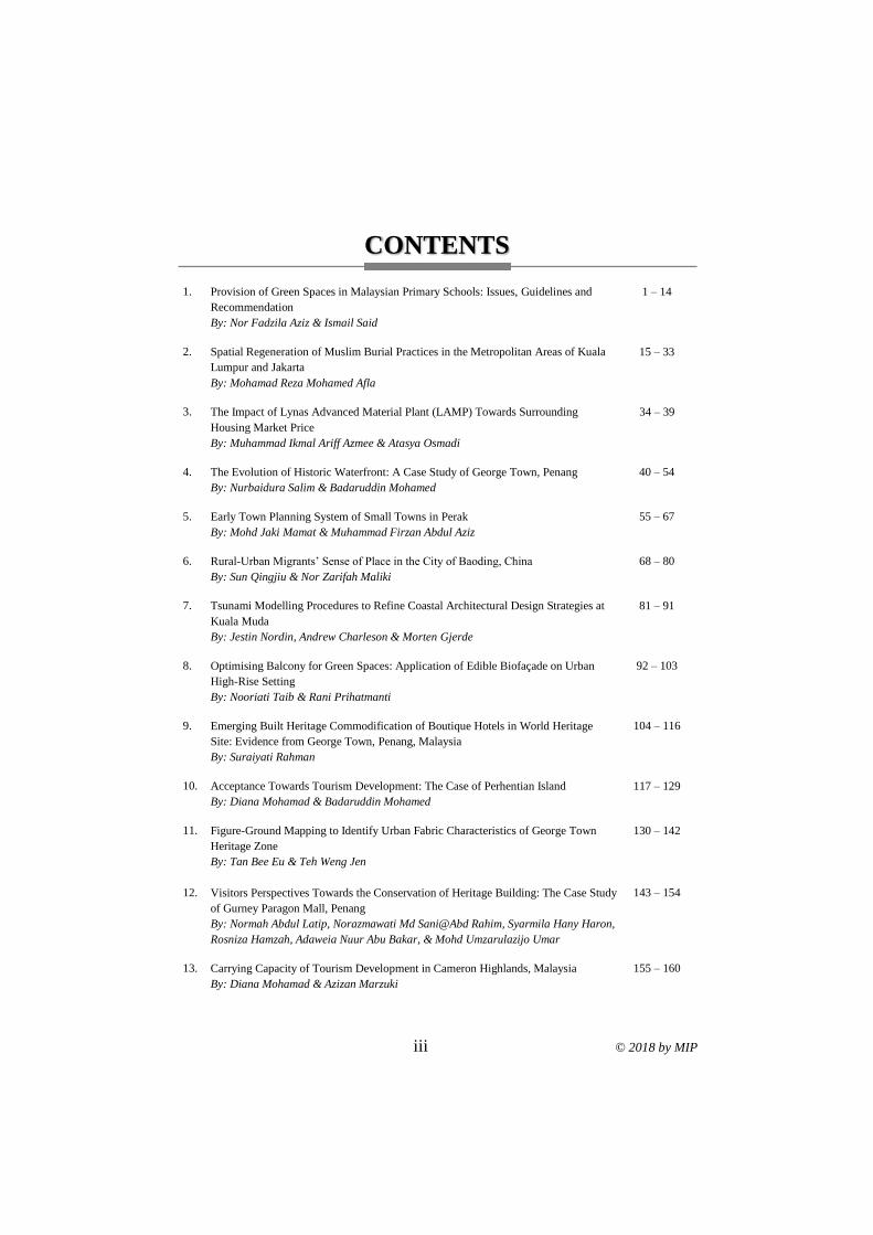
CONTENTS
1. Provision of Green Spaces in Malaysian Primary Schools: Issues, Guidelines and
Recommendation
By: Nor Fadzila Aziz & Ismail Said
1 – 14
2. Spatial Regeneration of Muslim Burial Practices in the Metropolitan Areas of Kuala
Lumpur and Jakarta
By: Mohamad Reza Mohamed Afla
15 – 33
3. The Impact of Lynas Advanced Material Plant (LAMP) Towards Surrounding
Housing Market Price
By: Muhammad Ikmal Ariff Azmee & Atasya Osmadi
34 – 39
4. The Evolution of Historic Waterfront: A Case Study of George Town, Penang
By: Nurbaidura Salim & Badaruddin Mohamed
40 – 54
5. Early Town Planning System of Small Towns in Perak
By: Mohd Jaki Mamat & Muhammad Firzan Abdul Aziz
55 – 67
6. Rural-Urban Migrants’ Sense of Place in the City of Baoding, China
By: Sun Qingjiu & Nor Zarifah Maliki
68 – 80
7. Tsunami Modelling Procedures to Refine Coastal Architectural Design Strategies at
Kuala Muda
By: Jestin Nordin, Andrew Charleson & Morten Gjerde
81 – 91
8. Optimising Balcony for Green Spaces: Application of Edible Biofaçade on Urban
High-Rise Setting
By: Nooriati Taib & Rani Prihatmanti
92 – 103
9. Emerging Built Heritage Commodification of Boutique Hotels in World Heritage
Site: Evidence from George Town, Penang, Malaysia
By: Suraiyati Rahman
104 – 116
10. Acceptance Towards Tourism Development: The Case of Perhentian Island
By: Diana Mohamad & Badaruddin Mohamed
117 – 129
11. Figure-Ground Mapping to Identify Urban Fabric Characteristics of George Town
Heritage Zone
By: Tan Bee Eu & Teh Weng Jen
130 – 142
12. Visitors Perspectives Towards the Conservation of Heritage Building: The Case Study
of Gurney Paragon Mall, Penang
By: Normah Abdul Latip, Norazmawati Md Sani@Abd Rahim, Syarmila Hany Haron,
Rosniza Hamzah, Adaweia Nuur Abu Bakar, & Mohd Umzarulazijo Umar
143 – 154
13. Carrying Capacity of Tourism Development in Cameron Highlands, Malaysia
By: Diana Mohamad & Azizan Marzuki
155 – 160
© 2018 by MIP iv
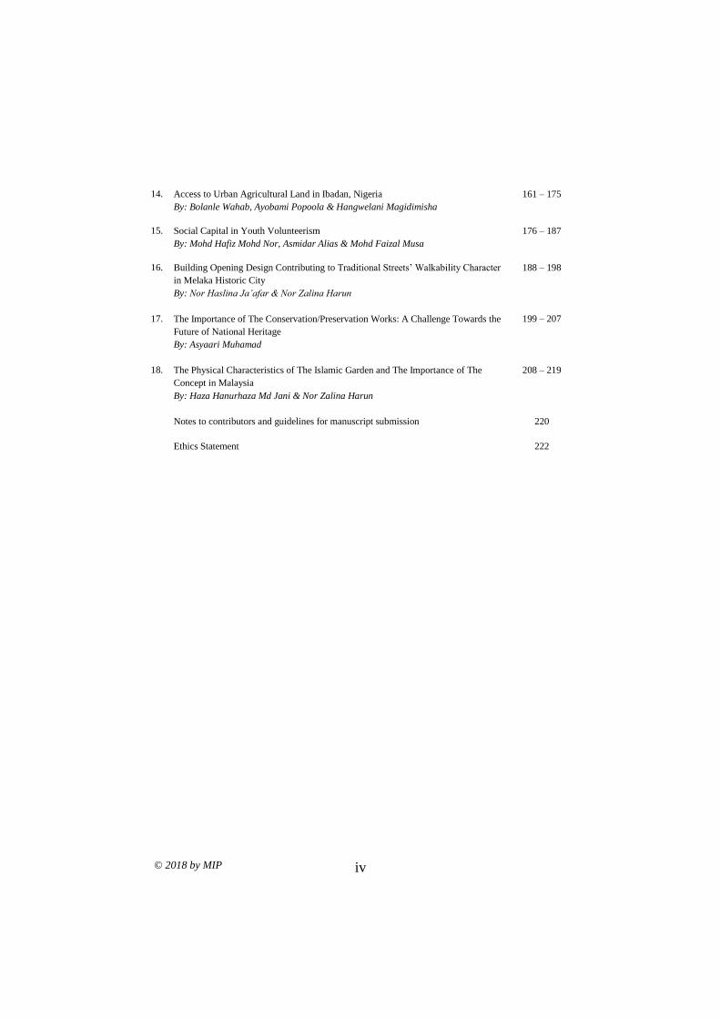
14. Access to Urban Agricultural Land in Ibadan, Nigeria
By: Bolanle Wahab, Ayobami Popoola & Hangwelani Magidimisha
161 – 175
15. Social Capital in Youth Volunteerism
By: Mohd Hafiz Mohd Nor, Asmidar Alias & Mohd Faizal Musa
176 – 187
16. Building Opening Design Contributing to Traditional Streets’ Walkability Character
in Melaka Historic City
By: Nor Haslina Ja’afar & Nor Zalina Harun
188 – 198
17. The Importance of The Conservation/Preservation Works: A Challenge Towards the
Future of National Heritage
By: Asyaari Muhamad
199 – 207
18. The Physical Characteristics of The Islamic Garden and The Importance of The
Concept in Malaysia
By: Haza Hanurhaza Md Jani & Nor Zalina Harun
208 – 219
Notes to contributors and guidelines for manuscript submission
220
Ethics Statement 222

v © 2018 by MIP
MIP Council Members
2017 - 2019 Session
President
TPr. Hj Ihsan Zainal Mokhtar (305/94)
Immediate Past President
TPr. Hj Md Nazri Mohd Noordin (301/94)
Vice President
Datin TPr. Hjh Noraida Saludin (468/02)
TPr. Mohamad Nazri Jaafar (168/86)
Honorary Secretary
Datin TPr. Hjh Mazrina Dato' Abdul Khalid (559/09)
Honorary Treasury
TPr. Mohd Zamri Husin (430/01)
Council Members
TPr. Lee Lih Shyan (267/92)
TPr. Hj Abdul Hamid Akub (450/01)
TPr. Hj Nik Mohd Ruiz Ahmad Fakhrul Razy (570/10)
Assoc. Prof. TPr. Dr. Saniah Ahmad Zaki (397/98)
TPr. Mohammad Fauzi Ahmad (418/99)
TPr. Mahani Mohd Yasin (614/12)
TPr. Nurul Sheema Abd Rahman (633/14)
TPr. Saiful Azman Abd Rashid (474/03)
TPr. Wan Andery Wan Mahmood (572/10
TPr. Fathuddin Kamaruddin (656/16)
Co-opted Members
TPr. Victor Lai Wee Peng (502/05) - Chairman, MIP Sarawak & Sabah Chapter
TPr. Cheah Lye Aik (432/01) - Chairman, MIP Northern Branch
TPr. Abd Halim Ali Hassan (407/89) - Chairman, MIP Southern Branch
TPr. Philipose Philip (127/84)
Dato' TPr. Mohd Zaki Ibrahim (197/88)
Assoc Prof. TPr. Dr. Mariana Mohamed Osman (581/11)
TPr. Hj Mohd Asri Husin (259/91)
TPr. Ishak Ariffin (239/90)
Pn. Rozita Hamit
Hon. Auditors
TPr. Hj Lokman Omar (211/88)
Assoc. Prof. TPr. Hj Ahmad Suhaimi Ismail (245/91)

1Senior Lecturer at Universiti Sains Malaysia. Email: [email protected] 1
PLANNING MALAYSIA:
Journal of the Malaysian Institute of Planners
VOLUME 16 ISSUE 4 (2018), Page 1 – 14
PROVISION OF GREEN SPACES IN MALAYSIAN PRIMARY
SCHOOLS: ISSUES, GUIDELINES AND RECOMMENDATION
Nor Fadzila Aziz1 & Ismail Said2
1School of Housing, Building and Planning
UNIVERSITI SAINS MALAYSIA
2Faculty of Built Environment and Surveying
UNIVERSITI TEKNOLOGI MALAYSIA
Abstract
The provision of conducive learning environments in schools is important in
determining the effectiveness of the curriculum and co-curriculum
implementation, as well as enriching children’s outdoor play and environmental
learning. However, the development of green spaces within school compound is
not a priority in Malaysian schools. This paper aims to explore the issues related
to the provision of green spaces in Malaysian national primary schools. There are
various green spaces that can be provided in school setting such as field, pocket
spaces, soft and hard play areas, and animal life, which serves different purposes
for children’s activities. Though, the limited budget and the lack of knowledge
and design guidelines are among the obstacles encountered by Malaysian schools
in developing functional green spaces that provide learning opportunities for
children. A greater effort is needed in helping the schools developing their green
spaces in terms of funding, expert knowledge and community support.
Keywords: green spaces, learning environment, school grounds greening,
sustainable schools, children’s development
Nor Fadzila Aziz & Ismail Said
Provision of Green Spaces in Malaysian Primary Schools: Issues, Guidelines and Recommendation
© 2018 by MIP 2
INTRODUCTION
In 2016, there were 7,772 primary schools under the MOE (Ministry of Education
Malaysia, 2016b). The number has increased as there were only 7,696 primary
schools in 2011 (Ministry of Education, 2013b). Apart from the MOE primary
schools, in 2016, there were also 126 primary schools under private institutions
and 74 primary schools under other government agencies (Ministry of Education
Malaysia, 2016a). The number of schools is expected to increase in the next ten
years as the ministry has planned to build more schools and classrooms to
accommodate the increasing number of students (Ministry of Education
Malaysia, 2012b). The statistics suggest that the Malaysian government is
committed in providing the primary education infrastructure in line with the
policy of compulsory education at the primary level (Ministry of Education
Malaysia, 2012a). The policy is in accordance with the right of all children to a
primary education as stated in Article 28 of the United Nations Convention on
the Rights of the Child (United Nations, 1989). Moreover, the provision of the
primary schools is to fulfil the National Education Philosophy of Malaysia.
The Malaysian government is committed to improving education in
Malaysia. For example, in 2011, the government allocated 16% (RM37 billion)
of the national budget to education – the highest allocation among the ministries.
The budget did not include the additional RM12 billion that was allocated to the
Ministry of Higher Education (MOHE) and other ministries that provide
education-related services (Ministry of Education Malaysia, 2013a). The budget
shown an increased in 2016, which the government allocated around one-fifth of
its budget on education, and almost 76% of the budget was allocated for the MOE
(RM41.3 billion) (Ministry of Finance Malaysia, 2016). As a developing country,
the Malaysian government has spent most of the budget on the development of
the educational infrastructure and increased the number of teachers to increase
the access to education. For example, the government spent more than RM20
billion for the development of the educational infrastructure from 2006 to 2010
(Ministry of Education Malaysia, 2013a).
The MOE is working to strengthen the educational infrastructure as one
of the important components in their strategic plan for educational development.
The provision of an adequate and comfortable educational infrastructure is
significant in determining the effectiveness of the curriculum and co-curriculum
implementation (Ministry of Education Malaysia, 2012b). The ministry mainly
focuses on the provision of the physical infrastructure for educational buildings
and their maintenance and the provision of clean water and electricity to all
schools (Ministry of Education Malaysia, 2012b). The purpose is to provide a
conducive learning environment for students. It was mentioned in the
implementation strategy of National Education Policy of Malaysia that a
conducive learning environment can be created by improving the safety, health
and aesthetic aspects of the school environment (Ministry of Education Malaysia,
PLANNING MALAYSIA
Journal of the Malaysia Institute of Planners (2018)
3 © 2018 by MIP
2012b). However, the provision of green spaces is not included or mentioned
clearly as part of concerns that also can contribute to the creation of conducive
learning environments at schools. The reason for this might be the priority of the
ministry to provide the basic infrastructure for schools as this is considered the
most necessary and important. This priority is in response to the condition that
there are still many schools in Malaysia that have inadequate basic infrastructure
(Ministry of Education Malaysia, 2013a). However, by focusing only on the
provision of the educational infrastructure, the significant benefits of school
grounds for children’s development and learning outcomes can be easily
overlooked. According to National Landscape Department (2012) and Tanner
(2000), green spaces at school refer to the variety of outside spaces close to the
school buildings which comprise the softscape, hardscape and the space functions
for children’s outdoor activities.
Therefore, this paper aims to explore the issues related to the provision
of green spaces in Malaysian primary schools. A study on the different types of
green spaces in school setting is conducted through review of landscape design
guidelines for primary schools in Malaysia and other countries for future
recommendations.
GOVERNMENT CONCERNS ON THE PROVISION OF GREEN
SPACES IN SCHOOL SETTING
Initiatives and Programmes
Even though the MOE has not made the provision of green spaces in schools a
priority, it has always supported any initiatives or programmes that aim to
improve the learning environment at schools, either inside or outside the
classroom. This is due to the growing concerns on the importance of conducive
learning environments in enhancing students’ performances at school. The
ministry has been involved in the organization of initiatives such as the 3K
Programme and the Sustainable School Programme Environment Award
(SLAAS), which included the greening and beautification of school grounds as
part of the criteria for evaluation.
The 3K Programme was launched in 1991 to improve school safety,
health and beautification through the implementation of an established system
related to the issues by the participating schools (Ministry of Education Malaysia,
2013c). The programme was organised by the MOE, Ministry of Health Malaysia
(MOH), Utusan Malaysia Team and Tetra Pak (M) Sdn. Bhd. (Department of
Environment, 2012). Starting from 2004, the programme was restructured and
was known as the 3K Initiative, which combined three separate programmes: Safe
School Programme, Health and Hygiene Programme and School Beautification
Programme (Ministry of Education Malaysia, 2013c).
Nor Fadzila Aziz & Ismail Said
Provision of Green Spaces in Malaysian Primary Schools: Issues, Guidelines and Recommendation
© 2018 by MIP 4
In addition to the 3K Programme, the MOE has also collaborated with
the Malaysian Department of the Environment (DOE) in the Ministry of Natural
Resources and the Environment (NRE), and the Institute for the Environment and
Development (LESTARI) of Universiti Kebangsaan Malaysia in organising the
SLAAS Programme (Department of Environment, 2004). The programme has
started in 2005 and went into its seventh session in 2017/2018. It is a Malaysian
initiative in nurturing, developing and embedding sustainability through
education that involves learning about, for and in the environment (Shaharudin,
Abdul Samad, Ahmad Fariz, Siti Nashroh, & Mazlin, 2010, Hanifah et al., 2015).
The objective can be achieved through the development of school environments
that emphasise environmental preservation and conservation in the aspects of
management, curriculum, co-curriculum and school greening (Department of
Environment, 2004; Shaharudin et al., 2010; Hanifah, Shaharudin, Mohmadisa,
Nasir, & Yazid, 2015). Therefore, it is crucial for the participant schools to create
a sustainable school environment to achieve the objectives of the programme. All
the criteria are outlined in the Guideline for Implementation and Evaluation of
Sustainable School – An Environment Award (Department of Environment,
2004).
The organization of both programmes has been seen to have several
positive impacts on the development of a more conducive learning environment
for students through school greening activities. A conducive school environment
has been proved to affect students’ learning experiences (Nik Roh Hayati, 2008;
Chen, Zaid & Nazarali, 2016) and academic performance (Mohd Redzauddin,
2008). Participated schools also have demonstrated their sustainability through
the enrichment of environmental activities which complement the learning in
classrooms (Shaharudin et al., 2010, Hanifah et al., 2015). These developments
are seen as a good start and an opportunity to promote environmental learning
among students in the school grounds.
The Implementations
The aforementioned initiatives and programmes are conducted as competitions to
attract more schools to participate since Malaysian schools have become
accustomed to the concept (Shaharudin et al., 2010). However, several
circumstances and issues have been raised regarding the implementation of the
programmes.
First, not all schools in Malaysia have the opportunity to participate in
such programmes because the participation is limited by the schools’ academic
performance (Shaharudin et al., 2010). Students’ achievement in national
examinations is always the priority of the MOE. Second, many schools have a
limited budget to organise the school’s greening activities and to develop and
manage their school environment for the competition since they have to use their
own financial funding. There is no budget allocated by the MOE for the

PLANNING MALAYSIA
Journal of the Malaysia Institute of Planners (2018)
5 © 2018 by MIP
development of green spaces within school compound. The MOE, through the
Procurement and Asset Management Unit, allocates financial support only for
basic maintenance work such as mowing the grass (Fazlie, 2012). Therefore, the
schools have to raise their own funding through networking and support from
various parties (Department of Environment, 2012), such as the Parent-Teacher
Association (PIBG), local authorities, the private sector, and non-government
organizations (NGO), to ensure the success of the programmes as well as the
sustainability of the school environments after the competition. In other countries,
some of the school grounds greening projects are funded by the city councils and
other organizations. For example, the ‘Urban Jungle’ project in Merrylee Primary
School in Glasgow was co-funded by the City Council and the Forestry
Commission (Children in Scotland, 2011).
The criteria of SLAAS Programme emphasised environmental activities
that can be conducted by schools according to the four components. No design
guidelines are provided to the schools. For example, in the criteria of garden and
landscape design, the aspects taken into consideration are the conditions of the
garden and the landscape, that is, their cleanliness and layout (Department of
Environment, 2004). It seems that the criteria focus only on the availability and
conditions of the school landscape without looking at the aspect of function of
the school landscape. Hence, the design of the school garden and landscape as
part of the components of school’s green spaces may not suit the students’ needs
and preferences or the climatic factors and the affordances of the landscape for
the students’ environmental learning and performances: physically, socially and
cognitively. Thus, the green spaces at school normally are developed by the
teachers, who maybe lack in any knowledge in designing green spaces for
educational environments. This situation may lead to the creation of green spaces
that are valueless for children’s play and learning.
In addition, the disadvantage of organizing a programme as a competition
is that the schools might participate in the competition simply with a view to it
being considered one of the school’s achievements; however, the efforts made
before and during the competition could be discontinued and not maintained after
the competition if constant monitoring is not feasible.
GREEN SPACES DESIGN ISSUES IN SCHOOL GROUNDS
The circumstances may have led to issues with the design green spaces in
Malaysian schools. Based on the assessment of the existing educational
environment, some common problems were identified, including a lack of
comprehensive planning for green spaces design, inappropriate designs for
certain area at schools, no systematic tree planting method being applied, the use
of inappropriate materials for hard landscaping, and a lack of maintenance of
school landscape (National Landscape Department, 2001).
Nor Fadzila Aziz & Ismail Said
Provision of Green Spaces in Malaysian Primary Schools: Issues, Guidelines and Recommendation
© 2018 by MIP 6
According to the Garden Nation Landscape Guidelines for primary
schools, 30 to 50 percent of the total development area of schools should be green
areas for landscaping and for students’ outdoor activities (National Landscape
Department, 2012). However, in 2001, only five to six per cent of the total green
area in schools was developed as places for learning activities. This means that
the remaining green area at schools did not fulfil the criteria of functional spaces
for use by both teachers and students, as stated in the draft of National Landscape
Guidelines for Specific Area – Educational Environment (Nik Roh Hayati, 2008).
It was found that the school landscapes are least utilised by the students
and teachers for learning purposes because the designs do not emphasise the
function of the school grounds as an extension of the classroom (Nik Roh Hayati,
2008). In addition, the use of school grounds for other activities was also limited.
Generally, the school grounds were designed only for the purpose of
beautification, and so the emphasis is on the attractiveness, neatness and
cleanliness of the environment (Nik Roh Hayati, 2008) rather than its functions.
The green spaces and landscapes might look pleasing to the viewers, but in terms
of affordances, they offer low quality landscapes and a minimal amount of
actualised affordances for students (Ozdemir & Yilmaz, 2008; Kyttä, 2003).
The criteria of school ground design and management are seen as
reflecting only the adults’ values (Malone & Tranter, 2003; Bakar, Osman,
Bachok, Zen & Abdullah, 2017) and do not consider the students’ needs and
preferences in that they do not reflect students’ physical, communal, emotional
and educational needs. Adults often disregard the potential of school grounds and
green spaces in schools in enhancing students’ performances and learning
experiences, either through formal or informal learning activities (Zainol & Au-
Yong, 2016). Therefore, the design of green spaces in Malaysian schools has been
proven to be unsuccessful in meeting children’s needs and certainly do not afford
the students any meaningful outdoor environmental experiences (Nik Roh Hayati,
2008; Khazainun, 2007).
School grounds should not only be designed to create conducive
environments for students’ doing, thinking, feeling and being (Titman, 1994), but
also should provide control, comfort and security for them. However, without an
understanding of the function and the importance of green spaces in schools for
students’ learning experiences and needs, it is impossible for schools to design a
green space that meet all the criteria.
METHODOLOGY
A review of primary school’s green spaces design guidelines was conducted to
identify (i) the aspects of design guidelines, and (ii) the different types of green
spaces in school setting. For local context, the community facilities’ planning
guidelines for educational facilities (FDTCP, 2012) and landscape design
guidelines (National Landscape Department, 2012) for Malaysian primary
PLANNING MALAYSIA
Journal of the Malaysia Institute of Planners (2018)
7 © 2018 by MIP
schools were reviewed. Besides review of the local guidelines, a review of the
guidelines, handbooks, research and case studies of primary school’s green
spaces in other countries, including the United States (Tanner, 2000), the United
Kingdom (FutureLab, 2008; Department for Education and Skills, 2006),
Scotland (Children in Scotland, 2011) and Australia (Play Space Guide, 2013)
were also made. This review was analysed using content analysis in order to
identify the green spaces of primary schools, how they are defined, and their
functions for students’ activities.
RESULTS AND FINDINGS
The planning and design guidelines for schools in Malaysia were based on the
National Education Policy and the syllabus of the Integrated Primary School
Curriculum (KBSR), which were in line with the National Education Philosophy
of Malaysia (Economic Planning Unit, 2008, 2015). The Public Works
Department (PWD) generally is responsible for planning and designing the layout
and building of schools under the MOE. A field and sports courts are included in
the layout design, depending on the configuration of the buildings and site
constraints. However, the scope of their works does not include designing the
school’s green spaces.
The Aspects of Primary School’s Design Guidelines
School Total Area
Based on the analysis of the community facilities’ planning guidelines for
educational facilities, the minimum requirement of area for a primary school is
2.5 to 5 acres for a flat area and 4 to 8 acres for a sloping area (FDTCP, 2012).
The school area is limited, and therefore, the efficient planning and design of
school facilities and green spaces is essential to ensure the adequacy, safety and
comfortability of the environment for the users.
School Zoning and Facilities
In general, the layout of schools in Malaysia can be divided into four main zones:
(i) administrative zone, (ii) academic zone, (iii) residential zone, and recreational
zone (FDTCP, 2012; Economic Planning Unit, 2008). The administrative zone
includes the school’s administrative and principal offices, meeting rooms, library,
and staff room. The academic zone includes the classrooms, workshops and
laboratories, computer laboratory, music room, and prayer room, while the
residential zone includes the dormitories and teachers’ quarters (for schools with
dormitories only). Finally, the recreational zone includes the school field and
sports courts. Other supporting facilities include the school hall, canteen, toilets,
store, guard house, parking area for staffs and visitors, lay-by for buses and cars,
pedestrian pathway (open or roofed), entrance road, and other services, such as
Nor Fadzila Aziz & Ismail Said
Provision of Green Spaces in Malaysian Primary Schools: Issues, Guidelines and Recommendation
© 2018 by MIP 8
water tank tower and electricity substation. It is mentioned in the guidelines that
the planning and design of schools should also consider the facilities for users
with disabilities, such as ramps, pathways, and toilets.
School Grounds Greening
Regarding the green spaces and landscapes, the community facilities’ planning
guidelines for educational facilities only emphasise the selection of suitable,
attractive and easy maintenance trees for the school environment (FDTCP, 2012)
though there is no guideline provided for the selection of trees.
However, the National Landscape Department of Malaysia has provided
guidelines for school landscapes which state that 30 to 50 percent of the total
school area should be a green spaces and for students’ outdoor activities (National
Landscape Department, 2012). The green spaces includes:
• School field: an area that functions as a playing field for team games, such
as football, and field events, such as an athletic track.
• Courtyards and pocket spaces: the spaces between school blocks or
laboratories that have the potential to be sites for outdoor learning
activities. Mini gardens with various concepts and activities such as
horticultural therapy, planting areas, and fish ponds can be designed in
these spaces.
• Assembly area: an area that functions as a place for school assemblies and
as a gathering point during an emergency.
• Main entrance area: an area that includes landscaping for a visitors’
parking area, waiting area, signboards, information boards, guard house,
and feature wall. It should evoke a welcoming feeling and be highly visible
to the students and visitors.
• Plaza: an area that functions as a foyer or gathering area that allows social
interactions during recess and times between classes.
• Semi-enclosed spaces: spaces that function as transaction areas between
the indoor and outdoor spaces of school buildings.
• Campus village zone (for schools with dormitories): an area that includes
landscaping and recreational areas, such as a field and sports courts for
students’ recreation.
• Buffer zones: an area between the school area and its surroundings,
especially the area beside the road. A tree buffer is normally planted
between the school buildings and school field to prevent accidents.
According to Tanner (2000), ‘green spaces’ refers to the outside space
close to the school buildings, which comprises lawns, trees and gardens. All the
green spaces in schools should be linked by the pathways that function as
transition spaces. The pathways are the clearly defined areas that allow freedom
PLANNING MALAYSIA
Journal of the Malaysia Institute of Planners (2018)
9 © 2018 by MIP
of movement (Tanner, 2000) from one activity to another at different times, such
as for meetings while walking.
When comparing the Malaysian guidelines with the guidelines, handbooks
and case studies from other countries regarding the planning and design of school
environments, it was found that there are several green spaces which have not
been included or have been paid scant attention in the Malaysian guidelines. The
green spaces are the informal and social areas (either soft or hard play areas) and
habitat areas. A variety of informal and social areas function as places that suit
the students’ learning development and cultural needs during informal times as
well as for a range of formal curriculum needs (Department for Education and
Skills, 2006). The habitat area refers to the places in the school for animals to live
in (Tanner, 2000). The description of the green spaces is as follows:
• Soft play area (informal and social area): The area includes a grassed
space and sloping grass area that should be suitably situated and safe, and
should provide some shade, imaginative landscaping and planting. It
allows students to sit and socialise, as well as to engage in imaginative
play.
• Hard play area (informal and social area): The area includes a hard
surface playground and sheltered space which is facilitated with play
equipment and site furniture. It affords social interactions and encourages
active and creative outdoor play.
• Habitat area and animal life: The area includes wildlife habitats, butterfly
houses, bird houses, ponds, various gardens, and outdoor science gardens
that support outdoor classrooms and environmental learning activities in
the school grounds, as well as diverse outdoor play activities. Some
wildlife habitats should be undisturbed and are best positioned away from
busy social areas. DISCUSSION AND RECOMMENDATIONS
The provision of various green spaces in school setting creates different
meaningful spaces that serve different developmental purposes for students with
different needs. Each green space at a school may hold more than one meaningful
space, while some of the meaningful spaces may overlap, depending on what kind
of activities that each outdoor space can afford when each child engages with the
environment. Therefore, ‘meaningful spaces’ refer to the functional spaces within
the designed green spaces at schools which were defined by the children when
they utilised the spaces. There is no specific boundary or location for the
meaningful spaces because their extent depends on the action and perception of
individual affordances which perceive the functionally significant properties of
the environment (Gibson, 1979) towards giving meaning to the green spaces at
schools. The meaningful spaces (Tanner, 2000) include:
Nor Fadzila Aziz & Ismail Said
Provision of Green Spaces in Malaysian Primary Schools: Issues, Guidelines and Recommendation
© 2018 by MIP 10
• Private spaces: social places where a small group of students may go to be
alone and perform their own activities such as telling secrets, chatting, and
playing in the playhouse.
• Quiet areas: solitary places where students may go to pause and refresh
themselves in a quiet setting.
• Play areas: special locations where students are given the opportunity to
be together and be healthy and active by using their bodies, building up
muscles, and testing new skills. Using imagination and releasing energy
are two important activities seen in these areas.
• Personal spaces: places for students to participate in activities and tasks
independently without being crowded. It is a good environment to aid
concentration.
• Outdoor rooms or specialist areas: outdoor learning environments
function like a classroom, but with the added benefits of nature that allow
exploration.
• Activity pocket: spaces for small group work where members are aiming
for the same goal, allowing access to resources and a shared working area.
• Large group spaces: spaces that can hold many people for an occasion or
daily activity.
• Eating spaces: places to eat, drink and socialise. An inviting setting may
allow students to eat comfortably.
• Display spaces: places to find out what others are doing and to see
examples of other people’s work.
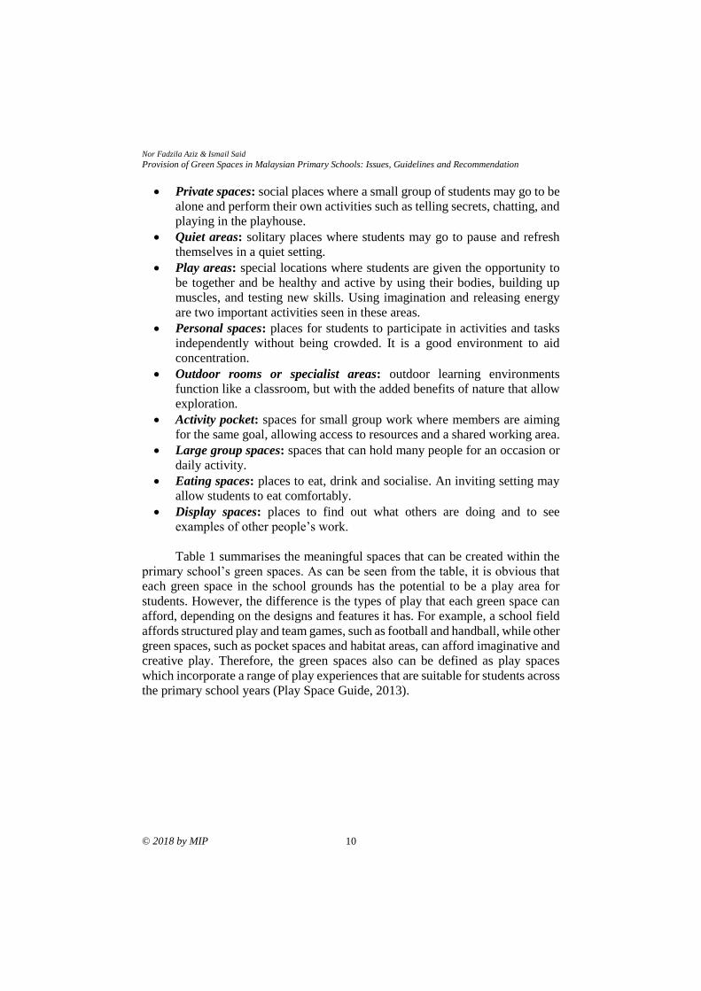
Table 1 summarises the meaningful spaces that can be created within the
primary school’s green spaces. As can be seen from the table, it is obvious that
each green space in the school grounds has the potential to be a play area for
students. However, the difference is the types of play that each green space can
afford, depending on the designs and features it has. For example, a school field
affords structured play and team games, such as football and handball, while other
green spaces, such as pocket spaces and habitat areas, can afford imaginative and
creative play. Therefore, the green spaces also can be defined as play spaces
which incorporate a range of play experiences that are suitable for students across
the primary school years (Play Space Guide, 2013).
PLANNING MALAYSIA
Journal of the Malaysia Institute of Planners (2018)
11 © 2018 by MIP
Table 1: The relationship between primary school’s green spaces and meaningful
spaces for students with different needs
Primary school’s
green spaces
Meaningful spaces created within green spaces
Pri
vat
e sp
aces
Qu
iet
area
s
Pla
y a
reas
Per
son
al s
pac
es
Ou
tdo
or
roo
ms/
spec
iali
st a
reas
Act
ivit
y p
ock
et
Lar
ge
gro
up s
pac
es
Eat
ing
sp
aces
Dis
pla
y s
pac
es
School field
Courtyard
Pocket spaces
Assembly area
Main entrance area
Plaza
Semi-enclosed spaces
Campus village zone
Buffer zone
Transition spaces/pathways
Soft play area
Hard play area
Habitat area/animal life
indicates the meaningful spaces that can be created within the green spaces
Some of the play spaces can also become part of the outdoor learning
environment at schools because the range of play experiences that occurs can
complement and extend learning in the classrooms (Play Space Guide, 2013).
This is especially true for the play spaces that are integrated with the natural
environment, such as pocket spaces, soft play areas and habitat areas. The play
spaces allow students to have direct contact with nature and inspire them to learn
through exploration, observation and investigation with the natural environments.
Furthermore, the natural play spaces also serve other developmental purposes for
students, such as private spaces, quiet areas, personal spaces, activity pockets and,
sometimes, as eating spaces. Therefore, schools should diversify their school
grounds environments with natural elements as much as possible to enrich the
children’s outdoor play and environmental learning.
For a few schools in Malaysia, the limitation of school area is another
issue that arises in the development of the green spaces in school grounds. As
solution, the green spaces around the school buildings can be designed for
multiple uses rather than only for beautification, such as the pocket spaces. The
Nor Fadzila Aziz & Ismail Said
Provision of Green Spaces in Malaysian Primary Schools: Issues, Guidelines and Recommendation
© 2018 by MIP 12
spaces should function as places for relaxation, social interaction, and exhibition
as well as for educational purposes.
CONCLUSION
Malaysia has its own initiatives such as ‘Sustainable School – An Environment
Award’ and the 3K programmes, which were organized as competitions and
which were intended to improve the learning environment in Malaysian schools.
However, the organization of these competitions alone is not enough to ensure
the success and sustainability of the programmes. This is due to certain
circumstances encountered by the schools, such as lack of knowledge, guidelines
and funding in developing a functional green spaces for children’s play and
learning in schools. Therefore, a greater effort is needed in helping the schools to
develop their school grounds in terms of the provision of funding and advice from
experts in landscape design that can assist them to transform their school grounds
environments. The school community, including the principals, teachers, parents,
and children, and also the surrounding community, should be educated and
involved in the processes, so that they will be aware of the potential of the school
grounds environment in providing important learning opportunities for children.
Children have the right to play and to get primary education. Therefore,
schools should provide the best opportunities for children to meet their rights and
needs. In order to achieve this, children should be actively involved in the whole
process of planning and designing their school grounds environment. Their
voices should be heard because they are the active occupants of their
environment. Without an understanding of children’s behaviour and preferences,
it is impossible for adults to create the environment that meets children’s needs.
ACKNOWLEDGEMENT
This study was funded by USM Short Term Grant (304/PPBGN/6313299).
REFERENCES Bakar, A. A., Osman, M. M., Bachok, S., Zen, I., & Abdullah, M. F. (2017). A review on
sustainable wellbeing indicators for human interrelationships with the
environment. Planning Malaysia, 15(1), 357-368.
Chen, W., Zaid, S. M., & Nazarali, N. (2016). Environmental psychology: The urban built
environment impact on human mental health. Planning Malaysia, Special Issue
5, 23-38.
Children in Scotland (2011). Making spaces: Architecture and design for children and
young people. Edinburgh: Princes House.
Department for Education and Skills (2006). Every child matters: Primary capital
programme - Building primary schools at the heart of the community
(DFES/0287/2006). Nottinghamshire: Author.
PLANNING MALAYSIA
Journal of the Malaysia Institute of Planners (2018)
13 © 2018 by MIP
Department of Environment (2004). Garis panduan pelaksanaan dan penilaian sekolah
lestari: Anugerah Alam Sekitar. Jabatan Alam Sekitar, Kementerian Sumber
Asli dan Alam Sekitar.
Department of Environment (2012). Asas pembentukan sekolah lestari: Anugerah Alam
Sekitar. Jabatan Alam Sekitar, Kementerian Sumber Asli dan Alam Sekitar.
Economic Planning Unit (2008). Garis panduan dan peraturan bagi perancangan
bangunan oleh jawatankuasa kecil piawaian dan kos bagi jppn (Edisi Tahun
2008). Putrajaya: Jabatan Perdana Menteri Malaysia.
Economic Planning Unit (2015). Garis panduan dan peraturan bagi perancangan
bangunan (Edisi Tahun 2015). Putrajaya: Jabatan Perdana Menteri Malaysia.
Fazlie, J. (2012). Unstructured interview with the staff at Sector of Management and
Development, Johor Education Department, December 31, 2012.
Federal Department of Town and Country Planning Peninsular Malaysia [FDTCP]
(2012). Garis panduan perancangan kemudahan masyarakat. Kuala Lumpur:
Author.
FutureLab (2008). Reimagining outdoor learning spaces: Primary capital, co-design and
educational transformation. Bristol: Author.
Gibson, J. J. (1979). The ecological approach to visual perception. Hillsdale, New Jersey:
Lawrence Erlbaum Associates, Inc.
Hanifah, M., Shaharudin, I., Mohmadisa, H., Nasir, N., & Yazid, S. (2015). Transforming
sustainability development education in Malaysian schools through greening
activities. Review of International Geographical Education Online
(RIGEO), 5(1), 77-94.
Khazainun, Z. (2007). Children’s concept of primary school ground for learning and
playing through landscape in Malaysia (Master thesis). Universiti Teknologi
Malaysia, Skudai, Johor.
Kyttä, M. (2003). Affordances and independent mobility in the assessment of
environmental child friendliness (Doctoral dissertation). Helsinki University of
Technology, Finland.
Malone, K., & Tranter, P. J. (2003). Children’s environmental learning and the use, design
and management of schoolgrounds. Children, Youth and Environments, 13(2),
87-137.
Ministry of Education Malaysia (2012a). Dasar pendidikan kebangsaan (Edisi 3).
Putrajaya: Bahagian Perancangan dan Penyelidikan Dasar Pendidikan.
Ministry of Education Malaysia (2012b). Pelan strategik interim kementerian pengajian
Malaysia 2011-2020. Putrajaya: Bahagian Perancangan dan Penyelidikan Dasar
Pendidikan.
Ministry of Education Malaysia (2013a). Malaysia education blueprint 2013-2025
(Preschool to post-secondary education). Putrajaya: Ministry of Education
Malaysia.
Ministry of Education Malaysia (2013b). Quick facts 2013: Malaysia educational
statistics. Putrajaya: Educational Data Sector, Educational Planning and
Research Division.
Ministry of Education Malaysia (2013c). The 3K programme. Retrieved October 1, 2013,
from http://www.moe.gov.my/en/program-3k
Nor Fadzila Aziz & Ismail Said
Provision of Green Spaces in Malaysian Primary Schools: Issues, Guidelines and Recommendation
© 2018 by MIP 14
Ministry of Education Malaysia (2016a). Malaysian educational statistics. Putrajaya:
Educational Planning and Research Division, Ministry of Education Malaysia.
Ministry of Education Malaysia (2016b). Quick facts 2016 Malaysian educational
statistics. Putrajaya: Educational Data Sector, Educational Planning and
Research Division, Ministry of Education Malaysia.
Ministry of Finance Malaysia (2016). 2016 budget. Purtajaya: Ministry of Finance
Malaysia.
Mohd Rezauddin, I. (2008). Hubungan rekabentuk landskap sekolah dengan pencapaian
prestasi akademik pelajar sekolah menengah di Besut, Terengganu (Master
thesis). Universiti Putra Malaysia, Serdang, Malaysia.
National Landscape Department (2001). Deraf Garis Panduan Landskap Terperinci
untuk Bangunan Pendidikan. Kuala Lumpur: Author.
National Landscape Department (2012). Garis panduan landskap negara taman. Kuala
Lumpur: Author.
Nik Roh Hayati, W. A. R. (2008). Students’ perception of school landscape and its
influence on learning experience at award-winning secondary schools in
Kelantan (Master thesis). Universiti Putra Malaysia, Serdang, Malaysia.
Ozdemir, A., & Yilmaz, O. (2008). Assessment of outdoor school environments and
physical activity in Ankara’s primary schools. Journal of Environmental
Psychology, 28(3), 287-300.
Play Space Guide (2013). Play space guide: creating valuable places to play and learn
outdoors in Western Australian Schools. Retrieved May 25, 2013, from
http://www.natureplaywa.org.au/assets/files/WA%20Education%20and%20C
BEH%20Play%20Space%20Guide.pdf
Shaharudin, I., Abdul Samad, H., Ahmad Fariz, M., Siti Nashroh, S., & Mazlin, M. (2010,
November). A Malaysian initiative in embedding sustainability: Sustainable
school - An Environment Award. 4th International Conference on Sustainability
Engineering and Science. November 30 - December 3, Auckland, Australia.
Tanner, C. K. (2000). The influence of school architecture on academic achievement.
Journal of Educational Administration, 38(4), 309-330.
Titman, W. (1994). Special Places, special people: The hidden curriculum of school
grounds. Surrey: Learning through Landscapes, Panda House.
United Nations (1989). The convention on the rights of the child. New York: UNICEF.
Zainol, R., & Au-Yong, C. P. (2016). What brings youths to recreational parks? Planning
Malaysia, 14, 67-80.
Received: 1st June 2018. Accepted:1st December 2018
1Lecturer at Universiti Sains Malaysia. Email: [email protected] 15
PLANNING MALAYSIA:
Journal of the Malaysian Institute of Planners
VOLUME 16 ISSUE 4 (2018), Page 15 – 33
SPATIAL REGENERATION OF MUSLIM BURIAL PRACTICES IN
THE METROPOLITAN AREAS OF KUALA LUMPUR AND JAKARTA
Mohamad Reza Mohamed Afla1
1School of Housing, Building and Planning
UNIVERSITI SAINS MALAYSIA
Abstract
This article focuses on the subject of burial practices which are performed by the
Muslim population and the management at public cemeteries within the
metropolitan areas of Kuala Lumpur and Jakarta. This research examines
specifically, the conventional way of burial practice by the majority of the
Muslim population. Unlike other major religions in Southeast Asia which are
more open and flexible in the disposal of corpses, full body burial is mandatory
in Islam. In response to the escalating issue of lack of space and land shortage for
Muslim cemetery, local authorities of the two metropolitan areas have identified
alternatives and solutions in handling these alarming situations. This research has
recognised factors that lead to these problems, as well as discussing available
methods to overcome these issues. The finding exhibits Muslim cemetery’s
layout to be problematic due to abundance of burial practices accumulated by
patrons which led to disorganisation of space and claustrophobia. This article
concludes by providing proposals and design guidelines at the terrain level,
together with recommendations that emphasise the long-term usage of the grave
plots.
Keywords: burial practices, spatial, cemeteries, metropolitan
Mohamad Reza Mohamed Afla Spatial Regeneration of Muslim Burial Practices in the Metropolitan Areas of Kuala Lumpur and Jakarta
© 2018 by MIP 16
INTRODUCTION
This article explores alternative methods and strategies for burial practices within
the context of rapid development of urban cemeteries. The main question of this
research is how the metropolitan cities of Kuala Lumpur (KL) and Jakarta deal
with the issue of burial. The intention of this research is to offer alternative
solutions to the critical situation of overcrowding and land shortage in Muslim
cemeteries (Rahim, 2011; “No more space”, 2011). This study argues that some
aspects of Muslim funerary practices should be altered and indeed transformed,
especially given the increasing pressure of urbanisation in Kuala Lumpur,
Singapore and Jakarta (Hamnett & Forbes, 2011, Rimmer, & Dick, 2009; Forbes,
1996). In addressing the issue regarding the lack of space for Muslim burials in
the cities, there are some modifications that could be employed in order to attain
a higher level of efficiency in utilising the space inside cemeteries (Ely & Howe,
2002).
The objectives of this research are to analyse alternatives for graves
arrangement by considering the burial practices of local Muslims and to explore
adaptability of graves layout by examining the requirements of Islamic burials.
METHODOLOGY
The case studies presented in this article will provide an insight into the current
state of urban cemeteries and practices employed for Muslim burials within Kuala
Lumpur and Jakarta. Site observation has been conducted at selective sites in each
city in order to examine closely the current trends associated with Muslim burial
practices and to provide a basis for potential improvements. These are identified
as catalysts in changing the burial practices of Muslim communities in Kuala
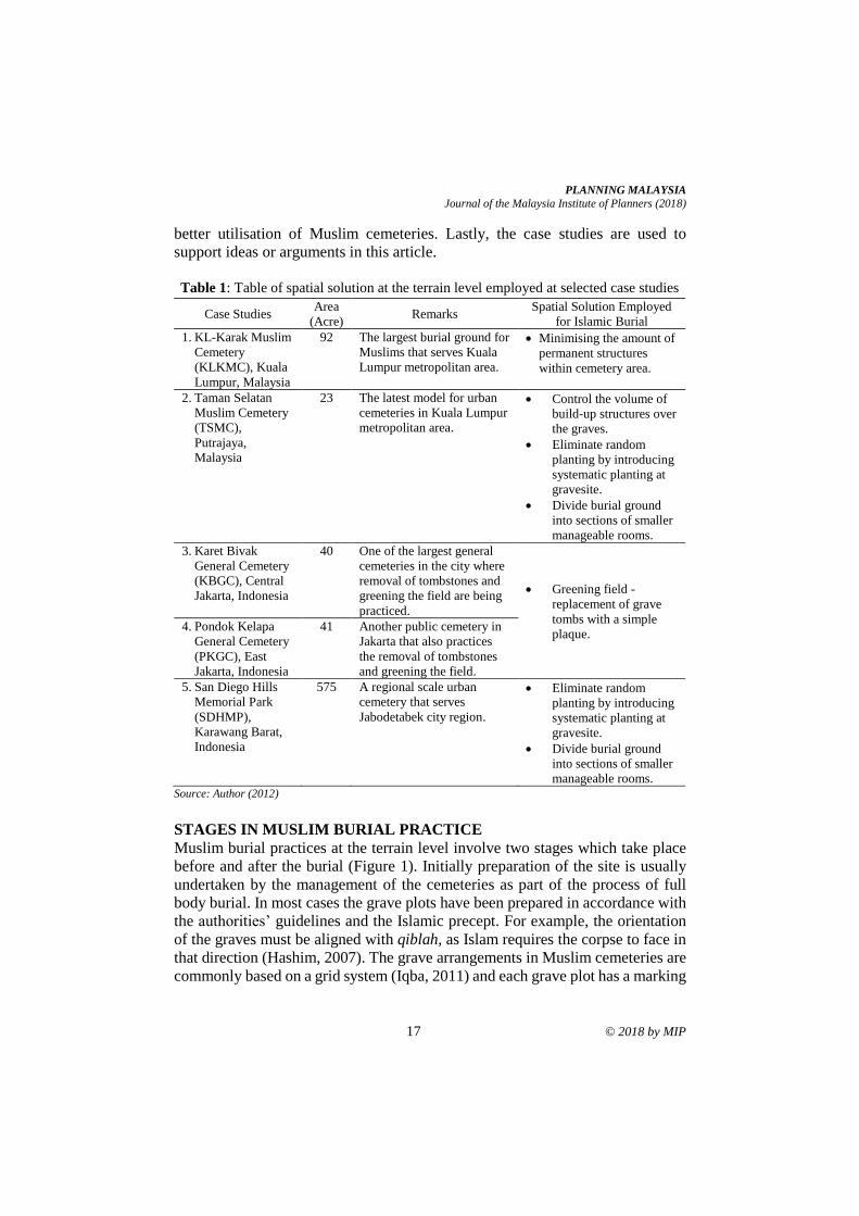
Lumpur and Jakarta. There are five case studies involved in this research as
shown in Table 1. In Kuala Lumpur metropolitan area, KL-Karak Muslim
Cemetery (KLKMC) and Taman Selatan Muslim Cemetery (TSMC) are among
the sites that have been chosen. Meanwhile, Karet Bivak General Cemetery
(KBGC), Pondok Kelapa General Cemetery (PKGC) and San Diego Hills
Memorial Park (SDHMP) are the sites that have been chosen for the Jakarta
metropolitan area. These sites have been selected as the case studies as they have
each employed a spatial solution as a new approach in managing the grave plots
for Islamic burial.
The case studies in this research are used in five ways. Firstly, the case
studies are consistently addressed in discussing the problems that relate to the
urban cemeteries in the metropolitan areas of KL and Jakarta. They are drawn
upon as examples to discuss the gravity of the situation within the sites. Secondly,
examples of case studies are used in searching for reliable approaches that are
consistent with Muslim burial practices. Thirdly, they are used to indicate similar
and shared characteristics and to highlight certain contradictory features.
Fourthly, the case studies are used to provide information which may lead to
PLANNING MALAYSIA
Journal of the Malaysia Institute of Planners (2018)
17 © 2018 by MIP
better utilisation of Muslim cemeteries. Lastly, the case studies are used to
support ideas or arguments in this article.
Table 1: Table of spatial solution at the terrain level employed at selected case studies
Case Studies Area
(Acre) Remarks
Spatial Solution Employed
for Islamic Burial
1. KL-Karak Muslim
Cemetery
(KLKMC), Kuala
Lumpur, Malaysia
92 The largest burial ground for
Muslims that serves Kuala
Lumpur metropolitan area.
• Minimising the amount of
permanent structures
within cemetery area.
2. Taman Selatan
Muslim Cemetery
(TSMC),
Putrajaya,
Malaysia
23
The latest model for urban
cemeteries in Kuala Lumpur
metropolitan area.
• Control the volume of
build-up structures over
the graves.
• Eliminate random
planting by introducing
systematic planting at
gravesite.
• Divide burial ground
into sections of smaller
manageable rooms.
3. Karet Bivak
General Cemetery
(KBGC), Central
Jakarta, Indonesia
40 One of the largest general
cemeteries in the city where
removal of tombstones and
greening the field are being
practiced.
• Greening field -
replacement of grave
tombs with a simple
plaque. 4. Pondok Kelapa
General Cemetery
(PKGC), East
Jakarta, Indonesia
41 Another public cemetery in
Jakarta that also practices
the removal of tombstones
and greening the field.
5. San Diego Hills
Memorial Park
(SDHMP),
Karawang Barat,
Indonesia
575 A regional scale urban
cemetery that serves
Jabodetabek city region.
• Eliminate random
planting by introducing
systematic planting at
gravesite.
• Divide burial ground
into sections of smaller
manageable rooms. Source: Author (2012)
STAGES IN MUSLIM BURIAL PRACTICE
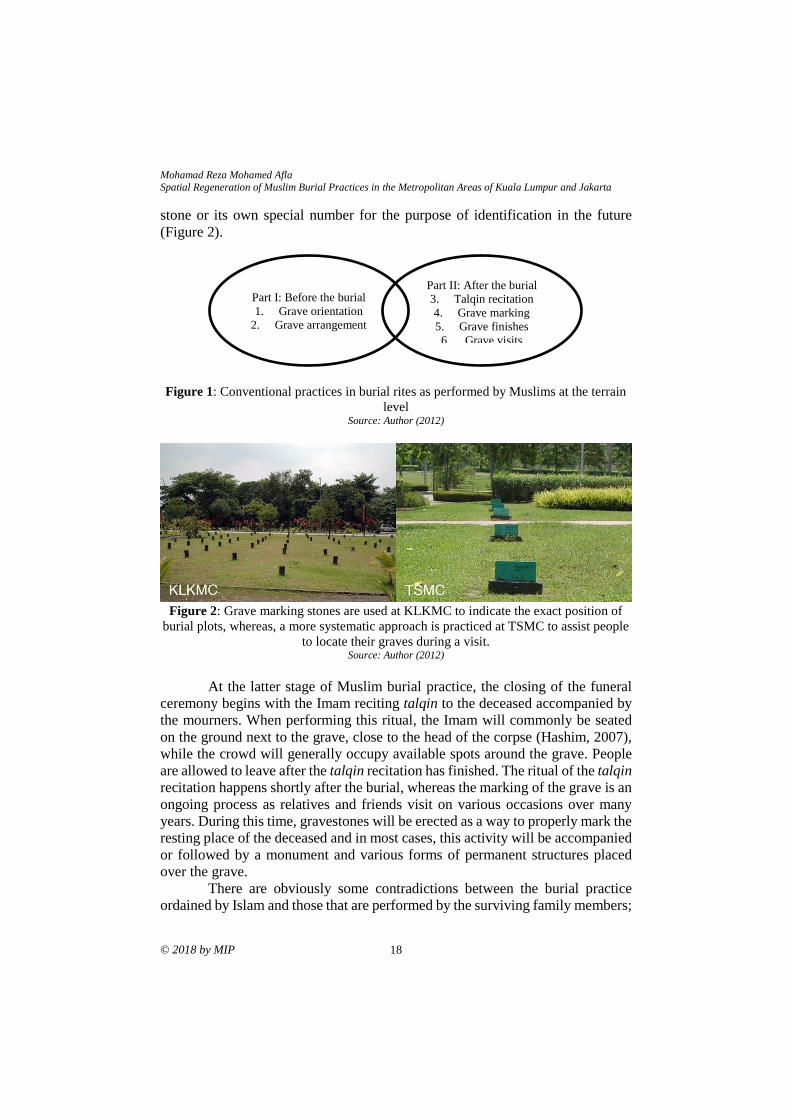
Muslim burial practices at the terrain level involve two stages which take place
before and after the burial (Figure 1). Initially preparation of the site is usually
undertaken by the management of the cemeteries as part of the process of full
body burial. In most cases the grave plots have been prepared in accordance with
the authorities’ guidelines and the Islamic precept. For example, the orientation
of the graves must be aligned with qiblah, as Islam requires the corpse to face in
that direction (Hashim, 2007). The grave arrangements in Muslim cemeteries are
commonly based on a grid system (Iqba, 2011) and each grave plot has a marking
Mohamad Reza Mohamed Afla Spatial Regeneration of Muslim Burial Practices in the Metropolitan Areas of Kuala Lumpur and Jakarta
© 2018 by MIP 18
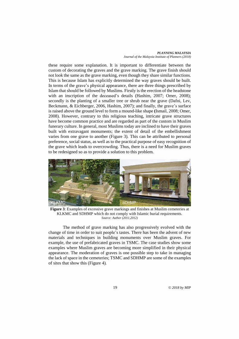
stone or its own special number for the purpose of identification in the future
(Figure 2).
Figure 1: Conventional practices in burial rites as performed by Muslims at the terrain
level Source: Author (2012)
Figure 2: Grave marking stones are used at KLKMC to indicate the exact position of
burial plots, whereas, a more systematic approach is practiced at TSMC to assist people
to locate their graves during a visit. Source: Author (2012)
At the latter stage of Muslim burial practice, the closing of the funeral
ceremony begins with the Imam reciting talqin to the deceased accompanied by
the mourners. When performing this ritual, the Imam will commonly be seated
on the ground next to the grave, close to the head of the corpse (Hashim, 2007),
while the crowd will generally occupy available spots around the grave. People
are allowed to leave after the talqin recitation has finished. The ritual of the talqin
recitation happens shortly after the burial, whereas the marking of the grave is an
ongoing process as relatives and friends visit on various occasions over many
years. During this time, gravestones will be erected as a way to properly mark the
resting place of the deceased and in most cases, this activity will be accompanied
or followed by a monument and various forms of permanent structures placed
over the grave.
There are obviously some contradictions between the burial practice
ordained by Islam and those that are performed by the surviving family members;
Part I: Before the burial
1. Grave orientation
2. Grave arrangement
Part II: After the burial
3. Talqin recitation
4. Grave marking
5. Grave finishes
6. Grave visits
PLANNING MALAYSIA
Journal of the Malaysia Institute of Planners (2018)
19 © 2018 by MIP
these require some explanation. It is important to differentiate between the
custom of decorating the graves and the grave marking. The grave finish should
not look the same as the grave marking, even though they share similar functions.
This is because Islam has explicitly determined the way graves should be built.
In terms of the grave’s physical appearance, there are three things prescribed by
Islam that should be followed by Muslims. Firstly is the erection of the headstone
with an inscription of the deceased’s details (Hashim, 2007; Omer, 2008);
secondly is the planting of a smaller tree or shrub near the grave (Dafni, Lev,
Beckmann, & Eichberger, 2006, Hashim, 2007); and finally, the grave’s surface
is raised above the ground level to form a mound-like shape (Ismail, 2008; Omer,
2008). However, contrary to this religious teaching, intricate grave structures
have become common practice and are regarded as part of the custom in Muslim
funerary culture. In general, most Muslims today are inclined to have their graves
built with extravagant monuments; the extent of detail of the embellishment
varies from one grave to another (Figure 3). This can be attributed to personal
preference, social status, as well as to the practical purpose of easy recognition of
the grave which leads to overcrowding. Thus, there is a need for Muslim graves
to be redesigned so as to provide a solution to this problem.
Figure 3: Examples of excessive grave markings and finishes at Muslim cemeteries at
KLKMC and SDHMP which do not comply with Islamic burial requirements. Source: Author (2011,2012)
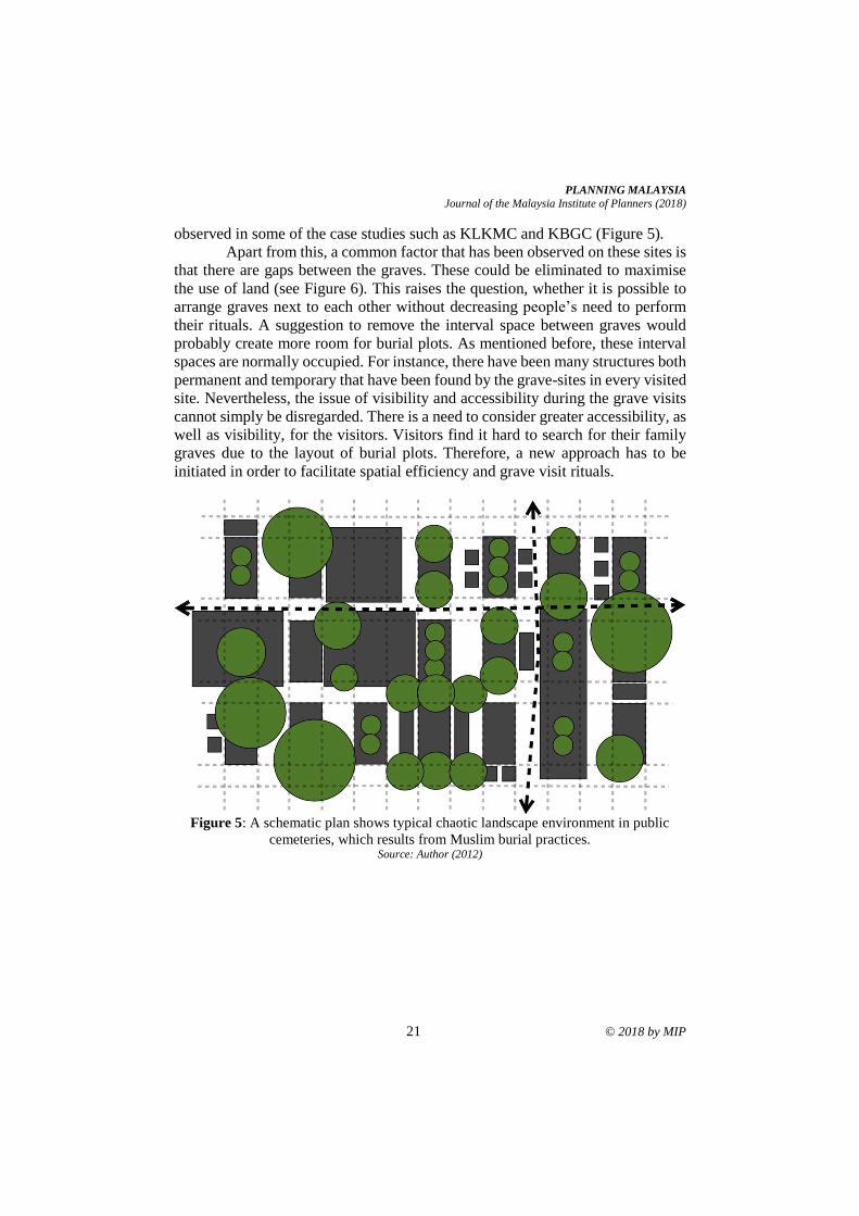
The method of grave marking has also progressively evolved with the
change of time in order to suit people’s tastes. There has been the advent of new
materials and techniques in building monuments over Muslim graves. For
example, the use of prefabricated graves in TSMC. The case studies show some
examples where Muslim graves are becoming more simplified in their physical
appearance. The moderation of graves is one possible step to take in managing
the lack of space in the cemeteries; TSMC and SDHMP are some of the examples
of sites that show this (Figure 4).
Mohamad Reza Mohamed Afla Spatial Regeneration of Muslim Burial Practices in the Metropolitan Areas of Kuala Lumpur and Jakarta
© 2018 by MIP 20
Figure 4: Examples of simplified and moderately designed graves at TSMC and
SDHMP, (2011, 2012). Source: Author (2011, 2012)
From site observations there is a significant difference between
conventional and simplified methods of building graves, in terms of the spatial
quality and in improving the environment offering more breathing space for
visitors. Apart from being low in cost, simple monuments require less
maintenance and it would be sensible for the management of the cemeteries to
erect them over Muslim graves. Moreover, the case studies have shown that there
will be minimal grave markings by imposing a strict control on the way they are
arranged such as is exemplified at TSMC. Therefore, elaborate and extensive
grave structures should be re-examined in terms of their function in the
cemeteries.
Grave visits are the last ritual in Muslim burial practices. This is a
continuing rite for the visitors as a way to commemorate the dead. During this
time, visitors will be seated on the ground in order to offer the prayer to the
deceased by reciting a chapter of Yasin from the Quran. This practice is usually
performed around the grave. The Yasin recitation ends with the spreading of
flower petals over the grave with some water. Families may bring a mat or
newspaper from home on which they sit temporarily. In some cases, people are
inclined to bring seats to place next to the grave in order to be more comfortable
during the recitation. However, with the help of grave makers, it is a common
thing now for grave structures to be built with seats. The seats vary according to
the size and materials from which they are made. Nevertheless, some people are
creative in accommodating this ritual by using simple material such as benches.
This practice of grave visits sometimes becomes a challenge for the visitors as
they have to find available places for seating and this could be difficult with the
way graves have been arranged. This situation becomes worse as new graves
gradually appear, and because of the abundance of grave structures and the
scattered use of trees and shrubs planted close to the graves. Muslims visit the
graves at certain times of the year and the claustrophobic environment that
sometimes results can potentially generate unpleasant experiences, which can be
PLANNING MALAYSIA
Journal of the Malaysia Institute of Planners (2018)
21 © 2018 by MIP
observed in some of the case studies such as KLKMC and KBGC (Figure 5).
Apart from this, a common factor that has been observed on these sites is
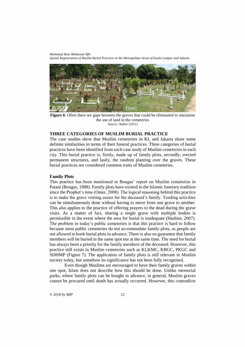
that there are gaps between the graves. These could be eliminated to maximise
the use of land (see Figure 6). This raises the question, whether it is possible to
arrange graves next to each other without decreasing people’s need to perform
their rituals. A suggestion to remove the interval space between graves would
probably create more room for burial plots. As mentioned before, these interval
spaces are normally occupied. For instance, there have been many structures both
permanent and temporary that have been found by the grave-sites in every visited
site. Nevertheless, the issue of visibility and accessibility during the grave visits
cannot simply be disregarded. There is a need to consider greater accessibility, as
well as visibility, for the visitors. Visitors find it hard to search for their family
graves due to the layout of burial plots. Therefore, a new approach has to be
initiated in order to facilitate spatial efficiency and grave visit rituals.
Figure 5: A schematic plan shows typical chaotic landscape environment in public
cemeteries, which results from Muslim burial practices. Source: Author (2012)
Mohamad Reza Mohamed Afla Spatial Regeneration of Muslim Burial Practices in the Metropolitan Areas of Kuala Lumpur and Jakarta
© 2018 by MIP 22
Figure 6: Often there are gaps between the graves that could be eliminated to maximise
the use of land in the cemeteries Source: Author (2011)
THREE CATEGORIES OF MUSLIM BURIAL PRACTICE
The case studies show that Muslim cemeteries in KL and Jakarta share some
definite similarities in terms of their funeral practices. Three categories of burial
practices have been identified from each case study of Muslim cemeteries in each
city. This burial practice is, firstly, made up of family plots, secondly, erected
permanent structures, and lastly, the random planting over the graves. These
burial practices are considered common traits of Muslim cemeteries.
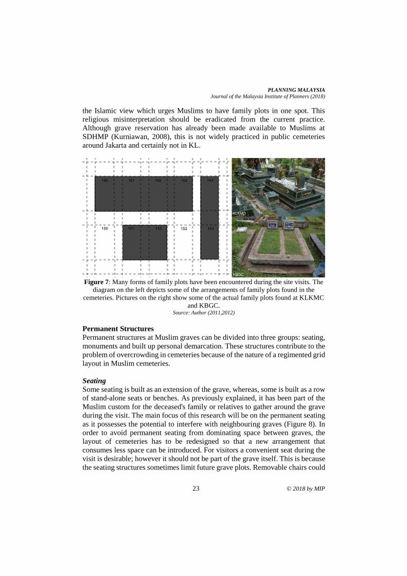
Family Plots
This practice has been mentioned in Bougas’ report on Muslim cemeteries in
Patani (Bougas, 1988). Family plots have existed in the Islamic funerary tradition
since the Prophet’s time (Omer, 2008). The logical reasoning behind this practice
is to make the grave visiting easier for the deceased’s family. Tending activities
can be simultaneously done without having to move from one grave to another.
This also applies to the practice of offering prayers to the dead during the grave
visits. As a matter of fact, sharing a single grave with multiple bodies is
permissible in the event where the area for burial is inadequate (Hashim, 2007).
The problem in today’s public cemeteries is that this practice is hard to follow
because most public cemeteries do not accommodate family plots, as people are
not allowed to book burial plots in advance. There is also no guarantee that family
members will be buried in the same spot nor at the same time. The need for burial
has always been a priority for the family members of the deceased. However, this
practice still exists in Muslim cemeteries such as KLKMC, KBGC, PKGC and
SDHMP (Figure 7). The application of family plots is still relevant in Muslim
society today, but somehow its significance has not been fully recognised.
Even though Muslims are encouraged to have their family graves within
one spot, Islam does not describe how this should be done. Unlike memorial
parks, where family plots can be bought in advance, in general, Muslim graves
cannot be procured until death has actually occurred. However, this contradicts
PLANNING MALAYSIA
Journal of the Malaysia Institute of Planners (2018)
23 © 2018 by MIP
the Islamic view which urges Muslims to have family plots in one spot. This
religious misinterpretation should be eradicated from the current practice.
Although grave reservation has already been made available to Muslims at
SDHMP (Kurniawan, 2008), this is not widely practiced in public cemeteries
around Jakarta and certainly not in KL.
Figure 7: Many forms of family plots have been encountered during the site visits. The
diagram on the left depicts some of the arrangements of family plots found in the
cemeteries. Pictures on the right show some of the actual family plots found at KLKMC
and KBGC. Source: Author (2011,2012)
Permanent Structures
Permanent structures at Muslim graves can be divided into three groups: seating,
monuments and built up personal demarcation. These structures contribute to the
problem of overcrowding in cemeteries because of the nature of a regimented grid
layout in Muslim cemeteries.
Seating
Some seating is built as an extension of the grave, whereas, some is built as a row
of stand-alone seats or benches. As previously explained, it has been part of the
Muslim custom for the deceased's family or relatives to gather around the grave
during the visit. The main focus of this research will be on the permanent seating
as it possesses the potential to interfere with neighbouring graves (Figure 8). In
order to avoid permanent seating from dominating space between graves, the
layout of cemeteries has to be redesigned so that a new arrangement that
consumes less space can be introduced. For visitors a convenient seat during the
visit is desirable; however it should not be part of the grave itself. This is because
the seating structures sometimes limit future grave plots. Removable chairs could
Mohamad Reza Mohamed Afla Spatial Regeneration of Muslim Burial Practices in the Metropolitan Areas of Kuala Lumpur and Jakarta
© 2018 by MIP 24
be used to solve this matter and there have been some cases where the
management of the cemetery provides this kind of service to visitors, for example
in KLKMC and TSMC.
Figure 8: There are many forms of permanent structures that have been encountered
during the site visits, including monumental structures and seating structures. The
diagram on the left depicts some of the variations of seating structures found in the
cemeteries. Pictures on the right show some of the actual seating structures found at
KLKMC and KBGC. The top right picture shows the slab-like pieces that were used by
the grave's owners to sit on the ground during the visit. Source: Author (2011, 2012)
Monuments
Muslims are not encouraged to spend money lavishly on memorial monuments
and they should restrict themselves from showing off their wealth through the
building of graves (Hashim, 2007; Ismail et al., 2017). According to Omer (2008),
Muslims are not encouraged to build grand monuments over the graves as this is
considered to be a waste of resources. In every general cemetery visited around
both metropolitans, local authorities have a great influence in controlling people’s
practices over the graves. Some burial practices are bound by the regulations set
by the local authorities. There are certain limits and specific dimensions that
people have to follow when building a grave monument. For example, with the
issuance of bylaw No. 2/1999 in Jakarta, grave structures such as tombs and
mausoleums can no longer be built within public cemeteries (“Limited cemetery
space”, 2011). Under this legislation, graves should not exceed 1.5 metres by 2.5
metres in dimension ((“Limited cemetery space”, 2011). In most case studies, a
clear warning has been displayed on the information board to prohibit people
from performing certain burial practices. As a consequence, people do not have
complete freedom in building monuments over the graves as they previously had.
PLANNING MALAYSIA
Journal of the Malaysia Institute of Planners (2018)
25 © 2018 by MIP
However, most people tend to ignore these regulations.
The decision to follow the Islamic precepts of low profile graves depends
on individual belief and intention. It is a question of personal choice, which seems
to fit more in the memorial park rather than in public cemeteries. The erection of
monumental structures over graves is not only found in Muslim cemeteries, but
is practiced in other cultures as well (Francis, 2003). However, there is a need to
re-examine this as the impact that grand monuments have on available space is a
serious problem. Public cemeteries have commonly refused to cater for the
installation of large monuments. Local authorities insist on keeping grave
monuments to a minimum size. However, some graves belonging to important
figures are still allowed to have grand statues; this can be regarded as a privilege.
Nevertheless, monumental structures are still considered as the main part of
Muslim graves and people should have the right to choose. This has been
exclusively granted to higher class people, but all people should be entitled to the
same rights by having a memorial park version of Muslim cemeteries as has been
demonstrated at SDHMP. Therefore, the initiative for a different kind of Muslim
cemetery ownership is present in KL and Jakarta.
It is important for local authorities to enforce rules about this practice by
only allowing minimal construction of monumental structures over graves for two
reasons. Firstly, because of the Islamic precept that forbids the glorification of
graves and secondly, to minimize the impact of overcrowding within cemeteries
(Omer, 2008). Certainly, this will help justify why Muslim graves should no
longer possess monumental structures, but rather a simple plaque to record the
details of the dead persons. As a matter of fact, the adoption of this simple plaque
has been used in KBGC and SDHMP (Figure 9). Out of preference for a green
field rather than a concrete landscape, the local authorities have redeveloped
general cemeteries in Jakarta, by replacing the existing grave structures including
gravestones with a simple plaque. The greening of general cemeteries is a step to
counter the immediate urban flooding in Jakarta city (Salim & Firman, 2011).
This step was also introduced to provide the public with alternatives to
insufficient green space in the city (Nirmala & Primanita, 2011, Uslu, Baris, &
Erdogan, 2009). The example of the green field in KBGC and SDHMP provides
the possibility of Muslim graves no longer having a solid and permanent epitaph.
No doubt that there have been some changes in the method of
constructing the grave monuments where prefabricated graves are in greater
evidence within Muslim cemeteries such as in TSMP. The expensive cost of
building grave monuments explains this trend. However, some people still prefer
to do their own rendition of grave monuments. This is motivated by the strong
relationship between people and death, especially in the event of a recent
bereavement (Hallam & Hockey, 2001). There are strong tendencies by some
people to personify the graves in their own way rather than leave it to the grave
makers. This phenomenon was highlighted by both Gibson (2004) and Doss
Mohamad Reza Mohamed Afla Spatial Regeneration of Muslim Burial Practices in the Metropolitan Areas of Kuala Lumpur and Jakarta
© 2018 by MIP 26
(2002), as an ongoing connection that continues to be performed by the bereaved.
This serves as a medium to convey multiple meanings and purposes that usually
are driven by personal motivations or historical events. A separation of burial
sections between grave builders and self-made monuments will probably help to
address the differences and needs of every individual.
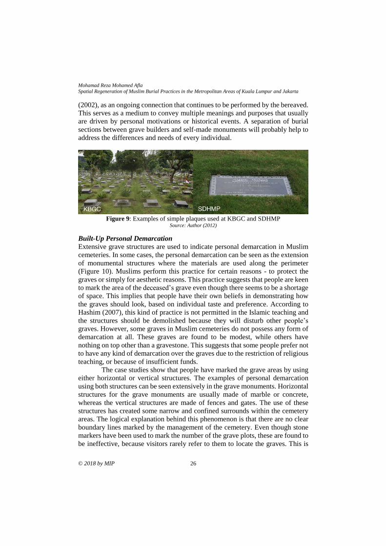
Figure 9: Examples of simple plaques used at KBGC and SDHMP Source: Author (2012)
Built-Up Personal Demarcation
Extensive grave structures are used to indicate personal demarcation in Muslim
cemeteries. In some cases, the personal demarcation can be seen as the extension
of monumental structures where the materials are used along the perimeter
(Figure 10). Muslims perform this practice for certain reasons - to protect the
graves or simply for aesthetic reasons. This practice suggests that people are keen
to mark the area of the deceased’s grave even though there seems to be a shortage
of space. This implies that people have their own beliefs in demonstrating how
the graves should look, based on individual taste and preference. According to
Hashim (2007), this kind of practice is not permitted in the Islamic teaching and
the structures should be demolished because they will disturb other people’s
graves. However, some graves in Muslim cemeteries do not possess any form of
demarcation at all. These graves are found to be modest, while others have
nothing on top other than a gravestone. This suggests that some people prefer not
to have any kind of demarcation over the graves due to the restriction of religious
teaching, or because of insufficient funds.
The case studies show that people have marked the grave areas by using
either horizontal or vertical structures. The examples of personal demarcation
using both structures can be seen extensively in the grave monuments. Horizontal
structures for the grave monuments are usually made of marble or concrete,
whereas the vertical structures are made of fences and gates. The use of these
structures has created some narrow and confined surrounds within the cemetery
areas. The logical explanation behind this phenomenon is that there are no clear
boundary lines marked by the management of the cemetery. Even though stone
markers have been used to mark the number of the grave plots, these are found to
be ineffective, because visitors rarely refer to them to locate the graves. This is

PLANNING MALAYSIA
Journal of the Malaysia Institute of Planners (2018)
27 © 2018 by MIP
because the stone markers are gradually disappearing from sight due to frequent
human activity at the graves. As a result, the stone markers become useless after
the gravestones have been erected. A clear marking of the grave plots should be
imposed to indicate certain space limitations as well as to enhance a sense of
ownership.
Figure 10: There are many forms of personal demarcation that have been encountered
during the site visits. The diagram on the left depicts some of the variations of built-up
personal demarcations. Pictures on the right show some of the actual structures found at
KLKMC and KBGC. Source: Author (2011,2012)
Random Planting
This is the part of the cemetery practice that deals with the softscape elements of
the sites. This planting of trees and shrubs is significant in Islamic funeral
tradition as a way to ease the suffering of the dead. It is not unusual to find Muslim
cemeteries colonised with plants as Muslims believe that the trees and shrubberies
are actually praying to the bodies inside the graves (Hashim, 2007). Random
plants are considered part of the natural elements. However, as plants and
shrubberies are the concern of cemetery patrons rather than the cemetery
administration, their proliferation naturally follows a random and haphazard form
(Figure 11). Plants have been used at Muslim cemeteries in Patani to serve as
temporary grave markers (Bougas, 1988). As explained by Bougas (1988: p. 65),
“In Aceh, trees were generally planted as temporary grave markers, and were later
replaced when proper tombstones were set. The Malays in Peninsular Malaysia
plant trees, side by side, with temporary wooden graves markers”. In Muslim
cemeteries, this interim role of the trees or shrubberies is still practiced.
Shrubberies or trees are added to new graves by the family members. These are
normally positioned at both ends of the grave, which is where the head and feet
are.
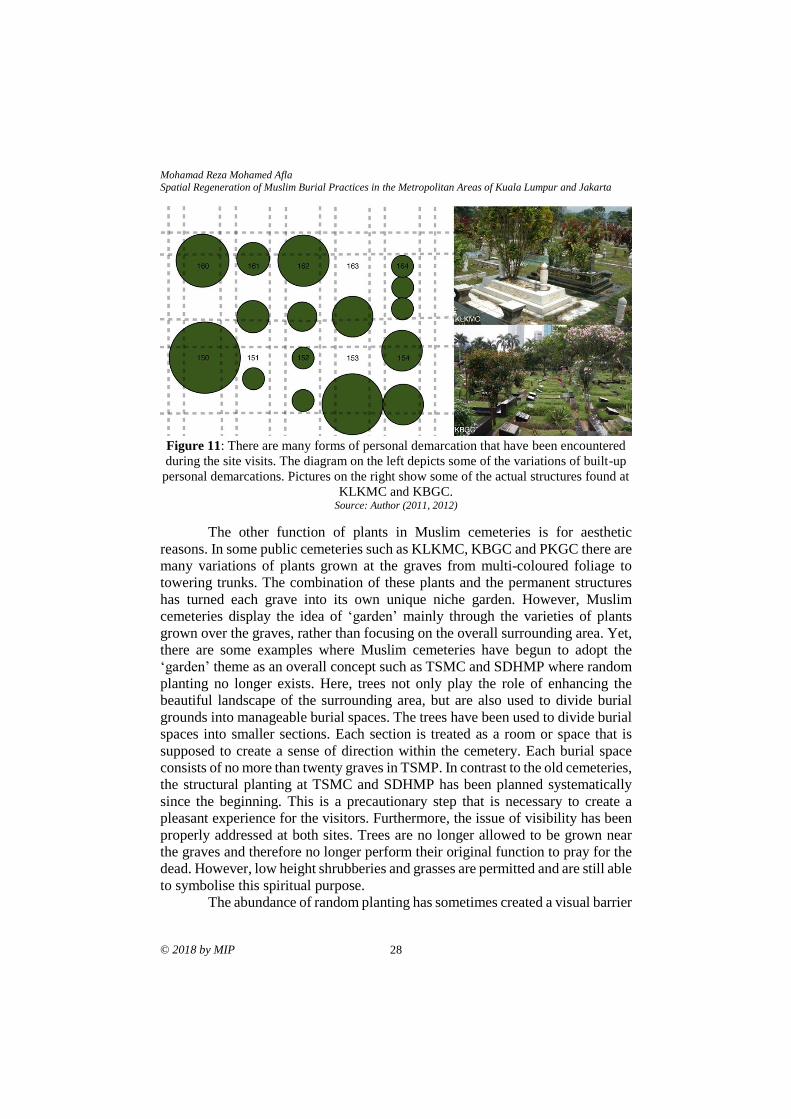
Mohamad Reza Mohamed Afla Spatial Regeneration of Muslim Burial Practices in the Metropolitan Areas of Kuala Lumpur and Jakarta
© 2018 by MIP 28
Figure 11: There are many forms of personal demarcation that have been encountered
during the site visits. The diagram on the left depicts some of the variations of built-up
personal demarcations. Pictures on the right show some of the actual structures found at
KLKMC and KBGC. Source: Author (2011, 2012)
The other function of plants in Muslim cemeteries is for aesthetic
reasons. In some public cemeteries such as KLKMC, KBGC and PKGC there are
many variations of plants grown at the graves from multi-coloured foliage to
towering trunks. The combination of these plants and the permanent structures
has turned each grave into its own unique niche garden. However, Muslim
cemeteries display the idea of ‘garden’ mainly through the varieties of plants
grown over the graves, rather than focusing on the overall surrounding area. Yet,
there are some examples where Muslim cemeteries have begun to adopt the
‘garden’ theme as an overall concept such as TSMC and SDHMP where random
planting no longer exists. Here, trees not only play the role of enhancing the
beautiful landscape of the surrounding area, but are also used to divide burial
grounds into manageable burial spaces. The trees have been used to divide burial
spaces into smaller sections. Each section is treated as a room or space that is
supposed to create a sense of direction within the cemetery. Each burial space
consists of no more than twenty graves in TSMP. In contrast to the old cemeteries,
the structural planting at TSMC and SDHMP has been planned systematically
since the beginning. This is a precautionary step that is necessary to create a
pleasant experience for the visitors. Furthermore, the issue of visibility has been
properly addressed at both sites. Trees are no longer allowed to be grown near
the graves and therefore no longer perform their original function to pray for the
dead. However, low height shrubberies and grasses are permitted and are still able
to symbolise this spiritual purpose.
The abundance of random planting has sometimes created a visual barrier
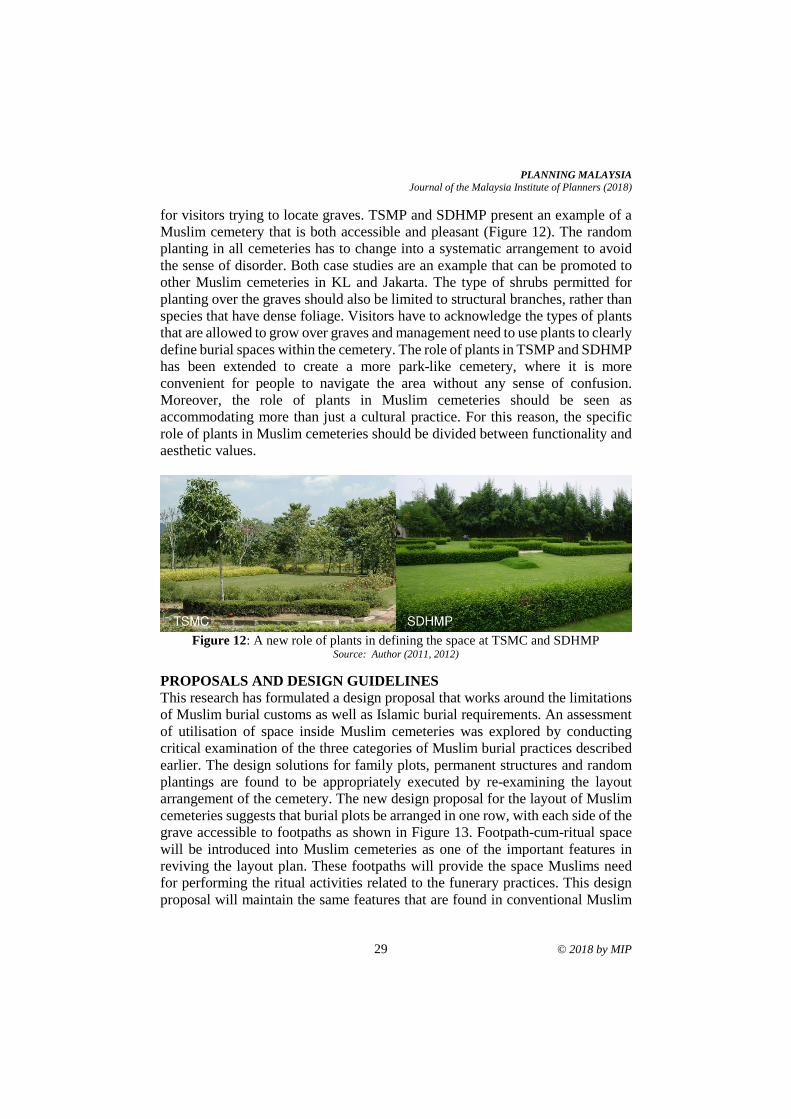
PLANNING MALAYSIA
Journal of the Malaysia Institute of Planners (2018)
29 © 2018 by MIP
for visitors trying to locate graves. TSMP and SDHMP present an example of a
Muslim cemetery that is both accessible and pleasant (Figure 12). The random
planting in all cemeteries has to change into a systematic arrangement to avoid
the sense of disorder. Both case studies are an example that can be promoted to
other Muslim cemeteries in KL and Jakarta. The type of shrubs permitted for
planting over the graves should also be limited to structural branches, rather than
species that have dense foliage. Visitors have to acknowledge the types of plants
that are allowed to grow over graves and management need to use plants to clearly
define burial spaces within the cemetery. The role of plants in TSMP and SDHMP
has been extended to create a more park-like cemetery, where it is more
convenient for people to navigate the area without any sense of confusion.
Moreover, the role of plants in Muslim cemeteries should be seen as
accommodating more than just a cultural practice. For this reason, the specific
role of plants in Muslim cemeteries should be divided between functionality and
aesthetic values.
Figure 12: A new role of plants in defining the space at TSMC and SDHMP
Source: Author (2011, 2012)
PROPOSALS AND DESIGN GUIDELINES
This research has formulated a design proposal that works around the limitations
of Muslim burial customs as well as Islamic burial requirements. An assessment
of utilisation of space inside Muslim cemeteries was explored by conducting
critical examination of the three categories of Muslim burial practices described
earlier. The design solutions for family plots, permanent structures and random
plantings are found to be appropriately executed by re-examining the layout
arrangement of the cemetery. The new design proposal for the layout of Muslim
cemeteries suggests that burial plots be arranged in one row, with each side of the
grave accessible to footpaths as shown in Figure 13. Footpath-cum-ritual space
will be introduced into Muslim cemeteries as one of the important features in
reviving the layout plan. These footpaths will provide the space Muslims need
for performing the ritual activities related to the funerary practices. This design
proposal will maintain the same features that are found in conventional Muslim
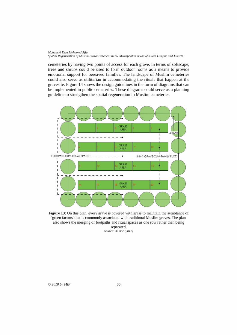
Mohamad Reza Mohamed Afla Spatial Regeneration of Muslim Burial Practices in the Metropolitan Areas of Kuala Lumpur and Jakarta
© 2018 by MIP 30
cemeteries by having two points of access for each grave. In terms of softscape,
trees and shrubs could be used to form outdoor rooms as a means to provide
emotional support for bereaved families. The landscape of Muslim cemeteries
could also serve as utilitarian in accommodating the rituals that happen at the
gravesite. Figure 14 shows the design guidelines in the form of diagrams that can
be implemented in public cemeteries. These diagrams could serve as a planning
guideline to strengthen the spatial regeneration in Muslim cemeteries.
Figure 13: On this plan, every grave is covered with grass to maintain the semblance of
'green factors' that is commonly associated with traditional Muslim graves. The plan
also shows the merging of footpaths and ritual spaces as one row rather than being
separated. Source: Author (2012)
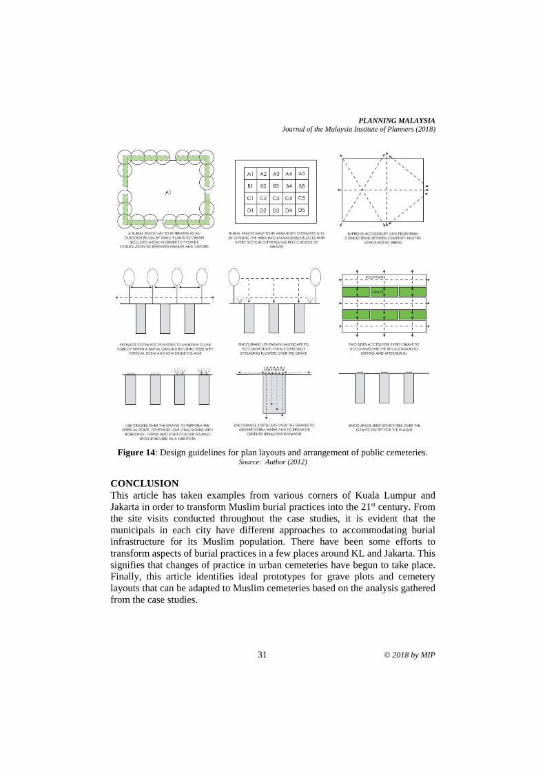
PLANNING MALAYSIA
Journal of the Malaysia Institute of Planners (2018)
31 © 2018 by MIP
Figure 14: Design guidelines for plan layouts and arrangement of public cemeteries.
Source: Author (2012)
CONCLUSION
This article has taken examples from various corners of Kuala Lumpur and
Jakarta in order to transform Muslim burial practices into the 21st century. From
the site visits conducted throughout the case studies, it is evident that the
municipals in each city have different approaches to accommodating burial
infrastructure for its Muslim population. There have been some efforts to
transform aspects of burial practices in a few places around KL and Jakarta. This
signifies that changes of practice in urban cemeteries have begun to take place.
Finally, this article identifies ideal prototypes for grave plots and cemetery
layouts that can be adapted to Muslim cemeteries based on the analysis gathered
from the case studies.
Mohamad Reza Mohamed Afla Spatial Regeneration of Muslim Burial Practices in the Metropolitan Areas of Kuala Lumpur and Jakarta
© 2018 by MIP 32
REFERENCES Bougas, W. A. (1988). Islamic cemeteries in Patani. Kuala Lumpur: The Malaysian
Historical Society.
Dafni, A., Lev, E., Beckmann, S., & Eichberger, C. (2006). Ritual plants of Muslim
graveyards in northern Israel. Journal of Ethnobiology and Ethnomedicine, 2,
38.
Doss, E. (2002). Death, art and memory in the public sphere: The visual and material
culture of grief in contemporary America. Mortality, 7, 63-82.
Ely, A., & Howe, M. (2002). Cemeteryscape. The Journal of the Institute of Burial &
Cremation Administration, Summer 2002. Retrieved from http://www.mae-
llp.co.uk/press/Citycemetery_essay.pdf
Forbes, D. K. (1996). Asian metropolis: Urbanisation and the Southeast Asian city.
Melbourne: Oxford University Press.
Francis, D. (2003). Cemeteries as cultural landscapes. Mortality, 8, 222-227.
Gibson, M. (2004). Melancholy objects. Mortality, 9, 285-299. Hallam, E., & Hockey, J. L. (2001). Death, memory, and material culture. Oxford: Berg.
Hamnett, S., & Forbes, D. K. (2011). Risks, resilience and planning in Asian cities. In S.
Hamnett, & D. K. Forbes (Eds.), Planning Asian cities: Risks and resilience (pp.
1-37). New York: Routledge.
Hashim, S. (2007). Kematian dan pengurusan jenazah [Death and funeral management].
Johor: Universiti Teknologi Malaysia.
Iqba, Z. (2011). McDonaldization, Islamic teachings, and funerary practices in Kuwait.
OMEGA, 63(1), 95-112.
Ismail, F. (2008). Muslim burial practices. The Journal of the Institute of Cemetery &
Crematorium Management, 76, 49-50.
Ismail, W. N. W., Arabi, F., Husini, E. M., Zolkifly, F. N. S., Darus, Z. M., Jaafar, N. H.
A., & Manaf, A. A. (2017). The establishment of Islamic dwelling principles for
the Malaysian communities. Advanced Science Letters, 23(7), 6289-6293.
Kurniawan, K. R. (2008, August). Marketing graves: Changing paradigm of a burial
ground from a city of death to a city of amusement in San Diego Hills Cemetery
in Cikarang West Java. ARTEPOLIS 2 International Conference and Workshop
on Creative Communities and the Making of Place. August 8-9, 2008, Bandung,
Indonesia.
Limited cemetery space prompts call to public to reuse graves (2011). The Jakarta Post.
Retrieved from http://www.thejakartapost.com/news/2002/07/13/limited-ceme-
tery-space-prompts-call- public-reuse-graves.html.
Nirmala, R., & Primanita, A. (2011). Jakarta’s grave need for green may be filled by
cemeteries. The Jakarta Globe. Retrieved from
http://www.thejakartaglobe.com/archive/jakartas- grave-need-for-green-may-
be-filled-by-cemeteries/346983/
No more space in Central Jakarta cemeteries (2011). The Jakarta Post. Retrieved from
http://www.thejakartapost.com/news/2011/03/12/no-more-space-c-jakarta-
cemeter- ies.html
Omer, S. (2008). Death, graveyards and funerary architecture in Islam. Kuala Lumpur:
AS Noordeen.

PLANNING MALAYSIA
Journal of the Malaysia Institute of Planners (2018)
33 © 2018 by MIP
Rahim, S. (2011). More Muslim cemetery plots. New Straits Times. Retrieved from
http://www.nst.com.my/life-times/health/more-muslim-cemetery-plots-1.9206
Rimmer, P. J., & Dick, H. W. (2009). The city in Southeast Asia: Patterns, processes and
policy. Honolulu: University of Hawaii Press.
Salim, W., & Firman, T. (2011). Governing the Jakarta city-region: history, challenges,
risks, and strategies. In S. Hamnett, & D. K. Forbes (Eds.), Planning Asian cities:
Risks and resilience (pp. 241–259). New York: Routledge.
Uslu, A., Baris, E., & Erdogan, E. (2009). Ecological concerns over cemeteries. African
Journal of Agricultural Research, 4, 1505-1511
Received: 1st June 2018. Accepted:1st December 2018
2 Senior Lecturer at University Sains Malaysia. Email: [email protected] 34
PLANNING MALAYSIA:
Journal of the Malaysian Institute of Planners
VOLUME 16 ISSUE 4 (2018), Page 34 – 39
THE IMPACT OF LYNAS ADVANCED MATERIAL
PLANT (LAMP) TOWARDS SURROUNDING HOUSING
MARKET PRICE
Muhammad Ikmal Ariff Azmee1 & Atasya Osmadi2
1&2School of Housing, Building and Planning
UNIVERSITI SAINS MALAYSIA
Abstract
Lynas Advanced Materials Plant (LAMP) is situated in Gebeng industrial estate
in Kuantan, Malaysia. Lynas plant processes rare earth elements that was trucked
from Mt Weld Western Australia’s mine site to Fremantle Port and then brought
to Malaysia. Rare elements are important in greenhouse emission reduction
especially for their distinctive use in wind turbines, hybrid vehicles, automotive
chemical action converters and others technologies. However, the construction
and the opening of Lynas plant may have caused pollution to the environment
and health risk towards surrounding area. Few case studies highlighted the
negative impacts of radioactive element towards the surrounding housing market
price. Using before-and-after analysis and sensitivity analysis, this research seeks
to evaluate the impact from Lynas plant on the price of housing (single storey
terrace) in its surrounding area. The findings show that Lynas plant could be one
of the factors that have affected the housing market price in the area. This research
concludes that, in general, there is an increase of house price after the opening of
Lynas plant, however it is evident that there is a trend of increasing house price
when the house is farther away from the plant. It is hoped that the findings of this
research helps in answering some of the public speculations regarding the impact
of the plant.
Keywords: impact, Lynas, house, price
PLANNING MALAYSIA
Journal of the Malaysia Institute of Planners (2018)
35 © 2018 by MIP
INTRODUCTION
Previous research have studied the impact of pollution or radioactive to the
surrounding housing market price. Nelson (1981) observed the impact of
residential property values, which resulted from the Three Mile Island (TMI)
nuclear tragedy. According to him, although there are two government reports
stated that the nuclear tragedy have caused losses in property values, more so
residential properties closest to the plant, neither report utilised elementary
statistical inference methods. Nelson’s objective was to find out whether the
nuclear tragedy caused a statistically decline in house price, which located inside
a five miles radius from the plant. Nelson used an indulgent value model called
hedonic model to look at the impact of TMI on sale costs of homes in two
communities within the radius. Analysis on property values close to the TMI
nuclear energy facility indicated that once the accident occurred, there was a brief
term call on the quantity of sales of residences within ten miles from the plant.
However, sales returned to normal within four to eight weeks. Hence, this proves
that nuclear plant does bring impact to surrounding property market.
In the 1980s, the Asian Rare Earth (ARE) company, owned by the
Mitsubishi Chemical Company, did not safely remove its industrial waste
containing radioactive thorium hydroxide. Employees and also the neighbouring
community were exposed to ionising radiation, leading to birth defects and
cancer, especially leukaemia cases, among the 11,000 individuals living in Bukit
Merah and Papan, Perak. Seven of the eight cases of cancer were fatal. Public
protests eventually forced Mitsubishi Chemical to shut its operations in 1992. The
clean-up had cost the company about US$100 million (McCoy, 2013). Although
the ARE case was not focussed on the impact of the rare earth plant on property
value, it does show that such plant poses negative impact on the surrounding
community. In the case of ARE, the area turned hazardous and not suitable for
people to be living in.
In Gebeng, Kuantan, a rare earth plant was constructed and operated by
Lynas Malaysian Sdn Bhd. However, property values do not seem to be affected
by the plant existence. Property development remains active and this shows the
confidence of the investors and entrepreneurs within the property sector and
economic climate in Pahang, significantly in Kuantan (“Lynas tidak jejas nilai
hartanah”, 2012). In keeping with the report of the Pahang Property Valuation
Department, the value of low-cost terrace homes in Jalan 10 Gambang has
increased from RM49,000 to RM68,000 per unit, as well as for three storey shop
houses in Jalan Beserah from RM700,000 to RM800,000 per unit (Husin, 2012).
Additionally, the Lynas plant was also said to have attracted investments in
various industries as well as offers more job opportunities, maximise the uses of
Kuantan Port, together with native residents who are benefitting the spill-over of
current economic impacts (Bernama, 2016). This proves that the existence of the
Lynas plant brings positive impact towards the value of surrounding property.
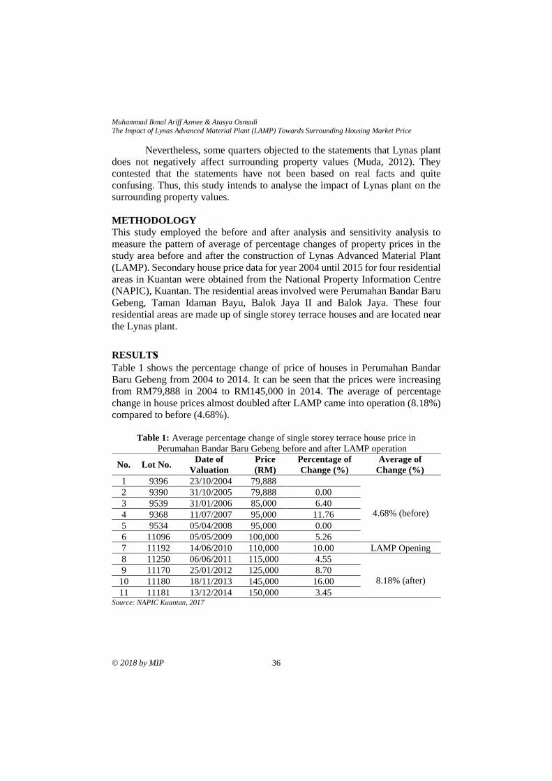
Muhammad Ikmal Ariff Azmee & Atasya Osmadi
The Impact of Lynas Advanced Material Plant (LAMP) Towards Surrounding Housing Market Price
© 2018 by MIP 36
Nevertheless, some quarters objected to the statements that Lynas plant
does not negatively affect surrounding property values (Muda, 2012). They
contested that the statements have not been based on real facts and quite
confusing. Thus, this study intends to analyse the impact of Lynas plant on the
surrounding property values.
METHODOLOGY
This study employed the before and after analysis and sensitivity analysis to
measure the pattern of average of percentage changes of property prices in the
study area before and after the construction of Lynas Advanced Material Plant
(LAMP). Secondary house price data for year 2004 until 2015 for four residential
areas in Kuantan were obtained from the National Property Information Centre
(NAPIC), Kuantan. The residential areas involved were Perumahan Bandar Baru
Gebeng, Taman Idaman Bayu, Balok Jaya II and Balok Jaya. These four
residential areas are made up of single storey terrace houses and are located near
the Lynas plant.
RESULTs
Table 1 shows the percentage change of price of houses in Perumahan Bandar
Baru Gebeng from 2004 to 2014. It can be seen that the prices were increasing
from RM79,888 in 2004 to RM145,000 in 2014. The average of percentage
change in house prices almost doubled after LAMP came into operation (8.18%)
compared to before (4.68%).
Table 1: Average percentage change of single storey terrace house price in
Perumahan Bandar Baru Gebeng before and after LAMP operation
No. Lot No. Date of
Valuation
Price
(RM)
Percentage of
Change (%)
Average of
Change (%)
1 9396 23/10/2004 79,888
4.68% (before)
2 9390 31/10/2005 79,888 0.00
3 9539 31/01/2006 85,000 6.40
4 9368 11/07/2007 95,000 11.76
5 9534 05/04/2008 95,000 0.00
6 11096 05/05/2009 100,000 5.26
7 11192 14/06/2010 110,000 10.00 LAMP Opening
8 11250 06/06/2011 115,000 4.55
8.18% (after) 9 11170 25/01/2012 125,000 8.70
10 11180 18/11/2013 145,000 16.00
11 11181 13/12/2014 150,000 3.45 Source: NAPIC Kuantan, 2017
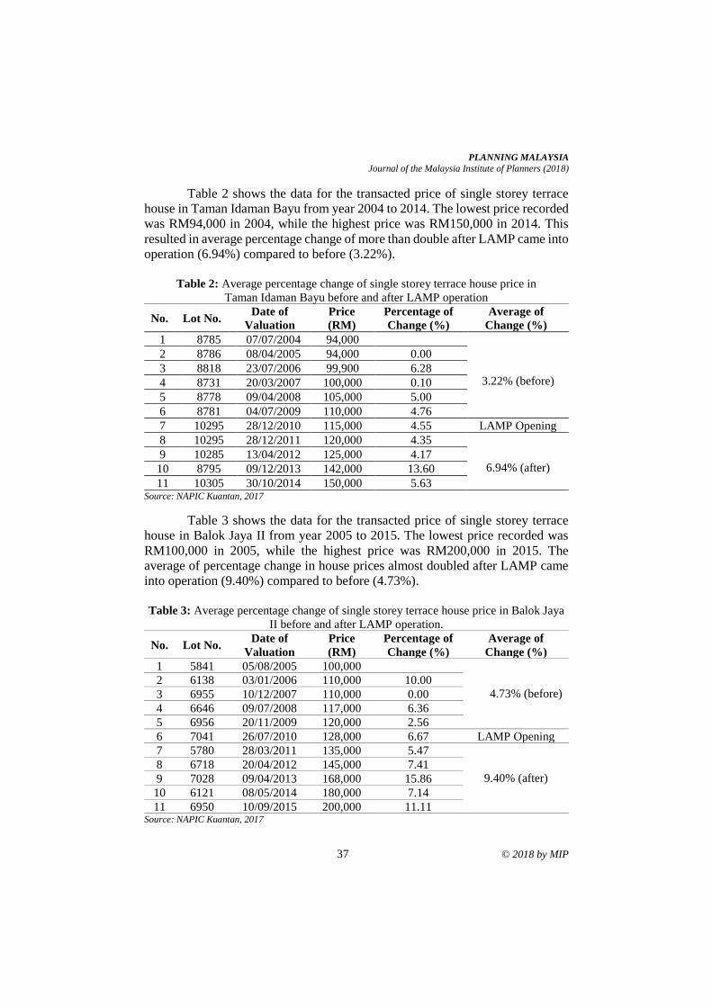
PLANNING MALAYSIA
Journal of the Malaysia Institute of Planners (2018)
37 © 2018 by MIP
Table 2 shows the data for the transacted price of single storey terrace
house in Taman Idaman Bayu from year 2004 to 2014. The lowest price recorded
was RM94,000 in 2004, while the highest price was RM150,000 in 2014. This
resulted in average percentage change of more than double after LAMP came into
operation (6.94%) compared to before (3.22%).
Table 2: Average percentage change of single storey terrace house price in
Taman Idaman Bayu before and after LAMP operation
No. Lot No. Date of
Valuation
Price
(RM)
Percentage of
Change (%)
Average of
Change (%)
1 8785 07/07/2004 94,000
3.22% (before)
2 8786 08/04/2005 94,000 0.00
3 8818 23/07/2006 99,900 6.28
4 8731 20/03/2007 100,000 0.10
5 8778 09/04/2008 105,000 5.00
6 8781 04/07/2009 110,000 4.76
7 10295 28/12/2010 115,000 4.55 LAMP Opening
8 10295 28/12/2011 120,000 4.35
6.94% (after) 9 10285 13/04/2012 125,000 4.17
10 8795 09/12/2013 142,000 13.60
11 10305 30/10/2014 150,000 5.63 Source: NAPIC Kuantan, 2017
Table 3 shows the data for the transacted price of single storey terrace
house in Balok Jaya II from year 2005 to 2015. The lowest price recorded was
RM100,000 in 2005, while the highest price was RM200,000 in 2015. The
average of percentage change in house prices almost doubled after LAMP came
into operation (9.40%) compared to before (4.73%).
Table 3: Average percentage change of single storey terrace house price in Balok Jaya
II before and after LAMP operation.
No. Lot No. Date of
Valuation
Price
(RM)
Percentage of
Change (%)
Average of
Change (%)
1 5841 05/08/2005 100,000
4.73% (before) 2 6138 03/01/2006 110,000 10.00
3 6955 10/12/2007 110,000 0.00
4 6646 09/07/2008 117,000 6.36
5 6956 20/11/2009 120,000 2.56
6 7041 26/07/2010 128,000 6.67 LAMP Opening
7 5780 28/03/2011 135,000 5.47
9.40% (after) 8 6718 20/04/2012 145,000 7.41
9 7028 09/04/2013 168,000 15.86
10 6121 08/05/2014 180,000 7.14
11 6950 10/09/2015 200,000 11.11 Source: NAPIC Kuantan, 2017

Muhammad Ikmal Ariff Azmee & Atasya Osmadi
The Impact of Lynas Advanced Material Plant (LAMP) Towards Surrounding Housing Market Price
© 2018 by MIP 38
Table 4 shows the data for the transacted price of single storey terrace
house in Balok Jaya from year 2005 to 2014. The lowest price recorded was
RM95,000 in 2005, while the highest price was RM200,000 in 2014. This
resulted in average percentage change of 12.98% after LAMP came into
operation compared to 8.42% before LAMP.
Table 4: Average percentage change of single storey terrace house price in Balok Jaya
before and after LAMP operation
No. Lot No. Date of
Valuation
Price
(RM)
Percentage of
Change (%)
Average of
Change (%)
1 4065 05/11/2005 95,000
8.42% (before) 2 4058 16/03/2006 98,000 3.16
3 4064 13/12/2007 96,000 -2.04
4 4074 12/08/2008 115,000 19.79
5 4096 26/04/2009 125,000 8.70
6 4035 13/05/2010 125,000 0.00 LAMP Opening
7 4056 19/12/2011 125,000 0.00
12.98% (after) 8 4092 19/11/2012 160,000 28.00
9 4054 07/01/2013 170,000 6.25
10 4040 05/09/2014 200,000 17.65 Source: NAPIC Kuantan, 2017
Meanwhile, Table 5 compares the average percentage change of house
prices in the four residential areas based on their distance from LAMP. In terms
of distance, among the four selected residential areas, the nearest to LAMP is
Perumahan Baru Gebeng, which is located only 8km from the plant. The farthest
is Balok Jay, which is 14km away from the plant.
Table 5: The Average percentage Change of House Price Based on Distance from
LAMP
Period Average Percentage Change
8km 12km 13km 14km
Perumahan
Baru Gebeng
Taman Idaman
Bayu Balok Jaya II Balok Jaya
Before
LAMP 4.68% 3.22% 4.73% 8.42%
After
LAMP 8.18% 6.94% 9.40% 12.98%
Percentage
increase 3.5% 3.72% 4.67% 4.56%
PLANNING MALAYSIA
Journal of the Malaysia Institute of Planners (2018)
39 © 2018 by MIP
From Table 5, it can be seen that the residential areas farther from LAMP
experienced higher percentage increase in their housing prices compared to those
located closer to LAMP.
CONCLUSION
The findings from this research indicate that the construction and operation of
LAMP do not negatively affect the house prices in its surrounding area. Despite
mixed speculations on the impacts of LAMP, the housing prices in its surrounding
have been increasing steadily even after LAMP came into operation. This could
partly be due to the economic benefits the plant brought to the area. Previous
research on impacts of nuclear facilities on property values by Bezdek and
Wendling (2006) found that establishment of nuclear facilities has led to increase
in property values and that the facilities also provided job opportunities to
surrounding communities.
However, there is a strong pattern shown in Table 5 where, although all
four residential areas continue to experience house price increase after LAMP
came into operation, the biggest increase happened in residential areas farther
from the plant.
REFERENCES Bernama (2016, July 28). Lynas operation safe, generates only low-level radiation, says
minister. Retrieved from https://www.malaysiakini.com/news/350292
Bezdek, R. H., & Wendling, R. M. (2006). The impacts of nuclear facilities on property
values and other factors in surrounding communities. International Journal of
Nuclear Governance, Economy and Ecology, 1(1), 122-145.
Husin, N. N. (2012, March 27). Lynas project has not affected Kuantan market. Retrieved
from https://www.thestar.com.my/news/nation/2012/03/27/lynas-project-has-
not-affected-kuantan-market/#ZImpzkegS6fLrvPg.99.
Lynas tidak jejas nilai hartanah. (2012). Retrieved from
http://ww1.kosmo.com.my/kosmo/content.asp?y=2012&dt=0327&pub=Kosm
o&sec=Negara&pg=ne_07.htm
McCoy, R. (2013, March 9). Launch of report on the description and critical
environmental evaluation of the Lynas Advanced Materials Plant in Gebeng,
Pahang. Retrieved from http://mpsr.org/wp/2013/03/09/report-on-lynas-
environmental-hazard/
Muda, M. N. (2012). PKR tuntut MB beri fakta nilai hartanah melonjak kerana Lynas.
Retrieved from http://www.freemalaysiatoday.com
National Property Information Center, Kuantan (2017). Property Reports.
Nelson, J. P. (1981). Three Mile Island and residential property values: Empirical analysis
and policy implications. Land Economics, 57(3), 363-372
Received: 1st June 2018. Accepted:1st December 2018
1 Postgraduate Student at Universiti Sains Malaysia. Email: [email protected] 40
PLANNING MALAYSIA:
Journal of the Malaysian Institute of Planners
VOLUME 16 ISSUE 4 (2018), Page 40 – 54
THE EVOLUTION OF HISTORIC WATERFRONT:
A CASE STUDY OF GEORGE TOWN, PENANG
Nurbaidura Salim1 & Badaruddin Mohamed2
1&2School of Housing, Building and Planning
UNIVERSITI SAINS MALAYSIA
Abstract
Waterfront development emerged as one of the important issues of urban design
and planning since it provides an opportunity to improve social well-being,
economic development and physical setting of a city. In recent decades, many
waterfronts have experienced reorientation from brownfield to commercial,
residential and recreational areas. Many early cities are located close to water
bodies due to water being a form of transportation. However, the advancement of
modern infrastructures such as roadways and increased modes of transportation
has moved the central business district into inner lands. This has left many old
city centres suffering economic depression, losing their local identity as people
moved to other places, and eventually facing abandonment. In this case, tourism
is seen as a panacea to help revitalizing those areas. This paper seeks to address
the evolution of historic waterfront at World Heritage Sites in Malaysia, from the
perspective of tourism development. By using evolutionary analysis based on
previous resources and maps, it demonstrates that government development
agencies and tourism development have been the key agents of change in
influencing waterfront redevelopment.
Keywords: waterfront development, waterfront revitalization, tourism
development, World Heritage Site, Malaysia
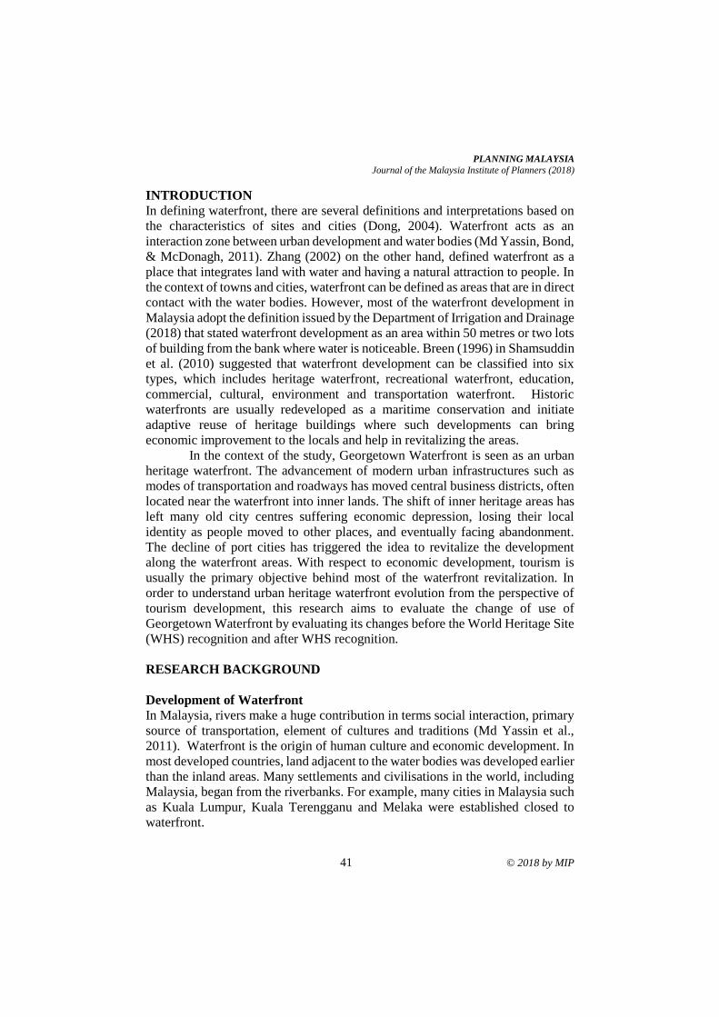
PLANNING MALAYSIA
Journal of the Malaysia Institute of Planners (2018)
41 © 2018 by MIP
INTRODUCTION
In defining waterfront, there are several definitions and interpretations based on
the characteristics of sites and cities (Dong, 2004). Waterfront acts as an
interaction zone between urban development and water bodies (Md Yassin, Bond,
& McDonagh, 2011). Zhang (2002) on the other hand, defined waterfront as a
place that integrates land with water and having a natural attraction to people. In
the context of towns and cities, waterfront can be defined as areas that are in direct
contact with the water bodies. However, most of the waterfront development in
Malaysia adopt the definition issued by the Department of Irrigation and Drainage
(2018) that stated waterfront development as an area within 50 metres or two lots
of building from the bank where water is noticeable. Breen (1996) in Shamsuddin
et al. (2010) suggested that waterfront development can be classified into six
types, which includes heritage waterfront, recreational waterfront, education,
commercial, cultural, environment and transportation waterfront. Historic
waterfronts are usually redeveloped as a maritime conservation and initiate
adaptive reuse of heritage buildings where such developments can bring
economic improvement to the locals and help in revitalizing the areas.
In the context of the study, Georgetown Waterfront is seen as an urban
heritage waterfront. The advancement of modern urban infrastructures such as
modes of transportation and roadways has moved central business districts, often
located near the waterfront into inner lands. The shift of inner heritage areas has
left many old city centres suffering economic depression, losing their local
identity as people moved to other places, and eventually facing abandonment.
The decline of port cities has triggered the idea to revitalize the development
along the waterfront areas. With respect to economic development, tourism is
usually the primary objective behind most of the waterfront revitalization. In
order to understand urban heritage waterfront evolution from the perspective of
tourism development, this research aims to evaluate the change of use of
Georgetown Waterfront by evaluating its changes before the World Heritage Site
(WHS) recognition and after WHS recognition.
RESEARCH BACKGROUND
Development of Waterfront
In Malaysia, rivers make a huge contribution in terms social interaction, primary
source of transportation, element of cultures and traditions (Md Yassin et al.,
2011). Waterfront is the origin of human culture and economic development. In
most developed countries, land adjacent to the water bodies was developed earlier
than the inland areas. Many settlements and civilisations in the world, including
Malaysia, began from the riverbanks. For example, many cities in Malaysia such
as Kuala Lumpur, Kuala Terengganu and Melaka were established closed to
waterfront.
Nurbaidura Salim & Badaruddin Mohamed
The Evolution of Historic Waterfront: A Case Study of George Town, Penang
© 2018 by MIP 42
The rise and fall of many cities were related to transportation. During the
early days, the villages expanded and became a port of trade among locals. In the
industrial era, the trade ports became container ports. The old ports became the
new waterfront appearance. Such development represents the diversity of
waterfront uses and its importance to waterfront community and commercial
activities (Chen, 2015). Due to the advancements during the Industrial
Revolution, many industrial cities were located near the sea. Chen (2015)
revealed that waterfront redevelopment is driven by the industry transformation,
where the port cities served as centres to export resources and as sites for
industrial manufacturing.
Waterfront ports and service centres began to emerge in Southeast Asia
in the coastal areas and river mouth locations (Khan & Idid, 2016). As time goes
by, some were transformed into successful cities while others have declined. Han
and Beisi (2016) discovered that development of waterfronts can be divided into
four stages in chronological order (Figure 1). During the emerging period, early
cities near the coastal and river locations established due to the foreign trading
between Western and East Asian regions. During this period, the cities were
located between two ancient civilizations, namely China and India. These cities
witnessed the land use changes and exchange of commodities. Ports, markets,
warehouses and whole settlements became hierarchically distributed from the
coastline.
During the early colonial period, the waterfronts functioned as
international trade and attracted European traders. The prosperous colonial
described the colonial administrative buildings were usually based in a fort. The
modern or transitional period has been an era of independence. Most of historical
buildings have been transformed into commercial structures. Some have been
demolished and lost their former activities, while others have been transformed
into modern commercial buildings.
Figure 1: Four phases of waterfront development
Source: Han & Beisi (2016)
Phase 1:
The Emerging
Period
Phase 2:
The Early
Colonial Period
Phase 3:
The Prosperous
Period
Phase 4:
The Modern
Period
PLANNING MALAYSIA
Journal of the Malaysia Institute of Planners (2018)
43 © 2018 by MIP
Since the decline of waterfront in post-industrial cities, the idea of
waterfront redevelopment has become a global trend (Chen, 2015; Hussein, 2006;
Xie & Gu, 2015). Waterfront redevelopment started to emerge in 1960s, where
waterfronts acted as a planning tool that consisted of different plans and processes
aimed to transform abandoned areas of post-industrial cities. According to
Kostopoulou (2013), there have been intense efforts to redesign abandoned
waterfront in the second half of the 20th century. The redevelopment of waterfront
has become the symbol of significant transformation, economic growth, and great
potential to attract foreign investment and improve declining local
economies. Many waterfront cities nowadays are motivated by the idea of
bringing back the water to cities and creating a high-quality environment with
vibrant mix of activities and buildings. Responding to widespread
deindustrialisation, expansion of service economy and perception of tourism as a
panacea to revitalise urban cores, many different port cities progressively
incorporated tourism activities in their waterfront redevelopment projects. Some
good examples can be observed at Tokyo Waterfront City (Japan) (Jinnai, 2016),
Singapore Waterfront (Chang & Huang, 2005), Baltimore Waterfront (United
States) (Kostopoulou, 2013) and many others.
Tourism as a Tool for Waterfront Redevelopment
In the latter half of the 20th century, waterfront started to become recognised as
an important feature of urban development and revitalization. At the time, most
of the cities had to experience consequences due to the economic growth and fast
development of technology, resulting to a decline of waterfront (Adamietz,
2012). Rather than abandoning the waterfronts to decay and neglect, some
countries have taken extra measure to preserve and suggest adaptive reuse of the
waterfronts. The growth of service economy and the perspective that tourism
would result in urban revitalization, have driven different port cities to integrate
tourism activities into historic waterfront redevelopment (Kostopoulou, 2013;
Xie & Gu, 2011). The increasing competition between cities improved the urban
image as many cities rebranded their image of post-industrial cities on
waterfronts. The intervention of tourism on waterfronts became an opportunity to
improve the physical, social and economic condition of a city.
In Singapore for example, the initiative by its former prime minister, Mr.
Lee Kuan Yew in 1977 to initiate a clean-up of Singapore river to be developed
as a tourism focal point has made its waterfront setting a liveable one. The river
used to face environmental hazard due to squatter activities (Goh, 2007). The
process of improvement and cleaning up the river took 10 years and had cost the
government $170 million (Choo, 2014). Revitalization project of the river
provided alternative places for the people who live at the river bank as the
Ministry of Environment in Singapore resettled around 26,000 families into
residential flats, more than 2,800 industrial enterprises into industrial state built
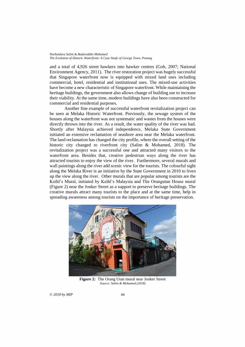
Nurbaidura Salim & Badaruddin Mohamed
The Evolution of Historic Waterfront: A Case Study of George Town, Penang
© 2018 by MIP 44
and a total of 4,926 street hawkers into hawker centres (Goh, 2007; National
Environment Agency, 2011). The river restoration project was hugely successful
that Singapore waterfront now is equipped with mixed land uses including
commercial, hotel, residential and institutional uses. The mixed-use activities
have become a new characteristic of Singapore waterfront. While maintaining the
heritage buildings, the government also allows change of building use to increase
their viability. At the same time, modern buildings have also been constructed for
commercial and residential purposes.
Another fine example of successful waterfront revitalization project can
be seen at Melaka Historic Waterfront. Previously, the sewage system of the
houses along the waterfront was not systematic and wastes from the houses were
directly thrown into the river. As a result, the water quality of the river was bad.
Shortly after Malaysia achieved independence, Melaka State Government
initiated an extensive reclamation of seashore area near the Melaka waterfront.
The land reclamation has changed the city profile, where the overall setting of the
historic city changed to riverfront city (Salim & Mohamed, 2018). The
revitalization project was a successful one and attracted many visitors to the
waterfront area. Besides that, creative pedestrian ways along the river has
attracted tourists to enjoy the view of the river. Furthermore, several murals and
wall paintings along the river add scenic view for the tourists. The colourful sight
along the Melaka River is an initiative by the State Government in 2010 to liven
up the view along the river. Other murals that are popular among tourists are the
Keihl’s Mural, initiated by Keihl’s Malaysia and The Orangutan House mural
(Figure 2) near the Jonker Street as a support to preserve heritage buildings. The
creative murals attract many tourists to the place and at the same time, help in
spreading awareness among tourists on the importance of heritage preservation.
Figure 2: The Orang Utan mural near Jonker Street
Source: Salim & Mohamed (2018)
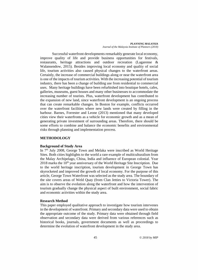
PLANNING MALAYSIA
Journal of the Malaysia Institute of Planners (2018)
45 © 2018 by MIP
Successful waterfront developments remarkably generate local economy,
improve quality of life and provide business opportunities for festivals,
restaurants, heritage attractions and outdoor recreation (Lagarense &
Walansendow, 2015). Besides improving local economy and quality of social
life, tourism activities also caused physical changes to the waterfront areas.
Certainly, the increase of commercial buildings along or near the waterfront area
is one of the impacts of tourism activities. With the increasing potential of tourism
industry, there has been a change of building use from residential to commercial
uses. Many heritage buildings have been refurbished into boutique hotels, cafes,
galleries, museums, guest houses and many other businesses to accommodate the
increasing number of tourists. Plus, waterfront development has contributed to
the expansion of new land, since waterfront development is an ongoing process
that can create remarkable changes. In Boston for example, conflicts occurred
over the waterfront facilities where new lands were created by filling in the
harbour. Barnes, Forrester and Leone (2013) mentioned that many developed
cities view their waterfronts as a vehicle for economic growth and as a mean of
generating private investment of surrounding areas. Therefore, there should be
some efforts to combine and balance the economic benefits and environmental
risks through planning and implementation process.
METHODOLOGY
Background of Study Area
In 7th July 2008, George Town and Melaka were inscribed as World Heritage
Sites. Both cities highlights to the world a rare example of multiculturalism from
the Malay Archipelago, China, India and influence of European colonial. Year
2018 marks the 10th year anniversary of the World Heritage Site Inscription. Due
to the world heritage inscription, tourism development in George Town has
skyrocketed and improved the growth of local economy. For the purpose of this
article, George Town Waterfront was selected as the study area. The boundary of
the site covers areas of Weld Quay (from Clan Jetties to Victoria Tower). The
aim is to observe the evolution along the waterfront and how the intervention of
tourism gradually change the physical aspect of built environment, social fabric
and economic activities within the study area.
Research Method
This paper employed qualitative approach to investigate how tourism intervenes
in the development of waterfront. Primary and secondary data were used to obtain
the appropriate outcome of the study. Primary data were obtained through field
observation and secondary data were derived from various references such as
historical books, journals, government documents as well as proceedings to
determine the evolution of waterfront development in the study area.
Nurbaidura Salim & Badaruddin Mohamed
The Evolution of Historic Waterfront: A Case Study of George Town, Penang
© 2018 by MIP 46
For field observation, direct observation is employed and any changes in
urban tourism planning on the streets and heritage buildings at the waterfront area
are studied. Building inventory consists of building use is recorded to identify the
variation of urban forms. Meanwhile, pictorial data were derived from various
references such as historical books, journals, government documents, collections
from related agencies and then compared with the current development. This step
is important to see the development changes and also to identify the change of
building use.
ANALYSIS
The presentation of research findings begins with a brief introduction of
waterfront evolution along the Weld Quay and how its development slowly
changed the urban form of the waterfront. It then continues with the identification
of impacts of commodification based on the literature review mentioned earlier
in this paper. This process is important to evaluate how tourism development have
affected the facade and use of the adjacent buildings.
Evolution of the Waterfront
Evolution of George Town began in 1786, where the development of George
Town was focused along the Weld Quay waterfront. Since water was the main
transportation mode, port activities were busy, and the waterfront was a well-
known trading centre for regional and international merchants. During 1811 until
1820, there was no major change along the waterfront area. The development of
shophouses, residential areas, Masjid Lebuh Acheh and administrative buildings
created an urban form of George Town. In 1821, the urbanization of George
Town continued to spread towards the inner city as more administrative buildings
were built. In late 19th century, George Town experienced a scarcity of land for
development. This situation had led to the idea of large-scale land reclamation
that pushed the shoreline outward, creating a new land for construction of
godowns between Beach Street and Weld Quay. Godowns were probably the first
buildings seen along the coastline looking from the ship to the shore. The
godowns were designed to speed up godown work and reduce as much as possible
the human workload. Nowadays, some of the remaining godowns have been
transformed into creative hubs such as café, residence home as well as community
hall.
Early Development of the Waterfront (1786-1811)
Fort Cornwallis was built, and street networks were full of people from different
races. Back in 1800, the development of George Town grew inwards the city and
settlement area known as Lebuh Acheh. The first Masjid Acheh was built near
the Malay settlement and the distribution of the settlement took place when the
late Francis Light began to introduce the village for international trading
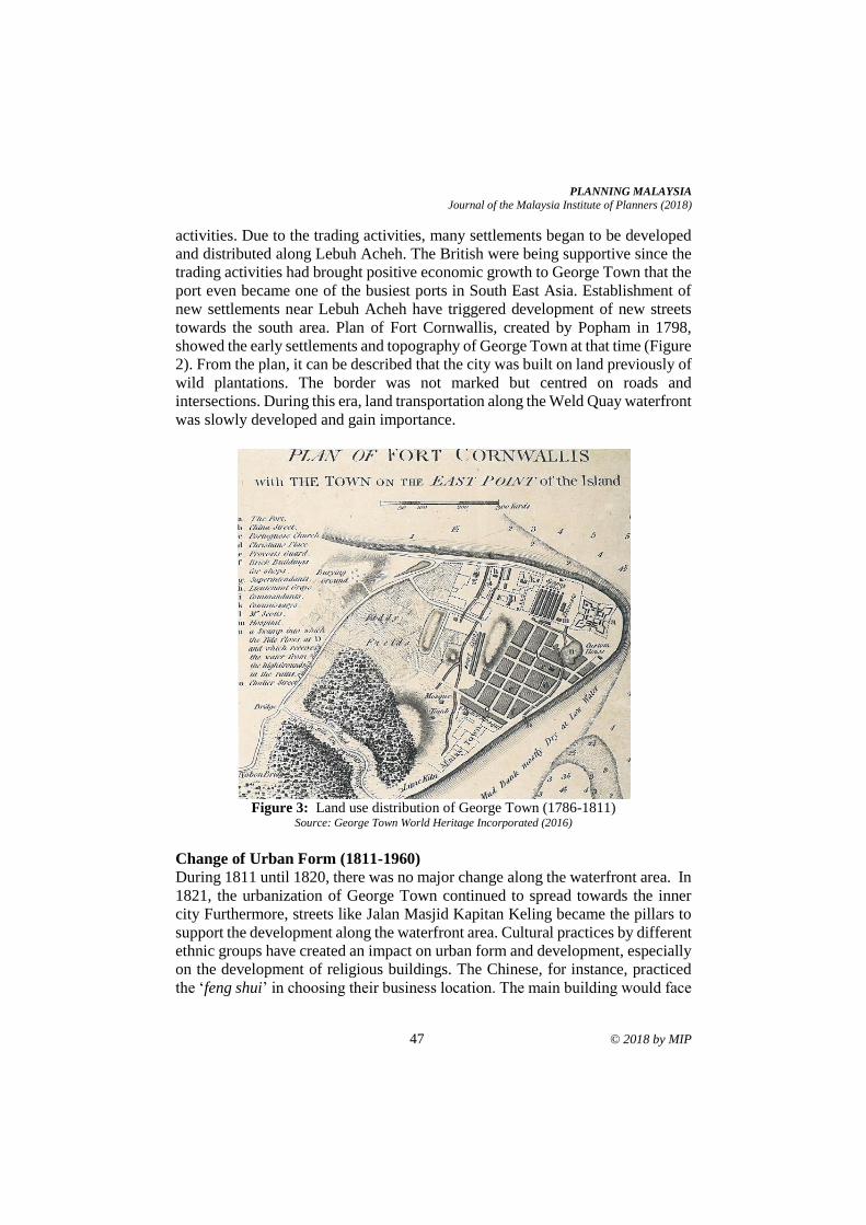
PLANNING MALAYSIA
Journal of the Malaysia Institute of Planners (2018)
47 © 2018 by MIP
activities. Due to the trading activities, many settlements began to be developed
and distributed along Lebuh Acheh. The British were being supportive since the
trading activities had brought positive economic growth to George Town that the
port even became one of the busiest ports in South East Asia. Establishment of
new settlements near Lebuh Acheh have triggered development of new streets
towards the south area. Plan of Fort Cornwallis, created by Popham in 1798,
showed the early settlements and topography of George Town at that time (Figure
2). From the plan, it can be described that the city was built on land previously of
wild plantations. The border was not marked but centred on roads and
intersections. During this era, land transportation along the Weld Quay waterfront
was slowly developed and gain importance.
Figure 3: Land use distribution of George Town (1786-1811)
Source: George Town World Heritage Incorporated (2016)
Change of Urban Form (1811-1960)
During 1811 until 1820, there was no major change along the waterfront area. In
1821, the urbanization of George Town continued to spread towards the inner
city Furthermore, streets like Jalan Masjid Kapitan Keling became the pillars to
support the development along the waterfront area. Cultural practices by different
ethnic groups have created an impact on urban form and development, especially
on the development of religious buildings. The Chinese, for instance, practiced
the ‘feng shui’ in choosing their business location. The main building would face
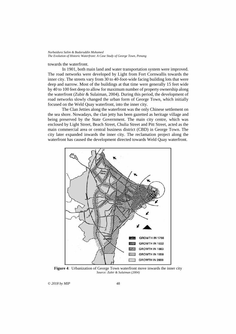
Nurbaidura Salim & Badaruddin Mohamed
The Evolution of Historic Waterfront: A Case Study of George Town, Penang
© 2018 by MIP 48
towards the waterfront.
In 1901, both main land and water transportation system were improved.
The road networks were developed by Light from Fort Cornwallis towards the
inner city. The streets vary from 30 to 40-foot-wide facing building lots that were
deep and narrow. Most of the buildings at that time were generally 15 feet wide
by 40 to 100 feet deep to allow for maximum number of property ownership along
the waterfront (Zubir & Sulaiman, 2004). During this period, the development of
road networks slowly changed the urban form of George Town, which initially
focused on the Weld Quay waterfront, into the inner city.
The Clan Jetties along the waterfront was the only Chinese settlement on
the sea shore. Nowadays, the clan jetty has been gazetted as heritage village and
being preserved by the State Government. The main city centre, which was
enclosed by Light Street, Beach Street, Chulia Street and Pitt Street, acted as the
main commercial area or central business district (CBD) in George Town. The
city later expanded inwards the inner city. The reclamation project along the
waterfront has caused the development directed towards Weld Quay waterfront.
Figure 4: Urbanization of George Town waterfront move inwards the inner city
Source: Zubir & Sulaiman (2004)
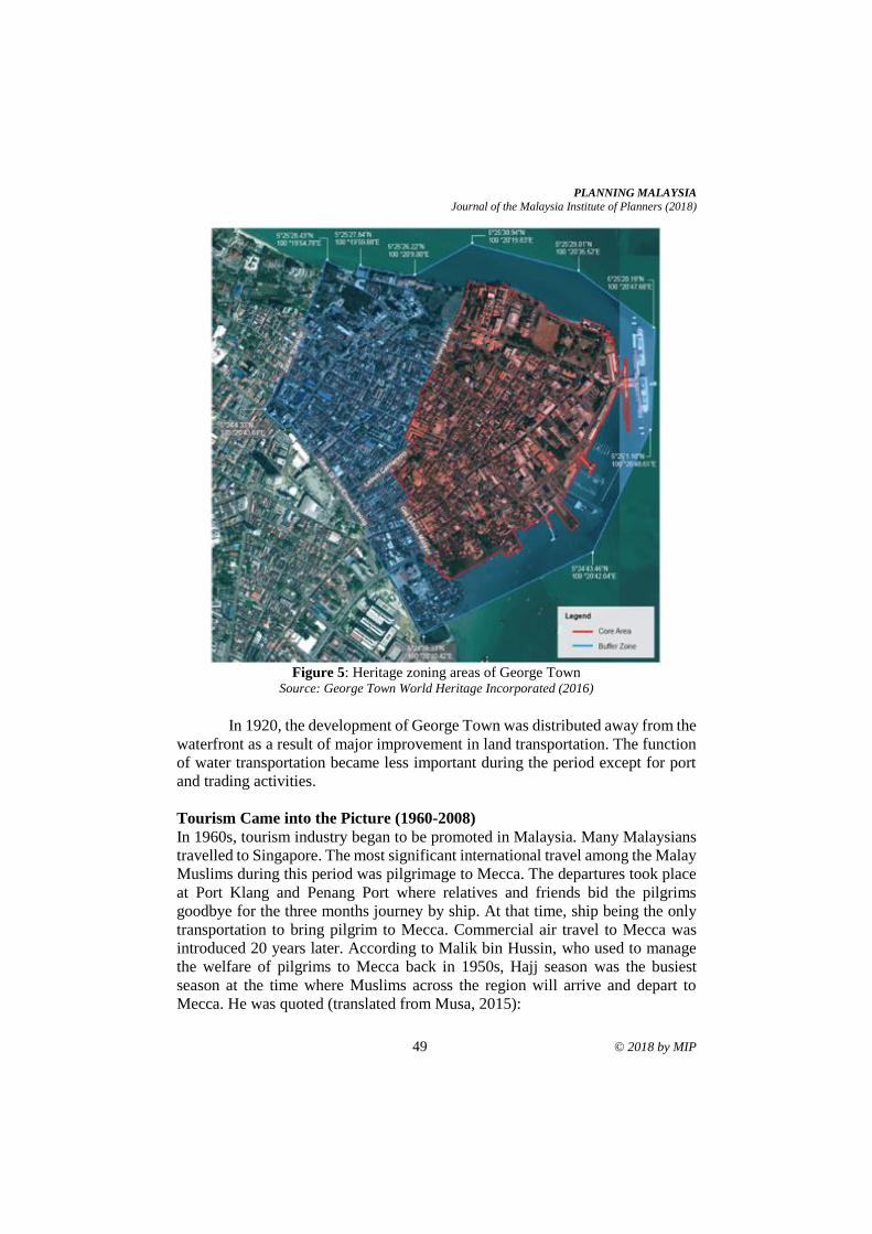
PLANNING MALAYSIA
Journal of the Malaysia Institute of Planners (2018)
49 © 2018 by MIP
Figure 5: Heritage zoning areas of George Town
Source: George Town World Heritage Incorporated (2016)
In 1920, the development of George Town was distributed away from the
waterfront as a result of major improvement in land transportation. The function
of water transportation became less important during the period except for port
and trading activities.
Tourism Came into the Picture (1960-2008)
In 1960s, tourism industry began to be promoted in Malaysia. Many Malaysians
travelled to Singapore. The most significant international travel among the Malay
Muslims during this period was pilgrimage to Mecca. The departures took place
at Port Klang and Penang Port where relatives and friends bid the pilgrims
goodbye for the three months journey by ship. At that time, ship being the only
transportation to bring pilgrim to Mecca. Commercial air travel to Mecca was
introduced 20 years later. According to Malik bin Hussin, who used to manage
the welfare of pilgrims to Mecca back in 1950s, Hajj season was the busiest
season at the time where Muslims across the region will arrive and depart to
Mecca. He was quoted (translated from Musa, 2015):
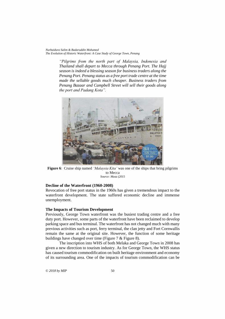
Nurbaidura Salim & Badaruddin Mohamed
The Evolution of Historic Waterfront: A Case Study of George Town, Penang
© 2018 by MIP 50
“Pilgrims from the north part of Malaysia, Indonesia and
Thailand shall depart to Mecca through Penang Port. The Hajj
season is indeed a blessing season for business traders along the
Penang Port. Penang status as a free port trade centre at the time
made the sellable goods much cheaper. Business traders from
Penang Bazaar and Campbell Street will sell their goods along
the port and Padang Kota”.
Figure 6: Cruise ship named ‘Malaysia Kita’ was one of the ships that bring pilgrims
to Mecca Source: Musa (2015
Decline of the Waterfront (1960-2008)
Revocation of free port status in the 1960s has given a tremendous impact to the
waterfront development. The state suffered economic decline and immense
unemployment.
The Impacts of Tourism Development
Previously, George Town waterfront was the busiest trading centre and a free
duty port. However, some parts of the waterfront have been reclaimed to develop
parking space and bus terminal. The waterfront has not changed much with many
previous activities such as port, ferry terminal, the clan jetty and Fort Cornwallis
remain the same at the original site. However, the function of some heritage
buildings have changed over time (Figure 7 & Figure 8).
The inscription into WHS of both Melaka and George Town in 2008 has
given a new direction to tourism industry. As for George Town, the WHS status
has caused tourism commodification on built heritage environment and economy
of its surrounding area. One of the impacts of tourism commodification can be
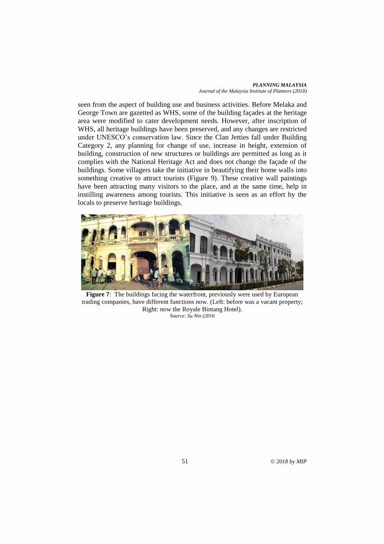
PLANNING MALAYSIA
Journal of the Malaysia Institute of Planners (2018)
51 © 2018 by MIP
seen from the aspect of building use and business activities. Before Melaka and
George Town are gazetted as WHS, some of the building façades at the heritage
area were modified to cater development needs. However, after inscription of
WHS, all heritage buildings have been preserved, and any changes are restricted
under UNESCO’s conservation law. Since the Clan Jetties fall under Building
Category 2, any planning for change of use, increase in height, extension of
building, construction of new structures or buildings are permitted as long as it
complies with the National Heritage Act and does not change the façade of the
buildings. Some villagers take the initiative in beautifying their home walls into
something creative to attract tourists (Figure 9). These creative wall paintings
have been attracting many visitors to the place, and at the same time, help in
instilling awareness among tourists. This initiative is seen as an effort by the
locals to preserve heritage buildings.
Figure 7: The buildings facing the waterfront, previously were used by European
trading companies, have different functions now. (Left: before was a vacant property;
Right: now the Royale Bintang Hotel). Source: Su Nin (2016
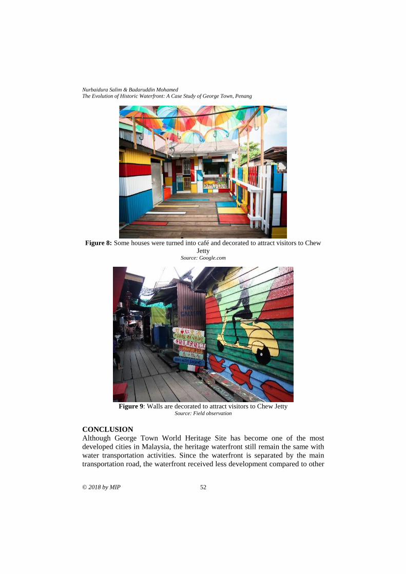
Nurbaidura Salim & Badaruddin Mohamed
The Evolution of Historic Waterfront: A Case Study of George Town, Penang
© 2018 by MIP 52
Figure 8: Some houses were turned into café and decorated to attract visitors to Chew
Jetty Source: Google.com
Figure 9: Walls are decorated to attract visitors to Chew Jetty
Source: Field observation
CONCLUSION
Although George Town World Heritage Site has become one of the most
developed cities in Malaysia, the heritage waterfront still remain the same with
water transportation activities. Since the waterfront is separated by the main
transportation road, the waterfront received less development compared to other

PLANNING MALAYSIA
Journal of the Malaysia Institute of Planners (2018)
53 © 2018 by MIP
parts of the heritage city. At the same time, most of the incentives and
development plans significantly focus on the development of the city centre. The
waterfront still remain detached from the development of city centre. Therefore,
strategic guidelines and effective development strategies are needed to help
redevelop the historic waterfront. One of the important strategies to develop the
waterfront is to include public participation during decision-making process and
seeking authentic heritage roots.
ACKNOWLEDGEMENT
This project was funded through the research grant obtained from the Ministry of
Higher Education, Malaysia under the Transdisciplinary Research Grant Scheme
2016 [TRGS grant no: 203.PPBGN.67611002].
REFERENCES Adamietz, J. (2012). Urban tourism and waterfronts: Exploring the case of the Auckland
waterfront development (Master’s thesis). Auckland University of Technology,
Auckland, New Zealand.
Barnes, M., Forrester, S., & Leone, M. (2013). A city looks to its past to discover its
future: A retrospective case study examining the evolution of an artificial white-
water river development. Managing Leisure, 18(1), 16-30.
Chang, T. C., & Huang, S. (2005). Recreating place, replacing memory: Creative
destruction at the Singapore River. Asia Pacific Viewpoint, 46(3), 267-280.
doi:10.1111/j.1467-8373.2005.00285.x
Chen, C.-H. (2015). The analysis of sustainable waterfront development strategy - The
case of Keelung Port City. International Journal of Environmental Protection
and Policy, 3(3), 65-78. doi:10.11648/j.ijepp.20150303.12
Choo, F. (2014, July 5). 5 interesting facts about the Singapore River clean-up. The Straits
Times.
Department of Irrigation and Drainage (2018). Guideline for the development related to
river and reserve. Retrieved from
https://www.water.gov.my/index.php/pages/view/587?mid=270
Dong, L. (2004). Waterfront Development: A case study of Dalian, China (Master thesis).
University of Waterloo, Ontario, Canada.
George Town World Heritage Incorporated (2016). George Town World Heritage Site
Special Area Plan. Penang: Author.
Goh, M. (2007). Singapore's waterfront rejuvenation efforts. Harbour Business Forum
Luncheon. Hong Kong.
Han, W., & Beisi, J. (2016). Urban morphology of commercial port cities and shophouses
in Southeast Asia. Procedia Engineering, 142, 190-197.
doi:10.1016/j.proeng.2016.02.031
Hussein, H. (2006). Urban recreational riverfronts: Successful revitalisation elements.
Journal of Design and Built Environment, 2(1), 1-14.
Jinnai, H. (2016). The landscape of Tokyo as a city on the water - Past and present. In H.
Porfyriou & M. Sepe (Eds.), Waterfronts revisited: European ports in a historic
and global perspective (pp. 266). United Kingdom: Routledge.
Nurbaidura Salim & Badaruddin Mohamed
The Evolution of Historic Waterfront: A Case Study of George Town, Penang
© 2018 by MIP 54
Khan, M., & Idid, S. Z. A. (2016). From trade routes to streets cultures - An overview of
the significance and characteristics of Southeast Asian traditional streets.
Planning Malaysia, 4(Special Issue), 31-44.
Kostopoulou, S. (2013). On the revitalized waterfront: Creative milieu for creative
tourism. Sustainability, 5(11), 4578-4593. doi:10.3390/su5114578
Lagarense, B. E. S., & Walansendow, A. (2015). Exploring residents' perceptions and
participation on tourism and waterfront development: The case of Manado
waterfront development in Indonesia. Asia Pacific Journal of Tourism Research,
20(2), 223-237.
Md Yassin, A., Bond, S., & McDonagh, J. (2011). Waterfront development in Malaysia:
Do we have sustainable governance? Pacific Rim Property Research Journal,
17(3), 336-356. doi:10.1080/14445921.2011.11104338
Musa, M. (2015). Memori di George Town. George Town, Penang: George Town World
Heritage Incorporated.
National Environment Agency (2011). Singapore river clean-up: Against the odds.
Envision, 15-17.
Salim, N., & Mohamed, B. (2018). The physical impacts of tourism development at
Melaka Historic Waterfront, Malaysia. In M. H. Nguyen, B. Mohamed, A. T.
Bang, & T. C. Luong (Eds.), International tourism development in Vietnam and
Malaysia: Issues and directions. Ho Chi Minh City: Vietnam National
University-Ho Chi Minh City Press.
Shamsuddin, S., Sulaiman, A. B., Alias, N. A., Abdul Latip, N. S., Ujang, N., Chelliapan,
S., & Azlan, N. A. (2010, April). Regeneration of the historical waterfront of
World Heritage Sites in Malaysia: The case of Georgetown and Melaka. UK
Ireland Planning Research Conference. April 7-9, 2010, Essex, United
Kingdom.
Su Nin, K. (2016). The changing harbour front. Penang Monthly. Retrieved from
https://penangmonthly.com/article.aspx?pageid=2569&name=the_changing_ha
rbour_front
Xie, P. F., & Gu, K. (2015). The changing urban morphology: Waterfront redevelopment
and event tourism in New Zealand. Tourism Management Perspectives, 15, 105-
114.
Zhang, L. (2002). An evaluation of urban riverfront park, Riverfront Park, Spokane,
Washington: Experiences and lessons for designers (Master’s thesis).
Washington State University, USA.
Zubir, S. S., & Sulaiman, W. A. (2004). Deciphering urban cultural heritage,
community and the city. In N. Marchettini, C. A. Brebbia, E. Tiezzi, & L. C.
Wadhwa (Eds.), The Sustainable City III: Urban regeneration and
sustainability. Southampton: WIT Press.
Received: 1st June 2018. Accepted:1st December 2018
1 Lecturer at Universiti Sains Malaysia. Email: [email protected] 55
PLANNING MALAYSIA:
Journal of the Malaysian Institute of Planners
VOLUME 16 ISSUE 4 (2018), Page 55 – 67
EARLY TOWN PLANNING SYSTEM OF SMALL TOWNS IN PERAK
Mohd Jaki Mamat1 & Muhammad Firzan Abdul Aziz2
1&2School of Housing Building and Planning
UNIVERSITI SAINS MALAYSIA
Abstract
The township planning in Perak was affected post-signing of the Pangkor Treaty
in 1874, as the state became the first state in Malaysian Peninsula intervened by
the British. Introduction of grid system by the British has apparently affected the
early layout of major cities such as Ipoh, Taiping, Kuala Lumpur, George Town
and Singapore. This study attempts to investigate the theory of town planning
during the British era after noticing a knowledge gap in regard to early town
planning system of small towns in Perak. Based on purposive sampling using
varying topographies as the criterion of site selection, 10 out of 20 small towns
in Perak were selected for data collection. The small towns were Kuala Kurau,
Klian Intan, Bagan Datoh, Lumut, Parit, Tanjung Rambutan, Pusing, Sungkai,
Padang Rengas and Lenggong. Besides measured drawings, interviews were
conducted with the locals and historical manuscripts of the research locale were
also revisited. Based on comparative analysis, the study found that topographical
factor was insignificant in influencing the early layout of small towns in Perak
since linear system was used at different topographical background (riverside,
coastal, hilly terrain and flatland areas). Moreover, location factor was found to
be significant in terms of influencing the arrangement of early shophouse
buildings into rows, which influenced the early layout of small towns in Perak.
Keywords: linear system, shophouses, small towns
Mohd Jaki Mamat & Muhammad Firzan Abdul Aziz Early Town Planning System of Small Towns in Perak
© 2018 by MIP 56
INTRODUCTION
Perak was the first state in the Malaysian Peninsula intervened by the British after
the signing of Pangkor Treaty in 1874. Ever since, the formation of several towns
in Perak started to appear as a consequence of the state’s socioeconomic and
physical development. Reportedly during the early physical development of
Perak, formation of small towns (that emerged from the arrangement and
concentration of shophouse buildings into rows) has brought upon health and
safety issues (Home, 1997; Nasution & Lubis, 2005). Sensitising the scenario,
application of grid system at the affected sites or exploration and development of
nearby areas were advocated by the British as the town re-planning measures
(Nasution & Lubis, 2005; Wan Mokhtar, 2016).
Historically, the English Town Planning Act 1932 and the British
Planning Legislation 1932 were the two influential guidelines regulated by the
British with regard to town planning in Malaysia (Home, 1997; Garnaut, 2004).
Owing to that, the grid system was then introduced and implemented, which
affected the planning of early Malaysian cities such as Ipoh, Taiping and Teluk
Intan of Perak (Yuen, 2011; Wee, Yoon, & Guan, 2014) as well as the capital
city, Kuala Lumpur (Garnaut, 2004). Despite the policy enforcement, the
underlying factor which caused several small towns in Perak remain unaffected
in terms of their physical layout was presumably due to their average economic
expansion. Acknowledging so, this paper emphasises the needs of conducting an
empirical investigation on the early small towns in Perak through their rows of
shophouse buildings which is regarded as the main element of town formation
(Symonds, 2005). Analysis of their layout pattern and topographical correlation
are deemed imperative especially when shophouse buildings are ethos from the
past. Evidently, they still bear the heritage value of old township formation
despite facing serious threats arising from modern development pressure, urban
dereliction and high deterioration rate (Bissel, 2005; Wee et al., 2014).
EARLY TOWN PLANNING
In the past, places of religious and worshipping practices as well as residences of
local community leaders have been commonly associated with the genesis of a
township or traditional settlements (Lewandowski, 1975; Harun & Jalil, 2012;
Abidin, Shahminan & Ibrahim, 2017). Later in the 19th Century, concentration of
populations and settlements shifted to places which carried out economic
activities (Lockard, 1974; Ortolano, 2011). Formation of small towns then
became more rampant after the influx of Chinese immigrants into the Malay
Peninsula, catalysed by the Chinese merchants who actively constructed business
premises and shophouses to cater their economic agenda (Lockard, 1974).
Apparently, their buildings were built either in close proximity, or, within the
existing settlements of the Malays’ community (Wan Ali, Abdul Hadi, & Ishak,
2015; Samsudin & Idid, 2016). This development trend clearly differs with the
PLANNING MALAYSIA
Journal of the Malaysia Institute of Planners (2018)
57 © 2018 by MIP
formation of early towns during the British years - in which their planning
considerations did not emphasise on the significance of community factor (Yuen,
2011). Instead, the British was more concerned with safety and administration
issues (Mizushima, 1997; Taylor, 2010) over business and trading activities
(Garnaut, 2004; Mamat, 2016). Meanwhile in Perak, the British was more
concerned with safety aspect for small towns located in distance with the state’s
main cities (Tilaki, Abdullah, Bahauddin, & Marzbali, 2014; Mamat, 2014;
Mamat, 2016).
Theoretically, the physical layout of townships or cities is dependent on
various factors, mainly including the local economic activities (Larkham, &
Lilley, 2012) involving business centres (Wan Ali et al., 2015), agricultural
products (Syed Zainol, 1995), shipping ports (Lewandowski, 1975; Hassan,
2009; Harun & Jalil, 2012) and also land transportations such as railway and
traffic networks (Ibrahim et al., 2014). Implying from that, these locations
typically turned to be the focal points of their respective localities (Yuen, 2011).
On the other facet, topographical condition was known to be influential towards
a town’s form and layout (Lockard, 1974; Mohd, Ahmad, & Wan Abd Aziz,
2009; Shamsuddin, 2011).
In the case of Perak specifically, its town formation was also influenced
by the state’s natural resources and its transportation network (Ortolano, 2011;
Symonds, 2005). Most of the towns in Perak are associable with the state’s tin
mining industry, as evidenced through its infrastructural developments such as
shophouses, administration offices, labourer’s residence, roads and so on
(Ahmad, 2013). The policy enforced in regard to town formation upon the British
arrival in Malay Peninsula was in line with Town Planning Enactment 1923
(Garnaut, 2004) and Town Planning Act 1932 (Taylor, 2010) - to address the
issues of safety as well as divide and rule policy (Home, 1997; Njoh, 2008).
Despite the implementation of the two legislations by the British, involvements
of their town planners and architects happened only after the localities reached
the states of stability and safety (Hassan, 2009). In essence, town formations in
Malay Peninsula occurred primarily due to the business activities and commercial
relationships between the Chinese merchants and the local Malays (Ahmad,
2013; Wan Ali et al., 2015; Mamat, 2016). This interrelationship has indirectly
influenced the physical layout of Perak townships, as seen in the rows of
shophouses built on the land owned by the Malays for instance (Mizushima,
1997).
The report of the Town Profile in Perak issued by the Federal Department
of Town & Country Planning Peninsular Malaysia in 2009 showed that the
layouts of early towns and cities of Perak such as Ipoh, Sitiawan, Kuala Kangsar,
Sungai Siput, Taiping and Teluk Intan were based on linear and grid systems.
Implying from this, the report can be leveraged as a point of reference to study
the early town planning system of small towns in Perak. The report finding is in

Mohd Jaki Mamat & Muhammad Firzan Abdul Aziz Early Town Planning System of Small Towns in Perak
© 2018 by MIP 58
tune with Haverfield’s (1913) assertion that most towns or cities initially were
formed either by a straight or curvy lines (depending on the sites’ topographical
condition), which later merged with each other. Those lines typically were in
parallel, or taking into accounts of the layout of the existing settlements
(Lewandowski, 1975). This is in line with Taylor (2010) who posited that the
evolvement of a township is commonly based on the offset of its settlements’
arrangement in the forms of centralised, linear and etc. In this manner, groups of
shophouse that row along streets eventually led to the formation of a town
(Garnaut, 2004).
Most of the architectural design and built of shophouse buildings found
in Perak originated from the mainland of China (Shamsuddin, 2011). With main
road as their frontage and back lane at their rear side, the rows of shophouse
basically correspond to the linear town planning system (Wan Ali et al., 2015).
This is in contrast with the British town planning concept in the use of grid system
which emphasised segregation of land based on their functions such as
administration, commercial, residential (Hassan, 2005; Shamsuddin, 2011),
recreational (Bissell, 2005; Harun & Jalil, 2012) and logistical (Ibrahim et al.,
2014) zones. Besides facilitating the conurbation process (Harun & Jalil, 2012),
implementation of the grid system also supported the divide and rule policy
applied by the British, especially for the purpose of social segregation based on
race and status (Bissell, 2005; Hassan, 2009).
Based on the literature review, it is found that the early layout of towns
or cities was influenced by their respective existing settlements. Apart from that,
other influential factors include land topologies, economic activities and logistics.
Only after the British arrival, town planning approach in Perak has shifted to the
grid system following the land segregation and zoning purposes. This historical
fact is thus imperative as point of reference to further understand the early small
town planning system through data collection conducted at 10 selected small
towns in Perak.
METHODOLOGY
Measured drawing was used as a methodological means in the present study to
identify and record the early layout of small towns in Perak. Using topographical
factor as the criterion of purposive sampling, 10 small towns were selected from
the total of 20 small towns available in Perak. Topographical characteristics
involved in the study include riverside, coastal, hilly terrain and flat land areas.
The small towns selected are namely Bagan Datoh, Lumut, Klian Intan, Kuala
Kurau, Parit, Tanjung Rambutan, Lenggong, Pusing, Padang Rengas and
Sungkai. Past manuscripts and writings were used to validate the early row of
shophouses. However, studies on small towns were sparsely carried out relative
to the numbers of documentations done on major cities. This is considerably a
limitation of the current study.
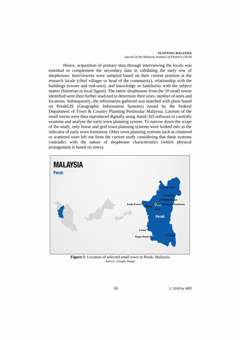
PLANNING MALAYSIA
Journal of the Malaysia Institute of Planners (2018)
59 © 2018 by MIP
Hence, acquisition of primary data through interviewing the locals was
essential to complement the secondary data in validating the early row of
shophouses. Interviewees were sampled based on their current position at the
research locale (chief villager or head of the community), relationship with the
buildings (owner and end-user), and knowledge or familiarity with the subject
matter (historian or local figure). The entire shophouses from the 10 small towns
identified were then further analysed to determine their sizes, number of units and
locations. Subsequently, the information gathered was matched with plans based
on PerakGIS (Geographic Information Systems) issued by the Federal
Department of Town & Country Planning Peninsular Malaysia. Layouts of the
small towns were then reproduced digitally using AutoCAD software to carefully
examine and analyse the early town planning system. To narrow down the scope
of the study, only linear and grid town planning systems were looked into as the
indicator of early town formation. Other town planning systems such as clustered
or scattered were left out from the current study considering that these systems
contradict with the nature of shophouse characteristics (which physical
arrangement is based on rows).
Figure 1: Location of selected small town in Perak, Malaysia
Source: Google Image
• Klian Intan
• Lenggong
• Padang Rengas
Kuala Kurau •
Bagan Datoh •
• Sungkai
• Parit
• Tangjung Rambutan Pusing •
Lumut •
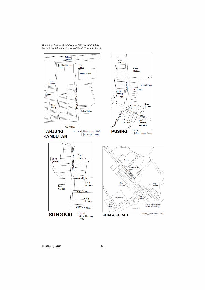
Mohd Jaki Mamat & Muhammad Firzan Abdul Aziz Early Town Planning System of Small Towns in Perak
© 2018 by MIP 60
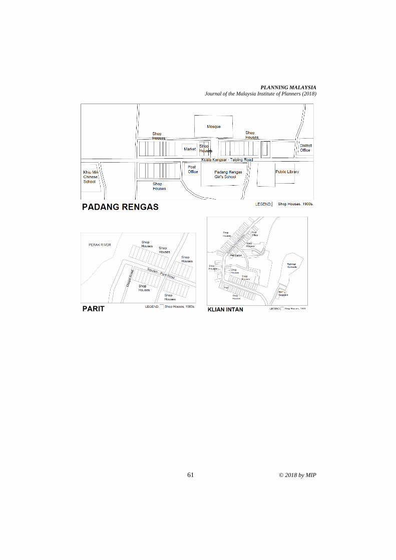
PLANNING MALAYSIA
Journal of the Malaysia Institute of Planners (2018)
61 © 2018 by MIP
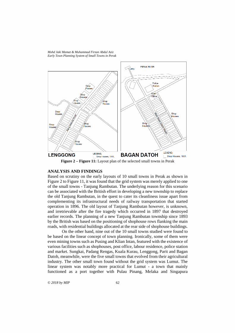
Mohd Jaki Mamat & Muhammad Firzan Abdul Aziz Early Town Planning System of Small Towns in Perak
© 2018 by MIP 62
Figure 2 – Figure 11: Layout plan of the selected small towns in Perak
ANALYSIS AND FINDINGS
Based on scrutiny on the early layouts of 10 small towns in Perak as shown in
Figure 2 to Figure 11, it was found that the grid system was merely applied to one
of the small towns - Tanjung Rambutan. The underlying reason for this scenario
can be associated with the British effort in developing a new township to replace
the old Tanjung Rambutan, in the quest to cater its cleanliness issue apart from
complementing its infrastructural needs of railway transportation that started
operation in 1896. The old layout of Tanjung Rambutan however, is unknown,
and irretrievable after the fire tragedy which occurred in 1897 that destroyed
earlier records. The planning of a new Tanjung Rambutan township since 1893
by the British was based on the positioning of shophouse rows flanking the main
roads, with residential buildings allocated at the rear side of shophouse buildings.
On the other hand, nine out of the 10 small towns studied were found to
be based on the linear concept of town planning. Ironically, some of them were
even mining towns such as Pusing and Klian Intan, featured with the existence of
various facilities such as shophouses, post office, labour residence, police station
and market. Sungkai, Padang Rengas, Kuala Kurau, Lenggong, Parit and Bagan
Datoh, meanwhile, were the five small towns that evolved from their agricultural
industry. The other small town found without the grid system was Lumut. The
linear system was notably more practical for Lumut - a town that mainly
functioned as a port together with Pulau Pinang, Melaka and Singapura
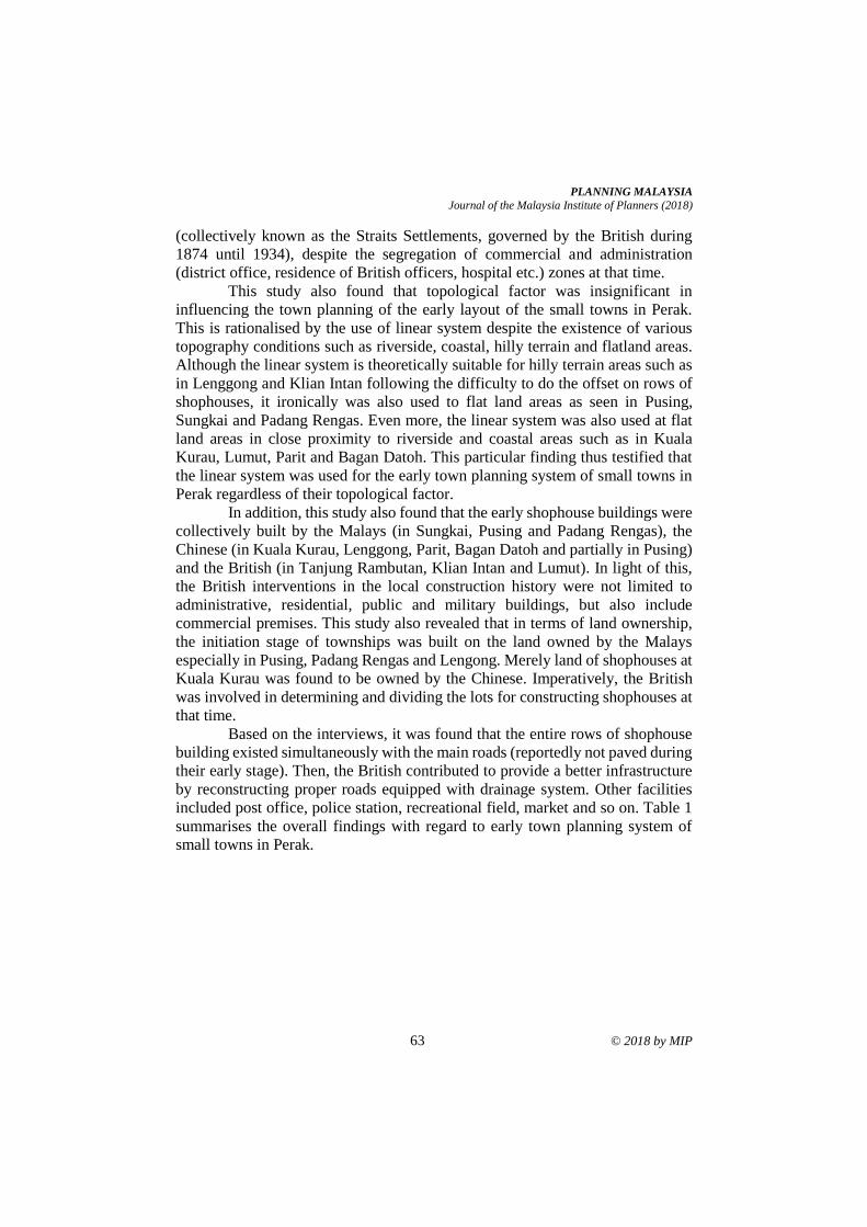
PLANNING MALAYSIA
Journal of the Malaysia Institute of Planners (2018)
63 © 2018 by MIP
(collectively known as the Straits Settlements, governed by the British during
1874 until 1934), despite the segregation of commercial and administration
(district office, residence of British officers, hospital etc.) zones at that time.
This study also found that topological factor was insignificant in
influencing the town planning of the early layout of the small towns in Perak.
This is rationalised by the use of linear system despite the existence of various
topography conditions such as riverside, coastal, hilly terrain and flatland areas.
Although the linear system is theoretically suitable for hilly terrain areas such as
in Lenggong and Klian Intan following the difficulty to do the offset on rows of
shophouses, it ironically was also used to flat land areas as seen in Pusing,
Sungkai and Padang Rengas. Even more, the linear system was also used at flat
land areas in close proximity to riverside and coastal areas such as in Kuala
Kurau, Lumut, Parit and Bagan Datoh. This particular finding thus testified that
the linear system was used for the early town planning system of small towns in
Perak regardless of their topological factor.
In addition, this study also found that the early shophouse buildings were
collectively built by the Malays (in Sungkai, Pusing and Padang Rengas), the
Chinese (in Kuala Kurau, Lenggong, Parit, Bagan Datoh and partially in Pusing)
and the British (in Tanjung Rambutan, Klian Intan and Lumut). In light of this,
the British interventions in the local construction history were not limited to
administrative, residential, public and military buildings, but also include
commercial premises. This study also revealed that in terms of land ownership,
the initiation stage of townships was built on the land owned by the Malays
especially in Pusing, Padang Rengas and Lengong. Merely land of shophouses at
Kuala Kurau was found to be owned by the Chinese. Imperatively, the British
was involved in determining and dividing the lots for constructing shophouses at
that time.
Based on the interviews, it was found that the entire rows of shophouse
building existed simultaneously with the main roads (reportedly not paved during
their early stage). Then, the British contributed to provide a better infrastructure
by reconstructing proper roads equipped with drainage system. Other facilities
included post office, police station, recreational field, market and so on. Table 1
summarises the overall findings with regard to early town planning system of
small towns in Perak.
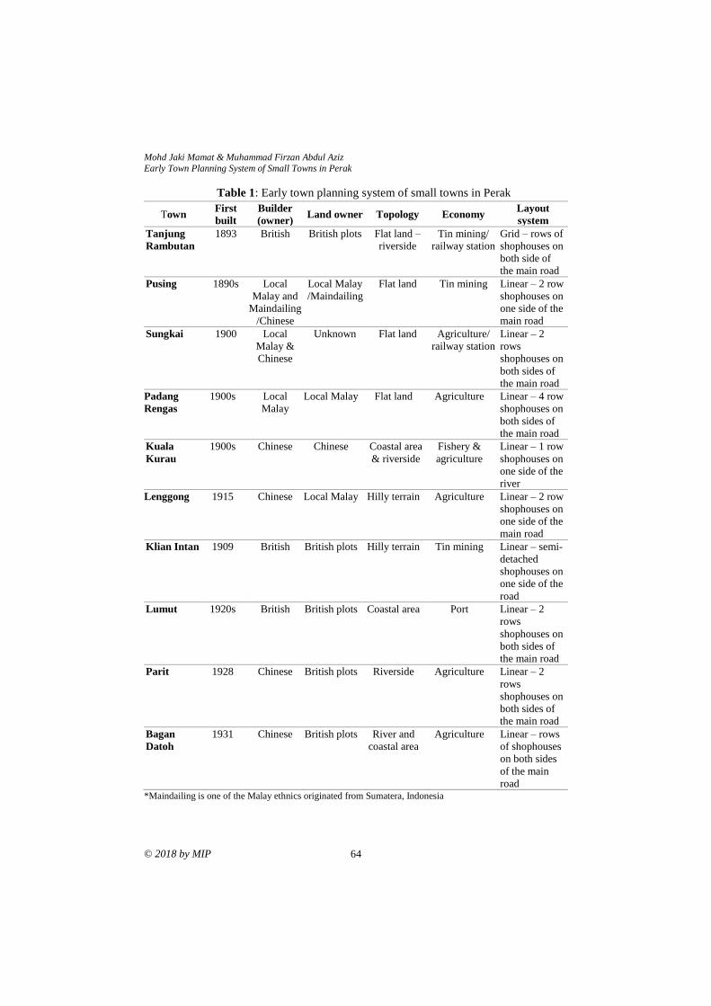
Mohd Jaki Mamat & Muhammad Firzan Abdul Aziz Early Town Planning System of Small Towns in Perak
© 2018 by MIP 64
Table 1: Early town planning system of small towns in Perak
Town First
built
Builder
(owner) Land owner Topology Economy
Layout
system
Tanjung
Rambutan
1893 British British plots Flat land –
riverside
Tin mining/
railway station
Grid – rows of
shophouses on
both side of
the main road
Pusing 1890s Local
Malay and
Maindailing
/Chinese
Local Malay
/Maindailing
Flat land Tin mining Linear – 2 row
shophouses on
one side of the
main road
Sungkai 1900 Local
Malay &
Chinese
Unknown Flat land Agriculture/
railway station
Linear – 2
rows
shophouses on
both sides of
the main road
Padang
Rengas
1900s Local
Malay
Local Malay Flat land Agriculture Linear – 4 row
shophouses on
both sides of
the main road
Kuala
Kurau
1900s Chinese Chinese Coastal area
& riverside
Fishery &
agriculture
Linear – 1 row
shophouses on
one side of the
river
Lenggong 1915 Chinese Local Malay Hilly terrain Agriculture Linear – 2 row
shophouses on
one side of the
main road
Klian Intan 1909 British British plots Hilly terrain Tin mining Linear – semi-
detached
shophouses on
one side of the
road
Lumut 1920s British British plots Coastal area Port Linear – 2
rows
shophouses on
both sides of
the main road
Parit 1928 Chinese British plots Riverside Agriculture Linear – 2
rows
shophouses on
both sides of
the main road
Bagan
Datoh
1931 Chinese British plots River and
coastal area
Agriculture Linear – rows
of shophouses
on both sides
of the main
road *Maindailing is one of the Malay ethnics originated from Sumatera, Indonesia
PLANNING MALAYSIA
Journal of the Malaysia Institute of Planners (2018)
65 © 2018 by MIP
CONCLUSION
To conclude, the linear system was used in the early town planning system of
small towns in Perak. In consolidating the claim, there were no land lots found
available for adding more premises (land expansion based on the grid planning
system) at the sites under this study. This finding is supported by both primary
(interviews conducted) and secondary (document review) data acquired pertinent
to the 10 small towns in Perak. Despite the introduction of the grid system by the
British for the planning of major cities in Perak, it was not applied in the planning
of small towns. Instead, the linear system was adopted and implemented by the
British following its practicality in the planning of small towns which are
relatively smaller in size compared to cities. Despite so, the uses of grid system
for land expansion are still found today in towns such as Pusing, Bagan Datoh,
Lumut, Parit, Lenggong, Sungkai and Kuala Kurau. Nevertheless, its
implementation is merely found on new sites located away from the immediate
surroundings of the earliest rows of shophouse.
Apart from the British interventions in town and city planning, this study
also acknowledges the equal role played by the local Malays and Chinese
merchants. In particular, there was a technical relationship existed between the
local Malays and Chinese merchants in terms of provision of lands and
construction of premises, thus influencing the location and layout pattern of the
early row of shophouses of the small towns in Perak. Conclusively, the layout of
small towns in Perak was influenced mainly by commercial activities, through
the building of shophouses by Chinese merchants on the lands owned by the local
Malays. The small towns in Perak basically emerged as a result from the
centralisation of the existing Malays’ settlements as well as the new settlements
formed by the Chinese immigrants who ran the tin mining industry.
ACKNOWLEDGEMENT
The authors would like to acknowledge the Town and Country Planning of Perak
(Federal Department) for funding the current studies under the project grant
received in 2015 and 2016. Special credits also go to the lecturers and students of
Ungku Omar Polytechnic, Perak Heritage Society (PHS), local councils and
district offices, local communities, respective building owners and individuals
who have directly and indirectly contributed in the process and conduct of this
study.
REFERENCES Abidin, N. Z., Shahminan, R. N. R., & Ibrahim, F. K. (2017). Architectural influences of
Istana Lama Seri Menanti, Negeri Sembilan. Planning Malaysia, 15(1), 151-
162.
Ahmad, S., & Jones, D. (2013). Investigating the mining heritage significance for Kinta
District, the industrial heritage legacy of Malaysia. Procedia - Social and
Behavioral Sciences, 105, 445-457.
Mohd Jaki Mamat & Muhammad Firzan Abdul Aziz Early Town Planning System of Small Towns in Perak
© 2018 by MIP 66
Bissell, W. C. (2005). Engaging colonial nostalgia. Cultural Anthropology, 20(2), 215-
248.
Federal Department of Town & Country Planning Peninsular Malaysia (2009). Perak
town profile report. Ipoh: Author.
Garnaut, C. (2004, July). Chronicles from the Far East: The garden city model of planning
in the Federated Malay States, 1920-1929. 11th Conference of the International
Planning History Society (IPHS). July 14-17, 2004, Barcelona, Spain.
Harun, N. Z., & Jalil, R. A. J. (2012). The morphological history of the Malaysian urban
form. International Proceedings of Economics Development and Research,
48(24), 111-116.
Hassan, A. S. (2009). The British colonial ‘divide and rule’ concept: Its influence to
transport access in inner city of Georgetown, Penang. Transportation, 36, 309-
324.
Hassan, A. S. (2005). Rekabentuk bandar di Semenanjung Malaysia. Penang: Penerbit
Universiti Sains Malaysia.
Haverfield, F. (1913). Ancient town-planning. London: Oxford University Press.
Home, R. (1997). Of planting and planning: The making of British colonial cities (1st
edition). London: Chapman & Hall.
Ibrahim, M. H., Baharom, A. A., Ariffin, K., Jabar, B., Marzuki, M., & Kamaludin, K.
(2014). Investigation of the landscape change in old Malaysian railways: Special
references to Port Weld-Taiping railway. The Social Sciences, 9(5), 357-361.
Larkham, P., & Lilley, K. (2012). Exhibiting the city: Planning ideas and public
involvement in wartime and early post-war Britain, Town Planning Review,
83(6), 647-668.
Lewandowski, S. J. (1975). Urban growth and municipal development in the colonial city
of Madras, 1860-1900. Journal of Asian Studies, 34(2), 341-360.
Lockard, C. A. (1974). The Southeast Asian town in historical perspective: A social
history of Kuching, Malaysia, 1820-1970 (Doctoral dissertation). University of
Wisconsin, USA.
Mamat, M. J. (2016). Lenggong: World Archaeology Heritage Town. Ipoh: Federal
Department of Town & Country Planning Peninsular Malaysia.
Mamat, M. J. (2014). Papan: The oldest mining town in Kinta. Ipoh: Federal Department
of Town & Country Planning Peninsular Malaysia.
Mizushima, T. (1997). A historical study on land transaction in a local town in Malaysia
Kuala Kangsar shop lots between 1885 and 1995. Regional Views, 10, 81-111.
Mohd, I., Ahmad, F., & Wan Abd Aziz, W. N. (2009). Exploiting town planning factors
in land development: Case study of urban housing in Kuala Lumpur, Malaysia.
Journal of Facilities Management, 7(4), 307-318.
Nasution, K. S., & Lubis, A. R. (2005). Kinta Valley: Pioneering Malaysia’s modern
development. Ipoh: Perak Academy.
Njoh, A. J. (2008), Colonial philosophies, urban space and racial segregation in British
and French Colonial Africa. Journal of Black Studies, 38(4), 579-599.
Ortolano, G. (2011). Planning the urban future in 1960s Britain. The Historical Journal,
54(2), 477-507.
PLANNING MALAYSIA
Journal of the Malaysia Institute of Planners (2018)
67 © 2018 by MIP
Samsudin, N. A., & Idid, S. Z. A. (2016). Influences of housing settings and designs in
fulfilling the Malay residents’ social cultures. Planning Malaysia, 4(Special
Issue), 109-120.
Shamsuddin, S. (2011). Townscape revisited: Unravelling the character of the townscape
in Malaysia. Skudai: Penerbit UTM Press.
Symonds, J. (2005). Dirty old town? Industrial archaeology and the urban historic
environment. Industrial Archaeology Review, XXVII(1), 57-65.
Taylor, N. (2010). Commentary: What is this thing called spatial planning? An analysis
of the British government’s view. Town Planning Review, 81(2), 193-208.
Tilaki, M. J. M., Abdullah, A., Bahauddin, A., & Marzbali, M. H. (2014). The necessity
of increasing livability for George Town World Heritage Site: An analytical
review. Modern Applied Science, 8(1), 123-133.
Wan Ali, W. N., Abdul Hadi, N. H., & Ishak, N. R. (2015, October). An overview on the
typology of shophouses’ façade at the heritage area in Ipoh City. Postgraduate
Conference on Global Green Issues (Go Green),UiTM (Perak). October 7-8,
2015, Perak, Malaysia.
Wan Mokhtar, W. N. H. (2016). Tanjung Rambutan; A serene town at the foot of Mount
Korbu. Ipoh: Federal Department of Town & Country Planning Peninsular
Malaysia.
Wan Mokhtar, W. N. H. (2015). Bagan Datoh; The earliest coconut plantation town.
Ipoh: Federal Department of Town & Country Planning Peninsular Malaysia.
Wee, L. H., Yoon, K. T., & Guan, G. G. (2014). Revitalisation of the old township of
Ipoh, Malaysia. Journal of Place Management and Development, 7(1), 57-73.
Yuen, B. (2011). Urban planning in Southeast Asia: Perspective from Singapore. Town
Planning Review, 82(2), 145-167.
Received: 1st June 2018. Accepted:1st December 2018
2 Lecturer at Universiti Sains Malaysia. Email: [email protected] 68
PLANNING MALAYSIA:
Journal of the Malaysian Institute of Planners
VOLUME 16 ISSUE 4 (2018), Page 68 – 80
RURAL-URBAN MIGRANTS’ SENSE OF PLACE IN THE CITY OF
BAODING, CHINA
Sun Qingjiu1 & Nor Zarifah Maliki2
1College of Architecture and Civil Engineering
HEBEI UNIVERSITY CHINA
2School of Housing, Building and Planning
UNIVERSITI SAINS MALAYSIA
Abstract
From 1978 to 2015, China’s urbanization rate raised from 17.92% to 56.10%.
The rapid urbanization and urban development brought enormous changes in
China. Rural-urban migration, the main driver of urban growth in the past few
years, has changed the social, spatial, and economic landscapes of Chinese cities
but also made the urban scene much more diverse, lively, and dynamic. After
migrating to the city, the Chinese migrants are not only subject to difficulties in
material aspects of surviving and socializing but also faced with predicaments in
re-establishing psychological bonding with the urban environment; due to
institutional obstacles such as the household registration system. This paper aims
to explore the association between migrants’ sense of place and the institutional
factor – household registration system. 'Sense of place’ is used as a lens to explore
and explain migrants’ interconnections with the city.
Keywords: rural-urban migrants, sense of place, the household
registration system
PLANNING MALAYSIA
Journal of the Malaysia Institute of Planners (2018)
69 © 2018 by MIP
INTRODUCTION
After adopting the policy of reform and opening-up at the end of 1978, China has
experienced a transformation from a relatively immobile society to one with
migrants accounting more than 10% of China’s population (Fan, 2008). As the
world’s most populous country, the sheer size of migration has affected the
economic growth and urban development. From 1980 to 2000, 268 million
Chinese, mainly from rural areas migrated to cities (Yusuf & Saich, 2008). The
China One Percent Sample Population Survey in 2005 indicates that the number
of migrants reached 147.4 million and rose to 211 million in 2009 (National
Population and Family Planning Commission of China [NPFPCC], 2010), and
294 million in 2015 (NBS, 2016).
The bonds of the Chinese migrants to places are seldom studied in the
field of people-place relationships. This paper investigates rural-urban migrants’
interactions with the urban environment from the perspective of sense of place.
Sense of place is a product of a constant process of interaction between people
and place. Steele (1981) introduced a sense of place model which consists of two
factors: settings (including physical setting and social setting), and the
independent and individual “person” (including psychological factors). Lewicka
(2011) summarizes these predictors into three rough categories: socio-
demographic predictors (referring to people), social predictors (referring to the
social setting), and physical predictors (referring to the physical setting).
Hukou, or the Household Registration System in China was introduced in
1958. Hukou has greatly changed the process of rural-urban migration and lives
of rural-urban migrants. Therefore, hukou as an institutional factor was
incorporated in this study to explore its influence on rural-urban migrants’ sense
of place.
LITERATURE REVIEW
Sense of Place
Place is essential to people’s daily life because it is where biological needs
including food, water, shelter and proliferation are satisfied (Tuan, 1979). Besides
the basic physiological needs, people are also in pursuit for security, belonging,
and rootedness from place when they have developed deep experiential
connections with place. A sense of place thus is created gradually in the pursuit
of physical, social, and psychological demands.
Sense of place is composed of three broad interrelated components: the
physical setting (Ismail, Sapian, Scriver, & Rashid, 2017), the individual’s
internal psychological and social process, and attributes and activities done at the
place (Relph, 1976). Steele (1981) suggests that sense of place is “the pattern of
reactions that a setting stimulates for a person. These reactions are a product of
both features of the setting and aspects the person brings to it” (p. 12). Gregory,
Sun Qingjiu & Nor Zarifah Maliki Rural-Urban Migrants’ Sense of Place in the City of Baoding, China
© 2018 by MIP 70
Johnston, Pratt, Watts and Whatmore (2009) define sense of place as “the
attitudes and feelings that individuals and groups hold vis-à-vis the geographical
areas in which they live. It further commonly suggests intimate, personal and
emotional relationships between self and place” (p. 676). Incorporating attitude
theory, Jorgensen and Stedman (2001) propose that sense of place in a
multidimensional construct comprises “(1) beliefs about the relationship between
self and place; (2) feelings toward the place; and (3) the behavioral exclusivity of
the place in relation to alternatives” (p. 233).
Rural-Urban Migrants and the Household Registration System
In contemporary society, people are very mobile largely due to the development
of transportation, information, and communication technologies (Marzukhi,
Ling, & Hamdan, 2017). In China, the emergence of rural-urban migration is the
outcome of various factors including not only the economic reason but also the
state’s decision of relaxing migration control. From being forbidden to being
encouraged, the rural-urban migration in China has experienced a complicated
process which tightly intertwines with the evolvement of the hukou system.The
hukou system has undergone numerous adjustments over the past 50 years.
Empirical studies indicate that the hukou still matters for many aspects of urban
life, such as job opportunities (Fan, 2002), housing attainment (Wu, 2004),
education, and social stratification and mobility (Wu & Treiman, 2004). The lack
of urban hukou causes migrants to suffer many kinds of social exclusion and
marginalization in the city (Li, Li, & Chen, 2010).
METHODOLOGY
Data
A survey was conducted between October 2014 to February 2015 on rural-urban
migrants who worked and lived in Baoding City, Hebei Province at that time.
Two non-probability sampling techniques (snowball sampling and quota
sampling) were used because there was no list of all migrants from the official
data, nor was the researcher likely to create such a list. The first quota of the
survey sample fell into length of residence, as residence length became the most
important variables, “even as the sole measure” (Lewicka, 2011, p. 216), in
developing sense of place. The second quota addressed home ownership status,
as the people-place literature suggested that home ownership was found to be
another consistent predictor. The third was urban hukou versus rural hukou. Based
on the primary criterion of redundancy, 14 qualitative interviews was also
conducted to supplement, validate, and better understand the survey data.
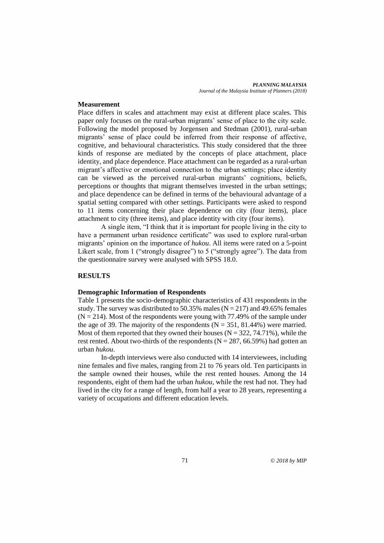
PLANNING MALAYSIA
Journal of the Malaysia Institute of Planners (2018)
71 © 2018 by MIP
Measurement
Place differs in scales and attachment may exist at different place scales. This
paper only focuses on the rural-urban migrants’ sense of place to the city scale.
Following the model proposed by Jorgensen and Stedman (2001), rural-urban
migrants’ sense of place could be inferred from their response of affective,
cognitive, and behavioural characteristics. This study considered that the three
kinds of response are mediated by the concepts of place attachment, place
identity, and place dependence. Place attachment can be regarded as a rural-urban
migrant’s affective or emotional connection to the urban settings; place identity
can be viewed as the perceived rural-urban migrants’ cognitions, beliefs,
perceptions or thoughts that migrant themselves invested in the urban settings;
and place dependence can be defined in terms of the behavioural advantage of a
spatial setting compared with other settings. Participants were asked to respond
to 11 items concerning their place dependence on city (four items), place
attachment to city (three items), and place identity with city (four items).
A single item, “I think that it is important for people living in the city to
have a permanent urban residence certificate” was used to explore rural-urban
migrants’ opinion on the importance of hukou. All items were rated on a 5-point
Likert scale, from 1 (“strongly disagree”) to 5 (“strongly agree”). The data from
the questionnaire survey were analysed with SPSS 18.0.
RESULTS
Demographic Information of Respondents
Table 1 presents the socio-demographic characteristics of 431 respondents in the
study. The survey was distributed to 50.35% males (N = 217) and 49.65% females
(N = 214). Most of the respondents were young with 77.49% of the sample under
the age of 39. The majority of the respondents (N = 351, 81.44%) were married.
Most of them reported that they owned their houses (N = 322, 74.71%), while the
rest rented. About two-thirds of the respondents (N = 287, 66.59%) had gotten an
urban hukou.
In-depth interviews were also conducted with 14 interviewees, including
nine females and five males, ranging from 21 to 76 years old. Ten participants in
the sample owned their houses, while the rest rented houses. Among the 14
respondents, eight of them had the urban hukou, while the rest had not. They had
lived in the city for a range of length, from half a year to 28 years, representing a
variety of occupations and different education levels.
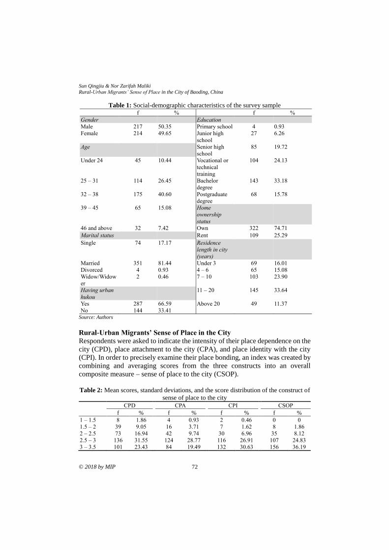
Sun Qingjiu & Nor Zarifah Maliki Rural-Urban Migrants’ Sense of Place in the City of Baoding, China
© 2018 by MIP 72
Table 1: Social-demographic characteristics of the survey sample f % f %
Gender Education
Male 217 50.35 Primary school 4 0.93
Female 214 49.65 Junior high
school
27 6.26
Age Senior high
school
85 19.72
Under 24 45 10.44 Vocational or
technical
training
104 24.13
25 – 31 114 26.45 Bachelor
degree
143 33.18
32 – 38 175 40.60 Postgraduate
degree
68 15.78
39 – 45 65 15.08 Home
ownership
status
46 and above 32 7.42 Own 322 74.71
Marital status Rent 109 25.29
Single 74 17.17 Residence
length in city
(years)
Married 351 81.44 Under 3 69 16.01
Divorced 4 0.93 4 – 6 65 15.08
Widow/Widow
er
2 0.46 7 – 10 103 23.90
Having urban
hukou
11 – 20 145 33.64
Yes 287 66.59 Above 20 49 11.37
No 144 33.41 Source: Authors
Rural-Urban Migrants’ Sense of Place in the City
Respondents were asked to indicate the intensity of their place dependence on the
city (CPD), place attachment to the city (CPA), and place identity with the city
(CPI). In order to precisely examine their place bonding, an index was created by
combining and averaging scores from the three constructs into an overall
composite measure – sense of place to the city (CSOP).
Table 2: Mean scores, standard deviations, and the score distribution of the construct of
sense of place to the city
CPD
CPA
CPI
CSOP
f % f % f % f %
1 – 1.5 8 1.86 4 0.93 2 0.46 0 0
1.5 – 2 39 9.05 16 3.71 7 1.62 8 1.86
2 – 2.5 73 16.94 42 9.74 30 6.96 35 8.12
2.5 – 3 136 31.55 124 28.77 116 26.91 107 24.83
3 – 3.5 101 23.43 84 19.49 132 30.63 156 36.19
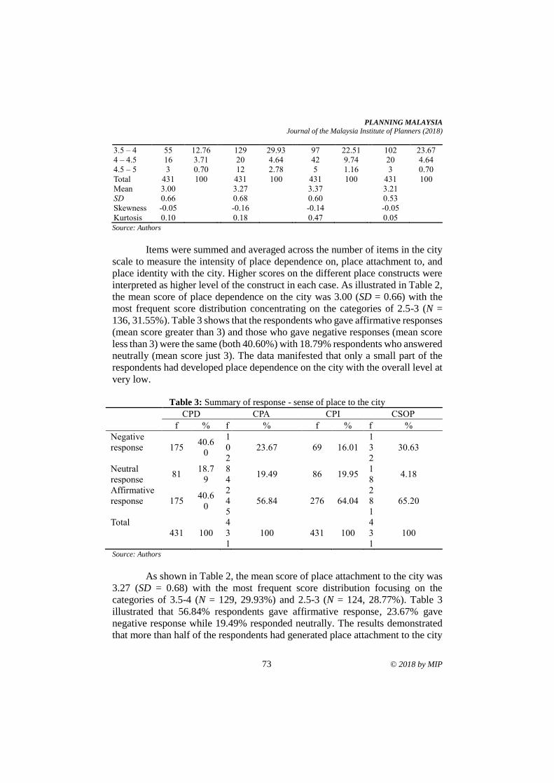
PLANNING MALAYSIA
Journal of the Malaysia Institute of Planners (2018)
73 © 2018 by MIP
3.5 – 4 55 12.76 129 29.93 97 22.51 102 23.67
4 – 4.5 16 3.71 20 4.64 42 9.74 20 4.64
4.5 – 5 3 0.70 12 2.78 5 1.16 3 0.70
Total 431 100 431 100 431 100 431 100
Mean 3.00 3.27 3.37 3.21
SD 0.66 0.68 0.60 0.53
Skewness -0.05 -0.16 -0.14 -0.05
Kurtosis 0.10 0.18 0.47 0.05
Source: Authors
Items were summed and averaged across the number of items in the city
scale to measure the intensity of place dependence on, place attachment to, and
place identity with the city. Higher scores on the different place constructs were
interpreted as higher level of the construct in each case. As illustrated in Table 2,
the mean score of place dependence on the city was 3.00 (SD = 0.66) with the
most frequent score distribution concentrating on the categories of 2.5-3 (N =
136, 31.55%). Table 3 shows that the respondents who gave affirmative responses
(mean score greater than 3) and those who gave negative responses (mean score
less than 3) were the same (both 40.60%) with 18.79% respondents who answered
neutrally (mean score just 3). The data manifested that only a small part of the
respondents had developed place dependence on the city with the overall level at
very low.
Table 3: Summary of response - sense of place to the city
CPD CPA CPI CSOP
f % f % f % f %
Negative
response 175 40.6
0
1
0
2
23.67 69 16.01
1
3
2
30.63
Neutral
response 81
18.7
9
8
4 19.49 86 19.95
1
8 4.18
Affirmative
response 175 40.6
0
2
4
5
56.84 276 64.04
2
8
1
65.20
Total
431 100
4
3
1
100 431 100
4
3
1
100
Source: Authors
As shown in Table 2, the mean score of place attachment to the city was
3.27 (SD = 0.68) with the most frequent score distribution focusing on the
categories of 3.5-4 (N = 129, 29.93%) and 2.5-3 (N = 124, 28.77%). Table 3
illustrated that 56.84% respondents gave affirmative response, 23.67% gave
negative response while 19.49% responded neutrally. The results demonstrated
that more than half of the respondents had generated place attachment to the city
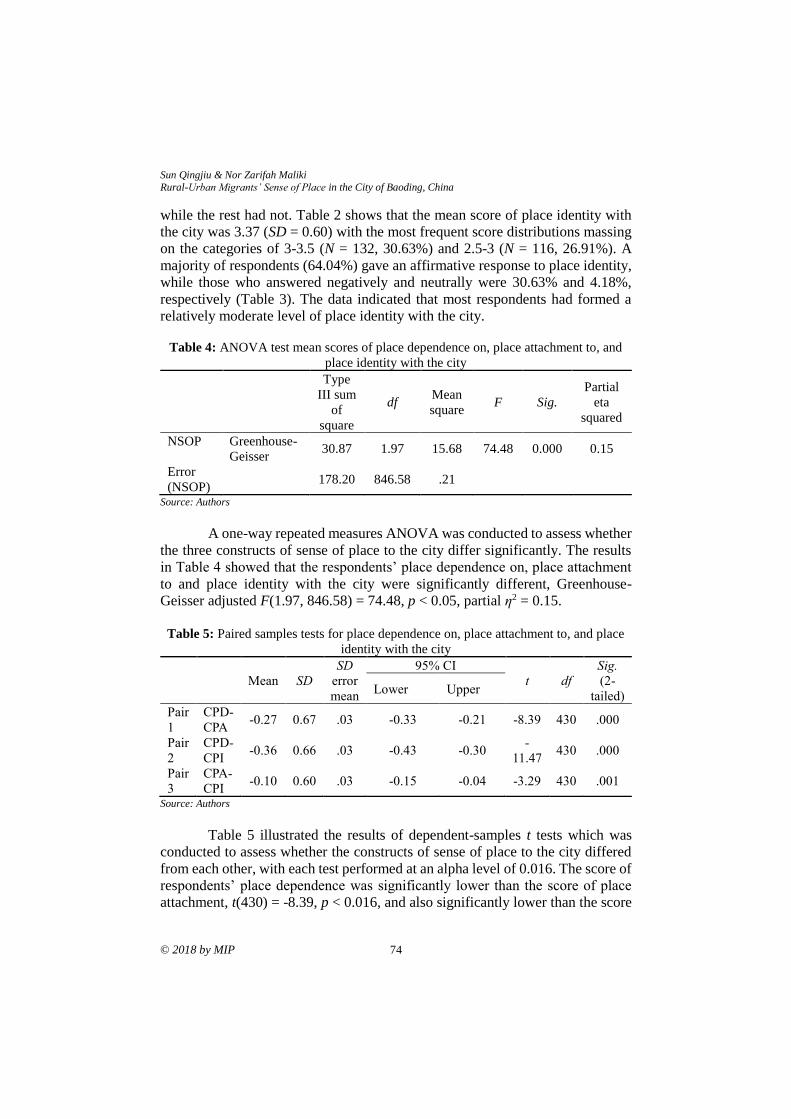
Sun Qingjiu & Nor Zarifah Maliki Rural-Urban Migrants’ Sense of Place in the City of Baoding, China
© 2018 by MIP 74
while the rest had not. Table 2 shows that the mean score of place identity with
the city was 3.37 (SD = 0.60) with the most frequent score distributions massing
on the categories of 3-3.5 (N = 132, 30.63%) and 2.5-3 (N = 116, 26.91%). A
majority of respondents (64.04%) gave an affirmative response to place identity,
while those who answered negatively and neutrally were 30.63% and 4.18%,
respectively (Table 3). The data indicated that most respondents had formed a
relatively moderate level of place identity with the city.
Table 4: ANOVA test mean scores of place dependence on, place attachment to, and
place identity with the city
Type
III sum
of
square
df Mean
square F Sig.
Partial
eta
squared
NSOP Greenhouse-
Geisser 30.87 1.97 15.68 74.48 0.000 0.15
Error
(NSOP)
178.20 846.58 .21
Source: Authors
A one-way repeated measures ANOVA was conducted to assess whether
the three constructs of sense of place to the city differ significantly. The results
in Table 4 showed that the respondents’ place dependence on, place attachment
to and place identity with the city were significantly different, Greenhouse-
Geisser adjusted F(1.97, 846.58) = 74.48, p < 0.05, partial η2 = 0.15.
Table 5: Paired samples tests for place dependence on, place attachment to, and place
identity with the city
Mean SD
SD
error
mean
95% CI
t df
Sig.
(2-
tailed) Lower Upper
Pair
1
CPD-
CPA -0.27 0.67 .03 -0.33 -0.21 -8.39 430 .000
Pair
2
CPD-
CPI -0.36 0.66 .03 -0.43 -0.30
-
11.47 430 .000
Pair
3
CPA-
CPI -0.10 0.60 .03 -0.15 -0.04 -3.29 430 .001
Source: Authors
Table 5 illustrated the results of dependent-samples t tests which was
conducted to assess whether the constructs of sense of place to the city differed
from each other, with each test performed at an alpha level of 0.016. The score of
respondents’ place dependence was significantly lower than the score of place
attachment, t(430) = -8.39, p < 0.016, and also significantly lower than the score
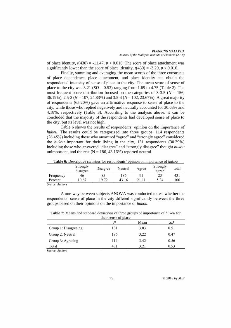
PLANNING MALAYSIA
Journal of the Malaysia Institute of Planners (2018)
75 © 2018 by MIP
of place identity, t(430) = -11.47, p < 0.016. The score of place attachment was
significantly lower than the score of place identity, t(430) = -3.29, p < 0.016.
Finally, summing and averaging the mean scores of the three constructs
of place dependence, place attachment, and place identity can obtain the
respondents’ intensity of sense of place to the city. The mean score of sense of
place to the city was 3.21 (SD = 0.53) ranging from 1.69 to 4.75 (Table 2). The
most frequent score distribution focused on the categories of 3-3.5 (N = 156,
36.19%), 2.5-3 (N = 107, 24.83%) and 3.5-4 (N = 102, 23.67%). A great majority
of respondents (65.20%) gave an affirmative response to sense of place to the
city, while those who replied negatively and neutrally accounted for 30.63% and
4.18%, respectively (Table 3). According to the analysis above, it can be
concluded that the majority of the respondents had developed sense of place to
the city, but its level was not high.
Table 6 shows the results of respondents’ opinion on the importance of
hukou. The results could be categorized into three groups: 114 respondents
(26.45%) including those who answered “agree” and “strongly agree” considered
the hukou important for their living in the city, 131 respondents (30.39%)
including those who answered “disagree” and “strongly disagree” thought hukou
unimportant, and the rest (N = 186, 43.16%) reported neutral.
Table 6: Descriptive statistics for respondents’ opinion on importance of hukou
Strongly
disagree Disagree Neutral Agree
Strongly
agree total
Frequency 46 85 186 91 23 431
Percent 10.67 19.72 43.16 21.11 5.34 100 Source: Authors
A one-way between subjects ANOVA was conducted to test whether the
respondents’ sense of place in the city differed significantly between the three
groups based on their opinions on the importance of hukou.
Table 7: Means and standard deviations of three groups of importance of hukou for
their sense of place
N Mean SD
Group 1: Disagreeing 131 3.03 0.51
Group 2: Neutral 186 3.22 0.47
Group 3: Agreeing 114 3.42 0.56
Total 431 3.21 0.53 Source: Authors
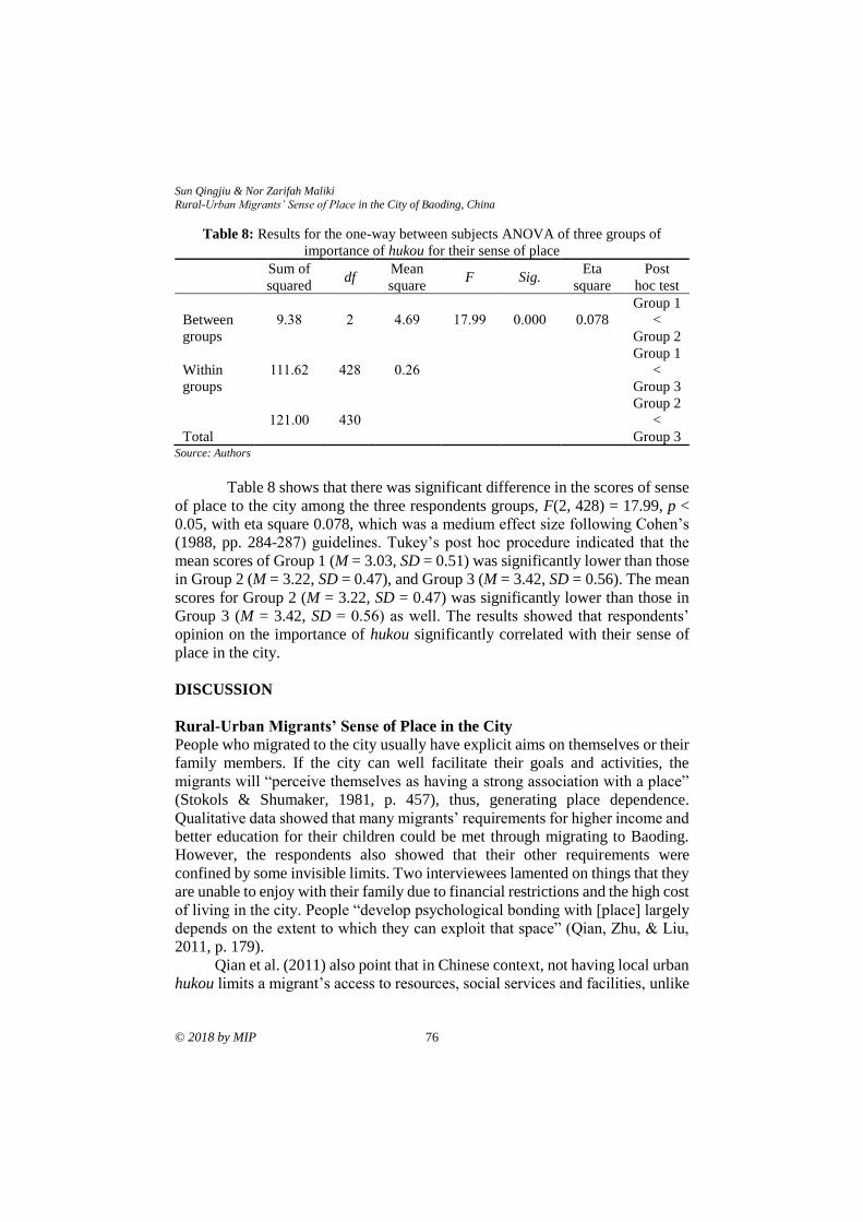
Sun Qingjiu & Nor Zarifah Maliki Rural-Urban Migrants’ Sense of Place in the City of Baoding, China
© 2018 by MIP 76
Table 8: Results for the one-way between subjects ANOVA of three groups of
importance of hukou for their sense of place
Sum of
squared df
Mean
square F Sig.
Eta
square
Post
hoc test
Between
groups
9.38 2 4.69 17.99 0.000 0.078
Group 1
<
Group 2
Within
groups
111.62 428 0.26
Group 1
<
Group 3
Total
121.00 430
Group 2
<
Group 3 Source: Authors
Table 8 shows that there was significant difference in the scores of sense
of place to the city among the three respondents groups, F(2, 428) = 17.99, p <
0.05, with eta square 0.078, which was a medium effect size following Cohen’s
(1988, pp. 284-287) guidelines. Tukey’s post hoc procedure indicated that the
mean scores of Group 1 (M = 3.03, SD = 0.51) was significantly lower than those
in Group 2 (M = 3.22, SD = 0.47), and Group 3 (M = 3.42, SD = 0.56). The mean
scores for Group 2 (M = 3.22, SD = 0.47) was significantly lower than those in
Group 3 (M = 3.42, SD = 0.56) as well. The results showed that respondents’
opinion on the importance of hukou significantly correlated with their sense of
place in the city.
DISCUSSION
Rural-Urban Migrants’ Sense of Place in the City
People who migrated to the city usually have explicit aims on themselves or their
family members. If the city can well facilitate their goals and activities, the
migrants will “perceive themselves as having a strong association with a place”
(Stokols & Shumaker, 1981, p. 457), thus, generating place dependence.
Qualitative data showed that many migrants’ requirements for higher income and
better education for their children could be met through migrating to Baoding.
However, the respondents also showed that their other requirements were
confined by some invisible limits. Two interviewees lamented on things that they
are unable to enjoy with their family due to financial restrictions and the high cost
of living in the city. People “develop psychological bonding with [place] largely
depends on the extent to which they can exploit that space” (Qian, Zhu, & Liu,
2011, p. 179).
Qian et al. (2011) also point that in Chinese context, not having local urban
hukou limits a migrant’s access to resources, social services and facilities, unlike
PLANNING MALAYSIA
Journal of the Malaysia Institute of Planners (2018)
77 © 2018 by MIP
the officially registered urban residents. In this study, two interviewees stated that
they need to pay the school more money as sponsor fee because they didn’t have
Baoding urban hukou. The limit undoubtedly decreases migrants’ place
dependence on the city, and that is why migrants report a medium degree of place
dependence on city (3.00).
The second dimension of sense of place to city is place attachment which
refers to behavioural commitment and emotional bonding of the migrants to the
city. Although the respondents showed an affirmative place attachment to city (M
= 3.27), it was worth noting that the level of their place attachment to city was
not high either. Individuals evaluate place characteristics according to different
subjective standards which have been “the result of differences in past
experiences or adaptations to present circumstances” (John, 1987, p. 377). The
concrete statement from qualitative data may help to explain this. Respondents’
place attachment to the city was developed through their first experiential
interactions with the city, especially through some unforgettable experience with
people.
According to Robertson (2006), place identity plays a decisive role in
keeping people in a place. In this study, migrants’ place identity with city is also
limited by the degree to which the city meets the migrants’ needs. Hence, if needs
are met, they prefer to stay in the city; if not, they may leave. The intensity of
respondents’ place identity with city (M = 3.37) reflected their predicaments –
they stated a positive evaluation of place identity with city, but the level is not
high. The degree to what the urban qualities fit their expectations and needs is
judged by the benefits and disadvantages provide by the city (Mesch & Manor,
1998). Qualitative results showed that the city had many advantages that attract
migrants such as more job opportunities and better education, but some
disadvantages also weakened their place-based identity such as loneliness and
isolation of the old migrants, serious air pollution in city, and no retirement
security. Another critical finding which was significantly different from previous
studies about place identity was that the hukou system greatly affected migrants’
situating self-identity within the city.
The Impact of Hukou on Rural-Urban Migrants’ Sense of Place
Previous research on sense of place have not assessed the importance of
institutional factor. Therefore, the importance of hukou for migrants living in the
city was assessed in this study. Results in this study indicated that hukou had
significantly influenced migrants’ sense of place to the city. Although the
government of China has instituted many reforms to hukou system to make the
rural-urban migration easier to live in the city, in fact, the hukou system, as a way
to stop the migrants enjoying the basic welfare and public services of urban
residents, remains strong. It is hard for the migrants to develop sense of place to
the city when their children cannot have an equal education right or when they
Sun Qingjiu & Nor Zarifah Maliki Rural-Urban Migrants’ Sense of Place in the City of Baoding, China
© 2018 by MIP 78
cannot enjoy urban medical insurance, just because they don’t have urban hukou.
One participant said that:
My children do not have Baoding urban residence certificate. We need
to pay the school more money as sponsor fee. . . . My son studies well at
school, but we have to pay a large amount of extra money even if he has
admitted to a key high school. . . .
China had built up urban medical insurance scheme for urban residents
and new rural cooperative medical system for rural residents. The migrants with
rural hukou should attend the new rural cooperative medical system. If they were
sick and needed hospital care, the rate of reimbursement for treatment fee was
85% - 90% when treated in hospitals in the village and towns; 70% - 80% in the
county hospital; 60% - 68% in the city hospital; and 55% in the provincial
hospital (Health and Family Planning Commission of Hebei Province [HFPCH],
2013). Some of the interviewees complained about this regulation. One female
interviewee said that:
The new rural cooperative medical system is a good policy for the farmer,
but it is inconvenient for us. . . . We live in the city. It is impossible to go
to the town hospital or county hospital when we are sick . . .
A variety of reforms have been instituted to reduce the restriction of
hukou system to rural-urban migrants and migration. “The cumulative effect of
these reforms is not abolition of the hukou, but devolution of responsibility for
hukou policies to local government” (Chan & Buckingham, 2008, p. 582). If the
hukou system sets up “an invisible wall” between rural and urban area initially,
another wall, which restricts migration from city to city, is being put up for urban-
urban migrants. With this wall, many basic welfares and government-provided
services (e.g., a city bus pass or scenic spots’ entrance tickets) are only provided
to local urban residents, but not to residents who hold urban hukou of other cities.
The hukou system not only seriously affect the livelihood of rural-urban migrants,
but it also has become “a tool that sharpens social cleavages and entrenches
inequality” (Ma, 2015).
CONCLUSION
The Chinese hukou system provides a unique case to examine how the social
institution affected people-place relationships. The integration of institutional
factor into a comprehensive exploration of rural-urban migrants’ sense of place
expands and enriches people-place relationships theory. A city is the best possible
place to live in the past, the present, and the foreseeable future (Glaeser, 2011).
Rapid urbanization is still ongoing in China, and more and more people are
migrating from rural areas to cities. Undoubtedly, the influx of migration is
changing the urban social, economic and even political landscapes. The rural-
PLANNING MALAYSIA
Journal of the Malaysia Institute of Planners (2018)
79 © 2018 by MIP
urban migrants devote their youth, energy, and efforts in cites – which also
contribute to the beauty, prosperity, and improvement of cities – in order to
survive, socialize and re-establish psychological bonding within the urban
environment. The aim of the city defined by Aristotle is to provide both security
and happiness for its inhabitants (Doxiadis, 1976). Migrants’ weak intensity of
sense of place to the city in this study indicated that they had not obtained
dependence, attachment, and identity from cities, and were on the way to pursuing
security, happiness and belonging to cities.
REFERENCES Chan, K. W., & Buckingham, W. (2008). Is China abolishing the hukou system?
The China Quarterly, 195, 582-606.
Cohen, J. (1988). Statistical power analysis for the behavioral sciences (Second Edition).
New York: Psychology Press, Taylor & Francis Group.
Doxiadis, C. A. (1976). How can we learn about man and his settlements? In A. Papoport
(Ed.), The mutual interaction of people and their built environment: a cross-
cultural perspective (pp. 77-126). Chicago: Mouton Publishers.
Fan, C. C. (2002). The elite, the natives, and the outsiders: Migration and labor market
segmentation in urban China. Annals of the Association of American
Geographers, 92(1), 103-124.
Fan, C. C. (2008). Migration, hukou, and the city. In S. Yusuf & T. Saich (Eds.), China
urbanizes: Consequences, strategies, and policies (pp. 65-89). Washington,
D.C.: The World Bank.
Glaeser, E. (2011). Triumph of the city. New York: The Penguin Press.
Gregory, D., Johnston, R., Pratt, G., Watts, M. J., & Whatmore, S. (2009). The Dictionary
of Human Geography (5th Edition ed.). Chichester, West Sussex, UK: Willey-
Blackwell.
Health and Family Planning Commission of Hebei Province [HFPCH] (2013).
Hebeisheng 2013 nian xinxing nongcun hezuo yiliao tongchou buchang fang'an
jiben kuangjia [The basic framework of the overall compensation scheme for
new rural cooperative medical system from 2013 in Hebei province].
Shijiazhuang: Health and Family Planning Commission of Hebei.
Ismail, M. N., Sapian, A. R., Scriver, P., & Rashid, M. (2017). Translation of social
citizenship to architecture and built environment: A methodological review.
Planning Malaysia, 15(1), 235-244.
John, C. S. (1987). Racial differences in neighborhood evaluation standards. Urban
Affairs Review, 22(3), 377-398.
Jorgensen, B. S., & Stedman, R. C. (2001). Sense of place as an attitude: Lakeshore
owners attitudes toward their properties. Journal of Environmental Psychology,
21(3), 233-248.
Lewicka, M. (2011). Place attachment: How far have we come in the last 40 years?
Journal of Environmental Psychology, 31(3), 207-230.
Li, L., Li, S., & Chen, Y. (2010). Better city, better life, but for whom? The hukou and
resident card system and the consequential citizenship stratification in Shanghai.
City, Culture and Society, 1(3), 145-154.
Sun Qingjiu & Nor Zarifah Maliki Rural-Urban Migrants’ Sense of Place in the City of Baoding, China
© 2018 by MIP 80
Ma, D. (2015, August, 25). China's 20 percent problem. Foreign Affairs.
Marzukhi, M. A., Ling, H. L., & Hamdan, H. (2017). Urban planning and the challenges
of neoliberal globalisation in Malaysia. Planning Malaysia, 15(2), 1-12.
Mesch, G. S., & Manor, O. (1998). Social ties, environmental perception, and local
attachment. Environment and Behavior, 30(4), 504-519.
National Bureau of Statistics of China [NBS] (2016). 2015 Nian guomin jingji he shehui
fazhan tongji gongbao [National economy and society developed statistical
bulletin 2015]. Beijing: National Bureau of Statistics of China.
National Population and Family Planning Commission of China [NPFPCC] (2010).
Zhongguo liudong renkou fazhan baogao 2010 [Report on China’s migrant
population development 2010]. Beijing: China Population Publishing House.
Qian, J., Zhu, H., & Liu, Y. (2011). Investigating urban migrants’ sense of place through
a multi-scalar perspective. Journal of Environmental Psychology, 31(2), 170-
183.
Relph, E. (1976). Place and placelessness. London: Pion Limited.
Robertson, D. (2006). Hard as the rock itself: Place and identity in the American mining
town. Colorado: University Press of Colorado.
Steele, F. (1981). The sense of place. Boston, Massachusetts: CBI Publishing Company.
Stokols, D., & Shumaker, S. A. (1981). People in places: A transactional view of settings.
In J. H. Harvey (Ed.), Cognition, social behavior, and the environment (pp. 441-
488). Hillsdale, N.J.: Lawrence Erlbaum.
Tuan, Y.-F. (1979). Space and place: Humanistic perspective. In S. Gale & G. Olsson
(Eds.), Philosophy in geography (pp. 387-427). Dordrecht, Holland: D. Reidel
Publishing Company.
Wu, W. (2004). Sources of migrant housing disadvantage in urban China. Environment
and Planning, 36(7), 1285-1304.
Wu, X, & Treiman, D.J. (2004) The household registration system and social stratification
in China, 1955 – 1996. Demography, 41(2), 363-384.
Yusuf, S., & Saich, T. (2008). China urbanizes: Consequences, strategies, and policies.
Washington, D.C.: The World Bank.
Received: 1st June 2018. Accepted:1st December 2018
1Lecturer at Universiti Sains Malaysia. Email: [email protected] 81
PLANNING MALAYSIA:
Journal of the Malaysian Institute of Planners
VOLUME 16 ISSUE 4 (2018), Page 81 – 91
TSUNAMI MODELLING PROCEDURES TO REFINE COASTAL
ARCHITECTURAL DESIGN STRATEGIES AT KUALA MUDA
Jestin Nordin1, Andrew Charleson2 & Morten Gjerde3
1School of Housing, Building and Planning
UNIVERSITI SAINS MALAYSIA
2&3School of Architecture
VICTORIA UNIVERSITY OF WELLINGTON, NEW ZEALAND
Abstract
This paper discusses the use of tsunami modelling to refine the strategies to be
used in coastal architectural and planning design works in effort to minimize
future tsunami impacts on the coastal buildings. The ability to recreate the
characteristics of the 2004 Sumatran Tsunami waves and their impacts is the
reason to use computer simulation as the main tool of this research project. The
Cornell Multi-Grid Coupled Tsunami Model (COMCOT) programme has been
chosen to generate a series of tsunami events onto a one-kilometre-square area of
Kuala Muda (north-west of Peninsular Malaysia) coastal area. COMCOT is
expected to help practitioners and researchers make the best possible designs for
this tsunami-threatened near-beach area. It has the capability to simulate the
entire lifespan of a tsunami inclusive of the characteristics and the behaviour of
the waves once it inundates the design area. It creates an opportunity to better
understand and evaluate the performance of proposed designs in order to achieve
the most tsunami-resistant design. The 2004 Sumatran Tsunami waves are
considered the worst case scenario this area will experience. Therefore, the waves
generated act upon proposed settlement patterns and buildings which are
iteratively modified to achieve minimum tsunami damage. COMCOT outputs are
used to propose coastal architectural design strategies for present and future near-
beach area developments, especially in the north-western coast of Malaysia. The
final Tsunami Responsive Architecture (TRA) design is intended to be culturally
acceptable, and to be extended with or without modification to suit other coastal
areas at risk of tsunami.
Keywords: tsunami response, COMCOT, coastal design, coastal architecture,
coastal design strategies
Jestin Nordin, Andrew Charleson & Morten Gjerde
Tsunami Modelling Procedures to Refine Coastal Architectural Design Strategies at Kuala Muda
© 2018 by MIP 82
IDENTIFIED MALAYSIAN TSUNAMI RISKS
Recent research suggests that Malaysian coastal dwellings may be under threat
from large tsunamis because of possible earthquakes in the region. The risk for
Malaysia originates from far-field tsunami sources originating from neighbouring
countries. In this introduction section, we briefly discuss and outline the threats
of future tsunami to Malaysia both for West Malaysia (Peninsular) and East
Malaysia (Borneo Island). However, this research focuses only the north-western
coastal area of Peninsular Malaysia, particularly the Kuala Muda, in Kedah.
Along the northern Peninsular Malaysia coast, tsunami risk comes from
the Indian Ocean (Andaman and Nicobar Islands) (Okal & Synolakis, 2008).
Research have also shown that the north-western coastal area of Peninsular
Malaysia will be the first to be impacted by a future tsunami generated by a
submarine earthquake originating from the Sumatra-Andaman fault (Ismail et al.,
2012; Teh, Koh, Moh, DeAngelis, & Jiang, 2011). The eastern coast of Peninsular
Malaysia and the Sabah and Sarawak region will be affected by the Manila
Trench near the Philippines (Teh et al., 2011), and Cotabato and North Sulawesi
(Raj, 2007). Additionally, the Sulawesi Trench could also impose future tsunami
threat to Sabah (“Tsunami can reach Sabah in 30 mins”, 2018).
Scientists cannot predict when an earthquake may happen again in this
area. The 2004 Mw 9.3 earthquake already released some of the strain along the
Sumatran plate boundaries. However strain in other areas is still building up and
scientist such as Stein suggests that the segments to the south of the fault slip can
break at any time generating another tsunami (Schirber, 2005).
Working on numerical tsunami simulation, Okal and Synolakis (2008)
note that if an earthquake occurs north of Andaman and Myanmar, a huge tsunami
will occur and inundate the coastal areas along the Strait of Melaka and to
Singapore. They suggest the need of researching the possibility of the inundation
to this area, and the impact the tsunami may create to coastal structures (Okal &
Synolakis, 2008; Johar, Majid, Jaffar, & Yahya, 2013). This shows that future
earthquakes in these areas will likely generate tsunamis that impact the north-
western Malaysia. Okal and Synolakis (2008) concluded that the Strait of Melaka
(Figure 1) would be safe from tsunami such as the south Sumatran Tsunami.
However, coastal areas in the straits area would be in greater danger than for the
2004 event if a tsunami originates from the Andaman and Myanmar region
earthquake (Hock, Su, Lee, & Zakaria, 2009; Okal & Synolakis, 2008; Teh et al.,
2011).
Additionally, researchers have also uncovered evidence of tsunamis
occurring hundreds of years ago in the northern part of Phra Thong Island,
Phuket, Thailand (Tan, 2008) as indicated by the triangle in Figure 1.
Researchers have found layers of sand that could be dated from 600 to 700 years
ago, which is evidence of a tsunami had struck Thailand before 2004, and
possibly the north-western coast of Peninsular Malaysia as well.
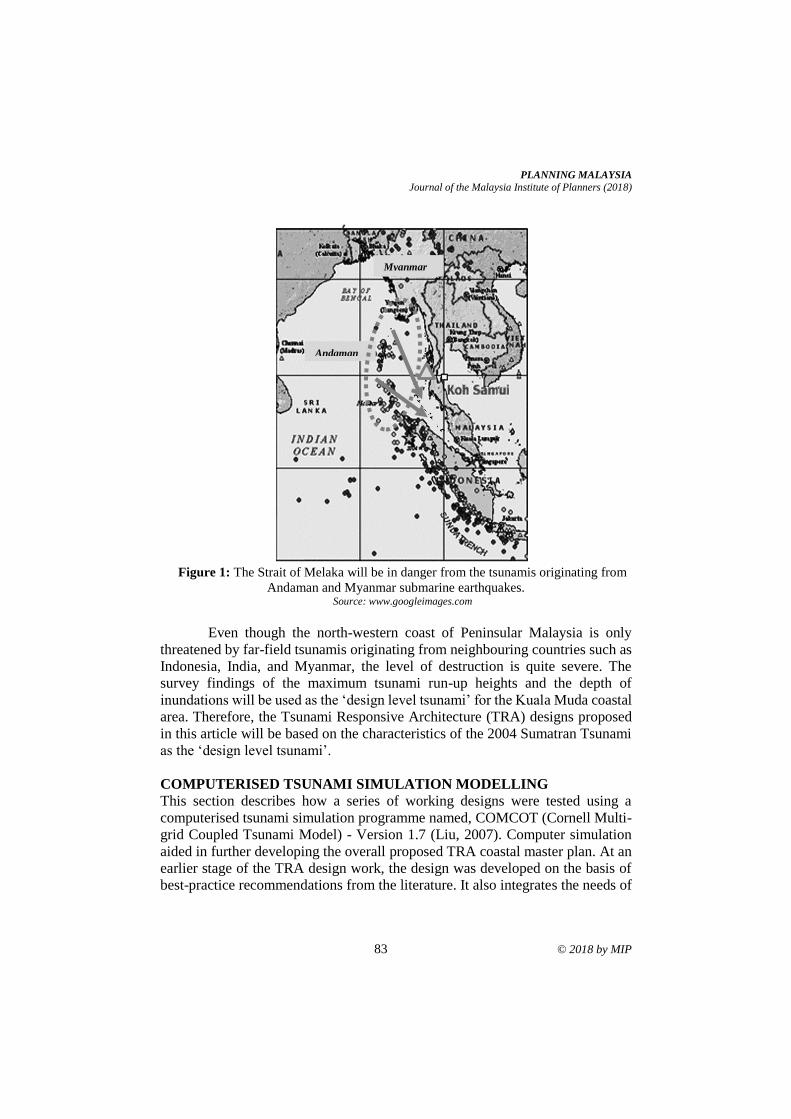
PLANNING MALAYSIA
Journal of the Malaysia Institute of Planners (2018)
83 © 2018 by MIP
Figure 1: The Strait of Melaka will be in danger from the tsunamis originating from
Andaman and Myanmar submarine earthquakes. Source: www.googleimages.com
Even though the north-western coast of Peninsular Malaysia is only
threatened by far-field tsunamis originating from neighbouring countries such as
Indonesia, India, and Myanmar, the level of destruction is quite severe. The
survey findings of the maximum tsunami run-up heights and the depth of
inundations will be used as the ‘design level tsunami’ for the Kuala Muda coastal
area. Therefore, the Tsunami Responsive Architecture (TRA) designs proposed
in this article will be based on the characteristics of the 2004 Sumatran Tsunami
as the ‘design level tsunami’.
COMPUTERISED TSUNAMI SIMULATION MODELLING
This section describes how a series of working designs were tested using a
computerised tsunami simulation programme named, COMCOT (Cornell Multi-
grid Coupled Tsunami Model) - Version 1.7 (Liu, 2007). Computer simulation
aided in further developing the overall proposed TRA coastal master plan. At an
earlier stage of the TRA design work, the design was developed on the basis of
best-practice recommendations from the literature. It also integrates the needs of
Andaman
Myanmar
Jestin Nordin, Andrew Charleson & Morten Gjerde
Tsunami Modelling Procedures to Refine Coastal Architectural Design Strategies at Kuala Muda
© 2018 by MIP 84
the coastal people of Kuala Muda (the end-users), which were identified during
data collection surveys.
There are several other tsunami simulations on the market such as
TsunAWI (Harig, Chaeroni, Pranowo, & Behrens, 2008), TUNA (Koh, 2007),
MOST (Pacific Marine Environmental Laboratory, 2006), ANUGA (Nielsen,
Sexton, Gray, & Bartzis, 2005), TUNAMI (Immamura, 1995), INGV of the
Instituto Nazionale Geofoscia e Vulcano, Italy and DELFT-3D of the Delft
Hydraulics, the Netherlands. However, one of the main reasons COMCOT was
used in this research was because COMCOT has been calibrated and is widely
used by researchers to simulate past tsunami events. Some of the simulation
projects using COMCOT were the re-creation of the 1960 Chilean earthquake
tsunami, the 1992 Flores Island tsunami, the 2003 Algerian tsunami and the 2004
Sumatran tsunami. Therefore, COMCOT was seen as an appropriate tool to test
the TRA designs options of this research project.
The main features of COMCOT are (COMCOT - A tsunami modelling
package, 2011):
i. COMCOT is capable of simulating the entire lifespan of a tsunami,
from its generation, propagation and run-up/rundown in coastal
regions;
ii. COMCOT can generate tsunami waves via an incident wave maker,
fault model, landslide, or even customized profile;
iii. COMCOT has a flexible nested grid setup which allows for the
balance between accuracy and efficiency;
iv. COMCOT can help refine TRA designs and in making strategic
decisions.
Although physical modelling was initially considered during the initial
setup for testing the TRA designs, COMCOT was finally selected. The decision
was made on the basis of cost; computer simulation is less expensive than the
setting up of a physical model.
OVERVIEW OF COMCOT MODELLING
Before starting with the COMCOT operation, several issues were considered to
ensure the experimental work can be successful. These are questions of what to
model, why, and how many designs to model and test, and how to get the best
from COMCOT.
What to Model?
COMCOT is needed to model several tsunamis that are likely to strike the
Malaysia north-western coastal area, especially Kuala Muda. COMCOT was
used to regenerate the 2004 Sumatran Tsunami. The proposed TRA designs was
then tested against that, because this is the worst case scenario that are dangerous
PLANNING MALAYSIA
Journal of the Malaysia Institute of Planners (2018)
85 © 2018 by MIP
for the Strait of Melaka’s coastal areas (Ismail, Wahab, & Ibrahim, 2009; Okal &
Synolakis, 2008).
Why Model This Particular Area?
Kuala Muda is just one fishing village from hundreds of typical Malaysian
traditional fishing communities bordering the Malacca Straits. However, it needs
to be protected from future tsunamis since the threats are real (Ismail, 2010; Okal
& Synolakis, 2008; Khor (2005). The selection of a one-kilometre square coastal
area was then used as a tsunami-resistant case-study to be implemented elsewhere
(with some adjustment, according to the local future predicted tsunami
characteristics) in Malaysia.
How Many Models to be Generated and Tested?
The proposed TRA designs were tested several times against the tsunami waves
generated by COMCOT. The first initial TRA design incorporated mostly
suggestions of the ‘best-practices’ tsunami resistant design from the literature,
coastal construction manuals, and also construction and planning guidelines such
as the FEMA P-55 (Coastal Construction Manual), FEMA 499 (Home
Builder's Guide to Coastal Construction), and FEMA 646A (Local
Community Official Guide to Vertical Evacuation from Tsunamis), just to
name a few. Iteration on the design was continuously done only until the design
could be evaluated as positively responsive enough to reduce tsunami forces upon
it.
What Aspects of the TRA Designs will be Tested?
A series of building layout and building designs was analysed against generated
tsunami waves. The overall performance of the proposed master layout, i.e.
arrangement and orientation of the buildings, elevations and the buildings’ forms
was investigated and analysed. To ensure that the final TRA design will be
tsunami-responsive enough, all critical design aspects were thoroughly inspected.
In every test, the waves flowing through the model i.e. the TRA design
layout and building designs were analysed. The analyses investigated the heights
of the run-up, the inundation, the velocity of the flow, the terminal height, and
the hydraulic forces impacting the surfaces of buildings, and the effectiveness of
the overall master layout. The results were used to iterate improvements in the
design, so as to meet the TRA design objectives as closely as possible.
COMCOT MODELLING PROCESSES
Setting up numerical simulation datasets for testing was a very time-consuming
task with so many datasets needing to be prepared in fine detail. First, a
bathymetry map of the near-shore area of Kuala Muda (MAL 565: Ko Tarutao –
Pulau Pinang) as well as the topography map of the researched coastal area were
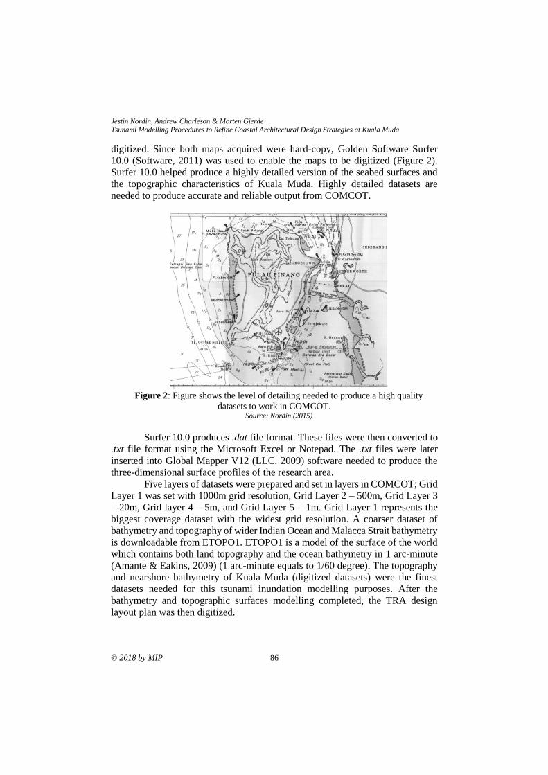
Jestin Nordin, Andrew Charleson & Morten Gjerde
Tsunami Modelling Procedures to Refine Coastal Architectural Design Strategies at Kuala Muda
© 2018 by MIP 86
digitized. Since both maps acquired were hard-copy, Golden Software Surfer
10.0 (Software, 2011) was used to enable the maps to be digitized (Figure 2).
Surfer 10.0 helped produce a highly detailed version of the seabed surfaces and
the topographic characteristics of Kuala Muda. Highly detailed datasets are
needed to produce accurate and reliable output from COMCOT.
Figure 2: Figure shows the level of detailing needed to produce a high quality
datasets to work in COMCOT. Source: Nordin (2015)
Surfer 10.0 produces .dat file format. These files were then converted to
.txt file format using the Microsoft Excel or Notepad. The .txt files were later
inserted into Global Mapper V12 (LLC, 2009) software needed to produce the
three-dimensional surface profiles of the research area.
Five layers of datasets were prepared and set in layers in COMCOT; Grid
Layer 1 was set with 1000m grid resolution, Grid Layer 2 – 500m, Grid Layer 3
– 20m, Grid layer 4 – 5m, and Grid Layer 5 – 1m. Grid Layer 1 represents the
biggest coverage dataset with the widest grid resolution. A coarser dataset of
bathymetry and topography of wider Indian Ocean and Malacca Strait bathymetry
is downloadable from ETOPO1. ETOPO1 is a model of the surface of the world
which contains both land topography and the ocean bathymetry in 1 arc-minute
(Amante & Eakins, 2009) (1 arc-minute equals to 1/60 degree). The topography
and nearshore bathymetry of Kuala Muda (digitized datasets) were the finest
datasets needed for this tsunami inundation modelling purposes. After the
bathymetry and topographic surfaces modelling completed, the TRA design
layout plan was then digitized.
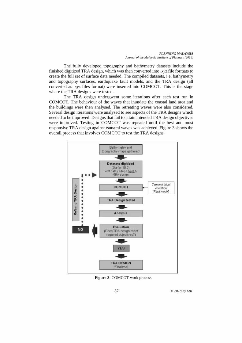
PLANNING MALAYSIA
Journal of the Malaysia Institute of Planners (2018)
87 © 2018 by MIP
The fully developed topography and bathymetry datasets include the
finished digitized TRA design, which was then converted into .xyz file formats to
create the full set of surface data needed. The compiled datasets, i.e. bathymetry
and topography surfaces, earthquake fault models, and the TRA design (all
converted as .xyz files format) were inserted into COMCOT. This is the stage
where the TRA designs were tested.
The TRA design undergwent some iterations after each test run in
COMCOT. The behaviour of the waves that inundate the coastal land area and
the buildings were then analysed. The retreating waves were also considered.
Several design iterations were analysed to see aspects of the TRA designs which
needed to be improved. Designs that fail to attain intended TRA design objectives
were improved. Testing in COMCOT was repeated until the best and most
responsive TRA design against tsunami waves was achieved. Figure 3 shows the
overall process that involves COMCOT to test the TRA designs.
Figure 3: COMCOT work process
Jestin Nordin, Andrew Charleson & Morten Gjerde
Tsunami Modelling Procedures to Refine Coastal Architectural Design Strategies at Kuala Muda
© 2018 by MIP 88
ADVANTAGES AND LIMITATIONS OF COMCOT
Every programme or application has its limitations, including COMCOT. In this
section, the advantages of using computer modelling against physical modelling
are discussed.
The first advantage of using the COMCOT is the ability to run test many
times, and for the researcher to make faster adjustments to the datasets compared
to using a physical model. COMCOT is capable of generating the maximum value
of inundation depth, velocity of the waves, hydrodynamic forces, and also the
curve of the tsunami arrival period (Wijetunge, Wang, & Liu, 2008). This
information can be recorded graphically and will help to study and understand
the waves’ behaviour when they hit the TRA design model.
COMCOT can model the tsunami run-up and also retreating tsunami
waves (COMCOT - A tsunami modelling package, 2011). These features enable
better analyses of the incoming waves’ movements onto the coastal area and
around the buildings and structures, and also the impact of retreating waves.
COMCOT has two fault models. First, from Mansinha & Smylie’s theory
and the second based upon Okada’s theory (COMCOT - A tsunami modelling
package, 2011; Wang 2011). Both are based on the input of earthquake
parameters to calculate the displacement of the seafloor. Okada's theory is an
extension of Mansinha & Smylie’s theory (COMCOT - A tsunami modelling
package, 2011). These models enable a submarine earthquake to be created from
anywhere along an identified existing fault slip in the region being considered.
Computer modelling is more cost effective to run. A physical model
using wave-flumes or a wave-basin needs far more resources than are available.
Computer simulation can also be operated from anywhere in the world, and not
fixed in one place.
Regarding limitations of COMCOT, there are some issues to be taken
care of by the researchers. Careful input of data is needed to avoid any mistakes
during the mapping and data digitalizing process. The data (.dat formats)
produced by the Surfer 10.0 need to be checked carefully before converting the
whole datasets to a .txt file. Any mistake in processing these datasets will generate
inaccurate results.
COMCOT works three-dimensionally, however it can only read the input
of two-dimensional models. In other words, COMCOT cannot read or give
information for better 3D building forms, except a solid geometric pattern. For
example, COMCOT only reads and gives information on what is happening to
the columns’ surfaces of buildings designed with elevated first floors, i.e. no walls
at ground floor, but no information for the walls at the first floor.
Another issue is that every building and structure designed is assumed to be
very strong and not collapse in the simulations. This occurs because COMCOT
cannot simulate the destruction of those buildings by the waves, but will shows
the diffraction of the waves when they hit the structures. The simulation’s output
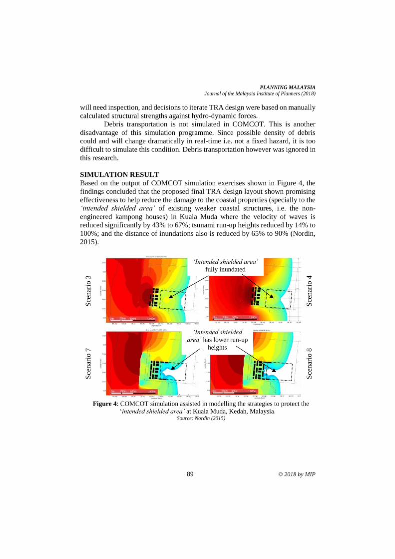
PLANNING MALAYSIA
Journal of the Malaysia Institute of Planners (2018)
89 © 2018 by MIP
will need inspection, and decisions to iterate TRA design were based on manually
calculated structural strengths against hydro-dynamic forces.
Debris transportation is not simulated in COMCOT. This is another
disadvantage of this simulation programme. Since possible density of debris
could and will change dramatically in real-time i.e. not a fixed hazard, it is too
difficult to simulate this condition. Debris transportation however was ignored in
this research.
SIMULATION RESULT
Based on the output of COMCOT simulation exercises shown in Figure 4, the
findings concluded that the proposed final TRA design layout shown promising
effectiveness to help reduce the damage to the coastal properties (specially to the
‘intended shielded area’ of existing weaker coastal structures, i.e. the non-
engineered kampong houses) in Kuala Muda where the velocity of waves is
reduced significantly by 43% to 67%; tsunami run-up heights reduced by 14% to
100%; and the distance of inundations also is reduced by 65% to 90% (Nordin,
2015).
Sce
nar
io 3
Sce
nar
io 4
Sce
nar
io 7
Sce
nar
io 8
Figure 4: COMCOT simulation assisted in modelling the strategies to protect the
‘intended shielded area’ at Kuala Muda, Kedah, Malaysia. Source: Nordin (2015)
‘Intended shielded area’
fully inundated
‘Intended shielded
area’ has lower run-up
heights
Jestin Nordin, Andrew Charleson & Morten Gjerde
Tsunami Modelling Procedures to Refine Coastal Architectural Design Strategies at Kuala Muda
© 2018 by MIP 90
CONCLUSION
COMCOT is a vital tool needed because of its ability to regenerate previous
tsunami events and also to generate predicted ones instead of using a physical
model. The decision was also made because computer simulation is not only
cheaper to run than setting up a physical model, but it also enable researcher to
study the overall performance of the proposed TRA coastal design as beneficial,
hence a better informed coastal architectural design decision can be made to
reduce casualties of both human and properties.
ACKNOWLEDGEMENT
Countless appreciations to the Universiti Sains Malaysia (USM) Short-Term
Grant No. 6313328. Also, thanks to the New Zealand Geological and Nuclear
Science (GNS) scientists especially to Dr. Xiaoming Wang (for the setting up of
the COMCOT simulation, and the technical guides provided) and Dr. Gegar
Prasetya (who has been so helpful during the earlier stage of dataset preparation).
The authors also would like to thank the Ministry of Higher Education Malaysia
(MoHE) and USM-ASTS for the financial assistance provided to finish this
research project.
REFERENCES Amante, C., & Eakins, B. W. (2009). ETOPO1 1 Arc-Minute Global Relief Model.
Available at http://www.ngdc.noaa.gov/mgg/global/global.html
COMCOT - A tsunami modelling package. (2011). Retrieved from
http://ceeserver.cee.cornell.edu/pll-group/comcot.htm
Harig, S., Chaeroni, Pranowo, W. S., & Behrens, J. (2008). Tsunami simulations on
several scales. Ocean Dynamics, 58(5-6), 429-440.
Hock, L. K. (2007). TUNA - tsunami model. Pulau Pinang: Universiti Sains Malaysia.
Hock, L. K., Su, Y. T., Lee, M. K., & Zakaria, N. A. H (2009). Simulation of future
Andaman Tsunami into Straits of Malacca by TUNA. Journal of Earthquake
and Tsunami, 3(2), 89-100.
Immamura, F. (1995). TUNAMI-N1. Tohoku, Japan: Tohoku University, Japan.
Ismail, H., Wahab, A. K. A., & Ibrahim. (2009, November). Numerical experiments on
tsunami propagation into the Straits of Melaka: Focus on the N-W Coast of
Peninsular Malaysia. South China Sea Tsunami Workshop. November 3-5, 2009,
Penang, Malaysia.
Ismail, H. (2010). Tsunami vulnerability assessment technique for the north-west coast
of Peninsular Malaysia. Petaling Jaya: (n.p).
Ismail, H., Abdul Wahab, A. K., Mohd Amin, M. F., Mohd Yunus, M. Z., Jaffar Sidek,
F., & Esfandier, J. B. (2012). A 3-tier tsunami vulnerability assessment
technique for the north-west coast of Peninsular Malaysia. Journal of Natural
Hazards, 63, 549-573.
Johar, F., Majid, M. R., Jaffar, A. R., & Yahya, A. S. (2013). Seismic microzonation for
Banda Aceh city planning. Planning Malaysia, 2, 137-162.
PLANNING MALAYSIA
Journal of the Malaysia Institute of Planners (2018)
91 © 2018 by MIP
Khor, M. (2005). Save the mangroves to fight tsunamis. Third World Network, (Climate
Change). Retrieved from http://www.twn.my/title2/gtrends39.htm
Liu, P. L.-F. (2007). Cornell Multi-grid Coupled Tsunami Model - COMCOT. Retrieved
from http://223.4.213.26/archive/tsunami/cornell/comcot_link.htm
Nielsen, O., Sexton, J., Gray, D., & Bartzis, N. (2005). ANUGA. Canberra, Australia:
Geoscience Australia. Retrieved from
http://www.ga.gov.au/ausgeonews/ausgeonews200609/modelling.jsp
Nordin, J. (2015). Tsunami responsive architecture: Reducing vulnerability along the
North-western Coast of Malaysia (Doctoral dissertation). Victoria University of
Wellington, Wellington, New Zealand.
Okal, E. A., & Synolakis, C. E. (2008). Far-field tsunami hazard from mega-thrust
earthquakes in the Indian Ocean. Geophysical Journal International, 172, 995-
1015.
Pacific Marine Environmental Laboratory (2006). Method of Splitting Tsunami (MOST).
Seattle, USA: National Oceanic and Atmospheric Administration. Retrieved
from http://www.prsn.uprm.edu/Spanish/tsunami/media/MOST_manual.pdf
Raj, J. K. (2007). Tsunami threats to coastal areas of Sabah, East Malaysia. Geological
Society of Malaysia. Bulletin 53, 51-57.
Schirber, M. (2005, February 8). Tsunami earthquake three times larger than first thought.
Retrieved from http://www.livescience.com/environment/050208_
sumatra_quake.html
Tan, E. L. (2008, October 30). Mega-tsunami hit Southeast Asia 700 years ago. Reuters.
Retrieved from https://www.reuters.com/article/us-tsunami-asia-history/mega-
tsunami-hit-southeast-asia-700-years-ago-idUSTRE49S7EX20081029
Teh, S. Y., Koh, H. L., Moh, Y. T., DeAngelis, D. L., & Jiang, J. (2011). Tsunami risk
mapping simulation for Malaysia. Disaster Management and Human Health
Risk II, 119, 3-14.
Tsunami can reach Sabah in 30 mins, says report (2018, October 17). Retrieved from
https://www.edgeprop.my/content/1434775/tsunami-can-reach-sabah-30-mins-
says-report
Wang, X. (2011). User manual of COMCOT - a tsunami generation propagation and run-
up model. GNS Science Report, 1-102.
Wijetunge, J. J., Wang, X., & Liu, P. L.-F. (2008). Indian Ocean Tsunami on 26
December 2004: Numerical modeling of inundation in three cities on the south
coast of Sri Lanka. Journal of Earthquake and Tsunami, 2(2), 133-155.
doi:10.1142/S1793431108000293
Received: 1st June 2018. Accepted:1st December 2018
1 Lecturer at Universiti Sains Malaysia. Email: [email protected] 92
PLANNING MALAYSIA:
Journal of the Malaysian Institute of Planners
VOLUME 16 ISSUE 4 (2018), Page 92 – 103
OPTIMISING BALCONY FOR GREEN SPACES: APPLICATION OF
EDIBLE BIOFAÇADE ON URBAN HIGH-RISE SETTING
Nooriati Taib1 & Rani Prihatmanti2
1&2School of Housing, Building and Planning
UNIVERSITI SAINS MALAYSIA
Abstract
The trend in vertical sprawl of building have initiated the experts in greening
high-rise buildings in the urban setting. This phenomenon has been captured by
many scholars in conducting studies on the benefits of greeneries in limited space
in urban buildings, especially in the form of biofaçade as one of the Vertical
Greenery Systems (VGS). Besides its cooling effects, biofaçade could be
optimised as a vertical edible landscape, hence it could also address food security
issue in the urban context. In a high-rise building, transitional or buffer space,
such as in the balcony, is a space with less economic value. Regardless, the
presence of transitional space is important and could be optimised in the
application of biofacade. This paper reviews the potential of biofaçade as one of
the methods for urban greening in a limited space. However, there are many
factors that need to be consdiered in growing edible plants on the balcony of high-
rise building. Those factors are the plant type and species, the climatic
considerations in high-rise building setting, and the technical and maintenance
issue.
Keywords: biofacade, Vertical Greenery System (VGS), balcony, high-rise
buildings, edible plants
PLANNING MALAYSIA
Journal of the Malaysia Institute of Planners (2018)
93 © 2018 by MIP
INTRODUCTION
Vertical sprawl is becoming a trend in the cities due to rapid growth of population.
The idea of growing vertical to reduce the sprawl and distribute the energy and
resources efficiently is in line with sustainability agendas. Thus, rapid trend of
tall slender towers and iconic skylines are transforming the cities today. It
symbolises the development, advancement of technology, richness, and
efficiency. Palme and Ramirez (2013) stated that it is not the argument of whether
vertical or horizontal growth increases consumption of energy and matter, but
more towards both strategies will increase the size of the city as population grow.
The population growth will incur high demands for human needs.
Food is one of the primary needs for all mankind. It is a key aspect for
most cultures, and has contributed to and inspired many creative aspects of our
lives from local cuisine to urban form (Gorgolewski, 2008). Over the years, the
activity to fulfil this requirement has created an evolution in human settlements
and cultures. The issue of safe food on the table is a never-ending concern for the
government particularly in the developing countries. This concern is also
triggered by the increasing population growth rate resulting in the decreasing
amount of land for food production in the urban area. This causes the source of
food production is relatively far from the urban area and increases health hazard
due to the need of using chemicals to prolong the post-harvest life (Tayobong,
Sanchez, Apacionado, Balladares, & Medina, 2013). They also agreed that the
most vulnerable to the food security is the depressed communities. The issue
about food availability is expected to raise awareness of the government and the
public to produce safe and readily available food (Yusoff, Mohd Hussain, &
Tukiman, 2017). Therefore, there is a need to investigate alternative method to
supply food to the urban community in a sustainable manner.
As future cities are moving towards vertical sprawl, one possible idea in
tackling food shortage is by growing food plants vertically, or known as vertical
farming. According to Al-chalabi (2015), the concept of vertical farm is growing
fruits, vegetables, and grains inside a building in an urban setting. This is also in
line with Despommier (2009), who defines vertical farm as a large-scale
extension of urban agriculture within a building. It is expected to provide food
supply for 60% urban people who will be migrating to the cities in the year 2030
(Despommier, 2013). Thus, it can be concluded that vertical farming is growing
edible plants within a building. Its basic system and technology can be a guiding
principle in establishing edible landscaping (EL). Edible landscaping could be
defined as the use of food-producing plants in landscaping. It could be a
combination of fruit and nut trees, edible flowers, berry bushes, vegetables, and
herbs along with ornamental plants to create an aesthetically pleasing landscape
design (Mansor, Zakariya, Harun, & Bakar, 2017). It is becoming a norm for
those living in homes with backyard to do gardening. This can be seen especially
in rural areas where houses come with spacious yards and gardening becomes a
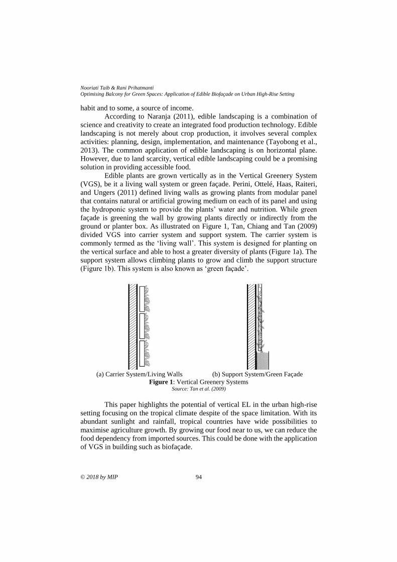
Nooriati Taib & Rani Prihatmanti
Optimising Balcony for Green Spaces: Application of Edible Biofaçade on Urban High-Rise Setting
© 2018 by MIP 94
habit and to some, a source of income.
According to Naranja (2011), edible landscaping is a combination of
science and creativity to create an integrated food production technology. Edible
landscaping is not merely about crop production, it involves several complex
activities: planning, design, implementation, and maintenance (Tayobong et al.,
2013). The common application of edible landscaping is on horizontal plane.
However, due to land scarcity, vertical edible landscaping could be a promising
solution in providing accessible food.
Edible plants are grown vertically as in the Vertical Greenery System
(VGS), be it a living wall system or green façade. Perini, Ottelé, Haas, Raiteri,
and Ungers (2011) defined living walls as growing plants from modular panel
that contains natural or artificial growing medium on each of its panel and using
the hydroponic system to provide the plants’ water and nutrition. While green
façade is greening the wall by growing plants directly or indirectly from the
ground or planter box. As illustrated on Figure 1, Tan, Chiang and Tan (2009)
divided VGS into carrier system and support system. The carrier system is
commonly termed as the ‘living wall’. This system is designed for planting on
the vertical surface and able to host a greater diversity of plants (Figure 1a). The
support system allows climbing plants to grow and climb the support structure
(Figure 1b). This system is also known as ‘green façade’.
(a) Carrier System/Living Walls (b) Support System/Green Façade
Figure 1: Vertical Greenery Systems Source: Tan et al. (2009)
This paper highlights the potential of vertical EL in the urban high-rise
setting focusing on the tropical climate despite of the space limitation. With its
abundant sunlight and rainfall, tropical countries have wide possibilities to
maximise agriculture growth. By growing our food near to us, we can reduce the
food dependency from imported sources. This could be done with the application
of VGS in building such as biofaçade.
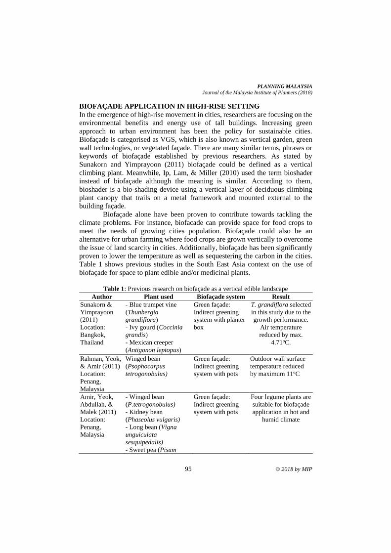
PLANNING MALAYSIA
Journal of the Malaysia Institute of Planners (2018)
95 © 2018 by MIP
BIOFAÇADE APPLICATION IN HIGH-RISE SETTING
In the emergence of high-rise movement in cities, researchers are focusing on the
environmental benefits and energy use of tall buildings. Increasing green
approach to urban environment has been the policy for sustainable cities.
Biofaçade is categorised as VGS, which is also known as vertical garden, green
wall technologies, or vegetated façade. There are many similar terms, phrases or
keywords of biofaçade established by previous researchers. As stated by
Sunakorn and Yimprayoon (2011) biofaçade could be defined as a vertical
climbing plant. Meanwhile, Ip, Lam, & Miller (2010) used the term bioshader
instead of biofaçade although the meaning is similar. According to them,
bioshader is a bio-shading device using a vertical layer of deciduous climbing
plant canopy that trails on a metal framework and mounted external to the
building façade.
Biofaçade alone have been proven to contribute towards tackling the
climate problems. For instance, biofacade can provide space for food crops to
meet the needs of growing cities population. Biofaçade could also be an
alternative for urban farming where food crops are grown vertically to overcome
the issue of land scarcity in cities. Additionally, biofaçade has been significantly
proven to lower the temperature as well as sequestering the carbon in the cities.
Table 1 shows previous studies in the South East Asia context on the use of
biofaçade for space to plant edible and/or medicinal plants.
Table 1: Previous research on biofaçade as a vertical edible landscape
Author Plant used Biofaçade system Result
Sunakorn &
Yimprayoon
(2011)
Location:
Bangkok,
Thailand
- Blue trumpet vine
(Thunbergia
grandiflora)
- Ivy gourd (Coccinia
grandis)
- Mexican creeper
(Antigonon leptopus)
Green façade:
Indirect greening
system with planter
box
T. grandiflora selected
in this study due to the
growth performance.
Air temperature
reduced by max.
4.71oC.
Rahman, Yeok,
& Amir (2011)
Location:
Penang,
Malaysia
Winged bean
(Psophocarpus
tetrogonobulus)
Green façade:
Indirect greening
system with pots
Outdoor wall surface
temperature reduced
by maximum 11oC
Amir, Yeok,
Abdullah, &
Malek (2011)
Location:
Penang,
Malaysia
- Winged bean
(P.tetrogonobulus)
- Kidney bean
(Phaseolus vulgaris)
- Long bean (Vigna
unguiculata
sesquipedalis)
- Sweet pea (Pisum
Green façade:
Indirect greening
system with pots
Four legume plants are
suitable for biofaçade
application in hot and
humid climate
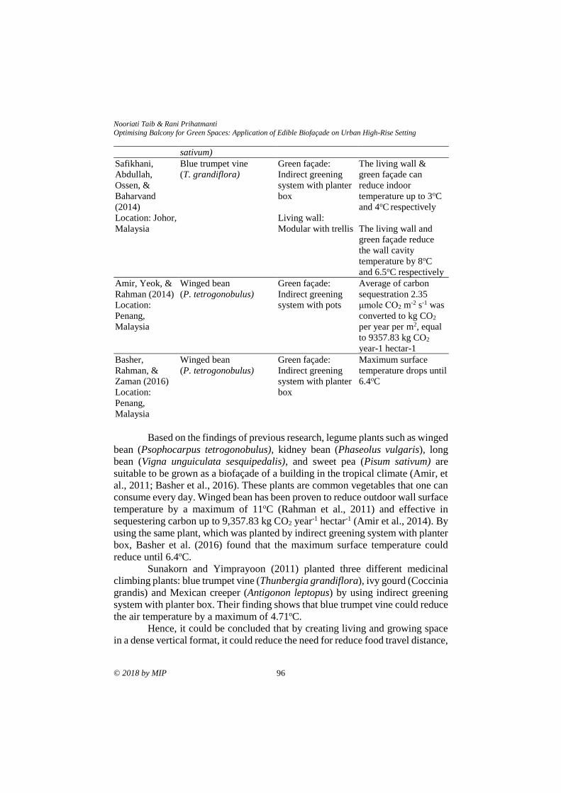
Nooriati Taib & Rani Prihatmanti
Optimising Balcony for Green Spaces: Application of Edible Biofaçade on Urban High-Rise Setting
© 2018 by MIP 96
Based on the findings of previous research, legume plants such as winged
bean (Psophocarpus tetrogonobulus), kidney bean (Phaseolus vulgaris), long
bean (Vigna unguiculata sesquipedalis), and sweet pea (Pisum sativum) are
suitable to be grown as a biofaçade of a building in the tropical climate (Amir, et
al., 2011; Basher et al., 2016). These plants are common vegetables that one can
consume every day. Winged bean has been proven to reduce outdoor wall surface
temperature by a maximum of 11oC (Rahman et al., 2011) and effective in
sequestering carbon up to 9,357.83 kg CO2 year-1 hectar-1 (Amir et al., 2014). By
using the same plant, which was planted by indirect greening system with planter
box, Basher et al. (2016) found that the maximum surface temperature could
reduce until 6.4oC.
Sunakorn and Yimprayoon (2011) planted three different medicinal
climbing plants: blue trumpet vine (Thunbergia grandiflora), ivy gourd (Coccinia
grandis) and Mexican creeper (Antigonon leptopus) by using indirect greening
system with planter box. Their finding shows that blue trumpet vine could reduce
the air temperature by a maximum of 4.71oC.
Hence, it could be concluded that by creating living and growing space
in a dense vertical format, it could reduce the need for reduce food travel distance,
sativum)
Safikhani,
Abdullah,
Ossen, &
Baharvand
(2014)
Location: Johor,
Malaysia
Blue trumpet vine
(T. grandiflora)
Green façade:
Indirect greening
system with planter
box
Living wall:
Modular with trellis
The living wall &
green façade can
reduce indoor
temperature up to 3oC
and 4oC respectively
The living wall and
green façade reduce
the wall cavity
temperature by 8oC
and 6.5oC respectively
Amir, Yeok, &
Rahman (2014)
Location:
Penang,
Malaysia
Winged bean
(P. tetrogonobulus)
Green façade:
Indirect greening
system with pots
Average of carbon
sequestration 2.35
μmole CO2 m-2 s-1 was
converted to kg CO2
per year per m2, equal
to 9357.83 kg CO2
year-1 hectar-1
Basher,
Rahman, &
Zaman (2016)
Location:
Penang,
Malaysia
Winged bean
(P. tetrogonobulus)
Green façade:
Indirect greening
system with planter
box
Maximum surface
temperature drops until
6.4oC
PLANNING MALAYSIA
Journal of the Malaysia Institute of Planners (2018)
97 © 2018 by MIP
create a living architecture that is part of an urban ecosystem, and improve the
thermal comfort of the building. This indirectly minimises the carbon footprint of
the cities.
Moreover, Tayobong et al. (2013) stated that edible biofaçade could
increase the diversity and promote the use of endemic plant species. Biofaçade
could also attract insects, butterflies, and small birds. The addition of natural
habitats in the urban area will enhance its biodiversity. Furthermore, biofaçade
harvests could be sold and become additional source of income for the
community.
GROWING VERTICAL EDIBLE LANDSCAPE ON TRANSITIONAL
SPACE IN HIGH-RISE BUILDING
As mentioned earlier, majority of urban dwellers are currently residing in high-
rise residential buildings with limited access to greeneries. According to the
United Nations (2018), 55% of the world’s population today live in the urban
areas. The figure is expected to increase up to 68% by the year 2050, with Asia
and Africa contributing the most (almost 90%). The urban population level in
Malaysia is also increasing rapidly (World Bank, 2015). It increases from 10.2
million (43% of the total population) to 15 million (53% of the total population)
in a decade, making it among the most urbanised countries in East Asia after
Japan, Republic of Korea, and Singapore.
Growing population and land scarcity would increase demand for high-
rise residential buildings as well as other infrastructure in the urban areas. This
would result in the separation of human from nature. However, Lohr (2010) and
Shibata & Suzuki (2002) agreed that nature brings positive impact on human’s
cognition, psychology, and physiology. Therefore, the connectedness of human
with the nature needs to be re-established by integrating greeneries on the
building.
Due to the space limitation in the high-rise building, transitional space
could be utilised as a green space. Transitional space, or buffer space could be
defined as a space in between the interior and exterior environment. Chun, Kwok,
& Tamura (2004) categorised transitional space into 3, which are (1) contained
space within a building, e.g. lobby or atrium; (2) space that is covered, connected
to the building, and affected by outdoor air, e.g. balcony, corridor, porch etc. and
(3), space that is not attached to a building and fully influenced by outdoor air,
e.g. pergola, pavilion. Although this space has less economic value, transitional
space has the potential to be optimised in replacing the greeneries on the ground
floor since it is often related with open area. Thus, it is easily influenced by the
variable weather conditions since it is close to the natural environment. It is
expected that by integrating vertical plants on building, it could help to filter out
the airborne pollutants as well as to improve the thermal comfort (Prihatmanti &
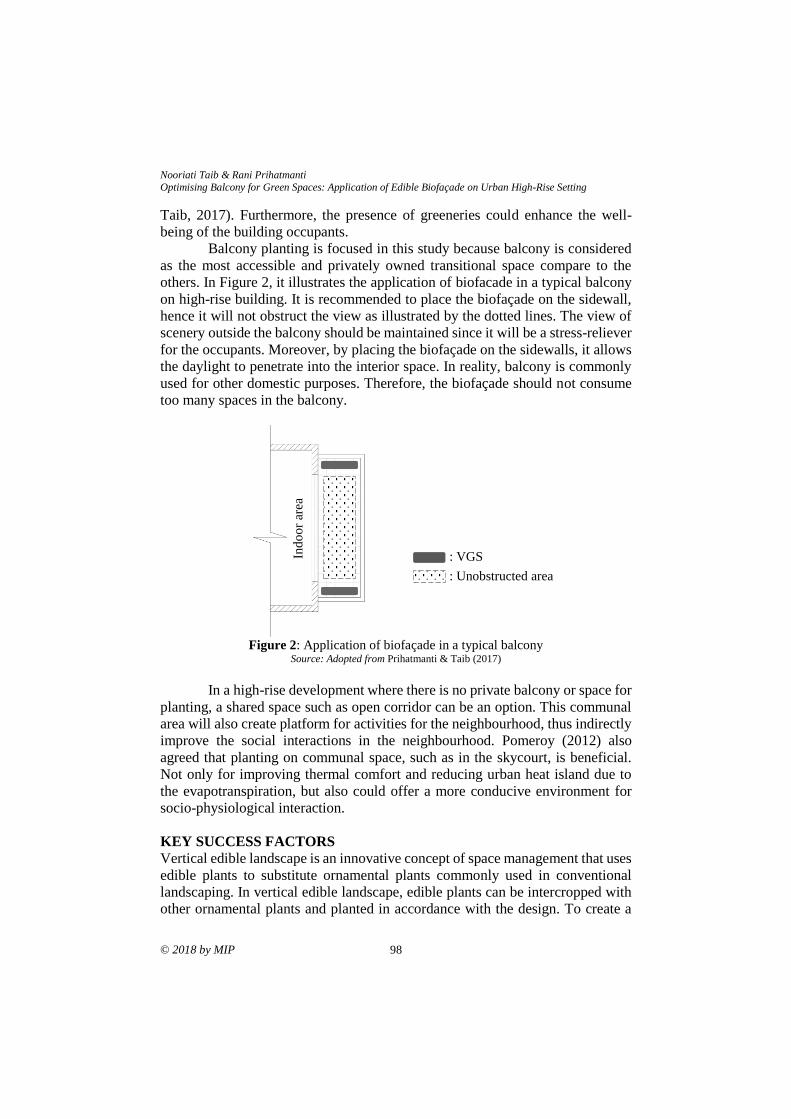
Nooriati Taib & Rani Prihatmanti
Optimising Balcony for Green Spaces: Application of Edible Biofaçade on Urban High-Rise Setting
© 2018 by MIP 98
Taib, 2017). Furthermore, the presence of greeneries could enhance the well-
being of the building occupants.
Balcony planting is focused in this study because balcony is considered
as the most accessible and privately owned transitional space compare to the
others. In Figure 2, it illustrates the application of biofacade in a typical balcony
on high-rise building. It is recommended to place the biofaçade on the sidewall,
hence it will not obstruct the view as illustrated by the dotted lines. The view of
scenery outside the balcony should be maintained since it will be a stress-reliever
for the occupants. Moreover, by placing the biofaçade on the sidewalls, it allows
the daylight to penetrate into the interior space. In reality, balcony is commonly
used for other domestic purposes. Therefore, the biofaçade should not consume
too many spaces in the balcony.
Figure 2: Application of biofaçade in a typical balcony
Source: Adopted from Prihatmanti & Taib (2017)
In a high-rise development where there is no private balcony or space for
planting, a shared space such as open corridor can be an option. This communal
area will also create platform for activities for the neighbourhood, thus indirectly
improve the social interactions in the neighbourhood. Pomeroy (2012) also
agreed that planting on communal space, such as in the skycourt, is beneficial.
Not only for improving thermal comfort and reducing urban heat island due to
the evapotranspiration, but also could offer a more conducive environment for
socio-physiological interaction.
KEY SUCCESS FACTORS
Vertical edible landscape is an innovative concept of space management that uses
edible plants to substitute ornamental plants commonly used in conventional
landscaping. In vertical edible landscape, edible plants can be intercropped with
other ornamental plants and planted in accordance with the design. To create a
: VGS
: Unobstructed area
Ind
oo
r ar
ea
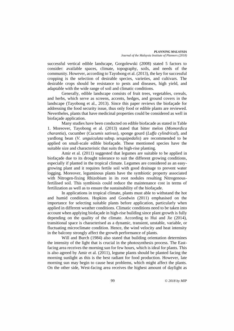
PLANNING MALAYSIA
Journal of the Malaysia Institute of Planners (2018)
99 © 2018 by MIP
successful vertical edible landscape, Gorgolewski (2008) stated 5 factors to
consider: available spaces, climate, topography, soils, and needs of the
community. However, according to Tayobong et al. (2013), the key for successful
cropping is the selection of desirable species, varieties, and cultivars. The
desirable crops should be resistance to pests and diseases, high yield, and
adaptable with the wide range of soil and climatic conditions.
Generally, edible landscape consists of fruit trees, vegetables, cereals,
and herbs, which serve as screens, accents, hedges, and ground covers in the
landscape (Tayobong et al., 2013). Since this paper reviews the biofaçade for
addressing the food security issue, thus only food or edible plants are reviewed.
Nevertheles, plants that have medicinal properties could be considered as well in
biofaçade application.
Many studies have been conducted on edible biofacade as stated in Table
1. Moreover, Tayobong et al. (2013) stated that bitter melon (Momordica
charantia), cucumber (Cucumis sativus), sponge gourd (Luffa cylindrical), and
yardlong bean (V. unguiculata subsp. sesquipedalis) are recommended to be
applied on small-scale edible biofaçade. These mentioned species have the
suitable size and characteristic that suits the high-rise planting.
Amir et al. (2011) suggested that legumes are suitable to be applied in
biofaçade due to its drought tolerance to suit the different growing conditions,
especially if planted in the tropical climate. Legumes are considered as an easy-
growing plant and it requires fertile soil with good drainage to prevent water
logging. Moreover, leguminous plants have the symbiotic property associated
with Nitrogen-fixing Rhizobium in its root nodules resulting Nitrogenous-
fertilised soil. This symbiosis could reduce the maintenance cost in terms of
fertilization as well as to ensure the sustainability of the biofaçade.
In applications in tropical climate, plants must able to withstand the hot
and humid conditions. Hopkins and Goodwin (2011) emphasised on the
importance for selecting suitable plants before application, particularly when
applied in different weather conditions. Climatic conditions need to be taken into
account when applying biofaçade in high-rise building since plant growth is fully
depending on the quality of the climate. According to Hui and Jie (2014),
transitional space is characterised as a dynamic, transient, unstable, variable, or
fluctuating microclimate condition. Hence, the wind velocity and heat intensity
in the balcony strongly affect the growth performance of plants.
Will and Burch (1984) also stated that building orientation determines
the intensity of the light that is crucial in the photosynthesis process. The East-
facing area receives the morning sun for few hours, which is ideal for plants. This
is also agreed by Amir et al. (2011), legume plants should be planted facing the
morning sunlight as this is the best radiant for food production. However, late
morning sun may begin to cause heat problems, which might affect the plants.
On the other side, West-facing area receives the highest amount of daylight as
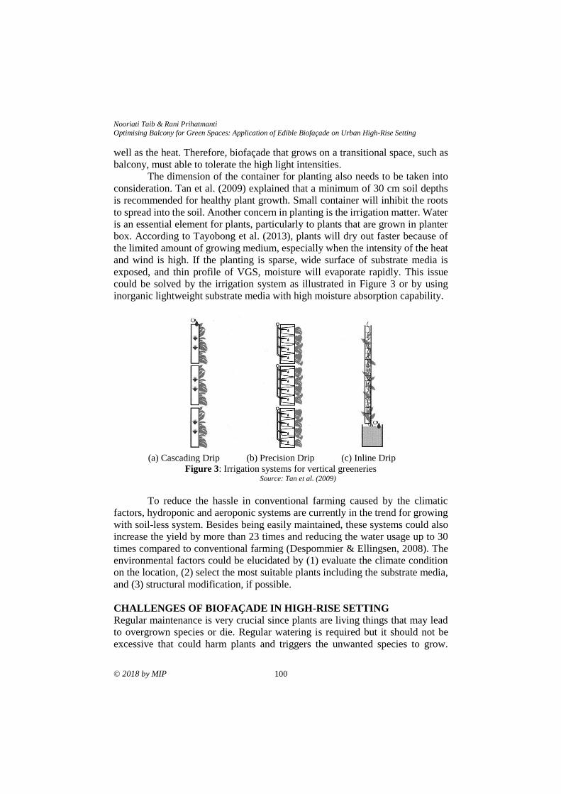
Nooriati Taib & Rani Prihatmanti
Optimising Balcony for Green Spaces: Application of Edible Biofaçade on Urban High-Rise Setting
© 2018 by MIP 100
well as the heat. Therefore, biofaçade that grows on a transitional space, such as
balcony, must able to tolerate the high light intensities.
The dimension of the container for planting also needs to be taken into
consideration. Tan et al. (2009) explained that a minimum of 30 cm soil depths
is recommended for healthy plant growth. Small container will inhibit the roots
to spread into the soil. Another concern in planting is the irrigation matter. Water
is an essential element for plants, particularly to plants that are grown in planter
box. According to Tayobong et al. (2013), plants will dry out faster because of
the limited amount of growing medium, especially when the intensity of the heat
and wind is high. If the planting is sparse, wide surface of substrate media is
exposed, and thin profile of VGS, moisture will evaporate rapidly. This issue
could be solved by the irrigation system as illustrated in Figure 3 or by using
inorganic lightweight substrate media with high moisture absorption capability.
(a) Cascading Drip (b) Precision Drip (c) Inline Drip
Figure 3: Irrigation systems for vertical greeneries Source: Tan et al. (2009)
To reduce the hassle in conventional farming caused by the climatic
factors, hydroponic and aeroponic systems are currently in the trend for growing
with soil-less system. Besides being easily maintained, these systems could also
increase the yield by more than 23 times and reducing the water usage up to 30
times compared to conventional farming (Despommier & Ellingsen, 2008). The
environmental factors could be elucidated by (1) evaluate the climate condition
on the location, (2) select the most suitable plants including the substrate media,
and (3) structural modification, if possible.
CHALLENGES OF BIOFAÇADE IN HIGH-RISE SETTING
Regular maintenance is very crucial since plants are living things that may lead
to overgrown species or die. Regular watering is required but it should not be
excessive that could harm plants and triggers the unwanted species to grow.
PLANNING MALAYSIA
Journal of the Malaysia Institute of Planners (2018)
101 © 2018 by MIP
Limited exposure to daylight also contributes to negative effect, where plants
could not optimally grow. However, excessive daylight also might be harmful to
the plants themselves. The idea of planting in balcony allows for some coverage
from the harsh climate conditions on the high-rise building. Good landscape
criteria should fulfil its function with efficiency, aesthetic, enhances the welfare,
and can be maintained in a viable condition. Hence, maintenance is important to
maintain the growth performance and the yield, where yield is a priority in
vertical edible landscape. Some simple practices conducted during maintenance
are watering, pruning, fertilizing, harvesting, and management of pests.
Although located above the ground, biofaçade in the balcony is still at
risk of being attack by pests and diseases. The use chemical pesticides and
herbicides as a pest management are widely applied and easy to use. However, it
will bring the short and long term adverse effects to the environment as well as
to the human. Chemicals with natural extracts, such as Cymbopogonnandus liquid
could be considered as an alternative (Amir, Yeok, Abdullah, & Rahman, 2011).
Fertiliser made from excrement should be avoided to prevent the spread of
numerous viral, bacterial, and eukaryotic infectious agents (Despommier, 2013).
Tayobong et al. (2013) suggested companion planting can be applied as one of
the pest management practices. It is known that onion (Allium cepa), marigold
(Tagetes spp.), and garlic (Allium sativum) are repellent plants that are commonly
used in companion planting to repel pests.
CONCLUSION
Lack of green spaces on the ground level has initiate many people to integrate the
greeneries with the building regardless the limitation of the space allocated. This
subject has attracted attention among the researchers and related professionals in
combining edible and medicinal plants as a biofaçade, which is planted on a
transitional space in high-rise building. Providing food to accommodate the basic
human need now is possible in an urban context in a way that is socially,
economically, and ecologically benefitting. The main objectives of edible
landscaping in urban areas is to engage the community in growing their own
vegetables by having their own sources of food even at the smallest scale possible
and it would increase vegetable consumption.
Growing food plants in the urban areas will lower the consumption of
fossil fuel for transportation as well as to increase the vegetable consumption in
the household level. Maximising the transitional spaces such as balcony can be
an alternative for biofaçade planting in a high-rise setting. Creating social
communal neighbourhood in urban context may have shifted from landscape
gardens on the ground to small gardens on high-rise setting. The plants selected
for biofaçade application should thrive in high daytime temperature, able to
tolerate dry conditions, and intense sunlight. The substrate media, dimension of
Nooriati Taib & Rani Prihatmanti
Optimising Balcony for Green Spaces: Application of Edible Biofaçade on Urban High-Rise Setting
© 2018 by MIP 102
container, building orientation, and the amount of water need to be considered in
balcony planting.
ACKNOWLEDGEMENT
The authors would like to thank to the Universiti Sains Malaysia (USM) as the
funding body of this research under the University Grant no.
1001/PPBGN/814286 and supported by the Fellowship scheme of Institute of
Postgraduate Studies USM.
REFERENCES Al-chalabi, M. (2015). Vertical farming: Skyscraper sustainability? Sustainable Cities
and Society, 18, 74-77. https://doi.org/10.1016/j.scs.2015.06.003
Amir, A. F., Yeok, F. S., Abdullah, A., & Malek, A. R. (2011). The most effective
Malaysian Legume plants as biofacade for building wall application. Journal of
Sustainable Development, 4(1), 103-111.
Amir, A. F., Yeok, F. S., Abdullah, A., & Rahman, A. M. A. (2011). Biofacade for Urban
Development: Pest and Diseases, Its Control and Prevention. Journal of
Sustainable Development, 4(5), 237-243. https://doi.org/10.5539/jsd.v4n5p237
Amir, A. F., Yeok, F. S., & Rahman, A. M. A. (2014). Estimation of Annual Carbon
Sequestration in Psophocarpus tetragonobulus used as Biofacade in Tropical
Environment. In International Conference on Architecture and Civil
Engineering (pp. 31–37). Dubai.
Basher, H. S., Rahman, A. M. A., & Zaman, N. Q. (2016). The use of edible vertical
greenery system to improve thermal performance in tropical climate. Journal of
Mechanical Engineering, 13, 57-66.
Chun, C., Kwok, A., & Tamura, A. (2004). Thermal comfort in transitional spaces - Basic
concepts: Literature review and trial measurement. Building and Environment,
39(10), 1187-1192. https://doi.org/10.1016/j.buildenv.2004.02.003
Despommier, D. (2009). The rise of vertical farms. Scientific American, 301(5), 80-87.
Despommier, D. (2013). Farming up the city: The rise of urban vertical farms. Trends in
Biotechnology, 31(7), 388-389. https://doi.org/10.1016/j.tibtech.2013.03.008
Despommier, D., & Ellingsen, E. (2008). The vertical farm: The sky-scraper as vehicle
for a sustainable urban agriculture. In CBTUH 8th World Congress (pp. 1-8).
Chicago: Council on Tall Buildings and Urban Habitat.
Gorgolewski, M. (2008, September). Food security and the design of sustainable
buildings and cities. World Sustainable Building Conference. September 21-25,
2008, Melbourne, Australia.
Hopkins, G., & Goodwin, C. (2011). Living architecture: Green roofs and walls.
Collingwood, Vic: Csiro Publishing.
Hui, S. C. M., & Jie, J. (2014). Assessment of thermal comfort in transitional spaces. In
Joint Symposium 2014: Change in Building Services for Future (pp. 1-13). Hong
Kong.
Ip, K., Lam, M., & Miller, A. (2010). Shading performance of a vertical deciduous
climbing plant canopy. Building and Environment, 45(1), 81-88.
https://doi.org/10.1016/j.buildenv.2009.05.003
PLANNING MALAYSIA
Journal of the Malaysia Institute of Planners (2018)
103 © 2018 by MIP
Lohr, V. I. (2010). What are the benefits of plants indoors and why do we respond
positively to them? Acta Horticulturae, 881(2), 675-682.
Mansor, M., Zakariya, K., Harun, N. Z., & Bakar, N. I. A. (2017). Appreciation of vertical
greenery in a city as public art. Planning Malaysia, 15(1), 117-128.
Naranja, L. R. (2011). Edible landscaping. UPLB Journal, 9, 44-63.
Palme, M., & Ramírez, J. (2013). A critical assessment and projection of urban vertical
growth in Antofagasta, Chile. Sustainability, 5(7), 2840-2855.
Perini, K., Ottelé, M., Haas, E. M., Raiteri, R., & Ungers, O. M. (2011). Greening the
building envelope, façade greening and living wall systems. Open Journal of
Ecology, 1(1), 1-8.
Pomeroy, J. (2012). Greening the urban habitat : Singapore. CTBUH Journal.
Prihatmanti, R., & Taib, N. (2017). Improving thermal comfort through vertical
greeneries in transitional spaces for the tropical climate : A review. Journal of
Engineering Technology, 4(3), 116-123.
Rahman, A. M. A., Yeok, F. S., & Amir, A. F. (2011). The building thermal performance
and Carbon sequestration evaluation for Psophocarpus tetrogonobulus on
biofaçade wall in the tropical environment. International Journal of
Environmental and Ecological Engineering, 5(4), 206-214.
Safikhani, T., Abdullah, A. M., Ossen, D. R., & Baharvand, M. (2014). Thermal impacts
of Vertical Greenery Systems. Environmental and Climate Technologies14, 10-
16. https://doi.org/10.1515/rtuect-2014-0007
Shibata, S., & Suzuki, N. (2002). Effects of the foliage plant on task performance and
mood. Journal of Environmental Psychology, 22(3), 265-272.
https://doi.org/10.1006/jevp.2002.0232
Sunakorn, P., & Yimprayoon, C. (2011). Thermal performance of biofacade with natural
ventilation in the tropical climate. Procedia Engineering, 21, 34-41.
https://doi.org/10.1016/j.proeng.2011.11.1984
Tan, P. Y., Chiang, K., & Tan, A. (2009). Vertical greenery for the tropics. Singapore:
National Parks Board, National Parks Board Headquarters, Singapore Botanic
Gardens
Tayobong, R. R. P., Sanchez, F. C., Apacionado, B. V, Balladares, M. C. E., & Medina,
N. G. (2013). Edible landscaping in the Philippines: Maximizing the use of small
spaces for aesthetics and crop production. Journal of Developments in
Sustainable Agriculture, 99, 91-99.
United Nations (2018). 2018 revision of world urbanization prospects. Retrieved from
https://www.un.org/development/desa/publications/2018-revision-of-world-
urbanization-prospects.html
Will, A. A. J., & Burch, D. (1984). Balcony plants. In Proceedings of the Florida State
Holticultural Society (pp. 257-260). Florida: Florida State Holticultural Society.
World Bank. (2015). Malaysia among most urbanized countries in East Asia. Retrieved
from http://www.worldbank.org/en/news/feature/2015/01/26/malaysia-among-
most-urbanized-countries-in-east-asia
Yusoff, N. H., Mohd Hussain, M. R., & Tukiman, I. (2017). Roles of community towards
urban farming. Journal of Malaysia Institute of Planners, 15(1), 271-2788
Received: 1st June 2018. Accepted:1st December 2018
1Senior Lecturer at Universiti Sains Malaysia. Email: [email protected] 104
PLANNING MALAYSIA:
Journal of the Malaysian Institute of Planners
VOLUME 16 ISSUE 4 (2018), Page 104 – 116
EMERGING BUILT HERITAGE COMMODIFICATION OF
BOUTIQUE HOTELS IN WORLD HERITAGE SITE: EVIDENCE
FROM GEORGE TOWN, PENANG, MALAYSIA
Suraiyati Rahman1
1School of Housing, Building and Planning
UNIVERSITI SAINS MALAYSIA
Abstract
Although heritage, by its very nature, has been in existence for a long time, an
understanding of the ways in which heritage products can be used is relatively
recent. The increasing number of boutique hotels in George Town has contributed
to the distinctiveness of lodging accommodation. In many cases, this has led to
the commodification of the built historic environment and its history into a form
of tourism product. This study sought to investigate the process of the built
heritage commodification of boutique hotels in George Town. A semi-structured
interview was conducted among boutique hotel managers and entrepreneurs in
George Town, Penang. The findings revealed that external factors such as the
global recognition of George Town as a World Heritage Site and the setting of
the historic city are the pull factors for investors to purchase premises in the city
centre. These built heritage resources (tangible heritage) and intangible values
have been assimilated with their contemporary uses to be commodified into
different types of boutique hotels. The attempt to establish a built heritage
commodification model will contribute to the empirical data on the process and
the factors that lead to the built heritage commodification of boutique hotels in
heritage city.
Keywords: built heritage, boutique hotels, heritage commodification, World
Heritage Site, tourism
PLANNING MALAYSIA
Journal of the Malaysia Institute of Planners (2018)
105 © 2018 by MIP
INTRODUCTION
Heritage buildings, monuments and cultures are heritage resources that remind us
of history and contribute to sense of place (Suraiyati, 2013). The concept of
heritage has evolved from a focus on preservation to looking at the practice and
adoption of contemporary needs. Recently, historical resources have been used
widely to shape the socio-cultural identity of places. Heritage commodification
is the process of transforming historic resources into a contemporary commodity
to satisfy a current consumption need. Yet, there is limited understanding of the
process of heritage as used in the context of tourism. Theoretically, the heritage
production model suggested by Ashworth and Larkham (1994) is mainly based
on the existence of resources. Culture and heritage are common attractions for
cultural tourists, who seek authenticity and an experience of the past.
Experiencing heritage has become one of several priorities in the cultural
motivation to travel, resulting in a commodification of the past (Waitt, 2000;
Amir, Osman, Bachok, Ibrahim, & Mohamed, 2017). According to Ashworth
(2012), the built environment resulted from human needs, and this can be seen in
the physical morphologies and usage of the physical environment (Rani, Putri, &
Devina, 2017). He added, as contemporary requirements change, the forms to
accommodate those requirements will consequently be transformed.
The trend to protect historic buildings and monuments, and to preserve,
conserve and re-adaptive use, has been extensively discussed and practised.
However, the response of the market towards the heritage tourism industry has
boosted the opportunity to commodify heritage resources into profitable products.
Heritage commodification is a newly-introduced term, yet it has been in practice
due to market demand. The conversion of built heritage resources into heritage
products can generate economic income, conserve heritage resources and educate
the society on the values of history (Astuti, Permana, Qomarun, Febela, &
Andisetyana, 2017). Wight (1994) claimed that a destination with maximum
business goals of tourism development but few strategies for cultural heritage
conservation might lead to the loss of its culture and tradition. Similarly, Li
(2003) stated that intensified efforts to conserve a cultural heritage rather than to
develop it for tourism may lead to the failure of businesses in a destination. The
scenario of a market driven by tourism development can be seen in Malaysia,
especially in George Town and Melaka, due to the World Heritage listing
inscription. George Town is known as a popular destination because of its local
culture and heritage characteristics, with its abundance of pre-war buildings and
history.
The increasing number of boutique hotels in George Town has
contributed to the distinctiveness of its lodging accommodation, and these serve
as tourist attractions. Based on previous studies, scholars and researchers have
identified boutique hotels across continents, including the United States of
America (Anhar, 2001), the United Kingdom (Aggett, 2007; Lim & Endean,
Suraiyati Rahman
Emerging Built Heritage Commodification of Boutique Hotels in World Heritage Site: Evidence from George Town,
Penang, Malaysia
© 2018 by MIP 106
2009), South Africa (Rogerson, 2010), Turkey (Erkutlu & Chafra, 2005),
Australia (Lwin & Phau, 2013), Thailand (Rompho & Boonitt, 2012), Malaysia
(Arifin, Jamal, Aziz, & Ismail, 2015; Khosravi, Malek, & Ekiz, 2014; Goh, 2015)
and Singapore (Chang & Teo, 2008; Henderson, 2011). Definitions for boutique
hotels differ based on different characteristics such as the concept and
architectural design, which vary from a unique architectural, modern, minimalist
or heritage design. Heritage hotels are small in size, with the number of rooms
being limited to not more than 100 rooms. They offer personalised service, and
focus on a target market (Aggett, 2007; Lim & Endean, 2009). Henderson (2011)
also noted that boutique-style hotels are becoming increasingly popular in
Southeast Asia, especially in heritage areas. However, research on the emerging
commodification of built heritage into boutique hotels in Malaysia is relatively
new. Hence, this article was aimed at examining the perspective from the supply
side of investors and managers on the interpretation of the boutique hotel concept
and the factors that contribute to the re-adaptation of heritage buildings into
boutique hotels.
LITERATURE REVIEW
Characteristics of Boutique Hotels
The terminology of boutique hotels is broad and has been evolving since the
1980s. The many definitions of boutique hotels have led to difficulties in defining
and conceptualising boutique hotels. The term ‘boutique’ itself refers to
exclusiveness. However, this exclusiveness does not necessarily signify
something that is expensive and that caters to the elite. The niche product in the
hospitality industry, which is more geared towards distinctiveness and
uniqueness, has led to the growing number of boutique hotels. The new consumer
trend, which rejects the homogeneity that characterises the commercial
accommodation sector, has given rise to the increasing number of boutique hotels
(Aggett, 2007; Rogerson, 2010; Timothy & Teye, 2009). A growing interest in
art, culture and history, which started in 1980, is the underlying factor that has
contributed to the acknowledgement of cultural tourism (Freund de Klumbis &
Munsters, 2005). The first boutique hotel, which was Morgan’s Hotel in New
York, was introduced in 1984. It was owned by Ian Schrager and Steve Rubell
(Freund de Klumbis & Munsters, 2005).
The key characteristics of a boutique hotel are quite subjective due to its
broad terminology. A few scholars have suggested that these key characteristics
are a small-sized property and limited rooms. Boutique hotels can accommodate
a limited number of rooms at the same time (McIntosh & Siggs, 2005; Wheeler,
2006; Lim & Endean, 2009). A typical boutique hotel is associated with a small-
scale property having between 50-100 rooms (Erkutlu & Chafra, 2005; Van
Hartesvelt, 2006; Agget, 2007; Lim & Endean, 2009). Therefore, the number of
PLANNING MALAYSIA
Journal of the Malaysia Institute of Planners (2018)
107 © 2018 by MIP
guests in boutique hotels is less due to the limited capacity, essentially providing
more individualised and personalised services compared to conventional hotels
(McIntosh & Siggs, 2005). The interaction between guests and the staff is more
intimate compared to typical hotels, which are mass consumers. Boutique hotels
have a high staff-to-guest ratio, thereby allowing them to provide personalised
services (Lim & Endean, 2009; Erkutlu & Chafra, 2005) that enable each guest
to experience a special and unique feeling throughout their stay.
Most of the boutique hotels are in city centres and are very popular among
business travellers (Lim & Endean, 2009; Albazzaz et al., 2003; Teo & Yeh,
1997). Besides, the concept of boutique hotels has also been introduced in rural
and suburban settings. Boutique hotels are typically referred to as non-
standardised hotels due to their unique design. This was supported by Forgsgren
and Franchetti (2004), who stated that the purpose of hotels with a unique concept
such as boutique hotels is to differentiate themselves from their competitors
through their image, lifestyle, design and style.
Most of the boutique hotels are typically housed in older and unique
structures that have been converted to new functions (Van Hartesvelt, 2006). The
themes for boutique hotels range from heritage to contemporary, and modern.
The aim is to offer an alternative option to chain hotels with a different look and
ambience. Another characteristic of boutique hotels is their unique interior
design. Lim and Endean (2009) added that “individuality” is the key term in
describing the dissimilar design of each room in boutique hotels. For example,
the decoration of each room might be based upon the works of a well-known
painter (Lim & Endean, 2009; Erkutlu & Chafra, 2005). ‘Warmth’, ‘intimacy’,
‘distinction’ and ‘stylish’ are the most important key words that describe the
architecture and design of boutique hotels. Generally, the room rate per night
depends on the type of room.
The prices at boutique hotels vary and correspond to those of three to
five-star hotels (Van Hartesvelt, 2006; Henderson, 2011). It is the exclusiveness
of the price offered by boutique hotels that makes these hotels give more attention
to the privacy of the guest. The table below shows the classification of the
characteristics in a town setting.
METHODOLOGY
This research adopted a qualitative approach by conducting a content analysis of
a literature review and semi-structured interview with hoteliers of boutique hotels
in George Town, Penang. The purposive sampling technique was adopted in the
qualitative studies by selecting units such as individuals, groups of individuals,
and institutions with specific purposes that were able to answer the research
questions. The key characteristics of boutique hotels in a heritage city were
defined and identified in the case study area. Eighteen boutique hotels were
identified in George Town, Penang based on the list given by the Ministry of
Suraiyati Rahman
Emerging Built Heritage Commodification of Boutique Hotels in World Heritage Site: Evidence from George Town,
Penang, Malaysia
© 2018 by MIP 108
Culture, Arts and Tourism, as well as a critical review of the characteristics of
boutique hotels. The identified boutique hotels that are located within the core
zone and buffer zone are shown in Figure 1. However, only 8 managers of the 18
boutique hotels agreed to participate in the interview. The responses were
transcribed and analysed using a thematic analysis to identify the characteristics
of a boutique hotel in the case study area as well as to establish a boutique hotel
commodification model in the historic city.
FINDINGS AND DISCUSSION
Emergence of Boutique Hotel Commodification in Heritage City
Historically, George Town is a vibrant trading port with multi-ethnic inhabitants.
The collection of pre-war buildings representing different periods and cultures
has flourished to promote George Town as a heritage destination with a unique
cultural image among tourists and visitors. However, it cannot be denied that the
changing nature of the local residents, who are not keen to reside in the inner city
of George Town compared to a few decades ago, has led to a change in the
functional structure of the residential houses in the inner city of George Town.
This has led to a re-adaptive use of the colonial premises in the inner city of
George Town, where they are being converted for contemporary uses. Although
the original functions of the premises might not be doable for the present day, but
the attempt to conserve the pre-war premises might revitalise the heritage city
and generate the economy. The emergence of boutique hotel commodification in
George Town is caused by several factors, both extrinsic and intrinsic, that have
contributed to the potential of new heritage business products in the World
Heritage Site of George Town.
Branding Image as World Heritage Site
George Town possesses a distinctive character as a heritage city and was
nominated as a World Heritage Site by UNESCO in 2008 under category II, III
and IV, according to the Outstanding Universal Value (OUV). The world’s
recognition of the branding image of a heritage site has made it a popular
destination for international and local tourists. Consequently, the demands of
heterogeneous users have transformed the preservation of the built heritage. The
establishment of boutique hotels started in George Town between 1999 and 2000,
before George Town was inscribed as a World Heritage Site. There were initially
only two boutique hotels, the Blue Mansion and Yeng Keng Hotel, which were
operating until recently. The built heritage commodification of boutique hotels is
an emerging phenomenon due to the market demand from a segmented group of
users. Beginning 2008 onwards, entrepreneurs began to purchase premises in the
city of George Town and converted their pre-war premises into classy and refined
boutique hotels. The number of boutique hotels started to increase from 2008
PLANNING MALAYSIA
Journal of the Malaysia Institute of Planners (2018)
109 © 2018 by MIP
onwards, until up to 16 boutique hotels had been established in George Town,
Penang. The commodification process can be defined as the process of
transforming goods, services or ideas into an extended economic value. R4
mentioned their decision to start a boutique hotel business in the inner city of
George Town because “…this place is a good location (strategic location), where
it is in the centre of George Town, a World Heritage Site…”. Similarly, with R1,
R2, R3 and R6 … “It is located within the heritage city of George Town....”. R5
stated, “…this area is the core zone of heritage…”. Most of the managers of
boutique hotels stated that the World Heritage Site image and the core heritage
zone were important factors for their initial motivation to set up their business.
Su (2011) revealed that the commodification of urban heritage in Lijiang
achieved great success in selling heritage to the tourism industry ever since it was
designated a World Heritage Site in 1997. Nevertheless, George Town has
inevitably shown an increase in the number of new investors who have adaptively
re-used abandoned or old buildings for commercial purposes. The market demand
has opened opportunities for contemporary uses for the hospitality industry.
Multi-Functions of City Centre Setting
Investors chose the location of the city centre of George Town as the city provides
multiple functions and uses to tourists. Boutique hotels gain popularity in the city
centre especially the heritage city. The city provides good transportation linkages
with abundant facilities, various interesting places to visit, conveniences for
pedestrians, and a setting for any art, music or cultural event or festival. From the
findings, the location of the boutique hotels within the city centre comes with
diverse amenities, facilities, local culture and accessibility to tourist attractions.
R2, R3, R4, R5 and R8 had similar perspectives, whereby they indicated that their
hotels were located in hotspots that were crowded with tourists. R2 stated, “It is
located within the heritage city of George Town, and almost the entire hotel is
crowded with people...”, and R3 also stated, “The owner has found that this area
is so crowded with people…”. Meanwhile, R5 suggested that the location was
“…very convenient for walking around to the places of attraction…”. Location is
not only a matter of convenience, but is also indicative of the ‘trendiness’ and
‘chic-ness’ of the respective neighbourhoods, which caused the hoteliers to locate
their hotels within the city centre (Olga, 2009). Hence, the location of boutique
hotels within city centres with vibrant economies and facilities provides a
platform for producers (investors) to fully utilize the image branding of heritage
sites for their consumers. This was supported by various authors (Teo & Yeoh,
1997; Albazzaz et al., 2003; Lim & Endean, 2009; Arifin et al., 2014), who stated
that the strategic location of boutique hotels has become one of the key factors
that can attract guests to stay. Hence, specialized lodgings like boutique hotels
have been growing in the business area, which is in the most crowded place in
the city.
Suraiyati Rahman
Emerging Built Heritage Commodification of Boutique Hotels in World Heritage Site: Evidence from George Town,
Penang, Malaysia
© 2018 by MIP 110
Tangible Values: Distinctive Character of Historic Buildings George Town has the largest collection of pre-war premises in Southeast Asia,
totalling approximately 4,000 premises. The conservation of historic buildings
has become one of the approaches to prevent deterioration and to prolong the life
of architectural buildings. Some of the owners are international investors, and
they have developed the theme of a boutique hotel based on their interests.
However, if the premises are under category I or II or are located within the core
heritage zone, they are bound to comply with certain guidelines. In Malaysia,
heritage buildings are protected under the National Heritage Act (2005), and any
refurbishment and modification of the exterior façade and the interior are
controlled by the local planning authority (Majlis Bandaraya Pulau Pinang) and
a panel of conservation advisors. This is in line with the ideology of sustainability
so as to preserve the historic value of a tangible heritage as an attraction in George
Town since users of the niche market have started to appreciate the uniqueness
and historic value of heritage buildings. According to the findings, quite a few
respondents were aware of the guidelines for the protection of historic buildings.
According to R1: “…We chose this location for our hotel so as to save a very
important Grade 1 historic building…”.
The Guidelines for Conservation Areas and Heritage Buildings (2011)
describe category 1 buildings as buildings or monuments of exceptional interest
that have been declared as being historical and are designated under the
Antiquities Act (1979). These buildings must also be registered under the
National Heritage Act (2005). Many of the boutique hotels, which are defined as
being unique, both culturally and architecturally, fall under category 2. A
category 2 building refers to a building that has special interest and warrants the
making of every effort to preserve it. Investors make use of the existence of
heritage buildings to transform them into boutique hotels. However, it is quite
challenging to the investors to adapt the existing layout plan of a heritage building
to convert it into a boutique hotel due to the protection guidelines. Most of
managers stated that the pre-war premises offer a unique architectural design and
layout.
Intangible Values: Historical Elements Associated with Building Design,
Location or Heritage Roots
The history of Penang is revealed in its cultural diversification derived from the
Europeans, Chinese, Indians, Bugis, Arabs, Armenians, Persians, Siamese,
Burmese, and Sumatrans. The consolidation of these wide-ranging cultural
influences has manifested itself in the interesting array of local cultures and
histories that have influenced the architectural design of its buildings. Boutique
hotels in George Town have diversified designs, with each room being
individually decorated and furnished with a mix of antique and modern
contemporary furnishings. Guests are offered the exclusiveness and rare

PLANNING MALAYSIA
Journal of the Malaysia Institute of Planners (2018)
111 © 2018 by MIP
experience of enjoying different interior decorations. Typical city hotels normally
categorise their various rooms based on the size such as deluxe, superior, family
suite, and executive suite. However, the majority of the boutique hotels in George
Town name their rooms according to themes. Some of the rooms refer to
historical roots like The Liang Collection and The Tang Suites, while some hotels
name their rooms according to the position of the room like the Air-Well Room,
Balcony Room, and Courtyard Room. Some of the hotels name their rooms by
referring to different types of spices like Ginger, Clove, Saffron, Star Anise,
Cardamom, and Cinnamon. The content analysis from the secondary data
(websites) provides the information in terms of the interior design of the room,
pricing, name and characteristics of boutique hotels.
Assimilation of Heritage Resources into the Characteristics of Boutique
Hotels
The number of rooms in boutique hotels in Georgetown range between 6 rooms
to 45 rooms. There are 6 boutique hotels that have less than 10 rooms. The limited
number of rooms is not only because of the special and distinctive boutique
concept, but is also due to the design of the original buildings and the existing
layout, which is quite narrow and with limited space. Most of the pre-war
buildings in Georgetown are less than three-storeys high. The findings revealed
that 6 units of boutique hotels had been transformed from residential houses into
boutique hotels, while the rest of the hotels were originally commercial shop
houses. The re-adapted old buildings have an interesting layout such as a
courtyard and backyard with natural ventilation and lighting. Some of these
buildings are Grade 1 Buildings, which pose a challenge to investors, who have
to preserve the original condition of the architectural features. Henderson (2011)
stated that heritage is a key element for boutique hotels in a city state, many of
which are the result of the adaptive reuse of old buildings but are increasingly
being combined with modern designs in many old buildings in Singapore. The
same situation has occurred in George Town, Penang, where the themes of
boutique hotels can be divided into 3 main themes, namely Mansions, Heritage
and Modern Contemporary. These themes are based on the key features of the
architectural style, the interior design, the furnishings, decorations and furniture.
Only 2 boutique hotels, namely the Blue Mansion and Macalister Mansion, were
converted from mansions into boutique hotels, while maintaining the name of the
mansions for the hotels. Out of the remaining 16 boutique hotels, 10 of them
emphasise the Heritage theme, while the other 6 represent the Modern
Contemporary theme.
Boutique hotels offer a homely environment, with facilities such as a
lobby, dining room, restaurant or cafe, living room, meeting room, private
museum, swimming pool, mini gym, mini library and souvenir shop. Some of
these hotels have an interesting layout like a courtyard and backyard with natural
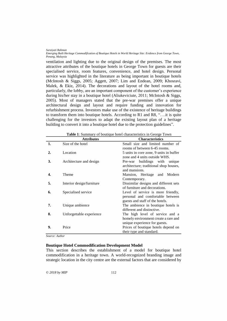
Suraiyati Rahman
Emerging Built Heritage Commodification of Boutique Hotels in World Heritage Site: Evidence from George Town,
Penang, Malaysia
© 2018 by MIP 112
ventilation and lighting due to the original design of the premises. The most
attractive attributes of the boutique hotels in George Town for guests are their
specialised service, room features, convenience, and hotel design. Personal
service was highlighted in the literature as being important in boutique hotels
(McIntosh & Siggs, 2005; Aggett, 2007; Lim and Endean, 2009; Khosravi,
Malek, & Ekiz, 2014). The decorations and layout of the hotel rooms and,
particularly, the lobby, are an important component of the customer’s experience
during his/her stay in a boutique hotel (Aliukeviciute, 2011; McIntosh & Siggs,
2005). Most of managers stated that the pre-war premises offer a unique
architectural design and layout and require funding and innovation for
refurbishment process. Investors make use of the existence of heritage buildings
to transform them into boutique hotels. According to R1 and R8, “….it is quite
challenging for the investors to adapt the existing layout plan of a heritage
building to convert it into a boutique hotel due to the protection guidelines”.
Table 1: Summary of boutique hotel characteristics in George Town
Attributes Characteristics
1. Size of the hotel Small size and limited number of
rooms of between 6-45 rooms.
2. Location 5 units in core zone, 9 units in buffer
zone and 4 units outside WHS.
3. Architecture and design Pre-war buildings with unique
architecture; traditional shop houses,
and mansions.
4. Theme Mansion, Heritage and Modern
Contemporary.
5. Interior design/furniture Dissimilar designs and different sets
of furniture and decorations.
6. Specialised service Level of service is more friendly,
personal and comfortable between
guests and staff of the hotels.
7. Unique ambience The ambience in boutique hotels is
different and distinctive.
8. Unforgettable experience The high level of service and a
homely environment create a rare and
unique experience for guests.
9. Price Prices of boutique hotels depend on
their type and standard. Source: Author
Boutique Hotel Commodification Development Model
This section describes the establishment of a model for boutique hotel
commodification in a heritage town. A world-recognized branding image and
strategic location in the city centre are the external factors that are considered by
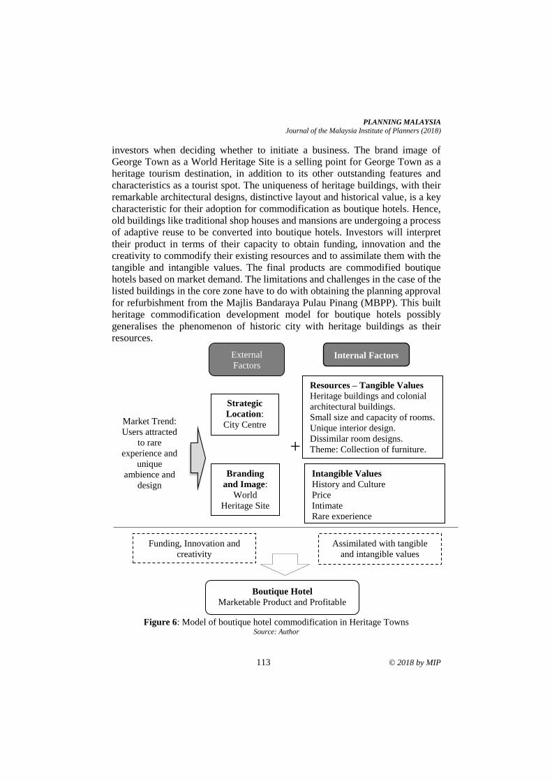
PLANNING MALAYSIA
Journal of the Malaysia Institute of Planners (2018)
113 © 2018 by MIP
investors when deciding whether to initiate a business. The brand image of
George Town as a World Heritage Site is a selling point for George Town as a
heritage tourism destination, in addition to its other outstanding features and
characteristics as a tourist spot. The uniqueness of heritage buildings, with their
remarkable architectural designs, distinctive layout and historical value, is a key
characteristic for their adoption for commodification as boutique hotels. Hence,
old buildings like traditional shop houses and mansions are undergoing a process
of adaptive reuse to be converted into boutique hotels. Investors will interpret
their product in terms of their capacity to obtain funding, innovation and the
creativity to commodify their existing resources and to assimilate them with the
tangible and intangible values. The final products are commodified boutique
hotels based on market demand. The limitations and challenges in the case of the
listed buildings in the core zone have to do with obtaining the planning approval
for refurbishment from the Majlis Bandaraya Pulau Pinang (MBPP). This built
heritage commodification development model for boutique hotels possibly
generalises the phenomenon of historic city with heritage buildings as their
resources.
Figure 6: Model of boutique hotel commodification in Heritage Towns
Source: Author
Resources – Tangible Values
Heritage buildings and colonial
architectural buildings.
Small size and capacity of rooms.
Unique interior design.
Dissimilar room designs.
Theme: Collection of furniture.
and art
Strategic
Location:
City Centre
+
Internal Factors External
Factors
Market Trend:
Users attracted
to rare
experience and
unique
ambience and
design
Branding
and Image:
World
Heritage Site
by UNESCO
Intangible Values
History and Culture
Price
Intimate
Rare experience
Boutique Hotel
Marketable Product and Profitable
Assimilated with tangible
and intangible values
Funding, Innovation and
creativity
Suraiyati Rahman
Emerging Built Heritage Commodification of Boutique Hotels in World Heritage Site: Evidence from George Town,
Penang, Malaysia
© 2018 by MIP 114
CONCLUSION Boutique hotels have a broad spectrum of characteristics, but in the case of
George Town, eight main criteria have been identified, namely the size of the
hotel, strategic location, distinctive architectural design, theme, dissimilar room
designs, personalised service, rare experience and price. The potential of a
branding image as a World Heritage Site and the multiple functions of a city
centre are the external factors that contribute to the decision of investors to
purchase pre-war premises for commodification into boutique hotels. The built
heritage commodification depends on the intrinsic value of the heritage resources
such as the unique architectural designs, distinctive layout, colonial premises,
history and culture, and the collection of furniture. These resources will be
assimilated with the intangible values and interpreted based on the innovation,
funding and creativity. Investors of boutique hotels in George Town are mainly
motivated by the making of profits and the revitalization of the built heritage. The
case study of boutique hotels in George Town might not be the same for other
urban settings. However, it can be concluded that the process of the
commodification of built heritage may enhance the sustainability of the built
heritage, but there may be a loss in authenticity due to the commercialisation of
the product and market orientation. The issue of commodifying heritage may led
to the loss of authenticity is supported by (Prideaux, 2003; Xu, Yan, & Zhu, 2013;
Su, 2011; Terzano, 2014).
ACKNOWLEDGEMENT
The author(s) would like to extend their appreciation to the Ministry of Higher
Education, Malaysia for granting the Fundamental Research Grant entitled
‘Establishing an Interpretation Model of Built Heritage Commodification for
Tourism in Georgetown, Penang' [Grant No. 203.PPBGN.6711405], which made
this study possible.
REFERENCES
Aggett, M. (2007). What has influenced growth in the UK's boutique hotel
sector? International Journal of Contemporary Hospitality Management, 19(2),
169-177.
Aliukeviciute, M. (2011). Boutique hotels evolution. Retrieved from
https://ojs.kauko.lt/index.php/stmd/article/download/233/229
Albazzaz, A., Birnbaum, B., Brachfeld, D., Danilov, D., Kets de Vries, O., & Moed, J.
(2003). Lifestyles of the rich and almost famous: The boutique hotel
phenomenon in the United States. Fontainebleau: Insead Business School.
Amir, S., Osman, M. M., Bachok, S., Ibrahim, M., & Mohamed, M. Z. (2017). Tourism
stakeholders perception on tourists’ expenditure in entertainment sector in
Melaka UNESCO World Heritage Area. Advanced Science Letters, 23(7), 6336-
6338.
PLANNING MALAYSIA
Journal of the Malaysia Institute of Planners (2018)
115 © 2018 by MIP
Anhar, L. (2001). The definition of boutique hotels. Retrieved from
http://www.hospitalitynet.org/news/4010409.html
Arifin, A. S., Jamal, S. A., Aziz, A. A., & Ismail, S. S. (2015, September). A preliminary
study on boutique hotels in the city of Kuala Lumpur. 2nd International
Hospitality and Tourism Conference 2014. September 2-4, 2014, Penang,
Malaysia.
Ashworth, G. J., & Larkham, P. J. (1994). Building a new heritage: Tourism, culture and
identity in the New Europe. London: Routledge.
Ashworth, G. J. (2012). Preservation, conservation and heritage: Approaches to the past
in the present through the built environment. Journal Asian Anthropology, 10(1),
1-18.
Astuti, W., Permana, A. S., Qomarun, Q., & Andisetyana, R. (2017). Integrated planning
model of creative industry-based kampung tourism in Jayengan Surakarta,
Indonesia. Planning Malaysia, 15(3), 63-76. Chang, T. C., & Teo, P. (2008). The shophouse hotel: Vernacular heritage in a creative
city. Urban Studies, 46, 341–367.
Erkutlu, H. V., & Chafra, J. (2006). Relationship between leadership power bases and job
stress of subordinates: Example from boutique hotels. Management Research
News, 29(5), 285-297.
Freund de Klumbis, D. & Munsters, W. (2005). Developments in the hotel industry:
Design meets historic properties. Retrieved October 12, 2015, from
http://bibemp2.us.es/turismo/turismonet1
Forsgren, S., & Franchetti, C. (2004). The marketing role of unique concepts for hotels in
Sweden: Tourism and hospitality management (Master Thesis No 2004: 53).
Goteborg University, Sweden.
Goh, Y. N. (2015). Investigating revisit intentions for the boutique hotels of Penang - A
UNESCO world heritage site. Asian Social Science, 11(4), 126-134.
Henderson, J. C. (2011). Hip heritage: The boutique hotel business in Singapore. Tourism
and Hospitality Research, 11(3), 217-223.
Khosravi, S., Malek, A., & Ekiz, E. (2014). Why tourists are attracted to boutique hotels:
Case of Penang Island, Malaysia. Journal of Hospitality and Tourism, 12(1), 26-
41.
Li, Y. (2003). Heritage tourism: The contradictions between conservation and change.
Tourism and Hospitality Research, 4(3), 247-261.
Lim, M. W., & Endean, M. (2009). Elucidating the aesthetic and operational
characteristics of UK boutique hotels. International Journal of Contemporary
Hospitality Management, 21(1), 38-51.
Lwin, M., & Phau, I. (2013). Effective advertising appeals for websites of small boutique
hotels. Journal of Research in Interactive Marketing, 7(1), 18-32.
Mcintosh, A. J., & Siggs, A. (2005). An exploration of the experiential nature of boutique
accommodation. Journal of Travel Research, 44(1), 74-81.
Olga, A. (2009, September). The alternative hotel market. International Conference on
Management Science and Engineering. September 14-16, 2009, Moscow,
Russia.
Suraiyati Rahman
Emerging Built Heritage Commodification of Boutique Hotels in World Heritage Site: Evidence from George Town,
Penang, Malaysia
© 2018 by MIP 116
Prideaux, B. (2003). Commodifying heritage: loss of authenticity and meaning or an
appropriate response to difficult circumstances? International Journal of
Tourism Sciences, 3(1), 1–15.
Rani, P., Putri, C., & Devina, A. (2017). Transforming heritage building for
commercialisation. Planning Malaysia, 15(3), 135-146.
Rompho, N., & Boon-itt, S. (2012). Measuring the success of a performance measurement
system in Thai firms. International Journal of Productivity and Performance
Management, 61(5), 548-562.
Rogerson, J. M. (2010). The boutique hotel industry in South Africa: Definition, scope,
and organization. Urban Forum, 21(4), 425-439.
Su, X. (2011). Commodification and the selling of ethnic music to tourists. Geoforum,
42(4), 496–505.
Suraiyati, R. (2013). Heritage management challenges in historic town of Ludlow,
England. World Applied Sciences Journal, 24(12), 1589-1596.
Teo, P., & Yeoh, B. S. A. (1997). Remaking local heritage for tourism. Annals of Tourism
Research, 24(1), 192-213.
Terzano, K. (2014). Commodification of transitioning ethnic enclaves. Behavioural
Sciences, 4(4), 341-351.
Timothy, D. J., & Teye, V. B. (2009). Tourism and the lodging sector. Oxford: Elsevier.
Van Hartesvelt, M. (2006). Building a better boutique hotel. Lodging Hospitality, 62(14),
32-44.
Waitt, G. (2000). Consuming heritage. Annals of Tourism Research, 27(4), 835-862.
Wheeler, D. (2006). Understanding the value of boutique hotels (Master's thesis).
Massachusetts Institute of Technology, USA.
Wight, P. (1994). Environmentally responsible marketing of tourism. In E. Carter & G.
Lowman (Eds.), Ecotourism: A Sustainable Option? London: Wiley.
Xu, K., Yan, T., & Zhu, X. (2013). Commodification of Chinese heritage villages. Annals
of Tourism Research, 40(1), 415-419
Received: 1st June 2018. Accepted:1st December 2018
1Lecturer at Universiti Sains Malaysia Email: [email protected] 117
PLANNING MALAYSIA:
Journal of the Malaysian Institute of Planners
VOLUME 16 ISSUE 4 (2018), Page 117 – 129
ACCEPTANCE TOWARDS TOURISM DEVELOPMENT: THE CASE
OF PERHENTIAN ISLAND
Diana Mohamad1 & Badaruddin Mohamed2
1,2School of Housing, Building and Planning
UNIVERSITI SAINS MALAYSIA
Abstract
Island tourism in Malaysia is gaining the globe’s attention and has attracted
people from all over the world to come to Malaysia. Islands of Malaysia have
been continuously developed for the purpose of providing the visitors’ with better
and exclusive tourism experience. Perhentian Island is one of Malaysia’s premier
tourism spots famous for its crystal clear water, uncrowded beaches in addition
to turtle and baby shark snorkelling points. It is learned that intense development
and steady growth of tourist arrivals to this island have somehow created various
positive and negative impacts. It is realized that tourism development is pressured
by the need to cater to the visitors’ demands while pays limited attention to the
locals’ needs and acceptance level. This paper reports on the tourism
development impacts on Perhentian Island, looking from the point of view of
locals engaged in tourism sector. Employing quantitative research approach, self-
administered questionnaire was developed with the aim of assessing the locals’
acceptance level pertaining changes in social structure of Perhentian Island and
negative influences of tourism development on the environment. The findings
showed immediate intervention is required for re-establishment of the social
structure, followed by environmental management.
Keywords: Perhentian Island, development, locals, acceptance level, social
structure change, environmental impact
Diana Mohamad & Badaruddin Mohamed
Acceptance Towards Tourism Development: The Case of Perhentian Island
© 2018 by MIP 118
INTRODUCTION
In 2017 Malaysia has received approximately 26 million international tourists
that contributed to RM82.2 billion to the country revenue (Tourism Malaysia,
2018). Given the ample benefits offered by tourism sector, notable investments
were allocated which allows intense progress of tourism development especially
for island tourism and Perhentian Island is no exception. Besides attractive and
unique resources, successful tourism planning requires a well-established
relationship between locals and tourism sector in the sense of changes in social
phenomena (Liu & Halim, 2011). Kaplan, Tekinay and Ugurlu (2013) described
social phenomenon as social event that happen between individuals, and the
individuals’ perception towards this social event differs depending on their
observations and experiences. Though complex and challenging, understanding
social phenomena is fundamental in assessing acceptance level, which directly
influences tourism management. As locals recognize the positive and negative
consequences tourism would bring, this paper envisages understanding of the
locals’ acceptance level as a lens to understand their acceptance towards tourism
development. Acceptance level in general is a concept used to assess ones’
satisfaction in relation to frequency and/or intensity of objects/situation (Brown,
Morris, & Murry, 1996). According to Gou, Lau and Ye (2014), acceptance level
is something that involves the elimination of discomfort where more specifically,
it is the state of mind when an individual reacts to the changes that occur. In the
context of tourism; acceptance level is an assumption of behaviour and satisfying
experiences, which plays a crucial part in predicting future intention (Ramkissoon
& Mavondo, 2015). This paper looks at the Perhentian Islanders' acceptance
towards tourism development, assessed from the perspective of changes in social
structure and environmental impacts. It seeks to address the role played by a
number of parameters namely safety issues, social issues, the intensity of tourism
development, migration rate, locals' participation and quality of life.
LITERATURE REVIEW
Social Structure
The social structure could interchangeably be used as a causal social structure
operative and as a social organization descriptive (Little, 2007). In most cases,
works of social structure linked the concept of social change with irregularities
in social life which then controls the way society response with each other and to
their environment (Wilterdink, 2015). The irregularities of social life could be
observed along the facets of time and space where in detail, it encompasses issues
related to safety, social, education and territory (Wilterdink, 2015).
Rasoolimanesh, Jaafar, Marzuki and Abdullah (2017) correlated the irregularities
in social life with the formation of a new political system and the entrance of new
values of other cultures. Social mobility process is considered as the main cause
PLANNING MALAYSIA
Journal of the Malaysia Institute of Planners (2018)
119 © 2018 by MIP
of irregularities of social life as this process affected the proportions of the social
demographic cohorts and more importantly, the inflow social mobility process
effect was deemed stronger than the outflow social mobility process. This
interlinked with Rasoolimanesh et al. (2017) argument in the sense that the
inclusion of non-locals (for example tourists and foreign workers) in the existing
organization of society (for example Perhentian Island’s community) gave impact
on the economic and communication networks.
Changes in the social structure of a particular society in the forms of
changes in layers of economic key players and social hierarchy could be
contributed by development, which at a deeper level, influenced by types and
intensity of the development undertaken (which could be used to measure
acceptance towards changes in social structure). Literature on Perhentian Island
presented several undesirable changes in social structure due to tourism
development. For example, Bozetka (2013) put forward the ability of tourism
development in influencing adaptation and/or creation of new modes of
behaviour, habits and customs; and in return would contribute to the paradigm
shift in social dimension (Gatewood & Cameron, 2009). Interestingly, according
to Salmond (2010), while backpackers tourism may encourage cross-cultural
exchange and positively manipulate the opinion relating to the economic
imbalance between locals and tourists, it also triggers the cultural sensitivity in
terms of backpackers’ dress code. The studies are examples of how tourism
development had affected the local community of Perhentian Island (socially and
culturally) and could be used as indicators in assessing the local community
acceptance level towards tourism development. Though understanding the
changes in social structure is challenging, it nevertheless crucial in managing the
quality of life by which, influence the acceptance towards development in general
and tourism development in particular.
Environmental Impacts of Island Tourism Development
Given the globe’s economic growth, people are enjoying a considerable amount
of dispensable income and therefore, the engagement in tourism has become
impressive in size and pervasive in society. According to Stydilis, Terzidou and
Terzidis (2007), the notion of enjoying island tourism was initiated by the unique
characteristic of separateness offered by land and water. Positive reaction could
be further enhanced provided the islands to meet the market's demand at an
efficient production cost (Smith, 1994). Wong (2016) painted the island tourism
as the medium to influxes of investments which accelerated the provision of
infrastructure. Zaie and Zaie (2013) response to Gatewood and Cameron (2009)
is in the affirmative where the provision of infrastructure benefitted both locals
and tourists. As tourism is lucrative, the intense development has captured the
concerns over the setbacks that tourism would bring (Nasir, Ibrahim, Mahamod,
& Othman, 2017). Seeing that the islands experience greater gravity of
Diana Mohamad & Badaruddin Mohamed
Acceptance Towards Tourism Development: The Case of Perhentian Island
© 2018 by MIP 120
environmental impact compared to non-island tourism destinations (Cater, 1987),
it is becoming increasingly difficult to ignore the adversity effect of improper and
ineffective management of environmental resource utilization (Bardolet &
Sheldon, 2008). Echoing Bardolet and Sheldon’s (2008), Bozetka (2013)
translated this as the continuous transformation of natural landscape into compact
urbanized areas whereby, this was opposed to the central discipline of carrying
capacity (Riley, 1995).
Though economic empowerment is desirable (Amir, Osman, Bachok,
Ibrahim, & Zen, 2017), serious thoughts should be directed towards the
environmental impact. It is learned that the development of chalets which first
taken place along the coastal localities has sprawled to the hills (Tan & Teh,
2001), staggering number of visitors has placed pressure on sewage management
and freshwater supply (Mohd Salleh, Othman, & Harun. 2010) along with the
provision of infrastructure and amenities (Ramdas & Mohamed, 2014), and
tourism activities have threatened the marine ecosystem (Comley et al., 2004);
hence, signals the immediate attention for environmental conservation. This is in
affirmative with Krippendorf’s (1982, cited by UKEssays, 2015) who claimed
that environment is the reason for engagement in and economic force of island
tourism. The studies are examples of how tourism development had affected the
local community of Perhentian Island (environmentally) and could be used as
indicators in assessing the local community acceptance level towards tourism
development. In line with the gravity of the issues at hand, scholars looked at
education program to stimulate the understanding and awareness of the
environment significance (Tan & Teh, 2001) other than proposed the
implementation of willingness to pay concept (Arabamiry, Abd. Rahim, Radam,
Khademfar, & Yacob, 2013), for the purpose of environmental conservation.
RESEARCH BACKGROUND
Located in the State of Terengganu, Perhentian Island (situated 25 kilometres
away from Kuala Besut) consists of two main islands namely Perhentian Besar
and Perhentian Kecil (Figure 1). Geologically, Perhentian Island is formed by the
Eastern Belt igneous rocks (granite and syenite plutons) with a mixture of Upper
Paleozoic metasedimentary (granite porphyry, microgranite and dolerite) rocks,
which extends approximately 600 kilometres long (Azman, 2001). Perhentian
Island, with an area of 3439 acres, can be reached by boat that takes less than 30
minutes per trip. It is well-known for its mesmerizing laid-back atmosphere,
natural beauty and crystal clear water. Perhentian Island, in general, is famous for
its snorkelling and scuba diving activities especially the shark, turtle and fish
spots namely Tokong Laut and Sugar Wreck (NUS Dive Club, 2013). While
Perhentian Kecil popularity lies with the young backpackers, Perhentian Besar is
more recognized for its 13 luxury accommodations and relaxed ambiance
(Hamzah & Hampton, 2011).
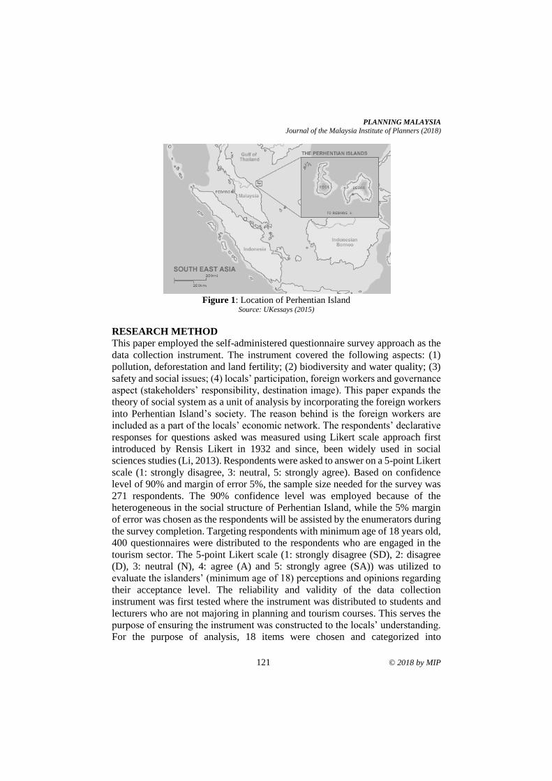
PLANNING MALAYSIA
Journal of the Malaysia Institute of Planners (2018)
121 © 2018 by MIP
Figure 1: Location of Perhentian Island
Source: UKessays (2015)
RESEARCH METHOD
This paper employed the self-administered questionnaire survey approach as the
data collection instrument. The instrument covered the following aspects: (1)
pollution, deforestation and land fertility; (2) biodiversity and water quality; (3)
safety and social issues; (4) locals’ participation, foreign workers and governance
aspect (stakeholders’ responsibility, destination image). This paper expands the
theory of social system as a unit of analysis by incorporating the foreign workers
into Perhentian Island’s society. The reason behind is the foreign workers are
included as a part of the locals’ economic network. The respondents’ declarative
responses for questions asked was measured using Likert scale approach first
introduced by Rensis Likert in 1932 and since, been widely used in social
sciences studies (Li, 2013). Respondents were asked to answer on a 5-point Likert
scale (1: strongly disagree, 3: neutral, 5: strongly agree). Based on confidence
level of 90% and margin of error 5%, the sample size needed for the survey was
271 respondents. The 90% confidence level was employed because of the
heterogeneous in the social structure of Perhentian Island, while the 5% margin
of error was chosen as the respondents will be assisted by the enumerators during
the survey completion. Targeting respondents with minimum age of 18 years old,
400 questionnaires were distributed to the respondents who are engaged in the
tourism sector. The 5-point Likert scale (1: strongly disagree (SD), 2: disagree
(D), 3: neutral (N), 4: agree (A) and 5: strongly agree (SA)) was utilized to
evaluate the islanders’ (minimum age of 18) perceptions and opinions regarding
their acceptance level. The reliability and validity of the data collection
instrument was first tested where the instrument was distributed to students and
lecturers who are not majoring in planning and tourism courses. This serves the
purpose of ensuring the instrument was constructed to the locals’ understanding.
For the purpose of analysis, 18 items were chosen and categorized into
Diana Mohamad & Badaruddin Mohamed
Acceptance Towards Tourism Development: The Case of Perhentian Island
© 2018 by MIP 122
environment and social structure constructs using the literature presented as
reference (Table 1).
Table 1: Items assessing the acceptance level in Perhentian Island
Items tested Code Construct
High participation of young generation in
tourism
Young generation
Social
structure
The high number of foreign workers Foreign workers
Increases in social issues Social issues
Increases in safety issues Safety issues
Increases in locals’ immigration Immigration
Increases in non-locals’ migration Migration
Increases in overall social status Social status
Social issues should be handled by all
stakeholders
Social stakeholders
Safety issues should be handled by all
stakeholders
Safety stakeholders
Increases in community-based activities Community activity
Environment
Tourism jeopardizes natural resources Degradation
Tourism develops this destination Island development
Tourism provides better water quality Water quality
Tourism pollutes the environment Pollution
Uncomfortable with tourism activities Tourism activities
Locals welcome more tourism development Intense development
Tourism development is of moderate level Development
intensity
Tourism conserves the environment Conservation
RESULTS
This section first addresses findings related to the changes in social structure and
later presents the findings relating to the environmental impacts of tourism
industry; to analyse the locals’ acceptance level of tourism development in
Perhentian Island. From the total 400 distributed questionnaires, 366 completed
questionnaires were retrieved, amounting to 91.5% response rate. Of 366
retrieved questionnaires, 354 questionnaires were found reliable to be further
analysed, contributing to 96.7% validity rate. Analysis on respondents’ database
provides the following details: [1] gender distribution is 56.2% male and 43.8%
female, [2] dominant age is 26-50 (46.0%), followed by 18-25 (38.7%) and more
than 50 (15.3%), [3] marital status cohort consists of 44.9% single and 55.1%
married, [4] 68.4% and 22.2% of respondents have secondary and tertiary
education level, [5] 54.2% respondents were born in Perhentian Island and [6]
76.8% respondents have more than 5 years of tenure status. Chi-square analysis
resulted in insignificant relationships between all 18 items and respondents'
PLANNING MALAYSIA
Journal of the Malaysia Institute of Planners (2018)
123 © 2018 by MIP
profile (age, gender, education level, marital status, tenure status, origins),
excluding tenure status. Hence, the following discussion is strictly related to
tenure status.
Findings for Social Structure
Kaiser-Meyer-Olkin values for a tenure of less than and more than 5 years were
.541 and .793, with Bartlett's Test of Sphericity for both tenure types reached
statistical significance. In case of tenure less than 5 years, it appeared that items
were grouped into six components (73.6% of the total variance explained) where
only component 1 could be regressed (Table 2). While component 1 addressed
the origin cohort, the remaining components measured the following: locals'
participation (component 2), management of culture-related issues (components
3 and 4), an influx of foreign workers (component 5) and safety issues
(component 6). Other than indicating that the locals' acceptance level was
moderately measured by high occurrences of social issues, analysis showed that
the acceptance level was not influenced by the ability of tourism to improve the
overall status standard and stakeholders' joint responsibility to handle safety
issues. Looking at tenure more than 5 years (Table 2), items were factored into
three components (76.2% of the total variance explained) where all items were
valid to be regressed excluding component 3. Component 1 was formed by 6
items that evaluated organization cohort and component 2 focused on the issues
management. Results emphasized the adverse gravity of changes in social
structure is increasing over time especially for migration of locals and high
occurrences of social issues.
Table 2: Items assessing social structure
<5 years (n = 271) >5 years (n = 81)
1 2 3 4 5 6 1 2 3
Young
generation
.062 .961 -.003 .030 -.012 .000 .950 -.037 -.199
Foreign workers -.017 -.024 -.107 .081 .834 -.011 .950 -.041 -.199
Social issues -.040 -.110 -.585 .377 -.399 -.016 .492 -.031 -.524
Safety issues .000 -.060 .142 .128 .194 .734 .703 -.311 .102
Immigration .817 .341 -.004 .014 -.012 .003 .949 -.038 -.199
Migration .900 -.169 .001 .000 -.002 -.002 .735 -.265 .248
Social status -.016 -.042 -.053 -.893 -.080 -.003 .026 .184 .827
Social
stakeholders
-.023 -.056 .785 .179 -.256 -.014 -.076 .852 .115
Safety
stakeholders
-.001 -.060 .151 .129 .210 -.684 -.158 .860 .108
Overall, the results of Table 3 indicated that an item could motivate more
than 49.0% changes in a particular item. For locals with tenure less than 5 years,
they observed the proportion of locals and non-locals as the root cause that
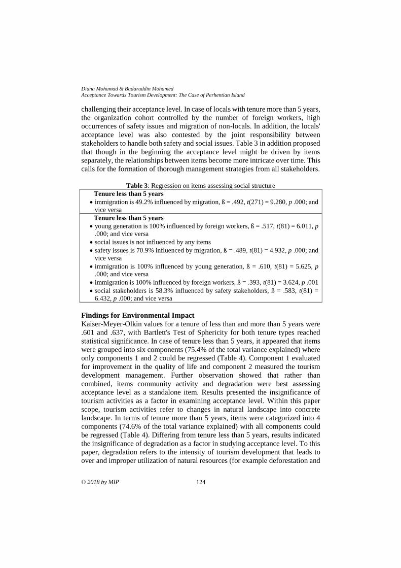
Diana Mohamad & Badaruddin Mohamed
Acceptance Towards Tourism Development: The Case of Perhentian Island
© 2018 by MIP 124
challenging their acceptance level. In case of locals with tenure more than 5 years,
the organization cohort controlled by the number of foreign workers, high
occurrences of safety issues and migration of non-locals. In addition, the locals'
acceptance level was also contested by the joint responsibility between
stakeholders to handle both safety and social issues. Table 3 in addition proposed
that though in the beginning the acceptance level might be driven by items
separately, the relationships between items become more intricate over time. This
calls for the formation of thorough management strategies from all stakeholders.
Table 3: Regression on items assessing social structure
Tenure less than 5 years
• immigration is 49.2% influenced by migration, ß = .492, t(271) = 9.280, p .000; and
vice versa
Tenure less than 5 years
• young generation is 100% influenced by foreign workers, ß = .517, t(81) = 6.011, p
.000; and vice versa
• social issues is not influenced by any items
• safety issues is 70.9% influenced by migration, ß = .489, t(81) = 4.932, p .000; and
vice versa
• immigration is 100% influenced by young generation, ß = .610, t(81) = 5.625, p
.000; and vice versa
• immigration is 100% influenced by foreign workers, ß = .393, t(81) = 3.624, p .001
• social stakeholders is 58.3% influenced by safety stakeholders, ß = .583, t(81) =
6.432, p .000; and vice versa
Findings for Environmental Impact
Kaiser-Meyer-Olkin values for a tenure of less than and more than 5 years were
.601 and .637, with Bartlett's Test of Sphericity for both tenure types reached
statistical significance. In case of tenure less than 5 years, it appeared that items
were grouped into six components (75.4% of the total variance explained) where
only components 1 and 2 could be regressed (Table 4). Component 1 evaluated
for improvement in the quality of life and component 2 measured the tourism
development management. Further observation showed that rather than
combined, items community activity and degradation were best assessing
acceptance level as a standalone item. Results presented the insignificance of
tourism activities as a factor in examining acceptance level. Within this paper
scope, tourism activities refer to changes in natural landscape into concrete
landscape. In terms of tenure more than 5 years, items were categorized into 4
components (74.6% of the total variance explained) with all components could
be regressed (Table 4). Differing from tenure less than 5 years, results indicated
the insignificance of degradation as a factor in studying acceptance level. To this
paper, degradation refers to the intensity of tourism development that leads to
over and improper utilization of natural resources (for example deforestation and
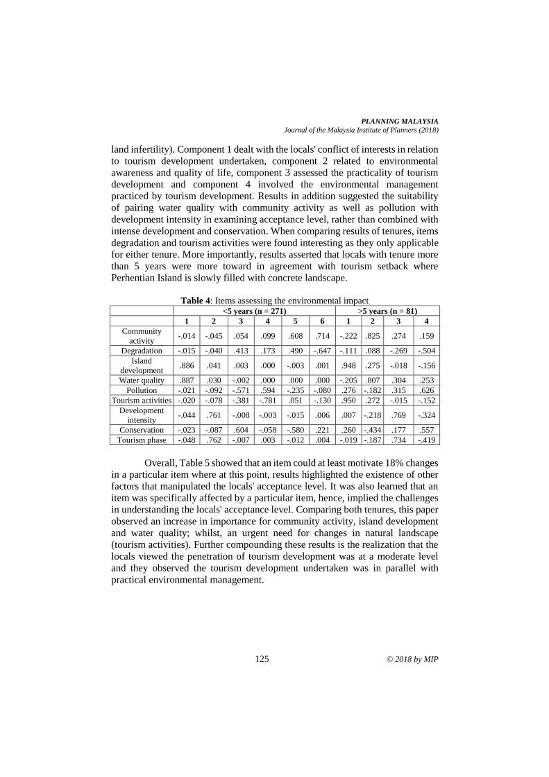
PLANNING MALAYSIA
Journal of the Malaysia Institute of Planners (2018)
125 © 2018 by MIP
land infertility). Component 1 dealt with the locals' conflict of interests in relation
to tourism development undertaken, component 2 related to environmental
awareness and quality of life, component 3 assessed the practicality of tourism
development and component 4 involved the environmental management
practiced by tourism development. Results in addition suggested the suitability
of pairing water quality with community activity as well as pollution with
development intensity in examining acceptance level, rather than combined with
intense development and conservation. When comparing results of tenures, items
degradation and tourism activities were found interesting as they only applicable
for either tenure. More importantly, results asserted that locals with tenure more
than 5 years were more toward in agreement with tourism setback where
Perhentian Island is slowly filled with concrete landscape.
Table 4: Items assessing the environmental impact
<5 years (n = 271) >5 years (n = 81)
1 2 3 4 5 6 1 2 3 4
Community
activity -.014 -.045 .054 .099 .608 .714 -.222 .825 .274 .159
Degradation -.015 -.040 .413 .173 .490 -.647 -.111 .088 -.269 -.504
Island
development .886 .041 .003 .000 -.003 .001 .948 .275 -.018 -.156
Water quality .887 .030 -.002 .000 .000 .000 -.205 .807 .304 .253
Pollution -.021 -.092 -.571 .594 -.235 -.080 .276 -.182 .315 .626
Tourism activities -.020 -.078 -.381 -.781 .051 -.130 .950 .272 -.015 -.152
Development
intensity -.044 .761 -.008 -.003 -.015 .006 .007 -.218 .769 -.324
Conservation -.023 -.087 .604 -.058 -.580 .221 .260 -.434 .177 .557
Tourism phase -.048 .762 -.007 .003 -.012 .004 -.019 -.187 .734 -.419
Overall, Table 5 showed that an item could at least motivate 18% changes
in a particular item where at this point, results highlighted the existence of other
factors that manipulated the locals' acceptance level. It was also learned that an
item was specifically affected by a particular item, hence, implied the challenges
in understanding the locals' acceptance level. Comparing both tenures, this paper
observed an increase in importance for community activity, island development
and water quality; whilst, an urgent need for changes in natural landscape
(tourism activities). Further compounding these results is the realization that the
locals viewed the penetration of tourism development was at a moderate level
and they observed the tourism development undertaken was in parallel with
practical environmental management.
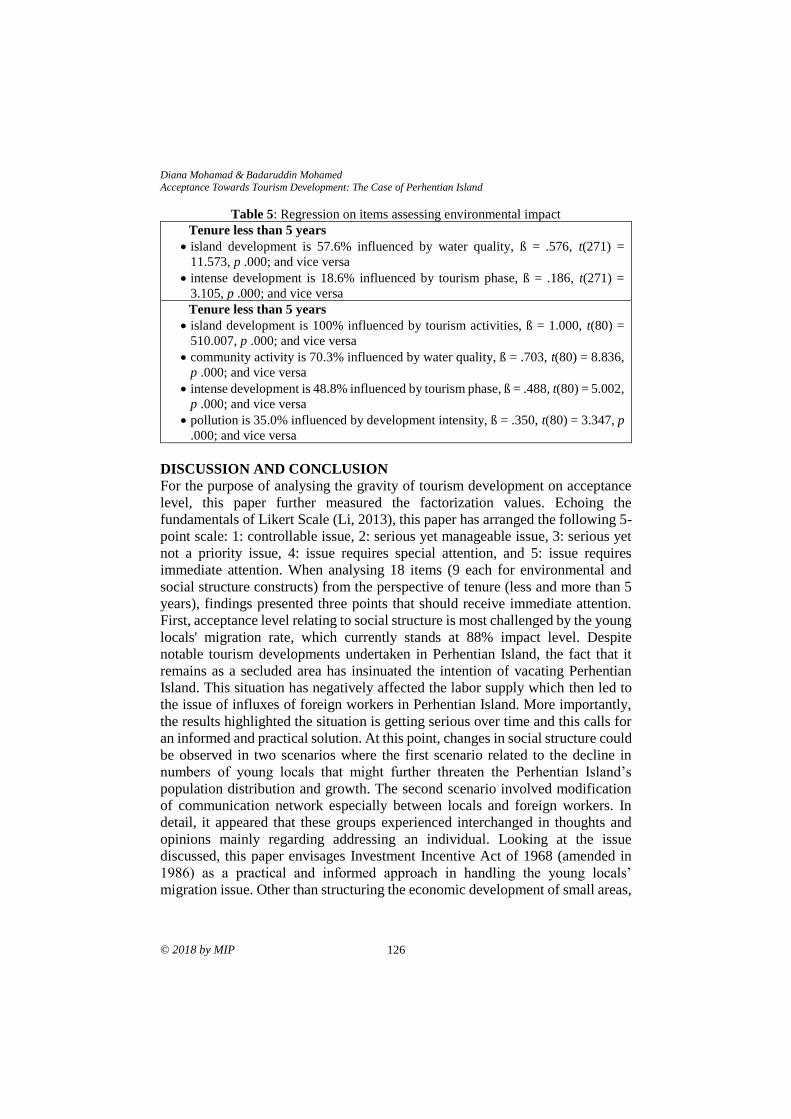
Diana Mohamad & Badaruddin Mohamed
Acceptance Towards Tourism Development: The Case of Perhentian Island
© 2018 by MIP 126
Table 5: Regression on items assessing environmental impact
Tenure less than 5 years
• island development is 57.6% influenced by water quality, ß = .576, t(271) =
11.573, p .000; and vice versa
• intense development is 18.6% influenced by tourism phase, ß = .186, t(271) =
3.105, p .000; and vice versa
Tenure less than 5 years
• island development is 100% influenced by tourism activities, ß = 1.000, t(80) =
510.007, p .000; and vice versa
• community activity is 70.3% influenced by water quality, ß = .703, t(80) = 8.836,
p .000; and vice versa
• intense development is 48.8% influenced by tourism phase, ß = .488, t(80) = 5.002,
p .000; and vice versa
• pollution is 35.0% influenced by development intensity, ß = .350, t(80) = 3.347, p
.000; and vice versa
DISCUSSION AND CONCLUSION
For the purpose of analysing the gravity of tourism development on acceptance
level, this paper further measured the factorization values. Echoing the
fundamentals of Likert Scale (Li, 2013), this paper has arranged the following 5-
point scale: 1: controllable issue, 2: serious yet manageable issue, 3: serious yet
not a priority issue, 4: issue requires special attention, and 5: issue requires
immediate attention. When analysing 18 items (9 each for environmental and
social structure constructs) from the perspective of tenure (less and more than 5
years), findings presented three points that should receive immediate attention.
First, acceptance level relating to social structure is most challenged by the young
locals' migration rate, which currently stands at 88% impact level. Despite
notable tourism developments undertaken in Perhentian Island, the fact that it
remains as a secluded area has insinuated the intention of vacating Perhentian
Island. This situation has negatively affected the labor supply which then led to
the issue of influxes of foreign workers in Perhentian Island. More importantly,
the results highlighted the situation is getting serious over time and this calls for
an informed and practical solution. At this point, changes in social structure could
be observed in two scenarios where the first scenario related to the decline in
numbers of young locals that might further threaten the Perhentian Island’s
population distribution and growth. The second scenario involved modification
of communication network especially between locals and foreign workers. In
detail, it appeared that these groups experienced interchanged in thoughts and
opinions mainly regarding addressing an individual. Looking at the issue
discussed, this paper envisages Investment Incentive Act of 1968 (amended in
1986) as a practical and informed approach in handling the young locals’
migration issue. Other than structuring the economic development of small areas,
PLANNING MALAYSIA
Journal of the Malaysia Institute of Planners (2018)
127 © 2018 by MIP
this Act should be expanded to cover individuals especially those who are
promoting the practices of sustainable tourism.
Second, the locals’ acceptance level with reference to environmental
impact was explained by the locals’ enjoying an improvement in the freshwater
supply quality, with approximately 85% acceptance level observed. To the locals,
the enjoyment was an outcome of their joint responsibility in managing and
maintaining the cleanliness of Perhentian Island; rather than recognizing it as one
of the benefits brought by tourism development and acknowledging the tourism
development strategies undertaken for the island. Nevertheless, results indicated
the decreases in quality over time, therefore, emphasized an urgent action to be
executed. Third, the locals' acceptance level could also be measured through the
level of environmental pollution experienced, which stands at 61% impact level.
It is interesting to find that the locals' are accepting the parallel relationship
between the intensity of tourism development and the adversity of pollution level.
Nevertheless, to this paper, the positive reaction towards additional tourism
development might be insinuated by the benefits experienced. Further
compounding this is the realization of the non-linear relationship that exists
between the positive reaction and the pragmatic tourism development approach
practiced. Within this paper interests, both second and third points suggest the
force of education and self-awareness crucially manoeuvres one's effort in
attaining a better quality of life.
ACKNOWLEDGEMENT
The authors would like to extend their appreciation to the Universiti Sains
Malaysia, Ministry of Higher Education, Malaysia under Trans Disciplinary
Research Grant Scheme (TRGS) 2017 (Grant Name: Models of Urban Growth
Tourism and Vitalization) (203/ppbgn/67611002) for granting the research grant
that made this study and paper possible.
REFERENCES Amir, S., Osman, M. M., Bachok, S., Ibrahim, M., & Zen, I. (2017). Community-based
tourism in Melaka UNESCO World Heritage Area: A success in food and
beverage sector? Planning Malaysia, 15(1), 89-108.
Arabamiry, S., Abd. Rahim, K., Radam, A., Khademfar, M., & Yacob, M.R (2013).
Marine park visitors’ trade-off among marine ecological attributes in Malaysia.
International Journal of Business and Social Science, 4(17), 218-228.
Azman, A. G. (2001). Petrology and geochemistry of granite and syenite from Perhentian
Island, Peninsular Malaysia. Geosciences Journal, 5(2), 123-137.
Bardolet, E., & Sheldon, P. J. (2008). Tourism in archipelagos: Hawai’i and the Balearics.
Annals of Tourism Research, 35(4), 900-923.
Bozetka, B. (2013). Wolin Island, tourism and conceptions of identity. Journal of Marine
and Island Cultures, 2, 1-12.
Diana Mohamad & Badaruddin Mohamed
Acceptance Towards Tourism Development: The Case of Perhentian Island
© 2018 by MIP 128
Brown, W. S., Morris, R. J., & Murry, T. (1996). Comfortable effort level revisited.
Journal of Voice, 10(3), 299-305.
Cater, E. A. (1987). Tourism in the least developed countries. Annals of Tourism
Research, 14, 202-226.
Comley, J., Walker, R., Wilson, J., Ramsay, A., Smith, I., & Raines, P. (2004). Malaysia
coral reef conservation project: Pulau Redang. Report to the Department of
Marine Parks, Malaysia. Retrieved May 12, 2014 from
http://www.dmpm.nre.gov.my/
Gatewood, J. B., & Cameron, C. M. (2009). Belonger perceptions of tourism and its
impacts in the Turks and Caicos Islands. Retrieved May 12, 2014 from
http://www.lehigh.edu/
Gou, Z., Lau, S. S. Y., & Ye, H. (2014). Visual alliesthesia: The gap between comfortable
and stimulating illuminance settings. Building and Environment, 82, 42-49
Hamzah, A., & Hampton, M. P. (2011). Tourism development and change in small
islands: Lessons from Perhentian Kecil, Malaysia. Skudai, Malaysia: Centre
for Innovative Planning and Development, Universiti Teknologi Malaysia.
Kaplan, Y., Tekinay, D., & Ugurlu, A. (2013). Social status of sport: Sport as a social
event, phenomenon and institution. International Journal of Science Culture
and Sport, 1(4), 64-69.
Li, Q. (2013). A novel Likert scale based on fuzzy sets theory. Expert Systems with
Applications, 40(5), 1609-1618.
Little, D. (2007). Understanding society: What is a social structure? Retrieved August 25,
2015 from http://understandingsociety.blogspot.com/
Liu, O. P., & Halim, S. A. (2011). Planning for heritage tourism: The Case of Langkawi
Geopark. Planning Malaysia, 9,121-144.
Nasir, N. M., Ibrahim, M., Mahamod, L. H., & Othman, R. (2017). Challenges to
implement carrying capacity framework: A case study of Pulau Perhentian
Marine Park institutional framework. Planning Malaysia, 15(1), 163-168.
Mohd Salleh, N. H., Othman, R., & Harun, N. F. A. (2010). The impact of marine park
gazettement to local community sustainable livelihood: A case study of
Redang and Tioman Islands. Retrieved May 12, 2014 from http://mpra.ub.uni-
muenchen.de/
NUS Dive Club (2013). Leisure trip to Perhentian Islands. Retrieved December 23, 2014
from http://nusdiveclub.org/
Ramdas, M., & Mohamed, B. (2014). Visitor perceptions on the impacts of tourism
activities, development and infrastructure on the environment of Perhentian
Islands. SHS Web of Conferences 12, 010801 (2014).
Ramkissoon, H., & Mavondo, F. T. (2015). The satisfaction-place attachment
relationship: Potential mediators and moderators. Journal of Business
Research, 66(12), 2593-2602.
Rasoolimanesh, S. M., Jaafar, M., Marzuki, A., & Abdullah, S. (2017). Tourist’s
perceptions of crowding at recreational sites: The case of the Perhentian
Islands. An International Journal of Tourism and Hospitality Research, 28(1),
41-51
Riley, M. (1995). Tourism development under close control: The case of the Falkland
Islands. Tourism Management, 16(6), 471-474.
PLANNING MALAYSIA
Journal of the Malaysia Institute of Planners (2018)
129 © 2018 by MIP
Salmond, J. L. (2010). The social relations of tourism on the Perhentian Islands
(Doctorate dissertation). University of Kentucky, USA.
Smith, S. L. J. (1994). The tourism product. Annals of Tourism Research, 21(3), 582-595.
Stylidis, D., Terzidou, M. & Terzidis, K. (2007, September). Island tourism and its socio-
economic impacts. MIBES. September 29-30, 2007, Larissa, Greece.
Tan, W. H., & Teh, T. S. (2001). Sustainability of island tourism resorts: A case study of
the Perhentian Islands. Malaysia Journal Tropical Geography, 30(1&2), 51-
68.
Tourism Malaysia (2018). Malaysia tourism statistics in brief. Retrieved October 15,
2018 from https://www.tourism.gov.my/
UKessays (2015). The environment of Perhentian Island, Malaysia. Available at http://www.ukessays.com/
Wilterdink, N. (2015). Social structure. Retrieved August 25, 2015 from
http://global.britannica.com/ topic/social-structure
Wong, K. W. (2016, October 13). Langkawi remains a magnet for tourists. Retrieved
from https://www.edgeprop.my/
Zaie, M. E., & Zaie, M. E. (2013). The impacts of tourism industry on host community.
European Journal of Tourism Hospitality and Research, 1(2), 12-21
Received: 1st June 2018. Accepted:1st December 2018
1 Senior Lecturer at Universiti Sains Malaysia. Email: [email protected] 130
PLANNING MALAYSIA:
Journal of the Malaysian Institute of Planners
VOLUME 16 ISSUE 4 (2018), Page 130 – 142
FIGURE-GROUND MAPPING TO IDENTIFY URBAN FABRIC
CHARACTERISTICS OF GEORGE TOWN HERITAGE ZONE
Tan Bee Eu1 & Teh Weng Jen2
1&2School of Housing, Building and Planning
UNIVERSITI SAINS MALAYSIA
Abstract
The traditional Penang shophouses with its unique architecture elements
constitutes the largest portion of the heritage zone which form a massive and
coherently unique urban fabric. Conservation guidelines have been enforced to
preserve the pre-war shophouses, by implementing classification of heritage
buildings, façade/structural restoration, height control and so on. Are these
measures truly effective to ensure meaningful intervention within the existing
urban fabric? Preservation and conservation of the physical elements of existing
shophouse will remain a superficial effort if no attempt is made to understand
first the urban sense of place, the town planning language, the very fabric that
weaves the solid formed by buildings with the void spaces of roads, parks,
courtyards, foot paths and back lanes. Hebbert (2016) reckons figure-ground
plans as the commonest type of image used in town planning, so common that it
is easy to overlook their peculiar characteristics. This paper aims to revisit the
power of figure-ground mapping and illustrates how its imaging will lead to
deciphering the unique fabric of George Town. The author also employs an
“Integrated Approach” (Trancik, 1986) by layering the two-dimensional solid-
void mappings with linkage study and sense of place to analyse unique patterns
of two case study archetypes that reveal exceptional urban spatial characteristics
of George Town that few have come to appreciate.
Keywords: figure ground mapping, planning mapping techniques, urban fabric,
George Town
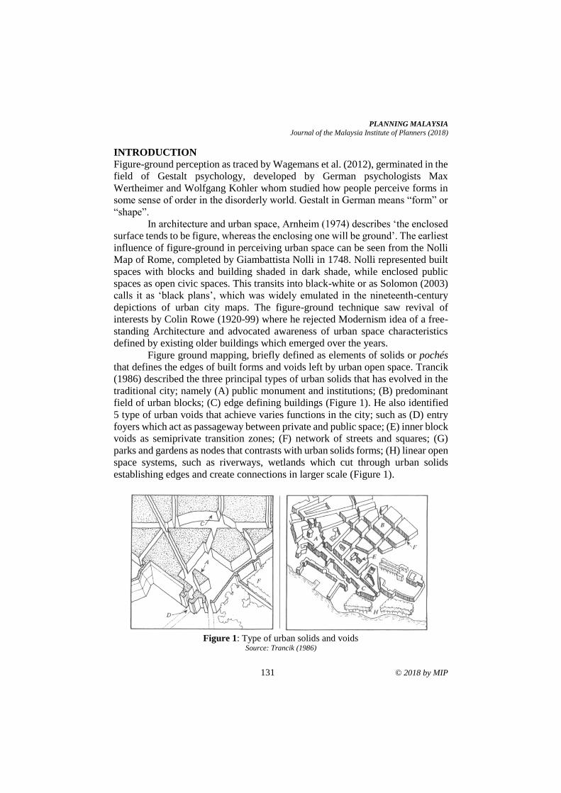
PLANNING MALAYSIA
Journal of the Malaysia Institute of Planners (2018)
131 © 2018 by MIP
INTRODUCTION
Figure-ground perception as traced by Wagemans et al. (2012), germinated in the
field of Gestalt psychology, developed by German psychologists Max
Wertheimer and Wolfgang Kohler whom studied how people perceive forms in
some sense of order in the disorderly world. Gestalt in German means “form” or
“shape”.
In architecture and urban space, Arnheim (1974) describes ‘the enclosed
surface tends to be figure, whereas the enclosing one will be ground’. The earliest
influence of figure-ground in perceiving urban space can be seen from the Nolli
Map of Rome, completed by Giambattista Nolli in 1748. Nolli represented built
spaces with blocks and building shaded in dark shade, while enclosed public
spaces as open civic spaces. This transits into black-white or as Solomon (2003)
calls it as ‘black plans’, which was widely emulated in the nineteenth-century
depictions of urban city maps. The figure-ground technique saw revival of
interests by Colin Rowe (1920-99) where he rejected Modernism idea of a free-
standing Architecture and advocated awareness of urban space characteristics
defined by existing older buildings which emerged over the years.
Figure ground mapping, briefly defined as elements of solids or pochés
that defines the edges of built forms and voids left by urban open space. Trancik
(1986) described the three principal types of urban solids that has evolved in the
traditional city; namely (A) public monument and institutions; (B) predominant
field of urban blocks; (C) edge defining buildings (Figure 1). He also identified
5 type of urban voids that achieve varies functions in the city; such as (D) entry
foyers which act as passageway between private and public space; (E) inner block
voids as semiprivate transition zones; (F) network of streets and squares; (G)
parks and gardens as nodes that contrasts with urban solids forms; (H) linear open
space systems, such as riverways, wetlands which cut through urban solids
establishing edges and create connections in larger scale (Figure 1).
Figure 1: Type of urban solids and voids
Source: Trancik (1986)
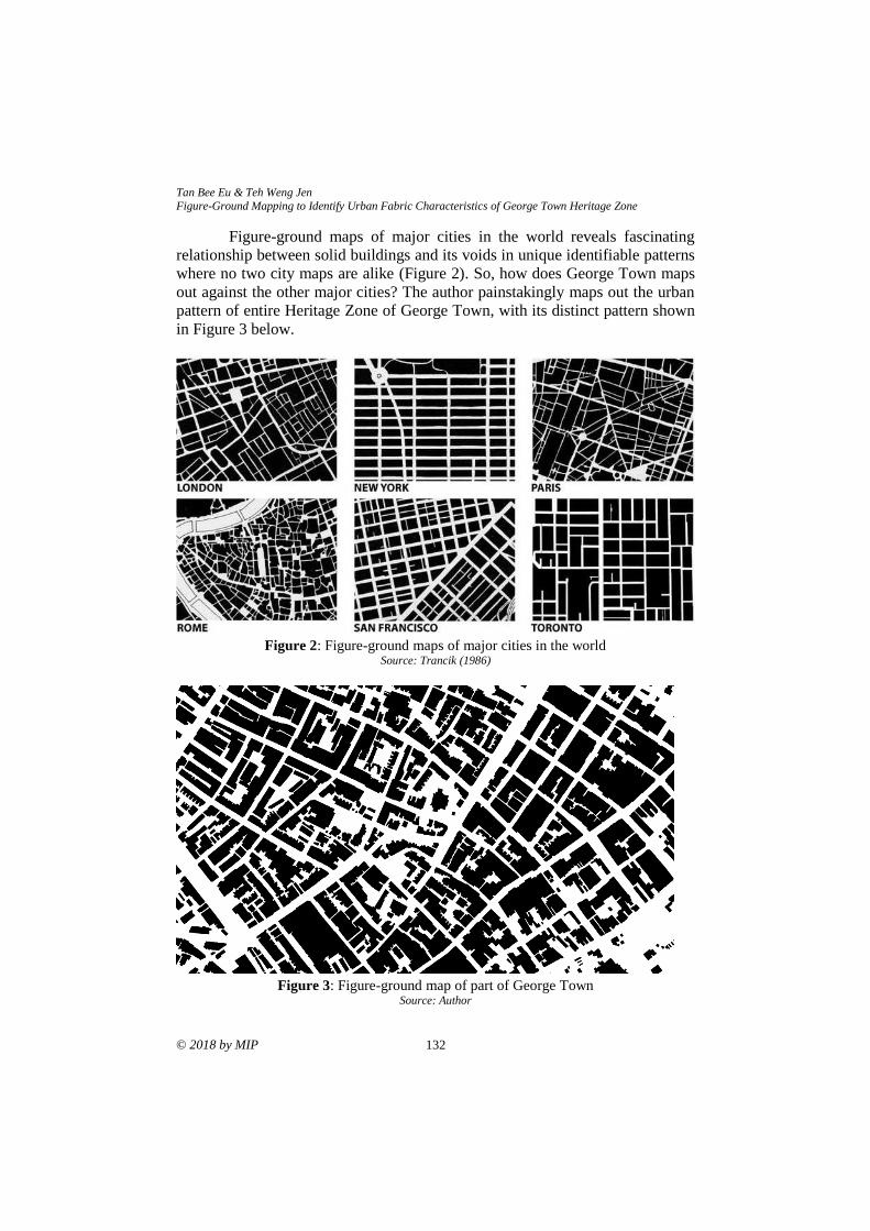
Tan Bee Eu & Teh Weng Jen Figure-Ground Mapping to Identify Urban Fabric Characteristics of George Town Heritage Zone
© 2018 by MIP 132
Figure-ground maps of major cities in the world reveals fascinating
relationship between solid buildings and its voids in unique identifiable patterns
where no two city maps are alike (Figure 2). So, how does George Town maps
out against the other major cities? The author painstakingly maps out the urban
pattern of entire Heritage Zone of George Town, with its distinct pattern shown
in Figure 3 below.
Figure 2: Figure-ground maps of major cities in the world
Source: Trancik (1986)
Figure 3: Figure-ground map of part of George Town
Source: Author
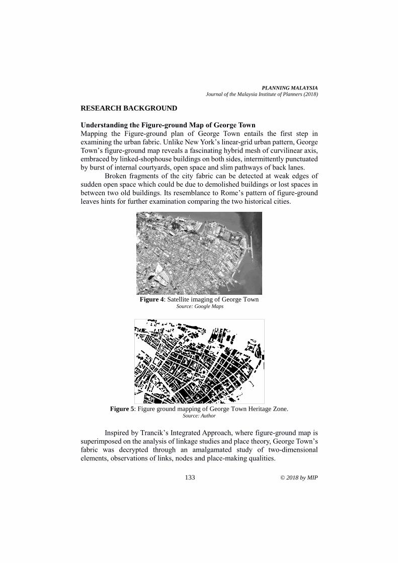
PLANNING MALAYSIA
Journal of the Malaysia Institute of Planners (2018)
133 © 2018 by MIP
RESEARCH BACKGROUND
Understanding the Figure-ground Map of George Town
Mapping the Figure-ground plan of George Town entails the first step in
examining the urban fabric. Unlike New York’s linear-grid urban pattern, George
Town’s figure-ground map reveals a fascinating hybrid mesh of curvilinear axis,
embraced by linked-shophouse buildings on both sides, intermittently punctuated
by burst of internal courtyards, open space and slim pathways of back lanes.
Broken fragments of the city fabric can be detected at weak edges of
sudden open space which could be due to demolished buildings or lost spaces in
between two old buildings. Its resemblance to Rome’s pattern of figure-ground
leaves hints for further examination comparing the two historical cities.
Figure 4: Satellite imaging of George Town
Source: Google Maps
Figure 5: Figure ground mapping of George Town Heritage Zone.
Source: Author
Inspired by Trancik’s Integrated Approach, where figure-ground map is
superimposed on the analysis of linkage studies and place theory, George Town’s
fabric was decrypted through an amalgamated study of two-dimensional
elements, observations of links, nodes and place-making qualities.
Tan Bee Eu & Teh Weng Jen Figure-Ground Mapping to Identify Urban Fabric Characteristics of George Town Heritage Zone
© 2018 by MIP 134
URBAN FORM & CHARACTERISTICS OF GEORGE TOWN
Structural Coherence
In George Town, its fabric whole is established mainly on heavy repetition and
proximity, in reference to Von Meiss's idea of structural coherence of the urban
environment lists elements of repetition and similarity, proximity, enclosure and
orientation. The structural form of buildings, and their relationship to the
elements, of the figure-ground relationship on building frontages; and third, of
the articulation of building parts. The buildings built until the Seventies have
conformed to these similarities, and hence, the slight variation of their floor
heights, ornamentation, materials, finishes and later the influences by Modernism
have not caused severe disorder.
People recognise an identity of a place through its regularity and
coherence of its parts. Our visual and mental settle on the easiness of a congruent
form. What makes a congruent whole? The heritage shophouses of George Town
from the Early Penang period until the Early Modern period (1790's to 1970's)
share a similar building form, which had only evolved over artistic influences and
the advance of building technology, however not to the extent of total chaos.
Although varied by stylistic periods, the shophouses generally adapt common
structural and formal characteristics: rectangular form of narrow frontage and
deep length, double pitched roofs and sectional divisions of the house by
courtyards and air wells. Each shophouse is linked to but articulated from its
adjacent units by load bearing party walls, terraced into irregular urban blocks.
Schumacher (1996) describes it as an experience of spaces defined by
continuous walls of building which are arranged in a way that emphasizes the
spaces and de-emphasizes the building volumes. The experience results from a
subtractive process in which spaces have been carved out of solid masses.
Linkage
The major tool that combines these shophouses into an urban fabric is largely by
the imposition of covered five-foot way on the ground floor that provides physical
linkages to an entire block, and visual linkages from one block to another. These
linkages are further enhanced by other details, such as common roof and cornice
lines. Sometimes, this continuity is disrupted by object-buildings which have
functional or symbolical importance, mainly mosques or temples. Such buildings
are normally built away from the proximity of the fabric, accentuated by gaps and
recesses. Otherwise, in cases of limited space and capital, unique architectural
solutions transpire in their relationship to the sky, the ground and the fabric-
buildings in immediate contact.
PLANNING MALAYSIA
Journal of the Malaysia Institute of Planners (2018)
135 © 2018 by MIP
Facade Characters
Rossi (1982) opines that urban artefact is the richness of the city history, its
auspicious character and ominous moments of life makes it an indispensable part
of the city. George Town’s heritage houses is filled with micro urban artefacts on
its façade. The windows, as figures, are articulated from the wall, as ground, by
plaster frames or pilasters which visually extend to the ground floor, enforcing
the division of the facade into three equal bays and an explicit symmetry. At the
roof, the relieves were done in many interesting forms of gable ends. The roof
eaves extend from the wall, suggesting its distinction from the facade. These
relieves were being manipulated in different degrees – curved, pronounced,
ornamented – for purposes of accentuation. The fenestrations on the facades of
shophouses could be studied as series of rhythmic elements with figure-ground
relationship to the solid wall. On the ground level, the central comb door with its
pair of square windows and air vents are in balance to the solid wall.
Articulation
Another method of looking at the coherence of the fabric is in the articulation of
the details. An articulation is a joint established between two different building
components meant to define, accentuate or separate opposing elements. An
explicit articulation let us recognise and trace building parts, such as to
differentiate a beam from a column, wall from floor, or a tile from another. The
articulation of parts in the shophouses of George Town lies muted in the transition
of the plinth to the columns, columns to beams, wall to windows and to the roof.
At the facade, the granite plinth of the five-foot way is articulated by the column
pedestals. The bressummer beam that supports upper level to the columns is
highlighted by a pair of corbel brackets. Cornices on the columns hint at the
change of levels and interrupt the verticality of the facade which would otherwise
become too protracted.
Continuity
However, there exists a sense of continuity created by the curves on the capital,
window arches and floral plaster works on the facade. This continuity created by
ornamentation was removed in shophouses built during the Art Deco and the
Early Modern periods, in which the former emphasised on verticality while the
latter held onto strict functionalism. Early Modern architecture had posed the
most radical challenges to the fabric: disruption of figure-ground rhythms,
removal of ornamental details, introduction of parapet walls, flat roof forms,
simplistic edge to the elements, and opposite methods of articulation, et cetera.
As such, the shophouses built under this influence had departed the most from
the original form. But other factors of coherence were at hand, such as the
consistency of development bay size and implied unification of the five-foot way.
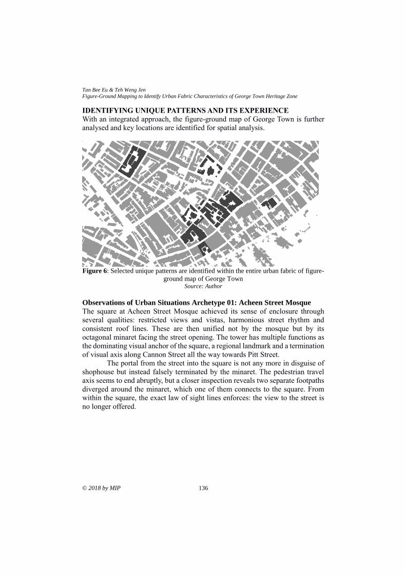
Tan Bee Eu & Teh Weng Jen Figure-Ground Mapping to Identify Urban Fabric Characteristics of George Town Heritage Zone
© 2018 by MIP 136
IDENTIFYING UNIQUE PATTERNS AND ITS EXPERIENCE
With an integrated approach, the figure-ground map of George Town is further
analysed and key locations are identified for spatial analysis.
Figure 6: Selected unique patterns are identified within the entire urban fabric of figure-
ground map of George Town Source: Author
Observations of Urban Situations Archetype 01: Acheen Street Mosque
The square at Acheen Street Mosque achieved its sense of enclosure through
several qualities: restricted views and vistas, harmonious street rhythm and
consistent roof lines. These are then unified not by the mosque but by its
octagonal minaret facing the street opening. The tower has multiple functions as
the dominating visual anchor of the square, a regional landmark and a termination
of visual axis along Cannon Street all the way towards Pitt Street.
The portal from the street into the square is not any more in disguise of
shophouse but instead falsely terminated by the minaret. The pedestrian travel
axis seems to end abruptly, but a closer inspection reveals two separate footpaths
diverged around the minaret, which one of them connects to the square. From
within the square, the exact law of sight lines enforces: the view to the street is
no longer offered.
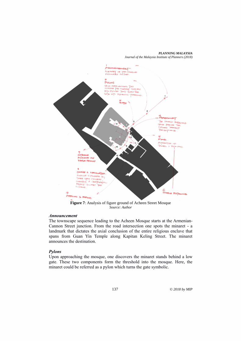
PLANNING MALAYSIA
Journal of the Malaysia Institute of Planners (2018)
137 © 2018 by MIP
Figure 7: Analysis of figure ground of Acheen Street Mosque Source: Author
Announcement
The townscape sequence leading to the Acheen Mosque starts at the Armenian-
Cannon Street junction. From the road intersection one spots the minaret - a
landmark that dictates the axial conclusion of the entire religious enclave that
spans from Guan Yin Temple along Kapitan Keling Street. The minaret
announces the destination.
Pylons
Upon approaching the mosque, one discovers the minaret stands behind a low
gate. These two components form the threshold into the mosque. Here, the
minaret could be referred as a pylon which turns the gate symbolic.
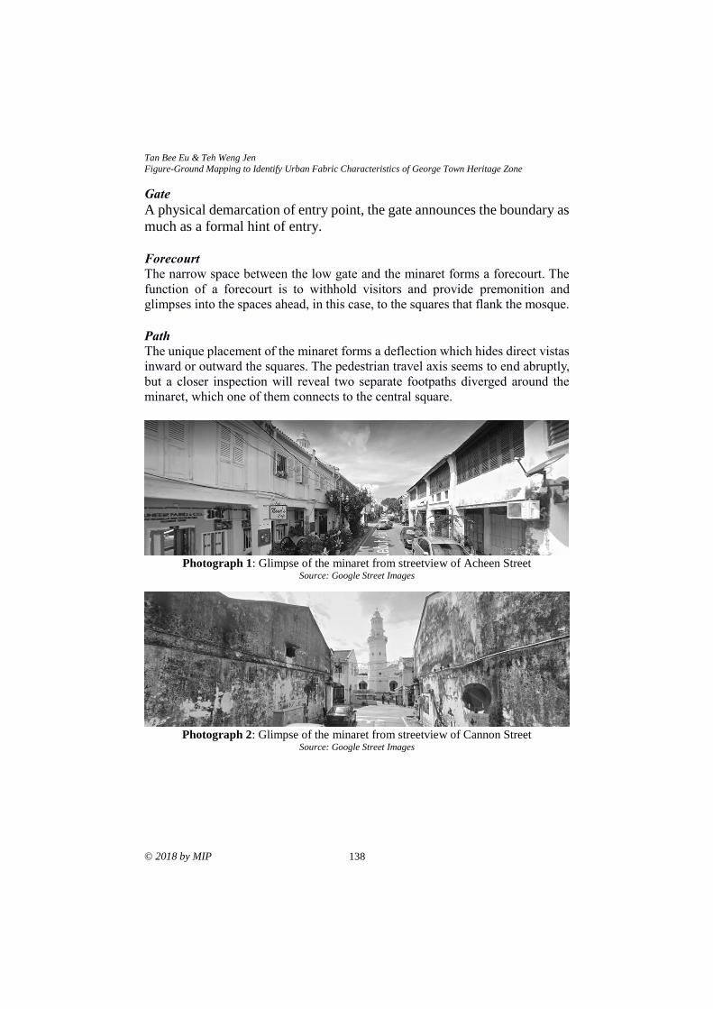
Tan Bee Eu & Teh Weng Jen Figure-Ground Mapping to Identify Urban Fabric Characteristics of George Town Heritage Zone
© 2018 by MIP 138
Gate
A physical demarcation of entry point, the gate announces the boundary as
much as a formal hint of entry.
Forecourt
The narrow space between the low gate and the minaret forms a forecourt. The
function of a forecourt is to withhold visitors and provide premonition and
glimpses into the spaces ahead, in this case, to the squares that flank the mosque.
Path
The unique placement of the minaret forms a deflection which hides direct vistas
inward or outward the squares. The pedestrian travel axis seems to end abruptly,
but a closer inspection will reveal two separate footpaths diverged around the
minaret, which one of them connects to the central square.
Photograph 1: Glimpse of the minaret from streetview of Acheen Street
Source: Google Street Images
Photograph 2: Glimpse of the minaret from streetview of Cannon Street
Source: Google Street Images
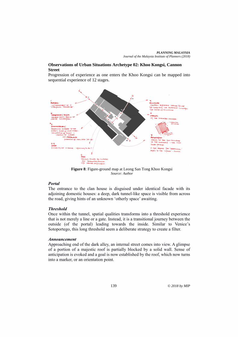
PLANNING MALAYSIA
Journal of the Malaysia Institute of Planners (2018)
139 © 2018 by MIP
Observations of Urban Situations Archetype 02: Khoo Kongsi, Cannon
Street
Progression of experience as one enters the Khoo Kongsi can be mapped into
sequential experience of 12 stages.
Figure 8: Figure-ground map at Leong San Tong Khoo Kongsi
Source: Author
Portal
The entrance to the clan house is disguised under identical facade with its
adjoining domestic houses: a deep, dark tunnel-like space is visible from across
the road, giving hints of an unknown ‘otherly space’ awaiting.
Threshold
Once within the tunnel, spatial qualities transforms into a threshold experience
that is not merely a line or a gate. Instead, it is a transitional journey between the
outside (of the portal) leading towards the inside. Similar to Venice’s
Sotoportego, this long threshold seem a deliberate strategy to create a filter.
Announcement
Approaching end of the dark alley, an internal street comes into view. A glimpse
of a portion of a majestic roof is partially blocked by a solid wall. Sense of
anticipation is evoked and a goal is now established by the roof, which now turns
into a marker, or an orientation point.
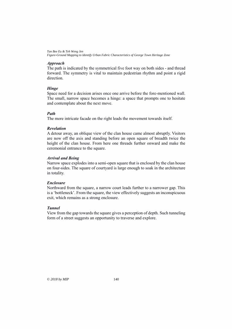
Tan Bee Eu & Teh Weng Jen Figure-Ground Mapping to Identify Urban Fabric Characteristics of George Town Heritage Zone
© 2018 by MIP 140
Approach
The path is indicated by the symmetrical five foot way on both sides - and thread
forward. The symmetry is vital to maintain pedestrian rhythm and point a rigid
direction.
Hinge
Space need for a decision arises once one arrive before the fore-mentioned wall.
The small, narrow space becomes a hinge: a space that prompts one to hesitate
and contemplate about the next move.
Path
The more intricate facade on the right leads the movement towards itself.
Revelation
A detour away, an oblique view of the clan house came almost abruptly. Visitors
are now off the axis and standing before an open square of breadth twice the
height of the clan house. From here one threads further onward and make the
ceremonial entrance to the square.
Arrival and Being
Narrow space explodes into a semi-open square that is enclosed by the clan house
on four-sides. The square of courtyard is large enough to soak in the architecture
in totality.
Enclosure
Northward from the square, a narrow court leads further to a narrower gap. This
is a ‘bottleneck’. From the square, the view effectively suggests an inconspicuous
exit, which remains as a strong enclosure.
Tunnel
View from the gap towards the square gives a perception of depth. Such tunneling
form of a street suggests an opportunity to traverse and explore.
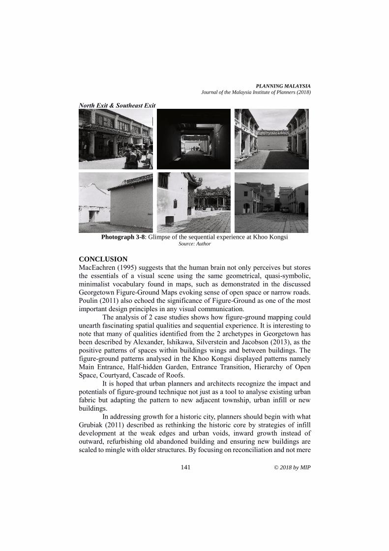
PLANNING MALAYSIA
Journal of the Malaysia Institute of Planners (2018)
141 © 2018 by MIP
North Exit & Southeast Exit
Photograph 3-8: Glimpse of the sequential experience at Khoo Kongsi
Source: Author
CONCLUSION
MacEachren (1995) suggests that the human brain not only perceives but stores
the essentials of a visual scene using the same geometrical, quasi-symbolic,
minimalist vocabulary found in maps, such as demonstrated in the discussed
Georgetown Figure-Ground Maps evoking sense of open space or narrow roads.
Poulin (2011) also echoed the significance of Figure-Ground as one of the most
important design principles in any visual communication.
The analysis of 2 case studies shows how figure-ground mapping could
unearth fascinating spatial qualities and sequential experience. It is interesting to
note that many of qualities identified from the 2 archetypes in Georgetown has
been described by Alexander, Ishikawa, Silverstein and Jacobson (2013), as the
positive patterns of spaces within buildings wings and between buildings. The
figure-ground patterns analysed in the Khoo Kongsi displayed patterns namely
Main Entrance, Half-hidden Garden, Entrance Transition, Hierarchy of Open
Space, Courtyard, Cascade of Roofs.
It is hoped that urban planners and architects recognize the impact and
potentials of figure-ground technique not just as a tool to analyse existing urban
fabric but adapting the pattern to new adjacent township, urban infill or new
buildings.
In addressing growth for a historic city, planners should begin with what
Grubiak (2011) described as rethinking the historic core by strategies of infill
development at the weak edges and urban voids, inward growth instead of
outward, refurbishing old abandoned building and ensuring new buildings are
scaled to mingle with older structures. By focusing on reconciliation and not mere
Tan Bee Eu & Teh Weng Jen Figure-Ground Mapping to Identify Urban Fabric Characteristics of George Town Heritage Zone
© 2018 by MIP 142
blending, Grubiak reckons it to be the essential strategy of success to any historic
city looking for equilibrium between change and continuity of relevancy.
It is by now important to appreciate that the analysis of figure-ground
pattern can also contribute to ensuring the sense of place of historic city is
retained and becomes an additional determining factors towards a quality
neighbourhood which was categorized by Rahman (2012) as physical
environment, economy and social factors.
Town Planners, architects and urban designers must have full awareness
of choices to design into or out of the urban fabric. Tibbalds (2001) urged that
new development should harmonize with the existing townscape, materials,
historical features and local vernacular. Perhaps it shall be in such manner of
abiding the subtle rules of a larger whole, that the heritage shophouses in George
Town could be built, adapted and rebuilt again without jeopardising its unique
urban fabric.
REFERENCES Abdul Rahman, N. (2012). Determinant factors of neighbourhood quality. Planning
Malaysia, 10, 1-16.
Alexander, C., Ishikawa, S., Silverstein, M., & Jacobson, M. (2013). A pattern language:
Towns, buildings, construction. New York, NY: Oxford Univ. Press.
Arnheim, R. (1974). Art and visual perception: A psychology of the creative eye: The
revised version. Berkeley, CA: University of California Press.
Grubiak, M. (2011). Figure ground relationship. Architect, 100, 28-29.
Hebbert, M. (2016). Figure-ground: History and practice of a planning technique. Town
Planning Review, 87, 705-728.
Maceachren, A. M. (1995). How maps work – Representation visualization and design.
New York: The Guilford Press.
Poulin, R. (2011). The language of graphic design. Beverly, MA: Rockport Publishers.
Rossi, A. (1982). The architecture of the city. Cambridge, MA: MIT Press.
Schumacher, T. (1996). Contextualism – urban ideals and deformations. In K. Nesbitt
(Ed.), Theorizing a new agenda for architecture (pp. 297-301). New York: Princeton
Architectural Press.
Solomon, D. (2003). Global city blues. Washington: Island Press.
Tibbalds, F. (2001). Making people-friendly towns: Improving the public environment in
towns and cities. London: E. & F. N. Spon.
Tice, J. (2005). The Interactive Nolli Map Of Rome Website,
Http://Nolli.Uoregon.Edu/Default.Asp (Accessed 12 January 2016).
Trancik, R. (1986). Finding lost space. New York: Van Nostrand Reinhold.
Wagemans, J. Elder, J. H.,Kubovy, M., Palmer, S. E., Peterson, M. A., Singh, M., & von
der Heydt, R. (2012). A century of gestalt psychology in visual perception: I.
perceptual grouping and figure–ground organization. Psychological Bulletin,
138(6), 1172-1217
Received: 1st June 2018. Accepted:1st December 2018
1 Senior Lecturer at University Sains Malaysia Email: [email protected] 143
PLANNING MALAYSIA:
Journal of the Malaysian Institute of Planners
VOLUME 16 ISSUE 4 (2018), Page 143 – 154
VISITORS PERSPECTIVES TOWARDS THE CONSERVATION OF
HERITAGE BUILDING: THE CASE STUDY OF GURNEY PARAGON
MALL, PENANG
Normah Abdul Latip1, Norazmawati Md Sani@Abd Rahim2, Syarmila Hany
Haron3, Rosniza Hamzah4, Adaweia Nuur Abu Bakar5, & Mohd Umzarulazijo
Umar6
1,2,3,5,6School of Housing Building and Planning
UNIVERSITI SAINS MALAYSIA
4Faculty of Engineering Technology UNIVERSITI MALAYSIA PERLIS
Abstract
The purpose of this paper is to acquire a better understanding of the history,
background, process and impact of the restoration of St. Joseph’s Novitiate, and
it integration into Gurney Paragon Mall. St. Joseph’s Novitiate has significant
historical, architectural, aesthetic, archaeological, spiritual, social, political and
economic value, and as such, requires continuous care and preservation. This
study explores the perspectives of visitors to the shopping mall, with St. Joseph’s
Novitiate having been physically integrated into the mall’s construction, and
found that the conservation of heritage buildings was regarded as very important,
even when a new development could easily replace the historic building. This is
likely a one of a kind study because it involves a modern shopping mall attached
to a UNESCO World Heritage Site building. The conservation of historical
buildings carries with it a number of environmental, social and cultural impacts.
Understanding these impacts is important in terms of trying to determine whether
conservation efforts help to maintain the value of the heritage.
Keywords: visitor perspective, heritage building, shopping mall
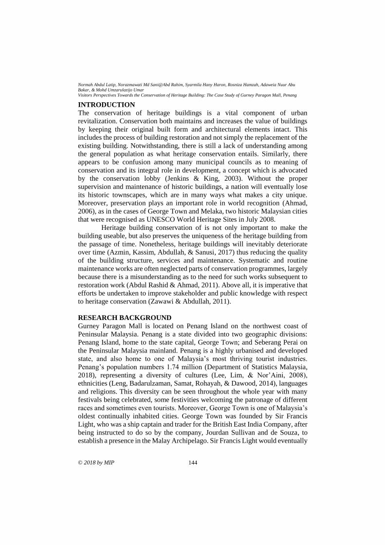
Normah Abdul Latip, Norazmawati Md Sani@Abd Rahim, Syarmila Hany Haron, Rosniza Hamzah, Adaweia Nuur Abu
Bakar, & Mohd Umzarulazijo Umar Visitors Perspectives Towards the Conservation of Heritage Building: The Case Study of Gurney Paragon Mall, Penang
© 2018 by MIP 144
INTRODUCTION
The conservation of heritage buildings is a vital component of urban
revitalization. Conservation both maintains and increases the value of buildings
by keeping their original built form and architectural elements intact. This
includes the process of building restoration and not simply the replacement of the
existing building. Notwithstanding, there is still a lack of understanding among
the general population as what heritage conservation entails. Similarly, there
appears to be confusion among many municipal councils as to meaning of
conservation and its integral role in development, a concept which is advocated
by the conservation lobby (Jenkins & King, 2003). Without the proper
supervision and maintenance of historic buildings, a nation will eventually lose
its historic townscapes, which are in many ways what makes a city unique.
Moreover, preservation plays an important role in world recognition (Ahmad,
2006), as in the cases of George Town and Melaka, two historic Malaysian cities
that were recognised as UNESCO World Heritage Sites in July 2008.
Heritage building conservation of is not only important to make the
building useable, but also preserves the uniqueness of the heritage building from
the passage of time. Nonetheless, heritage buildings will inevitably deteriorate
over time (Azmin, Kassim, Abdullah, & Sanusi, 2017) thus reducing the quality
of the building structure, services and maintenance. Systematic and routine
maintenance works are often neglected parts of conservation programmes, largely
because there is a misunderstanding as to the need for such works subsequent to
restoration work (Abdul Rashid & Ahmad, 2011). Above all, it is imperative that
efforts be undertaken to improve stakeholder and public knowledge with respect
to heritage conservation (Zawawi & Abdullah, 2011).
RESEARCH BACKGROUND
Gurney Paragon Mall is located on Penang Island on the northwest coast of
Peninsular Malaysia. Penang is a state divided into two geographic divisions:
Penang Island, home to the state capital, George Town; and Seberang Perai on
the Peninsular Malaysia mainland. Penang is a highly urbanised and developed
state, and also home to one of Malaysia’s most thriving tourist industries.
Penang’s population numbers 1.74 million (Department of Statistics Malaysia,
2018), representing a diversity of cultures (Lee, Lim, & Nor’Aini, 2008),
ethnicities (Leng, Badarulzaman, Samat, Rohayah, & Dawood, 2014), languages
and religions. This diversity can be seen throughout the whole year with many
festivals being celebrated, some festivities welcoming the patronage of different
races and sometimes even tourists. Moreover, George Town is one of Malaysia’s
oldest continually inhabited cities. George Town was founded by Sir Francis
Light, who was a ship captain and trader for the British East India Company, after
being instructed to do so by the company, Jourdan Sullivan and de Souza, to
establish a presence in the Malay Archipelago. Sir Francis Light would eventually
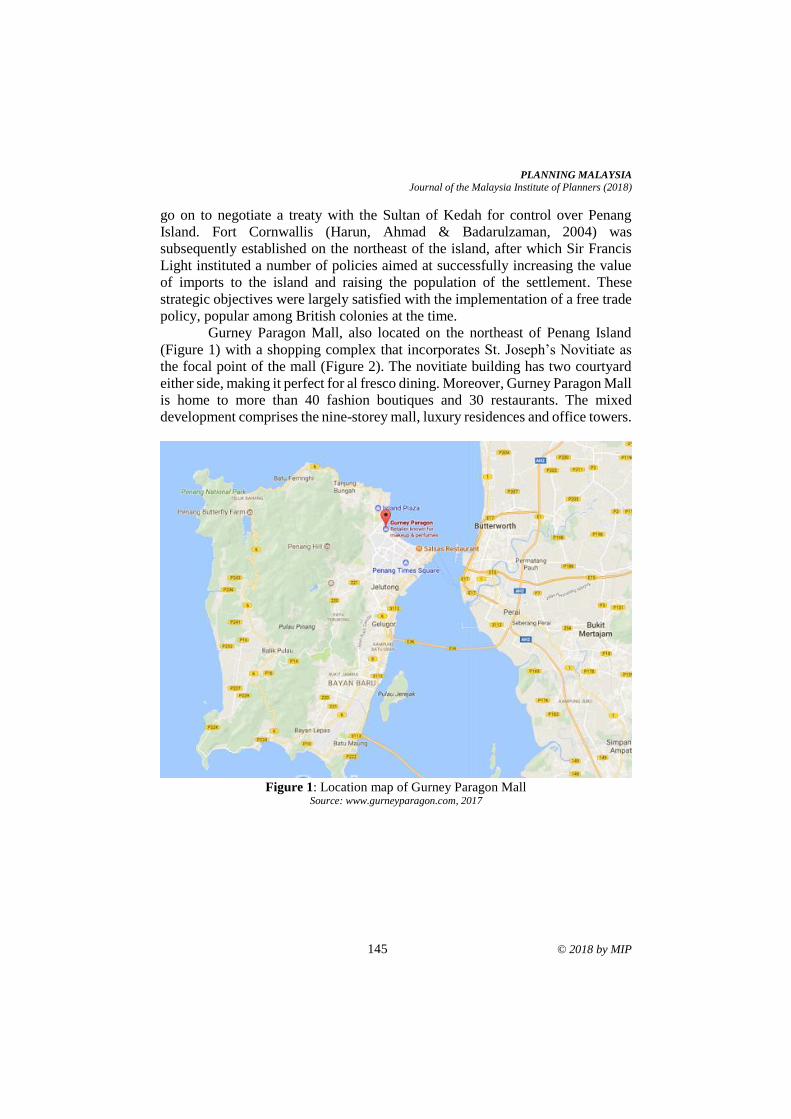
PLANNING MALAYSIA
Journal of the Malaysia Institute of Planners (2018)
145 © 2018 by MIP
go on to negotiate a treaty with the Sultan of Kedah for control over Penang
Island. Fort Cornwallis (Harun, Ahmad & Badarulzaman, 2004) was
subsequently established on the northeast of the island, after which Sir Francis
Light instituted a number of policies aimed at successfully increasing the value
of imports to the island and raising the population of the settlement. These
strategic objectives were largely satisfied with the implementation of a free trade
policy, popular among British colonies at the time.
Gurney Paragon Mall, also located on the northeast of Penang Island
(Figure 1) with a shopping complex that incorporates St. Joseph’s Novitiate as
the focal point of the mall (Figure 2). The novitiate building has two courtyard
either side, making it perfect for al fresco dining. Moreover, Gurney Paragon Mall
is home to more than 40 fashion boutiques and 30 restaurants. The mixed
development comprises the nine-storey mall, luxury residences and office towers.
Figure 1: Location map of Gurney Paragon Mall
Source: www.gurneyparagon.com, 2017
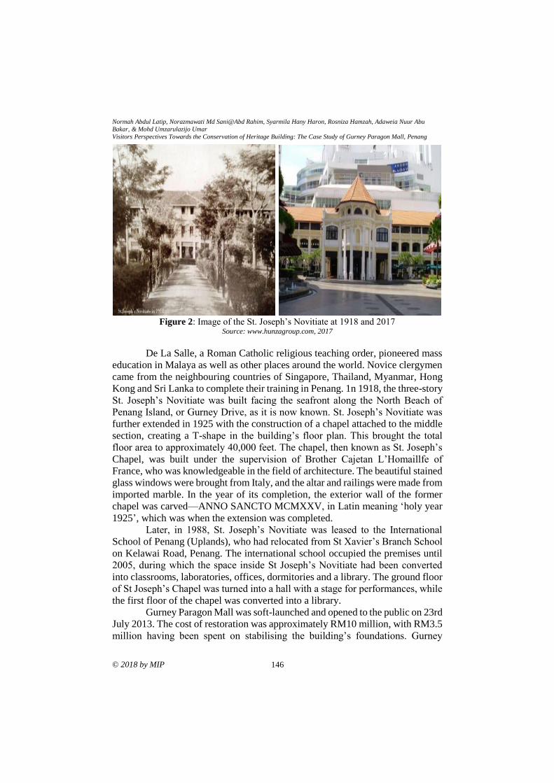
Normah Abdul Latip, Norazmawati Md Sani@Abd Rahim, Syarmila Hany Haron, Rosniza Hamzah, Adaweia Nuur Abu
Bakar, & Mohd Umzarulazijo Umar Visitors Perspectives Towards the Conservation of Heritage Building: The Case Study of Gurney Paragon Mall, Penang
© 2018 by MIP 146
Figure 2: Image of the St. Joseph’s Novitiate at 1918 and 2017
Source: www.hunzagroup.com, 2017
De La Salle, a Roman Catholic religious teaching order, pioneered mass
education in Malaya as well as other places around the world. Novice clergymen
came from the neighbouring countries of Singapore, Thailand, Myanmar, Hong
Kong and Sri Lanka to complete their training in Penang. 1n 1918, the three-story
St. Joseph’s Novitiate was built facing the seafront along the North Beach of
Penang Island, or Gurney Drive, as it is now known. St. Joseph’s Novitiate was
further extended in 1925 with the construction of a chapel attached to the middle
section, creating a T-shape in the building’s floor plan. This brought the total
floor area to approximately 40,000 feet. The chapel, then known as St. Joseph’s
Chapel, was built under the supervision of Brother Cajetan L’Homaillfe of
France, who was knowledgeable in the field of architecture. The beautiful stained
glass windows were brought from Italy, and the altar and railings were made from
imported marble. In the year of its completion, the exterior wall of the former
chapel was carved—ANNO SANCTO MCMXXV, in Latin meaning ‘holy year
1925’, which was when the extension was completed.
Later, in 1988, St. Joseph’s Novitiate was leased to the International
School of Penang (Uplands), who had relocated from St Xavier’s Branch School
on Kelawai Road, Penang. The international school occupied the premises until
2005, during which the space inside St Joseph’s Novitiate had been converted
into classrooms, laboratories, offices, dormitories and a library. The ground floor
of St Joseph’s Chapel was turned into a hall with a stage for performances, while
the first floor of the chapel was converted into a library.
Gurney Paragon Mall was soft-launched and opened to the public on 23rd
July 2013. The cost of restoration was approximately RM10 million, with RM3.5
million having been spent on stabilising the building’s foundations. Gurney
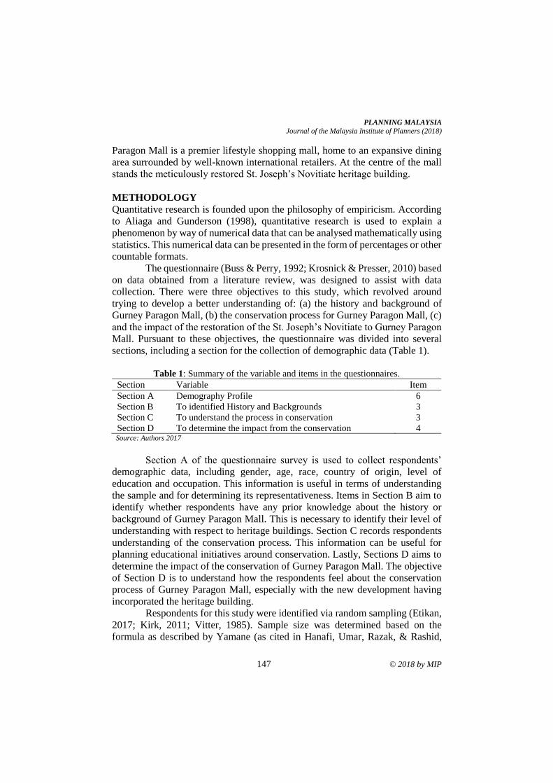
PLANNING MALAYSIA
Journal of the Malaysia Institute of Planners (2018)
147 © 2018 by MIP
Paragon Mall is a premier lifestyle shopping mall, home to an expansive dining
area surrounded by well-known international retailers. At the centre of the mall
stands the meticulously restored St. Joseph’s Novitiate heritage building.
METHODOLOGY
Quantitative research is founded upon the philosophy of empiricism. According
to Aliaga and Gunderson (1998), quantitative research is used to explain a
phenomenon by way of numerical data that can be analysed mathematically using
statistics. This numerical data can be presented in the form of percentages or other
countable formats.
The questionnaire (Buss & Perry, 1992; Krosnick & Presser, 2010) based
on data obtained from a literature review, was designed to assist with data
collection. There were three objectives to this study, which revolved around
trying to develop a better understanding of: (a) the history and background of
Gurney Paragon Mall, (b) the conservation process for Gurney Paragon Mall, (c)
and the impact of the restoration of the St. Joseph’s Novitiate to Gurney Paragon
Mall. Pursuant to these objectives, the questionnaire was divided into several
sections, including a section for the collection of demographic data (Table 1).
Table 1: Summary of the variable and items in the questionnaires.
Section Variable Item
Section A Demography Profile 6
Section B To identified History and Backgrounds 3
Section C To understand the process in conservation 3
Section D To determine the impact from the conservation 4 Source: Authors 2017
Section A of the questionnaire survey is used to collect respondents’
demographic data, including gender, age, race, country of origin, level of
education and occupation. This information is useful in terms of understanding
the sample and for determining its representativeness. Items in Section B aim to
identify whether respondents have any prior knowledge about the history or
background of Gurney Paragon Mall. This is necessary to identify their level of
understanding with respect to heritage buildings. Section C records respondents
understanding of the conservation process. This information can be useful for
planning educational initiatives around conservation. Lastly, Sections D aims to
determine the impact of the conservation of Gurney Paragon Mall. The objective
of Section D is to understand how the respondents feel about the conservation
process of Gurney Paragon Mall, especially with the new development having
incorporated the heritage building.
Respondents for this study were identified via random sampling (Etikan,
2017; Kirk, 2011; Vitter, 1985). Sample size was determined based on the
formula as described by Yamane (as cited in Hanafi, Umar, Razak, & Rashid,
Normah Abdul Latip, Norazmawati Md Sani@Abd Rahim, Syarmila Hany Haron, Rosniza Hamzah, Adaweia Nuur Abu
Bakar, & Mohd Umzarulazijo Umar Visitors Perspectives Towards the Conservation of Heritage Building: The Case Study of Gurney Paragon Mall, Penang
© 2018 by MIP 148
2018). This formula was used to calculate the sample size for a 95% confidence
level and precision = 0.05. It was estimated that about 1,000 people will enter
Gurney Paragon Mall. Based on the Yamane equation, this requires a sample size
of approximately 286 respondents. However, due to the need for a homogenous
population, the actual sample size should be smaller, thus improving the accuracy
and depth of information provided by the respondents. Moreover, the cost of
additional questionnaires would have exceeded the budget for this study. Time
constrains were another reason to reduce the size of the sample. As the number
of respondents increases, so too does the time required to administer the
questionnaire survey and to clean-up and analyse the data. Consequently, the
sample for this study was limited to less than 100 samples (n<100).
ANALYSIS AND FINDING
One hundred (100) questionnaires were distributed to visitors of Gurney Paragon
Mall. The researcher was responsible for the distribution of the questionnaires,
which also provided an opportunity for the researcher to clarify any
misunderstandings on the part of the respondents with regards to the
questionnaire items. The researcher aimed to distribute approximately 80% of
questionnaires; obviously the more responses received, the greater the validity of
the data analysis (Table 2). Table 2 indicates the response rates at 82% from 100
respondent followed by 18% refused to answers due to private and confidential
reasons. Table 2: Response Rate
Visitor
Percentage (%)
Total Distribute Questionnaire
Visitor Responded
Visitor Not Responded
100
82
18
100
82
18 Source: Authors 2017
The data was analysed using SPSS Version 24. The question items were
translated into simple terms to facilitate coding during the data analysis phase.
The results shown in Table 3 in terms of demography profile namely gender, age,
place origin and levels of education indicates a significant finding for gender
equal at 50% each. As for generations, the highest percentage with 73.2%
dominantly by age group at 18-24-year-olds, followed by group age at 25-35 with
13.4% and the rest at 46 years old and above. Place of origin for the respondent
indicates that 57.3% from outside Penang and the rest are locals. More than half
of them possess a degree with 65.9% followed by diploma and certificates with
18.3% and the rest STPM and below.

PLANNING MALAYSIA
Journal of the Malaysia Institute of Planners (2018)
149 © 2018 by MIP
Table 3: Demography Profile (n=82)
Demography Profile Respondent Percentage (%)
Gender
Male Female
Age
18-24
25-35
36-45
46-55
>56
Place Origin
Penang
Outside Penang
Level of Education
PMR/SRP
SPM
STPM
Certificate/Diploma
Degree and above
Out of School
Occupation
Self-employed
Government
Private sector
Retiree
Unemployed
41
41
60
11
1
5
5
35
47
1
6
4
15
54
2
13
5
15
1
48
50
50
73.2
13.4
1.2
6.1
6.1
42.7
57.3
1.2
7.3
4.9
18.3
65.9
2.4
15.9
6.1
18.3
1.2
58.5 Source: Author2017
Table 4 indicates that the respondent visited Gurney Paragon with the
primary goal for shopping at 59.8%, followed by tour and travel with 22%, and
loungers at12.2%. The rest came for business deals and opportunities.
Table 4: Purpose to Gurney Paragon Mall (n=82)
Purpose Respondent Percentage (%)
Tour/Travel
Shopping
Business
Loungers
18
49
5
10
22.0
59.8
6.1
12.2
Source: Author2017
Table 5 statistically revealed that 63% of the respondent had no idea that
UNESCO recognises Gurney Paragon and 82% did not know that Gurney
Paragon is also known as St. Joseph Novitiate. Meanwhile, 68% were not aware
that the building has undergone conservation process and 79% did not know the
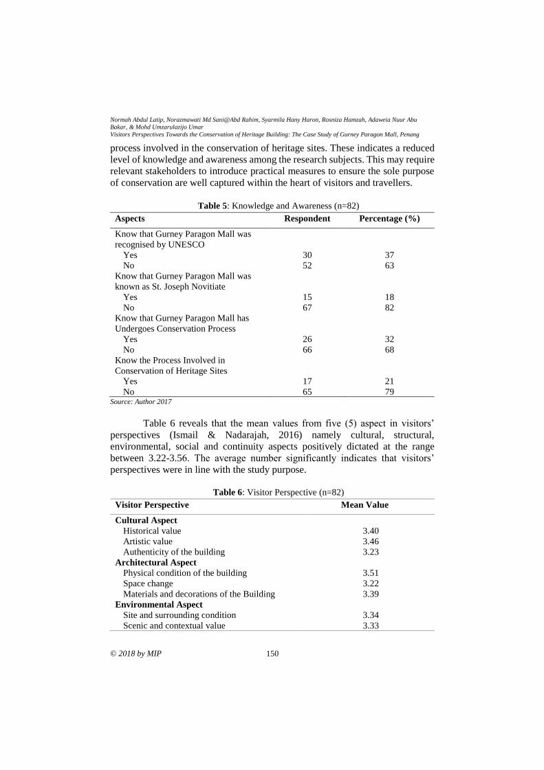
Normah Abdul Latip, Norazmawati Md Sani@Abd Rahim, Syarmila Hany Haron, Rosniza Hamzah, Adaweia Nuur Abu
Bakar, & Mohd Umzarulazijo Umar Visitors Perspectives Towards the Conservation of Heritage Building: The Case Study of Gurney Paragon Mall, Penang
© 2018 by MIP 150
process involved in the conservation of heritage sites. These indicates a reduced
level of knowledge and awareness among the research subjects. This may require
relevant stakeholders to introduce practical measures to ensure the sole purpose
of conservation are well captured within the heart of visitors and travellers.
Table 5: Knowledge and Awareness (n=82)
Aspects Respondent Percentage (%)
Know that Gurney Paragon Mall was
recognised by UNESCO
Yes
No
Know that Gurney Paragon Mall was
known as St. Joseph Novitiate
Yes
No
Know that Gurney Paragon Mall has
Undergoes Conservation Process
Yes
No
Know the Process Involved in
Conservation of Heritage Sites
Yes
No
30
52
15
67
26
66
17
65
37
63
18
82
32
68
21
79 Source: Author 2017
Table 6 reveals that the mean values from five (5) aspect in visitors’
perspectives (Ismail & Nadarajah, 2016) namely cultural, structural,
environmental, social and continuity aspects positively dictated at the range
between 3.22-3.56. The average number significantly indicates that visitors’
perspectives were in line with the study purpose.
Table 6: Visitor Perspective (n=82)
Visitor Perspective Mean Value
Cultural Aspect
Historical value
Artistic value
Authenticity of the building
Architectural Aspect
Physical condition of the building
Space change
Materials and decorations of the Building
Environmental Aspect
Site and surrounding condition
Scenic and contextual value
3.40
3.46
3.23
3.51
3.22
3.39
3.34
3.33
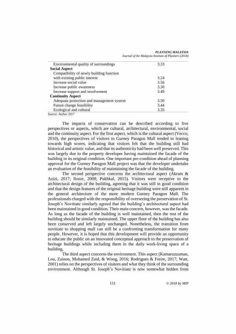
PLANNING MALAYSIA
Journal of the Malaysia Institute of Planners (2018)
151 © 2018 by MIP
Environmental quality of surroundings
Social Aspect
Compatibility of newly building function
with existing public interest
Increase social value
Increase public awareness
Increase support and involvement
Continuity Aspect
Adequate protection and management system
Future change feasibility
Ecological and cultural
3.33
3.24
3.56
3.30
3.49
3.50
3.44
3.35 Source: Author 2017
The impacts of conservation can be described according to five
perspectives or aspects, which are cultural, architectural, environmental, social
and the continuity aspect. For the first aspect, which is the cultural aspect (Vecco,
2010), the perspectives of visitors to Gurney Paragon Mall tended to leaning
towards high scores, indicating that visitors felt that the building still had
historical and artistic value, and that its authenticity had been well preserved. This
was largely due to the property developer having maintained the facade of the
building in its original condition. One important pre-condition ahead of planning
approval for the Gurney Paragon Mall project was that the developer undertake
an evaluation of the feasibility of maintaining the facade of the building.
The second perspective concerns the architectural aspect (Akram &
Azizi, 2017; Ilozor, 2008; Pukhkal, 2015). Visitors were receptive to the
architectural design of the building, agreeing that it was still in good condition
and that the design features of the original heritage building were still apparent in
the general architecture of the more modern Gurney Paragon Mall. The
professionals charged with the responsibility of overseeing the preservation of St.
Joseph’s Novitiate similarly agreed that the building’s architectural aspect had
been maintained in good condition. Their main concern, however, was the facade.
As long as the facade of the building is well maintained, then the rest of the
building should be similarly maintained. The upper floor of the building has also
been conserved and left largely unchanged. Nonetheless, the transition from
novitiate to shopping mall can still be a confronting transformation for many
people. However, it is hoped that this development will provide an opportunity
to educate the public on an innovated conceptual approach to the preservation of
heritage buildings while including them in the daily work-living space of a
building.
The third aspect concerns the environment. This aspect (Kamaruzzaman,
Lou, Zainon, Mohamed Zaid, & Wong, 2016; Rodrigues & Freire, 2017; Watt,
2001) relies on the perspectives of visitors and what they think of the surrounding
environment. Although St. Joseph’s Novitiate is now somewhat hidden from
Normah Abdul Latip, Norazmawati Md Sani@Abd Rahim, Syarmila Hany Haron, Rosniza Hamzah, Adaweia Nuur Abu
Bakar, & Mohd Umzarulazijo Umar Visitors Perspectives Towards the Conservation of Heritage Building: The Case Study of Gurney Paragon Mall, Penang
© 2018 by MIP 152
view due to the new development, the overall condition of the surrounding
environment is good. However, while Gurney Paragon Mall does not reflect much
the heritage value of St. Joseph’s Novitiate, the building does at least preserve
the value of St. Joseph’s Novitiate’s heritage.
The social aspect (ICOMOS, 2010; Yung, Zhang, & Chan, 2017) is the
fourth perspective in determining the impact of conservation to Gurney Paragon
Mall. This aspect again concerns visitors and whether they think that the
conservation of St. Joseph’s Novitiate will increase the social awareness and
involvement of people in the conservation and preservation of heritage buildings.
It is assumed that by converting St. Joseph’s Novitiate into a shopping mall
people will have the opportunity to experience a heritage building before they are
lost to history.
The final perspective is the continuity aspect. Continuity here implies
that both visitors and respondents think that the conservation of Gurney Paragon
Mall will not create any issues or problems in the future. One important
requirement levied by the municipal council was that the developer undertake to
preserve the building’s facade. Had the developer ignored this requirement to
preserve the facade of the building, planning permission would not have been
granted by the local authority.
CONCLUDING REMARK
The first objective of this study has been achieved, which is to identify the history
and background of Gurney Paragon Mall. St. Joseph’s Novitiate was purchased
by the developer before being restored and incorporated into the architecture of a
new shopping mall. The second objective has also been achieved - to determine
the impact of conservation of Gurney Paragon Mall. The impact of conservation
is gauged according to five aspects, which concern cultural, architectural,
environmental, social, and continuity impacts. Based on the findings, respondents
were generally satisfied, with 90% supporting the conservation of Gurney
Paragon Mall. Nonetheless, while there were some minor issues regarding the
conservation work, respondents generally satisfied so long as the conservation
efforts do not harm the heritage building either now or in the future.
PLANNING MALAYSIA
Journal of the Malaysia Institute of Planners (2018)
153 © 2018 by MIP
ACKNOWLEDGEMENT
We gratefully acknowledge Universiti Sains Malaysia and Ministry of Education
Malaysia for funding this project through Fundamental Research Grant Scheme,
FRGS, (Grant No: 203/PPBGN/6711404).
REFERENCES Abdul Rashid, R., & Ahmad, A. G. (2011). Overview of maintenance approaches of
historical buildings in Kuala Lumpur - A current practice. Procedia
Engineering, 20, 425-434.
Ahmad, A. G. (2006). The framework of historical building conservation.
Sejarah@Malaysia, 1(1), 50-56.
Akram, Z., & Azizi, B. (2017). The sustainable architectural values of eclectic style
shophouses case study: Sun Yat Sen Museum Penang, Malaysia. Panggung,
27(2), 108-116.
Aliaga, M., & Gunderson, B. (1998). Interactive statistics. Upper Saddle River, NJ:
Pearson.
Azmin, A. K., Kassim, M. H., Abdullah, F., & Sanusi, A. N. Z. (2017). Architectural
heritage restoration of Rumah Datuk Setia via mobile augmented reality
restoration. Planning Malaysia, 15(1), 139-50.
Buss, A. H., & Perry, M. (1992). The aggression questionnaire. Journal of Personality
and Social Psychology, 63(3), 452-459.
Department of Statistics Malaysia (2018). Department of Statistics Malaysia Official
Portal. [online] Available at
https://www.dosm.gov.my/v1/index.php?r=column/cone&menu_id=SEFobmo
1N212cXc5TFlLVTVxWUFXZz09 [Accessed 8 Aug. 2018].
Etikan, I. (2017). Sampling and sampling methods. Biometrics & Biostatistics
International Journal, 5(6), 00149
Harun, S. N., Ahmad, A. G., & Badarulzaman, N. (2004, August). Conservation and
archaeology of Fort Cornwallis, Penang, Malaysia. First International
Conference on Science and Technology in Archaeology and Conservation,
August 12-17, 2002, Jordan.
Hanafi, M. H., Umar, M. U., Razak, A. A., & Rashid, Z. Z. A. (2018). Essential entities
towards developing an adaptive reuse model for organization management in
conservation of heritage buildings in Malaysia. Environment-Behaviour
Proceedings Journal, 3(7), 265-276.
ICOMOS. (2010). Changing world , changing views of heritage: Heritage and social
change. Proceedings of the ICOMOS scientific symposium. Paris: ICOMOS
International Secretariat.
Ilozor, B. D. (2008). Architectural and building features disparity and preservation of
structural and fabrics integrity. Journal of Engineering, Design and Technology,
6(1), 33-47.
Ismail, W. H. W., & Nadarajah, J. R. (2016). Young visitors in the city: Their perceptions
of heritage buildings. Procedia - Social and Behavioral Sciences, 234, 470-477.
Jenkins, G., & King, V. T. (2003). Heritage and development in a Malaysian City: George
Town under threat? Indonesia and the Malay World, 31(89), 44-57.
Kamaruzzaman, S. N., Lou, E. C. W., Zainon, N., Mohamed Zaid, N. S., & Wong, P. F.
Normah Abdul Latip, Norazmawati Md Sani@Abd Rahim, Syarmila Hany Haron, Rosniza Hamzah, Adaweia Nuur Abu
Bakar, & Mohd Umzarulazijo Umar Visitors Perspectives Towards the Conservation of Heritage Building: The Case Study of Gurney Paragon Mall, Penang
© 2018 by MIP 154
(2016). Environmental assessment schemes for non-domestic building
refurbishment in the Malaysian context. Ecological Indicators, 69, 548-558.
Kirk R.E. (2011) Simple Random Sample. In Lovric M. (Eds), International encyclopedia
of statistical science. Springer, Berlin, Heidelberg. https://doi.org/10.1007/978-
3-642-04898-2_518
Krosnick, J. A., & Presser, S. (2010). Question and questionnaire design. In P. V.
Marsden, & J. D. Wright, (Eds.), Handbook of survey research (pp. 263-314).
Bingley, UK: Emerald.
Lee, L. M., Lim, Y. M., & Nor’Aini, Y. (2008). Strategies for urban conservation: A case
example of George Town, Penang. Habitat International, 32(3), 293-304.
Leng, K. S., Badarulzaman, N., Samat, N., Rohayah, S., & Dawood, S. (2014).
Capitalising on urban cultural resources for creative city development: A
conceptual review and the way forward for Malaysia’s George Town. Malaysian
Journal of Society and Space, 10(5), 20-29.
Pukhkal, V. (2015). Saving the architectural appearance of the historical buildings due to
heat insulation of their external walls. Procedia Engineering, 117, 891-899.
Rodrigues, C., & Freire, F. (2017). Building retrofit addressing occupancy: An integrated
cost and environmental life-cycle analysis. Energy and Buildings, 140, 388-398.
Vecco, M. (2010). A definition of cultural heritage: From the tangible to the intangible.
Journal of Cultural Heritage, 11(3), 321-324.
Vitter, J. S. (1985). Random sampling with a reservoir. ACM Transactions on
Mathematical Software, 11(1), 37-57.
Watt, D. (2001). Investigating the effects of site and environmental conditions on a
historic building and its contents. Structural Survey, 19(1), 46-57.
Yung, E. H. K., Zhang, Q., & Chan, E. H. W. (2017). Underlying social factors for
evaluating heritage conservation in urban renewal districts. Habitat
International, 66, 135-148.
Zawawi, N. A. W. A., & Abdullah, A. (2011). Evaluating stakeholders' preferences:
Reconciling heritage and sustainability in Kuala Lumpur traditional areas.
Planning Malaysia, 9, 37-50
Received: 1st June 2018. Accepted:1st December 2018
2 Lecturer at University Sains Malaysia. Email: [email protected] 155
PLANNING MALAYSIA:
Journal of the Malaysian Institute of Planners
VOLUME 16 ISSUE 4 (2018), Page 155 – 160
CARRYING CAPACITY OF TOURISM DEVELOPMENT IN
CAMERON HIGHLANDS, MALAYSIA
Diana Mohamad1 & Azizan Marzuki2
1&2School of Housing, Building and Planning
UNIVERSITI SAINS MALAYSIA
RESEARCH NOTES
TOURISM DEVELOPMENT IN CAMERON HIGHLANDS
In the beginning, tourism existed as travelling for gathering and festival by
noblemen and salvation by pilgrims. Of late, tourism generally liaises with
education, business and entertainment. Given that tourism is impressive in size
and pervasive in society, it is utilized as a mechanism for economic development
especially by the developing countries. This paper updates the current tourism
situation in Cameron Highlands (CH) and it is within this paper interest to bring
forward the consideration to prolong CH as one of Malaysia’s top tourism
destinations.
High popularity in addition to economic growth demand has stimulated
rapid development to the highlands, and CH is no exception (Kumaran &
Ainuddin, 2006, cited in Chan, 2006). Named after William Cameron (a British
surveyor), CH is a pot of melting treasures including distinctive biodiversity,
extraordinary tropical forest retreats and wilderness. CH was first enjoyed as a
colonial-based hill station, which the trend then moved towards agro-tourism,
ecotourism and entertainment activities. Agrotourism in CH began the last four
decades and since, has experienced notable expansion. Rather than attracting
people, agro-tourism in the beginning was to encourage the locals to participate
in developing CH while promoting the locals’ values and uniqueness
(Kunasekaran, Ramachandran, Yacob, & Shuib, 2011; Ling, Mohd Noor,
Marzukhi, & Mohamed Musthafa, 2017)). Agrotourism in CH were expanded to
night market, farms, gardens, recreational parks, jungle trekking and waterfall
trails; where these activities are subsets to ecotourism. In particular, both
agrotourism and ecotourism serve as development catalysts, at the expense of
minimum utilization of rural resources. As the entire discipline of CH is
environmentally driven and CH emphasized relaxation concept, this intensifies
Diana Mohamad & Azizan Marzuki
Carrying Capacity of Tourism Development in Cameron Highlands, Malaysia
© 2018 by MIP 156
CH values and benefits in terms of life support base. Referring to Ono (2010), the
soaring popularity of CH as favoured long-stay destination among Japanese was
much influenced by the Japanese financial power and intense commoditization,
in addition to CH competent image in hospitality and service sector. Relentless
development has stimulated the inclusion of resorts and hotels element into CH
natural landscape, with the construction was bound along the dimension of nature
preservation (Othman 2011). Interestingly, Chan (2006) was in the view that CH's
aggressive development was activated by the construction of highways, dams,
and mining and logging activities.
While experiencing agrotourism’s downturns due to the emergence of
new market and limited technological development, CH witnessed the
detrimental impact of polluted waterways combined with the extreme index of
agrichemicals and sewage (Barrow, Chan, & Masron, 2009). In the case of
ecotourism, it was learned that the locals were more inclined toward securing
financial stability compared to considering the consequences of CH’s landscape
rapid transformation (Othman 2011). Besides acting as a cause to increases in
daily temperature (Barrow et al., 2009), development of CH has also triggered
landslide occurrences (Nasir & Mohd Nasir, 2013); and this indirectly suggests
active deforestation activities. The reality that CH was struck off with
unsustainable farming, massive plantation activities as well as insensitively
speculative built skyscrapers (Barrow, Chan, & Masron, 2005), probably
personifies economic development as intuitively negative, selfish and socially
driven. Further compounding this concern is the difficulty of assessing the
development progress given CH’s low accessibility and mountainous landscape.
The current scenario implies CH is indeed in need of urgent pursuit of
effective management of tourism development. The management of tourism
development is a corporative process; hence, it is most effective when
stakeholders' census involvement is achieved. The primary goal of tourism
management is to prolong the tourism benefits enjoyed, as this is where the
contextual value is strongest. Given this, tourism carrying capacity is fast
becoming a key instrument in CH development. Carrying capacity is perceived
as the threshold of acceptance and/or endurance towards undesirable impact
(Diana, Mastura, & Azizan, 2014). As CH is dominantly operated on limited
resources, managing CH development along the carrying capacity dimension is
crucial as this allows for effective utilization and management of resources.
METHODOLOGY AND FINDINGS
This paper looks into factors that could potentially slow the progress and lighten
the adversity of tourism impact. As the abovementioned studies have much
covered the environment aspect, this paper is designed to study the social and
economic carrying capacity of CH. The following studies were referred as the
guidelines in constructing the self-administered questionnaire: accommodation
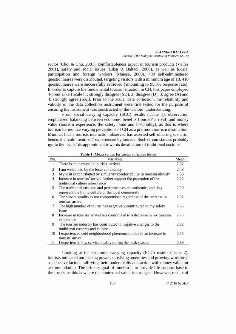
PLANNING MALAYSIA
Journal of the Malaysia Institute of Planners (2018)
157 © 2018 by MIP
sector (Choi & Chu, 2001), comfortableness aspect in tourism products (Valles
2001), safety and social issues (Likaj & Baltaci, 2008), as well as locals’
participation and foreign workers (Maiese, 2003). 430 self-administered
questionnaires were distributed, targeting visitors with a minimum age of 18. 410
questionnaires were successfully retrieved (amounting to 95.3% response rate).
In order to capture the fundamental tourism situation in CH, this paper employed
4-point Likert scale [1: strongly disagree (SD), 2: disagree (D), 3: agree (A) and
4: strongly agree (SA)]. Prior to the actual data collection, the reliability and
validity of the data collection instrument were first tested for the purpose of
ensuring the instrument was constructed to the visitors’ understanding.
From social carrying capacity (SCC) results (Table 1), observation
emphasized balancing between economic benefits (tourists' arrival) and money
value (tourism experience, the safety issue and hospitality), as this is where
tourism harmonize varying perceptions of CH as a premium tourism destination.
Minimal locals-tourists interaction observed has asserted self-othering scenario,
hence, the ‘cold treatment’ experienced by tourists. Such circumstances probably
ignite the locals’ disappointment towards devaluation of traditional customs.
Table 1: Mean values for social variables tested
No. Variables Mean
1 There is an increase in tourists’ arrival 2.57
2 I am welcomed by the local community 2.48
3 My visit is contributed by similarity/comfortability in tourism identity 2.33
4 Increase in tourists’ arrival further support the protection of the
traditional culture inheritance
2.22
5 The traditional customs and performances are authentic, and they
represent the living culture of the local community
2.20
6 The service quality is not compromised regardless of the increase in
tourists' arrival
2.02
7 The high number of tourist has negatively contributed to my safety
issue
2.65
8 Increase in tourists' arrival has contributed to a decrease in my tourism
experience
2.75
9 The tourism industry has contributed to negative changes to the
traditional customs and culture
2.82
10 I experienced cold neighborhood phenomenon due to an increase in
tourists' arrival
3.55
11 I experienced low service quality during the peak season 2.89
Looking at the economic carrying capacity (ECC) results (Table 2),
tourists indicated purchasing power, satisfying amenities and growing workforce
as cohesive factors nullifying their moderate dissatisfaction with money value for
accommodation. The primary goal of tourism is to provide life support base to
the locals, as this is where the contextual value is strongest. However, results of
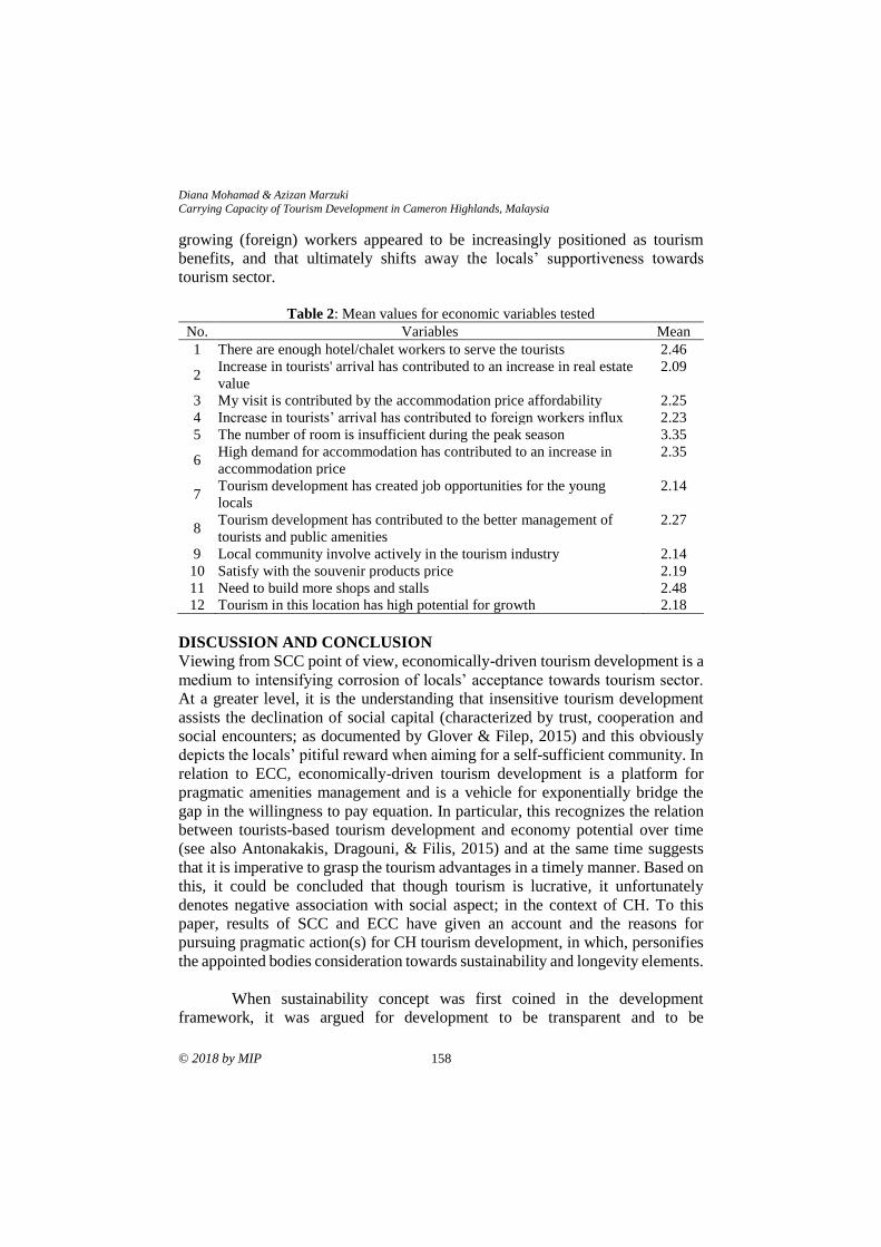
Diana Mohamad & Azizan Marzuki
Carrying Capacity of Tourism Development in Cameron Highlands, Malaysia
© 2018 by MIP 158
growing (foreign) workers appeared to be increasingly positioned as tourism
benefits, and that ultimately shifts away the locals’ supportiveness towards
tourism sector.
Table 2: Mean values for economic variables tested
No. Variables Mean
1 There are enough hotel/chalet workers to serve the tourists 2.46
2 Increase in tourists' arrival has contributed to an increase in real estate
value
2.09
3 My visit is contributed by the accommodation price affordability 2.25
4 Increase in tourists’ arrival has contributed to foreign workers influx 2.23
5 The number of room is insufficient during the peak season 3.35
6 High demand for accommodation has contributed to an increase in
accommodation price
2.35
7 Tourism development has created job opportunities for the young
locals
2.14
8 Tourism development has contributed to the better management of
tourists and public amenities
2.27
9 Local community involve actively in the tourism industry 2.14
10 Satisfy with the souvenir products price 2.19
11 Need to build more shops and stalls 2.48
12 Tourism in this location has high potential for growth 2.18
DISCUSSION AND CONCLUSION
Viewing from SCC point of view, economically-driven tourism development is a
medium to intensifying corrosion of locals’ acceptance towards tourism sector.
At a greater level, it is the understanding that insensitive tourism development
assists the declination of social capital (characterized by trust, cooperation and
social encounters; as documented by Glover & Filep, 2015) and this obviously
depicts the locals’ pitiful reward when aiming for a self-sufficient community. In
relation to ECC, economically-driven tourism development is a platform for
pragmatic amenities management and is a vehicle for exponentially bridge the
gap in the willingness to pay equation. In particular, this recognizes the relation
between tourists-based tourism development and economy potential over time
(see also Antonakakis, Dragouni, & Filis, 2015) and at the same time suggests
that it is imperative to grasp the tourism advantages in a timely manner. Based on
this, it could be concluded that though tourism is lucrative, it unfortunately
denotes negative association with social aspect; in the context of CH. To this
paper, results of SCC and ECC have given an account and the reasons for
pursuing pragmatic action(s) for CH tourism development, in which, personifies
the appointed bodies consideration towards sustainability and longevity elements.
When sustainability concept was first coined in the development
framework, it was argued for development to be transparent and to be
PLANNING MALAYSIA
Journal of the Malaysia Institute of Planners (2018)
159 © 2018 by MIP
rationalized. It was emphasized that rationalism maintains the conceptualization
of principals and that transparency acknowledges the fundamentals of
empiricism. Within such ‘conceptualization of principals’ and ‘fundamentals of
empiricism’ dimensions, carrying capacity blueprint is produced by working
through the locals’ requirements and the visitors’ desires; from the tourism sector.
In the case of CH, the visitors-tourism relationship is empathy and the locals-
tourism relationship is mathematics; yet both relationships violate the basic
principle of experiential consequences. Given this, it is increasingly difficult to
separate the overlapping lines of empathy (social and physical characteristics of
CH) and mathematics (corporate responsibility), when handling carrying
capacity.
ACKNOWLEDGEMENT
The authors would like to extend their appreciation to the Long-Term Research
Grant Scheme (Grant no: 304/PPBGN/650571/T121) that makes this study and
paper possible.
REFERENCES Antonakakis, N., Dragouni, M. & Filis, G. (2015). Tourism and growth: The times they
are a-changing. Annals of Tourism Research, 50, 165-169.
Barrow, C. J., Chan, N. W., & Masron, T. (2009). Issues and challenges of sustainable
agriculture in the Cameron Highlands. Malaysian Journal of Environmental
Management, 10(2), 89-114.
Barrow, C. J., Chan, N. W., & Masron, T. (2005). Sustainable development in the
Cameron Highlands, Malaysia. Malaysia Journal of Environmental
Management, 6, 41-57.
Choi, T. Y., & Chu, R. (2001). Determinants of hotel guests’ satisfaction and repeat
patronage in the Hong Kong hotel industry. Hospitality Management, 20, 277-
297.
Chan, N. W. (2006). Cameron Highlands: Issues & challenges in sustainable
development. Pulau Pinang: School of Humanities, Universiti Sains Malaysia.
Diana, M., Mastura, J., & Azizan, M. (2014). Langkawi Island, social aspect and the
carrying capacity. Proceeding of the 4th International Conference on Tourism
Research (4ICTR), 12, 01023. DOI: 10.1051/shsconf/20141201023
Glover, T. D., & Filep, S. (2015). On kindness of strangers in tourism. Annals of Tourism
Research, 50, 159-162.
Kunasekaran, P., Ramachandran, S., Yacob, M. R., & Shuib, A. (2011). Development of
farmer’s perception scale on agro-tourism in Cameron Highland, Malaysia.
World Applied Sciences Journal, 12, 10-18.
Likaj, M., & Baltaci, C. (2008). The changes of social structure and migration in cities in
Albania. ICBS 2008, 53-610.
Ling, H. L., Mohd Noor, M. H. C., Marzukhi, M. A., & Mohamed Musthafa, S. N. A.
(2017). Social impact of agro-tourism on local urban residents. Case study:
Cameron Highlands, Malaysia. Planning Malaysia, 15(2), 51-66.

Diana Mohamad & Azizan Marzuki
Carrying Capacity of Tourism Development in Cameron Highlands, Malaysia
© 2018 by MIP 160
Maiese, M. (2003). Social structural change. Accessed September 25, 2015 at
http://www.beyondintractability.org/
Nasir, Z. A., & Mohd Nasir, N. (2013). The determinants and measurement of tourists’
satisfaction towards environmental quality at tourism destination in Cameron
Highlands. Proceeding of the Global Conference on Business, Economics and
Social Sciences (GBSR 2013) (pp. 565-572).
Ono, M. (2010). Long-stay tourism: Elderly Japanese tourists in the Cameron Highlands,
Malaysia. Senri Ethnological Studies, 76, 95-110.
Othman, J. (2011). Scenic beauty preferences of Cameron Highland Malaysia: Local
versus foreign tourists. International Journal of Business and Social Science,
2(6), 248-253.
Valles, D. M. (2001). Improving the quality of tourist products. Accessed October 20,
2015 at http://ec.europa.eu/
Received: 1st June 2018. Accepted:1st December 2018
1PhD Candidate at University of KwaZulu-Natal. Email: [email protected] 161
PLANNING MALAYSIA:
Journal of the Malaysian Institute of Planners
VOLUME 16 ISSUE 4 (2018), Page 161 – 175
ACCESS TO URBAN AGRICULTURAL LAND IN IBADAN, NIGERIA
Bolanle Wahab¹, Ayobami Popoola² & Hangwelani Magidimisha3
1Department of Urban and Regional Planning
UNIVERSITY OF IBADAN NIGERIA
2&3Department of Town and Regional Planning,
UNIVERSITY OF KWAZULU-NATAL SOUTH AFRICA
Abstract
Efficient allocation of spaces for all activities is a pivot role of planners in human
settlements development. The rapid and unplanned growth of Ibadan has limited
farmers’ access to land for urban agriculture purposes, especially in the urban
local government areas (LGAs). This study examined urban farmers’ access to
land for farming and the activities of local planning authorities in terms of land
allocation for farming in Ibadan. A structured questionnaire was administered to
244 urban farmers, while key-informant interviews were conducted with the
officials of local planning authorities and departments of agriculture in the urban
LGAs in Ibadan. The study revealed that the scarcity of land for farming has
subjected over 30% of the respondents to practice farming on family land, while
17% farmed on available open spaces, including floodplains; land along
mountain ridges; land under power lines, and institutions’ lands. The barriers to
expanding urban farmland identified by farmers included finance, the
unavailability of land in the urban area, neglect of farming and land tenure
system. The study recommended the enactment of a planning policy for the
classification and integration of agricultural land use as a recognised land use
component in urban physical development and zoning plans.
Keywords: land scarcity, urban agriculture, zoning, land budgeting
Bolanle Wahab, Ayobami Popoola & Hangwelani Magidimisha
Access to Urban Agricultural Land in Ibadan, Nigeria
© 2018 by MIP 162
INTRODUCTION
Creating sustainable food systems is one of the most compelling challenges of
the 21st century. Because of its multi-functional character, food is an ideal
medium for designing sustainable places. For these reasons, food planning is
now bringing experts and people from diverse range of background together
(ISOCARP, 2015; Pothukuchi & Kaufman, 2000). Thus, in an attempt to bring
about a sustainable food system, urban planners need to understand the methods
and strategies of producing food. The momentum of advocacy for urban
agriculture (UA) all over the globe is a reflection of the need for food within the
urban space. Despite the increasing demand for food owing to the rapid rate of
urbanization and increasing population, cultivable lands for agriculture are
becoming scarce, as urban growth and expansion have been claiming much of the
arable lands (wetlands, open spaces, floodplains, agricultural layouts).
Land scarcity is a peculiar characteristic of urban centres in developing
nations. Land for agriculture has declined owing to urbanization, and land
fragmentation within urban areas. Studies (Headey & Jayne, 2014; Lal, 2007)
have established declines in farm sizes across the globe and Africa. Lwasa et al.
(2011) claim that inadequate space for farming is a limitation to food production
in Africa. Data source countries such as Ethiopia, Kenya, Malawi, Uganda and
Rwanda are experiencing a decline in farm size (Jayne, Chamberlin & Headey,
2014). Decline in farm sizes from 2.5 hectares (ha) in the year 1994 to 1.4 ha in
2010 and 0.85 ha in 2013 have been reported in Nigeria (Food and Agriculture
organisation-FAO, 2017; Headey & Jayne, 2014).
Atu, Offiong, Eni, Eja and Esien (2012) aver that urban sprawl has been
a common event and still remains one of the greatest threats facing agricultural
lands in Nigeria. Abiodun and Bayode (2014) assert that the rate of development
of land (from 42% built-up in 1989 to 70% built up in 2013) in the Ibadan
metropolis is a reflection of urban land consumption. The consequence of which
is a decline in food production within the urban space owing to inadequate access
to land for farming and induced land price inflation which has hindered poor
urban farmers from acquiring land for farming and commercialization of urban
farmland by fairly rich urban farmers. Lwasa et al. (2013) observe that one of the
factors that continuously constraints agricultural activities is competition from
other land uses/inadequate access to land, urbanisation and city expansion.
To attend to food demand and city growth several authors iterate the
introduction land use zoning as an effective and responsive police planning-
oriented device that can be used by local governments towards efficient urban
outcomes, open space integration for UA and proper spatial arrangements which
is inclusive of agricultural land use in physical development plans being prepared
by planning authorities (Bickerdike, DiLisio, Haskin, McCullagh, & Pierce-
Quinonez, 2010; Al-Chalabi, 2008). Ibadan’s continued spatial and demographic
growth and lack of a development plan as at December 2017 promotes disorderly
PLANNING MALAYSIA
Journal of the Malaysia Institute of Planners (2018)
163 © 2018 by MIP
land use and the unhealthy physical development of fragile and risk-prone areas,
such as wetlands, floodplains, steep slopes, urban vegetation and other areas that
are suitable for agriculture.
It is argued by Sauer et al. (2008) and Foley et al. (2005) that the future
supply of food and agriculture is faced with the challenges of decreasing rates
because of physical limits. Managing land and land allocation for activities
remains the duty of urban planners. In Nigeria, urban agricultural land has not
been properly delineated by local planning authorities. In Ibadan, urban
agriculture (UA) remains an incidental activity which is undertaken as a
temporary activity within any used land spaces, pending their use for the
designated development purposes. This is so because UA is not a recognised
urban land use and there is no statutory provision in physical plans at any scale-
residential site plan, neighbourhood district plan and city master plan.
Nonetheless planning as a locally-driven process and a shared community-based
vision of the future should include agricultural activities by recognizing the value
of agriculture as a land use and a business.
Planning for agriculture establishes a framework for an economically and
environmentally sustainable agricultural industry. It steers growth away from
active farming communities; reduces regulatory barriers; encourages policies that
support appropriate infrastructure development and new farming opportunities;
and addresses farm tenure and transfer. It is against this backdrop that this study
examined access to urban agricultural land amongst city farmers and also
identified the present and expected role of local planning authorities on urban
agriculture in Ibadan.
THE STUDY AREA
Ibadan is one of the major urban centres in Nigeria with an urban land area of
about 463.33km². The city is made up of 11 local government areas (LGAs) out
of which five (5) are urban LGAs (Figure 1) with an urban population of
1,338,659 and estimated at 6,017,709 in 2016 and projected to be 11.32 million
by 2036, at a 3.5% annual growth (Dar-Al-Handasah, 2018).
Studies (Adelekan, Olajide-Taiwo, Ayorinde, Ajayi, & Babajide, 2014;
Bankole & Bakare, 2011) established that the city’s growth became exponential
in the year 2000. The built-up area of Ibadan increased from 100 ha in 1830 to
448.56 km2 in 2006 and 491.21km2 in 2013 at an average annual rate of 2.8%
since the year 2000. The city’s physical expansions owing to fast-growing
commercial and industrial activities, has resulted in a decline in agricultural land
within the urban and peri-urban areas (Fourchard, 2003).
Dar-Al-Handasah (2018) reports that with the manufacturing sector of
Ibadan stagnant, agriculture which remains a means of household livelihood for
residents of Ibadan should be invested in and also supported to meet employment
demand. Dar-Al-Handasah (2018) avers that urban agricultural activities, which
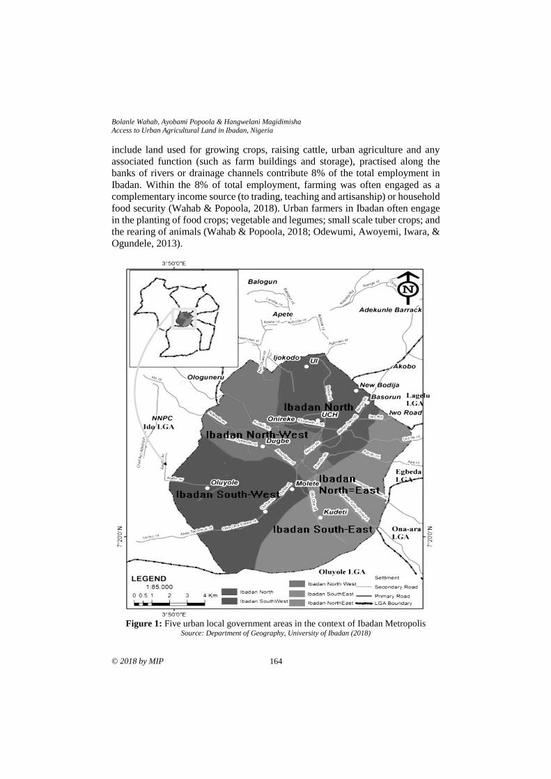
Bolanle Wahab, Ayobami Popoola & Hangwelani Magidimisha
Access to Urban Agricultural Land in Ibadan, Nigeria
© 2018 by MIP 164
include land used for growing crops, raising cattle, urban agriculture and any
associated function (such as farm buildings and storage), practised along the
banks of rivers or drainage channels contribute 8% of the total employment in
Ibadan. Within the 8% of total employment, farming was often engaged as a
complementary income source (to trading, teaching and artisanship) or household
food security (Wahab & Popoola, 2018). Urban farmers in Ibadan often engage
in the planting of food crops; vegetable and legumes; small scale tuber crops; and
the rearing of animals (Wahab & Popoola, 2018; Odewumi, Awoyemi, Iwara, &
Ogundele, 2013).
Figure 1: Five urban local government areas in the context of Ibadan Metropolis
Source: Department of Geography, University of Ibadan (2018)
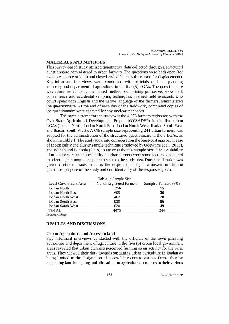
PLANNING MALAYSIA
Journal of the Malaysia Institute of Planners (2018)
165 © 2018 by MIP
MATERIALS AND METHODS
This survey-based study utilized quantitative data collected through a structured
questionnaire administered to urban farmers. The questions were both open (for
example, source of land) and closed-ended (such as the reason for displacement).
Key-informant interviews were conducted with officials of local planning
authority and department of agriculture in the five (5) LGAs. The questionnaire
was administered using the mixed method, comprising purposive, snow ball,
convenience and accidental sampling techniques. Trained field assistants who
could speak both English and the native language of the farmers, administered
the questionnaire. At the end of each day of the fieldwork, completed copies of
the questionnaire were checked for any unclear responses.
The sample frame for the study was the 4,073 farmers registered with the
Oyo State Agricultural Development Project (OYSADEP) in the five urban
LGAs (Ibadan North, Ibadan North-East, Ibadan North-West, Ibadan South-East,
and Ibadan South-West). A 6% sample size representing 244 urban farmers was
adopted for the administration of the structured questionnaire in the 5 LGAs, as
shown in Table 1. The study took into consideration the least-cost approach, ease
of accessibility and cluster sample technique employed by Odewumi et al. (2013),
and Wahab and Popoola (2018) to arrive at the 6% sample size. The availability
of urban farmers and accessibility to urban farmers were some factors considered
in selecting the sampled respondents across the study area. Due consideration was
given to ethical issues, such as the respondents’ right to answer or decline
questions, purpose of the study and confidentiality of the responses given.
Table 1: Sample Size
Local Government Area No. of Registered Farmers Sampled Farmers (6%)
Ibadan North 1256 75
Ibadan North-East 605 36
Ibadan North-West 462 28
Ibadan South-East 930 56
Ibadan South-West 820 49
TOTAL 4073 244 Source: Authors
RESULTS AND DISCUSSIONS
Urban Agriculture and Access to land
Key informant interviews conducted with the officials of the town planning
authorities and department of agriculture in the five (5) urban local government
areas revealed that urban planners perceived farming as an activity for the rural
areas. They viewed their duty towards sustaining urban agriculture in Ibadan as
being limited to the designation of accessible routes to various farms, thereby
neglecting land budgeting and allocation for agricultural purposes in their various
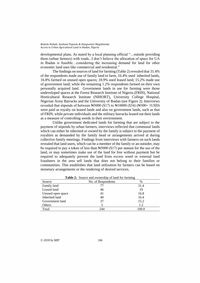
Bolanle Wahab, Ayobami Popoola & Hangwelani Magidimisha
Access to Urban Agricultural Land in Ibadan, Nigeria
© 2018 by MIP 166
developmental plans. As stated by a local planning official “…outside providing
them (urban farmers) with roads...I don’t believe the allocation of space for UA
in Ibadan is feasible…considering the increasing demand for land for other
economic land uses like commercial and residential.”
The findings on sources of land for farming (Table 2) revealed that 31.4%
of the respondents made use of family land to farm, 16.4% used inherited lands,
16.8% farmed on unused open spaces; 18.9% used leased land; 15.2% made use
of government land; while the remaining 1.2% respondents farmed on their own
personally acquired land. Government lands in use for farming were those
undeveloped spaces at the Forest Research Institute of Nigeria (FRIN), National
Horticultural Research Institute (NIHORT), University College Hospital,
Nigerian Army Barracks and the University of Ibadan (see Figure 2). Interviews
revealed that stipends of between ₦5000 ($17) to ₦10000 ($34) (₦300= 1USD)
were paid as royalty on leased lands and also on government lands, such as that
of FRIN, while private individuals and the military barracks leased out their lands
as a measure of controlling weeds in their environment.
Unlike government dedicated lands for farming that are subject to the
payment of stipends by urban farmers, interviews reflected that communal lands
which can either be inherited or owned by the family is subject to the payment of
royalties as demanded by the family head or arrangements arrived at during
collective family meetings. Findings from interviews with farmers on such lands
revealed that land users, which can be a member of the family or an outsider, may
be required to pay a token of less than ₦5000 ($17) per annum for the use of the
land, or may sometimes make use of the land for free without payment but be
required to adequately prevent the land from excess weed or external land
fraudsters in the area sell lands that does not belong to their families or
communities. This establishes that land utilization by farmers can be based on
monetary arrangements or the rendering of desired services.
Table 2: Source and ownership of land for farming
Source No. of Respondents %
Family land 77 31.4
Leased land 46 19
Unused open space 41 16.8
Inherited land 40 16.4
Government land 37 15.2
Others 3 1.2
Total 244 100.0
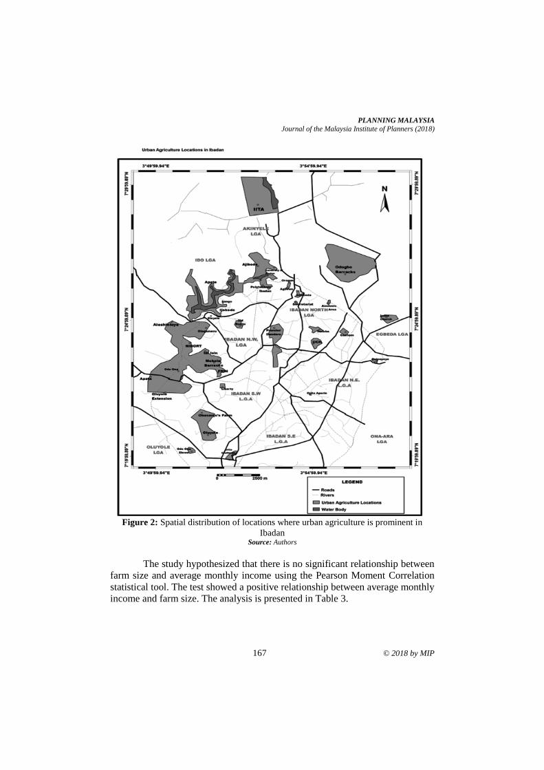
PLANNING MALAYSIA
Journal of the Malaysia Institute of Planners (2018)
167 © 2018 by MIP
Figure 2: Spatial distribution of locations where urban agriculture is prominent in
Ibadan Source: Authors
The study hypothesized that there is no significant relationship between
farm size and average monthly income using the Pearson Moment Correlation
statistical tool. The test showed a positive relationship between average monthly
income and farm size. The analysis is presented in Table 3.
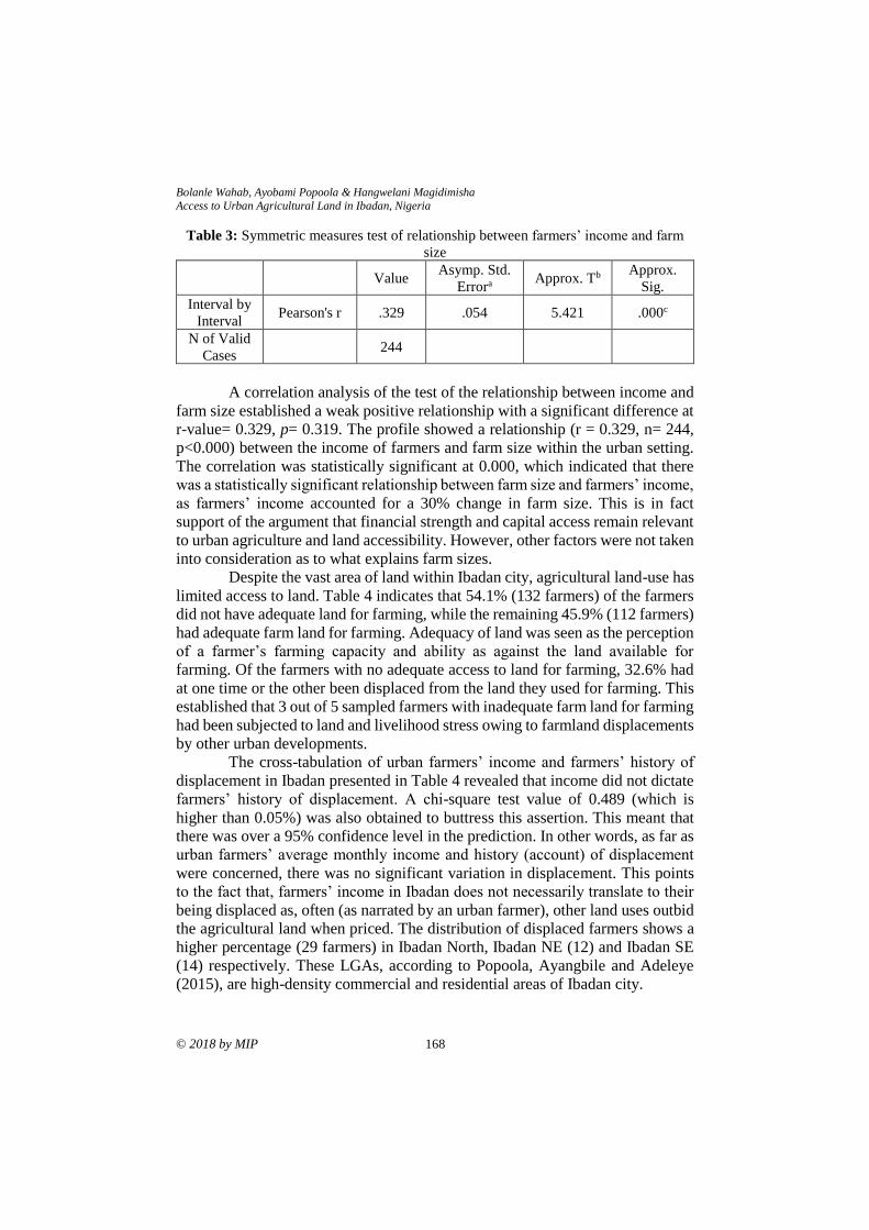
Bolanle Wahab, Ayobami Popoola & Hangwelani Magidimisha
Access to Urban Agricultural Land in Ibadan, Nigeria
© 2018 by MIP 168
Table 3: Symmetric measures test of relationship between farmers’ income and farm
size
Value Asymp. Std.
Errora Approx. Tb
Approx.
Sig.
Interval by
Interval Pearson's r .329 .054 5.421 .000c
N of Valid
Cases 244
A correlation analysis of the test of the relationship between income and
farm size established a weak positive relationship with a significant difference at
r-value= 0.329, p= 0.319. The profile showed a relationship (r = 0.329, n= 244,
p<0.000) between the income of farmers and farm size within the urban setting.
The correlation was statistically significant at 0.000, which indicated that there
was a statistically significant relationship between farm size and farmers’ income,
as farmers’ income accounted for a 30% change in farm size. This is in fact
support of the argument that financial strength and capital access remain relevant
to urban agriculture and land accessibility. However, other factors were not taken
into consideration as to what explains farm sizes.
Despite the vast area of land within Ibadan city, agricultural land-use has
limited access to land. Table 4 indicates that 54.1% (132 farmers) of the farmers
did not have adequate land for farming, while the remaining 45.9% (112 farmers)
had adequate farm land for farming. Adequacy of land was seen as the perception
of a farmer’s farming capacity and ability as against the land available for
farming. Of the farmers with no adequate access to land for farming, 32.6% had
at one time or the other been displaced from the land they used for farming. This
established that 3 out of 5 sampled farmers with inadequate farm land for farming
had been subjected to land and livelihood stress owing to farmland displacements
by other urban developments.
The cross-tabulation of urban farmers’ income and farmers’ history of
displacement in Ibadan presented in Table 4 revealed that income did not dictate
farmers’ history of displacement. A chi-square test value of 0.489 (which is
higher than 0.05%) was also obtained to buttress this assertion. This meant that
there was over a 95% confidence level in the prediction. In other words, as far as
urban farmers’ average monthly income and history (account) of displacement
were concerned, there was no significant variation in displacement. This points
to the fact that, farmers’ income in Ibadan does not necessarily translate to their
being displaced as, often (as narrated by an urban farmer), other land uses outbid
the agricultural land when priced. The distribution of displaced farmers shows a
higher percentage (29 farmers) in Ibadan North, Ibadan NE (12) and Ibadan SE
(14) respectively. These LGAs, according to Popoola, Ayangbile and Adeleye
(2015), are high-density commercial and residential areas of Ibadan city.
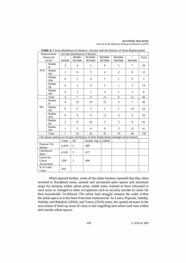
PLANNING MALAYSIA
Journal of the Malaysia Institute of Planners (2018)
169 © 2018 by MIP
Table 4: Cross-tabulation of farmers’ income and the history of farm displacement
Displacement
history by
LGAs
Income Distribution of farmers
<
₦5000
₦5000-
₦15000
₦16000-
₦25000
₦26000-
₦35000
₦36000-
₦45000
>
₦45000
Total
YES
Ibadan
N 3 4 5 9 1 7 29
Ibadan
NE 1 0 5 4 2 0 12
Ibadan
NW 0 1 0 1 1 0 3
Ibadan
SE 0 1 6 3 1 3 14
Ibadan
SW 0 1 1 4 1 1 8
Total 4 7 17 21 6 11 66
NO
Ibadan
N 4 10 10 12 3 7 46
Ibadan
NE 0 5 3 5 1 10 24
Ibadan
NW 0 4 6 12 3 0 25
Ibadan
SE 2 8 16 3 5 8 42
Ibadan
SW 1 5 8 9 3 15 41
Total 7 32 43 41 15 40 178
Chi-square analysis of income and history of farm displacement amongst urban farmers
Value Df Asymp. Sig. (2-sided) Pearson Chi-
Square 4.434a 5 .489
Likelihood
Ratio 4.520 5 .477
Linear-by-
Linear
Association
.039 1 .844
N of Valid
Cases 244
When queried further, some of the urban farmers reported that they often
resorted to floodplain areas, unused and unclaimed open spaces and mountain
strips for farming within urban areas, while some claimed to have relocated to
rural areas or changed to other occupations such as security inorder to carter for
their households’ livelihood. The urban land struggle remains the order within
the urban space as it has been from time immemorial. As Lasisi, Popoola, Adediji,
Adedeji and Babalola (2016), and Taiwo (2010) notes, the spatial increase in the
area extent of built-up areas of cities is fast engulfing non-urban land uses within
and outside urban spaces.
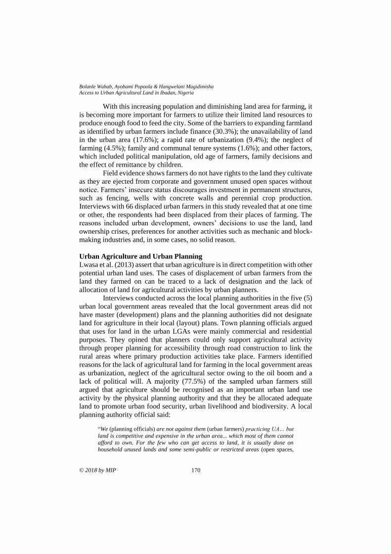
Bolanle Wahab, Ayobami Popoola & Hangwelani Magidimisha
Access to Urban Agricultural Land in Ibadan, Nigeria
© 2018 by MIP 170
With this increasing population and diminishing land area for farming, it
is becoming more important for farmers to utilize their limited land resources to
produce enough food to feed the city. Some of the barriers to expanding farmland
as identified by urban farmers include finance (30.3%); the unavailability of land
in the urban area (17.6%); a rapid rate of urbanization (9.4%); the neglect of
farming (4.5%); family and communal tenure systems (1.6%); and other factors,
which included political manipulation, old age of farmers, family decisions and
the effect of remittance by children.
Field evidence shows farmers do not have rights to the land they cultivate
as they are ejected from corporate and government unused open spaces without
notice. Farmers’ insecure status discourages investment in permanent structures,
such as fencing, wells with concrete walls and perennial crop production.
Interviews with 66 displaced urban farmers in this study revealed that at one time
or other, the respondents had been displaced from their places of farming. The
reasons included urban development, owners’ decisions to use the land, land
ownership crises, preferences for another activities such as mechanic and block-
making industries and, in some cases, no solid reason.
Urban Agriculture and Urban Planning
Lwasa et al. (2013) assert that urban agriculture is in direct competition with other
potential urban land uses. The cases of displacement of urban farmers from the
land they farmed on can be traced to a lack of designation and the lack of
allocation of land for agricultural activities by urban planners.
Interviews conducted across the local planning authorities in the five (5)
urban local government areas revealed that the local government areas did not
have master (development) plans and the planning authorities did not designate
land for agriculture in their local (layout) plans. Town planning officials argued
that uses for land in the urban LGAs were mainly commercial and residential
purposes. They opined that planners could only support agricultural activity
through proper planning for accessibility through road construction to link the
rural areas where primary production activities take place. Farmers identified
reasons for the lack of agricultural land for farming in the local government areas
as urbanization, neglect of the agricultural sector owing to the oil boom and a
lack of political will. A majority (77.5%) of the sampled urban farmers still
argued that agriculture should be recognised as an important urban land use
activity by the physical planning authority and that they be allocated adequate
land to promote urban food security, urban livelihood and biodiversity. A local
planning authority official said:
“We (planning officials) are not against them (urban farmers) practicing UA… but
land is competitive and expensive in the urban area... which most of them cannot
afford to own. For the few who can get access to land, it is usually done on
household unused lands and some semi-public or restricted areas (open spaces,
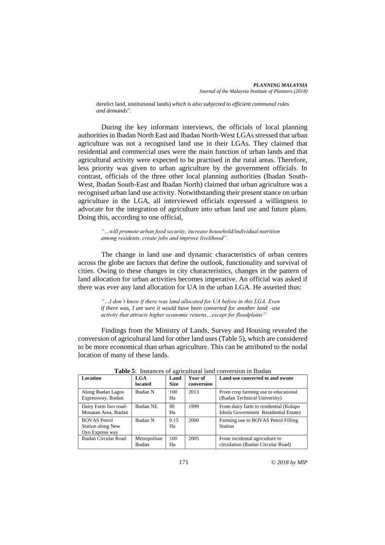
PLANNING MALAYSIA
Journal of the Malaysia Institute of Planners (2018)
171 © 2018 by MIP
derelict land, institutional lands) which is also subjected to efficient communal rules
and demands”.
During the key informant interviews, the officials of local planning
authorities in Ibadan North East and Ibadan North-West LGAs stressed that urban
agriculture was not a recognised land use in their LGAs. They claimed that
residential and commercial uses were the main function of urban lands and that
agricultural activity were expected to be practised in the rural areas. Therefore,
less priority was given to urban agriculture by the government officials. In
contrast, officials of the three other local planning authorities (Ibadan South-
West, Ibadan South-East and Ibadan North) claimed that urban agriculture was a
recognised urban land use activity. Notwithstanding their present stance on urban
agriculture in the LGA, all interviewed officials expressed a willingness to
advocate for the integration of agriculture into urban land use and future plans.
Doing this, according to one official,
“…will promote urban food security, increase household/individual nutrition
among residents, create jobs and improve livelihood”.
The change in land use and dynamic characteristics of urban centres
across the globe are factors that define the outlook, functionality and survival of
cities. Owing to these changes in city characteristics, changes in the pattern of
land allocation for urban activities becomes imperative. An official was asked if
there was ever any land allocation for UA in the urban LGA. He asserted thus:
“…I don’t know if there was land allocated for UA before in this LGA. Even
if there was, I am sure it would have been converted for another land –use
activity that attracts higher economic returns…except for floodplains”
Findings from the Ministry of Lands, Survey and Housing revealed the
conversion of agricultural land for other land uses (Table 5), which are considered
to be more economical than urban agriculture. This can be attributed to the nodal
location of many of these lands.
Table 5: Instances of agricultural land conversion in Ibadan
Location LGA
located
Land
Size
Year of
conversion
Land-use converted to and owner
Along Ibadan Lagos
Expressway, Ibadan
Ibadan N 100
Ha
2013 From crop farming use to educational
(Ibadan Technical University)
Dairy Farm Iwo road-
Monatan Area, Ibadan
Ibadan NE 80
Ha
1999 From dairy farm to residential (Kolapo
Ishola Government Residential Estate)
BOVAS Petrol Station along New
Oyo Express way
Ibadan N 0.15 Ha
2000 Farming use to BOVAS Petrol Filling Station
Ibadan Circular Road Metropolitan
Ibadan
100
Ha
2005 From incidental agriculture to
circulation (Ibadan Circular Road)
Bolanle Wahab, Ayobami Popoola & Hangwelani Magidimisha
Access to Urban Agricultural Land in Ibadan, Nigeria
© 2018 by MIP 172
The Lord Reigneth
Estate, off
Iseyin/Ibadan Road, Ijaye
Ibadan N-
Akinyele
150
Ha
2012 Farming use to residential and
commercial estate (Christian Union Old
Students Association (CUOSA) Investment Board, Lord Reigneth
Estate)
Emmanuel College
Wetland, Samonda, Along Sango-UI Road
Ibadan N 5 Ha 2015 Collective Farming use to enclosed
unused space (Emmanuel College of Theology)
Sango Floodplain Ibadan NE 10
Ha
2015 Legume farming use to enclosed unused
space
Eleyele/FRIN reserve Ibadan NW 11-20 Ha
2000 Forest reserve, arable, legume and food crop farming use to commercial
encroachment, religious land use,
residential encroachment (Forest Research Institute of Nigeria -FRIN)
Premier Strip farming
zone, Ajibade-
Dandaru Road
Ibadan N 2Ha 2016 Food crop farming use religious and
commercial land use (Proposed 5-Star
hotel and religious institutions) (Oyo State Government)
UI-Ajibode farming
zone
Ibadan N 30Ha 2015 Food crop and legume farming use to
residential and educational land use (University of Ibadan).
Source: Authors
The issue of land for urban agriculture in Ibadan metropolis was taken up
with an official of the department of agriculture in one of the LGs. He stated thus:
“…although we have practising urban farmers in the LGA, only a few
of them were registered with the department and we don’t have their
(urban farmers’) records... so it is actually difficult and impossible to
provide land for them...”
This finding depicts the relevance of database management amongst urban
agriculture responsibility agencies. Another official reported that:
“…urban farmers were being encouraged to migrate to the peri-
urban and rural areas…”; “… we (government) have acquired land
at Egbeda (a rural LGA in Ibadan) that we will allocate to farmers
who request for such...”
How farmers often faired in the aftermath of displacement or relocation
to rural acquired lands as identified by the official was not extensively
investigated in this study. Although the interview with the official reported a basic
stipend of ₦5000 (15USD) paid per planting season a year by the farmers on
every 1 hectare of land.
PLANNING MALAYSIA
Journal of the Malaysia Institute of Planners (2018)
173 © 2018 by MIP
CONCLUSION AND RECOMMENDATIONS
Animal and crop farming within the urban areas remain a vital source of food for
city dwellers and income for urban farmers. It is also a strategy to complement
the activities in rural food-producing zones. Despite the relevance of urban
farming, urban agricultural land use remains less relevant to physical planners
and, perhaps, of less priority in Nigeria. Thus, farmers within the city area depend
on open spaces, vulnerable areas and floodplains for their farming. However,
these are grossly inadequate, thus limiting farmer’s access to land for farming
purposes.
This study concludes that, for food to be available for human
consumption within the urban space, urban agriculture needs to be well-
integrated into the urban economy. An important defining factor for this to
translate into improved food security within the city areas is for cultivable land
to be protected and available within the urban areas. Based on the findings of this
study, the following recommendations become important:
For continuing food production, there is urgent need for the enactment of
a planning policy for the classification and integration of agricultural land use as
a recognised land use component in urban and rural physical development and
zoning plans to facilitate land budgeting by planning agencies for urban farming
activities. Statutory provision of land must be made for agricultural activities in
physical plans at any scale-residential site plan, neighbourhood district plan and
city master plan. There is also the need for heavy investment in floodplain
management in Ibadan, as these locations are often classified as automatic areas
of relocation some of the displaced farmers. The Bureau of Physical Planning and
Development Control needs to strictly enforce the regulation governing open
space and floodplain management for strict and proper utilization for farming.
Controlled urbanization and a rigid adherence to development plans by
local planning authorities will also help curtail the “rampant disappearance” and
uninformed/irrational conversion of agricultural land, as well as control the level
of encroachment onto agricultural lands by other urban land uses.
It is imperative that urban planners recognize farming activity as an urban
land use component. Improved awareness on the roles played by urban
agriculture within the urban development plan and space biodiversity is required
and should be pursued by relevant government departments and agencies in
collaboration with relevant NGOs and community groups.
The frequent cases of farm clearance by urban land owners can be
resolved through proper land use agreements and dialogue between land owners
and land users (farmers) through proper land agreement documentation. Land
formalization for urban agriculture remains the way through which urban farmers
can help secure their lands in the face of increasing economic interests provided
by other land uses.
Bolanle Wahab, Ayobami Popoola & Hangwelani Magidimisha
Access to Urban Agricultural Land in Ibadan, Nigeria
© 2018 by MIP 174
REFERENCES Abiodun, O. & Bayode, T. (2014). Monitoring and modeling of urban sprawl, case study
of Ibadan inner city. International Journal of Remote Sensing and GIS, 3(4), 64-
71.
Adelekan, I., Olajide-Taiwo, L., Ayorinde, A., Ajayi, D., & Babajide, S. (2014). Building
urban resilience: Assessing urban and peri-urban agriculture in Ibadan, Nigeria.
In J. Padgham, and J. Jabbour (Eds.), Nairobi, Kenya: United Nations
Environment Programme (UNEP). Retrieved from
http://www.start.org/upa/ibadan.pdf.
Al-Chalabi, M. (2008). Somerville’s green infrastructure project. Retrieved from
http://www.groundworksomerville.org/wp-content/uploads/2010/02/Chalabi.
FinalReport20081.pdf.
Atu, J, Offiong, R. Eni, D. Eja, I., &Esien, O. (2012). The effects of urban sprawl on
peripheral agricultural lands in Calabar, Nigeria. International Review of Social
Sciences and Humanities, 2(2), 68-76.
Bankole, M. & Bakare, H. (2011). Dynamics of urban land use changes with remote
sensing: Case of Ibadan, Nigeria. Journal of Geography and Regional Planning,
4(11), 632-643.
Bickerdike, C., DiLisio, C., Haskin, J., McCullagh, M., & Pierce-Quinonez, M. (2010).
From factories to fresh food planning for urban agriculture in Somerville.
Retrieved from https://www.farmlandinfo.org/sites/default/files/
Planning_for_Urban_Ag_in_Somerville_Final_Report_1.pdf.
Dar-Al-Handasah (2018, May 18). Ibadan City Master-plan. Retrieved from
www.ibadanmasterplan.com.
Foley, J. A., Defries, R., Asner, G. P., Barford, C., Bonan, G., Carpenter, S. R.,…& Gibbs,
H.K. (2005). Global consequences of land use. Science, 309(5734), 570-574.
Food and Agriculture Organization (FAO), (2017, April 11). Small family farms data
portrait basic information document methodology and data description.
Retrieved from http://www.fao.org/fileadmin/user_upload/smallholders
_dataportrait/docs/Data_portrait_variables_description_new2.pdf.
Fourchard, L. (2003). Urban slums reports: The case of Ibadan, Nigeria. Ibadan, Nigeria:
Institut Francais de Rechercheen Afrique. (IFRA), University of Ibadan.
Headey, D., & Jayne, T. (2014). Adaptation to land constraints: Is Africa different? Food
Policy, 48, 18-33.
International Society of City and Regional Planners (ISOCARP) (2015). Hungry city,
insatiable metropolis. Netherland: ISOCARP.
Jayne, T, Chamberlin, J., & Headey, D. (2014). Land pressures, the evolution of farming
systems, and development strategies in Africa: a synthesis. Food Policy, 48, 1-
17.
Lal, R. (2007). There is no such thing as a free biofuel from crop residues. Soil
Science Society of America, Past President’s Message Archive , 2007.
Retrieved from https://www.soils.org/about-society/presidents-
message/archive/2.
Lasisi, M, Popoola, A. Adediji, A. Adedeji, O., & Babalola, K. (2017). City expansion
and agricultural land loss within the peri-urban area of Osun state, Nigeria.
Ghana Journal of Geography, 9(3), 132-163.
PLANNING MALAYSIA
Journal of the Malaysia Institute of Planners (2018)
175 © 2018 by MIP
Lwasa, S, Mugagga, F. Wahab, B. Simon, D. Connors, J., & Griffith, C. (2013). Urban
and peri-urban agriculture and forestry: Transcending poverty alleviation to
climate change mitigation and adaptation. Urban Climate, 7, 92-106.
Lwasa, S., Wahab, B., Frank,M., Simon, D., Michail, F., Griffith,C.,…&Adesoji, A.
(2011). The role of urban and peri-urban agriculture in enhancing food security
and climate change resilience in East and West African cities. Final project
report for 2011 START grants for global change research in Africa.
Odewumi, S., Awoyemi, O., Iwara, A., & Ogundele, F. (2013). Farmer’s perception on
the effect of climate change and variation on urban agriculture in Ibadan
metropolis, South-western Nigeria. Academic Journals: Journal of Geography
and Regional Planning, 6(6), 209-217.
Popoola, A. A., Ayangbile, O. A., &Adeleye, B. M. (2015). Assessment of solid waste
management systems in Ibadan North, Oyo State using geo-spatial techniques.
Ethiopian Journal of Environmental Studies & Management, 9(6), 666-679.
Pothukuchi, K., & Kaufman, J. (2000). The food system: A stranger to the planning field.
Journal of the American Planning Association, 66(2), 113-124.
Sauer, T., Havlik, P., Schneider, U. A., Schmid, E., Kindermann, G., & Obersteiner, M.
(2008). Agriculture, population, land and water scarcity in a changing world:
The role of irrigation. 12th Congress of the European Association of
Agricultural Economists – EAAE 2008.
Taiwo, O. (2010). Remote sensing analysis of the spatio-temporal growth of Ibadan city
between 1984 and 2006. Ibadan Journal of the Social Sciences, 8(1), 75-90.
Wahab, B., & Popoola, A. (2018). Climate-induced problems and adaptation strategies of
urban farmers in Ibadan. Ethiopian Journal of Environmental Studies &
Management, 11(1), 31-42
Received: 10th August 2018. Accepted: 27th December 2018
1 Senior Lecturer at Universiti Teknologi Mara. Email: [email protected] 176
PLANNING MALAYSIA:
Journal of the Malaysian Institute of Planners
VOLUME 16 ISSUE 4 (2018), Page 176 – 187
SOCIAL CAPITAL IN YOUTH VOLUNTEERISM
Mohd Hafiz Mohd Nor1, Asmidar Alias2 & Mohd Faizal Musa3
2UNIVERSITI KEBANGSAAN MALAYSIA
1&3UNIVERSITI TEKNOLOGI MARA, MALAYSIA
Abstract
The theoretical framework of social capital suggests that individuals bound
together in dense social networks, and infused with the norms of reciprocity and
trust, are better able and more inclined to act collectively for mutual benefits and
social purposes as opposed to atomized individuals. The objective of the social
capital model is to improve and maintain society well-being and the economic
efficiency. ‘Social capital’ is a contemporary idea defined by Robert Putnam
(2000) as those connections among individuals, social networks and the norms of
reciprocity and trustworthiness that arise from them. This notion is therefore seen
as “sociological superglue” that holds society together. The effectiveness depends
strongly on a structural and cultural phenomenon. Recently, volunteerism has
flourished within youths which have given beneficial effects to local
communities. It is worth to scrutinize the elements of social capital within
voluntary activities. Thus, youth volunteerism is studied and highlighted based
on the social capital model suggested by Putnam (2000). This study is to inspect
factors that bind youth in society as with the case study of Teach for the Needs
(Malaysia) Berhad (TFTN). A field study is conducted whereby questionnaires
were distributed to 100 respondents. Data collected were analysed using SPSS
programme. Findings indicate that the norm of reciprocity and trust have a
positive relationship with youths’ skills and commitments.
Keywords: Social capital, youth volunteerism, structural phenomenon, TFTN
PLANNING MALAYSIA
Journal of the Malaysia Institute of Planners (2018)
177 © 2018 by MIP
INTRODUCTION
The social capital concept has been discussed carefully based on the constructive
theory from Pierre Bourdieu (1970) and Robert Putnam (2000). Social capital is
defined as the resource that stems from social interactions, networks and network
opportunities which take place in specific environments. Based on Putnam’s
concept, social capital has three components: 1) moral obligations and norms 2)
social values (trust) and 3) social networks (voluntary associations) (Siisiäinen,
2000; Chong, Koh, Fauziah, & Samsudin, 2017). This concept has been tested on
different kinds of interactions. First, from voluntary associations of specific
types, such as sports clubs and cultural associations. This is from the perspective
of Putnam. Second, Bourdieu’s approaches which scrutinize social capital as a
resource in the social struggles that are carried out in different social arenas or
fields (Siisiäinen, 2000; Chong, Farquharson, Choy, Lukman, & Mokhtar, 2011).
In the context of this study, it is aimed to apply the basic concept of Putnam’s
social capital, and how it binds the structure in youth volunteerism in society.
Further discussions in this essay are on social capital, youth volunteerism and the
importance of volunteerism, and the case study on Teach for the Needs
(Malaysia) Berhad. This paper is a discussion to emphasize on the current
developments of voluntary education activism known as Teach for the Needs
(Malaysia) Berhad, (thereafter referred as TFTN) and how TFTN defines its
moral obligations and norms.
SOCIAL CAPITAL
The theory of social capital proposed by Bourdieu (1970), and Sulaiman, Mahbob
and Sannusi (2015) emphasized the importance of social ties and shared norms
to improve and maintain society well-being and economic efficiency. The theory
has been expanded and simplified by Putnam (2000) who defined it as “…the
connection among individuals, social networks and the norms of reciprocity and
trustworthiness that arise from them”. The successful use of social capital in
organizations or society requires a structural phenomenon (social networks such
as solidarity between colleagues or trust) and a cultural phenomenon (the kind of
social norms than can ease and facilitate collaborative cooperation). This idea is
to promote a civil society to share ideas and activities (achieving common goals)
in helping the society at large, collectively and strategically. It can be achieved
through the development of private goods and public goods. Putnam’s concepts
of social capital and trust are directed to questions about mechanisms that
strengthen the integration of the values of society, and solidarity and togetherness,
and that create consensus and sustain the stable development of society (moving
equilibrium) (Siisiäinen, 2000; Ahmad, Salman, Rahim, Pawanteh, & Ahmad,
2013).
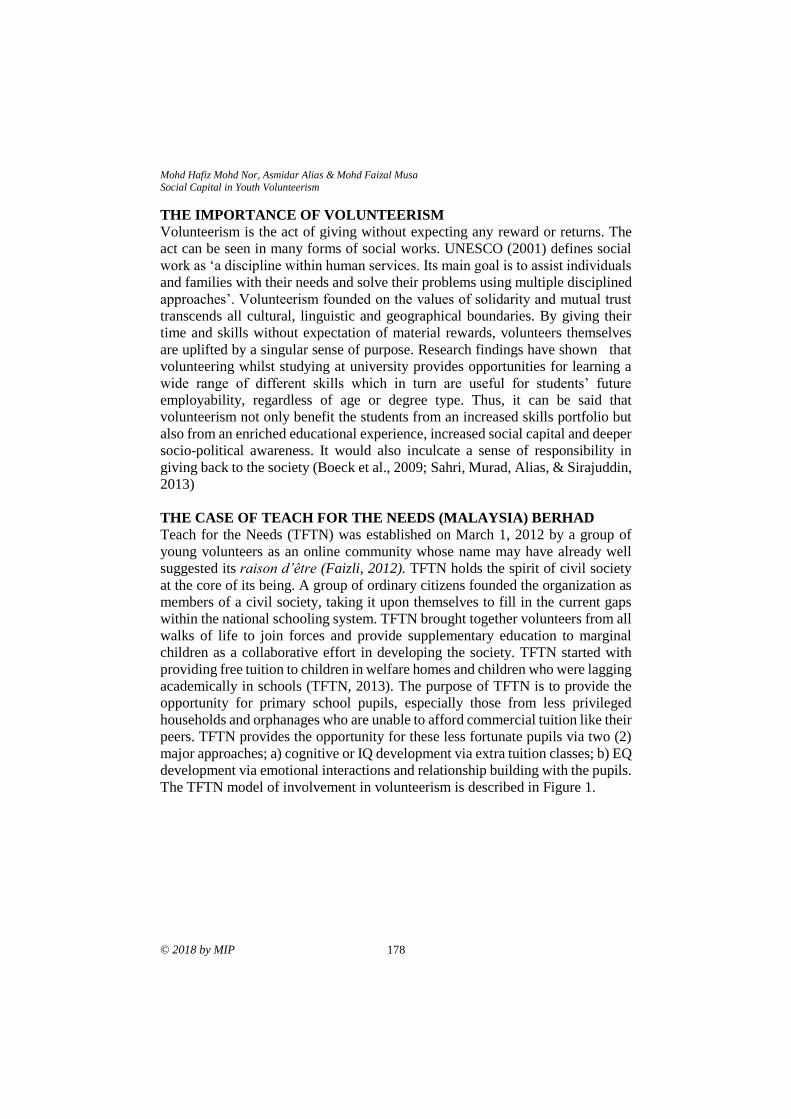
Mohd Hafiz Mohd Nor, Asmidar Alias & Mohd Faizal Musa
Social Capital in Youth Volunteerism
© 2018 by MIP 178
THE IMPORTANCE OF VOLUNTEERISM
Volunteerism is the act of giving without expecting any reward or returns. The
act can be seen in many forms of social works. UNESCO (2001) defines social
work as ‘a discipline within human services. Its main goal is to assist individuals
and families with their needs and solve their problems using multiple disciplined
approaches’. Volunteerism founded on the values of solidarity and mutual trust
transcends all cultural, linguistic and geographical boundaries. By giving their
time and skills without expectation of material rewards, volunteers themselves
are uplifted by a singular sense of purpose. Research findings have shown that
volunteering whilst studying at university provides opportunities for learning a
wide range of different skills which in turn are useful for students’ future
employability, regardless of age or degree type. Thus, it can be said that
volunteerism not only benefit the students from an increased skills portfolio but
also from an enriched educational experience, increased social capital and deeper
socio-political awareness. It would also inculcate a sense of responsibility in
giving back to the society (Boeck et al., 2009; Sahri, Murad, Alias, & Sirajuddin,
2013)
THE CASE OF TEACH FOR THE NEEDS (MALAYSIA) BERHAD
Teach for the Needs (TFTN) was established on March 1, 2012 by a group of
young volunteers as an online community whose name may have already well
suggested its raison d’être (Faizli, 2012). TFTN holds the spirit of civil society
at the core of its being. A group of ordinary citizens founded the organization as
members of a civil society, taking it upon themselves to fill in the current gaps
within the national schooling system. TFTN brought together volunteers from all
walks of life to join forces and provide supplementary education to marginal
children as a collaborative effort in developing the society. TFTN started with
providing free tuition to children in welfare homes and children who were lagging
academically in schools (TFTN, 2013). The purpose of TFTN is to provide the
opportunity for primary school pupils, especially those from less privileged
households and orphanages who are unable to afford commercial tuition like their
peers. TFTN provides the opportunity for these less fortunate pupils via two (2)
major approaches; a) cognitive or IQ development via extra tuition classes; b) EQ
development via emotional interactions and relationship building with the pupils.
The TFTN model of involvement in volunteerism is described in Figure 1.
PLANNING MALAYSIA
Journal of the Malaysia Institute of Planners (2018)
179 © 2018 by MIP
Figure 1: TFTN volunteerism model
Source: Field Study (2018)
TFTN Projects focus on i) education ii) vocational iii) funding iv) special projects
and v) research. Vocational education in TFTN is one of the ways to uncover and
develop the potential of the children particularly in the aspects of arts and skills.
Through theatre and art workshops, TFTN children are exposed to the creative
aspects of theatrical and visual arts. Meanwhile, for the development of skills,
TFTN focuses on entrepreneurship and product development. .
RESEARCH METHODOLOGY
The research was conducted on 100 respondents (100%) representing TFTN
activism at the early stage of its establishment. The respondents were youths who
volunteering in Malaysia. Questionnaires were given to identify those who were
active in volunteerism and matter in volunteer work. The questionnaire was
divided to two sectors, Sector A and Sector B. Sector A is to identify; 1) age,
occupation and education level 2) involvement in volunteerism, 3) involvement,
experience and commitment level 4) role of social media and 5) level of
involvement and skills in volunteerism work. Sector B investigated respondents’
perceptions on 1) Individual networking 2) Social Network 3) Norm of
reciprocity and 4) Norm of trust. The inventory was designed on a 5-point Likert
scale as Strongly Disagree (SD), Disagree (D), Agree (A), Strongly Agree (SA)
and Not Sure (NS).
Volunteers
TFTN Projects
TFTN Core
•Board of Trustees
•Administration
• Finance
• Projects
•Reseach
• Education
•Vocational
• Funding
• Special Projects
•Reseach
•Marginal Children
• Tertiary Students
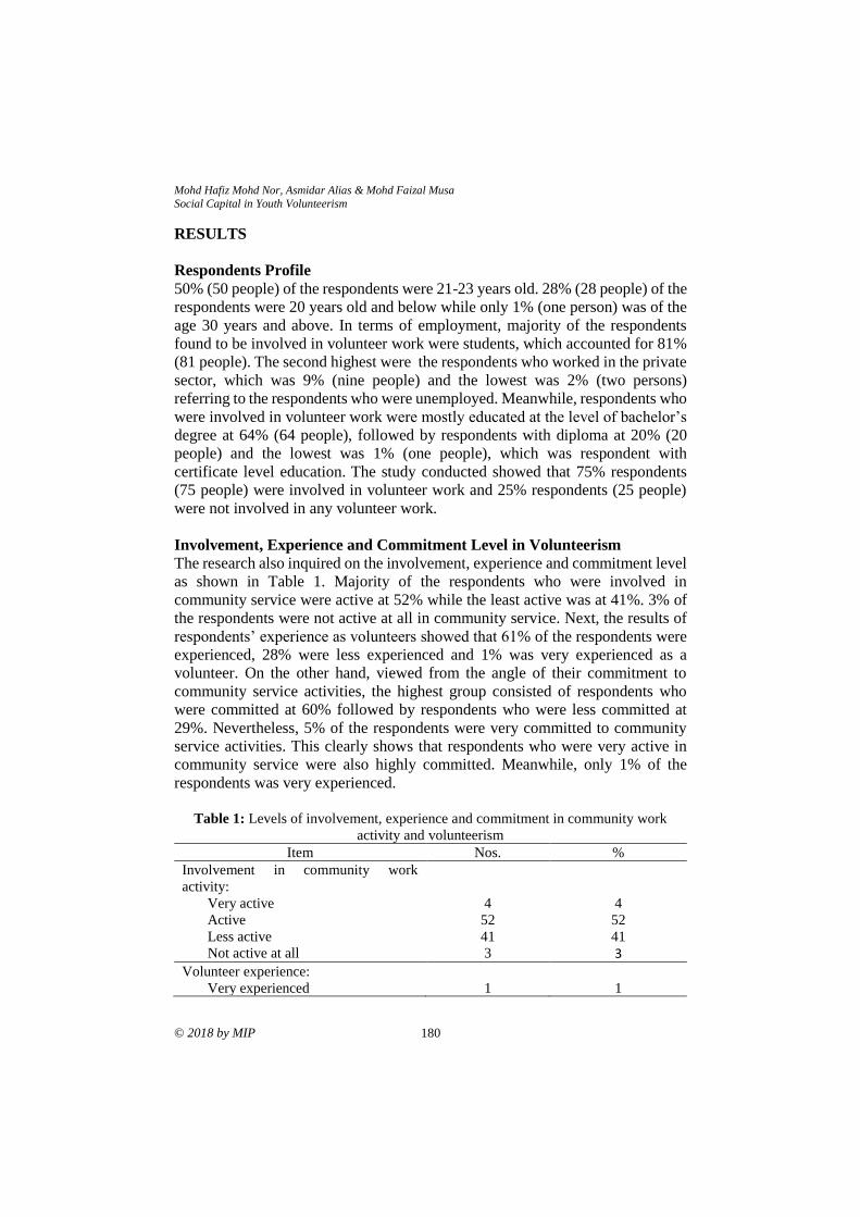
Mohd Hafiz Mohd Nor, Asmidar Alias & Mohd Faizal Musa
Social Capital in Youth Volunteerism
© 2018 by MIP 180
RESULTS
Respondents Profile
50% (50 people) of the respondents were 21-23 years old. 28% (28 people) of the
respondents were 20 years old and below while only 1% (one person) was of the
age 30 years and above. In terms of employment, majority of the respondents
found to be involved in volunteer work were students, which accounted for 81%
(81 people). The second highest were the respondents who worked in the private
sector, which was 9% (nine people) and the lowest was 2% (two persons)
referring to the respondents who were unemployed. Meanwhile, respondents who
were involved in volunteer work were mostly educated at the level of bachelor’s
degree at 64% (64 people), followed by respondents with diploma at 20% (20
people) and the lowest was 1% (one people), which was respondent with
certificate level education. The study conducted showed that 75% respondents
(75 people) were involved in volunteer work and 25% respondents (25 people)
were not involved in any volunteer work.
Involvement, Experience and Commitment Level in Volunteerism
The research also inquired on the involvement, experience and commitment level
as shown in Table 1. Majority of the respondents who were involved in
community service were active at 52% while the least active was at 41%. 3% of
the respondents were not active at all in community service. Next, the results of
respondents’ experience as volunteers showed that 61% of the respondents were
experienced, 28% were less experienced and 1% was very experienced as a
volunteer. On the other hand, viewed from the angle of their commitment to
community service activities, the highest group consisted of respondents who
were committed at 60% followed by respondents who were less committed at
29%. Nevertheless, 5% of the respondents were very committed to community
service activities. This clearly shows that respondents who were very active in
community service were also highly committed. Meanwhile, only 1% of the
respondents was very experienced.
Table 1: Levels of involvement, experience and commitment in community work
activity and volunteerism
Item Nos. %
Involvement in community work
activity:
Very active
Active
Less active
Not active at all
4
52
41
3
4
52
41
3
Volunteer experience:
Very experienced
1
1
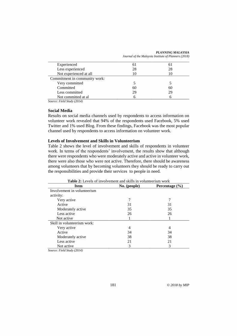
PLANNING MALAYSIA
Journal of the Malaysia Institute of Planners (2018)
181 © 2018 by MIP
Experienced
Less experienced
Not experienced at all
61
28
10
61
28
10
Commitment in community work:
Very committed
Committed
Less committed
Not committed at al
5
60
29
6
5
60
29
6 Source: Field Study (2014)
Social Media
Results on social media channels used by respondents to access information on
volunteer work revealed that 94% of the respondents used Facebook, 5% used
Twitter and 1% used Blog. From these findings, Facebook was the most popular
channel used by respondents to access information on volunteer work.
Levels of Involvement and Skills in Volunteerism
Table 2 shows the level of involvement and skills of respondents in volunteer
work. In terms of the respondents’ involvement, the results show that although
there were respondents who were moderately active and active in volunteer work,
there were also those who were not active. Therefore, there should be awareness
among volunteers that by becoming volunteers they should be ready to carry out
the responsibilities and provide their services to people in need.
Table 2: Levels of involvement and skills in volunteerism work
Item No. (people) Percentage (%)
Involvement in volunteerism
activity:
Very active
Active
Moderately active
Less active
Not active
7
31
35
26
1
7
31
35
26
1
Skill in volunteerism work:
Very active
Active
Moderately active
Less active
Not active
4
34
38
21
3
4
34
38
21
3 Source: Field Study (2014)
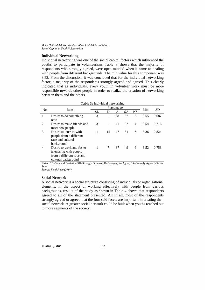
Mohd Hafiz Mohd Nor, Asmidar Alias & Mohd Faizal Musa
Social Capital in Youth Volunteerism
© 2018 by MIP 182
Individual Networking
Individual networking was one of the social capital factors which influenced the
youths to participate in volunteerism. Table 3 shows that the majority of
respondents who strongly agreed, were open-minded when it came to dealing
with people from different backgrounds. The min value for this component was
3.52. From the discussion, it was concluded that for the individual networking
factor, a majority of the respondents strongly agreed and agreed. This clearly
indicated that as individuals, every youth in volunteer work must be more
responsible towards other people in order to realize the creation of networking
between them and the others.
Table 3: Individual networking
No Item Percentage
Min SD SD D A SA NS
1 Desire to do something
new
3 - 38 57 2 3.55 0.687
2 Desire to make friends and
meet new people
3 - 41 52 4 3.54 0.716
3 Desire to interact with
people from a different
race and cultural
background
1 15 47 31 6 3.26 0.824
4 Desire to work and foster
friendship with people
from a different race and
cultural background
1 7 37 49 6 3.52 0.758
Notes: SD=Standard Deviation SD=Strongly Disagree, D=Disagree, A=Agree, SA=Strongly Agree, NS=Not Sure
Source: Field Study (2014)
Social Network
A social network is a social structure consisting of individuals or organizational
elements. In the aspect of working effectively with people from various
backgrounds, results of the study as shown in Table 4 shows that respondents
agreed to all of the statement presented. All in all, most of the respondents
strongly agreed or agreed that the four said facets are important in creating their
social network. A greater social network could be built when youths reached out
to more segments of the society.
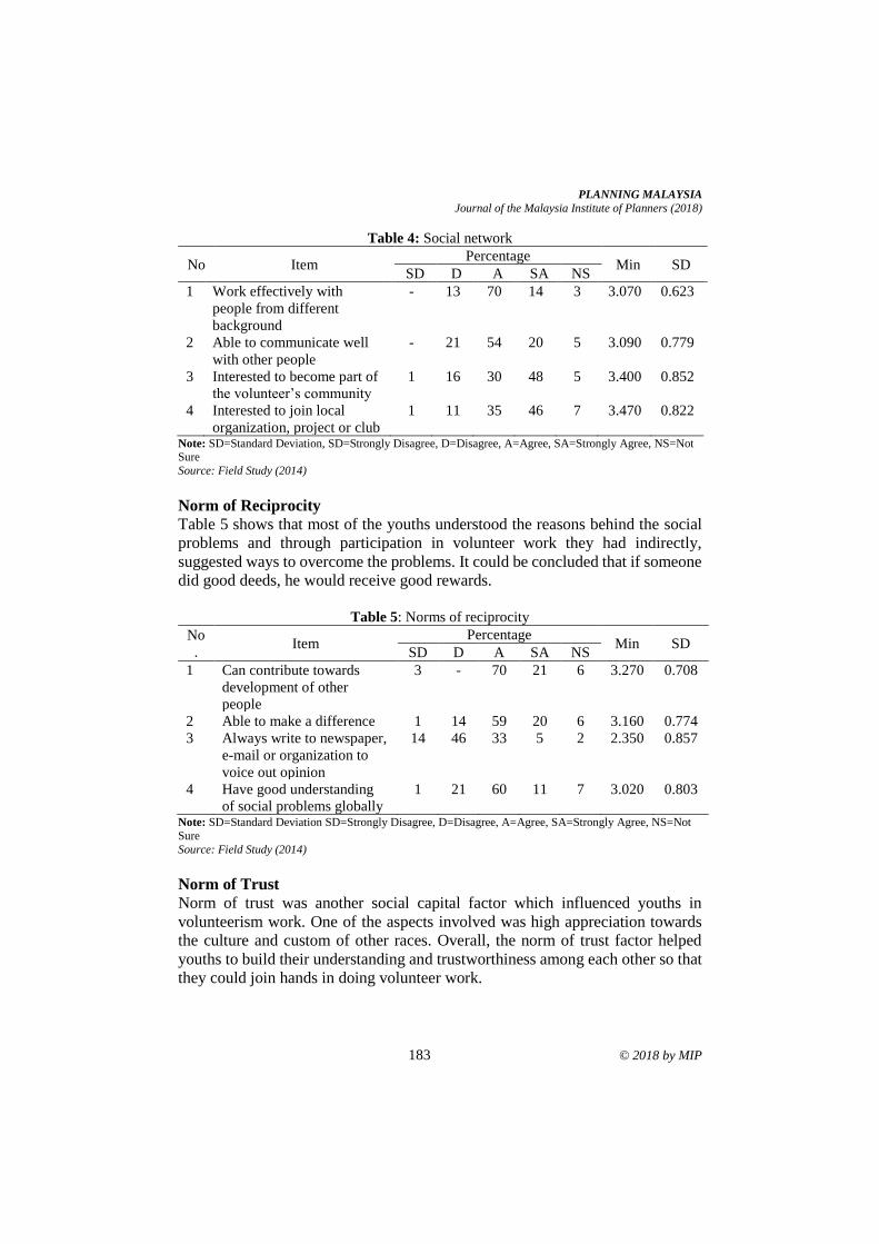
PLANNING MALAYSIA
Journal of the Malaysia Institute of Planners (2018)
183 © 2018 by MIP
Table 4: Social network
No Item Percentage
Min SD SD D A SA NS
1 Work effectively with
people from different
background
- 13 70 14 3 3.070 0.623
2 Able to communicate well
with other people
- 21 54 20 5 3.090 0.779
3 Interested to become part of
the volunteer’s community
1 16 30 48 5 3.400 0.852
4 Interested to join local
organization, project or club
1 11 35 46 7 3.470 0.822
Note: SD=Standard Deviation, SD=Strongly Disagree, D=Disagree, A=Agree, SA=Strongly Agree, NS=Not Sure
Source: Field Study (2014)
Norm of Reciprocity
Table 5 shows that most of the youths understood the reasons behind the social
problems and through participation in volunteer work they had indirectly,
suggested ways to overcome the problems. It could be concluded that if someone
did good deeds, he would receive good rewards.
Table 5: Norms of reciprocity
No
. Item
Percentage Min SD
SD D A SA NS
1 Can contribute towards
development of other
people
3 - 70 21 6 3.270 0.708
2 Able to make a difference 1 14 59 20 6 3.160 0.774
3 Always write to newspaper,
e-mail or organization to
voice out opinion
14 46 33 5 2 2.350 0.857
4 Have good understanding
of social problems globally
1 21 60 11 7 3.020 0.803
Note: SD=Standard Deviation SD=Strongly Disagree, D=Disagree, A=Agree, SA=Strongly Agree, NS=Not
Sure
Source: Field Study (2014)
Norm of Trust
Norm of trust was another social capital factor which influenced youths in
volunteerism work. One of the aspects involved was high appreciation towards
the culture and custom of other races. Overall, the norm of trust factor helped
youths to build their understanding and trustworthiness among each other so that
they could join hands in doing volunteer work.
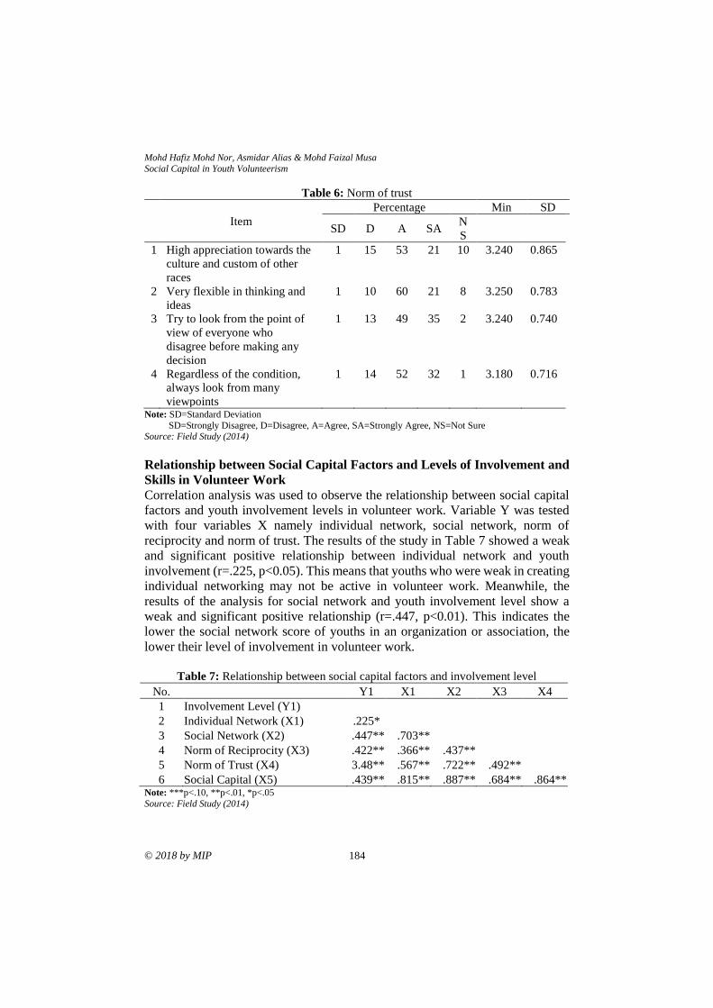
Mohd Hafiz Mohd Nor, Asmidar Alias & Mohd Faizal Musa
Social Capital in Youth Volunteerism
© 2018 by MIP 184
Table 6: Norm of trust
Item
Percentage Min SD
SD D A SA N
S
1 High appreciation towards the
culture and custom of other
races
1 15 53 21 10 3.240 0.865
2 Very flexible in thinking and
ideas
1 10 60 21 8 3.250 0.783
3 Try to look from the point of
view of everyone who
disagree before making any
decision
1 13 49 35 2 3.240 0.740
4 Regardless of the condition,
always look from many
viewpoints
1 14 52 32 1 3.180 0.716
Note: SD=Standard Deviation
SD=Strongly Disagree, D=Disagree, A=Agree, SA=Strongly Agree, NS=Not Sure Source: Field Study (2014)
Relationship between Social Capital Factors and Levels of Involvement and
Skills in Volunteer Work
Correlation analysis was used to observe the relationship between social capital
factors and youth involvement levels in volunteer work. Variable Y was tested
with four variables X namely individual network, social network, norm of
reciprocity and norm of trust. The results of the study in Table 7 showed a weak
and significant positive relationship between individual network and youth
involvement (r=.225, p<0.05). This means that youths who were weak in creating
individual networking may not be active in volunteer work. Meanwhile, the
results of the analysis for social network and youth involvement level show a
weak and significant positive relationship (r=.447, p<0.01). This indicates the
lower the social network score of youths in an organization or association, the
lower their level of involvement in volunteer work.
Table 7: Relationship between social capital factors and involvement level
No. Y1 X1 X2 X3 X4
1 Involvement Level (Y1) 2 Individual Network (X1) .225*
3 Social Network (X2) .447** .703**
4 Norm of Reciprocity (X3) .422** .366** .437** 5 Norm of Trust (X4) 3.48** .567** .722** .492** 6 Social Capital (X5) .439** .815** .887** .684** .864**
Note: ***p<.10, **p<.01, *p<.05
Source: Field Study (2014)
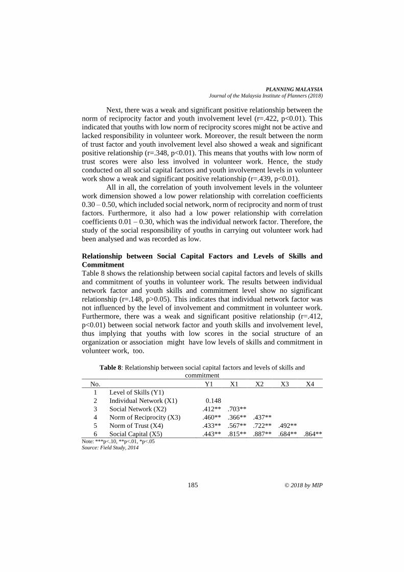
PLANNING MALAYSIA
Journal of the Malaysia Institute of Planners (2018)
185 © 2018 by MIP
Next, there was a weak and significant positive relationship between the
norm of reciprocity factor and youth involvement level (r=.422, p<0.01). This
indicated that youths with low norm of reciprocity scores might not be active and
lacked responsibility in volunteer work. Moreover, the result between the norm
of trust factor and youth involvement level also showed a weak and significant
positive relationship (r=.348, p<0.01). This means that youths with low norm of
trust scores were also less involved in volunteer work. Hence, the study
conducted on all social capital factors and youth involvement levels in volunteer
work show a weak and significant positive relationship (r=.439, p<0.01).
All in all, the correlation of youth involvement levels in the volunteer
work dimension showed a low power relationship with correlation coefficients
0.30 – 0.50, which included social network, norm of reciprocity and norm of trust
factors. Furthermore, it also had a low power relationship with correlation
coefficients 0.01 – 0.30, which was the individual network factor. Therefore, the
study of the social responsibility of youths in carrying out volunteer work had
been analysed and was recorded as low.
Relationship between Social Capital Factors and Levels of Skills and
Commitment
Table 8 shows the relationship between social capital factors and levels of skills
and commitment of youths in volunteer work. The results between individual
network factor and youth skills and commitment level show no significant
relationship (r=.148, p>0.05). This indicates that individual network factor was
not influenced by the level of involvement and commitment in volunteer work.
Furthermore, there was a weak and significant positive relationship (r=.412,
p<0.01) between social network factor and youth skills and involvement level,
thus implying that youths with low scores in the social structure of an
organization or association might have low levels of skills and commitment in
volunteer work, too.
Table 8: Relationship between social capital factors and levels of skills and
commitment
No. Y1 X1 X2 X3 X4
1 Level of Skills (Y1) 2 Individual Network (X1) 0.148
3 Social Network (X2) .412** .703**
4 Norm of Reciprocity (X3) .460** .366** .437** 5 Norm of Trust (X4) .433** .567** .722** .492** 6 Social Capital (X5) .443** .815** .887** .684** .864**
Note: ***p<.10, **p<.01, *p<.05
Source: Field Study, 2014
Mohd Hafiz Mohd Nor, Asmidar Alias & Mohd Faizal Musa
Social Capital in Youth Volunteerism
© 2018 by MIP 186
Moreover, there was also a weak and significant positive relationship
between the norm of reciprocity factor and youth skills and commitment levels
(r=.460, p<0.01). This shows that youths with low norm of reciprocity scores
have low levels of skills and commitment in volunteer work. Other than that, the
relationship between the norm of trust factor and youth skills and commitment
levels also weak and significant positive (r=.460, p<0.01). Hence, the lower youth
norm of trust score, the lower their level of skills and commitment in carrying out
their responsibilities as volunteers. The result of the analysis between the social
capital factors and youth level of skills and commitment in volunteer work shows
a low but significant positive relationship (r=.443, p<0.01).
CONCLUSION
The understanding on the theoretical concept of social capital and the nature of
volunteerism has shed some light on the understanding of social ties to promote
beneficial impacts for the local community in particular and the nation in general.
Having the real benefits, social capital is the best concept to empower voluntary
associations based on the nature of a community’s sociological behaviour. The
voluntary sector has even been regarded as the nation’s third sector which gives
a direct impact on the economy, thus, the results in community well-being. In the
case of TFTN volunteers, there are weak and significant positive relationships
between individual networks and youth involvements. Individual network factors
and youth skills are not significant to ensure commitment in volunteer work.
However, norms of reciprocity and trust have a positive relationship with youths’
skills and commitments.
REFERENCES Ahmad, F., Salman, A., Rahim, S. A., Pawanteh, L., & Ahmad, A. L. (2013). Interethnic
tolerance among multiethnic youth Accommodating differences in the
construction of social citizenship. Journal of Asian Pacific Communication,
23(2), 275-290.
Boeck, T., Makadia, N., Johnson, C., Cadogan, N., Salim, H., & Cushing, J. (2009). The
impact of volunteering on social capital and community cohesion. Available at
http://www.youthaction.network.org.uk
Bourdieu, P. (1970). Reproduction in education, culture and society. London: Sage.
Chong, S. T., Koh, D., Fauziah, I., & Samsudin, A. R. (2017). Neighbourhood social
capital and neighbourhood safety in predicting the subjective well-being of
young Malaysians. Pertanika Journal of Social Sciences and Humanities,
25(June), 155-163.
Chong, S. T., Farquharson, K., Choy, E., Lukman, Z. M., & Mokhtar, M. K. (2011).
Enhancing youth civic engagement and generalized trust through bonding social
capital among friends. Pertanika Journal of Social Science and Humanities,
19(Special Issue), 57-64.
PLANNING MALAYSIA
Journal of the Malaysia Institute of Planners (2018)
187 © 2018 by MIP
Faizli, A. A. (2012). Sukarelawan pendidikan melalui teach for the needs. Retrieved from
http://www.freemalaysiatoday.com/category/nation/ 2012/09/12./sukarelawan-
pendidikan-melalui-teach-for-the-needs/
Putnam, R. D. (2000). Bowling alone: The collapse and revival of American community.
New York: Simon and Schuster.
UNESCO (2011). Module 3: Social Work. France: Ag2i Communication.
Sahri, M., Murad, K., Alias, A., & Sirajuddin, M. D. M. (2013, September). Empowering
youth volunteerism: The importance and global motivating factors. 3rd
International Conference on Human and Social Sciences, September 20-22,
2013, Rome Italy.
Siisiainen, M. (2000, July). Two concepts of social capital: Bourdieu vs. Putnam. ISTR
Fourth International Conference. July 5-8, 2000, Dublin, Ireland.
Sulaiman, W. I. W., Mahbob, M. H., & Sannusi, S. N. (2015). Social capital and the
learning organization: Transformation in Malaysian public sector. Journal of
Asian Pacific Communication, 25(2), 208-219.
TFTN (2013). TFTN’s Company Profile
Received: 1st June 2018. Accepted:1st December 2018
1 Senior Lecturer at Universiti Teknologi Mara. Email: [email protected] 188
PLANNING MALAYSIA:
Journal of the Malaysian Institute of Planners
VOLUME 16 ISSUE 4 (2018), Page 188 – 198
BUILDING OPENING DESIGN CONTRIBUTING TO
TRADITIONAL STREETS’ WALKABILITY CHARACTER
IN MELAKA HISTORIC CITY
Nor Haslina Ja’afar1 & Nor Zalina Harun2
1Faculty of Engineering and Built Environment 2Institute of the Malay World and Civilisation
UNIVERSITI KEBANGSAAN MALAYSIA
Abstract
The street as a public space plays an essential role in representing the character
of a city. Therefore, it is vital to create streets that are pedestrian friendly.
However, rapid urbanisation has increased reliance on motorised modes of
transport, especially in developing countries. This has created urban street
environments unfriendly for walking, which diminishes the place character. This
study thus aims to determine the ground-level building opening design concepts
of the traditional street that promote street interaction via a case study of Jalan
Tukang Besi, Jalan Tukang Emas, and Jalan Tokong in Melaka Historic City. The
study applies a mixed-method approach with a survey, in-depth interviews of
street users, observation, and review of historical documents to identify the
character of the traditional street within the design of ground-level building
opening. The findings reveal that the building opening design concept should
correspond to the building function. The design concept for a commercial use
building should be more transparent compared to a residential building, which is
more private in character. The findings inform designers and planners on the
importance of referring to our traditional street design and to apply the concepts
in the design of new or existing streets, thereby preserving the local character.
Keywords: public space, traditional street, character, building opening, street
design
PLANNING MALAYSIA
Journal of the Malaysia Institute of Planners (2018)
189 © 2018 by MIP
INTRODUCTION
The image of a town or city depends on the image of its streets, i.e., if the streets
are walkable and have a strong character, so do the city (Jaafar, Abdul Rahim,
Abd Samad, & Che Rahim, 2017). In urban design, the street is an essential public
open space that acts as a ‘link’ as well as a ‘place’. The ‘link’ refers to the street’s
function for movement serving a variety of users including pedestrians, cyclists,
public transport, and motor vehicles. The purpose of the street as a ‘link’ is to
save time. While the street as a ‘place’ refers to it as a destination: a place where
people spend their time. This refers to pedestrians conducting and taking part in
a variety of activities (Jones & Boujenko, 2011; Jones & Boujenko, 2008; Gehl,
Kaefer, & Reigstad, 2006; Gehl & Gemzøe, 2001).
On the other hand, rapid urbanisation has also increased reliance on
motorised modes of transport such as cars, especially in developing countries. In
the process, many of our heritage buildings were not conserved and were replaced
by new, modernist buildings that were built without considering the existing
context that was rich in historical values and characters. At the same time, the
construction of large buildings, such as shopping complexes, destroys the existing
fine grain and texture of the street and the city. According to Gehl, (2010), the
‘big-box’ design of such buildings discourages ground-level interaction between
people inside and outside. The blank walls create an unsafe environment due to
the lack of natural surveillance while the long blank walls create unwalkable
surroundings for pedestrians to mingle around. Instead, interactions take place
inside the building via an indoor street design. The result is an urban street
environment that is unfriendly for walking. This disruption of the existing urban
form reduces the street and place character.
The explanation above portrays that it is crucial to develop place
character with walkable environments by designing buildings that encourage
interactions especially at the street level. To this end, this study aims to determine
the design concepts of ground-level building openings that create street
interactions that contribute to the traditional street character at Melaka Historic
City, Malaysia.
RESEARCH BACKGROUND
There have been many works on pedestrian-friendly urban street that emphasise
theories of walkability, such as Harun and Nashar (2016), Litman (2014), and
Clark, Scott and Yiannakoulias (2013). Among the most prominent is Speck
(2012), who lists the characteristics of interesting and walkable cities with
pedestrian-friendly streets. He argues that walking needs to be safe, useful,
comfortable, and attractive; each characteristic could not exist without the other.
Other proponents of walkable streets such as Jacobs (1993) and Litman (2014)
also emphasise that being pleasurable, prioritising pedestrians, having meaning,
Mohd Hafiz Mohd Nor, Asmidar Alias & Mohd Faizal Musa
Social Capital in Youth Volunteerism
© 2018 by MIP 190
eyes engaging, possessing transparency, and ensured complementary with
streetscape elements are pertinent qualities.
A more localised study by Rahman, Shamsuddin and Ghani (2014), and
Yap, Usman, Tahir and Abidin (2010) asserts that the street environment must
have the attributes of short distance or proximity, minimal congestion,
familiarity, greenery, public amenities, regularly maintained, and allowing
freedom of activities. Previous studies have also measured walkability in terms
of the number of lanes or high accessibility, presence of crosswalks, and density
(Asfar, Mohd Yazid, & Mohd Johari, 2015), high density development
(Miyakoda, 2005), street attractiveness, and high connectivity (Litman, 2014),
minimal distance to non-residential destinations and land-use mix (Handy,
Xinyu, & Mokhtarian, 2005), and connectivity, personal safety, and presence of
parks and open spaces (Sallis, Frank, Saelens, & Kraft , 2004; Maleki, Zain, &
Ismail, 2014).
METHODOLOGY
A survey of street users was conducted by distributing questionnaires to collect
quantitative data while direct observation, in-depth interviews of street users, and
review of documents of historical significance yielded qualitative data. All
methods were applied to triangulate the building design elements that contribute
towards the walkable character of the traditional streets in Melaka Historic City
Centre.
Street users were randomly selected as respondents for the survey. They
included shop owners, street vendors, shopkeepers, workers, shoppers, visitors,
and residents. 335 respondents were selected for a 95% confidence level and
5.5% sampling error as suggested by de Vaus (2003) and applied in Shamsuddin
and Ujang (2008). The questionnaire was designed with both multiple-choice and
open-ended questions, and each respondent was given 20 minutes to complete the
questionnaire with a 40-minute interval between respondents.
In-depth interviews were conducted on 21 respondents in a semi-
structured format, in which questions were prepared in advance as a guide to
ensure all variables were covered during the interview. The interviews collected
the respondents’ length of engagement, whether they are local, and familiarity
with the place and its milieu. According to character theory, it is essential to
gather information from locals or those who are familiar with the area so that the
historical significance of the place as well as other factors that contribute to the
place character could be identified. Audio recordings and handwritten notes were
taken of the interviews. In addition, a review of historical documents such as old
photo and map was also conducted to determine the area’s historical significance.
The study was also conducted by observation, whereby visual analysis
was applied on data recorded using digital camera and field notes to document
the physical characteristics, pattern of activities, and users to understand the
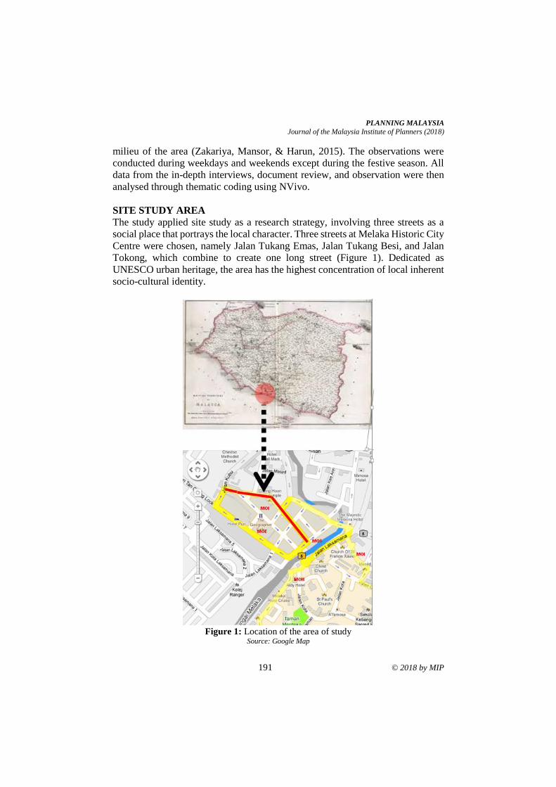
PLANNING MALAYSIA
Journal of the Malaysia Institute of Planners (2018)
191 © 2018 by MIP
milieu of the area (Zakariya, Mansor, & Harun, 2015). The observations were
conducted during weekdays and weekends except during the festive season. All
data from the in-depth interviews, document review, and observation were then
analysed through thematic coding using NVivo.
SITE STUDY AREA
The study applied site study as a research strategy, involving three streets as a
social place that portrays the local character. Three streets at Melaka Historic City
Centre were chosen, namely Jalan Tukang Emas, Jalan Tukang Besi, and Jalan
Tokong, which combine to create one long street (Figure 1). Dedicated as
UNESCO urban heritage, the area has the highest concentration of local inherent
socio-cultural identity.
Figure 1: Location of the area of study
Source: Google Map
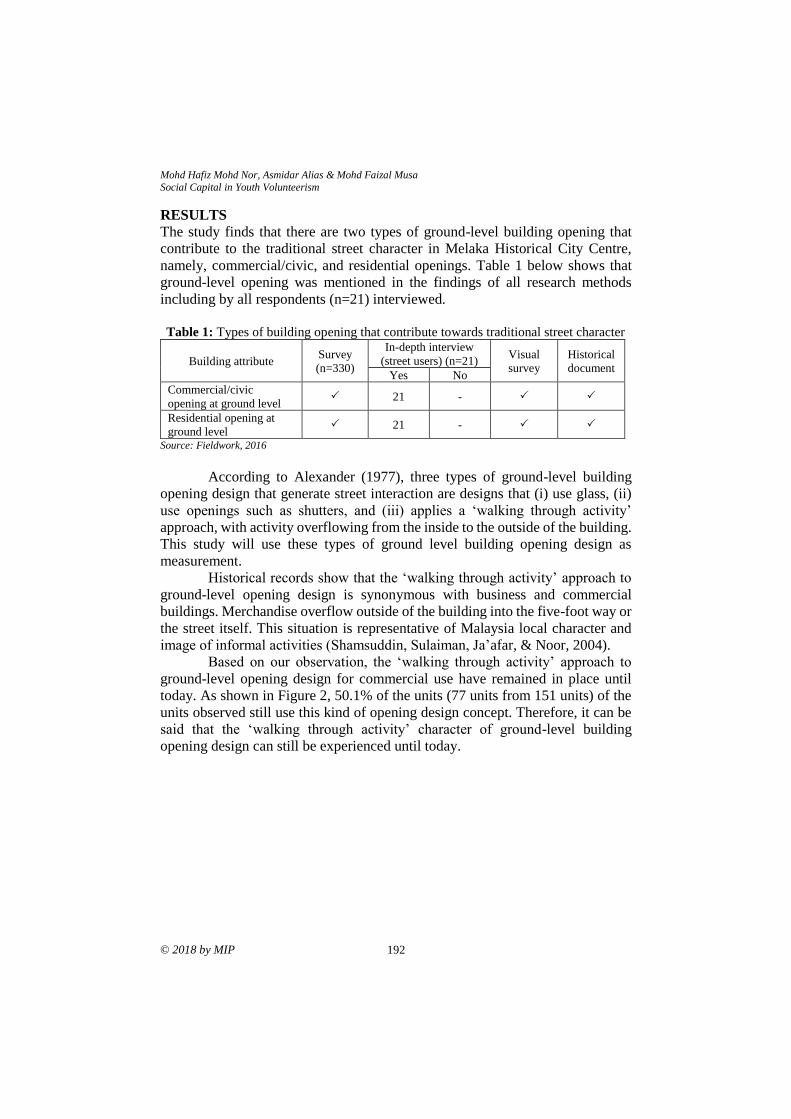
Mohd Hafiz Mohd Nor, Asmidar Alias & Mohd Faizal Musa
Social Capital in Youth Volunteerism
© 2018 by MIP 192
RESULTS
The study finds that there are two types of ground-level building opening that
contribute to the traditional street character in Melaka Historical City Centre,
namely, commercial/civic, and residential openings. Table 1 below shows that
ground-level opening was mentioned in the findings of all research methods
including by all respondents (n=21) interviewed.
Table 1: Types of building opening that contribute towards traditional street character
Building attribute Survey
(n=330)
In-depth interview (street users) (n=21)
Visual
survey
Historical
document Yes No
Commercial/civic
opening at ground level 21 -
Residential opening at
ground level 21 -
Source: Fieldwork, 2016
According to Alexander (1977), three types of ground-level building
opening design that generate street interaction are designs that (i) use glass, (ii)
use openings such as shutters, and (iii) applies a ‘walking through activity’
approach, with activity overflowing from the inside to the outside of the building.
This study will use these types of ground level building opening design as
measurement. Historical records show that the ‘walking through activity’ approach to
ground-level opening design is synonymous with business and commercial
buildings. Merchandise overflow outside of the building into the five-foot way or
the street itself. This situation is representative of Malaysia local character and
image of informal activities (Shamsuddin, Sulaiman, Ja’afar, & Noor, 2004). Based on our observation, the ‘walking through activity’ approach to
ground-level opening design for commercial use have remained in place until
today. As shown in Figure 2, 50.1% of the units (77 units from 151 units) of the
units observed still use this kind of opening design concept. Therefore, it can be
said that the ‘walking through activity’ character of ground-level building
opening design can still be experienced until today.
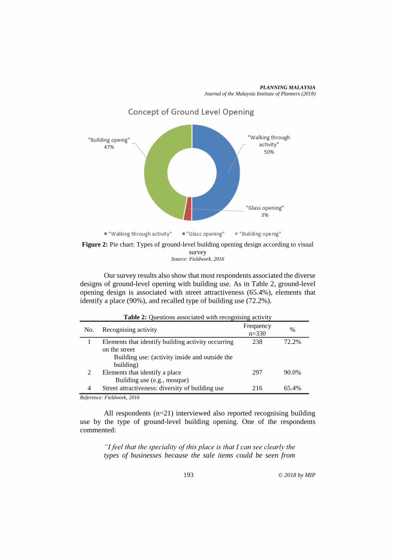
PLANNING MALAYSIA
Journal of the Malaysia Institute of Planners (2018)
193 © 2018 by MIP
Figure 2: Pie chart: Types of ground-level building opening design according to visual
survey Source: Fieldwork, 2016
Our survey results also show that most respondents associated the diverse
designs of ground-level opening with building use. As in Table 2, ground-level
opening design is associated with street attractiveness (65.4%), elements that
identify a place (90%), and recalled type of building use (72.2%).
Table 2: Questions associated with recognising activity
No. Recognising activity Frequency
n=330 %
1 Elements that identify building activity occurring
on the street
Building use: (activity inside and outside the
building)
238 72.2%
2 Elements that identify a place
Building use (e.g., mosque)
297 90.0%
4 Street attractiveness: diversity of building use 216 65.4%
Reference: Fieldwork, 2016
All respondents (n=21) interviewed also reported recognising building
use by the type of ground-level building opening. One of the respondents
commented:
“I feel that the speciality of this place is that I can see clearly the
types of businesses because the sale items could be seen from
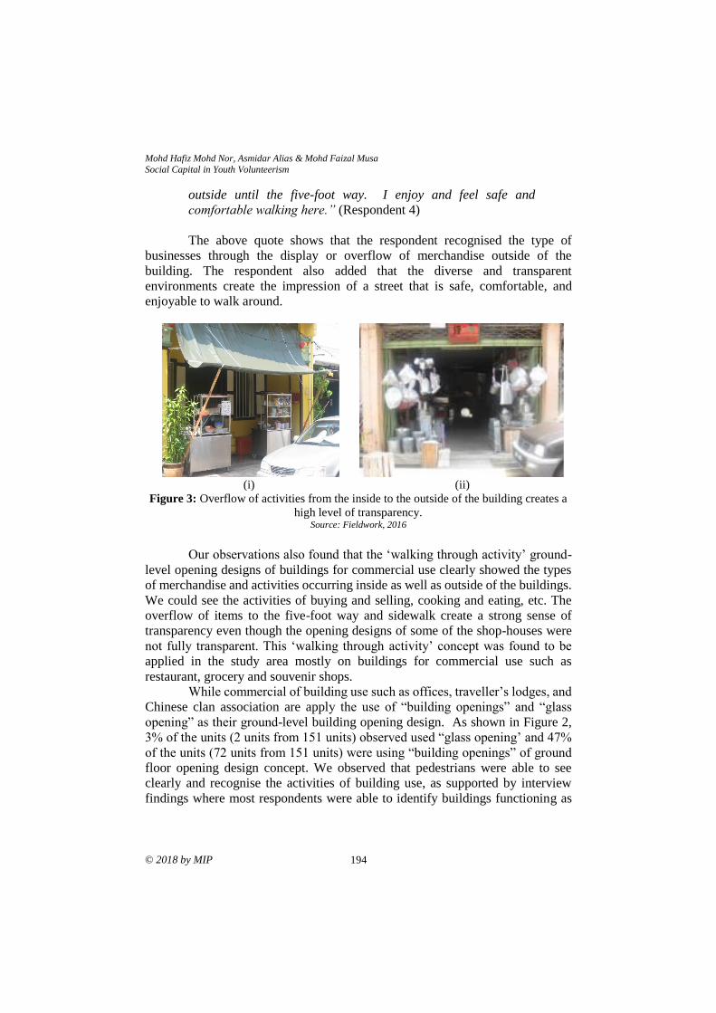
Mohd Hafiz Mohd Nor, Asmidar Alias & Mohd Faizal Musa
Social Capital in Youth Volunteerism
© 2018 by MIP 194
outside until the five-foot way. I enjoy and feel safe and
comfortable walking here.” (Respondent 4)
The above quote shows that the respondent recognised the type of
businesses through the display or overflow of merchandise outside of the
building. The respondent also added that the diverse and transparent
environments create the impression of a street that is safe, comfortable, and
enjoyable to walk around.
(i)
(ii)
Figure 3: Overflow of activities from the inside to the outside of the building creates a
high level of transparency. Source: Fieldwork, 2016
Our observations also found that the ‘walking through activity’ ground-
level opening designs of buildings for commercial use clearly showed the types
of merchandise and activities occurring inside as well as outside of the buildings.
We could see the activities of buying and selling, cooking and eating, etc. The
overflow of items to the five-foot way and sidewalk create a strong sense of
transparency even though the opening designs of some of the shop-houses were
not fully transparent. This ‘walking through activity’ concept was found to be
applied in the study area mostly on buildings for commercial use such as
restaurant, grocery and souvenir shops. While commercial of building use such as offices, traveller’s lodges, and
Chinese clan association are apply the use of “building openings” and “glass
opening” as their ground-level building opening design. As shown in Figure 2,
3% of the units (2 units from 151 units) observed used “glass opening’ and 47%
of the units (72 units from 151 units) were using “building openings” of ground
floor opening design concept. We observed that pedestrians were able to see
clearly and recognise the activities of building use, as supported by interview
findings where most respondents were able to identify buildings functioning as
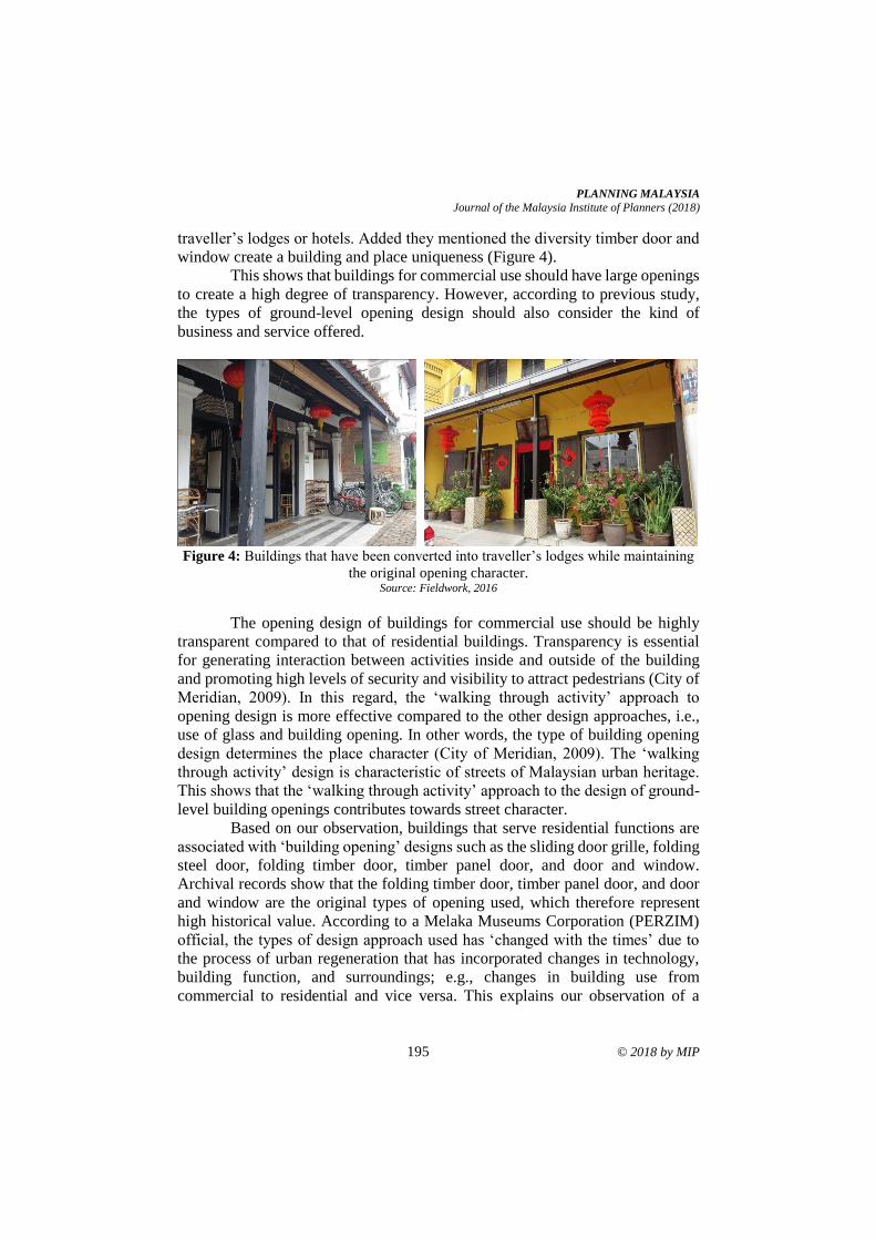
PLANNING MALAYSIA
Journal of the Malaysia Institute of Planners (2018)
195 © 2018 by MIP
traveller’s lodges or hotels. Added they mentioned the diversity timber door and
window create a building and place uniqueness (Figure 4). This shows that buildings for commercial use should have large openings
to create a high degree of transparency. However, according to previous study,
the types of ground-level opening design should also consider the kind of
business and service offered.
Figure 4: Buildings that have been converted into traveller’s lodges while maintaining
the original opening character. Source: Fieldwork, 2016
The opening design of buildings for commercial use should be highly
transparent compared to that of residential buildings. Transparency is essential
for generating interaction between activities inside and outside of the building
and promoting high levels of security and visibility to attract pedestrians (City of
Meridian, 2009). In this regard, the ‘walking through activity’ approach to
opening design is more effective compared to the other design approaches, i.e.,
use of glass and building opening. In other words, the type of building opening
design determines the place character (City of Meridian, 2009). The ‘walking
through activity’ design is characteristic of streets of Malaysian urban heritage.
This shows that the ‘walking through activity’ approach to the design of ground-
level building openings contributes towards street character. Based on our observation, buildings that serve residential functions are
associated with ‘building opening’ designs such as the sliding door grille, folding
steel door, folding timber door, timber panel door, and door and window.
Archival records show that the folding timber door, timber panel door, and door
and window are the original types of opening used, which therefore represent
high historical value. According to a Melaka Museums Corporation (PERZIM)
official, the types of design approach used has ‘changed with the times’ due to
the process of urban regeneration that has incorporated changes in technology,
building function, and surroundings; e.g., changes in building use from
commercial to residential and vice versa. This explains our observation of a
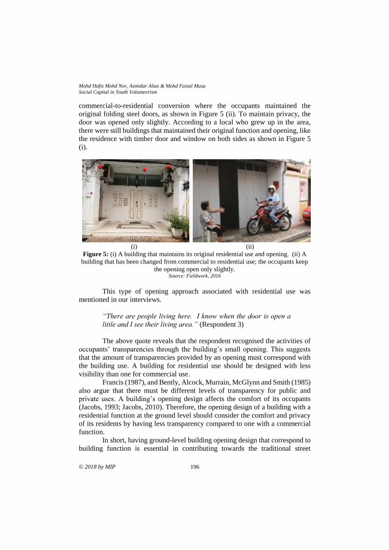
Mohd Hafiz Mohd Nor, Asmidar Alias & Mohd Faizal Musa
Social Capital in Youth Volunteerism
© 2018 by MIP 196
commercial-to-residential conversion where the occupants maintained the
original folding steel doors, as shown in Figure 5 (ii). To maintain privacy, the
door was opened only slightly. According to a local who grew up in the area,
there were still buildings that maintained their original function and opening, like
the residence with timber door and window on both sides as shown in Figure 5
(i).
(i)
(ii)
Figure 5: (i) A building that maintains its original residential use and opening. (ii) A
building that has been changed from commercial to residential use; the occupants keep
the opening open only slightly. Source: Fieldwork, 2016
This type of opening approach associated with residential use was
mentioned in our interviews.
“There are people living here. I know when the door is open a
little and I see their living area.” (Respondent 3)
The above quote reveals that the respondent recognised the activities of
occupants’ transparencies through the building’s small opening. This suggests
that the amount of transparencies provided by an opening must correspond with
the building use. A building for residential use should be designed with less
visibility than one for commercial use. Francis (1987), and Bently, Alcock, Murrain, McGlynn and Smith (1985)
also argue that there must be different levels of transparency for public and
private uses. A building’s opening design affects the comfort of its occupants
(Jacobs, 1993; Jacobs, 2010). Therefore, the opening design of a building with a
residential function at the ground level should consider the comfort and privacy
of its residents by having less transparency compared to one with a commercial
function. In short, having ground-level building opening design that correspond to
building function is essential in contributing towards the traditional street
PLANNING MALAYSIA
Journal of the Malaysia Institute of Planners (2018)
197 © 2018 by MIP
character. This study finds that the traditional character should be considered in
new and existing street designs in Malaysia through two design approaches: i. For commercial use, large opening design that creates high transparency,
comfort, walkable environment, preferably by the ‘walking through
activity’ approach followed by building opening and glass.
ii. For residential use, the design should consider the privacy of the
occupants by not providing high transparency, especially compared to
commercial use, via the building opening approach such as door-and-
window.
CONCLUSION
To conclude, the ground-level building opening design concept that corresponds
to building function is vital in enhancing the walkable environments as well as
providing comfortable surroundings for the occupants. These environments will
strengthen the place character that represents our heritage and local identity. The
results of this study could become a guide for architects, landscape architects,
urban designers, and planners in designing new or existing streets with diverse
functions and ground-level opening designs.
ACKNOWLEDGEMENT
The authors would like to express their sincere gratitude to Universiti Kebangsaan
Malaysia (UKM) and Ministry of Higher Education, Malaysia for funding this
study through research grant FRGS/1/2015/SSI11/UKM/02/2.
REFERENCES Alexander, C. (1977). A pattern language: Towns-building’s-construction. New York:
Oxford University Press.
Afsar, B., Mohd Yazid, M. Y., & Mohd Johari, M., Y. (2015). Assessing essential
facilities for daily walking in a tropical campus. Journal of Advances in
Environmental Biology, 9(4), 76-78.
Bently, I., Alcock, A., Murrain, P., McGlynn, S., & Smith, G. (1985). Responsive
environment: A manual for designers. London: The Architectural Press.
City of Meridian. (2009). City of Meridian design manual. (n.p.): Author.
de Vaus, D. A. (2003). Surveys in social research. New South Wales: George Allen &
Unwin.
Clark, A. F., Scott, D. M., & Yiannakoulias, N. (2013). Examining the relationship
between active travel, weather, and the built environment: a multilevel approach
using a GPS-enhanced dataset. Transportation, 41, 325- 338.
Francis, M. (1987). The making of democratic streets. Firenze: Firenze University Press.
Gehl, J. (2010). Cities for people. London: Island Press.
Gehl, J., & Gemzøe, L. (2001, February). Winning back the cities - The european
experience. In Australia: Walking the 21st Century. February 20-22, 2001. Perth,
Western Australia.
Gehl, J., Kaefer, L. J., & Reigstad, S. (2006). Close encounters with buildings. Urban
Mohd Hafiz Mohd Nor, Asmidar Alias & Mohd Faizal Musa
Social Capital in Youth Volunteerism
© 2018 by MIP 198
Design International, 29-47.
Handy, S., Xinyu, C., & Mokhtarian, P. L. (2005). Correlation or causality between the
built environment and travel behavior: Evidence from Northern California.
Transportation Research Part D: Transport and Environment, 10(6), 427-444.
Harun, N. Z., & Nashar, A. (2016). Developing a framework for streetscape design to
promote walkability in Malaysian campus. Advance Science Letter, 23(4), 2761-
2765.
Jaafar, N. H., Abdul Rahim, A., Abd Samad, N. A., & Che Rahim, C. R.. (2017). Sidewalk
accessibility at Melaka’s traditional street for people with disabilities (PwDs).
Planning Malaysia, 15(1), 389-396.
Jacobs, A. (1993). The great streets. United States of America: The MIT Press.
Jacobs, A. (2010). The importance of streets. In H. C. Kiang, L. B. Liang, & H. Limin
(Eds.), On Asian streets and public space (pp. 159-169). Singapore: Ridge Books.
Litman, T. (2014). Economic value of walkability. World Transport Policy and Practice,
10(1), 5-14.
Maleki, M. Z., Zain, M. F. M., & Ismail, A. (2012). Variables communalities and
dependence to factors of street system, density, and mixed land use in sustainable
site design. Sustainable Cities and Society, 3(1), 46-53.
Miyakoda, A. (2004). A pedestrian friendly environment for downtown Baton Rouge
(Master’s thesis). Kobe Design University, Japan.
Jones, P., & Boujenko, N. (2008). Creating more people-friendly urban streets through
“link and place”. Street Planning And Design, 32(1), 14-25.
Jones, P., & Boujenko, N. (2011). Street planning and design using “link” and “place”.
Journeys, (May), 7-15.
Rahman, N. A., Shamsuddin, S., & Ghani, I. (2014). What makes people use the street?:
Towards a liveable urban environment in Kuala Lumpur City Centre . Procedia
Social and Behavioral Sciences, 170, 624-632.
Sallis, J. F., Frank, L. D., Saelens, B. E., & Kraft, M. K. (2004). Active transportation and
physical activity: opportunities for collaboration on transportation and public
health. Transportation Research Part A, 38(4), 249-268.
Shamsuddin, S., Sulaiman, A. B., Ja’afar, N. H., & Noor, M. M. (2004). Kriteria kejayaan
jalan membeli-belah tradisional di Malaysia: Kajian kes Kuala Lumpur. Skudai:
Universiti Teknologi Malaysia.
Shamsuddin, S., & Ujang, N. (2008). Making places: Tthe role of attachment in creating
the sense of place for traditional streets in Malaysia. Habitat International, 32,
399-409.
Speck, J. (2012). Walkable city: How downtown can save America. One step at a time.
New York: Farrar, Straus and Giroux.
Yap, Y. C., Usman, I., Tahir, M., & Abidin, I. S. Z. (2010). Assessment of Perbadanan
Putrajaya office ground based on urban open space design guideline. Sel. Topics
in Energy, Environment, Sustainable Development and Landscaping - 6th WSEAS
Int. Conf. on Energy, Environment, Ecosystems and Sustainable Development.
Zakariya, K., Mansor, M., & Harun, N. Z. (2015) Mapping: A speculative and creative
design tool. Creative Space Journal, 3,1-12
Received: 1st June 2018. Accepted:1st December 2018
1 Associate Professor at Universiti Kebangsaan Malaysia. Email: [email protected] 199
PLANNING MALAYSIA:
Journal of the Malaysian Institute of Planners
VOLUME 16 ISSUE 4 (2018), Page 199 – 207
THE IMPORTANCE OF THE CONSERVATION/PRESERVATION
WORKS: A CHALLENGE TOWARDS THE FUTURE OF NATIONAL
HERITAGE
Asyaari Muhamad1
1Institute of The Malay World and Civilization
UNIVERSITI KEBANGSAAN MALAYSIA
Abstract
This article discusses the importance of archaeology in the conservation and
restoration works in Malaysia. Even though the development of archaeology in
the nation is approximately 200 years, it is still considered a new subject. Even
so, more than 50 research projects on the archaeological conservation of buildings
and historical sites have been completed in this nation. Some of the
archaeological conservation projects completed include Kota Kuala Kedah, the
candi of Lembah Bujang, Fort Cornwallis, Suffolk House, High Courts, and Shop
Houses of (Lebuh Acheh) in Pulau Pinang, Muzium Matang in Pasir Salak, Balai
Budaya in Kuala Lumpur, Kota Lukut in Negeri Sembilan, Kota Melawati and
Istana Bandar in Selangor, Bangunan Onn Jaafar in Johor and Fort Megarittha in
Sarawak. These archaeological conservation projects had varying success.
Successful in this context is when a site is uncovered with carefully preserved
and restored archaeological finds and the reconstruction of certain structures
whereas unsuccessful is when all the archaeological finds are disregarded or even
destroyed. Therefore, this article attempts to uncover several factors about the
importance of archaeological activities in the conservation or restoration of
buildings and historical sites. Among that being suggested is that all historical
buildings or sites that have to preserved and conserved should first be investigated
archaeologically, all archaeological finds should be restored, and reconstructed
in order to preserve the specific authenticity of the historical building or site,
some funds should be set aside for these activities, and that it should be
undertaken by an archaeologist who is experienced and trained in this field.
Keywords: archaeology, conservation, heritage
Asyaari Muhamad
The Importance of The Conservation/Preservation Works: A Challenge Towards the Future of National Heritage
© 2018 by MIP 200
INTRODUCTION
The general public are aware of archaeology as a branch of social science, which
studies the life of ancient society using a number of disciplines, starting with
archaeological survey (primary and secondary), excavation, analysing and
historical reconstruction. Scholars in this field since early times have
painstakingly putting forward their thoughts, opinion and interpretations
regarding archaeological findings. In other words, this field tries to venture into
the life of ancient societies by their cultural legacy, namely artefacts and non-
artefacts. To be precise, archaeologists try to look into their life from evidences
left at ancient sites such as stones, bronze, iron, cast-offs, dwellings, ritual sites,
grave sites, and so on.
Archaeological research is synonymous with how to preserve, conserve,
restore and protecting the data acquired in whatever forms after the study has
been carried out. This is important particularly to researchers in this field to think
about the direction of the findings gathered from the studies undertaken. The
direction refers to how to preserve and conserve the findings, how it is going to
be managed by museum agencies, and how to present it to the general public in
order to bring benefit to them (Renfrew & Bahn, 1997; Harun, 2013). In other
words, conservation aspect is very important in the field of archaeological
research.
The archaeological aspect and conservation are interrelated. If emphasis
is only on data collection without looking into management and conservation of
the data, the archaeological research will be in vain. Archaeological conservation
is crucial in identifying structure form, looking for evidence of original
construction materials and artefacts such as metal, glass, bead, pottery and so on.
In relation to the archaeological research, it must be carried out before restoration
and conservation works on historical buildings and sites take place in order to
plan for the real works of restoration and conservation (Harun, 2004).
Generally, conservation means skill in investigating techniques,
maintenance and conservation of cultural heritage properties (Caple, 2000).
Maintenance refers to the protection of monument from legacy and dispose, every
existing traditional environment must be maintained and preserved from threat of
destruction. Conservation is also a generic term used for any restoration works.
It refers to conservation efforts using several techniques and technologies related
to conservation discipline. Its concept is to preserve and expose the historical
and aesthetical values of a monument (Kassim, 2006).
In reality, both archaeological and conservation fields play important
roles in shaping, maintaining, and protecting national heritage. Therefore, the
roles of authorities such as the Malaysian Ministry of Culture, Arts and Heritage,
and agencies under it like the Museum Department and the Heritage Department,
are very important in enhancing the value of national heritage.
PLANNING MALAYSIA
Journal of the Malaysia Institute of Planners (2018)
201 © 2018 by MIP
Archaeological studies and conservation carried out in the country
concentrated on all ages, starting with prehistoric, proto-historic and historic
ages. But the level of studies on archaeology and conservation on prehistoric and
proto-historic are quite different from historic age. During the prehistoric age,
conservation works are focused on artefacts and non-artefacts such as potteries,
human skeletons and flora. While, during the proto-historic age, conservation
works concentrate on temple structure, artefacts and non-artefacts. During
historic age, studies concentrate more on old houses which have historical value,
historical buildings, mosques, fort and fortress. Nevertheless, archaeological
conservation aspect has been given much attention mainly on the historic age.
Hence, this essay will touch on archaeological studies carried out on old
buildings, old mosques, old fort and fortress.
One vital aspect of conservation works, either of historical buildings or
sites, is archaeological research. This includes taking into account building or site
historical background, architectural and building survey (HABS), dilapidation,
preparation of building and site plans, and so forth, so as to achieve the objective
of a conservation project. This article will discuss several issues pertaining to
archaeological research. It looks into issues in both fields in the last 20 years in
Malaysia. Studies in both fields have been carried out extensively in the country
either by researchers from local universities such as Universiti Kebangsaan
Malaysia (UKM), Universiti Sains Malaysia (USM), Universiti Malaya (UM)
and Mara Technology University (UiTM), government agencies such as
Department of Museum of Malaysia or the private sector. However, the local
universities mentioned above have made successful studies in both fields.
Among other things that will be discussed in this article are the historical
background of conservation archaeological research in Malaysia, purpose and
objective of research, and challenges and obstacles in conservation archaeology
in Malaysia. This article concludes by suggesting several steps considered
necessary to be implemented in achieving the real objective why archaeology is
vital in the conservation of historical buildings and sites.
HISTORY OF CONSERVATION ARCHAEOLOGICAL RESARCH IN
MALAYSIA
Starting from the founding of Malay Kingdoms such as Malacca Sultanate until
the arrival of colonists like the Portuguese, the Dutch and the English, the history
of the nation has left many significant evidences (Figure 1- Figure 3). A number
of buildings, monuments and historical sites are still in existence, which can be
traced back in many cities throughout the country. Conservation archaeological
research activities in the country are pioneered by local experts since 1990’s.
Initially, the experts are involved in historical archaeology (Muhamad, 2005). In
the early stage of conservation archaeological research development in the
country, researchers always learn and exchange ideas with conservators in order
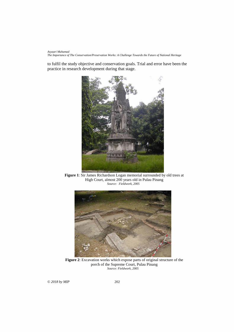
Asyaari Muhamad
The Importance of The Conservation/Preservation Works: A Challenge Towards the Future of National Heritage
© 2018 by MIP 202
to fulfil the study objective and conservation goals. Trial and error have been the
practice in research development during that stage.
Figure 1: Sir James Richardson Logan memorial surrounded by old trees at
High Court, almost 200 years old in Pulau Pinang Source: Fieldwork, 2005
Figure 2: Excavation works which expose parts of original structure of the
porch of the Supreme Court, Pulau Pinang Source: Fieldwork, 2005
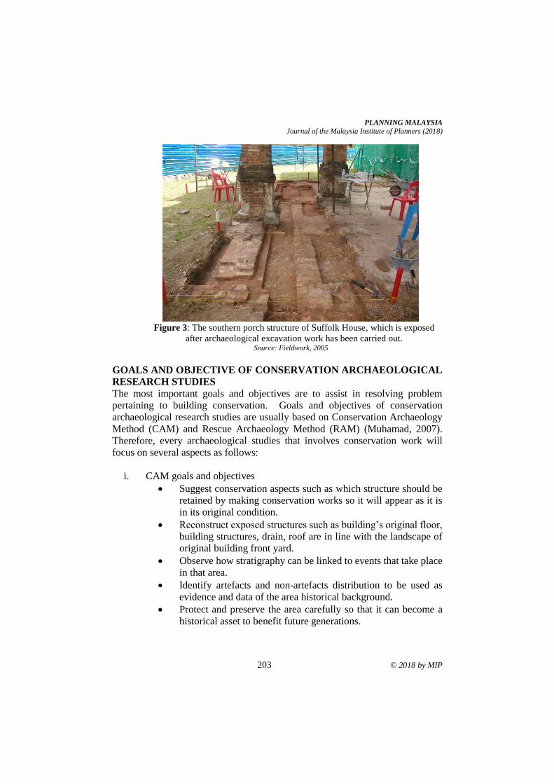
PLANNING MALAYSIA
Journal of the Malaysia Institute of Planners (2018)
203 © 2018 by MIP
Figure 3: The southern porch structure of Suffolk House, which is exposed
after archaeological excavation work has been carried out. Source: Fieldwork, 2005
GOALS AND OBJECTIVE OF CONSERVATION ARCHAEOLOGICAL
RESEARCH STUDIES
The most important goals and objectives are to assist in resolving problem
pertaining to building conservation. Goals and objectives of conservation
archaeological research studies are usually based on Conservation Archaeology
Method (CAM) and Rescue Archaeology Method (RAM) (Muhamad, 2007).
Therefore, every archaeological studies that involves conservation work will
focus on several aspects as follows:
i. CAM goals and objectives
• Suggest conservation aspects such as which structure should be
retained by making conservation works so it will appear as it is
in its original condition.
• Reconstruct exposed structures such as building’s original floor,
building structures, drain, roof are in line with the landscape of
original building front yard.
• Observe how stratigraphy can be linked to events that take place
in that area.
• Identify artefacts and non-artefacts distribution to be used as
evidence and data of the area historical background.
• Protect and preserve the area carefully so that it can become a
historical asset to benefit future generations.
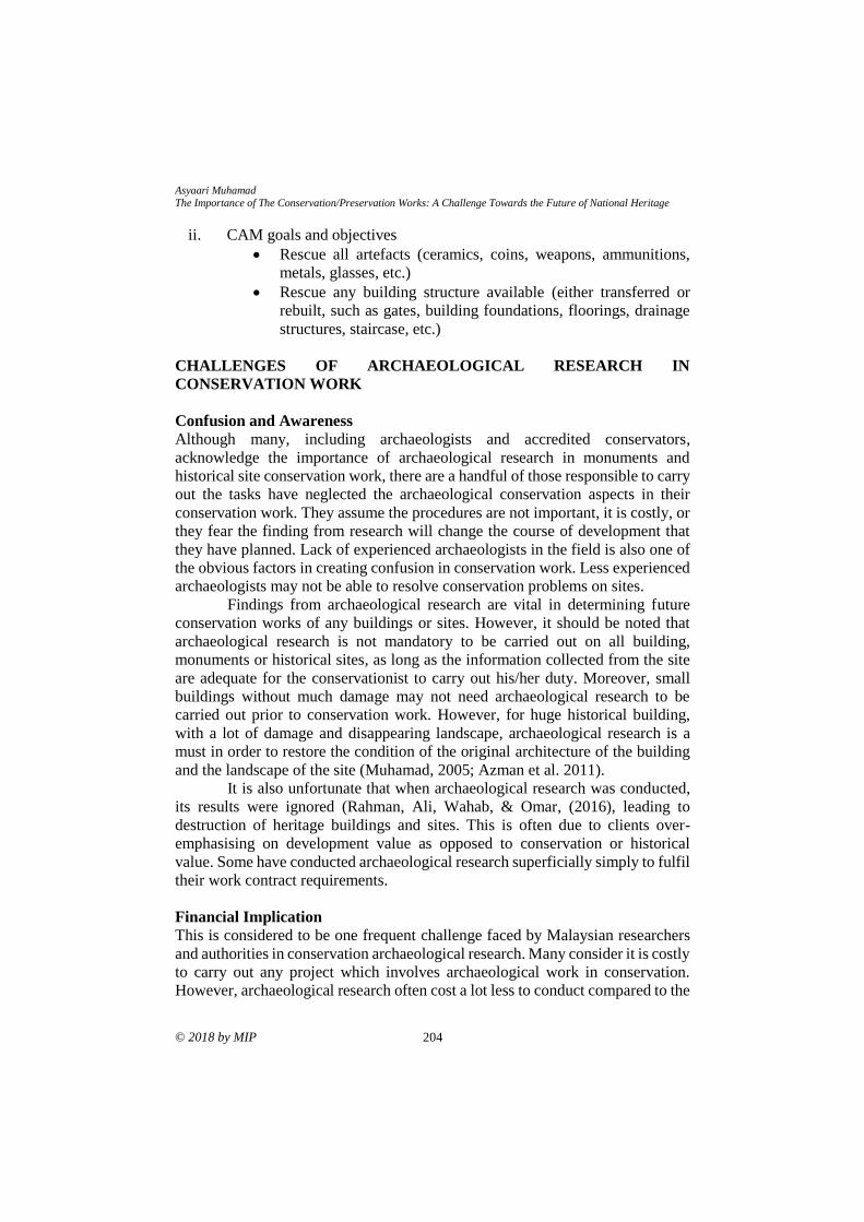
Asyaari Muhamad
The Importance of The Conservation/Preservation Works: A Challenge Towards the Future of National Heritage
© 2018 by MIP 204
ii. CAM goals and objectives
• Rescue all artefacts (ceramics, coins, weapons, ammunitions,
metals, glasses, etc.)
• Rescue any building structure available (either transferred or
rebuilt, such as gates, building foundations, floorings, drainage
structures, staircase, etc.)
CHALLENGES OF ARCHAEOLOGICAL RESEARCH IN
CONSERVATION WORK
Confusion and Awareness
Although many, including archaeologists and accredited conservators,
acknowledge the importance of archaeological research in monuments and
historical site conservation work, there are a handful of those responsible to carry
out the tasks have neglected the archaeological conservation aspects in their
conservation work. They assume the procedures are not important, it is costly, or
they fear the finding from research will change the course of development that
they have planned. Lack of experienced archaeologists in the field is also one of
the obvious factors in creating confusion in conservation work. Less experienced
archaeologists may not be able to resolve conservation problems on sites.
Findings from archaeological research are vital in determining future
conservation works of any buildings or sites. However, it should be noted that
archaeological research is not mandatory to be carried out on all building,
monuments or historical sites, as long as the information collected from the site
are adequate for the conservationist to carry out his/her duty. Moreover, small
buildings without much damage may not need archaeological research to be
carried out prior to conservation work. However, for huge historical building,
with a lot of damage and disappearing landscape, archaeological research is a
must in order to restore the condition of the original architecture of the building
and the landscape of the site (Muhamad, 2005; Azman et al. 2011).
It is also unfortunate that when archaeological research was conducted,
its results were ignored (Rahman, Ali, Wahab, & Omar, (2016), leading to
destruction of heritage buildings and sites. This is often due to clients over-
emphasising on development value as opposed to conservation or historical
value. Some have conducted archaeological research superficially simply to fulfil
their work contract requirements.
Financial Implication
This is considered to be one frequent challenge faced by Malaysian researchers
and authorities in conservation archaeological research. Many consider it is costly
to carry out any project which involves archaeological work in conservation.
However, archaeological research often cost a lot less to conduct compared to the
PLANNING MALAYSIA
Journal of the Malaysia Institute of Planners (2018)
205 © 2018 by MIP
cost of engaging conservationist and consultant. The fees of conservationist and
consultant are based on the value of the building, monument or site. At least 10%
to 15% of the total value are allocated to the consultant or conservationist. On the
other hand, archaeological research usually will only cost less than 5% of the total
conservation cost of the building. Thus, it is misleading for many to consider
archaeological research is expensive and hence to be omitted from conservation
work (Caple, 2000; Harun, Ariffin, & Abdullah, 2017).
Concerns over financial implication may also impede successful
archaeological research and conservation work. In the past, dispute has arisen
between archaeologist, conservationist and consultant in conservation project due
to consultant limiting the number of trenches on site due to additional cost that
will be incurred and for fear of discovering more relics that will hamper the
progress of the work. Thus, to avoid cases like this, it is helpful that the cost to
conduct archaeological research in devised as a lump sum figure rather than
itemised (Rahman, 2006).
Professional Expert and Skilled Worker
Presently, there is no body that oversee the practices of local archaeologists and
the award of professional recognition or accreditation to the archaeologists. The
number of archaeologist in Malaysia is rather small, and not all of them are
involved in conservation archaeology of buildings, monuments and historical
sites. Local archaeologists are involved in various archaeological fields such as
prehistoric, proto-historic and historic. Therefore, unlike other professions, it is
quite difficult to have a professional body that regulate and accredited the practice
of archaeological research in conservation works in Malaysia. Therefore, rather
than requiring local archaeologists to be ‘professionally recognised’, the
authorities should look at their specialisation, education and experience in
archaeological research when deciding on the eligibility of archaeologists to
conduct archaeological research in conservation project. The quality of their
previous research reports and having conducted studies that have led to practical
conservation solutions could also be part of the eligibility criteria of
archaeologists to conduct conservation archaeology projects (Muhamad, 2005;
Roslan, Ramli, Shin, Choy, & Razman, 2017).
The availability skilled workers is also paramount to ensure the success
of archaeological research, and ultimately the conservation project. Conservation
archaeological research requires several level of staff from the experts, and
technical staff including field director, supervisors, photographers, clerks and
general workers However, due to shortage of local skilled workers, it is common
in the field that labourers, especially foreign, are employed to assist in
archaeological research. These labourers are not experienced, much less skilled,
workers. Strict supervisions must be enforced on work by these labourers, such
as when digging, fearing some data may be destroyed.
Asyaari Muhamad
The Importance of The Conservation/Preservation Works: A Challenge Towards the Future of National Heritage
© 2018 by MIP 206
CONCLUSION AND RECOMMENDATION
Conservation archaeological research field in the country is still new, and it needs
a lot of reformations and improvements from all aspects. One such area is the
eligibility and experience of archaeologists to conduct conservation
archaeological research. The introduction of several initiatives like the ICOMS
Charter and the National Heritage Act 2005 have helped to improve the
credibility and importance of conservation archaeological research and
archaeologists. Nevertheless, a clear guideline on archaeological research in
conservation work must be prepared. The role played by archaeologists should
be specified and respected. Several recommendations are listed here for
implementation in order to fulfil the role of archaeologists and also for the interest
of all other parties:
i. The National Heritage Department to set up a committee to discuss and
prepare concept paper and guidelines on archaeological works regarding
conservation of old buildings and historical sites.
ii. Archaeological research must be carried out first before conservation
work takes place.
iii. Archaeological research team must be headed by an experienced
archaeologist.
iv. Since archaeological research are carried out by experts, payment made
must commensurate the fees paid to conservator or consultant.
v. Results from archaeological research must be evaluated by conservator
and not by consultant before being implemented in conservation works.
vi. Significant discoveries such as artefact, structures and natural
environment in historical sites or old building’s yard should be evaluated
for its significance in term of the building’s history, local or national
history. An exhibition space must be provided within the buildings so as
to exhibit artefacts discovered. If remains of the building on structures
that can be saved within a development area, it should be left in-situ as
foundation museum and as the lowest floor for construction starting from
second floor to the lowest floor. It can be the centre of attention to visitors
who visit the building.
REFERENCES Azman, N., Halim, S. A., Liu, O. P., & Komoo, I. (2011). The Langkawi Global Geopark:
Local community's perspectives on public education. International Journal of
Heritage Studies, 17(3), 261-279.
Caple, C. (2000). Conservation skills: Judgement, method and decision making. London:
Routledge.
Harun, N. Z. (2013). The challenges of historic public places in the development of
historic urban areas. In W. W. Choong, A. H. Mohammed, & M. T. S.
Mohammad (Eds), Non-structural environmental management (pp. 115-141).
Johor Bahru: UTM Press.

PLANNING MALAYSIA
Journal of the Malaysia Institute of Planners (2018)
207 © 2018 by MIP
Harun, N. Z., Ariffin, N. A. M., & Abdullah, F. (2017). Changes and threats in the
preservation of the traditional Malay landscape. Planning Malaysia, 15(4), 69-
78.
Harun, S. N. (2004). Amalan kerja pemuliharaan bangunan bersejarah di Malaysia
(Doctoral dissertation). Universiti Sains Malaysia, Malaysia.
Kassim, K. B. A. (2006, December). Konservasi pengenalan dan garis panduan terhadap
kerja-kerja pemuliharaan warisan. Kursus Konservasi Monumen & Tapak Tanah
Bersejarah. December 16-18, 2006, Pulau Pinang, Malaysia.
Muhamad, A. (2005). Ekskavasi arkeologi Padang Pahlawan di Melaka: Menggali
tamadun silam. MELAYU: Jurnal Antarabangsa Dunia Melayu, 4(2), 1-31
Muhamad, A. (2007). Kepentingan kajian arkeologi dalam kerja-kerja konservasi.
Bengkel Konsevasi Kali Pertama. Melaka.
Rahman, N. H. S. N. A. (2006). Kepentingan arkeologi dalam kerja konservasi monumen
dan tapak tanah bersejarah. Kursus Konservasi Monumen & Tapak Tanah
Bersejarah. December 16-18, 2006, Pulau Pinang, Malaysia.
Ramli, Z., Rahman, N. H. S. N. A., Ali, M. S. M., Wahab, M. R. A. & Omar, M. A.
(2016). Archaeological discoveries of 200BC coastal settlement in Pulau
Kelumpang, Matang, Perak. Social Sciences (Pakistan). 11(13), 3264-3270.
Renfrew, C., & Bahn, P. (1997). Archaeology: Theories, methods and practice. London:
Thames and Hudson.
Roslan, Z., Ramli, Z., Shin, C., Choy, E. A., & Razman, M. R. (2017). Local community
perception on the importance of cultural-natural heritage protection and
conservation: Case study in Jugra, Kuala Langat, Selangor, Malaysia. Journal
of Food, Agriculture and Environment, 15(2), 107-110
Received: 1st June 2018. Accepted:1st December 2018
1Assistant Professor at International Islamic University Malaysia. Email: [email protected] 208
PLANNING MALAYSIA:
Journal of the Malaysian Institute of Planners
VOLUME 16 ISSUE 4 (2018), Page 208 – 219
THE PHYSICAL CHARACTERISTICS OF THE ISLAMIC GARDEN
AND THE IMPORTANCE OF THE CONCEPT IN MALAYSIA
Haza Hanurhaza Md Jani1 & Nor Zalina Harun2
1Kulliyyah of Architecture and Environmental Design
INTERNATIONAL ISLAMIC UNIVERSITY MALAYSIA
2Institute of the Malay World and Civilisation
UNIVERSITI KEBANGSAAN MALAYSIA
Abstract
Islamic garden is a traditional garden concept that is significantly related to the
history of the Muslim civilization. The first establishment of the concept was in
the 7th century through the formation of the Persian Garden. Presently, the idea
of the Islamic garden is beginning to be overlooked as the contemporary garden
design is becoming a current trend. The situation has given a negative impact
towards the implementation of the traditional garden concept. This study is
conducted to identify the physical characteristics of the Islamic garden. The first
objective is to determine the chronology of the Islamic garden design and, second,
to categorize the physical characteristics of the garden according to the level of
its importance. Three types of methods are embedded in the study, which are the
document analysis, site study, and semi-structured interviews. The method of
analysing the data is using the Atlas.ti and Microsoft Excel software. The result
gathered are categorized into two important aspects: (1) the movement of the
Islamic garden concept in response to the history of the Muslim civilization and
(2) the list of the physical characteristic of the Islamic garden. The result is
triangulated as to develop an understanding on the list of the significant physical
characteristics of the Islamic garden that can be embedded as part of a garden
concept in Malaysia. Above and beyond that, the result includes a viewpoint from
the National Landscape Department (NLD) on the direction of a garden in
Malaysia pertaining to the Islamic garden concept. The input from the session is
perceived as necessary as to further develop an understanding of the current level
of adaptation of the Islamic garden concept, particularly in Malaysia.
Keywords: garden, Islamic garden, physical characteristics, Malaysia
PLANNING MALAYSIA:
Journal of the Malaysia Institute of Planners (2018)
© 2018 by MIP 209
INTRODUCTION
Islamic garden is recognized as the earthly garden of paradise (Brookes, 1987;
Ahmadi, 2014). The inspiration for the garden is according to the interpretation
of a garden in paradise based on the Al-Quran (Kausar, 2006). The description is
beautiful and overwhelms resulting the designers to create a garden as a
resemblance of the depiction. In the Al-Quran, garden is explained in a manner
that water and plants are the important elements shaping the garden (Ahmadi,
2014). In the early 5th century, during the pre-Islamic era, Persia is located in the
deserted area and hostile environment where the presence of water was limited
(Tajaddini, 2008; Ruggles, 2012). The arrival of Islam in the 6th century brought
along the new insight on the description of paradise by the Al-Quran. The Persian
garden was perceived as the result of the arrival of Islam in the country (Sanchez,
2008). The garden is regarded as the first establishment of the Islamic garden
throughout the history of the Muslim civilization. It is also acknowledged as the
basis for the following Islamic garden that occurs after the 7th century, such as
the Andalusian garden and the Mughal garden (Wescoat, 2011).
However, the adaptation of the Islamic garden concept has been
decreasing since the early the 21st century. There are several factors which have
influenced the decreasing number of the Islamic garden. Among them are the
interference of the modern movement and the deficiency in term of the physical
elements of the Islamic garden as well as the lack of appreciation towards the
traditional garden design (Brookes, 1987). Therefore, this study is conducted to
identify the physical characteristics of the Islamic garden based on three
prominent gardens, which are the Persian garden, the Andalusian garden and the
Mughal garden. Two objectives are outlined in the study. The first one is to
identify the chronology of the Islamic garden design. The second objective is to
categorize the physical characteristics of the garden according to the level of its
importance. The initiative to identify and document the physical characteristics
is perceived as a step to protect the Muslim legacy from disappearing and being
forgotten.
LITERATURE REVIEW
Faghih and Sadegby (2012) regarded the Islamic garden as a valuable historical
and cultural background that is closely related to the Muslim civilization. The
influences of the garden reaches the entire part of the world after the 19th century,
such as in the Royal Pavilion in Brighton, England (Petruccioli, 1998). The
acceptance and the adaptation of the concept were widely recognized by the
society. Due to the significant cultural influences, there are surviving Islamic
gardens that are being preserved and listed on the UNESCO World Heritage Site.
The garden is protected by the organization so as to preserve the original
condition and physical characteristics, which defined the Islamic garden, from
declining. The Alcazar palaces and the Alhambra in Spain are among the listed
Haza Hanurhaza Md Jani & Nor Zalina Harun The Physical Characteristics of The Islamic Garden and The Importance of The Concept in Malaysia
© 2018 by MIP 210
Islamic gardens under the World Heritage Site (Rostami, Lamit, Khoshnava,
Rostami, & Rosley, 2015; Md.Jani, Harun, Mansor, & Zen, 2018).
The early discovery of the Islamic garden occurs after the arrival of Islam
and the establishment of the first Islamic city-state, Medina in the 6th century.
According to Wescoat (2011), the Persian garden is perceived as the first creation
of the Islamic garden and it is considered as the earthy garden of paradise.
Brookes (1987) supports the idea as he stated the initial idea of the Persian garden
is related to the interpretation of a garden in the paradise as described by the Al-
Quran. In the Al-Quran, a true believer is promised with the highest reward and
the eternal happiness in the paradise (MacDougall & Ettinghausen, 1976). The
description of the paradise is described with the beautiful garden decorated with
abundant types of edible trees with an unlimited resource of the flowing water
(Brookes, 1987). The interpretation of the garden is portrayed exquisitely,
resulting designers to materialize the imaginary garden into a garden design.
Therefore, the Islamic garden is known as the “Earthly Garden of Paradise”
(Kausar, 2006; Faghih & Sadegby, 2012; Zakaria & Ramli, 2016).
Numerous researchers have discussed on the prominent Islamic garden
such as the Taj Mahal in the Mughal civilization, the Alhambra during the
Andalusian period and the well-known Fin Garden in Persia (Menocal,
Scheindlin, & Sells, 2000; Koch, 2005; Faghih & Sadegby, 2012). These gardens
have become the basis as well as the garden of reference concerning the Islamic
garden (Rostami et al., 2014). Throughout the chronology of the evolution of
Islamic garden, it is discovered that the physical characteristics of the garden
design play a big role in shaping the garden design. However, a study conducted
by Farahani, Motamed and Jamei (2016) discovered that there are several
modifications and improvement that have been made to expand the functions of
the garden as well as its utilizations. Although the characteristics may have
changed or altered through the evolution, nonetheless, the Islamic garden’s
philosophy remains the same. The garden evolves around similar philosophy,
which is the earthly garden of paradise (Ruggles, 2003; Ahmadi, 2014).
Islamic garden is closely associated with the symbol of paradise as the
word garden is often cited and described in the Quran. “Garden underneath which
rivers flow” is cited more than thirty times in the Al-Quran (Itani, 2014). Hence,
water is viewed as an ideal element for and Islamic garden. Other research
indicates that the basic physical characteristics of the Mughal garden are defined
in term of the layout and the elements. Kausar (2006) describes the basic layout
of a typical Mughal garden is designed in a geometrical pattern and the
chaharbagh or better known as the fourfold design. It is the straightforward
layout adapted from the traditional Persian garden design (Koch, 2005). The
layout of the garden in square or rectangular form following the chaharbagh
garden design. The spaces are divided into a smaller pattern and it can reach up
to sixteen from the original four-fold design (MacDougall & Ettinghausen, 1976;
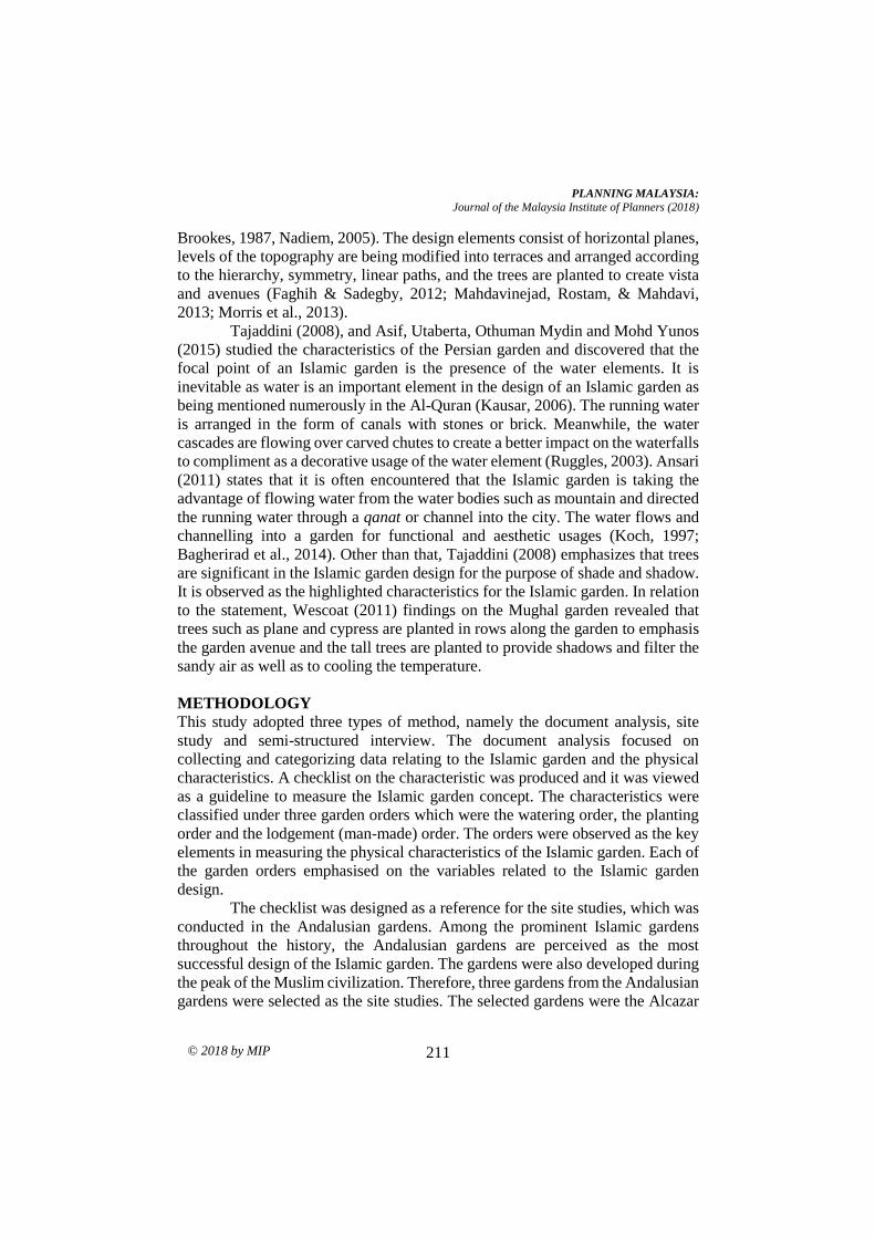
PLANNING MALAYSIA:
Journal of the Malaysia Institute of Planners (2018)
© 2018 by MIP 211
Brookes, 1987, Nadiem, 2005). The design elements consist of horizontal planes,
levels of the topography are being modified into terraces and arranged according
to the hierarchy, symmetry, linear paths, and the trees are planted to create vista
and avenues (Faghih & Sadegby, 2012; Mahdavinejad, Rostam, & Mahdavi,
2013; Morris et al., 2013).
Tajaddini (2008), and Asif, Utaberta, Othuman Mydin and Mohd Yunos
(2015) studied the characteristics of the Persian garden and discovered that the
focal point of an Islamic garden is the presence of the water elements. It is
inevitable as water is an important element in the design of an Islamic garden as
being mentioned numerously in the Al-Quran (Kausar, 2006). The running water
is arranged in the form of canals with stones or brick. Meanwhile, the water
cascades are flowing over carved chutes to create a better impact on the waterfalls
to compliment as a decorative usage of the water element (Ruggles, 2003). Ansari
(2011) states that it is often encountered that the Islamic garden is taking the
advantage of flowing water from the water bodies such as mountain and directed
the running water through a qanat or channel into the city. The water flows and
channelling into a garden for functional and aesthetic usages (Koch, 1997;
Bagherirad et al., 2014). Other than that, Tajaddini (2008) emphasizes that trees
are significant in the Islamic garden design for the purpose of shade and shadow.
It is observed as the highlighted characteristics for the Islamic garden. In relation
to the statement, Wescoat (2011) findings on the Mughal garden revealed that
trees such as plane and cypress are planted in rows along the garden to emphasis
the garden avenue and the tall trees are planted to provide shadows and filter the
sandy air as well as to cooling the temperature.
METHODOLOGY
This study adopted three types of method, namely the document analysis, site
study and semi-structured interview. The document analysis focused on
collecting and categorizing data relating to the Islamic garden and the physical
characteristics. A checklist on the characteristic was produced and it was viewed
as a guideline to measure the Islamic garden concept. The characteristics were
classified under three garden orders which were the watering order, the planting
order and the lodgement (man-made) order. The orders were observed as the key
elements in measuring the physical characteristics of the Islamic garden. Each of
the garden orders emphasised on the variables related to the Islamic garden
design.
The checklist was designed as a reference for the site studies, which was
conducted in the Andalusian gardens. Among the prominent Islamic gardens
throughout the history, the Andalusian gardens are perceived as the most
successful design of the Islamic garden. The gardens were also developed during
the peak of the Muslim civilization. Therefore, three gardens from the Andalusian
gardens were selected as the site studies. The selected gardens were the Alcazar
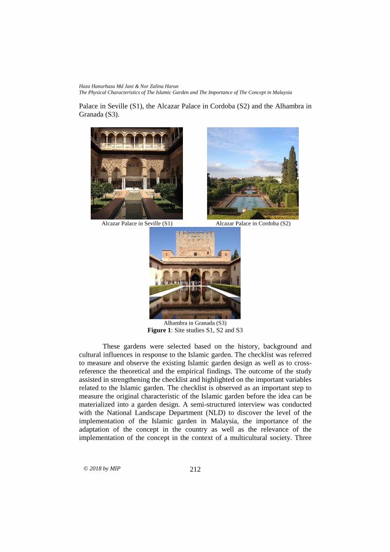
Haza Hanurhaza Md Jani & Nor Zalina Harun The Physical Characteristics of The Islamic Garden and The Importance of The Concept in Malaysia
© 2018 by MIP 212
Palace in Seville (S1), the Alcazar Palace in Cordoba (S2) and the Alhambra in
Granada (S3).
Alcazar Palace in Seville (S1) Alcazar Palace in Cordoba (S2)
Alhambra in Granada (S3)
Figure 1: Site studies S1, S2 and S3
These gardens were selected based on the history, background and
cultural influences in response to the Islamic garden. The checklist was referred
to measure and observe the existing Islamic garden design as well as to cross-
reference the theoretical and the empirical findings. The outcome of the study
assisted in strengthening the checklist and highlighted on the important variables
related to the Islamic garden. The checklist is observed as an important step to
measure the original characteristic of the Islamic garden before the idea can be
materialized into a garden design. A semi-structured interview was conducted
with the National Landscape Department (NLD) to discover the level of the
implementation of the Islamic garden in Malaysia, the importance of the
adaptation of the concept in the country as well as the relevance of the
implementation of the concept in the context of a multicultural society. Three
PLANNING MALAYSIA:
Journal of the Malaysia Institute of Planners (2018)
© 2018 by MIP 213
interviewees from the department were interviewed for the purpose of this study
under the code NLD1, NLD2 and NLD3.
RESULT AND DISCUSSIONS
This section highlights on two aspects. The movement of the Islamic garden
throughout the history of the Muslim civilization and the physical characteristics
of the garden based on three garden’s orders which are the watering order, the
planting order and the lodgment order. The result is supported by the semi-
structured interview conducted with the National Landscape Department. The
interview highlighted on three important factors, namely the level of the
implementation of the Islamic garden in Malaysia, the importance of the
adaptation of the concept in the country and the relevance of the implementation
of the concept in the context of a multicultural society. The result and discussion
are presented below.
Movement of Islamic Garden Concept in Response to the History of Muslim
Civilization
In tracing back the history of Islamic garden based on the chronology of the
Muslim civilization, it has been discovered that the movement of the Islamic
garden began in the 7th century through the establishment of the Persian garden.
Following the movement, there were another two notable Islamic gardens that
play a significant role in shaping the garden design, namely the Andalusian
garden and the Mughal garden. The Islamic garden received the
acknowledgement by the European culture in the 19th century. Later on, the
concept has been well accepted by many designers all over the region. However,
the downfall of the Islamic garden began in the early 20th century. The modern
movement has overshadowed most of the traditional garden concept and Islamic
garden was one of the affected gardens. The contemporary garden design has
started to become a must trend and its concept has been increasingly implemented
in the garden for the purpose of simplicity and elegance. The chronology of the
movement of Islamic garden concept is presented in Figure 2.
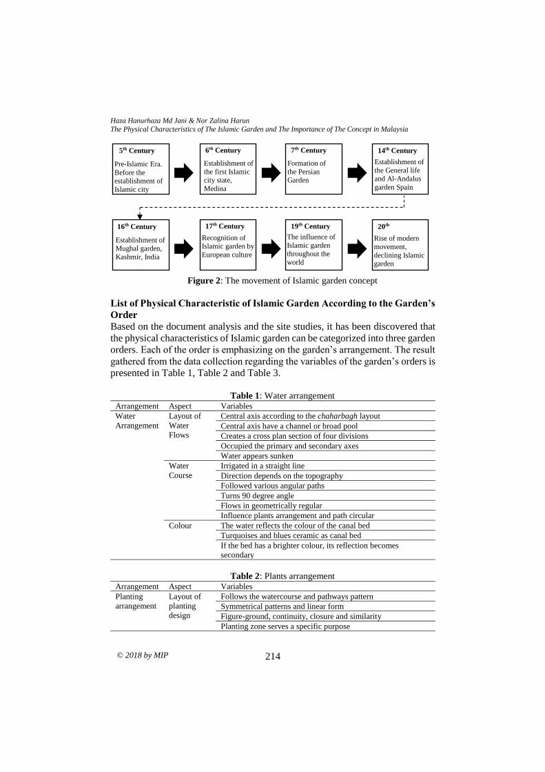
Haza Hanurhaza Md Jani & Nor Zalina Harun The Physical Characteristics of The Islamic Garden and The Importance of The Concept in Malaysia
© 2018 by MIP 214
Figure 2: The movement of Islamic garden concept
List of Physical Characteristic of Islamic Garden According to the Garden’s
Order
Based on the document analysis and the site studies, it has been discovered that
the physical characteristics of Islamic garden can be categorized into three garden
orders. Each of the order is emphasizing on the garden’s arrangement. The result
gathered from the data collection regarding the variables of the garden’s orders is
presented in Table 1, Table 2 and Table 3.
Table 1: Water arrangement
Arrangement Aspect Variables
Water
Arrangement
Layout of
Water
Flows
Central axis according to the chaharbagh layout
Central axis have a channel or broad pool
Creates a cross plan section of four divisions
Occupied the primary and secondary axes
Water appears sunken
Water
Course
Irrigated in a straight line
Direction depends on the topography
Followed various angular paths
Turns 90 degree angle
Flows in geometrically regular
Influence plants arrangement and path circular
Colour The water reflects the colour of the canal bed
Turquoises and blues ceramic as canal bed
If the bed has a brighter colour, its reflection becomes
secondary
Table 2: Plants arrangement Arrangement Aspect Variables
Planting
arrangement
Layout of
planting
design
Follows the watercourse and pathways pattern
Symmetrical patterns and linear form
Figure-ground, continuity, closure and similarity
Planting zone serves a specific purpose
20th
Century Rise of modern
movement,
declining Islamic garden
movement
19th Century
The influence of
Islamic garden
throughout the
world
17th Century
Recognition of Islamic garden by
European culture
Establishment of Mughal garden,
Kashmir, India
16th Century
14th Century
Establishment of
the General life and Al-Andalus
garden Spain
7th Century
Formation of
the Persian Garden
6th Century
Establishment of
the first Islamic city state,
Medina
Pre-Islamic Era.
Before the establishment of
Islamic city
5th Century
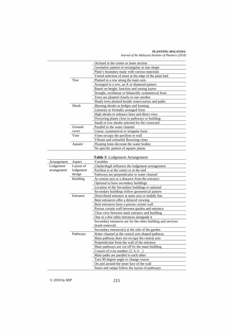
PLANNING MALAYSIA:
Journal of the Malaysia Institute of Planners (2018)
© 2018 by MIP 215
Orchard in the centre or inner section
Geometric pattern in rectangular or star-shape
Plant’s boundary made with various materials
Varied selection of plant at the edge of the plant bed
Tree Planted in a row along the main axis
Arranged in a row, an X or diamond pattern
Based on height, function and zoning layers
Straight, rectilinear or bilaterally symmetrical form
Trees are planted closely to one another
Shady trees planted beside watercourses and paths
Shrub Massing shrubs as hedges and framing
Linearity or formally arranged form
High shrubs to enhance lines and direct view
Flowering plants close to pathways or building
Small or low shrubs selected for the courtyard
Ground-
cover
Parallel to the water channel
Linear, symmetrical or irregular form
Vine Vines occupy the pavilion or wall
Vibrant and colourful flowering vines
Aquatic Floating lotus decorate the water bodies
No specific pattern of aquatic plants
Table 3: Lodgement Arrangement Arrangement Aspect Variables
Lodgement
arrangement
Layout of
lodgement
design
Chaharbagh influence the lodgement arrangement
Pavilion is at the centre or at the end
Pathways are perpendicular to water channel
Building At central axis or a distance from the entrance
Optional to have secondary buildings
Location of the Secondary buildings is optional
Secondary buildings follow geometrical pattern
Entrance Direct/bend entrance at main axis or middle line
Bent entrances offer a delayed viewing
Bent entrances have a porous curtain wall
Porous curtain wall between garden and entrance
Clear view between main entrance and building
One or a few other entrances alongside it
Secondary entrances are for the other building and services
(trash removal)
Secondary entrance(s) at the side of the garden
Pathways Water channel at the central axis shaped pathway
Main pathway does not occupy the central axis
Perpendicular from the wall of the entrance
Main pathways are cut off by the main building
Consist of even number (2, 4, 6…)
Main paths are parallel to each other
Turn 90 degree angle to change course
On and around the inner face of the wall
Stairs and ramps follow the layout of pathways
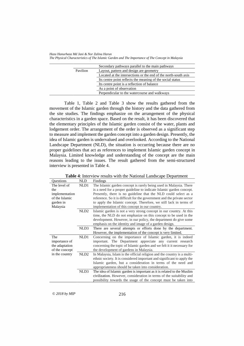
Haza Hanurhaza Md Jani & Nor Zalina Harun The Physical Characteristics of The Islamic Garden and The Importance of The Concept in Malaysia
© 2018 by MIP 216
Secondary pathways parallel to the main pathways
Pavilion Layout, pattern and design are geometry
Located at the intersections or the end of the north-south axis
Its centre point reflects the meaning of the social status
Its centre point is a reflection of balance
As a point of observation
Perpendicular to the watercourse and walkways
Table 1, Table 2 and Table 3 show the results gathered from the
movement of the Islamic garden through the history and the data gathered from
the site studies. The findings emphasize on the arrangement of the physical
characteristics in a garden space. Based on the result, it has been discovered that
the elementary principles of the Islamic garden consist of the water, plants and
lodgement order. The arrangement of the order is observed as a significant step
to measure and implement the garden concept into a garden design. Presently, the
idea of Islamic garden is undervalued and overlooked. According to the National
Landscape Department (NLD), the situation is occurring because there are no
proper guidelines that act as references to implement Islamic garden concept in
Malaysia. Limited knowledge and understanding of the concept are the main
reasons leading to the issues. The result gathered from the semi-structured
interview is presented in Table 4.
Table 4: Interview results with the National Landscape Department Questions NLD Findings
The level of
the
implementation
of the Islamic
garden in
Malaysia
NLD1 The Islamic garden concept is rarely being used in Malaysia. There
is a need for a proper guideline to indicate Islamic garden concept.
Presently, there is no guideline that the NLD could select as a
reference. So it is difficult for the government and the private sector
to apply the Islamic concept. Therefore, we still lack in terms of
implementation of this concept in our country.
NLD2 Islamic garden is not a very strong concept in our country. At this
time, the NLD do not emphasize on this concept to be used in the
development. However, in our policy, the department do give some
emphasis on the identity and image of a garden design.
NLD3 There are several attempts or efforts done by the department.
However, the implementation of the concept is very limited.
The
importance of
the adaptation
of the concept
in the country
NLD1 Concerning on the importance of Islamic garden, it is indeed
important. The Department appreciate any current research
concerning the topic of Islamic garden and we felt it it necessary for
the development of gardens in Malaysia.
NLD2 In Malaysia, Islam is the official religion and the country is a multi-
ethnic society. It is considered important and significant to apply the
Islamic garden, but a consideration in terms of the need and
appropriateness should be taken into consideration.
NLD3 The idea of Islamic garden is important as it is related to the Muslim
civilization. However, consideration in terms of the suitability and
possibility towards the usage of the concept must be taken into
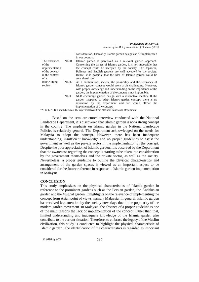
PLANNING MALAYSIA:
Journal of the Malaysia Institute of Planners (2018)
© 2018 by MIP 217
consideration. Then only Islamic garden design can be implemented
in our country.
The relevance
of the
implementation
of the concept
in the context
of a
multicultural
society
NLD1 Islamic garden is perceived as a relevant garden approach.
Concerning the values of Islamic garden, it is not impossible that
the concept could be accepted by the society. The Japanese,
Balinese and English gardens are well accepted by the society.
Hence, it is possible that the idea of Islamic garden could be
considered too.
NLD2 As a multicultural society, the possibility and the relevancy of
Islamic garden concept would seem a bit challenging. However,
with proper knowledge and understanding on the importance of the
garden, the implementation of the concept is not impossible.
NLD3 NLD encourage garden design with a distinctive identity. If the
garden happened to adapt Islamic garden concept, there is no
restriction by the department and we would allowe the
implementation of the concept. *NLD 1, NLD 2 and NLD 3 are the representatives from National Landscape Department
Based on the semi-structured interview conducted with the National
Landscape Department, it is discovered that Islamic garden is not a strong concept
in the country. The emphasis on Islamic garden in the National Landscape
Policies is relatively general. The Department acknowledged on the needs for
Malaysia to adopt the concept. However, there has been inadequate
understanding, insufficient knowledge and no proper guidelines to assist the
government as well as the private sector in the implementation of the concept.
Despite the poor appreciation of Islamic garden, it is observed by the Department
that the awareness regarding the concept is starting to be taken into consideration
by the government themselves and the private sector, as well as the society.
Nevertheless, a proper guideline to outline the physical characteristics and
arrangement of the garden spaces is viewed as an important aspect to be
considered for the future reference in response to Islamic garden implementation
in Malaysia.
CONCLUSION
This study emphasizes on the physical characteristics of Islamic garden in
reference to the prominent gardens such as the Persian garden, the Andalusian
garden and the Mughal garden. It highlights on the relevance of implementing the
concept from Asian point of views, namely Malaysia. In general, Islamic garden
has received less attention by the society nowadays due to the popularity of the
modern garden movement. In Malaysia, the absence of a proper guideline is one
of the main reasons the lack of implementation of the concept. Other than that,
limited understanding and inadequate knowledge of the Islamic garden also
contribute to the current situation. Therefore, to embrace the legacy of the Muslim
civilization, this study is conducted to highlight the physical characteristic of
Islamic garden. The identification of the characteristics is regarded as important
Haza Hanurhaza Md Jani & Nor Zalina Harun The Physical Characteristics of The Islamic Garden and The Importance of The Concept in Malaysia
© 2018 by MIP 218
to encourage Islamic garden concept implementation. Based on the findings, it
has been discovered that water and plants are the main characteristics that are
significantly related to the Islamic garden. The two elements are repeatedly
mentioned in the Al-Quran. The findings also provide a guiding principle which
includes the garden elements as well as the arrangement in response to Islamic
garden concept. It is hoped that the checklist could be viewed as a reference
concerning the implementation of Islamic garden in Malaysia.
ACKNOWLEDGEMENT
The authors would like to express their sincere gratitude to the Ministry of Higher
Education Malaysia (MOHE) support of this research. This research is funded by
the Fundamental Research Grant Scheme (FRGS), research project code FRGS
15-193-0434.
REFERENCES Ahmadi, M. (2014). Exploring the impact of religious and pre-Islamic Persian Gardens
in the creation of Chahar Bagh Avenue, Isfahan. In M. Hoxley, & A. Crabbe
(Eds), CADBE Doctoral Student Conference: 2014 Proceedings (pp. 4-17).
Nottingham: Nottingham Trent University.
Ansari, N. (2011). Origin of Islamic garden. Retrieved July 5, 2015, from
http://www.academia.edu/1861364/Origin_of_Islamic_Gardens
Asif, N., Utaberta, N., Othuman Mydin, M. A., & Mohd Yunos, M. Y. (2015). Redefining
Islamic garden: Comparative analysis of approaches, ideas and design
framework. Jurnal Teknologi, 75(9), 77-81.
Bagherirad, E., Ahmad, N., Amirkhani, M., Abdullah, M., Mesdaghi, M., & Kabudi, A.
(2014). Seasonal habitat use of Persian Gazelles (Gazella subgutturosa
subgutturosa) based on vegetation parameters at Golestan National Park, Iran.
Arid Land Research and Management, 28(4), 464-484.
Brookes, J. (1987). Gardens of paradise: The history and design of the great Islamic
gardens. New York: New Amsterdam.
Faghih, N., & Sadeghy, A. (2012). Persian gardens and landscapes. Architectural Design,
82(3), 38-51.
Farahani, L. M., Motamed, B., & Jamei, E. (2016). Persian gardens: Meaning, symbolism,
and design. Landscape Online LO, 1-19.
Itani, T. (2014). The Quran. Dallas: ClearQuran.
Kausar, S. (2005). Meaning of Mughal landscape. 10th International Seminar on Cultural
Landscapes in the 21st Century. April 11-15, Newcastle UK.
Koch, E. (2005). The Taj Mahal: Architecture, symbolism, and urban significance.
Muqarnas Online, 22(1), 128-149.
MacDougall, E. B., & Ettinghausen, R. (1976). The Islamic garden. Washington:
Dumbarton Oaks, Trustees for Harvard University.
Mahdavinejad, M., Rostam, N. G., & Mahdavi, S. (2013). The role of the Gestalt Theory
in understanding persian architectural masterpieces. Case study: Fin Garden of
Kashan. International Journal of Management and Sustainability, 2(1), 1-13.
PLANNING MALAYSIA:
Journal of the Malaysia Institute of Planners (2018)
© 2018 by MIP 219
Md.Jani, H. H., Harun, N. Z., Mansor, M., & Zen, I. (2018) A review on the values of the
Islamic garden in response to a garden design in Malaysia. In B. McLellan (Ed.),
Sustainable future for human security (pp. 251-261). Singapore: Springer.
Menocal, M. R., Scheindlin, R. P., & Sells, M. A. (2000). The literature of Al-Andalus.
New York: Cambridge University Press.
Morris, K. I., Chan, A., Morris, K. J. K., Ooi, M. C. G., Oozeer, M. Y., Abakr, Y. A., ...
& Al-Qrimli, H. F. (2017). Impact of urbanization level on the interactions of
urban area, the urban climate, and human thermal comfort. Applied Geography,
79, 50-72.
Nadiem, I. H. (2005). Gardens of Mughal Lahore. Lahore: Sang-e-Meel Publications.
Petruccioli, A. (1998). Rethinking the Islamic garden. In J. Coppock, & J. Miller (Eds.),
Transformation of Middle Eastern natural environment: Legacies and lessons
(pp. 349-363). New Haven: Yale University Press.
Ruggles, F. (2003). The Framed Landscape in Islamic Spain and Mughal India. In B. J.
Day (Ed.), The garden: Myth, meaning, and metaphor (pp. 21-50). Windsor,
Ont.: Humanities Research Group, University of Windsor.
Ruggles, F. (2012). The earliest surviving Islamic garden: The courtyard of the Great
Mosque of Cordoba. Manzar: The Iranian Scientific Journal of Landscape,
4(19), 95.
Rostami, R., Lamit, H., Khoshnava, S. M., Rostami, R., & Rosley, M. S. F. (2015).
Sustainable Cities and the Contribution of Historical Urban Green Soaces: A
Case Study of Historical Persian Gardens. Sustainability, 7(10), 13290-13316.
Sanchez, G. (2008). Utility and aesthetics in the gardens of An-Andalus: Species with
multiple uses. In P. Dendle, & A. Touwaide (Eds.), Health and healing from the
medieval garden (pp. 205-207). Woodbridge: The Boydell Press.
Tajaddini, L. (2008, June). Investigating the characteristics of Persian gardens: Taking a
close look at Mahan Shah Zadeh garden. Geo-Environment and Landscape
Evolution 2008. June 16-18, 2008. The New Forest, UK.
Wescoat, J. L. (2011). Architecture in Islamic arts: Treasures of the Aga Khan Museum.
Geneva: Aga Khan Trust for Culture.
Zakaria, R. M. A., & Ramli, Z. (2016). Significance of garden design decoration in
Islamic bookbinding. Islamic Quarterly, 60(4), 529-545.
Received: 1st June 2018. Accepted:1st December 2018
PLANNING MALAYSIA
Journal of the Malaysia Institute of Planners (2020)
193 © 2020 by MIP
NOTES TO CONTRIBUTORS AND GUIDELINES FOR MANUSCRIPT
SUBMISSION
INTRODUCTION
The Journal of the Malaysian Institute of Planners or PLANNING MALAYSIA is a
multidisciplinary journal related to theory, experiments, research, development,
applications of ICT, and practice of planning and development in Malaysia and
elsewhere.
The objective of the journal is to promote the activity of town planning through dialogue
and exchange of views concerning professional town planning practice. PLANNING
MALAYSIA will welcome any news, feature articles, or peer reviewed (including book
reviews, software review, etc.) articles for publication. All articles should be original
work by the authors. Articles, views and features will not be taken to be the official
view of the Malaysian Institute of Planners (MIP) unless it carries the name of MIP
as the author. This is to encourage open discussion on diverse issues and opinion for the
advancement of town planning practice. Articles and contributions will be accepted from
MIP members and non-members worldwide.
In year 2010, PLANNING MALAYSIA Journal has been indexed in SCOPUS. Previous
issues of PLANNING MALAYSIA Journal can be viewed on the MIP website.
SUBMISSION OF MANUSCRIPTS
Manuscript should be emailed to [email protected]. Manuscript should ideally be
in the range of 8-10 pages long. Each manuscript should have a title page and an abstract
of about 150 words. The title page should contain the title, full name(s), designation(s),
organizational affiliation(s), a contact address, and an email address. All manuscripts are
received on the understanding that they are not under concurrent consideration at another
journal. Exclusive copyright of accepted manuscripts shall be assigned to the Publisher
(i.e. the MIP), and in consideration for this, one copy of the current Journal will be
provided for each article. Additional reprints of article can be ordered, at cost, by the
author(s). PDF format of the article (if available) can be obtained from the Publisher.
LAYOUT
Manuscript should be typed in single spacing (including footnotes, endnotes and
references) on one side of the paper only (preferably A4) with the following margins:
right and left - 4.25 cm, top - 5.5 cm and bottom - 5.2 cm (including header – 4.5 cm and
footer – 4.3 cm) in 11 point Times New Roman font. Footnotes should be numbered
consecutively and placed at the end of the manuscript. Footnotes should be kept to a
minimum. Tables and diagrams should be provided in the text. References should follow
the APA (6th Edition) referencing format. All foreign words must be typed and
transliterated. The Editorial Board reserves the right to change the transliteration of all
historical names, titles and non-English terminology to bring them into conformity with
its own style.

Guidelines
© 2020 by MIP 194
USE OF FORMULA, FIGURES AND TABLES
Formula (mathematical formula) should be used only when necessary and the
CONCLUSION derived must be explained and made intelligible to a non-mathematical
reader. Wherever possible, authors are encouraged to place the mathematical parts of the
article in an appendix. In cases of empirical articles, authors are expected to make readily
available a complete set of data and any specialized computer programs to interested
readers.
All illustrations, figures and/or tables in the manuscript must be captioned, in clear black
and white (grayscale) and ready for reproduction.
REFEREEING PROCEDURE
Manuscripts will be acknowledged upon receipt. Only selected (preferred) manuscripts
will be reviewed by two (or three) referees in addition to the editors. Editorial decision
will normally be made within two to six months, but circumstances beyond control
occasionally dictate a longer cycle. If authors are invited to prepare a revision for further
consideration, the major issues to be resolved will be outlined and will be forwarded to
them as quickly as possible.
ACCEPTED ARTICLES
Authors of accepted articles will be requested to provide a digital copy of the manuscript,
preferably in Microsoft Word to the MIP (the Publisher) via email at
[email protected]. MIP will not be responsible for the loss or damage of the digital
copy.
COPYRIGHT
Copyright & Creative Commons Licence
eISSN: 0128-0945 © Year. The Authors. Published for Malaysia insititute of planner.
This is an open-access article under the CC BY-NC-ND license.
The authors hold the copyright without restrictions and also retain publishing rights
without restrictions.
Contact:
Editor-in-Chief
PLANNING MALAYSIA
Journal of the Malaysian Institute of Planners
B-01-02, Jalan SS7/13B, Aman Seri, Kelana Jaya,
47301, Petaling Jaya, Selangor Darul Ehsan, MALAYSIA
Tel: +603 78770637 Fax: +603 78779636
Email: [email protected]
Homepage: www.planningmalaysia.org
***
PLANNING MALAYSIA
Journal of the Malaysia Institute of Planners (2020)
195 © 2020 by MIP
ETHIC STATEMENT
The Journal of the Malaysia Institute of Planners or PLANNING MALAYSIA is a peer-
reviewed journal. This statement spells out ethical behaviour of all parties involved in the
act of publishing an article for this journal, i.e. the author, the peer-reviewer, the chief
editor and editors, and the publisher. This statement is based on COPE’s Best Practice
Guidelines for Journal Editors. URL: http://publicationethics.org/files/u2
/Best_Practice.pdf
DUTIES OF AUTHORS
Reporting Standards
Authors of original research should present an accurate account of the work done as well
as an objective discussion of its significance. Data of the research should be represented
accurately in the article. An article should contain sufficient detail and references to
permit others to replicate the work. Fraudulent or knowingly inaccurate statements
constitute unethical behaviour and are unacceptable.
Data Access and Retention
Authors may be asked to provide the raw data in connection with an article submitted for
editorial review, and should be prepared to provide public access to such, if practicable,
and should in any event be prepared to retain such data for a reasonable time after
publication.
Originality and Plagiarism
Authors should ensure that they have written entirely original works, and if the authors
have used the work and/or words of others this must be appropriately cited or quoted.
Such quotations and citations must be listed in the Reference at the end of the article.
Multiple Publication
An author should not in general publish manuscripts describing essentially the same
research in more than one journal or primary publication. Submitting the same manuscript
to more than one journal concurrently constitutes unethical publishing behaviour and is
unacceptable.
Acknowledgment of Sources
Proper acknowledgment of the work of others must always be given. Authors should cite
publications that have been influential in determining the nature of the reported work.
Authorship of the Paper
Authorship should be limited to those who have made a significant contribution to the
conception, design, execution, or interpretation of the study, and should be listed as co-
authors. Others who have participated in certain substantive aspects of the research
project, they should be acknowledged or listed as contributors.

Ethic Statement
© 2020 by MIP 196
Corresponding Author
Corresponding author is the author responsible for communicating with the journal for
publication. The corresponding author should ensure that all appropriate co-authors and
no inappropriate co-authors are included on the paper. All co-authors have seen and
approved the final version of the paper and have agreed to its submission for publication.
Acknowledgment of Funding Sources
Sources of funding for the research reported in the article should be duly acknowledged
at the end of the article.
Disclosure and Conflicts of Interest
All authors should disclose in their manuscript any financial or other substantive conflict
of interest that might be construed to influence the results or interpretation of their
manuscript.
Fundamental Errors in Published Works
When an author discovers a significant error or inaccuracy in his/her own published work,
it is the author’s obligation to promptly notify the journal editor or publisher and
cooperate with the editor to retract or correct the paper.
DUTIES OF REVIEWERS
Contribution of Peer Review
Peer review assists the chief editor and the editorial board in making editorial decisions
while editorial communications with the author may also assist the author in improving
the paper.
Unqualified to Review or Promptness
Any reviewer who feels unqualified to review the assigned manuscript or unable to
provide a prompt review should notify the editor and excuse himself/herself from the
review process.
Confidentiality
Manuscripts received for review must be treated as confidential documents. They must
not be shown to, or discussed with, others except as authorized by the chief editor.
Privileged information or ideas obtained through peer review must be kept confidential
and not used for personal advantage.
Standards of Objectivity
Reviews should be conducted objectively. There shall be no personal criticism of the
author. Reviewers should express their views clearly with supporting arguments.
Acknowledgment of Sources
Reviewers should identify relevant published work that has not been cited by the authors.
Any statement that had been previously reported elsewhere should be accompanied by
the relevant citation. A reviewer should also call to the chief editor's attention any

PLANNING MALAYSIA
Journal of the Malaysia Institute of Planners (2020)
197 © 2020 by MIP
substantial similarity or overlap between the manuscript under consideration and any
other published paper of which they have personal knowledge.
Conflict of Interest
Reviewers should decline to review manuscripts in which they have conflicts of interest
resulting from competitive, collaborative, or other relationships or connections with any
of the authors.
DUTIES OF EDITORS
Decision on the Publication of Articles
The chief editor of the PLANNING MALAYSIA is responsible for deciding which of the
articles submitted to the journal should be published. The chief editor may be guided by
the policies of the journal's editorial board subjected to such legal requirements regarding
libel, copyright infringement and plagiarism. The chief editor may confer with other
editors or reviewers in making this decision.
Fair play
Manuscripts shall be evaluated solely on their intellectual merit.
Confidentiality
The chief editor/editors and any editorial staff must not disclose any information about a
submitted manuscript to anyone other than the corresponding author, reviewers, potential
reviewers, other editorial advisers, and the publisher.
Disclosure and Conflicts of Interest
Unpublished materials disclosed in a submitted manuscript must not be used by anyone
who has a view of the manuscript while handling it in his or her own research without the
express written consent of the author

© 2018 by MIP 225