Planning & Development Services Committee Meeting Agenda
233
Planning & Development Services Committee Meeting Agenda August 1, 2019 4:00 pm Members: Director Reinhardt (Chair), Director McCormick (Vice Chair), Director Gay, Director Doehle, Director Sosnowski, Director Walter, Director Clovechok, Director Wilkie, Director Pratt, Director Graham, Director Qualizza, Director Miller, Director Sterzer, Director Wilks Who Votes Count 1. Call to Order 2. Addition of Late Items 3. Adoption of the Agenda 4. Adoption of the Minutes 4.1 July 4, 2019 Meeting 5. Delegations 5.1 Richard Haworth re: Doehle ALR Exclusion Application – item 9.2.1 5.2 Hans Plechinger re: 310613 BC Ltd. (Three Bars Ranch) ALR Non-Adhering Residential Use Application – item 9.2.2 5.3 Barry Stuart re: DVP No. 26-19 – item 9.3.2 5.4 Richard Haworth re: DVP No. 28-19– item 9.3.4 5.5 Wendy Booth re: DVP No. 29-19 – item 9.3.5 5.6 Doug Feely re: Liquor Licencing Application – Island Lake Lodge – item 9.6.2 6. Correspondence 6.1 ALC Decisions 6.1.1 ALC Application #57297 – Block Inclusion Application Referral 6.1.2 Lizard Creek Road / Ministry of Transportation ALR Non-Farm Use 6.1.3 North of Sparwood / Foothills Silva Culture Inc. ALR Non-Farm Use 6.2 Mine Referral 6.2.1 Placer Lease – Merklin Resources Inc. / Wildhorse River, northeast of Fort Steele Voting Rules Unless otherwise indicated on this agenda, all Directors except the Director representing the District of Elkford have one vote and a simple majority is required for a motion to pass.
-
Upload
khangminh22 -
Category
Documents
-
view
1 -
download
0
Transcript of Planning & Development Services Committee Meeting Agenda

Planning & Development Services Committee Meeting Agenda
August 1, 2019 4:00 pm
Members: Director Reinhardt (Chair), Director McCormick (Vice Chair), Director Gay, Director Doehle,
Director Sosnowski, Director Walter, Director Clovechok, Director Wilkie, Director Pratt, Director Graham, Director Qualizza, Director Miller, Director Sterzer, Director Wilks
Who Votes Count
1. Call to Order 2. Addition of Late Items 3. Adoption of the Agenda 4. Adoption of the Minutes
4.1 July 4, 2019 Meeting
5. Delegations 5.1 Richard Haworth re: Doehle ALR Exclusion Application – item 9.2.1 5.2 Hans Plechinger re: 310613 BC Ltd. (Three Bars Ranch) ALR Non-Adhering
Residential Use Application – item 9.2.2 5.3 Barry Stuart re: DVP No. 26-19 – item 9.3.2
5.4 Richard Haworth re: DVP No. 28-19– item 9.3.4 5.5 Wendy Booth re: DVP No. 29-19 – item 9.3.5
5.6 Doug Feely re: Liquor Licencing Application – Island Lake Lodge – item 9.6.2
6. Correspondence
6.1 ALC Decisions 6.1.1 ALC Application #57297 – Block Inclusion Application Referral 6.1.2 Lizard Creek Road / Ministry of Transportation ALR Non-Farm Use 6.1.3 North of Sparwood / Foothills Silva Culture Inc. ALR Non-Farm Use
6.2 Mine Referral 6.2.1 Placer Lease – Merklin Resources Inc. / Wildhorse River, northeast of Fort
Steele
Voting Rules Unless otherwise indicated on this agenda, all Directors except the Director representing the District of Elkford have one vote and a simple majority is
required for a motion to pass.

Agenda Page 2 Planning & Development Services Committee Meeting August 1, 2019
6.3 Miscellaneous 6.3.1 Planning & Development Services August 2019 Board Report 6.3.2 Information Report – Kootenay & Boundary Regional Adaptation
Strategies
7. Advisory Commissions 7.1 APC Minutes
7.1.1 Area A – July 16, 2019 7.1.2 Area B – July 17, 2019 7.1.3 Area C – July 11, 2019 7.1.4 Areas F & G – July 16, 2019
8. Unfinished Business 8.1.1 Area A – Ministry of Forests, Lands, Natural Resource Operations and
Rural Development: Recreation Sites & Titles Branch Crown Land Application for a Designated Use Area
9. New Business 9.1 Bylaw Amendments 9.2 ALR Applications
9.2.1 Baynes Lake / Doehle ALR Exclusion Application 9.2.2 Wycliffe / 310613 BC Ltd. (Three Bars Ranch) ALR Non-Adhering
Residential Use Application
9.3 Development Variance Permit Applications 9.3.1 DVP No. 25-19 Jim Smith Lake / Passey 9.3.2 DVP No. 26-19 Fernie Alpine Resort / Barry Stuart Realty Inc. 9.3.3 DVP No. 27-19 Monroe Lake Road / Pickering 9.3.4 DVP No. 28-19 Fernie Alpine Resort / Polar Peak Properties Inc. 9.3.5 DVP No. 29-19 Fairmont Hot Springs / Hemsing
9.4 Temporary Use Permit Applications 9.5 Ministry of Forests, Lands, Natural Resource Operations and Rural
Development Referrals 9.5.1 Area B – Koocanusa Recreation Steering Committee Crown Land
Application to Establish & Maintain a Recreation Area in the Dorr / Grasmere Area
9.5.2 Area C – Bombardier Crown Land Application for Specific Permission for an Existing Private Residential Dock on Moyie Lake

Agenda Page 3 Planning & Development Services Committee Meeting August 1, 2019
9.6 Miscellaneous Items 9.6.1 Request for Exemption from Providing a Professional Report – Friedley 9.6.2 Liquor Licencing Application – Island Lake Lodge
10. Late Agenda Items 11. Adjournment

MINUTES OF THE REGIONAL DISTRICT OF EAST KOOTENAY PLANNING & DEVELOPMENT SERVICES COMMITTEE MEETING HELD AT THE REGIONAL DISTRICT OFFICE IN CRANBROOK BC ON JULY 4, 2019
PRESENT Committee Chair Clara Reinhardt Village of Radium Hot Springs Director Mike Sosnowski Electoral Area A Director Stan Doehle Electoral Area B Board Chair Rob Gay Electoral Area C Director Jane Walter Electoral Area E Director Susan Clovechok Electoral Area F Director Gerry Wilkie Electoral Area G Director Lee Pratt City of Cranbrook Director Wesly Graham City of Cranbrook Director Don McCormick City of Kimberley Director Ange Qualizza City of Fernie Director David Wilks District of Sparwood Director Karl Sterzer Village of Canal Flats Director Allen Miller District of Invermere
OTHERS PRESENT Shawn Tomlin Chief Administrative Officer Andrew McLeod Planning & Development Services Manager Shannon Moskal Corporate Officer Rhiannon Chippett Planning Assistant (Recording Secretary)
Committee Chair Clara Reinhardt called the meeting to order at 3:02 pm.
ADOPTION OF THE AGENDA
MOVED by Director Wilkie Agenda SECONDED by Director Gay
THAT the agenda for the Planning & Development Services Committee meeting be adopted.
CARRIED
ADOPTION OF THE MINUTES
MOVED by Director Miller Minutes SECONDED by Director Sterzer
THAT the Minutes of the Planning & Development Services Committee meeting held on June 6, 2019 be adopted as circulated.
CARRIED DELEGATIONS
Shannon Kramer, spoke to her application requesting an amendment to the Elk Valley Zoning Bylaw to permit two dwellings on her property located at 797 Hartley Creek Road, north of Fernie. Mrs. Kramer explained that she would be willing to register a covenant stating that the secondary dwelling is for immediate family only and that it would be a manufactured home for her daughter and partner to live in.
Jean Terpsma, agent for Charlotte Marshall and Cameron Beaudry, made a presentation and requested an amendment to the Panorama Mountain Village OCP to support auxiliary dwelling units within the original Panorama Village single-family subdivision. Mrs. Terpsma explained the need for affordable housing and housing for employees in Panorama, and clarified that her request would not be for blanket permission but on a case by case basis and only provided dwellings have suitable parking and connectivity to water and sewer to support the secondary suite.
4.1

PLANNING & DEVELOPMENT SERVICES COMMITTEE July 4, 2019 MINUTES PAGE 2
DELEGATIONS (continued) Jeremy Traverse, spoke to his application to amend the Upper Columbia Valley Zoning Bylaw to construct a new full-service automotive repair facility at 4847 Selkirk Avenue in Edgewater. Mr. Traverse explained the existing buildings will be removed and a new 40’ x 60’ building will be constructed and insulated for noise reduction and that outdoor lighting will be downcast for minimal light pollution. Dan Ayars, spoke to his ALR application for a five lot subdivision at 1643 Dicken Road, north of Fernie. Mr. Ayars explained that two of the proposed parcels are currently used in farm operations which would continue, and that the other three parcels which lack agricultural capability would be sold. Richard Haworth, agent for Bad Toro Properties Inc., made a presentation and requested a development variance permit to waive provision of water and sewer services for three proposed lots resulting from a boundary adjustment subdivision. Mr. Haworth explained that no new lots are being created at this time, and a restrictive covenant will be registered and ensure proof of servicing prior to development of any building or structures. Dahlen Sabey, spoke on behalf of the Goulding, Evans, Leaney and Sabey Licence of Occupation application to amend an existing private moorage tenure for a recreational dock on the northeast shore of Tie Lake. Mr. Sabey explained that the existing dock currently accommodates two boats, but as there are four lots associated with the private group moorage tenure, they would like to expand the dock to accommodate four boats, one per lot. NEW BUSINESS
48600 MOVED by Director Sosnowski Bylaw No. 2932 SECONDED by Director Qualizza Introduced
THAT Bylaw No. 2932 cited as “Regional District of East Kootenay – Elk Valley Zoning Bylaw No. 829, 1990 – Amendment Bylaw No. 93, 2019 (Dicken Road / Kramer)” be introduced; and further, that a development agreement containing the item identified in the staff report be registered on title prior to bylaw adoption.
CARRIED
48601 MOVED by Director Clovechok Bylaw No. 2933 SECONDED by Director Gay Introduced
THAT Bylaw No. 2933 cited as “Regional District of East Kootenay – Panorama Mountain Village Official Community Plan Bylaw No. 1441, 1999 – Amendment Bylaw No. 16, 2019 (Panorama / Marshall & Beaudry)” be introduced; and further, that the Board is satisfied that the OCP consultation identified in the staff report is appropriate. CARRIED
48602 MOVED by Director Miller Bylaw No. 2934 SECONDED by Director Gay Introduced
THAT Bylaw No. 2934 cited as “Regional District of East Kootenay – Upper Columbia Valley Zoning Bylaw No. 900, 1992 – Amendment Bylaw No. 349, 2019 (Panorama / Marshall & Beaudry)” be introduced. CARRIED
48603 MOVED by Director Wilkie Bylaw No. 2936 SECONDED by Director Miller Introduced
THAT Bylaw No. 2936 cited as “Regional District of East Kootenay – Upper Columbia Valley Zoning Bylaw No. 900, 1992 – Amendment Bylaw No. 350, 2019 (Edgewater / Full Circle Automotive Inc)” be introduced.
CARRIED

PLANNING & DEVELOPMENT SERVICES COMMITTEE July 4, 2019 MINUTES PAGE 3 MOVED by Director Sosnowski Ayars SECONDED by Director Gay ALR Subdivision
THAT the Ayars ALR subdivision application for property located at 1643 Dicken Road, north of Fernie be refused.
DEFEATED IN FAVOUR: Director Gay Director Wilkie Director Walter
48604 MOVED by Director Wilks Ayars SECONDED by Director Doehle ALR Subdivision
THAT the Agricultural Land Commission be advised the RDEK supports the Ayars ALR subdivision application for property located at 1643 Dicken Road, north of Fernie.
CARRIED OPPOSED: Director Gay Director Wilkie Director Walter
48605 MOVED by Director Miller DVP 22-19 SECONDED by Director Clovechok Granted
THAT Development Variance Permit No. 22-19 be granted subject to registration of a restrictive covenant prohibiting serviceable buildings until proof of servicing is provided in accordance with the Subdivision Servicing Bylaw.
CARRIED
48606 MOVED by Director Doehle Goulding, Evans, Leaney & SECONDED by Director Walter Sabey Group Moorage
THAT the Ministry of Forests, Lands, Natural Resource Operations and Rural Development be advised the RDEK does not support the Goulding, Evans, Leaney and Sabey Crown land application for an amendment to a group moorage on Tie Lake.
CARRIED OPPOSED: Director Pratt
Director Mike Sosnowski left the meeting at 3:58 pm.
48607 MOVED by Director Walter Hunt SECONDED by Director Wilks ALR Residential Use
THAT the Agricultural Land Commission be advised the RDEK supports the Hunt ALR non-adhering residential use application for property located at 8064 and 8068 Hunt Road in the Meadowbrook area near Kimberley.
CARRIED Director Mike Sosnowski returned to the meeting at 4:00 pm.
48608 MOVED by Director Sosnowski DVP 21-19 SECONDED by Director Wilks Granted
THAT Development Variance Permit No. 21-19 be granted. CARRIED
48609 MOVED by Director Sterzer DVP 23-19 SECONDED by Director Doehle Granted
THAT Development Variance Permit No. 23-19 be granted. CARRIED

PLANNING & DEVELOPMENT SERVICES COMMITTEE July 4, 2019 MINUTES PAGE 4
NEW BUSINESS (continued)
48610 MOVED by Director Sterzer DVP 24-19 SECONDED by Director Clovechok Granted
THAT Development Variance Permit No. 24-19 be granted. CARRIED
48611 MOVED by Director Gay Designated Use Area SECONDED by Director Sterzer Postponed
THAT consideration of the Ministry of Forests, Lands, Natural Resource Operations and Rural Development Crown land application for a Designated Use Area under Section 17 of the Land Act, to preserve an existing historical recreation trail between Sparwood and Elkford, be postponed one month and the Ministry be requested to provide information on the impact the new designation will have on motorized access to the existing trapline tenure.
CARRIED
48612 MOVED by Director Gay Wildhorse Cycling Club SECONDED by Director Sterzer BC Recreation Trail
THAT the Ministry of Forests, Lands, Natural Resource Operations and Rural Development, be advised the RDEK supports the Wildhorse Cycling Club Crown land application to establish and maintain a BC Recreation Trail network in the vicinity of Cranbrook.
CARRIED OPPOSED: Director Wilks Director Pratt Director Sosnowski
48613 MOVED by Director Gay Freedom Mobile Inc. SECONDED by Director Pratt Communication Tower
THAT the Ministry of Forests, Lands, Natural Resource Operations and Rural Development, be advised the RDEK supports the Freedom Mobile Inc. application for a communication tower in the Cranbrook North area.
CARRIED 48614 MOVED by Director Walter Hi Ho Silver Resources Inc. SECONDED by Director Wilks Crown Land Application
THAT the Ministry of Forests, Lands, Natural Resource Operations and Rural Development, be advised the RDEK supports the Hi Ho Silver Resources Inc. Crown land application to establish a clay quarry on unsurveyed Crown land within DL 4592, northwest of Skookumchuk.
CARRIED
48615 MOVED by Director Walter Kimberley Trails Society SECONDED by Director McCormick Crown Land Application
THAT the Ministry of Forests, Lands, Natural Resource Operations and Rural Development, be advised the RDEK supports the Kimberley Trails Society Crown land application to establish and maintain a 4 km section of trail as a recreation trail / site in the Matthew Creek FSR area west of Kimberley.
CARRIED
The meeting adjourned at 4:14 pm.
CERTIFIED CORRECT
Committee Chair Clara Reinhardt Shannon Moskal, Corporate Officer

5.1
Rhiannon Chippett
Subject: Attachments:
FW: Delegation Request -August 1 Planning Committee - Doehle ALR Exclusion 19-08-01 Doehle ALR Exclusion.pptx
Rhiannon,
We are submitting this request to appear as a delegation at the August 1st Planning Committee meeting regarding our request for Exclusion from the ALR for property in Baynes Lake.
The subject property is located at 561 Chief David Road within the rural Baynes Lake area of the Regional District of East Kootenay. The property totals 5.9 acres (2.38 ha)
The ALC conducted a boundary review for RDEK Area "B" in 2015 which included the Baynes Lake area and the subject property. The subject property was included in within the Baynes Lake Area (Block Seven) in the 2015 review and was supported for exclusion from the ALC at that time.
Despite the recommendations of the ALC to remove property from the ALR, many property owners chose to retain ALR status. The owner of the subject property chose to remain in the ALR to support neighbouring property owners that were also remaining in the ALR.
It is the landowners' desire to exclude the property from the ALR. This exclusion is sought so the owner can construct a secondary dwelling on the property for the use of his adult daughter who is suffering from medical issues and requires assistance with daily living that will be provided by the property owners. Construction of a secondary dwelling on the property is not possible within the ALR.
The property is flat with a slough that occupies the rear half of the parcel. Agricultural use of the property is severely limited due to the small area of potentially arable land within the parcel (approximately 1.16 ha (2.8 acres) of the total parcel area of 2.38 ha (5.9 acres)), adjoining small acreage residential uses, the overall historical residential development pattern in the area, placement of the home and detached garage at the front of the lot, and the poor agricultural soil capability.
ALC mapping indicates that the agricultural capability classification for the area encompassing the property is 5:3MT -4:4TM - 1:6T. The classification area is quite large (see Appendix C-Agricultural Capability) and it appears that the higher quality soils are located elsewhere within the area with this property being lower quality soils and slough.
A site specific agrological assessment has not been undertaken for the property based on the ALC's recommendation to remove the property from the ALR in 2017.
Our powerpoint presentation is attached.
If you require anything further, please contact me at your convenience.
Thanks, Richard Haworth
H A\ A 'ORTH Develop:ment 1-\.V V · . Consultmg
PO Box 223, Suite 203, 926 - 7th Avenue,
1
5.2
Rhiannon Chippett
Subject: Attachments:
> Hello Rhiannon,
>
FW: Three Bars Ranch building application Presentation RDEK July 11 2019.docx; A TT00001.txt; Screen Shot 2017-11-28 at 2.01 .16 PM.png; ATT00002.txt
> I would like to attend the meeting as a delegation on behalf of Three > Bars Ranch building permit application. Please find attached > presentation. Looking forward to your Thank you and best regards Hans
> >

In 1986, the Plechinger and Beckley families formed Three Bars Ranch
In following years, the main lodge, 10 guest cabins, housing up to 48 guests at a time, a pool building with hot tub, a bunk house for staff (all massive log buildings) and a tennis court were built. The guest ranch opened in 1992. In subsequent years, additional buildings have been added to accommodate the Beckley family, staff housing as well as ranch equipment and ranch facilities. My family occupied the original ranch cabin from 1936.
Three Bars employs around 25 people each season between May and October and seven person's year around. In 2016/17, Three Bars Ranch acquired two more properties of 128 additional hectares agricultural land adjacent to its property for a total of 345 hectares. In 2018, we added 3 more guest cabins housing 12 additional guests for a total of 60 guests per week. We host about 900 international/domestic guests annually. Three Bars Ranch runs a cow herd of 120 mother cows and over 100 horses for the dude string and has about 100 ha of irrigated hay land.
Three Bars is operated by the Beckley and Plechinger families with the next generation involved in management As you all know, the ranch part of the operation is not sustainable by itself, it requires stringent cost control and is strictly depending on the success of the Guest Ranch, subsidizing the non-profitable agricultural operation. Therefore, the specific experience and daily, 24/7 presence of all family members on site is of great importance to keep cost under control in order to have the both parts of the operation going forward.
Our top priority is to ensure and sustain the future of the agricultural part of the ranch by means of supporting it financially from profits of the Guest Ranch business. Therefore, it is vital to have management living on site My wife and I can no longer live in the cabin due to its aging condition and have to travel daily to Cranbrook and back, thus cutting time on site significantly which is so important for operations. Our 24/7 presence is

required to conduct daily business operations smoothly. The ranch can't afford these additional expenses and loss of valuable management time.
Therefore, it is planned to build a family home of approximately 180 square meters living space in a small triangle of 0.25ha of land, on DL 14299, PID 007-422-059, size 91.2 ha. This very corner part of undulating land of this DL is only useable as horse pasture. This parcel does not have any value to the agricultural operation as it is low quality pasture which can't be irrigated due to its triangle shape in this specific corner of the lot, hence little growth and productivity. On one side of the proposed building site, there is a steep drop to Wycliffe/Perry Creek road, breaking up the DL. This planned location is within the approved zoning amendment as defined by the RDEK in 2015. We planned to build living quarters for us in 2016.
However, an opportunity arose to acquire an adjacent property of 115 ha, which had three gust cabins on site. We have moved these cabins to the existing ones. This project delayed the building of our living quarters as our resources had to be redirected to this project. We intended to start building this spring but where caught by surprise, not knowing about the new ALR/ ALC regulations when we applied for a building permit.
At the end I would like to underline, that the success and profitability of the Guest Ranch operation is the sole guarantor for the future of the agricultural operation of the company. But it requires all efforts and a 24/7 presence at the ranch of all managing family members.
I would like to thank the RDEK and its staff for their support of our operation in the past years and look forward to our future cooperation.
Thank you very much.

5.3
Rhiannon Chippett
Subject: Attachments:
FW: Delegation Request - DVP Application - Barry Stuart Realty Inc. DevelopmentVariancePermit (2) (2) (3).pdf
Further to our telephone discussion, please see my responses below Rhiannon.
Please advise if what I have provided here is acceptable.
Thanks, Barry
The topic on which the delegation wishes to speak; DP Variance Application
1. An executive summary or outline of the presentation to made; simply providing the reason for request
for increase in permitted height
2. The name of the designated speaker(s); Barry Stuart
3. The specific action which is being requested of the Board or Committee; Approval of my application
4. Whether or not you will require use of audio/visual equipment. No
1

5.4
Rhiannon Chippett
Subject: Attachments:
FW: Delegation Request -August 1 Planning Committee - Polar Peaks Properties 19-08-01 Polar Peaks.pptx
Rhiannon,
We are submitting this request to appear as a delegation at the August 1st Planning Committee meeting regarding our request for a DVP for the Polar Peaks property at Fernie Alpine Resort.
The subject property is located on Timberline Crescent at Fernie Alpine Resort and comprises approximately 1.62 acres (0.66 ha). The property is the undeveloped portion of a phased strata that will become part of NES199 (Polar Peaks).
We are seeking to obtain a building permit for the property to allow development of the next phase of the Polar Peaks strata development. However, due to split zoning of the property, issuance of a building permit cannot occur until this split zoning is resolved or a DVP is permitted to allow issuance of a BP in a split zoned area. The zoning bylaw requires setbacks within split zoned areas as if the edge of the zoning was a property boundary. We are seeking a DVP to reduce the setback on the split zoned portion of the property to 0.0m.
To expedite the approval process, we are seeking a DVP to allow issuance of the building permit. We have also submitted an application for zoning amendment to rectify the split zoning on the property.
Our powerpoint presentation is attached.
If you require anything further, please contact me at your convenience.
Thanks, Richard Haworth
H A\ A 'ORTH Develop:nent M.V V Consultmg
PO Box 223, Suite 203, 926 - 7th Avenue,
lnvermere, BC VOA lKO
T: 250-342-1227
Warning: This nies,age and any attachments are intended only for the use of the intended recipient(,), are confidential, and may If you are not the intc,nded recipient, you are hereby notified that any review, retransmission, conversion to hard copy, copying,
circulation or othel' use of this message and any attachrnents is strictly p1ohibited. If you are not the intended recipient, please notify the sender
by return e-mail, and delete this rnessage and any attachments from your system. Thank you.
1

5.5
Rhiannon Chippett
Subject: FW: Delegation Request RE: August planning committee meeting
Hi Rhiannon and Shannon
Please see the answers to appear as a delegation at the August Planning Committee meeting. My comments are in red.
1. The topic on which the delegation wishes to speak; Hemsing DVp 2. An executive summary or outline of the presentation to be made; I will make myself available to answer any
questions that the Directors may have. 3. The name of the designated speaker(s); Wendy Booth 4. The specific action which is being requested of the Board or Committee; and I will be asking the Planning
Committee to support the Hemsing DVP. 5. Whether or not you will require use of audio/visual equipment. No.
Depending on the APC and staff recommendation, I may withdrawal this request.
Thanks
Wendy
Wendy Booth cell 250 342 5381 home office 250-345-6155 www.wendybooth.ca
1

5.6
Rhiannon Chippett
From: Sent: To: Subject: Attachments:
Follow Up Flag: Flag Status:
Doug Feely <[email protected]> July 17, 2019 8:30 AM Rhiannon Chippett RDEK Aug 1 Planning Meeting P 719 116 Island Lake Lodge Letter (2).pdf
Follow up Flagged
I am requesting to appear at the Aug 1 Planning Meeting to present our Liquor License Application for Change to Operating Hours. I presented to the APC last evening in Fernie. Please confirm receipt of this email.
Thanks so much.
Doug Feely CEO, Island Lake Lodge
1

6.1.1
Karen Macleod
From: Sent: To:
ALC Kootenay Land Use ALC:EX <[email protected]> July-05-19 6:18 PM Karen Macleod
Subject: ALC Application #57297 (RDEK) - Referral to Executive Committee
Hi Karen,
A quick update for you. The block inclusion application will be reviewed at an upcoming meeting of the ALC Executive Committee. I will be in touch in the next few weeks once all the application material is compiled and the application is ready for review by the Commission.
Dear Karen Macleod:
This email is to advise you that your ALC application #57297 (RDEK) has been referred to the Executive Committee of the Agricultural Land Commission as the proposal has been determined to be of provincial importance under s. 11.2(1 )(a) of the Agricultural Land Commission Act (ALGA).
The ALC endeavors to communicate the decisions of applications directed under s. 11.2(1 )(a) ALCA within 180 business days of receipt of a complete application.
Sincerely,
Mike Bandy I Land Use Planner I Agricultural Land Commission 201 - 4940 Canada Way, Burnaby, BC, VSG 4K6 I 604.660.7047 [email protected] I www.alc.gov.bc.ca
If you are not the intended recipient af this e-mail and attachments please notify the sender by return e-mail and delete the e-mail and attachments immediately. This e-mail and attachments may be confidential and privileged. Confidentiality and privilege are not lost by this e-mail and attachments having been sent to the wrong person. Any use of this e-mail and attachments by an unintended recipient is prohibited.
1

6.1.2
July 15, 2019
Tim Dyer DELIVERED ELECTRONICALLY
Dear Tim Dyer:
Agricultural Land Commission 201 - 4940 Canada Way Burnaby, British Columbia V5G 4K6 Tel: 604 660-7000 Fax: 604 660-7033 www.alc.gov.bc.ca
ALC File: 57322 Your File: 24062
Re: Application 57322 to conduct a non-farm use in the Agricultural Land Reserve
Please find attached the Reasons for Decision for the above noted application (Resolution #240/2019). As agent, it is your responsibility to notify the applicants accordingly.
Request for Reconsideration of a Decision
Under section 33(1) of the ALGA, a person affected by a decision (e.g. the applicant) may submit a request for reconsideration. The request must be received within one (1) year from the date of this decision's release. For more information, refer to ALC Policy P-08: Request for Reconsideration available on the Commission website.
Please direct further correspondence with respect to this application to Jennifer Carson at [email protected]
~ Jenni er Carson, Land Use Planner
Enclosures: Reasons for Decision (Resolution #240/2019) Schedule A: Decision Map
cc: East Kootenay Regional District
Page 1 of 1

AGRICULTURAL LAND COMMISSION FILE 57322
REASONS FOR DECISION OF THE CHIEF EXECUTIVE OFFICER
Transportation Application Submitted Under s. 6 of the Agricultural Land Reserve General Regulation
Applicant:
Agent:
Properties:
Chief Executive Officer:
Ministry of Transportation
Tim Dyer
Legal Description: Part of District Lot 4130,
Kootenay District, Except (1) Reference Plan
66648-1, (2) The Right of Way of the Crows Nest
Southern Railway as shown on Plan B15 and (3)
Part included in Plans 1921 and 1339, Part of
District Lot 8900, Kootenay District Except (1)
Parcel A (See 142795-1) and (2) Parts included in
Plans R368 and 17500 and Crown Land Being the
Bed of Lizard Creek within District Lots 4130 and
8900, Kootenay District
Area: 0.8 ha
Kim Grout
(the "CEO)
Page 1 of 4

ALC File 57322 Reasons for Decision
OVERVIEW
[1] The Right of Way is located partially within the Agricultural Land Reserve (ALR) as defined
in s. 1 of the Agricultural Land Commission Act (ALGA).
[2] Pursuant to s. 6 of the Agricultural Land Reserve General Regulation (the "Regulation), the
Applicant is applying to the Agricultural Land Commission (the "Commission") to dedicate a
Right of Way for Highway 3 and to replace an existing bridge on a piled foundation with
concrete abutments, a large mammal crossing underneath the bridge, and a 3m wide multi
use pathway (for pedestrians and cyclists). These structures would require the placement of
2,335 m3 of fill with a total footprint of approximately 0.8 ha (the "Proposal").
[3] The Proposal along with related documentation from the Applicant, Agent, Commission, and
third parties is collectively referred to as the "Application". All documentation in the
Application was disclosed to the Applicant in advance of this decision.
[4] On October 19th, 2017 the Commission delegated decision-making to the CEO by
Resolution #046N/2017. In accordance with section 27 of the ALGA the Commission
specified applications may be decided by the CEO. One of these criteria is:
4. Non-farm use applications made pursuant to section 6 of BC Regulation #171/2002 (ALR
Use, Subdivision and Procedure Regulation), except for those relating to recreational trails.
Clarification: Applications made under Section 6 of BC Regulation #171/2002 (ALR Use,
Subdivision and Procedure Regulation) and Section 20(2) of the ALGA are considered to be
non-farm use applications. As such, Section 27 (1)(a) of the ALGA which delegates authority
to the CEO to consider non-farm use applications is interpreted to encompass applications
made under s. 6 of the Regulation.
BACKGROUND
[5] On February 22, 2019, section 6 (c) of the Agricultural Land General Regulation was
amended to no longer require an application for the dedication of a right of way itself,
Page 2 of 4

ALC File 57322 Reasons for Decision
however, an application is required for construction. In this case, the proposed bridge
replacement, mammal crossing and pedestrian walkway does require an application.
[6] The Ministry of Transportation provided further information that a total of approximately 0.83
ha of ALR will be impacted: 0.35 ha used for grading, 0.11 ha used for the pathway, 0.03 ha
used for the bridge including the ungulate pathway and 0.35 ha of total existing
components.
[7] The Agent submits that the pedestrian walkway could potentially be part of a larger trail
network in the future. It is understood that there are no concrete plans for this trail but that
the Fernie Trail Alliance understands that it must submit an application and gain approval
from the Commission before the trail can be constructed.
DECISION
[8] After reviewing the Application, I am satisfied that the Proposal is consistent with Criterion
#4 of Resolution #046N/2017 and approve the Proposal.
[9] The Proposal is approved subject to the following conditions:
a. Siting of the non-farm use for the road and bridge replacement in accordance with
Schedule A will not exceed 0.8 ha;
b. The volume of fill brought onto the property for the project will not exceed 2,335m3; and
c. A weed control plan for both the construction and operation phases of the project must
be developed and submitted to the Commission prior to starting construction of the
project.
[1 O] This decision does not relieve the owner or occupier of the responsibility to comply
with applicable Acts, regulations, bylaws of the local government, and decisions and
orders of any person or body having jurisdiction over the land under an enactment.
[11] A decision of the CEO is a decision of the Commission pursuant to s. 27(5) of the
ALGA.
Page 3 of 4

[12] Resolution #240/2019
Released on July 15, 2019
ALC File 57322 Reasons for Decision
Page 4 of 4


6.1.3
July 22, 2019
Richard Haworth Haworth Development Consulting Ltd. DELIVERED ELECTRONICALLY
Dear Richard Haworth:
Agricultural Land Commission 201 - 4940 Canada Way Burnaby, British Columbia V5G 4K6 Tel: 604 660-7000 Fax: 604 660-7033 www.alc.gov.bc.ca
ALC File: 57981
Re: Application 57981 to conduct a non-farm use in the Agricultural Land Reserve
Please find attached the Reasons for Decision of the Kootenay Panel for the above noted application (Resolution #249/2019). As agent, it is your responsibility to notify the applicant accordingly.
Review of Decisions by the Chair
Under section 33.1 of the Agricultural Land Commission Act (ALGA), the Chair of the Agricultural Land Commission (the "Commission") has 60 days to review this decision and determine if it should be reconsidered by the Executive Committee in accordance with the ALGA. You will be notified in writing if the Chair directs the reconsideration of this decision. The Commission therefore advises that you consider this 60 day review period prior to acting upon this decision.
Request for Reconsideration of a Decision
Under section 33(1) of the ALGA, a person affected by a decision (e.g. the applicant) may submit a request for reconsideration. The request must be received within one (1) year from the date of this decision's release. For more information, refer to ALC Policy P-08: Request for Reconsideration available on the Commission website.
Please direct further correspondence with respect to this application to [email protected].
Yours truly,
Mike Bandy, Land Use Planner
Enclosures: Reasons for Decision (Resolution #249/2019) Schedule A: Decision Map
cc: Regional District of East Kootenay (File: P 718 124)
Page 1 of 1
AGRICULTURAL LAND COMMISSION FILE 57981
REASONS FOR DECISION OF THE KOOTENAY PANEL
Non-Farm Use Application Submitted Under s. 20(2) of the Agricultural Land Commission Act
Applicant:
Agent:
Property:
Panel:
Foothills Silva Culture Inc.
Richard Haworth, Haworth Development
Consulting Ltd.
Parcel Identifier: 016-439-961
Legal Description: District Lot 11710,
Kootenay District
Civic: 5305 Highway 43, north of Sparwood, BC
Area: 62.7 ha
David Zehnder, Kootenay Panel Chair
Ian Knudsen
Jerry Thibeault
Page 1 of 8

ALC File 57981 Reasons for Decision
OVERVIEW
[1] The Property is located within the Agricultural Land Reserve (ALR) as defined ins. 1 of the
Agricultural Land Commission Act (ALCA).
[2] Pursuant to s. 20(2) of the ALCA, the Applicant is applying to the Agricultural Land
Commission (the "Commission") to use a 0.8 ha portion of the 62.7 ha Property as a
temporary lay-down yard during construction of powerline improvements on adjacent land
between Sparwood and Elkford (the "Proposal").
[3] The area proposed for the lay-down yard (the "Proposal Area") would be used for storage of
hydro poles, powerline, and other materials, for a period of approximately one year.
[4] The issue the Panel considered is whether the Proposal impacts the agricultural utility of the
Property.
[5] The Proposal was considered in the context of the purposes of the Commission set out
in s. 6 of the ALCA. These purposes are:
(a) to preserve the agricultural land reserve;
(b) to encourage farming of land within the agricultural land reserve in collaboration
with other communities of interest; and,
(c) to encourage local governments, first nations, the government and its agents to
enable and accommodate farm use of land within the agricultural land reserve
and uses compatible with agriculture in their plans, bylaws and policies.
EVIDENTIARY RECORD
[6] The Proposal along with related documentation from the Applicant, Agent, local government,
and Commission is collectively referred to as the "Application". All documentation in the
Application was disclosed to the Agent in advance of this decision.
Page 2 of 8

ALC File 57981 Reasons for Decision
EVIDENCE AND FINDINGS
[7] This Application was submitted on August 6, 2018 and was forwarded to the Commission by
the Regional District of East Kootenay on November 2, 2018. Subsequently, on February
22, 2019, the ALCA was amended and changes were made to its regulations. The Applicant
was given an opportunity to make written submissions relating to the amendment of the
ALCA and changes to its regulations. While the Application was submitted under the former
s. 20(3) of the ALCA, the Panel has considered it under s. 20(2) of the ALCA as amended.
Issue 1: Whether the Proposal would impact the agricultural utility of the Property.
[8] To assess agricultural capability on the Property, the Panel referred in part to agricultural
capability ratings. The ratings are identified using the Canada Land Inventory (CU), 'Soil
Capability Classification for Agriculture' system. The improved agricultural capability ratings
applicable to the Property is Class 4, more specifically, the majority of the Property is (4T),
while approximately a third of the southeast portion of the Property, including the Proposal
Area, is (4X).
Class 4 - land is capable of a restricted range of crops. Soil and climate conditions require
special management considerations.
The limiting subclasses associated with this parcel of land are T (topographic limitations),
and X (a combination of soil factors).
[9] In addition, the Panel received a Professional Agrologist's report, prepared by David
Struthers, dated July 15, 2011 (the "Struthers Report"). The Struthers Report was prepared
for a previous application on the Property and does not address the Proposal directly, but
contains agricultural capability information about the Property. The Struthers Report submits
that the unimproved agricultural capability rating for the Property is 5MTP, with limiting
subclasses of M (moisture deficiency), P (stoniness), and T (topographic limitations).
Improvements are considered to be unfeasible due to the combined influence of the limiting
factors, and soil-bound agricultural use is likely limited to seasonal grazing of perennial
Page 3 of 8

ALC File 57981 Reasons for Decision
forage. The author notes that remnants of past gravel extraction activities were observed on
the field inspection.
[1 O] Based on the agricultural capability ratings and the Struthers Report, the Panel finds that
the Property has secondary agricultural capability. The Panel recognizes that soil conditions
on the Property may limit some forms of soil-based agriculture.
[11] The Application submits that the Property is not currently utilized for agricultural purposes,
with the exception of a small horse paddock on the northern portion of the Property. The
Proposal would utilize an area of the Property that the Application suggests is not currently
capable of agricultural uses due to past gravel extraction activity. The Application submits
that the Proposal Area would be cleared and levelled, and any topsoil would be stripped and
stockpiled for remediation of the site. In addition, the Proposal would utilize existing access
roads to access the Proposal Area, and no new road construction would be required.
[12] Given the temporary nature of the Proposal, and the proposed utilization of a previously
disturbed site and existing access roads, the Panel finds that impacts to the Property's
agricultural utility could be reasonably mitigated if access is limited to existing road
infrastructure, and appropriate measures for invasive species control and remediation of the
Proposal Area are taken under the guidance of a qualified registered professional.
DECISION
[13] For the reasons given above, the Panel approves the Proposal to use a 0.8 ha portion
of the 62. 7 ha Property as a temporary lay-down yard during construction of powerline
improvements on adjacent land between Sparwood and Elkford subject to the following
conditions:
Qualified Registered Professional:
a) the reclamation of the Proposal Area must be overseen by a qualified registered
professional with specific knowledge of invasive plant species management and land
reclamation:
Page 4 of 8

ALC File 57981 Reasons for Decision
i. prior to commencement of the project, the Commission must review and
approve the qualified registered professional who will be responsible for
oversight of the reclamation;
ii. if the approved qualified registered professional associated with the
Application is to be replaced by any other qualified registered professional,
the Commission must be immediately notified and have the opportunity to
review and approve the change;
Prior to Commencement of the Non-Farm Use:
b) within 60 calendar days prior to the non-farm use commencing, the approved
qualified registered professional must submit for the Commission's review and
approval:
i. a reclamation plan for the Proposal Area that includes a pre-work site
assessment of the agricultural capability of the Proposal Area;
ii. an invasive plant species management plan that includes a pre-work
survey of invasive plant species in the Proposal Area, outlines control of
existing invasive plant species prior to the Proposal, and mitigation of
invasive plant species during the Proposal and for a period of two (2)
calendar years following completion of the Proposal;
Irrevocable Letter of Credit (ILOC)
c) to ensure the successful reclamation of the project area and appropriate oversight
should you cease to consult with a qualified registered professional, a financial
security in the form of an Irrevocable Letter of Credit (the "ILOC") in the amount of
$15,000 must be made payable to the Minister of Finance c/o the Agricultural Land
Commission. The ILOC is to ensure the Proposal is conducted in accordance with
the information submitted with the Application and the conditions of this decision;
i. the ILOC must be submitted to the Commission within 60 calendar days prior
to the commencement of the non-farm use;
ii. release of the ILOC will be dependent on receipt of evidence that the project
is completed to a standard deemed satisfactory by the Commission. In this
regard, the Commission will consider the final report that must be prepared
Page 5 of 8

ALC File 57981 Reasons for Decision
by a qualified registered professional and submitted to the Commission in
fulfillment of condition "h" below. For greater clarity, some or all of the ILOC
will be accessible to and used by the Commission upon the failure of the
operator to comply with any or all aspects of the conditions of approval
contained herein;
During the Non-Farm Use:
d) If any topsoil is to be stripped as part of the Proposal, it must be salvaged for use
during the reclamation of the Proposal Area where appropriate, under the
direction of the qualified registered professional:
i. stockpiled soils should be windrowed and located in an area where they
will not be disturbed and will not impede site drainage;
ii. stockpiles should be seeded and established with an appropriate plant
cover, or other suitable soil erosion control measure must be applied to
protect the stockpiles from wind, runoff and other removal process;
iii. stockpiled soil must not be removed from the Property without written
permission from the Commission;
e) appropriate invasive plant species control measures must be practiced on all areas
disturbed by the Proposal as per the invasive plant species management plan
submitted in accordance with condition "b(ii)";
After the Non-Farm Use:
f) appropriate invasive plant species control must be practiced on all areas disturbed
by the Proposal for at least two (2) calendar years following completion of the non
farm use, as per the invasive plant species management plan submitted in
accordance with condition "b(ii)";
g) within one (1) year following completion of the non-farm use, the Proposal Area must
be reclaimed to an agricultural capability equal or better to existing conditions as per
the pre-work site assessment submitted in accordance with condition "b(i)";
Page 6 of 8

ALC File 57981 Reasons for Decision
h) a post-reclamation assessment must be conducted by the qualified registered
professional two (2) years following the completion of the non-farm use to assess the
post-reclamation agricultural capability of the Proposal Area. The post-reclamation
assessment must include sign-off from the qualified registered professional indicating
that the Proposal Area has been reclaimed to conditions equal to or better than pre
disturbance conditions; the post-reclamation assessment must be submitted for
review by the Commission.
General:
i) The non-farm use is restricted to a 0.8 ha area, and must be sited in accordance with
Schedule A of this decision;
j) Access and egress of all vehicle traffic associated with the non-farm use must be
restricted to the existing road infrastructure labelled as 'existing access roads' on
Schedule A of this decision;
k) Approval for the non-farm use is granted for the sole benefit of the Applicant and is
non-transferable without the written approval of the Commission; and
I) Approval is valid for three (3) years from the date of release of this decision. If the
Proposal is not completed within this timeframe, a new application may be required.
[14] This decision does not relieve the owner or occupier of the responsibility to comply
with applicable Acts, regulations, bylaws of the local government, and decisions and
orders of any person or body having jurisdiction over the land under an enactment.
[15] These are the unanimous reasons of the Panel.
[16] A decision of the Panel is a decision of the Commission pursuant to s. 11.1 (5) of the
ALCA.
Page 7 of 8

[17] Resolution #249/2019
Released on July 22, 2019
David Zehnder, Panel Chair
On behalf of the Kootenay Panel
ALC File 57981 Reasons for Decision
Page 8 of 8


6.2.1
Planning & Development Services
To:
From:
Date:
Andrew Mcleod, Manager
Krista Gilbert, Planning Technician
July 22, 2019
File: P 146 020
Subject: Placer Lease - Merklin Resources Inc. / Wildhorse River, Northeast of Fort Steele
BACKGROUND
Basic Overview: The proposal is to extend an existing placer lease. The applicants propose to conduct a program of percussion drilling to define the shape of the bedrock surface and to sample gold concentrations above it so that they can design the most efficient production pit and associated infrastructure. The previous operation ran a shaker and sluice wash plant 10 hours per day, 5 days a week with a maximum production of 2,800 m3 per week. The applicants have indicated that they plan for a similar rate of production for this operation. Mining will proceed from southwest to northeast across the lease and will not disturb more than 5 ha at a time, with an estimated maximum disturbance area of 13 ha. As a new block is mined, waste material will go either from the wash plant or directly from current mining to fill the previously mined block. This will be topped by previously stock-piled soil and organic material and then will be seeded.
INFORMATION
Access Road: Highway 93/95 to Fort Steele-Wildhorse Road to Maus Creek Road to Boulder Creek Road.
Zoning Designation: RR-60, Rural Resource Zone. Grading, washing, screening, crushing and transporting of sand and gravel resources extracted from the parcel is a permitted use.
ALR Designation: The subject land is not within the ALR.
Nearest private land within the RDEK: The closest private property is a residential lot located approximately 1 km away on Fort Steele-Wildhorse Road.
Nearest community: Fort Steele
Attachments:
• Location Map • Referral Package

Location Map

N. SCALE 250 500 750 1000 m
• I I I
1000 2000 3000 ft
CASSIAR EAST YUKON EXP. LTD.
LEGEND TENURES PROPOSED AREAS
OF DISTURBANCE tenure
LEASE-"'nome 3683115 ...... record
number
NOTE: Topography ror his figure is from B:C. Map 082G 063, Mount Flsher.
wash plant and ponds
camp area
production block
MERKLIN RESOURCES INC.
TOPOGRAPHY, ACCESS, and PROPOSED AREAS of DISTURBANCE
PLACER LEASE 368385 49• 39' 49" N., 115° 34' 33" W. U.T.l'rl.: 5,501,800 N., 601,800 E.
N.T.S.: 81 G/12. B.C. 08lG 1163, FORT STEELE M.D., B.C. JOH~ OSTLER; M.S~, P.Geo. MAY, 2019

December 30, 2014
Mining and Placer Leases Explained
What is a Mining Lease? What is a Placer Lease?
A mining lease is a form of mineral title that effectively removes the limit on production of ore from a mineral claim. A mineral claim allows the recorded holder to explore for and develop minerals up to a production limit of 1,000 tonnes of ore in a year from each unit of a claim. A bulk sample of up to 10,000 tonnes of ore may be extracted from a mineral claim not more than once every five years. Production of ore, as one would encounter in a fully operational mine, beyond these limits requires a mining lease. Each adjoining mineral claim from which minerals will be extracted at mine production levels must be converted to a single mining lease. To apply for a mining lease, a recorded holder applies to have their mineral claim replaced with a mining lease under Section 42 of the Mineral Tenure Act.
The decision to issue a mining lease is a statutory decision made by the Chief Gold Commissioner under Section 42(5) of the Mineral Tenure Act. Mining leases are issued according to a survey plan and for a pre-defined term of no more than 30 years, and on conditions the Chief Gold Commissioner considers necessary. A mining lease is maintained by payment of annual rent of $20 per hectare. There are no exploration work requirements to maintain a lease in good standing as exist for a mineral claim. The presumption is that the lessee will be engaged in mine production and/or mine reclamation subsequent to production. Royalties under the Mineral Tax Act are paid on the volume of ore and/or minerals produced from a lease.
A placer lease serves essentially the same purpose as a mining lease but it differs in several ways:
• A placer claim may be converted to a placer lease and a mineral claim may be converted to a mining lease.
• Placer claims and leases confer a right to placer minerals, whereas mining claims and leases confer rights to hard rock minerals.
• Production on a placer claim or lease is expressed in cubic meters of "pay dirt". The annual production limit on a placer claim is 20,000 cubic meters. If more than 20,000 m3/year of pay dirt will be processed, the recorded holder must apply to convert the claim to a lease.
• Placer leases are issued pursuant to section 45 of the Mineral Tenure Act. Placer leases are issued for a term of no more than 10 years, and the term may be extended for additional terms up to 10 years each.
• As part of the application for a placer lease, the applicant may submit either a survey plan or a technical survey plan as described in Section 18 of the Mineral Tenure Act Regulation.
When a mining or placer lease expires, the area subject to the lease may become available to a recorded holder of a cell claim if some portion of the lease area overlaps some portion of an existing cell claim. Once a lease expires, it is not eligible for renewal unless an application has been made to extend the term. If no such application is made, the area may become available for subsequent staking of a claim.
A lease does not authorise any mining activity but does ensure the recorded holder has the exclusive right to all minerals on the lease area. A claim is a chattel interest; whereas a lease is considered an
Ministry of Energy and Mines
l\1ineral Titles Branch Location & Mailing Address:
300-865 Ilornby Street Vancomcr, BC V6Z 2G3
Page 1 of 3 Phone: 1 (866) 616-4999 l'ax: (604) 660-2653 Em: [email protected] http:/ /www.mincraltitlcs.ifov.bc.ca

December 30, 2014
interest in land as per Section 48 of the Mineral Tenure Act. Section 48 also notes that if a lease is issued over a mineral claim or group of mineral claims, the title of those claims is extinguished.
Leases can be bought and sold. Any sale transaction must be registered in the Mineral Titles Online registry.
Application for a Lease
The recorded holder or authorized agent of a claim may register an application for a lease on line using the Mineral Titles Online registry. There is a registration fee of $100 per application.
One or more adjoining claims may be replaced with a lease, and the claims may be legacy claims, cell claims or a combination ofthe two types, provided all claims are adjoining. A definition of adjoining is provided in Section 1 of the Mineral Tenure Act.
Upon registration of a lease application, Mineral Titles contacts the applicant respecting the type of survey that must be completed. Upon approval ofthe survey, the lease application must be advertised according to the requirements in section 42(2) of the Mineral Tenure Act for a mining lease, or section 18 of the Mineral Tenure Act Regulation for a placer lease. As the issuance of both mineral and placer leases are statutory decisions, the province is required to consult with and if necessary accommodate First Nations. Lease applications are also referred to other provincial ministries and agencies as well as to municipal and local government agencies. More detailed information may be obtained from Mineral Titles staff.
Payment of Annual Rent on a Lease
A lease is maintained by payment of the annual rent of $20 per hectare for a mining lease or $20 per hectare for a placer lease. The recorded holder or authorized agent registers the payment in Mineral Titles Online. Payment is due at the start of the anniversary year of the lease. If payment is not made on or before the anniversary date, Mineral Titles staff will send a notice requiring payment within 30 days. If no payment is made after notification that payment is due, the Chief Gold Commissioner may order the forfeiture of the lease.
A term extension application may be registered at any time prior to the date of expiry of the lease. Leases may also include a condition that the lessee applies for a renewal of the term of the lease at least one year prior to the expiry date of the lease.
Registering a Term Extension Application for a Lease
A mining lease is issued for a specific term up to maximum of 30 years while placer leases are issued for maximum 10 year terms. The recorded holder of a lease may register a term extension at any time prior to the expiry of the lease, but typically the application for an extension is made during the last year of the existing term. If this is not done, the lease automatically terminates on the anniversary date ending the last year of the current term.
Ministry of Energy and Mines
I\lineral Titles Branch Location & Mailing Address:
300-865 J lornby Street VancouYcr, BC V6Z 2G3
Page 2 of 3
Phone: 1 (866) 616-4999 Fax: (604) 660-2653 Em: [email protected] http://www.mineraltitlcs.goy.be.ca

December 30, 2014
When applying for an extension of the term of a lease the Chief Gold Commissioner must be satisfied that the lease is required for a mining activity. It is recommended that application for a term renewal be registered early in the last anniversary year. Mineral Titles Branch will contact the recorded holder following registration of the application for a term extension in order to obtain the necessary information to evaluate the application.
Any questions regarding the content of this document, may be directed to the Mineral Titles Branch at 1-866-616-4999 or at [email protected]
In the event of a discrepancy between the information in this document and the Mineral Tenure Act and regulations under the Act, the provisions in the statute and regulations apply.
Ministry of Energy and Mines
~:l.ineral Titles Branch
Page 3 of3
Location & i\failing Address:
300-865 Street Vancouwr, V6Z 2G,'\

Page 1 of 2
Planning & Development Services August 2019 Board Report
P 006 001
STATISTICS (June 16, 2019 – July 15, 2019)
2019 2018
INQUIRIES 349 335
BUILDING CHECKS 34 34
------------------- ELECTORAL AREAS ---------------
------
YEAR
A B C E F G 2019 2018
Agricultural Land Reserve 1 1 2 2 6 0
Bylaw Amendments (Zoning / Land Use / OCP)
1 4 1 1 7 3
DP 1 2 1 4 6 DVP / Bd. of Variance 1 1 2 5 Subdivision 1 1 1 2 5 4
MFLNRO Referrals 2 2 0
Other Agency Referrals (MoTI / Liquor Control etc.)
0 1
Other Permits & Agreements (Housing Agreements / Temp. Use / Floodplain Exemptions / Campground)
0 0
TOTALS 2019 2 2 6 8 5 3 26 TOTALS 2018 0 1 6 1 6 5 19
Area G OCP Review Three introductory meeting have been held in communities across the plan area to provide a brief presentation on the Steamboat-Jubilee Mountain OCP and the planning process. Those in attendance had an opportunity to share their knowledge of the plan area and identify concerns and values related to a variety of topics. This information will help shape the remainder of the OCP review.
Panorama OCP A public meeting was hosted on July 9th with about 30 people in attendance. Round two of the online engagement is open until Sept 2nd.
6.3.1

Information Report Planning & Development Services August 2019 Board Report P 006 001
Page 2 of 2
Lake Windermere OCP The public comment period for the draft plan closed on July 10. Over 150 responses were received. Wildsight promoted a write-in campaign for its members to express concern over certain policies in the OCP. As a result, an additional 139 form letters were also received. Unfortunately, much of the information Wildsight was sharing on its website was both incomplete and inaccurate. The most significant issue of public concern in all the submissions is the proposed development of the Grizzly Ridge lands west of Invermere, and the associated OCP policies related to that location. It is anticipated that the draft OCP will be amended, reviewed again by the OCP advisory committee, and then re-posted to the website with a summary of the public feedback received and the resulting changes.

6.3.2

BC Agriculture & Climate Change Regional Adaptation Strategies series

Copyright
Copyright © 2019 BC Agriculture & Food Climate Action Initiative.
Available to print and/or distribute under a Creative Commons Attribution-NonCommercial-NoDerivatives 4.0 International License. creativecommons.org/licenses/by-nc-nd/4.0/
Citation Format
In-text: BC Agriculture & Food Climate Action Initiative 2019
Reference List: BC Agriculture & Food Climate Action Initiative. 2019. Regional Adaptation Strategies: Kootenay & Boundary. BC Agriculture & Food Climate Action Initiative. www.bcagclimateaction.ca
Disclaimer
Agriculture and Agri-Food Canada and the BC Ministry of Agriculture are committed to working with industry partners. Opinions expressed in this document are those of the author and not necessarily those of Agriculture and Agri-Food Canada, or the BC Ministry of Agriculture. The Government of Canada, the BC Ministry of Agriculture, and their directors, agents, employees, or contractors will not be liable for any claims, damages, or losses of any kind whatsoever arising out of the use of, or reliance upon, this information.
Regional Adaptation Strategies: Kootenay & Boundary
This project is part of the Regional Adaptation Program, a program delivered by the BC Agriculture & Food Climate Action Initiative.
Published by BC Agriculture & Food Climate Action Initiative, 2019.
Learn more at www.bcagclimateaction.ca/regional/kootenay-boundary
Regional Adaptation Program
BC Agriculture & Food Climate Action
Initiative

Funding for this project has been provided in part by the governments
of Canada and British Columbia under the Canadian Agricultural Partnership,
a federal-provincial-territorial initiative.
Additional support has been provided by the Regional District of Kootenay Boundary,
the Regional District of Central Kootenay and the Regional District of East Kootenay.
Funding is administered by the BC Agricultural Research & Development Corporation.
The BC Agriculture & Food Climate Action Initiative (CAI) develops tools and resources that increase the capacity of
agriculture to adapt to climate change. Guided by industry, CAI brings together producers, government and researchers
to develop a strategic, proactive and pan-agricultural approach to climate adaptation. The Regional Adaptation Program is
part of the BC Ministry of Agriculture’s ongoing commitment to climate change adaptation in the agriculture sector while
enhancing sustainability, growth and competitiveness.
project delivery team Harmony Bjarnason, Samantha Charlton & Emily MacNair
project & workshop support Meeri Durand, Regional District of Central Kootenay, Paris Marshall-Smith, Regional District of Central Kootenay & Shauna MacKinnon, BC Agriculture & Food Climate Action Initiative
climate data Trevor Murdock, Pacific Climate Impacts Consortium
graphic design Rocketday Arts with photos by Harmony Bjarnason
project contact Emily MacNair [email protected]
www.BCAgClimateAction.ca

Acknowledgements
The Kootenay & Boundary Adaptation Strategies plan was initiated by the BC Agriculture &
Food Climate Action Initiative to address priorities identified through both the 2012 Climate Change Risk & Opportunity Assessment and the 2010 BC Agriculture Climate Change Action Plan (both available at www.bcagclimateaction.ca).
Thank you to the Regional District of Kootenay Boundary, the Regional District of Central Kootenay, the Regional District of East Kootenay and the agricultural organizations that supported, and contributed to, the success of this project.
The development of the Kootenay & Boundary Regional Adaptation Strategies involved contributions from many people, including 115 participants who took the time to attend one, two, or all, of the project workshops and focus groups. A special thank you to the agricultural producers who volunteered their time to come together and consider adaptation priorities and to provide their expertise and input.
Thank you to the Pacific Climate Impacts Consortium at the University of Victoria for providing the regional climate data and assistance with data interpretation.
Thank you to the project Advisory Committee members in the Kootenay & Boundary region who participated in local Advisory Committee meetings and attended the workshops and focus groups. The project could not have been successfully completed without their valuable insights, assistance and input throughout the process.
→ Kris Belanger Regional District of East Kootenay
→ Brad Braun Hummingbird Organic Farm
→ Meeri Durand Regional District of Central Kootenay
→ Christina Forbes BC Ministry of Agriculture
→ Paul Galbraith Windermere District Farmers' Institute
→ Vicky Gee, Area E Director Regional District of Kootenay Boundary
→ Ken Gobeil Regional District of Kootenay Boundary
→ Jaime Haynes Kettle River Stockmen’s Association
→ Kevin Murphy BC Ministry of Agriculture
→ Rachael Roussin Kootenay and Boundary Farm Advisors
→ Faye Street, Kootenay Livestock Association
→ Steve Vanderloos Kootenay Milk Producers Association
→ Nancy Woods Kootenay Milk Producers Association

Regional Adaptation Strategies series : Kootenay & Boundary 1
2 Introduction
Project Delivery
Project Methodology
4 Regional Context
Geography, Climate & Production Capacity
Economic & Institutional Context
Agricultural Production
8 Regional Climate Science
Climate Projections
Related Effects
13 Agricultural Impacts
16 Priority Impact Areas, Strategies & Actions
17 Impact Area 1 : Warmer & drier summer conditions
24 Impact Area 2 : Increasing wildfire risk
29 Impact Area 3 : Increasing variability
36 Impact Area 4 : Increasing risk of spring flooding
43 Implementation & Monitoring
48 Appendix A : Weather, Climate & Variability
49 Appendix B : Future Projections: Climate Maps & PCIC Tables
53 Appendix C : Definitions
54 Appendix D : Adaptive Management of Climate Change Impacts
55 Endnotes
Contents

Regional Adaptation Strategies series : Kootenay & Boundary 2
Introduction
Although agricultural producers are accustomed to adjusting their practices to manage through difficult conditions, the scope and scale of climate change is anticipated to exceed anything previously experienced. Strategies and actions that will enhance agriculture’s ability to adapt to climate change are the focus of this plan.
In 2011–2012, a province-wide assessment of climate change-related risks and opportunities evaluated the potential impacts of climate change on agricultural production and the sector’s capacity to adapt.1 The assessment made evident that due to British Columbia’s diversity (with respect to agriculture, ecology and climate), a regional approach to climate change adaptation is required. In addition, while some adaptation will occur at the farm level, the context beyond the farm and collaborative approaches, are critical for supporting agricultural adaptation.
Building on these findings, in 2012–2013 a pilot project was initiated with agricultural producers, agricultural organizations and local governments in Delta and the Peace River and Cowichan Valley regions. Each planning process resulted in a distinctive set of local sector impacts and priorities, as well as a series of strategies and actions for adapting and strengthening resilience. The plans are
intended to offer clear actions suited to the specifics of the local context, both with respect to anticipated changes and local capacity and assets.
In 2013–2014, following completion of the pilot, the Regional Adaptation Program was launched. The Program is delivered by the BC Agriculture & Food Climate Action Initiative (CAI). Since the Program’s inception, additional adaptation plans have been completed for the Cariboo region (2014), the Fraser Valley region (2015), the Okanagan region (2016), the Bulkley-Nechako & Fraser-Fort George region (2019) and Kootenay & Boundary region (2019). Between 2017 and 2018, five of the plans (Peace, Delta, Cariboo, Fraser Valley and Okanagan) were updated to reflect implementation progress and near-term priorities.
From 2018 through to 2023, the Regional Adaptation Program is funded by the governments of Canada and British Columbia through the Canadian Agricultural Partnership (CAP). Once regional adaptation plans are completed, CAP “seed” funding is available to regional partners (working with the CAI) to develop and implement collaborative priority projects.
Completed plans and details regarding projects (completed and underway) are available at www.bcagclimateaction.ca.
In the coming years, climate change will impact the agriculture sector in British Columbia in a range of different ways.

Regional Adaptation Strategies series : Kootenay & Boundary 3
photo by Harmony Bjarnason
Project Delivery
A local Advisory Committee for the Kootenay & Boundary region was formed to provide input throughout the project. This Committee included participants from the three regional districts, the BC Ministry of Agriculture, the Kootenay and Boundary Farm Advisors and five local/regional agricultural organizations.
The agricultural producer participants volunteered their time throughout the project, representing five distinct local production systems. The regional district partners provided staff time and expertise and covered costs associated with the workshops. With funding from the Canadian Agricultural Partnership, the BC Agriculture & Food Climate Action Initiative provided core management and human resources for project delivery. Please see Acknowledgements for more details.
Project Methodology
The development of the Kootenay & Boundary Adaptation Strategies involved three key stages:
Stage 1 – Project Development
A project plan was drafted and background research was conducted through a review of relevant documents and related activities. Eleven preliminary meetings were held with agricultural organization representatives and local and provincial government staff to discuss local issues and priorities. An initial meeting was held with the Advisory Committee to receive input on the project outline and the proposed approach for the first workshop.
Stage 2 – Workshops
Two sets of workshops were held (each set held in both Creston and Greenwood) for a total of four workshops. Due to the size and the diverse geography of the Kootenay & Boundary region, two supplementary focus groups were also held (in Winlaw and in Cranbrook).
The first set of workshops focused on reviewing climate change projections, discussing the associated agricultural impacts and identifying priority areas of risk. Developing strategies and actions for adapting to these priority areas then became the focus of the second set of workshops.
Prior to the second set of workshops, a series of overarching goals, strategies and sample actions was developed and reviewed by the Advisory Committee. These materials provided support for the workshop action planning process (which also incorporated consideration of local priorities, context and resources). One hundred and fifteen individual participants attended one or more of the project workshops, focus groups and/or the final implementation meeting.
Stage 3 – Implementation Meeting
An implementation meeting was held in Creston with participants representing many of the local partner organizations. The meeting involved prioritization of draft actions based on which were most important, which were easiest to implement and which would support enhancement of capacity for additional adaptation. The meeting also included discussion of steps to implement prioritized actions.

Regional Adaptation Strategies series : Kootenay & Boundary 4
Regional Context
Geography, Climate & Production Capacity
The geographic scope of the Kootenay & Boundary Adaptation Strategies covers 57,721 square kilometres2 and includes the Regional District of Kootenay Boundary (RDKB), the Regional District of Central Kootenay (RDCK) and the Regional District of East Kootenay (RDEK). The region includes a substantial portion of the Canadian Columbia basin drainage and is located in the
southeastern corner of British Columbia, bordered by Alberta to the east and the United States to the south.
Within these three regional districts there are 25 municipalities and 22 electoral areas.3 The area is home to the Shuswap First Nation and the Ktunaxa Nation and its communities of ʔAkisq̓nuk (Upper Kootenay Tribe), St. Mary’s (ʔAq̓am), Tobacco Plains (ʔAkink̓um‡asnuq‡iʔit) and Lower Kootenay (Yaqan Nuykiy).4
Figure 1 Map of the three Kootenay & Boundary region’s Regional Districts (with ALR shown in green)

Regional Adaptation Strategies series : Kootenay & Boundary 5
A series of valleys are distributed throughout the Kootenay & Boundary region, nestled between four mountain ranges — the Rocky Mountains, the Purcell Mountains, the Selkirk Mountains and the Monashee Mountains. There are also numerous watersheds in the region, including the Elk River, Kootenay River, Columbia River, Kootenay Lake, Slocan River and Kettle River.5 Crown land — largely forested and mountainous areas — comprises approximately 91% of the land base in the region.6 Much of the land in the valleys — where the majority of the agricultural production occurs — is privately owned.
The topography across the region is mountainous and diverse and temperature and precipitation can vary greatly across small distances.7 The region receives an average of 998 mm of precipitation annually,8 but this region-wide average does not accurately reflect precipitation along the valley floors, where annual precipitation tends to be much lower (649 mm in Creston, 496 mm in Cranbrook, 531 mm in Grand Forks). Precipitation falls relatively evenly throughout the year, with a slight increase in precipitation in May and June in the eastern and northern portion of the region, and slightly more precipitation during the winter in the central and western portion of the region.9 The exception is in the north-central Kootenays, through the Slocan Valley, which receives average annual precipitation of 1,298 mm10 with a higher concentration of precipitation (frequently falling as snow) during December, January and February.11
Summers in the Kootenay & Boundary region are generally hot and dry, while winters vary from mild to severe.12 Winter temperatures are slightly milder in the Boundary area.13 The average frost-free period is approximately 5 months long, with a slightly longer growing season in the western portion of the region.14 The Creston area of the Central Kootenays also has warmer average and minimum winter temperatures than the rest of the region.15 Summer maximum temperatures hover in the mid-to-high 20s along the valley floors.16
There are limitations to agricultural production in the region, due primarily to the mountainous topography (a climatic limitation) and to soil type and quality (e.g., moisture deficiency, stoniness, etc.). In the
East Kootenays, 24% of Agricultural Land Reserve (ALR) land is Class 2 through 4, with stone free, fine-textured soils found mostly on the terraces of the Rocky Mountain trench and the Elk River Valley.17 The remaining (76%) of East Kootenay ALR land is rated Class 5 or lower.18 In the Central Kootenays, cultivated soil types are primarily sand and silt loam, as well as silty clay loam19 and over 80% of ALR land is Class 4 or higher.20 The soils in the agricultural valleys of the Boundary area are — in their unimproved state
— predominantly marginal (Class 4, 5 or 6), but are often improvable to prime (Class 2 or 3).21
Economic & Institutional Context
The Kootenay & Boundary region’s economy is reliant on the natural resource sector which includes forestry, mining and hydroelectric power generation.22 While the forestry sector employs less than 2% of the population,23 the industry’s impact on the agricultural sector is relatively large since forest management practices affect the ecology, land-cover and hydrology of the region. Tourism is also a large economic driver for the region.24
The region is experiencing a positive population trend. Between 2011 and 2016, the population of the region increased 3.5%, from 146,264 to 151,403, although this growth is lower than the BC average of 5%.25 The combined population of the three regional districts is 151,403 (representing 3.3% of British Columbia’s population).26
Farmland in the Kootenays (at $45,000/acre) is more affordable than in the Okanagan and on the South Coast, but significantly more expensive than in other regions of the province (such Thompson-Nicola and Central/Northern BC).27 During the past few years, agriculture has trended toward smaller acreages. However, in 2018, the region as a whole saw a very limited number of farmland sales, especially for orchard properties.28
There are a number of local initiatives supporting and promoting local food production and/or consumption29 and the region is home to over 20 farmers’ market locations, with some markets operating year-round.30 Almost 40% of farms report participating in some form of direct marketing.31

Regional Adaptation Strategies series : Kootenay & Boundary 6
The Columbia Basin Trust32 supports the agriculture sector through several high-profile initiatives (e.g., Basin Business Advisors, Grassland and Rangeland Enhancement Program) and through capacity building and research (e.g., the Agricultural Forum on Market Development, Basin Food and Buyers Expo).33 The Trust also collaborates with the three Regional Districts to fund extension services for producers through the Kootenay and Boundary Farm Advisors (KBFA) program.34,35
The Regional District of Kootenay Boundary (2018), Regional District of Central Kootenay (2011), and Regional District of East Kootenay (2014) have all completed Agriculture Area Plans.36,37,38 RDCK previously had an Agricultural Advisory Commission (AAC) for Electoral Areas A, B and C (Creston Valley) to provide advice to local government on agricultural issues, although they are currently on hiatus. RDEK has an AAC built into their Advisory Planning Commissions and RDKB established the Boundary
Area Food and Agriculture Advisory Council to support the development of the Area Agricultural Plan and to advance food security in the region. An Agricultural Land Use Inventory (ALUI) has been completed for the Regional District of Central Kootenay, and for sub-areas of the Regional District of East Kootenay (including the Elk Valley, Columbia Valley and Central Region).39 Agriculture Water Demand modeling — which models current and future water demand for agriculture — has been completed for the RDCK and the Kettle Watershed (a sub-region of Regional District of Kootenay Boundary).40
While the Kootenay & Boundary region is home to two local colleges (Selkirk College, College of the Rockies), there are no formal agriculture education or research programs. The Columbia Basin Rural Development Institute (through Selkirk College) does facilitate agricultural research, including research focused on expanding the regional food system and improving food security.41
The region is home to many agriculture organizations including several local chapters of the BC Cattlemen’s Association (e.g., the Kootenay Livestock Association, Creston Valley Beef Growers Association, Southern Interior Stockmen’s Association), several organic grower groups, the Kootenay Milk Producers Association, the Windermere District Farmers’ Institute and the Rock Creek Farmers’ Institute. Some cherry growers in the Central Kootenays belong to the BC Cherry Association and, until 2019, BC Tree Fruits maintained field staff in the area, but has recently discontinued this service.
Agricultural Production
Of the Kootenay & Boundary region’s nearly 6 million hectares of land, 381,551 hectares (6.6%) are included in the ALR.42 The total number of farms in the region has steadily declined over the past decade, from 1,349 farms in 2006 to 1,157 farms in 2016 (a 14% decrease).43 During this same period, average farm size decreased by approximately 13% in all three regional districts.44 East Kootenay farms are the largest (at an average of 205 hectares), almost twice the size of the average farm in Kootenay Boundary (at 125 hectares) and over five times the size of the average farm in Central Kootenay (at 40 hectares).45 Differences in farm sizes photo by Harmony Bjarnason, Rock Creek

Regional Adaptation Strategies series : Kootenay & Boundary 7
can largely be attributed to differences in production types (due to soil and climatic factors). Ranching is the predominant industry on larger acreages in East Kootenay and Kootenay Boundary, and smaller acreage tree fruit orchards, market gardens and dairies are more prominent in Central Kootenay.
In contrast to the decline in farm number and size, gross farm receipts have been increasing across the region since 2006. Agricultural production generated $90 million in gross farm receipts in 2016, contribut-ing 2.4% to the provincial total.46 Central Kootenay generated the highest gross farm receipts in 2016 ($46 million)47 driven by strong dairy and tree fruit sec-tors. Boundary generated $25 million in farm receipts in 201648 and East Kootenay generated $21 million.49 Between 2011 and 2016, gross farm receipts increased by 28% for the region (the increase was greatest in the Central Kootenay with its concentration of high value production systems such as dairy and cherries). The overall increase represents a significant bump from the 3% increase in the previous 5-year period (2006–2011).50
Agriculture in the Kootenay & Boundary region is centred around the ranching industry (predominantly cattle and calf) with 377 ranches and 30,820 head.51 Ranchers were heavily impacted by the 2003 Bovine spongiform encephalopathy (BSE) crisis and between 2001 and 2016 the number of cattle ranching operations in all three regional districts declined (by over 50% in some areas).52,53,54 While the industry has recovered somewhat, production has not reached pre-BSE levels.
Forage and pasture accounts for more than 95% of all cultivated land in East Kootenay55 and are also the predominant crops in Central Kootenay (comprising 76% of all cultivated land)56 as well as in Boundary.57 There is some production of barley and oats and limited production of canola across the three regions.58
There are almost 200 hectares under
vegetable production in Kootenay & Boundary (3% of BC total), as well as small floriculture and greenhouse operations across the region.59 Forty-seven (4%) of the region’s farms are certified organic, and the area is home to 10% of BC’s organic farms.60 Many farms re-port having a small number of poultry (30% of farms), although the region’s overall poultry production is very limited.61 The region also produces sheep, goats, llamas, turkeys and rabbits and has a large number of bee colonies.62 East Kootenay also has a sizable Christmas tree industry, accounting for 38% of the BC Christmas tree acreage.63
The tree fruit industry in Kootenay & Boundary is primarily located east of Creston and represents 2% of cultivated tree fruit acreage for BC, but is steadily expanding, with acreage being converted from apples to cherries.64 Favourable climatic conditions — such as warmer winter temperatures and a high number of growing degree days — have led to the establishment of several wineries in the Creston area. Central Kootenay also has a profitable dairy industry that holds 1.4% of the Continuous Dairy Quota for BC (shared by six dairy operations).65
photo by Don Low
Regional Adaptation Strategies series : Kootenay & Boundary 8
Regional Climate Science
For many years, climate scientists have been improving and refining climate models to produce more accurate future projections.66 These models have been validated in several ways, including against observed climate records.67 The resolution of the data and models continues to increase, enabling the kinds of regional projections that follow.
The Pacific Climate Impacts Consortium (PCIC) is a regional climate service centre at the University of Victoria that provides practical information on the
physical impacts of climate variability and change, in support of long-term planning.68 As with the previous (CAI) Regional Adaptation Strategies, PCIC has assisted in the production of the agriculturally-relevant regional climate projections for the 2020s to 2080s that are presented in this document.
Additional information about regional climate projections, maps, and related definitions may be found in Appendix B and Appendix C, and in PCIC’s Updated Kootenay and Boundary Climate Summary.69
Accessing the best possible information about climate change is the first step in determining the options for adaptation.
Climate Projections
Key climate projections for the Kootenay & Boundary region from the 2020s to 2080s are summarized on the following pages.
Projections are derived from PCIC’s Statistically Downscaled Climate Scenarios70 at a gridded resolution of 300 arc-seconds (roughly 10 km) for the simulated period of 1950–2100.71 Numbers provided are the median of all model runs under the Representative Concentration Pathways 8.5 (RCP 8.5) high GHG emissions model (red and blue solid lines in the graphs that follow). The shaded areas on the graphs show the range of projected possible future conditions.72 RCP 8.5 assumes minor reductions in emissions leading to a + 3.5° Celsius increase in global temperatures. It is standard practice, when planning for future conditions at the local level, to focus planning around the worst case-scenario occurring at the middle of the century (2050s). The climate projections in this report follow this convention.73

Regional Adaptation Strategies series : Kootenay & Boundary 9
Temperature
Projections for key temperature variables (see sidebar) show a strong increasing trend with all models projecting warming in all seasons. This trend is significant compared to historical variability, represented by the black line in Figure 2. Average summer temperatures are projected to increase slightly more than average temperatures in other seasons, while average daytime high and nighttime low temperatures are also expected to increase across all seasons.
As shown in Figure 3 (on the following page), the Kootenay & Boundary region’s complex topography creates considerable climate variability over short distances with baseline temperatures varying with elevation (warmer in the valleys and cooler in the mountains). Projected warming trends (i.e., the percentage change from the baseline) are consistent across the region’s valleys and mountains, even when the baselines vary due to topography (see Appendix B for sub-regional baselines and future projections).
Figure 2 Average Annual Temperature change, 1960s to 2080s
RCP (Representative Concentration Pathways) 8.5 is a high GHG emissions scenario. RCP 4.5 is a medium GHG emissions scenario. The bold coloured lines indicate the mid-point of the ensembles of 12 different climate models while shading indicates the projected model range. The black line represents PCDS (Provincial Climate Data Set) and is historic climate data collected from BC.
Temperature Projections
■ Annual average 74 + 1.6°C by 2020s + 3.2°C by 2050s + 5.3°C by 2080s Baseline of 2.5°C 75
■ Annual frost-free days 76 + 24 days by 2020s + 49 days by 2050s + 82 days by 2080s Baseline of 155
■ Growing degree-days 77 + 266 days by 2020s + 580 days by 2050s + 1,019 days by 2080s Baseline of 969

Regional Adaptation Strategies series : Kootenay & Boundary 10
Figure 3 Kootenay & Boundary region Average Annual Temperature TOP: Historic baseline, 1971–2000 BOTTOM: Projected, 2041–2070
These maps illustrate the spatial distribution of median values for annual temperature.
The baseline map (top) provides a visualization of historic annual temperature, while the 2041–2070 map (bottom) illustrates the projected change in average temperature over a 30-year future period. The global model data has been down-scaled to reflect regional temperature variation, driven largely by topography.

Regional Adaptation Strategies series : Kootenay & Boundary 11
Precipitation
There is considerable variation in average annual precipitation across the region (measured in mm) with the majority of precipitation falling in the Selkirk, Purcell and Monashee mountain ranges. Grand Forks (to the west) receives an average of 531 mm of annual precipitation, Creston (central) receives 649 mm, Cranbrook (east) receives 496 mm. The Slocan Valley, nestled in the Selkirk mountain range, receives 1298 mm of annual precipitation. While models show a range of future average annual precipitation scenarios — including both increasing and decreasing trends — the median trend is an increase of 1% above the regional baseline (998 mm) by the 2020s, and an increase of 4% by the 2050s.
Projections show a decrease in summer precipitation in contrast to the projected increase in precipitation during spring, fall and winter (see sidebar). Projected changes in summer and spring precipitation (see Figure 4) are more pronounced than in winter and fall, which are relatively modest compared to historic variability. While local topography continues to create significant variation in sub-regional precipitation, seasonal relative precipitation projections (i.e., percentage change from the baseline) for the sub-regions closely follow the regional trends.
Figure 4 Average (Seasonal) Precipitation Change, 1960s to 2080s Left: Spring Right: Summer
Precipitation Projections
■ Summer − 8% by 2020s − 12% by 2050s − 20% by 2080s Baseline of 213 mm
■ Fall + 2% by 2020s + 7% by 2050s + 14% by 2080s Baseline of 268 mm
■ Winter +4% by 2020s +7% by 2050s +14% by 2080s Baseline of 286 mm
■ Spring + 5% by 2020s + 12% by 2050s + 18% by 2080s Baseline of 231 mm

Regional Adaptation Strategies series : Kootenay & Boundary 12
Related Effects
The magnitude and frequency of extreme events, related to both temperature and rainfall, are forecast to increase with climate change. Unusually warm temperatures are very likely to occur more often, and unusually cold temperatures less frequently. Projections are for twice the number of days per year over 25°C and three times the number of days per year over 30°C by the 2050s. Extremely hot days (defined as the hottest day in the past 20 years) previously reached 31°C. By the 2050s these extreme highs are expected to reach 36°C, and 39°C by the 2080s. The frequency and magnitude of extreme rainfall events are also projected to increase. Detailed projections for the 2050s extremes are provided in the sidebar.78
Winter and spring warming will reduce snowpack throughout much of the region, particularly at low elevations,79 although most basins will continue to be snow dominated watersheds.80
Future projections indicate that both the Columbia River and Kootenay River will have increased streamflow during the winter and spring. Summer and autumn stream flows in the Kootenay River are projected to decrease, while the summer flows in the Columbia River are expected to remain relatively consistent with past trends.81 Summer flows on the Kettle River in Boundary have been steadily decreasing over the last 50 years,82 and are expected to continue to decrease in the summer as temperatures warm and precipitation decreases.
Winter and spring flows on smaller tributaries will also be affected by more rapid snowmelt in the spring and increased spring precipitation, while summer flows will be affected by warming summer temperatures and decreased summer precipitation.
The projected changes outlined in this section will affect the Kootenay & Boundary region’s agricultural sector. The ecological effects and resulting agricultural impacts of these changes are summarized in the next section.
Extremes
■ Days per year over 25°C are expected to occur more than twice as often by 2050. Baseline of 19 days per year
■ 17% increase in “1-in-20 hottest day” temperature by 2050.83 Baseline of 31°C
■ Days with heavy rain84 are expected to occur up to 25% more often.
■ 30% more of the rain falling will fall in heavy rain events.

Regional Adaptation Strategies series : Kootenay & Boundary 13
The changes in climate projected for the Kootenay & Boundary region will have a range of impacts on the agriculture sector. These impacts are summarized in the table immediately below.
Agricultural Impacts
Table 1 Potential impacts of climate change on agricultural production in the Kootenay & Boundary region
Projected Climate Changes Projected Effects Potential Agricultural Impacts
■ Increase in average temperatures
■ Increase in summer average and maximum temperatures
■ Increase in number of days above 25°C and 30°C
■ Decrease in summer precipitation
Warmer & drier summers (changing hydrological regime):
■ Lower summer stream flows
■ More frequent and extended dry periods in summer
■ Increase in agricultural water demand
■ Reduction in water supply availability
■ Increase in need for new/improved water storage and irrigation infrastructure
■ Reduction in water flows and water pressure in purveyed water systems (due to increased water demand)
■ Negative impacts to crop yields and quality (particularly non-irrigated crops)
■ Changes to timing and use of rangelands for grazing cattle
■ Forage crop losses and increase in livestock feed costs during dry years
■ Increase in pest pressure
■ Increase in summer temperatures, reduction in summer rainfall and periods of extreme heat (longer, warmer and drier summers)
■ Increase in winter and spring temperatures (more rapid snowmelt, drier conditions)
Increasing wildfire risk:
■ More frequent and intensive wildfire events
■ Damage and losses to agricultural assets and infrastructure
■ Increase in costs associated with preparing for, managing and responding to wildfire
■ Stress and psychological challenges for producers
■ Lost production during active wildfire and recovery period
■ Negative impacts to animal and crop health and productivity/yield from smoke
■ Reduced human capacity and worker productivity (respiratory and cardiac illnesses) from smoke
■ Changes to pollinator behaviour
■ Long-term impacts to soil, hydrology and forest ecosystems
■ Increase in invasive species pressure in burned areas
table continued on next page →
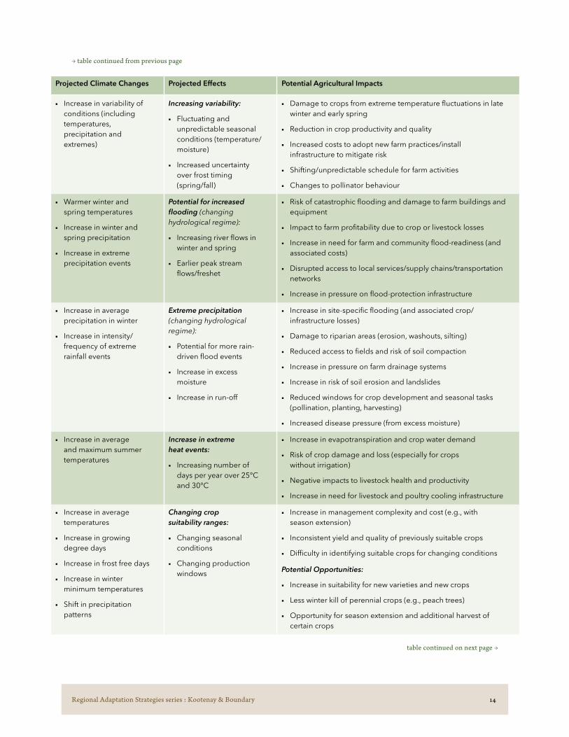
Regional Adaptation Strategies series : Kootenay & Boundary 14
Projected Climate Changes Projected Effects Potential Agricultural Impacts
■ Increase in variability of conditions (including temperatures, precipitation and extremes)
Increasing variability:
■ Fluctuating and unpredictable seasonal conditions (temperature/moisture)
■ Increased uncertainty over frost timing (spring/fall)
■ Damage to crops from extreme temperature fluctuations in late winter and early spring
■ Reduction in crop productivity and quality
■ Increased costs to adopt new farm practices/install infrastructure to mitigate risk
■ Shifting/unpredictable schedule for farm activities
■ Changes to pollinator behaviour
■ Warmer winter and spring temperatures
■ Increase in winter and spring precipitation
■ Increase in extreme precipitation events
Potential for increased flooding (changing hydrological regime):
■ Increasing river flows in winter and spring
■ Earlier peak stream flows/freshet
■ Risk of catastrophic flooding and damage to farm buildings and equipment
■ Impact to farm profitability due to crop or livestock losses
■ Increase in need for farm and community flood-readiness (and associated costs)
■ Disrupted access to local services/supply chains/transportation networks
■ Increase in pressure on flood-protection infrastructure
■ Increase in average precipitation in winter
■ Increase in intensity/ frequency of extreme rainfall events
Extreme precipitation (changing hydrological regime):
■ Potential for more rain-driven flood events
■ Increase in excess moisture
■ Increase in run-off
■ Increase in site-specific flooding (and associated crop/infrastructure losses)
■ Damage to riparian areas (erosion, washouts, silting)
■ Reduced access to fields and risk of soil compaction
■ Increase in pressure on farm drainage systems
■ Increase in risk of soil erosion and landslides
■ Reduced windows for crop development and seasonal tasks (pollination, planting, harvesting)
■ Increased disease pressure (from excess moisture)
■ Increase in average and maximum summer temperatures
Increase in extreme heat events:
■ Increasing number of days per year over 25°C and 30°C
■ Increase in evapotranspiration and crop water demand
■ Risk of crop damage and loss (especially for crops without irrigation)
■ Negative impacts to livestock health and productivity
■ Increase in need for livestock and poultry cooling infrastructure
■ Increase in average temperatures
■ Increase in growing degree days
■ Increase in frost free days
■ Increase in winter minimum temperatures
■ Shift in precipitation patterns
Changing crop suitability ranges:
■ Changing seasonal conditions
■ Changing production windows
■ Increase in management complexity and cost (e.g., with season extension)
■ Inconsistent yield and quality of previously suitable crops
■ Difficulty in identifying suitable crops for changing conditions
Potential Opportunities:
■ Increase in suitability for new varieties and new crops
■ Less winter kill of perennial crops (e.g., peach trees)
■ Opportunity for season extension and additional harvest of certain crops
→ table continued from previous page
table continued on next page →

Regional Adaptation Strategies series : Kootenay & Boundary 15
Projected Climate Changes Projected Effects Potential Agricultural Impacts
■ Increase in annual temperatures
■ Increase in winter minimum temperatures
■ Increase in spring precipitation and extreme rain events
■ Drier summer conditions
Changes in pests, diseases, invasive plants:
■ Increasing winter survival rates
■ Increasing number of cycles in a year
■ Introduction of new pests and diseases
■ Changing range/distribution of pests, diseases and invasive species
■ Reduction in efficacy of previous pest management schedules and practices
■ Increase in management costs and complexity
■ More frequent and increased damage to crops
■ Impacts to livestock health (poisonous weeds/ poor pasture)
■ Reduction in forage and pasture quality/yield
This set of “impact areas” (groupings of projected climate changes and their associated effects and agricultural impacts) formed the basis for discussions at the first set of workshops and the first focus group.
These impact areas were explored in detail with participants and ranked in order of importance for both the individual farm and at the regional level. Based on this input, the highest priorities were identified and some impact areas in the table above were excluded from consideration at the second workshops. Those impacts that were excluded may prove to be problematic or advantageous in the Kootenay & Boundary region in the future, and should continue to be monitored. Adaptation strategies will still be needed for agriculture to address all impact areas.
→ table continued from previous page
photo by Harmony Bjarnason

Regional Adaptation Strategies series : Kootenay & Boundary 16
Priority Impact Areas, Strategies & Actions
The following four impact areas were identified as the highest priorities with respect to agricultural
adaptation in the Kootenay & Boundary region:
→ Impact Area 1 Warmer & drier summer conditions
→ Impact Area 2 Increasing wildfire risk
→ Impact Area 3 Increasing variability
→ Impact Area 4 Increasing risk of spring flooding
In the sections that follow, a background description and adaptation goals are provided for each of the Impact Areas. Following the impact description, a series of strategies and actions to support the Kootenay & Boundary region agriculture sector with adapting to climate change are outlined.
The selected strategies and actions presented are intended to:
→ Address the highest priority impact areas
→ Reduce vulnerability to these impacts, and/or build capacity to adapt and respond to these impacts; and
→ Define practical steps forward that address gaps and build on existing assets in the Kootenay & Boundary region context.
Following the strategies and actions, the final section highlights those actions identified for near-term implementation. Implementation details, key participants, timeframes and cost ranges are provided for these near-term priority actions.

Regional Adaptation Strategies series : Kootenay & Boundary 17
Impact Area 1 : Warmer & drier summer conditions
The Kootenay & Boundary region’s (historical average) summer conditions are typically dry and
irrigation is required to maintain healthy agricultural production. The amount of land under agricultural production that relies on irrigation varies, from approximately 50% of actively farmed land in the East Kootenays, to 35% in the Central Kootenays to 10% in Kootenay Boundary.85 Some areas, such as the Creston Flats, are naturally sub-irrigated by high water tables from adjacent waterways (e.g., Kootenay and Goat Rivers). There is extensive dryland farming in the region primarily encompassing forage, pasture, cereals and oilseeds; while tree fruits, vegetables, and nursery production are typically irrigated. Demand for irrigation is expected to increase with drier conditions.
With climate change, increasing winter temperatures are expected to result in a decrease in snowpack and earlier peak stream flows. More frequent and extended hot and dry periods are also anticipated during the growing season, along with changes in hydrology that will reduce surface water flows in some major rivers and tributaries in summer. This combination of changes will result in reduced water supply during the periods of greatest water demand.86 Over time, the impact of glacial retreat on the region’s water resources and supply will be significant.87
Across the region there are a number of water systems that are already insufficient to meet peak demand.88 In August 2015 the Central and East Kootenay regions both reached a Level 3 drought,89 and in September of 2017 the Boundary region reached a Level 4 drought.90 The BC Ministry of Forests, Lands, Natural Resource Operations and Rural Development (FLNRORD) Water Stewardship division monitors 15 creeks and rivers in the Kootenay & Boundary region during drought conditions91 and the Regional Districts have flagged additional creeks with supply concerns.
The combined effect of warmer and drier summer conditions, and higher rates of evapotranspiration,
will increase agricultural water demand. The Agriculture Water Demand Model: Kettle Valley Report projects a 25% increase in future annual water demand (over demand during baseline hot, dry years). Agriculture Water Demand modelling has also been completed for the RDCK and an Agricultural Water Demand Review is underway for Erickson (within RDCK). Water demand in the Creston area could be further impacted by changes in production type (e.g., anticipated increase of cherry acreage of up to 50% over the next five years).92
In addition to changes in water supply and demand, the regulatory context for agricultural water is also shifting. The Water Sustainability Act includes a number of regulations of concern for agriculture (including those related to groundwater protection, dam safety and livestock watering).93,94 Producers require a clearer understanding of how the new and upcoming regulations will affect them, as well as information about how water supply and demand will change over time.
The strategies and actions in this section address the following adaptation goals:
→ Increasing adoption of water conservation best practices
→ Ensuring availability of a sustainable water supply for agricultural production
Relevant Climate Change Effects
→ Increasing average summer temperature
→ Increasing number of days per year above 25°C and days per year above 30°C
→ Increasing winter minimum temperatures
→ Decreasing precipitation in the summer

Regional Adaptation Strategies series : Kootenay & Boundary 18
As noted previously, many producers in the Kootenay & Boundary region utilize irrigation to maintain crop productivity. Use of best practices to optimize water use (suited to farm conditions and production type) will contribute towards ensuring producers have the water they need throughout the growing season.
Resources for irrigation efficiency and water management already exist in BC (e.g., Irrigation Management Guides, Irrigation Scheduling Calculators) and there is an opportunity to improve water use efficiency through irrigation management.95 Developing new resources — or adapting and improving existing resources – with locally relevant and/or commodity-specific water management options and opportunities would also be beneficial.
Measuring water use is an important component of water management, in order to track use and know where improvements can be made. At present many producers can estimate their water usage based on irrigation sets (i.e., a function of type of irrigation equipment utilized, length of time spent irrigating, flow rate, etc.), but a more precise (metered or non-metered) tracking tool may be helpful. A tracking tool piloted with grape growers in the Okanagan could inform development of a similar tool for the Kootenay & Boundary region.96 The RDCK is drafting a metering implementation plan for the Erickson area and subsequently for all RDCK water systems.97 Lessons learned from these initiatives could inform water measurement elsewhere in the Kootenay & Boundary region.
There may be opportunities to increase uptake of cost-shared irrigation management plans and water saving technologies (such as weather stations, soil moisture sensors and moisture meters) through the Environmental Farm Plan and Beneficial Management Practices programs.98
There is substantial interest from producers in obtaining new information regarding practices for improving soil moisture-holding capacity which are of benefit to both irrigated and dryland farms. For many producers optimizing soil moisture-holding capacity and preventing evaporation are the only options for dealing with warmer and drier conditions because water storage and irrigation are not feasible. Improving resources on this topic is a high priority — including better data regarding microclimates and soils, along with local demonstration. The Kootenay and Boundary Farm Advisors program provides a strong foundation for these types of knowledge transfer activities.
Impact Area 1 > Strategy 1.1 Improve tools and resources for irrigation efficiency and water management best practices
continued on next page →
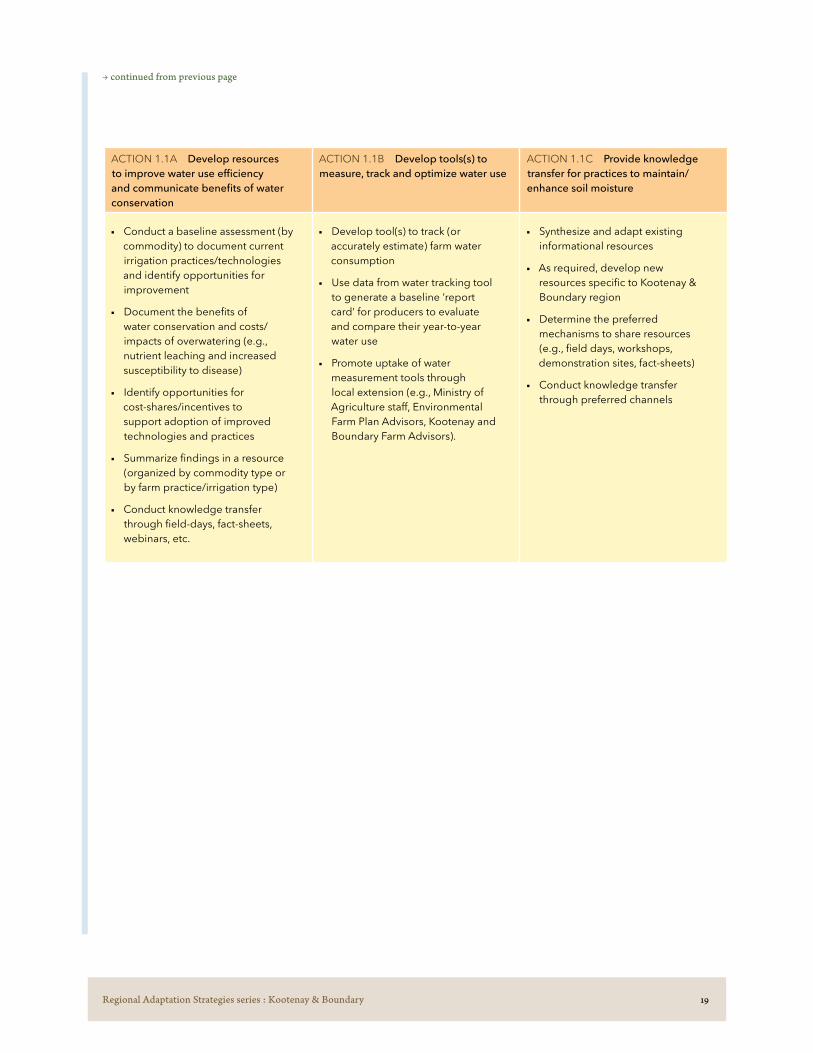
Regional Adaptation Strategies series : Kootenay & Boundary 19
ACTION 1.1A Develop resources to improve water use efficiency and communicate benefits of water conservation
ACTION 1.1B Develop tools(s) to measure, track and optimize water use
ACTION 1.1C Provide knowledge transfer for practices to maintain/enhance soil moisture
■ Conduct a baseline assessment (by commodity) to document current irrigation practices/technologies and identify opportunities for improvement
■ Document the benefits of water conservation and costs/impacts of overwatering (e.g., nutrient leaching and increased susceptibility to disease)
■ Identify opportunities for cost-shares/incentives to support adoption of improved technologies and practices
■ Summarize findings in a resource (organized by commodity type or by farm practice/irrigation type)
■ Conduct knowledge transfer through field-days, fact-sheets, webinars, etc.
■ Develop tool(s) to track (or accurately estimate) farm water consumption
■ Use data from water tracking tool to generate a baseline ‘report card’ for producers to evaluate and compare their year-to-year water use
■ Promote uptake of water measurement tools through local extension (e.g., Ministry of Agriculture staff, Environmental Farm Plan Advisors, Kootenay and Boundary Farm Advisors).
■ Synthesize and adapt existing informational resources
■ As required, develop new resources specific to Kootenay & Boundary region
■ Determine the preferred mechanisms to share resources (e.g., field days, workshops, demonstration sites, fact-sheets)
■ Conduct knowledge transfer through preferred channels
→ continued from previous page

Regional Adaptation Strategies series : Kootenay & Boundary 20
Producers in the Kootenay & Boundary region rely on many different water sources (e.g., dams, dugouts, points of diversion) for irrigation and livestock water. With water supply being adversely affected by climate change and peak agricultural water demand coinciding with periods of reduced water supply — enhancement of water storage and delivery infrastructure will be increasingly necessary to ensure adequate water availability. Climate change may make the cost/benefit of water storage investments more favourable, both at the farm-level and more broadly.
A high-level assessment to identify agricultural sub-regions that are (or may become) vulnerable to water shortages could be followed by a more in-depth assessment of optimal sites for shared water storage. The process would identify delivery infrastructure requirements and estimated installation costs, along with (agricultural and environmental/social) benefits, and would set the stage for collaboration on supplemental water storage development. Collaborative development and distribution of a shared water source may help to keep costs down for small farms, and thus be the best mechanism to increase water storage capacity.
Producers wishing to enhance or expand farm-level water storage face many barriers including the need for costly technical assistance and navigation of a complex regulatory context. These barriers, along with the financial cost (from lost production) of giving up sizable areas of land for water storage infrastructure, can prove particularly daunting to small-scale farms. Providing improved information (on technical considerations and requirements) that is tailored to farm and production type, could help to overcome some barriers. For example, market gardeners may be able to install small-scale water storage infrastructure for drip systems on private land.
Knowledge transfer activities could include developing and sharing new resources for farm-level water storage, establishing demonstration sites and/or piloting a ‘water management advisor’ to visit farms/ranches to provide guidance on suitable storage options and assistance with permit and cost-share applications. Collaborating with existing organizations and programs (e.g., RDKB’s Kettle River Watershed Management Plan implementation team, the Grassland and Rangeland Enhancement Program and the Kootenay Boundary Farm Advisors, as well as with the Ministry of FLNRORD) would reduce costs and improve success of this Strategy.
Impact Area 1 > Strategy 1.2 Support the enhancement of existing, and development of new, water storage capacity
continued on next page →

Regional Adaptation Strategies series : Kootenay & Boundary 21
ACTION 1.2A Identify and evaluate options for shared (sub-regional) water storage
ACTION 1.2B Strengthen availability of technical, regulatory and economic information on development/enhancement of on-farm/ranch water storage
■ Building on local knowledge and existing research, identify sub-regions experiencing (or likely to experience) water supply shortages but with opportunities for diversion/storage
■ Undertake in depth analysis in selected (pilot project) area/s including:
- Assessment of water delivery infrastructure and opportunities for improvement
- Storage options and criteria for suitability
- Cost-benefit analysis (development costs, agricultural benefits)
- Potential co-benefits (flood mitigation, fire protection, wildlife enhancement)
- Impacts of climate change on water availability/flows
- Possible partners
■ Convene stakeholders to discuss and prioritize options
■ Inventory existing informational and technical resources and develop new resources that fill information gaps for various farm types/scales regarding:
- Regulatory considerations
- Suitability of different infrastructure
- Cost-benefit analysis and pay-back period
- Cost-share supports/co-funding
- Climate change considerations
- Technical or “how-to” information
■ Establish demonstration sites to showcase a variety of storage types and sizes; provide knowledge transfer via (for example) case studies, field days, fact-sheets and videos
■ Pilot a ‘water management advisor’ program to provide farm/ranch specific guidance on suitable water storage options and to assist with permit and cost-share applications. (Note: This step may come first, as one or more years of this position could inform all previous steps identified)
→ continued from previous page

Regional Adaptation Strategies series : Kootenay & Boundary 22
Increasing temperatures, rapid spring snow melt and changing precipitation patterns are altering forest ecosystems in the Kootenay & Boundary region and affecting aquifer recharge rates and dynamics. Producers are concerned that forest management practices are also having an impact on aquifer health and increasing pressure on water resources.
Identifying informational gaps related to water management and aquifer health (of greatest importance to agriculture) would support suitably focused research and monitoring. There is an opportunity for the agriculture sector to work collaboratively on priority issues, and potential for the sector to become involved with improving baseline information/filling data gaps through on the ground activities such as well monitoring and citizen science.99
A number of specific topics of interest have been identified, ranging from improving knowledge about how climate change affects aquifer recharge, to sharing information with producers about how forest management practices affect the availability and quality of water resources. Aquifer and water mapping/monitoring is taking place in parts of the region and consolidating and sharing this information — as well as the results of the Ministry of FLNRORD’s cumulative effects100 assessment — would be a positive step in strengthening producer knowledge of aquifer health.
At present the Regional Districts have varying levels of activity associated with watershed planning (e.g., RDKB Watershed Coordinator position and the RDCK Watershed Governance Initiative project). Identifying opportunities for on-going, efficient and integrated engagement of the agriculture sector in watershed management, planning and initiatives would help to ensure that agricultural interests are represented and enable the sector to start addressing key areas of concern. There are a number of active water advocacy/water management groups in the Kootenay & Boundary region (e.g., the Columbia Basin Watershed Network, Kettle River Watershed Management Plan implementation team) that the agriculture sector could collaborate with.
Impact Area 1 > Strategy 1.3 Enhance representation of agricultural interests in landscape level water management and planning
continued on next page →

Regional Adaptation Strategies series : Kootenay & Boundary 23
ACTION 1.3A Identify and fill information and data gaps relating to water resources in the region
ACTION 1.3B Strengthen regional capacity for a coordinated, cross-sector approach to water management and planning
■ Inventory current research/knowledge/data and identify gaps of greatest importance to the agriculture sector
■ Support the initiation of new research/data gathering of greatest importance to the agriculture sector (as identified above)
■ Improve monitoring on small streams and wells and develop a resource/tool to provide real-time information about aquifer recharge/levels (use data collected on streams and wells to estimate aquifer recharge/health)
■ Develop resources to improve baseline knowledge relating to aquifer dynamics/water resource management
■ Document active water stewardship groups in the region and assess their mandates, activities and current links with the agriculture sector
■ Assess options for:
- Strengthening integration of agricultural representation/concerns with existing water stewardship groups
- Creating an agricultural water advisory committee to interface with all/select groups
- Creating a regional water board (similar to Okanagan Basin Water Board)
■ Engage with agricultural stakeholders (e.g., through a forum) to:
- Discuss options and identify the preferred engagement mechanism
- Identify key priorities (water management topics of most importance to agriculture)
- Develop a feedback mechanism to share water management updates/progress on key priorities with producers
→ continued from previous page

Regional Adaptation Strategies series : Kootenay & Boundary 24
Impact Area 2 : Increasing wildfire risk
Earlier snowmelt due to warmer winter and spring temperatures, combined with prolonged hot
and dry summers, is increasing the likelihood of more severe and frequent wildfires in the Kootenay & Boundary region. Forest die-off due to mountain pine beetle, a long history of fire suppression activities and logging practices that leave fuel behind, are also increasing wildfire risk.
Although the Kootenays have not experienced the extensive destructive wildfires that have impacted other agricultural regions of the province (i.e. the Cariboo in 2017 and Bulkley-Nechako in 2018),101 wildfire activity has been increasing in the region over the past decade.102 Boundary, which is more arid than Central and East Kootenay, experienced a significant wildfire season in 2015 with severe agricultural im-pacts. This fire burned 4400 hectares of land between Westridge and Rock Creek, destroyed structures on more than 50 properties (including 30 homes and 20 outbuildings), burned kilometres of livestock fencing and hundreds of hectares of ranchland.103
Wildfires jeopardize crop production and quality, livestock health, farm workers’ health and agricultural infrastructure. Producers are keenly aware of the increasing risk of wildfire and require support in mitigating risks to their operations and in planning for wildfire emergencies. Strategies to support and promote individual producer preparedness are required, as well as actions that will strengthen implementation of fuel management at the farm level and on the agriculture/wildland interface.
As in other areas of BC, producers in the region have concerns about effective communication with key agencies during wildfire response. A consistent and collaborative approach to communication and infor-mation sharing, before the wildfire season and during wildfire emergencies, is needed. A pilot project in the Regional District of Okanagan Similkameen to develop and test a “communication protocol”104 may provide a model for a similar project in the Kootenay & Boundary region.
Wildfire smoke impacts extend well beyond the areas in immediate jeopardy. The 2017 and 2018 growing seasons were notable for extensive and prolonged smoky conditions. In 2018, most of the region experienced more than 20 days of Air Quality Health Index105 above 7 (high health risk) due to significant smoke cover. These conditions negatively impacted crops and animal health across the region, and relevant adaptation actions are included in Impact 3, Strategy 3.2.
The strategies and actions in this section address the following adaptation goal:
→ Supporting comprehensive wildfire preparedness planning to minimize impacts from wildfire
Relevant Climate Change Effects
→ Increasing average and maximum summer temperature
→ Increasing average winter and spring temperature
→ Increasing number of days above 25°C and 30°C
→ Decreasing precipitation in the summer

Regional Adaptation Strategies series : Kootenay & Boundary 25
Impact Area 2 > Strategy 2.1 Promote wildfire preparedness planning at the farm and regional levels
As is the case across much of British Columbia, climate change is increasing the risk of wildfires on the agricultural interface in the Kootenay & Boundary region. Mitigating damage associated with wildfire requires preparedness planning at both the farm and community levels.
In 2018, the BC Agriculture & Food Climate Action Initiative released a farm-level Agri-culture Wildfire Preparedness and Mitigation Workbook & Guide106 to assist producers with planning for a wildfire emergency and reducing impacts to their operations. The wildfire preparedness materials were promoted through workshops held across the province in 2018 and 2019.107
Demand remains high within the producer community for continued support with prepar-ing for, and mitigating, risks associated with wildfire. There is particular interest in on-farm assessments to assist with preparedness/mitigation planning, but also in additional work-shops and/or instructional videos. The Kootenay Livestock Association has been collecting relevant information from producers (e.g., equipment available for mobilization during an emergency) to coordinate producer preparedness/response, and this type of leadership from the agricultural sector will enhance the actions below.
When wildfire risk is present (i.e., when wildfire is in the area and during alerts/orders) producers require timely information to help them react quickly and effectively and to in-form farm-level decisions (e.g., livestock relocation, harvest timing). Effective information exchange and communication – before and during wildfire events – is an important con-tributor to wildfire impact reduction.108 Producers rely on outside agencies for information during the wildfire season, and ensuring that communication mechanisms, key contacts and roles and responsibilities are shared and understood is critical.
As noted previously, a pilot project is underway in the Okanagan-Similkameen region to establish a protocol to guide communication between the Regional District of Okanagan Similkameen, response agencies and agricultural residents. The pilot approach could be adapted/replicated in the Kootenay & Boundary region.
continued on next page →

Regional Adaptation Strategies series : Kootenay & Boundary 26
ACTION 2.1A Encourage adoption of farm-level wildfire planning preparedness tools and resources
ACTION 2.1B Develop a wildfire communication protocol to guide communication between response agencies and producers
■ Identify and implement preferred mechanism(s) for completion of farm-level preparedness and mitigation planning (e.g., Agriculture Wildfire Preparedness and Mitigation Guide/Workbook). This may include:
- Development of how-to-videos and/or webinars
- Farm assessments
- Workshops (and follow-up sessions)
- Distribution of resources through partner agencies
■ Provide additional planning support (e.g., through targeted workshops) to livestock sector to develop and coordinate livestock relocation plans
■ Ensure relevant information from individual plans (e.g., contact information, maps, equipment lists) is being effectively shared with response agencies
■ Bring producers and response agencies together to develop a communication protocol (utilizing/adapting Regional District of Okanagan Similkameen Wildfire Communication Protocol materials). This protocol may include:
- Roles and responsibilities during a wildfire
- Local contact information
- Permitting and re-entry guidelines
- How and what to communicate at what times
- Where to post/find information
- Incorporating an “agricultural liaison” into Emergency Operations Centres
■ Pilot implementation of Wildfire Communication Protocol
■ Evaluate outcomes and revising protocol as needed
→ continued from previous page

Regional Adaptation Strategies series : Kootenay & Boundary 27
Impact Area 2 > Strategy 2.2 Pilot and demonstrate fuel management practices for private and Crown range land
Fuel management is a critical element of wildfire mitigation and refers primarily to reducing the fuel load (vegetation and woody debris). Producers with large acreages and private woodlot licensees109 — who hold exclusive rights to manage and harvest Crown timber within the woodlot licence area — have access to very few resources to assist them with reducing fire risk on their property or tenure.
FireSmart principles can be effectively utilized to reduce the risk of fire damage to agricultural buildings and structures, but fuel management on larger acreages necessitates the development and execution of larger-scale — and more costly and complex — fuel management plans. Developing new resources to support small-scale fuel management activities is an important component of farm-level wildfire preparedness. Producers are also interested in fuel management options that allow them to better manage (for profit) their private timber supply (private land/woodlot).
An initial assessment/consultation to define local priorities would be the first step, followed by a pilot to test and demonstrate practices. Producers would also benefit from identification and/or development of cost-share supports and incentives to support private fuel management practices. For example, the newly created provincial Community Resiliency Investment (CRI) program (replacing the Strategic Wildfire Prevention Initiative) has expanded its mandate to include funding for FireSmart activities on private land.110
High fuel loads on Crown land pose significant wildfire risk to adjacent private lands and farmers and ranchers cannot mitigate impacts to their operations (through actions identified in Strategy 2.1, and treatments on private land) without collaboration and partnerships with Crown land managers. Ember showers from Crown land can ignite fuels from up to two km away.111 Agricultural producers have very few opportunities for fuel management on Crown land, and even where opportunities exist, these activities tend to be complex, time consuming and expensive to carry out.
To fill gaps in current fuel management activities, there is a need to support collaborative fuel management at the agricultural/wildland interface by piloting different approaches for removal and disposal of fuel and exploring alternative options — such as range management practices — for fuel reduction.
continued on next page →

Regional Adaptation Strategies series : Kootenay & Boundary 28
ACTION 2.2A Identify and address barriers to fuel management on private land
ACTION 2.2B Develop and pilot collaborative fuel management approaches to reduce fuel on high-risk Crown land *
■ Building on work completed in the Cariboo (Opportunities and Barriers to Wildfire Risk Mitigation), conduct an analysis to identify local priorities for fuel management on private land (e.g. addressing access to equipment and expertise, costs of treatment, disposal challenges)
■ Develop pilot project(s)/program to reduce identified barriers (e.g., providing technical expertise to private landowners to develop prescriptions for reducing fuel load, identifying how land-owners can manage land to reduce wildfire risk and maximize profit from harvesting timber)
■ Develop resource materials and sharing results with producers
■ Identify and/or develop cost-share supports and incentives to support farm-level fuel management practices
■ Compile research on options for management of forest fuels near agricultural operations such as:
- creating fire breaks
- fuel thinning/fuel chipping
- prescribed burning
- silvopasture/agroforestry to remove understory
■ Document range management practices that can be used to reduce fuel loads and assess suitability for region
■ Convene partners to prioritize locally suitable fuel management practices for pilot/demonstration and identify pilot area(s) and collaborators
■ Establish one or more pilot sites to demonstrate practices identified above
■ Assess opportunities to increase the duration of range tenure as an incentive to employ management practices to reduce the fuel load in long-term
* Developing and testing collaborative fuel management approaches has been prioritized in other regions of the province and opportunities to build on existing/ongoing research and demonstration should be explored before undertaking a project.
→ continued from previous page

Regional Adaptation Strategies series : Kootenay & Boundary 29
Impact Area 3 : Increasing variability
The combination of changes in climate (including shifting and unpredictable temperature and
precipitation patterns, increasing growing degree days and increasing frequency and intensity of extreme events) is resulting in more variable seasonal conditions and changing pest cycles — both of which increase the complexity of farm management decisions and associated costs. Adapting to variable conditions requires that producers increase their overall resilience and their ability to respond to a broad range of projected changes.
Critical windows in the production season (such as planting and harvesting) are becoming less predictable. Variable temperatures and abrupt temperature swings can result in increased risk of frost or heat damage to crops, and winter storm events are of particular concern for livestock and forage producers (e.g., impact of freeze-thaw cycles on crops, livestock mortality due to extreme cold). Parameters for crop suitability may shift in some areas, reducing the viability of current crops/varieties and increasing the potential of others. However, harnessing the potential of new crops and varieties requires trials, market research and transition support.
Limited access to reliable local weather information is a gap for most producers which impacts their ability to manage (proactively or in response to) variable conditions. Increasing the availability of weather data and forecasts would support producers with decisions regarding soil management, irrigation scheduling and pest treatments, and would support more accurate assessments around the suitability of new crops.
A critical strategy for adaptation is conducting local research to trial new crops or varieties and to evaluate how differing practices and technologies may strengthen resilience. Some producers are already undertaking applied research, but would benefit from additional research support and expertise, as well as improved communication channels for sharing results and/or exchanging information with other producers.
Variability is also anticipated to increase pest pressure in the region. As average annual temperatures increase, the ranges and prevalence of insect pests, diseases and invasive species are anticipated to shift. Climate change may result in an increase in the number and distribution of existing problem species, and may also result in new species becoming established in the region.112 Improving locally relevant pest identification and management resources is a priority for producers in the region.
The strategies and actions in this section address the following adaptation goals:
→ Enhancing availability of data-driven resources to support adaptation
→ Supporting collaborative research on crop selection and farm practices
→ Strengthening knowledge transfer to limit the impacts of pests and invasive species
Relevant Climate Change Impacts
→ Shifting precipitation patterns
→ Increasing number of growing degree days
→ Increasing frequency and intensity of extreme events

Regional Adaptation Strategies series : Kootenay & Boundary 30
Impact Area 3 > Strategy 3.1 Enhance weather data collection/analysis and availability of decision support tools
Access to real-time weather data (such as growing degree day accumulation) would enable farm planning and decision-making that are more responsive to local microclimates and actual conditions (rather than timing activities based on historical averages). Access to more precise weather data would also allow producers to better track how variable conditions are affecting their operations year over year (e.g., frequency of late spring frosts and hot summer temperatures).
At present the Farmwest website (www.farmwest.com) provides access to 5-day forecasts for 17 weather stations across the Kootenay & Boundary region. Not all of these stations measure variables of value to the agriculture sector (e.g., humidity, precipitation). In addition, there remain significant geographic gaps in coverage which are exacerbated by the microclimatic variability across the region. For example, there are four microclimate zones for tree fruits in Creston alone, and there is only one weather station in Creston.113
Improving the weather monitoring network also creates the potential to develop locally relevant decision support tools114 which link to real-time weather station data. Some decision support tools can be found on the Farmwest website, but producers are interested in a greater diversity of these resources. Other relevant decision support tools already exist in BC and beyond but may require adaptation for the local context (e.g., the Okanagan BC Tree Fruit Decision Aid System, AgWeather Quebec).115,116 There may also be opportunities to test/demonstrate tools that link to private (on-farm) weather stations (i.e., that would not require the establishment of a network of weather stations).
The BC Ministry of Agriculture, in partnership with the British Columbia Agricultural Climate Adaptation Research Network (ACARN), has completed a Gap Analysis and Overview of Weather Station Data in British Columbia Agricultural Regions, which includes an analysis of the Kootenay & Boundary region.117 This research could inform a more in-depth assessment of the weather network coverage in the Kootenay & Boundary region. The BC Ministry of Agriculture has allocated funding to establish new weather stations across the province of BC and has approved a new station in Grand Forks that will link to Farmwest. Additional stations may be installed in the Kootenay & Boundary region through this initiative, although funding is limited.
Establishing and maintaining a weather station network is a significant undertaking that would require long-term collaboration, investment and effort, and partnering with existing initiatives will be vital to success. It will also be important to provide training and knowledge transfer about how to use the data and associated tools. Supporting education and training for existing extension agents, as well as sharing information through sector groups, would enable efficient transmission of information about new tools and resources.
continued on next page →

Regional Adaptation Strategies series : Kootenay & Boundary 31
ACTION 3.1A Expand weather station coverage and improve producer access to station data
ACTION 3.1B Develop decision support tools and resources linked to weather data
■ Complete an analysis of weather station coverage (identify existing station locations and utility to the agriculture sector) and identify monitoring gaps
■ Evaluate options for linking with existing networks and/or establishing and maintaining a new network (e.g., administration, funding and maintenance)
■ Share findings with agricultural organizations and regional partners and develop implementation plan
■ Install new stations to fill critical gaps and make data available to producers
■ Determine options for developing decision support tools that are relevant to agricultural needs (linked to expanded weather data network in ACTION 3.1A) and document costs of tool development and projected producer benefits. Tools may include:
- Expanding the BC Tree Fruits Decision Aid System (BC DAS) Tool
- Adapting/developing new tools for forage, hay and range management
- Providing improved (localized) weather forecasting information
■ Evaluate options (costs/benefits) for network/shared tools versus tools linked to private (on-farm) weather stations
■ Develop prioritized tool(s) and resources and share them with producers
→ continued from previous page

Regional Adaptation Strategies series : Kootenay & Boundary 32
Impact Area 3 > Strategy 3.2 Support local research and demonstration for crop trials and farm management practices
Producers are adept at managing through challenging conditions and are constantly experimenting with new crops and farm practices. Local research is a valuable contributor to testing and evaluating practices, technologies and/or crops for the local context. There has been no formal long-term agricultural research in the region since AAFC closed their regional station 30 years ago. Results from farm-level research may prove valuable in assisting other producers in the region to adapt to increasing variability.
Many producers are eager to undertake research but require assistance and support to design and conduct trials and analyze results. The recently developed Guide to On-Farm Demonstration Research provides a structured approach for producers to develop a research question, gather data and analyze results.118 Taking this work a step further, a project is underway (from 2019 to 2022) in the Kootenay & Boundary region to develop research templates (with accompanying Case Studies) for a range of commodities/research questions.119
The Kootenay & Boundary region is very diverse with respect to growing conditions and production types and research and demonstration interests/needs vary by location. Some examples of research interests include trialing new drought tolerant varieties, conducting season extension trials with high tunnels,120 management intensive grazing and keyline design.
Sharing the results from producer-led (and other locally relevant) research could be facilitated through the development of a digital knowledge hub which could be hosted on an existing website. The hub could offer a forum for questions/answers to be shared, and for local research priorities to be established. Creating a digital knowledge hub could be relatively low-cost, but long-term success requires ongoing funding and administrative support, as well as collaboration and engagement from producer partners.
The Kootenay and Boundary Farm Advisors would be a strong local partner for all of the actions within this strategy. Other partners could include university researchers and students (e.g., University of British Columbia, Thompson Rivers University, Kwantlen Polytechnic University). College of the Rockies and Selkirk College also have some interest in agricultural research.
continued on next page →

Regional Adaptation Strategies series : Kootenay & Boundary 33
ACTION 3.2A Create a producer-led research network
ACTION 3.2B Develop an online producer knowledge hub
ACTION 3.2C Identify and undertake applied research to support innovative farm practices to mitigate risk from climate change impacts
■ Create an inventory of producer-led research currently underway
■ Survey producers to identify research priorities
■ Secure partnerships and develop a program or support system to assist producers with their farm research. Support may include:
- providing in-person technical input in advance of and during trials
- assisting with trouble shooting, data collection and analysis
- hosting a ‘farm-research bootcamp’
- sharing the Guide to On-Farm Demonstration Research
■ Coordinate knowledge transfer activities for producers to share their research/results
■ Outline objectives and functional requirements of an online producer knowledge hub and identify possible partners. Objectives may include:
- Sharing of research results
- Linking producers wanting to do research with land
- Seed sharing
- Producer-to-producer knowledge exchange
■ Establish, pilot and evaluate the knowledge hub
■ Collaborate with partners and funders to develop a long-term administration and management plan
■ Consult with the agriculture sector to prioritize research topics and/or create a regional producer research advisory body (link to producer-led research network in ACTION 3.2A if action completed)
■ Conduct a scan of innovative management practices to assist producers in reducing impact of variable/extreme conditions such as:
- Extended periods of wildfire smoke (e.g., impacts to light levels, air quality and temperature)
- Protection from late spring/early fall frost
- Worker and animal health during extreme heat
■ Share scan results and assess local applicability including piloting and demonstrating practices (as needed)
■ Conduct knowledge transfer (e.g., field days, fact sheets etc.)
→ continued from previous page

Regional Adaptation Strategies series : Kootenay & Boundary 34
Impact Area 3 > Strategy 3.3 Improve education and awareness for effective management of pests (pests include insects, diseases, weeds and invasive species)
Climate change will shift the distribution and life cycles of insects, diseases, weeds and invasive species already present in the region (such as spotted wing drosophila and aster yellows) and may create conditions favourable for the establishment of new pests (such as brown marmorated stink bug which is currently found in the Okanagan).
Identifying the pests of greatest concern to agriculture and developing and/or disseminating resources for identification and effective management would minimize negative impacts to the sector and assist producers with making timely management decisions. Early detection of, and rapid response to, emerging pests can help to prevent establishment. A project completed in the Cariboo provides a methodology that could be applied to identification of priority pests, critical information gaps, and resource requirements for producers in the Kootenay & Boundary region.121
Knowledge transfer activities might include the development and delivery of fact-sheets, presentations, workshops and field days. There are also opportunities to develop new outreach mechanisms — such as a “pest-of-the-week” newsletter, enhanced pest-alerts122 and/or expanding the coverage of weed/pest reporting apps123 to cover the region.
There is demand from producers for Integrated Pest Management (IPM)124 and improved information regarding biological and mechanical controls for pests and invasive species. Currently IPM adoption is most common among organic growers, growers selling for export (e.g., cherry producers) and producers selling into the retail market.125 Generally, IPM information is difficult to access, or does not exist for the local context. Specific IPM topics of interest include:
→ providing/creating habitat for beneficial insects being introduced to farm;
→ managing soil health to reduce pest and invasive species pressure; and
→ understanding how the prevalence of certain weeds relates to soil health.
Invasive species are monitored and managed by each Regional District’s invasive species organization. The Boundary Invasive Species Society, Central Kootenay Invasive Species Society and East Kootenay Invasive Species Council have robust education, training and outreach programs, although to date the agriculturally focused resources have been primarily for the forage sector.
continued on next page →

Regional Adaptation Strategies series : Kootenay & Boundary 35
ACTION 3.3A Determine economically significant pests/emerging pests of concern to the agricultural sector
ACTION 3.3B Enhance producer knowledge of, and access to, pest and invasive species management information
ACTION 3.3C Provide knowledge transfer about biological/mechanical treatments for pests and invasive species
■ Utilize the methodology from Priority Pests of the Cariboo-Chilcotin; consult with agricultural organizations, regional invasive species groups and government agencies to:
- Identify pests and invasive species of greatest concern to the agricultural sector
- Assess existing programs and resources to determine transferability and identify gaps
■ Adapt existing resources and (if needed) develop new resources to address knowledge gaps (as identified above)
■ Share information about programs and cost-share supports (e.g., RDEK has a cost-share support program for invasive species management)
■ Utilize resources (from ACTION 3.3A) to deliver knowledge transfer activities which may include:
- Distributing fact sheets and other informational resources
- Hosting presentations/workshops/field days on pest and invasive species identification and management
- Developing targeted promotional campaigns/ outreach (such as Pest Alerts, or Insect Week — where one pest is highlighted each week)
- Working though existing channels (such as local agricultural newsletters and local agricultural meetings) to distribute information and resources
■ Consult with producers to determine which pests and invasive species to focus on (build on results of ACTION 3.3A if completed)
■ Identify biological and mechanical controls for priority pests and develop and share supporting resources with producers (may build on existing resources)
■ Develop resources to enhance producer knowledge of the relationship between soil health (e.g., soil pH, nutrient deficiency) and pests
→ continued from previous page

Regional Adaptation Strategies series : Kootenay & Boundary 36
Impact Area 4 : Increasing risk of spring flooding
Warming winter and spring temperatures are changing precipitation patterns (with less
precipitation falling as snow and more falling as rain) and are causing earlier and more rapid snowmelt.126 These factors, combined with projected increases in spring precipitation, are heightening the risk of flooding on land adjacent to large and small watercourses.
Flood risk in the Kootenay & Boundary region is most pronounced in the spring (although flooding can occur any time of year) and is most frequently caused by rapid melting of a thick snow pack, heavy rainfall and/or ice or debris jams.127
Areas that are deemed highly susceptible to flooding are designated as floodplains, and the region has the largest number of individual floodplains in British Columbia.128 Much of the agricultural land in the region follows the valley floors and rivers, and is therefore vulnerable to flood events.
Producers need to be prepared for a range of flood scenarios from large-scale floods (as experienced on the Kettle and Granby Rivers in 2018), to site-specific floods along smaller watercourses. Addressing flood risk on agricultural land requires both farm-level and landscape-level planning and mitigation approaches. The Regional Districts have been proactive in undertaking research to better understand regional flood risk and risk mitigation (such as LIDAR floodplain mapping, debris flow management planning, evacuation route mapping) and in developing programs to support flood recovery (such as Boundary Flood Recovery).
Landscape-level flood mitigation is increasingly examining how to restore and enhance the role of natural green infrastructure (such as forests, riparian areas, floodplains and wetlands) to reduce/manage flood risk. Following the 2018 flood season, the City of Grand Forks (as part of their 2018 flood recovery efforts) has been particularly proactive in identifying areas that would benefit from natural green infrastructure installation or enhancement, including the restoration of floodplains and riparian areas.129 There are opportunities to connect agricultural areas prone to flooding with
existing regional initiatives, to implement green infrastructure projects and/or demonstration sites.
At the farm level, riparian rehabilitation and the creation of riparian buffers can reduce the potential for inunda-tion, washouts and erosion, as well as minimize the loss of productive land to flooding.130 There are both local and provincial level resources and expertise available to provide support to producers with planning and under-taking riparian projects on private land.131 However, even with these supports, agricultural landowners still face significant obstacles when planning and undertak-ing riparian projects including difficulty navigating the regulatory and permitting process and the financial burden of establishing and maintaining these areas.
The highly productive Creston Flats agricultural area is a former floodplain that is now protected by dikes on the Kootenay and Goat rivers.132 However, this area is still at risk of flooding if dikes are overtopped or breached. The dikes are managed by several independent diking districts, and the agricultural sector would benefit from improved communication regarding planned maintenance and upgrades.
The strategies and actions in this section address the following adaptation goals:
→ Enhancing natural flood management infrastructure to mitigate flood risk
→ Reducing the impacts of flooding on agricultural lands and operations
Relevant Climate Change Impacts
→ Increasing winter and spring precipitation
→ Increasing average temperatures (particularly in spring)
→ Increasing frequency and intensity of precipitation events

Regional Adaptation Strategies series : Kootenay & Boundary 37
Green infrastructure refers to ecological systems, both natural and engineered, that act as living infrastructure. Natural green infrastructure (including forests, grasslands, wetlands, creeks and other waterways) supply valuable environmental services such as providing habitat for fish and wildlife, filtering of air and water pollutants and reducing run-off and associated flooding.133
As in many areas, the function and health of natural green infrastructure in the Kootenay & Boundary region has been compromised by human activities – particularly forestry – over the last century.134 Restoration and rehabilitation of existing green infrastructure and installation of new green infrastructure (such as the establishment of small woody dams, rehabilitation and/or improvements to riparian zones and rehabilitation of floodplains) can slow and spread run-off while reducing flood risk.
Various research projects (led by the Regional Districts) are currently underway to help to improve baseline understanding of regional flood risk. RDCK is undertaking a regional flood risk assessment, including a gap analysis and a prioritized
inventory of hazards across the region.135 RDKB and the City of Grand Forks have completed flood risk assessments and flood recovery planning and identified sites in need of natural (and constructed) flood infrastructure improvements.136 Opportunities exist to partner with these (and other) initiatives to incorporate an agricultural lens into current research and projects.
A scan of best practices for small-scale green infrastructure enhancements and an assessment of which options are best suited to the region (e.g., small woody dams, floodplain restoration, riparian zone rehabilitation) would be an important first step. Building on this work, identification of suitable small-scale pilot/demonstration locations could be followed by an assessment of feasibility, costs and potential for water storage (a valuable co-benefit for agriculture). Moving from the assessment phase into demonstration would require partnerships and strong local champions. It would also be important to collect baseline information at any new demonstration sites to enable evaluation of cost of installation/maintenance versus the extent of various anticipated benefits.
Impact Area 4 > Strategy 4.1 Slow and capture runoff through enhancement of small-scale green infrastructure
ACTION 4.1A Identify suitable green infrastructure options and priority pilot areas
ACTION 4.1B Establish pilot site(s) and evaluate benefits
■ Complete a scan of best practices for small-scale green infrastructure enhancements and assess which options are best suited to region
■ Conduct a vulnerability assessment to identify suitable pilot area(s) (with agricultural relevance) with potential for green infrastructure improvements/installations
■ Quantify costs of infrastructure and benefits of proposed project(s)
■ Convene relevant government agencies and agricultural partners to discuss pilot project options and to seek co-funding
■ Building on ACTION 4.1A, work with local partners and government agencies to plan pilot projects, obtain necessary permits and authorizations
■ Develop a monitoring and evaluation plan and collect baseline data before infrastructure installation
■ Work with partners to install and maintain green infrastructure
■ Evaluate project(s) and share the results with stakeholders (e.g., field tours, case studies)

Regional Adaptation Strategies series : Kootenay & Boundary 38
Impact Area 4 > Strategy 4.2 Support knowledge transfer for effective management and enhancement of on-farm riparian areas
Healthy wetlands and riparian areas provide valuable flood-mitigation services to adjacent farmland and lessen the impacts of floods when they do occur. There are many initiatives and groups across the region that provide support to producers with riparian and wetland restoration/enhancement such as the Slocan River Streamkeepers, Salmo Watershed Streamkeepers Society, Granby Wilderness Society and the Farmland-Riparian Interface Stewardship Program (FRISP).
Even with these existing supports, undertaking improvements in riparian zones is labour and cost-intensive and any work completed, requires ongoing maintenance. The benefits to the private land-owner are not always clear. Often the value of riparian health is connected to providing habitat or environmental services, rather than to reducing flood risk to private land. It is important to fill this information gap by documenting/sharing the role of riparian and wetland restoration in flood protection.
Existing resources on riparian restoration could be synthesized and tailored for an agricultural audience and could integrate case studies, outline suitability of enhancements/practices for particular sites and provide practical information on permitting requirements. Utilizing demonstration sites to showcase how riparian projects are designed and installed could also support adoption. There are existing projects on farms in the area that may be candidates for demonstration. Opportunities to develop new demonstration sites (with strong local partnerships) may also exist.
Cost is frequently identified by producers as the biggest barrier to riparian and wetland enhancement and restoration (followed closely by legislative and/or permitting barriers). Addressing this barrier is critical to broader adoption and may include enhancing availability/accessibility of cost-benefit information and improving linkages to financial supports (e.g., Environmental Farm Plan and Beneficial Management Practices Program)137. Farmland Advantage (based in East Kootenay) has partnered with the Environmental Farm Plan Program on a five-year pilot project (in three regions including the Kootenays) to establish and monitor riparian demonstration sites to inform the development of a payment for ecosystem services model which could be more broadly implemented in the future.138
continued on next page →

Regional Adaptation Strategies series : Kootenay & Boundary 39
ACTION 4.2A Consolidate, create and share information on riparian management and enhancement
ACTION 4.2B Establish demonstration sites to facilitate knowledge transfer
ACTION 4.2C Develop/improve financial supports available for riparian enhancement
■ Undertake a scan to document existing resources (informational, technical, financial, local experts) and to identify resource gaps
■ Tailor existing materials and/or develop new materials to communicate:
- Climate change impacts to watercourses and potential for riparian areas to reduce flood impacts/mitigate risk
- Costs and benefits of riparian enhancement
- Different types of riparian projects (suitability, case studies, how-to)
- Permitting requirements
- Available cost-share supports and expertise
- Farm management practices for riparian health
■ Share resources broadly through local agricultural/community groups (e.g., at monthly meetings and AGMs, through workshops, webinars)
■ Identify existing sites that could be used for demonstration and develop a shortlist of sites for new demonstration (may tie into ACTION 4.4B)
■ Develop criteria and select suitable new sites for demonstration (if existing sites are not sufficient)
■ Establish demonstration sites (documenting process/costs for knowledge transfer materials) and/or provide access to existing sites
■ Evaluate impact of project(s) and quantify benefits
■ Host field days and develop knowledge transfer materials (e.g., signage for sites, fact-sheets)
■ Assess existing financial supports and identify gaps/challenges with obtaining financial support/cost-shares
■ Identify opportunities to reduce cost-share barriers and enhance cost-share opportunities. Options may include:
- Establishing a per-plant/tree cost share program (similar to Municipal Neighbourwoods139 programs)
- Incorporating planning for riparian enhancement/flood mitigation into farm business planning services
- Improving access to education programs (e.g., subsidies for courses offered by the Wetlands Institute)
■ Pilot a program — with local funders — to improve financial support for producers (based on results above)
→ continued from previous page

Regional Adaptation Strategies series : Kootenay & Boundary 40
Impact Area 4 > Strategy 4.3 Improve tools and resources for farm-level flood readiness
Various resources are distributed by the Regional Districts to encourage flood-readiness and emergency preparedness, as well as to provide seasonal updates on snowpack/flood conditions.140 However, there are few informational materials that are specifically designed for agriculture. New agriculture and flood-focused resources are under development through CAI and will be available in 2020. There are also all hazard emergency planning guides available for some agricultural commodities in BC (e.g., dairy, cattle, pork).141
Reviewing and adapting existing farm-level pre-paredness resources (as needed) to suit the various local contexts within the region (e.g., Creston Flats, Boundary) is a first step. This process may focus pri-marily on how best to disseminate existing prepared-ness information, but may also incorporate locally specific considerations and support the development of supplemental (sub-regional) resources.
There are several flood related emergency planning activities taking place at the regional and municipal level and facilitating the agriculture sector’s participation in existing initiatives would help to ensure that emergency response needs for the sector are identified and addressed. However, much of the responsibility for emergency preparedness falls to producers and it may be beneficial to support an agriculture-led initiative that encourages preparedness planning and identifies sector specific concerns related to flood-readiness planning, flood response and flood recovery (e.g., carcass disposal, obtaining feed for animals after damage to cropped land, supporting non-commercial / hobby producers with post-disaster assistance).
ACTION 4.3A Develop and/or distribute farm-level flood readiness resources
ACTION 4.3B Enhance integration of agriculture-specific issues into community-level emergency planning
■ Assess applicability of existing resources and adapt and/or develop new resources as needed
■ If required, develop new resources to address links between flood risk and land and soils management decisions. Topics may include:
- How climate change will impact flood risk
- Examples of the positive benefits of flooding in restoring soil health
- Riparian enhancement as flood mitigation practice (ties into Strategy 4.2)
■ Provide active support for farm-level flood-readiness planning (e.g., workshops, webinars/videos, farm visits)
■ Share flood readiness resources with producers (e.g., at agricultural organization AGMs and monthly meetings, workshops)
■ Identify key challenges/areas of concern for the agriculture sector relating to flood readiness, response and recovery
■ Facilitate the agriculture sector’s participation in community preparedness initiatives (municipal or regional district level) and/or develop an agriculture-led initiative including identification of agriculture specific concerns

Regional Adaptation Strategies series : Kootenay & Boundary 41
Impact Area 4 > Strategy 4.4 Support a cooperative and consistent approach to dike management in the Creston Valley
Diking infrastructure along the Kootenay and Goat Rivers (comprised of dikes, control structures and pumps) has transformed the landscape of the Creston Flats and made farming possible on the former floodplain. The dikes are managed and maintained by several independently operated diking districts.142 Producers with operations located on the Creston Flats are interested in ensuring that the dikes are being managed and maintained to withstand additional pressures from climate change, but do not have easy access to information about planned maintenance and improvements.
To support information sharing, a first step could be collecting and collating information on planned maintenance and improvements, and documenting diking district processes and procedures (highlighting similarities, differences and best practices). Recent work completed by the Lower Kootenay Band (Yaqan Nukiy) assessing the state of the dikes143 could serve as a building block for this activity and reduce the necessary up front research. The results of this research could be shared through a collaborative forum with key stakeholders (producers, diking district representatives, Lower Kootenay Band, government agencies) to discuss research findings and to determine how to strengthen communication between producers and the diking districts. The forum could also serve as a venue to discuss the potential for increasing cooperation between the diking districts.
Improving riparian management practices along dike banks and set-backs could enhance the function of the dikes and reduce flood risk (from overtopping and breach), while the establishment of sediment ponds could help to reduce the need for dredging.144 There is potential to strengthen riparian management practices along dikes, but this would require partnerships with land-owners and technical guidance regarding practices. Identifying the best riparian practices for dike banks and set-backs and undertaking an analysis to document the costs (e.g., cost of establishment, loss of productive land from larger dike set-back) and benefits (e.g., erosion control, sediment control, flood mitigation, environmental values) of practices would be an important first step in supporting improved practices.
continued on next page →

Regional Adaptation Strategies series : Kootenay & Boundary 42
ACTION 4.4A Support improved communication among diking districts and between diking districts and the agricultural sector
ACTION 4.4B Establish demonstration sites to encourage adoption of riparian management practices that enhance flood mitigation on dike banks and set-backs
■ Synthesize and compile existing information on the current condition of dikes and planned dike upgrades and maintenance
■ Undertake an assessment of processes and procedures for dike management across the diking districts in the Creston region — documenting differences, similarities and best practices
■ Convene key stakeholders to share results of the assessment and facilitate dialogue about:
- Opportunities to improve communication with the agriculture sector
- Development of a common approach for dike management
- Creation of a joint body (with one representative per diking district) to facilitate collaborative dike management and fundraising
■ Undertake a scan of riparian practices to improve marginal land along dikes and to prevent dike erosion (e.g., riparian plantings, sediment ponds, larger set-backs)
■ Conduct an analysis to calculate the costs and benefits of potential riparian management practices
■ Identify and establish demonstration site(s) and conduct evaluation of project(s)
■ Provide knowledge transfer to support adoption of improved riparian practices along dikes (e.g., signage, tours, fact-sheets, how-to workshops)
→ continued from previous page

Regional Adaptation Strategies series : Kootenay & Boundary 43
Implementation & Monitoring
While all of the actions contained in this plan are important for the Kootenay & Boundary
region agriculture sector to adapt to climate change, the actions on the following pages are identified as
“next steps.” This is due to their importance and may also reflect their relative ease of implementation or their potential to build capacity for further adaptation actions (see text box on this page). Building momentum and capacity for collective action, and addressing the most important issues, will help to ensure implementation of all of the identified actions.
As the final stage in plan development, an implementation meeting was held with key partners (25 individuals) to prioritize actions and determine how to move them forward. The input received at this meeting informs the content below.
In some cases, multiple actions have been merged into single projects because this is the most effective and efficient way to accomplish them. Implementation considerations, such as potential partners and cost range, are identified for each of the next steps.
In order to move forward with project implementation, members of the Advisory Committee that supported the development of this plan will transition into a local working group to oversee implementation and monitor progress. This group will continue to include agricultural organizations, local government and provincial government representatives. The Climate Action Initiative will function as the overall coordinator for
this group and will also lead project development and assist with monitoring progress and reporting.
For each Action in the Next Steps below, potential partners are identified. Potential partners were determined through workshops and subsequent draft development, but no formal commitments have been made regarding roles in various strategies and actions. Development of partnerships will be a preliminary activity in project development.
■ Important actions are those that address the highest priority impacts or critical gaps for building resilience.
■ Ease of implementation refers to actions that can be initiated without delay because there is a window of opportunity, there are clear co-benefits with other actors or programs, or there are minimal barriers to address. These actions can also create momentum to help move more difficult or longer-term actions forward.
■ Capacity building actions support the sector by strengthening the ability of producers and producer organizations to take effective action. This may include filling knowledge gaps or developing resources that strengthen the ability to act collectively or individually.

Regional Adaptation Strategies series : Kootenay & Boundary 44
Next Steps for ACTIONS 1.1A & 1.1C
Actions
→ Develop resources to improve water use efficiency and communicate benefits of water conservation
→ Provide knowledge transfer for practices to maintain/enhance soil moisture
Implementation details
■ Initial phase will involve a scan to identify types of irrigation/water management practices being employed and opportunities for improvement
■ Resources will need to be tailored for different agricultural production systems and the local context
■ Knowledge transfer should include multiple channels (e.g., demonstration, field days, videos, fact-sheets)
■ Identify opportunities to support producers (through knowledge transfer/collaboration) with acquisition of necessary equipment/infrastructure and/or inputs (e.g., sharing woodchips and compost)
■ Topics of interest include:
- Organic practices for soil moisture preservation: cover crops, green manures, row mulch and supplements
- Impact of weeds on water availability for crops
- Tools to capture, slow and sink water
- Irrigation design
- Optimizing water use for crop type
- Costs of overwatering
Potential partners - Agricultural organizations
- BC Ministry of Agriculture
- Kootenay and Boundary Farm Advisors
- Post-secondary institutions (e.g., Selkirk College, College of the Rockies, UBC, Kwantlen)
- BC Institute of Agrologists
Timeframe
■ First project (scan and initial knowledge transfer resources/activities) = Short term (less than 2 years)
■ Multiple projects = Medium-term (2–4 years)
Cost
■ First project = Medium ($50,000–$100,000)
■ Multiple projects = High ($100,000+)
Next Steps for ACTION 1.2B
Actions
→ Strengthen availability of technical, regulatory and economic information on development/enhancement of on-farm/ranch water storage
Implementation details
■ First step is to identify and document water storage needs (e.g., types of storage, vulnerable production systems, areas with greatest need, producer interest, costs and benefits)
■ Explore opportunities to partner with existing resource people/groups to pilot water storage field support (e.g., Kootenay and Boundary Farm Advisors)
■ Knowledge gathered by ‘water management advisor ’ after first year can inform development of resources.
■ Can link knowledge transfer with ACTIONS 1.1A and 1.1C
Potential partners - Agricultural organizations
- BC Ministry of Agriculture
- BC Ministry of Environment
- Regional Districts and local governments
- First Nations
- Kootenay and Boundary Farm Advisors
- Kettle River Watershed Planning team
Timeframe
■ Medium-term (2–4 years)
Cost
■ Medium ($50,000–$100,000)

Regional Adaptation Strategies series : Kootenay & Boundary 45
Next Steps for ACTIONS 2.1A & 2.1B
Actions
→ Encourage adoption of farm-level wildfire planning preparedness tools and resources
→ Develop a wildfire communication protocol to guide communication between response agencies and producers
Implementation details
■ Explore options for linking preparedness support/information into existing events (e.g., Columbia Basin Agricultural Forum, South-East PREOC Emergency Preparedness Workshops)
■ Provide additional resources (beyond workshops) for farm-level preparedness planning (e.g., farm visits, videos)
■ Ongoing follow-up/support for farm-level planning would result in completion of more plans
■ Communication protocol priorities include: Incorporating an agricultural liaison into the Emergency Operation Centres (EOCs), streamlining the permitting and re-entry process for producers and developing a mechanism for producers to share their farm-level preparedness plans back with the Regional Districts
Potential partners - Agricultural organizations
- BC Ministry of Agriculture
- BC Ministry of Forests, Lands, Natural Resource Operations and Rural Development (Range staff and BC Wildfire Services)
- First Nations
- Partners in Protection Canada (FireSmart Program)
- Kootenay and Boundary Farm Advisors
- Columbia Basin Trust
- Regional Districts and local governments
- Emergency Management BC
Timeframe
■ Farm-level preparedness planning = Short-term (less than 2 years)
■ Developing and piloting a communication protocol
= Short-term (less than 2 years)
Cost
■ Farm-level preparedness planning = Low (less than $50,000)
■ Developing and piloting a communication protocol
= Medium ($50,000–$100,000)
Next Steps for ACTION 3.1A
Action
→ Expand weather station coverage and improve producer access to station data
Implementation details
■ Two phases are required — first phase is coverage and gap assessment/feasibility analysis, second phase is securing partnerships and establishing weather network
■ Phase 1 (assessment) can build on recent provincial weather network assessment by Agriculture Climate Adaptation Research Network
(ACARN) and Environment and Climate Change Canada/Canadian Centre for Climate Services
■ This project could link into Farmwest and the BC Ministry of Agriculture’s weather network expansion initiative, and could partner with technical colleges to hire students to check and maintain stations.
■ Phase 2 (establishing a network) will be dependent on securing strong partnerships and funding. The strength of these partnerships (and geographic concentration of agricultural operations) may necessitate the establishment
of sub-regional networks (e.g., Creston area).
Potential partners - Agricultural organizations
- BC Ministry of Agriculture
- Other government agencies (which maintain weather stations)
- Regional Districts and local governments
- First Nations
- Farmwest
- Growers’ Supply
- Post-secondary institutions
continued on next page →

Regional Adaptation Strategies series : Kootenay & Boundary 46
Timeframe
■ Assessment = Short-term (less than 2 years)
■ Establishing network = Medium-term (2—4 years)
Cost
■ Assessment = Low (less than $50,000)
■ Establishing network = Medium ($50,000–$100,000; will require partner funding)
Next Steps for ACTION 3.2C
Action
→ Identify and undertake applied research to support innovative farm practices to mitigate risk from climate change impacts
Implementation details
■ Begin with identifying commodities at greatest risk of negative impacts, impacts of greatest concern (e.g., wildfire smoke, pollinator populations, extreme heat, farm activity timing), along with suitable technologies/practices
■ Develop case studies and pilots to demonstrate and evaluate technologies and practices (including cost-benefit analysis) directed at highest risk commodities identified above
■ Knowledge transfer will be vital to success; work through local channels/champions (producers, Kootenay and Boundary Farm Advisors) to share findings
Potential partners - Agricultural organizations
- Producers
- BC Ministry of Agriculture
- BC Agricultural Climate Adaptation Research Network
- Kootenay and Boundary Farm Advisors
- Post-secondary institutions
- Kootenay Permaculture Institute
- Agricultural supply/seed companies
Timeframe
■ Assessment = Short-term (less than 2 years)
■ Piloting and demonstration = Medium-term (2–4 years)
Cost
■ Assessment = Low (less than $50,000)
■ Piloting and demonstration = Medium ($50,000–$100,000)
→ continued from previous page

Regional Adaptation Strategies series : Kootenay & Boundary 47
Next Steps for ACTIONS 4.1A
Action
→ Identify suitable green infrastructure options and priority pilot areas
Implementation details
■ It will be important to tie-into existing initiatives (e.g. green infrastructure planning/projects with Regional Districts) to keep costs down and to build partnerships for projects
■ Metric of success would be improving consideration for/understanding of agricultural values when planning green infrastructure projects
■ Moving from the assessment phase (identifying suitable green infrastructure options for the region) into establishing green infrastructure projects is dependent on strong local partnerships and co-funding
Potential partners - Agricultural organizations
- Producers
- BC Ministry of Agriculture
- BC Ministry of Environment
- Regional Districts and local governments
- First Nations
- Selkirk College Rural Development Institute and GIS department
- Local streamkeeper societies
- BC Wildlife Federation
- Ducks Unlimited
- Creston Valley Wildlife Authority
- Creston Wildsight Society
Timeframe
■ Assessment = Short-term (less than 2 years)
■ Piloting and demonstration = Medium-term (2–4 years)
Cost
■ Assessment = Low (less than $50,000)
■ Piloting = Low (less than $50,000; will require partner funding)
Next Steps for ACTION 4.2C
Action
→ Develop and improve financial cost-share supports for riparian enhancement
Implementation details
■ In-kind support (for project design, implementation) can serve as an important cost-share support and should be included in analysis
■ There are many strong local riparian enhancement groups who can provide support and expertise
■ Look to reduce permitting burden by building strong relationships with government agencies
Potential partners - BC Ministry of Agriculture
- BC Ministry of Environment
- Regional Districts and local governments
- First Nations
- Local streamkeeper societies
- BC Wildlife Federation
- Ducks Unlimited
- Credit unions
- Columbia Basin Trust
Timeframe
■ Medium-term (2—4 years)
Cost
■ Medium ($50,000–$100,000)

Regional Adaptation Strategies series : Kootenay & Boundary 48
Appendix A : Weather, Climate & Variability
Weather is what happens on a particular day at a particular location. Farmers are continually required to adapt to weather conditions to effectively plan and manage their businesses. In contrast, climate refers to long-term trends, patterns and averages over time. These are more difficult to notice through day-to-day or year-to-year experiences, or short-term records of weather. However, over a period of decades, recorded observations can characterize the climate and identify trends.
Anyone who pays close attention to weather forecasts appreciates that predictions of weather are often limited in their accuracy. This is partly because of the many factors that impact weather. Turning to longer, climate-related timescales, in BC we are familiar with the 3–7 year cycles of El Niño and La Niña (“ENSO”), which dramatically impact the climate of individual seasons and years (see Figure 5). Compared to La Niña years, conditions in BC during El Niño years are typically warmer and drier in winter and spring, and less stormy in southern BC.
Adding to the complexity, the Pacific Decadal Oscilla-tion (PDO) is a known pattern that shifts over longer time periods (20 to 30 years) and this is associated with different temperature and precipitation conditions here in BC. It also has a warm and cool phase, and so it can either enhance or dampen the impacts of El Niño and La Niña conditions in a given year.
Figure 5 shows the difference between climate variability, oscillations, and climate change. The many factors that impact the weather create significant variation in what we experience from year to year. However, we are still able to chart averages over long periods of time.
For additional resources see BC Agriculture Climate Change Adaptation Risk & Opportunity Assessment Series (https://bcagclimateaction.ca/regional/overview/risks-opportunities/) and Pacific Climate Impacts Consortium video Climate Insights 101: BC Climate Impacts and Adaptation: The Climate of British Columbia (https://pics.uvic.ca/insights/bc-regional-climate-impacts-adaptation/M2L1_SEPT23_2014/player.html).
CLIMATE VARIABILITYShort term (years to decadal)
rises and falls about the trend line (ENSO)
CLIMATE OSCILLATIONSMulti-decadal oscillations
in regional climate (e.g., PDO, NAO)
CLIMATE CHANGELong term trends or
major shifts in climate (centuries)
Figure 5 Climate Variability, Oscillations & Change
Diagram showing difference between climate variability, oscillations, and climate change. Adapted from original, courtesy of Pacific Climate Impacts Consortium, www.pacificclimate.org
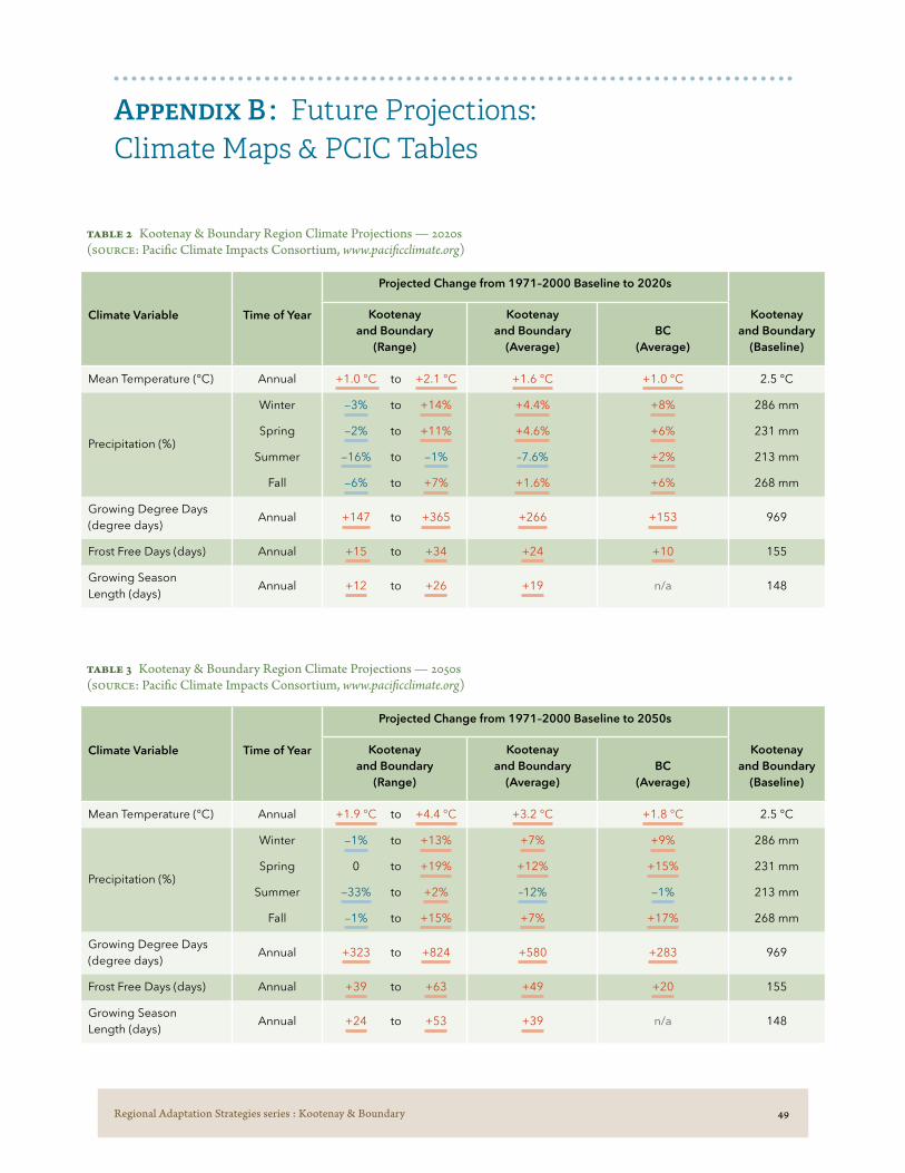
Regional Adaptation Strategies series : Kootenay & Boundary 49
Table 2 Kootenay & Boundary Region Climate Projections — 2020s (Source: Pacific Climate Impacts Consortium, www.pacificclimate.org)
Climate Variable Time of Year
Projected Change from 1971–2000 Baseline to 2020s
Kootenay and Boundary
(Baseline)
Kootenay and Boundary
(Range)
Kootenay and Boundary
(Average)BC
(Average)
Mean Temperature (°C) Annual +1.0 °C to +2.1 °C +1.6 °C +1.0 °C 2.5 °C
Precipitation (%)
Winter
Spring
Summer
Fall
−3% to +14%
−2% to +11%
−16% to −1%
−6% to +7%
+4.4%
+4.6%
–7.6%
+1.6%
+8%
+6%
+2%
+6%
286 mm
231 mm
213 mm
268 mm
Growing Degree Days (degree days)
Annual +147 to +365 +266 +153 969
Frost Free Days (days) Annual +15 to +34 +24 +10 155
Growing Season Length (days)
Annual +12 to +26 +19 n/a 148
Appendix B : Future Projections: Climate Maps & PCIC Tables
Table 3 Kootenay & Boundary Region Climate Projections — 2050s (Source: Pacific Climate Impacts Consortium, www.pacificclimate.org)
Climate Variable Time of Year
Projected Change from 1971–2000 Baseline to 2050s
Kootenay and Boundary
(Baseline)
Kootenay and Boundary
(Range)
Kootenay and Boundary
(Average)BC
(Average)
Mean Temperature (°C) Annual +1.9 °C to +4.4 °C +3.2 °C +1.8 °C 2.5 °C
Precipitation (%)
Winter
Spring
Summer
Fall
−1% to +13%
0 to +19%
−33% to +2%
−1% to +15%
+7%
+12%
–12%
+7%
+9%
+15%
−1%
+17%
286 mm
231 mm
213 mm
268 mm
Growing Degree Days (degree days)
Annual +323 to +824 +580 +283 969
Frost Free Days (days) Annual +39 to +63 +49 +20 155
Growing Season Length (days)
Annual +24 to +53 +39 n/a 148

Regional Adaptation Strategies series : Kootenay & Boundary 50
Table 4 Kootenay & Boundary Region Sub-Regional Baseline (Source: Pacific Climate Impacts Consortium, www.pacificclimate.org)
Climate Variable Time of Year Invermere Cranbrook Creston Slocan Valley Grand Forks
Mean Temperature (°C) Annual 5.2 °C 5.3 °C 7.3 °C 3.1 °C 7.5 °C
Precipitation (mm)
Winter
Spring
Summer
Fall
79 mm
83 mm
144 mm
89 mm
119 mm
111 mm
146 mm
120 mm
192 mm
156 mm
133 mm
169 mm
394 mm
302 mm
234 mm
368 mm
150 mm
139 mm
125 mm
117 mm
Growing Degree Days (degree days)
Annual 1,547 1,493 1,773 1,015 1,910
Frost Free Days (days) Annual 182 184 220 169 214
Growing Season Length (days)
Annual 194 191 210 153 212
Table 5 Kootenay & Boundary Region Sub-Regional Climate Projections — 2050s (Source: Pacific Climate Impacts Consortium, www.pacificclimate.org)
Climate Variable Time of Year Invermere Cranbrook Creston Slocan Valley Grand Forks
Mean Temperature (°C) Annual +3.2 °C +3 °C +3.1 °C +2.9 °C +3.2 °C
Precipitation (mm)
Winter
Spring
Summer
Fall
+8%
+13%
−9%
+7%
+6%
+12%
−11%
+4%
+6%
+11%
−13%
+6%
+6%
+11%
−14%
+8%
+11%
+16%
−19%
+9%
Growing Degree Days (degree days)
Annual +688 +694 +753 +595 +756
Frost Free Days (days) Annual +47 +51 +61 +49 +56
Growing Season Length (days)
Annual +32 +36 +40 +37 +34

Regional Adaptation Strategies series : Kootenay & Boundary 51
Figure 6 Growing Degree Days, Baseline 1971–2000 (left) and Projections 2041–2070 (right)
Figure 7 Growing Season Length, Baseline 1971–2000 (left) and Projections 2041–2070 (right)

Regional Adaptation Strategies series : Kootenay & Boundary 52
Note that for legibility, winter and summer use different legends and so cannot be directly compared.
Figure 8 Summer Precipitation (mm), Baseline 1971–2000 (left) and Projections 2041–2070 (right)
Figure 9 Winter Precipitation (mm), Baseline 1971–2000 (left) and Projections 2041–2070 (right)
Regional Adaptation Strategies series : Kootenay & Boundary 53
Appendix C : Definitions
■ Annual Average Temperature refers to the average of the nighttime low (minimum temperature) and the daytime high (maximum temperature) over a calendar year.
■ Frost-Free Days (FFD) refers to the number of days (in a calendar year) that the minimum daily temperature stayed above 0°C.
■ Growing Degree Days (GDD) are a measure of heat accumulation and represent the cumulative number of degrees that the average daily temperature is above a base temperature of 5ºC, for all days of the year.
■ Growing Season Length (GSL) represents the number of days between the first span of six consecutive days with a daily mean temperature above 6°C and the last day with a daily mean temperature above 6°C.
■ Heavy rain days (i.e., the 95th percentile wettest days) represents the total amount of rain that falls on the wettest days of the year, specifically on days when precipitation exceeds a threshold set by the annual 95th percentile of wet days during the baseline period (1971–2000).
■ Historic Baseline is the average of the variable from 1971 to 2000 (variables are averaged over this 30-year period to smooth out annual variability).
■ 1-in-20 hottest day refers to a day so hot that it has only a one-in-twenty chance of occurring in a given year. That is, there is a 5% chance in any year that temperatures could reach this magnitude.

Regional Adaptation Strategies series : Kootenay & Boundary 54
Appendix D : Adaptive Management of Climate Change Impacts
Climate change adaptation decision-making is an inherently complex task that requires ongoing learning and reflection to adjust to changing information, events and conditions. As learning progresses, new solutions as well as new challenges will be identified. The following questions are provided as tools for navigating this evolving landscape and determining priorities for action.
Additional considerations when determining how to implement priority actions would include:
→ Barriers (e.g., legislation, lack of working relationships)
→ Assets/Enablers (e.g., leadership, integrating into existing plans/programs)
→ Implementation costs
→ Operation and maintenance costs
→ Financing and resources
→ Timeframe
Table 6 Developing & Prioritizing Adaptation Actions
Effectiveness To what degree does this action reduce risk/vulnerability, and/or enhance resilience?
Adaptability Can this action (and resources dedicated to it) be changed or redirected as conditions change?
Urgency When does action need to be taken on this issue, in order to be effective by the time an impact is projected to occur?
Gaps & Assets How does this action address identified gaps or barriers? How can it build on existing assets and resources?
Co-benefits (“no-regrets”)
What other benefits would this action have, even if climate change impacts do not occur as projected?
Consequences What could be the unintended and/or undesirable effects of taking this action? Can these be avoided or mitigated?
Extent Do the benefits apply broadly in the region, or to specific individuals?
Relevance Does this action have the support of the agricultural community?

Regional Adaptation Strategies series : Kootenay & Boundary 55
Endnotes
1 BC Agriculture & Food Climate Action Initiative. (2012). BC Agriculture Climate Change Adaptation Risk + Opportunity Assessment: Provincial Report. https://bcagclimateaction.ca/documents/AdaptROseries-Provincial.pdf
2 Statistics Canada. (2017). Central Kootenay, RD [Census division], Central Kootenay, RD [Census Division], East Kootenay, RD [Census Division] British Columbia. Census Profile. 2016 Census. Statistics Canada Catalogue no. 98-316-X2016001. https://www12.statcan.gc.ca/census-recensement/2016/dp-pd/prof/
3 Regional District of Kootenay and Boundary. https://www.rdkb.com/AboutUs/Communities.aspx Regional District of Central Kootenay. https://rdck.ca/EN/main/ government/welcome.html Regional District of East Kootenay. https://rdek.bc.ca/about/board_of_directors/
4 British Columbia Assembly of First Nations website. Kootenay Community Profile. https://bcafn.ca/community-profiles/ ?region%5B%5D=kootenay
5 A full list of watersheds in the region can be found in Breen, S. (2012). Profile of the Kootenay Region. Simon Fraser University. http://cdnregdev.ruralresilience.ca/wp-content/uploads/2013/03/KootenayRegional-Profile_FINAL-20130120.pdf
6 Ministry of Forests, Lands and Natural Resource Operations. (2011). Crown Land: Indicators & Statistics Report 2010. Province of British Columbia. (p. 13).
7 See Table 4 in Appendix B for baseline information on sub-regional variability.
8 Climate projections for the Kootenay & Boundary region provided by Trevor Murdock and Steve Sobie at the Pacific Climate Impacts Consortium.
9 Based on review of historic seasonal precipitation patterns for Invermere, Cranbrook, Creston, Slocan Valley and Grand Forks. Data provided by the Pacific Climate Impacts Consortium and additional information and links to data available in Appendix B.
10 Climate projections for the Kootenay & Boundary region provided by Trevor Murdock and Steve Sobie at the Pacific Climate Impacts Consortium.
11 Based on review of Kaslo weather station data. Environment Canada. (2019). Canadian Climate Normals 1981–2010 Station Data.
12 Regional District of East Kootenays. (2014). RDEK Regional Profile: Issue Number 7. https://rdek.bc.ca/about/regional_profile/
13 Climate projections for the Kootenay & Boundary region provided by Trevor Murdock and Steve Sobie at the Pacific Climate Impacts Consortium.
14 Ibid.
15 Ibid.
16 Based on review of four agriculturally relevant weather stations located across the region. Environment Canada. (2019). Canadian Climate Normals 1981–2010 Station Data (Cranbrook A, Creston, Castlegar A, Grand Forks stations).
17 Regional District East Kootenays. (2013). RDEK Area Agricultural Plan. Prepared by Vast Resources. (p. 11). ftp://ftp.rdek.bc.ca/pdf/agplan/rdek%20ag%20plan_background%20report%20final.pdf
18 Ibid.
19 Van der Gulik, T., Tam, S. (2017) Agricultural Water Demand Model: Report for Regional District of Central Kootenay. https://waterbucket.ca/wp-content/uploads/2017/10/Report-for-the-Regional-District-of-Central-Kootenay.pdf
20 Roussin, R. (2014) Agricultural Potential of the West Kootenay, BC. University of British Columbia: Faculty of Land and Food Systems http://mlws.landfood.ubc.ca/files/2014/10/Report_Agricultural-Potential-of-the-W-Kootenay.pdf
21 Regional District of Kootenay and Boundary. (2017). Biophysical and Agricultural Profile: Boundary Area Agriculture and Food Security Plan. https://rdkb.com/LinkClick.aspx?fileticket=CWZxSxNzKo M%3D
22 Breen, S. (2012). Profile of the Kootenay Region. Simon Fraser University. http://cdnregdev.ruralresilience.ca/wp-content/uploads/2013/03/KootenayRegional-Profile_FINAL-20130120.pdf
23 WorkBC website. (2017) Labour Market & Industry: Regional Profile: Kootenays. https://workbc.ca/Labour-Market-Information/Regional-Profiles/Kootenay#view-full-profile
24 Ibid.
25 Statistics Canada. (2017). Kootenay [Economic region], British Columbia and Canada [Country] (table). Census Profile. 2016 Census. Statistics Canada Catalogue no. 98-316-X2016001. Ottawa. https://www12.statcan.gc.ca/census-recensement/2016/dp-pd/prof/
26 BC Stats. (2016). Census Total Population Results: Municipalities by Regional District. http://bcstats.gov.bc.ca/statisticsbysubject/census/2016census/populationhousing/municipalitiesbyregionaldistrict.aspx (as of 1 April 2016)
27 Farm Credit Canada (2018) FCC Farmland and Values Report. https://fcc-fac.ca/fcc/about-fcc/reports/2018-farmland-values-report-e.pdf
28 Ibid.

Regional Adaptation Strategies series : Kootenay & Boundary 56
29 Some of these local food initiatives include the Central Kootenay Food Policy Council, Cranbrook Food Action Committee, Fields Forward, Wildsight, as well as numerous food co-ops (Kootenay Co-op, Kettle Valley Food Co-op)
30 https://bcfarmersmarkettrail.com/markets/?region=kootenay-rockies
31 32% have farm gates sales/u-picks, 12% use farmer’s markets and 2% participate in Community Supported Agriculture. More information can be found in the 2016 Agriculture In Brief: Kootenays. https://www2.gov.bc.ca/assets/gov/farming-natural-resources-and-industry/agriculture-and-seafood/statistics/census/census-2016/aginbrief_2016_kootenay_region.pdf
32 The Columbia Basin Trust was established in 1995 as compensation for damages caused by the flooding of several valleys to support the construction of several large-scale hydroelectric facilities.
33 Information on the Columbia Basin Trust’s agricultural initiatives can be found at https://ourtrust.org/our-work/agriculture/
34 The area served by the Columbia Basin Trust does not include Boundary. Funding for Kootenay and Boundary Farm Advisors in the Boundary region is provided through the Regional Districts.
35 The Kootenay and Boundary Farm Advisors (KBFA) provides producers with free, technical production support and information from a network of specialized resources, including independent consultants and academics. KBFA supports producers to improve agricultural production and efficiency by helping find solutions to farm-specific production issues, coordinating educational events and connecting producers to information. Visit https://kbfa.ca for more information.
36 Boundary Area Food and Agriculture Plan. https://rdkb.com/LinkClick.aspx?fileticket=LrHSR1jfHqs%3d
37 Regional District East Kootenay Area Agricultural Plan. https://rdek.bc.ca/departments/planning/plans/ekag
38 Regional District Central Kootenay Agricultural Plan. https://rdck.ca/EN/main/services/sustainability-environmental-initiatives/agriculture-area-plan.html
39 Agricultural Land Use Inventories can be accessed on the BC Ministry of Agriculture’s website at: https://www2.gov.bc.ca/gov/content/industry/agriculture-seafood/agricultural-land-and-environment/strengthening-farming/planning-for-agriculture/agricultural-land-use-inventories/kootenay
40 Agriculture Water Demand Models can be accessed on the BC Ministry of Agriculture’s website at: https://www2.gov.bc.ca/gov/content/industry/agriculture-seafood/agricultural-land-and-environment/water/water-management/agriculture-water-demand-model
41 Information on the Columbia Rural Development Institute’s agricultural/food system research can be found at http://cbrdi.ca/Projects/FoodSystems
42 BC Ministry of Agriculture. (2016). Agriculture In Brief: Kootenays. https://www2.gov.bc.ca/assets/gov/farming-natural-resources-and-industry/agriculture-and-seafood/statistics/census/census-2016/aginbrief_2016_kootenay_region.pdf
43 Calculated from Agriculture in Brief profiles (2006, 2011, 2016) for Kootenay Boundary, Central Kootenay and East Kootenays. These can be accessed on the BC Ministry of Agriculture’s website at https://www2.gov.bc.ca/gov/content/industry/agriculture-seafood/statistics/census-of-agriculture
44 Ibid.
45 Ibid.
46 BC Ministry of Agriculture. (n 42)
47 BC Ministry of Agriculture. (2016). Agriculture in Brief: Regional District of Central Kootenay. https://www2.gov.bc.ca/assets/gov/farming-natural-resources-and-industry/agriculture-and-seafood/statistics/census/census-2016/aginbrief_2016_central_kootenay.pdf
48 BC Ministry of Agriculture. (2016). Agriculture in Brief: Regional District of Kootenay Boundary. https://www2.gov.bc.ca/assets/gov/farming-natural-resources-and-industry/agriculture-and-seafood/statistics/census/census-2016/aginbrief_2016_kootenay_boundary.pdf
49 BC Ministry of Agriculture. (2016). Agriculture in Brief: Regional District East Kootenay. https://www2.gov.bc.ca/assets/gov/farming-natural-resources-and-industry/agriculture-and-seafood/statistics/census/census-2016/aginbrief_2016_east_kootenay.pdf
50 Calculated from Agriculture in Brief profiles (2006, 2011, 2016) for Kootenay Boundary, Central Kootenay and East Kootenays. These can be accessed on the BC Ministry of Agriculture’s website at https://www2.gov.bc.ca/gov/content/industry/agriculture-seafood/statistics/census-of-agriculture
51 BC Ministry of Agriculture. (n 42)
52 Regional District East Kootenay Area Agricultural Plan. (n 37)
53 Regional District Central Kootenay Agricultural Plan. (n 38)
54 Regional District of Kootenay and Boundary. (2017). Biophysical and Agricultural Profile: Boundary Area Agriculture and Food Security Plan. https://rdkb.com/LinkClick.aspx?fileticket=CWZxSxNzKoM%3D
55 Regional District East Kootenay Area Agricultural Plan. (n 37)
56 Regional District Central Kootenay Agricultural Plan. (n 38)
57 BC Ministry of Agriculture. (n 48)
58 BC Ministry of Agriculture. (2017). Regional District of Central Kootenay Agricultural Land Use Inventory. https://www2.gov.bc.ca/assets/gov/farming-natural-resources-and-industry/agriculture-and-seafood/agricultural-land-and-environment/strengthening-farming/land-use-inventories/rdck_aluireport_may11_2017.pdf
59 BC Ministry of Agriculture. (n 42)
60 Ibid.
61 Ibid.
62 Ibid.
63 BC Ministry of Agriculture. (n 49)

Regional Adaptation Strategies series : Kootenay & Boundary 57
64 BC Ministry of Agriculture. (2017). Regional District of Central Kootenay Agricultural Land Use Inventory.
65 British Columbia Milk Marketing Board. (2018). Annual Report for the 2017/2018 Dairy Year. https://bcmilkmarketing.worldsecuresystems.com/LiteratureRetrieve.aspx?ID=44026
66 Stocker, T. F., Qin, D., et al. (2013). Climate Change 2013: The Physical Science Basis. Cambridge University Press. http://www.climatechange2013.org/images/report/WG1AR5_ALL_FINAL.pdf
67 Ibid.
68 Pacific Climate Impacts Consortium. https://pacificclimate.org
69 Pacific Climate Impacts Consortium. (2019). Updated Climate Summary for Kootenay and Boundary Region.
70 PCIC’s Statistically Downscaled Climate Scenarios are available for download through the PCIC data portal at https://pacificclimate.org/data/statistically-downscaled-climate-scenarios . This data can also be viewed through the “PCIC Climate Explorer” tool at https://pacificclimate.org/analysis-tools/pcic-climate-explorer .
71 The BCCAQ is a technique developed at the Pacific Climate Impacts Consortium for downscaling daily temperature and precipitation projections, and indices of extremes. It was tested for robustness according to three main criteria: day-to-day sequencing of events, distribution of values, and spatial structure. For more information see Cannon, A., Sobie S., Murdock, T. (2015). Precipitation by Quantile Mapping: How Well Do Methods Preserve Changes in Quantiles and Extremes? Journal of Climate. 28 (17). 6938-6959. doi:10.1175/JCLI-D-14-00754.1 or visit https://pacificclimate.org/data/statistically-downscaled-climate-scenarios
72 To view the Kootenay & Boundary region modelling and outputs in detail, use the PCIC Climate Explorer tool at https://pacificclimate.org/analysis-tools/pcic-climate-explorer . An excellent (general) description of climate modelling, outputs, ranges and variables can be found in the report Climate Projections for Metro Vancouver (developed
with PCIC) and accessible at http://metrovancouver.org/services/air-quality/AirQualityPublications/ClimateProjectionsForMetroVancouver.pdf
73 For a detailed explanation, see the presentation by Trevor Murdoch from the Pacific Climate Impacts Consortium at https://youtu.be/EqV9-jgFFeg (21 minute mark).
74 Annual average temperature refers to the average of the nighttime low (minimum temperature) and the daytime high (maximum temperature) over a calendar year.
75 The historic baseline (used for all climate variables) is the average of the variables from 1971 to 2000. Variables are averaged over this 30-year period to smooth out annual variability.
76 Frost-free days is a derived variable referring to the number of days that the minimum daily temperature stayed above 0°C, useful for determining the suitability of growing certain crops in a given area. The method used to compute this on a monthly basis is from (Wang et al, 2006).
77 Growing Degree-Days (GDDs) is a derived variable that indicates the amount of heat energy available for plant growth, useful for determining the growth potential of crops in a given area. It is calculated by multiplying the number of days that the mean daily temperature exceeded 5°C by the number of degrees above that threshold. For example, if a given day saw an average temperature of 8°C (3°C above the 5°C threshold), that day contributed 3 GDDs to the total. If a month had 15 such days, and the rest of the days had mean temperatures below the 5°C threshold, that month would result in 45 GDDs.
78 Climate projections for the Kootenay & Boundary region provided by Trevor Murdock and Steve Sobie at the Pacific Climate Impacts Consortium.
79 Pacific Climate Impacts Consortium. (2019). Climate Summary for Kootenay and Boundary Region. https://pacificclimate.org/sites/default/files/publications/Climate_Summary-Kootenay-Boundary.pdf
80 Ibid.
81 Ibid.
82 Maciak, R., Ford, T., Schroeder, J., (2013). Kettle River Watershed Analysis: Midway, British Columbia to stream headwaters. Boundary Environmental Alliance. https://boundaryalliance.org/kettleriverstudy.pdf
83 A 1-in-20 hottest day refers to the day so hot that it has only a one-in-twenty chance of occurring in a given year. Individual locations could be considerably warmer than the regional average but an increase of about 5°C (by 2050) in the 1-in-20 year hottest day is quite consistent around most of the region.
84 Heavy rain days (i.e., the 95th percentile wettest days) represents the total amount of rain that falls on the wettest days of the year, specifically on days when precipitation exceeds a threshold set by the annual 95th percentile of wet days during the baseline period (1971–2000).
85 Statistics for irrigated areas can be found in the Agricultural Land Use Inventories for the Central Kootenays and East Kootenays (Elk Valley, Columbia Valley and Central Region), and in the 2016 Agriculture in Brief profile for Kootenay and Boundary.
86 Pacific Climate Impacts Consortium. (n0 70)
87 Carver, M., (2017) Water Monitoring and Climate Change in the Upper Columbia Basin. Columbia Basin Trust. (p. 50). https://ourtrust.org/wp-content/uploads/downloads/2017-02_Trust_WaterMonitoring-ClimateChange_Web.pdf
88 The BC Ministry of Forests, Lands, Natural Resources Operations and Rural Development monitors dozens of streams that are at risk from potential water supply challenges during dry years (across the three Regional Districts). Rural well owners have also raised concerns about water quantity/water shortage with their Regional Districts (particularly in Kootenay and Boundary).
89 Regional District of Central Kootenay. (2015). Drought: Please conserve water. https://rdck.ca/EN/meta/news/news-archives/2015-news-archive/drought-please-conserve-water.html

Regional Adaptation Strategies series : Kootenay & Boundary 58
90 Provincial Government of BC. (September 8, 2017). Provincial Drought Level 4 for Kootenay Boundary. https://rdkb.com/LinkClick.aspx?fileticket=rjqfJo0X12w%3d
91 Ben Cross, Water Stewardship Officer, Ministry of FLNRORD, email communication, April 12, 2019.
92 van der Gulik, T., Neilsen, D., Fretwell, R. (2013). Agriculture Water Demand Model: Report for the Kettle Watershed.
93 Government of British Columbia. (2019). Water Sustainability Act. https://www2.gov.bc.ca/gov/content/environment/air-land-water/water/laws-rules/water-sustainability-act
94 Government of British Columbia. (2019). Blog Post #24 — Proposed Livestock Watering Regulations. https://engage.gov.bc.ca/watersustainabilityact/2018/01/12/blog-post-24-proposed-livestock-watering-regulations-what-do-you-think/
95 van der Gulik, T., Neilsen, D., Fretwell, R. (2013). Agriculture Water Demand Model: Report for the Kettle Watershed and van der Gulik, T., Tam, S. (2017). Agriculture Water Demand Model: Report for Regional District of Central Kootenay.
96 BC Agriculture & Food Climate Action Initiative. (2018). Okanagan – Vineyard Water Metric Toolkit (excel). https://www.bcagclimateaction.ca/project/ok04/
97 Jason McDiarmid, Utility Services Manager, Regional District of Central Kootenay, email communication, April 10, 2019.
98 Environmental Farm Plan. (2019). Canadian Agricultural Partnership Beneficial Management Practices List 2019/20. http://ardcorp.ca/wp-content/uploads/2019/04/2019-2020-BMP-List-Final.pdf
99 Citizen science is defined as scientific work undertaken by members of the general public, often in collaboration with or under the direction of professional scientists and scientific institutions. Examples of Canadian Citizen Science projects can be found at http://science.gc.ca/eic/site/063.nsf/eng/h_97169.html
100 The cumulative effects framework is a set of policies, procedures and decision-support tools that helps identify and manage cumulative effects consistently and transparently across British Columbia’s natural resource sector. The framework incorporates the combined effects of all activities and natural processes into decision-making to help avoid unintended consequences to identified economic, social and environmental values (such as impacts to aquatic ecosystems, which includes water quality and quantity). Government of BC. (2019). Cumulative effects framework. https://www2.gov.bc.ca/gov/content/environment/natural-resource-stewardship/cumulative-effects-framework and Provincial Aquatic Ecosystems Technical Working Group
– Ministries of Environment and Forests, Lands and Natural Resource Operations. (2017). Interim Assessment Protocol for Aquatic Ecosystems in British Columbia. https://www2.gov.bc.ca/assets/gov/environment/natural-resource-stewardship/cumulative-effects/interim_aquatic_ecosystems_protocol_dec2017_v11_final.pdf
101 Wildfire Season Summaries (dating back 10 years) are available on the BC Wildfire Services website. https://www2.gov.bc.ca/gov/content/safety/wildfire-status/about-bcws/wildfire-history/wildfire-season-summary
102 Based on review of Wildfire Season Summaries for the Kootenay region on the BC Wildfire Services website.
103 Lee, J. ( June 26, 2016). Rock Creek slow to rebuild after last summer’s devastating wildfire. Vancouver Sun. https://vancouversun.com/news/local-news/rock-creek-slow-to-rebuild-after-last-summers-devastating-wildfire
104 Information on the pilot project Wildfire Pre-Season Communications and Information Exchange Pilot Project can be found at https://bcagclimateaction.ca/project/ok09/ .
105 The Air Quality Health Index (AQHI) provides hourly air quality readings and related health messages to report on the health risks posed by a mixture of pollutants, including smoke. For more information visit https://www2.gov.bc.ca/gov/content/
environment/air-land-water/air/air-quality/aqhi . Data analyzed for Castlegar and Cranbrook stations from the Air Quality Monitoring: Verified Hourly Data data catalogue.
106 The BC Agriculture & Food Climate Action Initiative’s Agriculture Wildfire Preparedness and Mitigation Workbook & Guide leads producers through a series of modules that focus on actions producers can take before, during, and after a wildfire to protect their operations and business and helps them to develop an Agriculture Wildfire Plan. The workbook and guide can be downloaded at https://bcagclimateaction.ca/wildfire
107 In winter 2019, the BC Agriculture & Food Climate Action Initiative hosted ten provincial workshops focused on farm-level wildfire preparedness and planning (including workshops in Cranbrook, Creston and Greenwood). The BC Cattlemen’s Association, in conjunction with AgSafe BC, also hosted a series of farm-level preparedness workshops across BC in winter 2018.
108 Blackwell, B. (2018). Discussion Document: Planning and Information Exchange for Wildfire Impact Reduction. BC Agriculture & Food Climate Action Initiative.
109 A list of woodlot licencees for the province of British Columbia can be found at https://www2.gov.bc.ca/assets/gov/farming-natural-resources-and-industry/forestry/timber-tenufes/woodlots/issued_woodlot_licences.pdf . More information about the woodlot licence program is available at https://www2.gov.bc.ca/gov/content/industry/forestry/forest-tenures/timber-harvesting-rights/woodlot-licence .
110 The Community Resiliency Investment (CRI) program was introduced by the government of British Columbia in 2018. It is intended to reduce wildfire risks and wildfire impacts in communities by providing funding and support to complete FireSmart initiatives, including priority fuel management activities on provincial Crown land and on private land. Information about the Community Resilience Investment Program can be found at https://www2.gov.bc.ca/gov/content/safety/wildfire-status/prevention/crip .

Regional Adaptation Strategies series : Kootenay & Boundary 59
111 Burning embers or other flaming material from a wildfire can be carried by the wind to start new spot fires in areas of unburned fuel. It’s quite common for burning embers that are thrown ahead of the leading edge of the fire (the “flame front”) to allow wildfires to “jump” fuel-free barriers such as highways or bodies of water. FireSmart BC. https://firesmartcanada.ca/resources-library/manuals/
112 Xiang, Tao., and Chaya, Mona. (2019). Climate change exacerbates the challenge of plant pests. Foodtank: the Think Tank for Food. https://foodtank.com/news/2019/03/climate-change-exacerbates-the-challenge-of-plant-pests/
113 Duane Holder, horticulture consultant, personal communication, April 9, 2019.
114 Decision support tools (DSTs) are information technology resources designed to help farmers tackle complex problems in crop production, inputting the best available data combined with knowledge about best practices.
115 The BC Decision Aid System (BC DAS) is an example of a transferable tool that links data from 27 weather stations in the Okanagan, along with weather forecast data and pest models, to predict pest emergence timing for fruit crops. The tool has a clear, simple interface and links to conventional and organic management recommendations. https://www.oksir.org/bcdas/
116 AgWeather Quebec (AQ) provides dozens of bioclimatic models that help producers determine the best time to apply inputs to their fields (pesticides, fungicides, etc.), depending on the specific climate conditions in their area. AQ also provides a management tool for to hay producers to help them determine the best time for the first cut of hay to ensure optimal forage quantity and yield. http://www.agrometeo.org/indices/category/plantes_fourrageres
117 Tam, S., Anslow, F. (2018). Gap Analysis and Overview of Weather Station Data in British Columbia Agricultural Regions. British Columbia Agricultural Climate Adaptation Research Network. https://www.bcacarn.com/weather-station-project/
118 A Guide to On-Farm Demonstration Research includes step-by-step instructions on developing research objectives and formulating a research question, deciding what to measure and how to measure it, scouting for relevant research, collecting data and analyzing results. While developed for forage producers, the methodology can be applied to any production system. https://bcagclimateaction.ca/documents/FI03-On-Farm-Demonstration-Research-Guide.pdf
119 Information on the project Enabling Climate Change Adaptation through Grab & Go On-Farm Research Templates can be accessed at https://bcagclimateaction.ca/project/fi19/ .
120 Information on the Farm Adaptation Innovator project Adapting to Low Light Growing Conditions Using High Tunnel Structures can be found at https://bcagclimateaction.ca/project/fi14/ .
121 This CAI supported project, based in the Cariboo and completed in 2018, combined input from producers on their major pests of concern, statistics on the acreage and value of crops affected by certain pests, information on future biogeoclimatic (BEC) zone modeling to predict shifts to pests, and other criteria to prioritize and rank pests. https://bcagclimateaction.ca/project/cb13/
122 Pest alerts are distributed from Canadian Food Inspection Agency (CFIA), but these are reactive once a pest outbreak has occurred. The BC Ministry of Agriculture issues pest alerts and assists with production guides that include information about commodity specific pest management options.
123 In the Cariboo, the Invasive Species Council of BC is consolidating multiple weed reporting apps into one comprehensive app, and other species of pest (in addition to weeds), will be included in the app. If successful, this could be broadened to other regions as a tool.
124 IPM remains the most integrated way to address the increasing severity of pests resulting from climate change. T. Xiang, and M. Chaya. Climate change exacerbates the challenge of plant pests. Foodtank: the think tank for food. https://foodtank.com/news/2019/03/climate-change-exacerbates-the-challenge-of-plant-pests/
125 Kevin Murphy, Regional Agrologist, BC Ministry of Agriculture, personal communication, April 10, 2019.
126 Pacific Climate Impacts Consortium. (no 70)
127 Regional District Central Kootenays website. https://rdck.ca/EN/main/services/emergency-management/emergency-preparedness/floods.html
128 Floodplain maps identify areas that experience periodic flooding from nearby rivers, lakes, streams and the sea and provide information on the spatial distribution of flood construction levels. A comprehensive list of British Columbia floodplains (and associated floodplain maps) can be found at https://www2.gov.bc.ca/gov/content/environment/air-land-water/water/drought-flooding-dikes-dams/integrated-flood-hazard-management/flood-hazard-land-use-management/floodplain-mapping/floodplain-maps-by-region . Kootenay floodplain maps can be found under Region 4 – Kootenay, Boundary floodplain maps can be found under Region 3 – Southern Interior.
129 Graham Watt, Recovery Manager, City of Grand Forks and Regional District of Kootenay Boundary, personal communication, May 17, 2019.
130 Cohen, R. (2014). Fact Sheet #1: Functions of Riparian Areas for Flood Control. Division of Ecological Restoration, Massachusetts Department of Fish and Game.
131 See Strategy 4.2 for examples of local supports. Financial cost-shared incentives may also be available to eligible producers who develop and have completed a current EFP through the Canadian Agricultural Partnership Beneficial Management Practices (BMP) Program to implement actions identified in their on-farm

Regional Adaptation Strategies series : Kootenay & Boundary 60
Urls in these Endnotes were current as of June 2019.
environmental actions plan. BMP categories and practices can be found at http://ardcorp.ca/wp-content/uploads/2018/06/2018-19-BMP-List-Version-3.0-June-21-FINAL.pdf
132 Lower Kootenay Band — Creston Floodplain Management Plan: Baseline Study Stage 1. (2014). (Not public). Provided by Lower Kootenay Indian Band.
133 For more information see resources: Rutherford, S., (2007). The Green Infrastructure Guide: Issues, implementation strategies and success stories. West Coast Environmental Law Research Foundation and Fraser Basin Council. (2017). Rethinking our Waterways: A Guide to Water and Watershed Planning For BC Communities In The Face Of Climate Change And Other Challenges.
134 Ibid.
135 Information on the RDCK Flood and Geohazard Risk Review can be found on the RDCK website. https://rdck.ca/EN/meta/news/news-archives/2018-news-archive/regional-flood-and-geohazard-risk-assessment-will-help-reduce-the-impact-of-disasters.html
136 For more information see Regional District of Kootenay Boundary. (2018). Community Recovery Options for Areas Damaged by May 2018 Flooding in the Kettle River Watershed. https://bfre.ca/wp-content/uploads/Kettle-River-Flood-Recovery-Report-v-web.pdf
137 Producers who develop and have completed a current Environmental Farm Plan may be eligible to apply for cost-shared incentives through the Beneficial Management Practices (BMP) Program to implement actions identified in their on-farm environmental actions plan. BMP categories and practices can be found at http://ardcorp.ca/wp-content/uploads/2018/06/2018-19-BMP-List-Version-3.0-June-21-FINAL.pdf .
138 For more information on Farmland Advantage’s Payment For Ecosystem Services pilot project visit http://farmlandadvantage.com/about .
139 The City of Kelowna’s NeighbourWoods Program is a residential planting initiative developed to encourage citizens to help grow and preserve Kelowna’s healthy neighbourhoods’ urban forest. The program provides residents with opportunities to purchase discounted trees (subsidized by the City) on a set date during the year. https://kelowna.ca/parks-recreation/urban-trees-wildlife/neighbourwoods
140 An example of a strong resource is the Regional District of East Kootenay Seasonal Flooding Newsletter is available on the Emergency Services page of the RDEK website. https://rdek.bc.ca/departments/emergencyservices/emergencyinfo/
141 The BC Ministry of Agriculture has partnered with industry associations to develop all-hazard planning guides for beef, dairy, poultry and pork producers and for mixed farms. Government of British Columbia. (2016). https://www2.gov.bc.ca/gov/content/industry/agriculture-seafood/business-market-development/emergency-preparedness
142 The six diking districts in the Creston area are the Goat River Residence Association, The Duck Lake Diking District, the Creston Diking District, the Creston Valley Wildlife Management Area, the Reclamation Diking District. Details on each dike can be accessed at https://www2.gov.bc.ca/assets/gov/environment/air-land-water/water/integrated-flood-hazard-mgmt/dikes_listed_by_ownerauthority.pdf .
143 Lower Kootenay Indian Band. (no 135)
144 Fraser Basin Council. (2010). Environmental Protection in Flood Hazard Management: A guide for practitioners. https://www.fraserbasin.bc.ca/_Library/Water/report_flood_and_environmental_protection_2010.pdf

7.1.1DRAFT
Present: [Member], Chair [Member], Vice Chair Joe Caravetta Secretary Dale Garrett David Beranek Dan Savage Director Mike Sosnowski
1. Call to Order
Advisory Planning Commission Electoral Area A
Minutes
July 16, 2019 Fernie Chamber Commerce Office
Chair Joe called the meeting to order at 730 pm.
2. Delegations
Mike Delich spoke to their application p719 117 and advised that they are seeking a variance on the set back to proceed with building construction. Strata of nearby other buildings are supportive of the application and will be writing letters of support.
Barry Stuart spoke to his application P 719 115 and advised he was seeking a variance or height of building. Provided diagrams of adjacent homes and advised that neighbors were in support of the application.
Doug Feely spoke to his application P719 116 and advised Island Lake lodge is seeking a variance on their liquor license hours to accommodate weddings.
3. Adoption of the Minutes
Moved by David Seconded by Dan
That the minutes of the Advisory Planning Commission meeting held on June 18, be adopted.
CARRIED
4. Planning & Development Services Monthly Report
Moved by Dale Seconded by Dan
That the monthly Planning & Development Services Report be received.
5. Agriculture Land Reserve Referrals

Advisory Planning Commission (APC)
6. Bylaw Amendment Application
7. Development Variance Permit Application
P719 115 Barry Stuart /resort Drive Fernie Alpine Resort
Moved by David Seconded by Dan
Meeting Minutes
That the Advisory Planning Commission recommends the Stuart Development Variance Permit application be Supported
CARRIED
P719 117 Polar peeks Properties/timberline crescent Fernie Alpine
Moved by Dale Seconded by Dan
That the Advisory Planning Commission recommends the Polar Peeks Development Variance Permit application be Supported
CARRIED
8. Ministry of Forests, Lands, Natural Resource Operations and Rural Development (NRO) Referrals
9. Liquor & Cannabis Licence Applications
P719 116 Island Lake Lodge /Mt Fernie Road Fernie
Moved by Joe Seconded by Dan
That the Advisory Planning Commission recommends the Island Lake Lodge application be supported
CARRIED
10. Adjournment
The meeting adjourned at 8:20

7.1.2DRAFT
Advisory Planning Commission Electoral Area B
Minutes
July 17, 2019 Baynes Lake Fire Hall
Present: Shayne Webster, Chair Cory Wentzell, Vice Chair Lily Durham, Secretary Josh Pedersen Wendy Salanski Andy McDonald Kent Holmes Dave Gonnelly Maureen Coulombe Marjorie Reay John Todd
Director Stan Doehle
1. Call to Order
Chair Shayne Webster called the meeting to order at 7:03pm
2. Delegations
Stan Doehle spoke to their application P 719 207- Doehle/Chief David Rd, Baynes Lake (Stan removed himself from the room during discussion due to conflict of interest)
3. Adoption of the Minutes
Moved by Wendy Salanski Seconded by Dave Gonnelly
That the minutes of the Advisory Planning Commission meeting held on June 6, 2019 be adopted with revision of Delegations name from Sabey to Leaney.
CARRIED
4. Planning & Development Services Monthly Report
Moved by Kent Holmes Seconded by Dave Gonnelly
That the monthly Planning & Development Services Report be received.

Advisory Planning Commission (APC)
5. Agriculture Land Reserve Referrals
P 719 207 - Doehle/Chief David Rd, Baynes Lake
Moved by Lily Durham Seconded by Kent Holmes
Meeting Minutes
That the Advisory Planning Commission recommends the Doehle/Chief David rd., Agricultural Land Reserve application be supported.
CARRIED
Comments: Unanimous
5. Bylaw Amendment Application
No Application
6. Development Variance Permit Application
No Application
7. Ministry of Forests, Lands, Natural Resource Operations and Rural Development (NRO) Referrals
P 151 200 - Koocanusa Recreation Steering Committee/Dorr-Grasmere
Moved by Maureen Coulombe Seconded by Wendy Salanski
That the Advisory Planning Commission recommends the Koocanusa Recreation Steering Committee NRO Referral be refused based on the following conditions:
DEFEATED
Comments: Road access to the river north of the Elk River Bridge be open to the public for motorized access. What does rough road (restricted) mean?
8. Liquor & Cannabis Licence Applications
No Application
9. Adjournment
The meeting adjourned at 7:56 pm.

7.1.3DRAFT
MINUTES of the Electoral Area C Advisory Planning Commission meeting held on Thursday, July 11,
2019 in the Conference Room at the RDEK office in Cranbrook.
PRESENT Lee-Ann Crane, Chair & Secretary Herb Janzen Richard Wake
ABSENT Chris Caron Wayne Stone
The meeting was called to order at 7:00 pm.
DELEGATIONS
Bob Bjorn, Vice Chair Ilene Lowing Jim Westwood
Roger Mitchell Rob Gay, Electoral Area C Director
310613 BC Ltd. / Three Bars Guest Ranch - ALR Non-Adhering Residential Use Application Hans Plechinger from the Three Bars Guest Ranch presented information on their ALR NonAdhering Residential Use application for placement of a manufactured home as a principal dwelling on their property located at 9430 Wycliffe-Perry Creek Road. Mr. Plechinger provided the history of ownership and operations at the Ranch. He explained the need for the manufactured home and advised that the 'old cabin' is no longer habitable due to age and condition and that this building would be used for storage. Mr. Plechinger further advised that the plan to replace the 'old cabin' as a dwelling unit with a manufactured home had been in place before ALC rules changed to only allow one dwelling per lot.
Brian Passey- 4283 Lakeview Drive - DVP Application
Mr. Passey provided information on his proposal to construct a wheelchair ramp on their property at 4283 Lakeview Drive in the Jim Smith Lake area. It was noted that the ramp would be 4 feet wide (handrails within the 4 feet), constructed on a 1:12 slope, and made of 2x6 boards sitting on edge on concrete blocks. A front-yard setback variance from 6.0m to 1.2m is required to construct the ramp from the house to the parking area.
Darren Pickering - 7834 Monroe Lake Road - DVP Application
Mr. Pickering outlined his proposal to construct an accessory building on his property at 7834 Monroe Lake Road, west of Moyie Lake Road. The building is proposed to be 334 m2 with the height being 6.lm. He advised that the higher roof is required to accommodate a 12-foot door and 14-foot ceiling in order to park a large recreational vehicle in the building and to avoid having posts within the structure. Mr. Pickering noted that the building would not be used to store items from his commercial operation in Cranbrook, but instead would be used to store personal items and to get them out of his shop in town. He also noted that only one neighbour could actually see or be bothered by the higher building and that neighbour has indicated his support.
Harvey Bombardier - 7547 Green Bay Road - NRO Referral Mr. Bombardier advised that the purpose of his License of Occupation application is to legalize a wharf that has been in existence for over 20 years. The wharf is located on Crown foreshore immediately across the road from where his cabin is located. He also noted that all his neighbours have wharves and that there is no intent to alter the wharf in any way.

Electoral Area C Advisory Planning Commission Minutes - July 11, 2019
MINUTES
Moved by Bob Bjorn Seconded by Herb Janzen
That the minutes of the June 13, 2019 APC C meeting be adopted as circulated.
CARRIED
ALR APPLICATION
P 719 338 3130613 BC Ltd (Three Bars Guest Ranch)/ 9430 Wycliffe-Perry Creek Road, west of Wycliffe
Moved by Jim Westwood Seconded by Herb Janzen
Page 2
That the 3130613 BC Ltd (Three Bars Guest Ranch) ALR Non-Adhering Residential Use application for placement of a manufactured home as a principal dwelling on property located at 9430 Wycliffe-Perry Creek Road, be supported.
CARRIED
DEVELOPMENT VARIANCE PERMIT APPLICATIONS
P 719 335 Passey/ 4283 Lakeview Drive, Jim Smith Lake area west of Cranbrook
Moved by Bob Bjorn Seconded by Ilene Lowing
That the Passey DVP application to vary the Cranbrook Rural Zoning Bylaw to reduce the minimum front yard setback requirement from 6.0m to 1.2m for a wheelchair ramp addition on property located at 4283 Lakeview Drive in the Jim Smith Lake area, be supported.
CARRIED
P 719 337 Darren Pickering/ 7834 Monroe Lake Road, west of Moyie Lake
Moved by Bob Bjorn Seconded by Herb Janzen
That the Pickering DVP application to vary the Moyie & Area Land Use Bylaw maximum permitted height of an accessory building from 5.0m to 6.lm for a 334 m2 detached garage, be supported.
CARRIED
NRO REFERRAL
P 151300 Bombardier/ Crown foreshore across from 7547 Green Bay Road
Moved by Herb Janzen Seconded by Ilene Lowing
That the Bombardier License of Occupation application for specific permission to legalize an existing private recreational dock on Crown foreshore located across from 7547 Green Bay Road in the Moyie Lake area, be supported.
CARRIED
The meeting adjourned at 7:42 pm.

7.1.4DRAFT
APC Minutes. July 16, 2019 Areas F&G
Present: Area F Norbert Schab- Chair Colleen Roberts MaryAnne Csokonay. Chris Zehnder Director Susan Clovechok
Karl Conway - Secretary
Call to Order
Area G Hermann Mauthner Norm Funnell Stephane Stevens Owen Mitchell Director Gerry Wilke
Chair Norbert Schab called meeting to order at 7:05 pm
2 Minutes 2.1 APC Meeting July 16, 2019 Moved: Funnell; Second: Schab;
That the minutes of the APC meeting held on July 16, 2019 be adopted as amended to include member Doris Peters as present. Carried
2.2. Planning Commitee Meeting. June 6, 2019. Minutes received
3.1 Reports Planning&Develpment Services Report: July 2019 Report Received
4 Draft Lake Windermere OCP Presentation of Draft RDEK Planner Kris Belanger ( teleconference ). Excellent summary and
explanations from Mr Belanger. Subsequent to discussion the following motions made: Regarding policy 5.3.l(i) under Commercial & Resort Land Use "An amendment to the Upper Columbia Valley Zoning Bylaw to remove mini-storage, boat and recreational vehicle storage from the list of permitted and accessory uses in the C-2, Service Commercial Zone is supported ..... "
To address the issue of mini/boat/RV storage in the LWOCP plan area and to provide alignment of policyS.3.l(i) with current zoning, an amendment to the Upper Columbia Zoning Bylaw No. 900 should be made that removes mini storage, boat, and recreational vehicle storage from the list of permitted and accessory uses in the C-2, Service Commercial zone concurrent with approval of the LWOCP or within 3 months of its approval by the RDEK Board of Directors. Moved: Roberts; Second: Csokonay, Carried
The draft LWOCP be brought back to the APC for review after the public input from the June 9, 2019 open house website, comment forms, emails and letters submitted to the RDEK are considered. It is anticipated that based on this information, there may be changes made to the current document. Moved: Roberts. Seconded: Zehnder. CARRIED

Development Variance Permit Application 5.1. P 719 529 Hemsing/Falcon Drive, Fairmont Hotsprings Area
Wendy Booth represented applicants to explain nature of request. Moved: Funnell; Seconded: Stevens. CARRIED
Adjournment The meeting was adjourned at 7:55 PM

Staff Report …
Natural Resource Operations Referral
Date: July 24, 2019 File: P 151 100
NRO #409238
Applicant: Ministry of Forests, Lands, Natural Resource Operations and Rural Development: Recreation Sites and Titles Branch
Agent: Lisa Cox Location: Hornaday Pass area, between Sparwood and Elkford Legal: Unsurveyed Crown Land in the vicinity of Brule Creek
Proposal: Crown land application for a Designated Use Area under Section 17 of the Land Act, to protect and preserve an existing historical recreation trail. The trail is for non-motorized use only.
Options: 1. THAT the Ministry of Forests, Lands, Natural ResourceOperations and Rural Development, be advised the RDEKsupports the Designated Use Area under Section 17 of the LandAct, to preserve an existing historical recreation trail betweenSparwood and Elkford.
2. THAT the Ministry of Forests, Lands, Natural ResourceOperations and Rural Development be advised the RDEK doesnot support the Designated Use Area under Section 17 of the LandAct, to preserve an existing historical recreation trail betweenSparwood and Elkford.
Recommendation: Option # 1 Policies from both OCP’s support outdoor recreation opportunities that respect and protect resource values.
Property Information:
OCP Designation (Steeples and Elk Valley): RR, Rural Resource; includes agricultural, rural residential and rural resource land uses with parcel sizes 8.0 ha and larger. The RR designation also recognizes the use of these lands for public utility use, resource extraction, green space and recreation.
Elk Valley and Steeples OCP Policies: The provision of a broad spectrum of outdoor recreation
opportunities, suitable for both residents and tourists, that respectthe need to protect resource values, is supported
The Regional District encourages management of Crown land in anenvironmentally responsible manner which:
o Protects surface and groundwater sources;o Manages forest ingrowth;o Minimize risk of interface fire and wildfire;o Enhances wildlife habitat;
8.1.1

MFLNRORD Referral File: P 151 100 Ministry of Forests, Lands, Natural Resource Operations and Rural Development Page 2
Property Information - cont’d:
o Protects viewscapes and scenery;o Protects watershed ecological values, including waterfowl
and fish and their corresponding habitat; and,o Maintains diverse plant communities by managing invasive
plants.
Zoning Designation (Steeples and Elk Valley): RR-60, Rural Resource Zone, minimum parcel size: 60 ha. Recreation reserves are a permitted use in all zones
Parcel Size: Area under application: approx. 2696 ha (6661 ac)
Density: N/A
ALR Status: Not within the ALR.
BC Assessment: N/A
Water / Sewer Services: N/A
Interface Fire Hazard Rating: Low to high, Crown land is not serviced by RDEK fire services
Flood Hazard Rating: There are several creeks that run through the subject area
Crown Land Management Plans:
The Southern Rocky Mountain Management Plan designates the area as non-motorized in both snow-free months and snowbound months
Lake Management Plans:
N/A
Shoreline Management Guidelines:
N/A
Additional Information:
The Ministry of Forests, Lands, Natural Resource Operations andRural Development have indicated that access to the trapline hasbeen provided to the trapper through a Section 16 Authorizationunder the Forest Recreation Regulations in the Forest and RangePractices Act.
The referral states that the Recreation Sites and Trails Branchwould like to ensure that any future proposals are compatible withthe management intent for this Hornaday Pass reserve area. Theoverall intent is for a ‘semi-primitive non-motorized recreationexperience’ and to maintain a ‘high degree of naturalness’.
The referral states that it is intended to conserve the forested,riparian, meadow and alpine areas, and retain all naturalvegetation.

MFLNRORD Referral File: P 151 100 Ministry of Forests, Lands, Natural Resource Operations and Rural Development Page 3
Additional Information – cont’d:
The referral states that there will be opportunities for hiking andequestrian uses, but no public motorized use.
Consultation: APC Area A: Not Support
APC Area C: Support
Documents Attached:
Location Map Proposal
RDEK Contact:
Krista Gilbert, Planning Technician Phone: 250-489-0314 Email: [email protected]

Location Map
"" ) j


9.2.1
Regional District of
Applicants: Agent: Location: Legal:
Proposal:
Options:
Staff Report ...
ALR Exclusion Application
Stanley and Gloria Doehle Richard Haworth 561 Chief David Road, Baynes Lake Lot 3, Block 10, District Lot 132, KD, Plan 1181
To exclude their property from the ALR.
Date: July 22, 2019 File: P 719 207
1. THAT the Agricultural Land Commission be advised the RDEK supports the Doehle ALR exclusion application for property at 561 Chief David Road in Baynes Lake.
2. THAT the Doehle ALR exclusion application for property at 561 Chief David Road in Baynes Lake be refused.
Recommendation: Option# 1
Property Information:
Schedule C of the OCP identifies the subject property as having potential for ALR exclusion, as does the boundary review completed by the ALC in 2015.
OCP Designation: MH, Medium Holdings
OCP Agricultural Policies: • Land in the ALR is generally designated and supported for
agricultural use.
• To reduce the potential for negative impacts on agriculture and resource based activities, ALR subdivision and exclusion outside of the areas identified on Schedule C are generally not supported.
Zoning Designation: RR-2, Rural Residential (Small Holding) Zone, minimum parcel size: 2 ha.
Parcel Size: 2.4 ha (5.9 ac)
Density: One Single Family Dwelling
ALR Status: Within the ALR
Interface Fire Hazard Rating: Moderate to high, within the Baynes Lake fire service area.
Flood Hazard Rating: The applicant has identified a slough located on the property. Floodplain regulations apply to development.
BC Assessment: Residential - single family dwelling

ALR Exclusion Application File: P 719 207 Doehle Page 2
Agricultural Water/ Sewer Services: Onsite Capability Ratings:
Agrologist Report:
Additional Information:
Consultation:
Documents Attached:
RDEK Contact:
The property is 50% Class 3 with limiting subclasses of topography and moisture deficiency, 40% Class 4 with limiting subclasses of topography and moisture deficiency and 10% Class 6 with a limiting subclass of topography. This rating is not considered improvable.
Not required
• The application states that the property is flat and has a residence and outbuilding near the front of the lot. A slough occupies the rear half of the property.
• The application states that in 2015 the ALC completed a boundary review in the area. The ALC review supported exclusion of the subject property and surrounding area from the ALR. At that time the owners chose to remain within the ALR.
• The application states that the owners want to remove their property from the ALR so that they can construct a secondary dwelling on the property for the use of his adult daughter who is suffering from medical issues and requires assistance with daily living that will be provided by the property owners. Construction of a secondary dwelling on the property is not possible within the ALR.
• A secondary dwelling for a relative requiring care is identified as a permitted use by the RDEK on this property.
APC Area B: Support
• Location Map • Land Use Map • ALR Boundary Map • Agricultural Capability Map and Legend • Schedule C of OCP • Photo provided by applicant
Krista Gilbert, Planning Technician Phone: 250-489-0314 Email: [email protected]

~loo.1IOistrk:tof ~ ✓ -+ East Kootenay
Location Map
\ \\'-L 1-----+---------1\1\_··•··~--~-l-1\-'-\-~--·-····_····~
\\
500 0 250 500 Meters -----====--== WGS_ 1984_Web_Mercator_Auxiliary_Sphere RDEK GeoViewer- 7-2-2019 11:07 AM
' '1
\~ \ I
\\
Scale = 1: 20,000 0
1~c.+ ......... ~r./.r
n sL k
l ,'
/
THIS MAP IS NOT TO BE USED FOR NAVIGATION
This map is a user generated static output from an Internet mapping site and is for reference only. Data !ayers that appear on this map may or may not be accurate, current, or otherwise reliable.

..,,,o~, °'"'""'°'/";;,... East Kootenay
-0 0
I
5,l"'c. 12.e.si d-t""I; .. d (~J=D)
5A.C
~t'SiJt"-1-'"" ( ($F"D)
---,.cc"cc,c~l,c 1-----------'lrtc-(..i
(JJ
(I)
X !ti
5°'-c... Re~; t>e" +,""' l
{ H) ------1...J 1----~------+--I
3""c. Res,d(~~'°"'
(s1=c)
Sweet Rd
50\.C.
Rt.>iie~~i'c.4. ( (~Ft>)
175 0 88 175 Meters
------=====--=
Land Use Map
b ""c.. l Re5; c)'("cvl i"' I\
(Sft>) --~
,., AC.. I Res; Je"H °" r
(S~t>) I
,.~c. R.esic:\e<'.ti"- (
(S~D)
I
\ \ \ I
\ I
~Sctc Resi~r" ~;A. t, F~r-""' -,. Bvs i "e ss I Ork.tr
Cs.ee~)
Bay
!-------------l
1i
\ I S. 4 "'- c..
R-es i a~l"'lt; A I ( VA-Cq "-+)
THIS MAP IS NOT TO BE USED FOR NAVIGATION
WGS_ 1984_Web_Mercator_Auxiliary_Sphere Scale= 1: 7,000 0 This map is a user generated static output from an Internet mapping site and is for
I reference only. Data layers that appear on this map may or may not be accurate, current, or otherwise reliable. RDEK GeoViewer- 7-2-2019 11:08 AM

ReglonalObu-k."tof .~ / ;,,.. East Kootenay
300 0 150
WGS_ 1984_Web_Mercator_Auxiliary_Sphere RDEK GeoViewer- 7-2-2019 11:09 AM
300 Meters
ALR Boundary Map
Scale= 1: 12,000 0 THIS MAP IS NOT TO BE USED FOR NAVIGATION
This map is a user generated static output from an Internet mapping site and is for reference only. Data layers that appear on this map may or may not be accurate, current, or otherwise reliable.

East Kootenay
225 0 113 225 Meters -----====--== WGS _ 1984_ Web_Mercator _Auxiliary_Sphere RDEK GeoViewer- 7-2-2019 11:10 AM
Agricultural Capability Map
\
Scale= 1: 9,000 0
SMP (8:4MP-2:SPM}
Bayn
\ \
\ THIS MAP IS NOT TO BE USED FOR NAVIGATION
This map is a user generated static output from an Internet mapping site and is for reference only. Data layers that appear on this map may or may not be accurate, current, or otherwise reliable.
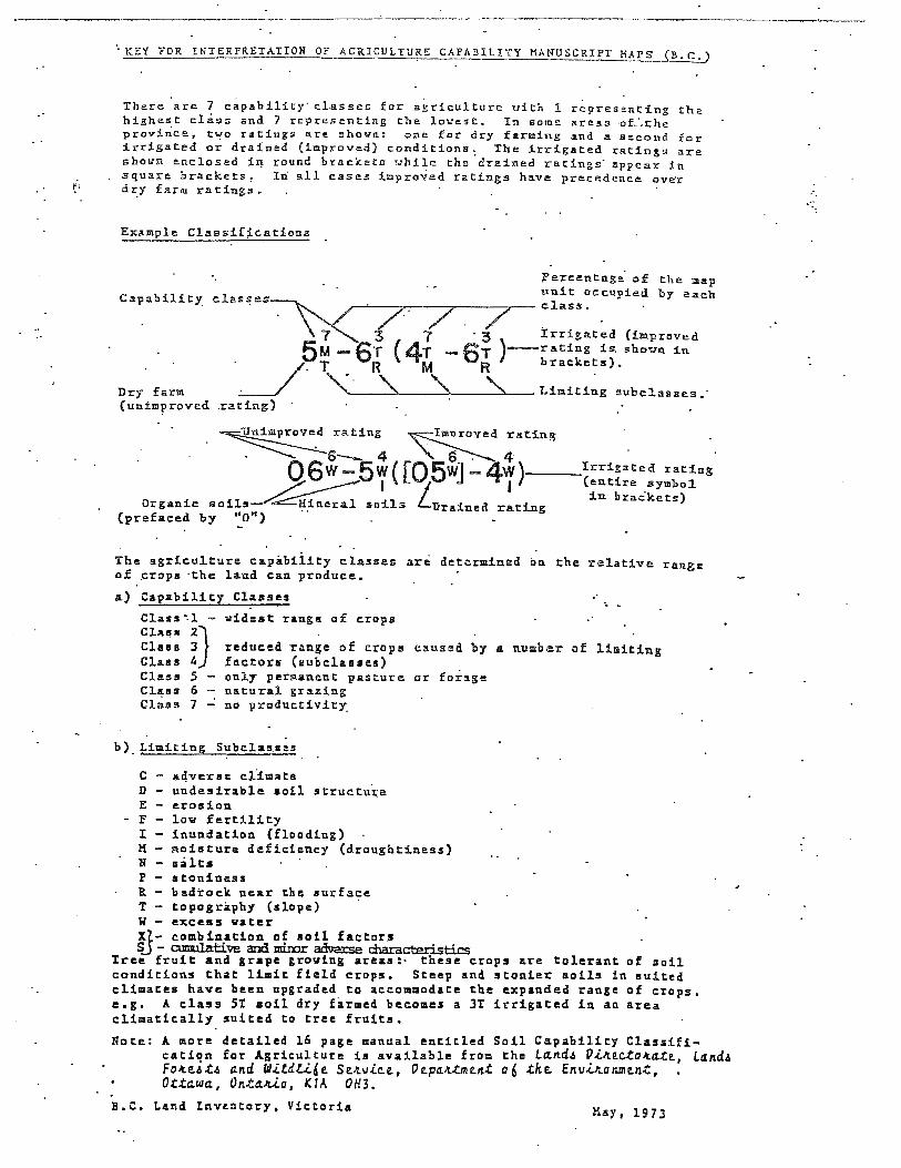
~KEY FOR INTERPRETATION OF AGRICULTURE CAPABILITY MANUSCRIPT HAPS (B.C.)
There are 7 c~pability· classes for a~riculture vith 1 representing the highest class and 7 representing the lovest. In i<ome areas -of_',the province, t~o ratings are ahovn: one for dry farming &nd a second for irrigated or drained (improved) conditions~ The ~rrigated ratings are shovn enclosed iri. round brackets Yhile the drained ratings· appear in square brackets, In all cases improved ratings have precedence over
~• dz::y farm racings.
Example Claasif~cations
Capability
?ercentage· of the map unit occupied by each
classes~ class. .. /·7.· /. / . 7 3 7 · 3 Irrigated (improved 5M _ 6T ( 4T _ 6T )-rating :l.s. shovn in
. /· T R M R brackets).
Dry farm ;___/ '(. '\, '\. ' Limiting sub cl.asses.· (unimproved .rating)
~oved rating ~roved rating
. ~ ~s- 4 _ ."- s-:---. 4 06W-5W( [05W1 -4W)--Irrigated rating .7 =---- I .J I (entire aymbo1
~"a-~, -/ in brac"ket:s) Organic soils Mineral soils Lurained rating
(prefaced by "o") ··
The agricu1ture capabiiity classes are determined on the relative range of ~rops ·the land can produce.
a) Capability Classes
Class"'.]. -Cl.lU!f!I 2} Cla1111 3 Clus 4 Class 5 Cll!,u 6 Class 7
~idest range of crops
reduced range of crops factor• (aubclasaes) only permanent pasture natural grazing
caused by a number of limiting
or forage
no productivity_
b)_Limiting Subclasses
C ,11.qverse cfimate D undesirable soil structure E erosion
- F low fertility I inundation (flooding) M moisture deficiency (draughtiness} N salts P stoniness R - bedrock near the surface T topography (slope) W excess water X1- combination of soil factors S.J - cumulative and mioor adverse characteristics
'Iree fruit and grape growing areas:- these crops are tolerant of soil conditions that limit field crops. Steep and stonier soils in suited climates have been upgraded to accommodate the expanded range of crops. e.g. A class ST aoil dry farmed becomes a 3T irrigated in an area climatically suited to tree fruits.
Note: A more detailed 16 page manual entitled Soil Capability Classification for Agriculture is available from the L~nd4 Vl~ecto~ate, Land4 Fo~eit4 and Wltdli6e Se~vice, Pepa~tment 06 the Envl~onment, Ottawa, Ontauo, KTA OH3.
B.C. Lend Inventory, Victoria Hsy• 197 3

,-., I
/ )
C./
DL 6197


Staff Report …
ALR Exclusion Application
Date: July 24, 2019 File: P 719 338
Applicant: 310613 BC Ltd. (Three Bars Ranch) Agent: Eagle Homes Location 9430 Wycliffe-Perry Creek Road, west of Wycliffe Legal: District Lot 14299, Kootenay District
Proposal: Application for placement of a new manufactured home as a principal dwelling, replacing an existing principal dwelling which will be converted to a storage building.
Options: 1. THAT the Agricultural Land Commission be advised the RDEKsupports the 310613 BC Ltd. ALR non-adhering residential useapplication for property located at 9430 Wycliffe-Perry CreekRoad, west of Wycliffe.
2. THAT the 310613 BC Ltd. ALR non-adhering residential useapplication for property located at 9430 Wycliffe-Perry CreekRoad, west of Wycliffe be refused.
Recommendation: Option # 1 A zoning amendment was adopted by the RDEK in 2015 for the proposed residential density. The proposal also supports the property’s existing agricultural operation.
Property Information:
OCP Designation: RR, Rural Resource – supports agricultural, rural residential and rural resource land uses with parcel sizes 8.0 ha or larger.
OCP Policies: Residential developments are encouraged to be designed to meet
the needs of permanent full-time residents.
Land in the ALR is generally designated and supported foragricultural use.
The primary commercial uses for land within the ALR should beagriculture production and the processing and marketing of on-farmproduce. However, accessory uses that complement agriculture,including, but not limited to agri-tourism and farm gate sales, willgenerally be supported in the ALR
Zoning Designation: RR-60, Rural Resource Zone, minimum parcel size: 60 ha.
Parcel Size: 92.2 ha (228 ac)
9.2.2
Regional District of.v-q ~ -East Kootenay

ALR Non-Adhering Residential Use Application P 719 338 310613 BC Ltd. (Eagle Homes) Page 2
Property Information - cont’d:
Density: A bylaw amendment for the subject property was approved in 2015 to allow for one principal single family dwelling, one dwelling unit for seasonal guest ranch staff, two dwelling units for year-round guest ranch staff and bunkhouse style accommodation for seasonal guest ranch staff up to a maximum floor area of 335 m2. This proposal does not increase the density granted by the 2015 bylaw amendment. ALR Status: Within the ALR Interface Fire Hazard Rating: Moderate to high, not within a fire service area. Flood Hazard Rating: Perry Creek flows through the south side of the subject property. Development must comply with flood regulations. BC Assessment: Beef Water / Sewer Services: Onsite
Agricultural Capability Ratings:
The Canada Land Inventory (CLI) Agricultural Capability Maps indicate that the majority of the property is considered Class 4 with a limiting soil factors of moisture deficiency and is considered improvable to 60% Class 2 with a combination of limiting factors and 40% Class 1. The proposed dwelling is in this portion of the property. The rest of the subject property is mostly considered Class 5 with limiting soil factors of moisture deficiency and stoniness. This is considered improvable to 60% Class 3 with a limiting soil factor of moisture deficiency and 40% Class 4 with limiting soil factors of moisture deficiency and stoniness.
Agrologist Report:
Not required for this type of application
Additional Information:
The application states a new septic system will be installed for the proposed dwelling. The existing well system is capable of providing potable water to the proposed dwelling and a new water line will be extended to the residence, along with a driveway connecting to the main ranch access road.
The total floor area of the proposed dwelling is 268 m2, which
includes a garage for parking and storage.
The 2015 bylaw amendment identified a 9 ha portion of the property that all dwelling units must be located within. The proposed dwelling is within the 9 ha area.
Consultation:
APC Area C: Support
Documents Attached:
Location Map Land Use Map ALR Boundary Agricultural Capability Map and Key Letter from Applicant Proposal

ALR Non-Adhering Residential Use Application P 719 338 310613 BC Ltd. (Eagle Homes) Page 3
Documents Attached – cont’d:
Photos provided by applicant
RDEK Contact:
Krista Gilbert, Planning Technician Phone: 250-489-0314 Email: [email protected]

Location M ap

[
750
R.eglonalDl,,.trlctofA --- .,,.. East Kootenay
Alo+ ALR
0 375
WGS_ 1984_ Web_Mercator_Auxiliary_Sphere RDEK GeoViewer - 6-25-2019 3:05 PM
750 Meters
Scale= 1: 30,000 0
Nof-ALR
THIS MAP IS NOT TO BE USED FOR NAVIGATION
This map is a user generated static output from an Internet mapping site and is for reference only. Data layers that appear on this map may or may not be accurate, current, or otherwise reliable.

[ R<...,g!ona!Dlstrlctof~ _..- ,.,... East Kootenay
I_
450 0 225
WGS_ 1984_ Web_Mercator_Auxiliary _ Sphere RDEK GeoViewer- 6-25-2019 3:06 PM
Land Use Map
.,,..,/. ... __
450 Meters
Scale = 1: 18,000 0
2Z.7'4c. Re.sic:)~"i; .... I 1- F"'rl""\
(C.rr:..iNf Fc,r~c.)
,,
THIS MAP IS NOT TO BE USED FOR NAVIGATION
This map is a user generated static output from an I ntemet mapping site and is for reference only. Data layers that appear on this map may or may not be accurate, current, or otherwise reliable.

:;!~•,O>aoctm:C>,. East Kootenay
300 0 150
WGS_ 1984_Web_Mercator_Auxiliary_Sphere RDEK GeoViewer- 6-25-2019 3:50 PM
300 Meters
Agricultural Capability Map
8 :4ST-2: 5PM ( 8 :lT-2 :SP M)
Scale= 1: 12,000 0
/
THIS MAP IS NOT TO BE USED FOR NAVIGATION
This map is a user generated static output from an Internet mapping site and is for reference only. Data layers that appear on this map may or may not be accurate, current, or otherwise reliable.

~KEY FOR INTERPRETATION OF AGRICULTURE CAPABILITY MANUSCRIPT HAPS (B.C.)
There are 7 c~pability· cLasses for a~riculture vith 1 representing the highest cl~ss and 7 representing the lovest. In some areas -0L~che provi~ce, two ratings are shovn: one for dry farming ~nd a second for irrigated or drained (improved) conditions~ The ~rrigated ratings are shown enclosed iq round brackets uhile the drained ratings· appear in square brackets, Iri all cases impro~ed ratings have precedence over
~; dX::Y farm ratings ..
Example Claasif~cations
Capability
?ercentage· of the map unit occupied by each classes · ~ /- · 7 . /. / class.
~ ~ 3 7 · 3 Irrigated {improved 5M - 6T ( 4T ... 6T )-rating is. shovn in . /· T R M R bracket:s).
Dry farm ;___/ '( · '\. '\, ':\. Limiting subcl.asses •· {unimproved .rating}
~oved rating ~roved r11.ting
· ---....---=--6- 4 _ '\. . S--:--- 4 06W-5W( [05W1 -4W)•--Irrigated rating
.7=------- J J I (entire aymbo1 ___.........~,u-~, -/ in brac·ket:s) Organic soils . 1:{_ineral .soils Lurained rat:lng
(prefaced by "o")
The agriculture capabiiity classes are determined on the relative range of ~raps ·t:he land can produce.
a) Capability Classe1
Class"'.l -
Cl.1us 2} Clua 3 Claas 4 Class 5 Cl~u 6 Class 7
widest range of crops
reduced range of crops factor• (aubclaa1es) only permanent pasture natural grazing
caused by a number of limiting
or forage
no product:iv.ity_
b)_Limiting Subclasses
C aqverae climate D undesirable soil structure E erosion
- F low fertility I inundation (flooding) M moisture deficiency (draughtiness) N salts P stoniness R - bedrock near the surface T topography (slope) W excess water Xl- combination of soil factors S_J - emulative and miror ad9e.r:se characteristics
Tree fruit and grape growing areas:- these crops &re 1:olerant of soil conditions that limit field crops. Steep and stonier soils in suited climates have been upgraded to accommodate the expanded range of crops. e.g. A class 5T soil dry farmed becomes a 3T irrigated in an area climatically suited to tree fruits.
Note: A more detailed 16 page manual entitled Soil Capability Classificatiqn for Agriculture is available from the L~nd4 Vl~ecto~ate, Land~ Fo~eA~A and WlldLi.6e Se~vlce, Vepa4tment a6 the Envl~anment, Ottawa, Onta«a, t1A OH3.
B,C, Land Invencory, Viecoria May, 1973

Le He("" ft"OM
A~lico,.f Addendum to a building permit application for 310613 BC Ltd., dba Three Bars Guest & Cattle Ranch
Legend:
In 1987, the Plechinger and Beckley families formed 310613 BC Ltd. dba Three Bars Guest & Cattle Ranch and acquired the former Clark ranch at Wycliffe as well as NorWest Guide Outfitting territory in the Purcell Mountains at Dewar Creek Hot springs and West Fork. In following years, the main lodge, 10 guest cabins, housing up to 48 guests at a time, a pool building with hot tub, a bunk house for staff (all massive log buildings) and a tennis court were built. In subsequent years, additional buildings have been added to accommodate the Beckley family, staff housing as well as ranch equipment and ranch facilities. The Plechinger family occupied the original ranch cabin from 1936. Three Bars Guest & Cattle Ranch introduced a cow herd of 180 head and a horse herd of about 20 horses in 1987. The operation produced losses and proved to be not sustainable as a cattle ranch. Therefore, the shareholders planned and opened the Guest Ranch operation in 1992. Since this time and now 27 years in operation, Three Bars Ranch is established in the industry as one of the leading family style guest ranches in North America with clientele from all over the world. Three Bars employs around 25 people each season between May and October and seven person's year around. In 2016/17, Three Bars Ranch acquired two more properties of 128 additional hectares agricultural land adjacent to its property for a total of 345 hectares. In 2018, it added 3 more guest cabins housing 12 additional guests.
The Plechinger family is mainly involved in strategic planning and finances of the operation, as well as overseeing and working in the agricultural operations. The Beckley family manages the ranch and Guest Ranch facility. Both families' diversified skills and experiences (Jeff and April Beckley had previous extensive experience in operating Guest Ranches in Idaho and at Top of the World in Cran brook) lead to the development of this operation into a financially viable and profitable business, the company is a reliable employer and contributing member to the local business and agricultural community since its inception. Three Bars Ranch runs at this time a cow herd of 120 mother cows and 100 horses for the dude string and has about 90 ha of irrigated hay land.
It must be understood, that the agricultural part of the ranch is not sustainable by itself, it required stringent cost control and is strictly depending on the success of the Guest Ranch, which is subsidizing the non-profitable
agricultural operation.
Therefore, the specific experience and daily, 24/7 presence of both shareholder family members of Three Bars Ranch on site is of great importance to keep cost under control in order to have the operation going forward
successfully.
Business strategy: Since the start up of the operation, many new and unique strategies in the guest ranch industry have been introduced in order to keep up with the rapidly changing times and guest's expectations. Even though the company is maintaining the "Western Theme", a lot of new activities and services needed to be introduced in the past in order to stay in the top ranking of Guest Ranches in North America. Our plan is to substantially improve the quality and extent of the services offered to our guests. In 2016, we have introduced a fishing pond, adding an attractive family activity for our guests in the 2017 season; beyond the vast variety of guest activities offered so far. In 2018, we have received approval for the addition of three more guest cabins. We also have acquired 128 additional hectares of agricultural land adjacent to the property. The ranch owns now sufficient land mass to conduct its daily rides on its own property, important during wild fire periods while access to the crown land has been closed for riding. This way we can conduct business as usual and don't have to send customers away and loose substantial revenue streams.
The company's top priority is to ensure and sustain the future of the agricultural part of the ranch by means of supporting it financially from profits of the Guest Ranch business. Therefore, it is vital to have management
living on site

Management:
All shareholders are closely involved in directing the company into its future, developing growth strategies, financial and investment control as well as market expansion and ongoing review of its operations. Jeff and April Beckley contribute with their extensive experience in Guest Ranch operations over three decades on a daily basis and full time involvement. The development of Three Bars Guest & Cattle Ranch since inception speaks for itself and does not require words, the numbers in growth and profits speak for themselves. Jeff Beckley is managing the agricultural part of the company, introducing new approaches and optimizing this business. April Beckley is leading the Guest Ranch part of the company, covering accounting, financial control, HR and overall control. Hans and Patricia Plechinger are strongly involved in strategic planning and in financial planning and control of the operation, as well as in the agricultural part of it. It is a necessity for them to live on the ranch and be present on site for the daily business operations. As the cabin is no longer feasible nor save to live in, they need a new on-site accommodation.
Family member Tyler Beckley, Jeff and April's oldest son, joined the company in 2001, covering marketing and sales, organising guest activities and guest relations, planning of maintenance and new business development. Tyler's contribution to the business is reflected in the steady growth of the Guest Ranch business during the past years. Tyler is actively engaged in the Dude Ranch Association of North America and serves as on the board of Destination British Columbia, a BC Provincial agency. These positions provide him with the latest information regarding the tourism industry which is continuously applied to the operation. Jenna Beckley, Tyler's wife, retired as a school teacher and joined the company in 2015. Jenna is leading the operation of the lodge, cabins, kitchen, bar, procurement of all required supplies, staff planning and staff management. The addition of Jenna and Tyler to the management team is of great importance, as guests expect to stay at a family operated ranch, offering a unique and direct daily contact with the ranch family members. Guest Ranch holidays are typically a family affair. Their involvement with the management team paves the way to a successful transition of management to the next generation into the future, securing the business operation and allowing the continuation of a strong, profitable and sustainable agricultural and tourism business in the East Kootenay's.
Reason for applying for a building permit:
The Plechinger family is strongly involved in cost control, strategic planning and finances of the operation, as well as agricultural operations. Their living quarter used to be the original ranch cabin built in 1936. This cabin is no longer suitable as living quarters and used for storage only; due to its age and related safety risk. The plan is to convert this storage cabin into a Ranch Heritage Building, displaying the history of Three Bars Ranch to the guests. This can be achieved with little alterations to the building.
Hans and Patricia Plechinger can no longer live in the cabin and have to travel daily to Cran brook and back, thus cutting time on site significantly which is so important for ranch operations. Their 24/7presence is required to conduct daily business operations. The ranch can't carry additional expenses and loss of valuable management time.
It is planned to build a family home of approximately 180 square meters living space in a small triangle of 0.25ha of land, on DL 14299, PIO 007-422-059, size 91.2 ha. This very corner part of undulating land of this DL is only useable as horse pasture. This parcel does not have any value to the agricultural operation as it is low quality pasture which can't be irrigated due to its triangle shape in this specific corner of the DL, hence little growth and productivity. On one side of the proposed building site, there is a steep drop to Wycliffe/Perry Creek road, breaking up the DL.


9.3.1
Applicant: Location: Legal:
Proposal:
Options:
Staff Report ...
Development Variance Permit Application
Date: July 22, 2019 File: P 719 335 DVP No. 25-19
Brian and Sarah Passey 4283 Lakeview Drive in the Jim Smith Lake area west of Cranbrook Lot 2, Block 3 District Lot 5801, Kootenay District, Plan 4785
Application to vary the Electoral Area C South Zoning and Floodplain Management Bylaw to reduce the minimum front yard setback requirement from 6.0 m to 1.2 m for a wheelchair ramp addition.
1. THAT Development Variance Permit No. 25-19 be granted.
2. THAT Development Variance Permit No. 25-19 be refused.
Recommendation: Option# 1 No negative impacts are anticipated.
Property OCP Designation: R-SF, Residential Low Density Information:
Additional Information:
Consultation:
OCP Objectives: • Residential developments are encouraged to be designed to meet the
needs of permanent full-time residents.
Zone Designation: RS-1, Residential (Semi-Rural) Zone; minimum parcel area requirement is 555 m2.
Parcel Area: 0.11 ha (0.28 acres)
Density: One single family dwelling or duplex is permitted per parcel
ALR Status: Not within the ALR
BC Assessment: Residential with a SFD
Water I Sewer Services: Onsite
Interface Fire Hazard Rating: Low, within the Cranbrook Rural Fire protection area
Flood Hazard Rating: The subject property is adjacent to Jim Smith Lake. Floodplain management provisions apply to development.
• None
Advisory Commissions:
APC Area C: Support
Development Variance Permit Passey
Page 2 File P 719 335
Consultation -cont'd:
Documents Attached:
RDEK Contact:
Response(s) to Notice: 27 notices were mailed on June 11, 2019 to all property owners within 100 m. One notice was returned as undeliverable and no responses have been received.
MOTi Referral: Interests unaffected
• Permit • Location Map • Land Use Map • Proposal
Krista Gilbert, Planning Technician Phone: 250-489-0314 Email: [email protected]

Development Variance
Permit No. 25-19
Permittee: Brian and Sarah Passey
1. This Development Variance Permit is issued subject to compliance with all ROEK bylaws applicable thereto, except as specifically varied or supplemented by this Permit.
2. This Permit applies to and only to those lands described below:
Lot 2, Block 3 District Lot 5801, Kootenay District, Plan 4785 (PID: 010-802-282)
3. Regional District of East Kootenay - Electoral Area C South Zoning and Floodplain Management Bylaw No. 2913, 2019, Section 4.03(3)(b)which requires a minimum front yard setback of 6.0 m for a principal building, is v · o reduce the front side yard
4.
5.
6.
7.
8.
9.
10.
setback from 6.0 m to 1.2 m for a wheelchair ramp
The lands described herein shall be develope conditions of this Permit and in substantial Development Variance Permit applicatio~
This Permit shall come into force on t~, RDEK.
cordance with the terms and drawings submitted in the
passed by the
:'QITleiif P:JJ.ct shall be filed in the Land 'ij~fiJing against the title of the land
Ri~~\pas made no representations, covenants, '~pt (verbal or otherwise) with the developer
':t,:,~,, ..
it of and be binding upon the parties hereto and their tors, successors, and assigns.
Authorizing Resolutr , , adopted by the Board of the Regional District of East
, 2019. Kootenay on the day" .
Shannon Moskal Corporate Officer

Reglonal District of .. /'---... / ;,,.. East Kootenay
300 0 150
WGS_ 1984_ Web_Mercator_Auxiliary_Sphere RDEK GeoViewer • 5-31-2019 9:31 AM
300 Meters
Location Map
t s
LAKE L_,.•.,-·
... -~•·-',.,
... , ... •·"'··'···"······
----------·+-------'
Scale= 1: 12,000 0 THIS MAP IS NOT TO BE USED FOR NAVIGATION
This map is a user generated static output from an Internet mapping site and is for reference only. Data layers that appear on this map may or may not be accurate, current, or otherwise reliable.

[ , .. ,~··""-"'~ East Koote;.;
44 0 22
WGS_ 1984_Web_Mercator_Auxiliary_Sphere RDEK GeoViewer- 5-31-2019 9:32 AM
44 Meters
Land Use Map
Scale= 1: 1,750 0
o-1>Y"'"c R-eS l Vc.£~"-'1
~\M $Mli-~ L°"ke_
THIS MAP IS NOT TO BE USED FOR NAVIGATION
This map is a user generated static output from an Internet mapping site and is for reference only. Data layers that appear on this map may or may not be accurate, current, or otherwise reliable.

-f.t.£,Tlll/V IN. W/:Jl,.L ...
ti
_'FAG/=- (
LAI< L l/1 £ W V-t2a I \/£
... C:\'; r;:r; \ ~ \ 1:) T?.IU I\J r, C:. L 'h ~\l+----=-~~-------t- ~
-\ 300P1
\\ ~~: 2 \ o 'I- 'J !1c'R £
\ \
--!
-LaT.3

9.3.2
Applicant: Location: Legal:
Proposal:
Options:
Staff Report ...
Development Variance Permit Application
Barry Stuart Realty Inc.
Resort Drive, Fernie Alpine Resort Lot 4, DL 8901, Kootenay District Plan EPP76410 ( PIO: 030-509-343)
Date: July 25, 2019 File: P 719 115 DVP No. 26-19
Application to vary the Elk Valley Zoning Bylaw maximum permitted height of a single family dwelling from 9.0 m to 11.6 m.
1. THAT Development Variance Permit No. 26 -19 be granted.
2. THAT Development Variance Permit No. 26 -19 be refused.
Recommendation: Option# 2 The dwelling would be significantly higher than surrounding buildings. The dwelling could be designed to meet the bylaw.
Property OCP Designation: R-SF, Resort Low Density Information:
Additional information:
OCP Policies: • The Regional District will encourage a range of densities and housing
mix within the plan area.
• The Regional District will encourage resort owners to monitor the housing needs of the community, consider a variety of housing types and encourage innovative housing approaches to meet the needs of permanent, semi-permanent and seasonal residents of the resort.
Zoning Designation: RS-2(A), Resort Residential Zone
Parcel Area: 0.08 ha (0.19 ac)
Density: One single family permitted per parcel
ALR Status: Not within the ALR
BC Assessment: Residential (vacant)
Flood Hazard Rating: Not within a flood hazard area.
Water I Sewer Services: Onsite groundwater well and sewage disposal
Interface Fire Hazard Rating: Low to high; within the Fernie Rural fire protection area
• The application states that the variance is being requested as the property is extremely steep, with the difference between the front and back of the property being around 11 m.

Development Variance Permit Application Barry Stuart Realty Inc.
File: P719115 Page2
Consultation:
Documents Attached:
RDEK Contact:
APC Area A: Support.
Response(s) to Notice: 8 notices were mailed on June 12, 2019 to all property owners within 100 m of the subject property. One letter was received objecting to the variance stating concerns due to the large variance requested and the impact it may have to view corridors and property value. They would also like to see a streetscape of the proposal to better understand the plan. The letter is attached.
• Permit • Location Map • Land Use Map • Site Plan • Proposal • Letter of Opposition
Krista Gilbert, Planning Technician Phone: 250-489-0314 Email: [email protected]

Development Variance
Permit No. 26-19
Permittee: Barry Stuart Realty Inc.
1. This Development Variance Permit is issued subject to compliance with all RDEK bylaws applicable thereto, except as specifically varied or supplemented by this Permit.
2. This Permit applies to and only to those lands described below:
Lot 4, District Lot 8901, Kootenay District Plan EPP76410 [PIO: 030-509-343]
3. Regional District of East Kootenay - Elk Valley Zonin Bylaw No. 829, 1990, Section 7.05(AX6)(a), which permits a maximum height for a 8.r;( I building or structure of 9.0 m, is varied to permit a height of 11.6 m for a proposectsi family dwelling.
4. The lands described herein shall be developed)ttfltt1;\l~tai:;cordance with the terms and conditions of this Permit and in substanti~lf¢om'pliance \j~~the development variance permit application received on May 6, 2019;{;, ·· · '
J,f;'\, -/ '·, ,,,,;;
5. This Permit shall come into force on th~\~~te of an authorizing :~!~Uon passed by the RDEK.
6. This Permit is not a building ~.r~J\~,,
7. If development authorized by thi < •;;i£~s not c:~fn~nce within two years of the issue date of this Permit, the Permit sha
8.
9.
10.
Kootenay on the
Shannon Moskal Corporate Officer
c0ij'~~i,;ome~i',tict shall be filed in the Land te of tlieBfiflng against the title of the land
made no representations, covenants, (verbal or otherwise) with the developer
· of and be binding upon the parties hereto and their ators, successors, and assigns.
adopted by the Board of the Regional District of East
, 2019.

I---/).. . East Kootenay
/
// ./., /
// / /
/
// ; .1
,,/
7
I ,'
·' / ' I
I
I I l I
' .. l l
/ /
I /
l t
l l 1· l
I I / l )
/ / I •
I l ,' '
/ / / /
/· / ' '
,./ /' i I I ,,
l \
/ I I\
\'-I l
\\ / ., \ l
/ / Ii ~ I l I j I l I
~\ ,l /
! J r
' /
Notes:
300 0 150 300 Meters -----===--== WGS_ 1984_ Web_Mercator _Auxiliary _Sphere RDEK GeoViewer - 6-3-2019 2:52 PM
I ,,
Location Map
--- --- ---,v=,••--'""''' V
Scale= 1: 12,000 0
' \.·
\
THIS MAP IS NOT TO BE USED FOR NAVIGATION
This map is a user generated static output from an Internet mapping site and is for reference only. Data layers that appear on this map may or may not be accurate, current, or otherwise reliable.

I Reg,on•'"""""°'~
East Koote;.; Land Use Map
...... . ~
I Cl) '(J) ·-c:
"-. (J)
6.::>Z5c,,..C... Re5,deA~1c.../ (v~~"'+)
;;;_/J.,..··~· _____ _..;;::,,o.._
38 0 19 38 Meters -----====--== WGS_ 1984_Web_Mercator_Auxiliary_Sphere RDEK GeoViewer - 6-3-2019 2:53 PM
'150\.c_ Res, J-e('\+ i~ {
(VD'..C"IA+)
Scale = 1: 1,500
31 ~c...
R.e, + Busi '"'e.s.s lc,t-~
(Ge.ct~ 17•~~/5~~.-1")' f;/0
0 THIS MAP IS NOT TO BE USED FOR NAVIGATION
' This map is a user generated static output from an Internet mapping site and is for reference only. Data layers that appear on this map may or may not be accurate.
, current, or otherwise reliable.

RESORT DRIVE
22.02m PL
7ici,;;;·-· I
1082~------·
EXISTING TREE LINE
TRAIL
NEW 3m TALL BLUE SPRUCE
13 PLACES
SITE PLAN 1/8"= l'~O"
SITE INFORMATION LEGAL
LOT 4, FLAN Ef'P764 I 0, DISTRICT LOT 8';)0 l
MUNICIFAL ADDRESS RESORT DRIVE - FER.NIE SKI HIU. BC
RDEK LAND USE DESIGNATION SINGLE RESIDENTIAL (URBAN-A) ZONE · RS- I A
AREA OF LOT 782 m2 (84 18 fV)
BUILDING LOT COVERAGE ALL STRUCTURES· 234.30 m2 (2522 ft.2)
LOT COVERAGE (%)
30%ALLONI'.D OR 234.b0 mi (2525 ft.2)
29.95% {PR.Of'051:D)
ph(..o3)921 \00
P&l&~"'°'com
l()
-w 0
I -J -~~

; J J . '
lr@rn•@ lr!1l@llllllilU©l•llil 1Hl@llll$® ~ •. cr1.11 ph ("4031';.!1 )1).15
pete.monolo~mOgmol com

I I I I ___ .__ ____ ~;f--------------~
,,,,,.,,,,-- ,e'~ <Rf" ___ __,.
f®rno® IMl@M~U~i~ ~@M$® ft.GUI -·
g :::5~ flt:VATION
!: "I -1~
I I
I
+-=
~
~
d ~i
I

Krista Gilbert
From: Andy Cohen Sent: June 25, 2019 10:12 PM To: Cc: Subject: Variance Request Lot 4 Timber Landing in Fernie
Hello Krista. We are commenting on the Variance Request by Barry Stuart on Lot 4 Timber Landing in Fernie. We own Lot 8, 3 Lots further down the road. As we understand it, Mr. Stuart has requested an additional 2.6 meters in his building height. As his lot is at the highest point of the street, we would like to see a street scape so we can understand his plan. We are concerned that an additional 2.6 meters is a large amount of variance. If the building sits up higher than the others, this will have a negative effect on our view corridors and potentially make the development decrease in value. So we would object to this variance being given, unless a street scape plan is verified that it will fit together. Thanks. Andy and Carol Cohen Lot 8 Timberlanding 8416 Resort Drive
1

9.3.3
Regional District of
Applicant: Location: Legal:
Proposal:
Options:
Staff Report ...
Development Variance Permit Application
Darren Pickering 7834 Monroe Lake Rd, west of Moyie Lake Lot 14, DL 11313, Kootenay District Plan 1632 ( PIO: 015-666-832)
Date: July 24, 2019 File: P 719 337 DVP No. 27-19
Application to vary the Electoral Area C South Zoning and Floodplain Management Bylaw maximum permitted height of an accessory building from 5.0 m to 6.1 m for a 334 m2 detached garage.
1. THAT Development Variance Permit No. 27 -19 be granted.
2. THAT Development Variance Permit No. 27 -19 be refused.
Recommendation: Option# 1
Property Information:
The subject parcel is a larger lot and the proposal complies with parcel coverage requirements. The proposed structure is located away from adjacent property dwellings or the road. No negative impacts are anticipated.
Zoning Designation: RS-1 (A), Residential (Semi-Rural Single Family) Zone
Land Use Bylaw Objectives:
• To recognize the current use of residential properties in the bylaw
• To recognize the rural character of the bylaw area by ensuring future residential developments are compatible with adjacent land uses
Parcel Area: 0.6 ha (1.6 ac)
Density: One single family permitted per parcel
ALR Status: Not within the ALR
BC Assessment: Residential (SFD)
Flood Hazard Rating: The subject property is adjacent to Monroe Lake. Floodplain regulations apply to development.
Water I Sewer Services: Onsite
Interface Fire Hazard Rating: Low to high; not within a fire protection area

Development Variance Permit Application Pickering
File: P 719 337 Page 2
Additional information:
Consultation:
Documents Attached:
RDEK Contact:
The applicant has stated that the proposed garage is for personal use to store the owner's personal recreation equipment, such as boats and dirt bikes.
Advisory Commissions:
APC Area C: Support
Response(s) to Notice: 14 notices were mailed on June 19, 2019 to all property owners within 100 m of the subject property. No notices were returned as undeliverable and no responses have been received.
• Permit • Location Map • Land Use Map • Site Plan • Proposal
Krista Gilbert, Planning Technician Phone: 250-489-0314 Email: [email protected]

Development Variance
Permit No. 27-19
Permittee: Darren Pickering
1. This Development Variance Permit is issued subject to compliance with all RDEK bylaws applicable thereto, except as specifically varied or supplemented by this Permit.
2. This Permit applies to and only to those lands described below:
3.
4.
5.
6.
7.
8.
9.
10.
Lot 14, District Lot 11313, Kootenay District Plan 1632 [PID: 015-666-832]
Regional District of East Kootenay - Electoral Area;,,,9 South Zoning & Floodplain Management Bylaw No. 2913, 2019, Section 4.04(3)(q)~~ich permits a maximum height for an accessory building or structure of 5.0 m, is )11:!0~~'to permit a height of 6.1 m for a proposed garage.
The lands described herein shall be devel91?~: ~\rictly i~\i~rdance with the terms and conditions of this Permit and in substa~Mil:teompliance wifllitt;ie development variance permit application received on May 16, ~~;e. This Permit shall come into force on the d~l~:of an ~!lttiprizing re;d;~tiQn passed by the RDEK.
This Permit is not a building pJ~tf:
If development authorized by this ~~rmit di>Ei~il)qt comrnJij~ within two years of the issue date of this Permjt~ffl!~~(!71it shall 1$p~e. ,::?~i , '~;\
This
1;~iJ shall inure respectivEi'ti;~irs, execut
3( 1) of fijtK#:~tJGo;~rjfflent Act shall be filed in the Land hall mak~11j3~ note of the filing against the title of the land
t 't~11~t;:>l=Ktfias made no representations, covenants, , or agfa~rr,ent (verbal or otherwise) with the developer
e benJWt•of and be binding upon the parties hereto and their dministrators, successors, and assigns.
Authorizing Resolution,~iif'~/' adopted by the Board of the Regional District of East
, 2019. Kootenay on the day of
Shannon Moskal Corporate Officer

fteglon11! Dbtrk:tof /'-,..,_ /+ East Kootenay
525 0 263
WGS_ 1984_ Web_Mercator_Auxiliary _Sphere RDEK GeoViewer- 6-17-2019 11:28 AM
525 Meters
Location Map
Scale= 1: 21,000 0
Jv\OYH: LAKE fARK
THIS MAP IS NOT TO BE USED FOR NAVIGATION
Moyie Lo..ke
This map is a user generated static output from an Internet mapping site and is for reference only. Data layers that appear on this map may or may not be accurate, current, or otherwise reliable.

45
Regional District of A ,,,,.,.- ,,,. East Kootenay
Monro€,,
L~1,u_
0 23
WGS_ 1984_Web_Mercator_Auxiliary_Sphere RDEK GeoViewer- 6-17-201912:02 PM
45 Meters
Land Use Map
Scale = 1: 1,800 0 THIS MAP IS NOT TO BE USED FOR NAVIGATION
This map is a user generated static output from an Internet mapping site and is for reference only. Data layers that appear on this map may or may not be accurate, current, or otherwise reliable.

c.,,,,,,,...__-,----------· , 1 r, -------------,~--r::> ~iie
j:J PfAI\ i-f)0 /+iJ/ /
- 3;;-' -
-\)rtr/e_..,....,Ll'f
------\ eob ;J\ l __
--...J


HARDIE SIDING HOUSE WRAP 1/2" OSB PLYWOOD SHEATHING
ASPHALT SHINGLES ROOFING FELT 1/2" OSB PLYWOOD SHEATHING C/W H-CLIPS@ MIDSPAN ENGINEERED MANUFACTURED TRUSSES R-38 INSULATION 6mil P.V.B. 5/8"G.W.B.
2X6 @ 16" O/C C/W SOLID BLOCKING ROWS @ 48" O/C 6mil P.V.B. 3/8" PAINTED PLYWOOD WALL FINISH
BLUE TARP ICF CONCRETE WALL SYSTEM 24" X 8" REINFORCED CONCRETE FOOTINGS UNDISTURBED GROUND
41/2" CONCRETE SLAB C/W 10M@16" O/C EACH WAY MIN 4" COMPACTED GRAVEL BASE UNDISTURBED GROUND
DARREN PICKERING
12
---r
SCALE: 1 /8" ~ 1 '-
cR6ss sect10N DETAIL A. PROPOSED DETACHED GARAGE

Regional District of
Applicant: Agent: Location: Legal:
Proposal:
Options:
Staff Report ...
Development Variance Permit Application
Polar Peak Properties Inc. Richard Haworth
4576 Timberline Crescent, Fernie Alpine Resort
Date: July 25, 2019 File: P 719117 DVP No. 28-19
Lot 1, DL 8901, Kootenay District Plan NEP59794 except Strata Plan NES199 (Phases 4, 5, 6 and 7) (PID: 023-867-884)
Application to vary the Elk Valley Zoning Bylaw to allow for construction of a multiple family dwelling along a zone boundary. The application is to waive the requirement that each different zone will be treated as a separate parcel for the purposes of calculating maximum parcel coverage and setbacks, and to reduce the setbacks from a side yard in the RS-2(A) zone and CG-8 zone from 3.0 m and 4.5 m to 0.0 m.
1. THAT Development Variance Permit No. 28 -19 be granted.
2. THAT Development Variance Permit No. 28 -19 be refused.
Recommendation: Option # 1 The proposal complies with the required setbacks from adjacent properties. A rezoning application is in process to address the issue and no issues are anticipated as the parcels are designated for multi-family development in the OCP.
Property OCP Designation: R-MF, Resort Multi-Family Information:
OCP Policies: • The Regional District will encourage a range of densities and housing
mix within the plan area.
• The Regional District will encourage resort owners to monitor the housing needs of the community, consider a variety of housing types and encourage innovative housing approaches to meet the needs of permanent, semi-permanent and seasonal residents of the resort.
Zoning Designation: Multiple - RS-2(A), Resort Residential Zone and CG-8, Resort Commercial Zone
Parcel Area: 0.65 ha (1.62 ac)
Density: In zones permitting multiple family dwellings, up to 60 dwelling units per gross hectare of minimum usable site area are permitted on a parcel
ALR Status: Not within the ALR
BC Assessment: Residential (multi-family - vacant)
9.3.4

Development Variance Permit Application Polar Peak Properties Inc.
File: P 719 117 Page 2
Property Information -cont'd:
Additional information:
Consultation:
Documents Attached:
RDEK Contact:
Flood Hazard Rating: Not within a flood hazard area. Water / Sewer Services: Community Water and Community Sewer, provided by Fernie Alpine Resort Utility Company
Interface Fire Hazard Rating: High; within the Fernie Rural fire protection area
• The subject property is the undeveloped portion of a phased strata that will become part of Strata Plan NES199.
• Due to the split zoning of the property, the applicants are unable to obtain a building permit for the proposed structure.
• The application states that to expedite the approval process, the applicants are asking to vary the zoning bylaw to allow construction on a zone boundary, but they have also submitted a bylaw amendment application to rectify the spilt zoning of the property.
• The building under application is building 8 on the site plan. Buildings 9, 10 and 11 have not been constructed at this time.
Advisory Commissions:
APC Area A: Support.
Response(s) to Notice: 293 notices were mailed on July 2, 2019 to all property owners within 100 m of the subject property with six letters returned as undeliverable. Eight letters of opposition have been received expressing a variety of concerns. These include, but aren't limited to, opposition to the increase in density, the impact on wildlife, property values and concerns with the impacts of a O m setback. The letters are attached.
• Permit • Location Map • Land Use Map • Zone Designation Map • Site Plan • Proposal • Letters of Opposition
Krista Gilbert, Planning Technician Phone: 250-489-0314 Email: [email protected]

Development Variance
Permit No. 28-19
Permittees: Polar Peak Properties Inc.
1. This Development Variance Permit is issued subject to compliance with all RDEK bylaws applicable thereto, except as specifically varied or supplemented by this Permit.
2. This Permit applies to and only to those lands described below:
Lot 1 District Lot 8901, Kootenay District, Plan NEP59794 except Strata Plan NES199 (Phases 4, 5, 6 and 7) [PIO: 023-867-884]
3. Regional District of East Kootenay - Elk Valley Zoni ;Bylaw No. 829, 1990, Section
4.
5.
6.
7.
3.3(2)(a) which requires that each different zone will · ed as a separate parcel for the purposes of calculating maximum parcel coveL,,}' setbacks, is waived, Section 7.05(A)(5)(a)(iii), which requires a principal buildi~'Q:,to b i:t at least 3.0 m or at least 10% of the width of the parcel from the side yard,jir!;ld6ced to ~·'.; and Section 7.16(5)(a)(iii), which requires a building to be sited at IEl~l!~ft, m from the slt{~.¥ard, is reduced to 0.0 m for construction of a multiple family dwell(~along a zone bouncfa~ ..
1t<~ The lands described herein shall be develb~ .. conditions of this Permit and .in substantial • permit application received , 2019.
strictltl!~. accordar{ci)~!}h the terms and Ri~pe with the devei~pment variance
',";:{5:!~.><:\l"<' \~--/'.'i~
This Permit shall come into fordibn tn1e}dlate of a~\iij\~prizing resolution passed by the RDEK.
,"," '., ,,,,''}
is Permltd&~~ not commence within two years of the issue ~)I lapse. ;
8. A~ti~IW&' ·, lJt~~bffice andt
/;;[;''<,
.L;t~J. Government Act shall be filed in the Land <•;.f~(~note of the filing against the title of the land
affet;tEld.
9.
10.
Authorizing Resolution No.
Kootenay on the day of
Shannon Moskal Corporate Officer
RDEK has made no representations, covenants, ises, or agreement (verbal or otherwise) with the developer
e benefit of and be binding upon the parties hereto and their s, administrators, successors, and assigns.
adopted by the Board of the Regional District of East
, 2019.

ReglonalDlsD'ktofA
---- ,,,,.. East Kootenay
226 226 Meters -----===--== 0 113
WGS_ 1984_Web_Mercator_Auxiliary_Sphere RDEK GeoViewer - 6-17-2019 11 :24 AM
Location Map
Scale= 1: 9,028 0 THIS MAP IS NOT TO BE USED FOR NAVIGATION
This map is a user generated static output from an Internet mapping site and is for reference only. Data layers that appear on this map may or may not be accurate, current, or otherwise reliable.

[
Rog<ooolDl,""'ofA ~ ,,... East Kootenay
I
50 0 25 50 Meters -----==~-== WGS_ 1984_ Web_Mercator_Auxiliary_Sphere RDEK GeoViewer- 6-17-201912:01 PM
Land Use Map
Scale= 1: 2,000 0
E
\ \
11 C<.,c.,, \
~e5iJe.-,I ;,:;,\ I (ec,.,Jo)
THIS MAP IS NOT TO BE USED FOR NAVIGATION
This map is a user generated static output from an Internet mapping site and is for reference only. Data layers that appear on this map may or may not be accurate, current, or otherwise reliable.


Andrew McLeod
Application Appeal Robert and Jill Gibson
4596 Timberline Crescent Fernie BC
Planning and Development Services Manager
Krista Gilbert, Planning Technician 19 - 24 Avenue South Cranbrook BC V1 C 3H8
Re: Development Variance Permit No. 28-19 Lot 1 District Lot 8901, Kootenay District Plan NEP59794
Dear Krista Gilbert and Andrew McLeod,
July 16, 2019
We, as one of the houses located on Snow Lake, will be impacted by this proposal and appeal the granting of the application for the variance setback. The elevation of the proposed build is higher than the surrounding buildings and homes. This will amplify noise both to Polar Peak and the surrounding homes on the Snow Lake. The BC building code requires greater setbacks if the building is larger than first proposed.
Families and children enjoy the teeming wildlife both in and around the lake/pond and will lose an important recreational area at the pond that will change the character of the neighbourhood with the proposed allocation of setbacks.
There is a watershed and wildlife corridor that will be cut off by the extension of the new build and the 6.0 metres of rear yard that the applicant is requesting to waive. The side yard on the west side will back up directly on the path which will inhibit wildlife routes. Bears, moose and deer regularly feed, traverse and bed in the proposed area. Certainly, this should be a consideration as wildlife in the area are already stressed with the busy highway and walkways throughout the subdivision. This green space needs to be preserved.
We are also wondering how long a landowner has to build on a property. The applicant has left a yard full of detritus, building materials, unsightly overgrown grass and mounds of dirt on lots for over twenty years. Is there a building statute?
We oppose this application for the reduction of setbacks due to the magnitude of changes. The current green space and snow space is home to families, wildlife, and owners. New residents of the proposed condo/townhome units will be on private land the moment they step outside their back door without the setbacks. The RS-2A zone and CG-8 zone should be maintained within the current BC building codes.

Further, the Notice of Intent for the Development Variance Permit No. 28-19 is unclear at best. There was no proper map, no explanation, no information, no return phone calls from the Planning Technician, and an incredibly short window in which to respond to this application.
We look forward to a response to this letter.
Very truly yours,
Robert and Jill Gibson

Krista Gilbert
From: Sent: To: Cc: Subject:
July 17, 2019 8:39 AM Info Krista Gilbert Development Variance Permit No. 28-19 - 4576 Timberline Crescent, Fernie
Attn: Regional District of East Kootenay- Board of Directors
Re: Development Variance Permit No. 28-19 - 4576 Timberline Crescent, Fernie
We hereby submit our opposition to the approval of this development permit as outlined in the letter dated June 24,2019. As property owners in Timberline Crescent we feel this development would be detrimental to the area, citing an increase in problems typically associated with a increase in housing density. The current approved development in the area will already pose challenges to those living around Fernie Alpine Resort as the construction continues and the problems do not need to increase further with changes to current zoning.
Thank you.
Colin & Michele Magee,
1

Objection to RDEK Development Variance Permit NO. 28-19
Attention: Andrew McLeod, Planning & Development Services Manager Krista Gilbert, Planning Technician
From: Anna Lowther & Mike Birmingham 4592 Timberline Crescent, Fernie,_
We are writing to register our strong opposition to the proposed Development Variance Permit No. 28-19. Our opinion is that proposing to reduce the required setbacks to zero is frankly outrageous, and represents a desire to overdevelop the site which is driven by simple greed on the part of the developer. It is basically an attempt at a land-grab.
Property setbacks are an essential requirement in every modern society across the planet for numerous reasons, including:
aesthetics; prevention of over-development of a site; privacy; fire safety; to minimise sound pollution to neighbouring properties;
to minimise light pollution to neighbouring properties; to allow for landscaping between properties; to allow access for original construction without encroaching on adjacent properties; to allow access for building maintenance without encroaching on adjacent properties; to maintain the neighbourhood character; to prevent spoiling views from neighbouring properties; to prevent devaluation of neighbouring properties.
For all of the above reasons the idea of allowing a zero setback in this proposal is ridiculous. Clearly to construct a building with a zero setback will require access to the neighbouring property. Beyond initial construction access to the neighbouring property will be necessary to maintain the building. It is obvious that once built the residents and strata will start treating a few metres of the adjacent property as if it were their own, whether it be by landscaping or access. What right does the developer think he has to clear trees on the adjacent property to build in the first place, which obviously would be a necessity?
We bought our property in Timberline Crescent on the clear understanding that there are rules to development of all properties that must be upheld by the RDEK. We expect the RDEK to uphold those rules in respect of this case, but we will not hesitate to join with our fellow neighbours to take the appropriate legal action if you fail to do so.
Regards,
Anna Lowther 15 July 2019

Re: Opposition to the Development Variance Permit No. 28-19
Pereonal lnformlllon hN bNrl wMhheld In acoordanoe with lectlon 22(1) of the FrNdont of lnfonnat#on and Protection of Priv•cyAct
As one of the owners of 4580 Timberline Cresent, Fernie, BC (lot 24 on your information package map)I am writing to register my opposition to the proposed variance. At the outset, I have some major issues with the whole "Notice of Intent" process as it applies to this application. First, the notice you provided to homeowners such as myself was very short. While the "notice of intent" from Andrew was dated June 24, 2019, the letter was not mailed until July 2, 2019 according to the stamped envelope. I did not receive the letter in the mail until July 8. That has left very little time for obtaining additional information and conferring with neighbours and other owners in order to provide a considered response by July 17. I am wondering now when the variance application came to your office in the first place.
Secondly, the "map" provided on the reverse side of the "notice of intent" letter is woefully inadequate. While the "subject property" is outlined, there is no reference to the two zones within it and no indication of the location of the proposed building.
And thirdly, what is the point of referencing "DL 8901", "Lotl, Plan NEP 59794" and "Strata Plan NES199(Phases 4,5,6 and7)" if they are not shown on the map?
To your credit Krista, the additional information you provided after our phone conversation has cleared up the last two points but it raised another - that being how "side yard" is determined by the RDEK. If I understand you correctly, looking at proposed building 8, the "front" of the building is the wall facing the street even if it is actually the side of the building. Thus the "side" is either a back wall or a front wall, the longest walls on the proposed building. In reality, this variance requests a zero setback on the back of a building which should, according to bylaws Section 7.16 (5)(a)(ii) and Section 7.05 (A)(5)(a)(ii), have a setback of 6m(19.7ft).
Setback standards are there for a reason. They are supposed protect present and future owners on all sides of property lines. We bought lot 24 in 1989 because of it's access to the ski hill and because it had a residential lot on only one side. While we knew there would be future development on the Polar Peak side we expected the developers would respect the setbacks just as we have. The setbacks in the area of Timberline Cresent allow for a screen of trees that is appreciated by homeowners on the Cresent itself and within the Polar Peak development. Any construction such as this variance would permit would negatively affect our property value, it would negatively affect our views of the mountain and be a distraction from this beautiful natural space.
We strongly oppose this development variance. While it apparently only applies to proposed building 8, we certainly do not want to see precedents set for future developments. Proposed buildings 9 and 10 come even closer to our property.
Finally, as I mentioned to you on the phone, many Timberline Cresent and Polar Peak homeowners do not have a great deal of trust in the Polar Peak developer and he has some history with the RDEK. A number of years ago he started an unauthorized condo development in the area of building 7 and proposed building 8. It was ordered removed.
Thanks for the opportunity to express our views on this matter, Krista.
-es and Phyllis Radchenko
2

Krista Gilbert
From: Robert Laird Sent: July 12, 2019 4:46 PM To: Krista Gilbert Subject: Re: Polar Peak -4576 Timberline
Thank you for this. I am apposed to any change in density as we have parking issues already.
Further to that the present strata rules forbid suites so im not certain why the applicant would waste your time with it.
This hasn't been socialized with the current owners in any fashion. This plan seems to continually change.
I am the owner at #16.
Please call if you have any questions.
Thanks
Rob Laird
> On Jul 9, 2019, at 12:00 PM, Krista Gilbert <[email protected]> wrote:
> > Hello Rob, > > I have attached a copy of the notice that was sent out for the Polar Peak Properties Inc. DVP application. The reasoning behind the application is the property currently has two zoning designations and we have a regulation in our bylaw that states where properties are split zoned each zone will be treated as a separate parcel for calculating setbacks. The proposal is to build a new multiple family dwelling along the zone boundary so they need to reduce the setback to zero to be able to build on the zone boundary. They are still going to be complying with setbacks from roads and from other properties. I've attached a bit more information from their application. Please note when reviewing the site plan they are currently proposing to construct Building 8. Buildings 9, 10 and 11 have not been constructed yet. The applicants are also going through a zoning bylaw amendment process to make the property zoned completely CG-8 and get rid of the split zone on the property, but they are wanting to move forward with constructing the multiple family dwelling and the DVP process is quicker than the bylaw amendment process. Let me know if you have any further questions. > > Krista Gilbert > Planning Technician
1

Krista Gilbert
From: Gina A Cose Sent: July 10, 2019 5:29 PM To: Krista Gilbert Subject: Development variance no. 28-19
We are the owners of 4572 Timberline Crescent, the lot adjacent to the applicant for the proposed variance. We are opposed to any variance for the purpose of reducing any setbacks and feel that this would represent a very bad precedent for the subdivision, let alone the rest of the Polar Peaks lot. Should other variance be requested at a future date on our common boundary, we and our property would be directly adversely affected by granting of the variance. Thus, we are very strongly opposed to this application. thankyou Gina and David Cosco 4572 Timberline Crescent Fernie, B.C.

Krista Gilbert
From: Sent: To: Cc: Subject:
Krista,
[email protected] July 11, 2019 5:42 PM Krista Gilbert Colin Radchenk Development Variance Permit No. 28-19
Re: Opposition to the Development Variance Permit No. 28-19
As the owners (Lana Radchenko, Colin Radchenko and Myles Radchenko) of Black Bear Chalet (located at 4580 Timberline Crescent, Fernie, BC), we are communicating to RDEK that we strongly oppose the request made in Permit No. 28-19 to reduce the setbacks to 0.0 m. Reducing the setbacks will negatively impact the our property value, as well as our views and enjoyment of the natural space between the proposed development and our lot and building. We are the original owners of this lot (since 1989) and while we expect future development in the area, we do not believe it is necessary to eliminate the setback.
Unfortunately, we are not able to attend the Board meeting on August 2, 2019. We understand RDEK will accept this email submission as our official opposition to this variance permit. Please confirm receipt of this email with a reply to us.
If you have any questions, please do not hesitate to contact us.
Respectfully, Lana Radchenko Owner
cc: Colin Radchenko Owner
Myles Radchenko Owner
1

'Ja'I Jfumi£w.n and fl eJt/U, &opett 32 .M.o«nlain.,ide :i)ltWe, ~wwn, .New ~elf
July 22, 2019
The Board of Directors Regional District of East Kootenay 19-24 Avenue South Cranbrook, B.C. V1C3H8
Reference: Development Variance Permit No. 28-19
Dear Directors;
I, and my partner, own unit 326 in Timberline Village which we purchased in the summer of 1999. We, and I believe many owners and visitors, purchased in or visit to, Femie because of the integration of the ski hill's development into the natural surroundings. Femie simply does not look like a corporate ski hill development. This was, and continues to be, one of the primary factors which influenced us both to purchase a unit in Timberline and to continue to use it, summer and winter, twenty years later.
The variance application by Polar Peak Properties proposes to construct a multi-family development with zero lot line clearance. This proposed development is directly across Timberline Crescent from our condominium unit 326 in Timberline Village (a maximum distance of I 00 feet from our unit). I know of no other development within the Femie community that has been allowed to build with zero lot line clearance. Such a request (zero clearance) is directly opposite the philosophy, which in my view, has underpinned development at Femie for the last 30 years, namely integrate development into the natural setting rather than dominating nature with the development.
Certainly, there are multi-family developments within the ski resort, Timberline Village being an example, but in every case these developments, to my knowledge, have generous open space around the multi-family units. This proposed high-density development close to our property will, in my view, have significant negative impact on the market value of our unit.
Looking out from our unit at present, we look directly on to the bowls of the ski hill, and most of the current dwellings between us and the ski hill are single family dwellings build within tree settings which affect neither our site line or destroy the nature vistas.

This proposed development will not be hidden within the natural setting and will negatively affect our enjoyment of our unit and of Femie.
This proposed variance strongly impacts the quantitative value and qualitative enjoyment of our property. We strongly recommend that the Board reject this variance request.
Should the Board not reject this request, we shall initiate an action against the Board and the developer, Polar Peaks for damages.
Regards
Jay F. Hamilton and Teresa A. Cooper
2

Staff Report …
Development Variance Permit Application
Date: July 24, 2019 File: P 719 529 DVP No. 29-19
Applicant: Russell and Diane Hemsing Location: 4975 Falcon Drive in the Fairmont Hot Springs area Legal: Lot 54, District Lot 138, KD, Plan 8297 (PID: 013-293-028)
Proposal: Application to waive the Subdivision Servicing Bylaw No. 1954, 2008, section 11.01 (5), for Proposed Lot B to permit a parcel consolidation. This section requires parcels less than 2 ha with a house or business connected to an existing individual sewerage disposal system, to provide proof that the existing system won’t create a health hazard and that a suitable future dispersal area is achievable on the parcel.
Mr. Hemsing and his neighbour have purchased the vacant lot between them and are consolidating it with their two lots. Both of their residential lots will become larger and are developed with existing onsite sewer systems. No additional lots are being created.
Options: 1. THAT Development Variance Permit No. 29-19 be granted subjectto an easement being registered across Proposed Lot A to allow forfuture connection of Proposed Lot B to the community sewersystem.
2. THAT Development Variance Permit No. 29-19 be refused.
3. THAT Development Variance Permit No. 29-19 be granted withoutthe requirement that an easement be registered on Lot A.
Recommendation: Option #3 Proposed Lot B is too small to accommodate a back-up sewerage disposal location. An easement to Proposed Lot B should be registered along the west boundary of Proposed Lot A to allow for connection to the nearby community sewer system in future if it is required.
Property Information:
OCP Designation: R-SF, Residential Low Density which includes single family residential subdivisions, duplexes, and zoning that supports secondary suites.
OCP Policies Related to Residential Development: New subdivisions of single family or greater density should be
serviced by community water and sewer servicing whereconnections and capacity are available.
Zoning: R-1, Single Family Residential Zone, minimum parcel area: 1390 m2 when serviced by either community water or community sewer.
9.3.5

Development Variance Permit Application File: P 719 529 Hemsing Page 2
Property Information - cont’d:
Parcel Size: Lot 54 is currently 0.077 ha (0.19 ac) and it is proposed to become: 0.113 ha (0.28 ac) Density: The subject lot will become larger and no additional dwellings are proposed. ALR Status: Not within Interface Fire Hazard Rating: Medium, within the Fairmont fire service area BC Assessment: Residential with a SFD and suite Flood Hazard Rating: The properties are not identified as being within a floodplain or a special policy area for flood hazard. Water and Sewer Services: Water: Fairmont Hot Springs community water. Sewer: The community sewer line runs along Wills Road but it was installed after the subject property was developed with a dwelling therefore the subject property is serviced by an individual onsite sewerage disposal system.
Additional Information:
The applicant has provided a letter from Ole Westergaard, ROWP, in which Mr. Westergaard states that a backup field area may be considered utilizing the front lawn between the house and the street for the disposal field area. This ROWP letter also states that, if the existing system fails, a Type 2 system is suggested for the same location as the current system.
Consultation: Advisory Commissions:
APC Areas F & G: Support Response(s) to Notice: Forty-four (44) notices were mailed on June 26, 2019 to all property owners within 100 m of the subject property. No notices were returned as undeliverable and 8 responses were received, all in support (letters attached).
Documents Attached:
Permit Location Map Land Use Map Bylaw Regulations Proposed Subdivision
RDEK Contact:
Tracy Van de Wiel, Planning Technician Phone: 250-489-0306 Email: [email protected]

Development Variance
Permit No. 29-19
Permittee: Russell and Diane Hemsing
1. This Development Variance Permit is issued subject to compliance with all RDEK bylaws applicable thereto, except as specifically varied or supplemented by this Permit.
2. This Permit applies to and only to those lands described below:
Lot 54, District Lot 138, KD, Plan 8297 [PIDs: 013-293-028]
3. Regional District of East Kootenay - Subdivision Servicirig Bylaw No. 1954, 2008, Section 11.01 (5), which requires parcels less than 2 ha with at"!Qijse or business connected to an existing individual sewerage disposal system, to provid~pr'oof that the existing system won't create a health hazard and that a suitable future djf~tiJ1
1area is achievable on the parcel,
is waived for Proposed Lot B in a consolidation sµ&livision;\1~14975 and 4979 Falcon Drive in the Fairmont Hot Springs area, subject to ~~tration of atqli~ty easement along the west boundary of Proposed Lot A, to allow fut1Jre:connection of Lof$to the existing community sewer system located in Wills Road. · · ·· . .
4. The lands described herein shall be dev;I~~ strictl~'m accordan~i~fth the terms and conditions of this Permit andii;l substantial cqm~pe with the development variance permit application received ori"M$y;21, 2019. · ·· · ·
5. This Permit shall come into for~'<>p the (t~te of an authprizing resolution passed by the RDEK . . .. . .
6. This Permit is o<>f~btiildirij;l:permit.
7. If development a&il:tqrized by.this Permit@s not commence within two years of the issue date of this Permit, ~;Pern1I6~1;liJll lapse.
8.
9.
10.
A,oq~1pJ~~t!P s/' · 503(1) cif:j~;J,.ocal Government Act shall be filed in the Land T-itk!!JOffice and ttfe'08e J~hall make<,atnote of the filing against the title of the land affeaed. . •
It is u~di(~tood and a~*d th~tihe RDEK has made no representations, covenants, warranties/g,.iarantees, Pi;l)rnises, or agreement (verbal or otherwise) with the developer other than th0$8.in this PEt1mit.
"\.< ,,:,.~;-
This Permit sha;f'~µt;~ttf9~e benefit of and be binding upon the parties hereto and their respective heirs, ex~6rs, administrators, successors, and assigns.
Auth<>rizing Res<>luti<>n N<>.
K<>otenay <>n the day <>f
ad<>pted by the B<>ard <>f the Regi<>nal District of East
, 2019.
Shannon Moskal Corporate Officer

Location M ap

_)
I 0 r+
:::0 a.
o. ::J.I o.c
r<ei,Je,,r,;J [$FD)
0.~';). 5C~S
f<es t::Je,A, J (S'FD/
o •?-l o.c. Re~·,J~ .. +t;J
(SFD)
0 · ';)..1 1-(.,
~·"1e,,+,J
tO .7..7 (AC,
f<.es,J~-h~ ( V.ACA.-."f)
0-~' a.c. Re${der. fi--.f
(_sr=.P)
(SyV w s"':t£)
'- Land Use Map ________ ...__ ___ _ Wills Rd
0-l'f ().(., o.,;lt,.c..
f!.t,sJ&3i Re;Jell\11.:.t ( v~eo.n~ [Sf-D)
Falcon Dr
0·:;," oe,, '2..e~identzJ) ('?FD)
o.:>{o.c.. ~~ele-1"1,:;1 \ l VA.Ct-At)

i ' '
t • !
I J I i f
,.~
I
·~ East kootenay
. ',U'lf.tl .... 0,.-t"'<-\~,.
Se,Q"'l, C Ac .
..... ,,. -.,. -- --.,
C. fi"f t)~~ ?b1.,.e, . . ....
.... · . F• a:.·"t·r_·:n,;:·· Or .. : ,\sf.~:--"~, -o -- ,- ' •
4991
4993
4995
.JU
5062.
4985;
5091 I

P'°roseJ . . S«4bo( '"' St,·~
l I
' 47 , Afyro~ l'3'2-! .,._ "2--
'A 57 58 (_Ma~(')
' '
>< ~
• ,....,,, C, \ J.
,o.-,11e t- - -~ - ... tJl co 'B -w
b-l~ $ -:,n~ I --df'Pn:,X • l I ~..., "l-
" ...._ 40 lf
50 53
39

Tracy Van de Wiel
From: Sent: To: Subject:
Hi
Paul Barret July-20-19 6:44 PM Tracy Van de Wiel Permit application 29-19
I am a neighbour of Russell Hemsing on falcon drive Fairmont hotsprings.
I know that he is sub dividing the lot next to him be part of his lot.
Personal information has been withheld in accordance with Section 22(1) of the Freedom of lnfonnstion and Protection of PrlvllcyAct
I have absolutely no problems with what he is doing it actually makes a lot of sense.
I could write you a essay on this but if you would like to talk please feel free to do so.
I live at 4973 Falcon drive my number is
Paul Barrett
1

Tracy Van de Wiel
From: Sent: To: Subject:
Dear Tracy,
July-06-19 6:27 PM Tracy Van de Wiel Development Variance Permit Application No 29-19
RE: Development Variance Permit Application No 29-19
Personal information has been withheld in accordance with Section 22(1) of the Freedom of Information and Protection of Privacy Act
We are a neighbouring property owner and are in support of waiving section 11.01(5) of the RDEK Subdivision Servicing
Bylaw 1954 for lot 54, District lot 138, KD, Plan 8297 belonging to Diane and Russ Hemsing, so that the consolidation of
lot 55 and the boundary adjustment to lot 54 and 56 can be completed. If you have any further questions or wish to
discuss anything with us, do not hesitate to contact us.
Best regards,
Anne Hamilton and Chris Dillistone
4992 Falcon Drive
Fairmont Hot Springs, BC
1

July 4, 2019
Tracy Van de Wiel
Planning Technician
Regional District of East Kootenay
Granite River Gear Ltd
5434 Dutch Creek Rd
Fairmont Hot Springs, BC
VOB 1L2
Re: Development Variance Application 29-19
Dear Tracy
As a neighbouring property owner, I am supportive of waiving section 11.01 (5) of the RDEK Subdivision
Servicing Bylaw 1954 for Lot 54, District Lot 138, KD, Plan 8297 belonging to Diane and Russ Hemsing so
that the consolidation of lot 55 and the boundary adjustment to lot 54 and 56 can be completed.
Please let me know if you have any questions.
Kind Regards,
Wendy Booth
Owner; Granite River Gear Ltd.

Tracy Van de Wiel
From: Sent: To: Subject:
Dear Tracy,
Hi Dang July-10-19 9:01 AM Tracy Van de Wiel Development Variance Permit Application No 29-19
Personal information has been withheld in accordance with Section 22(1) of the Freedom of Information and Protection of Privacy Act
As a neighboring property owner, I am in support of waiving section 11.01 (5) of the RDEK Subdivision Service Bylaw 1954 for Lot 54, District Lot 138, KD, Plan 8297 belonging to Diane and Russ Hemsing so that the consolidation of lot 55 and the boundary adjustment to lot 54 and 56 can be completed.
Regards,
Hiep Dang

Tracy Van de Wiel
From: Sent: To: Cc: Subject:
Hi Tracy 1
Morley Dougall <[email protected]> July-OS-19 10:45 AM Tracy Van de Wiel Gayle Dougall ); Info RE : Development Variance Permit Application No 29-19
As a neigllbouring property owner, I am supportive of waiving section 11.01(5) of the RDEK Subdivision Servicing Bylaw 1954 for Lot 54, District Lot 138, KD, Plan 8297 belonging to Diane and Russ Hemsing so that consolidation of lot 55 and the boundary adjustment to lot 54 and 56 can be completed.
Sincerely 1
Gayle & Morley Dougall, 5004 Fairmont Close Fairmont Hot Springs, BC
Morley Dougall Strata Manager
Gateway Property Management 101-124 Seymour Street Karnloops, BC V2C 2El
Direct 250-270-9440
Personal information has been withheld in accordance with Section 22(1) of the Freedom of Information and Protection of Privacy Act
This email message, including any attachments, is intended for the sole use of the individual(s) to whom it is addressed and may contain information that is confidential, proprietary and privileged. If you are not the intended recipient, you are hereby notified that any dissemination, distribution or copying of this communication is strictly prohibited. If you have received this communication in error, p!ease notify the sender and delete or destroy the communication immediately. Thank you.
1

Tracy Van de Wiel
From: Sent: To: Subject:
Hello Tracy,
TerJuly-10-19 1:07 PM Tracy Van de Wiel Re:Development Variance Permit Application #29-19
Personal information has been withheld in accordance with Section 22(1) of the Freedom of lnfonnation and Protection of Privacy Act.
Please find us as neighbouring property owners, that we are supportive of waiving section 11.01{5) of the RDEK Subdivision Serving Bylaw 1954 for Lot 54, District Lot 138, KO, Plan 8297 belonging to Diane and Russ Hemsing so that the consolidation of lot 55 and the boundary adjustment to lot 54 and 56 can be completed.
Terry and Helen Ohlhauser 4985 Facon Drive Fairmont Hot Springs, BC
1

02 July 2019
Tracy Van de Wiel
Planning Technician
Regional District of East Kootenay
Dear Tracy,
Re Variance Application regarding waiving section 11.01 (S) of the RDEK Subdivision Servicing Bylaw Lot 54, District Lot 138, KO, Plan 8297
As the Hemsing's next door neighbor and the resident most affected by the outcome of this application, I would like to give my support to the requested variance.
Together with the Hemsings my wife and I have made an application for a consolidation/boundary adjustment. As indicated above, the Hemsing's own lot 54, the Maher's own lot 56 and we both own lot 55 in a 1/3 2/3 split. We are wishing to simplify our ownership through a consolidation of lot 55 by boundary adjustment to lot 54 and 56.
Sincerely,
Gary Maher
4979 Falcon Drive
Fairmont Hot Springs, BC

Tracy Van de Wiel
From: Sent: To: Subject:
Bevnelda July-11-19 1:18 PM Tracy Van de Wiel Fwd: Development variance application no.29-19
Subject: Development variance application no.29-19
Personal information has been withheld in accordance with Section 22(1) of the Freedom of lnfonnation and Protection of Privacy Act
As neighboring property owners,we are supportive of waiving section 11.01 of the RDEK subdivision servicing bylaw 1954 for lot54.district lot 138.KD,plan 8297 belonging to
Diane and Russ Hemsingso that the consolidation of lot 55 and the boundary adjustments to lot 54 and 56 can be completed.
Nelda Harker Beverley Palfrey 5008 Fairmont Close Fairmont Hot Springs BC.
1

9.5.1
Applicant: Location:
Legal:
Proposal:
Options:
Staff Report ...
Natural Resource Operations Referral
Koocanusa Recreation Steering Committee
Date: July 25, 2019 File: P 151 200 NRO #4470576
Dorr/Grasmere area, between Lake Koocanusa, Grasmere, the USA border and the Elk River Unsurveyed Crown Land in the vicinity of Dorr/Grasmere
Crown land application pursuant to Section 57 of the Forest and Range Practices Act proposing roads and trails for motorized and nonmotorized recreation, camping areas and parking and staging areas for recreation use.
1. THAT the Ministry of Forests, Lands, Natural Resource Operations and Rural Development, be advised the RDEK supports the Koocanusa Recreation Strategy Committee Crown land application to establish and maintain a recreation area in the vicinity of Dorr/Grasmere.
2. THAT the Ministry of Forests, Lands, Natural Resource Operations and Rural Development be advised the RDEK does not support the Koocanusa Recreation Strategy Committee Crown land application to establish and maintain a recreation area in the vicinity of Dorr/Grasmere.
Recommendation: Option# 1
Property Information:
OCP policies support development of a management plan for roads, trails and recreation sites that respect and protect resource values.
OCP Designation: RR, Rural Resource supports agricultural, rural residential and rural resource land uses with parcel sizes 8.0 ha and larger. The RR designation also recognizes the use of these lands for public utility use, resource extraction, green space and recreation.
OCP Policies: • The Regional District encourages management of Crown land in an
environmentally responsible manner which: o Protects surface and groundwater sources; o Manages forest ingrowth o Minimize risk of interface fire and wildfire; o Enhances wildlife habitat o Protects viewscapes and scenery; o Protects watershed ecological values, including waterfowl
and fish and their corresponding habitat; and o Maintains diverse plant communities by managing invasive
plants.

MFLNRORD Referral Koocanusa Recreation Strategy Committee
File: P 151 200 Page2
Property Information - cont'd:
Crown Land Management Plans:
Lake Management
• Subsequent to adoption of the Lake Koocanusa OCP, the RDEK will request that the Province develop a management plan and enforcement strategy pertaining to unauthorized occupation of Crown land by recreational vehicles and associated structures.
• Subsequent to adoption of the Lake Koocanusa OCP, the RDEK will request that the Province develop an off-road vehicle management plan for the Lake Koocanusa area, including the specific identification of existing roads and trails on which off-road vehicle use is permitted, and to develop an associated education and enforcement strategy which directs off-road vehicle users to appropriate locations for activity participation and ensures user compliance with existence off-road vehicle regulations.
• Identification of potential trails in the plan area for motorized and non-motorized use is supported.
Zoning Designation: Multiple - RR-60, Rural Resource Zone, minimum parcel size: 60 ha and P-2, Parks and Open Space. Recreation reserves are a permitted use in all zones
Parcel Size: Area under application: approx. 12,750 ha (31,500 ac)
Density: NIA
ALR Status: Within the ALR. Applicant must contact the Agricultural Land Commission to confirm whether a non-farm use application will be required.
BC Assessment: NIA
Water I Sewer Services: NIA
Interface Fire Hazard Rating: Low to high, Crown land is not serviced by RDEK fire services.
Flood Hazard Rating: The subject area is adjacent to Lake Koocanusa and several unnamed watercourses run through the subject area. Development must comply with floodplain regulations.
• The Cranbrook West Recreation Management Strategy designates the area as partially motorized and partially ungulate winter range: grasslands (hard surfaces only) in snow-free months and as ungulate winter range: motorized use on roads and identified travel corridors only in snowbound months.
• Proposal is consistent with the Koocanusa Recreation Strategy (2017)
Plans: NIA

MFLNRORD Referral Koocanusa Recreation Strategy Committee
File: P 151 200 Page 3
Shoreline Management Guidelines:
Additional Information:
Consultation:
Documents Attached:
RDEK Contact:
N/A
• The referral states that the trails, camping and parking areas will subsequently be designated as established recreation sites and trails under FRPA Section 56. The designation will assist Recreation Sites and Trails BC together with the Koocanusa Recreation Steering Committee partners to effectively implement and enforce the Dorr-Grasmere Recreation Strategy.
• For more information see attached documents.
Advisory Commissions:
APC Area B: Not support. Road access to the river north of the Elk River Bridge be open to the public for motorized access. What does rough road (restricted) mean?
• Location Map • Land Referral Package • Proposal
Krista Gilbert, Planning Technician Phone: 250-489-0314 Email: [email protected]

Location Map
Sourcei

Location Map

f;<' 'ir<";~ BRITISH ... COLUMBIA
1 Background
KTUNAXA NATION
The Dorr-Grasmere area is 127 square kilometres in size and defined as the area south of the Elk River, west of Elko-Grasmere Road and Highway 93, extending south to the United States border, and west to approximately the low-water mark on the east shore of Koocanusa Reservoir. In the Ktunaxa language this area is called lakink'umfasnuqlilit, or rolling prairie. Dorr-Grasmere was identified as an area where current recreation use patterns are significantly impacting Crown land values to the point where these values are being severely degraded. This section introduces recreation management approaches to deal with these issues in the Dorr-Grasmere area.
2 Important Values in Dorr-Grasmere The Dorr-Grasmere area is part of the traditional territory of the Ktunaxa Nation. The area has high archaeological potential and there are several previously recorded archaeological sites, as well as areas with potential to contain archaeological material that have not been recorded.
The Dorr-Grasmere area also contains important wildlife and ecosystem values, including sensitive grasslands which provide important wintering range for ungulates including elk, moose and mule deer. As well, the area provides critical habitat for several species and ecosystems at risk including Spalding's Campion, Lewis's Woodpecker, Painted Turtle, Long-billed Curlew, Antelope-brush/bluebunch wheatgrass and Pinewood Peavine.
In addition to important cultural, archaeological and ecosystem values, Dorr-Grasmere is one of the most popular and important recreation areas in the Koocanusa area, particularly for motorized recreation use. Management activities seek to balance the need for protection of important values, while providing opportunities for continued recreation use and enjoyment of the area.
3 Dorr-Grasmere Recreation Strategy Beginning in 2017, based on overwhelming feedback from local First Nations, recreation stakeholders and residents in the Koocanusa region, a new recreation management approach was implemented in the Dorr-Grasmere area. The vision, to be implemented over several years, is a well-maintained network of recreation trails for motorized and non-motorized users. The trail network will provide opportunities for all ages and abilities and include loop trails and connections leading to and from points-of-interest, camping and parking areas. The trail network will be managed in partnership with recreation stewardship groups in the area. Vehicle-access camping and day-use parking areas will be designated and will facilitate access to the trail network while minimizing impacts to important values. This approach is intended to mitigate the growing number of recreation impacts in this area, while avoiding relocation of recreation issues and problems to adjacent areas.
The KRSC will work towards implementation of management strategies in the Dorr-Grasmere area based on three core management goals:
1. Vehicle-access camping will be restricted to designated areas;
2. Motorized recreation use will be restricted to designated roads and trails; and

Land Referral Package - Implementation of Dorr Grasmere Recreation Strategy
3. Day-use parking and staging areas for recreation users will be designated and will facilitate access to the trail network.
This management approach will yield important benefits, including:
• Mitigation of impacts on highly sensitive areas with significant ecological or cultural values;
• Mitigation of potential impacts on Aboriginal rights and traditional use activities; • Improved health of grasslands and ecosystems for local wildlife populations, species at risk and
ranching operations; • Reduction in potential for conflicts with other Crown land users;
• Improved public health and safety; and • Enhanced experiences for responsible recreation users.
Presented below, and in the Dorr-Grasmere Recreation Strategy Map (attached separately}, are details of the recreation management approach for Dorr-Grasmere area, including:
• A designated area and trail for non-motorized recreation;
• Designated trails for motorized recreation;
• Recreation access roads; • Three designated camping areas; and
• Four designated parking areas.
The locations of designated trails, camping and parking areas are subject to change as a result of, for example, additional assessment on the ground, including archaeological assessments.
3.1 Non-motorized area and recreation trails A 25 square kilometre area along the Elk River is identified as a non-motorized recreation area. This area has been identified as containing important wildlife, cultural and archaeological values, and deemed of high important for protection.
The Elk Rim Trail is an existing designated non-motorized trail in this area which is managed through a partnership agreement with a local stewardship group. 14 kilometres of the existing Elk Rim Trail is maintained within the designated non-motorized area. An additional 6.4 kilometres of trail is proposed for development to complete this non-motorized loop trail.
3.2 Single-track motorized trails A total of 83 kilometres have been identified as designated trails for single-track motorized recreation, including motorcycles and electric bikes. The trail network includes a perimeter loop trail with several linking and connecting trails which provide opportunities for riders to make shorter or longer loops, and/or to connect with viewpoints, camping areas and other recreation features. The Dorr-Grasmere Recreation Trail Assessment1 identified several trail issues which require improvements, for example seasonally wet areas that may require installation of a culvert or raised trail bed, and steep hill climbs which are subject to erosion and may require reinforcement or re-routing.
At this time, no additional single-track motorized trails are proposed for development. However, the Dorr-Grasmere Recreation Trail Assessment identified several new trail sections which could be
1 In the summer of 2017, the KRSC engaged a recreation contractor (Cordillera Technical Services) to assess and make recommendations regarding recreation use and access in the Dorr-Grasmere area (Dorr-Grasmere Recreation Trail Assessment)

Land Referral Package - Implementation of Dorr Grasmere Recreation Strategy
developed to improve the quality of the single-track motorized trail network. These trail sections be developed in the future, it and when an appropriate stewardship group is identified.
3.3 Double-track motorized trails A total of 57 kilometres of double-track trails for ATVs, quads and side-by-sides (UTVs) currently exist in the area. Some double-track trails exist on old road surfaces, while others started as single-track trails and have been widened over time. Given the extent of existing roads which are suitable for double-track motorized recreation activities, no additional double-track trails are proposed for development at this time.
3.4 Recreation use roads There are over 184 kilometres of existing wilderness roads in the Dorr-Grasmere area. Many of these roads were developed by forestry tenure holders; some are still in use today. Many of these historically developed roads have become access roads for recreation users, including 4x4 trucks, ATVs, side-bysides, OHVs and motorcycles.
95 kilometres of this existing road network is identified for managed recreation use and access. The DorrGrasmere Recreation Strategy Map shows the extent of recreation roads that are recommended for recreation use and access in the Dorr-Grasmere area. In the short-term, recreation users will be directed towards the recreation roads identified on the Map. Users will be discouraged from using other roads, with informational signage, maps and education. Over time, unsustainable and unusable roads may be deactivated, reclaimed and restored to maintain and improve important values in the area.
3.5 Public access roads and crossings Public access roads in the Dorr-Grasmere area include Highway 93, Dorr Cut-off Road, Grasmere-Dorr Road and Elko-Grasmere Road. Public access roads are maintained by the BC Ministry of Transportation and Infrastructure. Off-road vehicles including ATVs and motorcycles, are not permitted on public access roads, but can cross access roads at designated public road crossings.
There are currently six public road crossings proposed in the Dorr-Grasmere area. Road crossings must be reviewed and approved by the BC Ministry of Transportation and Infrastructure and are subject to change.
Table 1 provides a summary of managed recreation uses in the Dorr-Grasmere area, reflecting the types of recreation uses that will be designated on different road and trail types.
Table 1: Summary of managed recreation uses
Managed uses
j::: ::>
Road or trail type -(I) j::: (I) C u = (0 ~ ·;:: G <( u
,_ ..0 ...... - :::, (0
'- u - V) 0 "'O .._
(0 (I) (I) ...., ...... 0 "'O = :::, 0
(0 'Sj" 5 :::, (I) O" ~ a X Cl.. I Li.J 'Sj" N
Non-motorized trail • • •


Land Referral Package - Implementation of Dorr Grasmere Recreation Strategy
An archaeological review is currently being completed for the Dorr-Grasmere area. The review will provide guidelines for implementation activities where ground disturbance will occur, such as installation of pit toilets, signage, road and trail decommissioning, and trail construction. The location of, and the works required to implement some activities may change based on recommendations from the archaeological review, and further archaeological assessments.
Implementation Description of works and improvements
Activity
• The boundary of the camping area will be delineated with signage
• Two pit toilets will be installed
• The road will be improved with gravel and grading to repair a large wet area Camping Area 1
that is causing braiding of the road.
• A bump gate will be installed to allow access to the trail network
• Install large (3-panel) informational signage with maps and information
• The boundary of the camping area will be delineated with fencing and sign age
• Install cattle guard Camping Area 2 • A bump gate will be installed to allow foot access in and out
• A pit toilet will be installed
• Install large (3-panel) informational signage with maps and information
• The boundary of the camping area will be delineated with signage
• A pit toilet will be installed Camping Area 3
• The road will be improved with gravel and grading
• Install large (3-panel) informational signage with maps and information Unauthorized single-track and double track recreation trails which are not part of the designated trail network will be decommissioned and restored to improve range values and wildlife habitat. The decommissioning work may involve erosion control
Road and trail activities such as ditching, water barring and/or re-contouring of the land, and may decommissioning include installation of natural structures, and/or creating physical access barriers. The
surfaces of decommissioned roads and trails will be scarified and then seeded with appropriate grasses to restore wildlife and range values. Vegetation and/or rocks will be placed at trail heads to disguise the trail and block access.
Trail signage Trail markers and directional signage will be installed along the designated trail network
Public road Where a designated trail crosses a public road, signage will be installed to warm trail crossings users of the crossing.
Several sections of access road, specifically roads accessing designated camping and parking areas, will be improved to reduce erosion and braiding, and to maintain important values. Road improvements will likely be completed using machines and
Road tools, and may involve erosion control activities such as ditching, water barring and/or improvements re-contouring of the land, and may include installation of natural structures, and/or
placing fill such as gravel. Specific road improvement requirements will vary from site to site, based on road condition and soil type, and will be determined through a more detailed assessment. Some sections of the existing motorized and non-motorized trail network will be
Trail improved to reduce erosion and braiding, and to maintain important values. Trail improvements improvements will likely be completed using machine and hand tools, and may involve
erosion control activities such as ditching, water barring and/or re-contouring of the

Land Referral Package - Implementation of Dorr Grasmere Recreation Strategy
Implementation Description of works and improvements
Activity land, and may include installation of natural structures, and/or placing fill such as gravel. Specific trail improvement requirements will vary from site to site, based on trail condition and soil type, and will be determined through a more detailed assessment. To develop a contiguous trail network, some sections of non-motorized trail will be constructed. Trails will be constructed using machine and hand tools, by qualified and experienced trail construction crews, utilizing best practices for sustainable trail
New trail construction. Trail construction may involve erosion control activities such as ditching, construction water barring and/or re-contouring of the land, and may include installation of natural
structures, and/or placing fill such as gravel. Specific trail construction requirements will vary from site to site, based on trail condition and soil type, and will be determined through a more detailed assessment.
• The boundary of the parking area will be delineated with a hardened (gravel)
Parking Area 1 parking lot surface, and barriers (signage, rocks, etc.)
• Install large (3-panel) informational signage with maps and information
• A pit toilet will be installed
• The boundary of the parking area will be delineated with a hardened (gravel)
Parking Area 2 parking lot surface, and barriers (signage, rocks, etc.)
• Install large (3-panel) informational signage with maps and information
• A pit toilet will be installed
Parking Area 3 • Install large (3-panel) informational signage with maps and information
• The boundary of the parking area will be delineated with a hardened (gravel)
Parking Area 4 parking lot surface, barriers (signage, rocks, etc.)
• Install large (3-panel) informational signage with maps and information
• A pit toilet will be installed


9.5.2
Applicant: Location: Legal:
Proposal:
Options:
Staff Report ...
Natural Resource Operations Referral
Harvey and Karen Bombardier
Date: July 24, 2019 File: P 151 300
NRO #459798
Crown foreshore across from 7547 Green Bay Rd, Moyie Lake area Unsurveyed Crown land in the vicinity of Moyie Lake
License of Occupation for specific permission to legalize an existing private recreational dock that is approximately 18 m2 in total area.
1. THAT the Ministry of Forests, Lands, Natural Resource Operations and Rural Development, be advised the RDEK supports the Bombardier Crown land application for Specific Permission for an existing private residential dock on Moyie Lake.
2. THAT the Ministry of Forests, Lands, Natural Resource Operations and Rural Development be advised the RDEK does not support the Bombardier Crown land application for Specific Permission for an existing private residential dock on Moyie Lake.
Recommendation: Option# 1
Property Information:
Docks are considered low risk in the subject area. This location is not anticipated to provide public access to the lake as there are other public access options in the surrounding area. The application is also consistent with other previous proposals.
Zoning Designation: Moyie Lake is not zoned. The adjacent property is RS-1 (A), Residential (Semi-Rural Single Family) Zone, minimum parcel size: 1670 m2.
Land Use Objectives and Policies: • To protect water quality for the purposes of drinking water, recreation
and aquatic life.
• To protect sensitive riparian habitats and other ecologically significant areas.
• The Regional District encourages the management of Crown land in an environmentally responsible manner which:
a) Protects surface and groundwater sources; b) Manages forest ingrowth; c) Minimizes the risk of interface and wildfires; d) Enhances wildlife habitat and riparian areas; e) Protects watershed ecological values including fish and fish
habitat; and, f) Protects viewscapes and scenery.

MFLNRO Referral Bombardier
Property Information - cont'd:
Crown Land Management Plans:
Lake Management Plans:
Shoreline Management Guidelines:
Additional Information:
File: P 151 300 Page 2
• No person may carry out a work or undertaking that will cause the harmful alteration, disruption or destruction (HADD) of fish habitat unless it has been authorized by the Department of Fisheries and Oceans (DFO) and/or Ministry of Environment. Works include but are not limited to:
a) Adding or removing fill; b) Maintenance or construction of retaining walls, docks,
boathouses, bank protection installations, marinas, groynes or breakwaters, or other structures within the foreshore;
c) Any activity that alters, disrupts or destroys fish habitat; d) Removing of foreshore or riparian vegetation; e) Other significant works; f) Any and all changes in and about a stream or body of water.
Parcel Size: The adjacent parcel is 0.4 ha (1 acres)
Density: One single family dwelling permitted per parcel
ALR Status: Not within
BC Assessment: Residential (with single family dwelling)
Water I Sewer Services: Onsite
Interface Fire Hazard Rating: High, not within a fire protection area.
None
None
• The Moyie Lake Shoreline Management Guidelines designate the shoreline type in this area as grey with lower value habitats that may require some protection. The Guidelines state that this shoreline type accounts for 15% of the total shoreline length of Moyie Lake.
• New development and redevelopment in these areas may be considered.
• Docks are identified as a low risk activity within this shoreline type.
• The referral states that the existing dock fronts the land owner's private property, separated by a Ministry of Transportation and Infrastructure road (Green Bay Rd). No new construction is proposed at this time.
• The referral states that the dock has existed for over 20 years. The ramp and floats are made of treated wood and are supported by rubber floatation devices. The ramp is 5.5 m long and the dock is 17.8 m2.
• The referral states that the dock is used to moor boats seasonally in July and August, when the applicants visit their family cabin.
MFLNRO Referral Bombardier
Consultation:
Documents Attached:
RDEK Contact:
Advisory Commissions:
APC Area C: Support
• Location Map • Proposal • Photo Provided by Applicant
Krista Gilbert, Planning Technician Phone: 250-489-0314 Email: [email protected]
File: P 151 300 Page 3

ReglonllolOlstnctof /'-,-..._ / ;,,.. East Kootenay
375 0 188
WGS_ 1984_Web_Mercator_Auxiliary_Sphere RDEK GeoViewer - 6-11-2019 9:52 AM
375 Meters
Location Map
Scale= 1: 15,000 0
Moyie L°'lce_
THIS MAP IS NOT TO BE USED FOR NAVIGATION
I i' I I
i' I
II I
I i1
/ I
I II
j -'ll 0 '
This map is a user generated static output from an Internet mapping site and is for reference only. Data layers that appear on this map may or may not be accurate, current, or otherwise reliable.

,. .I '
('
_,.,, . -.>. 0
... -·,.
/
l\',i . o, · I(,' L',,/,1'
:'i'\
/
l
\
!, ! '!..,•
. \
. .. .
"'\ .\ 6 /.'
! .(.)1.. i·~-' /
?fr((_~-(
·I .-
0 0
I /
C
"'1,,,/ \.)/
·-~~ C> -1,. •.,,; ... _
=


9.6.1
Request for Decision File: Friedley & Pery
July 23, 2019
Tracy Van de Wiel, Planning Technician
Date
Author
Subject Request for Exemption from Providing a Professional Report - Friedley & Pery
REQUEST
Katherine Friedley and Adrian Pery have requested an exemption from the requirement to provide a report from a qualified professional in support of their ALR non-farm use application. Their ALR non-farm use application will request permission to host outdoor education courses such as orienteering, hiking and camping and will request use of a 1.0 ha portion of their property as the base for support facilities for the outdoor education activities. The application states that the 1 ha area will contain tent sites, a cooking and washing location, and a basic toilet facility. The owners plan to supplement their outdoor education operation by hosting other special events such as reunions, educational seminars, sports events etc. The owners expect to accommodate groups in the range of 16 - 75 individuals depending on the length of stay (larger groups will stay for a shorter length of time). The subject property is located at 3550 Highway 95 near Brisco north of Radium.
OPTIONS
1. THAT the Friedley and Pery request for exemption from providing a report from a qualified professional in support of a proposed ALR non-farm use application for property located at 3550 Highway 95 near Brisco be approved.
2. THAT the Friedley and Pery request for exemption from providing a report from a qualified professional in support of a proposed ALR non-farm use application for property located at 3550 Highway 95 near Brisco be refused.
RECOMMENDATION
Option 1 The property has marginal agricultural capability ratings and the proposed non-farm use is not anticipated to be intensive. An agrologist report is not required to review the ALR non-farm use application.
BACKGROUND/ ANALYSIS
The owners have stated that their outdoor activities are low impact and will utilize existing logging trails and cleared sites throughout the property. They say the 1.0 ha area proposed for use as their seasonal base is located in a historically cleared log landing site at a high elevation on the property. They also state that they've been reclaiming/ restoring the land by getting rid of old slash piles, reseeding and restoring natural ground cover, and working with the RDEK to administer an invasive weed control program.
Page 1 of 2

Request for Decision Request for Exemption from Providing a Professional Report - Friedley & Pery
SPECIFIC CONSIDERATIONS
Zoning Bylaw
Upper Columbia Valley Zoning Bylaw
July 23, 2019
Current Designation: A-2, Rural Residential (Country) Zone which has a minimum parcel area requirement of 8.0 ha and permitted uses that include: single-family dwelling, agricultural use, wildland use, extraction of sand and gravel, equestrian centre, and sawmill. Accessory uses include: home based business and cement plant.
Official Community Plan
Steamboat-Jubilee Mountain Official Community Plan Designation: RR, Rural Resource which includes rural residential and rural resource land uses with parcel sizes 8.0 hectares and larger. The RR designation also recognizes the use of these lands for agriculture, resource extraction, open space and working landscape.
OCP Section 5.3(3) -Agriculture ALR applications for non-farm use, subdivision or exclusion must be accompanied by a report from a qualified professional unless an exemption from the requirement has been approved by the Regional District Board. The report must include: (a) identification of the level of agricultural suitability and opportunity for both soil bound and non-soil bound agricultural uses; (b) identification of the agricultural capability of the parcel; and (c) demonstration of the impact that the proposal will have to the agricultural capability of the parcel, surrounding area and adjacent agricultural operations.
ATTACHMENTS
• Letter of Request • Location Map • Agricultural Capability Map • Arial Photos Provided by Applicant
Page 2 of 2

Hi Tracy,
Thank you for your call today and followup email. We have had a chance to look at the information
regarding the agologist's report, and have decided to proceed without it.
As such, please consider this our request for an exemption from the requirement for an agrologist's
report per section 5.3(3) of the OCP policies.
Please let us know if we need to supply anything further at this time.
Many thanks,
Katherine Friedley
Adrian Pery

3
nt 10133
DL 10721 d.
Cr e -
I
----'---
DL9573
I I I
"\.t,L ;. .ill!
~"' I 'UJ-.
Location Map

CLI Map - Agricultural Capability of Soil
DL 9573
\
\a . -- .... ·=·-·='"· ---,~- t, ·-~ ........
OL 9046


9.6.2
Applicant: Agent: Location: Legal:
Proposal:
Options:
Staff Report ...
Liquor Licensing Application
Island Lake Lodge Doug Feely 4330 Mt Fernie Park Road, Fernie Sublot 4, DL 4590, KO Plan X28
Date: July 25, 2019 File: P 719 116
Food Primary Licence# 131271 (Island Lake Lodge)
Application for a permanent change to the operating hours of liquor service for a Food Primary Licence at the Bear Bistro and Tamarack Dining Room located at Island Lake Lodge. The current hours of liquor service are 11 :00 am to 12:00 am seven days per week. The proposed hours are 9:00 am to 2:00 am seven days per week. No other changes to the facility or liquor service are proposed.
Option 1: Support
THAT the application by Island Lake Lodge for a permanent change to the operating hours of liquor service in the Bear Bistro and Tamarack Dining Room at Island Lake Lodge be supported;
and further, be it resolved that, the Board recommends issuance of the amended Food Primary Liquor Licence because the use of the property is consistent with the zoning bylaw and the proposal will not significantly affect the existing use of the property.
The Board's comments on the prescribed considerations are as follows:
a. The Bear Bistro and Tamarack Dining Room are located in the resort core area and ongoing recreational activities with associated noises are expected. There is nearby multi-family guest accommodation that could potentially be affected by noise.
b. The existing and proposed use of the area is not expected to conflict with the use of social, recreational and residential buildings in the Island Lake Lodge area.
c. The views of the public were not gathered as the nearest private property owners are approximately 6.5 km away from Island Lake Lodge.
d. The proposal is consistent with the uses permitted within the RES-4, Resort Core Zone and parking is not expected to be a concern because the venue has adequate parking area available.
Liquor Licence Application Island Lake Lodge
Options - cont'd:
Recommendation:
Property Information:
File: P719116 Page 2
e. The proposal will result in operating in a manner consistent with that expected of a liquor service establishment within a resort location.
Option 2: Not Support
THAT the Liquor and Cannabis Regulation Branch be advised the RDEK does not support the Island Lake Lodge application for a permanent change of operating hours of liquor service at the Bear Bistro and Tamarack Dining Room.
Option #1
OCP Designation: RES-CORE, Resort Core
OCP Objectives and Policies:
• To direct commercial facilities to designated areas within the plan area.
• To ensure that commercial facilities are designed to complement the character of the plan area.
• To ensure that the commercial offerings provided within the plan area are programmed and scaled to effectively satisfy the on-site needs of guests and owners at the Resort.
• The provision of commercial facilities and amenities such as food & beverage venues, retail and service commercial space as an integral part of the resort expansion program is supported.
• Commercial facilities shall be limited to those areas designated as RES-CORE, Resort Core and RES-REC, Resort Recreation.
Current Zoning: RES-4, Resort Core Zone which permits food services, bar, lounges and nightclubs, among other uses.
Parcel Size: 2115 ha (5227 ac)
Density: NIA
ALR Status: Not within the ALR
BC Assessment: Residential, Business/Other, Managed Forest, and Recreation (Seasonal Resort)
Flood Hazard Rating: Lizard Creek, Island Lake and several unnamed seasonal creeks flow through the property. Flood regulations apply.
Water I Sewer Services: Onsite

Liquor Licence Application Island Lake Lodge
Property Information - cont'd:
Additional Information:
Consultation:
Documents Attached:
RDEK Contact:
File: P 719 116 Page 3
Interface Fire Hazard Rating: Low to moderate; not within a fire protection area
• No notices of Intent were mailed as the nearest private property owners are approximately 6.5 km away from Island Lake Lodge.
• The application states that the reason for the change in hours is due to their growing and thriving wedding and event business, and that they have had many requests from guests for this extended service.
Advisory Commissions:
APC Area A: Support.
• Location Map • Island Lake Lodge Map • Current Liquor Licence • Floor Plans • Zoning Designation Map • Letters
Krista Gilbert, Planning Technician Phone: 250-489-0314 Email: [email protected]