
Planning Committee - Notice of meeting and agenda
105
Notice of meeting and agenda Planning Committee 10.00 am, Thursday, 6 October 2016 Dean of Guild Court Room, City Chambers, High Street, Edinburgh This is a public meeting and members of the public are welcome to attend. Contacts E-mail: [email protected] Tel: 0131 529 4261
-
Upload
khangminh22 -
Category
Documents
-
view
1 -
download
0
Transcript of Planning Committee - Notice of meeting and agenda

Notice of meeting and agenda
Planning Committee 10.00 am, Thursday, 6 October 2016 Dean of Guild Court Room, City Chambers, High Street, Edinburgh
This is a public meeting and members of the public are welcome to attend.
Contacts
E-mail: [email protected]
Tel: 0131 529 4261

Planning Committee – 6 October 2016 Page 2 of 3
1. Order of business
1.1 Including any notices of motion and any other items of business submitted as urgent for consideration at the meeting.
2. Declaration of interests
2.1 Members should declare any financial and non-financial interests they have in the items of business for consideration, identifying the relevant agenda item and the nature of their interest.
3. Deputations
3.1 If any
4. Minutes
4.1 Planning Committees of 11 August and 5 September 2016 – submitted for approval as correct records (circulated)
5. Business Bulletin 5.1 Planning Committee Business Bulletin (none)
6. Planning Performance
6.1 Short Stay Commercial Leisure Apartments – Monitoring Report – report by the Executive Director of Place (circulated)
7. Planning Policy
7.1 Housing Land Audit and Delivery Programme 2016 – report by the Executive Director of Place (circulated)
7.2 East Lothian Proposed Local Development Plan 2016: Period of Representations – report by the Executive Director of Place (circulated)
8. Conservation
8.1 Finalised Portobello Conservation Area Character Appraisal – report by the Executive Director of Place (circulated)
9. Referral Reports
9.1 None
10. Motions
10.1 None
Kirsty-Louise Campbell Interim Head of Strategy and Insight

Planning Committee – 6 October 2016 Page 3 of 3
Committee Members
Councillors Perry (Convener), Lunn (Vice-Convener), Bagshaw, Balfour, Blacklock, Cairns, Cardownie, Child, Gardner, Heslop, Keil, McVey, Milligan, Mowat and Ritchie.
Information about the Planning Committee
The Planning Committee consists of 15 Councillors and is appointed by the City of Edinburgh Council. The Planning Committee usually meets every eight weeks. It considers planning policy and projects and other matters but excluding planning applications (which are dealt with by the Development Management Sub-Committee).
The Planning Committee usually meets in the Dean of Guild Court Room in the City Chambers on the High Street in Edinburgh. There is a seated public gallery and the meeting is open to all members of the public.
Further information
If you have any questions about the agenda or meeting arrangements, please contact Stephen Broughton or Blair Ritchie, Committee Services, City of Edinburgh Council, Waverley Court, Business Centre 2.1, 4 East Market Street Edinburgh EH8 8BG, Tel 0131 529 4261or 529 4085, e-mail [email protected]
A copy of the agenda and papers for this meeting will be available for inspection prior to the meeting at the main reception office, City Chambers, High Street, Edinburgh.
The agenda, minutes and public reports for this meeting and all the main Council committees can be viewed online by going to www.edinburgh.gov.uk/cpol.
Webcasting of Council meetings
Please note: this meeting may be filmed for live or subsequent broadcast via the Council’s internet site – at the start of the meeting the clerk will confirm if all or part of the meeting is being filmed.
You should be aware that the Council is a Data Controller under the Data Protection Act. Data collected during this webcast will be retained in accordance with the Council’s published policy.
Generally, the public seating areas will not be filmed. However, by entering the Council Chamber and using the public seating area, you are consenting to being filmed and to the possible use of those images and sound recordings for webcasting or training purposes.
If you have any queries regarding this, please contact Committee Services on 0131 529 4106 or [email protected]

Minutes Item 4.1
Planning Committee 10.00 am, Thursday, 11 August 2016
Present
Councillors Perry (Convener), Lunn (Vice-Convener), Bagshaw, Blacklock, Cairns, Child, Gardner, Heslop, Keil, McVey, Milligan, Mowat, and Ritchie.
1. Minutes
Decision
To approve the minutes of the Planning Committee of 19 May 2016 as a correct record.
2. Strategic Development Plan 2 Proposed Plan and Action Programme
SESPlan had prepared a Proposed Strategic Development Plan and Action Programme for Edinburgh and South East Scotland. The Strategic Development Plan was a statutory planning document which was prepared every five years and covered a twenty year period. It communicated strategic level and cross-boundary planning policy and applied national policy and guidance from the Scottish Government. The Action Programme set out the key strategic actions needed to deliver the vision of the Plan.
There is a requirement to review the SDP within four years of its approval. The second SESplan Main Issues Report was published on 21 July 2015. This provided the main opportunity for engagement. During a 10 week consultation period, SESplan received 245 responses. The engagement has informed the preparation of a Proposed Plan. The Proposed Plan represents SESplan’s settled view of the final content of the plan. The City of Edinburgh Council officers have been involved in its preparation as members of an Operational Group and Project Board.
Community planning and spatial planning should be closely aligned. Within the SESPlan area, efforts have been made to ensure that SDP2 is consistent with the Community Plans in the area. In Edinburgh, Community Planning is represented on an internal SDP coordination group along with representatives from key Council services.
The SESplan Joint Committee approved the Proposed Plan and Action Programme for publication at its meeting on 20 June 2016. Each member council had been invited to formally ratify this decision. This report recommended that Committee

Planning Committee – 11 August 2016
endorses the Proposed Plan and Action Programme and referred this decision to full Council.
Decision
1) To support the decision by the SESplan Joint Committee at its meeting on 20 June 2016 to approve the Strategic Development Plan 2 Proposed Plan and Action Programme for publication for representations and refer it to full Council for ratification.
2) To note that minor editorial changes of a non‐policy nature to SDP2 and the supporting documents were delegated to the SDP Manager in consultation with the Head of Planning and Transport, SESplan Project Board Chair and Joint Committee Convener.
3) To note those background documents to be published with the Proposed Plan.
4) To note the proposals for consultation on SDP2 and the supporting documents considered by the SESplan Joint Committee on the 20 June 2016.
5) Details of the membership of the Community Planning Group and meetings held to be circulated to members of the Planning Committee.
6) Details of the population expansion projections to be provided to Planning Committee members.
(Reference – report by the Executive Director of Place, submitted.)
3. Legacy Planning Applications - Update
An update was provide on the new procedure for dealing with legacy planning applications approved on 15 June 2015.
The new procedure put forward arrangements to reduce delays in concluding legal agreements before planning permission decision notices could be issued and so improve the Council’s performance figures. Details were provided of progress in removing non-legal agreement cases from the system.
Decision
1) To note progress on dealing with legacy applications. 2) The Executive Director of Place to report to the Committee in two cycles on the
legacy applications classified as awaiting further information with explanations for the delay in this being submitted.
(References – Planning Committee 15 June 2015 (item 7); report by the Executive Director of Place, submitted.)

Planning Committee – 11 August 2016
4. Review of the Scottish Planning System – Progress Report and the Next Steps
The review of the Scottish planning system was continuing to make progress with a programme to deliver change which was emerging. The independent review panel had reported on its findings and made a series of detailed recommendations. Scottish Ministers had now responded to the panel’s report and set out a number of immediate actions, the scope for future reforms and details of a proposed White Paper.
A summary was provided of the findings from the independent review panel, its recommendations and the Scottish Ministers’ response and next steps. The written evidence to the panel from the Planning Authority was agreed by Planning Committee on 3 December 2015.
Decision 1) To note the outcomes of the independent panel’s review. 2) To note the Scottish Ministers’ response to the review and their
recommendations for future reforms to the planning system in Scotland. 3) The Executive Director of Place to arrange a Committee Workshop for members
to discuss the proposals in the White Paper on the review of the Planning System.
4) The Executive Director of Place to circulate the remit of the working groups to the Committee.
(References – Planning Committee 3 December 2015 (item 11); report by the Executive Director of Place, submitted.)
5. Open Space 2012, Edinburgh’s Draft open Space Strategy for Consulation
Edinburgh’s draft Open Space Strategy reported the following changes to open space between 2010 and 2015: access to good quality play areas and urban green space had improved; allotment capacity had increased and community growing had flourished; and the city’s green network had benefitted from measures to improve walking, cycling and biodiversity.
The draft Strategy took a co-ordinated view of future open space needs for the period to 2021 to protect and expand the city’s network of open spaces and create sustainable places. Details were provided of the key challenges to the strategy.
Decision
1) To approve ‘Open Space 2021’, Edinburgh’s draft Open Space Strategy for consultation purposes (Appendix 1 of the report by the Executive Director of Place).
2) To note the 2015 Open Space Audit schedules (Appendix 2 of the report).

Planning Committee – 11 August 2016
3) To refers the draft Strategy to the Transport and Environment Committee for information.
4) The Executive Director of Place to circulate a link the audit process to the Committee.
(Reference – report by the Executive Director of Place, submitted.)
6. Consultation on Airspace Change Programme
Approval was sought for a formal response to Edinburgh airport operator’s consultation on planned changes to the Edinburgh’s airspace flight paths. Details were provided of the proposed use of more tightly defined airspace, modern technology and the expansion of the use of Edinburgh airport. The response identified issues for further consideration with regard to the noise impact on Edinburgh residents and the impacts on habitats and designated sites of national/international importance.
Decision
1) To approve Appendix 3 of the report by the Executive Director of Place as the response to the Airspace Change Programme consultation.
2) To refer the report to the Transport and Environment Committee for information. (Reference – report by the Executive Director of Place, submitted.)
7. The Edinburgh Planning Concordat 2016
Approval was sought for the refreshed Edinburgh Planning Concordat.
The Edinburgh Planning Concordat was first agreed in 2010 between the Council and the Edinburgh Chamber of Commerce as a way of working together when major development was proposed in the City. It was updated in 2013 to include community councils and the Edinburgh Planning Concordat 2013 had been reviewed and refreshed in conjunction with the Edinburgh Chamber of Commerce and the Edinburgh Association of Community Councils.
The aim of the refreshed Concordat was to simplify it and make it easier for developers to use when major development was proposed in the City. Community Councils could also use it as a tool to engage with these developers and reach consensus on development in their area.
Decision
1) To approve the Edinburgh Planning Concordat 2016. 2) To note that the Planning Concordat Engagement Fund was closed. 3) To refer the report to the Communities and Neighbourhoods Committee.
(Reference – report by the Executive Director of Place, submitted.)

Planning Committee – 11 August 2016
8. Old Town Conservation Area – Review of Conservation Area Character Appraisal
Approval was sought of the revised Old Town Conservation Area Character Appraisal, in draft, for consultation. This had been developed in the new style of appraisal. The content had been updated to reflect changing issues in the area, and the community’s views and concerns. Details were provided of the way in which the consultation would be conducted.
Decision
1) To approve the attached revised Old Town Conservation Area Character Appraisal, in draft, for consultation.
2) The Executive Director of Place to circulate the figures for the population growth in the Old Town to the Committee.
(References – Planning Committee 3 October 2013 (item 7); report by the Executive Director of Place, submitted.)

Planning Committee
10am, Thursday, 6 October 2016
Short Stay Commercial Leisure Apartments – Monitoring Report
Item number Report number
Executive/routine Routine
Wards All
Executive Summary
In 2013, the Planning Committee agreed to make changes to its non-statutory ‘Guidance for Businesses’, in order to make specific reference to the issue of short stay commercial leisure apartments – so called ‘party flats’. This report provides an update on the Council’s current position, following the last report submitted in August 2015. It is recommended that the next report is made in one year’s time.
Links
Coalition Pledges P28 Council Priorities CO8 CO16 CO19 Single Outcome Agreement SO1 SO4
9062247
6.1

Planning Committee – 6/10/16 v1.2
Page 2
Report
Short Stay Commercial Leisure Apartments – Short Stay Commercial Leisure Apartments – Monitoring Report Monitoring Report 1. Recommendations 1. Recommendations
1.1 It is recommended that the Committee :
a) notes the current position in respect of action by the planning enforcement service relating to short stay commercial leisure lets and that a further report on progress will be made in a year’s time; and
b) refers the report to Health, Social Care and Housing Committee for information.
2. Background
2.1 Since the Guidance for Businesses was approved in December 2012, the Planning Committee has considered whether short stay commercial leisure apartments or ‘party flats’ can constitute a material change of use in planning terms. The Planning Committee considered that in certain cases they could. Accordingly, the published version of the non-statutory Guidance for Businesses was amended to incorporate the relevant criteria for assessing whether a residential property had undergone a change of use to a short stay commercial leisure apartment, (SSCLA).
2.2 At its meeting on 6 August 2015, the Planning Committee considered a progress report and noted the current position in respect of action by the planning enforcement service relating to short stay commercial leisure lets. It also noted that a further review will be carried out in one year’s time. This report fulfils that remit.
3. Main report
3.1 Since the previous update, the planning authority has closed 14 enquiries into the alleged use of residential properties as SSCLAs and opened 10 new cases. A list of the cases closed together with the reasons for closing is at Appendix A.
3.2 There are currently a total of 10 SSCLA cases pending consideration. The progress of each of these cases is recorded in the table at Appendix B

Planning Committee – 6/10/16 v1.2
Page 3
3.3 In terms of the 14 cases that have been closed, three were the subject of enforcement notices (26 Old Tollbooth Wynd, 3F1 22 Learmonth Terrace and F5 2 Eyre Place). The notices at 26 Old Tolbooth Wynd and 3F1 22 Learmonth Terrace were not appealed and the use ceased in accordance with the notice. The case at 2 Eyre Place (15/00267/ECOU) is notable as it was the first SSCLA enforcement notice that has gone to appeal. The reporter gave general support to the Council’s policy guidance, in as much as it was found to be relevant in assessing whether there was a change of use. The outcome was that the reporter agreed with the Council that a material change of use had occurred with the result that the notice was upheld and the use has ceased.
3.4 A separate outcome of the Eyre Place decision is that the terminology in the Guidance for Business has been changed from short term commercial leisure apartments to short term commercial visitor accommodation. This is to reflect the fact that this type of accommodation is not only used for leisure accommodation for holiday/tourism purposes but can also be used by other visitors in particular business travellers.
3.5 The planning service had not previously received an appeal against any of the SSCLA enforcement notices served. Consequently, there was no external measure of the robustness of the policy approach being taken. While the Eyre Place decision provides some useful pointers to what the reporters may look for in a change of use, each case must be considered on its own merits. Some factors may point to a change of use not being material. For example in the case of a small flat, the relatively small size of the premises increases the likelihood of its being occupied by single household rather than unrelated people, and limits the potential for anti-social behaviour to some extent. However other factors may indicate the change of use is material, for example, whether the flat shares a common access with permanent residents, which increases the likelihood of conflict with permanent residents. Other considerations include the nature of lets and frequency of turnover of residents. Until more appeal decisions are available, it is not possible to reach any definitive conclusion on whether the non-statutory guidance has resulted in an improvement to the situation in regard to such uses.
3.6 The difficulty for planning enforcement is having the evidence to show that the character of the premises has changed so substantially as to amount to a material change of use. In the majority of the cases that have been closed in the last year, there was usually some evidence that the flats were being used as short stay lets (i.e. advertised online), however there was no clear evidence that the character of the use of the flats for short term visitor accommodation was significantly different from the authorised use as flats for residential accommodation. Nevertheless in two cases (9 Featherhall Avenue and Flat 1 1 McEwan Square) the owners have chosen to put in place specific management measures to ensure the flats are not used as party flats in response to the enforcement enquiries.

Planning Committee – 6/10/16 v1.2
Page 4
3.7 In terms of new cases, there have been 10 SSCLA cases raised in the last year. This compares with 14 cases in 2014/2015 and 19 cases in 2013/2014.
3.8 Notwithstanding the relatively small number of new cases, it is evident from the growth of websites advertising short term lets that there are a large number of properties particularly in the City Centre and Leith that are being let out for short term lets. This has the potential to become a significant issue for the City. In this regard the Association of Scotland’s Self-Caterers (ASSC) has advised that it has recently drafted a Code of Practice for short-term let operators to encourage best practice and promote a harmonious existence between short term let apartments and local residents. This proactive approach by the ASSC is welcomed but at this early stage it is not possible to say whether it is having any effect on how premises are used.
4. Measures of success
4.1 That the Council’s performance in dealing with cases of short stay commercial visitor lets results in a decline in the particular problems associated with such uses, in a decline in the number of complaints about such activity, and in successful outcomes for the Council in any appeal or court proceedings.
5. Financial impact
5.1 There are no financial implications arising from this report.
6. Risk, policy, compliance and governance impact
6.1 There is no impact on risk, policy, compliance and governance impact arising from this report.
7. Equalities impact
7.1 There is no relationship between the matters described in this report and the public sector general equality duty. There is no direct equalities impact arising from this report.
8. Sustainability impact
8.1 The impacts of this report in relation to the three elements of the Climate Change (Scotland) Act 2009 Public Bodies Duties have been considered. Relevant Council

Planning Committee – 6/10/16 v1.2
Page 5
sustainable development policies have been taken into account. This review of the operation of revised non statutory guidance will have no adverse impacts on carbon emissions, the city’s resilience to climate change impacts, achieving a sustainable Edinburgh in respect of social justice, economic wellbeing or good environmental stewardship.

Planning Committee – 6/10/16 v1.2
Page 6
9. Consultation and engagement
9.1 Consultation and community engagement have not been carried out in respect of this review of the operation within the guidelines. However, there is regular contact and communication with community groups and other interested parties through the work of the task group.
10. Background reading/external references
10.1 Annual Review of Guidance, report to Planning Committee, 28 February 2013 Minutes of Planning Committee, 28 February 2013, Item 3 Minutes of Planning Committee, 5 December 2013 Item 5.1 Minutes of Development Management Sub Committee, 14 May 2014, Item 4.2 Minutes of Planning Committee, 7 August 2014, Item 6.1 Minutes of Planning Committee, 6 August 2015, Item 7.2
Paul Lawrence
Executive Director of Place
Contact: Kevin Ryan, Team Manager, Householder and Enforcement West
E-mail: [email protected] | Tel: 0131 529 3721
Contact: Alan Moonie, Team Manager, Householder and Enforcement East
E-mail: [email protected] | Tel: 0131 529 3909
11. Links
Coalition Pledges P28 Further strengthen our links with the business community by developing and implementing strategies to promote and protect the economic well being of the city
Council Priorities CP8 A vibrant, sustainable local economy CP10 A range of quality housing options C12 A built environment to match our ambitions
Single Outcome Agreement
SO1 Edinburgh’s economy delivers increased investment, jobs, and opportunities for all SO4 Edinburgh’s communities are safer and have improved

Planning Committee – 6/10/16 v1.2
Page 7
physical and social fabric.
Appendices Appendix A – Table of SSCLA Cases Closed Aug 2015 – Aug 2016 Appendix B – Table of SSCLA Cases Pending Consideration at Aug 2016

Appendix A - SSCLA Cases Closed Aug 2015 – Aug 2016
SSCLA
Case No Address Complaint Officer StatusReceived date
Date of Decision
Date case closed
Number of days
WardReason for Closing
13/00384/ECOU 26 Old Tolbooth Wynd Edinburgh EH8 8EQ
Change of use to Short Stay Let Accommodation
ALLANS CLOSED 02/07/2013 06/10/2015 06/10/2015 1,135.63 A11 Enforcement Notice was served 03/09/14. No appeal received. Complaints ceased and case was closed. However after a period of over a year without complaint, a complaint was received 09/08/16 alleging the use has recommenced. As a result a new case has been set up (See cases pending below).
13/00544/ECOU 1F2 61 Lothian Road Edinburgh EH1 2DJ
Change of use from residential flat to short stay commercial flat.
ALLANS CLOSED 05/09/2013 30/10/2015 30/10/2015 1,070.50 A11 Based on the results of the site inspections undertaken, and no further reports of anti social behaviour; it was concluded that the primary use of the premises

SSCLA
Case No Address Complaint Officer StatusReceived date
Date of Decision
Date case closed
Number of days
WardReason for Closing
remained as a residential flat. No change of use had occurred.
14/00144/ECOU 2 Chessel's Court 240 Canongate Edinburgh
Alleged use of premises as a short stay commercial leisure apartment.
ALLANS CLOSED 11/03/2014 06/11/2015 06/11/2015 883.39 A11 Several site inspections were undertaken. No unauthorised activity was witnessed occurring. No further reports of anti social behaviour in respect of this premises. On this basis concluded no change of use had occurred.
14/00331/ECOU Flat 8 38 Barony Street Edinburgh EH3 6NY
Alleged change of use to short stay commercial leisure apartment
ALLANS CLOSED 27/05/2014 06/10/2015 06/10/2015 806.52 A11 Several site inspections were undertaken. No unauthorised activity was witnessed occurring. the primary use of the premises remains as a residential flatted property. No breach in planning control had occurred.

SSCLA
Case No Address Complaint Officer StatusReceived date
Date of Decision
Date case closed
Number of days
WardReason for Closing
14/00400/ECOU 9 Featherhall Avenue Edinburgh
Alleged unauthorised change of use to short stay commercial leisure apartments (SSCLA)
BJF CLOSED 04/07/2014 01/06/2016 01/06/2016 768.68 A06 Several site inspections were undertaken. The owners have introduced measures to restrict the way the flats are used. In planning terms the primary use of the premises remains as a residential flatted property. No breach in planning control had occurred.
14/00492/ECOU Flat 1 1 McEwan Square Edinburgh
Use of premises as short stay commercial premises
ALLANS CLOSED 04/08/2014 29/09/2015 29/09/2015 737.36 A09 The premises no longer allow 'stag' and 'hen' parties on their premises, or permit guests to have parties in their flats. Community Safety has since confirmed that no complaints of anti social behaviour have been received, and there are no active investigations into

SSCLA
Case No Address Complaint Officer StatusReceived date
Date of Decision
Date case closed
Number of days
WardReason for Closing
the premises. Primary use of the premises is still a residential flat and no breach in planning control has occurred.
14/00530/ELBB 24 Queen Street Edinburgh
change of use from flatted accomodation to short stay commercial
ALLANS CLOSED 14/08/2014 26/04/2016 26/04/2016 727.43 A11 The Council's Building Standards Section are currently undertaking separate enforcement action requiring the habitation of the unit by members of the public to cease.
14/00779/ECOU 26 Dublin Street Lane South Edinburgh EH1 3PX
Operation of a premises as an alleged SSCLA
ALLANS CLOSED 03/12/2014 24/11/2015 24/11/2015 616.34 A11 Several site inspections were undertaken. No unauthorised activity was witnessed occurring. the primary use of the premises remains as a residential flatted property. No breach in planning control has

SSCLA
Case No Address Complaint Officer StatusReceived date
Date of Decision
Date case closed
Number of days
WardReason for Closing
occurred.
15/00199/ECOU 3F1 22 Learmonth Terrace Edinburgh EH4 1PG
Unauthorised change of use of a residential flatted dwelling to a short stay commercial leisure apartment.
MARTIP CLOSED 16/04/2015 17/05/2016 17/05/2016 482.60 A05 Enforcement notice was issued in June 2015. Notice was not appealed and the use has since ceased.
15/00267/ECOU Flat 5 2 Eyre Place Edinburgh EH3 5EP
Alleged unauthorised change of use from residential flat to short term holiday let /SSCLA
LOUDON CLOSED 22/05/2015 27/04/2016 27/04/2016 446.40 A05 First enforcement notice involving an SSCLA that has gone to appeal. Appeal dismissed. The DPEA gave general support to the Council’s policy guidance. The use has now ceased.
15/00280/ECOU 16 Lochend Close Edinburgh EH8 8BL
Short stay letting BT CLOSED 27/05/2015 24/11/2015 24/11/2015 441.30 A11 Community Safety has not received any reports of anti social behaviour relating to the premises, and do not have an active investigation into the property. No other

SSCLA
Case No Address Complaint Officer StatusReceived date
Date of Decision
Date case closed
Number of days
WardReason for Closing
evidence of a change of use. No action taken.
15/00471/ECOU Flat 9 12 Constitution Place Edinburgh EH6 7DL
Alleged unauthorised use as short stay accommodation.
WEBSTE CLOSED 21/08/2015 24/11/2015 11/04/2016 355.57 A13 Listings in web sites removed, and no further evidence of unauthorised use has been established. Notice complied with at present.
15/00565/ECOU 2F2 76 Grassmarket Edinburgh EH1 2JR
Short term let/ short stay commercial leisure apartments (SSCLA)
BT CLOSED 14/10/2015 14/01/2016 14/01/2016 301.36 A11 Community Safety has not received any reports of anti social behaviour relating to the premises, and do not have an active investigation into the property. No other evidence of a change of use. No action taken.
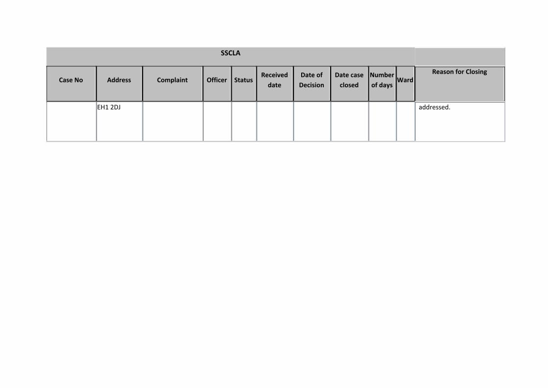
15/00621/ECOU 1F2 61 Lothian Road Edinburgh
Alleged use of premises as an SSCLA
BJF CLOSED 17/11/2015 11/02/2016 11/02/2016 267.52 A11 The enquirer requested that the case be closed on the basis that the original issues have been
SSCLA
Case No Address Complaint Officer StatusReceived date
Date of Decision
Date case closed
Number of days
WardReason for Closing
EH1 2DJ addressed.

Appendix B – Cases Pending Consideration at Aug 2016
SSCLA
Case No Address Complaint Officer StatusReceived date
Date of Decision
Date case closed
Number of days
WardProgress
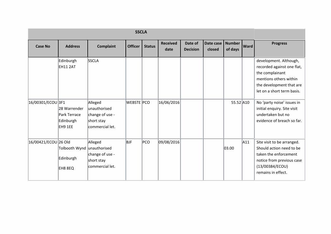
14/00721/ECOU 2F1 5 Lauriston Park Edinburgh EH3 9JA
Alleged material change of use ‐ use of the property as a short stay commercial leisure apartment.
MARTIP PCO 06/11/2014 643.34 A10 Discussions with owner, but no progress as yet. Likely to go to notice.
15/00296/ECOU 83 Dundas Street Edinburgh EH3 6SD
Alleged use of premises as an SSCLA
BJF PCO 08/06/2015 429.32 A11 Several site inspections were undertaken. No unauthorised activity was witnessed occurring. the primary use of the premises remains as a residential flatted property. Case to be closed.
15/00307/ECOU 1F2 56 Lochrin Buildings Edinburgh EH3 9ND
Unauthorised change of use ‐ flat to short stay commercial leisure accommodation
VM PCO 11/06/2015 426.28 A10 It would appear that notice has been complied with. No evidence of unauthorised use now

SSCLA
Case No Address Complaint Officer StatusReceived date
Date of Decision
Date case closed
Number of days
WardProgress
being found. No further complaints from neighbours. Case to be closed.
15/00532/ECOU 3F2 19 Elgin Terrace Edinburgh EH7 5NW
Unauthorised use of flat as short stay accommodation.
WEBSTE PCO 17/09/2015 328.29 A12 Site visit undertaken – no one there. No ‘party noise’ issues in initial enquiry. No breach identified as yet.
15/00640/ECOU 2F 17 Great Junction Street Edinburgh EH6 5HX
Alleged unauthorised use as short stay apartment (party flat).
WEBSTE PCO 04/12/2015 250.47 A13 Site visit undertaken – no one there. Has been issues with noise – agreement made between owner and community safety and action taken under antisocial behaviour act.

SSCLA
Case No Address Complaint Officer StatusReceived date
Date of Decision
Date case closed
Number of days
WardProgress
16/00265/ECOU Flat 7 14 East Parkside Edinburgh EH16 5XL
Alleged unauthorised use of flat as short stay accomodation.
WEBSTE PCO 01/06/2016 70.60 A15 Been out once during office hours – no one there. Sent letter to owner asking about patterns of use, got response saying was let to families only for short lets. No ‘party noise’ issues in initial enquiry.
16/00285/ECOU Flat 14 6 Drummond Street Edinburgh EH8 9TU
Party Flat BT PCO 08/06/2016 63.57 A15 Served Planning Contravention Notice to gather information regarding the current use. Further out of hours/weekend visits to be undertaken after the Fringe
16/00298/ECOU Flat 11 51 Caledonian Crescent
Alleged Unauthorised Change of Use to
BJF PCO 14/06/2016 57.50 A07 Site visit to be arranged with complainant due to the secure access to the
SSCLA
Case No Address Complaint Officer StatusReceived date
Date of Decision
Date case closed
Number of days
WardProgress
Edinburgh EH11 2AT
SSCLA development. Although, recorded against one flat, the complainant mentions others within the development that are let on a short term basis.
16/00301/ECOU 3F1 28 Warrender Park Terrace Edinburgh EH9 1EE
Alleged unauthorised change of use ‐ short stay commercial let.
WEBSTE PCO 16/06/2016 55.52 A10 No ‘party noise’ issues in initial enquiry. Site visit undertaken but no evidence of breach so far.
16/00421/ECOU 26 Old Tolbooth Wynd
Edinburgh
EH8 8EQ
Alleged unauthorised change of use ‐ short stay commercial let.
BJF PCO 09/08/2016 03.00
A11 Site visit to be arranged. Should action need to be taken the enforcement notice from previous case (13/00384/ECOU) remains in effect.

Links
Coalition Pledges P15, P50
Council Priorities CP8, CP10, CP12
Single Outcome Agreement SO1
Planning Committee
10.00am, Thursday, 6 October 2016
Housing Land Audit and Delivery Programme 2016
Executive Summary
The Housing Land Audit and Delivery Programme (HLADP) is a monitoring tool used to
assess the performance of Strategic Development Plan housing land policies and targets.
The HLADP records the amount of land available for house building, identifies any
constraints affecting development and assess the adequacy of the land supply against the
supply target and housing land requirement set by the Strategic Development Plan (SDP).
Edinburgh’s 2016 HLADP has been completed. Completions in 2016 were significantly
above 2015 levels, continuing the upward trend following the credit crunch and
subsequent recession.
The HLADP examines both the supply of land (an input) and the expected delivery of new
homes (an output). The delivery of new homes is dependent on many economic and
demand related factors unrelated to the supply of land and although the delivery
programme is currently below the level needed to meet the housing supply target for the
next five years, the HLADP demonstrates that this is not due to a lack of effective housing
land and the supply of land is sufficient to meet the housing land requirement.
Item number
Report number
Executive/routine Executive
Wards All
9062247
7.1

Planning Committee - 6 October 2016 Page 2
102606_Housing Land Audit and Delivery Programme 2016_061016 APM
Report
Housing Land Audit and Delivery Programme 2016
1. Recommendations
1.1 It is recommended that Committee:
1.1.1 notes the findings of this report including Appendix 2, “The Housing Land
Audit and Delivery Programme 2016”;
1.1.2 agrees to refer it to the SESplan Joint Committee;
1.1.3 agrees to refer it to the Health, Social Care and Housing Committee with a
request to consider the actions identified in paragraph 3.18 to help
accelerate housing delivery; and
1.1.4 agrees to refer it to the Scottish Government to assist in the ongoing
development of planning practice in relation to housing delivery and
measuring the availability of land.
2. Background
2.1 The Strategic Development Plan (SDP) for Edinburgh and South East Scotland was
approved by Scottish Ministers in June 2013. SESplan supplementary guidance on
housing land was approved in 2014 and sets the Housing Supply Target for the City
of Edinburgh Council area.
2.2 Scottish Planning Policy (SPP) requires local authorities to maintain a five year
supply of effective housing land at all times to ensure that the housing land
requirement is met. The annual Housing Land Audit and Delivery Programme
(HLADP) is used to monitor the effective housing land supply. It will also be used to
inform infrastructure decisions through the Local Development Plan Action
Programme.

Planning Committee - 6 October 2016 Page 3
102606_Housing Land Audit and Delivery Programme 2016_061016 APM
2.3 On 3 December 2015, the Planning Committee considered a report on the 2015
housing land audit that showed how programmed completions and consequently
the five-year effective land supply fell sharply during the recession even though the
overall stock of effective land remained broadly constant. The report concluded
that the five year delivery programme in the City of Edinburgh did not represent an
effective five year housing land supply. However the Committee noted that a
revised approach to calculating the effective supply should be applied, focussing on
land availability rather than solely on anticipated housing completions. This
approach has now been further developed resulting in an audit of both land supply
and anticipated completions – the delivery programme.
2.4 This report provides an update on the supply of housing land and the delivery of
new homes based upon the findings of the 2016 HLADP and assesses the
adequacy of the land supply against the housing land requirement set by the SDP.
3. Main report
3.1 In order for a housing site to be considered ‘effective’, it must be free of all
constraints that would prevent development. Sites are considered against a range
of criteria set out in Planning Advice Note 2/2010 “Affordable Housing and Housing
Land Audits” (PAN 2/2010). These criteria include ownership, physical (eg slope,
aspect, stability, flood risk, access), contamination, deficit funding, marketability,
infrastructure and land use. PAN 2/2010 also states that “The contribution of any
site to the effective land supply is that portion of the expected output from the site
which can be completed within the five-year period”.
3.2 The report considered by Planning Committee in December 2015 suggested an
alternative approach to assessing the effective land supply based upon the capacity
and availability of effective land rather than the developer’s output programme
which is affected by factors unrelated to the supply of land. A revised approach is
supported by the SESplan Joint Committee which at its meeting on 14 December
2015, noted "the difficulty in maintaining the 5-year effective supply in Edinburgh is
not related to a shortage of unconstrained land in that area".
3.3 The Scottish Government issued Draft Planning Delivery Advice on Housing and
Infrastructure for consultation in February 2016. The draft advice appears to
support the approach of assessing the adequacy of the land supply based upon
capacity rather than anticipated construction output. This change is currently
opposed by Homes for Scotland and the advice is yet to be finalised.
3.4 The 2016 HLADP is attached as Appendix 2.
Housing Land Supply
3.5 As at 31 March 2016, there was sufficient land free of planning constraints and
available for development for 25,748 houses. In addition to this, there was land for
a further 7,272 houses on sites where there is currently a constraint preventing
development.

Planning Committee - 6 October 2016 Page 4
102606_Housing Land Audit and Delivery Programme 2016_061016 APM
3.6 The effective land supply, which includes the sites allocated in the proposed local
development plan (LDP), is varied in type, size and location. It is spread over a
range of locations and includes brownfield (60%) and greenfield (40%) sites.
3.7 The locations and status of housing sites making up the established housing land
supply in the City of Edinburgh is shown on the map attached as Appendix 1.
Housing Land Requirement
3.8 The housing supply target for the City of Edinburgh is set by the South East
Scotland Strategic Development Plan (SDP) and its supplementary guidance. The
housing supply target was set at 22,300 units from 2009 to 2019 and a further
7,210 from 2019 to 2024. The Local Development Plan Report of Examination
(June 2016) recommended extending the housing supply target to 2026, increasing
the target by a further 2,884 houses. Taking account of completions to date, this
results in a housing supply target of 20,829 for the period 2016 to 2026. Adding in
a 10% ‘generosity’ margin to help ensure that the target will be met, the housing
land requirement is 22,912. The HLADP identified an effective land supply of
25,748 units; more than sufficient to meet the requirement.
Housing Delivery
3.9 Following the steep decline in the housing market brought about by the credit
crunch and subsequent recession in the mid 2000’s, a recovery has been taking
place. The number of new homes completed has almost doubled from 1,191 in
2013 to 2,297 in 2016.
3.10 In addition to recording the highest yearly completion figure since the recession, the
forward programme of anticipated construction is also the highest it has been since
the early 2000s. 11,970 houses are programmed to be built over the next five
years – an average of 2,390 houses per year.
3.11 Emerging from the recession, the delivery of new housing was helped by an
increase in the building of affordable homes. Prior to 2011, affordable tenures
accounted for just over 10% of all houses built in the city. Since 2011, affordable
homes have accounted for nearly 40% of new homes built.
3.12 Delivery of new homes is not solely dependent on the supply of effective land. The
housing market will react to both local and national changes in the economy
causing completions rates to increase and decrease according to fluctuations in
demand.
3.13 The housing supply target is the policy view of the number of homes that will be
delivered over the LDP period to 2026. This is set by the SDP and its
Supplementary Guidance, extended to 2026 by the LDP Report of Examination. To
ensure that the target can be met, additional land must be made available to allow
for flexibility of range and choice. An additional 10% is added to the target to obtain
the housing land requirement.

Planning Committee - 6 October 2016 Page 5
102606_Housing Land Audit and Delivery Programme 2016_061016 APM
3.14 The five year delivery programme, previously referred to as the five year effective
land supply, is the anticipated number of houses to be delivered from the land
supply of the following five year period.
3.15 The effective housing land supply and anticipated output from the supply are
summarised, alongside the housing land requirement and 5 year output target, in
Table 1 below.
Table 1. Housing Land Supply and Anticipated Delivery Output
Housing Supply Target 2009 to 2019 22,300
Housing supply Target 2019 to 2024 7,210
Housing Supply Target 2024 to 2026 2,884
Completions 2009 to 2016 11,565
Housing Supply Target 2016 to 2026 20,829
Land Supply Delivery Output
Housing Land Requirement Output Target 2016 to 2021
22,912 13,619
Effective Housing Land Supply 5 year Delivery Programme (2016 to 2021)*
25,748 11,970
* Previously referred to as the 5 year effective land supply
3.16 The 2016 table demonstrates that there is sufficient land, free from development
constraints, to meet the housing land requirement in the city. However, despite a
recovery in the housing market, anticipated output from the five year delivery
programme is still insufficient to meet the five year output target (88%). The five
year delivery programme is closer to the output target now than it was in 2015. The
five year delivery programme reported in the 2015 housing land audit was 9,753 –
67% of the five year output target.
3.17 Chart 1 demonstrates how the current supply of housing land can meet the housing
supply target to 2026. The amount of available land is represented by the bars in
the chart. The housing supply target, set by the SDP, is shown as the red line. The
chart demonstrates that the supply of housing land is sufficient to meet the overall
target. As land is developed, the remaining target reduces as does the amount of
land remaining. There will be some increases in the effective land supply, both
through new windfall sites and some sites that are currently constrained becoming
effective. The number of completions anticipated over the next five years may
fluctuate with changes in demand and economic factors but this is not a function of
the supply of land.

Planning Committee - 6 October 2016 Page 6
102606_Housing Land Audit and Delivery Programme 2016_061016 APM
Chart 1. Housing Delivery
3.18 The Council can seek to accelerate delivery rates as described in the following
proposed actions:
3.18.1 Homes for Scotland have been contacted, inviting them to meet with officials
to discuss how Homes for Scotland might work with its members and the
Council to address the challenge of increasing the delivery rate for housing
units of all tenures in the short term.
3.18.2 There is more than sufficient land available for development, but in some
cases sites which could commence development imminently are not
expected to be built on for some time due to poor market demand. These
sites include brownfield land in the waterfront, and other locations. In order
to achieve faster development rates, the Council and its partners may need
to intervene directly, to acquire sites and progress for development. A
potential vehicle for doings so is the Edinburgh Homes model, agreed by the
Health, Social Care and Housing Committee in April 2015. The HLADP
provides additional evidence, and potentially site-specific information, to
support the approach being taken by the Edinburgh Homes model to boost
housing delivery on the established land supply. There is scope to refer the
HLADP to the Health, Housing and Social Care Committee with a request
that the audit information be used to inform implementation of the Edinburgh
Homes programme. The emerging outcomes could be reported back in the
future HLADPs

Planning Committee - 6 October 2016 Page 7
102606_Housing Land Audit and Delivery Programme 2016_061016 APM
3.18.3 The Scottish Government’s Housing Infrastructure Fund could be accessed
to assist in unlocking development sites, including those in the waterfront
and other brownfield locations. Scottish Government have invited local
authorities, as part of the development of their Strategic Housing Investment
Plans, to identify priority housing sites that could, with support from the fund,
be unlocked to bring forward housing within the next five years. The fund,
administered by the Scottish Government, will offer infrastructure loans to
non-public sector organisations and infrastructure grants to local authorities
and registered social landlords to support affordable housing delivery. There
is scope to use it to help address any funding gaps arising in relation to the
LDP Action Programme’s actions for waterfront sites. There may also be
scope to use it to assist in housing site assembly in locations identified in the
LDP, and its supporting analysis. This activity could complement or form
part of the aforementioned Edinburgh Homes programme, and the following
action on Investment and Regeneration.
3.18.4 In addition to sites identified in the established land supply, there is potential
for housing development on brownfield sites currently occupied by low rise
commercial uses. Many of these locations have good public transport
accessibility and other existing infrastructure capacity, and so could be
developed for higher density housing. However, there has been limited
market-led activity in such redevelopment. The potential for the Council to
intervene to make better use of this land has been identified in a report to the
Economy Committee – Investment and Regeneration in Edinburgh – Next
Steps (28 June 2016). That report set a refreshed approach to investment
and regeneration. The planning service can work with economic
development to implement that fresh approach. The emerging outcomes
could be reported back in the future HLADPs.
3.18.5 The LDP Action Programme should continue to be used to manage
infrastructure planning with a view to avoiding unnecessary constraints on
delivery of priority sites.
3.19 Further types of actions to accelerate delivery on established land may arise as the
Review of the Planning System progresses.
3.20 It is considered that the present report’s approach to auditing land and estimated
delivery rates separately could be of interest to other councils and the Scottish
Government as a way of implementing some of the aspirations of the National Joint
Housing Delivery Plan and the Review of the Planning System. Accordingly, it is
proposed to share this report with the Scottish Government for that purpose.

Planning Committee - 6 October 2016 Page 8
102606_Housing Land Audit and Delivery Programme 2016_061016 APM
Conclusions
3.21 These are as follows:
3.21.1 Delivery of new homes is affected by many economic and demand factors
unrelated to the supply of effective land available for development. The
anticipated output programme will not be the only assessment that the
Council will consider to measure the adequacy of the land supply. Land
supply will also be considered in terms of the capacity of unconstrained land
available for development.
3.21.2 There is sufficient effective land supply available for development in the City
for Edinburgh to meet the housing land requirements set by the SDP for the
periods 2009 to 2019, 2019 to 2024 and 2024 to 2026.
3.21.3 There is still a need to measure the rate of delivery output over the next five
years and to seek ways to increase it. There are several ways that the
Council is seeking to do so and this report can help to inform them.
4. Measures of success
4.1 The statutory development plan and national planning policy are implemented,
resulting in housing need being met without unnecessary adverse environmental,
social and economic impacts. Infrastructure is used efficiently. Council
programmes are fully aligned to achieve desired outcomes.
5. Financial impact
5.1 This report and its recommendations have no financial impact on service or Council
budgets.
6. Risk, policy, compliance and governance impact
6.1 The HLADP is a strategic planning policy monitoring tool. The risks associated with
this area of work are not considered significant in terms of finance, reputation and
performance in relation to the statutory duties of the Council as Planning Authority,
Roads Authority and Education Authority.

Planning Committee - 6 October 2016 Page 9
102606_Housing Land Audit and Delivery Programme 2016_061016 APM
7. Equalities impact
7.1 There is no equalities impact arising as a result of this report’s analysis and
recommendations. SESplan undertook an Equality and Rights Impact Assessment
as part of the process of preparing the Edinburgh and South East Scotland
Strategic Development Plan. Details can be found at:
http://www.sesplan.gov.uk/assets/Strategic%20Development%20Plan%201/Strateg
ic%20Developme/Housing%20Land%20Supplementary%20Guidance/Housing%20
Land%20SG%20-%20EqHRIA.pdf
8. Sustainability impact
8.1 The Strategic Development Plan has been subject to a Strategic Environmental
Assessment. Details can be found at
http://www.sesplan.gov.uk/assets/Strategic%20Development%20Plan%201/Strateg
ic%20Developme/Housing%20Land%20Supplementary%20Guidance/Housing%20
Land%20SG%20-%20Environmental%20Report.pdf
8.2 The impacts of this report in relation to the three elements of the Climate Change
(Scotland) Act 2009 Public Bodies Duties have been considered, and the outcomes
are summarised below. Relevant Council sustainable development policies have
been taken into account.
8.2.1 The proposals in this report will have no impact on carbon emissions as it is
simply an assessment of the housing land supply position in the City of
Edinburgh Council area at 31 March 2016.
8.2.2 The need to build resilience to climate change impacts is not directly relevant
to the proposals in this report because the report is simply an assessment of
the housing land supply position in the City of Edinburgh Council area at
31 March 2016.
8.2.3 Social justice, economic well being and environmental good stewardship is
not considered to impact on the proposals in this report because it is simply
an assessment of the housing land supply position in the City of Edinburgh
Council area at 31 March 2016.
9. Consultation and engagement
9.1 No formal consultation is required in connection with this report. However, the
contents of the schedules within the housing land audit and delivery programme
were agreed as reasonable with the representative body of the private house
building industry, Homes for Scotland.

Planning Committee - 6 October 2016 Page 10
102606_Housing Land Audit and Delivery Programme 2016_061016 APM
10. Background reading/external references
Strategic Development Plan for Edinburgh and South East Scotland, SESplan, 2013
Local Development Plan
City Housing strategy
Health, Social Care and Housing Committee: 21 April 2015. Item 7.2 – Edinburgh Homes
– Accelerating House Building.
Paul Lawrence
Executive Director of Place
Contact: Alistair Harvey
E-mail: [email protected] | Tel: 0131 469 3596
11. Links
Coalition Pledges P15 - Work with public organisations the private sector and social enterprise to promote Edinburgh to Investors
P50 - Meet greenhouse gas targets, including the national targets of 42% by 2020
Council Priorities CP8 - A vibrant, sustainable local economy
CP10 - A range of quality housing options
CP12 - A built environment to match our ambition
Single Outcome Agreement
SO1 - Edinburgh’s economy delivers increased investment, jobs and opportunities
Appendices Appendix 1: Map of Established Land Supply
Appendix 2: Housing Land Audit and Delivery Programme 2016

Appendix 1.
Established Land Supply 2016

APPENDIX 2
Housing Land Audit and Delivery Programme 2016
1. Introduction
2. Housing Land Supply
Established land supply
Effective land supply
Constrained land
Greenfield / Brownfield analysis
3. Housing Delivery
Completions
Factors affecting delivery
Affordable housing
Accuracy of the audit
4. Housing Land Requirement
1. INTRODUCTION
The Housing Land Audit and Delivery Programme (HLADP) 2016 is an assessment of the
housing land supply in the City of Edinburgh Council area as at 31 March 2016. The audit
attempts to programme expected housing completions over the audit period, 2016 to 2021
and details completions that took place over the year April 2015 to March 2016.
Sites included in the HLADP are housing sites under construction, sites with planning
consent, sites in adopted or finalised Local Plans and, as appropriate, other buildings and
land with agreed potential for housing development. All new housing development,
redevelopment, conversions and subdivisions are included but rehabilitation of existing
housing is excluded. The HLADP gives a detailed picture of the supply of housing land in
terms of the number of housing units that it can accommodate. It also sets out a programme
of expected completions over the next 5 years and in the longer term.
The HLADP comprises schedules for each housing site with four or more units. Smaller sites
are not detailed individually but are included as an aggregate figure only. The estimates of
programmed completions are prepared by the City of Edinburgh Council in consultation with
Homes for Scotland, other private sector house builders, Housing Associations and public
agencies. A summary of the housing land supply, site details including delivery programme,
details of units completed over the previous 12 months and a list of constrained sites are
contained in schedules 1 to 4 at the end of this report.

2. HOUSING LAND SUPPLY
Established Land Supply
In order for a housing site to be considered effective, it must be free of all constraints that
would prevent development. Sites are considered against a range of criteria set out in
Planning Advice Note 2/2010 “Affordable Housing and Housing Land Audits” (PAN 2/2010).
These criteria include ownership, physical (e.g. slope, aspect, stability, flood risk, access),
contamination, deficit funding, marketability, infrastructure and land use.
As at 31 March 2016, the established land supply in the City of Edinburgh Council area was
33,020. This included land free of all planning constraints for 25,748 houses. The
established land supply also includes land for a further 7,272 houses on sites that are
currently considered constrained.
Effective land supply
When assessed against the criteria contained in PAN 2/2010, there is land free of planning
constraints for 25,748 houses in the City of Edinburgh Council. This includes 6,235 houses
on sites currently under construction, 10,102 houses on sites with planning consent but
where development has not yet started and a further 9,136 houses on sites that have not yet
received planning consent – mostly sites allocated in the first Proposed Local Development
Plan. The remaining 275 houses are on small sites that are not listed separately in the audit.
Figure 1 below shows how the established land supply in Edinburgh has changed over the
last ten years. In previous housing land audits, only units programmed for development over
the first 5 years were considered to represent the effective land supply. The 2016 HLADP
considers the supply of land separately from programmed delivery and defines land as
either:
‘Effective’. Land free of development constraints and available for the construction of
houses; and
‘Constrained.’ Land on which development cannot currently take place without remedial
action.
The chart, therefore, shows three categories of land up to 2015 - the effective land supply
programmed for development over the next five years, effective land supply programmed in
the longer term and constrained land. For 2016, only two categories of land are shown –
effective and constrained.
The five year effective land supply fell dramatically following the credit crunch in 2008/09. As
reduced credit availability affected both the development industry and house buyers, the rate
of development slowed, reducing the five-year programme of development intentions. Fewer
new applications were submitted on windfall land, resulting in the reduction of the overall

land supply as completions on land already partially developed, outstripped new land
entering the supply. Between 2009 and 2012, the five-year effective supply fell to around
5,200 (1,050 per year) – around half the level of the previous three years. Over the last three
years, the five-year effective supply has risen again but not quite to the pre-credit crunch
levels. The effective land supply is now higher than it has been for over ten years with the
exception of 2010. There was a large increase in land supply in 2010 caused by local plan
allocation and an application for around 18,000 units at Leith Docks. As the consent was not
issued, the site was moved from the long term effective supply into constrained in 2011.
Following a change in Forth Ports’ intentions to concentrate on port-related activities and
changes to the national and local planning policy context, a large part of the area around
Leith Docks was removed from the housing land supply entirely in 2014, reducing the
capacity from 18,000 to around 5,600. This has been reduced further in 2016 following the
publication of the LDP report of examination.
Figure 1: Make-up of the established land supply
Constrained Land
Constrained sites are those on which development cannot take place without some form of
remedial action. Such constraints include:
Ownership: the site is in the ownership or control of a party which can be expected to
develop it or to release it for development. Where a site is in the ownership of a local
authority or other public body, it should be included only where it is part of a
programme of land disposal;
Physical: the site, or relevant part of it, is free from constraints related to slope,
aspect, flood risk, ground stability or vehicular access which would preclude its
development. Where there is a solid commitment to removing the constraints in time
to allow development in the period under consideration, or the market is strong
enough to fund the remedial work required, the site can be included in the effective
land supply;
0
5000
10000
15000
20000
25000
30000
35000
40000
45000
50000
2006 2007 2008 2009 2010 2011 2012 2013 2014 2015 2016
Constrained
Long Term Effective
5 Year Effective
Effective (post 2015)

Contamination: previous use has not resulted in contamination of the site or, if it has,
commitments have been made which would allow it to be developed to provide
marketable housing;
Deficit funding: any public funding required to make residential development
economically viable is committed by the public bodies concerned;
Marketability: the site, or a relevant part of it, can be developed in the period under
consideration;
infrastructure: the site is either free of Infrastructure constraints, or any required
infrastructure can be provided realistically by the developer or is committed to by
another party to allow development;
Land use: housing is the preferred use of the land in planning terms, or if housing is
one of a range of possible uses other factors such as ownership and marketability
point to housing being a realistic option.
Map 1 below shows the land supply in terms of effective and constrained sites and a
schedule of constrained sites, including the nature of constraint, is included as appendix 4.
Map 1. Housing Land Supply 2016
Greenfield / Brownfield analysis
Excluding small sites, 11,031 units of the remaining capacity (25,473) of effective sites are
categorised as being on greenfield land. This represents 43% of the total. The proportion of
effective greenfield sites is the highest ever recorded. Ten years ago, less than 10% of the

effective land supply was greenfield. The Second Proposed Local Development Plan
allocated over 8,500 units on greenfield land and this has been a major factor in increasing
the overall proportion of greenfield sites in the city.
3. HOUSING DELIVERY
Completions
Mirroring the situation with changes to the effective land supply, the effect of the credit
crunch and subsequent recession was followed by a steep decline in the annual number of
completed dwellings. While there has been an increase in completions over the last 3 years,
the rate is still considerably lower than pre-recession years.
The recovery in the housing market is expected to continue and the number of completions
over the next 5 years is expected to increase to an average of nearly 2,400 homes per year
which is back to pre-recession levels. The number of completions could actually be even
higher as there will likely be some additional housing completions on windfall sites. Figure 2
below charts historic housing completions and programmed completions for the next 5
years.
Figure 2. Historic and Programmed Housing Completions
Factors Effecting Housing Delivery
Delivery of new homes is not solely dependent on the supply of effective land. The housing
market will react to both local and national changes in the economy causing completions
rates to increase and decrease. This was particularly noticeable following the credit crunch
in the late 2000s. Reduced credit availability affected both purchasers’ ability to obtain a
mortgage, thus vastly decreasing real demand for new homes and also developers’ ability to
0
500
1000
1500
2000
2500
3000
20
01
/02
20
02
/03
20
03
/04
20
04
/05
20
05
/06
20
06
/07
20
07
/08
20
08
/09
20
09
/10
20
10
/11
20
11
/12
20
12
/13
20
13
/14
20
14
/15
20
15
/16
20
16
/17
20
17
/18
20
18
/19
20
19
/20
20
20
/21
Programme
Affordable
Market

secure loans to enable development to take place. With no real change to the availability of
effective housing land, delivery rates fell to less than half of previous rates. Figure 3 below
shows the effective land supply, the five year delivery programme (previously referred to as
the five year effective land supply) and the number of completions that actually took place
over the period 2003 to 2016. As the land supply and five year delivery programme relate to
a period of five years and the number of completions refers to a single year, they are shown
against different scales on the chart.
Figure 3. Housing land supply and housing delivery
Affordable Housing
Affordable housing tenures account for 24% of the current established land supply (around
8,000 units). Whilst the remaining land supply reflects the 75/25 split intended by the
affordable housing policy, historical completion rates have varied. Between 2001 and 2011,
affordable tenures accounted for 18% of all dwellings completed in Edinburgh. Over the last
few years, affordable completions have accounted for a much higher proportion, averaging
over 40% of all houses completed since 2011. Numerically, affordable housing completions
have increased in recent years but the large proportional shift is more a consequence of a
reduction in market completions. The number of market completions increased markedly this
last year, from 890 in 2014/15 to 1,705 in 2015/16.
Accuracy of Delivery Programme
Estimating future completions for the delivery programme is not an exact science – some
sites will be built out faster than anticipated and some slower. Further, some sites may not
be developed at all or be developed for uses other than housing and additional windfall sites
will provide completions not anticipated at the base date of the audit. Figure 3 below
0
1,000
2,000
3,000
4,000
5,000
6,000
0
5,000
10,000
15,000
20,000
25,000
30,000
20
03
20
04
20
05
20
06
20
07
20
08
20
09
20
10
20
11
20
12
20
13
20
14
20
15
20
16
Co
mp
leti
on
s
Lan
d S
up
ply
5 Year delivery programme Effective Actual completions

compares the number of completions programmed for the following five year period to the
number of completions that actually occurred for each audit year since 1995.
Figure 3: 5 Year delivery programme and actual completions over the five year period
During the mid 1990s to early 2000s, far fewer units were programmed than the number of
completions that actually took place. This may be due to development taking place at a
faster pace with many windfall sites gaining consent and being built out in the five year
period in question. From 2003 until 2008, the audit programme was much closer to actual
completions. The programme was actually slightly higher than actual completions, the
difference increasing up to 2008. This period of time included the credit crunch which caused
a steep decline in completions which wasn’t anticipated when the audits were programmed.
The opposite effect can be seen for 2009 and 2010 when anticipated completions were low,
but as recent completion rates have started to increase once more, the five year completions
count is higher than was anticipated at the base date of the audits.
4. HOUSING LAND REQUIREMENT
SPP defines the Housing Supply Target as “a policy view of the number of homes the
authority has agreed will be delivered in each housing market area over the periods of the
development plan and local housing strategy, taking into account wider economic, social and
environmental factors, issues of capacity, resource and deliverability, and other important
requirements ...”
The housing supply target for the City of Edinburgh is set by the approved 2013 Strategic
Development Plan (SDP) and its supplementary guidance on housing land (SG). The SG
sets the housing supply target for the city at 22,300 units for the period to 2019 and a further
7,210 for the period to 2024. The LDP Report of Examination recommended extending the
supply target by an additional 2,884 for the two years to 2026. To ensure that the target can
0
2000
4000
6000
8000
10000
12000
14000
19
95
19
96
19
97
19
98
19
99
20
00
20
01
20
02
20
03
20
04
20
05
20
06
20
07
20
08
20
09
20
10
20
11
Programmed
Completed

be met, additional land must be made available to allow for flexibility of range and choice. An
additional 10% is added to the target to obtain the housing land requirement.
The annual average supply target for the period up to 2019 is considerably higher than for
the periods beyond 2019. This is due to two factors:
The Housing Needs and Demand Study identified a significant backlog of households
currently in need of affordable housing which should be addressed early. This
backlog is on top of newly arising need and demand and is all added to the housing
land requirement of the first period.
House building during the first period has been affected by the credit crunch and
subsequent recession resulting in lower completion rates than required. The shortfall
is added to the remaining requirement of the first period raising the annual average
needed even further, to a level nearly 15% above the highs achieved in the early
2000s.
Table 1 below compares the supply of effective land available for housing in the City of
Edinburgh to the remaining housing supply target. The table also shows the 5 year delivery
programme compared to the output target for the next 5 years.
Table 1: Effective housing land supply against requirement by period
Housing Supply Target 2009 to 2019 22,300
Housing supply Target 2019 to 2024 7,210
Housing Supply Target 2024 to 2026 2,884
Completions 2009 to 2016 11,565
Housing Supply Target 2016 to 2026 20,829
Land Supply Delivery Output
Housing Land Requirement Output Target 2016 to 2021
22,912 13,619
Effective Housing Land Supply 5 year Delivery Programme (2016 to 2021)*
25,748 11,970
* Previously referred to as the 5 year effective land supply
The table demonstrates that there is sufficient land, free from development constraints, to
meet the housing land requirement in the City. However, despite a recovery in the housing
market, anticipated output from the five year delivery programme is still insufficient to meet
the five year output target.

Schedule 1: Summary

Housing Land Audit and Delivery Progranme 2016
Schedule 1. Land supply and delivery summary
Total Total All Total
Status site capacity
affordable units
completions by 31/3/15
dwellings remaining
16/17 17/18 18/19 19/20 20/21 Total 16/21 21/22 22/23 Post 2023
Under Construction 9,801 2,832 3,566 6,235 1,788 1,478 1,018 577 333 5,194 259 215 567Consent 10,102 2,381 0 10,102 48 278 887 1,236 1,186 3,635 901 649 4,917No Consent 9,136 2,365 0 9,136 0 51 682 964 1,119 2,866 1,009 1,008 4,253
Small Sites 275 0 275 55 55 55 55 55 275 0 0 0
Total Effective Supply 29,314 7,578 3,566 25,748 1,891 1,862 2,642 2,832 2,693 11,970 2,169 1,872 9,737
Constrained 7,406 1,549 226 7,272
Total Established Supply 36,720 9,127 3,792 33,020in City of Edinburgh
Programmed CompletionsDelivery ProgrammeHousing Land Supply

Schedule 2: Site Details

Housing Land Audit and Delivery Progranme 2016
Schedule 2: Site Details
Site Ref Site Name /Address Developer (Or Owner) Area Brf/ Total Total Complete Remaining(N=New site in 2016) /ha Grf Type Date U/C Dwellings Houses Flats affdble by 04/16 as at 04/16 16/17 17/18 18/19 19/20 20/21 Total 21/22 22/23 Post
units 16-21 2023
N 5548 Advocate's Close Chris Stewart Group. 0.0 B FULL Jan‐16 14 0 14 0 0 14 0 14 0 0 0 14 0 0 0N 5552 Annandale Street WPH Developments Ltd. 0.0 B FULL Jun‐15 Y 60 0 60 15 0 60 0 30 30 0 0 60 0 0 0N 5687 Atholl Crescent Westerwood Ltd. 0.0 B FULL Feb‐16 Y 6 0 6 0 0 6 6 0 0 0 0 6 0 0 0
5394 Baberton Loan Mrs Anna Tedesco 1.0 B FULL Aug‐14 Y 6 6 0 0 0 6 6 0 0 0 0 6 0 0 0N 5562 Balcarres Street Morningside Manor Ltd. 0.0 B FULL Aug‐15 Y 10 0 10 0 0 10 0 10 0 0 0 10 0 0 0
5269 Barnton Park Wood MacTaggart and Mickel 0.4 B FULL Sep‐13 Y 8 8 0 0 0 8 8 0 0 0 0 8 0 0 03781 Bath Road Mr Spence 0.0 B FULL Oct‐15 6 0 6 0 0 6 0 0 6 0 0 6 0 0 03206 Bath Street Hopemangreen (East) Ltd. 0.0 B FULL Nov‐14 6 0 6 0 0 6 0 0 6 0 0 6 0 0 0
N 5560 Bath Street Mr Jamal Jabir. 0.0 B FULL Dec‐15 6 2 4 0 0 6 0 0 6 0 0 6 0 0 0
N 5596 Baxter's Place Cornerstone Property Development. 0.0 B FULL Feb‐16 5 0 5 0 0 5 0 0 5 0 0 5 0 0 0N 5698 Beaverbank Place Beaverbank Place LLP. 0.0 B FULL Apr‐15 41 0 41 0 0 41 0 0 21 20 0 41 0 0 0
5139 Beaverhall RoadSpringfield Properties & MD & JG Rutte 0.6 B FULL Nov‐15 Y 83 5 78 20 31 52 52 0 0 0 0 52 0 0 0
N 5558 Bell's Brae YOR Ltd. 0.0 B FULL Mar‐16 10 0 10 0 0 10 0 0 10 0 0 10 0 0 0
5384 Blackchapel Close CTL Newcraighall / Barratt East Scotla 2.2 B FULL Apr‐14 Y 91 67 24 22 46 45 45 0 0 0 0 45 0 0 0N 5575 Blackfriars Street Stone Acre. 0.0 B FULL Jun‐15 Y 8 0 8 0 0 8 8 0 0 0 0 8 0 0 0
4635 Broughton Street Lane Prosper Holdings Ltd. 0.1 B FULL Apr‐14 11 11 0 0 0 11 0 11 0 0 0 11 0 0 04402 Brunstane Road South South Castle Properties Limited. 0.3 B FULL May‐14 Y 12 12 0 0 6 6 3 3 0 0 0 6 0 0 0
N 5551A Brunswick RoadCala Management Ltd & Atiuia (BR) Ltd. 0.0 B FULL Jun‐15 Y 121 0 121 0 0 121 55 63 3 0 0 121 0 0 0
N 5551B Brunswick Road (AHP) Port of Leith HA 0.0 B FULL Jun‐15 Y 43 0 43 43 0 43 0 0 21 22 0 43 0 0 0
5406 Bruntsfield Terrace Global Properties & Development. 0.2 B FULL Mar‐15 5 3 2 0 0 5 0 0 5 0 0 5 0 0 04917B Calder Road The City Of Edinburgh Council. 4.3 B OUT Oct‐13 136 34 102 0 0 136 0 0 0 20 40 60 40 36 0
N 4917A Calder Road The City Of Edinburgh Council. 0.0 B FULL Nov‐15 184 35 149 184 0 184 0 0 24 40 40 104 40 40 0
N 5665 Canning Street LaneNeon Acquisitions Ltd./care Of Square 0.0 B FULL Dec‐15 7 0 7 0 0 7 0 0 7 0 0 7 0 0 0
5280 Canonmills Bridge Glovart Holdings Ltd. 0.1 B FULL May‐13 9 3 6 0 0 9 0 9 0 0 0 9 0 0 0N 5244.1 Castle Gogar Rigg Quarry Investments. 0.0 B FULL Sep‐15 9 1 8 0 0 9 0 0 9 0 0 9 0 0 0N 5574 Clearburn Crescent Mr David Rae 0.0 B FULL Oct‐15 10 0 10 0 0 10 0 0 10 0 0 10 0 0 0N 5554 Cockburn Street Cameron Guest House Group. 0.0 B FULL Aug‐15 5 0 5 0 0 5 0 0 5 0 0 5 0 0 0
5419 Cockburnhill Road Mr Simon Thomson 0.4 B FULL Jul‐14 Y 5 5 0 0 0 5 5 0 0 0 0 5 0 0 0N 5542 Corstorphine Road Barnardos. 0.0 B FULL Aug‐15 Y 30 0 30 7 0 30 0 15 15 0 0 30 0 0 0N 5553 Couper Street Chamberlain Bell Developments. 0.0 B FULL Jul‐15 Y 27 0 27 6 0 27 0 27 0 0 0 27 0 0 0
4536 Craighall Road J Anderson. 0.0 B FULL Dec‐13 Y 5 0 5 0 0 5 5 0 0 0 0 5 0 0 0
5423 Craighouse RoadEdinburgh Napier University And Craigh 19.8 B FULL Nov‐14 145 43 102 0 0 145 0 0 25 50 50 125 20 0 0
N 5547 Craigleith Road Motor Fuel Limited. 0.0 B OUT Dec‐15 10 10 0 0 0 10 0 0 0 10 0 10 0 0 0N 5573 Craigmount Avenue Glencairn Properties. 0.0 B FULL Feb‐16 Y 5 5 0 0 0 5 5 0 0 0 0 5 0 0 0
3667 Cramond Road North AMA 14.1 B FULL Mar‐06 Y 155 87 68 0 139 16 16 0 0 0 0 16 0 0 0N 5550 Dalgety Road Evantyr Properties Ltd. 0.0 B FULL Nov‐15 Y 52 0 52 0 0 52 0 26 26 0 0 52 0 0 0
5134 Derghorn Loan (Polo Fields) Miller Homes 7.3 G FULL Dec‐13 Y 79 66 13 19 43 36 36 0 0 0 0 36 0 0 0N 5679 Drumsheugh Gardens Drumsheugh Gardens LLP 0.0 B FULL Jan‐16 Y 9 0 9 0 0 9 9 0 0 0 0 9 0 0 0N 5634 Drumsheugh Gardens Yor Ltd 0.0 B FULL Nov‐15 Y 17 0 17 0 0 17 17 0 0 0 0 17 0 0 0N 5682 Dublin Street Dublin Street Developments Ltd. 0.0 B FULL Jan‐16 Y 5 0 5 0 0 5 5 0 0 0 0 5 0 0 0
5289 Duddingston Park South Barratt East Scotland 4.5 B FULL Feb‐15 Y 186 138 48 48 36 150 43 36 36 24 11 150 0 0 04365 Duke Street Sundial Properties. 0.6 B FULL Dec‐12 Y 53 0 53 0 0 53 53 0 0 0 0 53 0 0 0
Consent Expected CompletionsHousing Land Supply Delivery Programme

Housing Land Audit and Delivery Progranme 2016
Schedule 2: Site Details
Site Ref Site Name /Address Developer (Or Owner) Area Brf/ Total Total Complete Remaining(N=New site in 2016) /ha Grf Type Date U/C Dwellings Houses Flats affdble by 04/16 as at 04/16 16/17 17/18 18/19 19/20 20/21 Total 21/22 22/23 Post
units 16-21 2023
Consent Expected CompletionsHousing Land Supply Delivery Programme
4249 ECLP HSG 10: Clermiston Campus Persimmon Homes (East Scotland). 9.1 B FULL Apr‐14 Y 328 118 210 106 317 11 11 0 0 0 0 11 0 0 0
3544AECLP HSG2: Chesser Avenue ‐ FRUIT MARKET New City Vision/ West Register 3.6 B FULL Jun‐14 Y 114 34 80 80 0 114 14 50 50 0 0 114 0 0 0
4544 Ellersly Road S1 0.7 B FULL Nov‐07 Y 19 6 13 1 6 13 0 13 0 0 0 13 0 0 0
4942 FerrymuirBellway Homes & Forth Bridges Business 3.9 G FULL Dec‐15 Y 151 82 69 38 0 151 30 30 30 30 31 151 0 0 0
5300 Fort House The City Of Edinburgh Council. 1.9 B FULL May‐13 Y 94 2 92 94 0 94 0 30 30 34 0 94 0 0 0N 5673 Gayfield Place Cameron Guest House Group. 0.0 B FULL Jan‐16 5 0 5 0 0 5 0 0 5 0 0 5 0 0 0
4841 Gracemount Drive Cruden Homes (East) Ltd. 3.1 B FULL Jun‐11 Y 116 46 70 116 80 36 20 16 0 0 0 36 0 0 0N 5674 Great Stuart Street Drummore Homes 2 Ltd.. 0.0 B FULL Feb‐16 5 0 5 0 0 5 0 0 5 0 0 5 0 0 0
5310 Greenbank Drive MacTaggart and Mickel 0.5 B FULL Oct‐13 Y 9 9 0 0 0 9 9 0 0 0 0 9 0 0 0N 3753.3 Greendykes Road Persimmon Homes. 0.0 G FULL Oct‐15 62 62 0 0 0 62 31 31 0 0 0 62 0 0 0
4728 Groathill Road South Beaufort Property Company Ltd. 0.1 B FULL Nov‐14 11 1 10 0 0 11 0 11 0 0 0 11 0 0 05450 Harvesters Way Places For People. 2.6 B FULL Apr‐14 Y 183 40 143 183 38 145 45 50 50 0 0 145 0 0 0
N 5641 High Street Mr Steven Garry. 0.0 B FULL Jan‐16 13 0 13 0 0 13 0 0 13 0 0 13 0 0 0
N 5549 Horne TerraceS1 Developments Limited C/o Oilmews Li 0.0 B FULL Dec‐15 Y 16 0 16 0 0 16 0 16 0 0 0 16 0 0 0
4677 Inglis Green Road Cruden Homes (East) Ltd. 0.3 B FULL Dec‐15 Y 54 0 54 54 0 54 0 25 29 0 0 54 0 0 05314 Kinnear Road Kinnear Road Ltd. 0.5 B FULL May‐13 Y 15 3 12 0 14 1 1 0 0 0 0 1 0 0 05459 Lanark Road West Cruden Homes (East) Ltd. 1.1 B FULL Mar‐15 Y 48 21 27 12 0 48 20 28 0 0 0 48 0 0 04969 Lanark Road West W T Contractors Ltd. 0.4 B FULL Aug‐10 Y 5 5 0 0 0 5 5 0 0 0 0 5 0 0 05463A Liberton Gardens David Wilson Homes 10.3 B FULL Oct‐15 Y 206 116 90 71 0 206 10 6 44 60 60 180 26 0 05463B Liberton Gardens CALA Management 10.3 B FULL Oct‐15 Y 92 68 24 6 86 36 44 6 0 0 86 0 0 0
N 5694 Loaning Road Ryce Limited. 0.0 B FULL Mar‐16 6 0 6 0 0 6 0 0 6 0 0 6 0 0 05469 Manor Place YOR Ltd. 0.0 B FULL Nov‐14 Y 9 0 9 0 7 2 2 0 0 0 0 2 0 0 0
N 5544 Marionville Road Glendinning Assets Limited. 0.0 B FULL Nov‐15 34 0 34 0 0 34 0 0 17 17 0 34 0 0 05472 Mcdonald Road Kingsford Developments. 0.2 B FULL Jan‐15 Y 75 0 75 18 0 75 25 25 25 0 0 75 0 0 0
N 5556 Mcleod Street Cruden Homes (East) Limited. 0.0 B FULL Jul‐15 Y 25 0 25 6 0 25 0 25 0 0 0 25 0 0 0N 5676 Montpelier Terrace JNL Property Investments. 0.0 B FULL Feb‐16 5 0 5 0 0 5 0 0 5 0 0 5 0 0 0
5707 Morrison CrescentFountain North Ltd And Dunedin Canmore 0.0 B FULL Mar‐16 19 0 19 19 0 19 0 0 9 10 0 19 0 0 0
5197 Muirhouse Avenue Springfield Properties. 2.9 B FULL Mar‐16 Y 202 50 152 202 122 80 80 0 0 0 0 80 0 0 05476 Murrayfield Drive McCarthy And Stone Ltd. 0.4 B FULL Nov‐14 Y 17 0 17 0 0 17 17 0 0 0 0 17 0 0 05478 Newbattle Terrace Weymss Steadings 2006 Ltd. 0.1 B FULL Dec‐14 7 0 7 0 0 7 0 7 0 0 0 7 0 0 05709 Newbattle terrace Wemyss Steadings 2006 Ltd. 0.0 B FULL Mar‐16 7 0 7 0 0 7 0 0 7 0 0 7 0 0 05477 Newbattle Terrace Wemyss Steadings 2006 Ltd. 0.1 B FULL Jun‐14 11 0 11 0 0 11 0 0 11 0 0 11 0 0 0
N 5254.1 Newcraighall RoadBett Homes Ltd Scotland + Others (see 0.0 G FULL Mar‐16 176 152 24 0 0 176 0 0 26 50 50 126 50 0 0
N 3424.9 Newhaven Place FP Newhaven Two Ltd. 0.0 B FULL Mar‐16 138 0 138 0 0 138 0 38 50 50 0 138 0 0 0N 5651 North Bridge Jo Rowe Property. 0.0 B FULL Dec‐15 5 0 5 0 0 5 0 0 5 0 0 5 0 0 0
5484 North Castle Street Sundial Dundas Ltd. 0.1 B FULL Nov‐14 Y 11 0 11 0 0 11 0 11 0 0 0 11 0 0 05383 Old Dalkeith Road Sheratan Ltd. 9.6 G FULL Nov‐14 110 110 0 28 0 110 0 0 10 50 50 110 0 0 04996.1 Pennywell Road Urban Union. 3.8 B FULL Mar‐14 Y 193 70 123 108 63 130 30 30 30 30 10 130 0 0 04996.4 Pennywell Road CEC 10.2 B OUT Sep‐13 68 2 66 20 0 68 0 0 0 30 38 68 0 0 05159 Pennywell Road City Of Edinburgh Council. 11.5 B OUT Aug‐12 290 159 131 145 0 290 0 0 0 25 50 75 50 50 115
N 4996.3 Pennywell Road Urban Union. 0.0 B FULL Aug‐15 177 85 92 75 0 177 0 0 30 50 50 130 47 0 04710 Pitsligo Road Telereal Trillium. 1.9 B FULL Aug‐13 Y 81 24 57 0 18 63 30 33 0 0 0 63 0 0 0

Housing Land Audit and Delivery Progranme 2016
Schedule 2: Site Details
Site Ref Site Name /Address Developer (Or Owner) Area Brf/ Total Total Complete Remaining(N=New site in 2016) /ha Grf Type Date U/C Dwellings Houses Flats affdble by 04/16 as at 04/16 16/17 17/18 18/19 19/20 20/21 Total 21/22 22/23 Post
units 16-21 2023
Consent Expected CompletionsHousing Land Supply Delivery Programme
N 5540C Portobello High StreetMcCarthy & Stone Retirement Lifestyles 0.0 B FULL Nov‐15 42 0 42 0 0 42 0 0 0 42 0 42 0 0 0
N 5540A Portobello High Street Barratt East Scotland. 0.0 B FULL Nov‐15 105 105 0 0 0 105 0 38 38 29 0 105 0 0 0
N 5540B Portobello High Street Cruden Property Developments Ltd. 0.0 B FULL Nov‐15 52 0 52 52 0 52 0 26 26 0 0 52 0 0 0N 5561 Portobello High Street Kerwick Ltd. 0.0 B FULL Nov‐15 Y 26 0 26 0 0 26 0 10 16 0 0 26 0 0 0
5495 Princes Street Drummore Homes Limited. 0.0 B FULL Nov‐14 5 0 5 0 0 5 0 0 5 0 0 5 0 0 0N 5570 Queen Street C/O Destiny Scotland Group. 0.0 B FULL Jul‐15 Y 6 0 6 0 0 6 6 0 0 0 0 6 0 0 0
5102 Queensferry Road Castle Street Developments. 0.3 B FULL Jan‐15 Y 8 8 0 0 0 8 8 0 0 0 0 8 0 0 05496 Queensferry Road Mr Jim Dolan 0.3 B FULL Mar‐15 6 0 6 0 0 6 0 0 6 0 0 6 0 0 0
5507 Russell RoadThistle Property Holding Company Ltd. 0.0 B FULL Feb‐15 6 0 6 0 0 6 0 0 6 0 0 6 0 0 0
5508 Rutland Square The Ardoss Partnership. 0.0 B FULL Aug‐14 5 0 5 0 0 5 0 0 5 0 0 5 0 0 0
5510 Salvesen GardensScottish Veterans Garden City Associat 0.2 B FULL Dec‐14 Y 5 5 0 0 0 5 0 5 0 0 0 5 0 0 0
N 5585 Saughton Mains Street Haig Housing Trust. 0.0 B FULL Sep‐15 15 0 15 0 0 15 7 8 0 0 0 15 0 0 05011 Shandwick Place Mr T Diresta 0.1 B FULL Nov‐15 11 0 11 0 0 11 0 0 11 0 0 11 0 0 0
N 5702 Slateford Road AMA (New Town) Ltd. 0.0 B FULL Oct‐12 Y 34 13 21 8 6 28 28 0 0 0 0 28 0 0 0
5143 South Oswald Road New Age Developers (Lothian) Ltd 0.3 B FULL Oct‐14 Y 10 0 10 0 0 10 10 0 0 0 0 10 0 0 0
4528 St Andrew SquareING Real Estate Investment Management 0.4 B FULL Oct‐12 Y 6 0 6 0 0 6 6 0 0 0 0 6 0 0 0
4793 St James Centre TIAA Henderson Real Estate. 0.5 B FULL Jul‐15 143 0 143 0 0 143 0 0 43 50 50 143 0 0 04819 Tennant Street Silverfields LLP. 0.1 B FULL Jan‐16 Y 49 27 22 0 0 49 47 2 0 0 0 49 0 0 0
N 5699 Timber Bush KAAS Properties Limited 0.0 B FULL Jan‐16 6 0 6 0 0 6 0 0 6 0 0 6 0 0 0N 5569 Torphichen Street Stoneacre. 0.0 B FULL Apr‐15 Y 11 0 11 0 0 11 0 11 0 0 0 11 0 0 0N 5546 Warriston Road Gurney Ghatoray. 0.0 B FULL Nov‐15 10 0 10 0 0 10 0 0 10 0 0 10 0 0 0
5370 West Bowling Green Street J Smart & Co (Contractors) Plc. 0.8 B FULL May‐13 114 4 110 28 0 114 0 0 25 25 30 80 34 0 0
4502 West CoatesDonaldsons College + Cala Evans Restor 7.4 B NONE 203 0 203 0 0 203 0 0 25 50 50 125 50 28 0
4191 West Mill RoadChange Homes (West Mill Road) Ltd + Ca 0.2 B FULL Aug‐12 Y 7 7 0 0 0 7 7 0 0 0 0 7 0 0 0
5375 Westfield Court Mr P Black. 0.1 B FULL Feb‐14 5 0 5 0 0 5 0 5 0 0 0 5 0 0 0N 5647 York Place York Place Development LLP. 0.0 B FULL Nov‐15 11 0 11 0 0 11 0 0 11 0 0 11 0 0 0
Proposed Local Development Plan Sites3825 LDP CC2: New Street Artesan 0.8 B FULL May‐13 164 10 154 0 0 164 0 0 34 50 50 134 30 0 04338.2 LDP CC3: Fountainbridge Fountain North Limited. 0.9 B FULL Aug‐07 Y 191 0 191 0 115 76 30 46 0 0 0 76 0 0 0
4900 LDP CC3: Fountainbridge (South)LTSB (Fountainbridge1) Ltd. And LTSB ( 5.7 B OUT Sep‐11 340 0 300 85 0 340 0 0 50 50 50 150 50 50 90
4516 LDP CC3: West Tollcross Knightsbridge Student Housing Ltd. 0.8 B FULL Mar‐15 Y 113 0 113 22 22 91 0 45 46 0 0 91 0 0 0
4338 LDP CC3: FountainbridgeFountain North Ltd + Scottish Newcastl 2.3 B NONE 400 0 400 90 0 400 0 0 0 60 60 120 60 60 160
3957 LDP CC4: Quartermile Southside Capital Ltd. 6.2 B FULL Mar‐08 Y 1,110 0 1,110 171 835 275 75 75 75 50 0 275 0 0 0
5245.1LDP Del 5: Edinburgh Park / South Gyle David Wilson Homes 3.7 G FULL Jan‐15 Y 200 96 104 50 16 184 40 40 40 40 24 184 0 0 0
5245LDP Del 5: Edinburgh Park / South Gyle LDP Site 121.7 G NONE 375 0 0 94 0 375 0 0 0 50 50 100 50 50 175
5244 LDP Emp 6 IBG LDP Site 136.3 G NONE 350 0 0 88 0 350 0 0 60 60 60 180 60 60 50

Housing Land Audit and Delivery Progranme 2016
Schedule 2: Site Details
Site Ref Site Name /Address Developer (Or Owner) Area Brf/ Total Total Complete Remaining(N=New site in 2016) /ha Grf Type Date U/C Dwellings Houses Flats affdble by 04/16 as at 04/16 16/17 17/18 18/19 19/20 20/21 Total 21/22 22/23 Post
units 16-21 2023
Consent Expected CompletionsHousing Land Supply Delivery Programme
3424.6 LDP EW 1A: Western Harbour View AB Leith Ltd. 1.8 B FULL May‐13 258 11 247 0 0 258 0 25 50 50 50 175 50 33 03424.8 LDP EW 1A: Western Harbour Forth Properties Limited. 0.4 B FULL Aug‐14 Y 96 0 96 0 12 84 40 44 0 0 0 84 0 0 03424 LDP EW 1A: Western Harbour (*1) Forth Properties Limited. 17.6 B OUT Jul‐02 1,155 0 1,155 304 0 1,155 0 0 0 0 0 0 50 50 1,0554894.1 LDP EW 1C: Salamander Place Teague Developments Ltp 6.0 B FULL Dec‐11 Y 781 15 766 195 145 636 0 0 0 25 50 75 50 50 461
3105ALDP EW 2A: West Shore Road ‐ Forth Quarter Secondsite Property 19.6 B OUT Oct‐03 350 0 0 350 0 0 0 50 50 100 50 50 150
3733A.1 LDP EW 2B: Granton Park Avenue Buredi + Waterfront Edinburgh Ltd. 1.4 B FULL Sep‐05 Y 95 14 81 26 14 81 0 0 0 0 0 0 41 40 0
3733A.5 LDP EW 2B: Upper Strand Phs 2�Upper Strand Developments Ltd
Waterf 0.5 B NONE 64 0 64 16 0 64 0 0 0 30 34 64 0 0 0
3733ALDP EW 2B: Waterfront WEL ‐ Central Dev Area Various 7.1 B OUT Jul‐03 1,604 0 1,604 235 0 1,604 0 0 50 50 50 150 50 50 1,354
3744.2 LDP EW 2C: Granton Harbour Gregor Shore PLC. 0.6 B FULL Jul‐05 Y 288 0 288 0 133 155 0 0 0 0 0 0 80 75 03744A LDP EW 2C: Granton Harbour Various 20.0 B OUT Jan‐14 1,055 229 826 107 0 1,055 0 0 0 50 50 100 50 50 855
4723.1LDP HSG 2: Scotstoun Avenue (Agilent) Barratt 5.7 B FULL Dec‐13 Y 294 0 0 112 90 204 60 42 42 42 18 204 0 0 0
4723.2LDP HSG 2: Scotstoun Avenue (Agilent) Cala Homes 5.7 B FULL Dec‐13 Y 156 0 0 0 71 85 30 55 0 0 0 85 0 0 0
3745.4 LDP HSG 3: Queensferry Road Walker Group 2.2 G FULL Jul‐14 75 75 0 0 0 75 10 25 25 15 0 75 0 0 03745.5 LDP HSG 3: Queensferry Road Barratt East Scotland. 3.6 G FULL Jul‐14 Y 69 69 0 0 40 29 29 0 0 0 0 29 0 0 03745.6 LDP HSG 3: Queensferry Road Walker Group 3.1 G FULL Sep‐12 Y 125 81 44 81 105 20 20 0 0 0 0 20 0 0 04898 LDP HSG 6: South Gyle Wynd Persimmon Homes. 3.8 G FULL Dec‐14 Y 203 92 111 48 38 165 75 45 45 0 0 165 0 0 0
4508 LDP HSG 8: Telford College (North) Miller Homes Ltd. 3.9 B FULL Jun‐07 Y 329 0 329 89 211 118 40 40 38 0 118 0 0 0
4812 LDP HSG 9: City ParkLink Group Ltd And J Smart + Co (Cont 0.2 G FULL Sep‐13 Y 203 0 203 152 56 147 47 50 50 0 0 147 0 0 0
4899LDP HSG 10: Fairmilehead Water Treat CALA / Barratt 1.0 B FULL Nov‐14 Y 280 180 100 73 233 47 35 12 0 0 0 47 0 0 0
4773 LDP HSG 11: Shrub Place Places for People 2.1 B NONE 374 0 374 76 0 374 0 0 198 72 74 344 30 0 03965 LDP HSG 12: Albion Road Places for People 2.7 B FULL Mar‐14 Y 205 48 157 0 0 205 25 50 50 50 30 205 0 0 0
4509.2LDP HSG 13: Eastern General Hospital ph 2 Hillcrest Housing Association 5.5 B FULL Feb‐14 Y 155 10 145 155 24 131 50 50 31 0 0 131 0 0 0
4509.3LDP HSG 13: Eastern General Hospital ph 3 Hillcrest Housing Association B FULL Dec‐15 76 0 76 76 0 76 0 0 0 38 38 76 0 0 0
3756 LDP HSG 14: Niddrie Mains Parc Craigmillar Ltd. 25.9 B OUT Sep‐15 484 0 484 484 0 484 0 0 25 30 30 85 30 30 3393756.4 LDP HSG 14: Niddrie Mains Road Parc, EDI Group 1.3 B FULL May‐08 Y 110 26 84 17 87 23 23 0 0 0 0 23 0 0 03755 LDP HSG 16: Thistle Foundation Edinvar 7.8 B NONE 149 149 0 149 0 0 58 45 46 149 0 0 03754.3 LDP HSG 17: Greendykes Road Craigmillar Eco Housing Co‐op 0.6 B FULL Oct‐14 10 10 0 10 0 10 0 10 0 0 0 10 0 0 03754 LDP HSG 17: Greendykes Craigmillar JVC 15.6 B OUT Oct‐15 831 208 0 831 0 0 0 25 50 75 50 50 6563753 LDP HSG 18: New Greendykes Persimmon Homes. 22.5 G FULL Oct‐12 Y 526 351 175 95 60 466 60 50 50 50 50 260 50 50 106
3753.1LDP HSG 18: New Greendykes phase 1 Persimmon Homes. G FULL Oct‐14 Y 130 0 130 130 91 39 39 0 0 0 0 39 0 0 0
3753.2LDP HSG 18: New Greendykes phase 2 Taylor Wimpey 3.4 G FULL Nov‐14 Y 160 108 52 0 25 135 30 30 30 30 15 135 0 0 0
5246 LDP HSG 19: Maybury Various 74.6 G NONE 1,850 0 0 462 0 1,850 0 0 25 50 100 175 100 150 1,4255247 LDP HSG 20: Cammo LDP Site 28.2 G NONE 600 0 0 150 0 600 0 0 25 50 100 175 100 100 2255248 LDP HSG 21: Broomhills David Wilson Homes and Barratt 24.6 G NONE 633 611 22 158 0 633 0 0 50 50 50 150 50 50 383

Housing Land Audit and Delivery Progranme 2016
Schedule 2: Site Details
Site Ref Site Name /Address Developer (Or Owner) Area Brf/ Total Total Complete Remaining(N=New site in 2016) /ha Grf Type Date U/C Dwellings Houses Flats affdble by 04/16 as at 04/16 16/17 17/18 18/19 19/20 20/21 Total 21/22 22/23 Post
units 16-21 2023
Consent Expected CompletionsHousing Land Supply Delivery Programme
5133LDP HSG22: Burdiehouse Road phase 1 Barratt 19.6 G FULL Jun‐13 Y 122 91 31 30 83 39 39 0 0 0 0 39 0 0 0
5249 LDP HSG 22: Burdiehouse phase 2 Barratt 14.0 G NONE 211 0 0 51 0 211 0 36 36 36 36 144 36 31 0
5250 LDP HSG 23: Gilmerton Dykes Road Miller Homes 2.4 G NONE 61 0 0 15 0 61 0 8 29 24 0 61 0 0 0
5251 LDP HSG 24: Gilmerton Station Road Mac & Mic 19.7 G OUT Jan‐16 625 0 0 156 0 625 0 20 50 50 100 220 100 100 205
5252 LDP HSG 25: The DrumSouth East Edinburgh Development Compa 6.2 G OUT Aug‐15 175 151 24 43 0 175 0 0 25 50 50 125 50 0 0
5253 LDP HSG 26: Newcraighall NorthEDI Group Ltd And Barratt Homes/BDW Tr 8.6 G FULL Jul‐14 Y 220 194 26 55 34 186 36 36 34 34 34 174 12 0 0
5254 LDP HSG 27: Newcraighall East LDP Site 17.0 G NONE 154 0 0 83 0 154 0 0 0 25 50 75 50 29 0N 5710 LDP HSG 28: Ellens Glen Road LDP site 0.0 B NONE 240 0 0 60 0 240 0 0 0 25 50 75 50 50 65N 5711 LDP HSG 29: Brunstane LDP site 0.0 G NONE 1,330 0 0 332 0 1,330 0 0 25 50 100 175 100 100 955
5257 LDP HSG 30: Moredunvale Road LDP Site 5.4 G NONE 185 0 0 46 0 185 0 0 0 25 25 50 35 50 505256 LDP HSG 31: Curriemuirend LDP Site 5.7 G NONE 165 0 0 41 0 165 0 0 0 25 25 50 25 45 45
N 5712 LDP HSG 32: Buileyon Road LDP site 0.0 G NONE 840 0 0 210 0 840 0 0 0 25 50 75 50 100 615N 5713 LDP HSG 33: South Scotstoun LDP site 0.0 G NONE 375 0 0 94 0 375 0 0 35 35 50 170 50 50 105N 5714 LDP HSG 34: Dalmeny LDP site 0.0 G NONE 15 0 0 4 0 15 0 0 15 0 0 15 0 0 0
5255 LDP HSG 35: Riccarton Mains Road Cala Management Ltd. 1.2 G FULL Oct‐15 Y 17 17 0 0 0 17 17 0 0 0 0 17 0 0 0N 5715 LDP HSG 36: Curiehill Road LDP site 0.0 G NONE 60 0 0 15 0 60 0 0 30 30 0 60 0 0 0N 5716 LDP HSG 37: Newmills Road LDP site 0.0 G None 210 0 0 58 0 210 0 7 35 56 54 152 58 0 0N 5706 LDP HSG 38: Ravelrig Road Gladman Developments Limited. 0.0 G OUT Dec‐15 120 120 0 30 0 120 0 0 0 60 60 120 0 0 0
N 5717 LDP HSG 39: North Of Lang Loan Wallace Land G NONE 220 220 0 55 0 220 0 0 0 55 55 110 55 55 0
N 5704LDP HSG 40: SE Wedge South ‐ Edmonstone Sheratan Limited 0.0 G OUT Jul‐15 368 368 0 92 0 368 0 0 30 60 60 150 60 60 98
N 5718LDP HSG 41: SE Wedge North ‐ The wisp Springfield Properties G NONE 72 72 0 18 0 72 0 0 36 36 0 72 0 0 0
Rural West Edinburgh Local Plan Sites3762 RWELP HSG : Ferrymuir Gait Corus Hotels Ltd. 4.7 B OUT Oct‐15 108 78 30 0 0 108 0 0 18 40 50 108 0 0 01000 RWELP HSG 1: Kinleith Mills Cala Homes 2.9 B FULL Jan‐15 Y 89 65 24 22 2 87 34 37 16 0 0 87 0 0 03746 RWELP HSP 3: Kirkliston Distillery Miller Homes and Cruden 3.6 B FULL Jun‐15 Y 122 89 29 15 30 92 60 32 0 0 0 92 0 0 03750 RWELP HSP 6: Craigpark Quarry Cala Management Ltd. 7.5 B FULL Nov‐14 Y 111 111 0 17 16 95 20 29 28 18 0 95 0 0 0
Small Sites 275 0 275 55 55 55 55 55 275 0 0 0
Total 29,314 3,566 25,748 1,891 1,862 2,642 2,832 2,693 11,970 2,169 1,872 9,737
*1. Homes for Scotland are of the view that the remainder of Western Harbour should be considered constrained.

Schedule 3: Completions

Housing Land Audit and Delivery Progranme 2016
Schedule 3: Completions 2015/16
Site Ref Site Name Brf/ Total Total Remaining(C= Site completed Grf Dwellings Houses Flats affordable To Mar-15 15-16 To Mar-16 at Apr-16 16/17 17/18 18/19 19/20 20/21 Total 21/22 22/23 Postduring 2015/16) units 16-21 2023
C 3816 Albert Dock B 41 32 9 9 24 17 41 0C 4505 Albion Road B 42 0 42 0 42 42 0C 5391 Albyn Place B 6 1 5 0 6 6 0C 4352 Balcarres Street B 32 0 32 4 32 32 0C 5395 Balmwell Terrace B 43 11 32 43 43 43 0C 4357 Barnton Grove B 6 0 6 0 6 6 0C 4630 Beaverbank Place B 24 0 24 6 24 24 05139 Beaverhall Road B 83 5 78 20 5 26 31 52 52 0 0 0 0 52 0 0 05384 Blackchapel Close B 91 67 24 22 46 46 45 45 0 0 0 0 45 0 0 0
C 5274 Broomhouse Crescent B 96 73 24 47 37 59 96 0C 4503 Burdiehouse Road B 18 0 18 18 18 18 0C 5277 Burdiehouse Road B 28 0 28 28 28 28 0C 5531 Craigmount Brae B 44 0 44 44 44 44 05134 Derghorn Loan (Polo Fields) G 79 66 13 19 7 36 43 36 36 0 0 0 0 36 0 0 0
C 3771 Devon Place B 28 22 6 0 22 6 28 05289 Duddingston Park South B 186 138 48 48 36 36 150 43 36 36 24 11 150 0 0 0
C 5291 Duke Street B 5 0 5 0 5 5 04249 ECLP HSG 10: Clermiston Campus B 328 118 210 106 261 56 317 11 11 0 0 0 0 11 0 0 0
C 4332 ECLP HSG12: Telford College (South) B 351 54 297 0 282 69 351 0C 5539 Freelands Way (The Glebe) G 14 14 0 0 14 14 04841 Gracemount Drive B 116 46 70 116 65 15 80 36 20 16 0 0 0 36 0 0 0
C 5703 Hamilton Place B 6 0 6 0 6 6 05450 Harvesters Way B 183 40 143 183 38 38 145 45 50 50 0 0 145 0 0 0
C 5455 Kew Terrace B 8 0 8 0 8 8 05314 Kinnear Road B 15 3 12 0 14 14 1 1 0 0 0 0 1 0 0 0
C 4638 LDP CC2: Calton Road B 40 0 36 40 40 40 04338.2 LDP CC3: Fountainbridge B 191 0 191 0 108 7 115 76 30 46 0 0 0 76 0 0 03957 LDP CC4: Quartermile B 1110 0 1110 171 770 65 835 275 75 75 75 50 0 275 0 0 0
5245.1 LDP Del 5: Edinburgh Park / South Gyle G 200 96 104 50 16 16 184 40 40 40 40 24 184 0 0 03424.8 LDP EW 1A: Western Harbour B 96 0 96 0 12 12 84 40 44 0 0 0 84 0 0 0
4899 LDP HSG 10: Fairmilehead Water Treat B 280 180 100 73 125 108 233 47 35 12 0 0 0 47 0 0 0
Completions Delivery Programme

Housing Land Audit and Delivery Progranme 2016
Schedule 3: Completions 2015/16
Site Ref Site Name Brf/ Total Total Remaining(C= Site completed Grf Dwellings Houses Flats affordable To Mar-15 15-16 To Mar-16 at Apr-16 16/17 17/18 18/19 19/20 20/21 Total 21/22 22/23 Postduring 2015/16) units 16-21 2023
Completions Delivery Programme
4509.2 LDP HSG 13: Eastern General Hospital B 155 10 145 155 24 24 131 50 50 31 0 0 131 0 0 03756.4 LDP HSG 14: Niddrie Mains Road B 110 26 84 17 61 26 87 23 23 0 0 0 0 23 0 0 0
C 3755.2LDP HSG 16: Thistle Foundation phase 2 B 73 16 57 73 43 30 73 0
3753 LDP HSG 18: New Greendykes G 526 351 175 95 60 60 466 60 50 50 50 50 260 50 50 106
3753.1 LDP HSG 18: New Greendykes phase 1 G 130 0 130 130 49 42 91 39 39 0 0 0 0 39 0 0 0
3753.2 LDP HSG 18: New Greendykes phase 2 G 160 108 52 0 25 25 135 30 30 30 30 15 135 0 0 0
4723.2 LDP HSG 2: Scotstoun Avenue (Agilent) B 156 0 0 0 8 63 71 85 30 55 0 0 0 85 0 0 0
4723.1 LDP HSG 2: Scotstoun Avenue (Agilent) B 294 0 0 112 2 88 90 204 60 42 42 42 18 204 0 0 05253 LDP HSG 26: Newcraighall North G 220 194 26 55 34 34 186 36 36 34 34 34 174 12 0 03745.6 LDP HSG 3: Queensferry Road G 125 81 44 81 81 24 105 20 20 0 0 0 0 20 0 0 03745.5 LDP HSG 3: Queensferry Road G 69 69 0 0 3 37 40 29 29 0 0 0 0 29 0 0 04898 LDP HSG 6: South Gyle Wynd G 203 92 111 48 38 38 165 75 45 45 0 0 165 0 0 04812 LDP HSG 9: City Park G 203 0 203 152 56 56 147 47 50 50 0 0 147 0 0 0
5133 LDP HSG22: Burdiehouse Road phase 1 G 122 91 31 30 37 46 83 39 39 0 0 0 0 39 0 0 05463B Liberton Gardens B 92 68 24 0 6 6 86 36 44 6 0 0 86 0 0 0
C 4171 Liberton Road B 48 0 48 4 48 48 0C 5467 Manor Place B 12 0 12 0 12 12 05469 Manor Place B 9 0 9 0 7 7 2 2 0 0 0 0 2 0 0 0
C 5324 Mcdonald Road B 67 0 67 0 37 30 67 0C 4783 Moredunvale Place B 6 0 6 6 6 6 05197 Muirhouse Avenue B 202 50 152 202 58 64 122 80 80 0 0 0 0 80 0 0 0
C 5136 Newhaven Road B 131 0 131 31 78 53 131 0C 5482 Niddrie Mains Road B 66 15 51 0 66 66 0C 5336 Palmerston Place B 11 0 11 0 11 11 04996.1 Pennywell Road B 193 70 123 108 63 63 130 30 30 30 30 10 130 0 0 0
C 5530 Pipe Lane B 73 0 73 0 38 35 73 04710 Pitsligo Road B 81 24 57 0 18 18 63 30 33 0 0 0 63 0 0 0
C 5342 Queen Street B 8 0 8 0 8 8 0

Housing Land Audit and Delivery Progranme 2016
Schedule 3: Completions 2015/16
Site Ref Site Name Brf/ Total Total Remaining(C= Site completed Grf Dwellings Houses Flats affordable To Mar-15 15-16 To Mar-16 at Apr-16 16/17 17/18 18/19 19/20 20/21 Total 21/22 22/23 Postduring 2015/16) units 16-21 2023
Completions Delivery Programme
C 5380 Queen Street B 8 0 8 0 8 8 0C 5501 Ravelston Terrace B 32 0 32 0 32 32 01000 RWELP HSG 1: Kinleith Mills B 89 65 24 22 2 2 87 34 37 16 0 0 87 0 0 03746 RWELP HSP 3: Kirkliston Distillery B 122 89 29 15 30 30 92 60 32 0 0 0 92 0 0 03750 RWELP HSP 6: Craigpark Quarry B 111 111 0 17 16 16 95 20 29 28 18 0 95 0 0 05702 Slateford Road B 34 13 21 8 6 6 28 28 0 0 0 0 28 0 0 0
C 5379 Station Road B 32 0 32 8 32 32 0C 5374 Westfield Avenue B 60 0 60 60 60 60 0
Small sites 149
Total Completions 2297

Schedule 4: Constrained Sites

Housing Land Audit and Delivery Progranme 2016
Schedule 4: Constrained Sites
Ref Address Developer/applicant Total Afford. Comp. Remain Type Date Constraint
3677 Jeffrey Street Capital Land (holdiings Ltd). 53 8 0 53 NONE Consent Expired / Site not marketed
3424.1LDP EW 1A: Western Harbour ‐ Platinum Point Gregor Shore Plc. 452 0 226 226 FULL Apr‐04 Developer in administration
4893LDP EW 1B: Central Leith waterfront Forth Ports 2680 670 0 2,680 NONE Muliple sites / no consent or application
4894LDP EW 1C: Leith Waterfront ‐Salamander Place 719 180 0 719 NONE Site in use (light industry)
3105BLDP EW 2A: West Shore Road ‐ Forth Quarter Secondsite Property 691 125 0 691 OUT Oct‐03 Land contamination
3733A.6 LDP EW 2B: West Harbour Road Waterfront Edinburgh Limited. 42 7 0 42 NONE Consent expired3744B LDP EW 2C: Granton Harbour Various 426 190 0 426 OUT Jan-14 Site in use (Industrial)
3733BLDP EW 2D: Waterfront ‐ WEL ‐ North Shore Various 850 170 0 850 NONE Site in use (Industrial)
3760 LDP HSG 1: Springfield Lp Site 150 0 0 150 NONE Controlled by Forth Road Crrossing until project complete4157 LDP HSG 15: Castlebrae LP site 145 0 0 145 NONE Site in use (High School)5132 LDP HSG 4: West Newbridge Lp Site 500 125 0 500 NONE No Market ineterest3747 LDP HSG 5: Hillwood Rd Lp Site 50 25 0 50 NONE No Market ineterest4897 LDP HSG 7: Edinburgh Zoo 80 20 0 80 NONE Site in use (Edinburgh Zoo)3623 Ocean Drive Wimpey City 193 29 0 193 NONE No consent / not marketed1837 RWELP HSG 6: Port Edgar Private 300 0 0 300 NONE Site in use (Marina)3763 RWELP HSG 7: Society Road Lp Site 50 0 0 50 NONE No Consent / No developer interest
3533 RWELP HSP 4: Newbridge Nursery Kinleith Industrial Estates Ltd. 25 0 0 25 NONE No consent / not marketed
Small Sites 92
Total 7,272
Housing Units Consent

Links
Coalition pledges P15
Council priorities CP5, CP7, CP8, CP10
Single Outcome Agreement SO1, SO2, SO3, SO4
Planning Committee
10 am, Thursday, 6 October 2016
East Lothian Proposed Local Development Plan 2016: Period for Representations
Executive Summary
The purpose of this report is to inform Committee of the publication of the East Lothian
Proposed Local Development Plan for a period of representations. The Proposed Plan
sets out East Lothian Council’s settled view as to what the final adopted content of the
plan should be. It comprises a development strategy for the future development of East
Lothian to 2024 and a detailed policy framework for guiding development. It is supported
by an Action Programme and other planning guidance on specific matters, which are also
published in draft form.
The Proposed Plan implements the requirements of the approved SESplan Strategic
Development Plan 2013. There is no concern that the plan as proposed would prejudice
the interest of this Council. No formal representation is proposed.
Item number
Report number
Executive/routine
Wards All
9062247
7.2

Planning Committee 6 October 2016 – ELC Proposed Plan - Final
Page 2
Report
East Lothian Proposed Local Development Plan 2016:
Period for Representations
1. Recommendations
1.1 It is recommended that Committee:
1.1.1 notes the publication of the East Lothian Proposed Local Development Plan
for a period of representations; and
1.1.2 agrees that no formal representation is submitted on behalf of the Council.
2. Background
2.1 East Lothian Council is preparing its first Local Development Plan (LDP), the Plan,
once adopted will replace the East Lothian Local Plan 2008. The main
consultation stage in producing the LDP was the publication of the Main Issues
Report (MIR) in November 2014. No formal representation was made by this
Council.
3. Main report
3.1 East Lothian Council has considered the comments received on its MIR and has
published its Proposed East Lothian Local Development Plan for a statutory period
for representations. The period runs from 19 September to 31 October and
representations must be received by 31 October or they will not be valid. Following
this period East Lothian Council will assess representations received and consider
if changes should be made to the Plan. Any unresolved representations will be
considered through an examination by Scottish Government Reporters.
3.2 Draft statutory supplementary planning guidance addressing developer
contributions has also been published. Draft development briefs for new sites are
also being consulted on with the intention that the Council adopt them as non-
statutory Supplementary Planning Guidance to support the LDP in due course.
Further non-statutory guidance on affordable housing is also included within the
consultation.
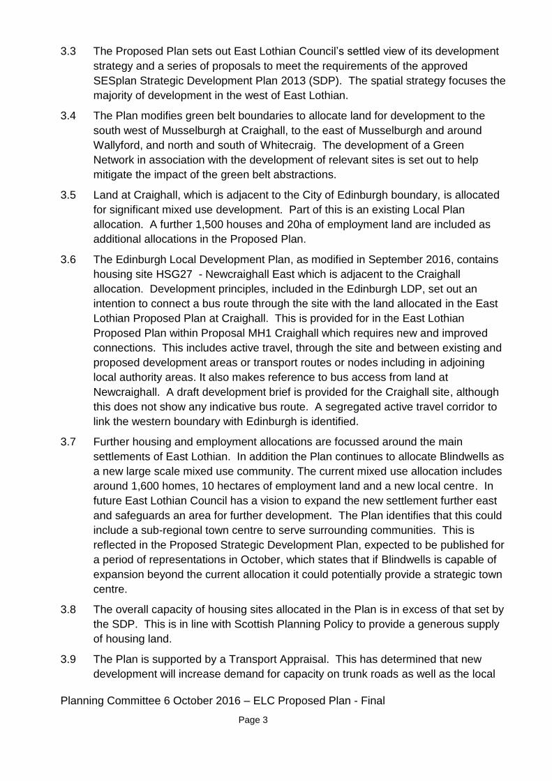
Planning Committee 6 October 2016 – ELC Proposed Plan - Final
Page 3
3.3 The Proposed Plan sets out East Lothian Council’s settled view of its development
strategy and a series of proposals to meet the requirements of the approved
SESplan Strategic Development Plan 2013 (SDP). The spatial strategy focuses the
majority of development in the west of East Lothian.
3.4 The Plan modifies green belt boundaries to allocate land for development to the
south west of Musselburgh at Craighall, to the east of Musselburgh and around
Wallyford, and north and south of Whitecraig. The development of a Green
Network in association with the development of relevant sites is set out to help
mitigate the impact of the green belt abstractions.
3.5 Land at Craighall, which is adjacent to the City of Edinburgh boundary, is allocated
for significant mixed use development. Part of this is an existing Local Plan
allocation. A further 1,500 houses and 20ha of employment land are included as
additional allocations in the Proposed Plan.
3.6 The Edinburgh Local Development Plan, as modified in September 2016, contains
housing site HSG27 - Newcraighall East which is adjacent to the Craighall
allocation. Development principles, included in the Edinburgh LDP, set out an
intention to connect a bus route through the site with the land allocated in the East
Lothian Proposed Plan at Craighall. This is provided for in the East Lothian
Proposed Plan within Proposal MH1 Craighall which requires new and improved
connections. This includes active travel, through the site and between existing and
proposed development areas or transport routes or nodes including in adjoining
local authority areas. It also makes reference to bus access from land at
Newcraighall. A draft development brief is provided for the Craighall site, although
this does not show any indicative bus route. A segregated active travel corridor to
link the western boundary with Edinburgh is identified.
3.7 Further housing and employment allocations are focussed around the main
settlements of East Lothian. In addition the Plan continues to allocate Blindwells as
a new large scale mixed use community. The current mixed use allocation includes
around 1,600 homes, 10 hectares of employment land and a new local centre. In
future East Lothian Council has a vision to expand the new settlement further east
and safeguards an area for further development. The Plan identifies that this could
include a sub-regional town centre to serve surrounding communities. This is
reflected in the Proposed Strategic Development Plan, expected to be published for
a period of representations in October, which states that if Blindwells is capable of
expansion beyond the current allocation it could potentially provide a strategic town
centre.
3.8 The overall capacity of housing sites allocated in the Plan is in excess of that set by
the SDP. This is in line with Scottish Planning Policy to provide a generous supply
of housing land.
3.9 The Plan is supported by a Transport Appraisal. This has determined that new
development will increase demand for capacity on trunk roads as well as the local

Planning Committee 6 October 2016 – ELC Proposed Plan - Final
Page 4
road network. Interventions are identified to meet the demands, including
improvements to Old Craighall junction. Development is subject to the mitigation of
any development related impacts, including cumulative impacts.
3.10 The Plan is accompanied by an Action Programme which sets out how the policies
and proposals will be delivered and identifies the infrastructure interventions
required. Draft Developer Contributions Supplementary Guidance identifies what
contributions will be required.
3.11 In line with Scottish Planning Policy the Plan sets a spatial framework for wind farm
development. Most of the area along the boundary with Edinburgh is identified as
an area of significant protection. An area to the east of Pathhead and a large part
of the south of East Lothian, which shares a small part of its boundary with
Edinburgh, is identified as an area with potential for wind farm development. Within
these areas wind farms are likely to be acceptable in principle, subject to detailed
consideration and cumulative issues. Small scale wind turbine development is
supported in most of the west of East Lothian subject to a number of factors
including landscape and visual impacts.
3.12 The Council supports the content of the plan and the development strategy that has
been set out to meet the requirements of the Strategic Development Plan. Policies
seek to integrate land use and sustainable transport. There is nothing within the
plan which would indicate that the interests of this Council would be prejudiced.
4. Measures of success
4.1 Development within a neighbouring authority takes place in a way which delivers the vision for the city region.
5. Financial impact
5.1 There is no direct financial impact arising from this report.
6. Risk, policy, compliance and governance impact
6.1 The report does not raise any health and safety, governance, compliance or
regulatory issues.
7. Equalities impact

Planning Committee 6 October 2016 – ELC Proposed Plan - Final
Page 5
7.1 There is no equalities impact arising as a result of this report’s proposed response.
East Lothian Council undertook an Equality and Rights Impact Assessment as part
of the process of preparing the Proposed Local Development Plan.
8. Sustainability impact
8.1 The East Lothian Local Development Plan has been subject to a Strategic
Environmental Assessment.
8.2 The proposals in this report will:
8.2.1 reduce carbon emissions because they are supportive of a plan which aims
to minimise energy consumption and an appropriate use of resources.
8.2.2 increase the city’s resilience to climate change impacts because it supports
a plan which aims to protect and enhance the environment of a neighbouring
authority, including directing development away from areas of flood risk and
designing development so it will be resilient to the effects of climate change.
8.2.3 help achieve a sustainable Edinburgh because they support proposed
measures which demonstrate good environmental stewardship.
9. Consultation and engagement
9.1 The East Lothian Proposed Local Development Plan is subject to a period of public
representations.
10. Background reading/external references
East Lothian Proposed Local Development Plan September 2016
Paul Lawrence
Executive Director of Place
Contact: Lindsay Robertson, Senior Planning Officer – Planning & Transport
E-mail: [email protected] | Tel: 0131 469 3932

Planning Committee 6 October 2016 – ELC Proposed Plan - Final
Page 6
11. Links
Coalition Pledges P15 Work with public organisations, the private sector and social enterprise to promote Edinburgh to investors.
Council Priorities CP5 business growth and investment
CP7 Access to work and learning
CP8 A vibrant sustainable economy
CP10 A range of quality housing options
Single Outcome Agreement
SO1 Edinburgh’s economy delivers increased investment, jobs and opportunities for all
SO2 Edinburgh’s citizens experience improved health and wellbeing, with reduced inequalities in health
SO3 Edinburgh’s children and young people enjoy their childhood and fulfil their potential
SO4 Edinburgh’s communities are safer and have improved physical and social fabric
Appendices

Planning Committee – 6 October 2016
Portobello Conservation Area Character Appraisal - APM
Planning Committee
10am, Thursday 6 October 2016
Finalised Portobello Conservation Area Character
Appraisal
Executive Summary
Committee approved a programme for reviewing key conservation area character
appraisals in October 2013. Portobello was identified as one of six priority areas for
review. In May this year, Committee approved a consultative draft revised Portobello
Conservation Character Appraisal.
Consultation has taken place and the finalised document is now presented for approval. It
includes an amendment to the boundary of the Conservation Area and has been revised
to reflect changing circumstances and make the document easier to use. The finalised
version has been informed by the views of local people and groups, following a
programme of consultation and engagement and promotion via a range of media.
Item number
Report number
Executive/routine Executive
Wards Portobello/Craigmillar
9062247
8.1

Planning Committee – 6 October 2016
Portobello Conservation Area Character Appraisal V1.3 with KT edits
Page 2
Report
Finalised Portobello Conservation Area Character
Appraisal
1. Recommendations
1.1 It is recommended that the Committee approves the appended finalised version of
the Portobello Conservation Area Character Appraisal, including a proposed
boundary amendment.
1.2 The interactive version of the appraisal document is attached at Appendix 2. This
includes maps showing the boundary amendments which are subject to approval by
the Committee. The boundary amendments will require to be advertised in the
Scotsman and Edinburgh Gazette. This process will be completed by the end of
2016.
2. Background
2.1 Committee approved a programme for reviewing conservation area character
appraisals in October 2013. Portobello was identified as one of six priority areas for
review. Priorities were set on the basis of the age of the current appraisal,
development and housing pressures, requests for change and other initiatives in
the area.
2.2 On 19 May 2016, Committee approved a draft revised Portobello Conservation
Area Character Appraisal for consultation. The draft featured a proposal to extend
the boundary of the Conservation Area to the north west to incorporate an important
approach and entrance area. The extended area includes part of the Promenade,
beach and foreshore and two surviving historic kilns.
3. Main report
3.1 Following approval of the consultative draft Portobello Conservation Area Character
Appraisal, an exhibition highlighting the main content of the new appraisal was
displayed in Portobello Public Library between 20 and 27 June 2016 and in

Planning Committee – 6 October 2016
Portobello Conservation Area Character Appraisal V1.3 with KT edits
Page 3
Portobello Swim Centre between 27 June and 11 July 2016. Staffed drop-in
sessions were also held at each venue on 22 and 30 June. Web-based information
was also circulated via Twitter and the Council's consultation hub.
3.2 An on-line questionnaire was set up to capture residents’ views on the draft
appraisal and to encourage comments about how well it refines, defines and
reflects the special characteristics of the Conservation Area. Comments specific to
the management chapter and the usability of the document as a whole were also
encouraged.
3.3 The consultation generated nine responses via the online survey. The Portobello
Heritage Trust and Portobello Amenity Society also submitted comments by email.
3.4 There were a number of comments about the format of the appraisal. The
consultation draft was issued a text documents without illustrations; the final
appraisal will be a fully illustrated colour electronic document that will include
images, photographs and interactive maps.
3.5 Appendix 1 lists the comments received and explains how these have been taken
into account in the final version of the document.
3.6 The appraisal document has been amended to address the consultation comments.
The final version of the interactive appraisal is attached at Appendix 2.
3.7 No objections to the proposed extension of the Conservation Area boundary were
received. The boundary of the proposed extension is shown in Appendix 3.
4. Measures of success
4.1 Publication of the finalised appraisal.
4.2 Formal re-designation of the conservation area, including the extended boundary.
4.3 Better-informed design and decision-making, helping to protect the character of the
area.
5. Financial impact
5.1 There are no immediate financial implications for the Council arising from this
report.
5.2 The new document format is intended to be viewed mainly on line, and can be
printed by users from home. The Council would not stock a traditional, printed
version. However, individual copies could be photocopied on request for customers
with difficulties accessing the web version. Demand for this service is expected to
be low and the minimal additional costs could be absorbed in existing budgets.

Planning Committee – 6 October 2016
Portobello Conservation Area Character Appraisal V1.3 with KT edits
Page 4
6. Risk, policy, compliance and governance impact
6.1 There are no significant risks associated with approval of the document as
recommended. Completion of the review of the appraisal ensures the Council’s
compliance with its statutory duty to review its conservation areas, as established in
the Planning (Listed Buildings and Conservation Areas) (Scotland) Act 1997.
6.2 If not approved, the appraisal review would be delayed with a consequent impact
on the quality of decision making and outcomes on the ground in the area. There
may be also be a degree of reputational damage: the Council’s relationship with
community groups could be affected due to delay or the failure to complete the
review process on time.
7. Equalities impact
7.1 The aim of conservation area status is to enhance the quality of the area. This has
the potential to improve quality of life and supports sustainable communities.
7.2 No infringements of rights have been identified. No negative impacts on equality
have been identified.
8. Sustainability impact
8.1 The impacts of this report in relation to the three elements of the Climate Change
(Scotland) Act 2009 Public Bodies Duties have been considered, and the outcomes
are summarised below.
- The proposals in this report will reduce carbon emissions by encouraging the conservation of resources and energy embodied in existing buildings, rather than demolition and reconstruction, major generators of carbon emissions.
- The need to build resilience to climate change impacts is not relevant to the proposals in this report because conservation of the built environment is not considered to be significantly affected, positively or negatively, in this regard.
- The proposals in this report will help achieve a sustainable Edinburgh because the conservation and management of the historic environment contributes directly to sustainability in a number of ways. These include the energy and material invested in a building, the scope for adaptation and reuse, and the unique quality of historic environments which provide a sense of identity and continuity.
9. Consultation and engagement
9.1 The draft appraisal was published on the Council website and promoted on the
internet, social media and at local community events.

Planning Committee – 6 October 2016
Portobello Conservation Area Character Appraisal V1.3 with KT edits
Page 5
9.2 Following the approval of the draft Portobello Conservation Area Character
Appraisal by the Planning Committee in May, an exhibition highlighting the main
content of the new appraisal was displayed at Portobello Public Library between 20
- 27 June 2016 and in Portobello Swim Centre between 27 June - 11 July 2016.
Drop-in sessions staffed by planning officers also took place at these venues on 22
and 30 June. Web-based information was also circulated via Twitter and the
Council's consultation hub.
9.3 An on line questionnaire was set up to capture residents’ views on the draft
appraisal and to encourage comments about how well it refines, defines and
reflects the special characteristics of the Conservation Area. Comments specific to
the management chapter and the usability of the document as a whole were also
encouraged.
10. Background reading/external references
10.1 Report to Planning Committee of 19 May 2016, Portobello Conservation Area –
Review of Conservation Area Character Appraisal
10.2 Report to Planning Committee of 3 October 2013, Review of Conservation Area
Character Appraisals
Paul Lawrence
Executive Director of Place
Contact: Daniel Lodge E-mail: [email protected] Tel: 0131 529 3901
Jack Gillon E-mail: [email protected] Tel: 0131 469 3634
11. Links
Coalition Pledges P40
Council Priorities
CO19 CO23 CO26
Single Outcome Agreement
SO4
Appendices
1 Consultation responses
2 Portobello Conservation Area Character Appraisal – final

Planning Committee – 6 October 2016
Portobello Conservation Area Character Appraisal V1.3 with KT edits
Page 6
version
3 Proposed extension to Portobello Conservation Area

Appendix 1
Portobello Draft Conservation Area Character Appraisal: Analysis of Survey Results Respondents completed the evaluation of the draft appraisal answering questions within two sections on ‘Special Characteristics’ and ‘Management and Document Format’ with a multiple-choice answer on a five point scale with space provided for comments. Respondents also completed a final question which asked if there were any further suggestions for changes or improvements to the draft character appraisal. Special Characteristics Q1 How well do you feel the revised appraisal reflects the special character of the Portobello Conservation Area overall? The dominant responses were: ‘fairly well’ (60%) and ‘neither well nor badly’ (40%) Comments Two respondents made specific reference to the document’s format. Reference was also been made to a factual error. Response The final appraisal will be a fully illustrated colour electronic document that will include images, photographs, and interactive maps. Noted and changes made. Q2 How well do you feel the draft appraisal describes the different elements of Portobello’s special character? The dominant responses were: ‘neither well nor badly’ (60%) and ‘fairly well (40%). Comments Respondent acknowledged that the ‘statement of significance’ covered these elements reasonably well, but highlights that these elements could be expanded to include the impact of buildings and their plots on the development of the Promenade with reference to the socio-economic development of the area also provided. Further reference to the document’s length, visual appearance and clarity in the changes implemented was also provided in the comments left by a respondent. Response The appraisal makes specific reference to the nature of Portobello’s varied development phases resulting in a varied spatial structure, townscape and architectural character that has provided an interesting blend of layouts, tenures and architectural styles. The document makes specific reference to the changing nature of sites on the Promenade. In response to the point made about the socio-economic development of the area, although

touched upon in the draft appraisal these issues are not normally relevant for a conservation area character appraisal. Q3 Have any special characteristics been missed? The dominant response was: ‘not sure’ (100%). Comments Respondents acknowledge the document’s appraisal of the architectural character within the area, but stress the lack of emphasis placed upon the other elements, such as the setts along Brighton Place and the important contribution they provide to the overall character of the conservation area. Response The document makes specific reference to traditional surface materials within the ‘Management – Opportunities for Planning Action’ section where it states that ‘the unique characteristics of the streetscape of the area should be protected and enhanced’ and that ‘interventions should be planned and designed taking account of their broader context in order to reinforce the sense of place’. The document also advocates minimising visual clutter, avoiding generic ‘off-the-peg’ solutions, and protecting traditional surface materials and design details. Q4 Do you agree with the separation of the three different character zones i.e. the High Street, Promenade and the residential zone? The dominant responses were: ‘not sure’ (80%) and ‘yes’ (20%). Comments Respondents generally acknowledged that the division was reasonable with a suggested split of the residential area at the Bath Street/Brighton Place intersection, owing to the differing architectural eras on either side. Response The area contains a mix of Georgian and Victorian residential property. The inclusion of a further character zone within the document is not recommended as appropriate. Management and Document Form Q5 How well do you feel the management chapter reflects issues relevant to the Portobello Conservation Area? The dominant responses were: ‘neither well nor badly’ (60%), ‘fairly well’ (20%) and ‘fairly badly’ (20%). Comments

The respondents welcomed the inclusion of the management chapter agreeing that it reflected issues relevant to the Portobello Conservation Area. However, further reference was made to the proposed removal of the setts within Brighton Place and the contradiction this removal would pose to such advice. Response The decision to remove the setts from Brighton Place has already been taken by the Council. Although the character appraisal primarily identifies what provides the area with its special characteristics and helps manage change within it, its purpose is not to respond to individual decisions previously taken within it. Q6 How user-friendly do you feel the format of the revised appraisal is? The dominant responses were: ‘very user friendly’ (40%) and ‘not sure / neutral’ (40%). Comments Respondents made reference to the documents visual appearance as a PDF flie. Response The final appraisal will be a fully illustrated colour electronic document that includes images, photographs and interactive maps. Q7 Do you have any further suggestions for changes or improvements to the document? Comments Minor comments include requesting ‘nice pictures’ and changing individual words eg from ‘should’ to ‘must’. Response All noted.

PortobelloConservation Area Character Appraisal

PortobelloConservation Area
Character Appraisal
3
Contents
Maps 4
Summary information 7
Purpose of character appraisals - why do we need them? 8
How to use this document 8
Historical origins and development 9
Character Zones - Structure 12
Management - Legislation, policies and guidance 24
Management - Assessing Development within Conservation Areas 25

PortobelloConservation Area
Character Appraisal
4
Historical Maps
Wood’s Plan 1790 -1847 Batholomew 1860 -1920

PortobelloConservation Area
Character Appraisal
5T
T
G
G
G
G
G
G
KeyConservation Area Boundary
Open/Green Space
Views
Vistas
Glimpse
Terminated View
Grid Plan
Landmarks
T
G
Main Focal Point
Structure Map & Special Characteristics

PortobelloConservation Area
Character Appraisal
6
Aerial Map

PortobelloConservation Area
Character Appraisal
7
Summary information
Location and boundaries
Portobello lies on the coast, some four miles east of the centre of Edinburgh, between Leith and Musselburgh.
The Conservation Area is enclosed to the north-east by the sea and to the south-west by Sir Harry Lauder Road, which creates a visual and physical boundary for the Conservation Area as far as Windsor Place. At this point, the boundary turns north down Windsor Place and excludes the housing on the former Mount Lodge Estate. The north western and south eastern boundaries are less well defined: the north western boundary being generally defined by Beach Lane on the north side of the High Street and to the rear of Adelphi Place properties on the south side of the High Street, and the south-east boundary extending to the end of Joppa Road taking in Dalkeith Street and Morton Street.
The boundaries of the Conservation Area have been examined through the appraisal process. At the north western edge of the Conservation Area is an important element of Promenade, beach and foreshore that signifies the approach and entrance to the Conservation Area and includes the two surviving historic kilns. This area warrants consideration for inclusion within a proposed boundary extension.
The Conservation Area falls within the Ward boundary of Portobello/Craigmillar. There are in the order of 4,500 people living within the Conservation Area and approximately 1,700 residential units.
Dates of designation/amendments
The original Portobello Conservation Area was designated on 13th October 1977. The original boundary was amended in July 1985 and again in February 1998. The first Portobello Conservation Area Character Appraisal was competed in May 2000.
Statement of significance
Portobello retains the character of a small town with a distinct town centre, an exceptionally high quality residential hinterland, a shoreline setting and a long sea-front promenade. The architectural form and character of Portobello is rich and varied, with many fine Georgian and Victorian historic buildings. The building materials are traditional: stone, harling, slate, pantiles, timber windows and doors.

PortobelloConservation Area
Character Appraisal
8
Conservation Area Character Appraisals
Purpose of character appraisals - why do we need them?
Conservation area character appraisals are intended to help manage change. They provide an agreed basis of understanding of what makes an area special. This understanding informs and provides the context in which decisions can be made on proposals which may affect that character. An enhanced level of understanding, combined with appropriate management tools, ensures that change and development sustains and respects the qualities and special characteristics of the area.
“When effectively managed, conservation areas can anchor thriving communities, sustain cultural heritage, generate wealth and prosperity and add to quality of life. To realise this potential many of them need to continue to adapt and develop in response to the modern-day needs and aspirations of living and working communities. This means accommodating physical, social and economic change for the better.
Physical change in conservation areas does not necessarily need to replicate its surroundings. The challenge is to ensure that all new development respects, enhances and has a positive impact on the area. Physical and land use change in conservation areas should always be founded on a detailed understanding of the historic and urban design context.”
From PAN 71, Conservation Area Management. www.scotland.gov.uk/Publications/2004/12/20450/49052
How to use this document
The analysis of Portobello’s character and appearance focuses on the features which make the area special and distinctive. This is divided into two sections: Structure, which describes and draws conclusions regarding the overall organisation and macro-scale features of the area; and Key Elements, which examines the smaller-scale features and details which fit within the structure.
This document is not intended to give prescriptive instructions on what designs or styles will be acceptable in the area. Instead, it can be used to ensure that the design of an alteration or addition is based on an informed interpretation of context. This context should be considered in conjunction with the relevant Local Development Plan policies and planning guidance. The Management section outlines the policy and legislation relevant to decision-making in the area. Issues specific to Portobello are discussed in more detail and recommendations or opportunities identified.

PortobelloConservation Area
Character Appraisal
9
Historical origins and development
A review of the historical development of Queensferry is important in order to understand how the area has evolved in its present form and adopted its essential character.
Origins and Development
Portobello takes its name from the Spanish port of Puerto Bello on the Isthmus of Panama. In a notable offensive of 1739, the port was captured by a British fleet under Admiral Vernon. In the 1740s, George Hamilton, one of the sailors involved in the battle, built a house four miles east of Edinburgh which he named his “Portobello Hut” after the battle of Puerto Bello.
In 1765, rich clay deposits were discovered just to the west of the Figgate Burn and this led to the establishment of brick, glass and pottery works, a soapworks, a white lead works, and associated workers’ housing. The earliest reference to Portobello appears in ‘The History of Edinburgh’ by Hugo Arnot, published in 1779. Arnot refers to Mr William Jamieson’s brickworks in the area. William Jamieson was a local entrepreneur who built several large villas in the area at this time. Of the large houses built during this period, only one, now with much altered, survives.
In 1787, local industry was further stimulated by the founding of a small harbour at the mouth of the Figgate Burn and, by 1811, Thomas Bonar’s ‘Plan of Edinburgh and Leith with the Roads Adjacent’ shows some 90 buildings under the heading ‘Village of Portobello’.
Portobello developed significantly in the 18th century, not only because of its industry but due to its popularity as a bathing and spa resort. Discovery of mineral wells added to the village’s attraction and in the early years of the 19th century, elegant residential terraces were developed, mainly between the High Street and the sea. Bath Street and Tower Street (Figgate Street) were laid out in 1801-1802, and Regent Street and Wellington Street (Marlborough Street) in 1815-1816. The next phase included the building of Melville Street (Bellfield Street), Pitt Street
(Pittville Street) and John Street, designed by the architect Robert Brown who lived in Pitt Street. The Brighton/Rosefield area was developed and built by a local builder, John Baxter. This area is one of the most attractive in Portobello, the uniform facades with their linking screen walls giving these streets considerable distinction.
John Wood 1874
0302867
Highlight

PortobelloConservation Area
Character Appraisal
10
Portobello was established both as a fashionable summer resort and as an attractive place to stay all year round. The population census of 1831 gives a population of 2,781 residents within 517 houses, which was swelled by an additional summer population of not less than 2,000.
Building continued eastwards towards Joppa from the 1830s onwards and also south of the High Street until the end of the century, with rows of Georgian terraces gradually giving way to Victorian semi-detached and detached houses.
As the 19th century progressed, the Georgian two storey buildings on the north side of the High Street became punctuated by larger Victorian tenements. The scale and symmetry of the streets between the High Street and the Promenade were also compromised to a degree. Some villas were demolished and their grounds redeveloped.
Many Georgian streets, such as Bath Street and Marlborough Street, now contain large Victorian tenements, some of them spectacular - Windsor Mansions (1899) in Straiton Place and St. James’s Terrace (1870) in Bath Street are two examples. Several of these tenements were built in red sandstone, contrasting with the grey stone of the original Georgian buildings.
The Regency Spa Town became both a Victorian suburb of Edinburgh - the Burgh
Reform Act of 1896 had seen Portobello incorporated into the City of Edinburgh - and a Victorian sea-side resort, popular with day trippers from Edinburgh and Glasgow. The establishment of rail and tram links increased the popularity of Portobello as a holiday destination.
Prior to the construction of the Promenade, gardens and garden walls extended down to the beach and the seafront was not easily accessible to the public. The first section of the Promenade was completed in the 1850s, from Bath Street to Melville Street. It was extended in the 1860s but was swept away twice by storms and was eventually completed in 1891. A 1,200 foot pier was opened in 1871 (demolished 1917) which included a restaurant, shops and kiosks.

PortobelloConservation Area
Character Appraisal
11
A number of fine individual buildings were built at the start of the 20th century - notably the baths in Bellfield Street (1901); the Town Hall (1911) and St. John’s Roman Catholic Church in Brighton Place (1906), the spire of which dominates the town’s skyline.
Between the wars, when Portobello was in its heyday, a number of buildings were constructed in the modern style. The former cinema in Bath Street remains, but the Open Air Swimming Pool (1936) was demolished in the 1980s.
The whole area between Figgate Street and Bridge Street, north of the High Street, was redeveloped between 1976 and 1980. The Marlborough Mansions (1899), near the foot of Bath Street, were demolished in the 1960s as part of proposals to widen the Promenade. By the 1960s, the number of tourists visiting Portobello reduced significantly and many of the shops and kiosks, which were once a feature on the Promenade, closed.
Portobello retains a heritage of fine buildings from all stages of its history, most notably the elegant Georgian terraces and the complementary fringe of Victorian and Edwardian buildings. The layering of high quality development from different eras makes a major contribution to the character of the Conservation Area. The town retains a recognisable seaside character with its long promenade, reclaimed and improved beach, and amusement arcade. It has a thriving resident population of around 4,500 and remains popular with visitors - on fine summer days the beach and promenade are crowded with day-trippers.
0302867
Highlight

PortobelloConservation Area
Character Appraisal
12
Character Zones - Structure
click image for further details
The Conservation Area includes three areas of distinctly different character:
The High Street provides the commercial and administrative focus for the Conservation Area retaining many original two storey Georgian buildings as well as a number of significant public buildings.
The vehicle free Promenade, beach, cafes and amusement arcades highlight Portobello’s character as a seaside resort.
The remainder of the Conservation Area constitutes Portobello’s main residential zone and includes an abundance of fine Georgian villas as well as a robust stock of Victorian villas and tenements which contribute to the suburban character.
Streets Spaces Views
Structure Development PatternThe High Street
The High street is an identified shopping centre.
Side streets running perpendicularly from the High Street down to the Promenade.
The street is predominantly a mixture of small scale Georgian buildings and larger Victorian tenements.
Abercorn Park is an attractive green space Streets and lanes leading to the Promenade offer views of the sea from the High Street.
0302867
Highlight

PortobelloConservation Area
Character Appraisal
13
Character Zones - Structure
Structure
The High street is an identified shopping centre that provide a diverse mix of commercial activities and in which retail frontages are protected. Key objectives involve encouraging regeneration to attract investors and generate new employment opportunities, promoting good quality design and enhancing existing quality.
Development pattern
The High Street forms a wide curving linear spine parallel to the sea with side streets running perpendicularly from it down to the Promenade. Commercial activity on Bath Street helps to draw visitors down them towards the sea. The architectural quality of the High Street is exemplified by individual buildings such as the Town Hall, the Police Station and the Georgian terraced shops with first floor housing in the eastern section
The building heights along the north side of the High Street show a high degree of uniformity, reflecting the planned Georgian development. This contrasts with the south side of the street, where building heights vary along the entire length from single storey to four storey.
There are few 20th century buildings on the south side of the High Street except a large residential conversion and further flats in the eastern section and shops and flats in the western section. All of these more recent additions are set back from the building line with the exception of the flatted block adjacent to the former Windsor Place Church.
Streets
Approaching from the west, the High Street is generally linear before curving significantly to the east of the Bath Street/Brighton Place junction. It then curves almost imperceptibly in the other direction before straightening out as it runs into Abercorn Terrace. Whilst the actual width of the street varies little throughout its length, at various points on the south side buildings have been set back from the building line - these are mostly 20th century developments - and the road widened to allow for parking. This gives these areas an air of spaciousness and helps to induce expectation and a sense of arrival in the town centre.
The street is predominantly a mixture of small scale Georgian buildings and larger Victorian tenements, with shops at ground floor and residential flats above. On the north side of the street, between Figgate Burn and Bath Street, the building height varies significantly,
0302867
Highlight
0302867
Highlight
0302867
Highlight

PortobelloConservation Area
Character Appraisal
14
Character Zones - Structure
ranging from single storey shops to four storey tenements. East of Bath Street, the buildings are predominantly two storey with the notable exception of a three storey block at the extreme east end and the four storey tenement at the junction with Marlborough Street. There are a number of buildings which contribute to the character of the area and give focus to the townscape - the Town Hall and Police Station add variety to the facades of the High Street shop fronts.
A number of original windows remain on the upper floors, however, there are a significant number of inappropriate replacement windows
There a small number of original or historic shop fronts along the High Street, however, the majority now have modern single paned, non-traditional frames with flush doors. Over-deep fascias, garish paint and inappropriate signage further detract from the character of the Conservation Area.
The street is at its widest between Rosefield Avenue and Brighton Place. This area has a sense of being an important place for people to congregate; benches on both sides of the street and the grouping of the town’s main bank, Town Hall and Police Station all contribute to this feeling.
The High Street shops represent the bulk of the shopping facilities in the Conservation Area and provide a focus of activity for the community. The shops are mainly independent retail units catering for local needs. The shops in the High Street extend from Figgate Burn to Pittville Street on the north side with some commercial uses continuing down Bath Street. On the south side, the shops extend from Adelphi Grove to east of Marlborough Street with some shops returning down the east side of Brighton Place as far as Lee Crescent.
The commercial section of the High Street is centred on its crossroads with Brighton Place/Bath Street, and extends eastwards to Pittville Street and westwards to Kings Road, with some residential interruptions.
The spaces between the buildings are predominantly in tarmac (roads) and concrete slabs (pavements). However, soft landscaping in the form of trees is located on the south side of the High Street to the front and side of the bank.

PortobelloConservation Area
Character Appraisal
15
Character Zones - Structure
Spaces
The buildings are set back significantly at the western entrance to the Conservation Area and to the east of Marlborough Street. The greater width at the entrance to the Conservation Area results from the grouping of residential blocks set back from the road. This area, although not part of the Conservation Area, accentuates the sense of arrival in the High Street as the building line returns sharply at the junction with Adelphi Grove, creating a sense of the street narrowing. At the east end of the High Street, the shops start at Pittville Street on the north side, the narrowing of the road and the forward building line east of Marlborough Street confirms the entry to a commercial area.
Abercorn Park is an attractive green space lined by elm, whitebeam, holly and hawthorn which forms a prominent break in the building line on the High Street.
Views
Streets and lanes leading to the Promenade offer views of the sea from the High Street. The spires of churches are distinctive landmarks and prominent in views along the High Street.
Key ElementsSpine with secondary streets running perpendicular.
A recognised shopping centre.
Uniform height terraces to the north of the High Street.
Views of the sea at various points along the street.
A number of landmark buildings.
Building lines to the heel of the pavement.
A mix of uses, mostly with residential on upper floors.
Variation in building periods, types and heights to the south of the High Street.
The predominant building material in the High Street is natural stone which
varies in colour, texture and condition.
A number of good quality original and historic shop fronts.

PortobelloConservation Area
Character Appraisal
16
Character Zones - Structure
Promenade/Beach The beach, along with the Promenade, are significant amenities which emphasise Portobello’s reputation and character as a seaside resort.
ViewsDevelopment Pattern
click image for further details
There is a rich mix of building styles fronting, or slightly set back from the Promenade.
Spaces
Today, the Promenade is an important part of Edinburgh’s waterfront and forms a popular pedestrian route.
The Promenade provides panoramic vistas to the coast of Fife, back towards the City and Leith, and down to the East Lothian countryside and North Berwick Law.

PortobelloConservation Area
Character Appraisal
17
Character Zones - Structure
Development Pattern
There is a rich mix of building styles fronting, or slightly set back from the Promenade. The form of development has resulted in buildings some of which have their frontages to the Promenade and others their rear elevations. These include single storey Georgian houses, two storey Victorian terraced properties, large two to three storey detached Victorian villas and four storey Victorian tenements. There are also two modern residential developments: a pair of two storey semi-detached houses (1990) at Straiton Place and a block of flats (1996) at the bottom of Pittville Street.
In addition to the residential properties described above, there are a number of other buildings along the Promenade related to the seaside leisure industry - the Public Baths on the Promenade (1901) in red sandstone with a long front, two curving gables and first floor timber balconies.
The Tower, in Figgate Lane, was built in 1785, possibly by William Jamieson as a summerhouse for John Cunningham. It is an unusual octagonal castellated gothic building and is constructed in sandstone with red brick dressings.
Spaces
Today, the Promenade is an important part of Edinburgh’s waterfront and forms a popular pedestrian route, which, along with the well maintained sandy beach, emphasises Portobello’s seaside resort character. This character is maintained despite the loss of the pier in 1917 which was constructed around the same time as the Promenade.
The Promenade starts at the bottom of Kings Road following the edge of the sea and curving significantly before becoming part of the Conservation Area at Figgate Lane. Its width alters according to the building line and opens out between John Street and James Street and at three points between James Street and the end of the Promenade.
The surface of the Promenade is predominantly red tarmac with a thin grey concrete strip adjacent to the low concrete wall forming the physical boundary between the beach and the Promenade. The red tarmac does not have a uniform appearance due to patch repairs in a different colour.

PortobelloConservation Area
Character Appraisal
18
The unifying streetscape elements are the low concrete wall to the beach side, the predominantly red tarmac surface and the benches and bollards, where each street or lane meets the Promenade.
There are also a number of public grassed areas between Bath Street and John Street with the larger area also incorporating a children’s playground and a community garden with restored Coade stone pillars. An additional small grassed area is located adjacent to the north west boundary of the area. There is also a hard-landscaped children’s play area to the north west of the Promenade.
The front gardens of residential properties set back from the Promenade, and generally enclosed by varying heights of stone wall, represent the predominant form of soft landscaping on the Promenade.
The Conservation Area extends eastward to include the beach as Portobello’s coastal location was integral to its development. The beach is generally well-maintained and clean.
Views
The Promenade provides panoramic vistas to the coast of Fife, back towards the City and Leith, and down to the East Lothian countryside and North Berwick Law.
Character Zones - Structure
Key ElementsLinear traffic free walkway with open views of Fife and North Berwick Law.
Open views to the sea.
Predominance of stone built properties, many with front doors to the Promenade, and generally retaining their original features.
The predominant roof covering is slate.
Good quality stone boundary walls.
Easy access from side streets/lanes.
Seasonal seaside attractions and indoor swimming pool.
Well maintained sandy beach.
Beach protected by groins.
0302867
Highlight
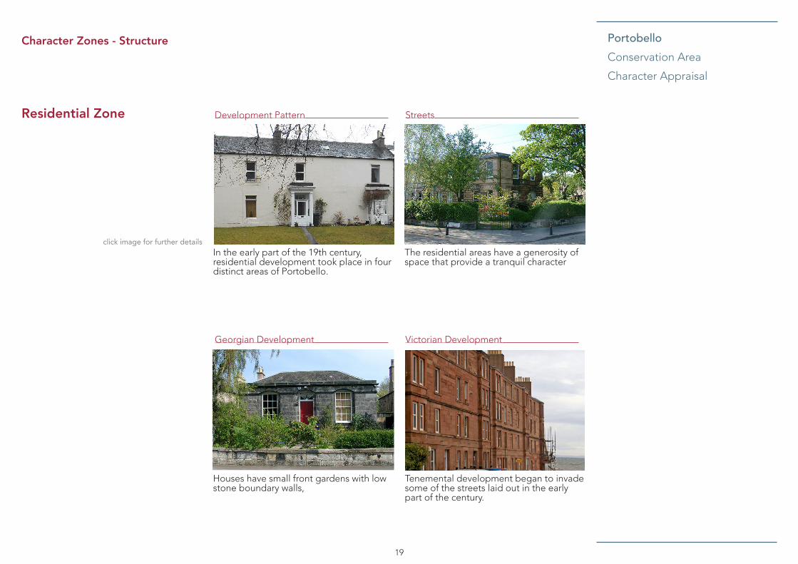
PortobelloConservation Area
Character Appraisal
19
Character Zones - Structure
Residential Zone StreetsDevelopment Pattern
Georgian Development Victorian Development
click image for further detailsThe residential areas have a generosity of space that provide a tranquil character
In the early part of the 19th century, residential development took place in four distinct areas of Portobello.
Tenemental development began to invade some of the streets laid out in the early part of the century.
Houses have small front gardens with low stone boundary walls,

PortobelloConservation Area
Character Appraisal
20
Character Zones - Structure
Development pattern
In the early part of the 19th century, residential development took place in four distinct areas of Portobello. By far the main development took place between 1800 and 1825 on the north side of the High Street, where streets were laid out on a grid plan, progressing from east to west. The next important area to be developed was on the south side of the High Street in the Brighton and Rosefield area. Two other small groups of houses were also built in this period; villas and part of a classic terrace in Windsor Place and several houses, mainly semi-detached, on the south side of Joppa Road, west of Morton Street.
In the Victorian period, residential development continued eastwards on both sides of the High Street. In the 1840s and 1850s, houses in a neo-classical style were built in James Street, Abercorn Terrace, Dalkeith Street and Elcho Terrace.
As the century progressed, buildings displayed a greater variety of styles and influences, including Baronial and, by the turn of the century, terraces of plain two-storey houses with bow windows at the east end of Joppa.
By this time, several detached houses in Bath Street and Marlborough Street had been demolished and these sites and other gap sites were filled with large Victorian tenements. These tenements, often in red sandstone and many displaying a profusion of exuberant carved detailing, overwhelmed their modest Georgian neighbours. Gap sites in other Georgian streets to the east were also filled with two storey houses, for example, the east side of Bellfield Street.
Residential development also continued eastwards along the Promenade where several grand villas in the French and Italian styles were built as well as large tenement blocks.
Thomas Tough, a local pottery owner, built housing in the Adelphi Place area around 1850-1860 to house his workers. As fashionable housing was being built towards the east, areas to the west, on the north side of the High Street, were filled with cheaper housing of a much higher density.
Development has changed the character of parts of the Conservation area, particularly within lanes and back-land areas, and further pressure for this type of development may arise in the future.

PortobelloConservation Area
Character Appraisal
21
Character Zones - Structure
Streets
The residential areas, whether they are Georgian with a classical layout and restrained architecture, or Victorian with more informal layouts and exuberant designs, have a generosity of space that provide a tranquil character.
Georgian Development - Streets are generally relatively narrow, although they tend to become wider towards the east. Houses have small front gardens with low stone boundary walls, originally with cast iron railings (some of which have recently been replaced). Back gardens are much larger and are bounded by high stone walls.
On the north side of the High Street, the majority of Georgian streets run at right angles north towards the Promenade. Most of these streets are serviced by back lanes which originally provided access to stables and mews buildings. This grid plan layout is not repeated on the south side of the High Street where East and West Brighton Crescent cross over Brighton Place in a sweeping curve. This has resulted in a less formal layout and interesting vistas. Brighton Place is the main entrance into the Conservation Area from Duddingston and is the only remaining setted street.
A wide range of classical detailing is used. Two storey houses generally have five windows on the front elevation. Semi-detached houses often have paired doorcases, with Roman Doric pilasters. Ground floor elevations can be rusticated or smooth ashlar. There are many other variations including gothic style windows and timber external shutters.
The houses on the south side of Joppa Road, west of Morton Street are built in a variety of styles. However, they reverse the normal practice, having high stone front garden walls and large front gardens, with smaller rear gardens. This took advantage of what was originally an open outlook at the front over the Firth of Forth.
East of Morton Street, on the south side of Joppa Road, is a long low terrace of workers’ houses. Few houses of this type built in the early part of the nineteenth century survive in either Portobello or Joppa. These are single storey, built in stone (some with later modern facings) and roofed with red Georgian property pantiles (some having later slate roofs) on Pitville Street
The Brighton and Rosefield area (circa 1823) is one of the least altered and most architecturally important areas of Portobello. The area displays a distinctive unity of style as John Baxter, the builder, provided designs for the elevations of the houses. Distinguished one and two storey villas are linked by single storey wings, the two storey properties being rusticated at ground floor. The single storey villas and villas with basements have doorways in both wings and houses which are within segmentally arched recesses.

PortobelloConservation Area
Character Appraisal
22
Character Zones - Structure
Victorian Development - Streets became wider in the Victorian era, continuing the pattern of small front gardens and larger back gardens. Most streets were serviced by back lanes, although the railway line prevented this from happening on the south side of Argyle Crescent.
In the early Victorian period, houses continued to be built in the classical style. Both houses and gardens became bigger as development progressed eastwards. However, by the end of the century, houses became increasingly smaller in scale and detailing tended to become less elegant.
Gradually a greater variety of building styles came to be used. The baronial style can frequently be seen, with canted bay windows beneath steep gables. Many houses incorporate barge boarding and others decorative cast-iron balconies.
Tenemental development began to invade some of the streets laid out in the early part of the century, notably Marlborough Street, Straiton Place and Bath Street, the latter now containing a rich mixture of building styles from all eras.
Overall, the more exuberant approach to house construction adopted by the Victorians has, in places, resulted in a disparity of scale between the neat and ordered Georgian villas and the grand decorative flourish of the Victorian tenements. This has created an interesting but restless and fragmented character.
St. John’s Roman Catholic Church in Brighton Place is the most prominent of Portobello’s churches. Designed by J.T. Walford and dating from 1906, it is a highly individual building, mixing Gothic and Arts and Crafts styles, and its octagonal pinnacle towers dominate the town’s skyline.
Key ElementsStrong formal patterns of Georgian housing eg. grids, crescents, squares and associated open space.
Overlapping and less formal patterns of Victorian housing often of more exuberant design demonstrating a range of interesting street corner treatments.
High quality architecture.
Views of the sea from the streets leading down from Abercorn Terrace/ Joppa Road.
Predominant use of traditional building materials: stone, slate, timber sash and case windows.
Stone retaining and separating walls, some with original railing pattern.
Variations in plot sizes and building types, heights, spacing and setbacks from the pavement.
Small scale cottages with narrow plot widths at the west and east ends of the Conservation Area.
System of narrow lanes and access ways between streets.

PortobelloConservation Area
Character Appraisal
23
Conservation Areas
The Planning (Listed Buildings and Conservation Areas) (Scotland) Act 1997 states that Conservation Areas “are areas of special architectural or historic interest, the character or appearance of which it is desirable to preserve or enhance”. Local authorities have a statutory duty to identify and designate such areas.
Special attention must be paid to the character and appearance of the Conservation Area when planning controls are being exercised. Conservation Area status brings a number of special controls:
• The demolition of unlisted buildings requires Conservation Area consent.
• Permitted development rights, which allow improvements or alterations to the external appearance of dwellinghouses and flatted dwellings, are removed.
• Works to trees are controlled (see Trees for more detail).
The demolition of unlisted buildings requires Conservation Area consent and the removal of buildings which make a positive contribution to the area is only permitted in exceptional circumstances, and where the proposals meet certain criteria relating to condition, conservation deficit, adequacy of efforts to retain the building and the relative public benefit of replacement proposals.
Conservation Area character appraisals are a material consideration when considering applications for development within Conservation Areas.
Listed buildings
A significant number of buildings within the Portobello Conservation Area are listed for their special architectural or historic interest and are protected under the Planning (Listed Buildings and Conservation Areas) (Scotland) Act 1997. Listed building consent is required for the demolition of a listed building, or its alteration or extension in any manner which would affect its special character.
Management - legislation, policies and guidance
Planning guidance
More detailed, subject-specific guidance is set out in Planning Guidance documents.
Those particularly relevant to the Portobello Conservation Area are:
• Guidance for Householders
• Guidance for Businesses
• Listed Buildings and Conservation Areas
• Developer contributions and affordable housing
• Edinburgh Design guidance
• Communications Infrastructure
• Street Design Guidance
In addition, a number of statutory tools are available to assist development management within the Conservation Area.

PortobelloConservation Area
Character Appraisal
24
GPDO and Article 4 Directions
The Town and Country Planning (General Permitted Development) (Scotland) Order 1992, amended 2012, (abbreviated to GPDO), restricts the types of development which can be carried out in a Conservation Area without the need for planning permission. These include most alterations to the external appearance of dwellinghouses and flats. Development is not precluded, but such alterations will require planning permission and special attention will be paid to the potential effect of proposals.
Under Article 4 of the GPDO the planning authority can seek the approval of the Scottish Ministers for Directions that restrict development rights further. The Directions effectively control the proliferation of relatively minor developments in Conservation Areas which can cumulatively lead to the erosion of character and appearance. Portobello Conservation Area has Article 4 Directions covering the following classes of development:
7 The erection, construction, maintenance, improvement or alteration of a gate, fence, wall or other means of enclosure.
35 Development on operational land by statutory undertakers in respect of dock,
Management - Legislation, policies and guidance
pier, harbour, water transport, or canal or inland navigation undertakings.
38 Development by statutory undertakers for the purpose of water undertakings.
39 Development by a public gas supplier.
40 Development by an electricity statutory undertaker.
Trees
Trees within Conservation Areas are covered by the Town and Country Planning (Scotland) Act 1997 as amended by the Planning (etc) Act 2006. This Act applies to the uprooting, felling or lopping of a tree having a diameter exceeding 75mm at a point 1.5m above ground level. The planning authority must be given six weeks’ notice of the intention to uproot, fell or lop trees. Failure to give notice will render the person liable to the same penalties as for contravention of a Tree Preservation Order (TPO).
Tree Preservation Orders are made under planning legislation to protect individual and groups of trees considered important for amenity or because of their cultural or historic interest. When assessing amenity, the importance of trees as wildlife habitats will be taken into consideration. There is a strong presumption against any form of development or change of use of land
which is likely to damage or prejudice the future long term existence of trees covered by a TPO. The removal of trees for arboricultural reasons will not imply that the space created by their removal can be used for development.
Trees in the City contains a set of policies with an action plan used to guide the management of the Council’s trees and woodlands.

PortobelloConservation Area
Character Appraisal
25
General Criteria
General issues to be taken into account in assessing development proposals in a Conservation Area include the appropriateness of the overall massing of development, its scale (the expression of size indicated by the windows, doors, floor heights, and other identifiable units), its proportions and its relationship with its context i.e. whether it sits comfortably. Development should be in harmony with, or complimentary to, its neighbours having regard to the adjoining architectural styles. The use of materials generally matching those which are historically dominant in the area is important, as is the need for the development not to have a visually disruptive impact on the existing townscape. It should also, as far as possible, fit into the “grain” of the Conservation Area, for example, by respecting historic layout, street patterns or existing land form. It is also important where new uses are proposed that these respect the unique character and general ambience of the Conservation Area, for example certain developments may adversely affect the character of a Conservation Area through noise, nuisance and general disturbance.
Management - Assessing Development within Conservation Areas
New Buildings
The development of new buildings in a Conservation Area should be a stimulus to imaginative, high quality design, and seen as an opportunity to enhance the area. What is important is not that new buildings should directly imitate earlier styles, rather that they should be designed with respect for their context, as part of a larger whole which has a well-established character and appearance of its own. Therefore, while development of a gap site in a traditional terrace may require a very sensitive design approach to maintain the overall integrity of the area; in other cases modern designs sympathetic and complimentary to the existing character of the area may be acceptable.
Alterations and Extensions
Proposals for the alteration or extension of properties in a Conservation Area will normally be acceptable where they are sensitive to the existing building, in keeping with the character and appearance of the particular area and do not prejudice the amenities of adjacent properties. Extensions should be subservient to the building, of an appropriate scale, use appropriate materials and should normally be located on the rear elevations of a property. Very careful consideration will be required for alterations and extensions
affecting the roof of a property, as these may be particularly detrimental to the character and appearance of the Conservation Area.
Definition of ‘Character’ and ‘Appearance’
Conservation areas are places of special architectural or historic interest, the character and appearance of which it is desirable to preserve or enhance.
The character of an area is the combination of features and qualities which contribute to the intrinsic worth of an area and make it distinctive. Special character does not derive only from the quality of buildings. Elements such as the historic layout of roads, paths and boundaries, paving materials, urban grain and more intangible features, such as smells and noises which are unique to the area, may all contribute to the local scene. Conservation area designation is the means of recognising the importance of all these factors and of ensuring that planning decisions address these qualities.
Appearance is more limited and relates to the way individual features within the conservation area look.
Care and attention should be paid in distinguishing between the impact of proposed developments on both the character and appearance of the conservation area.

PortobelloConservation Area
Character Appraisal
26
There are several open spaces which contribute to the townscape pattern of the area - squares, parks, the Figgate Burn, and the beach. Brighton Park and Abercorn Park are part of a formal structure surrounded by residential streets and gardens. Rosefield Park through which the Figgate Burn runs, has a less formal layout.
The Council has an obligation to take account of the impact of development on species protected by legislation and international commitments. The Nature Conservation (Scotland) Act 2004 places a duty on all public bodies to further the conservation of biodiversity as far as is consistent with their functions.
The Figgate Burn is designated as a Local Biodiversity Site for its value as a mixed habitat wetland for its amenity grassland, broadleaved plantation, semi-natural broadleaved woodland, standing water and running water. A small section of the beach to the east of the Conservation Area is part of the Joppa Shore Geodiversity Site which is designated for its geological interest including sedimentary rocks of the Upper Limestone Formation and coal measures of the Carboniferous Period.
The beach and foreshore within the Conservation Area are part of the Firth of Forth Special Protection Area for their value as an estuarine and coastal habitat for the wintering population of wading birds and wild fowl.
These sensitive nature conservation sites must be considered if affected by any development proposal.
Management - Archaeology
Prior to the mid 18th century Portobello appears to have remained relatively undeveloped as an area of coastal sand dunes and farmland, bisected by the medieval coastal road linking Leith to Musselburgh. This historic road may have had earlier Roman origins, as the coastal road linking the 2nd century AD Roman forts at Cramond and Inveresk (Musselburgh).
Development at Portobello commenced in earnest in 1765 when William Jamieson, an Edinburgh architect and speculative builder feued his first parcel of land from Baron William Muir of Caldwell to set up a pottery to utilise the recently discovered rich clay deposits to the west of the Figgate Burn. This early industrial pottery expanded with the addition of new potteries and brick and tile works across the mouth of the Figgate Burn over the following 18th and 19th centuries. As a result, by the end of the 19th century Portobello had became one of Scotland’s most significant industrial potteries of which the scheduled early 20th century pottery kilns built in 1906 and 1909 are the last residual remnants. A wider range of associated industries were also attracted to the area including: glass
Management -Landscape & Biodiversity
works, a soap works, a white lead works and associated workers’ houses. The early industrial development of the Portobello Potteries was aided by the foundation of a small harbour at the mouth of the Figgate Burn in 1787 - the remains of the harbour survive under the present beach, on the eastern side of the Figgate Burn. Recent excavations across the site of the former potteries demonstrated that, despite the demolition of the former pottery buildings and redevelopment for housing in the 1970s, extensive archaeological remains survive across the area.
In addition to the area’s important industrial heritage, the historic core of Portobello is of archaeological interest in its own right in terms of the social development of the settlement from its 18th century origins through to the 20th century. Excavations in advance of the new extension to Tower Bank Primary school unearthed the remains of former Georgian housing providing an important insight into the early development of the town.
Portobello is considered to be an area of archaeological significance principally in terms of both its industrial heritage and its development during the 18th and 19th centuries. Depending on the scale and impact of any development proposal, the City of Edinburgh Council Archaeology Service (CECAS) may recommend a pre-
0302867
Highlight
0302867
Highlight

PortobelloConservation Area
Character Appraisal
27
determination evaluation in order to assess the presence and significance of any surviving archaeological deposits and to determine the scope of any required mitigation including preservation and interpretation. Similarly for works affecting standing structures of historic significance, a programme of archaeological building assessment and recording may be recommended.
The following pressures are associated with development proposals which Conservation Area designation, together with the Council’s policies and guidance, are designed to manage. The Edinburgh Design Guidance, Guidance for Householders and Listed Buildings and Conservation Areas explain the Council’s approach to design in historic contexts.
Townscape and Architectural character
Portobello originally developed as a settlement based on industry. In the Victorian period, it became established as a prosperous seaside resort. The town initially grew rapidly as a resort increasing in size every year with little regularity or uniformity. From the middle of the 19th Century there was a greater planning of the layout of the streets and building. This has resulted
in a varied spatial structure, townscape and architectural character providing an interesting blend of layouts, tenures and architectural styles. Careful attention now needs to be paid to the extent and type of development and particularly to the amount of land which is built on.
Some recent development, mostly at the ends of streets has tended to negatively impact on the scale, proportion and permeability that are part of the Conservation Area’s essential character.
The sites on the Promenade that formerly accommodated the ghost train, to the front of Bath Place, and the paddling pool, at the corner of John Street, are now well maintained landscaped areas and represent a marked improvement in terms of townscape quality. However, the edge of the sites to the Promenade would benefit from improved boundary treatments or, where acceptable, appropriate development.
The area is characterised by the rows of Georgian, Victorian and Edwardian villas, terraces and tenements in a variety of styles with the use of blonde and red sandstones helping to unify the distinct building periods within the area. Contemporary developments have tended to utilise non-traditional materials that can adversely affect the character of the area if used indiscriminately or excessively. Multiple
Management - Pressures and Sensitivities
similar developments in close proximity can have a negative cumulative effect on character.
A number of gable ends of properties, predominantly at junctions with streets leading off the High Street, are in very poor condition due to unsightly and patchy rendering, poor or unfinished repair works and peeling paint.
A small number of original windows remain on the upper floors, their generally poor condition combined with the presence of a significant number of inappropriate replacement windows means that the upper floors of the High Street present a rather poor image within the street scene. This is exacerbated by the significant number of original chimneys that have been replaced in brick and render, and the general lack of maintenance to stonework and paintwork.
Although there are a small number of original or historic shop fronts along the High Street and Promenade, the majority now have modern single paned, non-traditional frames with flush doors. These frontages fail to relate to the upper floors and are discordant notes within the street scene. Over-deep fascias, garish paint and inappropriate signage further detract from the character of the Conservation Area.
Management - Archaeology

PortobelloConservation Area
Character Appraisal
28
Streetscape
The High Street has benefitted from a resurfacing of pedestrian walkways as part of a previous Town Centre Regeneration Fund Programme. However, the use of a variety of sizes of concrete paviors in the context of the Conservation Area does not support a simple palette of materials as promoted by the street design guidance. The streetscape of the High Street includes a proliferation of bus stops, lamp posts, litter bins, benches, telephone boxes and other services which can appear cluttered in places.
There are a number of unifying streetscape elements along the Promenade, notably
the street furniture such as the cast iron benches, decorative bollards and the low dividing wall to the beachside. However, the red asphalt surface is basic, with repair work in black asphalt leaving a patchy appearance.
The diverse range of boundary treatments along the Promenade is in many cases mismatched and of poor quality in terms of their scale, design and the materials.
Management - Pressures and Sensitivities
Small-scale development opportunities for infill or replacement may arise within the area, and will be considered in terms of the relevant guidance. No sites within the Conservation Area are identified for significant housing or other development through local development plans. Development of a significant scale is unlikely to take place within the Conservation Area. However, it is recognised that development has changed the character of parts of the Conservation Area over time, particularly at the peripheries of private open spaces or within lanes and back-land areas, and further pressure for this type of development may arise in the future.
Management -Opportunities for Development
The diverse quality of the architecture of Portobello creates a need for a sensitivity of approach to any new development or intervention. Most importantly, the design of new buildings or interventions should be based on a sound understanding of context. Policy DES1 of the Edinburgh City Local Plan and Proposed Local Development Plan requires that design should be based on an overall design concept that draws on positive characteristics of the surrounding area to create or reinforce a sense of place.
The Council’s planning guidance generally states a presumption for sandstone and other traditional, natural materials where these form the predominant palette in the surroundings of the development. High quality, innovative modern designs and materials are not precluded, but proposals must be able to demonstrate their respect for the historic character of the host building and the area. The cumulative effect of multiple developments within the same street or area should be taken into account.
Management -Opportunities for Planning Action

PortobelloConservation Area
Character Appraisal
29
The areas of open space on the Promenade at the foot of Marlborough Street and to the north east of Figgate Bank would benefit from enhanced landscaping and planting, and improvements to the boundary fencing. The full potential of these pieces of land as areas of accessible amenity space should be more thoroughly realised.
The concrete cap covering the main sewer on the Promenade towards the bottom of Malborough Street locally known as the ‘cake stand’ would benefit from attention with the potential installation of an appropriate piece of public art.
Management -Opportunities for Planning Action
Conservation Area boundaries
The boundaries of the Conservation Area have been examined through the appraisal process.
At the north western edge of the Conservation Area is an important element of Promenade, beach and foreshore that signifies the approach and entrance to the Conservation Area and includes the two surviving historic kilns. This area warrants consideration for inclusion within a proposed boundary extension.
Management -Opportunities for Enhancement
Roads and transport
Road safety, traffic management and parking are identified as priority issues in the Portobello Neighbourhood Plan along with enhanced walking and cycling opportunities. The unique characteristics of the streetscape of the area should be protected and enhanced in any road and transport proposals. Interventions should be planned and designed taking account of their broader context in order to reinforce the sense of place. This will also involve minimising visual clutter, avoiding generic, ‘off-the-peg’ solutions, and protecting traditional surface materials and design details.
Natural environment
Enhancing the walking and cycling environment provides an opportunity to promote the unique and valuable open space and natural landscape characteristics of the area. The aims of the Edinburgh Biodiversity Action Plan should be considered in any enhancement proposal throughout the area.
0302867
Highlight

PortobelloConservation Area
Character Appraisal
30
REFERENCES
Arnot, Hugh (1779), The History of Edinburgh.
Baird,William (1898), Annals of Duddingston and Portobello.
Mekie, Margeorie (1999), Old Portobello.
Statistical Accounts for the parish of Duddingston in the years 1791/99 and 1846.
Scottish Ethnology: The development of Portobello as a seaside resort (1990).
Old and New Edinburgh (1979).

PortobelloConservation Area
Character Appraisal
PortobelloConservation Area Character Appraisal
31
For further information please contact:
0131 529 4238

L Tw r
15
L Tw r
Depot
HA M IL TO N D R I V E
El S ub S t a
Depot
45
L Tw r
27
Ov erf lo w
El S ub S t a
Pond
SMSM
Ch yTank
47
19
Trav C
13
25
33
17
8
32
FB
L Tw r
15
DU R H A M S Q U A R E
37
26
21
Durha m
High School
35
5
37
13
24
16
11
77
53
23
25
19. 8m
36
MOU N TC A S T LE D R I VE S O U T H
31
Por tobello
3
44
39
34
57
54
69
15
26
31
52
16
1
55
14
12
20
El S ub S t a
23
SIR
HARR
Y LA
UDE
R RO
AD
13
80
1
Al l o t men t G ard e ns
76
SE A F IE L D R O A D E A S T
18
99
23
14.3
m
15 .8 m
18
Pos t s
15 .5 m
BAIL
EYFIE
LD R
OAD
Bai l
eyf i
eld
Esta
te
19
97
EA ST T EL FE RT O N
10
TE R R A C E
to
11
11 to 16
16 .2 m
90 to 102
El Sub Sta
12
17
7 t o 11
82
KI N G ' S
93
2
Garage
206
9
49
5
32
38
2
56
8.5 m
4.6 m
2
11
20
7
27
26
286
209
BAT H ST
R E E T
LEE
31
RE G E N T ST R E E T L A N E
7
12
REG E N T ST
R E E T
312
24
17
BE L L FI E LD T E R R AC E
TC B
1
228
51
41
Sand
4
37
7
1
10a
Hal l
2
194
1
RO A D
211
6
11
2
22
15
208
175
6
72
PH
4
9
Hal l
FB
209a
36
21
75
PI T TV I L LE S TR E E T L A N E
5
47
276
16
17
32a
39
AB E R C O R N T ER R A C E
10. 4m
CRE
SC
EN
T
9
4
140
10
49
Ban k185
15
27
Pari s
h Ch
u rch
35
10. 7m
11
51
ETL
221
55
5
167
5
HOPE
LA N
E N O
R TH
28
186
39
1
16
19
SM
1
8
5
24
7
Churc
h
9
28
51
168
28
9.4 m
9
2
30
6
21a
34
283
18
19
18
12. 5m
235
LA U D E R
PL A C E
3
240 2
219
Playground
257 to 271
25
2
15
37a
316
36
1
St M a rk's C ou rt
13
2
3
15
10
33
12
204
BEL L
FI ELD
ST R
EET
53 to
57
to
5
14
5
210 t o 216
10. 7m
1
156
2117
1
213
8
308
23
6
43
207
18
BEL L
FI ELD
LA N
E
332
Pos t O f f ice
4
14
18
Ga ra ge
62
11
22
LB
1
ST M A R K 'S L A N E
26
211
45
56
35
WI N D S O R P L A C E
30
176
Cl ub
4
21
15
1
50
Go vt O f f ic e
3
ST M
A R K 'S PLA
C E
173 Po rt o be ll o U ni t ed
24b
54
Ban k
23
38
22
3
6
169
64
10
11
29
7
70
5
Works
PH
MA R LBO R O U GH S
T R EET
13
25
9
PI TTV
I LLE
STR
E ET L
A NE
16
4
27
30
45
47
21
25
196
17
19
13
49
43
1a
27
5
37
330
8
45
119
Tel E x10. 4m
15
61
16
Sand
31
29
2
PH
1
35
22
14. 0m
20
Cl ub
10. 4m
18
10
32
5
19
6
11
LB
23
39
21b
6
26
Sand
39
7
54
10. 4m
110
18
16
47
3
23
PCs
10
84
68
9.8 m
Pavil i o
n
1
13. 4m
M O U N T
5
21
16. 8m
9
284
23
306
215
74
314
2
HA R R Y
20
14. 9m
44
148
1
49
20
234
34
Port o
bell o
Old
3
Ki ng do
m
27
12
66
17
242
36
25
24
18
Surg ery
24
3
34
13
328
14
35
25
17
3
12
LO D G E
278
247
19
8
162
14
3
31
13
ST R A I TO N P LA C E
Re f o rmed C hu rc h
9.1 m
12
4.9 m
253
2 6.7 m
STR E E T
El S ub S t a
14
22
El S ub S t a
SI R
171
165
218 t o 2205
20
188
BA T H
LAN E
4
3
6
28
37
18
16
113
10. 1m
L Tw r
Rosefie ld Park
AV E N U E
11
Es tat e
BA I L E YF I E LD R O A D
7
6
L Tw r
8
14
21
5
11. 3m
70
19
9.8 m
1
HA R R Y
12
Li brary
24
1
41
LA U D E R
8
19
12
Bowling G reen
10
Ai r T rain i ng
11. 0m
19
Pari s
h Chu rch
18
51
Hal l
22
30
Bu rn
St Ja
me s'
PH
10
Bri dg e
ROA D
16
El S ub S t a
FB
ROSE F I EL D
104
6
Bowling G reen
Ban k
35
R C C h urc h
8
ADE L P H I
64
7
1
SL
LAN E
134a
4
46
G A R DE N S
BR I G H T O N
WILL IA M FIE LD
El S ub S t a
22
20
BR I G H T O N
ROSE F I EL D
5
12
Bowling G reen
36
Pos t
Co rp s H all
LE E
10
19
1
14
124
23
16
6
31
Pres byt ery
41
9
LAN E
Bri dg e
153
Foo t
17
9.8 m
126
32
9.8 m
29
12
LB
SQ UA RE
42
Pol i ce S ta ti on
BA I L E YF I E LD
ST R E E T
7
10
1
9
ROSE
F I ELD
9.4 m
1a
G R O VE
St Jo h n' s
CR E S C E N T
BRI G
H T O N
130
3
Nu rs ery S c ho o l
29
TC B
44
14
Playground
WE S T
PL A C E
SI R
Tow n H al l
8
ROSE
F I ELD
Fi gga
te
11
34
119
134
2
CR E S C E N T
SA N D F O R D
LB
3
AVE N U E
32
St at i on
9.8 m
10
1
8
PL A C E
1
2
HI G H
7
52
9
19
7
4
52
5
37
Hal l
123
FB
PORTOBE LLO
L Tw r
6
Ho use
Brighton Park
135
15
127
FB
28
2
49
Baile yfi eld
134b
57
131
6
11
Ab ercorn
El Sub
S t a
Chri st ian P at h
ADE L
P HI
St Jo h n' s
STA TI O N B RA E
ROSE F I EL D
7
101
13. 1m
13. 1m
103
15
11. 6m
SOU T H F IE L D PL
A C E
PLA C E
ETL
CR E S C E N T
ST R E E T
PO R T O B E LL O
SD
Pavil i o
n
EA S T
El S
ub S
t a
FB
22
36
CH R I S T IA N
L Tw r
10
9
DRI V
E
1
2
2
3
6
21
El S ub S t as
51
TC B
244
SL
Ma st ( Te le comm uni ca ti on )
L Tw r
ST A N LE Y ST R E E T
240
SL
9
33
57
SI R H A R RY L A U D ER R O A D
G R O VE
SL
172
LAN
E
23
7
242
246
BRA
ND
248
27. 4m
Dep ot
A1 Indust r ial Pa rk
El S ub S t a
L Tw r
Pos t s
1
3
L Tw r
CH R I S T IA N
HOPE
Co a ch an d L orry P ark
8
1
25. 9m
13
4
L Tw r
Depot
TE R R A C E
2
35
40
1
79
Trave ll in g C rane
Depot
25. 0m12
47
44
16. 8m
11
17
75 to
78
LA N E
40
AV E N U E
2
8
2
15. 5m
13
52
DUD D I N
G S T O N R O A D
4
HA MIL TO
N
14
NOR
TH
6
SQU
AR
E
Pav il i on
PL A C E
14
DU R H A M
10
30
9
Surg ery
36
20
DU R H A M
2
38
14
ROA D
3
El
25
11
24
9
21
1
St Jo h n' s R C P ri ma ry S ch oo l
12
Sub
63 to
70
16
DU R H A M
Durha m
6
23. 2m
DU R H A M
62
DUR
HA
M
12a
35
1
PL A C E
5
TE R R A C E
15
Sou t hf
i eld V i l la
s
1
EA S T
25
2
62
33
61
12
1
GA
RDE
NS
18. 6m
22. 6m
46
St a
13. 7m
18
1a
5
1
DUD
DI N
GS
TO
N
7
1
LB
ST A N LE Y
El S ub S t a
1
14
13
6
1
5
18
26
14
11
AVE
NU
E
PAR
K
52
ST R E E T
1
DUR H A M
PAR
K
DU R H A M
Me an Lo w Wa t er S pri ng s
San d
PR O ME N AD E
Marine G ar ag e
San d4.9 m
4.6 m
STR E E T
2a
4.3 m
18
27
43
Fi gga te
7
LAN E
7
22
D Fn
Amu seme nt
Me an Lo w Wa t er S pri ng s
7
2
RA M SA Y
10a
Post s
FI G G A T E
45c
14
6
To w erb an k P ri ma ry
5.5 m
58
27 to 25
60
34 to 3 8
Groyne
10
3
16
WI LSO N ' S
39
NEW
TOW
E R P L A C E
PL A C E
31
Sc ho o l
PH
1
Pub l ic C on ven ie nce s
The T
owe r
1a
PL A C E
Burn
16
BR I D G E
28 to 3 2
6
62
MLW
S25
4.3 m
22
41
23
30
11
6
Groyne
9
5
SPA PL
A C E
10
39 to 35
FI GG A T E
Sand
1
4
6
RA T H B O N E
LB
ST R E E T
1
46
16
35
39
1
4.3 m
Sand
6
4
44 Sand
23
BEA C H
40
BA TH P LA C E
BAT H
Arca de
Hal l
Playground
11
BA N K
Pos t
46 to
56
20
PAR K Hal l
LAN E
ME N TO N E AV E N U E
58
6
5
10
14 to
24
1
11
4. 9m
18
5 to
15
1
13
Ga s Go v
3
ELEC TR
A PLA
CE
26 to 3 4
42 to 4 6
El S ub S t a
PI PE L A N E
25
1 to
4
8
8
Go v
16
20a
1
HI LL CO A T LO A N
CR E S C E N T
43
5
2
1a
1
11
3
4
17
KING 'S RO AD
6
12
WES TB A NK
In doo r B ow l i ng C ent re
7
8
8
BEAC H L
ANE
3
5. 2m
15
9
10
12
6
12 to
16
21
5
1
HILL
COA
T PL
ACE
7
Promenade Terrace
62
3
1
2
PH
16
11
54
BR I D G E S TR E E T L A N E
19
2
9
PI P E L A N E
65
68
5
Pav il i on
47 to 51
Sa nd
11
97
17 to
25
41
17
45
Sub
71
12
WE S TBA N K S
TRE E T
6
4
5
9
1
9. 8m
TC B
36 to 4
2
2
FI S H WI V E S' C A U SE W AY
38
12
2
9
99
Foo t bal l P it ch es
10
St a
10
Ga s
9
6
90 to 9
8
SH R U B
FI GG A T E S
T REE T
6
2
Sand
Ki ln s ( di s)
1
16t o
20
1 t o 3
48 to 5 2
11
Hall
WES
TBA
NK PL
ACE
22 to 2 8
14
5
5
13
8
GR E AT C AN N O N B AN K6
6
83
BA I L E YF I E LD
4. 9m
Ca r P ark
26
LB
4
79
1
1
23 to
31
2
Bri ckf i el d
PH
2
6
16
6 t o 9
to
2
12
El
7
7 to 11
11
2
10 .1 m
5 to
8
1
9 to
13
11
2 t o 6
PI PE S T R E ET
2
11
10 .7 m
14
7
3
4. 6m
6
6
7
17 to
21
Ha rb ou r G ree n
17
1
Est at e
PH
22
3
91 to
95
4
4
5
9. 8m
LB
3
7
8
1
BR I D G E S TR E E T
9
77
5. 5m
6. 4m
GR E AT
MO U N T
Bai le yf ie ld
1 to
5
13
8
7
PH
31 to
37
Figgate Bur n
CA N NO N B A NK
1 to
5
12
Sa nd
11
HAR B O U R R
O A D
9
34
17
15
30 to 3 6
17
PH
1
7
16
11
8
73
LO AN
1
74
40
2014 to 1 8
5
1
82 to 8
8
27
39
17
14a
6
14b
8
Marsh
1d
1e
279
14
59
5
40
39
54
Co mmun ica t io n M ast 4
1
28
Unit 13
Unit 15
Unit 14
MLWS
Pl ayg roun d
1
7
7c7a 7b
5a to
5c
7a
7b
214
St a
Unit 9
218
Unit 8
Unit 10
Unit 11
Unit 7
El S ub
216
38 U nit 438
1
25
El S ub S t a
10
8 to 9
17
20
PC
45
24
El S ub S t a
Pos t s
3
55
1
2
6
8
12
to108
TC B LB
El S ub S t a
9c
12
19
Ma st ( Te le comm uni ca ti on )
Pos t s
Pos t s
Post s
FB
6
PO
1c
5147
Pos t
56
Pos t s
Pos t s
Tank s
Pos t s
15
4
10
4
3
4
10
2
15
29
7
4 to
7
SL
(Tele
comm
uni cati on
)Ma
st
1
112
128
129
132
121
133
9
125
6
10
7
3
8
14
36
12
33
37
4
34
31
9
25
33
21
9
27
7
6
11a
37
16
3133
She lt er
19
Del i very O f f ice
PO R T O B E LL O H I G H ST R E E T
Sai l in g Cl ub
57
PO R T O B E LL O H I G H ST R E E T
76
Pos t
Pos t s
2
10
Ward B
dy
Def
Ward B dy
Def
Def
Def
8
El S ub S t a
4
51
20a
16
St M a rk' sCh u rch
275
44 to 6
0
Ga ra ge
40a
Ch il dren sNu rs ery
4
3
Towerbank P rimary
School Annexe
Me an H ig h Wat er Sp rin gs
Me an H ig h Wat er Sp rin gs2221
24 23
1618
2526
8991
1 3
13 15
758
6
17343032
18
116
114
120122
136
138
14
20
13
18
13
4038
15
110112
Me an H ig h Wat er Sp rin gs
Me an H ig h Wat er Sp rin gs
Me an H ig h Wat er Sp rin gs
William Jameson Place
LawPlace
Har bourPlace
ThePott ery
WH I N S P L A C E
AI T C H I SO N ' S PL A C E
KI N G ' S P L A C E
HI LL CO
AT
PL A C E
PR O MEN A D E
100102
1315
6466
7072
1112
4951
2931
2321
119
4143
Trees
Promenade
222
191
232
224
233
205
296
231
282
179
178
197
246
226
8
290
252
164to166
177
37
35
23
9b9a
272274
19
17
203
302304
294
236
174
237
320
318
280
239
248
241 243
324322
2729
245
54
225
260
229
52
262
180 11
8
4
292
6
13
288
9
11
244
254
158
10
160
258
170
249 251
15
172
17
193
230
256
250
25
326
238
Hope La
ne
4
310
FB
76c
33
9e
ES S
Cl i f t on M e w s
43
Ward B
dy
Ward B
dy
Ward B dy
Ward B dy
195
26
40c
2
1
9h
9d
Por tobello
57
Swim C entr e
16
24
Portobe llo Go lf Cours e a nd Pub lic Park
Spo rt sCo urt
ES S
5
1
78to80
23
13 to
17
19
Sand
Prome nad e
5
Rock
Sand
Esp la nad e Terrac e
Sand
12
Me an H ig h Wat er Sp rin gs
4.3 m
Me an Lo w Wa t er S pri ng s
21
Groyne
1
17
4 t o 8
73 to 71
30
8
Hal l
60 to 58
19
4.6 m
47
JO H N S TR E E T L A N E
TER R
A CE
1
JOH N
STR
E ET L
A NE E
A ST
5
PC
PI TTV
I LLE
STR
E ET
EL C H O TE R R A C E
11. 9m
4
1a
25a
25c
1
Wo od vil l e
16
11. 6m
2
38
14
25e
1
3
7
16
ST M A R Y 'S P LA C E LA N E
76
67
JAME S ST
R E E T
12
9a
STR E
E T
18
23
AB E R C O R N T ER R A C E
ST M
A R Y 'S PLA
C E
48
Sand
37
2
BE D F O R D TE R R A C E
Sand
Sand
45
17
NOR T
H
Es pl a na d e
15
Ter rac e
ROA D
2
1
ST R E E T
3
3
1
Aber corn Park
Sand
Ar ran
Co ur t
4
25
18
2
4.9 m
4.3 m
10
LAI N
G
43
Groyne
El
4
21
2
25b
JOH N
STR
E ET L
A NE W
E ST
LB
JA M E S
4.6 m
78
22
LA N E
13
JO P P A
JOH N
12
BRU N
S TA N
E
St P hilip's Parish C hurch
5
9
Hal l
11
1
2
1
6
7 to
13
Groyne
1
2
2
Ho te l
11
11. 6m
20
27
25d
20
6
Me an Lo w Wa t er S pri ng s
39
1
Pl a ce
77
O rme li e T erra ce
LO W E R
9
21
AR G YL E CR E S C E N T
37
D Fn
4
70 to 68
51
15
20
3
1
3
Sand
9
Sand
91101
1
1
5
MS
1
MI L
TO
N D
RI V
E
53
19
5
24
29
14
36
48
7
4.9 m
12
6.1 m
JOP PA
BA Y
38
9
43
25
23
JO P P A P A R K
55
2a
22
COIL
LES
DE
NE
DR
I VE
1
1917
4
10
13
65
2
14
231
1
37
4
10
6
2
77
4
LB
JO P P A R O A D
6a
7
6.4 m
28
3
6
21
21
17
14
16
1
52
G R O VE
Pum pi ng S ta ti o n
14
67
27
4
33
37 to 38
21
She lt er
CO IL L ES D E N E
48
Sub St a
Ho u se
9a
Rock
60
229
9
36
76
919
7
87
3
24
5
34
Se av i ew Te rrac e
El
2
18
68
89
WO O D S I D E T E R R A C E
1024
2
4
4a
23
7.3 m
11
15
13
Co i l le sd e ne
12
93
CR E S C E N T
48a
26
CO IL L ES D E N E C R E S C E N T
2
AV E N U E
Es pl a na d e Te rrac e
CO IL L ES D E N E
7.6 m
43
78
12
M U S SE L B U R G H R O AD
50
COIL
LES
DE
NE
11
9
50
38
TER
RA
CE
38
16
27
223
26
Boulders and Shingle
20
1
65
56
26
46
8
6
13
COIL
LES
DE
NE
6
109
Q U EE N ' S
32
5
GA
RDE
NS
7
16
Ash
t on Vi l l as
21 to 2
5
16
65MP 0. 5
ST R E E T
1
35
ROA
D
24
21 to 2 4
1
2
ROA D
34d
14
21a
31
10
36
Jo pp a S t at i o n
3
2
4
11
36
21
12
18. 3m
7
SI R
GAR D
E NS
Bo wl i ng G reen
SL
35
48
23
27
2
11. 0m
TE R R A C E
MP .5
1
LA U D E R
Tenn i s C o urt
1
20
9
15
21
ETL
El S ub S t a
37
28
SL
M E WS
10
19. 8m
Allotment Gardens
8
51
(Playing Field)
17
G A R DE N S
WO O D S I D E T E R R A C E
21b
BRU
NS
TA
NE
2
BR U N S T A NE
FB
20
JOP
PA
19
DA L K E I TH
23
13
Sub w ay
STR
EE
T
Pav il i on
12
14
JO P P A
HA R R Y
36a
34b
21
CR E S C E N T
22
16
GA
RDE
NS
15
34
18. 6m
3
29
2
AR GYL E
22
SOU
TH
Put t i ng G reen
1
Joppa Q uar ry
1
18
40
Dri vi ng Test C
ent re
23
11
LB
10
16
MO
RTO
N
26
PH
34a
14. 3m
21. 9m
33
11
Allotment Gardens
1
38 to 4 4
12
23
11
14
LB
26
21
11
6
2
34c
26. 5m
18
29. 0m
20 to 2 4
1
5
49b
2
2
37b
10
BRU
NS
TA
NE
30
1 t o 4
MOR TON S
T R EET
G R O VE
CH R I S T IA N
8
9
5
1
7
38
JO P P A R O A D
18
21
11. 3m
MO
RTO
N
39
8 t o 5
PC B
14
31. 4m
Pav il i on
19. 5m
19
24
4 t o 1
11
28
8
49
GA
RDE
NS
14
SL
STR
EE
T
O rme li e T erra ce
12 to 1 6
Ho u se
2
El S ub S t a
4
JO P P A
21
57
1
45
Me a n Low Wa t er Springs
Sand
Ro ck
Bo ul ders
73
4
233
34
The
Hedg
es
1
7.6 m
Shi n gl e
75
69
13
8
and
4046
32
36
10
Unit 12aUnit 12
Sl op in g M aso nry
9
7
8
4 to 6
2
1
JO P P A S TA T I O N P L A C E
PC
230
232
10
3
35
220
226
15
222
224
9
Co mmun it y C ent re
Ma st ( Te le comm uni ca ti on )
2a
9b
Pl ay A re a
SubSt a
47
3739
49
16
18
43
45
31 to 35
41
6
2624
4
39
Me an Lo w Wa t er S pri ng s
Me an H ig h Wat er Sp rin gs MH WSRo c k
Tre es
Tre es
Tre es
Trees
Tre es
Me an H ig h Wat er Sp rin gs
22 22a
44a
4a4
17
3
19
910
3a
55a
2a
2
1
1a
8
2b
Me an H ig h Wat er Sp rin gs
Groyne
LegendPortobello Conservation AreaProposed extensionto current CA