Pitt Town Bypass REF Volume 2 of 3
390
Pitt Town Bypass Review of Environmental Factors Roads and Maritime Services | Novermber 2018 Volume 2 of 3 - Technical reports, Appendix D to Appendix F
-
Upload
khangminh22 -
Category
Documents
-
view
2 -
download
0
Transcript of Pitt Town Bypass REF Volume 2 of 3

Pitt Town Bypass Review of Environmental Factors Roads and Maritime Services | Novermber 2018
Volume 2 of 3 - Technical reports, Appendix D to Appendix F

BLANK PAGE

Pitt Town Bypass Review of Environmental Factors Roads and Maritime Services | November 2018
Volume 2 of 3 - Technical reports, Appendix D to Appendix F
Prepared by Arcadis and Roads and Maritime Services
Publication Number: 18.1083
ISBN: 978-1-925093-92-6
Copyright: The concepts and information contained in this document are the property of NSW Roads and
Maritime Services. Use or copying of this document in whole or in part without the written permission of
NSW Roads and Maritime Services constitutes an infringement of copyright.
This report has been prepared for NSW Roads and Maritime Services in accordance with the terms and
conditions of appointment for the Pitt Town Bypass Project dated November 2017. Arcadis Australia Pacific
Pty Limited (ABN 76 104 485 289) cannot accept any responsibility for any use of or reliance on the
contents of this report by any third party.

Pitt Town Bypass
Review of Environmental Factors
i
Document controls
Approval and authorisation
Title Pitt Town Bypass review of environmental factors
Accepted on behalf of NSW Roads and Maritime Services by:
Ankur Arora Project Development Manager
Signed:
Dated: 6 November 2018
Document status
Document status Date Prepared by Reviewed by
Draft 1 21 June 2018 Danielle Haynes Javier Valderrama
Draft 2 18 August 2018 Danielle Haynes Javier Valderrama
Draft 3 9 October 2018 Danielle Haynes Javier Valderrama
Draft 4 16 October 2018 Danielle Haynes Javier Valderrama
Final for public display 6 November 2018 Danielle Haynes Javier Valderrama

Contents
Appendices
Appendix D
Appendix E
Appendix F
Urban Design Landscape Character and Visual Impact Assessment Report
Biodiversity assessment
Aboriginal Cultural Heritage Assessment

Blank page

Appendix D
Urban Design Landscape Character and Visual Impact Assessment
Report
Pitt Town Bypass
Review of Environmental Factors

BLANK PAGE
Pitt Town Bypass
Review of Environmental Factors

Pitt Town Bypass Review of Environmental Factors
Urban Design Landscape Character and Visual Impact Assessment Report
Prepared by Tract Consultants for Arcadis
0218 0003 L01_04 25 September 2018 Level 8, 80 Mount St, NORTH SYDNEY, 2060 Phone: (02) 9954 3733
www.tract.com.au

Pitt Town Bypass
ii

Pitt Town Bypass
Executive Summary
Roads and Maritime Services NSW (Roads and Maritime) proposes to build a bypass of Pitt Town, which involves constructing a new road between Pitt Town Road and Buckingham Road east of Pitt Town. The bypass (the proposal) would provide a connection between Pitt Town Road in the west and Cattai Road in the east to improve road connectivity and safety in the area. The total length of the proposal is approximately one kilometre, see figure 3.
The landscape character and visual impact assessment forms part of the REF prepared for the proposal, and assesses the proposals impacts of landscape character and its visual implications. Through this assessment process key areas of impact are defined and proposals for addressing these impacts determined. Key features of the proposal include:
Installing a single-lane roundabout at the intersection of Pi tt Town Road, Bathurst Street and Glebe Road (the southern roundabout)
Extending Pitt Town Road past Bathurst Street onto Cattai Road, east of Eldon Street
Installing a roundabout at Eldon Street and Old Pitt Town Road
Closing a portion of Cattai Road to maintain access to Buckingham Street
Providing new crossings of Hortons Creek at the southern and central sections of the proposal comprising:
A five-cell box culvert at the southern roundabout
Installing a new single-lane roundabout at the intersection of Pitt Town Road/Bathurst Street and Glebe Road
Installing a Single Span PSC Bulb Tee Bridge south of t he northern roundabout
Undertaking minor improvement works on connecting roads
Design Guidelines
In developing the urban design, landscape charac ter and visual assessment the design has been undertaken in accordance wi th a number of Roads and Maritime Service Guidelines in order to inform the design process and its outcomes. These guidelines included: Road Design Guidelines Environmental Impact Assessment Practice Note: Guideline for Landscape Character and Visual
Impact Assessment - EIA-N04 Beyond the Pavement, Urban Design Policy, Procedures and Design Principles, Roads and Maritime
January 2014 Landscape Guidelines, Roads and Traffic Authority, April 2008 Bridge Aesthetics - Design Guidelines to improve the aesthetics of bridges in NSW, 2012
Context
An understanding of the roads context is essential to ensure that the responses proposed are informed and reflect the planning and uses which occur within the vicinity of the corridor. A review of context was undertaken which encompasses: Landuse Heritage Vegetation Topography and Drainage
iii
Pitt Town Bypass
Urban Design Strategy
In developing a design response which addresses the impacts to landscape character and the visual environment a number of principles were developed.
Principle 1 - Contribute to the overall landscape structure and revitalisation of the region Principle 2 – Respect the land uses and built form of the corridor Principle 3 – Connecting modes and communities Principle 4 – Fit the landform of the corridor Principle 5 – Responding to natural patterns Principle 6 – Protect and enhance the heritage and cultural values of the corridor Principle 7 – Designing an experience in movement Principle 8 – Creating self-explaining road environments Principle 9 – Achieving integrated and minimal maintenance design
As part of the proposal’s concept design development, the urban design strategy developed responses to the:
landscape treatment of the formation to fit sensitively within the landscape
surface treatment to paths, medians and bridge elements to achieve a consistent design language throughout the proposal
the nature and placement of roadside furniture, and
the planting design required to integrate the proposal to achieve a contextually responsive design outcome a nd provide visual guidance a t the entrances to Pitt Town.
Landscape Character and Visual Assessment
The landscape character assessment identified four character zones:
Pastureland Landscape
Residential Landscape
Parkland Landscape
Woodland Landscape
Findings
Landscape character impacts of the proposal were found to generally be of a low to moderate level. This reflects that the changes, associated with the proposal, do not have a complete or holistic impact on the character of the setting.
The visual impacts of the proposal have been assessed at a higher level of impact ranging between moderate to high. This reflects the proximity of residential receptors and the proposal for new infrastructure within th e rural landscape setting which these residential properties over look. Where impacts are high mitigation measures will be needed to screen or moderate the imp acts of the proposal.
A number of key mitigation measures are sum marised which will assist in mitigating the impacts. These impacts will be taken forward into the detailed design to ensure impacts are minimised. Mitigation measures include:
Integration of earthworks profiles with surrounding landscape
Refinement of built elements to reduce visual prominence and visual bulk
Retention of existing vegetation
Provision of screen planting to control and limit views to the new alignment
among others.
iv

Pitt Town Bypass
Contents
1 Introduction 5
1.1 Background 5 1.2 Project Description 5 1.3 Purpose of report 5
2 Context 7
2.1 Location 7 2.2 Land Zoning 9 2.2.1 R2 Low Density Residential 9
2.2.2 RU4 Primary Production Small Lots 9
2.2.3 RE1 Public Recreation 11
2.2.4 SP2 Infrastructure 11
2.3 Heritage 11 2.3.1 Aboriginal Heritage 11
2.3.2 European Heritage 11
2.4 Vegetation 12 2.5 Topography and Drainage 14 2.5.1 Landform 14
2.5.2 Drainage 14
3 Concept Design 17
3.1 Urban and Landscape Design Principles and Objectives 18 3.1.1 Principle 1 - Contribute to the overall landscape structure and
revitalisation of the region 18
3.1.2 Principle 2 – Respect the land uses and built form of the corridor 18
3.1.3 Principle 3 – Connecting modes and communities 18
3.1.4 Principle 4 – Fit the landform of the corridor 18
3.1.5 Principle 5 - Responding to natural pattern 18
3.1.6 Principle 6 - Protect and enhance the heritage and cultural values of the corridor 19
3.1.7 Principle 7 - Designing an experience in movement 19
3.1.8 Principle 8 -Creating self-explaining road environments 19
3.1.9 Principle 9 - Achieving integrated and minimal maintenance design 19
3.2 Proposal 19 3.3 Design Responses 22 3.3.1 Landscape Design Precincts 22
3.3.2 Landscape Strategy Plan 24
3.3.3 Grading 26
3.3.4 Vegetation 27
3.3.5 Bridges 28
3.3.6 Other Structures 29
1

Pitt Town Bypass
3.3.7 Lighting 30
3.3.8 Safety Barriers and Fencing 30
3.3.9 Signage 30
4 Assessment Methodology 31
4.1 Landscape character and impact assessment 31 4.2 Visual Impact Assessment 31 4.3 Landscape character and visual assessment matrix 31
5 Landscape Character Assessment 33
5.1 Landscape Character Assessment 33 5.2 Landscape Character Zone Definitions 35 5.2.1 LCZ1 –Pastureland Landscape 35
5.2.2 LCZ2 - Residential Landscape 36
5.2.3 LCZ3 - Parkland Landscape 37
5.2.4 LCZ4 - Woodland Landscape 37
5.3 Landscape Character Assessment Summary 38
6 Visual Impact Assessment 39
6.1 Visual Receptors and viewpoints 39 6.2 Visual Catchment 39 6.3 View Points 39 6.4 Key Viewpoints 41 6.4.1 VP1 – Glebe Road 41
6.4.2 VP2 – Pitt Town Road 42
6.4.3 VP3 – Bathurst Street 43
6.4.4 VP4 – Buckridge Street 44
6.4.5 VP5 – Buckridge Street 45
6.4.6 VP6 – Mawson Place/ Somerset Street 46
6.4.7 VP7– Old Pitt Town Road 47
6.4.8 VP8 – Old Pitt Town Road 48
6.4.9 VP9– Buckingham Street 49
6.4.10 VP10 – Cattai Road 50
6.5 Construction Stage Visual Impact Assessment 50 6.5.1 VP1 – Glebe Road - Ancillary Facility No. 3 51
6.5.2 VP4 – Buckridge Street - Ancillary Facilities no.s 1 and 2 52
6.6 Visual Assessment Summary 53
7 Mitigation Measures 55
7.1 Mitigation Measures 55
8 Conclusion 57
9 Bibliography 59
10 Appendix 1 – Vegetation species
11 Appendix 2 – Concept design drawings
2
Pitt Town Bypass
List of Figures Figure 1 – Regional Context Plan, (Source: Arcadis 2018) 6
Figure 2 – Pitt Town Road approaching Pitt Town 7
Figure 3 – Local Context Plan, (Source: Arcadis 2018) 8
Figure 4 – Land use – Zoning Plan (One Map 2018, based on Pitt Town LEP) 10
Figure 5 – Biodiversity Constraints - Pitt Town Bypass (Source: Arcadis, 2018) 13
Figure 6 – Vegetation Communities - a) Exotic Grassland b) Broad-leaved Ironbark – Grey Box – Melaleuca decora grassy open forest; c) Grey Box – Forest Red Gum grassy woodland on flats; d) Phragmites australis and Typha orientalis coastal freshwater wetlands 14
Figure 7 – Topography and Drainage Plan 15
Figure 8 – Hortons Creek off Old Pitt Town Road 16
Figure 9 – Pitt Town Lagoon from Lagoon Road 16
Figure 10 – Guideline Covers 17
Figure 11 Key features of the proposal (Source: Arcadis 2018) 21
Figure 12 – Precinct Plan 23
Figure 13 – Landscape Strategy Plan 25
Figure 14 – Cross section between Bathurst Street and Eldon Street (Central Section) 26
Figure 15 – Cross section adjoining Old Pitt Town Road and Eldon Street 26
Figure 16 – Horton Creek Bridge 28
Figure 17 – Bridge Rail and Barrier Termination 28
Figure 18 – Landscape Character Zones Plan 34
Figure 19 – Pastureland landscape character from Bathurst Street 35
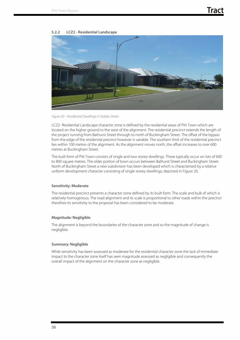
Figure 20 – Residential Dwellings in Stables Street 36
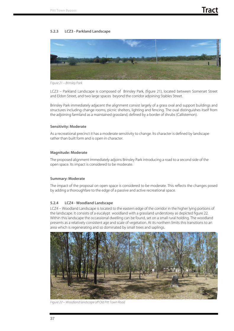
Figure 21 – Brinsley Park 37
Figure 22 – Woodland landscape off Old Pitt Town Road 37
Figure 23 – Visual catchment and key viewpoints plan 40
Figure 24 – Looking west across 58 Glebe Road. 41
Figure 25 – Looking north from along the proposed alignment from Pitt Town Road/ Glebe Road intersection 42
Figure 26 – Looking north east from Bathurst Street across the proposed alignment 43
Figure 27 – View looking east from Buckridge Street with the residence of 54 Wellesley Street visible to the left of image 44
Figure 28 – View from Termination of Buckridge Street 45
Figure 29 – Looking North East from Mawson Place / Somerset Street across Brinsley Park. 46
Figure 30 – Looking east along Old Pitt Town Road 47
Figure 31 – Looking west along Old Pitt Town Road. 48
Figure 32 – Looking east from Buckingham Street intersection. 49
Figure 33 – Looking south along Cattai Road. 50
3

Pitt Town Bypass
Figure 34 – Looking west across 58 Glebe Road. 51
Figure 35 – View looking east from Buckridge Street with the residence of 54 Wellesley Street visible to the left of image 52
List of Tables Table 1 – Landscape Character and Visual Impact Assessment Matrix 32
Table 2 – Landscape Character Assessment Summary 38
Table 3 - Visual Assessment Summary 53
Table 4 – Mitigation Measures 55
Table 5 – Mitigation Measures Continued 56
4
1 INTRODUCTION
Pitt Town Bypass
1.1 Background
Roads and Maritime Services NSW (Roads and Maritime) proposes to build a bypass of Pitt Town, which involves constructing a new road between Pitt Town Road and Buckingham Road east of Pitt Town. The bypass (the proposal) would provide a connection between Pitt Town Road in the west and Cattai Road in the east to improve road connectivity and safety in the area. The total length of the proposal is approximately one kilo metre.
The need for the proposal is driven by the large number of heavy vehicles, sometimes up to 18% of vehicles, travelling through Pitt Town daily. The number of vehicles is expected to increase due to nearby development and the sand mine to the north of the proposal in the Hills District. The purpose of the proposal is to bypass heavy freight from the township to improve road safety, reduce congestion, alleviate noise and improve liveability for the local community.
1.2 Project Description
Pitt Town is located 59km, by road, from Sydney in the north west of the Sydney Basin and lies within the Local Government Area of Hawkesbury Shire as indicated in Figure 1 - Regional Context Plan.
The Pitt Town Bypass project involves constructing a two-lane road between Pitt Town Road and Buckingham Road east of Pitt Town. The total length of the proposal is approximately one kilometre and includes a southern roundabout connection with Glebe Road and Bathurst Street, a northern roundabout at Old Pitt Town Road and a T- Intersection with Buckingham Street.
Roads and Maritime undertook community consultation before preparing and releasing a Preliminary Environment Investigation (PEI) and Strategic Design for the proposal in March 2017.
The key features of the proposal include:
Extending Pitt Town Road past Bathurst Street onto Cattai Road, east of Eldon Street
Installing a new roundabout at Eldon Street and Old Pitt Town Road
Closing a portion of Cattai Road to maintain access from Buckingham Street
Providing new crossings of Hortons Creek at the southern and central sections of the proposal
Installing a new roundabout at Pitt Town Road/Bathurst Street and Glebe Road.
1.3 Purpose of report
Tract Consultants Pty Ltd has been commissioned by Arcadis to provide an Urban Design, Landscape Character and Visual Impact Assessment for the bypass of Pitt Town between Bathurst Street and Buckingham Place. As part of this process a review of the design is to be undertaken and recommendations made as to its integration within the road corridor.
This assessment and recommendations will form part of the Review of Environmental Factors (REF) submission for the approval of the works.
5

Figure 1 – Regional Context Plan, (Source: Arcadis 2018)
Pitt Town Bypass
6

2 CONTEXT
Pitt Town Bypass
2.1 Location
Pitt Town is 59 kilometres north-west of the Sydney Central Business District in the local government area (LGA) of the City of Hawkesbury. Pitt Town Road and Cattai Road (MR181) are classified as a state road, and are a single lane in each direction, as indicated in figure 2. It is the main route north from Windsor and surrounds and passes through the town centre of Pitt Town. Pitt Town Road provides a major link between the Hawkesbury region and suburbs in Sydney’s north and the Central Coast.
Figure 3- Local Context Plan indicates the local context of the proposal and its relationship to Pitt Town urban centre and surrounding road network.
Figure 2 – Pitt Town Road approaching Pitt Town
7
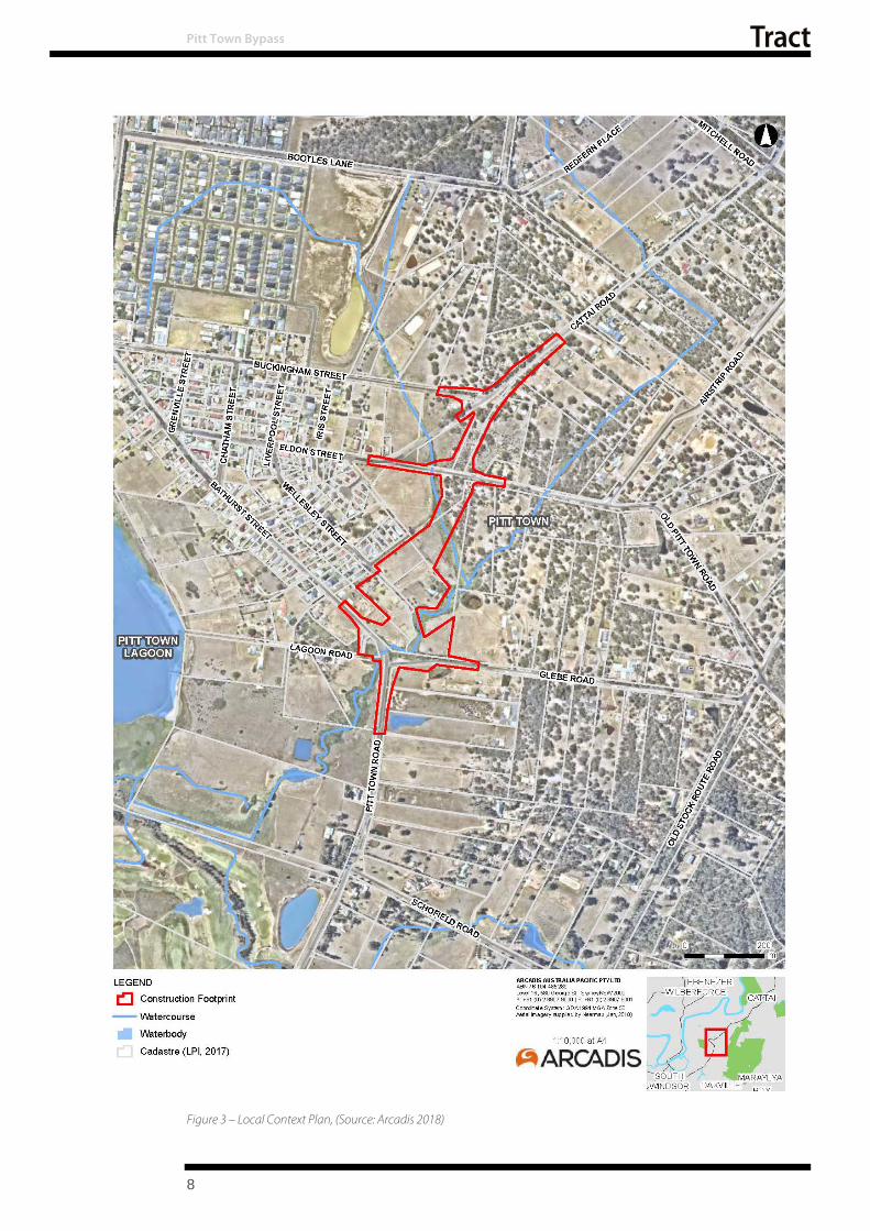
Figure 3 – Local Context Plan, (Source: Arcadis 2018)
Pitt Town Bypass
8

Pitt Town Bypass
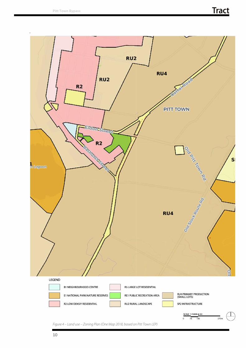
2.2 Land Zoning The land use of an area has the potential to influence the overall character and feel of an area. Pitt Town falls under the Hawkesbury Local Environmental Plan (LEP) 2012 refer figure 4 for land-use zoning.
There are two dominant land use areas to either side of the alignment, the se are:
R2 Low Density Residential
RU4 Primary Production Small Lots
In addition to these
RE1 public recreation occurs as a single occurrence adjoining the corriodor, and
SP2 Infrastructure defining Pitt Town Road, Cattai Road and the proposed alignment.
2.2.1 R2 Low Density Residential The dominant land use adjoining the alignment comprises elements of the original development of Pitt Town dating from 1815 along with newer subdivisions. This zone has the following objectives as listed in the LEP are:
Objectives of zone
To provide for the housing needs of the community within a low density residential environment.
To enable other land uses that provides facilities or services to meet the day to day needs of residents.
To protect the character of traditional residential development and streetscapes.
To ensure that new development retains and enhances that character.
To ensure that development is sympathetic to the natural environment and ecological processes of the area.
To enable development for purposes other than residential only if it is compatible with the character of the living area and has a domestic scale.
To ensure that water supply and sewage disposal on each resultant lot of a subdivision is provided to the satisfaction of the Council.
To ensure that development does not create unreasonable demands for the provision or extension of public amenities or services.
2.2.2 RU4 Primary Production Small Lots The dominant land use adjoining the corridor consists of larger holdings composed of cleared pasture and regenerated woodland communities. This land use is located in the lower lying portions of the study area and includes portions of creek and swamp lands. The objectives as listed in the LEP are:
Objectives of zone
To enable sustainable primary industry and other compatible land uses.
To encourage and promote diversity and employment opportunities in relation to primary industry enterprises, particularly those that require smaller lots or that are more intensive in nature.
To minimise conflict between land uses within this zone and land uses within adjoining zones.
To ensure that development occurs in a way that does not have a significant adverse effect on water catchments, including surface and groundwater quality and flows, land surface conditions and important ecosystems such as waterways.
9
-
Figure 4 – Land use – Zoning Plan (One Map 2018, based on Pitt Town LEP)
Pitt Town Bypass
10

Pitt Town Bypass
2.2.3 RE1 Public Recreation A number of open space areas are zoned RE1 Public Recreation. The key park within the study area is Brinsley Park which adjoins the corridor. It is largely comprised of a grass oval with some perimeter planting and service buildings. Its use is primarily as a football and cricket oval. Objectives for RE1 lands as listed in the Local Environment Plan are:
Objectives of zone
To enable land to be used for public open space or recreational purposes.
To provide a range of recreational settings and activities and compatible land uses.
To protect and enhance the natural environment for recreational purposes.
To protect and enhance the natural environment for environmental purposes.
To restrict development on land required for future open space purposes.
2.2.4 SP2 Infrastructure There is a narrow strip through the centre of the study area zoned SP2 Infrastructure, which corresponds to the general alignment of the proposal. Cattai Road, Eldon Street, Pitt Town Road and Bathurst Street are also zoned SP2. The Local Environmental Plan defines the objectives of these lands as:
Objectives of zone
To provide for infrastructure and related uses.
To prevent development that is not compatible with or that may detract from the provision of infrastructure.
The propos als design development needs to consider the underlying intent and objectives of these adjoining land uses in order that it may be informed by and developed in response to them. By responding to the areas planned land-use the roads design can be made relevant both for current and future uses in the short to medium term.
2.3 Heritage
2.3.1 Aboriginal Heritage The original inhabitants of the Hawkesbury district were the Darug tribe of Aboriginals, also spelt as Dharug or Daruk. The river, which they called Derrubbin was a focal point as a source of food, including fish, eels, water birds, & mussels: and transport, in the form of bark canoes. Yams, a staple food, grew along the banks of the river. The acquisition of these lands by settlers resulted in con flict lasting from 1789 to 1805. (Attenbrow 2010, p15).
Potential for Aboriginal relics has been identified within the corridor. This includes a number of sites within the adjoining Brinsley Park which is the subject of a land claim.
2.3.2 European Heritage Pitt Town is one of the five 'Macquarie Towns' established by Governor Macquarie in 1810. The towns were developed as market towns located near a navigable river and to contain town and pasture lots. The aim of the townships was to provide the settlers with ways to assist each other, provide security and easy access to trade routes for farm produce. It is named after William Pitt the Younger, the 18th Century British Prime Minister. In 1811 a site for a village was laid out but developed very slowly and was relocated to its present location by 1815. By 1841 there were only 36 houses in the town due to its location being too far from the rich river flats and the consequent long daily trek for farmers to their holdings.
There is one listed local heritage item ‘Cottage’ (Hawkesbury LEP 2012 Item No. I277, which is within 25m of the proposal site boundary.
Portions of the study area have been assessed as having moderate potential to contain an archaeological resource that would reach the local significance threshold, and be considered ‘relics’ under the Heritage Act 1977 (amended 2009).
11
Pitt Town Bypass
2.4 Vegetation
Vegetation in the study area mostly comprises cleared exotic grassland and disturbed native vegetation with some remnant or planted trees. The majority of the study area is classified as significant vegetation or connectivity corridors between significant vegetation in the Hawkesbury LEP 2012. This reflects intent to maintain connectivity between Scheyville National Park and Pitt Town Nature Reserve to the east and west of the study area. Vegetation of the corridor consists of predominantly cleared land associated with small rural lots in the south and centre of the proposed corridor with a transition to patches of woodland within the northern portion of the study area.
Vegetation communities mapped in the study area are shown in Figure 5, and comprise three Plant Community Types (PCTs) and three non-native vegetation communities. The three non-native vegetation communities are: exotic grassland – the dominant vegetation community along the corridor and associated roads;
mixed native/exotic vegetation in the road reserve; - comprising focused plantings in the form of hedges or landscape plantings, it occurs as isolated elements within the alignment typically in association with a house or former house site.
Juncus usitatus Rushland – located largely beyond the corridor at the southern limits of the project within a damp depression east of Hortons Creek
The three Plant Community Types are listed below
Broad-leaved Ironbark – Grey Box – Melaleuca decora grassy open forest on clay/gravel soils of the Cumberland Plain, Sydney Basin Bioregion. This is located straddling either side of Old Pitt Town Road east of the Proposal.
Grey Box – Forest Red Gum grassy woodland on flats of the Cumberland Plain, Sydney Basin Bioregion. Located predominantly north of Burmingham Street and West of Cattai Road
Phragmites australis and Typha orientalis coastal freshwater wetlands of the Sydney Basin Bioregion. This community occurs in association with Hortons Creek an ephemeral tributary which runs through the southern and central portions of the corridor before linking in the south with Pitt Town Lagoon and finally the Hawkesbury River.
Each of the PCTs was identified as having attributes associated consistent with Threatened Ecological Communities as defined by the Biodiversity Conservation Act, 2016. These are:
Shale Gravel Transitional Forest in the Sydney Bioregion
Cumberland Plain Woodland in the Sydney Basin Bioregion
Freshwater Wetlands on coastal floodplains of the New South Wales North Coast, Sydney Basin and south east corner Bioregion respectively. Cumberland Plain Woodland is also listed under the federal Environmental Protection and Biodiversity Conservation Act 1999.
Two threatened flora species were recorded in the study area: Downy Wattle Acacia pubescens and Dillwynia tenuifolia. In addition, four threatened flora species are considered moderately likely to occur in the study area, given the presence of potential habitat; Grevillea juniperina subsp. juniperina (Juniper-leaved Grevillea), Micromyrtus minutiflora, Pimelea spicata (Spiked Rice-flower) and Pultenaea parviflora. An understanding of the vegetation communities adjoining and within the corridor and their composition, informs the composition of the plant palette proposed and the methods to be adopted for its implementation Appendix 1 summarises the composition of these vegetation communities , which is to be used to inform the urban design response.
12

Figure 5 – Biodiversity Constraints - Pitt Town Bypass (Source: Arcadis, 2018)
Pitt Town Bypass
13

a) b)
Figure 6 – Vegetation Communities - a) Exotic Grassland b) Broad-leaved Ironbark – Grey Box – Melaleuca decora grassy open
c) d)
forest; c) Grey Box – Forest Red Gum grassy woodland on flats; d) Phragmites australis and Typha orientalis coastal freshwater wetlands
Pitt Town Bypass
2.5 Topography and Drainage
2.5.1 Landform The general elevation along the proposals alignment ranges between 10 and 20 metres above sea level. The landform and hydrology are interconnected with the area comprising an alluvial plain of the Hawkesbury Nepean River System, refer figure 7 for Topography and Drainage Plan.
The majority of the study area lies on Hawkesbury‐Nepean Terrace Gravels over the Cumberland Plain. This landscape is characterised by planar, poorly‐drained terraces with harsh texture‐contrast soils and heavy clays in swamps and cut‐off meanders.
The southernmost section of the alignment (approximately 80 metres) lies on Hawkesbury‐Nepean Channels and Floodplains. This landscape is characterised by meandering channels over a moderately wide floodplain of undifferentiated alluvial sand to poorly structured gradation profiles of sandy loam or clay loam (Mitchell, 2002). The south‐western corner of the study area lies over Hawkesbury‐Nepean Channels and Floodplains with similar characteristic pedology over wide floodplains up to 20 metres in elevation (Mitchell, 2002).
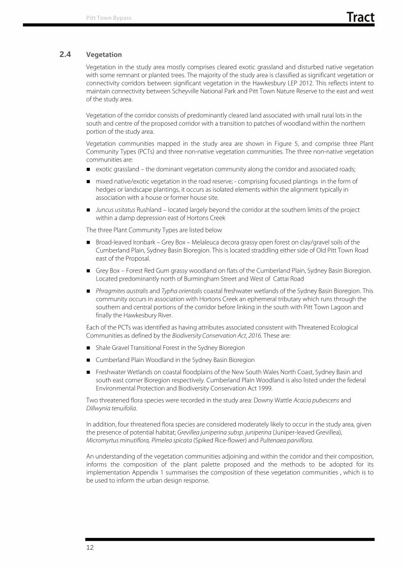
2.5.2 Drainage Pitt Town is located on the floodplain of the Hawkesbury Nepean River System. The proposals corridor crosses Hortons Creek twice, once at the Glebe Road end and the other near Eldon Road intersection. Hortons Creek, depicted in figure 8, is a second order ephemeral creek which flows to the south to Pitt Town Bottoms/ Pitt Town Lagoon (a nature reserve, depicted in figure 9,) before entering the Hawkesbury River.
14

Figure 7 – Topography and Drainage Plan
Pitt Town Bypass
15
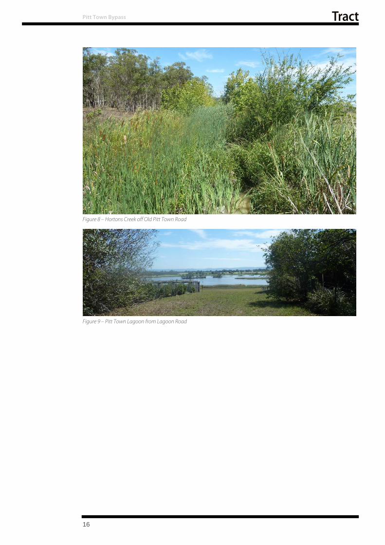
Figure 8 – Hortons Creek off Old Pitt Town Road
Figure 9 – Pitt Town Lagoon from Lagoon Road
Pitt Town Bypass
16
3 CONCEPT DESIGN
Pitt Town Bypass
The design response for the proposal needs to reflect both the character of the landscape through which the proposals alignment passes, as well as the broader landscape, addressing environmental, visual and physical constraints as part of an holistic design solution.
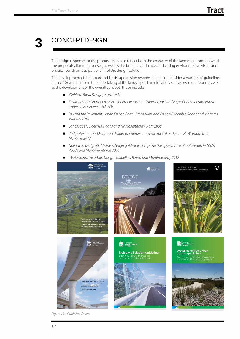
The development of the urban and landscape design response needs to consider a number of guidelines (figure 10) which inform t he undertaking of the landscape character and visual assessment report as well as the development of the overall concept. These include:
Guide to Road Design, Austroads
Environmental Impact Assessment Practice Note: Guideline for Landscape Character and Visual Impact Assessment - EIA-N04
Beyond the Pavement, Urban Design Policy, Procedures and Design Principles, Roads and Maritime January 2014
Landscape Guidelines, Roads and Traffic Authority, April 2008
Bridge Aesthetics - Design Guidelines to improve the aesthetics of bridges in NSW, Roads and Maritime 2012
Noise wall Design Guideline - Design guideline to improve the appearance of noise walls in NSW, Roads and Maritime, March 2016
Water Sensitive Urban Design Guideline, Roads and Maritime, May 2017
17
Figure 10 – Guideline Covers

18
Pitt Town Bypass
To achieve this, a number of principles and objectives have been developed to inform the design development of the corridor.
3.1 Urban and Landscape Design Principles and Objectives
The following objectives are derived from the ni ne urban design principles defined in the Road and Maritime Services urban design policy - Beyond the Pavement. They reflect both the unique character of the road, its rural context and key issues which adjoin it.
3.1.1 Principle 1 - Contribute to the overall landscape structure and revitalisation of the region Objectives
Develop an alignment which permits Pitt Town to function as an u rban centre without the disruption of through traffic
Design an alignment which is responsive to its landscape setting and does not detract from it
Minimise negative physical impacts on parklands, open space, the creeks and aquatic environments which drain Pitt Town.
3.1.2 Principle 2 – Respect the land uses and built form of the corridor Objectives
Minimise the footprint of the corridor to limit impacts to adjoining vegetation, communities, and farm holdings
Design an alignment which minimises fragmentation of fa rm holdings or the loss of connections between paddocks
Maintain the ecological integrity of the vegetated sections and landscape character of the corridor
Minimise the intrusio n of road -related elements (fencing and water quality control measures) on the local landscape
Respect the heritage values of Pitt Town.
3.1.3 Principle 3 – Connecting modes and co mmunities Objectives
Provide safe and efficient access to town both along and across the proposed corridor
Provide active transport opportunities both within the alignment and connecting to the broader local context and networks, where a need has been identified
Provide a design response which acknowledges the population centres of Pitt Town. Facilitate movement of people within this context providing an environment which reflects this human scale.
3.1.4 Principle 4 – Fit the landform of the corridor Objectives
Consider the relationship between road, and landscape minimising the overall scale of fills and cut along the a lignment
Minimise the footprint of the corridor to limit impacts to adjoining vegetation communities and farm holdings
Provide a formation which addresses local flood events.
3.1.5 Principle 5 - Responding to natural pattern Objectives
The route selection should respond to the grain of the landscape and avoid, where possible, the disruption of patches of vegetation, both natural and cultural
Integrate cut and fill embankments with surrounding terrain by grading out and varying slopes
Preserve existing cultural patterns within the landscape

Pitt Town Bypass
Vary the gradient of earthworks to provide visual interest and reflect characteristics of the surrounding landform and landscape.
3.1.6 Principle 6 - Protect and enhance the heritage and cultural values of the corridor Objectives
Preserve the integrity of heritage items and areas of cultural importance to the local community
Avoid, where possible areas of identified historic and Aboriginal heritage and cultural value
Acknowledge and respond to the heritage and cultural values of t he Pitt T own and its surrounding area
Acknowledge and respond to Aboriginal values and places in the broader landscape
Consider the interpretation of the heritage areas along the corridor.
3.1.7 Principle 7 - Designing an experience in movement Objectives
Minimise disruption to the visual qualities of the land use
Maximise the opportunities for high quality and varied views
Use landscape to frame or define views from the road.
3.1.8 Principle 8 -Creating self-explaining road environments Objectives
Provide a landscape design that defines the edge of bends and leads the driver through the landscape
Provide plantings that reinforce the reduced speed zones and connections to adjoining town centre
Provide a landscape design which reflects the needs and performance requirements of intersections along the corridor
3.1.9 Principle 9 - Achieving integrated a nd minimal maintenance design Objectives
Develop a consistent approach to the design of bridges along the project. Urban design principals to be consistent with those outlined in ‘Bridge Aesthetics: Design Guidelines To Improve The Appearance of Bridges in NSW’ (RTA, 2003)
Develop a consistent approach to the design of soft landscaping along the route. Planting design Principles to be consistent with those outlined in the ‘Landscape Guidelines: Landscape Design and Maintenance Guidelines to Improve the Quality, Safety and Cost Effectiveness of Road Corridor Planting and Seeding’ (RTA, 2008)”
Provide a landscape which is self-reliant and regenerating with minimal maintenance input requirements
Provide plantings to frame views and guide the driver along the alignment
3.2 Proposal
19
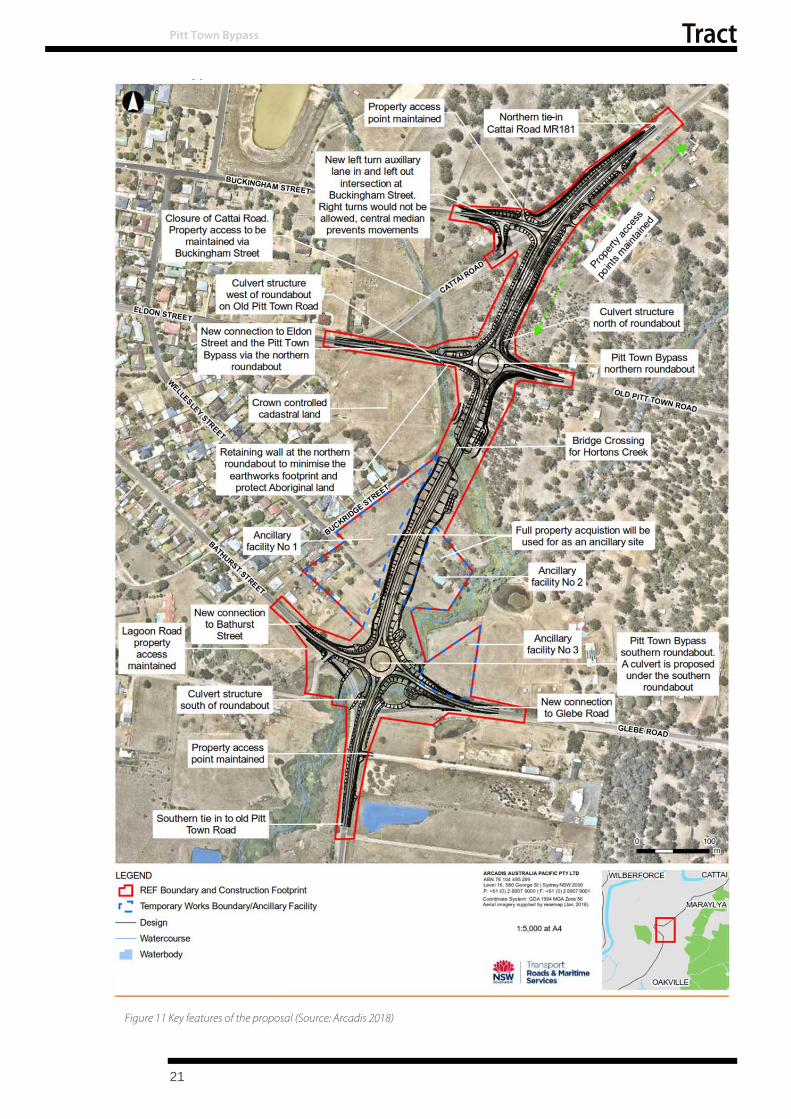
The proposal involves building a bypass of Pitt Town. The proposal is about one kilometre long, and extends from Pitt Town Road to Buckingham Road east of Pitt Town within the City of Hawkesbury local government area.. The proposal is shown in Figure 11. The key features of this proposal include: Extending Pitt Town Road past Bathurst Street onto Cattai Road, east of Eldon Street
Installing a roundabout at Eldon Street and Old Pitt Town Road
Closing a portion of Cattai Road to maintain access to Buckingham Street

Pitt Town Bypass
Providing new crossings of Hortons Creek at the southern and central sections of the proposal comprising:
A five-cell box culvert at the southern roundabout
Installing a new single-lane roundabout at the intersection of Pitt Town Road, /Bathurst Street and Glebe Road
20
Pitt Town Bypass
Figure 11 Key features of the proposal (Source: Arcadis 2018)
21

Pitt Town Bypass
3.3 Design Responses
In developing a design response for the Pitt Town Bypass, the fit of the road with its context has been considered as part of an integrated design solution for the project involving input from all disciplines.
As part of the proposal’s concept design development, the urba n design strategy has developed responses to the:
landscape treatment of the for mation
surface treatment to paths, medians and bridge elements
the nature and placement of roadside furniture, and
the planting design required to integrate the proposal to achieve a contextually responsive design outcome.
As part of the development of the Urban and Landscape Design for the proposal an overall landscape strategy has been developed. This has included the identification of landscape precincts to inform the overall character development along sections of the route and the landscape responses associated with these precincts.
3.3.1 Landscape Design Precincts The proposal has been divided in to three distinct character precincts as part of the overall review process and development of design philosophy. This is depicted in Figure 12 – Precinct Plan.
The precincts reflect a simplified contextual character of the route, and the key attributes which will be emphasised as part of the overall integration of the proposal.
Precinct 1 – Pasture land/ Arrival Precinct
This precinct is characterised by largely cleared pastureland landscape which provides a relatively open character along the existing Pitt Town Road on approach from the south. The design intent is to retain this sense of openness. The interface with the adjoining precinct coincides with the entrance into Pitt Town from the south. The landscape response proposes to reinforce this arrival space and provide an identity linked to the town along t he alignment through planting.
Precinct 2 – Residential/ Creek-line Precinct
This precinct occupies the central portion of the proposed alignment located between the two round-a-bouts, (at Bathurst and Eldon Streets respectively), and is composed of a number of elements, the dominant of which are the residential edge of Pitt Town to the west, and Hortons Creek east of the proposed alignment.
The residential precinct is largely located on higher ground overlooking the creek-line and woodland to the east beyond the proposed alignment. It addresses the western edge of the proposal and has an open outlook across the valley with minimal vegetation screening of the proposed alignment. Opportunities to limit the visibility of the proposal while providing the general open character of the valley are considered as part of the concept development.
The creek-line occupies the low-lying lands below the proposed alignment but forms a defined edge to the east of the alignment and represents a landscape asset which could be interpreted as part of the roads development. The mitigation of visual impacts to the east would be addressed through the revegetation of the creek-line margins.
Precinct 3 –Woodland Precinct
The northern-most precinct extends from Old Pitt Town Road north to its connection with Cattai Road. Similar to Precinct 1, the boundary of this precinct adjoins that of Precinct 2 and coincides with the northern entry into Pitt Town. Like the southern approach the landscape design is proposed as a means of providing the townships identity along the alignment through the type and structure of planting.
The landscape through this zone is dominated by remnant and regenerating woodland with scattered small rural holdings. This wooded landscape flanks the road corridor defining it spatial and visual quality. This woodland provides the ability for the landscape to absorb the proposal with reduced impact by providing visual screening to properties beyond the alignment.
22

Pitt Town Bypass
Figure 12 – Precinct Plan
23

Pitt Town Bypass
3.3.2 Landscape Strategy Plan The following Landscape Strategy Plan, shown in Figure 13, develops the precinct definition and project principles and objectives to d efine the detailed urban and landscape design response.
The strategy is then broken down into its elements to outline the particular issues and responses adopted within the corridors design development. Elements discussed include:
Grading
Vegetation
Bridges
Lighting
Safety Barrier and Fences
Signage.
24

Pitt Town Bypass
25
Figure 13 – Landscape Strategy Plan
Pitt Town Bypass
Figure 14 – Cross section between Bathurst Street and Eldon Street (Central Section)
Figure 15 – Cross section adjoining Old Pitt Town Road and Eldon Street
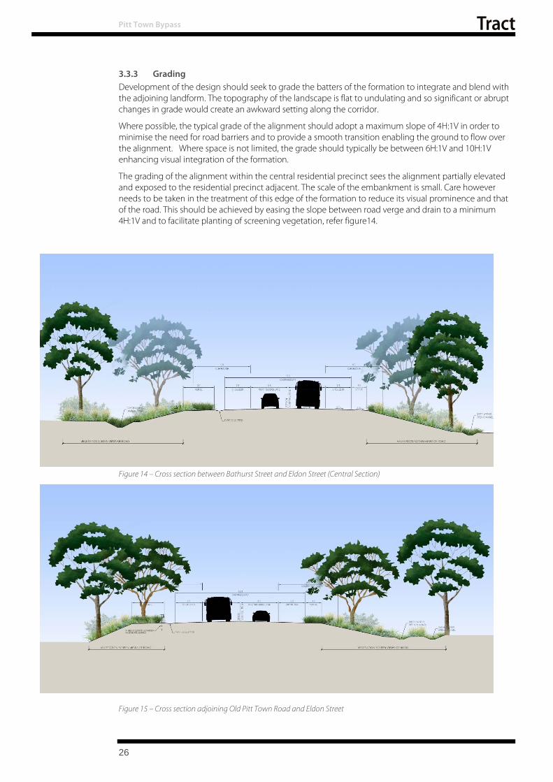
3.3.3 Grading Development of the design should seek to grade the batters of the formation to integrate and blend with the adjoining landform. The topography of the landscape is flat to undulating and so significant or abrupt changes in grade would create an awkward setting along the corridor.
Where possible, the typical grade of the alignment should adopt a maximum slope of 4H:1V in order to minimise the need for road barriers and to provide a smooth transition enabling the ground to flow over the alignment. Where space is not limited, the grade should typically be between 6H:1V and 10H:1V enhancing visual integration of the formation.
The grading of the alignment within the central residential precinct sees the alignment partially elevated and exposed to the residential precinct adjacent. The scale of the embankment is small. Care however needs to be taken in the treatment of this edge of the formation to reduce its visual prominence and that of the road. This should be achieved by easing the slope between road verge and drain to a minimum 4H:1V and to facilitate planting of screening vegetation, refer figure14.
26

Pitt Town Bypass
The design of drainage also contributes to the overall grading of the site. In some instances dirty water and clean water channels are required to separate flows from the road from the adjoining areas. The design has limited the extent of this system to a small section between Hortons Creek and Old Pitt Town Road minimising the overall footprint of the drainage works and consequently impacts. Figure 15 illustrates the dual channel system in relation to the alignment.
3.3.4 Vegetation The corridor has been identified as supporting a number of protected vegetation communities. The corridor provides a network of vegetation which has provided a web linking vegetation reserves and communities and enhancing fauna connectivity in what is a highly modified landscape setting.
The revegetation response for the proposal has been to relate the vegetation to the distribution of the various communities.
Key opportunities explored include:
Reestablishment of the endemic vegetation communities including:
Screening of residential properties overlooking the road corridor using Cumberland Plain woodland species
Revegetation/regeneration of Hortons Creek
Amalgamation and protection of woodland margin within government owned lands as a public reserve
Use of cultural landscape patterns and plantings to provide a connection to the Pitt Town town-centre including:
Retention of open grassland context to the road margins, f acilitating distant rural views
Gateway treatments to rou ndabouts, and
Establishment of street tree planting along Eldon Street and Bathurst Street, in consultation with Council and community.
Landscape Treatments
A variety of landscape treatments will be adopted to enable the implementation of the overall Urban and Landscape Design Strategy. Landscape trea tments need to be:
Robust and durable to minimise ongoing maintenance inputs
Cost effective, and
Maintainable meeting operational and safety needs
Treatment types would include:
Hydromulch as a surface application to establish permanent vegetation cover and prevent erosion. Hydromulch is the hydraulic application of mulch matrix, sprayed onto the soil as a slurry which sets to form a layer of protection from erosion.
Turfing is the application of grass rolls as a verge or broader landscape treatment. Typically turf will be used as the m argins to stre ets or landscape features.
Planting can be undertaken as individual specimen plantings such as street tree and broad scale tree planting or as garden beds consisting of a prepared mulched bed and the mass planting of shrub and grass species. This treatment type would be utilised in areas of high visual prominence, such as verges and roundabouts; and where instant plant densities are required to provide stability and minimise weed growth such as creeklines.
27
Pitt Town Bypass
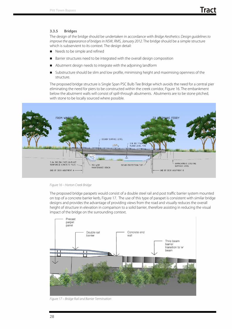
3.3.5 Bridges The design of the bridge should be undertaken in accordance with Bridge Aesthetics: Design guidelines to improve the appearance of bridges in NSW, RMS, January 2012. The bridge should be a simple structure which is subservient to its context. The design detail: Needs to be simple and refined
Barrier structures need to be integrated with the overall design composition
Abutment design needs to integrate with the adjoining landform
Substructure should be slim and low profile, minimising height and maximising openness of the structure.
The proposed bridge structure is Single Span PSC Bulb Tee Bridge which avoids the need for a central pier eliminating the need for piers to be constructed within the creek corridor, Figure 16. The embankment below the abutment walls will consist of spill-through abutments. Abutments are to be stone pitched, with stone to be locally sourced where possible.
Figure 16 – Horton Creek Bridge
The proposed bridge parapets would consist of a double steel rail and post traffic barrier system mounted on top of a concrete barrier kerb, Figure 17. The use of this type of parapet is consistent with similar bridge designs and provides the advantage of providing views from the road and visually reduces the overall height of structure in elevation in comparison to a solid barrier, therefore assisting in reducing the visual impact of the bridge on the surrounding context.
Figure 17 – Bridge Rail and Barrier Termination
28

Pitt Town Bypass
The proposed bridge parapets incorporates a skirt to provide a drip edge and conceal the planks, and service pipes behind when viewed in elevation. This approach helps to improve the visual aesthetic of the bridge by providing a simple smooth elevation. The parapet transitions into a concrete end termination panel and w-beam barrier. The overall composition of this transitional zone is depicted in Figure 16 Bridge Rail and Barrier Termination.
Landscape Adjoining Bridges
The landscape design at the bridges is responsive to the nature and context of the bridge, and has adopted these key strategies:
A 10 metre offset for trees is adopted. The offset of trees is an important consideration, which needs to be taken into account in order to minimise ongoing maintenance inputs and not compromise safety during maintenance activities and future damage to structures.
As a creek bridge the proposed bridge provides the opportunity to express the purpose of the crossing through the revegetation utilising the community which adjoins it. As part of the corridors development the regeneration of the natural creekline community including canopy would instil this crossing with a unique character within the broader landscape.
3.3.6 Other Structures
Retaining walls a nd Headwalls
Walls are required as part of the project primarily in association with culverts and the piped drainage network to reta in the formation around t hese drainage structures. These will typically adopt a precast headwall in accordance with Roads and Maritime Services standards. The head wall will incorporate wing walls.
An insitu retaining wall RW1 is identified at the intersection of Eldon Street and the proposed alignment. The height of the wall varies to a maximum of two meters. The wall forms the head wall of a transverse pipe run which is set at an oblique angle to the alignment creating an awkward geometry that prohibits the use of a precast headwall. The wall is potentially visible from the properties on the eastern edge of Pitt Town that overlook this zone. The treatment of the wall should recede into the background and restrict the potential for graffiti.
A similar wall is to be constructed on the opposite side of the road to minimise footprint on the adjoining parkland.
Roundabouts
The proposal adopts roundabouts for the management of the Old Pitt Town Road and Bathurst St/Glebe Road Intersections with the proposed alignment. These roundabouts are single lane and large.
The scale of the roundabout and their location at the entrance to Pitt Town requires a considered response which breaks up the expanse of pavement and built elements. Ideally this should adopt a landscape treatment that provides a distinctive maker and connection to Pitt Town.
Key considerations which need to be addressed in the provision of this are:
Safety
Maintenance accessibility
Maintenance Frequency
Sightlines
Other issues which need to be addressed include:
Appropriate soil depths
Adequate drainage
Integration of signage
29

Pitt Town Bypass
Design response The design proposes a concrete margin of four metres ensuring landscape elements are beyond the clear zone requirements of the corridor. Within this margin a raised bed facilitates the achievement of appropriate soil volumes and drainage layer to support the proposed landscape. A minimum soil depth of a metre is to be provided enabling the establishment of trees as well as groundcovers. In addition to soil volume the provision of appropriate drainage will also be critical to the success of this element. This will pose specific issues at the southern roundabout where culverts pass under the roundabout.
The planting of the roundabout needs to be considered in the context of the overall entrance experience into Pitt Town. Bathurst Street and Eldon Streets have overhead wires on the northern side of the road corridor which limits the overall scale of the planting which can be installed as part of this arrival experience. It is suggested that a small blossom tree be adopted reflecting the orchard past of the region and complying with the limitation of the services.
3.3.7 Lighting The current alignment of Pitt Town / Cattai Road is unlit. The introduction of roundabouts at the intersection of Pitt Town Road and both Glebe/ Bathurst Street and Eldon Street introduces the need to light the intersections and their approaches. The design of lighting shoul d seek to minimise the need for lighting and ensure that light spillage into residential properties is minimised or avoided as per AS4282- 1997.
3.3.8 Safety Barriers and Fencing Safety barriers have been provided where required along the main alignment, service roads, and local roads to give protection from hazards including steep slopes, and physical hazards including non-frangible signs, street lighting columns, power poles, headwalls, and non-traversable table and catch drains.
In general, the design has been carried out with a preference for the adoption of 4H:1V or flatter batters where possible and thereby reducing the need for safety barriers. Further refinement in barrier extents should be explored as part of the detailed design development for the project.
Pedestrian fencing is proposed where a steep level change exists. Opportunities to reduce the need for this should be explored to reduce the number of structural elements within the landscape. The design intent should seek to limit pedestrian fencing to areas where a vertical drop is present or its transition from this to a traversable slope of 1:4 or flatter.
3.3.9 Signage Signage is largely to be installed in accordance with the requirements of standards. Care needs to be taken to ensure the extent of signage is kept to a minimum and that the signage is integrated with the overall design of the alignment. The following strategies should be adopted:
Avoidance of signage structures on the skyline and within key views and vistas by considering placement or the incorporation of landscape beyond the structure as a backdrop.
Rationalise the number of signage structures.
30

31
4 ASSESSMENT METHODOLOGY
Pitt Town Bypass
This section of the report outlines the methodology adopted, which is consistent with Environmental Impact Assessment Practice Note: Guideline for Landscape Character and Visual Impact Assessment - EIA-N04, and is used to review the proposal and assess the impacts and effects of the proposed road alignment on the road user (primarily motorists), and any potential properties with views to the road.
4.1 Landscape character and impact assessment
To assess landscape character the local context of the site is divided into a number of units to assist in understanding the local context and the implications of the proposal. These include defining the landscape character zones (zones of similar spatial or character properties), and the analysis of changes to these zones as a result of the proposal.
Landscape character is defined as:
“The combined quality of built, natural and cultural aspects that make up an area and provide its unique sense of place.”
(Roads and Maritime, 2013).
The proposal is assessed in terms of its impacts on these character zones and the impact ranked in terms of sensitivity to change. This assessment differs from a visual assessment in that it assesses the overall impact of a proposal on an area’s character and sense of place.
4.2 Visual Impact Assessment
The Visual Impact Assessment involves the assessment of the visibility of the project. For the purposes of the study, visibility is considered in the following way:
Visibility The view field of a corridor or object is composed of static receptors, i.e. those that adjoin the road corridor and mobile receptors which are those that travel along the corridor or adjacent to it. The impacts of the two groups are unique in that the time and frequency of the exposure differ. The extent f rom wh ich views can be obtained is referred to as the ‘view catchment’.
Static Receptors
Static receptors occur within the visual catchment of the corridor i.e. they are points, which have a view of or can be viewed from the corridor. The corridor of the proposal is visually defined by both the topography and vegetation and built structures of the corridor.
Mobile Receptors
Mobile receptors are the users of the corridor; in this instance the vehicles, pedestrians and cyclists that travel along part or the whole alignment. Their experience of the space is short term. Mobile receptors constitute the main visual receptors of the proposed works.
4.3 Landscape character and visual assessment matrix
Landscape character and visual assessment are equally important. The landscape character assessment helps determine the overall impact of a proposal on an area’s character and sense of place including all built, natural and cultural aspects, covering towns, countryside and all shades between. The visual impact assessment helps define the day to day visual effects of a proposal on people’s views.
To quantify these impacts it is important to assess two qualities in relation to a view point. These are: -Sensitivity and Magnitude
Sensitivity refers to the qualities of an area, the type number and type of receivers, and how sensitive the existing character of the setting is to the proposed change. For example a pristine natural environment will be more sensitive to change than a built up industrial area.

Pitt Town Bypass
Magnitude refers to the nature of the project. For example a large interchange would have a very different impact on landscape character than a localised road widening in the same area (Roads and Maritime, 2013).
Table 1 summarises the ranking of the assessment of these two criteria and how they are combined to provide an overall impact assessment.
Table 1 – Landscape Character and Visual Impact Assessment Matrix
Sens
itivi
ty
Magnitude
High Moderate Low Negligible
High High Impact High - Moderate Moderate Negligible
Moderate High - Moderate Moderate Moderate - low Negligible
Low Moderate Moderate – low Low Negligible
Negligible Negligible Negligible Negligible Negligible
32

5 LANDSCAPE CHARACTER ASSESSMENT
Pitt Town Bypass
5.1 Landscape Character Assessment
This section of the report reviews the physical attributes of the character zones and the proposal’s potential impacts. As part of the character assessment, the assessment has reviewed the alignment of the bypass and its context, and classified it into a number of differing character zones.
The following differing character zones were identified.
LCZ1 - Pastureland Landscape
LCZ2 - Residential Landscape
LCZ3 - Parkland Landscape, and
LCZ4 - Woodland landscape
Figure18 illustrates the distribution of these character zones and their relationship to the proposal.
A review of planning controls was also undertaken prior to the assessment. This identified that no listed cultural or visual landscape character units were identified under the LEP 2012. However, the study area and more broadly the Pitt T own district retains a semi-rural character that is essential to the area’s cultural landscape heritage values as identified in the DCP 2002. The remnant semi-rural landscape within the study area reflects the settlement and development patterns of the region, and the evolving agricultural pursuits.
33
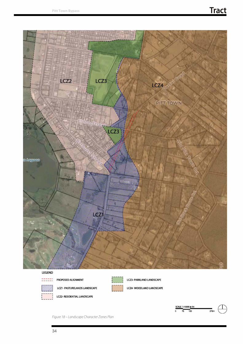
Figure 18 – Landscape Character Zones Plan
Pitt Town Bypass
34

Pitt Town Bypass
5.2 Landscape Character Zone Definitions
5.2.1 LCZ1 –Pastureland Landscape
Figure 19 – Pastureland landscape character from Bathurst Street
LCZ1 - Pastureland landscape, figure 19, is located in the low-lying flood prone lands. It is characterised by smaller rural holdings which present as largely cleared landscape dominated by grasslands. The extent of pasturelands is defined by woodland landscape to the east, and residential development to the west.
Hortons Creek divides this pastureland landscape with the Typha species (commonly known as Bull rush) dominating the creekline and limiting views across and through it. The built form reflects the agricultural use with stable elements, fencing, etc. located within the grassland setting.
This landscape is the focus of the proposal and will be bisected by it. Roads cross and pass through this landscape and are part of the overall character.
Sensitivity: Low
This landscape presents a relatively open landscape with a diversity of elements. This landscape is considered relatively robust and consequently has been assessed as having a low sensitivity.
Magnitude: Moderate
The proposal divides this landscape and has the potential to create a significant change. The alignment however sits relatively easily within the landscape without creating significant cuttings and fills. The scale of change is considered moderate.
Summary: Low to Moderate
The overall impact on LCZ1 - Pastureland landscape character of the proposal is considered low to moderate and reflects a low sensitivity combined with moderate magnitude of change.
35
Pitt Town Bypass
5.2.2 LCZ2 - Residential Landscape
Figure 20 – Residential Dwellings in Stables Street
LCZ2- Residential Landscape character zone is defined by the residential areas of Pitt Town which are located on the higher ground to the west of the alignment. The residential precinct extends the length of the project running from Bathurst Street through to north of Buckingham Street. The offset of the bypass from the edge of the residential precinct however is variable. The southern limit of the residential precinct lies within 100 metres of the alignment. As the alignment moves north, the offset increases to over 600 metres at Buckingham Street.
The built form of Pitt Town consists of single and two storey dwellings. These typically occur on lots of 600 to 800 square metres. The older portion of town occurs between Bathurst Street and Buckingham Street. North of Buckingham Street a new subdivision has been developed which is characterised by a relative uniform development character consisting of single storey dwellings, depicted in Figure 20.
Sensitivity: Moderate
The residential precinct presents a character zone defined by its built form. The scale and bulk of which is relatively homogenous. The road alignment and its scale is proportional to other roads within the precinct therefore its sensitivity to the proposal has been considered to be moderate.
Magnitude: Negligible
The alignment is beyond the boundaries of the character zone and so the magnitude of change is negligible.
Summary: Negligible
While sensitivity has been assessed as moderate for the residential character zone the lack of immediate impact to the character zone itself has seen magnitude assessed as negligible and consequently the overall impact of the alignment on the character zone as negligible.
36
Pitt Town Bypass
5.2.3 LCZ3 - Parkland Landscape
Figure 21 – Brinsley Park
LCZ3 – Parkland Landscape is composed of Brinsley Park, (figure 21), located between Somerset Street and Eldon Street, and two large spaces beyond the corridor adjoining Stables Street. Brinsley Park immediately adjacent the alignment consist largely of a grass oval and support buildings and structures including change rooms, picnic shelters, lighting and fencing. The oval distinguishes itself from the adjoining farmland as a maintained grassland, defined by a border of shrubs (Callistemon).
Sensitivity: Moderate
As a recreational precinct it has a moderate sensitivity to change. Its character is defined by landscape rather than built form and is open in character.
Magnitude: Moderate
The proposed alignment immediately adjoins Brinsley Park introducing a road to a second side of the open space. Its impact is considered to be moderate.
Summary: Moderate
The impact of the proposal on open space is considered to be moderate. This reflects the changes posed by adding a thoroughfare to the edge of a passive and active recreational space.
5.2.4 LCZ4 - Woodland Landscape LCZ4 – Woodland Landscape is located to the eastern edge of the corridor in the higher lying portions of the landscape. It consists of a eucalypt woodland with a grassland understorey as depicted figure 22. Within this landscape the occassional dwelling can be found, set on a small rural holding. The woodland presents as a relatively consistent age and scale of vegetation. At its northern limits this transitions to an area which is regenerating and so dominated by small trees and saplings.
Figure 22 – Woodland landscape off Old Pitt Town Road
37

Pitt Town Bypass
Sensitivity: Low
The character of the woo dland is distinctive and consistent in scale and density of vegetation cover. The level of screening offered by the community both at its edges and also from within provides a robustness to accommodate change within the canopy. Its sensitivity is assessed as low.
Magnitude: Moderate
The magnitude of the change as a result of the proposal sees the removal of a section of the edge of this vegetation in the north western portion of t he site. Despite the removal of the trees which make up the community, the overall presentation of a woodland edge to the east of the corridor would be maintained. Its impact is consequently considered moderate,
Summary: Low to Moderate
The proposal has been assessed as having an overall low-moderate impact on the Woodland Character. This reflects the loss of a section of woodland as part of the proposed alignment. This results in a reduced area but the continuation of th e overall landscape character.
5.3 Landscape Character Assessment Summary
Four landscape character units have been identified and assessed as part of the character study:
LCZ1 - Pastureland l Landscape
LCZ2 Residential Landscape
LCZ3 - Parkland Landscape, and
LCZ4 - Woodland landscape
No character zones were identified as having high impacts. Sensitivity was assessed as between Low and Moderate for the respective character zones. Magnitude of change has been assessed typically as moderate with the exception of the residential precinct. The residential precinct was identified as having no immediate impacts and so change was deemed to be negligible.
Overall a low to moderate impact on character zones was identified. A summary of the landscape character assessment is presented in Table 2.
Table 2 – Landscape Character Assessment Summary
Character Definition Sensitivity Magnitude Summary LCZ1 - Pastureland Landscape Low Moderate Low-moderate LCZ2 - Residential Landscape Moderate Negligible Negligible LCZ3 - Parkland Landscape Moderate Moderate Moderate LCZ4 - Woodland Landscape Low Moderate Low – Moderate
38

6 VISUAL IMPACT ASSESSMENT
Pitt Town Bypass
6.1 Visual Receptors and viewpoints
The experience of the viewers varies according to the duration, field of view a nd nature of exposure to the proposal.
In assessing the visual impact, the visual range has been considered to be the effective distance where a viewer can be influenced by changes in traffic movement and discern individual details such as signage and planting elements. This distance varies in relation to the topography and effectiveness of screening vegetation however the quality of detail in the landscape typically deteriorates rapidly for distances greater than 200 metres.
Typically the viewpoints have considered the imp act of those overlooking the proposal. Of the adjoining observers it is the residential users who would be the most sensitive to change. These are generally the primary viewpoint assessed. In some instances other viewers have been considered including the road user. Where differences in sensitivities of viewers exists the worst case assessment is the stated value in terms of Sensitivity, Magnitude and overall visual impact. The specific rating of the individual viewers is stated as part of the detailed assessment in Section 6.4.
6.2 Visual Catchment
The visual catchment of the proposal is well defined due to the topography of the site and clear barriers to sightlines, including vegetation, built form etc. Generally the catchment is below the ridge and is defined by the first line of residential development which overlooks the corridor. This is depicted in the following visual catchment plan in Figure 23.
6.3 View Points
A number of viewpoints have been identified which capture the key areas of potential visual impact associated with the proposal. These relate to key residential or public areas which overlook the corridor.
In total 10 viewpoints have been identified which provide an overview of the level of impact and their nature. These viewpoints are identified in the following visual catchment plan shown in Figure 20.
The assessment of these views provides:
1. An image of the outlook, including a tone indicating the approximate location of the proposaland its scale (depicted in a yellow tone).
2. A brief description of the view and the proposal3. An assessment of sensitivity 4. An assessment of magnitude 5. An assessment and e xplanation of impact
39

Pitt Town Bypass
40
Figure 23 – Visual catchment and key viewpoints plan

Pitt Town Bypass
6.4 Key Viewpoints
6.4.1 VP1 – Glebe Road
Figure 24 – Looking west across 58 Glebe Road.
View: Looking west across 58 Glebe Road towards the proposed bypass
Viewpoint one, Figure 24, presents an open grassland landscape set within the agricultural landscape character zone adjoining the corridor. The view provides the opportunity to overlook the proposal with only the foreground of stable yards interrupting the view of the corridor which is located some 250 metres from the viewpoint. Vegetation to the left and right of the stable yards restricts views to a broader exposure to the corridor.
Sensitivity: High
As a rural residential property, its outlook is highly valued. The attributes of rural residential are scenic landscape and quiet. The proposal has the potential to impact both these qualities and so sensitivity to change has been assessed as high.
Magnitude: Moderate
The proposal introduces a road formation into the background of the view, some 250 metres from the vantage point. As part of this process some vegetation will be removed and a new formation introduced which will enable traffic to become visible from this viewpoint. The magnitude of change is considered moderate.
Summary: Moderate to High
This viewpoint is removed from the alignment by about 250 metres but experiences an overall agricultural outlook. The proposal is likely to have a moderate impact on this outlook by the introduction of road infrastructure into the view field. When combined with a high sensitivity this results in a moderate to high impact.
41

6.4.2 VP2 – Pitt Town Road
Figure 25 – Looking north from along the proposed alignment from Pitt Town Road/ Glebe Road intersection
Pitt Town Bypass
View: Looking north along the proposed alignment from Pitt Town Road/ Glebe Street intersection
Viewpoint two, Figure 25, presents an open grassland and creekline landscape set within in the agricultural landscape character zone adjoining the corridor. The viewpoint provides a view along the proposed alignment. In its present form the typha within the creekline limits visibility along the route.
Sensitivity: Low
The viewer at this point is mobile being comprised of passing traffic. The exposure is short term and fleeting. The sensitivity to change is considered low.
Magnitude: High
The proposal sees Pitt Town Road continue straight ahead across the valley. This will result in clearing of vegetation with the potential to open up views. The magnitude of change is considered high.
Summary: Moderate
This assessment reflects the low sensitivity of a transient viewer combined with a high magnitude as a result of the introduction of a new infrastructure within an agricultural landscape. The overall impact has been assessed as moderate.
42
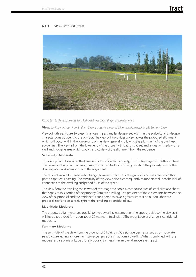
6.4.3 VP3 – Bathurst Street
Figure 26 – Looking north east from Bathurst Street across the proposed alignment
Pitt Town Bypass
View: Looking north east from Bathurst Street across the proposed alignment from adjoining 21 Bathurst Street
Viewpoint three, Figure 26 presents an open grassland landscape, set within in the agricultural landscape character zone adjacent to the corridor. The viewpoint provides a view across the proposed alignment which will occur within the foreground of the view, generally following the alignment of the overhead powerlines. The view is from the lower end of the property 21 Bathurst Street and is clear of sheds, works yard and stockpile area which would restrict view of the alignment from the residence.
Sensitivity: Moderate
This view point is located at the lower end of a residential property, from its frontage with Bathurst Street. The viewer at this point is a passing motorist or resident within the grounds of the property, east of the dwelling and work areas, closer to the alignment.
The resident would be sensitive to change, however, their use of the grounds and the area which this photo captures is passing. The sensitivity of this view point is consequently as moderate due to the lack of connection to the dwelling and periodic use of the space.
The view from the dwelling to the west of the image overlooks a compound area of stockpiles and sheds that separate this portion of the property from the dwelling. The presence of these elements between the view of the proposal and the residence is considered to have a greater impact on outlook than the proposal itself and so sensitivity from the dwelling is considered low.
Magnitude: Moderate
The proposed alignment runs parallel to the power line easement on the opposite side to the viewer. It will introduce a road formation about 20 metres in total width. The magnitude of change is considered moderate.
Summary: Moderate
The sensitivity of the view from the grounds of 21 Bathurst Street, have been assessed as of moderate sensitivity, reflecting a more transitory experience than that from a dwelling. When combined with the moderate scale of magnitude of the proposal, this results in an overall moderate impact.
43

6.4.4 VP4 – Buckridge Street
Figure 27 – View looking east from Buckridge Street with the residence of 54 Wellesley Street visible to the left of image
Pitt Town Bypass
View: Looking east from Buckridge Street overlooking the residence of 54 Wellesley Street
Viewpoint four, figure 27, looks east from the elevated residential edge of Pitt Town and overlooks the agricultural landscape that characterises the area of the proposal. Beyond Horton Creek valley the woodland landscape can be discerned. The foreground is dominated by pasture lands which are used for horse agistment. The mid-ground reveals a conifer hedge which has died and partially screens the residence of 54 Wellesley Street. The proposed alignment traverses this mid-ground zone.
Sensitivity: High
Residential receptors are the primary viewers in this location with five properties addressing the view directly. The residential properties have been assessed as susceptible and sensitive to changes associated with the introduction of a through road within the agricultural landscape. Sensitivity has consequently been assessed as high.
Magnitude: High
The proposal is located in the mid ground of the view and will see the removal of the conifer hedge. This will open views to both the alignment a nd 54 Wellesley Street. This will reveal both the new road alignment (the proposal) and the traffic using it. The impact and degree to which it is visible will in part be moderated by the formation being partially in cut, although the scale of this is small. Despite this the magnitude of change is considered high.
Summary: High
Buckridge Street is a no through road residential street overlooking an agricultural landscape, and has consequently been considered to have a high sensitivity to change. The proposal contributes to a change in the overall outlook and so has also been assessed as having a high magnitude of change. This results in an overall high impact.
44

Pitt Town Bypass
6.4.5 VP5 – Buckridge Street
Figure 28 – View from Termination of Buckridge Street
View: Looking east from the termination of Buckridge Street
Viewpoint five, figure 28, presents an open grassland landscape set within the agricultural landscape character zone adjoining the corridor. The view is across the alignment in the proximity of a twin span plank bridge. The background is defined by eucalypt woodland; the mid-ground reveals the reeds growing in Horton Creek; with the foreground dominated by grassland. The proposal falls in the mid-ground of the image, crossing Hortons Creek.
Sensitivity: High
The view is representative of the residences located at 1- 5 Buckridge Street. The residential receptors have been assessed as having a high sensitivity to change given the proposal will alter the views of the existing agricultural landscape a landscape that is considered to be valued by the residents.
Magnitude: High
The proposal is located in the mid-ground of the view. The alignment at th is point transitions to fill from cut and is elevated approximately three metres above ground level. The magnitude of change is considered high as it introduces a road alignment within the agricultural landscape and conceals views to the creek line.
Summary: High
Similar to the previous viewpoint, the overall impact has been assessed as high due to the scale of change and sensitivity of viewers.
45

Pitt Town Bypass
6.4.6 VP6 – Mawson Place/ Somerset Street
Figure 29 – Looking North East from Mawson Place / Somerset Street across Brinsley Park.
View: Looking northeast from Mawson Place / Somerset Street across Brinsley Park.
Viewpoint six, depicted in figure 29, overlooks Brinsley Oval in the foreground and woodland landscape beyond Hortons Creek in the background. Both Old Pitt Town Road and Cattai Road are visible and largely unobstructed in the background about 100 metres from the viewer. Brinsley Oval is managed as a sports oval and consists primarily of a large flat grass oval.
Sensitivity: Moderate
The view is representative of the residences within both Somerset Street and to a more limited extent Mawson Place. The proposal is located in the background of t he view. The viewer’s sensitivity to t he proposal is considered to be moderate because of their distance from the proposal and the existing roads within the view.
Magnitude: Moderate
The proposal sees the alignment of Cattai Road moved to the east as part of the proposal and linked through to Pitt Town Road. This will result in the relocation of through traffic within the view, reducing the dominance of the existing roads. Traffic on Cattai Road would be moved as part of the alignment to over 200 metres from the view point and located in th e background along the woodland backdrop. The magnitude of change is considered moderate.
Summary: Moderate
The view from Mawson Place has been considered moderate reflecting the distance from the proposal and the presence of the Cattai Road/ Old Pitt Town Road alignment in the view.
46

6.4.7 VP7– Old Pitt Town Road
Figure 30 – Looking east along Old Pitt Town Road
Pitt Town Bypass
View: Looking east along Old Pitt Town Road from near its intersection with Cattai Road and Eldon Street
Viewpoint seven looks east along Old Pitt Town Road and encompasses: Hortons Creek crossing the alignment, the woodland backdrop to the east of Hortons Creek, and the p roposed alignment, and the corner of Brinsley Park in the foreground, figure 30. The proposed alignment is largely located to the east of Hortons Creek in this section.
Sensitivity: Low
The viewer is located approximately 100 metres from the proposal. Visual receptors at this location would include road users on Old Pitt Town Road and recreational users of Brinsley Oval. In both instances the viewer is transient and not exposed to the view for an extended period.
In the case of the oval user however they may spend a number of hours within the park. The exposure is consequently fleeting for the road user and short term for the oval user. The overall sensitivity to change is considered low.
Magnitude: Moderate
The proposal is to the east of Hortons Creek and will see the removal of the edge margin of the woodland landscape. This landscape type however will remain in the background, beyond the footprint of the proposal. The proposal also crosses Old Pitt Town Road, introducing a new roundabout intersection. These changes do not alter the overall character of the area but will result in observable changes in its composition and configuration. The impact has consequently been assessed as moderate.
Summary: Low to Moderate
The visual impact has been assessed as low to moderate reflecting the low sensitivity of the viewers and the moderate scale of change as a result of the impacts from the proposed alignment and roundabout intersection tying into the existing road environment.
47

6.4.8 VP8 – Old Pitt Town Road
Figure 31 – Looking west along Old Pitt Town Road.
Pitt Town Bypass
View: Looking west along Old Pitt Town Road
Viewpoint eight as depicted by Figure 31, is within the woodland margins which define the eastern approach to Pitt Town. Looking along Old Pitt Town Road towards Pitt Town, the land is undulating and includes views of the crossing at Hortons Creek, the Cattai Road and Eldon Street intersection, and beyond. Views through the woodland are limited by its density with filtered views to the creek line visible left of photo.
Sensitivity: High
The viewer at this point is both transient and static, comprised of passing traffic and an adjoining residential receptor.
For the road user the exposure is short term and fleeting, and the sensitivity to change is considered low. The residential receptor is continually exposed to the proposal’s impacts and so is considered to have a high sensitivity to changes.
Magnitude: High
The proposal will intersect and tie in with Old Pitt Town Road. This occurs in the mid-ground of the view and introduces a roundabout that requires clearing of the woodland margin. The road user would experience a change in road configuration and general character of the road setting in relation to the roundabout. The magnitude of change for the road users is considered moderate.
With respect to the residential receptor, woodland vegetation would be removed altering the sense of enclosure and potential screening of the corridor. A new road form will be built in relation to the dwelling moving both the formation and traffic into the primary view. The magnitude of change for the residential receptors is considered high.
Summary: High
The overall visual impact for residential receptors at this location has been assessed as high due to the new infrastructure proposed and the loss of vegetation in what is a woodland context.
Road user impacts in contrast are low to moderate reflecting their transient and fleeting exposure.
48

6.4.9 VP9– Buckingham Street
Figure 32 – Looking east from Buckingham Street intersection.
Pitt Town Bypass
View: Looking east from Buckingham Street across Cattai Road
Viewpoint nine, figure 32, represents the woodland character which dominates the arrival to Pitt Town from the north. Scattered residential buildings set within this landscape on small rural holdings are evident.
Sensitivity: Moderate
The viewer at this point may, either be transient being comprised of road users or reflect the views of the few residential dwellings near Buckingham Street and Cattai Road. The proposal represents limited change from the current Cattai Road operations. Sensitivity of change for the road user is considered low. For the residential receptor, their sensitivity is considered moderate being moderated by their existing experience.
Magnitude: Moderate
The magnitude of change proposed is limited with Cattai Road moving eastward and the intersection reconfigured to provide left in and left out turning movements.
Southeast of Cattai Road, vegetation will be cleared which will reduce the sense of enclosure. This will not result in an overall change in character. The impact is consequently considered to be moderate.
Summary: Moderate
The overall impact at Buckingham Street has been assessed as moderate. This reflects the construction of new road infrastructure in a similar location to existing, as well as the implications of vegetation clearance to address the shift in alignment slightly to the east.
49
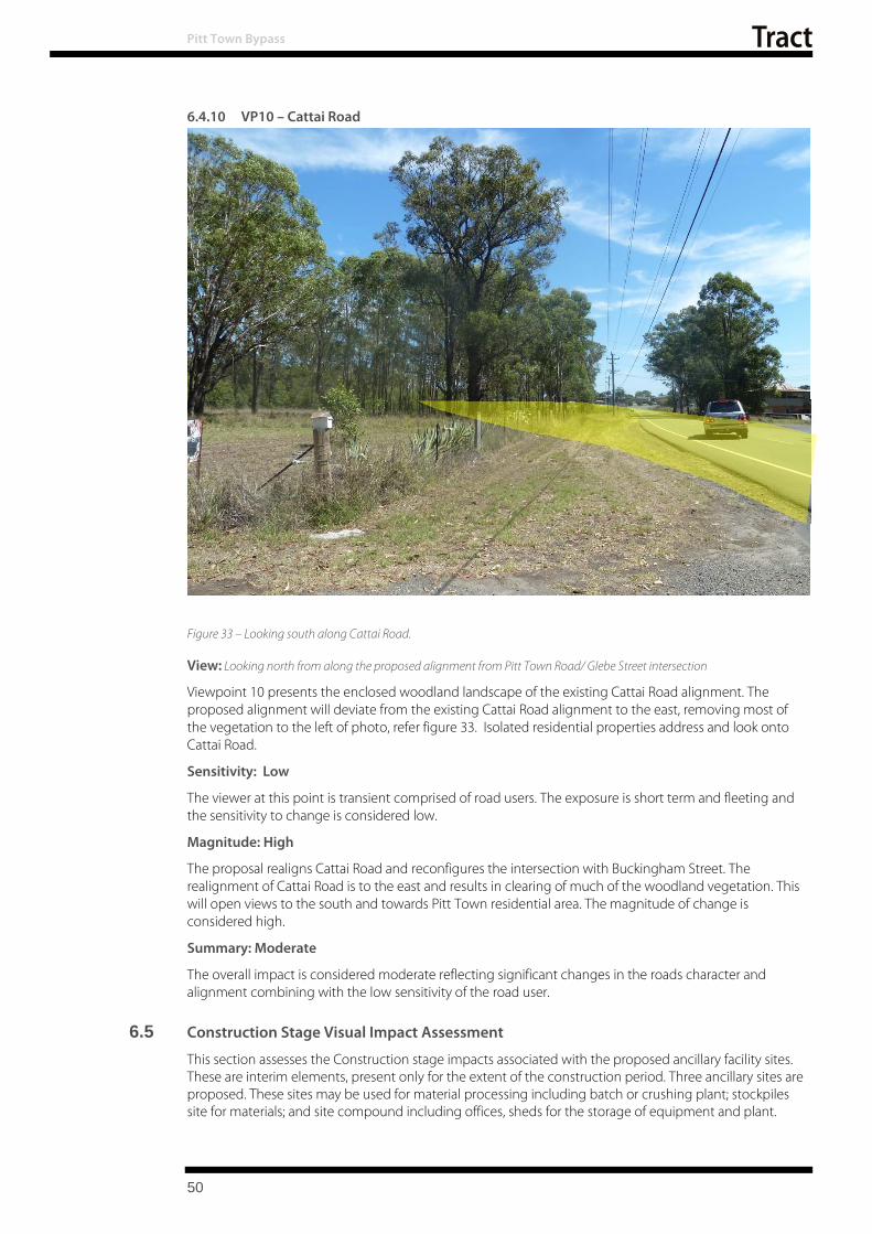
Pitt Town Bypass
6.4.10 VP10 – Cattai Road
Figure 33 – Looking south along Cattai Road.
View: Looking north from along the proposed alignment from Pitt Town Road/ Glebe Street intersection
Viewpoint 10 presents the enclosed woodland landscape of the existing Cattai Road alignment. The proposed alignment will deviate from the existing Cattai Road alignment to the east, removing most of the vegetation to the left of photo, refer figure 33. Isolated residential properties address and look onto Cattai Road.
Sensitivity: Low
The viewer at this point is transient comprised of road users. The exposure is short term and fleeting and the sensitivity to change is considered low.
Magnitude: High
The proposal realigns Cattai Road and reconfigures the intersection with Buckingham Street. The realignment of Cattai Road is to the east and results in clearing of much of the woodland vegetation. This will open views to the south and towards Pitt Town residential area. The magnitude of change is considered high.
Summary: Moderate
The overall impact is considered moderate reflecting significant changes in the roads character and alignment combining with the low sensitivity of the road user.
6.5 Construction Stage Visual Impact Assessment
This section assesses the Construction stage impacts associated with the proposed ancillary facility sites. These are interim elements, present only for the extent of the construction period. Three ancillary sites are proposed. These sites may be used for material processing including batch or crushing plant; stockpiles site for materials; and site compound including offices, sheds for the storage of equipment and plant.
50
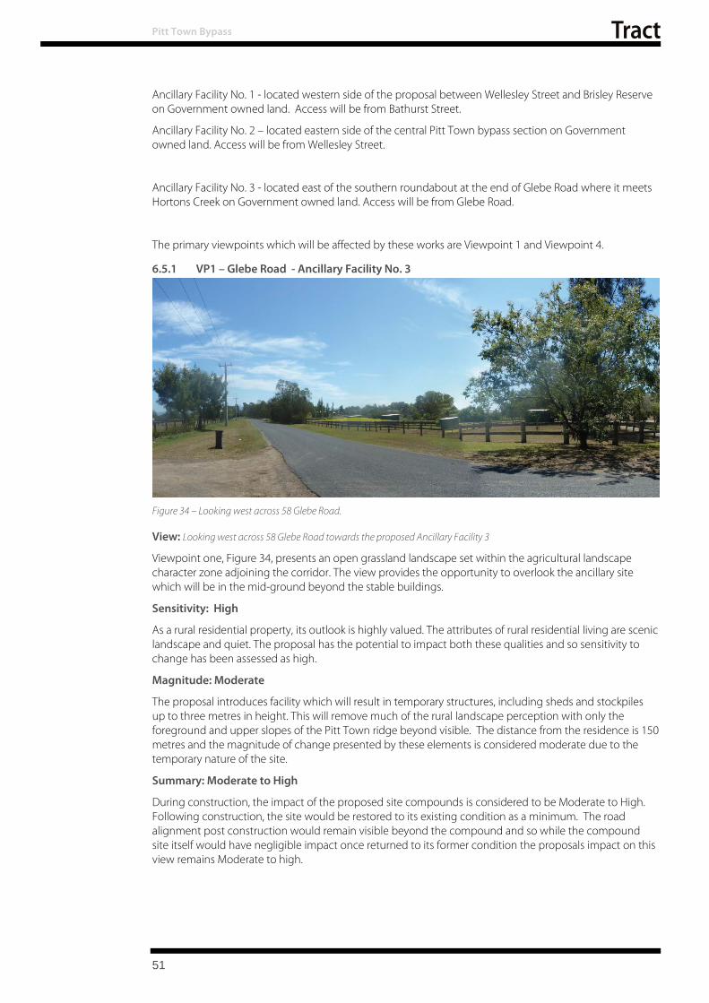
Pitt Town Bypass
Ancillary Facility No. 1 - located western side of the proposal between Wellesley Street and Brisley Reserve on Government owned land. Access will be from Bathurst Street.
Ancillary Facility No. 2 – located eastern side of the central Pitt Town bypass section on Government owned land. Access will be from Wellesley Street.
Ancillary Facility No. 3 - located east of the southern roundabout at the end of Glebe Road w here it m eets Hortons Creek on Government owned land. Access will be from Glebe Road.
The primary viewpoints which will be affected by these works are Viewpoint 1 and Viewpoint 4.
6.5.1 VP1 – Glebe Road - Ancillary Facility No. 3
Figure 34 – Looking west across 58 Glebe Road.
View: Looking west across 58 Glebe Road towards the proposed Ancillary Facility 3
Viewpoint one, Figure 34, presents an open grassland landscape set within the agricultural landscape character zone adjoining the corridor. The view provides the opportunity to overlook the ancillary site which will be in the mid-ground beyond the stable buildings.
Sensitivity: High
As a rural residential property, its outlook is highly valued. The attributes of rural residential living are scenic landscape and quiet. The proposal has the potential to impact both these qualities and so sensitivity to change has been assessed as high.
Magnitude: Moderate
The proposal introduces facility which will result in temporary structures, including sheds and stockpiles up to three metres in height. This will remove much of the rural landscape perception with only the foreground and upper slopes of the Pitt Town ridge beyond visible. The distance from the residence is 150 metres and the magnitude of change presented by these elements is considered moderate due to the temporary nature of the site.
Summary: Moderate to High
During construction, the impact of the proposed site compounds is considered to be Moderate to High. Following construction, the site would be restored to its existing condition as a minimum. The road alignment post construction would remain visible beyond the compound and so while the compound site itself w ould have negligible impact once returned to its former condition the proposals impact on this view remains Moderate to high.
51

Pitt Town Bypass
6.5.2 VP4 – Buckridge Street - Ancillary Facilities no.s 1 and 2
Ancillary Site 2
Ancillary Site 1
Figure 35 – View looking east from Buckridge Street with the residence of 54 Wellesley Street visible to the left of image
View: Looking east from Buckridge Street overlooking the residence of 54 Wellesley Street
Viewpoint four, figure 35, looks east from the elevated residential edge of Pitt Town and overlooks the agricultural landscape that characterises the area of the proposal. The foreground is dominated by pasture land which is currently used for horse agistment but is proposed to be the site of the Ancillary Facility No. 1.
Beyond the residential lot associated with 54 Wellesley Street is also identified a s an Ancillary Site, Ancillary Site 2.
Sensitivity: High
Residential receptors are the primary viewers in this location with five properties addressing the view directly. The residential properties have been assessed as susceptible and sensitive to changes associated to the removal of the agricultural outlook. Sensitivity has consequently been assessed as high.
Magnitude: High
The proposed ancillary site 2 is located in the foreground of the view and will block much of the outlook. Despite the temporary nature of the sites use the magnitude of change is considered high. Ancillary Site 2 is located further east of Site1 and is separated by the proposed alignment. Its impact is consequently lower as it is located further away from the view point and so is assessed as moderate.
Summary: High
During construction, the view from Buckridge Street has been assessed as having a high visual impact as a result of Ancillary Site 1. The impact of Ancillary Site 2 has been assessed as moderate to high due to its greater separation from the viewers. Following construction, the site would be restored to its existing condition as a minimum. While the impacts of the ancillary site would be moderated post construction by the reinstatement of t he existing finish, the overall visual impact assessment post construction for Buckridge Street was assessed as high reflecting the overall significance of a new road within the current rural outlook.
52

Pitt Town Bypass
6.6 Visual Assessment Summary
A total of ten viewpoints have been assessed in relation to the permanent works associated with the proposal. In addition to these views an assessment of three viewpoints impacted by construction ancillary facility sites has been undertaken.
A range of viewpoints has been considered reflecting the nature of land-use and the likely interaction that will occur in relation to the proposal and existing development. The viewpoints selected provide a range of receptors including residents, road users, open space users which reflect a broader cross section of community who will experience changes as a result of the proposal.
The overall ma gnitude of the proposal has been assessed as moderate to high. This reflects the establishment of a new alignment in relatively close proximity to an established community within a pastureland landscape which otherwise is not currently impacted by road infrastructure. .
Of the 10 viewpoints the range of visual impact ratings determined is as follows:
Three viewpoints have been a ssessed as having a high visual impact
One viewpoint as moderate to high visual impact
Five viewpoints as moderate visual impact, and
One view point as low to moderate visual impact.
Typically views of residential receptors have been assessed as experiencing high or moderate imp act, depending on distance from the proposal and relationship to existing road infrastructure. High impacts occur where residential viewers have the proposal in their immediate view field. Opportunity to moderate impacts in the mid to long term may be possible through the introduction of screen planting.
Landscape and urban design mitigation strategies have bee n developed from the outcomes of the landscape character and visual assessments, as a way of mitigating the potential impacts, and have been incorporated into the Urban Design Strategy in Chapter 3. These mitigation measures, as well as those to be further considered in detailed design stage of the proposal are discussed in the following Chapter 7. As the la ndscape mitigation measures develop over time their effectiveness will be enhanced as the planting matures.
The ancillary site assessment similarly reflects the sensitivity of residential receptors and overall magnitude of change with the visual impact assessment ranking from moderate to high to high. At the completion of the construction process, these sites would be restored to their pre-existing condition. Depending on the final resolution of the property adjustments these parcels of land would be used in part or in their entirety to provide a visual buffer between the road and adjoining viewpoints.
Table 3 below summarises these impacts.
Table 3 - Visual Assessment Summary
View point Sensitivity Magnitude Impact VP1 High Moderate Moderate - High VP2 Low High Moderate VP3 Moderate Moderate Moderate VP4 High High High VP5 High High High VP6 Moderate Moderate Moderate VP7 Low Moderate Low to Moderate VP8 High High High VP9 Moderate Moderate Moderate VP10 Low High Moderate Construction Ancillary Facilities VP1 High Moderate Moderate - High VP4 High High High
53

Pitt Town Bypass
This page is intentionally left blank
54
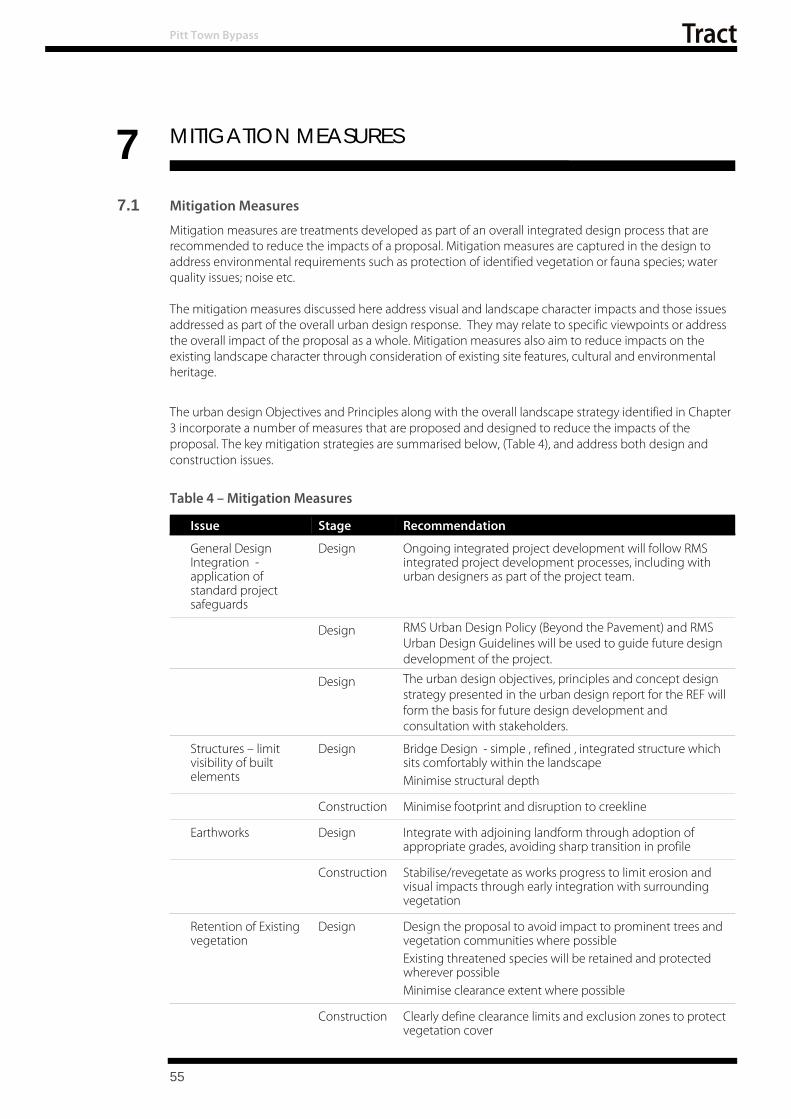
Pitt Town Bypass
55
7 MITIGATION MEASURES
7.1 Mitigation Measures
Mitigation measures are treatments developed as part of an overall integrated design process that are recommended to reduce the impacts of a proposal. Mitigation measures are captured in the design to address environmental requirements such as protection of identified vegetation or fauna species; water quality issues; noise etc. The mitigation measures discussed here address visual and landscape character impacts and those issues addressed as part of the overall urban design response. They may relate to specific viewpoints or address the overall impact of the proposal as a whole. Mitigation measures also aim to reduce impacts on the existing landscape character through consideration of existing site features, cultural and environmental heritage.
The urban design Objectives and Principles along with the overall landscape strategy identified in Chapter 3 incorporate a number of measures that are proposed and designed to reduce the impacts of the proposal. The key mitigation strategies are summarised below, (Table 4), and address both design and construction issues.
Table 4 – Mitigation Measures
Issue Stage Recommendation
General Design Integration -
application of standard project
safeguards
Design Ongoing integrated project development will follow RMS integrated project development processes, including with
urban designers as part of the project team.
Design RMS Urban Design Policy (Beyond the Pavement) and RMS Urban Design Guidelines will be used to guide future design
development of the project.
Design The urban design objectives, principles and concept design strategy presented in the urban design report for the REF will form the basis for future design development and
consultation with stakeholders.
Structures – limit visibility of built
elements
Design Bridge Design - simple , refined , integrated structure which sits comfortably within the landscape Minimise structural depth
Construction Minimise footprint and disruption to creekline
Earthworks Design Integrate with adjoining landform through adoption of appropriate grades, avoiding sharp transition in profile
Construction Stabilise/revegetate as works progress to limit erosion and visual impacts through early integration with surrounding
vegetation
Retention of Existing vegetation
Design Design the proposal to avoid impact to prominent trees and vegetation communities where possible
Existing threatened species will be retained and protected wherever possible
Minimise clearance extent where possible
Construction Clearly define clearance limits and exclusion zones to protect vegetation cover

Pitt Town Bypass
Table 5 – Mitigation Measures Continued
Issue Stage Recommendation
Revegetation Design Vegetation communities to respond to existing communities and landscape character
Utilise local provenance material Provide screen planting within corridor to limit visibility of
the proposal from adjoining residential properties
Construction Progressively implement revegetation works to limit erosion and to establish vegetation
Utilise cleared material as part of revegetation works
Minimise road furniture and
signage
Design Provide minimum signage requirements and limit structural elements to provide and open and permeable setting
Construction Look for opportunities to minimise designed signage,
Lighting Design Limit extent of lighting and potential for light spill
Construction Limit night works and provide lighting which minimises spill
View management Design Provide visual screening within the road corridor to limit the visual impact of the proposal in areas identified as moderate
or high impact Provide sense of space and openness associated with the
agricultural landscape
Construction Retain vegetation beyond the footprint to retain any existing screening
Ancillary Facilities Design Setout compounds to limit impacts , consider screening and location of key structures which provide the greatest impact
Construction Maintain compound in a tidy and well-presented manner. Provide and maintain screening
Construction Progressively throughout the work, where feasible and reasonable, the ancillary facility sites will be returned to at
least their pre-construction state
56

8 CONCLUSION
Pitt Town Bypass
The proposal for the Pitt Town Bypass project involves constructing a two-lane road between Pitt Town Road and Buckingham Road east of Pitt Town. The total length of the proposal is approximately one kilometre and includes a southern roundabout connection with Glebe Road and Bathurst Street, a northern roundabout at Old Pitt Town Road and a T- Intersection with Buckingham Street.
In developing an integrated design response for the proposal the development of urban design and landscape objectives and principles has occurred which responds to the landscape character and visual context of the study area. These objectives have been d eveloped to ensure that t he relationship between the proposal and the surrounding, agricultural, open woodland and urban areas is adequately considered and addressed in the design response.
The urban design, bridge and landscape concept has been developed to achieve an integrated outcome that helps fit the project as sensitively as possible into its context and to minimise the impacts of the project on the future character of the area. Mitigation measures discussed in chapters 3 and 7 would be implemented in the next (future) project development phase to ensure these objectives are realised. The urban design would:
Ensure attractive views into the broader landscape are maintained by revegetating disturbed areas along the road edges
Incorporate materials and finishes for new road elements that are site appropriate and reduce their prominence
Ensure there is a visually complementary relationship between the proposed bridge and its local context
Include a planting design intended to reduce the scale of the proposed road infrastructure by the provision of appropriate tree species in the streetscapes of the urban areas of Pitt Town and provide distinctive town entry points.
Provide screening, through the use of native plant species, of the road infrastructure to residential areas
Landscape Character Assessment
Landscape character impacts of the proposal were found to generally be of low to moderate level. This reflects that the changes associated with the proposal do not have a complete or holistic impact on the character of the setting.
Visual Impact Assessment
The visual impacts of the proposal have been assessed at a higher level of impact ranging between moderate to high. This reflects the proximity of residential receptors and the proposal for new infrastructure within the rural landscape setting over which these residential properties over look.
Where impacts are high mitigation measures will be needed to screen or moderate the impacts of the proposal.
A number of key mitigation measures are sum marised which will assist in mitigating the impacts. These impacts will be taken forward into the detailed design to ensure impacts are minimised.
57

Pitt Town Bypass
58

9 BIBLIOGRAPHY
Pitt Town Bypass
Artefact, May 2018, Pitt Town Bypass - Non-Aboriginal Statement of Heritage Impact (SoHI)
Austroads, 2017, Guide to Road Design Part 6a - Paths for walking and Cycling
Roads and Maritime Services (2014) Beyond the Pavement: Urban Design Policy, Procedures, and Design Principles.
Roads and Maritime Services - Centre for Urban Design (July 2012) Bridge Aesthetics Design guideline to improve the appearance of bridges in NSW.
Roads and Maritime Services (2013) Environmental Impact Assessment Practice Note: Guidelines for Landscape Character and Visual Impact Assessment. EIA-NO4.
Roads and Traffic Authority (RTA) (2008) Landscape Guideline: Landscape design and maintenance guidelines to improve the quality, safety and cost effectiveness of road corridor planting and seeding.
Roads and Traffic Authority (RTA) (2004) NSW Bicycle Guidelines
Roads and Maritime Services (18 August 2016) Pitt Town Bypass - Preliminary Environmental Investigation
59

Pitt Town Bypass
APPENDIX 1 – VEGETATION SPECIES10 The Grey Box - Forest Red Gum Grassy Woodland
Botanical Name Common Name TREES Eucalyptus fibrosa Red ironbark
Eucalyptus moluccana Grey box Eucalyptus tereticornis Forest red gum
UNDERSTOREY Brunoniella australis Blue Trumpet Bursaria spinosa Native blackthorn Desmodium varians Slender Tick-trefoil Dichondra repens Kidney weed Microlaena stipoides var stipoides Weeping meadow grass Themeda australis Kangaroo Grass
Shale Gravel Transition Forest Botanical Name Common Name
TREES Corymbia maculata Spotted gum
Eucalyptus crebra Narrow-leaved ironbark Eucalyptus eugenioides Thin-leaved stringybark Eucalyptus fibrosa Red ironbark Eucalyptus moluccana Grey box Eucalyptus tereticornis Forest red gum Melaleuca decora White feather honeymyrtle
UNDERSTOREY Acacia decurrens Black wattle Acacia parramattensis Parramatta wattle Aristida vagans Threeawn Speargrass Bursaria spinosa Native blackthorn
Brunoniella australis Blue Trumpet
Cheilanthes sieberi subsp. Sieberi
Daviesia ulicifolia Gorse bitter pea Desmodium varians Slender Tick-trefoil Dichelachne micrantha Shorthair Plumegrass Dichondra repens Kidney weed Exocarpos cupressiformis Native cherry Lissanthe strigosa Peach heath Lomandra multiflora subsp. multiflora Many-flowered Mat-rush Microlaena stipoides var stipoides Weeping meadow grass
Opercularia diphylla Opercularia diphylla Pratia purpurascens White root Themeda australis Kangaroo Grass Wahlenbergia gracilis Australian Bluebell

Pitt Town Bypass
11 APPENDIX 2 – CONCEPT DESIGN DRAWINGS

BLANK PAGE


ISSUE STATUS ISSUE
DS2016/001182RMS REGISTRATION No.
EDMS No.
DATE AMENDMENT / REVISION DESCRIPTION WVR No. APPROVAL
A3
SCALES ON A3 SIZE DRAWING
CO-ORDINATE SYSTEM HEIGHT DATUM
AHDMGA ZONE 56
CLIENT
35
45
50m
mO
NA3
SIZ
EO
RIGIN
AL
THIS
DR
AWIN
GM
AY
BE
PR
EP
AR
EDIN
CO
LO
UR
AN
DM
AY
BEIN
CO
MPLETEIF
COPIE
D
PREPARED FOR
DESIGN MODEL FILE(S) USED FOR DOCUMENTATION OF THIS DRAWING
DRAWINGS / DESIGN PREPARED BY TITLE NAME
© Roads and Maritime Services
DESIGN
DESIGN CHECK
PLOT DATE / TIME PLOT BY
DRAWN
DRG CHECK
DESIGN MNGR
PROJECT MNGR
DATE
SHEET No.
PART
REV
DRAWING FILE LOCATION / NAME
05
10
15
25
H:\~2018\0218-0003-Pitt Town Bypass\- 100% Design Stage\- 100% Design\- WD-000 CAD Sheet Files\0218-0003-01 WD-207 .dgn 25/09/2018 5:28:05 PM mnenadic0218-0003-01 WD-207 .dgn
DESIGN WESTERN
ENGINEERING SERVICES
ASSET MAINTENANCE 2
PITT TOWN - HAWKESBURY COUNCIL
MR 181 - PITT TOWN ROAD
PITT TOWN BYPASS
BETWEEN PITT TOWN ROAD AND CATTAI ROAD
1
2
1
0 M NENADIC
M EASTON
25.09.18
25.09.18
M EASTON
19.07.18 ME
NOT FOR CONSTRUCTION
LS-207
25.09.18
80% CONCEPT DESIGN
SHEET 9 OF 10
BTYPICAL SECTION NOT TO SCALE
ATYPICAL SECTION NOT TO SCALE
LANDSCAPE PROPOSAL
LANDSCAPE PROPOSAL
12.09.18 ME100% CONCEPT DESIGN
25.09.18 ME
FINAL CONCEPT DESIGN
FINAL CONCEPT DESIGN

ISSUE STATUS ISSUE
DS2016/001182RMS REGISTRATION No.
EDMS No.
DATE AMENDMENT / REVISION DESCRIPTION WVR No. APPROVAL
A3
SCALES ON A3 SIZE DRAWING
CO-ORDINATE SYSTEM HEIGHT DATUM
AHDMGA ZONE 56
CLIENT
35
45
50m
mO
NA3
SIZ
EO
RIGIN
AL
THIS
DR
AWIN
GM
AY
BE
PR
EP
AR
EDIN
CO
LO
UR
AN
DM
AY
BEIN
CO
MPLETEIF
COPIE
D
PREPARED FOR
DESIGN MODEL FILE(S) USED FOR DOCUMENTATION OF THIS DRAWING
DRAWINGS / DESIGN PREPARED BY TITLE NAME
© Roads and Maritime Services
DESIGN
DESIGN CHECK
PLOT DATE / TIME PLOT BY
DRAWN
DRG CHECK
DESIGN MNGR
PROJECT MNGR
DATE
SHEET No.
PART
REV
DRAWING FILE LOCATION / NAME
05
10
15
25
H:\~2018\0218-0003-Pitt Town Bypass\- 100% Design Stage\- 100% Design\- WD-000 CAD Sheet Files\0218-0003-01 WD-208 .dgn 25/09/2018 5:28:34 PM mnenadic0218-0003-01 WD-208 .dgn
DESIGN WESTERN
ENGINEERING SERVICES
ASSET MAINTENANCE 2
PITT TOWN - HAWKESBURY COUNCIL
MR 181 - PITT TOWN ROAD
PITT TOWN BYPASS
BETWEEN PITT TOWN ROAD AND CATTAI ROAD
1
2
1
0 M NENADIC
M EASTON
25.09.18
25.09.18
M EASTON
19.07.18 ME
NOT FOR CONSTRUCTION
LS-208
25.09.18
80% CONCEPT DESIGN
CNOT TO SCALE
BRIDGE
SHEET 10 OF 10
12.09.18 ME100% CONCEPT DESIGN
25.09.18 ME
FINAL CONCEPT DESIGN
FINAL CONCEPT DESIGN
TYPICAL SECTION

Appendix E
Biodiversity Assessment
Pitt Town Bypass
Review of Environmental Factors

BLANK PAGE
Pitt Town Bypass
Review of Environmental Factors

Pitt Town BypassBiodiversity Assessment
1
Pitt Town Bypass Biodiversity Assessment
September 2018

BLANK PAGE
Pitt Town Bypass Biodiversity Assessment
2

Roads and Maritime Services
Pitt Town Bypass Biodiversity Assessment
September 2018
Prepared by Arcadis Provide Roads and Maritime Services Publication Number
Pitt Town Bypass Biodiversity Assessment
3

ROADS AND MARITIME SERVICES
PITT TOWN BYPASS
Biodiversity Assessment
Author
Ed Cooper
Laura Hoffman
Checker Elvira Lanham
Approver Danielle Haynes
Report No 1
Date 24/09/2018
Revision Text C
This report has been prepared for NSW Roads and Maritime Services in accordance with the terms and conditions of appointment for contract 14.2166.0494-0023 dated 24 November 2017. Arcadis Australia Pacific Pty Limited (ABN 76 104 485 289) cannot accept any responsibility for any use of or reliance on the contents of this report by any third party.
REVISIONS
Revision Date Description Prepared
by
Approved
by
A 24/04/2018 First draft EC/LH DH
B 20/06/2018 Second draft EC DH
C 24/09/2018 Final EC DH
Pitt Town Bypass Biodiversity Assessment
4

Executive summary
NSW Roads and Maritime Services are proposing a bypass of Pitt Town, to the east of the town centre. The proposed bypass would be about one kilometre (km) long and would extend from south of the intersection of Pitt Town Road and Glebe Road, to north of the intersection of Cattai Road and Buckingham Road. The key features of the proposal include:
• Extending Pitt Town Road past Bathurst Street onto Cattai Road, east of Eldon Street
• Installing a new roundabout at the intersection of Pitt Town Road/Bathurst Street and Glebe Road
• Installing a new roundabout at Eldon Street and Old Pitt Town Road
• Closing a part of Cattai Road to maintain access to Buckingham Street
• Providing new road crossings of Hortons Creek at the southern and central parts of the proposal.
In order to satisfy Roads and Maritime’s obligations under Section 111 of the Environmental Planning and Assessment Act 1979 (EP&A Act) a Review of Environmental Factors (REF) has been prepared to consider the potential impacts of the proposal on the environment. This biodiversity assessment has been undertaken to inform the biodiversity chapter of the REF. The study area for this biodiversity assessment covers 26 hectares (ha) and encompasses the current construction footprint and a 50 metre (m) buffer on either side. Within this area there are several privately-owned rural residential properties that are located on the eastern periphery of Pitt Town town centre. Biodiversity field investigations were carried across the study area by four Arcadis ecologists between 13 February and 20 February 2018. Field investigations included classification of the vegetation into Plant Community Types (PCTs), completing Biodiversity Assessment Method 2017 (BAM) plots to determine the vegetation integrity, targeted surveys for threatened flora (including random meanders and parallel field traverses), spotlighting and call playback for nocturnal fauna, placement of two ANABAT devices, diurnal bird surveys and general habitat assessments. Field and desktop investigations identified the presence of the following ecological constraints within the study area:
• 2.95 hectares Cumberland Plain Woodland in the Sydney Basin Bioregion (critically endangered under the Biodiversity Conservation Act 2016) also equivalent to Cumberland Plain Woodland and Shale-Gravel Transition Forest (critically endangered under the Environment Protection and Biodiversity Conservation Act 1999)
• 1.78 hectares of Shale Gravel Transition Forest in the Sydney Basin Bioregion (endangered under the BC act Biodiversity Conservation Act 2016) but not equivalent to Cumberland Plain Woodland and Shale-Gravel Transition Forest (critically endangered under the Environment Protection and Biodiversity Conservation Act 1999) based on condition
• 1.46 hectares of Freshwater Wetlands on Coastal Floodplains of the NSW North Coast, Sydney Basin and South-East Corner bioregions (endangered under the BC Act Biodiversity Conservation Act 2016)
• About 30 stems of Acacia pubescens (vulnerable under the Environment Protection and Biodiversity Conservation Act 1999and Biodiversity Conservation Act 2016)
• Four stems of Dillwynea tenuifolia (vulnerable under the Biodiversity Conservation Act 2016)
• Grey-headed Flying Fox (Pteropus poliocephalus) (vulnerable under the Environment Protection and Biodiversity Conservation Act 1999 and Biodiversity Conservation Act 2016)
Pitt Town Bypass Biodiversity Assessment
1

• Eastern Bent-wing Bat (Miniopterus schreibersii oceanensis) (vulnerable under the Biodiversity Conservation Act 2016)
• Eastern Freetail Bat (Mormopterus norfolkensis) (vulnerable under the Biodiversity Conservation Act 2016)
• Greater Broad-nosed Bat (Scoteanax rueppellii) (vulnerable under the Biodiversity Conservation Act 2016)
• Southern Myotis (Myotis macropus) (vulnerable under the Biodiversity Conservation Act 2016)
• Potential habitat for: o Micromyrtus minutiflora (vulnerable under the Environment Protection and
Biodiversity Conservation Act 1999 and endangered under the Biodiversity Conservation Act 2016)
o Pimelea spicata (endangered under the Environment Protection and Biodiversity Conservation Act 1999 and Biodiversity Conservation Act 2016)
o Cumberland Plain Land Snail (endangered under the Environment Protection and Biodiversity Conservation Act 1999 and Biodiversity Conservation Act 2016).
The study area is transected by a north to south flowing un-named tributary of Hortons Creek. Hortons Creek is a tributary of Pitt Town Lagoon which is located about 500 m w est of the study area (one kilometre downstream) and is a Nationally Important Wetland. Another Nationally Important Wetland, Longneck Lagoon, is located about 2.5 km to the east of the study area. The un-named waterway within the study area is consistent with Class 4 Unlikely Fish Habitat (and not consistent with Key Fish Habitat). No threatened fish species are considered likely to occur within the study area. Similarly, the aquatic environments within the study area do not provide potential habitat for threatened frogs. The vegetation within the study area is predominantly comprised of modified exotic grassland with patches of degraded native vegetation, particularly on the eastern side. The current concept design for the Roads and Maritime has considered these constraints and impacts to these threatened species and ecological communities have been avoided and minimised where possible, however the proposal would result in residual impacts to threatened biodiversity. The residual impacts include:
• The removal of 1.41 hectares Cumberland Plain Woodland in the Sydney Basin Bioregion
• The removal of 0.39 hectares of Shale Gravel Transition Forest in the Sydney Basin Bioregion
• The removal of 0.67 hectares of Freshwater Wetlands on Coastal Floodplains of the NSW North Coast, Sydney Basin and South-East Corner bioregions
• Loss of 0.21 hectares of occupied habitat (containing five stems) of Acacia pubescens • Loss of 0.31 hectares of occupied habitat (containing four stems) of Dillwynea
tenuifolia • Loss of potential foraging resources for:
o Grey-headed Flying-fox (Pteropus poliocephalus) o Eastern Bentwing-bat (Miniopterus schreibersii oceanensis) o Eastern Freetail-bBat (Mormopterus norfolkensis) o Greater Broad-nosed Bat (Scoteanax rueppellii) o Southern Myotis (Myotis macropus)
• Loss off potential habitat for thr ee additional threatened flora and fauna species that may occur but were not recorded during surveys.
Pitt Town Bypass Biodiversity Assessment
2

Under the Roads and Maritime Strategic Assessment, referral of an action to the Commonwealth Department of the Environment and Energy is not required. However, consideration of whether an action is likely to result in a significant impact to Matters of National Environmental Significance is required during assessment of the proposal. Accordingly, Significant Impact Criteria assessments for Matters of National Environmental Signficance recorded or considered likely to occur within the study area have been conducted for the species that could be impacted by the proposal (noted above). In summary, these assessments have determined that a significant impact to Matters of National Environmental Signficance is not likely.
Further, the significance of impacts to Biodiversity Conservation Act 2016 listed biota that could be impacted by the proposal (noted above) have been assessed in accordance with the five criteria listed in Section 7.3 of the Biodiversity Conservation Act 2016. These tests have determined that the proposal is unlikely to result in a significant impact to any threatened species or ecological communities listed under the Biodiversity Conservation Act 2016.
Mitigation measures to manage the potential construction and operational impacts of the proposal on biodiversity have been provided. The key measures would be the continued minimisation of impacts to threatened biota through design and the management of construction phase impacts such as fauna mortality, spread of weeds and habitat loss.
In accordance with the Roads and Maritime Guideline for Biodiversity Offsets 2016, biodiversity offsets would be required for Cumberland Plain Woodland. The BAM Calculator has been used to quantify the offset requirements and it has been calculated that 45 credits would be required for removal of 1.41 hectares of Cumberland Plain Woodland (PCT 849 -Grey Box - Forest Red Gum grassy woodland on flats of the Cumberland Plain, Sydney Basin Bioregion). A Biodiversity Offset Strategy (BOS) will be prepared to document how this offset requirement will be met.
Pitt Town Bypass Biodiversity Assessment
3

Contents
Executive summary ................................................................................................................. 1
Contents ................................................................................................................................... 4
1 Introduction ........................................................................................................................ 8
1.1 Proposal background ................................................................................................... 8
1.2 The proposal ................................................................................................................ 8
1.3 Study area ................................................................................................................... 8
1.4 Legislative context ..................................................................................................... 10
2 Methods ............................................................................................................................ 12
2.1 Personnel .................................................................................................................. 12
2.2 Background research ................................................................................................ 13
2.3 Habitat assessment ................................................................................................... 14
2.4 Field survey ............................................................................................................... 15
2.5 Summary of survey effort .......................................................................................... 26
2.6 Limitations ................................................................................................................. 29
3 Existing environment ....................................................................................................... 31
3.1 Environmental Context .............................................................................................. 31
3.2 Flora survey results ................................................................................................... 32
3.3 Threatened ecological communities .......................................................................... 42
3.4 Exotic flora species .................................................................................................... 45
3.5 Groundwater dependent ecosystems ........................................................................ 46
3.6 Threatened species and populations ......................................................................... 47
3.7 Fauna habitat ............................................................................................................. 54
3.8 Areas of outstanding biodiversity value ..................................................................... 59
3.9 Wildlife connectivity corridors .................................................................................... 59
3.10 State Environmental Planning Policies ...................................................................... 60
3.11 Matters of National Environmental Significance ........................................................ 61
4 Impact assessment .......................................................................................................... 63
4.1 Construction impacts ................................................................................................. 63
4.2 Indirect/operational impacts ....................................................................................... 68
4.3 Key threatening processes ........................................................................................ 71
4.4 Cumulative impacts ................................................................................................... 71
4.5 Assessments of significance ..................................................................................... 74
4.6 Impact summary ........................................................................................................ 76
5 Avoid, minimise and mitigate impacts ........................................................................... 82
5.1 Avoidance and minimisation ...................................................................................... 82
5.2 Mitigation measures .................................................................................................. 82
6 Offset strategy .................................................................................................................. 85
Pitt Town Bypass Biodiversity Assessment
4

6.1 Quantification of impacts ........................................................................................... 85
6.2 Biodiversity Offset strategy ........................................................................................ 87
7 Conclusion ........................................................................................................................ 88
8 References ........................................................................................................................ 90
Appendix A – Species recorded ........................................................................................... 93
Appendix B – Habitat assessment table .............................................................................. 99
Appendix C EPBC Protected Matters Search Results ...................................................... 137
Appendix D Microbat Analysis Methodology .................................................................... 138
Appendix E Assessments of Significance (BC Act) ......................................................... 139
Cumberland Plain Woodland in the Sydney Basin Bioregion .......................................... 140
Shale Gravel Transition Forest in the Sydney Basin Bioregion ....................................... 143
Freshwater Wetlands on Coastal Floodplains of the New South Wales North Coast, Sydney Basin and South East Corner Bioregions ................................................... 146
Acacia pubescens (Downy Wattle) .................................................................................. 149
Dillwynia tenuifolia ............................................................................................................ 151
Micromyrtus minutiflora .................................................................................................... 154
Pimelea spicata (Spiked Rice-flower) .............................................................................. 156
Cumberland Plain Land Snail (Meridolum corneovirens) ................................................. 159
Hollow-dependant Microbats; Eastern Freetail-bat, Eastern False Pipistrelle, Greater Broad-nosed Bat, Southern Myotis, Yellow-bellied Sheathtail-bat .......................... 162
Cave/culvert dependent Microbats; Little Bentwing-bat, Eastern Bentwing-bat ............... 166
Grey-headed Flying-fox (Pteropus poliocephalus) ........................................................... 168
Appendix F EPBC Significant Impact Assessments ........................................................ 171
Cumberland Plain Woodland and Shale-Gravel Transition Forest .................................. 172
Downy Wattle Acacia pubescens ..................................................................................... 175
Micromyrtus minutiflora .................................................................................................... 178
Pimelea spicata (Spiked Rice-flower) .............................................................................. 181
Grey-headed Flying-fox (Pteropus poliocephalus) ........................................................... 184
Appendix G Microbat echolocation call analysis ............................................................. 187
Introduction ...................................................................................................................... 188
Methods ........................................................................................................................... 188
Results 189
Pitt Town Bypass Biodiversity Assessment
5
Glossary of terms for this template
Definitions
Construction Concept design, as shown on Figure 1-1.
footprint
Cumulative impact The impact on the environment which results from the incremental impact of the action when added to other past, present, and reasonably foreseeable future actions.
Cumulative impacts can result from individually minor but collectively significant actions taking place over a period of time. Refer to Clause 228(2) of the EP&A
Regulation 2000 for cumulative impact assessment requirements.
Direct impact Where an event or circumstance is a direct consequence of the action.
Habitat An area or areas occupied, or periodically or occasionally occupied, by a species, population or ecological community, including any biotic or abiotic component (OEH
2014).
Indirect impact Where a primary action is a substantial cause of a secondary event or circumstance which has an impact on a protected matter (ref
http://www.environment.gov.au/system/files/resources/0b0cfb1e-6e28-4b23-9a97- fdadda0f111c/files/environment-assessment-manual.pdf).
Matters of NES A matter of national environmental significance (NES) protected by a provision of Part 3 of the EPBC Act
Mitchell landscape Landscapes with relatively homogeneous geomorphology, soils and broad vegetation types, mapped at a scale of 1:250,000 (OEH 2014).
Mitigation Action to reduce the severity of an impact (OEH 2014).
Mitigation measure
Any measure that facilitates the safe movement of wildlife and/or prevents wildlife mortality.
Locality A 10-kilometre radius from the study area
Population All the individuals that interbreed within a given area.
Proposal area/ Proposal site
The area of land that is directly impacted on by a proposed Major Proposal that is under the EP&A Act, including access roads, and areas used to store construction
materials (OEH 2014).
Study area The area directly affected by the development and any additional areas likely to be affected by the development, either directly or indirectly (OEH 2014). Shown on Figure 1-1.
Target species A species that is the focus of a study or intended beneficiary of a conservation action or connectivity measure.
Abbreviations
AUSRIVAS Australian River Assessment System
BA Act Biosecurity Act 2015 (NSW)
BAM Biodiversity Assessment Method
BC Act Biodiversity Conservation Act 2016
BOS NSW Biodiversity Offset Scheme
CAMBA China-Australia Migratory Bird Agreement
CEEC Critically endangered ecological community
CMA Catchment management authority
DBH Diameter at Breast Height
DPI Department of Primary Industries
DoEE Commonwealth Department of the Environment and Energy
EEC Endangered Ecological Community
EIS Environmental Impact Statement
Pitt Town Bypass 6 Biodiversity Assessment

EPBC Act Environmental Protection and Biodiversity Conservation Act 1999 (Commonwealth).
EP&A Act Environmental Planning and Assessment Act 1979 (NSW)
FM Act Fisheries Management Act 1994 (NSW)
GDE Groundwater dependent ecosystems
JAMBA Japan-Australian Migratory Bird Agreement
KTP Key Threatening Process
LGA Local Government Area
MNES Matters of National Environmental Significance
NP National Park
NP&W Act National Parks and Wildlife Act 1974 (NSW)
OEH Office of Environment and Heritage
PEA Preliminary Environmental Assessment
PCT Plant Community Type
PMST Protected Matters Search Tool
ROKAMBA Republic of Korea-Australia Migratory Bird Agreement
REF Review of Environmental Factors
SEPP State Environmental Planning Policy
TECs Threatened Ecological Communities
TSC Act Threatened Species Conservation Act 1995 (NSW).
TSPD Threatened Species Profile Database
VIS Vegetation information system
WoNS Weeds of National Significance
Pitt Town Bypass Biodiversity Assessment
7

1 Introduction
1.1 Proposal background
Roads and Maritime Services (Roads and Maritime) propose to construct a new road that would bypass Pitt Town town centre, located about 45 kilometres (km) north-west of Sydney, near Windsor. Constructing this bypass would have a number of benefits, including:
• Reduced traffic volumes through the centre of Pitt Town, including heavy vehicles traffic.
• More reliable travel times on Pitt Town Road and Cattai Road.
• Improved safety for road users.
• Improved access for pedestrians and cyclists. Pitt Town Road and Cattai Road comprise the main route north from Windsor, and surrounding areas. Currently, this route carries vehicles through Pitt Town town centre via Bathurst Street and Eldon Street. An increasing number of vehicles, including a large number of heavy vehicles, are travelling this route on a daily basis, due to nearby residential and industrial development.
1.2 The proposal
The proposal involves constructing a bypass of Pitt Town tow n centre. The bypass would be located to the east of the town centre and would be about one kilometre long. The bypass would extend from south of the intersection of Pitt Town Road and Glebe Road, to north of the intersection of Cattai Road and Buckingham Road. The key features of the proposal include:
• Extending Pitt Town Road past Bathurst Street onto Cattai Road, east of Eldon Street
• Installing a new roundabout at the intersection of Pitt Town Road/Bathurst Street and Glebe Road
• Installing a new roundabout at Eldon Street and Old Pitt Town Road
• Closing a part of Cattai Road to maintain access to Buckingham Street
• Providing new road crossings of Hortons Creek at the southern and central parts of the proposal.
These key features, and temporary work areas, would be contained within the construction footprint. Temporary work areas would include site compounds, laydown areas, stockpiles and temporary access tracks.
1.3 Study area
The study area, in which flora and fauna surveys were carried out and potential impacts considered, covers about 26 hectares (ha) and comprises a 50-metre buffer of the construction footprint (shown as 20 per cent design on Figure 1-1). The study area encompasses several pr ivately-owned rural residential properties that are located on the eastern periphery of Pitt Town town centre. Two unnamed drainage lines transect the study area. Local sealed roads that fall within the study area include the western extent of Glebe Road and Old Pitt Town Road, and the eastern extent of Lagoon Road, Bathurst Street, Buckridge Street, Eldon Street, Cattai Road and Buckingham Street.
Pitt Town Bypass Biodiversity Assessment
8

°! GUNDERMAN
CATTAI
T E HORNSBY
E PENRITH RT BUCS K ING HAMT S TRE M EE A SYDNEY T
E H R T T A S T H L E C CAMP OBELLTOWN E RO T P S R S A D
EV I O
I IR T A I R
L TCA
ELDON STREET S O M ERSET S TR D A E E O T O R L W D PITT T I P E O R L W N R L OAD T E S SLE A IR
Y STR EET
E T E RTS
G E B R ID A K T C H U U B RST S TRE ET
L AGOON ROAD
GLEBE ROAD
D AORNWOTT TIP
0 100 m
LEGEND ARCADIS AUSTRALIA PACIFIC PTY LTD ABN 76 104 485 289Level 16, 580 George St | Sydney NSW 2000 WILBERFORCE CATTAI
Study area P: +61 (0) 2 8907 9000 | F: +61 (0) 2 8907 9001 Coordinate System: GDA 1994 MGA Zone 56
100% Design Aerial imagery supplied by nearmap (Jan, 2018) MARAYLYA Watercourse 1:6,000 at A4 Cadastre (LPI, 2017)
Figure 1-1: Study Area OAKVILLE Se rvice Laye r Credits:
BOX HILL Date: 19/09/2018 Path: \\hc-aus-ns-fs-01\jobs\10014101\D-DigitalEng\DG-GIS\DGA-Current\B_Maps\BAR\G10014101_BAR_001_StudyArea_A4P_v3.mxd
Created by : RM QA by : EC
Pitt Town Bypass Biodiversity Assessment
Overview
A Review of Environmental Factors (REF) is prepared to satisfy Roads and Maritime duties
under s.5.5 of the Environmental Planning and Assessment Act 1979 (EP&A Ac t) to “examine
and take into account to the fullest extent possible all matters affecting or likely to affect the
environment by reason of that activity” and s.5.7 in making decisions on the likely significance
of any environmental impacts. This biodiversity impact assessment forms part of the REF
being prepared for the proposal, and assesses the biodiversity impacts of the proposal to meet
the requirements of the EP&A Act.
Under s.5.5 of the EP&A Act, Roads and Maritime must consider the effect of an activity on:
• Any conservation agreement entered into under the National Parks and Wildlife Act 1974 (NP&W Act)
• Any plan of management adopted under the NP&W Act for the conservation area to which the agreement relates,
• Any joint management agreement entered into under the Threatened Species Conservation Act 1995 (TSC Act) (or equivalent under the Biodiversity Conservation Act 2016 (BC Act))
• Any BioBanking agreement entered into under Part 7A of the TSC Act (or Biodiversity Stewardship Site under the BC Act)
• Any wilderness area (within the meaning of the Wilderness Act 1987) in the locality
• Critical Habitat (now referred to as Areas of Outstanding Biodiversity Value)
• Threatened Species, populations and ecological communities, and their habitats and whether there is likely to be a significant effect
• Any other protected fauna or protected native plants within the meaning of the NP&W Act.
Biodiversity Conservation Act 2016 The purpose of the BC Act is to maintain a healthy, productive and resilient environment for
the greatest well-being of the community, now and into the future, consistent with the
principles of ecologically sustainable development. The BC Act replaced and repealed the
TSC Act on 25 August 2017. The BC Act incorporates broadly similar objectives to those
identified the TSC Act, and additionally seeks to establish a framework for assessment and
offsetting of development impacts as well as investment in biodiversity conservation:
• The NSW Biodiversity Offsets Scheme (BOS) is established under Part 6 of the BC Act.
• The Biodiversity Assessment Method (BAM) is established under section 6.7 of the BC Act. The purpose of the BAM is to assess certain impacts on threatened species and threatened ecological communities (TECs), and their habitats, and the impact on biodiversity values, where required under the BC Act.
Section 7.3 of the BC Act provides a test for determining whether proposed development or activity is likely to significantly affect threatened species or ecological communities, or their habitats. Where a significant impact is likely, a Species Impact Statement must be prepared. Alternatively, Roads and Maritime could elect to enter into the BOS as an alternative to preparing a Species Impact Statement. This test has been applied to this proposal and is shown in Section 4.5 of this report.
Environment Protection and Biodiversity Conservation Act 1999
The Environment Protection and Biodiversity Conservation Act 1999 (EPBC Act) is
Commonwealth legislation that provides a legal framework to protect and manage nationally
and internationally important flora, fauna, ecological communities and heritage places, defined
1.4 Legislative context
Pitt Town Bypass Biodiversity Assessment
10

in the EPBC Act as Matters of National Environmental Significance (MNES). MNES identified
in the EPBC Act include:
• World heritage properties.
• National heritage places.
• Wetlands of international importance (listed under the Ramsar Convention).
• Threatened species and communities.
• Migratory species protected under international agreements.
• Commonwealth marine areas.
• The Great Barrier Reef Marine Park.
• Nuclear actions (including uranium mines).
In September 2015, a “strategic assessment” approval was granted by the Commonwealth
Minister in a ccordance with the EPBC Act (Roads and Maritime 2015). The approval applies to
Roads and Maritime activities being assessed under Part 5 of the EP&A Act with respect to
potential impacts on nationally listed threatened species, ecological communities and
migratory species. As a result, Roads and Maritime proposals assessed via an REF:
• Must address and consider potential impacts on nationally listed threatened species, populations, ecological communities and migratory species, including application of the “avoid, minimise, mitigate and offset” hierarchy
• Do not require referral to the Commonwealth Department of the Environment and Energy for these matters, even if the activity is likely to have a significant impact.
Pitt Town Bypass Biodiversity Assessment
11

2 Methods
2.1 Personnel
This biodiversity assessment has been prepared by Arcadis ecologists. An overview of the
experience and qualifications of the authors (including of the revisions to the report) is
provided in Table 2-1.
Table 2-1 Experience of personnel involved in preparation of biodiversity assessment
Personnel Qualifications Experience
Laura Hoffman Bachelor of Science (Honours) Laura has over 10 years of experience in ecological consulting and GIS. Laura’s consulting experience includes undertaking ecological surveys and preparing assessments and management plans in accordance with relevant State and Commonwealth government legislative frameworks. Laura also possesses skills in GIS implemented across a variety of projects, utilising ArcGIS to undertake spatial analysis and field verification of ecological data; data management; mapping of ecological values; and analysis and mapping of environmental constraints.
Jane Rodd Bachelor of Science (Ecology) Jane has over 15 years of experience in environmental consulting, specialising in ecology and botany. She has undertaken ecological assessments for all stages of developments, from pre-purchase due diligence to post approval, and provided professional reports including flora and fauna assessments, assessments of significance, vegetation management plans, biodiversity offset strategies and contributions to statements of evidence for legal cases. Jane is an accredited person under the NSW Biodiversity Conservation Act 2016 and is qualified to prepare assessments using the BAM.
Ed Cooper Bachelor of Science (Honours) Ed has over 6 years of experience conducting ecological assessments across NSW. Ed has substantial linear infrastructure projects having worked on numerous road and rail REF and Environmental Impact Statement (EIS) projects. Ed has experience working across the Sydney Basin, and is very familiar with the biodiversity of north western Sydney. Ed is an accredited person under the NSW Biodiversity Conservation Act 2016 and is qualified to prepare assessments using the BAM.
Meredith Leal Bachelor of Science (Undergraduate)
Meredith is an undergraduate ecologist with experience in flora and fauna surveys, targeted threatened species surveys and GIS.
Pitt Town Bypass Biodiversity Assessment
12

Personnel Qualifications Experience
Jess Rooke Bachelor of Science (Honours) Jess is a graduate ecologist with experience in fauna surveys, targeted threatened species surveys and GIS.
2.2 Background research
Background research has been conducted to provide context for the biodiversity assessment. The following section outlines the sources of information that have been queried in the preparation of this report.
Literature review
Where available, previous ecological assessments, reports and literature relevant to the proposal and the study area were reviewed, including: Pitt Town Bypass- Preliminary Environmental Assessment (EMM 2016): this assessment provided an initial desktop and field verified assessment of the biodiversity values within the study area. It was used to scope the initial field methodology based on the constraints considered likely to occur. Although used for information, the findings of the Preliminary Environmental Assessment have been verified as part of the current assessment. Cattai National Park Plan of Management (NPWS 1997): this report provided some background information on the geology, vegetation and fauna species that occur in the region. The Plan of Management also identifies the threatened species that have been previously recorded within Cattai National Park and proves a description of the measures taken to manage them.
Database searches
Database searches were undertaken in January 2018 to identify State and Commonwealth records of threatened entities and Commonwealth MNES that occur or have the potential to occur within 10 km of the study area. Databases and reports interrogated for this purpose are listed in Table 2-2.
Table 2-2 Sources of information for database searches
Database Purpose of Search Date of Database Search
NSW Bionet Wildlife Atlas, managed by the NSW Office of Environment and Heritage (OEH)
Used to compile a list of threatened species records listed under the TSC Act to within 10 km of the study area
9 January 2018
Protected Matters Search Tool (PMST) (DoEE, 2017a), managed by the Commonwealth Department of the Environment and Energy (DoEE)
Used to compile a list of potentially occurring MNES listed under the EPBC Act to within 10 km of the study area (Appendix B). 10 January 2018
Vegetation Types Database, managed by OEH
Provides information on plant community types (PCT) and their relationship to a vegetation formation and vegetation class is managed and maintained in the Vegetation information system (VIS) Classification database
Referenced throughout
Pitt Town Bypass Biodiversity Assessment
13
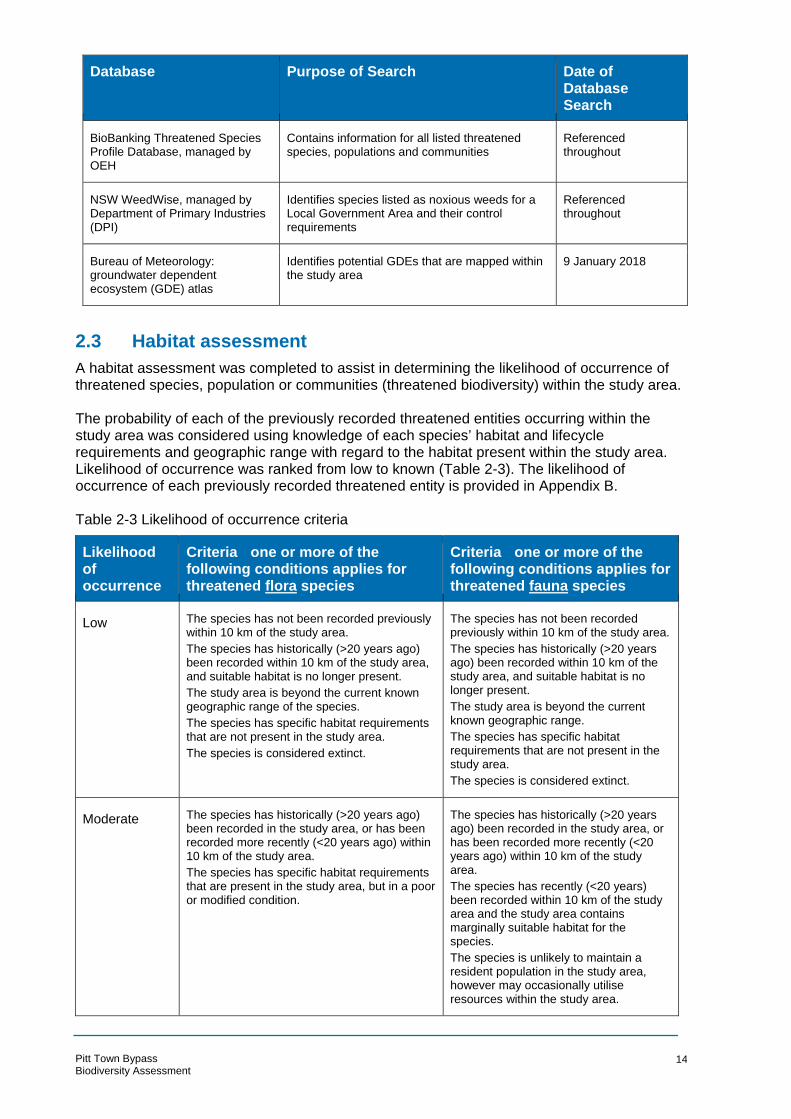
- -
Database Purpose of Search Date of Database Search
BioBanking Threatened Species Profile Database, managed by OEH
Contains information for all listed threatened species, populations and communities
Referenced throughout
NSW WeedWise, managed by Department of Primary Industries (DPI)
Identifies species listed as noxious weeds for a Local Government Area and their control requirements
Referenced throughout
Bureau of Meteorology: groundwater dependent ecosystem (GDE) atlas
Identifies potential GDEs that are mapped within the study area
9 January 2018
2.3 Habitat assessment
A habitat assessment was completed to assist in determining the likelihood of occurrence of threatened species, population or communities (threatened biodiversity) within the study area.
The probability of each of the previously recorded threatened entities occurring within the study area was considered using knowledge of each species’ habitat and lifecycle requirements and geographic range with regard to the habitat present within the study area. Likelihood of occurrence was ranked from low to known (Table 2-3). The likelihood of occurrence of each previously recorded threatened entity is provided in Appendix B.
Table 2-3 Likelihood of occurrence criteria
Likelihood of occurrence
Criteria one or more of the following conditions applies for threatened flora species
Criteria one or more of the following conditions applies for threatened fauna species
Low The species has not been recorded previously within 10 km of the study area.
The species has historically (>20 years ago) been recorded within 10 km of the study area, and suitable habitat is no longer present.
The study area is beyond the current known geographic range of the species.
The species has specific habitat requirements that are not present in the study area.
The species is considered extinct.
The species has not been recorded previously within 10 km of the study area.
The species has historically (>20 years ago) been recorded within 10 km of the study area, and suitable habitat is no longer present.
The study area is beyond the current known geographic range.
The species has specific habitat requirements that are not present in the study area.
The species is considered extinct.
Moderate The species has historically (>20 years ago) been recorded in the study area, or has been recorded more recently (<20 years ago) within 10 km of the study area.
The species has specific habitat requirements that are present in the study area, but in a poor or modified condition.
The species has historically (>20 years ago) been recorded in the study area, or has been recorded more recently (<20 years ago) within 10 km of the study area.
The species has recently (<20 years) been recorded within 10 km of the study area and the study area contains marginally suitable habitat for the species.
The species is unlikely to maintain a resident population in the study area, however may occasionally utilise resources within the study area.
Pitt Town Bypass Biodiversity Assessment
14
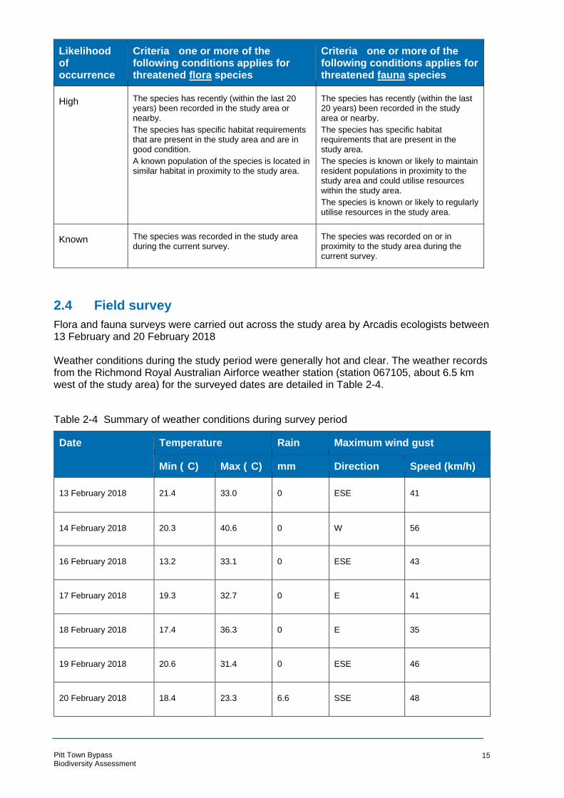
- -
° °
Likelihood of occurrence
Criteria one or more of the following conditions applies for threatened flora species
Criteria one or more of the following conditions applies for threatened fauna species
High The species has recently (within the last 20 years) been recorded in the study area or nearby.
The species has specific habitat requirements that are present in the study area and are in good condition.
A known population of the species is located in similar habitat in proximity to the study area.
The species has recently (within the last 20 years) been recorded in the study area or nearby.
The species has specific habitat requirements that are present in the study area.
The species is known or likely to maintain resident populations in proximity to the study area and could utilise resources within the study area.
The species is known or likely to regularly utilise resources in the study area.
Known The species was recorded in the study area during the current survey.
The species was recorded on or in proximity to the study area during the current survey.
2.4 Field survey
Flora and fauna surveys were carried out across the study area by Arcadis ecologists between 13 February and 20 February 2018 Weather conditions during the study period were generally hot and clear. The weather records from the Richmond Royal Australian Airforce weather station (station 067105, about 6.5 km west of the study area) for the surveyed dates are detailed in Table 2-4.
Table 2-4 Summary of weather conditions during survey period
Date Temperature Rain
mm
Maximum wind gust
Min ( C) Max ( C) Direction Speed (km/h)
13 February 2018 21.4 33.0 0 ESE 41
14 February 2018 20.3 40.6 0 W 56
16 February 2018 13.2 33.1 0 ESE 43
17 February 2018 19.3 32.7 0 E 41
18 February 2018 17.4 36.3 0 E 35
19 February 2018 20.6 31.4 0 ESE 46
20 February 2018 18.4 23.3 6.6 SSE 48
Pitt Town Bypass Biodiversity Assessment
15

Vegetation surveys
Vegetation mapping
The vegetation within the study area was stratified according to the PCTs present. Descriptions of PCTs are provided within the Bionet Vegetation Classification database. PCT equivalence was determined using the floristic composition and landscape descriptions held within this database. Regional vegetation mapping (Tozer et al 2003) was used as a base and then refined based on observations in the field.
Biodiversity Assessment Method plots
Five BAM (OEH 2017) plots were carried out in the study area. the number of required plots was determined in accordance with the minimum number of plots per vegetation zone in the BAM (Table 2-5).
Table 2-5: Minimum number of plots per vegetation zone
Vegetation zone area (ha) Minimum number of plots/transects
<2 1 plot/transect
>2–5 2 plots/transects
>5–20 3 plots /transects
>20–50 4 plots/transects
>50–100 5 plots/transects
>100–250 6 plots/transects
>250–1000 7 plots/transects; more plots may be needed if the condition of the
vegetation is variable across the zone
>1000 8 plots/transects; more plots may be needed if the condition of the
vegetation is variable across the zone
The BAM plot has been designed to assess the integrity of the vegetation being sampled by collecting data across three attribute streams. These include the composition, structure and function of the vegetation patch. This data is collected from a 0.1 hectare quadrat, typically in a 20 -m by 50 m arrangement, with one nested 20 m by 20 quadrat and five nested one metre by one metre quadrat. The typical arrangement of a BAM plot is demonstrated in Figure 2-1 below.
Pitt Town Bypass Biodiversity Assessment
16
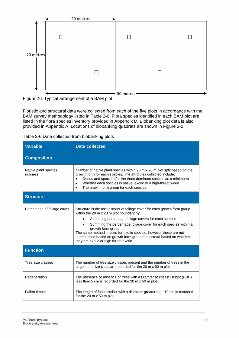
Figure 2-1 Typical arrangement of a BAM plot
Floristic and structural data were collected from each of the five plots in accordance with the BAM survey methodology listed in Table 2-6. Flora species identified in each BAM plot are listed in the flora species inventory provided in Appendix D. Biobanking plot data is also provided in Appendix A. Locations of biobanking quadrats are shown in Figure 2-2.
Table 2-6 Data collected from biobanking plots
Variable
Composition
Data collected
Native plant species richness
Number of native plant species within 20 m x 20 m plot split based on the growth form for each species. The attributes collected include:
• Genus and species (for the three dominant species as a minimum)
• Whether each species is native, exotic or a high-threat weed
• The growth form group for each species.
Structure
Percentage of foliage cover Structure is the assessment of foliage cover for each growth form group within the 20 m x 20 m plot boundary by:
• Attributing percentage foliage covers for each species
• Summing the percentage foliage cover for each species within a growth form group
The same method is used for exotic species; however these are not summarised based on growth form group but instead based on whether they are exotic or high threat exotic.
Function
Tree size classes The number of tree size classes present and the number of trees in the large stem size class are recorded for the 20 m x 50 m plot
Regeneration The presence or absence of trees with a Diamter at Breast Height (DBH) less than 5 cm is recorded for the 20 m x 50 m plot.
Fallen timber The length of fallen timber with a diameter greater than 10 cm is recorded for the 20 m x 50 m plot
Pitt Town Bypass Biodiversity Assessment
17

Variable
Composition
Data collected
Litter cover The per cent cover of leaf litter (dead material) is recorded for five 1 m x 1 m plots that are equally spaced throughout the 20 m x 50 m plot
Hollow bearing trees The number of trees with hollows is recorded for the 20 m x 50 m plot
Vegetation integrity
The integrity (condition) of native vegetation is calculated using the BAM calculator using the attribute data that is collected in each plot (and detailed in Table 2-6 above).
For the purpose of describing the communities within the study area, each PCT was allocated a condition class based on the observations made in the field. High value condition vegetation typically has a diversity of native species in each structural layer and a low proportion of exotic species. Low value condition vegetation may be missing structural layers entirely, or be dominated by exotic species, reducing native diversity. The definition of low condition vegetation has been removed from the BAM but it is typically taken to be vegetation with less than 25 per cent of the benchmark canopy cover value and less than 50 per cent native understorey (as defined in the now superseded BioBanking Assessment Method). Vegetation that falls between these two qualitative descriptions isdescribed as being in moderate condition.
Rapid assessment points
Rapid assessment points were used to collect data on non-native vegetation types or to capture floristic diversity in a PCT where there are indicative species located outside of the BAM plot.
The data collected at the rapid assessment point included the dominant canopy, understorey and ground cover species (where present) to allow verification against the PCT descriptions held within the BioNet Vegetation Classification database. The size of the area assessed during the rapid assessment was the visible area from the survey point (approximately 25 m in all directions) except where this crossed into another mapped PCT.
Table 2-7: Summary of flora survey effort
Technique Methodology Effort
BAM sampling point
The methodology outlined within the BAM was applied to each PCT within the study area. Likewise, the number of plots that were undertaken was based on the survey effort table provided in the BAM. Attribute data regarding the composition, structure and function was collected at each BAM plot location.
Five BAM plots within the three PCTs within the study area (one per 2 hectares of vegetation within each PCT), being around 10 person hours of effort.
Rapid assessment points
Information on the composition and structure of the vegetation present was collected at three rapid assessment points. These were completed to capture indicative PCT species outside of the associate BAM plots.
Three rapid assessment plots totalling about twoperson hours.
Pitt Town Bypass Biodiversity Assessment
18

Targeted flora surveys
Targeted flora surveys were carried in accordance with Threatened Biodiversity Survey and Assessment Guidelines for Developments and Activities (DEC 2004) and with reference to NSW Guide for surveying threatened plants (OEH 2016), which describes the two methods that were used to survey plant species in the study area: random meanders and parallel transects.
Random meanders were performed across the study area to identify areas of potential habitat for more targeted surveys. These meanders targeted threatened flora species considered to have the potential to occur within the study area. Where identified, potential habitat for threatened flora species was then assessed by way of parallel transects on a ten-metre spacing (the intensity that is required in this vegetation by the guide). The locations of previous threatened species records from within the study area (identified during database searches) were revisited to confirm the continued presence of these species. The species that were the focus of the targeted threatened flora species are detailed in Table 2-8, along with the optimal survey period.
Table 2-8 Threatened species targeted during flora surveys
Common Name Scientific Name Optimal survey period (OEH 2017)
Timing of surveys (and adequacy)
Bynoe's Wattle Acacia bynoeana September to March February 2018 (adequate)
Allocasuarina glareicola All year February 2018 (adequate)
Netted Bottle Brush Callistemon linearifolius September to March February 2018 (adequate)
Dillwynia tenuifolia All year February 2018 (adequate)
Epacris purpurascens var. purpurascens
All year February 2018 (adequate)
Juniper-leaved Grevillea
Grevillea juniperina subsp. juniperina
All year February 2018 (adequate)
Micromyrtus minutiflora All year February 2018 (adequate)
Nodding Geebung Persoonia nutans All year February 2018 (adequate)
Spiked Rice-flower Pimelea spicata All year February 2018 (adequate)
Pultenaea parviflora All year February 2018 (adequate)
Pitt Town Bypass Biodiversity Assessment
19

Pitt Town Bypass Biodiversity Assessment
Se rvice Laye r Credits:
ora survey effort Date: 19/09/2018 Path: \\hc-aus-ns-fs-01\ j obs\10014101 \ D-D g i i tal Eng \ DG-G IS\ DGA-Curren t\B_Maps\BAR G\ 10014101_BAR_002_F l oraSurveyE ffort_A4P_v4.mxd
Created by : RMQA by :
!(
!(
!(!(
!(
!(
!(
!(
DAON
RWOTTTIP
DAOI RTA
ATC
WELLESLEY STREET
GLEBE ROAD
SOMERSET STREET
BATHURST STREET
BUCKINGHAM STREET
ELDON STREET
OLD PITT TOWN ROAD
TEERTSEGDRIKCB
Q4
U
A D
RIIR
LAGOON ROAORP
S TA
D
TEERTSLOOPREVIL
TEERTSSIIR
Q1
Q2
R1 Q3
R2
Q5
R3
°!
0
LEGEND ARCADIS AUSTRALIA PACIFIC PTY LTD ABN 76 104 485 289
100
Level 16, 580 George St | Sydney NSW 2000 Study area P: +61 (0) 2 8907 9000 | F: +61 (0) 2 8907 9001 Coordinate System: GDA 1994 MGA Zone 56 Flora parallel survey area Aerial imagery supplied by nearmap (Jan, 2018)
! ( BAM /FBA survey location 1:6,000 at A4
! ( Spot search/Rapid assessment Watercourse Cadastre (LPI, 2017)
Figure 2-2: Fl
m
EC
BOX HILL OAKVILLE
WILBERFORCE
MARAYLYA
CATTAI

Targeted fauna surveys
Targeted fauna surveys were carried out in accordance with the Threatened Biodiversity Survey and Assessment Guidelines for Developments and Activities (DEC 2004). Surveys targeted threatened fauna species with a moderate or high likelihood of occurrence (Appendix B). Nineteen species were targeted for fauna surveys (Table 2-9).
Table 2-9 Threatened species targeted during fauna surveys
Scientific Name
Invertebrates
Common Name Optimal survey period (OEH 2017)
Timing of surveys (and adequacy)
Pommerhelix duralensis Dural Woodland Snail All year February 2018 (adequate)
Meridolum corneovirens Cumberland Plain Land Snail All year February 2018 (adequate)
Birds
Ninnox strenua Powerful Owl All year (ideally May to August)
February 2018 (adequate)
Ninnox corneovirens Barking Owl All year (ideally May to August)
February 2018 (adequate)
Tyto tenebricosa Sooty Owl All year (ideally May to August)
February 2018 (adequate)
Tyto novaehollandiae Masked Owl All year (ideally May to August)
February 2018 (adequate)
Daphoenositta chrysoptera Varied Sittella All year February 2018 (adequate)
Artamus cyanopterus Dusky Woodswallow All year February 2018 (adequate)
Callocephalon fimbriatum Gang-gang Cockatoo All year February 2018 (adequate)
Calyptorhynchus lathami Glossy Black-cockatoo All year February 2018 (adequate)
Mammals
Saccolaimus flaviventris Yellow-bellied Sheathtail-bat October to March February 2018 (adequate)
Scoteanax rueppellii Greater Broad-nosed Bat October to March February 2018 (adequate)
Falsistrellus tasmaniensis Eastern False Pipistrelle October to March February 2018 (adequate)
Miniopterus australis Little Bentwing-bat October to March February 2018 (adequate)
Pitt Town Bypass Biodiversity Assessment
21

Scientific Name Common Name Optimal survey period (OEH 2017)
Timing of surveys (and adequacy)
Miniopterus schreibersii oceanensis
Eastern Bentwing-bat October to March February 2018 (adequate)
Mormopterus norfolkensis Eastern Freetail-bat October to March February 2018 (adequate)
Myotis macropus Southern Myotis October to March February 2018 (adequate)
Pteropus poliocephalus Grey-headed Flying-fox All year February 2018 (adequate)
Petaurus australis Yellow-bellied Glider Spring, summer and autumn
February 2018 (adequate)
Spotlight transects
Spotlighting with a hand-held 100 Watt spotlight was undertaken throughout the study area by two observers on one night, to identify the presence of nocturnal fauna. Any fauna species observed were recorded and a fauna species inventory was compiled (Appendix D). Locations of spotlight transects are shown in Figure 2-3.
Call-playback surveys
One night of call-playback survey was implemented in accordance with the survey guidelines for nocturnal birds prescribed by Threatened Biodiversity Survey and Assessment: Guidelines for Developments and Activities (DEC 2004) and involved an initial period of listening for owl calls upon arrival at a site, followed by 10 minutes of spotlighting of the site to detect the presence of any forest owls or incidental species in the immediate vicinity. Calls of all fourtarget species was then broadcast intermittently for five minutes each (20 minutes total) in a random order. The calls were played from an mp3 audio device and amplified with a megaphone. Another 10 minutes was spent listening period for owl vocalisations. Given the absence of large tree hollows required by forest owls as nesting habitat, the highly fragmented nature of vegetation (eg that could comprise potential foraging habitat) within the study area, and limited habitat for preferred species in the study area, a habitat assessment was carried out to determine the likely occurrence of forest owls, in the absence of further call-playback surveys.
Bird surveys
Diurnal bird surveys were conducted in 20 minute segments over thr ee days by the ecologists, in the morning and afternoon. During these surveys, all birds heard or observed were recorded. All species recorded are listed in Appendix A.
Cumberland Plain Land Snail survey
Targeted surveys for Cumberland Plan Land Snail involved searching preferred microhabitats for the species, including under logs and other debris, amongst leaf and bark accumulations around bases of trees and under grass clumps (OEH 2000). Searches were focused in Cumberland Plain Woodland to the east and west of Cattai Road, in the north of the study area. Preferred microhabitat was generally absent from the southern extent of the study are. The locations of searches are shown in Figure 2-3.
Pitt Town Bypass Biodiversity Assessment
22
Targeted microbat survey
Two electronic detectors which record the ultrasonic echolocation calls of bats (Anabat Express – Titley Electronics) were deployed for five nights (16 - 20 February 2018) to identify as many microbat species in the study area as possible. The detectors were set to record between sunset and sunrise and placed in the Shale Gravel Transition Forest in the northern extent of the study area and the Grey Box Open Woodland immediately south of Old Pitt Town Road. The location of each stationary Anabat Express is shown in Figure 2-3. The study area was also searched for structures which could be used as potential roosting sites for microbats. This included existing culverts which were investigated to determine the availability of roost habitat. Bat call analysis was completed by Arcadis ecologist Carl Corden, with the presentation of data considering the guidelines of the Australasian Bat Society. Bat calls of New South Wales Sydney Basin region (Pennay et al., 2004) was used as a reference for bat call identification.
Opportunistic fauna observations
The study area was traversed on foot over four days and all species and evidence of fauna presence observed was recorded. An inventory of fauna species recorded in the study area was compiled (Appendix A). Opportunistic fauna surveys involved:
• Direct visual observations of animal activity
• Aural recognition of bird and frog calls
• Indirect evidence of fauna (such as scats, nests, burrows, hollows, tracks, scratches and diggings).
Pitt Town Bypass Biodiversity Assessment
23
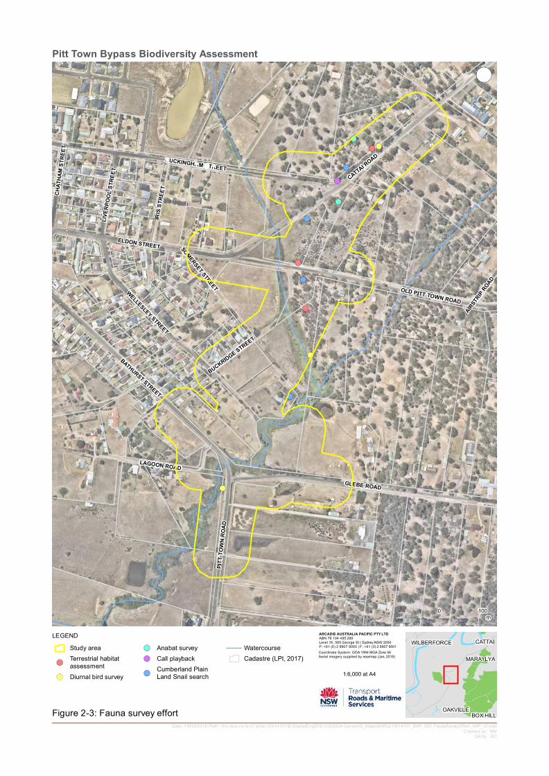
Se rvice Laye r Credits:
Pitt Town Bypass Biodiversity Assessment
Date: 19/09/2018 Path: \\hc-aus-ns-fs-01\ j obs\10014101 \ D-D g i i tal Eng \ DG-G IS\ DGA-Curren t\B_Maps\BAR G\ 10014101_BAR_003_FaunaSurveyE ffort_A4P_v3.mxdCreated by : RM
QA by :
!( !(!(
!(
!(
!(
!(
!(
!(
!(
!(
!(
!(
DAON
RWOTTTIP
DAOI RTA
ATC
WELLESLEY STREET
GLEBE ROAD
SOMERSET STREET
BATHURST STREET
OLD PITT TOWN ROAD
A D
BUCKINGHAM STREET
SEGDRIK
ORPRITSRAI
C
ELDON STREET
TEERT
UB
TEERTSMAHTAHC
TEERTSLOOPREVIL
TEERTSSIIR
LAGOON ROAD
°!
0 m
LEGEND ARCADIS AUSTRALIA PACIFIC PTY LTD ABN 76 104 485 289
100
Level 16, 580 George St | Sydney NSW 2000 Study area !( Anabat survey Watercourse P: +61 (0) 2 8907 9000 | F: +61 (0) 2 8907 9001
Coordinate System: GDA 1994 MGA Zone 56 Terrestrial habitat !( Call playback Cadastre (LPI, 2017) Aerial imagery supplied by nearmap (Jan, 2018)
! ( assessment Cumberland Plain! ( 1:6,000 at A4
( ! Diurnal bird survey Land Snail search
Figure 2-3: Fauna survey effort EC
BOX HILL OAKVILLE
WILBERFORCE
MARAYLYA
CATTAI

Habitat Assessment
Terrestrial fauna habitat assessment
A fauna habitat assessment was carried out in the study area. The presence of notable habitat features such as hollow-bearing trees, aquatic habitats, rocky features or patches of intact native vegetation were recorded, and their value to locally occurring threatened fauna species was assessed.
Aquatic habitat assessment
Aquatic surveys undertaken as part of this investigation comprised visual inspections of waterways located within the study area to classify the type of fish habitat they provide. The focus of the field investigation was to establish the potential presence of habitat with the aim of completing follow-up targeted surveys for threatened fish if required. Table 2-10 outlines the habitat types and sensitivity classes used by NSW DPI (DPI 2015) for assessing potential impacts of certain activities and developments on key fish habitat types. Table 2-10: Key fish habitat types and descriptions (adapted from the DPI 2015 guidelines)
Habitat type Description
TYPE 1 – Posidonia australis (strapweed)
Highly sensitive Zostera, Heterozostera, Halophila and Ruppia species of seagrass beds >5m2 in area key fish habitat
Coastal saltmarsh >5 m2 in area
Coral communities
Coastal lakes and lagoons that have a natural opening and closing regime (eg are not
permanently open or artificially opened or are subject to one off unauthorised openings)
Marine park, an aquatic reserve or intertidal protected area
State Environmental Planning Policy (SEPP) 14 coastal wetlands, wetlands recognised under
international agreements (eg Ramsar, Japan-Australian Migratory Bird Agreement (JAMBA),
China-Australia Migratory Bird Agreement (CAMBA), Republic of Korea-Australia Migratory
Bird Agreement (ROKAMBA) wetlands), wetlands listed in the Directory of Important
Wetlands of Australia2
Freshwater habitats that contain in-stream gravel beds, rocks greater than 500 mm in two
dimensions, snags greater than 300 mm in diameter or 3 m in length, or native aquatic plants
Any known or expected protected or threatened species habitat or area of declared ‘critical
habitat’ under the Fisheries Management Act 1994 (FM Act)
TYPE 2 – Zostera, Heterozostera, Halophila and Ruppia species of seagrass beds <5m2 in area
Moderately Mangroves sensitive key
fish habitat Coastal saltmarsh <5 m2 in area
Marine macroalgae such as Ecklonia and Sargassum species
Estuarine and marine rocky reefs
Coastal lakes and lagoons that are permanently open or subject to artificial opening via
agreed management arrangements (eg managed in line with an entrance management plan)
Aquatic habitat within 100 m of a marine park, an aquatic reserve or intertidal protected area
Stable intertidal sand/mud flats, coastal and estuarine sandy beaches with large populations
of in-fauna
Freshwater habitats and brackish wetlands, lakes and lagoons other than those defined in
TYPE 1
Weir pools and dams up to full supply level where the weir or dam is across a natural
waterway
Pitt Town Bypass Biodiversity Assessment
25
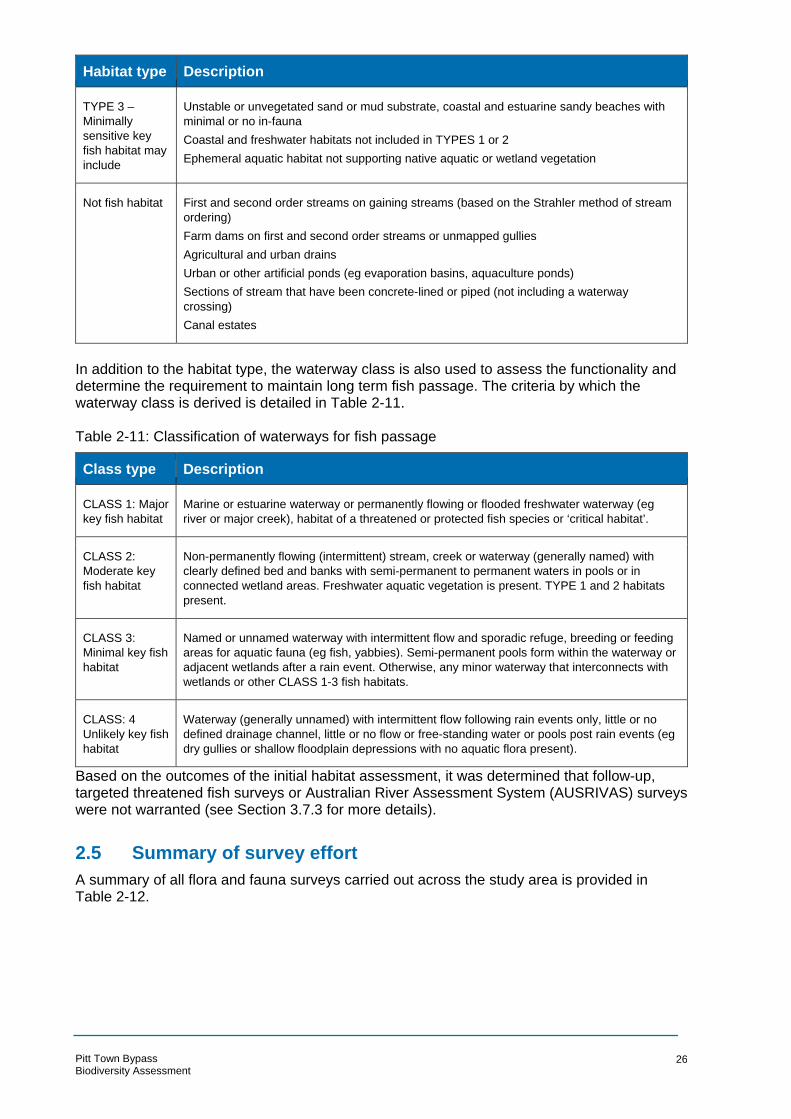
Habitat type Description
TYPE 3 –
Minimally
sensitive key
fish habitat may
include
Unstable or unvegetated sand or mud substrate, coastal and estuarine sandy beaches with
minimal or no in-fauna
Coastal and freshwater habitats not included in TYPES 1 or 2
Ephemeral aquatic habitat not supporting native aquatic or wetland vegetation
Not fish habitat First and second order streams on gaining streams (based on the Strahler method of stream
ordering)
Farm dams on first and second order streams or unmapped gullies
Agricultural and urban drains
Urban or other artificial ponds (eg evaporation basins, aquaculture ponds)
Sections of stream that have been concrete-lined or piped (not including a waterway
crossing)
Canal estates
In addition to the habitat type, the waterway class is also used to assess the functionality and determine the requirement to maintain long term fish passage. The criteria by which the waterway class is derived is detailed in Table 2-11.
Table 2-11: Classification of waterways for fish passage
Class type Description
CLASS 1: Major
key fish habitat
Marine or estuarine waterway or permanently flowing or flooded freshwater waterway (eg
river or major creek), habitat of a threatened or protected fish species or ‘critical habitat’.
CLASS 2:
Moderate key
fish habitat
Non-permanently flowing (intermittent) stream, creek or waterway (generally named) with
clearly defined bed and banks with semi-permanent to permanent waters in pools or in
connected wetland areas. Freshwater aquatic vegetation is present. TYPE 1 and 2 habitats
present.
CLASS 3:
Minimal key fish
habitat
Named or unnamed waterway with intermittent flow and sporadic refuge, breeding or feeding
areas for aquatic fauna (eg fish, yabbies). Semi-permanent pools form within the waterway or
adjacent wetlands after a rain event. Otherwise, any minor waterway that interconnects with
wetlands or other CLASS 1-3 fish habitats.
CLASS: 4
Unlikely key fish
habitat
Waterway (generally unnamed) with intermittent flow following rain events only, little or no
defined drainage channel, little or no flow or free-standing water or pools post rain events (eg
dry gullies or shallow floodplain depressions with no aquatic flora present).
Based on the outcomes of the initial habitat assessment, it was determined that follow-up, targeted threatened fish surveys or Australian River Assessment System (AUSRIVAS) surveys were not warranted (see Section 3.7.3 for more details).
2.5 Summary of survey effort
A summary of all flora and fauna surveys carried out across the study area is provided in Table 2-12.
Pitt Town Bypass Biodiversity Assessment
26
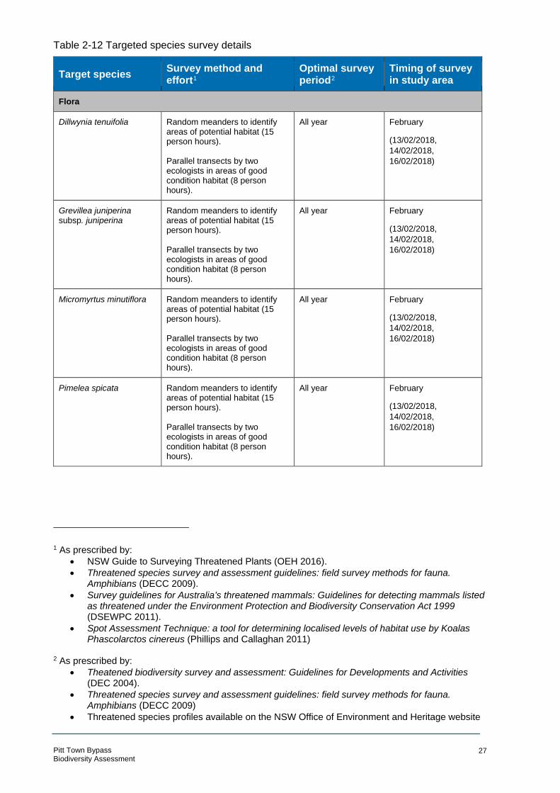
Table 2-12 Targeted species survey details
Target species
Flora
Survey method and effort1
Optimal survey period2
Timing of survey in study area
Dillwynia tenuifolia Random meanders to identify areas of potential habitat (15 person hours). Parallel transects by two ecologists in areas of good condition habitat (8 person hours).
All year February
(13/02/2018,
14/02/2018,
16/02/2018)
Grevillea juniperina subsp. juniperina
Random meanders to identify areas of potential habitat (15 person hours). Parallel transects by two ecologists in areas of good condition habitat (8 person hours).
All year February
(13/02/2018,
14/02/2018,
16/02/2018)
Micromyrtus minutiflora Random meanders to identify areas of potential habitat (15 person hours). Parallel transects by two ecologists in areas of good condition habitat (8 person hours).
All year February
(13/02/2018,
14/02/2018,
16/02/2018)
Pimelea spicata Random meanders to identify areas of potential habitat (15 person hours). Parallel transects by two ecologists in areas of good condition habitat (8 person hours).
All year February
(13/02/2018,
14/02/2018,
16/02/2018)
1 As prescribed by:
• NSW Guide to Surveying Threatened Plants (OEH 2 016).
• Threatened species survey and assessment guidelines: field survey methods for fauna. Amphibians (DECC 2009).
• Survey guidelines for Australia’s threatened mammals: Guidelines for detecting mammals listed as threatened under the Environment Protection and Biodiversity Conservation Act 1999 (DSEWPC 2 011).
• Spot Assessment Technique: a tool for det ermining localised levels of habitat use by Koalas Phascolarctos cinereus (Phillips and Callaghan 2011)
2 As prescribed by:
• Theatened biodiversity survey and assessment: Guidelines for D evelopments and Activities (DEC 2004).
• Threatened species survey and assessment guidelines: field survey methods for fauna. Amphibians (DECC 2009)
• Threatened species profiles available on the NSW O ffice of Environment and Heritage website
Pitt Town Bypass Biodiversity Assessment
27

Target species Survey method and effort1
Optimal survey period2
Timing of survey in study area
Pultenaea parviflora Random meanders to identify areas of potential habitat (15 person hours).
Parallel transects by two ecologists in areas of good condition habitat (8 person hours).
All year February
(13/02/2018, 14/02/2018, 16/02/2018)
Fauna
Nocturnal bird species:
Powerful Owl (Ninox strenua)
Masked Owl (Tyto novaehollandiae)
Sooty Owl (Tyto tenebricosa)
Call playback. One location over
one night. Calls of each target
species were played
intermittently for 5 minutes,
followed by a 10 minute listening
period
All year (ideally May
to August)
February
(20/02/18)
Walking spotlight transects. Two
observers walked five transects
over one night.
Diurnal bird species:
Varied Sittella (Daphoenositta chrysoptera)
Dusky Woodswallow (Artamus cyanopterus cyanopterus)
20 minute bird census, conducted during mornings and late afternoons/dusk
Opportunistic observations throughout entire survey period
All year February
(Morning of
14/02/2018 and
16/02/2018; dusk of
20/02/2018)
Gang-gang Cockatoo (Callocephalon fimbriatum)
Glossy Black-Cockatoo (Calyptorhynchus lathami)
Invertebrates
Dural Woodland Snail (Pommerhelix duralensis)
Cumberland Plain Land (Snail Meridolum corneovirens)
Targeted searches in areas of potential habitat
All year February
(14/02/2018 and
16/02/2018)
Pitt Town Bypass Biodiversity Assessment
28

Target species Survey method and effort1
Optimal survey period2
Timing of survey in study area
Microbats
Yellow-bellied Sheathtail-bat (Saccolaimus flaviventris)
Greater Broad-nosed Bat (Scoteanax rueppelli)
Eastern False Pipistrelle (Falsistrellus tasmaniensis)
Little Bentwing-bat (Miniopterus australis)
Eastern Bentwing-bat (Miniopterus schreibersii oceanensis)
Eastern Freetail-bat (Mormopterus norfolkensis)
Southern Myotis (Myotis macropus)
Stationery placements of two electronic detectors to record the ultrasonic echolocation calls of bats (Anabat) over a total of five consecutive nights
October to March February
(16/02/2018-
20/02/2018)
Grey-headed Flying-fox (Pteropus poliocephalus)
Walking spotlight transects. Two
observers walked five transects
over one night.
All year February
(20/02/2018)
Yellow-bellied Glider (Petaurus australis)
Walking spotlight transects. Two
observers walked five transects
over one night.
Spring and summer February
(20/02/2018)
2.6 Limitations
The current field survey was carried out over four days in February 2018. This assessment is based on the condition of the study area at the time of field investigations and the information provided on the project design and constructability at the date of publication of this document.
The duration and seasonal timing of the current field investigation means that the full spectrum of flora and fauna species likely to occur within the study area may not be fully quantified or described in this report. Some plant species that occur in the local area, such as cryptic orchid species, are annuals and do not have vegetative material for much of the year. Other plant species (such as Pimelea spicata) are perennial but are inconspicuous or difficult to identify unless flowering. Several reference populations of Pimelea spicata have been visited throughout spring, summer and autumn of 2017/2018 to verify flowering of the species. The closest of these to the study area are the Lizard Log carpark and another location in Western Sydney Parklands (about 30 kilometres south east of the study area). Peak flowering was estimated to be in January 2018, however flowers were still present on some plants when
Pitt Town Bypass Biodiversity Assessment
29

visited in early April 2018. This would suggest that if present, Pimelea spicata would likely have been flowering in the study area during the targeted surveys conducted in February.
Similarly, some fauna species that have been recorded in the local area visit on a seasonal or migratory basis, and may be absent from the locality for much for the year. Fauna behaviours may have also affected detectability; species that are easily disturbed or cryptic species may not have been detected during surveys. It is possible that a number of flora and fauna species occurring in the study area were not detected during the current survey due to the above factors.
In accordance with the Precautionary Principle, it has been assumed that threatened flora and fauna species which are likely to occur in the study area (based on the presence of suitable habitat and recent records) inhabit the entire extent of potential habitat for that species within the study area. Assessments of Significance have been conducted on this basis.
Pitt Town Bypass Biodiversity Assessment
30

3 Existing environment
3.1 Environmental Context
Landscape Context
The study area is located in the Sydney Basin bioregion, which lies on the central east coast of NSW and extends from Nelson Bay in the north to almost as far south as Batemans Bay. Within the Sydney Basin bioregion, the study area is situated within the Cumberland subregion, a broad shale basin in western Sydney.
The study area lies almost completely within Hawkesbury – Nepean Terrace Gravels Mitchell landscape, with the very southern edge of the study area extending into the Hawkesbury – Nepean Channels and Floodplains.
The landscape of the study area is largely made up of rural residential development with patches of native vegetation, many of which have been grazed by stock to varying degrees. Road reserves and front gardens of properties contain a mix of native and exotic vegetation, often with an exotic groundcover. A waterway which traverses through the study area is dense in exotic vegetation.
Soils and Geology
Two soil landscapes are mapped across the study area (Bannerman and Hazelton 1990). Freemans Reach soil landscape covers the majority of the study area while the very northern and southern extent of the site is located on the Berkshire Park soil landscape.
Freemans Reach soil landscape is an active floodplain of the Nepean River on alluvium derived from Narrabeen Group, Hawkesbury Sandstone and Wianamatta Group materials. It occurs discontinuously on either bank of the Nepean and Hawkesbury Rivers and is mainly level with minor (<10 m) relief. Soils are deep brown sands and loams, apedal to moderately structured, usually friable (Bannerman and Hazelton 1990).
Berkshire Park soil landscape is associated with gently undulating low rises on the Tertiary terraces of the Hawkesbury/Nepean River system. The soils of this landscape are the result of three depositional phases of Tertiary alluvial/colluvial origin. St Marys formation is overlain by Rickabys Creek gravel formation which is then topped by the Londonberry Clay formation. These formations are derived from sandstone and clay and have eroded on the surface resulting in the exposure of all three in different locations (Bannerman and Hazelton 1990).
Hydrology
The study area is located within the Hawkesbury-Nepean Catchment Management Area (CMA). Hortons Creek is a second order ephemeral waterway which traverses the study area and flows south to south-west into the wetlands within Pitt Town Nature Reserve and then into the Hawkesbury River. There are two existing culverts along this waterway, at the junction of Pitt Town Road and Bathurst Street in the south of the study area and at Cattai Road in the north of the study area. There is also an existing road crossing at Old Pitt Town Road which potentially relies on aboveground flooding.
There are three private dams in the south-east portion of the study area, along Glebe Road and Pitt Town Road. Some of the dams are stabilised by exotic grasses and forbs while vegetation is entirely absent from others.
Pitt Town Bypass Biodiversity Assessment
31

Land Use
The study area is located in a highly modified landscape, characterised by rural residential development. Rural dwellings are scattered across the study area with many attached to small horse paddocks or patches of vegetation. Much of the existing vegetation has been heavily grazed, particularly by horses. There are also several privately-owned dams in the southern extent of the study area and Hortons Creek which runs through the site.
The township of Pitt Town is directly west of the study area and several roads leading to the town transect the site. A public open space is located in the north west of the study area and is dominated by exotic grasses, with trees mostly absent.
3.2 Flora survey results
Plant community types
The vegetation within the study area is predominantly comprised of modified grasslands with some patches of woodland vegetation. Three PCTs and three non-native vegetation communities were recorded within the study area. The plant community types have been differentiated based on the floristic composition, structure, landscape position associates soils and other pertinent characteristic. Regional scale vegetation mapping was undertaken for the Cumberland Plain by Tozer et. al. in 2010. The ground truthed vegetation mapping that has been compiled during this assessment is broadly consistent with that of the Tozer (2003) mapping, however the PCT boundaries have been refined based on field observations. In summary, the following three PCTs and non-PCT vegetation communities were recorded in the study area and are shown in Figure 3-1.
• Broad-leaved Ironbark – Grey Box – Melaleuca decora grassy open forest on clay/gravel soils of the Cumberland Plain, Sydney Basin Bioregion
• Grey Box – Forest Red Gum grassy woodland on flats of the Cumberland Plain, Sydney Basin Bioregion
• Phragmites australis and Typha orientalis coastal freshwater wetlands of the Sydney Basin Bioregion
• Mixed Native and exotic vegetation (non-PCT)
• Exotic Grassland (non-PCT)
• Juncus usitatus Rushland (non-PCT) Table 3-1 Vegetation Communities
Vegetation Community Condition class Threatened ecological community?
Area (ha) in study area
Broad-leaved Ironbark – Grey Box – Melaleuca decora grassy open forest on clay/gravel soils of the Cumberland Plain, Sydney Basin Bioregion (PCT 724)
Moderate (low) Yes – Shale Gravel Transition Forest in the Sydney Basin Bioregion (BC Act)
1.78
Grey Box – Forest Red Gum grassy woodland on flats of the Cumberland Plain, Sydney Basin Bioregion (PCT 849)
Moderate Yes – Cumberland Plain Woodland in the Sydney Basin Bioregion (BC Act), Cumberland Plain Shale Woodlands and Shale-Gravel Transition Forest (EPBC Act)
2.95
Phragmites australis and Typha orientalis coastal freshwater wetlands of the Sydney Basin Bioregion (PCT 1071)
Moderate (low) Yes – Freshwater Wetlands on Coastal Floodplains of the New South Wales North Coast, Sydney Basin and
1.46
Pitt Town Bypass Biodiversity Assessment
32

Vegetation Community Condition class Threatened ecological community?
Area (ha) in study area
South-East Corner Bioregions (BC Act)
Mixed Native and exotic vegetation (non-PCT)
Low No 1.55
Exotic Grassland (non-PCT) Low No 18.43
Juncus usitatus Rushland (non-PCT) Low No 0.05
Total 26.22
Pitt Town Bypass Biodiversity Assessment
33
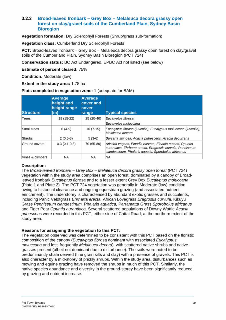
Broad-leaved Ironbark – Grey Box – Melaleuca decora grassy open forest on clay/gravel soils of the Cumberland Plain, Sydney Basin Bioregion
Vegetation formation: Dry Sclerophyll Forests (Shrub/grass sub-formation)
Vegetation class: Cumberland Dry Sclerophyll Forests
PCT: Broad-leaved Ironbark – Grey Box – Melaleuca decora grassy open forest on clay/gravel soils of the Cumberland Plain, Sydney Basin Bioregion (PCT 724)
Conservation status: BC Act Endangered, EPBC Act not listed (see below)
Estimate of percent cleared: 75%
Condition: Moderate (low)
Extent in the study area: 1.78 ha
Plots completed in vegetation zone: 1 (adequate for BAM)
Structure
Average height and height range (m)
Average cover and cover range Typical species
Trees 18 (15-22) 25 (20-40) Eucalyptus fibrosa Eucalyptus moluccana
Small trees 6 (4-9) 10 (7-15) Eucalyptus fibrosa (juvenile), Eucalyptus moluccana (juvenile), Melaleuca decora
Shrubs 2 (0.5-3) 5 (3-6) Bursaria spinosa, Acacia pubescens, Acacia decurrens Ground covers 0.3 (0.1-0.8) 70 (65-80) Aristida vagans, Einadia hastata, Einadia nutans, Opuntia
aurantiaca, Ehrharta erecta, Eragrostis curvula, Pennisetum clandestinum, Phalaris aquatic, Sporobolus africanus
Vines & climbers NA NA NA
Description: The Broad-leaved Ironbark – Grey Box – Melaleuca decora grassy open forest (PCT 724) vegetation within the study area comprises an open forest, dominated by a canopy of Broad-leaved Ironbark Eucalyptus fibrosa and to a lesser extent Grey Box Eucalyptus moluccana (Plate 1 and Plate 2). The PCT 724 vegetation was generally in Moderate (low) condition owing to historical clearance and ongoing equestrian grazing (and associated nutrient enrichment). The understorey is characterised by abundant exotic grasses and succulents, including Panic Veldtgrass Ehrharta erecta, African Lovegrass Eragrostis curvula, Kikuyu Grass Pennisetum clandestinum, Phalaris aquatica, Parramatta Grass Sporobolus africanus and Tiger Pear Opuntia aurantiaca. Several scattered populations of Downy Wattle Acacia pubescens were recorded in this PCT, either side of Cattai Road, at the northern extent of the study area.
Reasons for assigning the vegetation to this PCT: The vegetation observed was determined to be consistent with this PCT based on the floristic composition of the canopy (Eucalyptus fibrosa dominant with associated Eucalyptus moluccana and less frequently Melaleuca decora), with scattered native shrubs and native grasses present (albeit not dominant due to disturbance). The soils were noted to be predominantly shale derived (fine grain silts and clay) with a presence of gravels. This PCT is also character by a mid-storey of prickly shrubs. Within the study area, disturbances such as mowing and equine grazing have removed the shrubs in much of this PCT. Similarly, the native species abundance and diversity in the ground-storey have been significantly reduced by grazing and nutrient increase.
Pitt Town Bypass Biodiversity Assessment
34
Plate 1: PCT 724 Condition: Moderate (low) Plate 2: PCT 724 Condition: Moderate (low)
Pitt Town Bypass Biodiversity Assessment
35

Grey Box – Forest Red Gum grassy woodland on flats of the Cumberland Plain, Sydney Basin Bioregion
Vegetation formation: Grassy Woodlands
Vegetation class: Coastal Valley Grassy Woodlands
PCT: Grey Box – Forest Red Gum grassy woodland on flats of the Cumberland Plain, Sydney Basin Bioregion (PCT 849)
Conservation status: Critically Endangered (BC Act), Critically Endangered (EPBC Act).
Estimate of percent cleared: 93%
Condition: Moderate (open) and Moderate (shrubby)
Extent in the study area: 2.95 ha
Plots completed in vegetation zone: 2 (adequate for BAM)
Structure
Average height and height range (m)
Average cover and cover range Typical species
Trees 16 (13-18) 40 (35-50) Eucalyptus moluccana, Eucalyptus eugenioides Small trees 5 (4-8) 12 (9-15) Eucalyptus moluccana (juveniles), Melia azedarach Shrubs 2 (0.5-3) 18(8-20) Bursaria spinosa, Daviesia ulicifolia, Dillwynia tenuifolia
Ground covers 0.3 (0.1-0.8) 80 (70-90) Cheilanthes sieberi subsp. sieberi, Einadia hastate, Commelina cyanea, Desmodium varians, Eragrostis curvula, Aristida vagans, Entolasia stricta, Eragrostis leptostachya, Microlaena stipoides var. stipoides, Rytidosperma fulvum, Sporobolus creber, Opercularia diphylla
Vines & climbers 1 (0.5-2) 2 (1-5) Hardenbergia violacea, Glycine tabacina, Araujia sericifera
Description: Grey Box – Forest Red Gum grassy woodland (PCT 849) is characterised by a canopy of Eucalyptus moluccana with associated Forest Red Gum Eucalyptus tereticornis, Narrow-leaved Ironbark Eucalyptus crebra and Thin-leaved Stringybark Eucalyptus eugenioides.
The Moderate (open) condition variant (Plate 3) is subject to ongoing mowing and is characterised by an understorey of native and exotic grasses, including Paddock Lovegrass Eragrostis leptostachya, Weeping Grass Microlaena stipoides var. stipoides, Wallaby Grass Rytidosperma fulvum, Slender Rat's Tail Grass Sporobolus creber, and Slender Rat's Tail Grass Sporobolus creber. Scattered shrubs are present but are typically regrowth since the last mowing event. Where obstacles (such as fallen timber) have prevented mowing, these shrubs are typically taller. Species include Native Blackthorn Bursaria spinosa, Dillwynia tenuifolia and Gorse Bitter Pea Daviesia ulicifolia.
The Moderate (shrubby) condition variant (Plate 4) is characterised by a similar floristic assemblage but is not subject to ongoing mowing. The shrub stratum in this variant is comprised of dense regenerating Eucalyptus moluccana along with Bursaria spinosa, Sickle Wattle Acacia falcata and Parramatta Wattle Acacia parramattensis. The groundcover in this variant is comprised predominantly of African Lovegrass Eragrostis curvula with associated native grasses.
Reasons for assigning the vegetation to this PCT: The vegetation observed is consistent with PCT 849, based on the floristic composition of the vegetation present. Typically, this community is comprised of Eucalyptus moluccana and Eucalyptus tereticornis, with a mix of other ironbarks and stringybarks. This was the case within the study area. Similarly the mid-storey is comprised of Bursaria spinosa which, where
Pitt Town Bypass Biodiversity Assessment
36

present, was the dominant shrub in the PCT 849 vegetation. Finally, the ground-storey was comprised of native grasses, herbs and graminoids which are characteristic of the PCT.
Pitt Town Bypass Biodiversity Assessment
37
Plate 3: PCT 849, Condition: Moderate Plate 4: PCT 849, Condition: Moderate (open) (shrubby)
Phragmites australis and Typha orientalis coastal freshwater wetlands of the Sydney Basin Bioregion
Vegetation formation: Freshwater Wetlands
Vegetation class: Coastal Freshwater lagoons
PCT: Phragmites australis and Typha orientalis coastal freshwater wetlands of the Sydney Basin Bioregion (PCT 1071)
Conservation status: Endangered (BC Act).
Estimate of percent cleared: 75%
Condition: Moderate
Extent in the study area: 1.46 ha
Plots completed in vegetation zone: 2 (adequate for BAM)
Structure
Average height and height range (m)
Average cover and cover range Typical species
Trees 8 (6-12) 5 (3-6) Erythrina crista-galli, Salix sp, Populus nigra
Small trees 2.5 (1.5-4) 8 (6-9) Ligustrum lucidum, Ligustrum sinense Shrubs NA NA NA
Ground covers 2 (1.8-2.5) 90 (85-100) Phragmites australis, Typha orientalis, Persicaria decipiens, Rubus fruticosus complex, Cestrum parqui, Solanum mauritianum
Vines & climbers 1 (0.5-1.5) 3 (2-4) Lonicera japonica, Asparagus asparagoides
Description: Phragmites australis and Typha orientalis coastal freshwater wetlands occur through the centre of the study area, along an un-named drainage channel3 (referred to as Hortons Creek) that flows north to south, towards Pitt Town Lagoon. This community occurs in a single condition variant, however there are differences in the floristic composition within the study area. Some patches are dominated by Broad-leaved Cumbungi Typha orientalis (Plate 5) and some by Common Reed Phragmites australis (Plate 6). Despite this, the floristic variants areconsidered to be in a single condition class since they are similar when compared to the community benchmarks (OEH 2018b).
This vegetation is in moderate condition owing to a relatively high proportion of exotic species, including Fleabane Conyza bonariensis, Japanese Honeysuckle Lonicera japonica, Cockspur Coral Tree Erythrina crista-galli, Large-leaved Privet Ligustrum lucidum, Small-leaved Privet Ligustrum sinense, Blackberry complex Rubus fruticosus, Green Cestrum Cestrum parqui and Wild Tobacco Bush Solanum mauritianum. There was little in the way of native species diversity, which is likely due to the lack of habitat diversity. In a typical freshwater wetland community, differences in water depth and soil type would provide different habitat types that suit different species (including submerged, floating and emergent macrophytes). The consistent waterlogged nature of this area with no areas of deep water, means that weed infested monocultures of either Typha orientalis and Phragmites australis have been able to establish.
Reasons for assigning the vegetation to this PCT:
3 This waterway does not have a name in the LPI topographic data however it is locally referred to as Hortons Creek. For ease of reference, it will continue to be referred to as Hortons Creek throughout this document.
Pitt Town Bypass Biodiversity Assessment
38

The vegetation observed is consistent with this PCT based on the landscape position and floristic structure. Occurring in a low-lying drainage channel, the soils are permanently waterlogged and intermittently inundated. The community profile describes this PCT as occurring in man-made water bodies, drainage lines and depressions across a wide variety of environments and being characterised by Typha orientalis, Phragmites australis and Ludwigia peploides subsp. montevidensis. All of these are present in this PCT in the study area.
Plate 5: PCT 1071 Condition Moderate. Plate 6: PCT 1071 Condition Moderate.
Typha dominant. Phragmites dominant.
Pitt Town Bypass Biodiversity Assessment
39

Exotic grassland (non-PCT)
The m ajority of the properties and roadside verges across the study area consist of exotic grassland with a small number of scattered and isolated native and exotic trees. Typical species in exotic grassland across the study area include; African Lovegrass Eragrostis curvula, Paspalum Paspalum dilatatum, Rhodes Grass Chloris gayana, Whisky Grass Andropogon virginicus, Wild Oats Avena fatua, Common Vetch Vicia sativa, Narrow-leafed Carpet Grass Axonopus fissifolius, Prairie Grass Bromus catharticus, , Barnyard Grass Echinochloa crusgalli, Panic Veldtgrass Ehrharta erecta, Elastic Grass Eragrostis tenuifolia, Red-flowered Mallow Modiola caroliniana, Yorkshire Fog Holcus lanatus, Perennial Ryegrass Lolium perenne, Vasey Grass Paspalum urvillei, Kikuyu Grass Pennisetum clandestinum, Paddy's Lucerne Sida rhombifolia and Phalaris Phalaris aquatica.
Mixed native and exotic vegetation (non-PCT)
The mixed native and exotic vegetation typically occurs in landscaped and roadside areas where exotic shrubs and trees are present over a largely exotic understorey. Species present include Castor Oil Plant Ricinus communis, Senna pendula var. glabrata, Cockspur Coral Tree Erythrina crista-galli, White Clover Trifolium repens, Common Vetch Vicia sativa, Red-flowered Mallow Modiola caroliniana, Large-leaved Privet Ligustrum lucidum, Small-leaved Privet Ligustrum sinense, Lamb's Tongues Plantago lanceolata, Fennel Foeniculum vulgare, Moth Vine Araujia sericifera, Asparagus Fern Asparagus aethiopicus, Bridal Creeper Asparagus asparagoides, Scarlet Pimpernel Anagallis arvensis, Blackberry complex Rubus fruticosus, Lombardy Poplar Populus nigra, Willow Salix sp., Green Cestrum Cestrum parqui, African Boxthorn Lycium ferocissimum, Wild Tobacco Bush Solanum mauritianum, Black-berry Nightshade Solanum nigrum and Purpletop Verbena bonariensis.
Juncus usitatus Rushland (non-PCT)
This community occurred in a damp depression in a cleared portion of exotic grassland, to the east of Hortons Creek. The species composition is largely consistent with the exotic grassland, but with an abundance of Juncus usitatus.
Pitt Town Bypass Biodiversity Assessment
40

N
A HTAHC
SO
Pitt Town Bypass Biodiversity Assessmen
TE
ERT BUCKS I
M TE ER T
S T L EO E
OP RT SR E S V II IR L
ELDO N ST REET
W EL LE
SL EY STR EET
Se rvice Laye r Credits:
t EPBC Act EEC equivalence !Cumberland Plain Shale °
Woodlands and Shale-GravelTransition Forest
BC Act EEC equivalence
DAON
RWOTTTIP
DAOI RTA
ATC
GLEBE ROAD
MERSET STREET
BATHURST STREET
OLD PITT TOWN ROAD
DAORPRITSI RA
GHAM STREET
TEERTSEGDRIKCB U
LAGOON ROAD
Shale Gravel Transition Forest inthe Sydney Basin Bioregion Cumberland Plain Woodland in the Sydney Basin Bioregion Freshwater Wetlands on CoastalFloodplains of the New SouthWales North Coast, Sydney Basinand South East Corner Bioregions
Vegetation CommunityBroad-leaved Ironbark - Grey Box -Melaleuca decora grassy open forest on clay/gravel soils of the Cumberland Plain, Sydney BasinBioregion (PCT 724)Grey Box - Forest Red Gum grassy woodland on flats of the Cumberland Plain, Sydney BasinBioregion (PCT 849)Phragmites australis and Typha orientalis coastal freshwater wetlands of the Sydney BasinBioregion (PCT 1071)Mixed native and exotic vegetation (non-PCT)Exotic Grassland (non-PCT)Juncus usitatus Rushland (non-PCT)
0 100 m
LEGEND ARCADIS AUSTRALIA PACIFIC PTY LTD ABN 76 104 485 289Level 16, 580 George St | Sydney NSW 2000
Study area P: +61 (0) 2 8907 9000 | F: +61 (0) 2 8907 9001 Coordinate System: GDA 1994 MGA Zone 56
Watercourse Aerial imagery supplied by nearmap (Jan, 2018)
Waterbody 1:6,000 at A4 Cadastre (LPI, 2017)
Figure 3-1: Plant community typesDate: 19/09/2018 Path: \\hc-aus-ns-fs-01\jobs\10014101\D-DigitalEng\DG-GIS\DGA-Current\B_Maps\BAR\G10014101_BAR_004_PCTStudyArea_A4P_v3.mxd
Created by : RMQA by : EC
BOX HILL OAKVILLE
WILBERFORCE
MARAYLYA
CATTAI
3.3 Threatened ecological communities
All remnant vegetation that occurs on the Cumberland Plain is equivalent to one of several TECs, including transitional communities that occur on the intergrade between two other communities. Database searches identified 29 TECs as being predicted to potentially occur within the study area. Many of these could be immediately dismissed based on known habitat associations or geographies that are associated with them.
A shortlist of potential TECs were then considered against the PCTs recorded within the study area to determine the equivalence. The BioNet Vegetation Classification (OEH 2018b) predicts the equivalence of PCTs with Commonwealth and NSW TECs, however these must be used with caution as they can often only be consistent with a part of the PCT or there can be multiple equivalent TECs provided. The Final Determination that is published by the NSW Scientific Committee provides the legal definition of each TEC and these are the documents that are used to determine equivalence in the sections below.
Cumberland Plain Woodland in the Sydney Basin Bioregion (critically endangered EPBC Act4 and BC Act)
The Grey Box – Forest Red Gum grassy woodland (PCT 849) vegetation within the study area is consistent with Cumberland Plain Woodland in the Sydney Basin Bioregion.
Two distinct patches of Cumberland Plain Woodland in the Sydney Basin Bioregion were recorded within the study area, either side of Old Pitt Town Road (Figure 3-1). To the north of Old Pitt Town Road, this community is present as a canopy of Eucalyptus moluccana with a shrubby understorey of Bursaria spinosa and regenerating eucalypts. To the south of Old Pitt Town Road, the community has a more structurally intact canopy (comprised of Eucalyptus moluccana and Eucalyptus tereticornis) but is subject to ongoing mowing so is lacking a shrub stratum. The understorey is diverse and predominantly native.
The PCT 849 vegetation is consistent with the floristic composition, distribution, landscape position and soil associations detailed in Clause 2, 3, 4, 5 and 6 of the Final Determination. It is therefore consistent with Cumberland Plain Woodland in the Sydney Basin Bioregion under the BC Act.
This community also forms part of the critically endangered Cumberland Plain Shale Woodland and Shale-Gravel Transition Forest under the EPBC Act. In order to be eligible for listing under the EPBC Act, the condition criteria in Figure 3-2 must be met. Within the study area, the Cumberland Plain Woodland has a projected canopy cover greater than 10 per cent and is part of a patchwork of interconnected bushland remnants that have a collective patch size of greater than five hectares. The key element for EPBC Act TEC equivalence is therefore whether 30 per cent of the perennial understorey vegetative cover is made up of native species. In order to determine this, the 20 m by 20 m plots were used to determine the composition of the perennial understorey vegetative cover. The PCT 849 Moderate (open) community has almost no shrub species present but is characterised by a relatively high abundance and diversity of native grasses in the ground-storey. The PCT 849 Moderate (shrubby) community is characterised by Eragrostis curvula in the ground-storey (amongst some native species) but has a denser shrub strata of regenerating eucalypts and Bursaria spinosa. The combination of these two is greater than 30 per cent native species.
Both of these condition variants are therefore equivalent to Cumberland Plain Shale Woodland and Shale-Gravel Transition Forest under the EPBC Act.
4 Eligibility for listing under the EPBC Act is based on satisfying the relevant condition criteria in the Conservation Advice for the TEC. Not all BC Act listed patches would be eligible for listing under the EPBC Act.
Pitt Town Bypass Biodiversity Assessment
42
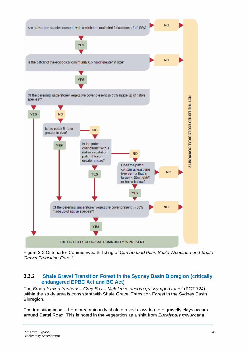
Figure 3-2 Criteria for Commonwealth listing of Cumberland Plain Shale Woodland and Shale-Gravel Transition Forest.
Shale Gravel Transition Forest in the Sydney Basin Bioregion (critically endangered EPBC Act and BC Act)
The Broad-leaved Ironbark – Grey Box – Melaleuca decora grassy open forest (PCT 724) within the study area is consistent with Shale Gravel Transition Forest in the Sydney Basin Bioregion.
The transition in soils from predominantly shale derived clays to more gravelly clays occurs around Cattai Road. This is noted in the vegetation as a shift from Eucalyptus moluccana
Pitt Town Bypass Biodiversity Assessment
43

being dominant to Eucalyptus fibrosa being dominant. The exact boundary of this transition is subject to interpretation since the composition and structure of the native vegetation in the study area has been subject to historical disturbances and much of it is subject to ongoing disturbances. Further, as a transitional community, Shale Gravel Transition Forest has a variable composition across its habitat extent. Eucalyptus moluccana and Eucalyptus tereticornis is indicative of both Cumberland plain woodland and Shale Gravel Transition forest, however Eucalyptus fibrosa is not associated with Cumberland Plain Woodland. Mapping in Figure 3-1 shows the boundary of these two TECs, which was determined due to a key difference in canopy composition.
The PCT 724 vegetation within the study area is consistent with Clause 2, 3, 4 and 5 of the Final Determination for Shale Gravel Transition Forest. Clause 8 of the Final Determination (OEH 2002) states that ‘Disturbed Shale Gravel Transition Forest remnants are considered to form part of the community including where the vegetation would respond to assisted natural regeneration, such as where the natural soil and associated seedbank is still at least partially intact.”
Although the Shale Gravel Transition Forest within the study area is degraded, some characteristic species occur in each stratum and likely persist in the soil seed bank. It is therefore considered to be consistent with Shale Gravel Transition Forest in the Sydney Basin Bioregion under the BC Act.
This community also forms part of the critically endangered Cumberland Plain Shale Woodland and Shale-Gravel Transition Forest under the EPBC Act. The condition thresholds outlined in Figure 3-2 apply to this TEC. Like the Cumberland Plain Woodland, the canopy cover is greater than 10 per cent and the patch size is greater than five hectares. The Shale Gravel Transition Forest (PCT 724) within the study area is characterised by exotic grasses and succulents and has a very low cover of native species. Ongoing grazing has reduced the shrub cover across most of the community to the north of Cattai Road. The perennial understorey vegetative cover is made up of less than 30 per cent native species.
Therefore, the Shale Gravel Transition Forest (PCT 724) vegetation within the study area is not equivalent to Cumberland Plain Shale Woodland and Shale-Gravel Transition Forest under the EPBC Act.
Freshwater Wetlands on Coastal Floodplains of the NSW North Coast, Sydney Basin and South-East Corner bioregions (endangered BC Act)
Phragmites australis and Typha orientalis coastal freshwater wetlands (PCT 1071) within the study area is equivalent to Freshwater Wetlands on Coastal Floodplains of the NSW North Coast, Sydney Basin and South-East Corner.
This TEC was recorded in the named drainage line that flows north to south through the study area (Figure 3-1). This community is consistent with Clause 1 of the Scientific Determination (OEH 2010) that states that the TEC is associated with periodic or semi-permanent inundation by freshwater and occur on silts, muds or humic loams in depressions and drainage lines. Freshwater Wetlands on Coastal Floodplains generally occur below 20 m elevation (the study area is between six and 14 m elevation) and the structure varies from sedgelands and reedlands to herbfields. The Freshwater Wetlands in the study area is also consistent with Clause 2 and 3 of the scientific Determination.
The Freshwater Wetlands on Coastal Floodplains (OEH 2008) identification guidelines states that the community can be present as large monocultures of reed species such as Typha orientalis and Phragmites australis. Although there is some diversity of species within the study area, this description is broadly accurate. Clause 14 of the Final Determination identifies Pitt Town Nature Reserve as containing this TEC. The PCT 1071 vegetation is consistent with
Pitt Town Bypass Biodiversity Assessment
44

Freshwater Wetlands on Coastal Floodplains under the BC Act. No equivalent TEC is listed under the EPBC Act
River-Flat Eucalypt Forest on Coastal Floodplains of the New South Wales North Coast, Sydney Basin and South-East Corner Bioregions
Patches of River-flat Eucalypt Forest on Coastal Floodplains of the NSW North Coast, Sydney Basin and South-East Corner Bioregions, listed as an endangered ecological community (EEC) under the BC Act, have been previously recorded in the locality and was predicted to occur in the study area in the Preliminary Environmental Assessment (PEA). Access to these patches was possible during the field investigations for this assessment and the presence of this TEC was discounted.
These patches of previous mapped River-flat Eucalypt Forest were found to be comprised predominantly of Eucalyptus moluccana with scattered Eucalyptus tereticornis. Although Eucalyptus moluccana can be associated with River-flat Eucalypt Forest, the dominance of this species typically marks the transition to Cumberland Plain Woodland TEC. Similarly, other species associated with River-flat Eucalypt Forest such as Cabbage Gum Eucalyptus amplifolia, Rough-barked Apple Angophora floribunda, Swamp Oak Casuarina glauca and paperbarks including Melaleuca styphelioides and Melaleuca decora are not present within the study area.
The soils within the study area are comprised of clay material derived from underlying Wianamatta Group shale. There is some alluvial material present (in the form of gravels and sand) but this is typically not dominant.
Based on the diagnostic elements considered above none of the vegetation within the study area is consistent with River-flat Eucalypt Forest.
3.4 Exotic flora species
All of the native vegetation within the study area has been historically modified and is subject to ongoing disturbances from grazing and rural residential development. The result is the degradation of condition, both in terms of the structure and composition of the communities’ present. Removal of native vegetation and increases in available nutrients result in recruitment of exotic species. The Broad-leaved Ironbark – Grey Box – Melaleuca decora grassy open forest (PCT 724) at the northern extent of the study area is comprised predominantly of exotic species in the understorey. Likewise the Grey Box – Forest Red Gum grassy woodland (PCT 849) in Moderate (shrubby) condition (Plate 4) has a high proportion of Eragrostis curvula in the understorey.
Six exotic species that have been recorded in the study area are declared as priority weeds for the Greater Sydney region under the Biosecurity Act 2015 (BA Act). Five recorded exotic species are included on the Commonwealth list of 32 Weeds of National Significance (WoNS). The names, classification and legal requirements for these species are outlined in Table 3-2.
Table 3-2: Weeds listed under the Biosecurity Act 2015 recorded within the study area
Common name
Scientific name WoNS Biosecurity Act 2015
Legal requirement
Sagittaria Sagittaria platyphylla - Prohibition on dealings
Must not be imported into the State or sold
Asparagus Fern
Asparagus aethiopicus
Yes Prohibition on dealings
Must not be imported into the State or sold
Pitt Town Bypass Biodiversity Assessment
45
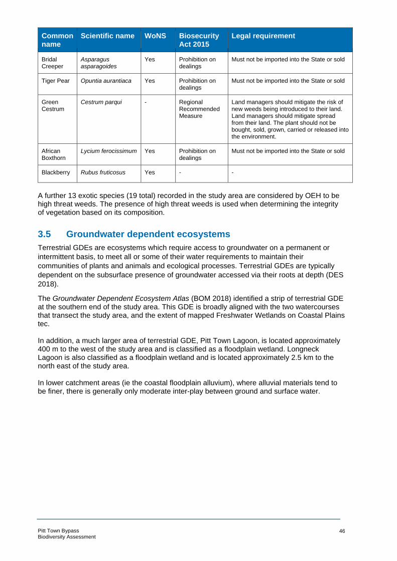
Common name
Scientific name WoNS Biosecurity Act 2015
Legal requirement
Bridal Creeper
Asparagus asparagoides
Yes Prohibition on dealings
Must not be imported into the State or sold
Tiger Pear Opuntia aurantiaca Yes Prohibition on dealings
Must not be imported into the State or sold
Green Cestrum
Cestrum parqui - Regional Recommended Measure
Land managers should mitigate the risk of new weeds being introduced to their land. Land managers should mitigate spread from their land. The plant should not be bought, sold, grown, carried or released into the environment.
African Boxthorn
Lycium ferocissimum Yes Prohibition on dealings
Must not be imported into the State or sold
Blackberry Rubus fruticosus Yes - -
A further 13 exotic species (19 total) recorded in the study area are considered by OEH to be high threat weeds. The presence of high threat weeds is used when determining the integrity of vegetation based on its composition.
3.5 Groundwater dependent ecosystems
Terrestrial GDEs are ecosystems which require access to groundwater on a permanent or
intermittent basis, to meet all or some of their water requirements to maintain their
communities of plants and animals and ecological processes. Terrestrial GDEs are typically
dependent on the subsurface presence of groundwater accessed via their roots at depth (DES
2018).
The Groundwater Dependent Ecosystem Atlas (BOM 2018) identified a strip of terrestrial GDE at the southern end of the study area. This GDE is broadly aligned with the two watercourses that transect the study area, and the extent of mapped Freshwater Wetlands on Coastal Plains tec.
In addition, a much larger area of terrestrial GDE, Pitt Town Lagoon, is located approximately 400 m to the west of the study area and is classified as a floodplain wetland. Longneck Lagoon is also classified as a floodplain wetland and is located approximately 2.5 km to the north east of the study area.
In lower catchment areas (ie the coastal floodplain alluvium), where alluvial materials tend to be finer, there is generally only moderate inter-play between ground and surface water.
Pitt Town Bypass Biodiversity Assessment
46

Figure 3-3 GDEs within the study area
3.6 Threatened species and populations
The OEH BioNet search (OEH, 2018a) revealed that 84 threatened species, including 12 flora species, 64 bird species, 16 mammal species, two invertebrate species and three amphibian species had been recorded previously in the locality.
The PMST revealed 68 threatened species and 28 migratory species (13 of the 28 migratory species are also threatened) in the locality including 27 flora species, 24 bird species, seven mammal species, four amphibian species, one invertebrate species and five reptile species may occur within the locality.
During the site assessment, the habitat preferences and geographical distributions of these species were considered when assessing the likely occurrence of each species. Each species was then allocated a likelihood rating based on set criteria. These criteria and the allocated rating for each species is provided in Appendix B.
Specific information of the threatened species that were recorded during the current survey, or that are considered moderately or highly likely to occur within the study area is provided in Section 3.6.1 to Section 3.6.2 below.
Threatened flora species
Two threatened flora species were recorded in the study area: Downy Wattle Acacia pubescens and Dillwynia tenuifolia.
Pitt Town Bypass Biodiversity Assessment
47
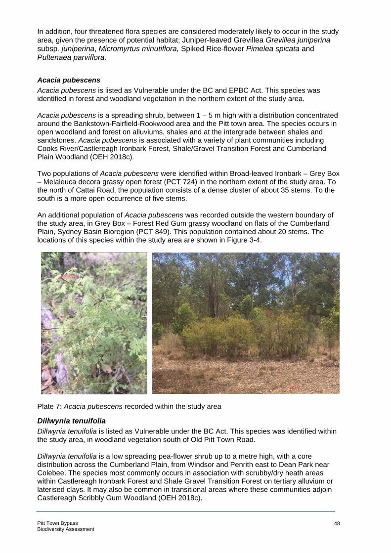
In addition, four threatened flora species are considered moderately likely to occur in the study
area, given the presence of potential habitat; Juniper-leaved Grevillea Grevillea juniperina subsp. juniperina, Micromyrtus minutiflora, Spiked Rice-flower Pimelea spicata and Pultenaea parviflora.
Acacia pubescens Acacia pubescens is listed as Vulnerable under the BC and EPBC Act. This species was identified in forest and woodland vegetation in the northern extent of the study area.
Acacia pubescens is a spreading shrub, between 1 – 5 m high with a distribution concentrated around the Bankstown-Fairfield-Rookwood area and the Pitt town area. The species occurs in open woodland and forest on alluviums, shales and at the intergrade between shales and sandstones. Acacia pubescens is associated with a variety of plant communities including Cooks River/Castlereagh Ironbark Forest, Shale/Gravel Transition Forest and Cumberland Plain Woodland (OEH 2018c).
Two populations of Acacia pubescens were identified within Broad-leaved Ironbark – Grey Box – Melaleuca decora grassy open forest (PCT 724) in the northern extent of the study area. To the north of Cattai Road, the population consists of a dense cluster of about 35 stems. To the south is a more open occurrence of five stems.
An additional population of Acacia pubescens was recorded outside the western boundary of the study area, in Grey Box – Forest Red Gum grassy woodland on flats of the Cumberland Plain, Sydney Basin Bioregion (PCT 849). This population contained about 20 stems. The locations of this species within the study area are shown in Figure 3-4.
Plate 7: Acacia pubescens recorded within the study area
Dillwynia tenuifolia Dillwynia tenuifolia is listed as Vulnerable under the BC Act. This species was identified within the study area, in woodland vegetation south of Old Pitt Town Road.
Dillwynia tenuifolia is a low spreading pea-flower shrub up to a metre high, with a core distribution across the Cumberland Plain, from Windsor and Penrith east to Dean Park near Colebee. The species most commonly occurs in association with scrubby/dry heath areas within Castlereagh Ironbark Forest and Shale Gravel Transition Forest on tertiary alluvium or laterised clays. It may also be common in transitional areas where these communities adjoin Castlereagh Scribbly Gum Woodland (OEH 2018c).
Pitt Town Bypass Biodiversity Assessment
48

Eucalyptus fibrosa is usually the dominant canopy species. Eucalyptus globoidea, E. longifolia, E. parramattensis, E. sclerophylla and E. sideroxylon may also be present or codominant.
In the study area, four individuals were recorded at two nearby locations within Grey Box – Forest Red Gum grassy woodland (PCT 849). One location contained three stems and one location contained a single stem. The species was recorded growing in an accumulation of gravel material in an area of exposed earth. This habitat was not typical within the PCT 849 vegetation. The plants were between 10 and 15 centimetres (cm) tall and had no reproductive material visible at the time of the survey. The locations of this species within the study area is shown on Figure 3-4.
Pitt Town Bypass Biodiversity Assessment
49
Plate 8: Dillwynia tenuifolia recorded within the study area

N
A HTAHC
SO
ESL
TEERT BUCKS I
M TEERTS TL EO ERO TP SRE SV II IRL
ELDON STREET
WELL
Se rvice Laye r Credits:
!<( !(
#* #*
!(
!(
#* #*
!(
D AORNWOTT TIP
D AOI RTA
ATC
EY STREET
GLEBE ROAD
MERSET STREET
BATHURST STREET
OLD PITT TOWN ROAD
D AORPRI
TSRAI
GHAM STREET
T EERTSEGDRIKCUB
Pitt Town Bypass Biodiversity Assessment EPBC Act EEC °!
Cumberland Plain Shale
LAGOON ROAD
Woodlands and Shale-GravelTransition Forest
BC Act EEC Shale Gravel Transition Forest inthe Sydney Basin Bioregion Cumberland Plain Woodland in the Sydney Basin Bioregion Freshwater Wetlands on CoastalFloodplains of the New SouthWales North Coast, Sydney Basinand South East Corner Bioregions
Vegetation CommunityBroad-leaved Ironbark - Grey Box -Melaleuca decora grassy open forest on clay/gravel soils of the Cumberland Plain, Sydney BasinBioregion (PCT 724)Grey Box - Forest Red Gum grassy woodland on flats of the Cumberland Plain, Sydney BasinBioregion (PCT 849)Phragmites australis and Typha orientalis coastal freshwater wetlands of the Sydney BasinBioregion (PCT 1071)
0 100 m
LEGEND ARCADIS AUSTRALIA PACIFIC PTY LTD ABN 76 104 485 289
Study area Threatened Fauna Species Level 16, 580 George St | Sydney NSW 2000 P: +61 (0) 2 8907 9000 | F: +61 (0) 2 8907 9001
Watercourse ( ! Grey-headed Flying-fox ( Pteropus poliocephalus Coordinate System: GDA 1994 MGA Zone 56 Aerial imagery supplied by nearmap (Jan, 2018)
Cadastre (LPI, 2017) Eastern Bent-wing Bat (Miniopterus schreibersii oceanensis)tened Flora Species - Definite, Eastern Freetail Bat (Mormopterus norfolkensis) -
(! 1:6,000 at A4 * # Definite, Greater Broad-nosed Bat ( Scoteanax rueppellii) -Acacia pubescens # *
ProbableDillwynia tenuifolia!( Southern Myotis (Myotis macropus) -
Figure 3-4: Threatened species locationsDate: 19/09/2018 Path: \\hc-aus-ns-fs-01\jobs\10014101\D-DigitalEng\DG-GIS\DGA-Current\B_Maps\BAR\G10014101_BAR_005_ThreatenedSpeciesStudyArea_A4P_v3.mxd
Created by : RM QA by : EC
Threa
BOX HILL OAKVILLE
WILBERFORCE
MARAYLYA
CATTAI

Threatened flora species habitat
In addition to the two threatened flora species that were recorded in the study area, several other threatened species have a moderate likelihood of occurrence. This has been determined based on the presence of potential habitat within the study area, in conjunction with the known extents for each species. The following species are considered to have potential habitat present within the study area:
• Juniper-leaved Grevillea Grevillea juniperina subsp. juniperina • Micromyrtus minutiflora • Spiked Rice-flower Pimelea spicata • Pultenaea parviflora.
Pimelea spicata is closely associated with Cumberland Plain Woodland and Moist Shale Woodland TECs. It grows in clay soils derived from Wianamatta Group shales. It is typically found growing with Kangaroo Grass Themeda australis under Eucalyptus moluccana and Eucalyptus crebra. The Grey Box – Forest Red Gum grassy woodland (PCT 849) vegetation is considered to provide potential habitat for the species, albeit marginal based on the historical and ongoing disturbance and mowing. This species can be recorded at any time of year but is much more readily detected when in flower. The targeted surveys for this species were conducted during the flowering season for this species. Grevillea juniperina subsp. juniperina, Micromyrtus minutiflora and Pultenaea parviflora, like Acacia pubescens and Dillwynia tenuifolia, are associated with tertiary alluviums. These soils are characteristic of Shale Gravel Transition Forest and as they become deeper, Castlereagh Ironbark Forest and Castlereagh Scribbly Gum Woodland TECs. Both the Broad-leaved Ironbark – Grey Box – Melaleuca decora grassy open forest (PCT 724) and the Grey Box – Forest Red Gum grassy woodland (PCT 849) are considered to provide habitat for these species. This is because there are isolated gravels in the soils underlying the PCT 849 vegetation, as demonstrated by the presence of Dillwynia tenuifolia. Grevillea juniperina subsp. juniperina and, to a lesser extent, Pultenaea parviflora are both conspicuous plants that are readily recorded in the field all year round. Pultenaea parviflora is more easily identified when reproductive material can be collected since these assist with differentiating it from the unlisted Pultenaea villosa. Neither of these species were recorded during the survey therefore, although potential habitat is present, they are not considered likely to occur.
Threatened fauna species
Five threatened fauna species was recorded in the study area: Grey-headed Flying Fox (Pteropus poliocephalus) and four species of microbat: Eastern Freetail-bat (Mormopterus norfolkensis), Eastern Bentwing-bat (Miniopterus schreibersii oceanensis), Southern Myotis (Myotis macropus) and Greater Broad-nosed Bat (Scoteanax rueppellii). The locations of these species are shown on Figure 3-4. Two additional threatened fauna species is considered highly likely to occur, given the presence of preferred habitat: Cumberland Plain Land Snail (Meridoluem cornivirens) and Yellow-bellied Sheathtail-bat (Saccolaimus flaviventris).
Grey-headed Flying-fox
The Grey-headed Flying-fox is listed as Vulnerable under the BC and EPBC Act. This species was observed in the study area foraging in the canopy of flowering eucalypts at several locations.
Pitt Town Bypass Biodiversity Assessment
51
--
The Grey-headed Flyingfox is generally found within 200 km of the eastern coast of Australia, from Rockhampton to Adelaide. The species may be found in subtropical and temperate rainforests, tall sclerophyll forests and woodlands, heaths and swamps, while additional foraging is provided by urban gardens and cultivated fruit crops. The Grey-Headed Flying-fox is a highly mobile species with a nightly feeding range of 20 to 50 km from a roosting camp. Diet typically comprises of a wide variety of flowering and fruiting plants (Tidemann 1995, Churchill 1998) with non-indigenous and exotic tree species introduced to the urban landscape providing additional foraging habitat for this species. Grey-headed Flying-foxes roost in large numbers, with up to tens of thousands of flying-foxes using individual camps for mating, birth and rearing of young.
During spotlight transects, three individuals were observed foraging on the blossoms of flowering Grey Box trees and a large number were seen flying overhead. Grey-headed Flying foxes were recorded foraging in Grey Box – Forest Red Gum grassy woodland on flats of the Cumberland Plain, Sydney Basin Bioregion (PCT 849), south of Old Pitt Town Road (Figure 3-4), and in the Mixed native and exotic vegetation (non-PCT) community south of Buckingham Street.
The study area does not support a camp, and therefore does not support critical roosting habitat for the species. The nearest nationally important Grey-headed Flying-fox camp as mapped by National Flying-fox monitoring viewer (DEE 2017a) is at Yarramundi (Camp ID 97), approximately 16 km west of the site. It has supported up to 10,000 flying-foxes in recent years. It is possible that the flying-foxes recorded in the study area were from this camp and were observed flying overhead to their foraging grounds. Other camps are located further south at Emu Plains (Camp ID 237) and Paramatta Park (Camp ID 134), located 24 and 27 km from the study area, respectively.
The study area provides foraging habitat for the Grey-headed Flying-fox, with a number of preferred blossom species in the blossom diet recorded in the study area (refer to Appendix A), as listed in Table 3-3.
Table 3-3 Grey-headed Flying-fox feed trees recorded in the study area
Species in the blossom diet of Grey headed Flying foxes recorded in the study area
Abundance in study area
Eucalyptus moluccana (Grey Box) Common
Eucalyptus tereticornis (Forest Red Gum) Uncommon
Eucalyptus fibrosa (Broad-leaved Ironbark) Uncommon
Melia azedarach (White Cedar) Uncommon
Eastern Bentwing-bat (Miniopterus schreibersii oceanensis)
Eastern Bentwing-bat is listed as a Vulnerable species under the BC Act. A definite recording of this species was made by both Anabats, in the northern extent of the study area.
The Eastern Bentwing-bat is a microbat that occurs along the east and north-west coasts of Australia (OEH 2018c) where it is known from a variety of habitats including rainforest, dry and wet sclerophyll forest, open woodland, paperbark forest and open grassland. The species hunts for moths and other flying insects above trees canopies or in open areas (OEH 2018c).
Pitt Town Bypass Biodiversity Assessment
52
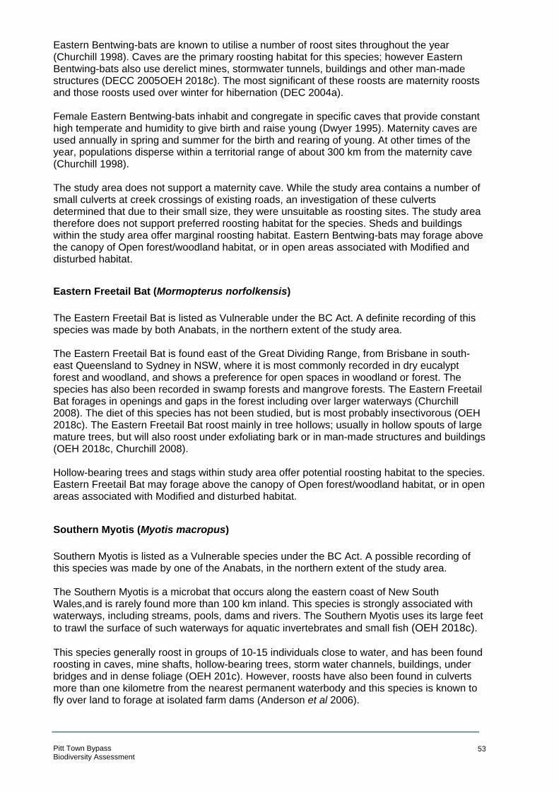
Eastern Bentwing-bats are known to utilise a number of roost sites throughout the year (Churchill 1998). Caves are the primary roosting habitat for this species; however Eastern Bentwing-bats also use derelict mines, stormwater tunnels, buildings and other man-made structures (DECC 2005OEH 2018c). The most significant of these roosts are maternity roosts and those roosts used over winter for hibernation (DEC 2004a). Female Eastern Bentwing-bats inhabit and congregate in specific caves that provide constant high temperate and humidity to give birth and raise young (Dwyer 1995). Maternity caves are used annually in spring and summer for the birth and rearing of young. At other times of the year, populations disperse within a territorial range of about 300 km from the maternity cave (Churchill 1998). The study area does not support a maternity cave. While the study area contains a number of small culverts at creek crossings of existing roads, an investigation of these culverts determined that due to their small size, they were unsuitable as roosting sites. The study area therefore does not support preferred roosting habitat for the species. Sheds and buildings within the study area offer marginal roosting habitat. Eastern Bentwing-bats may forage above the canopy of Open forest/woodland habitat, or in open areas associated with Modified and disturbed habitat.
Eastern Freetail Bat (Mormopterus norfolkensis)
The Eastern Freetail Bat is listed as Vulnerable under the BC Act. A definite recording of this species was made by both Anabats, in the northern extent of the study area. The Eastern Freetail Bat is found east of the Great Dividing Range, from Brisbane in south-east Queensland to Sydney in NSW, where it is most commonly recorded in dry eucalypt forest and woodland, and shows a preference for open spaces in woodland or forest. The species has also been recorded in swamp forests and mangrove forests. The Eastern Freetail Bat forages in openings and gaps in the forest including over larger waterways (Churchill 2008). The diet of this species has not been studied, but is most probably insectivorous (OEH 2018c). The Eastern Freetail Bat roost mainly in tree hollows; usually in hollow spouts of large mature trees, but will also roost under exfoliating bark or in man-made structures and buildings (OEH 2018c, Churchill 2008). Hollow-bearing trees and stags within study area offer potential roosting habitat to the species. Eastern Freetail Bat may forage above the canopy of Open forest/woodland habitat, or in open areas associated with Modified and disturbed habitat.
Southern Myotis (Myotis macropus)
Southern Myotis is listed as a Vulnerable species under the BC Act. A possible recording of this species was made by one of the Anabats, in the northern extent of the study area. The Southern Myotis is a microbat that occurs along the eastern coast of New South Wales,and is rarely found more than 100 km inland. This species is strongly associated with waterways, including streams, pools, dams and rivers. The Southern Myotis uses its large feet
to trawl the surface of such waterways for aquatic invertebrates and small fish (OEH 2018c). This species generally roost in groups of 10-15 individuals close to water, and has been found roosting in caves, mine shafts, hollow-bearing trees, storm water channels, buildings, under bridges and in dense foliage (OEH 201c). However, roosts have also been found in culverts more than one kilometre from the nearest permanent waterbody and this species is known to fly over land to forage at isolated farm dams (Anderson et al 2006).
Pitt Town Bypass Biodiversity Assessment
53
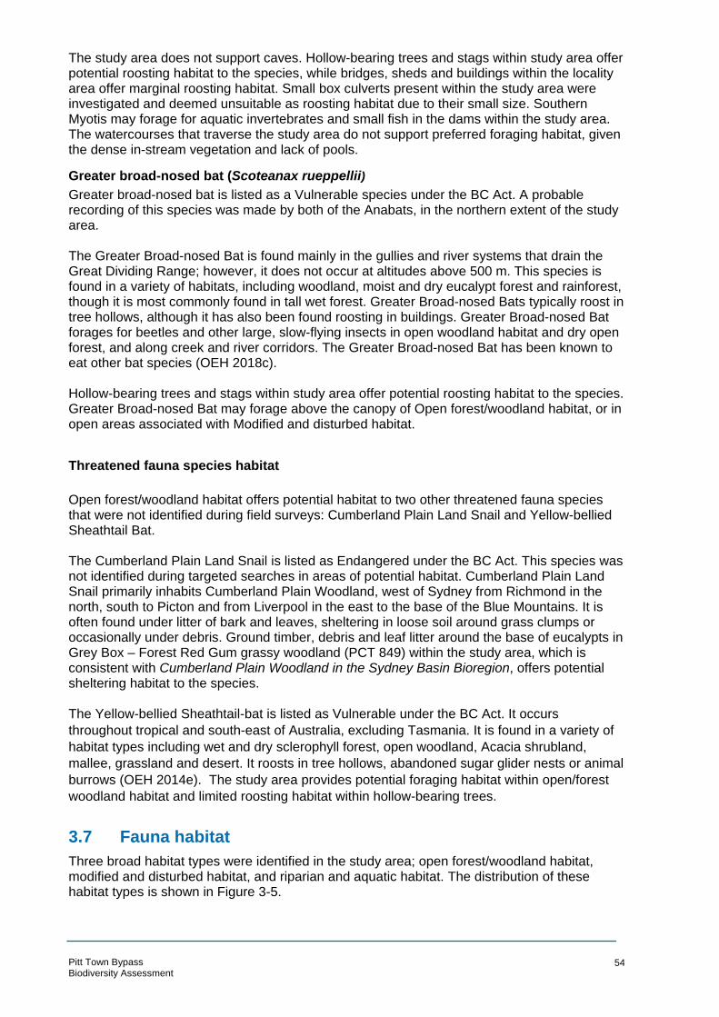
The study area does not support caves. Hollow-bearing trees and stags within study area offer potential roosting habitat to the species, while bridges, sheds and buildings within the locality area offer marginal roosting habitat. Small box culverts present within the study area were investigated and deemed unsuitable as roosting habitat due to their small size. Southern Myotis may forage for aquatic invertebrates and small fish in the dams within the study area. The watercourses that traverse the study area do not support preferred foraging habitat, given the dense in-stream vegetation and lack of pools.
Greater broad-nosed bat (Scoteanax rueppellii) Greater broad-nosed bat is listed as a Vulnerable species under the BC Act. A probable recording of this species was made by both of the Anabats, in the northern extent of the study area. The Greater Broad-nosed Bat is found mainly in the gullies and river systems that drain the Great Dividing Range; however, it does not occur at altitudes above 500 m. This species is found in a variety of habitats, including woodland, moist and dry eucalypt forest and rainforest, though it is most commonly found in tall wet forest. Greater Broad-nosed Bats typically roost in tree hollows, although it has also been found roosting in buildings. G reater Broad-nosed Bat forages for beetles and other large, slow-flying insects in open woodland habitat and dry open forest, and along creek and river corridors. The Greater Broad-nosed Bat has been known to eat other bat species (OEH 2018c). Hollow-bearing trees and stags within study area offer potential roosting habitat to the species. Greater Broad-nosed Bat may forage above the canopy of Open forest/woodland habitat, or in open areas associated with Modified and disturbed habitat.
Threatened fauna species habitat
Open forest/woodland habitat offers potential habitat to two other threatened fauna species that were not identified during field surveys: Cumberland Plain Land Snail and Yellow-bellied Sheathtail Bat. The Cumberland Plain Land Snail is listed as Endangered under the BC Act. This species was not identified during targeted searches in areas of potential habi tat. Cumberland Plain Land Snail primarily inhabits Cumberland Plain Woodland, west of Sydney from Richmond in the north, south to Picton and from Liverpool in the east to the base of the Blue Mountains. It is often found under litter of bark and leaves, sheltering in loose soil around grass clumps or occasionally under debris. Ground timber, debris and leaf litter around the base of eucalypts in Grey Box – Forest Red Gum grassy woodland (PCT 849) within the study area, which is consistent with Cumberland Plain Woodland in the Sydney Basin Bioregion, offers potential sheltering habitat to the species. The Yellow-bellied Sheathtail-bat is listed as Vulnerable under the BC Act. It occurs
throughout tropical and south-east of Australia, excluding Tasmania. It is found in a variety of
habitat types including wet and dry sclerophyll forest, open woodland, Acacia shrubland,
mallee, grassland and desert. It roosts in tree hollows, abandoned sugar glider nests or animal
burrows (OEH 2014e). The study area provides potential foraging habitat within open/forest
woodland habitat and limited roosting habitat within hollow-bearing trees.
3.7 Fauna habitat
Three broad habitat types were identified in the study area; open forest/woodland habitat, modified and disturbed habitat, and riparian and aquatic habitat. The distribution of these habitat types is shown in Figure 3-5.
Pitt Town Bypass Biodiversity Assessment
54

Open forest/woodland habitat
Open forest/woodland habitats occur in the northern extent of the study area, and correspond with the distribution of Broad-leaved Ironbark – Grey Box – Melaleuca decora grassy open forest (PCT 724) and Grey Box – Forest Red Gum grassy woodland (PCT 849). Open forest/woodland habitats cover 4.73 ha.
Open forest/woodland habitats within the study area are somewhat modified by livestock grazing (Plate 7) and/or regular slashing of groundlayer vegetation (Plate 8). Native canopy trees, including eucalypts and melaleucas, offer foraging resources to nectivorous birds such as Noisy Miner Manorina melanocephala, Noisy Friarbird Philemon corniculatus, Lewin’s Honeyeater Meliphaga lewinii and Rainbow Lorikeet Trichoglossus moluccanus, arboreal mammals and Grey-headed Flying-fox Pteropus poliocephalus. Hollow-bearing trees and stags offer nesting and sheltering habitat to locally occurring hollow-dependent fauna species. Rough-barked ironbarks offers preferred foraging habitat to insectivorous birds that forage for invertebrates on tree trunks and branches, such as White-throated Treecreeper Cormobates leucophaea. A diversity of microbats may forage for insects above and/or below the canopies of trees.
Shrubs were generally absent, with the exception of scattered Bursaria spinosa, Acacia pubescens, Acacia decurrens and Daviesia ulicifolia that offer limited sheltering and foraging habitat for small birds and mammals. The grassy groundlayer offers foraging and sheltering habitat to reptiles and small terrestrial mammals. Microhabitats are limited to well-developed leaf litter (in places) and ground timber. Rocky features are generally absent.
Plate 9: Broad-leaved Ironbark - Grey Box -Melaleuca decora grassy open forest west of Cattai Road
Plate 10: Grey Box - Forest Red Gum grassy woodland south of Old Pitt Town
Modified and disturbed habitat
Modified and disturbed habitats occur throughout much of the study area, and correspond with the distribution of mixed native and exotic vegetation (non-PCT) and Exotic Grassland (non-PCT). Modified and disturbed habitats cover 19.98 ha of the study area. Modified and disturbed habitats are characterised by slashed or mown grassland with scattered shrubs and trees. Habitat complexity is low, given this habitat type encompasses cleared grazing land, rural residential properties and residential properties on the outskirts of Pitt Town town centre. Expanses of exotic grassland offer potential foraging habitat for common birds such as Magpie Lark Grallina cyanoleuca and Australian Magpie Cracticus tibicen. Ground layer microhabitats such as well-developed leaf litter, ground timber and rocky features are absent. Shrubs are
Pitt Town Bypass Biodiversity Assessment
55
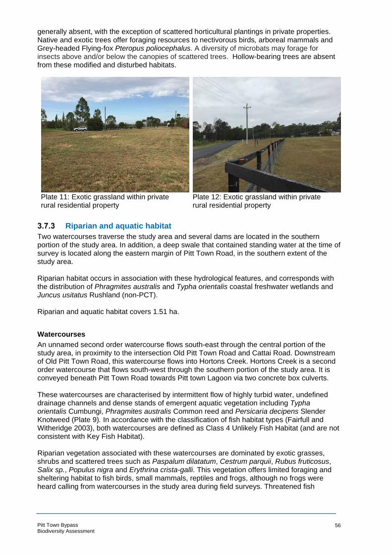
generally absent, with the exception of scattered horticultural plantings in private properties. Native and exotic trees offer foraging resources to nectivorous birds, arboreal mammals and Grey-headed Flying-fox Pteropus poliocephalus. A diversity of microbats may forage for insects above and/or below the canopies of scattered trees. Hollow-bearing trees are absent from these modified and disturbed habitats.
Plate 11: Exotic grassland within private rural residential property
Plate 12: Exotic grassland within private rural residential property
Riparian and aquatic habitat
Two watercourses traverse the study area and several dams are located in the southern portion of th e study area. In addition, a deep swale that contained standing water at the time of survey is located along the eastern margin of Pitt Town Road, in the southern extent of the study area. Riparian habitat occurs in association with these hydrological features, and corresponds with the distribution of Phragmites australis and Typha orientalis coastal freshwater wetlands and Juncus usitatus Rushland (non-PCT). Riparian and aquatic habitat covers 1.51 ha.
Watercourses
An unnamed second order watercourse flows south-east through the central portion of the study area, in proximity to the intersection Old Pitt Town Road and Cattai Road. Downstream of Old Pitt Town Road, this watercourse flows into Hortons Creek. Hortons Creek is a second order watercourse that flows south-west through the southern portion of the study area. It is conveyed beneath Pitt Town Road towards Pitt town Lagoon via two concrete box culverts. These watercourses are characterised by intermittent flow of highly turbid water, undefined drainage channels and dense stands of emergent aquatic vegetation including Typha orientalis Cumbungi, Phragmites australis Common reed and Persicaria decipens Slender Knotweed (Plate 9). In accordance with the classification of fish habitat types (Fairfull and Witheridge 2003), both watercourses are defined as Class 4 Unlikely Fish Habitat (and are not consistent with Key Fish Habitat). Riparian vegetation associated with these watercourses are dominated by exotic grasses, shrubs and scattered trees such as Paspalum dilatatum, Cestrum parquii, Rubus fruticosus, Salix sp., Populus nigra and Erythrina crista-galli. This vegetation offers limited foraging and sheltering habitat to fish birds, small mammals, reptiles and frogs, although no frogs were heard calling from watercourses in the study area during field surveys. Threatened fish
Pitt Town Bypass Biodiversity Assessment
56
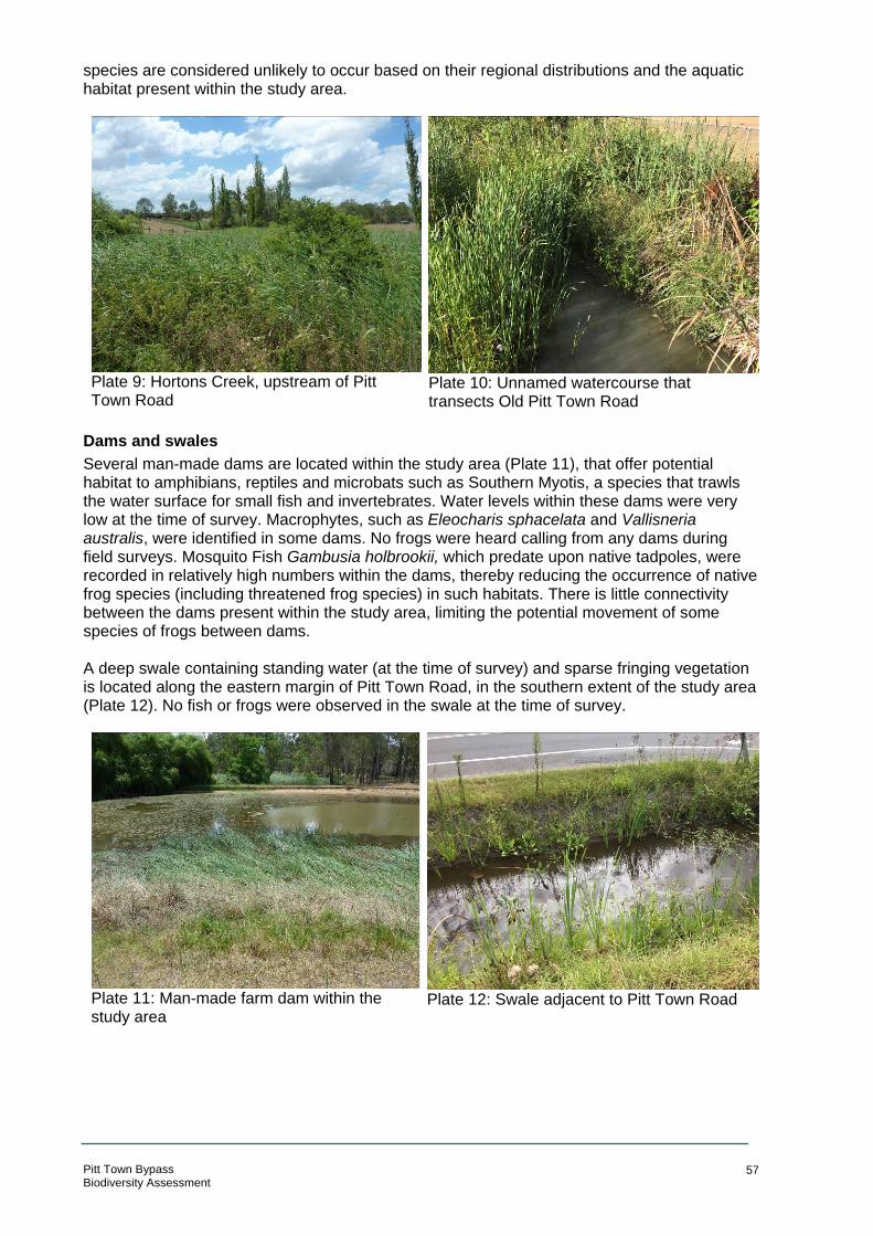
species are considered unlikely to occur based on their regional distributions and the aquatic habitat present within the study area.
Plate 9: Hortons Creek, upstream of Pitt Town Road
Plate 10: Unnamed watercourse that transects Old Pitt Town Road
Dams and swales
Several man-made dams are located within the study area (Plate 11), that offer potential habitat to amphibians, reptiles and microbats such as Southern Myotis, a species that trawls the water surface for small fish and invertebrates. Water levels within these dams were very low at the time of survey. Macrophytes, such as Eleocharis sphacelata and Vallisneria australis, were identified in some dams. No frogs were heard calling from any dams during field surveys. Mosquito Fish Gambusia holbrookii, which predate upon native tadpoles, were recorded in relatively high numbers within the dams, thereby reducing the occurrence of native frog species (including threatened frog species) in such habitats. There is little connectivity between the dams present within the study area, limiting the potential movement of some species of frogs between dams.
A deep swale containing standing water (at the time of survey) and sparse fringing vegetation is located along the eastern margin of Pitt Town Road, in the southern extent of the study area (Plate 12). No fish or frogs were observed in the swale at the time of survey.
Plate 11: Man-made farm dam within the study area
Plate 12: Swale adjacent to Pitt Town Road
Pitt Town Bypass Biodiversity Assessment
57

S N
MAHTAHC
EY
TEERT BUCKI
TEERTS TL EO ERO TP SRE SV II RL I
ELDON STREET
WELLESL
Se rvice Laye r Credits:
! @@!
@!
@!
@!
@!
(( (
(
(
(
D AOI RTA
ATC
STREET
GLEBE ROAD
BATHURST STREET
OLD PITT TOWN ROAD
D AORPRI
TSRAI
GHAM STREET
LAGOON ROAD
Pitt Town Bypass Biodiversity Assessment Fauna habitat feature °!@! Hollow-bearing tree
Dam itat type
Open forest / woodland Riparian / aquatic Modified / disturbed
Vege
K CREE
SNOTROH
tation CommunityBroad-leaved Ironbark - Grey Box -Melaleuca decora grassy open forest on clay/gravel soils of the Cumberland Plain, Sydney Basin Bioregion (PCT 724)
Fauna hab
Grey Box - Forest Red Gum grassy woodland on flats of the Cumberland Plain, Sydney Basin Bioregion (PCT 849)Phragmites australis and Typha orientalis coastal freshwater wetlands of the Sydney Basin Bioregion (PCT 1071)Mixed native and exotic vegetation (non-PCT)Exotic Grassland (non-PCT)Juncus usitatus Rushland (non-PCT)
0 100 m
LEGEND ARCADIS AUSTRALIA PACIFIC PTY LTD ABN 76 104 485 289Level 16, 580 George St | Sydney NSW 2000
Study area P: +61 (0) 2 8907 9000 | F: +61 (0) 2 8907 9001 Coordinate System: GDA 1994 MGA Zone 56
Watercourse Aerial imagery supplied by nearmap (Jan, 2018)
Cadastre (LPI, 2017) 1:6,000 at A4
Figure 3-5: Fauna habitat typesDate: 19/09/2018 Path: \\hc-aus-ns-fs-01\jobs\10014101\D-DigitalEng\DG-GIS\DGA-Current\B_Maps\BAR\G10014101_BAR_009_FaunaHabitatTypes_A4P_v3.mxd
Created by : RM QA by : EC
BOX HILL OAKVILLE
WILBERFORCE
MARAYLYA
CATTAI

Hollow-bearing trees
Three hollow-bearing trees and three stags containing hollows were identified in the study area (Figure 3-5). All hollow-bearing trees and stags occur within Broad-leaved Ironbark - Grey Box - Melaleuca decora grassy open forest (PCT 724) or Grey Box - Forest Red Gum grassy (PCT 849). Hollow-dependent fauna are defined as species that rely on tree hollows for shelter, roosting, or nesting at some stage in their life cycle. Several hollow-dependent species occur in the study area, including Rainbow Lorikeet Trichoglossus haematodus, Crimson Rosella Platycercus elegans and a diversity of microbat species (including several that are listed under the BC Act) that may utilise tree hollows as roosting, nesting or sheltering habitat. Tree hollows were generally small (five to 10 cm in diameter) or medium (10 to 20 cm in diameter) in size and located within a branch or trunk hollow. No large tree hollows (greater than 30 cm in diameter) were identified in the study area, which are typically required by owls and large cockatoos.
3.8 Areas of outstanding biodiversity value
Under the BC Act certain areas can be defined as being of outstanding biodiversity value for certain threatened species (previously referred to as critical habitat). Currently, the following threatened species areas of outstanding value have been identified:
• Gould’s Petrel (Cabbage Tree and Boondelbah Islands off the Coast of Port Stephens)
• Little penguin population in Sydney’s North Harbour
• Mitchell’s Rainforest Snail in Stotts Island Nature Reserve
• Wollemi Pine (approximately one per cent of the Wollemi National Park, North of Kurrajong)
No areas of outstanding biodiversity value occur within the study area for the proposal.
3.9 Wildlife connectivity corridors
The study area occurs in a modified landscape from which native vegetation has been removed for residential development, rural residential development, cropping, grazing and linear infrastructure. As a result, fauna habitat in the study area and surrounding locality is highly fragmented. There are no large tracts of native vegetation in the study area. Small patches of native vegetation (ie open forest/woodland habitat) that offer habitat to fauna species, mainly in the north of the study area, are separated from other patches of habitat in the locality by local and arterial roads. While many of the roads in the study area are narrow, gaps in habitat may deter the movement of some fauna species into and through the study area. This adverse effect on fauna movement may impact the ability of some fauna species to obtain food, shelter, and breeding resources, and to disperse from natal areas or undertake seasonal migrations (van der Ree et al. 2007). Fauna species that do attempt to cross roads to move through the landscape would be susceptible to injury and mortality from vehicle strike. The lack of intact vegetation in modified and disturbed habitats is likely to act as a barrier to the movement of many fauna species. The absence of groundlayer vegetation and shrubs that would otherwise offer shelter to small mammals, reptiles and amphibians, limits the ability of such animals to move through the area. As a result, it is likely only animals adapted to open space and modified environments, such as kangaroos, would be able to travel into and through the study area.
Pitt Town Bypass Biodiversity Assessment
59

Small patches of habitat in the north of the study area maintain tenuous connectivity to Scheyville National Park to the east, which covers about 954 ha. Intact, vegetated habitat corridors are generally absent from the study area and surrounding locality. Instead, habitat connectivity is represented by scattered trees and narrow, highly fragmented linear patches of vegetation.
Native vegetation in the study area does not maintain connectivity to other areas of ecological significance such as Pitt Town Nature Reserve to the west of the study area, nor the highly disturbed riparian corridor associated with the Hawkesbury River, further to the west.
3.10 State Environmental Planning Policies
SEPP 44 Koala habitat
State Environmental Planning Policy (SEPP) 44 aims to encourage the proper conservation and management of areas of natural vegetation that provide habitat for koalas to ensure a permanent free-living population over their present range and reverse the current trend of koala population decline
Hawkesbury Local Government Area (LGA) is listed under Schedule 1 as an LGA to which this SEPP applies. A list of 10 tree species which are considered indicators of ‘Potential Koala Habitat’ is provided by Schedule 2 of SEPP 44. The presence of any of the species listed on a site proposed for development triggers the requirement for an assessment for ‘Potential Koala Habitat’. SEPP 44 defines potential Koala Habitat as “areas of native vegetation where the trees of the types listed in Schedule 2 constitute at least 15 per cent of the total number of trees in the upper or lower strata of the tree component”.
One feed tree species listed under Schedule 2 of SEPP 44 – ‘Koala Habitat Protection’ occurs within the study area:” Eucalyptus tereticornis (Forest Red Gum). Based upon the low abundance of this species is the study area (ie less than 15 per cent of the total number of trees in the upper or lower strata of the tree component), the study area is not consistent with the definition of ‘Potential Koala Habitat’, in accordance with the provisions of SEPP 44.
No koalas or koala scats were recorded in the study area. While native vegetation within Scheyville National Park and Pitt Town Nature Reserve supports a range of native animals, koalas (Phascolarctos cinereus) are no longer present (NPWS 2000). The study area is unlikely to support a resident koala population due to the low abundance of koala feed trees listed under Schedule 2. Therefore, the study area is not consistent with the definition of Core Koala Habitat, in accordance with SEPP 44.
SEPP (Coastal Management) 2018
The SEPP (Coastal Management) 2018 repealed several coastal SEPPS, the most relevant of which (for biodiversity) are SEPP 14 Coastal Wetlands and SEPP 26 Littoral Rainforests. The SEPP (Coastal Management) commenced on 3 April 2018 and aims to preserve and protect sensitive coastal areas and associated ecosystems. Clause 21 of the SEPP (Coastal Management) outlines the savings and transitional provisions for existing development applications. Specifically, the pr oposal would be exempt from this SEPP according to Clause 21(2)(b). It states that: (2) Clause 10 of this Policy does not apply to the following activities (to the extent that they would otherwise comprise development to which that clause would apply):
(a) the carrying out of an activity for which an approval was granted by a determining authority under Part 5 of the Act before the commencement of this Policy,
(b) the carrying out of an activity after the commencement of this Policy, but only if: (i) any approval that is required for carrying out the activity is granted by the determining
authority under Part 5 of the Act within 12 months after that commencement, and
Pitt Town Bypass Biodiversity Assessment
60
(ii) any environmental impact assessment of that activity under Part 5 of the Act that is required had commenced before the commencement of this Policy.
As outlined in Section 2.4 the fieldwork commenced on 13 February 2018 (ie before the commencement of the SEPP) and it is anticipated that the REF would be determined by Roads and Maritime within 12 months of the commencement (ie 2 April 2019). As such, the proposal would be exempt due to these provisions and SEPP 14, and SEPP 26 would continue to apply, provided that approval is obtained within the above time frame. There are no SEPP 14 wetlands or SEPP 26 littoral rainforests within the study area.
3.11 Matters of National Environmental Significance
Matters of National Environmental Significance (MNES) are identified by the Protected Matters Report generated by the Protected Matters Search (Appendix C). In addition to the threatened flora species, threatened and migratory fauna species and ecological communities listed in Section 3.5 , two Nationally Important Wetlands are located within 10 km of the study area; Longneck Lagoon and Pitt Town Lagoon. No World Heritage Properties, National Heritage Places, Commonwealth Marine Reserves or Critical Habitats were identified within 10 km of the study area. Eight areas of Commonwealth land and two Commonwealth Heritage Places w ere identified within 10 km of the study area. However, none of these MNES adjoin or are in close proximity to the study area.
Longneck Lagoon
Longneck Lagoon is a freshwater lagoon located approximately 1.8 km north east of the study area. Once an ephemeral floodplain wetland, partial damming of the lagoon during the upgrading of Cattai Road in the 1980s led to higher water levels and the formation of a permanent water body. The lagoon is fed by Longneck and Llewellyn Creeks, surface and ground water runoff from the catchment, and backwater flooding from the Hawkesbury River (DEE 2010). Longneck Lagoon supports emergent reedland communities in zones of permanent water which are dominated by Eleocharis sphacelata. Areas around the lagoon perimeter adjacent to the main water body are seasonal wetland zones with rushland communities in this zone populated with the Juncus usitatus. Immediately surrounding Longneck Lagoon are stands of tall shrubland and woodland (DEE 2010a). Longneck Lagoon provides an important wetland habitat for waterbirds within the Hawkesbury area. Several threatened birds have been recorded within the lagoon including the Swift Parrot Lathamus discolor and Cotton Pygmy-Goose Nettapus coromandelianus and two wetland birds; the Black Bittern Ixobrychus flavicollis and Comb-crested Jacana Irediparra gallinacea. Species which are listed under JAMBA and/or CAMBA which have been recorded at Longneck Lagoon include the Marsh Sandpiper Tringa stagnatilis, Latham’s Snipe Gallinago hardwickii, Sharp-tailed Sandpiper Calidris acuminata, White-bellied Sea-Eagle Haliaeetus leucogaster and Glossy Ibis Plegadis falcinellus (DEE 2010a). While these threatened wetland bird species are highly mobile and the study area is within their foraging range, their preferred habitat is not supported by the study area. The dams present have little vegetation and no watercourse which transects the study area flows to this environment.
Pitt Town Lagoon
Pitt Town Lagoon is a seasonal freshwater swamp 400 m west of the study area. It occupies a shallow basin where a number of small creeks converge and is linked to the Hawkesbury River
Pitt Town Bypass Biodiversity Assessment
61

by a shallow drainage line which is usually dry. The lagoon fills to a depth of less than 2 m during floods and dries out through the combined effects of evaporation and transpiration to form a cracking clay bed in dry periods (DEE 2010b).
Vegetation of the lagoon varies considerably due to normal ecological factors and the surrounding land management. Vegetation in the low-lying areas of the Nature Reserve consists of native and introduced rushes, sedges, pondweeds and grasses with Spike-rush (Eleocharis sp.) and Water Ribbons (Triglochin procera) being dominant emergent vegetation.
Several threatened birds have been recorded at Pitt Town Lagoon including the Black-necked Stork (Ephippiorhynchus asiaticus) which is considered endangered at a state level under the BC Act. Six species considered vulnerable at a state level and 14 listed under JAMBA and/or CAMBA have also been recorded at the site.
The study area is in close proximity to this lagoon and is connected to the waterway which traverses the study area. However, the habitat present in the study area is not the preferred habitat of the threatened birds recorded at Pitt Town Lagoon. The dams in the study area are of a low quality and contain little vegetation. The densely vegetated Hortons Creek does not comprise preferred habitat for locally occurring threatened or migratory wetland birds.
Pitt Town Bypass Biodiversity Assessment
62

4 Impact assessment
4.1 Construction impacts
For the purpose of this assessment, the construction footprint consists of the Concept Design with a buffer and any temporary ancillary sites and construction compounds that would be required. It is assumed that this buffer will be sufficient to allow adequate constructability.
All necessary construction compounds and ancillary sites have been located within this construction boundary. It has been assumed that all ecological values within the construction footprint would be removed. However, the footprint of these design features may be refined during the detailed design, including minor changes to vertical alignment, drainage infrastructure, tie-ins etc. which may result in a slightly smaller or larger construction footprint.
Removal of native vegetation ( including TECs)
Clearing of native vegetation is required for the proposal. This includes native vegetation that is consistent with TECs listed under both Commonwealth and State legislation. A total of 2.47 ha of PCTs would be removed, predominantly for the construction of the bypass through the central portion of the study area. This is the equivalent of 39 per cent of the native vegetation within the study area.
The majority of the native vegetation that would be cleared is Grey Box – Forest Red Gum grassy woodland (PCT 849) equivalent to Cumberland Plain Woodland TEC. This vegetation has been historically modified but is generally in moderate condition and in both an open and a shrubby condition variant.
The areas of the PCTs and other vegetation types to be cleared from the construction footprint are listed in Table 4-1 and illustrated in Figure 4-1.
Table 4-1 Impacts on vegetation
Vegetation identified in study area
Status Area in study
area (ha)
Area to be cleared from construction footprint (ha)
BC Act
EPBC Act
Plant Community Types (PCT)
Broad-leaved Ironbark – Grey Box – Melaleuca decora grassy open forest on clay/gravel soils of the Cumberland Plain, Sydney Basin Bioregion (PCT 724)
E Not equivalent
1.78 0.39
Grey Box – Forest Red Gum grassy woodland on flats of the Cumberland Plain, Sydney Basin Bioregion (PCT 849)
CE CE 2.95 1.41
Phragmites australis and Typha orientalis coastal freshwater wetlands of the Sydney Basin Bioregion (PCT 1071)
E - 1.46 0.67
Sub-total native vegetation 6.19 2.47
Non-PCT vegetation
Mixed native and exotic vegetation - - 1.55 0.63
Exotic Grassland - - 18.43 4.87
Juncus usitatus Rushland - - 0.05 0.00
Sub-total non-native vegetation 20.03 5.5
Total 26.22 7.97
Pitt Town Bypass 63 Biodiversity Assessment

Pitt Town Bypass Biodiversity Assessment EPBC Act EEC !Cumberland Plain Shale °
Woodlands and Shale-GravelTransition Forest
BC Act EEC Shale Gravel Transition Forest inthe Sydney Basin Bioregion Cumberland Plain Woodland in the ( <! ( !Sydney Basin Bioregion Freshwater Wetlands on Coastal BUC * #KINGHFloodplains of the New South AM STREET T D A * #Wales North Coast, Sydne Ey Basin O
I Rand South East Corner Bi ERoregions A
T T T !( C AVegetation C T ommunity S T L EE O EBroad- Eleaved Ironbark - OGrey Box - RR TM l l TSu r s P ( !e a e ca decora g a s Ry open S Sforest Mon clay/gravel so EVils of the I
Cumb Aerland Plain, Syd Ln Iey Basin IR
HBiore TAgion (PCT 724)
HGrey C ELDBox - Forest Red GuOm N SgTraRsEsEy T woodland on flats of the SOCumberland Plain, Sydney Basin MEBioregion (PCT 849) RSETPhragmites australis and Typha STorientalis coastal freshwater RE *#E * # OLwetlands of the Sydney Basin DT PITT TW OWBioregion (PCT 1071) N RE OAL D L
Mixed native and exotic vegetation ESL
(non-PCT) EY STExotic Grassland (non-PCT) RE !( E T Juncus usitatus Rushland (non-B T PCT) A E T E H R U T eaten n R S Thr ed Fau a Species S E T D GS RI
( ! Grey-headed Flying-fox TR C KE E B UEastern Bent-wing Bat (MiniopteruT s schreibersii oceanensis) - Definite, Eastern Freetail Bat (Mormopterus
! ( norfolkensis) - Definite, Greater Broad-nosed Bat (Scoteanax rueppellii) - Probable Southern Myotis (Myotis macropus)
( ! - Poss i ble Threatened Flora Species *# Acacia pubescens # * Dillwynia tenuifolia LAGOON ROAD
GLEBE ROAD
D AOR NWOT TTIP
0 100 m
LEGEND ARCADIS AUSTRALIA PACIFIC PTY LTD ABN 76 104 485 289Level 16, 580 George St | Sydney NSW 2000 WILBERFORCE CATTAI
REF Boundary / 100% Design P: +61 (0) 2 8907 9000 | F: +61 (0) 2 8907 9001
Construction Footprint Coordinate System: GDA 1994 MGA Zone 56 Watercourse Aerial imagery supplied by nearmap (Jan, 2018) MARAYLYA Study area Cadastre (LPI, 2017) 1:6,000 at A4 Areas of occupancy
Figure 4-1: Biodiversity impacts OAKVILLE Se rvice Laye r Credits:
BOX HILL Date: 19/09/2018 Path: \\hc-aus-ns-fs-01\jobs\10014101\D-DigitalEng\DG-GIS\DGA-Current\B_Maps\BAR\G10014101_BAR_006_BiodiversityImpacts_A4P_v4.mxd
Created by : RM QA by : EC

Removal of threatened flora species and habitat
Two threatened flora species, Acacia pubescens and Dillwynia tenuifolia occur within the study area (Figure 3-5). Both of these would be directly impacted by the proposal, with the loss of four stems of Dillwynia tenuifolia and five stems of Acacia pubescens. Two additional recorded populations of Acacia pubescens are located about five to 15 m from the edge of the construction boundary and no direct impacts to these are anticipated.
Both Dillwynia tenuifolia and Acacia pubescens are listed as ‘area species’ in the Threatened Biodiversity Data Collection. This means that impacts to these species are calculated using an area of occupancy (or species polygon) rather than the number of stems being removed. The species polygons are calculated in accordance with Section 6.4.1.29 of the BAM, by applying a 30 m buffer to recorded plants. These areas are referred to as occupied habitat (areas of occupancy in Figure 4-1) in this report. Outside of this occupied habitat are areas of potential habitat, that contain habitat features that are suitable for the respective species, but do not contain individuals of the plant.
In addition to the loss of these Dillwynia tenuifolia and Acacia pubescens stems, the study area provides potential habitat for two additional threatened species that are considered moderately likely to occur within the study area (despite not having been recorded). The presence of habitat is limited to the PCT vegetation that has been recorded. The non-PCT (exotic) vegetation communities are not considered to provide potential habitat for these species since it is characterised by dense exotic grasses.
A summary of the number of threatened species and the amount of potential habitat that would be removed by the proposal is provided in Table 4-3.
Table 4-3 Impacts on threatened flora
Threatened species Recorded Status* Habitat or individuals
Habitat or individualsor habitat EPBC BC
present Act Act in the study to be area impacted
Acacia pubescens Recorded and habitat present
V V About 55 individuals
5 individuals
0.21 ha of 1.78 ha of habitat
occupied habitat
1.8 ha of potentialhabitat
Dillwynia tenuifolia Recorded and habitat present
- V 4 individuals
4.73 ha of
4 individuals
0.31 ha of habitat occupied
habitat 1.8 ha of potential habitat
Micromyrtus minutiflora Habitat present V E 1.78 ha of habitat
0.39 ha of habitat comprising moderate condition Shale Gravel Transition Forest in which it is moderately likely to occur.
Spiked Rice-flower Pimelea spicata Habitat present E E 2.95 ha of habitat
1.41 ha of habitat comprising moderate condition Cumberland Plain Woodland
Pitt Town Bypass Biodiversity Assessment
65
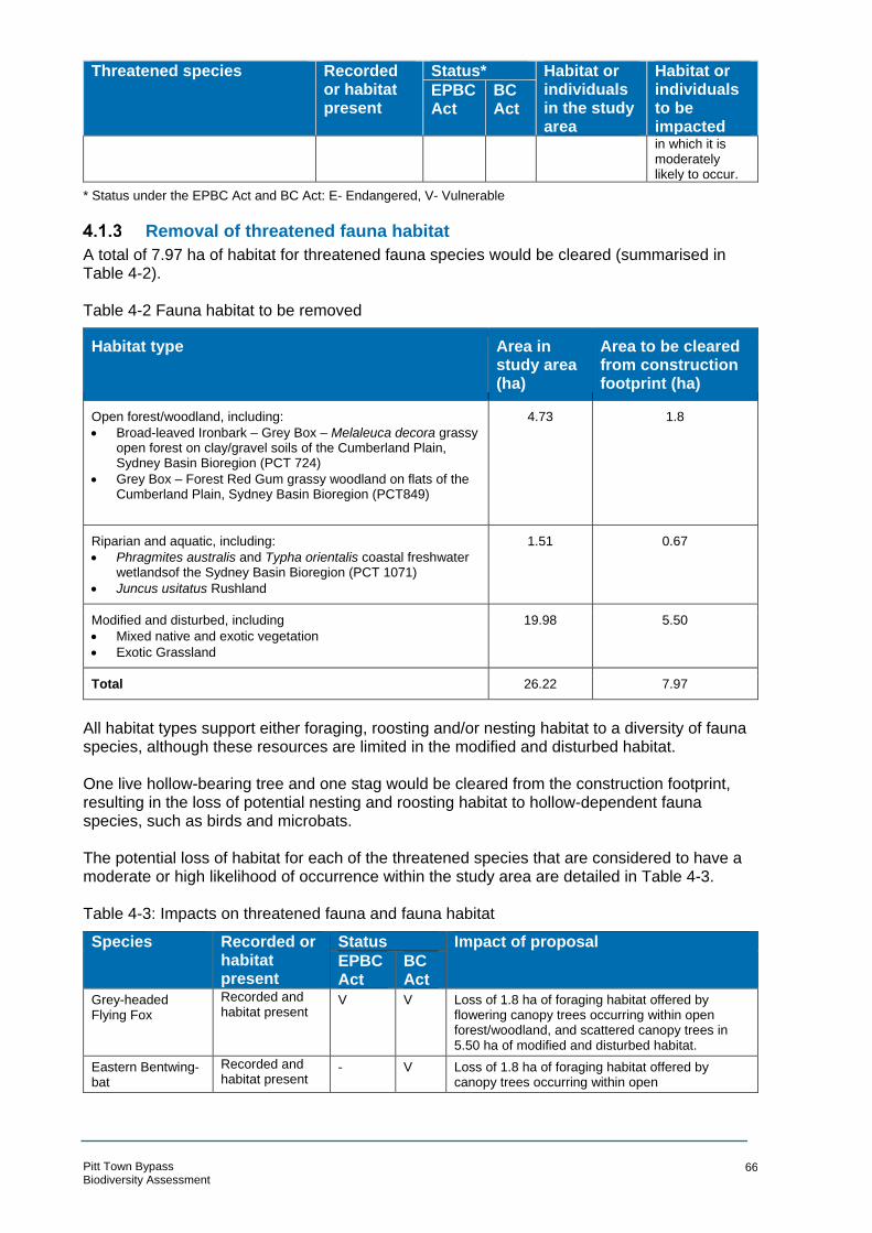
Threatened species Recorded or habitat present
Status* Habitat or individuals in the study area
Habitat or individuals to be impacted
EPBC Act
BC Act
in which it is moderately likely to occur.
* Status under the EPBC Act and BC Act: E- Endangered, V- Vulnerable
Removal of threatened fauna habitat
A total of 7.97 ha of habitat for threatened fauna species would be cleared (summarised in Table 4-2). Table 4-2 Fauna habitat to be removed
Species
Habitat type Area in study area (ha)
Area to be cleared from construction footprint (ha)
Open forest/woodland, including:
• Broad-leaved Ironbark – Grey Box – Melaleuca decora grassy open forest on clay/gravel soils of the Cumberland Plain, Sydney Basin Bioregion (PCT 724)
• Grey Box – Forest Red Gum grassy woodland on flats of the Cumberland Plain, Sydney Basin Bioregion (PCT849)
4.73 1.8
Riparian and aquatic, including:
• Phragmites australis and Typha orientalis coastal freshwater wetlandsof the Sydney Basin Bioregion (PCT 1071)
• Juncus usitatus Rushland
1.51 0.67
Modified and disturbed, including
• Mixed native and exotic vegetation
• Exotic Grassland
19.98 5.50
Total 26.22 7.97
All habitat types support either foraging, roosting and/or nesting habitat to a diversity of fauna species, although these resources are limited in the modified and disturbed habitat.
One live hollow-bearing tree and one stag would be cleared from the construction footprint, resulting in the loss of potential nesting and roosting habitat to hollow-dependent fauna species, such as birds and microbats.
The potential loss of habitat for each of the threatened species that are considered to have a moderate or high likelihood of occurrence within the study area are detailed in Table 4-3.
Table 4-3: Impacts on threatened fauna and fauna habitat
Recorded or Status Impact of proposal habitat present
EPBC Act
BC Act
Grey-headed Flying Fox
Recorded and habitat present
V V Loss of 1.8 ha of foraging habitat offered by flowering canopy trees occurring within open forest/woodland, and scattered canopy trees in 5.50 ha of modified and disturbed habitat.
Eastern Bentwing-bat
Recorded and habitat present
- V Loss of 1.8 ha of foraging habitat offered by canopy trees occurring within open
Pitt Town Bypass Biodiversity Assessment
66

Species Recorded or Status Impact of proposal habitat EPBC BC present Act Act
forest/woodland, and scattered canopy trees in 5.50 ha of modified and disturbed habitat.
Eastern Freetail-bat
Recorded and habitat present
- V Loss of 1.8 ha of foraging habitat offered by canopy trees occurring within open forest/woodland and scattered canopy trees in
5.50 ha of modified and disturbed habitat.
Loss of potential roosting habitat offered by one live tree and one stag.
Greater Broad- nosed Bat
Recorded and habitat present
- V Loss of 1.8 ha of foraging habitat offered by canopy trees occurring within open forest/woodland and scattered canopy trees in
5.50 ha of modified and disturbed habitat.
Loss of potential roosting habitat offered by one live tree and one stag.
Southern Myotis Recorded and habitat present
- V Loss of 1.8 ha of foraging habitat offered by canopy trees occurring within open forest/woodland and scattered canopy trees in
5.50 ha of modified and disturbed habitat.
Loss of potential roosting habitat offered by one live tree and one stag.
Cumberland Plain Land Snail
Habitat present - V Loss of 1.41 ha of foraging and breeding habitat within the Cumberland Plain Woodland within the
construction footprint
Aquatic impacts
Aquatic habitats are associated with Hortons Creek that transects Pitt Town Road, the unnamed creek that transects Old Pitt Town Road and a number of dams located within the study area. Construction activities, particularly culvert upgrades at the two watercourse crossings, could result in potential alteration and/or degradation of aquatic habitat in these areas. Impacts during construction could arise from:
• Sediment-laden run-off from cleared and disturbed areas adversely affecting water quality in watercourses.
• Stockpiling of soil near waterways and overland flow paths.
• Spills or leaks of road construction materials including fuels, lubricants and hydraulic oils from construction plant and equipment.
Once operational, the proposal is ex pected to have negligible impacts on aquatic habitats. Surface flows (stormwater run-off) from the bypass, potentially containing pollutants associated with the operation of the road (hydrocarbons, suspended solids and nutrients), would be directed towards and contained within drainage infrastructure, to be constructed as part of the proposal.
Injury and mortality
Fauna injury and mortality may occur during the clearing of vegetation or as a result of collisions with work vehicles or plant, or accidental entrapment in plant, trenches or other works. The majority of fauna species recorded within the study area were highly mobile bird species which are likely to be able to move away from vegetation clearing activities quite readily. During the operation of the road, vehicle strike may increase slightly from current levels as the new road will be constructed in areas which are currently unimpacted by a road. Furthermore,
Pitt Town Bypass Biodiversity Assessment
67

the new road will likely have an increased speed limit to current roads running through the site. This will make it more difficult for fauna to move away from oncoming traffic, resulting in an increase in fauna mortalities.
4.2 Indirect/operational impacts
Wildlife connectivity and habitat fragmentation
The study area is located in a highly modified environment in which much of the native vegetation has been fragmented by clearing for rural residential development. Intact, vegetated habitat corridors are generally absent from the study area and surrounding locality, instead, habitat connectivity is represented by scattered trees and narrow, highly fragmented linear patches of vegetation. It provides tenuous links to nearby areas of ecological significance including Scheyville National Park and Pitt Town Nature Reserve, as described in section 3.9.
A proportion of the proposed bypass will fragment a patch of woodland/open forest habitat in the north of the study area, creating smaller, narrow linear patches on either side of the bypass. Although this type of habitat is already highly fragmented across the locality, fragmentation of habitat within the study area may further reduce the movement of some fauna species that are deterred by gaps or edge effects, such as increased light and noise associated with vehicular traffic.
An additional crossing of Horton’s Creek, between Old Pitt Town Road and Glebe Road is proposed. The construction of watercourse crossings has potential to further fragment riparian and aquatic habitat, however, given there would not be any instream structure, the plank bridge proposed at this location is unlikely to comprise a barrier to the movement of fish and amphibians.
Cleared and disturbed habitat will also be fragmented by the bypass, however, fauna species likely to utilise habitat resources within such habitat are typically adapted to fragmented and modified environments, and are likely to continue utilising these types of environments.
Edge effects on adjacent native vegetation and habitat
While vegetation along the existing roads and cleared areas in the study area is currently subject to edge effects, the proposed road will create edge effects in new, relatively undisturbed areas. These edge effects will be caused by changed biotic and abiotic factors including enriched run-off from the road, increased light and wind and dumping of rubbish. As a result, these areas will be more susceptible to weed invasion.
This will be most prominent in the patch of Cumberland Plain Woodland which the proposed road runs directly through (Figure 4-1). The combined clearing of this vegetation community for the road and resultant edge effects will leave only small fragments of Cumberland Plain Woodland in the study area not impacted by the proposal. These areas will predominantly be north of Old Pitt Town Road were remnant trees and regenerating canopy species will remain to the west of the proposed bypass alignment. Although there will be some edge effects to these isolated patches, it is unlikely that the condition will be substantially modified from the current condition since weeds are already prevalent.
Similarly, the Freshwater Wetlands on Coastal Floodplains will experience new edge effects in the areas where the proposed road crosses Hortons Creek. Weeds were noted to be throughout the Typha and Phragmites within this community, although they were more prolific along the edge. It is likely that there will be an increase in cover of weeds within the first two to five metres of Freshwater Wetlands vegetation either side of the crossing locations. Beyond this, edge effects are unlikely.
Pitt Town Bypass Biodiversity Assessment
68

Invasion and spread of weeds
Section 3.4 identified the WoNS, high threat weeds and weeds listed under the Biosecurity Act 2015 that have been recorded within the study area. The majority of vegetation within the study area (both PCT and non-PCT) has been subject to previous disturbance and recruitment by exotic species.
Vegetation that is located adacent to, but outside, the construction boundary (to be retained) is equally as subject to exotic species recruitment as the vegetation that would be cleared. It is therefore at low risk of invasion of exotic species due to construction and operational impacts. It is possible that during construction, new weeds could be introduced into the study area, or weeds that are already present could be spread into more intact vegetation that currently does not support them. Implementing weed hygiene protocols would minimise this impact. In addition, based on the high levels of exotic species recruitment throughout the study area, the potential for spread of exotic species is considered to be a relatively low risk to surrounding bushland.
Invasion and spread of pests
A number of vertebrate pest species were observed in the study area, including:
• European Rabbit Oryctolagus cuniculus • Spotted Turtle-Dove Streptopelia chinensis • Common Myna Acridotheres tristis • Rock Dove Columba livia. A number of additional vertebrate pests are known to occur in the area (Bionet 2018), and are expected within the study area, which includes:
• European Red Fox Vulpes vulpes • Black Rat Rattus rattus • Red-whiskered Bulbul Pycnonotus jocosus • House Mouse Mus musculus • Common Starling Sturnus vulgaris • House Sparrow Passer domesticus • Eurasian Blackbird Turdus merula. Many of these vertebrate pests are potential threats to threatened species that have a high or moderate likelihood of occurring within the study area. Predatory species such as European Red Fox pose a risk to terrestrial and arboreal fauna. These species, and the other vertebrate pests listed above capitalise on the disturbance that is typically associated with construction and development activities. As such, it is important that the risks posed by these pests are considered and appropriately managed through implementation of mitigation measures during construction and operation.
Invasion and spread of pathogens and disease
The proposal has the potential to increase the spread of pathogens that threaten native biodiversity values. The soil-borne pathogen Phytophthora cinnamomi (Phytophthora) is known to occur in the Sydney Basin region but no evidence of its presence within the study area was observed. Phytophthora infects roots and is associated with damage and death to native plants. It may be dispersed over large distances in flowing water, such as storm runoff, or may be spread within a site via mycelial growth from infected roots to roots of healthy plants. Propagules of Phytophthora may also be dispersed by vehicles (eg cars and earth moving equipment),
Pitt Town Bypass Biodiversity Assessment
69

animals, walkers and movement of soil. It is listed as a Key Threatening Process (KTP) under the BC Act. No evidence of Phytophthora was observed in the study area, but there may be an increased risk of dispersal as a result of the proposal. Precautionary measures are recommended during construction.
Changes to hydrology
Changes to existing hydrological regimes are expected to be minimal. During construction, surface flows would be managed and potential impacts of sediment-laden run-off mitigated by the implementation of sediment and erosion controls. This includes separating “clean” water (eg surface flows from outside of the construction footprint) from “dirty” water (eg surface flows from disturbed areas within the construction footprint), prior to discharge.
Once the proposal is operational, a small change in magnitude of surfaces flows would largely be due to an increase in impervious surfaces (ie road pavement associated with the bypass). However, surface flows (stormwater run-off) from the bypass would be directed towards and contained within drainage infrastructure such as swales, pits and pipes and sediment basins (to be further developed during the detailed design phase). Stormwater run-off into native vegetation adjacent to the proposal would therefore be avoided. The stormwater drainage strategy that has been developed for the proposal aims to maintain existing drainage patterns as much as possible and implement water sensitive urban design features where practical.
It is not anticipated that the proposal would result in any impacts to Pitt Town Lagoon, located approximately one kilometre downstream of the proposal. Any alterations to the volume and quality of water in Hortons Creek are anticipated to be minor and short-term. These are anticipated to be negligible by the time this water enters Pitt Town Lagoon particularly when considered in the context of the existing catchment and the hardstand and potential water pollutions sources that it contains.
Noise, light and vibration
While construction activities will result in localised and temporary noise and vibration impacts, operation of the proposal is predicted to provide negligible change in the noise levels in the context of noise generated from traffic movements on existing local roads.
The porposed road will be lit with directional lighting during the operation phase. Light pollution has the potential to impact on nocturnal fauna that can be more vulnerable to predation. Based on the existing lighting on several of the larger streets in Pitt Town (Eldon Street and Bathurst Street) it is unlikely that this additional lighting would impact the behaviour of nocturnal fauna.
Groundwater dependent ecosystems
The extent of terrestrial GDEs mapped in the study area (Figure 3-3) are generally aligned with the two watercourses that transect the study area (Hortons Creek and an unnamed creek) and the distribution of Freshwater Wetland TEC.
This TEC may utilise groundwater- fed base flows associated with shallower groundwater. However, the risk of potential impacts on GDEs is considered to be low. There are no very shallow cuttings where the proposal transects the creeks; no dewatering is proposed at these locations and in-stream construction works would be limited to the provision of new crossings of Hortons Creek at the southern and central sections of the proposal, comprising a double span plank bridge south of the southern roundabout over Hortons Creek in the south, and a four-cell box culvert over Hortons Creek in the centre of the bypass.
Pitt Town Bypass Biodiversity Assessment
70

4.3 Key threatening processes
The proposal is likely to result in the operation of one or more KTPs or the exacerbation of one
or more key threatening processes currently in operation in the study area. KTPs are listed
under the BC Act and EPBC Act.
Biodiversity Conservation Act 2016
Key threatening processes are processes that “threaten or could threaten the survival or
evolutionary development of species, populations or ecological communities”. KTPs are listed
under Schedule 4 of the BC Act and may adversely affect threatened species, populations or
ecological communities, or could cause species, populations or ecological communities that
are not threatened to become threatened. The proposal may contribute to the following KTPs:
• Clearing of native vegetation: The proposal will result in the removal of 3.10 ha of vegetation, of which 2.47 ha comprises TECs
• Loss of hollow-bearing trees: the proposal will result in the removal of one live hollow-bearing tree, that offers potential roosting and nesting habitat to locally occurring fauna species, including threatened species
• Removal of dead wood and dead trees: the proposal will result in the removal of one stag, that offers potential roosting and nesting habitat to locally occurring fauna species, including threatened species
• Invasion of native plant communities by exotic perennial grasses. One exotic perennial grass species of special concern, Eragrostis curvula (African L ovegrass), was identified in the study area. Disturbed areas, following earthworks, would be susceptible
to the establishment and spread of Eragrostis curvula and other exotic grass species recorded in the study area.
• Predation by Gambusia holbrooki (Plague Minnow or Mosquito Fish). Gambusia holbrooki was identified in several dams in the study area and may occur in the two watercourses. The proposal is unlikely to exacerbate this KTP.
• Competition and grazing by the feral European Rabbit Oryctolagus cuniculus: European Rabbit was identified in the study area during field surveys. The proposal is unlikely to exacerbate this KTP.
• Infection of native plants by Phytophthora cinnamomi • Predation by the European Red Fox (Vulpes vulpes). European Red Fox is known to occur
in the surrounding locality (Bionet 2018). The proposal is unlikely to exacerbate this KTP.
Environment Protection and Biodiversity Conservation Act 1999
The EPBC Act defines a key threatening process as one that “threatens or may threaten the
survival, abundance or evolutionary development of a native species or ecological
community.” The proposal may contribute to the following key threatening processes:
• Land clearance: the proposal will result in the removal of 3.10 ha of vegetation, of which 2.47 ha comprises TECs listed under the EPBC Act.
4.4 Cumulative impacts
This cumulative impact section has assessed projects and proposals at a local and regional scale that would contribute to the cumulative impact of the proposal. The study area is in north-western Sydney, an area that is subject to ongoing development pressure, particularly for residential purposes. The Cumberland Plain provides fertile soils that have been historically cleared for farming. As such, much of the remaining vegetation communities are listed as threatened under Commonwealth and State legislation. A summary of past and future projects in the region are provided in Table 4-4 below.
Pitt Town Bypass Biodiversity Assessment
71

Table 4-4 Past, present and future projects
Pitt Town Bypass Biodiversity Assessment
72
Project
Past projects
Construction impacts Operational impacts
Pitt Town Residential Precinct, comprising 659 allotments together with associated infrastructure This residential precinct is located within one kilometre to the north-east of the proposal
Information source: Environmental Assessment: Pitt Town Residential
Precinct (DFP Town Planners 2007)
No quantitative impact assessment was provided within the
environmental assessment, therefore no accurate quantitative
assessment can be made here. The following ecological values
were identified in the study area:
• Eastern False Pipistrelle (Falsistrellus tasmaniensis) and
the Cumberland Plain Land Snail (Meridolum corneovirens)
were located in the study area
• Acacia pubescens (Downy Wattle) was located in the
vicinity of, but outside the study area
• Remnants of two ecological communities; Shale Gravel Transition Forest and Shale
Plains Woodland, both listed as EECs under the BC Act were
identified in the study area. It can be inferred from historical
aerial imagery that about 10 ha of native vegetation has been
removed for this project. It is not possible to determine the
TEC equivalence, however regardless of whether it is
Cumberland Plain Woodland of Shale Gravel Transition Forest, it would represent a relatively
small portion of the remaining TECs 10km of the study area
(the locality).
The operation impacts associated with this project have not been
defined but would likely include stormwater runoff and increased edge effects to surrounding retained bushland. Increased light, noise and vibration are unlikely to be substantial since the pre-
construction landscape was relatively developed.
Schofields Road upgrade and extension, between Windsor Road
and Richmond Road
The upgrade is located 16 km south-east of the proposal
Information source: Schofields
Road Upgrade: Stage 3 Veron Road to Richmond Road Review of
environmental factors (SMEC 2013)
•
•
•
Removal of 15 Juniper-leaved Grevillea (Grevillea juniperina
subsp. juniperina) and five Dillwynia tenuifolia, from certified areas.
Removal of 4.31 ha of Cumberland Plain Woodland
as listed under the TSC Act, of which 3.66 ha fulfils the
condition thresholds for inclusion as the EPBC Act-
listed community (of which 0.64 ha falls within non-certified
areas). The combination of the 4.31 ha of Cumberland Plain Woodland cleared for the
Schofields Road Upgrade and the 1.41 ha required for this
proposal would equal 0.2% of the 2,806 ha of Cumberland
Plain Woodland in the locality.
Removal of 4.30 ha of River-flat Eucalypt Forest, as listed
under the TSC Act, or which 0.48 ha occurs in certified
Increased levels of disturbance and exposure of Eastern Creek Potential changes to the instream
and bank vegetation, which may affect shading, habitat and water
velocities Potential scouring of the creek bed
downstream of bridge pylons as a result of turbulence during high
flows and increased flood flow velocities Proposed road upgrade would
result in a road approximately double its existing width and there is a potential for an increase in terrestrial fauna mortality
Continued spread of weeds in the woodland areas and riparian zones during operation of the road, particularly around Eastern Creek.
Project Construction impacts Operational impacts
areas, and 3.81 ha within non-certified areas
• Removal of 18 trees identified as potentially containing hollows, of which six are located within non-certified lands
• Realignment/diversion of two low flow channels associated with Bells Creek, and an adjustment to a shallow ephemeral drainage depression
Increase in width of the existing South Street and the construction of a roadway and bridge over Eastern Creek would dissect the existing wildlife corridor
North West Rail Link
The northern extent of the rail link (between Rouse Hill and Epping) is located 16 km south-east of the proposal
Information source: North West Rail Link Biodiversity Offset Package (Eco Logical 2014)
Removal of:
• 1.01 ha of Blue Gum High Forest CEEC
• 25.10 ha of Cumberland Plain Woodland CEEC, of which 13.88 ha is outside of the North-West Growth Centres; and 11.22 ha is within the North-West Growth Centre (of this, 0.08 ha is non-certified). The combination of the 25.10 ha of Cumberland Plain Woodland cleared for the Schofields Road Upgrade and the 1.41 ha required for this proposal would equal 0.9% of the 2,806 ha of Cumberland Plain Woodland in the locality.
• 2.33 ha of River Flat Eucalypt Forest EEC, of which 1.39 ha outside of the North-West Growth Centres; and 0.94 ha (within the North-West Growth Centre, of which 0.57 ha is non-certified)
• 0.78 ha Shale Sandstone Transition Forest EEC
• 0.32 ha of Sydney Turpentine Ironbark Forest CEEC
Future projects
Pitt Town road upgrades Yet to be determined. NSW Government is investigating upgrades to Pitt Town Road to improve safety and traffic flow for road users under the Pitt Town Voluntary Plan Agreement (2006)
Pitt Town Bypass Biodiversity Assessment
73

Project Construction impacts Operational impacts
North West Growth Area, which will support 33,000 homes, as well as workplaces, schools, parks, community facilities, transport and roads.
Vineyard Precinct, the northern-most precinct within the North-West Growth Area, covers 588 ha and is located five km to the south of the proposal
Information source: Vineyard Precinct Biodiversity and Riparian Corridors Assessment (Eco Logical 2015)
Yet to be determined. Rezoning and planning approvals are in progress.
A biodiversity assessment has identified the following ecological values in the Vineyard precinct:
Four vegetation communities, mostly within certified land;
• Cumberland Plain Woodland CEEC (BC Act and EPBC Act)
• River-Flat Eucalypt Forest EEC (BC Act)
• Shale Gravel Transition Forest EEC (BC Act) and CEEC (EPBC Act)
• Cooks River Castlereagh Ironbark Forest EEC (BC Act) and CEEC (EPBC Act)
Four threatened flora species and one threatened fauna species that
have previously been recorded within the study area:
• Dillwynia tenuifolia • Pultenaea parviflora • Micromyrtus minutiflora • Grevillea juniperina subsp. juniperia (Juniper-leaved Grevillea)
• Meridolum corneovirens (Cumberland Plain Land Snail).
The cumulative impacts associated with these proposals and projects include:
• The removal of native vegetation that is listed as Critically Endangered or Endangered Ecological Communities under the BC Act and/or EPBC Act
• The removal of threatened flora species listed under the BC Act and/or EPBC Act
• The removal of habitat for threated fauna species listed under the BC Act and/or EPBC Act
• The fragmentation of riparian corridors and wildlife connectivity corridors
• The degradation of waterways and waterbodies associated with the loss of riparian vegetation
Although the impacts of the proposal would contribute to the continued loss of threatened flora, fauna, ecological communities and their habitat, the quantum of impacts associated with the proposal is relatively small. These impacts are also restricted to already degraded vegetation and fauna habitat that is considered to be of low to moderate importance to the ongoing survival of these threatened biota.
4.5 Assessments of significance
The likelihood of occurrence assessment (Appendix B) determined that a total of two threatened ecological communities, four threatened flora species and nine threatened fauna species are known or likely to occur within the study area. Accordingly, assessments of significance have been undertaken for each of these species. Species and communities listed under the BC Act have been assessed with reference to the Test for determining whether proposed development or activity likely to significantly affect threatened species or ecological communities, or their habitats outlined in Section 7.3 of the BC Act (DECC, 2007). The outcome of the assessment of significance is to determine whether the proposal is likely to result in a significant impact to threatened species, population or ecological communities (biota) listed under the BC Act. Where it is deemed likely that a significant impact would result, a Species Impact Statement would be required for approval by OEH. Species and communities listed under the EPBC Act have been assess with reference to the Significant Impact Guidelines 1.1 - Matters of National Environmental Significance (DoEE
Pitt Town Bypass Biodiversity Assessment
74

2013) Although it is necessary to determine whether the proposal would result in a significant impact to MNES, referral to the Commonwealth DoEE is not required since the impacts can be assessed under the RMS Strategic Assessment process.
The assessments of significance for EPBC Act listed biota and BC Act listed biota are included in Appendix E and Appendix F, respectively. A summary of the findings is included in Table 4-5.
Table 4-5 Summary of the findings of significance assessments
TSC Act significance assessments
Threatened species, or communities
Significance assessment question1
Likely significant impact?
A B C D E
Threatened ecological communities
Cumberland Plain Woodland in the Sydney Basin Bioregion
X N N N N No
Shale Gravel Transition Forest in the Sydney Basin Bioregion
X N N N N No
Freshwater Wetlands on Coastal Floodplains of the NSW North Coast, Sydney Basin and South-East Corner bioregions
X N N N N No
Threatened species
Acacia pubescens N X N N N No
Dillwynea tenuifolia Y X N N N No
Micromyrtus minutiflora N X N N N No
Pimelea spicata N X N N N No
Eastern Freetail bat (Mormopterus norfolkensis) N X N N N No
Eastern False Pipistrelle (Falsistrellus tasmaniensis) N X N N N No
Greater Broad-nosed bat (Scoteanax rueppellii) N X N N N No
Southern Myotis (Myotis macropus) N X N N N No
Yellow-bellied sheathtail bat (Saccolaimus flaviventris) N X N N N No
Little Bentwing-bat (Miniopterus australis) N X N N N No
Eastern Bentwing-bat (Miniopterus schreibersii oceanensis)
N X N N N No
Grey-headed Flying-fox (Pteropus policephalus) N X N N N No
Cumberland Plain Land Snail (Meridoleum corneovirens) N X N N N No
EPBC Act Assessments
Threatened species, or communities Important population2
Likely significant impact?
Cumberland Plain Shale Woodland and Shale-Gravel Transition Forest NA No
Acacia pubescens No No
Micromyrtus minutiflora No No
Pimelea spicata NA No
Grey-headed Flying-fox (Pteropus policephalus) No No
Notes: Y= Yes (negative impact), N= No (no or positive impact), X= not applicable, ?= unknown impact.
Pitt Town Bypass Biodiversity Assessment
75

1. Significance Assessment Questions as set out in Section 7.3 of the BC Act. a in the case of a threatened species, whether the proposed development or activity is likely to have an
adverse effect on the life cycle of the species such that a viable local population of the species is likely to be placed at risk of extinction
b in the case of an endangered ecological community or critically endangered ecological community, whether the proposed development or activity:
i. is likely to have an adverse effect on the extent of the ecological community such that its local occurrence is likely to be placed at risk of extinction, or
ii. is likely to substantially and adversely modify the composition of the ecological community such that its local occurrence is likely to be placed at risk of extinction,
c in relation to the habitat of a threatened species or ecological community: i. the extent to which habitat is likely to be removed or modified as a result of the proposed
development or activity, and ii. whether an area of habitat is likely to become fragmented or isolated from other areas of habitat
as a result of the proposed development or activity, and iii. the importance of the habitat to be removed, modified, fragmented or isolated to the long-term
survival of the species or ecological community in the locality, d whether the proposed development or activity is likely to have an adverse effect on any declared area of
outstanding biodiversity value (either directly or indirectly), e whether the proposed development or activity is or is part of a key threatening process or is likely to
increase the impact of a key threatening process.
4.6 Impact summary
Table 4-6 provides the standard impacts to be considered in the assessment, but also provides a summary of the impact assessment and if residual impacts require offsetting.
Pitt Town Bypass Biodiversity Assessment
76
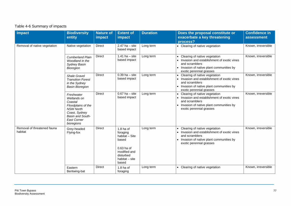
Table 4-6 Summary of impacts
Impact Biodiversity Nature of Extent of Duration Does the proposal constitute or Confidence in entity impact impact exacerbate a key threatening assessment
process? Removal of native vegetation Native vegetation Direct 2.47 ha – site
based impact Long term • Clearing of native vegetation Known, irreversible
Cumberland Plain Direct 1.41 ha – site Long term • Clearing of native vegetation Known, irreversible
Woodland in the based impact • Invasion and establishment of exotic vines
Sydney Basin Bioregion
and scramblers
• Invasion of native plant communities by exotic perennial grasses
Shale Gravel Direct 0.39 ha – site Long term • Clearing of native vegetation Known, irreversible
Transition Forest based impact • Invasion and establishment of exotic vines
in the Sydney Basin Bioregion
and scramblers
• Invasion of native plant communities by exotic perennial grasses
Freshwater Wetlands on Coastal Floodplains of the NSW North Coast, Sydney Basin and South-East Corner bioregions
Direct 0.67 ha – site based impact
Long term • Clearing of native vegetation
• Invasion and establishment of exotic vines and scramblers
• Invasion of native plant communities by exotic perennial grasses
Known, irreversible
Removal of threatened fauna habitat
Grey-headed Flying-fox
Direct 1.8 ha of foraging habitat – Site based
0.63 ha of modified and disturbed habitat – site based
Long term • Clearing of native vegetation
• Invasion and establishment of exotic vines and scramblers
• Invasion of native plant communities by exotic perennial grasses
Known, irreversible
Eastern Bentwing-bat
Direct 1.8 ha of foraging
Long term • Clearing of native vegetation Known, irreversible
Pitt Town Bypass Biodiversity Assessment
77

Impact Biodiversity Nature of Extent of Duration Does the proposal constitute or Confidence in entity impact impact exacerbate a key threatening assessment
process? habitat – Site based
0.63 ha of modified and disturbed habitat – site based
Eastern Freetail-bat
Direct 1.8 ha of foraging habitat – Site
Long term • Clearing of native vegetation
• Loss of hollow-bearing trees
Known, irreversible
based
0.63 ha of modified and disturbed habitat – site based
One HBT and one stag – site based
Greater Broad-nosed Bat
Direct 1.8 ha of foraging habitat – Site
Long term • Clearing of native vegetation
• Loss of hollow-bearing trees
Known, irreversible
based
0.63 ha of modified and disturbed habitat – site based
One HBT and one stag – site based
Southern Myotis Direct 1.8 ha of foraging
Long term • Clearing of native vegetation
• Loss of hollow-bearing trees
Known, irreversible
Pitt Town Bypass Biodiversity Assessment
78

Impact Biodiversity entity
Nature of impact
Extent of impact
Duration Does the proposal constitute or exacerbate a key threatening process?
Confidence in assessment
habitat – Site based
0.63 ha of modified and disturbed habitat – site based
One HBT and one stag – site based
Cumberland Plain Land Snail
Direct 1.41 ha of habitat – Site based
Long term • Clearing of native vegetation
• Removal of dead wood and dead trees
Known, irreversible
Removal of threatened flora and their habitat
Acacia pubescens Direct 5 individuals
1.8 ha of habitat – site based
Long term • Clearing of native vegetation
• Invasion of native plant communities by exotic perennial grasses
Known, irreversible
Dillwynia Direct 4 individuals Long term • Clearing of native vegetation Known, irreversible
tenuifolia 1.8 ha of habitat – site based
• Invasion of native plant communities by exotic perennial grasses
Micromyrtus minutiflora
Direct 0.39 ha of habitat – site based
Long term • Clearing of native vegetation
• Invasion of native plant communities by exotic perennial grasses
Known, irreversible
Spiked Rice-flower Pimelea spicata
Direct 1.41 ha of habitat – site based
Long term • Clearing of native vegetation
• Invasion of native plant communities by exotic perennial grasses
Known, irreversible
Aquatic impacts Freshwater Wetlands on Coastal Floodplains of the NSW North Coast, Sydney Basin and South-East Corner bioregions
Direct 0.67 ha – site based impact
Long term • Clearing of native vegetation
• Loss and degradation of native plant and animal habitat by invasion of escaped garden plants, including aquatic plants
• Alteration to the natural flow regimes of rivers and streams and their floodplains and wetlands
Known, irreversible
Pitt Town Bypass Biodiversity Assessment
79

Impact Biodiversity Nature of Extent of Duration Does the proposal constitute or Confidence in entity impact impact exacerbate a key threatening assessment
process? Loss of Class 4 Direct and Site based Long term and Short • Alteration to the natural flow regimes of Predictable Unlikely Fish indirect impact term rivers and streams and their floodplains and Habitat wetlands
Injury and mortality of fauna Native and threatened fauna
Direct Local impact Long term No Unexpected
Fragmentation of identified Native and Direct/ Local impact Long term No Predictable biodiversity links and habitat threatened fauna indirect corridors
Edge effects on adjacent native vegetation and habitat
Native vegetation and native fauna
Indirect Local impact Long term • Invasion and establishment of exotic vines and scramblers
• Invasion of native plant communities by exotic perennial grasses
• Loss and degradation of native plant and
Predictable
animal habitat by invasion of escaped
garden plants, including aquatic plants
• Competition and grazing by the feral
European Rabbit, Oryctolagus cuniculus
• Predation by the European Red Fox
Vulpes Vulpes
• Predation by the Feral Cat Felis catus
Invasion and spread of weeds Native vegetation Indirect Local impact Long term • Invasion and establishment of exotic vines Predictable and fauna habitat and scramblers
• Invasion of native plant communities by exotic perennial grasses
• Loss and degradation of native plant and animal habitat by invasion of escaped garden plants, including aquatic plants
Invasion and spread of pests Fauna habitat and diversity
Indirect Local impact Long term • Competition and grazing by the feral European Rabbit (Oryctolagus cuniculus)
• Invasion and establishment of the Cane
Predictable
Toad (Bufo marinus)
• Predation by the European Red Fox (Vulpes vulpes)
• Predation by the Feral Cat (Felis catus)
• Predation by Plague Minnow or Mosquito Fish (Gambusia holbrooki)”
Pitt Town Bypass Biodiversity Assessment
80

Impact Biodiversity Nature of Extent of Duration Does the proposal constitute or Confidence in entity impact impact exacerbate a key threatening assessment
process?
Invasion and spread of pathogens and disease
Native vegetation and fauna diversity
Indirect Local impact Long term • Infection of native plants by Phytophthora cinnamomi
• Introduction and Establishment of Exotic Rust Fungi of the order Pucciniales pathogenic on plants of the family Myrtaceae
• Infection by psittacine circoviral (beak and feather) disease affecting endangered psittacine species and populations
• Infection of frogs by amphibian chytrid causing the disease chytridiomycosis
Unpredictable
Changes to hydrology Aquatic vegetation and diversity
Direct/ indirect
Site based Short term • Alteration to the natural flow regimes of rivers and streams and their floodplains and wetlands
Predictable
Noise, light and vibration Native fauna Direct/ Site based Long term (operational) No Unpredictable indirect and short term
(construction)
Pitt Town Bypass Biodiversity Assessment
81

5 Avoid, minimise and mitigate impacts
5.1 Avoidance and minimisation
Impacts on ecological values should be avoided as far as practicable during the detailed design of the proposal.
The removal of native vegetation, particularly Cumberland Plain Woodland, has been minimised as much as possible by optimising the design in proximity to the distribution of this critically endangered ecological community (CEEC) in the northern extent of the study area.
Temporary construction features, such as sediment basins, ancillary sites, access tracks and other features that would require vegetation clearing have been located in areas of exotic grassland, away from Cumberland Plain Woodland and Shale Gravel Transition Forest. Development of the detailed design on the proposal should aim to maximise the number of hollow-bearing trees that could be retained within the study area.
5.2 Mitigation measures
Where impacts cannot be avoided, safeguards will be implemented to mitigate these impacts during construction and operation. Mitigation measures proposed to be implemented are described in Table 5-1.
Pitt Town Bypass Biodiversity Assessment
82

Table 5-1 Mitigation measures
Impact Mitigation measures Timing and duration
Likely efficacy of mitigation
Residual impacts anticipated
Removal of native vegetation (including TECs), threatened species and habitat
Measures to further minimise the construction boundary and avoid native vegetation or habitat removal will be investigated during detailed design and implemented where practicable and feasible.
Detailed design Effective Yes – a residual impact of 2.47 ha of native vegetation loss, four stems of Dillwynea tenuifolia and five stems of Acacia pubescens will remain.
Pre-clearing surveys will be undertaken in accordance with Guide 1: Pre-clearing process of the Biodiversity Guidelines: Protecting and managing biodiversity on RTA projects (RTA 2011).
Prior to construction Effective
Vegetation removal will be undertaken in accordance with Guide 4: Clearing of vegetation and removal of bushrock of the Biodiversity Guidelines: Protecting and managing biodiversity on RTA projects (RTA 2011).
During construction Effective
Where feasible, and where it does not substantially affect maintenance and safe operation of the proposal, native vegetation will be re-established in accordance with Guide 3: Re-establishment of Native Vegetation of the Biodiversity Guidelines: Protecting and Managing Biodiversity on RTA Projects (RTA, 2011).
Post construction Effective
Investigation will occur during detailed design for opportunities to replace or reinstate habitat where practical and feasible in accordance with Guide 5: Re-use of Woody Debris and Bushrock and Guide 8: Nest Boxes of the Biodiversity Guidelines: Protecting and Managing Biodiversity on RTA Projects (RTA, 2011).
During construction Proven
The unexpected species find procedure will be followed under Biodiversity Guidelines: Protecting and Managing Biodiversity on RTA Projects (RTA, 2011) if threatened ecological communities, flora or fauna not assessed in the biodiversity assessment are identified within the construction boundary.
During construction Proven
Aquatic impacts Aquatic habitat will be protected in accordance with Guide 10: Aquatic Habitats and Riparian Zones of the (RTA, 2011) and Section 3.3.2 Standard Precautions and Mitigation Measures of the Policy and Guidelines for Fish Habitat Conservation And Management Update 2013 (DPI (Fisheries NSW), 2013).
During construction Effective Residual impacts unlikely
Changes to hydrology Changes to existing surface water flows would mimic surface water flows during construction stage and re-established during operation.
Detailed design Effective Residual impacts unlikely
Edge effects on adjacent native vegetation and habitat
Exclusion zones will be set up at the limit of clearing in accordance with Guide 2: Exclusion zones of the Biodiversity Guidelines: Protecting and managing biodiversity on RTA projects (RTA 2011).
The limit of clearing will be confirmed within the construction footprint during the detailed design process.
During construction Effective Residual impacts unlikely
Pitt Town Bypass Biodiversity Assessment Report
83

Impact Mitigation measures Timing and duration
Likely efficacy of mitigation
Residual impacts anticipated
Injury and mortality of fauna
Fauna will be managed in accordance with Guide 9: Fauna handling of the Biodiversity Guidelines: Protecting and managing biodiversity on RTA projects (RTA 2011b).
During construction Effective Residual impacts unlikely
Invasion and spread of weeds
Weed species will be managed in accordance with Guide 6: Weed management of the Biodiversity Guidelines: Protecting and managing biodiversity on RTA projects (RTA 2011c).
During construction Effective Residual impacts unlikely
Invasion and spread of pests
Pest species will be managed within the proposal site. During construction Effective Residual impacts unlikely
Invasion and spread of pathogens and disease
Pathogens will be managed in accordance with Guide 2: Exclusion zones of the Biodiversity Guidelines: Protecting and managing biodiversity on RTA projects (RTA 2011d).
During construction Effective Residual impacts unlikely
Noise, light and vibration
Shading and artificial light impacts will be minimised through detailed design. Detailed design Effective Residual impacts unlikely
Pitt Town Bypass Biodiversity Assessment Report
84

6 Offset strategy
6.1 Quantification of impacts
Following the avoidance, minimisation and mitigation of potential impacts, residual impacts may
require offsetting if they meet given thresholds. Roads and Maritime have developed the Guideline for Biodiversity Offsets (Roads and Maritime 2016) to provide quantitative guidance for these
thresholds. This Guideline was reviewed to determine whether biodiversity offsets would be
required for the current proposal. The biodiversity values identified in the study area were
compared with the offset requirements in the guideline table (Table 6-1).
Table 6-1 Assessment of biodiversity values of the proposal area with Table 1 of the Roads and Maritime Biodiversity Offset Guidelines
Description of activity or impact Consider offsets or supplementary measures
Relevant to proposal
Activities in accordance with Roads and Maritime Environmental assessment procedure: Routine and Minor Works (RTA 2011)
No No
Works on cleared land, plantations, exotic vegetation where there are no threatened species or habitat present
No No
Works involving clearing of vegetation planted as part of a road corridor landscaping program (this includes where threatened species or species comprising listed ecological communities have been used for landscaping purposes)
No No
Works involving clearing of national or NSW listed CEEC
Where there is any clearing of an CEEC in moderate to good condition
Yes:
• There would be removal of
1.41 Cumberland Plain
Shale Woodlands and
Shale-Gravel Transition
Forest (EPBC Act)
• There would be removal of
1.41 Cumberland Plain
Woodland CEEC (BC Act)
Works involving clearing of nationally listed TEC or nationally listed threatened species habitat
Where clearing >1 ha of a TEC or habitat in moderate to good condition
No
The following impacts are below the offset consideration threshold:
• There would be removal of
0.21 hectares of occupied
habitat for Acacia pubescens
• There would be removal of
1.41 hectares of potential
habitat for Spiked Rice-
flower Pimelea spicata. As
this potential habitat was is
not occupied by a
population, offsetting
Cumberland Plain Woodland
(as per the CEEC offset
requirments above) is
Pitt Town Bypass Biodiversity Assessment Report
85

considered adequate for this
species.
• There would be removal of
1.41 hectares of potential
habitat for Cumberland Plain
Land Snail. As this potential
habitat was is not occupied
by a population, offsetting
Cumberland Plain Woodland
(as per the CEEC offset
requirments above) is
considered adequate for this
species
Works involving clearing of NSW endangered or vulnerable ecological community
Where clearing > 5 ha or where the ecological community is subject to an SIS
No
The following impacts are below the offset consideration threshold:
• There would be removal of
0.39 Shale Gravel Transition
Forest EEC
• There would be removal of
0.67 of Freshwater Wetlands
on Coastal Floodplains EEC
Works involving clearing of NSW listed threatened species habitat where the species is a species credit species as defined in the OEH Threatened Species Profile Database (TSPD)
Where clearing > 1 ha or where the species is the subject of an SIS
No
The following impacts are below the area threshold:
• There would be removal of
0.31 hectares of occupied
habitat for Dillwynia tenuifolia
• There would be removal of
0.21 hectares of occupied
habitat for Acacia pubescens
• There would be removal of
1.41 hectares of potential
habitat for Spiked Rice-
flower Pimelea spicata. As
this potential habitat was is
not occupied by a
population, offsetting
Cumberland Plain Woodland
(as per the CEEC offset
requirments above) is
considered adequate for this
species.
• There would be removal of
1.41 hectares of potential
habitat for Cumberland Plain
Land Snail. As this potential
habitat was is not occupied
by a population, offsetting
Cumberland Plain Woodland
(as per the CEEC offset
requirments above) is
Pitt Town Bypass Biodiversity Assessment Report
86
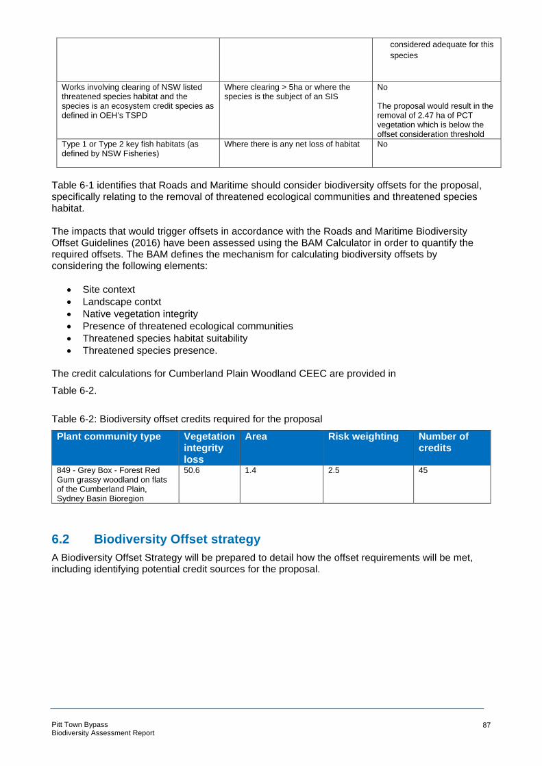
considered adequate for this
species
Works involving clearing of NSW listed threatened species habitat and the species is an ecosystem credit species as defined in OEH’s TSPD
Where clearing > 5ha or where the species is the subject of an SIS
No
The proposal would result in the removal of 2.47 ha of PCT vegetation which is below the offset consideration threshold
Type 1 or Type 2 key fish habitats (as defined by NSW Fisheries)
Where there is any net loss of habitat No
Table 6-1 identifies that Roads and Maritime should consider biodiversity offsets for the proposal, specifically relating to the removal of threatened ecological communities and threatened species habitat. The impacts that would trigger offsets in accordance with the Roads and Maritime Biodiversity Offset Guidelines (2016) have been assessed using the BAM Calculator in order to quantify the required offsets. The BAM defines the mechanism for calculating biodiversity offsets by considering the following elements:
• Site context
• Landscape contxt
• Native vegetation integrity
• Presence of threatened ecological communities
• Threatened species habitat suitability
• Threatened species presence. The credit calculations for Cumberland Plain Woodland CEEC are provided in
Table 6-2.
Table 6-2: Biodiversity offset credits required for the proposal
Plant community type Vegetation integrity loss
Area Risk weighting Number of credits
849 - Grey Box - Forest Red Gum grassy woodland on flats of the Cumberland Plain, Sydney Basin Bioregion
50.6 1.4 2.5 45
6.2 Biodiversity Offset strategy
A Biodiversity Offset Strategy will be prepared to detail how the offset requirements will be met, including identifying potential credit sources for the proposal.
Pitt Town Bypass Biodiversity Assessment Report
87

7 Conclusion
Biodiversity field investigations were carried across the study area by four Arcadis ecologists between 13 February and 20 February 2018. The weather was typically warm and dry across the survey period. Field investigations included classification of the vegetation into PCTs, completing BAM plots to determine the vegetation integrity, targeted surveys for threatened flora (including random meanders and parallel field traverses), spotlighting and call playback for nocturnal fauna, placement of two ANABAT devices, diurnal bird surveys and general habitat assessments. The ecological assessment for Pitt Town Bypass identified the presence of the following ecological constraints within the study area:
• 2.95 ha Cumberland Plain Woodland in the Sydney Basin Bioregion (critically endangered under the BC act) also equivalent to Cumberland Plain Woodland and Shale-Gravel Transition Forest (critically endangered under the EPBC Act)
• 1.78 ha of Shale Gravel Transition Forest in the Sydney Basin Bioregion (endangered under the BC act) but not equivalent to Cumberland Plain Woodland and Shale-Gravel Transition Forest (critically endangered under the EPBC Act) based on condition
• 1.46 ha of Freshwater Wetlands on Coastal Floodplains of the NSW North Coast, Sydney Basin and South East Corner bioregions (endangered under the BC Act)
• Approximately 30 stems of Acacia pubescens (vulnerable under the EPBC Act and BC Act)
• Four stems of Dillwynea tenuifolia (vulnerable under the BC Act)
• Grey-headed Flying-fox (vulnerable under the EPBC Act and BC Act)
• Eastern Bentwing-bat (vulnerable under the BC Act)
• Eastern Freetail-bat (vulnerable under the BC Act)
• Greater Broad-nosed Bat (vulnerable under the BC Act)
• Southern Myotis (vulnerable under the BC Act)
• Potential habitat for: o Micromyrtus minutiflora (vulnerable under the EPBC Act and endangered under the
BC Act) o Pimelea spicata (endangered under the EPBC Act and BC Act) o Cumberland Plain Land Snail (endangered under the EPBC Act and BC Act).
An un-named tributary of Hortons Creek traverses the study area. Hortons Creek is a tributary of Pitt Town Lagoon, a nationally significant wetland containing habitat for migratory birds. The un-named waterway is consistent with Class 4 Unlikely Fish Habitat (DPI 2015) (and are not consistent with Key Fish Habitat). No threatened fish species are considered likely to occur within the study area. Similarly, the aquatic environments within the study area do not provide potential habitat for threatened frogs. Impacts to these threatened species and ecological communities have been avoided and minimised where possible through the concept design, however the proposal would result in residual impacts to threatened biodiversity. The residual impacts include:
• The removal of 1.41 ha Cumberland Plain Woodland in the Sydney Basin Bioregion (equivalent to Cumberland Plain Woodland and Shale-Gravel Transition Forest)
• The removal of 0.39 ha of Shale Gravel Transition Forest in the Sydney Basin Bioregion (not equivalent to Cumberland Plain Woodland and Shale-Gravel Transition Forest)
• The removal of 0.67 ha of Freshwater Wetlands on Coastal Floodplains of the NSW North Coast, Sydney Basin and South-East Corner bioregions
• Loss of five stems of Acacia pubescens • Loss of four stems of Dillwynea tenuifolia • Loss of potential foraging resources for:
o Grey-headed Flying-fFox o Eastern Bentwing-bat
Pitt Town Bypass Biodiversity Assessment Report
88

o Eastern Freetail-bat o Greater Broad-nosed Bat o Southern Myotis
• Loss off potential habitat for several threatened flora and fauna species. Under the Roads and Maritime Strategic Assessment, referral of an action to the Commonwealth Department of the Environment and Energy is not required. However, consideration of whether an action is likely to result in a significant impact to MNES is required during assessment of the proposal. Accordingly, Significant Impact Criteria assessments for MNES recorded or considered likely to occur within the study area have been conducted for the species that could be impacted by the proposal (noted above). In summary, these assessments have determined that a significant impact to MNES is not likely. Further, the significance of impacts to BC Act listed biota that could be impacted by the proposal (noted above) have been assessed in accordance with the five criteria listed in Section 7.3 of the BC Act. These tests have determined that the proposal is unlikely to result in a significant impact to any threatened species or ecological communities listed under the BC Act. Mitigation measures to manage the potential construction and operational impacts of the proposal on biodiversity have been provided. The key measures would be the continued minimisation of impacts to threatened biota through design and the management of construction phase impacts such as fauna mortality, spread of weeds and habitat loss. In accordance with the Roads and Maritime Guideline for Biodiversity Offsets 2016, biodiversity offsets would be required for Cumberland Plain Woodland. The BAM Calculator has been used to quantify the offset requirements and it has been calculated that 45 credits would be required for removal of 1.41 hectares of Cumberland Plain Woodland (PCT 849 - Grey Box - Forest Red Gum grassy woodland on flats of the Cumberland Plain, Sydney Basin Bioregion). A Biodiversity Offset Strategy (BOS) will be prepared to document how this offset requirement will be met.
Pitt Town Bypass Biodiversity Assessment Report
89

8 References
Anderson J., Law B., Tidemann C. (2006). Stream use by the Large-footed Mytois Myotis
macropus in relation to environmental variables in northern New South Wales.
Bannerman, S.M. and Hazelton, P.A. (1990). Soil Landscapes of the Penrith 1:100 000 Sheet. Soil
Conservation Science of NSW, Sydney.
Bionet (2018) NSW BioNet. Office of Environment and Heritage, Sydney. URL:
http://www.bionet.nsw.gov.au/
BOM 2018 Groundwater Dependent Ecosystem Atlas
Churchill 1998 Australian Bats. Allen and Unwin, NSW
DEC (2004) Threatened Biodiversity Survey and Assessment Guidelines for Developments and
Activities, Department of Environment and Conservation, Sydney
DEC (2004a) Natural Resource Management Advisory Series: Note 7- Bat roosts. Department of
Environment and Conservation, Sydney
DEC (2005) Pimelea spicata R. Br. Recovery Plan. Department of Environment and Conservation
(NSW), Hurstville NSW.DECC (2007). Threatened Species Assessment Guidelines: the assessment of significance. NSW Department of Environment and Climate Change, Hurstville.
DECC (2005c), Micromyrtus minutiflora – Profile, Department of Environment and Climate Change
URL: http://www.threatenedspecies.environment.nsw.gov.au/tsprofile/profile.aspx?id=10529
DECCW (2009). Draft National Recovery Plan for the Grey-headed Flying-fox Pteropus poliocephalus. Prepared by Dr Peggy Eby. Department of Environment, Climate Change and
Water NSW, Sydney.
DEE (2010a). Australia Wetland Database: Longneck Lagoon. Available online: http://www.environment.gov.au/cgi-bin/wetlands/report.pl?smode=DOIW;doiw_refcodelist=NSW083 Accessed 19 February 2018. Department of Environment and Energy. DEE (2010b). Australia Wetland Database: Pitt Town Lagoon. Available online: http://www.environment.gov.au/cgi-bin/wetlands/report.pl?smode=DOIW;doiw_refcodelist=NSW087 Accessed 19 February 2018. DEE (2017a). National Flying-fox monitoring viewer. Available online: http://www.environment.gov.au/webgis-framework/apps/ffc-wide/ffc-wide.jsf
DES (2018). Groundwater dependent ecosystems, Queensland Department of Environment and Science, viewed 19 April 2018, https://wetlandinfo.ehp.qld.gov.au/wetlands/ecology/aquatic-ecosystems-natural/groundwater-dependent/
DFP Town Planners (2007) Environmental Assessment: Pitt Town Residential Precinct. DFP Town
Planners.
DoEE (2013) Significant Impact Guidelines 1.1 - Matters of National Environmental Significance
Pitt Town Bypass Biodiversity Assessment Report
90
DoEE (2017a). EPBC Protected Matters Search Tool. Available from:
http://www.environment.gov.au/topics/about-us/legislation/environment-protection-and-biodiversity-
conservation-act-1999/protected
DPI (2015). Policy and guidelines for fish habitat conservation and management guidelines
Dwyer, P.D. (1995) Common Bentwing-bat Miniopterus schreibersii Pp. 494-5 in Strahan, R. (ed.)
The Mamals of Australia. Reed Books, Sydney.Eco Logical (2014). North West Rail Link Biodiversity Offset Package. Report prepared for Transport for NSW.
Eco Logical (2015). Vineyard Precinct Biodiversity and Riparian Corridors Assessment. Report
prepared for NSW Department of Planning and Environment.
EMM (2016). Pitt town Bypass: Preliminary Environmental Assessment. EMM. Sydney.
Fairfull, S. and Witheridge G. (2003). Why do fish need to cross the road? Fish passage
requirements for waterway crossings. NSW Fisheries, Cronulla.
Hawkesbury Shire Council (2012) Hawkesbury Local Environment Plan. Hawkesbury Shire Council
NPWS (2000). Scheyville National Park and Pitt Town Nature Reserve Plan of Management. NSW National Parks and Wildlife Service, Sydney.
NPWS (2001) Grey-headed Flying-fox- Threatened species information, NSW National Parks and Wildlife Service, Sydney. URL: https://www.environment.nsw.gov.au/resources/nature/tsprofileGreyheadedFlyingfox.pdf
NPWS (2002) The environmental impact assessment guidelines for Dillwynia tenuifolia
NPWS (2004). NSW National Parks and Wildlife Service 2003, The Bioregions of New South
Wales: their biodiversity, conservation and history. NSW National Parks and Wildlife Service,
Sydney.
OEH (2000). Environmental Impact Assessment Guidelines: Cumberland Plain Large Land Snail
OEH (2002). Shale gravel transition forest in the Sydney Basin Bioregion - endangered ecological
community listing
OEH (2008). Freshwater Wetlands on Coastal Floodplains ID guidelines
OEH (2010). Freshwater Wetlands on Coastal Floodplains of the NSW North Coast, Sydney Basin
and South East Corner bioregions – Determination
OEH (2016) NSW Guide for surveying threatened plants. Offcie of Environment and Heritage,
Sydney. URL: https://www.environment.nsw.gov.au/resources/threatenedspecies/160129-
threatened-plants-survey-guide.pdf
OEH (2017). Biodiversity Assessment Method, Office of Environment and Heritage for NSW
Government, Sydney. URL: https://www.environment.nsw.gov.au/resources/bcact/biodiversity-
assessment-method-170206.pdf
Pitt Town Bypass Biodiversity Assessment Report
91

OEH (2018c) Threatened biodiversity profile search, Office of Environment and Heritage, Sydney.
URL: https://www.environment.nsw.gov.au/threatenedspeciesapp/
OEH (2018b). Vegetation Information System Classification database. NSW Office of Environment and Heritage. Available online: www.environment.nsw.gov.au/NSWVCA20PRapp/LoginPR.aspx
OEH (2018a). NSW Office of Environment and Heritage Bionet: Atlas of NSW Wildlife. Available
online: http://www.environment.nsw.gov.au/atlaspublicapp/UI_Modules/ATLAS_/AtlasSearch.aspx
Parry-Jones, K.A and Augee, M.L (2001) Factors affecting the occupation of a colony site in
Sydney, New South Wales by the Grey-headed flying-fox Pteropus poliocephalus (Pteropodidae),
Austral Ecology. 26, 47-55
Pennay 2004 Bat calls of New South Wales Sydney Basin region
Roads and Maritime (2015). Environmental Assessment and Decision-making by NSW Roads and
Maritime Services: Strategic Assessment – Under Part 10 Environment Protection and Biodiversity
Conservation Act 1999. Strategic Assessment Report – Final. Roads and Maritime Services,
Sydney. Document Number: 14.562.
Roads and Maritime (2016) Guideline for Biodiversity Offsets. Roads and Maritime Services,
Sydney.
RTA (2011) Biodiversity Guidelines: Protecting and managing biodiversity on RTA project. RTA
Environment Branch, Sydney.
RTA (2011b) Guide 9: Fauna handling of the Biodiversity Guidelines: Protecting and managing
biodiversity on RTA projects RTA Environment Branch, Sydney.
RTA (2011c) Guide 6: Weed management of the Biodiversity Guidelines: Protecting and managing
biodiversity on RTA projects, RTA Environment Branch, Sydney.
RTA (2011d) Guide 2: Exclusion zones of the Biodiversity Guidelines: Protecting and managing
biodiversity on RTA project, RTA Environment Branch, Sydney.
SMEC (2013). Schofields Road Upgrade: Stage 3 Veron Road to Richmond Road Review of
environmental factors. Report prepared for NSW Roads and Maritime Services.
Tidemann C (1995). Grey-Headed Flying-Fox. In (Eds) Strahan R The Australian Museum Complete Book of Australian Mammals (pp 494-495) Angus & Robertson, Sydney.
Tozer, M. (2003) The native vegetation of the Cumberland Plain, western Sydney: systematic classification and field identification of communities. Cunninghamia 8(1): 1-75.
Van der Ree, R., Clarkson, D. T., Holland, K., Gulle, N. and Budden, M. (2007) Review of
Mitigation Measures Used to Deal with the Issue of Habitat Fragmentation by Major Linear
Infrastructure. Report for the Department of Environment and Water Resources, Symonston.
Williams N., McDonnell M., Phelan G., Keim L., Van der Ree R. (2006). Range expansion due to
urbanization: Increased food resources attract Grey-headed Flying-foxes (Pteropus poliocephalus)
to Melbourne. Austral Ecology, 31 (2) pp. 190-198.
Pitt Town Bypass Biodiversity Assessment Report
92
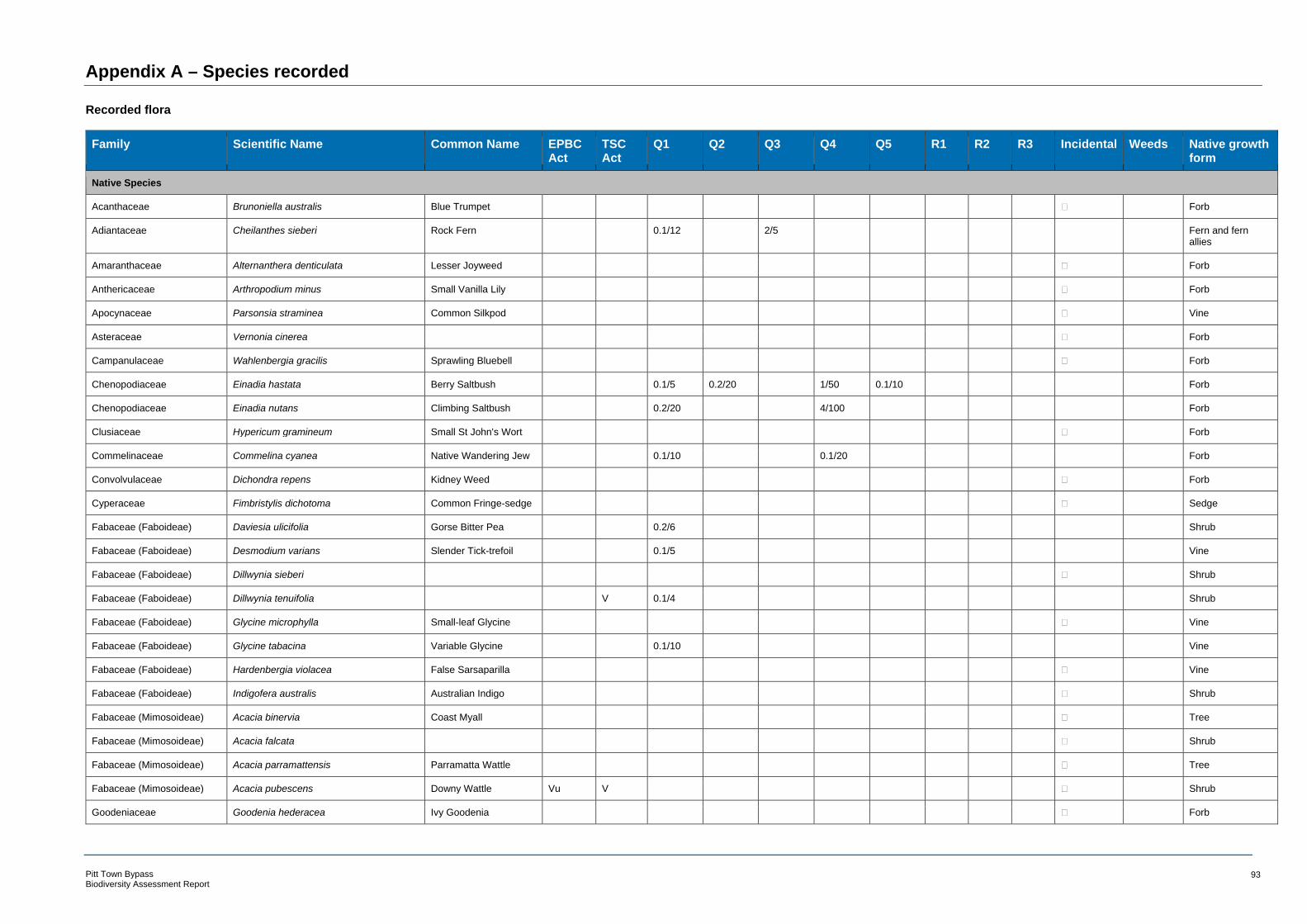
Appendix A – Species recorded
Recorded flora
Family
Native Species
Scientific Name Common Name EPBC Act
TSC Act
Q1 Q2 Q3 Q4 Q5 R1 R2 R3 Incidental Weeds Native growth form
Acanthaceae Brunoniella australis Blue Trumpet Forb
Adiantaceae Cheilanthes sieberi Rock Fern 0.1/12 2/5 Fern and fern allies
Amaranthaceae Alternanthera denticulata Lesser Joyweed Forb
Anthericaceae Arthropodium minus Small Vanilla Lily Forb
Apocynaceae Parsonsia straminea Common Silkpod Vine
Asteraceae Vernonia cinerea Forb
Campanulaceae Wahlenbergia gracilis Sprawling Bluebell Forb
Chenopodiaceae Einadia hastata Berry Saltbush 0.1/5 0.2/20 1/50 0.1/10 Forb
Chenopodiaceae Einadia nutans Climbing Saltbush 0.2/20 4/100 Forb
Clusiaceae Hypericum gramineum Small St John's Wort Forb
Commelinaceae Commelina cyanea Native Wandering Jew 0.1/10 0.1/20 Forb
Convolvulaceae Dichondra repens Kidney Weed Forb
Cyperaceae Fimbristylis dichotoma Common Fringe-sedge Sedge
Fabaceae (Faboideae) Daviesia ulicifolia Gorse Bitter Pea 0.2/6 Shrub
Fabaceae (Faboideae) Desmodium varians Slender Tick-trefoil 0.1/5 Vine
Fabaceae (Faboideae) Dillwynia sieberi Shrub
Fabaceae (Faboideae) Dillwynia tenuifolia V 0.1/4 Shrub
Fabaceae (Faboideae) Glycine microphylla Small-leaf Glycine Vine
Fabaceae (Faboideae) Glycine tabacina Variable Glycine 0.1/10 Vine
Fabaceae (Faboideae) Hardenbergia violacea False Sarsaparilla Vine
Fabaceae (Faboideae) Indigofera australis Australian Indigo Shrub
Fabaceae (Mimosoideae) Acacia binervia Coast Myall Tree
Fabaceae (Mimosoideae) Acacia falcata Shrub
Fabaceae (Mimosoideae) Acacia parramattensis Parramatta Wattle Tree
Fabaceae (Mimosoideae) Acacia pubescens Downy Wattle Vu V Shrub
Goodeniaceae Goodenia hederacea Ivy Goodenia Forb
Pitt Town Bypass Biodiversity Assessment Report
93

Family Scientific Name Common Name EPBC Act
TSC Act
Q1 Q2 Q3 Q4 Q5 R1 R2 R3 Incidental Weeds Native growth form
Goodeniaceae Goodenia hederacea subsp. hederacea Forb
Juncaceae Juncus usitatus Rush
Lomandraceae Lomandra filiformis Wattle Matt-rush Rush
Lomandraceae Lomandra filiformis subsp. filiformis Rush
Lomandraceae Lomandra gracilis 8/500 0.5/15 3/500 Rush
Lomandraceae Lomandra longifolia Spiny-headed Mat-rush 1/20 Rush
Lomandraceae Lomandra multiflora subsp. multiflora Many-flowered Mat-rush
Rush
Meliaceae Melia azedarach White Cedar 0.1/2 0.1/2 Tree
Myoporaceae Eremophila debilis Amulla Shrub
Myrtaceae Eucalyptus crebra Narrow-leaved Ironbark Tree
Myrtaceae Eucalyptus eugenioides Thin-leaved Stringybark Tree
Myrtaceae Eucalyptus fibrosa Red Ironbark 15/4 Tree
Myrtaceae Eucalyptus moluccana Grey Box 25/6 1/1 40/60 10/3 Tree
Myrtaceae Eucalyptus tereticornis Forest Red Gum Tree
Myrtaceae Melaleuca decora Shrub
Myrtaceae Melaleuca linariifolia Flax-leaved Paperbark 0.5/3 5/20 Shrub
Oxalidaceae Oxalis perennans Forb
Phormiaceae Dianella longifolia Blueberry Lily 0.5/15 0.2/10 Forb
Phormiaceae Dianella revoluta Blueberry Lily Forb
Phormiaceae Dianella revoluta var. revoluta A Blue Flax Lily Forb
Phyllanthaceae Breynia oblongifolia Coffee Bush Shrub
Phyllanthaceae Phyllanthus hirtellus Thyme Spurge Shrub
Pittosporaceae Bursaria spinosa Native Blackthorn 1/15 15/50 2/15 Shrub
Plantaginaceae Veronica plebeia Trailing Speedwell Forb
Poaceae Aristida vagans Threeawn Speargrass 8/1000 10/1000 0.1/20 Tussock Grass
Poaceae Bothriochloa macra Red Grass Tussock Grass
Poaceae Cymbopogon refractus Barbed Wire Grass 10/500 Tussock Grass
Poaceae Cynodon dactylon Common Couch 6/100 1/100 5/500 15/200 Other Grass
Poaceae Dichelachne micrantha Shorthair Plumegrass Tussock Grass
Poaceae Digitaria parviflora Small-flowered Finger Grass
Tussock Grass
Pitt Town Bypass Biodiversity Assessment Report
94

Family Scientific Name Common Name EPBC Act
TSC Act
Q1 Q2 Q3 Q4 Q5 R1 R2 R3 Incidental Weeds Native growth form
Poaceae Echinopogon caespitosus var. caespitosus
Tufted Hedgehog Grass Tussock Grass
Poaceae Entolasia stricta Wiry Panic 0.1/2 5/1000 Tussock Grass
Poaceae Eragrostis brownii Brown's Lovegrass Tussock Grass
Poaceae Eragrostis leptostachya Paddock Lovegrass 0.2/20 Tussock Grass
Poaceae Microlaena stipoides Weeping Grass Tussock Grass
Poaceae Microlaena stipoides var. stipoides Weeping Grass 0.1/10 Tussock Grass
Poaceae Oplismenus imbecillis Other Grass
Poaceae Panicum simile Two-colour Panic Tussock Grass
Poaceae Paspalidium distans Tussock Grass
Poaceae Phragmites australis Common Reed 90/1000 50/1000 Tussock Grass
Poaceae Rytidosperma fulvum Wallaby Grass 12/1000 Tussock Grass
Poaceae Sporobolus creber Slender Rat's Tail Grass
0.1/3 Tussock Grass
Polygonaceae Persicaria decipiens Slender Knotweed 1/100 1/100 Forb
Rubiaceae Asperula conferta Common Woodruff Forb
Rubiaceae Opercularia diphylla Stinkweed 0.1/2 5/100 Forb
Rubiaceae Pomax umbellata Pomax Forb
Santalaceae Exocarpos cupressiformis Cherry Ballart Shrub
Solanaceae Solanum prinophyllum Forest Nightshade Forb
Typhaceae Typha orientalis Broad-leaved Cumbungi
40/1000 Rush
Violaceae Viola hederacea Ivy-leaved Violet Forb
Exotic Species
Alismataceae Sagittaria platyphylla Sagittaria Bio
Apiaceae Foeniculum vulgare Fennel
Apocynaceae Araujia sericifera Moth Vine HTW
Asparagaceae Asparagus aethiopicus Asparagus Fern Bio/HTW
Asparagaceae Asparagus asparagoides Bridal Creeper 0.1/4 0.1/5 1/20 Bio/HTW
Asteraceae Bidens pilosa Cobbler's Pegs 0.1/1
Asteraceae Cirsium vulgare Spear Thistle
Asteraceae Conyza bonariensis Fleabane 0.1/10 0.3/20
Pitt Town Bypass Biodiversity Assessment Report
95

Family Scientific Name Common Name EPBC Act
TSC Act
Q1 Q2 Q3 Q4 Q5 R1 R2 R3 Incidental Weeds Native growth form
Asteraceae Hypochaeris radicata Catsear
Asteraceae Onopordum acanthium subsp. acanthium Scotch Thistle
Asteraceae Sonchus oleraceus Common Sowthistle 0.1/1
Asteraceae Taraxacum officinale Dandelion
Cactaceae Opuntia aurantiaca Tiger Pear 0.3/50 1/200 Bio
Caprifoliaceae Lonicera japonica Japanese Honeysuckle 0.5/50 1/100 HTW
Convolvulaceae Ipomoea indica Morning Glory HTW
Cyperaceae Cyperus eragrostis Umbrella Sedge HTW
Euphorbiaceae Ricinus communis Castor Oil Plant HTW
Fabaceae (Caesalpinioideae) Senna pendula var. glabrata
Fabaceae (Faboideae) Erythrina crista-galli Cockspur Coral Tree 1/3 1/3 HTW
Fabaceae (Faboideae) Trifolium repens White Clover
Fabaceae (Faboideae) Vicia sativa Common Vetch
Malvaceae Modiola caroliniana Red-flowered Mallow
Malvaceae Sida rhombifolia Paddy's Lucerne 1 2/50
Oleaceae Ligustrum lucidum Large-leaved Privet 0.1/2 0.1/2 HTW
Oleaceae Ligustrum sinense Small-leaved Privet 1/50 1/50 HTW
Plantaginaceae Plantago lanceolata Lamb's Tongues 0.2/25 0.5/10
Poaceae Andropogon virginicus Whisky Grass HTW
Poaceae Avena fatua Wild Oats
Poaceae Axonopus fissifolius Narrow-leafed Carpet Grass
HTW
Poaceae Bromus catharticus Praire Grass
Poaceae Chloris gayana Rhodes Grass HTW
Poaceae Echinochloa crusgalli Barnyard Grass
Poaceae Ehrharta erecta Panic Veldtgrass 0.2/20 HTW
Poaceae Eragrostis curvula African Lovegrass 1/100 50/100 35/1000 HTW
Poaceae Eragrostis tenuifolia Elastic Grass
Poaceae Holcus lanatus Yorkshire Fog
Poaceae Lolium perenne Perennial Ryegrass 5/10 0.5/10
Poaceae Paspalum dilatatum Paspalum HTW
Pitt Town Bypass Biodiversity Assessment Report
96
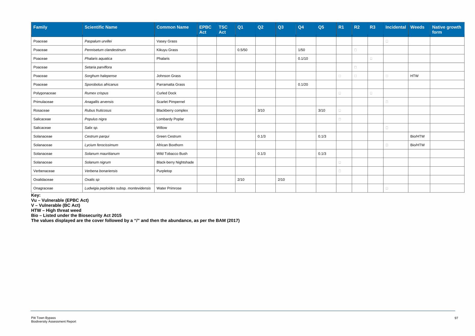
Family Scientific Name Common Name EPBC Act
TSC Act
Q1 Q2 Q3 Q4 Q5 R1 R2 R3 Incidental Weeds Native growth form
Poaceae Paspalum urvillei Vasey Grass
Poaceae Pennisetum clandestinum Kikuyu Grass 0.5/50 1/50
Poaceae Phalaris aquatica Phalaris 0.1/10
Poaceae Setaria parviflora
Poaceae Sorghum halepense Johnson Grass HTW
Poaceae Sporobolus africanus Parramatta Grass 0.1/20
Polygonaceae Rumex crispus Curled Dock
Primulaceae Anagallis arvensis Scarlet Pimpernel
Rosaceae Rubus fruticosus Blackberry complex 3/10 3/10
Salicaceae Populus nigra Lombardy Poplar
Salicaceae Salix sp. Willow
Solanaceae Cestrum parqui Green Cestrum 0.1/3 0.1/3 Bio/HTW
Solanaceae Lycium ferocissimum African Boxthorn Bio/HTW
Solanaceae Solanum mauritianum Wild Tobacco Bush 0.1/3 0.1/3
Solanaceae Solanum nigrum Black-berry Nightshade
Verbenaceae Verbena bonariensis Purpletop
Oxalidaceae Oxalis sp 2/10 2/10
Onagraceae Ludwigia peploides subsp. montevidensis Water Primrose
Key: Vu – Vulnerable (EPBC Act) V – Vulnerable (BC Act) HTW – High threat weed Bio – Listed under the Biosecurity Act 2015 The values displayed are the cover followed by a “/” and then the abundance, as per the BAM (2017)
Pitt Town Bypass Biodiversity Assessment Report
97
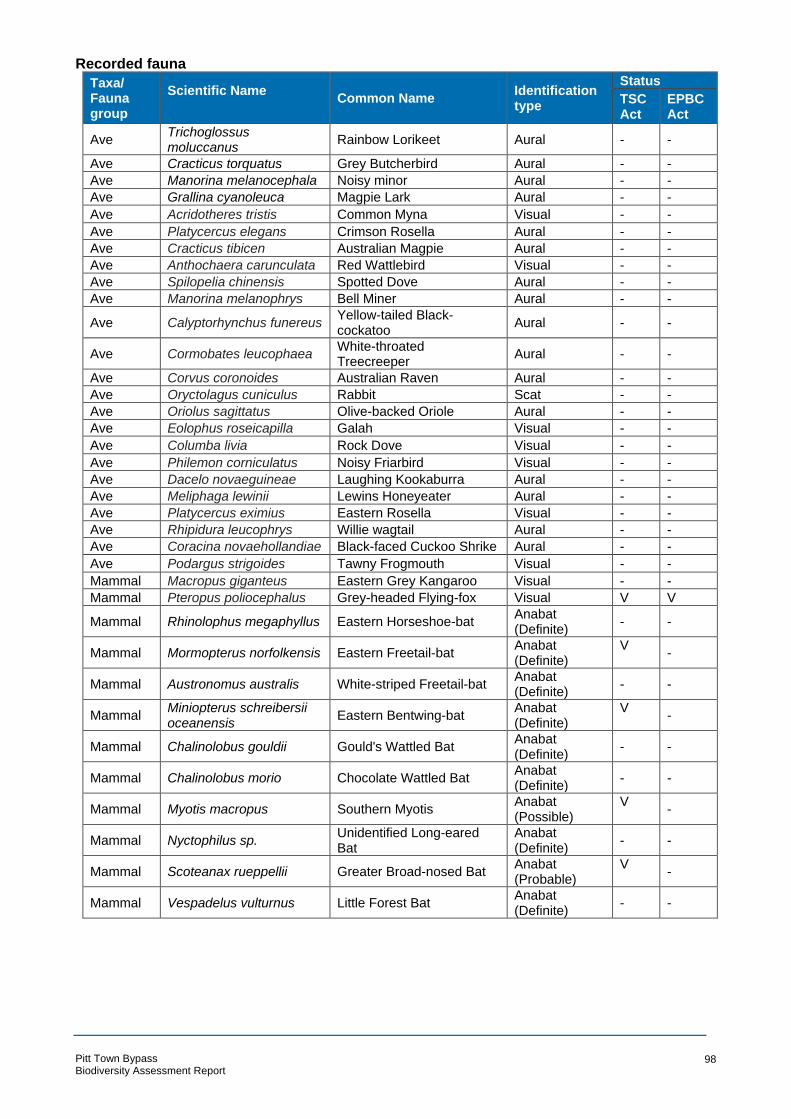
Recorded fauna
Taxa/ Fauna group
Scientific Name Common Name
Identification type
Status
TSC Act
EPBC Act
Ave Trichoglossus moluccanus Rainbow Lorikeet Aural - -
Ave Cracticus torquatus Grey Butcherbird Aural - -
Ave Manorina melanocephala Noisy minor Aural - -
Ave Grallina cyanoleuca Magpie Lark Aural - -
Ave Acridotheres tristis Common Myna Visual - -
Ave Platycercus elegans Crimson Rosella Aural - -
Ave Cracticus tibicen Australian Magpie Aural - -
Ave Anthochaera carunculata Red Wattlebird Visual - -
Ave Spilopelia chinensis Spotted Dove Aural - -
Ave Manorina melanophrys Bell Miner Aural - -
Ave Calyptorhynchus funereus Yellow-tailed Black-cockatoo
Aural - -
Ave Cormobates leucophaea White-throated Treecreeper
Aural - -
Ave Corvus coronoides Australian Raven Aural - -
Ave Oryctolagus cuniculus Rabbit Scat - -
Ave Oriolus sagittatus Olive-backed Oriole Aural - -
Ave Eolophus roseicapilla Galah Visual - -
Ave Columba livia Rock Dove Visual - -
Ave Philemon corniculatus Noisy Friarbird Visual - -
Ave Dacelo novaeguineae Laughing Kookaburra Aural - -
Ave Meliphaga lewinii Lewins Honeyeater Aural - -
Ave Platycercus eximius Eastern Rosella Visual - -
Ave Rhipidura leucophrys Willie wagtail Aural - -
Ave Coracina novaehollandiae Black-faced Cuckoo Shrike Aural - -
Ave Podargus strigoides Tawny Frogmouth Visual - -
Mammal Macropus giganteus Eastern Grey Kangaroo Visual - -
Mammal Pteropus poliocephalus Grey-headed Flying-fox Visual V V
Mammal Rhinolophus megaphyllus Eastern Horseshoe-bat Anabat (Definite)
- -
Mammal Mormopterus norfolkensis Eastern Freetail-bat Anabat (Definite)
V -
Mammal Austronomus australis White-striped Freetail-bat Anabat (Definite)
- -
Mammal Miniopterus schreibersii oceanensis Eastern Bentwing-bat
Anabat (Definite)
V -
Mammal Chalinolobus gouldii Gould's Wattled Bat Anabat (Definite)
- -
Mammal Chalinolobus morio Chocolate Wattled Bat Anabat (Definite)
- -
Mammal Myotis macropus Southern Myotis Anabat (Possible)
V -
Mammal Nyctophilus sp. Unidentified Long-eared Bat
Anabat (Definite)
- -
Mammal Scoteanax rueppellii Greater Broad-nosed Bat Anabat (Probable)
V -
Mammal Vespadelus vulturnus Little Forest Bat Anabat (Definite)
- -
Pitt Town Bypass Biodiversity Assessment Report
98

Appendix B – Habitat assessment table
Pitt Town Bypass Biodiversity Assessment Report
99

Pitt Town Bypass Biodiversity Assessment * # Acacia bynoeana * # Grevillea parviflora subsp. supplicans # * Persoonia nutans# * Acacia gordonii * # !H ibbertia superans # * P imelea curviflora var. curviflora °#* Acacia pubescens #* Kunzea rupestris *# Pimelea spicata # * Ca l l istemon l i nearifolius * # Lasiopetalum j oyceae * # Pterostyl is saxicola * # Darw inia biflora # * Leucopogon fletcheri subsp. fletcheri * # Pul tenaea parviflora # * D illwynia tenuifolia # * Melaleuca deanei *# Syzygium paniculatum #* Epacr i s purpurascens var. purpurascens #* Micromyrtus blakelyi * # Tetratheca glandulosa * # Euca l yptus nicholii # * Micromyrtus minutiflora #* Z i eria involucrata * # Euca l yp tus sp. Cattai # * Olearia cordata* # Grevillea juniperina subsp. juniperina # * Persoonia hirsuta
##***#* #
##***##* #* #**#* # *###***##* ##*#**###****#**##*##*###****##*#*#*#***### * #**## ###**##***##* **#*#*#*#*#**#**###*#*
#* #* *##*
*#*##* *#*#*###***#*#*#*###**#* *#*#*#* # #* * #*#
* # * ##* * # * #
* # * # *#*##* * #*##* #* #* #* *#*##* #* #* #* #*#*#*#* *##* #*#* *#*#*##***#*##*****##*##### # ##*##**# #* *##**#
#* * ###*** * *# * # #*#* #**#**####*****#*#* # * ###** **#*##**#*#***#*#####** ##* ##**#***###* * #* # #* ###*****####*##*##*##***##**#***###**#**##*#*
#*#* #**##*#**#*###*##****#*###*##**###*****##**##**##**##*****####*# ## *****####* * * ###*###****###**#*#*##*##*#**#*###*#*** *# * #*#* # #*##******###** ##* #**# #* #* #####****** ##* **## *#* # * ##* ****#### #* ##**
##**###*#*#* #*#*#**###**###****#** # *#* #*#**#**###**###*#***#*##*#* *##*##** #*#******#*##### *## ##***###* #*#* ##*****##**#* #**###* ##*##**###*#**#* *#* # #* **#* *## #*##*#******#####* * # #* *# #* #* # #* * ##**###*****##*#* ***####* * #
#** # *#* #* # #* #*
#* # * #**# ##*## **#**#*##*##**###****##* * #*#* * # * # #* #* *## *##* *#* #****###* #*# * # ###****#*#*##* #* #* #*#*#* # # *** # #*#*#**#**###**##* #* ###**** #*#**##*##**#***###*# *##**#* # *##* #*#* ##** *### #*# #** ** * #* #* ## * * ##*****##### # *# *#***###**###** *# * #*##*##*#**#*##***####******###*####***######*****#**#**##*#*#*##***##***#*#*#*##***###*#*****##*# * # ###* *#*#*#*##*#**#*###****###*#* #**## *##*# # * #**#* * ##** #*# *
*## #*#** # # *#**#* * #* #*###**
* # *##* * #* # #* #**#*# *##**#*##* ##*#**#** # * ##* #*# * # #*#** #**###**#** # #*#*##*#**##*#**##**#**## * **######***#**####**# #*#** **#**##**# *#*#* *# * ## #*#* ## *# * * ##* *#**#* ##* #* #*#* #* #**##*#**##***###***###* # # #* *#* * #**#* #* # #*#**# * # #* *# * ##**# * ##*#* #**###*##*##* * # ***#** *##
* #*###***#*##**#**#######*#****#*###**#*#**#**####**###***##*##*****#***#*##** #*###***#*##*##* #* * #* #######*******##*
#* #**##* 0 5km
LEGEND ARCADIS AUSTRALIA PACIFIC PTY LTDABN 76 104 485 289Level 16, 580 George St | Sydney NSW 2000
Study area P: +61 (0) 2 8907 9000 | F: +61 (0) 2 8907 9001Coordinate System: GDA 1994 MGA Zone 56
Locality buffer Topographic basemap provided by ESRI GUNDERMAN
1:125,000 at A4 CATTAI HORNSBYPENRITH
B1: Threatened flora within the locality CAMPBELLTOWN Se rvice Laye r Credits:So urce s: Esri, HERE,Garm in, Inter ma p, incrementPCo rp. , GEBCO, USGS,FAO, NPS, NRCAN,
Date: 19/09/2018 Path: \\hc-aus-ns-fs-01\jobs\10014101\D-DigitalEng\DG-GIS\DGA-Current\B_Maps\BAR\G10014101_BAR_007_ThreatenedFloraLocality_A4P_v4.mxdCreated by : RM
QA by : EC

Pitt Town Bypass Biodiversity Assessment ( ! Aus tral as i an B i ttern ( ! Bush S tone-curlew !( G iant Burrowing Frog ! ( Little Lorikeet ( ! Square-t a iled Kite
Australian Painted (! Comb-crested Jacana !( Glossy Black-Cockatoo Major Mitchell's ! ( Squirrel Glider( ! !(Snipe Cumberland Plain Land Greater Broad-nosed Cockatoo (! Star Finch
!( !(( ! Barking Owl Snai l Bat !( Masked Owl ( ! Superb Parrot!( Black Bittern !( Curlew Sandpiper !( Greater Glider ( ! Pa i nted Honeyeater ! ( Swift Parrot ( ! Black Falcon (! Dural Woodland Snail Green and Golden Bell !( Powerful Owl !( (! Turquoise Parrot
Black-chinned !( Dusky Woodswallow Frog !( Red-crowned Toadlet ( ! Varied Sittella ! ( Honeyeater (eastern ( ! Eastern Bentwing-bat ( ! Grey-headed Flying-fox ( ! Regent Honeyeater White-bellied Sea-subspecies) ( !Eastern False Hooded Robin (south- (! !( Scarlet Robin Eagle
! (! ( B lack-necked Stork P i pistrel l e eastern form) ( ! Soo ty Owl ! ( Whi te-fron t ed Chat( ! B l ack-tai l ed Godwit ( ! Eastern Freetail-bat ( ! Koala ! ( Sou t hern Myo ti s (! Yel l ow-be ll i ed G li der( ! Blue-bi l led Duck (! Flame Robin ! ( Large-eared P ied Bat ( ! Speckled Warbler Yellow-bellied
!( Brown Treecreeper !( ! ( Freckled Duck !( Little Bentwing-bat ! ( Spotted Harrier Sheathtail-bat(eastern subspecies) ( ! Gang-gang Cockatoo !( Little Eagle ( ! Spotted-tailed Quoll
!( !!!!!(((((!!((((((((!!(!!!!(!!
( !!!!((((!
!( !(!((!(! (!(!!!((((!! (!(!!( !( !((!!((((((((!(!!!!!!!!!!!((((!( !( (!( ! ((!!!!!((( ( !
!(( ! (!!( ((!! (!( !!!!!((((!( ! ((! (!!( (!
( ! !( (!( (( (! ! ( ( (! ! ( !( ( !!! ! !
!( (! (!!(!(!(!(((!!(((!!!(((((!!!!! !(! !(!((!( !(( !((((!!!! !((!!( !(!(( ! !!!((( ! ((!!( (! (! !(!!(((!(!(!!((((!!(!(!(!!!!!((( ! ( (! !(! ( (!!!(((!! (!( (!(!( !(((((((!(!!!!!!!!!((( ! !(!(!(!!! ( ! (!!(( ! !((! ((!!((((!(!((!!!(!!(!(!( (!(!(( !!((!(! !(! (( ((!((( !!( ! !!!( ! (!!((!!(!(! ( !(! !( (!!(((!
(!!( ( ( !(!! ( ! (! !(!((!!((!((!! (!
(! ( ! (!( ! !(!!!!((((
!(!( !(((!(!! ( !
!( !( !( ((((((((((((((!!!!!!!!!!!!!!!!!!!!!!!!!!!!!!(((((((((((((((( ! (!( ( !((!! !( !!((((!! (!!!((( (((((( (! ! !!!( ((((!!!!!!!!!( (!!(
( ! (! (! !(( !!!(((! (!(! !( !( (! !( (! !( ! (( ! ! ( (! ((!!!( !((!(!(!!!!!!!!!!!!!!!(((((((((((((!(( ! (!!(((!
! ! ( ! ( (! (( ( ( !! !!(!!(((! !(( ! (!!(! ( ! ( (!!(!( !(!( !(!(!!!!!!!!!!!!!((((((((((((!((!(( !(((((((!!!!!!!!!!!!!(((((( !( !!!!!((((( (! !(!((! (!(!
!( !( !((!((!!( ! ( !! ( (! (! ! ( ((!!!(( !!!(( !(!( !( (!(!(!(!(!!((!! !! !((((!!(!(! ! ((! !( (! ( (!( !( (! !( (!!( !(!( !( !!!!!(!!!((((((((!(!!(((((!!!!
! ((!!( ! ( !(((!!! (!!!!!!!(((((((!(!( !(!!(((((!!!!( (!!!((( ! !( !(!(!( !(!!!!((((!(!!!!!!!!!!(((((((((((! ! ( ! ((!(!(! !( !(!(!! ( (!( (!(!!(( !(!!!!!((((!( (!!( ( !((!!!!((( !!!(((!!( (!(!( ! (! ( ! (!(!!((!(! (!!( (!((!!!( (! (! !( ( !(! (!((!!!( !( !( (! (!!( (((((!!!(((!(!!(((!!!!!!!((!( !((!! !((!!!!(!((!((((!! ! ( (!!!((((((!!!!((!!(! !(((!! ! (((!! ( !(!
( ! (! ( !(! (!( !!((!( !!! ((! (( !(!!((!( !(!!( (! ( !!!!!!!!!!!!!!!!!!!!!!!!!!!!!!!!!!!!!!!!!!!!!!!!!!!!!!!!!!!!!!!!!!!!!!!!!!!!!!!!!!!!!!!!!!!!!!!!!!!!!!!!!!!!!!!!!!!!!!!!!!!!!!!!!!!!!!!!!!!!!!!!!!!!!!!!!!!!!!!!!!!!!!!!!!!!!!!!!!!!!!!!!!!!!!!!!!!!!!!!!!!!!!!!!!!!!!!!!!!!!!!!!!!!!!!!!!!!!!!!!!!!!!!!!!!!!!!!!!!!!!!!!!!!!!!!!!!!!!!!!!!(((((((((((((((((((((((((((((((((((((((((((((((((((((((((((((((((((((((((((((((((((((((((((((((((((((((((((((((((((((((((((((((((((((((((((((((((((((((((((((((((((((((((((((((((((((((((((((((((((((((((((((((((((((((((((((((((((((((((((((((((((((((((((((((((((((((((((((((((((((((((((((((((((((((((((((((((((((((((((((((((((((((((((((((((((((((((((((((((((((((((((((((((!!!!!!!!!!!!!!!!!!!!!!!!!!!!!!!!!!!!!!!!!!!!!!!!!!!!!!!!!!!!!!!!!!!!!!!!!!!!!!!!!!!!!!! !( (!(!(!!(( ! !( (!!!((! ( (!!!!!!!!!!!!!!((((((((((((((!!( (!(!( ! !( (! ( !!( (!(! !((!!(!((((!!!(!!((! !(!(!( ( !(! (!!(! (((!!!( !(!(!( !( ((!!(!!( ( !(!(! !( ! ((((!!!!(!(!(!!((((!(!! !(((!!!( ((!! (! !(!!((
!(( ! (! (! ((!!(! ((!!(!((!!!( !( (! ( ! ( !!( (!(((!(!!!!!!((!!((((! (! ( ! ( !(!!(!((((!!! ! (!!(( !(!!((! ( !( (!!( (((((!!!!!!((!((!!( ! (((!!(!!! (
!( ((!! !( !!(( ! (!(!((!!((! ( !( ! (!!( ! ( (!
( ! !((!((!(((!!!!!( !( (!(! ( ! !( !(
!(!!(((!(!!(( ! (!!(!(!( (! !(( ! !(
( !((!!!( !( !( !( !(!(! (!( !( (! !( !(!((((!(!!!!(!(!(!!!!!(((((((((((((!!!!!!!!! ( (! (!( ! !(((!! !(!(( ! !( !!( !!(( (! (
! ((!!( (! !(( ! ! (!!((!( (!!( (! !( (!!(!( (!(! !(!(!(!( ((!!(!(!!( !( (!!( !((! (! !((!!(((((!!!! ( !!(!!((!(!!((
(!!!(((!!( (!!( !( !(((!! !( !( !(
°!((((((((((((((((((((((((((((((((((((((((((((((!!(!!!!!!!!!!!!!!!!!!!!!!!!!!!!!!!!!!!!!!!!!!!!!!!!!!!!!((((((((((!!( (!!!!!!(((((
! !( !( !(
(!!( 0 5!((! (!(!!( (!!(( km !
LEGEND ARCADIS AUSTRALIA PACIFIC PTY LTDABN 76 104 485 289Level 16, 580 George St | Sydney NSW 2000
Study area P: +61 (0) 2 8907 9000 | F: +61 (0) 2 8907 9001Coordinate System: GDA 1994 MGA Zone 56
Locality buffer Topographic basemap provided by ESRI
1:125,000 at A4 CATTAI
B2: Threatened fauna within the locality CAMPBELLTOWN Se rvice Laye r Credits:So urce s: Esri, HERE,Garm in, Inter ma p, incrementPCo rp. , GEBCO, USGS,FAO, NPS, NRCAN,
Date: 19/09/2018 Path: \\hc-aus-ns-fs-01\jobs\10014101\D-DigitalEng\DG-GIS\DGA-Current\B_Maps\BAR\G10014101_BAR_008_ThreatenedFaunaLocality_A4P_v4.mxdCreated by : RM
QA by : EC

Likelihood of occurrence criteria
Likelihood Criteria
Recorded The species was observed in the study area during the current survey
High It is highly likely that a species inhabits the study area and is dependant on identified suitable habitat (ie. for breeding or important life cycle periods such as winter flowering resources), has been recorded recently in the locality (10 km) and is known or likely to maintain resident populations in the study area. Also includes species known or likely to visit the study area during regular seasonal movements or migration.
Moderate Potential habitat is present in the study area. Species unlikely to maintain sedentary populations, however may seasonally use resources within the study area opportunistically or during migration. The species is unlikely to be dependent (ie. for breeding or important life cycle periods such as winter flowering resources) on habitat within the study area, or habitat is in a modified or degraded state. Includes cryptic flowering flora species that were not seasonally targeted by surveys and that have not been recorded.
Low It is unlikely that the species inhabits the study area and has not been recorded recently in the locality (10 km). It may be an occasional visitor, but habitat similar to the study area is widely distributed in the local area, meaning that the species is not dependent (ie. for breeding or important life cycle periods such as winter flowering resources) on available habitat. Specific habitat is not present in the study area or the species are a non-cryptic perennial flora species that were specifically targeted by surveys and not recorded.
None Suitable habitat is absent from the study area.
Likelihood of occurrence of threatened flora species
Common Name
(Scientific Name)
EPBC Act*
BC Act^
Habitat requirements Most
Recent Record
Number of
records (source)
Likelihood of occurrence
Bynoe's Wattle (Acacia bynoeana)
V E Bynoe's wattle is found in central eastern NSW, from the Hunter District (Morisset) south to the Southern Highlands and west to the Blue Mountains. Found in heath or dry sclerophyll forest on sandy soils, often in slightly disturbed areas, in association with Red Bloodwood, Scribbly Gum, Parramatta Red Gum, Saw Banksia and Narrow-leaved Apple.
2014/# 31 Low. This species is associated with gravelly soils and is known to tolerate some disturbance, preferring trail margins and other trampled areas. The level of disturbance within the study area is not consistent with potential habitat for this species.
(Acacia gordonii) E E Restricted to North-West of Sydney (disjunct distribution occurring in the lower Blue Mountains in the west, and in the
2016/# 20 Low. This species is associated with sandstone derived soils that are not
Maroota/Glenorie area in the east.) in dry sclerophyll forest and present within the study area. heathlands amongst or within rock platforms.
Downy Wattle (Acacia pubescens)
V V Occurs in on alluviums, shales and between shales and sandstones in open woodland and forest. Concentrated around the Bankstown-Fairfield-Rookwood area and the Pitt Town area, with outliers occurring at Barden Ridge, Oakdale and Mountain Lagoon. Occurs in A variety of plant communities including, Cooks
2016/# 89 Recorded. The species was recorded during the current survey.
Pitt Town Bypass Biodiversity Assessment Report
102

Common Name
(Scientific Name)
EPBC Act*
BC Act^
Habitat requirements Most
Recent Record
Number of
records (source)
Likelihood of occurrence
River/Castlereagh Ironbark Forest, Shale/Gravel Transition Forest and Cumberland Plain Woodland.
(Allocasuarina glareicola)
E E Primarily restricted to the Richmond (NW Cumberland Plain) district, but with an outlier population found at Voyager Point, Liverpool. Grows in Castlereagh woodland on lateritic soil. Found in open woodland with Eucalyptus parramattensis, Eucalyptus fibrosa, Angophora bakeri, Eucalyptus sclerophylla and Melaleuca decora. Common associated understorey species include Melaleuca nodosa, Hakea dactyloides, Hakea sericea, Dillwynia tenuifolia, Micromyrtus minutiflora, Acacia elongata, Acacia brownei, Themeda australis and Xanthorrhoea minor.
# Low. This species has not been previously recorded within the locality and is associated with sandstone derived soils that are not present within the study area.
(Asterolasia elegans)
E E Occurs on Hawkesbury sandstone, found in sheltered forests on mid-lower slopes and valleys e.g. gullies supporting sheltered forest. Canopy at known sites includes Turpentine (Syncarpia glomulifera subsp. glomulifera), Smooth-barked Apple (Angophora costata), Sydney Peppermint (Eucalyptus piperita), Forest Oak (Allocasuarina torulosa) and Christmas Bush (Ceratopetalum gummiferum).
# Low. There is no sandstone gully habitat within the study area.
Netted Bottle Brush (Callistemon linearifolius)
V Populations occur from Georges River to Hawkesbury River and north to Nelson Bay. Currently only 5-6 populations in the Sydney area, recently sighted in Hornsby Plateau. Three populations are in Ku-ring-gai Chase National Park (NP), Lion Island Nature Reserve and Spectacle Island Nature Reserve. Grows in dry sclerophyll forest on the coast and adjacent ranges.
2016 2 Low. This species is associated with sandstone derived soils and coastal lowlands on the central coast. These habitats are not present within the study area.
Leafless Tongue Orchid (Cryptostylis hunteriana)
V V Can occur almost the entire NSW eastern coast in a range of communities, including swamp-heath and woodland. Larger populations can occur in woodlands dominated by Scribbly Gum, Silvertop Ash, Red Bloodwood and Black She-oak with populations preferring open areas in the understorey of this type of community.
# None. This species is associated with sandstone derived soils that are not present within the study area.
White-flowered Wax Plant (Cynanchum elegans)
E E This species is restricted to Wollongong, NSW, north to southeast Queensland and west to Mt Danger (Copeland & Hunter 1999; Harden 1992). Locations include Cumberland Plain, the Forster area, Manning Valley, Hunter Valley, Yabbra State Forest, Brunswick Heads, Gerroa, Merriwa and northeast of Tenterfield (Matthes & Nash 1993; NSW NPWS 2002a). It is most common in the Kempsey region (NSW NPWS 2002a). White-flowered Wax Plant occurs on a variety of lithologies and soil types, usually on steep slopes with varying degrees of soil fertility (Quinn et al.
# None. No suitable habitat present in the study area.
Pitt Town Bypass Biodiversity Assessment Report
103

Common Name
(Scientific Name)
EPBC Act*
BC Act^
Habitat requirements Most
Recent Record
Number of
records (source)
Likelihood of occurrence
1995). White-flowered Wax Plant occurs mainly at the ecotone between dry subtropical rainforest and sclerophyll forest/woodland communities (NSW NPWS 2002a).
(Darwinia biflora) V V Populations in Ku-ring-gai, Hornsby, Baulham Hills and Ryde. Grows on edges of weathered shale-capped ridges, on Hawkesbury Sandstone in woodland, open forest or scrub-heath. Associated overstorey species include Eucalyptus haemastoma, Corymbia gummifera and/or E. squamosa.
2009/# 6 Low. This species is associated with shale - sandstone transitional soils, particularly at the sandstone end of the transition, that are not present within the study area.
(Dillwynia V Distributed from the Cumberland Plain to Windsor and Penrith, 2016 124 Recorded. The species was recorded tenuifolia) east to Dean Park near Colebee and the Liverpool and Penrith
LGA's. Some localities in the Bulga Mountains, Kurrajong, Woodford and Lower Blue Mountains. Abundant within scrubby/dry heath areas within Castlereagh Ironbark Forest and Shale Gravel Transition Forest. Red Iron Bark often dominant cover species.
during the current survey.
(Epacris V Recorded between Gosford and Avon Dam (north to south) and 2016 11 Low. The species is associated with purpurascens var. Narrabeen to Silverdale (east to west). Can grow in a range of sandstone soils exhibiting a high shale purpurascens) habitats, generally with strong shale soil. influence, typically gorwing in heath and
woodlan on ridgetops or upper slopes. No such habitat is present.
Narrow-leaved V V This species is sparsely distributed but widespread on the New 2007 1 None. This species is commonly Black Peppermint England Tablelands from Nundle to north of Tenterfield, being most planted and does not naturally occur (Eucalyptus common in central portions of its range. Found largely on private within the Sydney region. nicholii) property and roadsides, and occasionally in conservation reserves.
Grows in dry grassy woodland, on shallow soils of slopes and ridges, on granite or metasedimentary rock.
(Eucalyptus sp. CE Occurs between Colo Heights, northwestern Sydney and Castle 2017 24 Low. This species is associated with Cattai) Hill (with historical records from central Sydney) as an emergent
tree scrub, heath and low woodland on sandy soils, usually as isolated individuals or occasionally in small clustered groups. Associated soils are laterised clays overlying sandstone.
clay caps on sandstone and has a specific distribution that is outside of the study area.
Bauer's Midge E E Populations occur between Ulladulla and Port Stevens with historic # None. No suitable habitat present in the Orchid recordings in Sydney suburbs. Likely to be in Berowra Valley study area. (Genoplesium Regional Park, Royal NP and Lane Cove NP. May occur in the baueri) Woronora, O’Hares, Metropolitan and Warragamba Catchments.
Grows in dry sclerophyll forest and moss gardens over sandstone.
Juniper-leaved Grevillea (Grevillea
V Native to Western Sydney, bounded by Blacktown, Erskine Park, Londonderry and Windsor. Outlier populations occur in Kemps Creek and Pitt Town. Grows on reddish clay to sandy soils derived
2013 30 Moderate
Pitt Town Bypass Biodiversity Assessment Report
104

Common Name
(Scientific Name)
EPBC Act*
BC Act^
Habitat requirements Most
Recent Record
Number of
records (source)
Likelihood of occurrence
juniperina subsp. from Wianamatta Shale and Tertiary alluvium containing lateritic Habitat for this species is present in the juniperina) gravels. Associated with canopy species within Cumberland Plain
Woodland and Shale/Gravel Transition Forest including Forest RedGum, Grey Box and Red Ironbark.
study area and the species has been recently recorded in the locality.
(Grevillea E Restricted to north-west of Sydney near Arcadia and Maroota- 2009 1 Low. This species is associated with parviflora subsp. Marramarra Creek, Hornsby and Baulkham Hills LGA's. Grows in sandstone derived soils that are not supplicans) heathy woodland on skeletal sandy soils over massive sandstones.
Can be associated with Sydney Turpentine Ironbark Forest and Shale/Sandstone Transition Forest. Flowers August to November.
present within the study area.
Square Raspwort V V Occurs in 4 widely scattered localities in eastern NSW including the # None. No suitable habitat present in the (Haloragis exalata Central Coast, South Coast and North Western Slopes botanical study area. subsp. exalata) subdivisions of NSW. Requires protected and shaded damp
situations in riparian habitats.
(Hibbertia E Occurs from Baulkham Hills to South Maroota where there are 2016 51 Low. This species is associated with superans) currently 16 known sites with one locality at Mount Boss. Grows on
sandstone ridgetops often near the shale/sandstone boundary. Can grow in both open woodland and heathland, preferring open undisturbed areas such as tracksides.
shale - sandstone derived soils that are not present within the study area.
(Kunzea V V Most locations in the Maroota-Sackville-Glenorie area with one 2006/# 2 Low. This species is associated with rupestris) outlier in Ku-ring-gai Chase NP all within the Central Coast
botanical subdivision of NSW. Species grows in shallow depressions on large flat sandstone rock outcrops, characteristically found in short to tall shrubland or heathland. Flowers in Spring.
sandstone derived soils that are not present within the study area.
(Lasiopetalum joyceae)
V V Species has a restricted range occurring on lateritic to shaley ridgetops on the Hornsby Plateau south of the Hawkesbury River. Grows in heath on sandstone.
2013 10 Low. This species is associated with shale capped ridgetops that are not present within the study area.
(Leucopogon E Populations restricted to north-west Sydney between St Albans in 1995 2 Low. This species is associated with fletcheri subsp. the north and Annangrove in the south in Hawkesbury, Baulkham lateritic ridgetops that are not present fletcheri) Hills and Blue Mountains LGA's. Occurs in dry eucalypt woodland
or shrubland on clayey lateritic soils, generally on flat to gently sloping terrain along ridges and spurs.
within the study area.
Deane's V V Species occurs in two distinct areas, Ku-ring-gai/Berowra and 2007/# 1 Low. This species is associated with Paperbark Holsworthy/Wedderburn. There are also isolated occurrences in heath on sandstone derived soils that (Melaleuca Springwood, Wollemi NP, Yalwal and Central Coast. Species are not present within the study area. deanei) occurs mostly in ridgetop woodland with only 5% of sites in heath
and sandstone.
Pitt Town Bypass Biodiversity Assessment Report
105

Common Name
(Scientific Name)
EPBC Act*
BC Act^
Habitat requirements Most
Recent Record
Number of
records (source)
Likelihood of occurrence
(Micromyrtus V V Restricted to areas near the Hawkesbury River from Maroota to 2016/# 12 Low. This species is associated with blakelyi) Cowan. All known populations occur within the Baulkham Hills and
Hornsby LGA's. Typically occurs within heathlands in shallow sandy soils in cracks and depressions of sandstone rock platforms.
sandstone derived soils that are not present within the study area.
(Micromyrtus V E Restricted to the general area between Richmond and Penrith, 2016/# 3 Moderate. There is suitable habitat minutiflora) growing in Castlereagh Scribby Gum Woodland, Ironbark Forest,
Shale/Gravel Transition Forest, open forest on tertiary alluvium and consolidated river sediments.
present within the study area and the species has been previously recorded within the locality.
(Olearia cordata) V V Scattered distribution generally restricted to the western Hunter Plateau, eastern Colo Plateau and north-west Hornsby Plateau. Grows in dry open sclerophyll forest and open shrubland, on sandstone ridges.
2009/# 1 Low. This species is associated with sandstone derived soils that are not present within the study area.
Omeo Stork's Bill E E Known from only 4 locations in NSW, with 3 on lake-beds on the # Low. No suitable habitat present. (Pelargonium sp. basalt plains of the Monaro and one at Lake Bathurst. It occurs at striatellum altitudes between 680 to 1030 m. It has a narrow habitat that is (G.W.Carr usually just above the high-water level of irregularly inundated or 10345)) ephemeral lakes, in the transition zone between surrounding
grasslands or pasture and the wetland or aquatic communities. It sometimes colonises exposed lake beds during dry periods.
Hairy Geebung (Persoonia hirsuta)
E E Species has scattered distribution around Sydney, from Singleton to Bargo and west toward Blue Mountains. Found in sandy soils in dry sclerophyll open forest, woodland and heath on sandstone.
2016/# 31 Low. This species is associated with sandstone derived soils that are not present within the study area.
Nodding E E Restricted to the Cumberland Plain in western Sydney between 2016/# 62 Low. This species is more typically Geebung Richmond and Macquarie Fields. Most individuals occur in the associated with Castlereagh Scribbly (Persoonia north of the species range (Agnes Banks, Londonderry, Gum Woodland and Castlereagh nutans) Castlereagh, Berkshire Park and Windsor Downs areas) in Penrith
and Hawkesbury LGA's. Isolated populations occur in Liverpool, Campbelltown, Bankstown and Blacktown LGA's. Northern populations grow on aeolian and alluvial sediments in sclerophyll forest and woodland vegetation. Southern populations grow on tertiary alluvium and shale sandstone transition communities.
Ironbark Forest on deeper tertiary alluvial soils. Further, it is a conspicuous species and was not recorded during the targeted surveys.
(Pimelea V V Confined to the coastal area of the Sydney and Illawarra regions 2012/# 52 Low. This species is associated with curviflora var. and between Sydney and Maroota in the north-west. A new lateritic soils on sandstone that are not curviflora) population has been discovered at Croom Reserve near Albion
Park in August 2011. Grows on shaley/lateric soils over sandstone and shale/sandstone transition soils. Occurs on ridgetops and upper slopes.
present within the study area.
Pitt Town Bypass Biodiversity Assessment Report
106

Common Name
(Scientific Name)
EPBC Act*
BC Act^
Habitat requirements Most
Recent Record
Number of
records (source)
Likelihood of occurrence
Spiked Rice-flower (Pimelea spicata)
E E Occurs in two populations; the Cumberland Plain (Marayong, Prospect Reservoir, Narellan and Douglas Park) and the Illawarra (Landsdowne, Shellharbour and Kiama). Species is found on well-structured clay soils. In the Cumberland population it is associated with Grey Box communities and Ironbark with Kangaroo Grass as an understorey species. In the Illawarra population it is associated with coastal woodland and coastal grassland species.
2015/# 3 Moderate. Potential habitat is present within the study area and the species has been previously recorded within the study area.
Illawarra Greenhood (Pterostylis gibbosa)
E E Known in Milbrodale, Albion Park, Yallah and the Shoalhaven region. Grows in open forest or woodland, on flat or gently sloping land with poor drainage. In the Illawarra region the species grows in woodland dominated by Forest Red Gum, Woollybutt and White Feather Honey-Myrtle. In Nowra it grows amongst Spotted Gum, Forest Red Gum and Grey Ironbark. In the Hunter it grows amongst Narrow-Leaved Ironbark, Forest Red Gum and Black Cypress Pine.
# Low. No suitable habitat present within the study area.
Waterfall Greenhood (Pterostylis pulchella)
V V The Waterfall Greenhood is found only at Fitzroy Falls, Belmore Falls, upper Bundanoon Creek (Meryla) and Minnamurra Falls. Usually favours creek banks and mossy rocks very close to running water.
# None. No habitat present in the study area.
Sydney Plains Greenhood (Pterostylis saxicola)
E E Restricted to western Sydney between Freemans Reach to Picton. Most commonly found growing in small pockets of shallow soil in depressions on sandstone rock shelves above cliff lines. The vegetation communities above the shelves are sclerophyll forest or woodland on shale/sandstone transition soils or shale soils.
2013/# 6 None. No sandstone rock shelf habitat present in the study area. t
(Pultenaea parviflora)
V E Endemic to the Cumberland Plain, mainly distributed from Windsor to Penrith and east to Dean Park with outlier populations from Kemps Creek and Wilberforce. Can be locally abundant in scrubby/dry heath areas within Castlereagh Ironbark Forest and Shale Gravel Transition Forest on tertiary alluvium or laterised clays. Could be common in transitional areas where the communities join Castlereagh Scribby Gum Woodland. Dominant canopy species Red Ironbark with associated species of Black She-Oak, Narrow-Leaved Apple and Needlebush.
2016/# 115 Moderate. Potential habitat occurs within the study area and the species has been recently recorded within the locality.
Magenta Lilly Pilly (Syzygium paniculatum)
V E Found only in NSW, in a narrow, linear coastal strip from Upper Lansdowne to Conjola State Forest. On the south coast populations occur on grey soils over sandstone, restricted mainly to remnant stands of littoral rainforest. On the central coast,
2009/# 1 None. No suitable rainforest vegetation present.
Pitt Town Bypass Biodiversity Assessment Report
107
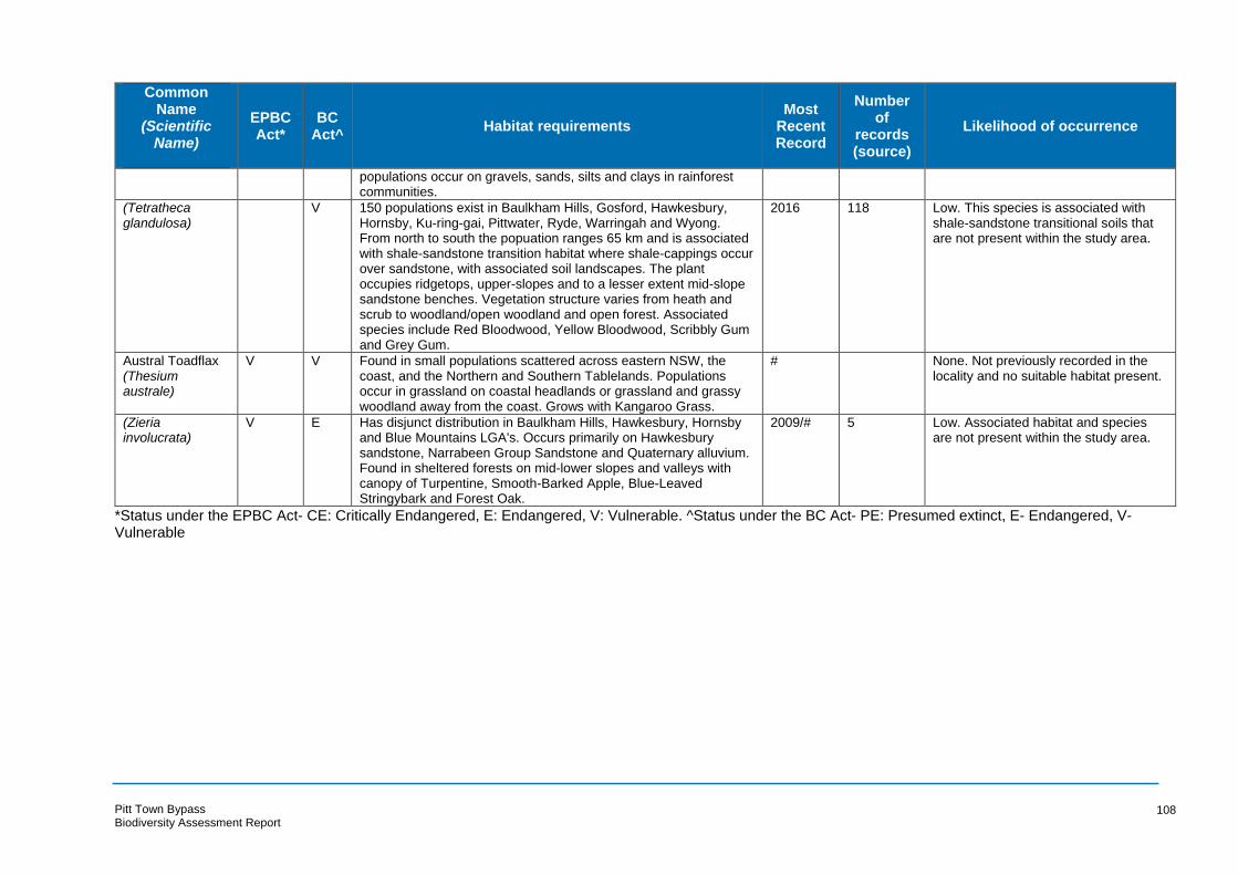
Common Name
(Scientific Name)
EPBC Act*
BC Act^
Habitat requirements Most
Recent Record
Number of
records (source)
Likelihood of occurrence
populations occur on gravels, sands, silts and clays in rainforest communities.
(Tetratheca glandulosa)
V 150 populations exist in Baulkham Hills, Gosford, Hawkesbury, Hornsby, Ku-ring-gai, Pittwater, Ryde, Warringah and Wyong. From north to south the popuation ranges 65 km and is associated with shale-sandstone transition habitat where shale-cappings occur over sandstone, with associated soil landscapes. The plant occupies ridgetops, upper-slopes and to a lesser extent mid-slope sandstone benches. Vegetation structure varies from heath and scrub to woodland/open woodland and open forest. Associated species include Red Bloodwood, Yellow Bloodwood, Scribbly Gum and Grey Gum.
2016 118 Low. This species is associated with shale-sandstone transitional soils that are not present within the study area.
Austral Toadflax (Thesium australe)
V V Found in small populations scattered across eastern NSW, the coast, and the Northern and Southern Tablelands. Populations occur in grassland on coastal headlands or grassland and grassy woodland away from the coast. Grows with Kangaroo Grass.
# None. Not previously recorded in the locality and no suitable habitat present.
(Zieria involucrata)
V E Has disjunct distribution in Baulkham Hills, Hawkesbury, Hornsby and Blue Mountains LGA's. Occurs primarily on Hawkesbury sandstone, Narrabeen Group Sandstone and Quaternary alluvium. Found in sheltered forests on mid-lower slopes and valleys with canopy of Turpentine, Smooth-Barked Apple, Blue-Leaved Stringybark and Forest Oak.
2009/# 5 Low. Associated habitat and species are not present within the study area.
*Status under the EPBC Act- CE: Critically Endangered, E: Endangered, V: Vulnerable. ^Status under the BC Act- PE: Presumed extinct, E- Endangered, V-Vulnerable
Pitt Town Bypass Biodiversity Assessment Report
108
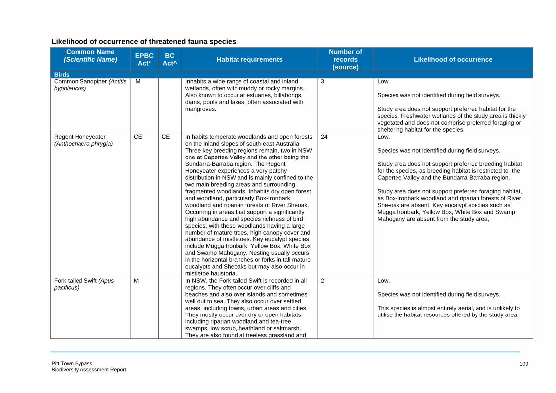
Likelihood of occurrence of threatened fauna species
Common Name (Scientific Name) EPBC
Act* BC
Act^ Habitat requirements
Number of records (source)
Likelihood of occurrence
Birds
Common Sandpiper (Actitis hypoleucos)
M Inhabits a wide range of coastal and inland wetlands, often with muddy or rocky margins. Also known to occur at estuaries, billabongs, dams, pools and lakes, often associated with mangroves.
3 Low.
Species was not identified during field surveys.
Study area does not support preferred habitat for the species. Freshwater wetlands of the study area is thickly vegetated and does not comprise preferred foraging or sheltering habitat for the species.
Regent Honeyeater CE CE In habits temperate woodlands and open forests 24 Low. (Anthochaera phrygia) on the inland slopes of south-east Australia.
Three key breeding regions remain, two in NSW one at Capertee Valley and the other being the Bundarra-Barraba region. The Regent Honeyeater experiences a very patchy distribution in NSW and is mainly confined to the two main breeding areas and surrounding fragmented woodlands. Inhabits dry open forest and woodland, particularly Box-Ironbark woodland and riparian forests of River Sheoak. Occurring in areas that support a significantly high abundance and species richness of bird species, with these woodlands having a large number of mature trees, high canopy cover and abundance of mistletoes. Key eucalypt species include Mugga Ironbark, Yellow Box, White Box and Swamp Mahogany. Nesting usually occurs in the horizontal branches or forks in tall mature eucalypts and Sheoaks but may also occur in mistletoe haustoria.
Species was not identified during field surveys.
Study area does not support preferred breeding habitat for the species, as breeding habitat is restricted to the Capertee Valley and the Bundarra-Barraba region.
Study area does not support preferred foraging habitat, as Box-Ironbark woodland and riparian forests of River She-oak are absent. Key eucalypt species such as Mugga Ironbark, Yellow Box, White Box and Swamp Mahogany are absent from the study area,
Fork-tailed Swift (Apus M In NSW, the Fork-tailed Swift is recorded in all 2 Low. pacificus) regions. They often occur over cliffs and
beaches and also over islands and sometimes well out to sea. They also occur over settled areas, including towns, urban areas and cities. They mostly occur over dry or open habitats, including riparian woodland and tea-tree swamps, low scrub, heathland or saltmarsh. They are also found at treeless grassland and
Species was not identified during field surveys.
This species is almost entirely aerial, and is unlikely to utilise the habitat resources offered by the study area.
Pitt Town Bypass Biodiversity Assessment Report
109
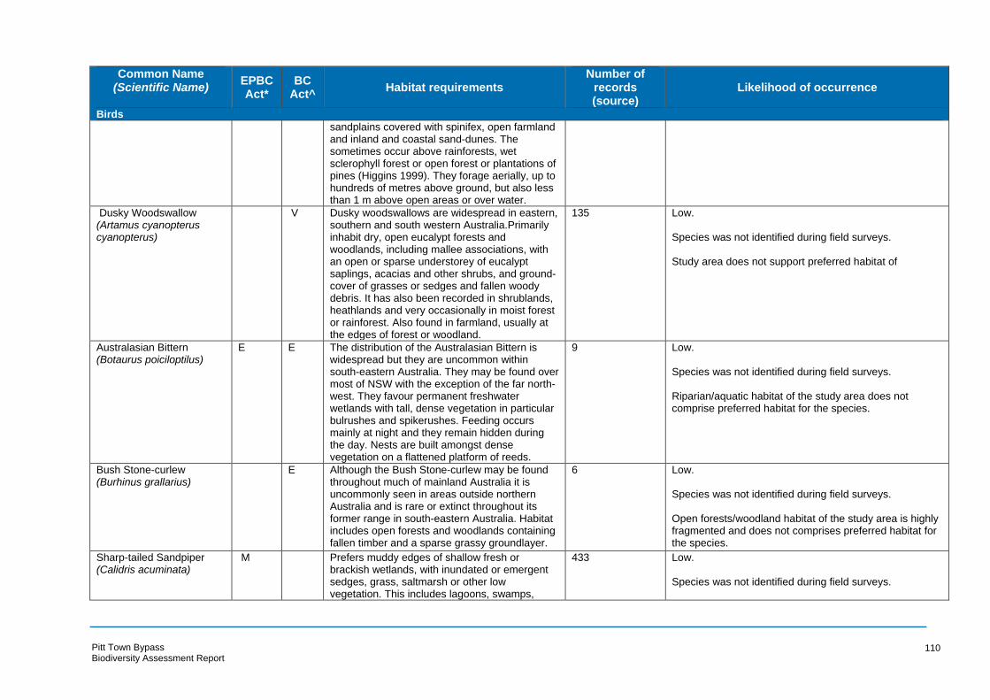
Common Name (Scientific Name) EPBC
Act* BC
Act^ Habitat requirements
Number of records (source)
Likelihood of occurrence
Birds
sandplains covered with spinifex, open farmland and inland and coastal sand-dunes. The sometimes occur above rainforests, wet sclerophyll forest or open forest or plantations of pines (Higgins 1999). They forage aerially, up to hundreds of metres above ground, but also less than 1 m above open areas or over water.
Dusky Woodswallow (Artamus cyanopterus cyanopterus)
V Dusky woodswallows are widespread in eastern, southern and south western Australia.Primarily inhabit dry, open eucalypt forests and woodlands, including mallee associations, with an open or sparse understorey of eucalypt saplings, acacias and other shrubs, and ground-cover of grasses or sedges and fallen woody debris. It has also been recorded in shrublands, heathlands and very occasionally in moist forest or rainforest. Also found in farmland, usually at the edges of forest or woodland.
135 Low.
Species was not identified during field surveys.
Study area does not support preferred habitat of
Australasian Bittern E E The distribution of the Australasian Bittern is 9 Low. (Botaurus poiciloptilus) widespread but they are uncommon within
south-eastern Australia. They may be found over Species was not identified during field surveys. most of NSW with the exception of the far north-west. They favour permanent freshwater Riparian/aquatic habitat of the study area does not wetlands with tall, dense vegetation in particular comprise preferred habitat for the species. bulrushes and spikerushes. Feeding occurs mainly at night and they remain hidden during the day. Nests are built amongst dense vegetation on a flattened platform of reeds.
Bush Stone-curlew (Burhinus grallarius)
E Although the Bush Stone-curlew may be found throughout much of mainland Australia it is
6 Low.
uncommonly seen in areas outside northern Species was not identified during field surveys. Australia and is rare or extinct throughout its former range in south-eastern Australia. Habitat Open forests/woodland habitat of the study area is highly includes open forests and woodlands containing fragmented and does not comprises preferred habitat for fallen timber and a sparse grassy groundlayer. the species.
Sharp-tailed Sandpiper M Prefers muddy edges of shallow fresh or 433 Low. (Calidris acuminata) brackish wetlands, with inundated or emergent
sedges, grass, saltmarsh or other low Species was not identified during field surveys. vegetation. This includes lagoons, swamps,
Pitt Town Bypass Biodiversity Assessment Report
110

Common Name (Scientific Name) EPBC
Act* BC
Act^ Habitat requirements
Number of records (source)
Likelihood of occurrence
Birds
lakes and pools near the coast, and dams, waterholes, soaks, bore drains and bore swamps, saltpans and hypersaline saltlakes inland.
Study area does not support preferred habitat for the species.
Curlew Sandpiper (Calidris ferruginea)
CE E The Curlew Sandpiper occurs along the entire coast of NSW and around most of the Australian coastline. It particularly occurs in the Hunter Estuary and at times in freshwater wetland within the Murray-Darling Basin. They occupy littoral and estuarine habitats and within NSW is mainly found in intertidal mudflats of sheltered coasts. They may also occur in non-tidal swamps, lakes and lagoons on the coast. Roosting occurs on shingle, shell or sand beaches; spits or islets on the coast or in wetlands; or sometimes in saltmarsh or on rocky shores.
24 Low.
Species was not identified during field surveys.
Study area does not support preferred habitat for the species.
Pectoral Sandpiper M Scarce, but regular visitor, usually recorded in 42 Low. (Calidris melanotos) summer from November to March. Widespread
but scattered records in Australia. Usually found in fresh to saline wetlands, floodplains, swamps, estuaries and lagoons, sometimes with emergent or fringing vegetation such as grass.
Species was not identified during field surveys.
Study area does not support preferred habitat for the species.
Red-necked Stint (Calidris ruficollis)
M Inhabits mainly coastal environments; saltmarshes, tidal mudflats, saline and freshwater wetlands, sandy or shelly beaches and sewage ponds.
14 Low.
Species was not identified during field surveys.
Study area does not support preferred habitat for the species.
Long-toed Stint (Calidris M Inhabit coastal and inland shallow wetlands, 3 Low. subminuta) sewage ponds and tidal mudflats.
Species was not identified during field surveys.
Study area does not support preferred habitat for the species.
Gang-gang Cockatoo V Distribution of the Gang-gang Cockatoo occurs 41 Low. (Callocephalon fimbriatum) from southern Victoria through south and
central-eastern NSW, occurring in NSW from the south-east coast to the Hunter region and inland to the Central Tablelands and south-west slopes
Species was not identified during field surveys.
Pitt Town Bypass Biodiversity Assessment Report
111
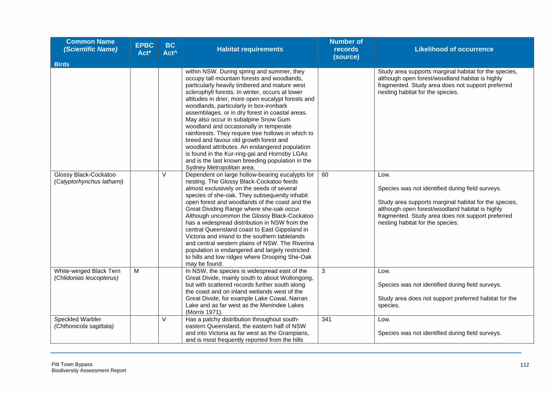
Common Name (Scientific Name) EPBC
Act* BC
Act^ Habitat requirements
Number of records (source)
Likelihood of occurrence
Birds
within NSW. During spring and summer, they occupy tall mountain forests and woodlands, particularly heavily timbered and mature west sclerophyll forests. In winter, occurs at lower altitudes in drier, more open eucalypt forests and woodlands, particularly in box-ironbark assemblages, or in dry forest in coastal areas. May also occur in subalpine Snow Gum woodland and occasionally in temperate rainforests. They require tree hollows in which to breed and favour old growth forest and woodland attributes. An endangered population is found in the Kur-ring-gai and Hornsby LGAs and is the last known breeding population in the Sydney Metropolitan area.
Study area supports marginal habitat for the species, although open forest/woodland habitat is highly fragmented. Study area does not support preferred nesting habitat for the species.
Glossy Black-Cockatoo V Dependent on large hollow-bearing eucalypts for 60 Low. (Calyptorhynchus lathami) nesting. The Glossy Black-Cockatoo feeds
almost exclusively on the seeds of several species of she-oak. They subsequently inhabit open forest and woodlands of the coast and the Great Dividing Range where she-oak occur. Although uncommon the Glossy Black-Cockatoo has a widespread distribution in NSW from the central Queensland coast to East Gippsland in Victoria and inland to the southern tablelands and central western plains of NSW. The Riverina population is endangered and largely restricted to hills and low ridges where Drooping She-Oak may be found.
Species was not identified during field surveys.
Study area supports marginal habitat for the species, although open forest/woodland habitat is highly fragmented. Study area does not support preferred nesting habitat for the species.
White-winged Black Tern M In NSW, the species is widespread east of the 3 Low. (Chlidonias leucopterus) Great Divide, mainly south to about Wollongong,
but with scattered records further south along the coast and on inland wetlands west of the Great Divide, for example Lake Cowal, Narran Lake and as far west as the Menindee Lakes (Morris 1971).
Species was not identified during field surveys.
Study area does not support preferred habitat for the species.
Speckled Warbler V Has a patchy distribution throughout south- 341 Low. (Chthonicola sagittata) eastern Queensland, the eastern half of NSW
and into Victoria as far west as the Grampians, and is most frequently reported from the hills
Species was not identified during field surveys.
Pitt Town Bypass Biodiversity Assessment Report
112

Common Name (Scientific Name) EPBC
Act* BC
Act^ Habitat requirements
Number of records (source)
Likelihood of occurrence
Birds
and tablelands of the Great Dividing Range and rarely from the coast. Inhabits a wide range of Eucalyptus dominated communities that have a grassy understorey, often on rocky ridges or in gullies. Typical habitat would include scattered native tussock grasses, a spare shrub layer, some eucalypt regrowth and an open canopy. Large relatively undisturbed remnants are required. Nests are often located among fallen branches.
Study area supports marginal habitat for the species, although open forest/woodland habitat is highly fragmented.
Spotted Harrier (Circus V The Spotted Harrier is distributed throughout the 11 Low. assimilis) Australian Mainland but rarely occur in densely
forested or wooded habitats of the coast, escarpment and ranges. Within NSW they are dispersed widely. They inhabit grassy open woodlands including Acacia and mallee remnants, grasslands and shrub steppe. The Spotted Harrier is found most commonly in native grassland although they may forage over open habitats Nests are built with sticks in a tree.
Species was not identified during field surveys.
Study area does not support preferred habitat for the species
Brown Treecreeper V Endemic to eastern Australia the Brown 11 Low. (eastern subspecies) Treecreeper inhabits eucalypt forests and (Climacteris picumnus woodlands dominated by stringbarks and other Species was not identified during field surveys. victoriae) rough-barked eucalypts lacking a dense shrub
layer with an open grassy understorey of inland plains and the slopes of the Great Dividing Range and is less commonly found on coastal plains and ranges. Within NSW they are found as far west as Wagga Wagga, Forbes, Dubbo and Inverell. In coastal areas the Brown Treecreeper tends to inhabit drier open woodlands. Fallen timber is also an important habitat component for foraging. Nesting occurs in standing dead or live trees and tree stumps. The Brown Treecreeper breeds in pairs or co-operatively in territories with a mean area of 4.4 ha although territories may range in size from 1.1 to 10.7 ha. Declines in the Brown Treecreeper have occurred in remanat
Study area supports marginal habitat for the species, although open forest/woodland habitat is highly fragmented. Fallen timber is uncommon within the study area. Stags offer potential nesting habitat to the species.
Pitt Town Bypass Biodiversity Assessment Report
113
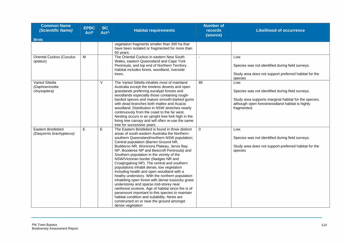
Common Name (Scientific Name) EPBC
Act* BC
Act^ Habitat requirements
Number of records (source)
Likelihood of occurrence
Birds
vegetation fragments smaller than 300 ha that have been isolated or fragmented for more than 50 years.
Oriental Cuckoo (Cuculus optatus)
M The Oriental Cuckoo in eastern New South Wales, eastern Queensland and Cape York Peninsula, and top end of Northern Territory. Habitat includes forest, woodland, riverside trees.
- Low.
Species was not identified during field surveys.
Study area does not support preferred habitat for the species
Varied Sittella V The Varied Sittella inhabits most of mainland 85 Low. (Daphoenositta Australia except the treeless deserts and open chrysoptera) grasslands preferring eucalypt forests and
woodlands especially those containing rough-barded speces and mature smooth-barked gums with dead branches both mallee and Acacia woodland. Distribution in NSW stretches nearly continuously from the coast to the far west. Nesting occurs in an upright tree fork high in the living tree canopy and will often re-use the same tree for successive years.
Species was not identified during field surveys.
Study area supports marginal habitat for the species, although open forest/woodland habitat is highly fragmented.
Eastern Bristlebird E E The Eastern Bristlebird is found in three distinct 0 Low. (Dasyornis brachypterus) areas of south-eastern Australia the Northern-
southern Queensland/northern NSW population; Central population (Barren Ground NR, Budderoo NR, Woronora Plateau, Jervis Bay NP, Booderee NP and Beecroft Peninsula) and Southern population in the vicinity of the NSW/Victorian border (Nadgee NR and Croajingalong NP). The central and southern populations inhabit dense, low vegetation including health and open woodland with a heathy understory. With the northern population inhabiting open forest with dense tussocky grass understorey and sparse mid-storey near rainforest ecotone. Age of habitat since fire is of paramount important to this species to maintain habitat condition and suitability. Nests are constructed on or near the ground amongst dense vegetation
Species was not identified during field surveys.
Study area does not support preferred habitat for the species
Pitt Town Bypass Biodiversity Assessment Report
114

Common Name (Scientific Name) EPBC
Act* BC
Act^ Habitat requirements
Number of records (source)
Likelihood of occurrence
Birds
Gibson’s Albatross (Diomedea antipodensis gibsoni)
V V The distribution of the Antipodean Albatross ranges across the southern Pacific Ocean, from eastern Australia to Chile. Breeds biennially in colonies on ridges, slopes and plateaus of isolated subantarctic islands usually in vegetation such as grass tussocks. Small numbers regularly occur off the NSW south coast from Green Cape to Newcastle during winter where they feed on cuttlefish, although a small proportion of the total foraging area of the Antipodean Albatross, potential forage in NSW waters is considered significant for the species.
0 Low.
Species was not identified during field surveys.
Study area does not support preferred habitat for the species
Southern Royal Albatross VM A marine pelagic species which breeds on the 0 Low. (Diomedea epomophora) Auckland islands, New Zealand.
Species was not identified during field surveys.
Study area does not support preferred habitat for the species
Wandering Albatross (Diomedea exulans)
E E The Wandering Albatross visits Australian waters extending from Fremantle, Western
0 Low.
Australia, across the southern water to the Species was not identified during field surveys. Whitsunday Islands in Queensland between June and Spetember. It has been recorded Study area does not support preferred habitat for the along the length of the NSW coast. At other species times birds roam the southern oceans and commonly follow fishing vessels for several days.
Northern Royal Albatross (Diomedea sanfordi)
E The Northern Royal Albatross ranges widely over the Southern Ocean, with individuals seen
0 Low.
in Australian waters off south-eastern Australia Species was not identified during field surveys. (Environment Australia 2001f). The Northern Royal Albatross feeds regularly in Tasmanian Study area does not support preferred habitat for the and South Australian waters, and less frequently species in NSW waters (Garnett & Crowley 2000).
Black-necked Stork (Ephippiorhynchus asiaticus)
E Black-necked Storks are widespread in coastal and subcoastal northern and eastern Australia, occurring as far south as Central NSW, although within NSW they are becoming increasingly uncommon south of the Clarence Valley and rarely occur south of Sydney. Since 1995,
6 Low.
Species was not identified during field surveys.
Study area does not support preferred habitat for the species
Pitt Town Bypass Biodiversity Assessment Report
115
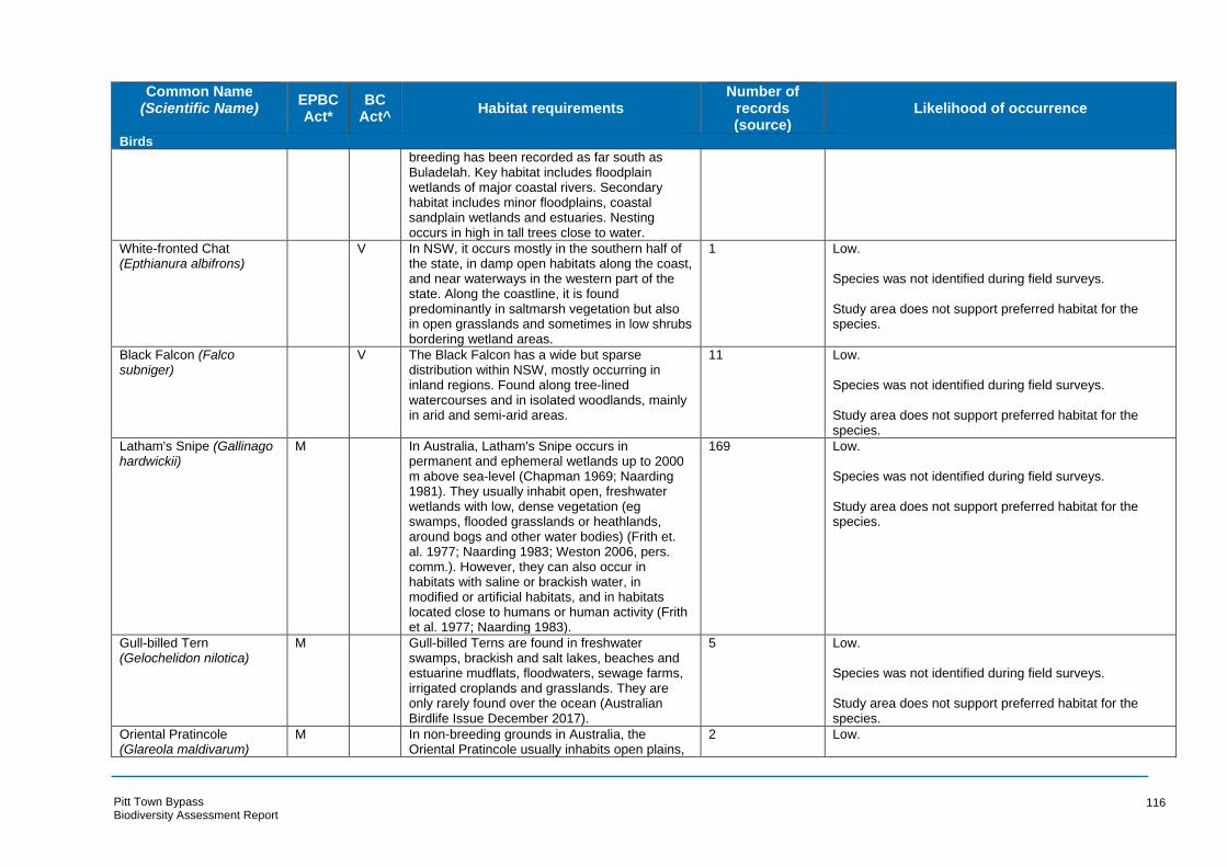
Common Name (Scientific Name) EPBC
Act* BC
Act^ Habitat requirements
Number of records (source)
Likelihood of occurrence
Birds
breeding has been recorded as far south as Buladelah. Key habitat includes floodplain wetlands of major coastal rivers. Secondary habitat includes minor floodplains, coastal sandplain wetlands and estuaries. Nesting occurs in high in tall trees close to water.
White-fronted Chat V In NSW, it occurs mostly in the southern half of 1 Low. (Epthianura albifrons) the state, in damp open habitats along the coast,
and near waterways in the western part of the state. Along the coastline, it is found predominantly in saltmarsh vegetation but also in open grasslands and sometimes in low shrubs bordering wetland areas.
Species was not identified during field surveys.
Study area does not support preferred habitat for the species.
Black Falcon (Falco V The Black Falcon has a wide but sparse 11 Low. subniger) distribution within NSW, mostly occurring in
inland regions. Found along tree-lined watercourses and in isolated woodlands, mainly in arid and semi-arid areas.
Species was not identified during field surveys.
Study area does not support preferred habitat for the species.
Latham's Snipe (Gallinago hardwickii)
M In Australia, Latham's Snipe occurs in permanent and ephemeral wetlands up to 2000 m above sea-level (Chapman 1969; Naarding 1981). They usually inhabit open, freshwater wetlands with low, dense vegetation (eg swamps, flooded grasslands or heathlands, around bogs and other water bodies) (Frith et. al. 1977; Naarding 1983; Weston 2006, pers. comm.). However, they can also occur in habitats with saline or brackish water, in modified or artificial habitats, and in habitats located close to humans or human activity (Frith et al. 1977; Naarding 1983).
169 Low.
Species was not identified during field surveys.
Study area does not support preferred habitat for the species.
Gull-billed Tern M Gull-billed Terns are found in freshwater 5 Low. (Gelochelidon nilotica) swamps, brackish and salt lakes, beaches and
estuarine mudflats, floodwaters, sewage farms, irrigated croplands and grasslands. They are only rarely found over the ocean (Australian Birdlife Issue December 2017).
Species was not identified during field surveys.
Study area does not support preferred habitat for the species.
Oriental Pratincole (Glareola maldivarum)
M In non-breeding grounds in Australia, the Oriental Pratincole usually inhabits open plains,
2 Low.
Pitt Town Bypass Biodiversity Assessment Report
116
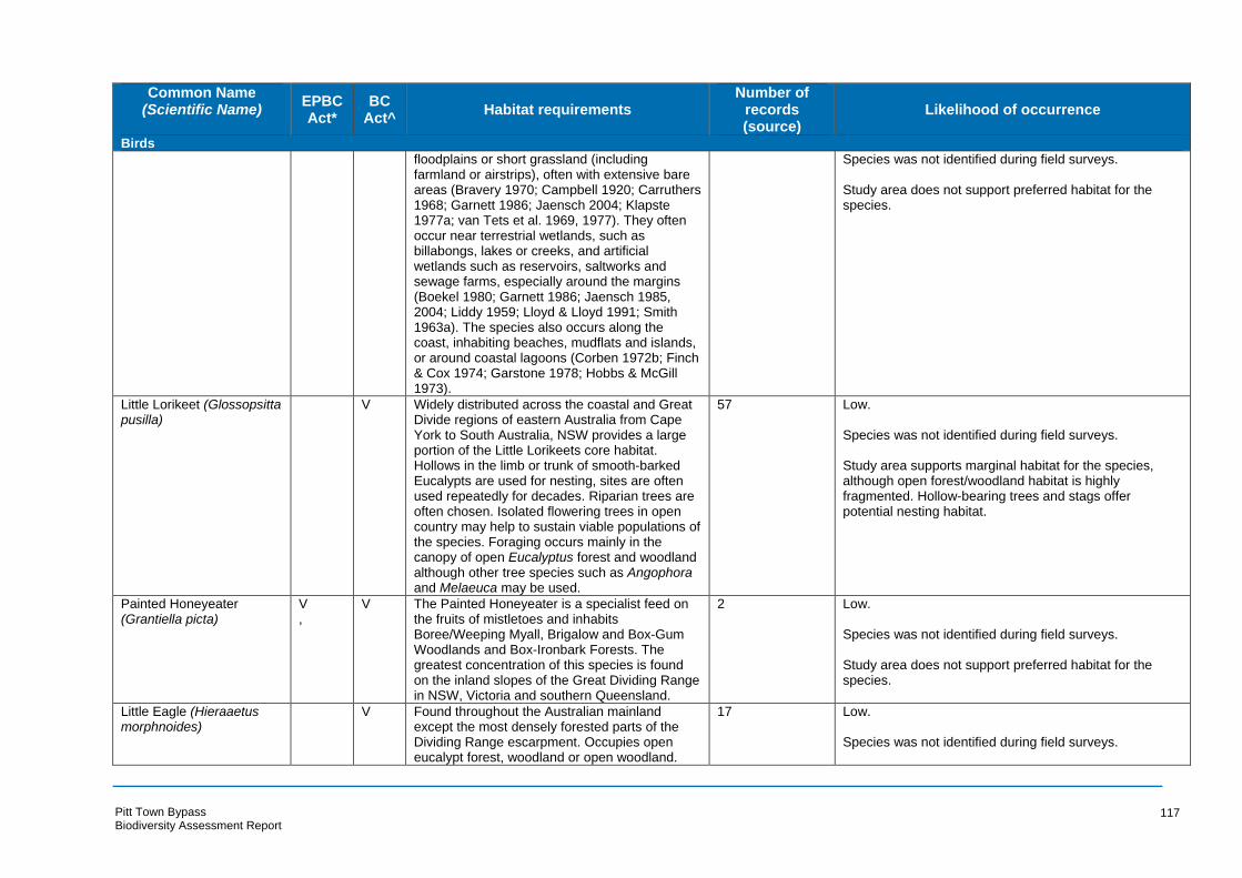
Common Name (Scientific Name) EPBC
Act* BC
Act^ Habitat requirements
Number of records (source)
Likelihood of occurrence
Birds
floodplains or short grassland (including farmland or airstrips), often with extensive bare areas (Bravery 1970; Campbell 1920; Carruthers 1968; Garnett 1986; Jaensch 2004; Klapste 1977a; van Tets et al. 1969, 1977). They often occur near terrestrial wetlands, such as billabongs, lakes or creeks, and artificial wetlands such as reservoirs, saltworks and sewage farms, especially around the margins (Boekel 1980; Garnett 1986; Jaensch 1985, 2004; Liddy 1959; Lloyd & Lloyd 1991; Smith 1963a). The species also occurs along the coast, inhabiting beaches, mudflats and islands, or around coastal lagoons (Corben 1972b; Finch & Cox 1974; Garstone 1978; Hobbs & McGill 1973).
Species was not identified during field surveys.
Study area does not support preferred habitat for the species.
Little Lorikeet (Glossopsitta pusilla)
V Widely distributed across the coastal and Great Divide regions of eastern Australia from Cape York to South Australia, NSW provides a large portion of the Little Lorikeets core habitat. Hollows in the limb or trunk of smooth-barked Eucalypts are used for nesting, sites are often used repeatedly for decades. Riparian trees are often chosen. Isolated flowering trees in open country may help to sustain viable populations of the species. Foraging occurs mainly in the canopy of open Eucalyptus forest and woodland although other tree species such as Angophora and Melaeuca may be used.
57 Low.
Species was not identified during field surveys.
Study area supports marginal habitat for the species, although open forest/woodland habitat is highly fragmented. Hollow-bearing trees and stags offer potential nesting habitat.
Painted Honeyeater V V The Painted Honeyeater is a specialist feed on 2 Low. (Grantiella picta) , the fruits of mistletoes and inhabits
Boree/Weeping Myall, Brigalow and Box-Gum Woodlands and Box-Ironbark Forests. The greatest concentration of this species is found on the inland slopes of the Great Dividing Range in NSW, Victoria and southern Queensland.
Species was not identified during field surveys.
Study area does not support preferred habitat for the species.
Little Eagle (Hieraaetus morphnoides)
V Found throughout the Australian mainland except the most densely forested parts of the Dividing Range escarpment. Occupies open eucalypt forest, woodland or open woodland.
17 Low.
Species was not identified during field surveys.
Pitt Town Bypass Biodiversity Assessment Report
117

Common Name (Scientific Name) EPBC
Act* BC
Act^ Habitat requirements
Number of records (source)
Likelihood of occurrence
Birds
Sheoak or Acacia woodlands and riparian Study area supports marginal habitat for the species, woodlands of interior NSW are also used. although open forest/woodland habitat is highly Nesting occurs in tall living trees. fragmented.
White-throated Needletail (Hirundapus caudacutus)
M In eastern Australia, it is recorded in all coastal regions of Queensland and NSW, extending inland to the western slopes of the Great Divide
30 Low.
Species was not identified during field surveys. and occasionally onto the adjacent inland plains. Although they occur over most types of habitat, Study area supports marginal habitat for the species. they are probably recorded most often above wooded areas, including open forest and rainforest, and may also fly between trees or in clearings, below the canopy, but they are less commonly recorded flying above woodland (Higgins 1999). They also commonly occur over heathland (Cooper 1971; Learmonth 1951; McFarland 1988), but less often over treeless areas, such as grassland or swamps (Cooper 1971; Gosper 1981; Learmonth 1951).
Barn Swallow (Hirundo rustica)
M Winters in the Southern Hemisphere, but only vagrant to NSW. Prefers open country, agricultural land.
8 Low.
Species was not identified during field surveys.
Study area supports marginal habitat for the species.
Caspian Tern (Hydroprogne caspia)
M The Caspian Tern is mostly found in sheltered coastal embayments (harbours, lagoons, inlets,
3 Low.
bays, estuaries and river deltas) and those with Species was not identified during field surveys. sandy or muddy margins are preferred. They also occur on near-coastal or inland terrestrial Study does not support preferred habitat for the species. wetlands that are either fresh or saline, especially lakes (including ephemeral lakes), waterholes, reservoirs, rivers and creeks. They also use artificial wetlands, including reservoirs, sewage ponds and saltworks. In offshore areas the species prefers sheltered situations, particularly near islands, and is rarely seen beyond reefs (Higgins & Davis 1996).
Comb-crested Jacana V Are found in permanent freshwater wetlands, 7 Low. (Irediparra gallinacea) either still or slow-flowing, with a good surface
cover of floating vegetation. The distribution of Species was not identified during field surveys. the Comb-crested Jacana along the east coast
Pitt Town Bypass Biodiversity Assessment Report
118

Common Name (Scientific Name) EPBC
Act* BC
Act^ Habitat requirements
Number of records (source)
Likelihood of occurrence
Birds
of Australia occurs from Cape York Peninsula to Study does not support preferred habitat for the species the hunter region of NSW.
Black Bittern (Ixobrychus flavicollis)
V Within NSW records are scattered along the east coast although individuals are rarely recorded south of Sydney or inland. They inhabit both terrestrial and estuarine wetlands, commonly in areas of permanent water and dense vegetation and may occur in flooded grassland, forest, woodland, rainforest and mangroves. Nesting occurs on a branch overhanging water.
10 Low.
Species was not identified during field surveys.
Study does not support preferred habitat for the species.
Swift Parrot (Lathamus discolor)
CE E Within NSW the Swift Parrot occurs mainly on the coast and south west slopes. In areas where eucalypts are flowering profusely or where there are abundant lerp (from sap-sucking bugs) infestations. Preferred trees include Swamp Mahogany, Spotted Gum, Red Bloodwood, Mugga Ironbark and white Box. Commonly used lerp infested trees include Grey Box E. microcarpa, Grey Box E. moluccana and Blackbutt E. pilularis.
7 Low.
Species was not identified during field surveys.
Eucalypts within the study area, mainly in open forest/woodland habitat, offer potential foraging habitat for the species.
Bar-tailed Godwit (Limosa lapponica)
M Coastal species, usually inhabiting intertidal sandflats, banks, mudflats, estuaries, inlets, harbours, coastal lagoons and bays. It is found often around beds of seagrass and, sometimes, in nearby saltmarsh. It has been sighted in coastal sewage farms and saltworks, saltlakes and brackish wetlands near coasts, sandy ocean beaches, rock platforms, and coral reef-flats. It is rarely found on inland wetlands or in areas of short grass, such as farmland, paddocks and airstrips, although it is commonly recorded in paddocks at some locations overseas (Marchant & Higgins 1993).
1 Low.
Species was not identified during field surveys.
Study does not support preferred habitat for the species.
Black-tailed Godwit (Limosa limosa)
V May usually be found in sheltered bays, estuaries, lagoons with large intertidal mudflats
6 Low.
or sandflats, further inland they may also be Species was not identified during field surveys. found on mudflats in water less than 10 cm deep around muddy lakes and swamps. Within NSW Study does not support preferred habitat for the species. the Black-tailed Godwit is most frequently
Pitt Town Bypass Biodiversity Assessment Report
119
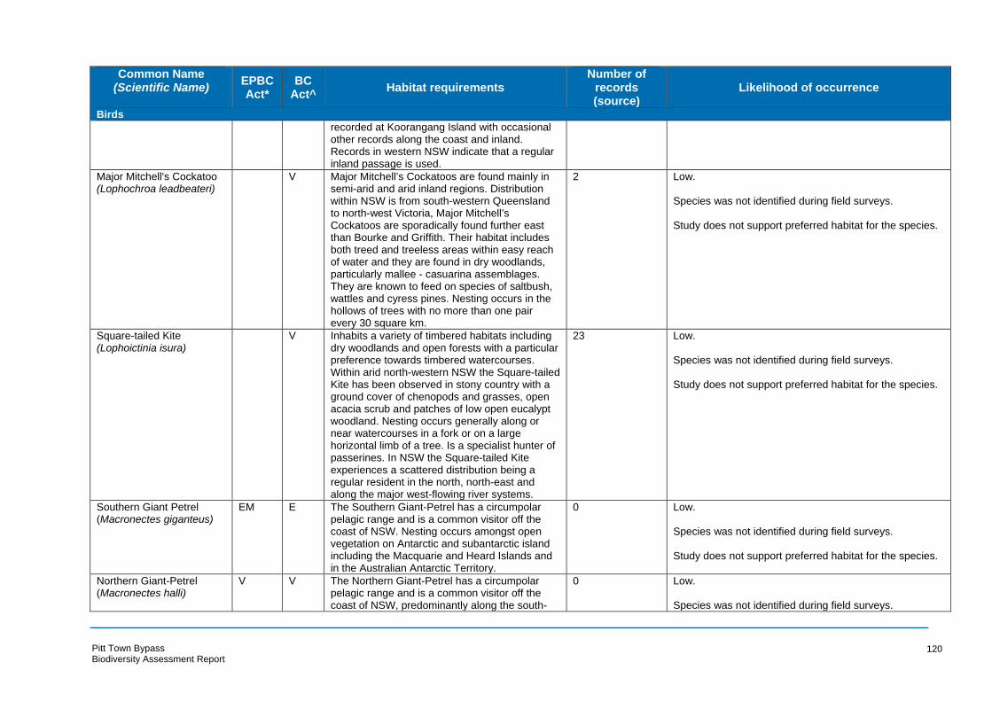
Common Name (Scientific Name) EPBC
Act* BC
Act^ Habitat requirements
Number of records (source)
Likelihood of occurrence
Birds
recorded at Koorangang Island with occasional other records along the coast and inland. Records in western NSW indicate that a regular inland passage is used.
Major Mitchell's Cockatoo (Lophochroa leadbeateri)
V Major Mitchell’s Cockatoos are found mainly in semi-arid and arid inland regions. Distribution
2 Low.
within NSW is from south-western Queensland Species was not identified during field surveys. to north-west Victoria, Major Mitchell’s Cockatoos are sporadically found further east Study does not support preferred habitat for the species. than Bourke and Griffith. Their habitat includes both treed and treeless areas within easy reach of water and they are found in dry woodlands, particularly mallee - casuarina assemblages. They are known to feed on species of saltbush, wattles and cyress pines. Nesting occurs in the hollows of trees with no more than one pair every 30 square km.
Square-tailed Kite (Lophoictinia isura)
V Inhabits a variety of timbered habitats including dry woodlands and open forests with a particular
23 Low.
preference towards timbered watercourses. Species was not identified during field surveys. Within arid north-western NSW the Square-tailed Kite has been observed in stony country with a Study does not support preferred habitat for the species. ground cover of chenopods and grasses, open acacia scrub and patches of low open eucalypt woodland. Nesting occurs generally along or near watercourses in a fork or on a large horizontal limb of a tree. Is a specialist hunter of passerines. In NSW the Square-tailed Kite experiences a scattered distribution being a regular resident in the north, north-east and along the major west-flowing river systems.
Southern Giant Petrel (Macronectes giganteus)
EM E The Southern Giant-Petrel has a circumpolar pelagic range and is a common visitor off the
0 Low.
coast of NSW. Nesting occurs amongst open Species was not identified during field surveys. vegetation on Antarctic and subantarctic island including the Macquarie and Heard Islands and Study does not support preferred habitat for the species. in the Australian Antarctic Territory.
Northern Giant-Petrel V V The Northern Giant-Petrel has a circumpolar 0 Low. (Macronectes halli) pelagic range and is a common visitor off the
coast of NSW, predominantly along the south- Species was not identified during field surveys.
Pitt Town Bypass Biodiversity Assessment Report
120

Common Name (Scientific Name) EPBC
Act* BC
Act^ Habitat requirements
Number of records (source)
Likelihood of occurrence
Birds
east coast during winter and autumn. Breeding within Australian territory is limited to Macquarie Island among tussocks of dense vegetation and areas of broken terrain.
Study does not support preferred habitat for the species.
Hooded Robin (south- V The Hooded Robin has a widespread distribution 1 Low. eastern form) across Australia, except for the driest deserts (Melanodryas cucullata and the wetter coastal areas. They are found Species was not identified during field surveys. cucullata) throughout much of inland NSW with the
exception of the extreme north-west. They preference lightly wooded country, usually open eucalypt woodland, acacia scrub and mallee, often in or near clearings or open areas. Requires structurally diverse habitats. Nesting occurs in a tree fork or crevice.
Study does not support preferred habitat for the species.
Black-chinned Honeyeater (eastern subspecies) (Melithreptus gularis gularis)
V In NSW the Black-chinned Honeyeater experiences a widespread distribution with records from the tablelands and western slopes of the Great Dividing Range to the north-west and central-west plains and the Riverina. It is rarely recorded east of the Great Dividing Range although regularly observed from the Richmond and Clarence River areas. Inhabits most upper levels of drier open forests or woodlands dominated by box and ironbark eucalypts. Is also found in open forests of smooth-barked gums, stringybarks, ironbarks, river sheoaks (nesting habitat) and tea-trees. Nest is placed high in the crown of a ree in the uppermost lateral branches.
13 Low.
Species was not identified during field surveys.
Eucalypts within the study area, mainly in open forest/woodland habitat, offer potential foraging habitat for the species.
Yellow Wagtail (Motacilla flava)
M Regular spring-summer visitor in north of Australia, rare vagrant or occasional visitor farther south. Found in marshes, damp paddocks, airfields, cultivated fields, lawns and estuaries.
1 Low.
Species was not identified during field surveys.
Study area offers marginal habitat to the species.
Satin Flycatcher (Myiagra M Satin Flycatchers mainly inhabit eucalypt forests, - Low. cyanoleuca) often near wetlands or watercourses. They
generally occur in moister, taller forests than the Leaden Flycatcher, Myiagra rebecula, often occurring in gullies (Blakers et al. 1984; Emison et al. 1987; Officer 1969). They also occur in
Species was not identified during field surveys.
Open forest/woodland habitat offers marginal habitat for the species.
Pitt Town Bypass Biodiversity Assessment Report
121
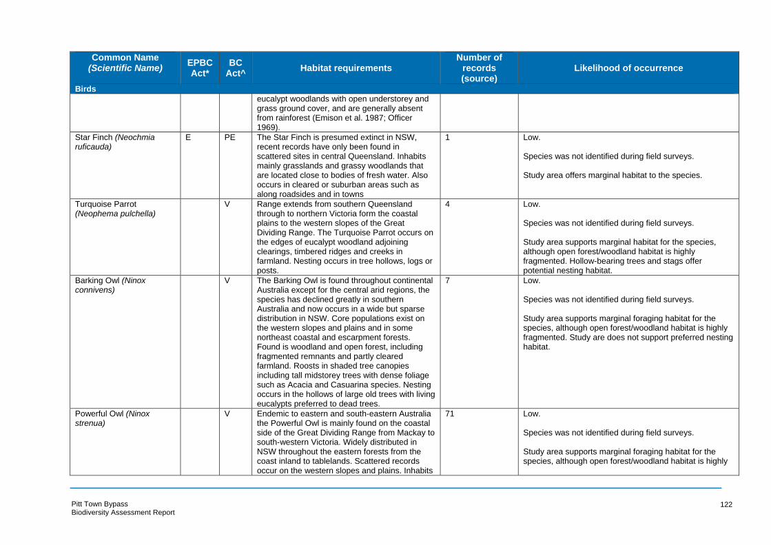
Common Name (Scientific Name) EPBC
Act* BC
Act^ Habitat requirements
Number of records (source)
Likelihood of occurrence
Birds
eucalypt woodlands with open understorey and grass ground cover, and are generally absent from rainforest (Emison et al. 1987; Officer 1969).
Star Finch (Neochmia E PE The Star Finch is presumed extinct in NSW, 1 Low. ruficauda) recent records have only been found in
scattered sites in central Queensland. Inhabits mainly grasslands and grassy woodlands that are located close to bodies of fresh water. Also occurs in cleared or suburban areas such as along roadsides and in towns
Species was not identified during field surveys.
Study area offers marginal habitat to the species.
Turquoise Parrot V Range extends from southern Queensland 4 Low. (Neophema pulchella) through to northern Victoria form the coastal
plains to the western slopes of the Great Dividing Range. The Turquoise Parrot occurs on the edges of eucalypt woodland adjoining clearings, timbered ridges and creeks in farmland. Nesting occurs in tree hollows, logs or posts.
Species was not identified during field surveys.
Study area supports marginal habitat for the species, although open forest/woodland habitat is highly fragmented. Hollow-bearing trees and stags offer potential nesting habitat.
Barking Owl (Ninox V The Barking Owl is found throughout continental 7 Low. connivens) Australia except for the central arid regions, the
species has declined greatly in southern Australia and now occurs in a wide but sparse distribution in NSW. Core populations exist on the western slopes and plains and in some northeast coastal and escarpment forests. Found is woodland and open forest, including fragmented remnants and partly cleared farmland. Roosts in shaded tree canopies including tall midstorey trees with dense foliage such as Acacia and Casuarina species. Nesting occurs in the hollows of large old trees with living eucalypts preferred to dead trees.
Species was not identified during field surveys.
Study area supports marginal foraging habitat for the species, although open forest/woodland habitat is highly fragmented. Study are does not support preferred nesting habitat.
Powerful Owl (Ninox V Endemic to eastern and south-eastern Australia 71 Low. strenua) the Powerful Owl is mainly found on the coastal
side of the Great Dividing Range from Mackay to south-western Victoria. Widely distributed in NSW throughout the eastern forests from the coast inland to tablelands. Scattered records occur on the western slopes and plains. Inhabits
Species was not identified during field surveys.
Study area supports marginal foraging habitat for the species, although open forest/woodland habitat is highly
Pitt Town Bypass Biodiversity Assessment Report
122
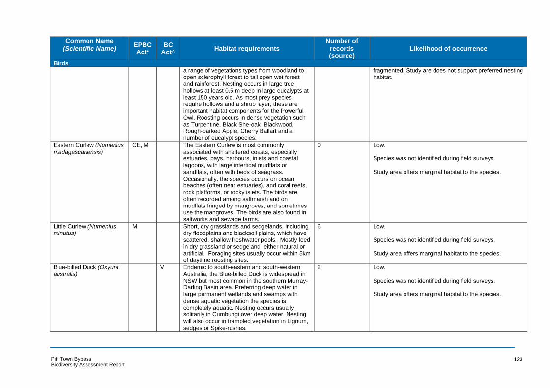
Common Name (Scientific Name) EPBC
Act* BC
Act^ Habitat requirements
Number of records (source)
Likelihood of occurrence
Birds
a range of vegetations types from woodland to open sclerophyll forest to tall open wet forest and rainforest. Nesting occurs in large tree hollows at least 0.5 m deep in large eucalypts at least 150 years old. As most prey species require hollows and a shrub layer, these are important habitat components for the Powerful Owl. Roosting occurs in dense vegetation such as Turpentine, Black She-oak, Blackwood, Rough-barked Apple, Cherry Ballart and a number of eucalypt species.
fragmented. Study are does not support preferred nesting habitat.
Eastern Curlew (Numenius CE, M The Eastern Curlew is most commonly 0 Low. madagascariensis) associated with sheltered coasts, especially
estuaries, bays, harbours, inlets and coastal lagoons, with large intertidal mudflats or sandflats, often with beds of seagrass. Occasionally, the species occurs on ocean beaches (often near estuaries), and coral reefs, rock platforms, or rocky islets. The birds are often recorded among saltmarsh and on mudflats fringed by mangroves, and sometimes use the mangroves. The birds are also found in saltworks and sewage farms.
Species was not identified during field surveys.
Study area offers marginal habitat to the species.
Little Curlew (Numenius minutus)
M Short, dry grasslands and sedgelands, including dry floodplains and blacksoil plains, which have scattered, shallow freshwater pools. Mostly feed in dry grassland or sedgeland, either natural or artificial. Foraging sites usually occur within 5km of daytime roosting sites.
6 Low.
Species was not identified during field surveys.
Study area offers marginal habitat to the species.
Blue-billed Duck (Oxyura australis)
V Endemic to south-eastern and south-western Australia, the Blue-billed Duck is widespread in NSW but most common in the southern Murray-Darling Basin area. Preferring deep water in large permanent wetlands and swamps with dense aquatic vegetation the species is completely aquatic. Nesting occurs usually solitarily in Cumbungi over deep water. Nesting will also occur in trampled vegetation in Lignum, sedges or Spike-rushes.
2 Low.
Species was not identified during field surveys.
Study area offers marginal habitat to the species.
Pitt Town Bypass Biodiversity Assessment Report
123
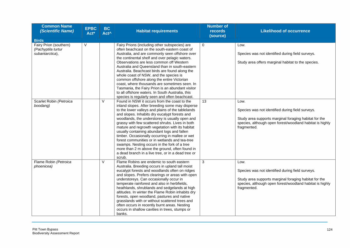
Common Name (Scientific Name) EPBC
Act* BC
Act^ Habitat requirements
Number of records (source)
Likelihood of occurrence
Birds
Fairy Prion (southern) V Fairy Prions (including other subspecies) are 0 Low. (Pachyptila turtur often beachcast on the south-eastern coast of subantarctica), Australia, and are commonly seen offshore over
the continental shelf and over pelagic waters. Observations are less common off Western Australia and Queensland than in south-eastern Australia. Beachcast birds are found along the whole coast of NSW, and the species is common offshore along the entire Victorian coast, where thousands are sometimes seen. In Tasmania, the Fairy Prion is an abundant visitor to all offshore waters. In South Australia, this species is regularly seen and often beachcast.
Species was not identified during field surveys.
Study area offers marginal habitat to the species.
Scarlet Robin (Petroica V Found in NSW it occurs from the coast to the 13 Low. boodang) inland slopes. After breeding some may disperse
to the lower valleys and plains of the tablelands and slopes. Inhabits dry eucalypt forests and woodlands, the understorey is usually open and grassy with few scattered shrubs. Lives in both mature and regrowth vegetation with its habitat usually containing abundant logs and fallen timber. Occasionally occurring in mallee or wet forest communities or in wetlands and tea-tree swamps. Nesting occurs in the fork of a tree more than 2 m above the ground, often found in a dead branch in a live tree, or in a dead tree or scrub.
Species was not identified during field surveys.
Study area supports marginal foraging habitat for the species, although open forest/woodland habitat is highly fragmented.
Flame Robin (Petroica V Flame Robins are endemic to south eastern 3 Low. phoenicea) Australia. Breeding occurs in upland tall moist
eucalypt forests and woodlands often on ridges and slopes. Prefers clearings or areas with open understoreys. Can occasionally occur in temperate rainforest and also in herbfields, heathlands, shrublands and sedgelands at high altitudes. In winter the Flame Robin inhabits dry forests, open woodland, pastures and native grasslands with or without scattered trees and often occurs in recently burnt areas. Nesting occurs in shallow cavities in trees, stumps or banks.
Species was not identified during field surveys.
Study area supports marginal foraging habitat for the species, although open forest/woodland habitat is highly fragmented.
Pitt Town Bypass Biodiversity Assessment Report
124

Common Name (Scientific Name) EPBC
Act* BC
Act^ Habitat requirements
Number of records (source)
Likelihood of occurrence
Birds
Ruff (Philomachus pugnax) M Rare migrant from northern Eurasia regularly visits fresh, brackish or saline wetlands with
9 Low.
exposed mudflats at edges, usually terrestrial Species was not identified during field surveys. but sometimes found in sheltered coast habitats.
Study area offers marginal habitat to the species.
Glossy Ibis (Plegadis falcinellus)
M The Glossy Ibis' preferred habitat for foraging and breeding are fresh water marshes at the edges of lakes and rivers, lagoons, flood-plains, wet meadows, swamps, reservoirs, sewage ponds, rice-fields and cultivated areas under irrigation. The species is occasionally found in coastal locations such as estuaries, deltas, saltmarshes and coastal lagoons (del Hoyo et al. 1992; Hancock et al. 1992; Marchant & Higgins 1990).
33 Low.
Species was not identified during field surveys.
Study area offers marginal habitat to the species.
Pacific Golden Plover (Pluvialis fulva)
M Pacific Golden Plovers usually occur on beaches, mudflats and sandflats (sometimes in
13 Low.
vegetation such as mangroves, low saltmarsh Species was not identified during field surveys. such as Sarcocornia, or beds of seagrass) in sheltered areas including harbours, estuaries Study area offers marginal habitat to the species. and lagoons, and also in evaporation ponds in saltworks.
Grey Plover (Pluvialis squatarola)
M Grey Plovers occur almost entirely in coastal areas, where they usually inhabit sheltered embayments, estuaries and lagoons with mudflats and sandflats, and occasionally on rocky coasts with wave-cut platforms or reef-flats, or on reefs within muddy lagoons. They also occur around terrestrial wetlands such as near-coastal lakes and swamps, or salt-lakes. The species is also very occasionally recorded further inland, where they occur around wetlands or salt-lakes (Marchant & Higgins 1993 and references therein).
1 Low.
Species was not identified during field surveys.
Study area offers marginal habitat to the species.
Superb Parrot (Polytelis swainsonii)
V V Distributed throughout eastern inland NSW, on the South-western Slopes their core breeding area is roughly bounded by Cowra and Yass in the east, and Grenfell, Cootamundra and Coolac in the west, during winter these birds migrate north to the upper Namoi and Gwydir Rivers.
1 Low.
Species was not identified during field surveys.
Study area offers marginal habitat to the species.
Pitt Town Bypass Biodiversity Assessment Report
125

Common Name (Scientific Name) EPBC
Act* BC
Act^ Habitat requirements
Number of records (source)
Likelihood of occurrence
Birds
Other breeding sites are in the Riverina area along the corridors of the Murray, Edward and Murrumbidgee Rivers. Found in Box-Gum, Box-Cypress-pine and Boree Woodlands and River Red Gum Forest. In the Riverina the birds nest in the hollows of large trees, dead or alive, mainly in the tall riparian River Red Gum Forest or Woodland. On the South West Slopes nest trees can be in open Box-Gum Woodland or isolated paddock trees. Species known to be used are Blakely’s Red Gum, Yellow Box, Apple Box and Red Box.
Rufous Fantail (Rhipidura rufifrons
M The Rufous Fantail mainly inhabits wet sclerophyll forests, often in gullies dominated by eucalypts such as Tallow-wood (Eucalyptus microcorys), Mountain Grey Gum (E. cypellocarpa), Narrow-leaved Peppermint (E. radiata), Mountain Ash (E. regnans), Alpine Ash (E. delegatensis), Blackbutt (E. pilularis) or Red Mahogany (E. resinifera); usually with a dense shrubby understorey often including ferns. They also occur in subtropical and temperate rainforests.
- Low.
Species was not identified during field surveys.
Study area offers marginal habitat to the species.
Australian Painted Snipe E E Most records of the Australian Painted Snipe are 13 Low. (Rostratula australis) form the south east particularly the Murray
Darling Basin. Preferred habitat includes fringes of swamps, dams and nearby marshy areas where there is a cover of grasses, lignum, low scrub or open timber. Nesting occurs on the group amongst tall vegetation, such as grasses, tussocks or reeds.
Species was not identified during field surveys.
Study area offers marginal habitat to the species.
Freckled Duck (Stictonetta naevosa)
V Distributed primarily in south-eastern and south-western Australia. Favours permanent freshwater swamps and creeks with heavy growth of Cumbungi, Lignum or Tea-tree. During drier times they move form ephemeral breeding swamps to more permanent waters such as lakes, reservoirs, farm dams and sewage ponds. Nesting occurs in dense vegetation at or near water level.
13 Low.
Species was not identified during field surveys.
Study area offers marginal habitat to the species.
Pitt Town Bypass Biodiversity Assessment Report
126

Common Name (Scientific Name) EPBC
Act* BC
Act^ Habitat requirements
Number of records (source)
Likelihood of occurrence
Birds
Buller's Albatross VM Buller's Albatross breed in New Zealand 0 Low. (Thalassarche bulleri) (Snares, Solander and Chatham Islands), but
are regular visitors to Australian waters. Inhabiting subtropical and subantarctic waters of the southern Pacific Ocean (Marchant & Higgins 1990). Specific habitat requirements are poorly known, but they have been observed in association with fishing boats close inshore and over waters 180–360 m deep in New Zealand (Robertson & Jenkins 1981; Secker 1969).
Species was not identified during field surveys.
Study area offers marginal habitat to the species.
Northern Buller's Albatross (Thalassarche bulleri platei)
V The Northern Buller’s Albatross is a non-breeding visitor to Australian waters. Foraging birds are mostly limited to the Pacific Ocean and the Tasman Sea, although birds do reach the east coast of the Australian mainland (EA 2001f).
0 Low.
Species was not identified during field surveys.
Study area offers marginal habitat to the species.
Shy Albatross V V A pelagic or ocean-going species inhabiting 0 Low. (Thalassarche cauta) subantarctic and subtropical marine waters,
spending the majority of its time at sea. Although uncommon north of Sydney, the species is commonly recorded off southeast NSW, particularly between July and November, and has been recorded in Ben Boyd National Park.
Species was not identified during field surveys.
Study area offers marginal habitat to the species.
Tasmanian Shy Albatross VM V The Shy Albatross is a marine pelagic species 0 Low. (Thalassarche cauta cauta) inhabiting sub-antarctic and subtropical waters,
spending the majority of their time at sea. Occasionally it is observed in continental shelf waters in bays and harbours.
Species was not identified during field surveys.
Study area offers marginal habitat to the species.
White-capped Albatross (Thalassarche cauta steadi)
V The White-capped Albatross is a marine species and occurs in subantarctic and subtropical waters. It reaches tropical areas associated with the cool Humboldt Current off South America (Marchant & Higgins 1990). It is unknown what sea-surface temperatures this subspecies prefers; however, in the southern Indian Ocean it has been observed in waters of 6.4–13.5 °C (Rand 1963).
0 Low.
Species was not identified during field surveys.
Study area offers marginal habitat to the species.
Chatham Albatross (Thalassarche eremita)
E The Chatham Albatross is a marine species. It occurs in subantarctic and subtropical waters reaching the tropics in the cool Humboldt
0 Low.
Species was not identified during field surveys.
Pitt Town Bypass Biodiversity Assessment Report
127

Common Name (Scientific Name) EPBC
Act* BC
Act^ Habitat requirements
Number of records (source)
Likelihood of occurrence
Birds
Current off South America (Marchant & Higgins 1990). It has been noted in shelf-waters around breeding islands, over continental shelves during the non-breeding season, and occurs inshore and offshore (Cox 1976; Falla 1937; Marchant 1977). It enters harbours and bays (Jehl 1973) and is scarce in pelagic waters (Falla 1937; Jehl 1973).
Study area offers marginal habitat to the species.
Campbell Albatross V In NSW waters it is probably frequently 0 Low. (Thalassarche impavida) overlooked due to the difficulties of separating it
from the Black-browed Albatross. However, it appears to be a regular visitor occurring in most months of the year with peaks in winter during the non-breeding season. Occurs in both inshore and offshore waters, including the continental shelf break and pelagic waters.
Species was not identified during field surveys.
Study area offers marginal habitat to the species.
Black-browed Albatross V V This species migrates to waters off the 0 Low. (Thalassarche continental shelf from approximately May to melanophris) November and is regularly recorded off the NSW
coast during this period. Inhabits antarctic, subantarctic, subtropical marine and coastal waters over upwellings and boundaries of currents.
Species was not identified during field surveys.
Study area offers marginal habitat to the species.
Salvin's Albatross V Salvin's Albatross is a non-breeding visitor to 0 Low. (Thalassarche salvini) Australian waters. A marine species occurring in
subantarctic and subtropical waters, reaching the tropics in the cool Humboldt Current, off South America (Marchant & Higgins 1990).
Species was not identified during field surveys.
Study area offers marginal habitat to the species.
Buller’s Albatross VM As Buller's Albatross is a seasonal visitor and 0 Low. (Thalassarche bulleri) does not breed in Australia, it is difficult to
estimate extent of occurrence or area of occupancy. Buller's Albatross are marine and pelagic, inhabiting subtropical and subantarctic waters of the southern Pacific Ocean (Marchant & Higgins 1990).
Species was not identified during field surveys.
Study area offers marginal habitat to the species.
Northern Buller's Albatross (Thalassarche bulleri platei)
V The Northern Buller’s Albatross is a marine, pelagic species. It occurs in subtropical and subantarctic waters of the South Pacific Ocean (Marchant & Higgins 1990). The foraging
0 Low.
Species was not identified during field surveys.
Pitt Town Bypass Biodiversity Assessment Report
128
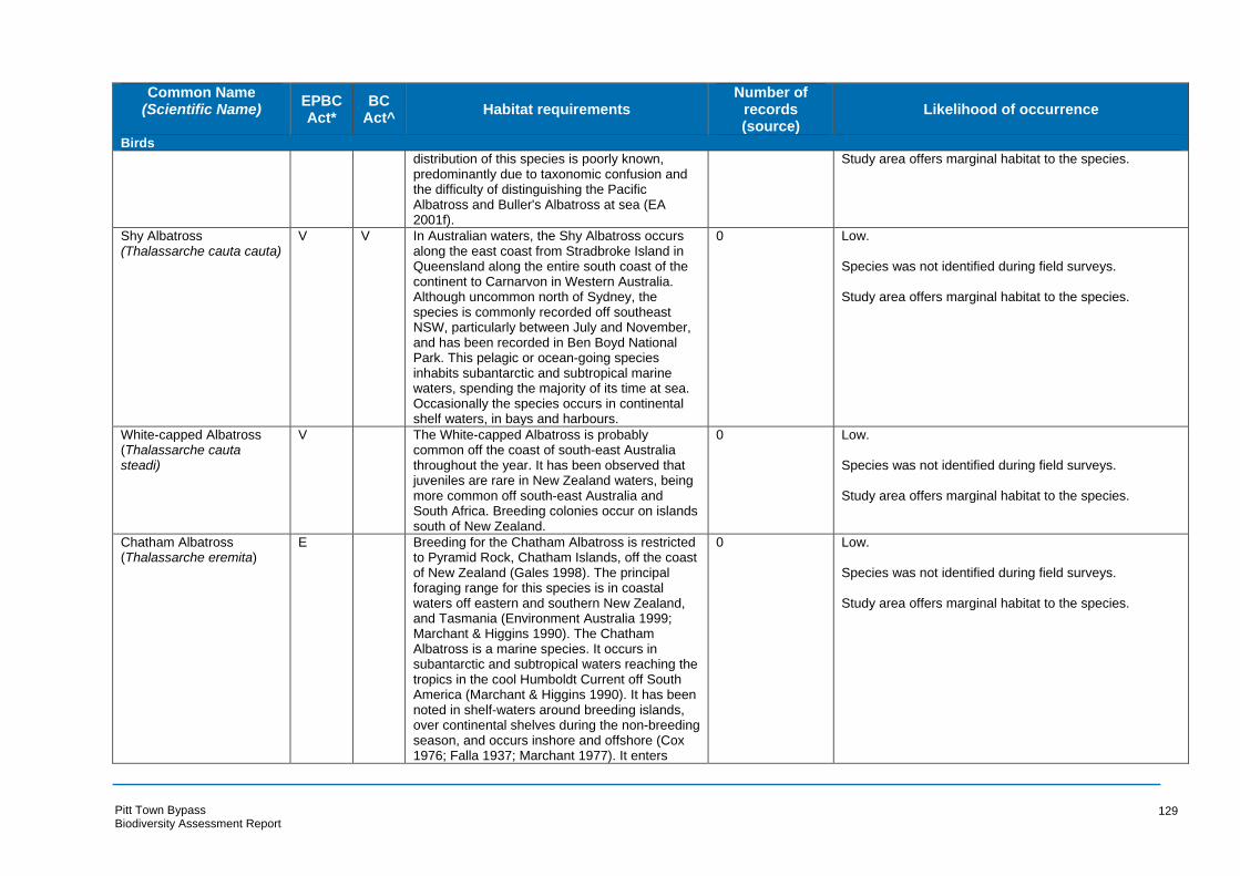
Common Name (Scientific Name) EPBC
Act* BC
Act^ Habitat requirements
Number of records (source)
Likelihood of occurrence
Birds
distribution of this species is poorly known, predominantly due to taxonomic confusion and the difficulty of distinguishing the Pacific Albatross and Buller's Albatross at sea (EA 2001f).
Study area offers marginal habitat to the species.
Shy Albatross V V In Australian waters, the Shy Albatross occurs 0 Low. (Thalassarche cauta cauta) along the east coast from Stradbroke Island in
Queensland along the entire south coast of the continent to Carnarvon in Western Australia. Although uncommon north of Sydney, the species is commonly recorded off southeast NSW, particularly between July and November, and has been recorded in Ben Boyd National Park. This pelagic or ocean-going species inhabits subantarctic and subtropical marine waters, spending the majority of its time at sea. Occasionally the species occurs in continental shelf waters, in bays and harbours.
Species was not identified during field surveys.
Study area offers marginal habitat to the species.
White-capped Albatross (Thalassarche cauta steadi)
V The White-capped Albatross is probably common off the coast of south-east Australia throughout the year. It has been observed that juveniles are rare in New Zealand waters, being more common off south-east Australia and South Africa. Breeding colonies occur on islands south of New Zealand.
0 Low.
Species was not identified during field surveys.
Study area offers marginal habitat to the species.
Chatham Albatross E Breeding for the Chatham Albatross is restricted 0 Low. (Thalassarche eremita) to Pyramid Rock, Chatham Islands, off the coast
of New Zealand (Gales 1998). The principal foraging range for this species is in coastal waters off eastern and southern New Zealand, and Tasmania (Environment Australia 1999; Marchant & Higgins 1990). The Chatham Albatross is a marine species. It occurs in subantarctic and subtropical waters reaching the tropics in the cool Humboldt Current off South America (Marchant & Higgins 1990). It has been noted in shelf-waters around breeding islands, over continental shelves during the non-breeding season, and occurs inshore and offshore (Cox 1976; Falla 1937; Marchant 1977). It enters
Species was not identified during field surveys.
Study area offers marginal habitat to the species.
Pitt Town Bypass Biodiversity Assessment Report
129
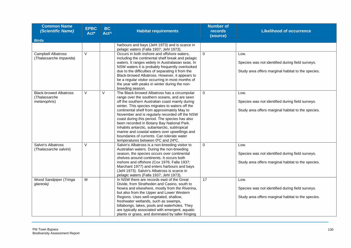
Common Name (Scientific Name) EPBC
Act* BC
Act^ Habitat requirements
Number of records (source)
Likelihood of occurrence
Birds
harbours and bays (Jehl 1973) and is scarce in pelagic waters (Falla 1937; Jehl 1973).
Campbell Albatross (Thalassarche impavida)
V Occurs in both inshore and offshore waters, including the continental shelf break and pelagic
0 Low.
waters. It ranges widely in Australasian seas. In Species was not identified during field surveys. NSW waters it is probably frequently overlooked due to the difficulties of separating it from the Study area offers marginal habitat to the species. Black-browed Albatross. However, it appears to be a regular visitor occurring in most months of the year with peaks in winter during the non-breeding season.
Black-browed Albatross (Thalassarche melanophris)
V V The Black-browed Albatross has a circumpolar range over the southern oceans, and are seen off the southern Australian coast mainly during
0 Low.
Species was not identified during field surveys. winter. This species migrates to waters off the continental shelf from approximately May to Study area offers marginal habitat to the species. November and is regularly recorded off the NSW coast during this period. The species has also been recorded in Botany Bay National Park. Inhabits antarctic, subantarctic, subtropical marine and coastal waters over upwellings and boundaries of currents. Can tolerate water temperatures between 0ºC and 24ºC.
Salvin's Albatross (Thalassarche salvini)
V Salvin's Albatross is a non-breeding visitor to Australian waters. During the non-breeding
0 Low.
season, the species occurs over continental Species was not identified during field surveys. shelves around continents. It occurs both inshore and offshore (Cox 1976; Falla 1937; Study area offers marginal habitat to the species. Marchant 1977) and enters harbours and bays (Jehl 1973). Salvin's Albatross is scarce in pelagic waters (Falla 1937; Jehl 1973).
Wood Sandpiper (Tringa glareola)
M In NSW there are records east of the Great Divide, from Stratheden and Casino, south to Nowra and elsewhere, mostly from the Riverina, but also from the Upper and Lower Western Regions. Uses well-vegetated, shallow, freshwater wetlands, such as swamps, billabongs, lakes, pools and waterholes. They are typically associated with emergent, aquatic plants or grass, and dominated by taller fringing
17 Low.
Species was not identified during field surveys.
Study area offers marginal habitat to the species.
Pitt Town Bypass Biodiversity Assessment Report
130

Common Name (Scientific Name) EPBC
Act* BC
Act^ Habitat requirements
Number of records (source)
Likelihood of occurrence
Birds
vegetation, such as dense stands of rushes or reeds, shrubs, or dead or live trees, especially Melaleuca and River Red Gums Eucalyptus camaldulensis and often with fallen timber. They also frequent inundated grasslands, short herbage or wooded floodplains, where floodwaters are temporary or receding, and irrigated crops. They are also found at some small wetlands only when they are drying. They are rarely found using brackish wetlands, or dry stunted saltmarsh.
Common Greenshank (Tringa nebularia)
M In NSW the species has been recorded in most coastal regions. It is widespread west of the
9 Low.
Great Dividing Range, especially between the Species was not identified during field surveys. Lachlan and Murray Rivers and the Darling River drainage basin, including the Macquarie Study area offers marginal habitat to the species. Marshes, and north-west regions (Higgins & Davies 1996). Widely distributed throughout a range of inland wetlands and sheltered coastal habitats. Occurs in habitats with varying salinity.
Marsh Sandpiper (Tringa stagnatilis)
M The species is recorded in all regions of NSW. Inhabits permanent or ephemeral wetlands, including swamps, billabongs, lagoons, saltmarshes and estuaries. Forages at the edge of wetlands in shallow water.
25 Low.
Species was not identified during field surveys.
Study area offers marginal habitat to the species.
Masked Owl (Tyto novaehollandiae)
V The distribution of the Masked Owl extends from the coast where it is most abundant to the western plains. Inhabits dry eucalypt forests and woodlands from sea level to 1100 m. Roosting and breeding occurs in moist eucalypt forested gullies, using large tree hollows or sometimes caves for nesting.
12 Low.
Species was not identified during field surveys.
Study area supports marginal foraging habitat for the species, although open forest/woodland habitat is highly fragmented. Study are does not support preferred nesting habitat.
Sooty Owl (Tyto tenebricosa)
V The Sooty Owl is distributed in the easternmost one-eighth of NSW, occurring on the coast, coastal escarpment and eastern tablelands. Inhabits rainforest including dry rainforest, subtropical and warm temperate rainforest as well as moist eucalypt forests. Nesting occurs in
7 Low.
Species was not identified during field surveys.
Study area supports marginal foraging habitat for the species, although open forest/woodland habitat is highly
Pitt Town Bypass Biodiversity Assessment Report
131
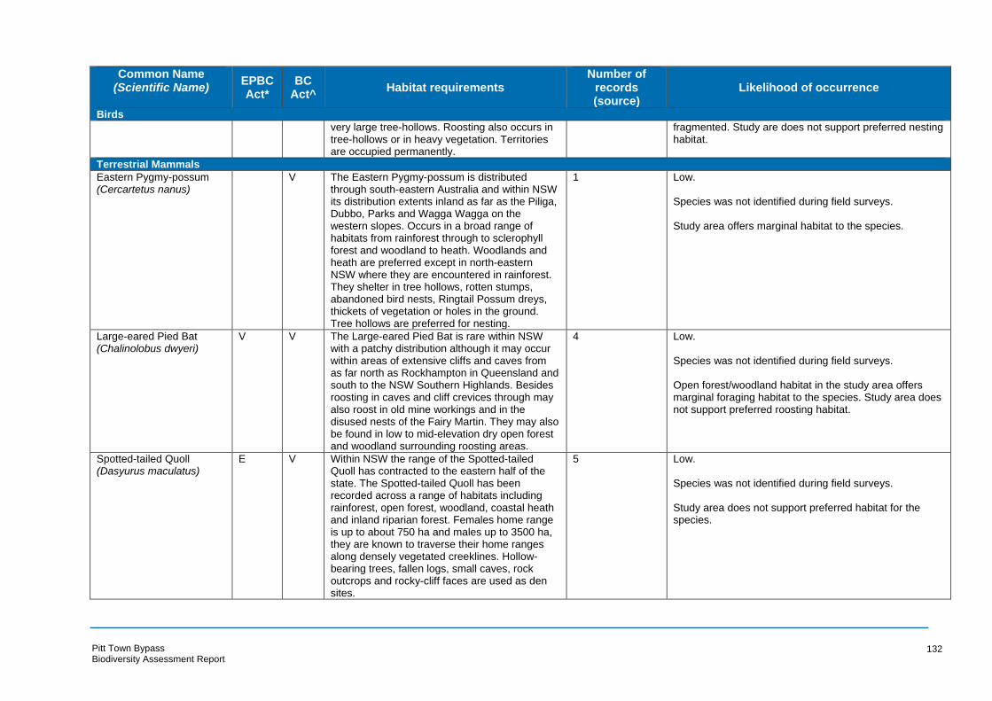
Common Name (Scientific Name) EPBC
Act* BC
Act^ Habitat requirements
Number of records (source)
Likelihood of occurrence
Birds
very large tree-hollows. Roosting also occurs in fragmented. Study are does not support preferred nesting tree-hollows or in heavy vegetation. Territories habitat. are occupied permanently.
Terrestrial Mammals
Eastern Pygmy-possum (Cercartetus nanus)
V The Eastern Pygmy-possum is distributed through south-eastern Australia and within NSW
1 Low.
its distribution extents inland as far as the Piliga, Species was not identified during field surveys. Dubbo, Parks and Wagga Wagga on the western slopes. Occurs in a broad range of Study area offers marginal habitat to the species. habitats from rainforest through to sclerophyll forest and woodland to heath. Woodlands and heath are preferred except in north-eastern NSW where they are encountered in rainforest. They shelter in tree hollows, rotten stumps, abandoned bird nests, Ringtail Possum dreys, thickets of vegetation or holes in the ground. Tree hollows are preferred for nesting.
Large-eared Pied Bat (Chalinolobus dwyeri)
V V The Large-eared Pied Bat is rare within NSW with a patchy distribution although it may occur
4 Low.
within areas of extensive cliffs and caves from Species was not identified during field surveys. as far north as Rockhampton in Queensland and south to the NSW Southern Highlands. Besides Open forest/woodland habitat in the study area offers roosting in caves and cliff crevices through may marginal foraging habitat to the species. Study area does also roost in old mine workings and in the not support preferred roosting habitat. disused nests of the Fairy Martin. They may also be found in low to mid-elevation dry open forest and woodland surrounding roosting areas.
Spotted-tailed Quoll (Dasyurus maculatus)
E V Within NSW the range of the Spotted-tailed Quoll has contracted to the eastern half of the
5 Low.
state. The Spotted-tailed Quoll has been Species was not identified during field surveys. recorded across a range of habitats including rainforest, open forest, woodland, coastal heath Study area does not support preferred habitat for the and inland riparian forest. Females home range species. is up to about 750 ha and males up to 3500 ha, they are known to traverse their home ranges along densely vegetated creeklines. Hollow-bearing trees, fallen logs, small caves, rock outcrops and rocky-cliff faces are used as den sites.
Pitt Town Bypass Biodiversity Assessment Report
132

Common Name (Scientific Name) EPBC
Act* BC
Act^ Habitat requirements
Number of records (source)
Likelihood of occurrence
Birds
Eastern False Pipistrelle (Falsistrellus tasmaniensis)
V The distribution of the Eastern False Pipistrelle is found on the south-east coast and ranges of Australia from southern Queensland to Victoria
21 Low
Species was not identified during field surveys. and Tasmania. Moist habitats with trees taller than 20 m are preferred. Roosting occurs Open forest/woodland habitat in the study area offers generally in eucalypt hollows but may also be marginal foraging habitat to the species. Hollow-bearing found under loose bark on trees or in buildings. trees and stags offer potential roosting habitat to the
species.
Little Bentwing-bat (Miniopterus australis)
V Distribution ranges from east coast and ranges of Australia from Cape York to Wollongong,
15 Low.
NSW. Generally found in well-timbered areas, in Species was not identified during field surveys. moist eucalypt forest, rainforest, vine thicket, wet and dry sclerophyll forest, Melaleuca swamps, Open forest/woodland habitat in the study area offers dense coastal forests and banksia scrub. marginal foraging habitat to the species. Study area does Roosting occurs in a range of areas including not support preferred roosting habitat. caves, tunnels, treehollows.
Eastern Bentwing-bat (Miniopterus schreibersii oceanensis)
V Occurs along the east and north-west coasts of Australia, with caves being the primary roosting habitats although derelict mines and storm-water tunnels along with other man-made structures are also used. Hunting occurs in forested areas and the Eastern Bentwing-bat disperses within about a 300 km range of their maternity caves which are used during spring and summer at other times of the year.
39 Known.
A definite recording of this species was made by both Anabats, in the northern extent of the study area.
Eastern Freetail-bat V Distributed from the east coast form south 55 Known. (Mormopterus norfolkensis) Queensland to southern NSW. Found in dry
sclerophyll forest, woodland, swamp forests and A definite recording of this species was made by both mangrove forests east of the Great Dividing Anabats, in the northern extent of the study area. Range. Roosting occurs mainly in tree hollows but will roost under bark or in man-made structures.
Southern Myotis (Myotis macropus)
V The Southern Myotis is rarely found more than 100 km inland, except along major rivers and is distributed in the coastal band from the north-west of Australia, across the top-end and south to western Victoria. Roosting generally occurs close to water in caves, hollow-bearing trees, dense foliage, mine shafts and other man-made structures.
41 High.
A possible recording of this species was made by one of the Anabats, in the northern extent of the study area.
Pitt Town Bypass Biodiversity Assessment Report
133

Common Name (Scientific Name) EPBC
Act* BC
Act^ Habitat requirements
Number of records (source)
Likelihood of occurrence
Birds
Greater Glider (Petauroides volans)
V The Greater Glider occurs in eucalypt forests and woodlands along the east coast of Australia
2 Low.
from north east Queensland to the Central Species was not identified during field surveys. Highlands of Victoria. Shelters in tree hollows during the day. It is typically found in highest Study area does not support preferred habitat for the abundance in taller, montane, moist eucalypt species. forests with relatively old trees and abundant hollows (Andrews et al., 1994; Smith et al., 1994, 1995; Kavanagh 2000; Eyre 2004; van der Ree et al., 2004; Vanderduys et al., 2012).
Yellow-bellied Glider (Petaurus australis)
V Distributed along the eastern coast to the western slops of the Great Dividing Range from
168 Low.
southern Queensland to Victoria. Found in tall Species was not identified during field surveys. mature eucalypt forest generally in areas with high rainfall and nutrient rich soils. Preference to Study area does not support preferred habitat for the a certain forest type varies with latitude and species. elevation; mixed coastal forests to dry escarpment forests in the north; moist coastal gullies and creek flats to tall montane forests in the south. An endangered population occurs on the Bago Plateau, this population is disjunct and inhabits tall wet sclerophyll forest dominated by Alpine Ash, Mountain Gum, Narrow-leaved Peppermint and Candlebark.
Squirrel Glider (Petaurus norfolcensis)
V The Squirrel Glider has a wide sparse distribution in eastern Australia from northern Queensland to western Victoria. Found in mature or old growth Box, Box-Ironbark woodlands and River Red Gum forest west of the Great Dividing Range and Blackbutt-Bloodwood forest with heath understorey in coastal areas. Prefers mixed species stands with a shrub or Acacia midstorey. Abundant tree hollows are required for refuge and nest sites. Endangered populations occur on Barrenjoey Peninsula, north of Bushrangers Hill and in the Wagga Wagga LGA.
7 Low.
Species was not identified during field surveys.
Study area does not support preferred habitat for the species.
Brush-tailed Rock-wallaby V E In NSW the Brush-tailed Rock-wallaby occurs 0 Low. (Petrogale penicillata) from the Queensland border in the north to the
Shoalhaven in the south, with the western limit Species was not identified during field surveys.
Pitt Town Bypass Biodiversity Assessment Report
134

Common Name (Scientific Name) EPBC
Act* BC
Act^ Habitat requirements
Number of records (source)
Likelihood of occurrence
Birds
being the population in the Warrumbungle Ranges. Found in rocky escarpments, outcrops Study area does not support preferred habitat for the and cliffs with a preference for complex species. structures with fissures, caves and ledges often facing north. Shelter or bask during the day in rock crevices, caves and overhangs.
Koala (Phascolarctos cinereus)
V V Fragmented distribution throughout eastern Australia, within NSW Koalas mainly occur on the central and north coasts with some populations west of the Great Dividing Range. Occupies eucalypt woodlands and forests. Feed on the foliage of more than 70 eucalypt species and 30 non-eucalypt species, but in any one area will select preferred browse species.
14 Low.
Species was not identified during field surveys.
Study area does not support preferred habitat for the species.
New Holland Mouse (Pseudomys novaehollandiae)
V The New Holland Mouse has a fragmented distribution across Tasmania, Victoria, New South Wales and Queensland. Known to inhabit open heathlands, woodlands and forests with a heathland understorey and vegetated sand dunes.
0 Low.
Species was not identified during field surveys.
Study area does not support preferred habitat for the species.
Grey-headed Flying-fox (Pteropus poliocephalus)
V V Grey-headed Flying-foxes are generally found within 200 km of the eastern coast from
34 Known.
Rockhampton, Queensland to Adelaide, South Several individuals were observed foraging on the Australia. They inhabit subtropical and blossoms of flowering Grey Box trees and a large number temperate rainforests, tall sclerophyll forests and were seen flying overhead. woodlands, heaths and swamps as well as urban gardens and cultivated fruit crops. Roosting camps are commonly found in gullies, close to water, in vegetation with a dense canopy.
Yellow-bellied Sheathtail- V Has a wide ranging distribution across northern 6 High. bat (Saccolaimus and eastern Australia. Utilise tree hollows and flaviventris) buildings; in treeless areas they are known to Study area provides potential foraging habitat within
utilise mammal burrows. Forages in most open/forest woodland habitat and limited roosting habitat habitats across its very wide range. within hollow-bearing trees.
Pitt Town Bypass Biodiversity Assessment Report
135

*Status under the EPBC Act- CE: Critically Endangered, E: Endangered, V: Vulnerable, M- Migratory. ^Status under the BC Act- PE: Presumed extinct, E-Endangered, V- Vulnerable
Pitt Town Bypass Biodiversity Assessment Report
136

Appendix C EPBC Protected Matters Search Results
Pitt Town Bypass Biodiversity Assessment Report
137
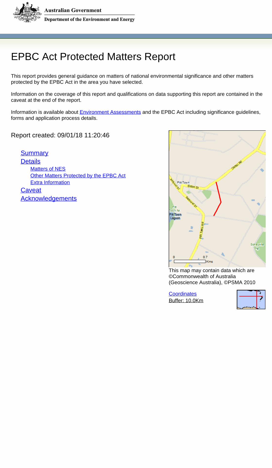
EPBC Act Protected Matters Report
This report provides general guidance on matters of national environmental significance and other mattersprotected by the EPBC Act in the area you have selected.
Information on the coverage of this report and qualifications on data supporting this report are contained in thecaveat at the end of the report.
Information is available about Environment Assessments and the EPBC Act including significance guidelines,forms and application process details.
Buffer: 10.0KmCoordinates
This map may contain data which are©Commonwealth of Australia(Geoscience Australia), ©PSMA 2010
Report created: 09/01/18 11:20:46
SummaryDetails
Matters of NESOther Matters Protected by the EPBC ActExtra Information
CaveatAcknowledgements

Summary
This part of the report summarises the matters of national environmental significance that may occur in, or mayrelate to, the area you nominated. Further information is available in the detail part of the report, which can beaccessed by scrolling or following the links below. If you are proposing to undertake an activity that may have asignificant impact on one or more matters of national environmental significance then you should consider theAdministrative Guidelines on Significance.
Matters of National Environmental Significance
World Heritage Properties: None
National Heritage Places: None
Wetlands of International Importance: None
Great Barrier Reef Marine Park: None
Commonwealth Marine Area: None
Listed Threatened Ecological Communities: 6
Listed Threatened Species: 71
Listed Migratory Species: 30
This part of the report summarises other matters protected under the Act that may relate to the area you nominated.Approval may be required for a proposed activity that significantly affects the environment on Commonwealth land,when the action is outside the Commonwealth land, or the environment anywhere when the action is taken onCommonwealth land. Approval may also be required for the Commonwealth or Commonwealth agencies proposing totake an action that is likely to have a significant impact on the environment anywhere.
The EPBC Act protects the environment on Commonwealth land, the environment from the actions taken onCommonwealth land, and the environment from actions taken by Commonwealth agencies. As heritage values of aplace are part of the 'environment', these aspects of the EPBC Act protect the Commonwealth Heritage values of aCommonwealth Heritage place. Information on the new heritage laws can be found athttp://www.environment.gov.au/heritage
A permit may be required for activities in or on a Commonwealth area that may affect a member of a listed threatenedspecies or ecological community, a member of a listed migratory species, whales and other cetaceans, or a member ofa listed marine species.
Other Matters Protected by the EPBC Act
None
None
None
Listed Marine Species:
Whales and Other Cetaceans:
43
Commonwealth Heritage Places:
8
2
Critical Habitats:
Commonwealth Land:
Commonwealth Reserves Terrestrial:
NoneCommonwealth Reserves Marine:
Extra Information
This part of the report provides information that may also be relevant to the area you have nominated.
2
5State and Territory Reserves:
Nationally Important Wetlands:
NoneRegional Forest Agreements:
Invasive Species: 55
NoneKey Ecological Features (Marine)

Details
Matters of National Environmental Significance
Listed Threatened Ecological Communities [ Resource Information ]For threatened ecological communities where the distribution is well known, maps are derived from recoveryplans, State vegetation maps, remote sensing imagery and other sources. Where threatened ecologicalcommunity distributions are less well known, existing vegetation maps and point location data are used toproduce indicative distribution maps.
Listed Threatened Species [ Resource Information ]Name Status Type of PresenceBirdsAnthochaera phrygiaRegent Honeyeater [82338] Critically Endangered Species or species habitat
known to occur within area
Botaurus poiciloptilusAustralasian Bittern [1001] Endangered Species or species habitat
known to occur within area
Calidris ferrugineaCurlew Sandpiper [856] Critically Endangered Species or species habitat
known to occur within area
Dasyornis brachypterusEastern Bristlebird [533] Endangered Species or species habitat
likely to occur within area
Diomedea antipodensisAntipodean Albatross [64458] Vulnerable Species or species habitat
likely to occur within area
Diomedea antipodensis gibsoniGibson's Albatross [82270] Vulnerable Species or species habitat
likely to occur within area
Diomedea epomophoraSouthern Royal Albatross [89221] Vulnerable Species or species habitat
likely to occur within area
Diomedea exulansWandering Albatross [89223] Vulnerable Species or species habitat
likely to occur within area
Name Status Type of PresenceCastlereagh Scribbly Gum and Agnes Banks Endangered Community likely to occurWoodlands of the Sydney Basin Bioregion within areaCooks River/Castlereagh Ironbark Forest of the Critically Endangered Community likely to occurSydney Basin Bioregion within areaCumberland Plain Shale Woodlands and Shale-Gravel Critically Endangered Community likely to occurTransition Forest within areaShale Sandstone Transition Forest of the Sydney Critically Endangered Community likely to occurBasin Bioregion within areaTurpentine-Ironbark Forest of the Sydney Basin Critically Endangered Community likely to occurBioregion within areaWestern Sydney Dry Rainforest and Moist Woodland Critically Endangered Community likely to occuron Shale within area

Name Status Type of PresenceDiomedea sanfordiNorthern Royal Albatross [64456] Endangered Species or species habitat
likely to occur within area
Grantiella pictaPainted Honeyeater [470] Vulnerable Species or species habitat
likely to occur within area
Lathamus discolorSwift Parrot [744] Critically Endangered Species or species habitat
known to occur within area
Macronectes giganteusSouthern Giant-Petrel, Southern Giant Petrel [1060] Endangered Species or species habitat
may occur within area
Macronectes halliNorthern Giant Petrel [1061] Vulnerable Species or species habitat
may occur within area
Numenius madagascariensisEastern Curlew, Far Eastern Curlew [847] Critically Endangered Species or species habitat
may occur within area
Pachyptila turtur subantarcticaFairy Prion (southern) [64445] Vulnerable Species or species habitat
likely to occur within area
Rostratula australisAustralian Painted Snipe [77037] Endangered Species or species habitat
likely to occur within area
Thalassarche bulleriBuller's Albatross, Pacific Albatross [64460] Vulnerable Species or species habitat
may occur within area
Thalassarche bulleri plateiNorthern Buller's Albatross, Pacific Albatross [82273] Vulnerable Species or species habitat
may occur within area
Thalassarche cauta cautaShy Albatross, Tasmanian Shy Albatross [82345] Vulnerable Species or species habitat
likely to occur within area
Thalassarche cauta steadiWhite-capped Albatross [82344] Vulnerable Species or species habitat
likely to occur within area
Thalassarche eremitaChatham Albatross [64457] Endangered Species or species habitat
likely to occur within area
Thalassarche impavidaCampbell Albatross, Campbell Black-browed Albatross Vulnerable Species or species habitat[64459] may occur within area
Thalassarche melanophrisBlack-browed Albatross [66472] Vulnerable Species or species habitat
may occur within area
Thalassarche salviniSalvin's Albatross [64463] Vulnerable Species or species habitat
likely to occur within area
FishEpinephelus daemeliiBlack Rockcod, Black Cod, Saddled Rockcod [68449] Vulnerable Species or species habitat
likely to occur within area
Macquaria australasicaMacquarie Perch [66632] Endangered Species or species habitat
may occur within area

Name Status Type of PresencePrototroctes maraenaAustralian Grayling [26179] Vulnerable Species or species habitat
likely to occur within area
FrogsHeleioporus australiacusGiant Burrowing Frog [1973] Vulnerable Species or species habitat
known to occur within area
Litoria aureaGreen and Golden Bell Frog [1870] Vulnerable Species or species habitat
known to occur within area
Litoria littlejohniLittlejohn's Tree Frog, Heath Frog [64733] Vulnerable Species or species habitat
may occur within area
Mixophyes balbusStuttering Frog, Southern Barred Frog (in Victoria) Vulnerable Species or species habitat[1942] likely to occur within area
MammalsChalinolobus dwyeriLarge-eared Pied Bat, Large Pied Bat [183] Vulnerable Species or species habitat
known to occur within area
Dasyurus maculatus maculatus (SE mainland population)Spot-tailed Quoll, Spotted-tail Quoll, Tiger Quoll Endangered Species or species habitat(southeastern mainland population) [75184] known to occur within area
Petauroides volansGreater Glider [254] Vulnerable Species or species habitat
known to occur within area
Petrogale penicillataBrush-tailed Rock-wallaby [225] Vulnerable Species or species habitat
may occur within area
Phascolarctos cinereus (combined populations of Qld, NSW and the ACT)Koala (combined populations of Queensland, New Vulnerable Species or species habitatSouth Wales and the Australian Capital Territory) known to occur within area[85104]Pseudomys novaehollandiaeNew Holland Mouse, Pookila [96] Vulnerable Species or species habitat
may occur within area
Pteropus poliocephalusGrey-headed Flying-fox [186] Vulnerable Foraging, feeding or related
behaviour known to occurwithin area
OtherPommerhelix duralensisDural Land Snail [85268] Endangered Species or species habitat
known to occur within area
PlantsAcacia bynoeanaBynoe's Wattle, Tiny Wattle [8575] Vulnerable Species or species habitat
known to occur within area
Acacia gordonii [5031] Endangered Species or species habitat
known to occur within area
Acacia pubescensDowny Wattle, Hairy Stemmed Wattle [18800] Vulnerable Species or species habitat
known to occur within area
Allocasuarina glareicola [21932] Endangered Species or species habitat
likely to occur within area

Name Status Type of PresenceAsterolasia elegans [56780] Endangered Species or species habitat
likely to occur within area
Cryptostylis hunterianaLeafless Tongue-orchid [19533] Vulnerable Species or species habitat
may occur within area
Cynanchum elegansWhite-flowered Wax Plant [12533] Endangered Species or species habitat
likely to occur within area
Darwinia biflora [14619] Vulnerable Species or species habitat
likely to occur within area
Genoplesium baueriYellow Gnat-orchid [7528] Endangered Species or species habitat
likely to occur within area
Haloragis exalata subsp. exalataWingless Raspwort, Square Raspwort [24636] Vulnerable Species or species habitat
may occur within area
Kunzea rupestris [8798] Vulnerable Species or species habitat
likely to occur within area
Melaleuca deaneiDeane's Melaleuca [5818] Vulnerable Species or species habitat
likely to occur within area
Micromyrtus blakelyi [6870] Vulnerable Species or species habitat
likely to occur within area
Micromyrtus minutiflora [11485] Vulnerable Species or species habitat
likely to occur within area
Olearia cordata [6710] Vulnerable Species or species habitat
likely to occur within area
Pelargonium sp. Striatellum (G.W.Carr 10345)Omeo Stork's-bill [84065] Endangered Species or species habitat
likely to occur within area
Persoonia hirsutaHairy Geebung, Hairy Persoonia [19006] Endangered Species or species habitat
likely to occur within area
Persoonia nutansNodding Geebung [18119] Endangered Species or species habitat
likely to occur within area
Pimelea curviflora var. curviflora [4182] Vulnerable Species or species habitat
known to occur within area
Pimelea spicataSpiked Rice-flower [20834] Endangered Species or species habitat
known to occur within area
Pterostylis gibbosaIllawarra Greenhood, Rufa Greenhood, Pouched Endangered Species or species habitatGreenhood [4562] may occur within area
Pterostylis pulchellaPretty Greenhood [6448] Vulnerable Species or species habitat
may occur within area

Name Status Type of PresencePterostylis saxicolaSydney Plains Greenhood [64537] Endangered Species or species habitat
known to occur within area
Pultenaea parviflora [19380] Vulnerable Species or species habitat
known to occur within area
Syzygium paniculatumMagenta Lilly Pilly, Magenta Cherry, Daguba, Scrub Vulnerable Species or species habitatCherry, Creek Lilly Pilly, Brush Cherry [20307] known to occur within area
Thesium australeAustral Toadflax, Toadflax [15202] Vulnerable Species or species habitat
may occur within area
Zieria involucrata [3087] Vulnerable Species or species habitat
likely to occur within area
ReptilesCaretta carettaLoggerhead Turtle [1763] Endangered Species or species habitat
known to occur within area
Chelonia mydasGreen Turtle [1765] Vulnerable Species or species habitat
known to occur within area
Dermochelys coriaceaLeatherback Turtle, Leathery Turtle, Luth [1768] Endangered Species or species habitat
known to occur within area
Eretmochelys imbricataHawksbill Turtle [1766] Vulnerable Species or species habitat
known to occur within area
Natator depressusFlatback Turtle [59257] Vulnerable Species or species habitat
known to occur within area
Listed Migratory Species [ Resource Information * Species is listed under a different scientific name on the EPBC Act - Threatened Species list.
Name Threatened Type of PresenceMigratory Marine BirdsApus pacificusFork-tailed Swift [678] Species or species habitat
likely to occur within area
Diomedea epomophoraSouthern Royal Albatross [89221] Vulnerable Species or species habitat
likely to occur within area
Diomedea exulansWandering Albatross [89223] Vulnerable Species or species habitat
likely to occur within area
Macronectes giganteusSouthern Giant-Petrel, Southern Giant Petrel [1060] Endangered Species or species habitat
may occur within area
Macronectes halliNorthern Giant Petrel [1061] Vulnerable Species or species habitat
may occur within area
Thalassarche bulleriBuller's Albatross, Pacific Albatross [64460] Vulnerable Species or species habitat
may occur within area
Thalassarche cautaTasmanian Shy Albatross [89224] Vulnerable* Species or species habitat
likely to occur
]

Name Threatened Type of Presencewithin area
Thalassarche melanophrisBlack-browed Albatross [66472] Vulnerable Species or species habitat
may occur within area
Migratory Marine SpeciesCaretta carettaLoggerhead Turtle [1763] Endangered Species or species habitat
known to occur within area
Chelonia mydasGreen Turtle [1765] Vulnerable Species or species habitat
known to occur within area
Dermochelys coriaceaLeatherback Turtle, Leathery Turtle, Luth [1768] Endangered Species or species habitat
known to occur within area
Eretmochelys imbricataHawksbill Turtle [1766] Vulnerable Species or species habitat
known to occur within area
Manta alfrediReef Manta Ray, Coastal Manta Ray, Inshore Manta Species or species habitatRay, Prince Alfred's Ray, Resident Manta Ray [84994] may occur within area
Manta birostrisGiant Manta Ray, Chevron Manta Ray, Pacific Manta Species or species habitatRay, Pelagic Manta Ray, Oceanic Manta Ray [84995] may occur within area
Natator depressusFlatback Turtle [59257] Vulnerable Species or species habitat
known to occur within area
Migratory Terrestrial SpeciesCuculus optatusOriental Cuckoo, Horsfield's Cuckoo [86651] Species or species habitat
known to occur within area
Hirundapus caudacutusWhite-throated Needletail [682] Species or species habitat
known to occur within area
Monarcha melanopsisBlack-faced Monarch [609] Species or species habitat
known to occur within area
Monarcha trivirgatusSpectacled Monarch [610] Species or species habitat
may occur within area
Motacilla flavaYellow Wagtail [644] Species or species habitat
known to occur within area
Myiagra cyanoleucaSatin Flycatcher [612] Species or species habitat
known to occur within area
Rhipidura rufifronsRufous Fantail [592] Species or species habitat
known to occur within area
Migratory Wetlands SpeciesActitis hypoleucosCommon Sandpiper [59309] Species or species habitat
known to occur within area
Calidris acuminataSharp-tailed Sandpiper [874] Species or species habitat
known to occur within area

Type of Presence
Name Threatened Type of PresenceCalidris ferrugineaCurlew Sandpiper [856] Critically Endangered Species or species habitat
known to occur within area
Calidris melanotosPectoral Sandpiper [858] Species or species habitat
known to occur within area
Gallinago hardwickiiLatham's Snipe, Japanese Snipe [863] Species or species habitat
may occur within area
Numenius madagascariensisEastern Curlew, Far Eastern Curlew [847] Critically Endangered Species or species habitat
may occur within area
Pandion haliaetusOsprey [952] Species or species habitat
likely to occur within area
Tringa nebulariaCommon Greenshank, Greenshank [832] Species or species habitat
likely to occur within area
Other Matters Protected by the EPBC Act
Commonwealth Land [ Resource Information ]The Commonwealth area listed below may indicate the presence of Commonwealth land in this vicinity. Due tothe unreliability of the data source, all proposals should be checked as to whether it impacts on aCommonwealth area, before making a definitive decision. Contact the State or Territory government landdepartment for further information.
NameCommonwealth Land - Australian Postal CorporationCommonwealth Land - Australian Telecommunications CommissionCommonwealth Land - Defence Housing AuthorityCommonwealth Land - Telstra Corporation LimitedDefence - RICHMOND - FUEL FARM, DENTAL, MEDICALDefence - RICHMOND - MIDDLE MARKERDefence - RICHMOND - OUTER MARKERDefence - RICHMOND RAAF BASE
Commonwealth Heritage Places [ Resource Information ]NameHistoricNorth Base Trig Station NSW Listed placeRAAF Base Richmond NSW Listed place
Listed Marine Species [ Resource Information ]* Species is listed under a different scientific name on the EPBC Act - Threatened Species list.
BirdsActitis hypoleucosCommon Sandpiper [59309] Species or species habitat
known to occur within area
Apus pacificusFork-tailed Swift [678] Species or species habitat
likely to occur within area
Ardea albaGreat Egret, White Egret [59541] Species or species habitat
known to occur within area
Ardea ibisCattle Egret [59542] Species or species habitat
may occur within area
Calidris acuminataSharp-tailed Sandpiper [874] Species or species
StatusState
Name Threatened

Name Threatened Type of Presencehabitat known to occurwithin area
Calidris ferrugineaCurlew Sandpiper [856] Critically Endangered Species or species habitat
known to occur within area
Calidris melanotosPectoral Sandpiper [858] Species or species habitat
known to occur within area
Cuculus saturatusOriental Cuckoo, Himalayan Cuckoo [710] Species or species habitat
known to occur within area
Diomedea antipodensisAntipodean Albatross [64458] Vulnerable Species or species habitat
likely to occur within area
Diomedea epomophoraSouthern Royal Albatross [89221] Vulnerable Species or species habitat
likely to occur within area
Diomedea exulansWandering Albatross [89223] Vulnerable Species or species habitat
likely to occur within area
Diomedea gibsoniGibson's Albatross [64466] Vulnerable* Species or species habitat
likely to occur within area
Diomedea sanfordiNorthern Royal Albatross [64456] Endangered Species or species habitat
likely to occur within area
Gallinago hardwickiiLatham's Snipe, Japanese Snipe [863] Species or species habitat
may occur within area
Haliaeetus leucogasterWhite-bellied Sea-Eagle [943] Species or species habitat
known to occur within area
Hirundapus caudacutusWhite-throated Needletail [682] Species or species habitat
known to occur within area
Lathamus discolorSwift Parrot [744] Critically Endangered Species or species habitat
known to occur within area
Macronectes giganteusSouthern Giant-Petrel, Southern Giant Petrel [1060] Endangered Species or species habitat
may occur within area
Macronectes halliNorthern Giant Petrel [1061] Vulnerable Species or species habitat
may occur within area
Merops ornatusRainbow Bee-eater [670] Species or species habitat
may occur within area
Monarcha melanopsisBlack-faced Monarch [609] Species or species habitat
known to occur within area
Monarcha trivirgatusSpectacled Monarch [610] Species or species habitat
may occur within area
Motacilla flavaYellow Wagtail [644] Species or species habitat
known to occur

Name Threatened Type of Presencewithin area
Myiagra cyanoleucaSatin Flycatcher [612] Species or species habitat
known to occur within area
Numenius madagascariensisEastern Curlew, Far Eastern Curlew [847] Critically Endangered Species or species habitat
may occur within area
Pachyptila turturFairy Prion [1066] Species or species habitat
likely to occur within area
Pandion haliaetusOsprey [952] Species or species habitat
likely to occur within area
Rhipidura rufifronsRufous Fantail [592] Species or species habitat
known to occur within area
Rostratula benghalensis (sensu lato)Painted Snipe [889] Endangered* Species or species habitat
likely to occur within area
Thalassarche bulleriBuller's Albatross, Pacific Albatross [64460] Vulnerable Species or species habitat
may occur within area
Thalassarche cautaTasmanian Shy Albatross [89224] Vulnerable* Species or species habitat
likely to occur within area
Thalassarche eremitaChatham Albatross [64457] Endangered Species or species habitat
likely to occur within area
Thalassarche impavidaCampbell Albatross, Campbell Black-browed Albatross Vulnerable Species or species habitat[64459] may occur within area
Thalassarche melanophrisBlack-browed Albatross [66472] Vulnerable Species or species habitat
may occur within area
Thalassarche salviniSalvin's Albatross [64463] Vulnerable Species or species habitat
likely to occur within area
Thalassarche sp. nov.Pacific Albatross [66511] Vulnerable* Species or species habitat
may occur within area
Thalassarche steadiWhite-capped Albatross [64462] Vulnerable* Species or species habitat
likely to occur within area
Tringa nebulariaCommon Greenshank, Greenshank [832] Species or species habitat
likely to occur within area
ReptilesCaretta carettaLoggerhead Turtle [1763] Endangered Species or species habitat
known to occur within area
Chelonia mydasGreen Turtle [1765] Vulnerable Species or species habitat
known to occur within area
Dermochelys coriaceaLeatherback Turtle, Leathery Turtle, Luth [1768] Endangered Species or species habitat
known to occur

Name Threatened Type of Presencewithin area
Eretmochelys imbricataHawksbill Turtle [1766] Vulnerable Species or species habitat
known to occur within area
Natator depressusFlatback Turtle [59257] Vulnerable Species or species habitat
known to occur within area
Extra Information
State and Territory Reserves [ Resource Information ]Name StateCattai NSWPitt Town NSWRouse Hill NSWScheyville NSWWindsor Downs NSW
Invasive Species [ Resource Information ]Weeds reported here are the 20 species of national significance (WoNS), along with other introduced plantsthat are considered by the States and Territories to pose a particularly significant threat to biodiversity. Thefollowing feral animals are reported: Goat, Red Fox, Cat, Rabbit, Pig, Water Buffalo and Cane Toad. Maps fromLandscape Health Project, National Land and Water Resouces Audit, 2001.
Name Status Type of PresenceBirdsAcridotheres tristisCommon Myna, Indian Myna [387] Species or species habitat
likely to occur within area
Alauda arvensisSkylark [656] Species or species habitat
likely to occur within area
Anas platyrhynchosMallard [974] Species or species habitat
likely to occur within area
Carduelis carduelisEuropean Goldfinch [403] Species or species habitat
likely to occur within area
Carduelis chlorisEuropean Greenfinch [404] Species or species habitat
likely to occur within area
Columba liviaRock Pigeon, Rock Dove, Domestic Pigeon [803] Species or species habitat
likely to occur within area
Lonchura punctulataNutmeg Mannikin [399] Species or species habitat
likely to occur within area
Passer domesticusHouse Sparrow [405] Species or species habitat
likely to occur within area
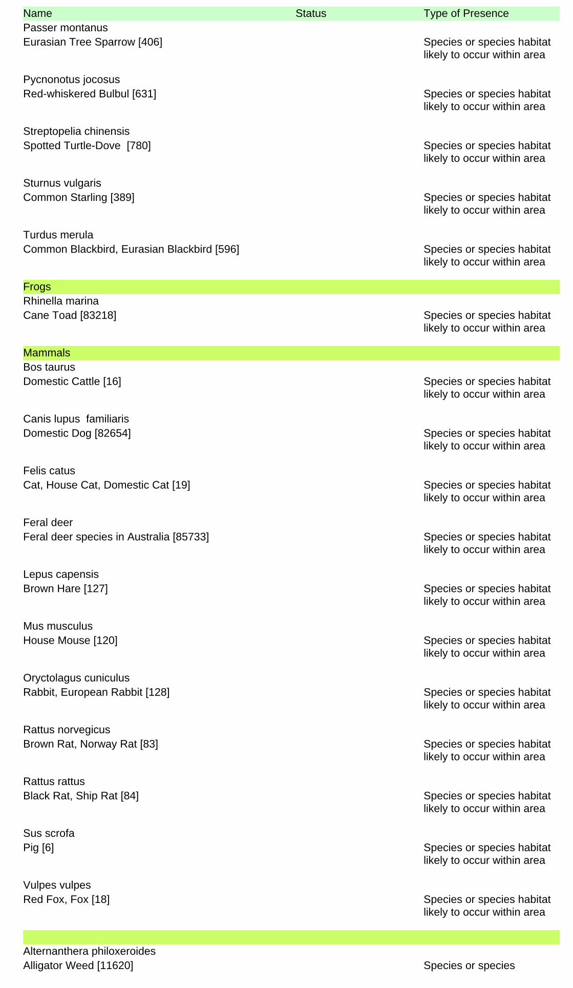
Name Status Type of PresencePasser montanusEurasian Tree Sparrow [406] Species or species habitat
likely to occur within area
Pycnonotus jocosusRed-whiskered Bulbul [631] Species or species habitat
likely to occur within area
Streptopelia chinensisSpotted Turtle-Dove [780] Species or species habitat
likely to occur within area
Sturnus vulgarisCommon Starling [389] Species or species habitat
likely to occur within area
Turdus merulaCommon Blackbird, Eurasian Blackbird [596] Species or species habitat
likely to occur within area
FrogsRhinella marinaCane Toad [83218] Species or species habitat
likely to occur within area
MammalsBos taurusDomestic Cattle [16] Species or species habitat
likely to occur within area
Canis lupus familiarisDomestic Dog [82654] Species or species habitat
likely to occur within area
Felis catusCat, House Cat, Domestic Cat [19] Species or species habitat
likely to occur within area
Feral deerFeral deer species in Australia [85733] Species or species habitat
likely to occur within area
Lepus capensisBrown Hare [127] Species or species habitat
likely to occur within area
Mus musculusHouse Mouse [120] Species or species habitat
likely to occur within area
Oryctolagus cuniculusRabbit, European Rabbit [128] Species or species habitat
likely to occur within area
Rattus norvegicusBrown Rat, Norway Rat [83] Species or species habitat
likely to occur within area
Rattus rattusBlack Rat, Ship Rat [84] Species or species habitat
likely to occur within area
Sus scrofaPig [6] Species or species habitat
likely to occur within area
Vulpes vulpesRed Fox, Fox [18] Species or species habitat
likely to occur within area
PlantsAlternanthera philoxeroidesAlligator Weed [11620] Species or species

Name Status Type of Presencehabitat likely to occur withinarea
Anredera cordifoliaMadeira Vine, Jalap, Lamb's-tail, Mignonette Vine, Species or species habitatAnredera, Gulf Madeiravine, Heartleaf Madeiravine, likely to occur within areaPotato Vine [2643]Asparagus aethiopicusAsparagus Fern, Ground Asparagus, Basket Fern, Species or species habitatSprengi's Fern, Bushy Asparagus, Emerald Asparagus likely to occur within area[62425]Asparagus asparagoidesBridal Creeper, Bridal Veil Creeper, Smilax, Florist's Species or species habitatSmilax, Smilax Asparagus [22473] likely to occur within area
Asparagus plumosusClimbing Asparagus-fern [48993] Species or species habitat
likely to occur within area
Asparagus scandensAsparagus Fern, Climbing Asparagus Fern [23255] Species or species habitat
likely to occur within area
Cabomba carolinianaCabomba, Fanwort, Carolina Watershield, Fish Grass, Species or species habitatWashington Grass, Watershield, Carolina Fanwort, likely to occur within areaCommon Cabomba [5171]Chrysanthemoides moniliferaBitou Bush, Boneseed [18983] Species or species habitat
may occur within area
Chrysanthemoides monilifera subsp. moniliferaBoneseed [16905] Species or species habitat
likely to occur within area
Cytisus scopariusBroom, English Broom, Scotch Broom, Common Species or species habitatBroom, Scottish Broom, Spanish Broom [5934] likely to occur within area
Dolichandra unguis-catiCat's Claw Vine, Yellow Trumpet Vine, Cat's Claw Species or species habitatCreeper, Funnel Creeper [85119] likely to occur within area
Eichhornia crassipesWater Hyacinth, Water Orchid, Nile Lily [13466] Species or species habitat
likely to occur within area
Genista linifoliaFlax-leaved Broom, Mediterranean Broom, Flax Broom Species or species habitat[2800] likely to occur within area
Genista monspessulanaMontpellier Broom, Cape Broom, Canary Broom, Species or species habitatCommon Broom, French Broom, Soft Broom [20126] likely to occur within area
Genista sp. X Genista monspessulanaBroom [67538] Species or species habitat
may occur within area
Lantana camaraLantana, Common Lantana, Kamara Lantana, Large- Species or species habitatleaf Lantana, Pink Flowered Lantana, Red Flowered likely to occur within areaLantana, Red-Flowered Sage, White Sage, Wild Sage[10892]Lycium ferocissimumAfrican Boxthorn, Boxthorn [19235] Species or species habitat
likely to occur within area
Nassella neesianaChilean Needle grass [67699] Species or species habitat
likely to occur within area
Nassella trichotomaSerrated Tussock, Yass River Tussock, Yass Species or species

Name Status Type of PresenceTussock, Nassella Tussock (NZ) [18884] habitat likely to occur within
areaOpuntia spp.Prickly Pears [82753] Species or species habitat
likely to occur within area
Pinus radiataRadiata Pine Monterey Pine, Insignis Pine, Wilding Species or species habitatPine [20780] may occur within area
Protasparagus densiflorusAsparagus Fern, Plume Asparagus [5015] Species or species habitat
likely to occur within area
Protasparagus plumosusClimbing Asparagus-fern, Ferny Asparagus [11747] Species or species habitat
likely to occur within area
Rubus fruticosus aggregateBlackberry, European Blackberry [68406] Species or species habitat
likely to occur within area
Sagittaria platyphyllaDelta Arrowhead, Arrowhead, Slender Arrowhead Species or species habitat[68483] likely to occur within area
Salix spp. except S.babylonica, S.x calodendron & S.x reichardtiiWillows except Weeping Willow, Pussy Willow and Species or species habitatSterile Pussy Willow [68497] likely to occur within area
Salvinia molestaSalvinia, Giant Salvinia, Aquarium Watermoss, Kariba Species or species habitatWeed [13665] likely to occur within area
Senecio madagascariensisFireweed, Madagascar Ragwort, Madagascar Species or species habitatGroundsel [2624] likely to occur within area
Ulex europaeusGorse, Furze [7693] Species or species habitat
likely to occur within area
ReptilesHemidactylus frenatusAsian House Gecko [1708] Species or species habitat
likely to occur within area
Nationally Important Wetlands [ Resource Information ]Name StateLongneck Lagoon NSWPitt Town Lagoon NSW

CaveatThe information presented in this report has been provided by a range of data sources as acknowledged at the end of the report.
This report is designed to assist in identifying the locations of places which may be relevant in determining obligations under the EnvironmentProtection and Biodiversity Conservation Act 1999. It holds mapped locations of World and National Heritage properties, Wetlands of Internationaland National Importance, Commonwealth and State/Territory reserves, listed threatened, migratory and marine species and listed threatenedecological communities. Mapping of Commonwealth land is not complete at this stage. Maps have been collated from a range of sources at variousresolutions.
Not all species listed under the EPBC Act have been mapped (see below) and therefore a report is a general guide only. Where available datasupports mapping, the type of presence that can be determined from the data is indicated in general terms. People using this information in makinga referral may need to consider the qualifications below and may need to seek and consider other information sources.
For threatened ecological communities where the distribution is well known, maps are derived from recovery plans, State vegetation maps, remotesensing imagery and other sources. Where threatened ecological community distributions are less well known, existing vegetation maps and pointlocation data are used to produce indicative distribution maps.
Threatened, migratory and marine species distributions have been derived through a variety of methods. Where distributions are well known and iftime permits, maps are derived using either thematic spatial data (i.e. vegetation, soils, geology, elevation, aspect, terrain, etc) together with pointlocations and described habitat; or environmental modelling (MAXENT or BIOCLIM habitat modelling) using point locations and environmental datalayers.
Where very little information is available for species or large number of maps are required in a short time-frame, maps are derived either from 0.04or 0.02 decimal degree cells; by an automated process using polygon capture techniques (static two kilometre grid cells, alpha-hull and convex hull);or captured manually or by using topographic features (national park boundaries, islands, etc). In the early stages of the distribution mappingprocess (1999-early 2000s) distributions were defined by degree blocks, 100K or 250K map sheets to rapidly create distribution maps. More reliabledistribution mapping methods are used to update these distributions as time permits.
Only selected species covered by the following provisions of the EPBC Act have been mapped:
- migratory and
- marine
The following species and ecological communities have not been mapped and do not appear in reports produced from this database:
- threatened species listed as extinct or considered as vagrants
- some species and ecological communities that have only recently been listed
- some terrestrial species that overfly the Commonwealth marine area
- migratory species that are very widespread, vagrant, or only occur in small numbers
The following groups have been mapped, but may not cover the complete distribution of the species:
- non-threatened seabirds which have only been mapped for recorded breeding sites
- seals which have only been mapped for breeding sites near the Australian continent
Such breeding sites may be important for the protection of the Commonwealth Marine environment.
Coordinates
-33.585723 150.866891,-33.589066 150.867878,-33.591336 150.866397

AcknowledgementsThis database has been compiled from a range of data sources. The department acknowledges the followingcustodians who have contributed valuable data and advice:
-Office of Environment and Heritage, New South Wales-Department of Environment and Primary Industries, Victoria-Department of Primary Industries, Parks, Water and Environment, Tasmania-Department of Environment, Water and Natural Resources, South Australia-Department of Land and Resource Management, Northern Territory-Department of Environmental and Heritage Protection, Queensland-Department of Parks and Wildlife, Western Australia-Environment and Planning Directorate, ACT-Birdlife Australia-Australian Bird and Bat Banding Scheme-Australian National Wildlife Collection-Natural history museums of Australia-Museum Victoria-Australian Museum-South Australian Museum-Queensland Museum-Online Zoological Collections of Australian Museums-Queensland Herbarium-National Herbarium of NSW-Royal Botanic Gardens and National Herbarium of Victoria-Tasmanian Herbarium-State Herbarium of South Australia-Northern Territory Herbarium-Western Australian Herbarium-Australian National Herbarium, Canberra-University of New England-Ocean Biogeographic Information System-Australian Government, Department of DefenceForestry Corporation, NSW-Geoscience Australia-CSIRO-Australian Tropical Herbarium, Cairns-eBird Australia-Australian Government – Australian Antarctic Data Centre-Museum and Art Gallery of the Northern Territory-Australian Government National Environmental Science Program-Australian Institute of Marine Science-Reef Life Survey Australia-American Museum of Natural History-Queen Victoria Museum and Art Gallery, Inveresk, Tasmania-Tasmanian Museum and Art Gallery, Hobart, Tasmania-Other groups and individuals
The Department is extremely grateful to the many organisations and individuals who provided expert adviceand information on numerous draft distributions.
© Commonwealth of Australia
+61 2 6274 1111
Canberra ACT 2601 Australia
GPO Box 787
Department of the Environment
Please feel free to provide feedback via the Contact Us page.

Appendix D Microbat Analysis Methodology
Pitt Town Bypass Biodiversity Assessment Report
138
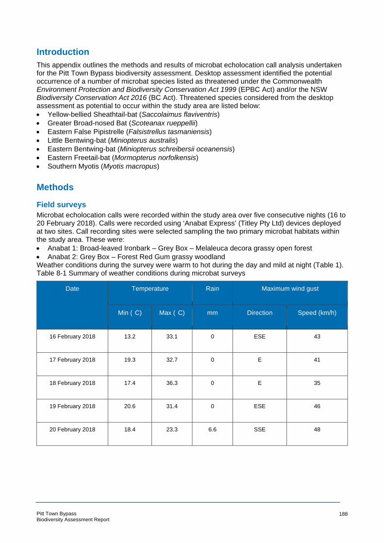
° °
Introduction
This appendix outlines the methods and results of microbat echolocation call analysis undertaken for the Pitt Town Bypass biodiversity assessment. Desktop assessment identified the potential occurrence of a number of microbat species listed as threatened under the Commonwealth Environment Protection and Biodiversity Conservation Act 1999 (EPBC Act) and/or the NSW Biodiversity Conservation Act 2016 (BC Act). Threatened species considered from the desktop assessment as potential to occur within the study area are listed below:
• Yellow-bellied Sheathtail-bat (Saccolaimus flaviventris)
• Greater Broad-nosed Bat (Scoteanax rueppellii) • Eastern False Pipistrelle (Falsistrellus tasmaniensis)
• Little Bentwing-bat (Miniopterus australis)
• Eastern Bentwing-bat (Miniopterus schreibersii oceanensis)
• Eastern Freetail-bat (Mormopterus norfolkensis)
• Southern Myotis (Myotis macropus)
Methods
Field surveys
Microbat echolocation calls were recorded within the study area over five consecutive nights (16 to 20 February 2018). Calls were recorded using ‘Anabat Express’ (Titley Pty Ltd) devices deployed at two sites. Call recording sites were selected sampling the two primary microbat habitats within the study area. These were:
• Anabat 1: Broad-leaved Ironbark – Grey Box – Melaleuca decora grassy open forest
• Anabat 2: Grey Box – Forest Red Gum grassy woodland Weather conditions during the survey were warm to hot during the day and mild at night (Table 1). Table 8-1 Summary of weather conditions during microbat surveys
Date Temperature Rain Maximum wind gust
Min ( C) Max ( C) mm Direction Speed (km/h)
16 February 2018 13.2 33.1 0 ESE 43
17 February 2018 19.3 32.7 0 E 41
18 February 2018 17.4 36.3 0 E 35
19 February 2018 20.6 31.4 0 ESE 46
20 February 2018 18.4 23.3 6.6 SSE 48
Pitt Town Bypass Biodiversity Assessment Report
188

Echolocation call analysis
Echolocation calls recorded during surveys were analysed by Arcadis ecologist Carl Corden. Carl has over 15 years experience as a consultant ecologist, and has undertaken microbat echolocation call analysis for a large number of projects across eastern Australia. Calls were extracted, viewed and analysed using ‘AnalookW for bat call analysis using ZCA - Version 4.2n 16 March 2017’ software ( Chris Corben, Copyright © 2017). Calls were identified with reference to ‘Bat Calls of NSW’ (Pennay et al., 2004). The report has been prepared in accordance with the ‘Standards for reporting bat detector surveys’ (Australasian Bat Society Inc. n.d) Where possible, calls were identified to species or genus based on the presence/absence of determinate features such as frequency, shape, pulse intervals and other indicative features (eg alternations in frequency within call sequences). Details of identification features used are provided for calls of each species identified in Appendix 1.
Results
A total of 1527 call sequences was recorded across two survey sites over five consecutive nights. The majority (i.e. > 95%) of these could be identified to species or genus once context had been established using the best quality examples of calls for each species recorded from the study area. A total of 10 microbat species were identified from echolocation calls recorded across the study area (Table 2).
Pitt Town Bypass Biodiversity Assessment Report
189

Appendix E Assessments of Significance (BC Act)
Pitt Town Bypass Biodiversity Assessment Report
139
Cumberland Plain Woodland in the Sydney Basin Bioregion
Cumberland Plain Woodland in the Sydney Basin Bioregion is listed as a critically endangered ecological community on Schedule 2 of the BC Act. Cumberland Plain Woodland has been recorded in the central portion of the study area and is typically in moderate condition owing to historical disturbances such as canopy thinning and mowing. Within the study area the community is characterised by a canopy of Eucalyptus moluccana with associated Eucalyptus tereticornis and Eucalyptus eugeniodies. Bursaria spinosa and several wattles occur as shrubs and there is a mixed native and exotic grassy understorey. The concept design requires the removal of 1.41 ha of Cumberland Plain Woodland.
a) in the case of a threatened species, whether the proposed development or activity is
likely to have an adverse effect on the life cycle of the species such that a viable
local population of the species is likely to be placed at risk of extinction,
Not applicable.
b) in the case of an endangered ecological community or critically endangered
ecological community, whether the proposed development or activity:
(i) is likely to have an adverse effect on the extent of the ecological community such that its
local occurrence is likely to be placed at risk of extinction, or
(ii) is likely to substantially and adversely modify the composition of the ecological
community such that its local occurrence is likely to be placed at risk of extinction,
The study area contains 2.95 ha of Cumberland Plain Woodland, of which 1.41 ha would be
removed by the proposal. The study area is towards the north western extent of the community as
to the west of the Hawkesbury River, the geology and topography chances from the Cumberland
Plain to the Hornsby and Blue Mountains Plateau. Regional vegetation mapping of the locality
(being a 10 km radius from the study area) (Tozer et al 2003) shows that about 2,806 ha of
Cumberland Plain Woodland occurs within the locality. The clearing of 1.41 ha of Cumberland
Plain Woodland represents about 39 per cent of the Cumberland Plain Woodland within the study
area and about 0.05 per cent of the Cumberland Plain Woodland in the locality. Further, the
Cumberland Plain Woodland in the study area is considered to be in moderate condition owing to
historical and ongoing disturbances. To the east of the study area, Scheyville National Park
provides a far more expansive and intact representation of the community. Scheyville National
Park is also mapped as Priority Conservation Lands in the Cumberland Plain Recovery Plan
The Cumberland Plain Woodland within the study area is on the western edge of a patch of
bushland that extends east to Scheyville National Park. It exhibits edge effects, such as increased
weed recruitment, and is subject to ongoing disturbances, including mowing. The surrounding
Cumberland Plain Woodland that would not be directly impacted by the proposal is in similar
condition, with exotic species common throughout.
Based on the condition of the immediately surrounding Cumberland Plain Woodland that would be
retained, plus the presence of a large area of well protected Cumberland Plain Woodland within
Scheyville National Park, it is unlikely that the proposal would affect the extent or composition of
the ecological community, such that it is placed at risk of extinction.
c) in relation to the habitat of a threatened species or ecologial community:
(i) the extent to which habitat is likely to be removed or modified as a result of the
proposed development or activity, and
Pitt Town Bypass Biodiversity Assessment Report
140

(ii) whether an area of habitat is likely to become fragmented or isolated from other areas of
habitat as a result of the proposed development or activity, and
(iii) the importance of the habitat to be removed, modified, fragmented or isolated to the
long-term survival of the species or ecological community in the locality,
The proposal will result in the removal of a total of 1.41 ha of Cumberland Plain Woodland, in
addition to about 20.03 ha of non-native vegetation. This non-native vegetation is not considered
potential habitat for Cumberland Plain Woodland since it has been entirely cleared, and in the most
part the soil has been enriched and modified. Therefore the extent of habitat for Cumberland Plain
Woodland that would be lost is the 1.41 ha that aready contains the community.
The Cumberland Plain Woodland within the study area occurs in a patch either side of Old Pitt
Town Road. More broadly, Cumberland Plain Woodland in the locality has been highly fragmented
by past clearing for agriculture and later residential purposes. The proposal would bisect the
existing patch of Cumberland Plain Woodland in the study area, leaving two small fragmented and
isolated patches to the west of the proposed alignment.
The condition of the Cumberland Plain Woodland within the study area is moderate and it is
currently being regularly mowed to the south of Old Pitt Town Road. Despite this, there is a
population of Dillwynia tenuifolia growing in this patch. The patch to the north of Old Pitt Town
Road has a large number of regenerating eucalypts and the patch to the south has a good diversity
of native understorey species, therefore the Cumberland Plain Woodland is considered to be of
low-moderate importance to the survival of the community.
In light of the above, it is considered unlikely that the proposal would have a significant impact on
the habitat of Cumberland Plain Woodland.
d) whether the proposed development or activity is likely to have an adverse effect on any
declared area of outstanding biodiversity value (either directly or indirectly)
Under the BC Act, the Director-General maintains a register of areas of outstanding biodiversity
value. To date, no area of outstanding biodiversity value has been associated with Cumberland
Plain Woodland.
e) whether the proposed development or activity is or is part of a key threatening
process or is likely to increase the impact of a key threatening process.
Of the key threatening processes listed in Schedule 4 of the BC Act, the following are relevant to
the potential impacts of the proposal on Cumberland Plain Woodland:
Clearing of native vegetation – Approximately 1.41 ha of native vegetation that contains
Cumberland Plain Woodland would be cleared. This does not represent a significant area of this
community in the context of the locality.
Invasion of native plant communities by exotic perennial grasses – Exotic grasses are abundant in
the study area and the proposed action may exacerbate the KTP by facilitating the spread of seeds
or fragments of plant to areas where these grasses are not present, via plant or contaminated
topsoil. This could include areas of potential habitat for the community.
It is unlikely that the exacerbation of these KTPs would have a significant impact on Cumberland
Plain Woodland.
Conclusion
The proposal will result in the removal of 1.41 ha of Cumberland Plain Woodland and its habitat,
representing about 39 per cent of the Cumberland Plain Woodland within the study area and about
0.05 per cent of the Cumberland Plain Woodland in the locality. The study area is located on the
Pitt Town Bypass Biodiversity Assessment Report
141

edge of a larger patch of Cumberland Plain Woodland (and other TECs), however the proposal
would fragment this edge vegetation and leave a narrow strip of the community, isolated to the
west of the proposed alignment. The Cumberland plain woodland in the study area is in moderate
condition having been modified by previous and ongoing land management practices such as
canopy thinning and mowing. Despite this, it does contain a population of five Dillwynia tenuifolia stems. This patch is considered to be of low-moderate importance to the survival of the community.
Based on the relatively small area, the moderate condition and low-moderate importance of the
Cumberland Plain Woodland that would be removed, it is considered unlikely that the proposal
would have a significant impact on the community.
Pitt Town Bypass Biodiversity Assessment Report
142

Shale Gravel Transition Forest in the Sydney Basin Bioregion
Shale Gravel Transition Forest is listed as critically endangered on Schedule 2 of the BC Act. This
community was recorded at the northern extent of the study area, to the north of Cattai Road. The
patch of Shale Gravel Transition Forest within the study area is in low-moderate condition, and
subject to ongoing equine grazing. The canopy is characterised by Eucalyptus fibrosa and
Eucalyptus moluccana with a mid-storey of Bursaria spinosa and the EPBC Act and BC Act listed
Acacia pubescens and a predominantly exotic grassy understorey.
in the case of a threatened species, whether the proposed development or activity is likely
to have an adverse effect on the life cycle of the species such that a viable local population
of the species is likely to be placed at risk of extinction,
Not applicable, Shale Gravel Transition Forest is not a threatened species.
d) in the case of an endangered ecological community or critically endangered
ecological community, whether the proposed development or activity:
(i) is likely to have an adverse effect on the extent of the ecological community such that its
local occurrence is likely to be placed at risk of extinction, or
(ii) is likely to substantially and adversely modify the composition of the ecological
community such that its local occurrence is likely to be placed at risk of extinction,
About 1.78 ha of Shale Gravel Transition Forest was recorded within the study area, of which 0.39
ha w ould be removed by the proposal. The study area is at the northern extent of the community
as to the west of the Hawkesbury River, the geology and topography chances from the
Cumberland Plain to the Hornsby and Blue Mountains Plateau. Regional vegetation mapping of the
locality (Tozer et al 2003) shows that about 403 ha of Shale Gravel Transition Forest occurs within
the locality. The clearing of 0.39 ha of Shale Gravel Transition Forest represents about 22 per cent
of the Shale Gravel Transition Forest within the study area and about 0.10 per cent of the Shale
Gravel Transition Forest in the locality. The Shale Gravel Transition Forest in the study area is
considered to be in low-moderate condition owing to historical clearing and ongoing equine
grazing. To the south west of the study area, Castlereagh Nature Reserve, Windsor Downs Nature
Reserve and Wianamatta Nature Reserve provides a far more expansive and intact representation
of the community (amongst other TECs). These nature reserves are also mapped as Priority
Conservation Lands in the Cumberland Plain Recovery Plan
The Shale Gravel Transition Forest within the study area has been degraded by historical and
ongoing land management practices. The species composition of the understory and mid-storey
has been highly modified due to recruitment of exotic species and systematic removal of native
species. The Shale Gravel Transition Forest in the immediately surrounding area (that would be
retained) is in similar degraded condition. It is unlikely that the proposal would substantially modify
the composition of surrounding vegetation to be retained.
Based on the condition of the immediately surrounding Shale Gravel Transition Forest that would
be retained, plus the presence of larger areas of well protected Shale Gravel Transition Forest
within Nature Reserves to the south of the study area, it is unlikely that the proposal would affect
the extent or composition of the ecological community, such that it is placed at risk of extinction.
e) in relation to the habitat of a threatened species or ecological community:
(i) the extent to which habitat is likely to be removed or modified as a result of the
proposed development or activity, and
Pitt Town Bypass Biodiversity Assessment Report
143
(ii) whether an area of habitat is likely to become fragmented or isolated from other areas of
habitat as a result of the proposed development or activity, and
(iii) the importance of the habitat to be removed, modified, fragmented or isolated to the
long-term survival of the species or ecological community in the locality,
The proposal will result in the removal of a total of 0.39 ha of Shale Gravel Transition Forest, in
addition to about 20.03 ha of non-native vegetation. This non-native vegetation is not considered
potential habitat for Shale Gravel Transition Forest since it has been entirely cleared, and in the
most part the soil has been enriched and modified. Therefore the extent of habitat for Shale Gravel
Transition Forest that would be lost is the 0.39 ha that aready contains the community.
The Shale Gravel Transition Forest within the study area occurs to the north of Cattai Road, in a
patch that extends to the north. The entire patch is edge effected due to its location on the
interface between more intact patches and the developed area of Pitt Town. The proposal would
result in the clearing of vegetation on the edge of this patch and would therefore not fragment or
further isolate Shale Gravel Transition Forest.
The condition of the Shale Gravel Transition Forest within the study area is low-moderate and it is
currently being grazed by horses. Despite this, there is a population of Acacia pubescens growing
in this patch. The Shale Gravel Transition Forest in the study area appears to have relatively low
resilience and is unlikely to return to a higher condition without substantial intervention. There is,
however, a mature canopy present and some indicative shrub and ground cover species present.
About 403 ha of Shale Gravel Transition Forest occurs within the locality (which covers about
31,000 ha) making it relatively scarce in the region. Accordingly, the patch within the study area is
considered to be moderately important to the survival of the community.
In light of the above, it is considered unlikely that the proposal would have a significant impact on
the habitat of Shale Gravel Transition Forest.
d) whether the proposed development or activity is likely to have an adverse effect on any
declared area of outstanding biodiversity value (either directly or indirectly)
Under the BC Act, the Director-General maintains a register of areas of outstanding biodiversity
value. To date, no area of outstanding biodiversity value has been associated with Shale Gravel
Transition Forest.
f) whether the proposed development or activity is or is part of a key threatening
process or is likely to increase the impact of a key threatening process.
Of the key threatening processes listed in Schedule 4 of the BC Act, the following are relevant to
the potential impacts of the proposal on Shale Gravel Transition Forest:
Clearing of native vegetation – Approximately 0.39 ha of native vegetation that is equivalent to
Shale Gravel Transition Forest would be cleared. This does not represent a significant area of this
community in the locality.
Invasion of native plant communities by exotic perennial grasses – Exotic grasses are abundant in
the study area and the proposed action may exacerbate the KTP by facilitating the spread of seeds
or fragments of plant to areas where these grasses are not present, via plant or contaminated
topsoil. This could include areas of Shale Gravel Transition Forest.
It is unlikely that the exacerbation of these KTPs would have a significant impact on Shale Gravel
Transition Forest.
Conclusion
Pitt Town Bypass Biodiversity Assessment Report
144

The proposal will result in the removal of 0.39 ha of Shale Gravel Transition Forest and its habitat,
representing about 22 per cent of the Shale Gravel Transition Forest within the study area and
about 0.1 per cent of the Shale Gravel Transition Forest in the locality. The study area is located
on the edge of a larger patch of Shale Gravel Transition Forest which would not be fragmented or
futher isolated by the proposal.
The Shale Gravel Transition Forest in the study area is in low-moderate condition having been
modified by previous and ongoing land management practices such as canopy thinning and equine
grazing. Despite this, it does contain a population of Acacia pubescens. Based on the relative
scarcity of community in the locality, this patch is considered to be of moderate importance to the
survival of the community.
Based on the small area, the low-moderate condition and moderate importance of the Shale
Gravel Transition Forest that would be removed, it is considered unlikely that the proposal would
have a significant impact on the community.
Pitt Town Bypass Biodiversity Assessment Report
145

Freshwater Wetlands on Coastal Floodplains of the New South Wales North Coast, Sydney Basin and South East Corner Bioregions Freshwater Wetlands on Coastal Floodplains is listed as endangered on Schedule 2 of the BC Act. This community was recorded along an un-named tributary of Hortons Creek through the central
portion of the study area. It is comprised of a dense stand of Phragmites Australis and Typha orientalis and has an extent of about 1.46 ha within the study area.
a) in the case of a threatened species, whether the proposed development or activity is
likely to have an adverse effect on the life cycle of the species such that a viable
local population of the species is likely to be placed at risk of extinction,
Not applicable. Freshwater Wetlands on Coastal Floodplains is not a threatened flora species.
b) in the case of an endangered ecological community or critically endangered
ecological community, whether the proposed development or activity:
(i) is likely to have an adverse effect on the extent of the ecological community such that its
local occurrence is likely to be placed at risk of extinction, or
(ii) is likely to substantially and adversely modify the composition of the ecological
community such that its local occurrence is likely to be placed at risk of extinction,
About 1.46 ha of Freshwater Wetlands on Coastal Floodplains was recorded within the study area,
of which 0.67 ha would be removed by the proposal. The study area occurs in the Cumberland
Plain Lowlands around the Hawkesbury River. There are three substantial areas of mapped
Freshwater Wetlands on Coastal Floodplains within the locality, being Pitt Town Lagoon (to the
west), Bushells Lagoon (to the north west) and Longneck Lagoon (to the north east).
Regional vegetation mapping of the locality (Tozer et al 2003) shows that about 266 ha of
Freshwater Wetlands on Coastal Floodplains occurs within the locality. The clearing of 0.67 ha of
Shale Gravel Transition Forest represents about 46 per cent of the Shale Gravel Transition Forest
within the study area and about 0.30 per cent of the Freshwater Wetlands on Coastal Floodplains
in the locality. The Freshwater Wetlands on Coastal Floodplains in the study area is considered to
be in moderate condition owing to the lack of native species diversity and lack of variability in
habitat present. There are high proportions of weeds in some locations that are historical clearing
and ongoing equine grazing.
The Freshwater Wetlands on Coastal Floodplains within the study area has been degraded by
historical and ongoing land management practices. The species composition has been affected by
a lack of habitat variability, leaving it as a dense stand of reeds and rushes. Nutrient runoff from
surrounding farm land and modified pasture have also lead recruitment of exotic species, such as
Blackberry, Privet and Japanese Honeysuckle. It is unlikely that the proposal would substantially
modify the composition of surrounding vegetation to be retained.
Based on the condition of the immediately surrounding Freshwater Wetlands on Coastal
Floodplains that would be retained, plus the presence of larger areas of well protected Freshwater
Wetlands on Coastal Floodplains within Pitt Town Lagoon, Bushells Lagoon and Longneck
Lagoon, it is unlikely that the proposal would affect the extent or composition of the ecological
community, such that it is placed at risk of extinction.
c) in relation to the habitat of a threatened species or ecological community:
(i) the extent to which habitat is likely to be removed or modified as a result of the
proposed development or activity, and
(ii) whether an area of habitat is likely to become fragmented or isolated from other areas of
habitat as a result of the proposed development or activity, and
Pitt Town Bypass Biodiversity Assessment Report
146

(iii) the importance of the habitat to be removed, modified, fragmented or isolated to the
long-term survival of the species or ecological community in the locality,
The proposal will result in the removal of a total of 0.67 ha of Freshwater Wetlands on Coastal
Floodplains, in addition to about 20.03 ha of non-native vegetation. This non-native vegetation is
not considered potential habitat for Freshwater Wetlands on Coastal Floodplains since it is not
inundated sufficiently frequently to support characteristic species. Therefore the extent of habitat
for Freshwater Wetlands on Coastal Floodplains that would be lost is the 0.67 ha that aready
contains the community.
The Freshwater Wetlands on Coastal Floodplains within the study area occurs in a linear strip
along an un-named tributary of Hortons Creek. The proposal would result in two new crossings of
this un-named tributary and would fragment the existing patch into several smaller patches. Pitt
Town Road and Old Pitt Town Road have both been constructed over the patch of Freshwater
Wetlands on Coastal Floodplains therefore the proposal would further fragment an already
fragmented patch.
The condition of the Freshwater Wetlands on Coastal Floodplains within the study area is
moderate due to a lack of native species diversity and recruitment of several exotic species. there
is little in the way of habitat variability, with the majority of the Freshwater Wetlands on Coastal
Floodplains within the study area being predominantly comprised of Typha orientalis and
Phragmites australis. This vegetation provides little aquatic habitat and it would appear that water
is only present for a short period following rain, and that it flows through the study area at a
relatively high velocity. As such, the Freshwater Wetlands on Coastal Floodplains in the study area
is considered to be of low importance to the long-term survival of the community.
Based on the relatively small area of required clearing and the already degraded and fragmented
nature of the Freshwater Wetlands on Coastal Floodplains in the study area, it is considered
unlikely that the proposal would result in a significant impact to the community.
d) whether the proposed development or activity is likely to have an adverse effect on any
declared area of outstanding biodiversity value (either directly or indirectly)
Under the BC Act, the Director-General maintains a register of areas of outstanding biodiversity
value. To date, no area of outstanding biodiversity value has been associated with Freshwater
Wetlands on Coastal Floodplains.
g) whether the proposed development or activity is or is part of a key threatening
process or is likely to increase the impact of a key threatening process.
Of the key threatening processes listed in Schedule 4 of the BC Act, the following are relevant to
the potential impacts of the proposal on Freshwater Wetlands on Coastal Floodplains:
Clearing of native vegetation – Approximately 0.67 ha of native vegetation equivalent to
Freshwater Wetlands on Coastal Floodplains would be cleared. This does not represent a
significant area of this community in the locality.
Invasion of native plant communities by exotic perennial grasses – Exotic grasses are abundant in
the study area and the proposed action may exacerbate the KTP by facilitating the spread of seeds
or fragments of plant to areas where these grasses are not present, via plant or contaminated
topsoil. This could include areas of Freshwater Wetlands on Coastal Floodplains.
Conclusion
The proposal will result in the removal of 0.67 ha of Freshwater Wetlands on Coastal Floodplains
and its habitat, representing about 46 per cent of the Freshwater Wetlands on Coastal Floodplains
within the study area and about 0.30 per cent of the Shale Gravel Transition Forest in the locality.
Pitt Town Bypass Biodiversity Assessment Report
147

Larger, more intact patches of Freshwater Wetlands on Coastal Floodplains occur in Pitt Town
Lagoon (to the west of the study area), Bushells Lagoon (to the north west) and Longneck Lagoon
(to the north east).
The Freshwater Wetlands on Coastal Floodplains in the study area is in moderate condition due to
the lack of complexity and native species diversity. This patch is therefore considered to be of low
importance to the survival of the community.
Based on the small area, the moderate condition and low importance of the Freshwater Wetlands
on Coastal Floodplains that would be removed, it is considered unlikely that the proposal would
have a significant impact on the community.
Pitt Town Bypass Biodiversity Assessment Report
148
Acacia pubescens (Downy Wattle)
Acacia pubescens is listed as vulnerable under the BC and has a concentrated distribution around
the Bankstown-Fairfield-Rockdale area and the Pitt Town area. It typically occurs on alluviums,
shales, and at the intergrade between shales and sandstones, in association with open woodland
and forest communities including Cooks River Castlereagh Ironbark Forest, Shale/Sandstone
Transition Forest and Cumberland Plain Woodland.
Acacia pubescens commonly reproduces via vegetative reproduction rather than seedlings,
resulting in dense patches of the species formed from one individual. The species also need a
minimum fire free period of 5-7 years for an adequate seedbank to develop.
Two populations of Acacia pubescens were recorded in the study area. Both were situated in
Broad-leaved Ironbark - Grey Box -Melaleuca decora grassy open forest on clay/gravel soils of the
Cumberland Plain, Sydney Basin Bioregion. An additional population was recorded approximately
50 m outside the western study area boundary.
d) in the case of a threatened species, whether the proposed development or activity is
likely to have an adverse effect on the life cycle of the species such that a viable
local population of the species is likely to be placed at risk of extinction,
The proposed action would result in the removal of one of the populations of Acacia pubescens, containing five stems, and consequently have an adverse impact on the life cycle of that
population. By removing the plants as well as the nearby soil, the seed bank is cleared resulting in
the disruption of the species life cycle. About 0.21 ha of occupied habitat for the species would be
removed and it is likely that Acacia pubescens is present in the soil seed bank of this habitat area.
Many other populations of the species have been recorded in the vicinity around the study area
which will not be impacted by the proposal. Therefore, while the life cycle of the species within the
study area will be adversely impacted, the local population of Acacia pubescens will unlikely be
placed at risk of extinction due to the large number of individuals nearby.
e) in the case of an endangered ecological community or critically endangered
ecological community, whether the proposed development or activity:
(i) is likely to have an adverse effect on the extent of the ecological community such that its
local occurrence is likely to be placed at risk of extinction, or
(ii) is likely to substantially and adversely modify the composition of the ecological
community such that its local occur rence is likely to be placed at risk of extinction,
Not applicable. Acacia pubescens is a threatened flora species.
f) in relation to the habitat of a threatened species or ecological community:
(i) the extent to which habitat is likely to be removed or modified as a result of the
proposed development or activity, and
(ii) whether an area of habitat is likely to become fragmented or isolated from other areas of
habitat as a result of the proposed development or activity, and
(iii) the importance of the habitat to be removed, modified, fragmented or isolated to the
long-term survival of the species or ecological community in the locality,
The proposal will result in the removal of a total of 0.21 ha of occupied habitat and 1.8 ha of
potential habitat A. pubescens habitat including 0.39 ha of Broad-leaved Ironbark - Grey Box -
Melaleuca decora grassy open forest on clay/gravel soils of the Cumberland Plain, Sydney Basin
Pitt Town Bypass Biodiversity Assessment Report
149
Bioregion and 1.41 ha of Grey Box - Forest Red Gum grassy woodland on flats of the Cumberland
Plain, Sydney Basin Bioregion.
The suitable habitat in the study area is already heavily modified and isolated from other areas of
habitat. The study area forms a small fragment of habitat within a highly developed and urbanised
context and therefore any further fragmentation as a result of the proposal is not deemed
significant.
A. pubescens is associated with a variety of vegetation types and has large numbers of recordings
in the locality and therefore, it is unlikely that the habitat is important to the species such that its
removal impacts its long-term survival.
d) whether the proposed development or activity is likely to have an adverse effect on any
declared area of outstanding biodiversity value (either directly or indirectly)
Under the BC Act, the Director-General maintains a register of areas of outstanding biodiversity
value. To date, no area of outstanding biodiversity value has been associated with A. pubescens.
h) whether the proposed development or activity is or is part of a key threatening
process or is likely to increase the impact of a key threatening process.
Of the key threatening processes listed in Schedule 4 of the BC Act, the following are relevant to
the potential impacts of the proposal on A. pubescens:
Clearing of native vegetation – Approximately 1.8 ha of native vegetation that contains potential
habitat would be cleared. This does not represent a significant area of this species’ habitat in the
locality.
Invasion of native plant communities by exotic perennial grasses – Exotic grasses are abundant in
the study area and the proposed action may exacerbate the KTP by facilitating the spread of seeds
or fragments of plant to areas where these grasses are not present, via plant or contaminated
topsoil. This could include areas of potential habitat for the species.
Conclusion
The proposal will result in the removal of one population of A. pubescens containing approximately
5 stems and 0.21 ha of occupied habitat. There are a large number of individuals near the site
which will not be impacted by the proposal and therefore the local population will unlikely be put at
risk of extinction. This vegetation to be cleared is not deemed to be a significant area of habitat or
of importance to the long-term survival of the species. As a result, it is considered unlikely that the
proposal represents a significant impact to this threatened species. A species impact statement is
not required for this species.
Pitt Town Bypass Biodiversity Assessment Report
150

Dillwynia tenuifolia
Dillwynia tenuifolia is listed as vulnerable under the BC Act. Its core distribution is the Cumberland
Plain from Windsor and Penrith east to Dean Park near Colebee. However other populations are
present in the Liverpool and Penrith LGA and Baulkham Hills Shire as well as in disjunct localities
in the lower Blue Mountains and Bulga Mountains.
Dillwynia tenuifolia is commonly associated with scrubby/dry heath areas within Castlereagh
Ironbark Forest and Shale Gravel Transition Forest on tertiary alluvium or laterised clays. It can
also be common in transitional areas where these communities adjoin Castlereagh Scribbly Gum
Woodland.
Four individual stems in two locations were recorded within Cumberland Plain Woodland in the
study area. These individuals will be cleared during construction.
(a) in the case of a threatened species, whether the proposed development or activity is
likely to have an adverse effect on the life cycle of the species such that a viable
local population of the species is likely to be placed at risk of extinction,
Four individual Dillwynia tenuifolia were recorded in two locations, about 10 m apart, growing in a
gravel patch in an area of Cumberland Plain Woodland. The lifecycle for these plants would be
adversely affected as they would be removed by the proposal. The environmental impact
assessment guidelines for Dillwynia tenuifolia (NPWS 2002) state that:
All populations should be considered viable unless proven otherwise ie. They consist of a few individuals in highly insecure, disturbed and weed impacted locales such as roadsides.
The population within the study area is in a patch of Cumberland Plain Woodland that is mown on
and ongoing basis. It is zoned SP2 Road Infrastructure in the Hawkesbury Local Environment Plan
(Hawkesbury Shire Council 2012) and surrounded by residential development, which is not
conducive or conservation. Based on the very small population size (this species can be locally
dominant in preferred habitat), the insecurity of the land on which it occurs (from a conservation
perspective) and the partially disturbed nature of this habitat, this population of 4 stems is not
considered viable.
A large population of Dillwynia tenuifolia exists approximately one kilometre to the east of the study
area within Scheyville National Park. This is the closest known viable population. The proposed
action would result in the removal of the four individuals of Dillwynia tenuifolia within the study area
and consequently there would be no impact on the nearby viable population and it would not be
placed at risk of extinction.
(b) in the case of an endangered ecological community or critically endangered ecological
community, whether the proposed development or act ivity
(i) is likely to have an adverse effect on the extent of the ecological community such that its
local occurrence is likely to be placed at risk of extinction, or
(ii) is likely to substantially and adversely modify the composition of the ecological
community such that its local occurrence is likely to be placed at risk of extinction,
Not applicable. Dillwynia tenuifolia is a threatened flora species.
(c) in relation to the habitat of a threatened species or ecological community:
(i) the extent to which habitat is likely to be removed or modified as a result of the
proposed development or activity, and
Pitt Town Bypass Biodiversity Assessment Report
151

(ii) whether an area of habitat is likely to become fragmented or isolated from other areas of
habitat as a result of the proposed development or activity, and
(iii) the importance of the habitat to be removed, modified, fragmented or isolated to the
long-term survival of the species or ecological community in the locality,
The proposal will result in the removal of a total of 1.8 ha of suitable Dillwynia tenuifolia habitat
(0.31 ha of occupied habitat) including 0.39 ha of Broad-leaved Ironbark - Grey Box -Melaleuca
decora grassy open forest on clay/gravel soils of the Cumberland Plain, Sydney Basin Bioregion
and 1.41 ha of Grey Box - Forest Red Gum grassy woodland on flats of the Cumberland Plain,
Sydney Basin Bioregion.
The suitable habitat in the study area is already heavily modified and isolated from other areas of
habitat. The study area forms a small fragment of habitat within a highly developed and urbanised
context and therefore any further fragmentation as a result of the proposal is not deemed
significant.
Dillwynia tenuifolia has large numbers of recordings in the locality and therefore, it is unlikely that
the habitat is important to the species such that its removal impacts its long-term survival.
(d) whether the proposed development or activity is likely to have an adverse effect on any
declared area of outstanding biodiversity value (either directly or indirectly),
Under the BC Act, the Director-General maintains a register of areas of outstanding biodiversity
value. To date, no area of outstanding biodiversity value has been associated with Dillwynia tenuifolia.
(e) whether the proposed development or activity is or is part of a key threatening process
or is likely to increase the impact of a key threatening process.
Of the key threatening processes listed in Schedule 4 of the BC Act, the following are relevant to
the potential impacts of the proposal on Dillwynia tenuifolia:
Clearing of native vegetation – Approximately 1.8 ha of native vegetation that contains potential
habitat would be cleared. This does not represent a significant area of this species’ habitat in the
locality.
Invasion of native plant communities by exotic perennial grasses – Exotic grasses are abundant in
the study area and the proposed action may exacerbate the KTP by facilitating the spread of seeds
or fragments of plant to areas where these grasses are not present, via plant or contaminated
topsoil. This could include areas of potential habitat for the species.
Conclusion
The proposal will result in the removal of 2 individuals and 0.31 ha of occupied habitat habitat.
There are a large number of individuals near the site which will not be impacted by the proposal
and therefore the local population will unlikely be put at risk of extinction. This vegetation to be
cleared is heavily modified and is not deemed to be a significant area of habitat or of importance to
the long-term survival of the species. As a result, it is considered unlikely that the proposal
represents a significant impact to this threatened species. A species impact statement is not
required for this species.
Pitt Town Bypass Biodiversity Assessment Report
152

Pitt Town Bypass Biodiversity Assessment Report
153
Micromyrtus minutiflora
Micromyrtus minutiflora is Endangered under the BC Act. It is a slender spreading shrub to two
metres high and is restricted to the general area between Richmond and Penrith in Western
Sydney.
Suitable habitat for Micromyrtus minutiflora includes Castlereagh Scribbly Gum Woodland,
Ironbark Forest, Shale/Gravel Transition Forest, open forest on tertiary alluvium and consolidated
river sediments.
No sightings of Micromyrtus minutiflora were recorded in the study area and there are no records
of the species in the area immediately adjacent to the study area. 0.39 ha of suitable habitat for
Micromyrtus minutiflora will be removed during construction of the proposed action.
a) in the case of a threatened species, whether the proposed development or activity is
likely to have an adverse effect on the life cycle of the species such that a viable
local population of the species is likely to be placed at risk of extinction
Little is known about the life cycle of Micromyrtus minutiflora and its response to fire and
disturbance. Regeneration may be due to resprouting or germination of soil-stored seed. No
individuals of Micromyrtus minutiflora will be removed as a result of the proposed action and no
individuals have been recorded adjacent to the study area. Therefore, impacts to the life cycle of
Micromyrtus minutiflora are considered unlikely due to the absence of a population of the species
in the study area. As such, the proposal is unlikely to affect a local viable population such that it is
placed at risk of extinction.
(b) in the case of an endangered ecological community or critically endangered ecological
community, whether the proposed development or activity:
(i) is likely to have an adverse effect on the extent of the ecological community such that its
local occurrence is likely to be placed at risk of extinction, or
(ii) is likely to substantially and adversely modify the composition of the ecological
community such that its local occurrence is likely to be placed at risk of extinction,
Not applicable. Micromyrtus minutiflora is a threatened flora species.
(c) in relation to the habitat of a threatened species or ecological community:
(i) the extent to which habitat is likely to be removed or modified as a result of the
proposed development or activity, and
(ii) whether an area of habitat is likely to become fragmented or isolated from other areas of
habitat as a result of the proposed development or activity, and
(iii) the importance of the habitat to be removed, modified, fragmented or isolated to the
long-term survival of the species or ecological community in the locality,
0.39 ha of suitable Micromyrtus minutiflora habitat will be removed as a result of the proposal. This
suitable habitat consists of Shale Gravel Transition Forest in the Sydney Basin Bioregion.
The habitat in the study area is already heavily modified and isolated from other areas of habitat.
The study area forms a small fragment of habitat within a highly developed and urbanised context
and therefore any further fragmentation as a result of the proposal is not deemed significant.
Pitt Town Bypass Biodiversity Assessment Report
154

As the suitable habitat on site is already heavily modified, the 0.39 ha to be cleared is a negligible
area. It is therefore unlikely that the habitat is important to the species such that its removal
impacts its long-term survival.
(d) whether the proposed development or activity is likely to have an adverse effect on any
declared area of outstanding biodiversity value (either directly or indirectly),
Under the BC Act, the Director-General maintains a register of areas of outstanding biodiversity
value. To date, no area of outstanding biodiversity value has been associated with Micromyrtus minutiflora.
(e) whether the proposed development or activity is or is part of a key threatening process
or is likely to increase the impact of a key threatening process.
Of the key threatening processes listed in Schedule 4 of the BC Act, the following are relevant to
the potential impacts of the proposal on Micromyrtus minutiflora:
Clearing of native vegetation – Approximately 0.39 ha of native vegetation that contains potential
habitat would be cleared. This does not represent a significant area of this species’ habitat in the
locality.
Invasion of native plant communities by exotic perennial grasses – Exotic grasses are abundant in
the study area and the proposed action may exacerbate the KTP by facilitating the spread of seeds
or fragments of plant to areas where these grasses are not present, via plant or contaminated
topsoil. This could include areas of potential habitat for the species.
Conclusion
The proposed action will not involve the removal of any Micromyrtus minutiflora individuals but will
involve the clearing of 0.39 ha of suitable habitat. As no individuals have been recorded in or
adjacent to the study area, the proposal is deemed unlikely to affect a local viable population such
that it is placed at risk of extinction. Furthermore, as the suitable habitat present has already been
heavily modified and fragmented, it is unlikely that the habitat is important to the species such that
its removal impacts its long-term survival. Therefore, it is considered unlikely that the proposal
represents a significant impact to this threatened species. A species impact statement is not
required for this species.
Pitt Town Bypass Biodiversity Assessment Report
155

Pimelea spicata (Spiked Rice-flower)
Pimelea spicata is listed as Endangered under the BC Act.
Pimelea spicata is a slender decumbent or erect shrub to 50 cm high (RBG&DT February 2012).
This species is endemic to NSW and is known from two disjunct areas, the Cumberland Plain west
of Sydney and coastal Illawarra south of Sydney. In western Sydney, the species is restricted to
areas supporting the Cumberland Plain Woodland vegetation community (DEC 2005). The species
is cryptic and difficult to detect, particularly when not in flower, so surveys should not be relied
upon unless undertaken whilst the species is flowering (NPWS 2004).
Various flowering times for the species have been noted, as the species is known to flower in
response to rain, and peak flowering time may vary from year to year. Benson and McDougall
(2001) stated the peak flowering period as March to April, however it has also been observed
flowering in May–January and in June-September in response to rain (NPWS 2004).
Pimelea spicata was targeted during flora surveys of native woodland in the study area. The
species was not recorded, however potential habitat was identified in the Cumberland Plain
Woodland in the study area.
a) in the case of a threatened species, whether the proposed development or activity is
likely to have an adverse effect on the life cycle of the species such that a viable
local population of the species is likely to be placed at risk of extinction,
The following is known about the lifecycle of Pimelea spicata (DEC 2005):
Flowering occurs sporadically throughout the year and is likely to be dependent on climatic
conditions, particularly rain;
Pimelea spicata is not capable of vegetative spread, and hence is dependent on seed production
for recruitment.
The pollinator has not been identified; native bees have been observed visiting flowers, and it has
been suggested that moths contribute to pollination. The species may be capable of self-
pollination.
Fruit production is highly variable within and between populations, and between years, and is likely
to be associated with environmental conditions. Seed viability has been recorded as relatively high.
Dispersal mechanisms for the species are unknown, but seed dispersal is likely to be very low, with
most seedlings observed in proximity to adult plants.
P. spicata is capable of maintaining a long-lived, persistent soil seed bank and germination may
occur following fire, slashing and mowing, grazing and soil disturbance.
Germination is significantly increased by smoke application.
1.41 ha of suitable habitat for Pimelea spicata will be removed from the study area during
construction. While no individuals will be removed, it is possible that the species occurs in the
seedbank. However, as no individuals have been recorded in close proximity to the study area this
is unlikely as Pimelea spicata have a low seed dispersal range. Therefore, it is unlikely that the
species would be impacted by the proposed action such that a viable local population is placed at
risk of extinction.
b) in the case of an endangered ecological community or critically endangered ecological
community, whether the proposed development or activity:
Pitt Town Bypass Biodiversity Assessment Report
156

(i) is likely to have an adverse effect on the extent of the ecological community such that its
local occurrence is likely to be placed at risk of extinction, or
(ii) is likely to substantially and adversely modify the composition of the ecological
community such that its local occurrence is likely to be placed at risk of extinction,
Not applicable. Pimelea spicata is a threatened flora species.
c) in relation to the habitat of a threatened species or ecological community:
(i) the extent to which habitat is likely to be removed or modified as a result of the
proposed development or activity, and
(ii) whether an area of habitat is likely to become fragmented or isolated from other areas of
habitat as a result of the proposed development or act ivity, and
(iii) the importance of the habitat to be removed, modified, fragmented or isolated to the
long-term survival of the species or ecological community in the locality,
The proposed action will result in the clearing of 1.41 ha of suitable habitat in the form of
Cumberland Plain Woodland. This habitat is currently heavily modified and fragmented by existing
roads and rural development. It is also isolated from other areas of suitable habitat. The proposed
action will further fragment the vegetation however due to its current extensive modification, any
further fragmentation is negligible. Therefore, it is unlikely that the habitat is important to the
species such that its removal impacts its long-term survival.
g) whether the proposed development or activity is likely to have an adverse effect on
any declared area of outstanding biodiversity value (either directly or indirectly),
Under the BC Act, the Director-General maintains a register of areas of outstanding biodiversity
value. To date, no area of outstanding biodiversity value has been associated with Pimelea spicata.
(e) whether the proposed development or activity is or is part of a key threatening process
or is likely to increase the impact of a key threatening process.
Of the key threatening processes listed in Schedule 4 of the BC Act, the following are relevant to
the potential impacts of the proposal on Pimelea spicata:
Clearing of native vegetation – Approximately 1.41 ha of native vegetation that contains potential
habitat would be cleared. This does not represent a significant area of this species’ habitat in the
locality.
Invasion of native plant communities by exotic perennial grasses – Exotic grasses are abundant in
the study area and the proposed action may exacerbate the KTP by facilitating the spread of seeds
or fragments of plant to areas where these grasses are not present, via plant or contaminated
topsoil. This could include areas of potential habitat for the species.
Conclusion
The proposed action will involve the removal of 1.41 ha of suitable Pimelea spicata habitat.
However, this habitat is heavily modified and fragmented and therefore any further fragmentation is
considered negligible. As a result, it is unlikely that the habitat is critical to the long-term survival of
the species. As no individuals were found in the study area and it is unlikely they occur in the
seedbank, the proposal is not deemed likely to have an adverse effect on the life cycle of the
species. Therefore, it is considered unlikely that the proposal represents a significant impact to this
threatened species. A species impact statement is not required for this species.
Pitt Town Bypass Biodiversity Assessment Report
157

Pitt Town Bypass Biodiversity Assessment Report
158

Cumberland Plain Land Snail (Meridolum corneovirens)
The Cumberland Plain Land Snail is listed as Endangered under the BC Act. The Cumberland
Plain Land Snail is distributed from Richmond and Windsor in the north of the Cumberland Plain,
from Cattai in the north to Picton in the south, and from Prospect Reservoir in the east to
Yarramundi in the west. In this region, the Cumberland Plain Land Snail is known only from
Cumberland Plain and Castlereagh Woodlands; grassy, open woodland with occasional dense
patches of shrubs.
The Cumberland Plain Land Snail is found under logs and debris, amongst accumulations of leaf
and bark around bases of trees, and occasionally under grass clumps. It has also been recorded
under debris such as building materials and car parts. Where possible it will burrow into loose soil.
The Cumberland Plain Land Snail is a fungal feeder and is generally active at night. Very little is
currently known about the biology and life history of the species. It is hermaphroditic and lays
clutches of around 20-25 small round white eggs, in moist and dark areas such as under logs.
The Cumberland Plain Woodland in the study area is characteristic of the preferred habitat of the
Cumberland Plain Land Snail. The canopy of this community is dominated by E. moluccana and E. tereticornis. To the north of Old Pitt Town Road this community has a shrubby understory of
Bursaria spinosa and regenerating eucalypts while to the south of Old Pitt Town Road the
community is subject to ongoing mowing and so is lacking a shrub strata. Shale gravel Transition
Forest present in the northern extent of the study area also provides potential habitat to the
species. As these potential habitats were identified, targeted snail surveys were performed in these
areas. No Cumberland Plain Land Snails were recorded.
(a) in the case of a threatened species, whether the proposed development or activity is
likely to have an adverse effect on the life cycle of the species such that a viable local
population of the species is likely to be placed at risk of extinction,
The Proposal could affect the lifecycle of the Cumberland Plain Land Snail as a result of habitat
removal and potential mortality of live snails, if the species occurs at the site. However, after
targeted snail surveys were performed no individuals were sighted within the study area. It is
therefore assumed that there is no viable population within the study area.
There is a large population of Cumberland Plain Land Snail to the east of the study area within
Scheyville National Park and further individuals recorded to the north of the study area. It is
unlikely that these populations will be impacted by the proposed action as there are already
several barriers from roads and residential developments fragmenting these areas of suitable
habitat.
Therefore, it is unlikely that the proposed action will have an adverse effect on the life cycle of the
species such that a viable local population is likely to be placed at risk of extinction.
(b) in the case of an endangered ecological community or critically endangered ecological
community, whether the proposed development or activity:
(i) is likely to have an adverse effect on the extent of the ecological community such that its
local occurrence is likely to be placed at risk of extinction, or
(ii) is likely to substantially and adversely modify the composition of the ecological
community such that its local occurrence is likely to be placed at risk of extinction,
Not applicable. Cumberland Plain Land Snail is a threatened fauna species.
Pitt Town Bypass Biodiversity Assessment Report
159
(c) in relation to the habitat of a threatened species or ecological community:
(i) the extent to which habitat is likely to be removed or modified as a result of the
proposed development or activity, and
(ii) whether an area of habitat is likely to become fragmented or isolated from other areas of
habitat as a result of the proposed development or activity, and
(iii) the importance of the habitat to be removed, modified, fragmented or isolated to the
long-term survival of the species or ecological community in the locality,
Approximately 1.8 ha of potential habitat for the species will be removed as a result of the
proposed action. This is a small area in comparison to the suitable habitat in the wider locality.
There are vast areas of suitable habitat which are protected and situated within the Scheyville
National Park. This area is uninterrupted by roads and developments and ideal for the Cumberland
Plain Land Snail.
The vegetation to be cleared will further fragment the habitat to a small degree. However, the area
is already heavily fragmented and modified by rural residential developments and several roads.
These have already created barriers to the dispersal of the species. The population to the north of
the study area has already been isolated from the study area due to several roads crossing the
area between the sites. Therefore, fragmentation caused by the proposed action will occur on a
very small scale and is considered negligible.
As the habitat in the study area is already isolated from other areas of suitable habitat and known
populations, and no individuals were recorded on site, the habitat to be removed is not considered
important to the species. It is unlikely that populations would be able to inhabit the site in the future
due to the barriers from roads and houses. Therefore, the removal of the 1.8 ha of habitat within
the study area is not considered to be important to the long-term survival of the species in the
locality.
(d) whether the proposed development or activity is likely to have an adverse effect on any
declared area of outstanding biodiversity value (either directly or indirectly),
Under the BC Act, the Director-General maintains a register of areas of outstanding biodiversity
value. To date, no area of outstanding biodiversity value has been associated with Cumberland
Plain Land Snail.
(e) whether the proposed development or activity is or is part of a key threatening process
or is likely to increase the impact of a key threatening process.
Of the key threatening processes listed in Schedule 4 of the BC Act, one is relevant to the potential
impacts of the proposed action on the Cumberland Plain Land Snail:
Clearing of native vegetation – Approximately 1.8 ha of native vegetation that contains potential
habitat would be cleared. This habitat is heavily fragmented and isolated and is not known to be
used by any individuals. Furthermore, it represents a small amount of habitat in comparison to the
vast areas of protected and suitable habitat in the wider locality.
Removal of dead wood and dead trees – While there are few dead trees and dead wood in the
study area, the removal of them will affect any Cumberland Plain Land Snails in the study area as
they represent a component of habitat for the species.
Conclusion
In consideration of the above five factors, the proposed action is unlikely to have a significant
impact on the Cumberland Plain Land Snail in the study area or wider locality as a result of the
current proposed action, as:
Pitt Town Bypass Biodiversity Assessment Report
160

As no individuals were recorded in the study area, the proposed action is unlikely to adversely
affect the lifecycle of the species such that a viable local population is likely to be placed at risk of
extinction.
The proposed action would remove habitat for the species, however, this is unlikely to comprise a
significant area of habitat for the species.
The proposed action would not substantially fragment habitat for the species.
Consequently, a Species Impact Statement is not required to be prepared.
Pitt Town Bypass Biodiversity Assessment Report
161
Hollow-dependant Microbats; Eastern Freetail-bat, Eastern False Pipistrelle, Greater Broad-nosed Bat, Southern Myotis, Yellow-bellied Sheathtail-bat
Eastern Freetail-bat (Mormopterus norfolkensis)
The Eastern Freetail-bat is listed as Vulnerable under the BC Act. It is found east of the Great
Dividing Range, from Brisbane in south-east Queensland to Sydney in NSW, where it is most
commonly recorded in dry eucalypt forest and woodland, and shows a preference for open spaces
in woodland or forest. The species has also been recorded in swamp forests and mangrove
forests. The Eastern Freetail-bat forages in openings and gaps in the forest including over larger
waterways (Churchill 2008). The Eastern Freetail-bat roost mainly in tree hollows; usually in hollow
spouts of large mature trees, but will also roost under exfoliating bark or in man-made structures
and buildings (Churchill 2008).
The study area provides potential foraging habitat for the species within the Cumberland Plain
Woodland and Shale-Gravel Transition Forest as well as limited roosting habitat. The species was
recorded in the study area during surveys.
Eastern False Pipistrelle (Falsistrellus tasmaniensis)
The Eastern False Pipistrelle is listed as Vulnerable under the BC Act. It is found on the south-east
coast and ranges of Australia, from southern Queensland to Victoria and Tasmania (OEH 2018). It
prefers moist habitats, with trees taller than 20 metres and generally roosts in eucalypt hollows, but
has also been found under loose bark on trees or in buildings. It hunts beetles, moths, weevils and
other flying insects above or just below the tree canopy. It breeds between late spring and early
summer (Churchill 2008).
The study area provides potential foraging habitat for the species within the Cumberland Plain
Woodland and Shale-Gravel Transition Forest as well as limited roosting habitat. The species was
not recorded in the study area during surveys.
Greater Broad-nosed Bat (Scoteanax rueppellii)
The Greater Broad-nosed Bat is listed as Vulnerable under the BC Act. It is found mainly in the
gullies and river systems that drain the Great Dividing Range, from north-eastern Victoria to the
Atherton Tableland (OEH 2018). Greater Broad-nosed Bat extends to the coast over much of its
range. In NSW, it is widespread on the New England Tablelands, however does not occur at
altitudes above 500 m. It utilises a variety of habitats from woodland through to moist and dry
eucalypt forest and rainforest, though it is most commonly found in tall wet forest. Although this
species usually roosts in tree hollows, it has also been found in buildings. The Greater Broad-
nosed Bat forages after sunset, flying slowly and directly along creek and river corridors at an
altitude of 3 to 6 m. Open woodland habitat and dry open forest suits the direct flight of this species
as it searches for beetles and other large, slow-flying insects; this species has been known to eat
other bat species.
The study area provides potential foraging habitat within woodland areas and limited roosting
habitat within hollow-bearing trees. The Greater Broad-nosed Bat was recorded in the study area
during surveys.
Pitt Town Bypass Biodiversity Assessment Report
162

Southern Myotis (Myotis macropus)
The Southern Myotis is listed as Vulnerable under the BC Act. The Southern Myotis occurs across
the northern and eastern coasts of Australia (from the Kimberley to Victoria) and is rarely found
more than 100 km inland (OEH 2018). The species is found in vegetated habitats associated with
streams and permanent waterways, most commonly at low elevations in flat or undulating terrain
(Churchill 2008). Habitats include riparian vegetation and also in mangroves, paperbark swamps,
rainforest, wet and dry sclerophyll forest and open woodland (OEH, 2018). The species forages
over water for insects and small fish that they catch by raking their large feet of the water surface.
They also forage aerially for moths, beetles, crickets and flies.
The Southern Myotis generally roost in groups of 10 - 15 close to water in caves, mine shafts,
hollow-bearing trees, storm water channels, buildings, under bridges and in dense foliage.
As the waterway in the study area is heavily vegetated and contains no open water the study area
provides no foraging habitat for the species. However, limited roosting habitat is provided by the
hollow-bearing trees in the study area. The species was not recorded during surveys.
Yellow-bellied Sheathtail Bat (Saccolaimus flaviventris)
The Yellow-bellied Sheathtail-bat is listed as Vulnerable under the BC Act. It occurs throughout
tropical and south-east of Australia, excluding Tasmania. It is found in a variety of habitat types
including wet and dry sclerophyll forest, open woodland, Acacia shrubland, mallee, grassland and
desert. It roosts in tree hollows, abandoned sugar glider nests or animal burrows (OEH 2018).
The study area provides potential foraging habitat within woodland areas and limited roosting
habitat within hollow-bearing trees. The Yellow-bellied Sheathtail-bat was not recorded in the study
area during surveys.
(a) in the case of a threatened species, whether the proposed development or activity is
likely to have an adverse effect on the life cycle of the species such that a viable
local population of the species is likely to be placed at risk of extinction,
There has been no evidence of roosting sites within the study area. However, three hollow-bearing
trees and three stags containing hollows have been recorded in the study area of which one
hollow-bearing tree and one stag will be removed. These hollow-bearing trees provide potential
roosting sites for all these species of hollow-dependant microbats. While the Eastern Freetail-bat
and Greater Broad-nosed Bat were recorded in the study area it is likely they use the site for
foraging rather than for roosting due to the limited number of hollow-bearing trees and lack of
evidence of their use as roosting sites. However, if any of the microbat species do use the hollow-
bearing trees as roosting sites, potential impacts to the breeding cycle of the microbats could
include displacement of females with young or pregnant females. Whether these impacts occur is
dependent on the timing of vegetation removal.
Microbats area highly mobile species and any local populations would extend beyond the study
area to include the greater locality. The study area and vegetation to be removed represents a very
small amount of potential foraging habitat in comparison to the foraging habitat in the greater
locality. Therefore, while potential roosting habitat for the five species of microbats will be removed
in the form of one hollow-bearing tree and one stag, this does not represent a significant amount of
suitable habitat. Consequently, the proposed action is unlikely to have an adverse effect on the life
cycle of the species such that a viable local population of any of the species is likely to be placed at
risk of extinction.
Pitt Town Bypass Biodiversity Assessment Report
163

(b) in the case of an endangered ecological community or critically endangered ecological
community, whether the proposed development or activity:
(i) is likely to have an adverse effect on the extent of the ecological community such that its
local occurrence is likely to be placed at risk of extinction, or
(ii) is likely to substantially and adversely modify the composition of the ecological
community such that its local occurrence is likely to be placed at risk of extinction,
Not applicable. The five hollow-dependant microbat species listed are threatened fauna species.
(c) in relation to the habitat of a threatened species or ecological community:
(i) the extent to which habitat is likely to be removed or modified as a result of the
proposed development or activity, and
(ii) whether an area of habitat is likely to become fragmented or isolated from other areas of
habitat as a result of the proposed development or activity, and
(iii) the importance of the habitat to be removed, modified, fragmented or isolated to the
long-term survival of the species or ecological community in the locality,
The proposed action will involve the removal of 1.8 ha of suitable foraging habitat for the Eastern
Freetail-bat, Eastern False Pipistrelle, Greater Broad-nosed Bat, and Yellow-bellied Sheathtail-bat.
This is in the form of Cumberland Plain Woodland and Shale-gravel Transition Forest. The
Southern Myotis forages over open water and as such there is no suitable foraging habitat for this
species in the study area. Its foraging habitat will therefore not be impacted. Potential roosting
habitat for all five microbat species will be impacted with the removal of one hollow-bearing tree
and one stag.
While roosting and foraging habitat will be affected this does not represent a large proportion of the
1.8 ha of suitable habitat which will be retained in the study area. Furthermore, as the foraging
habitat of the microbats is expansive and nonspecific, this foraging and roosting habitat does not
comprise a significant area of habitat within the locality. The loss of potential foraging and roosting
habitat within the study area is not likely to be significant to the species, and is already heavily
modified and fragmented from other areas of suitable habitat by rural residential development. As
the species are highly mobile, these developments, and the proposed action, do not pose as
barriers for the dispersal of the species. Therefore, any further fragmentation caused by the
proposed action is negligible. The long-term survival of any of the five microbat species is unlikely
to be affected by the removal of native vegetation.
(d) whether the proposed development or activity is likely to have an adverse effect on any
declared area of outstanding biodiversity value (either directly or indirectly),
Under the BC Act, the Director-General maintains a register of areas of outstanding biodiversity
value. To date, no area of outstanding biodiversity value has been associated with the Eastern
Freetail-bat, Eastern False Pipistrelle, Greater Broad-nosed Bat, Southern Myotis or Yellow-bellied
Sheathtail-bat.
(e) whether the proposed development or activity is or is part of a key threatening process
or is likely to increase the impact of a key threatening process.
Of the key threatening processes listed in Schedule 4 of the BC Act, one is relevant to the potential
impacts of the proposed action on the five microbat species:
Clearing of native vegetation – Approximately 1.8 ha of native vegetation that contains foraging
habitat would be cleared and one hollow-bearing tree and one stag which provides potential
Pitt Town Bypass Biodiversity Assessment Report
164

roosting habitat. This does not represent a significant area of foraging or roosting habitat for the
five microbat species in the locality.
Conclusion
In consideration of the above five factors, the proposed action is unlikely to have a significant
impact on any of the five hollow dependent microbats in the study area or wider locality as a result
of the current proposed action, as:
While one hollow-bearing tree and one stag containing hollows will be removed which contains
potential roosting habitat, this represents only a small proportion of suitable roosting habitat in the
wider locality and therefore it is unlikely that the proposed action will adversely affect the lifecycle
of any of the species such that a viable local population is likely to be placed at risk of extinction.
The proposed action would remove foraging habitat for the species, however, this is a small and
unimportant area in comparison to the large areas of foraging habitat in the locality.
The proposed action would not substantially fragment habitat for the species.
Consequently, a Species Impact Statement is not required to be prepared.
Pitt Town Bypass Biodiversity Assessment Report
165

Cave/culvert dependent Microbats; Little Bentwing-bat, Eastern Bentwing-bat
Eastern Bentwing-bat (Miniopterus schreibersii oceanensis)
Eastern Bentwing-bat (Miniopterus schreibersii oceanensis) is listed as Vulnerable under the BC
Act. It occurs along the east coast of Australia. The species primarily roosts in caves, but will also
use a range of man-made structures. They hunt in forested areas, catching moths and other flying
insects above the tree tops (OEH 2018). While there is no suitable roosting habitat in the study
area, potential foraging habitat is present. This species was recorded in the study area during
surveys.
Little Bentwing-bat (Miniopterus australis)
The Little Bentwing-bat is listed as Vulnerable under the BC Act and occurs along the east coast of
NSW and ranges from the northern border south to Wollongong. The species is found in moist
eucalypt forest, rainforest, vine thicket, wet and dry sclerophyll forest, Melaleuca swamps, dense
coastal forests and banksia scrub (OEH 2018). Little Bentwing-bats roost in caves, tunnels,
abandoned mines, stormwater drains, culverts, bridges and sometimes buildings during the day,
and at night forage for small insects beneath the canopy of densely vegetated habitats. While there
is no suitable roosting habitat in the study area, potential foraging habitat is present. This species
was not recorded in the study area during surveys.
(a) in the case of a threatened species, whether the proposed development or activity is
likely to have an adverse effect on the life cycle of the species such that a viable local
population of the species is likely to be placed at risk of extinction,
The study area contains no caves, bridges, stormwater drains or culverts which would be suitable
roosting sites for the Eastern Bentwing-bat or Little Bentwing-bat. Therefore, the proposed action
will not directly impact the breeding of the microbat species. The study area provides suitable
foraging habitat for both the Little Bentwing-bat and Eastern Bentwing-bat in the form of the
Cumberland Plain Woodland and Shale-gravel Transition Forest of which 1.8 ha will be removed.
However, this is not a considerable amount in comparison to the larger areas of suitable habitat in
the locality. While it is possible that breeding individuals may utilise this site for foraging, the high
mobility of these species and the abundance of foraging habitat in the locality results in the
proposed action being unlikely to have an adverse impact on their life cycle such that a viable local
population is likely to be placed at risk of extinction.
(b) in the case of an endangered ecological community or critically endangered ecological
community, whether the proposed development or activity:
(i) is likely to have an adverse effect on the extent of the ecological community such that its
local occurrence is likely to be placed at risk of extinction, or
(ii) is likely to substantially and adversely modify the composition of the ecological
community such that its local occurrence is likely to be placed at risk of extinction,
Not applicable. Little Bentwing-bat and Eastern Bentwing-bat are threatened fauna species.
(c) in relation to the habitat of a threatened species or ecological community:
(i) the extent to which habitat is likely to be removed or modified as a result of the
proposed development or activity, and
Pitt Town Bypass Biodiversity Assessment Report
166

(ii) whether an area of habitat is likely to become fragmented or isolated from other areas of
habitat as a result of the proposed development or activity, and
(iii) the importance of the habitat to be removed, modified, fragmented or isolated to the
long-term survival of the species or ecological community in the locality,
1.8 ha of suitable foraging habitat will be removed as a result of the proposed action. This does not
represent a large proportion of the of suitable habitat which will be retained in the study area and
the locality. Furthermore, as the foraging habitat of the microbats is expansive and nonspecific,
this foraging habitat does not comprise a significant area of habitat within the locality. The loss of
potential foraging habitat within the study area is not likely to be significant to the species, and is
already heavily modified and fragmented from other areas of suitable habitat by rural residential
development. As the species are highly mobile, these developments, and the proposed action, do
not pose as barriers for the dispersal of the species. Therefore, any further fragmentation caused
by the proposed action is negligible. The long-term survival of any of the Little Bentwing-bat and
Eastern Bentwing-bat is unlikely to be affected by the removal of native vegetation.
(d) whether the proposed development or activity is likely to have an adverse effect on any
declared area of outstanding biodiversity value (either directly or indirectly),
Under the BC Act, the Director-General maintains a register of areas of outstanding biodiversity
value. To date, no area of outstanding biodiversity value has been associated with the Little
Bentwing-bat and Eastern Bentwing-bat.
(e) whether the proposed development or activity is or is part of a key threatening process
or is likely to increase the impact of a key threatening process.
Of the key threatening processes listed in Schedule 4 of the BC Act, one is relevant to the potential
impacts of the proposed action on the two microbat species:
Clearing of native vegetation – Approximately 1.8 ha of native vegetation that contains foraging
habitat would be cleared. This does not represent a significant area of foraging habitat for the two
microbat species in the locality.
Conclusion
In consideration of the above five factors, the proposed action is unlikely to have a significant
impact on any of the two cave dependent microbats in the study area or wider locality as a result of
the current proposed action, as:
As the study area contains no suitable roosting sites for the species, the proposed action is unlikely
to adversely affect the lifecycle of any of the species such that a viable local population is likely to
be placed at risk of extinction.
The proposed action would remove foraging habitat for the species. However, this is a small and
unimportant area in comparison to the large areas of foraging habitat in the locality.
The proposed action would not substantially fragment habitat for the species.
Consequently, a Species Impact Statement is not required to be prepared.
Pitt Town Bypass Biodiversity Assessment Report
167
Grey-headed Flying-fox (Pteropus poliocephalus)
Grey-Headed Flying-Fox (Pteropus poliocephalus) is listed as a Vulnerable species under the
Biodiversity Conservation Act 2016 (BC Act).
The species was observed foraging in the canopy of flowering eucalypts in the study area and
flying overhead.
The Grey-headed Flying-fox occurs from Bundaberg in Queensland in the north to Melbourne in
Victoria to the south, typically between the coast and the western slopes of the Great Dividing
Range. In NSW, it occurs along the east coast, eastern slopes of the Great Dividing Range and the
tablelands. The species may be found in subtropical and temperate rainforests, tall sclerophyll
forests and woodlands, heaths and swamps, while additional foraging is provided by urban
gardens and cultivated fruit crops.
The Grey-Headed Flying-Fox is a highly mobile species with a nightly feeding range from a
roosting camp of 20 to 50 km. Diet typically comprises a wide variety of flowering and fruiting
plants (Tidemann 1995, Churchill 2008); in summer, diet mainly comprises fruits of rainforest trees
and vines in addition to the nectar and blossom of Eucalyptus, Melaleuca and Banksia. In winter,
diet is dominated by nectar and blossom. Non-indigenous and exotic tree species introduced to the
urban landscape provide additional foraging habitat for this species within the locality; where
previously existed a period of reduced availability of native food resource during the winter months,
non-native species now supply food resources throughout the year (Parry-Jones & Augee 2001,
Williams et al 2006).
Grey-headed Flying-foxes roost in large numbers, with up to tens of thousands of flying foxes using
individual camps for mating, birth and rearing of young. Camps are typically located in gullies,
close to water, in vegetation with a dense canopy, within 20km of a regular food source. Site
fidelity to camps is high, with some camps being used for over 100 years (NPWS 2001). The
closest known roosting camp to the study area is located at Yarramundi (Camp ID 97)
approximately 16 km west of the site. Other camps are located further south at Emu Plains (Camp
ID 237) and Paramatta Park (Camp ID 134), located 24 and 27 km from the study area,
respectively.
Habitat features of the study area which may support the Grey-Headed Flying-Fox include foraging
habitat provided by a number of flowering exotic and native trees, predominantly eucalypts, located
within the study area.
(a) in the case of a threatened species, whether the proposed development or activity is
likely to have an adverse effect on the life cycle of the species such that a viable
local population of the species is likely to be placed at risk of extinction,
There is no evidence of roosting or suitable roosting habitat for Grey-headed Flying fox in the study
area. This is due to the lack of gullies and dense canopy in the area. The nearest known roosting
site is located 16 km west of the study area. Individuals recorded in the study area are likely from
this camp.
The Grey-Headed Flying-Fox is a highly mobile species with a nightly feeding range from a
roosting camp of 20 to 50 km. Their diet typically comprises a wide variety of flowering and fruiting
plants, in particular, blossom from trees of the Myrtaceae family and native figs (Ficus sp.)
(Churchill 1998). Foraging resources during the final weeks of gestation, and during the weeks of
birth, lactation and conception (September to May) is important to this species (DECCW 2009).
The study area contains native flowering tree species that could be utilised across different
seasons, including during the important times of the reproductive cycle.
The study area provides a potential foraging resource for three camps located 16, 24 and 27 km
from the study area. Breeding individuals from nearby camps that utilise resources at the study
Pitt Town Bypass Biodiversity Assessment Report
168

area could be adversely impacted by the removal of foraging habitat. However, vegetation removal
would be within a relatively small area (1.8 ha) in comparison to the vegetation retained within the
study area as well as in comparison to the local area. This amount of clearing would therefore not
significantly diminish the foraging resources in the region that would support breeding females.
The removal of seasonal foraging habitat as a result of the proposed action is highly unlikely to
have an adverse effect on the life cycle of the Grey-Headed Flying-Fox such that a viable local
population of the species is likely to be placed at risk of extinction.
(b) in the case of an endangered ecological community or critically endangered ecological
community, whether the proposed development or activity:
(i) is likely to have an adverse effect on the extent of the ecological community such that its
local occurrence is likely to be placed at risk of extinction, or
(ii) is likely to substantially and adversely modify the composition of the ecological
community such that its local occurrence is likely to be placed at risk of extinction,
Not applicable. Grey-headed Flying-fox is a threatened fauna species.
(c) in relation to the habitat of a threatened species or ecological community:
(i) the extent to which habitat is likely to be removed or modified as a result of the
proposed development or activity, and
(ii) whether an area of habitat is likely to become fragmented or isolated from other areas of
habitat as a result of the proposed development or activity, and
(iii) the importance of the habitat to be removed, modified, fragmented or isolated to the
long-term survival of the species or ecological community in the locality,
The study area contains suitable foraging habitat for the Grey-headed Flying-fox with a number of
preferred species in the species blossom diet being recorded in the study area. These consist of
Eucalyptus moluccana which is common in the study area as well as Eucalyptus tereticornis, Eucalyptus fibrosa and Melia azedarach. In addition to these species, potential foraging habitat is
present in the form of scattered exotic vegetation. The proposed action will result in the clearing of
1.8 ha of potential foraging habitat. This represents a small amount of the total amount of suitable
foraging habitat to be retained in the study area. Furthermore, as the foraging habitat of Grey-
headed Flying-foxes is expansive and nonspecific, this foraging resource does not comprise a
significant area of foraging habitat within the locality.
The loss of potential foraging habitat within the study area is not likely to be significant to the
species, and is already heavily modified and fragmented from other areas of suitable habitat by
rural residential development. Therefore, any further fragmentation caused by the proposed action
is negligible. The long-term survival of the Grey-headed Flying-fox is highly unlikely to be affected
by the removal of native vegetation in the study area.
(d) whether the proposed development or activity is likely to have an adverse effect on any
declared area of outstanding biodiversity value (either directly or indirectly),
Under the BC Act, the Director-General maintains a register of areas of outstanding biodiversity
value. To date, no area of outstanding biodiversity value has been associated with Grey-headed
Flying-fox.
(e) whether the proposed development or activity is or is part of a key threatening process
or is likely to increase the impact of a key threatening process.
Pitt Town Bypass Biodiversity Assessment Report
169
Of the key threatening processes listed in Schedule 4 of the BC Act, one is relevant to the potential
impacts of the proposed action on Grey-Headed Flying-fox:
Clearing of native vegetation – Approximately 1.8 ha of native vegetation that contains foraging
habitat would be cleared. This does not represent a significant area of foraging habitat for Grey-
Headed Flying-Fox in the locality.
Conclusion
The proposed action would require the removal of 1.8 ha of native vegetation which provides
potential foraging habitat for the Grey-headed Flying-fox. This is a negligible amount in comparison
to the extensive amount of suitable foraging habitat in the wider locality. There is no roosting camp
in the study area nor is there suitable roosting habitat. Therefore, the proposed action is highly
unlikely to have an adverse impact on the life cycle of a local population, or impact the species
habitat such that it will affect its long-term survival. As a result, it is considered unlikely that the
proposed action represents a significant impact to the Grey-headed Flying-fox. A Species Impact
Statement is not required for this species.
Pitt Town Bypass Biodiversity Assessment Report
170

Appendix F EPBC Significant Impact Assessments
Pitt Town Bypass Biodiversity Assessment Report
171

Cumberland Plain Woodland and Shale-Gravel Transition Forest
Cumberland Plain Woodland and Shale-Gravel Transition Forest is listed as critically endangered
under the EPBC Act.
Will the action reduce the extent of an ecological community?
A total of 1.41 ha of Cumberland Plain Woodland and Shale-Gravel Transition Forest would be
impacted by the investigations. An additional 0.39 of Shale Gravel Transition Forest (BC Act) was
also recorded, however it was determined this this vegetation was not eligible for protection under
the EPBC Act due to it not meeting the condition thresholds.
Regional vegetation mapping has identified that about 1717 ha of Cumberland Plain Woodland and
Shale-Gravel Transition Forest occurs within the locality (based on the condition A and condition B
map units). The clearing of 1.41 ha represents 0.08 per cent of the remaining Cumberland Plain
Woodland and Shale-Gravel Transition Forest in the locality.
In 2009, the extent of the community was estimated at 12,300 ha. The removal or modification of
up to 1.41 ha of Cumberland Plain Woodland and Shale-Gravel Transition Forest for geotechnical
investigations is not likely to have a significant impact on the community.
Will the action fragment or increase fragmentation of an ecological community, for example
by clearing vegetation for roads or transmission lines
The propose investigations would result in linear impacts to an existing patch that would isolate
and fragment the ecological community. The Cumberland Plain Woodland and Shale-Gravel
Transition Forest in the broader landscape has been subject to clearing for residential, industrial
and infrastructure purposes. As such it is an already fragmented condition. Although the proposal
would further fragment this patch, it is not likely to result in a significant impact to the community
because of the existing level of fragmentation.
Will the action adversely affect habitat critical to the survival of an ecological community
Habitat critical to the survival of an ecological community is defined as habitat required for:
• The long-term maintenance of the species or ecological community (including the maintenance of species essential to the survival of the species or ecological community, such as pollinators), or
• For the reintroduction of populations or recovery of the species or ecological community.
The Cumberland Plain Woodland and Shale-Gravel Transition Forest within the study area would
not be considered critical to the survival of the community. The reason for this is the condition of
the vegetation present in addition to the land tenure and lack of protection that this vegetation is
afforded. The study area is located on the interface of bushland and the residential centre of Pitt
Town and has been modified by previous land management practices. To the east of the study
area, Scheyville National Park provides a well-protected remnant that would be considered critical
to the survival of the community. This land would not be affected by the proposal.
Will the action modify or destroy abiotic (non-living) factors (such as water, nutrients, or
soil) necessary for an ecological community’s survival, including reduction of groundwater
levels, or substantial alteration of surface water drainage patterns
Impacts associated with the investigations would be limited to the construction of new pavement
through the patch of Cumberland Plain Woodland and Shale-Gravel Transition Forest in the study
area. There is potential for short term impacts to water quality during construction, however it is
Pitt Town Bypass Biodiversity Assessment Report
172

anticipated that the operational impacts to water quality and quantity will be minimal. The proposal
is not likely to substantially modify abiotic factors.
Will the action cause a substantial change in the species composition of an occurrence of
an ecological community, including causing a decline or loss of functionally important
species, for example through regular burning or flora or fauna harvesting?
Much of the Cumberland Plain Woodland and Shale-Gravel Transition Forest within the
investigations area exhibits some level of weed ingress. Impacts would include vegetation clearing
as well as earthworks and construction of pavement. Weed management protocols will be
implanted as a part of the REF safeguards and exposed soil (such as batters) will be revegetated
following construction. The clearing of native vegetation and movement of construction equipment
will be strictly limited to the construction footprint. It is unlikely that the investigations would
exacerbate the presence of weeds within the ecological community.
Will the action cause a substantial reduction in the quality or integrity of an occurrence of
an ecological community, including, but not limited to:
assisting invasive species, that are harmful to the listed ecological community, to become
established, or
Several exotic species were recorded in the Cumberland Plain Woodland and Shale-Gravel
Transition Forest in the study area. Weed management protocols will be implanted as a part of the
REF safeguards and exposed soil (such as batters) will be revegetated following construction. The
clearing of native vegetation and movement of construction equipment will be strictly limited to the
construction footprint.
A number of non-native fauna species were also recorded within the study area. The proposal is
unlikely to assist any of these invasive species.
causing regular mobilisation of fertilisers, herbicides or other chemicals or pollutants into
the ecological community which kill or inhibit the growth of species in the ecological
community, or
The investigations are unlikely to cause regular mobilisation of fertilisers herbicides or other
chemicals.
interfere with the recovery of an ecological community.
The proposed investigations would result in the loss or modification of up to 1.41 ha of Cumberland
Plain Woodland and Shale-Gravel Transition Forest within the investigations area. This is not
consistent with the recovery of the community. However, based on the small scale and existing
condition of the vegetation to be impacted, it is unlikely that the proposed investigations would
interfere with the recovery of the community.
Conclusions
It is unlikely that the proposed investigations would have a significant impact on Cumberland Plain
Woodland and Shale-Gravel Transition Forest for the following reasons:
• The area that would be removed or modified is small and comprised of already modified and partially disturbed vegetation
• The investigations would further fragment or isolate the community, however the community is in an already fragmented and isolated condition.
• The investigations would not have an adverse effect on habitat critical to the survival of the community
Pitt Town Bypass Biodiversity Assessment Report
173

• The investigations would not significantly modify the composition or any abiotic influences of the community.
For this reason, referral of the action to the Commonwealth Department of the Environment and
Energy is not required.
Pitt Town Bypass Biodiversity Assessment Report
174

Downy Wattle Acacia pubescens
Acacia Pubescens is listed as Vulnerable under the EPBC Act.
Will the action lead to a long-term decrease in the size of an important population of a
species?
Two clusters of Acacia pubescens would be removed as a result of the proposed action. However,
there are numerous other clusters of the species in close proximity to the study area. The removal
of two clusters is negligible in comparison to the large number of individuals in the local area.
Therefore, the proposed action would not lead to a long-term decrease in the size of an important
population of a species.
Will the action reduce the area of occupancy of an important population?
The proposal will involve the removal of 1.8 ha of suitable habitat for Acacia pubescens. However,
this habitat is heavily modified and fragmented, having only tenuous links to other areas of suitable
habitat and the local population. Therefore, the removal of this vegetation will not reduce the area
of occupancy of an important population.
Will the action fragment an existing important population into two or more populations?
The proposed action will occur in an area already heavily fragmented. Any fragmentation caused
by the proposed action is therefore negligible. Two clusters of the species will be removed but
other populations will not be impacted. Therefore, an existing important population will not be
fragmented into two or more populations.
Will the action adversely affect habitat critical to the survival of a species?
No critical habitat has been declared for the species.
Will the action disrupt the breeding cycle of an important population?
By removing two clusters of Acacia pubescens the breeding cycle of these individuals will be
impacted however the larger local population will not be impacted. Therefore, the breeding cycle of
an important population will not be disrupted.
Will the action modify, destroy, remove or isolate or decrease the availability or quality of
habitat to the extent that the species is likely to decline?
1.8 ha of suitable habitat will be removed from the study area with additional areas of suitable
habitat potentially impacted by indirect impacts and edge effects. However, in relation to the
greater amount of habitat available in the area, particularly in Scheyville National Park, the habitat
impacted is comparatively low. Furthermore, the habitat is highly modified and fragmented. As
such, the proposed action will not remove or modify the habitat of Acacia pubescens such that the
species is likely to decline.
Will the action result in invasive species that are harmful to a vulnerable species becoming
established in the vulnerable species’ habitat?
Exotic grasses are abundant in the study area and the proposed action may facilitate the spread of
seeds or fragments of plant to areas where these grasses are not present, via plant or
contaminated topsoil. This could include areas of potential habitat for the species. However, with
the appropriate control measures enforced, the likelihood of this happening is significantly reduced.
Will the action introduce disease that may cause the species to decline?
Pitt Town Bypass Biodiversity Assessment Report
175
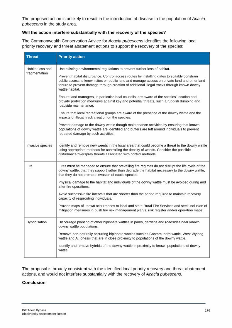
The proposed action is unlikely to result in the introduction of disease to the population of Acacia pubescens in the study area.
Will the action interfere substantially with the recovery of the species?
The Commonwealth Conservation Advice for Acacia pubescens identifies the following local
priority recovery and threat abatement actions to support the recovery of the species:
Threat Priority action
Habitat loss and Use existing environmental regulations to prevent further loss of habitat.
fragmentation Prevent habitat disturbance. Control access routes by installing gates to suitably constrain
public access to known sites on public land and manage access on private land and other land
tenure to prevent damage through creation of additional illegal tracks through known downy
wattle habitat.
Ensure land managers, in particular local councils, are aware of the species’ location and
provide protection measures against key and potential threats, such a rubbish dumping and
roadside maintenance.
Ensure that local recreational groups are aware of the presence of the downy wattle and the
impacts of illegal track creation on the species.
Prevent damage to the downy wattle though maintenance activities by ensuring that known
populations of downy wattle are identified and buffers are left around individuals to prevent
repeated damage by such activities
Invasive species Identify and remove new weeds in the local area that could become a threat to the downy wattle
using appropriate methods for controlling the density of weeds. Consider the possible
disturbance/overspray threats associated with control methods.
Fire Fires must be managed to ensure that prevailing fire regimes do not disrupt the life cycle of the
downy wattle, that they support rather than degrade the habitat necessary to the downy wattle,
that they do not promote invasion of exotic species.
Physical damage to the habitat and individuals of the downy wattle must be avoided during and
after fire operations.
Avoid successive fire intervals that are shorter than the period required to maintain recovery
capacity of resprouting individuals.
Provide maps of known occurrences to local and state Rural Fire Services and seek inclusion of
mitigation measures in bush fire risk management plan/s, risk register and/or operation maps.
Hybridisation Discourage planting of other bipinnate wattles in parks, gardens and roadsides near known
downy wattle populations.
Remove non-naturally occurring bipinnate wattles such as Cootamundra wattle, West Wylong
wattle and A. jonessi that are in close proximity to populations of the downy wattle.
Identify and remove hybrids of the downy wattle in proximity to known populations of downy
wattle.
The proposal is broadly consistent with the identified local priority recovery and threat abatement
actions, and would not interfere substantially with the recovery of Acacia pubescens.
Conclusion
Pitt Town Bypass Biodiversity Assessment Report
176

In consideration of the above factors, the proposed activity is unlikely to have “a significant effect”
on Acacia pubescens in the study area or wider locality as a result of the proposed action, as:
• The reduction in the population size and habitat of the species is negligible in comparison to the greater local population size and habitat.
• The proposed action would not fragment a population of the species, disrupt its breeding cycle or affect habitat critical to its survival; and
• Whilst the proposed action may exacerbate invasive species spread, invasive species currently dominate in the ground layer of most of the study area, and the Acacia pubescens habitat is already heavily modified.
Consequently, a referral to the Commonwealth Minister for the Environment is not required.
Pitt Town Bypass Biodiversity Assessment Report
177

Micromyrtus minutiflora
Micromyrtus minutiflora is Vulnerable under the EPBC Act.
Will the action lead to a long-term decrease in the size of an important population of a
species?
The proposed action will involve the clearing of 0.39 ha of habitat suitable to Micromyrtus minutiflora which does not currently contain any individuals of the species. The nearest record of
the species is 5km to the south of the study area and its population size will not be impacted by the
proposal.
Will the action reduce the area of occupancy of an important population?
0.39 ha of suitable Micromyrtus minutiflora habitat will be removed as a result of the proposal. This
suitable habitat consists of Shale Gravel Transition Forest in the Sydney Basin Bioregion. This
habitat is heavily modified and fragmented by rural residential development in the area. It is also
isolated from populations of Micromyrtus minutiflora and therefore it is unlikely that they would
inhabit this area. Therefore, the proposed action will not reduce the area of occupancy for any
nearby populations.
Will the action fragment an existing important population into two or more populations?
As there are no populations in close proximity to the study area and the landscape is already
modified and fragmented, the proposed action will not fragment an existing population into two or
more populations.
Will the action adversely affect habitat critical to the survival of a species?
The site is not critical to the survival of the species. While a small area of suitable habitat will be
removed, Micromyrtus minutiflora does not currently inhabit this area. Therefore, the proposed
action will not adversely affect habitat critical to the survival of a species.
Will the action disrupt the breeding cycle of an important population?
As the closest population is over 5km away, they will not be impacted by the proposed action.
Therefore, the breeding cycle of an important population will not be disrupted.
Will the action modify, destroy, remove or isolate or decrease the availability or quality of
habitat to the extent that the species is likely to decline?
The proposed action would result in the removal of a small area (0.39 ha) of potential habitat for Micromyrtus minutiflora. The area of impact does not support any above-ground occurrence of the
species and it is unlikely that it occurs in the soil seed bank in this location either. The closest
plants of Micromyrtus minutiflora are approximately 5.5 km to the south of the area of impact. The
species habitat would not be impacted by the proposed action such that it is likely to decline.
Will the action result in invasive species that are harmful to a vulnerable species becoming
established in the vulnerable species’ habitat?
Exotic grasses are abundant in the study area and the proposed action may facilitate the spread of
seeds or fragments of plant to areas where these grasses are not present, via plant or
contaminated topsoil. This could include areas of potential habitat for the species. However, with
the appropriate control measures enforced, the likelihood of this happening is significantly reduced.
Will the action introduce disease that may cause the species to decline?
Pitt Town Bypass Biodiversity Assessment Report
178
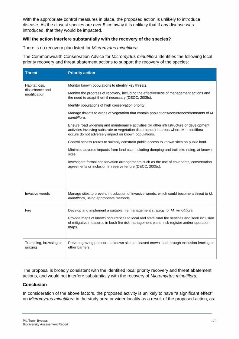
With the appropriate control measures in place, the proposed action is unlikely to introduce
disease. As the closest species are over 5 km away it is unlikely that if any disease was
introduced, that they would be impacted.
Will the action interfere substantially with the recovery of the species?
There is no recovery plan listed for Micromyrtus minutiflora.
The Commonwealth Conservation Advice for Micromyrtus minutiflora identifies the following local
priority recovery and threat abatement actions to support the recovery of the species:
Threat Priority action
Habitat loss, Monitor known populations to identify key threats.
disturbance and
modification Monitor the progress of recovery, including the effectiveness of management actions and
the need to adapt them if necessary (DECC, 2005c).
Identify populations of high conservation priority.
Manage threats to areas of vegetation that contain populations/occurrences/remnants of M. minutiflora.
Ensure road widening and maintenance activities (or other infrastructure or development
activities involving substrate or vegetation disturbance) in areas where M. minutiflora
occurs do not adversely impact on known populations.
Control access routes to suitably constrain public access to known sites on public land.
Minimise adverse impacts from land use, including dumping and trail bike riding, at known
sites.
Investigate formal conservation arrangements such as the use of covenants, conservation
agreements or inclusion in reserve tenure (DECC, 2005c).
Invasive weeds Manage sites to prevent introduction of invasive weeds, which could become a threat to M. minutiflora, using appropriate methods.
Fire Develop and implement a suitable fire management strategy for M. minutiflora.
Provide maps of known occurrences to local and state rural fire services and seek inclusion
of mitigative measures in bush fire risk management plans, risk register and/or operation
maps.
Trampling, browsing or
grazing
Prevent grazing pressure at known sites on leased crown land through exclusion fencing or
other barriers.
The proposal is broadly consistent with the identified local priority recovery and threat abatement
actions, and would not interfere substantially with the recovery of Micromyrtus minutiflora.
Conclusion
In consideration of the above factors, the proposed activity is unlikely to have “a significant effect”
on Micromyrtus minutiflora in the study area or wider locality as a result of the proposed action, as:
Pitt Town Bypass Biodiversity Assessment Report
179

• The proposed action would not reduce the area of occupancy or population size of the species;
• The proposed action would not fragment a population of the species, disrupt its breeding cycle or affect habitat critical to its survival; and
• Whilst the proposed action may exacerbate invasive species spread, invasive species currently dominate in the ground layer of most of the study area, and the Micromyrtus minutiflora habitat is already heavily modified.
Consequently, a referral to the Commonwealth Minister for the Environment is not required.
Pitt Town Bypass Biodiversity Assessment Report
180

Pimelea spicata (Spiked Rice-flower)
Pimelea spicata is listed as Endangered under the EPBC Act.
Will the action lead to a long-term decrease in the size of a population?
Pimelea spicata was not recorded in the study area during ecological surveys. The nearest known
population of P. spicata is approximately 4 km to the east of the study area and will not be
impacted by the proposed action. Furthermore, the species has a low seed dispersal range and
therefore, as there are no recordings in or near the study area it is unlikely that P. spicata occurs in
the seedbank. While the proposed action will result in the removal of 1.41 ha of potential habitat
for P. spicata, as no individuals have been recorded in the area it is considered highly unlikely that
it will result in a long-term decrease in the size of a population.
Will the action reduce the area of occupancy of the species?
The proposed action would result in the reduction of 1.41 ha of suitable habitat for P. spicata in the
form of Cumberland Plain Woodland. This habitat is currently heavily modified and fragmented by
existing roads and rural development. It is also isolated from other areas of suitable habitat. Due to
this, the habitat is considered sub-optimal and any reduction to the area of occupancy of the
species would be negligible.
Will the action fragment an existing population into two or more populations?
The potential habitat for P. spicata to be removed consists of patches of vegetation currently
fragmented by roads and dwellings. In a larger context, the study area is situated within a mosaic
of rural residential development with only patches of vegetation which have been heavily modified.
Any further fragmentation caused by this proposed action would therefore be negligible.
Furthermore, as the nearest record of the species is over 4 km away and the study area is not an
important habitat corridor, the proposed action is unlikely to further isolate any individuals or
groups of individuals. Therefore, the proposed action will not fragment an existing population of P. spicata into two or more populations.
Will the action adversely affect habitat critical to the survival of a species?
There is no critical habitat listed for P. spicata. The 1.41 ha of fragmented potential habitat to be
removed is not considered to be habitat critical to the survival of this species.
Will the action disrupt the breeding cycle of a population?
P. spicata is dependent on seed production for recruitment and while dispersal mechanisms for the
species are unknown, seed dispersal is likely to be very low, with most seedlings observed in
proximity to adult plants. Due to this, and because the species has not been recorded in close
proximity to the study area, it is highly unlikely that the proposed action will disrupt the breeding
cycle of a population.
Will the action modify, destroy, remove, isolate or decrease the availability or quality of
habitat to the extent that the species is likely to decline?
The proposed action will result in the clearing of 1.41 ha of suitable habitat in the form of
Cumberland Plain Woodland. This habitat is currently heavily modified and fragmented by existing
roads and rural development. It is also isolated from other areas of suitable habitat. The proposed
action will further fragment the vegetation however, due to its current extensive modification, any
further fragmentation is negligible. As the species is not known to inhabit this area, it is highly
unlikely that its removal will lead to the decline of the species.
Pitt Town Bypass Biodiversity Assessment Report
181
Will the action result in invasive species that are harmful to a critically endangered or
endangered species becoming established in the endangered or critically endangered
species’ habitat?
While the proposed action may result in the spread of some exotic grasses, it is unlikely that the
action will result in the establishment of an invasive species that is harmful to P. spicata.
Will the action introduce disease that may cause the species to decline?
The action is highly unlikely to introduce disease that may cause P. spicata to decline.
Will the action interfere with the recovery of the species?
A recovery plan has been prepared for Pimelea spicata. The overall objective of the recovery plan
is “to ensure the continued and long-term survival of P. spicata in the wild by promoting the in-situ
conservation of the species across its natural range”.
This plan consists of six specific recovery objectives (DEC 2005 p18):
• Conserve P. spicata using land-use and conservation planning mechanisms Actions associated with this recovery objective include ensuring that:
all relevant Environmental Planning Instruments (prepared under Pt 3 of the EP&A Act) are
prepared, or reviewed, with reference to this recovery plan and any future advice from the
Department of Environment and Conservation regarding the species.
all relevant consent and determining authorities (under Pt 4 & 5 of the EP&A Act) will assess
developments and activities with reference to this recovery plan, environmental impact assessment
guidelines... and any future advice from the Department of Environment and Conservation
regarding the species.
The Proposal is being assessed with reference to the recovery plan, environmental impact
assessment guidelines and all publicly available information regarding the species.
• identify and minimise the operation of threats at sites where P. spicata occurs This recovery objective is aimed at minimising threats operating at known P. spicata sites (in
addition to land clearing), including weed invasion; mowing and slashing; spraying of herbicide;
dumping of rubbish and garden waste; inappropriate disturbance regimes; and grazing and
associated trampling.
While there is a possibility that the proposed action may result in an increase in some of these
threats, the study area is not a known P. spicata site and therefore this recovery objective is not
applicable.
• implement a survey and monitoring program that will provide information on the extent and viability of P. spicata.
Not relevant to the current assessment.
• Provide the community with information that assists in conserving the species. Not relevant to the current assessment.
• raise awareness of the species and involve the community in the recovery program Not relevant to the current assessment.
• promote research questions that will assist future management decisions Not relevant to the current assessment.
Conclusion
Pitt Town Bypass Biodiversity Assessment Report
182

In consideration of the above factors, the proposed activity is unlikely to have “a significant effect”
on P. spicata in the study area or wider locality as a result of the proposed action, as:
• The proposed action would not reduce the area of occupancy or population size of the species;
• The proposed action would not fragment a population of the species, disrupt its breeding cycle or affect habitat critical to its survival; and
• Whilst the proposed action may exacerbate invasive species spread, invasive species currently dominate in the ground layer of most of the study area, and the P. spicata habitat is already heavily modified.
Consequently, a referral to the Commonwealth Minister for the Environment is not required.
Pitt Town Bypass Biodiversity Assessment Report
183

Grey-headed Flying-fox (Pteropus poliocephalus)
Grey-headed Flying-fox is listed as Vulnerable under the EPBC Act.
Will the proposed action lead to a long-term decrease in the size of an important population
of a species?
The closest known population of Grey-headed Flying-fox to the study area is at the roosting camp
located at Yarramundi (Camp ID 97) approximately 16 km west of the site. Other camps are
located further south at Emu Plains (Camp ID 237) and Paramatta Park (Camp ID 134), located 24
and 27 km from the study area, respectively. While these populations may utilise parts of the study
area for foraging, this foraging resource does not comprise a significant area of foraging habitat
within the locality. As Grey-headed Flying-foxes forage on a large variety of both native and exotic
vegetation, their foraging habitat is extensive. Therefore, the vegetation to be cleared is negligible
in comparison to the vast amount of foraging habitat in the locality. Furthermore, the species does
not currently use the study area for permanent roosting or as a maternity camp. Therefore, the
proposed action is highly unlikely to lead to a long-term decrease in the size of an important
population of the species.
Will the proposed action reduce the area of occupancy of an important population?
There are three camps near the study area, 16, 24 and 27 km away. Individuals from these camps
may utilise foraging resources within the study area however the 1.8 ha of potential foraging
habitat to be cleared does not represent a substantial amount of habitat in comparison to the
amount of suitable foraging habitat in the greater local area. The removal of a relatively small
portion of potential foraging habitat from the study area would not significantly reduce the area of
occupancy of the species.
Will the proposed action fragment an existing important population into two or more
populations?
There are no roosting sites in or in close proximity to the study area. The nearest roosting camps
will not be impacted by the proposed action. The removal of potential foraging habitat from the
study area would not fragment the population of the Grey-Headed Flying-fox into two or more
populations.
Will the proposed action adversely affect habitat critical to the survival of a species?
Whilst the Proposal would result in the removal of potential foraging habitat, this habitat is not likely
to be habitat critical to the survival of this species.
Will the proposed action disrupt the breeding cycle of an important population?
There is no known maternity roosting camp of Grey-headed Flying-foxes within, or in close
proximity to, the study area. The study area provides a potential foraging resource for a roosting
camp 16 km to the west of the study area. Breeding individuals from nearby camps that utilise
resources at the study area could be adversely impacted by the removal of foraging habitat.
However, vegetation removal would be within a relatively small area (1.8 ha) in comparison to the
vegetation that would be retained within the study area as well as in comparison to the local area.
This amount of clearing would therefore not significantly diminish the foraging resources in the
region that would support breeding females.
Will the proposed action modify, destroy, remove or isolate or decrease the availability or
quality of habitat to the extent that the species is likely to decline?
The proposed action would result in the removal of 1.8 ha of potential foraging habitat for the Grey-
headed Flying-fox. This represents a small amount of the total suitable foraging habitat to be
Pitt Town Bypass Biodiversity Assessment Report
184
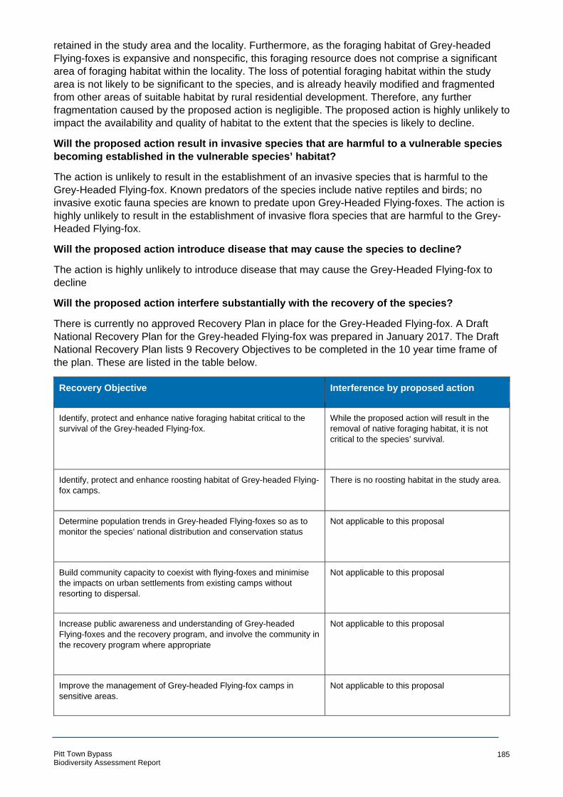
retained in the study area and the locality. Furthermore, as the foraging habitat of Grey-headed
Flying-foxes is expansive and nonspecific, this foraging resource does not comprise a significant
area of foraging habitat within the locality. The loss of potential foraging habitat within the study
area is not likely to be significant to the species, and is already heavily modified and fragmented
from other areas of suitable habitat by rural residential development. Therefore, any further
fragmentation caused by the proposed action is negligible. The proposed action is highly unlikely to
impact the availability and quality of habitat to the extent that the species is likely to decline.
Will the proposed action result in invasive species that are harmful to a vulnerable species
becoming established in the vulnerable species’ habitat?
The action is unlikely to result in the establishment of an invasive species that is harmful to the
Grey-Headed Flying-fox. Known predators of the species include native reptiles and birds; no
invasive exotic fauna species are known to predate upon Grey-Headed Flying-foxes. The action is
highly unlikely to result in the establishment of invasive flora species that are harmful to the Grey-
Headed Flying-fox.
Will the proposed action introduce disease that may cause the species to decline?
The action is highly unlikely to introduce disease that may cause the Grey-Headed Flying-fox to
decline
Will the proposed action interfere substantially with the recovery of the species?
There is currently no approved Recovery Plan in place for the Grey-Headed Flying-fox. A Draft
National Recovery Plan for the Grey-headed Flying-fox was prepared in January 2017. The Draft
National Recovery Plan lists 9 Recovery Objectives to be completed in the 10 year time frame of
the plan. These are listed in the table below.
Recovery Objective Interference by proposed action
Identify, protect and enhance native foraging habitat critical to the
survival of the Grey-headed Flying-fox.
While the proposed action will result in the
removal of native foraging habitat, it is not
critical to the species’ survival.
Identify, protect and enhance roosting habitat of Grey-headed Flying-
fox camps.
There is no roosting habitat in the study area.
Determine population trends in Grey-headed Flying-foxes so as to
monitor the species’ national distribution and conservation status
Not applicable to this proposal
Build community capacity to coexist with flying-foxes and minimise
the impacts on urban settlements from existing camps without
resorting to dispersal.
Not applicable to this proposal
Increase public awareness and understanding of Grey-headed
Flying-foxes and the recovery program, and involve the community in
the recovery program where appropriate
Not applicable to this proposal
Improve the management of Grey-headed Flying-fox camps in
sensitive areas.
Not applicable to this proposal
Pitt Town Bypass Biodiversity Assessment Report
185
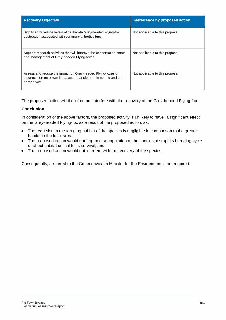
Recovery Objective Interference by proposed action
Significantly reduce levels of deliberate Grey-headed Flying-fox
destruction associated with commercial horticulture
Not applicable to this proposal
Support research activities that will improve the conservation status
and management of Grey-headed Flying-foxes
Not applicable to this proposal
Assess and reduce the impact on Grey-headed Flying-foxes of
electrocution on power lines, and entanglement in netting and on
barbed-wire.
Not applicable to this proposal
The proposed action will therefore not interfere with the recovery of the Grey-headed Flying-fox.
Conclusion
In consideration of the above factors, the proposed activity is unlikely to have “a significant effect”
on the Grey-headed Flying-fox as a result of the proposed action, as:
• The reduction in the foraging habitat of the species is negligible in comparison to the greater habitat in the local area.
• The proposed action would not fragment a population of the species, disrupt its breeding cycle or affect habitat critical to its survival; and
• The proposed action would not interfere with the recovery of the species.
Consequently, a referral to the Commonwealth Minister for the Environment is not required.
Pitt Town Bypass Biodiversity Assessment Report
186

Appendix G Microbat echolocation call analysis
Pitt Town Bypass Biodiversity Assessment Report
187

° °
Introduction
This appendix outlines the methods and results of microbat echolocation call analysis undertaken for the Pitt Town Bypass biodiversity assessment. Desktop assessment identified the potential occurrence of a number of microbat species listed as threatened under the Commonwealth Environment Protection and Biodiversity Conservation Act 1999 (EPBC Act) and/or the NSW Biodiversity Conservation Act 2016 (BC Act). Threatened species considered from the desktop assessment as potential to occur within the study area are listed below:
• Yellow-bellied Sheathtail-bat (Saccolaimus flaviventris)
• Greater Broad-nosed Bat (Scoteanax rueppellii) • Eastern False Pipistrelle (Falsistrellus tasmaniensis)
• Little Bentwing-bat (Miniopterus australis)
• Eastern Bentwing-bat (Miniopterus schreibersii oceanensis)
• Eastern Freetail-bat (Mormopterus norfolkensis)
• Southern Myotis (Myotis macropus)
Methods
Field surveys
Microbat echolocation calls were recorded within the study area over five consecutive nights (16 to 20 February 2018). Calls were recorded using ‘Anabat Express’ (Titley Pty Ltd) devices deployed at two sites. Call recording sites were selected sampling the two primary microbat habitats within the study area. These were:
• Anabat 1: Broad-leaved Ironbark – Grey Box – Melaleuca decora grassy open forest
• Anabat 2: Grey Box – Forest Red Gum grassy woodland Weather conditions during the survey were warm to hot during the day and mild at night (Table 1). Table 8-1 Summary of weather conditions during microbat surveys
Date Temperature Rain Maximum wind gust
Min ( C) Max ( C) mm Direction Speed (km/h)
16 February 2018 13.2 33.1 0 ESE 43
17 February 2018 19.3 32.7 0 E 41
18 February 2018 17.4 36.3 0 E 35
19 February 2018 20.6 31.4 0 ESE 46
20 February 2018 18.4 23.3 6.6 SSE 48
Pitt Town Bypass Biodiversity Assessment Report
188

Echolocation call analysis
Echolocation calls recorded during surveys were analysed by Arcadis ecologist Carl Corden. Carl has over 15 years experience as a consultant ecologist, and has undertaken microbat echolocation call analysis for a large number of projects across eastern Australia. Calls were extracted, viewed and analysed using ‘AnalookW for bat call analysis using ZCA - Version 4.2n 16 March 2017’ software ( Chris Corben, Copyright © 2017). Calls were identified with reference to ‘Bat Calls of NSW’ (Pennay et al., 2004). The report has been prepared in accordance with the ‘Standards for reporting bat detector surveys’ (Australasian Bat Society Inc. n.d) Where possible, calls were identified to species or genus based on the presence/absence of determinate features such as frequency, shape, pulse intervals and other indicative features (eg alternations in frequency within call sequences). Details of identification features used are provided for calls of each species identified in Appendix 1.
Results
A total of 1527 call sequences was recorded across two survey sites over five consecutive nights. The majority (i.e. > 95%) of these could be identified to species or genus once context had been established using the best quality examples of calls for each species recorded from the study area. A total of 10 microbat species were identified from echolocation calls recorded across the study area (Table 2).
Pitt Town Bypass Biodiversity Assessment Report
189

Eastern Horseshoe-bat Rhinolophus megaphyllus
Calls identified based on call shape (distinctly flat with up sweeping initial section and down sweeping tail) and characteristic frequency (67 kHz) which does not overlap with any other species known to occur in the region.
Pitt Town Bypass Biodiversity Assessment Report
190
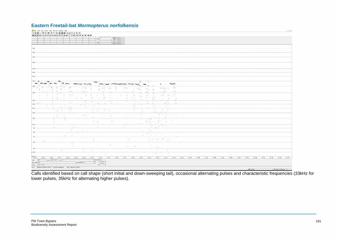
Eastern Freetail-bat Mormopterus norfolkensis
Calls identified based on call shape (short initial and down-sweeping tail), occasional alternating pulses and characteristic frequencies (33kHz for lower pulses, 35kHz for alternating higher pulses).
Pitt Town Bypass Biodiversity Assessment Report
191

White-striped Freetail-bat Austronomus (Tadarida) australis
Calls identified based on call shape and characteristic frequency (< 14kHz) which does not overlap with any other species known to occur in the region.
Pitt Town Bypass Biodiversity Assessment Report
192

Eastern Bentwing-bat Miniopterus schreibersii oceanensis
Calls identified based on call shape (down-sweeping tail), variations in pulse shapes within the sequence and characteristic frequency (45kHz).
Pitt Town Bypass Biodiversity Assessment Report
193

Gould’s Wattled Bat Chalinolobus gouldii
Calls identified based on call shape (down-sweeping tail), regular alternating pulses and characteristic frequencies (29kHz for lower pulses, 31kHz for alternating higher pulses).
Pitt Town Bypass Biodiversity Assessment Report
194

Chocolate Wattled Bat Chalinolobus morio
Calls overlap in frequency with Little Forest Bat Vespadelus vulturnus. Calls identified as Chocolate Wattled-bat based on call shape (down-sweeping tail), slight alternation between pulses and characteristic frequency (51kHz).
Pitt Town Bypass Biodiversity Assessment Report
195
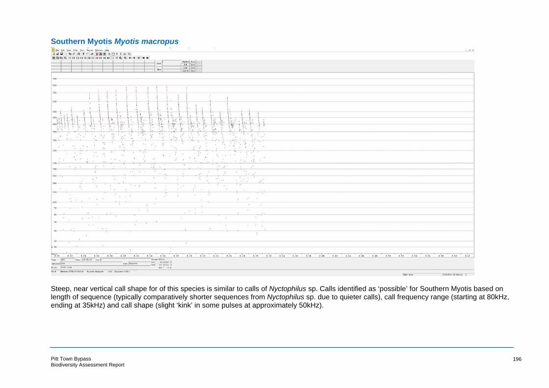
Southern Myotis Myotis macropus
Steep, near vertical call shape for of this species is similar to calls of Nyctophilus sp. Calls identified as ‘possible’ for Southern Myotis based on length of sequence (typically comparatively shorter sequences from Nyctophilus sp. due to quieter calls), call frequency range (starting at 80kHz, ending at 35kHz) and call shape (slight ‘kink’ in some pulses at approximately 50kHz).
Pitt Town Bypass Biodiversity Assessment Report
196

Unidentified Long-eared Bat Nyctophilus sp.
Steep, near vertical call shape for all species in the genus Nyctophilus are almost identical and cannot be identified to species. Calls are also similar to those of Southern Myotis Myotis macropus. Calls identified as Nyctophilus sp. based on comparatively short length of sequence due to quieter calls and uniform call shape (no distinctive ‘kinks’ in pulses).
Pitt Town Bypass Biodiversity Assessment Report
197

Greater Broad-nosed Bat Scoteanax rueppellii
Calls overlap in frequency with Eastern False Pipistrelle Falsistrellus tasmaniensis and Eastern Broad-nosed Bat Scotorepens orion. Calls above 35kHz are ‘possible’ records for any of these three species. Some calls identified as ‘probable’ Greater Broad-nosed Bat based on call shape (down-sweeping tail) and characteristic frequency of some calls (35kHz) which is below range of other similar species.
Pitt Town Bypass Biodiversity Assessment Report
198

Little Forest Bat Vespadelus vulturnus
Calls overlap in frequency with Chocolate Wattled-bat Chalinolobus morio. Calls identified as Little Forest Bat based on call shape (up-sweeping tail) and characteristic frequency (51kHz). Note calls of Eastern Freetail-bat Mormopterus norfolkensis are also shown in the sequence above.
Pitt Town Bypass Biodiversity Assessment Report
199

Appendix F
Aboriginal Cultural Heritage Assessment
Pitt Town Bypass
Review of Environmental Factors

BLANK PAGE
Pitt Town Bypass
Review of Environmental Factors

PITT TOWN BYPASS
Aboriginal Cultural Heritage Assessment
Prepared for NSW Roads and Maritime Services
Hawkesbury Local Government Area
September 2018
Ref. 1730
KELLEHER NIGHTINGALE CONSULTING PTY LTD
Archaeological and Heritage Management ACN 120 187 671
Level 10, 25 Bligh Street SYDNEY NSW 2000
Phone 02 9232 5373 Fax 02 9223 0680

Pitt Town Bypass - Aboriginal Cultural Heritage Assessment September 2018
Document Information
Project Name Pitt Town Bypass - Aboriginal Cultural Heritage Assessment
Project Number 1730
Version 1.0
Client Name NSW Roads and Maritime Services
Recipient Ankur Arora
Issue Date 28 September 2018
Prepared by Dr Matthew Kelleher; Ben Anderson
Approved by Dr Matthew Kelleher; Alison Nightingale
i

Pitt Town Bypass - Aboriginal Cultural Heritage Assessment September 2018
Executive Summary
The NSW Government is planning a bypass of Pitt Town to reduce traffic through the town centre and improve traffic flow and safety for all road users. Roads and Maritime Services (Roads and Maritime) propose to build the Pitt Town bypass to extend Pitt Town Road past Bathurst Street, where it currently deviates into the township, onto Cattai Road east of Eldon Street. A Preliminary Environmental Investigation (PEI) was undertaken in July 2016 and the preferred strategic design was released to the community in March 2017. Aboriginal archaeological survey, undertaken as part of Roads and Maritime Stage 2 Procedure for Aboriginal Cultural Heritage Consultation and Investigation (PACHCI) for the PEI identified one surface artefact scatter with an associated area of potential archaeological deposit and four areas of potential archaeological deposit within the proposal area. The assessment recommended a program of archaeological test excavation at the five areas of potential archaeological deposit to determine their archaeological potential. Concept design development and a Review of Environmental Factors (REF) are currently being undertaken for the project. Roads and Maritime engaged Kelleher Nightingale Consulting Pty Ltd (KNC) to prepare an Aboriginal cultural heritage assessment report (CHAR) for Aboriginal heritage within the proposal area as part of the REF for the project and including a test excavation program. An archaeological test excavation program was undertaken at the five areas of potential archaeological deposit (PTBP 1 PAD, PTBP PAD 1, PTBP PAD 2, PTBP PAD 3 and PTBP PAD 4) located within the study area in accordance with the Office of Environment and Heritage Code of Practice for the Archaeological Investigation of Aboriginal Objects in New South Wales and Roads and Maritime PACHCI. The archaeological test excavation identified the presence of subsurface archaeological deposit at four of the five areas of potential archaeological deposit:
PTBP 1 (formerly PTBP 1 PAD)
PTBP AFT 1 (formerly PTBP PAD 1)
PTBP AFT 2 (formerly PTBP PAD 2)
PTBP AFT 3 (formerly PTBP PAD 4). Archaeological significance of the identified Aboriginal sites was defined by the information exhibited by each site. A mitigation program comprising archaeological salvage, undertaken prior to construction, is required where portions of at least moderately significant Aboriginal sites would be impacted by the proposal. Mitigative salvage excavation would be required for the impacted archaeological site exhibiting moderate significance (PTBP AFT 3), while the remaining archaeological sites (PTBP 1, PTBP AFT 1 and PTBP AFT 2) displayed low archaeological significance (due to soil disturbance and paucity of artefacts) and do not warrant salvage excavation. An AHIP is being sought for the entirety of the lands subject to the proposed development and specifically for Aboriginal objects associated with sites:
PTBP 1 AHIMS 45-5-5150 Partial impact Low significance PTBP AFT 1 AHIMS 45-5-5148 Partial impact Low significance PTBP AFT 2 AHIMS 45-5-5149 Partial impact Low significance PTBP AFT 3 AHIMS 45-5-5147 Total impact Moderate significance
The CHAR has been prepared in accordance with Stage 3 of the Roads and Maritime PACHCI and NSW Office of Environment and Heritage Guide to investigating, assessing and reporting on Aboriginal cultural heritage in NSW.
ii

Pitt Town Bypass - Aboriginal Cultural Heritage Assessment September 2018
Contents
EXECUTIVE SUMMARY ............................................................................................................................. II
FIGURES ................................................................................................................................................... V
TABLES ..................................................................................................................................................... V
1 INTRODUCTION................................................................................................................................ 1
1.1 PROPONENT AND CONSULTANTS ............................................................................................................. 1 1.2 LOCATION AND SCOPE OF ACTIVITY .......................................................................................................... 1 1.3 STATUTORY CONTROLS AND DEVELOPMENT CONTEXT .................................................................................. 1 1.4 NATIONAL PARKS AND WILDLIFE ACT 1974 ............................................................................................. 4 1.5 OBJECTIVES OF THE CHAR .................................................................................................................... 4
2 LANDSCAPE CONTEXT ...................................................................................................................... 5
2.1 ETHNOHISTORIC AND HISTORIC CONTEXT .................................................................................................. 9
3 ARCHAEOLOGICAL CONTEXT ...........................................................................................................10
3.1 DATABASE SEARCH (AHIMS) .............................................................................................................. 10 3.2 PREVIOUS ARCHAEOLOGICAL ASSESSMENTS IN THE VICINITY OF THE STUDY AREA............................................. 12 3.3 PITT TOWN BYPASS PRELIMINARY ENVIRONMENTAL INVESTIGATION: ABORIGINAL ARCHAEOLOGICAL SURVEY
REPORT ............................................................................................................................................ 15
4 ARCHAEOLOGICAL TEST EXCAVATION.............................................................................................17
4.1 AIMS ............................................................................................................................................... 17 4.2 METHODOLOGY ................................................................................................................................ 17 4.3 PTBP 1 PAD.................................................................................................................................... 19
4.3.1 Soils and disturbance ............................................................................................................... 19 4.3.2 Artefact Distribution ................................................................................................................ 20 4.3.3 Lithics ....................................................................................................................................... 20 4.3.4 Discussion ................................................................................................................................ 21
4.4 PTBP PAD 1.................................................................................................................................... 23 4.4.1 Soils and disturbance ............................................................................................................... 23 4.4.2 Artefact Distribution ................................................................................................................ 24 4.4.3 Lithics ....................................................................................................................................... 25 4.4.4 Discussion ................................................................................................................................ 25
4.5 PTBP PAD 2.................................................................................................................................... 28 4.5.1 Soils and disturbance ............................................................................................................... 28 4.5.2 Artefact Distribution ................................................................................................................ 29 4.5.3 Lithics ....................................................................................................................................... 30 4.5.4 Discussion ................................................................................................................................ 31
4.6 PTBP PAD 3.................................................................................................................................... 33 4.6.1 Soils and disturbance ............................................................................................................... 33 4.6.2 Discussion ................................................................................................................................ 34
4.7 PTBP PAD 4.................................................................................................................................... 36 4.7.1 Soils and disturbance ............................................................................................................... 36 4.7.2 Artefact Distribution ................................................................................................................ 37 4.7.3 Lithics ....................................................................................................................................... 37 4.7.4 Discussion ................................................................................................................................ 39
5 CONSULTATION PROCESS ...............................................................................................................40
5.1 ABORIGINAL STAKEHOLDER CONSULTATION ............................................................................................. 40 5.2 PROVISION OF TEST EXCAVATION METHODOLOGY AND CHAR METHODOLOGY ............................................... 41 5.3 REVIEW OF DRAFT CHAR .................................................................................................................... 41
6 SUMMARY AND ANALYSIS OF BACKGROUND INFORMATION .........................................................42
6.1 SUMMARY OF KNOWN ABORIGINAL SITES WITHIN THE PROPOSAL AREA ........................................................ 42 6.2 ABORIGINAL SITES WITHIN THE PROPOSAL AREA ....................................................................................... 43
7 CULTURAL HERITAGE VALUES AND STATEMENT OF SIGNIFICANCE .................................................46
iii

Pitt Town Bypass - Aboriginal Cultural Heritage Assessment September 2018
7.1 SIGNIFICANCE ASSESSMENT CRITERIA ....................................................................................................46 7.2 STATEMENTS OF SIGNIFICANCE.............................................................................................................48
8 THE PROPOSED ACTIVITY AND IMPACT ASSESSMENT .....................................................................49
9 MITIGATING HARM.........................................................................................................................51
9.1 ECOLOGICALLY SUSTAINABLE DEVELOPMENT PRINCIPLES...........................................................................51 9.2 MITIGATION MEASURES .....................................................................................................................52
10 SUMMARY AND RECOMMENDATIONS ...........................................................................................53
GLOSSARY OF TERMS ..............................................................................................................................55
REFERENCES............................................................................................................................................59
APPENDIX A ADVERTISEMENT FOR REGISTRATION OF INTEREST .......................................................61
APPENDIX B ABORIGINAL FOCUS GROUP MEETING MINUTES ...........................................................62
APPENDIX C ABORIGINAL STAKEHOLDER COMMENTS.......................................................................65
APPENDIX D SALVAGE EXCAVATION METHODOLOGY ........................................................................71
iv
Pitt Town Bypass - Aboriginal Cultural Heritage Assessment September 2018
Figures
Figure 1. Location of the study area ................................................................................................................ 2 Figure 2. Study area details ............................................................................................................................. 3 Figure 3. Geology and soil landscape of the study area .................................................................................. 7 Figure 4. Topography of the study area .......................................................................................................... 8 Figure 5. AHIMS search results ...................................................................................................................... 11 Figure 6. PACHCI Stage 2 assessment results ................................................................................................ 16 Figure 7. Archaeological test square locations and artefact density at PTBP 1 PAD ..................................... 18 Figure 8. TS 1 north section and soil profile description ............................................................................... 19 Figure 9. TS 6 north section and soil profile description ............................................................................... 20 Figure 10. Archaeological test square locations and artefact density at PTBP PAD 1 ................................... 22 Figure 11. TS 13 north section and soil profile description ........................................................................... 23 Figure 12. TS 40 north section and soil profile description ........................................................................... 24 Figure 13. TS 51 north section and soil profile description ........................................................................... 24 Figure 14. Archaeological test square locations and artefact density at PTBP PAD 2 ................................... 27 Figure 15. TS 22 north section and soil profile description ........................................................................... 28 Figure 16. TS 28 south section and soil profile description ........................................................................... 29 Figure 17. TS 34 north section and soil profile description ........................................................................... 29 Figure 18. Archaeological test square locations and artefact density at PTBP PAD 3 ................................... 32 Figure 19. TS 7 south section and soil profile description ............................................................................. 33 Figure 20. TS 12 east section and soil profile description ............................................................................. 34 Figure 21. Archaeological test square locations and artefact density at PTBP PAD 4 ................................... 35 Figure 22. TS 55 west section and soil profile description ............................................................................ 36 Figure 23. TS 59 north section and soil profile description ........................................................................... 37 Figure 24. TS 68 south section and soil profile description ........................................................................... 37 Figure 25. Identified Aboriginal archaeological sites within the study area ................................................. 45 Figure 26. Study area (impact area) and Aboriginal heritage ........................................................................ 50 Figure 27. AHIP application area boundary ................................................................................................... 54
Tables
Table 1. Frequency of site types from OEH AHIMS database search ............................................................ 10 Table 2. Artefact densities and size at site PTBP 1 PAD................................................................................. 20 Table 3. Reduction types at PTBP 1 PAD ....................................................................................................... 20 Table 4. Test excavation artefact densities at site PTBP PAD 1 ..................................................................... 24 Table 5. Artefact densities and size at site PTBP PAD 1................................................................................. 25 Table 6. Reduction types at PTBP PAD 1 ....................................................................................................... 25 Table 7. Test excavation artefact densities at site PTBP PAD 2 ..................................................................... 29 Table 8. Artefact densities and size at site PTBP PAD 2................................................................................. 30 Table 9. Reduction types at PTBP PAD 2 ....................................................................................................... 30 Table 10. Test excavation artefact densities at site PTBP PAD 4 ................................................................... 37 Table 11. Artefact densities and size at site PTBP PAD 4 .............................................................................. 38 Table 12. Reduction types at PTBP PAD 4 ..................................................................................................... 38 Table 13. Registered Aboriginal parties ......................................................................................................... 40 Table 14. Identified Aboriginal archaeological sites within the proposal area.............................................. 42 Table 15. Proposed impact to Aboriginal archaeological sites within the study area ................................... 49 Table 16. Mitigation measures for impacted Aboriginal sites ....................................................................... 52 Table 17. Known archaeological sites requiring AHIP and degree of harm .................................................. 53
v

Pitt Town Bypass - Aboriginal Cultural Heritage Assessment September 2018
1 Introduction
1.1 Proponent and consultants
The NSW Government is planning a bypass of Pitt Town to reduce traffic through the town centre and improve traffic flow and safety for all road users. Roads and Maritime Services (Roads and Maritime) propose to build the Pitt Town bypass to extend Pitt Town Road past Bathurst Street, where it currently deviates into the township, onto Cattai Road east of Eldon Street.
A Preliminary Environmental Investigation (PEI) was undertaken in July 2016 and the preferred strategic design was released to the community in March 2017. Concept design development and a Review of Environmental Factors (REF) are currently being undertaken for the project.
Roads and Maritime engaged Kelleher Nightingale Consulting Pty Ltd (KNC) to prepare an Aboriginal cultural heritage assessment report (CHAR) for Aboriginal heritage within the proposal area as part of the REF for the project. The CHAR has been prepared in accordance with Stage 3 of the Roads and Maritime Procedure for Aboriginal Cultural Heritage Consultation and Investigation (PACHCI) (Roads and Maritime 2011) and NSW Office of Environment and Heritage (OEH) Guide to investigating, assessing and reporting on Aboriginal cultural heritage in NSW (OEH 2011a).
1.2 Location and scope of activity
Roads and Maritime proposes to build the Pitt Town bypass to extend Pitt Town Road past Bathurst Street, where it currently deviates into the township, onto Cattai Road east of Eldon Street (hereafter referred to as the study area). The proposed bypass would be approximately 1 kilometre in length and is located within the Hawkesbury Local Government Area (LGA). Key features of the proposal include:
Extending Pitt Town Road past Bathurst Street onto Cattai Road, east of Eldon Street
Installing a new two lane roundabout at Eldon Street and Old Pitt Town Road
Closing a portion of Cattai Road to maintain access to Buckingham Street
Providing new crossing off Hortons Creek
Installing a new two lane roundabout at Pitt Town Road/Bathurst Street and Glebe Road. The study area for this CHAR is shown on F igures 1 and 2.
1.3 Statutory controls and development context
The proposal is for road infrastructure carried out by Roads and Maritime assessed under Part 5 of the Environmental Planning and Assessment Act 1979. Aboriginal objects would be harmed by the proposal and an application for an Aboriginal Heritage Impact Permit (AHIP) would be made under section 90A of the National Parks and Wildlife Act 1974.
This Aboriginal CHAR has been prepared to support the AHIP application. It has been prepared in accordance with the Office of Environment and Heritage Guide to investigating, assessing and reporting on Aboriginal cultural heritage in NSW (OEH 2011a). The CHAR complies with the Roads and Maritime PACHCI (Roads and Maritime 2011).
1

Figure 1. Location of the study area
Pitt Town Bypass - Aboriginal Cultural Heritage Assessment September 2018
2
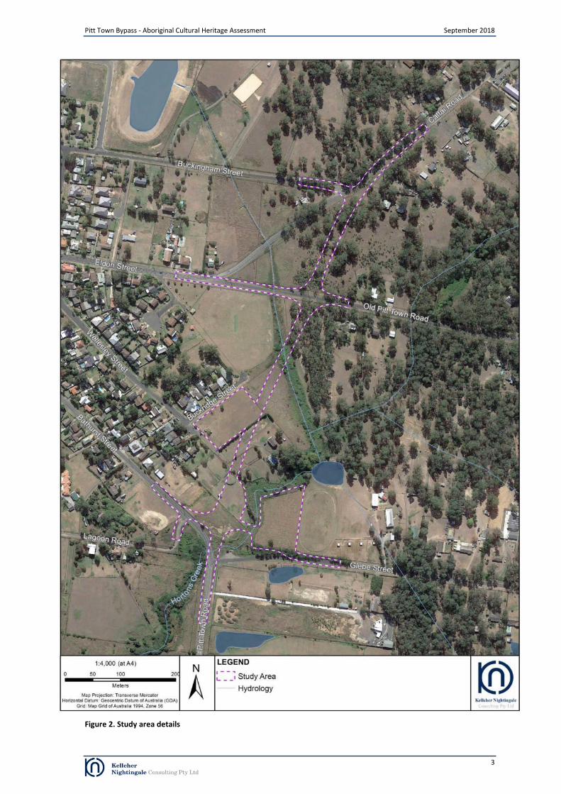
Figure 2. Study area details
Pitt Town Bypass - Aboriginal Cultural Heritage Assessment September 2018
3

Pitt Town Bypass - Aboriginal Cultural Heritage Assessment September 2018
1.4 National Parks and Wildlife Act 1974
The National Parks and Wildlife Act 1974 (NPW Act) is the primary statutory control dealing with Aboriginal heritage in New South Wales. Items of Aboriginal heritage (Aboriginal objects) or Aboriginal places (declared under section 84) are protected and regulated under the NPW Act. Under the Act, an “Aboriginal object” is defined as “any deposit, object or material evidence (not being a handicraft made for sale) relating to the Aboriginal habitation of the area that comprises New South Wales, being habitation before or concurrent with (or both) the occupation of that area by persons of non-Aboriginal extraction and includes Aboriginal remains”. As such, Aboriginal objects are confined to physical evidence and are commonly referred to as Aboriginal sites. Aboriginal objects are protected under section 86 of the Act. It is an offence to harm or desecrate an Aboriginal object, either knowingly [section 86 (1)] or unknowingly [section 86 (2)]. There are offences and penalties relating to harm to, or desecration of, an Aboriginal object or declared Aboriginal place. Harm includes to destroy, deface, damage or move. Penalties are tiered according to offences, which include:
a person must not harm or desecrate an Aboriginal object that the person knows is an Aboriginal object
a person must not harm an Aboriginal object (strict liability offence)
a person must not harm or desecrate an Aboriginal place (strict liability offence)
failure to notify Office of Environment and Heritage of the location of an Aboriginal object (existing offence and penalty)
contravention of any condition of an AHIP.
Under section 87 (1) it is a defence against prosecution if “(a) the harm or desecration concerned was authorised by an Aboriginal heritage impact permit and (b) the conditions to which that Aboriginal heritage impact permit was subject were not contravened”. Section 87 (2) of the Act provides a defence if “the defendant exercised due diligence to determine whether the act or omission constituting the alleged offence would harm an Aboriginal object and reasonably determined that no Aboriginal object would be harmed”. Section 89A of the Act relates to the notification of sites of Aboriginal objects, under which it is an offence if the location of an Aboriginal object is not notified to the Director-General in the prescribed manner within a reasonable time. Under section 90 (1) of the Act “the Director-General may issue an Aboriginal heritage impact permit”. The regulation of Aboriginal heritage impact permits is provided in Part 6 Division 2 of the Act, including regulations relating to consultation (section 90N). An AHIP is required for an activity which will harm an Aboriginal object.
1.5 Objectives of the CHAR
The proposed infrastructure works will impact on some Aboriginal objects (sites). Approval obtained under the National Parks and Wildlife Act 1974 is required for these Aboriginal objects prior to any impact or harm. The proponent would apply for an AHIP under section 90A of the Act. Clause 80D of the National Parks and Wildlife Regulation 2009 requires that an application for an AHIP is accompanied by a CHAR. The CHAR is to provide information on:
the significance of the Aboriginal places that are the subject of the application
the actual or likely harm to those Aboriginal objects or Aboriginal places from the proposed activity that is the subject of the application
any practical measures that may be taken to protect and conserve those Aboriginal objects or Aboriginal places
any practical measures that may be taken to avoid or mitigate any actual or likely harm to those Aboriginal objects or Aboriginal places.
The OEH Guide to investigating, assessing and reporting on Aboriginal cultural heritage in NSW (OEH 2011) provides further guidance on the preparation of a CHAR. This report has been prepared in accordance with the requirements of the Regulation and the OEH guide. This CHAR has been prepared to accompany an application for an AHIP made by Roads and Maritime for Aboriginal objects within the proposal area, including those associated with Aboriginal sites: PTBP 1, PTBP AFT 1, PTBP AFT 2 and PTBP AFT 3.
4

Pitt Town Bypass - Aboriginal Cultural Heritage Assessment September 2018
2 Landscape Context
The study area is located on the Cumberland Plain, a low lying and gently undulating subregion of the Sydney Basin. The Sydney Basin is a large geological feature stretching from Batemans Bay in the south to Newcastle in the north and Lithgow in the west. The formation of the basin began between 250 to 300 million years ago when river deltas gradually replaced the ocean that had extended as far west as Lithgow (Clark and Jones 1991).
The underlying geology of the study area is predominantly Londonderry Clay (Tl) with an area of Lowlands Formation (Qpl) in the south (Figure 3). Londonderry Clay geology consists of mottled red-grey moderately to highly plastic, relatively impervious clay with patches of sand and aggregates which have been partially or wholly cemented by iron oxides. Laterite pisolites and nodules are also abundant throughout. Lowlands Formation geology forms a broad terrace between Castlereagh and Pitt Town that consists of basal gravel grading upward into sand, silt and clay. The gravels include granite, porphyry, acid volcanics, basalt, quartz, quartzite, chert and sandstone. Londonderry Clays are generally prone to erosion and exhibit low level of archaeological survivability and/or sensitivity; while the opposite is true for less modified (low energy flood areas) of the Lowland Formation.
Lowlands Formation geology also contains raw material types that were utilised by past Aboriginal people. Areas where these materials were exposed at the surface, such as within creek channels, are likely to have been exploited by past Aboriginal people. The basal geology is overlain by Berkshire Park soils in the north and Freemans Reach soils in the south (Figure 3). The alluvial Berkshire Park soil landscape is characterised by flat terraces dissected by small drainage channels and narrow drainage lines with exposed areas of underlying geology due to erosion. These soils derived from the underlying Tertiary geology and consist of a sandy loam to sandy clay loam with inclusions of silcrete boulders of up to 20 centimetres in size overlying sandy clay and clay. The soils have a high level of wind erosion where cleared and have gully, sheet and rill erosion within dissected areas.
The alluvial Freemans Reach soil landscape are located on the present Hawkesbury River bank and are characterised by level landforms with minor relief to meander scrolls, levees and backwater swamps. These soils are derived from Narrabeen Group, Hawkesbury Sandstone and Wianamatta Group materials. The Freemans Reach soil landscape consists of sandy loam, apedal sand and apedal sandy clay loam overlying sandy clay and has a high level of stream bank erosion in addition to permanently high water tables and seasonal waterlogging.
The study area is located on the interface between the high alluvial terrace to the west that overlooks the floodplain of the Hawkesbury River and on which the present township of Pitt Town has been built and the Wianamatta geology to the east which forms the majority of undulating landforms within the Cumberland Plain. The study area traverses the creek flats, slopes and crest adjacent to Hortons Creek. Elevation within the study area ranges from 6 metres above sea level at Hortons Creek in the southern portion to 15 metres above sea level on the crest in the north. The hydrology of the study area is characterised by several minor drainage lines form Hortons Creek, a second order south flowing creek which joins Pitt Town Lagoon approximately 500 metres south west of the study area. The study area forms part of the catchment for the Hawkesbury River, a major watercourse which is located approximately two kilometres to the west of the study area. The Hawkesbury River is bound by an extensive flood plain which includes several lagoons including Pitt Town Lagoon and Longneck Lagoon, located two kilometres to the north east.
The distribution of native vegetation within the project area has been affected by historic and contemporary European land use practices in the region. Prior to 1788, a mixture of native vegetation communities would have extended across the entirety of the Cumberland Plain with distribution determined by a combination of factors including soil, terrain and climate (NSW National Parks and Wildlife Service (NPWS) 2002). The clearance of native vegetation across the majority of the study area by European settlers has left pockets of native vegetation. Prior to the clearance of native vegetation, the study area would have comprised Sydney Freshwater Wetlands in the Sydney Basin Bioregion within the riparian corridor of Hortons Creek and its tributaries, River Flat Eucalypt Forest on Coastal Floodplains of the NSW North Coast, Sydney Basin and South East Corner Bioregions on adjacent flats and slopes, Cumberland Plain Woodland in the Sydney Basin Bioregion on the slopes further from Hortons Creek and Shale‐Gravel Transition Forest in the Sydney Basin Bioregion on the elevated crest in the northern portion of the study area. The wide variety of native vegetation and sources of permanent water would have made the region an attractive locale for past Aboriginal people. The variety of habitats would also have encouraged a diverse population of fauna. Raw materials suitable for tool-making are available from surrounding geologies and may have been sourced directly from gravels along the Hawkesbury River or in the major creeks
European settlement of the area began in the in the late 18th
century with several land grants made along the Hawkesbury River in the area of Pitt Town Bottoms. The land grants were primarily utilised for growing maize, wheat and barley in addition to raising cattle, sheep, goats, pigs and horses. The occurrence of several floods in the late 18
th
and early 19th
centuries prompted the establishment of settlements on the elevated landforms adjacent to the Hawkesbury River floodplain including Windsor, Richmond, Castlereagh, Wilberforce and Pitt Town.
Land use practices have had a variable impact on the landscape within the study area. Road corridors have modified the landscape by creating cuttings and artificial embankments in addition to modifying the course of several
5

Pitt Town Bypass - Aboriginal Cultural Heritage Assessment September 2018
waterways. The properties have been predominantly cleared of native vegetation and utilised for grazing cattle and cultivating crops. A number of large dams have been constructed throughout the area within former creek channels, altering the area’s hydrology and drainage patterns.
6
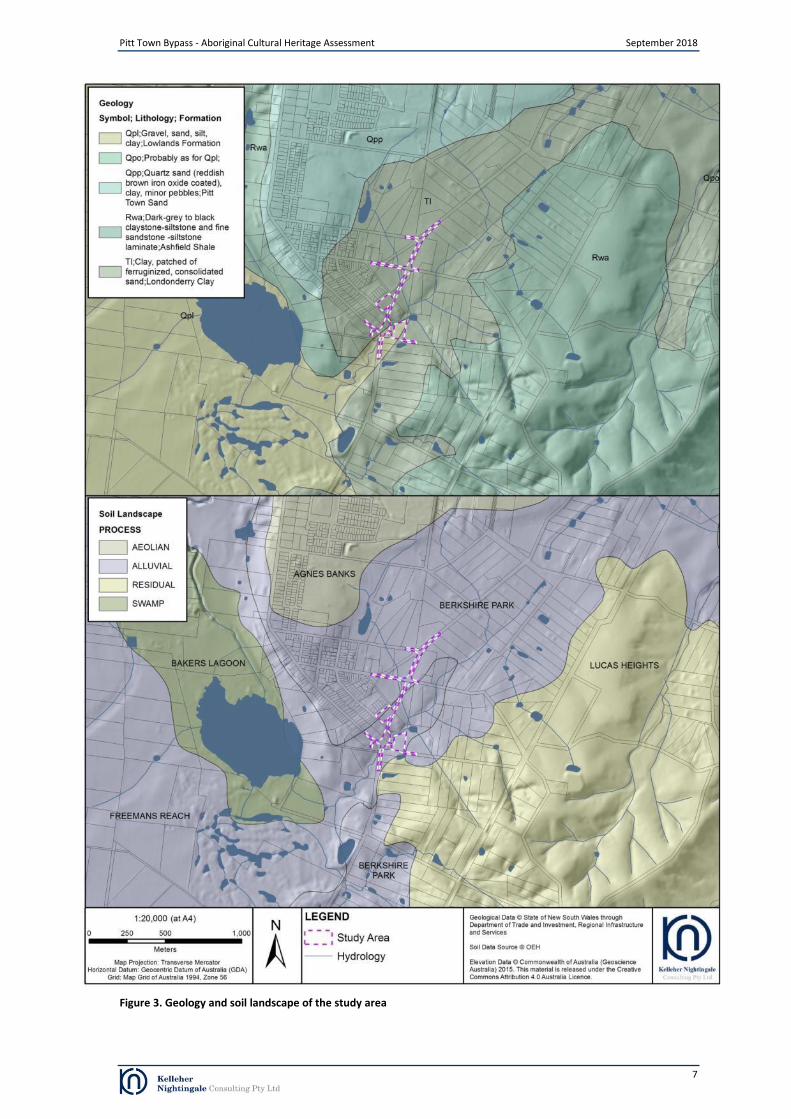
Figure 3. Geology and soil landscape of the study area
Pitt Town Bypass - Aboriginal Cultural Heritage Assessment September 2018
7

Figure 4. Topography of the study area
Pitt Town Bypass - Aboriginal Cultural Heritage Assessment September 2018
8

Pitt Town Bypass - Aboriginal Cultural Heritage Assessment September 2018
2.1 Ethnohistoric and historic context
The project area lies within a landscape which was important to, and intensively used by, past Aboriginal peoples (Attenbrow 2002). The arrival of European settlers began a cataclysmic series of events which radically changed the lifestyle of Aboriginal people on the Cumberland Plain. Contact with Europeans introduced diseases, such as smallpox, that drastically altered the size and structure of the Aboriginal population, whilst the expansion of settlements and establishment of farmland subsumed the traditional areas used to meet subsistence needs (Attenbrow 2002).
After their arrival in Sydney Cove in 1788, the British set about exploring the surrounding area. In the first three years of settlement many areas of the region were explored including Broken Bay, Botany Bay, Rose Hill (Parramatta), Prospect Hill and overland to the Nepean, Hawkesbury and Georges Rivers. During these explorations some of the British Officers, including Governor Phillip and Captain Watkin Tench, made a number of written observations regarding the local Aboriginal people that they met and travelled with (Attenbrow 2002:13).
In April 1791 an expedition was launched to determine if the Hawkesbury and Nepean Rivers were the same water body. The expedition set out from Rose Hill, Parramatta and traversed the area around Pitt Town. During the expedition a British officer, Captain Watkin Tench, made a number of observations regarding the local Aboriginal people that they encountered and travelled with that he later published. Whilst the observations made by Tench must be understood within the 18th century context in which they were written, they provide valuable information on the ethnohistorical context as it existed in the 18
th century for the region of the study area.
The expedition encountered several Aboriginal people near the Hawkesbury River around the area of present day Pitt Town. Tench observed that the Aboriginal guides brought by the expedition were from a different group to those encountered in the area; however, “they conversed on a par and understood each other perfectly, yet they spoke different dialects of the same language; many of the most common and necessary words used in life bearing no similitude and others being slightly different” (Tench 1793:122).
Historical observations described the Cumberland Plain as a mosaic of Aboriginal groups associated with particular areas of land. These groups were described as ‘tribes’ in many historical observations, when in fact they were more likely small territorial clans or local clans consisting of extended family groups, forming larger land-using bands linked through marriage and communal participation in subsistence gathering activities (Attenbrow 2002:22, Brook and Kohen 1991:2).
As well as differences in the dialect spoken between the coastal inhabitants and those further inland, the British also observed differences in subsistence activities. Brook and Kohen (1991:3) noted that “the Dharug people were apparently divided into two distinct sub-tribes: those along the coast, who lived on fish; those inland, who were frequently referred to as the ‘woods tribes’”. Tench recorded differences in the food eaten and methods used to acquire these resources between the inhabitants of the coast and those to the west of Rose Hill (Parramatta). On one occasion Tench observed a method of climbing trees for animals that involved cutting notches in the trunk and using these as toe-holds to climb the tree (Tench 1793:82).
Kohen (1986:77) explains that the Aboriginal people who lived between Parramatta and the Blue Mountains were not as dependant on fish and shellfish as groups closer to the coast, but relied on small animals and plant foods in addition to seasonally available freshwater mullet and eels. Tench (1793:230) observed that ‘they depend but little on fish, as the river yields only millets and that their principal support is derived from small animals which they kill and some roots (a species of wild yam chiefly) which they dig out of the earth’. These wild yams were found in considerable quantities along the banks of the Nepean and Hawkesbury Rivers. Berries, Banksia flowers and wild honey were also recorded as foods of the local inhabitants (Collins 1798 [Kohen 1985:9]). A particularly important plant food was the Burrawong (Macrozamia communis), which provided a nutritious nut that was pounded and soaked in running water to leach out toxins before the flour-like extract was made into small cakes and baked over a fire (Kohen 1993:8).
Small animals provided the protein component of the Aboriginal diet on the Cumberland Plain, with hunting comprising a major economic role of the men. Along the river, traps and snares were set for bandicoots and wallabies, while decoys for snaring birds were also a commonly employed technique, ‘these are formed of underwood and reeds, long and narrow, shaped like a mound raised over a grave, with a small aperture at one end for the admission of the prey’ (Tench 1793 [Kohen 1985:9]). Possums and gliders were particularly common in the open woodland across the Cumberland Plain and probably formed the main sources of animal food. These were hunted in a number of ways, including smoking out the animal by lighting a fire in the base of a hollow tree, burning large tracts of land and gathering the stranded animals, as well as cutting toe-holds in trees mentioned above (Kohen 1993:10; Tench 1793:82).
9

Pitt Town Bypass - Aboriginal Cultural Heritage Assessment September 2018
3 Archaeological Context
3.1 Database Search (AHIMS)
The Aboriginal Heritage Information Management System (AHIMS) is a database operated by the (NSW) Office of Environment and Heritage (OEH) and regulated under section 90(Q) of the (NSW) National Parks and Wildlife Act 1974 (NPW Act). AHIMS contains information and records related to registered Aboriginal archaeological sites (Aboriginal objects, as defined under the NPW Act) and declared Aboriginal places (as defined under the NPW Act) in NSW.
A search of AHIMS was conducted on 28 May 2018 to identify registered (known) Aboriginal sites or declared Aboriginal places within or adjacent to the study area (Client Service ID 347688). The search results are attached as Appendix A.
The AHIMS Web Service database search was conducted within the following coordinates (GDA, Zone 56): Eastings: 300100 - 303800 Northings: 6279300 - 6283500 Buffer: 0 metres (the search coordinates included an extensive buffer around the study area).
The AHIMS search results showed:
16 Aboriginal sites are recorded in or near the above location
0 Aboriginal places have been declared in or near the above location
The distribution of registered Aboriginal sites within these coordinates is shown in Figure 5. The frequencies of site features (site ‘types’) within the AHIMS database search area are shown in Table 1.
Table 1. Frequency of site types from OEH AHIMS database search
Site Context Site Feature Frequency (%)
Artefact 9 56.25
Artefact; Modified Tree (Carved or Scarred) 1 6.25
Artefact; Potential Archaeological Deposit (PAD) 2 12.50
Potential Archaeological Deposit (PAD) 4 25.00
Total 16 100
Other heritage registers and databases Other sources of information including heritage registers and lists were also searched for known Aboriginal heritage in the vicinity of the study area. These included:
Hawkesbury Local Environmental Plan 2012
Roads and Maritime s. 170 Heritage and Conservation Register
State Heritage Register and State Heritage Inventory
Commonwealth Heritage List
National Heritage List
Australian Heritage Places Inventory
Register of the National Estate (non-statutory list). No Aboriginal heritage items or places were listed on these registers within or in the vicinity of the study area.
10

Pitt Town Bypass - Aboriginal Cultural Heritage Assessment September 2018
Figure removed from public document
Figure 5. AHIMS search results
11

Pitt Town Bypass - Aboriginal Cultural Heritage Assessment September 2018
3.2 Previous archaeological assessments in the vicinity of the study area
Previous archaeological investigations have been undertaken within the vicinity of the study area as part of residential and commercial redevelopments in addition to a management study of the Aboriginal sites on the Cumberland Plain, which included the area of Scheyville National Park. A summary of these archaeological investigations is presented in this section.
Bona Vista and Fernadell, Pitt Town
An archaeological assessment was undertaken for two land parcels known as Bona Visa and Fernadell at Pitt Town, approximately 350 metres north west of the current study area (JMCHM 1998). The assessment area was located on relatively flat landform which sloped in the west towards the creek bank of Hortons Creek. The assessment comprised a review of landscape context, including disturbance mapping and an archaeological survey. The assessment determined that the most heavily disturbed portions of the properties were associated with structures, tracks, drains and other excavations while tree clearance, cultivation and pasture improvements had moderately disturbed the majority of the assessment area. The area identified as having the lowest levels of disturbance was located along the north eastern boundary on the slopes and bank of Hortons Creek where partial tree clearance had occurred.
The survey identified two surface artefact scatters (AHIMS 45-5-2488 and 45-5-2489), one culturally modified tree (AHIMS 45-5-2490) and two isolated artefacts. AHIMS site 45-5-2490 was a forest red gum with a single bark removal scar 140 centimetres long and 30 centimetres wide with regrowth of between 15-20 centimetres that was located 80 centimetres above the ground surface.
AHIMS sites 45-5-2488 and 45-5-2489 were low density scatters of less than five artefacts that were located on elevated flats adjacent to the western bank of Hortons Creek. AHIMS site 45-5-2488 was identified in a heavily disturbed context within a citrus orchid while AHIMS site 45-5-2489 was located along a relatively undisturbed and partially exposed track. The two isolated artefacts were identified in disturbed contexts on the relatively flat landform within the western portion of the assessment area. The artefacts identified at the surface artefact scatter and isolated artefact sites were predominantly made from indurated mudstone with a colour varying from yellow to red with some examples of banded yellow and red. One flake made from petrified wood was also recovered. The artefacts were predominantly flakes and flaked pieces with one core also identified.
The assessment noted that while general visibility during the survey was good, ground surface exposures accounted for less than one percent of the total assessment area and that surface visibility was greatest in areas where subsurface disturbance had occurred. The assessment concluded that the area identified as having low subsurface disturbance would require subsurface testing if impacts from the development were to occur in this area.
An archaeological subsurface testing program was undertaken within the area of low disturbance (including the surface artefact scatter AHIMS 45-5-2489) identified in the north eastern portion of Bona Visa and Fernadell properties in addition to an area in the south western portion of the properties adjacent to Bathurst Street where the two isolated artefacts had been identified (Navin Officer 2004). The program comprised seventeen test pits which were excavated in spits by a backhoe using a straight edged 700 millimetre bucket. The test pits ranged from two to five metres in length and were positioned approximately 100 metres apart. Eleven pits were excavated within the north east (B1-B3, C1-C2, E1-E2, D1 and G1-G2) and seven were excavated in the south west (A1-A5 and F1-F2). A geomorphic and pedological assessment was undertaken during the test excavation program. The assessment determined that the area was situated within the Pitt Town Sand geology and was located on a low asymmetrical ridge that graded to the Hawkesbury River floodplain to the west and sloped gently to the junction of the sand body with Londonderry Clay geology in the east. The deposits within the test pits transitioned from red earths in the east through podsols with nodular iron pan on the lower slopes and yellow podzolic soils overlying Londonderry Clay along the margins of the two geologies. The deposit within the test pits was generally deep and varied in depth from 100 centimetres to 170 centimetres.
A total of 96 artefacts and 138 nondescript lithic items were retrieved from 13 of the excavated pits with no artefacts or lithic items recovered from test pits B3, D1, E1 and F2. The nondescript lithic items consisted of “manuport material lacking sufficient morphological attributes to identify them as a complete artefact or a portion of an artefact” (Navin Officer 2004: 33). Very little natural background stone detritus was identified during the test excavation. The test pits excavated on the raised flat landform in the south western portion of the properties contained the highest artefact and lithic item densities. The density of artefacts in the south western portion of the properties was interpreted as “indicating that this was a focus of flaking activity and very possibly associated activities such as encampment” (Navin Officer 2004: 1). The test pits excavated in the north western portion of the properties where characterised by low artefact and lithic item density. Historical items were identified in the upper three spits of test pit A1 and the upper spits of test pits A4 and A5.
Artefacts were primarily flakes, flaked pieces and flaked fragments. Microblades and microblade fragments in addition to two microblade cores were also found. One Bondi point, one thumbnail scraper and one bipolar flake were also
12

Pitt Town Bypass - Aboriginal Cultural Heritage Assessment September 2018
recorded. The presence of microlith artefacts was interpreted as indicating an age range of less than 4,500 year BP. The combined artefact and lithic item assemblage was predominantly made from rhyolitic tuff with some silcrete and smaller quantities of quartz, quartzite, chalcedony, volcanic and unclassified material. The majority of the combined assemblage was heat affected and these items were generally small in size and made from rhyolitic tuff.
A salvage excavation program was undertaken at AHIMS site 45-5-2489 within the Bona Vista property (AHMS 2010). The program excavated a series of one metre grid squares within a five by five metre area around the previously excavated test pit C2. In addition, four one metre square test trenches were excavated five and ten metres west of the grid squares to determine if higher concentrations of artefacts were present in the surrounding deposits. The deposit within the salvage excavation squares was moderately deep and characterised by an upper 30 centimetre thick plough zone that overlay white/grey sand with iron staining which increased from 60 centimetres below the ground surface. At a depth of approximately 70 centimetres below the ground surface, the sand transitioned to a mottled brown sandy clay and white/grey sand with very frequent cemented sand nodules and large ironstone nodules. The program noted that the presence of heavy iron staining indicated changes in the water table and that the deposit had been affected by waterlogging (AHMS 2010: 42-43)
A total of 47 artefacts were recovered the salvage excavation program, with an artefact density of 2.11 artefacts per cubic metre. The artefacts were predominantly made from silcrete and quartz with smaller quantities of chert, tuff, volcanic material and fine grained siliceous material also present. The majority of artefacts (n=30) did not retain cortex and the cortex which was present was generally water worn. Artefacts made from chert and volcanic material were found to have higher amounts of cortex and lower core reduction in comparison to artefacts made of silcrete and was seen as indicating that “the source of these raw materials are located closer to the site than other sources of silcrete” (AHMS 2010: 48); however, the sample size of artefacts made from chert and volcanic material was considerably smaller than that of artefacts made from silcrete.
The artefact assemblage was predominantly broken flakes, followed by complete flakes, cores and angular fragments. The low number of cores to complete flakes and the lack of split flakes and platform rejuvenation flakes was interpreted as indicating that little on site reduction occurred at the site. The high percentage of broken flakes was interpreted as being the result of post depositional influences and breakage during manufacture. The uniform direction of negative flaking scars, predominance of feather terminations on flakes and bidirectional or unidirectional cores within the artefact assemblage was interpreted as suggesting that cores were not heavily reduced at the site.
A total of 14 artefacts were found to have evidence of heat damage as either pot lidding or crazing that was interpreted as being the result of unintentional heating from events such as bush fires or proximity to a hearth. The vertical location of artefacts within the deposit was found to indicate a downward movement of smaller artefacts at the site; however, this was not the case for broken flakes which were found with smaller weight and maximum dimensions in the upper layers of the deposit. This was interpreted as further evidence for post depositional disturbance from ploughing and tread age.
Hall Street, Pitt Town
An Aboriginal archaeological assessment was undertaken within Lots 11 to 18 DP1021340, an area of approximately 61 hectares bound by the Hawkesbury River, Hall Street and Hawkesbury Street at Pitt Town, approximately 1.5 kilometres north of the current study area (AHMS 2005). The assessment area encompassed an elevated alluvial terrace, steep slopes descending to the north and west in addition to a portion of the current Hawkesbury River flood plain with a former back swamp that was situated in the north eastern portion of the area. The assessment determined that the one in 100 year flood level for the assessment area was 17.3 metres AHD which would have covered large areas in the north and centre of the assessment area. Historical aerial photography from 1947, 1955 and 1982 indicated that large portions of the assessment area had been disturbed by past land use practices.
The survey identified 11 surface artefact scatters, including 45-5-3038, and seven isolated artefacts, including 45-5-3050 and 45-5-3051. The surface artefact scatters contained between two and 22 artefacts. A total of nine surface scatters and five isolated artefacts were identified on the elevated alluvial terrace while two surface artefact scatters and two isolated artefacts on the steep slopes to the north. The results were interpreted as “a combination of recent ground disturbance, associated visibility and possibly an intensity of cultural activity” (AHMS 2005: 68). The artefacts were predominantly made from silcrete followed by quartz and tuff with smaller quantities of chert and basalt. The artefact types were primarily flakes, flaked pieces and flaked fragments; however, 14 cores were also identified as were broken ground edge axes, manuports and hammer stones.
An archaeological subsurface testing program and surface collection of Aboriginal objects was undertaken to sample the landforms and determine the nature integrity and potential significance of any Aboriginal sites and/or objects. The subsurface testing program consisted of 12 two metre square trenches which were spaced approximately 60 metres apart and were excavated by machine in 10 centimetre spits using a 1.2 metre wide bucket. The deposit above cultural sterile layers varied in depth from 40 centimetres to 160 centimetres. The program determined that flooding from the Hawkesbury River had opposing effects on the deposit within the tested area. The trenches closest to the river and
13
Pitt Town Bypass - Aboriginal Cultural Heritage Assessment September 2018
within the one in 100 year flood zone exhibited signs of erosion from major flood events and deposition from more recent minor flood events. Trenches excavated above the one in 100 year flood zone indicated that the deposit on the elevated terrace had been deposited by major flood events which had reached these heights during the more distant past. The trenches on the elevated terrace also showed evidence of modern land use disturbance within the top 20 to 30 centimetres of the deposit due to ploughing while the deposit below 30 centimetres was found to be relatively intact and retained at least two vertically separate phases of Aboriginal occupation. The lowest phase, located approximately 60 to 110 centimetres below the ground surface contained the greatest concentrations of artefacts that were almost entirely made from tuff and utilised a simpler form of flaking technology where by a flakes were stuck from a core and occasionally further reduced as cores. The upper phase, located approximately 10 to 50 centimetres below the ground surface, was characterised by less pronounced concentrations of artefacts which were predominantly made from silcrete and quartz and which contained a number of backed artefacts. Artefacts in the upper phase also included cores for making elongated flakes and platform redirecting flakes.
A salvage excavation program was undertaken at AHIMS site 45-5-3198 (Williams et al 2012). The site was identified across a shallow sand levee measuring approximate 700 metres long and 100 metres wide that encompassed the northern extent of the elevated terrace from Punt Road in the west and Cattai Road in the east. The site was located approximately 2 kilometres north of the current study area. The salvage excavation consisted of a 25 metre square open area which was excavated in the portion of the site where borehole data had indicated the deposit was deepest and least disturbed. The excavation was undertaken in 50 centimetre squares which were excavated by hand in five centimetre spits. Sterile deposits were reached at a depth between 128 and 182 centimetres below the ground surface. The deposit contained medium to coarse grained sand without primary bedding that was interpreted as being derived from fluvial activity with some aeolian reworking. Bioturbation was present throughout the deposit above 95 centimetres in depth. Six OSL samples were taken from the site during the salvage excavation program. The three samples taken from the greatest depth below ground surface indicate that the sand at this depth was deposited before 51 thousand years ago (ka).
The salvage excavation program recovered 1,356 stone artefacts and 469 non-diagnostic pieces of stone. The artefacts were found in three horizons between spits 7 and 21 based on composition and spatial location. The upper horizon was characterised by a predominance of silcrete flakes and flaked pieces. The horizon also included 21 backed artefacts and the majority of recovered cores of which several indicated that they had been used for the production of backed artefacts. The middle horizon consisted of amorphous pebble tools and manuports predominantly made from tuff with smaller quantities of volcanic material and quartzite. The lower horizon was the same as the middle horizon but was arbitrarily separated based on depth. Flakes were generally larger within the lower two horizons and utilised the same simpler flaking technology noted during test excavation program. The OSL dates for the site indicate that the lower assemblages dated between 11-15ka while the upper assemblage began between 4-5ka. The presence of conjoining artefacts, different horizontal locations for the three horizons and clearly differentiated materials and artefact types between the horizons was interpreted as indicating that each horizon represented a different phases of occupation and were not the result of bioturbation.
Scheyville National Park, Scheyville
An archaeological survey was undertaken within a portion of Scheyville National Park, approximately 700 metres east of the current study area, as part of an Aboriginal site planning study in the Sydney Basin (Smith 1988). The survey encompassed the slopes and ridge crest adjacent to Llewellyn Creek, Longneck Creek and Longneck Lagoon. The survey identified sixteen artefact scatters (including 45-5-0644 and 45-5-0645) and nine isolated artefacts. The survey noted the presence of lithic raw material sources along the banks of Llewellyn Creek and Longneck Lagoon. The sites were predominantly identified on the banks or flats adjacent to the creeks or lagoon. Two sites were also identified on slope landforms. Artefact density was greatest at sites in close proximity to Longneck Creek, Longneck Lagoon and the lower reaches of Llewellyn Creek. The artefacts were predominantly silcrete and indurated mudstone with lower quantities quartz, quartzite, basalt and chert. Artefact types were predominantly flakes or flake pieces with smaller quantities of cores, backed artefacts and scrapers.
An Aboriginal heritage assessment was undertaken within a portion of the Scheyville National Park (Dallas 1990). The assessment included a field survey which identified two previously unrecorded artefact scatters and relocated 14 previously identified sites. The artefacts were made from silcrete, chert and quartzite. Sites appeared to increase in number and density closer to Longneck Lagoon, in the north of the study area, and were considered significant as they could provide information on past Aboriginal people’s potentially focused use of the lagoon environment.
14

Pitt Town Bypass - Aboriginal Cultural Heritage Assessment September 2018
3.3 Pitt Town Bypass Preliminary Environmental Investigation: Aboriginal archaeological survey report
An Aboriginal archaeological survey report (PACHCI Stage 2) was prepared as part of the Preliminary Environmental Investigation for the Pitt Town Bypass (EMM 2016). The assessment comprised an archaeological survey in addition to a desktop review of previous archaeological investigations and the environmental context.
The desktop review of previous investigations showed that archaeological sites in the region generally occurred as surface artefact scatters, isolated artefacts or areas of potential archaeological deposit (PAD) which were concentrated on relatively elevated landforms along the margins of the Hawkesbury River, lagoons and along major creek lines. Other site types included axe grinding grooves, rock engravings and rock shelters which were confined to areas where outcropping sandstone geologies occurred. The desktop review noted that the proposal area was located within a landscape with varying levels of natural and human disturbance including the construction of roads in addition to earthworks, ploughing and natural process such as erosion and fluvial activity.
The archaeological survey was undertaken with representatives from the Deerubbin Local Aboriginal Land Council. Ground surface visibility was generally low within the survey area due to dense vegetation. Ground surface visibility occurred in areas where natural processes such as erosion and fluvial activity, or land use practices such as recent ground excavation had removed vegetation or restricted its growth.
The survey identified one surface artefact scatter with an associated area of potential archaeological deposit (PTBP 1 and PTBP 1 PAD), one tree with potentially cultural modification (PTBP 2) and four areas of potential archaeological deposit (PTBP PAD 1, PTBP PAD 2, PTBP PAD 3 and PTBP PAD 4) within the PACHCI Stage 2 assessment area (Figure 5).
The tree with potentially cultural modification was also identified on a slope landform overlooking the junction of an unnamed south tributary creek of Pitt Town Lagoon. The tree was reassessed as part of the PACHCI Stage 3 assessment in accordance with the Aboriginal Scared Trees in New South Wales: A Field Manual (Long 2005). The tree was assessed as not being a culturally modified tree as it did not exhibit any evidence of Aboriginal cultural modification.
Site PTBP 1 was a surface artefact scatter with an associated area of potential archaeological deposit which consisted of 18 artefacts that were identified in seven clusters across a slope landform overlooking the junction of an unnamed tributary and Hortons Creek. The artefacts were predominantly flakes and flaked pieces made from silcrete, mudstone and quartz. One mudstone core was also identified.
The four areas of potential archaeological deposit were identified on elevated locations in the vicinity Horton Creek where there was low visible subsurface disturbance. No archaeological potential was identified within the remaining portions of the assessment area. The assessment recommended a program of archaeological test excavation at the five areas of potential archaeological deposit to determine their archaeological potential.
15

Figure 6. PACHCI Stage 2 assessment results
Pitt Town Bypass - Aboriginal Cultural Heritage Assessment September 2018
16

Pitt Town Bypass - Aboriginal Cultural Heritage Assessment September 2018
4 Archaeological Test Excavation
Previous investigation undertaken as part of the PACHCI Stage 2 assessment identified one surface artefact scatter (PTBP 1) with an associated potential archaeological deposit (PAD) (PTBP 1 PAD) and four areas of PAD (PTBP PAD 1, PTBP PAD 2, PTBP PAD 3 and PTBP PAD 4) within the current study area. The PACHCI Stage 2 assessment recommended a program of archaeological test excavation at the five areas of potential archaeological deposit (PTBP 1 PAD, PTBP PAD 1, PTBP PAD 2, PTBP PAD 3 and PTBP PAD 4) to obtain further information in regards to the nature and significance of the Aboriginal cultural heritage resource and how it may be affected by the project. The purpose of the test excavation program is to collect information about the nature and extent of subsurface Aboriginal objects through excavation of a sample of the identified areas of potential archaeological deposit at PTBP PAD 1, PTBP PAD 2, PTBP PAD 3 and PTBP PAD 4.
Archaeological test excavation was carried out by KNC and field representatives of registered Aboriginal parties in May 2018 as recommended by the PACHCI Stage 2 assessment and in accordance with the OEH Code of Practice for Archaeological Investigation of Aboriginal Objects in New South Wales.
Aims, methodology and results of the test excavation program are presented below.
4.1 Aims
The primary aim of the test program was to determine if intact archaeological deposits were extant and to assess the nature and extent of these deposits. Test excavation focused on defining the boundary of any subsurface archaeological deposit in relation to artefact distribution and disturbance from land use practices or natural processes.
This information was sought to assist in interpreting the archaeological landscape that remains in the proposal area and aid management of the archaeological resource. The sampling area was restricted to ensure an adequate sample without having significant impact on the archaeological value of the identified sites.
4.2 Methodology
Field methodology was developed and carried out in accordance with the Roads and Maritime PACHCI and OEH Code of Practice for Archaeological Investigation of Aboriginal Objects in New South Wales. The test excavation program was specifically designed to target questions of artefact survivability through assessing the intactness of the deposit.
The test excavation program was undertaken at PTBP PAD 1, PTBP PAD 2, PTBP PAD 3 and PTBP PAD 4. At each test excavation area, a site datum was recorded and test excavation units were placed along north to south or north east to south west aligned transects. In accordance with the Code of Practice, each test excavation unit measured 50 x 50 centimetres and squares were evenly distributed to sample the extent of each area within the study area. The coordinate of the north-west corner for each excavation unit was recorded using a handheld GPS receiver in GDA94 Zone 56. The test units were then given the name ‘TS’ for Test Square, followed by an arbitrary unique identifying number (e.g. TS 1, TS 2, TS 3).
Following OEH guidelines, the first excavation unit was excavated in 5 centimetre spits onto a culturally sterile deposit. Based on the results of the first excavation square, subsequent squares were excavated in 10 centimetre spits until culturally sterile soils were reached. The information from each test excavation square, including a detailed deposit description and unit depths, was recorded by the excavators onto standardised excavation unit recording sheets. At the end of the excavation program, all squares were photographed and soil section profiles were drawn.
All excavation was undertaken using hand tools. All excavated material was placed in buckets and dry sieved on site using a combination of nested 5 millimetre and 2.5 millimetre wire mesh screens. Artefacts retrieved from the excavation were retained for further investigation. All test squares were backfilled with the original soil at the completion of the excavation. The excavation took place between 16 and 24 May 2018.
17

Pitt Town Bypass - Aboriginal Cultural Heritage Assessment September 2018
Figure removed from public document
Figure 7. Archaeological test square locations and artefact density at PTBP 1 PAD
18

Pitt Town Bypass - Aboriginal Cultural Heritage Assessment September 2018
4.3 PTBP 1 PAD
The PTBP 1 PAD test excavation area was located on the southern side of Old Pitt Town Road within Lot 3 DP522823 and approximately 150 metres east of the intersection of Old Pitt Town Road and Cattai Road. The test excavation area was situated on a gently sloping landform west of Hortons Creek.
A total of six, 50 x 50 centimetre test squares (TS 1 – 6) were excavated within the proposed impact area at PTBP 1 PAD. The test squares within the PTBP 1 PAD test excavation area were positioned at 15 metre intervals along one north to south oriented transect (Figure 7).
Plate 1. Excavation PTBP PAD 1 showing excavation of TS 2 facing east
Vegetation within the test excavation area comprised of planted grey box open woodland with patchy low grasses. Visible surface disturbance was low and limited to past tree clearance with some modern glass and plastic on the ground surface.
4.3.1 Soils and disturbance
Sediment profiles were homogenous across the test excavation area and were characterised by a very shallow deposit of sandy loam overlying basal clays. Bioturbation was evident within the test excavation squares with fine root systems present throughout the area. Small fragmented pieces of charcoal were dispersed throughout the test excavation squares with no obvious burning event. The soil structure and deposit were modified and disturbed displaying only remnant structure.
19
I. 0-8cm: Light yellowish-brown sandy loam, dry, very
compact. Infrequent fine root systems.Frequent charcoal
flecking. Iron-manganse nodules < 1cm <10%. Clear
boundary to:
II. 8cm-base: Dark yelowish brown sandy clay, dry,
compact. Infrequent fine root systems.
Figure 8. TS 1 north section and soil profile description

I. 0-11cm: Light yellowish-brown sandy loam, dry,
very compact. Infrequent fine root systems.
Frequent charcoal flecking. Iron-manganse
nodules < 1cm <10%. Clear boundary to:
II. 11cm-base: Dark yellowish-brown sandy clay
mottled with light yellowish-brown sandy loam,
dry, compact. Frequent charcoal flecking.
Figure 9. TS 6 north section and soil profile description
Pitt Town Bypass - Aboriginal Cultural Heritage Assessment September 2018
4.3.2 Artefact Distribution
A total of eight artefacts were recovered from two of the six test squares excavated at PTBP 1 PAD giving a mean artefact density across the test excavation area of 1.33 artefacts/test square. Extrapolated to square metres, the test area displayed a mean artefact density of 5.33/m
2. Five artefacts were recovered from TS 3 while three artefacts were
recovered from TS 6. Artefact densities for the PTBP 1 PAD test squares are shown in Figure 7.
Artefact distribution within the PTBP 1 PAD test excavation area was characterised by localised low density concentrations at TS 3 and TS 6. The artefacts were predominantly recovered from the top (modified layer) 10 centimetres of the deposit (n=7) with one artefact recovered from between 10 and 20 centimetres in TS 3.
4.3.3 Lithics
The artefacts recovered from PTBP 1 PAD during the test excavation program were made from silicified tuff and silcrete. Artefacts were predominantly small in size with all artefacts between 5-24 millimetres in size.
Table 2. Artefact densities and size at site PTBP 1 PAD
Raw Material 0-
4mm 5-
9mm 10-
14mm 15-
19mm 20-
24mm 25-
29mm 30-
34mm 35-
39mm 40-
44mm >44mm
Total Artefacts
Silcrete 0 2 1 1 0 0 0 0 0 0 4
Silicified Tuff 0 0 3 0 1 0 0 0 0 0 4
Total 0 2 4 1 1 0 0 0 0 0 8
The artefact assemblage recovered from PTBP 1 PAD was characterised by a limited number of diagnostic artefacts (n=3) with a predominance of angular fragments (n=5) without diagnostic features and exhibition indicators of heat damage. The diagnostic artefacts comprised unmodified flake fragments. Two of the three diagnostic artefacts have been damaged by heat. The presence of heat damage on these artefacts indicates that the damage occurred after the artefacts were made and was not done to prepare the material for flaking.
Table 3. Reduction types at PTBP 1 PAD
Core Core
Fragment Flake
Proximal Fragment
Medial Fragment
Distal Fragment
Angular Fragment
Split Flake
Total
PTBP 1 PAD 0 0 0 2 1 0 5 0 8
20
Plate 2. Silcrete medial flake fragment (ID 1) from TS 3 Plate 3. Silcrete proximal flake fragment (ID 3) from TS 3

Pitt Town Bypass - Aboriginal Cultural Heritage Assessment September 2018
4.3.4 Discussion
The PTBP 1 PAD test excavation program confirmed the presence of subsurface archaeological deposit. A total of eight artefacts were recovered from two of the six test squares excavated at PTBP 1 PAD. The artefact assemblage from PTBP 1 PAD was predominantly angular fragments without diagnostic features. As the raw materials are not present within the geology of the site, these items were brought to the site and the large proportion of heat damaged artefacts, including diagnostic artefacts, indicates that these items were possibly part of diagnostic artefacts which were damaged by fire. The presence of charcoal flecking throughout the test excavation squares indicates that fires had occurred at this location in the past and may have been associated with past tree clearance activities.
Artefact distribution within the PTBP 1 PAD test excavation was limited to two very low density concentrations (TS 3 and TS 6) while surface artefact finds from the site (PTBP 1), identified during the PACHCI Stage 2 survey were recorded in seven locations across the site. The presence of surface artefacts, low density of subsurface artefacts and shallow deposit indicate that the site had been disturbed possibly from past tree clearance activities and erosion which had deflated the deposit and exposed artefacts. The very low density, limited range of artefact types and shallow deposit at the site indicated a low potential to retrieve additional archaeological information.
21

Pitt Town Bypass - Aboriginal Cultural Heritage Assessment September 2018
Figure removed from public document
Figure 10. Archaeological test square locations and artefact density at PTBP PAD 1
22

Pitt Town Bypass - Aboriginal Cultural Heritage Assessment September 2018
4.4 PTBP PAD 1
The PTBP PAD 1 test excavation area was located within Lot 2 DP77487 and Lot 1 DP107709. The lots were located north of Wellesley Street and east of Buckridge Street. The test excavation area was situated on a gently sloping landform west of Hortons Creek.
A total of 22, 50 x 50 centimetre test squares (TS 13 – 17, TS 37-40 and TS 44-53) were excavated within the proposed impact area at PTBP PAD 1. The test squares within the PTBP PAD 1 test excavation area were positioned at 15 metre intervals along five north to south oriented transects and one north-east to south west oriented transect (Figure 10).
Plate 4. Excavation PTBP PAD 1 facing south west with TS 13 in foreground
Plate 5. Excavation PTBP PAD 1 facing north with TS 43 in foreground
Vegetation within the test excavation area comprised of exotic grasses and isolated trees. Visible surface disturbance was low and limited to past tree clearance, the installation of an above ground power line along the eastern boundary and the construction of livestock shelters along the southern boundary.
4.4.1 Soils and disturbance
Sediment profiles were variable across the test excavation area. Sediment profiles in the northern portion of the test excavation area were characterised by a shallow deposit of sandy loam overlying basal clay which increased in depth within the test squares closer to Hortons Creek. A similar deposit with an overlying layer of clay fill was found in the southern portion of the test area. The layer of modern clay fill was identified in test squares from TS 48 to TS 53 with modern inclusions of blue metal, concrete, brick and ceramic. While the fill deposit generally overlay natural soil profiles, a further fill deposit of charcoal and modern contaminants was found beneath the fill layer in TS 48. Modern inclusions of glass, ceramic and metal were also noted in in the top 10 centimetres of the natural deposit within TS 16 and TS 44. Bioturbation was evident within the test excavation squares with fine root systems present throughout the area. Beyond the area of burning associated with fill in TS 48, small fragmented pieces of charcoal were dispersed throughout the test excavation squares with no obvious burning event.
23
I. 0-2cm: Medium grey-brown sandy loam, dry, friable.
Frequent fine root systems. Clear boundary to:
II. 2-5cm: Light brown sandy loam, dry, compact.
Infrequent fine root systems. Clear boundary to:
III. 5cm-base: Dark yelowish brown sandy clay, dry,
compact. Infrequent fine root systems. Frquent charcoal
flecking. Iron-manganse nodules < 1cm <5%
Figure 11. TS 13 north section and soil profile description

I. 0-3cm: Medium grey-brown sandy loam, dry, friable.
Frequent fine root systems. Clear boundary to:
II. 3-17cm: Light grey-brown sandy loam, dry, compact.
Infrequent fine root systems. Infrequent charcoal
flecking. Iron-manganse nodules < 1cm <5%. Clear
boundary to:
III. 17cm-base: Yellow-brown sandy clay, dry, compact.
Infrequent fine root systems. Frquent charcoal flecking
Figure 12. TS 40 north section and soil profile description
I. 0-3cm: Medium grey-brown sandy loam, dry, friable.
Frequent fine root systems. Clear boundary to:
II. 3-10cm: Pale yellow-brown clay, fill, compact. Infrequent
fine root systems. < 1cm <5%. Modern contaminants
(glass). Clear boundary to:
III. 10-23cm: Light grey-brown sandy loam, dry, compact.
Infrequent fine root systems. Infrequent charcoal
flecking. Iron-manganse nodules < 1cm <5%. Modern
contaminants (glass) between 10 and 15 cm. Clear
boundary to:
IV. 23cm-base: yellow-brown sandy clay, dry, compact.
Infrequent fine root systems.
Figure 13. TS 51 north section and soil profile description
Pitt Town Bypass - Aboriginal Cultural Heritage Assessment September 2018
4.4.2 Artefact Distribution
A total of 33 artefacts were recovered from 13 of the 22 test squares excavated at PTBP PAD 1 giving a mean artefact density across the test excavation area of 1.5 artefacts/test square. Extrapolated to square metres, the test area displayed a mean artefact density of 6/m
2. Artefact densities for the test squares are shown in Table 4 and Figure 10.
Table 4. Test excavation artefact densities at site PTBP PAD 1 Test Square Total Artefacts Test square Total Artefacts Test square Total Artefacts
13 2 40 2 48 1
14 0 41 3 49 0
15 1 42 2 50 0
16 0 43 3 51 0
17 3 44 0 52 0
37 7 45 0 53 0
38 3 46 2
39 2 47 2
Artefact distribution within the PTBP PAD 1 test excavation area was characterised by a low density deposit in the north west and along the eastern boundary of the tested area. A localised concentration and highest artefact count came from TS 37 (n=7) which was located adjacent to the north western boundary of the tested area.
The artefacts were predominantly recovered from the top 10 centimetres of the deposit (n= 22) while 10 artefacts were recovered between 10 and 20 centimetres. The depth of artefacts in the deposit is not related to the deposition of fill over natural deposit in the southern test squares as the majority of artefacts found below 10 centimetres were recovered from test squares in the northern portion of the test excavation area. Only one artefact was recovered from a test square with overlying fill (TS 48) and was recovered in the natural deposit between 10 and 20 centimetres below the ground surface.
24

Pitt Town Bypass - Aboriginal Cultural Heritage Assessment September 2018
4.4.3 Lithics
The artefacts recovered from PTBP PAD 1 during the test excavation program were predominantly made from silcrete (n=23) while silicified tuff (n=8) and quartz (n=2) artefacts were also recovered. Artefacts were predominantly small in size with the majority of artefacts between 5-24 millimetres in size.
Table 5. Artefact densities and size at site PTBP PAD 1
Raw Material 0-
4mm 5-
9mm 10-
14mm 15-
19mm 20-
24mm 25-
29mm 30-
34mm 35-
39mm 40-
44mm >44mm
Total Artefacts
Quartz 0 0 1 0 0 1 0 0 0 0 2
Silcrete 0 1 10 6 6 0 0 0 0 0 23
Silicified Tuff 0 0 3 3 1 0 0 1 0 0 8
Total 0 1 14 9 7 1 0 1 0 0 33
Cortex was absent on the majority of recovered artefacts; however, one silicified tuff flake and one silcrete distal fragment retained 1-30% cortex, one quartz core retained 31-69% cortex and one silicified tuff flake retained over 70% cortex.
The artefact assemblage recovered from PTBP 1 PAD was characterised by a high proportion of angular fragments (n=15) and heat affected items (n=17). The presence of diagnostic artefacts with heat damage indicates that the heating was not undertaken to prepare the material for flaking. The majority of diagnostic artefacts were unmodified flaking debitage including complete flakes and flake fragments. One silcrete backed proximal fragment (ID=23) was recovered from TS 37 and one silicified tuff core rejuvenation flake (ID=17) was recovered from TS 41. Three multidirectional cores were also recovered with one quartz core recovered from TS 36, one silcrete core recovered from TS 13 and one silcrete core recovered from TS 46.
Table 6. Reduction types at PTBP PAD 1
Core Core
Fragment Flake
Proximal Fragment
Medial Fragment
Distal Fragment
Angular Fragment
Split Flake
Total
PTBP PAD 1 3 0 5 5 2 3 15 0 33
Plate 6. Tuff core rejuvenation flake (ID 17) from TS 41 Plate 7. Silcrete multidirectional core (ID 37) from TS 46
4.4.4 Discussion
The PTBP PAD 1 test excavation program confirmed the presence of a subsurface archaeological deposit. A total of 33 artefacts were recovered from 13 of the 22 test squares excavated at PTBP PAD 1. Due to the presence of artefacts at the site, it was reclassified/renamed PTBP AFT 1.
The test excavation squares in the northern portion of the test excavation area contained a shallow deposit of sandy loam overlying basal clay which increased in depth towards Hortons Creek while the test squares within southern portion of the test excavation area contained a similar deposit beneath a clay fill deposit. The test excavation program at PTBP AFT 1 demonstrated that the fill deposit extended across the southern portion of the tested area and consisted of clay and modern contaminate material. The shallowness of the natural soil profile across the tested area indicates that the site had been affected by a deflation of the deposit as a result of natural processes such as erosion.
The artefact assemblage from PTBP PAD 1 contained a high proportion of angular fragments without diagnostic features. As the raw materials are not present within the geology of the site, these items had been brought to the site and the large proportion of heat damaged artefacts, including diagnostic artefacts, indicates that these items were possibly part of diagnostic artefacts which were damaged by fire. The presence of charcoal flecking in several test excavation squares indicates that fires had occurred at this location in the past and may have been associated with past tree clearance activities. While a large quantity of charcoal was identified in TS 48, it was associated with modern contaminant material and was located immediately under a layer of clay fill.
25

Pitt Town Bypass - Aboriginal Cultural Heritage Assessment September 2018
Artefact distribution within the PTBP PAD 1 test excavation area was characterised by a low density deposit in the north west and along the eastern boundary of the tested area with a localised concentration within TS 37. The absence of conjoining artefacts suggests that horizontal movement had occurred within the deposit while the predominance of artefacts located within the top 10 centimetres of the deposit indicates that the tested area had been affected by soil deflation.
The test excavation program demonstrated that while subsurface deposits existed at the site, subsurface archaeological deposits had been disturbed by natural processes and/or modern land use practices which had caused a dispersed and fragmentary distribution of Aboriginal objects. The low density, limited range of artefact types, deflated soil profile and subsurface disturbance at the site indicated a low potential to retrieve additional archaeological information.
26

Pitt Town Bypass - Aboriginal Cultural Heritage Assessment September 2018
Figure removed from public document
Figure 14. Archaeological test square locations and artefact density at PTBP PAD 2
27
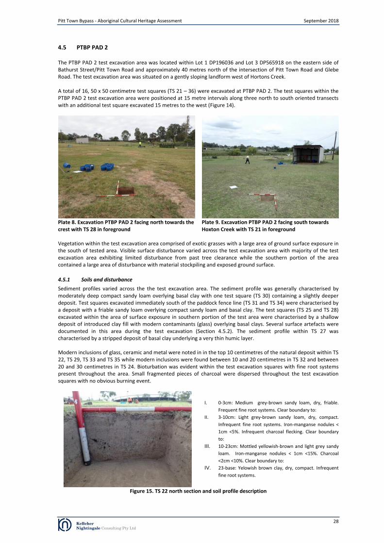
Pitt Town Bypass - Aboriginal Cultural Heritage Assessment September 2018
4.5 PTBP PAD 2
The PTBP PAD 2 test excavation area was located within Lot 1 DP196036 and Lot 3 DP565918 on the eastern side of Bathurst Street/Pitt Town Road and approximately 40 metres north of the intersection of Pitt Town Road and Glebe Road. The test excavation area was situated on a gently sloping landform west of Hortons Creek.
A total of 16, 50 x 50 centimetre test squares (TS 21 – 36) were excavated at PTBP PAD 2. The test squares within the PTBP PAD 2 test excavation area were positioned at 15 metre intervals along three north to south oriented transects with an additional test square excavated 15 metres to the west (Figure 14).
Plate 8. Excavation PTBP PAD 2 facing north towards the crest with TS 28 in foreground
Plate 9. Excavation PTBP PAD 2 facing south towards Hoxton Creek with TS 21 in foreground
Vegetation within the test excavation area comprised of exotic grasses with a large area of ground surface exposure in the south of tested area. Visible surface disturbance varied across the test excavation area with majority of the test excavation area exhibiting limited disturbance from past tree clearance while the southern portion of the area contained a large area of disturbance with material stockpiling and exposed ground surface.
4.5.1 Soils and disturbance
Sediment profiles varied across the the test excavation area. The sediment profile was generally characterised by moderately deep compact sandy loam overlying basal clay with one test square (TS 30) containing a slightly deeper deposit. Test squares excavated immediately south of the paddock fence line (TS 31 and TS 34) were characterised by a deposit with a friable sandy loam overlying compact sandy loam and basal clay. The test squares (TS 25 and TS 28) excavated within the area of surface exposure in southern portion of the test area were characterised by a shallow deposit of introduced clay fill with modern contaminants (glass) overlying basal clays. Several surface artefacts were documented in this area during the test excavation (Section 4.5.2). The sediment profile within TS 27 was characterised by a stripped deposit of basal clay underlying a very thin humic layer.
Modern inclusions of glass, ceramic and metal were noted in in the top 10 centimetres of the natural deposit within TS 22, TS 29, TS 33 and TS 35 while modern inclusions were found between 10 and 20 centimetres in TS 32 and between 20 and 30 centimetres in TS 24. Bioturbation was evident within the test excavation squares with fine root systems present throughout the area. Small fragmented pieces of charcoal were dispersed throughout the test excavation squares with no obvious burning event.
I. 0-3cm: Medium grey-brown sandy loam, dry, friable.
Frequent fine root systems. Clear boundary to:
II. 3-10cm: Light grey-brown sandy loam, dry, compact.
Infrequent fine root systems. Iron-manganse nodules <
1cm <5%. Infrequent charcoal flecking. Clear boundary
to:
III. 10-23cm: Mottled yellowish-brown and light grey sandy
loam. Iron-manganse nodules < 1cm <15%. Charcoal
<2cm <10%. Clear boundary to:
IV. 23-base: Yelowish brown clay, dry, compact. Infrequent
fine root systems.
Figure 15. TS 22 north section and soil profile description
28
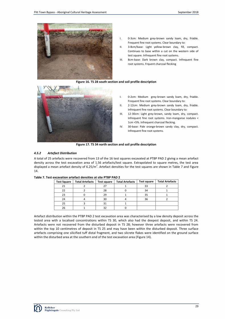
I. 0-3cm: Medium grey-brown sandy loam, dry, friable.
Frequent fine root systems. Clear boundary to:
II. 3-8cm/base: Light yellow-brown clay, fill, compact.
Continues to base within a cut on the western side of
test square. Infrequent fine root systems.
III. 8cm-base: Dark brown clay, compact. Infrequent fine
root systems. Frquent charcoal flecking
Figure 16. TS 28 south section and soil profile description
I. 0-2cm: Medium grey-brown sandy loam, dry, friable.
Frequent fine root systems. Clear boundary to:
II. 2-12cm: Medium grey-brown sandy loam, dry, friable.
Infrequent fine root systems. Clear boundary to:
III. 12-30cm: Light grey-brown, sandy loam, dry, compact.
Infrequent fine root systems. Iron-manganse nodules <
1cm <5%. Infrequent charcoal flecking.
IV. 30-base: Pale orange-brown sandy clay, dry, compact.
Infrequent fine root systems.
Figure 17. TS 34 north section and soil profile description
Pitt Town Bypass - Aboriginal Cultural Heritage Assessment September 2018
4.5.2 Artefact Distribution
A total of 25 artefacts were recovered from 13 of the 16 test squares excavated at PTBP PAD 2 giving a mean artefact density across the test excavation area of 1.56 artefacts/test square. Extrapolated to square metres, the test area displayed a mean artefact density of 6.25/m
2. Artefact densities for the test squares are shown in Table 7 and Figure
14.
Table 7. Test excavation artefact densities at site PTBP PAD 2 Test Square Total Artefacts Test square Total Artefacts Test square Total Artefacts
21 2 27 1 33 2
22 2 28 0 34 1
23 0 29 1 35 1
24 4 30 4 36 2
25 3 31 1
26 1 32 0
Artefact distribution within the PTBP PAD 2 test excavation area was characterised by a low density deposit across the tested area with a localised concentrations within TS 30, which also had the deepest deposit, and within TS 24. Artefacts were not recovered from the disturbed deposit in TS 28; however three artefacts were recovered from within the top 10 centimetres of deposit in TS 25 and may have been within the disturbed deposit. Three surface artefacts comprising one silicified tuff distal fragment, and two silcrete flakes were identified on the ground surface within the disturbed area at the southern end of the test excavation area (Figure 14).
29
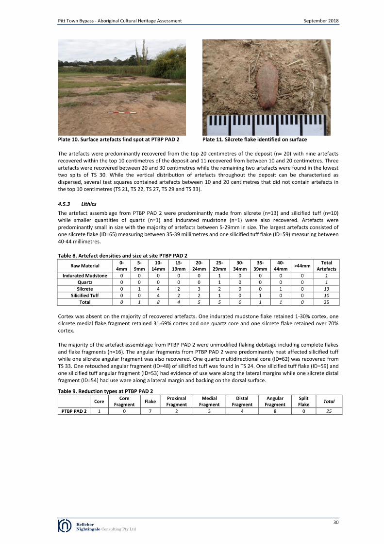
Plate 10. Surface artefacts find spot at PTBP PAD 2 Plate 11. Silcrete flake identified on surface
Pitt Town Bypass - Aboriginal Cultural Heritage Assessment September 2018
The artefacts were predominantly recovered from the top 20 centimetres of the deposit (n= 20) with nine artefacts recovered within the top 10 centimetres of the deposit and 11 recovered from between 10 and 20 centimetres. Three artefacts were recovered between 20 and 30 centimetres while the remaining two artefacts were found in the lowest two spits of TS 30. While the vertical distribution of artefacts throughout the deposit can be characterised as dispersed, several test squares contained artefacts between 10 and 20 centimetres that did not contain artefacts in the top 10 centimetres (TS 21, TS 22, TS 27, TS 29 and TS 33).
4.5.3 Lithics
The artefact assemblage from PTBP PAD 2 were predominantly made from silcrete (n=13) and silicified tuff (n=10) while smaller quantities of quartz (n=1) and indurated mudstone (n=1) were also recovered. Artefacts were predominantly small in size with the majority of artefacts between 5-29mm in size. The largest artefacts consisted of one silcrete flake (ID=65) measuring between 35-39 millimetres and one silicified tuff flake (ID=59) measuring between 40-44 millimetres.
Table 8. Artefact densities and size at site PTBP PAD 2
Raw Material 0-
4mm 5-
9mm 10-
14mm 15-
19mm 20-
24mm 25-
29mm 30-
34mm 35-
39mm 40-
44mm >44mm
Total Artefacts
Indurated Mudstone 0 0 0 0 0 1 0 0 0 0 1
Quartz 0 0 0 0 0 1 0 0 0 0 1
Silcrete 0 1 4 2 3 2 0 0 1 0 13
Silicified Tuff 0 0 4 2 2 1 0 1 0 0 10
Total 0 1 8 4 5 5 0 1 1 0 25
Cortex was absent on the majority of recovered artefacts. One indurated mudstone flake retained 1-30% cortex, one silcrete medial flake fragment retained 31-69% cortex and one quartz core and one silcrete flake retained over 70% cortex.
The majority of the artefact assemblage from PTBP PAD 2 were unmodified flaking debitage including complete flakes and flake fragments (n=16). The angular fragments from PTBP PAD 2 were predominantly heat affected silicified tuff while one silcrete angular fragment was also recovered. One quartz multidirectional core (ID=62) was recovered from TS 33. One retouched angular fragment (ID=48) of silicified tuff was found in TS 24. One silicified tuff flake (ID=59) and one silicified tuff angular fragment (ID=53) had evidence of use ware along the lateral margins while one silcrete distal fragment (ID=54) had use ware along a lateral margin and backing on the dorsal surface.
Table 9. Reduction types at PTBP PAD 2
Core Core
Fragment Flake
Proximal Fragment
Medial Fragment
Distal Fragment
Angular Fragment
Split Flake
Total
PTBP PAD 2 1 0 7 2 3 4 8 0 25
30
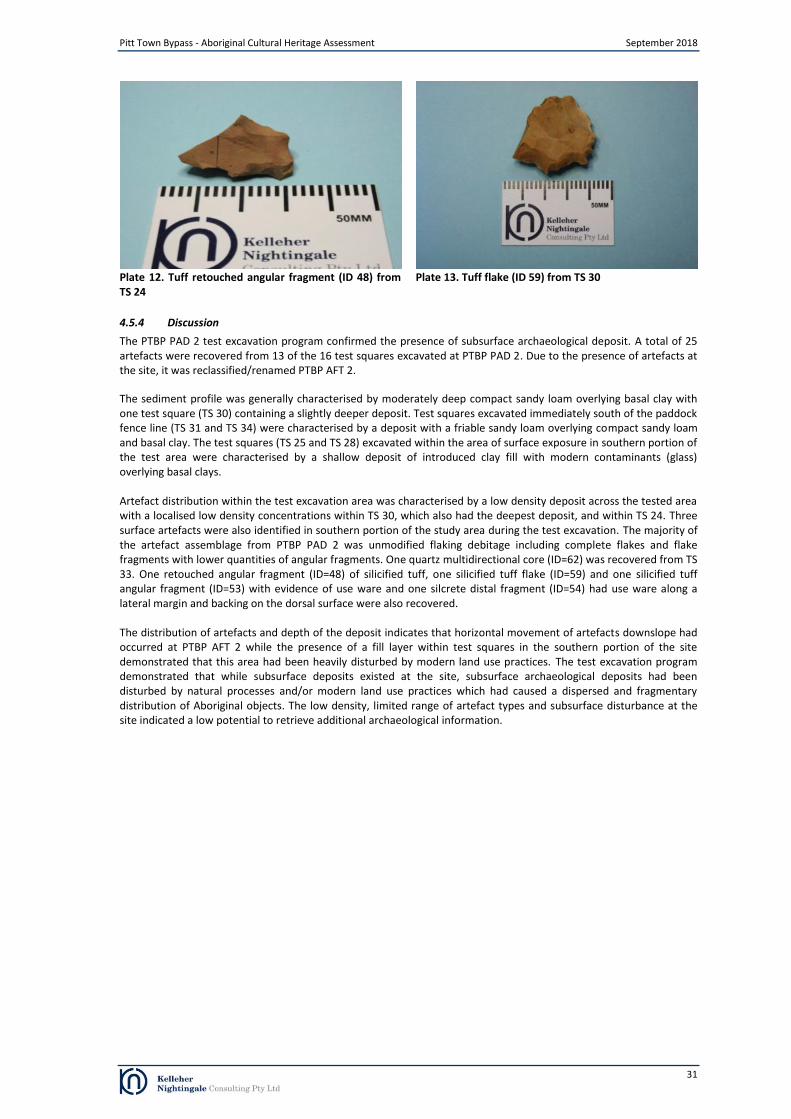
Plate 12. Tuff retouched angular fragment (ID 48) from Plate 13. Tuff flake (ID 59) from TS 30
TS 24
Pitt Town Bypass - Aboriginal Cultural Heritage Assessment September 2018
4.5.4 Discussion
The PTBP PAD 2 test excavation program confirmed the presence of subsurface archaeological deposit. A total of 25 artefacts were recovered from 13 of the 16 test squares excavated at PTBP PAD 2. Due to the presence of artefacts at the site, it was reclassified/renamed PTBP AFT 2. The sediment profile was generally characterised by moderately deep compact sandy loam overlying basal clay with one test square (TS 30) containing a slightly deeper deposit. Test squares excavated immediately south of the paddock fence line (TS 31 and TS 34) were characterised by a deposit with a friable sandy loam overlying compact sandy loam and basal clay. The test squares (TS 25 and TS 28) excavated within the area of surface exposure in southern portion of the test area were characterised by a shallow deposit of introduced clay fill with modern contaminants (glass) overlying basal clays. Artefact distribution within the test excavation area was characterised by a low density deposit across the tested area with a localised low density concentrations within TS 30, which also had the deepest deposit, and within TS 24. Three surface artefacts were also identified in southern portion of the study area during the test excavation. The majority of the artefact assemblage from PTBP PAD 2 was unmodified flaking debitage including complete flakes and flake fragments with lower quantities of angular fragments. One quartz multidirectional core (ID=62) was recovered from TS 33. One retouched angular fragment (ID=48) of silicified tuff, one silicified tuff flake (ID=59) and one silicified tuff angular fragment (ID=53) with evidence of use ware and one silcrete distal fragment (ID=54) had use ware along a lateral margin and backing on the dorsal surface were also recovered. The distribution of artefacts and depth of the deposit indicates that horizontal movement of artefacts downslope had occurred at PTBP AFT 2 while the presence of a fill layer within test squares in the southern portion of the site demonstrated that this area had been heavily disturbed by modern land use practices. The test excavation program demonstrated that while subsurface deposits existed at the site, subsurface archaeological deposits had been disturbed by natural processes and/or modern land use practices which had caused a dispersed and fragmentary distribution of Aboriginal objects. The low density, limited range of artefact types and subsurface disturbance at the site indicated a low potential to retrieve additional archaeological information.
31

Pitt Town Bypass - Aboriginal Cultural Heritage Assessment September 2018
Figure removed from public document
Figure 18. Archaeological test square locations and artefact density at PTBP PAD 3
32
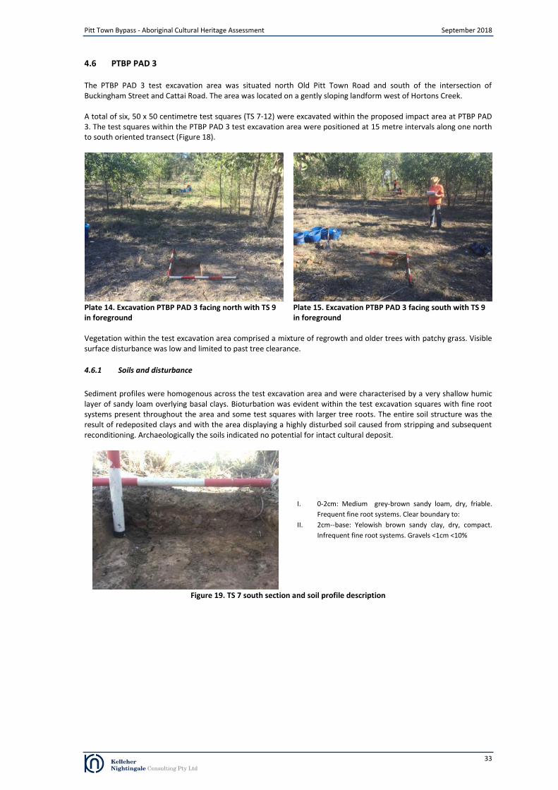
Pitt Town Bypass - Aboriginal Cultural Heritage Assessment September 2018
4.6 PTBP PAD 3
The PTBP PAD 3 test excavation area was situated north Old Pitt Town Road and south of the intersection of Buckingham Street and Cattai Road. The area was located on a gently sloping landform west of Hortons Creek.
A total of six, 50 x 50 centimetre test squares (TS 7-12) were excavated within the proposed impact area at PTBP PAD 3. The test squares within the PTBP PAD 3 test excavation area were positioned at 15 metre intervals along one north to south oriented transect (Figure 18).
Plate 14. Excavation PTBP PAD 3 facing north with TS 9 in foreground
Plate 15. Excavation PTBP PAD 3 facing south with TS 9 in foreground
Vegetation within the test excavation area comprised a mixture of regrowth and older trees with patchy grass. Visible surface disturbance was low and limited to past tree clearance.
4.6.1 Soils and disturbance
Sediment profiles were homogenous across the test excavation area and were characterised by a very shallow humic layer of sandy loam overlying basal clays. Bioturbation was evident within the test excavation squares with fine root systems present throughout the area and some test squares with larger tree roots. The entire soil structure was the result of redeposited clays and with the area displaying a highly disturbed soil caused from stripping and subsequent reconditioning. Archaeologically the soils indicated no potential for intact cultural deposit.
I. 0-2cm: Medium grey-brown sandy loam, dry, friable.
Frequent fine root systems. Clear boundary to:
II. 2cm--base: Yelowish brown sandy clay, dry, compact.
Infrequent fine root systems. Gravels <1cm <10%
Figure 19. TS 7 south section and soil profile description
33

I. 0-2cm: Medium grey-brown sandy loam, dry, friable.
Frequent fine root systems. Clear boundary to:
II. 3cm-base: Yelowish brown sandy clay, dry, compact.
Infrequent fine root systems. Gravels <1cm <10%
Figure 20. TS 12 east section and soil profile description
Pitt Town Bypass - Aboriginal Cultural Heritage Assessment September 2018
4.6.2 Discussion
No Aboriginal objects (artefacts) were recovered from the test excavation program at PTBP PAD 3. The test excavation program found that the soil profile had been almost entirely removed with only a very thin humic (recently reconditioned) deposit overlying natural clays. The soil profile was homogenous across the site indicating that the soils on the landform had been stripped through past land use practices and were not conductive to the preservation of Aboriginal archaeological deposits.
34

Pitt Town Bypass - Aboriginal Cultural Heritage Assessment September 2018
Figure removed from public document
Figure 21. Archaeological test square locations and artefact density at PTBP PAD 4
35

Pitt Town Bypass - Aboriginal Cultural Heritage Assessment September 2018
4.7 PTBP PAD 4
The PTBP PAD 4 test excavation area was located within Lot 1 DP107709 on the northern side of Glebe Road and approximately 80 metres east of the intersection of Pitt Town Road and Glebe Road. The test excavation area was situated on a gently sloping landform east of Hortons Creek.
A total of 19, 50 x 50 centimetre test squares (TS 18-19 and TS 54-70) were excavated at PTBP PAD 4. The test squares within the PTBP PAD 4 test excavation area were positioned at 15 metre intervals along four north to south oriented transects with an additional test square excavated 15 metres to the west (Figure 21).
Plate 16. Excavation PTBP PAD 4 facing north with TS 59 in foreground and Hoxton Creek left
Plate 17. Excavation PTBP PAD 4 facing south towards Hoxton Creek with TS 65 in foreground
Vegetation within the test excavation area comprised of exotic grasses and an isolated tree. Visible surface disturbance was low and limited to past tree clearance.
4.7.1 Soils and disturbance
Sediment profiles were generally homogenous across the test excavation area and were characterised by a medium depth deposit of sandy loam overlying basal clay which increased in depth towards Hoxton Creek (TS 59). Bioturbation was evident within the test excavation squares with fine root systems present throughout the area. Small fragmented pieces of charcoal were dispersed throughout the test excavation squares with no obvious burning event. Iron-manganese nodules were noted throughout the tested area and increased (grading) in density towards the interface between the sandy loam deposit and basal clay. The manganese structure indicated a change to the Lowlands Formation and a more integral Berkshire Park soil structure suggesting lower energy soil movements (despite some agricultural reworking on the upper spits)allowing greater artefact survivability.
I. 0-3cm: Medium grey-brown sandy loam, dry, friable.
Frequent fine root systems. Clear boundary to:
II. 3-20cm: Light grey-brown sandy loam, dry, compact.
Infrequent fine root systems. Iron-manganse nodules <
1cm <5%. Infrequent charcoal flecking. Clear boundary
to:
III. 10-25cm: Mottled yellowish-brown and light grey sandy
loam. Iron-manganse nodules < 2cm <10%. Charcoal
<1cm <10%. Clear boundary to:
IV. 25-base: Yelowish brown clay, dry, compact. Infrequent
fine root systems. Iron-manganse nodules < 5cm <15%.
Figure 22. TS 55 west section and soil profile description
36
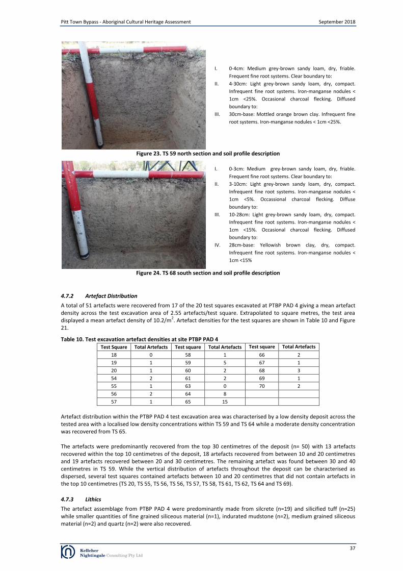
I. 0-4cm: Medium grey-brown sandy loam, dry, friable.
Frequent fine root systems. Clear boundary to:
II. 4-30cm: Light grey-brown sandy loam, dry, compact.
Infrequent fine root systems. Iron-manganse nodules <
1cm <25%. Occasional charcoal flecking. Diffused
boundary to:
III. 30cm-base: Mottled orange brown clay. Infrequent fine
root systems. Iron-manganse nodules < 1cm <25%.
Figure 23. TS 59 north section and soil profile description
I. 0-3cm: Medium grey-brown sandy loam, dry, friable.
Frequent fine root systems. Clear boundary to:
II. 3-10cm: Light grey-brown sandy loam, dry, compact.
Infrequent fine root systems. Iron-manganse nodules <
1cm <5%. Occassional charcoal flecking. Diffuse
boundary to:
III. 10-28cm: Light grey-brown sandy loam, dry, compact.
Infrequent fine root systems. Iron-manganse nodules <
1cm <15%. Occasional charcoal flecking. Diffused
boundary to:
IV. 28cm-base: Yellowish brown clay, dry, compact.
Infrequent fine root systems. Iron-manganse nodules <
1cm <15%
Figure 24. TS 68 south section and soil profile description
Pitt Town Bypass - Aboriginal Cultural Heritage Assessment September 2018
4.7.2 Artefact Distribution
A total of 51 artefacts were recovered from 17 of the 20 test squares excavated at PTBP PAD 4 giving a mean artefact density across the test excavation area of 2.55 artefacts/test square. Extrapolated to square metres, the test area displayed a mean artefact density of 10.2/m
2. Artefact densities for the test squares are shown in Table 10 and Figure
21.
Table 10. Test excavation artefact densities at site PTBP PAD 4 Test Square Total Artefacts Test square Total Artefacts Test square Total Artefacts
18 0 58 1 66 2
19 1 59 5 67 1
20 1 60 2 68 3
54 2 61 2 69 1
55 1 63 0 70 2
56 2 64 8
57 1 65 15
Artefact distribution within the PTBP PAD 4 test excavation area was characterised by a low density deposit across the tested area with a localised low density concentrations within TS 59 and TS 64 while a moderate density concentration was recovered from TS 65.
The artefacts were predominantly recovered from the top 30 centimetres of the deposit (n= 50) with 13 artefacts recovered within the top 10 centimetres of the deposit, 18 artefacts recovered from between 10 and 20 centimetres and 19 artefacts recovered between 20 and 30 centimetres. The remaining artefact was found between 30 and 40 centimetres in TS 59. While the vertical distribution of artefacts throughout the deposit can be characterised as dispersed, several test squares contained artefacts between 10 and 20 centimetres that did not contain artefacts in the top 10 centimetres (TS 20, TS 55, TS 56, TS 56, TS 57, TS 58, TS 61, TS 62, TS 64 and TS 69).
4.7.3 Lithics
The artefact assemblage from PTBP PAD 4 were predominantly made from silcrete (n=19) and silicified tuff (n=25) while smaller quantities of fine grained siliceous material (n=1), indurated mudstone (n=2), medium grained siliceous material (n=2) and quartz (n=2) were also recovered.
37
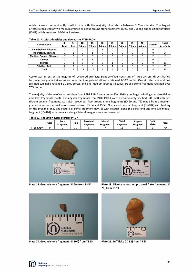
Pitt Town Bypass - Aboriginal Cultural Heritage Assessment September 2018
Artefacts were predominantly small in size with the majority of artefacts between 5-29mm in size. The largest artefacts consisted of two medium grained siliceous ground stone fragments (ID 69 and 75) and one silicified tuff flake (ID 82) which measured 60-64 millimetres.
Table 11. Artefact densities and size at site PTBP PAD 4
Raw Material 0-
4mm 5-
9mm 10-
14mm 15-
19mm 20-
24mm 25-
29mm 30-
34mm 35-
39mm 40-
44mm >44mm
Total Artefacts
Fine Grained Siliceous 0 0 0 0 1 0 0 0 0 0 1
Indurated Mudstone 0 1 0 1 0 0 0 0 0 0 2
Medium Grained Siliceous 0 0 0 0 0 0 0 0 0 2 2
Quartz 0 0 1 1 0 0 0 0 0 0 2
Silcrete 0 2 8 5 3 1 0 0 0 0 19
Silicified Tuff 2 3 9 3 3 1 2 0 0 2 25
Total 2 6 18 10 7 2 2 0 0 4 51
Cortex was absent on the majority of recovered artefacts. Eight artefacts consisting of three silcrete, three silicified tuff, one fine grained siliceous and one medium grained siliceous retained 1-30% cortex. One silcrete flake and one silicified tuff flake retained 31-69% cortex and one medium grained siliceous ground stone fragment retained over 70% cortex.
The majority of the artefact assemblage from PTBP PAD 4 were unmodified flaking debitage including complete flakes and flake fragments (n=38). The angular fragments from PTBP PAD 4 were predominantly silicified tuff (n=9) with two silcrete angular fragments was also recovered. Two ground stone fragments (ID 69 and 75) made from a medium grained siliceous material were recovered from TS 54 and TS 58. One silcrete medial fragment (ID=104) with backing on the proximal end, one silcrete proximal fragment (ID=76) with retouch along the distal end and one tuff medial fragment (ID=101) with use ware along a lateral margin were also recovered.
Table 12. Reduction types at PTBP PAD 4
Core Core
Fragment Flake
Proximal Fragment
Medial Fragment
Distal Fragment
Angular Fragment
Split Flake
Total
PTBP PAD 4 0 0 11 9 7 11 11 0 49
Plate 18. Ground stone fragment (ID 69) from TS 54 Plate 19. Silcrete retouched proximal flake fragment (ID
76) from TS 59
Plate 20. Ground stone fragment (ID 104) from TS 65 Plate 21. Tuff flake (ID 82) from TS 60
38
Pitt Town Bypass - Aboriginal Cultural Heritage Assessment September 2018
4.7.4 Discussion
The PTBP PAD 4 test excavation program confirmed the presence of subsurface archaeological deposit. A total of 51 artefacts were recovered from 17 of the 20 test squares excavated at PTBP PAD 4. Due to the presence of artefacts at the site, it was reclassified/renamed PTBP AFT 3.
Sediment profiles were generally homogenous across the test excavation area and were characterised by a medium depth deposit of sandy loam overlying basal clay which increased in depth towards Hoxton Creek (TS 59). The vertical grading of iron-manganese nodules extended across the tested area. The iron-manganese increased in density towards the interface between the sandy loam deposit and basal clay indicating that the area may be prone to waterlogging and may indicate that flooding events in this area did not scour the site but inundate the area with low energy standing water. Such inundation events may have assisted artefact survivability by placing blanket-like layers of soil on top of cultural events.
Artefact distribution was characterised by a low density deposit across the tested area with a localised low density concentrations within TS 59 and TS 64 while a moderate density concentration was recovered from TS 65. The concentration of artefacts around TS 65 indicates horizontal integrity of the site. The majority of the artefact assemblage was unmodified flaking debitage including complete flakes and flake fragments. Two ground stone fragments (ID 69 and 75) made from a medium grained siliceous material, one silcrete medial fragment (ID=104) with backing on the proximal end, one silcrete proximal fragment (ID=76) with retouch along the distal end and one tuff medial fragment (ID=101) with use ware along a lateral margin were also recovered.
The distribution of artefacts horizontally and vertically indicates that subsurface deposits at the site are relatively intact. A range of material and artefact types were found during the test excavation program indicating that the site has moderate potential to retrieve additional archaeological information.
39

Pitt Town Bypass - Aboriginal Cultural Heritage Assessment September 2018
5 Consultation Process
5.1 Aboriginal stakeholder consultation
Roads and Maritime is committed to effective consultation with Aboriginal communities regarding Roads and Maritime activities and their potential for impact on Aboriginal cultural heritage. The Roads and Maritime PACHCI was developed to provide a consistent means of effective consultation with Aboriginal communities regarding activities which may impact on Aboriginal cultural heritage and a consistent assessment process for Roads and Maritime activities across NSW.
The aim of consultation is to integrate cultural and archaeological knowledge and ensure registered Aboriginal parties have information to make decisions on Aboriginal cultural heritage. For the preparation of this CHAR, consultation with Aboriginal people has been undertaken in accordance with the OEH Aboriginal Cultural Heritage Consultation Requirements for Proponents 2010 (OEH 2010) and the requirements of Clause 80C of the National Parks and Wildlife Regulation 2009.
Roads and Maritime advertised in local media (Appendix A) and contacted potential Aboriginal stakeholders identified from government agency notification responses. Roads and Maritime invited Aboriginal people who hold knowledge relevant to determining the cultural heritage significance of Aboriginal objects and Aboriginal places in the area in which the proposed activity is to occur to register an interest in a process of community consultation. Investigations for the Pitt Town Bypass have included consultation with the 20 Aboriginal community groups and individuals as listed in Table 13 below.
Table 13. Registered Aboriginal parties
Registered Aboriginal party Representative and/or Contact Person
Deerubbin Local Aboriginal Land Council Kevin Cavanagh
Aboriginal Archaeological Service Andrew Williams
Amanda Hickey Cultural Services Amanda Hickey
Biamanga Seli Storer
Cullendulla Corey Smith
Darug Aboriginal Cultural Heritage Assessments Celestine Everingham
Darug Aboriginal Land Care Des Dyer
Darug Land Observations Anna O’Hara
Didge Ngunawal Clan Paul Boyd
DJMD Consultancy Darren Duncan
Goobah Developments Basil Smith
Gunjeewong Cultural Heritage Aboriginal Corporation Cherie Carroll
Kamilaroi Yankuntjatjara Working Group Phil Khan
Kawul Cultural Services Vicky Slater
Muragadi Heritage Indigenous Corporation Darleen Johnson
Murra Bidgee Mullangari Ryan Johnson
Murramarang Roxanne Smith
Tocomwall Danny Franks
Warrigal Cultural Services Aaron Slater
Widescope Indigenous Groups Steven Hickey
The formal consultation process has included:
advertising for registered Aboriginal parties (Appendix A);
government agency notification letters;
notification of closing date for registration;
40
Pitt Town Bypass - Aboriginal Cultural Heritage Assessment September 2018
provision of proposed assessment methodology (allowing 28 day review);
an Aboriginal Focus Group (AFG) meeting held to discuss assessment methodology (Appendix B);
ongoing compilation of registrants list, through continuing to register individuals and groups for consultation on the project;
provision of draft CHAR for review (allowing a minimum 28 day review) ;
a second AFG meeting held on 31 August 2018 to discuss investigation results, draft CHAR and detailed mitigation strategies (Appendix B);
ongoing consultation with the local Aboriginal community.
5.2 Provision of test excavation methodology and CHAR methodology
All registered stakeholders were provided with a copy of the proposed text excavation methodology and CHAR methodology as part of an information package. Stakeholders were requested to review the information and provide and comments or cultural information that may affect, inform or refine the methodology. Stakeholders were also invited to attend an AFG meeting during the review period to discuss the draft methodology. The AFG meeting was attended by representatives from Roads and Maritime, KNC and registered Aboriginal stakeholder groups and individuals. Meeting minutes are attached in Appendix C.
Kamilaroi Yankuntjatjara Working Group (KYWG) responded to the proposed text excavation methodology in the AFG and expressed concern for burial sites and the importance of preserving and respecting burial sites. KNC acknowledged KYWG’s concerns and confirmed that the test excavation program would be untaken with diligence in regards to burial sites.
5.3 Review of draft CHAR
The draft CHAR was provided to registered Aboriginal stakeholders for review and comment. All registered Aboriginal stakeholders were provided a minimum 28 day period for review. Stakeholders were also invited to attend an AFG meeting during the review period to discuss the draft CHAR. The AFG meeting was attended by representatives from Roads and Maritime, KNC and registered Aboriginal stakeholder groups and individuals. Meeting minutes are attached in Appendix C. Comments and information received from stakeholders during this period is attached in full in Appendix B.
Aboriginal Archaeological Service (AAS) stated that they agreed with the recommendations (Email dated 10/08/2018).
Darug Aboriginal Land Care (DALC) responded to the draft CHAR via email (dated 15/08/2018). DALC agreed with the recommendations and recommended that artefacts be reburied on site. It is KNC’s position that the long term management of recovered Aboriginal objects will comply with Requirement 26 “Stone artefact deposition and storage” in the Code of Practice for Archaeological Investigation of Aboriginal Objects in NSW. Recovered objects will be lodged with the Australian Museum in the first instance.
KYWG responded to the draft CHAR via letters (dated 10/08/2018 and 15/08/2018). KYWG stated that they support the recommendations in the draft CHAR. KYWG advised that the area is highly significant to Aboriginal people as they were camping areas over thousands of years and that there may be burial grounds in the area. No evidence of burial sites within the study area have been identified during the Aboriginal cultural heritage assessment.
41

Pitt Town Bypass - Aboriginal Cultural Heritage Assessment September 2018
6 Summary and Analysis of Background Information
Analysis of the background information presented in sections 2, 3 and 4 allows an assessment of the cultural heritage values within the proposal area to be made. Combining data from historical/ethnographic sources, Aboriginal community consultation, landscape evaluation and archaeological context provides an insight into how the landscape around the proposal area was used and what sort of events took place in the past. This section draws together a variety of information to bring further understanding to the cultural landscape of the proposal area.
Historical accounts from the early years of the colony documented Aboriginal people’s use of the local area. Archaeological evidence of past Aboriginal occupation and use of the landscape shows the types and preservation of archaeological sites in the vicinity of the study area are highly influenced by geology, soil landscapes and ground surface disturbance. Archaeological site types in the vicinity of the study area comprise open artefact scatters and isolated finds. The raw stone materials used to make the artefacts found at these sites is locally available from gravels within Hawkesbury River and in the vicinity of Longneck Lagoon.
Previous archaeological investigations at Hall Street, Pitt Town uncovered deep and stratified archaeological deposits with at least two separate phases of Aboriginal occupation. The artefact types and materials utilised during these phases differed as did the flaking technology employed. The more recent phase, which OSL dating from AHIMS site 45-5-3198 suggests began between 4-5 thousand years ago, was characterised by artefacts predominantly made from silcrete which included backed artefacts and cores used in the production of backed artefacts. The older phase, which OSL dating from AHIMS site 45-5-3198 suggests dated between 11-15 thousand years ago, was characterised by artefacts predominantly made from tuff and consisted of generally larger flakes that were produced utilising a simpler form of flaking technology where by the flakes were stuck from a core and occasionally further reduced as cores.
Archaeologically, open artefact scatters with stratigraphic integrity provide the most archaeological research potential. The geology and soil landscapes of the study area differ from sites excavated further west in Pitt Town, such as AHIMS site 45-5-3198. The alluvial soil landscapes of the study area are generally a dynamic landscape subject to areas of erosion and deposition from flooding events. Aboriginal sites within these areas are likely to be highly disturbed low-density scatters exposed by erosion and/or redeposited by flooding events; however, where low energy flooding events which deposit sediment without eroding the existing deposit occur, the preservation of in situ archaeological material is possible.
The study area and adjacent lands have been subject to archaeological investigations as part of the current proposal. An archaeological survey was undertaken as part of the PACHCI Stage 2 assessment and identified one surface artefact scatter with an associated area of potential archaeological deposit (PTBP 1 and PTBP 1 PAD) and four areas of potential archaeological deposit (PTBP PAD 1, PTBP PAD 2, PTBP PAD 3 and PTBP PAD 4) within the current study area. The areas of potential archaeological deposit were identified on elevated locations in the vicinity of Horton Creek where there was low visible subsurface disturbance.
An archaeological test excavation confirmed the presence of subsurface archaeological deposit at four of the five areas of potential archaeological deposit: PTBP 1, PTBP AFT 1 (formerly PTBP PAD 1), PTBP AFT 2 (formerly PTBP PAD 2) and PTBP AFT 3 (formerly PTBP PAD 4). No subsurface archaeological deposit was identified at PTBP PAD 3. Archaeological deposit at PTBP AFT 3 was found to be intact and exhibited moderate archaeological potential. The remaining two sites (PTBP 1, PTBP AFT 1 and PTBP AFT 2) exhibited high levels of subsurface disturbance and low archaeological potential.
6.1 Summary of known Aboriginal sites within the proposal area
Review of background information, Aboriginal community consultation and archaeological assessment has resulted in the identification of four Aboriginal archaeological sites of Aboriginal archaeological value containing Aboriginal objects within the proposal area (Table 14). The locations of these sites are shown on Figure 25.
Table 14. Identified Aboriginal archaeological sites within the proposal area
Site Name AHIMS ID Site Feature
PTBP 1 45-5-5150 Artefact
PTBP AFT 1 45-5-5148 Artefact
PTBP AFT 2 45-5-5149 Artefact
PTBP AFT 3 45-5-5147 Artefact
42
Pitt Town Bypass - Aboriginal Cultural Heritage Assessment September 2018
6.2 Aboriginal sites within the proposal area
Site name: PTBP 1 AHIMS site ID: 45-5-5150
Site PTBP 1 was an artefact scatter situated on a gently sloping landform west of Hortons Creek. The site was located on the southern side of Old Pitt Town Road within Lot 3 DP522823 and approximately 150 metres east of the intersection of Old Pitt Town Road and Cattai Road. The PACHCI Stage 2 survey identified a surface artefact scatter at the site that consisted of of 18 artefacts that were identified in seven clusters across a slope landform overlooking the junction of an unnamed tributary and Hortons Creek. The artefacts were predominantly flakes and flaked pieces made from silcrete, mudstone and quartz. One mudstone core was also identified.
An archaeological test excavation was undertaken at the site by KNC in May 2018. The program excavated six test squares within the proposed impact area. A total of three diagnostic artefacts and five non diagnostic angular fragments were recovered from two of the six test squares. As the raw materials are not present within the geology of the site, these items had been brought to the site. The large proportion of heat damaged artefacts, including diagnostic artefacts, indicates that these items were probably part of diagnostic artefacts which were damaged by fire.
Artefact distribution within the test excavation area was by localised very low density concentrations at TS 3 and TS 6. The presence of surface artefacts, very low density of subsurface artefacts and very shallow deposit indicate that the site had been disturbed possibly from past tree clearance activities and erosion which had deflated the deposit and exposed artefacts. The very low density, limited range of artefact types and very shallow deposit at the site indicated a low potential to retrieve additional archaeological information
Site name: PTBP AFT 1 AHIMS site ID: 45-5-5148
Site PTBP AFT 1 was an artefact scatter situated on a gently sloping landform west of Hortons Creek. The site was located within Lot 2 DP77487 and Lot 1 DP107709 north of Wellesley Street and east of Buckridge Street. The site was initially identified as an area of archaeological potential (PTBP PAD 1) during the PACHCI Stage 2 survey.
An archaeological test excavation was undertaken at the site by KNC in May 2018. The program excavated 22 test squares within the proposed impact area. A total of 18 diagnostic artefacts and 15 non diagnostic angular fragments were recovered from 13 of the 22 test squares. The artefact assemblage was characterised by a high proportion of angular fragments and heat affected items. The presence of diagnostic artefacts with heat damage indicated that the heating was not undertaken to prepare the material for flaking and that some of the heat damaged non diagnostic artefacts may have been part of diagnostic artefacts. Artefact distribution was characterised by a low density deposit in the north west and along the eastern boundary of the tested area. A localised concentration and highest artefact count came from TS 37 which was located adjacent to the north western boundary of the tested area. The test excavation program demonstrated that while subsurface deposits existed at the site, they had been disturbed by natural processes and/or modern land use practices which had caused a dispersed and fragmentary distribution of Aboriginal objects. The low density, limited range of artefact types, deflated soil profile and subsurface disturbance at the site indicated a low potential to retrieve additional archaeological information. Site name: PTBP AFT 2 AHIMS site ID: 45-5-5149 Site PTBP AFT 2 was an artefact scatter situated on a gently sloping landform west of Hortons Creek. The site was located within Lot 1 DP196036 and Lot 3 DP565918 on the eastern side of Bathurst Street/Pitt Town Road and approximately 40 metres north of the intersection of Pitt Town Road and Glebe Road. The site was initially identified as an area of archaeological potential (PTBP PAD 2) during the PACHCI Stage 2 survey. An archaeological test excavation was undertaken at the site by KNC in May 2018. The program excavated 16 test squares within the proposed impact area. A total of 25 artefacts were recovered from 13 of the 16 test squares. Artefact distribution was characterised by a low density deposit across the tested area with a localised low density concentrations within TS 30 and within TS 24. The distribution of artefacts and depth of the deposit indicates that horizontal movement of artefact downslope had occurred at PTBP AFT 2 while the presence of a fill layer within test squares in the southern portion of the site demonstrated that this area had been heavily disturbed by modern land use practices. The test excavation program demonstrated that while subsurface deposits existed at the site, subsurface archaeological deposits had been disturbed by natural processes and/or modern land use practices which had caused a dispersed and fragmentary distribution of Aboriginal objects. The low density and limited range of artefact types at the site indicated a low potential to retrieve additional archaeological information.
43

Pitt Town Bypass - Aboriginal Cultural Heritage Assessment September 2018
Site name: PTBP AFT 3 AHIMS site ID: 45-5-5147
Site PTBP AFT 3 was an artefact scatter situated on a gently sloping landform east of Hortons Creek. The site was located within Lot 1 DP107709 on the northern side of Glebe Road and approximately 80 metres east of the intersection of Pitt Town Road and Glebe Road. The site was initially identified as an area of archaeological potential (PTBP PAD 4) during the PACHCI Stage 2 survey.
An archaeological test excavation was undertaken at the site by KNC in May 2018. The program excavated 19 test squares within the proposed impact area. A total of 51 artefacts were recovered from 17 of the 20 test squares. Artefact distribution was characterised by a low density deposit across the tested area with a localised low density concentrations within TS 59 and TS 64 while a moderate density concentration was recovered from TS 65. The distribution of artefacts horizontally and vertically indicates that subsurface deposits at the site are relatively intact. The test excavation program demonstrated that an intact archaeological deposit was present at the site within the proposed impact area which contained a range of raw material and artefact types. Disturbance across the site was low and the site was assessed as having moderate archaeological potential.
44

Pitt Town Bypass - Aboriginal Cultural Heritage Assessment September 2018
Figure removed from public document
Figure 25. Identified Aboriginal archaeological sites within the study area
45

Pitt Town Bypass - Aboriginal Cultural Heritage Assessment September 2018
7 Cultural Heritage Va lues and Statement of Significance
7.1 Significance Assessment Criteria
One of the primary steps in the process of cultural heritage management is the assessment of significance. Not all sites are equally significant and not all are worthy of equal consideration and management (Sullivan and Bowdler 1984; Pearson and Sullivan 1995:7). The determination of significance can be a difficult process as the social and scientific context within which these decisions are made is subject to change (Sullivan and Bowdler 1984). This does not lessen the value of the heritage approach, but enriches both the process and the long term outcomes for future generations as the nature of what is conserved and why, also changes over time. The assessment of significance is a key step in the process of impact assessment for a proposed activity as the significance or value of an object, site or place will be reflected in resultant recommendations for conservation, management or mitigation. The Code of Practice for Archaeological Investigation of Aboriginal Objects in New South Wales (OEH 2010a) requires significance assessment according to criteria established in the Australia ICOMOS Burra Charter, 1999 (Australia ICOMOS 1999). The Burra Charter and its accompanying guidelines are considered best practice standard for cultural heritage management, specifically conservation, in Australia. Guidelines to the Burra Charter set out four criteria for the assessment of cultural significance:
• Aesthetic value - relates to the sense of the beauty of a place, object, site or item
• Historic value - relates to the association of a place, object, site or item with historical events, people, activities or periods
• Scientific value - scientific (or research) value relates to the importance of the data available for a place, object, site or item, based on its rarity, quality or representativeness, as well as on the degree to which the place (object, site or item) may contribute further substantial information
• Social value - relates to the qualities for which a place, object, site or item has become a focus of spiritual, political, national or other cultural sentiment to a group of people. In accordance with the OEH Guide to investigating, assessing and reporting on Aboriginal cultural heritage in NSW, the social or cultural value of a place (object, site or item) may be related to spiritual, traditional, historical or contemporary associations. According to OEH, “social or cultural value can only be identified though consultation with Aboriginal people” (OEH 2011:8).
There are four locations of recorded Aboriginal cultural heritage values within the study area. The significance assessment for the identified archaeological sites has focussed on the social/cultural, historic, scientific and aesthetic significance of Aboriginal heritage values as identified in The Burra Charter. Social Values This area of assessment concerns the value/s of a place, feature or site to a particular community group, in this case the local Aboriginal community. Aspects of social significance are relevant to sites, objects and landscapes that are important or have become important to the local Aboriginal community. This importance involves both traditional links with specific areas as well as an overall concern by Aboriginal people for sites generally and their continued protection. Aboriginal cultural significance may include social, spiritual, historic and archaeological values. It has been identified during the consultation process that the local area has cultural heritage value (social value) to the local Aboriginal community. Regarding Aboriginal sites identified within the study area, no specific cultural or social values expressed by these sites have been identified to date. Historic Values Historical research did not identify any information regarding specific historical significance of identified Aboriginal archaeological sites within the current study area. No specific historical significance for the sites within the study area provided by the registered Aboriginal stakeholders.
46

Pitt Town Bypass - Aboriginal Cultural Heritage Assessment September 2018
Scientific Values
Scientific values have been assessed for the identified Aboriginal archaeological sites in the proposal area. These values have been developed based on significance criteria of research potential (including integrity/condition, complexity and archaeological potential), representativeness and rarity. Identified archaeological sites in the study area displayed both moderate and low scientific significance.
Sites of low significance are those that do not offer archaeological research potential and are unlikely to provide any further scientifically valuable information. Sites with moderate significance are those that offer the potential to yield information that will contribute to our understanding of how the resources of the Hortons Creek and the wider Hawkesbury River floodplain were utilised by past Aboriginal people by providing information regarding site type interrelationships and occupation patterns, especially in relation to the identified environmental factors influencing site formation and preservation in the region (fluvial activity and other disturbance factors along the creek corridor).
Aesthetic Values
Aesthetic values are often closely related to the social values of a site or broader cultural landscape. Aspects may include scenic sights, smells and sounds, architectural fabric and creative aspects of a place.
The study area has no specific associated aesthetic values listed by registered Aboriginal community groups. Archaeologically, the study area does not contain these values.
47

Pitt Town Bypass - Aboriginal Cultural Heritage Assessment September 2018
7.2 Statements of Significance
The proposal area contains four identified Aboriginal archaeological sites as defined under the National Parks and Wildlife Act 1974. The four identified Aboriginal archaeological sites within the study area are:
PTBP 1 45-5-5150 PTBP AFT 1 45-5-5148 PTBP AFT 2 45-5-5149 PTBP AFT 3 45-5-5147
Based on the values assessment, the following levels of significance were ascribed to the four sites within the study area:
PTBP 1 Site PTBP 1 represents a commonly occurring type of site in the region, consisting of an open artefact scatter of very low density on a slope landform. The artefacts at the site are typical of the region in terms of type and raw material. The site has been subject to high levels of disturbance from modern land use practices. Low to nil potential exists at the site for intact deposit. The site demonstrates low scientific value and it is unlikely that further investigation could contribute to our understanding of Aboriginal landscape use in the region. Based on the intactness, representativeness and research potential of the site, PTBP 1 is determined to have low archaeological significance.
PTBP AFT 1 Site PTBP AFT 1 represents a commonly occurring type of site in the region, consisting of an open artefact scatter of very low density on a slope landform. The artefacts at the site are typical of the region in terms of type and raw material. The site has been subject to high levels of disturbance from modern land use practices. Low to nil potential exists at the site for intact deposit. The site demonstrates low scientific value and it is unlikely that further investigation could contribute to our understanding of Aboriginal landscape use in the region. Based on the intactness, representativeness and research potential of the site, PTBP AFT 1 is determined to have low archaeological significance.
PTBP AFT 2 Site PTBP AFT 2 represents a commonly occurring type of site in the region, consisting of an open artefact scatter of low density on a slope landform. The artefacts at the site are typical of the region in terms of type and raw material. The site has been subject to moderate to high levels of disturbance from modern land use practices. Low to nil potential exists at the site for intact deposit. The site demonstrates low scientific value and it is unlikely that further investigation could contribute to our understanding of Aboriginal landscape use in the region. Based on the intactness, representativeness and research potential of the site, PTBP AFT 2 is determined to have low archaeological significance.
PTBP AFT 3 Site PTBP AFT 3 represents a commonly occurring type of site in the region, consisting of an open artefact scatter of low density on a slope landform. The artefacts at the site are typical of the region in terms of type and raw material. The site displayed a relatively low level of disturbance and is located in an archaeologically significant location on raised landforms adjacent to Hortons Creek. The site demonstrates moderate scientific value and it is likely that further investigation could contribute to our understanding of past Aboriginal landscape use along Hortons Creek. Based on the intactness, representativeness and research potential of the site, PTBP AFT 3 is determined to have moderate archaeological significance.
48

8 The Pr oposed Activity and Impact Assessment
Pitt Town Bypass - Aboriginal Cultural Heritage Assessment September 2018
Roads and Maritime proposes to build the Pitt Town bypass to extend Pitt Town Road past Bathurst Street, where it currently deviates into the township, onto Cattai Road east of Eldon Street. Key features of the proposal include:
Extending Pitt Town Road past Bathurst Street onto Cattai Road, east of Eldon Street
Installing a new two lane roundabout at Eldon Street and Old Pitt Town Road
Closing a portion of Cattai Road to maintain access to Buckingham Street
Providing new crossing off Hortons Creek
Installing a new two lane roundabout at Pitt Town Road/Bathurst Street and Glebe Road. The study area encompasses both the construction and operational footprints allowing for space to construct the bypass, local road alterations and temporary ancillary facilities. The entirety of the study area would be impacted by construction and associated works. In total four Aboriginal archaeological sites would be impacted by the proposal. Proposed impacts to sites identified within the study area are detailed in Table 15 and shown in Figure 26. Table 15. Proposed impact to Aboriginal archaeological sites within the study area
Site Name AHIMS ID Description Significance Type / Degree
of Harm Consequence
of Harm
PTBP 1 45-5-5150 Low density surface artefact scatter located within a disturbed context
on a slope landform Low Direct / Partial
Partial loss of value
PTBP AFT 1 45-5-5148 Low density surface artefact scatter located within a disturbed context
on a slope landform Low Direct / Partial
Partial loss of value
PTBP AFT 2 45-5-5149 Low density surface artefact scatter located within a disturbed context
on a slope landform Low Direct / Partial
Partial loss of value
PTBP AFT 3 45-5-5147
Moderate density surface artefact scatter located within an area of low disturbance and good archaeological
potential.
Moderate Direct / Total Total loss of
value
49

Pitt Town Bypass - Aboriginal Cultural Heritage Assessment September 2018
Figure removed from public document
Figure 26. Study area (impact area) and Aboriginal heritage
50
Pitt Town Bypass - Aboriginal Cultural Heritage Assessment September 2018
9 Mitigating Harm
9.1 Ecologically Sustainable Development Principles
The assessment applied the principles of Ecologically Sustainable Development (ESD) to the current proposal. The principles of Ecologically Sustainable Development are defined in Section 6 of the NSW Protection of the Environment Administration Act 1991. The ESD principles relevant to Aboriginal cultural heritage within the proposal area are: the Precautionary Principle and the Principle of Inter-Generational Equity. The application of these principles in relation to the current proposal is discussed below.
The Precautionary Principle The Precautionary Principle states “that if there are threats of serious or irreversible environmental damage, lack of full scientific certainty should not be used as a reason for postponing measures to prevent environmental degradation”.
The identified Aboriginal archaeological sites have been considered by Roads and Maritime in relation to the proposed bypass and associated activities. A larger area was surveyed as part of the PACHCI Stage 2 assessment in order to provide options for Aboriginal archaeological site avoidance where possible. While conservation is the best approach when considering Aboriginal heritage, the avoidance of Aboriginal archaeological sites within the study area was not possible due to the requirements of the project and limited area in which it could occur.
The Aboriginal sites located within the study area have been impacted by past land use activities and would be further impacted by current land use practices. Scientific confidence has been achieved through archaeological investigations which have included test excavation and survey (Sections 3 and 4). Regarding Aboriginal cultural heritage value confidence, no specific cultural or social values expressed by these sites have been identified to date (Section 5). As detailed in Sections 6 and 7, the assessment has determined that the study area contains Aboriginal archaeological sites with a mix of low and moderate significance.
The Principle of Inter-Generational Equity The Principle of Inter-Generational Equity states “that the present generation should ensure that the health, diversity and productivity of the environment are maintained or enhanced for the benefit of future generations”.
The archaeological sites located within the proposal area were evaluated in relation to intergenerational equality and in particular, the cumulative impact of the proposal on the Aboriginal heritage of the region. As discussed in Section 3, previous archaeological investigations have identified the presence of artefact scatters in the region. While sites have subsequently been impacted by development, the several of the identified sites were located within areas that have not been impacted, such as Scheyville National Park.
51
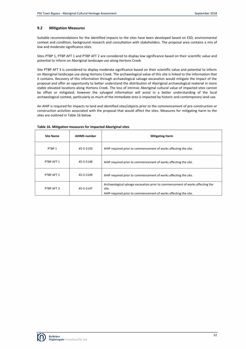
Pitt Town Bypass - Aboriginal Cultural Heritage Assessment September 2018
9.2 Mitigation Measures
Suitable recommendations for the identified impacts to the sites have been developed based on ESD, environmental context and condition, background research and consultation with stakeholders. The proposal area contains a mix of low and moderate significance sites.
Sites PTBP 1, PTBP AFT 1 and PTBP AFT 2 are considered to display low significance based on their scientific value and potential to inform on Aboriginal landscape use along Hortons Creek.
Site PTBP AFT 3 is considered to display moderate significance based on their scientific value and potential to inform on Aboriginal landscape use along Hortons Creek. The archaeological value of this site is linked to the information that it contains. Recovery of this information through archaeological salvage excavation would mitigate the impact of the proposal and offer an opportunity to better understand the distribution of Aboriginal archaeological material in more stable elevated locations along Hortons Creek. The loss of intrinsic Aboriginal cultural value of impacted sites cannot be offset or mitigated; however the salvaged information will assist in a better understanding of the local archaeological context, particularly as much of the immediate area is impacted by historic and contemporary land use.
An AHIP is required for impacts to land and identified sites/objects prior to the commencement of pre-construction or construction activities associated with the proposal that would affect the sites. Measures for mitigating harm to the sites are outlined in Table 16 below.
Table 16. Mitigation measures for impacted Aboriginal sites
Site Name AHIMS number Mitigating Harm
PTBP 1 45-5-5150 AHIP required prior to commencement of works affecting the site.
PTBP AFT 1 45-5-5148 AHIP required prior to commencement of works affecting the site.
PTBP AFT 2 45-5-5149 AHIP required prior to commencement of works affecting the site.
PTBP AFT 3 45-5-5147 Archaeological salvage excavation prior to commencement of works affecting the site.
AHIP required prior to commencement of works affecting the site.
52
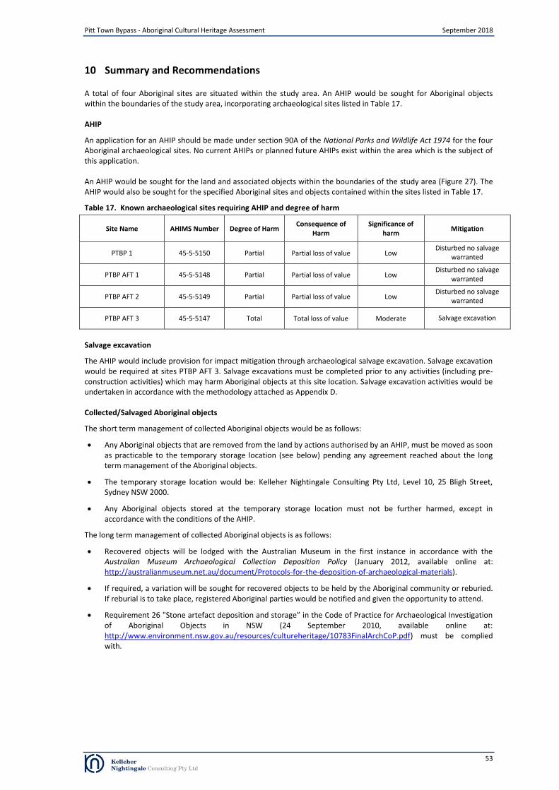
Pitt Town Bypass - Aboriginal Cultural Heritage Assessment September 2018
10 Summary and Recommendations
A total of four Aboriginal sites are situated within the study area. An AHIP would be sought for Aboriginal objects within the boundaries of the study area, incorporating archaeological sites listed in Table 17.
AHIP
An application for an AHIP should be made under section 90A of the National Parks and Wildlife Act 1974 for the four Aboriginal archaeological sites. No current AHIPs or planned future AHIPs exist within the area which is the subject of this application.
An AHIP would be sought for the land and associated objects within the boundaries of the study area (Figure 27). The AHIP would also be sought for the specified Aboriginal sites and objects contained within the sites listed in Table 17.
Table 17. Known archaeological sites requiring AHIP and degree of harm
Site Name AHIMS Number Degree of Harm Consequence of
Harm Significance of
harm Mitigation
PTBP 1 45-5-5150 Partial Partial loss of value Low Disturbed no salvage
warranted
PTBP AFT 1 45-5-5148 Partial Partial loss of value Low Disturbed no salvage
warranted
PTBP AFT 2 45-5-5149 Partial Partial loss of value Low Disturbed no salvage
warranted
PTBP AFT 3 45-5-5147 Total Total loss of value Moderate Salvage excavation
Salvage excavation
The AHIP would include provision for impact mitigation through archaeological salvage excavation. Salvage excavation would be required at sites PTBP AFT 3. Salvage excavations must be completed prior to any activities (including pre-construction activities) which may harm Aboriginal objects at this site location. Salvage excavation activities would be undertaken in accordance with the methodology attached as Appendix D. Collected/Salvaged Aboriginal objects
The short term management of collected Aboriginal objects would be as follows:
Any Aboriginal objects that are removed from the land by actions authorised by an AHIP, must be moved as soon as practicable to the temporary storage location (see below) pending any agreement reached about the long term management of the Aboriginal objects.
The temporary storage location would be: Kelleher Nightingale Consulting Pty Ltd, Level 10, 25 Bligh Street, Sydney NSW 2000.
Any Aboriginal objects stored at the temporary storage location must not be further harmed, except in accordance with the conditions of the AHIP.
The long term management of collected Aboriginal objects is as follows:
Recovered objects will be lodged with the Australian Museum in the first instance in accordance with the Australian Museum Archaeological Collection Deposition Policy (January 2012, available online at: http://australianmuseum.net.au/document/Protocols-for-the-deposition-of-archaeological-materials).
If required, a variation will be sought for recovered objects to be held by the Aboriginal community or reburied. If reburial is to take place, registered Aboriginal parties would be notified and given the opportunity to attend.
Requirement 26 "Stone artefact deposition and storage” in the Code of Practice for Archaeological Investigation of Aboriginal Objects in NSW (24 September 2010, available online at: http://www.environment.nsw.gov.au/resources/cultureheritage/10783FinalArchCoP.pdf) must be complied with.
53
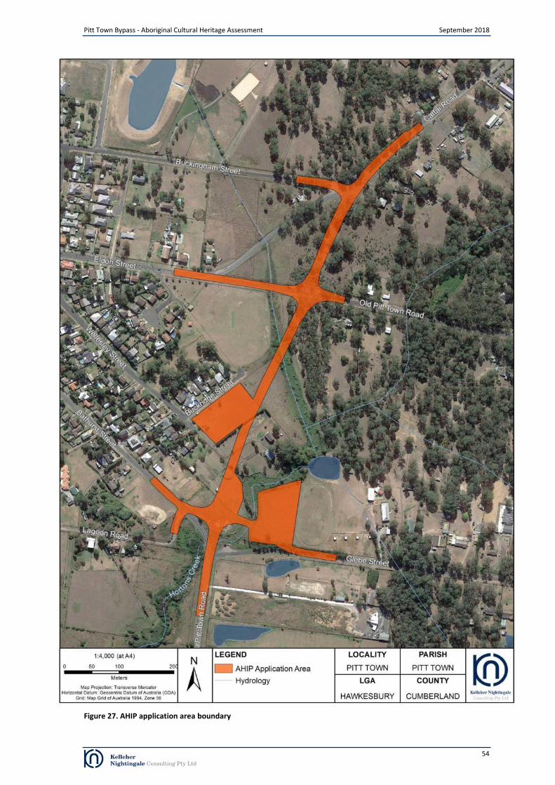
Figure 27. AHIP application area boundary
Pitt Town Bypass - Aboriginal Cultural Heritage Assessment September 2018
54

Pitt Town Bypass - Aboriginal Cultural Heritage Assessment September 2018
Glossary of Terms
Aboriginal Object Any deposit, object or material evidence (not being a handicraft made for sale) relating to (as defined in the NPW the Aboriginal habitation of the area that comprises NSW, being habitation before or Act) concurrent with (or both) the occupation of that area by persons of non-Aboriginal
extraction, and includes Aboriginal remains.
Aboriginal Place A place declared under s.84 of the NPW Act that, in the opinion of the (as defined in the NPW Minister, is or was of special significance to Aboriginal culture. Act) Anvil An object used as a stable base for producing stone artefacts. This will have percussion
pitting from the impact of reducing an anvil rested core.
Artefact Any object that has been physically modified by humans or that is unmodified but is out
of its natural context and considered to have been brought to the location by humans (a
manuport).
Attribute A physical characteristic of an artefact
Backed Artefact A tool made from a flake or flake fragment, with steep blunting retouch along one or
opposite margin after the flake was removed from the core. Includes geometric microliths
of various shapes and asymmetric Bondi points.
Backed Broken Fragments of backed or partly backed flakes. Breakage often occurred during
manufacture.
Backing Debitage Small retouching flakes produced from the backing process using an anvil rested
technique along its thick margin. May have bidirectional scars or a small distal cone from
rebounding off an anvil.
Bipolar Core A core reduced using the bipolar technique, being placed on an anvil and struck with a
hammer stone.
Bipolar Flake A flake with proximal and distal crushing produced by bipolar flaking technique. These
may have a flattened ventral surface/bulb of percussion. Some flakes may only have
crushing/step fractures at proximal end, having been removed before reaching the base
of the core.
Bondi Point An asymmetrical backed artefact which is widest at the proximal end and pointed at the
distal end. The length of a Bondi point is generally over twice the artefact width.
Bulb of Percussion An attribute on the ventral surface of a flake during the detachment of the flake from a
core by the movement of force from a blow applied to a single point. The bulb of
percussion is characteristically a bulge which occurs just below the point of force
application.
Bulbar (Éraillure) Scar A scar on the ventral surface of a flake which sometimes occurs during the removal of the
flake from a core by the force of percussion.
Chert A fine rock of sedimentary origin, made up mostly of microcrystalline quartz, but
sometimes with a chalcedony or opal component. Chalcedony is a microporous mass of
silica. Includes banded varieties.
Cobble An edge rounded stone more than 6.4 centimeters in size. e.g. core blank, hatchet blank,
or hammer stone.
Colour Recorded with particular reference to silcrete to determine if artefacts were heat altered
material versus unheated stone.
Conchoidal Exhibiting the characteristics of direct percussion such as a bulb of percussion or ripple
marks
Cone-Split Broken Flake A flake broken longitudinally through its point of force application (pfa) /cone. Retains
some of the striking platform and point of impact. These are recorded as left or right half
of the flake when viewing its ventral surface CSBF/Left, or CSBF/Right.
Conjoin Two or more stone artefacts which are part of a knapping event that can be refitted to
each other.
Core Any stone used as a nucleus or blank for removing flakes large enough for use as
implements. These must have negative flakes scars, although large retouched flakes used
as cores may still retain a remnant ventral surface. Subsequent use as a core must
intercept the old ventral surface. A core may be made on a cobble, pebble, flake, broken
flake, flake fragment, heat shatter or naturally fragmented rock.
Core Flaking Pattern The pattern of negative flake scars on cores, used to determine stone reduction
strategies. Sometimes a core may have evidence of more than one flaking pattern. These
55

Pitt Town Bypass - Aboriginal Cultural Heritage Assessment September 2018
include:
Unifacial – scars show that useable flakes have been removed one edge at a
time in one direction. Sometimes reduction continued in this way after the core
was rotated. Flakes should have a flat unmodified platform.
Bifacial – scars show that larger potentially useable flakes were struck off both
opposing faces of an edge. Core edges often appear ‘wavy’ when viewed in
plan.
Asymmetric alternating – tiny preparation flakes are first removed off the core
platform, then larger useable flakes struck off the opposing face. The
preparation scars can be seen on flakes with faceted platforms, and are
sometimes still present on abandoned cores or core fragments.
Bipolar – small negative step scars or crushing at opposing ends of a core, from
it being rested on an anvil and struck with a hammer stone. There may also be a
tiny distal cone on flakes, from the force rebounding off the anvil.
Core Fragment Broken off a core, and still retaining technological attributes such as negative flake scars
or core platform.
Core Tool A core that also has evidence of tool use on its margins or ridges such as striations, edge
rounding or polish.
Cortex The natural outer weathering rind or surface of rock. This may be remnant on the dorsal
surfaces of an artifact, and is recorded as a percentage of the dorsal surface area.
Crazing The surface of a heat affected rock which resembles cracked ceramic.
Crenate Fracture (CF) Debitage with crenate fracture. This could be from heat shatter but may be from chemical
weathering, particularly in chert or tuff artefacts
Culturally Modified Tree A tree that, before or concurrent with (or both) the occupation of the area in which the (as defined in the NPW tree is located by persons of non-Aboriginal extraction, has been scarred, carved or Regulation) modified by an Aboriginal person by:
The deliberate removal, by traditional methods, of bark or wood from the tree,
or
The deliberate modification, by traditional methods, of the wood of the tree.
Debitage Material from the stone knapping process with no signs of subsequent modification.
Distal End The termination of a flake opposite the bulb of percussion or point of applied force.
Distal Flake Fragment A fragment of a flake that has been broken but distal termination (also termed distal
fragment or distal flake). It does not have a distal termination.
Dorsal The outside or back of a flake when removed from a core. The dorsal surface may have
negative flake scars from previous flake removals and/or cortex
Fine Grained Siliceous Fine grained siliceous rocks which could not be positively identified without detailed (FGS) mineralogical investigation.
Flake A stone artefact that has been removed from a core. A flake has a proximal striking
platform, point of force application (pfa), bulb of percussion and distal termination. Also
may have a bulbar (éraillure) scar, ripple marks and fracture lines
Flaked Piece An artefact that has evidence of flaking but no characteristics of a flake, broken flake,
flake fragment, retouched flake or core can be discerned. Also referred to as an angular
fragment.
Geometric Microlith A type of backed artefact which is symmetrical in shape. They are often made from flakes
with backing along truncated proximal and or distal ends.
Grinding Grooves Oval shaped indentations on rock surfaces, such as sandstone outcrops which occurred as
the result of the shaping and sharpening of ground stone artefacts.
Grindstone A portable stone with linear striations and/or polish which shows that it has ground.
Often made from fine grained sandstone or quartzite. May retain evidence of
multipurpose use such as grinding of seeds, ochre.
Ground Stone Artefact A stone artefact with an edge or surface that had been modified by grinding on another
piece of stone. See Grindstone and Hatchet
Hammer stone A stone used to strike a core for removal of flakes. Often spherical pebbles or cobbles
with evidence of percussion pitting or spall scars on ends or margins.
Hatchet An ground edged hatchet head or fragment. Should have evidence of intentional grinding
e.g. linear striations/polish from shaping or resharpening the cutting edge. Hatchets were
multipurpose tools and may also have evidence of hammer percussion or anvil use.
56

Pitt Town Bypass - Aboriginal Cultural Heritage Assessment September 2018
Heat Shatter (HS) Debitage caused by heat shatter. May have evidence of pot lidding from excessive heat Debitage stress and/or irregular heat fractured surfaces.
Hornfels A medium to fine grained metamorphic rock. Includes a variety known as spotted pelitic
hornfels with tiny dark clasts or grains.
Igneous A range of rocks of mixed mineral composition formed after cooling of molten
subterranean materials. Occur as intrusions into older rocks such as dykes, diatremes, or
spread onto the land surface from volcanic activity. Includes varieties such as basalt,
dolerite.
Knapping Floor An area where a core was flaked/knapped to produce flakes and tools.
Length A measurement of the distance between the platform and the termination of a flake.
Lustre A subjective record of lustre of stone artefact, also relating to heat treatment.
Manuport An unmodified piece of stone out of natural context and considered to have been brought
to the site by humans.
Medial Flake Fragment A fragment of the mid-section of a flake with no platform or termination. (Med Frag) Medium Grained A medium grained Siliceous rock of unknown type.
Midden Also called shell midden. An area with the remains of edible shellfish which were
discarded as the result of human procurement/consumption. May included fish and
animal bones, stone artefacts and/or charcoal.
Mortar A large base stone for grinding/pounding.
Modification/Activity Refers to the activity associated with the lithic item e.g. debitage or waste from stone Type flaking, used as a hammer, anvil, core, bipolar core, retouched artefact, backed artefact.
Pebble An edge rounded stone less than 6.4 centimetres in size. May have been used as core or
small hammer stone.
Petrified Wood Also called silicified or fossilized wood. Formed when trees were fossilized and their
structure replaced by silica. Wood structure and growth rings are still visible as ‘bands’
within this material.
Platform Type Records the type of platform on whole flakes or proximal flake fragments for information
on flaking patterns and reduction strategies. These include:
Cortical – platform covered in cortex. Unifacial flaking.
Plain – platform is smooth flat surface. Unifacial flaking or unifacial with core
rotation.
Ridged – platform has ridge from previous flake removal across core. Unifacial
rotated or symmetric alternating (bifacial) flaking.
Scarred – platform has one or more flake scars. Symmetric alternating (bifacial)
flaking or asymmetric alternating flaking. May indicate platform preparation.
Faceted – platform has multiple tiny flake scars struck from the dorsal. Indicates
careful platform preparation. Asymmetric alternating flaking.
Focal – small platform less than twice the area of ring crack.
Crushed - platform has been crushed from force of flake removal but the rest of
the flake is otherwise intact. The platform may have multiple step fractures.
Bipolar or unifacial.
Indeterminate – platform is flawed, irregular, or partly collapsed with the
remainder of the flake intact.
Potential Archaeological An area where no surface archaeological remains are present that has been assessed as Deposit (PAD) having the potential to contain subsurface archaeological deposits on the basis of
indicators which may include landform, distance to water and visible surface disturbance.
Proximal End The striking end of a flake opposite the distal end or termination.
Proximal Flake Fragment A fragment of a flake that has been broken but retains its proximal striking platform (also (Prox Frag) termed proximal fragment or proximal flake). It does not have a distal termination.
Quality A record of the flaking quality of the stone. This is a subjective measurement based on
how well the material flakes and the presence of flaws. Poor quality material may have
large grains or internal flaws which may inhibit controlled reduction of the material.
Certain fine grained material lacking in flaws or inclusions may have been preferred for its
good flaking properties and selected for particular tasks or implement types e.g. precision
cutting/slicing.
Quartz A hexagonal crystalline form of silicon dioxide (SiO2). May occur as clear, white or
57
Pitt Town Bypass - Aboriginal Cultural Heritage Assessment September 2018
coloured from mineral impurities. Can occur as single crystals, veins or geodes. Often has
internal fractures or flaws.
Quartzite Sandstone that had been metamorphosed by volcanic activity or recemented with silica in
solution.
Raw Material The type of stone out of which the artefacts have been made. See Chert, Silcrete and
Quartz
Reduction Type Refers to the technological aspects of reducing stone. For definitions on fracture
mechanics and flake characteristics refer to work by Cotterell and Kamminga (1987) and
Holdaway and Stern (2004). For non-debitage items it is used to describe the form of that
item before it was modified or fractured e.g. a large flake may have been reflaked and
used as a core to produce further useable flakes.
Retouched Artefact A stone artefact with negative flake scars along its margins from intentional retouch after
it was removed from the core. More recent scars show that the flakes removed were too
small to have been used as tools. It could not always be determined whether these were
intended for use as tools or were for core preparation.
Shape Recorded for whole flakes and includes the following:
Wider than long (W>L)
Longer than wide (L>W)
Length equals width (L=W)
Elongate - length more than twice the width.
Silcrete An indurated rock comprised of quartz grains cemented in a siliceous matrix.
Silicified Tuff Also variously termed indurated mudstone, tuff or ryolitic tuff. A fine grained rock of
volcanic ash or other fine sediments metamorphosed and consolidated with silica.
Sometimes distinguished from chert by having a lack of lustre (Corkill 1999:45), although
heat treatment may result in lustrous flaked surfaces (Flenniken & White 1983:43).
Site An area where Aboriginal objects have been identified.
Size The maximum or longest dimension of each item was recorded, and entered as individual
size classes of 5 milimetres (0-4mm, 5-9mm, 10-14mm, 15-19mm etc.).
Termination Records the type of termination on whole flakes or distal flake fragments. Termination
variation depends on the amount of force used, nature of the raw material and core
morphology. These include:
Feather – A distal end which has a gradual thinning towards the termination
Hinge – A rounded termination
Plunging – A distal end containing the bottom surface of the core it was
removed from
Step – A squared off termination
Thickness A measurement of the distance between the dorsal and ventral faces of a flake at point
where length and width measurements meet.
Tool A stone artefact which has been modified into a formal type or used (expedient tool).
Usewear An artefact with evidence of use such as striations, rounding or tiny edge fracture scars
Ventral Surface The face of a flake which can be joined back to the core the flake was removed from. The
ventral surface of a flake may exhibit the bulb of percussion, the ringcrack, ripple marks or
fissures
Weight Weight for each artefact was recorded using an electronic balance to the nearest 0.1g.
Width A measurement at right angles to the length measurement of a flake, at the midpoint of
the length
58

Pitt Town Bypass - Aboriginal Cultural Heritage Assessment September 2018
References
Archaeological & Heritage Management Solutions (AHMS). 2005. Lots 11 – 18 (DP1021340) Hall Street, Pitt Town NSW: Aboriginal Archaeological Survey and Assessment. Report on behalf of Johnson Property Group.
AHMS. 2010. Bona Vista, Pitt Town, NSW – Section 90 #2720 AHIP Excavation Report. Report for Johnson Property Group
Australia ICOMOS, 2013. The Burra Charter: The Australia ICOMOS Charter for Places of Cultural Significance 2013. Australia ICOMOS Incorporated 2013. Burwood, Victoria.
Attenbrow, V., 2002. Sydney’s Aboriginal Past: Investigating the Archaeological and Historical Records. University of New South Wales Press, Sydney.
Australia ICOMOS (1999). The Burra Charter: The Australia ICOMOS Charter for Places of Cultural Significance 1999. Australia ICOMOS Incorporated. Burwood, Victoria.
Bannerman, S.M., Hazelton, P.A. and Tille, P.J., 1990. Penrith 1:100,000 Soil Landscape Series Sheet 9030. Soil Conservation Service of NSW, Sydney.
Brook, J. and Kohen, J.L., 1991. The Parramatta Native Institution and the Black Town: A History. New South Wales University Press, Kensington.
Clark, N.R. and Jones, D.C., (Eds) 1991. Penrith 1:100,000 Geological Sheet 9030. New South Wales Geological Survey, Sydney
Dallas, M., and Navin, K., 1990. Archaeological study of the Scheyville Development Area at Scheyville, NSW. Report to Hawkesbury City Council.
Jo McDonald Cultural Heritage Management Pty Ltd (JMCHM). 1998. Archaeological Survey of Two Land Parcels, Bona Vista and Fernadell, at Pitt Town, NSW. Report to Don Fox Planning on behalf of Bona Vista and Fernadell Pty Ltd.
Kohen, J.L., 1986. Prehistoric Settlement in the Western Cumberland Plain: Resources, Environment and Technology. PhD Thesis, School of Earth Sciences, Macquarie University, Sydney.
Long, A. 2005. Aboriginal Scarred Trees in New South Wales: A Field Manual. Department of Environment and Conservation (NSW), Hurstville.
Navin Officer Heritage Consultants Pty Ltd (Navin Officer). 2004. Residential Development Fernadell and Bona Vista Pitt Town, NSW: Archaeological Subsurface Testing Program. A Report to Jillian Comber
NSW National Parks and Wildlife Service, 2002. Interpretation Guidelines for the Native Vegetation Maps of the Cumberland Plain, Western Sydney. Final Edition. NSW NPWS, Hurstville NSW.
Office of Environment and Heritage (OEH), 2010. Code of Practice for Archaeological Investigation of Aboriginal Objects in New South Wales: Part 6 National Parks and Wildlife Act 1974. Department of Environment, Climate Change and Water NSW, Sydney.
OEH, 2010b. Aboriginal Cultural Heritage Consultation Requirements for Proponents 2010: Part 6 National Parks and Wildlife Act 1974. Department of Environment, Climate Change and Water NSW, Sydney.
OEH, 2011. Guide to investigating, assessing and reporting on Aboriginal cultural heritage in NSW: Part 6 National Parks and Wildlife Act 1974. Office of Environment and Heritage, Department of Premier and Cabinet, Sydney South.
Pearson, M. and Sullivan, S. 1995. Looking After Heritage Places: The Basics of Heritage Planning for Managers, Landowners and Administrators Melbourne University Press.
Roads and Maritime Services (Roads and Maritime), November 2011. Procedure for Aboriginal cultural heritage consultation and investigation.
Smith, L. 1988. Interim report: Site survey and site analysis on the northern Cumberland Plain. Report prepared for the NSW National Parks and Wildlife Service.
Tench, W., 1793. Complete Account of the Settlement at Port Jackson. G. Nicol and J. Sewell, London.
59

Pitt Town Bypass - Aboriginal Cultural Heritage Assessment September 2018
Williams, A.N., Mitchell, P., Wright, R.V.S., and P.S. Toms (Williams et al.). 2012. A Terminal Pleistocene Open Site on the Hawkesbury River, Pitt Town, New South Wales. Australian Archaeology 74. pp 85-97
60

Appendix A Advertisement for registration of interest
Appeared in: Koori Mail, Wednesday 13 December 2018 Hawkesbury Courier, Thursday 14 December 2018 Hawkesbury Gazette, Wednesday 13 December 2018 National Indigenous Times, Monday 11 December 2018
Pitt Town Bypass - Aboriginal Cultural Heritage Assessment September 2018
61

Pitt Town Bypass - Aboriginal Cultural Heritage Assessment September 2018
Appendix B Aboriginal Focus Group Meeting Minutes
62

Pitt Town Bypass - Aboriginal Cultural Heritage Assessment September 2018
63

Pitt Town Bypass - Aboriginal Cultural Heritage Assessment September 2018
64

Pitt Town Bypass - Aboriginal Cultural Heritage Assessment September 2018
Appendix C Aboriginal Stakeholder Comments
65

Pitt Town Bypass - Aboriginal Cultural Heritage Assessment September 2018
66
Pitt Town Bypass - Aboriginal Cultural Heritage Assessment September 2018
67

Pitt Town Bypass - Aboriginal Cultural Heritage Assessment September 2018
68

Pitt Town Bypass - Aboriginal Cultural Heritage Assessment September 2018
69

Pitt Town Bypass - Aboriginal Cultural Heritage Assessment September 2018
70

Methodology Research Aims The main aims of the proposed salvage excavation program are:
To salvage a representative sample of identified archaeological site PTBP AFT 3 prior to impact.
To analyse the salvaged archaeological material to gain and conserve knowledge and understanding of the scientific and cultural information exhibited by the activities associated with landforms along the Hortons Creek.
To use the excavation results to gain insight into the subsurface archaeology of the adjacent areas not being impacted by the proposal. This would increase future educational opportunities and allow more informed management of Aboriginal heritage.
The further scientific aim of the salvage excavation program would be to determine the subsurface integrity, extent, spatial distribution and nature of the cultural deposit and the specific types of associated archaeological/cultural activities.
Determining the integrity of the deposit involves assessing the degree of disturbance which is present.
Determining the statistical extent of the sites and/or activity areas involves identifying the boundaries associated with the identified archaeological deposit.
Assessing the spatial distribution involves identifying the presence/absence of archaeological material across the identified archaeological site.
The nature of the site refers to the type of activities indicated by the artefactual material (e.g. primary production, domestic knapping, hunting camps). The goal would be to retrieve entire assemblages from specific activities if such activities were present.
Retrieved assemblages would be compared with the results from other relevant archaeological projects in order to assess significance.
Research Questions The results of the proposed salvage excavation would increase our understanding of subsurface archaeology of the study area. In particular, research would focus on addressing questions about the survivability of archaeological deposit. Understanding how environmental processes have impacted archaeological deposits and how these impacts effect our ability to analyse salvaged archaeological material will assists the planning process and potentially increases conservation outcomes.
Question 1: What are the taphonomic features of archaeological site PTBP AFT 3? What do these features indicate about site integrity and artefact survivability for similar landforms along the Hortons Creek? What is the effect of land use and natural processes on the preservation of this Aboriginal archaeological site and does this have implications for our ability to analyse the salvaged archaeological material.
What can we expect? It is anticipated that stone tools will be recovered from the sites. The differences in stone tool assemblages may be related to different cultural activities (e.g. primary reduction vs maintenance flaking). The science of archaeology is paramount to any research question and it is important to stress that the goal for the salvage program for all excavated sites is straight forward: to retrieve a viable sample for comparative analysis using established techniques (see Field Methods below). In this regard interpretation would not precede data collection. The proposed archaeological program would systematically sample the relevant area using standard techniques with the outcome being a viable, robust and comparable sample. Analysis of the sample would follow and interpretations would be made distinctly separate from the results.
Question 2: Where intact archaeological deposit exists, what cultural activities are archaeologically identifiable at the site? Do the identified cultural activities differ from sites excavated near the Hawkesbury River?
Pitt Town Bypass - Aboriginal Cultural Heritage Assessment September 2018
Appendix D Salvage Excavation Methodology
71
Pitt Town Bypass - Aboriginal Cultural Heritage Assessment September 2018
Archaeological Salvage Areas Salvage excavation would be undertaken on identified archaeological site PTBP AFT 3. Salvage excavation of the site would focus on the extraction of collections of artefacts related to activity areas.
FIELD METHODS The goal of the field excavation program is to recover significant assemblages of artefacts
Salvage Program In order to achieve the most robust and comparable result, KNC advocates an open area salvage excavation. The first phase in open area salvage is to establish the statistical boundaries of the previously identified archaeological deposit. In other words, recording the spread of activities across the site/landscape. This approach is designed to salvage the spatial properties of the site as shown in the lithic continuum.
Phase 1 A series of 1 m
2 squares are excavated on a transect grid at 15 metre intervals overlain on each site to mark the spread
of lithics and related geomorphic activity.
GDA 94 coordinates would be recorded for each square to enable three dimensional modelling. Statistical salvage following this method is highly beneficial because it creates a robust inter-site sample, sufficiently random, critical for regional comparative analysis. No other method is as efficient or effective.
Individual excavation squares measuring 1 m2
would be hand excavated in stratigraphic units (Unit A, Unit B, etc.). Squares would be excavated until the basal layer or culturally sterile deposit is reached (usually 25-35 cm). Previous excavation of the podzolic soils associated with the area indicates no archaeological stratigraphy within units. As such the A1 and A2 soil layers are culturally one layer (suffering from cyclical soil transfer resulting in a mixed cultural profile within the soil) and can be salvaged as one unit where possible. All excavated deposit would be wet sieved using nested 5.0 mm and 2.5 mm sieves. Where potential micro-debitage is recovered 1.0mm sieves will be utilised.
The location of each excavated square would be identified on a surveyed plan of the site. Stratigraphic sections detailing the stratigraphy and features within the excavated deposit would be drawn and all squares would be photographed. Soil samples as well as thin section profiles (where feasible) would also be collected. The stratigraphy of all excavated areas would be fully documented and appropriate records archived.
Phase 2 Open area salvage of significant deposit follows the Phase 1 assessment. Additional 1 m
2 squares, constituting an open
area, will be excavated around information bearing deposits along the excavation grid. Information bearing deposits are identified by triggers such as: significant quantities of artefacts, variations in raw material, unusual artefacts, chronological material and/or taphonomic indicators. In this context chronologic material is anything that can be used to date artefacts or deposit: charcoal or charcoal bearing deposit (e.g. hearth ash), sandy deposit, gravels (e.g. aluminium feldspar). Phase 2 open area investigation would expand to encompass entire activity areas. The location of Phase 2 open area investigation would be based on Phase 1 results.
Phase 2 will require the excavation of a minimum of 25m2
and a maximum of 50m2
per salvage area. Total salvage area at the archaeological site would be approximately 50-75m
2 (combining both Phase 1 and Phase 2).
Carbon samples will be collected and analysed for material relating to both the archaeology and geomorphology. Where appropriate cosmogenic and radiometric dating of soils and rock surfaces will be applied (Nishiizumi et al. 1986, 1993).
72
Pitt Town Bypass - Aboriginal Cultural Heritage Assessment September 2018
Analysis Stone artefacts would be analysed on a comparable level with previous analyses of excavated assemblages. Information derived from this analysis; in particular the identification of specific artefact types and their distributions and associations; would be used to put together interpretations about how sites were used, where sites were located across the landscape, the age of sites and to assess cultural heritage values. By comparing different areas it would be possible to determine whether there were differences in the kinds of activities carried out and if different activities were related to different landforms. A range of stone artefacts may be present across the salvage areas and the analysis would expand accordingly to account for artefact variability. All information would be recorded in database form (MS Excel). Various types of evidence would be used to determine the kinds of activities that were carried out. A short description of the proposed analysis in outlined below.
Field analysis would record basic data, such as material type, number and any significant technological characteristics, such as backing or bipolar techniques; added to this would be any provenance data such as pit ID and spit number. The purpose of the field recording is twofold: 1) establish a basic recording of artefacts retrieved and 2) to allow on-going assessment of the excavation regime (e.g. whether higher stratigraphic resolution is required while digging).
Detailed (laboratory) analysis would entail recording a larger number of characteristics for each individual artefact. These details would be recorded in matrices suitable for comparative analysis (e.g. multivariate and univariate) of the excavated assemblage on a local and regional basis.
Lithic characteristics to be recorded cover a range of basic information but are not limited to these categories (see example below). For transparency, terms and category types would in large part be derived from Holdaway and Stern (2004).
Sample Categories
Record Number % Cortex Flake Type
Pit ID Length Termination Type
Spit Number Width Core Type
Count Thickness Number of Scars (Core)
Raw Material Weight Scar Type (Core)
Colour Modification Shape of Flake
Quality Reduction Type Platform Type
A detailed explanation and glossary would be provided with the final excavation report.
Minimum Number of Flake (MNF) calculations formulated by Hiscock (2000, 2002) would be undertaken where applicable (although past experience indicates MNF calculations would not be required for this excavation program).
The analysis of artefacts recovered during the excavation program would be undertaken in a transparent and replicable fashion so as to permit the comparison of the entire excavated assemblage with data from other areas. This would also allow for an interpretation of the proposal area’s archaeological significance. Field Team KNC directors, Dr Matthew Kelleher and Alison Nightingale, would be responsible for the salvage excavation program. Dr Matthew Kelleher would direct the excavation component of the Aboriginal archaeological assessment. Matthew has extensive experience in managing archaeological excavations and research projects. Matthew would also be the principal contact for the overall Aboriginal archaeological assessment for the project. The salvage excavation will be undertaken in association with registered Aboriginal parties.
73

rms.nsw.gov.au/
13 22 13
Customer feedback
Roads and Maritime
Locked Bag 928,
North Sydney NSW 2059
November 2018
RMS 18.1083
ISBN: 978-1-925093-92-6