PERI-URBAN ECOSYSTEMS AND URBAN RESILIENCE
51
PERI-URBAN ECOSYSTEMS AND URBAN RESILIENCE: KNOWLEDGE COMPENDIUM OF CASE STUDIES Prof. Anil K. Gupta;Swati Singh;Mahak Agarwal;Nivedita Mani;Dr. Shiraz A. Wajih; ; © 2021, CDKN This work is licensed under the Creative Commons Attribution License ( https://creativecommons.org/licenses/by/4.0/legalcode), which permits unrestricted use, distribution, and reproduction, provided the original work is properly credited. Cette œuvre est mise à disposition selon les termes de la licence Creative Commons Attribution ( https://creativecommons.org/licenses/by/4.0/legalcode), qui permet l’utilisation, la distribution et la reproduction sans restriction, pourvu que le mérite de la création originale soit adéquatement reconnu. IDRC Grant/ Subvention du CRDI: 108754-001-CDKN knowledge accelerator for climate compatible development
-
Upload
khangminh22 -
Category
Documents
-
view
4 -
download
0
Transcript of PERI-URBAN ECOSYSTEMS AND URBAN RESILIENCE
PERI-URBAN ECOSYSTEMS AND URBAN
RESILIENCE: KNOWLEDGE COMPENDIUM OF CASE
STUDIES
Prof. Anil K. Gupta;Swati Singh;Mahak Agarwal;Nivedita Mani;Dr. Shiraz A. Wajih;
;
© 2021, CDKN
This work is licensed under the Creative Commons Attribution License (https://creativecommons.org/licenses/by/4.0/legalcode), which permits unrestricted use, distribution, and reproduction, provided the original work is properly credited.
Cette œuvre est mise à disposition selon les termes de la licence Creative Commons
Attribution (https://creativecommons.org/licenses/by/4.0/legalcode), qui permet
l’utilisation, la distribution et la reproduction sans restriction, pourvu que le mérite de la
création originale soit adéquatement reconnu.
IDRC Grant/ Subvention du CRDI: 108754-001-CDKN knowledge accelerator for climate
compatible development
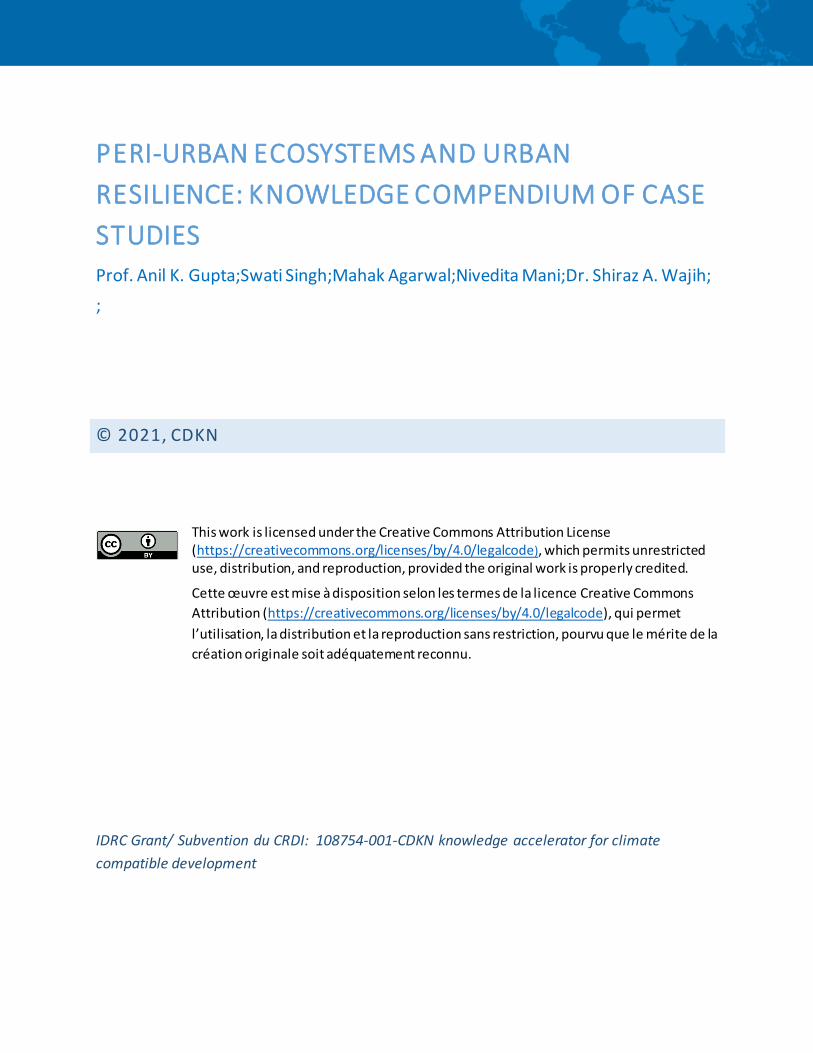
PERI-URBAN ECOSYSTEMS AND URBAN RESILIENCEKNOWLEDGE COMPENDIUM OF CASE STUDIESThis Knowledge Compendium is a compilation of practical case studies on the role of peri-urban ecosystems for enhancing urban resilience and is a supplementary document for the Training Module document. Both these documents should be used together by the trainers in capacity building programmes.
Government of India
Copyright © 2021, National Institute of Disaster Management, Climate and Development Knowledge Network, Gorakhpur Environmental Action Group. All rights reserved.
ISBN: 978-93-82571-48-3
Contributors:
• Ms Nivedita Mani, Coordinator - Networking and Liaison, Gorakhpur Environmental Action Group, Delhi Office, New Delhi, India
• Dr Shiraz A. Wajih, President, Gorakhpur Environmental Action Group, Gorakhpur, Uttar Pradesh, India
• Prof. Anil K. Gupta, Head – Div. of Environment, Climate Change and Disaster Risk Management, National Institute of Disaster Management, New Delhi, India.
• Dr Vishal Narain, Professor, Management Development Institute, Gurgaon
• Dr Anjal Prakash, Research Director and Adjunct Associate Professor, Indian School of Business, Hyderabad
• Ms Tallulah D’Silva, Practicing Architect and Adjunct Professor, Goa College of Architecture, Goa
• Ms Shipra Singh, Researcher, Shiv Nadar University, Noida
• Mr Amit Mitra, Researcher, New Delhi
• Bijay K Singh, Coordinator, Gorakhpur Environmental Action Group, Gorakhpur, Uttar Pradesh, India
• Ajay K Singh, Coordinator, Gorakhpur Environmental Action Group, Gorakhpur, Uttar Pradesh, India
Compilation and Editing:
Nivedita Mani Shiraz A Wajih
Citation:
Nivedita, M., Wajih, S.A. (2021). Peri-urban Ecosystems and Urban Resilience: Knowledge Compendium of Case Studies. Gorakhpur Environmental Action Group, Gorakhpur (U.P.) India, Climate Development and Knowledge Network, Cape Town, South Africa, Pages 46.
Disclaimer:
A range of literature and data from various published and unpublished sources, reports, documents, research notes and internet sources have been utilized in developing the content of the Knowledge Compendium through their appropriate interpretation. Authors acknowledge their sources and contributors. The Compendium and its contents can be freely referred, translated or put into any training and/or academic purposes with due acknowledgement and citation of the authors. Views expressed and statements are of the authors, and not necessarily of CDKN or any Organizations or Government. The document is aimed to serve as a reference document for policy planning, capacity development including research, training and extension, in any part of the world.
Published by:
Gorakhpur Environmental Action Group (GEAG) HIG-1/4, Siddharthpuram, Taramandal Road Gorakhpur – 273017 (Uttar Pradesh) Phone: +91 551 2230004; Fax: +91 551 2230005 Website: www.geagindia.org
and
National Institute of Disaster Management (Ministry of Home Affairs, Govt. of India), NDCC-2 Building, Jaisingh Marg, New Delhi – 110 001, India
Support and Cooperation:
Climate Development and Knowledge Network ICLEI - Local Governments for Sustainability, South Asia
Design and Print
Aspire Design, New Delhi
PERI-URBAN ECOSYSTEMS AND URBAN RESILIENCEKNOWLEDGE COMPENDIUM OF
CASE STUDIES

iiiPeri-Urban Ecosystems and Urban Resilience:Knowledge Compendium of Case Studies
The present urban dynamics are changing robustly under the disaster risk drivers to
environmental changes encompassing climate change, changing land use pattern
and natural resource degradation. Cities are likely to take the hit as it is predicted
that more than two-third of the global population will live in cities by 2050. Urban
resilience encompasses adaptation to risk dynamics and business continuity coupled
with sustained improvement towards meeting the developmental needs. Peri-Urban
areas serve cities through supporting capacities-ecosystem services, rural-urban
connect and input-output systems etc.
Ensuring city and urban developmental dynamics, ecosystem integrity and service
flows are essential. Peri-Urban ecosystems are key providers of social, economic
and health vulnerabilities by providing resources, buffers and capacities that help in
reducing vulnerabilities.
NIDM and GEAG have collaborated in many endeavors supporting research and
on ground action projects in the thematic areas of urban resilience and peri-urban
ecosystems. The “Peri-Urban Ecosystem and Urban Resilience” is a collective
documentation of case studies form various cities pan-India and highlights the connect
between the role of urban resilience and peri-urban ecosystems.
This Knowledge Compendium of Case Studies is developed to support the training
manual on ‘Peri-Urban Ecosystems and Urban Resilience’. This compendium is
developed under the CDKN initiative and is a compilation of practical case studies
undertaken in field under various pilot studies. We hope that this compendium will turn
out to be a good resource material for researchers, practitioners, academicians and
other professionals.
FOREWORD
Major Gen. Manoj Kumar BindalExecutive DirectorNational Institute of Disaster Management
Manoj Kumar Bindal


vPeri-Urban Ecosystems and Urban Resilience:Knowledge Compendium of Case Studies
TABLE OF CONTENTS1. Introduction 1
2. Institutional Coordination for Water Supply in Shimla The Crucial Peri Urban-Urban Connect 2
3. Peri-urban crisis in Visakhapatnam as a result of CRZ violations 6
4. Urban and Periurban Water Flows The Case of Gurgaon 9
5. Diminishing Lifeline of Panjim’s Resilience: The Khazaan lands 11
6. Changing land use and growing water insecurity in Mukteshwar 15
7. The urban-peri-urban water connect in Hyderabad: implications for resilience to climate change 17
8. Circular Economy: Urban Resilience through Peri Urban Ecosystems 22
9. Ecosystem Services for Disaster Risk Reduction: Wetlands of Okhla Bird Sanctuary, Delhi 28
10. Peri-urban Ecosystems impacting Urban Resilience A case study of Secondary Cities in
Eastern India 34
1Peri-Urban Ecosystems and Urban Resilience:Knowledge Compendium of Case Studies
The peri-urban is a fast-changing, semi-natural ecosystem which provides natural resources for growing cities in
terms of water bodies, open and green lands, and orchards. Peri-urbanisation leads to usurpation of ecologically
sensitive lands for housing and other construction activities. These change the face of agriculture, reduce open
spaces, enhance pressure on natural resources like water. These areas are marked by a lack of hygiene and
sanitation infrastructure, industrial effluence, air pollution and inadequate provision of basic services. Often, the
solid waste of a city is dumped in peri-urban areas.
The resilience of most of the secondary cities in India is threatened with the decline of ecosystem services. With
rapid land-use changes and an economic shift from agriculture to urban development, small-scale and marginal
farmers in peri-urban areas, whose practices provide redundancy to urban food production, are on the brink
of collapse. The diversity of peri-urban agriculture, including its ability to provide food in periods of floods and
waterlogging, is an example of how the provisioning services of ecosystems help in developing the flexibility of hard
systems.
Peri-urban ecosystems are increasingly at risk of degradation and loss as natural resource consumption and waste
in peri-urban areas increase due to rapid urbanization and increasing human activity. Cities do not operate in
isolation but within a “sphere of dependence” on surrounding areas and their ecosystems. As such, the degradation
of these ecosystems results in loss of ecosystem services that support urban and peri-urban populations.
This Knowledge Compendium is a collection of case studies from different cities in India which establishes the
important connect between the role of peri urban ecosystems and urban resilience.
INTRODUCTION

2 Peri-Urban Ecosystems and Urban Resilience:Knowledge Compendium of Case Studies
Institutional Coordination for Water Supply in ShimlaThe Crucial Peri Urban-Urban Connect
Until 2016, Shimla had a total of seven water sources of which the
two main sources of water, Ashwani Khad and the Nauti Khad (of
which Gumma is a part), have witnessed significant reduction in
water levels. These existing water sources are tributaries and sub-
tributaries of river Sutlej and river Yamuna and lie in the peri-urban
areas of Shimla. The entire water sources of the State are managed
by the Irrigation and Public Health Department, while the distribution
of water to the town is handled by the Municipal Corporation.
The various water sources in Shimla from where water was sourced
until 2016 along with the intake in MLD is shown as below:
The city of Shimla is located on a ridge. Water has always been a scarce resource in Shimla. After Himachal Pradesh was granted full statehood in 1971, the population of Shimla, being the state capital, increased manifold. The water sources present at that time were the only ones set up by the British supplying 22 MLD of water where the demand was 24 MLD, creating a deficit of 2 MLD. Over the years, this deficit increased with growing population and little augmentation to the water supply.
1%Seog
3%Chair
43%Gumma
35%Giri
11%AshwaniKhad
7%churat,vagrotti
Water Sources in Shimla
and Intake (in MLD)
(Until 2016)
Shiraz A Wajih and Nivedita Mani

3Peri-Urban Ecosystems and Urban Resilience:Knowledge Compendium of Case Studies
Sewage Contaminated Water Stream leads to Jaundice OutbreakA major water-contamination episode struck Shimla
between December 2015 and March 2016. There was
a Hepatitis epidemic caused by contaminated water
from Ashwani Khad – a spring from where Shimla used
to get its largest share of water. Unclean water from
a sewage treatment plant contaminated the streams
in Ashwani Khad, resulting in an outbreak of jaundice
that affected more than 500 people in the Shimla city,
including residents of the IAS Officers’ colony. The
sludge from a treatment plant at Malyana, which had a
faulty sewage treatment system, was flowing into the
Ashwani Khad.
The 3 Sewage Treatment Plants (STPs) were located
upstream of the Ashwani Khad water scheme and
had not been working since the time they were set up.
When the STPs were being set up, the health experts
and virologists had warned that hepatitis outbreak
may compound in the years to come when the 3
STPs – Malyana STP (4.44 MLD capacity), Lalpani STP
(19.35 MLD) and Dhalli STP (0.76 MLD) would run to
their maximum capacity in the years to come (as the
whole city was not connected to STPs until then) which
could discharge upto 24.55 MLD treated or untreated
sewage into the Ashwani Khad located downstream.
Despite this warning, the IPH department which
happens to be a state-run department did not take
much cognizance of this issue and without any
discussions with the Shimla Municipal Corporation
(ULB responsible for provision of water in the city)
went ahead to install the STPs right above the
mouth of the drinking water sources. This was
labelled as a complete “planning failure” as the 3
STPs were installed upstream of the Ashwani Khad
water stream. The Ashwani Khad water source was
established in 1995-96 and the STP which came much
later, overlooked the placement. And as an added
disadvantage, the STPs never worked!
The experts analysed that in winter months, the
condition for the Hepatitis virus became more
conducive due to low dissolution of sewage in the
natural streams due to lean discharge of water in the
catchments. During rains, the sewage flow is diluted
due to increased water discharge in the Ashwani Khad.
So the repetitive Hepatitis outbreaks were taking place
only in the winter months. In 2016, the city reported
1620 jaundice cases out of which 9 people were dead.
This was a shocking situation for the Shimla Municipal
Corporation which immediately shut down the Ashwani
Khad water source after the initial investigations.
This entire episode led to the arrest of a junior
engineer and a supervisor from the IPH Department for
their negligence in preventing the contamination of the
drinking water source at Ashwani Khad, which supplied
water to several localities in the city.
The governance gapShimla is a classic example of unique as well as
natural ecosystems, most of which lies in the peri
urban areas of Shimla. It is also one of the largest
inhabitations on the hills. The urban forests add value
to Shimla by providing environmental buffer for the
city, absorbing storm water, improving air quality and
adding to water supply. The famous Mall Road of the
city is situated on a watershed, the drainage from
which, on the one side flows into the Sutlej and so
into Arabian Sea, and on the other into the Yamuna

4 Peri-Urban Ecosystems and Urban Resilience:Knowledge Compendium of Case Studies
on its way to the Bay of Bengal. Inhabitants of Shimla
depend on these ecosystem services for a decent,
healthy, and secure life as these provide for most
of the resources like water, food, fibre, and genetic
resources.
The water supply system is one of the most fragile
urban systems in Shimla. With most of the water
sources lying in the peri urban areas of Shimla (as
shown in the map below), the cost of fetching and
supplying good quality water to its inhabitants comes
at a very high cost.
In 2005, a Sewage Treatment Plant was set up
above the drinking water source in Ashwani Khad.
The experts opined that lifting water to a huge height
was not cost effective. They must have ensured
that sewage does not get mixed with water through
decentralised sewage treatment plants. Unfortunately,
IPH department never paid heed to this and the mixing
of raw sewage water with the drinking water started
happening quite frequently leading to outbreak of
Hepatitis E and Jaundice and several deaths every
year.
The lack of effective coordination and convergence
between the IPH Department and the Shimla Municipal
Corporation led to the Hepatitis disaster year on year
and unfortunately, became a serious one in 2016
causing huge number of deaths.
The Policy and Institutional Reforms in Shimla’s Water SectorThere is opportunity in every crisis and the repeated
Jaundice outbreaks built momentum for major reforms
in the water supply sector in Shimla, 2016 onwards.
As the first step, the state government, jointly with
the Shimla Municipal Corporation, set up a dedicated
Utility which aims to take over Water Supply and
Sewerage (WSS) services for the city. Earlier, these
responsibilities were fragmented between different
agencies and departments, leading to blurred
accountability and suffered from lack of proper
coordination. This Utility - the Shimla Jal Prabandhan
Nigam Ltd (SJPNL) now runs the city’s WSS system.
Policy decisions such as setting water tariffs and
subsidies are done by the state government and the
city municipality. This initiative which is supported by
the World Bank through a Development Policy Loan

5Peri-Urban Ecosystems and Urban Resilience:Knowledge Compendium of Case Studies
(DPL) is supporting the GoHP’s program of policy
and institutional reforms needed in (i) bringing bulk
water to Shimla from a new source on the Sutlej River
after the close down of Ashwani Khad; (ii) 24x7 water
supply and sewage management for Shimla City and;
(iii) sewage services for peri-urban areas. It will also
support capacity building for the Shimla Municipal
Corporation to take on its new role of oversight.
With the current reforms in the policy and institutional
structures, SJPNL is now able to source 54 MLD
of water on a daily basis while the demand is just
for about 49 MLD. The peri urban areas upto 300
metres of city’s periphery are also being served with
water supply. The water quality monitoring system
established in the Utility is ensuring water testing
at three levels – Water Treatment Plant level, Indira
Gandhi Medical College has also been roped in for
testing samples and Eco Labs, Chandigarh is also
engaged in water quality monitoring.
By doing this, the Government of Himachal has taken a
bold step to make the supply of WSS services directly
accountable to citizens by devolving responsibilities to
an autonomous, professional company that answers
to the urban local body. The customer-focused utility
has the technical capacity, governance framework,
and performance-based management policies needed
to provide reliable water and efficient sanitation to the
citizens of Shimla.
Shri. Dharmendra Gill, the Managing Director-cum-
CEO of SJPNL rightly points out that the two main
reasons for this paradigm shift in the water supply
sector in Shimla are the much needed policy and
institutional reforms. For other cities to learn from this
model, it is not necessary that the Shimla model needs
to be replicated. Rather, certain principles of good
governance, if followed, will be sufficient to bring about
a positive change in the water sector. These include:
• Ring-fencing of accounts for which the SJPNL has
notified a new policy called as Cost Recovery,
Tariff and Subsidy Policy under which all the
stakeholders have proper commitment towards
their duties. This means that the customers are
responsible for cost recovery, government is
accountable for subsidies and the tariff structures
are made as per the local situation
• Strong institutional structure which includes a
powerful Board of Directors and professional staff
including qualified technical engineers, customer
relations people, communications specialists,
managers and so on.
This case shows that Shimla and many other cities in
India do not exist in silos and are dependent on their
peripheral/peri-urban areas for supply of food, water,
goods and services. The Urban-Peri Urban connect
and the related governance mechanisms are very
crucial for the holistic resilience of cities and the peri
urban areas as well. Specifically, water needs to be
looked at as an eco-system and not a commodity in a
decentralised manner and hence the urban-peri urban
governance becomes very important for the provision
of adequate and safe water supply to the cities.
6 Peri-Urban Ecosystems and Urban Resilience:Knowledge Compendium of Case Studies
Visakhapatnam is a coastal city situated in the state of Andhra Pradesh. It has a land area of 620 sq.km and an overall population of 18, 81,952 with an average density of approximately 3,320 people per sq.km (Visakhapatnam Smart City Proposal). Agriculture was the main primary sector activity in the last two decades that contributed to Visakhapatnam’s’ growth. Irrigation was mostly through small rainwater harvesting structures. The sub-urban pockets near Kapuluppada, Mehadrigedda and Gambheeram grew vegetables and commercial crops.
Peri-urban crisis in Visakhapatnam as a result of CRZ violations
The problem Encroachment of peri-urban regions: Today peri-urban
agriculture in Visakhapatnam is vanishing rapidly due to
land diversions for industrial and commercial purposes.
Private builders have purchased many acres of lands
from smallholder farmers in the vicinity of industries like
the NTPC and the Steel Plant. They have developed
empty plots for housing on these farms. Consequently,
the supply of fresh vegetables, fruits, flowers, milk, meat
and eggs from nearby peri-urban areas is reducing.
The entire Sagar Nagar colony and Singapore Society
in the northern part of Visakhapatnam have developed
by acquiring agricultural lands. Usurpation of common
property resources like grazing lands has led to fodder
shortages and subsequently of the farmers moving out of
agriculture (Mitra et al, 2017).
Water crisis: Visakhapatnam’s water situation is
worsening despite its 23 streams and small lakes. With
the municipal water supply unable to keep up with the
rapid expansion of the city boundaries, many areas face
shortages in summer. A recent study covering 936 sq.km
(GVMC area and the catchment of the springs draining
into it) found that between 1976 and to 2010, there was
a 2.48% loss of water bodies. A decreasing trend of
the surface area of freshwater bodies was observed at
many places as freshwater lakes or small ponds were
converted into the land and built-up area. Also, several
studies on water quality found high levels of metals like
aluminium, manganese, copper, zinc, selenium, rubidium,
cadmium, lead and cobalt in the groundwater in the areas
like Akkireddypalem, Balacheruvu and Lankelapalem
which are in the vicinity of industries like Hindustan Zinc
Limited and Visakhapatnam Steel Plant.
Solid waste management: Solid waste management
is a serious issue in Visakhapatnam. The
Greater Visakhapatnam Municipal Corporation (GVMC)
is responsible for waste management. The municipal
dumping yard is located at Kapuluppada, a peri-urban
locality about 25 km from the city, in Zone 1 of GVMC.
Around 920 tonnes of solid waste is generated within the
Amit Mitra, Bijay Kumar Singh, Ajay Singh

7Peri-Urban Ecosystems and Urban Resilience:Knowledge Compendium of Case Studies
GVMC limits per day. In most wards of the city, door
to door waste collection happens but the waste is not
segregated at source. Recyclables like newspapers,
plastics and metals are collected by rag pickers.
There are no treatment plants and often the waste is
openly burnt. Toxins leach into the soil and pollute the
groundwater. Visakhapatnam and its peri-urban areas
do not have adequate sanitation facilities. Only 48%
of the city has closed drains and there is a shortage of
sewage treatment plants.
The health issues: In Visakhapatnam, contaminated/
polluted water, lack of sanitation and heavy
atmospheric pollution (the city is one of the most
polluted ones in the country) due to industrialization is
silently affecting thousands of its residents. Diseases
like swine flu, chikungunya, dengue, malaria and
anthrax have emerged as new diseases in the last 30
years in the city and peri-urban areas due to climate
change, deterioration in sanitation conditions, dumping
yard and industrial pollution. The human resources
in the medical department are not proportional to
the increasing population, which results in a lack
of services in many areas. With this rapid pace of
urbanization and the changing lifestyle of people,
diseases like HIV and hepatitis are expected to
increase (Mitra et al, 2017).
Marginalization: Peri-urban areas are marginalized in
every possible way. This is best reflected in the growth
of slums and squatter settlements. Visakhapatnam had
around 793 slums according to the 2011 census that
housed 44% of the city’s households. Visakhapatnam
has an additional aspect of marginalisation that is
linked to land-use changes. In a blatant violation of
CRZ rules, private and government agencies have built
hotels and other entertainment sites along the coast.
Impact of CRZ violation in Vishakhapatnam
Due to severe Coastal Regulation Zone (CRZ) violations within the city in terms of pumping of groundwater
from borewells, groundwater wells especially near the Lawson’s Bay area have turned saline. CRZ norms
are mostly violated by the construction of hotels, like in the RK Beach area and apartments along the coast.
In 2007, the Andhra Pradesh High Court ordered the removal of constructions violating the CRZ, but there
has hardly been any action. Many big hotels are trying to regularise their properties. Efforts are on to relax
the CRZ norms to facilitate beachfront construction. Aquaculture farms along the coast have put up concrete
structures and electricity lines in the prohibited zone along the shore. Around 55 ha of mangrove habitat fall
under the Visakhapatnam Port Trust (VPT) area, which extends up to the Visakhapatnam airport. Dredging by
the VPT to stop the airport from flooding, the mangrove cover has depleted by 50%.

8 Peri-Urban Ecosystems and Urban Resilience:Knowledge Compendium of Case Studies
Conclusion and way forwardFundamental changes in mindset are needed to
prevent further land-use changes and unregulated
construction activities. This would require mapping
the peri-urban areas and land-use patterns effectively
through GIS tools instead of relying on masterplans in
addition to strictly implementing the land and water
use rules and regulations. It has to be recognised that
in a city, the peri-urban need not be homogenous
but the variety contributes to the overall resilience
of the city in addition to the livelihoods of hundreds
of people. The Visakhapatnam study shows this
very clearly. Rapid urbanization or peri-urbanization
displaces peoples livelihoods, forcing them to join the
ranks of the urban informal labour force as casual
labour. Fishers, both marine and inland, too need to
be recognised and their rights protected. The CRZ
rules are violated with impunity by private and state
agencies alike, leading not only to loss of livelihoods
but also potentially increasing the adverse impacts of
disasters like cyclones.
References:Mitra Amit, (2017) Peri-urbanity and the Smart City:
Case Studies of Bhopal and Visakhapatnam,
India. Gorakhpur Environmental Action Group,
Gorakhpur.
Mitra, A., Singh, B.K., Singh, A.K., Katyal, S.
(2017): India’s Peri-urban Crises: The lack
of an ecosystems approach, Gorakhpur
Environmental Action Group, Gorakhpur.
9Peri-Urban Ecosystems and Urban Resilience:Knowledge Compendium of Case Studies
Gurgaon was a sleepy village till the 1980s. After that, DLF, a real estate agency, started buying plots of land for residential and commercial uses. The transformation of Gurgaon was facilitated by three factors: namely, its proximity to the National Capital, New Delhi and the Indira Gandhi International Airport; policies pursued by the state government to promote private enterprise through the creation of Special Economic Zones and the growth of the outsourcing and real estate sectors (Narain 2009). Land use change is a major driver of periurbanization processes: the growth of Gurgaon took place through the conversion of private and common lands for building gated colonies, residential buildings, recreation and shopping centers. Thus the visual landscape of the city reveals a duality wherein the ‘rural’ co-exists with the ‘urban’. Modern residential buildings, malls and shopping centres exist alongside village settlement areas, village ponds and small plots of agricultural land.
This growth of the city has impacted upon the peripheral villages in many ways. Competition for groundwater has increased, and the falling water tables mean that many small and marginal farmers are no longer able to access groundwater. In village Sadhraana, for instance, about 15 km away from the city, many farm-houses have come to be located (Narain 2014). Most of these farm-houses were located on lands overlying what locals call “meetha paani (water that is sweet or not saline)”. Some farm-houses were built on the lands over the “khaara paani (saline groundwater)”. The owners of these farm-houses responded by buying small plots of land overlying the sweet groundwater and transporting it to their farm-houses using underground pipes. This is the consequence of an institutional framework in which access to groundwater is tied to the ownership of land. To acquire access to groundwater, you have to be interested in the land lying above it.
Located a few kms away from Sadhraana village is village Budhera. Budhera shows another way in which the ecological foot-print of urbanization is borne by peri-urban areas (Narain 2014; Vij and Narain 2016). As the city of Gurgaon expanded, a need was felt to augment its infrastructure. A water treatment plant was built to augment the water being provided by the water treatment plant located at Basai. This water treatment plant, known as the Chandu-Budhera water treatment plant, was built by acquiring the grazing lands of the village. This is paradoxical as Budhera is a heavily livestock dependent village. Many households had to cut back on the livestock population. However, for several other households, this was not an option. These households responded by switching from grazing to stall-feeding. While taking livestock to graze is the responsibility of male family members or of professional grazers who engage in this activity as a hereditary or family occupation, collecting fodder grass for stall-feeding is the responsibility of women. Thus, this process led to a transformation of gender relations around livestock rearing activities, creating additional responsibilities for women. This
Urban and Periurban Water FlowsThe Case of Gurgaon
Vishal Narain
This case describes urban-rural linkages, typically ignored in planning because of a dichotomous view of urban planning and rural development. The story relates to Gurgaon, located in the north-western Indian state of Haryana. It shows how studies of rural-urban water flows provide a mechanism to study urban and peri-urban linkages and the impact of urban expansion on the periurban areas.
10 Peri-Urban Ecosystems and Urban Resilience:Knowledge Compendium of Case Studies
is an important way in which urban expansion impacts gender relations, adding to women’s work burdens and responsibilities, over and above their responsibilities at home and on the farms.
These farm-houses serve the social and recreation needs of the urban elite. They are used for family get – togethers and as weekend get aways. It is common to find fruit orchards located in them. One consequence of the location of these farm-houses in Sadhraana village has been that many local farmers have lost access to groundwater, as they cannot compete with the farm-house owners in digging deep into the aquifers to extract groundwater. They are forced to leave their land fallow or take only one crop in a year. A common response to the scarcity of water is the increased use of sprinkler irrigation sets. The case of losing access to groundwater by the residents of Sadhraana shows the negative impacts of urban expansion and land use change on peri-urban residents who lose access to groundwater in the process. This has negative equity implications.
It is important to note that periurbanization processes can also impact gender relations in other ways (Ranjan and Narain 2012). In Sultanpur village, the tasks of collecting water for household purposes have traditionally not been done by women in the upper caste households such as the Rajputs. It is considered against a woman’s dignity to go out to collect water. However, with land use change and occupational diversification characteristic of periurban spaces, men of these households started working in the city. The women would then not wait for the men to return home, but instead started going out to collect water. ‘Purdaah phaat gaya hai… (the veil has been removed)”, as they would say. This shows another way in which rural-urban relationships and the movement of people between rural and urban areas impacts gender relations around water.
While there is an appropriation of fresh water from the rural areas in the to the city, there are also reverse flows of wastewater from the city into the periurban areas. Cutting through village Budhera is a wastewater runnel that carries the domestic wastewater of Gurgaon city. This wastewater is heavily relied upon for the cultivation of wheat and paddy. Waste water is appropriated from the wastewater runnel either by installing pipe outlets along the wastewater runnel after applying for the same from the Irrigation Department or by pumping it using diesel pump-sets or electric motors (Narain and Singh 2017). Wastewater flowing from the city being used in periurban agriculture serves two purposes: first, it provides a way of disposing the urban waste. Second, it plays an important role in supporting the resilience of periurban spaces to water insecurity induced by urbanization and climate change.
Many residents of Budhera had lost access to groundwater sources that were located on the lands that were acquired to build the GWS (Gurgaon Water
Supply) Canal and the NCR (National Capital Region) Channel, that were constructed to transport water to the Basai and Chandu Budhera water treatment plants, respectively (Narain 2014). Further, the area is not served by an irrigation canal. For these reasons, wastewater remains an important means of irrigation. The reliance on wastewater has further increased because of changes in the precipitation patterns. The region no longer experiences what the locals call “chaumasa (the four-month monsoon period) “. Wastewater generated by the city serves as an irrigation choice of last resort. When asked by a wastewater irrigator why he used wastewater, he said “lachaar hoon...(I am helpless) (Narain and Singh 2017)’’.
For paddy irrigation, particularly, farmers wait for the rains. If there are no rains at the time that the crop needs water, they use wastewater. Wastewater irrigation thus serves as an important coping strategy in the wake of growing urbanization and changing rainfall patterns. It is important to note, however, that none of the wastewater irrigated produce is consumed directly by its growers; instead, it finds its way into the wholesale market.
The use of wastewater in periurban agriculture shows yet another way in which the rural and the urban are related through flows of water and agricultural produce: wastewater flows from the city into the peri-urban areas and there are reverse flows of the wastewater irrigated produce from the peri-urban to the urban areas. In the face of growing urbanization and climate change, wastewater generated by the city plays an important role in supporting periurban livelihoods.
References: Ranjan, P. and Narain, V. 2012. Urbanization, climate
change and water security; a study of
vulnerability and adaptation in Sultanpur and
Jhanjhrola Khera in periurban Gurgaon, India.
Discussion paper series No. 3. Water security in
peri-urban South Asia. Hyderabad: SaciWATERS.
Narain, V. and Singh, A.K. 2017. Flowing against the
current: the socio-technical mediation of water
insecurity in periurban Gurgaon, India. Geoforum.
81, 66-75.
Vij, S. and Narain, V.2016. Land, water and power: the
demise of common property resources in periurban
Gurgaon, India. Land Use Policy. 50: 59-66.
Narain, V. 2014. Whose land ? Whose water ? Water
rights, equity and justice in a periurban context.
Local Environment: the International Journal of
Justice and Sustainability. 19(9): 974-989.
Narain, V. 2009. Growing city, shrinking hinterland: land
acquisition, transition and conflict in periurban
Gurgaon, India. Environment & Urbanization. 21
(2): 501-512.
This case study has been developed by GEAG as part of the Knowledge Brokering Project supported by CDKN.
11Peri-Urban Ecosystems and Urban Resilience:Knowledge Compendium of Case Studies
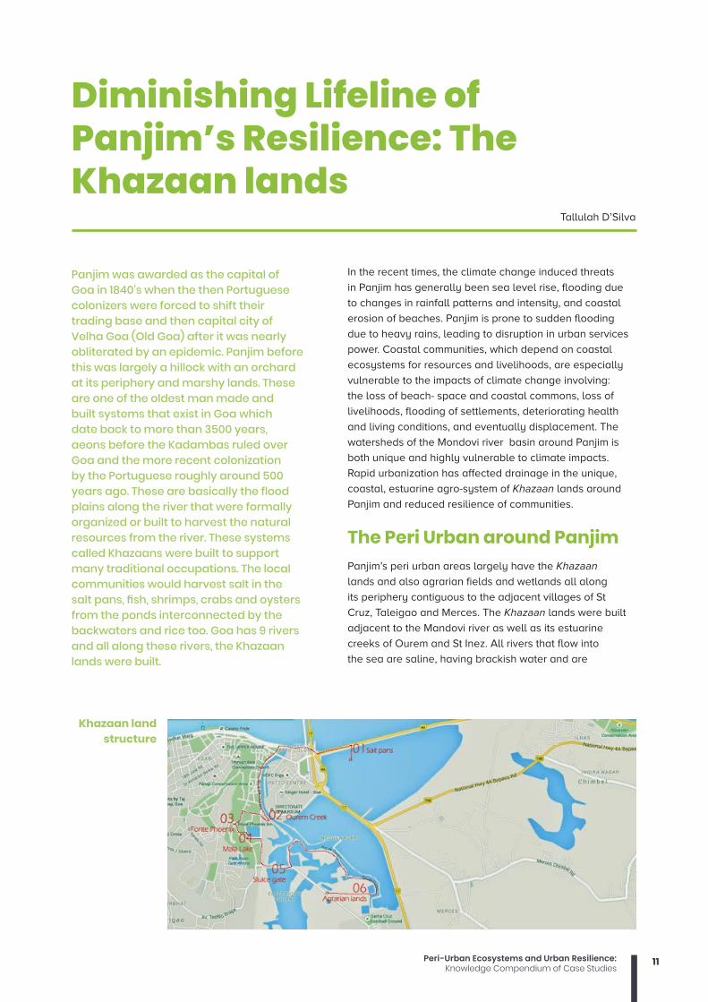
Panjim was awarded as the capital of Goa in 1840’s when the then Portuguese colonizers were forced to shift their trading base and then capital city of Velha Goa (Old Goa) after it was nearly obliterated by an epidemic. Panjim before this was largely a hillock with an orchard at its periphery and marshy lands. These are one of the oldest man made and built systems that exist in Goa which date back to more than 3500 years, aeons before the Kadambas ruled over Goa and the more recent colonization by the Portuguese roughly around 500 years ago. These are basically the flood plains along the river that were formally organized or built to harvest the natural resources from the river. These systems called Khazaans were built to support many traditional occupations. The local communities would harvest salt in the salt pans, fish, shrimps, crabs and oysters from the ponds interconnected by the backwaters and rice too. Goa has 9 rivers and all along these rivers, the Khazaan lands were built.
Diminishing Lifeline of Panjim’s Resilience: The Khazaan lands
Tallulah D’Silva
In the recent times, the climate change induced threats
in Panjim has generally been sea level rise, flooding due
to changes in rainfall patterns and intensity, and coastal
erosion of beaches. Panjim is prone to sudden flooding
due to heavy rains, leading to disruption in urban services
power. Coastal communities, which depend on coastal
ecosystems for resources and livelihoods, are especially
vulnerable to the impacts of climate change involving:
the loss of beach- space and coastal commons, loss of
livelihoods, flooding of settlements, deteriorating health
and living conditions, and eventually displacement. The
watersheds of the Mondovi river basin around Panjim is
both unique and highly vulnerable to climate impacts.
Rapid urbanization has affected drainage in the unique,
coastal, estuarine agro-system of Khazaan lands around
Panjim and reduced resilience of communities.
The Peri Urban around PanjimPanjim’s peri urban areas largely have the Khazaan
lands and also agrarian fields and wetlands all along
its periphery contiguous to the adjacent villages of St
Cruz, Taleigao and Merces. The Khazaan lands were built
adjacent to the Mandovi river as well as its estuarine
creeks of Ourem and St Inez. All rivers that flow into
the sea are saline, having brackish water and are
Khazaan land structure
12 Peri-Urban Ecosystems and Urban Resilience:Knowledge Compendium of Case Studies
approximately around 40 kilometers from the coast.
The rivers swell during rains and therefore, many of
these have large floodplains that are rich in silt that
gets washed down from the hills and mountains of the
Western Ghats along the eastern length of Goa. The
communities that lived around these flood plains built
this network of raised embankments called dykes or
bunds with sluice gates at strategic locations along
the river and further inland within the backwaters of
the Khazaan lands. These sluice gates allowed the
river water during high tide to flow into the backwaters
and into the series of shallow troughs or poims. The
pressure of water would push the doors of the sluice
gates allowing the river water to flow into the channels
and along with it, fish spawn would also flow in. When
the tide would change, the gates would automatically
close allowing the water to stay within as it slowly
trickled out and the fish spawn would thrive in these
waters, safe from its predators. Since the sluice gates
were the only points of entry and exit, fresh fish and
shrimp would be caught at these points using small
fishing nets. These were systems that allowed fishing
in the Khazaan lands without the risk of going into the
unpredictable waters of the sea.
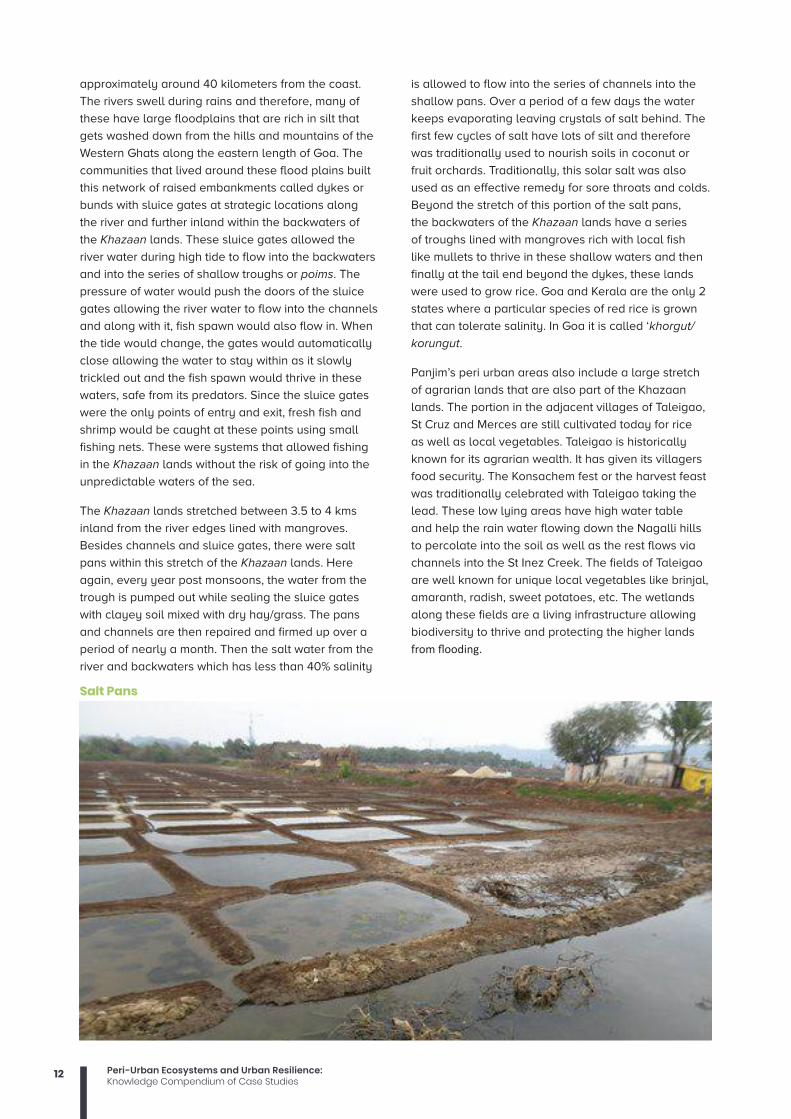
The Khazaan lands stretched between 3.5 to 4 kms
inland from the river edges lined with mangroves.
Besides channels and sluice gates, there were salt
pans within this stretch of the Khazaan lands. Here
again, every year post monsoons, the water from the
trough is pumped out while sealing the sluice gates
with clayey soil mixed with dry hay/grass. The pans
and channels are then repaired and firmed up over a
period of nearly a month. Then the salt water from the
river and backwaters which has less than 40% salinity
is allowed to flow into the series of channels into the
shallow pans. Over a period of a few days the water
keeps evaporating leaving crystals of salt behind. The
first few cycles of salt have lots of silt and therefore
was traditionally used to nourish soils in coconut or
fruit orchards. Traditionally, this solar salt was also
used as an effective remedy for sore throats and colds.
Beyond the stretch of this portion of the salt pans,
the backwaters of the Khazaan lands have a series
of troughs lined with mangroves rich with local fish
like mullets to thrive in these shallow waters and then
finally at the tail end beyond the dykes, these lands
were used to grow rice. Goa and Kerala are the only 2
states where a particular species of red rice is grown
that can tolerate salinity. In Goa it is called ‘khorgut/
korungut.
Panjim’s peri urban areas also include a large stretch
of agrarian lands that are also part of the Khazaan
lands. The portion in the adjacent villages of Taleigao,
St Cruz and Merces are still cultivated today for rice
as well as local vegetables. Taleigao is historically
known for its agrarian wealth. It has given its villagers
food security. The Konsachem fest or the harvest feast
was traditionally celebrated with Taleigao taking the
lead. These low lying areas have high water table
and help the rain water flowing down the Nagalli hills
to percolate into the soil as well as the rest flows via
channels into the St Inez Creek. The fields of Taleigao
are well known for unique local vegetables like brinjal,
amaranth, radish, sweet potatoes, etc. The wetlands
along these fields are a living infrastructure allowing
biodiversity to thrive and protecting the higher lands
from flooding.
Salt Pans

13Peri-Urban Ecosystems and Urban Resilience:Knowledge Compendium of Case Studies
The Ecosystem Biodiversity Panjim is perhaps one of the few cities that has a
mangrove forest all along its riverine or creek edges
and Khazaan lands. There are roughly around 14
species of mangroves found in these peri urban areas.
The mangroves support unique biodiversity like mud
skippers, fiddler crabs, mud lobsters, fish like mullets,
pearl spot, mutri, etc, shrimps, crabs, bivalves and
oysters. These play a role in enriching and aerating
soils, arresting erosion, etc. There are a number of
local as well as migratory birds that often visit these
areas teaming with snails and alga which are a rich
source of food for birds like red shanks, black winged
stilts, Asian open bills, painted storks and the lesser
adjutant storks. Otters and the marsh crocodiles are
often found in these areas too! The locals worship the
crocodile as its protector in an annual ritual called
‘mange thapnee.’
Ecosystem services and benefitsThe mangroves, wetlands and the agrarian fields in the
peri urban areas of Panjim help in carbon sequestering,
soil formation and soil retention, nutrient cycling,
water cycling and filtering of water, production of
atmospheric oxygen, generation of biomass, regulation
of floods and checking soil erosion. These areas
also provide relief to urban cities for recreation and
opportunities for improving health and wellbeing. The
Khazaan lands also aid with food production like salt,
fish and rice which is Goa’s staple. Therefore, they
provide livelihood opportunities.
Disappearing KhazaansThe Khazaan lands and its systems were originally
managed by the people of the community. During the
Portuguese colonization, these thrived because they
were systematically managed and in the absence of
refrigeration, salt was used largely for preservation
of food. So the salt pans also flourished. Post
liberation, these lands fell into private ownership and
management of these became very difficult. With local
labour becoming difficult to find, today the few salt
pans that are surviving have workers who come from
nearby coastal villages of Gokarna in Karnataka. With
refrigeration the use of salt for preservation has largely
reduced. So from nearly 300 salt pans that existed in
Goa at one time, there are barely 30-40 saltpans that
are active today.
The fields are also under pressure from development.
With land in the city becoming scarce, fields are
seen as lucrative lands that can be converted for
commercial and residential use. Fields that haven’t
been cultivated for a few years are seen as useless
and its ecosystem benefits are ignored. Debris
are often dumped in these areas hastening the
degradation of these once cultivated lands. Over the
years, the contiguous sections have been filled up
and constructed upon impacting the larger seamless
Agrarian lands
14 Peri-Urban Ecosystems and Urban Resilience:Knowledge Compendium of Case Studies
connections. The fields adjacent to the Khazaan lands
are often affected by salt water intrusion due to lack of
maintenance of the bunds/dykes.
The key historic location of the ‘Konsachem fest’ which
used to be in a large section of the Khazaan lands is
under threat from filling up of debris, garbage dumping
and sewage pollution from the houses and colonies on
its fringes.
Every year the water levels are rising with the
increasing heat. The fields in the peri urban areas
of Panjim as well as the Khazaan lands are unique
infrastructure of the city for protecting it from the
vagaries of climate, its climate resilient armour.
The mangroves along the coast and riverine areas is
another buffer that in a way protects the coastal city.
These therefore, need to be protected and conserved
for posterity. Their role and ecosystem benefits and
services need to be understood and retained as assets
of the city in all the development and future plans for
the city.
The development activities have significantly
impacted the ecology and economy of the Khazaans
and estuarine areas. The pace of degradation
of the Khazaan ecology has increased in recent
years due to short-sighted planning, public apathy,
industrialization and urbanization.
ConclusionOver the years, awareness about these peri urban
areas has surely increased with regular walks
being conducted for students, youth, citizens
and stakeholders by many individuals as well as
responsible tourism entities. A lot has been written
about the wealth of the Khazaans, food security as
well as its role as climate resilient infrastructure.
Such citizen participation is the first step leading to
conservation.
The local body as well as the Goa State Biodiversity
Board acknowledges these areas as eco-sensitive
hotspots and has recommended that all these be
included in the People’s Biodiversity Register that are
currently being prepared by the respective Biodiversity
Management Committees of the city and its suburbs.
Further to this effort, the Planning and Development
Authority, Town and Country Planning Department
too needs to integrate these areas as Special Zones
and completely bar any development or land use
conversions of these critical green and blue belts so
that this age old climate resilience infrastructure is
conserved in all the development plans for the region.
The government should help the creation of detailed
ecosystem and site-specific protocols and guidelines
based on global and national best practices. For
this, they will need to incorporate cutting edge
technologies and traditional knowledge systems for
the restoration and conservation of marine ecosystems
such as the mangroves, Khazaans, dune vegetation,
and so on, using an ecosystem-based adaptation
approach. Building bye-laws in coastal settlements
should integrate ecological approaches with resilient
infrastructure as a construction norm. Individuals,
communities, NGOs, government and policymaking
bodies can play a crucial role in combating future
adverse impacts.
15Peri-Urban Ecosystems and Urban Resilience:Knowledge Compendium of Case Studies
Changing land use and growing water insecurity in Mukteshwar
The case of Mukteshwar represents a case of amenity-led mingration, wherein the migration is led by aesthetic rather than economic reasons (Chipeniuk, 2004: Moss, 2006; Perlik 2011). In this case, we look at the changing flows of people between Mukteshwar and urban centres led by the region’s pristine and scenic beauty and pleasant climate, and its implications for local water access.
In this case, we describe how land use change has impacted the access
to water of the residents of villages in Mutkeshwar, in the Kumaon Hills of
the North Indian state of Uttarakhand. We further show how the impacts of
these changes are aggravated by climatic change and variability. The case
shows how rural-urban links through the movement of urban residents into
Mukteshwar bring about land use change, which in turn has implications for
the water security of the local resident
Mukteshwar is the name of a sacred Shiva1 temple in the Kumaon hills of
the North Indian state of Uttarakhand. What is popularly referred to as
Mukteshwar, however, is a cluster of villages around the temple. The region is
known for its scenic and pristine beauty, pleasant climate, fruit orchards and
breath taking views of the snow clad Himalaya. It is dotted with trees of pine,
deodar, rhodedondron and oak. Writings on the region, such as those of the
naturalist Jim Corbett, document its rich flora and fauna. Wheat has been the
dominant crop in the region. In recent years, however, there has been a shift
towards fruits and vegetables.
Mukteshwar is preferred over the surrounding tourist areas such as Nainital,
Almora and Ranikhet as it is still relatively unspoilt. Land use change started
in Mukteshwar in the 1980s and has accelerated over the last two decades.
Land use change has taken place mainly for building tourist complexes,
resorts and hotels, and to build private cottages that urban residents from as
far as Delhi and Mumbai use for weekend breaks or short vacations. Prices
for land vary, with the highest price attached to parcels of land attached to
springs, followed by those with a good view of the snow clad Himalaya. Most
of the up-market resorts are located in the upper reaches of the region, while
in the lower reaches there is still much construction underway, which will
result in the proliferation of new tourist resorts and complexes in the future.
Traditionally, water was sourced in the region by the local residents from
Springs. Each spring had a catchment area of about 2-3 hectares. Local
communities were seen as the custodian of these springs; their access to
and appropriation of this water was institutionalized on the basis of religious
values. These springs were managed collectively by them. Increasingly, the
plots of land that are acquired for the above mentioned purposes are located
adjacent to springs. The buyers of plots of land prefer to buy plots with
springs attached to them; in fact, as noted above, plots of land with springs
attached to them command the highest price. One of the owners of a coffee
shop and tourist resort, in the course of this research pointed out, ‘’There is
scarcity of water in the area, but I am blessed with a spring on my land”.
1 In Hindu Mythology, Shiva is one of the trinity of popular Gods, representing the destroyer. He is the Hindu God of destruction.
Vishal Narain

16 Peri-Urban Ecosystems and Urban Resilience:Knowledge Compendium of Case Studies
When these plots of land are sold off, the local residents
lose access to the springs. CHIRAG, a local NGO, used
to conduct hydro-geological surveys of the region in
the past; they used to identify the catchment area and
monitor the discharge of springs. The sale of lands
affected the local soil and water conservation activities;
the NGO was unable to convince the locals to cease
the sale of their lands. The NGO consequently withdrew
from its efforts at monitoring and recharging the springs.
A second way in which the access of local communities
to water is impacted through this process is that
increased withdrawals of groundwater upstream
by cottages, tourist resorts and hotels reduces the
discharge in the springs downstream.
The occupants of the new cottages of the urban
residents further compete with the local residents for the
appropriation of piped water supply. As the residents
of Letey Bhunga, one of the villages in the region, put
it, “ all the big houses located in Mukteshwar are of the
outsiders, while the small houses are of local residents.”
The big cottages, located upstream of the piped water
distribution network, appropriate the water supply,
reducing its availability to the smaller houses of the
local residents located downstream. Besides, the new
settlers often bribe the lineman - in charge of water
delivery from the piped network (that is, in turn, based
on springs), to release water to serve them. The lineman
therefore deliberately holds back the supply of water,
and waits to be bribed. Local residents, unable to match
the outsiders in their capacity to bribe, once again lose
out in their access to water.
The movement of outsiders into the region, therefore,
alters the pattern of water distribution away from local
residents in their favour. Thus, we need to see issues
of periurban water security not only in terms of the
physical flows of water from the periurban or rural
areas to the urban areas; but also as represented by
the physical movement of urban residents into the
periurban spaces, giving rise to land use change and
are appropriation of water.
This process of re appropriation of water from the
local residents to outsiders and the new settlers has
increased the reliance of many locals on water brought
in from the adjoining areas. This is the case especially
during the summers, when water is brought in from the
Kosi River or from perennial streams through water
tankers. Water can be bought at prices varying from 3 to
5 Indian Rupees per litre.
The effects of changing access to water brought about
through land use change are further aggravated by the
impacts of climate change and variability. Narratives
of locals point to climate change manifest in declining
intensity of winters, reduced snowfall as well as a
change in the seasonal distribution of rainfall. Locals
also report a decline in the volume of rainfall over the
years. This has resulted in a poor recharge of springs.
Thus, both demand side and supply side factors have
reduced the access of the local communities to springs.
On the demand side, the stresses come from changing
land use - which in turn, alters water use practices. On
the supply side, the reduced precipitation reduces the
recharge of springs. Together, urbanization and climate
change impact the water security of the residents of
Mukteshwar.
The change in the climate experienced by the local
communities of Letey Bhunga has caused a shift in
the cropping pattern away from grains to fruits and
vegetables.” Earlier there used to be 3-4 feet of snow,
now it is difficult to see snow’, as was heard in the
fieldwork. This has translated into an increased burden
for fodder collection for women, as earlier the crop
residue from the harvest of wheat could serve as a
valuable source of fodder. Women respond to this in
two ways. First, they mobilise their social capital; using
norms of reciprocity, they assist each other in fodder
collection. Second, they walk one way, to the source of
fodder, and return through a commute in a shared taxi.
References:Narain, V. and Singh, A.K. 2019. Replacement or
displacement? Periurbanization and changing
water access in the Kumaon Himalaya, India.
Land Use Policy, 82, 130-137.
Perlik, M. (2011). Alpine gentrification: The mountain
village as a metropolitan neighbourhood. New
inhabitants between landscape adulation and
positional good. Journal of Alpine Research|
Revue de géographie alpine, 99-1.
Moss, L.A. (ed.) (2006). The Amenity Migrants: seeking
and sustaining mountains and their cultures.
Wallingford, UK. Cambridge, USA.
Chipeniuk, R. (2004). Planning for amenity migration
in Canada: Current capacities of interior British
Columbian mountain communities. Mountain
Research and Development, 24(4), 327-335.
This case study has been developed by GEAG as part of the Knowledge Brokering Project supported by CDKN.

17Peri-Urban Ecosystems and Urban Resilience:Knowledge Compendium of Case Studies
The urban-peri-urban water connect in Hyderabad: implications for resilience to climate change
Anjal Prakash
The urban-peri-urban water connect in Hyderabad
Hyderabad is the fourth most populous cities of India with a population of about 7.7 million as per 2011 census. The city is located on the bank of River Musi in the Deccan plateau in peninsular India. The city was founded by Qutub Shahi Sultans of Golkunda in 15th Century India. Post-independence, Hyderabad became the capital of Andhra Pradesh.
In the mid-1990s when India started to liberalise,
Hyderabad started to be the major hub for
pharmaceutical industries, Information Technology (IT)
processing and services industry. Many global companies
started its offices in Hyderabad as it became one of the
major IT Hubs of India. As a result, Hyderabad started to
expand rapidly. A larger district called Ranga Reddy (RR
District) was culled out to accommodate this expansion.
RR District became the most developed district of Andhra
Pradesh in the late 1990s with a global hub of major IT
companies. As the city grew in shape and size, the peri-
urban areas of Hyderabad showed incremental growth.
During 1981-91, this growth was to the tune of 158 per cent
(Kamraju & Kamraju, 2018). In 2014, Hyderabad became
part of Telangana state that comprised ten districts from
north-western Andhra Pradesh. This was due to the
bifurcation of former Andhra Pradesh into two states –
Telangana and Andhra Pradesh. Hyderabad is the capital
of Telangana since 2014.
The Hyderabad UA (HUA) consisted of the Municipal
Corporation of Hyderabad (MCH) and several peripheral
municipalities. These along with many gram panchayats
were assimilated in 2007 and the Greater Hyderabad
Municipal Corporation was formed. These areas, also
recognised as periurban areas, have become nodes of
development post-1990s when the city started growing
and the real-estate sector has boomed covering the
erstwhile adjoining rural areas. Between 1991-2001, the
growth in the municipal corporation of Hyderabad was
about 19% while the same was to the tune of 71 per cent
in the surrounding areas (Prakash., Singh & Narain 2011;
Prakash, 2014).
The rapid expansion of the city has affected its
hydrological cycle. Wakode et al (2018) study the urban
water balance of Hyderabad City. The study finds that
due to rapid urbanisation, the natural hydrological
cycle of the city has been disrupted following the water
balance of the city. The city does not keep account of its
Hyderabad is the fourth most populous cities of India with a population of about 7.7 million as per 2011 census

18 Peri-Urban Ecosystems and Urban Resilience:Knowledge Compendium of Case Studies
groundwater withdrawal which is impacting the water
balance of the city. To meet the lack of water in newly
developed areas in Hyderabad, water transferer from
peri-urban areas through tankers have been recorded.
An informal water market has been developed
that feeds the new housing societies in IT hubs of
Hyderabad drawing on water from peri-urban locations
(Prakash, 2015; Narain et al 2013; Narain and Prakash,
2016).
This case study examines the nature of the relationship
between peri-urban and urban Hyderabad through the
water lens. It shows the importance of the practical
urban-peri urban connect and how peri-urban areas of
Hyderabad has lent resilience to the urban centres. It is
divided into three sections. Following the introduction,
I look at the issues of water insecurity in Hyderabad
through a rise in groundwater markets. Section three
looks at the destruction of surface water bodies in
Hyderabad which is linked with the exploitation of peri-
urban water resources. The last section concludes this
case study with implications for resilience.
groundwater recharge and issues of water transfer from peri-urban to urban locations As the city started to grow, the water supply was the
main issue that the new societies and establishments
were tackling. The sudden jump in demand was not
able to match the supply and therefore elaborate
drinking water markets started to develop in the
new settlement areas in and around Hi-tech City in
Hyderabad. The water need for newly developed
housing societies, companies and business
establishments were met by tanker companies which
were fetching water from peri-urban locations.
In Mallampet, a peri-urban village in Hyderabad,
several tanker companies are functioning. These
tankers were owned in partnership with local powerful
residents to exploit the rich groundwater resource.
Most of them operated illegally and without any
permission. These companies were operating because
there were a demand and lack of enforcement of laws
that ban the sale of water. Based on the data collected
from individual pumps and selected tanker companies
operating in the village, estimates were made for the
amount of water extracted and the revenue earned by
a few wealthy and powerful people in the village who
are ignorant of the dire consequences of rapid aquifer
discharge (Prakash, Singh and Brouwer, 2015). Similar
markets exist in Kokapet, another peri-urban village
in Hyderabad. This village was amongst the largest
in terms of several people involved in informal water
markets as per the study. In 2016, there were 14 water
venders in Kokapet village which used to fetch water
from the village to sell in the nearby housing societies
in IT hubs as well as in the industrial areas. The
Panchayat felt that the village is facing water issue due
to increased water vending by individuals. The authors
reported conflicts between individual sellers and
village panchayat over the issue (Vij, John and Barua,
2019). Sen et al, 2019 studies the same set of villages
(Malampet, Kokapet Adibatla and Malkaram) to report
that the villages now have moved towards establishing
water treatment plants to cater to the demands of this
market also sell water outside the peri-urban space
for double or four times the price. They also serve the
villages they reside in, but larger clients are outside
Photo: SaciWATERs

19Peri-Urban Ecosystems and Urban Resilience:Knowledge Compendium of Case Studies
the village and located in the new housing societies
in the neo-rich urban locations. These places are
populated by new professionals who are now working
in the IT and pharmaceutical industries in Hyderabad.
The authors point out that they fill an important gap
created by a lack of public provisioning in peri-urban
spaces to provide free and safe drinking water.
The larger question is – who is benefitted by the sale
of water? It is largely the influential individuals who
had money to invest in water extracting infrastructure.
They violated the laws and sold water, which was
common property, for private gains. These situations
would not have arrived if there was no market. The
market was created due to the new area which was
developed to house new IT and pharma companies,
but the new urban locations did not plan for water
supply and sanitation infrastructure (Narain et al, 2014).
The gaps were filled up by the local water markets at
the cost of drawing their resource base. The fact that
these markets keep moving interior as they drain the
resource bases slowly, show the irreversibility of this
phenomenon where groundwater bodies were not able
to recharge themselves (Narain and Prakash, 2016).
The drawdown has outnumbered the groundwater
recharge rate and so the aquifer started to dry up soon
(Cronin et al 2014).
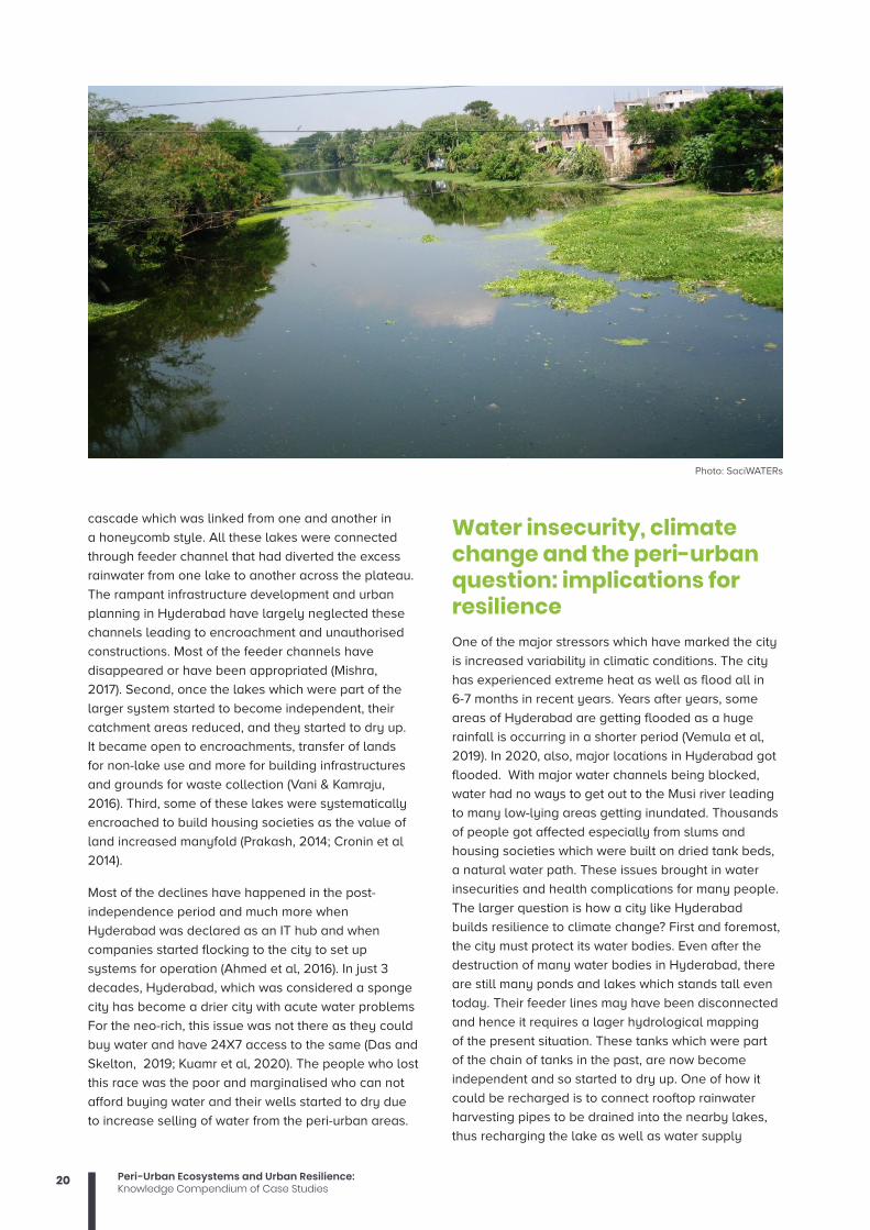
From sponge city to a city of water crisis: The story of the destruction of the surface water system in Hyderabad If the increased urbanization in the post-liberalization
era is to be blamed for the water supply crisis of
Hyderabad, what lies beneath is a larger process. It
involves systematic destruction of lakes and ponds of
Hyderabad. The city was part of the unique system of
rainwater harvesting that was created by earlier rulers
not only in Telangana but almost entire south India
and Sri Lanka. The system of water harvesting through
cascades of tanks for irrigation and drinking water
needs were first built during Kakatiya Dynasty (1163-
1323) which were strengthened by the QutubShahi
rulers (1534–1724 AD) and later by the Asaf Jahi rulers
(1724–1948). During the latter part of the years, some
of the large tanks built such as Hussain Sagar, Mir
Alam, Afzal Sagar, Jalpalli, Ma-Sehaba, Talab Katta,
Osman Sagar and Himayat Sagar. All these tanks
are artificially built, and residents of Hyderabad are
still dependent on some of these large tank systems
(Rekha Rani, 1999, quoted in Ramachandraiah &
Prasad, 2004).
Most of these lakes are now declining due to three
main reasons. First, these lakes were built on a
Photo: SaciWATERs
Photo: SaciWATERs
20 Peri-Urban Ecosystems and Urban Resilience:Knowledge Compendium of Case Studies
cascade which was linked from one and another in
a honeycomb style. All these lakes were connected
through feeder channel that had diverted the excess
rainwater from one lake to another across the plateau.
The rampant infrastructure development and urban
planning in Hyderabad have largely neglected these
channels leading to encroachment and unauthorised
constructions. Most of the feeder channels have
disappeared or have been appropriated (Mishra,
2017). Second, once the lakes which were part of the
larger system started to become independent, their
catchment areas reduced, and they started to dry up.
It became open to encroachments, transfer of lands
for non-lake use and more for building infrastructures
and grounds for waste collection (Vani & Kamraju,
2016). Third, some of these lakes were systematically
encroached to build housing societies as the value of
land increased manyfold (Prakash, 2014; Cronin et al
2014).
Most of the declines have happened in the post-
independence period and much more when
Hyderabad was declared as an IT hub and when
companies started flocking to the city to set up
systems for operation (Ahmed et al, 2016). In just 3
decades, Hyderabad, which was considered a sponge
city has become a drier city with acute water problems
For the neo-rich, this issue was not there as they could
buy water and have 24X7 access to the same (Das and
Skelton, 2019; Kuamr et al, 2020). The people who lost
this race was the poor and marginalised who can not
afford buying water and their wells started to dry due
to increase selling of water from the peri-urban areas.
Water insecurity, climate change and the peri-urban question: implications for resilience One of the major stressors which have marked the city
is increased variability in climatic conditions. The city
has experienced extreme heat as well as flood all in
6-7 months in recent years. Years after years, some
areas of Hyderabad are getting flooded as a huge
rainfall is occurring in a shorter period (Vemula et al,
2019). In 2020, also, major locations in Hyderabad got
flooded. With major water channels being blocked,
water had no ways to get out to the Musi river leading
to many low-lying areas getting inundated. Thousands
of people got affected especially from slums and
housing societies which were built on dried tank beds,
a natural water path. These issues brought in water
insecurities and health complications for many people.
The larger question is how a city like Hyderabad
builds resilience to climate change? First and foremost,
the city must protect its water bodies. Even after the
destruction of many water bodies in Hyderabad, there
are still many ponds and lakes which stands tall even
today. Their feeder lines may have been disconnected
and hence it requires a lager hydrological mapping
of the present situation. These tanks which were part
of the chain of tanks in the past, are now become
independent and so started to dry up. One of how it
could be recharged is to connect rooftop rainwater
harvesting pipes to be drained into the nearby lakes,
thus recharging the lake as well as water supply
Photo: SaciWATERs
21Peri-Urban Ecosystems and Urban Resilience:Knowledge Compendium of Case Studies
bores in the areas. Most of Hyderabad still relies on
individual bores and not on the water supply systems,
these provisions will help in recharging their borewells.
Second, all new and old housing societies must build
rainwater harvesting systems. For the new societies,
building permission should not be granted if the
rainwater harvesting system is not planned. If not, then
urban Hyderabad will continue to rely on peri-urban
and rural locations for their water supply. In future,
large conflicts may break out reported in the case
studies.
References Ahmed, Z., Rao, D. R. M., Reddy, K. R. M., & Raj, Y. E.
(2016). Integrated Storm Water Management–An
Approach for Urban Flooding In Hyderabad,
India. American Journal of Engineering
Research (AJER) e-ISSN: 2320-0847 p-ISSN:
2320-0936 Volume-5, Issue-10, pp-102-110
Cronin, A. A., Prakash, A., Priya, S., & Coates, S. (2014).
Water in India: situation and prospects. Water
Policy, 16(3), 425-441.
Das, D., & Skelton, T. (2019). Hydrating Hyderabad:
Rapid urbanisation, water scarcity and
the difficulties and possibilities of human
flourishing. Urban Studies, 57(7), 1553-1569.
Kamraju, M., & Kamraju, M. (2018). Changing Pattern of
Urban Growth in Hyderabad City: A Study. Jai
Maa Saraswati Gyanadayani, 3, 483-503.
Kumar Nayan, N., Das, A., Mukerji, A., Mazumder, T.,
& Bera, S. (2020). Spatio-temporal dynamics
of water resources of Hyderabad Metropolitan
Area and its relationship with urbanization. Land
Use Policy, 99, 105010.
Mishra, P. P. (2017). The benefits of improving urban
lakes in mega cities: a revealed and stated
preference approach applied to the Hussain
Sagar in Hyderabad, India. Environment and
Development Economics, 22(4), 447-469.
Narain, V., & Prakash, A. (Eds.). (2016). Water security
in peri-urban South Asia: Adapting to climate
change and urbanization (pp. 1-32). New Delhi:
Oxford University Press.
Narain, V., Khan, M. S. A., Sada, R., Singh, S., &
Prakash, A. (2013). Urbanization, peri-urban
water (in) security and human well-being: A
perspective from four South Asian cities. Water
international, 38(7), 930-940.
Prakash, A. (2014). The periurban water security
problem: a case study of Hyderabad in
Southern India. Water Policy, 16(3), 454-469.
Prakash, A., Singh, S., & Brouwer, L. (2015). Water
transfer from peri-urban to urban areas:
conflict over water for Hyderabad city in South
India. Environment and Urbanization ASIA, 6(1),
41-58.
Prakash, A., Singh, S., & Narain, V. (2011). Changing
Waterscapes in the Periphery. INDIA
INFRASTRUCTURE REPORT, 162.
Sen, S., John, A., Chakraborty, S., & Jatav, M. (2019).
Geographies of Drinking Water (In) securities
in Peri-urban Hyderabad. Economic & Political
Weekly, 54(39), 43.
Vani, M., & Kamraju, M. (2016). IMPACT OF
URBANISATION ON LAKES: A Case Study of
Hyderabad. Journal of Urban and Regional
Studies VOL, 5(1).
Vemula, S., Raju, K. S., Veena, S. S., & Kumar, A. S.
(2019). Urban floods in Hyderabad, India, under
present and future rainfall scenarios: a case
study. Natural Hazards, 95(3), 637-655.
Vij, S., John, A., & Barua, A. (2019). Whose water?
Whose profits? The role of informal water
markets in groundwater depletion in peri-urban
Hyderabad. Water Policy, 21(5), 1081-1095.
Wakode, H. B., Baier, K., Jha, R., & Azzam, R. (2018).
Impact of urbanization on groundwater recharge
and urban water balance for the city of
Hyderabad, India. International Soil and Water
Conservation Research, 6(1), 51- 62.
22 Peri-Urban Ecosystems and Urban Resilience:Knowledge Compendium of Case Studies
Circular Economy: Urban Resilience through Peri Urban Ecosystems
Shipra Singh, Ajay Singh
By adopting different practices, rapid urbanization at the peripheries of urban areas can be restructured into a more environmentally stable system. In recent times, urban expansion has led to creation of a new region called ‘peri urban’ with its own unique social, economic, environmental and institutional characteristic. Nevertheless, these regions are highly vulnerable due to a number of factors. Burdened by the growing cities, the natural resources such as land, water and air are greatly affected in peri urban regions. The increasing urban dependence on these regions makes them vital for planning and policy formulation. Under the interventions of Gorakhpur Environmental Action Group (GEAG), peri urban agriculture has been witnessing many innovative approaches to develop resilience. This case study documents the significance of peri urban regions in developing urban resilience and how these regions serve to be a bulwark for urban areas. The case study analyses different roles peri urban ecosystems play, the challenges they face and how a concept of circular economy will be helpful in becoming a way forward for these regions.
Rapid rate of urbanization in India, has led the cities
to continue expanding their urban margins. The effect
of urban sprawl can be witnessed more in developing
countries and is expected to double by 2050. India,
being a developing nation, can hence be predicted to
face new concerns and challenges in future. The urban
population in the world since 1970s was 40 percent
which is currently expected to rise by 60 percent in
2025 (Anjal et.al., 2011). The changing land use pattern,
rapid industrialization, migration and transformation
in agricultural practices have led to an accentuated
urbanisation. Increasing urban disasters, goods and
services, urban governance challenges and other
such factors have led to growing realization about
the importance of ‘peri urban’ space around cities
with its unique social, economic, environmental and
institutional characteristics. As the peri urban regions
are peripheral areas, they are quite hazy to distinguish
from urban or rural regions (Manasi and Raju, 2020).
Roughly understood, these regions are defined to be
a subtle boundary between urban and rural areas, an
urban fringe, a lacking area, a transition zone, new
kind of rural-urban hybrid, a challenging periphery and
so on (Varkey and Manasi, 2019).
These regions are crucial for understanding as they
are highly vulnerable due to a number of factors. Lack
of infrastructure facilities and poor economic status of
people form the core of these challenges. A significant
amount of untreated solid and liquid waste ends up
either in freshwater sources (rivers, lakes, ponds) or
in empty land sites (Varkey and Manasi, 2019). The
anthropogenic drivers of climate change in the form
of land degradation, pollution, changing livelihood
patterns, dumping industrial waste into surface and
groundwater have further resulted in an intensified
rainfall and temperatures (Ramasamy et.al., 2018). these
regions are highly prone to illegal land acquisition and
encroachment due to lack of any proper regulation or
advocacy (Saxena and Sharma, 2015). All these factors
pose a serious question mark on the meaning of a
peri urban region narrowed down to just becoming a
‘dumping ground region’ for urban neighbourhoods.

23Peri-Urban Ecosystems and Urban Resilience:Knowledge Compendium of Case Studies
The City of GorakhpurGorakhpur is becoming one of the fastest growing
urban economies in Uttar Pradesh. Located in the Terai
region of Uttar Pradesh, the city has a total area of
147sq. km and divided into 70 administrative wards. It
is a secondary city which is located at the confluence
of rivers Rapti and Rohin. Having the potential of
falling under the leading cities, Gorakhpur still faces
a myriad of problems related to urban planning and
natural disasters. The city has a natural inclination
towards floods due to being located at a lower
elevation than river Rohin along which it rests. The
city collects excess water discharged from Nepal in its
bowl-shaped topography. This is further aggravated by
climate uncertainties which might further increase the
rainfall intensity by 10 to 20 percent in future. This is a
major factor due to which small and marginal farmers
inhabited in the adjoining areas of city suffer from crop
losses (Bhatt et.al., 2016). Despite flooding being a
major calamity in this region, anthropogenic activities
such as encroachment of land and illegal construction
around the floodplain of river Rapti is being manifested
in many parts. (Mani and Wajih, 2014). The farming
community around Gorakhpur city includes 90 percent
of small and marginalised farmers who often have
very small land or high vulnerability to floods. Due to
lack of a concrete policy and insufficient capital and
resources, the young farmers easily fall into the cycle
of “distress migration” (Mani and Wajih, 2014).
Peri urban-urban resilience connect in Gorakhpur can
be understood in terms of the ecosystem services peri
urban regions bring to the urban regions. Gorakhpur’s
northern, western and southern areas have water
bodies such as lakes, ponds, tals (depressions) that
provide regulating services in the form of collection of
excess flood water, acting as natural reservoirs and
carbon sequestration Supporting services in the form of
soil erosion control, nutrient enrichment etc. indirectly
benefits the local population and nearby urban areas
through food security, livestock rearing, horticulture
and aquaculture (Mitra et.al, 2015). Owing to their
significance, the peri urban regions therefore, need to
be acknowledged properly through technical, local
and administrative interventions through a framework
of circular economy.
Girard and Nocca (2019) have described circular
economy to be based on the principle that in nature
nothing is “waste” and everything can become
a “resource”, and is proposed to operationalize
sustainable development principles. By adopting
different practices, rapid industrialisation at the
peripheries of urban areas can be restructured into a
more environmentally stable system. The concept of
circular economy is focused on minimizing untreated
waste and harmful emissions and stressing more on
recycling and reuse. Adoption of this framework helps
in generating benefits in terms of social, economic and
environmental and to recover lost natural resources
(Kakwani and Kalbar, 2020).
Recognizing the connection between peri-urban
ecosystems and rban resilience, efforts were made to
strengthen the circularity of economy amongst these
spaces resulting in a win-win situation. Conservation of
natural infrastructure and ecosystems and re-cycling
and re-use mechanisms in peri-urban areas on one
hand helped the livelihoods and production system of
communities in peri-urban spaces and this also helped
in enhancing the buffering capacity providing resilience
to city.
1. Wastewater Treatment:
Dumping of wastewater in the outskirts of city
is a common phenomenon causing damages
to crops, affecting health and hygiene and
enhancing pollution load. Through introduction
of Decentralised Wastewater Treatment System
(DEWATS), as a pilot initiative in village Semradevi
Prasad located in the southwest peri-urban part of
Gorakhpur. The basic principle behind DEWATS is
treatment of organic wastewater generated from
households, and reusing it in irrigation. Semradevi
Prasad is majorly engaged in agriculture and allied
activities (cattle rearing). Due to being in close
vicinity with urban Gorakhpur, this village is highly
influenced by the goods and services offered or
Figure: Gorakhpur and its Periphery (Bhatt et.al., 2016)

24 Peri-Urban Ecosystems and Urban Resilience:Knowledge Compendium of Case Studies
received by the city. However, this village often
serves as a mere dumping ground for urban
waste (solid and liquid). This disturbs the balance
of urban-peri urban relationship and urban
areas become parasites to peri urban regions,
leaching off their shores. Therefore, installation
of DEWATS in Semradevi Prasad village has
helped a total of 106 households (544 persons)
by treating approx. 65000 litres of wastewater
per annum through a simple and low operation
and maintenance technology. This has helped
increase the volume of land used for irrigation
by 4 hectares and replaced almost 8 agricultural
pump sets (average capacity 7.5 HP). The farmers
in the village now have access to clean irrigation
water for irrigating their crop fields, especially
vegetables. Farmers continue to lobby for access
to clean water and the treatment of sewage water
from Gorakhpur. Along with the economic benefits,
the installation of DEWATS has eased the access
of local population to clean water, increase in
toilet construction, ensured safety of women
and children from social bias and water-borne
diseases, behavioural shift from open defecation to
using toilets, provision of manure etc.
2. Solid Waste Management:
The increasing volume of solid waste in
Gorakhpur and the reduction of disposal options
are creating serious environmental problems in
the peri-urban villages. This led to a violent clash
between municipal authorities and peri urban
communities in Mahewa. Gorakhpur Municipal
Corporation records claim that the city engenders
601 metric tons of municipal waste circadian.
Records show that almost 90 to 92 percent of
city’s solid waste is accumulated. But garbage
management practices contravene the Municipal
Solid Waste (management and handling) Rules,
(Municipal Solid Waste) 2000. Gorakhpur’s
solid waste is either utilized as land fill material
(peri-urban villages like Chakradoyam, Mahewa,
Baharampur) or is dumped in some of the
demarcated locations especially in the low-lying
areas in the outskirts (Mahewa, Nausadh and
Mahesara) (Mitra et.al., 2017).
A pilot initiative to manage solid waste in Mahewa
area of Gorakhpur city was undertaken. It was
assessed that the 951 households in Mahewa
generate about 700 kgs of solid waste on a
daily basis out of which almost 50% was kitchen
waste which could be decomposed to produce
organic manure. The waste collection area was
divided into 3 zones and waste collectors were
deployed to collect and segregate waste into
bio-degradable and non-biodegradable. The
bio-degradable waste was collected in a drum
and compost culture was added to it (250 gms
of culture/75 kgs of waste). The compost was
prepared in 20 days which is used by the peri-
urban farmers in their field crops. Additionally, the
leachate (liquid substrate) obtained as part of the
composting process is also being used as liquid
manure in the crops.
A good example of circular economy that
composting resulted into, the bio-waste was well
managed, not landfilled and incinerated. Instead,
it formed a resource for improving soil quality and
promoting sustainable farming practices in the
peri urban areas.
Vegetable farming in thermokol boxes in waterlogged areas

25Peri-Urban Ecosystems and Urban Resilience:Knowledge Compendium of Case Studies
3. Climate Resilient Peri-Urban Agriculture:
Peri-urban agriculture, adopted as a strategy in
the flood prone areas of Gorakhpur, is serving
as a means to keep areas that are vulnerable to
flooding, free from construction and to maintain
their natural functions (enhancing water storage
and infiltration; reducing run off) resulting in less
floods and reduced impacts of high rainfall. It
has worked in reducing vulnerabilities of the
urban poor and enhanced their coping capacity
to deal with impacts of floods. It has also helped
in enhancing the food and income sources
of peri-urban agricultural communities. Since
most of the agricultural activities are done by
the women members of the family, nutritional
security has also been an important outcome
of peri-urban farming. Peri-urban agriculture
has helped in diversifying the food sources,
thereby reducing energy footprints. This has
also led to diversification in income opportunities
which helped in times of economic crisis and
in alleviating poverty. Preservation of local
biodiversity and recycling of urban waste are
other potentials that peri-urban agriculture has
offered in Gorakhpur.
Peri-urban agriculture is being practiced by small
anf marginal farmers in Gorakhpur in about 200
hectares of land in different pockets. The climate
resilient agriculture, based on the principles of
integration of livestock-household-agricultural field
is being promoted which is enhancing the diversity-
complexity and recycling processes in the farming
systems. Use of low external bio-inputs, appropriate
crop varieties, space and time management, seed
banking, land shaping and potable nursery systems
are practices being followed by these farmers.
Keeping in view the geographical conditions of
the area and frequent flood events, farmers have
adopted innovative and robust farming practices to
sustain their livelihoods such as:
• Integration of various farm sub-systems:
helping use of outputs of one subsystem as
input for another sub-system for example the
efficient use of dung from cattle shed/poultry
for composting and bio-manure for agriculture
field, waste from farmers house and agriculture
field as feed of poultry or fish ponds etc can
help in utilizing the waste/outputs efficiently,
thereby reducing the requirement of inputs
from beyond farm system and hence reducing
input costs
• Integration of crops and multi-tier farming:
helping in optimal utilization of resources like
water, nutrients as well as saving the upper tier
of crops in spite of flooding and inundation.
Climbers and multi-level c rops also provides
better outputs per unit area of land
• Linking with nearby ecosystems: like
waterbodies, orchards, green spaces for inputs
in farming as well as food and fodder.
• Crop diversification, space and time
management, food resilient crop varieties,
Low External Input Sustainable Agriculture
(LEISA) and other such practices helped
farmers in better outputs, saving from losses
and lesser inputs.
Machan farming to reduce crop losses
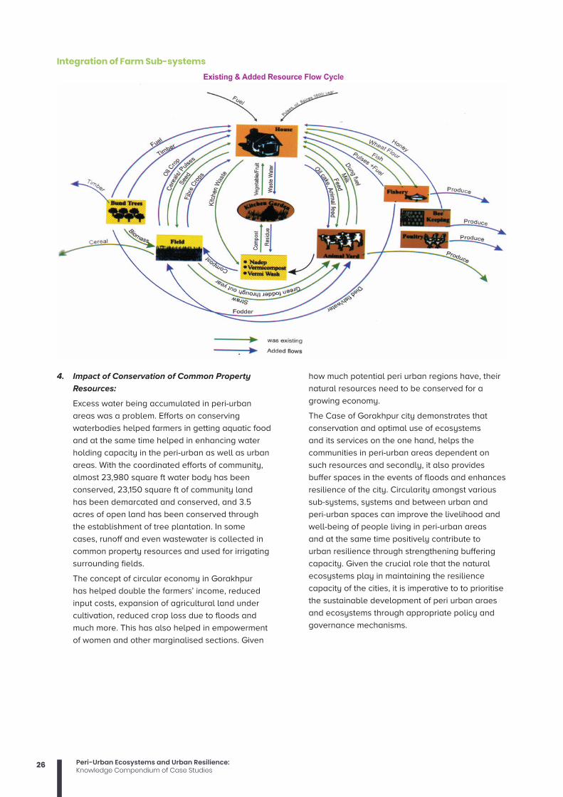
26 Peri-Urban Ecosystems and Urban Resilience:Knowledge Compendium of Case Studies
4. Impact of Conservation of Common Property
Resources:
Excess water being accumulated in peri-urban
areas was a problem. Efforts on conserving
waterbodies helped farmers in getting aquatic food
and at the same time helped in enhancing water
holding capacity in the peri-urban as well as urban
areas. With the coordinated efforts of community,
almost 23,980 square ft water body has been
conserved, 23,150 square ft of community land
has been demarcated and conserved, and 3.5
acres of open land has been conserved through
the establishment of tree plantation. In some
cases, runoff and even wastewater is collected in
common property resources and used for irrigating
surrounding fields.
The concept of circular economy in Gorakhpur
has helped double the farmers’ income, reduced
input costs, expansion of agricultural land under
cultivation, reduced crop loss due to floods and
much more. This has also helped in empowerment
of women and other marginalised sections. Given
how much potential peri urban regions have, their
natural resources need to be conserved for a
growing economy.
The Case of Gorakhpur city demonstrates that
conservation and optimal use of ecosystems
and its services on the one hand, helps the
communities in peri-urban areas dependent on
such resources and secondly, it also provides
buffer spaces in the events of floods and enhances
resilience of the city. Circularity amongst various
sub-systems, systems and between urban and
peri-urban spaces can improve the livelihood and
well-being of people living in peri-urban areas
and at the same time positively contribute to
urban resilience through strengthening buffering
capacity. Given the crucial role that the natural
ecosystems play in maintaining the resilience
capacity of the cities, it is imperative to to prioritise
the sustainable development of peri urban araes
and ecosystems through appropriate policy and
governance mechanisms.
Integration of Farm Sub-systems
27Peri-Urban Ecosystems and Urban Resilience:Knowledge Compendium of Case Studies
References:Prakash Anjal, Singh Sreoshi, Narain Vishal, (2011),
Changing Waterscapes in the Periphery:
Understanding Peri-Urban Water Security in
Urbanizing India, pp. 162-173.
Varkey Amrutha Mary, Manasi S, (2019), A Review of
Peri-Urban Definitions, Land Use Changes and
Challenges to Development, Vol. 39(1), pp. 96-
110.
Manasi S, Raju V. K., (2020), Coping Mechanisms for
Climate Change in Peri-Urban Areas.
Mani Nivedita, Wajih Shiraz A, (2014), A participatory
approach to micro-resilience planning
by community institutions: The case of
Mahewa ward in Gorakhpur City, Gorakhpur
Environmental Action Group, Asian Cities
Climate Resilience, Gorakhpur (U.P.).
Saxena Manita, Sharma Suman, (2015), Peri urban
Area: A Review of Problems and Resolutions,
International Journal of Engineering Research &
Technology, Vol. 4, pp. 15-18.
Ranjan Vishnu C, Sridharan R, (2016), A Case Study
on Impact of Chennai Floods: Supply Chain
Perspective, IIIE Industrial Engineering Journal,
Vol. 9.
Ramasamy S.M., Vijay. A, Selvam, Dhinesh, (2018),
Geo-anthropogenic aberrations and Chennai
floods: 2015, India, Natural Hazards.
The Energy and Resources Institute, (August, 2012),
Mainstreaming Climate Resilience in Urban
Areas: A case of Gorakhpur City, Rockefeller
Foundation.
Bhatt Seema, Singh Ajay, Mani Nivedita, (2016), Peri-
Urban Agriculture and Ecosystems: Resilient
Narratives, Gorakhpur Environmental Action
Group.
Mitra Amit, Wajih Shiraz, Singh Bijay. (2015). Wheezing
ecosystems, livelihood services and climate
change resilience in Uttar Pradesh, Asian Cities
Climate Resilience.
Girard Fusco Luigi, Nocca Francesca, (2019), Moving
Towards the Circular Economy/City Model:
Which Tools for Operationalizing This Model,
Sustainability, pp. 1-48.
Meijboom Marianne, Tiwari Sunandan, Dubbeling,
(May, 2016), Marielle Enhancing climate
resilience of Gorakhpur by buffering floods
through climate-resilient peri-urban agriculture,
The Rockefeller Foundation.
Mitra Amit, Singh Bijay K, Singh Ajay.K., Katyal
Sakshi, (2017), India’s Peri-urban Crises: The
lack of an ecosystems approach, Gorakhpur
Environmental Action Group, Gorakhpur.
Mitra Amit, Singh Bijay, (2013), Gorakhpur City:
2031 Solid Waste Management, Gorakhpur
Environmental Action Group, Gorakhpur, Uttar
Pradesh and Asian Cities Climate Change
Network.

28 Peri-Urban Ecosystems and Urban Resilience:Knowledge Compendium of Case Studies
Ecosystem Services for Disaster Risk Reduction: Wetlands of Okhla Bird Sanctuary, Delhi
Swati Singh, Sreeja Nair, Anil Kumar Gupta
Wetland ecosystems are part of our natural wealth. According to Ramsar Convention, they provide us with services worth trillions of US dollars every year entirely free of charge making a vital contribution to human health and well being. Wetlands are one of the most productive ecosystems of the world which along with supporting unique flora and fauna provides range of ecosystem services (MA, 2005). Wetland ecosystems also contribute to reducing disaster risk by serving as natural protective barriers or buffers and thus mitigating hazard impacts (Gupta and Nair, 2012).
Well managed ecosystems can provide natural protection
against common natural hazards, such as landslides,
flooding, wildfires, storm surges and drought (Rieux et al.,
2009). Ecosystem decline increases disaster risk both by
reducing the ability of an ecosystem to act as a natural
buffer, as well as by reducing people’s resilience by
reducing their bases for livelihoods such as food, medicine
and construction materials (ProAct Network, 2008). A
study was conducted to understand the role of wetland
ecosystem in East Delhi to analyse the present state and
the services provided by these systems. The study also
analyses the role of ecosystem in reducing the risk of
water and climate related disasters like flood, drought
and epidemics. Besides this, the study is an attempt to
analyse the importance of these services and suggest
various opportunities for protecting these ecosystems and
challenges in Delhiand itsvicinity.
Flood plains of river Yamuna and Yamuna river basin
(Source: Singh et al., 2013)

29Peri-Urban Ecosystems and Urban Resilience:Knowledge Compendium of Case Studies
The Case Study AreaDelhi, the capital city of India lies between 28.380 N
and 77.120 E in latitude and longitude respectively. The
River Yamuna (Fig 5.6), a major tributary of Ganges, is
one of the key natural infrastructures of Delhi city. The
total length of the river in the city is 50 Km between its
entry at Palla and exit at Jaitpur. Its floodplains extends
to an area of 94.84 km2 comprising forests, agriculture
land, settlements and lakes/ponds and can hold lot of
water-about 2 billion cubic meters. The maximum width
of the active floodplain is observed near Okhla where
a large quantumofwaterisbroughtthroughHinduncut.
Despitehighurbanstress,thefloraldiversity of the
floodplains include 74 species of macrophytes and 90
species of phytoplankton, whereas the faunal diversity
constitutes 62 species of zooplankton, 55 species of
benthos, 36 fish species and 131 bird species (Source:
Wetland International-SouthAsia).
Delhi region has suffered major floods during 1924, 1947,
1967, 1971,1975,1976,1978, 1988, 1993, 1995, 1998 and
2010. The 1978 was the worst ever flood in Delhi when
water Level reached at 207.49 m (danger level is 204.83
m) with discharge 2.53 lakh cusec at old Railway bridge
(7.0 lakh cusec discharge was released from Tajewala)
when130 villages and 25 urban colonies in Delhi were
submerged in water. As per the map of flood prone
areas prepared by central water commission, Delhi
has been classified into thirteen zones based on the
flooding risk in relation to incremental rise in the water
level of the of the Yamuna. Beside this, the Delhi flood
control order (2011) also divides the NCTD into four flood
sectors, namely Shahdra, Wazirabad-Babrapur, Alipur
and Nangloi-Najafgarg sectors. A detailed analysis of
the eight flood affected villages during 2010 September,
from the North Delhi, it is evident that the area witnessed
tremendous land use land cover changes over past
two decades. During the September 2010, rainfall in
Delhi was 359.7 mm which 180% more than the normal
rainfall. Urban floods are becoming a perennial feature
of the city due to inadequate drainage, uncontrolled
development and land use changes particularly in the
Yamuna Flood Plain.
MethodologyTransect walk was carried out across the corridor
of river Yamuna in Delhi to identify and explain the
relationships among floodplain, natural vegetation,
cultivation, human activities & settlement pattern
and understand the various ecosystem services
provided by the wetland. Transect walk helped us
to understand natural resources, present land use
pattern, vegetation, changes in the physical features
and cropping systems, and so on in villages Public
resources, land use, social differentiation and mobility
in urban communities (de Zeeuw, 2004). A survey was
also conducted to have view of communities living
on the fringes of wetland on disasters faced by them
and ecosystem services provided by the wetland.
Experts view (academicians, ecologist, practioners,
and bureaucrats) on the integration of ecosystem
services and DRR were also taken. Scoring was done
(on the basis of number of hazards addressed by
one ecosystem service) for analysing the ecosystem
services and DRR aspects addressed and based on the
scores importance were attached as high (4-5), medium
(3) and low (<3). In this study five is the highest score.
Discussions: Ecosystem services of wetland of East DelhiThe availability of water near Okhla throughout the
year helps to maintain minimum water level required
for functioning of the floodplain. The surplus water
during monsoon percolates down and helps to control
floods and maintain moisture regimes during lean
period. Bio accumulation of key nutrients in floodplain
helps to reduce pollution stress thereby leading to
development of rich biodiversity habitat. Okhla Bird
Sanctuary (notified in 1990 by UP Govt.) situated in
Gautam Budha Nagar is rich in avifaunal diversity
and presently inhabits more than 145 bird species
include 22 species of resident water birds, 44 species
of resident terrestrial birds, 43 species of migratory
water birds and 26 species of terrestrial migratory
birds. The sanctuary covers rich aquatic, semi-aquatic
and terrestrial habitat where more than 25 species
of aquatic plants, 110 species of terrestrial plants
including herbs, shrubs, climbers, grasses and trees
have been recorded (Source: Divisional Forest Officer,
Gautam Budha Nagar, UP, 2012).
Communities residing in the floodplain derive their
basic needs like water for drinking, irrigation and
domestic purposes from the floodplains of Yamuna. For
drinking purpose hand pump is available and water
depth is found to be 10-15ft. For irrigation bore wells
are used. The source of livelihood of the communities
is agriculture and labour. The floodplain is very fertile
and supports lots of vegetables, horticulture and
floriculture. Vegetables grown are lobia, cauliflower,
cabbage, bottleguard, lady’s finger, onion, potato,
spinach, corn and bitter guard. It was surprising to the
researchers to find out that cultivators used urea, DIP
and other chemical fertilizers in their field. Community
didn’t complain about diseases caused by water
however dengue outbreak has been reported after
monsoon and flood in the entire city.
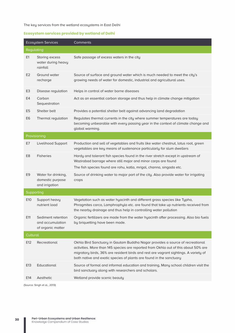
30 Peri-Urban Ecosystems and Urban Resilience:Knowledge Compendium of Case Studies
The key services from the wetland ecosystems in East Delhi
Ecosystem services provided by wetland of Delhi
Ecosystem Services Comments
Regulating
E1 Storing excess
water during heavy
rainfall
Safe passage of excess waters in the city
E2 Ground water
recharge
Source of surface and ground water which is much needed to meet the city’s
growing needs of water for domestic, industrial and agricultural uses.
E3 Disease regulation Helps in control of water borne diseases
E4 Carbon
Sequestration
Act as an essential carbon storage and thus help in climate change mitigation
E5 Shelter belt Provides a potential shelter belt against advancing land degradation
E6 Thermal regulation Regulates thermal currents in the city where summer temperatures are today
becoming unbearable with every passing year in the context of climate change and
global warming.
Provisioning
E7 Livelihood Support Production and sell of vegetables and fruits like water chestnut, lotus root, green
vegetables are key means of sustenance particularly for slum dwellers
E8 Fisheries Hardy and tolerant fish species found in the river stretch except in upstream of
Wazirabad barrage where still major and minor carps are found
The fish species found are rohu, katla, mrigal, channa, singada etc.
E9 Water for drinking,
domestic purpose
and irrigation
Source of drinking water to major part of the city. Also provide water for irrigating
crops
Supporting
E10 Support heavy
nutrient load
Vegetation such as water hyacinth and different grass species like Typha,
Phragmites carca, Lamphrophyla etc. are found that take up nutrients received from
the nearby drainage and thus help in controlling water pollution
E11 Sediment retention
and accumulation
of organic matter
Organic fertilizers are made from the water hyacinth after processing. Also bio fuels
by briquetting have been made.
Cultural
E12 Recreational Okhla Bird Sanctuary in Gautam Buddha Nagar provides a source of recreational
activities. More than 145 species are reported from Okhla out of this about 50% are
migratory birds, 36% are resident birds and rest are vagrant sightings. A variety of
both native and exotic species of plants are found in the sanctuary
E13 Educational Source of formal and informal education and training, Many school children visit the
bird sanctuary along with researchers and scholars.
E14 Aesthetic Wetland provide scenic beauty
(Source: Singh et al., 2013)

31Peri-Urban Ecosystems and Urban Resilience:Knowledge Compendium of Case Studies
Exposure and RisksThe Flood plains of river Yamuna in Delhi are critically
threatened due to biotic, abiotic and huge urbanisation
pressures. Biotic stress includes uncontrolled siltation
and weed infestation, uncontrolled discharge of
waste water, industrial effluents etc. Abiotic stress
includes encroachment resulting in shrinkage of area,
anthropogenic pressures leading in habitat destruction
and loss of biodiversity etc. Rapidly increasing
urbanisation with limited integration of values and
functions of floodplains in developmental planning
has led to their fragmentation. Flows in the river are
drastically reduced due to upstream abstractions
for irrigation, industrial and domestic water supply.
Conversion of floodplain areas for developmental
activities like NOIDA toll bridge, Akshardham Temple,
Millennium depot, Delhi Secretariat, Commonwealth
games infrastructure etc. are making the region more
vulnerable. From risk perspective, degradation of
floodplains is increasing flooding risks to the city along
with stresses related to food and water scarcity.
In 2010 the city witnessed one of the worst floods
because of heavy rainfall coupled with development
within the natural course of the river. Yamuna water
entered Delhi after being released from Tajewala and
Hathnikund barrages up North, the water had lesser
area to accommodate itself on the floodplain since a
chunk of the floodplain–the size of the Commonwealth
Games Village–was no longer available to the river
that it was for centuries. As evident from the above
figure 5.7 the entire river bed in the west between the
ring road and stream has been lost due to various
construction and developmental activities. A tour
through the Yamuna flood plain gives the glimpse of
encroached wetland. Indraprastha thermal power
plant was established on the bank of the river to
discharge waste generated directly into the flowing
water. Samadhis of our several leaders and politicians
had been built in the floodplain between Nigambhod
Ghat and Rajghat. Millennium Bus Depot (Asia’s
biggest depot) which was constructed during Common
Wealth games, remain flooded for almost three months
because of no drainage system in 2010 and ironically it
happened just before a month for games to commence.
Ponds, near Barakullah drain have disappeared due
to bridges and flyovers and have now been converted
into parks full of water hyacinths showing eutrophied
condition. The important lung space of the city has
been lost converting it into heat island.
Many marginalised communities depend upon the
ecological services provided by the wetland to meet
their day to day requirements(Table5.2).Migratory birds
that come to Okhla Sanctuary used to rest at Gautam
Buddha Park which has now been converted into
concrete political park. Ecologist and Conservationist
Mr. T K Roy say that Gautam Buddha Park has
negatively affected the species diversity and also the
duration of stay of migratory species has lessened. The
reason is non availability of tree species for nesting
and food. The species that have not been sighted
in the sanctuary from last 5-6 years are paradise
flycatcher, Egyptian vulture and great spottedeagle.
Unplanned urbanisation has drastically altered the
drainage characteristics of natural catchments by
increasing the volume and rate of surface runoff.
Drainage systems are unable to cope up with the
increased volume of water and are often encountered
with the blockage due to indiscriminate disposal of
solid wastes. Twenty prominent sewage and drainage
system that carries the untreated loads of in and
around Delhi is increasing the vulnerability of the
sanctuary. Total quantity of sewage generated in Delhi
is around 2,871 MLD whereas the capacity of sewage
treatment plan is 1,478 MLD only. The figure clearly
indicates that 1,393 mld of untreated sewage is directly
discharge into the river (Source: Wetland International-
South Asia). The table 5.3 provides how the floodplain
has been addressing various hazards and helped in
disaster risk reduction.
Vulnerability map showing present State of river bed in Delhi
(Source: Yamuna Jiye Abhiyaan, 2007)

32 Peri-Urban Ecosystems and Urban Resilience:Knowledge Compendium of Case Studies
Disaster Risk Reduction function of Yamuna floodplain
Addressing Hazard
H1 Flood Addressing flood hazard by means of spread and passage of flood waters during the
monsoon every year and exceptional floods once every decade or more (1978, 1988, 1995,
2010).
H2 Epidemics Addressing epidemics like dengue and malaria
H3 Drought Addressing meteorological drought in the capital by supplying water for irrigation during
lean period
Reducing Vulnerability
V1 Physical
vulnerability
Reducing physical vulnerability by providing buffer to build in infrastructure like irrigation
system, municipal water supply, sanitation and drainage by checking land degradation
both to the people as well as of the ecosystem
V2 Economic
vulnerability
Reducing economic vulnerability by providing stable source of income from fruits,
vegetables and fisheries
V3 Livelihood
vulnerability
Reducing vulnerability of local people who are dependent on wetland for their livelihood
like vegetables and fruits along with addressing issue of food security. Also reducing
vulnerability of the people who are dependent on fisheries for their livelihood support
V4 Environment
Vulnerability
Reducing environmental vulnerability by checking water scarcity, providing suitable
environment for fish breeding, taking nutrient loads from the drainage system etc. around
the city.
Increasing Capacity
C1 Governance Strengthens knowledge and policy environment which in turn helps strengthening
governance and hence increasing the capacity to address disaster in a holistic way. It
helps traditional DM professionals and engineers recognise DRR benefits of ecosystems
C2 Society and
economy
Communities are engaged in diverse and environmentally sustainable livelihoods resistant
to hazards.
C3 Land use
management
and structural
design
Effective land use and structural design that complement environmental, economic, and
community goals and reduce risks from hazards.
C4 Risk
Knowledge
Leadership and community members are aware of hazards and risk information is utilized
when making decisions.
C5 Warning and
evacuation
Community is capable of receiving notifications and alerts of flood, warning at-risk
populations and individuals acting on the alert.
C6 Emergency
Response
Mechanisms and networks are established and maintained to respond quickly to flood
and drought disasters and address emergency needs at the community level
C7 Disaster
Recovery
Plans are in place prior to hazard events that accelerate disaster recovery. Engage
communities in the recovery process and minimize impacts
(Source: Singh et al., 2013)

33Peri-Urban Ecosystems and Urban Resilience:Knowledge Compendium of Case Studies
Opportunities and challenges of Integrating Ecosystem Approach in Disaster Risk ReductionEcosystem approach to DRR is widely advocated
as second paradigm shift in disaster management,
as it directly links with the livelihood of the people
and sustainability of their resources (Gupta,
2012). This calls for emphasis on natural resource
management,ecosystem services, land-use and
adaptation to climate change within the strategies of
disaster prevention, preparedness and post-disaster
relief and recovery process (National Policy on Disaster
Management, 2009, section 5.1.6). Most of the floodplains
have been encroached for various developmental
projects, however, there are opportunities available for
developing ecosystem approaches for reducing disaster
risks due to climate change in Delhi and nearby areas.
In the table below an effort has been made to integrate
ecosystem services in DRR framework.
The table above clearly shows that each of the
ecosystem services addresses one or more aspects
of DRR. Out of 14 ecosystem services provided by the
wetland of East Delhi four are highly important (E1R,
E7P, E9P and E11S), one holds medium importance
(E8P) and rest are of low importance. The scoring
and importance attached does not discourage the
other ecosystem services provided by the wetland
rather it gives the priority for such services that can be
integrated in the DRR framework.
ConclusionWetlands on the corridor of Yamuna have become one
of the most threatened ecosystems and are rapidly
diminishing due to anthropogenic activities. Pressure for
conversion of wetlands for developmental purposes is
very high especially in case of urban riparian wetlands.
These wetland ecosystems provide many tangible and
intangible benefits on a sustainable basis not only to
the urban society but also to the associated dependent
ecosystems. According to Dr. David Pithart, we can
consider river floodplain as a tool for mitigation of flood
waves or extreme low discharges, only if a floodplain
management and structure respect this natural function.
Recognizing the importance of wetland ecosystems, the
National Environment Policy (NEP), 2006, contains an
unambiguous assertion ofthe need for a holistic view
of wetlands, which looks at each identified wetland in
terms of its causal linkages with other natural entities,
human needs, and its own attributes. The ecosystem
approach to disaster risk reduction advocates for
sustainableecosystems management as strategy to
reduce exposure and vulnerability, through hazard
mitigation or regulation as well as enhancement of
livelihood capacities and resilience.
Note: Reference for more detailed understanding of
the case study is following:
Singh, S., Nair, S.S., & Gupta, A.K. (2013). Ecosystem
Services for Disaster Risk Reduction: A Case Study
of Wetland in East Delhi Region, India. Global Jour.
on Human Social Science, Geog., Geo- Sciences,
Env. and Disaster Mgt, 13 (4), 37-47.
Integrating Ecosystem services and Disaster Risk reduction of the wetland of East Delhi
Ecosystem Services DRR aspects addressed Scoring Importance
E1R Storing excess water during heavy rainfall H1, V1, C3,C5 4 High
E2R Ground water recharge V4 1 Low
E3R Disease regulation H2 1 Low
E4R Carbon Sequestration V4 1 Low
E5R Shelter belt V1 1 Low
E6R Thermal regulation V4 1 Low
E7P Livelihood Support V2, V3, V4, C1, C2 5 High
E8P Fisheries V2, V3, V4 3 Medium
E9P Water for drinking, domestic purpose and irrigation H3,V1, V4, C3 4 High
E10S Support heavy nutrient load V4 1 Low
E11S Sediment retention and accumulation of organic matter V1, V4, C1, C3 4 High
E12C Recreational C1 1 Low
E13C Educational C4 1 Low
E14C Aesthetic V4 1 Low
(Source: Singh et al., 2013)Note: R, P S and C stands for regulating, provisioning, supporting and cultural services of eco system respectively.

34 Peri-Urban Ecosystems and Urban Resilience:Knowledge Compendium of Case Studies
Peri-urban Ecosystems impacting Urban ResilienceA case study of Secondary Cities in Eastern India Nivedita Mani, Shiraz A Wajih
This case study seeks to examine the links between ecosystem services, urbanisation and resilience to climate change, using the cases of few cities in the Ganga-Brahmaputra Plains of eastern India. This includes understanding the notion of an ecosystem and how urban transformations, unless carefully planned and implemented, can impact such ecosystems adversely. It argues that not adhering to certain basic principles of an ecosystem-based approach to development, including the understanding of urban, peri-urban and rural areas and their associated systems, can be detrimental for both populations and the ecosystem itself.
For instance, in the process of urban sprawl at the peri-
urban interface, areas such as greenbelts, open spaces
and floodplains are threatened and rendered fragile. This
affects livelihoods which draw on ecosystem services,
and are possibly more at risk in a situation of uncertainty
surrounding climate change. Thus, by understanding the
roles and services provided by these spaces and their
ecosystems more generally, one can understand their
role in contributing to urban resilience to climate change.
Even as cities’ burst at their seams, they continue to turn
a blind eye as their natural blue and green infrastructure,
in and around them, slowly and steadily morphs into a
deeper, darker shade of grey. And when disaster strikes,
as it often does in today’s changing climate, these same
cities are left battered and disoriented. The impact of
climate change poses newer challenges for the cities
because of their demographic, geo-climatic and socio-
economic settings.
The cities along the Ganga-Brahmaputra basin are no
different. With climate variability here ranging from high
precipitation to rain shadow areas, snowfall to strong
winds, the region is highly vulnerable. With climate change
adding even more unpredictability to an already volatile
scenario, the basin and its people face a greater risk
than before. When we talk of urban climate resilience,
we can no longer discuss urban areas in isolation. The
places around it, especially the peri-urban spaces play an
essential role in urban well-being. It is possible for cities
to grow and still be resilient. The steady march of urban
concrete into river basins, open areas and agricultural
land needs to hit a pause button. After all, it is these
‘transition’ zones that help make a city smart, sustainable
and resilient. The challenge, though, lies in turning these
common resources into viable opportunities. And, more
often than not, it is the men and women living in these risk
prone areas, who turn their modest ideas into innovations
that help show the way forward to a resilient urban space.

35Peri-Urban Ecosystems and Urban Resilience:Knowledge Compendium of Case Studies
Under the Asian Cities Climate Change Resilience
Network (ACCCRN) initiative of the Rockefeller
Foundation, Gorakhpur Environmental Action Group
(GEAG) worked in the peri urban areas of Gorakhpur
(UP), Jorhat (Assam), Bashirhat (West Bengal) and
Saharsa (Bihar) to scale up its experiences on
conserving peri-urban areas and ecosystems for urban
resilience.
Peri-urban Ecosystems in Jorhat, Assam Jorhat is a secondary city located in the north-
eastern part of Assam. The city is located on the
Bohgodi and Tarajan rivers which are tributaries
of river Brahmaputra. Jorhat is one of the fastest-
growing cities in Assam. The peri urban areas of
Jorhat are particularly prone to recurring floods and
water logging for two to three months every year,
because of which small and marginal farmers suffer
from crop losses. Climate change is likely to increase
the intensity of similar rainfall events by 5-10 % in
the future. Climate projections have indicated that
the intensity of extreme rainfall in Jorhat is likely
to increase in the coming years, which will cause
significant flooding in the city and peri urban areas.
Flooding occurs in most of the village which are in low-
lying areas.
Between 1962 and 2005, major land use changes
have taken place both in residential and commercial
areas in Jorhat Municipal Area. The vacant land which
was demarcated as “no-construction zone” decreased
from 87.35 hectares to 39.88 hectares. In case of roads
and railways, the land area has increased from 55.95
hectares in 1962 to 81.78 hectares in 2005. The area
under parks and playgrounds has decreased from
15.39 hectares to 14.09 hectares.
Similarly, the vacant land demarcated for open and
green areas and water bodies have also decreased.
All these land use changes are mainly due to
urbanisation and new settlements. It is observed that
covered areas have increased at a faster rate, which
ultimately reduced the capacity of surface flow. As a
result, surface water accumulates more and rushes to
depressed areas resulting in waterlogging in the city.
The current situation of peri-urban ecosystems in
Jorhat is alarming. Before 10-15 years, 60-70% of the
households in villages had their own waterbodies like
ponds but they are only left with presently 30-32%
water bodies. The main causes for decreasing of water
bodies are the contamination of ponds, high land
value, climate change (less rain fall), and urbanization
pressure. Further, the bamboo plantation area in the
peri-urban areas has also reduced by 30-35%. The
forest cover has also reduced because of constructions
taking place which has also impacted the natural
habitat for animals.
Peri-urban agriculture in Jorhat is also facing
threats of land use change and distressed selling of
land because of low income from agriculture. The
ecosystems are also shrinking which used to provide
much of the inputs at no cost for agriculture. GEAG
worked with the peri-urban farmers in Jorhat and
supported them in learning new techniques of low
external input and climate resilient agriculture at
small scale for small land holding small and marginal
farmers, integrated farming systems with combinations
of crop-horticulture, horticulture-fisheries, animals-
fishery-crop, growing high value crops like vegetables,
flowers, citrus fruit cultivation, increasing crop diversity,
and so on.
Case Study Cities (Four cities of eastern India in the Ganga-Brahmaputra Plains
Jorhat city and its periphery showing green areas

36 Peri-Urban Ecosystems and Urban Resilience:Knowledge Compendium of Case Studies
Flower Power: A woman farmer shows the way
Barnalli Datta, a forty-three old woman, living in Dhenuchosa village in the peri urban areas of Jorhat, adopted climate resilient farming systems in her crop fields. On her land, water logging was a major nuisance and the soil remained wet throughout the year. The land was fertile no doubt, but water surplus; 1.5 acres was not always available for cultivation, many times nothing could be irrigated here due to water logging and the rest arable for just about six months in a year. The only way to keep plants from being smothered by water was to raise the level of the land. Gaining insights on resilient farming techniques, Barnalli went on to construct rows of high beds, nearly three feet in height. A deeper trench, more than four feet deep, was then built around the entire field, sloping towards an existing natural channel in the area.
Barnalli further learnt that flowers had a ready market, and the idea of fragrance and colour in her fields swayed her decision to go for ‘flower power’. She began to experiment with different flowers that were planted on the ridges. The furrows are taken up by rice, vegetables or marigold planting. Today, her field is one blooming garden all year round. And the money is good. Flowers are in demand throughout the year, and she manages to earn a handsome profit from her venture. She is astute enough to understand the pulse of the market and ensures that there is atleast a gap of 10-15 days between flower plantations. This prevents too many blooms reaching the market at one go, which would result in lower prices for her. Another interesting innovation is the placement of plastic sheets on the raised beds. These have holes punched in them for the plant to grow, while the rest of the soil is left covered. With this, the need for weeding reduces, as does the labour cost.
The trench that borders her land is an added asset. It acts a water storage unit, from where water is pumped for irrigating the fields. During heavy rains, the surplus is allowed to runoff into the natural channel that it meets. And in the normal course of events, this water channel doubles as a fishery. A quick and easy source of income and nutrition for the family, local varieties of fish thrive here. Barnalli makes a neat profit of approx. Rs 20,000 to Rs 30,000 by selling off her fish produce. Today Barnalli has completely moved away from the mono cropping method to a diversified farming system which is not only fetching her good prices but is also resilient to climate shocks.
Peri-urban Ecosystems in Gorakhpur, Uttar PradeshGorakhpur, a secondary city, located in eastern Uttar
Pradesh at the confluence of rivers Rapti and Rohin, has
grown rapidly into an economic and institutional hub
in the region. The peri-urban areas of Gorakhpur are
particularly prone to recurring floods and waterlogging
for 2 to 3 months every year due to which small and
marginal farmers suffer from crop losses.
In the peri-urban areas of Gorakhpur, 8089 hectares
of land is prone to flood. This is in the western part
of the city and gets inundated every year. In spite of
flood plains and being a no construction zone, the
rapid encroachment is being manifested in many parts.
As per the satellite images of two-time period (2002
Gorakhpur city and its surroundings

37Peri-Urban Ecosystems and Urban Resilience:Knowledge Compendium of Case Studies
and 2015), 267.42 hectares (33%) of land has been
converted into built-up area. The north, north-east, east
and south-eastern part of the city periphery are free
from water logging and flood. This segment accounts
11558.17 hectares which is marked as agriculture land/
green land. The city is growing in this direction. Due to
rapid urbanization, the land mafias (builders) are more
active in this zone and converting the open spaces/
agriculture lands into residential area.
About 54% of the peri-urban area represented in the
Gorakhpur city Master Plan-2021 for agricultural use,
has a population of 0.1 million of which a significant
proportion belongs to small and marginal farmers’
category. These farmers are hit by several problems
of flood and waterlogging, sewage dumping,
increasing cost in agriculture, changing land use
patterns and governance issues which make them
socially and economically vulnerable.
The peri-urban spaces had provided vital ecosystem
services such as recharging water bodies and acting
as buffers. These services, and their contribution
to the city’s resilience, are being lost. Supporting
services, including nutrient dispersal and cycling, seed
dispersal, and primary production have been altered,
changing the nature of all other services. The people in
Gorakhpur’s peri-urban villages now increasingly rely
on the market for food and medicines and other goods.
There is an acute fuel shortage, leading to reliance on
expensive sources of energy and electricity.
GEAG undertook the initiative which sought to mitigate
flood risks through maintenance of open spaces by
strengthening peri-urban agriculture based livelihoods
around the city of Gorakhpur. While the initiative aimed
at enhancing incomes and increasing food security
for low-income residents, it also targeted to influence
citywide land use planning decisions towards the goal
of developing greater flood resilience. Today, peri-
urban agriculture in Gorakhpur city of India represents
a practical mechanism for diversifying urban
livelihoods, particularly those of poor and marginalised
communities, ensuring the availability of local food
supplies, particularly vegetables and fruits and
maintaining open areas that can serve as flood buffers.
The land use pattern and ecosystem services in these
areas are maintained to promote climate resilient peri-
urban agriculture with innovative methods. This has
resulted in securing livelihoods of small and marginal
farmers, enhancing agricultural productivity and
ensuring urban food security.
Peri-urban Ecosystems in Bashirhat, West BengalThe peri-urban areas of North 24 Parganas
is experiencing rapid urbanization due to the
neighbouring Bangladesh border. With the spread of
Peri-urban Gorakhpur - flood affected areas
Sprouting the seeds of change
Ram Nagina, a marginal farmer with three acres of land in
Nuruddin Chak village in the peri-urban areas of Gorakhpur city
laboriously collects every single seed from his vegetable patch.
Saving seeds is a ritual as old as farming itself, and has always
been an integral part of a farmer’s yearly calendar. But that has
been the case primarily for cereals, grains and pulses, not so much
for seasonal vegetables. Ram Nagina is trying to tip the balance
just for that, so he grows vegetables for seeds.
Conservation of seeds helps him create the finest seed possible
for where he lives, seeds that perform best in the local agro-
ecosystem and environment, thus conserving greater diversity. In
today’s times when climate change is a reality that is slowly seeping into our everyday life and environment,
seed diversity can make farmers more resilient. Home grown vegetable seeds allow a farmer, especially the
small and marginal ones, greater flexibility, reduce his risk to outside influences and help him.

38 Peri-Urban Ecosystems and Urban Resilience:Knowledge Compendium of Case Studies
urban sprawl, a drastic change in land use land cover
and socio-economic environment has been taking
place. Huge migration and rapid urbanization has
resulted in the loss of critical ecosystem services. The
city is also witnessing a clear impact of climate change
in the form of erratic rainfall, high temperatures and
humidity, impacting lives and livelihoods of people.
Some of the key changes witnessed in the peri-urban
ecosystems of Bashirhat are that, that rapid land use
change is taking place and in the last 10 years, 5-8%
of agriculture land has been converted to residential
buildings. There is a huge shrinkage in water bodies due
to rampant encroachment and about 30% ponds are
contaminated due to hybrid fish rearing. Drinking water is
a major issue impacting health of the urban poor people.
The current problem in Basirhat peri-urban area is
the reduction in the area for agricultural activities
and continuous waterlogging, impacting the flood
resilience of the city. One of the main reasons behind
these two problems is that people have shifted from
traditional fishing practices to rearing hybrid fish in the
last decade or so. Earlier, the fish which was in demand
locally was bred but now people have started rearing
catfish as that is more commercially viable. Catfish is
usually reared in dirty water which contaminates the
environment and the groundwater.
Peri-urban Ecosystems in Saharsa, BiharSaharsa is a city and a municipality in the Saharsa
district in the state of Bihar in the north of the country,
east of the Kosi River. Saharsa and its surrounding areas
are a flat alluvial plain forming part of the Kosi river
basin. This makes the land very fertile. However, frequent
changes during the Kosi, one of the largest tributaries of
the Ganges, have led to soil erosion. Saharsa is hit by
floods almost annually, causing a significant loss of life
and property. In Saharsa district, the main problems of
Bashirhat Municipality demarcating green areas
Less water flows, more food grows
The peri-urban areas of Basirhat city in West Bengal, on the banks of Ichamati river, a tributary of river Ganges,
are water affluent. Not so Sangrampur village, barely 2 kilometres away from the city, where Amal Kumar Basu
is a marginal farmer. Neither floods nor water logging affect Basu’s land; on the contrary he suffers from a lack
of this precious manna. The soil in his fields is sandy, unable to retain rainwater during the monsoons. Growing
vegetables proved to be an uphill task on his one-acre land, even as rains and erratic temperatures played
havoc with his existing irrigation system. Basu switched to furrow farming, shaping mud bunds nearly six inches
high on every field. All vegetables - cauliflower, cabbage, radish, chilli, cucumber, carrot, onion, potato and even
red amarnath leaves were then planted on these mounds. Mixed farming of exciting combinations, inter cropping
of plants that complement each other, swaying banana trees with orange tinged turmeric plants or white
flowering cauliflowers with big, fat pumpkins,
today keep his field flushed with greens.
These vegetable crops are watered through
the empty channels along these bunds which
reduce the water need by nearly 45 percent,
a huge relief for Basu in his water scarce
land. His yearlong continuous supply of col
crops to the market, where cabbages and
cauliflowers are in high demand has earned
him the title of ‘Cabbage man’ amongst other
local farmers, who are unable to grow the
same in the hot summer season.
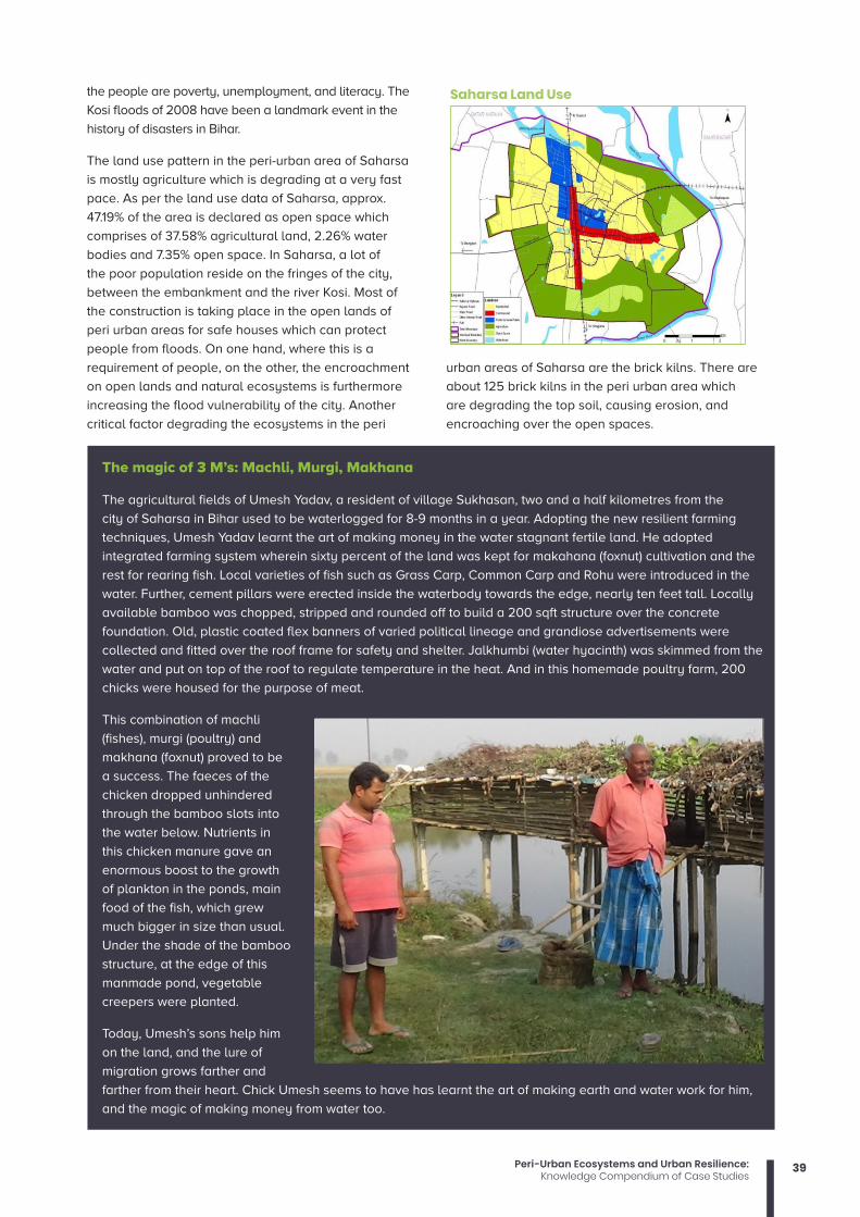
39Peri-Urban Ecosystems and Urban Resilience:Knowledge Compendium of Case Studies
the people are poverty, unemployment, and literacy. The
Kosi floods of 2008 have been a landmark event in the
history of disasters in Bihar.
The land use pattern in the peri-urban area of Saharsa
is mostly agriculture which is degrading at a very fast
pace. As per the land use data of Saharsa, approx.
47.19% of the area is declared as open space which
comprises of 37.58% agricultural land, 2.26% water
bodies and 7.35% open space. In Saharsa, a lot of
the poor population reside on the fringes of the city,
between the embankment and the river Kosi. Most of
the construction is taking place in the open lands of
peri urban areas for safe houses which can protect
people from floods. On one hand, where this is a
requirement of people, on the other, the encroachment
on open lands and natural ecosystems is furthermore
increasing the flood vulnerability of the city. Another
critical factor degrading the ecosystems in the peri
urban areas of Saharsa are the brick kilns. There are
about 125 brick kilns in the peri urban area which
are degrading the top soil, causing erosion, and
encroaching over the open spaces.
Saharsa Land Use
The magic of 3 M’s: Machli, Murgi, Makhana
The agricultural fields of Umesh Yadav, a resident of village Sukhasan, two and a half kilometres from the
city of Saharsa in Bihar used to be waterlogged for 8-9 months in a year. Adopting the new resilient farming
techniques, Umesh Yadav learnt the art of making money in the water stagnant fertile land. He adopted
integrated farming system wherein sixty percent of the land was kept for makahana (foxnut) cultivation and the
rest for rearing fish. Local varieties of fish such as Grass Carp, Common Carp and Rohu were introduced in the
water. Further, cement pillars were erected inside the waterbody towards the edge, nearly ten feet tall. Locally
available bamboo was chopped, stripped and rounded off to build a 200 sqft structure over the concrete
foundation. Old, plastic coated flex banners of varied political lineage and grandiose advertisements were
collected and fitted over the roof frame for safety and shelter. Jalkhumbi (water hyacinth) was skimmed from the
water and put on top of the roof to regulate temperature in the heat. And in this homemade poultry farm, 200
chicks were housed for the purpose of meat.
This combination of machli
(fishes), murgi (poultry) and
makhana (foxnut) proved to be
a success. The faeces of the
chicken dropped unhindered
through the bamboo slots into
the water below. Nutrients in
this chicken manure gave an
enormous boost to the growth
of plankton in the ponds, main
food of the fish, which grew
much bigger in size than usual.
Under the shade of the bamboo
structure, at the edge of this
manmade pond, vegetable
creepers were planted.
Today, Umesh’s sons help him
on the land, and the lure of
migration grows farther and
farther from their heart. Chick Umesh seems to have has learnt the art of making earth and water work for him,
and the magic of making money from water too.

40 Peri-Urban Ecosystems and Urban Resilience:Knowledge Compendium of Case Studies
Climate resilient agriculture being promoted in the peri urban areas ensure farmers with better livelihoods and aids
in enhancing the resilience of the city by conserving open and green spaces.
As more and more cities and their peripheral areas face an increased frequency of climatic risks, their impact on life
increases dramatically. People and places, are both left vulnerable, unable to rise effectively to these challenges.
As we well know, cities do not operate in isolation, but within a ‘sphere of dependence’ on surrounding areas
and their ecosystems. With the onset of climate change and a growing unpredictability in weather conditions, this
dependency on the so called ‘fringe’ areas has only increased. Thus, protecting ecosystems and their services in
peri-urban areas becomes essential for the wellbeing of the urban people and for enhancing a city’s resilience.

Gorakhpur Environmental Action Group (GEAG)Gorakhpur Environmental Action Group (GEAG) is a voluntary organization working in the field of environment and
sustainable development since 1975. Ever since its inception, GEAG has been actively engaged in implementing
several development projects addressing livelihood issues of small and marginal farmers, particularly women,
based on ecological principles and gender-sensitive participatory approach. Besides, GEAG has accomplished
several appraisals, studies, researches at the micro and macro levels as well as successfully conducted several
capacity building programmes for various stakeholders including women farmers, civil societies groups and
government officials etc.
GEAG has established its identity in North India as a leading resource institution on sustainable agriculture,
participatory approaches, methodologies and gender. Acknowledging its achievements, GEAG was awarded the
Lighthouse Activity Award by UNFCCC in 2013. GEAG also holds the Observer status to Green Climate Fund.
National Institute of Disaster Management The National Institute of Disaster Management constituted under the Disaster Management Act 2005, has been
entrusted with the nodal national responsibility for human resource development, capacity building, research,
documentation and policy advocacy in the field of disaster management. The Institute provides training in face-to-
face, on-line and self-learning mode as well as satellites based training. NIDM provides technical support to the
state governments through the Disaster Management Centres (DMCs) in the Administrative Training Institutes (ATIs)
of the States and Union Territories. Presently NIDM is supporting thirty such centres. Upgraded from National Centre
for Disaster Management of the Indian Institute of Public Administration on 16th October 2003, NIDM is steadily
marching forward to fulfil its mission to make disaster resilient India by developing and promoting a culture of
prevention and preparedness at all levels.
Climate Development Knowledge NetworkThe Climate and Development Knowledge Network works to enhance the quality of life for the poorest and
most vulnerable to climate change. We support decision-makers in designing and delivering climate compatible
development. We do this by combining knowledge, research and technical advisory in support of locally owned
and managed policy processes. We work in partnership with decision-makers in the public, private and non-
governmental sectors nationally, regionally and globally.
This work was carried out with the aid of a grant from the Ministry of Foreign Affairs of the Netherlands and the
International Development Research Centre (IDRC), Canada, as part of the Climate and Development Knowledge
Network (CDKN) Programme. The views expressed herein do not necessarily represent those of the Ministry of
Foreign Affairs of the Netherlands, or of the International Development Research Centre (IDRC) or its Board of
Governors, or of the entities managing CDKN.
Gorakhpur Environmental Action Group (GEAG)
HIG-1/4, Siddharthpuram, Taramandal Road
Gorakhpur – 273017 (Uttar Pradesh)
Phone: +91 551 2230004; Fax: +91 551 2230005
Website: www.geagindia.org