Pedosedimentary and climatic reconstruction of the last interglacial and early glacial...
22
Ž . Catena 35 1999 197–218 Pedosedimentary and climatic reconstruction of the last interglacial and early glacial loess–paleosol sequence in South Tadzhikistan Hans Mestdagh a, ) , Paul Haesaerts a , Andrej Dodonov b , Jozef Hus c a Koninklijk Belgisch Instituut Õoor Natuurwetenschappen, Vautierstraat 29, 1000 Brussel, Belgium b Geological Institute, Russian Academy of Sciences, PyzheÕsky 7, 109017 Moscow, Russian Federation c Centre de Physique du Globe, B-5670 Dourbes, Belgium Received 9 May 1997; accepted 15 December 1997 Abstract The thick loess–paleosol-sequences in Tadzhikistan, which indirectly record the environmental changes from the Upper Pliocene to the present-day, have been extensively described from a chronostratigraphical and archaeological point of view. The genesis of the soil-sedimentary complexes and their implications for palaeoenvironmental reconstruction in Tadzhikistan, how- w ever, have been considered only relatively recently Bronger, A., Winter, R., Derevjanko, O., Aldag, S., 1993. Loess–paleosol sequences in Tadjikistan as a palaeoclimatic record of the Quaternary in Central Asia. Quaternary Proceedings 4, 69–81; Lomov, S.P., Tursina, T.V., Zhou, L.P., 1996. Magnetic susceptibility of soils: Micromorphology and possible reconstructions of climate. In: Soil micromorphology. Studies in Soil Diversity, Diagnostics, Dynamics, 10th International Working Meeting on Soil Micromorphology. Moscow, Russia, July 8–13, 1996, p. x Ž . 145 . The pedocomplex of Last Interglacial and Early Glacial age Oxygen Isotope Stage 5 in the Tagidjar and Darai Kalon sections near the town of Khovaling is represented by three major stages of soil formation. The soil characteristics have been micromorphologically analysed. The distinc- tion between primary and secondary carbonates is of major importance to understand the soil Ž . Ž . forming processes. The relative distribution of needle fibre calcite NFC , micritic infillings M, Ž . Ž . Ž . hypocoatings CHC , coarse calcitic grains CCG and calcified root cells CRC provides detailed insights into the environmental conditions prior, during and following pedogenesis. The Ž . abundance of coprolitic aggregates CA and pupal chambers gives a clear indication of the rate of biological activity which prevailed during the last two soil forming stages. Void pseudomorphs ) Corresponding author. 0341-8162r99r$ 20.00 q 1999 Elsevier Science B.V. All rights reserved. Ž . PII: S0341-8162 98 00100-3
-
Upload
universiteitgent -
Category
Documents
-
view
0 -
download
0
Transcript of Pedosedimentary and climatic reconstruction of the last interglacial and early glacial...
Ž .Catena 35 1999 197–218
Pedosedimentary and climatic reconstruction of thelast interglacial and early glacial loess–paleosol
sequence in South Tadzhikistan
Hans Mestdagh a,), Paul Haesaerts a, Andrej Dodonov b,Jozef Hus c
a Koninklijk Belgisch Instituut Õoor Natuurwetenschappen, Vautierstraat 29, 1000 Brussel, Belgiumb Geological Institute, Russian Academy of Sciences, PyzheÕsky 7, 109017 Moscow, Russian Federation
c Centre de Physique du Globe, B-5670 Dourbes, Belgium
Received 9 May 1997; accepted 15 December 1997
Abstract
The thick loess–paleosol-sequences in Tadzhikistan, which indirectly record the environmentalchanges from the Upper Pliocene to the present-day, have been extensively described from achronostratigraphical and archaeological point of view. The genesis of the soil-sedimentarycomplexes and their implications for palaeoenvironmental reconstruction in Tadzhikistan, how-
wever, have been considered only relatively recently Bronger, A., Winter, R., Derevjanko, O.,Aldag, S., 1993. Loess–paleosol sequences in Tadjikistan as a palaeoclimatic record of theQuaternary in Central Asia. Quaternary Proceedings 4, 69–81; Lomov, S.P., Tursina, T.V., Zhou,L.P., 1996. Magnetic susceptibility of soils: Micromorphology and possible reconstructions ofclimate. In: Soil micromorphology. Studies in Soil Diversity, Diagnostics, Dynamics, 10thInternational Working Meeting on Soil Micromorphology. Moscow, Russia, July 8–13, 1996, p.
x Ž .145 . The pedocomplex of Last Interglacial and Early Glacial age Oxygen Isotope Stage 5 in theTagidjar and Darai Kalon sections near the town of Khovaling is represented by three major stagesof soil formation. The soil characteristics have been micromorphologically analysed. The distinc-tion between primary and secondary carbonates is of major importance to understand the soil
Ž . Ž .forming processes. The relative distribution of needle fibre calcite NFC , micritic infillings M ,Ž . Ž . Ž .hypocoatings CHC , coarse calcitic grains CCG and calcified root cells CRC provides
detailed insights into the environmental conditions prior, during and following pedogenesis. TheŽ .abundance of coprolitic aggregates CA and pupal chambers gives a clear indication of the rate
of biological activity which prevailed during the last two soil forming stages. Void pseudomorphs
) Corresponding author.
0341-8162r99r$ 20.00 q 1999 Elsevier Science B.V. All rights reserved.Ž .PII: S0341-8162 98 00100-3
( )H. Mestdagh et al.rCatena 35 1999 197–218198
Ž .after gypsum crystals gypsum pseudomorphs are frequently observed beneath the Cca horizonsof the paleosols. Using the present-day climate and soilscape as a reference base, the obtainedpedosedimentary events detected in the Tadzhikistan sections provide a detailed palaeoenviron-mental record. Indeed, glacial and interglacial climates and soils respond to contemporaneousclimatic schemes and soil forming processes, which are still active in the region today. Theamount and the seasonal variability of precipitation, mostly, are at the origin of the variable soilsformed during glacial and interglacial ages. q 1999 Elsevier Science B.V. All rights reserved.
Keywords: Palaeopedology; Loess; Soil micromorphology; Stratigraphy
1. Introduction
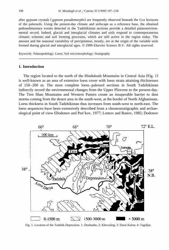
Ž .The region located to the north of the Hindukush Mountains in Central Asia Fig. 1is well-known as an area of extensive loess cover with loess strata attaining thicknessesof 150–200 m. The most complete loess–paleosol sections in South Tadzhikistanindirectly record the environmental changes from the Upper Pliocene to the present-day.The Tien Shan Mountains and Western Pamirs create an insuperable barrier to duststorms coming from the desert area in the south-west, at the border of North Afghanistan.Loess thickness in South Tadzhikistan thus increases from south-west to north-east. Theloess sequences have been extensively described from a chronostratigraphic and archae-
Žological point of view Dodonov and Pen’kov, 1977; Lomov and Ranov, 1985; Dodonov
Fig. 1. Location of the Tadzhik Depression. 1: Dushanbe; 2: Khovaling; 3: Darai Kalon; 4: Tagidjar.
( )H. Mestdagh et al.rCatena 35 1999 197–218 199
.et al., 1991 . The genesis of the soil-sedimentary complexes and their implications forpalaeoenvironmental reconstruction in Tadzhikistan, however, have been considered
Ž .relatively recently Bronger et al., 1993; Lomov et al., 1996 as a subject of research.These recent investigations only provided general ideas concerning the climatic signalrecorded in the complete loess–paleosol sequence of South Tadzhikistan. By contrastthis research wants to focus in more detail on the soil forming processes of the LastInterglacial and Early Glacial age, which is now generally correlated with the 1st
Ž . ŽPedocomplex S1 and the Oxygen Isotope Stage 5 Dodonov and Baiguzina, 1995;.Shackleton et al., 1995; Zhou et al., 1995 . This pedocomplex is well-represented in
Tadzhikistan and encompasses approximately 5–6 m.The present paper deals with two sections of Southeast Tadzhikistan, located in the
Ž .vicinity of Khovaling: Tagidjar and Darai Kalon Fig. 1 . The Tagidjar section issituated on the south-eastern flank of Obimazar River valley, 10 km south-west ofKhovaling, where the river has eroded a 150 m high loess wall with a succession of 17pedocomplexes; Tagidjar literally means ‘Big Wall’. Although this section represents afairly perfect stratigraphical record, evidences of erosion and truncation were obvious inthe lower half of S1 Pedocomplex. Therefore, the Darai Kalon section, which provides amore complete picture of the Last Interglacial and Early Glacial soil evolution, waschosen as complementary record. Darai Kalon is situated about 15 km to the north ofKhovaling, very near to Chashmanigar, one of the reference loess sections of CentralAsia. Tagidjar and Darai Kalon are entirely new; the whole record of Tagidjar and theS1 Pedocomplex in Darai Kalon were examined by the authors in 1995, in closecollaboration with the Institute of Archaeological and Ethnography of the Tadzhik
Ž .Academy of Sciences Dushanbe .Since in recent years increasing emphasis has been placed on soil micromorphology
Žas a diagnostic tool for loess–paleosol sequences in Asia Bronger et al., 1993; Kemp,.1995; Kemp et al., 1995; Lomov et al., 1996 , oriented samples were taken from each
soil horizon of the S1 Pedocomplex in both sections; nevertheless, discussion of themicromorphological features will mainly focus on the Darai Kalon section.
2. Present-day climate
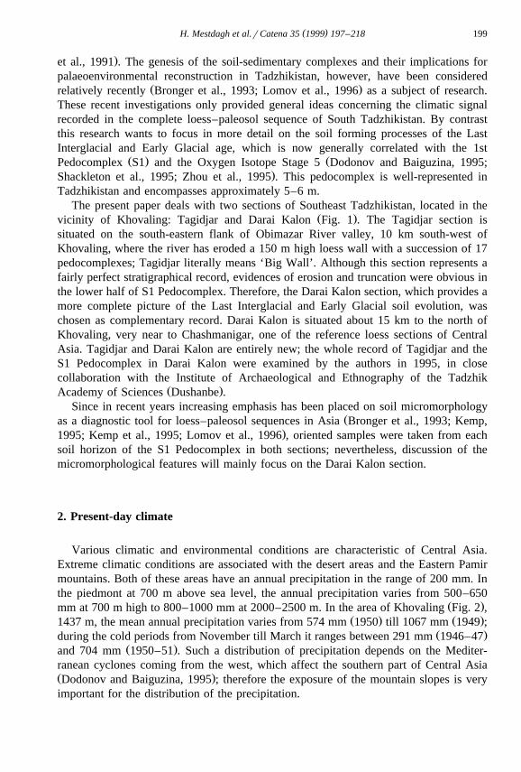
Various climatic and environmental conditions are characteristic of Central Asia.Extreme climatic conditions are associated with the desert areas and the Eastern Pamirmountains. Both of these areas have an annual precipitation in the range of 200 mm. Inthe piedmont at 700 m above sea level, the annual precipitation varies from 500–650
Ž .mm at 700 m high to 800–1000 mm at 2000–2500 m. In the area of Khovaling Fig. 2 ,Ž . Ž .1437 m, the mean annual precipitation varies from 574 mm 1950 till 1067 mm 1949 ;
Ž .during the cold periods from November till March it ranges between 291 mm 1946–47Ž .and 704 mm 1950–51 . Such a distribution of precipitation depends on the Mediter-
ranean cyclones coming from the west, which affect the southern part of Central AsiaŽ .Dodonov and Baiguzina, 1995 ; therefore the exposure of the mountain slopes is veryimportant for the distribution of the precipitation.
( )H. Mestdagh et al.rCatena 35 1999 197–218200
Ž .Fig. 2. Climatic data of Khovaling. a: Annual precipitation mm ; b: Annual potential evapotranspirationŽ . Ž .mm ; c: Annual mean temperature; d: Altitude m ; e: Soil moisture regime; f: Soil Temperature regime.
Ž .The mean annual temperature in Khovaling varies from 9.78C 1950 up to 13.08CŽ . Ž .1940 . Mean monthly temperatures range between y5.38C January 1933 and 26.08CŽ .July 1944 . No freezing temperatures are measured 150 up to 237 days per yearŽ .Kerzum and Vasiljikova, 1982 . Superimposition of the temperature and precipitation
( )H. Mestdagh et al.rCatena 35 1999 197–218 201
Žresults in a xeric soil moisture regime Soil Survey Staff, 1975; Van Wambeke et al.,.1986 for Khovaling. The temperature is constantly mesic. Gerasimov and Glazovskaya
Ž .1960 described the climate as dry subtropic.
3. Present-day soilscape
The pluvial and altitudinal variability is well-illustrated by the Tadzhik soilscape. TheŽpiedmont from 700 to 2600 m is characterised by Cinnamon soils Afans’eva et al.,
.1979; Sadriddinov, 1982a . They have a well-pronounced greyish-brown humiferoushorizon, leached from carbonates, with a well expressed subangular blocky pedality andlower horizons containing evidence of slight clay illuviation. In general carbonates in theTypical Cinnamon soil accumulate at a depth of 1–1.5 m. There are three main subtypesof Cinnamon soils, which occur at different altitudes: Carbonate Cinnamon soils from700 to 1400 m, Typical Cinnamon soils from 1600 to 2600 m and Leached Cinnamonsoils from 2200 to 2600 m. The soilscape of the lower belt at an elevation of 300–1000Ž . Ž .1500 m is characterized by Serozems Afans’eva et al., 1979; Sadriddinov, 1982b .One can define three subtypes of Serozems: Light, Common and Dark. The two latterones developed at the highest altitudes of this belt. They are calcareous and contain6–14% of CaCO in the upper horizons for the Common Serozems and 8–10% for the3
Dark Serozems. In the lower horizons both Serozem types show an increasing content ofCaCO up to 22% and even gypsum crystals. The present-day soils in Tagidjar are3
characterized by a gradual decalcification boundary and a thick humus-rich surfacehorizon. Carbonates can be macroscopically observed at a depth of 80 cm. Based upon
Žthe analytical and climatological data these soils key out Dark Serozems Sadriddinov,.1982b .
4. Geologic context
The loess–paleosol formation of South Tadzhikistan belongs to the Upper Pliocene–Pleistocene sediments which unconformably overlie the older Neogene rocks. Strati-graphically the Upper Pliocene–Pleistocene sediments are subdivided into three units:
Ž . Ž .the Kuruksay suite Upper Pliocene , the Kayrubak suite Lower Pleistocene and theŽ . ŽKyzylsu suite Middle–Upper Pleistocene Pen’kov et al., 1976; Dodonov and Pen’kov,
. Ž1977; Dodonov et al., 1991 . These suites are represented both by subaqueous alluvial. Ž .and fluvial and subaerial loess–paleosol facies. The aeolian processes are widespread
and result in subaerial sedimentation. The high-mountain nival zone of Pamirs and TienShan was a source of silt resulting from frost and thermal weathering. These sedimentsreworked by the fluvial system were deposited in the piedmont plains and subjected todeflation. Even today dust storms are common during the warm seasons; dust haze
Ž .occurs up to 20 days per year in Khovaling Uskova, 1982 . In the Central Asian aridŽ .zone the loess consists of calcareous silts about 20% CaCO for parent loess forming3
( )H. Mestdagh et al.rCatena 35 1999 197–218202
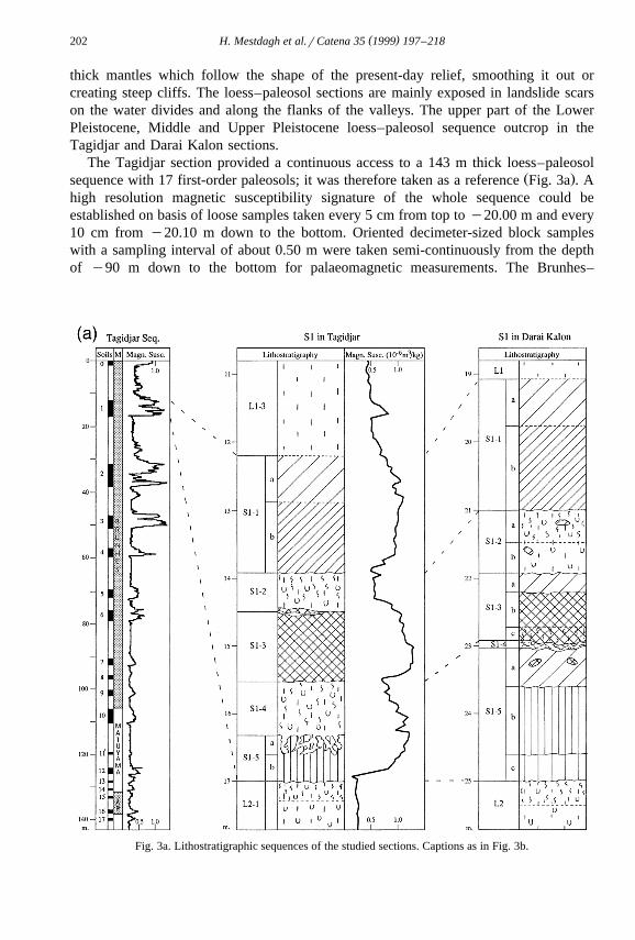
thick mantles which follow the shape of the present-day relief, smoothing it out orcreating steep cliffs. The loess–paleosol sections are mainly exposed in landslide scarson the water divides and along the flanks of the valleys. The upper part of the LowerPleistocene, Middle and Upper Pleistocene loess–paleosol sequence outcrop in theTagidjar and Darai Kalon sections.
The Tagidjar section provided a continuous access to a 143 m thick loess–paleosolŽ .sequence with 17 first-order paleosols; it was therefore taken as a reference Fig. 3a . A
high resolution magnetic susceptibility signature of the whole sequence could beestablished on basis of loose samples taken every 5 cm from top to y20.00 m and every10 cm from y20.10 m down to the bottom. Oriented decimeter-sized block sampleswith a sampling interval of about 0.50 m were taken semi-continuously from the depthof y90 m down to the bottom for palaeomagnetic measurements. The Brunhes–
Fig. 3a. Lithostratigraphic sequences of the studied sections. Captions as in Fig. 3b.
( )H. Mestdagh et al.rCatena 35 1999 197–218 203
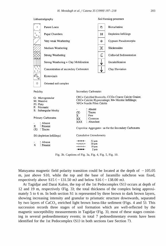
Fig. 3b. Captions of Fig. 3a, Fig. 4, Fig. 5, Fig. 10.
Matuyama magnetic field polarity transition could be located at the depth of y105.05m, just above S10, while the top and the base of Jaramillo subchron was fixed,
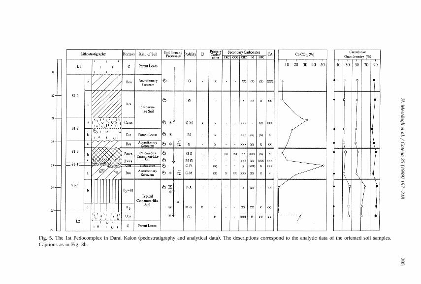
Ž . Ž .respectively above S15 y131.50 m and below S16 y138.00 m .Ž .At Tagidjar and Darai Kalon, the top of the 1st Pedocomplex S1 occurs at depth of
Ž .12 and 19 m, respectively Fig. 3 ; the total thickness of the complex being approxi-mately 5 to 6 m. In both section S1 is represented by three brown to dark brown layers,showing increasing intensity and granular to prismatic structure downwards, separated
Ž .by two layers of CaCO enriched light brown loess-like sediment Figs. 4 and 5 . This3
succession records three stages of soil formation which are well-reflected by theŽ .magnetic susceptibility measurements in Tagidjar Fig. 3 , most of these stages consist-
ing in several pedosedimentary events; in total 7 pedosedimentary events have beenŽ . Ž .identified for the 1st Pedocomplex S1 in both sections see Section 7 .
()
H.M
estdaghet
al.rC
atena35
1999197
–218
204
Ž .Fig. 4. The 1st pedocomplex in Tagidjar pedostratigraphy and analytical data . Captions as in Fig. 3b.
()
H.M
estdaghet
al.rC
atena35
1999197
–218
205
Ž .Fig. 5. The 1st Pedocomplex in Darai Kalon pedostratigraphy and analytical data . The descriptions correspond to the analytic data of the oriented soil samples.Captions as in Fig. 3b.

( )H. Mestdagh et al.rCatena 35 1999 197–218206
5. Laboratory methods
Ž .The bulk weak field magnetic susceptibility MS of dried loose samples wasmeasured in a Kappabridge KLY-1 at 970 Hz in a magnetic field of 80 A my1. MSobtained on a mass specific basis is expressed in m3 kgy1. The remanent magnetizationbefore and after ‘cleaning’ of 1-in. cubes trimmed from the oriented block sample wasmeasured in a shielded, three-axis 2G-Enterprise cryogenic rock magnetometer. In orderto remove the viscous overprint and hence to isolate the stable characteristic remanenceall the oriented samples were ‘cleaned’ by heating at 3508C following by zero-fieldcooling in a Schonsted thermal demagnetizer TSD-1.
Ž .Calcium carbonate content was determined by gasometry Gale and Hoare, 1991 .Since the amount of organic carbon in the paleosols was extremely low the measurement
Ž .of the organic carbon content using the Walkley–Black method Janitzky, 1986 seemedto be impracticable. The hydrometer method with sodium oxalate and sodium carbonateas dispersing agent was used for granulometric analysis of the decalcified sediment. Thecolours were measured on the moist oriented samples in the laboratory, using theMunsell Soil Color Charts.
Estimates of the abundances of the cited pedofeatures recorded by macro-, meso- andmicromorphological analysis for each sample of the 1st Pedocomplex of Darai Kalon are
Ž .recorded and compared with analytical results Fig. 5 . Additional information comingfrom the Tagidjar section was used for each stratigraphical equivalent.
( )6. Soil micromorphological features Figs. 5–9
6.1. General information
Ž .The used terminology is in accordance with the definitions of Bullock et al. 1985 .Ž .The ratios of coarse to fine material c:f 5 mm of the groundmass varies between 75:25
Ž .and 85:15 with most of the coarse material quartz, feldspar, calcite and mica being-50 mm or even -25 mm. The related distribution varies between chitonic andgefuric.
6.2. B-fabric and pedality
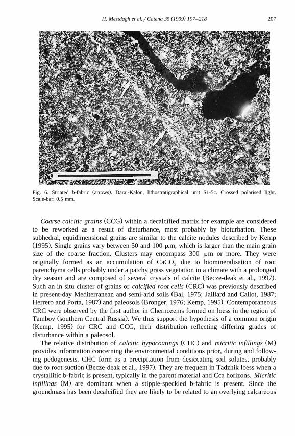
The b-fabric of the micromass is crystallitic when fine-grained primary carbonatesare present, or stipple-speckled when primary carbonates are lacking. A colour andstructure B horizon with a weakly developed prismatic pedality locally reveals a striated
Ž . Ž .b-fabric Fig. 6 , due to swelling and shrinking Nettleton et al., 1969 .
6.3. Calcitic pedofeatures
The distinction between primary and secondary carbonates is of major importanceto understand the soil forming processes. The distinction between these two kinds ofcarbonates is generally very clear, although secondary carbonates may be turbated and
Ž .integrated in the groundmass Kemp, 1995; Kemp et al., 1995 .
( )H. Mestdagh et al.rCatena 35 1999 197–218 207
Ž .Fig. 6. Striated b-fabric arrows . Darai-Kalon, lithostratigraphical unit S1-5c. Crossed polarised light.Scale-bar: 0.5 mm.
Ž .Coarse calcitic grains CCG within a decalcified matrix for example are consideredto be reworked as a result of disturbance, most probably by bioturbation. Thesesubhedral, equidimensional grains are similar to the calcite nodules described by KempŽ .1995 . Single grains vary between 50 and 100 mm, which is larger than the main grainsize of the coarse fraction. Clusters may encompass 300 mm or more. They wereoriginally formed as an accumulation of CaCO due to biomineralisation of root3
parenchyma cells probably under a patchy grass vegetation in a climate with a prolongedŽ .dry season and are composed of several crystals of calcite Becze-deak et al., 1997 .
Ž .Such an in situ cluster of grains or calcified root cells CRC was previously describedŽin present-day Mediterranean and semi-arid soils Bal, 1975; Jaillard and Callot, 1987;
. Ž .Herrero and Porta, 1987 and paleosols Bronger, 1976; Kemp, 1995 . ContemporaneousCRC were observed by the first author in Chernozems formed on loess in the region of
Ž .Tambov southern Central Russia . We thus support the hypothesis of a common originŽ .Kemp, 1995 for CRC and CCG, their distribution reflecting differing grades ofdisturbance within a paleosol.
Ž . Ž .The relative distribution of calcitic hypocoatings CHC and micritic infillings Mprovides information concerning the environmental conditions prior, during and follow-ing pedogenesis. CHC form as a precipitation from desiccating soil solutes, probably
Ž .due to root suction Becze-deak et al., 1997 . They are frequent in Tadzhik loess when acrystallitic b-fabric is present, typically in the parent material and Cca horizons. Micritic
Ž .infillings M are dominant when a stipple-speckled b-fabric is present. Since thegroundmass has been decalcified they are likely to be related to an overlying calcareous
( )H. Mestdagh et al.rCatena 35 1999 197–218208
sediment and are therefore clearly the result of diagenesis. In Tadzhikistan M seems toprevail over CHC for initially decalcified horizons, which supports their diageneticorigin. At a larger magnification up to 400= M looks like a sieve of welded needles.
Ž .Their morphology clearly differs from needle fiber calcite NFC .Ž .Depletion infillings DI are frequently observed in the Cca horizon. Contrary to the
Chinese loess these features are seldom associated with CHC within compound pedofea-Ž .tures Kemp, 1995 . They appear as a cylindrical form of a decalcified, massive
material, which sharply contrasts with the calcareous groundmass. They are in factchannels filled by material from the overlying decalcified horizon.
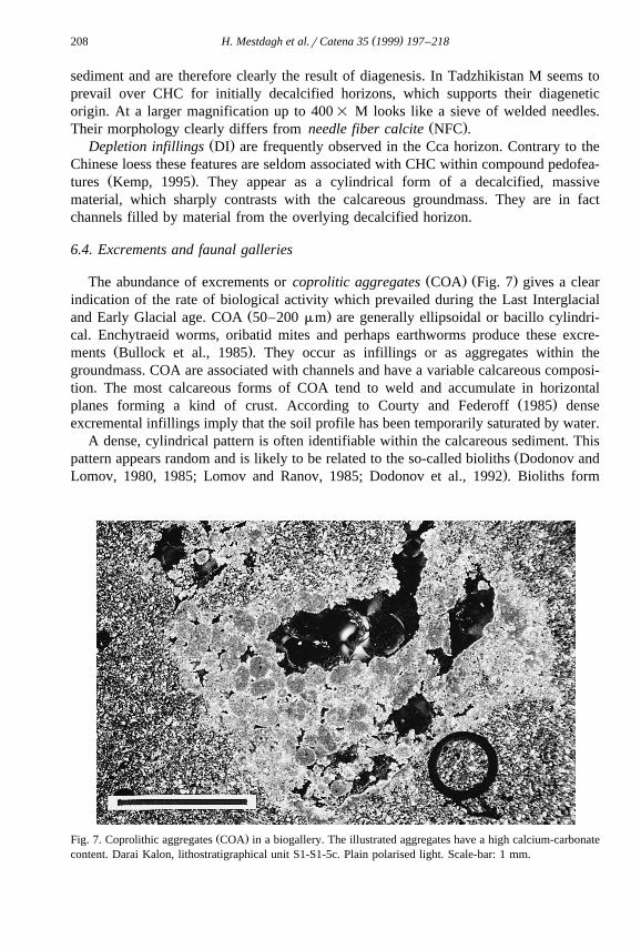
6.4. Excrements and faunal galleries
Ž . Ž .The abundance of excrements or coprolitic aggregates COA Fig. 7 gives a clearindication of the rate of biological activity which prevailed during the Last Interglacial
Ž .and Early Glacial age. COA 50–200 mm are generally ellipsoidal or bacillo cylindri-cal. Enchytraeid worms, oribatid mites and perhaps earthworms produce these excre-
Ž .ments Bullock et al., 1985 . They occur as infillings or as aggregates within thegroundmass. COA are associated with channels and have a variable calcareous composi-tion. The most calcareous forms of COA tend to weld and accumulate in horizontal
Ž .planes forming a kind of crust. According to Courty and Federoff 1985 denseexcremental infillings imply that the soil profile has been temporarily saturated by water.
A dense, cylindrical pattern is often identifiable within the calcareous sediment. ThisŽpattern appears random and is likely to be related to the so-called bioliths Dodonov and
.Lomov, 1980, 1985; Lomov and Ranov, 1985; Dodonov et al., 1992 . Bioliths form
Ž .Fig. 7. Coprolithic aggregates COA in a biogallery. The illustrated aggregates have a high calcium-carbonatecontent. Darai Kalon, lithostratigraphical unit S1-S1-5c. Plain polarised light. Scale-bar: 1 mm.
( )H. Mestdagh et al.rCatena 35 1999 197–218 209
circular or ellipsoidal patterns in the sediment. These pedofeatures are not lithified butconsist of a dense, compacted parent material. Occasionally former galleries withcompacted rims entering these pedofeatures can be observed. Internally, bioliths maycontain a manganiferous or calcareous coating of the internal wall of the feature. Thediameter of a biolith generally varies between 0.5 and 3 cm. These features are in factfaunal galleries and pupal chambers of soil-dwelling invertebrates. The macroscopicalanalysis of their form and dimensions showed that they are related to the contemporary
Ž . Ž .xerophylous group of Phitrophagus cicadas Gicadidae , cockchafers Hemictenius ,Ž . Ždarkling beetles Prosodes Dodonov and Lomov, 1980; Lomov and Ranov, 1985;
.Valiakhmedov, 1977 . These insects are ecologically related to dry climatologicalenvironments and form pupal chambers in serozems at depths of 0.3 to 1 m.
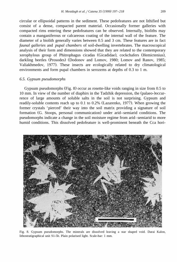
6.5. Gypsum pseudomorphs
Ž .Gypsum pseudomorphs Fig. 8 occur as rosette-like voids ranging in size from 0.5 toŽ .10 mm. In view of the number of diaphirs in the Tadzhik depression, the palaeo- occur-
rence of large amounts of soluble salts in the soil is not surprising. Gypsum andŽ .readily-soluble contents reach up to 0.1 to 0.2% Lazarenko, 1977 . When growing the
former crystals ‘pierced’ their way into the soil matrix providing a signature of soilŽ .formation G. Stoops, personal communication under arid–semiarid conditions. The
pseudomorphs indicate a change in the soil moisture regime from arid–semiarid to morehumid conditions. This dissolved pedofeature is well-prominent beneath the Cca hori-
Fig. 8. Gypsum pseudomorphs. The minerals are dissolved leaving a star shaped void. Darai Kalon,lithostratigraphical unit S1-5b. Plain polarised light. Scale-bar: 1 mm.
( )H. Mestdagh et al.rCatena 35 1999 197–218210
zons of soils formed during the Early Glacial age. Since the observed pseudomorphs arenever related to redoximorphic or secondary carbonate pedofeatures such as M or CHC,their formation and dissolving perhaps belong to a final diagenetical process.
6.6. Clay coatings
The presence of clay coatings is scarce and is only noticed in both sections in S1-5.The clay coatings are thin and at higher magnifications a microlamination is observed.The scarce presence of clay coatings indicates favourable leaching conditions for clayminerals. This clay mobilization may be temporal or annual. The pH-values for clay
Ž .illuviation equal figures lower than 7 and higher than 5 Schachtschabel et al., 1992 .Since these values will hardly be reached during the input of an eolian sedimentcontaining 20% of CaCO , this implies a temporal interruption of the calcareous dust3
accumulation.
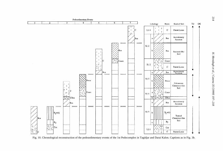
( )7. Chronological sequence of pedosedimentary events Fig. 10
7.1. EÕent 1
During the final build-up of loess a period of relative land surface stability exists. Anaccretionary pedogenesis of a calcareous soil with abundant biological activity character-izes this event. Environmental conditions at this stage are arid to semi-arid and the
Ž .weakly developed soil formed is Serozem-like Afans’eva et al., 1979 . Although onlylittle pedofeatures of this soil forming process are preserved, the later carbonate enriched
Ž .groundmass L-2-1 is dominated by faunal galleries and pupal chambers formed duringthis event.
7.2. EÕent 2
ŽIn an increasingly moist environment a short temporal end of the dust deposition at.about 23.5 m and 16 m in Darai Kalon and Tagidjar, respectively led to complete
decalcification of the sediment. Leaching erased evidence of existing pupal chambersŽ .and led to the formation of a lower carbonate enriched horizon L-2-1 with abundant
Ž . Ž .CHC. The dark brown B2w t -horizon 7.5YR 4r6 of the paleosol S1-5b in DaraiKalon and in Tagidjar witnesses a strong prismatic to weakly subangular blockystructure and in the field slickensides are observed. In thin sections the b-fabric is locally
Ž .striated Tagidjar and traces of clay coatings are present.The slickensides are likely to be related to environmental conditions such as an
intense wetting and drying perhaps due to a dry, warm season and a moist, cold season.Leaching conditions resemble the present-day ones and are also reflected by the sharp
Ž .decalcification boundary. Near the carbonate enriched horizon L-2-1 the presence ofDI can be noticed, testifying the biological activity during the formation of this Typical
Ž .Cinnamon-like soil Afans’eva et al., 1979 . The associated vegetation is that of aŽ .subtropical, broad-leaved forest Lomov et al., 1982; Lomov and Ranov, 1985 .
( )H. Mestdagh et al.rCatena 35 1999 197–218 211
7.3. EÕent 3
An increasing dust accumulation during dry environmental conditions resulted in theŽ . Ž .formation of a brown 7.5YR 4r3 horizon S1-5a in Darai Kalon , which is lacking in
Tagidjar. The horizon has a weakly microgranular to massive pedality and abundantchannels indicate a high biological activity. Traces of primary carbonate minerals in thematrix indicate a less strong decalcification in comparison to the formation of the lower
Ž .Cinnamon-like soil S1-5b . The presence of CCG and CRC in S1-5a could be related toŽ .a patchy grass vegetation Becze-deak et al., 1997 .
Sedimentation due to local erosion at this stage is not unlikely, as can be testified bythe rounded ferrugineous nodules and slightly capped grains. Also the statistical
Žcomparison of the sediments using a similarity index on the grain size analysis Langohr.et al., 1976 clearly indicates a different origin of the sediments. The statistical
comparison pinpoints this pedosedimentary event as the onset of different sediments,which will continue to build up even during the Last Glacial age. Thus different
Žpalaeo-landscape positions explain the presence or absence of this horizon S1-5a in.Darai Kalon in both sections. Landscape positions close to the main river, such as
Tagidjar, will be eroded while profiles at greater distance from the river, such as DaraiKalon, could witness colluvial sedimentation. A general appreciation of the environmentduring the build-up of S1-5a in Darai Kalon may be that of an extreme dry steppe,vulnerable to erosion due to a patchy vegetation.
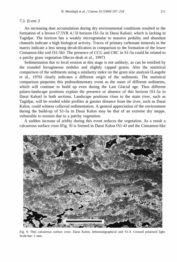
A sudden increase of aridity during this event reduces the vegetation. As a result aŽ . Ž .calcareous surface crust Fig. 9 is formed in Darai Kalon S1-4 and the Cinnamon-like
Fig. 9. Thin calcareous surface crust. Darai Kalon, lithostratigraphical unit S1-4. Crossed polarised light.Scale-bar: 1 mm.
( )H. Mestdagh et al.rCatena 35 1999 197–218212
soil in Tagidjar, formed during the second event, is further disrupted. Calcareous surfaceŽ .crusting )53% CaCO is characterized by welded COA, a locally strong microgranu-3
lar and moderately platy pedality. The porosity is very low. Gypsum pseudomorphsfound in S1-5c and L-2-1 at Darai Kalon were probably formed during this event.
7.4. EÕent 4
As the rate of sedimentation continues a new level of relative surface stability arisesŽ .about 22.2 m and 14.8 m for Darai Kalon and Tagidjar, respectively . The paleosol in
Ž . Ž .Darai Kalon S1-3b is dark brown 7.5YR 4r4 . NFC, M, CCG and CRC are the majorforms of secondary calcite within the decalcified groundmass. Some COA are observed
Ž .in the matrix. The amount of CHC increases near the calcareous crust S1-4 , formedduring the previous event. This increase of secondary carbonates results in the formation
Ž . Ž .of a CBca horizon S1-3c on top of the former surface crust S1-4 . The sharpdecalcification boundary, a weak subangular blocky pedality and the dark brown colour
Ž .are characteristics shared by this paleosol and the first major paleosol S1-5b formedduring the second event. The presence of CCG and CRC however suggests a lower
Ž .decalcification rate under a grass vegetation Becze-deak et al., 1997 and a higherŽ .bioactivity. In conclusion, the characteristics of this soil S1-3b are close to the
Ž .present-day Calcareous Cinnamon Afans’eva et al., 1979 ; it seems to be related to asomewhat dry environment and the vegetation was probably dominated by xerophyticgrasses and shrubs in combination with some broad-leaf trees.
7.5. EÕent 5
Ž .The paleosol S1-3b in Darai Kalon is covered by a brown to dark yellowish brownŽ . Ž .7.5-10YR 4r4 horizon S1-3a . The matrix still contains primary carbonate minerals.Although channels are numerous, the amount of COA is limited. The pedality is stronglymicrogranular and manganiferous aggregate nodules are common. The horizon is theresult of an accretionary pedogenesis. Similarly to event 3 local erosion and sedimenta-tion are not unlikely and former landscape positions may eventually explain the local
Ž .presence or absence of this horizon S1-3a . Environmental conditions are dry and theprobably syngenetical soil is a slightly decalcified Serozem. Weak decalcification led to
Ž .the formation of M in the underlying paleosol S1-3b .In Tagidjar the upper part of the horizon has a platy pedality. Between the decalcified
platy peds a micritic mass, with numerous, welded COA, fills the joints. This featureonce again indicates initial surface crusting in association with a very dry environmentand a sparse vegetation. Seasonal water reworking was probably active at this time as issuggested by the manganiferous aggregate nodules and ferrugineous hypocoatings thatextend into the underlying horizons. As dry climatological conditions continued to
Ž .dominate, the rate of dust deposition increased S1-2 .
7.6. EÕent 6
At 19.8 and 12.8 m at Darai Kalon and Tagidjar, respectively, a level of relative landŽ . Ž .surface stability is reached. A dark yellowish brown 10YR 4r6 horizon S1-1b
( )H. Mestdagh et al.rCatena 35 1999 197–218 213
formed at this stage, characterized by a weakly developed microgranular pedality. TheŽgroundmass is decalcified and later enriched by secondary carbonates 5 and 7% CaCO3
.for Darai Kalon and Tagidjar, respectively . Locally CCG are observed. Loose orwelded COA are common in the channels. DI and COA in the matrix are commonly
Ž .observed in the underlying Cca horizon S1-2 . The rosettes of gypsum recognized in thelower horizons of the profile may well belong to this pedogenesis.
As a conclusion, pedogenesis is characterized by a weak decalcification with agradual decalcification boundary and a high rate of bioturbation. Gypsum and thegradual decalcification boundary indicate semi-arid conditions. The paleosol therefore
Žcorresponds to Serozem type of soil Gerasimov and Glazovskaya, 1960; Afans’eva et.al., 1979 in association with a xerophytic grass vegetation.
7.7. EÕent 7
Ž . Ž .A yellowish brown 10YR 5r4 horizon S1-1a marks the gentle transition towards astill more dry environment and increasing loess deposition. The rate of decalcificationdecreases but bioactivity remains fairly high. This is shown by calcareous COA, whichare often welded, and the common presence of pupal chambers. The matrix is slightly
Ž .decalcified 5 and 14% CaCO for Darai Kalon and Tagidjar, respectively , inducing the3
formation of M in the underlying horizon. Partly dissolved primary carbonates are stillpresent in the matrix and the pedality is microgranular. This event resembles events 3and 5 but since the increasing sedimentation is 100% aeolian S1-1a is present in both
Žsections. The soil can be regarded as a syngenetically formed ‘weak’ Serozem Afans’eva.et al., 1979 . After this event the sedimentation rate increases drastically and loess of the
Ž .Last Glacial age is deposited under very dry climatological conditions L-1-3 .
8. Palaeoclimatological record and dynamics
Taking into account the diversity of the paleosols recorded in the 1st pedocomplexŽ .Fig. 10 , one can simplify the environmental conditions with regard to the present-day
Ž .soilscape see Section 3 . Although annual data however seldom reflect the dynamics ofpalaeoclimatology, a general trend of an increasing arid environment during the LastInterglacial and Early Glacial period can be noticed.
Ž .During the formation of the Typical Cinnamon-like soil S1-5 the major precipitationŽ .probably 700–800 mm per year occurs during the winter-spring period, similarconditions as the Holocene interglacial. As mentioned before the distribution of precipi-
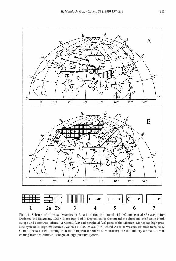
Ž .tation in the area of study depends upon the Mediterranean cyclones Fig. 11 . Climaticconditions during interglacials are in fact controlled by a western air-mass transfer fromthe North Atlantic and from the Mediterranean. During the winter season Central Asia is
Žinfluenced by the area controlled by the Siberian high-pressure centre Dodonov and.Baiguzina, 1995 .
During periods when the Calcareous Cinnamon-like and Serozem-like paleosolsŽ . Ždeveloped S1-3 and S1-1 , annual precipitation is decreasing further probably 500–700
.mmryear and 400–500 mmryear, respectively . These interstadial periods are charac-terized by a strong Siberian high-pressure centre. Consequently the infiltration of
()
H.M
estdaghet
al.rC
atena35
1999197
–218
214
Fig. 10. Chronological reconstruction of the pedosedimentary events of the 1st Pedocomplex in Tagidjar and Darai Kalon. Captions as in Fig. 3b.
( )H. Mestdagh et al.rCatena 35 1999 197–218 215
Ž . Ž . ŽFig. 11. Scheme of air-mass dynamics in Eurasia during the interglacial A and glacial B ages after.Dodonov and Baiguzina, 1995 . Black star: Tadjik Depression; 1: Continental ice sheet and shelf ice in North
Ž . Ž .europe and Northwest Siberia; 2: Central 2a and peripheral 2b parts of the Siberian–Mongolian high-pres-Ž .sure system; 3: High mountain elevation )3000 m a.s.l. in Central Asia; 4: Western air-mass transfer; 5:
Cold air-mass current coming from the European ice sheet; 6: Monsoons; 7: Cold and dry air-mass currentcoming from the Siberian–Mongolian high-pressure system.
( )H. Mestdagh et al.rCatena 35 1999 197–218216
western winds is blocked and precipitation is decreasing. This decrease is particularlystrong in the winter season. Precipitation maxima thus shift towards the warmer springseason. These climatological conditions are similar to the altitudinal belt where at
Ž .present Serozems prevail Gerasimov and Glazovskaya, 1960 .During periods of accretionary pedogenesis, dust deposition and surface crusting the
Ž .precipitation further decreases 400 mm per year and even less . These pedosedimentaryevents belong to the glacial periods, when the Siberian high-pressure centre is furtherstrengthened. Moreover cold winds blow from the northern European Ice Sheet to the
Ž .south and block the penetration of the western air-mass Dodonov and Baiguzina, 1995bringing moisture to Central Asia. Precipitation maxima shift towards the summer, whenevapotranspiration also reaches its maximum. These conditions are not favourable for anextensive vegetation and intense weathering of the soil profile.
9. Conclusions
According to the pedostratigraphy, the first pedocomplex of the Tagidjar and DaraiKalon sections comprises three major soil forming periods, which are in close relationwith the measured high magnetic susceptibility values. Using macro-, meso- andmicromorphological analysis several soil characteristics were defined and are ascribed tospecific soil forming processes, giving a general appreciation of the ‘kind of soil’.Especially the relative distribution of various forms of secondary carbonate was helpfulin reconstructing the soil forming processes. Various pedofeatures related to bioturbationare visible at all morphological levels. Gypsum pseudomorphs, b-fabric of the ground-mass and pedality provided useful additional information. The first pedocomplex ofTadzhikistan reflects a complex sequence of pedosedimentary events, which suggest anincrease of arid conditions throughout the Early Glacial age with soils in the range ofTypical Cinnamon to Serozem. Transitions between glacial and interglacial are ingeneral gentle and syngenetical. The soil forming processes stress the importance of theamount and seasonal variation of the precipitation, rather than temperature. Such apalaeoclimatological signal is well-illustrated by the impact of the Siberian high-pres-sure region and our present knowledge of the Tadzhik climate.
Acknowledgements
This research was funded by the initiative ‘Versterking van het wetenschappelijk enŽ .technologisch potentieel van de Federale Wetenschappelijke Diensten D.W.T.C. ’
Ž . Ž .Belgium , Project Research Network D.W.T.C. Sc.-004 Belgium and the ProjectŽ .INTAS-93-1693. We thank R. Langohr University Ghent, Belgium for his constructive
criticism of the manuscript; H. Eswaran for the provided climatological data of theŽ .Frank Newhall System of computisation; G. Stoops University Ghent, Belgium for the
help he provided with the interpretation of some pedological features; H. Depotter, C.Ž .Herze, V. Janssens and W. Miseur Royal Belgian Institute of Natural Sciences for the´
analyses and technical support.
( )H. Mestdagh et al.rCatena 35 1999 197–218 217
References
Afans’eva, T.V., Vasilienko, V.I., Tereshina, T.V., Sheremet, B.V., 1979. Pochvy SSSR. Spravochniki-Ž .Opredeliteli Geografa i Puteshchestvennika, Moskva, 380 pp. in Russian .
Bal, L., 1975. Carbonate in soil: a theoretical consideration on, and proposal for its fabric analysis: 2. Crystaltubes, intercalary crystals, K fabric. Neth. J. Agric. Sci. 23, 163–176.
Becze-deak, J., Langohr, R., Verrechia, E.P., 1997. Small scale secondary CaCO accumulations in selected3
sections of the European loess belt. Morphological forms and potential for palaeoenvironmental reconstruc-tion. Geoderma 76, 221–252.
Ž .Bronger, A., 1976. Zur quartaren Klima- und Landschaftsentwickelung des Karpatenbeckens auf palao-¨ ¨pedologischer und bodengeographischer Grundlage. Kieler Geographische Schriften 45, 267 pp.
Bronger, A., Winter, R., Derevjanko, O., Aldag, S., 1993. Loess–paleosol sequences in Tadjikistan as apalaeoclimatic record of the Quaternary in Central Asia. Quat. Proc. 4, 69–81.
Bullock, P., Federoff, N., Jongerius, A., Stoops, G., Tursina, T., 1985. Handbook for Soil Thin SectionDescription. Waine Research, Wolverhampton, 152 pp.
Courty, M.A., Federoff, N., 1985. Micromorphology of recent and buried soils in a semi-arid region ofNorthwest India. Geoderma 35, 287–332.
Dodonov, A.E., Pen’kov, A.V., 1977. Nekotorye itogi po stratigrafii vodorazdel’nykh lessov Tadzhikskoi¨Ž .depressii Yuzhnyi Tadzhikistan . Byulleten’ Komissii Po Izucheniyu Chetvertichnogo Perioda 47, 67–76,
Ž .in Russian .Dodonov, A.E., Lomov, S.P., 1980. Stratigraficheskie i paleogeograficheskie aspekty izucheniya iskopaemykh
pochv i lessov Yuzhnogo Tadzhikistana. Izvestiya Akademii Nauk SSSR, Seriya Geologicheskaya 8,Ž .75–85, in Russian .
Dodonov, A.E., Lomov, S.P., 1985. Stratigraphy and pedogenesis of loess formation of Southern Tadzhikistan.Ž .Curr. Trends Geol. VI, 223–225, Climate and Geology of Kashmir and Central Asia .
Dodonov, A.E., Baiguzina, L.L., 1995. Loess stratigraphy of central asia: palaeoclimatic and palaeoenviron-mental aspects. Quat. Sci. Rev. 14, 707–720.
Dodonov, A.E., Zhegallo, V.I., Pen’kov, A.V., Sotnikova, M.V., 1991. Stratigrafiya mestonakhozhdeniipozdnepliotsenovykh pozvonochnykh Yuzhnogo Tadzhikistana. Izvestiya Akademii Nauk SSSR, Seriya
Ž .Geologicheskaya 5, 12–21, in Russian .Ž .Dodonov, A.E., Ranov, V.A., Schafer, J., 1992. Das Loßpalaolithikum am Obi-Mazar Tadshikistan . Jahrbuch¨ ¨ ¨
des Romisch-Germanischen Zentralmuseums Mainz 39, 209–243.¨Gale, S.J., Hoare P.G., 1991. Quaternary Sediments. Belhaven Press, London, 323 pp.Gerasimov, I.P., Glazovskaya, M.A., 1960. Fundamentals of Soil Science and Soil Geography State Depart-
Ž .ment Geographical Literature, Moscow, 490 pp in Russian .Herrero, J., Porta, J., 1987. Gypsiferous soil in north-east Spain. In: Fedoroff, N., Bresson, L.M., Courty, M.A.
Ž .Eds. , Soil Micromorphology. Association Francaise pour l’Etude du Sol, Plaisir, 187–192.Jaillard, B., Callot, G., 1987. Action des racines sur la segregation mineralogique des constituants mineraux du´ ´ ´ ´
Ž .sol. In: Fedoroff, N., Bresson, L.M., Courty, M.A. Eds. , Soil Micromorphology. Association Francaise´pour l’Etude du Sol, Plaisir, 371–375.
Ž . Ž .Janitzky, P., 1986. Organic carbon Walkley–Black method . In: Singer, M.J., Janitzky, P. Eds. , Field andLaboratory Procedures Used in Soil Chronosequence Study. U.S. Geological Survey Bulletin, 1684,34–36.
Kemp, R.A., 1995. Distribution and genesis of calcitic pedofeatures within a rapidly aggrading loess–paleosolsequence in China. Geoderma 65, 303–316.
Kemp, R.A., Derbyshire, E., Xingmin, M., Fahu, C., Baotian, P., 1995. Pedosedimentary reconstruction of athick loess–paleosol sequence near lanzhou in North-Central China. Quat. Res. 43, 30–45.
Kerzum, P.A., Vasiljikova, S.I., 1982. Prirodnye usloviya. Tipy pochv. Prirodnokhozyai-stvennye oblasti iŽ . Žraiony. In: Saidmuradov, H.M., Stanyukovich, K.V. Otvetstvennye Redaktory Tadzhikistan Priroda i
. Ž .prirodnye resursy . Izdatel’stvo ‘Donish’, Dushanbe, 303–314 in Russian .Langohr, R., Scoppa, C.O., Van Wambeke, A., 1976. The use of a comparative particle size distribution index
for the numerical classification of soil parent materials: application to Mollisols of the Argentinian pampa.Geoderma 15, 305–312.
( )H. Mestdagh et al.rCatena 35 1999 197–218218
Lazarenko, A.A., 1977. Lithology of loess and buried soils. In: Dodonov, A.E., Melamed, Y.R., Nikiforova,Ž .K.V. Eds. , International Symposium on the Neogene-Quaternary Boundary. Excursions Guide-book.
Scientific Editions, Moscow, 122–124.Lomov, P., Ranov, V.A., 1985. The peculiarities of the pleistocene paleosol formations and distribution of
Žembedded palaeolithic tools. Curr. Trends Geol. VI, 227–240, Climate and Geology of Kashmir and.Central Asia .
Lomov, S.P., Sosin, P.M., Sosnovskaya, V.P., 1982. Stroenie i veshchestvennyi sostav pogrebennykh pochvŽ .Tadzhikistana. Pochvovedenie 1, 18–30, in Russian .
Lomov, S.P., Tursina, T.V., Zhou, L.P., 1996. Magnetic susceptibility of soils: Micromorphology and possiblereconstructions of climate. In: Soil micromorphology. Studies in Soil Diversity, Diagnostics, Dynamics.10th International Working Meeting on Soil Micromorphology, Moscow, Russia, July 8–13, 1996, p. 145.
Nettleton, W.D., Flach, K.W., Brasher, B.R., 1969. Argillic horizons without clay skins. Soil Sci. Soc. Am.Proc. 33, 121–125.
Pen’kov, A.V., Gamov, L.N., Dodonov, A.E., 1976. Svodnyi paleomagnitnyi razrez verkhnepliotsen-pleistot-Ž .senovykh otlozhenii basseina r. Kyzylcu Yuzhnyi Tadzhikistan . Izvestiya Akademii Nauk SSSR, Seriya
Ž .Geologicheskaya 9, 33–43, in Russian .ŽSadriddinov, A.A., 1982a. Gornye pochvy. In: Saidmuradov, H.M., Stanyukovich, K.V. Otvetstvennye
. Ž . ŽRedaktory Tadzhikistan Priroda i prirodnye resursy . Izdatel’stvo ‘Donish’, Dushanbe, 330–336 in.Russian .
Ž .Sadriddinov, A.A., 1982b. Pochvy polypustynnoi zony. Tip-serozemy . In: Saidmuradov, H.M., Stanyukovich,Ž . Ž .K.V. Otvetstvennye Redaktory Tadzhikistan Priroda i prirodnye resursy . Izdatel’stvo ‘Donish’,
Ž .Dushanbe, 317–322 in Russian .Schachtschabel, P., Blume, H.P., Brummer, G., Hartge, K.H., Schwertmann, U., 1992.¨
SchefferrSchachtschabel. Lehrbuch der Bodenkunde, 13. Durchgesehene Auflage, Ferdinand Enke Verlag,Stuttgart, 491 pp.
Shackleton, N.J., An, Z., Dodonov, A.E., Gavin, J., Kukla, G.J., Ranov, V.A., Zhou, L.P., 1995. Accumulationrate of loess in Tadjikistan and China: relationship with global ice volume cycles. Quat. Proc. 4, 1–6.
Soil Survey Staff, 1975. Soil taxonomy. A basic system for soil classification for making and interpreting soilsurveys. Agriculture Handbook no. 436, U.S. Govt. Printing Office, U.S.D.A., Soil Conservation Service,Washington, DC.
ŽUskova, R.A., 1982. Atmosfernye yableniya. In: Saidmuradov, H.M., Stanyukovich, K.V. Otbetctbennye. Ž . ŽPedaktory Tadzhikistan Npriroda i prirodnyi resursy . Izdatel’stvo ‘Donish’, Dushanbe, 187–199 in
.Russian .Valiakhmedov, B., 1977. Pupal chambers of soil-dwelling invertebrates in the sierozems of Tadzhikistan and
their effect on the development of the soil profile. Soil Biol. 4, 85–91.Van Wambeke, A., Hastings, P., Tolomeo, M., 1986. Newhall simulation model: a basic programme for the
IBM PC. Department of Agronomy, Cornell University, Ithaca, New York, 37 pp.Zhou, L.P., Dodonov, A.E., Shackleton, N.J., 1995. Thermoluminescence dating of the Orkutsay loess section
in Tashkent Region, Uzbekistan, Central Asia. Quat. Sci. Rev. 14, 721–730.