Protobranch bivalves of the Piauí Formation (Middle Pennsylvanian), Parnaíba Basin, Brazil

291
Tabor, N.J., Montañez, I.P., Scotese, C.R., Poulsen, C.J., and Mack, G.H., 2008, Paleosol archives of environmental and climatic history in paleotropical western Pangea during the latest Pennsylvanian through Early Permian, in Fielding, C.R., Frank, T.D., and Isbell, J.L., eds., Resolving the Late Paleozoic Ice Age in Time and Space: Geological Society of America Special Paper 441, p. 291–303, doi: 10.1130/2008.2441(20). For permission to copy, contact [email protected]. ©2008 The Geological Society of America. All rights reserved.
The Geological Society of AmericaSpecial Paper 441
2008
Paleosol archives of environmental and climatic history in paleotropical western Pangea during the latest
Pennsylvanian through Early Permian
Neil J. Tabor†
Department of Geological Sciences, Southern Methodist University, Dallas, Texas 75275-0395, USA
Isabel P. MontañezDepartment of Geology, One Shields Avenue, University of California, Davis, California 95616, USA
Christopher R. ScoteseDepartment of Geology, Geoscience Building 203, University of Texas, Arlington, Texas 76019-0049, USA
Christopher J. PoulsenDepartment of Geological Sciences, University of Michigan,
1100 North University Avenue, Ann Arbor, Michigan 48109-1063, USA
Greg H. MackDepartment of Geological Sciences, New Mexico State University, Las Cruces, New Mexico 88003, USA
ABSTRACT
The stratigraphic and regional distributions of paleosol morphology in latest Pennsylvanian through Early Permian strata in Colorado, Utah, Arizona, New Mexico , Texas, and Oklahoma are presented in this paper. This regional extent corresponds to a paleolatitudinal gradient spanning ~5°S to 10°N. Morphological trends from this region delineate signifi cant and systematic temporal and spatial changes in Permian-Carboniferous paleoenvironment and paleoclimate. The inferred latest Penn-sylvanian (Virgilian) through early Early Permian environmental pattern is complex, but it indicates persistently dry, semiarid to arid conditions in Colorado, Utah, and Arizona, at paleolatitudes north of ~2°N, whereas lower paleolatitude (~2°S to 2°N) tropical regions in New Mexico exhibit a stepwise shift from subhumid to semiarid and variably seasonal conditions throughout late Pennsylvanian and the fi rst half of Early Permian (Virgilian through Wolfcampian) time, followed by a subsequent shift to more arid conditions during the latter part of the Early Permian (Leonardian). Notably, strata from the southernmost paleosites, in Texas and Oklahoma, exhibit
†E-mail: [email protected].
spe441-20 page 291
INTRODUCTION
Late Paleozoic Gondwanan glaciation history has long been linked to the paleotropical and subtropical (far-fi eld) strati-graphic record through the distribution of climate-sensitive lith-ologies (Heckel, 1986; West et al., 1997; Soreghan and Giles, 1999; Kessler et al., 2001; Tramp et al., 2004). A general debate, however, exists over the magnitude of glacio-eustasy and asso-ciated climatic change, and whether glacial maxima correspond to equatorial arid, or humid, climate (e.g., Tandon and Gibling, 1994; Miller et al., 1996; Cecil et al., 2003). The underlying assumption for all these hypotheses is that (1) paleopolar and paleoequatorial climates were mechanistically linked, (2) there is a sensitive and robust record of paleotropical climate and eustasy that may be deciphered from the paleotropical lithologi-cal record, and (3) therefore the climatic evolution of low-latitude Pangea can provide insight into the history of the late Paleozoic ice age through global climate linkages. To date, the second issue has been addressed primarily through study of cyclothems, which are generally interpreted to be stratigraphic packages that originated from glacio-eustasy (Wanless and Sheppard, 1936; Heckel, 1984). Recent studies have addressed the relationships and linkages between paleotropical climate and high-latitude glacial dynamics (Montañez et al., 2007; Peyser and Poulsen, 2008; Poulsen et al., 2007). Nevertheless, the relationship among Gondwanan ice volume, global climate, and the depositional record remains largely unresolved across vast areas of equatorial Permian-Pennsylvanian Pangea (Soreghan, 1997). This refl ects, in part, the fact that large regions of the tropical landmass do not preserve cyclothemic strata because deposition took place in continental settings that were far away from (and well above) the physical oscillations of sea level. The terrestrial part of the Permian-Pennsylvanian stratigraphic record, with its abundant record of paleosols and surfi cial weathering, offers a comple-mentary climate archive that is independent of the physical (and depositional) effects of sea-level oscillation.
This contribution presents a synthesis of paleosol devel-opment and distribution across western tropical Pangea during
earliest Permian glacial phase III (sensu Isbell et al., 2003), which is considered to be the largest-scale glaciation of the late Paleozoic ice age, and the implications for tropical climate evo-lution. The stratigraphic and regional records of paleosol mor-phology, mineralogy, and geochemistry are presented from the American Southwest. The observed trends are used as a basis for an initial assessment of regional paleoclimate evolution over western equatorial Pangea, and to delineate perceptible corre-lations, if any, with the contemporaneous evolution of Gond-wanan continental ice.
GEOLOGICAL BACKGROUND
Field Sites and Stratigraphy
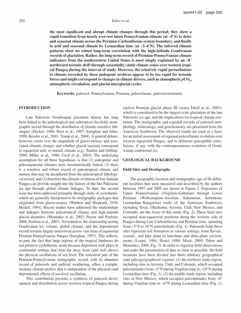
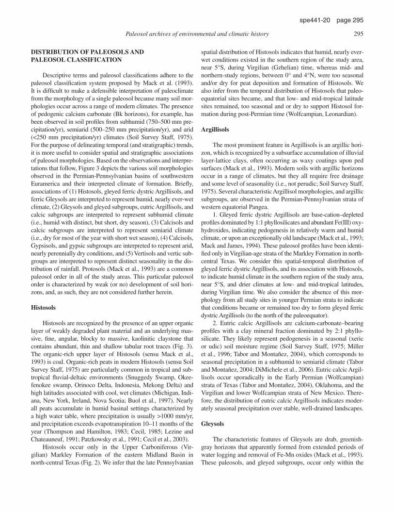
The geographic location and stratigraphic age of 96 differ-ent localities that were measured and described by the authors between 1997 and 2005 are shown in Figure 1. Exposures of Upper Pennsylvanian (Virgilian–Gzhelian) through Lower Permian (Wolfcampian–Asselian, Sakmarian, Artinskian; Leonardian–Kungurian) rocks of the American Southwest, including Texas, Oklahoma, Arizona, Utah, New Mexico, and Colorado, are the focus of this study (Fig. 2). These fi eld sites occupied near-equatorial positions along the western side of Pangea during Late Carboniferous and Permian time, spanning from ~5°S to 10°N paleolatitude (Fig. 1). Paleosols from these sites represent soil formation in various settings, from fl uvial-, coastal-, and lake plain to interdune and delta-plain environ-ments (Loope, 1984; Hentz, 1988; Mack, 2003; Tabor and Montañez, 2004; Fig. 3). In order to organize fi eld observations and make the presentation of data as clear as possible, the fi eld locations have been divided into three arbitrary geographical (and paleogeographical) regions: (1) the northern study region, including sites in Arizona, Utah, and Colorado, which occupied paleolatitudes from ~2°N during Virgilian time to ~10°N during Leonardian time (Fig. 1), (2) the middle study region, including sites in New Mexico, which occupied paleolatitudes from ~0° during Virgilian time to ~6°N during Leonardian time (Fig. 1),
the most signifi cant and abrupt climate changes through this period; they show a rapid transition from nearly ever-wet latest Pennsylvanian climate (at ~5°S) to drier and seasonal climate across the Permian-Carboniferous system boundary, and fi nally to arid and seasonal climate by Leonardian time (at ~2–4°N). The inferred climate patterns show no robust long-term correlation with the high-latitude Gondwanan records of glaciation. Rather, the long-term record of Permian-Pennsylvanian climate indicators from the southwestern United States is most simply explained by an ~8° northward tectonic drift through (essentially) static climate zones over western tropi-cal Pangea during the interval of study. However, the relatively rapid perturbations to climate recorded by these pedogenic archives appear to be too rapid for tectonic forces and might correspond to changes in climate drivers, such as atmospheric pCO2, atmospheric circulation, and glacial-interglacial cycles.
Keywords: paleosol, Pennsylvanian, Permian, paleoclimate, paleoenvironment.
292 Tabor et al.
spe441-20 page 292
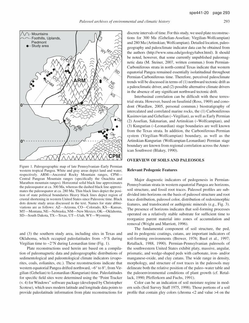
and (3) the southern study area, including sites in Texas and Oklahoma, which occupied paleolatitudes from ~5°S during Virgilian time to ~2°N during Leonardian time (Fig. 1).
Plate reconstructions used herein are based on a compila-tion of paleomagnetic data and paleogeographic distributions of sedimentological and paleontological climate indicators (evapo-rites, coals, eolianites, etc.). These reconstructions indicate that western equatorial Pangea drifted northward, ~6° to 8°, from Vir-gilian (Gzhelian) to Leonardian (Kungurian) time. Paleolatitudes for specifi c fi eld sites were determined using the “Point Tracker (v. 4) for Windows” software package (developed by Christopher Scotese), which uses modern latitude and longitude data points to provide paleolatitude information from plate reconstructions for
discrete intervals of time. For this study, we used plate reconstruc-tions for 300 Ma (Gzhelian-Asselian; Virgilian-Wolfcampian) and 280 Ma (Artinskian; Wolfcampian). Detailed location, paleo-geography and paleoclimate indicator data can be obtained from the authors (http://www.smu.edu/geology/tabor.html). It should be noted, however, that some currently unpublished paleomag-netic data (M. Steiner, 2007, written commun.) from Permian-Carboniferous strata in north-central Texas indicate that western equatorial Pangea remained essentially isolatitudinal throughout Permian-Carboniferous time. Therefore, perceived paleoclimate trends will be discussed in terms of (1) northward tectonic drift as a paleoclimatic driver, and (2) possible alternative climate drivers in the absence of any signifi cant northward tectonic drift.
Interbasinal correlation can be diffi cult with these terres-trial strata. However, based on fusulinid (Ross, 1969) and cono-dont (Wardlaw, 2005, personal commun.) biostratigraphy of intercalated and correlated marine rocks, the (1) Carboniferous Kasimovian and Gzhelian (~Virgilian), as well as Early Permian (2) Asselian, Sakmarian, and Artinskian (~Wolf campian), and (3) Kungurian (~Leonardian) stage boundaries are well known from the Texas strata. In addition, the Carboniferous-Permian system (Virgilian-Wolfcampian) boundary, as well as the Artinskian-Kungurian (Wolfcampian-Leonardian) Permian stage boundary are known from regional correlation across the Amer-ican Southwest (Blakey, 1990).
OVERVIEW OF SOILS AND PALEOSOLS
Relevant Pedogenic Features
Major diagnostic indicators of pedogenesis in Permian-Pennsylvanian strata in western equatorial Pangea are horizons, soil structure, and fossil root traces. Paleosol profi les are sub-divided into horizons on the basis of paleosol structure and root trace distribution, paleosol color, distribution of redoximorphic features, and translocated or authigenic minerals (e.g., Fig. 3). The presence of horizons indicates that soil-forming processes operated on a relatively stable substrate for suffi cient time to reorganize parent material into zones of accumulation and removal (Wright and Marriott, 1996).
The fundamental component of soil structure, the ped, and its pedogenic coatings, cutans, are important indicators of soil-forming environments (Brewer, 1976; Buol et al., 1997; Retallack, 1988, 1990). Permian-Pennsylvanian paleosols of the southwestern United States exhibit platy, massive, angular, prismatic, and wedge-shaped peds with carbonate, iron- and/or manganese-oxide, and clay cutans. The wide range in density, morphology, and structure of root traces in the paleosols may delineate both the relative position of the paleo–water table and the paleoenvironmental conditions of plant growth (cf. Retal-lack, 1990; Pfefferkorn and Fuchs, 1991).
Color can be an indication of soil moisture regime in mod-ern soils (Soil Survey Staff 1975, 1998). Those portions of a soil profi le that contain gley colors (chroma <2 and value >4 on the
ARM
CPM
- Mountains- Foothills, Uplands,
Piedmont- Study area
0°
0°
Figure 1. Paleogeographic map of late Pennsylvanian–Early Permian western tropical Pangea. White and gray areas depict land and water , respectively. ARM—Ancestral Rocky Mountain ranges, CPM—Central Pangean Mountain ranges (specifi cally the Ouachita and Mara thon mountain ranges). Horizontal solid black line approximates the paleoequator at ca. 300 Ma, whereas the dashed black line approxi-mates the paleoequator at ca. 280 Ma. Thin black lines depict the posi-tion of state political boundaries Heavy black lines depict region of crustal shortening in western United States since Paleozoic time. Black dots denote study areas discussed in the text. Names for state abbre-viations are as follows: AZ—Arizona, CO—Colorado, KS—Kansas, MT—Montana, NE—Nebraska, NM—New Mexico, OK—Oklahoma, SD—South Dakota, TX—Texas, UT—Utah, WY—Wyoming.
Paleosol archives of environmental and climatic history 293
spe441-20 page 293

Munsell color charts) and/or mottling are referred to as redoxi-morphic zones or features (e.g., Vepraskas, 1994), and they indi-cate reduced conditions, which are typical of relatively prolonged saturation (25%–50% of the year; Daniels et al., 1971).
By analogy with modern soils, paleosol redoximorphic fea-tures are interpreted to have formed in seasonally saturated por-
tions of the profi le that contained suffi cient organic content to yield reducing conditions and gleyed horizons (cf. PiPujol and Buurman, 1994). However, soil color is susceptible to signifi cant changes upon burial and diagenesis (Retallack, 1990; Mack et al., 1993). Thus, paleosol color is not, by itself, used as a diagnostic environmental indicator (e.g., Mack et al., 1993).
MagdalenaGp.
Hueco F
m.A
bo F
m.
Bursum
Yeso Fm.
Glorieta Fm.
San Andres Fm.
New MexicoN S
San
gre
de C
risto
Fm
.
EsplanadeFm.
Hermit Fm.
Schnebly Hill
DeChelley SS
Coconino SS
Kaibab Fm.Arizona
Toroweap Fm.
WescogameFm.
North-CentralTexas
Markley Fm.
Archer City FmNocona Fm.Petrolia Fm.
WaggonerRanch Fm.
Leuders Fm.Clear Fork Fm.
San Angelo Fm.
Blaine Fm.
ColoradoSW SC
Eag
le V
alle
yF
m.
low
erm
iddl
e
lower
middle
Hon
aker
Tra
ilF
m.
SoutheastUtah
Honaker TrailFm.
Halgaito Fm.
Cedar Mesa Fm.
Organ Rock Fm.
White Rim Fm.
Virg
ilian
Wol
fcam
pian
Leon
ardi
an
Gzehlian
Asselian
Sakmarian
Artinskian
Kungurian
Stage
Mar
oon
Fm
. Cutler G
p.
Per
mia
nP
enns
ylva
nian
Per
iod South Middle NorthS N
Figure 2. Stratigraphic correlation across the southwestern United States placed against geological period, and geological stage for the international and regional (i.e., west Texas) subdivisions.
O C S F M C
Sand
OiAjC
Histosol
O C S F M C
Sand
ABt1
Bt2
BCg
Cgv
Gleyed FerricDystric
Argillisol
Cg
BCssg
Bv
Ag
O C S F M C
Sand
FerricGleysol
O C S F M C
Sand
ABwBgc
Bss2C
GleyedVertisol
Bw
By
BCss
C
O C S F M C
Sand
VerticGypsisol
ABk
Bkss1
Bkss2
BCss
C
O C S F M C
Sand
CalcicVertisol
O C S F M C
Sand
ABBt1Bt2BtkBCss
C
CalcicArgillisol
1 m
Decreasing Relative Soil MoistureHumid/
Ever-wetArid/Dry
BkmBk1Bk22Bss
3Css
4C
O C S F M C
Sand
VerticCalcisol
Waterlogged
HumidWell-Drained
HumidSeasonally
Drained
Humid,Seasonal
Precipitation &Drainage
Subhumid-SemiaridWell-Drained
SeasonalPrecipitation
Subhumid-SemiaridSeasonal
Precipitation &Drainage
SemiaridWell-Drained
SeasonalPrecipitation
AridWell-Drained
SeasonalPrecipitation
HumidSubhumid
SemiaridArid
Extreme Seasonal Precipitation
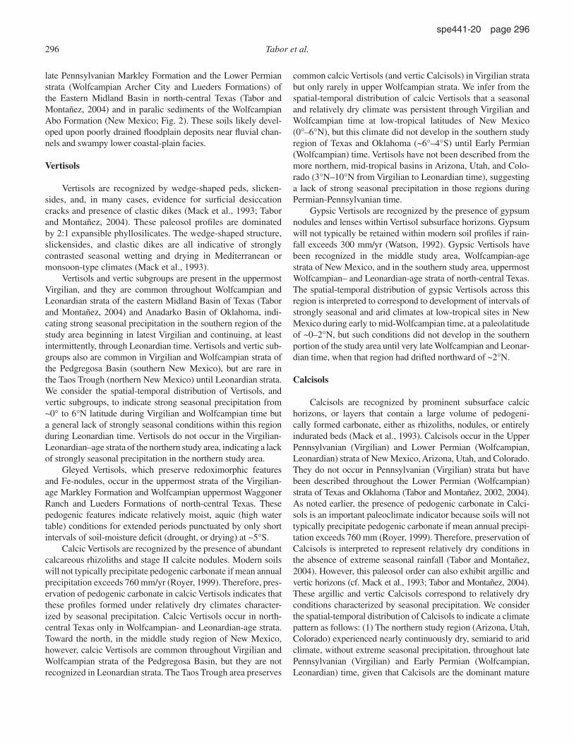
Figure 3. Examples of paleosol profi les from the Pennsylvanian–Early Permian strata of western tropical Pangea. See text for discussion. O—Coal, C—claystone, S—siltstone, F—fi ne sandstone, M—medium sandstone, C—coarse sandstone.
294 Tabor et al.
spe441-20 page 294
DISTRIBUTION OF PALEOSOLS AND PALEOSOL CLASSIFICATION
Descriptive terms and paleosol classifi cations adhere to the paleosol classifi cation system proposed by Mack et al. (1993). It is diffi cult to make a defensible interpretation of paleoclimate from the morphology of a single paleosol because many soil mor-phologies occur across a range of modern climates. The presence of pedogenic calcium carbonate (Bk horizons), for example, has been observed in soil profi les from subhumid (750–500 mm pre-cipitation/yr), semiarid (500–250 mm precipitation/yr), and arid (<250 mm precipitation/yr) climates (Soil Survey Staff, 1975). For the purpose of delineating temporal (and stratigraphic) trends, it is more useful to consider spatial and stratigraphic associations of paleosol morphologies. Based on the observations and interpre-tations that follow, Figure 3 depicts the various soil morphologies observed in the Permian-Pennsylvanian basins of southwestern Euramerica and their interpreted climate of formation. Briefl y, associations of (1) Histosols, gleyed ferric dystric Argillisols, and ferric Gleysols are interpreted to represent humid, nearly ever-wet climate, (2) Gleysols and gleyed subgroups, eutric Argillisols, and calcic subgroups are interpreted to represent subhumid climate (i.e., humid with distinct, but short, dry season), (3) Calcisols and calcic subgroups are interpreted to represent semiarid climate (i.e., dry for most of the year with short wet season), (4) Calcisols, Gypsisols, and gypsic subgroups are interpreted to represent arid, nearly perennially dry conditions, and (5) Vertisols and vertic sub-groups are interpreted to represent distinct seasonality in the dis-tribution of rainfall. Protosols (Mack et al., 1993) are a common paleosol order in all of the study areas. This particular paleosol order is characterized by weak (or no) development of soil hori-zons, and, as such, they are not considered further herein.
Histosols
Histosols are recognized by the presence of an upper organic layer of weakly degraded plant material and an underlying mas-sive, fi ne, angular, blocky to massive, kaolinitic claystone that contains abundant, thin and shallow tabular root traces (Fig. 3). The organic-rich upper layer of Histosols (sensu Mack et al., 1993) is coal. Organic-rich peats in modern Histosols (sensu Soil Survey Staff, 1975) are particularly common in tropical and sub-tropical fl uvial-deltaic environments (Snuggedy Swamp, Okee-fenokee swamp, Orinoco Delta, Indonesia, Mekong Delta) and high latitudes associated with cool, wet climates (Michigan, Indi-ana, New York, Ireland, Nova Scotia; Buol et al., 1997). Nearly all peats accumulate in humid basinal settings characterized by a high water table, where precipitation is usually >1000 mm/yr, and precipitation exceeds evapotranspiration 10–11 months of the year (Thompson and Hamilton, 1983; Cecil, 1985; Lezine and Chateauneuf, 1991; Patzkowsky et al., 1991; Cecil et al., 2003).
Histosols occur only in the Upper Carboniferous (Vir-gilian) Markley Formation of the eastern Midland Basin in north-central Texas (Fig. 2). We infer that the late Pennsylvanian
spatial distribution of Histosols indicates that humid, nearly ever-wet conditions existed in the southern region of the study area, near 5°S, during Virgilian (Gzhelian) time, whereas mid- and northern-study regions, between 0° and 4°N, were too seasonal and/or dry for peat deposition and formation of Histosols. We also infer from the temporal distribution of Histosols that paleo-equatorial sites became, and that low- and mid-tropical latitude sites remained, too seasonal and or dry to support Histosol for-mation during post-Permian time (Wolfcampian, Leonardian).
Argillisols
The most prominent feature in Argillisols is an argillic hori-zon, which is recognized by a subsurface accumulation of illuvial layer-lattice clays, often occurring as waxy coatings upon ped surfaces (Mack et al., 1993). Modern soils with argillic horizons occur in a range of climates, but they all require free drainage and some level of seasonality (i.e., not perudic; Soil Survey Staff, 1975). Several characteristic Argillisol morphologies, and argillic subgroups, are observed in the Permian-Pennsylvanian strata of western equatorial Pangea.
1. Gleyed ferric dystric Argillisols are base-cation–depleted profi les dominated by 1:1 phyllosilicates and abundant Fe(III) oxy-hydroxides, indicating pedogenesis in relatively warm and humid climate, or upon an exceptionally old landscape (Mack et al., 1993; Mack and James, 1994). These paleosol profi les have been identi-fi ed only in Virgilian-age strata of the Markley Formation in north-central Texas. We consider this spatial-temporal distribution of gleyed ferric dystric Argillisols, and its association with Histosols, to indicate humid climate in the southern region of the study area, near 5°S, and drier climates at low- and mid-tropical latitudes, during Virgilian time. We also consider the absence of this mor-phology from all study sites in younger Permian strata to indicate that conditions became or remained too dry to form gleyed ferric dystric Argillisols (to the north of the paleoequator).
2. Eutric calcic Argillisols are calcium-carbonate–bearing profi les with a clay mineral fraction dominated by 2:1 phyllo-silicate. They likely represent pedogenesis in a seasonal (xeric or udic) soil moisture regime (Soil Survey Staff, 1975; Miller et al., 1996; Tabor and Montañez, 2004), which corresponds to seasonal precipitation in a subhumid to semiarid climate (Tabor and Montañez, 2004; DiMichele et al., 2006). Eutric calcic Argil-lisols occur sporadically in the Early Permian (Wolfcampian) strata of Texas (Tabor and Montañez, 2004), Oklahoma, and the Virgilian and lower Wolfcampian strata of New Mexico. There-fore, the distribution of eutric calcic Argillisols indicates moder-ately seasonal precipitation over stable, well-drained landscapes.
Gleysols
The characteristic features of Gleysols are drab, greenish-gray horizons that apparently formed from extended periods of water logging and removal of Fe-Mn oxides (Mack et al., 1993). These paleosols, and gleyed subgroups, occur only within the
Paleosol archives of environmental and climatic history 295
spe441-20 page 295
late Pennsylvanian Markley Formation and the Lower Permian strata (Wolfcampian Archer City and Lueders Formations) of the Eastern Midland Basin in north-central Texas (Tabor and Montañez, 2004) and in paralic sediments of the Wolfcampian Abo Formation (New Mexico; Fig. 2). These soils likely devel-oped upon poorly drained fl oodplain deposits near fl uvial chan-nels and swampy lower coastal-plain facies.
Vertisols
Vertisols are recognized by wedge-shaped peds, slicken-sides, and, in many cases, evidence for surfi cial desiccation cracks and presence of clastic dikes (Mack et al., 1993; Tabor and Montañez, 2004). These paleosol profi les are dominated by 2:1 expansible phyllosilicates. The wedge-shaped structure, slickensides, and clastic dikes are all indicative of strongly contrasted seasonal wetting and drying in Mediterranean or monsoon-type climates (Mack et al., 1993).
Vertisols and vertic subgroups are present in the uppermost Virgilian, and they are common throughout Wolfcampian and Leonardian strata of the eastern Midland Basin of Texas (Tabor and Montañez, 2004) and Anadarko Basin of Oklahoma, indi-cating strong seasonal precipitation in the southern region of the study area beginning in latest Virgilian and continuing, at least intermittently, through Leonardian time. Vertisols and vertic sub-groups also are common in Virgilian and Wolfcampian strata of the Pedgregosa Basin (southern New Mexico), but are rare in the Taos Trough (northern New Mexico) until Leonardian strata. We consider the spatial-temporal distribution of Vertisols, and vertic subgroups, to indicate strong seasonal precipitation from ~0° to 6°N latitude during Virgilian and Wolfcampian time but a general lack of strongly seasonal conditions within this region during Leonardian time. Vertisols do not occur in the Virgilian-Leonardian –age strata of the northern study area, indicating a lack of strongly seasonal precipitation in the northern study area.
Gleyed Vertisols, which preserve redoximorphic features and Fe-nodules, occur in the uppermost strata of the Virgilian-age Markley Formation and Wolfcampian uppermost Waggoner Ranch and Lueders Formations of north-central Texas. These pedogenic features indicate relatively moist, aquic (high water table) conditions for extended periods punctuated by only short intervals of soil-moisture defi cit (drought, or drying) at ~5°S.
Calcic Vertisols are recognized by the presence of abundant calcareous rhizoliths and stage II calcite nodules. Modern soils will not typically precipitate pedogenic carbonate if mean annual precipitation exceeds 760 mm/yr (Royer, 1999). Therefore, pres-ervation of pedogenic carbonate in calcic Vertisols indicates that these profi les formed under relatively dry climates character-ized by seasonal precipitation. Calcic Vertisols occur in north-central Texas only in Wolfcampian- and Leonardian-age strata. Toward the north, in the middle study region of New Mexico, however, calcic Vertisols are common throughout Virgilian and Wolfcampian strata of the Pedgregosa Basin, but they are not recognized in Leonardian strata. The Taos Trough area preserves
common calcic Vertisols (and vertic Calcisols) in Virgilian strata but only rarely in upper Wolfcampian strata. We infer from the spatial-temporal distribution of calcic Vertisols that a seasonal and relatively dry climate was persistent through Virgilian and Wolfcampian time at low-tropical latitudes of New Mexico (0°–6°N), but this climate did not develop in the southern study region of Texas and Oklahoma (~6°–4°S) until Early Permian (Wolfcampian) time. Vertisols have not been described from the more northern, mid-tropical basins in Arizona, Utah, and Colo-rado (3°N–10°N from Virgilian to Leonardian time), suggesting a lack of strong seasonal precipitation in those regions during Permian-Pennsylvanian time.
Gypsic Vertisols are recognized by the presence of gypsum nodules and lenses within Vertisol subsurface horizons. Gypsum will not typically be retained within modern soil profi les if rain-fall exceeds 300 mm/yr (Watson, 1992). Gypsic Vertisols have been recognized in the middle study area, Wolfcampian-age strata of New Mexico, and in the southern study area, uppermost Wolfcampian– and Leonardian-age strata of north-central Texas. The spatial-temporal distribution of gypsic Vertisols across this region is interpreted to correspond to development of intervals of strongly seasonal and arid climates at low-tropical sites in New Mexico during early to mid-Wolfcampian time, at a paleolatitude of ~0–2°N, but such conditions did not develop in the southern portion of the study area until very late Wolfcampian and Leonar-dian time, when that region had drifted northward of ~2°N.
Calcisols
Calcisols are recognized by prominent subsurface calcic horizons, or layers that contain a large volume of pedogeni-cally formed carbonate, either as rhizoliths, nodules, or entirely indurated beds (Mack et al., 1993). Calcisols occur in the Upper Pennsylvanian (Virgilian) and Lower Permian (Wolfcampian, Leonardian ) strata of New Mexico, Arizona, Utah, and Colorado. They do not occur in Pennsylvanian (Virgilian) strata but have been described throughout the Lower Permian (Wolfcampian) strata of Texas and Oklahoma (Tabor and Montañez, 2002, 2004). As noted earlier, the presence of pedogenic carbonate in Calci-sols is an important paleoclimate indicator because soils will not typically precipitate pedogenic carbonate if mean annual precipi-tation exceeds 760 mm (Royer, 1999). Therefore, preservation of Calcisols is interpreted to represent relatively dry conditions in the absence of extreme seasonal rainfall (Tabor and Montañez, 2004). However, this paleosol order can also exhibit argillic and vertic horizons (cf. Mack et al., 1993; Tabor and Montañez, 2004). These argillic and vertic Calcisols correspond to relatively dry conditions characterized by seasonal precipitation. We consider the spatial-temporal distribution of Calcisols to indicate a climate pattern as follows: (1) The northern study region (Arizona, Utah, Colorado) experienced nearly continuously dry, semiarid to arid climate, without extreme seasonal precipitation, throughout late Pennsylvanian (Virgilian) and Early Permian (Wolfcampian, Leonardian) time, given that Calcisols are the dominant mature
296 Tabor et al.
spe441-20 page 296
paleosol profi les throughout these strata. (2) The northern portion of the middle study region (Taos trough, New Mexico) was char-acterized by stable, dry (subhumid to semiarid) climate during late Pennsylvanian (Virgilian) time and a stable, dry (semiarid to arid) climate during Early Permian (Wolfcampian) time. Calcic Vertisols at these same sites suggest that the climate might have varied between episodes of stable, and then highly seasonal, rain-fall. Calcisols do not occur in the southern portion of the middle study area (Pedregosa Basin, New Mexico) until Wolfcampian time. However, calcic Vertisols occur in the Virgilian strata of these sites, suggesting a relatively dry (subhumid to semiarid) and seasonal climate. (3) Calcisols are recognized in middle through upper Wolfcampian strata of the southern study region (Texas, Oklahoma), and calcic Vertisols and calcic Argillisols are present in younger, Wolfcampian strata of this area. Collectively, the distribution of these paleosols across the entire study area suggests that stable, dry climates progressed southward across mid- and low-tropical regions of Pangea from Virgilian through Wolfcampian time. These stable and relatively dry climate indi-cators originally occupied only the northern portions of the study area but subsequently replaced preexisting dry and seasonal cli-mates in middle (New Mexico) and southern (Oklahoma, Texas) sites during Virgilian and Wolfcampian time.
Gypsisols
Gypsisols are recognized by prominent gypsic horizons, or layers that contain a large volume of gypsum (Mack et al., 1993), in a subsurface or near-surface layer of the paleosol profi le. Pedo-genic gypsum occurs in modern soil profi les in warm and dry cli-mates with mean annual precipitation less than 250–300 mm/yr (Watson, 1992). In this regard, the presence of Gypsisols, and other paleosol morphologies with “gypsic” subgroups, likely indicates stable to strongly seasonal climates that were, at times, quite arid. In the northern study region, Gypsisols and gypsic subgroups fi rst occur in mid-Wolfcampian strata of the northern region (Utah), and continue through Leonardian (Arizona), strata. Gypsic sub-groups appear in the upper half of Wolfcampian-age strata in the northern part of the middle study region (New Mexico), and in uppermost Wolfcampian– and Leonardian-age strata of the south-ern region (Texas). We consider the spatial-temporal distribution of Gypsisols and gypsic subgroups across the entire study area to indicate that arid climates initially developed in the northern study region (Colorado, Utah, Arizona) of western equatorial Pan-gea during mid-Wolfcampian time. Arid conditions subsequently occurred in more southern regions, fi rst in the late Wolfcampian of New Mexico, and then in latest Wolfcampian of Texas.
DISCUSSION AND CONCLUSIONS
The variability of paleosol morphologies in the Upper Pennsylvanian and Lower Permian strata of tropical western Pangea refl ects a range of soil-forming environments across Permian-Pennsylvanian landscapes. The distribution of paleo-
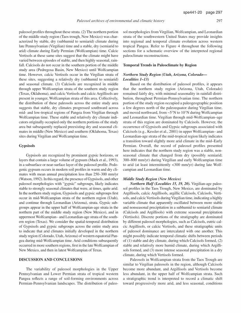
sol morphologies from Virgilian, Wolfcampian, and Leonardian strata of the southwestern United States may provide insights into regional and temporal climate evolution across western tropical Pangea. Refer to Figure 4 throughout the following sections for a schematic overview of the interpreted regional paleoclimate reconstructions.
Temporal Trends in Paleoclimate by Region
Northern Study Region (Utah, Arizona, Colorado—Localities 1–13)
Based on the distribution of paleosol profi les, it appears that the northern study region (Arizona, Utah, Colorado) remained fairly dry, with minimal seasonality in rainfall distri-bution, throughout Permian-Pennsylvanian time. The northern portion of the study region occupied a paleogeographic position a few degrees north of the paleoequator during Virgilian time, and moved northward, from ~5°N to 10°N during Wolfcampian and Leonardian time. Virgilian through mid-Wolfcampian–age strata of this region are dominated by Calcisols. However, the occurrence of Gypsisols and Gypsic subgroups associated with Calcisols (e.g., Kessler et al., 2001) in upper Wolfcampian– and Leonardian-age strata of the mid-tropical region likely indicates a transition toward slightly more arid climate in the mid–Early Permian. Overall, the record of paleosol profi les presented here indicates that the northern study region was a stable, non-seasonal climate that changed from dry (possibly semiarid; 300–800 mm/yr) during Virgilian and early Wolfcampian time to arid (at least intermittently <300 mm/yr) during late Wolf-campian and Leonardian time.
Middle Study Region (New Mexico)Northern Half (Localities 15, 19, 20). Virgilian-age paleo-
sol profi les in the Taos Trough, New Mexico, are dominated by Argillisols, calcic Argillisols, argillic Calcisols, Calcisols, Verti-sols, and calcic Vertisols during Virgilian time, indicating a highly variable climate that apparently oscillated between more stable and nonseasonal precipitation in a subhumid to semiarid climate (Calcisols and Argillisols) with extreme seasonal precipitation (Vertisols). Discrete portions of the stratigraphy are dominated by different paleosol morphologies, such as Calcisols, eutric cal-cic Argillisols, or calcic Vertisols, and these stratigraphic units of paleosol dominance are intercalated with one another. This might possibly indicate temporal climatic shifts between periods of (1) stable and dry climate, during which Calcisols formed, (2) stable and relatively more humid climate, during which Argilli-sols formed, and (3) more intense seasonal precipitation in a dry climate, during which Vertisols formed.
Paleosols in Wolfcampian strata from the Taos Trough are similar to Virgilian paleosols in the region, although Calcisols become more abundant, and Argillisols and Vertisols become less abundant, in the upper half of Wolfcampian strata. Such a stratigraphic trend is interpreted to record a climatic shift toward progressively more arid, and less seasonal, conditions
Paleosol archives of environmental and climatic history 297
spe441-20 page 297

from early to late Wolfcampian time. Leonardian-age strata of this same region are dominated by Calcisols and Gypsisols. We interpret this long-term stratigraphic trend of paleosol morphol-ogies in the region to correspond to relatively dry, subhumid to semiarid climate (between 300 and 800 mm/yr precipita-tion) and seasonal precipitation during Virgilian and early
Wolf campian time, development of semiarid to arid and non-seasonal precipitation during late Wolfcampian time, and arid (<300 mm/yr precipitation) climate during Leonardian time.
The northern half of the middle study region moved from equatorial latitudes during Virgilian time to ~6°N through Wolf-campian and Leonardian time. Therefore, the loss of Argillisols,
Car
boni
fero
usP
erm
ian
Cis
ural
ian
Kun
guri
anA
rtin
skia
nSa
kmar
ian
Ass
elia
nG
zhel
ian
Kas
imov
ian
Mos
covi
an
310
305
300
295
290
285
280
275
270
Virgilian
Bursum
Missourian
Desmoinesian
Atokan
Wol
fcam
pian
Leonardian
Per
iod
Epo
chSt
age North
American Subdivision
North Region
Mid-Region North
Mid-Region South
Equatorial Region
Hum
id
Subh
umid
Sem
iari
d
Ari
d
Hum
id
Subh
umid
Sem
iari
d
Ari
d
Hum
id
Subh
umid
Sem
iari
d
Ari
d
Hum
id
Subh
umid
Sem
iari
d
Ari
d
Humid = dystric Argillisols, Histosols Subhumid = eutric Argillisols, argillic subgroups Semiarid = Calcisols, calcic subgroups Arid = Gypsisols, gypsic subgroups, Calcisols, calcic subgroups Extreme Seasonal Precipitation = Vertisols
Figure 4. Diagram of stratigraphic correlation that depicts interpreted temporal climate trends, based on spatial-temporal distribution of paleosol morphologies, across the various regions in the study area of the southwestern United States (western tropical Pangea). These data are placed against geological periods, epochs, international stages, and regional North American stages (Gradstein et al., 2004). Also shown are age ranges of glacial periods for Australia and Antarctica (Fielding et al., 2006, this volume). Dark blue denotes intervals during which grounded continental ice occurred on both Australia and Antarctica, whereas light blue denotes ice for Australia only, and purple denotes ice for Antarctica only. See text for discussion.
298 Tabor et al.
spe441-20 page 298

Vertisols, and calcic Vertisols, and replacement by Calcisols, gypsic Vertisols, and Gypsisols, could be related to northward tectonic drift of that region from a more seasonal and humid cli-mate zone during Virgilian time to a more arid and nonseasonal climate zone during Wolfcampian and Leonardian time, which had previously been occupied by sites in the northern study region (Colorado, Utah, Arizona) during Virgilian time.
Central and Southern New Mexico (Localities 14–16, 18–20). Virgilian (Bursumian) strata in the southern area of the low-tropical region (central and southern New Mexico) are dominated by calcic Vertisols, suggesting intense seasonal precipitation in a dry climate. Wolfcampian strata are domi-nated by calcic Vertisols and Calcisols, suggesting that climate remained relatively dry (semiarid to arid) but was also charac-terized by alternating episodes of extreme seasonal and non-seasonal precipitation. At the current time, however, it is not possible to determine whether Calcisols become progressively more abundant upward through the Wolfcampian strata, and therefore whether stable, nonseasonal, dry climates were more common prior to Leonardian time. Leonardian strata are domi-nated by Gypsisols, indicating a shift to stable, nonseasonal and arid climate in late Early Permian time.
The southern half of the middle study region moved from equatorial latitudes during Virgilian time to ~4°N through Wolf-campian and Leonardian time. Therefore, the transition from calcic Vertisols and Calcisols in Virgilian and Wolf campian strata to Gypsisols in Leonardian strata could be related to northward tectonic drift of the region from an intermittently sea-sonal, dry climate zone in Virgilian and Wolfcampian time to a nonseasonal, arid climate zone by Leonardian time. In addition, the fi rst appearance of arid-climate indicators, such as gypsic horizons, in the upper Wolfcampian strata of the northern half, and the Leonardian strata of the southern half, of the middle study region is suggestive of a time-transgressive climate trend toward aridity that is consistent with a northward tectonic drift across climate belts.
Southern Study Region (Texas, Oklahoma)The southern region of the study area, which occupied paleo-
geographic positions from ~5°S to ~2°N between Virgilian and Leonardian time, respectively, shows the greatest stratigraphic changes in paleosol morphologies and inferred paleoclimate change. Virgilian-age paleosols of Texas and Oklahoma pre-serve gleyed dystric Argillisols, Histosols, and ferric Gleysols, indicating a humid, nearly ever-wet climate with little or no sea-sonality. An abrupt transition from older ever-wet morphologies to subhumid to semiarid and seasonal morphologies, including calcic Vertisols, argillic Calcisols, calcic Argillisols, and Calci-sols, is recorded over a thin stratigraphic interval (~40 m) across the Permian-Carboniferous boundary (~Virgilian-Wolfcampian boundary; Tabor and Montañez, 2004). These calcic, argillic, and vertic morphologies are indicative of subhumid to semiarid, strongly seasonal climates. In a similar manner to the distribution of Virgilian and Wolfcampian paleosols in the Taos Trough (New
Mexico), the Wolfcampian through lower Leonardian strata of Texas and Oklahoma exhibit discrete portions of the stratigraphy that are dominated by different paleosol morphologies, such as Calcisols, eutric calcic Argillisols, or calcic Vertisols, that seem to indicate temporal climatic shifts among periods of (1) stable and dry climate, during which Calcisols formed, (2) stable and relatively more humid climate, during which eutric calcic Argil-lisols formed, and (3) more intense seasonal precipitation in a dry climate, during which calcic Vertisols formed. In addition, there is a short stratigraphic interval in mid-Wolfcampian strata (lower and middle Waggoner Ranch Formation) where noncalcic morphologies, such as Vertisols, become dominant, which may correspond to a brief period of relatively more humid and sea-sonal climate. Vertic Calcisols and Calcisols become dominant in upper Wolfcampian strata, indicating a return to a relative dry, possibly semiarid to arid climate with intermittent periods of sea-sonal and nonseasonal precipitation, before being followed by semiarid and arid seasonal climate indicators such as gypsic Ver-tisols, Calcisols, and Gypsisols in uppermost Wolfcampian– and Leonardian-age strata.
Paleogeographic, Paleotectonic, and Paleoclimatic Implications
Figure 4 provides a schematic depiction of interpreted paleoclimate trends from different regions of the study area. Two major climatic trends are apparent from the stratigraphic and regional distribution of paleosol profi les across the Permian-Pennsylvanian landscapes of western equatorial Pangea: (1) a regional trend toward increasingly more arid climate from equa-torial to more northern paleolatitudes, and (2) a temporal trend toward more dry conditions in all areas but that is most extreme for the southern study area, which includes change from humid, nearly ever-wet, to subhumid, then semiarid, and fi nally arid cli-mate in Virgilian through Leonardian strata.
Permian-Pennsylvanian paleoclimate trends across western tropical Pangea have been attributed to several extrinsic factors, including (1) reorganization of zonal atmospheric circulation pat-terns to tropical monsoonal atmospheric circulation and reverse equatorial fl ow (Parrish, 1993a; Kessler et al., 2001; Soreghan et al., 2002; Tabor and Montañez, 2002), (2) uplift of the Central Pangean Mountains (Rowley et al., 1985; Otto-Bliesner, 1998, 2003), (3) northward tectonic drift of western tropical Pangea across (effectively) static climate belts or zones over the Pangean landmass (Parrish, 1993a, 1993b; Kutzbach and Ziegler, 1994; Ziegler et al., 1996; Kessler et al., 2001) and (4) global cli-mate change related to inception of high-latitude continental ice-sheet growth, glacial-interglacial cycles, and deglaciation (Kessler et al., 2001; Soreghan et al., 2002; Tabor et al., 2002, 2004; Miller et al., 1996; Ziegler et al., 1986; Cecil et al., 2003; Olszewski and Patzkowsky, 2003; Montañez et al., 2007; Poulsen et al., 2007; Peyser and Poulsen, 2008). Atmospheric circulation, reversed equatorial fl ow, and mountain uplift have been consid-ered elsewhere (Parrish, 1993a, 1993b; Kessler et al., 2001; Tabor
Paleosol archives of environmental and climatic history 299
spe441-20 page 299

and Montañez, 2002, 2004), and they are not within the scope of this investigation. We consider here the observed spatial and temporal distribution of paleosol morphologies across western tropical Pangea, and their relationship to (1) the emerging record of short-lived (1–7 m.y. duration) icehouse-greenhouse climate cycles during the late Paleozoic ice age and glacial-interglacial cycles and (2) northward tectonic drift.
Icehouse-Greenhouse and Glacial-Interglacial Cycles
Fluctuations of the continental ice sheets, and variations in pCO
2 that accompanied them (Montañez et al., 2007), are pre-
dicted to infl uence climate on a large scale, which would include western tropical Pangea (Peyser and Poulsen, 2008). Global atmo-spheric models of the late Paleozoic deglaciation that incorporate the waning of the Gondwanan ice sheet and the rise of pCO
2
simulate long-term aridifi cation over western and central Pangea. Deglaciation contributes to tropical drying in two ways. (1) Wast-ing of the Gondwanan ice sheets during deglaciation reduced convective precipitation in the tropical Hadley circulation. The link between polar climate and tropical circulation arose through the infl uence of large Gondwana ice sheets on surface tempera-ture gradients over southern Pangea. The disappearance of these ice sheets increased surface temperatures and, more importantly, reduced the low-latitude meridional temperature gradient over southern Pangea, weakening the Hadley circulation and the con-vective processes that drove low-latitude rainfall in the Southern Hemisphere in particular. (2) An increase in atmospheric pCO
2
enhanced surface evaporation over Pangea, reducing soil mois-ture and its availability as a moisture source for tropical rainfall (Peyser and Poulsen, 2008).
The degree to which the paleosol record responded to these changes is unclear. The distribution of glacial and glaciogenic sediments during late Paleozoic time suggests numerous, discrete and nonoverlapping periods of continental ice on the southern Gondwanan landmass (Isbell et al. [2003, and references therein] as revised in Montañez et al., 2007; Fielding et al., 2006; this vol-ume). Figure 4 shows the age ranges of Permian-Pennsylvanian glaciations (between 310 Ma and 270 Ma) across Antarctica and Australia (Fielding et al., 2006, this volume) plotted against the international time scale and regional stratigraphic stages for the southwestern United States (Gradstein et al., 2004). Super-imposed upon the glacial age ranges, we present climate curves for different regions of western tropical Pangea that are based upon the stratigraphic distribution of paleosol morphologies. There does not appear to be a straightforward correspondence between paleoclimate conditions at high-latitude Pangea (south-ern Gondwanaland) and western tropical Pangea. The effect of this relationship, whether it refl ects a decoupling between low- and high-latitude climate on Pangea, is presently impossible for us to evaluate because it is not clear to what extent these regional variations in glaciation represent broad-scale climate changes over southern Pangea. It is possible that the long-term drying trend indicated by the paleosol record refl ects the slow demise of
the late Paleozoic ice age (and/or increased pCO2) but does not
capture regional-scale variations in the ice sheets.Several studies have considered Permian-Pennsylvanian
paleosols to be a partial record of glacio-eustatic climate cycles that were driven by high-latitude climate. Loope (1980, 1984, 1985), among others (Blakey, 1990; Langford and Chan, 1988; Mountney, 2006), interpreted the record of regionally traceable paleosol profi les (Calcisols, gypsic Protosols) intercalated with eolian sandstones of the Wolfcampian Cedar Mesa Formation (Utah) and Schnebly Hill Formation (Arizona) to be glacio-eustatic –driven climate cycles, in this case, ~400,000 yr duration. Specifi cally, these workers interpreted the eolian sandstones as intervals of aridity, during which there were active dune migra-tion and deposition, coincident with glacial intervals, sea-level lowstands, and a regionally low water table. The defl ationary surfaces upon which soils formed (and which are intercalated with eolian sandstones) were interpreted to represent intervals of relative humidity, sea-level highstands, and regionally high water table coincident with interglacials. Nevertheless, the Calcisol and gypsic Protosol paleosol morphologies that are intercalated with eolian sandstones from these regions are still indicative of a fairly dry and nonseasonal, semiarid to arid climate even during these supposed “pluvial,” or wetter, intervals (Fig. 4). To date, no sys-tematic stacking order of paleosol morphologies, such as inter-calated Calcisols and Gypsisols, has been observed as a possible validation of climatic wet-dry cycles that might be correlated to glacio-eustatic cycles and high-latitude climate. If regional cli-mate did change in accord with glacial-interglacial cycles, there is no paleopedogenic evidence, other than perhaps periodic changes in landscape stability (i.e., Soreghan et al., 1997; Kessler et al., 2001; Tramp et al., 2004) to indicate that pluvial (glacials) inter-vals were any less arid than nonpluvial (interglacial) intervals.
Tectonic Drift
The entire study area occupied a paleolatitudinal gradient of ~9°, and plate reconstructions suggest that western tropical Pangea drifted northward by ~8° from Virgilian to Leonardian time (Figs. 1 and 5). Therefore, the most southern Leonardian-age (ca. 270 Ma) study area, in Texas and Oklahoma, arrived at approximately the same paleolatitude as the most northern Virgilian-age (ca. 300 Ma) study area in Colorado, Utah, and Arizona. If the style and magnitude of tectonic drift are correct, the stratigraphic, or temporal, trend toward progressively more seasonal and/or arid climate indicators appears to be related to long-term northward drift through different climate zones, and the spatial-temporal trends in paleosol morphologies may provide information about the relative position of, and changes among, climate zones in Permian-Pennsylvanian western tropical Pangea.
The Gzhelian-Virgilian record of paleosol morphologies suggests the following distribution of climate zones (Fig. 5A): Gleyed ferric dystric Argillisols and Histosols in the southern region indicate a humid, nearly ever-wet climate zone with mini-mal seasonality around 5°S. The upward stratigraphic trend to
300 Tabor et al.
spe441-20 page 300
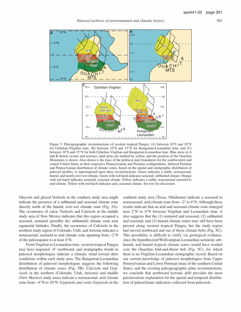
Gleysols and gleyed Vertisols in the southern study area might indicate the presence of a subhumid and seasonal climate zone directly north of the humid, ever-wet climate zone (Fig. 5A). The occurrence of calcic Vertisols and Calcisols in the middle study area of New Mexico indicates that this region occupied a seasonal, semiarid (possibly dry subhumid) climate zone near equatorial latitudes. Finally, the occurrence of Calcisols in the northern study region of Colorado, Utah, and Arizona indicates a nonseasonal, semiarid to arid climate zone spanning from ~2°N of the paleoequator to at least 4°N.
From Virgilian to Leonardian time, western tropical Pangea may have migrated ~8° northward, and stratigraphic trends in paleosol morphologies indicate a climatic trend toward drier conditions within each study area. The Kungurian-Leonardian distribution of paleosol morphologies suggests the following distribution of climate zones (Fig. 5B): Calcisols and Gyp-sisols in the northern (Colorado, Utah, Arizona) and middle (New Mexico) study areas indicate a nonseasonal, arid climate zone from ~4°N to 10°N. Gypsisols and vertic Gypsisols in the
southern study area (Texas, Oklahoma) indicate a seasonal to non seasonal, arid climate zone from ~2° to 4°N. Although these results indicate that an arid and seasonal climate zone emerged near 2°N to 4°N between Virgilian and Leonardian time, it also suggests that the (1) semiarid and seasonal, (2) subhumid and seasonal, and (3) humid climate zones may still have been present along western tropical Pangea, but the study region had moved northward and out of those climate belts (Fig. 5C). This possibility is diffi cult to verify via geological evidence, since the hypothesized Wolfcampian-Leonardian semiarid, sub-humid, and humid tropical climate zones would have resided over the Ouachita fold-and-thrust belt (Fig. 5C), for which there is no Virgilian-Leonardian stratigraphic record. Based on our current knowledge of paleosol morphologies from Upper Pennsylvanian and Lower Permian strata of the southern United States, and the existing paleogeographic plate reconstructions, we conclude that northward tectonic drift provides the most parsimonious explanation for the spatial and temporal distribu-tion of paleoclimate indicators collected from paleosols.
AOUA C H I T
MTS
10°N
10°S
5°N
5°S
A
10
10
5
5
15
OUA C H I T
MTS
A
B
TS
10
10
5
5
15
0
AOUA C H I T
MTS
Gzhelian-Virgilian
Kungurian-Leonardian
10
10
5
5
15
0
C
0°
O
arid
aridseasonal
arid tosemi-arid
semiaridseasonal
subhumid
humid
arid
humid?
aridseasonal
seasonal?semiarid
subhumid?
arid
semiaridseasonal
subhumid
humid
A
Figure 5. Paleogeographic reconstructions of western tropical Pangea: (A) between 10°S and 10°N for Gzhelian-Virgilian time, (B) between 10°S and 15°N for Kungurian-Leonardian time, and (C) between 10°S and 15°N for both Gzhelian-Virgilian and Kungurian-Leonardian time. Blue areas in A and B denote oceans and seaways, land areas are marked by yellow, and the position of the Ouachita Mountains is shown. Also shown is the trace of the political state boundaries for the southwestern and central United States in their respective Pennsylvanian and Permian confi gurations. Inferred Permian and Pennsylvanian distribution of climate zones, based on the spatial and stratigraphic distribution of paleosol profi les, is superimposed upon these reconstructions. Green indicates a stable, nonseasonal, humid, and nearly ever-wet climate. Green with red hatch indicates seasonal, subhumid climate. Orange with red hatch indicates semiarid, seasonal climate. Yellow indicates a stable, nonseasonal semiarid to arid climate. Yellow with red hatch indicates arid, seasonal climate. See text for discussion.
Paleosol archives of environmental and climatic history 301
spe441-20 page 301

In spite of these current fi ndings, we want to stress three dif-ferent points: (1) recent unpublished paleomagnetic data from the north-central Texas region indicate that this region of south-western Euramerica did not experience any signifi cant north-ward tectonic drift, and that western equatorial Pangea remained essentially isolatitudinal throughout Permian-Carboniferous time (M. Steiner, 2007, written commun.). If this is correct, then other mechanisms, such as regional- to global-scale changes in atmo-spheric circulation, must have been responsible for southward migration of climate belts over the still-standing southwestern portion of Euramerica. (2) Stratigraphic changes in paleosol morphologies of western tropical Pangea occur within short stratigraphic distances that likely correspond to time scales of climate change that are too rapid for the effects of tectonic drift (e.g., Tabor and Montañez, 2004; Montañez et al., 2007). (3) Stratigraphic changes in glacial deposits and inferred paleoatmo-spheric pCO
2 values based on soil-formed carbonate δ13C proxies
record variations in climate drivers that likely had a global infl u-ence. In this regard, we consider it unlikely that tectonic drift was entirely responsible for the stratigraphic and regional distribution of paleosol morphologies. Nonetheless, in the absence of a more refi ned correlation between high-latitude glacial and tropical paleosol records, tectonic drift must be considered as the primary long-term driver of inferred paleoprecipitation trends over west-ern equatorial Euramerica.
ACKNOWLEDGMENTS
We would like to thank Bill DiMichele and Dan Chaney (Smithsonian Institution Department of Paleobiology) for their scientifi c support and assistance over the past ten years of collab-oration. Thanks are also due to Frank Tabor for fi eld assistance. This project was supported by National Science Foundation grant EAR-0447381 and EAR-0617250 to Tabor, and EAR-0545654 to Tabor, Montañez, and Poulsen.
REFERENCES CITED
Blakey, R.C., 1990, Stratigraphy and geologic history of Pennsylvanian and Permian rocks, Mogollon Rim region, central Arizona and vicinity: Geo-logical Society of America Bulletin, v. 102, p. 1189–1217, doi: 10.1130/0016-7606(1990)102<1189:SAGHOP>2.3.CO;2.
Brewer, R., 1976, Fabric and Mineral Analysis of Soils: New York, Krieger, 482 p.
Buol, S.W., Hole, F.D., McCracken, R.J., and Southard, R.J., 1997, Soil Gen-esis and Classifi cation: Ames, Iowa, Iowa State University Press, 527 p.
Cecil, C.B., 1985, Paleoclimate controls on late Paleozoic sedimentation and peat formation in the central Appalachian Basin (U.S.A.): International Journal of Coal Geology, v. 5, p. 195–230, doi: 10.1016/0166-5162(85)90014-X.
Cecil, C.B., Dulong, F.T., West, R.R., Stamm, R., Wardlaw, B., and Edgar, N.T., 2003, Climate controls on the stratigraphy of a middle Pennsylvanian cyclothem in North America, in Cecil, C.B., and Edgar, T.N., eds., Cli-mate Controls on Stratigraphy: Society for Sedimentary Geology (SEPM) Special Publication 77, p. 151–180.
Daniels, R.B., Gamble, E.E., and Nelson, L.A., 1971, Relations between soil morphology and water table levels on a dissected north-central Carolina coastal plain surface: Soil Science Society of America Proceedings, v. 35, p. 157–175.
DiMichele, W.A., Tabor, N.J., Chaney, D.S., and Nelson, W.J., 2006, From wet-lands to wet spots: Environmental tracking and the fate of Carboniferous
elements in Early Permian tropical fl oras, in Greb, S.F., DiMichele, W.A., eds., Wetlands through Time: Geological Society of America Special Paper 399, p. 223–248.
Fielding, C.R., Rygel, M.C., Frank, T.D., Birgenheier, L.P., Jones, A.T., and Roberts, J., 2006, Near-fi eld stratigraphic record of the late Paleozoic Gondwanan ice age from eastern Australia discloses multiple alternating glacial and nonglacial intervals: Geological Society of America Abstracts with Programs, v. 38, no. 2, p. 317.
Fielding, C.R., Frank, T.D., Birgenheier, L.P., Rygel, M.C., Jones, A.T., and Roberts, J., 2008, this volume, Stratigraphic record and facies associa-tions of the late Paleozoic ice age in eastern Australia (New South Wales and Queensland), in Fielding, C.R., Frank, T.D., and Isbell, J.L., eds., Resolving the Late Paleozoic Ice Age in Time and Space: Geological Society of America Special Paper 441, doi: 10.1130/2008.2441(03).
Gradstein, F., Ogg, J., and Smith, A., 2004, A Geologic Time Scale 2004: Cam-bridge, UK, Cambridge University Press, 589 p.
Heckel, P.H., 1984, Changing concepts of Midcontinent Pennsylvanian cyclothems, North America: International Congress on Carboniferous Stratigraphy and Geology, Compte Rendu, v. 9, p. 535–553.
Heckel, P.H., 1986, Sea-level curve for Pennsylvanian eustatic marine transgressive-regressive depositional cycles along Midcontinent outcrop belt: North America: Geology, v. 14, p. 330–334, doi: 10.1130/0091-7613(1986)14<330:SCFPEM>2.0.CO;2.
Hentz, T.F., 1988, Lithostratigraphy and paleoenvironments of Upper Paleo-zoic continental red beds, north-central Texas: Bowie (new) and Wichita (revised) Groups: Bureau of Economic Geology Report of Investigations, v. 170, 49 p.
Isbell, J.L., Miller, M.F., Wolfe, K.L., and Lenaker, P.A., 2003, Timing of the late Paleozoic glaciation in Gondwana: Was glaciation responsible for the development of Northern Hemisphere cyclothems?, in Chan, M.A., and Archer, A.W., eds., Extreme Depositional Environments: Mega End Members in Geologic Time: Geological Society of America Special Paper 370, p. 5–24.
Kessler, J.L.P., Soreghan, G.S., and Wacker, H.J., 2001, Equatorial aridity in western Pangea: Lower Permian loessite and dolomitic paleosols in northeastern New Mexico, USA: Journal of Sedimentary Research, v. 71, p. 817–832, doi: 10.1306/2DC4096B-0E47-11D7-8643000102C1865D.
Kutzbach, J.E., and Ziegler, A.M., 1994, Simulation of Late Permian climate and biomes with an atmosphere-ocean model: Comparisons and observa-tions, in Allen, J.R.L., Hoskins, B.J., Sellwood, B.W., Spicer, R.A., and Valdes, P.J., eds., Palaeoclimates and their Modelling: With Special Refer-ence to the Mesozoic Era: London, UK, Chapman and Hall, p. 119–132.
Langford, R.P., and Chan, M.A., 1988, Flood surfaces and defl ation surfaces within the Cutler Formation and Cedar Mesa Sandstone (Permian), south-eastern Utah: Geological Society of America Bulletin, v. 100, p. 1541–1549, doi: 10.1130/0016-7606(1988)100<1541:FSADSW>2.3.CO;2.
Lezine, A.M., and Chateauneuf, J.J., 1991, Peat in the ‘Niayes’ of Senegal; depo sitional environment and Holocene evolution: Journal of African Earth Sciences, v. 12, p. 171–179, doi: 10.1016/0899-5362(91)90067-9.
Loope, D.B., 1980, Evidence for soil-forming episodes during deposition of the Permian Cedar Mesa Sandstone of Utah: Geological Society of America Abstracts with Programs, v. 12, no. 6, p. 278.
Loope, D.B., 1984, Eolian origin of Upper Paleozoic sandstones, southeastern Utah: Journal of Sedimentary Petrology, v. 54, p. 563–580.
Loope, D.B., 1985, Episodic deposition and preservation of aeolian sands: A late Paleozoic example from southeastern Utah: Geology, v. 13, p. 73–76, doi: 10.1130/0091-7613(1985)13<73:EDAPOE>2.0.CO;2.
Mack, G.H., 2003, Lower Permian terrestrial palaeoclimate indicators in New Mexico and their comparison to palaeoclimate models: New Mexico Geo-logical Society Guidebook, v. 54, p. 231–240.
Mack, G.H., and James, W.C., 1994, Paleoclimate and global distribution of paleosols: The Journal of Geology, v. 102, p. 360–366.
Mack, G.H., James, W.C., and Monger, H.C., 1993, Classifi cation of Paleosols: Geological Society of America Bulletin, v. 105, p. 129–136, doi: 10.1130/0016-7606(1993)105<0129:COP>2.3.CO;2.
Miller, K.B., McCahon, T.J., and West, R.R., 1996, Lower Permian (Wolf-campian) paleosol-bearing cycles of the U.S. Midcontinent: Evidence of climatic cyclicity: Journal of Sedimentary Research, v. 66, p. 71–84.
Montañez, I.P., Tabor, N.J., Niemeier, D., DiMichele, W.A., Frank, T.D., Fielding , C.R., and Isbell, J.L., 2007, CO2-forced climate and vegetation instability during late Paleozoic deglaciation: Science, v. 315, p. 87–91, doi: 10.1126/science.1134207.
302 Tabor et al.
spe441-20 page 302
Mountney, N.P., 2006, Periodic accumulation and destruction of aeolian erg sequences in the Permian Cedar Mesa Sandstone, White Canyon, southern Utah, USA: Sedimentology, v. 53, p. 789–823, doi: 10.1111/j.1365-3091.2006.00793.x.
Olszewski, T.D., and Patzkowsky, M.E., 2003, From cyclothems to sequences; the record of eustasy and climate on an icehouse epeiric platform ( Pennsylvanian-Permian, North America Midcontinent): Journal of Sedi-mentary Research, v. 73, p. 15–30, doi: 10.1306/061002730015.
Otto-Bliesner, B.L., 1998, Effects of tropical mountain elevations on the cli-mate of the Late Carboniferous: Climate model simulations, in Crowley, T.J., and Burke, K.C., eds., Tectonic Boundary Conditions for Climate Reconstructions: Oxford Monographs on Geology and Geophysics 39, p. 100–115.
Otto-Bliesner, B.L., 2003, The role of mountains, polar ice, and vegetation in determining the tropical climate during the middle Pennsylvanian: Cli-mate model simulations, in Cecil, C.B., and Edgar, T.N., eds., Climate Controls on Stratigraphy: Society for Sedimentary Geology (SEPM) Spe-cial Publication 77, p. 227–237.
Parrish, J.T., 1993a, Climate of the supercontinent Pangea: The Journal of Geol-ogy, v. 101, p. 215–233.
Parrish, J.T., 1993b, A brief discussion of the history, strengths and limitations of conceptual climate models for pre-Quaternary time: Philosophical Transactions of the Royal Society of London, Series B, Biological Sci-ences, v. 341, p. 263–266, doi: 10.1098/rstb.1993.0111.
Patzkowsky, M.E., Smith, L.H., Markwick, P.J., Engberts, C.J., and Gyllenhaal , E.D., 1991, Application of the Fujita-Ziegler paleoclimate model: Early Permian and Late Cretaceous examples: Paleogeography, Palaeo-climatology, Palaeoecology, v. 86, p. 67–85, doi: 10.1016/0031-0182(91)90006-D.
Peyser, C.E., and Poulsen, C.J., 2008, Controls on Permo-Carboniferous pre-cipitation over tropical Pangaea: A GCM sensitivity study: Palaeogeog-raphy, Palaeoclimatology, Palaeoecology (in press).
Pfefferkorn, H., and Fuchs, K., 1991, A fi eld classifi cation of fossil plant sub-strate interactions: Neues Jahrbuch für Geologie and Palaeontologie Abhandlungen, v. 183, p. 17–36.
PiPujol, M.D., and Buurman, P., 1994, The distinction between groundwater gley and surface-water gley phenomena in Tertiary paleosols of the Ebro Basin, NE Spain: Palaeogeography, Palaeoclimatology, Palaeoecology, v. 110, p. 103–113.
Poulsen, C.J., Pollard, D., Montañez, I.P., and Rowley, D., 2007, Late Paleozoic tropical climate response to Gondwanan deglaciation: Geology, v. 35, p. 771–774.
Retallack, G.J., 1988, Field recognition of paleosols, in Reinhardt, J., and Sigleo, W.R., eds., Paleosols and Weathering through Geologic Time: Principles and Applications: Geological Society of America Special Pub-lication 216, p. 1–20.
Retallack, G.J., 1990, Soils of the Past: An Introduction to Paleopedology: Bos-ton, Massachusetts, Unwin Hyman, 520 p.
Ross, C.A., 1969, Paleoecology of Triticites and Dunbarinella in Upper Penn-sylvanian strata of Texas: Journal of Paleontology, v. 43, p. 298–311.
Rowley, D.B., Raymond, A., Parrish, J.T., Lottes, A.L., Scotese, C.R., and Ziegler, A.M., 1985, Carboniferous paleogeographic, phytogeographic, and paleoclimatic reconstructions: International Journal of Coal Geology, v. 5, p. 7–42, doi: 10.1016/0166-5162(85)90009-6.
Royer, D.L., 1999, Depth to pedogenic carbonate horizon as a paleoprecipi-tation indicator: Geology, v. 27, p. 1123–1126, doi: 10.1130/0091-7613(1999)027<1123:DTPCHA>2.3.CO;2.
Soil Survey Staff, 1975, Soil Taxonomy 1975: Washington, D.C., U.S. Depart-ment of Agriculture Handbook no. 436, 754 p.
Soil Survey Staff, 1998, Keys to Soil Taxonomy 1998: Washington, D.C., U.S. Department of Agriculture, Natural Resources Conservation Service, 326 p.
Soreghan, G.S., 1997, Current ripples: Walther’s law, climate change, and the upper Paleozoic cyclostratigraphy in the ancestral Rocky Mountains: Journal of Sedimentary Research, v. 67, p. 1001–1004, doi: 10.1306/D42686AD-2B26-11D7-8648000102C1865D.
Soreghan, G.S., and Giles, K.A., 1999, Amplitudes of late Pennsylvanian glacio eustasy: Geology, v. 27, p. 255–258, doi: 10.1130/0091-7613(1999)027<0255:AOLPG>2.3.CO;2.
Soreghan, G.S., Elmore, R.D., Katz, B., Cogoini, M., and Banerjee, S., 1997, Pedogenically enhanced magnetic susceptibility variations preserved in Paleozoic loessite: Geology, v. 25, p. 1003–1006, doi: 10.1130/0091-7613(1997)025<1003:PEMSVP>2.3.CO;2.
Soreghan, M.J., Soreghan, G.S., and Hamilton, M.A., 2002, Paleo-winds inferred from detrital-zircon geochronology of upper Paleozoic loessite, western equatorial Pangea: Geology, v. 30, p. 695–698, doi: 10.1130/0091-7613(2002)030<0695:PIFDZG>2.0.CO;2.
Tabor, N.J., and Montañez, I.P., 2002, Shifts in late Paleozoic atmospheric circulation over western equatorial Pangea: Insights from pedogenic mineral δ18O compositions: Geology, v. 30, p. 1127–1130, doi: 10.1130/0091-7613(2002)030<1127:SILPAC>2.0.CO;2.
Tabor, N.J., and Montañez, I.P., 2004, Permo-Pennsylvanian alluvial paleosols (north-central Texas): High-resolution proxy records of the evolution of early Pangean paleoclimate: Sedimentology, v. 51, p. 851–884, doi: 10.1111/j.1365-3091.2004.00655.x.
Tabor, N.J., Montañez, I.P., and Southard, R.J., 2002, Mineralogical and stable isotopic analysis of pedogenic proxies in Permo-Pennsylvanian paleo-sols: Implications for paleoclimate and paleoatmospheric circulation: Geochimica et Cosmochimica Acta, v. 66, p. 3093–3107, doi: 10.1016/S0016-7037(02)00879-7.
Tabor, N.J., Montañez, I.P., and Zierenberg, R.B., 2004, Mineralogical, chemi-cal, and stable isotope analyses of a pedogenically altered basalt: Implica-tions for climate in the Late Triassic Ischigualasto Basin, northwestern Argentina: Geological Society of America Bulletin, v. 116, p. 1280–1293, doi: 10.1130/B25222.1.
Tandon, S.K., and Gibling, M.R., 1994, Calcrete and coal in Late Carbonifer-ous cyclothems of Nova Scotia, Canada: Climate and sea-level changes linked: Geology, v. 22, p. 755–758, doi: 10.1130/0091-7613(1994)022<0755:CACILC>2.3.CO;2.
Thompson, K., and Hamilton, A.C., 1983, Peatlands and swamps of the African continent, in Goodall, D.W., ed., Ecosystems of the World, Volume 4B: Amsterdam, Elsevier, p. 331–373.
Tramp, K.L., Soreghan, G.S., and Elmore, R.D., 2004, Paleoclimatic inferences from paleopedology and magnetism of the Permian Maroon Formation loessite, Colorado, USA: Geological Society of America Bulletin, v. 116, p. 671–686, doi: 10.1130/B25354.1.
Vepraskas, M.J., 1994, Redoximorphic features for identifying aquic conditions: North Carolina Agricultural Research Service Technical Bulletin, 301 p.
Wanless, H.R., and Sheppard, E.P., 1936, Sea level and climate changes related to late Paleozoic cycles: Geological Society of America Bulletin, v. 47, p. 1177–1206.
Watson, A., 1992, Desert Soils: Developments in Earth Surface Processes, v. 2, p. 225–260.
West, R.R., Archer, A.W., and Miller, K.B., 1997, The role of climate in strati-graphic patterns exhibited by late Paleozoic rocks exposed in Kansas: Palaeogeography, Palaeoclimatology, Palaeoecology, v. 128, p. 1–16, doi: 10.1016/S0031-0182(97)81127-3.
Wright, V.P., and Marriott, S.B., 1996, A quantitative approach to soil occur-rence in alluvial deposits and its application to the Old Red Sandstone of Britain: Journal of the Geological Society of London, v. 153, p. 907–913, doi: 10.1144/gsjgs.153.6.0907.
Ziegler, A.M., Raymond, A., Geirlowski, T.C., Horrell, M.A., Rowley, D.B., and Lottes, A.L., 1986, Coal, climate and terrestrial productivity: The present and Early Cretaceous compared, in Scott, A.C., ed., Coal and Coal-Bearing Strata: Recent Advances: Geological Society [London] Special Publication 32, p. 25–49.
Ziegler, A.M., Hulver, M.L., and Rowley, D.B., 1996, Permian world topog raphy and climate, in Martini, I.P., ed., Late Glacial and Post-Glacial Environ-mental Changes—Quaternary, Carboniferous-Permian and Protero zoic: Oxford, UK, Oxford University Press, p. 111–146.
MANUSCRIPT ACCEPTED BY THE SOCIETY 19 NOVEMBER 2007
Printed in the USA
Paleosol archives of environmental and climatic history 303
spe441-20 page 303

Copyright © 2022 FDOKUMEN