Palaeohydrology and sedimentary impacts of jökulhlaups from Kverkfjöll, Iceland
19
Palaeohydrology and sedimentary impacts of j fkulhlaups from Kverkfjfll, Iceland Jonathan L. Carrivick a, * , Andrew J. Russell d , Fiona S. Tweed b , Dave Twigg c a School of Earth Sciences and Geography, Keele University, Staffordshire, ST5 5BG, United Kingdom b Department of Geography, Staffordshire University, College Road, Stoke-on-Trent, Staffordshire, ST4 2DE, United Kingdom c Department of Civil and Building Engineering, Loughborough University, Leicestershire, LE11 3TU, United Kingdom d School of Politics and Sociology University of Newcastle, Daysh Building, Newcastle Upon Tyne, NE1 7RU, UK Received 6 January 2004; received in revised form 1 July 2004; accepted 20 July 2004 Abstract Jfkulhlaups (glacial outburst floods) occur frequently within Iceland and within most glaciated regions of the world. The largest jfkulhlaups known to have occurred within Iceland drained from the northern margin of the Vatnajfkull and along the Jfkulsa ´a ´ Fjfllum during the Holocene. However, little is known about the number, age and flow characteristics of the Jfkulsa ´a ´ Fjfllum jfkulhlaups. One source of meltwater into the Jfkulsa ´a ´ Fjfllum is Kverkfjfll, a glaciated stratovolcano. This paper provides detailed sedimentological evidence demonstrating that jfkulhlaups have routed through Kverkfjallarani and hence from Kverkfjfll. Sedimentological evidence of jfkulhlaups includes valley-fill deposits and slack water deposits. Lithofacies, which are indicative of high-magnitude fluvial sedimentation, show that these deposits cannot be the result of nonjfkulhlaup processes. The situation and nature of the sediments permit palaeoflow reconstructions. Fine-grained deposits within slack water deposits mark a break in jfkulhlaup deposition and suggest that at least three jfkulhlaups have drained through Hraundalur, the predominant valley within Kverkfjallarani. Evidence of lava overrunning dwetT jfkulhlaup deposits indicates that jfkulhlaups occurred in close association with volcanic eruptions in the Biskupsfell fissure. The largest jfkulhlaup was initially hyperconcentrated and subsequently became more fluid. Slope–area reconstructions indicate that the largest jfkulhlaup had a probable average peak discharge of 45,000–50,000 m 3 s 1 ; however, the peak discharge attenuated by 25–30% in just 25 km. These observations quantify the number, rheology, hydraulics and chronology of jfkulhlaups from Kverkfjfll and hence within the Jfkulsa ´a ´ Fjfllum. This study presents a model of jfkulhlaup impacts and characteristics from glaciated volcanoes and/or within volcanic rifting zones. D 2004 Elsevier B.V. All rights reserved. Keywords: Kverkfjfll; Outburst floods; Jfkulhlaups; Rheology; Flow characteristics; Iceland 1. Introduction, background and rationale Jfkulhlaups (glacial outburst floods) occur fre- quently within Iceland and indeed within most 0037-0738/$ - see front matter D 2004 Elsevier B.V. All rights reserved. doi:10.1016/j.sedgeo.2004.07.005 * Corresponding author. Tel.: +44 1782 583620; fax: +44 1782 715261. E-mail address: [email protected] (J.L. Carrivick). Sedimentary Geology 172 (2004) 19 – 40 www.elsevier.com/locate/sedgeo
Transcript of Palaeohydrology and sedimentary impacts of jökulhlaups from Kverkfjöll, Iceland
www.elsevier.com/locate/sedgeo
Sedimentary Geology 1
Palaeohydrology and sedimentary impacts of jfkulhlaups fromKverkfjfll, Iceland
Jonathan L. Carrivicka,*, Andrew J. Russelld, Fiona S. Tweedb, Dave Twiggc
aSchool of Earth Sciences and Geography, Keele University, Staffordshire, ST5 5BG, United KingdombDepartment of Geography, Staffordshire University, College Road, Stoke-on-Trent, Staffordshire, ST4 2DE, United Kingdom
cDepartment of Civil and Building Engineering, Loughborough University, Leicestershire, LE11 3TU, United KingdomdSchool of Politics and Sociology University of Newcastle, Daysh Building, Newcastle Upon Tyne, NE1 7RU, UK
Received 6 January 2004; received in revised form 1 July 2004; accepted 20 July 2004
Abstract
Jfkulhlaups (glacial outburst floods) occur frequently within Iceland and within most glaciated regions of the world. The
largest jfkulhlaups known to have occurred within Iceland drained from the northern margin of the Vatnajfkull and along the
Jfkulsa a Fjfllum during the Holocene. However, little is known about the number, age and flow characteristics of the Jfkulsa aFjfllum jfkulhlaups. One source of meltwater into the Jfkulsa a Fjfllum is Kverkfjfll, a glaciated stratovolcano. This paper
provides detailed sedimentological evidence demonstrating that jfkulhlaups have routed through Kverkfjallarani and hence
from Kverkfjfll. Sedimentological evidence of jfkulhlaups includes valley-fill deposits and slack water deposits. Lithofacies,
which are indicative of high-magnitude fluvial sedimentation, show that these deposits cannot be the result of nonjfkulhlaupprocesses. The situation and nature of the sediments permit palaeoflow reconstructions. Fine-grained deposits within slack
water deposits mark a break in jfkulhlaup deposition and suggest that at least three jfkulhlaups have drained through
Hraundalur, the predominant valley within Kverkfjallarani. Evidence of lava overrunning dwetT jfkulhlaup deposits indicates
that jfkulhlaups occurred in close association with volcanic eruptions in the Biskupsfell fissure. The largest jfkulhlaup was
initially hyperconcentrated and subsequently became more fluid. Slope–area reconstructions indicate that the largest jfkulhlauphad a probable average peak discharge of 45,000–50,000 m3 s�1; however, the peak discharge attenuated by 25–30% in just 25
km. These observations quantify the number, rheology, hydraulics and chronology of jfkulhlaups from Kverkfjfll and hence
within the Jfkulsa a Fjfllum. This study presents a model of jfkulhlaup impacts and characteristics from glaciated volcanoes
and/or within volcanic rifting zones.
D 2004 Elsevier B.V. All rights reserved.
Keywords: Kverkfjfll; Outburst floods; Jfkulhlaups; Rheology; Flow characteristics; Iceland
1. Introduction, background and rationale
0037-0738/$ - see front matter D 2004 Elsevier B.V. All rights reserved.
doi:10.1016/j.sedgeo.2004.07.005
* Corresponding author. Tel.: +44 1782 583620; fax: +44 1782
715261.
E-mail address: [email protected] (J.L. Carrivick).
Jfkulhlaups (glacial outburst floods) occur fre-
quently within Iceland and indeed within most
72 (2004) 19–40

Fig. 1. The location of Kverkfjfll within Iceland. Inset boxes locate
other diagrams within this study. Arrows denote palaeoflow
directions based on Carrivick et al. (in press).
J.L. Carrivick et al. / Sedimentary Geology 172 (2004) 19–4020
glaciated regions of the world (e.g., Haerberli, 1983;
Bjornsson, 1992; Tomasson, 2002). Large jfkulhlaupshave the capacity to cause loss of life and damage to
infrastructure, communications and managed land
(see Costa and Schuster, 1988 and Tomasson, 2002
for further references). These effects of jfkulhlaupsare related most generally to the volume, propagation
and deposition of water and sediment across a
landscape. However, the precise nature of a
jfkulhlaup sedimentary impact depends upon inter-
actions between the jfkulhlaup flow and the
jfkulhlaup routeway (Maizels and Russell, 1992).
Sedimentary landforms attributed to jfkulhlaups,including dunes, bars and terraces, have been
described, interpreted and classified (e.g., Carling,
1996; Russell and Marren, 1999; Carling et al., 2002).
This has allowed models of jfkulhlaup flow dynam-
ics, flow rheology and the control of jfkulhlaupmagnitude and frequency upon outwash fan or sandar
evolution to be proposed (Maizels, 1989, 1991, 1993,
1995, 1997). However, these models remain to be
tested for jfkulhlaups within confined, steep, bedrock
channel systems.
The largest jfkulhlaups known to have occurred in
Iceland drained along the Jfkulsa a Fjfllum within the
Northern Volcanic Zone (NVZ) (Thorarinsson, 1950;
Saemundsson, 1973; Tomasson, 1973; 2002; Fig. 1).
These jfkulhlaups routed along bedrock channels.
The inland area of the NVZ is both a semiarid desert
and an active volcanic rifting zone. Consequently, the
NE of Iceland has high denudation rates, high
sediment availability and frequent tectonic and vol-
canic activity (Kayhko et al., 2002; Olafsdottir and
Guðmundsson, 2002).
Controversy surrounds the number, age and flow
characteristics of the Jfkulsa a Fjfllum jfkulhlaups.Previous research concerning the number and age of
the Jfkulsa a Fjfllum jfkulhlaups has concentrated on
the generally accessible northern reaches of the
Jfkulsa a Fjfllum (Thorarinsson, 1950; Saemundsson,
1973; Tomasson, 1973). Tephra found between soil
horizons within and outside jfkulhlaup canyons
suggests that there has been more than one erosive
jfkulhlaup during the Holocene (Tomasson, 1973;
Eliasson, 1977; Waitt, 2002). However, there is
considerable discrepancy between authors who have
proposed that two (Saemundsson, 1973; Waitt, 1998),
three (Waitt, 2002) and even four (Helgason, 1987)
canyon-forming jfkulhlaups have occurred along the
Jfkulsa a Fjfllum during the Holocene. Many smaller
dhistoricT jfkulhlaups have also occurred along the
Jfkulsa a Fjfllum (Thorarinsson, 1950) but have not
overtopped canyon rims.
The literature also fails to determine a precise
source of the Jfkulsa a Fjfllum jfkulhlaups. Large

J.L. Carrivick et al. / Sedimentary Geology 172 (2004) 19–40 21
(erosive) Jfkulsa a Fjfllum jfkulhlaups may have
originated within the BarWabunga caldera beneath
Vatnajfkull, because jfkulhlaup impacts can be traced
to form routeways that emanate from the Dyng-
jujfkull margin (Tomasson, 1973). Waitt (2002)
concluded that the Kverkfjfll volcano was also a
source of jfkulhlaup flows but suggested that these
flows were unlikely to have been of the capacity to
form canyons. Carrivick et al. (in press) support
Waitt’s (2002) suggestion and presented convincing
evidence of landforms within a network of anasto-
mosing routeways to show that at least two
jfkulhlaups have routed from Kverkfjfll. There are
therefore at least two separate sources of Jfkulsa a
Fjfllum jfkulhlaups.The rheology of Jfkulsa a Fjfllum jfkulhlaups has
received only minor attention from researchers.
Massive, poorly sorted and upwardly coarsening
sediments within the vicinity of Asbyrgi have been
interpreted to be the product of high-magnitude
sediment-rich jfkulhlaups (Knudsen and Russell,
2001). Carrivick et al. (in press) also suggest sedi-
ment-rich fluidal flows; a rheology inferred from
superficial bars, terraces, alluvial fans and erratic
boulders within the Kverkfjfll proglacial zone. How-ever, besides these two studies, there have been no
other detailed observations and measurements of the
sedimentological impacts of the Jfkulsa a Fjfllumjfkulhlaups specifically or of jfkulhlaups within
volcanic rifting zones more generally.
2. Aims
The aims of this paper are firstly to reconstruct
the characteristics of the largest jfkulhlaup from
Kverkfjfll that routed along Hraundalur. Secondly,
we compare this model of a jfkulhlaup within an
active volcanic rifting zone to existing models of
jfkulhlaup characteristics.
3. Study site
Kverkfjfll is a glaciated stratovolcano and is a part
of the Kverkfjfll Volcanic System (KVS; Johannesson
and Saemundsson, 1989; Fig. 1). The southerly
component of the KVS is heavily glaciated and
comprises two subglacial calderas, supraglacial caul-
drons and a subglacial lake (Bjornsson, 1988, 2002;
Bjornsson and Einarrson, 1991). Both calderas are 5–
7 km in diameter and at an elevation of approximately
1600 m. The glacier Kverkjfkull breaches the rim of
the most northerly of these calderas and descends to
approximately 900 m within 6 km. The proglacial area
of the KVS is known as Kverkfjallarani and is
dominated by a series of parallel volcanic pillow–
hyaloclastite ridges, each typically 100 m high and
several kilometres long (Johannesson and Saemunds-
son, 1989). These ridges mark fissures that probably
erupted beneath the Late Devensian ice sheet (Karhu-
nen, 1988). The Late Devensian ice sheet had receded
from north-central Iceland by ~12,000 BP
(GuWmundsson, 1997). Between the present day
pillow–hyaloclastite ridges, postglacial subaerial lava
flows tend to fill valley floors (Karhunen, 1988).
Much of the sedimentological evidence of jfkulhlaupsthrough Kverkfjallarani overlies postglacial lava flows
and is located either in areas of valley expansion,
tributary valley mouths or behind downslope protru-
sions of pillow–hyaloclastite ridges. This study
concentrates upon data from within and around
Hraundalur (dlava valleyT), which stretches 20 km
northwards from Kverkjfkull proglacial moraine
limits to the Krepputungahraun (dKrepputunga lavaT;Fig. 1). Hraundalur is thus the largest valley within
Kverkfjallarani. For note, names of geomorphological
features are those used by Guttormson (1987), who
compiled official and unofficial names from several
other academic and nonacademic sources.
4. Methodology
A set of key criteria was adapted from Marren
(2000) (Table 1) to distinguish sediments that are the
product of jfkulhlaups from those that are the product
of other processes. This research uses the spatial
distribution of these jfkulhlaup sediments to define
jfkulhlaup routeways. The Interpretation of sediment
facies and architecture is used to determine jfkulhlaupflow characteristics. Extensive fieldwork was under-
taken during the summers of 2000–2003. Four
profiles up to a maximum height of 7 m were
manually excavated into the faces of incised valley-
fill deposits. Seven pits were manually excavated to a

Table 1
Sedimentary key criteria indicate that sediments cannot have been deposited by low-magnitude high-frequency flows (adapted from
Marren, 2000)
Sedimentary key criteria for
falsification of the low-magnitude
high-frequency hypothesis
Sedimentary characteristics Selected references
Hyperconcentrated flow Volumes of sediment too great to be entrained
by dnormalT flows. Poor sorting, massive,
reverse grading, poor imbrication, dfloatingTclasts. Traction carpetsT
Costa (1988); Todd (1989); Sohn (1997)
Debris flow Volumes of sediment too great to be entrained
by dnormalT flows. Very poor sorting, massive.
May show correlation between maximum
particle size and bed thickness
Costa (1988); Nemec and Steel (1984)
Strongly uniform palaeoflow Indicates lack of repeated reworking by falling
stage flows
Bluck (1974)
Thick inversely graded units Inversely graded units in coarse sediment
thicker than c. 2 m. Formed on rising limb
of flood
Maizels (1993)
Large-scale gravel foresets Thick (N2 m) cross-bedded coarse gravel.
Formed in expansion or pendant bars and
in dunes
Baker (1973); Carling (1996)
Reactivation surfaces in large-scale
cross-stratified gravel
Cross-bedded gravel with low-angle
reactivation surfaces. Indicates that bar
has been subjected to repeated floods
Russell and Marren (1999)
Laterally extensive erosion surfaces Contrast with localised incision common in
low-magnitude high-frequency rivers.
Indicates initial incision of flood prior to
aggradation
Kehew (1993)
Architecture Features occurring on a valley-wide scale.
Alternatively, features indicate peak discharges
larger than expected by size of glacier
catchment area
Maizels (1995), (1997);
Miall (1977), (1985)
Obstacle marks Protruding bedrock, perched boulders and ice
blocks may become obstacles.
Downstream-fining trends
Russell (1993); Fay (2001), (2002a,b)
J.L. Carrivick et al. / Sedimentary Geology 172 (2004) 19–4022
maximum depth of 3 m within Hraundalur tributary
valleys. Sediment texture, sorting, grade, grain mor-
phology and lithology, fabric properties and any dip or
orientation of beds and/or clasts were recorded in the
field using the established criteria suggested by Jones
et al. (1989). Additionally, several representative beds
within each pit were sampled for grain size analyses
and others for determining major-element composi-
tion. Major-element composition of some fine-grained
samples was sought in order to investigate suspicions
of tephra. Suspected tephra samples were prepared by
manufacturing them into a glass disc and then
subjecting to X-ray fluorescence (XRF).
Slope–area calculations have been widely used to
reconstruct jfkulhlaup hydraulics. Slope–area techni-
ques use measurements of maximum water stage at
several sites along a channel to calculate a cross-
sectional averaged velocity and hence discharge. It
should be noted that in this study, these calculations
pertain to the largest jfkulhlaup to have deposited
slack water sediments through Hraundalur, but
assume that bed elevation has not changed. Because
some postflood in-filling has occurred from perennial
slope processes, reconstructed peak discharges may
therefore be taken as minimum estimates. Further-
more, bed elevation was assumed to remain constant
during the flood. Slope–area calculations of palaeo-
flow velocities and discharges were computed for
cross-sections measured off a Digital Elevation Model
(DEM) of the Kverkfjallarani area. The DEM was
georeferenced from 29 ground control points that
were surveyed using a Differential Global Positioning

J.L. Carrivick et al. / Sedimentary Geology 172 (2004) 19–40 23
System (DGPS) relative to the Icelandic Geodetic
Network. The DEM was processed using digital
stereo aerial photographs and Erdas Orthomax soft-
ware. The resultant DEM has a 10-m horizontal
resolution and therefore allows accurate and high-
resolution cross-sectional areas of jfkulhlaup channelsto be computed. Combining knowledge of the
location and altitude of slack water deposits and of
other wash limit altitudes along Hraundalur, slope–
area calculations were made on 124 cross-sections. At
each cross-section, discharges were calculated from a
flow velocity based on channel gradient, roughness
and cross-sectional geometry.
5. Sediments within Kverkfjallarani
5.1. Valley-fill deposits
Valley-fill deposits are located where the Hraunda-
lur valley widens and are of a relatively low gradient
(Fig. 2). Valley-fill deposits generally span the width
and often a considerable length of Hraundalur. Valley-
fill sediments include boulders and cobble, granule
and sand facies. Isolated boulders occur in most of the
granule-dominated units. Cobble units and granule
facies are dominant throughout all of the profiles (Fig.
2). Boulders are almost exclusively subrounded
subaerial basalt lava blocks, although some are well-
rounded palagonite clasts. Palagonite is indurated
volcaniclastic and pyroclastic sediments or more
specifically a weathered and hydrated product of
basaltic sideromelene (Cas and Wright, 1988). Side-
romelene is found at the margin of pillows in pillow
lava. Cobbles and pebbles are usually subrounded and
are derived from pillow lava bricks and subaerial
basalt, scoria or pumice. Granules are heterolithic and
include a whole continuum of basalt, scoria, spatter
and pumice shards. In all profiles, sand is black and
basaltic.
Isolated boulders occur throughout profiles 1, 3
and 4 but are absent from profile 2. Individual
boulders have b-axes of up to 1 m. Cobble and
pebble units typically comprise pumice and lithic-
fragment clasts within a matrix of granules and
volcanic sands (Fig. 2). It is uncommon for cobble
and pebble units to be clast-supported, but several
matrix-poor units occur, for example, within the upper
units of profile 2 and midway up profile 4 (Fig. 2).
The vast majority of these units are therefore
structureless, with the remaining matrix-poor and
clast-supported units being upwardly coarsening.
Upward coarsening units are particularly prevalent
within the upper part of profile 2 (Fig. 2).
5.2. Tributary mouth deposits
Tributary valleys running into Hraundalur contain
distinctive suites of exotic sediments at the valley
mouth. This is the case for tributary valleys within
both ice marginally proximal and distal reaches of
Hraundalur (Figs. 3 and 4). Superficially, tributary
mouth sediments have a local gradient of either 08 ormore commonly of 18. This slight gradient is notable,because the dip is into or up the tributary valley.
Surface clasts are subangular, matrix-supported and
coarse in comparison to those within lower units. Pit 2
has occasional vegetation rootlets immediately
beneath the surface unit. Tributary mouth sediments
include granule, sand and silt facies. Isolated pebbles
occur in many of the granule-dominated units and less
frequently within sand units. Cobbles and boulders are
absent from tributary mouth sediments.
Pebble beds and pebble-dominated units are
present in all pits and predominate midway down
the excavated depth of each pit (Figs. 3 and 4). Pebble
units are supported by a matrix of heterolithic granule
and coarse black sand. With the exception of pit 5,
units beneath the pebble and granule beds are massive
coarse sands occasionally interspersed by thin (less
than 5 cm) beds of granules. Uppermost units are
highly varied between pits. Upper units in pits 1, 3
and 5 contain thin (a few centimetres) beds of
granules and sands interspersed with silty sand beds.
Upper units in pits 2, 4 and 7 contain thicker (tens of
centimetres) massive units of polymodal heterolithic
granular and/or sand-dominated material. Pit 6 fea-
tures convoluted and chaotically disturbed beds of silt
and sand. These sand beds also contain irregular
lenses of fine heterolithic openwork granules (Fig. 4).
With the exception of silt beds, all samples taken for
grain size analysis were polymodal (Figs. 3 and 4).
All pits have surface deposits of subangular pebbles
dominated by pillow lava clasts. Tributary mouth
sediments within Kverkfjallarani therefore have sev-
eral characteristics that are similar although of finer

Fig. 2. Sedimentary logs of valley-fill profiles. Inset shows location of profiles within Hraundalur. NB. For clarity vertical scale varies between profiles. Dip and orientation of beds
are given where appropriate. Bracketed numbers are b-axis measurements of the largest clasts. No attempt is made to correlate stratigraphy between profiles in order to preserve the
high spatial variability of the sediments.
J.L.Carrivick
etal./Sedimentary
Geology172(2004)19–40
24

Fig. 3. Sedimentary logs of distal slack water pits excavated within Hraundalur. Inset shows location of pits within Hraundalur. NB. Vertical scale is uniform on all logs. Dip and orientation of beds are given where appropriate. Bracketed numbers are
b-axis measurements of the largest clasts. Encircled numbers are tephra samples. Black bars on y-axes indicate a separation between jfkulhlaups, from either tephra or silt layers.
J.L. Carrivick et al. / Sedimentary Geology 172 (2004) 19–40 pp. 25–28
Fig. 4. Sedimentary logs of proximal slack water pits excavated within Hraundalur. Inset shows location of pits within Hraundalur. NB. Vertical scale is uniform on both logs. Dip and
orientation of beds are given where appropriate. Bracketed numbers are b-axis measurements of the largest clasts.
J.L.Carrivick
etal./Sedimentary
Geology172(2004)19–40
29

J.L. Carrivick et al. / Sedimentary Geology 172 (2004) 19–4030
grade to valley-fill deposits. Finally, it is evident that
pits further from the Hraundalur valley axis contain
generally finer sediment and thinner units than those
that are closer to the valley margin (Fig. 3).
6. Interpretation
6.1. Valley-fill sediments
We interpret valley-fill sediments within Hraun-
dalur (Fig. 2) to be the product of high-magnitude
subaerial fluidal and hyperconcentrated flows. The
occurrence of laterally extensive valley-fill sedi-
ments implies widespread flood inundation. How-
ever, the variability of the valley-fill sediments
themselves preclude laterally uniform flow condi-
tions. Such laterally extensive features are typical of
dunconfinedT low stage subcritical flows (Allen,
1985) and may also suggest jfkulhlaup flows
(Marren, 2000). The variability exhibited by valley-
fill sediments indicates considerable and abrupt
alterations in flow hydraulics and/or sediment. Ero-
sional and reactivation surfaces lead to a preference
for either a multievent hypothesis or perhaps several
flow pulses (Collinson, 1970). Relatively thin sand
beds and minor textural changes and/or bimodality
within units are interpreted as falling stage reworking
of relatively featureless granular sheets (Boothroyd
and Ashley, 1975; Smith, 1974).
Valley-fill sediments represent a continuum of flow
rheologies. Structureless or massive units containing
boulders within a finer-grained and poorly sorted
matrix, as well as matrix-supported pebbles, are
products of hyperconcentrated flows (Costa, 1988).
These units are therefore indicative of jfkulhlaups inwhich rapid deposition from both tractive and
suspended deposits occurred simultaneously. Further-
more, it can further be inferred that jfkulhlaupsthrough Hraundalur comprised basal granular flows,
a rheological property suggested by Kneller and
Branney (1995) and substantiated by Manville and
White (2003) as typifying high-magnitude floods that
entrain voluminous unweathered volcaniclastic mate-
rial. However, the vertical trend from matrix-sup-
ported to clast-supported units, particularly within pit
sections, suggests transitions from hyperconcentrated
to more fluidal flows. Sorted, clast-supported and
imbricated cobble and pebble units are interpreted to
represent grain by grain deposition from traction load
within a high-energy turbulent flow (Brayshaw,
1984). Imbricated clasts are indicative of fluidal bed
load (Allen, 1985). Fluidal lithofacies may or may not
be the product of jfkulhlaups, but the calibre of
material certainly indicates a high-magnitude flow.
Horizontally bedded and poorly sorted ungraded
granules reflect deposition from a turbulent suspen-
sion prior to late-stage traction transport (Brennand,
1994). A series of units that progressively coarsen
upwards reflects rising stage fluidal deposition
(Bluck, 1974; Allen, 1985; Maizels, 1993, 1997).
However, upwardly coarsening units can be sugges-
tive of sediment-laden or hyperconcentrated
jfkulhlaups, because upwardly coarsening units can
reflect rapid deposition from flows where larger clasts
become dbouyantT with dispersive stress from grain
interactions (Kneller and Branney, 1995). Heterolithic
clasts distributed throughout valley-fill profiles reflect
several nonlocal sources of sediment. Clasts have
therefore been transported from up to 15–20 km up-
valley and deposited together.
Horizontally bedded and massive silt and sand
lenses suggest planar bed upper- and lower-flow
regimes. Horizontally bedded thin intercalated units
or dcoupletsT of granules and pebbles are similar to
those described by Carling (1990) in association with
scour and fill. Alternatively, and more likely, they
simply suggest shallow but variable flow conditions.
Dipping beds of granules and sand occur due to
prograding sheets of sediment, i.e., the passage of
shallow relief bedforms (Allen, 1985).
6.2. Tributary mouth sediments
Tributary mouth sediments alongside Hraundalur
(Figs. 3 and 4) are also interpreted to be the product of
subaerial flows. Tributary mouth deposits have not
originated from the tributary valley itself, because
within a single kilometre, all of the valleys become a
dcul-de-sacT, having no point upslope from which
flow might influx. Thus, tributary mouth deposits do
not consist of locally derived slope material, rather
deposits entirely comprise exotic material. Tributary
valley sediments must therefore be products of flows
from the main Hraundalur valley entering and backing
up into a tributary valley. In this respect, valley mouth
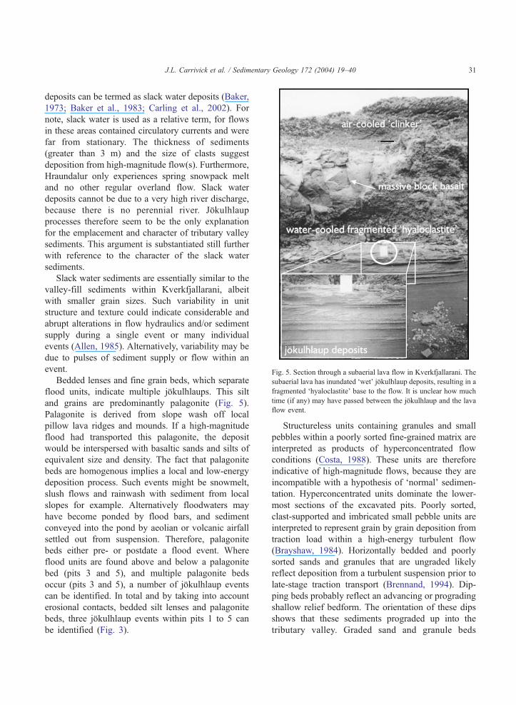
Fig. 5. Section through a subaerial lava flow in Kverkfjallarani. The
subaerial lava has inundated dwetT jfkulhlaup deposits, resulting in afragmented dhyaloclastiteT base to the flow. It is unclear how much
time (if any) may have passed between the jfkulhlaup and the lava
flow event.
J.L. Carrivick et al. / Sedimentary Geology 172 (2004) 19–40 31
deposits can be termed as slack water deposits (Baker,
1973; Baker et al., 1983; Carling et al., 2002). For
note, slack water is used as a relative term, for flows
in these areas contained circulatory currents and were
far from stationary. The thickness of sediments
(greater than 3 m) and the size of clasts suggest
deposition from high-magnitude flow(s). Furthermore,
Hraundalur only experiences spring snowpack melt
and no other regular overland flow. Slack water
deposits cannot be due to a very high river discharge,
because there is no perennial river. Jfkulhlaupprocesses therefore seem to be the only explanation
for the emplacement and character of tributary valley
sediments. This argument is substantiated still further
with reference to the character of the slack water
sediments.
Slack water sediments are essentially similar to the
valley-fill sediments within Kverkfjallarani, albeit
with smaller grain sizes. Such variability in unit
structure and texture could indicate considerable and
abrupt alterations in flow hydraulics and/or sediment
supply during a single event or many individual
events (Allen, 1985). Alternatively, variability may be
due to pulses of sediment supply or flow within an
event.
Bedded lenses and fine grain beds, which separate
flood units, indicate multiple jfkulhlaups. This silt
and grains are predominantly palagonite (Fig. 5).
Palagonite is derived from slope wash off local
pillow lava ridges and mounds. If a high-magnitude
flood had transported this palagonite, the deposit
would be interspersed with basaltic sands and silts of
equivalent size and density. The fact that palagonite
beds are homogenous implies a local and low-energy
deposition process. Such events might be snowmelt,
slush flows and rainwash with sediment from local
slopes for example. Alternatively floodwaters may
have become ponded by flood bars, and sediment
conveyed into the pond by aeolian or volcanic airfall
settled out from suspension. Therefore, palagonite
beds either pre- or postdate a flood event. Where
flood units are found above and below a palagonite
bed (pits 3 and 5), and multiple palagonite beds
occur (pits 3 and 5), a number of jfkulhlaup events
can be identified. In total and by taking into account
erosional contacts, bedded silt lenses and palagonite
beds, three jfkulhlaup events within pits 1 to 5 can
be identified (Fig. 3).
Structureless units containing granules and small
pebbles within a poorly sorted fine-grained matrix are
interpreted as products of hyperconcentrated flow
conditions (Costa, 1988). These units are therefore
indicative of high-magnitude flows, because they are
incompatible with a hypothesis of dnormalT sedimen-
tation. Hyperconcentrated units dominate the lower-
most sections of the excavated pits. Poorly sorted,
clast-supported and imbricated small pebble units are
interpreted to represent grain by grain deposition from
traction load within a high-energy turbulent flow
(Brayshaw, 1984). Horizontally bedded and poorly
sorted sands and granules that are ungraded likely
reflect deposition from a turbulent suspension prior to
late-stage traction transport (Brennand, 1994). Dip-
ping beds probably reflect an advancing or prograding
shallow relief bedform. The orientation of these dips
shows that these sediments prograded up into the
tributary valley. Graded sand and granule beds

J.L. Carrivick et al. / Sedimentary Geology 172 (2004) 19–4032
represent pulses of tractive bed load with fluctuating
energies. Shallow and low-energy flows at pit 6 have
produced small (mm–cm) scale flaser and lenticular
bedding (Fig. 4). This site, which is ~1 km from the
main Hraundalur channel, was thus inundated by a
regime of multiple fluctuations between shallow flow
with spatially varying low-energy currents and sta-
tionary water. Deposition varied in time and space
between suspension dropout and low-energy traction.
Granular lenses have a chaotic appearance (Fig. 4),
probably reflecting slumping within the saturated
sediments or water-table pressure disturbance, perhaps
from slush avalanches or another jfkulhlaup for
example. Fining-upwards units reflect waning stage
deposition as competence decreased. The prolific
nature of heterolithic and volcaniclastic clasts reflects
multiple and nonlocal sources of sediment. Surface
pebble lags are likely to be due to a combination of
several processes including frost heave action, win-
nowing by waning stage flows and winnowing by
aeolian action.
6.3. Summary of interpretation
Valley-fill deposits within Kverkfjallarani are con-
sistent with a high-magnitude hyperconcentrated and
fluidal flow. Given the environmental and local
situation of the deposits and the absence of surface
drainage in this area, the high-magnitude flows were
most likely jfkulhlaups from Kverkfjfll. The com-
plexity and multifaceted nature of the units imply the
passage of several high-magnitude jfkulhlaups or a
single jfkulhlaup with a highly variable flow regime.
In either case, the fact that valley-fill sediment is
derived from nonlocal sources and that both tractive
and suspended deposits are present together shows
that jfkulhlaup flow(s) had extremely variable
hydraulics and sediment supply, both spatially and
temporally. These deposits are similar to those
suggested by Kneller and Branney (1995) and
documented by Manville and White (2003), who
inferred a volcaniclastic sediment-laden flow with a
granular base flow. However, because uppermost beds
of valley-fill sediments comprise extensive sheets of
granules and imply prograding shallow bedforms,
flows progressed to a rather more fluidal flow.
Tributary mouth deposits within Kverkfjallarani
are interpreted as slack water deposits (Baker et al.,
1983), which are the result of high-magnitude flows
that have backed up into tributary valleys from
Hraundalur. Like valley-fill sediments, slack water
deposits within Kverkfjallarani are a product of
initially sediment-laden or hyperconcentrated flows
that subsequently became more fluidal.
7. Discussion: properties of jokulhlaups from
Kverkfjoll
Several inferences may be made concerning the
number, age and hydraulics of the Kverkfjallarani
jfkulhlaups. Carrivick et al. (in press) describe several
locations within Kverkfjallarani where an older
jfkulhlaup surface has become overlain by a post-
glacial subaerial lava flow. Several postglacial lava
flows within Kverkfjallarani are a product of an
eruption of the Biskupsfell fissure (Karhunen, 1988).
Some Biskupsfell fissure lava flows display evidence
of erosive dwashingT by jfkulhlaups (Carrivick et al.,
in press). Jfkulhlaups through Kverkfjallarani there-
fore both pre- and postdate the Biskupsfell fissure
eruption.
An exposure of a section through part of a
subaerial lava flow reveals fragmented hyaloclastite
at the base of subaerial units (Fig. 5). Beneath the
hyaloclastite lie a series of laterally continuous sand
beds inundated by thin granular sheets. This section
represents a subaerial lava that has overrun and cooled
in contact with dwetT jfkulhlaup sediments overlain by
a pond of water. Therefore, Fig. 5 is suggestive of
jfkulhlaup and volcanic event coupling, because the
lava flow has been erupted whilst the jfkulhlaupsediments were ponded and because superficial water
or snow in Kverkfjallarani rarely survives a summer
season. Therefore, jfkulhlaups are probably linked
with fissure eruptions within the Kverkfjfll VolcanicSystem (KVS).
Jfkulhlaups through Kverkfjallarani also appear
to have been associated with much larger
jfkulhlaups that routed from the Dyngjujfkull ice
margin. Fig. 6 illustrates how jfkulhlaup evidence at
the northernmost extent of Hraundalur merges with
the Krepputungahraun. The Krepputungahraun itself
has been severely scoured by a jfkulhlaup flow from
the Dyngjujfkull ice margin. There is no evidence to
suggest that the Hraundalur jfkulhlaup deposits
washed over the Krepputungahraun, and therefore

Fig. 6. Cross-cutting evidence for two jfkulhlaups from the Dyngjujfkull ice margin (a). It is unclear whether the first jfkulhlaup from the
Dyngjujfkull ice margin coincides with or postdates the last jfkulhlaup that exited from Hraundalur (the Kverkfjfll ice margin). An example of
the scoured and plucked nature of the Krepputunguhraun is given (b) and located on (a).
J.L. Carrivick et al. / Sedimentary Geology 172 (2004) 19–40 33
we assume either that the Hraundalur flows were of
an insufficient magnitude to deposit that lava, or that
the Krepputangahraun was erupted after the Hraun-
dalur jfkulhlaups. The scoured Krepputungahraun
has been subject to tectonic faulting after jfkulhlaup1, from the Dyngjujfkull ice margin. After this
tectonic activity, the Kverkfjallahraun was erupted
and its route partly determined by the tectonic faults
(Fig. 6). At its margins near Lindafjfll, the Kverkf-
jallahraun is not eroded and supports no sedimentary
deposits; it appears dfreshT. However, near the
present-day course of the Jfkulsa a Fjfllum, the
Kverkfjallahraun is smoothed, scoured and has
cobbles and boulder material upon it. This texture
is evident even from an aerial photograph (Fig. 6). A
second jfkulhlaup is inferred to have routed across
the Kverkfjallahraun. This flood is informally
labelled as jfkulhlaup 2. Jfkulhlaup 2 from the
Dyngjujfkull ice margin may well be the same
jfkulhlaup as that from Hraundalur, or it might have

J.L. Carrivick et al. / Sedimentary Geology 172 (2004) 19–4034
been a separate event but lies in the same strati-
graphic context.
Along Hraundalur, each distal slack water (pits 1–
5) has been inundated by three separate jfkulhlaups.Basaltic fine sand beds stratigraphically separate these
jfkulhlaups from each other (Fig. 3). The major-
element composition of the basaltic fine sand is
similar to that of other silica-poor tephras or of
Biskupsfell airfall (Table 2). Table 2 illustrates that it
is not possible to discriminate between the suspected
tephra samples of this study or between those and
known tephra samples documented elsewhere. Fur-
thermore, the high loss on ignition (LOI) values
(N1%) indicate that if these are tephra, they have
become altered. It is therefore possible that the
samples of this study are variations of previously
recorded tephra or that the samples are in fact a new
tephra that has not been previously documented.
Given the lack of tephra data from the central
highlands of Iceland (Newton, 1996, 2003), either
scenario is quite possible. A third and most likely
possibility for the genesis of fine-grained basaltic beds
is that of slope-washed palagonite. Because palagonite
is a hydrated and weathered product from the outer
sections of pillow lava (Cas and Wright, 1988), we
suggest that fine-grained beds of palagonite may form
between jfkulhlaups as successive slush flows,
avalanches and rain storms, for example, wash
Table 2
Constituent major elements by percentage of tephra sample
Sample SiO2 TiO2 Al2O3 FeO MnO MgO CaO Na
Pit 5 (1) 45.2 3.7 14.9 16.3 0.3 5.4 6.0 1.2
Pit 5 (2) 47.2 3.2 14.3 15.4 0.2 4.9 6.1 1.4
Pit 5 (3) 49.5 2.6 13.7 14.6 0.2 5.2 8.2 2.0
Pit 5 (4) 46.2 3.5 13.9 16.4 0.2 4.9 5.7 1.2
Pit 3 (1) 47.3 3.2 13.1 17.1 0.3 5.0 8.7 2.6
Pit 3 (2) 43.9 3.6 14.2 17.1 0.2 4.3 6.2 1.2
Mjauvotn dAT 46.7 4.2 12.9 14.5 0.3 4.9 10.1 3.1
Hekla1104 48.7 2.6 13.1 13.1 0.2 5.9 10.6 2.6
Katla1000K-X 46.3 4.7 12.6 14.5 0.2 4.9 9.4 3.2
Landman 49.9 2.0 13.4 12.1 0.2 6.2 10.7 2.6
Saksunarvatn 48.6 3.0 13.0 13.8 0.3 5.7 9.9 2.7
SWVeidivotn 48.9 1.8 13.5 11.4 0.2 7.5 11.8 2.4
Biskupsfell airfall 48.4 3.1 12.8 15.4 0.2 4.9 9.3 3.1
Akja 1875 69.6 1.0 13.4 5.2 0.1 1.2 3.3 3.6
Akja 1875 71.6 0.8 12.7 3.5 0.1 0.7 2.4 3.5
A number of Icelandic tephras that are low in silica and data from the Bisk
within Kverkfjfll jfkulhlaup slack water pits.
material off hillsides. Crucially, palagonitized pillow
lava rinds will have very similar major-element
composition as the basaltic tephra (Table 2).
Whether the basaltic fine sand is volcanic tephra
or slope-washed palagonite, we can conclude that a
break in the jfkulhlaup deposition occurred of
duration sufficient for another process(es) to deposit
sediment. Therefore, at least three jfkulhlaups have
inundated the areas of pit 3 and 5 (Fig. 3). This
conclusion probably holds for pits 1, 2 and 4 as well,
because they also contain beds of basaltic silt and
fine sand (Fig. 3). To put an absolute date against
any of these jfkulhlaups is currently impossible,
because jfkulhlaup sediments are simply reworked
material and the volcanic material cannot be matched
to a specific eruption. Furthermore, absence of
nonjfkulhlaup units within pits 1, 2 and 4 does not
necessarily mean that these pits did not experience
the same interruptions in jfkulhlaup deposition as
pits 3 and 5. Pits 1, 2 and 4 are closer to Hraundalur
than pits 3 and 5 and are therefore likely to have
experienced higher energy flows than that at pits 3
and 5. Therefore, a jfkulhlaup at sites 1, 2 and 4
could easily have had the capacity to erode fine-
grained tephra or slope-washed palagonite before
emplacing slack water sediments.
Given that slack water sediments mark the highest
elevations within a jfkulhlaup, they can be used as
2O K2O P2O5 Loss on
ignition
Total No. of
samples
Reference
0.6 0.4 6.0 100.0 2 This study
0.6 0.3 5.9 99.5 2 This study
0.6 0.3 2.8 99.6 2 This study
0.6 0.3 6.5 99.4 2 This study
0.6 0.3 1.3 99.4 2 This study
0.5 0.3 7.9 99.2 2 This study
0.8 97.3 19 Data is sourced
from Newton,
2003
0.4 97.3 6 (12)
0.8 96.6 20
0.3 97.5 59
0.4 97.3 30
0.2 97.5 6
0.6 0.4 8 Karhunen (1988)
2.0 0.2 0.4 100.04 2 This study
2.4 97.7 36 Newton (2003)
upsfell fissure eruption are given for comparison with tephra found

J.L. Carrivick et al. / Sedimentary Geology 172 (2004) 19–40 35
palaeostage indicators (Kochel and Baker, 1988).
Slack water surface altitudes were measured from a
Digital Elevation Model (DEM) of the Kverkfjallarani
area and accompany observations of wash limits. Wash
limits within Kverkfjallarani include valley-marginal
terraces, bars, scour and deposition (Carrivick et al., in
press). However, the most distinct wash limits within
Kverkfjallarani are ridge (valley wall) flank deposits of
exotic, heterolithic and well-rounded small pebbles
and coarse granules (Carrivick et al., in press).
Slope–area calculations of the largest jfkulhlaup to
have occurred along Hraundalur produce a variety of
results depending upon the method used (Fig. 7). The
Jarrett method (Jarrett, 1984), which relies upon the
hydraulic radius parameter rather than specific form
Fig. 7. Slope–area calculations of peak discharge based upon field and DEM
used in the calculations are shown.
and grain roughness values for its resistance term,
suggests an average peak discharge value of 29,400
m3 s�1. The Thompson and Campbell (1979) method
includes a term for the relative protrusion of resistance
elements into the flow depth and yields average peak
discharge estimates for Hraundalur of 46,300–54,600
m3 s�1. A similar average value of 49,300 m3 s�1 is
obtained by the Manning–Strickler method (Strickler,
1923) that incorporates a grain resistance factor of
transported sediment. The Manning–Limerinos
method that adds a relative roughness element to the
grain resistance factor (Limerinos, 1970) produces
average values of 35,500–46,400 m3 s�1. It should be
noted that within Hraundalur, we estimate that our
wash limits and slack water elevations are accurate to
measurements. NB. For clarity, only a few of the 124 cross-sections

Fig. 8. Peak discharges estimated by slope–area methods along Hraundalur. Different methods produce a range of estimates, depending upon
how they parameterise roughness. However, the rapid downstream attenuation of peak discharge is consistent between methods. Discharge
attenuation seems to be more closely linked to the channel topography than by spillways (black arrows). Spillways are flows exiting from the
Hraundalur valley.
J.L. Carrivick et al. / Sedimentary Geology 172 (2004) 19–4036
1 m, based upon the agreement of DGPS, GPS and
DEM measurements. Within the widest and shallow-
est cross-sections, this might produce an error in the
estimate of discharge by up to 25%. Although this is
the highest probable error, there is variability within
the Hraundalur estimates of discharge, not least
because the channel frequently diverges around
ridges. This paper does not attempt to analyse the
differences in the methods and assumptions between
the different slope–area methods. Interestingly, there
is a notable decrease in peak discharge downstream.
All four methods record the same downstream
attenuation of some 50–70% decrease in peak
discharge in just 25 km (Fig. 8). This attenuation is
mostly attributable to high roughness values rather
than spillways (Fig. 8). The steepest sections of the
Table 3
Properties of jfkulhlaups from Kverkfjfll; a glaciated volcano within an a
Properties of jokulhlaups within Kverkfjallarani; an active volcanic rifting
Channel Steep V
High resistance F
Trigger Volcanogenic (
Hydraulics R
High velocities S
High discharges S
Sedimentology and rheology Bimodal S
Phase I
Variable R
channel are those where subaerial lava flows are
exposed and terminate. The shallowest channel
sections are between lava flows and are sediment
traps. It follows that most energy loss and hence
attenuation of peak discharge will occur across steeper
and rougher lava surfaces.
Jfkulhlaups along Hraundalur present a model of
the main controls on characteristics of jfkulhlaupswithin an active volcanic rifting zone (Table 3; Fig. 9).
This model illustrates deposition on both the rising
(Fig. 9a) and falling (Fig. 9b) stages of the hydrograph
and results in a distinctive suite of sedimentary impacts
(Fig. 9c). With respect to the sedimentary impacts of
jfkulhlaups within other environments, models of
jfkulhlaup characteristics need to be altered to include
the effects of high sediment availability and high-
ctive volcanic rifting zone
zone
alley gradients commonly 0.02 and greater water surface gradients
rom roughness elements up to 30% of flow depth
Either with or without intermediary storage)
elatively shallow (N10 m) anastomosing flows
lope–area calculations suggest typically N20 m s�1
lope–area calculations suggest minimum of 50,000 m3 s�1
upply limited to subaerial lava boulders and pillow bricks
nitially non-Newtonian, then more fluidal
apid downstream attenuation of discharge
Fig. 9. Overview conceptual model of controls on and nature of bedrock-channelled jfkulhlaup sedimentation within a volcanic rifting
landscape. (a) Rising and peak stage, (b) waning stage, (c) overview of sedimentary products including slack water deposits (S), terraces (T) and
valley-fill deposits (Vf).
J.L. Carrivick et al. / Sedimentary Geology 172 (2004) 19–40 37
gradient, hydraulically rough routeways. These factors
control the consequential high transmission losses and
rapid downstream attenuation of peak discharge.
8. Conclusions
This study provides a suite of sedimentary impacts
that evidence jfkulhlaups from Kverkfjfll volcano and
has suggested many characteristics of these jokulhla-
ups. Slack water stratigraphy shows that at least three
jfkulhlaups routed through Hraundalur at a similar
time to the Biskupsfell eruption. Valley-fill sediments
and slack water sediments illustrate that these
jfkulhlaups were typically hyperconcentrated but
became more fluidal. Slope–area calculations suggest
that the largest jfkulhlaup through Hraundalur had a
peak discharge of 45,000–55,000 m3 s�1, although this

J.L. Carrivick et al. / Sedimentary Geology 172 (2004) 19–4038
discharge attenuated by 50–70% in just 25 km. This
attenuation and thus hydrograph modification were
determined by the interplay of many external and
internal controls (Carrivick et al., in press), but
particularly of the jfkulhlaup source upon a glaciated
volcano and its passage through a steep and hydrauli-
cally rough volcanic landscape. Therefore, a variety of
external and internal controls modified the hydrograph
shape and thus exerted controls on large-scale sedi-
mentary impacts (Rushmer et al., 2002).
9. Wider implications
It is anticipated that this model of sedimentary
characteristics of jfkulhlaups from Kverkfjfll will beapplicable to other outburst floods from glaciated
volcanoes and/or within active volcanic rifting zones.
Estimates of the hydraulic properties of jfkulhlaupsfrom Kverkfjfll will enable examination of sediment
entrainment mechanisms, sediment volumes within
flows, erosional and depositional thresholds and
landform evolution for example. Furthermore, flood
hazard mapping, risk assessment and mitigation
measures can be introduced, given knowledge of the
source, routeway and behaviour of jfkulhlaups.Finally, estimates of sudden discharges of freshwater
and sediment from the north coast of Iceland during
deglaciation may provide information regarding
potential triggers of abrupt changes in thermohaline
circulation and hence regional climatic changes in the
North Atlantic (Manabe and Stouffer, 1995; Rahm-
storf, 1995, 1997). Teller et al. (2002) have already
discussed the effects of similar inputs to the North
Atlantic from the American continent.
Acknowledgements
We thank the Icelandic Research Council and the
Nature Conservation Agency for permission to under-
take research in northern Iceland. JLC gratefully
acknowledges the receipt of grants from BGRG,
IAS and QRA for aerial photograph acquisition and
field assistant costs. AJR received a Royal Society
grant for fieldwork in 2000. The Earthwatch Institute
funded the fieldwork during the summers of 2000,
2001, 2002 and 2003. A very special thank you to all
of the 2000 Earthwatch Team III and the 2001, 2002
and 2003 Earthwatch Team IV volunteers and to Oly
Lowe and Hugh Deeming for invaluable field
assistance. Hauker, Rachel, Sira, Loftur and Edda
and Elisabet made us very welcome at Sigurdarskali.
JLC thanks Dave Emley for his XRF guidance and Ian
Wilshaw for his support in the sediments laboratory.
Aslaug Geirsdottir and Paul Carling provided con-
structive critical reviews on an earlier version of the
manuscript.
References
Allen, J.R.L., 1985. Principles of Physical Sedimentology. Allen
and Unwin, London. 272 pp.
Baker, V.R., 1973. Palaeohydrology and sedimentology of Lake
Missoula flooding in eastern Washington. Special Paper -
Geological Society Of America 144, 1–79.
Baker, V.R., Kochel, R.C., Patton, P.C., Pickup, G., 1983. Palaeo-
hydrologic analysis of Holocene flood slackwater sediments.
Special Publication of the International Association of Sedi-
mentologists 6, 229–239.
Bjfrnsson, H., 1988. Hydrology of Ice Caps in Volcanic Regions.
Visingdafelag Islendinga, Reykjavik. 44pp+map plates pp.
Bjfrnsson, H., 1992. Jfkulhlaups in Iceland: prediction, characte-
ristics and simulation. Annals of Glaciology 16, 95–106.
Bjfrnsson, H., 2002. Subglacial lakes and jfkulhlaups in Iceland.
Global and Planetary Change 35, 255–271.
Bjfrnsson, H., 1991. Volcanoes beneath Vatnajfkull, Iceland:
evidence from radio-echo sounding, earthquakes and
jfkulhlaups. Jfkull 40, 147–168.Bluck, B.J., 1974. Stuctural and directional properties of some
valley sandur deposits in southern Iceland. Sedimentology 21,
553–554.
Boothroyd, J.C., Ashley, G.M., 1975. Processes, bar morphology
and sedimentary structures on braided outwash fans, north-
eastern Gulf of Alaska. In: Jopling, A.V., McDonald, B.C.
(Eds.), Glaciofluvial and Glaciolacustrine sedimentation, SEPM
Special Publication 23, pp. 193–222.
Brayshaw, A.C., 1984. Characteristics and origin of cluster
bedforms in coarse-grained alluvial channels. In: Koster,
E.H., Steel, R.J. (Eds.), Sedimentology of Gravels and
Conglomerates. Canadian Society of Petroleum Geologists,
pp. 77–85.
Brennand, T.A., 1994. Macroforms, large bedforms and rhythmic
sedimentary sequences in subglacial eskers, south-central
Ontario: implications for esker genesis and meltwater regime.
Sedimentary Geology 91, 9–55.
Carling, P.A., 1990. Particle over-passing on depth-limited gravel
bars. Sedimentology 37, 345–355.
Carling, P.A., 1996. Morphology, sedimentology and palaeohy-
draulic significance of large gravel dunes, Altai Mountains,
Siberia. Sedimentology 43, 647–664.

J.L. Carrivick et al. / Sedimentary Geology 172 (2004) 19–40 39
Carling, P.A., Kirkbride, A.D, Parnachov, S., Borodavko, P.S.,
Berger, G.W., 2002. Late Quaternary catastrophic flooding in
the Altai mountains of south-central Siberia: a synoptic over-
view and an introduction to flood deposit sedimentology. In:
Martini, P.I., Baker, V.R., Garzon, G. (Eds.), Flood and
Megaflood Processes and Deposits: Recent and Ancient
Examples, Spec. Publs Int. Ass. Sedment, pp. 17–35.
Cas, R.A.F., Wright, J.V., 1988. Volcanic Successions: Modern and
Ancient. Unwin Hyman, London. 528 pp.
Carrivick, J.L., Russell, A.J., Tweed, F.S., in press. Geomorpho-
logical evidence for jfkulhlaups from Kverkfjfll volcano,
Iceland. Geomorphology.
Collinson, J.D., 1970. Bedforms of the Tana River, Norway.
Geographiska Annaler 52A, 31–56.
Costa, J.E., 1988. Rheologic, geomorphic and sedimentologic
differentiation of water flows, hyperconcentrated flows and
debris flows. In: Baker, V.R., Kochel, R.C., Patton, P.C. (Eds.),
Flood Geomorphology. Wiley, New York, pp. 113–122.
Costa, J.E., Schuster, R.L., 1988. The formation and failure of
natural dams. Geological Society of America Bulletin 100,
1054–1068.
Eliasson, S., 1977. Molar um Jfkulsarhlaup og Asbyrgi. Nattu-
rufr&ðingurinn 47, 160–179.
Fay, H., 2002a. Formation of kettle holes following a glacial-
outburst flood (jfkulhlaup), Skeiðararsandur, southern Iceland.
In: Snorasson, A., Finnsdottir, H.P., Moss, M. (Eds.), The
Extremes of The Extremes: Extraordinary floods. IAHS
Publication no. 271, pp. 205–210.
Fay, H., 2002b. Formation of ice-block obstacle marks during the
November 1996 glacier-outburst flood (jfkulhlaup), Skeiðar-
arsandur, southern Iceland. Special Publications International
Association of Sedimentology 32, 85–97.
Guðmundsson, H.J., 1997. A review of the Holocene environ-
mental history of Iceland. Quaternary Science Reviews 16,
81–92.
Guttormson, H., 1987. Norð-Austurland—Halendi og Eyðibyggðir
(highlands and uninhabited areas). Ferðafelag Islands Arbok.
Ferðafelag Islands, Reykjavik.
Haerberli, W., 1983. Frequency and characteristics of glacier floods
in the Swiss Alps. Annals of Glaciology 4, 85–90.
Helgason, J. 1987. Jarðfr&ðirannsoknir a Vatnasviði Jfkulsar a
Fjfllum við Mfðrudal. Report OS-87005/VOD-01: Orkustof-nun Reykjavık.
Jarrett, R.D., 1984. Hydraulics of high gradient streams. Journal of
Hydraulic Engineering 110, 1519–1539.
Jones, A.P., Tucker, M.E., Hart, J.K., 1989. Guidelines and
recommendations. In: Jones, A.P., Hart, J.K., Tucker, M.E.
(Eds.), The description and analysis of Quaternary Stratigraphic
Field Sections. Quaternary Research Association Technical
Guide No.7. QRA London, pp. 27–76.
Johannesson, H., Saemundsson, K., 1989. Geological map of
Iceland, 1:1500 000 Bedrock geology. Icelandic Museum of
Natural History and Icelandic Geodetic Survey, Reykjavık.
Karhunen, R., 1988. Eruption mechanism and rheomorphism during
the basaltic fissure eruption in Biskupsfell, Kverkfjoll, north-
central Iceland. Nordic Volcanological Institute 8802 (Reykja-
vik. 91 pp.).
K7yhko, J., Alho, P., Hendriks, J.P.M., Rossi, M., 2002. Geo-
morphological processes and land degradation in Odaðahraun
semi-desert, north-eastern Iceland. Jfkull 51, 1–16.Kehew, A.E., 1993. Glacial-lake outburst erosion of the Grand
Valley, Michigan and impacts on glacial lakes in the Lake
Michigan Basin. Quaternary Research 39, 36–44.
Kneller, B.C., Branney, M.J., 1995. Sustained high-density turbidity
currents and the deposition of thick massive sands. Sedimento-
logy 42, 607–616.
Knudsen, O., Russell, A.J., 1995. Jfkulhlaup deposits at the
Asbyrgi Canyon, northern Iceland: sedimentology and implica-
tions for flow type. Proceedings of The Extremes of The
Extremes symposium, Reykjavik, Iceland, IAHS Publication,
vol. 271.
Kochel, R.C., Baker, V.R., 1988. Palaeoflood analysis using
slackwater deposits. In: Baker, V.R., Kochel, R.C., Patton,
P.C. (Eds.), Flood Geomorphology, pp. 357–376.
Limerinos, J.T., 1970. Determination of the Manning coeffiecient
from measured bed roughness in natural channels. United States
Geological Water Supply Paper 1898-B (47 pp.).
Maizels, J.K., 1989. Sedimentology, palaeoflow dynamics and flood
history of jfkulhlaup deposits: paleohydrology of Holocene
sediment sequences in southern Iceland sandur deposits. Journal
of Sedimentary Petrology 59, 204–223.
Maizels, J.K., 1991. The origin and evolution of Holocene
sandur deposits in areas of jfkulhlaup drainage, Iceland. In:
Maizels, J.K., Caseldine, C. (Eds.), Environmental Change
in Iceland: past and present. Kluwer Academic Publishing,
pp. 267–299.
Maizels, J.K., 1993. Lithofacies variations within sandar deposits:
the role of runoff regime, flow dynamics and sediment supply
characteristics. Sedimentary Geology 85, 299–325.
Maizels, J.K., 1995. Sediments and landforms of modern proglacial
terrestrial environments. In: Menzies, J.E. (Ed.), Modern Glacial
Environments. Butterworth-Heinemann, Oxford, pp. 365–416.
Maizels, J.K., 1997. Jfkulhlaup deposits in proglacial areas.
Quaternary Science Reviews 16, 793–819.
Maizels, J., Russell, A.J., 1992. Quaternary perspectives on
jfkulhlaup prediction. Quaternary Proceeedings 2, 133–152.
Manabe, S., Stouffer, R.J., 1995. Simulation of abrupt climate
change induced by freshwater input to the North Atlantic Ocean.
Nature 378, 165–167.
Manville, V., White, J.D.L., 2003. Incipient granular mass flows at
the base of sediment-laden floods, and the roles of flow
competence and flow capacity in the deposition of stratified
bouldery sands. Sedimentary Geology 155, 157–173.
Marren, P.M., 2003. Criteria for distinguishing high magnitude
flood events in the proglacial fluvial sedimentary record.
Proceedings of The Extremes of The Extremes symposium,
Reykjavik, Iceland, IAHS Publication, vol. 271.
Miall, A.D., 1977. A review of the braided river environment. Earth
Science Reviews 13, 1–62.
Miall, A.D., 1985. Architectural-element analysis: a new method of
facies analysis applied to fluvial deposits. Earth Science
Reviews 22, 263–308.
Nemec, W., Steel, R.J., 1984. Alluvial and coastal conglomerates:
their significant features and some comments on gravelly mass

J.L. Carrivick et al. / Sedimentary Geology 172 (2004) 19–4040
flow deposits. In: Koster, E.H., Steel, R.J. (Eds.), Sedimentol-
ogy of gravels and conglomerates. Canadian Society of
Petroleum Geologists, pp. 1–31.
Newton, A.J., 1996. Tephrabase. A tephrochronological database.
Quaternary Newsletter 78, 8–13.
Newton, A.J., 2003. Tephrabase. http://www.geo.ed.ac.uk/tephra/
(visited 16/11/03).
Olafsdottir, R., Guðmundsson, H.J., 2002. Holocene land degrada-
tion and climatic change in northeastern Iceland. The Holocene
12 (2), 159–167.
Rahmstorf, S., 1995. Bifurcations of the Atlantic thermohaline
circulation in response to changes in the hydrological cycle.
Nature 378, 145–149.
Rahmstorf, S., 1997. Risk of sea-level change in the Atlantic.
Nature 388, 825–826.
Rushmer, E.R., Russell, A.J., Tweed, F.S., Knudsen, O., Marren,
P.M., 2002. The role of hydrograph shape in controlling glacier
outburst flood (jfkulhlaup) sedimentation. The Structure,
Function and Management of Fluvial Sedimentary Systems
Proceedings of an international symposium held in Alice
Springs, Australia, September 2002, IAHS Publication, vol.
276, pp. 305–313.
Russell, A.J., 1993. Obstacle marks produced by flow around
stranded ice blocks during a glacier outburst flood (jfkulhlaup)in west Greenland. Sedimentology 40, 1091–1111.
Russell, A.J., Marren, P.M., 1999. Proglacial fluvial sedimentary
sequences in Greenland and Iceland: a case study from active
proglacial environments subject to jfkulhlaups. In: Jones, A.P.,Hart, J.K., Tucker, M.E. (Eds.), The description and analysis
of Quaternary Stratigraphic Field Sections. Quaternary
Research association technical Guide No.7. QRA London,
pp. 171–208.
Saemundsson, K., 1973. StraumrakaWar klappir ı kringum Asbyrgi.
Natturufr&ðzingurinn 43, 52–60.
Smith, N.D., 1974. Sedimentology and bar formation in the upper
Kicking Horse River, a braided outwash stream. Journal of
Geology 82, 205–223.
Sohn, Y.K., 1997. On traction carpet sedimentation. Journal of
Sedimentary Research 67, 502–509.
Strickler, A., 1923. Beitrage zur Frage der Geschwindigheitsformel
und der Rauhigkeitszahlen fur Strome, Kanale und Geschlos-
sene Leitungen. Mitteilungen des Eidgenossischer Amtes fur
Wasserwirtschaft, Bern, Switzerland, p. 16.
Teller, J.T., Leverington, D.W., Mann, J.D., 2002. Freshwater
outbursts to the oceans from glacial Lake Agassiz and their role
in climate change during the last deglaciation. Quaternary
Science Reviews 21, 879–887.
Thompson, S.M., Campbell, P.L., 1979. Hydraulics of a large
channel paved with boulders. Journal of Hydraulic Research 17,
341–354.
Thorarinsson, S., 1950. Glacier outbursts in the river Jfkulsa a
Fjfllum. Natturufr&ðingurinn 20, 113–133.
Todd, S.P., 1989. Stream-driven, high density gravelly traction
carpets: possible deposits in the Trabeg Conglomerate For-
mation, SW Ireland and some theoretical considerations of their
origin. Sedimentology 36, 513–530.
Tomasson, H., 1973. Hamfarahlaup ı Jfkulsa a Fjfllum. Nattu-
rufr&ðingurinn 43, 12–34.
Tomasson, H., 2002. Catastrophic floods in Iceland. The Extremes
of The Extremes: Extraordinary Floods, Proceedings of a
symposium held at Reykjavik, Iceland, July 2000 (IAHS Publ.
no. 271), pp. 121–126.
Waitt R.B. 1998. Cataclysmic flood along Jfkulsa a Fjfllum,
north Iceland, compared to repeated colossal jfkulhlaups of
Washington’s channelled scabland. 15th Int. Sediemntol.
Congr., Alicante, 811– 812.
Waitt, R.B., 2002. Great Holocene floods along Jfkulsa a Fjfllum,
north Iceland. In: Martini, P.I., Baker, V.R., Garzon, G. (Eds.),
Flood and Megaflood Processes and Deposits: Recent and
Ancient Examples, Special Publications International Associa-
tion of Sedimentology, pp. 37–51.