P. Jia, A. Betts and X. Wu 2011. New evidence for Bronze Age agricultural settlements in the...
12
New evidence for Bronze Age agricultural settlements in the Zhunge’er (Junggar) Basin, China Peter Weiming Jia 1 , Alison Betts 1 and Xinhua Wu 2 1 University of Sydney, Sydney, Australia, 2 Chinese Academy of Social Sciences, Beijing, China The Zhunge’er (Junggar) Basin in northern Xinjiang was a key crossroads in antiquity for the dispersal of ideas and technological innovations from the Eurasian steppe into the heartland of central China. The Bronze Age chronology of the Zhunge’er Basin is chiefly based on relative dating and little is known about subsistence strategies, although the strong tradition of nomadic and transhumant pastoralism among modern populations suggests that there may have been a high degree of mobility. The visibility of ancient cemeteries and the need to salvage graves before they are looted have resulted in a lack of focus on settlements, with a consequent assumption that in antiquity agriculture played a limited role. This assumption has been challenged by rescue excavations at the Jimusa’er (Jimsar) Luanzagangzi site, which indicate that agriculture may have been a significant component of Bronze Age subsistence strategies. Small-scale soundings at settlement sites provide well-stratified sequences of material for absolute dating which can be used to place the artifacts recovered from graves in a more secure chronological context. Keywords: China, Bronze Age chronology, agricultural settlements, nomadic pastoralism Introduction The Zhunge’er (Junggar) Basin in northern Xinjiang was a crossroads in antiquity for the dispersal of ideas and technological innovations from the Eurasian steppe into the heartland of central China. Of the two desert basins that make up Xinjiang, the larger in the south, the Talimu (Tarim) Basin, belongs to Central Asia on the basis of its oasis settlements, while the smaller northern Zhunge’er Basin is the easternmost extension of the Eurasian steppe. Little systematic archaeological fieldwork has been carried out in Xinjiang and the work that has been done focuses on the Talimu Basin. With its dry climate, organic material from as early as the Bronze Age is remarkably well preserved in the Talimu Basin (Mallory and Mair 2000; Kuz’mina 2008; Xinjiang Institute of Archaeology 2003), while the Zhunge’er Basin has a moister climate contributing to poor preservation of organic material. Archaeological research in the Zhunge’er Basin has mainly involved excavation of cemeteries, which are abundant in both the oases and the high summer pastures. Such excavations have produced a broad outline of the basin in the Bronze Age, revealing a range of external cultural influences from the Mongolian Altai and southern Siberia, the Eurasian steppes, and the Gansu corridor in the southeast leading to China (Debaine-Francfort 1988, 1989; An Zhimin 1992; Chen Kwang-Tzuu and Hiebert 1995; Mair 1998; Mallory and Mair 2000; Kuz’mina 2008; Jia et al. 2009; Jia and Betts 2010). The strongest links are with the north and west, suggesting a movement of people, or at least cultural influence, from the Eurasian steppes (Mallory and Mair 2000; Kuz’mina 2008). The high visibility of ancient graves, parallels with the Bronze Age nomadic cultures of the steppe, and the strong tradition of nomadic and transhumant pastoralism among modern populations have con- tributed to an almost exclusive focus on the excava- tion of cemeteries rather than settlements. This trend is paralleled in salvage work as cemeteries are threatened by looting because of their complete vessels and museum-quality artifacts. Some ceme- teries, such as those at Qiemu’erqieke, Dalongkou, Sazicun, Weisheng, and Xikanerzi, were excavated as part of structured research projects (Xinjiang Institute of Archaeology 1981; Xinjiang Institute of Archaeology et al. 1994; Li Xiao 1992; Jia and Betts 2010; Qitai Cultural Centre 1982), but not all were well dated or fully published. Other cemeteries were excavated as rescue operations by local heritage Correspondence to: Alison Betts, Department of Archaeology, University of Sydney, NSW 2006, Australia. Email: [email protected] ß Trustees of Boston University 2011 DOI 10.1179/009346911X13140904382057 Journal of Field Archaeology 2011 VOL. 36 NO.4 269
Transcript of P. Jia, A. Betts and X. Wu 2011. New evidence for Bronze Age agricultural settlements in the...

New evidence for Bronze Age agriculturalsettlements in the Zhunge’er (Junggar) Basin,China
Peter Weiming Jia1, Alison Betts1 and Xinhua Wu2
1University of Sydney, Sydney, Australia, 2Chinese Academy of Social Sciences, Beijing, China
The Zhunge’er (Junggar) Basin in northern Xinjiang was a key crossroads in antiquity for the dispersal ofideas and technological innovations from the Eurasian steppe into the heartland of central China. TheBronze Age chronology of the Zhunge’er Basin is chiefly based on relative dating and little is known aboutsubsistence strategies, although the strong tradition of nomadic and transhumant pastoralism amongmodern populations suggests that there may have been a high degree of mobility. The visibility of ancientcemeteries and the need to salvage graves before they are looted have resulted in a lack of focus onsettlements, with a consequent assumption that in antiquity agriculture played a limited role. Thisassumption has been challenged by rescue excavations at the Jimusa’er (Jimsar) Luanzagangzi site,which indicate that agriculture may have been a significant component of Bronze Age subsistencestrategies. Small-scale soundings at settlement sites provide well-stratified sequences of material forabsolute dating which can be used to place the artifacts recovered from graves in a more securechronological context.
Keywords: China, Bronze Age chronology, agricultural settlements, nomadic pastoralism
IntroductionThe Zhunge’er (Junggar) Basin in northern Xinjiang
was a crossroads in antiquity for the dispersal of
ideas and technological innovations from the Eurasian
steppe into the heartland of central China. Of the two
desert basins that make up Xinjiang, the larger in the
south, the Talimu (Tarim) Basin, belongs to Central
Asia on the basis of its oasis settlements, while the
smaller northern Zhunge’er Basin is the easternmost
extension of the Eurasian steppe. Little systematic
archaeological fieldwork has been carried out in
Xinjiang and the work that has been done focuses on
the Talimu Basin. With its dry climate, organic
material from as early as the Bronze Age is remarkably
well preserved in the Talimu Basin (Mallory and
Mair 2000; Kuz’mina 2008; Xinjiang Institute of
Archaeology 2003), while the Zhunge’er Basin has a
moister climate contributing to poor preservation of
organic material.
Archaeological research in the Zhunge’er Basin has
mainly involved excavation of cemeteries, which are
abundant in both the oases and the high summer
pastures. Such excavations have produced a broad
outline of the basin in the Bronze Age, revealing
a range of external cultural influences from the
Mongolian Altai and southern Siberia, the Eurasian
steppes, and the Gansu corridor in the southeast
leading to China (Debaine-Francfort 1988, 1989; An
Zhimin 1992; Chen Kwang-Tzuu and Hiebert 1995;
Mair 1998; Mallory and Mair 2000; Kuz’mina 2008;
Jia et al. 2009; Jia and Betts 2010). The strongest links
are with the north and west, suggesting a movement
of people, or at least cultural influence, from the
Eurasian steppes (Mallory and Mair 2000; Kuz’mina
2008). The high visibility of ancient graves, parallels
with the Bronze Age nomadic cultures of the steppe,
and the strong tradition of nomadic and transhumant
pastoralism among modern populations have con-
tributed to an almost exclusive focus on the excava-
tion of cemeteries rather than settlements. This trend
is paralleled in salvage work as cemeteries are
threatened by looting because of their complete
vessels and museum-quality artifacts. Some ceme-
teries, such as those at Qiemu’erqieke, Dalongkou,
Sazicun, Weisheng, and Xikanerzi, were excavated
as part of structured research projects (Xinjiang
Institute of Archaeology 1981; Xinjiang Institute of
Archaeology et al. 1994; Li Xiao 1992; Jia and Betts
2010; Qitai Cultural Centre 1982), but not all were
well dated or fully published. Other cemeteries were
excavated as rescue operations by local heritageCorrespondence to: Alison Betts, Department of Archaeology, Universityof Sydney, NSW 2006, Australia. Email: [email protected]
� Trustees of Boston University 2011DOI 10.1179/009346911X13140904382057 Journal of Field Archaeology 2011 VOL. 36 NO. 4 269

officers, adding to the pool of partially published
and poorly dated remains from the region. As a
result, local museums contain extensive collections of
intact ceramic vessels and associated metal and other
artifacts that provide limited information. Heritage
authorities know the locations of settlement sites,
but because they are not threatened by looting, their
excavation is not considered a priority. This has
led to the erroneous assumption that the prehistoric
population of the Zhunge’er Basin in the Bronze Age
was primarily nomadic. Finally, the relative chronology
is poorly understood—there are few absolute dates—
and little is known about prehistoric economies.
The environment of the Zhunge’er Basin is con-
sidered to be marginal for human subsistence and
high mobility has seemed like a good response to
environmental conditions. The Ku’erbantonggute
(Gurbantunggut) Desert lies at the center of the
basin, which funnels the natural routes through the
basin along the foothills of the surrounding mountain
ranges (FIG. 1). To the north lie the high mountains of
the Altai (Altay). The way to the Eurasian steppes to
the west is partly barred by the smaller Tarbagatai
Range. On the south the basin is rimmed by the
Tianshan (Tangri Tagh) Mountains. The eastern
route to China runs between the northern foothills
of the Altyn Tagh and the Gobi Desert to Gansu. The
central desert is low-lying at around 200 masl, while
the mountains rise up to 4000 m in height, their peaks
covered in permanent glaciers. Seasonal ice caps form
in winter providing spring snowmelt, which feeds
streams that drain into the desert sands. Rainfall is
extremely low in the desert—from around 350 mm on
the northern slopes of the Tianshan Mountains to
600 mm in parts of the far west. Above 2000 m on the
upper slopes of the Tianshan Mountains there is a
band of pine forest. Below this, where the rainfall
decreases, the trees give way to mountain grassland.
The river valleys support large stands of elms. While
much of the land comprises desert or high mountains,
there are areas in the valleys, along the slopes of the
ranges, and in the oases with favorable conditions for
grazing, dry farming, and irrigation agriculture.
In 2007, during a tour of the area by one of us
(PWJ) and local heritage officials, a settlement site
called Luanzagangzi was discovered on the north-
eastern slopes of the Tianshan mountains near the
town of Jimusa’er (FIGS. 1, 2). A salvage sounding
under the auspices of the Xinjiang Team of the
Archaeological Institute of the Chinese Academy of
Figure 1 Map of Xinjiang showing Bronze Age sites in the Zhunge’er (Junggar) Basin.
Jia et al. Bronze Age agricultural settlements in Zhunge’er Basin, China
270 Journal of Field Archaeology 2011 VOL. 36 NO. 4

Social Sciences revealed almost 4 m of occupation
deposits rich in charcoal and fragments of pottery,
bone, and other artifacts (FIG. 3). Abundant botanical
remains indicate that agriculture was an important
part of the economy, while starch analyses provide
evidence for plant use previously unknown in the
prehistoric periods. Absolute and relative dating in-
dicate that Luanzagangzi may have seen two main
phases of occupation, an early phase around 1400–
1000 CAL B.C. and a later one from 1000–800 CAL B.C.
Painted ceramics from the lowest levels at Luan-
zagangzi can be linked to ceramics from two pre-
viously excavated sites in the region, providing a
stronger chronology for the northeastern Tianshan in
the Bronze Age.
If Luanzagangzi is not unique, the sounding at this
site provides evidence for long-lived settlement sites
in the Zhunge’er Bronze Age, suggesting that agri-
cultural communities coexisted with more mobile
groups. The site illustrates the potential of research
on settlements to provide secure chronologies and
address issues concerning subsistence strategies and
the transfer of agricultural technologies. Test exca-
vation is an inexpensive option that can provide
stratified ceramic sequences, and, combined with
absolute dating, may be used to establish a chronol-
ogy for otherwise poorly dated artifacts recovered
from cemeteries. Xinjiang is a key area for under-
standing the relationship between China and the west
in the later prehistoric periods. Important ideas and
technologies were transmitted across the region and
Luanzagangzi offers encouragement that large-scale
excavation is not necessarily required to obtain
significant results.
Modern Subsistence EconomyToday, villages on the northern slopes of the
Tianshan Mountains are located on river terraces in
the foothills or on floodplains. The northern slopes of
the range have higher rainfall and less extreme
temperatures than on the south side where the lower
slopes border the edge of the Gobi Desert. Rainfall
near the mountain slopes is around 350 mm (Yan
Shun et al. 2004), within the practical range for dry
agriculture. Irrigation agriculture is practiced on the
river deltas at the edge of the desert (Xinjiang Bureau
of Geographical Survey 1995). The population today
is mainly composed of Chinese Muslims (Hui)
with a small number of Turkic-speaking Kazakhs.
The Hui are settled farmers, growing wheat, barley,
beans, and vegetables. The Kazakhs are partially
nomadic, practicing short-range transhumance, and
breeding sheep, goats, cattle, and horses. The Hui
also engage in herding to a limited degree and the
Kazakhs have some small-scale agriculture. This mix
of subsistence strategies may provide a model for
earlier times. It is possible that settled or semi-settled
peoples coexisted with more mobile populations
moving in from the Eurasian steppes as the
Kazakhs did around 100 years ago. Bronze Age sites
are located in areas similar to the modern villages,
favoring river terraces.
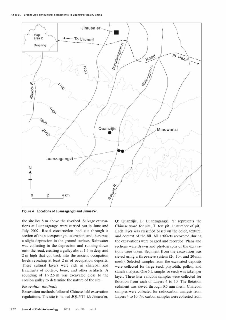
LuanzagangziLuanzagangzi is located in Jimusa’er County, at the
southeastern edge of the Zhunge’er Basin on the
northern slopes of the Tianshan Mountains at 1486
masl. The site is about 1 km west of the village of
Miaowanzi and 2 km southeast of Quanzijie town-
ship (FIG. 4). The Wutanggou River runs about 500 m
to the west of Luanzagangzi and at its highest point
Figure 3 Luanzagangzi sounding after excavation.
Figure 2 View from Luanzagangzi to the southwest showing
the Tianshan Mountains.
Jia et al. Bronze Age agricultural settlements in Zhunge’er Basin, China
Journal of Field Archaeology 2011 VOL. 36 NO. 4 271
the site lies 8 m above the riverbed. Salvage excava-
tions at Luanzagangzi were carried out in June and
July 2007. Road construction had cut through a
section of the site exposing it to erosion, and there was
a slight depression in the ground surface. Rainwater
was collecting in the depression and running down
onto the road, creating a gulley about 1.5 m deep and
2 m high that cut back into the ancient occupation
levels revealing at least 2 m of occupation deposits.
These cultural layers were rich in charcoal and
fragments of pottery, bone, and other artifacts. A
sounding of 162.5 m was excavated close to the
erosion gulley to determine the nature of the site.
Excavation methodsExcavation methods followed Chinese field excavation
regulations. The site is named JQLYT1 (J: Jimusa’er,
Q: Quanzijie, L: Luanzagangzi, Y: represents the
Chinese word for site, T: test pit, 1: number of pit).
Each layer was classified based on the color, texture,
and context of the fill. All artifacts recovered during
the excavations were bagged and recorded. Plans and
sections were drawn and photographs of the excava-
tions were taken. Sediment from the excavation was
sieved using a three-sieve system (2-, 10-, and 20-mm
mesh). Selected samples from the excavated deposits
were collected for large seed, phytolith, pollen, and
starch analyses. One 5 L sample for seeds was taken per
layer. Three liter random samples were collected for
flotation from each of Layers 4 to 10. The flotation
sediment was sieved through 0.5 mm mesh. Charcoal
samples were collected for radiocarbon analysis from
Layers 4 to 10. No carbon samples were collected from
Figure 4 Locations of Luanzagangzi and Jimusa’er.
Jia et al. Bronze Age agricultural settlements in Zhunge’er Basin, China
272 Journal of Field Archaeology 2011 VOL. 36 NO. 4
Layers 1, 2, and 3 as there was no charcoal in these
layers. Eight AMS radiocarbon dates were processed at
the 14CHRONO Centre, The Queens University of
Belfast (TABLE 1).
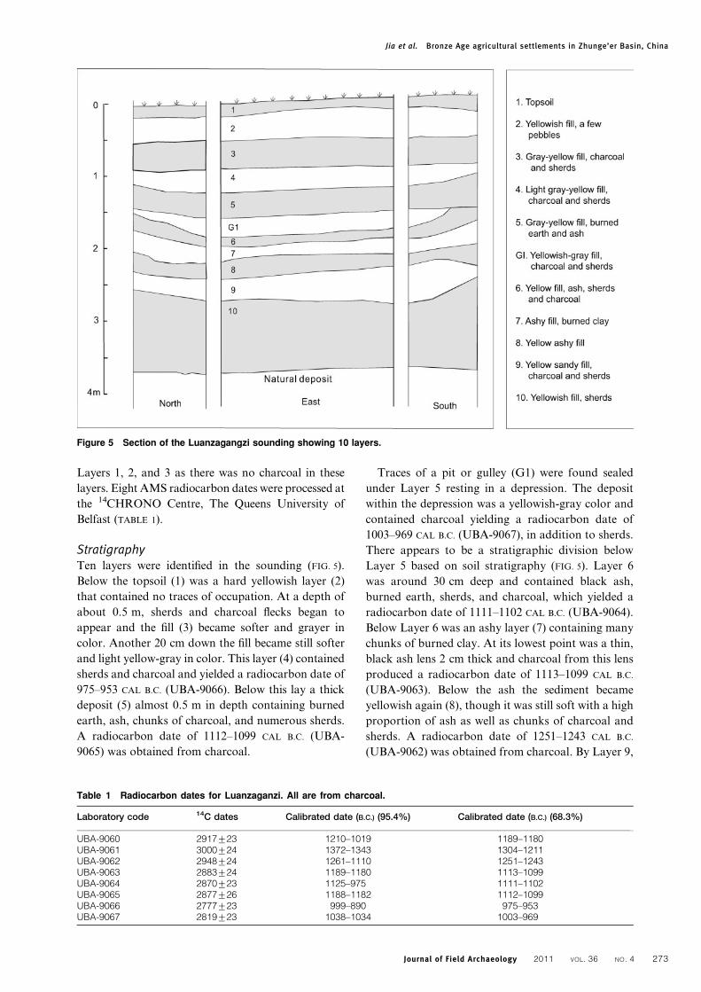
StratigraphyTen layers were identified in the sounding (FIG. 5).
Below the topsoil (1) was a hard yellowish layer (2)
that contained no traces of occupation. At a depth of
about 0.5 m, sherds and charcoal flecks began to
appear and the fill (3) became softer and grayer in
color. Another 20 cm down the fill became still softer
and light yellow-gray in color. This layer (4) contained
sherds and charcoal and yielded a radiocarbon date of
975–953 CAL B.C. (UBA-9066). Below this lay a thick
deposit (5) almost 0.5 m in depth containing burned
earth, ash, chunks of charcoal, and numerous sherds.
A radiocarbon date of 1112–1099 CAL B.C. (UBA-
9065) was obtained from charcoal.
Traces of a pit or gulley (G1) were found sealed
under Layer 5 resting in a depression. The deposit
within the depression was a yellowish-gray color and
contained charcoal yielding a radiocarbon date of
1003–969 CAL B.C. (UBA-9067), in addition to sherds.
There appears to be a stratigraphic division below
Layer 5 based on soil stratigraphy (FIG. 5). Layer 6
was around 30 cm deep and contained black ash,
burned earth, sherds, and charcoal, which yielded a
radiocarbon date of 1111–1102 CAL B.C. (UBA-9064).
Below Layer 6 was an ashy layer (7) containing many
chunks of burned clay. At its lowest point was a thin,
black ash lens 2 cm thick and charcoal from this lens
produced a radiocarbon date of 1113–1099 CAL B.C.
(UBA-9063). Below the ash the sediment became
yellowish again (8), though it was still soft with a high
proportion of ash as well as chunks of charcoal and
sherds. A radiocarbon date of 1251–1243 CAL B.C.
(UBA-9062) was obtained from charcoal. By Layer 9,
Table 1 Radiocarbon dates for Luanzaganzi. All are from charcoal.
Laboratory code 14C dates Calibrated date (B.C.) (95.4%) Calibrated date (B.C.) (68.3%)
UBA-9060 2917¡23 1210–1019 1189–1180UBA-9061 3000¡24 1372–1343 1304–1211UBA-9062 2948¡24 1261–1110 1251–1243UBA-9063 2883¡24 1189–1180 1113–1099UBA-9064 2870¡23 1125–975 1111–1102UBA-9065 2877¡26 1188–1182 1112–1099UBA-9066 2777¡23 999–890 975–953UBA-9067 2819¡23 1038–1034 1003–969
Figure 5 Section of the Luanzagangzi sounding showing 10 layers.
Jia et al. Bronze Age agricultural settlements in Zhunge’er Basin, China
Journal of Field Archaeology 2011 VOL. 36 NO. 4 273

which was over 0.5 m in depth, it was more difficult
to identify traces of occupation. Layer 9 contained a
few small pebbles and some sherds and charcoal,
which generated a radiocarbon date of 1304–1211
CAL B.C. (UBA-9061). The lowest occupation layer
(10) was 80 cm deep. The deposits here were hard and
yellow with flecks of charcoal and some sherds. At
the base was a concentration of sherds and large
chunks of charcoal, which yielded a radiocarbon date
of 1189–1180 CAL B.C. (UBA-9060). Below Layer 10
was clean, yellow sediment with no traces of occupa-
tion debris.
There was no evidence of any structure in the
sounding. The only recognizable feature was the
shallow depression visible in the north, east, and
south sections culminating in the pit or gulley labeled
G1 (FIG. 5). It is possible that the burned clay in Layer
7 represents building material and may indicate a
structure of some kind.
Artifacts were abundant and include sherds,
groundstone tools, bronze fragments, and bone tools.
Groundstone artifacts were present throughout all
phases as well as on the surface. The most common
items were broken querns and handstones fashioned
from carefully selected sandstone (FIG. 6: 6, 7). Other
tools included a centrally pierced stone ‘‘hoe’’ (FIG. 6:
5), a stone chopping tool, and a stone ball. The few
bone tools included an animal knucklebone (possibly
sheep), another piece worked in the shape of a
knucklebone (FIG. 6: 1, 2), a bone hook (FIG. 6: 3), and
an artifact made of antler. Four bronze artifacts were
recovered: two sharp tips broken off from unidenti-
fied tools, the tip of a small knife, and one but-
ton (FIG. 6: 4). All were recovered from the exposed
section, at the equivalent level of Layers 7 or 8.
Animal bones recovered from the sounding are under
analysis.
Botanical remainsThe initial laboratory examination by Andrew
Fairbairn shows that carbonized crop seeds were
present in every sample, including foxtail millet
(Setaria italica), wheat (Triticum aestivum/durum)
(FIG. 7), and barley (Hordeum vulgare var. nudum)
(FIG. 8). In a separate study, samples for starch
residue analysis were extracted from three ground-
stone artifacts (a broken quern and two broken
hammerstones) from Layers 5, 7, and 8. Samples were
collected through the ‘‘saturation/extraction’’ techni-
que, using a pipette and ultra-pure water. All slides
were observed using a Zeiss Axioskop light penetra-
tion microscope with DIC effect. A few unusual
starch granules were noted (FIG. 9). These are rela-
tively large and do not resemble any known cereal
starches. They have been identified by Florence Chau
as Cistanche deserticola, a holoparasitic member of
the Orobanchaceae family of plants, used today as a
valued ingredient in Chinese medicine.
CeramicsLarge numbers of pottery sherds were collected
(TABLE 2), but there were no complete vessels. The
sherds vary significantly in color, texture, shape, and
surface decoration through time from Layer 3 to
Layer 10, although only a few sherds were recovered
from the levels above Layer 5. In the lower levels
(Layers 6–10), painted sherds were abundant. The
bases of the vessels may have been predominantly
rounded as no recognizable base sherds were
recovered. This contrasts with Layers 5 and above
where the sherds are unpainted and flat base sherds
Figure 6 Artifacts from the Luanzagangzi sounding. 1)
Knucklebone; 2) Worked bone; 3) Bone hook; 4) Bronze
fragments, unstratified; 5) Stone hoe, broken; 6) Stone quern,
broken; 7) Handstone, broken.
Figure 7 Wheat seeds recovered from Layer 5 (Triticum
aestivum/durum). Photograph by Andrew Fairbairn.
Jia et al. Bronze Age agricultural settlements in Zhunge’er Basin, China
274 Journal of Field Archaeology 2011 VOL. 36 NO. 4

were identified. Four phases have been identified
based on the stratigraphic profile and ceramic classi-
fication. Of the three phases with occupation debris,
Phase I includes Layers 8–10; Phase II includes Layers
6 and 7; and Layers 3–5 and G1 comprise Phase III.
The dominant vessel shapes in the Phase I deposits
are double-handled jars with rounded bodies and
straight necks (FIG. 10: 1, 2), jars with plastic decoration
in the form of applied clay bands with incised dots on
the necks and near the handles (FIG. 10: 3–8, FIG. 11: 8, 16),
and single-handled cups (FIG. 11: 12). Other shapes
include painted and plain bowls (FIG. 11: 2, 3), painted
and plain jars (FIG. 11: 13, 17), and jars with incised
decoration (FIG. 11: 4, 7, 11). Some body sherds are up to
15 cm in diameter, indicating that the original vessels
were quite large. Some sherds are covered in red or
black slip. Many sherds have red painted designs,
predominantly net patterns, on both the exterior and
interior of some vessels (FIG. 11). There are also small
numbers of gray sherds with dots incised directly on
the body of the vessel. Similar decoration appears on
some red sherds, but the style, technique, and shape
are not the same.
The double-handled jar reconstructions shown in
Figure 10 are based on parallels with vessels from
other sites in the area such as the Dalongkou burials
(Xinjiang Institute of Archaeology et al. 1994) and
Xiaoxigou site (Han Yaoping and Yan Shun 1992)
as only sherds with a single handle were recovered.
There are two types of this jar, both with plastic,
banded decoration at the shoulder. One has a
straight, narrow neck opening to an everted, flaring
rim (FIG. 10: 1). The exterior surface appears black-
ened from direct contact with fire, possibly indicating
its use as a cooking pot. A single clay band with in-
cised dots is applied to the vessel within the handles.
The second type is larger with a wider, inward-
sloping neck and a vertical rim (FIG. 10: 2).
In Phase II there are fewer painted sherds. These
show more simplistic designs involving straight,
mostly vertical lines (FIG. 12: 4, 5), and no examples
of applied plastic decoration are represented in this
phase. Shapes include plain bowls (FIG. 12: 1, 7), bag-
shaped jars (FIG. 12: 2, 3), and a handled jar without
applied decoration (FIG. 12: 6). Incised decoration is
illustrated on a single body sherd (FIG. 12: 8).
Phase III contained only a few coarse sherds
(FIG. 13) representing undecorated vessels with thick
walls. A single flat base was found in this phase, in
the depression (G1), which implies a change in this
late stage from round-bottomed to flat-bottomed
vessels.
ChronologyThe stratification in the sounding at Luanzagangzi is
something of a surprise to regional archaeologists.
Based on AMS radiocarbon dates, the chronology
indicates that this site, with its 3.8 m of deposits,
was continuously or sporadically used for around
400 years before being abandoned. The broad dating
for use of the site spans ca. 1300 to 900 CAL B.C.
(TABLE 1). On the basis of the ceramic evidence,
Luanzagangzi had two main stages of occupation: an
early stage characterized by painted vessels (Phases I
and II) and a later one (Phase III) with plain coarse
ware vessels. This fits with the apparent stratigraphic
division between Layers 5 and 6; however, the
radiocarbon data are less clear here. The samples
obtained from the depression fill (G1) and from
Layer 4 fit with a date of ca. 1000–900 CAL B.C. for the
late stage, but the date from Layer 5 matches those
for Layers 6 and 7, falling generally in the range of
1100 to 1000 CAL B.C. The charcoal samples from
Layer 5 came from large chunks and this discrepancy
in dates could perhaps be explained by the use of
older wood. The rest of the radiocarbon dates for the
early stage of occupation indicate a range from
around 1300 to 1000 CAL B.C.
The closest parallels for the ceramics from the early
stage are from the Dalongkou cemetery (Xinjiang
Institute of Archaeology et al. 1994), 30 km northwest
Figure 8 Ventral (left) and dorsal (right) views of asymme-
trical (lateral) naked barley grains (Hordeum vulgare var.
nudum) from Layer 9. Photograph by Andrew Fairbairn.
Jia et al. Bronze Age agricultural settlements in Zhunge’er Basin, China
Journal of Field Archaeology 2011 VOL. 36 NO. 4 275

of Luanzagangzi, and the site of Banjiegou (Xinjiang
Museum 1981), 40 km to the northeast (FIG. 1). Similar
double-handled jars with applied plastic decoration at
the neck occur at Dalongkou cemetery (FIG. 14: 3). The
Dalongkou examples are round-bottomed, lending
weight to the suggestion that the Luanzagangzi vessels
are also rounded at the base. Similar painted designs
are found on vessels from the Banjiegou site (FIG. 14: 1).
There are also parallels in the stone tools, in particular
the stone hoes. Thus, the early stage at Luanzagangzi
likely belongs to the same archaeological tradition
as Banjiegou, forming a ‘‘Luanzagangzi-Banjiegou’’
tradition. Based on ceramic similarities with radio-
carbon-dated levels at Xintala on the southern slopes
of the Tianshan, it has been suggested that the type site
of Banjiegou may date to around 1500 CAL B.C. (Han
Jianye 2005). The evidence from Luanzagangzi indi-
cates that this estimate may be a little early.
The Luanzagangzi-Banjiegou tradition may dom-
inate the late Bronze Age in the mid-northern
Tianshan area. The major characteristics of this
tradition are the prevalence of round-bottomed
vessels, the high proportion of red painted net and
triangle designs, and the double-handled jars with
Figure 9 Starch granules (Cistanche deserticola) recovered from groundstone tools. Identification by Florence Chau.
Photograph by Peter Weiming Jia, taken with Zeiss Axioskop microscope under DIC effect.
Table 2 Distribution of ceramic types (number of sherds) by layer at Luanzagangzi.
Layer number 10 9 8 7 6 G1 5 4 3 2 1 Total
Double-handled jar 4 2 10 4 0 0 0 0 0 0 0 20Cup with handle 2 4 2 0 0 0 2 0 4 0 0 14Vertical rim 24 6 3 0 0 0 2 2 3 0 0 40Everted rim 39 22 11 6 8 4 2 4 2 0 0 98Rim, red paint 15 5 0 0 2 0 0 0 0 0 0 22Applied clay band 32 15 25 6 0 0 0 0 0 0 0 78Incised design 3 3 9 2 0 0 0 0 0 0 0 17Red painted net pattern 14 4 0 0 0 0 0 0 0 0 0 18Red painted, other 45 14 16 2 2 0 0 0 0 0 0 79Flat base 0 0 0 0 0 1 0 0 0 0 0 1
Jia et al. Bronze Age agricultural settlements in Zhunge’er Basin, China
276 Journal of Field Archaeology 2011 VOL. 36 NO. 4

applied plastic decoration. The stone artifacts, while
less diagnostic, are also important. The early phase of
Sidaogou, a site some 60 km east of Luanzagangzi
(FIG. 1), contains similar painted designs but the vessel
shapes are different from those of the Luanzagangzi-
Banjiegou tradition. The double-handled, round-
bottomed jars from the early phase of Sidaogou find
their best parallels in the Nanshan-Tianshanbeilu
tradition (Jia et al. 2009) at sites in the Balikun
grasslands to the south and at the oasis of Hami on the
southern side of the Tianshan. The applied clay bands
with incised dots found at Luanzagangzi might have
some connections with ceramics from the Ka’ersang
site (FIG. 14: 2) located at Yiwu County, on the far
northeastern tip of the Tianshan, at the southern edge
of the Gobi Desert, near the Mongolian plateau
(FIG. 1). Shao Huiqiu (2007) has suggested that the clay
band tradition at Ka’ersang is linked to influence from
further east, the Bronze Age culture of Xindian
tradition found in Gansu, in the area of the upper
Yellow River. Gansu Province straddles a corridor
that runs through Xinjiang connecting Central Asia
with the areas of early cultural development in central
China along the middle reaches of the Yellow River.
The Xindian tradition (An Zhimin 1992: 324; Su
Xiuqing and Chen Honghai 1992; Archaeological
Institute, Chinese Academy of Social Science 1980)
was widespread across the lower reaches of a series of
tributaries of the Yellow River, and lasted around
700 years (1400–700 B.C.). The ceramics are character-
ized by vessels painted in black and red, often on white
slip. A second distinctive feature found on jars is the
application of clay bands across the upper shoulder or
lower neck, usually running between pairs of handles.
This Xindian tradition evolved from the late Chinese
Neolithic culture based along the upper Yellow River.
It is possible that the connection in prehistoric periods
between the Zhunge’er Basin, and in fact the whole of
Xinjiang, eastwards to central China might follow
multiple routes. The location of Ka’ersang might
indicate that one of these routes passed through the
Mongolian plateau.
Figure 11 Phase I miscellaneous vessels and painted
sherds. 12) Single-handled cup; 2, 3) Plain and painted
bowls; 13, 17) Plain and painted jars; 4, 7, 11) Jars with
incised decoration; 1, 5, 6, 9, 10, 13–15, 18) Red painted
sherds; 8, 16) Jars with plastic banded decoration.
Figure 12 Phase II miscellaneous sherds. 1, 7) Plain bowls;
2, 3) Bag-shaped jars; 4, 5) Red painted sherds; 6) Handled
jar; 8) Incised sherd.
Figure 13 Phase III miscellaneous sherds showing flat-
bottomed vessels. 1, 3) Flat-bottomed jar; 2) Bag-shaped jar.
Figure 10 Phase I ceramics. 1, 2) Double-handled jars; 3–8)
Jars with plastic banded decoration.
Jia et al. Bronze Age agricultural settlements in Zhunge’er Basin, China
Journal of Field Archaeology 2011 VOL. 36 NO. 4 277

The Bronze Age in the Zhunge’er BasinTo put these finds in context, it is necessary to review
what is known of the Bronze Age in the Zhunge’er
Basin. During the period from around 2000–1000
CAL B.C., evidence from the Zhunge’er Basin reflects a
variety of influences (Jia et al. 2009), with the earliest
being the Tianshanbeilu Culture in the southeastern
corner of the basin. The painted decoration of this
tradition shows connections with the east through the
Siba Culture in Gansu (Jia et al. 2009: 179, fig. 8). A
little later in the southwestern basin, on the northern
slopes of the Tianshan, are the Banjiegou and early
Sidaogou sites, starting at around 1500 CAL B.C.,
which also yielded ceramics with painted decoration.
In the northwest, excavations at a series of ceme-
teries collectively termed Qiemu’erqieke (Shamirshak)
revealed pottery and burial practices that have pa-
rallels in the Okunevo culture of the Altai region of
southern Siberia and the Yenisei Valley (Xinjiang
Institute of Archaeology 1981; Lin Yun 2008; Jia and
Betts 2010). To the southwest, and a little later in date,
are the Sazicun and Adunqiaolu sites. These have
some connections with the steppic Andronovo (Mei
Jianjun and Shell 1999) and the more localized and
slightly later Karasuk cultures (Jia et al. 2009). The
vessels from all of these sites are predominantly
unpainted gray wares, decorated with incised and
punctate designs. These northern and western sites
imply the possible expansion of steppe cultures into
the Zhunge’er Basin from Eurasia through the natural
lowlands to the west and perhaps through patterns of
nomadic movement across the Altai. Pottery found at
Shuinichang imitates classic Karasuk forms, suggest-
ing that adaptation by incomers to the environment
and interaction with local groups may have resulted in
new cultural variants of the steppic Bronze Age in
Xinjiang (Guo Wu 2005; Han Jianye 2005). Cultural
influence or actual migration of people from the
Eurasian steppe, however, should not be taken to
assume a fully nomadic population and an absence of
settlements. Along the streams in the well-watered
lowlands around Tacheng in the far west are a number
of small settlement sites clearly visible from surface
pottery scatters and eroded sections on the river banks
(e.g., Li Xiao 1992). What can be seen then in the
Luanzagangzi-Banjiegou tradition is a local culture
blending eastern influences, as shown in the painted
pottery, with western influences as populations in the
northeastern Tianshan adapted new cultural traits
from the Eurasian steppe.
Agricultural sites in Xinjiang are significant for
another important reason. While Chinese scholars
are still divided on the issue, there is consensus
among western scholars that wheat was first domes-
ticated in western Asia. Wheat derived from the wild
progenitors einkorn (Triticum boeoticum) and emmer
(Triticum dicoccoides) was cultivated as early as 8200
CAL B.C. Domesticated wheat is present in archae-
ological contexts in the same region from at least
7250 CAL B.C. (Tanno and Willcox 2006; Heun et al.
1997). Wheat cultivation then spread eastward, rea-
ching central China several thousand years later (Li
Xiaoqiang et al. 2007), where the earliest reliable
evidence for wheat comes from finds around Gansu
and the Yellow River in northern China dated to the
late 4th to early 3rd millennia CAL B.C. Charred wheat
grains from the site of Donghuishan in the Hexi
corridor are dated to 3400/1900 CAL B.C. (BK92101)
(Li Shuicheng and Mo Duowen 2004; Flad et al.
2010) and wheat seeds from Xishanping on the Xi
River, in the upper part of the Yellow River drainage
system, are dated by associated charcoal to 2650 CAL
B.C. (Li Xiaoqiang et al. 2007).
From western Asia, domesticated wheat entered
Central Asia from northern Iran and first appears in
Neolithic sites along the northern foothills of the
Kopet Dagh in Turkmenistan around 6000 CAL B.C.
(Harris et al. 1993). It also appears at around the
same time at Mehrgarh in Baluchistan (Costantini
1981). This leaves a gap of well over a millennium
between the appearance of wheat in Central Asia
and Pakistan and its earliest recorded appearance
in China, during which time it must be assumed
that wheat agriculture gradually spread into China
through the only feasible route, across Xinjiang.
The lack of excavation of settlement sites and the
limited use of flotation techniques means that little is
known about this process. While the evidence from
Figure 14 Ceramics from other sites (various scales): 1)
Painted sherds from Banjiegou; 2) Jars with applied decora-
tion from Ka’ersang; 3) Round-bottomed jar from Dalongkou.
Jia et al. Bronze Age agricultural settlements in Zhunge’er Basin, China
278 Journal of Field Archaeology 2011 VOL. 36 NO. 4

Luanzagangzi is too late to contribute meaningfully
to this debate, the results of our sounding show that a
search for earlier agricultural sites in Xinjiang might
well be fruitful.
ConclusionsThe sounding at Luanzagangzi provides important
data on the local subsistence economy of north-
eastern Tianshan from the mid-2nd into the early-1st
millennium CAL B.C. The botanical remains indicate
intensive dry-land agriculture in the late Bronze Age
and it is likely that this was associated with some
degree of permanent settlement. Even after damage
from erosion and road construction, at least 4000 sq
m of the site remain intact. No features or structures
were identified in the sounding, but this does not
imply a lack of permanent structures at the site. The
sounding also provides a well-stratified sequence of
absolute dates for comparison with other excavations
and museum collections.
The results clearly indicate the potential produc-
tivity of soundings at other settlement sites. Test
excavation is inexpensive and can provide stratified
ceramic sequences that, with absolute dating, may be
used to tie in a significant number of the poorly dated
artifacts recovered from cemeteries. Archaeological
research in the Zhunge’er Basin has focused on
burials, which may have led in part to an assumption
that the Bronze Age population was primarily no-
madic, drawing attention away from the important
information to be derived from excavation of set-
tlement sites. It is clear that this perception is at least
partially incorrect. Around the mid-2nd millennium
CAL B.C. the southwestern corner of the basin was
occupied by people with a mixed agricultural
subsistence strategy. Xinjiang must also have formed
part of the route by which elements of the Near
Eastern Neolithic package of domesticated crops and
animals were transferred to central China. The route
must have passed either from Central Asia over the
Pamirs into Kashgar, or through the Ili Valley along
the Tianshan, or from the Eurasian steppe through
the Zhunge’er Basin. The presence of a stratified
settlement site from the mid-2nd millennium CAL B.C.
along one of these potential routes suggests that the
search for an earlier agricultural settlement dating
to the 4th or 5th millennium CAL B.C. might not be
fruitless. Excavations at Luanzagangzi illustrate the
potential for focused research on aspects of economy
and cultural exchange.
AcknowledgmentsExcavations at Luanzagangzi were organized by the
Xinjiang Team of the Archaeological Institute of
the Chinese Academy of Social Sciences, assisted by
staff from the Department of Archaeology at the
University of Sydney. Jia’s work in Xinjiang was
funded by Australian Research Council Discovery
Grant No. 0770997. The fieldwork was conducted
under a collaborative agreement between the Institute
of Archaeology, Chinese Academy of Social Sciences,
and the University of Sydney. The fieldwork, inclu-
ding excavation, flotation, and starch residue extrac-
tion, could not have been carried out without the kind
assistance of Xia Guo, Director of Bureau of Relics,
Jimusa’er County. Junfeng Ma and Ding Zhang from
the Bureau helped with the excavation, flotation, and
starch residue extraction. Yanli Zhong drew the
illustrations of the artifacts and compiled the Relics
Files for storage in the Bureau. The carbonized seed
remains were identified by Andrew Fairbairn at the
University of Queensland. Starch residue analysis was
carried out by Jia at the University of Sydney, using
the facilities of the Electronic Microscope Unit
(EMU). Judith Field kindly offered assistance regard-
ing the analysis. Identification of starches was con-
ducted at the University of Sydney by Florence
Chau. The charcoal samples were analyzed at the14CHRONO Centre, The Queens University of Bel-
fast. The authors are grateful to Paula Reimer, and to
James Mallory, Queens University Belfast, for his
advice and support. The authors would like to
acknowledge valuable comments from two anonymous
referees in relation to earlier drafts of the manuscript.
Throughout the text, place names within the People’s
Republic of China are given in Chinese Pinyin with the
common Turkic or Mongol spelling in brackets at the
first occurrence. Spelling of local names is not
consistent in English language publications and the
names here may vary from those published elsewhere.
Peter Weiming Jia (Ph.D. 2005, University of
Sydney) is a University of Sydney Research Fellow
in the Department of Archaeology at the University of
Sydney and a Member of the Centre for Chinese
Studies. He has been involved in East Asian prehistoric
archaeology since 1982 and is currently working on two
Australian Research Council-funded projects in China,
one on the Bronze Age in Xinjiang and the other on the
study of obsidian artifacts from northeast China.
Alison Betts (Ph.D. 1986, University of London) is
Associate Professor and Director of the University
of Sydney Central Asian Research Programme
(USCAP) and Convenor of the Archaeology and
Ancient History Group in the Centre for Chinese
Studies. She has been working in Central Asia for
15 years and has over 30 years of experience in the
study of prehistoric nomadic peoples in the arid regions
of the Middle East and Asia.
Xinhua Wu (Ph.D. 1997, Archaeological Institute of
Chinese Academy of Social Science) is Director of the
Xinjiang Team for the Archaeological Institute. He has
Jia et al. Bronze Age agricultural settlements in Zhunge’er Basin, China
Journal of Field Archaeology 2011 VOL. 36 NO. 4 279

been involved in many aspects of Xinjiang historical
and prehistoric archaeology for the past 12 years.
ReferencesAn Zhimin. 1992. ‘‘The Bronze Age in Eastern Parts of Central
Asia,’’ in A. H. Dani and V. M. Masson, eds., History ofCivilizations of Central Asia, Vol 1: The Dawn of Civilization:Earliest Times to 700 B.C. Paris: UNESCO, 319–336.
Archaeological Institute, Chinese Academy of Social Science. 1980.‘‘Excavation at Zhangjiazui and Jijiachuan Sites,’’ Kaoguxuebao2: 187–219 (in Chinese).
Chen Kwang-Tzuu and F. T. Hiebert. 1995. ‘‘The Late Prehistoryof Xinjiang in Relation to its Neighbours,’’ Journal of WorldPrehistory 9: 243–300.
Costantini, L. 1981. ‘‘The Beginning of Agriculture in the KachiPlain: The Evidence of Mehrgarh,’’ in B. Allchin, ed., SouthAsian Archaeology. Cambridge: Cambridge Archaeology Press,29–33.
Debaine-Francfort, C. 1988. ‘‘Archeologie du Xinjiang des Originsaux Han,’’ Paleorient 14: 5–29.
Debaine-Francfort, C. 1989. ‘‘Archeologie du Xinjiang des Originsaux Han,’’ Paleorient 15: 183–213.
Flad, R., Shuicheng Li, Xiaohong Wu, and Zhijun Zhao. 2010.‘‘Early Wheat in China: Results from New Studies atDonghuishan in the Hexi Corridor,’’ The Holocene 20: 955–965.
Guo Wu. 2005. ‘‘Archaeological Studies of Tianshan RegionAround First Millennium B.C., Xinjiang,’’ unpublished Ph.D.dissertation, Academy of Social Science, Beijing (in Chinese).
Han Jianye. 2005. ‘‘Chronological and Typological Analysis ofXinjiang Bronze and Early Iron Age,’’ Xinjiang Wenwu 3: 57–91 (in Chinese).
Han Yaoping and Yan Shun. 1992. ‘‘Observations on the Jimusa’erXiaoxigou Site,’’ Xinjiang Wenwu 4: 16–23 (in Chinese).
Harris, D., V. Masson, Y. Berezkin, M. Charles, C. Gosden, G.Hillman, A. Kasparov, G. Korobkova, K. Kurbansakhatov,A. Legge, and S. Limbrey. 1993. ‘‘Investigating EarlyAgriculture in Central Asia: New Research at Jeitun,Turkmenistan,’’ Antiquity 67: 324–338.
Heun, M., R. Schafer-Pregl, D. Klawan, R. Castagna, M. Accerbi,B. Borghi, and F. Salamini. 1997. ‘‘Site of Einkorn WheatDomestication Identified by DNA Fingerprinting,’’ Science278: 1312–1314.
Jia, P., and A. Betts. 2010. ‘‘A Re-analysis of the Qiemu’erqieke(Shamirshak) Cemeteries, Xinjiang, China,’’ Journal of Indo-European Studies 38: 1–43.
Jia, P., A. Betts, and Wu Xinhua. 2009. ‘‘Prehistoric Archaeologyin the Zhunge’er (Junggar) Basin, Xinjiang, China,’’ Journal ofEurasian Prehistory 6: 167–198.
Kuz’mina, E. E. 2008. The Prehistory of the Silk Road.Philadelphia: University of Pennsylvania Press.
Li Shuicheng and Mo Duowen. 2004. ‘‘Analysis of the Date onCharred Wheat Seeds Found at Donghuishan,’’ Kaogu yuwenwu. 6: 51–60 (in Chinese)
Li Xiao. 1992. ‘‘The Cemetery Found at the Weisheng School,Tacheng,’’ Chinese Archaeology Year Book 1991. Beijing:Wenwuchubanshe, 328–329 (in Chinese).
Li Xiaoqiang, J. Dodson, Xinying Zhou, Hongbin Zhang, andR. Matsumoto. 2007. ‘‘Early Cultivated Wheat and Broadeningof Agriculture in Neolithic China,’’ The Holocene 17: 555–560.
Lin Yun. 2008. ‘‘Some Issues of Qie’ermuqieke Remains Found inNorthern Xinjiang – Referring to the Pottery Found in BuerjinCounty,’’ in Lin Yun, ed., Lin Yun Xueshuwenji. Beijing:Beijing Science Press, 143–161 (in Chinese).
Mair, V., ed. 1998. The Bronze Age Peoples of Eastern CentralAsia. Philadelphia: University of Pennsylvania MuseumPublications.
Mallory, J. P., and V. Mair. 2000. The Tarim Mummies. AncientChina and the Mystery of the Earliest Peoples from the West.London: Thames and Hudson.
Mei Jianjun and C. Shell. 1999. ‘‘The Existence of AndronovoCultural Influence in Xinjiang During the Second MillenniumB.C.,’’ Antiquity 73: 570–578.
Qitai Cultural Centre. 1982. ‘‘The Lithic Site and Cemetery Foundin Qitai, Xinjiang,’’ Kaoguxue jikan 2: 22–24 (in Chinese).
Shao Huiqiu. 2007. ‘‘Prehistoric Cultures, their Development,Distribution and Relationship with Neighbours,’’ unpublishedPh.D. dissertation, Jilin University, China. Accessed fromCNKI net on December 2, 2010. (http://epub.cnki.net/grid2008/detail.aspx?QueryID523&CurRec51).
Su Xiuqing and Chen Honghai. 1992. ‘‘The Excavation atHetaozhuang Shanjiatou Cemetery, Qinghai,’’ Wenwu 11: 26–31 (in Chinese).
Tanno, K., and G. Willcox. 2006. ‘‘How Fast Was Wild WheatDomesticated?’’ Science 311: 1886.
Xinjiang Bureau of Geographical Survey. 1995. Atlas of XinjiangUygur Autonomous Region, People’s Republic of China.Ulumuchi: Bureau of Geographical Survey.
Xinjiang Institute of Archaeology. 1981. ‘‘Summary of Excavationat Qiermu’erqieke Cemetery,’’ Wenwu 1: 176–186 (in Chinese).
Xinjiang Institute of Archaeology. 2003. ‘‘Excavation Report in2002 of Xiaohe Cemeteries,’’ Xinjiang Wenwu 2: 8–46 (inChinese).
Xinjiang Institute of Archaeology, Cangji Heritage ManagementCentre, and Jimusa’er Heritage Management Centre. 1994.‘‘Jimusa’er Dalongkou Burials,’’ Xinjiang Wenwu 4: 1–11 (inChinese).
Xinjiang Museum. 1981. ‘‘Qitai Banjiegou Neolithic Site,Xinjiang,’’ Kaogu 6: 552–553 (in Chinese).
Yan Shun, Mu Guijin, Kong Zhaochen, Ni Jian, and YangZhenjing. 2004. ‘‘Environmental Evolution and HumanActivity on the North Slopes of the Tianshan Mountains,China,’’ Journal of Glaciology and Geocryology 25: 403–410.
Jia et al. Bronze Age agricultural settlements in Zhunge’er Basin, China
280 Journal of Field Archaeology 2011 VOL. 36 NO. 4