Oxford, West End Spatial Framework | Chapter 2. A Vision for ...
278
32
-
Upload
khangminh22 -
Category
Documents
-
view
0 -
download
0
Transcript of Oxford, West End Spatial Framework | Chapter 2. A Vision for ...

32

33Oxford, West End Spatial Framework | Chapter 2. A Vision for the West End
““
A VISION FOR THE WEST END
Cities have the capability of providing something for everybody, only because, and only when, they are created by everyone. - Jane Jacobs
2

34
VISION: INTRODUCTION
Oxford is a centre of learning and innovation on a global scale, and forms part of the Oxford-Cambridge Arc which houses one of the fastest growing economies in England. Oxford should continue to be a successful and attractive city; a place that people enjoy living and working in, as well as visiting.
The West End and its up-and-coming developments will play a key part in growing Oxford as a liveable and equitable city that can benefit all communities; a city which celebrates innovation and creativity, and where all its citizens have a stake and no one is left behind. The West End is designated as an Area of Change in Oxford’s Local Plan, and a priority project for Oxford, Oxfordshire and the Oxford-Cambridge Arc, as set out in the Local Industrial Strategy.
Underpinned by the upcoming development of Oxford Railway Station, the West End offers a once in a lifetime chance to create a new urban neighbourhood for Oxford. The area can expand and showcase the city’s ‘innovation ecosystem’, and its world-changing ideas, inventions and companies. It can be a place that can combine workspaces and fantastic amenities, with new residential neighbourhoods that support existing and new communities alike.
Delivering new homes for Oxford is highly important (Oxford's Growth Strategy) and the West End plays an important role in dealing with the increasing challenge of cost and supply of housing in the city. The Spatial Framework sets out how the West End and its major new developments could become a thriving extension of the city's core over the next 25+ years.
The Spatial Framework and its various strategies are important tools to guide and shape future development in the West End of Oxford. Our ambition is to create a place that is welcoming to all – to live, work, enjoy leisure time and build on Oxford's strengths as a world-class city.
There is a widespread acknowledgement that climate change is with us and is set to intensify. The Spatial Framework also outlines a series of essential guiding principles which will help mobilise effective responses to climate change impacts. Focus here is placed, primarily, on climate change mitigation – reducing the emission of greenhouse gases – though the economic and social dimensions of sustainability are also highlighted. These considerations will need to be implemented early on, to ensure the West End is resilient for years to come.
The ambitions of the Spatial Framework look to represent the Oxford West End Investment Prospectus Draft (2022) which sets out an ambitious vision for a well-connected, green, mixed-use neighbourhood that is a place of innovation.
The purpose of the Spatial Framework is to:
· Promote a long term and co-ordinated approach to growth and infrastructure planning in the wider West End
· Outline a vision and priorities for growth through various spatial strategies
· Establish an overall public realm strategy for the area · Identify broad locations for short, medium and long term
growth
The realisation of the vision set out in the Spatial Framework is supported in greater detail by the West End Design Guide. This builds upon the broad visioning principles set out in this document and offers councillors, developers and other stakeholders confidence in the delivery process. This includes details at the design level around topics such as movement, sustainability, built form and public realm, and how they tie into the broad social, economic and sustainability goals outlined below.
The setting of infrastructure delivery priorities can further aid the realisation of the vision. Defining key infrastructure projects is important in setting out a cohesive delivery plan. The development of these priorities are built upon the three key golden threads of sustainability, social value and economy. These priorities, in conjunction with the guidance provided in the Design Guide, can give structure and confidence to stakeholders in delivering the ambitions of the Spatial Framework.

35Oxford, West End Spatial Framework | Chapter 2. A Vision for the West End
VISION IN THE CONTEXT OF AN INNOVATION DISTRICT
The Spatial Framework looks to represent the Oxford West End Investment Prospectus Draft (2022) which sets out an ambitious vision for an ‘inspiring and inclusive innovation district’ which expands the city’s innovative network sustainably. A well-managed balance of residential and employment uses are a prerequisite for the development of a successful innovation district.
As echoed in the Area of Change Policy of the Local Plan, the rapid expansion of the city centre has called for a more balanced mix of uses and has reached an immediate need for commercial space. This is also echoed within the Local Plan 2036 which envisages Oxford to be a centre of learning, knowledge and innovation. Policy SP2 allocates Osney Mead as a mixed use development where an ‘innovation quarter’ is encouraged. This falls within the University’s vision (2019) which aims to create a campus experience which fosters an ecosystem of innovation, in both the academic and business world. This vision for the West End has regional and national importance, as set out in the Oxfordshire Local Industrial Strategy (2019) and is a key component of the Oxford-Cambridge Arc.
Oxford has a number of key assets: economic assets, such as different types of businesses; physical assets, such as public realm and mixed use areas; and network assets, which are organisations which hold communities together. The overlaps which occur between assets are key for innovation and growth, ultimately fostering an environment which the city can achieve the status of an Innovation District.
The vision seeks to build upon these valuable assets and improve them. It aims to expand the current offer by delivering new workspaces and homes; improving connectivity and enriching the existing context.
ECONOMIC ASSETS
PHYSICAL ASSETS NETWORKING ASSETS
Riverside and marina
Edge of green belt
Public transport: bus and rail Infrastructure
Anchor institutions: Oxford Brookes
University, Oxford University
Saïd Business School
Creative businesses
Dynamic business environment with new and
well-established businesses
Tech start-ups
Small-scale industrial
Science and research facilities
Oxford Catalysis Network
Oxford Innovation Society
Oxford Biosciences Network
Oxford Entrepreneurs
Oxford Technology Media and Finance Network
OxLEP
Located within the Knowledge Arc
Public spaces
Co-working spaces
Social spaces (cafés, pubs, local retail)
A PLACE OF INNOVATION
Oxford Academic Health Sciences Network
Oxford Sciences Innovation
Oxford Preservation Trust
Professional services
Wholesale retail
Headquarters of global brands (BMW,
Siemens)
Local retail
Flexible workspaces
Mixed-uses
Collaborative Networks
Collaborative Spaces
Walkability
Enterprising Oxford Portal
High proportion of population with a university
degree
Knowledge-based firms
Cultural destinations
Green recreational spaces
Medium-high density housing
Diversity of housing
Connectivity within the city
Specialist skills
Sustainability and climate -friendly initiatives
Digital infrastructure
Drive, support and cultivate innovation-rich environments
Public or private spaces which stimulate connections between people, organisations and even opportunities beyond the city
Relationships between actors (people, firms and institutions),
providing potential for collaboration
First and last mile connectivity
Car-free developments
Balance between affordable and private
housing
Collaborative Growth

36
HOW HAS THIS SPATIAL FRAMEWORK DEVELOPED?
The Spatial Framework has been set up through an iterative process as the diagram below illustrates. It has been prepared to co-ordinate development across the wider area of the West End of Oxford, comprising several sites in multiple ownerships, with widely differing delivery timescales. The framework is set out to provide flexibility for current and subsequent masterplans, to develop individual design details and ideas, but which conform to the overarching guiding principles of the framework. It will be used to spatially co-ordinate new developments, essential connections to ensure easy access between existing and new destinations, and the delivery of high quality public realm and infrastructure within the area.
The vision has developed through a series of ideas workshops and a visioning workshop with several key stakeholders, including landowners. It focuses on central guiding factors under four key themes:
· Connectivity · Place · People · Enterprise.
The early contextual analysis of the wider setting, including how areas around and adjacent to the West End will influence change and growth in this area, have formed the foundations
of the Spatial Framework. A key aspect of the framework is its placemaking approach - it sets out the spatial arrangements and hierarchy for streets, the various open spaces, infrastructure, and the built form and land uses influenced by landscape setting, topography and the waterways. It could bring multiple benefits to the area, including:
· Facilitating enterprise · Building social capital · Fostering economic growth and social innovation · Attracting investment to the area by offering a competitive
edge.
SPATIAL FRAMEWORK STRATEGIC SITES IMPLEMENTATION & DELIVERYVISION
WORKING WITH STAKEHOLDERS TO
SET OUT THE VISION
UNDERSTANDING THE CONTEXT:
SPATIAL ANALYSIS
Baseline analysis - Appendix A
Desktop based research & site visits
Interpretation of technical data
Setting out the strengths, weaknesses,
opportunities and threats (SWOT)
Engagement - Appendix B
Chapter 2: A Vision for the West End
Chapter 3: The Spatial Framework
Chapter 4: Emerging masterplans
Chapter 5: Implementation & Delivery
The Vision
The Visioning Principles
Challenges and Responses analysis
Implementation and Delivery
Golden Threads (social value, economic,
sustainability)
Core strategies (green and blue, movement,
public realm)
Secondary strategies
Key delivery priorities
Visioning Workshop -
creating a shared vision
IDEAS Workshops
Technical Workshops
Osney Mead
Oxpens
Frideswide Square and Castle Mill Stream Quarter
Station
Key delivery priorities
Oxford’s Economic Strategy Draft
Implementation & Delivery Principles
The Way Forward

37Oxford, West End Spatial Framework | Chapter 2. A Vision for the West End
At the start of 2019, Oxford City Council declared a climate emergency and became the first City Council to hold a citizens' assembly on the issue. This assembly helped consider new carbon targets and additional measures to reduce emissions.
This ambitious approach by Oxford City Council has meant creating an action plan and roadmap for Oxford to reach net zero carbon emissions by 2040. Working in partnership with the Carbon Trust, OCC has developed a whole city approach which creates transformational change.
Achieving these targets will require a considerable step-up in national-level policy and funding support. However, some initial steps are being taken by the City Council through the Zero Carbon Oxford Action Plan.
The strategies of this plan will have a significant impact on how we design and develop our neighbourhoods in the coming years to meet these ambitious targets. The diagram below highlights a number of the critical sustainability aspects which need to be integrated into the design of places and neighbourhoods of the wider West End of Oxford.
A VISION LED BY SUSTAINABILITYClimate Resilience and Net Zero Carbon Approach
The schematic section demonstrates how sustainability principles need to form an integral part of design, delivery and lifestyles to enable the West End to achieve zero carbon status by 2040.

38
There are a number of immediate steps prescribed in the Zero Carbon Action Plan which will help achieve the Council's targets. This includes a number a topics: methods for retrofitting buildings; knowledge sharing platforms for good practices; reducing costs of implementing interventions, such as solar PVs and heat pumps; and the implementation of EV charging infrastructure.
The work of the Spatial Framework seeks to strengthen the Zero Carbon Action Plan and help establish sustainable lifestyles and a resilient city in the longer term.
Each strategy within the Spatial Framework considers how the sustainability agenda can be best promoted. This includes:
· The Green and Blue Infrastructure Strategy seeks to promote biodiversity net gain, help mitigate flooding and address health inequalities through provision of good quality public space.
· The Movement Strategy seeks to promote active and low carbon lifestyles which cut private car use, improves air quality, encourages walking and cycling; to promote environmental, social and economic sustainability.
· The Public Realm Strategy seeks to address health inequalities, cut private car use by encouraging walking and cycling and promote mental health and well-being through improved community cohesion and active travel.
· The Heritage Strategy considers principles of circular economy and promotes retrofitting, refurbishing and celebrating existing assets. It also helps strengthen people's identity to a place.
· The Arts and Cultural Strategy is vital in fostering social and economic sustainability through providing affordable and community led arts space and sharing of knowledge; whilst also creating cultural spaces which promote learning and well-being.
· The Meanwhile Use Strategy will be essential in fostering a new sense of community as the Spatial Framework gets built out. It also seeks to re-purpose and re-use existing urban form.
· The Building Heights Strategy promotes good quality living with good levels of daylight/sunlight. It also promotes legibility - something which is key to promote mental health resilience when navigating the city.
· The Emerging Development and Land Use Distribution Strategy both promotes low carbon movement through the promotion of 15-minute neighbourhoods; and sets out buildings to be flexible, adaptable and follow principles of the circular economy.
A VISION LED BY SUSTAINABILITYClimate Resilience and Net Zero Carbon Approach

39Oxford, West End Spatial Framework | Chapter 2. A Vision for the West End
VISION: PLACEMAKING APPROACH
The Spatial Framework promotes the West End of Oxford as a liveable quarter of the city. This is an area of the city centre where people will want to live well together, work well together and play well together.
A liveable city promotes healthy and happy people and community well-being - a place where people want to live. It will be thriving, socially inclusive, biodiverse and energy efficient. It will encourage healthy lifestyles as a primary choice for all.
A liveable city is also a resilient city with competitive social,
economic and environmental advantages. The quality of place and its essential ingredients on offer are key factors in attracting and retaining high value knowledge, hi-tech and creative industries and exceptionally skilled workers make up a competitive city.
The Spatial Framework takes a holistic and integrated approach to place-making and setting high expectations for future developments in this gateway quarter of Oxford. This approach will involve working collaboratively with key partners to plan and deliver the necessary infrastructure which enables the unlocking of future development sites, and by utilising the creative energy which already exists in the city to find innovative ways to attract greater investment and interest in the area.
In the age of climate crisis and COVID-19 pandemic recovery, the high expectations for development will need to exceed Oxford's current sustainability operating standards for the public realm, housing, commercial developments and adaptive re-use of existing buildings.
It will involve the use of local and renewable resources for construction and future flexibility, and for smart energy use and waste management which align with Oxford's zero carbon ambitions.
It will promote smart mobility by placing walking, cycling and public transport as primary considerations above private cars. Greening of the urban environment will form an important part of the public realm and movement strategy.
A local approach which calls on integrated thinking is crucial for the future for liveable cities.
An innovative and creative place with easy access to a broad mix of uses encouraging
live-work-play activities
A CREATIVE PLACE
A 15-minute place which has strong connections of ecology, community and digital infrastructure movement into and
around the city
AN ACCESSIBLE AND CONNECTED PLACE
A distinctive and unique place building on the West End’s economic strengths - its innovation and creative industry mix
A GLOBAL ENTERPRISEA VIBRANT COMMUNITY
A liveable, diverse and inclusive place that maximises land with balanced mixed use
destinations

40
The placemaking approach sets out to create safe and prosperous communities; places where people want to live, work and do business are at the heart of the vision for this emerging new quarter of the city's extended core. Four key themes help us unpack and understand this vision. These are:
An Accessible and Connected Place:
Major public infrastructure investments are being proposed and will be essential to create better linkages between existing places and emerging new destinations within and around the West End. Forthcoming developments in the area (at any stage in the planning process) are expected to both contribute towards a collaborative delivery process and experience the benefits. Meeting resident's daily needs within a walking distance of 15-minutes underpins a sustainable community.
Easy access to places which encourage walking, cycling and improved public transport links to and from the station are primary considerations for a high quality public realm network. High speed broadband and digital infrastructure will bring greater connectivity and convenience to the heart of this place. This is a key initiative of the framework and will form a catalyst for future investments.
A Creative Place:
The Station Quarter and its redevelopment will create a welcoming new gateway into Oxford. It is a regional driver for growth and connectivity to the wider Oxford Cambridge Arc. There is a real opportunity here to create vibrant, high density mixed use neighbourhoods (in line with Policy AOC1, Local Plan 2036) and distinct new destinations through the emerging new masterplans and future opportunity sites. With the Local Plan 2036, proposing a minimum of approximately 1,000 homes within the West End - this provides a fantastic opportunity to create 24-hour neighbourhoods which are vibrant and diverse.
New places will need to respect and respond to the rich historic context of the city centre and enhance local biodiversity/ ecology by integrating well with the surrounding natural environment.
A Vibrant Community:
Creating opportunities for true social capital will help strengthen existing and build new strong local economies and promote entrepreneurship (local and global competitive edge). Places that are equitable and offer access to essential infrastructure are socially inclusive, create opportunities for a better life, provide pathways out of poverty for many and act as an engine for economic growth.
Strategies must address the significant inequality within Oxford. In particular the need for more affordable, diverse and high quality housing for existing and new communities. This is made every more pertinent with the expected significant population and economic growth in the coming decades (Local Plan 2036).
Mental health and well-being of local communities is another essential factor to creating successful places - the 'café culture' of various emerging mixed use neighbourhoods must ensure there are activities and places for all age groups in an inclusive environment.
Communities can exist or be created from a shared location, hobbies, lived experiences and backgrounds, or a common cause - there is immense opportunity to introduce the needed infrastructure for sharing, learning and growing together.
A Global Enterprise:
Oxford can truly claim to be world-leading given the exceptional mix of academic and facility-based research that supports new and established businesses. It is world-renowned for the excellence of its universities, innovative business culture, research, excellence in medicine and for
the quality of its built and natural environment. It's impact has a much wider catchment then the City of Oxford and it's innovation has stature at regional, national and international scales. Infrastructure improvements of east-west rail and the vision for the OxCam Arc all set a trajectory for this to become ever more important.
The West End has the opportunity to build on this existing vibrant innovation-led economy in Oxford to drive additional high value growth, also recognising the significant contributions made by all sectors and all types of businesses.
The importance of creating economic growth which is both underpinned by an approach which is inclusive and has the strength to be influential on a global scale is highlighted in the Oxford's Economic Strategy Draft (2022). Promoting an economy which is environmentally responsible and led by green initiatives is also a key priority (Oxford's Economic Strategy Draft, 2022).
The role of housing to deliver this economic vision is particularly pertinent to ensure employers are able to attract and retain the skilled workforce Oxford requires - a challenge set out within the Local Plan 2036. This is important in helping to support economic growth in Oxford, and aligns with the Oxford Economic Strategy Draft (2022).
New emerging neighbourhoods could benefit from catalysts like meanwhile uses and innovative mixed use urban typologies which embrace - the 'live-work-play' model, helping to create social capital and attract inward investments.
VISION: PLACEMAKING APPROACH

41Oxford, West End Spatial Framework | Chapter 2. A Vision for the West End
‘A Liveable Quarter of the City’ Living together, working together, playing together
· Mixed use innovative urban typologies · A wide range of housing tenures/ typologies to support
economic growth · Multifunctional outdoor spaces - ranging in scale, character
and hierarchy · A place which fosters research, innovation and technology · Active ground floor uses to encourage street animation · Enhanced public transport solutions, including rapid transit,
integrating this with active travel and new forms of mobility (e.g. e-scooters)
· Multi- tenure neighbourhoods · Easy access to community
facilities and local jobs · Food growing opportunities · Play and recreation for all age
groups · Inclusive streets and spaces · Low carbon lifestyles · Affordable housing and
workplaces
· Compatible uses and creative industries, encouraging a balanced mix of creative industries, arts, science and culture
· Integrating green - blue infrastructure · Urban greening · Restaurants, cafés and mobile eatery/
· Major expansion of railway station, include 2 new railway lines and platforms, doubling capacity and unlocking potential connections to Cambridge and Bristol, as well as more trains to London and the north
· A legible, permeable, and direct active travel network accessible to all · Integrated travel - charging stations; cycle-hire; cycle and scooter
storage; electric vehicles for deliveries and servicing; and future for connected autonomous vehicles.
· Water connectivity through water taxis and leisure boards · High quality public realm - prioritising pedestrians and cyclists · Digital infrastructure to create safe, inclusive and resilient environments.
A CREATIVE PLACE
A VIBRANT COMMUNITY
A GLOBAL ENTERPRISE
AN ACCESSIBLE ANDCONNECTED PLACE
venues to activate primary public spaces · Innovative future mobility solutions - mobility hubs, electric vehicle
sharing, micro-mobility, or even autonomous connected vehicles · Innovative mix of land uses - bringing homes closer to work opportunities · Enhance local biodiversity and ecology · Innovative meanwhile interventions to help unlock sites and work with
local communities

42
AN ACCESSIBLE AND CONNECTED PLACEOverarching Principles
A sense of arrival and improved legibility · Importance of the railway station to be a gateway to
Oxford - the experience and connections from the station to key development areas are important (Policy WE6, AAP, 2008; Policy SP1, Local Plan 2036)
· The station building should integrate connectivity with commerce, and act as a central hub to integrate all modes of transport activated with vibrant uses and good place-making.
Movement of people between key sites · This includes the railway station, Osney Mead and
Oxpens within the West End and into the city centre (SP1, Local Plan 2036).
· This is a critical element of Oxford's Economic Strategy Draft (2022) which sees the movement of people as key to an inclusive economy which connects residents with opportunities.
· Realising the importance of the positive fundamental shift in Zero Emissions Zones and Connecting Oxford could deliver in shaping the West End (Vision of Local Plan 2036).
· Access to Osney Mead needs to be improved through an introduction of new travel routes, particularly sustainable travel modes (Policy M1, Local Plan 2036).
Access to the West End from the wider area · Wider connections into the West End and Oxford need to
be enhanced. · Proposals of east-west rail; OxCam Arc
New and existing connections should be enhanced through walking, cycling, public transport and river access
· Connect new and existing neighbourhoods through safe pedestrian and cycle infrastructure (Policy M1, Local Plan 2036).
· Create mixed use 15-minute neighbourhoods which
A range of public spaces where people can dwell,
socialise and relax
Sufficient cycle parking to encourage active travel in
last mile journeys
Good quality connections from the railway station to the
bus terminal
Encourage mixed use developments around key destinations to help
activate and create 24-hour destinations
Future-proofing connectivity around
Oxford will be crucial - promotion of
mobility hubs
Encouragement of water taxis and boat trips - for purposes of both movement and
leisure
Improving the perception of safety
on existing routes with lighting, active frontage
and visibility linesNew linkages to create
connections across watercourses which are currently causing
severances
Prioritising walking and cycling from and to the
railway station with good infrastructure and high
quality public realm
Workshop spaces, studios, café and restaurant units help
create an active gateway space at the station
provide homes, places of employment, culture and leisure; - encourage walking and cycling.
· Promote active and clean travel through cycling, mobility hubs, scooters and in the future, driver-less pods (Connecting Oxford, 2020).
· Improve river connections through better linkages, and even water travel through the watercourses.
· High quality public realm to a standard that befits Oxford's world class heritage.
· Improve safety perceptions on existing connections - active frontages, lighting, visibility lines (Getting Home Safely, OCCAP 2021, p. 54)

43Oxford, West End Spatial Framework | Chapter 2. A Vision for the West End
A rich and diverse mix of uses · Current uses need to be protected, but also enhanced (especially
those of regional importance - e.g. Ice Rink - Policy WE28, Area Action Plan, 2008).
· Mix of uses should reflect feel of the area- quieter in residential areas, more vibrant in economic focused areas.
· Need to recognise diversity of uses in different areas is important, but they should be well-connected to establish a cohesive place (Policy V1, Local Plan 2036)
· Cultural uses should be encouraged (Policy WE24, Area Action Plan, 2008)
· Buildings which help fulfil Oxford's ambitious housing needs
Retaining character and heritage of Oxford · Character of buildings and heritage areas should be retained and
refurbished when possible. · Respect the setting of conservation areas and assets and the
views to them (Policy DH3, Local Plan 2036). · Underused heritage assets should be refurbished and re
purposed for a suitable use.
Activation of riverside · Riverside should optimise routes for walking, cycling and jogging. · Riverside spaces could be developed as destinations - introduce
appropriate uses should encourage dwell time activities · Meanwhile interventions can help to unlock and open up
riverside spaces. · Improve capacity and pedestrian experience on towpaths of
watercourses (incl. Thames pathway). This is reflected in Policy WE9 in the Area Action Plan (2008).
· Distinction of riverside character areas is important.
Initiatives to enhance open spaces and streets · Themed walks and improved access could encourage more
people to use currently under-utilised open spaces like the cemetery.
· Importance of tree-lined streets and its impact on sense of place (especially for pedestrian and cyclist routes).
· Special places like Oxpens Meadows should be enhanced and improved for the local communities.
A CREATIVE PLACEOverarching Principles Shared semi-private
courtyards to provide amenity space for local residents and workers
Innovative refurbishment and re-use of heritage buildings
for community, residential and employment uses
Vertical stacking of non residential uses and non
habitable rooms at ground floor level in flood risk zones
Sustainable Urban Drainage Systems which use swales, between paving, raingardens and rainwater
harvesting mechanisms
Mixed use buildings which accommodate workshop spaces, housing, studios,
cafés and places
Active rooftops which provide amenity space
for residents and workers
Riverside edges to be activated with places to
dwell, play, grow food and celebrate
Activation of waterways through board-walks,
houseboat communities, kayaking and paddle-boarding, floating theatres and gardens, and meanwhile interventions

44
A VIBRANT COMMUNITYOverarching Principles
Supporting local communities · Importance of flexible spaces and co-located community
facilities creating vibrant hubs of activity (OCCAP, 2021, p. 86).
· Need for affordable and flexible work spaces to support a range of occupier requirements for local businesses
· Working with existing local supply chains as an opportunity to create social value for education, skills and training.
· Importance of a high quality environment which deals with issues of air pollution (Oxford's Economic Strategy Draft, 2022).
Providing a range of housing options · Mix of homes, sizes and tenures are crucial, especially in
achieving intergenerational communities (Policy WE15-18, Area Action Plan, 2008).
· Provision of amenities, flexibility and support facilities as people age.
· Opportunities for new and alternative communities to be formed e.g. house boats on watercourses and moorings for cruising boats.
· Providing a range of affordable housing options which meet the demand.
· Opportunity to plan housing for the future population and economic growth of Oxford.
Spaces for relaxation, recreation and bonding · A diversity of outdoor spaces (e.g public squares; parks;
informal green space; well-designed streets; private gardens; semi-private courtyard space) - public and private - is crucial for well-being for communities.
· Spaces to carry out community initiatives like edible streets and urban food production can bring communities together (Policy G4, Local Plan 2036).
· More play spaces for multi-generational recreation and activities.
Multi-functional public spaces where communities can hold events; and meet and dwell
Energy efficient homes
accommodating a diverse range of household sizes
Spaces for nature that encourage net biodiversity
gain and support mental well-being
Local shopping, work spaces and leisure
amenities to be provided alongside housing
Integrating school bus drop off and public transport modes into the
public realm
A range of housing typologies and tenures
close to community assets and workplaces
Educational facilities can be provided in mixed use
developments which utilise rooftops for amenity space and recreation
Community uses such as community centres, tree planting initiatives, food growing
opportunities and gardens to be embedded within all neighbourhoods
45Oxford, West End Spatial Framework | Chapter 2. A Vision for the West End
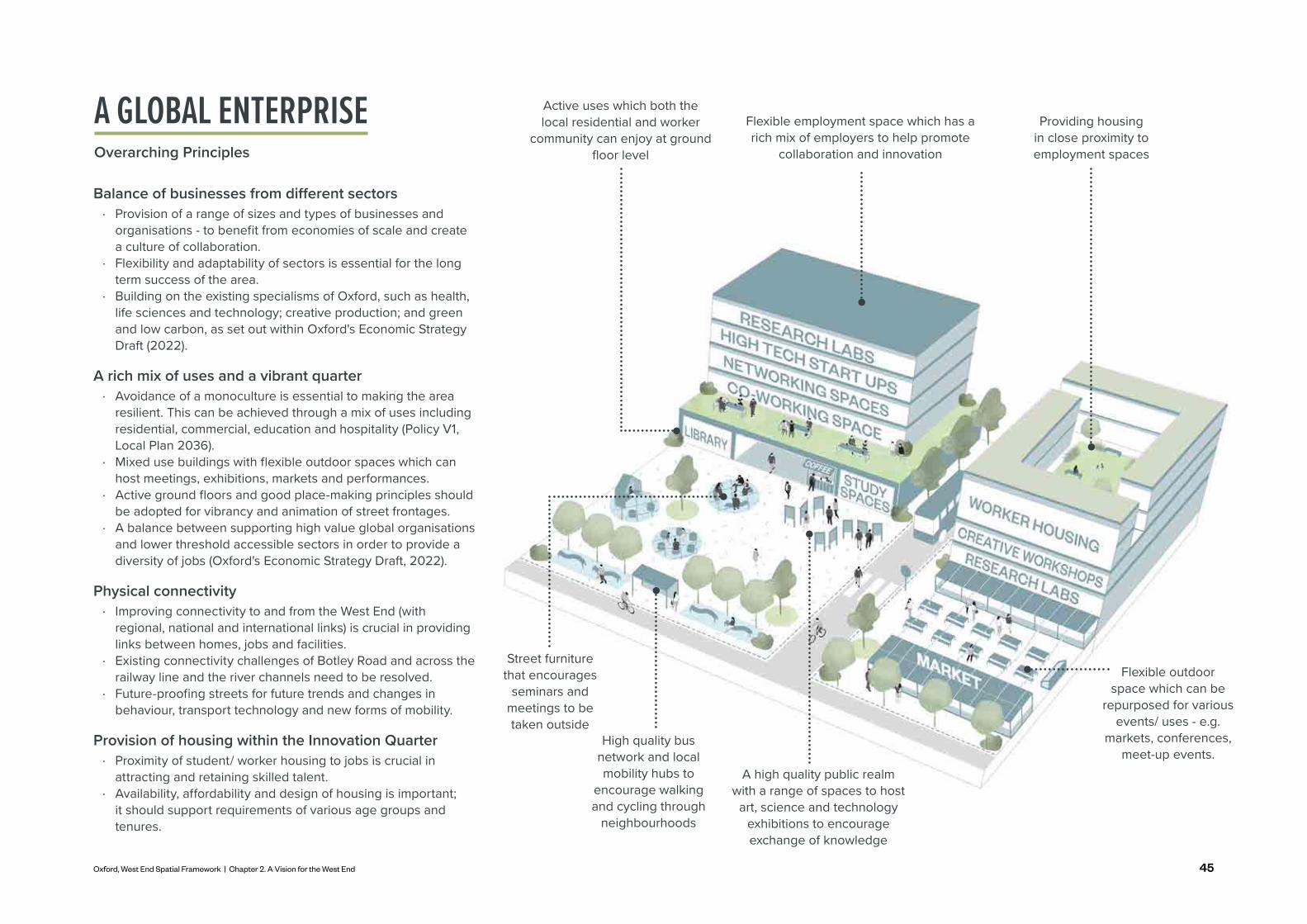
Balance of businesses from different sectors · Provision of a range of sizes and types of businesses and
organisations - to benefit from economies of scale and create a culture of collaboration.
· Flexibility and adaptability of sectors is essential for the long term success of the area.
· Building on the existing specialisms of Oxford, such as health, life sciences and technology; creative production; and green and low carbon, as set out within Oxford's Economic Strategy Draft (2022).
A rich mix of uses and a vibrant quarter · Avoidance of a monoculture is essential to making the area
resilient. This can be achieved through a mix of uses including residential, commercial, education and hospitality (Policy V1, Local Plan 2036).
· Mixed use buildings with flexible outdoor spaces which can host meetings, exhibitions, markets and performances.
· Active ground floors and good place-making principles should be adopted for vibrancy and animation of street frontages.
· A balance between supporting high value global organisations and lower threshold accessible sectors in order to provide a diversity of jobs (Oxford's Economic Strategy Draft, 2022).
Physical connectivity · Improving connectivity to and from the West End (with
regional, national and international links) is crucial in providing links between homes, jobs and facilities.
· Existing connectivity challenges of Botley Road and across the railway line and the river channels need to be resolved.
· Future-proofing streets for future trends and changes in behaviour, transport technology and new forms of mobility.
Provision of housing within the Innovation Quarter · Proximity of student/ worker housing to jobs is crucial in
attracting and retaining skilled talent. · Availability, affordability and design of housing is important;
it should support requirements of various age groups and tenures.
A GLOBAL ENTERPRISEOverarching Principles
Flexible outdoor space which can be
repurposed for various events/ uses - e.g.
markets, conferences, meet-up events.
A high quality public realm with a range of spaces to host
art, science and technology exhibitions to encourage exchange of knowledge
High quality bus network and local mobility hubs to
encourage walking and cycling through
neighbourhoods
Active uses which both the local residential and worker
community can enjoy at ground floor level
Providing housing in close proximity to employment spaces
Flexible employment space which has a rich mix of employers to help promote
collaboration and innovation
Street furniture that encourages
seminars and meetings to be taken outside

46
Natural and man-made barriers
· River and railway line create severance within the West End of Oxford
· Botley and Oxpens Road lack good quality pedestrian crossings
Draw West End closer to city centre
· Creation of a series of connections across barriers
· Enabling connectivity through walking and cycling
· A variety of connections with different character and qualities
KEY C
HALL
ENGE
S: EX
ISTIN
G CON
TEXT
PLAC
E-MAK
ING R
ESPO
NSE
TO CH
ALLE
NGE
CHALLENGES AND RESPONSESPlacemaking Approach
Integrate blue-green infrastructure to minimise flood risk, promote biodiversity, urban cooling and health and well-being
· Enhance local biodiversity and ecology
· Integrate with proposed Flood Alleviation Scheme
· Floodable landscapes which form part of the network and could be places for play/ recreation
Flood risk in many key development areas
· Much of the West End sits within Flood Zone 3
· Proposed Flood Alleviation Scheme seeks to help mitigate existing flood risk in some areas
· Highly constrained with development plots in Osney Mead regeneration site
The Placemaking Approach stems off the SWOT analysis and helps to breakdown some of the thinking which has led us to the Spatial Framework. It considers how key challenges within the West End manifest spatially and how we look to respond to these.

47Oxford, West End Spatial Framework | Chapter 2. A Vision for the West End
Predominance of vacant and/or underdeveloped sites
· Many vacant or under-utilised sites which have a frontage that is inaccessible or blank
· Lack of good quality connections between them create isolated sites and fragmented urban grain
A world class transport interchange to fit Oxford’s growing need
· High quality public realm which cements it as a key gateway
· Opportunity to promote active transport - bicycle parking and good pedestrian infrastructure
· Opportunity for mixed use development within the station and around the Becket Street car park
· Opportunity to rationalise the bus network and use space to the rear of the station precinct for viable uses
Underdeveloped transport interchange at Oxford Station
· Lack of sense of arrival · Lots of underutilised
spaces · Poorly designed and
located car and cycle parking, bus stands and hard landscaping.
· Poor pedestrian/cyclist connectivity and experience
KEY C
HALL
ENGE
S: EX
ISTIN
G CON
TEXT
PLAC
E-MAK
ING R
ESPO
NSE
TO CH
ALLE
NGE
Interconnected web of distinct destinations
· Imaginatively developed sites, each with own unique character
· Interconnected with high quality links and public realm

48
Lacking attractive safe and accessible public spaces
· Few places to sit, play and socialise in the West End
· Some poor quality existing public spaces
· Lack of opportunity to spend leisure time by the waterways
Animated and well-accessed waterways
· High quality public realm adjacent to the waterways
· Activating the waterways with boardwalks, boat moorings, a kayak club, cafés and restaurants
· A multitude of connections
· Public realm that invites you into Osney Mead and key development sites
Inaccessible or underutilised waterways
· Development backs onto waterways
· Towpaths are narrow with heavy vegetation - poor perception of safety and experience
· Much of the waterways are publicly inaccessible.
· Open spaces which lack purpose and legibility
KEY C
HALL
ENGE
S: EX
ISTIN
G CON
TEXT
PLAC
E-MAK
ING R
ESPO
NSE
TO CH
ALLE
NGE
A network of new and existing public spaces
· New public spaces which are activated by surrounding uses
· Opening up the riverside
· Strong connections between public spaces
· Opportunity for more play, food growing, sports and recreation
· Spaces with different characters and purposes
· Interlinking spaces and activities within neighbourhoods
CHALLENGES AND RESPONSESPlacemaking Approach

49Oxford, West End Spatial Framework | Chapter 2. A Vision for the West End
Poor legibility and setting for historic assets in the West End
· Historical assets lack appropriate setting
· Poor legibility at key gateways within the West End (e.g arrival at the station; entrance to Osney Mead Industrial Estate)
Better wayfinding and strategic tall buildings that complement the historic core
· Celebration of historic assets with good quality public realm and sensitive design
· Key gateways to be enhanced with moments of height and public realm
· Views to historical assets to be maintained and enhanced
· Improved connectivity
Create distinct activity links, cluster facilities and balance development
· Improved connectivity helps foster a culture of collaboration, sharing assets and distributing complementary uses between various development sites and their activity hubs
· Attractive destinations as places where people want to live, work and play.
· Mixed use buildings which accommodate residential use to create 24-hour neighbourhoods
Scattered assets and activities in West End
· Hubs of activity feel disconnected and don’t maximise on essential synergies needed between various sites
· A fragmented urban grain with limited dialogue between development sitesKE
Y CHA
LLEN
GES:
EXIST
ING C
ONTE
XTPL
ACE-M
AKIN
G RES
PONS
E TO
CHAL
LENG
E

50

51Oxford, West End Spatial Framework | Chapter 3. The Spatial Framework
THE SPATIAL FRAMEWORK3
“
“
Urbanism works when it creates a journey as desirable as the destination
- Paul Goldberger

52
THE SPATIAL FRAMEWORKPlacemaking Approach
The Spatial Framework is set out in the form of broad principles of good place-making and strategic thinking for the West End. Guiding principles of the framework stem from a holistic approach - which considers stakeholder input, responding to various priorities, constraints and ambitions.
Understanding each of the strategies cannot be done in the isolation of the 'Area for Change' boundary identified in the Local Plan 2036. The strategies must be considered in the wider context - taking into account strategic movement patterns; characters of neighbouring areas; and key green and blue infrastructure considerations.
Ultimately, these strategies are set in the context of the Local Plan's vision to provide a 'liveable and sustainable environment that balances economic, social and environmental needs, ensuring that the city remains a highly desirable place to live, work and visit' (p.6, Local Plan 2036). It seeks to deal with the city's challenges such as housing supply, traffic congestion and heritage. Principles set out within the allocation policies (Local Plan 2036) of AOC1 and SP1 are built upon within the following strategies.
Three golden threads run through each of the Core and Supporting strategies. These include sustainability, social value and economic value.
Sustainability Strategy
It sets the scene for all following strategies and it is to be embedded in all decisions. This covers interventions on water, health and well-being, active travel, net zero carbon design, and ecology and biodiversity.
Social Value Strategy
This ensures all strategies and interventions provide effective social value. It includes securing social infrastructure, involving the community at the heart of every decision and producing high quality design for all.
Economic StrategyThis builds upon Oxford's Economic Draft Strategy (2022) which provides new ideas on how the economy of Oxford can be more inclusive, global and transition towards zero carbon. The strategy sets out principles to support good practice and delivery.
Three core strategies represent many of the key moves being made in the West End. These strategies require large amounts of infrastructure and will shape how people move and dwell in spaces. For effective delivery of these strategies, key delivery priorities have been identified under each. The core strategies are:
Green and Blue Infrastructure Strategy
It highlights the importance of landscapes, ecology and enhancing biodiversity as an integral part of design. It also promotes green and blue infrastructure as key to the design of streets and spaces - helping to mitigate flood risk and bring communities together.
Movement Strategy This is pivotal to the West End and the vision of creating a net zero future. It promotes low carbon lifestyles by encouraging active travel through improved connections, improved streets and spaces and good mixed use design. It highlights the importance of how good digital connectivity can support land use planning, avoiding the need to travel, allowing a greater focus on local living and working.
Public Realm StrategyThis sits ingrained within the Movement Strategy and seeks to promote high quality streets and public spaces for people to move through and dwell in. By improving many existing public spaces and introducing many new ones, this strategy aims to create a series of interconnected public spaces which are characterful, enjoyable and comfortable.
The Supporting Strategies touch on more specific topic areas, equally essential in delivering the vision for the West End. These include:
Heritage Strategy
Celebrating the rich heritage of Oxford, it seeks to ensure a diversity of heritage assets are retained and conserved; and they actively promote a sense of place; character and way-finding through the West End.
Arts and Cultural StrategyThis promotes the importance of integrating culture and arts into the West End - both supporting cultural employment and creating spaces where culture can be shared as well as spaces where culture can be created. With strong local partnerships this strategy will help shape the West End's growth and identity.
Meanwhile Use StrategyRecognising that the vision for the West End is likely to be fulfilled over many decades - meanwhile uses will be essential catalysts for change by promoting activity, changing perceptions and creating social value in the short and medium term. Strong local partnerships and collaborations are needed to make this strategy a success.
Emerging Development and Land Use Distribution Strategy This seeks to provide the right mix of land uses across the different development sites - which seek to compliment and enhance existing networks. Ultimately it aims to provide land uses which complement each-other and foster a culture of collaboration and innovation.
Building Heights StrategyUnderpinning this strategy is the balancing of development needs while also being sensitive to viewing corridors and the settings of heritage assets. This includes the strategic placement of height to act as landmarks while not impeding heritage values. How these are to be applied have been set out with written and visual guidance.

53Oxford, West End Spatial Framework | Chapter 3. The Spatial Framework
Key connections
Key frontages
Sites for redevelopment
Opportunity sites for redevelopment
Emerging development proposals
Existing buildings of significance
Streets to be greened and pedestrians/cyclists prioritised
Key hubs of activity
Key green spaces
Key green routes
Minor green routes
Major streets to be greened
Key public spaces
The Spatial Framework
0 400200m
Botley Rd
Oxpens RdFe
rry
Hin
ksey
Rd
St. Aldate's R
d
Cornm
arket St
Osney Mead Rd
Frideswide Square
Botley Park
Oatlands Road Recreation Ground
River Thames
Castle Mill Stream
Bulstake Stream
A34Grandpont Nature Park
Osney Cemetery

54
SUSTAINABILITYThe Golden Threads
The Sustainability Strategy is one of the three golden threads of the framework. In the age of a Climate Emergency, future developments must work hard to fulfil Oxford City's Council ambitious goals to achieve social, environmental and economic sustainability.
This is recognised by Oxford's Economic Draft Strategy (2022) and the Zero Carbon Action Plan (2021) which seeks to increase jobs within the zero carbon sector; create diverse and inclusive places; and promote opportunities which restore habitats and provide urban green infrastructure. The West End Investment Prospectus Draft (2022) campaigns for the expansion of the green-tech sector and embracing new sustainable approaches.
Urban greening to reduce heat
island effect
Multi-functional
green spaces
Flood resistance and resilienceProtecting and improving
watercourse systems
Swale/ treatment
ponds/ attenuation
basins
Rainwater collection
Porous paving
Re-wild canal/river edges
Water recycling for urban farming
Promoting good health and well-being
Space for cycle storage and mobility scooters/hubs
Active by design/ encourage zero carbon lifestyles
Improved pedestrian and cycling routes
Live-work models for homes / mixed use
buildings
Multi-generational living
Power generation through
renewable technologies /
Smart grid
Mixed communities and tenures
Sustainable transport/
mass transitConnected
green corridors
Traffic calming and shared surfaces
Walking encouraged through improved connections of parks
Charging for electric vehicles/ reduced bills
Improved connections across natural barriers
Prioritise reuse of existing buildings
Dual aspect to provide cross ventilation
Improve and increase flora/
fauna
Enhance ecology
in built-up urban areas
Net biodiversity gain
Inclusion of green/brown/blue roofs
Carbon neutral/ low embodied
carbon construction
targets
Maximise daylight
Target high fabric efficiency

55Oxford, West End Spatial Framework | Chapter 3. The Spatial Framework
HEALTH AND WELL-BEING
NET ZERO DESIGN
ECOLOGY AND BIODIVERSITY
ACTIVE TRAVELWATER
MAXIMISE DAYLIGHT
POWER GENERATION THROUGH RENEWABLE
TECHNOLOGIES
TARGET HIGH FABRIC EFFICIENCY
DUAL ASPECT TO PROVIDE CROSS
VENTILATION
INCLUSION OF GREEN/BROWN/BLUE
ROOFS
ENHANCE ECOLOGY IN BUILT-UP
URBAN AREAS
IMPROVE AND INCREASE FLORA AND FAUNA
CONNECTED GREEN CORRIDORS
NET BIODIVERSITY GAIN
IMPROVED SOIL QUALITY
CARBON SEQUESTRATION
GREEN AND BLUE
INFRASTRUCTURE
MULTI-FUNCTIONAL GREEN SPACES
URBAN GREENING TO REDUCE HEAT
ISLAND EFFECT
FOOD GROWING
HEALTH AND WELL-BEING
GOOD AIR QUALITY
ACTIVE BY DESIGN
IMPROVED PEDESTRIAN AND CYCLING ROUTES
ENCOURAGE ZERO CARBON
LIFESTYLE
RAINWATER COLLECTION
SUSTAINABLE URBAN
DRAINAGE
SUSTAINABLE TRANSPORT
REDUCED BILLS
SPACE FOR CYCLE STORAGE
AND MOBILITY SCOOTERS/HUBS
WALKING ENCOURAGED
THROUGH IMPROVED CONNECTIONS OF
PARKS
BRIDGE CONNECTIONS
TRAFFIC CALMING
AND SHARED SURFACES
MASS TRANSIT SYSTEM
SMART GRID
PROTECTING AND IMPROVING WATERCOURSE
SYSTEMS
REWILD CANAL/RIVER EDGES
ATTENUATION BASINS
SWALE/ TREATMENT
PONDS
WATER RECYCLING
PRIORITISE REUSE OF EXISTING
BUILDINGS
CARBON NEUTRAL/ LOW EMBODIED CARBON
CONSTRUCTION TARGETS
LIVE-WORK MODELS FOR HOMES AND MIXED USE
NEIGHBOURHOODS
INTERGENERATIONAL LIVING
MIXED COMMUNITIES AND TENURES
REUSE-RECYCLE-RENEW
PublicFootpath
CHARGING FOR ELECTRIC VEHICLES
FLOOD RISK/RESILIENCE

56
The Earth Trust is the environmental partner for the Oxford Flood Alleviation Scheme and aims to enrich the landscape with new wetland habitat, grazing meadows and wild flowers
New cycle lanes have already been constructed at Osney Mead Industrial Estate. There is opportunity to expand this network and provide active frontages onto these routes
Osney Lock existing community owned Hydro uses a reverse Archimedean screw to turn the power of the river into electricity
The Council is investing in EV taxis and Westgate Shopping Centre is already offering 50 EV charging spaces
SUSTAINABILITYThe Golden Threads
A number of strategies which promote a sustainable vision are already being promoted within the West End and wider Oxfordshire. This includes:
· EV charging points · Hydroelectric power for local residents and businesses · Better cycle infrastructure encouraging low carbon
lifestyles · Battery Technology Centre which seeks to develop
batteries at a huge scale · New wetland habits created by the Oxford Flood
Alleviation Scheme · Housing such as Springfield Meadows which provides
climate positive homes · Oxford has recently become DPD's first all-electric city,
with future parcel deliveries now only being made with electric vehicles
· Retrofitting existing homes with better insulation, solar panels, heat pumps and rainwater collection units, like the service of Cosy Homes Oxfordshire
· Businesses which operate with pedal-power such as Oxwash
· A completed wetland restoration project which has created a species rich environment
· Investment in EV taxi infrastructure in the Go Ultra Low Oxford Taxi Project (GULO Phase 2)
· The University of Oxford generating new clean-tech spinout companies (Oxford's Economic Draft Strategy, 2022)
· Two national energy systems demonstrator projects are based in Oxfordshire (Oxford's Economic Draft Strategy, 2022)
· Zero Emission Zone Pilot Scheme (OCCAP, 2021, p. 57).
Supporting these local initiatives, learning from them, tapping into their networks and expanding their reach will be an important part of achieving sustainable developments within the West End.

57Oxford, West End Spatial Framework | Chapter 3. The Spatial Framework
Cosy Homes Oxfordshire is a whole house retrofit service aiming to improve the energy efficiency of existing homes in Oxfordshire
Oxwash is a company providing a laundry service via electric cargo bicycles. Improved cycle infrastructure could encourage these types of innovation
Springfield Meadows development is providing 25 carbon positive homes
The recently opened Johnson Matthey Battery Technology Centre in Oxford aims to develop a sustainable battery materials ecosystem
Oxford has recently become DPD's first all-electric city, with future parcel deliveries now only being made with electric vehicles
Chimney Meadows Wetland Restoration Project has restored the area into an area to a mosaic of floodplain meadows, wetlands, pasture and wet woodland

58
SOCIAL VALUEThe Golden Threads
STEWARDSHIP KEY PRINCIPLES
SOCIAL VALUE
Setting up an infrastructure for a community to take ownership over the processes, decision-making and future development of an area within and beyond the design process
Providing diverse, tenure blind housing and sensitively and contextually designed places of play, leisure, public space, and housing types
Considering existing social assets, businesses, and community structures and evaluating how they may continue to enhance areas
A meaningful engagement process that is inclusive, diverse and accessible to all stakeholders
ENHANCING SOCIAL FACILITIES
HIGH QUALITY AFFORDABLE DESIGN
MEANINGFUL ENGAGEMENT
PLACES ARE NOT A BLANK CANVAS
Protecting and enhancing existing social capital and providing new infrastructure to suit needs
Ensuring all developments and interventions provide effective social value will be critical to realising the vision of the Spatial Framework. This includes sensitively assessing what is existing and responding to context appropriately through high quality, inclusive and affordable design. Engagement of the community and stakeholders is imperative from early concept design through all stages of design and delivery. These five principles encompass this.

59Oxford, West End Spatial Framework | Chapter 3. The Spatial Framework
SOCIAL VALUEThe Golden Threads
Identify social needs as a precondition for any development
Protect and enhance existing social infrastructure and their networks
Include the community as a driver of design decisions
Aberfeldy Street, Jan Kattein ArchitectsYouth Engagement for Aberfeldy New Masterplan, Levitt Bernstein and ZCD Architects
Sugarhouse Studios, Assemble Architects
A thorough survey and engagement process must precede any intervention to develop an understanding of existing communities, their needs and priorities. This is especially important in the West End whose diverse working and residential population may vary in social needs. Whilst two sites may be physically close, their social needs may be vastly different.
In practice, this identification of social needs may also operate as an enabler for development if a sufficient need is identified. This should be closely aligned with the goals set in the Local Plan 2036.
While every site will have specific social needs, they will simultaneously have their existing social infrastructures and networks. These may include local businesses and community groups. These networks are to be assessed and strengthened, providing a basis for evolving communities. They may provide an anchor for development and new people coming into the area, enabling social continuity in the light of physical changes.
Recognising that the West End is not a blank canvas - that it is rich in communities which come from existing homes, employment, leisure, retail and heritage, and is particularly important in carving out the area's future. Each development site coming forward already has a social network and it is important to build on this to maintain cohesive and long-lasting communities.
Successful regeneration is founded on listening to all stakeholders with a role in the future of their neighbourhood. Setting out from the onset a robust structure for a representative and meaningful consultation will greatly benefit schemes in the West End to foster thriving communities.
Proposals should be expected to provide good communication with stakeholders, reach under-represented groups and take stakeholders on the process from concept to delivery stages. Consultation should not end when the design process ends, and strong frameworks need to be developed for continued and long-term community stewardship.
1 2 3

60
New developments must provide an affordable and diverse housing mix
Designing public spaces which are inclusive and accessible to all
High quality design for all - tenure blind - whether its affordable or market
Housing delivery is a significant factor in the Local Plan 2036, which foresees a great deal of population growth within the West End. It is crucial to demonstrate and justify within planning policy frameworks a scheme's affordability and housing mix, which should echo local context and viability.
This is especially important in the several sites throughout the West End which aim to deliver a significant amount of housing. This works in conjunction with the points set out in the Land Use and Emerging Developments section of this Spatial Framework.
Strategic sites will need to offer a wide range of house types to create a balanced community that is able to adapt and grow. This includes the opportunity to give tenants the ability to up size or down size their homes according to needs.
Home unaffordability is one of the greatest challenges for residents in Oxford (Local Plan 2036). For this reason, the Local Plan sets clear ambitions to provide broad and effective housing at or below the Local Housing Allowance.
Designing tenure blind schemes will help achieve these goals and work to create an equitable built environment. Housing and its surrounding public realm must be of high standard regardless of ownership type. Separate entrances and amenities for different tenure groups must be avoided.
Affordable employment units will also be an important part of creating a mixed 'Innovation Quarter'.
Designing accessible spaces is an important factor in bringing about a truly socially inclusive public realm. Design for all abilities and demographics should be met contextually and flexibly.
As expanded upon in the Public Realm Strategy of this Spatial Framework - accessible public realm elements such as paving, benches, public toilets and street crossings are some of the ways to ensure an inclusive space. Proposals coming forward should build out the Public Realm strategy which is underpinned by a series of interconnected public spaces with different characters.
Urban greening of streets and spaces is also a key factor - this contributes to zero carbon designs and provides opportunities to improve mental health of citizens.
4 5 6
Sutherland Road, Walthamstow, Levitt Bernstein Parkview, South Thamesmead, Levitt BernsteinRochester Way, Greenwich, Peter Barber Architects
SOCIAL VALUEThe Golden Threads

61Oxford, West End Spatial Framework | Chapter 3. The Spatial Framework
Oxford’s Economic Draft Strategy (2022) marks a shift in thinking about Oxford’s economy and a step-change in the City Council and partners’ approach to economic development. It responds significantly to local, national and societal challenges in terms of inclusion and the climate emergency. The strategy provides new ideas on how the economy of Oxford can be more inclusive, global and transition towards zero carbon. The successful implementation of the strategy will need new collaborations and enhanced partnership under the strategic leadership of the City Council and the Economic Growth Board. A set of principles has been created to inform this, provoke new practices and support delivery:
ECONOMIC STRATEGYThe Golden Threads
The following list is a selection of headlines which indicate how Oxford City Council and its partners will work together to deliver actions which support the strategy’s objectives. These relate to the first five years of a ten-year plan, underpinned by the big ideas within the strategy document. Many of these actions will form the foundation for the future, providing the basis for Oxford to become an inclusive, global and zero carbon city. The full list is set out in Oxford’s Economic Draft Strategy – Delivery Plan Document.
1 Commitment and Focus - a shared, long-term commitment to responding to the priority challenges and opportunities identified in the economic strategy.
2 Collaboration - making the most of available capacity and resources that exist across the city by building on the work of partners, brokering new relationships and working across new areas.
3 Participation - embedding participatory principles within delivery to ensure that Oxford’s residents are actively involved in idea development, decision-making and delivery.
4 Innovation - using the city as a ‘living lab’ to try innovative projects, alongside taking innovative approaches to leverage funding and realising ambitions.
5 Agility - continuously reviewing delivery mechanisms, project priorities and ways of working to ensure the city remains agile in responding to changing needs.
6 Pace - working rapidly to deliver projects that deliver positive economic, social and environmental impacts.
Develop an Oxfordshire Inclusive Economy Charter and pledge to engage all local business and institutions to play a fuller role in embedding an inclusive economy.
Increase the quantity and quality of commercial space, with a focus on supporting Life Sciences, Low Carbon, Digital and knowledge driven sectors.
A.
Expedite connectivity improvements and infrastructure needed to unlock Oxford's economic potential.
B.
Support businesses to recover from the pandemic and adapt to changing economic conditions.
C.
Help deliver Oxford West End at pace, as a major mixed-use, sustainable neighbourhood.
D.
Boost domestic and international inward investment.E.Retain a greater proportion of spin-outs and growing companies and increase the local economic value of knowledge and innovation.
F.
Support the recovery of the visitor economy and seek benefits for visitors and residents.
G.
Harness the potential of Oxford’s population to make the city’s workforce a more distinctive factor in its success.
H.
Focus recovery efforts on the needs of the most disadvantaged places, through community wealth building and community economic development.
I.
Further develop and build on the Oxford Living Wage initiative.
J.
Support social enterprise, cooperative businesses and civil society sectors to recover and grow.
K.
Support local spend and enhance local business through procurement and targeted social value.
L.
Support local people to access skills, training and education opportunities to help them prosper and adapt to structural changes to the economy.
M.
Deliver affordable workspace that supports local businesses and organisations to prosper and support community wealth building.
O.
Use the principles of 15-minute neighbourhoods to give residents access to the services they need to participate in the economy and society.
P.
Explore options to deliver more affordable travel for local people to travel to key employment locations using public transport and cycling.
Q.
N.
Pro-actively encourage mainstream socially and environmentally responsible business practices city-wide.
R.
Reduce the negative environmental impacts of existing economic activity.
S.
Mitigate environmental impacts of new development and housing growth.
T.
Support the growth of the green and low carbon technology sectors through innovative partnerships and targeted business support.
U.
Support and partner businesses and institutions to be more environmentally responsible and address city-wide zero carbon targets.
V.
Deliver the Oxford Zero Emission Zone.W.
The opportunity in Oxford is one of national significance. It is therefore reasonable that the projects which will support the aspirations of the strategy should receive some investment from national government. The City Council, Economic Growth Steering Board and Oxfordshire LEP will all need to form a consistent lobby to make the case for this and ensure that any resource is used efficiently and impactfully.

62
GREEN AND BLUE INFRASTRUCTURESpatial Framework Strategies
OPEN SPACE FOR THE COMMUNITY
TRANSITIONAL LANDSCAPES
PRODUCTIVE LANDSCAPES
BLUE INFRASTRUCTURE
RICH ECOLOGICAL LANDSCAPES
Landscapes for recreation, play, social life and small to medium scale urban food growing
KEY PRINCIPLES
GREEN AND BLUE INFRASTRUCTURE
STRATEGY
· Neighbourhood parks · Sports fields · Playgrounds · Regional parks · Public plazas/squares · Green ways
Temporary landscapes and meanwhile methods to clean soils (land re-mediation) and enable new forms of social life and creative displays
· Event spaces · Re-mediation areas to
prepare for forests · Innovative art spaces
· Urban meadows · Re-wilding canal/river
edges
Landscapes to generate new knowledge, grow energy and food, and create new urban experiences
· Research landscape
· Urban farms · Aquaculture and
hydroponics · Forests or energy
fields
· Homesteads · Algaculture · Green/brown/blue
roofs · Micro-forests
Landscapes that capture storm-water and clean air
Tree planting, meadows and forested areas that provide habitat and other environmental benefits · Urban growing
· swales/SuDS · Retention ponds · Lakes · Infiltration parks
and basins · Roadside ponds
to wider roads
· Rain gardens · Green culture
in industrial zones
· Community initiatives
· Canal side routes and routes to the waterways
· Rivers · Nature parks · Wild areas
· Rapid reforestation and greening of barren dense areas
· Industrial nature paths
· Successional routes and spaces
A strong green and blue network is essential in adapting our environment in the light of climate change, promoting health and well-being and fostering biodiversity. These key principles underpin the Green and Blue Landscape Strategy.
· Natural trails · Farmers markets · Gardens · Local cemeteries

63Oxford, West End Spatial Framework | Chapter 3. The Spatial Framework
Community food growing
Farmers' Markets selling local produce
Riverside play and recreation
space
Sports and recreation
on rooftops
SuDS and raingardens
along the street
Neighbourhood parks
Re-wilding riverside with mixed species
Tree planted streets
Floodable landscapes
Events space
Research landscapes
Innovative art spaces
Watercourses to have capacity
to capture excessive rainwater
Ensuring that these principles underpin the four visioning themes is important. These broad principles can be integrated into streets, spaces and building typologies to create an urban environment which sits in conjunction with nature - allowing communities to enjoy it; biodiversity to flourish; mitigate flood risk and allowing landscapes to rejuvenate.
Green and blue roods - promoting
natural surface cover
GREEN AND BLUE INFRASTRUCTURESpatial Framework Strategies

64
11
1
2
3
3 32
2
4
4
4 5
5
5
6
6
6
5
Green Spine
Flood defence proposed as part of the Alleviation Scheme
Sports and recreation
Greening major streets
Key green spaces
Key green routes
Minor green routes
Key public realm
Greening of existing and proposed streets
Integration of flood risk mitigation into all elements of design
To make a destination for Osney Mead’s riverside and lock
Towpaths to be key green arteries within the city
Putting the community at the heart of every green space
Improve access to the green belt areas through sports and recreation provision
The West End of Oxford has some fantastic green and blue assets – many accessible watercourses, the green belt, and some key parks and meadows.
These green and blue spaces accomplish important social, environmental and economic functions individually and as part of a wider network.
This strategy seeks to reinforce what is already there, create better connections between components and add new green and blue infrastructure which enriches the existing offering. The green and blue landscape strategy is underpinned by policy G8 (Local Plan 2036). More detailed design guidance can be found in the West End Design Guide. Principles include:
0 400200m
Botley Rd
Oxpens RdFerr
y H
inks
ey R
d
St. Aldate's R
d
Cornm
arket St
Osney Mead Rd
Frideswide Square
Botley Park
Oatlands Road Recreation Ground
River Thames
Castle Mill Stream
Bulstake Stream
Grandpont Nature Park
Osney Cemetery
GREEN AND BLUE INFRASTRUCTURESpatial Framework Strategies
65Oxford, West End Spatial Framework | Chapter 3. The Spatial Framework
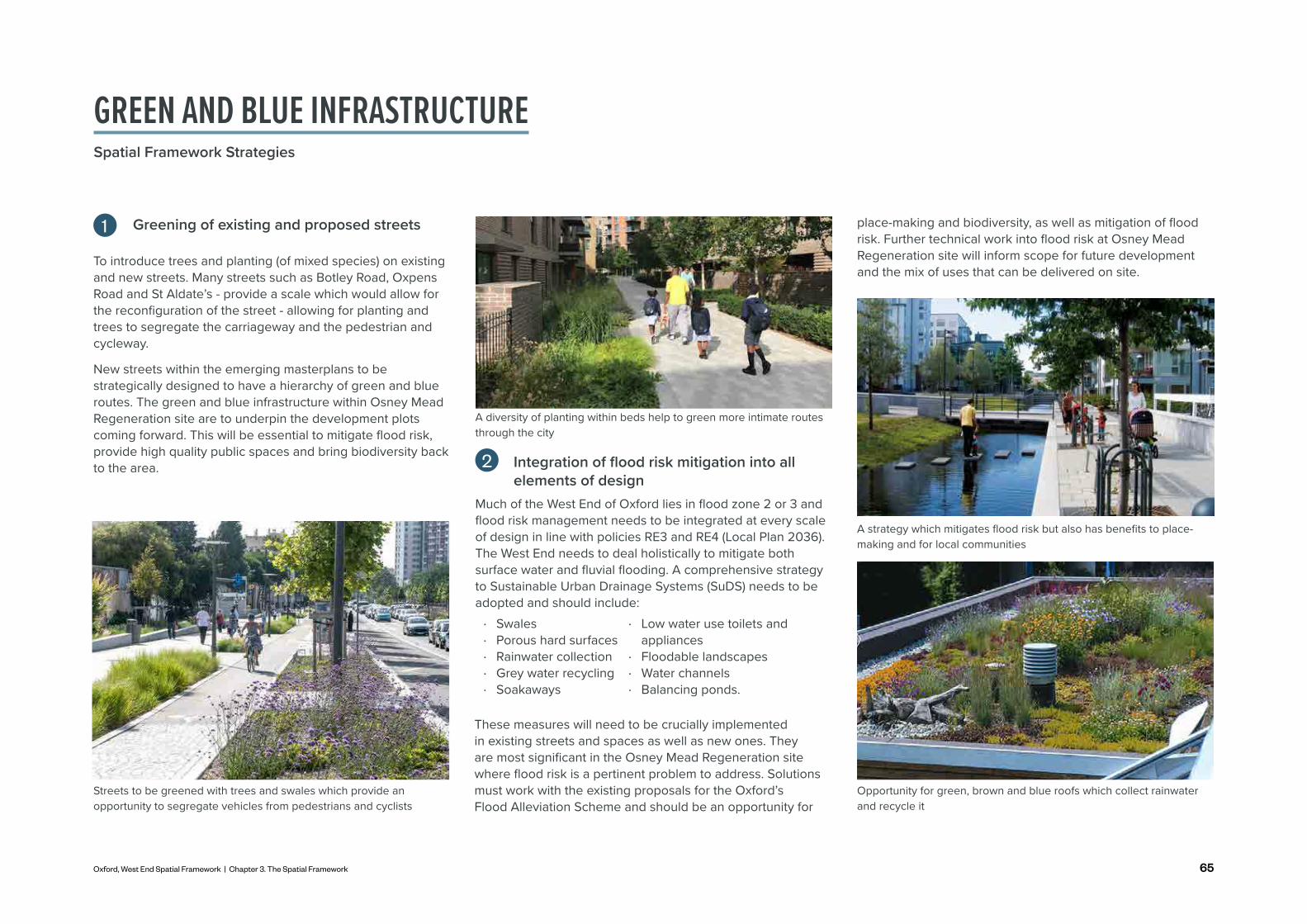
Greening of existing and proposed streets
Much of the West End of Oxford lies in flood zone 2 or 3 and flood risk management needs to be integrated at every scale of design in line with policies RE3 and RE4 (Local Plan 2036). The West End needs to deal holistically to mitigate both surface water and fluvial flooding. A comprehensive strategy to Sustainable Urban Drainage Systems (SuDS) needs to be adopted and should include:
1
Streets to be greened with trees and swales which provide an opportunity to segregate vehicles from pedestrians and cyclists
2
These measures will need to be crucially implemented in existing streets and spaces as well as new ones. They are most significant in the Osney Mead Regeneration site where flood risk is a pertinent problem to address. Solutions must work with the existing proposals for the Oxford’s Flood Alleviation Scheme and should be an opportunity for
A strategy which mitigates flood risk but also has benefits to place-making and for local communities
A diversity of planting within beds help to green more intimate routes through the city
To introduce trees and planting (of mixed species) on existing and new streets. Many streets such as Botley Road, Oxpens Road and St Aldate’s - provide a scale which would allow for the reconfiguration of the street - allowing for planting and trees to segregate the carriageway and the pedestrian and cycleway.
New streets within the emerging masterplans to be strategically designed to have a hierarchy of green and blue routes. The green and blue infrastructure within Osney Mead Regeneration site are to underpin the development plots coming forward. This will be essential to mitigate flood risk, provide high quality public spaces and bring biodiversity back to the area. Integration of flood risk mitigation into all
elements of design
· Swales · Porous hard surfaces · Rainwater collection · Grey water recycling · Soakaways
· Low water use toilets and appliances
· Floodable landscapes · Water channels · Balancing ponds.
Opportunity for green, brown and blue roofs which collect rainwater and recycle it
GREEN AND BLUE INFRASTRUCTURESpatial Framework Strategies
place-making and biodiversity, as well as mitigation of flood risk. Further technical work into flood risk at Osney Mead Regeneration site will inform scope for future development and the mix of uses that can be delivered on site.

66
Towpaths to be key green arteries within the city
To make a destination for Osney Mead's riverside and lock
As stated within the Policy SP1 (Local Plan 2036) there is great opportunity to create a greater relationship between the West End and it's watercourses with better visual and physical permeability. The area around Osney Lock provides a significant place-making opportunity to be the epicentre of this relationship and a destination, driven by its blue and green assets.
There is significant opportunity to generate activity on and alongside the River Thames with a water sports offering; food and drink; play; food growing and recreation - all to be actively overlooked by both the existing and a new mixed-use community at Osney Mead. With the opening of the Environment Agency bridge to the public, a high quality public space which includes the River Thames; Osney Island and lock - there is a real opportunity for activity on and off the water.
3
Opportunity for leisure on the waterfront with water-sports such as canoeing and paddle-boarding; and bars and restaurants
The recent opening up of Castle Mill Stream sets a real precedent for how Oxford’s watercourses can be made more accessible, safe and enjoyable for pedestrians, promoting active travel within the city. The River Thames, Bulstake Stream, Mill Stream and Osney Stream all provide a similar opportunity.
Opening up these watercourses for pedestrians and cyclists is essential in capturing the place-making value out of the green and blue network of Oxford. New and improved links across the river help open up the riverside and connect it to key destinations / assets.
Different blue arteries may have very different characters and design approaches but by opening them up and enriching them with accessible routes, tree planting, community gardens, development frontages and activities help to promote safe and rich ecology/biodiversity corridors within the city.
4
Part of the existing route in Osney Mead provides a separate shared path for bikes and walkers as well as the historic tow-path
A floating pocket park activates underused parts of the watercourse with seating and planting
A significant area of space is sunken and dedicated to capturing rainwater and improving ecology
GREEN AND BLUE INFRASTRUCTURESpatial Framework Strategies

67Oxford, West End Spatial Framework | Chapter 3. The Spatial Framework
Opportunity for green space adjacent to the watercourse which provides a place for planting, play and relaxation
A strong network of food growing is already established within Oxford and there are several allotment sites near the West End. However, the densification of the West End will mean there is a greater demand for food growing spaces. This provides a real opportunity for emerging sites and underutilised land to be utilised for food growing which is looked after and used by a strong community network (Policy G4, Local Plan 2036).
A network of play spaces exists within the realm of the West End but there is great opportunity to improve and expand this network alongside the emerging masterplans and the opening up of the riverside. A playful city seeks to incorporate the spirit of playfulness and curiosity in all spaces bringing joy to daily life. A place where one can sit, dwell and gather allows communities to use outdoor space flexibly.
5
Places to sit, dwell and socialise - can be used for business meetings, socialising, community gatherings and hobbies
Food growing opportunities bring communities together and promote a healthy lifestyle
As part of promoting an active lifestyle and promoting community cohesion through sports and recreation there is great opportunity for the West End of Oxford and the surrounding area to accommodate more sports infrastructure or opportunities for outdoor activity. Currently much of outdoor sports areas in the city are owned by colleges or private schools.
In particular, the Osney Mead Regeneration site and Oxpens could utilise the playing pitches in surrounding areas. Facilities should be accessible, multi-functional and integrated with community uses.
6
The green belt areas adjacent to development sites provide an opportunity for sports and recreation
Improve access to the green belt areas and sports and recreation provision
Putting the community at the heart of every green space
GREEN AND BLUE INFRASTRUCTURESpatial Framework Strategies

68
MOVEMENTSpatial Framework Strategies
Considering Movement and Public Realm within Oxford needs to be done in parallel as they are intrinsically linked and complement each other. Movement and public realm are the most significant strategies within the Spatial Framework and seek to knit together isolated parts of the West End.
The Movement Strategy sets the skeleton of how people move around the city - how people walk, cycle, drive and travel by bus. Physical connections and strategic land use placement seek to prioritise active modes - the experience of these to be dealt with in the Public Realm Strategy.
The Public Realm Strategy concentrates on the experience of users as they travel and spend time around the West End. It aims to provide streets and public spaces which are safe, enjoyable and resilient - encouraging people to dwell with café uses, community uses and places to play and sit.
The importance of these strategies is highlighted in the Oxford's Economic Draft Strategy (2022) which recognises mobility as fundamental to a more inclusive city which allows people to access opportunities. More detailed design guidance can be found in the West End Design Guide.

69Oxford, West End Spatial Framework | Chapter 3. The Spatial Framework
ACTIVE AND LOW CARBON LIFESTYLES
15-MINUTE NEIGHBOURHOOD
CONNECTIONS
STREET CHARACTER AND HIERARCHY
DIGITAL INFRASTRUCTURE
Routes which prioritise pedestrians and cyclists
KEY PRINCIPLES
MOVEMENT
· Wide green footpaths and cycle lanes on major streets
· Car-free streets · Good lighting · Accessible for all
· New walking and cycling routes and bridges
· Enhanced First and Last mile connections to improve access to and from development
· Appropriate cycle parking · Connecting up with
Land use distribution which ensures places have everything within a 15-minute walking distance from homes
· Schools · Community uses · Play and green
spaces
· Local shops · Workplaces · Local culture · Key transport links
Improved existing and new connections which mitigate existing severances
· Bridges which provide a destination
· Comprehensive and high frequency public transport network with improved access and integrationEnsuring connectivity which is
transpatial - promoting technology and digital innovation
A clear hierarchy of routes which have different characters improves legibility and attractiveness
· Integrated public transport systems
· Data driven design · Good communication platforms
allowing for collaboration, engagement and serendipitous encounters
· Key artery streets · Local streets · Car-free streets · Watercourse
paths
· High-quality new connections which encourage walkers and cyclists
· A hierarchy of links · Connections which
provide direct and coherent links across the area
· School streets · Play streets
strategic cycle routes · Local bus stops and
city interchanges · Consolidation of
delivery and servicing trips by cargo bike / electric vehicle
MOVEMENTSpatial Framework Strategies

70
A strong movement network is pivotal to the future of the West End. Currently the West End is highly limited in connections, relying on constrained towpaths and streets which are poor in quality and connectivity. This strategy provides a real opportunity to bring the West End into the life of the bustling city centre - providing key activity hubs with high quality public realm which are interlinked with good quality walking and cycling connections.
As the residential and worker population grows, this strategy seeks to connect people to jobs and facilities through walking and cycling, encouraging a sustainable movement vision (Policy M1, Local Plan 2036). Without improvements to connectivity, proposals will not be able to come forward on key development sites. Providing new links and connections is an enabler of development and strong partnerships will be required to deliver these.
Mobility around the city and to other destinations cements the vision of the West End contributing to Oxford as global city (Oxford's Economic Draft Strategy, 2022) - one which connects Oxford to spaces nationally and internationally; and provides good digital connectivity. Introducing better connectivity to the West End will enable and enhance further public realm improvements (OCCAP, 2021, p. 54).
Connecting Oxford (2020) sets out Oxford City Council's and Oxfordshire County Council's plans to address congestion, pollution and poor transport connections into and across Oxford. Proposals put forward in Connecting Oxford include a Workplace Parking Levy and traffic filters at locations within Oxford.
The movement principals set out in the following pages reflect the initial proposals put forward. In a similar way, the key principles set out in the Local Cycling and Walking Infrastructure Plan (LCWIP, 2020) to significantly increase cycling in Oxford are reflected in the following pages.
Implementation of the measures put forward in Connecting Oxford and the Oxford LCWIP, or enhanced measures to further encourage shifts away from private car use to active, sustainable travel would be beneficial for the area.
Wide green footpaths on major streets
Adequate cycle and scooter parking and hire at key transport
nodesCar-free streets
School streets
Food growing, play and
sports close to housing
Mixed use blocks which integrate
housing and workspaces
Future proofing city with driverless pods
and other technology
Promotion of safe cycling routes on
watercourses
A train station which provides a gateway to the city and a multi-modal interchange
Bridges as a destination
and a connector
Riverside paths which have a distinct character and include a place to dwell,
play and socialise
Local bus stops and city interchanges
MOVEMENTSpatial Framework Strategies
Ensuring that these principles underpin the four visioning themes is important. How one moves through the urban environment needs a holistic approach to street design, land use placement and public realm. Ultimately moving around the City needs to be safe, easy to navigate and provide interest for the user.

71Oxford, West End Spatial Framework | Chapter 3. The Spatial Framework
Produce a framework that seeks to build a strategy for movement that will support the decarbonisation of the transport network in Oxford and help meet its net zero ambitions
Create a series of new east-west links within the West End which will connect existing and future places and centres of activity
Realise opportunities to enhance access to the bus network and plan for future improvements in accessibility
Build on the re-configuration of Oxford station to create a key gateway to the City and ensure delivery and new suitable movement corridors to Osney Mead and Oxpens
Create a network of routes which promote active travel as the first choice for travel
Plan for the improved integration of public transport services with walking, cycling and micromobility to make it easier for people to travel and switch seamlessly between modes
Improve connections to green and open spaces adjacent to the West End to better integrate into the wider area
0 400200m
1
3
2
4
5
6
7
While the West End is well situated in close proximity with the historic and vibrant city centre of Oxford, poor quality connections and disjointed transport infrastructure leave the full potential of the area unrealised.
Expanding provision and support for active means of travel such as cycling and walking as well as public transit can increase accessibility between the city centre and West End and work towards broader net zero carbon ambitions. Application of the movement strategy aims to build on present transport infrastructure and introduce ad hoc strategies to transform the West End’s movement networks into ones that are sustainable, efficient, and inclusive.
Green Spine
Sports and recreation
Greening major streets
Key green spaces
Key green routes
Minor green routes
Key public realm
Key frontages
Key gatewaysLinks to improve New linksMOVEMENTSpatial Framework Strategies

72
Produce a framework that seeks to build a strategy for movement that will support the decarbonisation of the transport network in Oxford and help meet its net zero ambitions
The Net Zero Oxford Action Plan sets out the ambitious target to deliver a net zero carbon Oxford by 2040. Within the theme of transport, shifts away from private car use, implementation of infrastructure changes, and incentivise public transport use are critical to realising this goal. This is supported by the Zero Emissions Zone project due for expansion in 2022 (OCCAP, 2021, p. 56).
The central location of the West End and forthcoming developments being brought forward in the area present an opportunity for the West End to be at the forefront of realising this zero carbon ambition. Within this context, the West End and new developments coming forward should have a clear prioritisation and hierarchy of modes of travel:
Create a series of new east-west links within the West End which will connect existing and future places and centres of activity
The natural severance created by the river and railway create barriers to east-west accessibility in the West End. This means that the time taken to travel from certain areas of the West End, (particularly Osney Mead) towards the city centre does not reflect their geographical proximity to each other. Existing connections are have particular issues for people with mobility impairments and people walking and cycling.
Oxford Local Plan 2036 - Policy M1 supports the creation of good and direct walking connections. The future sites coming forward for development in the West End presents
Realise opportunities to enhance access to the bus network and plan for future improvements in accessibility
Oxford benefits from multiple bus services which serve a wide range of destinations within Oxfordshire and wider. Most terminating buses are currently concentrated on the Station.
A comprehensive and high frequency network of buses is critical in helping realise net zero ambitions. However, a balance also needs to be struck at the Station between provision for buses and ensuring high quality walking and cycling facilities can be delivered while ensuring an attractive streetscape that respects heritage assets such as St Thomas’s Church.
The nature of Oxford, as a city which attracts large numbers of visitors and tourists, means that it attracts a large number of visitor coaches. A balance needs to be struck between encouraging visitors to Oxford and reducing coach movements in areas which experience high levels of footfall and on streets close to the city centre which are less suitable for accommodating coach movements. A comprehensive strategy to address the large amount of visitor coaches needs to be considered, with the aim of reducing coach movements close to the city centre and providing appropriate standing
A strategy which prioritises walking and cycling and de-prioritises the private vehicle
Introducing cycle parking and tree planting which create a more human scale street
Promoting leisure routes for health and well-being
1
3
2
· Reduce the need to travel · Walking · Cycling · Public transport · Taxi, freight and servicing · Private vehicles.
an opportunity to improve existing links and create new links for people walking and cycling. Links should focus on helping meet the Local Plan aspiration of making Osney Mead functioning as an extension of the city centre.
Different links may have varying design approaches and characteristics, owing to constraints presented by the existing urban environment. However, new links should wherever possible should be inclusive by catering for people from all walks of life.
MOVEMENTSpatial Framework Strategies

73Oxford, West End Spatial Framework | Chapter 3. The Spatial Framework
Build on the re-configuration of Oxford Station to create a key gateway to the City and ensure delivery of new movement corridors to Osney Mead and Oxpens
Oxford station is the key gateway into Oxford through which the majority of visitors to the City initially arrive and depart.
Improvements to Frideswide Square that have been delivered in recent years have helped create new places within the public realm in the area, however the station itself is still dominated by hard landscaping, parking and vehicles and which do not create a welcoming environment to the City. The redevelopment of the station presents the opportunity to change this, by creating a gateway befitting the status of Oxford as a global city.
The central location and strategic importance of the station should be capitalised on by ensuring that it acts as a world-class transport hub and interchange. The focus should be on ensuring that seamless onwards connections can be made by walking and cycling within the West End to areas such as Osney Mead and Oxpens. Further, focused improvements to public realm, which prioritise active travel users within the station boundary and to the east and west of the station,
High quality public realm strengthens a railway station as a key gateway to a city
Rationalising Oxford's busy coach and bus network is critical to realising net zero ambitions and improving the public realm
4
spaces for coaches. This approach would help greatly reduce city centre congestion and set out Oxford to be certified as a 'Coach friendly City' (OCCAP, 2021, p.64).
Oxford benefits from a park & ride system, with park & ride sites on most key routes into Oxford. The Oxford Park & Ride Future Strategy Development (2016) set out proposals for the park & ride network in Oxfordshire, including an expansion and reconfiguration of the system with the aim of intercepting more car journeys into the city centre. These changes would help contribute towards the overarching aim of reducing vehicular dominance in the West End Area and support car-free developments and reductions in car parking at key sites within the West End.
It is critical that large-scale new developments in the area, particularly Osney Mean and Oxpens, are suitably connected to the bus network. This is supported by Local Plan 2036 - Policy M1 which requires new developments to promote buses, secure necessary improvements to bus services and be designed to accommodate bus movements where appropriate.
Connections to the bus network will help to ensure that the scale of development at these sites can be delivered, and help enable the delivery of car-free developments. Further investigation would be required between bus operators, the County Council and developers to help create these new connections, and developer contributions may be required to help fund these improvements. New bus services to access development sites would need to run at a frequency which is sufficient to ensure that buses are an attractive and suitable mode of travel for those who need them.
would help realise this vision. Buses should also be easily accessible and provide access to key destinations in the West End and wider area.
The hierarchy of modes outlined previously in this framework should be the key consideration when redeveloping the station. Any re-provided car parking should first and foremost be considered in the context of Oxford's net zero ambitions, and Local Plan 2036 - Policy M3 which encourages redeveloped non-residential sites to reduce their levels of car parking.
MOVEMENTSpatial Framework Strategies

74
Plan for the improved integration of public transport services with walking, cycling, and micromobility to make it easier for people to travel and switch seamlessly between modes
Transport and travel characteristics within cities have been changing rapidly in recent years. To realise future net zero ambitions, as well as wider inclusivity and health ambitions, cities are expected to undergo further changes in the coming years.
Urban Mobility Hubs
6Create a network of routes which promote active travel as the first choice for travel
The creation of new links and connections within the West End is vital, however these new links and those existing connections need to be well designed to promote active travel and to create an environment that feels safe and welcoming for all. To realise net zero carbon ambitions and increase walking and cycling, streets need to perform more than just a functionary role; they need to be safe, pleasant and attractive places to be.
Healthy Streets Approach is a new framework which places human health and experience at the heart of future planning
5
MOVEMENTSpatial Framework Strategies
The West End could look to the 'Healthy Streets' approach that has been introduced by Transport for London as a means of creating a network of well designed streets. The Healthy Streets approach is underpinned by ten evidence based indicators of what makes streets attractive places to be. The incorporation of high quality design standards for new and existing streets is crucial to delivering this outcome that enables a fully accessible and inclusive streetscape for people of all demographics, backgrounds, experiences and mobility requirements.

75Oxford, West End Spatial Framework | Chapter 3. The Spatial Framework
Improve connections to green and open spaces adjacent to the West End to better integrate into the wider area
The West End is surrounded by a wide range of green and open spaces. Connections to these spaces should be prioritised, in order to promote active and healthy lifestyles. The West End should be an outward looking area which is well integrated with its surroundings; both to encourage visitors into this area and ensure that residents and people living / working here experience the benefits available in the surrounding area.
A bridge which improves connectivity and is a destination in itself
Utilising cargo bicycle for deliver
A bridge which promotes cycling
7To reflect its status of Oxford as a city of innovation and research, the West End needs to be prepared to accommodate these future changes. Consideration should be given to mobility hubs, which are a network of structures which cluster together complementary transport modes, as well as passenger facilities, to allow people to complete journeys in a more convenient, efficient, sustainable and cost-effective way.
Mobility hubs could include bus stops, shared cycle hire / e-scooters, cycle parking repair stations, seating / planting or pop-up food outlets. The provision of mobility hubs at key locations within the West End would help to create an integrated and connected transport network within the area. These may work in conjunction with delivery and collection strategies in defining parcel collection points in strategic areas to reduce the number of heavy vehicles in the city centre (OCCAP, 2021, p. 62-63).
Other trends and changes in transport should also be considered and accommodated within the West End. For example, increased delivery and servicing activity could be met through the provision of consolidation centres and use of cargo bikes and low emission vehicles.
MOVEMENTSpatial Framework Strategies

76
Walking routes to be improved New routes created Existing routes
How will people cycle through the area?Creating Oxford as a 'world-class cycling city' is embedded within the Local Plan's aspirations (Policy M1, Local Plan 2036). Key to this strategy is to provide connected and high quality cycle routes which link in with the existing and future urban fabric. Sufficient public cycle parking which is integrated into the public realm will also need to be provided at key points - railway station; Westgate Shopping Centre; and the new epicentres of Oxpens, Osney Mead and Nuffield College Sites.
Routes highlighted are ones which cycling infrastructure should be particularly enhanced on. This could be through a variety of treatments including segregated cycle lanes, shared cycle and pedestrian lanes or cycle friendly/priority routes.
Cycle routes Locations of significant bicycle parking National Cycle Network
Cycle Route 5
Cycle Route 51
How will people walk through the area?Many of the streets within the West End are not conducive to pedestrian movement - there are problems with lack of human scale; narrow and poor quality footpaths; conflicts with bus transport; vehicle dominated streets; and poor pedestrian crossings. (Policy WE1, Area Action Plan, 2008). This strategy seeks to improve pedestrian experience on many key streets; as well as add a series of new routes.
In particular, the experience of pedestrians will need to be considered on the highlighted routes - this could be a range of improvements from re-surfacing, widening of footpaths, signage or tree planting. Further technical work will need to be achieved. A number of new routes will also be created, predominately in Osney Mead, Oxpens and Nuffield. Routes within new developments will need to connect well with existing routes and follow design principles set out within Policy M1 (Local Plan 2036) and other design guidance.
A balanced approach needs to be taken to main vehicle carrying routes in the area, namely Oxpens Road and Botley Road. Improving conditions for pedestrians and cyclists on these routes is necessary, as these provide critical and well used east-west and north-south routes in the area. However, this needs to be balanced with the fact that these are likely to remain key routes for vehicles too, unless significant traffic restrictions are implemented.
MOVEMENTSpatial Framework Strategies

77Oxford, West End Spatial Framework | Chapter 3. The Spatial Framework
How will public transport move through the area?A high quality, well-connected and high frequency public transport system is needed to meet the overarching movement needs of the West End and aims of this framework. New developments need to be well-connected to the bus network, in order to help deliver car-free schemes and the scale of development envisaged. Last mile solutions to show how a fully integrated approach to sustainable travel can be achieved. Opportunities for improved accessibility & bus layovers should be fully explored.
Whilst Oxford is, and will remain, a renowned tourist destination, tourist coaches should be dealt with sensitively and not prevent improvements to walking and cycling networks. Within that context, the existing and future bus networks should not constrain future opportunities to pedestrianise key streets in the area or prioritise their use for walking and cycling.
How will vehicles move through the area?The de-prioritisation of vehicular movements is a key pillar of the Spatial Framework, however it is recognised that the need for a limited number of vehicles to safely and efficiently navigate the West End is also important. Ensuring that the West End accommodates future trends in vehicular use, in particular the expected increase in electric vehicle usage and changes in delivery and servicing trends, is important. In accordance with the Local Plan 2036, Policy M3, residential developments falling with Controlled Parking Zones should be car-free and for re-provided parking at non-residential developments, reductions in car parking should be sought where there is good accessibility to a range of facilities. Ultimately, all developments should be aiming for a shift away from private motorised transport towards active, sustainable travel.
Primary routes
Pilot Zero Emissions Zone Streets
Residents/servicing only
Modal Filter (Indicative locations)
Secondary routes Pedestrian onlyExisting bus routes
Potential future bus routes
Existing bus stop
Potential future bus stop
Existing coach stop
Rail station

78
MOVEMENT AND CONNECTIVITY ACROSS THE RIVER THAMESSpatial Framework Strategies
As a minimum, new developments are expected to not worsen connectivity in the area, and should be encouraged to positively contribute towards it. Links into Osney Mead will become increasingly important in future, and existing routes which provide connections from the city centre towards Osney Mead will also be important in facilitating access. This includes the limited number of crossing points that currently exist over the river and railway.
The Council have the intent of re-providing the bridge which crosses the railway line connecting the two parts of Osney Lane. Therefore, the link further westwards over the River Thames and into Osney Mead regeneration site is becoming ever more important.
The aim is:
• To provide options for residents, workers and visitors who are travelling from the railway station, the city centre and Oxpens into the Osney Mead Regeneration site. Ambitions to connect Oxpens and Osney Mead are echoed in the OCCAP (2021).
• Constrained local streets such as Bridge and East Street aren't flooded with increased footfall which hinders the character and already constrained streets
• Promoting 15-minute neighbourhood principles enhancing liveability and sustainability.
Movement across and within areas of the River Thames can be thought of within several routes
· Route 1: Along Barrett Street crossing the two channels of the River Thames to South Street and then through Bridge Street and across the existing bridge into the redeveloped EA depot site
· Route 2: Along Mill Street and Millbank and into Osney Mead marina - across an improved connection over Osney Lock and across the existing footbridge.
1a
1b
1c2a
2b2c
2d1d
2e
34
3
5a
5b
5c5d
South St
Osney LnOsney Ln
Oxpens Rd
Barrett St
Mill St
Millb
ank
Marina
As well as providing new walking and cycling routes in the West End, these new routes could also serve micromobility in the area. The routes could also help to activate the river frontage, bringing more people into the area.
· Route 3: Along the central green space around Osney Lock and the marina
· Route 4: the northern side of the River Thames · Route 5: Connecting Oxpens and Osney Mead.
Bridge St
East St

79Oxford, West End Spatial Framework | Chapter 3. The Spatial Framework
A drawbridge could be a destination in itself and provide connectivity with the allowance for boat traffic
A rolling bridge provides a connection opportunity in a constrained space
A key public space which is activated with a rich mix of uses signifies the heart of Osney Mead regeneration site
Ensuring that the urban environment is permeable with good and direct connections within and across the wider network is supported by Local Plan 2036 - Policy M1. The importance of providing continuous pedestrian and cycle routes throughout the City is also highlighted by this policy. Local Plan 2036 - Policy AO1 regarding the West End and Osney Mean note that there is potential to better integrate the area with the city centre.
The provision of improved connections from Osney Mead and the West End area towards the city centre is therefore a key aspect of the Movement Strategy, in order for the area to 'reflect Oxford's internal reputation and live up to its potential' (Local Plan Policy AO1).
Route 1: From Barrett Street to the redeveloped EA depot on Osney Mead regeneration site
This route will require a number of interventions, including:
1A: Land ownership and spatial issues at the Barrett Street side of the river would need to be explored in order to provide a suitable area for a bridge landing point
1B: A bridge or two bridges will need to be provided here. With constrained space for ramps or lifts, these could be swing, draw or rolling bridges which utilise the central green space as a midpoint. A landing point will need to land on south street and integrate with the existing Thames tow-path.
There is opportunity to link in with an additional walking route which links down the central green space to Osney Lock (ref.3 of adjacent aerial image).
1C: Currently the Environment Agency Depot has two parallel bridges that connect Bridge Street with the depot. There is opportunity to open these up to the public as a key walking and cycling route; and emergency access for vehicles - especially important in times of flooding.
1D: A new public square could provide the landing point for this newly opened up EA bridge and be a vibrant heart of Osney Mead - with a rich mix of uses facing onto it. This would require the EA depot to relocate to another suitable location within the Osney Mead regeneration area.
1

80
Route 2: From Mill Street to Osney Mead regeneration site via Osney Lock
2
This route will require a number of interventions, including:
2A: the opening up of the Osney Mill area - transforming the existing car park into a new public square with marina uses, heritage assets, the college building and residential fronting onto it.
Opportunity to integrate the remnants of the 15th Century Osney Abbey into the public realm
2B: Currently there is a private connection from Osney Lock to Osney Mill area - to make this route work there is a requirement to open this up to the public.
2C: Currently, Osney Lock provides a small pedestrian crossing when the lock is closed. This is currently private. For this route to work a more major, publicly accessible connection is needed.
A more significant connection is needed across Osney Lock
2D: This existing bridge provides a crucial connection from Osney Island into Osney Mead regeneration site. There is opportunity to improve the width of this bridge to accommodate increased footfall.
The existing bridge connecting Osney Island with Osney Mead regeneration site could be improved
2E: With the redevelopment of Osney Mead regeneration site, the bridge needs to land in a good quality piece of public realm which is activated.
Opportunity for a café or other active use to be at the landing point for the existing bridge
MOVEMENT AND CONNECTIVITY ACROSS THE RIVER THAMESSpatial Framework Strategies

81Oxford, West End Spatial Framework | Chapter 3. The Spatial Framework
Route 3: Along the central green space 3 Route 4: Connecting Mill Street with Oxpens4
Opportunity for central green space to be a space where locals and visits can dwell in the sun
This route links the two east-west connections and seeks to be a green space where people can dwell, socialise and play. It would also be framed by the Grade II listed Osney Mill Cottage and the marina.
Opening up this route aims to provide more activity along the river - encouraging water-sports; an increase houseboat community; and a sunny spot where residents and workers can sit and have lunch.
It would also offer alternative routes into Osney Mead regeneration site, greater connecting the West End.
This would require cooperation with the Osney Mill Cottage and the Marina.
With the redevelopment of Gibbs Crescent and a new activity node emerging at Oxpens, the northern side of the River Thames will see an increased amount of footfall in the future. This link will be critical for local residents, users of the marina and local workers in navigating the West End.
Route 5: Connecting Oxpens to Osney Mead 5The link connecting Osney Mead to Oxpens and further to Westgate Shopping Centre to the east and direction legible route to the Station and Frideswide Square to the north, is one that is critical to the connectivity of the West End.
5A: Its landing point onto Oxpens will need to be carefully designed and the bridge must land onto a good quality piece of public realm which both directs pedestrians and cyclists into the heart of Oxpens and into Oxpens Meadows and connects into the Westgate Shopping Centre and Castle Mill Stream.
5B: Oxpens bridge needs to be significant in size and design quality and it will need to accommodate a high footfall of pedestrians and cyclists safely. It's landing point into Grandpont Nature Park is particularly important. This new gateway into the park must navigate users into the park and southwards onto the National Cycleway 5; and westwards under the railway underpass into Osney Mead regeneration site.
5C: The highly constrained railway underpass will need to be carefully considered and a design developed which activates it through interventions such as a café; public art; play; seating; or waterfront activity.
Canal and barges used as performance space or commercial units can activate previously underused space
5D: A public square and gateway building will need to act as a point of reference to welcome people into the site. This location will be a key convergence between Osney Mead regeneration site; Oxpens; sports and recreation on the green belt; Grandpont Nature Park and activity on the river.

82
The potential bridge options set out on the previous pages require a collaborative approach between Oxford City Council, Oxfordshire County Council and local developers if they are to be delivered. Further technical work, viability and deliverability considerations would need to be undertaken carefully considered by key stakeholders - to ascertain scope and types of bridge connections which might be possible to deliver here.
New bridges provided as part of the Meridian Water Masterplan will help to link areas that are severed by the River Lea Navigation and enable the delivery of a large-scale residential-led masterplan.
The provision of new bridges to improve east-west connectivity in the area is supported in Local Plan policy terms and is fundamental to better linking Osney Mead with Oxford city centre and promoting the concept of 15-minute neighbourhoods.
The Gateshead Millennium Bridge provides an innovative tilting design. As well as being a landmark in the area, it provides a vital link for commuters travelling between the north and south of the River Tyne.
As well as improving connectivity, new bridges can also have high-quality, innovative designs thereby act as landmarks or focal points, provide views over Oxford’s historic city centre, and help activate areas of the river. An example of a bridge which perform this function in other locations is provided above.
Location: Enfield, London Location: Newcastle-upon-Tyne
Meridian Water Masterplan The Gateshead Millennium Bridge
MOVEMENT AND CONNECTIVITY ACROSS THE RIVER THAMESSpatial Framework Strategies

83Oxford, West End Spatial Framework | Chapter 3. The Spatial Framework

84
SCENARIO OPTIONS FOR THE MOVEMENT STRATEGYSpatial Framework Strategies
Once viability and deliverability considerations have been analysed in detail, it may not be possible to deliver all routes. Here we explore different scenarios for deliverability.
Scenario 1: All routes deliveredDelivering all of these connections will be key to creating a vibrant, mixed use community which accommodates a diverse residential and innovation led employment community; and provides a destination for culture, arts and leisure.
This scenario provides ten points of access to the Osney Mead regeneration site - this includes:
· Five routes towards the city centre and station - each of different character and prioritisation of a mode of transportation
· Two routes towards Botley Retail Park - essential for future-proofing the area with this site up for redevelopment
· Three routes into the green belt - this allows for the opportunity of opening up the green belt for recreational uses and to connect in with North Hinksey.
A multitude of different connections which prioritise pedestrians and cyclists provide a web of routes - allowing for key connections from Osney Mead regeneration site to:
· Railway station · Oxpens · Westgate shopping
centre
· City centre · North Hinksey · Botley retail park
Promotion of a network of connections which promotes low carbon lifestyles, a strong sustainability agenda and car-free development
Allowance for key access and egress points in times of flooding
The redevelopment and relocation of the EA depot allows a new heart with a strong relationship to Osney Lock to be established
It relieves future footfall pressure on the streets within the Osney Town Conservation Area - most significantly Bridge and East Street
A new public square is Osney Mill's which celebrates the history of the site and is a place to walk through and dwell
It utilises the central green space within the River Thames for leisure
Land ownership and spatial issues at the Barrett Street side of the river would need to be explored in order to provide a suitable area for a bridge landing point
Some streets may experience localised increases in footfall at certain times of the day
Scenario 2: Some routes deliveredIf a viability and deliverability assessment shows that scenario 1 is not possible - it may be that not all routes are delivered. Despite it providing a less permeable web of routes, it is important that those delivered are designed and implemented to a high standard. This is essential to deal with the demands of high footfall and the need for high quality public realm within the Osney Mead regeneration site.
In this scenario, the first scenario's five routes towards the city centre and station are reduced to three routes. This scenario excludes 1) the route which requires the bridge connection from Barrett Street to South Street, and the opening up of the EA depot access point; and 2) the bridge connections linking onto the central green space and marina.
Local businesses - stakeholders located at Osney Mill may need to reconfigure parking/public realm
Environment Agency would need to relocate or provide a good quality access point
There are a number of pros and cons to this scenario:
X
X
X
X
Primary Routes
Secondary and tertiary routes
Urban gateways
Green gateways
Primary Routes
Secondary and tertiary routes
Urban gateways
Green gateways

85Oxford, West End Spatial Framework | Chapter 3. The Spatial Framework
An improvement in east-west connectivity
It slightly relieves future footfall pressure on the streets within the Osney Town Conservation Area - most significantly Bridge and East Street
Would provide less disruption for residents in the short term and may be easier to deliver
A new public square is Osney Mills which celebrates the history of the site and is a place to walk through and dwell.
Retained lack of connectivity for existing residents living in Osney Island to Osney Mead regeneration site
The Osney Lock connection relies on the existing bridge between Osney Island and Osney Mead regeneration site for a large proportion of its footfall. This bridge is approximately 1.5m-wide which does not provide sufficient width for pedestrians and cyclists to pass, and may struggle to accommodate future increases in footfall
Excluding the opening up of the EA depot bridge for public access (even emergency only for vehicles) limits the access/egress from the site in a time of flooding
Loss of opportunity to utilise the central green space and marina as good quality green space
Puts footfall pressure on constrained and characterful Osney lock and island
X
X
X
X
X
Scenario 3: Limited routes delivered If the deliverability of Osney Lock connections; the opening up of the EA depot connection and link from Barrett to South Street; and the link to the marina is not able to be delivered, the ability to improve connectivity is limited. And connections from the West End to the city centre will need to rely on the connection under the railway line and the new Oxpens bridge; and the existing Ferry Hinksey Road.
There would be opportunity to improve the public realm of these connections through changing street design and activating the routes with gateway uses. However, this scenario doesn't provide the level of connectivity needed to realise the vision and undermines the West End's future as an Innovation District.
Opportunity to improve existing connection to Botley Road and Oxpens Meadows
Easiest to deliver in terms of cost and time
Limited improvement in connectivity within the West End
Lack of new routes to take increased footfall off existing streets which will be detrimental to character and usage of the streets; and may be a concern to local residents - in particular East and Bridge Street
Lack of connections significantly limits the access/egress from the site in a time of flooding
Loss of opportunity to utilise the central green space and marina as good quality green space
Heavy reliance on the underpass under the railway and narrow bridge across Bulstake Stream which is highly constrained in terms of space and does not provide an attractive sense of arrival.
X
X
X
X
X
There are a number of pros and cons to this scenario: There are a number of pros and cons to this scenario:
In order to achieve this, a collaborative approach is required between Oxford City Council, Country Council and Highways, with landowner involvement; lots of technical work needs to be undertaken and key negotiations with appropriate stakeholders. However, provision of new connections supports policy objectives and has several benefits.
Summary
Primary Routes
Secondary and tertiary routes
Urban gateways
Green gateways

86
PUBLIC REALMSpatial Framework Strategies
CHARACTERFUL
HIGH QUALITY STREETS
AND PUBLIC SPACES
CONNECTED ENJOYABLE
COMFORTABLE
RESILIENTFLEXIBLE
Public streets and spaces are central to how we live - to how we create connections; stay active; move through the city and bring joy to our lives. The following principles are characteristics that need to be embedded in all public spaces.

87Oxford, West End Spatial Framework | Chapter 3. The Spatial Framework
COMFORTABLE
Safe crossings and traffic calming
measures
ENJOYABLE
Public art to entertain and
inspire
RESILIENT
Green-blue Infrastructure
for comfort and environmental
resilience CHARACTERFUL
Maintaining diverse building ages and styles
CHARACTERFUL
A sense of built enclosure
CONNECTED
Bicycle and Pedestrian oriented streets
COMFORTABLE
Comfortable and well distributed street furniture
CONNECTED
New statement linkages
ENJOYABLE
Providing public space amenities for all ages and
interests
ENJOYABLE
Providing active frontage for a
vibrant and safe street
FLEXIBLE
Providing space for meanwhile
usesEnsuring that these principles underpin the four visioning themes is important. The quality of public space and streets is pivotal to how we experience and move through a city. The public realm provides a setting for community life. It includes all parts of the urban environment that people can experience or access - public space and buildings, and those parts of private development that impact on public space.
A high quality public realm can:
· Increase the use of public space and support associated local businesses and mixed use living
· Encourage greater participation in community and cultural activities
· Enhance personal safety.
PUBLIC REALMSpatial Framework Strategies

88
Characterful
Urban character is made up of the distinctive features of a community and place which make it recognisable from others. These features are made up of those found in the built environment (buildings, streets, public spaces) as well as the experiences, activities and routines of its users. A characterful place is more than a collection of pleasing buildings but a place whose identity is constantly expressed through how its users use its public spaces. Characterful places are places of living heritage (both listed and unlisted) in which the past and present are woven together in active daily use. The West End's setting, natural resources, and active community is in some cases overshadowed by weaknesses in its urban character has a great deal of potential when considering interventions.
· Maintaining diverse building styles, materials, and functions
· Keeping building proportions in line with the human scale
· Maintaining built enclosure when appropriate
· Allowing the integration of the cultural and artistic expressions of residents into urban design
· Recognising minor heritage and cultural assets important to the make up of a town, for example elevating and finding appropriate uses for buildings on local heritage lists
· Promotion of independent businesses providing locally sourced retail
Carnaby Street in London expresses its character through its diverse architecture and retail offerings
The Square of Traditional Crafts in Varaždin, Croatia, puts the community's craft and art at the forefront, as the public realm becomes a place of local culture
Birmingham's Canalside reflects how industrial heritage can be both symbolic of a place's history but simultaneously its future
Aabenraa city centre in Denmark is an example of how enclosure, building rhythm, and proportionate space builds upon a distinct sense of character
Bath's Union Street is characterful through its heritage buildings and the active use they continue to maintain
· Identifying and maintaining scenic sight lines around new development
· An active heritage management strategy which equally protects heritage while allowing it to be an active part of modern urban life
· Introducing new urban landmarks to complement existing ones
· Design advice for shopfronts to protect quality and character (OCCAP, 2021, p. 74-75).
PUBLIC REALMSpatial Framework Strategies

89Oxford, West End Spatial Framework | Chapter 3. The Spatial Framework
· Spaces where public events of varying scales can be held
· Spaces for physical activity for all age groups
· Provision of services and supplies in suitable locations to support temporary uses
· Comfortable, multi-purpose urban furniture allowing engagement with the built environment in varying ways including desks, recliners, benches etc
· Well located and accessible public infrastructure such as toilets and baby changing stations
· Public art works that engage and inspire creativity in the public
· An enjoyable public realm should encourage social interaction
· Maintain a 24-hour economy throughout various amenities and spaces ensuring space is constantly active
A Superblock in Barcelona which provides open ended recreation space
A'Beckett Square in Melbourne offers diverse structured and non-structured recreation opportunities from sport to rest
Public art in spaces can create activities of engagement for all age groups
The New Road in Brighton sustains a 24-hour economy providing lively entertainment at all times of day
Urban Street Furniture can provide important places for rest and relaxation in busy spaces
Rundle Mall in Adelaide is a pedestrian concourse with amenities easily accessible and active street frontages inviting interaction between building and street
Making a space enjoyable is key in shaping a successful space, beyond looking and feeling nice, a place ultimately must be fun. Parks, streets, and squares are hubs of recreation as they foster interaction and can support space for varied enjoyment including play, shopping, and the appreciation of art. Enjoyment is a broad spectrum that varies person to person. An enjoyable space also plays an important part in supporting local economies. Offering diverse recreation amenities would be a boost to the West End's businesses and its consumers.
· A wide range of public spaces varying in character, design, and function to create choice for locals and visitors alike
· Streets and spaces with active ground floor uses to create a welcoming and engaging atmosphere encouraging social interactions and movement between spaces
Enjoyable · Spaces protected from vehicle traffic and the associated noise and pollution
· Easy access to local amenities for all users through walkable streets and legible routes.
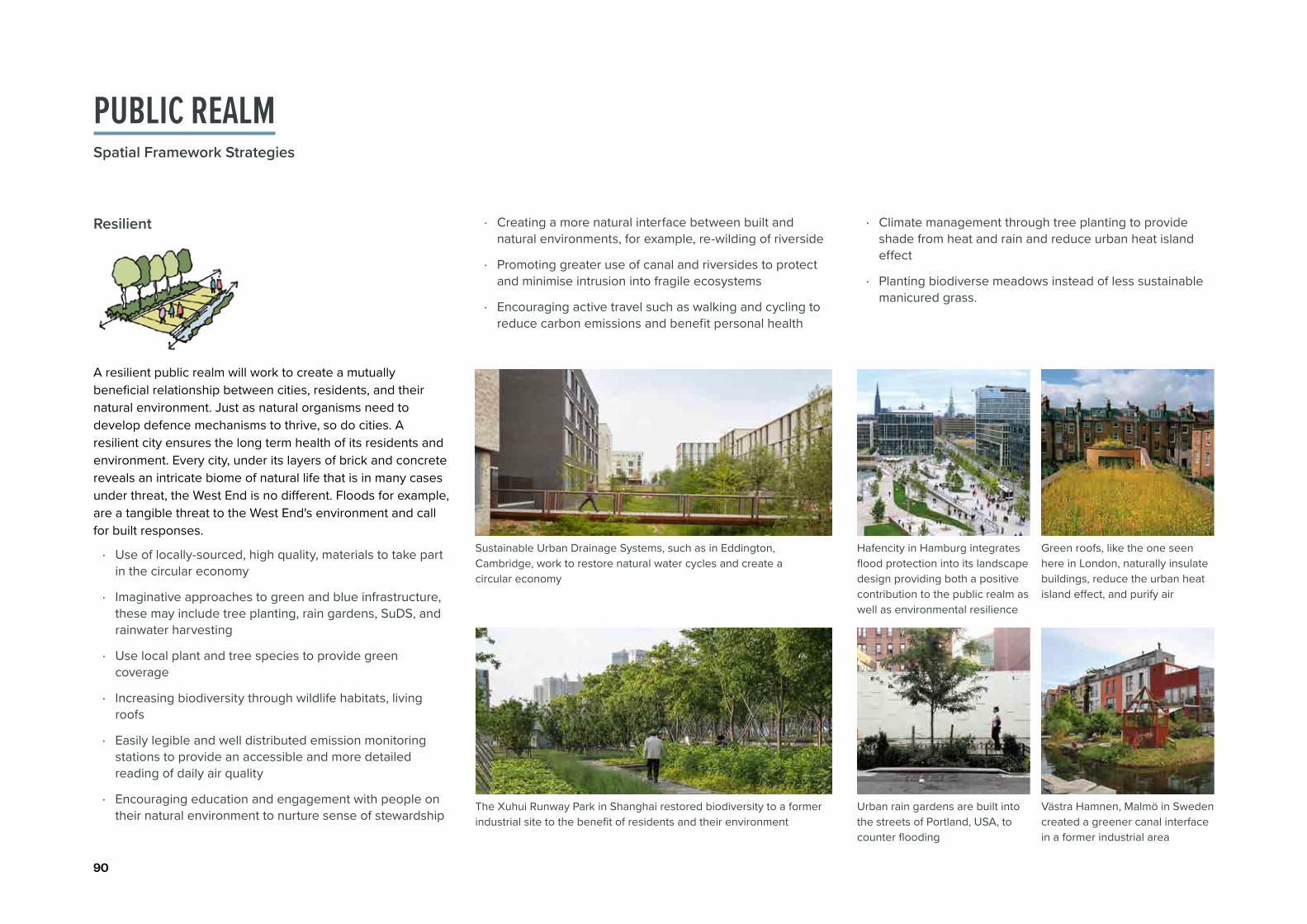
90
· Use of locally-sourced, high quality, materials to take part in the circular economy
· Imaginative approaches to green and blue infrastructure, these may include tree planting, rain gardens, SuDS, and rainwater harvesting
· Use local plant and tree species to provide green coverage
· Increasing biodiversity through wildlife habitats, living roofs
· Easily legible and well distributed emission monitoring stations to provide an accessible and more detailed reading of daily air quality
· Encouraging education and engagement with people on their natural environment to nurture sense of stewardship
A resilient public realm will work to create a mutually beneficial relationship between cities, residents, and their natural environment. Just as natural organisms need to develop defence mechanisms to thrive, so do cities. A resilient city ensures the long term health of its residents and environment. Every city, under its layers of brick and concrete reveals an intricate biome of natural life that is in many cases under threat, the West End is no different. Floods for example, are a tangible threat to the West End's environment and call for built responses.
The Xuhui Runway Park in Shanghai restored biodiversity to a former industrial site to the benefit of residents and their environment
Sustainable Urban Drainage Systems, such as in Eddington, Cambridge, work to restore natural water cycles and create a circular economy
Hafencity in Hamburg integrates flood protection into its landscape design providing both a positive contribution to the public realm as well as environmental resilience
Urban rain gardens are built into the streets of Portland, USA, to counter flooding
Green roofs, like the one seen here in London, naturally insulate buildings, reduce the urban heat island effect, and purify air
Västra Hamnen, Malmö in Sweden created a greener canal interface in a former industrial area
· Creating a more natural interface between built and natural environments, for example, re-wilding of riverside
· Promoting greater use of canal and riversides to protect and minimise intrusion into fragile ecosystems
· Encouraging active travel such as walking and cycling to reduce carbon emissions and benefit personal health
Resilient · Climate management through tree planting to provide shade from heat and rain and reduce urban heat island effect
· Planting biodiverse meadows instead of less sustainable manicured grass.
PUBLIC REALMSpatial Framework Strategies

91Oxford, West End Spatial Framework | Chapter 3. The Spatial Framework
Comfort is of great importance in the public realm as people will choose to spend time in a place in which they feel comfortable. Comfort is a concept that can be felt physically as well as psychologically which is why strategies around comfort are diverse and broad reaching. A comfortable place carries associations of safety from environmental threats, the ability to detach oneself from the bustle of urban life, senses of friendliness, and playfulness.
A junction in Seattle, USA, which includes accessible level street paving and traffic calming measures
Superkilen in Copenhagen is an example of a public space which encourages interactivity through street furniture and landscaping
La Rambla in Barcelona is one of the most famous examples of a pedestrian street with active ground floor uses throughout encouraging a range of activities and providing safety
Dongshan South Square Park, Guangzhou, is an urban space that provides comfortable seating and natural shade
City Thread in Chattanooga, USA, is an example of a lighthearted approach to public art that passers-by interact with as they navigate space
The King's Cross Square Lighting Project uses illumination to provide wayfinding, a safer and accessible space at night
Comfortable · Providing high quality public lighting to ensure safety and encourage night time activity (OCCAP, 2021, p. 92-93)
· Generous and regular safe road crossings
· Shared surfaces to provide a clear priority between pedestrians, cyclists, and cars
· Traffic calming measures to ensure safer streets while avoiding conflict including planting, street furniture, and surface treatments
· Active ground floor uses and building frontages to encourage use and provide safety
· Inclusive design that ensures equal access to people of all ages and abilities
· Prioritising the public transport and the needs of cyclists and pedestrians
· Reduction of unnecessary signs, posts, and advertisements causing street clutter; whilst ensuring legibility and wayfinding (OCCAP, 2021, p. 92-93)
· Shaded and sheltered areas for protection including integrated tree planting strategies
· Providing seating away from heat stress, heavy rainfall, noise and air pollution - to allow quiet relaxation.

92
· Supporting Economic activity across the West End through interventions that will help stimulate investment and create employment
· Building a degree of cultural and economic self-sufficiency and reduce reliance on external sources
· Publicly accessible service points able to accommodate a wide range of performance related events such as markets and performances
· Street furniture that can be re-instated, removed, and re-purposed allowing residents to choose how they use their space
· Temporary and changing public art to enliven and refresh already familiar spaces
Flexibility in the public realm opens it up and prepares it for spontaneous change, good and bad. Flexibility makes the built environment more dynamic and ultimately a more successful space as it can accommodate future change without significant redesign. Flexibility also protects spaces from long term structural or economic change, allowing changes of function to suit needs. Capability to capitalise on changing circumstances is greatly beneficial to the social and financial stability of a place. Flexibility at the day to day level is key in maintaining a space that is continuously engaging and interesting.
Gillett Square in Dalston, London, is a multi-functional community driven space where the activity of its users defines its function, from pop-up shops to performances
Knit the Bridge is a recurring community-led arts project that sees the community imprint its artistic expression on a public feature in a spontaneous way
Blue House Yard in Haringey provides maker spaces and public space, and retail space to enliven the community's small business-led economy
· Accommodating temporary uses and events without much disruption or additional cost
· Co-locate utilities in shared service areas to maximise public realm benefits
· Multi-functional spaces where future activities and opportunities can be planned
· Adaptability through all aspects of public space, built, social, and natural environments.
Railway arches in Deptford re-purposed into retail show how flexibility in the face of change can produce positive economic and social opportunities
Tandem Space in Madrid created multi-functional spaces in which the community manages and regulates energy usage
Flexible
PUBLIC REALMSpatial Framework Strategies

93Oxford, West End Spatial Framework | Chapter 3. The Spatial Framework
· Key roads in the West End, such as Botley Road and Oxpens Road, are busy and less than ideally suited for pedestrians and cyclists
· Using design and infrastructure measures to calm traffic at junctions to make them more pedestrian-friendly
· Legible routes with clear lines of sight and smart information points to assist in wayfinding
· A convenient place that encourages active transport, such as walking, cycling and public transport
· Accommodating digital connectivity and infrastructure in the public realm to help meet consumer demands for greater mobile connectivity and urban management
A connected public realm is what makes any urban activity function. Without it, there would be little character, enjoyment, or comfort. Connection is more than getting from A to B, it involves how the individual reads and navigates through their environment and the relationship between a place and the outside world. More tangibly, the problems of poor street safety, lack of cycling infrastructure, illegible streets, and inefficient public transport negatively affect urban connectivity. While many spaces in the West End have these characteristics, capitalising on the area's key opportunities will bring its residents closer to each other and their community.
This protected Cycle lane in Queens, USA, creates a safe environment for efficient bicycle commuting
Traffic Calming dots in Melbourne are an imaginative yet effective way of regulating vehicle speed and ensuring calmer and safer streets
The Umea Station of Being in Sweden uses smart systems to alert passengers of approaching buses with sound and light
This Public Information Point in New York City feeds the user real time information on transit as well as a legible street map
Bicycle Storage infrastructure makes everyday bicycle use more feasible and more secure
The Luchtsingel pedestrian bridge in Rotterdam connects formerly disconnected areas through a bridge which is an architectural statement in itself
· Using design and infrastructure measures to calm traffic at busy streets, such as Botley Road or Oxpens Road to make them more pedestrian-friendly
· Imaginative new links provide a once in a generation opportunity to improve linkages across disconnected landscapes, such as at Barrett and South Street in Osney Mead
· Public transport stops located at convenient and appropriate locations
· Following pedestrian desire lines as much as possible and avoiding cumbersome diversions.
Connected

94
1
3
2
4
Looking holistically at the public realm within the West End of Oxford is essential in fulfilling the Vision of the Spatial Framework - one which is a liveable place where people want to live, work and play. The West End has very limited public spaces and all sizeable spaces are concentrated to the east of the railway line.
The west of the railway line is limited to the constrained riverside edges and the green belt - two fantastic assets but more needs to be done to create established spaces for people to dwell, socialise and play in. This strategy seeks to create a series of interconnected public spaces which have different characters but all seek to be enjoyable, resilient, comfortable and flexible.
Interconnected public spaces to anchor future development
Humanising and greening major streets which are vehicle dominated
Improving and creating east-west connections which provide a good quality pedestrian experience from Osney Mead regeneration site to Oxford city centre
Improving public realm around the watercourses to create a destination
Improvement of wayfinding through design with the creation of gateway spaces
Public Realm which celebrates heritage assets
5
60 400200
m
Oxpens to city centre
Major streets to be greened
Existing public spaces
Station to Oxpens
St Thomas' Street
Osney Mead Regen. site Spine
Future public spaces
Extension of Woodins Way
Major streets to be greened
Proposed buildings
Listed Buildings
Gateway
5
5
4
3
2
2
1
6
Botley Rd
Oxpens RdFerr
y H
inks
ey R
d
St. Aldate's R
d
Cornm
arket St
Osney Mead Rd
Frideswide Square
Botley Park
Oatlands Road Recreation Ground
River Thames
Castle Mill Stream
Bulstake Stream
Grandpont Nature Park
Osney Cemetery
PUBLIC REALMSpatial Framework Strategies

95Oxford, West End Spatial Framework | Chapter 3. The Spatial Framework
Interconnected public spaces to anchor future development
1
Public space which provides seating, play, planting is essential for a health community
2
Surrounding a hard urban square, new and existing buildings are activated with non-residential uses and good quality public realm
Humanising and greening major streets which are vehicle dominated
With a significant amount of change happening within the West End, this provides an opportunity for a public realm and landscape led Spatial Framework which sets out the urban armature and allows development plots to work with it.
Existing public spaces are to be interconnected with new ones to create a set of public spaces which differ in character. Some to be at the heart of active uses of cafés, retail and leisure; others to be spaces defined by their innovative users; and some to have a more residential and community feel.
This strategy sets out a series of connected public spaces, each with their own purpose and response to the assets which currently or in the future will surround it. Encouraging cultural activity and street activities to help provide each space with their own feel and function; and is also outlined in Policy WE5 of the Area Action Plan (2008) shares.
In their current form, streets of Botley Road; Oxpens Road and St Aldate’s are dominated by vehicles; lack human scale; and provide a poor pedestrian and cyclist experience.
Streets are to be greened; footpaths and cycle routes to be widened and improved; and new active frontages to be sensitively designed.
Existing improvements to various streets are already happening under the Connecting Oxfordshire project. Currently Botley Road is already undergoing existing improvements which include bus priority measures, major cycle improvements, improved pedestrian provision and road surface repairs.
Carriageway of Oxpens Road to be narrowed and planting and widened footpath to be incorporated
Improving and creating east-west connections which provide a good quality pedestrian experience from Osney Mead Regeneration site to Oxford city centre
3
With increased connections, this significantly improves the physical linkages of Osney Mead to Oxford city centre. The experience of pedestrians and cyclists on these links are an essential component of the Public Realm Strategy.
Improvements of Woodins Way and the western extension of this route across the River Thames and into the existing EA depot site.

96
Improving public realm around the watercourses to create a destination
4
Significant investment in the public realm adjacent to the River Thames is needed to improve the perception of safety and attractiveness of the Thames pathway.
Public realm to incorporate interventions aimed at mitigating flood risk; creating a safer route for pedestrians and cyclists; and interconnecting the new bridge connections.
This includes creating a significant open space which runs to the north-east of the Osney Mead Regeneration site - to include spaces to play, grow food, play sport, dwell and socialise. Designing spaces which are multi-use and flexible will be crucial.
Public realm which is flexible and incorporates both hard and green characters
Routes with distinct character and opportunities to host seasonal activities (e.g. markets)
Pedestrian only routes that are green; have good lighting and development fronts onto them
Improvements from Osney Mead Regeneration site to Westgate shopping centre along the Oxpens Meadows and new bridge. This new route will be critical in connecting Osney Mead with the city centre and will connect up a series of key public spaces - Oxpens Meadows; Grandpont Nature Park; Oxpens new public square and the new improved river-front at Osney Mead regeneration site.
Both these connections present an opportunity to include a multitude of improvements:
· Public art interventions · Tree planting · Improved paving / surfacing · Improved lighting · New development which is able to provide a positive and
active edge onto route · Meanwhile uses - e.g markets, events.
Additionally, similar improvements should be made to the public realm by the northern section of Castle Mill Stream, located adjacent to Worcester car park. This would further the improvement of the station as a gateway, as it is part of the route between the station and city centre.
Public realm around the southern part of Castle Mill Stream has already been improved, incorporating lighting, seating and greening. This holistic development of activating the watercourses in the West End could significantly boost Oxford's riverside character and encourage more interaction with the riverside as well.
PUBLIC REALMSpatial Framework Strategies

97Oxford, West End Spatial Framework | Chapter 3. The Spatial Framework
5
6
A waterfront space with lots of seating and one which can be used flexibly
Flexibility in the public realm to host meanwhile art, events and gatherings
Incorporating play into wayfinding elements, creating a distinct feature in the public realm
Improvement of wayfinding through design with the creation of gateway spaces
Public Realm which celebrates heritage assets
Gateway spaces will be crucial in making new development sites more prominent, attracting activity and people to the space. This could be in the form of public spaces with temporary uses, significant structures/buildings and elements of play and wayfinding.
This would be especially important in guiding people into Osney Mead, where it is currently difficult to access and needs improvement in legibility.
Historic buildings and structures which were designed for a different purpose could be refurbished and reused. Creative solutions and innovative spaces which celebrate these assets are essential and will form part of the public realm network within the West End.
The Osney Mill Marina is a private marina along the River Thames. Routes along and across this setting into Osney Mead could be carefully designed with good lighting, linkages and spaces to pause for views across the river and towards the Mill.
Celebrating the historic context and creating spaces of appropriate scale for suitable activities

98
The above strategy looks at how principles for public realm and movement are applied at an Oxford West End scale. Here some consideration is given to particular interventions which are important in realising the wider vision and connectivity aspects of the Spatial Framework.
These are separated into:
· Routes · Exceptional public spaces · Key junctions.
Detailed design and technical work will need to be undertaken to understand the complexities of each intervention; and how different stakeholders can work together to prepare detailed designs, organise funding for short, medium and longer term projects and implement these interventions.
1
82
5
3
9
4
67
10
11
12
13
1
6
3
711
10 4
5
2
89
12
4
1
6
2
5
3
LIST OF PUBLIC REALM AND INFRASTRUCTURE INTERVENTIONSSpatial Framework Strategies

99Oxford, West End Spatial Framework | Chapter 3. The Spatial Framework
ROUT
ESREF LOCATION INTERVENTIONS POLICY AND DEVELOPMENT CONTEXT
1 Botley Road Segregated cycle route
Improved settings of bus stops
Improved pedestrian crossings (at Ferry Hinksey Road and Mill Street-Cripley Street) and widening footpaths
Improvements to the pedestrian/cycle connection under the railway line
Tree Planting - Continuing tree lined character of the western approach of Botley Road
Existing improvements are being made to provide better bus, cycle and pedestrian movement
Phase 2 of the station improves connection under the railway line - further improvements may be needed
2 Oxpens Road/ Hollybush Row/Thames Street
Trees, SuDS and planting from Frideswide Square to Castle Mill Stream
Narrowing vehicular carriageways
Provision of improved cycle lane
Proposals coming forward on Oxpens, College site to provide active ground floor uses/positive active ground floor uses/positive frontage
Improved pedestrian crossings and central reservation (connecting Oxpens/Castle Mill stream; crossing of Osney Lane; crossing of St Thomas’ Street) and widening footpaths
Masterplan for Oxpens is being developed which includes improvements to Oxpens RoadStreet identified as important in the OCCAP as an enabler to deliver the mixed use innovation district sustaining 12,400 new jobs by 2040 and be a key crossing point into the West End for Oxpens and Osney Mead developments (OCCAP 2021, p.132)
3 Hythe Bridge Street Narrowing vehicular carriageways
Segregated cycle route
Proposals coming forward on Nuffield and Beaver House to provide positive/active frontage
Introduce tree planting
Creation of a safe pedestrian crossings into Nuffield's new public square
Widening of footpaths
Masterplan for the Nuffield sites is being developed which includes improvements on both Hythe Bridge Street and Park End Street. Ambitions for Hythe Bridge Street and Park End Street to build upon pedestrian and cyclist improvements at Frideswide Square and to create new pedestrian and cycle links making up new key routes from Oxford Rail Station (OCCAP 2021, p.130-131)
4 Park End Street/ New Road
Improved cycleway
Widening of footpaths
Proposals coming forward on Nuffield site to provide positive/active frontage
Introduce tree planting
Improved settings of bus stops
5 Becket Street Street to celebrate and be sensitive to St Thomas Church and its setting
Retain and celebrate street trees
Proposals coming forward on car park site to provide positive/active frontage
Widening of footpaths and improved pedestrian crossings
Narrowing vehicular carriageways
Consideration of relationship with Osney Lane railway bridge
6 Woodins Way/Osney Lane and the western extension
Opportunity for public art interventions Opportunity for planting depending on scale of area
Improved lighting
Opportunity for regular events, such as markets
Proposals coming forward to provide positive/active frontage
Improved paving
7 Ferry Hinksey Road
Improvements in pedestrian crossings at junction with Botley Road
Improved signage of street at Botley Road
Consideration of the street's relationship with flood defence (OFAS)
Improved paving
Tree Planting
Improvements in street's relationship with West Oxford Primary School
Masterplan for Osney Mead regeneration site to include improvements to Ferry Hinksey Road as a key access route into the site
8 Mill Street into Osney Lock
Opening up of Osney Mill and Osney Lock to public as a welcoming route
Signage required to improve wayfinding
Tree planting
Car parking in Osney Mill area to be rationalised and minimised
9 Osney Mead Road
Trees, SuDS and planting which integrates with strategic blue infrastructure
Improved cycleway and widening of footpaths
Existing trees to be retained
Proposals coming forward on Osney Mead Regen. site to provide positive/active frontage
Masterplan for Osney Mead regeneration site to include design improvements for Osney Mead Road
10 Bulstake Stream Road
A new low grade street which is only for residents with accessibility needs, local businesses, deliveries and taxis
Better relationship with Bulstake Stream
Opportunity for food growing and play on the way
Proposals on Osney Mead regeneration. site provide opportunity to re-shape threshold with a positive interface along green belt edge
Masterplan for Osney Mead regeneration site to include technical survey, design and implementation strategy for this route
11 Green belt routes Works to ensure footpaths are safe and accessible and clear of fallen trees
Bridge improvements and new bridges Connections from existing network into new network at Osney Mead/Oxpens
Improvements to Willow walk and committed replacement bridge
OFAS maintenance track 12 Towpaths and
their linksWorks to ensure footpaths are safe and accessible and clear of fallen trees
Bridge improvements and new bridges
Character of towpath will be informed by surrounding context
Creating connections into new network created by proposals
Improvements to tow-path from Hythe Bridge Street to Iffley Lock
Gasworks and Pipe bridges are to be improved (scoping work has already been undertaken)
13 City College site Proposals for this site must improve pedestrian and cyclist connections from Osney Mead/Oxpens to the city centre
Proposals must link into to existing east-west connections - Woodins Way and Castle Mill Stream
Proposals must provide a positive and active frontage to Oxpens Road

100
EXCE
PTIO
NAL P
UBLIC
SPAC
ES
REF LOCATION INTERVENTIONS POLICY AND DEVELOPMENT CONTEXT1 Frideswide
SquareProposals of Nuffield College Sites to respond to scale of square
Improved pedestrian crossings which are legible
Rationalisation of bus movement through square
Mature tree planting which responds to scale of square
SuDS which integrate with strategic green-blue infrastructure
Implementation of a way-finding strategy
2 St Thomas Church Becket St Square
Creation of a square which frames the entrance to St Thomas' Church
Retention of mature trees
Improvements in the fencing of Street Thomas Church's setting
Proposals on Becket St (by the Nuffield College Sites masterplan) to frame new public square
Sensitive design which promotes walking and cycling and minimises vehicular usage - important to mitigate this as a congested route to Oxpens development site
Proposals coming forward for Becket Street car park as part of the masterplan for Oxford station
3 Oxpens Meadows
Safer pedestrian crossing across Oxpens Road from Castle Mill Stream to Oxpens Meadow
Routes through the meadows to link into the new Oxpens bridge
Proposals at Oxpens to provide a positive and active frontage to the green space
Promotion of active space on Oxpens Meadows - sports, recreation and play
Opportunity for the green space to have a better relationship with adjacent Castle Mill Stream
Masterplan for Oxpens is being developed which includes impact and interface of proposed buildings with Oxpens Meadow and a new public space design (Oxpens Heart)
4 Oxpens Heart Creation of a new public square at the heart of Oxpens masterplan
Ground floor uses that are active, inclusive and interactive
Interventions of an outside amphitheatre; water and water gardens
Focal points of height and interest to help way-finding and legibility
Proposals to work in line with proposed Oxpens Bridge
Sensitivity to preserve the heritage and community value of Oxpens Meadows and waterfront
5 Oxpens bridge southern landing point
Public realm improvements at the north of Grandpont Park to facilitate landing of Oxpens bridge
Public realm improvements to railway underpass to lead to key gateway of Osney Mead Regen. site.
Good cycle infrastructure to connect to National Cycle Route 5
Placemaking principles and spatial strategy objectives set out in this Spatial Framework to help inform public space design
6 West Oxford Community School Square
Creation of a gateway space to Osney Mead Regen. site which incorporates school, possible residential uses and other community uses
Linking into new riverside edge and existing bridge to Swan Street
Good quality public realm which provides a sense of arrival into the site
7 Osney Mead Regen. Site Community Heart
EA depot bridge to be publicly accessible (negotiations with EA authorities needed to understand their access requirements - possible relocation of the depot site along River Thames)
Proposals on Osney Mead to provide a positive and active frontage
Flexibility within public space
Tree, SuDS and planting which integrates with strategic green-blue infrastructure
Opportunities for food growing, play, recreation, entertainment space and exhibitions
9 Osney Mead Regen. Site Working Heart
Flexible space which can be used by surrounding employment uses - outside exhibitions; conferences
Proposals on Osney Mead to provide mixed use buildings which activate the space
Trees, SuDS and planting which integrates with strategic green-blue infrastructure
11 Osney Lock and surrounding green
Opening up of Osney Lock and central green island as additional natural amenity space for local communities
Celebration of heritage assets
Opportunity for food growing and community / education and learning projects
Encourage biodiversity through planting
New openable bridges to create a number of links and easier access through this island site
8 Osney Mead Regen. Site Riverfront
Vegetation of good value to be retained and incorporated public realm
Improved biodiversity
Well integrated pedestrian and cycle links
Opportunities for food growing, play, recreation and exhibitions
Proposals on Osney Mead to provide a positive and active frontage
Discussing design aspirations and redevelopment proposals with the Environmental Agency (who manages the River Thames) will be beneficial. Included in Policy SP1 (Local Plan 2036)
10 Osney Mill Square
Celebration of heritage of Osney Abbey
Tree planting
Re-configuration of surrounding uses to activate square
Improved lighting
Car parking in Osney Mill area to be rationalised and minimised
12 Osney Lane Square
A space which links people between the railway station, Osney Mead, Oxpens and city centre
Incorporation of square design with railway bridge
Emerging masterplan at Oxpens and at Becket Street car park (Oxford Station masterplan) to inform square design

101Oxford, West End Spatial Framework | Chapter 3. The Spatial Framework
JUNC
TIONS
REF LOCATION INTERVENTIONS POLICY AND DEVELOPMENT CONTEXT1 Botley Road/
Ferry Hinksey Road
Improvements in pedestrian crossings Improved signage to improve legibility Proposal at Osney Mead Regen. site to provide view of landmark or a gateway building
2 Eastern Frideswide Square
Vehicular movement between Hythe Bridge Street; Rewley Road; Park End Street; Hollybush Row to be rationalised
Improvements in pedestrian crossings Proposals coming forward on Nuffield College Sites to provide positive and active frontage; and an urban form/ mass which is sensitive and responds to the scale of the square
Masterplan for the Nuffield sites is being developed which looks at improving junctions
3 Hythe Bridge Street / Worcester Street / George Street
Rationalisation of how vehicles, cycles and pedestrians use junction
Proposals for a new active public square at Nuffield College Sites on Junction to help pedestrian and cycle movement
Sensitive design to historic wall and view of Nuffield College
4 Oxpens Meadows/Oxpens Road
Improvements in public realm which link Oxpens Meadows to existing crossing
Improvements to space surrounding the ice rink to provide active interface to space that leads to public square in Oxpens
Improved signage and wayfinding for measures to guide pedestrians and cyclists through and beyond the site and onto Oxpens bridge
Masterplan for the Oxpens site is being developed which looks at improving junction
5 Speedwell Street / Thames Street
Rationalisation of how vehicles, cycles and pedestrians use junction
Opportunity to improve Cycle Route 5 and it's relationship with the junction
6 Thames Steet / St Aldate's
Rationalisation of how vehicles, cycles and pedestrians use junction
Improved signage and wayfing measures to guide flows towards Oxford Centre and the West End
The OCCAP (2021 p. 118-119) identifies this junction as a major gateway into the city centre and highlights the need to review its scale, public realm and the potential for Speedwell Street to be a strategic bus and coach hub

102
SUMMARY OF KEY DELIVERY PRIORITIESCore Strategies
Green and Blue Landscape Strategy
1. Establishing the green and blue network on Osney MeadEstablishing the green and blue network on Osney Mead is a key infrastructural priority which aims to introduce significant green and blue elements to Osney Mead's existing routes. This will need to precede comprehensive redevelopment and offer both immediate environmental and flood defence benefits and long term benefits in opening the site up for potential redevelopment.
Green and blue infrastructure must consider being highly effective in flood mitigation, promoting and protecting ecology and providing amenity space for communities using the site. Designs must consider work on the Oxford Flood Alleviation Scheme (OFAS) and ongoing works to surrounding watercourses.
2. Opening up the Thames riverside and Osney LockOpening up the Thames riverside must have an integrated approach with the green and blue network of Osney Mead. There is opportunity for the Thames Riverside to be a key place of activity, biodiversity, flood mitigation, leisure and play. Works here must respond to changing character of the River Thames from the Thames at St Ebbs to the north at Osney; and the character of nearby Castle Mill Stream.
Discussions with stakeholders such as the Environmental Agency, Osney Lock Hydro and residents will needed to open up Osney Lock.
3. Urban greening along major routesOxpens Road, Ferry Hinksey Road and Botley Road significantly needed greening and movement rationalising. These streets and development sites off them will need to contribute positively to creating streets which prioritise pedestrian and cycle movement, foster biodiversity and activate the street frontage.
Key delivery priorities have been identified for the three Core Strategies. To ensure successful and comprehensive development which will be delivered over a long period of time, these key delivery priorities are essential to help unlock sites and projects within the West End.

103Oxford, West End Spatial Framework | Chapter 3. The Spatial Framework
Public Realm and Infrastructure strategyMovement Strategy
1. Railway station gatewayThe station gateway is the highest priority project for the Movement Strategy as its development holds implications throughout all of the West End's transport network; and strengthens it's importance as a regional transport hub.
It will be critical to address current deficiencies that the existing station provides. This includes poor east-west connectivity along Botley Road and wider networks; a poor sense of arrival; and a confused and an environment that doesn't prioritise pedestrians or cyclists. An improved gateway and linkages is critical. Connectivity and gateway of the station need to be carefully considered on the eastern and western side of the station. This will be especially significant to sites such as Osney Mead, Oxpens and Nuffield.
2. Oxpens bridgeThe Oxpens bridge is a key piece of movement infrastructure that will facilitate the development of a world class innovation district in both Osney Mead and Oxpens. This connection will work to connect these new developments to each other and to the city as a whole and bring value to the area around Grandpont Nature park. Consideration of how and where the bridge lands on both sides will need to be carefully considered.
3. Opening up of the EA depot and lockOsney Lock and the Thames riverside are great assets that are currently under utilised as movement routes. A significant connection between Osney Town and Osney Mead may be facilitated through the opening up of the EA depot to the public for walking and cycling. This will allow greater permeability into the Osney Mead site and better public access to the riverside. An emergency only vehicular access also could be considered.
4. Oxpens RoadWhile Oxpens Road is already a key transport link in the city, its improvement, especially for pedestrians and cyclists will be a critical goal. Oxpens road must be thought of holistically, from Frideswide Square to St Aldate's and options regarding tree planting, cycle infrastructure, a central reservation, safe crossings, frontages and swales must be considered.
1. Station gatewayThe station gateway aims to deliver a new and improved arrival into Oxford and signifies the West End. This project is set at the highest priority because of its aforementioned prominence as a transport gateway. A holistic vision will be needed for the station which include public realm improvements to all surrounding streets and spaces.
2. Oxpens RoadEstablishing a network of public space building off of the improvements to the station is similarly a significant infrastructure priority. This will allow the development of a consistent public realm experience from the station to the new developments at Oxpens and Osney Mead. Public realm connecting Oxpens and the adjacent Meadows to Westgate is also particularly important.
3. Becket Street linkImprovement to Becket Street will greatly improve the pedestrian experience from the station to Oxpens and Osney Mead. Last mile solutions to show how a fully integrated approach to sustainable travel can be achieved. Opportunities for improved accessibility & bus layovers should be fully explored. St Thomas the Martyr Church and it's setting will need to be sensitively considered.
4. South Frideswide Sq and Castle Mill streamPublic realm improvements along Hythe Bridge Street and Park End Street will be critical in unlocking the island site. Improvements to public realm also need to consider the station gateway and strategic route into the city centre.
5. Opening up the riversideOpening up the riverfront offers great potential to make the most of the West End's natural resources to create high quality public space. This involves opening up Oxpens meadow up to where the EA depot site. This will require significant stakeholder cooperation, therefore its application may be on the longer term.
6. Osney Mead riverside squareA new riverside square in Osney Mead will be integral to unlocking the site. Meanwhile uses during early phases of development may be used to activate the public realm and foster community support. Such inventive strategies can aid delivery.

104
Strat Key Priority Detail of Priority Indicative Infrastructure Cost (Investment Prospectus & Volterra report (2022)
Gre
en a
nd B
lue
Infra
stru
ctur
e
1. Establishing a green and blue network on Osney Mead
• New green and blue elements introduced to Osney Mead’s existing routes will need to precede comprehensive development and will work to unlock the site for development
• Green and blue infrastructure effective for flood mitigation, promoting biodiversity and amenity space
• Designs must consider works from the Oxford Flood Alleviation scheme (OFAS) and ongoing works to watercourses
• Osney Mead and Thames improved cycle paths - £4.9m – delivery 2021–23
2. Opening up the Thames riverside and Osney Lock
• Opportunity for the Thames riverside to be a key place of activity, biodiversity, flood mitigation, leisure and play
• Works must respond to the different characters present on the River Thames and the nearby Castle Mill Stream
3. Urban greening along major routes
• Greening and rationalising of movement on key roads such as Oxpens, Ferry Hinksey and Botley Road
• Ensuring streets and surrounding development sites contribute positively to active travel, biodiversity and active street frontages
Mov
emen
t
4. Railway station gateway
• Strengthening Oxford Railway station as a local and regional transport hub through public realm and infrastructure improvements
• Improving east-west connectivity to sites such as Osney Mead and Oxpens through pedestrian and cyclist prioritisation
• Creating a new sense of arrival at the station
• Oxford Station West side improvements - £80–160m
• Oxford Station East side improvements - £350-550m
• Connecting Oxford - £60-100m– new and improved bus services and associated bus and cycle infrastructure
• Becket St to Oxford railway station Rd pedestrian / cycle bridge - £10m-16m – delivery by 2028
• Cowley branch line reopening - £50–150m – required by 2028
5. Oxpens bridge
• Creating an important new connection between the developments at Osney Mead and Oxpens
• Improving access and improving value to the area around Grandpont Nature park, Thames riverside and the green belt
• Osney Mead to Oxpens pedestrian and cycle bridge - £6m – delivery in 2023
6. Opening up the EA depot & Osney Lock
• Improving public access to the River Thames
• Opening up key route through the EA depot connecting Osney Town and Osney Mead and introducing new permeability between the two banks of the river
• An element of West End public realm and movement interventions - £500k – to design and development of project proposals
7. Oxpens Road
• Interventions could include tree planting, cycle infrastructure, building frontages, swales, and a central reservation
• Oxpens road as a holistic site for delivery of infrastructure, from Frideswide Square to St Aldate’s
• Zero Emission Zone - £2m – delivery dependent on Connecting Oxon
• Connecting Oxford £60-100m – new and improved bus services and associated bus and cycle infrastructure
• An element of West End public realm and movement interventions - £500k – to design and development of project proposals
INDICATIVE INFRASTRUCTURE COSTS FOR KEY DELIVERY PRIORITIES
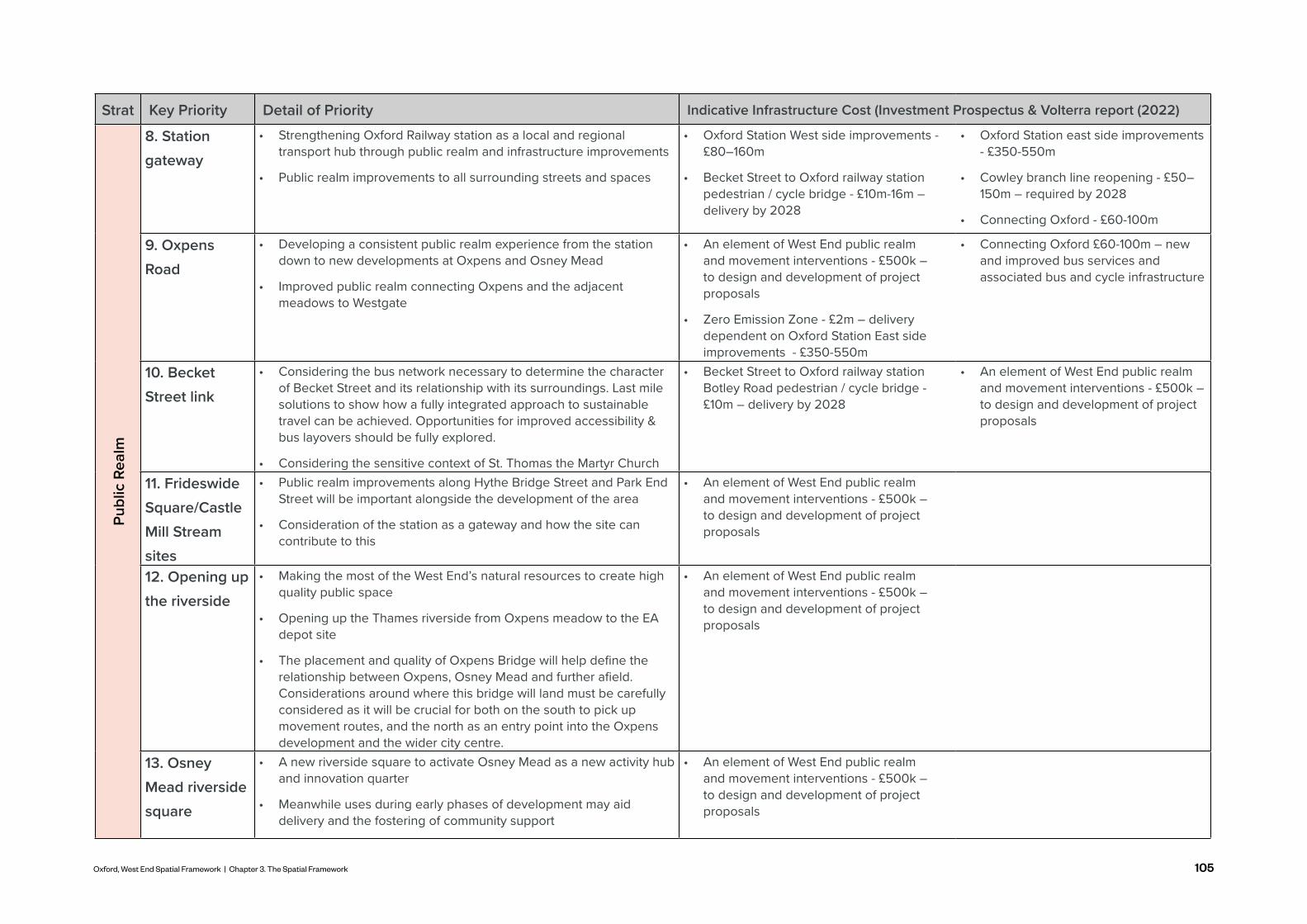
105Oxford, West End Spatial Framework | Chapter 3. The Spatial Framework
Strat Key Priority Detail of Priority Indicative Infrastructure Cost (Investment Prospectus & Volterra report (2022)Pu
blic
Rea
lm8. Station gateway
• Strengthening Oxford Railway station as a local and regional transport hub through public realm and infrastructure improvements
• Public realm improvements to all surrounding streets and spaces
• Oxford Station West side improvements - £80–160m
• Becket Street to Oxford railway station pedestrian / cycle bridge - £10m-16m – delivery by 2028
• Oxford Station east side improvements - £350-550m
• Cowley branch line reopening - £50–150m – required by 2028
• Connecting Oxford - £60-100m
9. Oxpens Road
• Developing a consistent public realm experience from the station down to new developments at Oxpens and Osney Mead
• Improved public realm connecting Oxpens and the adjacent meadows to Westgate
• An element of West End public realm and movement interventions - £500k – to design and development of project proposals
• Zero Emission Zone - £2m – delivery dependent on Oxford Station East side improvements - £350-550m
• Connecting Oxford £60-100m – new and improved bus services and associated bus and cycle infrastructure
10. Becket Street link
• Considering the bus network necessary to determine the character of Becket Street and its relationship with its surroundings. Last mile solutions to show how a fully integrated approach to sustainable travel can be achieved. Opportunities for improved accessibility & bus layovers should be fully explored.
• Considering the sensitive context of St. Thomas the Martyr Church
• Becket Street to Oxford railway station Botley Road pedestrian / cycle bridge - £10m – delivery by 2028
• An element of West End public realm and movement interventions - £500k – to design and development of project proposals
11. Frideswide Square/Castle Mill Stream sites
• Public realm improvements along Hythe Bridge Street and Park End Street will be important alongside the development of the area
• Consideration of the station as a gateway and how the site can contribute to this
• An element of West End public realm and movement interventions - £500k – to design and development of project proposals
12. Opening up the riverside
• Making the most of the West End’s natural resources to create high quality public space
• Opening up the Thames riverside from Oxpens meadow to the EA depot site
• The placement and quality of Oxpens Bridge will help define the relationship between Oxpens, Osney Mead and further afield. Considerations around where this bridge will land must be carefully considered as it will be crucial for both on the south to pick up movement routes, and the north as an entry point into the Oxpens development and the wider city centre.
• An element of West End public realm and movement interventions - £500k – to design and development of project proposals
13. Osney Mead riverside square
• A new riverside square to activate Osney Mead as a new activity hub and innovation quarter
• Meanwhile uses during early phases of development may aid delivery and the fostering of community support
• An element of West End public realm and movement interventions - £500k – to design and development of project proposals

106
HERITAGESpatial Framework Strategies
RETAINING AND RECYCLING THE
BUILT FORM KEY PRINCIPLES
HERITAGERetaining and reusing existing built form considering principles of a circular economy
Using the character of heritage assets to improve the sense of place
· Shared memories and heritage
· Attractiveness
Enhancing and conserving heritage assets and their settings through sensitive design and refurbishment and reuse
Using heritage assets as a wayfinding tool for people moving through the city of Oxford
· Short distance views
· Long distance views
· Marker buildings · A place to meet
and dwell
CELEBRATING DIVERSE HERITAGE
SENSE OF PLACE AND CHARACTER
HERITAGE FOR WAYFINDING
CONSERVING HERITAGE
Enhancing and opening heritage assets with improved settings - recognising the diversity of heritage within the city
· Educational · Manufacturing · Industrial
· Cultural · Birth of Oxford
The historical diversity across the West End must be recognised. The Spatial Framework seeks to both celebrate and conserve existing heritage assets; use them to anchor a sense of place and character; and be a key asset in wayfinding across and into the historic core of the city.
Oxford is an iconic place amongst the top rank of European cities, famous for learning, its green setting and its historic buildings and institutions.
The heritage is much more than these high-ranking assets, for it also includes local places, features and associations: minor buildings, paths and open spaces, viewpoints and events. This history and heritage is of significance for the local communities of people who live and work in the city and feel a sense of belonging and ownership, which is reinforced by the continuity of experience that the heritage provides.

107Oxford, West End Spatial Framework | Chapter 3. The Spatial Framework
1
3
2
4
Re-establishing the historic relationship of the River Thames and its heritage assets
Ensuring the protection of heritage assets from increased footfall and traffic - taking a holistic approach to connectivity
Improving public realm to celebrate key heritage assets
Ensuring short and long distance heritage views are maintained
Proposed heights need to be sensitive and respond to existing heritage assets
Creating a culture of reusing, recycling and retaining and promoting the principles of circular economy
5
6
Conservation Areas Scheduled monuments
Listed Buildings Public spaces key to protect heritage setting
Re-establish historic connection with River
Long distance viewing corridors and historic core
Moments of height which have key heritage value
Heritage streets to be maintained in character and not hindered by increased movement
1
2
6
23
3
3
4
4
FROM RALEIGH
PARK
FROM BOARS
HILL
Oxford Central Conservation Area
Osney Town Conservation Area
0 400200m
Frideswide Square
Botley Park
Oatlands Road Recreation Ground
River Thames
Castle Mill Stream
Bulstake Stream
A34
Grandpont Nature Park
Osney Cemetery

108
Re-establishing the historic relationship of the River Thames and its heritage assets
1
Opportunity for space adjacent to the watercourse which provides a place to dwell, planting and play
Opportunity for a modern extension to a heritage asset which rejuvenates it as an active use
With many development sites coming forward, there will be increased footfall through the West End - in the form of pedestrians, cyclists, buses and vehicles. However, the effect on existing streets and spaces which have a strong heritage and character value need to be mitigated.
This calls for a holistic Movement Strategy (p.68) which carefully balances footfall through the West End and creates new routes which relieve pressure on more constrained spaces. Furthermore, it requires strategic planning on where different modes of transport can go and what the quality of routes are.
This includes ensuring the following areas are protected:
· Osney Mead’s Bridge, East, West and South Street · Becket Street and the surroundings of St Thomas the
Martyr Church · Osney Mead’s Cemetery · Walking routes across the green belt to North Hinksey
village.
This protection of heritage assets is supported by Policy DH3 (Local Plan 2036) which values the importance of protecting heritage assets and their settings.
2
Historic photos of Osney Abbey cathedral and Osney Lock show their relationship with the River Thames
In the early development of Oxford, Osney Mead had a much closer relationship with the riverside and Osney Abbey provided a focal point for the area and city. Then from the 1800s, the River Thames became an important transport network for industrial uses. Now much of the area’s heritage turns its back on the River. Working with the sensitivities set out within the Osney Town Conservation Area, the Spatial Framework seeks to re-establish this historic relationship.
By opening up the remnants of Osney Abbey and Osney Mill Cottage with public realm improvements, new connections and activity along the riverside - this seeks to bring back the river back into the heart of the Conservation Area. Furthermore, the opening up of the EA depot and its bridge connection to the public would significantly improve accessibility from Bridge Street to the river.
Ensuring the protection of heritage assets from increased footfall and traffic - taking a holistic approach to connectivity
This strategy seeks to celebrate heritage assets within Osney Mead and re-establish the River Thames as a key component in the character of the area.
HERITAGESpatial Framework Strategies

109Oxford, West End Spatial Framework | Chapter 3. The Spatial Framework
The River Thames helps define the character of Osney Town Conservation Area
Osney Town Conservation Area is defined by tight streets, which have narrow footpaths, little or no front gardens and an intimate human scale
Opportunity for St Thomas Church to frame a key public space on the site of Becket Street car park
Opportunity to re-purpose a heritage asset as a community use with a modern extension
Activating an existing heritage asset with a meanwhile space and extension which houses a café and outdoor seating space
Many of the key heritage assets within the West End have poor settings which erode their community value. In conjunction with the Public Realm Strategy, the Heritage Strategy seeks to celebrate key assets with improved settings in line with Policy WE10 (Area Action Plan, 2008).This could include providing landscape improvements, places to sit and a strategy which allows people to learn about the rich heritage of various assets. Public realm improvements should be made at:
· Osney Abbey and Lock · St Thomas the Martyr’s Church · St Frideswide’s Church · Nuffield College Sites · Oxford Castle
3 Improving public realm to celebrate key heritage assets

110
Oxford’s Local Plan sets out the importance of protecting short and long distance views within Oxford (Policy DH2, Local Plan 2036). Oxford has a rich set of spires and moments of height, including at Nuffield College, the Castle Mound and Tom Tower at Christ Church College. These not only have heritage value but are important in navigating through the city and anchoring a sense of place for locals and visitors.
Long distance views also have navigational and heritage value. Of particular significance is the proposals for Osney Mead Industrial Estate and Oxpens; and their impact on the historic view from Raleigh Park. There is opportunity to design a sensitive roofscape and to have a strong landscape strategy. This is in line with Policy DH2 which states roofscapes of new development must be carefully considered and heights should ge nerally not exceed 18.2m within the Historic Core Area (Local Plan 2036).
The spire of Nuffield College and the Castle Mound can be seen from a number of points within the city centre
View of Oxford city centre from Raleigh Park
Being sensitive with building heights on development proposals in close proximity to heritage assets is essential
4 Ensuring short and long distance heritage views are maintained
5 Proposed heights need to be sensitive and respond to existing heritage assets
The built form within the West End is predominately 2-5 storeys and the Local Plan 2036 states that proposals should generally not exceed 18.2m within the Historic Core Area which covers most of the West End.
In addition to this, there are design considerations needed for particular heritage assets including:
· St Thomas's Church and proposals on Becket Street · Nuffield College and Castle Mound and proposals on
Nuffield College Sites · Christchurch Old Buildings and proposals on Osney Lane · Rewley Abbey Scheduled Monument and proposals on
Rewley Road Fire Station and Oxford Station depot site.
Osney Mead Regeneration site has few heritage assets on and therefore proposed heights and urban form will not need to respond to or take specific heritage assets into consideration. However, its massing and urban form will have an impact on long distance views, which will need to be taken into account.
HERITAGESpatial Framework Strategies

111Oxford, West End Spatial Framework | Chapter 3. The Spatial Framework
Creating a culture of reusing, recycling and retaining and promoting the principles of circular economy
6
With so many sites of opportunity identified, there will be a lot of new development within Oxford. However, many of these sites of opportunity include existing heritage assets on. The Heritage Strategy asks proposals to re-use, recycle or retain existing built form wherever possible and integrate this into the new urban fabric of the emerging new destinations.
This could be retaining a historic wall within a piece of public realm or re-using bricks from a demolished building within the public realm. This has benefits for carbon (embodied) as well as heritage.
Existing historic features could be re-used as a point of interest for a public space
Recycled building waste materials could be repurposed to create meanwhile/movable exhibition spaces within the public realm
New development could be made out of recycled concrete, re-purposed double glazing and discarded floor boards to promote circular economy principles
Adaptive reuse of old warehouses can provide unique living and work spaces

112
STRONG PARTNERSHIPS KEY
PRINCIPLES
ARTS AND CULTURE
Promoting a strong identity and sense of belonging through culture by creating a distinctive place which is animated and community driven
A culture of sharing allows for innovation, learning and chance encounters
Culture as an opportunity for regeneration and revitalisation. Cultural activity to kick-start economic development through:
· Increased footfall and creation of a new destination
· Improved perception of the area
· Programme of events
SUPPORTING DIVERSE CULTURAL
GROWTH
IDENTITY AND PRIDE OF PLACE
DRIVER OF ECONOMIC
DEVELOPMENT
A CULTURE OF SHARING AND INNOVATION
Creating a community led environment which is open and allows for creative development which encourages diverse culture and growth of skills
· Café culture · Public spaces · Libraries and
archives · Museums and
galleries
· Community spaces
· Active lifestyles · Intergenerational
activities
Strong partnerships with national and local stakeholders ensure delivery and vitality of culture within Oxford
· Public and private partnerships
· Arts council
· Youth groups
· Arts groups · Schools
· Community and Council led curation · Co-creation · Local training and upskilling · Connecting various age groups
through culture
· Public art · Public art programmes · Guaranteed funding mechanisms · Supporting creative economy · Meanwhile art to preserve/refurbish buildings
Oxford's Economic Draft Strategy (2022) highlights the importance of culture in embracing Oxford as a global city - one which capitalises on its already rich culture.
With COVID-19 having an adverse impact on culture - it is more important then ever to promote spaces for culture and creative energy to foster local community spirit and create opportunity for public participation in a city.
Culture and arts have a multitude of socio-economic benefits which are crucial in realising the Vision for Oxford. It provides an opportunity to improve the skills and diversity of the creative workforce and helps to foster social capital in the various destinations which attract locals and visitors. These principles underpin Policy WE24 (Area Action Plan, 2008) which seeks to promote cultural employment and attractions.
ARTS AND CULTURESpatial Framework Strategies

113Oxford, West End Spatial Framework | Chapter 3. The Spatial Framework
1
3
2
4
Allowing for space within the West End where culture can be produced and can thrive
Creation of a destination(s) in the West End where people can experience and share culture.
Promotion of cultural and arts activities in mixed use neighbourhoods
Utilising the public realm as a key space for culture with a programme of events
Celebrating the cultural heritage of the West End
5
44
5
5
5
1
1
2
0 400200m
10 mins.
5 mins.
4
3
0 400200m
Botley Rd
Oxpens RdFerr
y H
inks
ey R
d
St. Aldate's R
d
Cornm
arket St
Osney Mead Rd
Frideswide Square
Botley Park
Oatlands Road Recreation Ground
River Thames
Castle Mill Stream
Bulstake Stream
A34Grandpont Nature Park
Osney Cemetery
Christ Church Meadows and centre
Museums and Galleries
Theatres and Performance Spaces
Listed Buildings
Proposed Developments
Proposed Hard Public Space
Arts and Performance Hub
Castle and College Hub
Museum and Heritage Hub
Opportunities for new cultural hubs - Destination for the consumption and production of culture
University and Education
Osney Mead Opportunity Area

114
Allowing for space within the West End where culture can be produced and can thrive
1
Artist spaces such as a ceramics studio which encourage making and knowledge sharing could be accommodated within an existing industrial shed
2 Creation of a destination(s) in the West End where people can experience and share culture
A mix of cultural and leisure uses coming together with high quality public realm creates a vibrant place
Creation of affordable space within the West End where cultural stakeholders can work together to innovate, create and produce. Through co-creation and collaboration, existing and new stakeholders provide an exciting opportunity for different disciplines to come together, including science, fine art, conservation, performance arts, education, technology etc.
This could be within new mixed use buildings or within existing buildings which are repurposed for other mixed functions. The latter could include under-utilised spaces within Osney Mead’s Industrial Estate and within vacant shop units within the city centre. Cultural uses could include:
· Creative workspaces · Rehearsal studios · Recording studios
· Production studios · Artist and maker spaces.
3
The redevelopment of Osney Mead and Oxpens with comprehensive masterplans provide the opportunity to strategically make a destination for culture within the West End. Easily accessible uses - by walking, cycling or public transport - which add to and enhance the social and cultural scene of the city are encouraged (Policy V6, Local Plan 2036). This includes providing spaces such as:
· Cinemas · Sports and leisure venues · Galleries and museums · Heritage buildings
Promotion of cultural and arts activities in mixed use neighbourhoods
· Performance venues · Libraries · Community spaces.
Promotion of cultural uses as part of mixed use buildings will be essential in the creation of a vibrant West End. Mixing cultural and arts uses with residential and workspace will be particularly important in realising the vision of a place to live, work and play. (OCCAP, 2021, p.72-73).
Opportunity for library spaces and places to share knowledge
Floating performance spaces activate the water's edge
Reusing historic buildings and re-purposing for creative uses
Exploration of different funding opportunities will need to be explored in the creation of new cultural hubs (OCAAP, 2021).
ARTS AND CULTURESpatial Framework Strategies

115Oxford, West End Spatial Framework | Chapter 3. The Spatial Framework
Opportunity to mix uses of co-working space and leisure uses of a rock-climbing gym
Utilising the public realm as a key space for culture with a programme of events
Derelict and underutilised space under an elevated freeway is now an activated space with a film studio
4
Existing and proposed public spaces provide a real opportunity to share, produce and experience culture. As set out within the Public Realm Strategy, a series of existing and new public spaces can be utilised for cultural purposes.
Important epicentres of culture are to include the waterfront square in Osney Mead and the area surrounding Oxpens Meadow. Linking this activity with the local stakeholders of education, innovation, creative industries and community will be essential.
Both permanent and temporary public realm interventions could help to activate the space with culture. Permanent interventions such as outside amphitheatres, artwork and locally curated community led projects. A programme of events is also essential - this could include temporary exhibition spaces, local performances and pop-up cinemas.
Temporary exhibition space could feature art exhibitions outside
Pop-up events, such as outdoor cinemas, can utilise public realm
Celebrating the cultural heritage of the West End
As dealt with in the Heritage Strategy, there is lots of heritage to celebrate within the West End, especially around Osney Lock. By re-opening the riverside up and the heritage buildings around Osney Lock - there is an opportunity to celebrate this heritage as part of the cultural strategy. To be a place where the community can share and learn about the cultural heritage of the site.
Providing heritage buildings with the appropriate setting celebrates it and lets locals and visitors learn about the cultural heritage of the place
5

116
The West End of Oxford has plenty of vacant and under-utilised land and buildings which could be re-purposed as meanwhile spaces/uses to help stimulate activity and change perceptions of some neighbourhoods. The Spatial Framework identifies some key opportunities to help unlock sites, create better footfall through and to areas and attract investment in strategic locations.
Ultimately the strategy seeks to generate social value, resilience and create a long legacy for the area.
STRONG PARTNERSHIPS KEY
PRINCIPLES
MEANWHILE USES
A collaborative approach is required between public and private partners which allows for a holistic vision to be implemented. Timing of interventions will be essential Opportunity for meanwhile
uses to tackle contextual problems within the West End
· Training and skills opportunities
· Collaboration with local stakeholders
· Co-creation opportunities
· Lack of connectivity
· Flooding · Climate change · Pandemic · Lack of social
cohesion · Food insecurity · Poor housing
affordability and quality
· Subsidise local artists/ community groups to enable occupation and stimulus
· Improve linkages and frontages along key streets to enable footfall
· Put an area/ place on the map
Activation of space with the aim of changing perceptions, bringing new users to the area and making derelict or unloved spaces better used and safe for the communities
COMMUNITY LED
CATALYSTS FOR CHANGE
GENERATING ACTIVATION
CHANGING PERCEPTIONS
Opportunity to put the community at the heart of decision making of purpose, design and delivery of meanwhile uses
Opportunity to use meanwhile uses as a tool to change perceptions of an area
· Perception of priority (turning a congested street into a pedestrian priority one
· Perception of safety · Perception of activation
(bringing internal activity outdoors)
· Perception of innovation (highlighting the benefits of businesses locating in the West End
MEANWHILE USESSpatial Framework Strategies

117Oxford, West End Spatial Framework | Chapter 3. The Spatial Framework
1
3
2
4
Improving existing and creating new connections and promoting active travel
Creating new hubs of activity
Meanwhile uses which seek to aid developing and fostering a new community
Re-using and re-purposing existing urban form
Makespace Oxford provides Co-working Space in an unoccupied buildings
The Covered Market hosts Pop-up food and drink stalls
LEO Project providing community organised green energy
Osney Mead Regeneration Site provides major opportunity for meanwhile uses
Community designed landscaping at Broad Meadows
Dis-occupied or underutilised buildings
Areas for potential future meanwhile uses
New developments
Potential for temporary bridge connections
Opportunity for interventions on Woodins Way
Opportunity to re-use vacant shops along High Street with Meanwhile Uses
3 3
3
2
22 4
1
1
1
1
0 400200m
Botley Rd
Oxpens RdFerr
y H
inks
ey R
d
St. Aldate's R
d
Cornm
arket St
Botley Park
Oatlands Road Recreation Ground
River Thames
Castle Mill Stream
Bulstake Stream
A34Grandpont Nature Park
Osney Cemetery
4
Woodins Way

118
Improving existing and creating new connections and promoting active travel
1
Temporary bridges which cross the key severances within the site can be a destination and a means to move of movement
2
Opportunity for a piece of underused hard standing to be transformed with affordable studio spaces for local artists
Along with improved routes, cycle parking, benches and park-lets can also be placed to encourage people to walk and cycle through the city.
Low cost artwork can promote safety, encourage walking and cycling and bring joy to visitors and locals
A place to park a bike or sit will be really important in encouraging active travel within the West End
Creating new hubs of activity
As stated within the Movement Strategy, there is great opportunity to improve connections and active travel within the West End and to surrounding areas. Meanwhile uses are to play a key role in this.
There is opportunity for a temporary bridge(s) which could cross the area's watercourses at a number of points, as described within the Movement Strategy.
Meanwhile art could also be used to improve the attractiveness, legibility and perception of safety of many existing routes within the West End. Coordinating with local art and community groups to facilitate this would further generate social value. This could include the east-west route of Woodins Way; key crossings at Oxpens and Botley Road; including the Botley Road underpass.
With many under-utilised sites and development sites coming forward at different stages, there is a huge opportunity to generate hubs of activity across the West End and provide businesses and local creatives with subsidised, low cost space. This could include providing:
· Local artists - studio and performance spaces · Local groups - community spaces · Local homeless charities - temporary housing · Local business owners - food and drink outlets · Local historians and cultural users - exhibition space · Local sports and leisure groups - space.
These could be accommodated in particular on locations within Osney Mead Industrial Estate; Oxpens; under the underpass of the railway line; or within any of the Sites of Opportunity whilst new development comes forward.
MEANWHILE USESSpatial Framework Strategies

119Oxford, West End Spatial Framework | Chapter 3. The Spatial Framework
3
Opportunity for a piece of underused hard standing to be transformed into a food and drink destination
Meanwhile uses which seek to aid developing and fostering a new community
Canal and barges used as performance space or commercial units can activate previously underused space
Opportunity for local sports and community groups to utilise the river offering activation
Opportunity for community led food growing in under-utilised spaces
Playful art installations can activate the space and be used as a form of community engagement for regeneration
Meanwhile uses can have a very important role in fostering a sense of community whilst early housing and employment space is being established. Key events and spaces can bring together existing and new residents, workers and visitors together.
It is essential that the community is involved and takes ownership of the process and development of these meanwhile uses. Co - creation and collaborative methods for design and management should be established in early stages to make these initiatives truly successful.
This could be accommodated in particular on locations within Osney Mead Industrial Estate; Oxpens; under the underpass of the railway line; or within any of the Sites of Opportunity whilst new development comes forward.

120
Re-using and re-purposing existing urban form
Utilising an empty piece of hardstanding as a skateboard park
Utilising a closed street for community classes such as yoga
Rooftops of existing buildings could be utilised for food growing
Existing industrial sheds could be transformed at low cost into co-working spaces for small businesses
4
With lots of existing buildings within Sites of Opportunity and Development Sites, there is a real opportunity to re-use and re-purpose some of these buildings in the short and medium term.
This is essential in realising the sustainability agenda and fostering a sense of activity and community within the West End. This could include transforming industrial sheds into incubator space; or utilising rooftops for food growing, bee keeping or other uses.
There is a plethora of existing opportunity within Osney Mead Industrial Estate - with many buildings already sitting unoccupied. Other Sites of Opportunity also provide opportunity to enhance local skills and training for the local communities.
Existing industrial sheds could be used for food markets and music events
MEANWHILE USESSpatial Framework Strategies

121Oxford, West End Spatial Framework | Chapter 3. The Spatial Framework
Location: Rotterdam, Netherlands
Year Completed: 2015
Who: ZUS Architects
The Luchstingel pedestrian bridge is a crowd-funded piece of public infrastructure which connects historically disjointed parts of the city. The scheme is one of the first of its kind that uses public funding and ambition to deliver an infrastructure led regeneration scheme. The Luchtsingel combines a new key pedestrian link with a playful community oriented space. The bridge was first developed on the concept of 'permanent temporality' which uses the character of the city as the starting point for design before transitioning into permanent space.
The Brentford Project in West London exemplifies public realm regeneration through temporary artistic spaces and installation. In 2019 an artist was commissioned to transform a formerly disused industrial road into a dynamic and vibrant linear public space. The road, painted completely in blue, takes inspiration from the Brentford flood of 1841 and aims to connect the high street to the waterside. The road has also been designated as a space for meanwhile uses, from food trucks to car shows. The simple art installation at the Brentford Project in effect creates a dynamic and vibrant space in which users are drawn and can enjoy changing activities.
Location: Brentford, UK
Year Completed: 2019
Who: Huw Morgan and Ballymore Developers
Luchtsingel Brentford Project
MEANWHILE USES: CASE STUDIESSpatial Framework Strategies

122
Building heights within Oxford's West End need to be strategically and sensitively designed to: i) respond to viewing cones and heritage assets (Policy DH1, Local Plan 2036) and; ii) allow for moments of heights which provide a quantum of development space and are key marker buildings enhancing legibility and enabling wayfinding through the neighbourhoods in the West End.
SENSITIVITY TO HERITAGE ASSETS KEY
PRINCIPLES
BUILDING HEIGHTS
Sensitivity required in how new development responds to existing heritage assets - height, mass, proportions and urban form.
Opportunity to improve long distance views with improved roof-scape, urban greening approach in key areas of conflict and sensitive massing
Moments of heights should occur at strategic points to aid legibility, way-finding and create areas of focus to achieve a sense of place
MEDIUM HEIGHT NEIGHBOURHOODS
STRATEGIC PLACES OF HEIGHT
HEIGHT AS MARKER BUILDINGS
SENSITIVITY OF VIEWING CORRIDORS
New proposals and masterplans in the West End to be developed as medium rise mixed use neighbourhoods which are limited in height
Achieving the quantity of floorspace needed by strategically increasing height in less sensitive areas
BUILDING HEIGHTSSpatial Framework Strategies

123Oxford, West End Spatial Framework | Chapter 3. The Spatial Framework
1
3
2
4
Celebrating the West End’s existing points of height, and strategically adding more
Enhancing the long distance views by improving the roofscape and form of the West End
Ensuring height of new development is informed by immediate surroundings
Building heights and massing must respond to existing heritage assets
Balance of new development with spaces in-between buildings 5
22
5
4
4
4
4Botley Rd
Oxpens Rd
Ferr
y H
inks
ey R
d
St. Aldate's R
d
Cornm
arket St
Osney Mead Rd
Frideswide Square
Botley Park
Oatlands Road Recreation Ground
River Thames
Castle Mill Stream
Bulstake Stream
A34Grandpont Nature Park
Osney Cemetery
From Raleigh Park
From Boars Hill
Historic Core Area and long Distance Views
5+ storeys (existing)
Medium density
3-4 storeys (existing)
High density
1-2 storeys (existing)
Maximum density
Key sensitive views to heritage buildings

124
1. Celebrating the West End’s existing points of height, and strategically adding more1
Existing points of heights such as Nuffield College, the Castle mound and chimney of the former Morrell's Brewing Company
32 Enhancing the long distance views by improving the roofscape and form of the West End
A tall piece of public art which is at a key intersection of views aids wayfinding and establishes a sense of place
Green roofs, mature trees and varied built form provide an interesting and attractive roofscape
Ensuring height of new development is informed by immediate surroundings
The West End of Oxford has multiple towers and spires which when moving through the city are key wayfinding markers to navigate by and anchor a sense of place for people. These can be seen at Nuffield College, Saïd Business School, Christ Church College and Carfax Tower.
New development within the West End must ensure street-views to these moments of heights are protected and enhanced. Additional moments of height could be created within the neighbourhoods, these should be located in strategic areas within the new masterplans - in the form of mixed use buildings, a piece of public art/sculpture, a pavilion or a viewing tower. Ideal locations for these would be:
· Key gateways - Eastern and western gateway of Osney Mead; framing Frideswide Square; Railway station
· Key hubs of activity within Osney Mead, Oxpens and other sizeable development sites.
Height of proposed development must respond to its immediate context. Within the West End and the adjacent areas, there is a significant amount of open space in the form of the green belt, parks, the marina and watercourses. Also streets such as Oxpens Road and Botley Road are wide.
Development facing onto these open spaces and wide streets, provide an opportunity to have points of height which maximise views; provide more floorspace and create a good sense of enclosure.
The stipulated maximum heights and parameters recommended for new development within the West End sits at 15 -18m (Oxford High Buildings, TAN 2018). However, high
At present, the sites of Osney Mead Industrial Estate; Oxpens and the station all provide roofscapes that could be improved - currently the sites have large amounts of hard standing; large flat roofs and little landscaping.
This Strategy seeks to improve the articulation of the roofscape, provide green roofs, enhance visual diversity and create a green and varied roofscape. This would also provide the opportunity to activate roofs by creating usable amenity space and taking advantage of great views across the green belt.
BUILDING HEIGHTSSpatial Framework Strategies

125Oxford, West End Spatial Framework | Chapter 3. The Spatial Framework
4
Being sensitive with building heights on development proposals in close proximity to heritage assets is essential
In a medium rise neighbourhood, this courtyard provides a good sense of scale for the user - providing a comfortable space
Building heights and massing must respond to existing heritage assets
Development facing onto a river and open space has the opportunity of taking advantage of good views and provides a strong urban edge
Adding moments of height at key junctions, with large street widths, creates enclosure and enhances legibility for the user
As set out within the heritage strategy, there are many Listed Buildings; Conservation Areas and Scheduled Monuments within the West End. Development proposals must respond sensitively to these. These must be considered in terms of sight lines; character; attractiveness, desire lines and changes in footfall.
Of particular importance within the West End, key design consideration must be given to:
· The relationship between St Thomas the Martyr Church and Vicarage and development on Beckett Street car park and on the eastern side of Beckett Street
· The relationship between the Nuffield College Sites and Nuffield College, Oxford Castle, Cooper’s Marmalade Factory and Oxford Central Conservation Area.
· The relationship between Osney Mead regeneration site and Osney Town Conservation Area The relationship between development at Speedwell House/Court buildings Oxford Central Conservation Area.
5 Balance of new development with spaces in-between buildings
To create vibrant mixed use places for living, working and playing the spaces in between the buildings. Public open space should be provided in the form of a diverse range of typologies - parks, plazas, sports and recreation, play, food growing opportunities, wild flower gardens; and private or semi-private space in internal courtyards, balconies and private gardens.
These spaces need to be provided in balance with built form. The sense of enclosure created by buildings and spaces will aid creating a comfortable and legible environment. Daylight, overshadowing, microclimate, and wind levels should be key considerations in the design process.
buildings that help articulate the silhouette of the city and add interest and diversity are encouraged provided they do not conflict with the surrounding context or appear incoherent. (Oxford High Buildings, TAN 2018)

126
With so many sites up for development, the make-up of the West End is subject to change within the coming years. This includes new buildings, increase in population in the area, new land uses, activities, routes, public realm elements and green spaces.
The Local Plan 2036 sets this out and under different site allocations provides minimum housing requirements which respond to the existing and future needs of the area in the context of each site. Within the scope of the West End a number of sites are relevant:
· Osney Mead Innovation Quarter (SP2): Mixed use development (to include employment; academic; student accommodation; employer-linked affordable housing; market housing (expected to deliver around 247 homes)
· Old Power Station (SP48): No housing requirement from Local Plan. Employer linked affordable housing can be integrated into site.
· Oxpens (SP1): Minimum 450 homes · Oxford Station and Becket Street Car Park (SP1):
Minimum 20 homes · Student Castle, Osney Lane (SP1): Minimum 206 homes -
already built · Island site (SP1): Minimum 40 homes · Worcester Street Car Park (SP1): Minimum 18 homes · Faculty of Music (SP36): Minimum 40 homes
In practice, and subject to viability, many of these sites may be able to take more housing which will bring vibrancy to the areas. Ultimately, Oxford's West End is looking at a significant influx of homes in the coming decades and those need to be designed carefully with other uses.
The housing requirements set by the Local Plan 2036 is a direct response to Oxford's urgent need for more homes as a response to the city's housing supply crisis. The details of Oxford's housing need, in which the Local Plan's housing requirements are set from, can be found in the Oxfordshire Strategic Housing Market Assessment (SHMA).
Housing delivery holds far reaching implications having impacts to the city's economic, environmental, and social health. Economically, housing provision attracts and retains people to support the economy. Socially, it prevents the disconnection of social networks caused by housing unaffordability and environmentally lessens the impact of commuting.
Proposals will need to be cognisant of viability, land acquisition, market demand and public sector ability to manage spaces.
The Oxford Economic Draft Strategy (2022) aims to create more commercial spaces which enable innovation and creativity; generate vibrancy within the city centre; and enhance Oxford's already significant visitor economy.
The West End Investment Prospectus Draft (2022) echoes this and envisions the West End as a location where workspaces of different sizes, scale and price-points are homed. This will create new well paid jobs, more effective supply chain opportunities and better access to workspaces for local communities on their doorstep.
This provides an excellent opportunity to shape the activities of the West End going forward. Looking holistically at this strategy allows each development site to provide uses which complement each-other and seeks to foster a culture of collaboration, innovation and connect existing and future residents to local opportunities of work and play. This is echoed within Oxford's Economic Draft Strategy (2022) which seeks to create an inclusive city which supports local businesses and organisations with improved connectivity, funding and delivery of suitable workspace and homes.
Sites must also comply with the guidance set in the West End Design Guide. The guide specifies several relevant pieces of guidance which emerging developments should follow.
DEVELOPMENTS AND LAND USE DISTRIBUTIONSpatial Framework Strategies

127Oxford, West End Spatial Framework | Chapter 3. The Spatial Framework
LIFECYCLE OF BUILDINGS
KEY PRINCIPLES
EMERGING DEVELOPMENTS AND LAND USE DISTRIBUTION
Where possible, ensuring buildings are part of the circular economy - construction methods which reuse and recycle materials; and share energy and other resources
Buildings and spaces should be designed with flexibility and adaptability in mind - to accommodate multiple functions and users in the short, medium and long term
Using typologies which combine a multitude of uses and are cleverly designed to activate the public realm. The internal world of the urban block must also serve the workers or residents effectively
ACTIVITY HUBS - INGREDIENTS FOR
SUCCESS
MIXED USE NEIGHBOURHOODS
INNOVATIVE URBAN TYPOLOGIES
FLEXIBILITY AND ADAPTABILITY
Creation of vibrant activity hubs which have an intensity of uses and are served by good connections. Creating 24-hour economies will be important
Land use distribution which ensures places have everything within a short walking distance from one's home; like the 15-minute city model. A balanced mix of housing and other non-residential functions is critical

128
Site to come forward in the short, medium and long term
Footprints of developing masterplans
Existing public spaces
Future public spaces
32
4
1
5
6
8
7
10
11
12
13
14
15
16
1718
1920 21
9
24
0 400200m
22231 Osney Mead
regeneration Site
13
Abbey Road and Cripley Place14
Oxford Railway Station Depot15
Rewley Road Fire Station
16
Botley Road Retail Park17
Oxfordshire County Hall
18
Magistrates' Court, County Court and Telephone Exchange
19
Speedwell House20
Faculty of Music21
Odeon Cinema22
New Theatre23
24 Police Station
4 Becket Street Car Park
5 Oxford Station
6 Frideswide Square and Castle Mill Stream Quarter (Nuffield College Sites)
7 Beaver House
8
9
Osney Lane
SAID Business School
10 Richard Gray Court and Royal Mail Delivery Office
Ice Rink11
City of Oxford College, Employment and Homes
12
1-17 Botley Road3 Oxpens
2 Gibbs Crescent Botley Rd
Oxpens RdFerr
y H
inks
ey R
d
St. Aldate's R
d
Cornm
arket St
Osney Mead Rd
Botley Park
Oatlands Road Recreation Ground
River Thames
Castle Mill Stream
Bulstake Stream
Grandpont Nature Park
Osney Cemetery
With lots of sites coming up for development in the short, medium and long term - there lies a real opportunity here to enhance existing neighbourhoods, their activity hubs and create complementary new hubs and destinations that connect well within the existing setting, both spatially and in terms of the mix of opportunities they offer.
EMERGING DEVELOPMENTSSpatial Framework Strategies

129Oxford, West End Spatial Framework | Chapter 3. The Spatial Framework
1
2
43Osney Mead regeneration site
Osney Mead regeneration site is outlined in the Local Plan 2036 for mixed use development under Policy SP2. A holistic approach needs to be undertaken to ensure within the process of long term comprehensive development that collaboration of different land-owners and existing businesses on the Industrial Estate. This is ever more important due to its challenging constraints which include: flooding; utilities infrastructure; lack of existing connections; and a fragmented land ownership.
As the Local Plan states, the site should have a range of uses on: employment, academic, student accommodation, employer-linked affordable housing and market housing. To create a vibrant community, a diverse mix of uses are needed - securing it as a destination to work, live and play in Oxford's West End.
Further in this document, a set of overarching principles for development on Osney Mead have been set out through a Spatial Strategy. The strategy will need to be assessed against thorough site analysis, technical surveys and viability testing at future masterplanning stages.
Gibbs Crescent This is a residential scheme providing 140 homes in a mix of 1-3 bedroom flats. Currently an isolated site, the new proposed connections will knit it into the West End and create a better synergy with neighbouring Osney Mead and Oxpens.
Oxpens
Oxpens is a joint venture between Oxford City Council and Nuffield College. It is a strategic site which sits where the city meets the green and it aims to be a place in the city where people can live, work and play. A new central square and bridge within the masterplan ensures a strong connection from Oxpens to Osney Mead regeneration site and the wider green network. The emerging masterplan will need to ensure it deals with flood risk and the potential impact on the skyline.
Flexibility in land use types within the masterplan is very important with an evolving market. However, EIA testing has suggested the following uses for the site.
Becket Street car parkBecket Street car park will play a critical role in creating a strong sense of arrival into Oxford. Proposals on here will need to shape the station gateway. Facing the station entrance could be an ideal location for an active use, such as cafés, restaurant, retail or services. Land uses, the movement strategy and built form will need to sensitively frame the Grade II listed St Thomas Church.
The street offers a direct link to the Oxpens site further south, the route should feel animated and pleasant for pedestrians and cyclists to make way towards Oxpens and areas further south (Ice Rink and Westgate Shopping Centre).
Indicative Land Use Quantum• Residential (C2, C3)- up to 28,000m2
• Student Accommodation (sui generis) - up to 8,000m2
• Co-living/purpose built shared accommodation (sui generis) - up to 8,000m2
• Hotel (C1) - Up to 24,000m2/ 400 keys• Commercial, business, and service (E) - 58,000m2
• Community use class (F1, F2) - 1,200m2
Indicative Land Use Quantum• Residential - 140 homes• A new green space
5 Oxford Station
The redevelopment of the station needs to ensure a strong sense of arrival to the city with good quality public realm, restructuring of how buses, taxis and cars move to and from the site; and the promotion of better pedestrian and cycle links. A mixed use station which could include offices and workshop spaces above, as well as a food and drink offering at ground floor should be encouraged. The station precinct needs to designed as a true world-class destination/gateway into Oxford city centre and its extended West End neighbourhoods.
The station will also be adding two additional lines and associated platforms - expanding its reach and regularity of service. The additional Cowley Line will be particularly important and provide a direct rail connection from Oxford Business and Science park; and 3,000-5,000 planned homes into the West End - providing a sustainable connection between big employment hubs (West End Investment Prospectus Draft, 2022).
EMERGING DEVELOPMENTSSpatial Framework Strategies

130
7
6 Frideswide Square and Castle Mill Stream Quarter (Nuffield College Sites)
The Nuffield College Sites will need to work hard at creative active ground floors as all of the site perimeters are on key pedestrian routes into the city centre and Oxpens - most significantly Hythe Bridge Street and Park End Street. The emerging masterplan puts commercial, business and service (Class E) at the ground floor of most of the buildings, with predominantly office spaces above, with 58 homes. Nuffield College Sites is leading the development on these sites and a planning application is expected in 2022.
Beaver HouseCurrently accommodating offices, options from refurbishment to redevelopment are being looked at for this building. Importantly, the future of this building will need to provide a positive frontage onto Hythe Bridge Street with effective ground floor uses to help animate and activate the street frontage. Consideration for the functioning of Rewley Road Fire Station is also needed.
Although a separate site and under different ownerships, the two sites need to be considered jointly to ensure access and movement issues are resolved through comprehensive masterplanning and joint-up thinking.
8
9
Osney Lane
Osney Lane
The old St Thomas School and OVADA are being looked at for redevelopment. This site sits on a strategic east-west connection which the Spatial Framework hopes to improve. There is an opportunity for a local public space which becomes a pivotal point between Osney Lane and Woodins Way and encourages pedestrians to walk from Osney Mead into the city centre.
The attractive and heritage assets of the Old Christchurch buildings, the chimney of the former Morrell's Brewing Company and the façade of St Thomas School provide the opportunity for a piece of public realm activated by community and cultural uses.
Dealing with last mile connectivity is particularly important and high quality public realm which encourage walking and cycling when arriving at the station to places of work and living is important. The provision of bus parking needs to be dealt with sensitively and a technical study needs to be looked at to understand where best to accommodate this. The Oxford station masterplan will provide a small allowance of parking for short stay, pickup and drop off.
At present there are a number of scenarios being proposed for how the station and its land uses and distribution/location of these would help to influence change in and around this gateway destination. A masterplan report (studies and options) will come forward for consultation in 2023. Further in the document we have set out key guiding principles for how the station and its development could establish itself as a world-class gateway and connect people to the various places within Oxford.
Richard Gray Court and Royal Mail Delivery Office
Consisting of an office and housing with associated car park, there is opportunity to redevelop this site with higher quality built form and public realm. It sits at a key point between a major east-west connection and Oxpens Road and an active land use at ground floor is desirable in this location.
Ice RinkThe location of the ice rink is an important part of the city's identity and function. It has a close synergy with the adjacent colleges and the city centre uses. Any refurbishment or redevelopment should be designed alongside the wider placemaking aspirations of Oxpens
City of Oxford College, Employment and Homes
This site provides a range of different functions but its configuration doesn't provide a good frontage onto Oxpens Road, doesn't utilise space efficiently and doesn't provide pedestrian permeability through the site. There is opportunity for this site to be redeveloped and many of the uses retained.
If this were the case, connectivity through the site is particularly important. This is about creating a stronger connection from Oxpens and Osney Mead to the city centre. Linking in with existing routes (Woodins Way and Castle Mill Stream) will be essential.
1-17 Botley RoadThis site, which currently contains two hotels, a retail unit and homes provides an opportunity for improvements in built form quality and public realm. Its location is a key part of the station's gateway and non-residential uses at ground floor are to be encouraged.
10
11
12
13 Indicative Land Use Quantum• 58 residential units• 30,000 sqm office led commercial floorspace• Supporting active ground floor uses
Planning consent has been given in January 2020 for the conversion, redevelopment and extension of Osney Power Station to become the Centre of Executive Education run by Said Business School.
EMERGING DEVELOPMENTSSpatial Framework Strategies

131Oxford, West End Spatial Framework | Chapter 3. The Spatial Framework
14
15
16
17
Abbey Road and Cripley Place There are opportunities here to improve the south-eastern end of this site which sits on the junction between Botley Road and Cripley Road. This is a pivotal point in the western exit of the station but currently is an open car park with poor quality public realm. Improvements in built form and public realm are necessary here.
Oxford Railway Station DepotTo the rear of the railway station, currently this site provides a raised car park and station buildings. There is an opportunity to utilise this site better. It could perhaps provide space for bus parking and limited car parking, allowing more public sites such as Becket Street car park to be utilised for active uses and public domain.
There is also opportunity to link the rear of the site to Rewley Road to improve circulation and access within the wider setting of the site.
Rewley Road Fire StationIn such close proximity to the railway station and tucked off the main vehicular network - this site provides an opportunity for housing. Currently used by a working fire station, consideration of how this function remains in the city centre will be essential.
Botley Road Retail ParkLike many retail parks around the country, Botley Road Retail Park is suffering to retain occupancy for many of its units. With Seacourt Tower Retail Park close by, there is perhaps an opportunity to consolidate retail units at Seacourt Tower Retail Park which sits at a major junction in the road network (A34-A420). This would then provide the opportunity
to redevelop Botley Road Retail Park into a mixed use development which would be a gateway to Oxford city centre from the West.
Establishing strong connections from this site to Osney Mead Regeneration site via both the northern and southern edge of Oatlands Road Recreation Ground is important.
Oxfordshire County Hall
The Old County Hall has been identified as a site with long term opportunity. Work needs to be undertaken to understand it's future need and how the space can be improved.
Magistrates' Court, County Court and Telephone Exchange
The Old County Hall has been identified as a site with long term opportunity. Work needs to be undertaken to understand the site's future need and how the space can be improved.
Speedwell House
Sites around Speedwell Street provide an opportunity to create an active node and gateway at the south-east of Oxford city centre. A better synergy with the Christ Church Meadows could also be created. With some of Speedwell House currently occupied by County Council offices, work needs to be undertaken to understand the site's future need and how the space can be improved.
Faculty of Music
The Faculty of Music, St Aldates is outlined in the Local Plan under Policy SP36 and is allocated to provide at least 40 employer linked affordable homes or student accommodation.
19
18
20
21
Odeon Cinema
Outlined as a site in the Area Action plan (2008), the Odeon is a long term site of opportunity and to be looked at alongside aspirations for Gloucester Green.
New Theatre
The New Theatre is a site allocated in the Area Action plan (2008). Work needs to be undertaken to understand the site's future need and how the space can be improved.
Police Station
The Police Station, identified in the Area Action plan (2008) is also a Site of Opportunity for the long term. Redevelopment of this site will need to be considered in conjunction with surrounding sites. Work needs to be undertaken to understand the site's future need and how the space can be improved.
22
24
23
EMERGING DEVELOPMENTSSpatial Framework Strategies

Setting the Groundwork Short Term
Public Realm Improvements 1. Oxpens Bridge and towpath improvements2. Botley Road bus and cycle enhancements3. Osney Mead and Thames improved cycle paths 4. Connecting Oxford - new and improved bus service and
associated bus and cycle infrastructure
Development Proposals 5. Oxford station west improvements 6. Oxford Station East - development of proposals 7. Gibbs Crescent and associated green8. Saïd Business School development9. Clarendon Centre development
Other10. Energy Systems Accelerator start-up and spin-out hub in
Osney Mead - Phase 111. Zero Emission Zone
Technical work will need to be undertaken to understand the building out of the Spatial Framework. The Key Priorities on pages 102-103 set out the ingredients needed to fulfil the various Spatial Framework strategies. However, the West End Draft Investment Prospectus (2022) outlines the key infrastructure projects which have had some technical analysis put into them. Alongside this, some development sites have permission and are currently being built out. These include the following:
3
2
4
1
5 6
8
7
9
10
11
0 400200m
Sites for development
Zero Emissions Zone
New public realm Proposal footprint
Creation of improved cycle paths
Primary street improvements
2021 - 2025
BUILDING OUT THE SPATIAL FRAMEWORKSpatial Framework Strategies
132

Public Realm Improvements 1. Becket Street to station bridge across Botley Road
pedestrian/cycle bridge
Development Proposals 2. Phase 1 of Osney Mead regeneration site3. Frideswide Square and Castle Mill Stream Quarter
(Nuffield College Sites)4. Oxpens5. Beaver House6. Oxford Station East7. Becket Street/Oxford railway station development sites
Other 8. Oxford Flood Alleviation Scheme9. Cowley Branch re-opening10. Energy Systems Accelerator start up and spin-out hub in
Osney Mead - Phase 211. Undergrounding power lines at Osney Mead
2
3
4
1
56
8
7
9
10 11
0 400200m
Sites for development
Relocation of EA depot Zero Emissions ZoneImproved green routes
Primary street improvementsNew public realm Creation of improved cycle paths
Proposal footprint
2025 - 2030 Development Sites are Built Out
Medium Term
BUILDING OUT THE SPATIAL FRAMEWORKSpatial Framework Strategies
133Oxford, West End Spatial Framework | Chapter 3. The Spatial Framework

134

135Oxford, West End Spatial Framework | Chapter 4. Emerging Masterplans
““
EMERGING DESIGNS AND MASTERPLANS WITHIN THE
SPATIAL FRAMEWORK
EMERGING MASTERPLANS
Culture and climate differs all over the world, but people are the same. They’ll gather in public, if you give them a good place to do it.- Jan Gehl
4“
“

136

137Oxford, West End Spatial Framework | Chapter 4. Emerging Masterplans
Botley Road
Port Meadow
Oxpens RoadRiver Thames
Grandpont Nature Park
Christ Church Meadows
University Parks
River Cherwell
Oxpens Meadows
St Aldate’s
Oatland Rd Recreation Ground
Osney Mead
Oxpens
Frideswide Sq and Castle Mill Stream Quarter
(Nuffield College Sites)
INTRODUCTION
Port MeadowThe West End contains several key development sites, each with their own ambitious and impactful emerging masterplans. While each of these sites are being designed and developed individually, their close proximity to each other and their overlapping interests in good design and public realm improvement make these the current key emerging sites with evolving masterplans within the West End.
The creation of an effective world class urban quarter in the West End is dependent on the success and the relationship between these sites and their emerging masterplans. Overarching design principles and aspirations, as well as key delivery ingredients are listed for each of these in the following pages. These set out the high level objectives for successful place-making within each of the sites, explaining how these align with the various Spatial Framework Strategies.
Of the four sites identified in this chapter, Osney Mead will be expanded upon in greater detail. This is because the Osney Mead development is in very early stages and its size, location and connection to other sites makes it critical in the shaping of the West End. Osney Mead presents one of the West End’s most significant opportunities for a comprehensive mixed use innovation district development.
Osney Mead Industrial Estate1
1
2
3
4
Key emerging sites within West End
2 Frideswide Square and Castle Mill Stream Quarter
Oxpens3
4 Station Gateway

138
Retail/ Commercial
Small-scale Industrial
Professional Services
Creative Businesses
Tech Start-ups
Community Facilities
University Services
Co-Working Spaces
Unknown
The current business fabric of Osney Mead predominantly comprises of small-scale industries, professional services and wholesale retail businesses.
An emergence of tech start-ups and creative businesses in this area can also be observed, presenting an opportunity for Osney Mead to establish itself as an emerging hub of start-ups and innovation. Co-working spaces will also become increasingly important in the post-pandemic world and by expanding this existing network of local businesses, emerging new types of start-ups and Oxford University uses, Osney Mead will find a unique address on the map as a dynamic quarter stimulating the innovation potential of the West End.
Overall, there is a need to provide suitable spaces to facilitate a wide variety of business types within Osney Mead. This ranges from catering to the existing industrial & wholesale sectors, to the creation of more flexible office spaces for start-ups to establish themselves in.
OSNEY MEAD TODAYExisting Land Uses and Buildings
Ferry
Hin
ksey
Rd
Botley Rd
Oxpens Rd
Osney Mead Rd
N
10.50 km
Map of Osney Mead showing the spread of existing uses
River Thames
Bulstake Stream Grandpont Nature Park
Oxpens Meadow
Oatlands Road Recreation Ground

139Oxford, West End Spatial Framework | Chapter 4. Emerging Masterplans
12% Retail (Small-scale)
20% Small-scale Industrial
20% Professional Services
9% Creative Businesses
9% Tech Start-ups
5% Community Facilities
5% University Services
2% Co-Working Spaces
18% Retail (Wholesale)
Includes a range of management, consultancies,
transport and specialised services
Light manufacturing and production industries
Creative studios, theatre companies and suppliers
Specialised tech services, research &
development
Cafés, eateries, car rentals and repairs
Food wholesalers, electronic suppliers and
showrooms
Administrative and technical services
Conference hall, recreation centre & community
organisation
Flexible office space for rent to firms or individuals
BREAKDOWN OF BUSINESS TYPESCurrent Occupants
Wholesale
Professional Services (11)
R.R.Aiden & Son
Anakata: Wind Power Resources
Oxford Whole Foods Ltd
Adestra Limited
Seca Sports Europe
Oxford Archaeology
Oxford Production Kitchen
Kabir Family Law Oxford
Evergreen Capital Investment Ltd
ATB Taxis Oxford
Reeds Solicitors
Small scale Industrial (14)
Refeyn Ltd
Dynamique Ltd
Oxford Calor Centre
SIG Roofing
Isis Publishing
F M B Oxford
Dracorn Group
Symm Group
Newsquest Oxfordshire
Booker Wholesale
Lambdatek
Nicholas Hunter Limited
Witney Gazette
Oxford Mail & Oxford Times
Retail/Commercial (18) Aldens Meatmaster
Shirtworks
Haymans Fisheries Limited
Lung Wah Chong
Omnima Electronics
Edmunson Electrical
Magnet: Kitchen Showroom
WeGot Ticket Event Ticket
Active Washrooms
Ocean Waves
Thrifty Car and Van Rental
Europcar
Mac Simple: Apple Repairs
Hertz
Jericho Coffee Traders Roastery
Spring Greens Café
Terry’s Stone Cottage
Rogers Auto Factors
Creative Businesses (5)Startech Productions
Lancelyn Theatre Supplies
Rebellion Developments
What a Voice
Evolution Studios
Tech Start-ups (5)
Corefiling
Oxford Flow
StreetDrone Ltd
Elements Software
Fruto UX Design Studio
Community Facilities (3)
INTRAC
The King’s Centre
The Athlete Centre
Co-working Spaces (1)
Urbanold Workspace Oxford
University Services (3)
Oxford University Library Services
Bodleian Libraries Admin Office
Southwell Building, Oxford University

140
Large amount of hardstanding sits in front of businesses
Jericho Coffee is a cafe which activates the street frontage
Businesses such as APS Masonry spill out onto the forecourt of the unit
The former Alden Press building now sits empty
The Oxford Mail & Times hold a large plot on the site
Multiple small scale businesses are scattered around the south side of the site
Interfaces along roads are often impermeable and unfriendly
The King’s Centre is a multi-purpose conference venue
Urbanoid Workspace Oxford is a co-working space for new and small businesses

141Oxford, West End Spatial Framework | Chapter 4. Emerging Masterplans
Non-University Owners/Unknown
Environmental Agency
SSE
Land in Osney Mead Industrial Estate is currently owned by various groups, requiring greater consideration in developing a masterplan and planning for phasing of new development. A joint undertaking of detail assessment by all stakeholders is key in determining the scale and type of development to be undertaken.
While the University owns a significant amount of Osney Mead, a large amount of it falls outside of the University’s ownership (approximately 43%).
Of great strategic importance are the plots owned by the Environmental Agency (EA). The EA owns a great majority of Osney Mead’s northern edge and several key access points in from Osney Lock and Osney Island. Cooperation and early collaboration with the Environmental Agency around these access points and the riverfront edge is key to any conclusive proposals.
SSE is another key stakeholder throughout Osney Mead. SSE’s stations and accompanying electrical pylons are an important part of Oxford’s infrastructure yet they prove to be a challenge due to their scale and large built footprint. Under-grounding the electrical pylons will be critical to unlock the site for comprehensive redevelopment, something which is echoed in the Oxford West End’s Investment Prospectus Draft (2022), though further work is needed to better understand the costs and feasibilities of undergounding.
University of Oxford
Oxford City Council
Decommissioned SSE SiteThe King’s Centre
Rebellion Developments
LAND OWNERSHIP
Ferry
Hin
ksey
Rd
Botley Rd
Oxpens Rd
Osney Mead Rd
N
10.50 km
Inaccessible
Electrical Pylons
River Thames
Bulstake Stream
Oxpens Meadow
Oatlands Road Recreation Ground
Grandpont Nature Park

142
The majority of Osney Mead Industrial Estate sits on flood zones 3a and 3b, where there is significant risk of flooding on the site. Flood zone 3b is particularly serious as land will be compromised if a flood were to occur, limiting development opportunities. Ferry Hinksey road, the key gateway into the site is particularly prone to flooding. Hence, there is a need to offset the flood risk through mitigation strategies with an ‘infrastructure first’ approach to integrating the blue-green network for any new development proposed for this site.
Existing terraced houses in Osney Mead would inevitably be affected by the new development and its accompanying flood risk mitigation strategies. Therefore, any proposed developments should address the impact of flooding on both existing and new development.
The Oxford Flood Alleviation Scheme, due for completion in 2025, has been set up independently from flood mitigation measures required for unlocking Osney Mead. Thus, there is a need for greater flood mitigation efforts as the site cannot rely on the existing scheme to reduce flood risk. While present flood defences leave little land suitable for comprehensive development, an expansion of flood mitigation strategies will enable a greater amount of land on Osney Mead to sustain development. Further technical work and detailed surveys to understand and propose mitigation measures will need to will need to be undertaken pre-planning.
Existing flood alleviation scheme (OFAS) - TBC 2025
Flood zone 3b Functional floodplain: zone compromises land where water has to flow or be stored in times of flooding
Flood zone 3a High probability of flooding: land has 1 in 100 or greater annual probability of river flooding
Flood zone 2 High probability of flooding: land has 1 in 1000 or greater annual probability of river flooding
FLOOD RISK
Proposed flood defence as part of OFAS
Ferry
Hin
ksey
Rd
Botley Rd
Oxpens Rd
Osney Mead Rd
N
10.50 km
River Thames
Bulstake
Stream
Barrett St
South St
Oxpens Meadow
Oatlands Road Recreation Ground
Grandpont Nature Park

143Oxford, West End Spatial Framework | Chapter 4. Emerging Masterplans
The site comes with multiple key constraints, which require careful consideration especially across the different land owners and stakeholders involved.
Flood risk remains one of the major constraints for the site, where majority of the site is under Flood Risk classification 3A. Much discussion surrounding flood risk also relates to the problem of limited access points to and from the site, which becomes a greater challenge when Osney Mead would need to serve a greater capacity of people when comprehensive development happens, especially with residential uses.
River connections also remain a challenge, especially when considering both cyclists and pedestrians as users of these crossings. This is most evident in the crossings around the Environmental Agency site, which limit permeability into Osney Mead Industrial Estate from the surrounding areas. This limits access into Osney Mead Industrial Estate to one point for vehicles (Ferry Hinksey Road) and two poor quality pedestrian only access points via the Thames towpath.
Much of the site is comprised in the Oxford Historic Core Area which places limitations on height of buildings. The Osney Town Conservation area to the north of the site calls for additional sensitivity in designing new connections into the site
Electrical pylons also pose as a challenge to the delivery of development on Osney Mead. Further feasibility work is needed to better understand the costs and planning implications of removing or burying the pylons which may be essential to enable a commercially viable proposal. The SSE substation site will also need to be looked at in a similar way.
Limited Pedestrian or Cyclist accessibility
Electrical Pylons
Flood Zone 3b
Flood Zone 3a
Disconnected, dead-end streets
Fragmented Land Ownership Boundaries
Poor quality access points
No public Access through EA Site
KEY CONSTRAINTS
SSE Substation
Ferry
Hin
ksey
Rd
Botley Rd
Oxpens Rd
Osney Mead Rd
N
10.50 km
River Thames
Bulstake
Stream
Oxpens Meadow
Oatlands Road Recreation Ground
Grandpont Nature Park
Oxford Historic Core Area
Osney Town Conservation Area

144
Thames Riverside Opportunity
Opportunities for new social hubs
Key opportunities to unlock Osney Mead Industrial Estate revolve around access, place-making and sustainable infrastructure.
Improving connections and the capacity of these connections is vital, creating pleasant and seamless routes within, to and from the site. This includes the improvement of existing routes and the opening of a new route through the EA Depot. Opening up the riverside for greater leisure and recreational activities would also serve both development and communities well.
Furthermore, opportunities can arise when assessing the constraints of the site. For example, the opportunity to implement a major flood mitigation scheme arises to tackle the flood risk issues. This can be done through comprehensive green and blue infrastructure like Sustainable Urban Drainage Systems (SuDs). An infrastructural approach to sustainability can further support a business case for development and open up the full development potential of Osney Mead.
Secondary Gateway
External connections
Green Spine
Blue Infrastructure - SuDs
Secondary Green and Blue connections
Opportunity to activate and connect the nearby green belt edge with recreation grounds and Grandpont, Oxpens Meadows
Decommissioned SSE Site
Primary Gateway
KEY OPPORTUNITIES
Ferry
Hin
ksey
Rd
Botley Rd
Oxpens Rd
Osney Mead Rd
N
10.50 km
Bulstake Stream
River Thames
Barrett St
South St
Grandpont Park
Oxpens Meadow
Oatlands Road Recreation Ground
Willow Walk

145Oxford, West End Spatial Framework | Chapter 4. Emerging Masterplans
Site Specific Analysis Spatial StrategyPlacemaking Approach
· Great opportunity of the site in terms of scale and the close proximity to the City Centre/railway station, as well as the natural assets of open countryside and water
· Relatively limited land ownerships over a large site area
· Significant flood risk posed by the surrounding River Thames
· Disjointed land ownership among many different stakeholders
· Poor quality and limited capacity in key access points into the site
· Great opportunity to establish new connections across the River to Osney Island
· Already present cycle infrastructure down Osney Mead
PLACE-MAKING STRATEGY
· The opportunity for green and blue infrastructure to address not only environmental challenges but be adapted into a friendly and comfortable public realm network
· Building upon existing urban structure and existing access routes to create a practical urban armature of movement, connections and infrastructure
· Allowing intimate and lively public spaces to emerge from the processional design of streets and flexible urban block typologies
· Early and consistent collaboration between stakeholders and various land owners
· Establishment of clear though flexible guiding design principles to help a robust masterplan framework emerge in future design stages
· Noting of and aligning to broader planning policy which will influence and connect into development on Osney Mead and the intentions of nearby developments
· Allowing for the retention of key buildings or businesses throughout the life of the evolving phases as the area develops through a comprehensive development plan and phased approach, over a long term period

146
VISION AND DESIGN PRINCIPLES
Osney Mead’s location and opportunity for change is instrumental in realising the wider vision for the West End of Oxford, also aligning with other key documents - most significantly the Local Plan 2036 and Investment Prospectus Draft (2022). It’s a site which provides significant opportunity for more innovation, a new working and residential community and a place for culture, arts and leisure. Allocated in the Local Plan 2036 (Policy SP2), Osney Mead is earmarked as a place for a mixed use development which accommodates employment uses, academic uses, student accommodation, employer linked affordable housing and market housing.
The vision of the University aims to create a campus experience like no other which integrates academic staff and students with businesses and enterprise in an ecosystem which sees the academic world and public world benefiting each other.
The site already has a number of existing assets - a frontage to a number of watercourses; a rich mix of existing businesses; proximity and views to the green belt; and is close to the City Centre. The vision for Osney Mead builds on these assets whilst also looking holistically at the role Osney Mead can play within the West End’s future.
Due to both Osney Mead’s challenges and its natural assets, a vision for the site should first and foremost be led by sustainability. An overarching strategy towards carbon neutrality and the creation of a sustainable circular economy on Osney Mead is the only way to properly insulate it from climate emergency and to allow for the creation of a vibrant place to live and work.
An infrastructural approach will be adopted in delivery of development on Osney Mead to ensure key aspects such as flood mitigation, solutions for pylon undergrounding, and expanding transport and connectivity infrastructure.
These measures make the most efficient use of land to fully achieve development goals and to unlock the full potential of Osney Mead as a world leading innovation and sustainable urban quarter.
If executed properly, Osney Mead could build upon the strengths of its strategic location alongside the economic strengths of the city to become a world leading innovation quarter, balancing high level research, global headquarters, and the growing need for high quality housing.

147Oxford, West End Spatial Framework | Chapter 4. Emerging Masterplans
12
3
Blue and Green Infrastructure
Movement
Urban Armature Urban Grain
Four design principles have been outlined to illustrate potential development in Osney Mead. These principles are the key considerations that go into developing a spatial approach for the wider site.
The Blue and Green infrastructure principle discusses spatial approaches to sustainability and the ability of flood mitigation strategies to become an enabler for development.
The Movement principle aims to improve connections between Osney Mead, Oxford, and beyond. This principle builds upon existing infrastructure to create transport networks that are pedestrian and cyclist friendly and open up new routes throughout the city.
Urban armature examines various types of public and open spaces. This discusses the variance in types of public space and the uses and activities they foster.
Urban grain proposes innovative built typologies and urban block types to make the most efficient use of land and to create a mix of compatible uses supporting a vibrant public realm.
The development of these principles stems from the baseline analysis undertaken in the preceding pages and represent the most pressing challenges and opportunities identified in Osney Mead. These principles are layered together to create an overarching spatial strategy which, while conceptual, sets out a spatial approach to place shaping on Osney Mead.

148
Secondary Green HubsRiverfront Greening
Blue Infrastructure - SuDs
Green belt edge with recreational open spaces and new connections
Blue Infrastructure - Flood Prevention Measures
Primary Green Hubs
Green Spine
Trees, swales, and planting along central green spine and green fingers to introduce biodiverse landscapes and improve urban greening
BLUE AND GREEN INFRASTRUCTUREDesign principles
Ferry
Hin
ksey
Rd
Botley Rd
Oxpens Rd
Osney Mead Rd
N
10.50 km
Oatlands Road Recreation Ground
The environmental context of Osney Mead alongside the global context of the climate crisis requires us to look at developing and implementing an essential ‘blue- green’ framework to unlock the site. A thorough technical and environmental analysis of the site should be a pre-requisite to determine the quantity of development (including housing) that may come up for development.
Bulstake Stream
Oxpens Meadow
Willow Walk
Grandpont Nature Park
Promotion of active sports and recreation to encourage healthy living and relationship with natural environment
Creating a wide range of new spaces for play
Allowing for community food growing to encourage sustainable lifestyles
Nature trails making more accessible and improving interaction between the natural and human environment including the green belt areas and the Thames bank
Distributing a SuDS network throughout the site and most heavily in areas with the highest flood risk to enable comprehensive development
Activating the largely inaccessible and inactive Thames riverfront for public enjoyment
Minimising carbon emissions from transport by encouraging healthy lifestyles and active transport through high quality cycle infrastructure
Safeguarding and expanding biodiversity for long term ecological health
Oxford Railway Station

149Oxford, West End Spatial Framework | Chapter 4. Emerging Masterplans
Location: Stockholm, Sweden
Year Completed: 1990s
Hammarby Sjostad is a former industrial area on the outskirts of Stockholm which in the early 1990s underwent complete regeneration through a well-established collaborative process between planners, designers and all stakeholders and around the principles of sustainability. The design combines density with walkability and incorporates green and blue infrastructure into everyday routes and spaces. Canals run through the site provide waterfront walkways and biodiverse reed ponds bringing natural flood prevention alongside the aesthetic benefits of green space. Rain water harvesting and recycling has also been integrated into the design of spaces and buildings right from the outset.
Location: Seoul, South Korea
Year Completed: 2005
The Cheonggyecheon River Restoration project in Seoul was a major green infrastructure project which redefined an entire urban quarter through green riverside restoration and the returning of biodiversity to formerly built sites. Cheonggyecheon Stream had been covered for decades by a highway overpass. The elevated freeway was demolished to rediscover and revitalise the river as a primary green- blue asset for the centre of Seoul. The River, which cuts through the city was once a polluted eyesore but today has been transformed into an 11 kilometre long linear public space. The new friendly green interface with the river has allowed the space to become key to the city’s social life. The revitalisation project also brings many other benefits to the citizens of Seoul - it reduces the urban heat island effect, air pollution, increases overall biodiversity and provides flood protection for up to a 200-year flood event.
BLUE AND GREEN INFRASTRUCTURECase studies
Hammarby Sjöstad Cheonggyecheon River Restoration

150
Secondary Gateway
External connections
Primary Route
Secondary Route
Tertiary Route
Cycle InfrastructurePrimary Gateway
12
3
12 3
MOVEMENTDesign principles
Botley Rd
Oxpens RdWillow Walk
Improved connections to and from Oxford Railway Station
N
10.50 km
Establishing robust principles of movement can better integrate Osney Mead within its context and unlock its potential to be a thriving destination for local businesses and communities. A permeable and well integrated network of streets and spaces which prioritise pedestrian and cyclist activity is critical to attract and draw people to this destination.
Bulstake Stream
Oxpens Meadow
Oatlands Road Recreation Ground
Oxford Railway Station
Grandpont Nature Park
Green belt edge
Thames canalside opportunityPotential new linkages
Expanding bus infrastructure into Osney Mead to better connect it to the West End and the City as a whole
Expanding existing bicycle highways throughout Osney Mead and providing well placed and designed bicycle storage, mobility hubs, and maintenance points.
Ensuring walkability through pedestrian friendly paving strategies, traffic calming measures, and inclusive street space design
Providing services for emerging forms of transportation such as scooters and e-mobility
Creating a clear hierarchy of streets which are flexible in nature to assist transport planning and easy navigation
Utilising new and existing landmarks with effective and clear signage to guide movement through the site
Establishing key transport gateways and creating new connections at previously inaccessible points into the site such as through the EA Depot
Providing reliable and easily accessible digital infrastructure and integration into the Internet of Things part of the Better Connectivity for Oxfordshire programme

151Oxford, West End Spatial Framework | Chapter 4. Emerging Masterplans
Location: Chicago, USA
Year Completed: 2016
The riverwalk in Chicago combines the creation of a new urban route with pleasant and environmentally conscious public realm design. The site integrates public amenities such as performance spaces and dynamic street furniture along the span of river as it meanders through the city. While the space encourages a steady flow of pedestrians, it also invites people to spend time within the space as they move along. For example, the floating wetlands (pictured above) allow passers-by to passively interact with their natural environment. The architecture is always background, modest and not over-designed. In some ways it remains almost unnoticed as the eye is diverted by the skyscrapers that frame it, by the boats passing along the river and the bars and cafés that now line the Riverwalk — the rents from which are rapidly repaying the loans the city took to build this public space.
The Bicycle Snake in Copenhagen creates a new urban linkage providing a crucial part of the city’s cycling infrastructure. The project creates an elevated bicycle super-highway allowing protected access for cyclists along previously unfriendly routes. The scheme is successful in opening up new routes across canals and through city blocks. An urban realm that is truly committed to diverse forms of active transit should consider such an intervention shows, when provided the proper infrastructure bicycle transit can be very efficient.
Location: Copenhagen, Denmark
Year Completed: 2014
MOVEMENTCase studies
Chicago Riverwalk Bicycle Snake
12 3

152
URBAN ARMATUREDesign principles
Secondary Gateway
Primary Gateway Primary public space - Vibrant and active public life
Secondary Public Space - Internal spaces, working yards, and spill out areas for local businesses
Ferry
Hin
ksey
Rd
Botley Rd
Oxpens Rd
Osney Mead Rd
Comfortable, multi-use street furniture to allow comfortable seating and interaction
Active frontages along public squares creating an animated, lively, and safe public space
Flexible market spaces allowing for dynamic meanwhile uses and activities
Creating visual and physical permeability through Osney Mead to improve legibility
Spaces for public art in key public space which inspire and enlighten also promoting way finding and legibility
Aligning public space along key gateways to channel activity and create a welcoming entry into the site
Encouraging lively street activity in principal public spaces bringing senses of comfort and animation and support the creation of a 24-hour economy
N
10.50 km
Urban armature is the framework that shapes the form of urban spaces. It represents the spaces between buildings and their importance as interstitial spaces varying in scale and hierarchy to create places for socialisation, recreation, play and enjoyment at all times of day. Osney Mead’s public realm must deliver diverse spaces and experiences to help support a night time economy.
Bulstake Stream
Willow Walk
Oxpens Meadow
Oatlands Road Recreation Ground
Grandpont Nature Park
Thames Roverfront improvement and spaces to create special destinations along the river
Oxford Railway Station

153Oxford, West End Spatial Framework | Chapter 4. Emerging Masterplans
Location: Banyoles, Spain
Year Completed: 2008
The regeneration of the public spaces in the historic town of Banyoles reflect important principles in how public space is approached. The regeneration, undertaken by MIAS Architects in 2008, emphasises and works to the strengths of the varying hierarchies of public space. In this way it recognises that different spaces have different functions, feelings, and looks. These range from the wide central plazas suited to market activity or meanwhile uses to more intimate minor spaces with comfortable street furniture.
This scheme integrates a semi-open canal which runs through the town acting as a natural drainage system and a playful element used for recreation. Complete separation of water systems has been carried out to create clean rainwater canals and sewage systems which were previously mixed. New pedestrian and low traffic use of streets enables and fluid and more organic use of the public realm and spaces.
The Immac² Mixed Use Project by Urban Platform architects takes up an abandoned school site, housing several historic buildings. The scheme injects modern infill buildings and a fresh public realm design into the historic fabric to create a dynamic and visually and functionally interesting composition. The layout of the space is guided by the existing urban fabric provided by the standing buildings with new streets and squares being carved out from the spaces in between buildings. Co-working and community spaces are designed in complimentary styles and material palettes clustering around public spaces.
Location: Tienen, Belgium
Year Completed: 2019
URBAN ARMATURECase studies
Banyoles Old Town Refurbishment Immac² Mixed Use Project

154
URBAN GRAINDesign principles
Ferry
Hin
ksey
Rd
Botley Rd
Oxpens Rd
Osney Mead Rd
Creating a comfortable sense of enclosure by facing buildings onto public space
Mixing uses in blocks to ensure access to diverse services and uses and to ensure inactive pockets do not emerge
Establishing a vibrant 24-hour economy through the promotion of strong arts and culture
Café and retail opportunities along public space with the ability to spill out into the public realm
Flexible design guidance allowing for the creation of landmark blocks adding to Oxford’s characteristic skyline and improving wayfinding
Encouraging diverse and interesting building typologies
Providing creative spaces for innovation through maker spaces and co-working spaces and yards
Fostering multigenerational activities and providing diverse housing types
N
10.50 km
The current coarse urban grain of Osney Mead reflects the less intense demands on movement and agglomeration. However new development should be designed to imitate tighter street patterns. A strong main street should connect up a series of secondary streets with interconnected spaces. Large urban footprints accommodating uses, such as university labs, could be mixed with smaller footprints, such as start-up businesses and housing to create a rich variety of uses and mix of urban block typologies.
Bulstake Stream
Willow Walk
Oxpens Meadow
Oatlands Road Recreation Ground
Grandpont Nature Park
Possible urban block parameters
Primary public movement route
Secondary and tertiary routes
Riverfront movement route

155Oxford, West End Spatial Framework | Chapter 4. Emerging Masterplans
P10 Mixed-use buildingSplit, Croatia
2009
· Encouraging more efficient land usage instead of single use- single plot concepts
· Limiting on street parking to protect pedestrian and cyclist priority spaces
· Mixed use and flexible building and urban block typologies to allow for vertical stacking of compatible uses (eg: retail with labs or offices above, or business uses with housing above)
· Dressing light/semi-industrial uses with active frontages and positive street interfaces
· Flexible building typologies presents various options for building use to support changing objectives
· Sustaining complementary building uses to ensure efficient use and commercial viability.
URBAN GRAINVertical Stacking of Mixed Uses
The P10 mixed-use building in Split, Croatia by Studio UP engages in a dynamic use of height and vertical stacking of uses to make the most of a limited and underutilised site. The building combines housing with diverse uses from retail, office space, and parking to an archaeological museum. A comprehensive system of internal pedestrian routes connects residents to the amenities and uses throughout the building. Less active uses such as parking are nested towards the centre of the building. The building also makes use of inventive layouts to maximise the amount of natural light coming in and to preserve historic views through building gaps to maintain heights.

156
URBAN GRAINShared Building and Public Space Usage
· Providing a diverse and easily accessible selection of activities and functions for all users within the buildings
· Encouraging active ground floor uses such as shops, cafés, restaurants, maker spaces/SMEs to spill out and create active and vibrant public spaces
· Public space that is multi-functional and complements the needs of the surrounding community
· A range of uses sharing common facilities such as entrances, foyers and other communal spaces such as shared canteens, toilets etc
· Provision of sufficient housing of various types in appropriate locations to sustain a vibrant mixed use place which supports a 24-hr economy.
KPTN Warehouse Inspired DesignHamburg, Germany
2020
The KPTN building by Blauraum architects is part of the HafenCity regeneration area in the Port of Hamburg and takes cues from the area’s industrial heritage to create a multi-functional urban node. Taking stylistic inspiration from a warehouse, the building is deceptive as within its walls it houses a wide range of uses including housing, retail, restaurants, a cinema, and more. Building uses are determined semi-hierarchically with more private uses such as hotel rooms and residential apartments on the highest floors and restaurants and retail along the ground floor and below. Units in the building are modular, being able to be configured in variable sizes and with the opportunity to redefine housing patterns within the building.

157Oxford, West End Spatial Framework | Chapter 4. Emerging Masterplans
URBAN GRAINInterstitial Spaces
· Allowing spatially interesting and varied public spaces · Public spaces that emerge from and work with the
surrounding urban grain · Integration of green and blue infrastructure into public
spaces of all sizes · Making use of all leftover space between buildings for
public uses · Allowing for organic growth of spaces through
incremental initiatives and meanwhile uses · Interstitial spaces that are flexible in use and can be used
by multiple groups and functions.
The public space designed around the Integrated Care Centre of the University of Los Andes shows how higher education and research buildings may positively contribute to creating a successful and cohesive public realm. This design provides a space for users of the University building to spill out into for socialisation and meanwhile uses. Providing a public interface between research facilities and the wider city ensures that such uses are well integrated. Such an approach would be relevant in Osney Mead, as the provision of such spaces would well link together both the goals of producing a world leading centre for research as well as a vibrant and effective public space.
University of Los Andes Public SpaceBogotá, Colombia
2014

158
· Flexibility to produce diverse, interesting, and effective building typologies with opportunity to introduce height at strategic locations
· Design coding that does not impede the creation of good spaces, but includes basic protections such as the protection of strategic views
· Setting high standards for design and materiality to help achieve high quality buildings and public realm
· Multi-disciplinary approach to design and delivery which takes into consideration broader stakeholder interests, needs and standards
· Open and accessible buildings to allow seamless flow of activity and movement allowing for a smooth transition from building to public realm.
URBAN GRAINDesign Coding and Flexibility
Fish Island Village, Hackney WickLondon, UK
2020
The ongoing Fish Island Village in Hackney Wick addresses a former industrial site to create a mixed use waterfront community. The development is notable in its flexible approach to urban block and architectural typologies. This creates a diverse and visually interesting townscape. Buildings within the envelop of the parameter block work well together in a composition but are simultaneously treated individually, bringing about a built language of heights, materials, and styles.
< 18 m
> 18 m
Primary interfaces and active frontages along key routes flexibly apply height thresholds. While the Oxford Local Plan says heights should generally not exceed 18.2m within the Historic Core Area (Policy DH2, Local Plan 2036), part of Osney Mead being outside of the Historic Core Area provides an opportunity for increased heights of key buildings
< 15 m

159Oxford, West End Spatial Framework | Chapter 4. Emerging Masterplans
The overall spatial strategy for Osney Mead builds on the four design principles outlined in this chapter to create a single holistic vision which considers the strengths and opportunities of the site. For example, the green and blue infrastructure forms an integral part of the movement and street network to create opportunities for SuDS, rain gardens and floodable landscapes along the green-blue fingers running through the site. The diagram shows an indicative layout to achieve the spatial strategy. The diagram shows an indicative layout to achieve the spatial strategy.
The public spaces will all have varying character and form part of the urban blocks to create interesting break out spaces for a range of activities. Spaces in-between the buildings all have varying character - some being very public whilst others being for the businesses and residents that use them. This will create a series of interconnected public spaces with different purposes and uses. The Spatial Strategy seeks to provide broad design parameters for a masterplan to come forward in the next stages. Further technical work and stakeholder engagement should inform future work.
SPATIAL STRATEGY
Landmark Buildings
Tree planting along streetsSecondary routes / network
Green/ blue infrastructure - along key routes (Floodable landscapes, SuDs, raingardens)Working HeartSocial Heart Ferry Hinksey Road Gateway Plaza
Interstitial public spaces
Ferry
Hin
ksey
Rd
Botley Rd
Oxpens Rd
Osney Mead Rd
N
10.50 km
Central Spine
Primary interfaces and active frontages along key routes/ spaces
Bulstake Stream
Willow Walk
Oxpens Meadow
Oatlands Road Recreation Ground
Gateway Public Spaces linking to the city centre
Grandpont Nature Park

160
Rooftop farming/allotments
Rooftop meadow/wildflower planting
South-facing solar panels
Shared resident-only courtyards for housing along the green belt
The Green belt edge
MIXED USES AND INNOVATIVE URBAN TYPOLOGIES
Worker housing with a range of suitable homes and typologies to activate the green belt edge
1
2 Multi-generational public space for families and community use spillout with a range of active ground floor uses (Workshops, Maker spaces, Research Labs, small scale industries etc.) To animate the space
Rooftop spaces for communities - food growing, entertainment, social spaces and opportunities for rainwater harvesting, enhancing local ecology and biodiversity
4Flexible Streets - encouraging sustainable transport modes such as cycling, walking and use of buses with integrated green/ blue infrastructure
3
1
2
3
4

161Oxford, West End Spatial Framework | Chapter 4. Emerging Masterplans
Rooftop farming/allotments
Urban block height parameters which allow flexibility and respond to the principles set by the Historic Core Area
River Thames
Reactivating the interface with the River Thames through the creation of a lively and sociable river walk animated with a range of uses and activities along the river edge
6Adaptable market sheds - for meanwhile uses able to house temporary pop ups, modular structures and other curated events
5 Lightwells to provide natural light for interior spaces within wide building footprints and create rooftop access as additional amenity space
7
Street front animation - restaurants, cafés, bars and other entertainment/ leisure related uses spill out onto the public realm and help to animate key street frontages
8
5
6
7
8

162
MIXED USES AND INNOVATIVE URBAN TYPOLOGIES
1
2
3
4
5
University research and office block
Protected cycle way
Arts and science related workshop spaces, maker spaces and venues
SuDS and floodable landscape spaces integrated into public spaces
Landmark residential tower block
Urban block height parameters which allow flexibility and respond to the principles set by the Historic Core Area
Multi-functional community spaces for workers, residents and students

163Oxford, West End Spatial Framework | Chapter 4. Emerging Masterplans
1 2 3
4 5
Mobility hub providing cycle repair, parking, and café space and animation in public square
Floodable landscapes, SuDs and raingardens integrated into square - these could also be play spaces and meeting/ seating areas when dry
Rooftop sports and activity space attached to research and creative spaces attached to research labs, arts and creative focused workshop spaces and community uses - to encourage active and healthy lifestyles
Community uses integrated into mix with shared amenities and spaces between various users within the buildings
Green-Blue routes - offering significant urban greening, swales/SuDs/ rain gardens as integral part of pedestrian - cyclist friendly routes with good access to public transport

164
LAND USESConceptual Section One
Green Belt interface Homes Semi-private garden lots Stacked maker
space and residential
Stacked maker space and residentialCommunity spillout space
Stacked commercial, community, and professional service uses
A broad mix of uses are essential to create a vibrant public realm; and a stable and self-reliant economy. Osney Mead will need to encourage night time economy and be a 15-minute neighbourhood - all of which requires a careful mix of uses. Complementary functions and uses will need to be co-located to create a viable and cohesive environment. Vertical and horizontal stacking of uses can be challenging and should be carefully designed to consider noise levels, vibrations and structural spans of wider building footprints which can allow for such stacking.
Mixing housing, community and commercial uses alongside world leading research facilities and global HQs aims to create a welcoming and characterful yet productive and innovative urban community. The conceptual section indicates how various uses could be mixed and vertical-horizontal stacking could occur to create opportunities for a series of vibrant destinations and places within the framework.
Research, Lab, and University
Residential
Commercial, business, and services
Community, leisure, and culture
Postgraduate student accommodation
Encouraging smaller businesses and SMEs to thrive

165Oxford, West End Spatial Framework | Chapter 4. Emerging Masterplans
Central Green SpineMarket shed for meanwhile uses
Mixed use atrium building - offices, research labs, arts venues etc
Restaurant and cafe space with rooftop and riverside spillout
Riverfront walk, green interface and river access
Essential blue-green networks as part of movement routes
Adaptable sheds/market spaces for multifunctional
meanwhile use opportunitiesEffective animation and
improvement of riverside edge

166
LAND USESConceptual Section Two
Community uses, creative spaces and maker spaces with
Sports Pitch at upper levelMobility hub and transport infrastructure
This section shows a different yet equally rich mix of uses along one of the blue-green fingers through the site. Many of the same principles are retained showing spatial continuity in design. A community driven mobility hub in the working public space provides key services for cyclists, doubling as a café which spills out onto the square. Creative arts, cultural activities and research, science based university functions are stacked vertically and horizontally, with shared access to amenity spaces which can be used by various users through various hours of the day.
Blue - Green fingers / links
Research space and residential landmark block in elevation
Commercial and business space
Research, Lab, and University
Residential
Commercial, business, and services
Community, leisure, and culture
Postgraduate student accommodation
Encouraging smaller businesses and SMEs to thrive
Usable rooftop spaces for sports and community uses
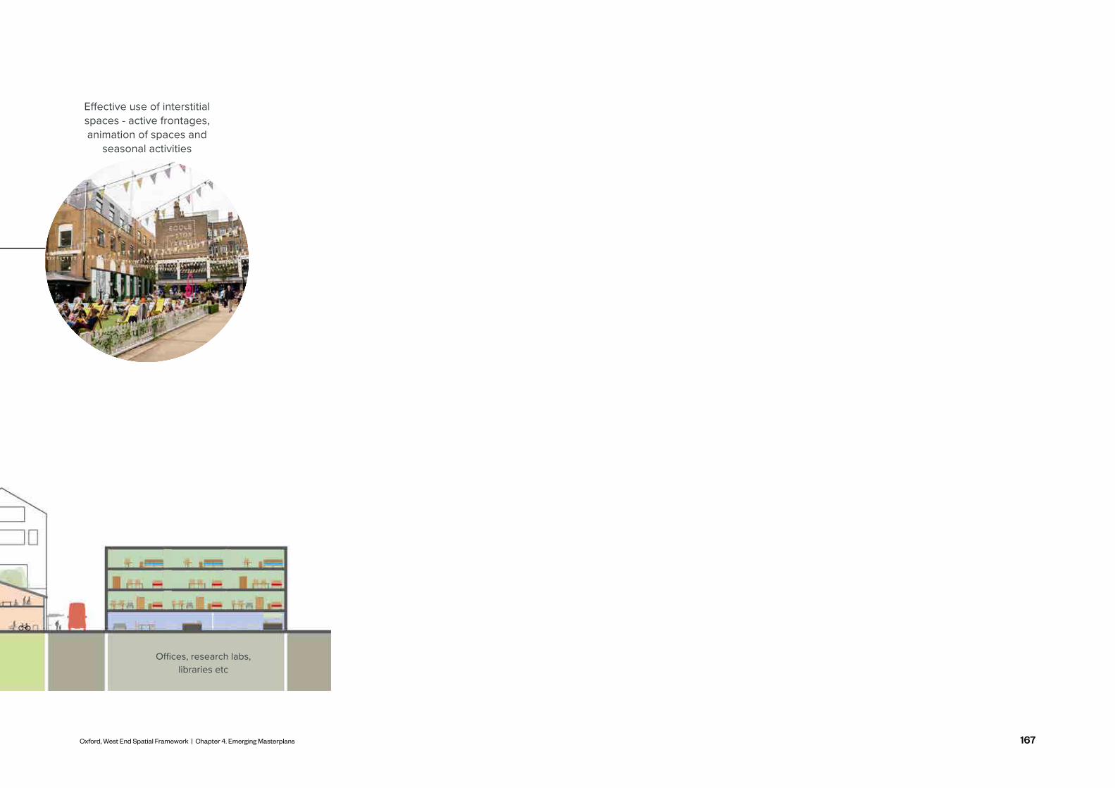
167Oxford, West End Spatial Framework | Chapter 4. Emerging Masterplans
Offices, research labs, libraries etcMobility hub and transport infrastructure
Effective use of interstitial spaces - active frontages, animation of spaces and
seasonal activities

168
KEY DELIVERY PRIORITIES
In order to deliver a comprehensive development on Osney Mead, flexible yet well-defined delivery objectives must be set out at the start of the process. These delivery priorities will need to be sequenced correctly for the unlocking of any development on the site. These priorities are deliverable through different time scales leading up to the delivery process, from pieces of major infrastructure, to less intensive meanwhile interventions.
Flexibility is important to ensure developments are able to respond to changing needs or contexts throughout the delivery process.
Further feasibility work and an in depth technical and viability analysis will be required as a part of each priority identified.

169Oxford, West End Spatial Framework | Chapter 4. Emerging Masterplans
KEY DELIVERY PRIORITIES
To unlock the site, new east to west routes in and out of Osney Mead are critical. They may be provided through a multitude of connections - Oxpens Bridge; Osney Lock, making the Environment Agency depot publicly accessible for pedestrians; and South Street to Barrett Street. Existing connections along the Thames pathway and at Osney Lock will need to be strengthened.
Links and connections:
Currently, with a complicated and fragmented land ownership, proposals at Osney Mead will need to engage effectively with many stakeholders. A holistic vision which enables the site to come forward in strategic phases should be agreed early on. This includes resolving existing land titles and may make use of compulsory purchase powers.
Meanwhile interventions along Thames riverside
Securing all the land and property required
for the project
Green and Blue infrastructure:
Meanwhile interventions should precede more substantial development and aid holistic delivery strategies. The focus of these meanwhile interventions should be at Osney Mead’s riverside square and along the existing towpath.
Under-grounding of power lines:
Strategy for businesses and relocations:
Establishing the green and blue network on Osney Mead is a key infrastructural priority which will introduce significant green and blue elements to Osney Mead's existing routes. This will need to precede comprehensive redevelopment and offer both immediate environmental and flood defence benefits, as well as long-term benefits in opening the site up for redevelopment. Green and blue infrastructure must be highly effective in flood mitigation, promote and protect ecology and providing amenity space for communities. Designs must consider work on the Oxford Flood Alleviation Scheme and ongoing works to surrounding watercourses
The treatment for existing businesses in Osney Mead must be accounted for as an infrastructure priority.
Delivery drivers and steps to unlock Osney Mead's potential
1
2
3 5
64
The under-grounding of power lines will enable the comprehensive development of Osney Mead. Without burying or removing these, the site is heavily constrained in terms of new development, also due to flood risk and appearance. This includes the SSI substation which sits at the gateway to the site, coming in from Ferry Hinksey Road. Feasibility work is needed to better understand the costs, a funding strategy and planning implications of removing or burying the pylons which may be essential to enable a commercially viable proposal.

170
FUNDING ESTIMATIONS FOR KEY DELIVERY PRIORITIES
Strat Key Priority Detail of Priority Known Infrastructure Cost
Osn
ey M
ead
1. Links and connections
• New east-west routes in and out of Osney Mead is critical. This may be provided through a multitude of connections - Osney Bridge; Osney Lock, making the EA depot publicly accessible for pedestrians; and South Street to Barrett Street.
• Existing connections along the Thames pathway and at Osney Lock will need to be strengthened.
• West end public realm and movement interventions - £500k – to design and development of project proposals
2. Meanwhile interventions along Thames riverside
• Meanwhile interventions should precede more substantial development and aid holistic delivery strategies.
• Focus of these meanwhile interventions should be at Osney Mead’s riverside square and along the existing towpath.
• West end public realm and movement interventions - £500k – to design and development of project proposals
3. Securing all the land and property required for the project
• Currently with a complicated and fragmented land ownership, proposals at Osney Mead will need to engage effectively with many stakeholders.
• A holistic vision which enables the site to come forward in strategic phases should be agreed early on. This includes resolving existing land titles and may make use of compulsory purchase powers.
4. Under-grounding of power lines
• The under-grounding of power-lines will enable the comprehensive development of Osney Mead. Without them being put underground or removed, the site is heavily constrained in terms of new development, green and blue infrastructure and appearance.
• This includes the SSI substation which sits at the gateway to the site, coming in from Ferry Hinksey Road. A funding strategy for this works will need to be agreed with all stakeholders.
• Underground power lines at Osney Mead - £20m – delivery TBC
• The Energy Systems Accelerator start-up and spin-out hub - £800k (phase 1) – delivery in 2022; and £96m (phase 2) – delivery TBC
5. Green and Blue infrastructure
• Establishing the green and blue network on Osney Mead will need to precede comprehensive redevelopment and offer both immediate environmental and flood defence benefits and long term benefits in opening the site up for potential redevelopment.
• Green and blue infrastructure must consider being highly effective in flood mitigation, promoting and protecting ecology and providing amenity space for communities using the site. Designs must consider work on the Oxford Flood Alleviation Scheme (OFAS) and ongoing works to surrounding watercourses.
• Oxford flood alleviation scheme - £150m – delivery by 2030
6. Strategy for businesses and relocations
• The treatment for existing businesses in Osney Mead must be accounted for as an infrastructure priority with the goal of protecting businesses and providing relocations of equal value.

171Oxford, West End Spatial Framework | Chapter 4. Emerging Masterplans

172
FRIDESWIDE SQUARE AND CASTLE MILL STREAM QUARTER Key Design Aspirations
Enhancing the pedestrian and cycle experience so as to encourage more sustainable travel, promote health and well-being and provide a better setting for new development.
Connecting activity to the asset of Castle Mill Stream and surrounding trees; promoting biodiversity and ecology and connecting people with nature.
Public realm which promotes legibility, feels safe, creates joy and celebrates existing assets. This transformation needs to respond to the importance of this as a gateway to Oxford.
A rich mix of uses which creates a vibrancy which fosters innovation and joy. An eco-system of workspace and innovation for a variety of business types and active ground floor uses alongside residential. An innovative roofscape with key moments of height - enhancing legibility.
12
3
MOVEMENTENHANCING PEDESTRIAN & CYCLE
GREEN AND BLUE STRONGER CONNECTION TO GREEN
Transforming the Nuffield West End sites into a vibrant mixed-use quarter which is a place to work, live, study, socialise, play and visit is a critical piece of the Spatial Framework.
Proposals on the three sites which form 'Frideswide Square and Castle Mill Stream Quarter' will contribute to the vision of becoming a vibrant mixed use quarter which supports an eco-system of workspace and innovation through a mix of uses knitted together with high quality public realm, activated waterside space and a new residential community.
Proposals will need to adhere to strategies set out within the Spatial Framework, including the following site specific principles. A design brief is being developed for the sites but a masterplan goes beyond the timeframe of this Spatial Framework.
• Creation of a western gateway at Friedeswide Square
• Better north-south connectivity through the area, connecting Hythe Bridge Street and Park End Street
• A clear wayfinding strategy for people coming from the railway station to city centre
• Improvements to the pedestrian and cyclist experience of Hythe Bridge Street and Park End Street
EXPERIENCE AND BLUE ASSETS
URBAN ARMATUREPUBLIC REALM IMPROVEMENTS
URBAN GRAINMIXED USES AND SYNERGIES WITH
AND ACTIVATION PUBLIC SPACES
• Creating a public space adjacent to the Castle Mill Stream which is active and celebrates the site's history
• Greening Frideswide Square
• Retaining existing trees and consider opportunities for planting new trees, especially on Hythe Bridge Street and Park End Street
• Promoting ecology on rooftops
• Celebration and sensitivity towards existing heritage walls
• Greening of streets and public realm
• Wayfinding interventions which improve legibility and navigation.
• Ground floor activation
• Diverse built typologies and flexible floor-plates
• Design to be sensitive to surrounding heritage assets
• Moments of height to aid legibility
• Strong relationship with built form of Nuffield College

173Oxford, West End Spatial Framework | Chapter 4. Emerging Masterplans
FRIDESWIDE SQUARE AND CASTLE MILL STREAM QUARTER Key Design Aspirations
1
2
3
4
Creation of high quality waterside public realm on the car park site allowing north-south permeability between Hythe Bridge Street and Park End Street
Reactivate the Island and Frideswide Square sites with active frontages and a mix of office and residential
Introduction of a new commercial building on the car park site with an active ground floor enhancing new waterside public realm
Potential for meanwhile use of vacant space and units while longer term development plans come forward
Opportunity for height on the island and car park sites to be sensitively incorporated
Opportunity to accommodate a range of types and sizes of businesses
Opportunity to enhance the evening economy via the mix of uses
Complement opportunities for enhancement to the public realm and streets around the Nuffield West End sites
Opportunity for the South Frideswide Square and island sites to assist with legibility and wayfinding
Opportunity to provide enhancements to the public realm on Becket Street to improve the setting of the heritage assets of St Thomas Martyr Church and Abbey, and to respond to proposals coming forward on the Becket Street Car Park
5
6
7
8
9
10
Early Indicative Land Use Quantum proposed by developer*
(Nuffield West End sites only and subject to site masterplanning and design development)
• 58 residential units• 30,000 sqm commercial business space• Supporting active ground floor uses
*Subject to further discussion and consultation
Frideswide Square and Castle Mill Stream Quarter
Design principles for this quarter include:
Frideswide Square
Nuffield College
South Frideswide Square site Island site
Worcester Street car park site
Castle Mill
Stream
Wor
ceste
r St
Hythe Bridge St
Park End St
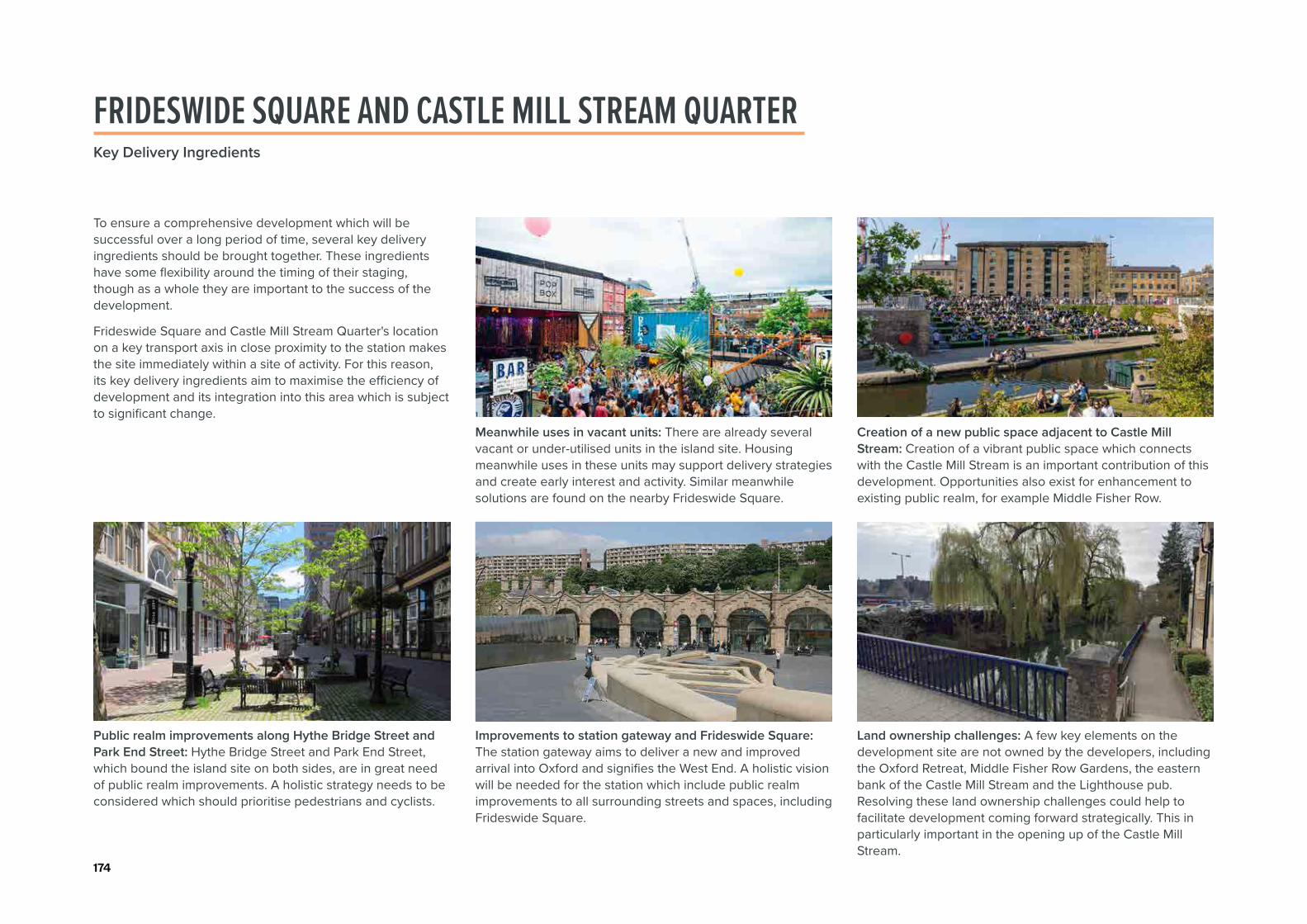
174
FRIDESWIDE SQUARE AND CASTLE MILL STREAM QUARTER Key Delivery Ingredients
Public realm improvements along Hythe Bridge Street and Park End Street: Hythe Bridge Street and Park End Street, which bound the island site on both sides, are in great need of public realm improvements. A holistic strategy needs to be considered which should prioritise pedestrians and cyclists.
Meanwhile uses in vacant units: There are already several vacant or under-utilised units in the island site. Housing meanwhile uses in these units may support delivery strategies and create early interest and activity. Similar meanwhile solutions are found on the nearby Frideswide Square.
Improvements to station gateway and Frideswide Square: The station gateway aims to deliver a new and improved arrival into Oxford and signifies the West End. A holistic vision will be needed for the station which include public realm improvements to all surrounding streets and spaces, including Frideswide Square.
Creation of a new public space adjacent to Castle Mill Stream: Creation of a vibrant public space which connects with the Castle Mill Stream is an important contribution of this development. Opportunities also exist for enhancement to existing public realm, for example Middle Fisher Row.
Land ownership challenges: A few key elements on the development site are not owned by the developers, including the Oxford Retreat, Middle Fisher Row Gardens, the eastern bank of the Castle Mill Stream and the Lighthouse pub. Resolving these land ownership challenges could help to facilitate development coming forward strategically. This in particularly important in the opening up of the Castle Mill Stream.
To ensure a comprehensive development which will be successful over a long period of time, several key delivery ingredients should be brought together. These ingredients have some flexibility around the timing of their staging, though as a whole they are important to the success of the development.
Frideswide Square and Castle Mill Stream Quarter's location on a key transport axis in close proximity to the station makes the site immediately within a site of activity. For this reason, its key delivery ingredients aim to maximise the efficiency of development and its integration into this area which is subject to significant change.

175Oxford, West End Spatial Framework | Chapter 4. Emerging Masterplans
OXPENS
Oxpens has the opportunity to provide a mixed use neighbourhood that opens up the riverside to provide a new public space for Oxford. There is significant opportunity to provide new homes and jobs at scale through residential, commercial and community uses as part of the Area of Change established within the Oxford Local Plan.
It's strategic location where city meets nature provides a unique opportunity for a landscape led masterplan which is driven by the character of the River Thames, Oxpens Meadow, the green belt and the heritage of the West End as
A destination for and of Oxford
a seat of industry and productivity for Oxford. It's relationship with Osney Mead, the station and the city centre's core is particularly important.
Oxpens will be a key development within the West End of Oxford with a significant impact as one of the first development projects to come forward. The development of Oxpens will be a first mover within the West End and needs to be considered as the Oxpens road improvements are established alongside strategic transport and bus provision in the West End.
Oxford West End Developments (OxWED), a joint venture between Oxford City Council and Nuffield College will be submitting a planning application in 2022. The majority of land ownership is with the OxWED LLP (Oxford City Council and Nuffield College). Adjoining land ownerships, as they come forward, are expected to deliver against the policy objectives of Policy SP1.
Oxpens Road
Oxpens Meadows
River Thames
Osney Lane
CGI of proposed new public spaceSite location (OxWED)

176
A new piece of public realm which promotes activity and creates points of interest along key routes
A rich mix of uses which creates a vibrancy which fosters innovation and joy. The masterplan must provide a diversity of architectural forms and expressions - with innovative roofscapes, materiality and key moments of height. Buildings must celebrate and enhance the public realm in-between.
URBAN ARMATUREPUBLIC REALM IMPROVEMENTS
URBAN GRAINMIXED USES AND SYNERGIES WITH
AND ACTIVATION
PUBLIC SPACES
• A new destination public space
• Improvement of the quality to Oxpens Road
• Different characters of public realm - harder civic spaces to softer green interfaces throughout the development
• A strong frontage onto destination public space (new public square and Oxpens Meadows) and streets
• Flexible commercial floor-plates meeting needs of headquarters to lab space to start-ups
• Mix of housing tenures and types
• Moments of height/architectural treatment to enhance legibility
Creating pedestrian and cycle links through this site are essential to link it up with Osney Mead, the railway station, the College site and the city centre core.
Celebrating that this site sits at an urban edge and ecological features of the river, Oxpens meadows, Grandpont Nature Park and the green belt need to drive a landscape led masterplan
12
3
MOVEMENTENHANCING PEDESTRIAN AND CYCLE
GREEN AND BLUE STRONGER CONNECTION TO GREEN AND
• Establishing a legible hierarchy of streets
• The proposed Oxpens Bridge will provide enhanced connectivity between Osney Mead and the green belt south of the Thames, and the station and city centre north of the Thames
• Significant improvements to the pedestrian and cyclist quality of Oxpens Road
• Improved access to Oxpens Meadows, Grandpont Nature Park and green belt
• A clear wayfinding strategy for people coming from the railway station, from Osney Mead and city centre.
EXPERIENCE BLUE ASSETS
• Expanding the meadows into the Oxpens masterplan
• Contributing to the greening of Oxpens Road
• Promoting ecology on rooftops
• Retaining and planting trees
• Maximising views of the river development frontages
OXPENSKey Design Aspirations

177Oxford, West End Spatial Framework | Chapter 4. Emerging Masterplans
How the design brief for the OxWED site sits within the wider Oxpens allocation and Spatial Framework
1
2
3
4
5
6
7
8
9
10
11
12
13
14
Across the whole of the Oxpens site the provision of homes to respond to housing need within the city and provide the 450 (minimum) homes the Local Plan states
Commercial development to provide flexible floorplates appropriate for a variety of enterprises from big offices and laboratories for world leading research institutions to smaller floorplates for start-ups and SMEs
Hotel use to address need established within local plan. Opportunity to activate the new public realm with hospitality, cultural and ancilliary uses associated with visitors to the hotel
A new amphitheatre providing a new public outdoor gathering space which can host events and provide a place to dwell
A strong biodiverse blue and green infrastructure which narrates the journey of water from river to city
A new river plaza on the river's edge opening up the Thames to the city and west end
A meadow front promenade - a continuous and active terrace along the edge of the floodplain meadows together with a riverfront plaza
Ladder of laneways - narrow pedestrian dominated spaces linking places of attraction
Cycleway and Oxpens bridge - direct route linking station and communities south of the Thames
Expanded meadows - an extension of the meadows into the heart of the development area and articulated with themed gardens and a river front plaza
Housing/Student Accommodation
Workspace
Hotel
Opportunity for flagship building
Oxpens Road
Oxpens River Bridge
Early Indicative Land Use Quantum proposed by developer*• Residential (C2, C3)- up to 30,000 sqm• Student Accommodation (sui generis) - up to 8,000 sqm• Co-living/purpose built shared accommodation (sui
generis) - up to 8,000 sqm• Hotel (C1) - Up to 24,000 sqm/ 400 keys• Commercial, business, and service (E) - 80,000 sqm• Community use class (F1, F2) - 1,200 sqm
*Subject to further discussion and consultation
A dynamic roof landscape - a picturesque contribution to Oxford’s skyline with industrial inspired and three dimensional greenery
Improvement of public realm on Oxpens Road - tree planting, active frontages, better crossings, cycle lane provision
Strengthening the link to the Castle Mill Stream north of Oxpens Road and Westgate Shopping Centre
Consideration for the existing Student Castle proposal and the strengthened east-west connection over the railway line
OXPENSKey Design Aspirations
Emerging masterplan for the site have been produced by the design team and have the following design principles:

178
OXPENS BRIDGE
Oxpens bridge is an important element alongside the Oxpens masterplan and will be key in providing greater east-west connectivity and establishing Oxpens as a destination. It will also connect key destinations including Osney Mead, Grandpont Nature Park, Oxpens, the station and the city centre.
Pedestrian and cyclist experience will need to be a key driver for the design of the bridge. Importantly, providing well-designed landing points on both sides of the river which are safe and active will be essential in enhancing this connectivity, as well as providing an entry point into the new Oxpens development. There are a number of major constraints including a challenging topography, flood risk, constrained existing towpaths and ecological factors.
The City Council in partnership with OxWED are currently discussing design options for Oxpens bridge and associated towpath works.

179Oxford, West End Spatial Framework | Chapter 4. Emerging Masterplans
OXPENSKey Delivery Ingredients
Green and blue infrastructure: Integrating Oxpens Meadows and the River Thames will be essential in unlocking Oxpens as a development site, and it forms a key part of the amenity space for the new development.
Oxpens Bridge: The placement and quality of Oxpens Bridge will help define the relationship between Oxpens, Osney Mead and further afield. Considerations around where this bridge will land must be carefully considered as it will be crucial for both on the south to pick up movement routes, and the north as an entry point into the Oxpens development and the wider city centre.
Oxpens Road improvements: Public realm improvements on Oxpens Road will benefit the character of the development itself as well as movement links into the wider West End and the city as a whole. Urban greening; prioritisation of pedestrians and cyclists; better crossings; and positive frontages will all be needed.
Richard Gray Court and Royal Mail Delivery Office and the Ice Rink: A strategic vision which includes all land ownerships of Oxpens will allow the whole site to come forward comprehensively.
Becket Street and link from Oxpens to Station: Public realm improvements on Becket street will be important in providing a better link between Oxpens and the station.
To ensure a successful, comprehensive development which will be successful over a long period of time, several key delivery ingredients must be brought together. These ingredients have some flexibility around the timing of their staging, though as a whole they are critical to the success of the development.
The Oxpens development faces several major infrastructural projects through its delivery. This includes new linkages and blue and green infrastructure. How these ingredients are led into the delivery process will be key to Oxpens' success.

180
OXFORD STATION: A WORLD CLASS TRANSPORT HUBKey Design Aspirations
Establishing Oxford Station as a world class multi-modal transport hub will form the gateway into the city. It needs to accommodate the anticipated growth in people using and passing through the station area. This need for additional capacity will meet the forecast demand set out within the Oxfordshire Rail Connectivity Study.
Strong sense of arrivalA high quality public realm provides a legible landing point for those emerging from the station. Elements of local character and activity enables the station to become a gateway for both locals and visitors. There is an opportunity to further connect Oxford station to Frideswide Square, and link southwards to Becket Street, creating a comprehensive public realm network and establishing as a gateway and also link westwards to the forthcoming innovation district and existing communities.
A mixed use precinctAccommodating a rich mix of uses around the station promotes activity across time as well as the spaces around. This feeds into having a strong sense of arrival too, establishing it as a world class destination for all who arrive. Active frontages from, for example, cafés, restaurants, studios, commercial uses, retail, and community uses spill out onto the street as well as pleasant streetscaping which all feed into the bustle of activity to establish a lively station quarter.
A multi-modal hubAccessible pedestrian, cycle and public transportation connections are key in connecting the station to various destinations around the city and county. This multi-modal hub should include supporting infrastructure like bicycle parking and hire, accessible and attractive bus stops, good quality public realm, active ground floor uses and legible wayfinding elements as well.
King's Cross, London, UK Utrecht Centraal, The Netherlands Berlin Hauptbahnhof, Germany
This mixed-use precinct should include features like a high quality public realm, rich connectivity and jostling of activities in order to create a strong sense of arrival into the city.

181Oxford, West End Spatial Framework | Chapter 4. Emerging Masterplans
Across the proposed scenarios, common key uses have been identified for the site. Land uses of commercial and residential development are key in introducing activity and greater functionality around the station. These jostling of uses also enable the creation of a world class hub, promoting innovative environments for commerce, mobility and sociability.
Options for the Oxford Station masterplan, which includes the station site (east and west of the station) and Becket Street car park, are being developed and tested. The proposed scenarios will differ in how they deal with interchange to public and active transport, parking, development plots and movement around the site.
Commercial development opportunities will help unlock potential value. It is expected that investment and improvement in the station area will need to be implemented on a phased basis, as business cases are approved and
STATION AND SURROUNDING SITESKey Design Aspirations
in this may help improve overall viability, underpin inward investment and deliver earlier change. Becket Street car park is one of the most significant development opportunities to be opened up, as is over-station development.
This is echoed in the Oxford City Centre Action Plan, which states that the station, in becoming a new national rail hub, may act as a catalyst for the greater development of the West End (OCCAP, 2021, p. 58-59). Ground floor activation with cafés and shops would also lead to a spillover of activity, livening up the streetscape and surrounding public spaces.
The diagram flags different factors to consider when masterplanning the station's sites.
1
1
2
2
3
3
4
4
4
4
5
5
6
6
7
7
8
9
9
8
Enhancement of Becket Street as a key sustainable movement link which retains existing mature tree line
Sensitivity and celebration of the setting of St Thomas Martyr Church and Abbey
Creation of a new pedestrian bridge crossing Botley Road. Concept visualisations have been produced.
Retention of existing trees
• Trees in the station's forecourt (east side) - Tree Preservation Order 2012
Visualisation from the east (Network Rail, 2021)
Visualisation from the west (Network Rail, 2021)
Visualisation of the Western Entrance of the Railway Station (Network Rail, 2021)
• Trees east of station - between Cripley Rd and Roger Dudman Way - Tree Preservation Order 2017
• St Thomas Martyr Church and Becket Street
Activation and enhancement of Frideswide Square with new built form
Enhance last mile solutions with an integral approach to the provision of bus stands, cycle storage and taxi pull-ups. No Public parking to be at a level agreed by the Rail Regulator that will focus on key needs, which is is necessary except for a small allowance for disabled, short stay, pick up and drop off
Opportunity for depot site to be used for transport solutions e.g. bus parking
Importance of the western station entrance and its facilitation of connectivity to the west, especially towards Osney Mead
The Western entrance and Botley Road underpass is at advanced stages in design/planning and are coming forward ahead of the wider masterplan

182
STATION AND SURROUNDING SITESKey Design Aspirations
Enhancing the public realm to establish it as a real gateway for Oxford which provides legible walking and cycling routes to a variety of key locations in the West End and beyond.
A rich mix of uses at the station which brings vibrancy and activity will be required to create a strong sense of arrival. New buildings to be of architectural excellence and celebrate and enhance the public realm.
URBAN ARMATUREESTABLISHING A PUBLIC REALM WHICH
URBAN GRAINHIGH QUALITY BUILT FORM WHICH CELEBRATE S
ENHANCES IT AS A KEY GATEWAY
THIS AS A GATEWAY SPACE
• Greening Frideswide Square and the new station gateway to improve biodiversity and ecology; enhance health and well-being and establish this space as a gateway.
• A strong wayfinding strategy
• Enhancement of frontage of new station building on both the eastern and western sides
• Public realm to be flexible in use with meanwhile events
• A station building which is a landmark building of architectural excellence
• Activation with commercial uses
• Moments of height to aid legibility
• A built form which improves the frontage and public realm quality
on Becket Street and enhances the setting of St Thomas the Martyr Church
• Investment in rail infrastructure, rail stations and multi modal transport hubs as a fundamental component and driver for economic growth and the success of places.
Creating a movement strategy which has a strong sense of arrival and prioritises walking and cycling will be key to establishing this as a major gateway to the city. The railway station and multi-modal interchange play an important role in movement around the city and county which needs careful consideration.
Greening Frideswide Square and the new station gateway to improve biodiversity and ecology; enhance health and well-being.
12
3
MOVEMENTCREATING A GATEWAY WHICH IS DRIVEN
GREEN AND BLUE RETAINING AND ENHANCING GREEN
• Creating good quality access points from the eastern and western station entrances
• Improved pedestrian and cyclist experience
• Efficient interchange and stronger bus connections
• Taxi ranks well connected and visible, with integrated EV charging
• A vision which provides flexibility for change and future-proofs movement
• Ensuring accessibility standards are met
• Interventions on Becket Street to establish is as a sustainable travel link
BY PEDESTRIANS
INFRASTRUCTURE
• Retaining and planting trees
• Retaining green character of Becket Street and setting of St Thomas the Martyr Church
• Promoting ecology on rooftops
• Greening Frideswide Square and the new station gateway to improve biodiversity and ecology; enhance health and well-being and establish this space as a gateway.

183Oxford, West End Spatial Framework | Chapter 4. Emerging Masterplans
STATION AND SURROUNDING SITESKey Delivery Ingredients
Improvements to public realm and sense of arrival both to the east and the west: Changing how people arrive and depart Oxford is a major infrastructural undertaking. Public realm improvements around the station will need to create a sense of arrival from both the east and the west. A holistic vision will be needed for the station which include public realm improvements to all surrounding streets and spaces, including Frideswide Square.
Improving east-west connections around Botley Road and Botley Road underpass: East-west connections around the station will be key in how the site is linked to other surrounding developments such as Osney Mead and Nuffield. Improvements to the congested Botley Road, the railway underpass and Frideswide Square will be essential in realising the vision of the Spatial Framework.
To ensure a comprehensive development which will be successful over a long period of time, several key delivery ingredients must be brought together. These ingredients have some flexibility around the timing of their staging, though as a whole they are critical to the success of the development.
The station development involves several adjacent streams of development, from improvements to local and city-wide transport networks, to public realm improvements around the station gateway.
Consideration of bus movement in Oxford: Resolving how we should move around Oxford will be a key factor in how the railway station and its surrounding public realm will work.
Last mile solutions to show how a fully integrated approach to sustainable travel can be achieved. Opportunities for improved accessibility & bus layovers should be fully explored.
Consideration of car parking: A great deal of space around the station is currently taken up by car parking. How much of this space is to be retained as parking and the role of cars in general in the scheme must be evaluated through in depth audits from both a transport and a sustainability agenda. As stated above last mile solutions which use sustainable travel should be explored.

184

185Oxford, West End Spatial Framework | Chapter 5. Implementation and Delivery
Growth is inevitable and desirable, but destruction of community and local character is not.- Edward T. McMahon
IMPLEMENTATION AND DELIVERY5
““

186
This section focuses on the Implementation and Delivery of the Spatial Framework and reflects and supports the ambitions set out in Oxford City Council’s Oxford West End Investment Prospectus, Oxford’s Economic Strategy Delivery Plan and the Volterra Oxford West End Strategic and Economic Case Report.
Oxford’s West End has the potential to deliver change at a significant scale to address demand for new homes, start-ups, spin-offs and headquarter facilities for major businesses, through the implementation of projects across a number of key development sites.
A coordinated approach to delivery is required in order to set up the optimum conditions for change. In particular to:
INTRODUCTION ‘The West End will become a piece of city for everyone. It will be a place where the world’s best ideas and Oxford’s extraordinary breadth of talent converge. It will take Oxford’s success to the next level.’
Oxford West End Investment Prospectus
· Securing additional funding · Co-ordinating and delivering investment and
improvements wider than project area · Capture benefit of new station investment · Ensure projects fit within the historic fabric of the city · Optimise connections between significant and diverse
project areas.
Blending, coordinating and delivering these ambitions will be the key to future success.
Oxford’s history and its attraction as a location for business, linked with world-class higher education, provides both a resilient context for change and a responsibility to ensure that such change benefits the wider city context and blends the ambition for modern facilities with the history and context that Oxford possesses.

187Oxford, West End Spatial Framework | Chapter 5. Implementation and Delivery
OXFORD’S ECONOMIC STRATEGY
The city has experienced a number of issues that now need to be addressed. These challenges can be addressed through the successful and coordinated development and regeneration of a variety of sites and opportunities in Oxford’s West End. Among these challenges, Oxford’s employment growth has stagnated in the past five years with low business survival rates and a rate of business start ups substantially below the national average. Furthermore, Oxford lacks a central business district (CBD) comprising of competitive, high quality commercial space and an appropriate mix of supporting uses.
There has been a shift in thinking about Oxford’s economy and a step-change in the Council and its partners’ approach to economic development. It is more holistic than previous strategies, responding to significant local, national and societal challenges in terms of inclusion and climate emergency. The key principles are:
While Oxford produces a high amount of highly-skilled graduates, only 18% are retained in the city following graduation. In Oxford there is a brain drain of highly-skilled graduates to other global innovation clusters.
· Commitment and Focus - a shared and long-term commitment to responding to challenges and opportunities
· Collaboration - making the most of available capacity and resource that exists across the city by building on the work of partners, brokering new relationships and working across new areas
· Participation - embedding participatory principles within delivery to ensure that Oxford’s residents are actively involved in idea development, decision-making and delivery
· Innovation - using the city as a ‘living lab’ to try innovative projects, alongside taking innovative approaches to leverage funding and realising ambitions
· Agility - continuously reviewing delivery mechanisms, project principles and ways of working to ensure the city remains agile in responding to changing needs
· Pace - working rapidly to deliver projects that deliver positive economic, social and environmental impacts.
Triple Bottom Line ‘Success Factors,’ Oxford Economid Strategy 2021, pg. 28

188
The recently adopted Oxford Local Plan 2036 highlights ‘Areas of Change’ within the city, and includes a number of major development and regeneration opportunities including Oxpens, Oxford Railway Station, and Osney Mead.
The mixed-use nature of the potential projects within Oxford’s West End will allow the area to attract and retain more interlinked and highly productive industries. The addition of new commercial floorspace will be particularly important in achieving this ambition, along with the provision of new homes and associated facilities that embrace the principles of a successful city. This enhanced offer will also act as a driver for wider change in the region and through the Oxford-Cambridge Arc.
Successful implementation will provide the floorspace to facilitate research & development in key sectors, through a long-term co-ordination between major landowners. The large-scale nature of the ambition for the West End is likely to attract anchors and multinational firms once both public and private sector investment has enabled the sites to come forward, ideally in a planned and coordinated manner.
The various projects are anticipated to provide a mix of uses within the West End, facilitating an environment for knowledge transfers between commercial businesses, the University and other organisations. There is also the potential for these key sites to act as catalysts for attracting further private sector investment into the area.
Major investment to provide an improved public transport hub as part of the railway station development (providing both east and west frontages) will be a significant upgrade for the city, and early implementation will help to set a new context for decision-making on each of the development sites. The planned improvements at the railway station will provide the most important facility that major R&D firms value when choosing a location.
Momentum is building not only as a result of the planned upgrade to Oxford railway station, but also importantly through landowner commitments to long-term co-ordination and quality development within the West End, and through the gathering pace of change in the wider region and the Oxford-Cambridge Arc, in particular.
The West End has the potential to deliver long-term value by attracting and retaining more talent, wealth and opportunity in Oxford, with lasting benefits for local communities, the companies and institutions that invest, and for UK plc. This includes ambitions for zero carbon targets.
To fulfil this potential and take Oxford’s success to the next level, the Oxford West End partners are seeking public investment in infrastructure to maximise and accelerate the growth opportunity, and to lever in private investment to help finance and deliver new homes, amenity and innovation space.
Oxford West End will expand the city centre and the various projects are anticipated to treble its amount of commercial floorspace. The opportunity also exists to deliver mixed-tenure homes and a variety of supporting land uses and public realm to optimise the potential of each project and the wider city context through coordinated delivery.
The central location will make for an extraordinary place to live, and work. This will also make it ideal for attracting and retaining the best talent, who are drawn to urban areas.
Integrating Oxford West End into the city centre is key to the place-making ambitions of the area. This will be achieved by seeking to develop complementary uses, but also through investment in new river crossings, bridges and public realm, and to support seamless pedestrian and cycle movement across an expanded city centre. This potential to improve connectivity should also be optimised as
projects are delivered and the full potential of locations are realised. Future decisions may be needed as desire lines are established. By way of example Osney Mead could potentially extend connections through to Botley Road to help set up a new strong cycling and pedestrian route into the city utilising planned new bridge crossings connecting to Oxpens and into Castle Street.
THE WEST END AND OSNEY MEAD OPPORTUNITY
In summary it is anticipated to provide: · A new innovation district, expanding from the city
centre · A new higher-density urban quarter for Oxford · A location where start-ups, spin-outs and HQs will
want to be · An area designed around people and sustainable
movement · An expanded area that can be greater than the sum
of its parts · A national rail hub and super connected gateway · A place that will deliver world changing ideas · A new community that helps meet Oxford’s housing
needs · A significant opportunity for levelling up Oxford · A part of the city that will embrace green innovation
at its heart.

189Oxford, West End Spatial Framework | Chapter 5. Implementation and Delivery
STRATEGIC BOARD
In order to achieve these ambitions and ensure the planned coordination between sites, public sector investment, and key new and upgraded infrastructure are delivered a Strategic Board has been established to provide co-ordination and alignment across the key partners throughout the development and regeneration of the West End.
This Board provides the strategic leadership necessary to realise the scale of ambition and opportunity, as the largest-scale mixed-use set of development and regeneration projects in Oxford in recent history. Leadership and coordination are critical to successful implementation and delivery, and the ability to optimise potential through future decision-making as projects and phases are delivered.
The Board includes senior representatives from OxLEP, Oxford City Council, Oxfordshire County Council, Nuffield College, Christ Church, University of Oxford, Network Rail, the Department for Levelling Up, Housing and Communities and the Department for Transport, with the anticipation that other central Government departments could join, as required.
Board members share an interest in the long-term success of the city and region, and recognise that the West End can be much more than the sum of its parts, a positive long-term catalyst for the rest of Oxford and the wider Oxford-Cambridge Arc growth area.
In order to achieve this there is an early focus on creating a step change in connectivity and maximising development potential, to build confidence, increase value, and speed up delivery.
· Expedite the reopening of the Cowley Branch Line · Prioritise the design and development funding for the new
track and platform at Oxford Station eastern side · Collaborate with local partners to unlock issues holding
development back · Support the delivery of Connecting Oxford, to reduce
congestion and improve bus and active travel · Allocate revenue funding to increase the level of officer
resource and feasibility work being prepared at a local level.
A number of structural areas for investment have been identified and include:

190
The Council will continue to play a pivotal role in shaping Oxford’s economy by leading and co-ordinating change and using all available levers and powers to achieve this, and assisting in setting up the right conditions within which new investment and phased change takes place.
At the strategic level, planning powers are being used to create innovative and progressive policies that are responsive to the city’s economic, social and environmental context.
At the projects level, the Council will use its influence and powers to involve key decision-makers and influencers to help unlock opportunities, overcome barriers and help to meet the needs of the city.
Land and property assets will also be used as part of this approach to deliver positive change. This is particularly the case in the West End, where the Council owns several sites and in the city centre where the Council has a strong property portfolio.
Council resources will also be needed to support relevant initiatives being led by partner organisations in order to enable place-based solutions that meet the needs of the city. Where appropriate, this may be through project management support, external funding, political support or advice. Officers will also help stakeholders understand the different funding pots available to deliver projects.
The opportunity in Oxford is one of national significance. It is therefore reasonable that the projects which will support the aspirations of the strategy should receive some investment from national government.
OXFORD CITY COUNCIL

191Oxford, West End Spatial Framework | Chapter 5. Implementation and Delivery
SOCIAL VALUE
The ambition for the West End and Osney Mead offers significant social value potential for local people and businesses to play many and diverse roles in the future mix, diversity and sustainable success of the area.
The variety of projects from Osney Mead to Oxpens and into the heart of the West End offer a wide-range of potential social value benefits including, but not limited to:
· Investment in meanwhile uses to help establish underused or vacant locations and potentially provide long-term flexible accommodation for new start-ups that will help create a diverse and stimulating context for delivery of wider main-stream ambitions.
· Retention of and investment in established local businesses that may be affected by projects, including relocation within projects or to alternative premises within the city or its environs. This is a core part of successful regeneration that helps protect local jobs and supply chains.
· Provision of facilities for local groups and support services that compliment the wider ambitions for the area and specific projects.
· Opportunities to support the creation and development of start-ups in all their forms from traditional office accommodation to makers’ space and from street-based food and drink to local energy generation and the wider green economy. Flexibility and diversity will not only help local residents and businesses but also provide a platform to help retain former students within the city.

192
In order to achieve the ambition and coordination that is set out in the various reports, it will be important that all the tools available to the projects are utilised as needed. Each project will have its specific challenges and opportunities and it will be important that the contribution each can make to the future prosperity and success of Oxford as a whole is reflected in the delivery structures that are established and any additional funding support that may be required.
Strategic Board1
Established to help achieve the successful coordination and communication required to optimise delivery of the various projects and phases within larger projects, and to provide support where required, to ensure timings and outputs from individual projects fit within the overall ambition for the West End and wider city and regional contexts.
2 Council Powers
IMPLEMENTATION AND DELIVERY PRINCIPLES
to provide support for projects to secure all the land and property required through CPO procedures, the potential benefits to secure clean title, support for applications to government for funding where required, and political support to help provide the basis for consistency in decision-making, growing confidence in the delivery processes and managing risk.
Infrastructure costs such as the undergrounding of electrical lines and the creation of new connections may require additional funding support between various parties
By way of example the Osney Mead project requires further land acquisition and the project will benefit from having the confidence of control of all the land required to deliver a comprehensive solution, that will benefit the wider ambitions of the Council and University, and help ensure the contribution Osney Mead plays for the wider city is optimised.
3 Financial Viability
Where it is challenging to achieve viability, it will be important for projects to be considered in the wider context so that all of the ambition for the West End can be achieved. This may require appropriate additional financial support or the ability to join viable and unviable projects together so that one can support the other.
The regeneration of land and property often involves significant additional costs when compared with green field development. The ability for projects to achieve their ambitions and deliver financially viable outcomes often requires additional funding support in key areas such as land acquisition and relocations, land remediation and infrastructure (including flood defences, removal/
undergrounding of powers cables, new and improved access including new bridges and opening up locations to become an integrated part of the wider town or city).
Osney Mead exemplifies these challenges and indications suggest there will need to be additional financial support made available to help set up the optimum conditions for change so that all the costs can be met and appropriate financial returns secured by those parties taking development risk.

193Oxford, West End Spatial Framework | Chapter 5. Implementation and Delivery
Relocation of existing businesses4
The Wapping Wharf project in Bristol introduced flexible retail and café space to a former industrial site and spearheaded a wider regeneration of the site. Such a simple intervention may be equally successful on a site such as Osney Mead
The relocation of some high quality existing businesses is a key principle
This is a key regeneration principle that will be important to address within the wider city context to support existing businesses that are affected by projects and need to be relocated, helping to retain them in the city and protect the jobs and local services networks.
Provision of meanwhile uses5
Provision of meanwhile uses will help set up locations for change that are underused or vacant. To repopulate and help to reintegrate such locations with the core of the city as new infrastructure is delivered and early phases are implemented.
This type of early investment can play a significant role in repopulating a site, establishing awareness of the location, reintroducing people to the location and establishing the right conditions for the early attraction of start-up businesses.
IMPLEMENTATION AND DELIVERY PRINCIPLES
Osney Mead has the potential to utilise meanwhile uses, particularly along its river frontage, which offers a rare opportunity for the city to provide a waterside destination, mix of uses and vibrancy that will act as a catalyst for the wider ambitions for the site and help to reconnect it with the wider city both physically and economically. This has parallels with the Wapping Wharf project in Bristol and its meanwhile uses known as Cargo 1 and Cargo 2.

194
Robust phasing and programming 6
to enable the West End to improve further as each project is delivered, to manage outputs from each project to ensure values are optimised. The Oxpens project, in particular, has a significant role to play in helping knit together planned major projects including the railway station and Osney Mead, with the core of the city.
Capturing value uplift8
To set up the right conditions for projects to benefit from improved financial conditions as quality projects and phases and new infrastructure are delivered.
Delivery mechanisms7
To reflect specific project needs, including potential public and private sector partnering through development agreements or joint ventures and the consideration of longer-term stewardship approaches.
IMPLEMENTATION AND DELIVERY PRINCIPLES

195Oxford, West End Spatial Framework | Chapter 5. Implementation and Delivery

203Oxford, West End Spatial Framework | Chapter 6. Appendices
Universities world’s top
four
High tech and Science investment
Innovative industries
National Infrastructure Commission estimated an
annual output of the corridor will increase £163bn per annum by
2050
E - W Rail 40 min
E - W Rail 60 min
Currently by rail 1 h 30 min
Currently by rail 2h 50 min
Oxford
Oxford
Milton Keynes
Bedford
The concentration of educational uses, high tech and science and innovation industries within the Oxford-Cambridge corridor make this area highly significant on a local-global scale.
Oxford’s role within this corridor is highly significant and advances in rail connections and spaces for high quality facilities will only help facilitate this.

204
The existing pattern of clustering of key knowledge intensive and growth sectors is schematically summarised in the drawing below. While different parts of the study area have their own distinctive qualities and strengths, this drawing demonstrates the relative lack of interaction across the corridor, with linkages from each sub-area to London
This is unsurprising given the lack of a functional corridor in terms of movement and spatial relationships.
A key question this poses is: What would be the clustering effect within a more functional corridor geography? The distinctive qualities and strengths of each part of the corridor are outlined on the following page, extracted from the SQW/Cambridge Econometrics study.
UNDERSTANDING THE CORRIDOR: KEY DRIVERS OF ECONOMIC GROWTH
Final Report: Cambridge, Milton Keynes and Oxford Future Planning Options Project IntroductionChapter 1: Page 16 of 144 5th studio
Source: Plan extracted from “Cambridge, Milton Keynes and Oxford Future Planning Options Project” report by 5th Studio
OXFORDCAMBRIDGE
MILTON KEYNES
The diagram shows the existing patterns formed by clusters of knowledge and growth sectors. This demonstrates the relative lack of interaction across the corridor, with linkages from each sub-area to London being more significant than connection between sub-areas. This pattern responds to the lack of a functional corridor in terms of connectivity and spatial relationships.
The clustering patterns might change with greater connections/ linkages between the various emerging sectors within the Oxford - Cambridge Arc.
UNDERSTANDING OXFORDSHIRE: ECONOMIC SECTORS AND ASSETSStrategic Context

205Oxford, West End Spatial Framework | Chapter 6. Appendices
Railway network
Major roads
Secondary roads
Green town/villages
Enterprise Zone
Science Vale UK
Knowledge Spine
Railway stations
FC Colleges
Universities
Science Park
Business Park
1
2
9
6
3
7
8
2
7
4 5
4
Bioscience Physics related
Medical tech Pharmaceuticals
Creative industries Arts
Heritage
Telecoms Computer
hardware and software
Engineering and electronics
Motorsport
Innovation Core
Oxfordshire
Within Oxfordshire, there a number of significant towns, universities and colleges, and innovation parks that need to be considered within the context of Oxford’s West End. These places have created a knowledge spine which links Oxford with innovation around the likes of Didcot and Bicester.
1 Begbroke Science Park
2 Living Labs Testbed
3 Harwell Campus
5 Upper Heyford Creative City
6 Williams Innovation and Technology
9 Culham Science Park
8 Oxford City Science Area
7 Milton Park / Didcot Garden Town
4 Motorsport Valley
Understanding the innovation core of Oxfordshire: overlapping industries

206
POLICY CONTEXT
Note: Significant number of allocated sites defined within wider Oxford are located within the West End.
SP8 SP7
SP10
SP9
SP41
SP19
SP2
SP1
SP4
SP22
SP20
SP60
SP21
SP44
SP17
SP47
SP3
SP14(A)
SP17
SP54
SP24
SP25
SP34 SP51
SP9
SP11
SP52
SP29
SP43
SP15
SP6
SP38
SP28
SP1
SP26
SP60
SP63
SP55
SP60
SP5
SP35
SP57
SP32(B)
SP18
SP27
SP14(B)
SP16
SP31(A)
SP45
SP64
SP56
SP50
SP11
SP16
SP42
SP1
SP62SP60
SP23
SP31(B)
SP61
SP46
SP12
SP1
SP30
SP13
SP40
SP33
SP37
SP32(A)
SP39
SP53
SP31(C)
SP36
SP48
SP58
SP49
SP59
SP34SP34
© Crown Copyright and database right 2020.Ordnance Survey 100019348.
LegendOxford City Boundary
Areas of Change
DH2 - View Cones
!
! ! !
!
!!!! DH2 - Historic Core Area
RE3 - Flood Zone 3b
RE3 - Flood Zone 3a
RE3 - Flood Zone 2
E1 - Category 1 Employment Sites
Allocated Sites
G5 - Outdoor Sports
G4 - Allotments
G2 - Oxford City Wildlife Sites
M1 - Local Cycle Connection Routes
G2 - Local Wildlife Sites
G3 - Green Belt
G2 - SACs
G2 - Natural England SSSI
Northern Gateway AAP
Barton AAP
G1 - Green and Blue Infrastructure Network
V1 - City Centre
V1 - District Centre
V1 - Local Centre
V1 - Primary Shopping Area
V2 - City Centre Secondary Shopping Frontage
V2 - City Centre Primary Shopping Frontage
V2 - Westgate Shopping Frontage
V3 - Covered Market Shopping Frontage
V4 - District Centre Shopping Frontage
V4 - Local Centre Shopping Frontage
DH3 - Conservation Areas
±Oxford Local Plan 2036 Policies Map
SP8 SP7
SP10
SP9
SP41
SP19
SP2
SP1
SP4
SP22
SP20
SP60
SP21
SP44
SP17
SP47
SP3
SP14(A)
SP17
SP54
SP24
SP25
SP34 SP51
SP9
SP11
SP52
SP29
SP43
SP15
SP6
SP38
SP28
SP1
SP26
SP60
SP63
SP55
SP60
SP5
SP35
SP57
SP32(B)
SP18
SP27
SP14(B)
SP16
SP31(A)
SP45
SP64
SP56
SP50
SP11
SP16
SP42
SP1
SP62SP60
SP23
SP31(B)
SP61
SP46
SP12
SP1
SP30
SP13
SP40
SP33
SP37
SP32(A)
SP39
SP53
SP31(C)
SP36
SP48
SP58
SP49
SP59
SP34SP34
© Crown Copyright and database right 2020.Ordnance Survey 100019348.
LegendOxford City Boundary
Areas of Change
DH2 - View Cones
!
! ! !!
!!!! DH2 - Historic Core Area
RE3 - Flood Zone 3b
RE3 - Flood Zone 3a
RE3 - Flood Zone 2
E1 - Category 1 Employment Sites
Allocated Sites
G5 - Outdoor Sports
G4 - Allotments
G2 - Oxford City Wildlife Sites
M1 - Local Cycle Connection Routes
G2 - Local Wildlife Sites
G3 - Green Belt
G2 - SACs
G2 - Natural England SSSI
Northern Gateway AAP
Barton AAP
G1 - Green and Blue Infrastructure Network
V1 - City Centre
V1 - District Centre
V1 - Local Centre
V1 - Primary Shopping Area
V2 - City Centre Secondary Shopping Frontage
V2 - City Centre Primary Shopping Frontage
V2 - Westgate Shopping Frontage
V3 - Covered Market Shopping Frontage
V4 - District Centre Shopping Frontage
V4 - Local Centre Shopping Frontage
DH3 - Conservation Areas
±Oxford Local Plan 2036 Policies Map
There are a number of key policy documents which provide a breadth of information which has been consulted on. Most significantly, the Local Plan (2036) provides standards, guidance and parameters for many of the sites within the West End.

207Oxford, West End Spatial Framework | Chapter 6. Appendices
The Local Plan (2036) considers how best to address challenges, issues and opportunities for the City. It’s ambitious vision seeks to create:
· A Centre for Learning, Knowledge and Innovation · A Prosperous City with Opportunities for All · An Environmentally Sustainable City · An Enjoyable City to live in and visit · A Strong Community · A Healthy Place
The Local Plan is key to setting out Oxford’s housing aspirations and specific policies set out minimum housing requirements for each of the allocated sites. Policy AOC1 advocates for ‘high-density urban living’ which will inform strategies within this Spatial Framework.
SP8 SP7
SP10
SP9
SP41
SP19
SP2
SP1
SP4
SP22
SP20
SP60
SP21
SP44
SP17
SP47
SP3
SP14(A)
SP17
SP54
SP24
SP25
SP34 SP51
SP9
SP11
SP52
SP29
SP43
SP15
SP6
SP38
SP28
SP1
SP26
SP60
SP63
SP55
SP60
SP5
SP35
SP57
SP32(B)
SP18
SP27
SP14(B)
SP16
SP31(A)
SP45
SP64
SP56
SP50
SP11
SP16
SP42
SP1
SP62SP60
SP23
SP31(B)
SP61
SP46
SP12
SP1
SP30
SP13
SP40
SP33
SP37
SP32(A)
SP39
SP53
SP31(C)
SP36
SP48
SP58
SP49
SP59
SP34SP34
© Crown Copyright and database right 2020.Ordnance Survey 100019348.
LegendOxford City Boundary
Areas of Change
DH2 - View Cones
!
! ! !
!
!!!! DH2 - Historic Core Area
RE3 - Flood Zone 3b
RE3 - Flood Zone 3a
RE3 - Flood Zone 2
E1 - Category 1 Employment Sites
Allocated Sites
G5 - Outdoor Sports
G4 - Allotments
G2 - Oxford City Wildlife Sites
M1 - Local Cycle Connection Routes
G2 - Local Wildlife Sites
G3 - Green Belt
G2 - SACs
G2 - Natural England SSSI
Northern Gateway AAP
Barton AAP
G1 - Green and Blue Infrastructure Network
V1 - City Centre
V1 - District Centre
V1 - Local Centre
V1 - Primary Shopping Area
V2 - City Centre Secondary Shopping Frontage
V2 - City Centre Primary Shopping Frontage
V2 - Westgate Shopping Frontage
V3 - Covered Market Shopping Frontage
V4 - District Centre Shopping Frontage
V4 - Local Centre Shopping Frontage
DH3 - Conservation Areas
±Oxford Local Plan 2036 Policies Map
Policy AOC1: West End and Osney MeadOpportunities to deliver the following, where relevant:
· Create high-density urban living that makes efficient use of land
· Maintain a vibrant mix of uses · Has regard to the framework set out in the
West End Design Code (2008) · Maximise the area’s contribution to Oxford’s
knowledge economy · Enhance public realm along the waterways · Enhance connectivity throughout the area · Enhance the pedestrian and cycling
experience · Consider the heritage of the area · Create easy and attractive transport
interchange · Reduce car parking
Policy SP2: Osney MeadPlanning permission will be granted for a mixed use development that:
· Includes employment uses, academic uses, student accommodation, employer-linked affordable housing and market housing
· Development of an innovation quarter · To deliver around 247 homes and other uses · Only suitable for academic institutional uses
provided that the requirements of Policy H9 are met
· A masterplan approved by the City Council should be developed prior to any development, and all development should comply with the masterplan.
· New high-quality public open space should be created on the site - footpaths to and through the site should be provided and existing routes enhanced; consideration in greater detail how and when a new pedestrian and cycle bridge will be delivered linking this site with the other side of the river.
· Enhance the relationship and connection between site and river and enhance the physical and visual permeability of the site.
· Has a positive impact on view (particular view from Hinksey Hill to historic core)
· Is supported by a Comprehensive Flood Risk Management Strategy and a Flood Risk Assessment.
LOCAL PLANPolicy Context

208
Policy SP1: Sites in the West EndPlanning permission will be granted for a number of mixed use developments across the West End. Residential development and/ or student accommodation should deliver a minimum of 734 homes on the following sites:
a. Oxford Station and Becket St Car Park: 20 homes
b. Student Castle Osney Lane: 206 homes
c. Worcester Street Carpark: 18 homes
d. Island Site: 40 homes
e. Oxpens: 450 homes
Planning permission will only be granted for new developments and these need to respond to the framework set out in the West End Design Code.
Planning permission will only be granted for redevelopment of the station and Becket Street Car Park if it improves the station for passengers and creates a strong sense of arrival to Oxford, and is in accordance with the Oxford Station SPD.
Planning permission will only be granted for development on Oxpens where it enhances Oxpens Field to create a high quality open space, includes new high quality and well- located public realm, creates an active frontage along Oxpens Road, enhances connectivity to Osney Mead including future proofing the proposals so they do not prevent the landing of a foot/cycle bridge across the Thames and has regard to the Oxpens SPD.
Planning applications for the Island Site and Oxpens site must be accompanied by a site- specific flood risk assessment and development should incorporate any mitigation measures.
Policy SP36: Faculty of Music, St AldatesSite allocated for academic uses, residential development including employer-linked affordable housing and student accommodation at the Faculty of Music.
Minimum number of homes to be delivered is 40. The site would only be suitable for academic institutional uses provided that the requirements of Policy H9 are met (Policy H9: Linking the delivery of new/redeveloped and refurbished university academic facilities to the delivery of university provided residential accommodation)
Policy SP48: Old Power StationSite allocated for academic institutional use, student accommodation and/ or residential development, including employer-linked affordable housing on the Old Power Station site. Development of the site may include replacement of existing educational use of the site. Other complementary uses will be considered on their merits.
A planning application must be accompanied by a site-specific flood risk assessment and development should incorporate any mitigation measures .
LOCAL PLANPolicy Context

209Oxford, West End Spatial Framework | Chapter 6. Appendices
SITE ALLOCATIONSPolicy Context
Area of Change (Local Plan)
Site Allocations
The Oxford Local Plan (2036) identifies an Area of Change and a series of site allocations for improvements and development. These include the following which sit within the West End’s red line boundary:
Osney Mead Innovation Quarter (SP2)Mixed use development (to include employment; academic; student accommodation; employer-linked affordable housing; market housing (expected to deliver around 247 homes)
Old Power Station (SP48)No housing requirement from Local Plan. Employer linked affordable housing can be integrated into site.
Oxford Station and Becket Street Car Park (SP1)Minimum 20 homes
Oxpens (SP1)Minimum 450 homes
Student Castle, Osney Lane (SP1)Minimum 206 homes
Island site (SP1) Minimum 40 homes
Worcester Street Car Park (SP1)Minimum 18 homes
Faculty of Music (SP36)Minimum 40 homes
1
1
2
2
3
3
4
4
5
5
6
6
7
7
8
8
10.50 km
River Thames
Botley Road
Oxpens Road
St Aldate’s
N

210
Oxford City Council has ambitious environmental plans for the city, aiming to be a net zero carbon city by 2040 or earlier and this is set out in the Net Zero Oxford Action Plan.
Policy RE1 (Sustainable design and construction) within the Local Plan also reinforces that planning permissions will only be granted where its demonstrated that sustainable design and construction principles have been incorporated.
The Council is currently working towards targets in the following ways:
· Council’s 4th Carbon Management Plan, which aims to achieve zero carbon by 2030
· Continuing to support the installation of renewable energy in and around the city
· Publishing a plan outlining steps toward full decarbonisation of fleet vehicles and moving forward with electrification of 25% of fleet vehicles by 2023.
· Purchasing renewable gas for all sites and offsetting remaining emissions in 2021
· Investing £50m in the retrofitting of council homes with new heating systems and insulation to make them more environmentally sustainable.
· Developing proposals to reduce carbon emissions at key sites after being awarded nearly £11m to explore the provision of heat pumps, thermal storage, and battery storage powered by renewable energy.
The Council has adopted a number of targets and plans, all of which will support the transition to net zero:
Air Quality Action PlanThis includes a city-wide air pollution target of 30 g/m3 by 2025, more ambitious than the legal annual mean limit value for NO2 of 40g/m3. This focuses on the reduction of transport emissions, primarily from the delivery of the Zero Emission Zone (ZEZ) and Connecting Oxford.
The ZEZ seeks to reduce emissions from vehicles in parts of the city while Connecting Oxford seeks to reduce the number of private cars on the city’s roads.
Urban Forest StrategyTrees provide shading, biodiversity resources, carbon sequestration and green infrastructure. An Urban Forest Strategy sets out the vision, strategy and actions to protect and enhance the city’s urban forest.
Waste and Recycling StrategyThis strategy sits within a hierarchy of waste management strategy and policy at European and national levels. Waste and recycling have a critical role in relation to carbon emissions and resource management.
Biodiversity Action PlanThe Biodiversity Action Plan provides an overview of actions Oxford City Council are taking to improve and conserve biodiversity through our range of functions.
A ZERO CARBON FUTURE: THE NET ZERO OXFORD ACTION PLANPolicy Context
Zero Carbon Oxford Partnership Net-Zero Roadmap (Oxford City Council)

211Oxford, West End Spatial Framework | Chapter 6. Appendices
Other DocumentsA number of other policy documents are of particular importance:
Oxfordshire Plan (2050)
The Oxfordshire Plan 2050, which is currently undergoing public consultation is a joint Statutory Spatial Plan which will provide a strategic planning framework for Oxfordshire to 2050, setting out housing, employment and infrastructure needs whilst seeking to protect and enhance our natural environment and improve quality of life for all
The Oxfordshire Infrastructure StrategyRegionally and county-wide, the strategy supports an East-West rail link between Oxford, Bicester, Milton Keynes and Bedford; rail improvements between Oxford and Didcot; redevelopment of Oxford Station, and upgrades to the A34.
Oxford City Centre Action Plan (2021)
The OCCAP details improvements to the city centre and the West End in particular through key themes and site specific projects. The document presents several detailed spatial strategies addressing constraints throughout the built environment providing tangible and well laid out roadmaps.
West End Investment Prospectus Draft (2022)
The Investment Prospectus sets out an ambitious vision for the West End of Oxford and provides 10 shared principles that have been collectively agreed by landowners and key public and private stakeholders. It looks at key sites of opportunity and understands broadly what investments are needed to achieve the vision.
Strategic Economic Plan (SEP)
The authorities would receive up to £215 million of central government funding in return for delivering 100,000 homes by 2031. The assumption built in to this figure was that 1,400 dwellings per annum were required in Oxford to 2031.
Oxford’s Economic Strategy Draft (2022)
The Oxford’s Economic Strategy looks at the economic geography of Oxford and sets out a vision which is underpinned by three pillars: an economy that is inclusive, global and green. It unpacks these pillars and sets out a Delivery plan.
Oxfordshire Growth Needs Assessment (2021)The Oxfordshire Growth Needs Assessment provides an integrated evidence base to help the Oxfordshire Council’s identify the appropriate level and distributions of housing and employment over the period to 2050. It highlights that job growth over the 2010-18 period has outpaced growth in housing and labour. This has helped contribute to the lack of affordability of housing and the increasing in commuting into Oxfordshire.
Oxford Local Industrial Strategy (2019)The strategy sets out a long term framework of how Oxford will drive R&D and innovation - becoming one of the top three global innovation ecosystems by 2040.
It identifies Oxford as an Ideation cluster which sits within the wider Innovation Corridor. The Oxford-Cambridge Arc provides a key network of resources and connections which are crucial to the Strategy’s success
The Oxfordshire Local Transport Plan (LTP4) of 2015, ‘Connecting Oxfordshire’ to:
· Support jobs and housing growth · Reduce transport emissions and meet our obligations
from Government; · Protect, and where possible enhance Oxfordshire’s
environment and improve quality of life; · Improve public health, air quality, safety and individual
well-being
OTHER DOCUMENTSPolicy Context
Local Cycling and Walking Infrastructure Plan (LCWIP)
Oxford’s LCWIP was approved in 2020, which sets out proposals and evidence as to how a 50% increase in cycling can be achieved in the City. Key to this is providing a comprehensive network of cycle routes and further measures to support cycling, such as Low Traffic Neighbourhoods (LTNs). A number of key cycling principles are set out, including improved road maintenance, removing barriers on cycle paths, providing secure cycle parking, and ensuring a well connected permeable network of routes.
Local Transport and Connectivity Plan (2020)
The Local Transport and Connectivity Plan pushes the net zero agenda on Oxfordshire’s transportation system by seeking to reduce the need to travel; secure high quality gigabyte connectivity; and make active travel, public and shared transport the natural first choice.
Through this vision is considers themes of environment, health, place-shaping, productivity, connectivity. Currently this plan is in visionary stage and is to be approved and adopted Winter 2021-22.
A revised National Planning Policy Framework (NPPF)- Objectives relating to Oxford
· Meet objectively assessed housing numbers using a standard methodology
· Assess the viability of affordable housing · Provide at least 10% of housing requirements on small and
medium sized sites · Protect the Green Belt except where exceptional
circumstances are fully evidenced and justified · Promote good design and well-designed places · Promote sustainable transport · Promote healthy communities · Protect designated heritage assets · Meet the challenge of climate change and flooding · Conserve and enhance the natural and historic
environment

212
A CHANGING CONTEXT
The fabric of Oxford City and the West End is changing rapidly with a range of different developments coming forward from redeveloping brownfield land; refurbishment of existing buildings; and the transformation and densification of different uses.
Mapping the future of Oxford in the short, medium and long term is an essential element in understanding the place.

213Oxford, West End Spatial Framework | Chapter 6. Appendices
River Thames
10.50 km
PROPOSALSAn Evolving Context
Pre-planning block plans
Pre-planing development sites coming forward
Areas of Opportunity
Planning consent Construction
There has been a number of planning consents and early stage masterplans within the site boundary:
1 Osney Mead masterplan (Initial assessment work)
2 Oxpens masterplan (OPA to be submitted - early2022)
3 Saïd Business School Global Leadership Centre(Planning consented in 2020)
4 1-86 Gibbs Crescent (Planning consented in 2018)
5 Oxford Station (Options study underway, 2021)
6 Nuffield College Sites (Application to be submitted2023)
7 The Clarendon Centre (Awaiting consent -submitted in Feb 2021)
8 Northgate (under construction)
Oxpens Bridge and associated towpath works1
2
3
4
6 78
9
5
9
Botley Road
Oxpens Road
St Aldate’s
N

214
Frontage to Oxpens Road
Oxpens River Bridge
A flagship building
OXPENS MEADOWS
NE
W O
XP
EN
S
PU
BLI
C S
PA
CE
A framework for a new mixed use quarter
workspace
student accomodation
housing
hotel
Oxpens theatre
Water Gardens
Ecological Gardens
Osney Mead masterplan (2021 - present)Oxford University Development Limited have prepared a feasibility study to consider what could be provided on the site. Predominately office, research and university buildings are provided, with some residential. Further technical work and cooperation with other land owners is needed. More detail can be found in Chapter 4.
Oxpens masterplan (2021 - present) Mixed use development including commercial and residential uses. OxWED (Oxford City Council and Nuffield College) will be submitting a planning application in 2022. More detail can be found in Chapter 4.
SAID Business School (2020)The conversion, redevelopment and extension of Osney Power Station to Centre of Executive Education run by Said Business School. Consented in Jan 2020 (John McAslan and Partners, 18/02982/FUL)
PROPOSALSAn Evolving Context
1 2 3

215Oxford, West End Spatial Framework | Chapter 6. Appendices
South Frideswide Square Site
Island Site Worcester St. Car Park Site
• At this Western gateway to the City centre, deliver the transformation and re-purposing of the West End between the Station and Worcester Street as a commercial led mixed use quarter;
• Creation of waterside public realm on the Car Park site, providing a new high quality public resource, which will also allow north-south permeability between Hythe Bridge Street and Park End Street;
• Reactivate the Island and South Frideswide Square sites with active frontages on Park End Street and Hythe Bridge Street and a mix of office and residential ensuring a mixed use area;
• Introduction of a new commercial building with an active ground floor enhancing the new waterside public realm on the Car Park site;
• Opportunity to accommodate a range of types and sizes of business in commercial floorspace;
• Opportunity to enhance the evening economy via the mix of uses;
• Opportunity for the sensitive stitching of old and new on the Island and South Frideswide Square sites;
• Opportunity for the South Frideswide Square and Island sites to assist with legibility and wayfinding;
• Opportunity for height on the Island and Car Park sites to be sensitively incorporated;
• Complement opportunities for enhancement to the public realm and streets around the Nuffield West End sites and the wider area; and
• Potential for meanwhile use of vacant space and units while longer term development plans come forward.
Frideswide Square and Castle Mill Stream QuarterKey Design Principles
1
1
2
3
3
3
34
4
5
7
7
6
8
7
8
9
10
11
119
9
2
N
Key
development plots
illustrative new links
enhanced existing links
opportunities for height
new public realm
key active frontages
December 2021
Castle Mill Stream
Oxford Station
Frideswide Square
Wor
cest
er S
t
Hythe Bridge St
Park End St
Oxford Station (2021 - present)The overall masterplan is currently in design stages and includes a series of options for the future of the eastern and western side of the station; Becket St car park; Frideswide Sq and Botley Road (Atkins). More detail can be found in Chapter 4.
1-86 Gibbs Crescent (Consented 2018)Demolition and redevelopment of site into 140 homes (3 x studios; 73 x 1 bed; 60 x 2 bed; 4 x 3 bed) and a green space. It is 6 storeys at its maximum (Yurky Cross Chartered Architects, 18/03369/FUL)
4 5
Frideswide Square and Catle Mill Stream Quarter (Nuffield College Sites) (2021 - present)
The emerging masterplan for the Nuffield sites provides a series of mixed use buildings which provide spaces for offices, commercial, businesses and services, with some residential. More detail can be found in Chapter 4.
6
South Frideswide Square Site
Island Site Worcester St. Car Park Site
• At this Western gateway to the City centre, deliver the transformation and re-purposing of the West End between the Station and Worcester Street as a commercial led mixed use quarter;
• Creation of waterside public realm on the Car Park site, providing a new high quality public resource, which will also allow north-south permeability between Hythe Bridge Street and Park End Street;
• Reactivate the Island and South Frideswide Square sites with active frontages on Park End Street and Hythe Bridge Street and a mix of office and residential ensuring a mixed use area;
• Introduction of a new commercial building with an active ground floor enhancing the new waterside public realm on the Car Park site;
• Opportunity to accommodate a range of types and sizes of business in commercial floorspace;
• Opportunity to enhance the evening economy via the mix of uses;
• Opportunity for the sensitive stitching of old and new on the Island and South Frideswide Square sites;
• Opportunity for the South Frideswide Square and Island sites to assist with legibility and wayfinding;
• Opportunity for height on the Island and Car Park sites to be sensitively incorporated;
• Complement opportunities for enhancement to the public realm and streets around the Nuffield West End sites and the wider area; and
• Potential for meanwhile use of vacant space and units while longer term development plans come forward.
Frideswide Square and Castle Mill Stream QuarterKey Design Principles
1
1
2
3
3
3
34
4
5
7
7
6
8
7
8
9
10
11
119
9
2
N
Key
development plots
illustrative new links
enhanced existing links
opportunities for height
new public realm
key active frontages
December 2021
Castle Mill Stream
Oxford Station
Frideswide Square
Wor
cest
er S
t
Hythe Bridge St
Park End St

216
Clarendon Centre (2021) Proposed redevelopment incl. partial demolition and partial re-use and extension of buildings - retail; offices; student accommodation; R&D; and a new public square (Marchini Curran Associates) - Awaiting consent (21/00110/FUL)
Northgate (consented in 2018 - under construction) Demolition and erection of replacement building to provide commercial units, new teaching facilities, ancillary accommodation and student rooms for Jesus College (18/00258/FUL)
Oxpens Bridge Separate but linked to the Oxpens masterplan, the City Council are developing options and designs for Oxpens bridge and associated towpath works. More detail can be found in Chapter 4.
PROPOSALSAn Evolving Context
7 8
9

217Oxford, West End Spatial Framework | Chapter 6. Appendices

218
MEANWHILE USESAn Evolving Context
As development proposals and plans are underway, there have been a number of initiatives for meanwhile uses around the city. These have been scattered around within the red line boundary and some lying outside of it.
The main trends include converting these spaces for community uses, such as workshops and co-working spaces. This presents further opportunities for meanwhile uses to be proposed in more locations.
Alongside the City Council, Make Space are leading on ‘Meanwhile in Oxfordshire’ which aims to fill vacant shop units with short term/pop up uses while work continues to get them let. A space on Frideswide Square has already opened which has artist studio space and office space.
This initiative comes from Oxford City Council as Summer 2021 begins. Broad Street would be a lively destination featuring extensive outdoor seating, play opportunities, extended restaurant frontages and a dedicated cycle lane. There are plans to gradually implement this as a permanent scheme if it is successful.
1
21
2
Meanwhile uses in vacant shops Broad Meadows, Broad Street
3
4
5

219Oxford, West End Spatial Framework | Chapter 6. Appendices
Oxford City Council and Independent Oxford has piloted start-up business space in Covered Market (which originally opened in 1774). The scheme provided a space for the ‘Indie Oxford Market Place’ which provided a space for small businesses to sell.
Proposals for a tethered balloon and centre within Oxpens. The Osney Island Smart and Fair Neighbourhood Trial aims to understand the impacts and opportunities for small dense urban environments to make the switch to electric vehicles (EVs). It also aims to maximise the renewable electricity generated by the Oxford Lock Hydro.
3 4 5Start-up space in Covered Market Project LEO (Local Energy Oxford) James Sadler Oxford Balloon Experience

220
HISTORIC CONTEXT
The City of Oxford has an incredibly rich history which is highly significant for the growth and transformation of the UK. It’s historical context underpins the city as a place of educational excellence; innovation and culture.
The City has a number of key heritage designations that have historic and community value. Listed Buildings; Conservation Areas and Viewing Cones are all things that need to be considered; along with the role heritage has to play within the character of the West End.

221Oxford, West End Spatial Framework | Chapter 6. Appendices
9th C 10th C 14th C12th C 17th C15th C13th C 18th C
Timeline
Oxford was founded in the 9th Century when the Saxon, Alfred the Great created a network of fortified towns called burghs across his kingdom.
By the time of the Normans, Oxford was a large and important town (population of 5000). Oxford Castle was built next to the River Thames in the late 11th Century within the Saxon walls.
Oxford became a key manufacturing town noted for cloth and leather. The University of Oxford was founded in the 12th Century and soon began to dominate the city by the 14th and 15th centuries.
By the 16th Century Oxford had significantly declined in national
importance and had a population of around 3,500 people.
Tudor Oxford was economically dependent on the university and students provided a large market for beer, food, clothes and other
goods.
Within the 17th and 18th Century, Oxford became established as a market town with
a key High Street and a density of coffee shops. By the end of the 18th Century the city
had a population of nearly 12,000 people.
20th C
Within the 20th Century the city continued to prosper and became an important manufacturing centre spearheaded by the Morris Motors car company. Boundaries of the city were extended and in the 1930s new housing was built in Botley and North Hinksey.
Modern sewers and piped water; St
Ebbe’s gasworks; and the Oxford
to London railway were all built during
the 19th C Oxford. Oxford expanded
rapidly and industries of marmalade;
publishing and iron casting boomed.
19th C
Today, the population of Oxford is more than 152,000 and the city’s main industries are car manufacturing; publishing, higher education and biotech.
21th C16th C11th C

222
Botley Road
High Street
Oxpens RoadRiver Thames
Castle MIll Stream
Tight rows of terraces
Osney Abbey dates back to 1129
The line of the High St dates back to at
least the 16th C
In the 1850s Oxford Railway was re-located
here
1888
From Raleigh Park
St Ebbe’s Gasworks was in operation from 1818-1960. Terraced housing was built
around the works site.
Osney Cemetery was established in 1848 as a result of central Oxford churchyards becoming full
OXFORD’S WEST END THROUGH TIMEHistorical Context
A series of roads were built out in the early 20th C The towns industrial uses lined
the railway
1945
Botley Road
High Street
Oxpens RoadRiver Thames
Castle MIll Stream
From Raleigh Park

223Oxford, West End Spatial Framework | Chapter 6. Appendices
Listed Buildings
Extent of today’s built area
Footbridges
Viewing cones
Creation of Botley Road Retail Park
Osney Mead Industrial Estate was developed
in the 1960s
The Oxford Green Belt was formally approved in 1975 Oxford’s Ice Rink
opened in 1984
A large amount of housing was built to the south-east of the Town Centre during the
late 20th C
The area of St Ebbe’s was redeveloped between the 1950s and 80s and Oxpens road was constructed2004
Botley Road
High StreetOxpens Road
River Thames
Castle MIll Stream
From Raleigh Park

224
N
HERITAGE DESIGNATIONSHistorical Context
Oxford Asset Heritage Register
Conservation Areas
Listed Buildings
Oxford Asset Heritage Register Points
Scheduled Monuments
Registered Parks and Gardens
Historic Core Area 10.50 km
The quantity and quality of heritage assets help define the character of Oxford. This includes their setting; views to and from them; and the opportunity for them to be a key place-making tool mean they are a key consideration within the masterplanning process.
The majority of the site is covered by the Historic Core Area which has two Conservation Areas and many Listed Buildings; Scheduled Monuments, buildings and areas that are on the Oxford Asset Heritage Register list. The eastern side of the site has a higher concentration of listed buildings reflecting the city’s historic centre.
Osney Town Conservation Area
Central (University and City) Conservation Area
Botley Road
Oxpens Road

225Oxford, West End Spatial Framework | Chapter 6. Appendices
Osney Town Conservation AreaOsney Town is a riverside community located off Botley Road. The Conservation Area is partially sited on an island at a point where the River Thames splits into several channels.
The majority of the Conservation Areas’ 300 households live in 19th Century terraced cottages built on a tight grid. These homes were constructed as a result of influx of workers from the opening of the railway station. There is a high townscape quality and the regularity of fenestration, doorway details and materials give the streets a regular rhythm and unity.
The Conservation Area has an important relationship with the River Thames and limited bridge access to the settlement creates a sense of containment and isolation. Proposed built form and connections will need carefully to be considered to retain the identity of this Conservation Area.
Oxford Central Conservation AreaThe Oxford Central Conservation Area covers the areas around the principal streets (High Street; St Aldates; Cornmarket St) which have been in place since at least the 16th Century. The ‘Western Fringe’ borders the Conservation
Takeaway points · Consideration of the sensitivity of several key Listed
Buildings; Scheduled Monuments and Asset Heritage Register points.
· Character and sensitivity of Conservation Areas to inform masterplanning.
· Opportunity to use historic references to inform design.
View from Osney Bridge overlooking Osney Town Conservation AreaAerial view of Osney Lock
Area to the west which has been an industrial quarter of the city since the Middle Ages.
Surrounding the castle there are characters of the medieval town where there is a tight grid of medieval streets with characteristically long plots. College typologies also dominate the western side of the town. Nuffield College and Worcester Colleges both have grand formal architecture which sit in spacious grounds.
Osney AbbeyOsney Mill complex incorporates the surviving 15th Century remnants of the former Osney Abbey. Osney Abbey is Grade II Listed and consists of a rubber and timber framed structure.
Osney Lock Constructed in 1790, Osney Lock is an important and vital feature of river life and the surrounding character. Long views up and down the river can be seen from the lock area.
The redevelopment of Osney Mead Industrial Estate will need to respond sensitively to Osney Lock and the adjacent buildings - Osney Mill Cottage; Osney Mill and Osney Abbey.
St Thomas the Martyr’s ChurchFounded in the 12th Century this Anglo-Catholic church is Grade II Listed and sits just south-east of Oxford Railway Station. It’s setting at the end of St Thomas’ Street and onto Becket Street is an important consideration for proposed development.
HERITAGE DESIGNATIONSHistorical Context

226
1
HISTORIC CHARACTER AREASHistorical Context
Pre 19th C Colleges
Pre 18th C
Late 20th C/21st C Shopping Centre
Late 20th C Housing
Early 20th C uni/colleges
Church and setting (pre 19th C)
1960s Industrial sheds
21st Century Boarding House
Late 20th C offices/institutional buildings
20th C Apartments/Offices
Rail side industrial uses (20th C)
Mix of uses and ages
Larger 19th C Housing
19th C Terraced Cottages
21st Century Business School
Oxford Town Centre and the West End has seen a multitude of change over different centuries. The adjacent plan seeks to broadly categorise areas into character areas which stem from the historical growth of Oxford.
10.50 km
1
2
4
5
6Botley Road
Oxpens Road
River Thames
St Aldate’s
3
N

227Oxford, West End Spatial Framework | Chapter 6. Appendices
Large amounts of housing was built to the south-east of the Town Centre during the late 20th C
A series of offices and institutional buildings sit along Oxpens Road St Micheals Street dates back before the 18th C and consists of college buildings and some retail
Bridge Street is characterised by a tight grid of 19th Century Cottages with narrow pavements and on-street car parking
The SAID Business School was built during the late 20th Century and fronts onto Frideswide Square
To the right - Nuffield College built in the early 20th C and to the left - the remains of the Castle (dating back to the 11th C)
1 2 3
4 5 6
Takeaway points · Consideration of the character of different areas to
inform the masterplan

228
VIEW CONESHistorical Context
Site boundary
Viewing Cones
Historic Core Area
Raleigh Park
Boar Hill
Hinksey Hill
Several significant views of great importance to the City of Oxford are identified in the Assessment of Oxford View Cones (2015). This is predominately due to a collection of buildings which rise above the lower level roof-scape of the city.
This includes St George’s Tower; the University Church of St Mary the Virgin; Christ Church Cathedral; the Tower of Five Orders; Wren’s Tom Tower; and the spire of Nuffield College. These assets are deemed to have historical, evidential, aesthetic and communal value.
The 10 View Cones identified within the Local Plan are from different key landscaped locations. Most relevant are the following views:
The view from Raleigh Park which looks north east across Osney Mead.
The view from Boar Hill which looks north-east over the site
Hinksey Hill (A34) Interchange looks north over the western area of the site
HeightsUnder Policy DH1 (High Quality Design and Place-making) in the Local Plan it states that development within the historic core area must not exceed 18.2m. Development in the areas within the viewing cones must ensure they respond to the heritage views.
Area of max. heights = 18.2m
Raleigh Park
Boar Hill
Hinksey Hill
1
1
1
22
2
3
33

229Oxford, West End Spatial Framework | Chapter 6. Appendices
View from Raleigh ParkThe view from Raleigh Park has been important since the early 18th C and was made public with the establishment of Raleigh Park in the early 20th C.
The Assessment recognises an opportunity to enhance this view by reducing the prominence of the industrial estate’s roof-surfaces - either by using a darker or less reflective material; or using tree planting to break up the area of roof surfaces.
It also considers the long side elevation of the Westgate Centre as hindering the view and seeks to break them up through use of shorter lengths of different materials - creating a finer grain of other roof-surfaces.
View from Boars HillThis view has also been admired since the 18th Century and looks north-east to the city centre over Hinksey Heights Golf Club. The green space between the viewing point and the urban area of Oxford is protected by the green belt which safeguards ‘the setting and historic character of the city.’ (View Cones Assessment, 2015)
View from Hinksey HillThis view looks north from the A34 Interchange which has historically been a crossing point for vehicles since the Middle Ages. It overlooks the green valley of the River Thames and is a view predominately experienced by those travelling in car.
Analysis of the view from Raleigh Park (Assessment of the Oxford View Cones (201%)
Takeaway points · Opportunity to improve the roof-scape and view from
Raleigh Park (and Boar Hill; Hinksey Hill) as discussed in the Assessment of the Oxford View Cones
· Development above this height (18.2m) should be limited in bulk and must be of the highest design quality

230
DEMOGRAPHICS AND USE
The people that live, work and play within the West End are essential to understand in terms of their demographic; their movements and the hubs of activity and character they create.

231Oxford, West End Spatial Framework | Chapter 6. Appendices
LAND USE
Religious and Worship
Retail and Commercial
Community, Culture, and Leisure
Higher Education
Rail station
Offices and Professional Services
Residential
10.50 km
Civic and Public Services
Light Industrial
Mixed Uses
The greatest diversity in uses is found towards the city centre, which contains a great deal of mixed uses alongside community and commercial uses. Higher education is prevalent throughout Oxford, including the West End, with several key university sites such as the Said Business School Sites and Nuffield College Sites.
Osney is nearly wholly residential whereas Osney Mead Industrial Estate is a greater source of employment, mostly in industrial and office professional sectors.
River Thames
Botley Road
Oxpens Road
St Aldate’s
N

232
32% of Oxford’s population is aged 18-29 years old (16% for England and
A high percentage of residents have a university degree
The % of people who have a degree (e.g BA; BSc) or higher degree (e.g MA; PhD; PGCE) (Datashine, Census, 2011)Distribution of population within 2021 (Oxford Council
website)
DEMOGRAPHICS OF THE WEST END
Demographic data will be vital in informing the masterplan - it gives us a high level overview of who lives and works in the area; and what their needs are. This analysis will be built upon further in comprehensive consultation exercise.
In general the population of Oxford is young and relatively highly educated. There are big differences between areas separated by the railway line. To the west, residents mostly live in houses and are homeowners. There is a higher car ownership level and a much lower student population.
To the east of the railway line - household sizes are smaller; residents don’t own their homes; there is a much higher student population and lower car ownership. There are a number of pockets of deprivation within the West End which sit alongside wealthy areas.
The residential demographic and built form which houses them help contribute to different character areas within the site and will inform the masterplanning going forward.
Wales) · England and Wales Youngest City · Oxford’s population reduces by 10% in out of university/
school term time · 24% of city’s adult population are full time students
· Two universities - University of Oxford and Oxford Brookes
· 60-70% of residents have degrees within Osney and housing area east of Oxpens Meadows.

233Oxford, West End Spatial Framework | Chapter 6. Appendices
DEMOGRAPHICS OF THE WEST END
Varying levels of deprivation and wealth; and sizes of homes
Low unemployment/high percentage of people working in education
Very low level of car ownership, with many people walking or cycle to work places
· There are pockets of deprivation - higher degrees of deprivation in the SE of the site. Osney has very low degrees of deprivation.
· Home ownership drops as you move towards the city centre
· Concentration of 1-2 bedroom homes to the east and 2-3 bedroom homes to the west.
· A high percentage of people work in the education sector; and in science, research, engineering and technology
· Low unemployment figures
· Within Osney 27-40% of people either walk, cycle or use an alternative method to get to work
· To the east of the site car ownership levels are low with 50-80% of people not owning a car. In Osney 45-55% of people own one car.
The percentage of households which are not deprived any dimensions (Datashine, Census, 2011)
The percentage of working age adults within the education industry (Datashine, Census, 2011)
The percentage who walk, cycle or use an alternative method to get to work (Datashine, Census, 2011)
Takeaway points · Creating a vision that celebrates and supports young population and a dominance of education within the city · Masterplans for allocated sites to interrogate existing and predicted housing needs · Understanding of modes of transportation to inform masterplan design and help shift people to more sustainable
forms of transportation

234
The site and surrounding area has an intensity of uses which help contribute to the character of the area. The following hubs are particularly significant:
1. Botley Road Corridor Starting from the station, Botley Road has a number of non-residential uses which are essential for the local community. Most notably, the West Oxford Community Centre; a supermarket (Waitrose); and many local shops/restaurants. At the Western end of the agglomeration of uses, sits Botley Road Retail Park. There is opportunity to redevelop and rejuvenate parts of the Retail Park.
Botley Road itself is currently dominated with cars often causing congestion. Improving walking and cycling along the road may encourage surrounding residents and workers to use shops and facilities more; and travel into the city centre actively. Cycle improvements at the Seacourt Park and Ride junction have started, and in future phases will be implemented along the length of Botley Road (up to Ferry Hinksey Road.
2. Station ArrivalFridewide Square; Said Business School; and a number of shops form the Station’s Arrival. Future plans for Oxford Station and the Island site will help regenerate this area as a key Station Gateway.
3. Employment and Education The uses in and around Osney Mead Industrial Estate and Oxpens road is largely made up of lots of different employment uses - wholesalers; offices; car repair shops; university laboratories and coffee roasters. Alongside this there are many educational uses (City of Oxford College; Oxford University buildings) a sports and conference centre.
An intensity of uses: Oxford University’s Laboratories; a gym; taxi company; software company; stone suppliers; electronic repair shop; masonry contractor
Regenerated in 2008, Bonn Square provides a place to dwell and move through. It is home to the Tirah war memorial and the surrounding shops/cafés activate the space
HUBS OF ACTIVITYCommunity and Character
With the re-development of Osney Mead Industrial Estate, there is opportunity to integrate some of these uses within mixed use blocks and create a better quality environment with connections into the City.
4. Retail Core The intensity of retail uses is concentrated around Westgate Shopping Centre and the streets of Queens St; Cornmarket St; and the High Street. Along with retail there is a concentration of food and drink offering and services.
1 2
Many of the streets within the retail core are pedestrian only or pedestrian first and Bonn Square provides a public space where shoppers can dwell. There is opportunity to improve the pedestrian experience within the retail core.
5. CultureThis area has a multitude of uses including cultural buildings (museums, galleries, theatres, the Town Hall); university buildings; retail; and food and drink offering.

235Oxford, West End Spatial Framework | Chapter 6. Appendices
Westgate Shopping Centre Frontage
Osney Mead Industrial Estate
Category 1 employment space
Public Spaces
Primary Shopping Frontage
Areas of Retail and Leisure
City and District Centre
Note: Facilities highlighted are predominately publicly accessible. There are also many private or semi-private facilities (e.g University libraries) which aren’t accessible to all.
Community and Conference Centres
Secondary Shopping Frontage
Schools
Healthcare facilities
Culture and leisure
Pubs
Sports facilities
Osney Mead Industrial Park
Westgate Oxford
Botley Road Retail Park
RETAIL
STATION ARRIVAL
BOTLEY RD CORRIDOR
CULTURE
EMPLOYMENT
and EDUCATION
1
2
River Thames
Botley Road
Oxpens Road
St Aldate’s
N
10.50 km
Takeaway points
· Opportunity to create better connections and synergies between different hubs of activity.
· Opportunity to improve and integrate facilities on Botley Road through improved public realm.
· Opportunity to re-provide many of the existing employment uses on Osney Mead through innovative mixed used typologies and create a better quality environment with connections into the City.
· Opportunity to provide some further activation around the station with sites such as Becket St Car park and the Island site coming forward.
· Opportunity to improve the public realm of both the retail and cultural quarters and create an innovative strategy for activating vacant units and spaces with meanwhile uses.

236
INNOVATION AND EMPLOYMENT
Oxford’s West End accommodates a number of employers and innovators and enhancing this offer will be a significant element of transforming the West End.

237Oxford, West End Spatial Framework | Chapter 6. Appendices
INNOVATION DISTRICTAn Innovation District with regional, national and international importance
The Golden Triangle
London
Cambridge
Luton airport
Oxford International airport
Heathrow airport
Stansted airport
Oxford
Glasgow West End and Waterfront Innovation District
Oxford Cambridge Arc
Knowledge Quarter London
Queen Elizabeth Olympic Park
Oxford West End + Osney Mead Innovation District
Manchester Oxford Road Corridor
Leeds Innovation District
UK Innovation Corridor (LSCC)
Knowledge Quarter Liverpool
The future Oxford West End and Osney Mead Innovation District sits geographically close to a series of other hubs and innovation corridors. The networks and interactions between these hubs are an essential factor to help establish the much needed synergies between the UK’s innovation, education and technology sectors; and support many livelihoods across the UK.
Within the south-east, The Golden Triangle has emerged which encompasses the Innovation hubs of Oxford, Cambridge and London; as well as access to air travel linking to other global innovation hubs. Oxford Innovation District will need to be designed following a holistic approach in relation to these other emerging innovation districts within this network.

238
ECONOMIC ASSETS
PHYSICAL ASSETS NETWORKING ASSETS
Riverside and Marina
Edge of Green Belt
Public Transport: Bus and Rail Infrastructure
Anchor Institutions: Oxford Brookes
University Oxford University
Said Business School
Creative Businesses
Dynamic business environment with new and
well-established businesses
Tech Start-Ups
Small-scale Industrial
Science and Research Facilities
Oxford Catalysis Network
Oxford Innovation Society
Oxford Biosciences Network
Oxford Entrepreneurs
Oxford Technology Media and Finance Network
OxLEP
Located within the Knowledge Arc
Public Spaces
Co-Working Spaces
Social Spaces (Cafés, pubs, local retail)
INNOVATION DISTRICT
Oxford Academic Health Sciences Network
Oxford Sciences Innovation
Oxford Preservation Trust
Professional Services
Wholesale Retail
Headquarters of Global Brands (BMW,
Siemens)
Local Retail
Flexible Workspaces
Mixed-Uses
Collaborative Networks
Collaborative Spaces
Collaborative Growth
Walkability
Enterprising Oxford Portal
High proportion of population with a university
degree
Knowledge-based firms
Cultural Destinations
Green Recreational Spaces
Medium-High Density
Diversity of Housing
Connectivity within the city
Specialist Skills
Sustainability and Climate -Friendly initiatives
Digital Infrastructure
Drive, support and cultivate innovation-rich environments
Public or private spaces which stimulate connections between people, organisations and even opportunities beyond the city
Relationships between actors (people, firms and institutions),
providing potential for collaboration
Takeaway points · Opportunities to improve upon Oxford’s
existing economic, physical and networking assets.
· Important to facilitate the areas of overlap between assets to create collaborative and innovative environments.
First and last mile connectivity
Car-Free developments
OXFORD’S ASSETSAn Innovation District for Oxford
Recognising Oxford’s key assets is essential in bridging the gap between what exists in the city, and what the city needs to establish itself as a place for innovation. These can be broken down into economic, physical and networking assets. The overlaps which occur between assets are key for innovation and growth, ultimately fostering an environment which the city can achieve the status of an Innovation District.
Though Oxford boasts many valuable assets, there is a prime opportunity for the city to improve upon many of these assets to foster an even greater environment for innovation and collaboration. Such improvements include enhancing connectivity within the city, delivering new homes, a rich mix of workspaces which foster collaboration and promoting greater sustainability initiatives.

239Oxford, West End Spatial Framework | Chapter 6. Appendices
The existing Oxford West End already has many of the key ingredients of a Global Innovation District. The adjacent plan and diagram shows just a few of these. This scenario has organically emerged over the years. Although these uses are established in the West End, a clear strategy to provide distinct connections and linkages between these many uses will form the key to its future success as a recognised Global Innovation Quarter.
Using the existing uses and the social and technical networks which interconnect them will be essential in transforming the area into a Global Innovation District. In addition by adding new and improved uses and spaces to the area particularly through mixing of uses this will aim to create an environment with an innovative and creative energy for the people that live, work and play there.
Retail/ Commercial
Co-Working Spaces
Arts and Culture
Creative Businesses
Tech Start-Ups
Small-scale Industrial
Places of networking
Educational Institutions
Research and Development
Public Spaces
Bus Stops
Rail Infrastructure

240
TOWNSCAPE AND CHARACTER
The townscape within the West End varies greatly and a number of visual landmarks define views and provides legibility when moving around the city. Townscape along with a variety of other factors contribute to the character of Oxford’s West End.

241Oxford, West End Spatial Framework | Chapter 6. Appendices
BUILDING HEIGHTS
5 storeys +
3-4 storeys
1-2 storeys
Oxford for the most part is comprised of relatively low rise buildings, with most being between two to three storeys tall. For this reason, positive visual landmarks and alternatively tall new development proposals are of a heightened importance in Oxford. The recent Westgate shopping mall is one of the few building clusters which levels out at more than four storeys. New development will necessarily undergo a great deal of scrutiny, especially when proposing buildings taller than four storeys.
Osney Mead, owing to its industrial and maisonette residential land use, stands out as having a noticeably lower average building height. Most buildings in Osney Mead and its surroundings are between one and two storeys offering largely unobstructed views.
10.50 km
River Thames
Botley RoadO
xpens Road
St Aldate’s
N

242
VISUAL LANDMARKSTownscape
Throughout Oxford, there are distinctive visual landmarks, such as spires and towers, which make up the city’s townscape. These can include both historically significant heritage listed buildings as well as non-listed buildings. Townscape views can be seen at different levels, from the street in which certain buildings or elements may be framed through building openings, or as an entire elevated vista in which the townscape in its whole can be appreciated.
Furthermore, there are other visual landmarks throughout the city which are prominent from multiple angles. For example, Saïd Business School and Nuffield College have towers which can be seen by pedestrians and cyclists throughout the surrounding street network, guiding them to their respective destinations. Using these as way-finding tools can assist in legibility throughout the city whilst drawing attention to these landmarks.
While some strategic views are protected in planning legislation, a townscape is not static. A townscape will evolve and change as new buildings replace old ones with new developments in some cases becoming just as iconic. For example, the Saïd Business School has become an iconic part of Oxford’s skyline despite being much younger than Oxford’s medieval core.
Listed Building
Saïd Business School
Oxford Ice Rink
Oxford Castle and Castle Mound
Morrell’s Brewing Company Chimney
Osney Power Station
Nuffield College
Carfax Tower
St. Thomas Martyr Church Tower
Sight Line
Tom Tower Christ Church College
10.50 km
Botley RoadO
xpens Road
River Thames
St Aldate’s
N

243Oxford, West End Spatial Framework | Chapter 6. Appendices
Townscape Views towards city centre from Westgate Shopping Centre
Saïd Business School from Frideswide Square
St. T
hom
as th
e M
arty
r Chu
rch
Tow
er
Osn
ey P
ower
Sta
tion
Mor
rell’s
Bre
win
g C
ompa
ny C
him
eny
Oxf
ord
Ice
Rink
Tom
Tow
er C
hris
t Chu
rch
Townscape Views towards the West End from Castle Mound
Nuffield College and Castle Mound from Beckett Street Car Park Wesley Momorial Methodist Church from Park End Road

244
Looking east on Hythe Bridge Street Nuffield College from Bonn Square
Morrell’s Brewing Company Chimeny from Osney Lane Nuffield College from Gloucester Green
Wesley Memorial Methodist Church from Oxford Castle
All Saints Church from High Street
VISUAL LANDMARKSTownscape

245Oxford, West End Spatial Framework | Chapter 6. Appendices
Nuffield College and Oxford Castle Mound from Quaking Bridge
Nuffield College from Bulwarks Lane
City centre from Westgate Shopping Centre
Carfax Tower, Queen Street

246
CHARACTER ANALYSISCommunity and Character
10.50 km
Broadly, the site can be divided into eight character areas that are distinct in their land use, building style, age, natural environment, and other characteristics. A place’s character can strongly influence peoples’ desire to spend time and resources in a place.
Having areas of different characters is positive at the city level - offering residents and visitors choice between areas with different amenities and looks. The diversity of urban character is what makes cities such as Oxford enjoyable and dynamic.
Furthermore, character areas are often flexible, with some elements carrying over throughout. Changes to the urban fabric can change a place’s character, for better or for worse. For example, the Westgate Shopping Centre fundamentally changed Oxford’s city centre, enough so that it today forms part of its own character area. For this reason, considering character areas is an important first step when considering any potential intervention into a space.
Osney Mead Industrial Estate
City centre homes and education
Osney
Heritage Quarter
Millennium Development and Transport Infrastructure
Retail Core
Mid-century residential development
Historic University Quarter
1 2 3
Administrative Quarter
Botley RoadO
xpens
Road
River Thames
St Aldate’s
N
4
5
6
7 8

247Oxford, West End Spatial Framework | Chapter 6. Appendices
CHARACTER ANALYSISCommunity and Character
Osney
• A diversity of employment uses from industrial to office spaces
• Some residential buildings on Ferry Hinksey Road though they are disconnected from the industrial estate as a whole
• Mid to late 20th Century warehouse and office buildings
• Though situated on the water, there is little public interface with the river
• Nearly all residential land use with some restaurants and pubs
• One to two storey 19th century workers’ cottages
• Streets are fine grain and have an intimate and historic character
• Several crossing points at Osney Bridge and Osney Lock
• The watercourses through Osney are both fronted on and backed onto and contribute significantly to the area’s character
• Nearly all residential land use with some restaurants and pubs
• Characterised by building and public realm development dating from the early 2000s to mid 2010s including the Saïd Business School and Frideswide Square
• Large amounts of space dedicated to travel infrastructure from railway depots to car parks
• Pedestrian friendly streets around Frideswide Square with some active frontage
Osney Mead Industrial Estate1 2 3 Millennium development and Transport Infrastructure
Beckett Street car park
Frideswide Square and the Saïd business school Environmental Agency Depot, Osney Mead
Electrical Pylons, Osney Mead Industrial Estate Housing on South Street, Osney
Restaurant on East Street, Osney

248
Castle Quarter4 5 6
• The site of a large amount of commercially oriented developments and chain high street retail
• Public-ness of public space is ambiguous here including several semi-public spaces such as the Westgate main concourse
• Spaces such as Bonn Square provide key amenity space for visitors and locals.
• Interface between historic buildings on the high street and nearby Castle Quarter and contemporary Westgate development
Commercial Core
• Dominated by the medieval Oxford Castle and several key Oxford Colleges (Nuffield College Sites, St. Peter’s)
• Development around Gloucester Green is more modern and provides a key public space which is used for weekly markets.
• Historic buildings mostly oriented towards leisure activities and the tourist economy
• New residential developments around the castle largely in compatible building materials, styles, and dimensions to historic surroundings
• The most pedestrian friendly of the character areas
• Some new residential developments along Castle Mill Stream, Woodins Way and Oxpens Road
• Former industrial conversion and workers’ cottages near former brewery site [Morrell’s Brewing Company]
• Limited Access to green space
• Woodins Way a key linkage through the area connecting the Castle Quarter to Oxpens Road
Oxpens Residential
Osney Lane and Morrell’s Brewing Company Chimney Bonn Square and Queen’s StreetSpace within the Castle Quarter where the old castle meets new residential development
Westgate Shopping Centre Oxford High StreetOxford CastleFalkland House, Oxpens Road

249Oxford, West End Spatial Framework | Chapter 6. Appendices
7 8 Commercial and Administrative SlabsMid-Century Residential Development
• Mid 20th Century housing developments laid out in cul-de-sacs which lack permeability.
• The quiet residential character of this area is bisected by the busy Thames Street
• Public-ness of public space is ambiguous here including several semi-public spaces such as the Westgate main concourse
• Residential community relies on green spaces of Oxpens Meadow, River Garden and Grandpont Nature Park
• Southernmost extent of the highstreet, mostly large commercial and administrative buildings including several court buildings
• Buildings of varying ages though similar scales
• Wide streets and little active street frontage, largely little design acknowledgement of pedestrians
• Little green space but close proximity to Christ Church Meadows
Speedwell House
Thames Valley Police
Housing at Sadler Walk
Faulkner Street has a strategic cycle route through it

250
PUBLIC REALM AND OPEN SPACEThe Oxford’s West End has a number of key open space and public realm assets. There are a number of key public squares and spaces; formal and recreational parks; and informal green spaces.
Prominent to the character of the West End is the watercourses and the opportunity for movement; leisure and ecology on them.
These spaces are essential as part of the green and blue infrastructure of the West End in Oxford; and will need to be improved and better connected to.

251Oxford, West End Spatial Framework | Chapter 6. Appendices
PUBLIC REALM
Approx. 5 mins. walk from parks
Approx. 2 mins. walk from informal greens
Approx. 2 mins. walking from squares
Other Green Spaces
Parks
Public Squares
1. Botley Park
2. Oatlands Road Recreation Ground
6. Osney Lock
7. St Thomas Church Gardens
9. Middle Fisher Row Gardens10. Fridewide Sq
14. Paradise Sq
15. Westgate Shopping Centre
11. Gloucester Green Town Sq
13. Bonn Sq
12. Castle Quarter
8. Castle Mill Stream
3. Oxpens Meadow and 4. Grandpont Nature ParkGreen and Blue Infrastructure
17. Woodins Way
16.Clarendon Square (proposed)
Allotments
The public realm in Oxford is varied in that it provides a multitude of experiences and environments for users. These may include lively commercially oriented public squares such as Bonn square, or quieter places for reflecting and enjoying nature such as Grandpont Nature Park.
Most public spaces are within short walking distance of each other allowing pedestrians a good variety of public amenities available at any given point. While Oxford has a diverse and well connected public realm, there are comparably fewer high quality public spaces, especially hard public squares, to the Western most extents of the site.
Beyond Grandpont Nature Park, there are few green spaces within the site boundary though there are several within close distance including Christ Church Meadows, Botley Park, the green belt, and others.
N
5. Christ Church Meadows
10.50 km
252
PUBLIC REALMPublic Realm and Open Space
Oxford has a range of different public spaces of varying sizes, use and quality. The adjacent plan maps the following:
Parks and Recreation Grounds
1. Botley Park
2. Oatlands Road Recreation Ground
3. Oxpens Meadow
4. Grandpont Nature Park
5. Christ Church Meadow
6. Osney Lock · Tow-path; vegetation and green space adjacent to River
Thames · Opportunity for future development to improve amenity
space offering and front positively onto.7. St Thomas Church Gardens
· Quiet garden surrounding St Thomas’s Church · Opportunity for future development to respond to
Grade II Listed church and green space8. Castle Mill Stream
· A series of hard and soft pedestrianised spaces from Oxpens Meadows to the Castle Mound
· Opportunity to provide a safer pedestrian crossing to Oxpens Meadows across the A420
9. Middle Fisher Row Gardens · A small garden on the Castle Mill Stream · Opportunity to improve and integrate with future
development on Island Site.
St Thomas Church Gardens
Osney Lock
Oxpens Meadow
Osney Mead Towpath

253Oxford, West End Spatial Framework | Chapter 6. Appendices
Public Squares and SpacesPlan shows a 2 minute walking distance
10. Frideswide Square · Large square with through road; tree planting; cycle
parking; and seating · Opportunity to reduce traffic creating a more pedestrian
focused square11. Gloucester Green Town Square
· Surrounded by shops with flats above, this square is used weekly for food and antiques markets
· Opportunity for public realm improvements12. Castle Quarter
· A sequence of courtyards (closed overnight)13. Bonn Square
· An urban square fronted with retail units. · Opportunity for public realm improvements
14. Paradise Square · A small square with dense tree planting · Opportunity for public realm improvements
15. Westgate Shopping Centre · Indoor public spaces which are managed by Westgate
shopping centre · Only open during Westgate shopping centre hours
16. Clarendon Square (proposed) · Indoor public spaces which are managed by Westgate
shopping centre17. Woodins Way
· A key pedestrian only link between Oxpens and the Castle Quarter/city centre
Frideswide Square Gloucester Green Town Square
Castle Quarter Bonn Square

254
PUBLIC REALMPublic Realm and Open Space
Woodins Way · Woodins Way has been identified as a strategic east-west
route linking Oxpens road to the city centre which could be significantly improved
· Woodins Way is currently used as a pedestrian linkage between the Oxpens site and the Castle Quarter/ city centre
· It goes through a back alley, and leads to a pleasant riverside crossing and path
· It was well utilised despite the unactivated frontages and lack of uses around
· There is a prime opportunity to improve connections like these in Oxford as they are currently key routes people use
Takeaway points · Oxford has a number of public squares but there is
big opportunity for public realm improvements and to improve the connections between them.
· Osney Lock - opportunity to improve and expand green space.
· Despite not being within the red line boundary - a number of parks with sports and recreation surround the site and should be connected to the main sites of intervention.
· Opportunity for future development to frame, activate and improve adjacent public spaces and informal green spaces.
· Opportunity to improve connections like Woodins Way which are currently well utilised.

255Oxford, West End Spatial Framework | Chapter 6. Appendices
LANDSCAPE AND ENVIRONMENTAL ASSETSPublic Realm and Open Space
Oxfordshire in relation to strategic green and wildlife corridors
Oxford
River Thames
Swindon
Cheltenham
Source of River Thames
Cirencester
Cotswolds AONB
North Wessex Downs AONB
Chiltern Hills AONB
Gloucester
Bicester
Milton Keynes
Oxford lies in between two strategic East - West green corridors. These corridors are designated Areas of Outstanding Natural Beauty (AONB) and the development of nearby areas should protect the character of these assets.
The River Thames corridor runs through Cotswolds AONB and Oxford and North Wessex AONB. These corridors have a rich variety of biodiversity and wildlife and are significant pieces of green and blue infrastructure in the region.
Oxford is surrounded by several hills which offer long distance views of the city. These hills and their views play an important role as environmental assets and make up an important and distinctive feature of its character (Oxford Landscape Character Assessment 2002).
Takeaway points · Site sits on the nationally important Thames Pathway trail
from its source in the Cotswolds finishing at the Thames Barrier in London
· Site sits between two strategic Areas Of Natural Beauty

256
Outdoor Sports
Allotments
Green Belt
Local Wildlife Site
Wildlife Corridors
SSSI (A Site of Scientific Special Interest)
Green and Blue Infrastructure
Port Meadow Country Park
River Thames
River Cherwell
Marleywood Plantation
LANDSCAPE AND ENVIRONMENTAL ASSETSPublic Realm and Open Space
N
Takeaway points · West of the site - Local Wildlife Site - consideration into the protection of
this area when thinking about wider connections to Botley. · North-west of the site - some important Sites of Special Scientific Interest
(SSSI) · River Cherwell green corridor to the eastern side of the city centre. · Proximity and adjacency of Green Belt edgeStrategically, the West End sits within a rich ecological context
with multiple Local Wildlife Sites, Wildlife Corridors and SSSI’s. A number of watercourses dominate the landscape. Of particular significance is the River Thames and Cherwell - both having a number of environmental assets sitting adjacent to them.

257Oxford, West End Spatial Framework | Chapter 6. Appendices
Outdoor Sports
Allotments
Green Belt
5 minutes walking distance
Green and Blue Infrastructure
Play Area
Oatlands Road Recreation Ground
10.50 km
Cemetery
Oxpens
Meadows
Botley Park
Grandpont Nature Park
River Thames
Local Wildlife Site
Wildlife Corridors
River Thames
Botley Road
Oxpens Road
St Aldate’s
N
Christ Church Meadows
The site is the convergence of town and countryside and therefore there are a number of semi-nature green-spaces bordering the western and southern edge of the site.
Within the site itself Oxpens Meadows is the only formal park. Botley Park; Oatlands Road Recreation Ground and Grandpont Nature Park are all vital amenity spaces for the local community. Also, the areas extensive green belt area and riversides provide lots of opportunities for walkers.
Policy G1-G5 and G7 within the Local Plan 2036 seek to protect existing green infrastructure, including all those marked on the plan. Policy G8 asks development proposals to demonstrate how new or improved green or blue infrastructure features will be incorporated - including encouraging public access; food growing; recreation and play; biodiversity; links to the green network. It then sets out standards for green space provision for larger development proposals.
Takeaway points · Importance of the protection of green spaces as outlined by the
Local Plan · Shortage of green spaces within the site area, especially to the east
of the area. · Lots of green amenity space bordering the south-west of the site -
masterplan development must respond positively.

258
PARKSPublic Realm and Open Space
Botley Park sits adjacent to a large area of allotments and accommodates lots of sports facilities: a Multi Use Games Area; tennis courts; West Oxford Bowls Club and green; and football goals. A community centre and cafe along with play area sits to the south of the park.
Oatland Road Recreational Ground provides play equipment, two football goals and is bordered with mature trees and a watercourse to the west. There is opportunity to improve the interest within the park - enhancing play and sports facilities as well as improving biodiversity and promoting it as a place for the community to dwell. There is also opportunity to improve access from of the park to Osney Mead, despite being directly adjacent.
5.1 HA
5 HA
There is opportunity to improve pedestrian connections to this asset. It currently takes approx. 10 minutes to walk from Botley Park to Osney Mead.

259Oxford, West End Spatial Framework | Chapter 6. Appendices
Grandpont Nature Park
9.6 HA
Oxpens Meadows (approx. 5HA)
Grandpont Nature Park is a mix of open meadow areas, woodland areas and sports, recreation and play. Especially in the summer, people frequent the park for picnics, relaxing in the sun and for nature walks.
Takeaway points · Consideration of the connections to these important public parks · All parks could be improved with a landscape strategy · Local parks should be assessed in terms of local needs to understand what
types of play and recreation areas they might be able to accommodate. · Access and entrance points to Oatland Road Recreational Ground could
be improved creating an improved synergy between Osney Mead and the park.
Oxpens Meadows is an open green space and is subject to be improved by the City Council. Links to and through these green spaces will be a vital consideration within the masterplan.
Christ Church Meadow is a large green meadow along the Thames though it is privately owned by Christ Church College.
Christ Church Meadow
(approx. 23HA)

260
WATERSIDE WALKSPublic Realm and Open Space
Recreation along and on the river is an important part of the West End’s community and connectivity along the watersides. Proposals need to be balanced with recreational facilities and preserving the areas for ecology.
River Thames flows just east of Osney and then south of the city centre. It is a key recreational and navigational route. It also provides space for canal boats; Osney Lock and borders a number of important green spaces.
It’s character changes throughout the site but is often shaped by heritage buildings and historic towpaths.
View south from Osney Bridge towards Osney Mead
Osney Marina is full of boats for recreation and living
Said Business School fronts onto the River where there is lots of canal boats
Crossing of Bulstake Stream and under the railway line
Osney Lock and weir
South-east along the River Thames with Gasworks Bridge
1
4
1
2
5
2
3
6
3
45
6

261Oxford, West End Spatial Framework | Chapter 6. Appendices
The Castle Mill Steam flows through the western part of the city centre and joins up to the River Thames in the south. The character through the city centre is quite urban with many residential and educational buildings fronting onto it.
To the west and in the greenbelt, the watercourses take a much more natural character.
The watercourse runs through the middle of the Nuffield College Sites
The intersection between Castle Mill Stream and the River Thames
University buildings front onto the watercourse
Artist impression of Willow Walk Bridge 15 years after the Oxford Flood Alleviation Scheme is complete
Newly improved public realm sits in front of Mill Stream House
The watercourse runs through Oatlands Road Recreation Ground
1
1
4
2
2
5
3
3
6
45
6
Takeaway points · Highlighting the importance of the watercourses as key recreational
routes · To highlight the different characters of each of the watercourses. · Opportunity to enhance frontages onto watercourses · Opportunity to create waterside paths where missing and improve
connectivity · Opportunity to link any proposed new blue - green infrastructure into this
natural system as part of Water Sensitive Urban Design (WSUD) solutions

262
There are three designated food growing sites in close proximity to the site:
1. Twenty Pound Meadow Allotments (4.5ha) has 180 plots of varying sizes
2. Botley Meadows Allotments (1.5ha) has around 60 plots of varying sizes
3. Cripley Meadow Allotments (6.5ha) has approx. 200 plots of varying sizes
A strong network of food growing is already established within Oxford and there are some key stakeholders which will be key to consult and work with including Good Food Oxford; OxGrow; University of Oxford; and Incredible Edible Oxford.
Twenty Pound Meadow Allotments is bounded by the River Thames to the east and Bulstake Stream to the north
New student housing has emerged to the east of Cripley Meadow Allotments
A strong network of food growing is already established in Oxford.
Botley Meadow Allotments is bounded to the north by the Botley Stream
FOOD GROWINGPublic Realm and Open Space
1
1
2
2
33
Takeaway points · There is a strong network of infrastructure and groups for food growing already existing
in Oxford, · Opportunity to collaborate with food growing stakeholders for information sharing and
food growing projects. · Opportunity to design smaller scale food growing opportunities - along streets; existing
parks; under-utilised land) and also link this into the blue - green infrastructure · Opportunity to incorporate productive landscapes as a key driver for the
Osney Mead Masterplan

263Oxford, West End Spatial Framework | Chapter 6. Appendices
Osney Cemetery is a key visual landmark as you cross the bridge over the railway from Oxpens
The wooden lynch gate is surrounded by a low stone wall and is the only entrance in which sits on Osney Lane
The cemetery has a fairly dense tree coverage and planting
CEMETERY
Osney Cemetery was established in 1848 due to central Oxford churchyards becoming too full. It has a lych gate and a stone wall surrounding it. The cemetery is now closed for new burials.
It’s location is very hidden from key routes and it sits adjacent to the railway line and Osney Mead.
Takeaway points · Within the redevelopment of Gibbs Crescent and the improvements
of east-west connections across the railway line - consideration of the setting of the cemetery is essential.
· Highlighting the visual amenity of the cemetery and its importance as a visual landmark

264
MOVEMENT AND TRANSPORT
Understanding movement at a strategic and local scale is an essential component of the Spatial Framework. Promoting active travel within the surroundings of the site will require a holistic overview which needs new bridge; new links and an improved quality of experience along existing routes.

265Oxford, West End Spatial Framework | Chapter 6. Appendices
WIDER TRANSPORT NETWORK
Oxford Parkway
Radley
The Green Zone
To London
To Newbury
To Swindon
To Cheltenham
Islip
Hanborough
A40
A44Combe
A34
A420
A4142
A40
M40
A34
Built form area of Oxford
Existing Park and Rides
Area of influence
Proposed Park and Rides
The Green Zone (2021-22)
Railway Station
Oxford sits strategically between London; the West Country and the West Midlands. The Great Western Railway and Cross Country provides services to Reading (approx. 25 mins); London (approx. 50 mins); and Birmingham (approx. 1h10).
A number of existing Park and Rides are established, and new ones proposed around the city - aiming to reduce congestion into and within the City. The Green Zone enforces low emission and zero emission requirements from 2021/22.
In March 2021, the Zero Emission Zone Pilot was approved by Oxford City Council’s cabinet and will involve restricting polluting vehicles from key city centre streets during the day. Those who drive polluting vehicles into the zone will be charged a fee, with the level of the charge dependent on how polluting the vehicle is. The ZEZ pilot is the first phase of the Zero Emission Zone and will allow pave the way for a larger Zero Emission Zone covering most of Oxford city centre to be implemented in 2022, subject to further public consultation. Several key West End streets were included in the Pilot program including New Inn Hall Street and Bonn Square.
N

266
EXISTING CONNECTIONS AND SEVERANCE: WALKINGMovement and Transport
There is a disparity between the quality and comprehensiveness of walking routes and connections in the eastern and western parts of the study area. The east of the study area benefits from a comprehensive network of footways / walking routes linking key destinations within the city centre and between towards the station. Although walking connections are available to Osney Mead, the main route (Ferry Hinksey Road) is vehicle dominated and indirect. Walking connections are also available via the Thames towpath, however these suffer from issues such as flooding and lack of lighting.
Walking isochrone analysis of the West End of Oxford currently shows that there is significant severance and poor connectivity between the east and the west of the area of interest. This can be attributed to the barriers created by the River Thames and railway line. It currently takes over 15 minutes to reach the city centre and Westgate shopping centre on foot from Osney Mead. Connections are provided in the north along Botley Road, across the railway at the Becket Street – Osney Lane footbridge and to the south across the Gasworks walking and cycling bridge.
The central focus area of the West End at Osney Mead can only be currently be accessed on foot via Ferry Hinksey Road or via the River Thames towpath, which bounds East Street and Osney Island to the north, or through Grandpont to the east. Osney Mead as it currently stands has a high Travel to Work car mode share (around 55%) meaning that at present there is a high proportion of vehicular movement into the area during the morning peak hour and out of the area during the evening peak hour. The station and local bus stops are also likely to be key destinations for those working in Osney Mead, which can be accessed via Ferry Hinksey Road or the Thames towpath via Osney Island.

267Oxford, West End Spatial Framework | Chapter 6. Appendices
Botley Road
A34
Existing Bridges
5 mins
15 mins
Walking accessibility from site
Local Walking Routes (incl. Bridgleways)
Bus Stops
10 mins
20 mins
Local Cycle Routes
Oxpens Road
N
Takeaway points · There is significant severance and poor connectivity
between the east and west in the study area, which can be attributed to the barriers created by the River Thames, railway line and north-south by highways and built-forms.
· Despite its proximity to the city centre, it currently takes over 15 minutes to walk from Osney Mead to the city centre and Westgate Shopping Centre due to severance and lack of connectivity.
· There is a disparity between the quality of walking routes and connections in the eastern and western parts of the study area.
· Poor inclusivity and accessibility for those who may be mobility impaired, with a lack of adequate lighting, wayfinding and weather protection.

268
The cycling isochrone analysis shows that the majority of the city centre can be accessed within a 15-20 minute cycle of Osney Mead (based on a cycling speed of 21 kph).
On-street painted cycle lanes are provided on most of Botley Road, providing east – west connections for cyclists towards the city centre, however not in the greatest level of quality considering the likely volume of cyclists using this as a main route into the city centre from the west. Improvements to cycling infrastructure are currently being implemented along the Botley Road corridor between Eynsham Road (to the west) and Ferry Hinksey Road (to the east). Cyclists can also use the Thames towpath to travel from the Osney Mead to the city centre, however this is shared use with pedestrians and lack of opportunity to provide separate facilities due to current width constraints. The surface quality along this route is also variable, and there is a lack of lighting, wayfinding and weather protection. There are also height restriction under some of the bridges, which could affect cyclists.
On-street painted cycle lanes are present along Oxpens Road, although as noted previously, this road is dominated by vehicular traffic and this does not provide a pleasant cycling environment. The spatial constraints within the historic city centre means that dedicated cycling infrastructure is generally limited.
The Oxford Transport Strategy (2016) proposes a network of Cycle Super Routes, Premium Routes and Connector Routes, which would link Oxford city centre with key destinations in the surrounding area such Headington, Summertown, Kidlington and Blackbird Leys.
The Oxford LCWIP (2020) further supports the creation of a comprehensive network of mixed cycle routes to destinations throughout Oxford. The LCWIP has an ambitious aim for increasing cycling in Oxford by 50% by 2031. As well as creating a comprehensive network of cycle routes, key pillars of the LCWIP include Low Traffic Neighbourhoods and traffic restrictions in the city centre.
EXISTING CONNECTIONS AND SEVERANCE: CYCLINGMovement and Transport
Takeaway points · Cycle lanes are provided along Botley Road and Oxpens Road,
however there is a lack of protected infrastructure from vehicular traffic.
· Spatial constrains within the historic city centre means that dedicated cycling infrastructure is generally limited.
· The Oxford Transport Strategy proposed the introduction of a network of cycle routes linking Oxford city centre with key destinations in the wider area.
Oxpens Road
Oxpens Road

269Oxford, West End Spatial Framework | Chapter 6. Appendices
EXISTING PUBLIC TRANSPORT NETWORK
Oxford Railway StationWell used bicycle parking in Bonn Square
Poor pedestrian access from Oxford Station to Osney
Poor pedestrian experience on Oxpens road with lack of legibility, poor crossings and inactive street frontages
Limited cycle infrastructure on Botley Road
Cycle storage at Oxford Railway Station

270
EXISTING PUBLIC TRANSPORT NETWORKMovement and Transport
Botley Road
Oxpens Road
There is a disparity in access to public transport services between the eastern and western parts of the study area. The eastern part of the study area is well served by multiple bus stops and routes, and the railway station can easily be reached via the network of walking routes available. Several bus stops are located outside the Westgate Shopping Centre, however there are currently no public service routes available from stops on Oxpens Road.
The eastern part of the study area (Osney Mead) is not directly served by any bus routes or stops. The nearest bus stops to Osney Mead are a 10 minute walk, which have to be accessed via Ferry Hinksey Road. Whilst bus services from this location on Botley Road provide east – west connections, including to the city centre, these suffer from peak hour congestion affecting bus journey times and reliability. The railway station and additional bus services can be accessed in around a 10 minute walk from Osney Mead, via the Thames towpath and Botley Road’
North-south connectivity from the station and Botley Road to Oxpens and Osney Mead are currently poor for walking and cycling. The severance as mentioned previously, causes a lack of opportunity for east-west movement to the town centre.
Owing to this poor connectivity, bus stops in the city centre are currently outside a 10-minute walk from Osney Mead. There are proposals for some improved connections to the east, including the proposed bridge delivered as part of the Oxpens masterplan (policy SP1 in the Local Plan and Oxpens SPD) linking Oxpens with Grandpont and Osney Mead, which could reduce the time taken to reach these bus stops, making services from these stops more accessible.
Takeaway points · The station is located at the heart of the study area,
providing access to rail services and city-wide bus routes.
· There is a disparity in public transport accessibility between the eastern and western parts of the study area.
· Bus stops are available on Botley Road and the Westgate Centre. There are currently no bus services available to be accessed on Oxpens Road.
· Whilst bus services are available on the Botley Road providing access to the city centre, these suffer from peak hour congestion affecting bus journey times and reliability.
· Owing to the poor east – west connectivity, the bus stops in the city centre are over a 10-minute walk from Osney Mead. Opportunities to improve Osney Mead’s access to the public transport network may improve in future through the delivery of the proposed bridge as part of the Oxpens Masterplan.

271Oxford, West End Spatial Framework | Chapter 6. Appendices
A number of transport interventions and improvements have been proposed by Oxford City Council (OCC) / Oxfordshire County Council and third parties in recent years, including:
· Oxford City Centre Movement and Public Realm Strategy (MPRS) (Phil Jones Associates on behalf of OCC and the County Council, 2018).
· Alternative Movement and Public Realm Strategy (AMPRS) (Stantec on behalf of Oxford Bus Company and Stagecoach, 2019).
· Connecting Oxford (OCC and the County Council, 2019).
· Oxford LCWIP (2020)
The status of the interventions and improvements contained in these is currently unknown, owing to difficulties receiving stakeholder buy-in. The key shared principles of all of the proposals are:
Buses – both the MPRS and AMPRS propose changes to bus routing which would increase the number of bus services running along Oxpens Road, thus potentially improving the public transport connectivity of within the study area and increasing the public transport accessibility catchment.
Walking and cycling – All documents cited above promote reallocating space away from vehicles and towards people walking and cycling in the city centre and on corridors into it.
POTENTIAL TRANSPORT NETWORK AND PROPOSED IMPROVEMENTS: OCC AND 3RD PARTIES
Bus Strategy - Phil Jones Oxford City Centre Movement and Public Realm Strategy and the Alternative Movement and Public Realm Strategy (2018)

272
The Connecting Oxford strategy proposes wide ranging interventions, including bus gates, one of which is proposed on Oxpens Road / Thames Street which would limit access for private cars during certain times of the day. A Workplace Parking Levy for employers located in the Eastern Arc of the City is proposed. These changes are due to be implemented by 2023.
Proposals for the Station are currently being developed by Network Rail and Atkins (as Masterplanners). More details about the proposals are referred to in Chapter 4 of the Spatial Framework. Various options for the redevelopment of the Station are being explored, including the potential for a new bus interchange and active travel improvements on surrounding streets.
A pilot of the Zero Emissions Zone (ZEZ) is due to be introduced in August 2021, covering streets in the city centre. This will levy varying charges on vehicles based on tailpipe emissions, with only 100% zero emission vehicles being able to enter the zone free of charge. The wider ZEZ is due to be implemented in Spring 2022 and will cover streets in the study area, including Oxpens Road and Hythe Bridge Street.
POTENTIAL TRANSPORT NETWORK AND PROPOSED IMPROVEMENTS: OCC AND 3RD PARTIES Movement and Transport
Connecting Oxford, Oxford County Council

273Oxford, West End Spatial Framework | Chapter 6. Appendices
The Local Cycling and Walking Infrastructure Plan (LCWIP) was adopted in 2020 and sets out a target to achieve a 50% increase in cycling trips in Oxford by 2031. The LCWIP sets out proposals for active travel improvements in the area, including the implementation of a comprehensive cycle network (to be formed of ‘quick’ and ‘quiet’ routes), a series of Low Traffic Neighbourhoods (LTNs) and public realm proposals to help support walking.
Future policy changes – the County Council are currently updating the Local Transport Plan (to be renamed the Local Transport and Connectivity Plan), which will set out core policies and principles to be considered and this is due to be adopted in the near future.
Takeaway points · A number of transport interventions and
improvements have been proposed by Oxford City Council / Oxfordshire County Council and third party stakeholders in recent years. The status, priority and programme for delivery of these interventions is unclear.
· Changes to bus routes have been proposed, which
would potentially increase the number of bus services running along Oxpens Road, thus potentially improving public transport connectivity in the study area.
· Proposals for a bus gate could limit access for private cars on Oxpens Road at certain times of the day.
· Proposals for the Station redevelopment envisage the creation of a distinctive new gateway to Oxford. The provision of a new bus interchange at the Station is also being explored.
Movement Strategy, Phil Jones Oxford City Centre Movement and Public Realm Strategy (2018)

274
The study area covers a wide spectrum of different environments. Frideswide Square (photo 5) has undergone transformative change over the last few years, providing a new higher quality gateway to the city centre and West End. However, similar changes have not been undertaken at the west side of the station, which has a lower quality sense of arrival for visitors (photo 6). There are plans to improve the station forecourt and arrival space, but connections between these focus areas and others are poor.
For instance, Osney Mead is currently accessed via Ferry Hinksey Road (photo 1), South Street (photo 2) and the Thames towpath (photo 3). From the station, Osney Mead is reached via Botley Road which provides a bridge over the River Thames (photo 4).
The current accesses do not create a gateway befitting a global innovation quarter. The accesses are generally narrow in width and have limited / no street lighting or overlooking, particularly in the case of the towpath. The towpath has a mixed surface quality, only paved in places and is liable to flooding, making it muddy or impassable at certain times of the year.
SENSE OF ARRIVALMovement and Transport
1 2
3
4 56
7
Ferry Hinksey Road is the main vehicular access to Osney Mead and is currently vehicle-dominated, with little sense of place, and substandard sustainable transport infrastructure, despite recent interventions.
Botley Road is a key vehicular corridor from the west into Oxford, and is also car-dominated and heavily congested at peak times.
Despite being a key movement corridor to the west, pinch points currently exist on some footways, in particular on the bridge over the river (photo 4). However, Network Rail’s plans to redevelop the west side of the Station were approved in November 2021. The redevelopment will provide a new second entrance to the Station and public realm improvements next to the Station on the north side of the Botley Road. This paves the way for further improvements to the east of the Station as part of the wider redevelopment proposals.
Oxpens Road (photo 7) has seen recent changes to facilitate the redevelopment of the Westgate shopping centre. Basic cycling and pedestrian infrastructure is provided along here, however the street is vehicle dominated and provides access to the Westgate shopping centre car park which has 1,000 spaces.

275Oxford, West End Spatial Framework | Chapter 6. Appendices
Ferry Hinksey Road South Street Towpath Botley Road (bridge over Thames)
Oxpens RoadBotley Road (west of station)Frideswide Square
1
Takeaway points · Some parts of the study area, particularly to the
east of the station around Frideswide Square, have undergone transformative changes in recent years to provide a higher quality gateway to the city centre.
· The current access points to Osney Mead do not create a gateway befitting a global innovation quarter.
· Oxpens Road has benefited from changes in recent years, however it is still vehicle dominated and provides access to the Westgate Shopping Centre car park which has 1,000 spaces.
2 3 4
5 6 7

276
EXISTING BRIDGES CONNECTIONSMovement and Transport
12
3
4
5
6
There are currently four places where the river / railway line can be crossed and provides east-west connectivity:
· Botley Road (photo 4). · Becket Street – Osney Lane bridge over the railway line
(photo 5). · The Gasworks bridge over the river linking St Ebbe’s with
Grandpont (photo 3). · Under the railway line along the Thames towpath (photo
6).
The existing connections are not of high quality and lack inclusivity and accessibility for all users. They also suffer issues including being liable to flooding (photo 6), being very restrictive in width, (photos 1, 2, 4 and 5) and not providing step-free access (photo 5).
Regarding existing and future bridges, further information has been gathered as follows:
· Knight Architects published a RIBA Stage 1 Report in October 2021 investigating potential locations of a newly proposed Oxpens Bridge. Key elements to consider for the bridge location include the relationship between Oxpens / Osney Mead and wider connectivity in the area, the proximity to the railway line, the design of the bridge (so as to minimise length and height), aligning the bridge with the Oxpens masterplan street layout, and reducing the impact on the Field in Trust designation area in Oxpens Meadow. The bridge will cater for a range of users and will provide access to the Oxpens development as well as the wider area.
· Oxford University have previously informally raised the idea about a new bridge linking Barrett Street and South Street (Osney Island). The view at the time was that this would be a useful new route, however would present challenges in terms of land ownership and potentially
being unattractive for cyclists who would need to dismount to travel over the bridge as the appropriate gradient ramps could through not be achieved, as well as the route across the lock. However, it is understood that this could be explored further with the University and City Council as part of Osney Mead discussions.
· It is understood that Network Rail are considering removing the bridge over the railway line linking Beckett Street with Osney Lane as part of the station masterplan work. This would worsen east-west connectivity in the area. This clearly presents a challenge in terms of wider connectivity, regardless of whether other connectivity proposals are delivered.

277Oxford, West End Spatial Framework | Chapter 6. Appendices
Takeaway points · There are currently four locations where the river / railway line
can be crossed to provide east – west connections in the study area.
· Existing connections suffer from issues such as a lack of inclusivity, accessibility and step-free access, being liable to flooding and being restricted in width
2 3
4 5 6
1

278
CHALLENGES AND OPPORTUNITIES Movement and Transport
Opportunity to improve public transport connectivity to Osney Mead.
Opportunity to improve connections under / over railway line and river. Network Rail are looking to re-provide it within the Station masterplan.
Opportunity to enhance walking and cycling facilities on existing streets in the area, in collaboration with the County Council and developers.
Opportunity to utilise the river as a point of access and improve the quality of experience on it.
Opportunity to collaborate with developers to enhance the gateway to the city centre from the station.
Opportunity to utilise the Station as an impressive gateway to the City.
Opportunities
Large retail car park for the Westgate Centre contributes to significant vehicle flows in the West End area and on Oxpens Road.
The existing footbridge is of poor pedestrian quality though Network Rail are looking to re-provide it within the Station masterplan.
Currently car parking and vehicles dominate streets and the public realm. Network Rail are looking at options for the amount and configuration of car parking and options for the future of Becket Street.
Existing walking and cycling connections to Osney Mead are generally of poor quality and in need of upgrading. Poor public transport accessibility
Challenges
1 1
22
33
4
45
6

279Oxford, West End Spatial Framework | Chapter 6. Appendices
1
1
22
2
2
2
3
3
3
44
4
4
56

280
FLOODING
Flood risk is a major consideration on the site and with new sites coming forward for redevelopment it must be dealt with sensitively. This chapter assesses the existing flood risk and topography of the site; the role of Oxford’s Flood Alleviation Scheme (OFAS) and some preliminary conclusions for the Osney Mead Regeneration site.

281Oxford, West End Spatial Framework | Chapter 6. Appendices
EXISTING FLOOD RISK
Watercourses
River Thames
Mill Stream
Osney Stream
Bulstake Stream
Castle Mill Stream
Existing flood risk posed to the site prior to the implementation of the Oxford Flood Alleviation Scheme.
Most of the site is within flood zone 2 or 3a, with some of Osney and Osney Mead Industrial Estate in 3b.–
Flood zone 3b Functional floodplain: zone compromises land where water has to flow or be stored in times of flooding
Flood zone 3a High probability of flooding: land has 1 in 100 or greater annual probability of river flooding
Flood zone 2 High probability of flooding: land has 1 in 1000 or greater annual probability of river flooding
10.50 km
N

282
UNDERSTANDING TOPOGRAPHYFlooding
Osney Mead Industrial Estate is relatively flat sitting at approx. 57m above sea level. The adjacent green belt drops to around 55-56m and the level of watercourses drop further to 54m.
Section A illustrates how flat the Industrial Estate is varying by half a metre. At Bulstake Stream the topography suddenly drops to 54.6m.
Similarly, Section B illustrates how flat the Industrial Estate is and either side Bulstake Stream and the River Thames drop to under 55m.
Section A: north-west to south-east
Section B: north-east to south-west

283Oxford, West End Spatial Framework | Chapter 6. Appendices
SECTION A
SECTI
ON BElevation (mAOD)
54
55
56
57
58

284
OXFORD FLOOD ALLEVIATION SCHEMEFlooding
Oxford Flood Alleviation SchemeThe Environment Agency is working in partnership on a major new scheme to reduce flood risk in Oxford. The Oxford Flood Alleviation Scheme will cost around £150 million and is one of the biggest flood schemes in the country. Due for completion in 2025.
The scheme is approximately 5km long and begins north of Botley Road and ends south of the A423 near Kennington where the new stream joins the River Thames.
Creating a new wildlife corridor for OxfordThe scheme will create a new stream with wetland wildlife corridor, running through the existing floodplain to the west of Oxford. This will create more space for floodwater away from built-up areas, reducing flood risk in Oxford and surrounding areas for many decades to come.
Environmentally, the new scheme will create over 20ha of new wetland habitat and the lowered ground alongside the new stream will consist of wetland habitat, grazing meadow and seeded with wild-flowers which will encourage biodiversity of wetland and aquatic wildlife.
The Environment Agency has collaborated with Earth Trust to ensure the long term environmental benefits and legacy of the scheme and ensure habitat management and enhancement; and maintaining long term engagement with local communities.
When water levels in the River Thames are high, flood water will overtop the new stream and start to fill the lowered wetland around it. This will ensure that water flows away from built-up areas.
Flood defences proposed along the northern boundary of the site to provide greater protection to the island

285Oxford, West End Spatial Framework | Chapter 6. Appendices
The height of the flood defences at this location (circled in red) is constrained by the surrounding topography. The (Above Ordnance Datum) design height of the proposed flood defences is 56.70m AOD , the 100 year flood event is 56.75m AOD.
Any water which overtops these defences in these storm events will need to be either pumped out or drained away by the on site drainage network.
Takeaway points · Opportunity to connect into proposed wildlife corridor created by Flood Alleviation
Scheme · Opportunity for masterplan to respond to floodable landscapes through landscape/
public realm features and interesting typologies as part of Water Sensitive Urban Design (WSUD) solutions
· Consideration of how the quality of the raised defences at Ferry Hinksey Road will affect the interface between Osney Mead and Oatlands Road Recreation Ground.

286
FLOOD MODELLINGFlooding
Flood Alleviation Scheme
Do minimum
The maps contain the flood modelling within the flood risk assessment for the Oxford Flood Alleviation Scheme. The maps compare the modelled flood outline of the scenario where minimal action is taken to mitigate flooding and where the flood alleviation scheme is implemented.
The green areas represent flooding after the implementation of the flood alleviation scheme, the blue are areas that would have flooded before but are now protected by the alleviation scheme.
1 in 5 year event
1 in 50 year event 1 in 100 year event +35%
1 in 20 year event

287Oxford, West End Spatial Framework | Chapter 6. Appendices
PRELIMINARY CONCLUSIONS FOR OSNEY MEAD DEVELOPMENT SITESummary points
· The site is currently very vulnerable to flooding. The existing flood maps suggest a flood event of 1 in 5 yrs will impact the north west corner of the site. This increases significantly for the 1 in 50yr and for the 1 in 100 year plus climate change much of the site is flooded.
· The Oxford Flood Alleviation scheme will improve the situation through the construction of a new by pass channel and flood defences to the north west of the site.
· The EA have confirmed that they have secured funding to protect the Osney Mead Industrial Park
· On completion of the flood alleviation scheme the site will be protected up to the 1 in 50yr event but will be exposed to flooding during the 1 in 100yr event plus Climate Change. This still leave the site in Flood Zone 3 (high risk) but the probability of flooding is reduced.
· In line with NPPF, commercial development in this area will be acceptable but residential would be subject to the Exception Test.
· The existing ground levels across the site are approximately between 56.5 to 56.9m AOD. Extreme water levels for the 1 in 100yr plus CC equate to approx. 57m AOD (Above Ordnance Datum). So roughly 0.5m of flood depth during this event.
· It is not clear whether new development will need to compensate for the loss of flood storage if land raising is undertaken. This will need to be discussed with the EA. It is possible that compensation may not be required for parts of the site because the Island is partially protected.
· Storm drainage across the site would be constrained
by the river levels so use of SUDS across the site very important to keep water systems shallow.
Mitigation · Based on the above safe threshold levels could be set at
approximately 57.6m AOD (i.e. 0.5 to 1m above existing GL). This would give approx. 600mm freeboard above the 1 in 100yr plus CC water levels.
· Like for like flood storage compensation may need to be provided if land raising is undertake to make buildings safe. This needs to be discuss with the EA.
· Residential should be placed on the less vulnerable land to the south east and will be subject to the Exception Test. This is likely to involve making buildings flood resilient and having safe havens in upper floors because safe access and egress is challenging because access routes are generally flooded during the 1 in 100yr event.
· No basement dwellings will be allowed and any basements will need to be raised as above or protected
· Buildings that can’t be raised as above will either need to be flood resistant or designed to be flood resilient (raising critical services and use of appropriate materials, safe havens in upper floors).
· Significant space will be needed to accommodate SUDS across the site due to the flood levels.
· A flood emergency plan will need to be developed for the site
Takeaway points · Flood mitigation and resilience will need to
underpin the design of the masterplan · Residential to be placed on less vulnerable land
and will be subject to an Exception Test. · Water Sensitive Urban Design solutions and
mitigation measures will be required as part of the green - blue infrastructure strategies
· Integration of flood defences, channels and crossings into masterplan.
· A comprehensive SUDS strategy will need to underpin the landscape and public realm strategy

288
ELECTRICAL INFRASTRUCTUREThere is significant electrical infrastructure across Osney Mead Industrial Estate. Pylons are very visible and two significant substations sit off of Ferry Hinksey Road.
The future of these pylons and cables will inform the masterplanning process.
Burying of the cables in underground trenches might be a solution to unlock the Osney Mead site for mixed use development. However heavy costs are associated with this change in electric grid infrastructure, and will need to be balanced at future delivery - viability stages of masterplan development. Further technical analysis needs to be undertaken.
The existing sub-station just east of Ferry Hinksey Road is the existing gateway to the site
1

289Oxford, West End Spatial Framework | Chapter 6. Appendices
2
3 4
5
Electrical substation
Overhead electric cables
Pylon
Electricity pylons are present in most of views within Osney MeadElectricity pylons are a dominant feature within the view as you look south and west from Osney Mead
The sites relationship with the existing substation will be vital to consider
Dense tree planting disguises some of the electricity pylons at street view
A 2nd substation lies to the south-west of the site
6
Osney Mead Industrial Estate
1
25
3 6
4
N
Takeaway points
· The electrical infrastructure across the site and surroundings has a big visual impact when navigating the area by foot.
· The future of these pylons and cables will inform the masterplanning process.

290
STRENGTHSConclusions
1 Close proximity to the train station (15 mins) and city centre (20 mins)
2 An extensive network of footpaths - along watercourses (incl. Thames Pathway); into the green belt; through parks
3 Proximity to the green belt and a number of important parks - natural beauty; views out; walking routes
4 Listed buildings and their settings (e.g St Thomas Church; Osney Abbey) have visual beauty; amenity benefits and historical importance Listed buildings and their settings (e.g St Thomas Church; Osney Abbey) have visual beauty; amenity benefits and historical importance
5 Existing valuable assets and uses which could contribute to the formation of a Global innovation District
6 Widely connected (physically and economically)regionally and internationally
7 Lots of young, highly educated, economically productive people living and working in the area
8 The Flood Alleviation Scheme will help to reduce risk of flooding; have a positive ecological impact; and provide new footpaths for the local community
9 A diversity of uses - culture, education, retail - which make the area vibrant and active for the local community
10 Existing cycle lanes on Botley and Oxpens Road - could be improved and these connections strengthened
11 Historic and heritage importance and its contribution to character of the area
12 A series of exciting development proposals are currently coming forward and will push for regeneration in the area.

291Oxford, West End Spatial Framework | Chapter 6. Appendices
Botley Park
Oatlands Road Recreation Ground
Grandpont Nature Park
Oxpens Meadows
Green space
Proposed development
Footpaths
Cultural uses
Allotments Railway crossingsListed buildings and setting
Railway StationAreas of retail and leisure
Existing public squares
University uses
Views to Green Formal play spaces
Flood defence Consented development
Osney Mead Employment uses
3
3
4
4
42
1 6
11 9
10
7
12
12
2
2
2
5
8
8
10Botley Road
Oxpens Road
St Aldate’s

292
WEAKNESSESConclusions
Watercourse footpaths lack capacity for increased footfall and can have a poor perception of safety due to thick vegetation and no street lighting
1
2 Poor vehicle connectivity into the site - Ferry Hinksey Road is constrained; the only route in; and lacks a sense of arrival
3 Poor quality pedestrian experience of crossings over/under the railway line
4 Existing bus routes are disconnected from the site with most of Osney Mead Industrial Estate and Oxpens more than 5 minutes’ walk from bus stops
5 Oxpens Road and Botley Road are both busy, congested roads with poor pedestrian and cyclist infrastructure
6 Lack of sense of arrival when coming into Osney Mead Industrial Estate via Ferry Hinksey Road; South Street; or the Thames towpath
7 A number of the employment units within Osney Mead Industrial Estate are unoccupied
8 EA depot site and SSE sites cut Osney Mead off from the Thames riverfront - also creating issues for connectivity along riverside
9 Overhead pylons run through Osney Mead sites - these pose as a major infrastructure cost for any future development here

293Oxford, West End Spatial Framework | Chapter 6. Appendices
Constrained Ferry Hinksey Road
Poor quality rail crossingsUnoccupied units Bus stop
Botley Road and Oxpens road are car dominated
Poor permeability east-west Poor pedestrian experience5 min. walking radius
Heavily vegetated; narrow; inactivated routes
Poor sense of arrival
2
3
44
4
5
5
6
8
6
69
11
7
7
No Access
Botley Road
EA depot
SSI site
Oxpens Road8

294
OPPORTUNITIESConclusions
10.5
12 minutes walk
3 minutes cycle
0 km
2
2
2
1
1
3
3
4
456
6
7
7
8 9
11
12
10
Botley RoadO
xpens Road
River Thames
St Aldate’s
N
Opportunity to utilise the river and improve access to it/quality of experience
1
2 Opportunity to improve crossings over/under the railway line
3 Opportunity to create a positive edge to the greenbelt through built form and landscaping
4 Opportunity to improve existing public open squares
5 Opportunity to provide St Thomas Church a better setting and create a usable public space
6 Opportunity for masterplan to integrate with consented schemes
8 Opportunity to open up inaccessible parts of the watercourse system
9 Treatment of cemetery - potential improvements to the integration and frontage onto the cemetery
10 Opportunity to create a link to Botley Road Retail Park - potential for future redevelopment in further phases
11 Opportunity to integrate with the amenity and ecological benefits of the Flood Alleviation Scheme
12 Opportunity to create new public space and activity surrounding Osney Lock
7 Opportunity to make improvements on Oxpens Road and Botley Road - downgrading carriageways; providing better active frontages; greening; improving walking and cycling

295Oxford, West End Spatial Framework | Chapter 6. Appendices
Opportunity to create activity on the watercourses through sports/recreation; food and drink offering; play; amenity space
Opportunity to integrate with the amenity and ecological benefits of the Flood Alleviation Scheme
Opportunity for infrastructure improvements on Botley Road and Oxpens Road
Opportunity to create a positive edge to the greenbelt through built form and landscaping
Opportunity to improve existing public spaces
Existing public open space
Consented development
Concentrations of retail
Consented flood alleviation channels
Footpath
Proposed flood defence
Site allocations
Opportunity to improve existing green connections
Opportunity to improve connections
Opportunity to respond to edge of green belt with proposal
Opportunity to use existing listed buildings as setting for good quality public realm
Opportunity to downgrade; improve and activate Oxpens Road
Play Area
Centre of potential Osney Mead Industrial Estate Regeneration

296
THREATSConclusions
10.5
12 minutes walk
3 minutes cycle
0 km
1 2
3
4
5
7
7
8
9
9
9
6
10
Botley Road Oxpens Road
River Thames
St Aldate’s
N
River and the lack of good quality crossings is a barrier of permeability
1
2 Rail line and the lack of good quality crossings is a barrier of permeability
3 Sensitivity of cemetery with development overlooking
4 Designated viewing cones put height constraints on future development
5 In their current form, electrical pylons and substations provide a significant constraint on where redevelopment can happen
6 Retail within the city centre suffering with many empty shop units
8 Despite the Flood Alleviation Scheme, flood risk is still a constrain on future development plots
9 Poor quality bridge connections over the railway - pedestrian experience to be improved
7 Lack of a sense of arrival - in particular to Osney Mead from Ferry Hinksey Road; South Street; Thames towpath
10 Inaccessible EA depot restricts movement into Osney Mead regeneration site

297Oxford, West End Spatial Framework | Chapter 6. Appendices
THREATSConclusions
Sensitivity of cemetery to development overlooking
A420 Road as a barrier
Height constraints from Viewing Cones
Poor sense of arrival
Site allocations
Insufficient existing bridges/underpasses
Rail line as a barrier
River as a barrier
Lack of good quality crossings across the railway line - poor perception of safety; poor visually; not universally accessible to all
Development and pedestrian thoroughfares surrounding the cemetery will need to consider its setting
Oxpens Road (A420) is car dominated with poor frontages
An electrical substation sits in the current gateway to the Osney Mead site and pylons are a major constraint to any future development
Electrical substation
Overhead electric cables
Pylons
Areas of Retail and Leisure
Environmental Agency Depot
Oxpens Meadow only sizable green space within site boundary

298
EARLY THOUGHTS AND IDEAS Summary
1
2
38
4
56
7
Early thoughts resulted in concept sketches which came as a result of our baseline analysis. These sketches allowed us to engage with stakeholders on our ideas to understand what constraints and opportunities we had missed. These have translated into the various strategies of the Spatial Framework.
Overall the comprehensive analysis into the site and surroundings has given us a strong basis to progress the Spatial Framework. It has allowed us to understand the importance and value of factors such as heritage, community and green space; and understand that the Spatial Framework must work hard in dealing with connectivity between the up and coming quarters of the West End, flood risk issues and public realm aspects for various sites.
Ultimately, Oxford’s West End has many great assets and it’s important that a holistic and sensitive framework is put in place to enrich these and design for the future.
Key east-west link across railway barrier – direct link between historic city centre core and Osney Mead
1
2 Key gateway into Osney Mead – pedestrians, cyclists and vehicles from Botley Road – other critical gateways are highlighted on Botley Road
3 Activating the green edge/ green belt edge along Osney Mead – overlooking and making edge safe
5 Station entrance concourse and improvements to arrival area on Botley Road to Oxford Station – both east and west
8 Opportunity for open recreational areas- sports fields, flood-able landscapes on edge with access for Osney Mead into these areas – green fingers lead to Thames edge through Osney Mead Framework
6 Island site and cluster of sites in this area to be reconsidered for refurbishment/infill to complement West End and city centre core uses – gateway sites
4 City of Oxford College and OxLEP campus to activate Oxpens Road – opportunity for mobility hubs along this edge – also downgrade Oxpens Road for vehicles, making it pedestrian-cyclist friendly
7 Make key junctions safe for pedestrians and cyclists – also where they meet green loop through the WE

299Oxford, West End Spatial Framework | Chapter 6. Appendices
1. Celebrating and enhancing the setting of the Oxford’s watercourses
· Waterside and water activities · Improving capacity and experience of tow-paths · Improved accessibility and connections · Improved landscaping
2. Water sensitive urban design at both a macro and micro scale
3. Improving and adding productive landscapes; play and sports and recreation
4. Creating stronger connections through greening routes and connecting to key green and public spaces
5. Greening streets with formal tree planting; and SuDS (e.g Oxpens Road)
6. Utilising the greenbelt for opportunities for walking; sports and recreation; and visual amenity
EARLY THOUGHTS AND IDEAS Summary
After understanding the analysis of the West End, celebrating the existing green and blue landscape assets was a key design priority. Despite the extensive watercourse network, there is limited access and a poor quality pedestrian experience along watercourses. The recent works to Castle Mill Stream, just west of Westgate are an example of how the watercourses can be opened up.
The West End currently provides a lack of green spaces. Although there are a number adjacent to the site - e.g Grandpont Nature Park, Botley Park and Oatlands Road Recreation Ground.
The principle of improving access to these green spaces along with utilising the watercourses as good quality connections will be key to informing the Spatial Framework. This includes the following principles:
EARLY THOUGHTS AND IDEASGreen and Blue Infrastructure

300
EARLY THOUGHTS AND IDEAS Movement and wayfinding through the West End
Journey from Railway Station to TownJourney from Town to Osney MeadJourney from Railway Station to Osney Mead
Lack of arrival on Ferry Hinksey Road
Botley Road is busy with cars and bikes Bridge connections are not wheelchair or cycle friendly and visually unattractive
Bridge to East Street lacks capacity The bridge connecting Osney Mead and Osney Lock
Woodins Way is a valuable east-west connection but lacks activation and interest
The eastern gateway of Woodins Way is uninviting and hinders legibility
Once completed this route will take you to Oxpens and the proposed bridge connecting to Osney Mead
Park End Street is currently uninviting with a narrow footpath and vacant units
The eastern gateway of Woodins Way is uninviting and hinders legibility
St Thomas’ Street
A more inviting public realm on New Road with wider pavements and tree planting
1
1 1 1
1
12
2 2 2
2
23
3 3 3
3
34
4 4 4
4 4
Analysis of the quality of different routes and ideas to how they could be improved were looked at early on, and informed the development of the movement and public realms strategies.

301Oxford, West End Spatial Framework | Chapter 6. Appendices
1. Improving connectivity throughout the site through: · Improving capacity of routes and bridges · Creating new routes and bridges - unlocking areas
2. Improving the pedestrian and cyclist experience on routes - lighting; capacity; resolving conflicts of different modes; planting
3. Creating routes into the site that have different characters
4. A series of interconnected pieces of public realm (squares; parks; waterside)
5. Animate routes with active uses; public art and planting
6. Creating car-free streets which are playful, green and inclusive
7. A strong wayfinding strategy
Botley Road
Oxpens Road
EARLY THOUGHTS AND SUMMARY Movement and Public realm
The baseline analysis has shown us that improving movement within the West End is pivotal to unlocking the strategic sites. Currently east-west movement is poor, due to the severances created by the railway line, the watercourses and the congested roads.
Improving east-west connections across these severances is crucial and a series of interconnected high quality public spaces will establish destinations within the West End. This includes the following principles:

302

303Oxford, West End Spatial Framework | Chapter 6. Appendices
““
APPENDIX BENGAGEMENT
As an artificial world, the city should be so in the best sense: made by art, shaped for human purposes. - Kevin Lynch

304
OVERVIEW OF STAKEHOLDER ENGAGEMENT STRATEGY
Stakeholder engagement has underpinned the formation of the Vision for the West End. A comprehensive stakeholder engagement strategy has ensured the appropriate stakeholders have been engaged at the right time. On top of meeting with different stakeholders, weekly meetings with the core client team has allowed for regular updates and the engagement strategy to evolve.
The following diagram sets out sequentially how engagement was done, to develop the Spatial Framework. Developing this project in a time where working has been affected by COVID-19 has created both limitations and opportunities. We have had to adapt to online methods of engagement - which have both challenges and benefits to them.
Predominately we have used video conferencing software which has allowed us to facilitate one-to-one sessions as well as larger sessions such as the Visioning workshop. Sessions have taken different forms - some more interactive which seek to gather information and discuss designs; and others that are more informative presentations - providing updates and overviews for stakeholders.
Due to the spatial nature of the project, we have used Miro to aid video conferencing. Miro is an online collaborative whiteboard platform which allows people to engage with drawings through commenting through sticky notes and drawing on plans. Using Miro within some of our engagement sessions has been very useful in:
· Allowing a large group of people to make multiple comments simultaneously
· Allowing participants to understand the process of work through a series of frames
· Allowing participants to draw on plans to illustrate a point · Collecting preferences of positive and negative comments
Miro tutorials were provided to all participants prior to using them and multiple facilitators were at hand to assist. Those who were unable to engage with the software used the video conferencing software to speak or put their comments in the chat box; and a facilitator was able to type comments live onto the whiteboard.
Information and data sharing through email exchange has underpinned communication. This has been an accessible platform for people to engage with and share documents and plans. Telephone exchanges have also been useful.
The following pages will unpack each step of the engagement strategy.

305Oxford, West End Spatial Framework | Chapter 6. Appendices
1
2 4
5
6
73
Stakeholder mapping
Internal steering
group
Visioning workshop
IDEAS workshops
Technical workshops
Final SF presentation
Information sharing
session(s)
MAY /JUNE
MAY /JULY
APRIL
JULY
DEC ‘21 / JAN ‘22
AUGUST - NOVEMBER
· Internal · External · Identify groups
· Agree tasks · Agree engagement
methods · Set out schedule of
meetings
· Agree themes - what makes a successful West End
· USP of the place · Key ingredients for
success · How can we achieve
success here?
· Share Spatial Framework principles and design elements
· Final joint review and sign-off
· Listen · Record · Inorporate · Collaborate · Feedback
· Gather data where there are gaps
· Update outdated information
· Agree any one-one meetings
· Present - collaborate · One-one meetings · Clear record of feedback
and summaries

306
STAGE 1: STAKEHOLDER MAPPING
Soon after the inception meeting and our initial desktop analysis, we mapped the internal and external stakeholders and reviewed with the Council. Many stakeholders were needed in order to cover the complexities of the West End and its geographic reach.
This included a core group of internal stakeholders - consisting of the consultant and client team; and the Internal Steering Group. And external stakeholders who were from a variety of backgrounds.
Due to the holistic and high level nature of this document, not all stakeholders involved in all projects were included - instead it was most effective to reach out to other high level thinkers. And this allowed us to understand how people move around the city; high level heritage considerations; how education at all levels is promoted in the city; and the needs and evolving designs for each development site.
Stakeholders were contacted and invited to a series of workshops and one-to-one sessions which helped develop the vision and include the detail.

307Oxford, West End Spatial Framework | Chapter 6. Appendices
Levitt Bernstein
Landowner GroupNuffield College Sites
Oxfordshire County CouncilOxWED/Nuffield College Sites
OxWED/OxpensNetwork Rail
University of OxfordUniversity of Oxford - Osney Mead
Christ Church CollegeOxWED/Oxford City Council
City of Oxford College
Oxford City
Council
Internal Steering Group
Internal
External
Stakeholder Group
OxLEPOxford Strategic Partnership
Oxford TrustSaïd Business School
Oxford County CouncilAdvanced Oxford
Oxford Bus CompanyThames Water
Oxford Preservation TrustEnvironment Agency
Activate LearningStagecoach Oxfordshire
001 Taxis
SSERoyal Cars
COLTA Taxicab AssociationOxford Civic Society
CycloxOxfordshire Architectural and
Historic SocietyHomes England
Public Health EnglandMakespace OxfordNHS OxfordshireWard members
Arup
Urban Delivery

308
STAGE 2: INTERNAL STEERING GROUP
An Internal Steering Group was set up and led by Oxford City Council. This consisted of all key officers within the City and County Council concerned with key drivers including, planning, housing, employability, land uses, flood risk, infrastructure and transport.
Meeting the Internal Steering Group early on in the process allowed us to gather vital information, agree tasks and engagement methods and understand the intricacies of the project. Having regular progress meetings helped us monitor and manage the stakeholder process.
Members of the Internal Steering Group:
· Leisure and Performance Manager - Lucy Cherry · Locality Coordinator (Central) - Azul Strong Corcoran · Growth Manager (County Council) - Jo Fellowes · Environmental Quality Teams Manager - Amanda Ford · Green Space Development Manager - Chris Bell · Regeneration Manager - Trudy Godfrey · Regeneration Manager - Jenny Barker · Affordable Housing Supply Senior Programme Officer -
Deborah Wyatt · Economic Development Manager - Matt Peachey · Regeneration Manager - Jenny Barker · Team Leader Planning Policy - Tom Morris · Development Manager (Planning) - Andrew Murdoch · Director of Development - Tom Bridgeman

309Oxford, West End Spatial Framework | Chapter 6. Appendices
STAGE 3: INFORMATION SHARING SESSIONSOxpens team
Introductons, context and design
Oxford City Council (Planning Team)Inception meeting
Oxford City Council (Planning Team)Progress meeting
Oxford City Council (Planning Team)Progress meeting
Internal Steering GroupProgress meeting
Oxford University Development LimitedIntroductons and context
Station teamIntroductons, context and design
Oxford City CouncilOxford Flood Alleviation Scheme
VolterraIntroductons and context
Consultant teamUnderstanding the spatial analysis
VolterraChrist Church sites
VolterraOxWED
Nuffield College Sites teamIntroductons and context
Evidence studiesOXWED
Investment Prospectus
Nuffield College Sites - Vision and
design
Policy documents
Oxford University
Development Limited - Vision
and design
West End SPD consultation statement
Oxford Flood Alleviation Scheme
- design
GIS layers and other spatial data
Oxpens - Vision and design
Oxford Railway Station - Vision and
scenario options
Updates from other Sites of Opportunity
Strategic and Economic Case for Oxford West End
Material shared:
May
June
July
Oxford City Council (Planning Team)Progress meeting
Due to the complexity and scale of the West End, having multiple information sharing sessions was important to understand the evolving context and how a multitude of factors affect each other.
Sessions with a number of stakeholders were needed:
· Oxford City Council · Oxfordshire County Council · Development sites (Oxpens; Nuffield College Sites;
Railway Station; Oxford University Development Limited) · Volterra - Economic Consultants
As a result of these sessions, a large amount of material was shared with us (see below).
Oxfordshire County CouncilMovement/Accessibility - overarching SF principles
Oxfordshire County CouncilMovement/Accessibility - public transport

310
STAGE 4: VISIONING WORKSHOP
Session 1(33 min)
Overview
3 good things about the West End?
3 greatest challenges of the West End?
What do you think needs to change/ improve in the West End?
Feedback – summary from a stakeholder representative
Bre
ak (1
0 m
ins)
Bre
ak (2
0 m
ins)
Session 2(33 min)
Session 3(1h 25 min)
Place
People
Connectivity
Enterprise
Spatial Framework
The visioning workshop on the 28th July 2021 brought various stakeholders together to discuss the development of the vision through four key themes: Place; People; Connectivity; and Enterprise. Structuring the workshop around these themes gave the workshop a structure which allowed for stakeholders to provide invaluable insight.
Virtually aided with Miro boards, this workshop had an attendance of 60 people. The use of Miro allowed people to interact through writing notes, speaking and drawing their opinions and inputs.
The workshop consisted of three sessions. The first considering what people liked about the West End; what they felt was the greatest challenges; and what needs to improve or change.
The second session sought to understand what people’s stake was in the area and how they might be affected either positively or negatively by changes in the West End. It allowed stakeholders an opportunity to voice concerns about changes in the West End and helped us shape the direction of the Spatial Framework.
Session 3 was the longest session and each of the group’s was broken up into four sub-groups - each looking at a different topic - Place; People; Connectivity; and Enterprise. Facilitators from both the consultant and council team helped guide people through the complexities of each theme and asked people to voice ideas and opinions. With lots of useful input on the Miro broads, we came back together as a group and each sub-group shared their findings, which allowed for others to comment.
With so much useful content from the Visioning Workshop we were able to develop vignettes of each of the four themes, which highlighted stakeholders’ priorities and desires for the future of the West End.
Summary and main conclusions debrief
Overview
What is your stake in the area?
How will you be affected (positive/ negative) by any changes in the West End?
What are your concerns about changes in WE – the spatial framework?
Feedback – summary from a stakeholder representative
It was noted that many of the stakeholders engaged also were involved in the West End and Osney Mead SPD Scoping Consultation exercise ran by Oxford City Council between 19th March - 30th April 2021. This consultation included a
questionnaire asking how respondents felt about the area; the scope and vision of the SPD; and identifying priorities for the area. Reviewing the output of this consultation was a useful part of information gathering.
Structure for Visioning Workshop
Overview of four themes and elements that go under each theme.
Break-out rooms to discuss themes
Feedback – summary from a stakeholder representative and discussion
Conclusions (10 min) Concluding statements, next steps and any further questions.
Introduction to the Visioning Workshop (25 min) - Introductions, what today is about, getting familiar with Miro.

311Oxford, West End Spatial Framework | Chapter 6. Appendices
A VIBRANT COMMUNITY
A CREATIVE PLACE
A GLOBALENTERPRISE
A CONNECTED and ACCESSIBLE PLACE
Debbie Dance: Environment AgencyChris Bell: Oxford Preservation TrustJames Baughan: Leisure, City CouncilAmanda Ford: Environmental Quality/ City CouncilJenny Barker: Regeneration/ City CouncilCllr Susanna Pressell: Osney & Jericho Ward MemberLaurie Dighton: Oxford Preservation TrustDavid Crook: Homes EnglandCeri Davies: OxWED/Nuffield College Sites (AHMM)Dan Young: Planning/ City CouncilDavid Clark: Oxfordshire Architectural and Historic SocietyClive Booth: Oxford Civic Society
Darren Colley: Oxford Bus CompanyBen Smith: Transport & Connectivity/County CouncilLynette Hughes: Transport & Connectivity/County CouncilJessica Jones: Network RailDavid Walker: Endowment/ Nuffield College SitesAdrian Arnold: Planning/ City CouncilCarolyn Ploszynski: Regeneration & Economy/ City CouncilMichael Crofton-Briggs: Planner/University of Oxford
Paul Comerford: Oxpens/OxWED (Priors & Partners)John Lee: Public Health EnglandHelen Whyman: Planning/City CouncilLaura Warden: Oxford Preservation TrustAzul Strong Corcoran: Community Services/ County CouncilDeborah Wyatt: Housing/County CouncilCllr Alex Hollingsworth: Carfax Ward Member/ Planning, Housing & Development Cabinet Member Cllr Colin Cook: Osney & Jericho Ward Member Management - Uni of OxfordCarolyn Puddicombe: Planning & Housing, Christ Church CollegeMatt Peachey: Regeneration/ City CouncilJames Dodds: OxWED/Nuffield College Sites (CBRE)Penny Lawrence: Makespace OxfordJulie-Anne Howe: Oxfordshire CCGMargaret Maden: Oxford Civic SocietySarah Harrison: Planning/ City CouncilArome Agamah: Planning/ City Council
Ian Downie: Saïd Business School, University of OxfordSarah Haywood-Price: Advanced OxfordSteve Burgess: Oxford Trust Iain Critchlow: Asset & Space Management - Uni of OxfordAhmed Goga: OxLEPPaul Beerling: University of OxfordPeter Nolan: Economy, Oxford Strategic PartnershipTom Morris: Planning/ City CouncilTrudy Godfrey: Planning/ City CouncilSimon Webb: Regeneration/ City Council Rob Linnell: Christ ChurchHannah Goodlad: County Council
Attendance and Groupings
STAGE 4: VISIONING WORKSHOPAttendance of Visioning Workshop

312
STAGE 4: VISIONING WORKSHOPSummary of Output
Lots of useful technical information, opinions and updates were shared within the Visioning Workshop. From this a Summary Report was drawn up (see Appendices) and circulated to all attendees and those invitees which weren’t able to attend. Many stakeholders who weren’t able to attend then provided feedback via email exchange, and the summary report was developed further.
Along with the baseline analysis work, the summary report then formed the basis for the vision and a vignette for each of the four themes was developed. The principles within these vignettes inform all the spatial framework strategies and are integral to the future of the West End.
The adjacent images show how group 1 and 2 used and interacted with the Miro board. Participants of the Visioning workshop all had access to the Miro board and could pin sticky notes up and draw on the plans. Chapter 2: A Vision for the West End provides a summary of the vignettes developed from the output of the Visioning Workshop.
Visioning Workshop - Summary Report
West End, Oxford
September 2021
Robert West Designarchitect + urban designer
Visioning Workshop - Summary Report (September 2021)

313Oxford, West End Spatial Framework | Chapter 6. Appendices
STAGE 5 AND 6: IDEAS AND TECHNICAL WORKSHOPS
Oxpens teamDesign development
Oxpens teamDesign development
Oxford University Development LimitedDesign development
Oxford University Development LimitedRelationship of Spatial Framework with OUD masterplan
County Council Movement and Accessibility
County CouncilSites of Opportunity
Environment Agency Flood Risk
Oxford City Council (Regeneration Team)Understanding the ambition of regeneration
Oxford City CouncilRailway Station
Oxford City Council (Regeneration Team)Railway Station
Oxford City Council (Regeneration Team)Oxpens bridge and towpath works
Skyline CablewaysIntroduction and ideas
Canal and River TrustIntroduction and ideas
Oxford City Council (Planning Team)Lessons learnt from Visioning Workshop
Oxford University Development LimitedDesign Principles
Nuffield College Sites teamDesign development
Nuffield College Sites teamDesign development
Augu
st
Nov
embe
r
Sept
embe
r
Oct
ober
Oxford City Council (Planning Team)Progress meeting
Oxford City Council (Planning Team)Progress meeting
To follow on from the information sharing sessions and the visioning workshop, a number of ideas and technical workshops happened. This provided the opportunity to discuss design development with emerging master-planners; understand ambitions from the City Council; and understand technical work of flooding and transport.
Having a holistic overview of all the projects within the West End allowed us to understand the area’s interdependencies and patterns; and gave us the opportunity to scrutinise different projects in response to an overarching emerging vision.
All the emerging masterplans (Oxpens; Nuffield College Sites; OUD; Station) are working in parallel to the Spatial Framework’s process and therefore discussions and updates from both parties could inform emerging designs.
Sessions with a number of stakeholders happened:
· Oxford City Council · Oxford County Council · Development sites (Oxpens; Nuffield College Sites;
Railway Station; Oxford University Development Limited) · Volterra - Economic Consultants · Environment Agency · Skyline Cableways
Lots of useful discussions and ideas were generated within this process.
Station teamDevelopment of the Spatial Framework

314
STAGE 7: PRESENTING THE SFConcluding meetings
A series of concluding meetings were undertaken to present the Spatial Framework to key stakeholders. This allowed stakeholders to feedback and revisions were made accordingly. This review process was undertaken with the Internal Steering Group, the Regeneration Team at Oxford City Council, the transport team at the County Council and the design and development teams at Oxpens and Nuffield.
We have worked with the client team at Oxford City Council (planning policy team) closely and have had weekly meetings and a concluding meeting for final sign-off. Oxford City Council will now take this forward and prepare an SPD.
Internal Steering Group (ISG)Presenting the Spatial Framework
County Council Movement/Accessibility - Presenting the Spatial Framework
Oxford City Council (Planning Team)Final sign-off
Oxford City Council (Regeneration Team)Presenting the Spatial Framework
Dec
embe
r Ja
nuar
yFe
brua
ry/M
arch
Nuffield College Sites teamPresenting the Spatial Framework
Oxpens teamPresenting the Spatial Framework
Oxford University Development LimitedDesign development

315Oxford, West End Spatial Framework | Chapter 6. Appendices
316Oxford, West End Spatial Framework | Chapter 6. Appendices
Robert West Designarchitect + urban designer
LondonThane Studios 2-4 Thane Villas London N7 7PA
+44 (0)20 7275 7676
levittbernstein.co.uk
OXFORD WEST END