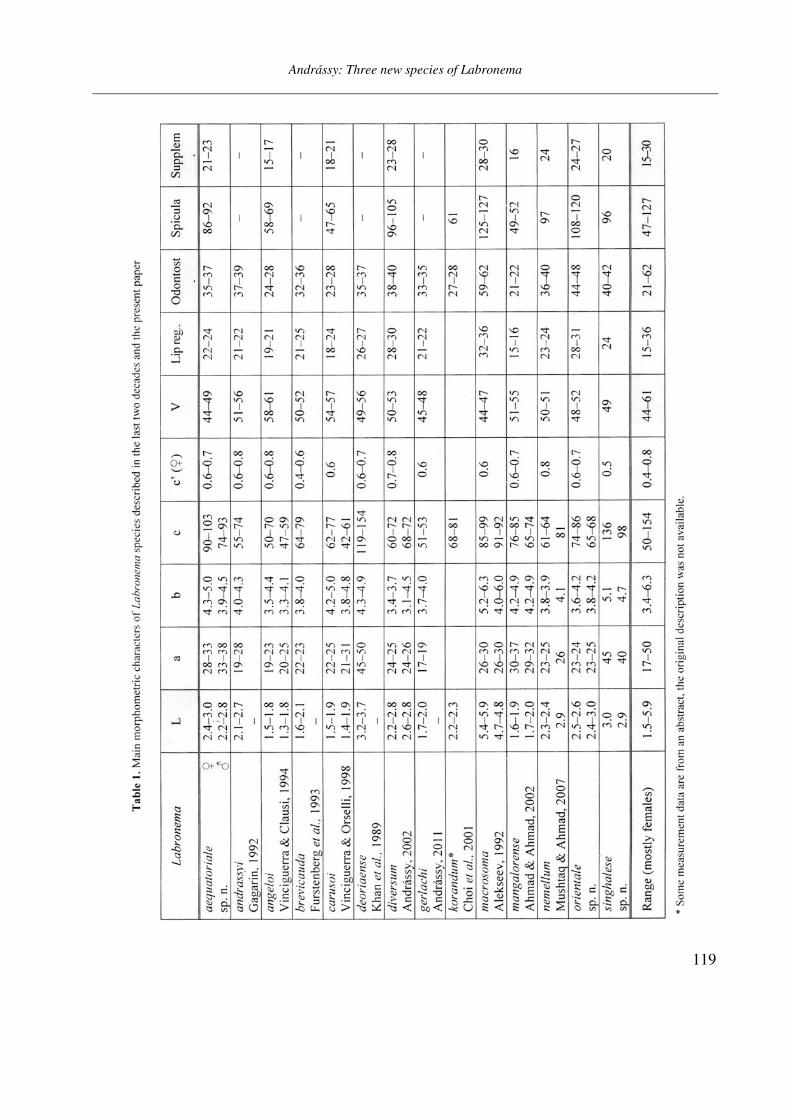
Opuscula Zoologica - Tomus 42. Fasc. 2. (2011.) - REAL-J
103
Opusc. Zool. Budapest, 2011, 42(2): 107–120 _______________________________________________________________________________________________________ 1 Dr. István Andrássy, ELTE Állatrendszertani és Ökológiai Tanszék, MTA Zootaxonómiai Kutatócsoport (Department of Systematic Zoology and Ecology of the Eötvös Loránd University, Systematic Zoology Research Group of the Hungarian Academy of Sciences), Pázmány Péter sétány 1/C, 1117 Budapest, Hungary. Three new bisexual species of Labronema Thorne, 1939 (Nematoda: Qudsianematidae) I. ANDRÁSSY 1 Abstract. Three new species of the genus Labronema Thorne, 1939 are described on the basis of both female and male specimens. Labronema aequatoriale sp. n. from Ecuador is characterized by the body length on average 2.77 (female) and 2.46 (male) mm, odontostyle as long as labial width, very long cardia, long rectum, short prerectum and supplements 21–23. Labronema singhalese sp. n. from Sri Lanka is differentiated by 3 mm long body, odontostyle longer than labial diameter, short female and long male prerectum, long eggs and supplements 20 in number. Labronema orientale sp. n. from Taiwan is characterized by a body length on average 2.52 (female) and 2.65 (male) mm, lip region offset, odontostyle longer than labial width, long rectum, short prerectum and 24–27 supplements. The taxonomic positions of Labronema species described after 1989-90 are commented. Keywords. Nematoda, Ecuador, Sri Lanca, Taiwan, new species ithin the family Qudsianematidae, Labro- nema Thorne, 1939 is well characterized by the double guiding ring, longitudinal or pore-like vulva, shape of the vagina, great number of very small and contiguous supplements and the short, rounded tail of sexes. As for the nominal species placed under this genus, about half a hundred in number, the picture is by far not so clear. The high per cent (about 40 %!) of species described on the basis of one sex (female) only make the orientation within the genus more difficult. Par- ticularly in dorylaimid nematodes, descriptions of both females and males are much to be wished! As is expressed in the title, both of the sexes of three new Labronema species are herewith pre- sented. They have been collected in tropical–sub- tropical regions of earth, namely in Ecuador, Sri Lanka and Taiwan. They were compared with the species described before 1989-90 (29 in number) as listed and keyed by Andrássy (1991), but with those, too, that have been discovered in the two subsequent decades (11 in number). MATERIAL AND METHODS The nematodes were collected by Hungarian scientists. The samples were fixed in situ with 4% formaldehyde solution, and then washed out in the laboratory by flotation techniques. The nematodes were picked out by hand, and fixed again with FAA. Subsequently they were processed to pure glycerine by a slow method, and finally mounted on permanent glass slides. Measurements were taken by ocular micro- meter, curved structures were measured along the curved medial line. Drawings were made with the aid of a drawing tube attachment. The nematodes discussed herein are preserved in the nematode collection of the Systematic Zoology and Ecology of ELTE University, Budapest. Labronema aequatoriale sp. n. (Figs. 1 A–E and 2 A–C) Holotype female: L = 2.58 mm; a = 28; b = 4.6; c = 99; c’ = 0.7; V = 44 %. Paratype females (n = 4): L = 2.40–3.00 mm; a = 30–33; b = 4.3–5.0; c = 90–103; c’ = 0.6–0.7; V = 46–49 %. Paratype males (n = 3): L = 2.20–2.76 mm; a = 33–38; b = 3.9–4.5; c = 74–93; c’ = 0.7–0.8. General characters. Body mostly slightly bent ventrad upon fixation, moderately slender, 75–96 W
-
Upload
khangminh22 -
Category
Documents
-
view
1 -
download
0
Transcript of Opuscula Zoologica - Tomus 42. Fasc. 2. (2011.) - REAL-J
Opusc. Zool. Budapest, 2011, 42(2): 107–120
_______________________________________________________________________________________________________ 1Dr. István Andrássy, ELTE Állatrendszertani és Ökológiai Tanszék, MTA Zootaxonómiai Kutatócsoport (Department of
Systematic Zoology and Ecology of the Eötvös Loránd University, Systematic Zoology Research Group of the Hungarian Academy of Sciences), Pázmány Péter sétány 1/C, 1117 Budapest, Hungary.
Three new bisexual species of Labronema Thorne, 1939
(Nematoda: Qudsianematidae)
I. ANDRÁSSY1
Abstract. Three new species of the genus Labronema Thorne, 1939 are described on the basis of both female and male specimens. Labronema aequatoriale sp. n. from Ecuador is characterized by the body length on average 2.77 (female) and 2.46 (male) mm, odontostyle as long as labial width, very long cardia, long rectum, short prerectum and supplements 21–23. Labronema singhalese sp. n. from Sri Lanka is differentiated by 3 mm long body, odontostyle longer than labial diameter, short female and long male prerectum, long eggs and supplements 20 in number. Labronema orientale sp. n. from Taiwan is characterized by a body length on average 2.52 (female) and 2.65 (male) mm, lip region offset, odontostyle longer than labial width, long rectum, short prerectum and 24–27 supplements. The taxonomic positions of Labronema species described after 1989-90 are commented.
Keywords. Nematoda, Ecuador, Sri Lanca, Taiwan, new species
ithin the family Qudsianematidae, Labro-nema Thorne, 1939 is well characterized by
the double guiding ring, longitudinal or pore-like vulva, shape of the vagina, great number of very small and contiguous supplements and the short, rounded tail of sexes. As for the nominal species placed under this genus, about half a hundred in number, the picture is by far not so clear. The high per cent (about 40 %!) of species described on the basis of one sex (female) only make the orientation within the genus more difficult. Par-ticularly in dorylaimid nematodes, descriptions of both females and males are much to be wished!
As is expressed in the title, both of the sexes of three new Labronema species are herewith pre-sented. They have been collected in tropical–sub-tropical regions of earth, namely in Ecuador, Sri Lanka and Taiwan. They were compared with the species described before 1989-90 (29 in number) as listed and keyed by Andrássy (1991), but with those, too, that have been discovered in the two subsequent decades (11 in number).
MATERIAL AND METHODS
The nematodes were collected by Hungarian scientists. The samples were fixed in situ with 4%
formaldehyde solution, and then washed out in the laboratory by flotation techniques. The nematodes were picked out by hand, and fixed again with FAA. Subsequently they were processed to pure glycerine by a slow method, and finally mounted on permanent glass slides.
Measurements were taken by ocular micro-meter, curved structures were measured along the curved medial line. Drawings were made with the aid of a drawing tube attachment. The nematodes discussed herein are preserved in the nematode collection of the Systematic Zoology and Ecology of ELTE University, Budapest.
Labronema aequatoriale sp. n.
(Figs. 1 A–E and 2 A–C)
Holotype female: L = 2.58 mm; a = 28; b = 4.6; c = 99; c’ = 0.7; V = 44 %.
Paratype females (n = 4): L = 2.40–3.00 mm; a = 30–33; b = 4.3–5.0; c = 90–103; c’ = 0.6–0.7; V = 46–49 %.
Paratype males (n = 3): L = 2.20–2.76 mm; a = 33–38; b = 3.9–4.5; c = 74–93; c’ = 0.7–0.8.
General characters. Body mostly slightly bent ventrad upon fixation, moderately slender, 75–96
W
Andrássy: Three new species of Labronema
108
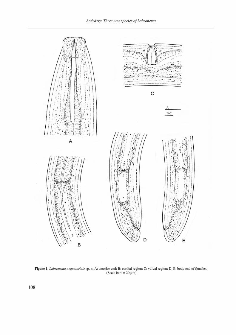
Figure 1. Labronema aequatoriale sp. n. A: anterior end; B: cardial region; C: vulval region; D–E: body end of females. (Scale bars = 20 µm)
Andrássy: Three new species of Labronema
109
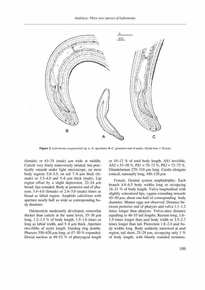
Figure 2. Labronema aequatoriale sp. n. A: spiculum; B–C: posterior end of males. (Scale bars = 20 µm)
(female) or 63–74 (male) µm wide at middle. Cuticle very finely transversely striated, but prac-tically smooth under light microscope, on most body regions 5.0–5.5, on tail 7–8 µm thick (fe-male) or 3.5–4.0 and 5–6 µm thick (male). Lip region offset by a slight depression, 22–24 µm broad; lips rounded. Body at posterior end of pha-rynx 3.4–4.0 (female) or 2.6–3.0 (male) times as broad as labial region. Amphids caliciform with aperture nearly half as wide as corresponding bo-dy diameter.
Odontostyle moderately developed, somewhat thicker than cuticle at the same level, 35–38 µm long, 1.2–1.5 % of body length, 1.5–1.6 times as long as labial width, and 5–6 µm thick. Aperture two-fifths of stylet length. Guiding ring double. Pharynx 550–620 µm long, at 47–50 % expanded. Dorsal nucleus at 49–52 % of pharyngeal length
or 10–12 % of total body length. AS1 invisible, AS2 = 53–56 %, PS1 = 70–72 %, PS2 = 72–75 %. Glandularium 270–310 µm long. Cardia elongate conical, unusually long, 100–120 µm.
Female. Genital system amphidelphic. Each branch 4.8–6.5 body widths long or occupying 16–21 % of body length. Vulva longitudinal with slightly sclerotized lips, vagina extending inwards 45–50 µm, about one-half of corresponding body diameter. Mature eggs not observed. Distance be-tween posterior end of pharynx and vulva 1.1–1.2 times longer than pharynx. Vulva–anus distance equalling to 48–55 tail lengths. Rectum long, 1.6–1.9 times longer than anal body width or 2.5–2.7 times longer than tail. Prerectum 1.8–2.4 anal bo-dy widths long. Body suddenly narrowed at anal region, tail short, 25–29 µm, occupying only 1 % of body length, with bluntly rounded terminus.

Andrássy: Three new species of Labronema
110
Figure 3. Labronema singhalese sp. n. A: anterior end; B: cardial region; C: vulval region; D: female posterior end.
(Scale bars = 20 µm)
Andrássy: Three new species of Labronema
111
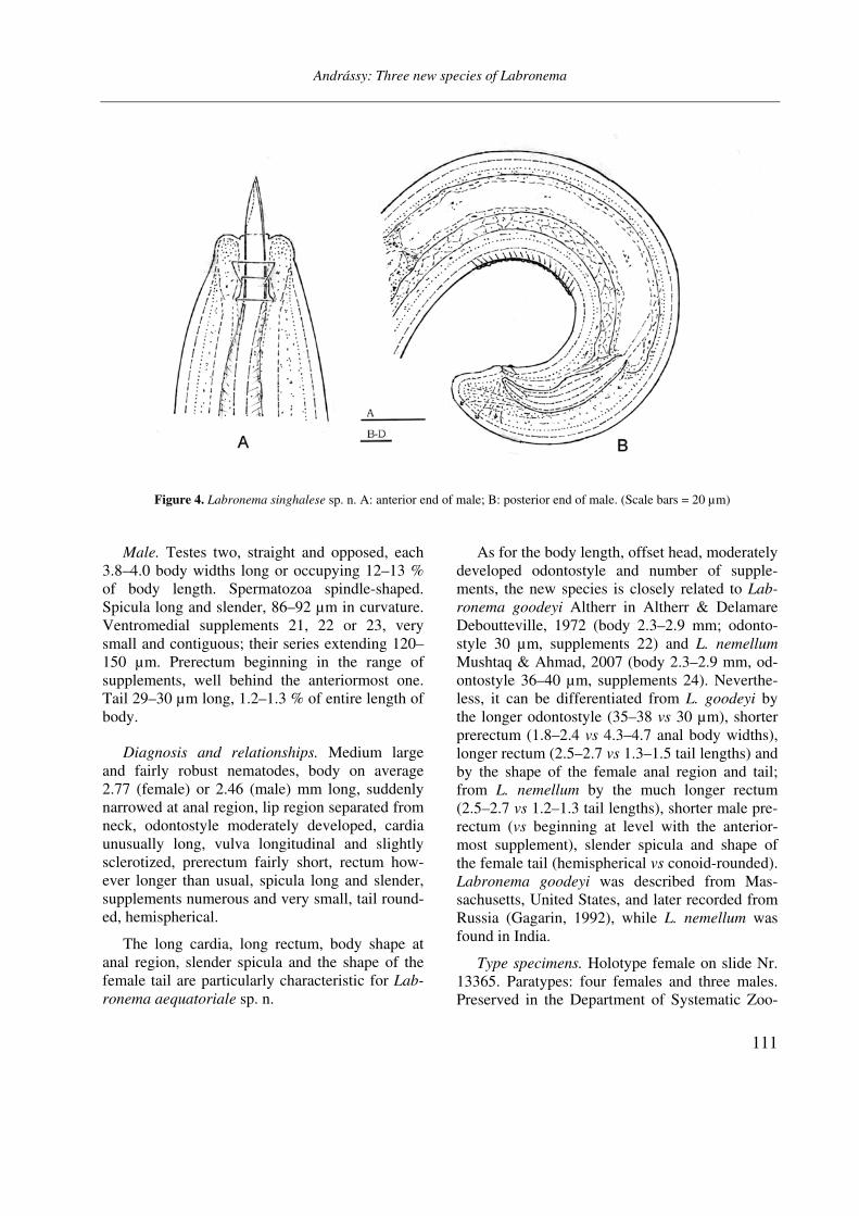
Figure 4. Labronema singhalese sp. n. A: anterior end of male; B: posterior end of male. (Scale bars = 20 µm)
Male. Testes two, straight and opposed, each 3.8–4.0 body widths long or occupying 12–13 % of body length. Spermatozoa spindle-shaped. Spicula long and slender, 86–92 µm in curvature. Ventromedial supplements 21, 22 or 23, very small and contiguous; their series extending 120–150 µm. Prerectum beginning in the range of supplements, well behind the anteriormost one. Tail 29–30 µm long, 1.2–1.3 % of entire length of body.
Diagnosis and relationships. Medium large and fairly robust nematodes, body on average 2.77 (female) or 2.46 (male) mm long, suddenly narrowed at anal region, lip region separated from neck, odontostyle moderately developed, cardia unusually long, vulva longitudinal and slightly sclerotized, prerectum fairly short, rectum how-ever longer than usual, spicula long and slender, supplements numerous and very small, tail round-ed, hemispherical.
The long cardia, long rectum, body shape at anal region, slender spicula and the shape of the female tail are particularly characteristic for Lab-
ronema aequatoriale sp. n.
As for the body length, offset head, moderately developed odontostyle and number of supple-ments, the new species is closely related to Lab-
ronema goodeyi Altherr in Altherr & Delamare Deboutteville, 1972 (body 2.3–2.9 mm; odonto-style 30 µm, supplements 22) and L. nemellum
Mushtaq & Ahmad, 2007 (body 2.3–2.9 mm, od-ontostyle 36–40 µm, supplements 24). Neverthe-less, it can be differentiated from L. goodeyi by the longer odontostyle (35–38 vs 30 µm), shorter prerectum (1.8–2.4 vs 4.3–4.7 anal body widths), longer rectum (2.5–2.7 vs 1.3–1.5 tail lengths) and by the shape of the female anal region and tail; from L. nemellum by the much longer rectum (2.5–2.7 vs 1.2–1.3 tail lengths), shorter male pre-rectum (vs beginning at level with the anterior-most supplement), slender spicula and shape of the female tail (hemispherical vs conoid-rounded). Labronema goodeyi was described from Mas-sachusetts, United States, and later recorded from Russia (Gagarin, 1992), while L. nemellum was found in India.
Type specimens. Holotype female on slide Nr. 13365. Paratypes: four females and three males. Preserved in the Department of Systematic Zoo-
Andrássy: Three new species of Labronema
112
logy and Ecology of the ELTE University, Buda-pest.
Type habitat and locality. Litter from a rain-forest, 750 m above sea level, El Palmar, Cañar Province, Ecuador; collected in April 1990 by A. Zicsi and Cs. Csuzdi.
Etymology. Named after its geographical di-stribution.
Labronema singhalese sp. n.
(Figs. 3 A–D and 4 A–B)
Holotype female: L = 3.04 mm; a = 45; b = 5.1; c = 136; c’ = 0.5; V = 49 %.
Paratype male: L = 2.86 mm; a = 40; b = 4.7; c = 98; c’ = 0.7.
General characters. Body slightly (female) or strongly (male) curved ventrad, 66–70 µm wide at middle. Cuticle practically smooth, 3.5–5 µm thick on most body, and 7 µm thick on tail. Lip region separated by a shallow depression, 25 µm wide, lips rounded. Body at posterior end of pha-rynx 2.8–2.9 times as wide as head. Amphids ca-liciform with aperture about one-half of corre-sponding body width.
Odontostyle 40–42 µm long, 1.3–1.4 % of to-tal body length, 1.7 times longer than labial width, strong, 6–7 µm thick, thicker than cuticle at the same level (about as thick as one-third labial di-ameter). Aperture occupying two-fifth to nearly one-half of stylet length. Guiding ring double. Pharynx 600–610 µm long, heavily muscular, at 48–49 % expanded. Dorsal nucleus at 50–51 % of pharyngeal length, or 10–11 % of entire length of body. Most of the other gland nuclei inconspi-cuous, PS2 = 70–72 %. Glandularium 296–302 µm long. Cardia conical.
Female. Reproductive system very well de-veloped, amphidelphic. Each genital branch 9.2 body diameters long or occupying 20 % of body length. Vulva longitudinal with slightly scleroti-zed lips, vagina 36 µm long, extending inwards to about 50 % of the corresponding body diameter. Distance between posterior end of pharynx and vulva 1.5 times as long as pharynx. Rectum 1.2,
prerectum 1.1 anal body widths long. One mature egg: 124×40 µm, 1.8 times as long as mid-body diameter. Vulva–anus distance equalling to 68 tail lengths. Tail quite short, 22 µm, only 0.7 % of body length.
Male. Testes opposite, straight, each 6.3 body widths long or occupying 16 % of body length. Spermatozoa fusiform, small, 6–7 µm. Spicula large, 96 µm long. Ventromedial supplements very small, 20 in number; their series 70 µm long. Prerectum beginning well over the anteriormost supplement. Tail conoid-rounded, 29 µm long or 1.0 % of entire length of body.
Diagnosis and relationships. A large species, 3 mm, with comparatively slender body, slightly se-parated lip region, strong odontostyle more than one-half times longer than labial width, at its middle expanded pharynx, short female and long male prerectum, longitudinal vulva, well deve-loped gonads, long egg, large spicula, very small supplements 20 in number, and broadly rounded tail in both sexes.
By virtue of the the length (about 3 mm) and slenderness of body, the moderately offset head and the large stylet opening, this new species re-sembles Labronema thornei Ferris, 1968. It can be distinguished from its relative by having a longer and thicker odontostyle (40–42 vs 30–34 µm; 1.7 vs 1.2–1.3 labial widths; thicker vs thin-ner than cuticle) and a shorter prerectum (1 vs
2.5–3.0 anal body widths long). The male is not comparable since this sex is unknown in L.
thornei. Ferris found her species in Indiana, Uni-ted States. Subsequently, Panesar and Marshall (2003) reported it from British Columbia, Canada, but they did not add any contribution to its mor-phology.
Type specimens. Holotype female on slide “Sri Lanka Nr. 6”. Paratype: one male. Deposited at the Department of Systematic Zoology and Eco-logy of the ELTE University, Budapest.
Type habitat and locality. Rich black humus around grass roots in a claudy bamboo forest, 1800 m above sea level, Nuwara Eliya in the central highlands of Sri Lanka; collected in June 1968 by J. Balogh and I. Loksa.
Andrássy: Three new species of Labronema
113
Etymology. Named after Singhalese (or Sin-halese) people, the majority ethnic group in Sri Lanka.
Labronema orientale sp. n.
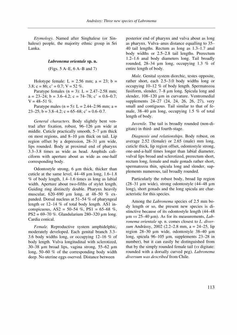
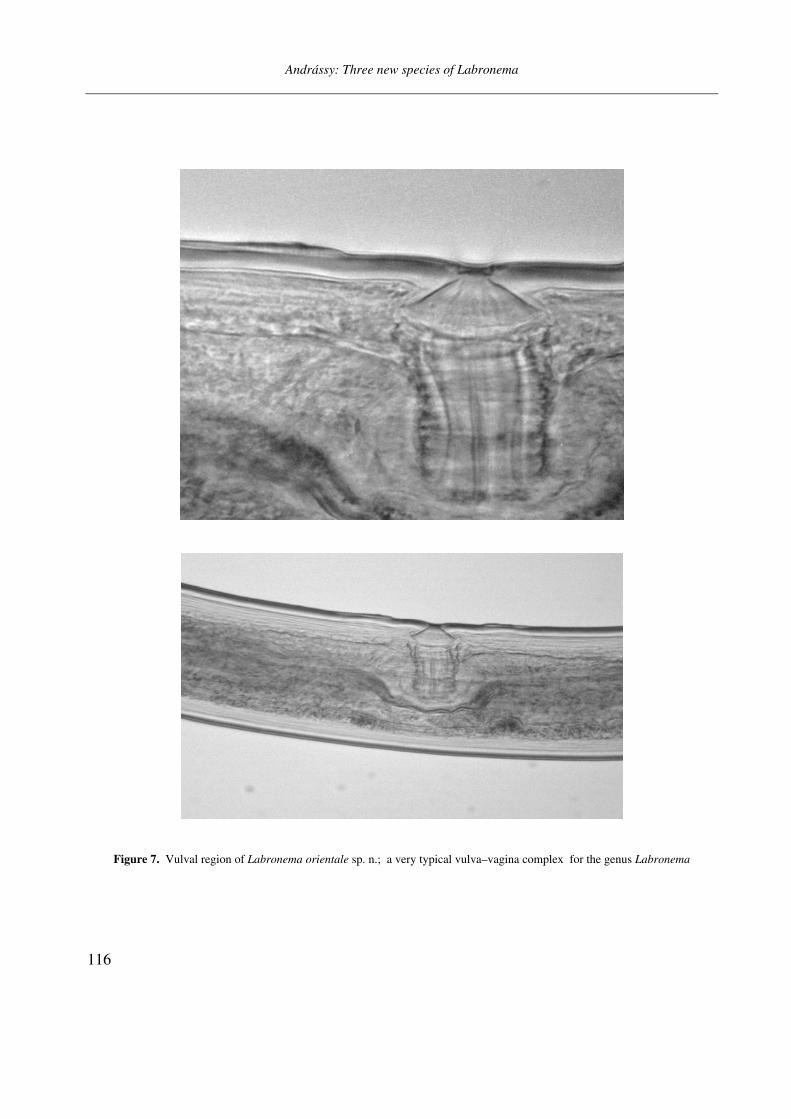
(Figs. 5 A–E, 6 A–B and 7)
Holotype female: L = 2.56 mm; a = 23; b = 3.8; c = 86; c’ = 0.7; V = 52 %.
Paratype females (n = 3): L = 2.47–2.58 mm; a = 23–24; b = 3.6–4.2; c = 74–78; c’ = 0.6–0.7; V = 48–51 %.
Paratype males (n = 5): L = 2.44–2.96 mm; a = 23–25; b = 3.8–4.2; c = 65–68; c’ = 0.6–0.7.
General characters. Body slightly bent ven-trad after fixation, robust, 96–126 µm wide at middle. Cuticle practically smooth, 5–7 µm thick on most regions, and 8–10 µm thick on tail. Lip region offset by a depression, 28–31 µm wide, lips rounded. Body at proximal end of pharynx 3.3–3.8 times as wide as head. Amphids cali-ciform with aperture about as wide as one-half corresponding body.
Odontostyle strong, 6 µm thick, thicker than cuticle at the same level, 44–48 µm long, 1.6–1.8 % of body length, 1.4–1.6 times as long as labial width. Aperture about two-fifths of stylet length. Guiding ring distinctly double. Pharynx heavily muscular, 620–690 µm long, at 48–50 % ex-panded. Dorsal nucleus at 51–54 % of pharyngeal length or 12–14 % of total body length. AS1 in-conspicuous, AS2 = 50–54 %, PS1 = 65–68 %, PS2 = 69–70 %. Glandularium 280–320 µm long. Cardia conical.
Female. Reproductive system amphidelphic, moderately developed. Each genital branch 3.3–3.6 body widths long, or occupying 12–16 % of body length. Vulva longitudinal with sclerotized, 30–38 µm broad lips, vagina strong, 55–62 µm long, 50–60 % of the corresponding body width deep. No uterine eggs oserved. Distance between
posterior end of pharynx and vulva about as long as pharynx. Vulva–anus distance equalling to 35–40 tail lengths. Rectum as long as 1.3–1.7 anal body widths or 2.5–2.8 tail lengths. Prerectum 1.2–1.6 anal body diameters long. Tail broadly rounded, 28–34 µm long, occupying 1.3 % of entire length of body.
Male. Genital system diorchic, testes opposite, rather short, each 2.5–3.0 body widths long or occupying 10–12 % of body length. Spermatozoa fusiform, slender, 7–8 µm long. Spicula long and slender, 108–120 µm in curvature. Ventromedial supplements 24–27 (24, 24, 26, 26, 27), very small and contiguous. Tail similar to that of fe-male, 38–40 µm long, occupying 1.5 % of total length of body.
Juvenile. The tail is broadly rounded (non-di-gitate) in third- and fourth-stage.
Diagnosis and relationships. Body robust, on average 2.52 (female) or 2.65 (male) mm long, cuticle thick, lip region offset, odontostyle strong, one-and-a-half times longer than labial diameter, vulval lips broad and sclerotized, prerectum short, rectum long, female and male gonads rather short, spermatozoa thin, spicula long and slender, sup-plements numerous, tail broadly rounded.
Particularly the robust body, broad lip region (28–31 µm wide), strong odontostyle (44–48 µm long), short gonads and the long spicula are char-acteristic for this species.
Among the Labronema species of 2.5 mm bo-dy length or so, the present new species is di-stinctive because of its odontostyle length (44–48 µm vs 25–40 µm). As for its measurements, Lab-
ronema orientale sp. n. comes closest to L. diver-
sum Andrássy, 2002 (2.2–2.8 mm, a = 24–25, lip region 28–30 µm wide, odontostyle 38–40 µm long, spicula 96–105 µm, supplements 23–28 in number), but it can easily be distinguished from that by the simply rounded female tail (vs digitate: rounded with a dorsally curved peg). Labronema
diversum was described from Chile.

Andrássy: Three new species of Labronema
114
Figure 5. Labronema orientale sp. n. A: anterior end; B: cardial region; C: vulval region; D–E: posterior end of females. (Scale bars = 20 µm)
Andrássy: Three new species of Labronema
115
Figure 6. Labronema orientale sp. n. A–B: posterior end of two males. (Scale bar = 20 µm)
Type specimens. Holotype female on slide “Taiwan Nr. II/1”. Paratypes: three females, five males and four juveniles in the collection of De-partment of Systematic Zoology and Ecology at the ELTE University, Budapest.
Type habitat and locality. Soil from a secon-dary broad-leaved forest, 2100 m above sea level, NW slope of Mt. Wufanaiwe, Renai township, Nantou County, Taiwan; collected in October 2009 by L. Dányi and E. Lazányi.
Etymology. The epithet orientale refers to the far oriental distribution of this species.
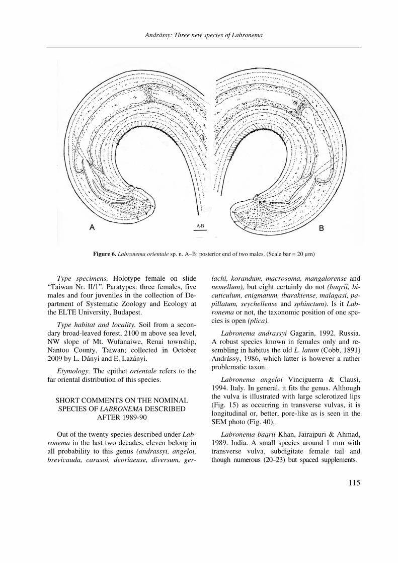
SHORT COMMENTS ON THE NOMINAL SPECIES OF LABRONEMA DESCRIBED
AFTER 1989-90
Out of the twenty species described under Lab-
ronema in the last two decades, eleven belong in all probability to this genus (andrassyi, angeloi,
brevicauda, carusoi, deoriaense, diversum, ger-
lachi, korandum, macrosoma, mangalorense and nemellum), but eight certainly do not (baqrii, bi-
cuticulum, enigmatum, ibarakiense, malagasi, pa-
pillatum, seychellense and sphinctum). Is it Lab-
ronema or not, the taxonomic position of one spe-cies is open (plica).
Labronema andrassyi Gagarin, 1992. Russia. A robust species known in females only and re-sembling in habitus the old L. latum (Cobb, 1891) Andrássy, 1986, which latter is however a rather problematic taxon.
Labronema angeloi Vinciguerra & Clausi, 1994. Italy. In general, it fits the genus. Although the vulva is illustrated with large sclerotized lips (Fig. 15) as occurring in transverse vulvas, it is longitudinal or, better, pore-like as is seen in the SEM photo (Fig. 40).
Labronema baqrii Khan, Jairajpuri & Ahmad, 1989. India. A small species around 1 mm with transverse vulva, subdigitate female tail and though numerous (20–23) but spaced supplements.
Andrássy: Three new species of Labronema
116
Figure 7. Vulval region of Labronema orientale sp. n.; a very typical vulva–vagina complex for the genus Labronema

Andrássy: Three new species of Labronema
117
It does surely not belong to Labronema. Is it a Crassolabium?
Labronema bicuticulum Furstenberg, Heyns & Swart, 1993. Seychelles. As the authors say, the double cuticle on tail distinguishes it from all known Labronema species. In addition, the short odontostyle and the non-typical vulva–vagina also suppose that this species better belongs to the genus Aporcelaimellus than Labronema. It is herewith transferred to the former genus: Apor-
celaimellus bicuticulus (Furstenberg, Heyns & Swart, 1993) comb. n.
Labronema brevicauda Furstenberg, Heyns & Swart, 1993. Madagascar. A robust species with Labronema-like vulva–vagina and other charac-ters typical for the genus. The male is uniknown.
Labronema carusoi Vinciguerra & Orselli, 1998. Italy. In spite of the fact that the illustration (Fig. 2 A) shows a non-typical vulva, this species corresponds in other morphological characters to Labronema.
Labronema deoriaense Khan, Jairajpuri & Ah-mad, 1989. India. In having Labronema-like char-acters, this large-sized (3–4 mm) and very slender species should be accepted as a representative of this genus. Known in female only.
Labronema diversum Andrássy, 2002. Chile. Easily can be identified by the dimorphic tail: conoid-rounded in male as usual, but possessing a dorsally curved peg in female. This peculiar struc-ture of the female tail appears to be an atavistic character which may occur in some larval stages as illustrated by Ferris (1968) in Labronema
thornei Ferris, 1968.
Labronema enigmatum Baniyamuddin & Ah-mad, 2007. India. This spedcies was transferred by me (Andrássy, 2009) to Labronemella.
Labronema gerlachi Andrássy, 2011. Sey-chelles. A very robust monosexual species with quite short prerectum, but with typical Labronema
characters. Only females are known.
Labronema ibarakiense Khan & Araki, 2002. Japan. Since the vulva is transverse, the tail sub-digitate in both sexes and the supplements are
spaced, I propose to transfer this species to the genus Talanema, as T. ibarakiense (Khan & Ara-ki, 2003) comb. n.
Labronema korandum Choi, Khan & Choi, 2001. Korea. I know this species only from a short abstract; its description was unfortunately not available. Labronema?
Labronema macrosoma Alekseev, 1992. Russia. A well characterized species, one of the largest representatives of the genus Labronema
(5–6 mm).
Labronema malagasi Furstenberg, Heyns & Swart, 1993. Madagascar, India. Because of the transverse vulva and the few (13) and well-spaced supplements I (2009) transferred this species to Crassolabium.
Labronema mangalorense Ahmad & Ahmad, 2002. India. A well characterized Labronema species. Its spicula (L-shaped, dorsally thickened and beak-like in distal part) are very similar to those of L. pacificum (Cobb, 1906) Thorne, 1939 as recently described and illustrated by Álvarez-Ortega, Vu and Peña-Santiago (2010). Labronema
mangalorense is however shorter, more slender and has a much shorter odontostyle.
Labronema nemellum Mushtaq & Ahmad, 2007. India. Well fits the Labronema pattern.
Labronema papillatum Khan, Ahmad & Jai-rajpuri, 1995. India. Because of the heavily scle-rotized transverse vulva it was transferred by me (Andrássy, 2009) to Crassolabium.
Labronema plica Ciobanu, Popovici & De-craemer, 2004. Romania. In having a cap-like lip region, a short odontostyle and a simple guiding ring, Popovici et al. (2008) transferred this spe-cies to Thonus, and recently Peña-Santiago and Ciobanu (2011) to Crassolabium (syn. Thonus). The former authors noted that the shape of the vulva–vagina and the great number of the con-tiguous supplements better fit the Labronema pat-tern. It is possible that, by virtue of the last men-tioned two structures being so characteristic for Labronema (e.g. see the vulval regions of the pre-sent new species), L. plica should still be left in its
Andrássy: Three new species of Labronema
118
original genus. For the present, be this question open.
Labronema seychellense Furstengberg, Heyns & Swart, 1993. Seychelles. Because of the few (10) non-contiguous supplements I (2009) trans-ferred it to Crassolabium.
Labronema sphinctum Mohilal & Dhanachand, 2001. India. In having only a few (8) well spaced supplements, this species cannot be placed under Labronema. Its taxonomic position is uncertain.
Acknowledgements. My thanks are due to the late Prof. János Balogh and Dr. Imre Loksa, furthermore to Prof. Csaba Csuzdi, László Dányi, Eszter Lazányi and Prof. András Zicsi for collecting the materials studied.
REFERENCES
AHMAD, A. & AHMAD, W. (2002): Descriptions of three new species of Dorylaimoidea (Nematoda: Dorylaimida) from South India. International Jour-
nal of Nematology, 12: 23–28.
ALEKSEEV, B. M. (1992): Morphology of new and rare nematode species from the waters in the south of the Far East in Russia. (In Russian.) Zoologicheskii
Zhurnal, 71: 9–18.
ALTHERR, E. & DELAMARE DEBOUTTEVILLE, CL. (1972): Nématodes interstitiels des eaux douces des États-Unis d’Amérique (États de Washington, du Colorado et du Massachusetts) récoltés par Cl. De-lamare Deboutteville. Annales de Spéléologie, 27:
683–760.
ÁLVAREZ-ORTEGA, S., VU, T. T. & PEÑA-SANTIAGO, R. (2010): Studies on four atypical species of the genus Labronema Thorne, 1939 (Dorylaimida, Qudsianematidae). Journal of Nematode Morpho-
logy and Systematics, 13: 107–122.
ANDRÁSSY, I. (1991): The superfamily Dorylaimoidea (Nematoda) – a review. Family Qudsianematidae, II. Opuscula Zoologica Instituti Zoosystematici
Universitatis Budapestinensis, 24: 3–55.
ANDRÁSSY, I. (2002): New genera and species of ne-matodes from southern Chile. Opuscula Zoologica
Instituti Zoosystematici Universitatis Budapestinen-
sis, 34: 5–22.
ANDRÁSSY, I. (2009): Free-living nematodes of Hun-
gary (Nematoda errantia), III. Pedozoologica Hun-garica, 5, 608 pp.
ANDRÁSSY, I. (2011): Free living nematodes of Sey-chelles. In: Gerlach, J. (ed.): Crustacea, Platyhel-minthes, Nematoda, Annelida and Tardigrada of the Seychelles Islands. Siri Scientific Press, Manches-
ter (160 pp), spec p. 15–57.
BANIYAMUDDIN, MD. & AHMAD, W. (2007): Some new and known species of Dorylaimoidea (Dorylaimida: Nematoda) from nature forest of Arunachal Pra-desh, India. Journal of Nematode Morphology and
Systematics, 10: 75–93.
CIOBANU, M., POPOVICI, I. & DECRAEMER, W. (2004): Nematodes of some salt affected areas from Ro-mania (Nematoda: Dorylaimoidea). Russian Jour-
nal of Nematology, 12: 9–30.
CIOBANU, M., POPOVICI, I., DECRAEMER, W. & PEÑA-SANTIAGO, R. (2008): On the identity of Labro-
nema plica Ciobanu, Popovici & Decraemer, 2004 and proposal for its transfer to the genus Thonus
Thorne, 1974 (Nematoda: Dorylaimoidea). Nema-
tology, 10: 599–602.
FERRIS, V. R. (1968): Biometric analyses in the genus Labronema (Nematoda: Dorylaimida) with a de-scription of L. thornei n. sp. Nematologica, 14:
276–284.
FURSTENBERG, J. P., HEYNS, J. & SWART, A. (1993): Four new species of Labronema Thorne, 1939 from islands in the Western Indian Ocean (Nematoda: Dorylaimoidea). Nematologica, 39: 450–465.
GAGARIN, V. G. (1992): The freeliving freshwater ne-
matodes of SSSR. (In Russian.) Sankt-Peterburg, 152 pp.
KHAN, T. H., JAIRAJPURI, M. S. & AHMAD, W. (1989): Two new species of Labronema (Nematoda: Do-rylaimida) from India. Indian Journal of Nemato-
logy, 19: 194–189.
KHAN, Z., AHMAD, W. & JAIRAJPURI, M. S. (1995): Description of four new species of dorylaimid ne-matodes. Afro-Asian Journal of Nematology, 5:
133–140.
Andrássy: Three new species of Labronema
119
Andrássy: Three new species of Labronema
120
KHAN Z. & ARAKI, M. (2002): Study of dorylaims (Nematoda) from Japan with descriptions of five new species. International Journal of Nematology,
12: 1–12.
MOHILAL, N. & DHANACHAND, CH. (2001): Inves-tigations of soil nematodes from Manipur. X: Spe-cies of the family Qudsianematidae. Uttar Pradesh
Journal of Zoology, 21: 41–45.
MUSHTAQ, P. & AHMAD, W. (2007): Some new and known species of the family Qudsianematidae (Ne-matoda: Dorylaimida) from Jammu and Kashmir, India. Journal of Nematode Morphology and Syste-
matics, 9: 153–178.
PANESAR, T. S. & MARSHALL, V. G. (2003): Mono-
graph of soil nematodes from coastal Douglas-fir
forests in British Columbia. Royal Roads Univer-sity, Canada, 177 pp.
PEÑA-SANTIAGO, R. & CIOBANU, M. (2011): The genus
Crassolabium Yeates, 1967 (Nematoda: Dorylaimi-
da): a monographic study. Monographic Papers on Nematology, 5, 195 pp.
POPOVICI, I., CIOBANU, M. & PEÑA-SANTIAGO, R. (2008): Soil and freshwater nematodes (Nemato-
da) from Romania: A compendium. Monographic Papers on Nematology, 4, 142 pp.
THORNE, G. (1939): A monograph of the superfamily
Dorylaimoidea. Capita Zoologica, 8, 261 pp.
VINCIGUERRA, M. T. & CLAUSI, M. (1994): Nematodes of Salina. Three new and one rare species of Qud-sianematidae (Dorylaimida). Animalia, 21: 97–112.
VINCIGUERRA, M. T. & ORSELLI, L. (1998): Nematodes of Italian sand dunes. 3. Four new species of Qud-sianematidae (Dorylaimida: Nematoda). Nematolo-gia Mediterranea, 26: 255–266.
Opusc. Zool. Budapest, 2011, 42(2): 121–124
_______________________________________________________________________________________________________
1Dr. Jenő Kontschán, Systematic Zoology Research Group, Hungarian Academy of Sciences, and Department of Zoology, Hungarian Natural History Museum, H-1088 Budapest, Baross u. 13. Hungary. E-mail: [email protected]
First record of the family Rotundabaloghiidae Hirschmann, 1975
in India, with description of two new species of Angulobaloghia
Hirschmann, 1975 (Acari: Mesostigmata: Uropodina)
J. KONTSCHÁN1
Abstract. Two new species, Angulobaloghia tamilica and Angulobaloghia indica spp. nov. belonging to the family Rotundabaloghiidae are recorded from India. The new species differ from the previously described congeners in the shape of the females’ genital shield and shape and position of sternal and ventral setae.
Keywords. Acari, Uropodina, Angulobaloghia, new species, India.
INTRODUCTION
ropodina mites are small (300 to 1200 µm), yellow or reddish-brown animals, belonging
to the soil fauna. They inhabit soil, leaf litter, moss, lichens and bark of tree. Several species live in association with other arthropods and ver-tebrates as well. More than two thousand species are known worldwide (Wiśniewski and Hirsch-mann, 1993), but their maximum diversity is reached in the tropical rain forests (Lindquist at
al., 2009).
The family Rotundabaloghiidae, a member of Uropodina mites is distributed overall in the tropics (Kontschán, 2010). This family contains an interesting genus Angulobaloghia Hirschmann, 1979 of South-East Asian distribution which can easily be recognized by the triangular or semi-circular shape of the genital shield of females.
The genus was established by Hirschmann in 1979 separating several Rotundabaloghia Hirsch-mann, 1975 species with triangular genital shield. Later Hirschmann and his colleagues (Wiśniewski and Hirschmann, 1993; Wiśniewski, 1993 a, 1993 b,) never mentioned again this genus, and the species with triangular genital shield were placed back to the genus Rotundabaloghia. A recent phy-logenetic analysis of Uropodina by Kontschán (2010) resulted in resurrection the genus An-
gulobaloghia and furthermore he presented oc-
currences of the all species belonging to the fa-mily Rotundabaloghiidae. However he did not mention any rotundabaloghid mite from the In-dian subcontinent.
During studying the “Berlese” samples of the Hungarian Natural History Museum collected in the Indian subcontinent, two new Angulobaloghia species were found which are herewith described.
MATERIAL AND METHODS
Specimens were cleared in lactic acid and
drawings were made with the aid of a drawing tube. All specimens are stored in alcohol and de-posited in the Soil Zoology Collections of the Hungarian Natural History Museum, Budapest. Abbreviations: h = hypostomal setae, St = sternal setae, ad = adanal setae. All measurements are given in micrometres (µm).
TAXONOMY
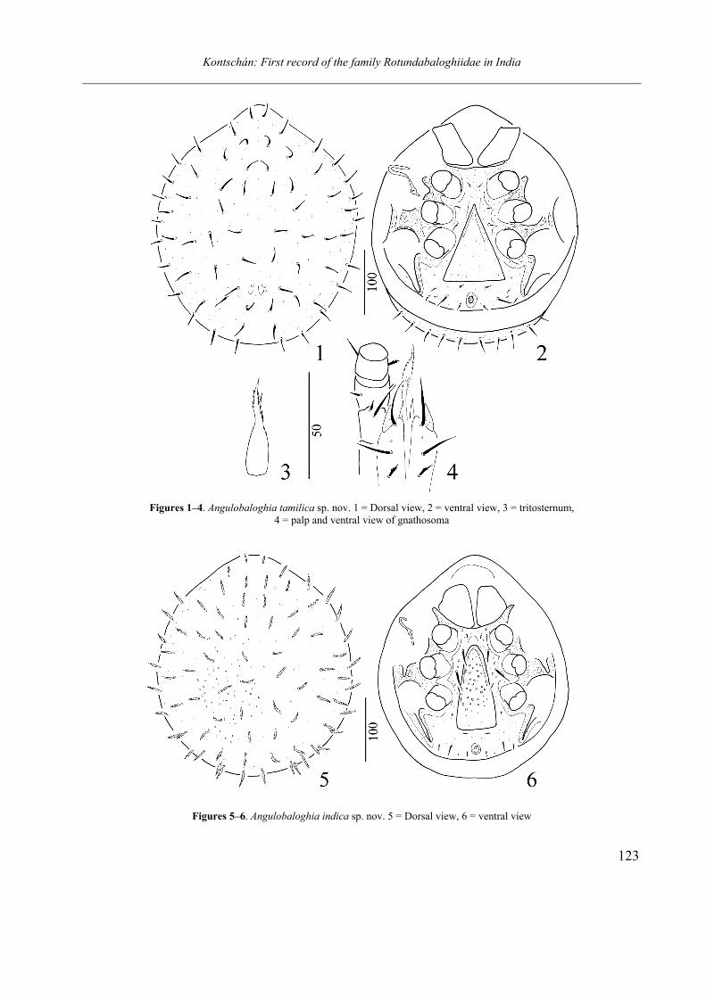
Angulobaloghia tamilica sp. nov.
(Figs. 1–4)
Material examined. Holotype, female. As 400, India, Berijam, Palni Hills, Tamil Nadu Nature Reserve, extracted from litter of shola, 8–11. 04.1980. Leg. Gy. Topál.
U
Kontschán: First record of the family Rotundabaloghiidae in India
122
Description. Female. Length of idiosoma 370 µm, width 290 µm (n = 1). Shape circular, pos-terior margin rounded.
Dorsal idiosoma (Fig. 1). Marginal and dorsal shields fused. Dorsal setae smooth, needle-like, ca. 19–21 µm long. Surface of dorsal idiosoma smooth, several muscle scars present on central area of dorsal shield.
Ventral idiosoma (Fig. 2). Sculptural pattern absent on sternal and ventral shields. Sternal setae smooth and needle-like. St1 (ca. 6–7 µm) at level of central area of coxae II, St2 (ca. 6–7 µm) at level of anterior margin of coxae III, St3 (ca. 10 µm) at level of posterior margin of coxae III, other sternal setae absent. Ventral setae smooth and needle-like, V2 (ca. 7 µm) situated at basal line of genital shield, V4 (ca. 6 µm) and V7 near posterior part of pedofossae of leg IV. V8 (ca. 21 µm) placed between V7 and ad, setae ad (ca. 9 µm) near anal opening. One pair of lyrifissure pre-sents between V7 and V8. Stigmata situated between coxae II and III. Peritremes hook-shaped. Genital shield triangular, its surface smooth. Pe-dofossae deep, their surface smooth, with separate furrows for tarsi IV. Tritosternum with narrow basis, its laciniae marginally serrate (Fig. 3).
Gnathosoma (Fig. 4). Corniculi horn-like, in-ternal malae smooth and as long as corniculi. Labrum marginally pilose. Hypostomal setae: h1 long (ca. 22 µm), smooth and setiform; h2 were broken, h3 long (ca. 16 µm) and smooth; h4 short (ca. 7 µm) and marginally serrate. Epistome mar-ginally serrate. Palp trochanter with one long and one short smooth setae, other setae on palp smooth or marginally serrate.
Legs. Leg I with claws.
Etymology. The name of the new species refers to the Tamil Nadu state of India where it was collected.
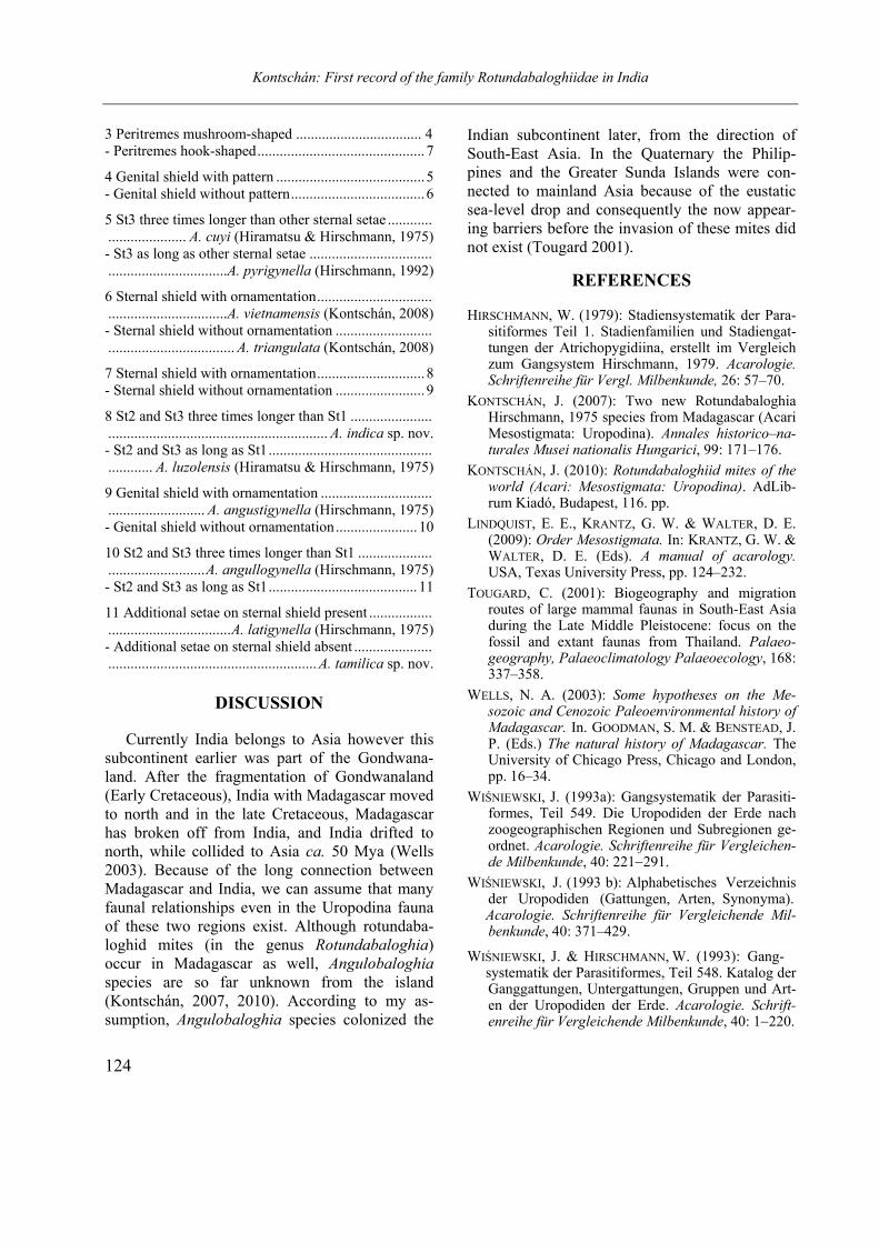
Angulobaloghia indica sp. nov.
(Figs. 5–6)
Material examined. Holotype, female. As 508, India, Debrapani, Darjeeling District, West Ben-
gal, sifted and extracted from litter in indigenous wood 30.05.1980. Leg. Gy. Topál.
Description. Female. Length of idiosoma 340 µm, width 290 µm (n = 1). Shape circular, pos-terior margin rounded.
Dorsal idiosoma (Fig. 5). Marginal and dorsal shields fused. Dorsal setae marginally pilose and ca. 21–22 µm long. Surface of dorsal idiosoma covered by small oval pits.
Ventral idiosoma (Fig. 6). Surface of sternal shield with several oval pits, ventral shield without sculptural pattern. Sternal setae smooth and needle-like. St1 short (ca. 7 µm) and at level of anterior margin of coxae II, St2 long and robust (ca. 26 µm), and at level of posterior margin of coxae II, St3 long and robust (ca. 29 µm) at level of posterior margin of coxae III, St4 short (ca. 9 µm) and placed at level of anterior margin of coxae IV. Two pairs of lyriform fissures present on sternal shield, first of pair situated near ante-rior margin of sternal shield, second of pair at level of anterior area of pedofossae of leg IV. Ventral setae smooth and needle-like, V2 (ca. 7 µm) situated at basal line of genital shield, V4 absent, V7 (ca. 7 µm) near posterior part of pedo-fossae of leg IV. V8 (ca. 14 µm) placed between V7 and ad, setae ad (ca. 8 µm) near anal opening. Stigmata situated between coxae II and III. Pe-ritremes hook-shaped. Genital shield triangular, its surface covered by oval pits. Pedofossae deep, their surface smooth, with separate furrows for tarsi IV. Tritosternum and gnathosoma not clearly visible on the single specimen, because coxae I covered by them.
Legs. Leg I with claws.
Etymology. The species epithet refers to India.
Key to the Angulobaloghia species
1 Ventral shield ornamented .......................................... .............................................A. aokii (Hiramatsu, 1979) - Ventral shield smooth................................................ 2
2 Genital shield of female semi-circular ........................ .......................................... A. danyii (Kontschán, 2008) - Genital shield of female triangular ............................ 3
Kontschán: First record of the family Rotundabaloghiidae in India
123
Figures 1–4. Angulobaloghia tamilica sp. nov. 1 = Dorsal view, 2 = ventral view, 3 = tritosternum,
4 = palp and ventral view of gnathosoma
Figures 5–6. Angulobaloghia indica sp. nov. 5 = Dorsal view, 6 = ventral view
Kontschán: First record of the family Rotundabaloghiidae in India
124
3 Peritremes mushroom-shaped .................................. 4 - Peritremes hook-shaped............................................. 7
4 Genital shield with pattern ........................................ 5 - Genital shield without pattern.................................... 6
5 St3 three times longer than other sternal setae ............ ..................... A. cuyi (Hiramatsu & Hirschmann, 1975) - St3 as long as other sternal setae ................................. ................................A. pyrigynella (Hirschmann, 1992)
6 Sternal shield with ornamentation............................... ................................A. vietnamensis (Kontschán, 2008) - Sternal shield without ornamentation .......................... .................................. A. triangulata (Kontschán, 2008)
7 Sternal shield with ornamentation............................. 8 - Sternal shield without ornamentation ........................ 9
8 St2 and St3 three times longer than St1 ...................... ........................................................... A. indica sp. nov. - St2 and St3 as long as St1............................................ ............ A. luzolensis (Hiramatsu & Hirschmann, 1975)
9 Genital shield with ornamentation .............................. .......................... A. angustigynella (Hirschmann, 1975) - Genital shield without ornamentation...................... 10
10 St2 and St3 three times longer than St1 .................... ..........................A. angullogynella (Hirschmann, 1975) - St2 and St3 as long as St1........................................ 11
11 Additional setae on sternal shield present ................. .................................A. latigynella (Hirschmann, 1975) - Additional setae on sternal shield absent ..................... ........................................................ A. tamilica sp. nov.
DISCUSSION
Currently India belongs to Asia however this
subcontinent earlier was part of the Gondwana-land. After the fragmentation of Gondwanaland (Early Cretaceous), India with Madagascar moved to north and in the late Cretaceous, Madagascar has broken off from India, and India drifted to north, while collided to Asia ca. 50 Mya (Wells 2003). Because of the long connection between Madagascar and India, we can assume that many faunal relationships even in the Uropodina fauna of these two regions exist. Although rotundaba-loghid mites (in the genus Rotundabaloghia) occur in Madagascar as well, Angulobaloghia
species are so far unknown from the island (Kontschán, 2007, 2010). According to my as-sumption, Angulobaloghia species colonized the
Indian subcontinent later, from the direction of South-East Asia. In the Quaternary the Philip-pines and the Greater Sunda Islands were con-nected to mainland Asia because of the eustatic sea-level drop and consequently the now appear-ing barriers before the invasion of these mites did not exist (Tougard 2001).
REFERENCES
HIRSCHMANN, W. (1979): Stadiensystematik der Para-sitiformes Teil 1. Stadienfamilien und Stadiengat-tungen der Atrichopygidiina, erstellt im Vergleich zum Gangsystem Hirschmann, 1979. Acarologie. Schriftenreihe für Vergl. Milbenkunde, 26: 57–70.
KONTSCHÁN, J. (2007): Two new Rotundabaloghia Hirschmann, 1975 species from Madagascar (Acari Mesostigmata: Uropodina). Annales historico–na-turales Musei nationalis Hungarici, 99: 171–176.
KONTSCHÁN, J. (2010): Rotundabaloghiid mites of the world (Acari: Mesostigmata: Uropodina). AdLib-rum Kiadó, Budapest, 116. pp.
LINDQUIST, E. E., KRANTZ, G. W. & WALTER, D. E. (2009): Order Mesostigmata. In: KRANTZ, G. W. &
WALTER, D. E. (Eds). A manual of acarology. USA, Texas University Press, pp. 124–232.
TOUGARD, C. (2001): Biogeography and migration routes of large mammal faunas in South-East Asia during the Late Middle Pleistocene: focus on the fossil and extant faunas from Thailand. Palaeo-geography, Palaeoclimatology Palaeoecology, 168: 337–358.
WELLS, N. A. (2003): Some hypotheses on the Me-sozoic and Cenozoic Paleoenvironmental history of Madagascar. In. GOODMAN, S. M. & BENSTEAD, J. P. (Eds.) The natural history of Madagascar. The University of Chicago Press, Chicago and London, pp. 16–34.
WIŚNIEWSKI, J. (1993a): Gangsystematik der Parasiti-formes, Teil 549. Die Uropodiden der Erde nach zoogeographischen Regionen und Subregionen ge-ordnet. Acarologie. Schriftenreihe für Vergleichen-de Milbenkunde, 40: 221−291.
WIŚNIEWSKI, J. (1993 b): Alphabetisches Verzeichnis der Uropodiden (Gattungen, Arten, Synonyma).
Acarologie. Schriftenreihe für Vergleichende Mil-benkunde, 40: 371–429.
WIŚNIEWSKI, J. & HIRSCHMANN, W. (1993): Gang- systematik der Parasitiformes, Teil 548. Katalog der
Ganggattungen, Untergattungen, Gruppen und Art-en der Uropodiden der Erde. Acarologie. Schrift-enreihe für Vergleichende Milbenkunde, 40: 1−220.

Opusc. Zool. Budapest, 2011, 42(2): 125–145
_______________________________________________________________________________________________________
1Prof. Dr. Sándor Mahunka, Systematic Zoology Research Group of the Hungarian Academy of Sciences, and Hungarian Natural History Museum, H-1088 Budapest, Baross u. 13, Hungary. E-mail: [email protected]
2Luise Mahunka-Papp, Department of Zoology, Hungarian Natural History Museum, H-1088 Budapest, Baross u. 13, Hungary. E-mail: [email protected]
New and little known oribatid mites from Madagascar
(Acari: Oribatida), IV
S. MAHUNKA1 and L. MAHUNKA-PAPP
2
Abstract: Continuously studied and newly identified oribatids from Madagascar (Malagasy Republic) are given. Altogether 14 species are listed and discussed originating from several sites of the island. Nine species of them are new to science and some other were known only from other territories. Four species are recorded from Madagascar for the first time. With 11 figures.
Keywords: Moss mites, taxonomy, new species, new distributions, Repoblikan'i Madagasikara.
INTRODUCTION
resent contribution is a continuation of our earlier endeavours (Mahunka 2009a, 2009b,
2009c, 2010, 2011, or much earlier Mahunka 1994) to elaborate the oribatid fauna of Madagas-car. Our main aim and final goal are to compile a monograph on this very rich and peculiar fauna. The richness of this fauna is so high that requires much more investigation than planned before-hand. To achieve this goal, it is important to exa-mine even more not yet completely studied soil samples, or samples, that haven’t been studied yet.
For this reason we continue the examination of
some interesting soil samples which were collect-ed in different parts of Madagscar by first of all Dr. T. Pócs, the Hungarian bryologist and by col-lectors of the Musée d’Histoire naturelle de Ge-nève (mainly Dr. B. Hauser) and recently also by the Hungarian collector Dr. Cs. Csuzdi. This part comprises mainly the species that were collected in Antsiranana and Tomasine Province by Dr. T. Pócs, in Ambohitra Region by Dr. Cs. Csuzdi and Nosy Be or Tamateve Province by Dr. B. Hauser.
In this most recent work we give a list of 14
species belonging to different oribatid families, with the exception of Oppiidoidea superfamily,
which will be published later. Of them, ten spe-cies are new to science: Cosmochthonius mar-
garitatus, Hermanniella vohimana, Austrocarabo-
des planisetus, Carabodes afrominusculus, Pseu-
dotocepheus subtilis, Microlamellarea coetzeeae,
Africoribates nasalis, Peloribates pocsi, Hetero-
leius flagellifer and Tuberemaeus puruczkyi spp. nov. and four, viz. Cosmochthonius semiareolatus Hammer, 1966, Nodocepheus baloghi Mahunka, 1983, Tectocepheus minor (Berlese, 1903) and Licneremaeus polygonatus Hammer, 1971, are re-corded for the first time in Madagascar.
As in our earlier papers, we follow the system
of Norton & Behan-Pelletier (2009) and Subías (2004, 2011), and besides we also use some work, which was mentioned in our works on this theme (Mahunka. 2010, 2011). Similarly to our previous publications in the descriptions the morphological terminology follows the already mentioned publi-cation of Norton and Behan-Pelletier (2009), Weigmann (2006), Woas (2002) and Mahunka and Zombori (1985) .
The material examined is deposited in the
Hungarian Natural History Museum, Budapest (HNHM), and some paratypes and voucher spe-cimens in the Musée d’Histoire naturelle de Ge-nève (MHNG).
P
Mahunka & Mahunka-Papp: Oribatid mites from Madagascar, IV
126
LOCALITIES
Afr – 857: Madagascar, Central Plateau: Ambohitantely
Forest Reserve, E of Manonkazo village (Ankaszabz town). Relic xerophyllous (dry evergreen) plateau forest at 1500–1530 m alt. Leg. T. Pócs. 5–-6 Sept. 1994 (No. 9444).
Afr – 859: Madagascar, Nosy Mangabe Island in An-tongil Bay S of Maroantsetra town. Mesic lowland rainforest on the W-slope at 100–300 m alt.13. September, 1994. Leg. T. Pócs (No. 9450).
Afr – 917: Madagascar, Antsiranana Province, Nosy Komba Island. Submontane rainforest remnants in the NW valley of Antaninaomby summit with tree ferns and with Mariatta fraxinea, at 570–580 m alt. 29. July, 1998. Leg. T. Pócs. (no. 9862).
Afr – 921: Madagascar, Toamasina Province, Mananara Nord Biosphere Reserve and National Park. Lowland rain-forest on the E slopes of Mahavoho Hill (very wet types along Manahovo River, with many tree ferns, palms and Pandanus ssp., less humid on slopes) at 220-300 m alt. 16°27'S, 49°46.9–47.5'E. Date: 14–15. August 1998. Leg. T. Pócs. (No. 9878).
Afr – 923: Madagascar, Toamasina Province. Maromizaha forest. Mossy montane rainforest with bamboo (Nastus sp.) undergrowth on the summit ridge of Mt. Maromizaha, south of the Andasibe Nat. Park and the Antananarivo Toamasina road, 2 km W of Anevoka village, at 1080–1214 m alt. 18°57.8'S, 48°27.5'E. Date: 26. August 1998. Leg. T. Pócs (No. 9890).
Afr - 996: Madagascar, Vohimana Reserve, primary fo-rest. 17. April 2008. Leg. Cs. Csuzdi.
Mad-89/3:Magascar, Tamatave Moramanga: Analamazo-atra special reserve (Perinet) before Andasibe, primary forest with dominating Ravensara sp.(Lauraceae). 1020 m. 21. No-vember 1989. Leg. B. Hauser.
LIST OF THE NEWLY IDENTIFIED
SPECIES
COSMOCHTHONIIDAE Grandjean, 1947
Cosmochthonius margaritatus sp. nov. Cosmochthonius semiareolatus Hammer, 1966
Locality: Afr – 921.
HERMANNIELLIDAE Grandjean, 1934
Hermanniella vohimana sp. nov.
NODOCEPHEIDAE Piffl, 1972 Nodocepheus baloghi Mahunka, 1983
Locality: Afr – 859, first record for Madagascar.
CARABODIDAE C. L. Koch, 1835
Austrocarabodes planisetus sp. nov. Carabodes afrominusculus sp. nov.
OTOCEPHEIDAE Balogh, 1961
Pseudotocepheus subtilis sp. nov.
TECTOCEPHEIDAE Grandjean, 1954
Tectocepheus minor (Berlese, 1903) Locality: Afr – 996. First record for Madagascar.
LAMELLAREIDAE Balogh, 1972
Microlamellarea coetzeeae sp. nov.
HUMEROBATIDAE Grandjean, 1970
Africoribates nasalis sp. nov.
LICNEREMAEIDAE Grandjean, 1931
Licneremaeus polygonatus Hammer, 1971 Locality: Afr. 917. First record for Madagascar.
HAPLOZETIDAE Grandjean, 1936
Peloribates pocsi sp. nov.
SCHELORIBATIDAE Grandjean, 1953 Heteroleius flagellifer sp. nov. Tuberemaeus puruczkyi sp. nov.
DESCRIPTIONS
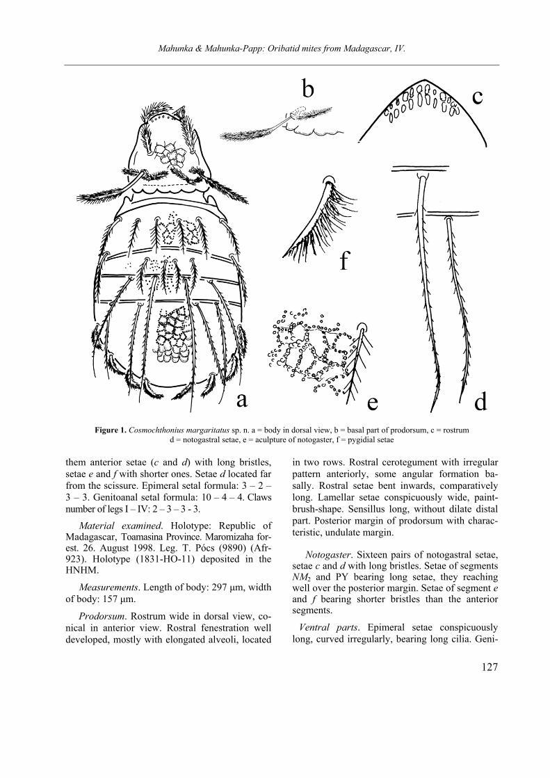
Cosmochthonius margaritatus sp. nov.
(Figures 1a–1f)
Diagnosis. Body surface covered by irregular cerotegument. Rostral apex conical, rostral fene-stration with longitudinal position, mostly narrow foveolae ordered in two rows. Prodorsal surface with polygonal sculpture consists of small tu-bercles, like pearl lines. Rostral setae compara-tively bent inwards. Sensillus typical for the ge-nus, narrow. Posterior margin of prodorsum cha-racteristically undulate. Notogastral surface partly with polygonal pattern, partly irregularly punc-tate. Sixteen pairs of notogastral setae, among
Mahunka & Mahunka-Papp: Oribatid mites from Madagascar, IV.
127
Figure 1. Cosmochthonius margaritatus sp. n. a = body in dorsal view, b = basal part of prodorsum, c = rostrum d = notogastral setae, e = aculpture of notogaster, f = pygidial setae
them anterior setae (c and d) with long bristles, setae e and f with shorter ones. Setae d located far from the scissure. Epimeral setal formula: 3 – 2 – 3 – 3. Genitoanal setal formula: 10 – 4 – 4. Claws number of legs I – IV: 2 – 3 – 3 - 3.
Material examined. Holotype: Republic of Madagascar, Toamasina Province. Maromizaha for-est. 26. August 1998. Leg. T. Pócs (9890) (Afr-923). Holotype (1831-HO-11) deposited in the HNHM.
Measurements. Length of body: 297 µm, width of body: 157 µm.
Prodorsum. Rostrum wide in dorsal view, co-nical in anterior view. Rostral fenestration well developed, mostly with elongated alveoli, located
in two rows. Rostral cerotegument with irregular pattern anteriorly, some angular formation ba-sally. Rostral setae bent inwards, comparatively long. Lamellar setae conspicuously wide, paint-brush-shape. Sensillus long, without dilate distal part. Posterior margin of prodorsum with charac-teristic, undulate margin.
Notogaster. Sixteen pairs of notogastral setae, setae c and d with long bristles. Setae of segments NM2 and PY bearing long setae, they reaching well over the posterior margin. Setae of segment e and f bearing shorter bristles than the anterior segments.
Ventral parts. Epimeral setae conspicuously long, curved irregularly, bearing long cilia. Geni-
Mahunka & Mahunka-Papp: Oribatid mites from Madagascar, IV
128
toanal setation is typical for the genus, 6 pairs of genital setae arising along the inner margin of ge-nital plates. Anal and adanal setae with conspicu-ously long cilia.
Legs. Number of claws: 2 – 3 – 3 – 3.
Remarks. On the basis of the characteristically
undulate “collar” margin of prodorsum the new species is closest to Cosmochthonius foliatus Su-bias, 1982. However, the pattern of the notogaster consists of angular and smaller alveoli in the new species (smaller and round in foliatus), and they are absent from segments NM1 and NM2, (present in foliatus). The setae d1 and d2 are located far from the scissure (very near in foliatus). The pat-tern of this species on the segment PY much ra-ther similar to C. reticulatus Grandjean, 1947 than the foliatus (see Penttinen & Gordeeva 2005), however the undulate posterior margin of pro-dorsum is absent in reticulatus and present in f-
oliatus and in the new species..
Etymology. The species name refers to the sculpture consisting of different size of alveoli on the body surface. Cosmochthonius semiareolatus Hammer, 1966
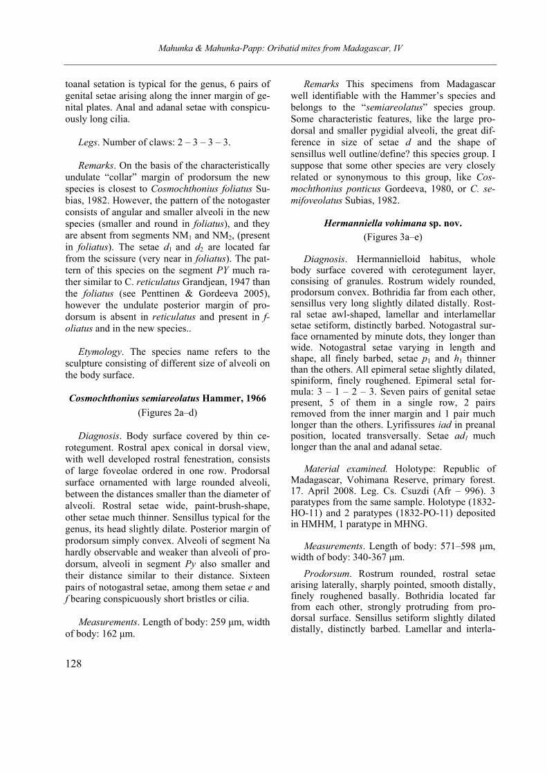
(Figures 2a–d)
Diagnosis. Body surface covered by thin ce-rotegument. Rostral apex conical in dorsal view, with well developed rostral fenestration, consists of large foveolae ordered in one row. Prodorsal surface ornamented with large rounded alveoli, between the distances smaller than the diameter of alveoli. Rostral setae wide, paint-brush-shape, other setae much thinner. Sensillus typical for the genus, its head slightly dilate. Posterior margin of prodorsum simply convex. Alveoli of segment Na hardly observable and weaker than alveoli of pro-dorsum, alveoli in segment Py also smaller and their distance similar to their distance. Sixteen pairs of notogastral setae, among them setae e and f bearing conspicuously short bristles or cilia.
Measurements. Length of body: 259 µm, width of body: 162 µm.
Remarks This specimens from Madagascar well identifiable with the Hammer’s species and belongs to the “semiareolatus” species group. Some characteristic features, like the large pro-dorsal and smaller pygidial alveoli, the great dif-ference in size of setae d and the shape of sensillus well outline/define? this species group. I suppose that some other species are very closely related or synonymous to this group, like Cos-
mochthonius ponticus Gordeeva, 1980, or C. se-
mifoveolatus Subias, 1982.
Hermanniella vohimana sp. nov.
(Figures 3a–e)
Diagnosis. Hermannielloid habitus, whole body surface covered with cerotegument layer, consising of granules. Rostrum widely rounded, prodorsum convex. Bothridia far from each other, sensillus very long slightly dilated distally. Rost-ral setae awl-shaped, lamellar and interlamellar setae setiform, distinctly barbed. Notogastral sur-face ornamented by minute dots, they longer than wide. Notogastral setae varying in length and shape, all finely barbed, setae p1 and h1 thinner than the others. All epimeral setae slightly dilated, spiniform, finely roughened. Epimeral setal for-mula: 3 – 1 – 2 – 3. Seven pairs of genital setae present, 5 of them in a single row, 2 pairs removed from the inner margin and 1 pair much longer than the others. Lyrifissures iad in preanal position, located transversally. Setae ad1 much longer than the anal and adanal setae.
Material examined. Holotype: Republic of
Madagascar, Vohimana Reserve, primary forest. 17. April 2008. Leg. Cs. Csuzdi (Afr – 996). 3 paratypes from the same sample. Holotype (1832-HO-11) and 2 paratypes (1832-PO-11) deposited in HMHM, 1 paratype in MHNG.
Measurements. Length of body: 571–598 µm, width of body: 340-367 µm.
Prodorsum. Rostrum rounded, rostral setae arising laterally, sharply pointed, smooth distally, finely roughened basally. Bothridia located far from each other, strongly protruding from pro-dorsal surface. Sensillus setiform slightly dilated distally, distinctly barbed. Lamellar and interla-
Mahunka & Mahunka-Papp: Oribatid mites from Madagascar, IV.
129
Figure 2. Cosmochthonius semiareolatus Hammer, 1966. a = body in dorsal view, b = rostrum, c = epimeral and genital region, d = anal region
Mahunka & Mahunka-Papp: Oribatid mites from Madagascar, IV.
130
mellar setae setiform, also barbed, slightly shorter than sensillus. Exobothridial setae minute, arising at the basis of bothridium.
Lateral part of podosoma. Prodorsum distinct-ly convex, with anterior transversal depression.
Notogaster. Distinct, but partly ragged cerote-gument layer present. Surface with very small characteristic, elongate dots. Notogastral tubes well developed, narrow. Sixteen pairs of notogas-tral setae present, they well variable in length and thickness. All setae distinctly barbed, setiform or bacilliform, setae p1 and h1 conspicuously thinner than the others
Ventral parts. Apodemes comparatively short, epimeral surface covered by cerotegument gra-nules. Epimeral setae mostly spiniform, epimeral setal formula: 3 – 1 – 3 – 3. Seven pairs of spi-niform genital setae, 5 pairs arising nearer to inner margin than others. One pair among the latter 2 pairs much larger than the inner pairs. Adanal se-tae of different lengths, ad1 being the longest, ad3
the shortest. Lyrifissures iad located transversally, in front of the anal opening.
Remarks. Owing to the shape of the notogast-ral setae, especially the setae p1 and h1, it may be distinguished from all the heretofore known other Hermanniella species.
Etymology. The species name refers to the sculpture consisting of different foveolae on the body surface.
Austrocarabodes planisetus sp. nov.
(Figures 4a–e)
Diagnosis. Rostrum convex. Lamellae and translamella well developed, lamella with distinct apex, translamella wide. Rostral setae conspicu-ously long and narrow, lamellar setae with ser-rated dorsal margin, interlamellar setae narrow, similar to rostral setae. Lamellar surface smooth, interlamellar surface with round pustules. Sensil-lus short, with dilate and recurved distal end. Humeral process small. Notogastral surface co-vered by pustules, ordered in irregular rows. Fourteen pairs of small, slightly phylliform, com-paratively short, mostly blunt notogastral setae present, all nearly equal in length and well barbed with median rib. Apodemes and borders well vi-sible, sejugal one with a characteristic median formation medially. Epimeral surface smooth.
Epimeral setae partly long (e. g. 1b, 3b, 4b, 4c); partly minute (e.g. 1a, 2a, 3a). Epimeral setal formula 3 – 1 – 2 – 3. All setae - except adanal setae simple setiform.
Measurements. Length of body: 421–540 µm, width of body: 254–346 µm.
Material examined. Holotype: Republic of Ma-
dagascar, Antsiranana Provincie, Nosy Komba Is-land. 29. July 1998. Leg. T. Pócs. (9862) (Afr-917). 5 paratypes from the same sample. Holotype (1833-HO-11) and 3 paratypes (1833-P0-11) de-posited in HNHM, 2 paratypes in MHNG.
Prodorsum. Rostrum rounded, convex. Lamel-
lae and translamella well developed, their surface smooth. Lamellar cusp short, its basal part nar-rowed, inner margin concave. Lamellar setae short, with serrated outer margin. Lamellar and interlamellar setae much longer than the other dorsal setae, conspicuously narrow, slightly dilat-ed anteriorly. Their surface with minute bristles, basal surface roughened. Sensillus short, with di-late, slightly curved backward, densely barbed.
Lateral part of podosoma. Tutorium bifurcate anteriorly.
Notogaster. Anterior margin slightly convex. Humeral apophysis small, with straight lateral margin. Surface covered by granules or pustules located in irregular order, sometimes they com-pose an irregular polygonal pattern. Fourteen pairs of narrow, slightly bent, bacilliform noto-gastral setae, all nearly equal in size and barbed. All setae with median ribs. They distal end blunt at tip.
Ventral parts. Epimeral region with well deve-loped structure, but apodemes and epimeral bor-ders not compose a connected network. Sternal apodemes reduced anteriorly, and widen out in sejugal region to apodemes 4. In this part with a median quadrangular formation observable. Length of epimeral setae differs. Genital, agge-nital and anal setae simple, thin, comparatively long. Adanal setae slightly dilate, similar to no-togastral setae.
Remarks: The new species is well charac-terised by the narrow and long rostral and in-terlamellar setae, by the notogastral sculpture

Mahunka & Mahunka-Papp: Oribatid mites from Madagascar, IV.
131
Figure 3. Hermanniella vohimana sp. n. a = body in dorsal view, b = body in ventral view, c = lamellar setae d = rostral setae, e = trichobothrium
Mahunka & Mahunka-Papp: Oribatid mites from Madagascar, IV
132
Figure 4. Austrocarabodes planisetus sp. n. a = body in dorsal view, b = interlamellar seta, c = notogastral setae d = body in ventral view, e = rostral part of prodorsum
and the characteristic median formation in the sejugal region. Its notogastral sculpture resembles to A. parapustulatus Mahunka, 2009 species, however the other characters are quite different.
Etymology. The species name refers to the shape of the rostral and interlamellar setae.
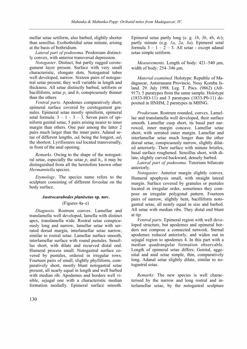
Carabodes afrominusculus sp. nov.
(Figures 5a–c)
Diagnosis. Rostral apex widely rounded. La-mellae narrow simple, their surface smooth. Inter-lamellar region ornamented by large foveolae. Lamellar setae slightly thicker and longer than the rostral setae, interlamellar setae minute, arising on the interlamellar surface. Sensillus dilate medi-ally, curves backwards. Anterior margin of the
notogaster with a row consists of pustules like the surface of notogaster. Pustules are distinctly smal-ler than the prodorsal pustules. Ten pairs of mi-nute notogastral setae. Epimeral region orna-mented by foveolae in different size, ventral plates with larger pustules. Genitoanal setal for-mula: 4 – 1 – 2 – 3. Genital plates with some lon-gitudinal lines, anal plates punctuate. All ventral setae minute.
Material examined. Holotype: Republic of Ma-
dagascar, Plateau: Ambohitantely Forest Reserve, E of Manonkazo village (Ankaszabz town). Leg. T. Pócs. 5-6 Sept. 1994 (No. 9444). Holotype (1834-PO-11) deposited in HNHM.
Measurements. Length of body: 296-304 µm, width of body: 162-168 µm.
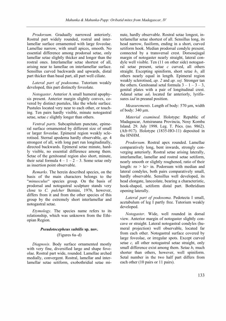
Mahunka & Mahunka-Papp: Oribatid mites from Madagascar, IV
133
Prodorsum. Gradually narrowed anteriorly. Rostral part widely rounded, rostral and inter-lamellar surface ornamented with large foveolae. Lamellae narrow, with small apices, smooth. No essential difference among prodorsal setae, only lamellar setae slightly thicker and longer than the rostral ones. Interlamellar setae shortest of all, arising near to lamellae on interlamellar surface. Sensillus curved backwards and upwards, distal part thicker than basal part, all part well ciliate.
Lateral part of podosoma. Tutorium weakly developed, this part distinctly foveolate.
Notogaster. Anterior A small humeral apophy-sis present. Anterior margin slightly convex, co-vered by distinct pustules, like the whole surface. Pustules located very near to each other, or touch-ing. Ten pairs hardly visible, minute notogastral setae, setae c slightly longer than others.
Ventral parts. Subcapitulum punctate, epime-ral surface ornamented by different size of small or larger foveolae. Epimeral region weakly scle-rotised. Sternal apodema hardly observable, ap. 4 strongest of all, with long part run longitudinally, directed backwards. Epimeral setae minute, hard-ly visible, no essential difference among them. Setae of the genitoanal region also short, minute, their setal formula 4 – 1 – 2 – 3. Some setae only as insertion point observable.
Remarks. The herein described species, on the basis of the main characters belongs to the “minusculus“ species group. On the basis of prodorsal and notogastral sculpture stands very close to C. pulcher Bernini, 1976, however, differs from it and from the other species of this group by the extremely short interlamellar and notogastral setae.
Etymology. The species name refers to its relationship, which was unknown from the Ethi-opian Region.
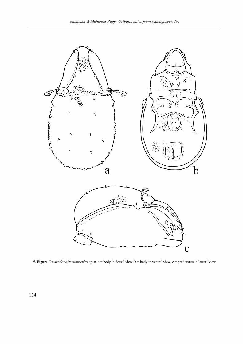
Pseudotocepheus subtilis sp. nov.
(Figures 6a–d)
Diagnosis. Body surface ornamented mostly with very fine, diversified large and shape fove-olae. Rostral part wide, rounded. Lamellae arched medially, convergent. Rostral, lamellar and inter-lamellar setae setiform, exobothridial setae mi-
nute, hardly observable. Rostral setae longest, in-terlamellar setae shortest of all. Sensillus long, its head narrow, fusiform, ending in a short, curved setiform hook. Median prodorsal condyle present, connected by a transversal crest. Dorsosejugal margin of notogaster nearly straight, lateral con-dyle well visible. Ten (11 on other side) notogast-ral setae present, setae c curved, all others straight. Excepting spiniform, short setae h1, all others nearly equal in length. Epimeral region weakly sclerotised, ap. 2 and ap. sej. Stronger tan the others. Genitoanal setal formula 3 – 1 – 3 – 3, genital plates with a pair of longitudinal crest. Adanal setae ad3 located far anteriorly, lyrifis-sures iad in preanal position.
Measurements. Length of body: 570 µm, width of body: 340 µm.
Material examined. Holotype: Republic of Madagascar, Antsiranana Provincia, Nosy Komba Island. 29. July 1998. Leg. T. Pócs. (no. 9862). (Afr-917). Holotype (1835-HO-11) deposited in the HNHM.
Prodorsum. Rostral apex rounded. Lamellae comparatively long, bent inwards, strongly con-verging anteriorly. Rostral setae arising laterally, interlamellar, lamellar and rostral setae setiform, nearly smooth or slightly roughened, ratio of their length: ro > le> in. Podorsum with median and lateral condyles, both pairs comparatively small, hardly observable. Sensillus well developed, its head elongate, lanceolate, bearing a characteristic, hook-shaped, setiform distal part. Bothridium opening laterally.
Lateral part of podosoma. Pedotecta I small, acetabulum of leg I partly free. Tutorium weakly developed.
Notogaster. Wide, well rounded in dorsal view. Anterior margin of notogaster slightly con-cave or straight. Lateral notogastral condyles (hu-meral projection) well observable, located far from each other. Notogastral surface covered by large foveolae, or irregular spots. Except curved setae c, all other notogastral setae straight, only small difference exist among them. Setae h1 much
shorter than others, however, well spiniform. Setal number in the two half part differs from each other (10 pairs or 11 pairs).
Mahunka & Mahunka-Papp: Oribatid mites from Madagascar, IV.
134
5. Figure Carabodes afrominusculus sp. n. a = body in dorsal view, b = body in ventral view, c = prodorsum in lateral view
Mahunka & Mahunka-Papp: Oribatid mites from Madagascar, IV
135
Figure 6. Pseudotocepheus subtilis sp. n. a = body in dorsal view, b = sensillus, c = body in ventral view, d = genital region
Mahunka & Mahunka-Papp: Oribatid mites from Madagascar, IV.
136
Ventral parts. Surface of mentum well fove-olate. Apodemes and epimeral borders weakly de-veloped, straight. Ap. 2 and ap. sej. much longer than the others. All epimeral setae setiform, well observable, comparatively strong. Epimeral setal formula: 3 – 1 – 3 – 3. Epimeral surface also foveolate, foveolae on this par smaller, than the other parts, e.g. on ventral plate. Genitoanal setal formula: 3 – 1 – 2 – 3. Genital plate with well de-veloped longitudinal crest, anal plates ornamented by small foveolae. Aggenital, anal and adanal setae much longer than the genital ones, among the adanal setae ad1 in postanal, ad3 in preanal position. Lyrifissures iad located far from each other, observable in praeanal position
Legs. All leg monodactylous, claws compara-
tively large and thin. Setae u on all legs setiform.
Remarks. The new species belongs to the Pse-udotocepheus medius (Balogh & Mahunka, 1966) species group, which is well characterised by the absence of median notogastral condyles, the position of lyrifissures iad and adanal setae ad3.
The new species is closely related to P. granu-latus (Mahunka, 1985) and P. sturmi (P. Balogh, 1984), however, the shape of the sensillus and the sculpture of the body in both species are different from that of the new species.
Etymology. The species name refers to the sculpture consisting of different, finely framed foveolae on the body surface.
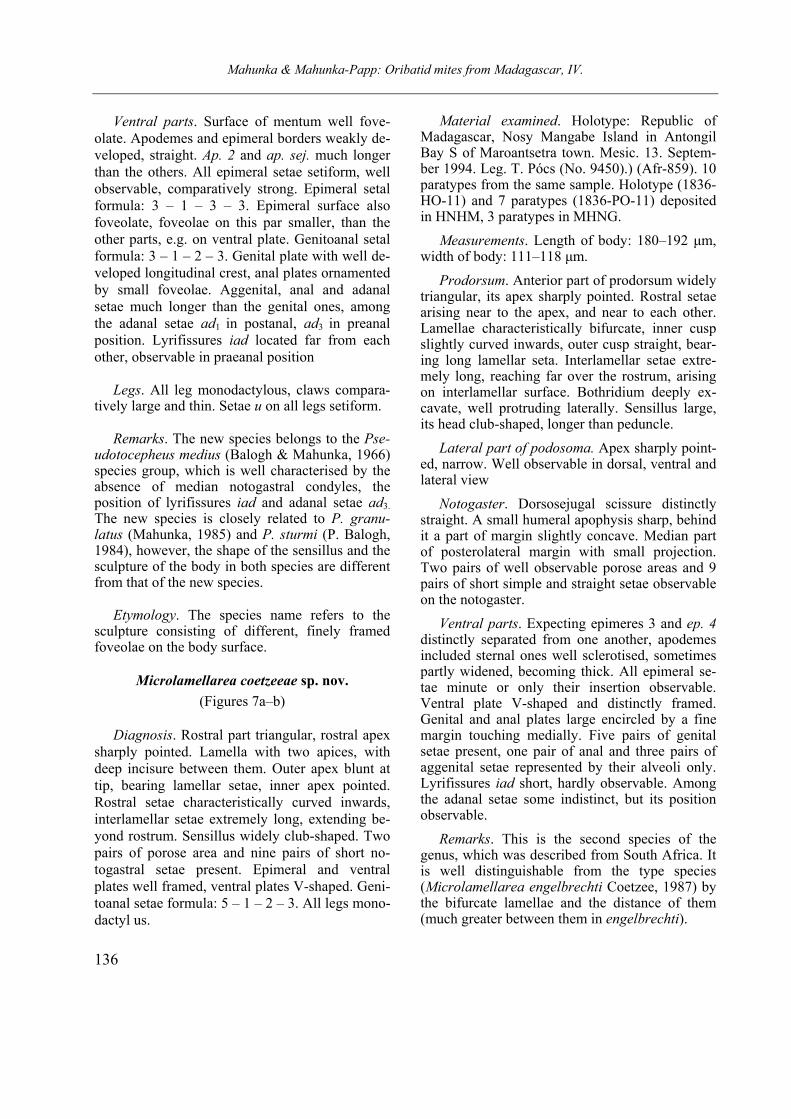
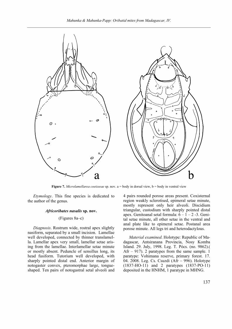
Microlamellarea coetzeeae sp. nov.
(Figures 7a–b)
Diagnosis. Rostral part triangular, rostral apex sharply pointed. Lamella with two apices, with deep incisure between them. Outer apex blunt at tip, bearing lamellar setae, inner apex pointed. Rostral setae characteristically curved inwards, interlamellar setae extremely long, extending be-yond rostrum. Sensillus widely club-shaped. Two pairs of porose area and nine pairs of short no-togastral setae present. Epimeral and ventral plates well framed, ventral plates V-shaped. Geni-toanal setae formula: 5 – 1 – 2 – 3. All legs mono-dactyl us.
Material examined. Holotype: Republic of Madagascar, Nosy Mangabe Island in Antongil Bay S of Maroantsetra town. Mesic. 13. Septem-ber 1994. Leg. T. Pócs (No. 9450).) (Afr-859). 10 paratypes from the same sample. Holotype (1836-HO-11) and 7 paratypes (1836-PO-11) deposited in HNHM, 3 paratypes in MHNG.
Measurements. Length of body: 180–192 µm, width of body: 111–118 µm.
Prodorsum. Anterior part of prodorsum widely triangular, its apex sharply pointed. Rostral setae arising near to the apex, and near to each other. Lamellae characteristically bifurcate, inner cusp slightly curved inwards, outer cusp straight, bear-ing long lamellar seta. Interlamellar setae extre-mely long, reaching far over the rostrum, arising on interlamellar surface. Bothridium deeply ex-cavate, well protruding laterally. Sensillus large, its head club-shaped, longer than peduncle.
Lateral part of podosoma. Apex sharply point-ed, narrow. Well observable in dorsal, ventral and lateral view
Notogaster. Dorsosejugal scissure distinctly straight. A small humeral apophysis sharp, behind it a part of margin slightly concave. Median part of posterolateral margin with small projection. Two pairs of well observable porose areas and 9 pairs of short simple and straight setae observable on the notogaster.
Ventral parts. Expecting epimeres 3 and ep. 4 distinctly separated from one another, apodemes included sternal ones well sclerotised, sometimes partly widened, becoming thick. All epimeral se-tae minute or only their insertion observable. Ventral plate V-shaped and distinctly framed. Genital and anal plates large encircled by a fine margin touching medially. Five pairs of genital setae present, one pair of anal and three pairs of aggenital setae represented by their alveoli only. Lyrifissures iad short, hardly observable. Among the adanal setae some indistinct, but its position observable.
Remarks. This is the second species of the genus, which was described from South Africa. It is well distinguishable from the type species (Microlamellarea engelbrechti Coetzee, 1987) by the bifurcate lamellae and the distance of them (much greater between them in engelbrechti).
Mahunka & Mahunka-Papp: Oribatid mites from Madagascar, IV.
137
Figure 7. Microlamellarea coetzeeae sp. nov. a = body in dorsal view, b = body in ventral view
Etymology. This fine species is dedicated to the author of the genus.
Africoribates nasalis sp. nov.
(Figures 8a–c) Diagnosis. Rostrum wide, rostral apex slightly
nasiform, separated by a small incision. Lamellae well developed, connected by thinner translamel-la. Lamellar apex very small, lamellar setae aris-ing from the lamellae. Interlamellar setae minute or mostly absent. Peduncle of sensillus long, its head fusiform. Tutorium well developed, with sharply pointed distal end. Anterior margin of notogaster convex, pteromorphae large, tongue-shaped. Ten pairs of notogastral setal alveoli and
4 pairs rounded porose areas present. Coxisternal region weakly sclerotised, epimeral setae minute, mostly represent only heir alveoli. Discidium triangular, custodium with sharply pointed distal apex. Genitoanal setal formula: 6 – 1 – 2 -3. Geni-tal setae minute, all other setae in the ventral and anal plate like to epimeral setae. Postanal area porose minute. All legs tri and heterodactylous.
Material examined. Holotype: Republic of Ma-dagascar, Antsiranana Provincia, Nosy Komba Island. 29. July, 1998. Leg. T. Pócs. (no. 9862).( Afr – 917). 2 paratypes from the same sample. 1 paratype: Vohimana reserve, primary forest. 17. 04. 2008. Leg. Cs. Csuzdi (Afr – 996). Holotype (1837-HO-11) and 2 paratypes (1837-PO-11) deposited in the HNHM, 1 paratype in MHNG.
Mahunka & Mahunka-Papp: Oribatid mites from Madagascar, IV
138
Measurements. Length of body: 378–400 µm, width of body: 265–297 µm.
Prodorsum. Rostral apex slightly protruding anteriorly, it separated from the lateral part of prodorsum by short and small u-shaped incisure. They observable clearly in lateral view. Lamellae short, convergent, translamella between them nar-rower than lamellae. Lamellar cusp very small, hardly observable. Rostral setae unilaterally pi-lose, lamellar setae longer than rostral ones. In-terlamellar setae minute, very thin or completely absent, only their alveoli observable. Peduncle of sensillus conspicuously long, waved, it head fusi-form, distinctly barbed.
Lateral part of podosoma. Tutorium well de-veloped, large and long, its distal end triangular, sharply pointed. Rostral setae arising on the pro-dorsal surface. Pedotectum I large.
Notogaster. Anterior margin of notogaster convex, well observable. Pleurophragma large tri-angular, dorsophragma small, rounded. Ptero-morpha large, its surface with some lines. All notogastral setae reduced, only ten pairs of setal alveoli visible. Four pairs of prose areas present, no larger difference among them.
Ventral parts. Anterior margin of mentum con-vex. Coxisternal region weakly sclerotised, only very short part of apodemes and thin epimeral borders visible. All epimeral setae represent by their alveoli only, alveoli of setae 2a minute, hardly or obscurely visible. Discidium and cus-todium present well developed, circumpedal ca-rina thin, short, ending far from the lateral margin of ventral plate. Genital setae short, 2 pairs arising along the anterior margin of plates. Anal and adanal setae also reduced, all three pairs of adanal setae arising behind the lyrifissures, in post- and paraanal position. A minute postanal porose area present, hardly visible.
Legs. All legs tridactylous, median claws
large, lateral ones smaller and much thinner, than the median claw. Anterior part of genu I and II with large, triangular apophysis.
Remarks. On the basis of the development of interlamellar setae and the notogastral sculpture the genus Africoribates Evans, 1953 is divided into two species groups. One of them has reduced
or absent interlamellar setae with a well distinct sculpture, the other has a well developed interla-mellar setae and/or a well developed pattern of notogaster. The new species belongs to the first group, its interlamellar setae minute or absent, and the notogastral surface completely smooth. Other characteristic is the length of notogastral or ventral setae. On this basis the new species stands nearest to Africoribates luteus (Hammer, 1967), however, the species described from New Zealand is smaller, and its translamella thinner and no has a nasiform rostral apex.
Etymology. The species epithet refers to the form of nasiform rostral apex.
Peloribates pocsi sp. nov.
(Figures 9a–c)
Diagnosis. Rostral part very wide, its apex rounded. Lamellae simple, straight. Bothridium well protruding, sensillus setiform, very long, distinctly pilose. All prodorsal setae rarely pilose. Anterior margin of notogaster convex, pteromor-pha ear-shaped, partly separated by a distinct incisure. Thirteen pairs of very long, setiform and thin notogastral setae and 4 pairs of long sacculi present. All notogastral setae with fine pilose. Apodemes and epimeral borders typical for this genus, all epimeral setae very short. Discidium normal, custodium with very short, distinct distal apex. Circumpedal carina well developed. Genito-anal setal formula 5 – 1 – 2 – 3. All minute or represent their alveoli only. All legs tridactylous.
Material examined. Holotype: Republic of
Madagascar, Plateau: Ambohitantely Forest Re-serve, E of Manonkazo village (Ankaszabz town). Leg. T. Pócs. 5–6 Septrmber 1994 (No. 9444). (Afr -859). Holotype (1838-HO-11) deposited in the HNHM.
Measurements. Length of body: 422 µm, width of body: 366 µm.
Prodorsum. Very wide, its apex rounded. Sur-
face smooth, lamellae normal, run distinctly la-terally. All setae on the prodorsum very long
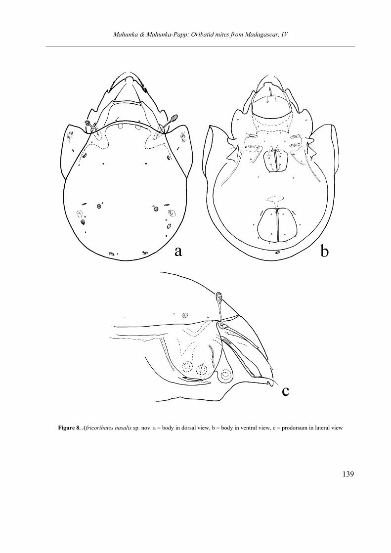
Mahunka & Mahunka-Papp: Oribatid mites from Madagascar, IV
139
Figure 8. Africoribates nasalis sp. nov. a = body in dorsal view, b = body in ventral view, c = prodorsum in lateral view
Mahunka & Mahunka-Papp: Oribatid mites from Madagascar, IV
140
Figure 9. Peloribates pocsi sp. nov. a = body in dorsal view, b = custodium c = body in ventral view
Mahunka & Mahunka-Papp: Oribatid mites from Madagascar, IV
141
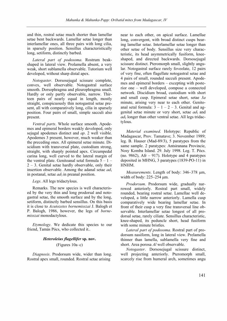
and thin, rostral setae much shorter than lamellar setae bent backwards. Lamellar setae longer than interlamellar ones, all three pairs with long cilia, in sparsely position. Sensillus characteristically long, setiform, distinctly barbed.
Lateral part of podosoma. Rostrum beak- shaped in lateral view. Prolamella absent, a very weak, short sublamella observable. Tutorium well developed, without sharp distal apex.
Notogaster. Dorsosejugal scissure complete, convex, well observable. Notogastral surface smooth. Dorsophragma and pleurophragma small. Hardly or only partly observable, narrow. Thir-teen pairs of nearly equal in length, mostly straight, conspicuously thin notogastral setae pre-sent, all with comparatively long, cilia in sparsely position. Four pairs of small, simple sacculi also present.
Ventral parts. Whole surface smooth. Apode-mes and epimeral borders weakly developed, only sejugal apodemes distinct and ap. 2 well visible. Apodemes 3 present, however, much weaker than the preceding ones. All epimeral setae minute. Di-scidium with transversal plate, custodium strong, straight, with sharply pointed apex. Circumpedal carina long, well curved to the lateral margin of the ventral plate. Genitoanal setal formula 5 – 1 – 2 – 3. Genital setae hardly observable, only their insertion observable. Among the adanal setae ad1 in postanal, setae ad3 in preanal position.
Legs. All legs tridactylous.
Remarks. The new species is well characteris-ed by the very thin and long prodorsal and noto-gastral setae, the smooth surface and by the long, setiform, distinctly barbed sensillus. On this basis it is close to Acutozetes bornemisszai J. Balogh et P. Balogh, 1986, however, the legs of borne-misszai monodactylous.
Etymology. We dedicate this species to our friend, Tamás Pócs, who collected it..
Heteroleius flagellifer sp. nov.
(Figures 10a–c)
Diagnosis. Prodorsum wide, wider than long. Rostral apex small, rounded. Rostral setae arising
near to each other, on apical surface. Lamellae long, convergent, with broad distinct cusps bear-ing lamellar setae. Interlamellar setae longer than other setae of body. Sensillus size very charac-teristic, its head asymmetrically fusiform, knee-shaped, and directed backwards. Dorsosejugal scissure distinct. Pteromorph small, slightly angu-lar. Notogastral surface rarely foveolate, 12 pairs of very fine, often flagellate notogastral setae and 4 pairs of small, rounded sacculi present. Apode-mes and epimeral borders – excepting with poste-rior one – well developed, compose a connected network. Discidium broad, custodium with short and small cusp. Epimeral setae short, setae 3a minute, arising very near to each other. Genito-anal setal formula: 3 – 1 – 2 – 3. Genital and ag-genital setae minute or very short, setae ad1 and ad2 longer than other ventral setae. All legs tridac-tylous.
Material examined. Holotype: Republic of Madagascar, Prov. Tamatave; 3. November 1989; leg. B. Hauser (Mad-89/3), 5 paratypes from the same sample. 2 paratypes: Antsiranana Provincie, Nosy Komba Island. 29. July 1998. Leg. T. Pócs. (no. 9862), Afr – 917). Holotype and 4 paratypes deposited in MHNG, 3 paratypes (1839-PO-11) in HNHM.
Measurements. Length of body: 346–378 µm, width of body: 225–254 µm.
Prodorsum. Prodorsum wide, gradually nar-rowed anteriorly. Rostral part small, widely rounded, bearing rostral setae. Lamellae well de-veloped, a little narrow anteriorly. Lamella cusp comparatively wide bearing lamellar setae. In front of their cusp a very fine transversal line ob-servable. Interlamellar setae longest of all pro-dorsal setae, rarely ciliate. Sensillus characteristic, knee-shaped, its peduncle short, head fusiform with some minute bristles.
Lateral part of podosoma. Rostral part of pro-dorsum nasiform, long in lateral view. Prelamella thinner than lamella, sublamella very fine and short. Area porosa Al well observable.
Notogaster. Dorsosejugal scissure distinct, well projecting anteriorly. Pteromorph small, scarcely rise from humeral arch, sometimes angu
Mahunka & Mahunka-Papp: Oribatid mites from Madagascar, IV
142
Figure 10. Heteroleius flagellifer sp. nov. a = body in dorsal view, b = body in ventral view, c = prodorsum in lateral view
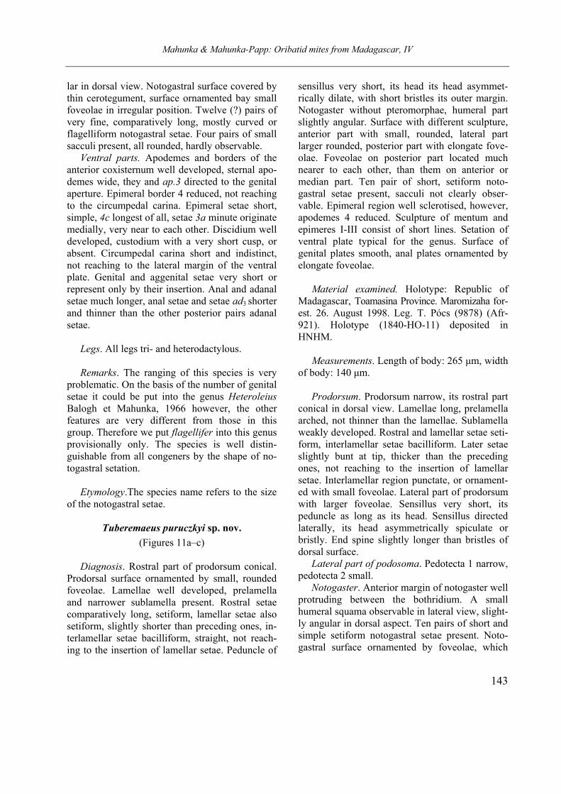
Mahunka & Mahunka-Papp: Oribatid mites from Madagascar, IV
143
lar in dorsal view. Notogastral surface covered by thin cerotegument, surface ornamented bay small foveolae in irregular position. Twelve (?) pairs of very fine, comparatively long, mostly curved or flagelliform notogastral setae. Four pairs of small sacculi present, all rounded, hardly observable.
Ventral parts. Apodemes and borders of the anterior coxisternum well developed, sternal apo-demes wide, they and ap.3 directed to the genital aperture. Epimeral border 4 reduced, not reaching to the circumpedal carina. Epimeral setae short, simple, 4c longest of all, setae 3a minute originate medially, very near to each other. Discidium well developed, custodium with a very short cusp, or absent. Circumpedal carina short and indistinct, not reaching to the lateral margin of the ventral plate. Genital and aggenital setae very short or represent only by their insertion. Anal and adanal setae much longer, anal setae and setae ad3 shorter and thinner than the other posterior pairs adanal setae.
Legs. All legs tri- and heterodactylous.
Remarks. The ranging of this species is very problematic. On the basis of the number of genital setae it could be put into the genus Heteroleius Balogh et Mahunka, 1966 however, the other features are very different from those in this group. Therefore we put flagellifer into this genus provisionally only. The species is well distin-guishable from all congeners by the shape of no-togastral setation.
Etymology.The species name refers to the size of the notogastral setae.
Tuberemaeus puruczkyi sp. nov.
(Figures 11a–c)
Diagnosis. Rostral part of prodorsum conical. Prodorsal surface ornamented by small, rounded foveolae. Lamellae well developed, prelamella and narrower sublamella present. Rostral setae comparatively long, setiform, lamellar setae also setiform, slightly shorter than preceding ones, in-terlamellar setae bacilliform, straight, not reach-ing to the insertion of lamellar setae. Peduncle of
sensillus very short, its head its head asymmet-rically dilate, with short bristles its outer margin. Notogaster without pteromorphae, humeral part slightly angular. Surface with different sculpture, anterior part with small, rounded, lateral part larger rounded, posterior part with elongate fove-olae. Foveolae on posterior part located much nearer to each other, than them on anterior or median part. Ten pair of short, setiform noto-gastral setae present, sacculi not clearly obser-vable. Epimeral region well sclerotised, however, apodemes 4 reduced. Sculpture of mentum and epimeres I-III consist of short lines. Setation of ventral plate typical for the genus. Surface of genital plates smooth, anal plates ornamented by elongate foveolae.
Material examined. Holotype: Republic of
Madagascar, Toamasina Province. Maromizaha for-est. 26. August 1998. Leg. T. Pócs (9878) (Afr-921). Holotype (1840-HO-11) deposited in HNHM.
Measurements. Length of body: 265 µm, width
of body: 140 µm.
Prodorsum. Prodorsum narrow, its rostral part conical in dorsal view. Lamellae long, prelamella arched, not thinner than the lamellae. Sublamella weakly developed. Rostral and lamellar setae seti-form, interlamellar setae bacilliform. Later setae slightly bunt at tip, thicker than the preceding ones, not reaching to the insertion of lamellar setae. Interlamellar region punctate, or ornament-ed with small foveolae. Lateral part of prodorsum with larger foveolae. Sensillus very short, its peduncle as long as its head. Sensillus directed laterally, its head asymmetrically spiculate or bristly. End spine slightly longer than bristles of dorsal surface.
Lateral part of podosoma. Pedotecta 1 narrow, pedotecta 2 small.
Notogaster. Anterior margin of notogaster well protruding between the bothridium. A small humeral squama observable in lateral view, slight-ly angular in dorsal aspect. Ten pairs of short and simple setiform notogastral setae present. Noto-gastral surface ornamented by foveolae, which
Mahunka & Mahunka-Papp: Oribatid mites from Madagascar, IV
144
Figure 11. Tuberemaeus puruczkyi sp. nov. a = body in dorsal view, b = body in ventral view, c = prodorsum in lateral view
Mahunka & Mahunka-Papp: Oribatid mites from Madagascar, IV
145
small and round anteriorly, on the posterior sur-face resembling narrow slits.
Ventral parts. Mentum ornamented by short lines or slits, mostly in transversal position. On epimeral surface observable similar formation, however mostly in longitudinal position. Ventral plate foveolate, with smaller foveolae medially around the aggenital setae and much larger ones in posterolateral position. Surface of ventral plate smooth, and foveolate of anal plates. All epimeral setae small and simple, genital and aggenital simi-lar to them, two posterior adanal setae longer than anterior one (ad3).
Legs. All legs monodactylous.
Remarks. On the basis of the form of prodorsal setae, sensillus and the sculpture of notogaster the new species belongs to the relationship of T.
nagaii Mahunka 1988. However the sculpture of the epimeral region is characteristically different from this and from the other related species.
Etymology. We dedicate this species to our friend Mr. Zoltán Puruczky (Budapest), who help-ed us in several collecting trips in Africa.
REFERENCES
MAHUNKA, S. (1994): Oribatids from Madagascar II.
(Acari: Oribatida). (New and interesting mites from the Geneva Museum LXXIX). Revue suisse de Zoologie, 101: 47–88.
MAHUNKA, S. (2009a): Oribatid mites from the Vohi-mana Reserve (Madagascar) (Acari: Oribatida). I. Acta Zoologica Academiae Scientiarum Hungari-cae, 55(2): 89–122.
MAHUNKA, S. (2009b): Oribatids from Madagascar IV. (Acari: Oribatida). Revue suisse de Zoologie, 116: 337–352.
MAHUNKA, S. (2009c): Oribatid mites from the Vohi-mana Reserve (Madagascar) (Acari: Oribatida). II. Opuscula Zoologica Budapest, 55(2): 47–-61.
MAHUNKA, S. (2010): New and little known oribatid mites from Madagascar (Acari: Oribatida). I. Opus-
cula Zoologica, Budapest, 41(1): 47–56.
MAHUNKA, S. (2011): New and little known oribatid mites from Madagascar (Acari: Oribatida). II. Acta
Zoologica Academiae Scientiarum Hungaricae, 57(1): 1–21.
MAHUNKA, S. & ZOMBORI, L. (1985): The variability of some morphological features in Oribatid mites. Folia entomologica Hungarica, 46: 115–128.
NORTON, R. A. & BEHAN-PELLETIER, V. (2009): Sub-
order Oribatida. In: Krantz, G. W. & Walter, D. E. (eds): A manual of Acarology. 3rd edition. Texas Tech University Press, Lubbock, pp. 430–564.
PENTTINEN, R. & GORDEEVA, E. (2005): Redescription of Cosmochthonius foliatus Subias, 1982 and supp-lements to the descriptions of C. reticulatus Grand-jean, 1947 and C. latus (Michael, 1885) (Acari: Oribatida: Cosmochthoniidae). Acarologia, 46: 349–362.
SUBÍAS, L. S. (2004): Listado sistemático, sinonímico y biogeográfico de los ácaros oribátidos (Acarifor-mes, Oribatida) del Mundo (1758–2002). Graellsia,
60: 3–305.
SUBÍAS, L. S. (2010): Listado sistemático, sinonímico y biogeográfico de los ácaros oribátidos (Acarifor-mes, Oribatida) del Mundo (exepto fósiles). Origi-nally published in Graellsia 60, 3–305, 2004, ac-tualized April 2009), 547 pp. Available from http://www.ucm.es/info/zoo/Artropodos/Catalogo.pdf (last access 1 May 2010).
WEIGMANN, G. (2006): Hornmilben (Oribatida). Die
Tierwelt Deutschlands, 76. Teil. 520 pp.
WOAS, S. (2002): 4. 1. Acari: Oribatida. In: Adis, J. (ed.) Amazonian Arachnida and Myriopoda. Pen-soft Publishers, Sofia –Moscow, p. 21–291.
Opusc. Zool. Budapest, 2011, 42(2): 147–175
1Dr. Dávid Murányi, Dr. Zoltán Fehér, Magyar Természettudományi Múzeum Állattára (Department of Zoology, Hungarian
Natural History Museum), H-1088 Budapest, Baross u. 13, Hungary. E-mail: [email protected], [email protected] 2Dr. Jenő Kontschán, MTA Zootaxonómiai Kutatócsoport és Magyar Természettudományi Múzeum (Systematic Zoology
Research Group of the Hungarian Academy of Sciences, and Hungarian Natural History Museum), H-1088 Budapest, Baross u. 13, Hungary. E-mail: [email protected]
Zoological collectings in Albania between 2004 and 2010 by the Hungarian Natural History Museum and the Hungarian
Academy of Sciences
D. MURÁNYI1, J. KONTSCHÁN
2 & Z. FEHÉR
1
Abstract. The Albanian locality data of zoological collectings carried out by the Hungarian Natural History Museum and the Hungarian Academy of Sciences during 30 tours to the Balkans between 2004 and 2010 are enumerated. The localities and methods of collecting are enumerated in chronological order. Sites are marked on the map of Albania.
Keywords. Albania, collections, localities, list.
raditions of the Hungarian Natural History Museum and the Hungarian Academy of Sci-
ences in exploration of the Albanian fauna dates back to the first quarter of the Twentieth Century. Zoological results of these scientific collectings were published in two monographic issues (Teleki & Csiki, 1923, 1940). With the political transition of the 90’s, collecting activity in Albania re-sumed, and during the last ten years the country became one of the main target for faunistical col-lecting tours of our institutions. On the basis of the new material gathered in Albania, 74 new taxa were described during the last years: 3 new species of Nematoda (Andrássy, 2009), 1 genus, 11 species and 34 subspecies of Mollusca (Erőss et al., 1999, 2006; Fehér, 2004; Fehér & Erőss, 2009a, 2009b; Fehér et al., 2001, 2010; Riedel et al., 1999; Subai, 2008, 2009; Subai & Fehér, 2006), 1 species of Opiliones (Murányi, 2008), 11 species of Acari (Kontschán, 2003; Mahunka & Mahunka-Papp, 2008; Újvári, 2010), 4 species and 1 subspecies of Plecoptera (Murányi, 2007) and 8 species of Trichoptera (Oláh, 2010; Oláh et al., 2011).
Herein we enumarate the zoological collecting sites of researchers and collaborators in Albania, taken between 2004 and 2010. These includes the data of 30 Balkanian tours taken wholy or partly in Albania, mostly by zoologists but also as side targets of botanical tours. Sites of the previous tours were detailed in Fehér et al. (2004). The localities are given in chronological order, as the
followings: district, mountains, settlement, locali-ty and habitat, date (locality code used during the collectings), geocoordinate, elevation, methods of collecting. The localities are presented on the maps of Albania (Figs. 1–5).
24–28.05.2004 (leg. Krisztina Balogh, Zoltán
Barina, Krisztián Harmos, Dávid Murányi,
Csaba Németh, Kiril Orci)
1: Berat district, Berat, Gorica, house walls, 24.05.
2004 (2004/3), N40°42.183’ E19°56.938’, 65m; singl-ed.
2: Berat district, Tomor Mts, Vodicë, macchia in the vicinity of Vodicë Stream above its bridge, 24.05. 2004 (2004/4), N40°40.732’ E20°01.576’, 100m; singled, waternet.
3: Berat district, Tomor Mts, Leghë, macchia and grasslands in the valley of Vodicë Stream, 24.05.2004 (2004/5), N40°41.651’ E20°02.219’, 140m; singled, beaten.
4: Berat district, Tomor Mts, Leghë, grassland above the village, 25.05.2004 (2004/6), N40°41.875’ E20°02.739’, 310m; singled.
5: Berat district, Tomor Mts, Karkanjos, Karkanjos Stream and its gallery beneath the village, 25.05.2004 (2004/7), N40°41.657’ E20°03.548’, 360m; singled, beaten, waternet.
6: Berat district, Tomor Mts, Karkanjos, macchia above the village, 25.05.2004 (2004/8), N40°41.077’ E20°03.921’, 440m; singled.
7: Berat district, Tomor Mts, Tomor i Madhë, side-brook of the Tomor Stream, 25.05.2004 (2004/9), N40°41.198’ E20°04.213’, 435m; singled, waternet.
T
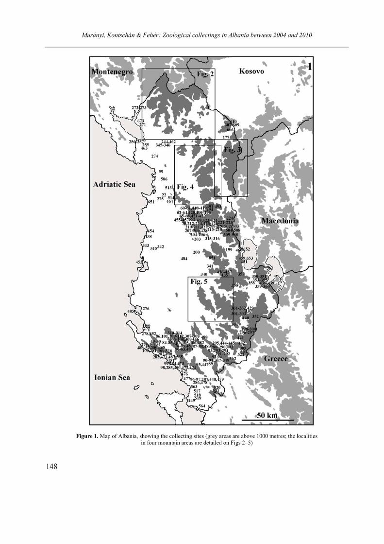
Murányi, Kontschán & Fehér: Zoological collectings in Albania between 2004 and 2010
148
Figure 1. Map of Albania, showing the collecting sites (grey areas are above 1000 metres; the localities in four mountain areas are detailed on Figs 2–5)

Murányi, Kontschán & Fehér: Zoological collectings in Albania between 2004 and 2010
149
Figures 2–5. Maps of Albanian mountain ranges, showing the collecting sites. 2 = Prokletije and Madhë Mts; 3 = Korab and Gjalica e Lumës Mts; 4 = Southern part of Mirditë (Munellë, Pezë, Shent, Lurë area, Dejë, Kreshtës) and Shkanderbeu Mts; 5 =
Tomor, Ostrovicë and Vallamarë Mts.
Murányi, Kontschán & Fehér: Zoological collectings in Albania between 2004 and 2010
150
8: Berat district, Tomor Mts, Tomor i Madhë, Ka-laja e Tomorit, limestone rocks and rocky grassland, 26.05.2004 (2004/10), N40°42.160’ E20°06.568’, 1180m; singled, beaten.
9: Berat district, Tomor Mts, Tomor i Madhë, spring on a meadow beneath Kalaja e Tomorit, 26.05. 2004 (2004/11), N40°42.409’ E20°06.832’, 1165m; singled, waternet.
10: Berat district, Tomor Mts, Çoban Spring in the upper valley of Karkanjos Stream, 26.05.2004 (2004/12), N40°42.897’ E20°06.763’, 1050m; singled, waternet.
11: Berat district, Tomor Mts, karst spring in the upper valley of Vodicë Stream, 26.05.2004 (2004/13), N40°43.231’ E20°06.863’, 1030m; singled, beaten, waternet, soil sample (springside moss).
12: Berat district, Tomor Mts, Karkanjos, macchia and grassland above the village, 27.05.2004 (2004/14), N40°41.483’ E20°04.144’, 570m; singled.
13: Berat district, Tomor Mts, Bogdan, macchia above the village, 27.05.2004 (2004/15), N40°41.849’ E20°03.135’, 380m; singled.
14: Berat district, Tomor Mts, Bogdan, macchia along the road towards Vodicë, 27.05.2004 (2004/16), N40°41.721’ E20°02.860’, 300m; singled.
15: Berat district, Tomor Mts, Vodicë, Vodicë Stream and its shore vegetation above the village, 27.05.2004 (2004/17), N40°40.949’ E20°01.780’, 105m; singled, beaten, waternet, plancton sample (temporary puddle close to the stream).
16: Berat district, Berat, Kalaja e Beratit, castle walls, 27.05.2004 (2004/18), N40°42.377’ E19° 56.785’, 205m; singled.
17: Berat district, Berat, city centre, 27.05.2004 (2004/19), N40°42.319’ E19°57.133’, 65m; singled.
18: Berat district, Berat, Osum River and its gallery, 28.05.2004 (2004/20), N40°42.231’ E19° 56.934’, 60m; singled, beaten, waternet.
19: Berat district, Tomor Mts, Tomor i Madhë, limestone rocks above the village, 26.05.2004 (2004/21), N40°40.733’ E20°06.633’, 970m; singled.
20: Berat district, Tomor Mts, limestone rocks close to the ridge towards Mt. Çuka Partizan, 26.05 2004 (2004/12), N40°41.329’ E20°08.761’, 2090m; singled.
21: Berat district, Tomor Mts, Tomor i Madhë, macchia SW of the village, 25.05.2004 (2004/23), N40°40.891’ E20°05.297’, 495m; singled.
22: Kurbin district, shallow pond along the Krujë–Mamuras road, 28.05.2004 (2004/24), N41°32.19’ E19°42.77’, 15m; singled.
08–14.08.2004 (leg. Zoltán Barina, Zoltán
Fehér, Csaba Németh, Dániel Pifkó)
23: Skrapar district, Tomor Mts, Radesh, limestone
rocks in the left side of a gorge NE of the village, 08.08.2004 (2004/75), N40°33.213’ E20°16.699’, 830m; singled.
24: Skrapar district, Tomor Mts, Radesh, limestone rocks in the right side of a gorge NE of the village, 08.08.2004 (2004/76), N40°33.232’ E20°16.289’, 1180m; singled.
25: Skrapar district, Tomor Mts, alpine meadow SE of Mt. Ramië, 08.08.2004 (2004/77), N40°33.614’ E20°15.872’, 1570m; singled.
26: Skrapar district, Tomor Mts, limestone rocks SE of Mt. Ramië, 08.08.2004 (2004/78), N40°33.878’ E20°15.716’, 1750m; singled.
27: Skrapar district, Tomor Mts, sink-hole S of Mt. Ramië, 09.08.2004 (2004/79), N40°34.114’ E20° 15.512’, 1850m; singled.
28: Skrapar district, Tomor Mts, sink-hole E of Mt. Ramië, 09.08.2004 (2004/80), N40°34.652’ E20° 15.495’, 2050m; singled.
29: Skrapar district, Tomor Mts, limestone rocks in the peak region of Mt. Kulmakë, 09.08.2004 (2004/81), N40°35.194’ E20°14.629’, 2180m; singled.
30: Skrapar district, Tomor Mts, limestone rocks N of Mt. Kulmakë, 09.08.2004 (2004/82), N40°35.377’ E20°14.482’, 2150m; singled.
31: Skrapar district, Tomor Mts, limestone rocks in a small gorge NW of Mt. Kulmakë, 09.08.2004 (2004/83), N40°35.477’ E20°14.308’, 2070m; singled.
32: Skrapar district, Tomor Mts, beech forest and limestone rocks NW of Mt. Kulmakë, 09.08.2004 (2004/84), N40°35.711’ E20°13.283’, 1610m; singled.
33: Skrapar district, Tomor Mts, meadow with small limestone rocks NW of Mt. Kulmakë, 09.08. 2004 (2004/85), N40°35.909’ E20°12.929’, 1560m; singled.
34: Berat district, Tomor Mts, limestone rocks S of Mt. Tomor, 10.08.2004 (2004/86), N40°37.488’ E20° 10.452’, 2100m; singled.
35: Berat district, Tomor Mts, limestone rocks in the peak region of Mt. Tomor, 10.08.2004 (2004/87), N40°37.838’ E20°09.971’, 2270m; singled.
36: Berat district, Tomor Mts, limestone rocks along the ridge N of Mt. Tomor, 10.08.2004 (2004/88), N40°38.494’ E20°09.558’, 2375m; singled.
37: Berat district, Tomor Mts, alpine meadow under limestone rocks, along the ridge N of Mt. Tomor, 10.08.2004 (2004/89), N40°38.641’ E20° 09.541’, 2230m; singled.
Murányi, Kontschán & Fehér: Zoological collectings in Albania between 2004 and 2010
151
38: Berat district, Tomor Mts, limestone rocks along the ridge N of Mt. Tomor, 10.08.2004 (2004/90), N40°39.094’ E20°09.437’, 2250m; singled.
39: Berat district, Tomor Mts, pine forest and limestone rocks below the E side of the ridge N of Mt. Tomor, 10.08.2004 (2004/91), N40°39.200’ E20° 09.670’, 2050m; singled.
40: Berat district, Tomor Mts, limestone rocks below the W side of the ridge N of Mt. Tomor, 10.08.2004 (2004/92), N40°40.470’ E20°09.464’, 2060m; singled
41: Berat district, Tomor Mts, limestone rocks along the ridge N of Mt. Tomor, 10.08.2004 (2004/93), N40°41.233’ E20°09.040’, 2240m; singled.
42: Berat district, Tomor Mts, limestone rocks below the W side of the ridge N of Mt. Tomor, 11.08.2004 (2004/94), N40°41.332’ E20°08.767’, 2090m; singled.
43: Berat district, Tomor Mts, alpine meadow un-der limestone rocks, along the ridge N of Mt. Tomor, 11.08.2004 (2004/95), N40°41.919’ E20°08.698’, 2320m; singled.
44: Berat district, Tomor Mts, Tomor i Madhë, beech forest towards the ridge, above the village, 11.08.2004 (2004/96), N40°41.278’ E20°08.392’, 1780m; singled.
45: Berat district, Tomor Mts, Tomor i Madhë, beech forest towards the ridge, above the village, 11.08.2004 (2004/97), N40°41.299’ E20°08.046’, 1520m; singled
46: Berat district, Tomor Mts, Tomor i Madhë, limestone rocks towards the ridge, above the village, 11.08.2004 (2004/98), N40°41.267’ E20°07.724’, 1400m; singled.
47: Berat district, Tomor Mts, Tomor i Madhë, spring along the path towards the ridge, S of the village, 11.08.2004 (2004/99), N40°40.681’ E20° 06.683’, 1000m; singled.
48: Berat district, Tomor Mts, Tomor i Madhë, limestone rocks above the village, 11.08.2004 (2004/100), N40°40.730’ E20°06.651’, 975m; singled.
49: Vlorë district, Cikë Mts, limestone rocks on Mt. Gurrë, 12.08.2004 (2004/101), N40°12.950’ E19° 36.380’, 2010m; singled.
50: Vlorë district, Cikë Mts, alpine meadow under limestone rocks on the W side of Mt. Gurrë, 12.08. 2004 (2004/102), N40°12.830’ E19°36.659’, 1850m; singled.
51: Vlorë district, Cikë Mts, alpine meadow along the ridge towards Mt. Cikë, 12.08.2004 (2004/103), N40°12.580’ E19°37.072’, 1840m; singled.
52: Vlorë district, Cikë Mts, limestone rocks and macchia N of Llogara Pass, 13.08.2004 (2004/104), N40°11.911’ E19°35.498’, 1040m; singled.
53: Shkodër district, Shkodër, Kalaja e Rozafat, limestone rocks on the N side of the castle hill, 14.08. 2004 (2004/105), N42°02.836’ E19°29.488’, 15m; singled.
08–13.10.2004 (leg. Zoltán Fehér, Jenő
Kontschán, Dávid Murányi)
54: Mat district, Ulëz, gorge of Mat River along the
Burrel–Milot main road, 08.10.2004 (2004/107), N41°41.316’ E19°49.572’, 100m; singled, beaten.
55: Mat district, Shkanderbeu Mts, forest stream E of Shtamë Pass, along the Burrel–Krujë road, 08.10. 2004 (2004/108), N41°32.346’ E19°54.042’, 970m; singled,beaten, waternet, soil sample (moss).
56: Krujë district, Shkanderbeu Mts, small spring SE of Shtamë Pass, along the Burrel–Krujë road, 08.10.2004 (2004/109), N41°30.234’ E19°55.186’, 1100m; singled, beaten.
57: Krujë district, Shkanderbeu Mts, forest torrent SE of Shtamë Pass, along the Burrel–Krujë road, 08.10.2004 (2004/110), N41°30.284’ E19°55.334’, 1150m; singled, beaten, waternet, soil sample (soil)
58: Mat district, Shkanderbeu Mts, beech forest on Shtamë Pass, 08.10.2004 (2004/111), N41°31.129’ E19°53.521’, 1250m; singled, beaten, soil samples (soil, beech litter).
59: Lezhë district, Lezhë, in the city, 09.10.2004 (2004/112), N41°46.489’ E19°38.408’, 10m; singled.
60: Mat district, Fshat, Mat River and its gallery at Vashë Bridge, 09.10.2004 (2004/113), N41°28.033’ E20°06.168’, 350 m; singled, beaten, waternet, soil samples (moss, rivershore moss).
61: Mat district, Fshat, sidespring of Mat River at Vashë bridge, 09.10.2004 (2004/113A), N41°28.033’ E20°06.168’, 350m; singled, beaten, waternet.
62: Mat district, Gropë Mts, Gurri i Bardhë, limestone rocks along the Klos–Elbasan road, NE of the village, 09.10.2004 (2004/114), N41°28.057’ E20°05.252’, 650m; singled, sweeping net.
63: Mat district, Gropë Mts, Gurri i Bardhë, grassland and limestone rocks along the Klos–Elbasan road, N of the village, 09.10.2004 (2004/115), N41° 28.150’ E20°04.402’, 740m; singled, sweeping net.
64: Mat district, Gropë Mts, Gurri i Bardhë, Zoig-jevë Stream along the Klos–Elbasan road, S of the village, 09.10.2004 (2004/116), N41°26.110’ E20° 04.322’, 925m; singled, beaten, waternet.
65: Mat district, Gropë Mts, Gurri i Bardhë, forest spring along the Klos–Elbasan road, S of the village, 09.10.2004 (2004/117), N41°26.064’ E20°04.589’, 965m; singled, waternet.
Murányi, Kontschán & Fehér: Zoological collectings in Albania between 2004 and 2010
152
66: Mat district, Gropë Mts, Gurri i Bardhë, beech forest and forest brook along the Klos–Elbasan road, S of the village, 09.10.2004 (2004/118), N41°23.232’ E20°04.544’, 1365m; singled, beaten, soil sample (beech litter).
67: Mat district, Gropë Mts, shallow pond and stream on a meadow N of Shtyllë Pass, along the Klos–Elbasan road, 09.10.2004 (2004/119), N41°22.340’ E20°05.084’, 1475m; singled, beaten, waternet, sweep-ing net, plancton sample (shallow pond).
68: Tiranë district, Gropë Mts, limestone rocks and forest brook S of Shtyllë Pass, along the Klos–Elbasan road, 09.10.2004 (2004/120), N41°22.158’ E20° 05.079’, 1500m; singled, beaten, soil samples (soil, litter, moss).
69: Tiranë district, Gropë Mts, Shëngjergj, grass-land and limestone rocks along the Klos–Elbasan road, NE of the village, 09.10.2004 (2004/121), N41° 21.053’ E20°06.586’, 1380m; singled.
70: Tiranë district, Gropë Mts, Shëngjergj, beech forest along the Klos–Elbasan road, S of the village, 09.10.2004 (2004/122), N41°18.200’ E20°08.074’, 1425m; singled, soil sample (beech litter).
71: Berat district, Tomor Mts, Vodicë, dry grass-land in the valley of Vodice Stream, above the village, 10.10.2004 (2004/123), N40°41.396’ E20°02.144’, 135m; singled, sweeping net.
72: Skrapar district, Tomor Mts, Çorovodë, bank of Çorovodë Stream at the Turkish bridge, above the city, 10.10.2004 (2004/124), N40°30.576’ E20°14.335’, 325m; singled.
73: Skrapar district, Tomor Mts, Çorovodë, dry forest and limestone walls above the gorge of Çoro-vodë Stream, NE of the city, 10.10.2004 (2004/125), N40°31.246’ E20°15.112’, 475m; singled.
74: Skrapar district, Tomor Mts, Çorovodë, macchia and limestone rocks above the gorge of Osum River, SE of the city, 10.10.2004 (2004/126), N40°28.467’ E20°15.016’, 400m; singled, soil sample (moss).
75: Skrapar district, Tomor Mts, Çorovodë, gallery of Osum River, NW of the city, 10.10.2004 (2004/127), N40°31.414’ E20°10.069’, 240m; singled.
76: Mallakastër district, Greshicë, Pavli Stream and the nearby limestone rocks S of the village, 11.10.2004 (2004/128), N40°32.082’ E19°47.470’, 120m; singled, beaten, waternet.
77: Berat district, Berat, city street, 10.10.2004 (2004/129), N40°42.217’ E19°57.231’, 65m; singled.
78: Tepelenë district, Kendrevicë Mts, Bencë, limestone rocks SW of the village, 11.10.2004 (2004/130), N40°14.570’ E19°59.383’, 270m; singled, beaten.
79: Tepelenë district, Kendrevicë Mts, Lekdush, dry grassland N of the village, 11.10.2004 (2004/131), N40°14.268’ E19°57.415’, 900m; singled, sweeping net.
80: Tepelenë district, Kendrevicë Mts, Progonat, Gurri Stream and its gorge E of the village, 11.10.2004 (2004/132), N40°12.368’ E19°57.411’, 950m; singled, beaten, waternet, soil samples (soil, moss).
81: Tepelenë district, Kendrevicë Mts, Progonat, brook and grassland W of the village, 11.10.2004 (2004/133), N40°12.486’ E19°56.075’, 785m; singled, beaten, waternet.
82: Tepelenë district, Kendrevicë Mts, Progonat, stream, spring and limestone rocks W of the village, 11.10.2004 (2004/134), N40°12.467’ E19°55.499’, 740m; singled, beaten, waternet.
83: Tepelenë district, Kendrevicë Mts, Progonat, cave W of the village, 11.10.2004 (2004/134B), N40°12.47’ E19°55.50’, 800m; singled, soil sample (guano of bats).
84: Tepelenë district, Kendrevicë Mts, Bencë, limestone rocks at the turkish aqueduct, NE of the village, 11.10.2004 (2004/135), N40°15.485’ E20° 00.255’, 220m; singled.
85: Tepelenë district, Kendrevicë Mts, Bencë, Bencë River and its gallery at the turkish aqueduct, NE of the village, 11.10.2004 (2004/135A), N40°15.485’ E20°00.255’, 160m; singled, beaten, waternet.
86: Tepelenë district, Kendrevicë Mts, Tepelenë, limestone rocks and aqueduct above Bencë River, 12.10.2004 (2004/136), N40°17.377’ E20°00.315’, 160m; singled, beaten, soil samples (litter, moss).
87: Tepelenë district, Tepelenë, Uji i Ftohtë, karst springs, limestone rocks and degraded forest, 12.10. 2004 (2004/137), N40°15.011’ E20°03.548’, 165m; singled, beaten, waternet, soil sample (soil).
88: Tepelenë district, Tepelenë, Uji i Ftohtë, Drinos River and its gallery, 12.10.2004 (2004/137A), N40° 15.007’ E20°03.550’, 150m; beaten.
89: Gjirokastër district, Lunxherisë Mts, Suhë, limestone rocks NE of the village, 12.10.2004 (2004/ 138), N40°05.178’ E20°16.180’, 425m; singled.
90: Gjirokastër district, Lunxherisë Mts, Suhë, Suhë River NE of the village, 12.10.2004 (2004/139), N40°05.293’ E20°17.319’, 415m; singled, beaten, waternet.
91: Gjirokastër district, Lunxherisë Mts, Poliçan, sidetorrent of Suhë River SW of the village, 12.10. 2004 (2004/140), N40°06.591’ E20°19.459’, 490m; singled, beaten.
92: Gjirokastër district, Nemerçkë Mts, Sheper, limestone gorge of Pogoni Stream at the village, 12.10.2004 (2004/141), N40°10.124’ E20°18.544’, 800m; singled.

Murányi, Kontschán & Fehér: Zoological collectings in Albania between 2004 and 2010
153
93: Gjirokastër district, Nemerçkë Mts, grassland and limestone rocks on Dhëmbel Pass, 12.10.2004 (2004/142), N40°11.081’ E20°19.565’, 1270m; singl-ed.
94: Gjirokastër district, Nemerçkë Mts, Sheper, shallow lake S of the village, 12.10.2004 (2004/143), N40°09.370’ E20°18.528’, 880m; plancton sample (shallow lake).
95: Gjirokastër district, Gjirokastër, Kalaje e Gjirokastërit, castle walls, 13.10.2004 (2004/144), N40°04.280’ E20°08.263’, 330m; singled, soil sample (moss).
96: Delvinë district, Gjerë Mts, Muzinë, Syri i Kaltër, karst springs W of the village, 13.10.2004 (2004/145), N39°55.286’ E20°11.330’, 155m; singled, beaten, waternet, soil sample (moss from tree), planc-ton samples (strong karst spring, and muddy spring with dense vegetation).
97: Delvinë district, Gjerë Mts, Muzinë, Syri i Kaltër, lake beneath the springs, W of the village, 13. 10.2004 (2004/145B), N39°55.091’ E20°11.057’, 150m; singled, waternet, plancton sample (artificial reservoir).
98: Sarandë district, Çikë Mts, Borsh, Ixuor Spring in the village, 13.10.2004 (2004/146), N40°03.686’ E19°51.462’, 105m; singled, beaten, waternet.
99: Vlorë district, Qeparo, seaside springs and seashore N of the village, 13.10.2004 (2004/147), N40°03.134’ E19°48.756’, 5m; singled, waternet, plancton sample (seaside spring outlet).
100: Vlorë district, Dhërmi, Dhërmi Stream in the village, 13.10.2004 (2004/148), N40°09.330’ E19° 38.374’, 140m; singled.
01–05.05.2005 (leg. Zoltán Barina, Gergely
Király, Dániel Pifkó)
101: Tepelenë district, Tepelenë, floodplain of
Vjosë River SE of the city, 01.05.2005 (1), N40° 17.476’ E20°01.460’, 125m; singled.
102: Tepelenë district, Kendrevicë Mts, Bencë, limestone rocks on the slope of Mt. Tresenik, towards Belikjot, 02.05.2005 (2), N40°15.995’ E20°00.358’, 235m; singled.
103: Tepelenë district, Kendrevicë Mts, Bencë, limestone rocks on the slope of Mt. Dutihë, NW of the village, 02.05.2005 (3), N40°15.721’ E19°58.855’, 1220m; singled.
104: Tepelenë district, Kendrevicë Mts, Bencë, limestone rocks on the slope of Mt. Dutihë, NW of the village, 02.05.2005 (4), N40°15.831’ E19°58.224’, 1225m; singled.
105: Tepelenë district, Kendrevicë Mts, Bencë, limestone rocks on the slope of Mt. Dutihë, NW of the village, 03.05.2005 (5), N40°15.896’ E19°57.541’, 1330m; singled.
106: Tepelenë district, Kendrevicë Mts, limestone rocks on the slope of Mt. Tushnicë, 03.05.2005 (6), N40°16.244’ E19°55.570’, 1150m; singled.
107: Tepelenë district, Kendrevicë Mts, spring section of Bencë River in a limestone gorge, beneath Kresha Pass, 03.05.2005 (7), N40°16.561’ E19° 54.078’, 885m; singled.
108: Tepelenë district, Kendrevicë Mts, limestone rocks on the E slope of the peak of Mt. Klozjurë, 04.05.2005 (8), N40°16.693’ E19°52.408’, 1780m; singled.
109: Tepelenë district, Kendrevicë Mts, limestone rocks in the peak region of Mt. Kendrevicë, 04.05.2005 (9), N40°17.058’ E19°51.400’, 2005m; singled.
110: Tepelenë district, Kendrevicë Mts, limestone rocks in the peak region of Mt. Kendrevicë, 04.05.2005 (10A), N40°17.224’ E19°51.168’, 2085m; singled.
111: Tepelenë district, Kendrevicë Mts, limestone rocks in the peak region of Mt. Kendrevicë, 04.05.2005 (10B), N40°17.219’ E19°51.684’, 2005m; singled.
112: Tepelenë district, Kendrevicë Mts, Hoxhaj, bush on the slope of Mt. Komtiri, W of the village, 05.05.2005 (11), N40°18.919’ E19°55.771’, 775m; singled.
29.05–03.06.2005 (leg. Krisztina Balogh, Zoltán
Barina, Dávid Murányi, Dániel Pifkó)
113: Shkodër district, Prokletije Mts, shallow
alpine lake and limestone rocks on Terthorë Pass, 29.05.2005 (2005/1), N42°23.428’ E19°43.580’, 1690m; singled, plancton sample (shallow alpine lake).
114: Shkodër district, Prokletije Mts, Okol, karst spring and its outlet along the road towards Terthorë Pass, 29.05.2005 (2005/2), N42°23.168’ E19°44.876’, 1620m; singled, waternet.
115: Shkodër district, Prokletije Mts, Okol, beech forest along the road towards Terthorë Pass, 29.05.2005 (2005/3), N42°23.154’ E19°45.534’, 1550m; singled.
116: Shkodër district, Prokletije Mts, Okol, stream along the path towards Pejë Pass, 30.05.2005 (2005/4), N42°24.496’ E19°45.271’, 1010m; singled, beaten, waternet.
117: Shkodër district, Prokletije Mts, Okol, brook along the path towards Pejë Pass, 30.05.2005 (2005/5), N42°24.510’ E19°45.300’, 1000m; singled, beaten, waternet.
Murányi, Kontschán & Fehér: Zoological collectings in Albania between 2004 and 2010
154
118: Shkodër district, Prokletije Mts, Okol, karst spring and beech forest N of the village, towards Pejë Pass, 30.05.2005 (2005/6), N42°25.664’ E19°45.704’, 990m; singled, beaten, waternet, soil sample (beech litter and soil).
119: Shkodër district, Prokletije Mts, alpine grassland and limestone rocks on Pejë Pass, 31.05. 2005 (2005/7), N42°26.650’ E19°46.228’, 1720m; singled, soil sample (soil and moss from rocks at a small, seasonal spring).
120: Shkodër district, Prokletije Mts, alpine grass-land and limestone rocks on the slope of Mt. Harapë, 31.05.2005 (2005/8), N42°26.588’ E19°45.824’, 1800m; singled.
121: Shkodër district, Prokletije Mts, Okol, karst spring system N of the village, 01.06.2005 (2005/9), N42°25.347’ E19°45.680’, 885m; singled, beaten, waternet.
122: Shkodër district, Prokletije Mts, Okol, stream along the path towards Valbonë Pass, 01.06.2005 (2005/10), N42°24.255’ E19°46.483’, 895m; singled, waternet.
123: Shkodër district, Prokletije Mts, Okol, stream beneath Valbonë Pass, 01.06.2005 (2005/11), N42° 24.385’ E19°47.917’, 1430m; singled, beaten, water-net.
124: Tropojë district, Prokletije Mts, Rrogam, limestone rocks and alpine grassland beneath Valbonë Pass, 02.06.2005 (2005/12), N42°24.679’ E19° 48.784’, 1650m; singled, soil sample (soil and moss near a small, snow melt watercourse).
125: Tropojë district, Prokletije Mts, Rrogam, spring system of Valbonë River and beech forest above the village, 02.06.2005 (2005/13), N42°24.620’ E19°49.366’, 1455m; singled, beaten, waternet, soil samples (litter, soil and moss from the bank of an outlet, beech litter).
126: Tropojë district, Prokletije Mts, Rrogam, Valbonë River above the village, 02.06.2005 (2005/ 14), N42°24.551’ E19°49.935’, 1120m; singled, beaten, waternet.
127: Shkodër district, Prokletije Mts, Okol, forest spring and its outlet beneath Valbonë Pass, 02.06.2005 (2005/15), N42°24.384’ E19°47.916’, 1500m; singled.
128: Shkodër district, Prokletije Mts, Okol, beech forest along the path towards Valbonë Pass, 03.06. 2005 (2005/16), N42°24.374’ E19°48.461’, 1070m; singled, soil sample (beech litter).
129: Shkodër district, Prokletije Mts, Theth, Shalë River in the village, 03.06.2005 (2005/17), N42° 23.695’ E19°46.265’, 750m; singled, beaten, waternet.
130: Shkodër district, Prokletije Mts, Okol, stream with a waterfall along the road to Theth, 03.06.2005 (2005/18), N42°24.137’ E19°45.791’, 900m; singled, waternet.
03–07.07.2005 (leg. Zoltán Barina, Dániel
Pifkó, Dávid Schmidt)
131: Skrapar district, Polena, cultivated pine forest
on the N edge of the village, 03.07.2005 (8327), N40°29.542’ E20°16.672’, 825m; singled.
132: Skrapar district, Ostrovicë Mts, Backë, lime-stone rocks on the slope of Frengu Peak, NE of the village, 04.07.2005 (8374), N40°31.197’ E20°25.063’, 1580m; singled.
133: Skrapar district, Ostrovicë Mts, Backë, lime-stone rocks on the slope of Frengu Peak, NE of the village, 04.07.2005 (8394), N40°31.364’ E20°24.817’, 1765m; singled.
134: Skrapar district, Ostrovicë Mts, Backë, limes-tone rocks and open brook on the E slope of Frengu Peak, NE of the village, 04.07.2005 (8415), N40° 31.561’ E20°24.917’, 1900m; singled.
135: Skrapar district, Ostrovicë Mts, Backë, open stream beneath the pass between Frengu and Faqekuq Peaks, N of the village, 04.07.2005 (001), N40°31.614’ E20°25.021’, 1915m; singled.
136: Skrapar district, Ostrovicë Mts, Backë, spring section of Mrbret Stream beneath Faqekuq Peak, N of the village, 05.07.2005 (8457), N40°31.752’ E20° 25.153’, 1970m; singled.
137: Skrapar district, Ostrovicë Mts, Backë, limestone rocks in the peak region of Faqekuq Peak, N of the village, 05.07.2005 (8483), N40°31.951’ E20° 25.458’, 2310m; singled.
138: Skrapar district, Ostrovicë Mts, Çeramica, open brook W of the village, 05.07.2005 (003), N40° 32.649’ E20°26.573’, 1820m; singled.
139: Skrapar district, Ostrovicë Mts, Çeramica, sandy soil W of the village, 06.07.2005 (8535), N40° 32.480’ E20°26.797’, 1735m; singled.
140: Skrapar district, Ostrovicë Mts, Çeramica, Ja-norec Brook W of the village, 06.07.2005 (8585), N40°32.507’ E20°27.708’, 1450m; singled.
141: Skrapar district, Ostrovicë Mts, Çeramica, open stream W of the village, 06.07.2005 (8588), N40° 32.780’ E20°27.527’, 1535m; singled.
142: Skrapar district, Ostrovicë Mts, grassland above Vesci Pass, 06.07.2005 (004), N40°34.012’ E20°26.666’, 2060m; singled.
143: Skrapar district, Ostrovicë Mts, open brook beneath Mt. Ostrovicë, 06.07.2005 (260), N40°34.051’ E20°26.846’, 1960m; singled.
144: Skrapar district, Ostrovicë Mts, limestone rocks on the SW ridge of Mt. Ostrovicë, 07.07.2005 (005), N40°34.589’ E20°26.840’, 2260m; singled.
145: Skrapar district, Ostrovicë Mts, open spring beneath Mt. Ostrovicë, NW of Faqekuq Peak, 07.07.2005 (006), N40°33.485’ E20°25.074’, 1715m; singled
Murányi, Kontschán & Fehér: Zoological collectings in Albania between 2004 and 2010
155
146: Skrapar district, Ostrovicë Mts, entrance of the limestone gorge of Krishovë Stream, N of Faqekuq Peak, 07.07.2005 (8676), N40°33.639’ E20°23.626’, 1070m; singled. 04–11.10.2005 (leg. Tamás Deli, Zoltán Erőss,
Zoltán Fehér, Dávid Murányi)
147: Malësi e Madhe district, Madhë Mts, Gërçarë
border station, house walls, 04.10.2005 (2005/45), N42°35.014’ E19°46.487’, 950m; singled.
148: Malësi e Madhe district, Madhë Mts, Ver-mosh, Vermosh (Lim) River and its littoral bush E of the village, 04.10.2005 (2005/46), N42°34.999’ E19°44.241’, 1010m; singled, beaten, waternet.
149: Malësi e Madhe district, Madhë Mts, Ver-mosh, limestone rocks, Lepushë Stream and its gallery along the Gusinje-Shkodër road, 04.10.2005 (2005/47), N42°34.325’ E19°44.395’, 1080m; singled, beaten, waternet, soil sample (beech litter).
150: Malësi e Madhe district, Madhë Mts, Gropa e Sëlces, karst cave sidespring of the Cem River and its littoral vegetation, S of the village, 04.10.2005 (2005/48), N42°31.937’ E19°39.052’, 900m; singled, beaten, waternet, sweeping net.
151: Malësi e Madhe district, Madhë Mts, Lepushë, limestone rocks and beech forest beneath Mt. Peron-disë, SE of the village, 04.10.2005 (2005/49), N42° 30.938’ E19°44.228’, 1410m; singled.
152: Malësi e Madhe district, Madhë Mts, Lepushë, degraded pasture in the village, 04.10.2005 (2005/ 49A), N42°31.705’ E19°43.660’, 1280m; singled.
153: Malësi e Madhe district, Madhë Mts, Ver-mosh, beech and alder forest along the sidestream of Vermosh (Lim) River in the village, 04.10.2005 (2005/50), N42°35.460’ E19°40.746’, 1075m; singled, soil sample (beech and alder litter).
154: Tropojë district, Qafa e Morinës border station, house walls, 05.10.2005 (2005/56), N42° 24.848’ E20°13.850’, 565m; singled.
155: Tropojë district, Prokletije Mts, Bajram Curri, Hotel Turizm, in and around the hotel, 06.10.2005 (2005/57), N42°21.345’ E20°04.394’, 360m; singled.
156: Tropojë district, Prokletije Mts, Shoshan, limestone gorge of Valbonë River close to the village, 06.10.2005 (2005/58), N42°23.305’ E20°04.374’, 280m; singled.
157: Tropojë district, Prokletije Mts, Dragobi, limestone rocks SE of the village, 06.10.2005 (2005/ 59), N42°24.983’ E20°00.763’, 445m; singled.
158: Tropojë district, Prokletije Mts, Dragobi, Thatë Stream and its gorge in the village, 06.10.2005
(2005/60), N42°26.184’ E19°59.079’, 540m; singled, beaten, waternet.
159: Tropojë district, Prokletije Mts, Rrogam, spring system of Valbonë River, above the village, 06.10.2005 (2005/61), N42°24.620’ E19°49.366’, 1455m; singled, beaten, waternet, soil sample (beech litter).
160: Tropojë district, Prokletije Mts, Rrogam, lime-stone rocks, cave and alpine grassland beneath Val-bonë Pass, 06.10.2005 (2005/62), N42°24.681’ E19° 48.885’, 1560m; singled, sweeping net, soil sample (cave soil), sweeping net sample (alpine grassland).
161: Tropojë district, Prokletije Mts, limestone walls over the N side of Valbonë Pass, 06.10.2005 (2005/63), N42°24.407’ E19°48.732’, 1850m; singled, soil sample (soil and grass roots under rocks).
162: Tropojë district, Prokletije Mts, limestone rocks E of Valbonë Pass, 06.10.2005 (2005/63B), N42°24.495’ E19°48.819’, 1760m; singled.
163: Tropojë district, Prokletije Mts, Rrogam, pasture in the garden of Lulasë family, 06.10.2005 (2005/64), N42°24.610’ E19°50.392’, 1105m; singled.
164: Tropojë district, Lëkurtaj, Valbonë River and Shijë Stream at their confluence, littoral vegetation and limestone rock, S of the village, 07.10.2005 (2005/65), N42°17.927’ E20°01.731’, 220m; singled, beaten, waternet.
165: Tropojë district, Gurorë, limestone walls and secondary hornbeam bush above the village, 07.10.2005 (2005/66), N42°17.206’ E20°01.287’, 290m; singled
166: Tropojë district, Fierzë, limestone walls above Koman Lake, W of the city, 07.10.2005 (2005/67), N42°15.784’ E19°59.400’, 225m; singled.
167: Tropojë district, Fierzë, brook and limestone rocks above Koman Lake, W of the city, 07.10.2005 (2005/68), N42°16.068’ E19°56.966’, 290m; singled, waternet.
168: Tropojë district, Lekbibaj, secondary horn-beam forest at the Vodafone tower, SW of the village, 07.10.2005 (2005/69), N42°16.536’ E19° 54.285’, 900m; singled.
169: Pukë district, Miliskë, limestone rocks N of the village, 07.10.2005 (2005/70), N42°13.215’ E20° 05.859’, 565m; singled.
170: Pukë district, Dardhë, Hotel Kunora, on house walls, 07.10.2005 (2005/71), N42°10.549’ E20° 09.458’, 750m; singled.
171: Pukë district, Mali Pass, roadside vegetation along the Shkodër–Kukës road, 08.10.2005 (2005/72), N42°06.033’ E20°08.627’, 940m; singled.
172: Kukës district, Pezë Mts, Arrën, brook in hornbeam bush N of the village, 08.10.2005 (2005/73),
Murányi, Kontschán & Fehér: Zoological collectings in Albania between 2004 and 2010
156
N41°59.701’ E20°18.154’, 890m; singled, beaten, waternet.
173: Kukës district, Pezë Mts, Arrën, karst plateau with secondary beech forest, N of the village, 08.10. 2005 (2005/74), N41°56.833’ E20°16.773’, 1320m; singled, soil sample (beech litter).
174: Kukës district, Pezë Mts, Arrën, limestone rocks with secondary hornbeam forest at the village, 08.10.2005 (2005/75), N41°55.450’ E20°16.878’, 1150m; singled, soil sample (empty bird nest).
175: Kukës district, Pezë Mts, Arrën, Gurri i Arrënit (Mt. Zepa), limestone rocks and devasted beech forest karst E of the village, 08.10.2005 (2005/76), N41°54.978’ E20°15.156’, 1600m; singled.
176: Kukës district, Pezë Mts, Arrën, Gurri i Shkallës, limestone rocks E of the village, 08.10.2005 (2005/77), N41°55.129’ E20°16.157’, 1300m; singled.
177: Kukës district, Kukës, petrol station in the city, 09.10.2005 (2005/78), N42°04.875’ E20°25.272’, 360m; singled.
178: Kukës district, Kolesjan, limestone rocks S of the village, 09.10.2005 (2005/79), N41°57.597’ E20° 23.689’, 670m; singled.
179: Kukës district, Resk, limestone rocks S of the village, 09.10.2005 (2005/80), N41°56.999’ E20° 22.842’, 675m; singled.
180: Kukës district, Resk, small stream N of the mouth of Bushtricë Stream, S of the village, 09.10. 2005 (2005/81), N41°56.428’ E20°22.561’, 420m; singled, beaten, waternet.
181: Kukës district, Skavicë, Drin i Zi River and Bushtricë Stream at their confluence, limestone rocks at the village, 09.10.2005 (2005/82), N41°56.109’ E20°21.792’, 305m; singled, beaten, waternet.
182: Kukës district, Skavicë, limestone rocks at the bridge of Drin i Zi River, S of the village, 09.10.2005 (2005/83), N41°55.423’ E20°21.237’, 320m; singled.
183: Kukës district, Tej-Drinit, limestone rocks and hornbeam bush at the village, 09.10.2005 (2005/84), N41°56.539’ E20°21.560’, 620m; singled.
184: Kukës district, Skavicë, limestone rocks E of the village, 09.10.2005 (2005/85), N41°54.488’ E20°21.495’, 620m; singled.
185: Dibër district, Draj-Reç, limestone rocks and pasture N of the village, 09.10.2005 (2005/86), N41° 53.447’ E20°20.220’, 550m; singled, sweeping net, sweeping net sample (pasture).
186: Dibër district, Draj-Reç, Drin i Zi River at the bridge towards Zall-Reç, S of the village, 09.10.2005 (2005/87), N41°53.282’ E20°18.991’, 310m; singled, beaten, waternet.
187: Dibër district, Zall-Reç, limestone rocks S of the village, 09.10.2005 (2005/88), N41°51.010’ E20°19.769’, 510m; singled.
188: Dibër district, Arras, limestone rocks above the village, 10.10.2005 (2005/89), N41°44.345’ E20°17.809’, 465m; singled.
189: Dibër district, Lurë area, Cidhnë, limestone rocks at the entrance of the gorge of Setë Stream, W of the village, 10.10.2005 (2005/90), N41°45.111’ E 20°15.665’, 680m; singled.
190: Dibër district, Lurë area, Cidhnë, aqueduct and limestone walls above Setë Stream in its gorge, W of the village, 10.10.2005 (2005/90A), N41°45.149’ E20°14.732’, 780m; singled, beaten, waternet.
191: Dibër district, Lurë area, Cidhnë, Setë Stream and limestone walls in its gorge, 10.10.2005 (2005/ 90B), N41°45.036’ E20°15.754’, 510m; singled.
192: Dibër district, Lurë area, Cidhnë, limestone rocks N of the village, 10.10.2005 (2005/91), N41° 47.133’ E 20°17.221’, 1085m; singled.
193: Dibër district, Lurë area, Cidhnë, limestone rocks N of the village, 10.10.2005 (2005/92), N41°47.964’ E 20°16.837’, 1230m; singled
194: Dibër district, Lurë area, karst forest, limestone rocks and dry grassland along the Cidhnë–Fushë Lurë road, 10.10.2005 (2005/93), N41°48.892’ E 20°16.650’, 1345m; singled, sweeping net, soil sample (beech litter from rocks), sweeping net sample (dry grassland).
195: Dibër district, Dejë Mts, Lunarë, limestone rocks, Murrë River and its sidespring at the bridge, 11.10.2005 (2005/94), N41°37.542’ E20°14.993’, 730m; singled, beaten.
196: Mat district, Dejë Mts, limestone rocks W of Shkanderbeu Cliff, N of Murrë Pass, 11.10.2005 (2005/95), N41°38.763’ E20°10.832’, 1160m; singled.
197: Mat district, Dejë Mts, Varoshit Stream and its karst cave sidespring at Shkanderbeu Cliff, N of Murrë Pass, 11.10.2005 (2005/96), N41°38.792’ E20° 11.390’, 975m; singled, beaten, waternet, soil sample (litter from dead tree trunk), sweeping net sample (bush at a karst spring outlet).
198: Dibër district, Dejë Mts, Selishtë, limestone rocks above the village, 11.10.2005 (2005/97), N41° 37.119’ E20°17.372’, 1000m; singled.
09–17.04.2006 (leg. Zoltán Erőss, Zoltán Fehér,
András Hunyadi, Dávid Murányi)
199: Librazhd district, Qukës Shkumbin, Shkumbin
River and its sidespring, 09.04.2006 (2006/4), N41°05.761’ E20°26.566’, 380m; singled, beaten, waternet.
200: Elbasan district, Shirgjan, limestone rocks and roadside vegetation at the village, 09.04.2006 (2006/5), N41°02.147’ E20°04.117’, 200m; singled.
Murányi, Kontschán & Fehér: Zoological collectings in Albania between 2004 and 2010
157
201: Gramsh district, Tomor Mts, Tunjë, degraded oak forest S of the village, 09.04.2006 (2006/6), N40°47.488’ E20°05.693’, 900m; singled.
202: Gramsh district, Tomor Mts, Dardhë, open brook and limestone rocks beneath Mt. Çuka Partizan, 09.04.2006 (2006/7), N40°44.584’ E20°07.628’, 810m; singled, beaten, waternet, soil sample (soil beneath rocks).
203: Elbasan district, Çermenikë Mts, Griqan, limestone rocks in the village, 10.04.2006 (2006/8), N41°09.454’ E20°07.480’, 580m; singled.
204: Elbasan district, Çermenikë Mts, Gurri i Zi, limestone rocks along the Elbasan–Klos road, S of the village, 10.04.2006 (2006/9), N41°12.212’ E20° 06.875’, 900m; singled, soil sample (soil and roots under rocks).
205: Elbasan district, Çermenikë Mts, Gurri i Zi, limestone rocks along the Elbasan–Klos road, N of the village, 10.04.2006 (2006/10), N41°12.763’ E20° 08.184’, 1100m; singled.
206: Elbasan district, Çermenikë Mts, Gurri i Zi, limestone rocks along the Elbasan–Klos road, N of the village, 10.04.2006 (2006/11), N41°13.356’ E20° 07.605’, 1150m; singled.
207: Elbasan district, Çermenikë Mts, Cerunjë, for-est brook, spring and rocks along the Elbasan–Klos road, E of the village, 10.04.2006 (2006/12), N41° 14.355’ E20°06.570’, 1150m; singled, beaten, waternet.
208: Elbasan district, Çermenikë Mts, Cerunjë, limestone rocks along the Elbasan–Klos road, E of the village, 10.04.2006 (2006/13), N41°14.332’ E20° 05.856’, 1180m; singled.
209: Tiranë district, Gropë Mts, Vakumonë, karst spring, open brook, puddle and beech forest along the Elbasan–Klos road, SE of the village, 10.04.2006 (2006/14), N41°15.122’ E20°05.791’, 1200m; singled, beaten, waternet, soil sample (beech litter).
210: Tiranë district, Gropë Mts, Vakumonë, beech forest along the Elbasan–Klos road, E of the village, 10.04.2006 (2006/15), N41°16.165’ E20°05.088’, 1150m; singled, soil sample (beech litter and decaying wood).
211: Tiranë district, Gropë Mts, Vakumonë, limestone rocks, wet grassland and forest brook along the Elbasan–Klos road, NE of the village, 10.04.2006 (2006/16), N41°17.456’ E20°04.992’, 1230m; singled, waternet, sweeping net.
212: Tiranë district, Gropë Mts, Shëngjergj, spring and its outlet in beech forest along the Elbasan–Klos road, S of the village, 10.04.2006 (2006/17), N41° 17.706’ E20°06.051’, 1230m; singled, waternet.
213: Tiranë district, Gropë Mts, Shëngjergj, lime-stone rocks along the Elbasan–Klos road, S of the village, 10.04.2006 (2006/18), N41°17.438’ E20° 07.133’, 1300m; singled.
214: Tiranë district, Gropë Mts, Shëngjergj, beech forest along the Elbasan–Klos road, S of the village, 10.04.2006 (2006/19), N41°17.683’ E20°07.333’, 1350m; singled, soil sample (beech litter).
215: Librazhd district, Çermenikë Mts, Funarës, limestone rocks E of the village, 11.04.2006 (2006/20), N41°16.485’ E20°16.076’, 660m; singled, formol method.
216: Librazhd district, Çermenikë Mts, Floq, limestone rocks at the village, 11.04.2006 (2006/21), N41°15.960’ E20°15.573’, 690m; singled.
217: Librazhd district, Çermenikë Mts, Oranjë, limestone rocks at the village, 11.04.2006 (2006/22), N41°16.718’ E20°12.723’, 750m; singled.
218: Librazhd district, Çermenikë Mts, Floq, open stream E of the village, 11.04.2006 (2006/23), N41° 15.986’ E20°14.621’, 620m; singled, waternet.
219: Librazhd district, Çermenikë Mts, Lunik, limestone rocks S of the village, 11.04.2006 (2006/24), N41°15.961’ E20°19.092’, 700m; singled
220: Librazhd district, Çermenikë Mts, Lunik, limestone rocks E of the village, 11.04.2006 (2006/25), N41°16.606’ E20°20.109’, 750m; singled.
221: Librazhd district, Çermenikë Mts, Lunik, limestone rocks NE of the village, 11.04.2006 (2006/26), N41°17.812’ E20°22.441’, 1050m; singled.
222: Bulqizë district, Çermenikë Mts, Fushë Stu-den, beech forest and forest brook NE of the village, 11.04. 2006 (2006/27), N41°19.423’ E20°25.376’, 1190m; singled, formol method, soil sample (beech litter).
223: Bulqizë district, Çermenikë Mts, Steblevë, limestone rocks S of the village, 11.04.2006 (2006/28), N41°19.517’ E20°27.073’, 1230m; singled.
224: Bulqizë district, Gollobordë Mts, Klenjë, cave and limestone rocks at the village, 11.04.2006 (2006/ 29), N41°21.890’ E20°28.112’, 1200m; singled.
225: Dibër district, Arras, limestone rocks above the village, 12.04.2006 (2006/30), N41°44.345’ E20° 17.809’, 465m; singled.
226: Dibër district, Lurë area, Cidhnë, limestone walls above Setë Stream in its gorge, W of the village, 12.04.2006 (2006/31A), N41°45.123’ E20°15.145’, 710m; singled.
227: Dibër district, Lurë area, Cidhnë, limestone walls above Setë Stream in its gorge, W of the village, 12.04.2006 (2006/31B), N41°45.170’ E20°15.029’, 750m; singled.
228: Dibër district, Lurë area, Cidhnë, limestone walls above Setë Stream in its gorge, W of the village,
Murányi, Kontschán & Fehér: Zoological collectings in Albania between 2004 and 2010
158
12.04.2006 (2006/31C), N41°45.149’ E20°14.732’, 780m; singled.
229: Dibër district, Lurë area, Cidhnë, Setë Stream and limestone rocks above the gorge, W of the village, 12.04.2006 (2006/32), N41°45.428’ E20°14.333’, 730m; singled, waternet, soil samples (moss and maple litter).
230: Dibër district, Lurë area, Cidhnë, spring above the gorge of Setë Stream, W of the village, 12.04.2006 (2006/32F), N41°45.370’ E20°14.351’, 730m; singled.
231: Dibër district, Trojak, open stream S of the village, 12.04.2006 (2006/33), N41°47.381’ E20° 23.491’, 790m; singled, beaten, waternet.
232: Dibër district, Dejë Mts, Selishtë, marble quarry E of the village, 13.04.2006 (2006/34), N41° 39.745’ E20°19.037’, 530m; singled.
233: Dibër district, Dejë Mts, Selishtë, limestone rocks above Murrë River, in the village, 13.04.2006 (2006/35), N41°37.550’ E20°16.367’, 810m; singled, soil sample (litter from a rock hole).
234: Dibër district, Dejë Mts, Lunarë, limestone rocks, Murrë River and its sidespring at the bridge, 13.04.2006 (2006/36), N41°37.542’ E20°14.993’, 730m; singled, beaten, waternet.
235: Mat district, Dejë Mts, Varoshit Stream and its karst cave sidespring at Shkanderbeu Cliff, N of Murrë Pass, 13.04.2006 (2006/37), N41°38.792’ E20° 11.390’, 975m; singled, beaten, waternet.
236: Mat district, Dejë Mts, limestone rocks W of Shkanderbeu Cliff, N of Murrë Pass, 13.04.2006 (2006/38), N41°38.707’ E20°10.939’, 1090m; singled.
237: Mat district, Dejë Mts, limestone rocks W of Shkanderbeu Cliff, N of Murrë Pass, 13.04.2006 (2006/39), N41°38.763’ E20°10.836’, 1160m; singled.
238: Mat district, Dejë Mts, degraded forest and sidestream of Varoshit Stream along the road to Lurë area, 13.04.2006 (2006/40), N41°39.829’ E20°11.730’, 1210m; singled, beaten, waternet, soil sample (soil from beneath dead tree trunk).
239: Mat district, Dejë Mts, limestone rocks W of Shkanderbeu Cliff, N of Murrë Pass, 13.04.2006 (2006/41), N41°39.015’ E20°11.164’, 1180m; singled.
240: Mat district, Dejë Mts, Fikë, artificial pond and pasture NE of the village, 13.04.2006 (2006/42), N41°38.658’ E20°09.558’, 1120m; singled, plancton sample (artificial pond).
241: Mat district, Dejë Mts, Lis, limestone rocks E of the village, 13.04.2006 (2006/43), N41°38.110’ E20°07.460’, 860m; singled
242: Mat district, spring and brook in the gorge of Mat River along the Burrel–Milot main road, 14.04.2006 (2006/44), N41°40.684’ E19°51.175’, 90m; singled.
243: Mat district, limestone rocks in the gorge of Mat River along the Burrel–Milot main road, 14.04. 2006 (2006/45), N41°41.505’ E19°49.906’, 90m; singled.
244: Shkodër district, Laç-Qyrsaç, brook and pine forest NE of the city, 14.04.2006 (2006/46), N42° 01.013’ E19°39.636’, 115m; singled, beaten, waternet.
245: Shkodër district, Koman, limestone rocks at the ferry harbour of Koman Lake, 14.04.2006 (2006/47), N42°06.519’ E19°49.584’, 180m; singled.
246: Shkodër district, limestone rocks and right sidestream of Koman Lake, right bank 1.5km above the dam, 14.04.2006 (2006/48), N42°07.302’ E19° 49.882’, 180m; singled, waternet.
247: Shkodër district, limestone rocks and rocky forest at Koman Lake, left bank 1.5km above the dam, 14.04.2006 (2006/49), N42°06.993’ E19°50.243’, 180m; singled.
248: Shkodër district, Karmë, macchia and limestone rocks at the village 14.04.2006 (2006/50), N42°04.856’ E19°44.173’, 90m; singled.
249: Shkodër district, Karmë, brook in bush and rocks E of the village 14.04.2006 (2006/51), N42° 04.421’ E19°47.350’, 140m; singled, beaten, waternet.
250: Shkodër district, limestone rocks at Koman Lake, right bank 12km above the dam, 15.04.2006 (2006/52), N42°11.229’ E19°52.173’, 180m; singled.
251: Shkodër district, limestone rocks at Koman Lake, right bank 15km above the dam, 15.04.2006 (2006/53), N42°12.321’ E19°53.507’, 180m; singled.
252: Shkodër district, open brook on limestone rocks, and the shore of Koman Lake, right bank 15.5km above the dam, 15.04.2006 (2006/54), N42° 12.640’ E19°53.677’, 180m; singled, waternet.
253: Shkodër district, brook and limestone rocks at Koman Lake, right bank 17.5km above the dam, 15.04. 2006 (2006/55), N42°13.550’ E19°53.542’, 180m; singled, beaten, waternet.
254: Shkodër district, stream and its valley with limestone rocks at Koman Lake, left bank 18km above the dam, 15.04.2006 (2006/56), N42°13.613’ E19° 54.300’, 180m; singled, beaten, waternet.
255: Shkodër district, Zuos, Bunë River and its gallery at the village, 15.04.2006 (2006/57), N42° 01.634’ E19°28.318’, 5m; singled, beaten.
256: Shkodër district, Zogaj, macchia and lime-stone rocks at Shkodër Lake, E of the village, 15.04.2006 (2006/58), N42°04.148’ E19°24.788’, 30m; singled,
257: Shkodër district, Zogaj, macchia and lime-stone rocks at Shkodër Lake, W of the village, 15.04.2006 (2006/59), N42°04.342’ E19°23.678’, 30m; singled.
258: Shkodër district, Rrash, Vrak Spring and its outlet stream, limestone rocks and macchia at the
Murányi, Kontschán & Fehér: Zoological collectings in Albania between 2004 and 2010
159
village, 16.04.2006 (2006/60), N42°08.817’ E19° 32.726’, 50m; singled, beaten, waternet.
259: Shkodër district, Gruemirë, limestone quarry at the village, 16.04.2006 (2006/61), N42°09.138’ E19°32.412’, 90m; singled.
260: Shkodër district, Kurtaj, limestone rocks above the village, 16.04.2006 (2006/62), N42°11.380’ E19°33.726’, 330m; singled, plancton sample (lito-thelma on limestone rock).
261: Shkodër district, Prokletije Mts, Rioli, side-torrent of Sheu River and limestone rocks beneath the village, 16.04.2006 (2006/63), N42°12.267’ E19° 34.079’, 270m; singled, beaten, waternet.
262: Shkodër district, Prokletije Mts, Rioli, Sheu River, pasture and limestone rocks beneath the village, 16.04.2006 (2006/64), N42°12.390’ E19°34.139’, 260m; singled, beaten, waternet.
263: Shkodër district, Prokletije Mts, Rioli, lime-stone rocks at Sheu River in the village, 16.04.2006 (2006/65), N42°12.688’ E19°34.750’, 370m; singled.
264: Shkodër district, Prokletije Mts, Rioli, horn-beam shrub SW of the village, 16.04.2006 (2006/66), N42°11.827’ E19°33.783’, 350m; singled.
265: Shkodër district, Mes, limestone rocks on the shore of Kir River at Mesi Bridge, 16.04.2006 (2006/ 67), N42°06.854’ E19°34.562’, 60m; singled.
266: Shkodër district, Prokletije Mts, Ukbibaj, limestone rocks E of the village, 16.04.2006 (2006/68), N42°07.076’ E19°39.538’, 570m; singled.
267: Shkodër district, Prokletije Mts, Ukbibaj, limestone rocks NE of the village, 16.04.2006 (2006/ 69), N42°07.543’ E19°40.061’, 710m; singled.
268: Shkodër district, Prokletije Mts, Shllak, lime-stone rocks W of the village, 16.04.2006 (2006/70), N42°07.844’ E19°42.641’, 1020m; singled.
269: Shkodër district, Prokletije Mts, Shllak, arti-ficial pond and limestone rocks W of the village, 16.04. 2006 (2006/70A), N42°07.626’ E19°42.773’, 1020m; singled, waternet, plancton sample (artificial pond).
270: Shkodër district, Shkodër, Hotel Kaduku, gar-den and house walls, 17.04.2006 (2006/71), N42° 03.439’ E19°30.095’, 20m; singled.
271: Malësi e Madhe district, Polvar, shallow lake and ruderal grassland at the village, 17.04.2006 (2006/ 72), N42°11.916’ E19°27.014’, 60m; singled, waternet.
272: Malësi e Madhe district, Hani i Hotit, Shkodër Lake and its shore before the border station, 17.04. 2006 (2006/73), N42°20.056’ E19°25.641’, 20m; singled, waternet.
10–12.05.2006 (leg. László Dányi, Jenő Kontschán, Dávid Murányi)
273: Malësi e Madhe district, Hani i Hotit, Shkodër
Lake and macchia vegatation before the border station,
10.05.2006 (2006/82), N42°20.053’ E19°25.617’, 20m; singled, waternet.
274: Lezhë district, Kakarriq, channel along the Shkodër–Tiranë road, N of the village, 10.05.2006 (2006/83), N41°55.537’ E19°35.007’, 10m; singled, waternet.
275: Kurbin district, Mamuras, channel along the Shkodër–Tiranë road, S of the city, 10.05.2006 (2006/ 84), N41°32.148’ E19°40.670’, 20m; singled, waternet.
276: Vlorë district, Panaja, olive grove N of the village, 11.05.2006 (2006/85), N40°33.015’ E19° 28.238’, 20m; singled, sweeping net.
277: Vlorë district, Radhimë, seashore beneath the village, 11.05.2006 (2006/86), N40°21.673’ E19° 28.832’, 0m; singled, waternet, soil sample (seashore debrits).
278: Vlorë district, Orikum, mouth of a brackish channel N of the city, 11.05.2006 (2006/86B), N40° 20.594’ E19°28.917’, 0m; singled, waternet.
279: Vlorë district, Çikë Mts, pine forest N of Llogara Pass, 11.05.2006 (2006/87), N40°12.717’ E19°34.750’, 860m; singled, beaten, soil sample (pine forest soil).
280: Vlorë district, Çikë Mts, spring and its outlet N of Llogara Pass, 11.05.2006 (2006/88), N40°12.187’ E19°35.254’, 980m; singled, beaten, waternet, soil sample (moss).
281: Vlorë district, Dhërmi, Dhërmi Stream in the village, 11.05.2006 (2006/89), N40°09.330’ E19° 38.374’, 140m; singled, beaten.
282: Vlorë district, Dhërmi, macchia and rocky grassland S of the village, 11.05.2006 (2006/90), N40°08.607’ E19°39.735’, 250m; singled, soil sample (rocky grassland soil).
283: Vlorë district, Lias, oak forest, grassland and limestone rocks in Canion Gjipesë, S of the village, 11.05.2006 (2006/91), N40°08.622’ E19°40.620’, 255m; singled, beaten.
284: Vlorë district, Qeparo, seaside springs, rocky macchia and seashore N of the village, 11.05.2006 (2006/92), N40°03.134’ E19°48.756’, 5m; singled, waternet.
285: Sarandë district, Çikë Mts, Borsh, Ixuor Spring in the village, 11.05.2006 (2006/93), N40° 03.686’ E19°51.462’, 105m; singled, beaten, waternet.
286: Sarandë district, Mezopotam, Bistricë River and riverside pasture at the village, 11.05.2006 (2006/ 94), N39°54.528’ E20°06.173’, 35m; singled, beaten, soil sample (pasture soil).
287: Delvinë district, Gjerë Mts, Muzinë, Syri i Kaltër, karst springs W of the village, 12.05.2006 (2006/95), N39°55.286’ E20°11.330’, 155m; singled, beaten, waternet, sweeping net sample (streamside bush).

Murányi, Kontschán & Fehér: Zoological collectings in Albania between 2004 and 2010
160
22–24.05.2006 (leg. Zoltán Barina, Tamás Deli,
Dániel Pifkó)
288: Permët district, Dhëmbel Mts, limestone rocks
on the E slope of Mt. Dhëmbel, 22.05.2006 (210160), N40°12.181’ E20°19.004’, 1965m; singled.
289: Permët district, Dhëmbel Mts, melting snow in the peak region of Mt. Dhëmbel, 22.05.2006 (15Mn), N40°11.956’ E20°18.879’, 2010m; singled.
290: Permët district, Dhëmbel Mts, limestone rocks in the peak region of Mt. Dhëmbel, 22.05.2006 (160null), N40°11.598’ E20°18.857’, 2050m; singled.
291: Permët district, Nemerçkë Mts, Poliçani, limestone rocks between Poliçani and Gataku Peaks, NE of the village, 23.05.2006 (4/1), N40°09.250’ E20°22.076’, 2120m; singled.
292: Permët district, Nemerçkë Mts, open rocky grassland on the SW slope of Mt. Poliçani, 23.05.2006 (4/2), N40°10.199’ E20°21.123’, 2060m; singled.
293: Permët district, Nemerçkë Mts, limestone rocks on the NW slope of Mt. Poliçani, SE of Dhëmbel Pass, 23.05.2006 (4/3), N40°11.933’ E20°20.359’, 1535m; singled.
294: Permët district, Nemerçkë Mts, Leushë, N slope of Mt. Poliçani E of Dhëmbel Pass, S of the village, 24.05.2006 (5), N40°13.205’ E20°21.388’, 660m; singled.
295: Permët district, Dangelli region, Grabovë, limestone gorge of Lengaricë River NW of the village, 24.05.2006 (6), N40°14.671’ E20°26.222’, 335m; singled.
17–22.07.2006 (leg. Zoltán Barina, Gergely
Király, Csaba Németh, Dániel Pifkó)
296: Kolonjë district, Grammos Mts, Rehovë,
brook in the valley of Lasishta River, E of the village, 17.07.2006 (9722), N40°20.210’ E20°43.822’, 1605m; singled.
297: Kolonjë district, Grammos Mts, Rehovë, mountain pasture on the W slope of Mt. Meci, E of the village, 17.07.2006 (9750), N40°20.162’ E20°44.438’, 1875m; singled.
298: Kolonjë district, Grammos Mts, Rehovë, brook valley on the W slope of Mt. Meci, E of the village, 18.07.2006 (9821), N40°20.581’ E20°44.629’, 1965m; singled.
299: Kolonjë district, Grammos Mts, Starjë, brook in the valley of Alikolar Stream, E of the village, 19.07.2006 (9949), N40°21.677’ E20°45.275’, 1865m; singled.
300: Kolonjë district, Grammos Mts, Rehovë, mountain pasture on the slope of Mt. Varibob, NW of Mt. Qukapeci, 19.07.2006 (004), N40°21.973’ E20°46.231’, 2250m; singled.
301: Korçë district, Vithkuq, limestone rocks on the NE ridge of Mt. Rungajë, SW of the village, 20.07.2006 (10053), N40°30.518’ E20°33.920’, 1735m; singled.
302: Korçë district, Vithkuq, limestone rocks on the N slope of Mt. Rungajë, SW of the village, 20.07.2006 (10064), N40°30.328’ E20°33.075’, 1730m; singled.
303: Korçë district, Vithkuq, limestone rocks on the N slope of Mt. Rungajë, W of the village, 20.07.2006 (10081), N40°31.135’ E20°33.673’, 1500m; singled.
304: Kolonjë district, Qesara, serpentine rocks N of the village, 21.07.2006 (10147), N40°25.096’ E20° 32.076’, 1215m; singled.
305: Kolonjë district, Grammos Mts, Sotina Stream and alder forest W of Mt. Kameniku, 22.07.2006 (10206), N40°12.646’ E20°39.412’, 1050m; singled.
10–12.08.2006 (leg. Zoltán Barina, Dániel
Pifkó, Dávid Schmidt)
306: Tepelenë district, Kendrevicë Mts, Lekdush,
riverbed of Bencë River N of the village, 10.08.2006 (10344), N40°15.109’ E19°57.916’, 245m; singled.
307: Tepelenë district, Kendrevicë Mts, Dragot, scrubby pasture E of the village, 11.08.2006 (10362), N40°17.270’ E20°04.997’, 555m; singled.
308: Tepelenë district, Kendrevicë Mts, Dragot, scrubby pasture E of the village, 11.08.2006 (10363), N40°17.233’ E20°04.997’, 605m; singled.
309: Tepelenë district, Kendrevicë Mts, Kodra, limestone rocks E of the village, 11.08.2006 (10379), N40°16.549’ E20°05.638’, 1270m; singled.
310: Tepelenë district, Kendrevicë Mts, Matoha-sanaj, pasture on limestone W of the village, 12.08. 2006 (10463), N40°21.333’ E19°48.260’, 950m; singled.
311: Tepelenë district, Kendrevicë Mts, Matoha-sanaj, ravine on limestone W of the village, 12.08.2006 (10474), N40°20.434’ E19°46.816’, 1485m; singled.
312: Tepelenë district, Kendrevicë Mts, rocky grassland on the NE slope of Mt. Tartari, 12.08.2006 (10485), N40°20.245’ E19°46.481’, 1680m; singled.
313: Tepelenë district, Kendrevicë Mts, rocky grassland on the peak of Mt. Tartari, 12.08.2006 (10488), N40°20.143’ E19°45.897’, 1950m; singled.
314: Tepelenë district, Kendrevicë Mts, limestone rock NE of the peak of Mt. Tartari, 12.08.2006 (10504), N40°21.023’ E19°46.577’, 1465m; singled.
Murányi, Kontschán & Fehér: Zoological collectings in Albania between 2004 and 2010
161
20–27.08.2006 (leg. Zoltán Fehér, András
Hunyadi, Tamás Huszár, Dávid Murányi)
315: Librazhd district, Mirakë, Shkumbin River and
limestone rocks at Kamarë Bridge, 20.08.2006 (2006/ 133), N41°09.809’ E20°13.821’, 190m; singled, beaten, waternet.
316: Librazhd district, Mirakë, right sidespring of Shkumbin River above Kamarë Bridge, 20.08.2006 (2006/133A), N41°09.917’ E20°14.297’, 200m; singl-ed, waternet.
317: Skrapar district, Osojë, secondary forest along the Çorovodë–Backë road, 20.08.2006 (2006/134), N40°30.031’ E20°17.161’, 1010m; singled.
318: Skrapar district, Ostrovicë Mts, Backë, limestone rocks and rocky grassland along the path to Frengu Peak, N of the village, 20.08.2006 (2006/135), N40°30.983’ E20°24.422’, 1450m; singled.
319: Skrapar district, Ostrovicë Mts, Backë, limestone rocks and mountain pasture beneath the Frengu Peak, N of the village, 20.08.2006 (2006/136), N40°31.314’ E20°24.833’, 1750m; singled, light trap, sweeping net sample (mountain pasture).
320: Skrapar district, Ostrovicë Mts, Backë, Krojmbret Spring and its outlet between the Frengu and Faqekuq Peaks, NE of the village, 21.08.2006 (2006/137), N40°31.753’ E20°25.152’, 1965m; singl-ed, waternet.
321: Skrapar district, Ostrovicë Mts, limestone rocks and rocky grassland in the peak region of Faqekuq Peak, 21.08.2006 (2006/138), N40°31.947’ E20°25.538’, 2340m; singled, sweeping net.
322: Skrapar district, Ostrovicë Mts, Backë, cave SE of Frengu Peak, NE of the village, 21.08.2006 (2006/139), N40°31.472’ E20°24.980’, 1850m; singl-ed, soil sample (cave soil).
323: Skrapar district, Çorovodë, Grand Hotel, house walls, 21.08.2006 (2006/140), N40°30.269’ E20°13.535’, 270m; singled.
324: Skrapar district, Tomor Mts, Çorovodë, limestone rocks at the junction to Gradec, NE of the city, 22.08.2006 (2006/141), N40°32.609’ E20° 16.309’, 1000m; singled.
325: Skrapar district, Tomor Mts, Radesh, dry forest at the military camp entrance, 22.08.2006 (2006/142), N40°31.818’ E20°15.452’, 740m; singled, sweeping net sample (dry forest edge).
326: Skrapar district, Tomor Mts, Çorovodë, limestone gorge of Çorovodë Stream NE of the city, 22.08.2006 (2006/143), N40°31.338’ E20°15.444’, 540m; singled, sweeping net.
327: Skrapar district, Tomor Mts, Radesh, lime-stone rocks, pasture and secondary forest at Dëvri Pass, NE of the village, 22.08.2006 (2006/144), N40°
33.365’ E20°16.544’, 1150m; singled, soil sample (cave soil and soil from nut bush).
328: Skrapar district, Turbehovë, dry secondary ve-getation in a right side valley of Çorovodë Stream, SW of the village, 22.08.2006 (2006/145), N40°32.531’ E20°20.760’, 850m; singled, light trap.
329: Skrapar district, Ostrovicë Mts, Turbehovë, limestone gorge of Krishovë Stream NE of the village, 23.08.2006 (2006/146), N40°33.540’ E20°23.450’, 1040m; singled, beaten, waternet, soil sample (moss from rocks).
330: Skrapar district, Tomor Mts, small limestone gorge N of Dëvri Pass along the road to Zaloshnje, 23.08.2006 (2006/147), N40°34.287’ E20°17.279’, 1110m; singled, soil samples (bird nest, soil from rocks).
331: Skrapar district, Tomor Mts, Ujanik, gorge of Ujanik Stream above the village, 23.08.2006 (2006/ 148), N40°37.969’ E20°12.969’, 965m; singled, beaten, waternet, soil samples (cave soil and mouse nest, soil from rocks).
332: Berat district, Tomor Mts, limestone rocks and rocky grassland in the peak region of Mt. Tomor, 23.08.2006 (2006/149), N40°38.468’ E20°09.448’, 2375m; singled
333: Skrapar district, Tomor Mts, grassland on Kulmak Pass, close to the bektashi teqe, 23.08.2006 (2006/150), N40°37.116’ E20°11.945’, 1485m; singl-ed, light trap.
334: Skrapar district, Tomor Mts, Treblja, beech forest NW of the village, 24.08.2006 (2006/151), N40°40.879’ E20°11.009’, 1290m; singled, soil sample (beech litter).
335: Skrapar district, Tomor Mts, Terovë, lime-stone gorge above the village, 24.08.2006 (2006/152), N40°42.748’ E20°11.023’, 855m; singled.
336: Skrapar district, Tomor Mts, limestone rocks on the NE slope of Mt. Çuka Parizan, 24.08.2006 (2006/153), N40°43.275’ E20°10.321’, 1130m; singled.
337: Skrapar district, Tomor Mts, beech forest and subalpine grassland on the NE slope of Mt. Çuka Parti-zan, 24.08.2006 (2006/154), N40°43.198’ E20° 10.166’, 1280m; singled, light trap, sweeping net sample (subalpine grassland), soil sample (beech litter).
338: Berat district, Tomor Mts, pine forest and alpine grassland on the NE slope of Mt. Çuka Partizan, 25.08.2006 (2006/155), N40°42.983’ E20°09.403’, 1950m; singled, sweeping net.
339: Skrapar district, Terovë, Tomorica River beneath (E of) the village, 25.08.2006 (2006/156), N40°42.886’ E20°13.337’, 345m; singled.
340: Gramsh district, Gramsh, motel at the S edge of the city, 25.08.2006 (2006/157), N40°51.643’ E20°11.303’, 230m; light trap.
Murányi, Kontschán & Fehér: Zoological collectings in Albania between 2004 and 2010
162
341: Gramsh district, Tërvol, limestone gorge of Holta Stream above the village, 26.08.2006 (2006/ 158), N40°55.562’ E20°13.390’, 250m; singled, beaten, waternet, soil sample (soil and moss from rocks).
342: Kavajë district, Lekaj, channel and its bushy shore vegetation at the junction to Luzi i Madh, 26.08.2006 (2006/159), N41°06.679’ E19°36.345’, 25m; singled, sweeping net sample (bushy shore vegetation).
343: Kavajë district, Bardhor, sandy seashore S of Kepi i Lagjit, 26.08.2006 (2006/160), N41°07.624’ E19°26.954’, 0m; singled, soil sample (seashore debrits).
344: Shkodër district, Shkodër, Hotel Kaduku, house walls, 27.08.2006 (2006/161), N42°03.439’ E19°30.095’, 20m; singled.
10–22.04.2007 (leg. Zoltán Barina, Annamária
Csóka, Dániel Pifkó, Balázs Pintér)
345: Shkodër district, Mjedë, limestone rocks near Drin River, NE of the village, 12.04.2007 (víztározó 1), N42°00.881’ E19°37.703’, 85m; singled.
346: Shkodër district, Mjedë, Drin River N of the village, 12.04.2007 (víztározó 2), N42°00.989’ E19°37.711’, 40m; singled.
347: Gjirokastër district, Lunxherisë Mts, Suhë, Suhë River NE of the village, 18.04.2007 (szurdok 1), N40°05.387’ E20°17.315’, 255m; singled.
348: Gjirokastër district, Lunxherisë Mts, Suhë, limestone rocks along the road in the valley of Suhë River, NE of the village, 18.04.2007 (szurdok 2), N40°05.473’ E20°17.503’, 375m; singled.
349: Gjirokastër district, Lunxherisë Mts, Suhë, deciduous forest in the valley of Suhë River, NE of the village, 18.04.2007 (szurdok 3), N40°05.738’ E20° 17.807’, 355m; singled.
18–28.05.2007 (leg. Zoltán Barina, Csaba
Németh, Dániel Pifkó)
350: Korçe district, Thatë Mts, Podgorije, lime-stone rocks E of the village, between Mt. Bregu i Stanit and Mt. Meza, 20.05.2007 (11436), N40°49.074’ E20°50.965’, 1860m; singled.
351: Korçe district, Thatë Mts, Podgorije, lime-stone rocks E of the village, E of Mt. Bregu i Stanit, 20.05.2007 (009), N40°49.529’ E20°51.169’, 1825m; singled.
352: Korçe district, Moravë Mts, Dardhë, clear SW of the village, E of Mt. Lofka, 21.05.2007 (11536), N40°29.127’ E20°46.684’, 1770m; singled.
353: Korçe district, Thatë Mts, Liqenas, limestone rocks NW of the village, E of Mt. Buz e Korutës, 22.
05.2007 (023), N40°48.145’ E20°52.445’, 1745m; singled.
354: Korçe district, Thatë Mts, Liqenas, limestone rocks NW of the village, 22.05.2007 (11614), N40° 49.099’ E20°52.370’, 1915m; singled.
355: Korçe district, Thatë Mts, Liqenas, limestone rocks NW of the village, 22.05.2007 (11619), N40° 49.322’ E20°52.732’, 1780m; singled.
356: Korçe district, Vallamarë Mts, Strelcë, edge of the limestone gorge of Verbë River NE of the village, 23.05.2007 (11648), N40°44.892’ E20°31.309’, 935m; singled.
357: Pogradec district, Kamjë Mts, Osnat, conglomerate on Mt. Rzhan, N of the village, 24.05. 2007 (11707), N40°51.117’ E20°35.931’, 1575m; singled.
358: Korçe district, Zvirinë, Trifti Spring N of the village, 24.05.2007 (035), N40°47.644’ E20°44.128’, 835m; singled.
359: Korçe district, Thatë Mts, Zvezdë, limestone rocks SE of Mt. Zvezdë, N of the village, 25.05.2007 (11723), N40°44.515’ E20°51.811’, 1180m; singled.
360: Korçe district, Thatë Mts, Zvezdë, limestone rocks on Mt. Zvezdë, N of the village, 25.05.2007 (11747), N40°45.390’ E20°50.967’, 1720m; singled.
361: Korçe district, Vithkuq, limestone rocks N of the village, 27.05.2007 (11843), N40°32.260’ E20° 34.754’, 1395m; singled.
362: Korçe district, Vithkuq, Osum River and its limestone gorge NW of the village, 27.05.2007 (11856), N40°32.268’ E20°34.198’, 1250m; singled.
24.06–01.07.2007 (leg. László Dányi, Zoltán Erőss, Zoltán Fehér, András Hunyadi, Dávid
Murányi)
363: Kukës district, Kukës, gorge of Lumë River E of the city, 24.06.2007 (2007/103), N42°03.979’ E20°29.278’, 340m; singled, beaten, waternet.
364: Kukës district, Kukës, gorge of Lumë River E of the city, 24.06.2007 (2007/104), N42°03.530’ E20°30.109’, 370m; singled, beaten, waternet.
365: Kukës district, Lojme, spring outlet in a secondary alder forest, N of the village, 24.06.2007 (2007/105), N41°59.898’ E20°31.393’, 815m; singled, beaten, waternet.
366: Kukës district, Lojme, stream and its gorge S of the village, 24.06.2007 (2007/106), N41°59.200’ E20°31.715’, 900m; singled, beaten, waternet, soil samples (soil, moss).
367: Kukës district, Novoselë, wet grassland and open stream N of the village, 24.06.2007 (2007/107), N41°59.056’ E20°34.113’, 1220m; singled, beaten, waternet, sweeping net, sweeping net sample (wet grassland).
Murányi, Kontschán & Fehér: Zoological collectings in Albania between 2004 and 2010
163
368: Kukës district, Novoselë, spring and roadside vegetation SE of the village, 24.06.2007 (2007/108), N41°58.094’ E20°34.626’, 1280m; singled, sweeping net, soil sample (moss).
369: Kukës district, Turaj, open stream and alpine grassland along the Novoselë–Kolesjan road, NE of the village, 24.06.2007 (2007/109), N41°57.222’ E20° 34.160’, 1430m; singled, beaten, waternet, sweeping net.
370: Kukës district, Turaj, stream and its gorge at the village, 24.06.2007 (2007/110), N41°56.298’ E20° 33.480’, 1450m; singled, beaten, waternet.
371: Kukës district, Turaj, open brook and alpine grassland along the Novoselë–Kolesjan road, E of the village, 24.06.2007 (2007/111), N41°56.594’ E20° 29.879’, 1800m; singled, beaten, waternet, sweeping net sample (alpine grassland).
372: Kukës district, Turaj, beech forest and bog beneath the Novoselë–Kolesjan road, E of the village, 24.06.2007 (2007/111E), N41°56.375’ E20°29.866’, 1715m; singled, sweeping net, soil samples (beech litter, turf, soil from cotton grass bog).
373: Kukës district, Gjalica e Lumës Mts, Bjëshkë, rocky grassland SE of the village, 24.06.2007 (2007/112), N41°59.679’ E20°29.099’, 1760m; singl-ed, light trap.
374: Kukës district, Gjalica e Lumës Mts, Bjëshkë, limestone rocks above the village, E of the ridge, 25. 06.2007 (2007/113), N41°59.938’ E20°28.301’, 1885m; singled.
375: Kukës district, Gjalica e Lumës Mts, limestone rocks W of the ridge, 25.06.2007 (2007/ 114), N41°59.959’ E20°27.680’, 2060m; singled, soil sample (litter).
376: Kukës district, Gjalica e Lumës Mts, beech and pine forest W of the ridge, 25.06.2007 (2007/115), N41°59.974’ E20°27.464’, 1940m; singled, soil sample (litter).
377: Kukës district, Gjalica e Lumës Mts, Nangë, forest spring above the village, 25.06.2007 (2007/116), N42°00.491’ E20°26.841’, 1530m; singled, soil sample (moss).
378: Kukës district, Gjalica e Lumës Mts, rocky alpine grassland in the peak region of Mt. Gjalica e Lumës, 25.06.2007 (2007/117), N42°00.569’ E20° 28.179’, 2350m; singled.
379: Kukës district, Gjalica e Lumës Mts, rocky alpine grassland on the sidepeak of Mt. Gjalica e Lumës, 25.06.2007 (2007/117B), N42°00.725’ E20° 28.179’, 2440m; singled.
380: Kukës district, Gjalica e Lumës Mts, Bjëshkë, open spring above the village, E of the ridge, 25.06. 2007 (2007/118), N42°00.225’ E20°28.433’, 2020m; singled, soil sample (moss).
381: Kukës district, Gjalica e Lumës Mts, Bjëshkë, spring and ruderal vegetation in the village, 25.06.2007 (2007/119), N41°59.962’ E20°28.613’, 1820m; singl-ed, beaten, waternet.
382: Kukës district, Gjalica e Lumës Mts, Bicaj, Shkallë Bicaj, gorge of Tershanë Stream, 25.06.2007 (2007/120), N41°59.518’ E20°25.333’, 500m; singled
383: Kukës district, Resk, limestone rocks S of the village, 26.06.2007 (2007/121), N41°55.558’ E20° 23.224’, 690m; singled.
384: Kukës district, Lusën, limestone rocks at the village, 26.06.2007 (2007/122), N41°54.581’ E20° 24.540’, 1010m; singled.
385: Kukës district, Bushtricë, limestone rocks and Vau i Cajës Stream at Lapavë Bridge, N of the village, 26.06.2007 (2007/123), N41°53.696’ E20°25.013’, 600m; singled, beaten, waternet.
386: Kukës district, Vasiaj, wet secondary forest at the village, 26.06.2007 (2007/124), N41°51.905’ E20° 25.908’, 1070m; singled.
387: Dibër district, Korab Mts, Radomirë, spring, stream and streamside vegetation E of the village, 26.06.2007 (2007/125), N41°49.032’ E20°30.016’, 1440m; singled, beaten, waternet.
388: Dibër district, Korab Mts, Radomirë, torrent, limestone rocks and cave E of the village, 26.07.2007 (2007/126), N41°49.131’ E20°30.160’, 1460m; singled, beaten, waternet, soil sample (moss).
389: Dibër district, Korab Mts, Fushë Korabit, limestone rocks and dry pasture, 26.07.2007 (2007/ 127), N41°49.074’ E20°31.621’, 1880m; singled, light trap, soil sample (moss), sweeping net sample (dry pasture).
390: Dibër district, Korab Mts, Fushë Korabit, spring and wet meadow, 26.06.2007 (2007/127F), N41°49.210’ E20°31.563’, 1880m; singled, sweeping net
391: Dibër district, Korab Mts, open brook, cave and limestone rocks above Fushë Korabit, 27.06.2007 (2007/128), N41°49.121’ E20°32.240’, 1905m; singled, beaten, waternet, soil sample (moss from cave entrance).
392: Dibër district, Korab Mts, limestone rocks along the foothpath from Fushë Korabit to Mt. Korab, 27.06.2007 (2007/129), N41°48.312’ E20°33.653’, 2170m; singled.
393: Dibër district, Korab Mts, torrent and wet meadow beneath Mt. Korab, 27.06.2007 (2007/130), N41°48.143’ E20°33.285’, 2300m; singled, beaten, waternet, sweeping net, soil samples (turf, moss).
394: Dibër district, Korab Mts, limestone rocks on the NE slope of Mt. Korab, 27.06.2007 (2007/131), N41°48.005’ E20°32.996’, 2360m; singled.
Murányi, Kontschán & Fehér: Zoological collectings in Albania between 2004 and 2010
164
395: Dibër district, Korab Mts, rocks on the ridge NW to the peak of Mt. Korab, 27.06.2007 (2007/132), N41°47.716’ E20°32.537’, 2685m; singled.
396: Dibër district, Korab Mts, rocky grassland in the peak region of Mt. Korab, 27.06.2007 (2007/133), N41°47.601’ E20°32.634’, 2750m; singled, soil sample (turf).
397: Dibër district, Korab Mts, cave on the N slope of Mt. Korab, 27.06.2007 (2007/134), N41°47.823’ E20°32.722’, 2530m; singled, soil samples (guano of bats, moss).
398: Dibër district, Korab Mts, snow smelt feeded bog on the NE slope of Mt. Korab, 27.06.2007 (2007/ 135), N41°47.948’ E20°33.251’, 2300m; singled, soil sample (moss).
399: Dibër district, Korab Mts, large bog and its inflow torrents beneath Mt. Korab, 27.06.2007 (2007/136), N41°48.229’ E20°33.642’, 2165m; singl-ed, beaten, waternet, soil sample (mossy turf).
400: Dibër district, Korab Mts, pasture above Fushë Korabit, 27.06.2007 (2007/137), N41°49.022’ E20° 33.041’, 1935m; singled, light trap.
401: Dibër district, Korab Mts, open stream above Fushë Korabit, 28.06.2007 (2007/138), N41°49.215’ E20°32.738’, 1945m; singled, beaten, waternet.
402: Dibër district, Korab Mts, cave and limestone rocks above Fushë Korabit, 28.06.2007 (2007/139), N41°48.921’ E20°32.691’, 2010m; singled, soil sample (moss from cave).
403: Dibër district, Korab Mts, spring and open brook above Fushë Korabit, 28.06.2007 (2007/140), N41°49.251’ E20°31.543’, 1940m; singled, beaten, waternet.
404: Dibër district, Korab Mts, open brook, wet grassland and limestone rocks beneath Fushë Korabit, 28.06.2007 (2007/141), N41°49.149’ E20°31.304’, 1875m; singled, beaten, waternet, sweeping net.
405: Dibër district, Korab Mts, spring and torrent beneath Fushë Korabit, 28.06.2007 (2007/142), N41°49.207’ E20°30.727’, 1770m; singled, beaten, waternet.
406: Dibër district, Korab Mts, Radomirë, Rado-mirë Stream and pasture E of the village, 28.06.2007 (2007/143), N41°49.022’ E20°30.022’, 1445m; singl-ed, beaten, waternet, sweeping net sample (pasture).
407: Dibër district, Fushë Muhur, Drin i Zi River and riverside willow bush at the inflow of Murrës Stream, 29.06.2007 (2007/144), N41°40.600’ E20° 20.213’, 400m; singled, beaten, waternet.
408: Dibër district, Lurë area, Cidhnë, spring and stream with degraded shore vegetation along the road to Grikno, 29.06.2007 (2007/145), N41°45.593’ E20°16.823’, 600m; singled, beaten, waternet.
409: Dibër district, Lurë area, karst forest, lime-stone rocks and dry grassland along the Cidhnë–Fushë Lurë road, 29.06.2007 (2007/147), N41°48.892’ E 20°16.650’, 1330m; singled, sweeping net, soil sample (decaying wood).
410: Dibër district, Lurë area, Fushë Lurë, spring along the Cidhnë–Fushë Lurë road, E of the village, 29.06.2007 (2007/148), N41°48.837’ E 20°14.773’, 1320m; singled, waternet.
411: Dibër district, Lurë area, Fushë Lurë, rocks and secondary hornbeam forest along the Cidhnë–Fushë Lurë road, E of the village, 29.06.2007 (2007/149), N41°48.819’ E 20°14.171’, 1220m; singl-ed, beaten.
412: Dibër district, Lurë area, Fushë Lurë, stream at the lumber-yard, 29.06.2007 (2007/150), N41°48.567’ E20°13.492’, 1055m; singled, beaten, waternet.
413: Dibër district, Lurë area, Fushë Lurë, garden of Hotel Mexhit, 29.06.2007 (2007/151), N41°48.907’ E20°12.549’, 1075m; singled.
414: Dibër district, Lurë area, Krej Lurë, pasture SW of the village, 29.06.2007 (2007/152), N41° 49.934’ E20°10.513’, 1010m; singled, waternet, sweeping net, soil samples (beech and nut litter, streamshore turf), sweeping net sample (pasture).
415: Dibër district, Lurë area, Krej Lurë, limestone rocks NW of the village, 29.06.2007 (2007/153), N41°50.291’ E20°09.987’, 1050m; singled.
416: Dibër district, Cerjan, limestone rocks NE of the village, 30.06.2007 (2007/154), N41°42.091’ E20°29.131’, 900m; singled.
417: Bulqizë district, Lopë Mts, Valikardhë, Zalli i Qytetit River and the nearby limestone rocks N of the village, 30.06.2007 (2007/155), N41°30.593’ E20° 18.908’, 595m; singled, sweeping net, soil sample (moss).
418: Mat district, Fshat, Mat River, its gallery and limestone rocks at Vashë Bridge, 30.06.2007 (2007/ 156), N41°28.064’ E20°06.283’, 360m; singled, beaten, waternet, soil sample (dry moss).
419: Mat district, Fshat, limestone rocks above Vashë Bridge, 30.06.2007 (2007/157), N41°28.181’ E20°06.090’, 360m; singled.
420: Mat district, Gropë Mts, Gurri i Bardhë, secondary forest along the Klos–Elbasan road, S of the village, 30.06.2007 (2007/158), N41°26.759’ E20° 04.489’, 800m; singled, soil sample (moss).
421: Mat district, Gropë Mts, Gurri i Bardhë, gorge of Guisë Stream and open stream along the Klos–Elbasan road, S of the village, 30.06.2007 (2007/159), N41°25.839’ E20°05.518’, 1025m; singled, beaten, waternet, soil sample (decaying wood).

Murányi, Kontschán & Fehér: Zoological collectings in Albania between 2004 and 2010
165
422: Tiranë district, Gropë Mts, limestone rocks and grassland at Shtyllë Pass, along the Klos–Elbasan road, 30.06.2007 (2007/160), N41°22.270’ E20° 05.126’, 1495m; singled, soil sample (litter), sweeping net sample (grassland).
423: Tiranë district, Gropë Mts, Shëngjergj, rocky grassland along the Klos–Elbasan road, S of the village, 30.06.2007 (2007/161), N41°21.091’ E20° 06.974’, 1390m; singled, sweeping net.
424: Tiranë district, Gropë Mts, Shëngjergj, cafe bar along the Klos–Elbasan road, E of the village, 30.06.2007 (2007/162), N41°20.186’ E20°08.424’, 1385m; singled.
425: Tiranë district, Gropë Mts, Shëngjergj, beech forest E of the village, 30.06.2007 (2007/163), N41° 19.895’ E20°08.454’, 1370m; singled, soil samples (beech litter, decaying wood).
426: Tiranë district, Gropë Mts, Shëngjergj, rocks SE of the village, 30.06.2007 (2007/164), N41°19.264’ E20°08.842’, 1240m; singled.
427: Tiranë district, Gropë Mts, Vakumonë, beech forest E of the village, 30.06.2007 (2007/165), N41° 16.165’ E20°05.088’, 1155m; singled, soil sample (beech litter).
428: Tiranë district, Gropë Mts, Vakumonë, beech forest SE of the village, 30.06.2007 (2007/166), N41°15.109’ E20°05.801’, 1210m; singled, soil sample (soil).
429: Korçë district, Vithkuq, upper gorge of Osum River W of the village, 01.07.2007 (2007/167), N40° 32.268’ E20°34.198’, 1300m; singled, beaten, waternet, soil samples (soil, moss)
430: Korçë district, Vithkuq, dry grassland and a spring E of the village, 01.07.2007 (2007/168), N40° 31.698’ E20°38.062’, 1145m; singled, sweeping net sample (dry grassland).
431: Pogradec district, Pishkupat, Ohrid Lake S of the village, 01.07.2007 (2007/169), N40°59.641’ E20°38.268’, 710m; singled, waternet.
16–19.08.2007 (leg. Zoltán Barina, Dániel
Pifkó)
432: Korçë district, Vallamarë Mts, Moglicë,
mountain pasture at Mushka Pass, N of the village, 16. 08.2007 (12614), N40°45.073’ E20°26.233’, 1840m; singled.
433: Korçë district, Vallamarë Mts, alpine lake on the N slope of a mountain S of Mt. Vallamarë, 16.08.2007 (14), N40°46.335’ E20°28.063’, 2025m; singled.
434: Pogradec district, Vallamarë Mts, limestone rocks NW of the peak of Mt. Gurri i Topit, 18.08.2007 (12739), N40°50.854’ E20°26.492’, 1850m; singled.
435: Pogradec district, Vallamarë Mts, Shpellë, limestone rocks S of the village, 18.08.2007 (12745), N40°51.986’ E20°25.717’, 1710m; singled.
436: Pogradec district, Vallamarë Mts, Shpellë, brook on the NE slope of Mt. Lukova, SW of the village, 18.08.2007 (4), N40°53.730’ E20°24.065’, 1835m; singled.
437: Pogradec district, Vallamarë Mts, Shpellë, brook in beech forest on the E slope of Mt. Lukova, W of the village, 19.08.2007 (5), N40°54.049’ E20° 24.929’, 1375m; singled.
17–23.08.2007 (leg. Zoltán Fehér, Lilla Tamás)
438: Korçë district, Liqenas, Prespa Lake NE of the
village, 17.08.2007 (2007/171), N40°47.478’ E20° 54.560’, 860m; singled.
439: Korçë district, Liqenas, Ishull i Vogel, Prespa Lake E of the village, 17.08.2007 (2007/172), N40°47.491’ E20°55.944’, 860m; singled, debris sample.
440: Kolonjë district, Mollas, spring along the Korçë–Ersekë road, N of the village, 17.08.2007 (2007/173), N40°28.050’ E20°40.326’, 980m; singled, mud sample.
441: Kolonjë district, Barmash, limestone rocks along the Korçë–Ersekë road, S of the village, 17. 08.2007 (2007/174), N40°16.127’ E20°36.390’, 880m; singled.
442: Kolonjë district, Barmash, spring near the bridge at the conjunction to Shalës, S of the village, 17.08.2007 (2007/175), N40°14.278’ E20°38.601’, 870m; singled, mud sample.
443: Përmet district, Leusë, Leusë Spring in the village, 18.08.2007 (2007/176), N40°13.149’ E20° 21.406’, 410m; singled, mud sample.
444: Përmet district, Benjë, gorge of Lengaricë River E of the village, 18.08.2007 (2007/177), N40°14.678’ E20°26.262’, 335m; singled, soil sample.
445: Përmet district, Petran, confluence of Vjosë and Lengaricë Rivers W of the village, 18.08.2007 (2007/178), N40°12.566’ E20°24.758’, 285m; singled.
446: Tepelenë district, Dragot, along the Tepelenë–Këlcyre road, E of the bridge of Vjosë River, 18. 08.2007 (2007/179), N40°17.930’ E20°05.316’, 180m; singled, soil sample.
447: Gjirokastër district, Gjirokastër, Kalaje e Gjirokastërit, castle hill, 19.08.2007 (2007/180), N40° 04.362’ E20°08.350’, 360m; singled, soil sample.

Murányi, Kontschán & Fehér: Zoological collectings in Albania between 2004 and 2010
166
448: Delvinë district, Gjerë Mts, Muzinë, Syri i Kaltër, karst springs W of the village, 19.08.2007 (2007/181), N39°55.471’ E20°11.508’, 165m; singled.
449: Sarandë district, Butrinti Archeological Site, Butrinti Lake and limestone walls of the ancient ruins, 19.08.2007 (2007/182), N39°44.721’ E20°01.173’, 10m; singled.
450: Sarandë district, Borsh, stream near the seashore beneath the village, 20.08.2007 (2007/183), N40°02.619’ E19°51.334’, 0m; singled.
451: Vlorë district, Himarë, Llamani Beach S of the village, 20.08.2007 (2007/184), N40°04.848’ E19° 46.048’, 0m; singled.
452: Vlorë district, Orikum, seashore at the naval base, 21.08.2007 (2007/185), N40°19.553’ E19° 27.151’, 0m; soil sample (seagrass).
453: Lushnjë district, Divjakë, Divjakë Beach W of the city, 21.08.2007 (2007/186), N40°58.281’ E19° 28.583’, 0m; soil sample (seagrass).
454: Durrës district, Durrës, Durrës Beach S of the city, 21.08.2007 (2007/187), N41°16.125’ E19° 31.060’, 0m; soil sample (seagrass).
455: Tiranë district, Dajt Mts, W slope of Mt. Dajt, 22.08.2007 (2007/188), N41°22.405’ E19°55.190’, 1300m; singled, soil sample.
456: Tiranë district, Dajt Mts, limestone rocks and beech forest on the W slope of Mt. Dajt, 22.08.2007 (2007/189), N41°22.387’ E19°55.202’, 1450m; singled.
457: Tiranë district, Dajt Mts, limestone rocks and beech forest in the peak region of Mt. Dajt, 22.08.2007 (2007/190), N41°22.134’ E19°55.326’, 1600m; singled.
458: Durrës district, Mali Robit, seashore at the settlement, 23.08.2007 (2007/191), N41°13.774’ E19° 30.744’, 0m; soil sample (seagrass).
459: Pogradec district, Pishkupat, Ohrid Lake N of the village, 23.08.2007 (2007/192), N41°01.831’ E20° 38.162’, 700m; singled.
460: Pogradec district, Derven Mts, limestone rocks along the Librazhd–Pogradec road, E of Thanë Pass, 23.08.2007 (2007/193), N41°03.881’ E20°37.581’, 860m; singled,
08–13.03.2008 (leg. Szilvia Czigány, Dávid
Murányi)
461: Shkodër district, Shkodër, Kalaje e Rozafat,
castle walls and rocky grassland, 08.03.2008 (2008/5), N42°02.838’ E19°29.633’, 75m; singled, soil sample (soil and moss from ruderal rocky grassland),
462: Shkodër district, Laç-Qyrsaç, brook in a pine forest mixed with macchia, NE of the city, 08.03.2008 (2008/6), N42°01.013’ E19°39.636’, 115m; singled,
beaten, waternet, soil sample (brookshore litter and grass tufts),
463: Shkodër district, Oblikë, Bunë River, shore vegetation and littoral puddles E of the village, 09.03.2008 (2008/7), N42°00.849’ E19°27.911’, 5m; singled, beaten, waternet, soil sample (shore deposit), plancton sample (littoral puddles),
464: Krujë district, Krujë, pine forest beneath the city, 09.03.2008 (2008/8), N41°29.413’ E19°46.095’, 230m; singled, soil sample (pine litter and moss),
465: Skrapar district, Bogovë, Osum River, gallery, oak forest and sidestream N of the village, 10.03.2008 (2008/9), N40°34.742’ E20°08.075’, 165m; singled, beaten, waternet, soil sample (oak litter and moss),
466: Vlorë district, Radhimë, seashore N of the village, 11.03.2008 (2008/10), N40°23.349’ E19° 28.897’, 0m; singled, soil sample (dead seagrass deposit).
467: Vlorë district, Çikë Mts, pine forest N of Llogara Pass, 11.03.2008 (2008/11), N40°12.698’ E19°34.702’, 815m; singled, beaten, soil sample (moss).
468: Vlorë district, Çikë Mts, spring and its outlet N of Llogara Pass, 11.03.2008 (2008/12), N40°12.187’ E19°35.254’, 980m; singled, beaten, waternet.
469: Vlorë district, Dhërmi, Dhërmi Stream in the village, 11.03.2008 (2008/13), N40°09.330’ E19° 38.374’, 140m; singled, beaten, waternet.
470: Vlorë district, Dhërmi, macchia S of the village, 11.03.2008 (2008/14), N40°08.387’ E19° 39.046’, 160m; singled, beaten, soil sample (macchia soil).
471: Vlorë district, Lias, grassland and limestone rocks in Canion Gjipesë, S of the village, 11.03.2008 (2008/15), N40°08.622’ E19°40.620’, 255m; singled, beaten, waternet.
472: Sarandë district, Çikë Mts, Borsh, Ixuor Spring in the village, 12.03.2008 (2008/16), N40° 03.686’ E19°51.462’, 105m; singled, beaten, waternet, soil sample (moss from springshore).
473: Vlorë district, Qeparo, seaside springs, rocky macchia and seashore N of the village, 12.03.2008 (2008/17), N40°03.134’ E19°48.756’, 5m; singled, beaten, waternet.
474: Sarandë district, Çikë Mts, Borsh, Borsh River and riverside macchia N of the village, 12.03.2008 (2008/18), N40°03.951’ E19°50.892’, 35m; singled, beaten, waternet, soil samples (sifted macchia litter, Selaginella).
475: Sarandë district, Piqeras, open oak wood N of the village, 12.03.2008 (2008/19), N40°02.647’ E19° 52.549’, 290m; singled, beaten, soil sample (soil from beneath stones).
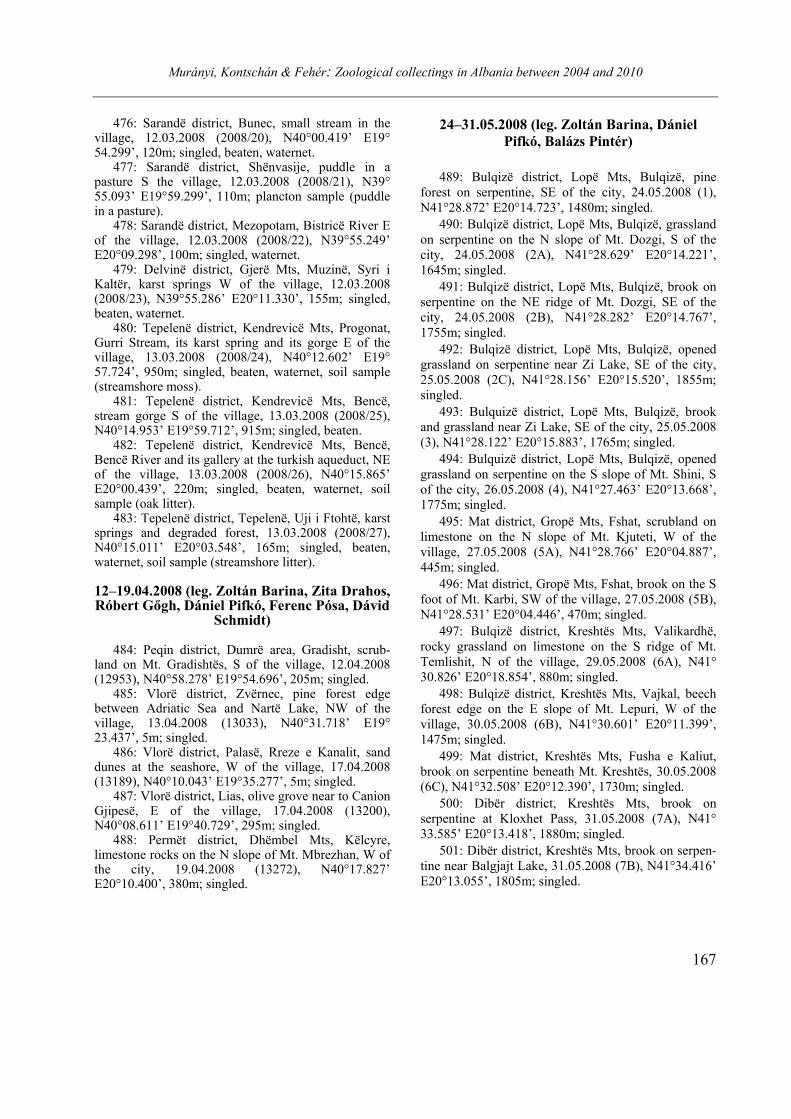
Murányi, Kontschán & Fehér: Zoological collectings in Albania between 2004 and 2010
167
476: Sarandë district, Bunec, small stream in the village, 12.03.2008 (2008/20), N40°00.419’ E19° 54.299’, 120m; singled, beaten, waternet.
477: Sarandë district, Shënvasije, puddle in a pasture S the village, 12.03.2008 (2008/21), N39° 55.093’ E19°59.299’, 110m; plancton sample (puddle in a pasture).
478: Sarandë district, Mezopotam, Bistricë River E of the village, 12.03.2008 (2008/22), N39°55.249’ E20°09.298’, 100m; singled, waternet.
479: Delvinë district, Gjerë Mts, Muzinë, Syri i Kaltër, karst springs W of the village, 12.03.2008 (2008/23), N39°55.286’ E20°11.330’, 155m; singled, beaten, waternet.
480: Tepelenë district, Kendrevicë Mts, Progonat, Gurri Stream, its karst spring and its gorge E of the village, 13.03.2008 (2008/24), N40°12.602’ E19° 57.724’, 950m; singled, beaten, waternet, soil sample (streamshore moss).
481: Tepelenë district, Kendrevicë Mts, Bencë, stream gorge S of the village, 13.03.2008 (2008/25), N40°14.953’ E19°59.712’, 915m; singled, beaten.
482: Tepelenë district, Kendrevicë Mts, Bencë, Bencë River and its gallery at the turkish aqueduct, NE of the village, 13.03.2008 (2008/26), N40°15.865’ E20°00.439’, 220m; singled, beaten, waternet, soil sample (oak litter).
483: Tepelenë district, Tepelenë, Uji i Ftohtë, karst springs and degraded forest, 13.03.2008 (2008/27), N40°15.011’ E20°03.548’, 165m; singled, beaten, waternet, soil sample (streamshore litter). 12–19.04.2008 (leg. Zoltán Barina, Zita Drahos, Róbert Gőgh, Dániel Pifkó, Ferenc Pósa, Dávid
Schmidt)
484: Peqin district, Dumrë area, Gradisht, scrub-land on Mt. Gradishtës, S of the village, 12.04.2008 (12953), N40°58.278’ E19°54.696’, 205m; singled.
485: Vlorë district, Zvërnec, pine forest edge between Adriatic Sea and Nartë Lake, NW of the village, 13.04.2008 (13033), N40°31.718’ E19° 23.437’, 5m; singled.
486: Vlorë district, Palasë, Rreze e Kanalit, sand dunes at the seashore, W of the village, 17.04.2008 (13189), N40°10.043’ E19°35.277’, 5m; singled.
487: Vlorë district, Lias, olive grove near to Canion Gjipesë, E of the village, 17.04.2008 (13200), N40°08.611’ E19°40.729’, 295m; singled.
488: Permët district, Dhëmbel Mts, Këlcyre, limestone rocks on the N slope of Mt. Mbrezhan, W of the city, 19.04.2008 (13272), N40°17.827’ E20°10.400’, 380m; singled.
24–31.05.2008 (leg. Zoltán Barina, Dániel
Pifkó, Balázs Pintér)
489: Bulqizë district, Lopë Mts, Bulqizë, pine
forest on serpentine, SE of the city, 24.05.2008 (1), N41°28.872’ E20°14.723’, 1480m; singled.
490: Bulqizë district, Lopë Mts, Bulqizë, grassland on serpentine on the N slope of Mt. Dozgi, S of the city, 24.05.2008 (2A), N41°28.629’ E20°14.221’, 1645m; singled.
491: Bulqizë district, Lopë Mts, Bulqizë, brook on serpentine on the NE ridge of Mt. Dozgi, SE of the city, 24.05.2008 (2B), N41°28.282’ E20°14.767’, 1755m; singled.
492: Bulqizë district, Lopë Mts, Bulqizë, opened grassland on serpentine near Zi Lake, SE of the city, 25.05.2008 (2C), N41°28.156’ E20°15.520’, 1855m; singled.
493: Bulquizë district, Lopë Mts, Bulqizë, brook and grassland near Zi Lake, SE of the city, 25.05.2008 (3), N41°28.122’ E20°15.883’, 1765m; singled.
494: Bulquizë district, Lopë Mts, Bulqizë, opened grassland on serpentine on the S slope of Mt. Shini, S of the city, 26.05.2008 (4), N41°27.463’ E20°13.668’, 1775m; singled.
495: Mat district, Gropë Mts, Fshat, scrubland on limestone on the N slope of Mt. Kjuteti, W of the village, 27.05.2008 (5A), N41°28.766’ E20°04.887’, 445m; singled.
496: Mat district, Gropë Mts, Fshat, brook on the S foot of Mt. Karbi, SW of the village, 27.05.2008 (5B), N41°28.531’ E20°04.446’, 470m; singled.
497: Bulqizë district, Kreshtës Mts, Valikardhë, rocky grassland on limestone on the S ridge of Mt. Temlishit, N of the village, 29.05.2008 (6A), N41° 30.826’ E20°18.854’, 880m; singled.
498: Bulqizë district, Kreshtës Mts, Vajkal, beech forest edge on the E slope of Mt. Lepuri, W of the village, 30.05.2008 (6B), N41°30.601’ E20°11.399’, 1475m; singled.
499: Mat district, Kreshtës Mts, Fusha e Kaliut, brook on serpentine beneath Mt. Kreshtës, 30.05.2008 (6C), N41°32.508’ E20°12.390’, 1730m; singled.
500: Dibër district, Kreshtës Mts, brook on serpentine at Kloxhet Pass, 31.05.2008 (7A), N41° 33.585’ E20°13.418’, 1880m; singled.
501: Dibër district, Kreshtës Mts, brook on serpen-tine near Balgjajt Lake, 31.05.2008 (7B), N41°34.416’ E20°13.055’, 1805m; singled.
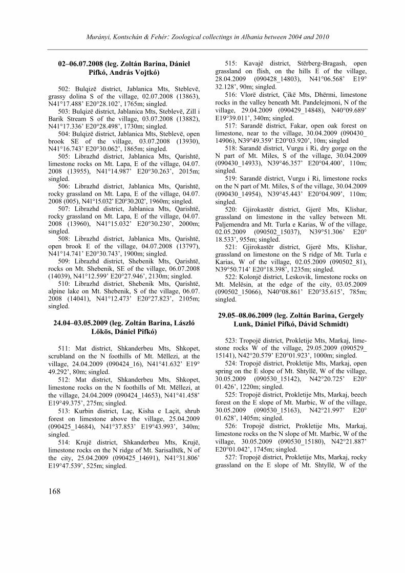
Murányi, Kontschán & Fehér: Zoological collectings in Albania between 2004 and 2010
168
02–06.07.2008 (leg. Zoltán Barina, Dániel
Pifkó, András Vojtkó)
502: Bulqizë district, Jablanica Mts, Steblevë,
grassy dolina S of the village, 02.07.2008 (13863), N41°17.488’ E20°28.102’, 1765m; singled.
503: Bulqizë district, Jablanica Mts, Steblevë, Zill i Barik Stream S of the village, 03.07.2008 (13882), N41°17.336’ E20°28.498’, 1730m; singled.
504: Bulqizë district, Jablanica Mts, Steblevë, open brook SE of the village, 03.07.2008 (13930), N41°16.743’ E20°30.062’, 1865m; singled.
505: Librazhd district, Jablanica Mts, Qarishtë, limestone rocks on Mt. Lapa, E of the village, 04.07. 2008 (13955), N41°14.987’ E20°30.263’, 2015m; singled.
506: Librazhd district, Jablanica Mts, Qarishtë, rocky grassland on Mt. Lapa, E of the village, 04.07. 2008 (005), N41°15.032’ E20°30.202’, 1960m; singled.
507: Librazhd district, Jablanica Mts, Qarishtë, rocky grassland on Mt. Lapa, E of the village, 04.07. 2008 (13960), N41°15.032’ E20°30.230’, 2000m; singled.
508: Librazhd district, Jablanica Mts, Qarishtë, open brook E of the village, 04.07.2008 (13797), N41°14.741’ E20°30.743’, 1900m; singled.
509: Librazhd district, Shebenik Mts, Qarishtë, rocks on Mt. Shebenik, SE of the village, 06.07.2008 (14039), N41°12.599’ E20°27.946’, 2130m; singled.
510: Librazhd district, Shebenik Mts, Qarishtë, alpine lake on Mt. Shebenik, S of the village, 06.07. 2008 (14041), N41°12.473’ E20°27.823’, 2105m; singled.
24.04–03.05.2009 (leg. Zoltán Barina, László
Lőkös, Dániel Pifkó)
511: Mat district, Shkanderbeu Mts, Shkopet,
scrubland on the N foothills of Mt. Mëllezi, at the village, 24.04.2009 (090424_16), N41°41.632’ E19° 49.292’, 80m; singled.
512: Mat district, Shkanderbeu Mts, Shkopet, limestone rocks on the N foothills of Mt. Mëllezi, at the village, 24.04.2009 (090424_14653), N41°41.458’ E19°49.375’, 275m; singled.
513: Kurbin district, Laç, Kisha e Laçit, shrub forest on limestone above the village, 25.04.2009 (090425_14684), N41°37.853’ E19°43.993’, 340m; singled.
514: Krujë district, Shkanderbeu Mts, Krujë, limestone rocks on the N ridge of Mt. Sarisalltëk, N of the city, 25.04.2009 (090425_14691), N41°31.806’ E19°47.539’, 525m; singled.
515: Kavajë district, Stërberg-Bragash, open grassland on flish, on the hills E of the village, 28.04.2009 (090428_14803), N41°06.568’ E19° 32.128’, 90m; singled.
516: Vlorë district, Çikë Mts, Dhërmi, limestone rocks in the valley beneath Mt. Pandelejmoni, N of the village, 29.04.2009 (090429_14848), N40°09.689’ E19°39.011’, 340m; singled.
517: Sarandë district, Fakar, open oak forest on limestone, near to the village, 30.04.2009 (090430_ 14906), N39°49.359’ E20°03.920’, 10m; singled
518: Sarandë district, Vurgu i Ri, dry gorge on the N part of Mt. Miles, S of the village, 30.04.2009 (090430_14933), N39°46.357’ E20°04.400’, 110m; singled.
519: Sarandë district, Vurgu i Ri, limestone rocks on the N part of Mt. Miles, S of the village, 30.04.2009 (090430_14954), N39°45.443’ E20°04.909’, 110m; singled.
520: Gjirokastër district, Gjerë Mts, Klishar, grassland on limestone in the valley between Mt. Paljemendra and Mt. Turla e Karias, W of the village, 02.05.2009 (090502_15037), N39°51.306’ E20° 18.533’, 955m; singled.
521: Gjirokastër district, Gjerë Mts, Klishar, grassland on limestone on the S ridge of Mt. Turla e Karias, W of the village, 02.05.2009 (090502_81), N39°50.714’ E20°18.398’, 1235m; singled.
522: Kolonjë district, Leskovik, limestone rocks on Mt. Melësin, at the edge of the city, 03.05.2009 (090502_15066), N40°08.861’ E20°35.615’, 785m; singled.
29.05–08.06.2009 (leg. Zoltán Barina, Gergely
Lunk, Dániel Pifkó, Dávid Schmidt)
523: Tropojë district, Prokletije Mts, Markaj, lime-
stone rocks W of the village, 29.05.2009 (090529_ 15141), N42°20.579’ E20°01.923’, 1000m; singled.
524: Tropojë district, Prokletije Mts, Markaj, open spring on the E slope of Mt. Shtyllë, W of the village, 30.05.2009 (090530_15142), N42°20.725’ E20° 01.426’, 1220m; singled.
525: Tropojë district, Prokletije Mts, Markaj, beech forest on the E slope of Mt. Marbic, W of the village, 30.05.2009 (090530_15163), N42°21.997’ E20° 01.628’, 1405m; singled.
526: Tropojë district, Prokletije Mts, Markaj, limestone rocks on the N slope of Mt. Marbic, W of the village, 30.05.2009 (090530_15180), N42°21.887’ E20°01.042’, 1745m; singled.
527: Tropojë district, Prokletije Mts, Markaj, rocky grassland on the E slope of Mt. Shtyllë, W of the
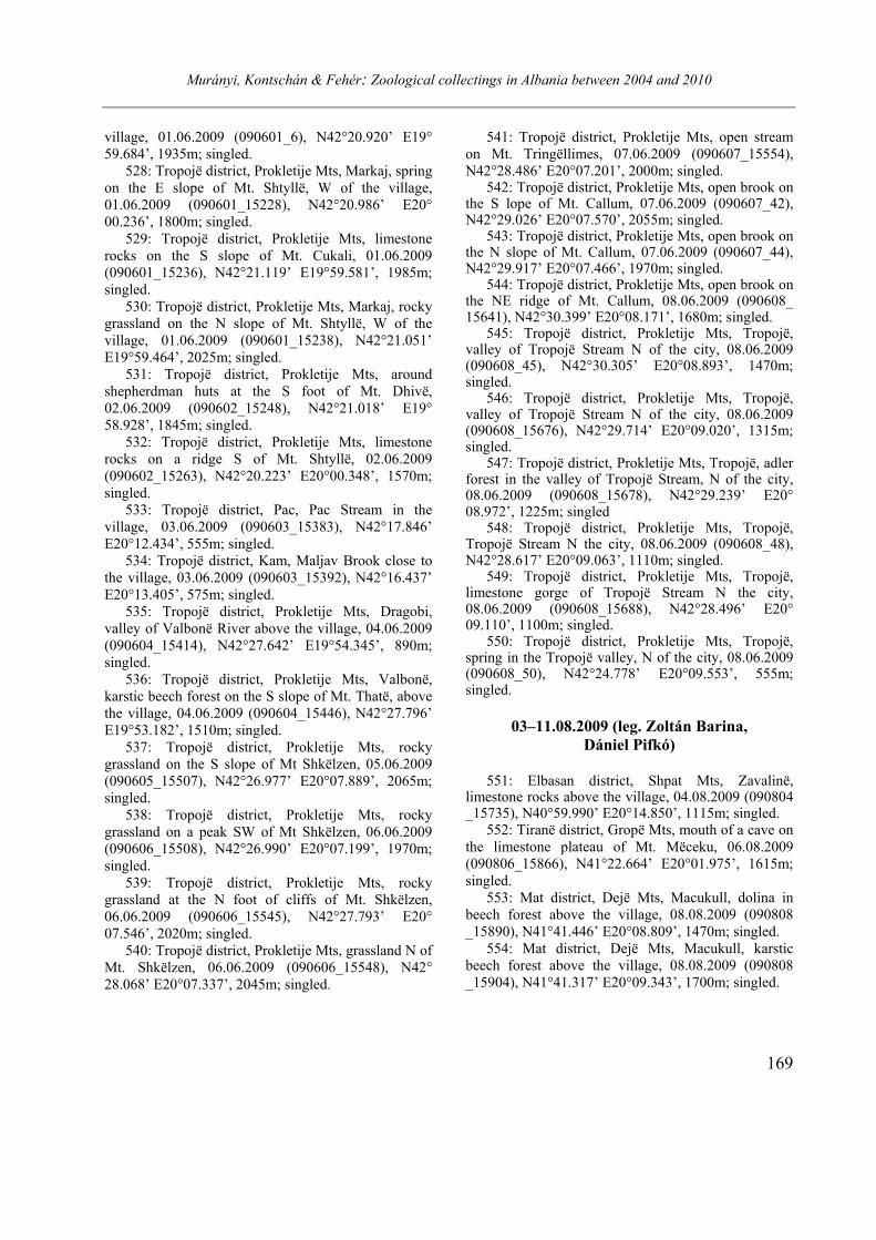
Murányi, Kontschán & Fehér: Zoological collectings in Albania between 2004 and 2010
169
village, 01.06.2009 (090601_6), N42°20.920’ E19° 59.684’, 1935m; singled.
528: Tropojë district, Prokletije Mts, Markaj, spring on the E slope of Mt. Shtyllë, W of the village, 01.06.2009 (090601_15228), N42°20.986’ E20° 00.236’, 1800m; singled.
529: Tropojë district, Prokletije Mts, limestone rocks on the S slope of Mt. Cukali, 01.06.2009 (090601_15236), N42°21.119’ E19°59.581’, 1985m; singled.
530: Tropojë district, Prokletije Mts, Markaj, rocky grassland on the N slope of Mt. Shtyllë, W of the village, 01.06.2009 (090601_15238), N42°21.051’ E19°59.464’, 2025m; singled.
531: Tropojë district, Prokletije Mts, around shepherdman huts at the S foot of Mt. Dhivë, 02.06.2009 (090602_15248), N42°21.018’ E19° 58.928’, 1845m; singled.
532: Tropojë district, Prokletije Mts, limestone rocks on a ridge S of Mt. Shtyllë, 02.06.2009 (090602_15263), N42°20.223’ E20°00.348’, 1570m; singled.
533: Tropojë district, Pac, Pac Stream in the village, 03.06.2009 (090603_15383), N42°17.846’ E20°12.434’, 555m; singled.
534: Tropojë district, Kam, Maljav Brook close to the village, 03.06.2009 (090603_15392), N42°16.437’ E20°13.405’, 575m; singled.
535: Tropojë district, Prokletije Mts, Dragobi, valley of Valbonë River above the village, 04.06.2009 (090604_15414), N42°27.642’ E19°54.345’, 890m; singled.
536: Tropojë district, Prokletije Mts, Valbonë, karstic beech forest on the S slope of Mt. Thatë, above the village, 04.06.2009 (090604_15446), N42°27.796’ E19°53.182’, 1510m; singled.
537: Tropojë district, Prokletije Mts, rocky grassland on the S slope of Mt Shkëlzen, 05.06.2009 (090605_15507), N42°26.977’ E20°07.889’, 2065m; singled.
538: Tropojë district, Prokletije Mts, rocky grassland on a peak SW of Mt Shkëlzen, 06.06.2009 (090606_15508), N42°26.990’ E20°07.199’, 1970m; singled.
539: Tropojë district, Prokletije Mts, rocky grassland at the N foot of cliffs of Mt. Shkëlzen, 06.06.2009 (090606_15545), N42°27.793’ E20° 07.546’, 2020m; singled.
540: Tropojë district, Prokletije Mts, grassland N of Mt. Shkëlzen, 06.06.2009 (090606_15548), N42° 28.068’ E20°07.337’, 2045m; singled.
541: Tropojë district, Prokletije Mts, open stream on Mt. Tringëllimes, 07.06.2009 (090607_15554), N42°28.486’ E20°07.201’, 2000m; singled.
542: Tropojë district, Prokletije Mts, open brook on the S lope of Mt. Callum, 07.06.2009 (090607_42), N42°29.026’ E20°07.570’, 2055m; singled.
543: Tropojë district, Prokletije Mts, open brook on the N slope of Mt. Callum, 07.06.2009 (090607_44), N42°29.917’ E20°07.466’, 1970m; singled.
544: Tropojë district, Prokletije Mts, open brook on the NE ridge of Mt. Callum, 08.06.2009 (090608_ 15641), N42°30.399’ E20°08.171’, 1680m; singled.
545: Tropojë district, Prokletije Mts, Tropojë, valley of Tropojë Stream N of the city, 08.06.2009 (090608_45), N42°30.305’ E20°08.893’, 1470m; singled.
546: Tropojë district, Prokletije Mts, Tropojë, valley of Tropojë Stream N of the city, 08.06.2009 (090608_15676), N42°29.714’ E20°09.020’, 1315m; singled.
547: Tropojë district, Prokletije Mts, Tropojë, adler forest in the valley of Tropojë Stream, N of the city, 08.06.2009 (090608_15678), N42°29.239’ E20° 08.972’, 1225m; singled
548: Tropojë district, Prokletije Mts, Tropojë, Tropojë Stream N the city, 08.06.2009 (090608_48), N42°28.617’ E20°09.063’, 1110m; singled.
549: Tropojë district, Prokletije Mts, Tropojë, limestone gorge of Tropojë Stream N the city, 08.06.2009 (090608_15688), N42°28.496’ E20° 09.110’, 1100m; singled.
550: Tropojë district, Prokletije Mts, Tropojë, spring in the Tropojë valley, N of the city, 08.06.2009 (090608_50), N42°24.778’ E20°09.553’, 555m; singled.
03–11.08.2009 (leg. Zoltán Barina,
Dániel Pifkó)
551: Elbasan district, Shpat Mts, Zavalinë,
limestone rocks above the village, 04.08.2009 (090804 _15735), N40°59.990’ E20°14.850’, 1115m; singled.
552: Tiranë district, Gropë Mts, mouth of a cave on the limestone plateau of Mt. Mëceku, 06.08.2009 (090806_15866), N41°22.664’ E20°01.975’, 1615m; singled.
553: Mat district, Dejë Mts, Macukull, dolina in beech forest above the village, 08.08.2009 (090808 _15890), N41°41.446’ E20°08.809’, 1470m; singled.
554: Mat district, Dejë Mts, Macukull, karstic beech forest above the village, 08.08.2009 (090808 _15904), N41°41.317’ E20°09.343’, 1700m; singled.
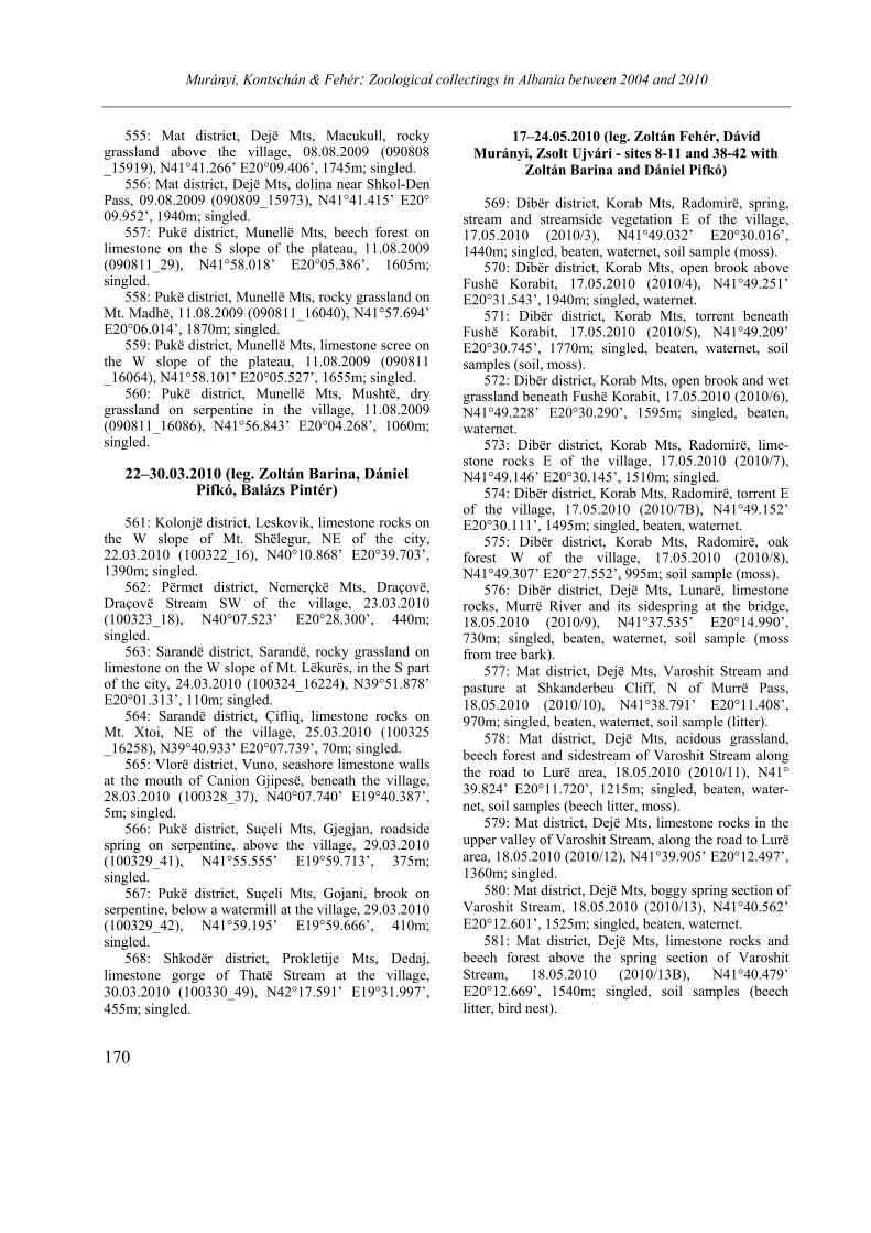
Murányi, Kontschán & Fehér: Zoological collectings in Albania between 2004 and 2010
170
555: Mat district, Dejë Mts, Macukull, rocky grassland above the village, 08.08.2009 (090808 _15919), N41°41.266’ E20°09.406’, 1745m; singled.
556: Mat district, Dejë Mts, dolina near Shkol-Den Pass, 09.08.2009 (090809_15973), N41°41.415’ E20° 09.952’, 1940m; singled.
557: Pukë district, Munellë Mts, beech forest on limestone on the S slope of the plateau, 11.08.2009 (090811_29), N41°58.018’ E20°05.386’, 1605m; singled.
558: Pukë district, Munellë Mts, rocky grassland on Mt. Madhë, 11.08.2009 (090811_16040), N41°57.694’ E20°06.014’, 1870m; singled.
559: Pukë district, Munellë Mts, limestone scree on the W slope of the plateau, 11.08.2009 (090811 _16064), N41°58.101’ E20°05.527’, 1655m; singled.
560: Pukë district, Munellë Mts, Mushtë, dry grassland on serpentine in the village, 11.08.2009 (090811_16086), N41°56.843’ E20°04.268’, 1060m; singled.
22–30.03.2010 (leg. Zoltán Barina, Dániel Pifkó, Balázs Pintér)
561: Kolonjë district, Leskovik, limestone rocks on
the W slope of Mt. Shëlegur, NE of the city, 22.03.2010 (100322_16), N40°10.868’ E20°39.703’, 1390m; singled.
562: Përmet district, Nemerçkë Mts, Draçovë, Draçovë Stream SW of the village, 23.03.2010 (100323_18), N40°07.523’ E20°28.300’, 440m; singled.
563: Sarandë district, Sarandë, rocky grassland on limestone on the W slope of Mt. Lëkurës, in the S part of the city, 24.03.2010 (100324_16224), N39°51.878’ E20°01.313’, 110m; singled.
564: Sarandë district, Çifliq, limestone rocks on Mt. Xtoi, NE of the village, 25.03.2010 (100325 _16258), N39°40.933’ E20°07.739’, 70m; singled.
565: Vlorë district, Vuno, seashore limestone walls at the mouth of Canion Gjipesë, beneath the village, 28.03.2010 (100328_37), N40°07.740’ E19°40.387’, 5m; singled.
566: Pukë district, Suçeli Mts, Gjegjan, roadside spring on serpentine, above the village, 29.03.2010 (100329_41), N41°55.555’ E19°59.713’, 375m; singled.
567: Pukë district, Suçeli Mts, Gojani, brook on serpentine, below a watermill at the village, 29.03.2010 (100329_42), N41°59.195’ E19°59.666’, 410m; singled.
568: Shkodër district, Prokletije Mts, Dedaj, limestone gorge of Thatë Stream at the village, 30.03.2010 (100330_49), N42°17.591’ E19°31.997’, 455m; singled.
17–24.05.2010 (leg. Zoltán Fehér, Dávid
Murányi, Zsolt Ujvári - sites 8-11 and 38-42 with
Zoltán Barina and Dániel Pifkó)
569: Dibër district, Korab Mts, Radomirë, spring,
stream and streamside vegetation E of the village, 17.05.2010 (2010/3), N41°49.032’ E20°30.016’, 1440m; singled, beaten, waternet, soil sample (moss).
570: Dibër district, Korab Mts, open brook above Fushë Korabit, 17.05.2010 (2010/4), N41°49.251’ E20°31.543’, 1940m; singled, waternet.
571: Dibër district, Korab Mts, torrent beneath Fushë Korabit, 17.05.2010 (2010/5), N41°49.209’ E20°30.745’, 1770m; singled, beaten, waternet, soil samples (soil, moss).
572: Dibër district, Korab Mts, open brook and wet grassland beneath Fushë Korabit, 17.05.2010 (2010/6), N41°49.228’ E20°30.290’, 1595m; singled, beaten, waternet.
573: Dibër district, Korab Mts, Radomirë, lime-stone rocks E of the village, 17.05.2010 (2010/7), N41°49.146’ E20°30.145’, 1510m; singled.
574: Dibër district, Korab Mts, Radomirë, torrent E of the village, 17.05.2010 (2010/7B), N41°49.152’ E20°30.111’, 1495m; singled, beaten, waternet.
575: Dibër district, Korab Mts, Radomirë, oak forest W of the village, 17.05.2010 (2010/8), N41°49.307’ E20°27.552’, 995m; soil sample (moss).
576: Dibër district, Dejë Mts, Lunarë, limestone rocks, Murrë River and its sidespring at the bridge, 18.05.2010 (2010/9), N41°37.535’ E20°14.990’, 730m; singled, beaten, waternet, soil sample (moss from tree bark).
577: Mat district, Dejë Mts, Varoshit Stream and pasture at Shkanderbeu Cliff, N of Murrë Pass, 18.05.2010 (2010/10), N41°38.791’ E20°11.408’, 970m; singled, beaten, waternet, soil sample (litter).
578: Mat district, Dejë Mts, acidous grassland, beech forest and sidestream of Varoshit Stream along the road to Lurë area, 18.05.2010 (2010/11), N41° 39.824’ E20°11.720’, 1215m; singled, beaten, water-net, soil samples (beech litter, moss).
579: Mat district, Dejë Mts, limestone rocks in the upper valley of Varoshit Stream, along the road to Lurë area, 18.05.2010 (2010/12), N41°39.905’ E20°12.497’, 1360m; singled.
580: Mat district, Dejë Mts, boggy spring section of Varoshit Stream, 18.05.2010 (2010/13), N41°40.562’ E20°12.601’, 1525m; singled, beaten, waternet.
581: Mat district, Dejë Mts, limestone rocks and beech forest above the spring section of Varoshit Stream, 18.05.2010 (2010/13B), N41°40.479’ E20°12.669’, 1540m; singled, soil samples (beech litter, bird nest).
Murányi, Kontschán & Fehér: Zoological collectings in Albania between 2004 and 2010
171
582: Mat district, Dejë Mts, limestone rocks W of Shkanderbeu Cliff, N of Murrë Pass, 18.05.2010 (2010/14), N41°38.763’ E20°10.841’, 1160m; singled.
583: Mat district, Dejë Mts, Macukull, limestone rocks E of the village, 19.05.2010 (2010/15), N41° 41.774’ E20°07.999’, 1265m; singled, soil sample (moss from rocks).
584: Mat district, Dejë Mts, Macukull, rocky forest E of the village, 19.05.2010 (2010/16), N41°41.825’ E20°08.171’, 1280m; singled, beaten, soil sample (moss).
585: Mat district, Ulëz, limestone rocks and macchia above Mat River, W of the village, 19.05.2010 (2010/17), N41°41.746’ E19°48.883’, 70m; singled.
586: Lezhë district, Pllanë, limestone rocks and macchia at the village, 19.05.2010 (2010/18), N41° 42.018’ E19°42.319’, 65m; singled.
587: Mirditë district, Shent Mts, Kurbnesh, lime-stone rocks, Urakës River and its sidespring NE of the city, 20.05.2010 (2010/19), N41°47.711’ E20°06.703’, 800m; singled, beaten, waternet, soil sample (moss).
588: Dibër district, Lurë area, Mërkuth, limestone rocks S of the village, 20.05.2010 (2010/20), N41°48.808’ E20°08.384’, 1015m; singled, soil samples (soil, moss).
589: Dibër district, Lurë area, Humbla, stream and pine forest SE of the village, 20.05.2010 (2010/21), N41°48.127’ E20°09.272’, 1215m; singled, beaten, waternet, soil sample (soil).
590: Dibër district, Lurë area, Humbla, brook and pine forest E of the village, 20.05.2010 (2010/22), N41°48.353’ E20°09.415’, 1170m; singled, beaten, waternet.
591: Dibër district, Lurë area, Humbla, Humbla Stream E of the village, 20.05.2010 (2010/23), N41° 48.498’ E20°09.506’, 1155m; singled, beaten, waternet.
592: Dibër district, Lurë area, Krej Lurë, large temporary pool in a pasture at the village, 20.05.2010 (2010/24), N41°50.167’ E20°10.440’, 970m; plancton sample (temporary pool).
593: Dibër district, Lurë area, Fushë Lurë, inflowing brooks, beech forest and puddles at Vogël Lake, 20.05.2010 (2010/25), N41°47.552’ E20° 11.675’, 1700m; singled, beaten, waternet, soil samples (beech litter, moss), plancton sample (forest puddle).
594: Dibër district, Lurë area, Fushë Lurë, small bog beneath the lakes, 20.05.2010 (2010/26), N41°47.595’ E20°12.308’, 1585m; waternet.
595: Dibër district, Lurë area, Fushë Lurë, beech forest beneath the lakes, 20.05.2010 (2010/27), N41°47.758’ E20°12.599’, 1410m; singled, soil sample (beech litter).
596: Dibër district, Lurë area, Fushë Lurë, brook in pine forest S of the village, 21.05.2010 (2010/28), N41°48.547’ E20°12.598’, 1155m; singled, beaten, waternet, soil samples (pine litter, moss).
597: Mirditë district, Prosec, pine forest E of the village, 21.05.2010 (2010/29), N41°44.706’ E19° 58.371’, 315m; singled, soil samples (soil, moss).
598: Mirditë district, Oroshi area, Bulsharë, pine forest N of the village, 21.05.2010 (2010/30), N41°51.095’ E20°03.896’, 515m; singled, soil samples (pine litter, moss).
599: Mirditë district, Oroshi area, Ndërshenë, brook in a pine forest at the village, 21.05.2010 (2010/31), N41°49.898’ E20°05.480’, 990m; singled, beaten, waternet, soil sample (moss).
600: Mirditë district, Oroshi area, Ndërshenë, karst spring and rocks N of the village, 21.05.2010 (2010/ 32), N41°50.539’ E20°05.671’, 1160m; singled, beaten, waternet, soil samples (soil, moss).
601: Mirditë district, Oroshi area, Ndërshenë, limestone rocks N of the village, 21.05.2010 (2010/33), N41°51.034’ E20°05.842’, 1135m; singled, soil sample (moss).
602: Mirditë district, Shent Mts, limestone rocks, beech forest and puddles on the W edge of the great plateau, 21.05.2010 (2010/34), N41°51.274’ E20° 07.302’, 1365m; singled, soil sample (beech litter), plancton sample (temporary puddles on dirt road).
603: Mirditë district, Oroshi area, Nanshenë, open stream in the village, 21.05.2010 (2010/35), N41° 51.848’ E20°07.088’, 1175m; singled, beaten, waternet.
604: Mirditë district, Oroshi area, Nanshenë, limestone rocks in the village, 21.05.2010 (2010/36), N41°52.154’ E20°07.118’, 1165m; singled, soil sample (moss from rocks).
605: Mirditë district, Oroshi area, Nanshenë, limestone rocks N of the village, 21.05.2010 (2010/37), N41°52.240’ E20°06.510’, 1045m; singled.
606: Has district, Pashtrik Mts, Domaj Has, Gurra Domaj Has Spring in the village, 22.05.2010 (2010/38), N42°08.309’ E20°29.403’, 440m; singled, beaten, waternet.
607: Has district, Pashtrik Mts, Salghinë, open karst forest N of the village, 22.05.2010 (2010/39), N42°11.541’ E20°32.258’, 945m; singled, beaten, soil sample (litter).
608: Has district, Pashtrik Mts, Salghinë, rocky forest N of the village, 22.05.2010 (2010/40), N42° 12.046’ E20°31.998’, 1405m; singled, beaten, soil samples (soil, litter).
609: Has district, Pashtrik Mts, Salghinë, forest cave N of the village, 22.05.2010 (2010/41), N42° 12.171’ E20°32.027’, 1415m; singled, soil samples (litter, moss).
Murányi, Kontschán & Fehér: Zoological collectings in Albania between 2004 and 2010
172
610: Has district, Pashtrik Mts, limestone rocks and alpine grassland beneath the peak region, 22.05.2010 (2010/42), N42°12.417’ E20°31.709’, 1730m; singled, soil sample (soil).
611: Shkodër district, Mes, Kir River, riverside macchia and limestone rocks at Mesi Bridge, 23.05. 2010 (2010/43), N42°06.874’ E19°34.483’, 50m; singled, beaten, waternet.
612: Shkodër district, Prokletije Mts, Drisht, limestone rocks N of the village, 23.05.2010 (2010/44), N42°07.491’ E19°36.222’, 95m; singled.
613: Shkodër district, Prokletije Mts, Ura e Shtrenjtë, ruderalia and a sidestream of Kir River in the village, 23.05.2010 (2010/45), N42°08.503’ E19° 38.846’, 110m; singled.
614: Shkodër district, Prokletije Mts, Prekal, limestone rocks S of the village, 23.05.2010 (2010/46), N42°09.899’ E19°41.709’, 190m; singled.
615: Shkodër district, Prokletije Mts, Prekal, Zhyla Cave and Kir River in the village, 23.05.2010 (2010/47), N42°10.718’ E19°43.205’, 215m; singled, beaten, waternet, soil sample (moss).
616: Shkodër district, Prokletije Mts, Prekal, limestone rocks N of the village, 23.05.2010 (2010/48), N42°12.420’ E19°42.544’, 315m; singled.
617: Shkodër district, Prokletije Mts, Kir, rocky torrent and secondary forest S of the village, 23.05. 2010 (2010/49), N42°12.854’ E19°42.349’, 320m; singled, beaten, waternet, soil samples (litter, moss).
618: Shkodër district, Prokletije Mts, Kir, limestone rocks E of the village, 23.05.2010 (2010/50), N42°14.717’ E19°43.015’, 870m; singled.
619: Shkodër district, Prokletije Mts, Kir, forest brook and limestone rocks E of the village, 23.05.2010 (2010/51), N42°14.422’ E19°43.682’, 990m; singled, beaten, waternet, soil sample (litter).
620: Shkodër district, Prokletije Mts, Nicaj-Shosh, nut forest W of the village, 23.05.2010 (2010/52), N42°14.249’ E19°44.330’, 1210m; singled.
621: Shkodër district, Prokletije Mts, Nicaj-Shosh, limestone rocks and rocky stream W of the village, 23.05.2010 (2010/53), N42°15.082’ E19°44.873’, 980m; singled.
622: Shkodër district, Prokletije Mts, Breg-Lumi, limestone rocks above Shalë River, S of the village, 23.05.2010 (2010/54), N42°17.386’ E19°47.810’, 335m; singled.
623: Shkodër district, Prokletije Mts, Breg-Lumi, Shalë River and its gallery in the village, 23.05.2010 (2010/55), N42°18.258’ E19°47.814’, 360m; singled, beaten, waternet.
624: Shkodër district, Prokletije Mts, Okol, beech forest in the village, 23.05.2010 (2010/56), N42° 24.077’ E19°45.948’, 840m; soil sample (beech litter, moss).
625: Shkodër district, Prokletije Mts, Okol, beech forest along the road towards Terthorë Pass, W of the village, 24.05.2010 (2010/57), N42°24.097’ E19° 45.462’, 980m; soil sample (beech litter).
626: Shkodër district, Prokletije Mts, Okol, karst spring outlet along the road towards Terthorë Pass, 24.05.2010 (2010/58), N42°23.256’ E19°44.202’, 1660m; singled, soil sample (beech litter).
627: Malësi e Madhe district, Prokletije Mts, Bogë, artificial pond in a pasture, E of the village, 24.05.2010 (2010/59), N42°23.826’ E19°41.801’, 1195m; plancton sample (artificial pond).
19–26.05.2010 (leg. Zoltán Barina, Dániel Pifkó
– apart from the jointly collected sites of the
previous tour)
628: Mat district, Dejë Mts, rocky forest S of Mt.
Lajë, 18.05.2010 (100518_25), N41°40.603’ E20° 12.810’, 1605m; singled.
629: Dibër district, Dejë Mts, temporary stream in the spring area of Sëte Stream, 19.05.2010 (F), N41°41.181’ E20°13.218’, 1415m; singled.
630: Dibër district, Dejë Mts, rocky grassland on the ridge of Mt. Lajë, 19.05.2010 (100519_16991), N41°41.516’ E20°12.773’, 1675m; singled.
631: Dibër district, Dejë Mts, boggy spring in the spring area of Sëte Stream, N of Kshëz Pass, 19.05.2010 (100519_17010), N41°40.873’ E20° 13.998’, 1455m; singled.
632: Dibër district, Dejë Mts, rocky grassland close to the ridge of M. Runja, 19.05.2010 (100519_29), N41°41.386’ E20°15.341’, 1625m; singled.
633: Dibër district, Dejë Mts, Hurdhë Muhur, open brook E of the village, 20.05.2010 (100520_17040), N41°41.199’ E20°17.389’, 895m; singled.
634: Kukës district, Gjalice e Lumës Mts, Nangë, shrubby forest above the village, 23.05.2010 (100523_17217), N41°59.576’ E20°25.602’, 715m; singled.
635: Kukës district, Gjalica e Lumës Mts, Stabi i Sasatit, forest spring above the village, 23.05.2010 (100523_47), N42°00.479’ E20°26.765’, 1485m; singled.
636: Mirditë district, Munellë Mts, Domgjon, forest brook above the village, 25.05.2010 (100525_52), N41°58.617’ E20°07.543’, 1295m; singled.
637: Mirditë district, Munellë Mts, rocky grassland on the plateau, 25.05.2010 (100525_54), N41°59.170’ E20°06.827’, 1865m; singled.
638: Mirditë district, Munellë Mts, Domgjon, spring above the village, 26.05.2010 (100526_17389), N41°58.653’ E20°06.922’, 1435m; singled.
Murányi, Kontschán & Fehér: Zoological collectings in Albania between 2004 and 2010
173
639: Mirditë district, Munellë Mts, Domgjon, beech forest above the village, 26.05.2010 (100526_17392), N41°58.301’ E20°07.010’, 1380m; singled.
640: Mirditë district, Munellë Mts, Domgjon, serpentine rocks above the village, 26.05.2010 (14), N41°57.128’ E20°07.829’, 1145m; singled.
10–16.07.2010 (leg. Dávid Murányi, accompa-
nied with 11 students of the Alternative Secon-
dary School of Economics, Budapest, leading
teachers Zoltán Marsi, László Halász)
641: Malësi e Madhe district, Prokletije Mts, Xhajë,
brick walls of the local pub, 10.07.2010 (2010/2/2), N42°19.810’ E19°36.062’, 650m; singled.
642: Shkodër district, Prokletije Mts, shallow alpine lake at Terthorë Pass, 11.07.2010 (2010/2/3), N42°23.389’ E19°43.535’, 1690m; singled, waternet, sweeping net, plancton sample (shallow alpine lake).
643: Shkodër district, Prokletije Mts, Okol, karst spring outlet along the road towards Terthorë Pass, 11.07.2010 (2010/2/4), N42°23.256’ E19°44.202’, 1620m; singled.
644: Shkodër district, Prokletije Mts, Okol, forest edge along the road towards Terthorë Pass, 11.07.2010 (2010/2/5), N42°23.245’ E19°45.493’, 1510m; singled.
645: Shkodër district, Prokletije Mts, Peçakeç Lakes and limestone rocks at Pejë Pass, 12.07.2010 (2010/2/6), N42°26.814’ E19°46.235’, 1620m; singled, waternet, plancton sample (shallow alpine lake).
646: Shkodër district, Prokletije Mts, limestone rocks and alpine grassland on the E slope of Mt. Harapë, 12.07.2010 (2010/2/7), N42°26.616’ E19° 45.714’, 1950m; singled.
647: Shkodër district, Prokletije Mts, limestone rocks in the peak region of Mt. Harapë, 12.07.2010 (2010/2/8), N42°26.741’ E19°45.364’, 2220m; singled.
648: Shkodër district, Prokletije Mts, Okol, rocky grassland along the path towards Pejë Pass, N of the village, 13.07.2010 (2010/2/9), N42°26.536’ E19° 46.344’, 1380m; singled.
649: Shkodër district, Prokletije Mts, Okol, karst spring and the shore vegetation towards Pejë Pass, N of the village, 13.07.2010 (2010/2/10), N42°25.664’ E19°45.704’, 990m; singled, beaten, waternet.
650: Shkodër district, Prokletije Mts, Okol, garden of the Kamping-Restaurant-Bar in the village, 13.07.2010 (2010/2/11), N42°24.306’ E19°45.483’, 920m; singled.
651: Durrës district, Hamallaj, sandy seashore N of the village, 15.07.2010 (2010/2/12), N41°29.334’ E19°30.645’, 0m; singled.
652: Pogradec district, Lin, shore of the Ohrid Lake in the village, 16.07.2010 (2010/2/13), N41°03.982’ E20°38.613’, 730m; singled, waternet.
653: Pogradec district, Pishkupat, shore of the Ohrid Lake at Hotel Leon, 16.07.2010 (2010/2/14), N41°01.152’ E20°38.196’, 730m; singled, waternet.
12–15.07.2010 (leg. Zoltán Barina, Dániel
Pifkó, Gellért Puskás, Barnabás Sárospataki)
654: Malësi e Madhe district, Prokletije Mts, Bogë,
rocky grassland on the S slope of Mt. Dragomir, W of the village, 11.07.2010 (1), N42°24.167’ E19°38.278’ – N42°24.127’ E19°37.089’, 1100–1850m; singled.
655: Malësi e Madhe district, Prokletije Mts, Bogë, spring at a cave on the S slope of Mt. Dragomir, W of the village, 11.07.2010 (2), N42°24.274’ E19°38.039’, 1230m; singled.
656: Malësi e Madhe district, Prokletije Mts, rocky grassland and beech forest edge along the way Mt. Dragomir – Mt. Borë – Bjeshkë Mekzezë, 12.07.2010 (3), N42°24.127’ E19°37.089’ – N42°25.140’ E19° 38.608’, 1650–1850m; singled.
657: Malësi e Madhe district, Prokletije Mts, wet vegetation in a doline W of Bjeshkë Jaraku, towards Mt. Bridashe, 12.07.2010 (4), N42°25.140’ E19° 38.608’, 1810m; singled.
658: Malësi e Madhe district, Prokletije Mts, rocky grassland along the way Mt. Bridashe – pass at the NE foot of Mt. Ergu, 13.07.2010 (5), N42°25.140’ E19°38.608’ – N42°25.205’ E19°40.037’, 1800–1950m; singled.
659: Malësi e Madhe district, Prokletije Mts, rocky grassland along the way NE foot of Mt. Ergu – S foot of Mt. Kuç towards Mushkë Pass, 13.07.2010 (6), N42°25.300’ E19°40.301’ – N42°25.846’ E19° 41.560’, 1950–2150m; singled.
660: Malësi e Madhe district, Prokletije Mts, rocky grassland at Mushkë Pass, 13.07.2010 (7), N42° 25.846’ E19°41.560’, 2150m; singled.
661: Malësi e Madhe district, Prokletije Mts, rocky grassland along the way Mushkë Pass – pasture Surta e Bogës, 13.07.2010 (8), N42°25.846’ E19°41.560’ – N42°26.210’ E19°42.168’, 1850–2150m; singled.
662: Malësi e Madhe district, Prokletije Mts, mountain pasture and rocky grassland N of pasture Surta e Bogës, 14.07.2010 (9), N42°26.801’ E19° 42.651’ – N42°27.468’ E19°42.909’, 1750–1800m; singled.
663: Malësi e Madhe district, Prokletije Mts, lime-stone rocks and Bogë Lake N of pasture Surta e Bogës, 14.07.2010 (10), N42°27.017’ E19°42.704’, 1800m; singled.
Murányi, Kontschán & Fehér: Zoological collectings in Albania between 2004 and 2010
174
664: Malësi e Madhe district, Prokletije Mts, spring and limestone rocks at Bogë Lake, N of pasture Surta e Bogës, 14.07.2010 (11), N42°27.468’ E19°42.909’, 1770m; singled.
665: Malësi e Madhe district, Prokletije Mts, Nikç, limestone rocks above Dobraçë Pass, E of the village, 14.07.2010 (12), N42°27.665’ E19°42.958’, 1730m; singled.
666: Malësi e Madhe district, Prokletije Mts, rocky grassland on the W slope and peak of the mount above Bogë Lake, 14.07.2010 (13), N42°27.468’ E19° 42.909’ – N42°27.114’ E19°43.322’, 1750–2120m; singled.
667: Malësi e Madhe district, Prokletije Mts, rocky grassland on the S slope and peaks of Mt. Shniku, 15.07.2010 (14), N42°27.695’ E19°44.739’ – N42° 28.364’ E19°44.236’, 1900–2555m; singled.
668: Malësi e Madhe district, Prokletije Mts, spring on the W slope of Mt. Popluks, near Pejë Pass, 16.07. 2010 (15), N42°27.343’ E19°46.479’, 1660m; singled.
669: Malësi e Madhe district, Prokletije Mts, rocky grassland along the way Pejë Pass – Vogl Pass, 16.07.2010 (16), N42°26.624’ E19°46.302’ – N42° 27.701’ E19°47.810’, 1650–2100m; singled.
670: Malësi e Madhe district, Prokletije Mts, limestone rocks and snow-fields on the N slope of Mt. Malisorë and Mt. Jezercë, 16.07.2010 (17), N42° 27.701’ E19°47.810’ – N42°26.647’ E19° 48.482’, 2100–2500m; singled.
671: Shkodër district, Prokletije Mts, Okol, karst spring and beech forest edge towards Pejë Pass, N of the village, 16.07.2010 (18), N42°25.659’ E19° 45.700’, 950m; singled.
672: Shkodër district, Prokletije Mts, Okol, beech forest along the road towards Terthorë Pass, 17.07. 2010 (19), N42°24.1’ E19°45.5’, 1000m; singled.
673: Malësi e Madhe district, Koplik, city street, 17.07.2010 (20), N42°12.5’ E19°26.2’, 60m; singled.
Acknowledgements – Field work was supported by the Hungarian Scientific Research Fund (OTKA 72744, OTKA-NNF 78185), the János Bolyai Scholarship of the Hungarian Academy of Sciences and the National R&D Programme (3B023-0-4).
REFERENCES
ANDRÁSSY, I: Free-living nematodes from Albania, including the description of three new species. Nematologia Mediterranea, 37: 73–88.
ERŐSS, Z., FEHÉR, Z. & SZEKERES, M. (1999): Seven new taxa of the subfamily Alopiinae (Gastropoda: Pulmonata: Clausiliidae) from the Balkans. An-nalen der Naturhistorischen Museums in Wien, 101(B): 445–452.
ERŐSS, Z., FEHÉR, Z. & SZEKERES, M. (2006): New taxa of Montenegrina O. Boettger, 1877 (Gastro-
poda: Pulmonata: Clausiliidae) from Albania and the neighbouring regions. Annalen der Naturhisto-rischen Museums in Wien, 107(B): 181–208.
FEHÉR, Z. (2004): A revision of the genus Cochlo-stoma, subgenus Titanopoma (Gastropoda, Caeno-gastropoda, Cochlostomatidae), in particular the forms occurring in Albania. Basteria, 68: 25–44.
FEHÉR Z, DELI T, SÓLYMOS P (2010): Revision of Granaria frumentum (Draparnaud 1801) (Mollusca, Gastropoda, Chondrinidae) subspecies occurring in the eastern part of the species’ range. Journal of Conchoogy, 40: 201–217.
FEHÉR, Z. & ERŐSS, Z. (2009a): Contribution to the Mollusca fauna of Albania. Results of the field trips of the Hungarian Natural History Museum between 1992 and 2007. Schriften zur Malakozoologie, 25: 3–21.
FEHÉR, Z. & ERŐSS, Z. (2009b): Check list of the Al-banian mollusca fauna. Schriften zur Malakozoo-logie, 25: 22–38.
FEHÉR, Z., ERŐSS, Z., KONTSCHÁN, J. & MURÁNYI, D. (2004): Collecting sites of the zoological expediti-ons of the Hungarian Natural History Museum to Albania (1992–2003). Folia historico-naturalia Musei Matraensis, 28: 67–82.
FEHÉR, Z., ERŐSS, Z. & VARGA, A. (2001): Contrib-utions to the knowledge of the Albanian Cochlo-stoma fauna (Gastropoda: Cyclophoridae). Schrift-en zur Malakozoologie, 17: 71–78.
KONTSCHÁN, J. (2003): Data to the Uropodina (Acari: Mesostigmata) fauna of Albania. Folia entomolo-gica hungarica, 64: 5–18.
MAHUNKA, S. & MAHUNKA-PAPP, L. (2008): Faunis-tical and taxonomical studies on oribatids collected in Albania (Acari: Oribatida), I. Opuscula Zoolo-gica, Budapest, 37: 43–62.
MURÁNYI, D. (2007): New and little-known stoneflies (Plecoptera) from Albania and the neighbouring countries. Zootaxa, 1533: 1–40.
MURÁNYI, D. (2008): The first species of the genus Megabunus Meade, 1855 (Opiliones: Phalangiidae) in the Balkan region. Opuscula Zoologica Buda-pest, 39: 53–63.
OLÁH, J. (2010): New species and new records of Palaearctic Trichoptera in the material of the Hun-garian Natural History Museum. Annales Historico-Naturales Musei Nationalis Hungarici, 102: 65–117.
Murányi, Kontschán & Fehér: Zoological collectings in Albania between 2004 and 2010
175
OLÁH, J., LODOVICI, O. & VALLE, M. (2011): A new species of Potamophylax (Trichoptera, Limnephi-lidae) from Albania. Braueria, 38: 13–14.
RIEDEL, A., FEHER, Z. & EROSS, Z. (1999): Eine neue Zonitiden-Art (Gastropoda: Stylommatophora) aus Nord-Albanien. Folia Malacologica, 7: 241–244.
SUBAI, P. (2008): Revision of the Argninae, 1. The species of Agardhiella from the countries bordering the Adriatic Sea (Gastropoda: Pulmonata: Pupil-lidae). Archiv für Molluskenkunde, 137: 75–103.
SUBAI, P. (2009): New land snails from Montenegro and Albania (Mollusca: Gastropoda). Archiv für Molluskenkunde, 138: 103–112.
SUBAI, P. & FEHÉR, Z. (2006): Revision of the Arian-tinae, 3. Superba gen. nov., with the description of three new species (Gastropoda: Pulmonata: Heli-cidae). Archiv für Molluskenkunde, 135: 205–224.
TELEKI, P. & CSIKI, E. (eds.) (1923): A Magyar Tudományos Akadémia Balkán-Kutatásainak Ered-ményei. I/1. Csiki Ernő Állattani Kutatásai Albáni-ában (Explorationes Zoologicae ab E. Csiki in Albania Peractae. Pars I/1), Magyar Tudományos Akadémia, Budapest, 176 pp. + X tab.
TELEKI, P. & CSIKI, E. (eds.) (1940): A Magyar Tudo-mányos Akadémia Balkán-Kutatásainak Eredmé-nyei I/2. Csiki Ernő Állattani Kutatásai Albániában (Explorationes Zoologicae ab E. Csiki in Albania Peractae. Pars I/2), Magyar Tudományos Akadé-mia, Budapest, 332 pp. + X tab.
UJVÁRI, ZS. (2010): First records of zerconid mites (Acari: Mesostigmata: Zerconidae) from Albania, with description of three new species. Opuscula Zoologica Budapest, 41(1): 57–75.
Opusc. Zool. Budapest, 2011, 42(2): 177–183
1Walter Pfliegler, Department of Genetics and Applied Microbiology, University of Debrecen, Egyetem tér 1., H-4010 Debrecen, Hungary. E-mail: [email protected]
2Dr. Michel Bertrand, UMR5175 CEFE, Université Montpellier 3, Route de Mende, 34199 Montpellier cedex5, France.
A new species of Labidostomma Kramer, 1879 for the fauna of
Hungary (Acari: Trombidiformes: Labidostommatidae)
with an overview of the family
W. PFLIEGLER1 and M. BERTRAND
2
Abstract. We report on two species of the trombidiform mite family Labidostommatidae from the Bükk Mountains, Hungary. One, Labidostomma (Cornutella) cornuta (G. Canestrini & Fanzago, 1877) is a new species for the fauna of Hungary, the other, L. (Nicoletiella) denticulata (Schrank, 1776) has recently been recorded by Ujvári & Kontschán (2010). A brief description of the family and the species are given, with data on morphology and known occurrences in Europe. The species are illustrated. A key to genera and subgenera of European labidostommatids is presented.
Keywords. Acari, Trombidiformes, new record, Hungary.
INTRODUCTION
he family Labidostommatidae (syn. Labido-stomatidae Oudemans, 1906; Labidostommi-
dae Oudemans, 1906; Nicoletiellidae G. Canes-trini, 1891) is the only one assigned to the super-cohort Labidostommatides and superfamily Labi-dostommatoidea (Walter et. al., 2009). The family includes heavily sclerotinised, mostly yellow or orange, medium-sized or large raptorial mites that are mostly found in forest leaf litter, moss and in caves (Grandjean, 1942; Storkán, 1938). Three genera are known from Europe, Labidostomma (often written as Labidostoma, but in the original description two ’m’s were written; see Dunlop & Bertrand, 2011) being the most widespread. The other genera Akrostomma Robaux, 1977 and Eunicolina Berlese, 1911 are mostly found in Southern Europe.
The family is easily recognised by the general
appearance and some specific characters as fol-lows: integument is scluptured, chelicerae are chelate-dentate, first leg-pair is used for sensing. The whole dorsum is covered by a large shield. Two pairs of prodorsal trichobothria are present. The genital and anal openings are cojoined in females, whereas these are apart from, yet close to each other in males. Relatively few information is
available on their biology. Larvae are inactive, non-feeding. Three active nymph-stages are pre-sent. Fertilisation occurs via spermatophores. All known species are predators of microarthropods (Walter et. al., 2009).
The occurrence of the family (represented by
L. (Nicoletiella) denticulatum) in Hungary was first reported in 2010 from Veszprém county, West Hungary (Ujvári and Kontschán, 2010). The members of the family are reportedly sensitive to harmful processes in the soil caused by human ac-tivities and are considered to be good indicator organisms (Błoszyk and Czarnota, 1998).
MATERIALS AND METHODS
Small samples of forest leaf litter were collect-
ed in the Bükk mountains, Hungary during autumn, 2010 and kept wet for weeks. These were later manually searched for microarthropods. Af-ter killing in alcohol, specimens were left in lactic acid for 24 hours at room temperature then tem-porary mounted in glycerol on a microscope slide. The so prepared specimens were examined and photographed with transmitted light. One cheli-cera of each specimen was removed for further examination. The specimens are in alcohol-filled
T
Pfliegler & Bertrand: A new species of Labidostomma for the fauna of Hungary
178
vials and deposited in the collection of the first author.
RESULTS
Labidostomma (Cornutella) cornutum (G. Ca-
nestrini & Fanzago, 1878)
(Figures 1a–c and 3a)
Material examined. Hungary, Borsod-Abaúj-Zemplén county, Ómassa (cold mountain-side, beech forest), leaf-litter, 500 m a.s.l., 48.107924o
N, 20.532074o E. Leg. WP. 15.10.2010, (1 male).
Diagnosis. The species is recognizable by its large size (dorsal shield of adults 950–1200µm long), and yellow colour.
Dorsal shield anteriorly ended by well visible cornuae, the ornamentation is consisted of im-perfect alveoles. Dorsal trichobothria with few branches, lateral gland-like organ rather large and longer than wide. Median eye in subterminal po-sition.
Chelicerae with proximal seta inserted on a long cuticular peduncle.
Digitus fixus divided distally to proximal and antiaxial teeth, while inferior tooth is modified into a recurrent blade.
Legs. The length of the first pair is remarkable with genu as long as tibia. On the tarsus I the two dorsal solenidia are visible and the famulus is of characteristic shape with acute branches (Grand-jean, 1941).
Remark. The species name often misspelled as L. cornuta.
Distribution. Central Europe, Southern Europe (Vistorin, 1978).
Labidostomma (Nicoletiella) denticulatum
(Schrank, 1776)
(Figures 2a–c and 3b)
Material examined. Hungary, Borsod-Abaúj-Zemplén county, Ómassa (cold mountain-side,
beech forest), leaf-litter, 500 m a.s.l., 48.107924o
N, 20.532074o E. Leg. WP. 15.10.2010, (1 male and 1 female).
Remarks. Yellow-coloured species inhabiting forest litter. Dorsal shield 850–1200µm (adults) anteriorly with prominent cornuae. The mobile di-gitus of the chelicera is armed with a large pro-ximal tooth and several indentations. The species name often misspelled as L. denticulata.
Distribution. Central Europe, Balkan, Italy (Vistorin, 1978).
DISCUSSION
The genus and the family are recorded from
the second time in the country. The family is also reported as new to the fauna of the Bükk National Park. The list of Hungarian labidostommatids now includes Labidostomma (Cornutella) cornutum and Labidostomma (Nicoletiella) denticulatum.
L. denticulatum and another species, L. luteum Kramer, 1879 were found to be frequently synpat-ric by Vistorin (1980) (parthogenetic population for the latter). These two species can be confused but the mobile digitus of the chelicerae is armed with a large proximal tooth and several indenta-tions in denticulatum, whereas this digitus is only armed with fewer little indentations in luteum).
In the original description of another species found in the Carpathian Basin, but not yet report-ed from Hungary, Labidostomma (Nicoletiella) romanicum Feider & Vasiliu (1968) noted that both digits of chelicerae are armed with pro-nounced denticles (8 on the mobile digit, and a file of more than 12 on the fixed digit). It can easily be distinguished from the two species re-ported here by the terminal teeth of fixed digits, which are stout and robust in romanicum, whereas these are smooth in the other two species herewith reported.
L. (C.) cornutum is widely distributed but considered to be typically Mediterranean (Grand-jean, 1942), it has been collected in Algeria, France, and all around the Mediterranean basin (Vistorin, 1978; Bertrand, 1989), Romania (Feider & Vasiliu, 1970) with a Northern limit in South Poland.
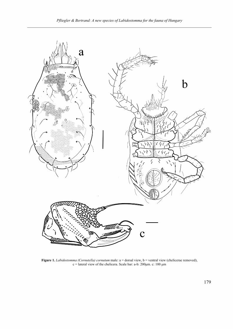
Pfliegler & Bertrand: A new species of Labidostomma for the fauna of Hungary
179
Figure 1. Labidostomma (Cornutella) cornutum male: a = dorsal view, b = ventral view (chelicerae removed), c = lateral view of the chelicera. Scale bar: a-b: 200µm. c: 100 µm
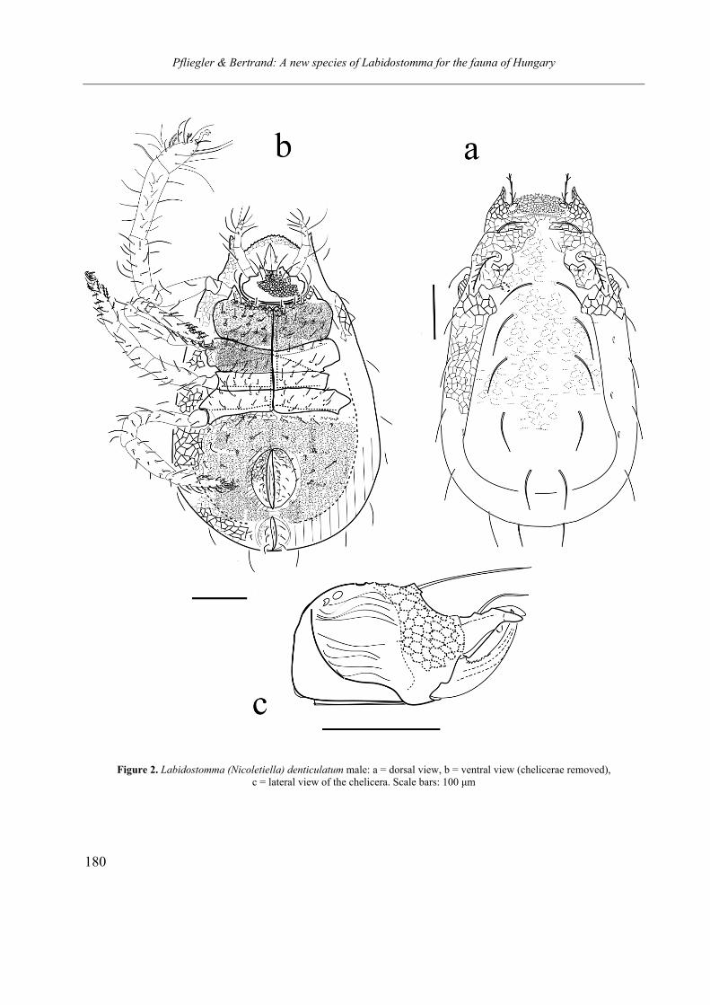
Pfliegler & Bertrand: A new species of Labidostomma for the fauna of Hungary
180
Figure 2. Labidostomma (Nicoletiella) denticulatum male: a = dorsal view, b = ventral view (chelicerae removed), c = lateral view of the chelicera. Scale bars: 100 µm
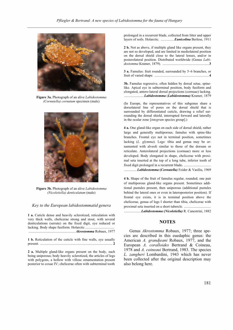
Pfliegler & Bertrand: A new species of Labidostomma for the fauna of Hungary
181
Figure 3a. Photograph of an alive Labidostomma
(Cornutella) cornutum specimen (male)
Figure 3b. Photograph of an alive Labidostomma
(Nicoletiella) denticulatum (male)
Key to the European labidostommatid genera
1 a. Cuticle dense and heavily sclerotized, reticulation with very thick walls, chelicerae strong and stout, with several denticulations (serrate) on the fixed digit, eye reduced or lacking. Body shape fusiform. Holarctic ................................. .................................................... Akrostomma Robaux, 1977
1 b. Reticulation of the cuticle with fine walls, eye usually present. ................................................................................. 2
2 a. Multiple gland-like organs present on the body, each being uniporous; body heavily sclerotized, the articles of legs with polygons, a hollow with villose ornamentation present posterior to coxae IV; chelicerae often with subterminal tooth
prolonged in a recurrent blade, collected from litter and upper layers of soils. Holarctic. ...............Eunicolina Berlese, 1911 2 b. Not as above, if multiple gland like organs present, they are not so developed, and are limited in mediolateral position on the dorsal shield close to the lateral lenses, and/or in posterolateral position. Distributed worldwide (Genus Labi-
dostomma Kramer, 1879). ....................................................3
3 a. Famulus: fruit rounded, surrounded by 5–6 branches, or fruit of varied shape. .............................................................4
3b. Famulus regressive, often hidden by dorsal setae, spine-like. Apical eye in subterminal position, body fusiform and elongated, antero-lateral dorsal projections (cornuae) lacking. ......................Labidostomma (Labidostomma) Kramer, 1879 (In Europe, the representatives of this subgenus share a dorsolateral line of pores on the dorsal shield that is surrounded by differentiated cuticle, drawing a relief sur-rounding the dorsal shield, interrupted forward and laterally in the ocular zone [integrum species group].) 4 a. One gland-like organ on each side of dorsal shield, rather large and generally multiporous; famulus with spine-like branches. Frontal eye not in terminal position, sometimes lacking (L. glymma). Legs: tibia and genua may be or-namented with alveoli similar to those of the dorsum or reticulate. Anterolateral projections (cornuae) more or less developed. Body elongated in shape, chelicerae with proxi-mal seta inserted at the top of a long tube, inferior tooth of fixed digit prolonged in a recurrent blade. .............................. .............. Labidostomma (Cornutella) Feider & Vasiliu, 1969 4 b. Shape of the fruit of famulus regular, rounded; one pair of multiporous gland-like organs present. Sometimes addi-tional pustules present, then uniporous (additional pustules behind the lateral ones or even in lateroposterior position). If frontal eye exists, it is in terminal position above the chelicerae, genua of legs I shorter than tibia, chelicerae with proximal seta inserted on a short tubercle. .............................. ...................Labidostomma (Nicoletiella) R. Canestrini, 1882
NOTES
Genus Akrostomma Robaux, 1977; three spe-cies are described in this euedaphic genus: the American A. grandjeani Robaux, 1977, and the European A. coralloides Bertrand & Coineau, 1978 and A. coineaui Bertrand, 1983. The species L. zangheri Lombardini, 1943 which has never been collected after the original description may also belong here.

Pfliegler & Bertrand: A new species of Labidostomma for the fauna of Hungary
182
Genus Eunicolina Berlese, 1911 consists of three European species: E. tuberculata, E. travei and E. nova. E. nova was assigned to the genus Grandjeanellina by Feider and Vasiliu (1969) that cannot be considered sufficiently characterized to be validated.
Genus Labidostomma Kramer, 1879; type spe-cies L. luteum. Cosmopolitan; the genus is the most heterogeneous in the family because many new species of labidostommatids were placed herein.
It is commonly accepted that the most com-mon species in Europe, L. luteum is the type spe-cies of the genus Labidostomma, though the first species described was L. denticulatum (syn. Aca-
rus denticulatus Schrank, 1776). The species L.
cornutum, L. denticulatum and L. luteum were in the past described in the distinct genera Ni-
coletiella R. Canestrini, 1882 (replacing Nicoletia G. Canestrini & Fanzago, 1877, a junior homo-nym of an insect genus) and Cornutella Feider & Vasiliu, 1969, which are now considered to be subgenera. The more recent acarologists progres-sively gave up these genera, and the family name Nicoletiellidae (Walter et. al,. 2009). However the division of Labidostomma into three subgenera is informative and supported by morphology as well (Feider & Vasiliu, 1969; Bertrand, 1990). It must be noted that there is still confusion about the type species of each subgenera.
Acknowledgements – We thank Dr. Jenő Kontschán for
his remarks on the earlier draft of the article. We also thank the editor, Dr. Csaba Csuzdi for his valuable help concerning nomenclature, editing and for allowing the work to be pub-lished.
REFERENCES
BERTRAND, M. (1989): La durée de développement, un
facteur limitant de l’extension de l’aire de ré-
partition: le cas de trois espèces européennes de
Labidostomidae (Acari, Actinedida). In: André, H. M. & Lions, J. C. (eds.): Ontogénèse et le concept de stases chez les arthropodes, Agar Press, pp. 123–128.
BERTRAND, M. (1990) La famille des Labidostomidae Oudemans, 1904 (Acari: Actinedida). Révision des
genres et sous-genres et catalogue des espèces décrites. Acarologia, 31: 31–38.
BŁOSZYK, J. & CZARNOTA, P. (1998). Wpływ wybra-nych czynników na liczebność i rozmieszczenie Nicoletiella denticulata (Schrank, 1776) (Acari: Actinotrichida, Labidostommatina) w Gorczań-skim Parku Narodowym, w porównaniu ze zde-gradowanymi środowiskami Karkonoszy i Gór Izerskich [The influence of selected factors on the density and distribution of Nicoletiella denticulata (Schrank, 1776) (Acari: Actinotrichida, Labido-stommatina) in the Gorce National Park when compared with the degraded habitats in the Kar-konosze and Izery Mountains]. Parki Narodowe i Rezervati Przyrodi, 17: 31–49.
DUNLOP, J. A. & BERTRAND, M. (2011): Fossil Labi-dostomatid mites (Prostigmata: Labidostommati-dae) from baltic amber. Acarologia. 51: 191–198.
FEIDER, Z. & VASILIU, N. (1968): Nicoletiella roma-nica n. sp. (Acariformes), une nouvelle espèce d’acarien de litiére. Revue Roumaine de Biologie (Zoologie). 13: 31–41.
FEIDER, Z. & VASILIU, N. (1969) Révision critique de la famille des Nicoletiellidae. In: Proceedings of the 2nd International Congress of Acarology, Sutton Bonington (England), 19th-25th July, 1967. Akadé-miai Kiadó, Budapest, pp. 202–207.
FEIDER, Z. & VASILIU, N. (1970): Espèces de Nico-letiellidae (Acariformes) de Roumanie. In: Livre du Centenaire Emile G. Racovitza (1868-1968), Edi-tions de l'Academie de la République socialiste de Roumanie, pp. 371–391.
GRANDJEAN, F. (1941): Observations sur les Acariens, 6ème série. Bulletin du Muséum National d'Histo-ire Naturelle Paris Série 2, XIII. 6: 532–539.
GRANDJEAN, F. (1942): Observations sur les Labido-stommidae (2e série). Bulletin du Muséum National d'Histoire Naturelle Paris Série 2, XIV. 3: 185–192.
ŠTORKÁN, J. (1938): Beiträge zur Kentniss der Familie Nicoletiellidae. Mémoires de la Société zoologique Tchécoslovaque de Prague. 5: 436–453.
ÚJVÁRI, ZS. & KONTSCHÁN, J. (2010): Adatok Porva és környékének Mesostigmata és Trombidiformes (Acari) faunájához [Data to the Mesostigmata and Trombidiformes (Acari) fauna of Porva and sur-roundings.]. Folia Musei historico-naturalis Bako-nyiensis, 27: 33–38.
VISTORIN, H. E. (1978): Zur Verbreitung europäischer Nicoletielliden-Arten (Acari, Trombidiformes).
Pfliegler & Bertrand: A new species of Labidostomma for the fauna of Hungary
183
Mitteilungen des Naturwissenschaftlichen Vereines
für Steiermark. 108: 271–280.
VISTORIN, H. E. (1980): Morphologische Untersuch-ungen an europäischen Nicoletielliden (Acari, Tro-mbidiformes). Acarologia, 21: 367–383.
WALTER, D. E., LINDQUIST, L. L., SMITH, I. M., COOK, D. R. & KRANTZ, G. W. (2009) Order Trombi-
diformes. In: KRANTZ, G. W. and WALTER, D. E. (eds.). A Manual of Acarology, Third Edition. Texas Tech University Press, pp. 234–236.
Opusc. Zool. Budapest, 2011, 42(2): 185–197
1Prof. B. K. Sharma, Freshwater Biology Laboratory, Department of Zoology, North-Eastern Hill University, Permanent
campus, Umshing, Shillong - 793 022, Meghalaya, India. E-mail: [email protected]
Zooplankton diversity of two floodplain lakes (pats) of Manipur,
northeast India
B. K. SHARMA1
Abstract. Plankton samples collected (November, 2002 – October, 2004) from Waithou and Utra pats, two floodplain lakes
in Manipur state of northeast India, revealed species rich zooplankton (121 species) with diverse nature of Rotifera (75 species).
The individual pats exhibited rich species diversity (110 and 103 species) and high monthly richness (68±7 and 61±8 species)
respectively with higher community similarities. Zooplankton formed important quantitative component (56.0±4.3 % and
55.1±5.1 %) of net plankton of the two pats; Rotifera dominantly contributed to their abundance while Cladocera > Copepoda
were sub-dominant groups. The richness and abundance showed significant variations between pats and between months and
followed oscillating annual patterns in each pat except for peaks during winter. Zooplankton indicated higher species diversity
and evenness, lower dominance, lack of quantitative importance of individual species, low densities and equitable abundance of
the majority of species in both pats. The richness correlated inversely only with nitrate in Waithou pat and abundance positively
correlated with alkalinity only in Utra Pat. Canonical correspondence analysis (CCA) with abiotic factors explained 55.6 % and
61.8% cumulative variance of zooplankton assemblages of Waithou and Utra pats respectively along axis 1 and 2.
INTRODUCTION
ooplankton invariably forms an integral com-
ponent of freshwater communities and con-
tributes significantly to biological productivity.
These fish-food organisms have been studied
from various inland ecosystems of this country
but information on their ecology in the Indian
floodplain lakes in particular is yet limited (Shar-
ma & Sharma, 2008). The related contributions
from northeast India are by Sharma and Hussain
(2001), Sharma (2011), Sharma and Sharma
(2011). The present study, on diversity of zoo-
plankton of two floodplain lakes (commonly cal-
led ‘pats’) of Manipur, assumes limnological im-
portance in view of the stated lacunae. The ob-
servations are made on monthly variations of
richness and abundance of zooplankton and their
constituent groups with special reference to their
community similarities, species diversity, domi-
nance, evenness and ecology.
MATERIALS AND METHODS
This work is resulted from limnological investi-
gations undertaken between November 2002 –
October 2004, in two floodplain lakes of Manipur
namely Waithou Pat (24o 41’ N, 93o 55’ E; area:
455 ha; max. depth: 1.7 m, mean depth: 1.2 m; al-
titude: 785 m ASL, Thoubal river basin, Thoubal
district) and Utra Pat (24o 41’ N, 93o 50’ E; area:
185 ha; max. depth: 2.2 m, mean depth: 1.4 m; al-
titude: 783 m ASL, Nambol river basin, Bish-
nupur district). Various aquatic plants common in
these pats included Eichhornia crassipes, Hydrilla verticellata, Utricularia flexuosa, Trapa natans, Lemna trisula, Pistia striates, Salvinia, Nymphaea spp., Nymphoides spp., Azolla pinnata, and Sagit-taria sp.
Water samples were collected at monthly in-
tervals between 7.00 am – 9.00 am, at one sam-
pling station each (due to local logistic reasons),
from Waithou and Utra pats. Water temperature,
pH and specific conductivity were recorded by the
field probes, dissolved oxygen was estimated by
Winkler’s method and other abiotic factors were
analyzed following APHA (1992). The qualitative
and quantitative plankton samples, collected
monthly from two pats, by nylobolt plankton net
(No. 25; mesh # 55 µm) by towing and by
filtering 25 l water each respectively, were pre-
served in 5 % formalin. The former were screened
and zooplankton species were identified following
Z
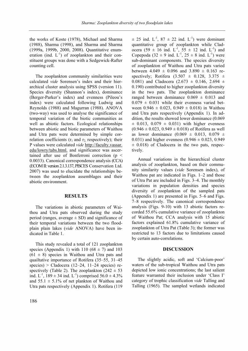
Sharma: Zooplankton diversity of two floodplain lakes
186
the works of Koste (1978), Michael and Sharma
(1988), Sharma (1998), and Sharma and Sharma
(1999a, 1999b, 2000, 2008). Quantitative enum-
eration (ind. L-1) of zooplankton and their con-
stituent groups was done with a Sedgewick-Rafter
counting cell.
The zooplankton community similarities were
calculated vide Sorensen’s index and their hier-
archical cluster analysis using SPSS (version 11).
Species diversity (Shannon’s index), dominance
(Berger-Parker’s index) and evenness (Pileou’s
index) were calculated following Ludwig and
Reynolds (1988) and Magurran (1988). ANOVA
(two-way) was used to analyse the significance of
temporal variation of the biotic communities as
well as abiotic factors. Ecological relationships
between abiotic and biotic parameters of Waithou
and Utra pats were determined by simple cor-
relation coefficients (r1 and r2, respectively); their
P values were calculated vide http://faculty.vassar.
edu/lowry/tabs.html. and significance was ascer-
tained after use of Bonferroni correction (p <
0.0033). Canonical correspondence analysis (CCA)
(ECOM II: version 2.1.3.137, PISCES Conservation Ltd.
2007) was used to elucidate the relationships be-
tween the zooplankton assemblages and their
abiotic environment.
RESULTS
The variations in abiotic parameters of Wai-
thou and Utra pats observed during the study
period (ranges, average ± SD) and significance of
their temporal variations between the two flood-
plain plain lakes (vide ANOVA) have been in-
dicated in Table 1.
This study revealed a total of 121 zooplankton
species (Appendix 1) with 110 (68 ± 7) and 103
(61 ± 8) species in Waithou and Utra pats and
quailtative importance of Rotifera (35–55, 31–45
species) > Cladocera (12–24, 11–24 species) re-
spectively (Table 2). The zooplankton (242 ± 53
ind. L-1, 189 ± 34 ind. L-1) comprised 56.0 ± 4.3%
and 55.1 ± 5.1% of net plankton of Waithou and
Utra pats respectively (Appendix 1). Rotifera (119
± 25 ind. L-1, 87 ± 22 ind. L-1) were dominant
quantitative group of zooplankton while Clad-
ocera (59 ± 16 ind. L-1, 55 ± 12 ind. L-1) and
Copepoda (32 ± 9 ind. L-1, 25 ± 8 ind. L-1) were
sub-dominant components. The species diversity
of zooplankton of Waithou and Utra pats varied
between 4.049 ± 0.096 and 3.890 ± 0.163 re-
spectively; Rotifera (3.507 ± 0.128, 3.375 ±
0.081) and Cladocera (2.673 ± 0.146, 2.694 ±
0.190) contributed to higher zooplankton diversity
in the two pats. The zooplankton dominance
ranged between dominance 0.069 ± 0.013 and
0.079 ± 0.031 while their evenness varied bet-
ween 0.946 ± 0.023, 0.949 ± 0.018) in Waithou
and Utra pats respectively (Appendix 1). In ad-
dition, the results showed lower dominance (0.069
± 0.013, 0.079 ± 0.031) with higher evenness
(0.946 ± 0.023, 0.949 ± 0.018) of Rotifera as well
as lower dominance (0.069 ± 0.013, 0.079 ±
0.031) and higher evenness (0.946 ± 0.023, 0.949
± 0.018) of Cladocera in the two pats, respec-
tively.
Annual variations in the hierarchical cluster
analysis of zooplankton, based on their commu-
nity similarity values (vide Sorensen index), of
Waithou pat are indicated in Figs. 1–2 and those
of Utra Pat are included in Figs. 3–4. The monthly
variations in population densities and species
diversity of zooplankton of the sampled pats
(Appendix 1) are presented in Figs. 5–6 and Figs.
7–8 respectively. The canonical correspondence
analysis (Figs. 9-10) with 13 abiotic factors re-
corded 55.6% cumulative variance of zooplankton
of Waithou Pat; CCA analysis with 15 abiotic
factors explained 61.8% cumulative variance of
zooplankton of Utra Pat (Table 3); the former was
restricted to 13 factors due to limitations caused
by certain auto-correlations.
DISCUSSION
The slightly acidic, soft and ‘Calcium-poor’
waters of the sub-tropical Waithou and Utra pats
depicted low ionic concentrations; the last salient
feature warranted their inclusion under ‘Class I’
category of trophic classification vide Talling and
Talling (1965). The sampled wetlands indicated
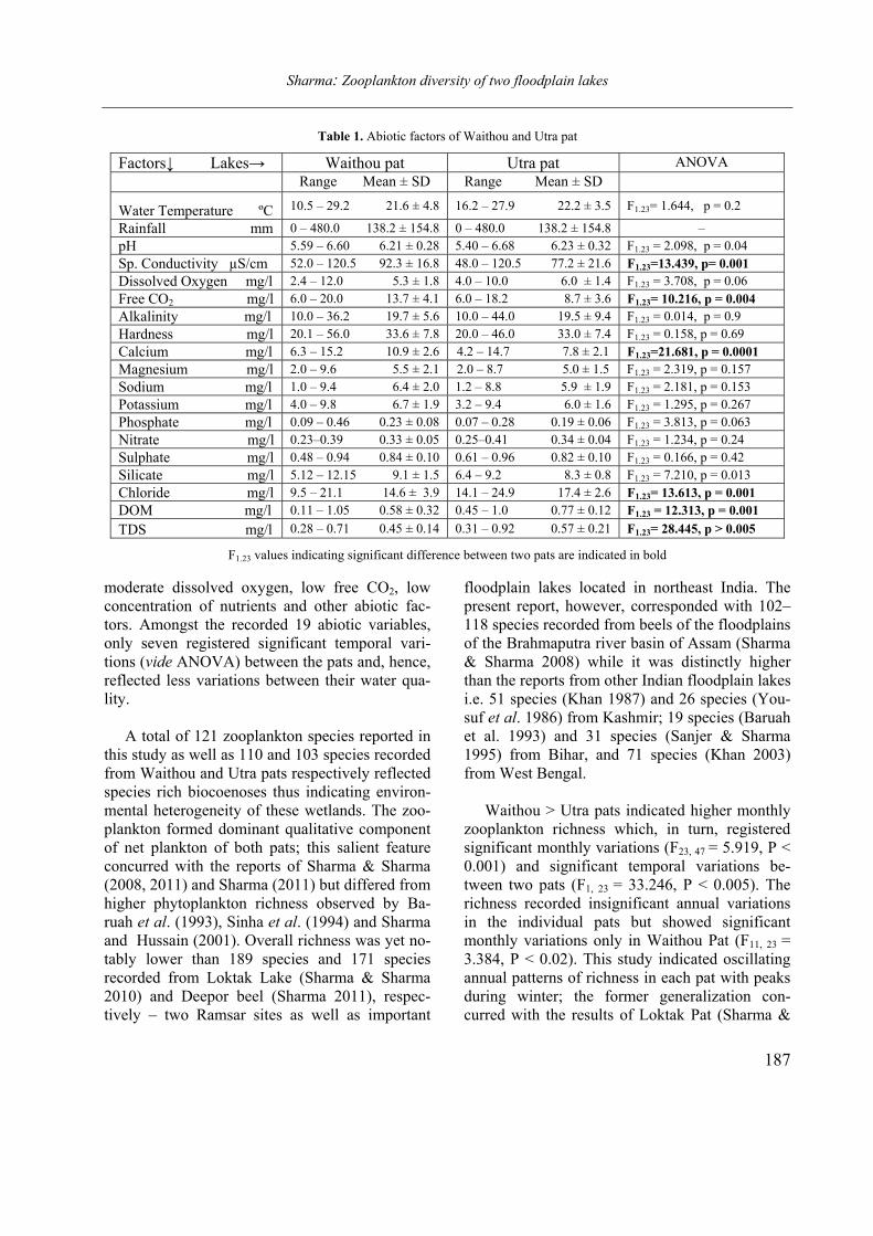
Sharma: Zooplankton diversity of two floodplain lakes
187
Table 1. Abiotic factors of Waithou and Utra pat
Factors ↓ Lakes→ Waithou pat Utra pat ANOVA
Range Mean ± SD Range Mean ± SD
Water Temperature ºC 10.5 – 29.2 21.6 ± 4.8 16.2 – 27.9 22.2 ± 3.5 F1.23= 1.644, p = 0.2
Rainfall mm 0 – 480.0 138.2 ± 154.8 0 – 480.0 138.2 ± 154.8 –
pH 5.59 – 6.60 6.21 ± 0.28 5.40 – 6.68 6.23 ± 0.32 F1.23 = 2.098, p = 0.04
Sp. Conductivity µS/cm 52.0 – 120.5 92.3 ± 16.8 48.0 – 120.5 77.2 ± 21.6 F1.23=13.439, p= 0.001
Dissolved Oxygen mg/l 2.4 – 12.0 5.3 ± 1.8 4.0 – 10.0 6.0 ± 1.4 F1.23 = 3.708, p = 0.06
Free CO2 mg/l 6.0 – 20.0 13.7 ± 4.1 6.0 – 18.2 8.7 ± 3.6 F1.23= 10.216, p = 0.004
Alkalinity mg/l 10.0 – 36.2 19.7 ± 5.6 10.0 – 44.0 19.5 ± 9.4 F1.23 = 0.014, p = 0.9
Hardness mg/l 20.1 – 56.0 33.6 ± 7.8 20.0 – 46.0 33.0 ± 7.4 F1.23 = 0.158, p = 0.69
Calcium mg/l 6.3 – 15.2 10.9 ± 2.6 4.2 – 14.7 7.8 ± 2.1 F1.23=21.681, p = 0.0001
Magnesium mg/l 2.0 – 9.6 5.5 ± 2.1 2.0 – 8.7 5.0 ± 1.5 F1.23 = 2.319, p = 0.157
Sodium mg/l 1.0 – 9.4 6.4 ± 2.0 1.2 – 8.8 5.9 ± 1.9 F1.23 = 2.181, p = 0.153
Potassium mg/l 4.0 – 9.8 6.7 ± 1.9 3.2 – 9.4 6.0 ± 1.6 F1.23 = 1.295, p = 0.267
Phosphate mg/l 0.09 – 0.46 0.23 ± 0.08 0.07 – 0.28 0.19 ± 0.06 F1.23 = 3.813, p = 0.063
Nitrate mg/l 0.23–0.39 0.33 ± 0.05 0.25–0.41 0.34 ± 0.04 F1.23 = 1.234, p = 0.24
Sulphate mg/l 0.48 – 0.94 0.84 ± 0.10 0.61 – 0.96 0.82 ± 0.10 F1.23 = 0.166, p = 0.42
Silicate mg/l 5.12 – 12.15 9.1 ± 1.5 6.4 – 9.2 8.3 ± 0.8 F1.23 = 7.210, p = 0.013
Chloride mg/l 9.5 – 21.1 14.6 ± 3.9 14.1 – 24.9 17.4 ± 2.6 F1.23= 13.613, p = 0.001
DOM mg/l 0.11 – 1.05 0.58 ± 0.32 0.45 – 1.0 0.77 ± 0.12 F1.23 = 12.313, p = 0.001
TDS mg/l 0.28 – 0.71 0.45 ± 0.14 0.31 – 0.92 0.57 ± 0.21 F1.23= 28.445, p > 0.005
F1.23 values indicating significant difference between two pats are indicated in bold
moderate dissolved oxygen, low free CO2, low
concentration of nutrients and other abiotic fac-
tors. Amongst the recorded 19 abiotic variables,
only seven registered significant temporal vari-
tions (vide ANOVA) between the pats and, hence,
reflected less variations between their water qua-
lity.
A total of 121 zooplankton species reported in
this study as well as 110 and 103 species recorded
from Waithou and Utra pats respectively reflected
species rich biocoenoses thus indicating environ-
mental heterogeneity of these wetlands. The zoo-
plankton formed dominant qualitative component
of net plankton of both pats; this salient feature
concurred with the reports of Sharma & Sharma
(2008, 2011) and Sharma (2011) but differed from
higher phytoplankton richness observed by Ba-
ruah et al. (1993), Sinha et al. (1994) and Sharma
and Hussain (2001). Overall richness was yet no-
tably lower than 189 species and 171 species
recorded from Loktak Lake (Sharma & Sharma
2010) and Deepor beel (Sharma 2011), respec-
tively – two Ramsar sites as well as important
floodplain lakes located in northeast India. The
present report, however, corresponded with 102–
118 species recorded from beels of the floodplains
of the Brahmaputra river basin of Assam (Sharma
& Sharma 2008) while it was distinctly higher
than the reports from other Indian floodplain lakes
i.e. 51 species (Khan 1987) and 26 species (You-
suf et al. 1986) from Kashmir; 19 species (Baruah
et al. 1993) and 31 species (Sanjer & Sharma
1995) from Bihar, and 71 species (Khan 2003)
from West Bengal.
Waithou > Utra pats indicated higher monthly
zooplankton richness which, in turn, registered
significant monthly variations (F23, 47 = 5.919, P <
0.001) and significant temporal variations be-
tween two pats (F1, 23 = 33.246, P < 0.005). The
richness recorded insignificant annual variations
in the individual pats but showed significant
monthly variations only in Waithou Pat (F11, 23 =
3.384, P < 0.02). This study indicated oscillating
annual patterns of richness in each pat with peaks
during winter; the former generalization con-
curred with the results of Loktak Pat (Sharma &
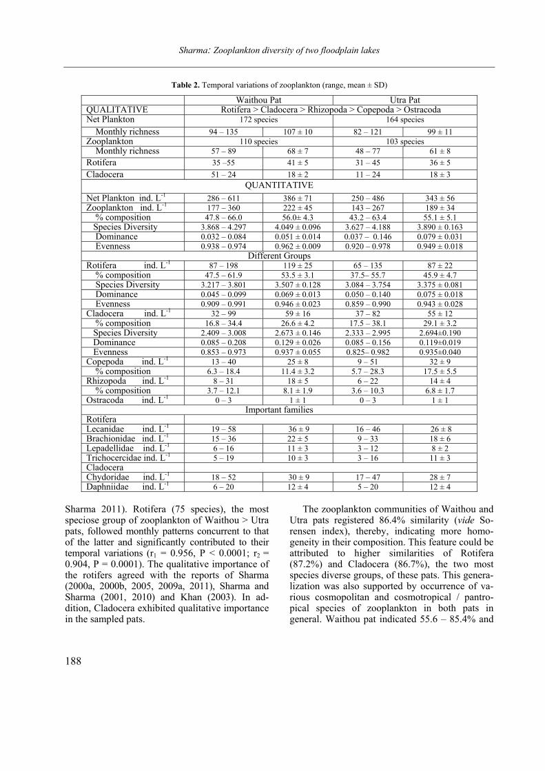
Sharma: Zooplankton diversity of two floodplain lakes
188
Table 2. Temporal variations of zooplankton (range, mean ± SD)
Waithou Pat Utra Pat QUALITATIVE Rotifera > Cladocera > Rhizopoda > Copepoda > Ostracoda Net Plankton 172 species 164 species
Monthly richness 94 – 135 107 ± 10 82 – 121 99 ± 11
Zooplankton 110 species 103 species
Monthly richness 57 – 89 68 ± 7 48 – 77 61 ± 8
Rotifera 35 –55 41 ± 5 31 – 45 36 ± 5
Cladocera 51 – 24 18 ± 2 11 – 24 18 ± 3
QUANTITATIVE
Net Plankton ind. L-1 286 – 611 386 ± 71 250 – 486 343 ± 56
Zooplankton ind. L-1 177 – 360 222 ± 45 143 – 267 189 ± 34
% composition 47.8 – 66.0 56.0± 4.3 43.2 – 63.4 55.1 ± 5.1
Species Diversity 3.868 – 4.297 4.049 ± 0.096 3.627 – 4.188 3.890 ± 0.163
Dominance 0.032 – 0.084 0.051 ± 0.014 0.037 – 0.146 0.079 ± 0.031
Evenness 0.938 – 0.974 0.962 ± 0.009 0.920 – 0.978 0.949 ± 0.018
Different Groups Rotifera ind. L-1 87 – 198 119 ± 25 65 – 135 87 ± 22
% composition 47.5 – 61.9 53.5 ± 3.1 37.5– 55.7 45.9 ± 4.7
Species Diversity 3.217 – 3.801 3.507 ± 0.128 3.084 – 3.754 3.375 ± 0.081
Dominance 0.045 – 0.099 0.069 ± 0.013 0.050 – 0.140 0.075 ± 0.018
Evenness 0.909 – 0.991 0.946 ± 0.023 0.859 – 0.990 0.943 ± 0.028
Cladocera ind. L-1 32 – 99 59 ± 16 37 – 82 55 ± 12
% composition 16.8 – 34.4 26.6 ± 4.2 17.5 – 38.1 29.1 ± 3.2
Species Diversity 2.409 – 3.008 2.673 ± 0.146 2.333 – 2.995 2.694±0.190
Dominance 0.085 – 0.208 0.129 ± 0.026 0.085 – 0.156 0.119±0.019
Evenness 0.853 – 0.973 0.937 ± 0.055 0.825– 0.982 0.935±0.040
Copepoda ind. L-1 13 – 40 25 ± 8 9 – 51 32 ± 9
% composition 6.3 – 18.4 11.4 ± 3.2 5.7 – 28.3 17.5 ± 5.5
Rhizopoda ind. L-1 8 – 31 18 ± 5 6 – 22 14 ± 4
% composition 3.7 – 12.1 8.1 ± 1.9 3.6 – 10.3 6.8 ± 1.7
Ostracoda ind. L-1 0 – 3 1 ± 1 0 – 3 1 ± 1
Important families Rotifera Lecanidae ind. L-1 19 – 58 36 ± 9 16 – 46 26 ± 8
Brachionidae ind. L-1 15 – 36 22 ± 5 9 – 33 18 ± 6
Lepadellidae ind. L-1 6 – 16 11 ± 3 3 – 12 8 ± 2
Trichocercidae ind. L-1 5 – 19 10 ± 3 3 – 16 11 ± 3
Cladocera
Chydoridae ind. L-1 18 – 52 30 ± 9 17 – 47 28 ± 7
Daphniidae ind. L-1 6 – 20 12 ± 4 5 – 20 12 ± 4
Sharma 2011). Rotifera (75 species), the most speciose group of zooplankton of Waithou > Utra pats, followed monthly patterns concurrent to that of the latter and significantly contributed to their temporal variations (r1 = 0.956, P < 0.0001; r2 = 0.904, P = 0.0001). The qualitative importance of the rotifers agreed with the reports of Sharma (2000a, 2000b, 2005, 2009a, 2011), Sharma and Sharma (2001, 2010) and Khan (2003). In ad-dition, Cladocera exhibited qualitative importance in the sampled pats.
The zooplankton communities of Waithou and Utra pats registered 86.4% similarity (vide So-rensen index), thereby, indicating more homo-geneity in their composition. This feature could be attributed to higher similarities of Rotifera (87.2%) and Cladocera (86.7%), the two most species diverse groups, of these pats. This genera-lization was also supported by occurrence of va-rious cosmopolitan and cosmotropical / pantro-pical species of zooplankton in both pats in general. Waithou pat indicated 55.6 – 85.4% and
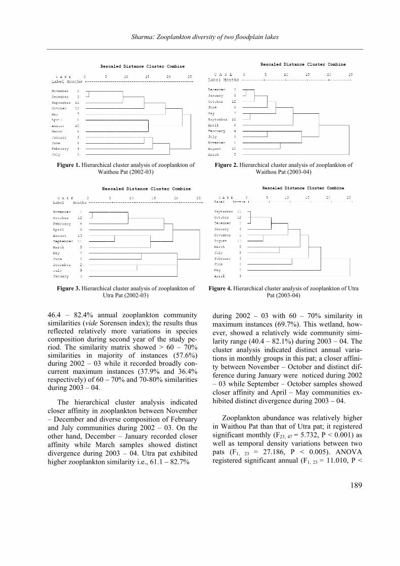
Sharma: Zooplankton diversity of two floodplain lakes
189
Figure 1. Hierarchical cluster analysis of zooplankton of
Waithou Pat (2002-03)
Figure 2. Hierarchical cluster analysis of zooplankton of
Waithou Pat (2003-04)
Figure 3. Hierarchical cluster analysis of zooplankton of
Utra Pat (2002-03)
Figure 4. Hierarchical cluster analysis of zooplankton of Utra
Pat (2003-04)
46.4 – 82.4% annual zooplankton community similarities (vide Sorensen index); the results thus reflected relatively more variations in species composition during second year of the study pe-riod. The similarity matrix showed > 60 – 70% similarities in majority of instances (57.6%) during 2002 – 03 while it recorded broadly con-current maximum instances (37.9% and 36.4% respectively) of 60 – 70% and 70-80% similarities during 2003 – 04.
The hierarchical cluster analysis indicated
closer affinity in zooplankton between November
– December and diverse composition of February
and July communities during 2002 – 03. On the
other hand, December – January recorded closer
affinity while March samples showed distinct
divergence during 2003 – 04. Utra pat exhibited
higher zooplankton similarity i.e., 61.1 – 82.7%
during 2002 – 03 with 60 – 70% similarity in
maximum instances (69.7%). This wetland, how-
ever, showed a relatively wide community simi-
larity range (40.4 – 82.1%) during 2003 – 04. The
cluster analysis indicated distinct annual varia-
tions in monthly groups in this pat; a closer affini-
ty between November – October and distinct dif-
ference during January were noticed during 2002
– 03 while September – October samples showed
closer affinity and April – May communities ex-
hibited distinct divergence during 2003 – 04.
Zooplankton abundance was relatively higher
in Waithou Pat than that of Utra pat; it registered
significant monthly (F23, 47 = 5.732, P < 0.001) as
well as temporal density variations between two
pats (F1, 23 = 27.186, P < 0.005). ANOVA
registered significant annual (F1, 23 = 11.010, P <
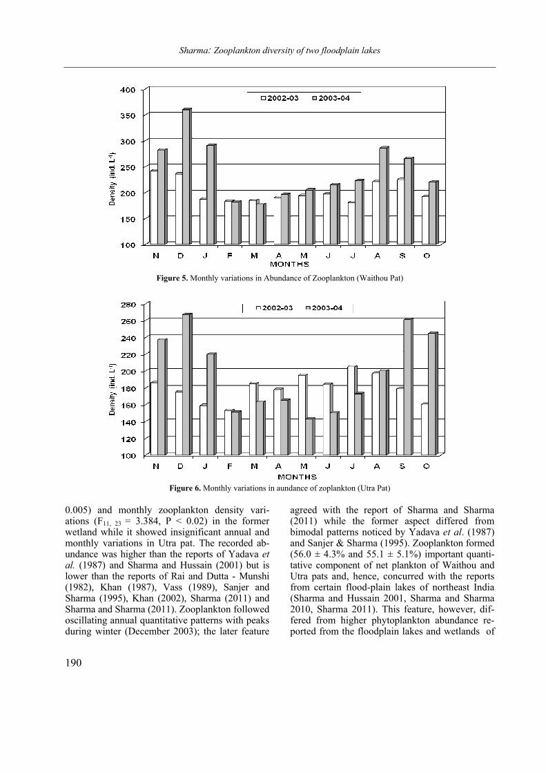
Sharma: Zooplankton diversity of two floodplain lakes
190
Figure 5. Monthly variations in Abundance of Zooplankton (Waithou Pat)
Figure 6. Monthly variations in aundance of zoplankton (Utra Pat)
0.005) and monthly zooplankton density vari-ations (F11, 23 = 3.384, P < 0.02) in the former wetland while it showed insignificant annual and monthly variations in Utra pat. The recorded ab-undance was higher than the reports of Yadava et al. (1987) and Sharma and Hussain (2001) but is lower than the reports of Rai and Dutta - Munshi (1982), Khan (1987), Vass (1989), Sanjer and Sharma (1995), Khan (2002), Sharma (2011) and Sharma and Sharma (2011). Zooplankton followed oscillating annual quantitative patterns with peaks during winter (December 2003); the later feature
agreed with the report of Sharma and Sharma (2011) while the former aspect differed from bimodal patterns noticed by Yadava et al. (1987) and Sanjer & Sharma (1995). Zooplankton formed (56.0 ± 4.3% and 55.1 ± 5.1%) important quanti-tative component of net plankton of Waithou and Utra pats and, hence, concurred with the reports from certain flood-plain lakes of northeast India (Sharma and Hussain 2001, Sharma and Sharma 2010, Sharma 2011). This feature, however, dif-fered from higher phytoplankton abundance re-ported from the floodplain lakes and wetlands of
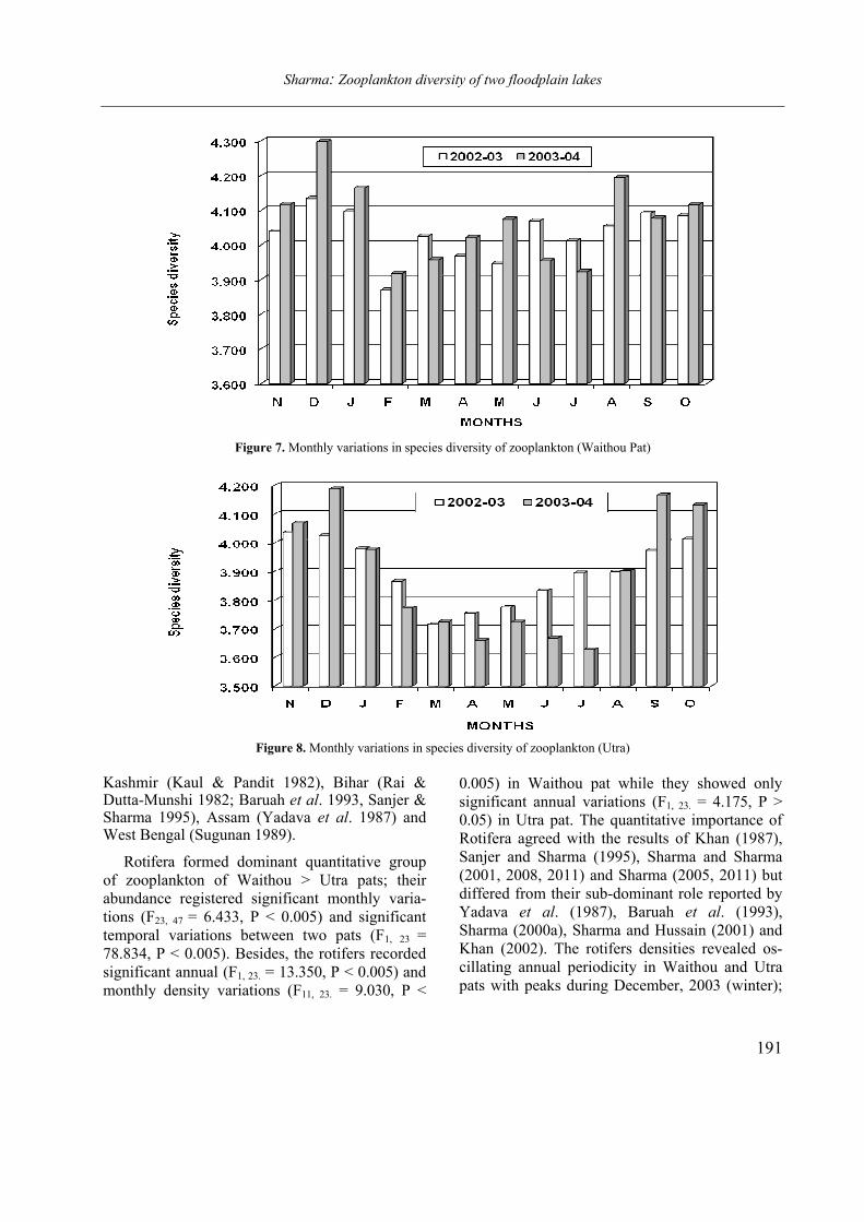
Sharma: Zooplankton diversity of two floodplain lakes
191
Figure 7. Monthly variations in species diversity of zooplankton (Waithou Pat)
Figure 8. Monthly variations in species diversity of zooplankton (Utra)
Kashmir (Kaul & Pandit 1982), Bihar (Rai & Dutta-Munshi 1982; Baruah et al. 1993, Sanjer & Sharma 1995), Assam (Yadava et al. 1987) and West Bengal (Sugunan 1989).
Rotifera formed dominant quantitative group
of zooplankton of Waithou > Utra pats; their
abundance registered significant monthly varia-
tions (F23, 47 = 6.433, P < 0.005) and significant
temporal variations between two pats (F1, 23 =
78.834, P < 0.005). Besides, the rotifers recorded
significant annual (F1, 23. = 13.350, P < 0.005) and
monthly density variations (F11, 23. = 9.030, P <
0.005) in Waithou pat while they showed only
significant annual variations (F1, 23. = 4.175, P >
0.05) in Utra pat. The quantitative importance of
Rotifera agreed with the results of Khan (1987),
Sanjer and Sharma (1995), Sharma and Sharma
(2001, 2008, 2011) and Sharma (2005, 2011) but
differed from their sub-dominant role reported by
Yadava et al. (1987), Baruah et al. (1993),
Sharma (2000a), Sharma and Hussain (2001) and
Khan (2002). The rotifers densities revealed os-
cillating annual periodicity in Waithou and Utra
pats with peaks during December, 2003 (winter);
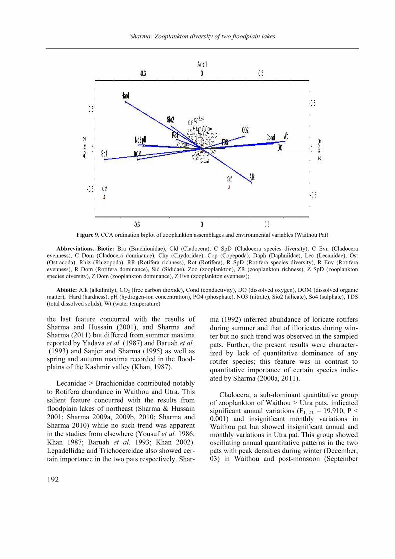
Sharma: Zooplankton diversity of two floodplain lakes
192
Figure 9. CCA ordination biplot of zooplankton assemblages and environmental variables (Waithou Pat)
Abbreviations. Biotic: Bra (Brachionidae), Cld (Cladocera), C SpD (Cladocera species diversity), C Evn (Cladocera
evenness), C Dom (Cladocera dominance), Chy (Chydoridae), Cop (Copepoda), Daph (Daphniidae), Lec (Lecanidae), Ost
(Ostracoda), Rhiz (Rhizopoda), RR (Rotifera richness), Rot (Rotifera), R SpD (Rotifera species diversity), R Env (Rotifera
evenness), R Dom (Rotifera dominance), Sid (Sididae), Zoo (zooplankton), ZR (zooplankton richness), Z SpD (zooplankton
species diversity), Z Dom (zooplankton dominance), Z Evn (zooplankton evenness);
Abiotic: Alk (alkalinity), CO2 (free carbon dioxide), Cond (conductivity), DO (dissolved oxygen), DOM (dissolved organic
matter), Hard (hardness), pH (hydrogen-ion concentration), PO4 (phosphate), NO3 (nitrate), Sio2 (silicate), So4 (sulphate), TDS
(total dissolved solids), Wt (water temperature)
the last feature concurred with the results of Sharma and Hussain (2001), and Sharma and Sharma (2011) but differed from summer maxima reported by Yadava et al. (1987) and Baruah et al. (1993) and Sanjer and Sharma (1995) as well as spring and autumn maxima recorded in the flood-plains of the Kashmir valley (Khan, 1987).
Lecanidae > Brachionidae contributed notably
to Rotifera abundance in Waithou and Utra. This
salient feature concurred with the results from
floodplain lakes of northeast (Sharma & Hussain
2001; Sharma 2009a, 2009b, 2010; Sharma and
Sharma 2010) while no such trend was apparent
in the studies from elsewhere (Yousuf et al. 1986;
Khan 1987; Baruah et al. 1993; Khan 2002).
Lepadellidae and Trichocercidae also showed cer-
tain importance in the two pats respectively. Shar-
ma (1992) inferred abundance of loricate rotifers
during summer and that of illoricates during win-
ter but no such trend was observed in the sampled
pats. Further, the present results were character-
ized by lack of quantitative dominance of any
rotifer species; this feature was in contrast to
quantitative importance of certain species indic-
ated by Sharma (2000a, 2011).
Cladocera, a sub-dominant quantitative group
of zooplankton of Waithou > Utra pats, indicated significant annual variations (F1, 23. = 19.910, P < 0.001) and insignificant monthly variations in Waithou pat but showed insignificant annual and monthly variations in Utra pat. This group showed oscillating annual quantitative patterns in the two pats with peak densities during winter (December, 03) in Waithou and post-monsoon (September
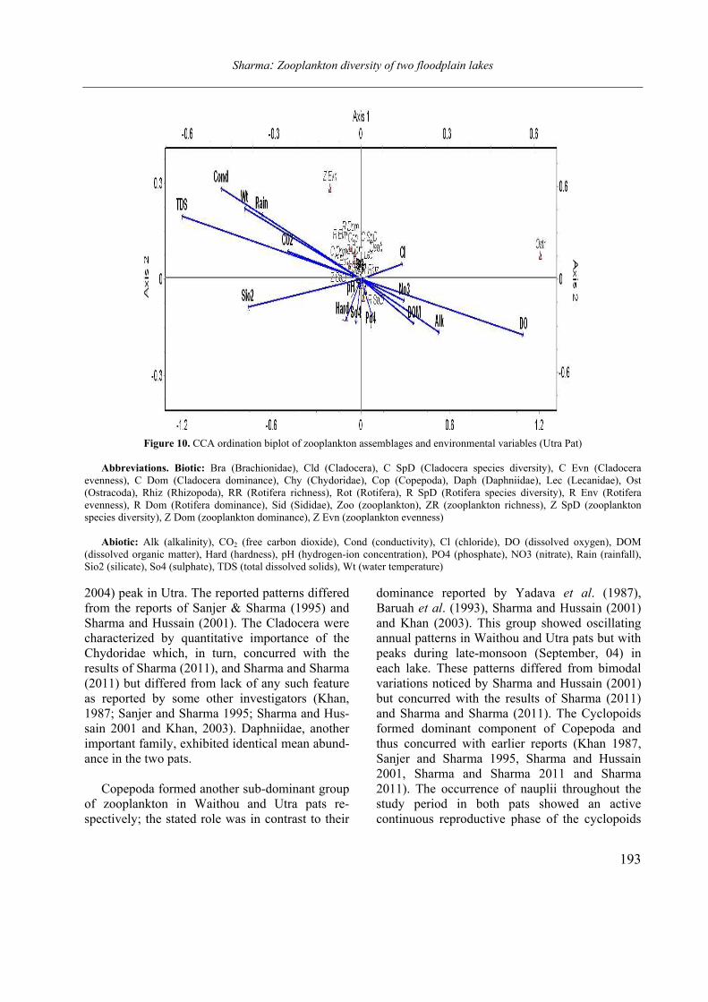
Sharma: Zooplankton diversity of two floodplain lakes
193
Figure 10. CCA ordination biplot of zooplankton assemblages and environmental variables (Utra Pat)
Abbreviations. Biotic: Bra (Brachionidae), Cld (Cladocera), C SpD (Cladocera species diversity), C Evn (Cladocera
evenness), C Dom (Cladocera dominance), Chy (Chydoridae), Cop (Copepoda), Daph (Daphniidae), Lec (Lecanidae), Ost
(Ostracoda), Rhiz (Rhizopoda), RR (Rotifera richness), Rot (Rotifera), R SpD (Rotifera species diversity), R Env (Rotifera
evenness), R Dom (Rotifera dominance), Sid (Sididae), Zoo (zooplankton), ZR (zooplankton richness), Z SpD (zooplankton
species diversity), Z Dom (zooplankton dominance), Z Evn (zooplankton evenness)
Abiotic: Alk (alkalinity), CO2 (free carbon dioxide), Cond (conductivity), Cl (chloride), DO (dissolved oxygen), DOM
(dissolved organic matter), Hard (hardness), pH (hydrogen-ion concentration), PO4 (phosphate), NO3 (nitrate), Rain (rainfall),
Sio2 (silicate), So4 (sulphate), TDS (total dissolved solids), Wt (water temperature)
2004) peak in Utra. The reported patterns differed
from the reports of Sanjer & Sharma (1995) and
Sharma and Hussain (2001). The Cladocera were
characterized by quantitative importance of the
Chydoridae which, in turn, concurred with the
results of Sharma (2011), and Sharma and Sharma
(2011) but differed from lack of any such feature
as reported by some other investigators (Khan,
1987; Sanjer and Sharma 1995; Sharma and Hus-
sain 2001 and Khan, 2003). Daphniidae, another
important family, exhibited identical mean abund-
ance in the two pats.
Copepoda formed another sub-dominant group
of zooplankton in Waithou and Utra pats re-
spectively; the stated role was in contrast to their
dominance reported by Yadava et al. (1987),
Baruah et al. (1993), Sharma and Hussain (2001)
and Khan (2003). This group showed oscillating
annual patterns in Waithou and Utra pats but with
peaks during late-monsoon (September, 04) in
each lake. These patterns differed from bimodal
variations noticed by Sharma and Hussain (2001)
but concurred with the results of Sharma (2011)
and Sharma and Sharma (2011). The Cyclopoids
formed dominant component of Copepoda and
thus concurred with earlier reports (Khan 1987,
Sanjer and Sharma 1995, Sharma and Hussain
2001, Sharma and Sharma 2011 and Sharma
2011). The occurrence of nauplii throughout the
study period in both pats showed an active
continuous reproductive phase of the cyclopoids
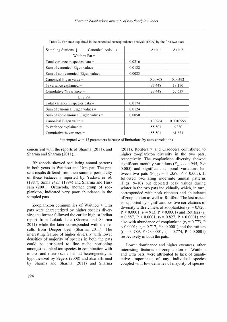
Sharma: Zooplankton diversity of two floodplain lakes
194
Table 3. Variance explained in the canonical correspondence analysis (CCA) by the first two axes
Sampling Stations ↓ Canonical Axis → Axis 1 Axis 2
Waithou Pat *
Total variance in species data = 0.0216
Sum of canonical Eigen values = 0.0132
Sum of non-canonical Eigen values = 0.0083
Canonical Eigen value = 0.00808 0.00392
% variance explained = 37.448 18.190
Cumulative % variance = 37.448 55.639
Utra Pat
Total variance in species data = 0.0174
Sum of canonical Eigen values = 0.0124
Sum of non-canonical Eigen values = 0.0050
Canonical Eigen value = 0.00964 0.0010995
% variance explained = 55.501 6.330
Cumulative % variance = 55.501 61.831
*attempted with 13 parameters because of limitations by auto-correlations
concurrent with the reports of Sharma (2011), and
Sharma and Sharma (2011).
Rhizopoda showed oscillating annual patterns
in both years in Waithou and Utra pat. The pre-
sent results differed from their summer periodicity
of these testaceans reported by Yadava et al. (1987), Sinha et al. (1994) and Sharma and Hus-
sain (2001). Ostracoda, another group of zoo-
plankton, indicated very poor abundance in the
sampled pats.
Zooplankton communities of Waithou > Utra
pats were characterized by higher species diver-
sity; the former followed the earlier highest Indian
report from Loktak lake (Sharma and Sharma
2011) while the later corresponded with the re-
sults from Deepor beel (Sharma 2011). The
interesting feature of higher diversity with lower
densities of majority of species in both the pats
could be attributed to fine niche portioning
amongst zooplankton species in combination with
micro- and macro-scale habitat heterogeneity as
hypothesized by Segers (2008) and also affirmed
by Sharma and Sharma (2011) and Sharma
(2011). Rotifera > and Cladocera contributed to
higher zooplankton diversity in the two pats,
respectively. The zooplankton diversity showed
significant monthly variations (F23, 47 = 4.945, P >
0.005) and significant temporal variations be-
tween two pats (F1, 23 = 41.357, P < 0.005). It
followed oscillating indefinite annual patterns
(Figs. 9–10) but depicted peak values during
winter in the two pats individually which, in turn,
corresponded with peak richness and abundance
of zooplankton as well as Rotifera. The last aspect
is supported by significant positive correlations of
diversity with richness of zooplankton (r1 = 0.920,
P < 0.0001; r2 = 913, P < 0.0001) and Rotifera (r1
= 0.887, P < 0.0001; r2 = 0.827, P < 0.0001) and
also with abundance of zooplankton (r1 = 0.773, P
< 0.0001; r2 = 0.717, P < 0.0001) and the rotifers
(r1 = 0.789, P < 0.0001; r2 = 0.774, P < 0.0001)
respectively in both the pats.
Lower dominance and higher evenness, other interesting features of zooplankton of Waithou and Utra pats, were attributed to lack of quanti-tative importance of any individual species coupled with low densities of majority of species.
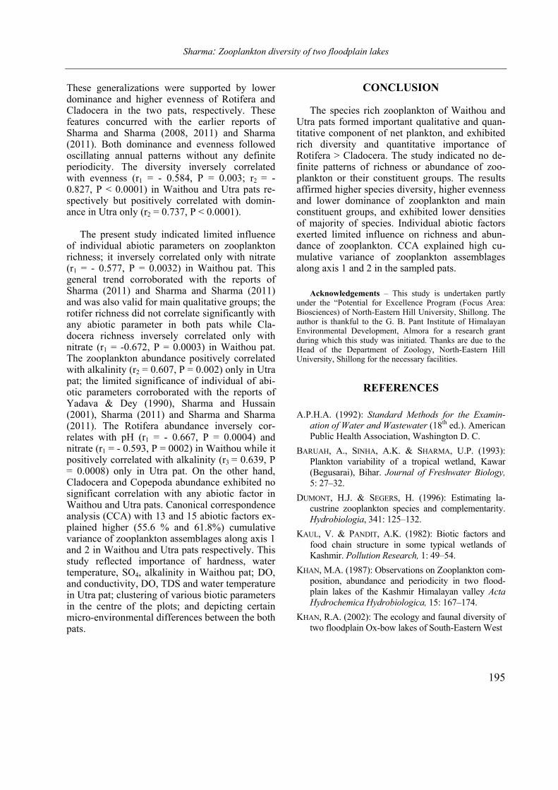
Sharma: Zooplankton diversity of two floodplain lakes
195
These generalizations were supported by lower dominance and higher evenness of Rotifera and Cladocera in the two pats, respectively. These features concurred with the earlier reports of Sharma and Sharma (2008, 2011) and Sharma (2011). Both dominance and evenness followed oscillating annual patterns without any definite periodicity. The diversity inversely correlated with evenness (r1 = - 0.584, P = 0.003; r2 = - 0.827, P < 0.0001) in Waithou and Utra pats re-spectively but positively correlated with domin-ance in Utra only (r2 = 0.737, P < 0.0001).
The present study indicated limited influence of individual abiotic parameters on zooplankton richness; it inversely correlated only with nitrate (r1 = - 0.577, P = 0.0032) in Waithou pat. This general trend corroborated with the reports of Sharma (2011) and Sharma and Sharma (2011) and was also valid for main qualitative groups; the rotifer richness did not correlate significantly with any abiotic parameter in both pats while Cla-docera richness inversely correlated only with nitrate (r1 = -0.672, P = 0.0003) in Waithou pat. The zooplankton abundance positively correlated with alkalinity (r2 = 0.607, P = 0.002) only in Utra pat; the limited significance of individual of abi-otic parameters corroborated with the reports of Yadava & Dey (1990), Sharma and Hussain (2001), Sharma (2011) and Sharma and Sharma (2011). The Rotifera abundance inversely cor-relates with pH (r1 = - 0.667, P = 0.0004) and nitrate (r1 = - 0.593, P = 0002) in Waithou while it positively correlated with alkalinity (r3 = 0.639, P = 0.0008) only in Utra pat. On the other hand, Cladocera and Copepoda abundance exhibited no significant correlation with any abiotic factor in Waithou and Utra pats. Canonical correspondence analysis (CCA) with 13 and 15 abiotic factors ex-plained higher (55.6 % and 61.8%) cumulative variance of zooplankton assemblages along axis 1 and 2 in Waithou and Utra pats respectively. This study reflected importance of hardness, water temperature, SO4, alkalinity in Waithou pat; DO, and conductivity, DO, TDS and water temperature in Utra pat; clustering of various biotic parameters in the centre of the plots; and depicting certain micro-environmental differences between the both pats.
CONCLUSION
The species rich zooplankton of Waithou and Utra pats formed important qualitative and quan-titative component of net plankton, and exhibited rich diversity and quantitative importance of Rotifera > Cladocera. The study indicated no de-finite patterns of richness or abundance of zoo-plankton or their constituent groups. The results affirmed higher species diversity, higher evenness and lower dominance of zooplankton and main constituent groups, and exhibited lower densities of majority of species. Individual abiotic factors exerted limited influence on richness and abun-dance of zooplankton. CCA explained high cu-mulative variance of zooplankton assemblages along axis 1 and 2 in the sampled pats.
Acknowledgements – This study is undertaken partly
under the “Potential for Excellence Program (Focus Area: Biosciences) of North-Eastern Hill University, Shillong. The author is thankful to the G. B. Pant Institute of Himalayan Environmental Development, Almora for a research grant during which this study was initiated. Thanks are due to the Head of the Department of Zoology, North-Eastern Hill University, Shillong for the necessary facilities.
REFERENCES
A.P.H.A. (1992): Standard Methods for the Examin-
ation of Water and Wastewater (18th ed.). American
Public Health Association, Washington D. C.
BARUAH, A., SINHA, A.K. & SHARMA, U.P. (1993):
Plankton variability of a tropical wetland, Kawar
(Begusarai), Bihar. Journal of Freshwater Biology, 5: 27–32.
DUMONT, H.J. & SEGERS, H. (1996): Estimating la-
custrine zooplankton species and complementarity.
Hydrobiologia, 341: 125–132.
KAUL, V. & PANDIT, A.K. (1982): Biotic factors and
food chain structure in some typical wetlands of
Kashmir. Pollution Research, 1: 49–54.
KHAN, M.A. (1987): Observations on Zooplankton com-
position, abundance and periodicity in two flood-
plain lakes of the Kashmir Himalayan valley Acta Hydrochemica Hydrobiologica, 15: 167–174.
KHAN, R.A. (2002): The ecology and faunal diversity of
two floodplain Ox-bow lakes of South-Eastern West
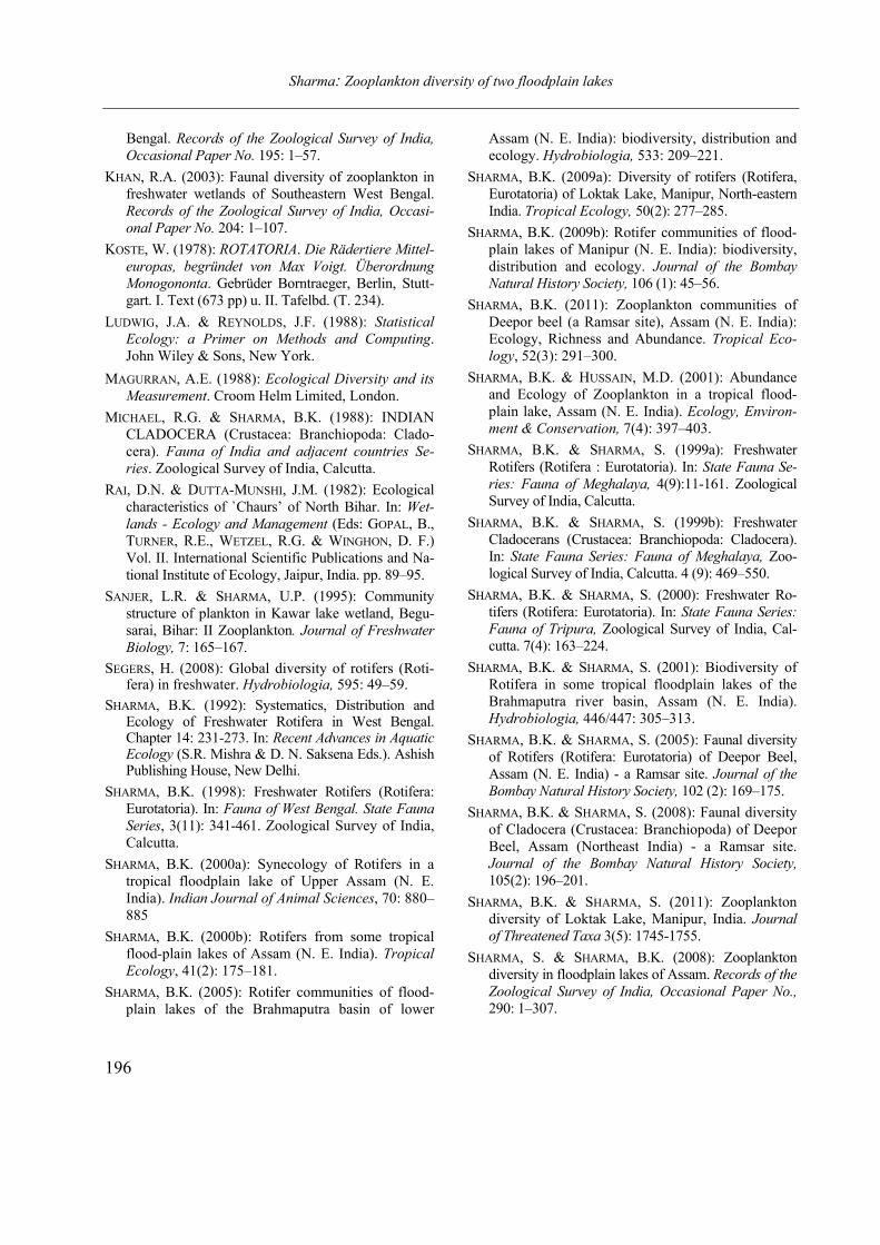
Sharma: Zooplankton diversity of two floodplain lakes
196
Bengal. Records of the Zoological Survey of India, Occasional Paper No. 195: 1–57.
KHAN, R.A. (2003): Faunal diversity of zooplankton in
freshwater wetlands of Southeastern West Bengal.
Records of the Zoological Survey of India, Occasi-onal Paper No. 204: 1–107.
KOSTE, W. (1978): ROTATORIA. Die Rädertiere Mittel-europas, begründet von Max Voigt. Überordnung Monogononta. Gebrüder Borntraeger, Berlin, Stutt-
gart. I. Text (673 pp) u. II. Tafelbd. (T. 234).
LUDWIG, J.A. & REYNOLDS, J.F. (1988): Statistical Ecology: a Primer on Methods and Computing.
John Wiley & Sons, New York.
MAGURRAN, A.E. (1988): Ecological Diversity and its Measurement. Croom Helm Limited, London.
MICHAEL, R.G. & SHARMA, B.K. (1988): INDIAN
CLADOCERA (Crustacea: Branchiopoda: Clado-
cera). Fauna of India and adjacent countries Se-ries. Zoological Survey of India, Calcutta.
RAI, D.N. & DUTTA-MUNSHI, J.M. (1982): Ecological
characteristics of `Chaurs’ of North Bihar. In: Wet-lands - Ecology and Management (Eds: GOPAL, B.,
TURNER, R.E., WETZEL, R.G. & WINGHON, D. F.)
Vol. II. International Scientific Publications and Na-
tional Institute of Ecology, Jaipur, India. pp. 89–95.
SANJER, L.R. & SHARMA, U.P. (1995): Community
structure of plankton in Kawar lake wetland, Begu-
sarai, Bihar: II Zooplankton. Journal of Freshwater Biology, 7: 165–167.
SEGERS, H. (2008): Global diversity of rotifers (Roti-fera) in freshwater. Hydrobiologia, 595: 49–59.
SHARMA, B.K. (1992): Systematics, Distribution and Ecology of Freshwater Rotifera in West Bengal. Chapter 14: 231-273. In: Recent Advances in Aquatic Ecology (S.R. Mishra & D. N. Saksena Eds.). Ashish Publishing House, New Delhi.
SHARMA, B.K. (1998): Freshwater Rotifers (Rotifera:
Eurotatoria). In: Fauna of West Bengal. State Fauna Series, 3(11): 341-461. Zoological Survey of India,
Calcutta.
SHARMA, B.K. (2000a): Synecology of Rotifers in a
tropical floodplain lake of Upper Assam (N. E.
India). Indian Journal of Animal Sciences, 70: 880–
885
SHARMA, B.K. (2000b): Rotifers from some tropical
flood-plain lakes of Assam (N. E. India). Tropical Ecology, 41(2): 175–181.
SHARMA, B.K. (2005): Rotifer communities of flood-
plain lakes of the Brahmaputra basin of lower
Assam (N. E. India): biodiversity, distribution and
ecology. Hydrobiologia, 533: 209–221.
SHARMA, B.K. (2009a): Diversity of rotifers (Rotifera,
Eurotatoria) of Loktak Lake, Manipur, North-eastern
India. Tropical Ecology, 50(2): 277–285.
SHARMA, B.K. (2009b): Rotifer communities of flood-
plain lakes of Manipur (N. E. India): biodiversity,
distribution and ecology. Journal of the Bombay Natural History Society, 106 (1): 45–56.
SHARMA, B.K. (2011): Zooplankton communities of
Deepor beel (a Ramsar site), Assam (N. E. India):
Ecology, Richness and Abundance. Tropical Eco-logy, 52(3): 291–300.
SHARMA, B.K. & HUSSAIN, M.D. (2001): Abundance
and Ecology of Zooplankton in a tropical flood-
plain lake, Assam (N. E. India). Ecology, Environ-ment & Conservation, 7(4): 397–403.
SHARMA, B.K. & SHARMA, S. (1999a): Freshwater
Rotifers (Rotifera : Eurotatoria). In: State Fauna Se-ries: Fauna of Meghalaya, 4(9):11-161. Zoological
Survey of India, Calcutta.
SHARMA, B.K. & SHARMA, S. (1999b): Freshwater
Cladocerans (Crustacea: Branchiopoda: Cladocera).
In: State Fauna Series: Fauna of Meghalaya, Zoo-
logical Survey of India, Calcutta. 4 (9): 469–550.
SHARMA, B.K. & SHARMA, S. (2000): Freshwater Ro-
tifers (Rotifera: Eurotatoria). In: State Fauna Series: Fauna of Tripura, Zoological Survey of India, Cal-
cutta. 7(4): 163–224.
SHARMA, B.K. & SHARMA, S. (2001): Biodiversity of
Rotifera in some tropical floodplain lakes of the
Brahmaputra river basin, Assam (N. E. India).
Hydrobiologia, 446/447: 305–313.
SHARMA, B.K. & SHARMA, S. (2005): Faunal diversity
of Rotifers (Rotifera: Eurotatoria) of Deepor Beel,
Assam (N. E. India) - a Ramsar site. Journal of the Bombay Natural History Society, 102 (2): 169–175.
SHARMA, B.K. & SHARMA, S. (2008): Faunal diversity
of Cladocera (Crustacea: Branchiopoda) of Deepor
Beel, Assam (Northeast India) - a Ramsar site.
Journal of the Bombay Natural History Society, 105(2): 196–201.
SHARMA, B.K. & SHARMA, S. (2011): Zooplankton
diversity of Loktak Lake, Manipur, India. Journal of Threatened Taxa 3(5): 1745-1755.
SHARMA, S. & SHARMA, B.K. (2008): Zooplankton
diversity in floodplain lakes of Assam. Records of the Zoological Survey of India, Occasional Paper No., 290: 1–307.
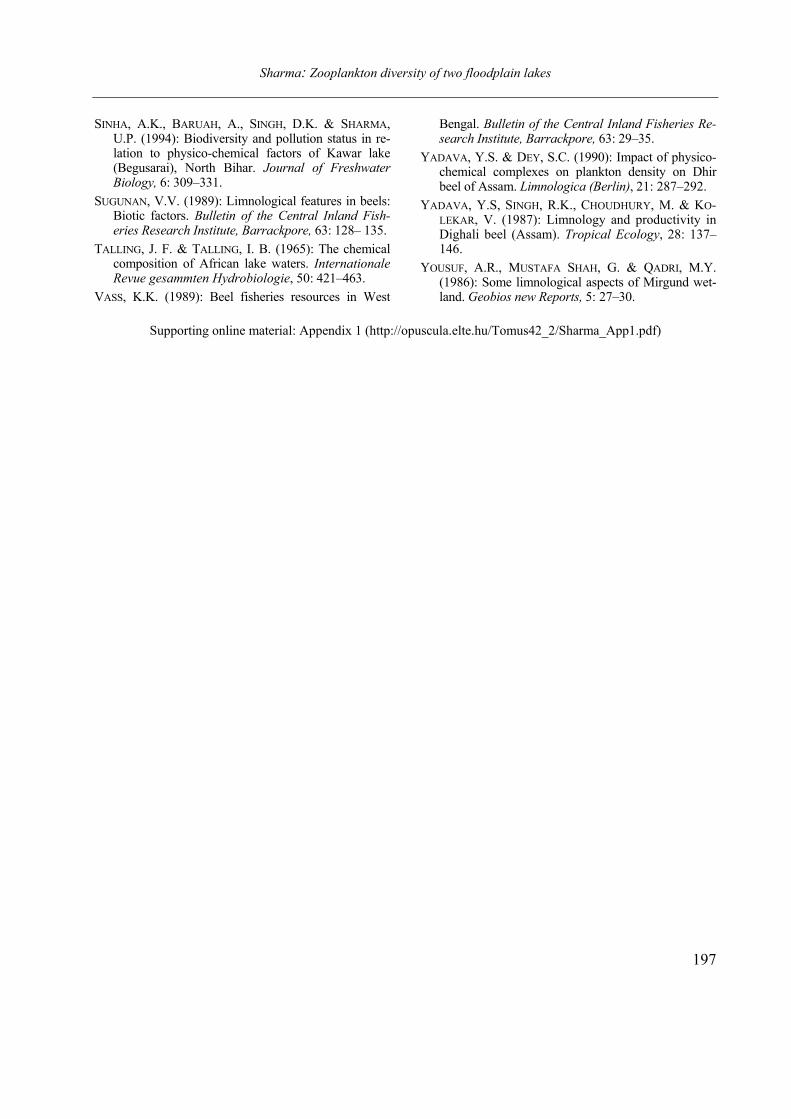
Sharma: Zooplankton diversity of two floodplain lakes
197
SINHA, A.K., BARUAH, A., SINGH, D.K. & SHARMA, U.P. (1994): Biodiversity and pollution status in re-lation to physico-chemical factors of Kawar lake (Begusarai), North Bihar. Journal of Freshwater Biology, 6: 309–331.
SUGUNAN, V.V. (1989): Limnological features in beels: Biotic factors. Bulletin of the Central Inland Fish-eries Research Institute, Barrackpore, 63: 128– 135.
TALLING, J. F. & TALLING, I. B. (1965): The chemical composition of African lake waters. Internationale Revue gesammten Hydrobiologie, 50: 421–463.
VASS, K.K. (1989): Beel fisheries resources in West
Bengal. Bulletin of the Central Inland Fisheries Re-search Institute, Barrackpore, 63: 29–35.
YADAVA, Y.S. & DEY, S.C. (1990): Impact of physico-chemical complexes on plankton density on Dhir beel of Assam. Limnologica (Berlin), 21: 287–292.
YADAVA, Y.S, SINGH, R.K., CHOUDHURY, M. & KO-LEKAR, V. (1987): Limnology and productivity in Dighali beel (Assam). Tropical Ecology, 28: 137–146.
YOUSUF, A.R., MUSTAFA SHAH, G. & QADRI, M.Y. (1986): Some limnological aspects of Mirgund wet-land. Geobios new Reports, 5: 27–30.
Supporting online material: Appendix 1 (http://opuscula.elte.hu/Tomus42_2/Sharma_App1.pdf)
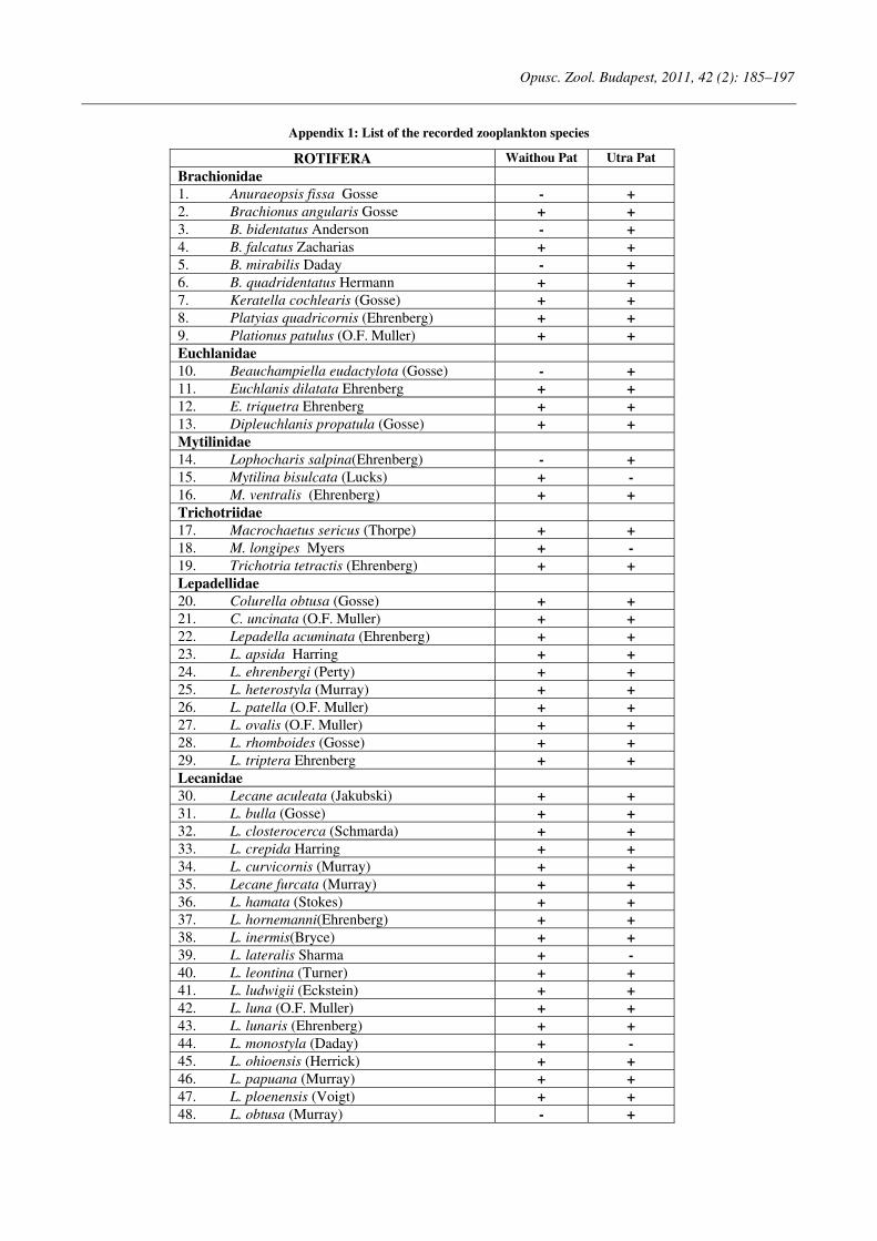
Opusc. Zool. Budapest, 2011, 42 (2): 185–197
Appendix 1: List of the recorded zooplankton species
ROTIFERA Waithou Pat Utra Pat
Brachionidae
1. Anuraeopsis fissa Gosse - +
2. Brachionus angularis Gosse + +
3. B. bidentatus Anderson - +
4. B. falcatus Zacharias + +
5. B. mirabilis Daday - +
6. B. quadridentatus Hermann + +
7. Keratella cochlearis (Gosse) + +
8. Platyias quadricornis (Ehrenberg) + +
9. Plationus patulus (O.F. Muller) + +
Euchlanidae
10. Beauchampiella eudactylota (Gosse) - +
11. Euchlanis dilatata Ehrenberg + +
12. E. triquetra Ehrenberg + +
13. Dipleuchlanis propatula (Gosse) + +
Mytilinidae
14. Lophocharis salpina(Ehrenberg) - +
15. Mytilina bisulcata (Lucks) + -
16. M. ventralis (Ehrenberg) + +
Trichotriidae
17. Macrochaetus sericus (Thorpe) + +
18. M. longipes Myers + -
19. Trichotria tetractis (Ehrenberg) + +
Lepadellidae
20. Colurella obtusa (Gosse) + +
21. C. uncinata (O.F. Muller) + +
22. Lepadella acuminata (Ehrenberg) + +
23. L. apsida Harring + +
24. L. ehrenbergi (Perty) + +
25. L. heterostyla (Murray) + +
26. L. patella (O.F. Muller) + +
27. L. ovalis (O.F. Muller) + +
28. L. rhomboides (Gosse) + +
29. L. triptera Ehrenberg + +
Lecanidae
30. Lecane aculeata (Jakubski) + +
31. L. bulla (Gosse) + +
32. L. closterocerca (Schmarda) + +
33. L. crepida Harring + +
34. L. curvicornis (Murray) + +
35. Lecane furcata (Murray) + +
36. L. hamata (Stokes) + +
37. L. hornemanni(Ehrenberg) + +
38. L. inermis(Bryce) + +
39. L. lateralis Sharma + -
40. L. leontina (Turner) + +
41. L. ludwigii (Eckstein) + +
42. L. luna (O.F. Muller) + +
43. L. lunaris (Ehrenberg) + +
44. L. monostyla (Daday) + -
45. L. ohioensis (Herrick) + +
46. L. papuana (Murray) + +
47. L. ploenensis (Voigt) + +
48. L. obtusa (Murray) - +
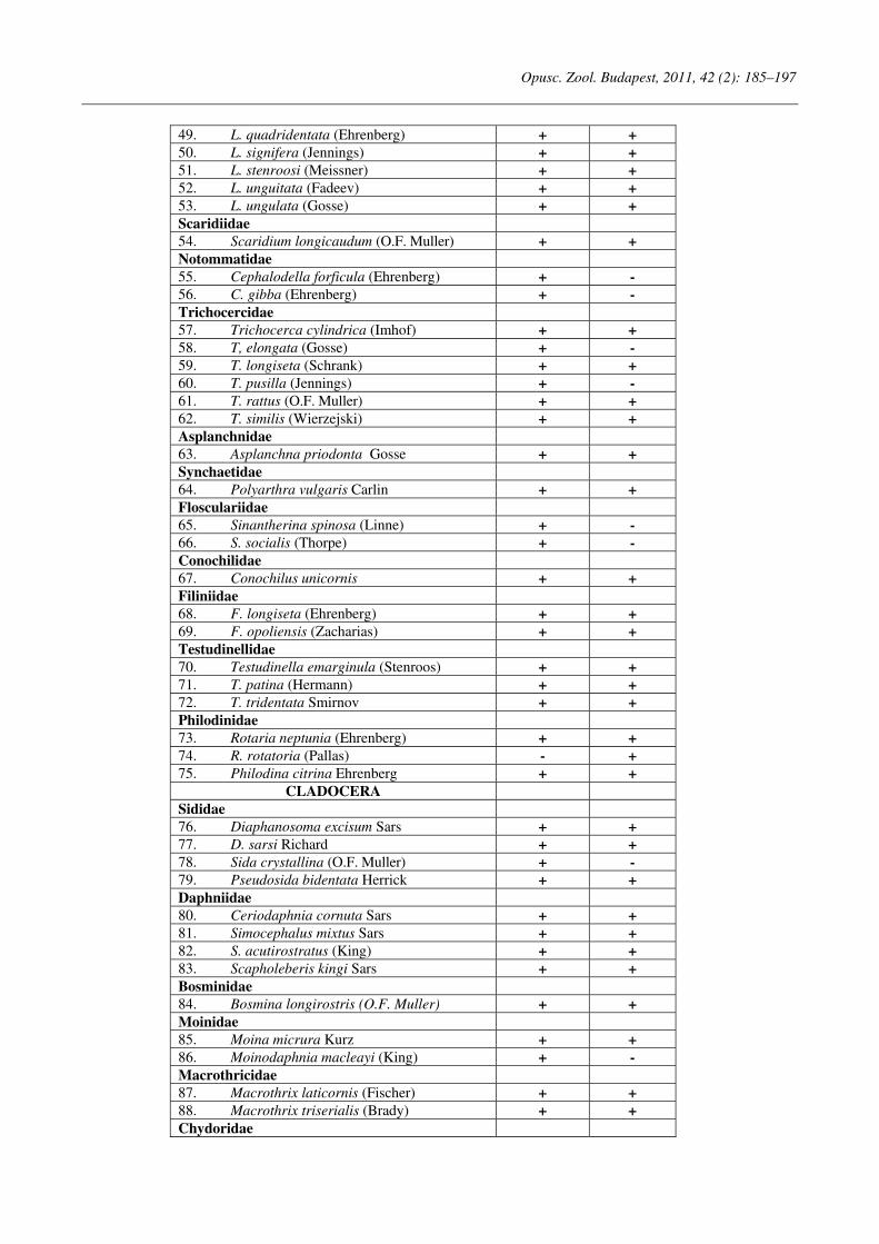
Opusc. Zool. Budapest, 2011, 42 (2): 185–197
49. L. quadridentata (Ehrenberg) + +
50. L. signifera (Jennings) + +
51. L. stenroosi (Meissner) + +
52. L. unguitata (Fadeev) + +
53. L. ungulata (Gosse) + +
Scaridiidae
54. Scaridium longicaudum (O.F. Muller) + +
Notommatidae
55. Cephalodella forficula (Ehrenberg) + -
56. C. gibba (Ehrenberg) + -
Trichocercidae
57. Trichocerca cylindrica (Imhof) + +
58. T, elongata (Gosse) + -
59. T. longiseta (Schrank) + +
60. T. pusilla (Jennings) + -
61. T. rattus (O.F. Muller) + +
62. T. similis (Wierzejski) + +
Asplanchnidae
63. Asplanchna priodonta Gosse + +
Synchaetidae
64. Polyarthra vulgaris Carlin + +
Flosculariidae
65. Sinantherina spinosa (Linne) + -
66. S. socialis (Thorpe) + -
Conochilidae
67. Conochilus unicornis + +
Filiniidae
68. F. longiseta (Ehrenberg) + +
69. F. opoliensis (Zacharias) + +
Testudinellidae
70. Testudinella emarginula (Stenroos) + +
71. T. patina (Hermann) + +
72. T. tridentata Smirnov + +
Philodinidae
73. Rotaria neptunia (Ehrenberg) + +
74. R. rotatoria (Pallas) - +
75. Philodina citrina Ehrenberg + +
CLADOCERA
Sididae
76. Diaphanosoma excisum Sars + +
77. D. sarsi Richard + +
78. Sida crystallina (O.F. Muller) + -
79. Pseudosida bidentata Herrick + +
Daphniidae
80. Ceriodaphnia cornuta Sars + +
81. Simocephalus mixtus Sars + +
82. S. acutirostratus (King) + +
83. Scapholeberis kingi Sars + +
Bosminidae
84. Bosmina longirostris (O.F. Muller) + +
Moinidae
85. Moina micrura Kurz + +
86. Moinodaphnia macleayi (King) + -
Macrothricidae
87. Macrothrix laticornis (Fischer) + +
88. Macrothrix triserialis (Brady) + +
Chydoridae
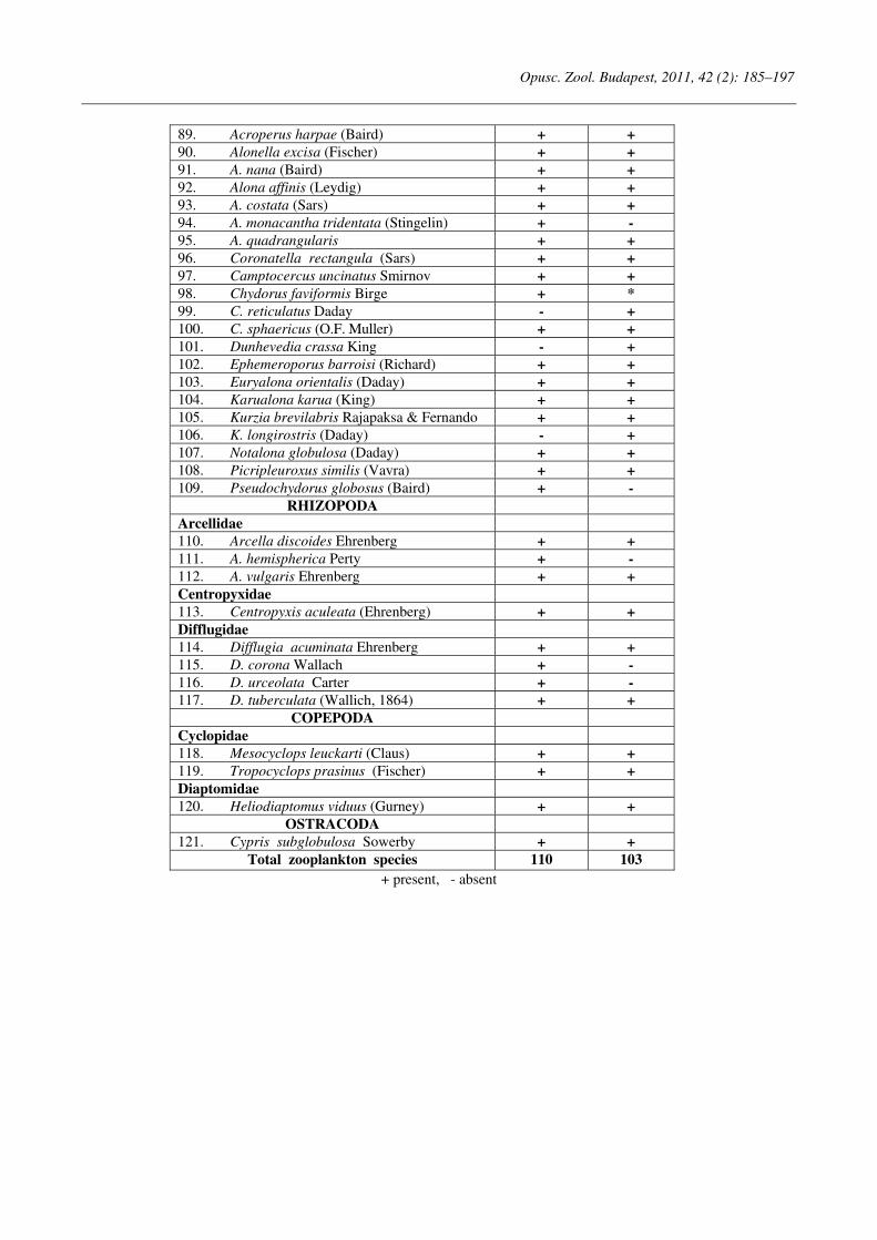
Opusc. Zool. Budapest, 2011, 42 (2): 185–197
89. Acroperus harpae (Baird) + +
90. Alonella excisa (Fischer) + +
91. A. nana (Baird) + +
92. Alona affinis (Leydig) + +
93. A. costata (Sars) + +
94. A. monacantha tridentata (Stingelin) + -
95. A. quadrangularis + +
96. Coronatella rectangula (Sars) + +
97. Camptocercus uncinatus Smirnov + +
98. Chydorus faviformis Birge + *
99. C. reticulatus Daday - +
100. C. sphaericus (O.F. Muller) + +
101. Dunhevedia crassa King - +
102. Ephemeroporus barroisi (Richard) + +
103. Euryalona orientalis (Daday) + +
104. Karualona karua (King) + +
105. Kurzia brevilabris Rajapaksa & Fernando + +
106. K. longirostris (Daday) - +
107. Notalona globulosa (Daday) + +
108. Picripleuroxus similis (Vavra) + +
109. Pseudochydorus globosus (Baird) + -
RHIZOPODA
Arcellidae
110. Arcella discoides Ehrenberg + +
111. A. hemispherica Perty + -
112. A. vulgaris Ehrenberg + +
Centropyxidae
113. Centropyxis aculeata (Ehrenberg) + +
Difflugidae
114. Difflugia acuminata Ehrenberg + +
115. D. corona Wallach + -
116. D. urceolata Carter + -
117. D. tuberculata (Wallich, 1864) + +
COPEPODA
Cyclopidae
118. Mesocyclops leuckarti (Claus) + +
119. Tropocyclops prasinus (Fischer) + +
Diaptomidae
120. Heliodiaptomus viduus (Gurney) + +
OSTRACODA
121. Cypris subglobulosa Sowerby + +
Total zooplankton species 110 103
+ present, - absent
Opusc. Zool. Budapest, 2011, 42(2): 199–206
_______________________________________________________________________________________________________
1Dr. Dániel Winkler, Institute of Wildlife Management and Vertebrate Zoology, University of West Hungary, H-9400 Sopron, Bajcsy-Zs. u. 4., Hungary; E-mail: [email protected]
2Márton Korda, Institute of Botany and Nature Conservation, University of West Hungary, H-9400 Sopron, Bajcsy-Zs. u. 4., Hungary. E-mail: [email protected]
3Dr. György Traser, Institute of Silviculture and Forest Protection, University of West Hungary, H-9400 Sopron, Bajcsy-Zs. u. 4., Hungary. E-mail: [email protected]
Two species of Collembola new for the fauna of Hungary
D. WINKLER1, M. KORDA
2 and GY. TRASER
3
Abstract. Two Collembola species are recorded as new for the fauna of Hungary. Tetracanthella pericarpatica Kaprus & Tsalan, 2009 (Isotomidae), previously known only from the Transcarpathian Lowland and Roztochchia Hill (Ukraine), was collected in a oak-ash-elm lowland forest in Western Hungary. Some corrections and additions to the original description are given. The xerophilous species Xenylla uniseta Da Gama, 1963 (Hypogastruridae), found mostly in Mediterranean countries, was collected in meadow steppe habitats near Budapest. An updated description is provided with emphasis on the first instar.
Keywords. Tetracanthella pericarpatica, Xenylla uniseta, Isotomidae, Hypogastruridae, chaetotaxy, first instar.
INTRODUCTION
he collembolan fauna of Hungary is fairly well studied. The number of the species in
Hungary has been steadily increasing (Traser & Dányi, 2008; Traser et al, 2011) to the current total of 414 species (Dányi & Traser, 2008). Due to the diversity of biogeographical regions, many areas are still unexplored. Opportunistic sampling at two localities, carried out on survey trips or in the course of other studies, yielded two interesting species new to the Hungarian fauna: Tetracanth-
ella pericarpatica and Xenylla uniseta. The genus Tetracanthella Schött, 1891 is one
of the largest genera in the family Isotomidae with about 100 described species in the Holarctic re-gion and now six species in Hungary. The wide-spread hypogastrurid genus Xenylla Tullberg, 1869 has now nine Hungarian representatives.
MATERIALS AND METHODS
The terminology follows Deharveng & Bedos
(1997), Potapov (2001), and Potapov and Dehar-veng (2005) for Tetracanthella pericarpatica, and Da Gama (1967, 1969) and Thibaud et al. (2004) for Xenylla uniseta.
General morphological abbreviations used: Ant. = Antennal segments; PAO = postantennal
organ; Th. I–III = thoracic tergites; Abd. I–VI = abdominal tergites.
Abbreviations used for Tetracanthella pericar-
patica: a1; p1; p3 = 'normal setae' in the anterior and posterior rows ('1' in medial, '3' in more distal position on tergites); Ml; Md; Mdl = macro-chaetae dorsally in lateral, dorsal and dorsolateral positions; dcA, dcH = diameter of the eyes (ocelli) 'A' and 'H'; GIII = claw (griffe) of leg III; eIII = empodium (unguiculus) of leg III; Ed3 = ergot dorsal on Ti III; d = dens; s = s-chaetae; ms = s-microchaetae; ASe,ASi = external and internal anal spine; ap = unpaired seta in the frontal area of the head (also known as 'do'); VT = ventral tube.
Morphological code used for Xenylla uniseta: Dorsal chaetotaxy: a = a0 on the head absent; b = p1 on the head absent; f = L1 on the head is longer than L3; h1 = a2 on Th. II-III behind a1; h2 = p2 on Th. II-III before p1; j = la2 on Th. II-III absent; k = m3 on Th. II-III absent; l = p3 absent on Abd. IV; o = m3 on Abd. IV absent; q = a2 on Abd. V absent; Ventral chaetotaxy: r = p1 on the head absent; s = m3 absent on head; t = the pair of setae on Th. II-III. absent; v = p1 and p2 on Abd. II absent; w = p6 on Abd. II absent; a2 = a6 on Abd. III absent; a3 = p5 on Abd. III absent; a4 = m1 on Abd. IV absent.
T
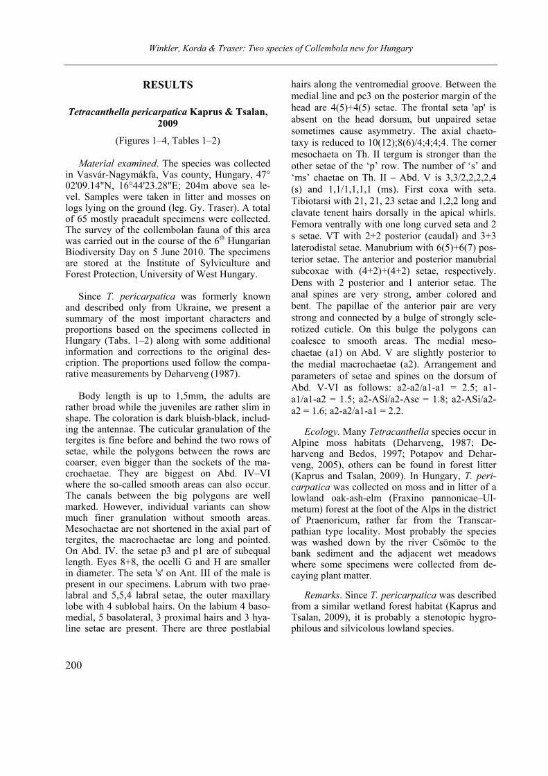
Winkler, Korda & Traser: Two species of Collembola new for Hungary
200
RESULTS
Tetracanthella pericarpatica Kaprus & Tsalan,
2009
(Figures 1–4, Tables 1–2)
Material examined. The species was collected in Vasvár-Nagymákfa, Vas county, Hungary, 47° 02'09.14"N, 16°44'23.28"E; 204m above sea le-vel. Samples were taken in litter and mosses on logs lying on the ground (leg. Gy. Traser). A total of 65 mostly praeadult specimens were collected. The survey of the collembolan fauna of this area was carried out in the course of the 6th Hungarian Biodiversity Day on 5 June 2010. The specimens are stored at the Institute of Sylviculture and Forest Protection, University of West Hungary.
Since T. pericarpatica was formerly known
and described only from Ukraine, we present a summary of the most important characters and proportions based on the specimens collected in Hungary (Tabs. 1–2) along with some additional information and corrections to the original des-cription. The proportions used follow the compa-rative measurements by Deharveng (1987).
Body length is up to 1,5mm, the adults are rather broad while the juveniles are rather slim in shape. The coloration is dark bluish-black, includ-ing the antennae. The cuticular granulation of the tergites is fine before and behind the two rows of setae, while the polygons between the rows are coarser, even bigger than the sockets of the ma-crochaetae. They are biggest on Abd. IV–VI where the so-called smooth areas can also occur. The canals between the big polygons are well marked. However, individual variants can show much finer granulation without smooth areas. Mesochaetae are not shortened in the axial part of tergites, the macrochaetae are long and pointed. On Abd. IV. the setae p3 and p1 are of subequal length. Eyes 8+8, the ocelli G and H are smaller in diameter. The seta 's' on Ant. III of the male is present in our specimens. Labrum with two prae-labral and 5,5,4 labral setae, the outer maxillary lobe with 4 sublobal hairs. On the labium 4 baso-medial, 5 basolateral, 3 proximal hairs and 3 hya-line setae are present. There are three postlabial
hairs along the ventromedial groove. Between the medial line and pc3 on the posterior margin of the head are 4(5)+4(5) setae. The frontal seta 'ap' is absent on the head dorsum, but unpaired setae sometimes cause asymmetry. The axial chaeto-taxy is reduced to 10(12);8(6)/4;4;4;4. The corner mesochaeta on Th. II tergum is stronger than the other setae of the ‘p’ row. The number of ‘s’ and ‘ms’ chaetae on Th. II – Abd. V is 3,3/2,2,2,2,4 (s) and 1,1/1,1,1,1 (ms). First coxa with seta. Tibiotarsi with 21, 21, 23 setae and 1,2,2 long and clavate tenent hairs dorsally in the apical whirls. Femora ventrally with one long curved seta and 2 s setae. VT with 2+2 posterior (caudal) and 3+3 laterodistal setae. Manubrium with 6(5)+6(7) pos-terior setae. The anterior and posterior manubrial subcoxae with (4+2)+(4+2) setae, respectively. Dens with 2 posterior and 1 anterior setae. The anal spines are very strong, amber colored and bent. The papillae of the anterior pair are very strong and connected by a bulge of strongly scle-rotized cuticle. On this bulge the polygons can coalesce to smooth areas. The medial meso-chaetae (a1) on Abd. V are slightly posterior to the medial macrochaetae (a2). Arrangement and parameters of setae and spines on the dorsum of Abd. V-VI as follows: a2-a2/a1-a1 = 2.5; a1-a1/a1-a2 = 1.5; a2-ASi/a2-Ase = 1.8; a2-ASi/a2-a2 = 1.6; a2-a2/a1-a1 = 2.2.
Ecology. Many Tetracanthella species occur in
Alpine moss habitats (Deharveng, 1987; De-harveng and Bedos, 1997; Potapov and Dehar-veng, 2005), others can be found in forest litter (Kaprus and Tsalan, 2009). In Hungary, T. peri-carpatica was collected on moss and in litter of a lowland oak-ash-elm (Fraxino pannonicae–Ul-metum) forest at the foot of the Alps in the district of Praenoricum, rather far from the Transcar-pathian type locality. Most probably the species was washed down by the river Csömöc to the bank sediment and the adjacent wet meadows where some specimens were collected from de-caying plant matter.
Remarks. Since T. pericarpatica was described from a similar wetland forest habitat (Kaprus and Tsalan, 2009), it is probably a stenotopic hygro-philous and silvicolous lowland species.
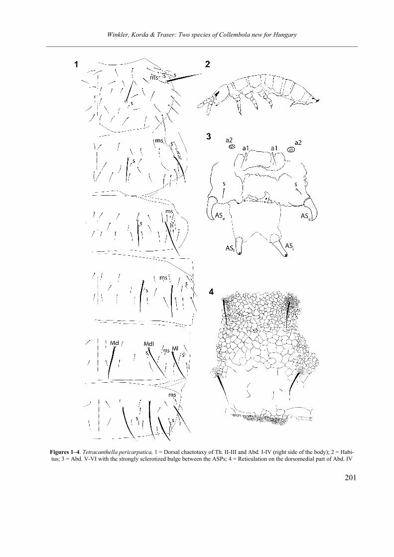
Winkler, Korda & Traser: Two species of Collembola new for Hungary
201
Figures 1–4. Tetracanthella pericarpatica, 1 = Dorsal chaetotaxy of Th. II-III and Abd. I-IV (right side of the body); 2 = Habi-tus; 3 = Abd. V-VI with the strongly sclerotized bulge between the ASPs; 4 = Reticulation on the dorsomedial part of Abd. IV

Winkler, Korda & Traser: Two species of Collembola new for Hungary
202
Xenylla uniseta Da Gama, 1963
(Figures 5–11, Table 3)
Material examined. The species was collected on the Tétényi Plateau, Budapest, Hungary, 47° 25'46.02"N, 18°58'21.58"E, 207m above sea le-vel, on 24 October 2009, 14 and 30 May 2011 (leg. M. Korda). A total of 115 included a number of first instar specimens. In both cases soil cores were extracted. The specimens are stored at the Institute of Sylviculture and Forest Protection, University of West Hungary.
X. uniseta was originally described from Dalmatia (Da Gama 1963) and subsequently found in Ser-bia (Loksa & Bogojević 1970), the Iberian Penin-sula (Acón 1975, Jordana et al. 1997) South-East Ukraine (Bondarenko-Borisova & Sandul 2002) and int the Transcarpathian region (Kaprus, pers. comm.). Based on the Hungarian specimens, we give details of the chaetotaxy and add new information to the data of Da Gama (1963, 1967, 1969), Loksa & Bogojević (1970), Thibaud et al. (2004) and Jordana et al. (199). Examination of numerous juvenile specimens uncovered further particulars of the first instar´s chaetotaxy in comparison with the adult stage (Table 3).
According to Da Gama (1969), X. uniseta is a species with morphological characters coded as “b, f, h1, h2, q, a4”, which applies to the adult specimens collected in Hungary. First instar juveniles show “a, b, f, h1, h2, I, j, k, l, n, o, q” dorsally, and “r, s, t, v, w, y, a2, a3, a4” ventrally.
The oligochaetous body chaetotaxy of the first instar resembles that of the corresponding stages of other Hypogastruridae (Yosii 1961, Thibaud 1970).
Ecology. Xenylla uniseta is a rare xerophilous species chiefly known from Mediterranean count-ries. The locality in Ukraine is an interglacial forest-steppe refugium (Bondarenko-Borisova & Sandul 2002). The Hungarian specimens were collected in the following dolomite-steppe meadow associations: Seselio leucospermi – Fes-tucetum pallentis, Chrysopogono – Caricetum hu-milis, Festuco pallenti – Brometum pannonici, Cleistogeni – Festucetum sucatae.
Acknowledgements – We would like to thank Igor Kap-rus for his friendly comments and the verification of our des-criptions, the financial support of the TÁMOP 4.2.1/B pro-ject, and the Organizing Committee of the 6th Hungarian Bio-diversity Day.
Table 1. Main characters of T. pericarpatica
Features Tetracanthella pericarpatica
PAO 3.5-4xs as long as nearest ocellus praelabral and sublobal hairs 2 praelabral and 4 sublobal hairs number of setae on tibiotarsi I, II, III 21, 21, 23 seta on coxa I present manubrium with 6(5)+6(7) posterior setae dens with 1+2 seate (anterior + posterior) mucro with 2 teeth retinaculum with 3 teeth, no seta smooth fields between the cuticle polygons present, sometimes absent anal spines very strong, amber color, fortification between the two
spines prominent ventromedian seta on the metasternum present (1+1)
Table 2. Proportions of T. pericarpatica
Head Thorax II Abdomen IV Leg III PAO/ dcA
dcA/ dcH
Ml/ p1
Md/ p1
p1/ GIII
Md/ p1
p3/ p1
p1/ a1
p1/ GIII
GIII/ eIII
Ed3/ GIII
d/ GIII
ASi/ GIII
3.5-4 1.88 4.4 3.3 0.55 5.3 0.9 1.1 0.5 3.1 1 1 0.96
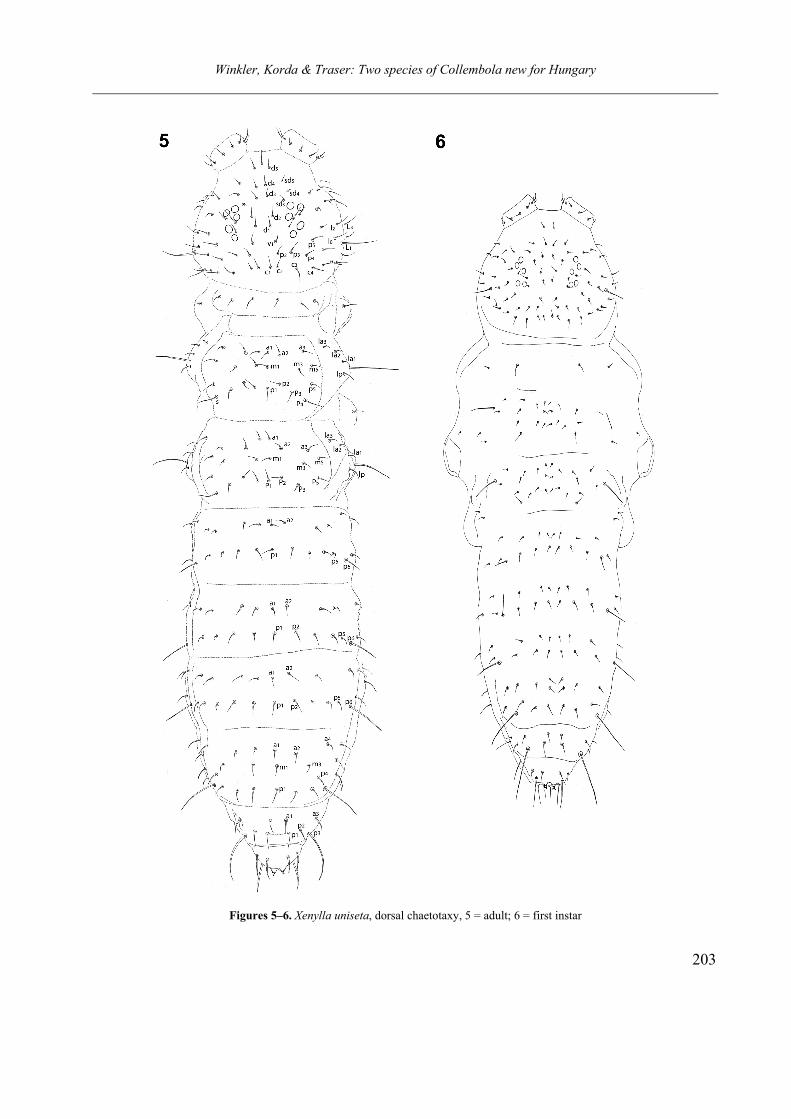
Winkler, Korda & Traser: Two species of Collembola new for Hungary
203
Figures 5–6. Xenylla uniseta, dorsal chaetotaxy, 5 = adult; 6 = first instar
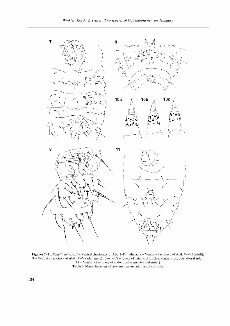
Winkler, Korda & Traser: Two species of Collembola new for Hungary
204
Figures 7–11. Xenylla uniseta, 7 = Ventral chaetotaxy of Abd. I–IV (adult); 8 = Ventral chaetotaxy of Abd. V–-VI (adult); 9 = Ventral chaetotaxy of Abd. IV–V (adult male) 10a-c = Chaetotaxy of Tita I–III (circles: ventral side, dots: dorsal side);
11 = Ventral chaetotaxy of abdominal segments (first instar) Table 3. Main characters of Xenylla uniseta, adult and first instar

Winkler, Korda & Traser: Two species of Collembola new for Hungary
205
Features Adult First instar
blunt setae on Ant. IV. present absent a0 on the head present absent praelabral/labral setae 4/554 2/444 number of labial setae 6 proximal, 5 basolateral and
4 basomedial 3 proximal, 5 basolateral and 4 basomedial
postlabial setae along ventral groove 3 2 maxillary palp with one sublobal hair with one sublobal hair number of setae on tibiotarsi 19,19,18 18,18,17 distal verticil on tibiotarsi 11 10 setae on Abd. VI. serrated (some) all smooth anal spines shape small, slightly curved bispinate ventromedial setae on Th. II. and Th. III. present absent Abd. II. ventral chaetotaxy a6 + p1-6 only one seta laterodistal setae on the VT 4+4 (in some cases more,
sometimes asymmetrical) 3+3
REFERENCES
ACÓN, M. (1975): Colémbolos de musgos corticicolas
del Valle de Hecho, Pirineo Aragonés. Graellsia, 30: 173–186.
BONDARENKO-BORISOVA, I. V. & SANDUL N.G. (2002): The Fauna of Springtails (Collembola) from the Forest Ecosystems of South-East Ukraine. Vestnik zoologii, 36(2): 11–21.
DA GAMA, M. M. (1963): Quatre espèces nouvelles de Collemboles d'Austrische et de Jugoslavie. Ar-
chives of Biological Sciences, 16(1): 43–49.
DA GAMA, M. M. (1967): Collemboles du genre Xe-
nylla trouvés dans les Iles Salomon et dans l'Ar-chipel de Bismarck. Noona Dan Papers, 39: 1–21.
DA GAMA, M. M. (1969): Notes taxonomiques et lignees genealogiques de quarante deux espèces et sous-espèces du genre Xenylla (Insecta: Collem-bola). Memorias e Estudos do Museu Zoologico da
Universidade de Coimbra, 308: 19–27.
DÁNYI L. & TRASER GY. (2008): An annotated check-list of the springtail fauna of Hungary (Hexapoda: Collembola). Opuscula Zoologica, 38: 3–82.
DEHARVENG, L. & BEDOS, A. (1997): Tetracanthella
ariegica (Collembola, Isotomidae), nouvelle espèce du Massif de l'Arize (Ariège, France). Bulletin de
la Société d'Histoire Naturelle de Toulouse, 133: 29–31.
DEHARVENG, L. (1987): Revision taxonomique du genre Tetracanthella Schött, 1891. Travaux du La-boratoire d’Ecobiologie des Arthropodes Eda-phiques, Toulouse, 5: 1–151.
JORDANA, R.; ARBEA, J. I.; SIMON, C. & LUCIAÑEZ, M. J. (1997): Collembola Poduromorpha. In Ramos, M.A. et al. (Eds.): Fauna Ibérica vol. 8. Museo Nacional de Ciencias Naturales, CSIC. Madrid. 807 pp.
KAPRUS, I. J. & TSALAN, J. V. (2009): New Collembola species from the floodplain forests of the Trans-carpathian lowland (Ukraine). Vestnik Zoologii, 43(2): 27–32.
LOKSA, I. & BOGOJEVIĆ, J. (1970) Einige interessante Collembolen-Arten aus der Sandwüste von Deliblat, Jugoslawien. Opuscula Zoologica, 10(1): 125–142.
POTAPOV, M. & DEHARVENG, L. (2005): Three new species of Tetracanthella (Collembola, Isotomidae) from Western Europe. Zoosystema, 27: 85–93.
POTAPOV, M. (2001): Synopses on Palaearctic Col-lembola: Isotomidae. Abhandlungen und Berichte des Naturkundemuseums Görlitz, 73(2): 603 pp.
THIBAUD, J. M., SCHULZ H. J. & DA GAMA, M. M. (2004): Hypogastruridae. In W. Dunger (ed.). Synopses on Palaearctic Collembola 4. pp. 7–10, 217–250.
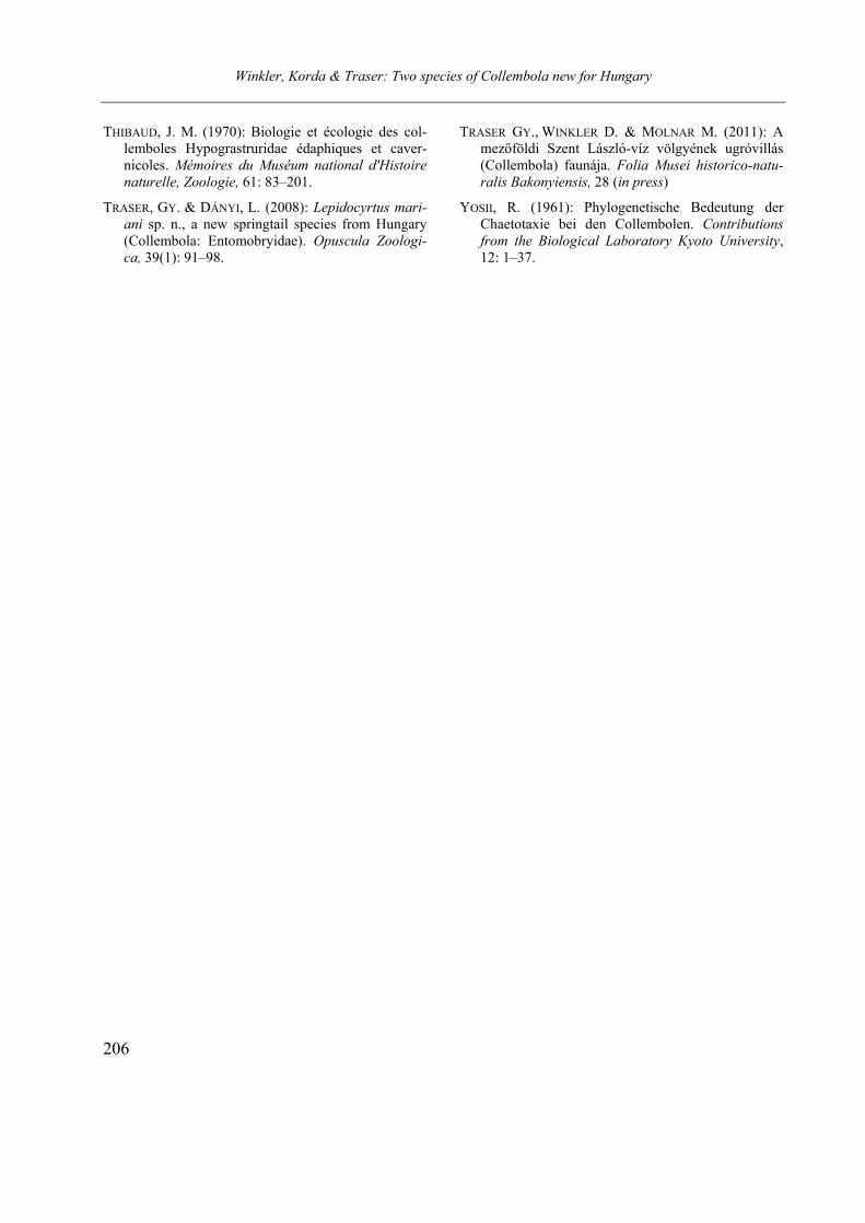
Winkler, Korda & Traser: Two species of Collembola new for Hungary
206
THIBAUD, J. M. (1970): Biologie et écologie des col-lemboles Hypograstruridae édaphiques et caver-nicoles. Mémoires du Muséum national d'Histoire
naturelle, Zoologie, 61: 83–201.
TRASER, GY. & DÁNYI, L. (2008): Lepidocyrtus mari-
ani sp. n., a new springtail species from Hungary (Collembola: Entomobryidae). Opuscula Zoologi-
ca, 39(1): 91–98.
TRASER GY., WINKLER D. & MOLNAR M. (2011): A mezőföldi Szent László-víz völgyének ugróvillás (Collembola) faunája. Folia Musei historico-natu-
ralis Bakonyiensis, 28 (in press)
YOSII, R. (1961): Phylogenetische Bedeutung der Chaetotaxie bei den Collembolen. Contributions
from the Biological Laboratory Kyoto University, 12: 1–37.
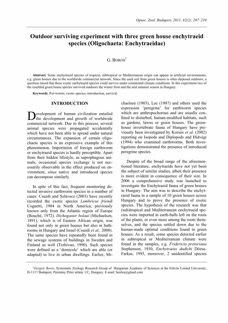
Opusc. Zool. Budapest, 2011, 42(2): 207–210
1Gergely Boros, Systematic Zoology Research Group of Hungarian Academy of Sciences at the Eötvös Loránd University, H-1117 Budapest, Pázmány Péter sétány 1/C, Hungary. E-mail: [email protected]
Outdoor surviving experiment with three green house enchytraeid
species (Oligochaeta: Enchytraeidae)
G. BOROS1
Abstract. Some enchytraeid species of tropical, subtropical or Mediterranean origin can appear in artificial environments, e.g. green houses due to the worldwide commercial network. Since the used soil from green houses is often disposed outdoors, a question raised that these exotic enchytraeid species could survive under continental climate conditions. In this experiment two of the resettled green house species survived outdoors the winter frost and the arid summer season in Hungary.
Keywords. Pot-worms, exotic species, introduction, survival.
INTRODUCTION
evelopment of human civilization entailed the development and growth of worldwide
commercial network. Due to this process, several animal species were propagated accidentally which have not been able to spread under natural circumstances. The expansion of certain oligo-chaete species is an expressive example of this phenomenon. Importation of foreign earthworm or enchytraeid species is hardly perceptible. Apart from their hidden lifestyle, as saprophagous ani-mals, occasional species exchange is not nec-essarily observable in the effect produced on en-vironment, since native and introduced species can decompose similarly.
In spite of this fact, frequent monitoring de-tected invasive earthworm species in a number of cases: Csuzdi and Szlávecz (2003) have recently recorded the exotic species Lumbricus friendi Cognetti, 1904 in North America, previously known only from the Atlantic region of Europe (Bouché, 1972). Dichogaster bolaui (Michaelsen, 1891), which is of Eastern African origin, was found not only in green houses but also in bath-rooms in Hungary and Israel (Csuzdi et al,. 2008). The same species have repeatedly been found in the sewage systems of buildings in Sweden and Finland as well (Terhivuo, 1990). Such species were defined as a ‘domicole’ which are able (or adapted) to live in urban dwellings. Earlier, Mi-
chaelsen (1903), Lee (1987) and others used the expression ‘peregrine’ for earthworm species which are anthropochorous and are usually con-fined to disturbed, human-modified habitats, such as gardens, lawns or green houses. The green-house invertebrate fauna of Hungary have pre-viously been investigated by Korsós et al. (2002) reporting on Isopods and Diplopods and Hídvégi (1994) who examined earthworms. Both inves-tigations demonstrated the presence of introduced peregrine species.
Despite of the broad range of the aforemen-
tioned literature, enchytraeids have not yet been the subject of similar studies, albeit their presence is more evident in consequence of their size. In 2006 a comprehensive study was launched to investigate the Enchytraeid fauna of green houses in Hungary. The aim was to describe the enchyt-raeid fauna in a sample of 10 green houses across Hungary and to prove the presence of exotic species. The hypothesis of the research was that (sub)tropical and Mediterranean enchytraeid spe-cies were imported in earth-balls left on the roots of the plants, or even more among the roots them-selves, and the species settled down due to the human-made optimal conditions found in green houses. As a result, some species detected earlier in subtropical or Mediterranean climate were found in the samples, e.g. Fridericia pretoriana Stephenson, 1930, Enchytraeus dudichi Dózsa-Farkas, 1995, moreover, 2 unidentified species
D
Boros: Outdoor surviving experiment with enchytraeids
208
belonging to the genus Hemienchytraeus were described (Boros and Dózsa-Farkas, 2007). A new species to science, Marionina scintillans Boros and Dózsa-Farkas, 2008 was also discovered (Bo-ros and Dózsa-Farkas, 2008). The abundance of this species was extremely high: ca. 342.000 ind./m2. This high number can be explained with the artificial circumstances, since the highest ab-undance of enchytraeids in the nature was 289.000 ind./m2 (Peachey, 1963). Since the used soil from green houses is often disposed outdoors, the question raised by this paper is whether in-troduced exotic enchytraeid species could survive under continental climate conditions, especially with that high abundance. In the course of outdoor sampling in botanical gardens, has not been found an evidence of surviving exotic populations, therefore an experiment was carried out to answer this question.
This experiment was carried out in the Bo-tanical Garden of the Eötvös Loránd University. Three species were chosen: Enchytraeus bigemi-nus Nielsen & Christensen, 1963; the above men-tioned Marionina scintillans, and a fragmenting Marionina species found in the botanical garden of Szeged University in 2009 and uniquely in the genus able to multiply by architomy. Although stable breeding cultures are sustained, no sexually matured specimens of this species are known yet. Even so, the species was considered as suited to this study due to the special asexual reproduction like that of E. bigeminus.
MATERIAL AND METHODS
The research were carried out in the Botanical
Garden of the Eötvös Loránd University. A 0.25 m2 (0.5x0.5 m) undisturbed lawn area was en-closed where lack of any gardening intervention was guaranteed. Before resettlement, qualitative samples were taken from this area to establish the present Enchytraeid species.
Individuals of the 3 species were placed in the
following numbers: 100 specimens each of En-chytraeus bigeminus and Marionina scintillans, and 40 specimens of the fragmenting Marionina
species. Breeding cultures of the fragmenting Ma-rionina sp. increase slowly, so only a small num-ber of worms were to be expended.
The reasons why these species were chosen are
1) these species were missing from the research area so the presence of the newly introduced species were traceable 2) due to reliable breeding cultures relatively high number of enchytraeids were available.
Breeding cultures were sustained in Petri-
dishes on 1% agar-agar medium with soil on top, earlier sterilized by heat-treatment. Foods were rolled oats and dried leaves of nettle (Urtica dioica). Breeding cultures were kept between 10–12 °C in refrigerator.)
Quantitative samples were taken 5 times in the
year of 2011: 2 times both in spring (09. 04. and 28. 04.) and in summer (24. 06. and 11. 07.) and once in autumn (06. 09.). Every time 5 samples were taken with a 20 cm2 surface split soil corer. Samples were 10 cm deep which means 200 cm3 volumes each.
Enchytraeids were extracted from the soil by
the wet funnel method (O’Connor, 1962) and were identified alive with a Zeiss Axioskop Imager.A2 microscope, using DIC (differential interference contrast) illumination. Voucher spe-cimens were preserved in 70% ethanol and stored in 600 µl. Eppendorf tubes.
RESULTS
Just before the resettlement (05. 04. 2010.) six
species of five genera were found in the research field:
Achaeta eiseni Vejdovský, 1878 Buchholzia appendiculata (Buchholz, 1862) Enchytraeus buchholzi Vejdovský, 1879 Enchytraeus sp. juv. Fridericia bulboides Nielsen & Christensen,
1959 Henlea ventriculosa (d’Udekem, 1854)
Boros: Outdoor surviving experiment with enchytraeids
209
It was impossible to identify specimens of En-chytraeus sp. juv. due to the lack of sexual organs. However, based on setal complements and the number of setal follicles, it was obvious that this species is identical neither with E. bigeminus nor E. buchholzi.
The following species were found in the spring samples (recollected species are represented in bold):
Buchholzia appendiculata Enchytraeus bigeminus Enchytraeus buchholzi Enchytraeus sp. juv. Fridericia bulboides Henlea ventriculosa Marionina scintillans
Two of the resettled species were present which justify their survival of the winter frost. All specimens of Marionina scintillans were adults, in some of them matured egg was observable. At the same time, individuals of the other Marionina species completely disappeared.
Species found during the summer sampling were:
Enchytraeus bigeminus Fridericia bulboides Enchytraeus buchholzi
Low numbers of individuals were present from
all the three species. In some samples there were absolutely no enchytraeids.
Species found during the autumn sampling were:
Buchholzia appendiculata Enchytraeus bigeminus Enchytraeus buchholzi Fridericia bulboides Marionina scintillans Moisture demanding Buchholzia appendicula-
ta and M. scintillans reappeared in the samples, but only in low numbers.
From the original fauna of the research field, Achaeta eiseni were not found in any samples after introduction of the 3 new species.
DISCUSSION
The number of species of the research area was relatively low compared to other lawns in the region, e.g. 5–15 species in the meadows near Tisza river, Hungary (Dózsa-Farkas et al., 2003), 7–12 species in lawn parks of Brno, Czech Re-public (Schlaghamerský and Pižl, 2009) or 6–10 species in the grasslands of Sas-hegy Nature Conservation Area, Budapest, Hungary (Boros, 2007). This low number of species was especially prominent in the dry summer season when spe-cimen numbers were also small. The periodical lack of Buchholzia appendiculata also confirms the importance of aridity in the seasonal deve-lopment of species’ abundances which is also in line with earlier findings.
In the course of the experiment two displaced
species were found outdoors. E. bigeminus is well known from compost fields, and is considered as a common species in Southern Europe (Schmelz and Collado, 2010). Now, it seems we can find it in colder continental climate as well. Expressly, an advantage is that this species can multiply asexually by fragmentation (architomy) so in-creases their populations quickly. Earlier expe-riences showed that this species can contaminate other enchytraeid breeding cultures so it can be an invasive species.
M. scintillans was so far known only from
green houses. However, this experiment proved its ability to survive outdoors as well. This species was missing from the samples in the summer but reappeared during the moist autumn. A presu-mable explanation for this behaviour is that only cocoons survived the arid period and all the worms died. Another possibility is that these worms go deeper than the sampling depth of 10 cm during the arid season.
The fragmenting Marionina species was not
found outdoors in the course of the study which possibly means the extinction of these enchyt-raeids during the harsh winter conditions. Another
Boros: Outdoor surviving experiment with enchytraeids
210
explanation could be the lower initial number of the test worms.
As it was already mentioned, Achaeta eiseni was also missing in every sample, in spite of the fact it was present in the study area before. This phenomenon should be placed under more thor-ough scrutiny in the future.
The preliminary results of the experiment herewith presented show that several green house species are able to survive outdoors under con-tinental climate. For the more reliable explanation of their behaviour and survival further expe-riments are needed with higher number of en-chytraeid species and individuals.
Acknowledgements – The author is grateful to Dr. László Orlóczy, Director of the ELTE Botanical Garden for providing an opportunity to execute this study. Many thanks are due to Márton Czirfusz (HAS Centre for Regional Studies) for correcting the English of this paper. This re-search was partly financed by the Hungarian National Sci-entific Research Foundation (OTKA K77999).
REFERENCES
BOROS, G. (2007): The enchytraeid fauna (Annelida:
Oligochaeta) of Sas-hegy Nature Conservation Area, Hungary. Opuscula Zoologica Budapest, 36: 31–35.
BOROS, G. & DÓZSA-FARKAS, K. (2007): Preliminary investigations of the enchytraeid fauna in Hungari-an greenhouses. Newsletter on Enchytraeidae No. 10, Folia Facultatis Scientiarum Naturalium Uni-versitatis Masarykianae Brunensis, Biologia, 110: 135–140.
BOROS, G. & DÓZSA-FARKAS, K. (2008): Marionina scintillans sp. n., a new enchytraeid species (Anne-lida: Oligochaeta) from Hungarian green houses. Acta Zoologica Academiae Scientiarum Hungari-cae, 54(2): 113–123.
BOUCHE, M.B. (1972): Lombriciens de France, Éco-logie et Systématique. Institut de la Resherché Ag-ronomique (Numéro hors-serie) 72(2): 1–671.
CSUZDI, CS., PAVLICEK, T. & NEVO, E. (2008): Is Dichogaster bolaui (Michaelsen, 1891) the first domicole earthworm species? European Journal of Soil Biology, 44(2): 198–201.
CSUZDI, CS. & SZLÁVECZ, K. (2003): Lumbricus friendi Cognetti, 1904 A new exotic earthworm in North America. Northeastern Naturalist, 10(1): 77–82.
DÓZSA-FARKAS, K., TÖRÖK, J., FARKAS, J., NAGY, D., CSUZDI, CS., HUFNAGEL, L. & BÍRÓ J. (2003): A Tisza-parti fauna néhány jellegzetes csoportjának (Testacea, Oligochaeta, Collembola, Heteroptera, Mammalia) vizsgálata a márciusi ökológiai ka-tasztrófára tekintettel. In: Kálmán, E. & Csanády A. (Eds.) A Tisza és környezete a 2000. évi rend-kívüli vízszennyezések után. Tanulmánykötet, Bay Z Alapítvány és a Környezetvédelmi és Vízügyi Minisztérium kiadványa, Budapest, pp. 52a–60a.
HÍDVÉGI, T. (1994) Néhány hazai botanikus kertünk és egy dísznövénykereskedő cég üvegházainak ter-resztrikus Oligochaeta faunája. Unpublished MSc thesis. Eötvös Loránd University, Budapest.
KORSÓS, Z., HORNUNG, E., SZLÁVECZ, K. & KON-TSCHÁN, J. (2002): Isopoda and Diplopoda of urban habitats: new data to the fauna of Budapest. An-nales Historico-Naturales Musei Nationalis Hun-garici, 94: 193–208.
LEE, K.E. (1987): Peregrine species of earthworms. In: A.M. Bonvicini Pagliai & P. Omodeo (Eds.) On Earthworms. Selected Symposia and Monographs, Mucchi Editore, Modena, pp. 315–327.
MICHAELSEN, W. (1903): Die geographische Verbreit-ung der Oligochaeten. Friedländer & Sohn, Berlin.
O’CONNOR, F.B. (1962): The extraction of Enchytrae-idae from soil. In: Murphy, P.W. (Ed.) Progress in Soil Zoology. Butterworths Publishing, London, pp. 279–285.
PEACHEY, J.E. (1963): Studies on Enchytraeidae (Oli-gochaeta) of mooreland soils. Pedobiologia, 2: 81–95.
SCHLAGHAMERSKỳ, J. & PIŽL, V. (2009): Enchytraeids and Earthworms (Annelida: Clitellata: Enchytrae-idae, Lumbricidae) of park sin the city of Brno, Czech Republic. Soil Organisms, 81(2): 145–173.
SCHMELZ, R.M. & COLLADO, R. (2010): A guide to European terrestrial and freshwater species of En-chytraeidae (Oligochaeta). Soil Organisms, 82(1): 1–176.
TERHIVUO, J. (1999): Dichogaster bolaui (Michaelsen) (Octochaetidae) – an allochthonous oligochaet in-vading urban sewer system. Memoranda Societatis pro Fauna et Flora Fennica, 67: 61–65.