Numerical modelling of the Laurentide Ice Sheet in the Baffin Island region: the role of a...
12
Numerical modelling of the Laurentide Ice Sheet in the Baffin Island region: the role of a Cumberland Sound ice stream Michael R. Kaplan, W. Tad Pfeffer, Christophe Sassolas, and Gifford H. Miller Abstract: A numerical model reconstruction was made of the northeastern Laurentide Ice Sheet in the Baffin Island – Foxe Basin region using geophysical, terrestrial, and marine geologic evidence for initial and boundary conditions. The simulated ice sheet consists of a Foxe Dome with additional smaller Hall and Amadjuak domes and a Penny Ice Divide. A specific objective was to determine boundary conditions that would allow advance of a marine-based low surface slope ice stream into and out of Cumberland Sound, a major marine embayment in the uplifted rim of the eastern Canadian Arctic (up to 1200 m deep), while maintaining ice free or nonsliding (e.g., cold-based) thin ice on adjacent plateaus of Cumberland Peninsula; this scenario accommodates interpretations based on terrestrial and marine studies in this region. After an initial ice-sheet configuration is placed on the eastern Arctic terrain, basal sliding is allowed in specified regions. Basal sliding below sea level and between the Foxe Dome and Cumberland Sound and a reasonable but critical initial ice sheet volume and dome surface elevation are needed to obtain advance along and out of Cumberland Sound. Rapid flow into Hudson Strait and along Cumberland Sound causes drawdown and a change in ice-sheet configuration. Although more Foxe Dome ice flows into western Hudson Strait than Cumberland Sound in the simulations, the latter may still have been an important conduit connecting the interior of the northeastern Laurentide Ice Sheet to the Labrador Sea, thereby affecting regional ice sheet dynamics, specifically ice surface elevations and flow paths. Résumé : Un modèle numérique a été élaboré pour la reconstruction de portion nord-est de l’Inlandsis laurentidien, dans la région de l’île de Baffin – bassin de Foxe, en utilisant les données de géophysique et de géologie terrestres et marines pour définir les conditions initiales et retracer les limites des glaces. La calotte glaciaire simulée est formée du dôme de Foxe, elle inclut les dômes plus petits de Hall et Amadjuak et la ligne de partage des glaces de Penny. Un objectif donné était de déterminer les conditions des limites susceptibles de permettre la progression d’un courant glaciaire, sur une pente douce en milieu marin à l’intérieur et à l’extérieur du détroit de Cumberland, une importante baie marine localisée sur la bordure soulevée de l’est de l’Arctique au Canada (profondeur jusqu’à 1200 m), et ce en maintenant libre de glace ou seulement un mince glacier fixé (ex. à base froide) sur les plateaux adjacents de la péninsule de Cumberland; un tel scénario peut satisfaire harmonieusement les interprétations fondées sur les études terrestres et marines de cette région. Après avoir placé la configuration de la calotte glaciaire initiale sur le terrain de l’Arctique oriental, on a autorisé le glissement basal dans des régions spécifiques. Ce glissement basal sous le niveau de la mer, entre le dôme de Foxe et le détroit de Cumberland, avec un volume de calotte glaciaire et une hauteur de la surface du dôme initial, raisonnables mais critiques, étaient les conditions essentielles pour mettre en mouvement une avancée glaciaire le long et à l’extérieur du détroit de Cumberland. L’écoulement rapide dans le détroit d’Hudson et le long du détroit de Cumberland se traduirait par un abaissement et un changement de la configuration de la calotte glaciaire. Bien que dans ces simulations, on a plus augmenté les écoulements glaciaires issus du dôme de Foxe dans le détroit d’Hudson que ceux dans le détroit de Cumberland, ce dernier pouvait tout de même demeurer un conduit important connectant l’intérieur de la région nord-est de l’Inlandsis laurentidien avec la mer du Labrador, et ainsi affecté la dynamique régionale de la calotte glaciaire, particulièrement les élévations de la surface et les chemins d’écoulement. [Traduit par la Rédaction] Kaplan et al. 1326 Introduction A significant problem in Quaternary science is our limited knowledge of the dynamics of the Laurentide Ice Sheet and its role in the climate system. Dynamics of the northeastern section of the ice sheet may have been especially important because of contact with the adjacent Labrador Sea and thus North Atlantic Ocean. Marine-based sections and ice streams connecting the interior of the ice sheet and the sea may have facilitated drawdown and destruction of the ice sheet, and ice sheet – ocean – atmosphere interactions may Can. J. Earth Sci. 36: 1315–1326 (1999) © 1999 NRC Canada 1315 Received May 26, 1998. Accepted March 11, 1999. M.R. Kaplan, 1 W.T. Pfeffer, and G.H. Miller. Institute of Arctic and Alpine Research (INSTAAR), and Department of Geological Sciences, Campus Box 450, Boulder, CO 80309- 0450, U.S.A. C. Sassolas. Institute of Arctic and Alpine Research (INSTAAR), Campus Box 450, Boulder, CO 80309-0450, U.S.A. 1 Corresponding author (e-mail: [email protected]).
Transcript of Numerical modelling of the Laurentide Ice Sheet in the Baffin Island region: the role of a...
Numerical modelling of the Laurentide Ice Sheetin the Baffin Island region: the role of aCumberland Sound ice stream
Michael R. Kaplan, W. Tad Pfeffer, Christophe Sassolas, and Gifford H. Miller
Abstract: A numerical model reconstruction was made of the northeastern Laurentide Ice Sheet in the Baffin Island –Foxe Basin region using geophysical, terrestrial, and marine geologic evidence for initial and boundary conditions. Thesimulated ice sheet consists of a Foxe Dome with additional smaller Hall and Amadjuak domes and a Penny IceDivide. A specific objective was to determine boundary conditions that would allow advance of a marine-based lowsurface slope ice stream into and out of Cumberland Sound, a major marine embayment in the uplifted rim of theeastern Canadian Arctic (up to 1200 m deep), while maintaining ice free or nonsliding (e.g., cold-based) thin ice onadjacent plateaus of Cumberland Peninsula; this scenario accommodates interpretations based on terrestrial and marinestudies in this region. After an initial ice-sheet configuration is placed on the eastern Arctic terrain, basal sliding isallowed in specified regions. Basal sliding below sea level and between the Foxe Dome and Cumberland Sound and areasonable but critical initial ice sheet volume and dome surface elevation are needed to obtain advance along and outof Cumberland Sound. Rapid flow into Hudson Strait and along Cumberland Sound causes drawdown and a change inice-sheet configuration. Although more Foxe Dome ice flows into western Hudson Strait than Cumberland Sound in thesimulations, the latter may still have been an important conduit connecting the interior of the northeastern LaurentideIce Sheet to the Labrador Sea, thereby affecting regional ice sheet dynamics, specifically ice surface elevations andflow paths.
Résumé : Un modèle numérique a été élaboré pour la reconstruction de portion nord-est de l’Inlandsis laurentidien,dans la région de l’île de Baffin – bassin de Foxe, en utilisant les données de géophysique et de géologie terrestres etmarines pour définir les conditions initiales et retracer les limites des glaces. La calotte glaciaire simulée est formée dudôme de Foxe, elle inclut les dômes plus petits de Hall et Amadjuak et la ligne de partage des glaces de Penny. Unobjectif donné était de déterminer les conditions des limites susceptibles de permettre la progression d’un courantglaciaire, sur une pente douce en milieu marin à l’intérieur et à l’extérieur du détroit de Cumberland, une importantebaie marine localisée sur la bordure soulevée de l’est de l’Arctique au Canada (profondeur jusqu’à 1200 m), et ce enmaintenant libre de glace ou seulement un mince glacier fixé (ex. à base froide) sur les plateaux adjacents de lapéninsule de Cumberland; un tel scénario peut satisfaire harmonieusement les interprétations fondées sur les étudesterrestres et marines de cette région. Après avoir placé la configuration de la calotte glaciaire initiale sur le terrain del’Arctique oriental, on a autorisé le glissement basal dans des régions spécifiques. Ce glissement basal sous le niveaude la mer, entre le dôme de Foxe et le détroit de Cumberland, avec un volume de calotte glaciaire et une hauteur de lasurface du dôme initial, raisonnables mais critiques, étaient les conditions essentielles pour mettre en mouvement uneavancée glaciaire le long et à l’extérieur du détroit de Cumberland. L’écoulement rapide dans le détroit d’Hudson et lelong du détroit de Cumberland se traduirait par un abaissement et un changement de la configuration de la calotteglaciaire. Bien que dans ces simulations, on a plus augmenté les écoulements glaciaires issus du dôme de Foxe dans ledétroit d’Hudson que ceux dans le détroit de Cumberland, ce dernier pouvait tout de même demeurer un conduitimportant connectant l’intérieur de la région nord-est de l’Inlandsis laurentidien avec la mer du Labrador, et ainsiaffecté la dynamique régionale de la calotte glaciaire, particulièrement les élévations de la surface et les cheminsd’écoulement.
[Traduit par la Rédaction] Kaplan et al. 1326
Introduction
A significant problem in Quaternary science is our limitedknowledge of the dynamics of the Laurentide Ice Sheet andits role in the climate system. Dynamics of the northeasternsection of the ice sheet may have been especially importantbecause of contact with the adjacent Labrador Sea and thusNorth Atlantic Ocean. Marine-based sections and icestreams connecting the interior of the ice sheet and the seamay have facilitated drawdown and destruction of the icesheet, and ice sheet – ocean – atmosphere interactions may
Can. J. Earth Sci. 36: 1315–1326 (1999) © 1999 NRC Canada
1315
Received May 26, 1998. Accepted March 11, 1999.
M.R. Kaplan,1 W.T. Pfeffer, and G.H. Miller. Institute ofArctic and Alpine Research (INSTAAR), and Department ofGeological Sciences, Campus Box 450, Boulder, CO 80309-0450, U.S.A.C. Sassolas. Institute of Arctic and Alpine Research(INSTAAR), Campus Box 450, Boulder, CO 80309-0450,U.S.A.
1Corresponding author (e-mail: [email protected]).
have affected North Atlantic Ocean characteristics and con-sequently deep-water formation. The major outlets in theeastern Canadian Arctic connecting the ice sheet to the Lab-rador Sea, in order of importance, were Hudson Strait andCumberland Sound. Several studies have focused on the im-
portance of the former (e.g., Bond et al. 1992; Andrews etal. 1993, 1996; Barber et al. 1995; Gwiazda et al. 1996,1997; Manley 1995, 1996; Marshall et al. 1996; Pfeffer et al.1997), although the latter has also received attention (Dyke1979; Dyke et al. 1982; Jennings 1993; Jennings et al. 1996;Andrews et al. 1998). In this study, a numerical model wasused to focus on the Laurentide Ice Sheet in the BaffinIsland – Foxe Basin region, including the CumberlandSound connection (Fig. 1). The purpose was twofold: (1) re-construct the northeastern Laurentide Ice Sheet for the entireBaffin Island – Foxe Basin region during the late QuaternaryPeriod, using prior geologic studies to constrain initial andboundary conditions; and (2) determine an ice configurationand boundary conditions that allow a low surface slope icestream advance into Cumberland Sound and onto the adja-cent inner shelf, and also maintain a minimal thickness ofcold-based ice on the higher plateaus of adjacent Cumber-land Peninsula. This modelling effort is designed to testwhether Laurentide Ice Sheet dynamics can be reconciledwith both terrestrial glacial geology and marine geology inthis region.
There is no modern Laurentide Ice Sheet from which in-formation can be extracted and applied to paleostates.Studies of the present and past Greenland and Antarctic icesheets are relevant for understanding Laurentide Ice Sheetdynamics. An alternative approach used to study theLaurentide Ice Sheet is numerical modelling (i.e., computersimulations), even if primarily done for heuristic studies(Oreskes et al. 1994). When addressing a specific problem,paleo-ice sheet models generally produce nonunique solu-tions because of unknown boundary conditions and poorlyunderstood processes (e.g., basal sliding). There are twoways to deal with this dilemma: (1) use geologic and geo-physical evidence to constrain initial and boundary condi-tions; in this study, boundary conditions were chosen in partso that the model would conform to geologic data, specifi-cally field observations; and (2) by applying a heuristic ap-proach, questions are carefully chosen, focus is ongeneralities and processes, and conclusions are conservative.Both approaches are used in this study.
Physical setting and Foxe glacial history of theCumberland Sound region
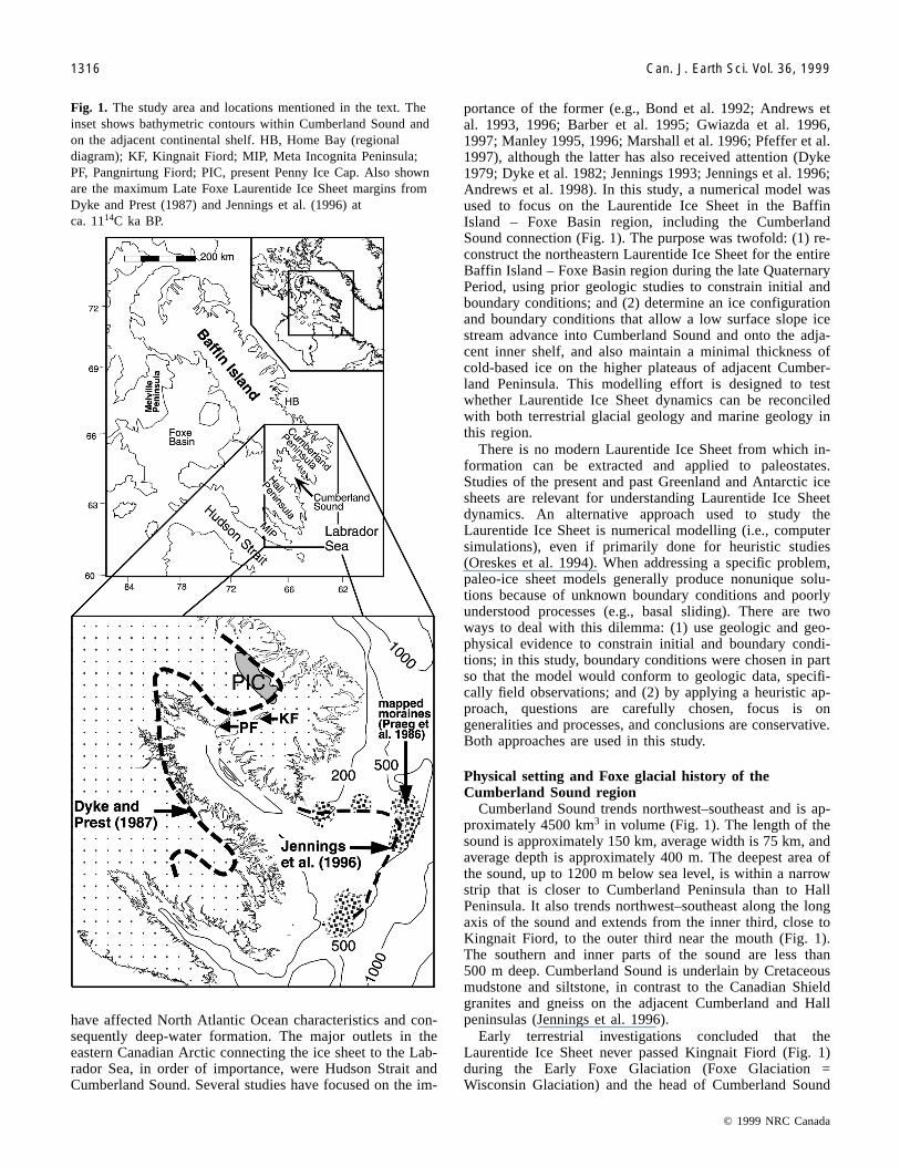
Cumberland Sound trends northwest–southeast and is ap-proximately 4500 km3 in volume (Fig. 1). The length of thesound is approximately 150 km, average width is 75 km, andaverage depth is approximately 400 m. The deepest area ofthe sound, up to 1200 m below sea level, is within a narrowstrip that is closer to Cumberland Peninsula than to HallPeninsula. It also trends northwest–southeast along the longaxis of the sound and extends from the inner third, close toKingnait Fiord, to the outer third near the mouth (Fig. 1).The southern and inner parts of the sound are less than500 m deep. Cumberland Sound is underlain by Cretaceousmudstone and siltstone, in contrast to the Canadian Shieldgranites and gneiss on the adjacent Cumberland and Hallpeninsulas (Jennings et al. 1996).
Early terrestrial investigations concluded that theLaurentide Ice Sheet never passed Kingnait Fiord (Fig. 1)during the Early Foxe Glaciation (Foxe Glaciation =Wisconsin Glaciation) and the head of Cumberland Sound
© 1999 NRC Canada
1316 Can. J. Earth Sci. Vol. 36, 1999
Fig. 1. The study area and locations mentioned in the text. Theinset shows bathymetric contours within Cumberland Sound andon the adjacent continental shelf. HB, Home Bay (regionaldiagram); KF, Kingnait Fiord; MIP, Meta Incognita Peninsula;PF, Pangnirtung Fiord; PIC, present Penny Ice Cap. Also shownare the maximum Late Foxe Laurentide Ice Sheet margins fromDyke and Prest (1987) and Jennings et al. (1996) atca. 1114C ka BP.
during the Late Foxe Glaciation (ca. 25 to 8 14C ka BP;Dyke 1979; Dyke et al. 1982). In addition, Pangnirtung andKingnait fiords on adjacent Cumberland Peninsula (Fig. 1),bordering Cumberland Sound, were mapped as ice free dur-ing the latter period (Dyke 1979; Dyke et al. 1982). Thesereconstructions were partly based on a lack of glacial depos-its with Late Foxe 14C ages, and the interpretation of soil de-velopment and relative weathering of glacial landforms (e.g.,morainal boulders) as indicating pre-Late Foxe glacial activ-ity. In addition, high plateaus on southern Cumberland Pen-insula lack evidence of recent glacial activity; surficialmaterials typically included felsenmeer (i.e., soliflucted andcryoturbated angular blocks, gruss or fines, and highlyweathered bedrock) or block fields solely composed of an-gular blocks (Dyke et al. 1982; Wolfe 1996; Kaplan et al.1997). In some areas, the occasional presence of perchedboulders and glacial erratics (i.e., different lithology fromsurrounding bedrock) indicates that at some unknown timethese higher plateau areas were covered with glacial ice(Dyke et al. 1982; Wolfe 1996). Based on a downcore studyof accelerator mass spectrometry (AMS) 14C dated lake sedi-ments adjacent to Pangnirtung Fiord, Wolfe (1994) andWolfe and Härtling (1996) concluded that some lakes athigher elevations (545, 754, and 848 m) experienced contin-uous sedimentation and thus were never occupied by gla-ciers during the Late Foxe Glaciation, agreeing with theearlier investigations of Dyke (1979) and Dyke et al. (1982).In contrast to the earlier land-based studies, Jennings (1989,1993) and Jennings et al. (1996) used marine geologic evi-dence to conclude that the Laurentide Ice Sheet advancedout of Cumberland Sound and extended onto the adjacentcontinental shelf between ca. 34 and 21 14C ka BP, and dur-ing the Late Foxe Glaciation ca. 11.0 14C ka BP (Fig. 1).Jennings (1993) also documented retreat into the inner partof the sound by 10.2 14C ka BP. Recent terrestrial investiga-tions also provide a different interpretation of Late FoxeGlaciation on southeastern Cumberland Peninsula, includingthe previously studied Pangnirtung and Kingnait fiords area.Marsella et al. (1996), Davis et al. (1996), and Kaplan et al.(1997) dated morainal boulders and bedrock surfaces in ar-eas that had been previously mapped as lacking glacialcover during the Late Foxe Glaciation, using in situ pro-duced 10Be and 26Al isotopes. Their results showed the mo-raines to be younger than previously thought and that glacierice did cover low-lying areas, such as Pangnirtung Fiord.
Ice sheet modelling
Model descriptionWe use a two-dimensional (2D) vertically integrated finite
element model (Pfeffer et al. 1997; Fastook and Chapman1989) to simulate nonlinear creeping flow of ice under grav-itational driving forces, basal sliding of ice over bedrock, ac-cumulation and ablation of ice, flotation of ice in seawater,and calving of icebergs. Bedrock and ice surface height, icesurface gradient, and column-integrated flux are given orcalculated at each nodal point in a 2D map space. Numericalsolutions in the model are obtained for the time-varying iceheight on realistic bedrock terrain. The spatially and tempo-rally varying total velocity U is
U = φUs + (1 – φ)Uf
where Us is the velocity due to basal sliding
UB
m
sb=
τ
Uf is the column-averaged deformational velocity
Un A
Hn
fb=
+
2
2τ
H is the ice thickness, and φcontrols the relative contribu-tions of flow and sliding (Fastook and Chapman 1989). Theparameter φis set or varied in accordance with observed ter-restrial geology as fully described below. In contrast to mod-els in which basal sliding is determined internally by theaction of stress equilibrium and thermal and hydrologicalprocesses, sliding is specified here externally as a functionof location by adjusting the parameter φ to zero or one. Pa-rameters n, m, and A are set to n = 3, m = 2, and A =3.0 bar·yeara, and B (bar(m·year–1)–½) (1 bar = 100 kPa) isan adjustable parameter that is set or varied in accordancewith prior modelling studies and bedrock geology, as de-scribed below. The basal shear stress is defined as τb =ρgH sin α, where ρ is the ice density, g is the gravitationalacceleration, and α is the surface slope. A continuity equa-tion is solved at each time step to determine the new ice sur-face elevation created by processes of interelement flow andsurface mass balance:
∂∂
= − ∇ht
b Q�
where b is the spatially and temporally variable mass bal-ance, Q is the individual element flux, h is the thickness, andt is the time. In water-covered areas occupied by ice, flota-tion is determined using a simple water–ice buoyancy rela-tion. Our model representation of calving employed here issummarized in Pfeffer et al. (1997) and is based on work ofReeh (1968) and Fastook and Schmidt (1982). We includecalving as an ablation term acting at elements along the per-imeter of floating ice margins. Longitudinal stress couplingis not taken into account in these simulations, in contrast tothe simulations in Pfeffer et al. (1997).
Adjustments were made to the bedrock surface to com-pensate isostatically for the initial ice-sheet configuration(time zero, t = 0) to obtain bedrock and ice surface eleva-tions more comparable to those existing during the LateFoxe Glaciation. The bed and ice surface elevations were de-pressed, while ice thickness was held constant, using a ratioof 1:3.7 (bedrock-surface depression / ice thickness). Thisratio was calculated based on an ice density of 900 kg·m–3
and an upper mantle density of 3300 kg·m–3. Because themodel is not capable of time-dependent isostatic adjustment,bedrock surface elevations were subsequently held fixedthroughout the model simulation. This approach assumesthat at t = 0 bedrock surfaces are in equilibrium with the ini-tial ice-sheet configuration, which is reasonable consideringthat geologic evidence supports a continuous Baffin Island –Foxe Dome ice complex throughout the Late Foxe Glaci-ation (e.g., Dyke and Prest 1987).
© 1999 NRC Canada
Kaplan et al. 1317
Boundary conditions for Baffin Island, Foxe Basin, andCumberland Sound
This work focused on obtaining ice sheet reconstructionsappropriate for the Late Foxe Glaciation because a main ob-jective was to accommodate various lines of geologic evi-dence concerning the glacial history of the region during thistime period. The simulated region extends from the southernshore of Hudson Strait to northern Baffin Island and fromMelville Peninsula to the Labrador Sea and Baffin Bay(Fig. 1). The bedrock topography was obtained from the5 min ETOPO5 DTM (National Oceanic and AtmosphericAdministration 1988). The spatial resolution in all simula-tions is thus 5 min or between approximately 2.5 and 7 kmdepending on the latitude. Prior geological and geophysicalstudies were used to reconstruct the initial ice-sheet configu-ration over the region. Domes and divide locations weretaken from Andrews and Miller (1979), Andrews et al.(1985), and Dyke and Prest (1987). These authors recon-structed the northeastern Laurentide Ice Sheet based on theevidence for paleo-ice flow directions such as distribution ofcarbonate erratics and striations, and pattern of isobases rep-resenting postglacial isostatic uplift. Their reconstructionsshowed a Foxe Dome centered over Foxe Basin, Hall andAmadjuak domes centered over Hall Peninsula and south-west Baffin Island, respectively, a Penny ice divide (proto-Penny ice cap) extending from the Foxe Dome to Cumber-land Peninsula, and a Meta Incognita ice divide. A Meta In-cognita ice divide was not grown for the initialconfigurations because the model’s spatial resolution wastoo coarse, and it was assumed that it would have little effecton ice dynamics in the Cumberland Sound region, which isthe focus of this study. This assumption was based on recon-structions for the Late Foxe Glaciation (Dyke and Prest1987) which suggest a Meta Incognita ice divide may havehad little or no influence on glacial events and dynamics inthe Cumberland Sound region (Manley 1996). Nonetheless,it should be noted that if it had been grown in the initial con-figurations, a Meta Incognita ice divide may have affectedthe model results for the Cumberland Sound region. Thesesimulations also contain no glacial ice in Hudson Strait,which is incorrect according to geologic evidence (e.g.,Dyke and Prest 1987; Laymon 1988).
Given the lack of glacial ice in Hudson Strait and a MetaIncognita ice divide in the initial configurations, the resultspresented here should not be considered reliable for thesouthern coastline of Baffin Island along Hudson Strait,Frobisher Bay, and Meta Incognita Peninsula. During theLate Foxe Glaciation, ice flow across southern Baffin Island(from the Foxe and Amadjuak domes and Meta Incognita icedivide) would for the most part have converged with iceflowing in Hudson Strait and Frobisher Bay (Dyke and Prest1987) or ablated after Hudson Strait was ice free approxi-mately 8 14C ka BP (Kerwin 1996). In this modelling study,ice flowing into Hudson Strait always ablates (e.g., calving).Convergence with ice in western Hudson Strait, instead ofablating, and the presence of a Meta Incognita ice dividemay have allowed more Foxe Dome ice to flow into Cum-berland Sound than shown in this study.
A major objective of the modelling effort was to deter-mine whether a low surface slope ice stream in CumberlandSound could be obtained simultaneously with thin ice cover
on adjacent Cumberland Peninsula. This configuration is in-dicated by geomorphological, lake-core, and marine-geologic studies in the region. On the northeastern side ofthe Cumberland Sound is southern Cumberland Peninsula, alandscape primarily of selective linear erosion (cf. Sugdenand John 1976) where a dominant geomorphic element,felsenmeer-covered (i.e., angular block fields along withhighly weathered bedrock) plateau, shows no evidence ofglacial erosion. When Cumberland Sound was filled withLaurentide ice, the possible configurations for thefelsenmeer-covered plateaus of the peninsula included noglacial coverage or coverage with stagnant nonerosive cold-based ice. In the simulations, we sought either ice-free con-ditions on the plateaus or coverage with relatively thin (e.g.,<250 m thick) nonsliding and thus nonerosive ice.
Initial ice-sheet configurations were “grown” by specify-ing a positive mass balance (between 0 and 1 m·year–1) overthe central locations of domes and divides until desired ice-surface elevations were achieved. Maximum ice-surface ele-vations were constrained based on studies by Peltier (1994)and Fisher et al. (1985) and include 1550–2000 m for FoxeDome and �1500 m for all other domes and divides. Slightlyhigher values were used for the Foxe Dome (�2250 m) inthe third simulation. During buildup, no basal sliding was al-lowed. This growing scheme is reasonable considering thatwe are not studying the growth of the ice sheet but insteadare reproducing specific glacial events following from an as-sumed initial geometry. Once the domes and divides weregrown, the mass-balance regime was switched to that usedsubsequently in the simulations (Fig. 2) and the ice sheetwas allowed to adjust and stabilize for approximately 500–1000 years (depending on desired initial configuration), withthe entire base not sliding. After the initial ice-sheet configu-ration is placed on the eastern Arctic terrain, basal sliding isallowed in specified regions (see below; Fig. 3) at the startof each simulation (model time t = 0). Model simulationslasted for 3000 years, unless otherwise noted.
In all simulations, a low-gradient mass-balance regimewas used for the entire ice sheet (Fig. 2). This regime repre-sents a cold, low-accumulation, low equilibrium line altitude(ELA) climate that would have been typical for the easternCanadian Arctic during glacial periods or the Younger Dryaschron (Pfeffer et al. 1997). We took the magnitude of theshifts in precipitation (e.g., decrease by twofold) and tem-perature from Alley et al. (1993) and applied them to an ele-vation distribution for the Baffin Island – Foxe Basin region(Fig. 2) constructed from observations for the modern Devonice cap (Haeberli and Hoelze 1988, 1993) and the Expedi-tion Glaciologique Internationale au Groenland line (EGIG)in West Greenland (Ohmura 1993). This mass-balance gradi-ent was used in all simulations to more clearly isolate andstudy the effects of changes in parameters such as slidingrate and initial ice-sheet configuration.
Sliding area and rate were two of our most important ad-justable parameters (in addition to initial ice-sheet configura-tion). For areas above present sea level, we used prior glacialgeologic studies to delineate where the ice slid on its bed.Designated basal sliding areas were primarily based on thelake density per unit area (Andrews et al. 1985), which wasused as a proxy for glacial erosion (Fig. 3). Basal slidingwas also allowed in areas above present sea level that con-
© 1999 NRC Canada
1318 Can. J. Earth Sci. Vol. 36, 1999
© 1999 NRC Canada
Kaplan et al. 1319
Fig. 2. Mass-balance regime used in all simulations (from Pfeffer et al. 1997).
Fig. 3. Areas where basal sliding was allowed in the simulations. MSA, maximum sliding area extent, which represents the largestdelineation of basal sliding used on land; PK, Plains of the Koudjuak. Lake density per unit area is from Andrews et al. (1985),mapped carbonate trains towards Home Bay is from Tippett (1985) and on Melville Peninsula from Dredge (1990, 1995). All areasbelow present sea level were delineated as sliding, except under the Foxe Dome for stability reasons (see text).
tain “carbonate trains” (Fig. 3) (Andrews et al. 1970; Tippett1985; Dredge 1990, 1995). Basal sliding is allowed every-where below present sea level, except the central area underthe Foxe Dome. This was done for stability reasons, as theFoxe Dome could not be maintained if sliding was allowedunder the central area. Because Cumberland Sound is under-lain by sedimentary rocks, higher sliding rates were allowedbelow –250 m to simulate deforming beds (cf. Holmlundand Fastook 1995). Values for the sliding parameter B (Us =(τb/B)m) were chosen based on those used in previous model-ling studies (Raup 1995; Pfeffer et al. 1997; Fastook andChapman 1989) and set to 0.02 bar(m·year–1)–½ above−250 m (bed elevation) and 0.01 bar(m·year–1)–½ below−250 m, or 0.01 bar(m·year–1)–½ above –250 m and0.005 bar(m·year–1)–½ below –250 m. The higher sliding ratein Cumberland Sound allows a better match between modelresults and glacial geologic constraints, as described below.In all simulations, nonsliding ice is equivalent to (or inter-preted as) cold-based or frozen conditions.
Relative sea level (combining isostatic and eustatic ef-fects) cannot be adjusted accordingly (spatially and tempo-rally) for all of the simulated region, even if all of the valueswere known or estimated. Field measurements at the mouthof Cumberland Sound indicate a relative sea level duringdeglaciation of about 25 m above present sea level (Kaplanet al. 1997). Eustatic sea level is held fixed at 0 m abovepresent because the model is not yet capable of allowingtime-dependent eustatic change, which would have occurredduring the Late Foxe Glaciation. Because the duration of thesimulations (3000 years) is shorter than the typical timescale of equilibrated depression for this region(ca. 8000 years; J. Wahr, personal communication, 1996),and in light of the modelling objectives and conclusionsdrawn, we assume that errors arising from the assumption offixed depression and eustasy are not significant. Two effectsof a fixed isostatic depression are (1) ice-surface elevationsthat are lower or higher compared with the results obtainedif bedrock depression varied throughout the simulation ac-cording to ice thickness changes; and (2) advance of ice intoareas not ice covered initially, such as Cumberland Sound,will not cause subsequent isostatic adjustment.
Model simulations were repeated with 25, 3, and 0.5 yeartime-step increments to observe whether the time step cho-sen affected model results, specifically ice velocities. Also,the time step 0.5 years was chosen so as not to violate theCourant–Friedrichs–Lewy (CFL) stability criterion (Press etal. 1992), given that the spatial resolution is about 2.5–7 kmand maximum velocities obtained are 4 km·year–1. In detail,simulations repeated with different time steps show minordifferences in areas where basal sliding is allowed, espe-cially for the first 300 years. For example, it was noted thatfor the first 300 years changing the time step from 25 to3 years can cause noticeably different results in areas whereice velocities are >1 km·year–1, specifically near the margin.After the first 300 years, in an area that is sliding, surface el-evations and velocities may differ by up to approximately20% with different time steps. Although changing the timestep can cause minor differences, as presented in this paper,the results and interpretations are not affected. Simulationswith a 25 year time step are presented.
Modelling results
The rationale for the chosen modelling experiments is asfollows. The first simulation is presented mainly to show anice-sheet configuration that fails to produce an advance intoCumberland Sound, because either the ice surface elevationsare not high enough or total ice volume is too small. Thesecond and third simulations are presented to show that thereis a nonunique solution for producing modelling resultscompatible with geologic observations, specifically an ad-vance of an ice stream into Cumberland Sound.
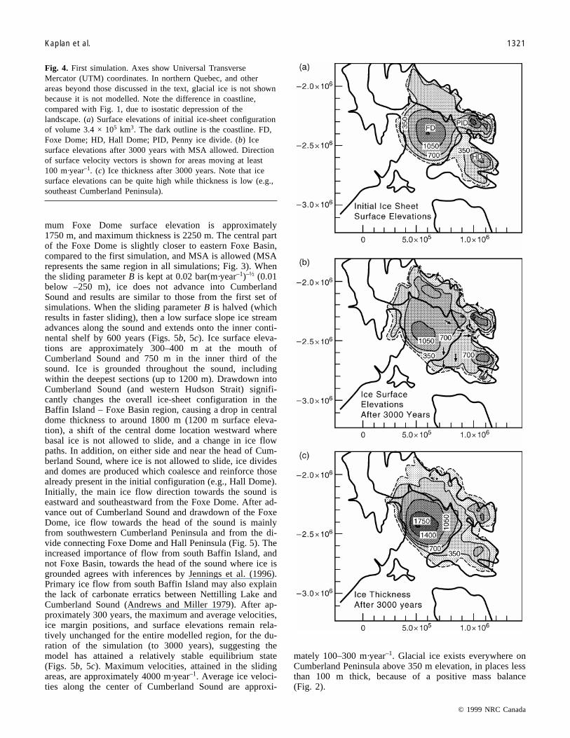
First set of simulationsThe volume of the initial ice-sheet configuration is ap-
proximately 3.4 × 10⁵ km3, maximum surface elevation ofthe Foxe Dome is approximately 1250 m, and central-domethickness is 1950 m (Fig. 4a). Initially, several simulationswere carried out to obtain a better match between modellingresults and terrestrial geologic constraints for Baffin Island(e.g., Dyke and Prest 1987; Andrews et al. 1985) and clearlyascertain the sensitivity of the ice sheet to changes in the ar-eal extent of sliding. In these initial simulations the amountof sliding area above sea level was increased incrementally.First, basal sliding was allowed only over areas that pres-ently contain >30% lake density, then over areas that contain>15% lake density (i.e., a greater area), and finally over ar-eas with >15% lake density and also over western Baffin Is-land, which is covered by marine sediments (Plains of theKoudjuak) (Fig. 3). The maximum sliding area (MSA) delin-eated (Fig. 3) allows ice to slide over most of present cen-tral, southern, and western Baffin Island. Basal sliding is notallowed over all other land areas, which included most ofcentral Baffin Island and Cumberland Peninsula. When slid-ing is allowed in designated areas (model time t = 0) the gla-cial response is immediate (<100 years). Ice divides anddomes are created in areas where basal sliding is not al-lowed, such as along central Baffin Island, and ice streamsare created where sliding is allowed. As expected, thesteeper surface slopes and consistently higher velocities typi-cally occur on eastern Baffin Island where relief is highest(Fig. 4b). Flow from Foxe Basin towards Home Bay andacross Melville Peninsula only occurs if sliding in these ar-eas is allowed, which supports field-based interpretations(Tippett 1985; Dredge 1995). Unexpectedly, flow from FoxeBasin and flow from much of central Baffin Island convergeto form a southeastward-flowing ice stream over the westernpart of the island (Fig. 4). This is in conflict with other re-constructions (e.g., Dyke and Prest 1987; Andrews et al.1985) that showed flow from the Foxe Dome towards BaffinBay. Even with MSA delineated, this initial ice-sheet config-uration does not provide enough ice flux to allow the marginto advance past the inner third of Cumberland Sound. Thesimulated margin maintains an equilibrium position at thehead of the sound (Fig. 4b), approximately 50 km beyondthe ice margin position mapped by Dyke et al. (1982) andDyke and Prest (1987) at 8000 years ago.
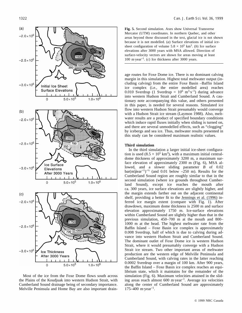
Second simulationThe volume of the initial ice-sheet configuration in this
simulation (Fig. 5a) is approximately 5.7 × 10⁵ km3, maxi-
© 1999 NRC Canada
1320 Can. J. Earth Sci. Vol. 36, 1999
mum Foxe Dome surface elevation is approximately1750 m, and maximum thickness is 2250 m. The central partof the Foxe Dome is slightly closer to eastern Foxe Basin,compared to the first simulation, and MSA is allowed (MSArepresents the same region in all simulations; Fig. 3). Whenthe sliding parameter B is kept at 0.02 bar(m·year–1)–½ (0.01below –250 m), ice does not advance into CumberlandSound and results are similar to those from the first set ofsimulations. When the sliding parameter B is halved (whichresults in faster sliding), then a low surface slope ice streamadvances along the sound and extends onto the inner conti-nental shelf by 600 years (Figs. 5b, 5c). Ice surface eleva-tions are approximately 300–400 m at the mouth ofCumberland Sound and 750 m in the inner third of thesound. Ice is grounded throughout the sound, includingwithin the deepest sections (up to 1200 m). Drawdown intoCumberland Sound (and western Hudson Strait) signifi-cantly changes the overall ice-sheet configuration in theBaffin Island – Foxe Basin region, causing a drop in centraldome thickness to around 1800 m (1200 m surface eleva-tion), a shift of the central dome location westward wherebasal ice is not allowed to slide, and a change in ice flowpaths. In addition, on either side and near the head of Cum-berland Sound, where ice is not allowed to slide, ice dividesand domes are produced which coalesce and reinforce thosealready present in the initial configuration (e.g., Hall Dome).Initially, the main ice flow direction towards the sound iseastward and southeastward from the Foxe Dome. After ad-vance out of Cumberland Sound and drawdown of the FoxeDome, ice flow towards the head of the sound is mainlyfrom southwestern Cumberland Peninsula and from the di-vide connecting Foxe Dome and Hall Peninsula (Fig. 5). Theincreased importance of flow from south Baffin Island, andnot Foxe Basin, towards the head of the sound where ice isgrounded agrees with inferences by Jennings et al. (1996).Primary ice flow from south Baffin Island may also explainthe lack of carbonate erratics between Nettilling Lake andCumberland Sound (Andrews and Miller 1979). After ap-proximately 300 years, the maximum and average velocities,ice margin positions, and surface elevations remain rela-tively unchanged for the entire modelled region, for the du-ration of the simulation (to 3000 years), suggesting themodel has attained a relatively stable equilibrium state(Figs. 5b, 5c). Maximum velocities, attained in the slidingareas, are approximately 4000 m·year–1. Average ice veloci-ties along the center of Cumberland Sound are approxi-
mately 100–300 m·year–1. Glacial ice exists everywhere onCumberland Peninsula above 350 m elevation, in places lessthan 100 m thick, because of a positive mass balance(Fig. 2).
© 1999 NRC Canada
Kaplan et al. 1321
Fig. 4. First simulation. Axes show Universal TransverseMercator (UTM) coordinates. In northern Quebec, and otherareas beyond those discussed in the text, glacial ice is not shownbecause it is not modelled. Note the difference in coastline,compared with Fig. 1, due to isostatic depression of thelandscape. (a) Surface elevations of initial ice-sheet configurationof volume 3.4 × 10⁵ km3. The dark outline is the coastline. FD,Foxe Dome; HD, Hall Dome; PID, Penny ice divide. (b) Icesurface elevations after 3000 years with MSA allowed. Directionof surface velocity vectors is shown for areas moving at least100 m·year–1. (c) Ice thickness after 3000 years. Note that icesurface elevations can be quite high while thickness is low (e.g.,southeast Cumberland Peninsula).
Most of the ice from the Foxe Dome flows south acrossthe Plains of the Koudjuak into western Hudson Strait, withCumberland Sound drainage being of secondary importance.Melville Peninsula and Home Bay are also important drain-
age routes for Foxe Dome ice. There is no dominant calvingmargin in this simulation. Highest total meltwater output (in-cluding calving) from the entire Foxe Basin –Baffin Islandice complex (i.e., the entire modelled area) reaches0.010 Sverdrup (1 Sverdrup = 106 m3·s–1) during advanceinto western Hudson Strait and Cumberland Sound. A cau-tionary note accompanying this value, and others presentedin this paper, is needed for several reasons. Simulated iceflow into western Hudson Strait presumably would convergewith a Hudson Strait ice stream (Laymon 1988). Also, melt-water results are a product of specified boundary conditionswhich induce rapid fluxes initially when sliding is turned on,and there are several unmodelled effects, such as “clogging”by icebergs and sea ice. Thus, meltwater results presented inthis study can be considered maximum realistic values.
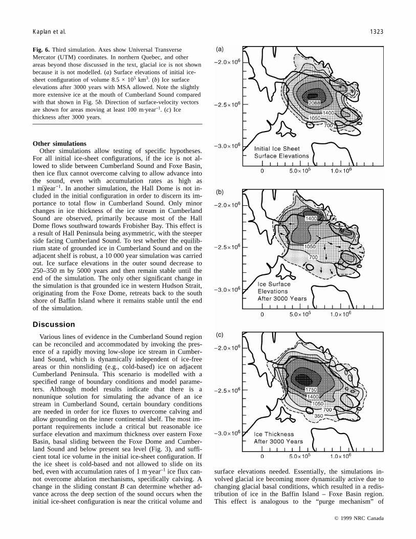
Third simulationIn the third simulation a larger initial ice-sheet configura-
tion is used (8.5 × 10⁵ km3), with a maximum initial central-dome thickness of approximately 3200 m, a maximum sur-face elevation of approximately 2300 m (Fig. 6), MSA al-lowed, and a slower sliding parameter B of 0.02bar m year( ⋅ −1)–½ (and 0.01 below –250 m). Results for theCumberland Sound region are roughly similar to that in thesecond simulation (where ice grounds throughout Cumber-land Sound), except ice reaches the mouth afterca. 300 years, ice surface elevations are slightly higher, andthe margin extends farther out on the adjacent continentalshelf, providing a better fit to the Jennings et al. (1996) in-ferred ice margin extent (compare with Fig. 1). Afterdrawdown, maximum dome thickness is 2500 m and surfaceelevation approximately 1750 m. Ice-surface elevationswithin Cumberland Sound are slightly higher than that in theprevious simulation, 450–700 m at the mouth and 800–1000 m at the head. The highest meltwater rate from theBaffin Island – Foxe Basin ice complex is approximately0.008 Sverdrup, half of which is due to calving during ad-vance into western Hudson Strait and Cumberland Sound.The dominant outlet of Foxe Dome ice is western HudsonStrait, where it would presumably converge with a HudsonStrait ice stream. Two other important areas of meltwaterproduction are the western edge of Melville Peninsula andCumberland Sound, with calving rates in the latter reaching0.0002 Sverdrup over a margin of 100 km. After 900 years,the Baffin Island – Foxe Basin ice complex reaches an equi-librium state, which it maintains for the remainder of thesimulation (Fig. 6). Maximum velocities attained in the slid-ing areas reach almost 600 m·year–1. Average ice velocitiesalong the center of Cumberland Sound are approximately175–400 m·year–1.
© 1999 NRC Canada
1322 Can. J. Earth Sci. Vol. 36, 1999
Fig. 5. Second simulation. Axes show Universal TransverseMercator (UTM) coordinates. In northern Quebec, and otherareas beyond those discussed in the text, glacial ice is not shownbecause it is not modelled. (a) Surface elevations of initial ice-sheet configuration of volume 5.8 × 10⁵ km3. (b) Ice surfaceelevations after 3000 years with MSA allowed. Direction ofsurface-velocity vectors are shown for areas moving at least100 m·year–1. (c) Ice thickness after 3000 years.
Other simulationsOther simulations allow testing of specific hypotheses.
For all initial ice-sheet configurations, if the ice is not al-lowed to slide between Cumberland Sound and Foxe Basin,then ice flux cannot overcome calving to allow advance intothe sound, even with accumulation rates as high as1 1m year⋅ − . In another simulation, the Hall Dome is not in-cluded in the initial configuration in order to discern its im-portance to total flow in Cumberland Sound. Only minorchanges in ice thickness of the ice stream in CumberlandSound are observed, primarily because most of the HallDome flows southward towards Frobisher Bay. This effect isa result of Hall Peninsula being asymmetric, with the steeperside facing Cumberland Sound. To test whether the equilib-rium state of grounded ice in Cumberland Sound and on theadjacent shelf is robust, a 10 000 year simulation was carriedout. Ice surface elevations in the outer sound decrease to250–350 m by 5000 years and then remain stable until theend of the simulation. The only other significant change inthe simulation is that grounded ice in western Hudson Strait,originating from the Foxe Dome, retreats back to the southshore of Baffin Island where it remains stable until the endof the simulation.
Discussion
Various lines of evidence in the Cumberland Sound regioncan be reconciled and accommodated by invoking the pres-ence of a rapidly moving low-slope ice stream in Cumber-land Sound, which is dynamically independent of ice-freeareas or thin nonsliding (e.g., cold-based) ice on adjacentCumberland Peninsula. This scenario is modelled with aspecified range of boundary conditions and model parame-ters. Although model results indicate that there is anonunique solution for simulating the advance of an icestream in Cumberland Sound, certain boundary conditionsare needed in order for ice fluxes to overcome calving andallow grounding on the inner continental shelf. The most im-portant requirements include a critical but reasonable icesurface elevation and maximum thickness over eastern FoxeBasin, basal sliding between the Foxe Dome and Cumber-land Sound and below present sea level (Fig. 3), and suffi-cient total ice volume in the initial ice-sheet configuration. Ifthe ice sheet is cold-based and not allowed to slide on itsbed, even with accumulation rates of 1 m·year–1 ice flux can-not overcome ablation mechanisms, specifically calving. Achange in the sliding constant B can determine whether ad-vance across the deep section of the sound occurs when theinitial ice-sheet configuration is near the critical volume and
surface elevations needed. Essentially, the simulations in-volved glacial ice becoming more dynamically active due tochanging glacial basal conditions, which resulted in a redis-tribution of ice in the Baffin Island – Foxe Basin region.This effect is analogous to the “purge mechanism” of
© 1999 NRC Canada
Kaplan et al. 1323
Fig. 6. Third simulation. Axes show Universal TransverseMercator (UTM) coordinates. In northern Quebec, and otherareas beyond those discussed in the text, glacial ice is not shownbecause it is not modelled. (a) Surface elevations of initial ice-sheet configuration of volume 8.5 × 10⁵ km3. (b) Ice surfaceelevations after 3000 years with MSA allowed. Note the slightlymore extensive ice at the mouth of Cumberland Sound comparedwith that shown in Fig. 5b. Direction of surface-velocity vectorsare shown for areas moving at least 100 m·year–1. (c) Icethickness after 3000 years.
MacAyeal (1993). Initial Foxe Dome elevations in the simu-lations are compatible (e.g., 1750 m) with those from themodelled ICE-4G last glacial maximum (LGM) reconstruc-tion as shown in Peltier (1994), indicating that reasonableice sheet geometry and configuration are being used tomodel the dynamics of the Cumberland Sound ice stream.Total ice sheet volume in all simulations is always less than5% of all estimates for the entire Laurentide Ice Sheet at theLGM (e.g., Hughes et al. 1981; Clark et al. 1996).
Given the necessary boundary conditions, the topographiclow of Cumberland Sound provides an ideal location for thepresence of a low surface slope ice stream extending out tothe continental shelf. Surface slopes of the ice stream are al-ways comparable to that of present West Antarctic icestreams (e.g., approx. 0.14–0.29° or an elevational change ofapprox. 500–1000 m over 200 km; cf. Bentley 1987). Criti-cal surface elevations are needed for advance, but not formaintaining the stable ice margin position on the inner shelfadjacent to the sound. The ice margin can maintain a rela-tively stable position despite the fact that dome surface ele-vations are lower, and ice flux subsequently comes mainlyfrom Hall Peninsula – south Baffin Island and not the FoxeDome, which is thinner and farther away. The sill at themouth of the sound and the broad shallow adjacent innershelf (200–500 m) probably act to stabilize the groundingline and thus the calving rate is reduced. Thus, after ad-vance, smaller ice influxes from around Cumberland Soundand a positive mass balance in the region can maintain a sta-ble ice margin.
The simulated reconstruction for Cumberland Peninsulaand Cumberland Sound accommodates various conclusions,reached by different studies, regarding their recent glacialhistory. According to the ICE-4G reconstruction (Peltier1994), surface elevations over Foxe Basin – Baffin Islandwere decreasing between 20 and 10 ka BP. By 10 ka BP,ICE-4G maximum reconstructed ice surface elevations overFoxe Basin were reduced considerably to approximately1200 m. Our findings indicate approximately 1750 m surfaceelevation of the Foxe Dome was needed to allow advanceacross the deepest part of the sound. Jennings (1993) andJennings et al. (1996) concluded that ice remained groundedon the continental shelf until 11 14C ka BP and then subse-quently retreated into the sound by 10.2 14C ka BP. To ac-commodate the ICE-4G decreasing Foxe Dome surfaceelevations between 20 and 10 ka BP, and the 11 14C ka BPice margin of Jennings et al. (1996), we infer that ice ad-vance across the deep section of Cumberland Sound had tooccur much earlier than 11 14C ka BP when Foxe Dome sur-face elevations were still considerable higher. Model find-ings indicate that the ice stream margin then could haveremained within the sound (occasionally advancing onto theshelf) between approximately 20 and 10.2 ka BP supportedto a large extent by nearby ice divides on Hall Peninsula andCumberland Peninsula, with much lower Foxe Dome surfaceelevations; this scenario also accommodates the temporalchange in ICE-4G Foxe Dome surface elevations. Modelledice surface elevations along Cumberland Peninsula shown inFig. 5 (second simulation) are closer, compared with thoseshown in Fig. 6 (third simulation), to the lower elevation ofthe glacially unmodified plateaus (Wolfe 1996; Kaplan et al.1997), which are approximately 300 m at the mouth of the
sound. With the higher initial ice sheet volume and domesurface elevation shown in Fig. 6, modelled ice surface ele-vations along Cumberland Peninsula are slightly higher thanthe lower elevations of the glacially unmodified landscape.On the other hand, the maximum ice margin extent past themouth shown in Fig. 6 agrees more closely, compared tothat in Fig. 5, with the inferred limit of Jennings et al.(1996) (Fig. 1). Simulated grounded ice in front of Cumber-land Sound is still slightly less extensive compared to thatmapped by Jennings et al. (1996) (Fig. 1). However, their in-ferred limits were based on undated moraines originallymapped by Praeg et al. (1986) which may represent morethen one advance of a grounding line. In addition, manyvariables are not tested in the simulations, such as loweredrelative sea level beyond Cumberland Sound, and stability ofa grounding line due to moraine accumulation. In summary,in light of model imperfections and untested effects, we feelthe model results compare reasonably well with the conclu-sions reached by both marine and recent terrestrial studies.
Modelled results also accommodate the field-based inter-pretation (Dyke et al. 1982; Kaplan et al. 1997) that southernCumberland Peninsula is a landscape primarily of selectivelinear erosion (Sugden and John 1976). Warm-based erosiveice would have been channelled in the low-lying areas, whileintervening plateaus remained glacially unmodified. Thesimulated Cumberland Sound ice stream is dynamically in-dependent of locally formed nonsliding (i.e., cold-based) iceon Cumberland Peninsula. Thin nonsliding ice or ice-free ar-eas on the upland plateaus could have resulted in this land-scape remaining unmodified by glacial erosion and in somelakes experiencing sedimentation during the Late Foxe Gla-ciation (Dyke et al. 1982; Wolfe 1994, 1996; Marsella et al.1996). In all simulations, areas above 350 m are in a positivemass-balance regime (Fig. 2). Given the constraint of thisboundary condition in the simulations, it is reasonable to ex-pect that in reality, during the Late Foxe Glaciation, someplateau areas may actually have had a negative mass balanceand remained ice free due to other unmodelled factors suchas high winds and (or) low precipitation (cf. Dry Valleys inthe Transantarctic Mountains).
During the Late Foxe Glaciation, major discharge routesfor Foxe Dome ice would have been western Hudson Straitand Cumberland Sound. Because Foxe Dome ice would haveconverged with glacial ice in western Hudson Strait (seeDyke and Prest 1987), Cumberland Sound may have beenthe most direct connection between the Foxe Dome and theLabrador Sea. Thus, Cumberland Sound may have been animportant ice-drainage route for the northeastern LaurentideIce Sheet, and may have affected its dynamics by causingdrawdown and influencing the overall configuration and thusice flow paths. Advance into and out of Cumberland Soundmay have facilitated destruction of this section of the icesheet. Simulated freshwater contributions from the Cumber-land Sound ice stream are insignificant compared with theproposed minimum values needed to affect deep-water for-mation in the North Atlantic ocean (e.g., 0.06 Sverdrup,Rahmstorf 1994; Manabe and Stouffer 1995), and modernatmospheric freshwater fluxes into the high-latitude NorthAtlantic region (e.g., 0.31 Sverdrup, Baumgartner andReichel 1975). Although the simulations failed to producesignificant iceberg discharge from Cumberland Sound, this
© 1999 NRC Canada
1324 Can. J. Earth Sci. Vol. 36, 1999
may be a result of our formulation of calving, and the resultsmay have underestimated the importance of the sound intransferring fresh water from land to sea. Taken at facevalue, these findings indicate that the glaciologic role ofCumberland Sound would have been more important interms of drainage and drawdown, possibly affecting atmo-spheric dynamics (Shinn and Barron 1989), than directly af-fecting ocean salinity and circulation by adding a freshwaterflux.
Conclusions
A finite element model has been used to show that variousLate Foxe glacial reconstructions for the Cumberland Soundregion, eastern Canadian Arctic, can be reconciled and ac-commodated by invoking the presence of a rapidly movinglow-slope ice stream in Cumberland Sound which is dynam-ically independent of ice free areas or thin nonsliding (e.g.,cold-based) ice on adjacent Cumberland Peninsula. Modelresults indicate that an extensive marine-based low-slope icestream in Cumberland Sound is possible given a critical butreasonable ice surface elevation over eastern Foxe Basin andbasal sliding in key areas, specifically between the FoxeDome and the mouth of the sound. In the simulations, icesurface elevations of at least 1750 m over eastern Foxe Basinare needed for ice fluxes to overcome ablation mechanisms,such as calving, and allowing ice to advance across the deepsection of Cumberland Sound and ground on the inner conti-nental shelf. In contrast, once an ice margin is grounded ator past the mouth of the sound, lower Foxe Dome ice surfaceelevations (maximum surface elevations of 1000–1200 m)are needed to maintain a relatively stable ice stream. In addi-tion, for the Foxe Dome to exist, a nonsliding core is re-quired. This work highlights the glaciologic roleCumberland Sound may have played in ice sheet – ocean in-teraction during glaciations; specifically, the sound facili-tated drawdown and possible destruction of this section ofthe Laurentide Ice Sheet, and affected the ice-sheet configu-ration, including ice surface elevations and flow paths.
Acknowledgments
This work was supported by National Science Foundationgrant EAR-9510063. We thank Jeremiah Dwyer, BruceRaup, Mark Dyugerov, John Andrews, Anne Jennings, Wil-liam Manley, Donald Barber, Scott Lehman, AlexanderWolfe, Eric Steig, John Wahr, James Fastook, Nick Hulton,and anonymous reviewers.
References
Alley, R.B., Meese, D.A., Shuman, C.A., et al. 1993. Abrupt in-crease in Greenland snow accumulation at the end of the Youn-ger Dryas event. Nature (London), 362: 527–529.
Andrews, J.T., and Miller, G.H. 1979. Glacial erosion and ice sheetdivides, northeastern Laurentide Ice Sheet, on the basis of thedistribution of limestone. Geology, 7: 592–596.
Andrews, J.T., Buckley, J.T., and England, J.H. 1970. Late-glacialchronology and glacio-isostatic recovery, Home Bay, east BaffinIsland, Canada. Geological Society of America Bulletin, 81:1123–1148.
Andrews, J.T., Clark P.U., and Stravers, J.A. 1985. The patterns ofglacial erosion across them Eastern Canadian Arctic. In Quater-nary environments: Baffin Island, Baffin Bay, and West Green-land. Edited by J.T. Andrews. Allen & Unwin, Winchester,Mass., pp. 69–92.
Andrews, J.T., Tedesco, K., and Jennings, A.K. 1993. Heinrichevents: chronology and processes, east central Laurentide IceSheet and NW Labrador Sea. In Ice in the climate system.Edited by W.R. Peltier. Springer-Verlag, New York, pp. 167–186.
Andrews, J.T., Jennings, A.E., Kerwin, M., Kirby, M., Manley, W.,and Miller, G.H. 1996. Heinrich-like event, H-0 (DC-0):source(s) for detrital carbonate in the North Atlantic during theYounger Dryas chronozone. Paleoceanography, 10: 943–952.
Andrews, J.T., Kirby, M., Jennings, A.E., and Barber, D.C. 1998.Late Quaternary stratigraphy, chronology, and depositional pro-cesses on the slope of S.E. Baffin Island, detrital carbonate andHeinrich events: implications for onshore glacial history.Géographie physique et Quaternaire, 52: 91–105.
Barber, D.C., Farmer, G.L., Andrews, J.T., et al. 1995. Mineralogicand isotopic tracers in late Quaternary sediments in the Labra-dor Sea: implications for iceberg sources during Heinrichevents. EOS Transactions, 76: F296.
Baumgartner, A., and Reichel, E. 1975. The world water balance:mean annual global, continental and marine precipitation, evap-oration, and run off. Elsevier Scientific Publishing Company,Amsterdam.
Bentley, C.R. 1987. Antarctic ice streams: a review. Journal ofGeophysical Research, 92: 8843–8858.
Bond, G., Heinrich, H., Broecker, W., et al. 1992. Evidence formassive discharges of icebergs into the North Atlantic oceanduring the last glacial. Nature (London), 360: 245–249.
Clark, P.U., Licciardi, J.M., MacAyeal, D.R., and Jensen, J.W.1996. Numerical reconstruction of a soft-bedded Laurentide icesheet during the last glacial maximum. Geology, 24: 679–682.
Davis, P.T., Marsella, K.A., Bierman, P.R., and Caffee, M.W. 1996.Deglacial dynamics of Baffin Island by cosmogenic dating. Geo-logical Society of America Abstracts with Programs, 28: A434.
Dredge, L.A. 1990. The Melville Moraine: sea-level change andresponse of the western margin of the Foxe Ice Dome, MelvillePeninsula, Northwest Territories. Canadian Journal of Earth Sci-ences, 27: 1215–1224.
Dredge, L.A. 1995. Quaternary geology of northern Melville Pen-insula, District of Franklin, Northwest Territories: surface de-posits, glacial history, environmental geology, and tillgeochemistry. Geological Survey of Canada, Bulletin 484.
Dyke, A.S. 1979. Glacial and sea level history of the southwesternCumberland Peninsula, Baffin Island, N.W.T., Canada. Arcticand Alpine Research, 11: 179–202.
Dyke, A.S., and Prest, K. 1987. Late Wisconsinan and Holocenehistory of the Laurentide Ice Sheet. Géographie physique etQuatenaire, 41: 237–263
Dyke, A.S., Andrews, J.T., and Miller, G.H. 1982. Quaternary ge-ology of Cumberland Peninsula, Baffin Island, District of Frank-lin: Geological Survey of Canada, Paper 403.
Fastook, J., and Chapman, J.E. 1989. A map-plane finite elementmodel: three modelling experiments. Journal of Glaciology, 35:48–52.
Fastook, J., and Schmidt, W. 1982. Finite element analysis of calv-ing from ice fronts. Annals of Glaciology, 3: 103–106.
Fisher, D.A., Reeh, N., and Langley, K. 1985. Objective recon-structions of the Late Wisconsinan Laurentide Ice Sheet and thesignificance of deforming beds. Géographie physique etQuaternaire, 39: 229–238.
© 1999 NRC Canada
Kaplan et al. 1325
© 1999 NRC Canada
1326 Can. J. Earth Sci. Vol. 36, 1999
Gwiazda, R.H., Hemming, S.R., and Broecker, W.S. 1996. Prove-nance of icebergs during Heinrich event 3 and the contrast totheir sources during other Heinrich episodes. Paleoceanography,11: 371–378.
Gwiazda, R.H., Hemming, S.R., Broecker, W.S., Onsttot, T., andMueller, C. 1997. Evidence from 40Ar/39Ar ages for a Churchillprovince source of ice-rafted amphiboles in Heinrich layer 2.Journal of Glaciology, 42: 440–446.
Haeberli, W., and Hoelze, M. (Editors). 1988. Fluctuations of gla-ciers, 1980–1985. International Association of Hydrological Sci-ences and United Nations Environmental Program(IAHS/UNEP), World Glacier Monitoring Services, Zurich.
Haeberli, W., and Hoelze, M. (Editors). 1993. Fluctuations of gla-ciers, 1985–1990. International Association of Hydrological Sci-ences and United Nations Environmental Program(IAHS/UNEP), World Glacier Monitoring Services, Zurich.
Holmlund, P., and Fastook, J.A. 1995. Time dependentglaciological model of the Wechselian Ice Sheet. Quaternary In-ternational, 27: 53–58.
Hughes, T.J., Denton, G.H., Andersen, B.J., Schilling, D.H.,Fastook, J.L., and Lingle, C.S. 1981. The last great ice sheets: aglobal view. In The last great ice sheets. Edited by G.H. Dentonand T.J. Hughes. Wiley, New York, pp. 263–317.
Jennings, A.E. 1989. Late Quaternary history of CumberlandSound, Baffin Island, Arctic Canada. Ph.D. thesis, University ofColorado, Boulder.
Jennings, A.E. 1993. The Quaternary history of CumberlandSound, southeastern Baffin Island. The evidence. Géographiephysique et Quaternaire, 47: 21–42.
Jennings, A.E., Tedesco, K., and Andrews, J.T. 1996. Shelf erosionand glacial proximity in the Labrador Sea during and after Hein-rich events as shown by foraminifera. In Paleoceanography ofNorth Atlantic margins. Edited by J.T. Andrews, W. Austin, H.Bergsten, and A.E. Jennings. Geological Society of London,London, U.K., pp. 29–49.
Kaplan, M.R., Steig, E.J., and Pfeffer, W.T. 1997. Late Quaternaryglacial history of mid-outer Cumberland Sound, eastern Cana-dian Arctic. Geological Society of America, Abstracts with Pro-grams, 29: A117.
Kerwin, M.W. 1996. A regional stratigraphic isochron (ca.8000 14C yr B.P.) from final deglaciation of Hudson Strait. Qua-ternary Research, 46: 89–98.
Laymon, C.A. 1988. Glacial geology of western Hudson Strait,Canada, with reference to Laurentide Ice Sheet dynamics. Ph.D.thesis, University of Colorado, Boulder.
MacAyeal, D.R. 1993. Binge/purge oscillations of the LaurentideIce Sheet as a cause of the North Atlantic’s Heinrich events.Paleoceanography, 8: 775–784.
Manabe, S., and Stouffer, R.J. 1995. Simulation of abrupt climatechange induced by freshwater input to the North Atlantic Ocean.Nature (London), 378: 165–167.
Manley, W.F. 1995. Late-glacial record of ice sheet/ocean interac-tions, Hudson Strait and southern Baffin Island, eastern Cana-dian Arctic. Ph.D. thesis, University of Colorado, Boulder.
Manley, W.F. 1996. Late-glacial flow patterns, deglaciation, andpostglacial emergence of south-central Baffin Island and north-central coast of Hudson Strait, eastern Canadian Arctic. Cana-dian Journal of Earth Sciences, 33: 1499–1510.
Marsella, K.A., Bierman, P.R., Davis, P.T., and Caffee, M.W. 1996.Stage II “Big ice” on Baffin Island. Geological Society of Amer-ica, Abstracts with Programs, 28: A433.
Marshall, S.J., Clarke, G.C., Dyke, A.S., and Fisher, D.A. 1996.Geologic and topographic controls of fast flow in the Laurentideand Cordilleran ice sheets. Journal of Geophysical Research,101: 17 827 – 17 839.
NOAA. 1988. Data announcement 88-MGG-02: digital relief ofthe surface of the earth. National Oceanic and Atmospheric Ad-ministration, National Geophysical Data Center, Boulder Colo.
Ohmura, A. 1993. ETH Greenland Ice Sheet Program; an over-view. In Mass balance and related topics of the Greenland IceSheet. Edited by N. Reeh and H. Oerter. Open File Series 93/5,ETH (Eid genössische Technische Hochschule. Geological Sur-vey of Greenland, Copenhagen, pp. 30–32.
Oreskes, N., Shrader-Frechette, K., and Belitz, K. 1994. Verifica-tion, validation, and confirmation of numerical models in theearth sciences. Science (Washington, D.C.), 263: 641–646.
Peltier, W.R. 1994. Ice-age paleotopography. Science (Washington,D.C.), 265: 195–201.
Pfeffer, W.T., Dyurgerov M., Kaplan, M., Dwyer, J., Sassolas,C.A., Jennings, A.E., Raup, B., and Manley, W.F. 1997. Numeri-cal modelling of late glacial Laurentide advance of ice acrossHudson Strait: insights into terrestrial and marine geology, massbalance, and calving flux. Paleoceanography, 12: 97–110.
Praeg, D.B., MacLean, B., Hardy, I.A., and Mudie, P.J. 1986. Qua-ternary geology of the southeast Baffin Island Continental Shelf,N.W.T. Geological Survey of Canada, Paper 85-14.
Press, W.H., Teukolsky, S.A., Vetterling, W.T., and Flannery, B.P.1992. Numerical recipes: the art of scientific computing. 2nd ed.Cambridge University Press, New York.
Rahmstorf, S. 1995. Bifurcations of the Atlantic thermohaline cir-culation in response to changes in the hydrologic cycle. Nature(London), 378: 145–149.
Raup, B.H. 1995. Implementation of longitudinal stress couplinginto a map-plane finite-element glacier flow model. M.A. thesis,University of Colorado, Boulder.
Reeh, N. 1968. On the calving of ice from floating glaciers and iceshelves. Journal of Glaciology, 7: 215–232.
Shinn, R.A., and Barron, E.J. 1989. Climate sensitivity to conti-nental ice sheet size and configuration. American Meteorologi-cal Society, 2: 1517–1537.
Sugden, D.E., and John, B.S. 1976. Glaciers and landscape: ageomorphological approach. Edward Arnold, London.
Tippett, C.R. 1985. Glacial dispersal train of Paleozoic erratics,central Baffin Island, N.W.T., Canada. Canadian Journal ofEarth Science, 22: 1818–1826.
Wolfe, A.P. 1994. Paleolimnological assessment of Late Quater-nary environmental change on southwestern Cumberland Penin-sula, Baffin Island, N.W.T., Canada. Ph.D. thesis, Queen’sUniversity, Kingston, Ont.
Wolfe, A.P. 1996. Wisconsinan refugial landscapes, eastern BaffinIsland, Northwest Territories. The Canadian Geographer, 40:81–87.
Wolfe, A.P., and Härtling, J.W. 1996. The Late Quaternary devel-opment of three ancient tarns on southwestern Cumberland Pen-insula, Baffin Island, Arctic Canada: paleolimnological evidencefrom diatoms and sediment chemistry. Journal ofPaleolimnology, 15: 1–18.