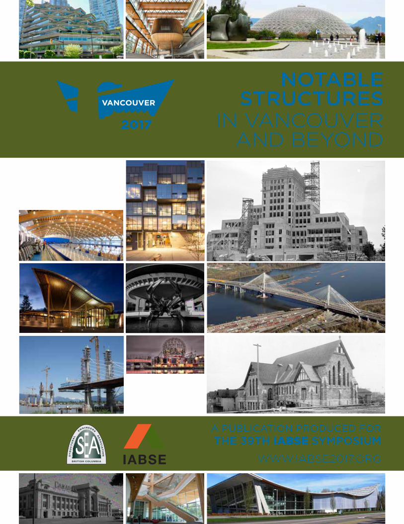
NOTABLE STRUCTURES IN VANCOUVER AND BEYOND
55
A PUBLICATION PRODUCED FOR THE 39TH IABSE SYMPOSIUM WWW.IABSE2017.ORG NOTABLE STRUCTURES IN VANCOUVER AND BEYOND
-
Upload
khangminh22 -
Category
Documents
-
view
2 -
download
0
Transcript of NOTABLE STRUCTURES IN VANCOUVER AND BEYOND
A PUBLICATION PRODUCED FORTHE 39TH IABSE SYMPOSIUM
WWW.IABSE2017.ORG
NOTABLESTRUCTURES
IN VANCOUVERAND BEYOND
IABSE SYMPOSIUM ENGINEERING THE FUTURE SEPTEMBER 19-23, 2017
ii
ROBSO
N
ROBSO
N
DAVIE
EAST HASTINGS
GRA
NVIL
LE
GRA
NVIL
LE
BURRARD
BURRARD
HORN
BY
HOW
E
CA
MB
IE
CAM
BIE
W. WATERFRONT
W. HASTINGS
CA
MB
IE
DEN
MAN
H
H
Expo Line
West Coast Express
Expo Line
Canada Line
Canada Line
CHINATOWN
RAILTOWN
STRATHCONA
MOUNTPLEASANT
YALETOWN
GASTOWN
GRANVILLEISLAND
SOUTHGRANVILLE
FAIRVIEW
KITSILANO
STANLEYPARK
10
ROBSON
WESTEND
FALSECREEK
ENGLISHBAY
COALHARBOUR
BURRARDINLET
N
500m7 minute
walk
0 1 km15 minute
walk
1.5 km22 minute
walk
Conference Location
Tourist Information
Hospital
Airport
Skytrain Stop
I
I
H
17
36
18 4
619
25
29
1321
275
11 28
3431
301233
22
261
7
3
1
14 62
9
1526
2023
32
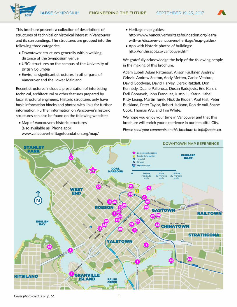
This brochure presents a collection of descriptions of structures of technical or historical interest in Vancouver and its surroundings. The structures are grouped into the following three categories:
• Downtown: structures generally within walking distance of the Symposium venue
• UBC: structures on the campus of the University of British Columbia
• Environs: significant structures in other parts of Vancouver and the Lower Mainland
Recent structures include a presentation of interesting technical, architectural or other features prepared by local structural engineers. Historic structures only have basic information blocks and photos with links for further information. Further information on Vancouver’s historic structures can also be found on the following websites:
• Map of Vancouver’s historic structures (also available as iPhone app): www.vancouverheritagefoundation.org/map/
• Heritage map guides: http://www.vancouverheritagefoundation.org/learn-with-us/discover-vancouvers-heritage/map-guides/
• App with historic photos of buildings: http://onthisspot.ca/vancouver.html
We gratefully acknowledge the help of the following people in the making of this brochure:
Adam Lubell, Adam Patterson, Alison Faulkner, Andrew Griezic, Andrew Seeton, Andy Metten, Carlos Ventura, David Goodyear, David Harvey, Derek Ratzlaff, Don Kennedy, Duane Palibroda, Dusan Radojevic, Eric Karsh, Fadi Ghorayeb, John Franquet, Justin Li, Katrin Habel, Kitty Leung, Martin Turek, Nick de Ridder, Paul Fast, Peter Buckland, Peter Taylor, Robert Jackson, Ron de Vall, Shane Cook, Thomas Wu, and Tim White.
We hope you enjoy your time in Vancouver and that this brochure will enrich your experience in our beautiful City.
Please send your comments on this brochure to [email protected].
DOWNTOWN MAP REFERENCE
Cover photo credits on p. 51

IABSE SYMPOSIUM ENGINEERING THE FUTURE SEPTEMBER 19-23, 2017BRITISH COLUMBIA
EST
RU
CT
UR
AL
E
NGINEERS A
SS
OC
IAT
ION
iii
Canada
U.S.A.
North Arm Fraser River
Millennium Line
Canada Line
Expo Line
West Coast Express
10
1010
10
17
17
7B
7A
7
7
15
91
91
99
99
99
99
99
99
1A
99A
99A
99A
17A
WESTVANCOUVER
NORTHVANCOUVER PORT
MOODY
COQUITLAM
NEWWESTM.
PITTMEADOWS
MAPLERIDGE
SURREYDELTA
RICHMOND
BURNABYVANCOUVER
H
H
I
HH
H
H
H
H
H
H
HH
N
6km0 12km
I
H
Conference Location
Tourist Information
Hospital
Airport
Skytrain Stop
5957
51
54
48
56
53
52
49
88
58
60
55
10
6261
WESB
RO
OK
MA
LL
EA
ST M
ALLW
EST M
ALL
CHANCELLOR BLVD
4645
47
43
4137
44 394038 42
UNIVERSITY BLVD
500m7 minute
walk
0 1km15 minute
walk
ENVIRONS MAP REFERENCE (UBC INSET)

IABSE SYMPOSIUM ENGINEERING THE FUTURE SEPTEMBER 19-23, 2017
iv
Contents PAGE MAP PAGE MAP DOWNTOWN # # # #
BC Place 1 1Burrard Bridge 2 2Cambie Bridge 3 3Canada Place 4 4Former Vancouver Public Library 5 5Granville Square 6 6Granville Street Bridge 7 7Jameson House 8 8Library Square 9 9Lions Gate Bridge 10 10Living Shangri-La 11 11One Wall Centre 12 12Park Place 13 13Science World 14 14TELUS Garden 15 15The Exchange 16 16The QUBE 17 17Vancouver Convention Centre 18 18Waterfront Station 19 19Woodward’s Redevelopment 20 20
Christ Church Cathedral 21 21Dal Grauer Substation 21 22Dominion Building 22 23Evergreen Building 22 24Harbour Centre 23 25Holy Rosary Cathedral 23 26Hotel Vancouver 24 27MacMillan Bloedel Building 24 28Marine Building 25 29Orpheum Theatre 25 30Robson Square and Law Courts 26 31Sun Tower 26 32The Electra (former BC Hydro Building) 27 33Vancouver Art Gallery (former Vancouver Law Courts) 27 34Vancouver Rowing Club 28 35Westin Bayshore 28 36
PAGE MAP PAGE MAP UBC # # # #
AMS Student Nest 29 37Centre for Interactive Research on Sustainability 30 38Earthquake Engineering Research Facility 31 39Earth, Ocean and Atmospheric Sciences Building 32 40Irving K. Barber Learning Centre 33 41Pharmaceutical Sciences Building 34 42Tallwood House at Brock Commons 35 43
Beaty Biodiversity Museum 36 44Chan Centre 36 45Museum of Anthropology 37 46Walter C. Koerner Library 37 47
PAGE MAP PAGE MAP ENVIRONS # # # #
Alex Fraser Bridge 38 48Golden Ears Bridge 39 49Grandview Heights Aquatic Centre 40 50North Arm Bridge 41 51Pitt River Bridge 42 52Port Mann Bridge 43 53Richmond Olympic Oval 44 54Second Narrows (Ironworkers Memorial) Bridge 45 55Skybridge 46 56VanDusen Botanical Gardens Visitor Centre 47 57Simon Fraser University 48 58 (Burnaby Mountain Campus)
Bloedel Conservatory 49 59Lynn Canyon Bridge 49 60Museum of Vancouver and 50 61 H.R. MacMillan Space CentrePacific Central Station 50 62Vancouver City Hall 51 63
IABSE SYMPOSIUM ENGINEERING THE FUTURE SEPTEMBER 19-23, 2017BRITISH COLUMBIA
EST
RU
CT
UR
AL
E
NGINEERS A
SS
OC
IAT
ION
1
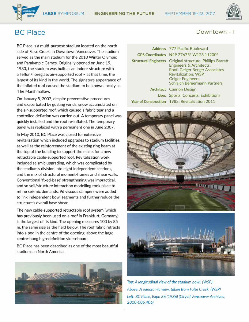
BC Place
BC Place is a multi-purpose stadium located on the north side of False Creek, in Downtown Vancouver. The stadium served as the main stadium for the 2010 Winter Olympic and Paralympic Games. Originally opened on June 19, 1983, the stadium was built as an indoor structure with a Teflon/fibreglass air-supported roof – at that time, the largest of its kind in the world. The signature appearance of the inflated roof caused the stadium to be known locally as ‘The Marshmallow.’
On January 5, 2007, despite preventative procedures and exacerbated by gusting winds, snow accumulated on the air-supported roof, which caused a fabric tear and a controlled deflation was carried out. A temporary panel was quickly installed and the roof re-inflated. The temporary panel was replaced with a permanent one in June 2007.
In May 2010, BC Place was closed for extensive revitalization which included upgrades to stadium facilities, as well as the reinforcement of the existing ring beam at the top of the building to support the masts for a new retractable cable-supported roof. Revitalization work included seismic upgrading, which was complicated by the stadium’s division into eight independent sections, and the mix of structural moment-frames and shear walls. Conventional ‘fixed-base’ strengthening was impractical, and so soil/structure interaction modelling took place to refine seismic demands. 96 viscous dampers were added to link independent bowl segments and further reduce the structure’s overall base shear.
The new cable-supported retractable roof system (which has previously been used on a roof in Frankfurt, Germany) is the largest of its kind. The opening measures 100 by 85 m, the same size as the field below. The roof fabric retracts into a pod in the centre of the opening, above the large centre-hung high-definition video-board.
BC Place has been described as one of the most beautiful stadiums in North America.
Address 777 Pacific Boulevard GPS Coordinates N49.27675° W123.11200° Structural Engineers Original structure: Phillips Barratt Engineers & Architects; Roof: Geiger Berger Associates Revitalization: WSP, Geiger Engineers, Schlaich Bergermann Partners Architect Cannon Design Uses Sports, Concerts, ExhibitionsYearofConstruction 1983; Revitalization 2011
Top: A longitudinal view of the stadium bowl. (WSP)
Above: A panoramic view, taken from False Creek. (WSP)
Left: BC Place, Expo 86 (1986) (City of Vancouver Archives, 2010-006.406)
Downtown - 1

IABSE SYMPOSIUM ENGINEERING THE FUTURE SEPTEMBER 19-23, 2017
2
Burrard Bridge
The Burrard Bridge is a massive board-formed concrete and riveted steel truss bridge spanning False Creek on Burrard Street, connecting the downtown peninsula with the community of Kitsilano to the south. The iconic Art-Deco style structure opened on July 1, 1932, and remains one of the most recognizable landmarks in the City of Vancouver. The 836 m long Burrard Bridge is recognized for transcending its functional requirements through carefully designed architectural and sculptural embellishments, and is one of Vancouver’s most important examples of Art Deco architecture. The sculptural work was carried out by Vancouver’s pre-eminent architectural sculptor, Charles Marega.
The bridge consists of three primary structure types: the riveted steel through-truss main span of 96.2 m; four riveted deck-truss marine approach-spans 56.8, 70.7, 70.7 and 56.3 m long; and 26 cast-in-place concrete on-shore approach spans varying from 5.5 m to 27.1 m in length. The bridge was seismically retrofitted, through multiple phases from the early 1990s through 2006. A recent retrofit and rehabilitation project included the replacement of the concrete railings, addition of suicide-deterrent fencing, widening of the north approach, and restoration of the pedestrian-scale lighting.
The monumentality of the bridge is emphasized through its over-scaled elements and massive embellishments such as the piers and galleries that serve a decorative purpose. The pylons at each end of the bridge, with their flaming torch-light fixtures, were conceived as a memorial to the First World War. The decoration of the pylons include a stylized Cross of Lorraine, and the bronze lights were inspired by the braziers used by soldiers in the trenches, a traditional feature of the battlefield.
GPS Coordinates N49.27511° W123.13817° Structural Engineers Major J.R. Grant Architect George G.L. Sharp of Sharp & Thompson Use Carries Burrard Street and mulitiuse pathways over False CreekYearofConstruction 1932
Top: East Elevation from False Creek (Associated Engineering)
Above left: Sculptural Elements (Michael Fussell)
Above right: Burrard North End 1932’s (City of Vancouver Archives, CVA 20-110, photograph by Neon Products)
Left: Refurbished Railing with Fence and Lighting (Kayla Dawson)
Downtown - 2
IABSE SYMPOSIUM ENGINEERING THE FUTURE SEPTEMBER 19-23, 2017BRITISH COLUMBIA
EST
RU
CT
UR
AL
E
NGINEERS A
SS
OC
IAT
ION
3
Cambie Bridge
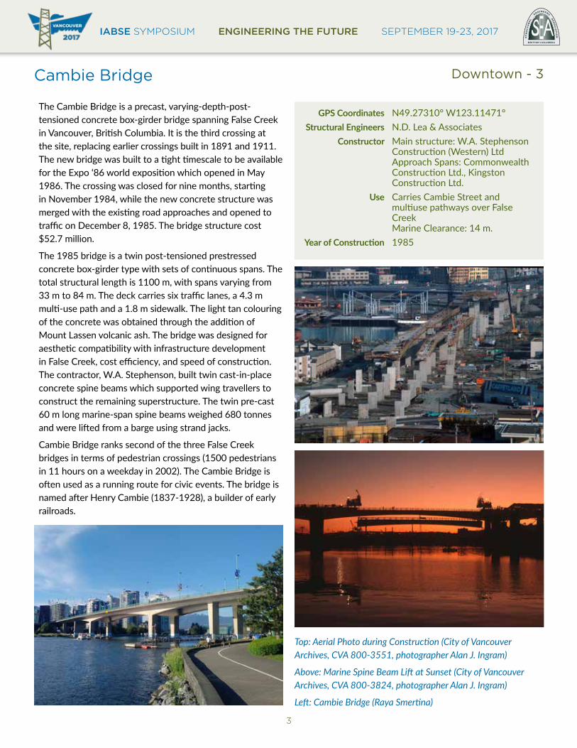
The Cambie Bridge is a precast, varying-depth-post-tensioned concrete box-girder bridge spanning False Creek in Vancouver, British Columbia. It is the third crossing at the site, replacing earlier crossings built in 1891 and 1911. The new bridge was built to a tight timescale to be available for the Expo ‘86 world exposition which opened in May 1986. The crossing was closed for nine months, starting in November 1984, while the new concrete structure was merged with the existing road approaches and opened to traffic on December 8, 1985. The bridge structure cost $52.7 million.
The 1985 bridge is a twin post-tensioned prestressed concrete box-girder type with sets of continuous spans. The total structural length is 1100 m, with spans varying from 33 m to 84 m. The deck carries six traffic lanes, a 4.3 m multi-use path and a 1.8 m sidewalk. The light tan colouring of the concrete was obtained through the addition of Mount Lassen volcanic ash. The bridge was designed for aesthetic compatibility with infrastructure development in False Creek, cost efficiency, and speed of construction. The contractor, W.A. Stephenson, built twin cast-in-place concrete spine beams which supported wing travellers to construct the remaining superstructure. The twin pre-cast 60 m long marine-span spine beams weighed 680 tonnes and were lifted from a barge using strand jacks.
Cambie Bridge ranks second of the three False Creek bridges in terms of pedestrian crossings (1500 pedestrians in 11 hours on a weekday in 2002). The Cambie Bridge is often used as a running route for civic events. The bridge is named after Henry Cambie (1837-1928), a builder of early railroads.
GPS Coordinates N49.27310° W123.11471° Structural Engineers N.D. Lea & Associates Constructor Main structure: W.A. Stephenson Construction (Western) Ltd Approach Spans: Commonwealth Construction Ltd., Kingston Construction Ltd. Use Carries Cambie Street and multiuse pathways over False Creek Marine Clearance: 14 m.YearofConstruction 1985
Top: Aerial Photo during Construction (City of Vancouver Archives, CVA 800-3551, photographer Alan J. Ingram)
Above: Marine Spine Beam Lift at Sunset (City of Vancouver Archives, CVA 800-3824, photographer Alan J. Ingram)
Left: Cambie Bridge (Raya Smertina)
Downtown - 3
IABSE SYMPOSIUM ENGINEERING THE FUTURE SEPTEMBER 19-23, 2017
4
Canada Place
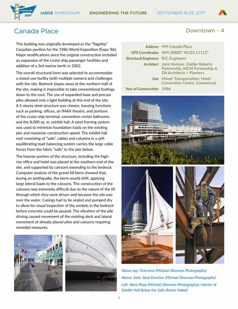
This building was originally developed as the “flagship” Canadian pavilion for the 1986 World Exposition (Expo ’86). Major modifications since the original construction included an expansion of the cruise ship passenger facilities and addition of a 3rd marine berth in 2002.
The overall structural form was selected to accommodate a mixed-use facility (with multiple owners) and challenges with the site. Bedrock slopes away at the northern half of the site, making it impossible to take conventional footings down to the rock. The use of expanded base and precast piles allowed only a light building at this end of the site. A 5-storey steel structure was chosen, housing functions such as parking, offices, an IMAX theatre, and portions of the cruise ship terminal, convention center ballrooms and the 8,000 sq. m. exhibit hall. A steel framing system was used to minimize foundation loads on the existing pier and maximize construction speed. The exhibit hall roof consisting of “sails”, cables and columns in a self-equilibrating load-balancing system carries the large cable forces from the fabric “sails” to the pier below.
The heavier portion of the structure, including the high-rise office and hotel was placed at the southern end of the site, and supported by caissons extending to the bedrock. Computer analysis of the gravel fill berm showed that, during an earthquake, the berm would shift, applying large lateral loads to the caissons. The construction of the caissons was extremely difficult due to the nature of the fill through which they were driven and because the site was over the water. Casings had to be sealed and pumped dry to allow for visual inspection of the sockets in the bedrock before concrete could be poured. The vibration of the pile driving caused movement of the existing deck and lateral movement of already placed piles and caissons requiring remedial measures.
Address 999 Canada Place GPS Coordinates N49.28882° W123.11112° Structural Engineers RJC Engineers Architect Joint Venture: Zeidler Roberts Partnership, MCM Partnership & DA Architects + Planners Use Mixed: Transportation, Hotel Convention Centre, CommercialYearofConstruction 1986
Above top: Overview (Michael Sherman Photography)
Above: Sails; Steel Erection (Michael Sherman Photography)
Left: West Plaza (Michael Sherman Photography); Interior of Exhibit Hall Below the Sails (Katrin Habel)
Downtown - 4
IABSE SYMPOSIUM ENGINEERING THE FUTURE SEPTEMBER 19-23, 2017BRITISH COLUMBIA
EST
RU
CT
UR
AL
E
NGINEERS A
SS
OC
IAT
ION
5
Former Vancouver Public Library
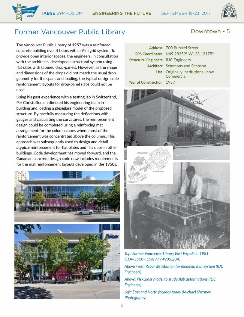
The Vancouver Public Library of 1957 was a reinforced concrete building over 4 floors with a 9-m grid system. To provide open interior spaces, the engineers, in consultation with the architects, developed a structural system using flat slabs with tapered drop-panels. However, as the shape and dimensions of the drops did not match the usual drop geometry for the spans and loading, the typical design code reinforcement layouts for drop-panel slabs could not be used.
Using his past experience with a testing lab in Switzerland, Per Christoffersen directed his engineering team in building and loading a plexiglass model of the proposed structure. By carefully measuring the deflections with gauges and calculating the curvatures, the reinforcement design could be completed using a reinforcing mat arrangement for the column zones where most of the reinforcement was concentrated above the columns. This approach was subsequently used to design and detail atypical reinforcement for flat plates and flat slabs in other buildings. Code development has moved forward, and the Canadian concrete design code now includes requirements for the mat reinforcement layouts developed in the 1950s.
Address 700 Burrard Street GPS Coordinates N49.28359° W123.12175° Structural Engineers RJC Engineers Architect Semmons and Simpson Use Originally Institutional, now CommercialYearofConstruction 1957
Top: Former Vancouver Library East Façade in 1981 (COV-S510-: CVA 779-W05.20A)
Above inset: Rebar distribution for modified mat system (RJC Engineers)
Above: Plexiglass model to study slab deformations (RJC Engineers)
Left: East and North façades today (Michael Sherman Photography)
Downtown - 5
IABSE SYMPOSIUM ENGINEERING THE FUTURE SEPTEMBER 19-23, 2017
6
Granville Square
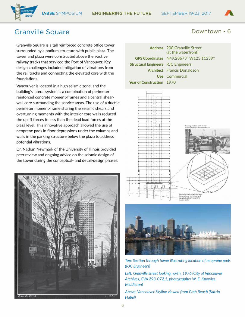
Granville Square is a tall reinforced concrete office tower surrounded by a podium structure with public plaza. The tower and plaza were constructed above then-active railway tracks that serviced the Port of Vancouver. Key design challenges included mitigation of vibrations from the rail tracks and connecting the elevated core with the foundations.
Vancouver is located in a high seismic zone, and the building’s lateral system is a combination of perimeter reinforced concrete moment-frames and a central shear-wall core surrounding the service areas. The use of a ductile perimeter moment-frame sharing the seismic shears and overturning moments with the interior core walls reduced the uplift forces to less than the dead load forces at the plaza level. This innovative approach allowed the use of neoprene pads in floor depressions under the columns and walls in the parking structure below the plaza to address potential vibrations.
Dr. Nathan Newmark of the University of Illinois provided peer review and ongoing advice on the seismic design of the tower during the conceptual- and detail-design phases.
Address 200 Granville Street (at the waterfront) GPS Coordinates N49.28673° W123.11239° Structural Engineers RJC Engineers. Architect Francis Donaldson Use CommercialYearofConstruction 1970
Top: Section through tower illustrating location of neoprene pads (RJC Engineers)
Left: Granville street looking north, 1976 (City of Vancouver Archives, CVA 293-072.1, photographer W. E. Knowles Middleton)
Above: Vancouver Skyline viewed from Crab Beach (Katrin Habel)
Downtown - 6
IABSE SYMPOSIUM ENGINEERING THE FUTURE SEPTEMBER 19-23, 2017BRITISH COLUMBIA
EST
RU
CT
UR
AL
E
NGINEERS A
SS
OC
IAT
ION
7
Granville Street Bridge
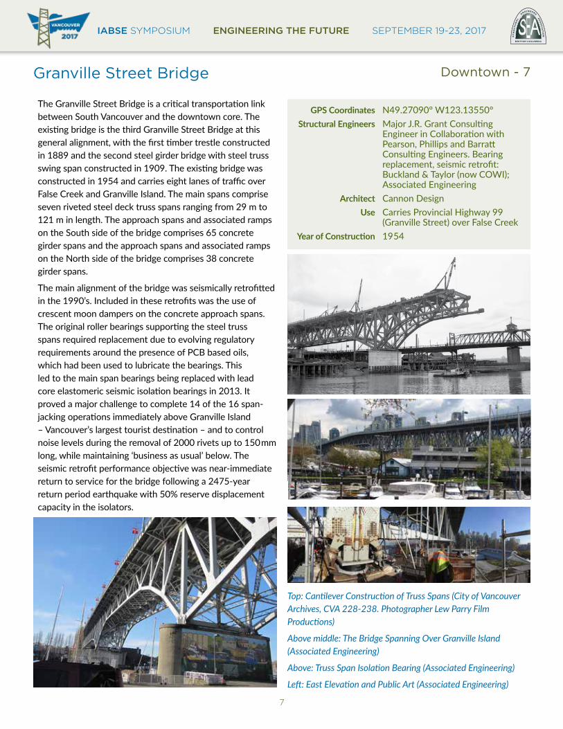
The Granville Street Bridge is a critical transportation link between South Vancouver and the downtown core. The existing bridge is the third Granville Street Bridge at this general alignment, with the first timber trestle constructed in 1889 and the second steel girder bridge with steel truss swing span constructed in 1909. The existing bridge was constructed in 1954 and carries eight lanes of traffic over False Creek and Granville Island. The main spans comprise seven riveted steel deck truss spans ranging from 29 m to 121 m in length. The approach spans and associated ramps on the South side of the bridge comprises 65 concrete girder spans and the approach spans and associated ramps on the North side of the bridge comprises 38 concrete girder spans.
The main alignment of the bridge was seismically retrofitted in the 1990’s. Included in these retrofits was the use of crescent moon dampers on the concrete approach spans. The original roller bearings supporting the steel truss spans required replacement due to evolving regulatory requirements around the presence of PCB based oils, which had been used to lubricate the bearings. This led to the main span bearings being replaced with lead core elastomeric seismic isolation bearings in 2013. It proved a major challenge to complete 14 of the 16 span-jacking operations immediately above Granville Island – Vancouver’s largest tourist destination – and to control noise levels during the removal of 2000 rivets up to 150mm long, while maintaining ‘business as usual’ below. The seismic retrofit performance objective was near-immediate return to service for the bridge following a 2475-year return period earthquake with 50% reserve displacement capacity in the isolators.
GPS Coordinates N49.27090° W123.13550° Structural Engineers Major J.R. Grant Consulting Engineer in Collaboration with Pearson, Phillips and Barratt Consulting Engineers. Bearing replacement, seismic retrofit: Buckland & Taylor (now COWI); Associated Engineering Architect Cannon Design Use Carries Provincial Highway 99 (Granville Street) over False CreekYearofConstruction 19 54
Top: Cantilever Construction of Truss Spans (City of Vancouver Archives, CVA 228-238. Photographer Lew Parry Film Productions)
Above middle: The Bridge Spanning Over Granville Island (Associated Engineering)
Above: Truss Span Isolation Bearing (Associated Engineering)
Left: East Elevation and Public Art (Associated Engineering)
Downtown - 7
IABSE SYMPOSIUM ENGINEERING THE FUTURE SEPTEMBER 19-23, 2017
8
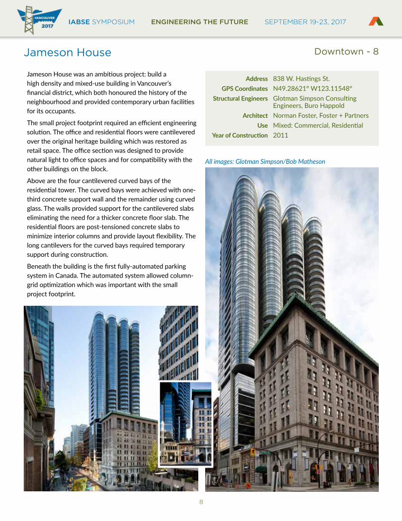
Jameson House
Jameson House was an ambitious project: build a high density and mixed-use building in Vancouver’s financial district, which both honoured the history of the neighbourhood and provided contemporary urban facilities for its occupants.
The small project footprint required an efficient engineering solution. The office and residential floors were cantilevered over the original heritage building which was restored as retail space. The office section was designed to provide natural light to office spaces and for compatibility with the other buildings on the block.
Above are the four cantilevered curved bays of the residential tower. The curved bays were achieved with one-third concrete support wall and the remainder using curved glass. The walls provided support for the cantilevered slabs eliminating the need for a thicker concrete floor slab. The residential floors are post-tensioned concrete slabs to minimize interior columns and provide layout flexibility. The long cantilevers for the curved bays required temporary support during construction.
Beneath the building is the first fully-automated parking system in Canada. The automated system allowed column-grid optimization which was important with the small project footprint.
Address 838 W. Hastings St. GPS Coordinates N49.28621° W123.11548° Structural Engineers Glotman Simpson Consulting Engineers, Buro Happold Architect Norman Foster, Foster + Partners Use Mixed: Commercial, ResidentialYearofConstruction 2011
All images: Glotman Simpson/Bob Matheson
Downtown - 8
IABSE SYMPOSIUM ENGINEERING THE FUTURE SEPTEMBER 19-23, 2017BRITISH COLUMBIA
EST
RU
CT
UR
AL
E
NGINEERS A
SS
OC
IAT
ION
9
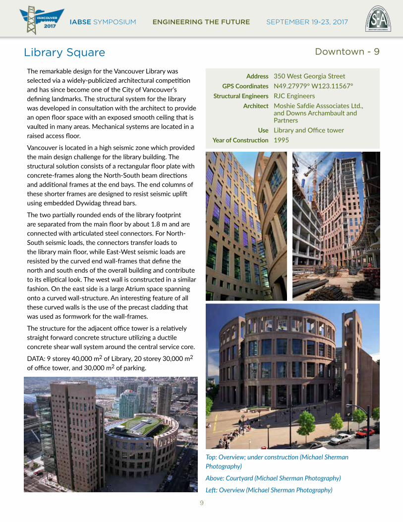
Library Square
The remarkable design for the Vancouver Library was selected via a widely-publicized architectural competition and has since become one of the City of Vancouver’s defining landmarks. The structural system for the library was developed in consultation with the architect to provide an open floor space with an exposed smooth ceiling that is vaulted in many areas. Mechanical systems are located in a raised access floor.
Vancouver is located in a high seismic zone which provided the main design challenge for the library building. The structural solution consists of a rectangular floor plate with concrete-frames along the North-South beam directions and additional frames at the end bays. The end columns of these shorter frames are designed to resist seismic uplift using embedded Dywidag thread bars.
The two partially rounded ends of the library footprint are separated from the main floor by about 1.8 m and are connected with articulated steel connectors. For North-South seismic loads, the connectors transfer loads to the library main floor, while East-West seismic loads are resisted by the curved end wall-frames that define the north and south ends of the overall building and contribute to its elliptical look. The west wall is constructed in a similar fashion. On the east side is a large Atrium space spanning onto a curved wall-structure. An interesting feature of all these curved walls is the use of the precast cladding that was used as formwork for the wall-frames.
The structure for the adjacent office tower is a relatively straight forward concrete structure utilizing a ductile concrete shear wall system around the central service core.
DATA: 9 storey 40,000 m2 of Library, 20 storey 30,000 m2 of office tower, and 30,000 m2 of parking.
Address 350 West Georgia Street GPS Coordinates N49.27979° W123.11567° Structural Engineers RJC Engineers Architect Moshie Safdie Asssociates Ltd., and Downs Archambault and Partners Use Library and Office towerYearofConstruction 1995
Top: Overview; under construction (Michael Sherman Photography)
Above: Courtyard (Michael Sherman Photography)
Left: Overview (Michael Sherman Photography)
Downtown - 9
IABSE SYMPOSIUM ENGINEERING THE FUTURE SEPTEMBER 19-23, 2017
10
Lions Gate Bridge
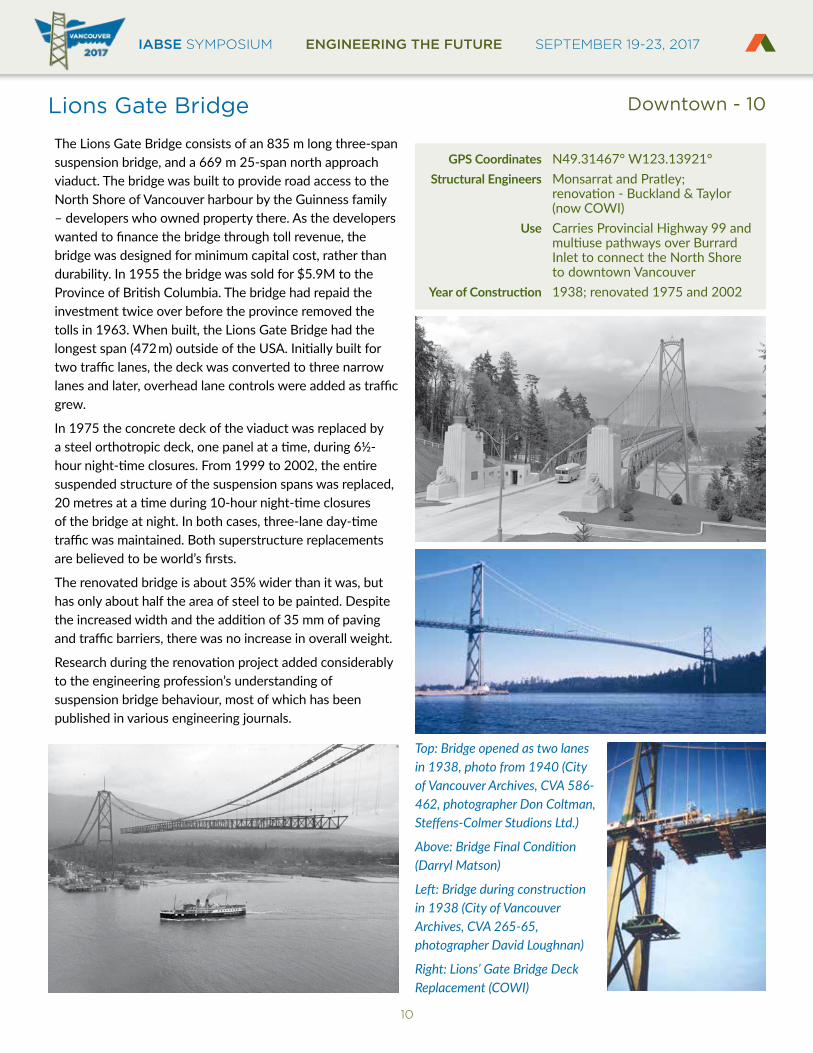
The Lions Gate Bridge consists of an 835 m long three-span suspension bridge, and a 669 m 25-span north approach viaduct. The bridge was built to provide road access to the North Shore of Vancouver harbour by the Guinness family – developers who owned property there. As the developers wanted to finance the bridge through toll revenue, the bridge was designed for minimum capital cost, rather than durability. In 1955 the bridge was sold for $5.9M to the Province of British Columbia. The bridge had repaid the investment twice over before the province removed the tolls in 1963. When built, the Lions Gate Bridge had the longest span (472m) outside of the USA. Initially built for two traffic lanes, the deck was converted to three narrow lanes and later, overhead lane controls were added as traffic grew.
In 1975 the concrete deck of the viaduct was replaced by a steel orthotropic deck, one panel at a time, during 6½-hour night-time closures. From 1999 to 2002, the entire suspended structure of the suspension spans was replaced, 20 metres at a time during 10-hour night-time closures of the bridge at night. In both cases, three-lane day-time traffic was maintained. Both superstructure replacements are believed to be world’s firsts.
The renovated bridge is about 35% wider than it was, but has only about half the area of steel to be painted. Despite the increased width and the addition of 35 mm of paving and traffic barriers, there was no increase in overall weight.
Research during the renovation project added considerably to the engineering profession’s understanding of suspension bridge behaviour, most of which has been published in various engineering journals.
GPS Coordinates N49.31467° W123.13921° Structural Engineers Monsarrat and Pratley; renovation - Buckland & Taylor (now COWI) Use Carries Provincial Highway 99 and multiuse pathways over Burrard Inlet to connect the North Shore to downtown VancouverYearofConstruction 1938; renovated 1975 and 2002
Top: Bridge opened as two lanes in 1938, photo from 1940 (City of Vancouver Archives, CVA 586-462, photographer Don Coltman, Steffens-Colmer Studions Ltd.)
Above: Bridge Final Condition (Darryl Matson)
Left: Bridge during construction in 1938 (City of Vancouver Archives, CVA 265-65, photographer David Loughnan)
Right: Lions’ Gate Bridge Deck Replacement (COWI)
Downtown - 10
IABSE SYMPOSIUM ENGINEERING THE FUTURE SEPTEMBER 19-23, 2017BRITISH COLUMBIA
EST
RU
CT
UR
AL
E
NGINEERS A
SS
OC
IAT
ION
11
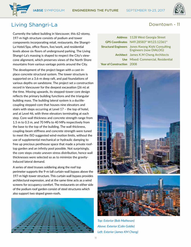
Living Shangri-La
Currently the tallest building in Vancouver, this 62-storey, 197-m high structure consists of podium and tower components incorporating retail, restaurants, the Shangri-La Hotel/Spa, office floors, live/work, and residential levels above six floors of underground parking. The Living Shangri-La’s massing is shaped to respect the City’s view-cone alignment, which preserves views of the North Shore mountains from various vantage points around the City.
The development of the project began with a cast-in-place concrete structural system. The tower structure is supported on a 3.6-m deep raft, and pad foundations of various depths on sandstone. The project set a construction record in Vancouver for the deepest excavation (26 m) at the time. Moving upwards, its stepped-tower core design reflects the primary building functions and the triangular building mass. The building lateral system is a ductile-coupling stepped-core that houses nine elevators and stairs with steps occurring at Level 17 – the top of hotel, and at Level 46, with three elevators terminating at each step. Core-wall thickness and concrete strength range from 1.5 m to 0.3 m, and 70 MPa to 40 MPa respectively from the base to the top of the building. The wall thickness, coupling-beam stiffness and concrete strength were tuned to meet the ISO suggested wind-motion limits, without the use of supplemental mechanical or hydraulic damping to free up precious penthouse space that made a private roof-top garden and an infinity pool possible. Not surprisingly, the core steps create uneven stress distribution, hence wall thicknesses were selected so as to minimize the gravity-induced lateral demand.
A series of steel trusses soldiering along the roof top perimeter supports the 9-m tall curtain-wall bypass above the 197-m high tower structure. This curtain wall bypass provides architectural expression, and at the same time acts as a wind screens for occupancy comfort. The restaurants on either side of the podium roof garden consist of steel structures which also support two sloped green-roofs.
Address 1128 West Georgia Street GPS Coordinates N49.28583° W123.12361° Structural Engineers Jones Kwong Kishi Consulting Engineers (now DIALOG) Architect James K.M Cheng Architects Use Mixed: Commercial, ResidentialYearofConstruction 2008
Top: Exterior (Bob Matheson)
Above: Exterior (Colin Goldie)
Left: Exterior (James KM Cheng)
Downtown - 11

IABSE SYMPOSIUM ENGINEERING THE FUTURE SEPTEMBER 19-23, 2017
12
One Wall Centre
The elegant elliptical One Wall Centre tower was Vancouver’s tallest building until 2008 with a height of 137m to the roof slab and 158m to the spire tip. The prominent building is located on Downtown Vancouver’s highest point of land. The building comprises 17 storeys of residential floors above a 29-storey hotel, with a low-rise podium containing commercial and retail space.
One Wall Centre has a slender profile to preserve the City-mandated view corridors. The slender tower is 21.4 m wide with a 6.4 m wide central core. The overall height-to-width ratio of 7:1 and core ratio of 21:1 presented technical challenges.
The lateral stiffness of the tower is enhanced with an outrigger system consisting of deep concrete beams at four levels that couple the central core walls with enlarged perimeter columns. The outriggers at Level 5 are 6.4 m deep and support several upper tower columns which created an open hotel lobby below. Dynamic analysis and wind-tunnel testing showed that alternating vortices could initiate vibrations that may cause discomfort to building occupants during high wind-speed events. Vibrations were mitigated with tuned liquid column dampers (TLCDs). At the top of the building are two TLCDs, each consisting of a 180 m3 water tank, extending nearly the full width of the tower. Each U-shaped tank has a horizontal chamber at the bottom and a vertical chamber at each end. The TLCDs provide structural damping as the water oscillates between the liquid columns and passes through a gate, counteracting tower vibration. TLCD response was match the natural frequency of the tower for optimal performance which was was confirmed by field measurements. The water is also used for mechanical heat recovery and fire suppression.
Address 1088 Burrard Street GPS Coordinates N49.28014° W123.12711° Structural Engineers Glotman Simpson Consulting Engineers Wind Consultant Rowan Williams Davies & Irwin Architect Busby Perkins + Will Use Mixed: Commercial, ResidentialYearofConstruction 2001
All images: Glotman Simpson
Downtown - 12
IABSE SYMPOSIUM ENGINEERING THE FUTURE SEPTEMBER 19-23, 2017BRITISH COLUMBIA
EST
RU
CT
UR
AL
E
NGINEERS A
SS
OC
IAT
ION
13
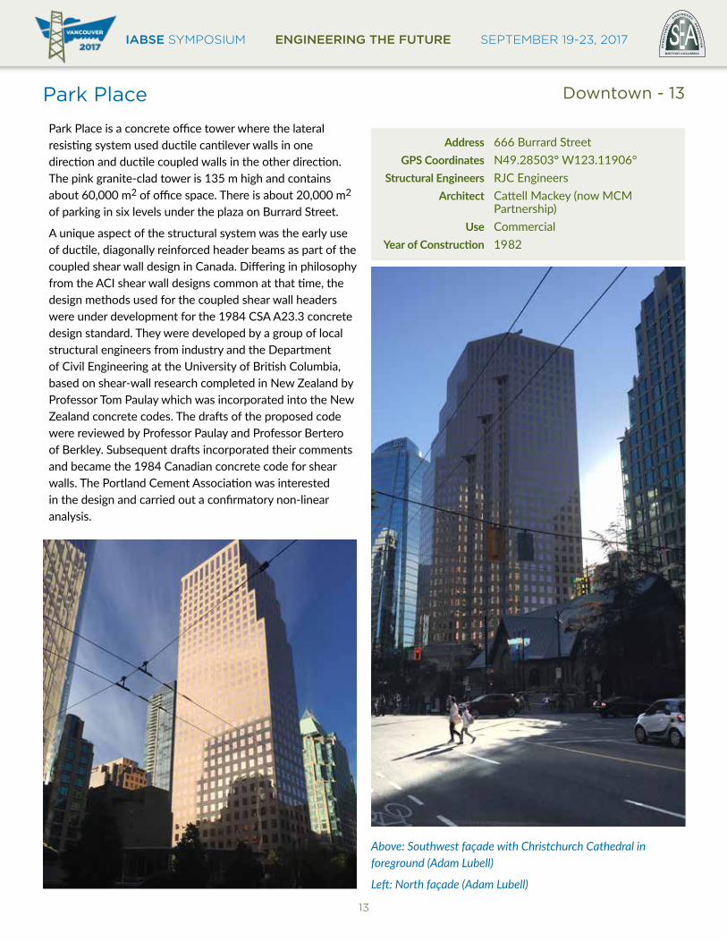
Park Place
Park Place is a concrete office tower where the lateral resisting system used ductile cantilever walls in one direction and ductile coupled walls in the other direction. The pink granite-clad tower is 135 m high and contains about 60,000 m2 of office space. There is about 20,000 m2 of parking in six levels under the plaza on Burrard Street.
A unique aspect of the structural system was the early use of ductile, diagonally reinforced header beams as part of the coupled shear wall design in Canada. Differing in philosophy from the ACI shear wall designs common at that time, the design methods used for the coupled shear wall headers were under development for the 1984 CSA A23.3 concrete design standard. They were developed by a group of local structural engineers from industry and the Department of Civil Engineering at the University of British Columbia, based on shear-wall research completed in New Zealand by Professor Tom Paulay which was incorporated into the New Zealand concrete codes. The drafts of the proposed code were reviewed by Professor Paulay and Professor Bertero of Berkley. Subsequent drafts incorporated their comments and became the 1984 Canadian concrete code for shear walls. The Portland Cement Association was interested in the design and carried out a confirmatory non-linear analysis.
Address 666 Burrard Street GPS Coordinates N49.28503° W123.11906° Structural Engineers RJC Engineers Architect Cattell Mackey (now MCM Partnership) Use CommercialYearofConstruction 19 82
Above: Southwest façade with Christchurch Cathedral in foreground (Adam Lubell)
Left: North façade (Adam Lubell)
Downtown - 13
IABSE SYMPOSIUM ENGINEERING THE FUTURE SEPTEMBER 19-23, 2017
14
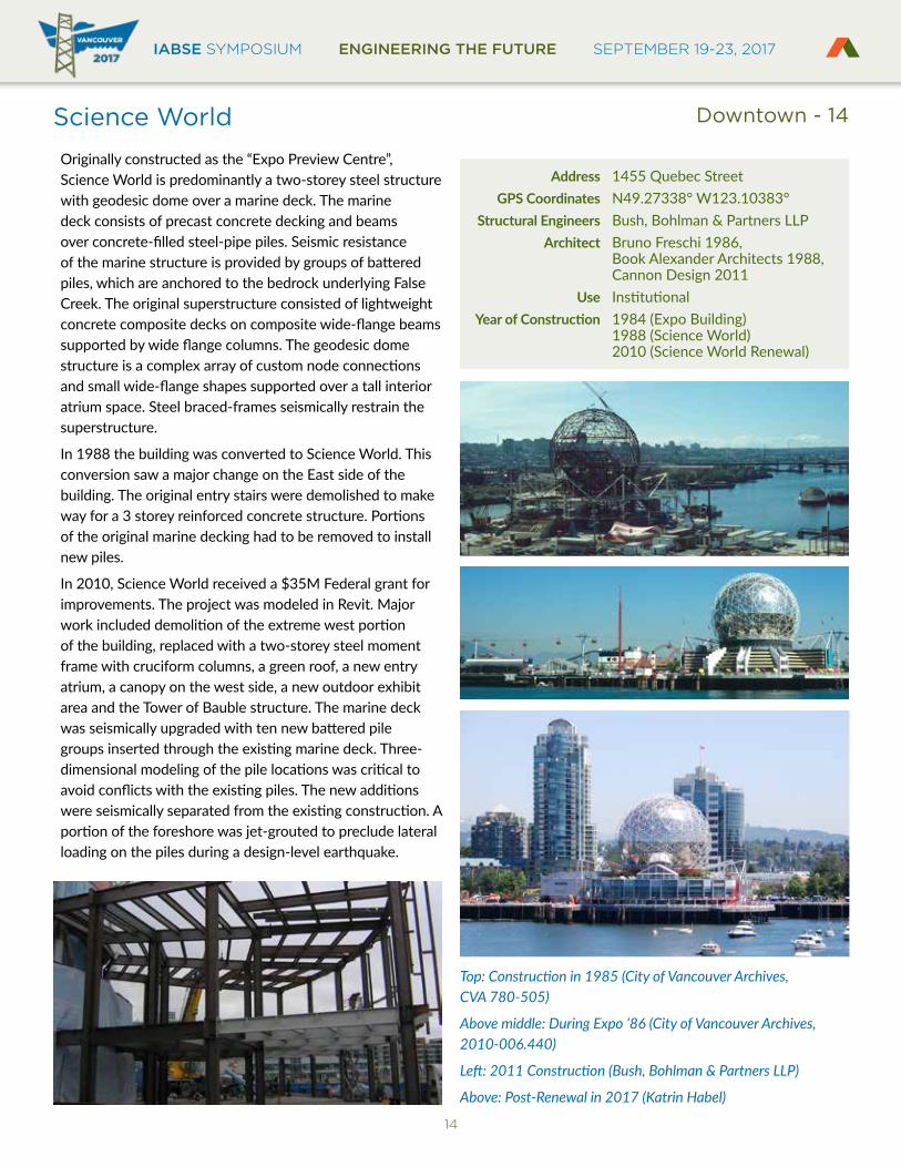
Science World
Originally constructed as the “Expo Preview Centre”, Science World is predominantly a two-storey steel structure with geodesic dome over a marine deck. The marine deck consists of precast concrete decking and beams over concrete-filled steel-pipe piles. Seismic resistance of the marine structure is provided by groups of battered piles, which are anchored to the bedrock underlying False Creek. The original superstructure consisted of lightweight concrete composite decks on composite wide-flange beams supported by wide flange columns. The geodesic dome structure is a complex array of custom node connections and small wide-flange shapes supported over a tall interior atrium space. Steel braced-frames seismically restrain the superstructure.
In 1988 the building was converted to Science World. This conversion saw a major change on the East side of the building. The original entry stairs were demolished to make way for a 3 storey reinforced concrete structure. Portions of the original marine decking had to be removed to install new piles.
In 2010, Science World received a $35M Federal grant for improvements. The project was modeled in Revit. Major work included demolition of the extreme west portion of the building, replaced with a two-storey steel moment frame with cruciform columns, a green roof, a new entry atrium, a canopy on the west side, a new outdoor exhibit area and the Tower of Bauble structure. The marine deck was seismically upgraded with ten new battered pile groups inserted through the existing marine deck. Three-dimensional modeling of the pile locations was critical to avoid conflicts with the existing piles. The new additions were seismically separated from the existing construction. A portion of the foreshore was jet-grouted to preclude lateral loading on the piles during a design-level earthquake.
Address 1455 Quebec Street GPS Coordinates N49.27338° W123.10383° Structural Engineers Bush, Bohlman & Partners LLP Architect Bruno Freschi 1986, Book Alexander Architects 1988, Cannon Design 2011 Use InstitutionalYearofConstruction 1984 (Expo Building) 1988 (Science World) 2010 (Science World Renewal)
Top: Construction in 1985 (City of Vancouver Archives, CVA 780-505)
Above middle: During Expo ‘86 (City of Vancouver Archives, 2010-006.440)
Left: 2011 Construction (Bush, Bohlman & Partners LLP)
Above: Post-Renewal in 2017 (Katrin Habel)
Downtown - 14
IABSE SYMPOSIUM ENGINEERING THE FUTURE SEPTEMBER 19-23, 2017BRITISH COLUMBIA
EST
RU
CT
UR
AL
E
NGINEERS A
SS
OC
IAT
ION
15
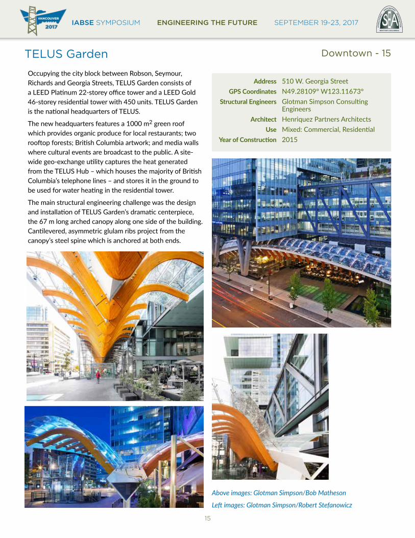
TELUS Garden
Occupying the city block between Robson, Seymour, Richards and Georgia Streets, TELUS Garden consists of a LEED Platinum 22-storey office tower and a LEED Gold 46-storey residential tower with 450 units. TELUS Garden is the national headquarters of TELUS.
The new headquarters features a 1000 m2 green roof which provides organic produce for local restaurants; two rooftop forests; British Columbia artwork; and media walls where cultural events are broadcast to the public. A site-wide geo-exchange utility captures the heat generated from the TELUS Hub – which houses the majority of British Columbia’s telephone lines – and stores it in the ground to be used for water heating in the residential tower.
The main structural engineering challenge was the design and installation of TELUS Garden’s dramatic centerpiece, the 67 m long arched canopy along one side of the building. Cantilevered, asymmetric glulam ribs project from the canopy’s steel spine which is anchored at both ends.
Address 510 W. Georgia Street GPS Coordinates N49.28109° W123.11673° Structural Engineers Glotman Simpson Consulting Engineers Architect Henriquez Partners Architects Use Mixed: Commercial, ResidentialYearofConstruction 2015
Above images: Glotman Simpson/Bob Matheson
Left images: Glotman Simpson/Robert Stefanowicz
Downtown - 15
IABSE SYMPOSIUM ENGINEERING THE FUTURE SEPTEMBER 19-23, 2017
16
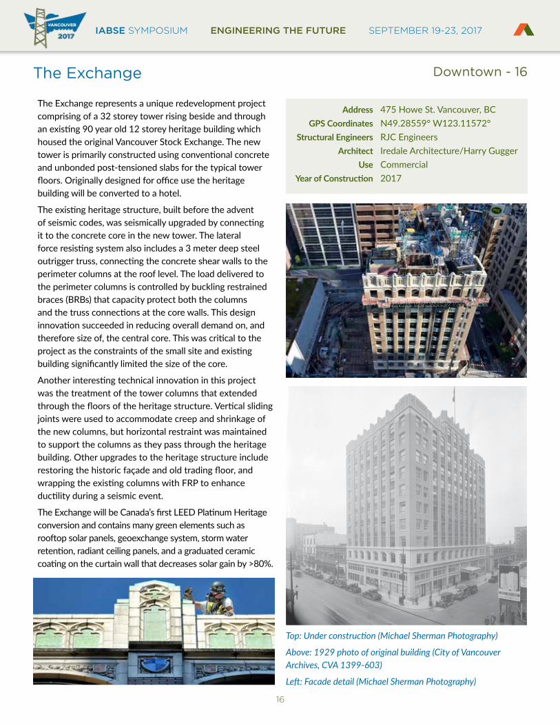
The Exchange
The Exchange represents a unique redevelopment project comprising of a 32 storey tower rising beside and through an existing 90 year old 12 storey heritage building which housed the original Vancouver Stock Exchange. The new tower is primarily constructed using conventional concrete and unbonded post-tensioned slabs for the typical tower floors. Originally designed for office use the heritage building will be converted to a hotel.
The existing heritage structure, built before the advent of seismic codes, was seismically upgraded by connecting it to the concrete core in the new tower. The lateral force resisting system also includes a 3 meter deep steel outrigger truss, connecting the concrete shear walls to the perimeter columns at the roof level. The load delivered to the perimeter columns is controlled by buckling restrained braces (BRBs) that capacity protect both the columns and the truss connections at the core walls. This design innovation succeeded in reducing overall demand on, and therefore size of, the central core. This was critical to the project as the constraints of the small site and existing building significantly limited the size of the core.
Another interesting technical innovation in this project was the treatment of the tower columns that extended through the floors of the heritage structure. Vertical sliding joints were used to accommodate creep and shrinkage of the new columns, but horizontal restraint was maintained to support the columns as they pass through the heritage building. Other upgrades to the heritage structure include restoring the historic façade and old trading floor, and wrapping the existing columns with FRP to enhance ductility during a seismic event.
The Exchange will be Canada’s first LEED Platinum Heritage conversion and contains many green elements such as rooftop solar panels, geoexchange system, storm water retention, radiant ceiling panels, and a graduated ceramic coating on the curtain wall that decreases solar gain by >80%.
Address 475 Howe St. Vancouver, BC GPS Coordinates N49.28559° W123.11572° Structural Engineers RJC Engineers Architect Iredale Architecture/Harry Gugger Use CommercialYearofConstruction 2017
Top: Under construction (Michael Sherman Photography)
Above: 1929 photo of original building (City of Vancouver Archives, CVA 1399-603)
Left: Facade detail (Michael Sherman Photography)
Downtown - 16
IABSE SYMPOSIUM ENGINEERING THE FUTURE SEPTEMBER 19-23, 2017BRITISH COLUMBIA
EST
RU
CT
UR
AL
E
NGINEERS A
SS
OC
IAT
ION
17
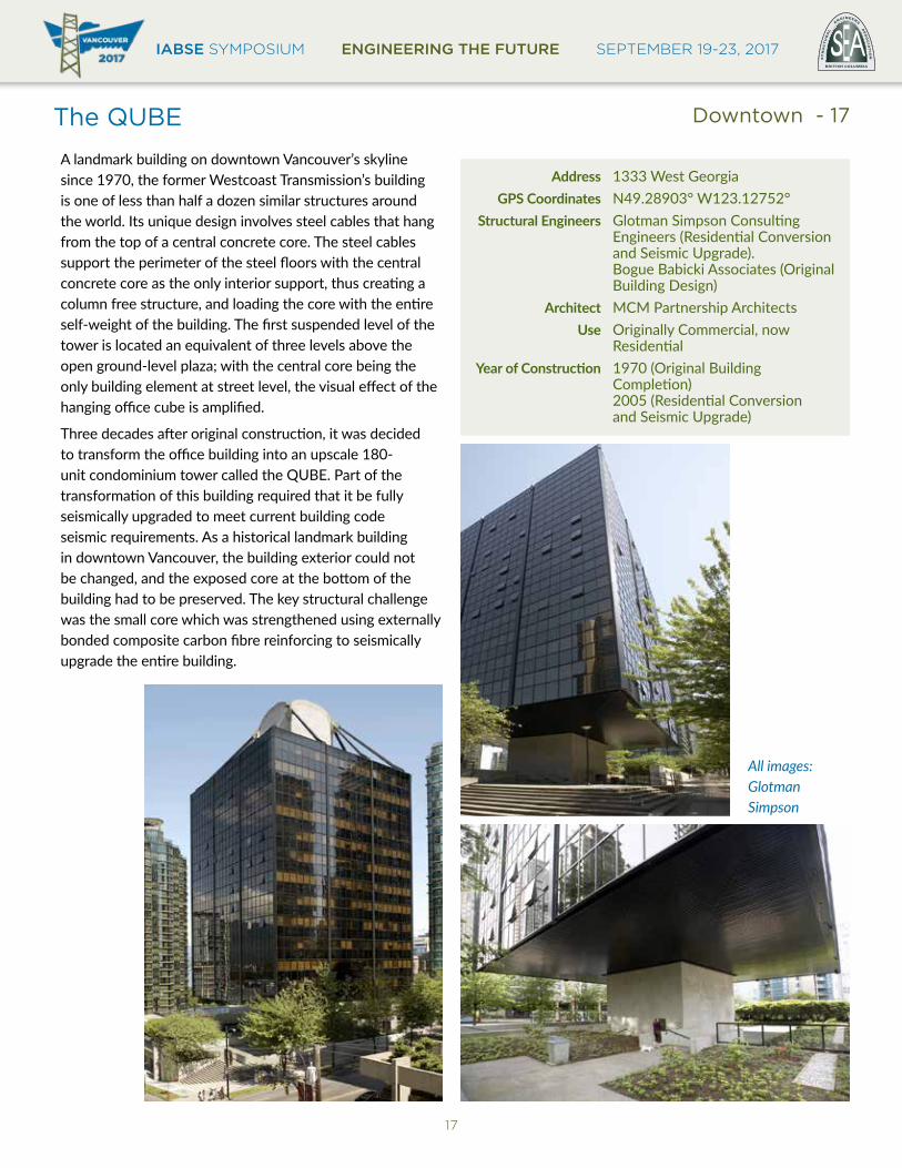
The QUBE
A landmark building on downtown Vancouver’s skyline since 1970, the former Westcoast Transmission’s building is one of less than half a dozen similar structures around the world. Its unique design involves steel cables that hang from the top of a central concrete core. The steel cables support the perimeter of the steel floors with the central concrete core as the only interior support, thus creating a column free structure, and loading the core with the entire self-weight of the building. The first suspended level of the tower is located an equivalent of three levels above the open ground-level plaza; with the central core being the only building element at street level, the visual effect of the hanging office cube is amplified.
Three decades after original construction, it was decided to transform the office building into an upscale 180-unit condominium tower called the QUBE. Part of the transformation of this building required that it be fully seismically upgraded to meet current building code seismic requirements. As a historical landmark building in downtown Vancouver, the building exterior could not be changed, and the exposed core at the bottom of the building had to be preserved. The key structural challenge was the small core which was strengthened using externally bonded composite carbon fibre reinforcing to seismically upgrade the entire building.
Address 1333 West Georgia GPS Coordinates N49.28903° W123.12752° Structural Engineers Glotman Simpson Consulting Engineers (Residential Conversion and Seismic Upgrade). Bogue Babicki Associates (Original Building Design) Architect MCM Partnership Architects Use Originally Commercial, now ResidentialYearofConstruction 1970 (Original Building Completion) 2005 (Residential Conversion and Seismic Upgrade)
Downtown - 17
All images: Glotman Simpson
IABSE SYMPOSIUM ENGINEERING THE FUTURE SEPTEMBER 19-23, 2017
18
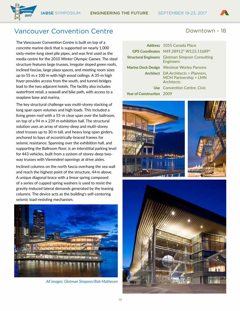
Vancouver Convention Centre
The Vancouver Convention Centre is built on top of a concrete marine deck that is supported on nearly 1,000 sixty-metre-long steel pile pipes, and was first used as the media centre for the 2010 Winter Olympic Games. The steel structure features large trusses, irregular sloped green roofs, inclined fascias, large plaza spaces, and meeting room sizes up to 55 m x 100 m with high wood ceilings. A 35-m high foyer provides access from the south, and tunnel-bridges lead to the two adjacent hotels. The facility also includes waterfront retail, a seawall and bike path, with access to a seaplane base and marina.
The key structural challenge was multi-storey stacking of long span open volumes and high loads. This included a living green roof with a 55-m clear span over the ballroom, on top of a 94 m x 239 m exhibition hall. The structural solution uses an array of storey-deep and multi-storey steel trusses up to 30 m tall, and heavy long-span girders, anchored to bays of eccentrically-braced frames for seismic resistance. Spanning over the exhibition hall, and supporting the Ballroom floor, is an interstitial parking level for 443 vehicles, built from a system of storey-deep two-way trusses with Vierendeel openings at drive aisles.
Inclined columns on the north fascia overhang the sea wall and reach the highest point of the structure, 44m above. A unique diagonal brace with a linear spring composed of a series of cupped spring washers is used to resist the gravity-induced lateral demands generated by the leaning columns. The device acts as the building‘s self-centering seismic load-resisting mechanism.
Address 1055 Canada Place GPS Coordinates N49.28912° W123.11689° Structural Engineers Glotman Simpson Consulting Engineers Marine Deck Design Westmar Worley Parsons Architect DA Architects + Planners, MCM Partnership + LMN Architects Use Convention Centre, CivicYearofConstruction 2009
All images: Glotman Simposn/Bob Matheson
Downtown - 18

IABSE SYMPOSIUM ENGINEERING THE FUTURE SEPTEMBER 19-23, 2017BRITISH COLUMBIA
EST
RU
CT
UR
AL
E
NGINEERS A
SS
OC
IAT
ION
19
Waterfront Station
Waterfront Station was constructed as the terminus for the Canadian Pacific Railway’s transcontinental passenger trains and opened in 1914. Passenger trains were relocated to the Pacific Central Station in 1979 and today Waterfront Station serves as a key multi-modal transportation hub for bus, Seabus, Canada Line, Skytrain Expo Line and Westcoast Express transit systems serving Vancouver’s downtown core.
Despite the exterior appearance as a brick building the primary structure is a steel frame. Steel beams and columns are encased in concrete for fireproofing and improved stiffness. Concrete slabs with terrazzo topping between the steel beams form the floors. The original lateral load resisting system consisted of the unreinforced brick and masonry walls and the steel frame. In 1979 the building was seismically upgraded to seismic codes in effect at that time with a series of steel braces that were, for the most part, hidden behind ornate architectural surfaces that were protected. During subsequent renovations for restaurants and the Canada Line station some of the interior seismic bracing has been exposed. The bracing is original from the 1979 work while the rivet shapes were added at brace connections as an architectural embellishment.
Address 601 West Cordova Street GPS Coordinates N49.28596° W123.11165° Structural Engineers Original Design done in 1910 by CPR. 1979 Seismic upgrade and modifications for Canada Line and restaurants by Bush, Bohlman & Partners LLP Architect Unknown Use Mixed: Transportation, CommercialYearofConstruction 1914
Top: Seismic bracing added in 1979 was for the most part hidden. Restaurant construction in last decade has exposed it. (Andy Metten)
Above: At the completion of the Canada line construction Waterfront Station kept much of its historic appearance including the ornate coffered ceiling. (Andy Metten)
Left top: Waiting Room 1914 (City of Vancouver Archives, CVA 152-1.217)
Left bottom: With the exception of the traffic, the Building exterior in present times is very similar to its 1914 opening. (Katrin Habel)
Downtown - 19
IABSE SYMPOSIUM ENGINEERING THE FUTURE SEPTEMBER 19-23, 2017
20
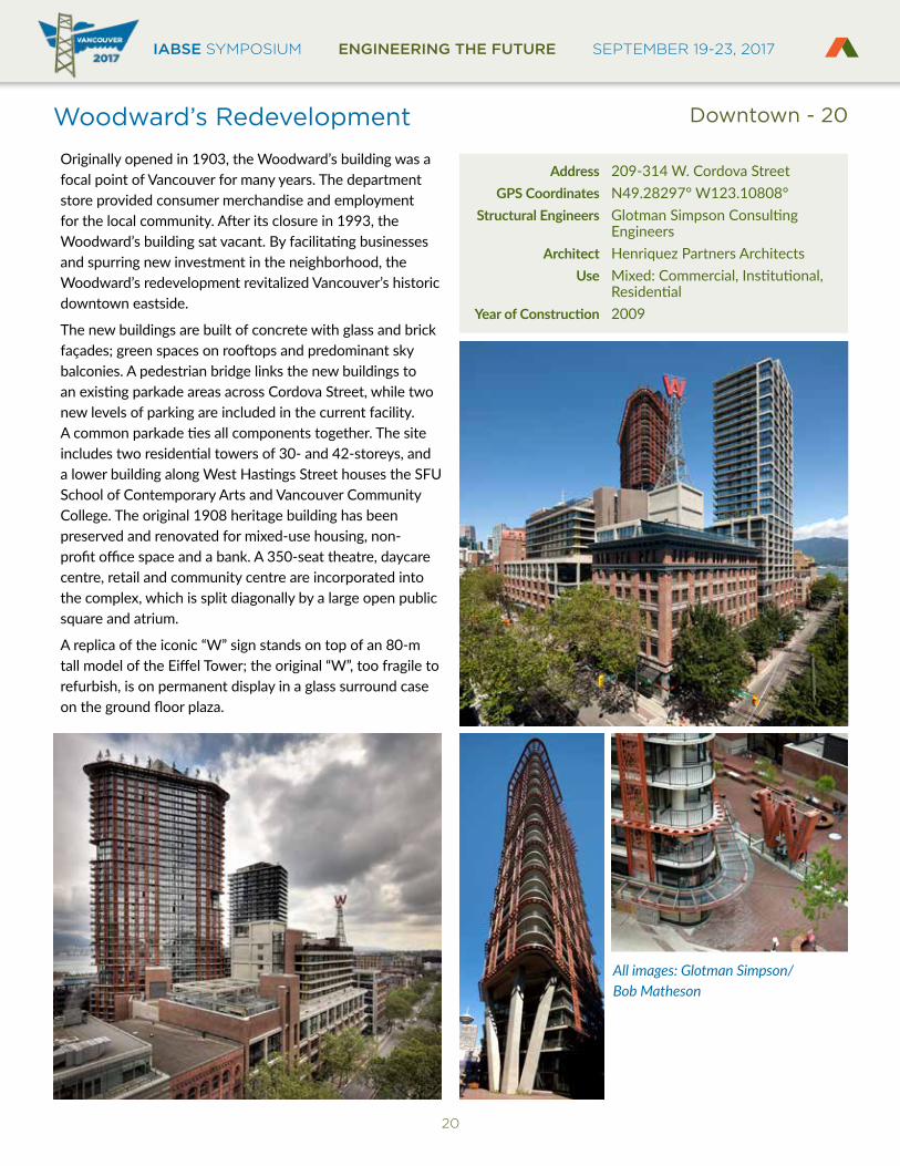
Woodward’s Redevelopment
Originally opened in 1903, the Woodward’s building was a focal point of Vancouver for many years. The department store provided consumer merchandise and employment for the local community. After its closure in 1993, the Woodward’s building sat vacant. By facilitating businesses and spurring new investment in the neighborhood, the Woodward’s redevelopment revitalized Vancouver’s historic downtown eastside.
The new buildings are built of concrete with glass and brick façades; green spaces on rooftops and predominant sky balconies. A pedestrian bridge links the new buildings to an existing parkade areas across Cordova Street, while two new levels of parking are included in the current facility. A common parkade ties all components together. The site includes two residential towers of 30- and 42-storeys, and a lower building along West Hastings Street houses the SFU School of Contemporary Arts and Vancouver Community College. The original 1908 heritage building has been preserved and renovated for mixed-use housing, non-profit office space and a bank. A 350-seat theatre, daycare centre, retail and community centre are incorporated into the complex, which is split diagonally by a large open public square and atrium.
A replica of the iconic “W” sign stands on top of an 80-m tall model of the Eiffel Tower; the original “W”, too fragile to refurbish, is on permanent display in a glass surround case on the ground floor plaza.
Address 209-314 W. Cordova Street GPS Coordinates N49.28297° W123.10808° Structural Engineers Glotman Simpson Consulting Engineers Architect Henriquez Partners Architects Use Mixed: Commercial, Institutional, ResidentialYearofConstruction 2009
All images: Glotman Simpson/Bob Matheson
Downtown - 20
IABSE SYMPOSIUM ENGINEERING THE FUTURE SEPTEMBER 19-23, 2017BRITISH COLUMBIA
EST
RU
CT
UR
AL
E
NGINEERS A
SS
OC
IAT
ION
21
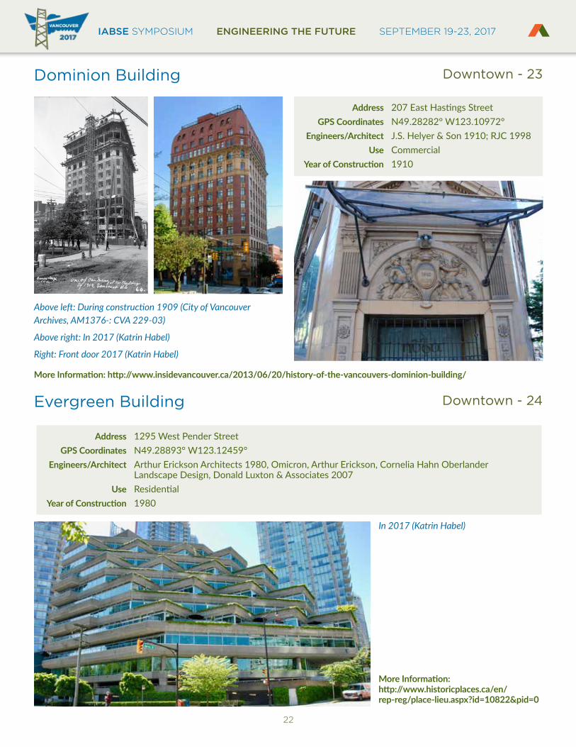
Dal Grauer Substation
Downtown - 21
Downtown - 22
Address 950 Burrard Street GPS Coordinates 49.28156, -123.12492 Engineers/Architects Sharp & Thompson, Berwick, Pratt 1954 Use IndustrialYearofConstruction 1954
Left: In 2017 (Katrin Habel)
MoreInformation:http://www.historicplaces.ca/en/rep-reg/place-lieu.aspx?id=8777&pid=0
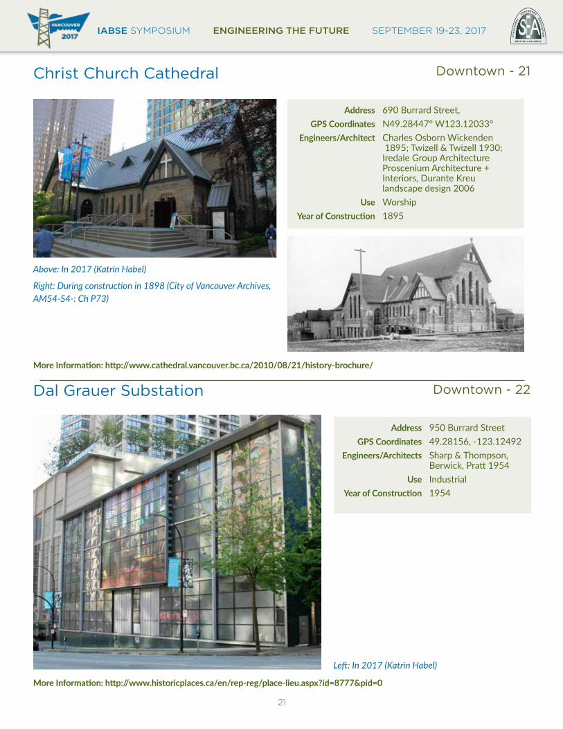
Christ Church Cathedral
Address 690 Burrard Street, GPS Coordinates N49.28447° W123.12033° Engineers/Architect Charles Osborn Wickenden 1895; Twizell & Twizell 1930; Iredale Group Architecture Proscenium Architecture + Interiors, Durante Kreu landscape design 2006 Use WorshipYearofConstruction 1895
Above: In 2017 (Katrin Habel)
Right: During construction in 1898 (City of Vancouver Archives, AM54-S4-: Ch P73)
MoreInformation:http://www.cathedral.vancouver.bc.ca/2010/08/21/history-brochure/
IABSE SYMPOSIUM ENGINEERING THE FUTURE SEPTEMBER 19-23, 2017
22
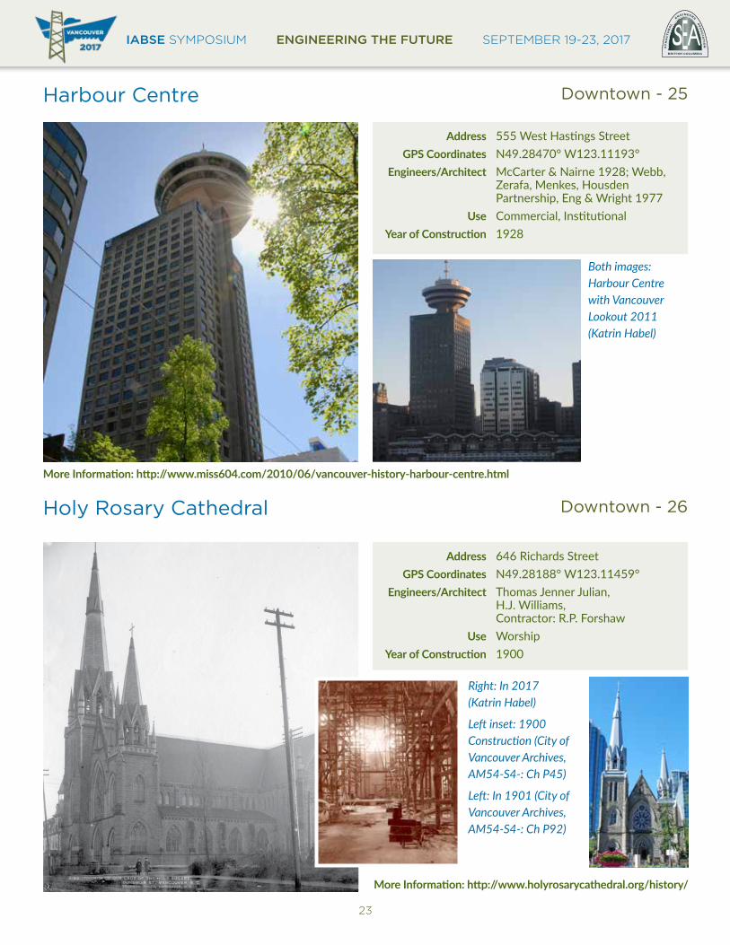
Dominion Building
Evergreen Building
Downtown - 23
Downtown - 24
Address 207 East Hastings Street GPS Coordinates N49.28282° W123.10972° Engineers/Architect J.S. Helyer & Son 1910; RJC 1998 Use CommercialYearofConstruction 1910
Above left: During construction 1909 (City of Vancouver Archives, AM1376-: CVA 229-03)
Above right: In 2017 (Katrin Habel)
Right: Front door 2017 (Katrin Habel)
In 2017 (Katrin Habel)
MoreInformation:http://www.insidevancouver.ca/2013/06/20/history-of-the-vancouvers-dominion-building/
MoreInformation: http://www.historicplaces.ca/en/ rep-reg/place-lieu.aspx?id=10822&pid=0
Address 1295 West Pender Street GPS Coordinates N49.28893° W123.12459° Engineers/Architect Arthur Erickson Architects 1980, Omicron, Arthur Erickson, Cornelia Hahn Oberlander Landscape Design, Donald Luxton & Associates 2007 Use ResidentialYearofConstruction 1980
IABSE SYMPOSIUM ENGINEERING THE FUTURE SEPTEMBER 19-23, 2017BRITISH COLUMBIA
EST
RU
CT
UR
AL
E
NGINEERS A
SS
OC
IAT
ION
23
Harbour Centre
Holy Rosary Cathedral
Downtown - 25
Downtown - 26
Address 555 West Hastings Street GPS Coordinates N49.28470° W123.11193° Engineers/Architect McCarter & Nairne 1928; Webb, Zerafa, Menkes, Housden Partnership, Eng & Wright 1977 Use Commercial, InstitutionalYearofConstruction 1928
Address 646 Richards Street GPS Coordinates N49.28188° W123.11459° Engineers/Architect Thomas Jenner Julian, H.J. Williams, Contractor: R.P. Forshaw Use WorshipYearofConstruction 1900
Both images: Harbour Centre with Vancouver Lookout 2011 (Katrin Habel)
Right: In 2017 (Katrin Habel)
Left inset: 1900 Construction (City of Vancouver Archives, AM54-S4-: Ch P45)
Left: In 1901 (City of Vancouver Archives, AM54-S4-: Ch P92)
MoreInformation:http://www.miss604.com/2010/06/vancouver-history-harbour-centre.html
MoreInformation:http://www.holyrosarycathedral.org/history/

IABSE SYMPOSIUM ENGINEERING THE FUTURE SEPTEMBER 19-23, 2017
24
Hotel Vancouver
MacMillan Bloedel Building (Fluor Building)
Downtown - 27
Downtown - 28
Address 900 West Georgia Street GPS Coordinates N49.28379° W123.12099° Engineers/Architect Archibald & Schofield 1928-39 Use CommercialYearofConstruction 1938
Address 1075 West Georgia Street GPS Coordinates N49.28574° W123.12225° Engineers/Architect Erickson/Massey 1969; Arthur Erickson Architects 1993 Use CommercialYearofConstruction 1969
Left: During construction in 1931 (City of Vancouver Archives, AM1535-: CVA 99-3697)
Right: In 1946 (City of Vancouver Archives, AM1545-S3-: CVA 586-4590)
Far right: In 2017 (Katrin Habel)
The MacMillan Bloedel Building was the first cast-in-place concrete moment frame in Vancouver. Image 2017 (Katrin Habel)
MoreInformation:http://www.insidevancouver.ca/2012/06/26/the-secret-history-of-the-hotel-vancouver/
MoreInformation: http://www.historicplaces.ca/en/rep-reg/ place-lieu.aspx?id=8781
IABSE SYMPOSIUM ENGINEERING THE FUTURE SEPTEMBER 19-23, 2017BRITISH COLUMBIA
EST
RU
CT
UR
AL
E
NGINEERS A
SS
OC
IAT
ION
25
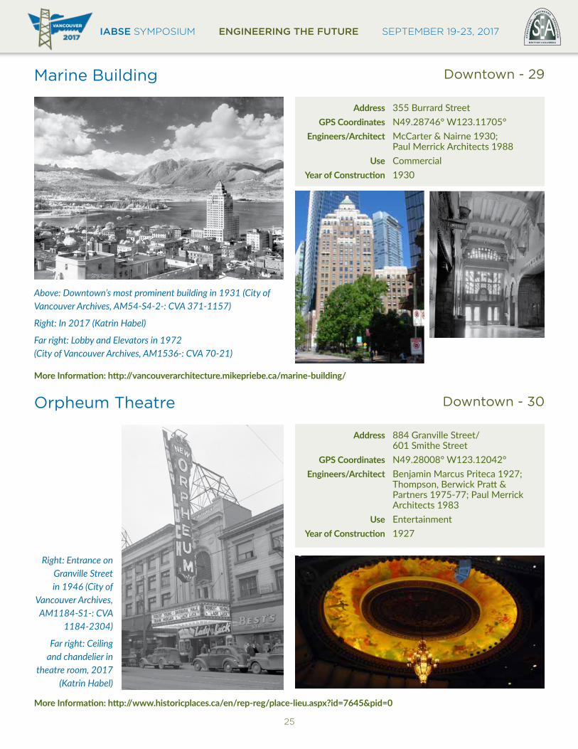
Marine Building
Orpheum Theatre
Downtown - 29
Downtown - 30
Address 355 Burrard Street GPS Coordinates N49.28746° W123.11705° Engineers/Architect McCarter & Nairne 1930; Paul Merrick Architects 1988 Use CommercialYearofConstruction 1930
Address 884 Granville Street/ 601 Smithe Street GPS Coordinates N49.28008° W123.12042° Engineers/Architect Benjamin Marcus Priteca 1927; Thompson, Berwick Pratt & Partners 1975-77; Paul Merrick Architects 1983 Use EntertainmentYearofConstruction 1927
Above: Downtown’s most prominent building in 1931 (City of Vancouver Archives, AM54-S4-2-: CVA 371-1157)
Right: In 2017 (Katrin Habel)
Far right: Lobby and Elevators in 1972 (City of Vancouver Archives, AM1536-: CVA 70-21)
Right: Entrance on Granville Street in 1946 (City of
Vancouver Archives, AM1184-S1-: CVA
1184-2304)
Far right: Ceiling and chandelier in
theatre room, 2017 (Katrin Habel)
MoreInformation:http://vancouverarchitecture.mikepriebe.ca/marine-building/
MoreInformation:http://www.historicplaces.ca/en/rep-reg/place-lieu.aspx?id=7645&pid=0
IABSE SYMPOSIUM ENGINEERING THE FUTURE SEPTEMBER 19-23, 2017
26
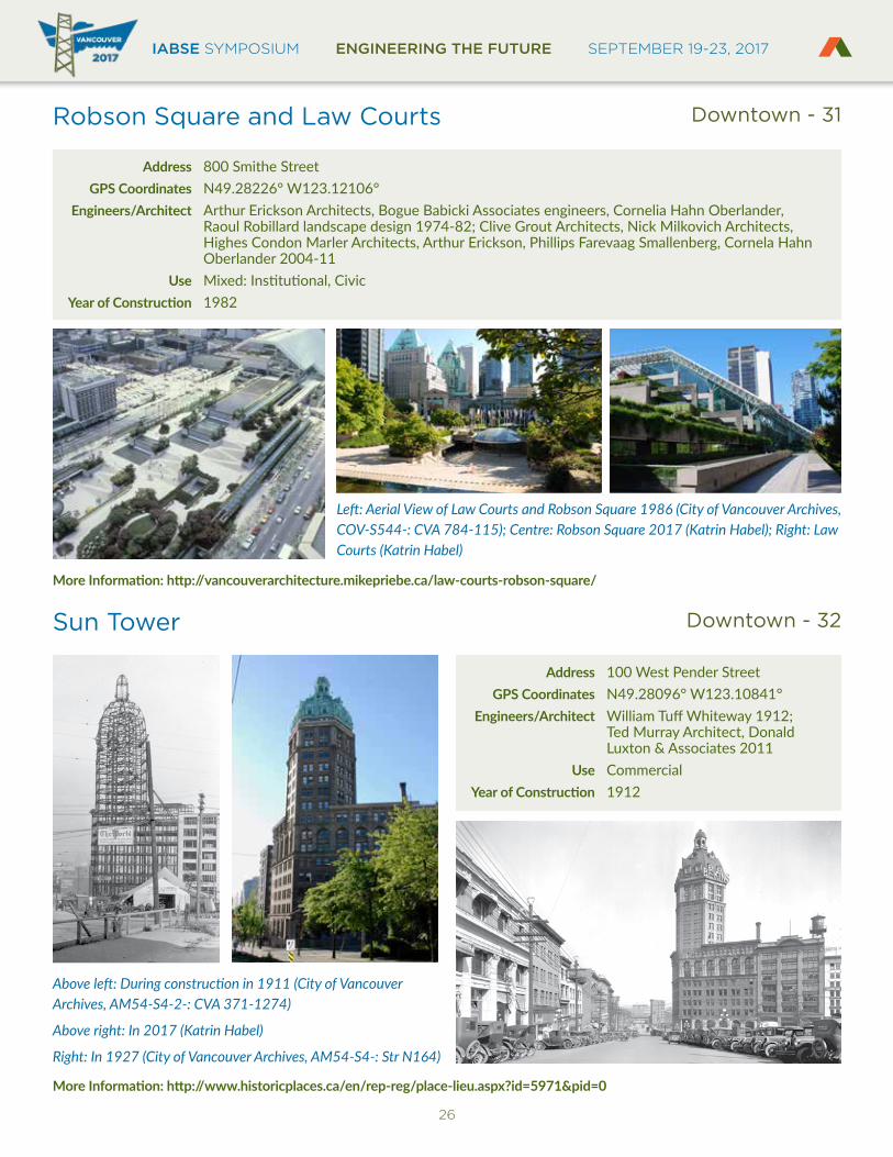
Robson Square and Law Courts
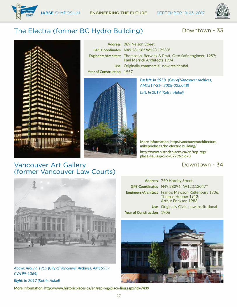
Sun Tower
Downtown - 31
Downtown - 32
Address 800 Smithe Street GPS Coordinates N49.28226° W123.12106° Engineers/Architect Arthur Erickson Architects, Bogue Babicki Associates engineers, Cornelia Hahn Oberlander, Raoul Robillard landscape design 1974-82; Clive Grout Architects, Nick Milkovich Architects, Highes Condon Marler Architects, Arthur Erickson, Phillips Farevaag Smallenberg, Cornela Hahn Oberlander 2004-11 Use Mixed: Institutional, CivicYearofConstruction 1982
Address 100 West Pender Street GPS Coordinates N49.28096° W123.10841° Engineers/Architect William Tuff Whiteway 1912; Ted Murray Architect, Donald Luxton & Associates 2011 Use CommercialYearofConstruction 1912
Left: Aerial View of Law Courts and Robson Square 1986 (City of Vancouver Archives, COV-S544-: CVA 784-115); Centre: Robson Square 2017 (Katrin Habel); Right: Law Courts (Katrin Habel)
Above left: During construction in 1911 (City of Vancouver Archives, AM54-S4-2-: CVA 371-1274)
Above right: In 2017 (Katrin Habel)
Right: In 1927 (City of Vancouver Archives, AM54-S4-: Str N164)
MoreInformation:http://vancouverarchitecture.mikepriebe.ca/law-courts-robson-square/
MoreInformation:http://www.historicplaces.ca/en/rep-reg/place-lieu.aspx?id=5971&pid=0
IABSE SYMPOSIUM ENGINEERING THE FUTURE SEPTEMBER 19-23, 2017BRITISH COLUMBIA
EST
RU
CT
UR
AL
E
NGINEERS A
SS
OC
IAT
ION
27
The Electra (former BC Hydro Building)
Vancouver Art Gallery (former Vancouver Law Courts)
Downtown - 33
Downtown - 34
Address 989 Nelson Street GPS Coordinates N49.28118° W123.12538° Engineers/Architect Thompson, Berwick & Pratt, Otto Safir engineer, 1957; Paul Merrick Architects 1994 Use Originally commercial, now residentialYearofConstruction 1957
Address 750 Hornby Street GPS Coordinates N49.28296° W123.12047° Engineers/Architect Francis Mawson Rattenbury 1906; Thomas Hooper 1912; Arthur Erickson 1983 Use Originally Civic, now InstitutionalYearofConstruction 1906
Far left: In 1958 (City of Vancouver Archives, AM1517-S1-: 2008-022.048)
Left: In 2017 (Katrin Habel)
Above: Around 1915 (City of Vancouver Archives, AM1535-: CVA 99-1064)
Right: In 2017 (Katrin Habel)
MoreInformation:http://vancouverarchitecture.mikepriebe.ca/bc-electric-building/http://www.historicplaces.ca/en/rep-reg/ place-lieu.aspx?id=8779&pid=0
MoreInformation:http://www.historicplaces.ca/en/rep-reg/place-lieu.aspx?id=7439
IABSE SYMPOSIUM ENGINEERING THE FUTURE SEPTEMBER 19-23, 2017
28
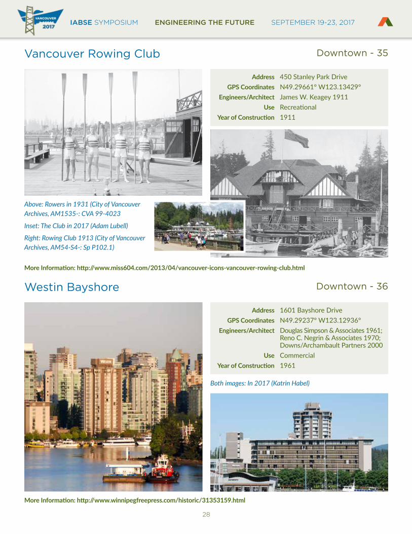
Vancouver Rowing Club
Westin Bayshore
Downtown - 35
Downtown - 36
Address 450 Stanley Park Drive GPS Coordinates N49.29661° W123.13429° Engineers/Architect James W. Keagey 1911 Use RecreationalYearofConstruction 1911
Address 1601 Bayshore Drive GPS Coordinates N49.29237° W123.12936° Engineers/Architect Douglas Simpson & Associates 1961; Reno C. Negrin & Associates 1970; Downs/Archambault Partners 2000 Use CommercialYearofConstruction 1961
Above: Rowers in 1931 (City of Vancouver Archives, AM1535-: CVA 99-4023
Inset: The Club in 2017 (Adam Lubell)
Right: Rowing Club 1913 (City of Vancouver Archives, AM54-S4-: Sp P102.1)
Both images: In 2017 (Katrin Habel)
MoreInformation:http://www.miss604.com/2013/04/vancouver-icons-vancouver-rowing-club.html
MoreInformation:http://www.winnipegfreepress.com/historic/31353159.html

IABSE SYMPOSIUM ENGINEERING THE FUTURE SEPTEMBER 19-23, 2017BRITISH COLUMBIA
EST
RU
CT
UR
AL
E
NGINEERS A
SS
OC
IAT
ION
29
AMS Student Nest
The University of British Columbia’s Student Union Building (The Nest) serves as a central gathering place for students and alumni to converse and grow as a vibrant student community. The 20,000 m2 building, delivered through an Integrated Design Process (IDP), contains food and retail outlets at the lower levels, as well as numerous offices, meeting/club rooms, a 12 m tall indoor climbing wall, a day-care and a community garden at the upper levels.
The Nest features five-levels above grade. A full-height central atrium is characterized by breathtaking views and exposed heavy-wood structural components. A saw-tooth roof design used a hybrid structure of glazed glulam trusses (27m long) and cross-laminated timber (CLT) panels. The glazed west façade continues the wood expression with 18m tall twin-glulam columns. Connectivity across the atrium was achieved through hybrid heavy-wood and steel sky-bridges that cantilever off the west façade columns. A pod-like open-air lounge within the atrium spaced was constructed with double-cantilevered structural steel framing supported by three widely spaced, slender steel columns.
In the south part of the building, the Great Hall serves as a visually striking multi-purpose space. To maintain open spaces, the structural configuration utilized 9m deep exposed trusses on three sides of the Great Hall, with spans on the east and west sides exceeding 36m.
Address 6133 University Boulevard GPS Coordinates N49.26660° W123.24986° Structural Engineers RJC Engineers Architect B+H Architects and DIALOG Use InstitutionalYearofConstruction 2015
Clockwise from above: Roof and Nest, façade view, outside view, façade and roof structure. All images: Ema Peter/DIALOG
UBC - 37
IABSE SYMPOSIUM ENGINEERING THE FUTURE SEPTEMBER 19-23, 2017
30
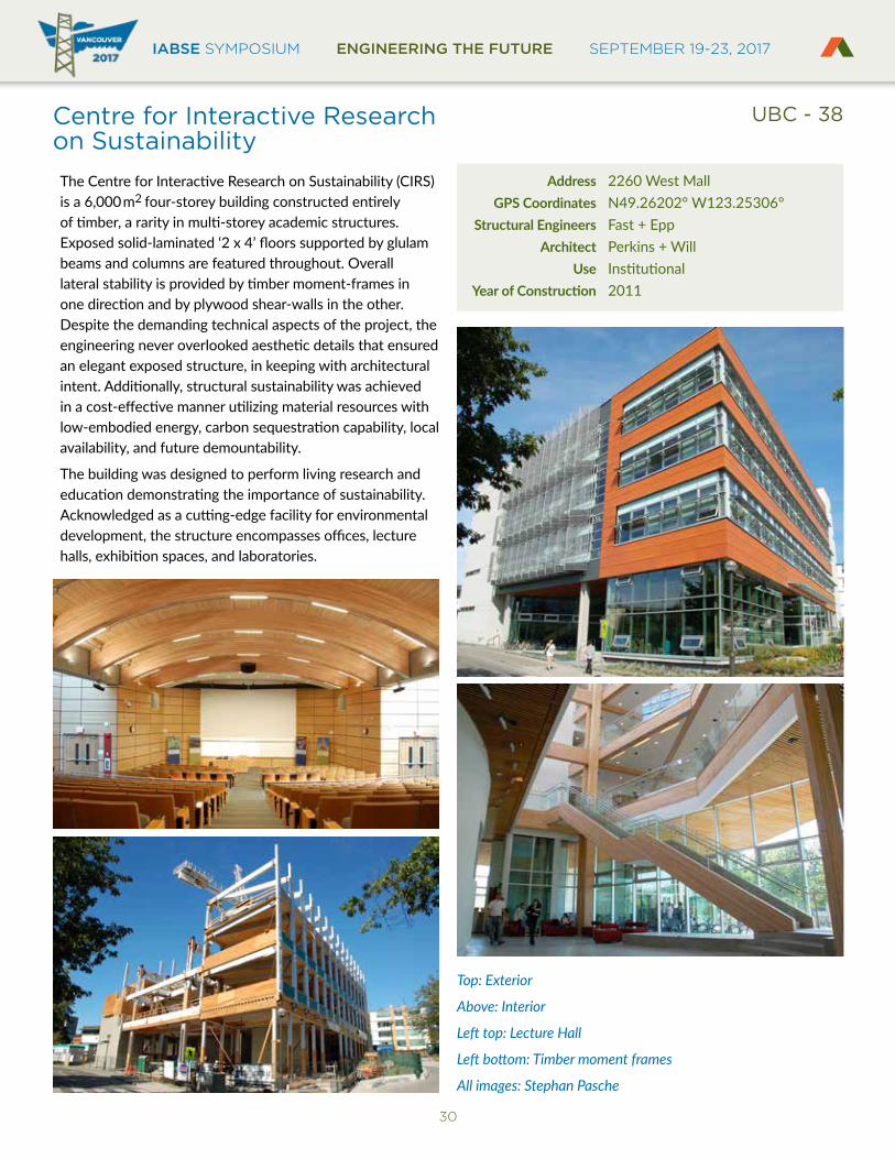
Centre for Interactive Research on SustainabilityThe Centre for Interactive Research on Sustainability (CIRS) is a 6,000m2 four-storey building constructed entirely of timber, a rarity in multi-storey academic structures. Exposed solid-laminated ‘2 x 4’ floors supported by glulam beams and columns are featured throughout. Overall lateral stability is provided by timber moment-frames in one direction and by plywood shear-walls in the other. Despite the demanding technical aspects of the project, the engineering never overlooked aesthetic details that ensured an elegant exposed structure, in keeping with architectural intent. Additionally, structural sustainability was achieved in a cost-effective manner utilizing material resources with low-embodied energy, carbon sequestration capability, local availability, and future demountability.
The building was designed to perform living research and education demonstrating the importance of sustainability. Acknowledged as a cutting-edge facility for environmental development, the structure encompasses offices, lecture halls, exhibition spaces, and laboratories.
Address 2260 West Mall GPS Coordinates N49.26202° W123.25306° Structural Engineers Fast + Epp Architect Perkins + Will Use InstitutionalYearofConstruction 2011
Top: Exterior
Above: Interior
Left top: Lecture Hall
Left bottom: Timber moment frames
All images: Stephan Pasche
UBC - 38
IABSE SYMPOSIUM ENGINEERING THE FUTURE SEPTEMBER 19-23, 2017BRITISH COLUMBIA
EST
RU
CT
UR
AL
E
NGINEERS A
SS
OC
IAT
ION
31
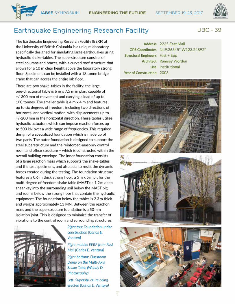
Earthquake Engineering Research Facility
The Earthquake Engineering Research Facility (EERF) at the University of British Columbia is a unique laboratory specifically designed for simulating large earthquakes using hydraulic shake-tables. The superstructure consists of steel columns and braces, with a curved roof structure that allows for a 10 m clear height above the laboratory strong floor. Specimens can be installed with a 18 tonne bridge crane that can access the entire lab floor.
There are two shake-tables in the facility: the large, one-directional table is 6 m x 7.5 m in plan, capable of +/-300 mm of movement and carrying a load of up to 100 tonnes. The smaller table is 4 m x 4 m and features up to six degrees of freedom, including two directions of horizontal and vertical motion, with displacements up to +/-200 mm in the horizontal direction. These tables utilize hydraulic actuators which can impose reaction forces up to 500 kN over a wide range of frequencies. This required design of a specialized foundation which is made up of two parts. The outer foundation is designed to support the steel superstructure and the reinforced-masonry control room and office structure – which is constructed within the overall building envelope. The inner foundation consists of a large reaction mass which supports the shake-tables and the test specimens, and also acts to resist the dynamic forces created during the testing. The foundation structure features a 0.6 m thick strong floor; a 5m x 5m pit for the multi-degree of freedom shake table (MAST); a 1.2m deep shear key into the surrounding soil below the MAST pit; and rooms below the strong floor that contain the hydraulic equipment. The foundation below the tables is 2.3m thick and weighs approximately 13 MN. Between the reaction mass and the superstructure foundation is a 50mm isolation joint. This is designed to minimize the transfer of vibrations to the control room and surrounding structures.
Address 2235 East Mall GPS Coordinates N49.26345° W123.24892° Structural Engineers Fast + Epp Architect Ramsey Worden Use InstitutionalYearofConstruction 2003
Right top: Foundation under construction (Carlos E. Ventura)
Right middle: EERF from East Mall (Carlos E. Ventura)
Right bottom: Classroom Demo on the Multi-Axis Shake-Table (Wendy D. Photography)
Left: Superstructure being erected (Carlos E. Ventura)
UBC - 39
IABSE SYMPOSIUM ENGINEERING THE FUTURE SEPTEMBER 19-23, 2017
32
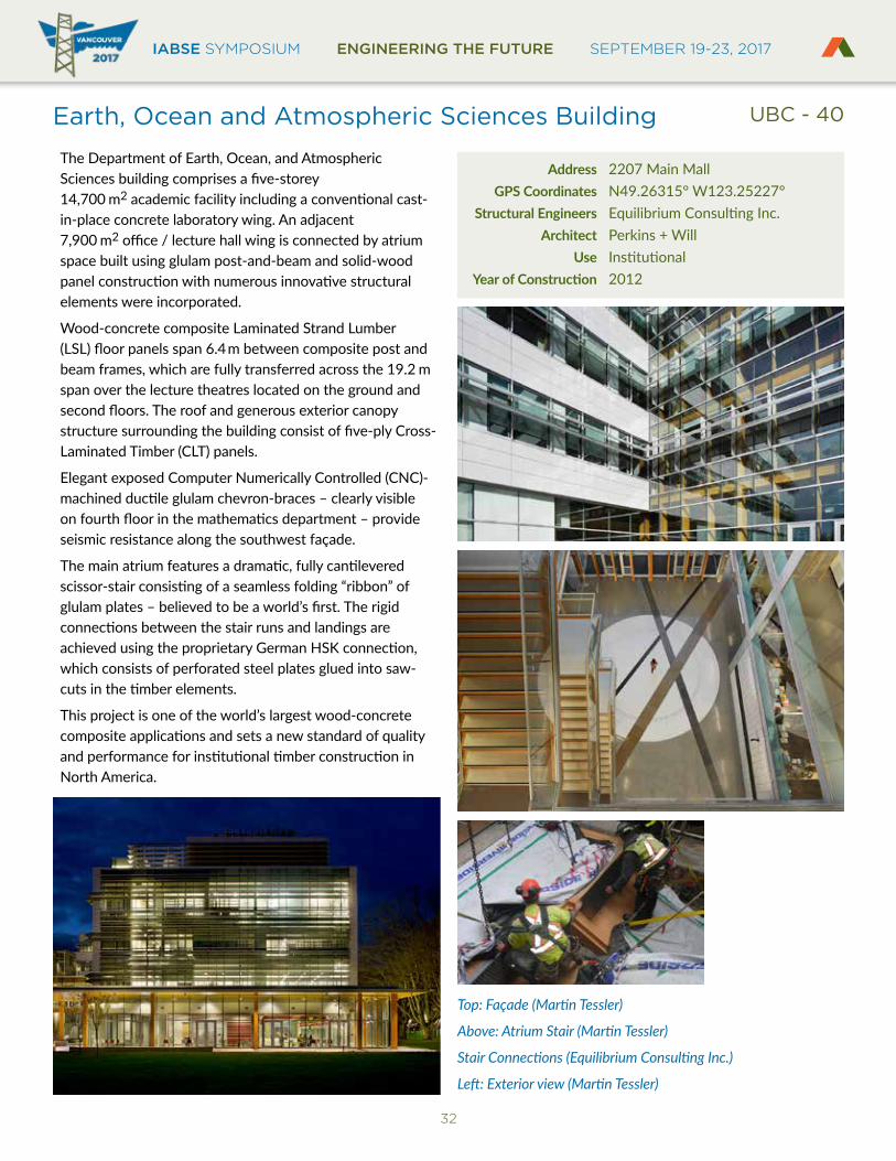
Earth, Ocean and Atmospheric Sciences Building
The Department of Earth, Ocean, and Atmospheric Sciences building comprises a five-storey 14,700 m2 academic facility including a conventional cast-in-place concrete laboratory wing. An adjacent 7,900 m2 office / lecture hall wing is connected by atrium space built using glulam post-and-beam and solid-wood panel construction with numerous innovative structural elements were incorporated.
Wood-concrete composite Laminated Strand Lumber (LSL) floor panels span 6.4m between composite post and beam frames, which are fully transferred across the 19.2 m span over the lecture theatres located on the ground and second floors. The roof and generous exterior canopy structure surrounding the building consist of five-ply Cross-Laminated Timber (CLT) panels.
Elegant exposed Computer Numerically Controlled (CNC)-machined ductile glulam chevron-braces – clearly visible on fourth floor in the mathematics department – provide seismic resistance along the southwest façade.
The main atrium features a dramatic, fully cantilevered scissor-stair consisting of a seamless folding “ribbon” of glulam plates – believed to be a world’s first. The rigid connections between the stair runs and landings are achieved using the proprietary German HSK connection, which consists of perforated steel plates glued into saw-cuts in the timber elements.
This project is one of the world’s largest wood-concrete composite applications and sets a new standard of quality and performance for institutional timber construction in North America.
Address 2207 Main Mall GPS Coordinates N49.26315° W123.25227° Structural Engineers Equilibrium Consulting Inc. Architect Perkins + Will Use InstitutionalYearofConstruction 2012
Top: Façade (Martin Tessler)
Above: Atrium Stair (Martin Tessler)
Stair Connections (Equilibrium Consulting Inc.)
Left: Exterior view (Martin Tessler)
UBC - 40
IABSE SYMPOSIUM ENGINEERING THE FUTURE SEPTEMBER 19-23, 2017BRITISH COLUMBIA
EST
RU
CT
UR
AL
E
NGINEERS A
SS
OC
IAT
ION
33
Irving K. Barber Learning Centre
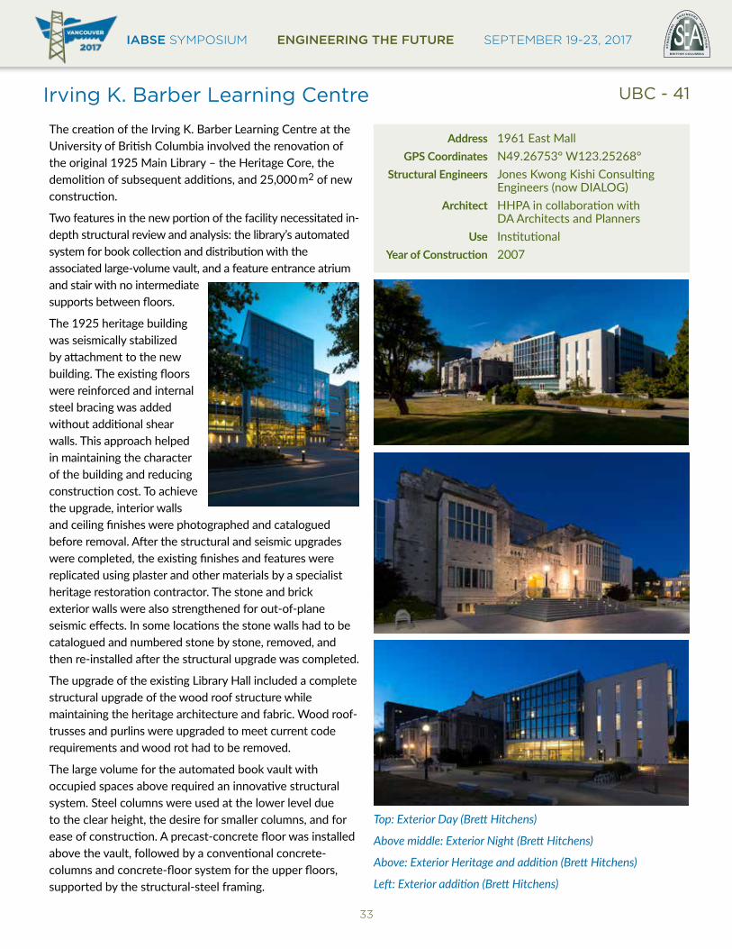
The creation of the Irving K. Barber Learning Centre at the University of British Columbia involved the renovation of the original 1925 Main Library – the Heritage Core, the demolition of subsequent additions, and 25,000m2 of new construction.
Two features in the new portion of the facility necessitated in-depth structural review and analysis: the library’s automated system for book collection and distribution with the associated large-volume vault, and a feature entrance atrium and stair with no intermediate supports between floors.
The 1925 heritage building was seismically stabilized by attachment to the new building. The existing floors were reinforced and internal steel bracing was added without additional shear walls. This approach helped in maintaining the character of the building and reducing construction cost. To achieve the upgrade, interior walls and ceiling finishes were photographed and catalogued before removal. After the structural and seismic upgrades were completed, the existing finishes and features were replicated using plaster and other materials by a specialist heritage restoration contractor. The stone and brick exterior walls were also strengthened for out-of-plane seismic effects. In some locations the stone walls had to be catalogued and numbered stone by stone, removed, and then re-installed after the structural upgrade was completed.
The upgrade of the existing Library Hall included a complete structural upgrade of the wood roof structure while maintaining the heritage architecture and fabric. Wood roof-trusses and purlins were upgraded to meet current code requirements and wood rot had to be removed.
The large volume for the automated book vault with occupied spaces above required an innovative structural system. Steel columns were used at the lower level due to the clear height, the desire for smaller columns, and for ease of construction. A precast-concrete floor was installed above the vault, followed by a conventional concrete-columns and concrete-floor system for the upper floors, supported by the structural-steel framing.
Address 1961 East Mall GPS Coordinates N49.26753° W123.25268° Structural Engineers Jones Kwong Kishi Consulting Engineers (now DIALOG) Architect HHPA in collaboration with DA Architects and Planners Use InstitutionalYearofConstruction 2007
Top: Exterior Day (Brett Hitchens)
Above middle: Exterior Night (Brett Hitchens)
Above: Exterior Heritage and addition (Brett Hitchens)
Left: Exterior addition (Brett Hitchens)
UBC - 41

IABSE SYMPOSIUM ENGINEERING THE FUTURE SEPTEMBER 19-23, 2017
34
Pharmaceutical Sciences Building
The novel design of the Faculty of Pharmaceutical Sciences building combines four structurally distinct buildings into a single complex, connecting the buildings with three large atriums. Signature features are a large, two-level open entrance, abundant natural light, and sloped walls at the base.
To create the cantilevered west façade, columns connected to each slab were offset, and placed next to the exterior curtain to provide unobstructed views for corner boardrooms. The design connects individual elements with link-slabs to resist seismic effects. The link-slabs transfer loads throughout the structure and supporting the architect’s overall project vision. BIM modelling facilitated fast-track construction.
Address 2405 Wesbrook Mall GPS Coordinates N49.26227° W123.24339° Structural Engineers Glotman Simpson Consulting Engineers Architect Saucier + Perrotte Architects and HCMA Architecture + Design Use EducationalYearofConstruction 2012
All images Glotman Simpson/Bob Matheson
UBC - 42
IABSE SYMPOSIUM ENGINEERING THE FUTURE SEPTEMBER 19-23, 2017BRITISH COLUMBIA
EST
RU
CT
UR
AL
E
NGINEERS A
SS
OC
IAT
ION
35
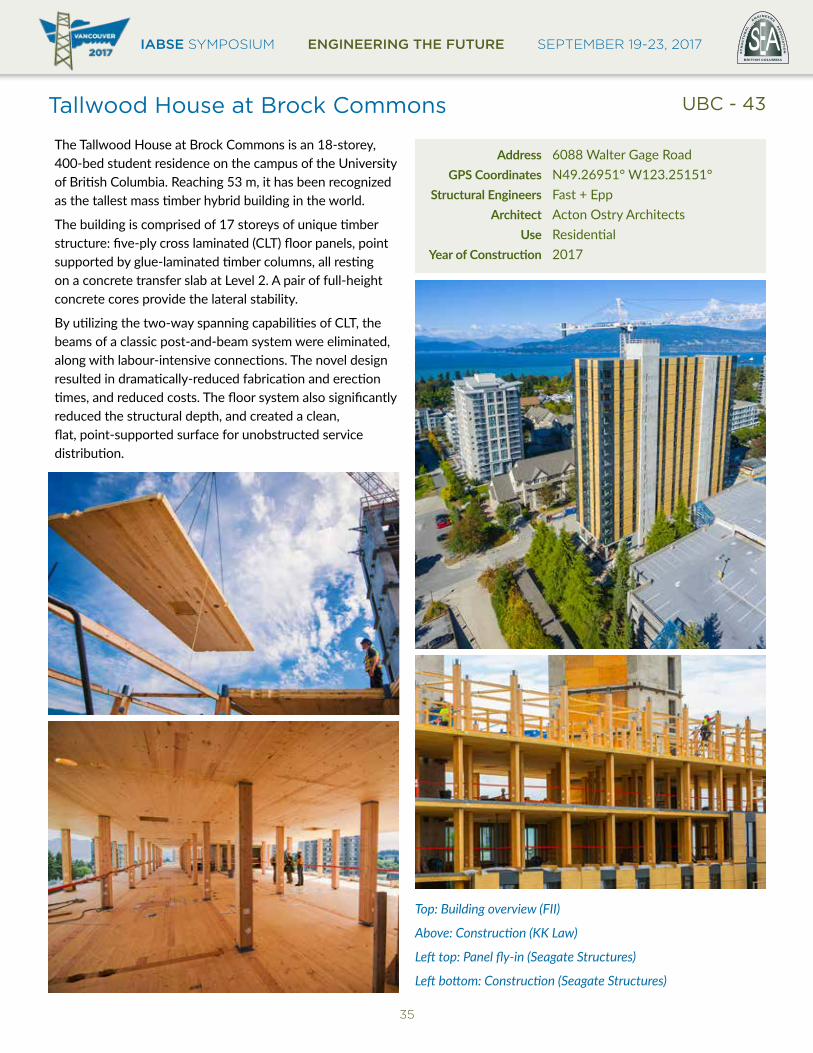
Tallwood House at Brock Commons
The Tallwood House at Brock Commons is an 18-storey, 400-bed student residence on the campus of the University of British Columbia. Reaching 53 m, it has been recognized as the tallest mass timber hybrid building in the world.
The building is comprised of 17 storeys of unique timber structure: five-ply cross laminated (CLT) floor panels, point supported by glue-laminated timber columns, all resting on a concrete transfer slab at Level 2. A pair of full-height concrete cores provide the lateral stability.
By utilizing the two-way spanning capabilities of CLT, the beams of a classic post-and-beam system were eliminated, along with labour-intensive connections. The novel design resulted in dramatically-reduced fabrication and erection times, and reduced costs. The floor system also significantly reduced the structural depth, and created a clean, flat, point-supported surface for unobstructed service distribution.
Address 6088 Walter Gage Road GPS Coordinates N49.26951° W123.25151° Structural Engineers Fast + Epp Architect Acton Ostry Architects Use ResidentialYearofConstruction 2017
Top: Building overview (FII)
Above: Construction (KK Law)
Left top: Panel fly-in (Seagate Structures)
Left bottom: Construction (Seagate Structures)
UBC - 43
IABSE SYMPOSIUM ENGINEERING THE FUTURE SEPTEMBER 19-23, 2017
36
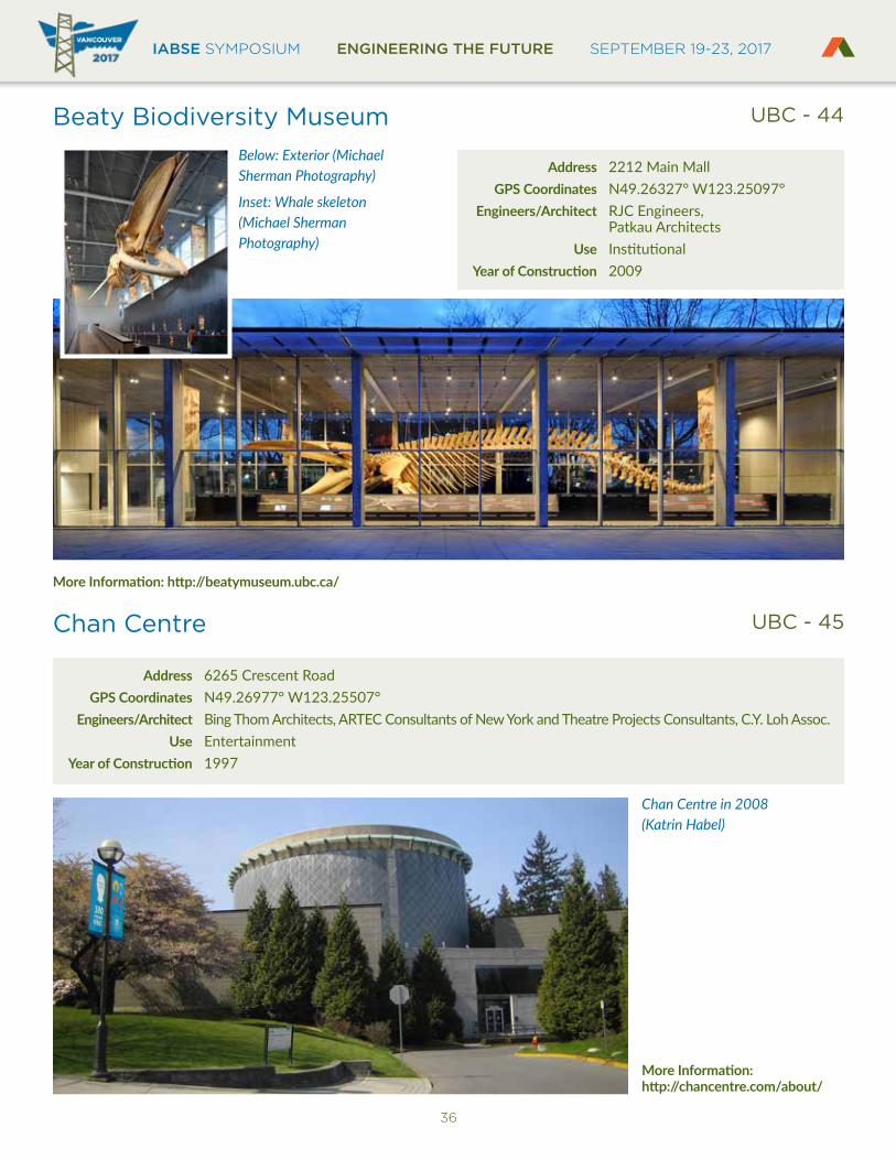
Beaty Biodiversity Museum
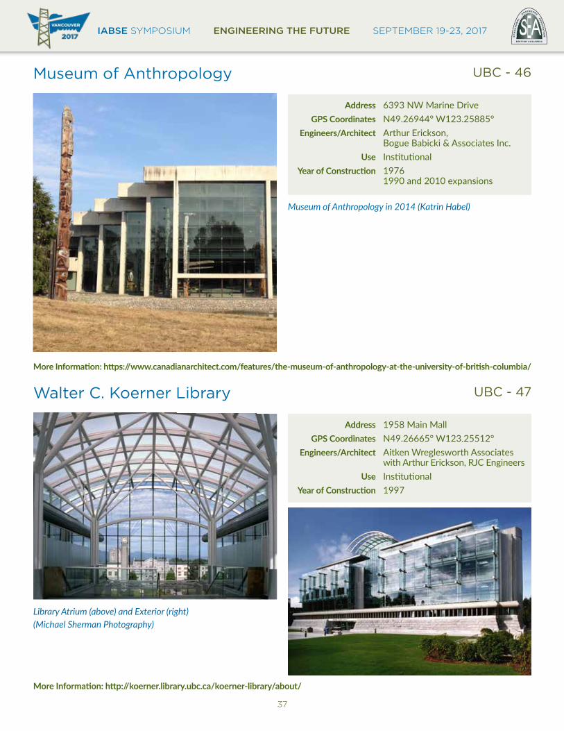
Chan Centre
UBC - 44
UBC - 45
Address 2212 Main Mall GPS Coordinates N49.26327° W123.25097° Engineers/Architect RJC Engineers, Patkau Architects Use InstitutionalYearofConstruction 2009
Address 6265 Crescent Road GPS Coordinates N49.26977° W123.25507° Engineers/Architect Bing Thom Architects, ARTEC Consultants of New York and Theatre Projects Consultants, C.Y. Loh Assoc. Use EntertainmentYearofConstruction 1997
Below: Exterior (Michael Sherman Photography)
Inset: Whale skeleton (Michael Sherman Photography)
Chan Centre in 2008 (Katrin Habel)
MoreInformation:http://beatymuseum.ubc.ca/
MoreInformation: http://chancentre.com/about/
IABSE SYMPOSIUM ENGINEERING THE FUTURE SEPTEMBER 19-23, 2017BRITISH COLUMBIA
EST
RU
CT
UR
AL
E
NGINEERS A
SS
OC
IAT
ION
37
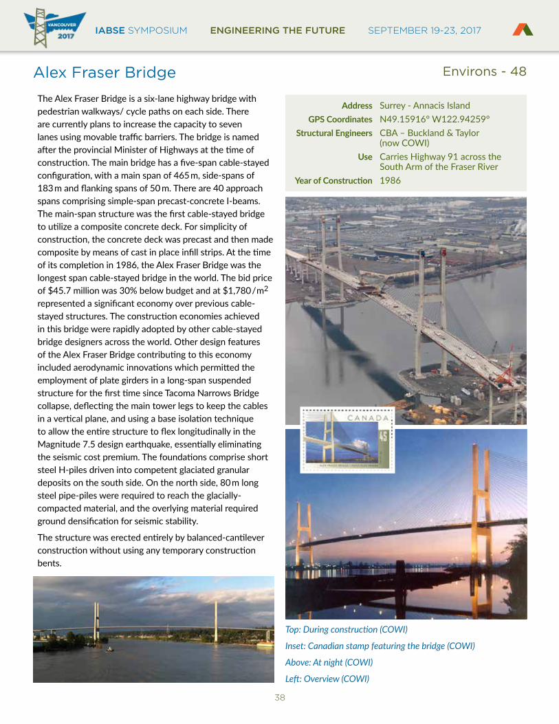
Museum of Anthropology
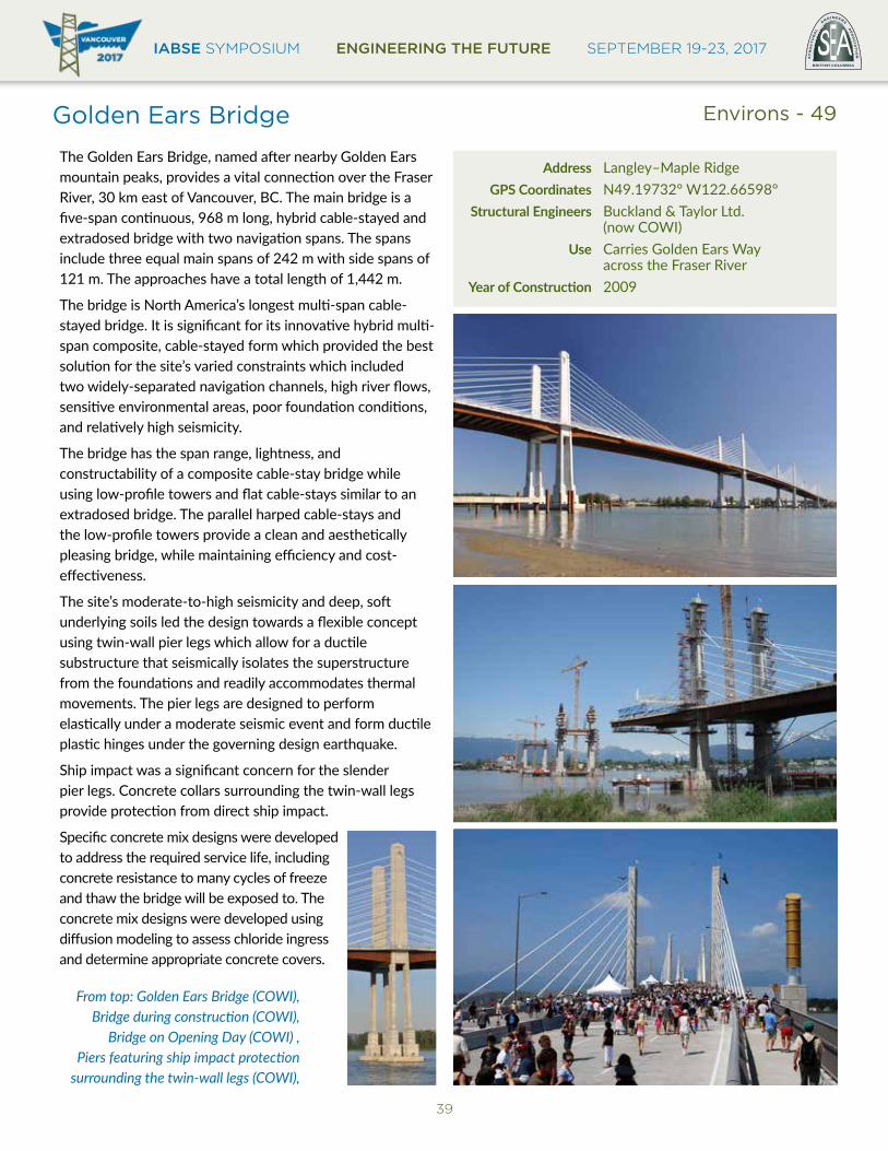
Walter C. Koerner Library
UBC - 46
UBC - 47
Address 6393 NW Marine Drive GPS Coordinates N49.26944° W123.25885° Engineers/Architect Arthur Erickson, Bogue Babicki & Associates Inc. Use InstitutionalYearofConstruction 1976 1990 and 2010 expansions
Address 1958 Main Mall GPS Coordinates N49.26665° W123.25512° Engineers/Architect Aitken Wreglesworth Associates with Arthur Erickson, RJC Engineers Use InstitutionalYearofConstruction 1997
Museum of Anthropology in 2014 (Katrin Habel)
Library Atrium (above) and Exterior (right) (Michael Sherman Photography)
MoreInformation:https://www.canadianarchitect.com/features/the-museum-of-anthropology-at-the-university-of-british-columbia/
MoreInformation:http://koerner.library.ubc.ca/koerner-library/about/
IABSE SYMPOSIUM ENGINEERING THE FUTURE SEPTEMBER 19-23, 2017
38
Alex Fraser Bridge
The Alex Fraser Bridge is a six-lane highway bridge with pedestrian walkways/ cycle paths on each side. There are currently plans to increase the capacity to seven lanes using movable traffic barriers. The bridge is named after the provincial Minister of Highways at the time of construction. The main bridge has a five-span cable-stayed configuration, with a main span of 465m, side-spans of 183m and flanking spans of 50 m. There are 40 approach spans comprising simple-span precast-concrete I-beams. The main-span structure was the first cable-stayed bridge to utilize a composite concrete deck. For simplicity of construction, the concrete deck was precast and then made composite by means of cast in place infill strips. At the time of its completion in 1986, the Alex Fraser Bridge was the longest span cable-stayed bridge in the world. The bid price of $45.7 million was 30% below budget and at $1,780/m2 represented a significant economy over previous cable-stayed structures. The construction economies achieved in this bridge were rapidly adopted by other cable-stayed bridge designers across the world. Other design features of the Alex Fraser Bridge contributing to this economy included aerodynamic innovations which permitted the employment of plate girders in a long-span suspended structure for the first time since Tacoma Narrows Bridge collapse, deflecting the main tower legs to keep the cables in a vertical plane, and using a base isolation technique to allow the entire structure to flex longitudinally in the Magnitude 7.5 design earthquake, essentially eliminating the seismic cost premium. The foundations comprise short steel H-piles driven into competent glaciated granular deposits on the south side. On the north side, 80m long steel pipe-piles were required to reach the glacially-compacted material, and the overlying material required ground densification for seismic stability.
The structure was erected entirely by balanced-cantilever construction without using any temporary construction bents.
Address Surrey - Annacis Island GPS Coordinates N49.15916° W122.94259° Structural Engineers CBA – Buckland & Taylor (now COWI) Use Carries Highway 91 across the South Arm of the Fraser RiverYearofConstruction 1986
Top: During construction (COWI)
Inset: Canadian stamp featuring the bridge (COWI)
Above: At night (COWI)
Left: Overview (COWI)
Environs - 48
IABSE SYMPOSIUM ENGINEERING THE FUTURE SEPTEMBER 19-23, 2017BRITISH COLUMBIA
EST
RU
CT
UR
AL
E
NGINEERS A
SS
OC
IAT
ION
39
Golden Ears Bridge
The Golden Ears Bridge, named after nearby Golden Ears mountain peaks, provides a vital connection over the Fraser River, 30 km east of Vancouver, BC. The main bridge is a five-span continuous, 968 m long, hybrid cable-stayed and extradosed bridge with two navigation spans. The spans include three equal main spans of 242 m with side spans of 121 m. The approaches have a total length of 1,442 m.
The bridge is North America’s longest multi-span cable-stayed bridge. It is significant for its innovative hybrid multi-span composite, cable-stayed form which provided the best solution for the site’s varied constraints which included two widely-separated navigation channels, high river flows, sensitive environmental areas, poor foundation conditions, and relatively high seismicity.
The bridge has the span range, lightness, and constructability of a composite cable-stay bridge while using low-profile towers and flat cable-stays similar to an extradosed bridge. The parallel harped cable-stays and the low-profile towers provide a clean and aesthetically pleasing bridge, while maintaining efficiency and cost-effectiveness.
The site’s moderate-to-high seismicity and deep, soft underlying soils led the design towards a flexible concept using twin-wall pier legs which allow for a ductile substructure that seismically isolates the superstructure from the foundations and readily accommodates thermal movements. The pier legs are designed to perform elastically under a moderate seismic event and form ductile plastic hinges under the governing design earthquake.
Ship impact was a significant concern for the slender pier legs. Concrete collars surrounding the twin-wall legs provide protection from direct ship impact.
Specific concrete mix designs were developed to address the required service life, including concrete resistance to many cycles of freeze and thaw the bridge will be exposed to. The concrete mix designs were developed using diffusion modeling to assess chloride ingress and determine appropriate concrete covers.
Address Langley–Maple Ridge GPS Coordinates N49.19732° W122.66598° Structural Engineers Buckland & Taylor Ltd. (now COWI) Use Carries Golden Ears Way across the Fraser RiverYearofConstruction 2009
From top: Golden Ears Bridge (COWI), Bridge during construction (COWI),
Bridge on Opening Day (COWI) , Piers featuring ship impact protection
surrounding the twin-wall legs (COWI),
Environs - 49
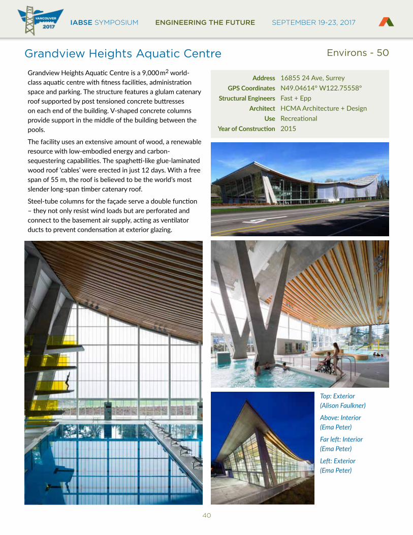
IABSE SYMPOSIUM ENGINEERING THE FUTURE SEPTEMBER 19-23, 2017
40
Grandview Heights Aquatic Centre
Grandview Heights Aquatic Centre is a 9,000m2 world-class aquatic centre with fitness facilities, administration space and parking. The structure features a glulam catenary roof supported by post tensioned concrete buttresses on each end of the building. V-shaped concrete columns provide support in the middle of the building between the pools.
The facility uses an extensive amount of wood, a renewable resource with low-embodied energy and carbon-sequestering capabilities. The spaghetti-like glue-laminated wood roof ‘cables’ were erected in just 12 days. With a free span of 55 m, the roof is believed to be the world’s most slender long-span timber catenary roof.
Steel-tube columns for the façade serve a double function – they not only resist wind loads but are perforated and connect to the basement air supply, acting as ventilator ducts to prevent condensation at exterior glazing.
Address 16855 24 Ave, Surrey GPS Coordinates N49.04614° W122.75558° Structural Engineers Fast + Epp Architect HCMA Architecture + Design Use RecreationalYearofConstruction 2015
Top: Exterior (Alison Faulkner)
Above: Interior (Ema Peter)
Far left: Interior (Ema Peter)
Left: Exterior (Ema Peter)
Environs - 50
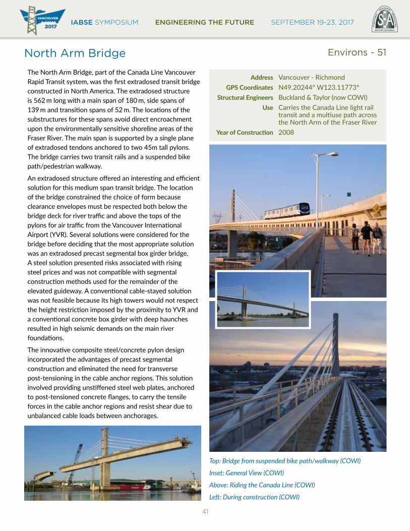
IABSE SYMPOSIUM ENGINEERING THE FUTURE SEPTEMBER 19-23, 2017BRITISH COLUMBIA
EST
RU
CT
UR
AL
E
NGINEERS A
SS
OC
IAT
ION
41
North Arm Bridge
The North Arm Bridge, part of the Canada Line Vancouver Rapid Transit system, was the first extradosed transit bridge constructed in North America. The extradosed structure is 562 m long with a main span of 180 m, side spans of 139 m and transition spans of 52 m. The locations of the substructures for these spans avoid direct encroachment upon the environmentally sensitive shoreline areas of the Fraser River. The main span is supported by a single plane of extradosed tendons anchored to two 45m tall pylons. The bridge carries two transit rails and a suspended bike path/pedestrian walkway.
An extradosed structure offered an interesting and efficient solution for this medium span transit bridge. The location of the bridge constrained the choice of form because clearance envelopes must be respected both below the bridge deck for river traffic and above the tops of the pylons for air traffic from the Vancouver International Airport (YVR). Several solutions were considered for the bridge before deciding that the most appropriate solution was an extradosed precast segmental box girder bridge. A steel solution presented risks associated with rising steel prices and was not compatible with segmental construction methods used for the remainder of the elevated guideway. A conventional cable-stayed solution was not feasible because its high towers would not respect the height restriction imposed by the proximity to YVR and a conventional concrete box girder with deep haunches resulted in high seismic demands on the main river foundations.
The innovative composite steel/concrete pylon design incorporated the advantages of precast segmental construction and eliminated the need for transverse post-tensioning in the cable anchor regions. This solution involved providing unstiffened steel web plates, anchored to post-tensioned concrete flanges, to carry the tensile forces in the cable anchor regions and resist shear due to unbalanced cable loads between anchorages.
Address Vancouver - Richmond GPS Coordinates N49.20244° W123.11773° Structural Engineers Buckland & Taylor (now COWI) Use Carries the Canada Line light rail transit and a multiuse path across the North Arm of the Fraser RiverYearofConstruction 2008
Top: Bridge from suspended bike path/walkway (COWI)
Inset: General View (COWI)
Above: Riding the Canada Line (COWI)
Left: During construction (COWI)
Environs - 51

IABSE SYMPOSIUM ENGINEERING THE FUTURE SEPTEMBER 19-23, 2017
42
Pitt River Bridge
The Pitt River Bridge is a 506 m-long crossing, procured through design-build delivery between 2007 and 2010. It replaced two swing bridges that were unreliable, costly to maintain, and vulnerable to vessel impacts and earthquakes. The crossing has seven spans, including a three-span, three-plane 380 m composite cable-stayed bridge with 190 m main span, 95 m back spans, and four concrete approach spans. It crosses a 20 m deep section of the Pitt River, which is underlain by deposits of liquefiable sands and soft, compressible organics, silts and clays. Firm glacial till is at 100 m depth. Originally envisaged as a girder bridge, a cable-stayed option was preferred by the contractor to minimize in-stream piers and interference by river traffic. The bridge accommodates seven lanes of traffic and allows for easy addition of a transit or rapid bus lane. The regional seismic hazard is high, with the risk of crustal and Cascadia-Subduction events. The bridge must remain functional for traffic following a design-level earthquake. The seismic design used a performance-based design (PBD) philosophy, which contributed to the adoption of PBD in the 2014 Canadian Highway Bridge Design Code.
Key to the successful lateral load design for seismic and vessel impact was adopting a structurally continuous superstructure between abutments. Many cable-stayed bridges utilize expansion joints at tie-down piers; however, this creates significant design, construction and operational risks. The continuous span arrangement with integral pier connections avoided these issues, but needed flexible substructure and foundations with the associated detailing. Other factors contributing to a successful project were the use of design-build delivery, a full-scale 45 MN pile load test for the 1.8 m diameter steel pipe piles, the cable-stayed arrangement to simplify in-river construction, design and construction innovation throughout the work, a partnership with Canadian steel suppliers and fabricators, and excellent quality management.
Address Lougheed Highway, Port Coquitlam GPS Coordinates N49.24889° W122.73185° Structural Engineers Associated Engineering, International Bridge Technologies Use Carries Highway 7 (Lougheed Highway) across the Pitt RiverYearofConstruction 2009
Top: Aerial View (Associated Engineering)
Inset: 45 MN Pile Test (Associated Engineering)
South Elevation (Associated Engineering)
Left: Main Pier (Associated Engineering)
Environs - 52
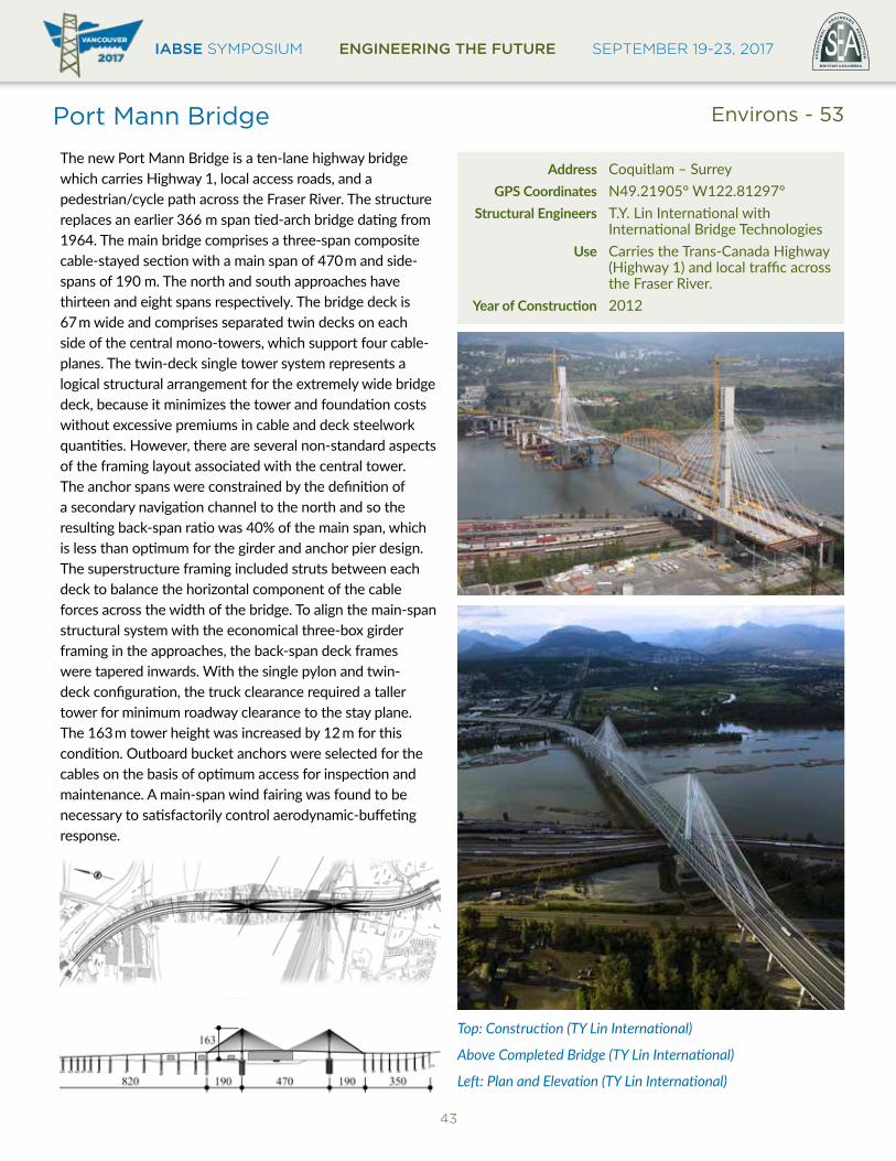
IABSE SYMPOSIUM ENGINEERING THE FUTURE SEPTEMBER 19-23, 2017BRITISH COLUMBIA
EST
RU
CT
UR
AL
E
NGINEERS A
SS
OC
IAT
ION
43
Port Mann Bridge
The new Port Mann Bridge is a ten-lane highway bridge which carries Highway 1, local access roads, and a pedestrian/cycle path across the Fraser River. The structure replaces an earlier 366 m span tied-arch bridge dating from 1964. The main bridge comprises a three-span composite cable-stayed section with a main span of 470m and side-spans of 190 m. The north and south approaches have thirteen and eight spans respectively. The bridge deck is 67m wide and comprises separated twin decks on each side of the central mono-towers, which support four cable-planes. The twin-deck single tower system represents a logical structural arrangement for the extremely wide bridge deck, because it minimizes the tower and foundation costs without excessive premiums in cable and deck steelwork quantities. However, there are several non-standard aspects of the framing layout associated with the central tower. The anchor spans were constrained by the definition of a secondary navigation channel to the north and so the resulting back-span ratio was 40% of the main span, which is less than optimum for the girder and anchor pier design. The superstructure framing included struts between each deck to balance the horizontal component of the cable forces across the width of the bridge. To align the main-span structural system with the economical three-box girder framing in the approaches, the back-span deck frames were tapered inwards. With the single pylon and twin-deck configuration, the truck clearance required a taller tower for minimum roadway clearance to the stay plane. The 163m tower height was increased by 12 m for this condition. Outboard bucket anchors were selected for the cables on the basis of optimum access for inspection and maintenance. A main-span wind fairing was found to be necessary to satisfactorily control aerodynamic-buffeting response.
Address Coquitlam – Surrey GPS Coordinates N49.21905° W122.81297° Structural Engineers T.Y. Lin International with International Bridge Technologies Use Carries the Trans-Canada Highway (Highway 1) and local traffic across the Fraser River.YearofConstruction 2012
Top: Construction (TY Lin International)
Above Completed Bridge (TY Lin International)
Left: Plan and Elevation (TY Lin International)
Environs - 53

IABSE SYMPOSIUM ENGINEERING THE FUTURE SEPTEMBER 19-23, 2017
44
Richmond Olympic Oval
The Richmond Olympic Oval is a 30,000m2 multi-purpose sports and recreation facility that initially served as the Long-Track Speed Skating venue for the 2010 Winter Olympic and Paralympic Games. The structure features sweeping long-span timber-steel hybrid arches, considered a world first, which support a visually-intriguing array of ‘Wood Wave’ panels that immediately capture the attention of visitors to the venue. The roof structure conceals all mechanical and electrical services within the hybrid arches, creating an uncluttered architectural expression. The wood-wave panels, constructed with extensive use of built-up pine-beetle-kill ‘2 x 4s’, sustainably and economically responded to the epidemic plaguing BC’s forests. The perforated panel structure yields outstanding acoustic performance, and sprinklers were fabricated inside the panels, making the entire structure a truly integrated design.
Address 6111 River Rd, Richmond GPS Coordinates N49.17483° W123.15189° Structural Engineers Fast + Epp Architect Cannon Design Use RecreationalYearofConstruction 2008
Top: Exterior (Nic Lehoux)
Far left: Wood Wave panel (Martin Tessler)
Left: Exterior (Stephan Pasche)
Below: Interior (Cannon Design)
Environs - 54

IABSE SYMPOSIUM ENGINEERING THE FUTURE SEPTEMBER 19-23, 2017BRITISH COLUMBIA
EST
RU
CT
UR
AL
E
NGINEERS A
SS
OC
IAT
ION
45
Second Narrows (Ironworkers Memorial) Bridge
The Second Narrows Bridge is located at the East end of Vancouver Harbour. It replaces an earlier bridge at this location which carried both road and rail traffic. The 1292 m long harbour crossing is located immediately adjacent to a new lift-span for rail traffic. The Second Narrows Bridge is a six-lane highway structure carrying the Trans-Canada Highway, two segregated paths for cyclists and pedestrians, and gas and water mains. High fences were recently installed at each side of the bridge to reduce suicide risks.
The bridge design comprises four simple-span steel trusses on the north approach with spans of about 86 m, and a three-span continuous main bridge with a main span of 335 m and flanking spans of 142 m. There are nine concrete-girder spans of about 36.5 m at the north end. The main span contains a pin-ended drop-in span 110 m long. The trusses mostly comprise shop riveted, field bolted box members made up from angles and plates. The concrete deck is composite with its supporting stringers, but is structurally independent of the support trusses. The foundations comprise hollow concrete caissons bearing on dense sandstone on the south side and steel H-piles driven into gravel on the north. Construction tenders totaling about $15 million were awarded and work started in 1957. The north side-span collapsed during construction on 17th June 1958 due to lateral instability of three parallel needle-beams supporting the erection bent. The adjacent pier and approach span were pulled down by the collapse. 18 Ironworkers were killed in the collapse and the bridge was later (1994) renamed “The Ironworkers Memorial Bridge.“ The bridge was opened to traffic in August 1960.
In 1992 the bridge was upgraded with improvements to the seismic resistance, replacement of the original maintenance traveler with three independent travelers affording maintenance access to all truss members, and the deck overlay was replaced. Design and supervision were by COWI.
Address Second Narrows of Burrard Inlet GPS Coordinates N49.29856° W123.02644° Structural Engineers Swan Wooster Engineering Use Carries the Trans-Canada Highway (Highway 1) and multiuse trails across Burrard InletYearofConstruction 1960
Top: Bridge view from the narrows (COWI)
Above: Bridge Traffic in 2006 (Associated Engineering)
Ironworkers Memorial Bridge Bearing Replacement 1998 (Associated Engineering)
Environs - 55

IABSE SYMPOSIUM ENGINEERING THE FUTURE SEPTEMBER 19-23, 2017
46
Skybridge
The Skybridge is a three-span span 616 m long cable-stayed bridge with a 340 m long main span that connects rapid transit from Surrey to Vancouver. The Skybridge was built in 1987-1989 at a cost of approximately $28 Million – it opened for revenue service on March 16, 1990. The deck consists of precast post-tensioned concrete segments, erected by lifting directly from barges in the river. The 123 m tall towers and end-piers were built in cast-in-place reinforced concrete using jump-forms.
The Skybridge caries Automated Light Rail Transit (ALRT) trains 45m above the Fraser River and is the world’s longest cable-supported structure solely for transit use.
Address New Westminster - Surrey GPS Coordinates N49.20558° W122.89688° Structural Engineers Reid Crowther and Bush Bohlman & Partners joint venture Use Carries ALRT trains across the Fraser RiverYearofConstruction 1990
Above top: Construction of New Westminster side nears completion (Andy Metten)
Above: Completed bridge (Andy Metten)
Right top: Lifting of final precast segment (Andy Metten)
Right bottom: First half of bridge erected with traveler removed (Andy Metten)
Environs - 56
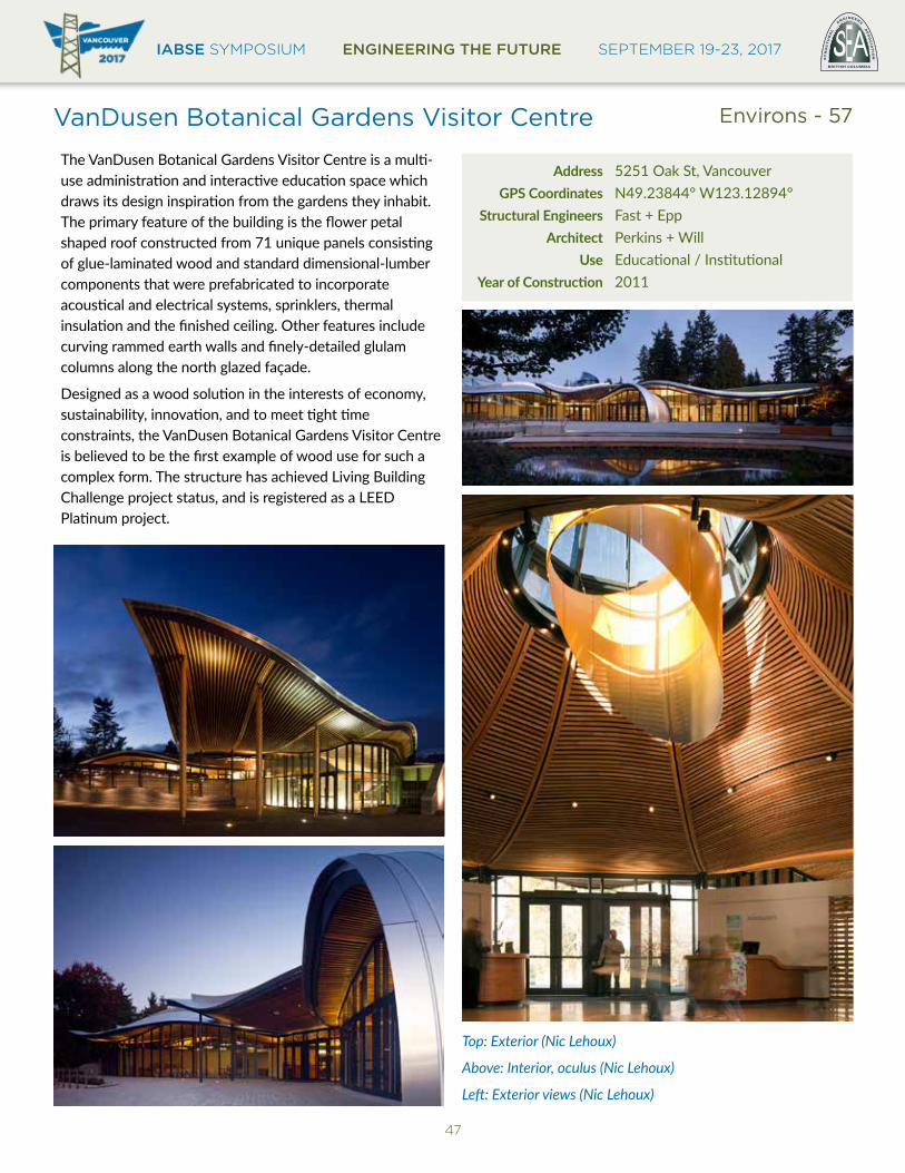
IABSE SYMPOSIUM ENGINEERING THE FUTURE SEPTEMBER 19-23, 2017BRITISH COLUMBIA
EST
RU
CT
UR
AL
E
NGINEERS A
SS
OC
IAT
ION
47
VanDusen Botanical Gardens Visitor Centre
The VanDusen Botanical Gardens Visitor Centre is a multi-use administration and interactive education space which draws its design inspiration from the gardens they inhabit. The primary feature of the building is the flower petal shaped roof constructed from 71 unique panels consisting of glue-laminated wood and standard dimensional-lumber components that were prefabricated to incorporate acoustical and electrical systems, sprinklers, thermal insulation and the finished ceiling. Other features include curving rammed earth walls and finely-detailed glulam columns along the north glazed façade.
Designed as a wood solution in the interests of economy, sustainability, innovation, and to meet tight time constraints, the VanDusen Botanical Gardens Visitor Centre is believed to be the first example of wood use for such a complex form. The structure has achieved Living Building Challenge project status, and is registered as a LEED Platinum project.
Address 5251 Oak St, Vancouver GPS Coordinates N49.23844° W123.12894° Structural Engineers Fast + Epp Architect Perkins + Will Use Educational / InstitutionalYearofConstruction 2011
Top: Exterior (Nic Lehoux)
Above: Interior, oculus (Nic Lehoux)
Left: Exterior views (Nic Lehoux)
Environs - 57
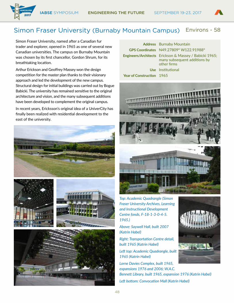
IABSE SYMPOSIUM ENGINEERING THE FUTURE SEPTEMBER 19-23, 2017
48
Simon Fraser University (Burnaby Mountain Campus)
Simon Fraser University, named after a Canadian fur trader and explorer, opened in 1965 as one of several new Canadian universities. The campus on Burnaby Mountain was chosen by its first chancellor, Gordon Shrum, for its breathtaking location.
Arthur Erickson and Geoffrey Massey won the design competition for the master plan thanks to their visionary approach and led the development of the new campus. Structural design for initial buildings was carried out by Bogue Babicki. The university has remained sensitive to the original architecture and vision, and the many subsequent additions have been developed to complement the original campus.
In recent years, Ericksson’s original idea of a UniverCity has finally been realized with residential development to the east of the university.
Address Burnaby Mountain GPS Coordinates N49.27809° W122.91988° Engineers/Architects Erickson & Massey / Babicki 1965; many subsequent additions by other firms Use InstitutionalYearofConstruction 1965
Top: Academic Quadrangle (Simon Fraser University Archives, Learning and Instructional Development Centre fonds, F-18-1-3-0-4-5. 1965.)
Above: Saywell Hall, built 2007 (Katrin Habel)
Right: Transportation Centre detail, built 1965 (Katrin Habel)
Left top: Academic Quadrangle, built 1965 (Katrin Habel)
Lorne Davies Complex, built 1965, expansions 1976 and 2006; W.A.C. Bennett Library, built 1965, expansion 1976 (Katrin Habel)
Left bottom: Convocation Mall (Katrin Habel)
Environs - 58
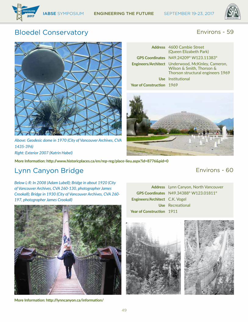
IABSE SYMPOSIUM ENGINEERING THE FUTURE SEPTEMBER 19-23, 2017BRITISH COLUMBIA
EST
RU
CT
UR
AL
E
NGINEERS A
SS
OC
IAT
ION
49
Bloedel Conservatory Environs - 59
Address 4600 Cambie Street (Queen Elizabeth Park) GPS Coordinates N49.24209° W123.11383° Engineers/Architect Underwood, McKinley, Cameron, Wilson & Smith, Thorson & Thorson structural engineers 1969 Use InstitutionalYearofConstruction 1969
Above: Geodesic dome in 1970 (City of Vancouver Archives, CVA1435-396)Right: Exterior 2007 (Katrin Habel)
MoreInformation:http://www.historicplaces.ca/en/rep-reg/place-lieu.aspx?id=8776&pid=0
Lynn Canyon Bridge Environs - 60
Address Lynn Canyon, North Vancouver GPS Coordinates N49.34388° W123.01811° Engineers/Architect C.K. Vogel Use RecreationalYearofConstruction 1911
Below L-R: In 2008 (Adam Lubell); Bridge in about 1920 (City of Vancouver Archives, CVA 260-130, photographer James Crookall); Bridge in 1930 (City of Vancouver Archives, CVA 260-197, photographer James Crookall)
MoreInformation:http://lynncanyon.ca/information/

IABSE SYMPOSIUM ENGINEERING THE FUTURE SEPTEMBER 19-23, 2017
50
Pacific Central Station Environs - 62
Address 1150 Station Street GPS Coordinates N49.27370° W123.09789° Engineers/Architect Pratt & Ross, John Schofield 1919; Philips Barratt Engineers & Architect 1993 Use TransportationYearofConstruction 1919
Top: In 2017 (Katrin Habel)
Above: During construction in 1918 (City of Vancouver Archives, Bu N540.080)
Right: In 1973 (City of Vancouver Archives, CVA 447-253, photographer Walter E. Frost)
MoreInformation:http://www.historicplaces.ca/en/rep-reg/image-image.aspx?id=4527#i1
Museum of Vancouver and H.R. MacMillan Space Centre
Environs - 61
Address 1100 Chestnut Street GPS Coordinates N49.27622° W123.14444° Engineers/Architect Gerald Hamilton & Assoc. 1968; Hancock, Brueckner Eng & Wright, Sears & Russell 2002 Use InstitutionalYearofConstruction 1968
Above: In 2017 (Katrin Habel)
Inset: In 1970 (Pugstem Publications)
Far right: In 1970 (City of Vancouver Archives, CVA 23-40, photographer William Roozeboom)
MoreInformation:http://www.historicplaces.ca/en/rep-reg/place-lieu.aspx?id=8920
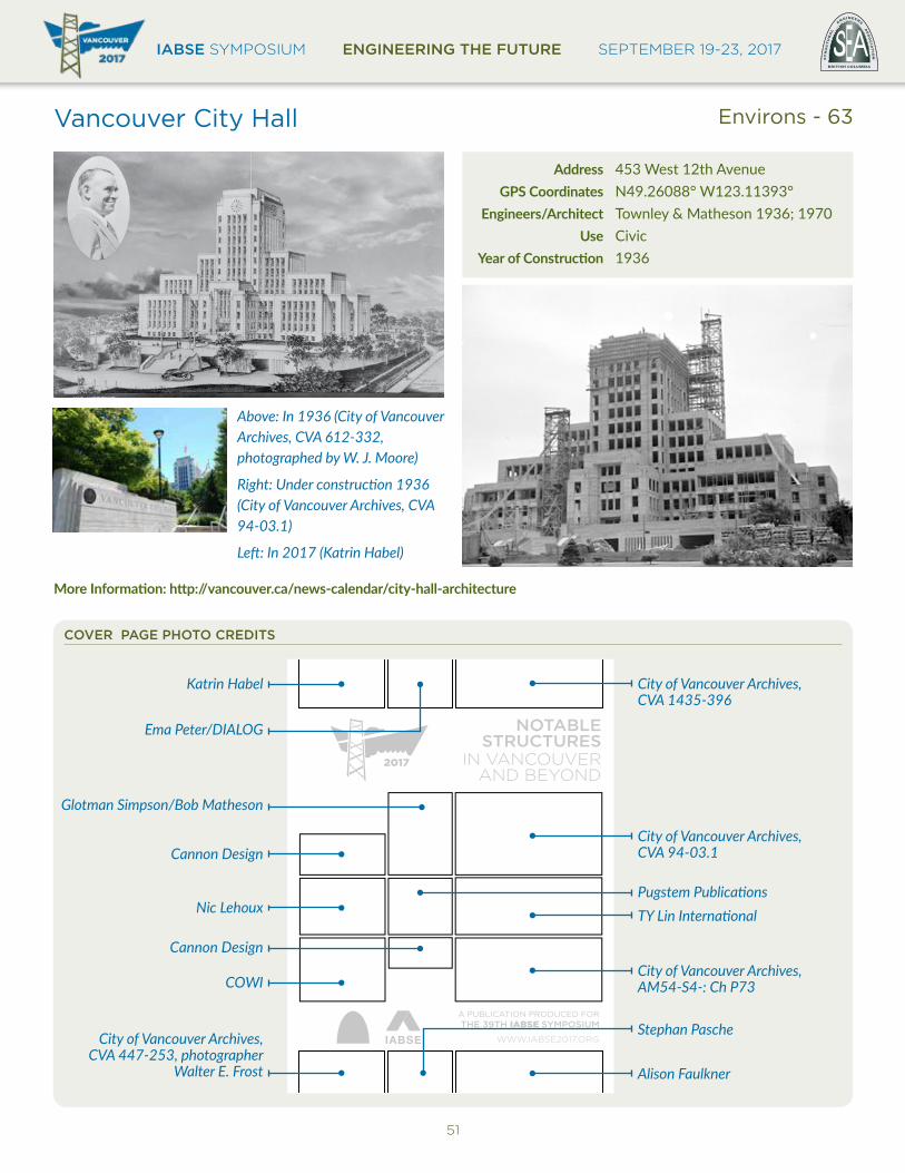
IABSE SYMPOSIUM ENGINEERING THE FUTURE SEPTEMBER 19-23, 2017BRITISH COLUMBIA
EST
RU
CT
UR
AL
E
NGINEERS A
SS
OC
IAT
ION
51
Vancouver City Hall Environs - 63
Address 453 West 12th Avenue GPS Coordinates N49.26088° W123.11393° Engineers/Architect Townley & Matheson 1936; 1970 Use CivicYearofConstruction 1936
Above: In 1936 (City of Vancouver Archives, CVA 612-332, photographed by W. J. Moore)
Right: Under construction 1936 (City of Vancouver Archives, CVA 94-03.1)
Left: In 2017 (Katrin Habel)
MoreInformation:http://vancouver.ca/news-calendar/city-hall-architecture
A PUBLICATION PRODUCED FORTHE 39TH IABSE SYMPOSIUM
WWW.IABSE2017.ORG
NOTABLESTRUCTURES
IN VANCOUVERAND BEYOND
Ema Peter/DIALOG
Cannon Design
Glotman Simpson/Bob Matheson
Nic Lehoux
Cannon Design
COWI
City of Vancouver Archives, CVA 94-03.1
City of Vancouver Archives, AM54-S4-: Ch P73
TY Lin InternationalPugstem Publications
Alison Faulkner
Stephan Pasche
City of Vancouver Archives, CVA 1435-396
City of Vancouver Archives, CVA 447-253, photographer
Walter E. Frost
Katrin Habel
COVER PAGE PHOTO CREDITS