WEST VANCOUVER COMMUNITY WILDFIRE PROTECTION ...
149
District of West Vancouver British Columbia WEST VANCOUVER COMMUNITY WILDFIRE PROTECTION PLAN 2019
-
Upload
khangminh22 -
Category
Documents
-
view
1 -
download
0
Transcript of WEST VANCOUVER COMMUNITY WILDFIRE PROTECTION ...
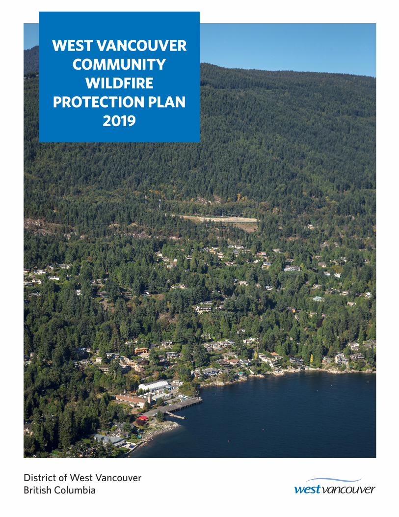
District of West VancouverBritish Columbia
WEST VANCOUVER COMMUNITY
WILDFIRE PROTECTION PLAN
2019
SUBMITTED BY:Leslie Brown, RPF
Bruce Blackwell, RPF, RPBioB.A. Blackwell & Associates Ltd.
270–18 Gostick PlaceNorth Vancouver, BC, V7M 3G3
Phone: 604-986-8346Email: [email protected]
SUBMITTED TO:Dave Clark | Fire Chief
District of West VancouverFire & Rescue Services
760 16th StreetWest Vancouver, BC, V7V 3S1
Phone: 604-925-7396Email: [email protected]
District of West Vancouver Community Wildfire Protection Plan
i
September 13, 2019
B.A. Blackwell & Associates Ltd.
ACKNOWLEDGEMENTS
The authors would like to thank the following District and non-District staff: Dave Clark, Fire Chief, West
Vancouver Fire and Rescue Services; Garrith Michael, Assistant Fire Chief, West Vancouver Fire &
Rescue Services; Andrew Banks, Senior Manager of Parks; Stina Hanson, Community Planner; Dan
Henegar, Parks Maintenance Manager; Ann Mooi, Director of Parks; Krista Jakobsen, GIS Administrator;
Jon Chuma, Fire Business Manager; Matt MacKinnon, Environmental Manager; Alex (Sasha) Charanin,
Parks staff; Ania Mafi, Communications & Engagement Manager, John Chapman, Emergency Planning
Officer; and Fiona Dercole, Emergency Planning Officer, North Shore Emergency Management. These
individuals invested substantial time in meetings, answering questions, reviewing, and commenting on the
contents of this document.
In addition, the authors would like to thank staff from the BC Wildfire Service, including Tony Botica,
Wildfire Prevention Officer, and Jessica Duncan, Prevention Specialist; and staff from the Ministry of
Forests, Lands, Natural Resource Operations and Rural Development, including Catherine Charman,
First Nations Advisor, as well as staff from BC Parks including Scott Donker, Area Supervisor, and David
Whiteside, Acting Area Supervisor.
The authors extend their appreciation to the Squamish, Tsleil-Waututh, and Musqueam First Nations.
District of West Vancouver Community Wildfire Protection Plan
ii
September 13, 2019
B.A. Blackwell & Associates Ltd.
REGISTERED PROFESSIONAL SIGN AND SEAL
RPF PRINTED NAME
Leslie L. Brown RPF 5117
DATE SIGNED
September 13, 2019
I certify that the work described herein fulfills the standards expected of a member of the
Association of British Columbia Forest Professionals and that I did personally supervise
the work.
Registered Professional Forester Signature and Seal
District of West Vancouver Community Wildfire Protection Plan
iii
September 13, 2019
B.A. Blackwell & Associates Ltd.
EXECUTIVE SUMMARY/SUMMARY OF CWPP
RECOMMENDATIONS
The Community Wildfire Protection Plan (CWPP) process was created in British Columbia as a response
to the devastating 2003 wildfire in Kelowna. As an integral part of the Strategic Wildfire Prevention
Initiative, managed and funded through the Strategic Wildfire Prevention Working Group, CWPPs aim to
develop strategic recommendations to assist in improving safety and to reduce the risk of damage to
property from wildfires.
This CWPP will provide the District of West Vancouver with a framework that can be used to review and
assess areas of identified moderate and high fire risk within the District. Additionally, the information
contained in this report should help to guide the development of emergency plans, emergency response,
evacuation plans, communication and education programs (including FireSmart), bylaw development in
areas of fire risk, and the management of potentially hazardous forest lands adjacent to the community.
Wildfire management requires a multi-faceted approach for greatest efficacy and risk reduction outcomes.
A total of 54 strategic recommendations are summarized in Table 1 below. In addition, these
recommendations are included and more thoroughly discussed in their appropriate sections within the
document. Ultimately, the recommendations within this plan should be considered a toolbox of options to
help reduce the wildfire threat to the community. There is not one course of action or combination of
actions that is the singular answer to the challenge of wildfire risk in communities. The District must
further prioritize actions based on resources, strengths, constraints, and availability of funding, regularly
updating prioritizations and courses of action as variables and circumstances change through time.
District of West Vancouver Community Wildfire Protection Plan
iv
September 13, 2019
B.A. Blackwell & Associates Ltd.
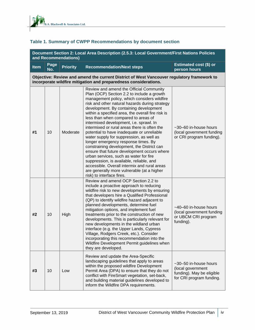
Table 1. Summary of CWPP Recommendations by document section
Document Section 2: Local Area Description (2.5.3: Local Government/First Nations Policies and Recommendations)
Item Page No.
Priority Recommendation/Next steps Estimated cost ($) or person hours
Objective: Review and amend the current District of West Vancouver regulatory framework to incorporate wildfire mitigation and preparedness considerations.
#1 10 Moderate
Review and amend the Official Community Plan (OCP) Section 2.2 to include a growth management policy, which considers wildfire risk and other natural hazards during strategy development. By containing development within a specified area, the overall fire risk is less than when compared to areas of intermixed development, i.e. sprawl. In intermixed or rural areas there is often the potential to have inadequate or unreliable water supply for suppression, as well as longer emergency response times. By constraining development, the District can ensure that future development occurs where urban services, such as water for fire suppression, is available, reliable, and accessible. Overall intermix and rural areas are generally more vulnerable (at a higher risk) to interface fires.
~30–60 in-house hours (local government funding or CRI program funding).
#2 10 High
Review and amend OCP Section 2.2 to include a proactive approach to reducing wildfire risk to new developments by ensuring that developers hire a Qualified Professional (QP) to identify wildfire hazard adjacent to planned developments, determine fuel mitigation options, and implement fuel treatments prior to the construction of new developments. This is particularly relevant for new developments in the wildland urban interface (e.g. the Upper Lands, Cypress Village, Rodgers Creek, etc.). Consider incorporating this recommendation into the Wildfire Development Permit guidelines when they are developed.
~40–60 in-house hours (local government funding or UBCM CRI program funding).
#3 10 Low
Review and update the Area-Specific landscaping guidelines that apply to areas within the proposed wildfire Development Permit Area (DPA) to ensure that they do not conflict with FireSmart vegetation, set-back, and building material guidelines developed to inform the Wildfire DPA requirements.
~30–50 in-house hours (local government funding). May be eligible for CRI program funding.
District of West Vancouver Community Wildfire Protection Plan
v
September 13, 2019
B.A. Blackwell & Associates Ltd.
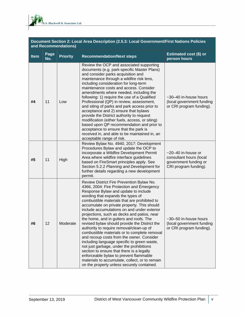
Document Section 2: Local Area Description (2.5.3: Local Government/First Nations Policies and Recommendations)
Item Page No.
Priority Recommendation/Next steps Estimated cost ($) or person hours
#4 11 Low
Review the OCP and associated supporting documents (e.g. park-specific Master Plans) and consider parks acquisition and maintenance through a wildfire risk lens, including consideration for long-term maintenance costs and access. Consider amendments where needed, including the following: 1) require the use of a Qualified Professional (QP) in review, assessment, and siting of parks and park access prior to acceptance and 2) ensure that bylaws provide the District authority to request modification (either fuels, access, or siting) based upon QP recommendation and prior to acceptance to ensure that the park is received in, and able to be maintained in, an acceptable range of risk.
~30–40 in-house hours (local government funding or CRI program funding).
#5 11 High
Review Bylaw No. 4940, 2017: Development Procedures Bylaw and update the OCP to incorporate a Wildfire Development Permit Area where wildfire interface guidelines based on FireSmart principles apply. See Section 5.2.2 Planning and Development for further details regarding a new development permit.
~20–40 in-house or consultant hours (local government funding or CRI program funding).
#6 12 Moderate
Review District Fire Prevention Bylaw No. 4366, 2004: Fire Protection and Emergency Response Bylaw and update to include wording that expands the types of combustible materials that are prohibited to accumulate on private property. This should include accumulations on and under exterior projections, such as decks and patios, near the home, and in gutters and roofs. The revised bylaw should provide the District the authority to require removal/clean-up of combustible materials or to complete removal and recoup costs from the owner. Consider including language specific to green waste, not just garbage, under the prohibitions section to ensure that there is a legally enforceable bylaw to prevent flammable materials to accumulate, collect, or to remain on the property unless securely contained.
~30–50 in-house hours (local government funding or CRI program funding).
District of West Vancouver Community Wildfire Protection Plan
vi
September 13, 2019
B.A. Blackwell & Associates Ltd.
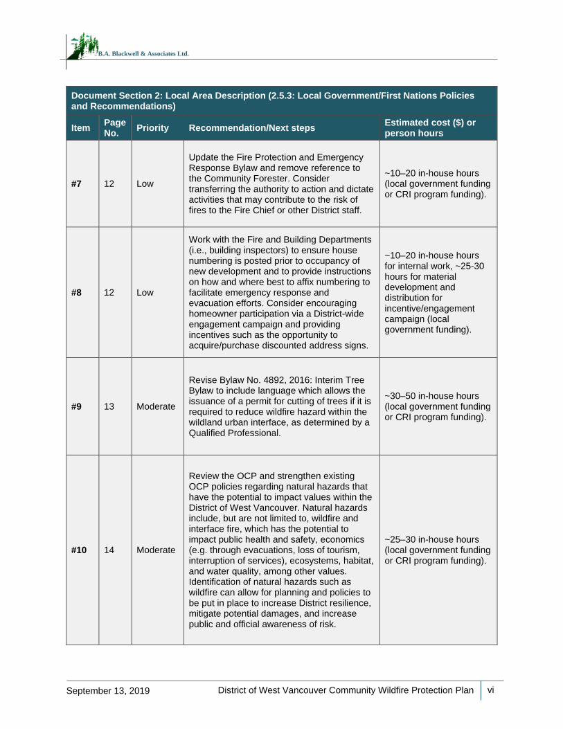
Document Section 2: Local Area Description (2.5.3: Local Government/First Nations Policies and Recommendations)
Item Page No.
Priority Recommendation/Next steps Estimated cost ($) or person hours
#7 12 Low
Update the Fire Protection and Emergency Response Bylaw and remove reference to the Community Forester. Consider transferring the authority to action and dictate activities that may contribute to the risk of fires to the Fire Chief or other District staff.
~10–20 in-house hours (local government funding or CRI program funding).
#8 12 Low
Work with the Fire and Building Departments (i.e., building inspectors) to ensure house numbering is posted prior to occupancy of new development and to provide instructions on how and where best to affix numbering to facilitate emergency response and evacuation efforts. Consider encouraging homeowner participation via a District-wide engagement campaign and providing incentives such as the opportunity to acquire/purchase discounted address signs.
~10–20 in-house hours for internal work, ~25-30 hours for material development and distribution for incentive/engagement campaign (local government funding).
#9 13 Moderate
Revise Bylaw No. 4892, 2016: Interim Tree Bylaw to include language which allows the issuance of a permit for cutting of trees if it is required to reduce wildfire hazard within the wildland urban interface, as determined by a Qualified Professional.
~30–50 in-house hours (local government funding or CRI program funding).
#10 14 Moderate
Review the OCP and strengthen existing OCP policies regarding natural hazards that have the potential to impact values within the District of West Vancouver. Natural hazards include, but are not limited to, wildfire and interface fire, which has the potential to impact public health and safety, economics (e.g. through evacuations, loss of tourism, interruption of services), ecosystems, habitat, and water quality, among other values. Identification of natural hazards such as wildfire can allow for planning and policies to be put in place to increase District resilience, mitigate potential damages, and increase public and official awareness of risk.
~25–30 in-house hours (local government funding or CRI program funding).
District of West Vancouver Community Wildfire Protection Plan
vii
September 13, 2019
B.A. Blackwell & Associates Ltd.
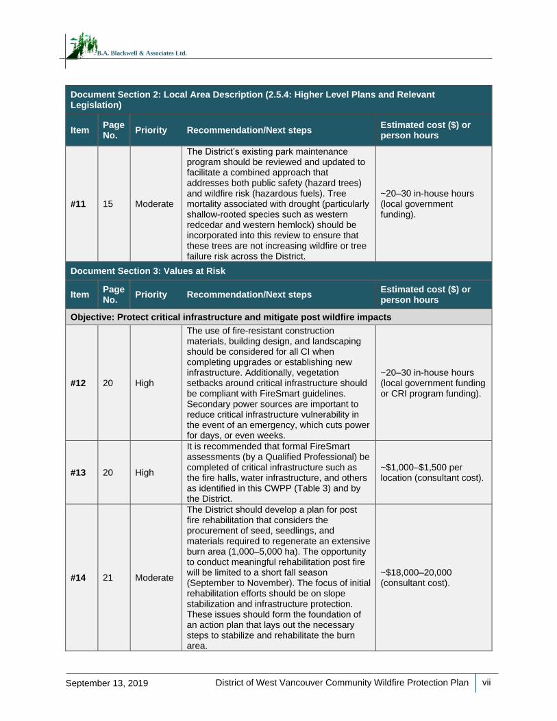
Document Section 2: Local Area Description (2.5.4: Higher Level Plans and Relevant Legislation)
Item Page No.
Priority Recommendation/Next steps Estimated cost ($) or person hours
#11 15 Moderate
The District’s existing park maintenance program should be reviewed and updated to facilitate a combined approach that addresses both public safety (hazard trees) and wildfire risk (hazardous fuels). Tree mortality associated with drought (particularly shallow-rooted species such as western redcedar and western hemlock) should be incorporated into this review to ensure that these trees are not increasing wildfire or tree failure risk across the District.
~20–30 in-house hours (local government funding).
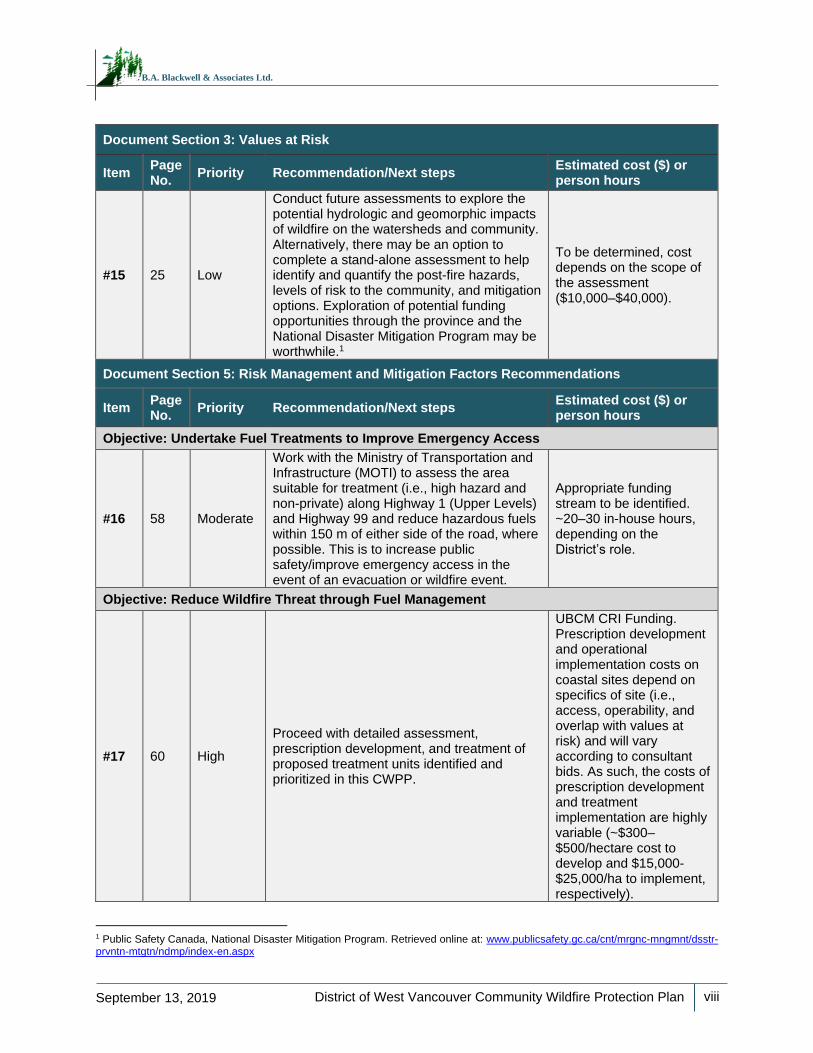
Document Section 3: Values at Risk
Item Page No.
Priority Recommendation/Next steps Estimated cost ($) or person hours
Objective: Protect critical infrastructure and mitigate post wildfire impacts
#12 20 High
The use of fire-resistant construction materials, building design, and landscaping should be considered for all CI when completing upgrades or establishing new infrastructure. Additionally, vegetation setbacks around critical infrastructure should be compliant with FireSmart guidelines. Secondary power sources are important to reduce critical infrastructure vulnerability in the event of an emergency, which cuts power for days, or even weeks.
~20–30 in-house hours (local government funding or CRI program funding).
#13 20 High
It is recommended that formal FireSmart assessments (by a Qualified Professional) be completed of critical infrastructure such as the fire halls, water infrastructure, and others as identified in this CWPP (Table 3) and by the District.
~$1,000–$1,500 per location (consultant cost).
#14 21 Moderate
The District should develop a plan for post fire rehabilitation that considers the procurement of seed, seedlings, and materials required to regenerate an extensive burn area (1,000–5,000 ha). The opportunity to conduct meaningful rehabilitation post fire will be limited to a short fall season (September to November). The focus of initial rehabilitation efforts should be on slope stabilization and infrastructure protection. These issues should form the foundation of an action plan that lays out the necessary steps to stabilize and rehabilitate the burn area.
~$18,000–20,000 (consultant cost).
District of West Vancouver Community Wildfire Protection Plan
viii
September 13, 2019
B.A. Blackwell & Associates Ltd.
Document Section 3: Values at Risk
Item Page No.
Priority Recommendation/Next steps Estimated cost ($) or person hours
#15 25 Low
Conduct future assessments to explore the potential hydrologic and geomorphic impacts of wildfire on the watersheds and community. Alternatively, there may be an option to complete a stand-alone assessment to help identify and quantify the post-fire hazards, levels of risk to the community, and mitigation options. Exploration of potential funding opportunities through the province and the National Disaster Mitigation Program may be worthwhile.1
To be determined, cost depends on the scope of the assessment ($10,000–$40,000).
Document Section 5: Risk Management and Mitigation Factors Recommendations
Item Page No.
Priority Recommendation/Next steps Estimated cost ($) or person hours
Objective: Undertake Fuel Treatments to Improve Emergency Access
#16 58 Moderate
Work with the Ministry of Transportation and Infrastructure (MOTI) to assess the area suitable for treatment (i.e., high hazard and non-private) along Highway 1 (Upper Levels) and Highway 99 and reduce hazardous fuels within 150 m of either side of the road, where possible. This is to increase public safety/improve emergency access in the event of an evacuation or wildfire event.
Appropriate funding stream to be identified. ~20–30 in-house hours, depending on the District’s role.
Objective: Reduce Wildfire Threat through Fuel Management
#17 60 High
Proceed with detailed assessment, prescription development, and treatment of proposed treatment units identified and prioritized in this CWPP.
UBCM CRI Funding. Prescription development and operational implementation costs on coastal sites depend on specifics of site (i.e., access, operability, and overlap with values at risk) and will vary according to consultant bids. As such, the costs of prescription development and treatment implementation are highly variable (~$300–$500/hectare cost to develop and $15,000-$25,000/ha to implement, respectively).
1 Public Safety Canada, National Disaster Mitigation Program. Retrieved online at: www.publicsafety.gc.ca/cnt/mrgnc-mngmnt/dsstr-prvntn-mtgtn/ndmp/index-en.aspx
District of West Vancouver Community Wildfire Protection Plan
ix
September 13, 2019
B.A. Blackwell & Associates Ltd.
Document Section 5: Risk Management and Mitigation Factors Recommendations
Item Page No.
Priority Recommendation/Next steps Estimated cost ($) or person hours
#18 68 Moderate
If and when operational fuel treatments are conducted within the District AOI, treatment monitoring should be completed by a Qualified Professional in order to schedule the next set of maintenance activities (5–10 years out). This can be completed with a CWPP update or as a stand-alone exercise.
UBCM CRI funding. Costs will vary according to site specifics and according to consultant bid.
Objective: Reduce Wildfire Hazard on Private Land
#19 73 High
Apply for a FireSmart demonstration grant through the CRI program. This type of fuel treatment can display the practices and principles of FireSmart activities to the public in the form of demonstration treatments. These small projects are not necessarily completed to reduce fire behaviour or increase stand resiliency in any measurable way, but instead are prioritized more by their visibility to the public and combining the treatment with elements of public education (signage, community work days, public tours, active demonstrations of operations, etc.).
~20–25 in-house hours to complete application/ UBCM CRI Funding to implement FireSmart demonstration treatment. Prescription development and implementation costs are similar to those provided above in Recommendation #15.
#20 73 Moderate
Continue to offer yard waste pick-up and disposal opportunities and consider developing and implementing a community chipper program with the help of neighbourhood representatives. As a demonstration, this program can begin twice per year in two separate neighbourhoods. This program can also be implemented in conjunction with community clean-up days.
Eligible for UBCM CRI program funding. ~20–30 in-house hours of additional time for advertisement of program will be required.
District of West Vancouver Community Wildfire Protection Plan
x
September 13, 2019
B.A. Blackwell & Associates Ltd.
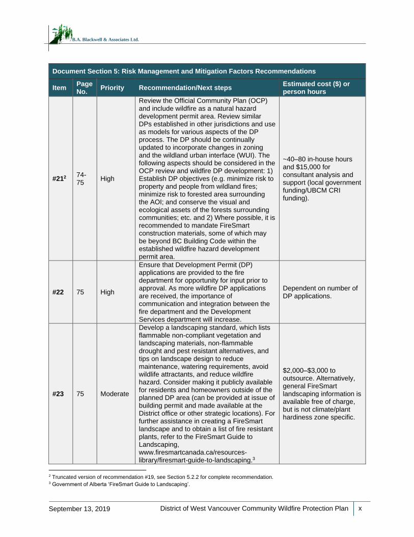
Document Section 5: Risk Management and Mitigation Factors Recommendations
Item Page No.
Priority Recommendation/Next steps Estimated cost ($) or person hours
#212 74-75
High
Review the Official Community Plan (OCP) and include wildfire as a natural hazard development permit area. Review similar DPs established in other jurisdictions and use as models for various aspects of the DP process. The DP should be continually updated to incorporate changes in zoning and the wildland urban interface (WUI). The following aspects should be considered in the OCP review and wildfire DP development: 1) Establish DP objectives (e.g. minimize risk to property and people from wildland fires; minimize risk to forested area surrounding the AOI; and conserve the visual and ecological assets of the forests surrounding communities; etc. and 2) Where possible, it is recommended to mandate FireSmart construction materials, some of which may be beyond BC Building Code within the established wildfire hazard development permit area.
~40–80 in-house hours and $15,000 for consultant analysis and support (local government funding/UBCM CRI funding).
#22 75 High
Ensure that Development Permit (DP) applications are provided to the fire department for opportunity for input prior to approval. As more wildfire DP applications are received, the importance of communication and integration between the fire department and the Development Services department will increase.
Dependent on number of DP applications.
#23 75 Moderate
Develop a landscaping standard, which lists flammable non-compliant vegetation and landscaping materials, non-flammable drought and pest resistant alternatives, and tips on landscape design to reduce maintenance, watering requirements, avoid wildlife attractants, and reduce wildfire hazard. Consider making it publicly available for residents and homeowners outside of the planned DP area (can be provided at issue of building permit and made available at the District office or other strategic locations). For further assistance in creating a FireSmart landscape and to obtain a list of fire resistant plants, refer to the FireSmart Guide to Landscaping, www.firesmartcanada.ca/resources-library/firesmart-guide-to-landscaping.3
$2,000–$3,000 to outsource. Alternatively, general FireSmart landscaping information is available free of charge, but is not climate/plant hardiness zone specific.
2 Truncated version of recommendation #19, see Section 5.2.2 for complete recommendation. 3 Government of Alberta ‘FireSmart Guide to Landscaping’.
District of West Vancouver Community Wildfire Protection Plan
xi
September 13, 2019
B.A. Blackwell & Associates Ltd.
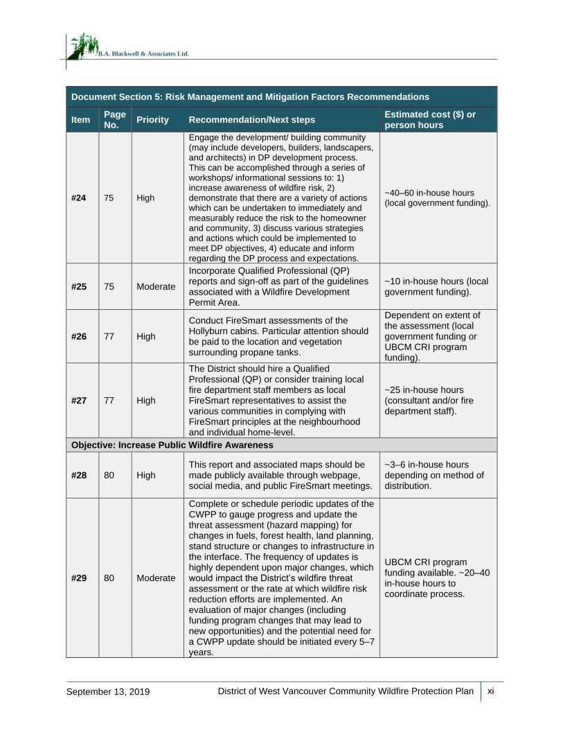
Document Section 5: Risk Management and Mitigation Factors Recommendations
Item Page No.
Priority Recommendation/Next steps Estimated cost ($) or person hours
#24 75 High
Engage the development/ building community (may include developers, builders, landscapers, and architects) in DP development process. This can be accomplished through a series of workshops/ informational sessions to: 1) increase awareness of wildfire risk, 2) demonstrate that there are a variety of actions which can be undertaken to immediately and measurably reduce the risk to the homeowner and community, 3) discuss various strategies and actions which could be implemented to meet DP objectives, 4) educate and inform regarding the DP process and expectations.
~40–60 in-house hours (local government funding).
#25 75 Moderate
Incorporate Qualified Professional (QP) reports and sign-off as part of the guidelines associated with a Wildfire Development Permit Area.
~10 in-house hours (local government funding).
#26 77 High
Conduct FireSmart assessments of the Hollyburn cabins. Particular attention should be paid to the location and vegetation surrounding propane tanks.
Dependent on extent of the assessment (local government funding or UBCM CRI program funding).
#27 77 High
The District should hire a Qualified Professional (QP) or consider training local fire department staff members as local FireSmart representatives to assist the various communities in complying with FireSmart principles at the neighbourhood and individual home-level.
~25 in-house hours (consultant and/or fire department staff).
Objective: Increase Public Wildfire Awareness
#28 80 High This report and associated maps should be made publicly available through webpage, social media, and public FireSmart meetings.
~3–6 in-house hours depending on method of distribution.
#29 80 Moderate
Complete or schedule periodic updates of the CWPP to gauge progress and update the threat assessment (hazard mapping) for changes in fuels, forest health, land planning, stand structure or changes to infrastructure in the interface. The frequency of updates is highly dependent upon major changes, which would impact the District’s wildfire threat assessment or the rate at which wildfire risk reduction efforts are implemented. An evaluation of major changes (including funding program changes that may lead to new opportunities) and the potential need for a CWPP update should be initiated every 5–7 years.
UBCM CRI program funding available. ~20–40 in-house hours to coordinate process.
District of West Vancouver Community Wildfire Protection Plan
xii
September 13, 2019
B.A. Blackwell & Associates Ltd.
Document Section 5: Risk Management and Mitigation Factors Recommendations
Item Page No.
Priority Recommendation/Next steps Estimated cost ($) or person hours
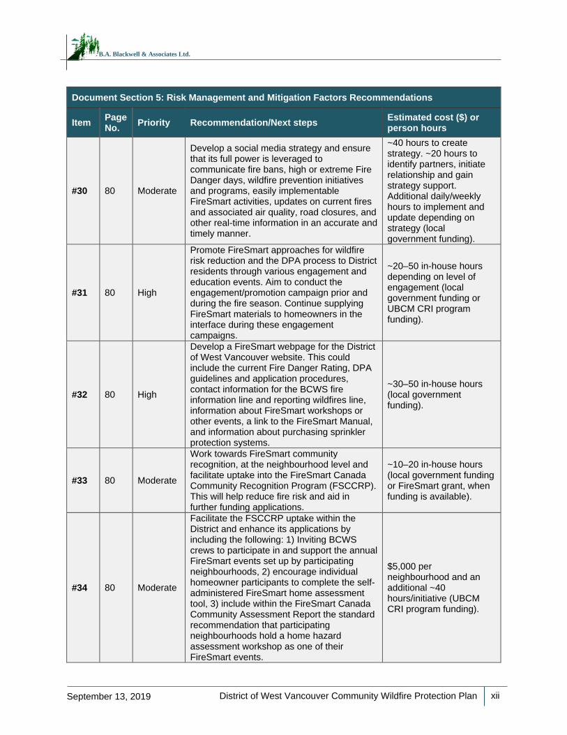
#30 80 Moderate
Develop a social media strategy and ensure that its full power is leveraged to communicate fire bans, high or extreme Fire Danger days, wildfire prevention initiatives and programs, easily implementable FireSmart activities, updates on current fires and associated air quality, road closures, and other real-time information in an accurate and timely manner.
~40 hours to create strategy. ~20 hours to identify partners, initiate relationship and gain strategy support. Additional daily/weekly hours to implement and update depending on strategy (local government funding).
#31 80 High
Promote FireSmart approaches for wildfire risk reduction and the DPA process to District residents through various engagement and education events. Aim to conduct the engagement/promotion campaign prior and during the fire season. Continue supplying FireSmart materials to homeowners in the interface during these engagement campaigns.
~20–50 in-house hours depending on level of engagement (local government funding or UBCM CRI program funding).
#32 80 High
Develop a FireSmart webpage for the District of West Vancouver website. This could include the current Fire Danger Rating, DPA guidelines and application procedures, contact information for the BCWS fire information line and reporting wildfires line, information about FireSmart workshops or other events, a link to the FireSmart Manual, and information about purchasing sprinkler protection systems.
~30–50 in-house hours (local government funding).
#33 80 Moderate
Work towards FireSmart community recognition, at the neighbourhood level and facilitate uptake into the FireSmart Canada Community Recognition Program (FSCCRP). This will help reduce fire risk and aid in further funding applications.
~10–20 in-house hours (local government funding or FireSmart grant, when funding is available).
#34 80 Moderate
Facilitate the FSCCRP uptake within the District and enhance its applications by including the following: 1) Inviting BCWS crews to participate in and support the annual FireSmart events set up by participating neighbourhoods, 2) encourage individual homeowner participants to complete the self-administered FireSmart home assessment tool, 3) include within the FireSmart Canada Community Assessment Report the standard recommendation that participating neighbourhoods hold a home hazard assessment workshop as one of their FireSmart events.
$5,000 per neighbourhood and an additional ~40 hours/initiative (UBCM CRI program funding).
District of West Vancouver Community Wildfire Protection Plan
xiii
September 13, 2019
B.A. Blackwell & Associates Ltd.
Document Section 5: Risk Management and Mitigation Factors Recommendations
Item Page No.
Priority Recommendation/Next steps Estimated cost ($) or person hours
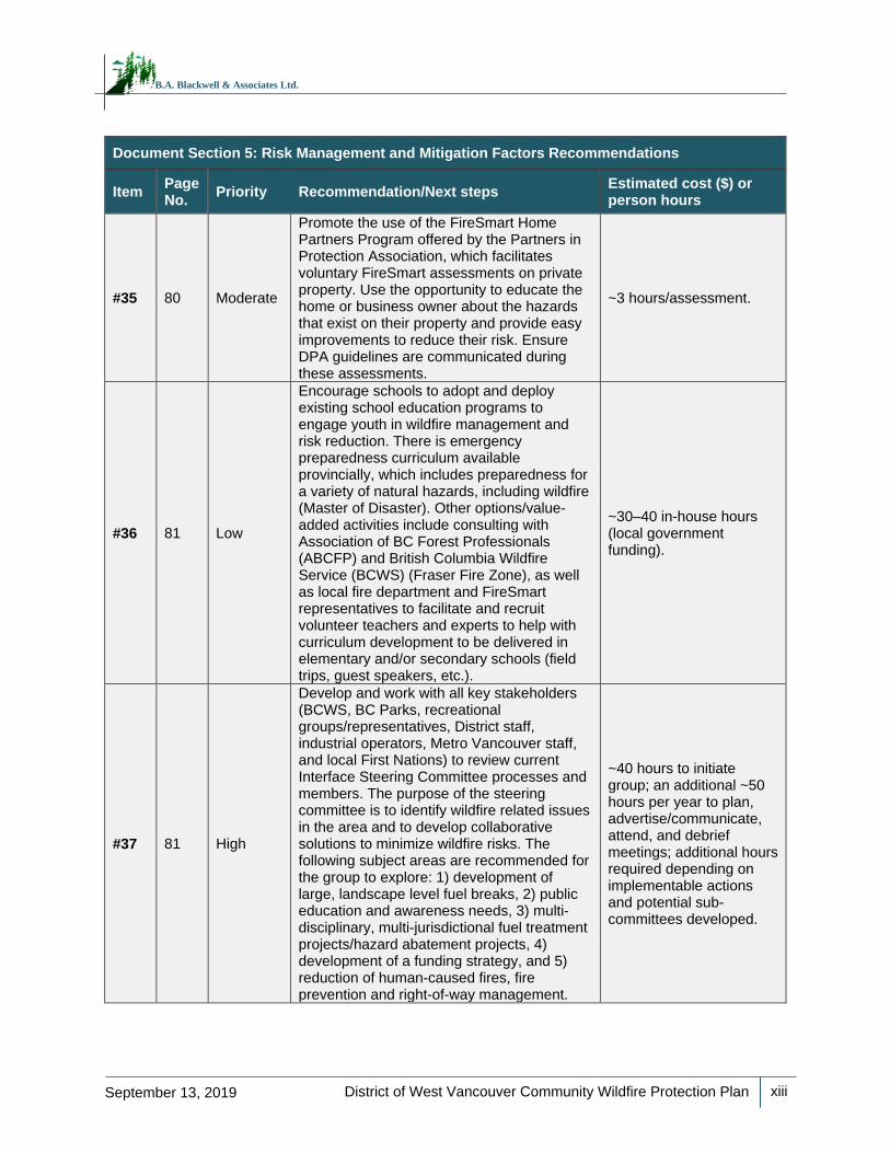
#35 80 Moderate
Promote the use of the FireSmart Home Partners Program offered by the Partners in Protection Association, which facilitates voluntary FireSmart assessments on private property. Use the opportunity to educate the home or business owner about the hazards that exist on their property and provide easy improvements to reduce their risk. Ensure DPA guidelines are communicated during these assessments.
~3 hours/assessment.
#36 81 Low
Encourage schools to adopt and deploy existing school education programs to engage youth in wildfire management and risk reduction. There is emergency preparedness curriculum available provincially, which includes preparedness for a variety of natural hazards, including wildfire (Master of Disaster). Other options/value-added activities include consulting with Association of BC Forest Professionals (ABCFP) and British Columbia Wildfire Service (BCWS) (Fraser Fire Zone), as well as local fire department and FireSmart representatives to facilitate and recruit volunteer teachers and experts to help with curriculum development to be delivered in elementary and/or secondary schools (field trips, guest speakers, etc.).
~30–40 in-house hours (local government funding).
#37 81 High
Develop and work with all key stakeholders (BCWS, BC Parks, recreational groups/representatives, District staff, industrial operators, Metro Vancouver staff, and local First Nations) to review current Interface Steering Committee processes and members. The purpose of the steering committee is to identify wildfire related issues in the area and to develop collaborative solutions to minimize wildfire risks. The following subject areas are recommended for the group to explore: 1) development of large, landscape level fuel breaks, 2) public education and awareness needs, 3) multi-disciplinary, multi-jurisdictional fuel treatment projects/hazard abatement projects, 4) development of a funding strategy, and 5) reduction of human-caused fires, fire prevention and right-of-way management.
~40 hours to initiate group; an additional ~50 hours per year to plan, advertise/communicate, attend, and debrief meetings; additional hours required depending on implementable actions and potential sub-committees developed.
District of West Vancouver Community Wildfire Protection Plan
xiv
September 13, 2019
B.A. Blackwell & Associates Ltd.
Document Section 5: Risk Management and Mitigation Factors Recommendations
Item Page No.
Priority Recommendation/Next steps Estimated cost ($) or person hours
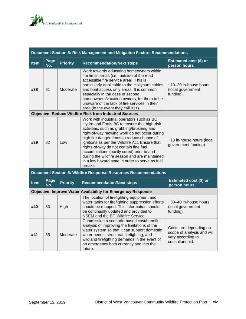
#38 81 Moderate
Work towards educating homeowners within fire limits areas (i.e., outside of the road accessible fire service area). This is particularly applicable to the Hollyburn cabins and boat access only areas. It is common, especially in the case of second homeowners/vacation owners, for them to be unaware of the lack of fire services in their area (in the event they call 911).
~10–20 in-house hours (local government funding).
Objective: Reduce Wildfire Risk from Industrial Sources
#39 82 Low
Work with industrial operators such as BC Hydro and Fortis BC to ensure that high-risk activities, such as grubbing/brushing and right-of-way mowing work do not occur during high fire danger times to reduce chance of ignitions as per the Wildfire Act. Ensure that rights-of-way do not contain fine fuel accumulations (easily cured) prior to and during the wildfire season and are maintained in a low hazard state in order to serve as fuel breaks.
~10 in-house hours (local government funding).
Document Section 6: Wildfire Response Resources Recommendations
Item Page No.
Priority Recommendation/Next steps Estimated cost ($) or person hours
Objective: Improve Water Availability for Emergency Response
#40 83 High
The location of firefighting equipment and water tanks for firefighting suppression efforts should be mapped. This information should be continually updated and provided to NSEM and the BC Wildfire Service.
~30–40 in-house hours (local government funding).
#41 85 Moderate
Commission a scenario-based cost/benefit analysis of improving the limitations of the water system so that it can support domestic water needs, structural firefighting, and wildland firefighting demands in the event of an emergency both currently and into the future.
Costs are depending on scope of analysis and will vary according to consultant bid.
District of West Vancouver Community Wildfire Protection Plan
xv
September 13, 2019
B.A. Blackwell & Associates Ltd.
Document Section 6: Wildfire Response Resources Recommendations
Item Page No.
Priority Recommendation/Next steps Estimated cost ($) or person hours
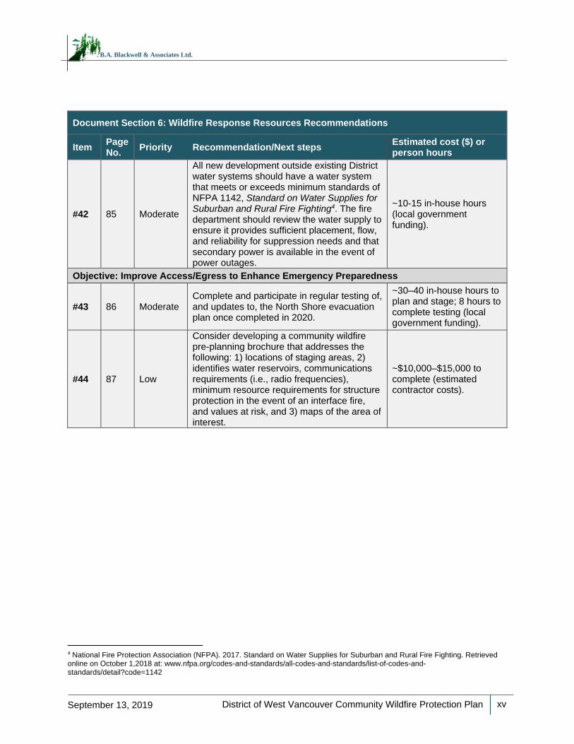
#42 85 Moderate
All new development outside existing District water systems should have a water system that meets or exceeds minimum standards of NFPA 1142, Standard on Water Supplies for Suburban and Rural Fire Fighting4. The fire department should review the water supply to ensure it provides sufficient placement, flow, and reliability for suppression needs and that secondary power is available in the event of power outages.
~10-15 in-house hours (local government funding).
Objective: Improve Access/Egress to Enhance Emergency Preparedness
#43 86 Moderate Complete and participate in regular testing of, and updates to, the North Shore evacuation plan once completed in 2020.
~30–40 in-house hours to plan and stage; 8 hours to complete testing (local government funding).
#44 87 Low
Consider developing a community wildfire pre-planning brochure that addresses the following: 1) locations of staging areas, 2) identifies water reservoirs, communications requirements (i.e., radio frequencies), minimum resource requirements for structure protection in the event of an interface fire, and values at risk, and 3) maps of the area of interest.
~$10,000–$15,000 to complete (estimated contractor costs).
4 National Fire Protection Association (NFPA). 2017. Standard on Water Supplies for Suburban and Rural Fire Fighting. Retrieved online on October 1,2018 at: www.nfpa.org/codes-and-standards/all-codes-and-standards/list-of-codes-and-standards/detail?code=1142
District of West Vancouver Community Wildfire Protection Plan
xvi
September 13, 2019
B.A. Blackwell & Associates Ltd.
Document Section 6: Wildfire Response Resources Recommendations
Item Page No.
Priority Recommendation/Next steps Estimated cost ($) or person hours
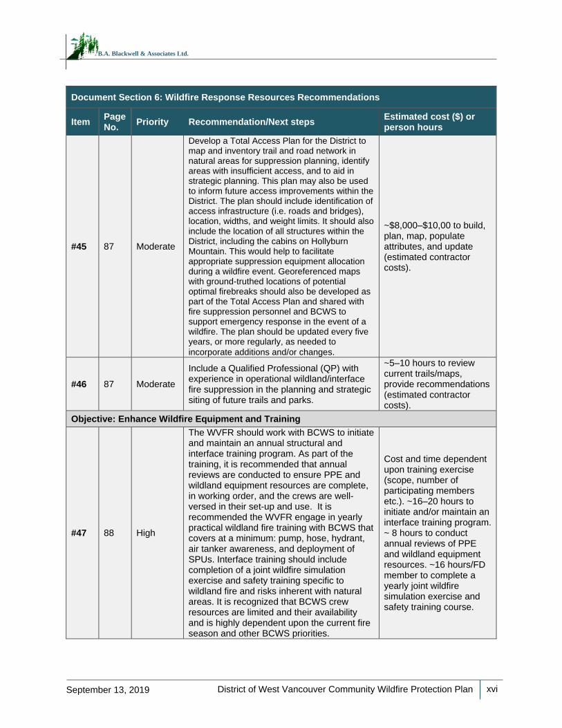
#45 87 Moderate
Develop a Total Access Plan for the District to map and inventory trail and road network in natural areas for suppression planning, identify areas with insufficient access, and to aid in strategic planning. This plan may also be used to inform future access improvements within the District. The plan should include identification of access infrastructure (i.e. roads and bridges), location, widths, and weight limits. It should also include the location of all structures within the District, including the cabins on Hollyburn Mountain. This would help to facilitate appropriate suppression equipment allocation during a wildfire event. Georeferenced maps with ground-truthed locations of potential optimal firebreaks should also be developed as part of the Total Access Plan and shared with fire suppression personnel and BCWS to support emergency response in the event of a wildfire. The plan should be updated every five years, or more regularly, as needed to
incorporate additions and/or changes.
~$8,000–$10,00 to build, plan, map, populate attributes, and update (estimated contractor costs).
#46 87 Moderate
Include a Qualified Professional (QP) with experience in operational wildland/interface fire suppression in the planning and strategic siting of future trails and parks.
~5–10 hours to review current trails/maps, provide recommendations (estimated contractor costs).
Objective: Enhance Wildfire Equipment and Training
#47 88 High
The WVFR should work with BCWS to initiate and maintain an annual structural and interface training program. As part of the training, it is recommended that annual reviews are conducted to ensure PPE and wildland equipment resources are complete, in working order, and the crews are well-versed in their set-up and use. It is recommended the WVFR engage in yearly practical wildland fire training with BCWS that covers at a minimum: pump, hose, hydrant, air tanker awareness, and deployment of SPUs. Interface training should include completion of a joint wildfire simulation exercise and safety training specific to wildland fire and risks inherent with natural areas. It is recognized that BCWS crew resources are limited and their availability and is highly dependent upon the current fire season and other BCWS priorities.
Cost and time dependent upon training exercise (scope, number of participating members etc.). ~16–20 hours to initiate and/or maintain an interface training program. ~ 8 hours to conduct annual reviews of PPE and wildland equipment resources. ~16 hours/FD member to complete a yearly joint wildfire simulation exercise and safety training course.
District of West Vancouver Community Wildfire Protection Plan
xvii
September 13, 2019
B.A. Blackwell & Associates Ltd.
Document Section 6: Wildfire Response Resources Recommendations
Item Page No.
Priority Recommendation/Next steps Estimated cost ($) or person hours
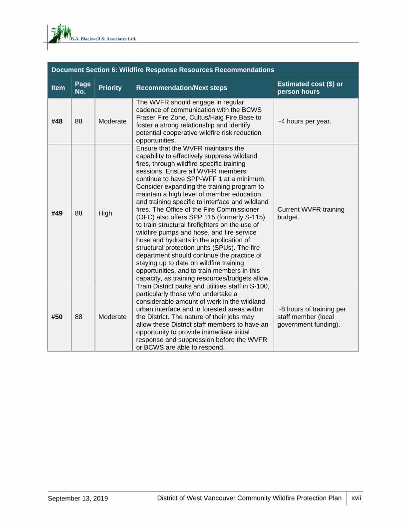
#48 88 Moderate
The WVFR should engage in regular cadence of communication with the BCWS Fraser Fire Zone, Cultus/Haig Fire Base to foster a strong relationship and identify potential cooperative wildfire risk reduction opportunities.
~4 hours per year.
#49 88 High
Ensure that the WVFR maintains the capability to effectively suppress wildland fires, through wildfire-specific training sessions. Ensure all WVFR members continue to have SPP-WFF 1 at a minimum. Consider expanding the training program to maintain a high level of member education and training specific to interface and wildland fires. The Office of the Fire Commissioner (OFC) also offers SPP 115 (formerly S-115) to train structural firefighters on the use of wildfire pumps and hose, and fire service hose and hydrants in the application of structural protection units (SPUs). The fire department should continue the practice of staying up to date on wildfire training opportunities, and to train members in this capacity, as training resources/budgets allow.
Current WVFR training budget.
#50 88 Moderate
Train District parks and utilities staff in S-100, particularly those who undertake a considerable amount of work in the wildland urban interface and in forested areas within the District. The nature of their jobs may allow these District staff members to have an opportunity to provide immediate initial response and suppression before the WVFR or BCWS are able to respond.
~8 hours of training per staff member (local government funding).
District of West Vancouver Community Wildfire Protection Plan
xviii
September 13, 2019
B.A. Blackwell & Associates Ltd.
Document Section 6: Wildfire Response Resources Recommendations
Item Page No.
Priority Recommendation/Next steps Estimated cost ($) or person hours
Objective: Encourage FireSmart Initiatives
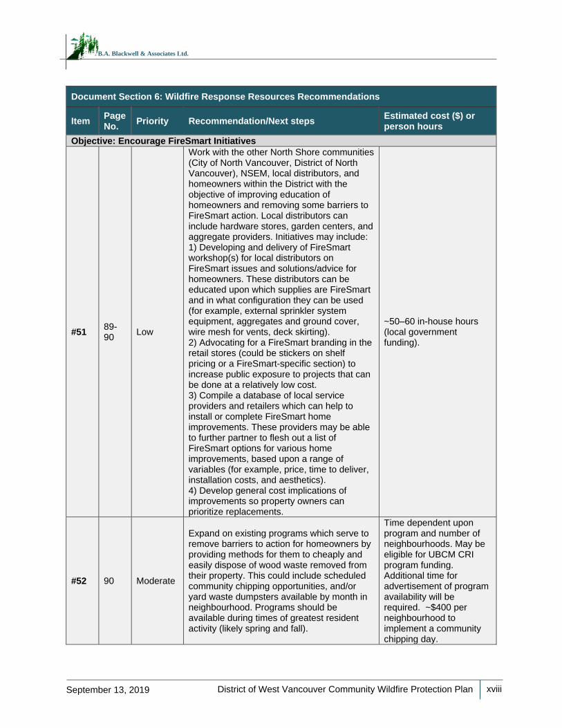
#51 89-90
Low
Work with the other North Shore communities (City of North Vancouver, District of North Vancouver), NSEM, local distributors, and homeowners within the District with the objective of improving education of homeowners and removing some barriers to FireSmart action. Local distributors can include hardware stores, garden centers, and aggregate providers. Initiatives may include: 1) Developing and delivery of FireSmart workshop(s) for local distributors on FireSmart issues and solutions/advice for homeowners. These distributors can be educated upon which supplies are FireSmart and in what configuration they can be used (for example, external sprinkler system equipment, aggregates and ground cover, wire mesh for vents, deck skirting). 2) Advocating for a FireSmart branding in the retail stores (could be stickers on shelf pricing or a FireSmart-specific section) to increase public exposure to projects that can be done at a relatively low cost. 3) Compile a database of local service providers and retailers which can help to install or complete FireSmart home improvements. These providers may be able to further partner to flesh out a list of FireSmart options for various home improvements, based upon a range of variables (for example, price, time to deliver, installation costs, and aesthetics). 4) Develop general cost implications of improvements so property owners can prioritize replacements.
~50–60 in-house hours (local government funding).
#52 90 Moderate
Expand on existing programs which serve to remove barriers to action for homeowners by providing methods for them to cheaply and easily dispose of wood waste removed from their property. This could include scheduled community chipping opportunities, and/or yard waste dumpsters available by month in neighbourhood. Programs should be available during times of greatest resident activity (likely spring and fall).
Time dependent upon program and number of neighbourhoods. May be eligible for UBCM CRI program funding. Additional time for advertisement of program availability will be required. ~$400 per neighbourhood to implement a community chipping day.
District of West Vancouver Community Wildfire Protection Plan
xix
September 13, 2019
B.A. Blackwell & Associates Ltd.
Document Section 6: Wildfire Response Resources Recommendations
Item Page No.
Priority Recommendation/Next steps Estimated cost ($) or person hours
Objective: Enhance Protection of Municipal Infrastructure from Wildfire
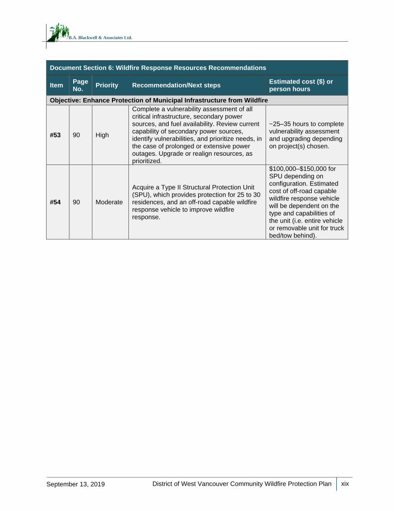
#53 90 High
Complete a vulnerability assessment of all critical infrastructure, secondary power sources, and fuel availability. Review current capability of secondary power sources, identify vulnerabilities, and prioritize needs, in the case of prolonged or extensive power outages. Upgrade or realign resources, as prioritized.
~25–35 hours to complete vulnerability assessment and upgrading depending on project(s) chosen.
#54 90 Moderate
Acquire a Type II Structural Protection Unit (SPU), which provides protection for 25 to 30 residences, and an off-road capable wildfire response vehicle to improve wildfire response.
$100,000–$150,000 for SPU depending on configuration. Estimated cost of off-road capable wildfire response vehicle will be dependent on the type and capabilities of the unit (i.e. entire vehicle or removable unit for truck bed/tow behind).
District of West Vancouver Community Wildfire Protection Plan
xx
September 13, 2019
B.A. Blackwell & Associates Ltd.
TABLE OF CONTENTS
Acknowledgements ........................................................................................................................................ i
Registered Professional Sign and Seal ......................................................................................................... ii
Executive Summary/Summary of CWPP Recommendations ....................................................................... iii
Commonly Used Acronyms ....................................................................................................................... xxiv
SECTION 1: Introduction .............................................................................................................................. 1
1.1 Purpose ......................................................................................................................................... 1
1.2 CWPP Planning Process .............................................................................................................. 2
1.2.1 Consultation .......................................................................................................................... 2
1.2.2 Identification of Values at Risk and Local Wildfire Threat Assessment ................................ 3
1.2.3 Development of a Risk Management Strategy ..................................................................... 4
1.2.4 Building Community Engagement and Education Strategy .................................................. 4
SECTION 2: Local Area Description ............................................................................................................. 5
2.1 Area of Interest .............................................................................................................................. 5
2.2 Community Description ................................................................................................................. 6
2.3 Past Wildfires, Evacuations and Impacts ...................................................................................... 8
2.4 Current Community Engagement .................................................................................................. 8
2.5 Linkages to Other Plans and Policies ........................................................................................... 9
2.5.1 Local Authority Emergency Plan ........................................................................................... 9
2.5.2 Affiliated CWPPs ................................................................................................................... 9
2.5.3 Local Government/First Nation Policies and Recommendations ........................................ 10
2.5.4 Higher Level Plans and Relevant Legislation ..................................................................... 15
2.5.5 Ministry or Industry Plans .................................................................................................... 18
SECTION 3: Values At Risk ........................................................................................................................ 19
3.1 Human Life and Safety ................................................................................................................ 20
3.2 Critical Infrastructure ................................................................................................................... 21
3.2.1 Electrical Power ................................................................................................................... 22
3.2.2 Communications, Pipelines and Municipal Buildings .......................................................... 23
3.2.3 Water and Sewage .............................................................................................................. 24
3.3 High Environmental and Cultural Values .................................................................................... 26
3.3.1 Drinking Water Supply Area and Community Watersheds ................................................. 26
3.3.2 Cultural Values .................................................................................................................... 27
3.3.3 High Environmental Values ................................................................................................. 28
3.4 Other Resource Values ............................................................................................................... 29
3.5 Hazardous Values ....................................................................................................................... 29
SECTION 4: Wildfire Threat and Risk ......................................................................................................... 29
4.1 Fire Regime, Fire Danger Days and Climate Change ................................................................ 29
4.1.1 Fire Regime ......................................................................................................................... 30
4.1.2 Fire Weather Rating ............................................................................................................ 36
4.1.3 Climate Change ................................................................................................................... 37
4.2 Provincial Strategic Threat Analysis ........................................................................................... 41
4.2.1 PSTA Final Wildfire Threat Rating ...................................................................................... 43
4.2.2 Spotting Impact ................................................................................................................... 45
4.2.3 Head Fire Intensity .............................................................................................................. 48
4.2.4 Fire History .......................................................................................................................... 49
4.3 Local Wildfire Threat Assessment ............................................................................................... 50
District of West Vancouver Community Wildfire Protection Plan
xxi
September 13, 2019
B.A. Blackwell & Associates Ltd.
4.3.1 Fuel Type Verification ......................................................................................................... 51
4.3.2 Proximity of Fuel to the Community .................................................................................... 54
4.3.3 Fire Spread Patterns ........................................................................................................... 55
4.3.4 Topography ......................................................................................................................... 57
4.3.5 Local Wildfire Threat Classification ..................................................................................... 58
SECTION 5: Risk Management and Mitigation Factors ............................................................................. 59
5.1 Fuel Management ....................................................................................................................... 60
5.1.1 Proposed Treatment Units .................................................................................................. 62
5.1.2 Maintenance of Previously Treated Areas .......................................................................... 71
5.2 FireSmart Planning and Activities ............................................................................................... 73
5.2.1 FireSmart Goals and Objectives ......................................................................................... 73
5.2.2 Key Aspects of FireSmart for Local Governments .............................................................. 76
5.2.3 Priority Areas within the AOI for FireSmart ......................................................................... 83
5.3 Communication and Education ................................................................................................... 84
5.4 Other Prevention Measures ........................................................................................................ 87
SECTION 6: Wildfire Response Resources ................................................................................................ 87
6.1 Local Government and First Nation Firefighting Resources ....................................................... 88
6.1.1 Fire Department and Equipment ......................................................................................... 88
6.1.2 Water Availability for Wildfire Suppression ......................................................................... 89
6.1.3 Access and Evacuation ....................................................................................................... 91
6.1.4 Training ............................................................................................................................... 93
6.2 Structure Protection .................................................................................................................... 95
References .................................................................................................................................................. 98
Appendix A – Wildfire Threat Assessment – FBP Fuel Type Change Rationale ....................................... 99
Appendix B – Wildfire Threat Assessment Worksheets and Photos ........................................................ 100
Appendix C – Maps ................................................................................................................................... 101
Appendix D – Wildland Urban Interface Defined ...................................................................................... 102
Appendix E – WUI Threat Plot Locations .................................................................................................. 105
Appendix F – Fuel Typing Methodology and Limitations .......................................................................... 107
Appendix G – WUI Threat Assessment Methodology .............................................................................. 108
Appendix H – Principles of Fuel Management .......................................................................................... 112
Appendix I – FireSmart Fuel Treatments .................................................................................................. 118
Appendix J – FireSmart Construction and Landscaping ........................................................................... 119
Appendix K – Communication and Education ........................................................................................... 123
District of West Vancouver Community Wildfire Protection Plan
xxii
September 13, 2019
B.A. Blackwell & Associates Ltd.
List of Tables
Table 1. Summary of CWPP Recommendations by Document Section. .................................................... iv
Table 2. Summary of AOI by land ownership. .............................................................................................. 5
Table 3. Critical Infrastructure Identified in 2019 field visits. ....................................................................... 23
Table 4. Critical Water and Sewer Infrastructure Identified in 2019 CWPP field visits. .............................. 25
Table 5. Publicly available occurrences of Red and Blue-listed species recorded within the AOI. ............ 28
Table 6. Hazardous Infrastructure Identified in CWPP field visits. ............................................................. 29
Table 7. BEC zones and natural disturbance types found within the AOI. ................................................. 32
Table 8. Overall PSTA Wildfire Threat Analysis for the AOI (rounded to the nearest hectare). ................. 44
Table 9. Head Fire Intensity Classes and Associated Fire Behaviour. ....................................................... 48
Table 10. Fuel Type Categories and Crown Fire Spot Potential. Only summaries of fuel types
encountered within the AOI are provided (as such, other fuel types, i.e., C-1, C-2, C-4, C-6, C-7 and S-
1/2/3 are not summarized below). ............................................................................................................... 52
Table 11. Proximity to the Interface. ........................................................................................................... 55
Table 12. Slope Percentage and Fire Behaviour Implications. ................................................................... 57
Table 13. Slope Position of Value and Fire Behaviour Implications. .......................................................... 57
Table 14. Fire behaviour threat summary for the AOI. ............................................................................... 58
Table 15. Proposed Treatment Area Summary Table. ............................................................................... 65
Table 16. Summary of FireSmart Priority Areas. ........................................................................................ 83
Table 17. Fire department capacity and equipment within the AOI. ........................................................... 88
Table 18. Summary of WUI Threat Assessment Worksheets. ................................................................. 105
Table 19. Description of variables used in spatial analysis for WUI wildfire threat assessment. ............. 110
List of Maps
Map 1. Area of Interest (AOI). ....................................................................................................................... 6
Map 2. Values at Risk within the AOI. ......................................................................................................... 19
Map 3. Biogeoclimatic Zones within the AOI. ............................................................................................. 33
Map 4. Fire Regime, Ecology and Climate Change. ................................................................................... 40
Map 5. Historical Fire Density. .................................................................................................................... 43
Map 6. Provincial Strategic Threat Rating. ................................................................................................. 45
Map 7. Spotting Impact within the AOI. ....................................................................................................... 47
Map 8. Head Fire Intensity within the AOI. ................................................................................................. 49
Map 9. Updated Fuel Type.......................................................................................................................... 54
Map 10. Local Fire Behaviour Threat Rating and WUI Threat Rating. ....................................................... 59
Map 11. Proposed and Past Fuel Treatments. ........................................................................................... 71
District of West Vancouver Community Wildfire Protection Plan
xxiii
September 13, 2019
B.A. Blackwell & Associates Ltd.
List of Figures
Figure 1. Average number of danger class days for the Capilano weather station. Summary of fire
weather data for the years 2002 – 2018. .................................................................................................... 37
Figure 2. Wind rose for Capilano weather station based on hourly wind speed data during the fire season
(April 1 – October 31) 2002-2018. Data courtesy of GVRD. The length of each bar represents the
frequency of readings in percent and bar colour indicates the windspeed range. ...................................... 56
Figure 3. Diagram of the various, coordinated levels of the FireSmart program. CWPP: Community
Wildfire Protection Plan, FSCCRP: FireSmart Canada Community Recognition Program, HIZ: Home
Ignition Zone. .............................................................................................................................................. 74
Figure 4. Wildland/urban interface disaster sequence. It is possible to break up the disaster sequence by
decreasing the number of highly ignitable homes exposed to embers, therefore reducing the number of
homes ignited and removing the consequences of multiple structures lost. .............................................. 76
Figure 5. Illustration of intermix and interface situations. .......................................................................... 102
Figure 6. Firebrand caused ignitions: burning embers are carried ahead of the fire front and alight on
vulnerable building surfaces. .................................................................................................................... 103
Figure 7. Radiant heat and flame contact allows fire to spread from vegetation to structure or from
structure to structure. ................................................................................................................................ 103
Figure 8. Comparison of stand level differences in height-to-live crown in an interior forest, where low
height to live crown is more hazardous than high height to live crown. .................................................... 114
Figure 9. Comparison of stand level differences in crown closure, where high crown closure/continuity
contributes to crown fire spread, while low crown closure reduces crown fire potential. ......................... 115
Figure 10. Comparison of stand level differences in density and mortality, and the distribution of live and
dead fuels in these types of stands. .......................................................................................................... 115
Figure 11. Illustration of the principles of thinning to reduce the stand level wildfire hazard. ................... 116
Figure 12. Illustration of FireSmart zones. ................................................................................................ 118
District of West Vancouver Community Wildfire Protection Plan
xxiv
September 13, 2019
B.A. Blackwell & Associates Ltd.
COMMONLY USED ACRONYMS
BCWS British Columbia Wildfire Service
BEC Biogeoclimatic Ecosystem Classification
BMP Best Management Practices
CDC B.C. Conservation Data Centre
CFFDRS Canadian Forest Fire Danger Rating System
CRI Community Resiliency Investment Program
CWPP Community Wildfire Protection Plan
DP Development Permit
DPA Development Permit Area
FBP Fire Behaviour Prediction System
FESBC Forest Enhancement Society of British Columbia
FMP Fire Management Plan
FRS Fire Rescue Services
FSCCRP FireSmart Canada Community Recognition Program
HIZ Home Ignition Zone
ISI Initial Spread Index
MFLNRORD Ministry of Forests, Lands, Natural Resource Operations, and Rural Development
MOTI Ministry of Transportation and Infrastructure
NFPA National Fire Protection Agency
NSEOC North Shore Emergency Operations Centre
NSEM North Shore Emergency Management
NSR North Shore Rescue
OCP Official Community Plan
OFC Office of the Fire Commissioner
PSTA Provincial Strategic Threat Analysis
PTU Proposed Treatment Unit
QP Qualified Professional
SPU Structural Protection Unit
SWPI Strategic Wildfire Prevention Initiative
TSA Timber Supply Area
UBCM Union of British Columbian Municipalities
WUI Wildland Urban Interface
WVFR West Vancouver Fire and Rescue Services
District of West Vancouver Community Wildfire Protection Plan
1
September 13, 2019
B.A. Blackwell & Associates Ltd.
SECTION 1: INTRODUCTION
District of West Vancouver staff have recognized wildfire mitigation and planning to be a foundational
component of emergency planning and preparedness. In early 2019, B.A. Blackwell and Associates Ltd.
was retained to assist the District in developing a Community Wildfire Protection Plan (CWPP). This
CWPP document focuses on integrating the updated Provincial Strategic Threat Analysis (PSTA),
updated BC Wildfire Service (BCWS) fuel type mapping, and the updated and improved wildfire threat
analysis methodology. Furthermore, District staff have recognized that wildfire mitigation and planning is
an important component of emergency planning and preparedness for the community.
Although forest fires are both inevitable and essential to the health of forested ecosystems, the 2003,
2004, 2009, 2010, 2014, 2015, 2017, and 2018 wildfire seasons resulted in significant economic, social,
and environmental losses in British Columbia . The 2018 fire season was the most extensive in terms of
area burned, surpassing the 2017 fire season. The suppression costs for the 2018 season are
estimated at $615 million and the 2017 fire season costs were estimated at over $568 million.5 Other
recent wildfire disasters—such as those experienced in Slave Lake, Alberta (2011), Washington State
(2014 and 2015), Fort McMurray, Alberta (2016) and BC and California (2017 to 2018) demonstrate the
vulnerability of communities and the potential toll of wildfires on families, neighbourhoods, and the
economy of entire regions. These events, along with critical lessons learned and important advances in
knowledge and loss prevention programs, have spurred the need for greater consideration and due
diligence with respect to fire risk in the wildland urban interface (WUI). 6
1.1 PURPOSE
The purpose of this CWPP is to identify the wildfire risks within and surrounding the District, to describe
the potential consequences of a wildfire impacting the area, and to examine options and strategies to
reduce wildfire risk to the community. This CWPP provides an assessment of the level of risk with
respect to threats to human life, property, and critical infrastructure faced by the community from
wildfires. The goal of this CWPP, in addition to defining the threats, is to identify measures necessary to
mitigate these threats and outline a plan of action for implementing these measures. Specifically, this
CWPP is intended to serve as a framework to inform the implementation of specific actions and
strategies that will serve to: 1) reduce the likelihood of wildfire leaving or entering the community, 2)
5 BC Wildfire Service. Wildfire Season Summary. Available online at: www2.gov.bc.ca/gov/content/safety/wildfire-status/about-bcws/wildfire-history/wildfire-season-summary 6 Wildland/urban interface is defined as the presence of structures in locations in which conditions result in the potential for their ignition from flames and firebrands/embers of a wildland fire (National Fire Protection Association). See Appendix E for a more detailed discussion.
District of West Vancouver Community Wildfire Protection Plan
2
September 13, 2019
B.A. Blackwell & Associates Ltd.
reduce the impacts and losses to property and critical infrastructure if a wildfire were to occur, and 3)
reduce the negative economic and social impacts of wildfire to the community.
1.2 CWPP PLANNING PROCESS
This CWPP is a review and synthesis of the background information and current data related to the area
of interest (AOI) that represents the District municipal boundary. The CWPP process consists of four
general phases:
1) Consultation involving key local government representatives, structural and wildfire
specialists, and stakeholders. Consultation and information sharing occurred at various stages of
the CWPP development and ensured linkages with relevant existing land use plans, legislation, and
policy currently in place.
2) Identification of the values at risk and assessment of the local wildfire threat. Wildfire threat
assessment takes into consideration natural fire regime and ecology, Provincial Strategic Threat
Analysis (2017), ground truthing, fuel type verification, completion of WUI Threat Forms and GIS
wildfire threat analyses.
3) Developing a risk mitigation strategy. This phase provides a guide for the District to implement
mitigation and risk reduction activities. The risk mitigation strategy accounts for prioritization of fuel
treatments, FireSmart activities, and wildfire response recommendations that will reduce wildfire
risk locally.
4) Building a community engagement and education strategy. This phase includes presentation
of the CWPP to municipal Council, the formation of a Wildfire Working Group, as well as
comprehensive consultation with First Nations, government, and non-governmental agencies. This
CWPP provides recommendations for ongoing community education and engagement to support
successful implementation of the CWPP.
1.2.1 Consultation
Broad engagement with local government, provincial government landowner representatives,
stakeholders, and First Nations played a key role in developing this CWPP.
The first step in the consultation process was to assemble key players in the Wildfire Working Group.
This group comprised key internal District staff, including but not limited to members of the Fire &
Rescue Services, GIS/Mapping, Parks, and Community Planning. Non-District staff participating in the
Wildfire Working Group included the Emergency Planning Officer at North Shore Emergency
Management (NSEM). During the initial meeting of the Wildfire Working Group, the objectives were to
obtain information about wildfire risk mitigation initiatives currently in place or that had been completed;
District of West Vancouver Community Wildfire Protection Plan
3
September 13, 2019
B.A. Blackwell & Associates Ltd.
existing plans, policies, and current resources; to identify areas of concern and District vulnerabilities;
and, finally, to determine priorities and potential mitigation strategies. Members of the Wildfire Working
Group were consulted on an ongoing basis throughout CWPP development and were integral in
providing Plan review and approval.
BCWS representatives from the Coastal Fire Centre and South Island Fire Zone – Cultus/Haig (Forest
Protection Technician) were consulted as follows: 1) at the onset of the project planning phase and 2)
throughout the CWPP development process, both via the submission of Fuel Type Change Rationales and
questionnaires regarding concerns and priorities of BCWS with respect to wildfire and emergency planning
in the District; and 3) to provide review and revision of the draft document upon plan completion.
Information sharing took place with the following First Nations groups: Squamish, Tsleil-Waututh, Halalt,
Kwikwetlem, Lake Cowichan, Lyackson, Shxw’ow’hamel, Skawahlook, Soowahlie, Sto:lo, and
Stz’uminus Nations; the Cowichan and Penelakut tribes; and the Musqueam and Seabird Island Bands,
as identified through the Consultative Areas Database, and in consultation with MFLNRORD and the
District. The Nations, Bands and tribes were consulted during the development of the CWPP with
regards to locations of existing or potential cultural values at risk requiring protection consideration.
Information sharing consisted of an initial phone call, and subsequent distribution of a referral letter and
information package, which included maps, an explanation of the CWPP, and the CWPP draft
document. The First Nations groups were asked to review and provide feedback on the draft document.
Additional stakeholders were consulted to identify synergies, opportunities for collaboration, and ensure
linkages with adjacent and overlapping planning. These stakeholders included BC Parks, Metro
Vancouver, British Pacific Properties, and BC Hydro. Combined, these various consultation and
engagement opportunities have generated a shared understanding of the CWPP objectives and
expected outcomes among local government, stakeholders, residents, and land managers.
1.2.2 Identification of Values at Risk and Local Wildfire Threat Assessment
The risks associated with wildfire must be clearly identified and understood before a CWPP can define
strategies or actions to mitigate risks. The identified values at risk are described in Section 3. Wildfire
threat in the District was assessed through a combination of the following approaches:
natural fire regime and ecology (Section 4.1)
Provincial Strategic Threat Analysis (Section 4.2)
local wildfire threat analysis (Section 4.3)
District of West Vancouver Community Wildfire Protection Plan
4
September 13, 2019
B.A. Blackwell & Associates Ltd.
The relationship between wildfire hazard, threat, and risk can be demonstrated in the following example.
If a fire (the hazard) ignites and spreads towards a community, the wildfire can become a threat to life
and property, with an associated risk of loss, where:
𝑾𝒊𝒍𝒅𝒇𝒊𝒓𝒆 𝒓𝒊𝒔𝒌 = 𝑷𝒓𝒐𝒃𝒂𝒃𝒊𝒍𝒊𝒕𝒚 𝒙 𝑪𝒐𝒏𝒔𝒆𝒒𝒖𝒆𝒏𝒄𝒆 and:
Wildfire risk is defined as the potential losses incurred to human life, property and critical
infrastructure within a community in the event of a wildfire
Probability is the likelihood of fire occurring in an area and is related to the susceptibility of an
area to fire (e.g., fuel type, climate, probability of ignition)
Consequences refer to the repercussions associated with fire occurrence in a given area (i.e.,
higher consequences are associated with densely populated areas, or areas of high
biodiversity, etc.)
1.2.3 Development of a Risk Management Strategy
An effective risk management strategy was developed considering a full range of activities relating to
the following:
fuel management
FireSmart planning and activities
community communication and education
other prevention measures
structure protection and planning (i.e., FireSmart activities)
emergency response and preparedness
evacuation and access
planning and development
1.2.4 Building Community Engagement and Education Strategy
Engaging the community, from local government staff and officials to key stakeholders and residents in
wildfire protection planning activities, is key to ensuring successful implementation. A community
engagement and education strategy is described in Section 5.3.
A presentation to the District Council will aim to ensure high level approval and support for this CWPP.
District of West Vancouver Community Wildfire Protection Plan
5
September 13, 2019
B.A. Blackwell & Associates Ltd.
SECTION 2: LOCAL AREA DESCRIPTION
This section defines the Area of Interest (AOI) and describes the District of West Vancouver within the
AOI. It also summarizes the current community engagement in wildfire prevention and mitigation and
identifies linkages to other plans and policies with relevance to wildfire planning.
2.1 AREA OF INTEREST
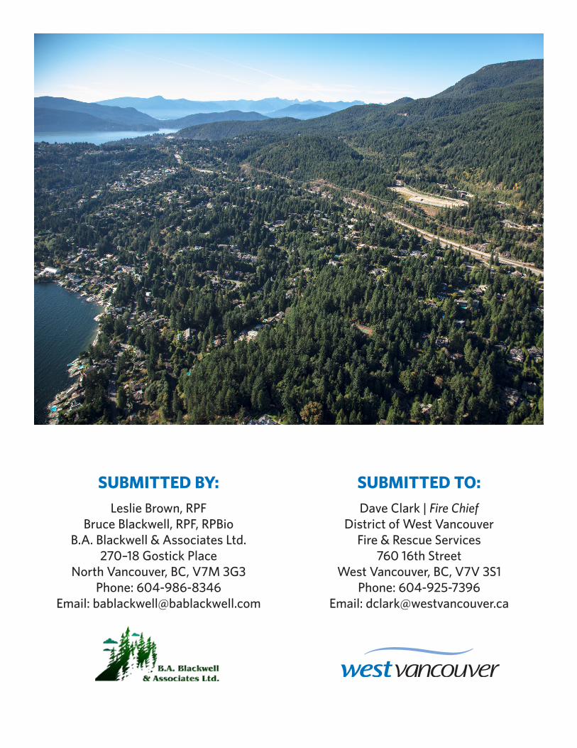
The District of West Vancouver is located on the north shore of Burrard Inlet, between the District of
North Vancouver and the unincorporated area of Metro Vancouver. The District has a total land area of
approximately 100 square kilometers. Within its boundaries there is a mix of residential, commercial,
and waterfront properties, as well as a large forested area. Watersheds, limited use and recreation, and
major parks make up approximately 62% of the District, including such features as Cypress Provincial
Park, Hollyburn Mountain, and Lighthouse Park.
West Vancouver’s sloping topography is one of its defining characteristics. Rugged shorelines, steep
terrain, numerous creeks and watercourses, and spectacular views provide an extremely attractive
setting of international renown. West Vancouver is a popular destination year-round for outdoor
recreation in many forms, including hiking, skiing, boating, cycling, and mountain biking.
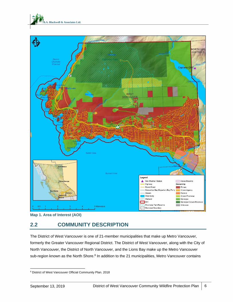
The AOI for the CWPP is illustrated below in Map 1. The AOI includes the municipal boundary, which
encompasses all developed areas, and the wildland urban interface (with a minimum density of six
structures per square kilometer) within the District’s jurisdiction. The current AOI is bounded in the east
by Capilano River and the District of North Vancouver, in the south the Burrard Inlet, in the north by the
unincorporated area of Metro Vancouver (Electoral Area A), and in the west by Howe Sound. The AOI is
approximately 9,946 ha in size. A breakdown of the AOI’s land ownership is provided in Table 2 below.7
Table 2. Summary of AOI by land ownership.
Land Ownership Hectares
Crown Agency 86
Crown Provincial 339
Federal 32
Municipal 2,755
Municipal/Crown Provincial 3,825
Private 2,574
Unknown 334
Total 9,946
7 These land ownership area estimates were derived from the BC Land Title & Survey ParcelMap BC data.
District of West Vancouver Community Wildfire Protection Plan
6
September 13, 2019
B.A. Blackwell & Associates Ltd.
Map 1. Area of Interest (AOI)
2.2 COMMUNITY DESCRIPTION
The District of West Vancouver is one of 21-member municipalities that make up Metro Vancouver,
formerly the Greater Vancouver Regional District. The District of West Vancouver, along with the City of
North Vancouver, the District of North Vancouver, and the Lions Bay make up the Metro Vancouver
sub-region known as the North Shore.8 In addition to the 21 municipalities, Metro Vancouver contains
8 District of West Vancouver Official Community Plan. 2018
District of West Vancouver Community Wildfire Protection Plan
7
September 13, 2019
B.A. Blackwell & Associates Ltd.
one Treaty Nation (Tsawwassen First Nation) and one unincorporated electoral area. As members of
Metro Vancouver, the four North Shore municipalities are provided shared services such as roads and
utilities. Partnerships also exist for recreation and emergency planning services. At the District level,
services provided include land use planning, fire protection services, water distribution, waste water
collections, and bylaw development and enforcement. The District in its entirety has a population of
approximately 42,500 people.9
The District has been inhabited by the Coast Salish Aboriginal Peoples from time immemorial. The
Tsleil-Waututh, Squamish, and Musqueam Nations are among the Coast Salish Nations that historically
occupied the land, some of whom continue to live within the AOI today. The AOI encompasses one
Indian Reserve: Capilano No.5, which pertains to the Squamish Nation.
The District’s economy was historically driven by forestry, commerce, and water way transportation
services. Although the Ambleside waterfront and its industries remain of importance to the local
economy, in recent decades the economic focus has shifted to tourism and residential development.
Fire protection within the AOI is the responsibility of the District of West Vancouver Fire & Rescue
Services (WVFR). A shared services agreement (automatic aid) exists between this department and the
North Vancouver City Fire Department and the District of North Vancouver Fire Rescue. WVFR has a
standing agreement in place with the BCWS and the Metro Vancouver Regional District (MVRD)
Watershed Protection Team, which is an initial attack team trained to respond to wildland fires. In the
event of an interface fire or wildfire, BCWS aid is requested; however, BCWS may task Metro
Vancouver Watershed Protection to action the fire on their behalf.
Highway 1 and Highway 99 are the primary access/egress routes within the District, which are connected
highway routes that run east-west through the District and north of Horseshoe Bay, respectively. Arterial
roads such as Marine Drive, Cypress Bowl Road, 21st Street, 15th Street, and Taylor Way provide access
to and from developments located in interface areas within the District. In the event of a wildfire, the
northern and southern portion of the District of West Vancouver, specifically Cypress Bowl Road and
developed areas surrounding Lighthouse Park, have limited emergency egress routes. These narrow and
forested corridors are an area of particular concern with respect to limited emergency egress and lack of
an alternate evacuation route. This not only presents a challenge for emergency egress, but also limits the
ability of fire crews to respond to fires and to safely evacuate residents.
9 Statistics Canada. 2016 Census. West Vancouver, District Municipality [Census Subdivision], British Columbia. westvancouver.ca/home-building-property/planning/facts-and-stats
District of West Vancouver Community Wildfire Protection Plan
8
September 13, 2019
B.A. Blackwell & Associates Ltd.
2.3 PAST WILDFIRES, EVACUATIONS AND IMPACTS
The BCWS has a response agreement in place with the MVRD that ensures immediate and efficient
deployment of resources, as needed.
Based on the BCWS historical wildfire dataset, the largest fire to burn within the District AOI occurred in
1944, with an estimated area of 192 ha. In 2018, multiple small fires occurred within and around the
District AOI, with the most notable one being the Whyte Lake fire in West Vancouver, which burned for
more than one week and covered an estimated three ha. This fire burned in difficult terrain, caused trail
closures on the Baden Powell and Black Mountain trails, and led to both visual distractions and smoke
conditions along the Sea-to-Sky Highway. Another fire, sighted early in the fire season on May 14, 2018
near Lions Bay (Tunnel Bluffs) burned approximately one ha and was similarly difficult to action due to
steep, mountainous terrain. The Tunnel Bluffs fire caused two hikers to become stranded above the fire
perimeter and required rescue via helicopter. In June 2019, the Strip Creek fire burned adjacent to
Highway 99 near Sunset Beach with an estimated size of 4.5 ha. These three fires, in combination with
the 2017 and 2018 local and province-wide wildfires, have alerted the District, MVRD Watershed
Protection Team, and member North Shore municipalities of the potential for wildfires occurring within
and around the AOI.
The BCWS historical ignition dataset demonstrates that the proportion of human-caused fires within the
District of West Vancouver AOI is greater than that of BC as a whole. This ignition data shows that within
the District AOI, approximately 57% of ignitions since 1950 have been human-caused versus 40% in the
province of BC.10 This statistic may be explained by the lower proportion and occurrence of lightning
strikes in the Metro Vancouver area relative to other areas in the province. Additionally, high recreational
use and historic industrial logging within many parts of the AOI may also contribute to this statistic.
2.4 CURRENT COMMUNITY ENGAGEMENT
There is widespread recognition and awareness from both District staff and the community of West
Vancouver of the threat posed to the community by wildfire, and support for hazard mitigation activities.
However, there has been limited community engagement in FireSmart initiatives to this point. Several
bylaws that relate to wildfire have been adopted by the District. These include the Fire Protection and
Emergency Response Bylaw (No. 4366) that addresses powers of the Fire Chief, open air burning, and
jurisdiction of the WVFR, and the Parks Regulation Bylaw (No. 4867) that controls fire use and smoking
in District parks. The District does not, however, have an established wildfire hazard development
permit area that addresses new development in the wildland urban interface and sets standards based
10 BCWS, 2018.
District of West Vancouver Community Wildfire Protection Plan
9
September 13, 2019
B.A. Blackwell & Associates Ltd.
on FireSmart principles for building material use, landscaping, and appropriate setbacks from forested
areas. Future initiatives should focus engagement efforts during times of high public uptake (during or
post wildfire season) in order to maximize the resources available for community engagement.
Recommendations for education and communication initiatives that may be undertaken by the District
are provided in Section 5.3.
2.5 LINKAGES TO OTHER PLANS AND POLICIES
Following is a summary of District and regional policies and guidelines that relate to strategic wildfire
management, wildfire threat reduction, operational fuel treatments and emergency planning.
2.5.1 Local Authority Emergency Plan
Emergency preparedness and response is managed jointly by the District of West Vancouver and its
two neighbour municipalities, the City of North Vancouver, and District of North Vancouver, as part of a
comprehensive North Shore Emergency Operations Plan that serves the three communities.11 The plan
was developed to optimize the response, resources, and planning for major emergencies that may
occur within the District and its North Shore member municipalities. The plan outlines the Department
Operations Centre (DOC) and Emergency Operations Centre (EOC) functions and activation, Incident
Command Post (ICP) functions, guidelines for emergency response (communications, personnel
identification, documentation, etc.), and hazard-specific roles and procedures. The hazard-specific roles
and procedures for wildland interface fires list the possible major effects of such an event, the potential
actions that may be required to address these effects, the associated actions of the DOC and EOC, and
any resources that could aid in response. Emergency response is coordinated using the BC Emergency
Management System (BCEMS) Site and Site Support Standard, with designated DOC and EOC
locations and Incident Command (IC) for site level response. A Provincial Emergency Operations
Centre (PREOC) and a Provincial Emergency Coordination Centre (PECC) may also be established if
the emergency is large in scale.
2.5.2 Affiliated CWPPs
A CWPP for the District of North Vancouver is being developed concurrently by the same consultant,
ensuring consistency in recommendations and synergies within proposed future fuel treatment works.
11 North Shore Fire Services – Major Emergency Operations Plan, 2018.

District of West Vancouver Community Wildfire Protection Plan
10
September 13, 2019
B.A. Blackwell & Associates Ltd.
2.5.3 Local Government/First Nation Policies and Recommendations
The intent of this section is to review all relevant local government plans, policies, and bylaws and
identify sections within that are relevant to the CWPP. This review included Metro Vancouver bylaws,
however, no recommendations were provided for any Metro Vancouver bylaws as they are not within
the scope of this CWPP. The following municipal bylaws, strategies, and policies are relevant to wildfire
planning in the District of West Vancouver AOI.
Bylaw No. 4985, 2018: District of West Vancouver Official Community Plan
The District of West Vancouver Official Community Plan (OCP) provides a statement of the objectives
and policies of the local government and outlines a long-range framework to guide, monitor, and
evaluate future land uses and development throughout the municipality. The following sections contain
objectives and policies which are directly relevant to wildfire risk reduction, emergency response, and
community resilience post-disaster, as described below.
2018 OCP Section 2.2: Future Neighbourhoods
This section of the OCP outlines the plans for continued development of the Upper Lands, which are
defined as the undeveloped public and private lands above Highway 1. The OCP currently restricts
development above 1,200 feet. It also recommends the clustering of new residential development close
to existing neighbourhoods of Cypress Village and Cypress West to protect the ecological and
recreational value of currently undeveloped areas.
The spread of development above Highway 1, especially in low densities where structures are
intermixed with forested areas, increases the overall wildfire interface risk of the District. Section 2.2 of
the OCP recommends that Area Development Plans include an environmental plan that includes a
wildfire risk analysis. There is an opportunity for Area Development Plans to take into account the
location of natural and planned fuel breaks using landscape features, as well as specifically treated
forested areas. See Section 5.2.2 for more details on recommendations relating to planning.
RECOMMENDATION #1: Review and amend the OCP Section 2.2 to include a growth management
policy that considers wildfire risk and other natural hazards during strategy development. By
containing development within a specified area, the overall fire risk is less than when compared to
areas of intermixed development, i.e. sprawl. In intermixed or rural areas there is often the potential
to have inadequate or unreliable water supply for suppression, as well as longer emergency response
times. By constraining development, the District can ensure that future development occurs where
urban services, such as water for fire suppression, is available, reliable, and accessible. Overall
intermix and rural areas are generally more vulnerable (at a higher risk) to interface fires.
District of West Vancouver Community Wildfire Protection Plan
11
September 13, 2019
B.A. Blackwell & Associates Ltd.
RECOMMENDATION #2: Review and amend OCP Section 2.2 to include a proactive approach to
reducing wildfire risk to new developments by ensuring that developers hire a Qualified Professional
(QP) to identify wildfire hazard adjacent to planned developments, determine fuel mitigation options,
and implement fuel treatments prior to the construction of new developments. This is particularly
relevant for new developments in the wildland urban interface (e.g. the Upper Lands, Cypress Village,
Rodgers Creek, etc.). Consider incorporating this recommendation into the Wildfire Development
Permit Area (DPA) guidelines when they are developed.
2018 OCP Schedule ii: Area-Specific Policies and Guidelines, Future Neighbourhoods
The Area-Specific Policies and Guidelines outline policies that relate to particular neighbourhoods (new,
commercial, multi-family), which guide development permit area designations relating to residential
areas, natural areas, and the Upper Lands. The Future Neighbourhoods Area is defined as the
undeveloped portion of land above Highway 1, excluding Rodgers Creek and the Upper Lands. In these
areas, measures should be taken to minimize the wildfire hazard. Because of its location at the forest
interface, Schedule ii also requires that development in Rodgers Creek incorporate wildland fire
management best practices into building and landscaping, including a defensible space at the forest
edge and the use of appropriate building and roof materials, which are not specified in the OCP.
Many guidelines consider the aesthetic experience of pedestrians and inhabitants and regulate building
materials and landscape and building design. For example, in Duplex Areas, roof materials are required
to be appropriate with the style of architecture. Guidelines for landscaping in most neighbourhoods
include healthy tree retention and the emphasis of drought resistant native vegetation. It should be
noted that aesthetic guidelines have the potential to limit the adoption of FireSmart principles for both
vegetation and building materials.
RECOMMENDATION #3: Review and update the Area-Specific landscaping guidelines that apply to
areas within the proposed Wildfire Development Permit Area to ensure that they do not conflict with
FireSmart vegetation, set-back, and building material guidelines developed to inform the Wildfire DPA
requirements.
2018 OCP Section 2.6: Natural Environment
This section covers the policies and objectives surrounding the protection of the natural environment,
particularly adjacent to developed areas within the District. Section 2.6.18 details the District’s intention
to review and update the development process to ensure that hazards such as wildfires are adequately
addressed. In addition, the need to shift to a proactive approach to managing the natural environment is
articulated. Such a shift is intended to increase the resilience of areas to natural disturbances like
wildfire and extreme weather events.
District of West Vancouver Community Wildfire Protection Plan
12
September 13, 2019
B.A. Blackwell & Associates Ltd.
2018 OCP Section 2.7: Managing Our Valuable Parks System
This section of the OCP promotes the use of trails, access to nature, and acknowledges the risk of
human-caused ignitions. Included in the District’s park system is the 4,600 acres of forested public and
private land above 1,200 feet, known as the Upper Lands. The public portion of the Upper Lands is
intended to be dedicated as municipal parkland, which may have implications for fuel reduction and
canopy modification treatments. The District is already targeting an appropriate urban-forest interface
and buffer to sensitive ecological features through a ‘soft edge’ of development.
RECOMMENDATION #4: Review the OCP and associated supporting documents (e.g. park-specific
Master Plans) and consider parks acquisition and maintenance through a wildfire risk lens, including
consideration for long-term maintenance costs and access. Consider amendments where needed,
including the following: 1) require the use of a Qualified Professional (QP) in review, assessment, and
siting of parks and park access prior to acceptance and 2) ensure that bylaws provide the District
authority to request modification (either fuels, access, or siting) based upon the QP’s recommendation
and, prior to acceptance, to ensure that the park is received in, and able to be maintained in, an
acceptable range of risk.
Bylaw No. 4940: Development Procedures Bylaw
This bylaw establishes procedures related to an application for an amendment to the OCP, the Zoning
Bylaw, Development Permits, and other permits, contracts, or designations. It outlines fees and
requirements for notice given and delegates the authority of the Council to make decisions.
RECOMMENDATION #5: Review Bylaw No. 4940, 2017: Development Procedures Bylaw and
update the OCP to incorporate a Wildfire Development Permit Area where wildfire interface
guidelines based on FireSmart principles apply. See Section 5.2.2 Planning and Development for
further details regarding a new development permit.
Bylaw No. 4366, 2004: Fire Protection and Emergency Response Bylaw
This bylaw outlines regulation for the prevention and suppression of fires, defines how persons should
conduct themselves around fires, and regulates the sale and disposal of explosives, firecrackers, and
fireworks. It also authorizes the issuance of fire related permits in order to protect life and property. The
bylaw defines the immediate role and powers of the Fire Chief, which includes community protection
from forests that may be deemed hazardous through the spread of fire. It regulates open air burning,
and mandates fire hydrant visibility, clearance and flow testing. The bylaw also defines the role of the
Community Forester who is authorized to take actions to prevent and suppress fires. He or she may
cease any activity that may contribute to the risk of fire, they may also forbid or limit the entry of
individuals within all or a portion of the forest. He or she may also enter on private or public forest or
woodland to suppress a fire through the cutting and removal of trees, vegetation, and structures. In
District of West Vancouver Community Wildfire Protection Plan
13
September 13, 2019
B.A. Blackwell & Associates Ltd.
consultation with the Wildfire Working Group, it was determined that the role of the Community Forester
no longer exists at the District.
RECOMMENDATION #6: Review District Fire Prevention Bylaw No. 4366, 2004: Fire Protection and
Emergency Response Bylaw and update to include wording that expands the types of combustible
materials that are prohibited to accumulate on private property. This should include accumulations on
and under exterior projections, such as decks and patios, near the home, and in gutters and roofs. The
revised bylaw should provide the District the authority to require removal/clean-up of combustible
materials or to complete removal and recoup costs from the owner. Consider including language
specific to green waste, not just garbage, under the prohibitions section to ensure that there is a legally
enforceable bylaw to prevent flammable materials to accumulate, collect or to remain on the property
unless securely contained.
RECOMMENDATION #7: Update the Fire Protection and Emergency Response Bylaw and remove
reference to the Community Forester. Consider transferring the authority to action and dictate activities
that may contribute to the risk of fires to the Fire Chief or other District staff.
RECOMMENDATION #8: Work with the Fire and Building Department (i.e., building inspectors) to
ensure house numbering is posted prior to occupancy of new development and to provide instructions
on how and where best to affix numbering to facilitate emergency response and evacuation efforts.
Consider encouraging home owner participation via a District-wide engagement campaign and
providing incentives such as the opportunity to acquire/purchase discounted address signs.
Bylaw No. 4892, 2016: Interim Tree Bylaw
This bylaw summarizes how to regulate, prohibit, and impose requirements in relation to trees. This
includes the application and interpretation of the tree bylaw, protection of trees from damage, tree
cutting permits and procedures, the replacement of trees and potential offences, and penalties
pertaining to tree cutting.
RECOMMENDATION #9: Revise Bylaw No. 4892, 2016: Interim Tree Bylaw to include language
which allows the issuance of a permit for cutting of trees if it is required to reduce wildfire hazard
within the wildland urban interface, as determined by a Qualified Professional (QP).
Bylaw No. 4867, 2015: Parks Regulation Bylaw
This bylaw describes how to regulate the use of parks and describes specific regulations and
prohibitions, as well as specific offences and penalties that may be incurred with regards to park usage.
General regulations include: obeying all signs and notices, obeying park hours and closures, protection
District of West Vancouver Community Wildfire Protection Plan
14
September 13, 2019
B.A. Blackwell & Associates Ltd.
of parks, limiting nuisances and obstructions and managing the use of fires, fireworks, barbecues, and
smoking within parks.
Bylaw No. 4607, 2009: Smoking Regulation Bylaw
This bylaw defines how to regulate smoking in the District of West Vancouver under the Community
Charter. It describes various topics including smoking bans, pertaining to buildings, vehicles, and parks
or municipal facility sites, the power of an enforcement officer to inspect, and any offence and penalty
that a violation may incur.
Bylaw No. 4975, 2018: Revised Drinking Water Conservation Plan
This bylaw describes how to regulate the sustainable use of drinking water resources in accordance with
the Metro Vancouver Drinking Water Conservation Plan. This bylaw covers water management plans,
restriction stages, permits, exemptions and offences, and penalties pertaining to the drinking water
conservation plan. Certain water restriction stages may come into effect automatically such as Stage 1
restrictions, which occur automatically on May 1 of every year, or they may be activated or deactivated by
the Greater Vancouver Water District commissioner. Exemptions may be granted to stage 1 to 3
restrictions should a person be operating under a valid and subsisting Water Management Plan.
Bylaw No. 4309, 2002: Water Vancouver Emergency Plan Bylaw
This bylaw provides an operation plan and scheme for preparedness, response and recovery in the
case of emergencies pursuant to the provisions of the Emergency Program Act R.S.B.C. 1996, c.111.
Bylaw No. 4400, 2004: Building Bylaw
This bylaw provides an overview on the health, safety, and protection of persons and property, and the
conservation of energy. It describes owner responsibilities, building, plumbing, and electrical permits,
including offence and penalty descriptions.
Bylaw No. 4886, 2016: Boulevard Bylaw
This bylaw summarizes how to regulate the use and occupation of highway boulevards, especially with
regards to tree cutting and vegetation maintenance along highways.
RECOMMENDATION #10: Review the OCP and strengthen existing OCP policies regarding natural
hazards that have the potential to impact values within the District of West Vancouver. Natural hazards
include, but are not limited to, wildfire and interface fire, which has the potential to impact public health
and safety, economics (e.g. through evacuations, loss of tourism, interruption of services), ecosystems,
habitat, and water quality, among other values. Identification of natural hazards such as wildfire can
allow for planning and policies to be put in place to increase District resilience, mitigate potential
damages, and increase public and official awareness of risk.
District of West Vancouver Community Wildfire Protection Plan
15
September 13, 2019
B.A. Blackwell & Associates Ltd.
2.5.4 Higher Level Plans and Relevant Legislation
West Vancouver Community Energy & Emissions Plan 2016
The Community Energy & Emissions Plan (CEEP) aims to support the BC’s commitment to climate
change mitigation by outlining steps to reduce greenhouse gas (GHG) emissions within the District. The
document organizes the impacts and objectives for the District by four main sectors:
1) neighborhood and community planning
2) housing and land use
3) transportation and land use
4) solid waste and materials
The impact of each sector is discussed and high-level guidance is provided in the form of strategic
directions for each sector. The strategic directions vary in resource intensity, impact, and
implementation status. Reducing the risk of natural disasters is part of the CEEP’s high-level objectives,
but mitigating the risk of regional forest fires is not specifically addressed by any strategic directions.
The CEEP also sets indicators and targets for each sector. West Vancouver’s official GHG reduction
target is 80% emissions reductions by 2050 from a 2007 base year. Performance indicators are used to
identify priority actions for the District to meet these targets. This plan acknowledges the potential
implications of climate change and wildfire risk within the District, noting possible impacts to wildlife
habitat, air quality, biodiversity, and property. However, it does not identify measures to reduce or
mitigate this risk.
District of West Vancouver Parks Master Plan 2012
This document provides a comprehensive strategy for the maintenance, development, and renewal of
the parks, trails, and open spaces throughout the District of West Vancouver. It builds upon the Parks
and Open Space Background Document of 2006 and was developed in consultation with the
community. The plan includes an analysis of existing parkland and park amenities and identifies trends
and areas of improvement. The plan provides recommendations under four categories to better meet
the objectives of the citizens of West Vancouver:
Parkland Protection and Acquisition: Dedicated bylaws to protect existing and future parks and
areas with high environmental and cultural value.
Capital Development for Active Living: Upgrading and improving park amenities, from
accessible washrooms to off-lease dog areas.
Community Involvement and Stewardship: Increasing community involvement through volunteer
opportunities and partnerships.
District of West Vancouver Community Wildfire Protection Plan
16
September 13, 2019
B.A. Blackwell & Associates Ltd.
Parks Management and Service Delivery: Improving park management to most effectively
deliver services.
High-use recreational parks and trails can be beneficial when high-use times provide increased early
detection and reporting for fires. Alternatively, these areas can also potentially be locations of increased
ignitions in the interface (high-use areas). For trails in particular, depending upon the width, clearance
and surfacing, they can provide points of access for suppression efforts, serve as surface fire fuel
breaks, and act as control lines for suppression efforts if a fire is nearby.
RECOMMENDATION #11: The District’s existing park maintenance program should be reviewed and
updated to facilitate a combined approach that addresses both public safety (hazard trees) and
wildfire risk (hazardous fuels). Tree mortality associated with drought (particularly shallow-rooted
species such as western redcedar and western hemlock) should be incorporated into this review to
ensure that these trees are not increasing wildfire or tree failure risk across the District.
District of West Vancouver Invasive Plants Strategy 2014
This strategy addresses the threat of invasive plants to human and ecosystem health in the District of
West Vancouver. It summarizes the activities of the Invasive Plants Working Group and contains a 5-
year phased implementation plan for 44 recommendations. The highest priority recommendations are:
Treating giant hogweed and knotweed species.
Amending the Pesticide Use Control Bylaw to allow for the use of pesticides to control invasive
plants where absolutely necessary.
Providing annual funding to support invasive plant management.
The plan also emphasizes Best Management Practices (BMP) to reduce the spread of invasive plants
within the District, including discouraging the planting of invasive species on public and private lands,
and detailed BMPs for 19 plant species. These BMPs should be reviewed and integrated, where
appropriate, into planning and implementation of any future operational fuel treatments within the
District. Gorse and Scotch Broom have been identified as species that increase fire hazard. Both
species are evergreen shrubs that grow in dense thickets up to three meters high. Scotch broom and
Gorse are typically found in dry, non-forested sites along roadsides and disturbed areas. Control of
these species is important for reducing fuel continuity across the landscape.
District of West Vancouver Water Asset Management Plan 2010
This technical report identifies value, condition, replacement requirements, and associated costs for all
of West Vancouver’s water assets. West Vancouver owns and operates $272 million of water
infrastructure, including two dams, 22 reservoirs, and two water treatment plants. As is the case with
District of West Vancouver Community Wildfire Protection Plan
17
September 13, 2019
B.A. Blackwell & Associates Ltd.
many municipalities, there is an infrastructure gap projected over the next 100 years as anticipated
renewal costs exceeds the annual budget allocated to replacement. The District of West Vancouver
Water Asset Management Plan identifies increasing the annual renewal budget and performing
preventative maintenance as the two most important strategies to close the gap. Maintaining water
supply to the District’s hydrants is critical to the suppression of wildfire within the AOI.
Urban Forest Climate Adaptation Framework for Metro Vancouver 201712
This document provides a comprehensive framework for building urban forest resilience and addressing
climate change requirements at a regional level, through the following steps:
1. Risk identification within regional and urban forests.
2. Assessment of urban forest vulnerabilities to issues such as forest health, pests, invasive
species, and wildfire.
3. Development of guidelines to build resilience (i.e., through species selection, management
techniques, soil and planting infrastructure, and water management guidelines)
4. Development of a 144 species selection decision support tool.
The framework is complemented by a Design Guidebook13 and a tree species selection database14,
which considers urban forest climate change adaptation requirements and provides best management
practices for landscape and development design. Additionally, the guidebook serves as a reference
guide for Metro Vancouver member municipalities in support of landscape design for existing and new
developments. This has relevance to fuel treatment planning, particularly if re-planting or species
conversion treatments are prescribed.
Metro Vancouver 2040 Shaping Our Future, 201715
This document outlines a regional vision and strategy for sustainable growth within all member
municipalities. The document identifies the importance of environmental protection and climate change
impact (Goal 3), and provides the following four strategies to guide high-level management decisions
within Metro Vancouver:
Strategy 3.1: Protect conservation and recreation lands
Strategy 3.2: Protect and enhance natural features and connectivity
Strategy 3.3: Encourage land use and transportation infrastructure that reduce energy
consumption and greenhouse gas emissions, and improve air quality
12 Diamond Head Consulting. 2017. Urban Forest Climate Adaptation Framework for Metro Vancouver. Tree Species Selection,
Planting and Management 13 Diamond Head Consulting. 2017. Design Guidebook – Maximizing Climate Adaptation Benefits with Trees 14 Diamond Head Consulting. 2017. Urban Forest Climate Adaptation – Tree Species Selection Database 15 Metro Vancouver. Regional Growth Strategy. Adopted 2011 and updated to 2017.
District of West Vancouver Community Wildfire Protection Plan
18
September 13, 2019
B.A. Blackwell & Associates Ltd.
Strategy 3.4: Encourage land use and transportation infrastructure that improve the ability to
withstand climate change impacts and natural hazard risks (wildfire, earthquakes, flooding,
mudslides, etc.)
Sensitive Ecosystem Inventory for Metro Vancouver and Abbotsford, 2011–201216
This technical report uses standard provincial methodology to identify sensitive ecosystems across the
land base of Metro Vancouver and Abbotsford. Orthophotography and existing Terrestrial Ecosystem
Mapping (TEM) were used to assign Sensitive Ecosystem Inventory (SEI) values to ecosystem
polygons. This inventory is an important resource to support land and environmental decisions and is
relevant in the context of fuel treatment planning.
Much of the area bordering the District of West Vancouver to the north is classified as a ‘Sensitive
Ecosystems’ (i.e., wetlands and old forest) or a ‘Modified Ecosystems’ (human-modified but with
significant ecological and biological value). Several class and subclasses within each ecosystem type
are assigned and delineated in the inventory. The inventory should be reviewed during fuel treatment
planning to ensure that sensitive ecosystems are protected.
2.5.5 Ministry or Industry Plans
Reviewing and incorporating other important forest management planning initiatives into the CWPP
planning process is a critical step in ensuring a proactive and effective wildfire mitigation approach.
The South Coast Response Fire Management Plan (FMP)17 was developed for the Sea to Sky Natural
Resource District (NRD), the Sunshine Coast NRD, and the Chilliwack NRD. The FMP was reviewed to
identify any regional fire management planning objectives and their interpretation in the context of
management considerations for the District AOI. The 2018 South Coast FMP identifies values at risk
and prioritizes broad categories of values as ‘themes’ for response planning through the Resource
Strategic Wildfire Allocation Protocol (RSWAP). The South Coast FMP briefly speaks to the concept of
wildfire prevention engineering within the region, which includes fuel management such as locally
identified fuel breaks, proposed treatment areas, or demonstration and operational treatment areas. In
order to reduce local fire threat and to build defensible space around critical infrastructure and/or
residential neighbourhoods, this CWPP identifies various fuel treatment opportunities (Section 5.1.1).
16 Metro Vancouver. Regional Growth Strategy. Adopted 2011 and updated to 2017. 17 South Coast Fire Management Plan. 2018. (Internal government document)
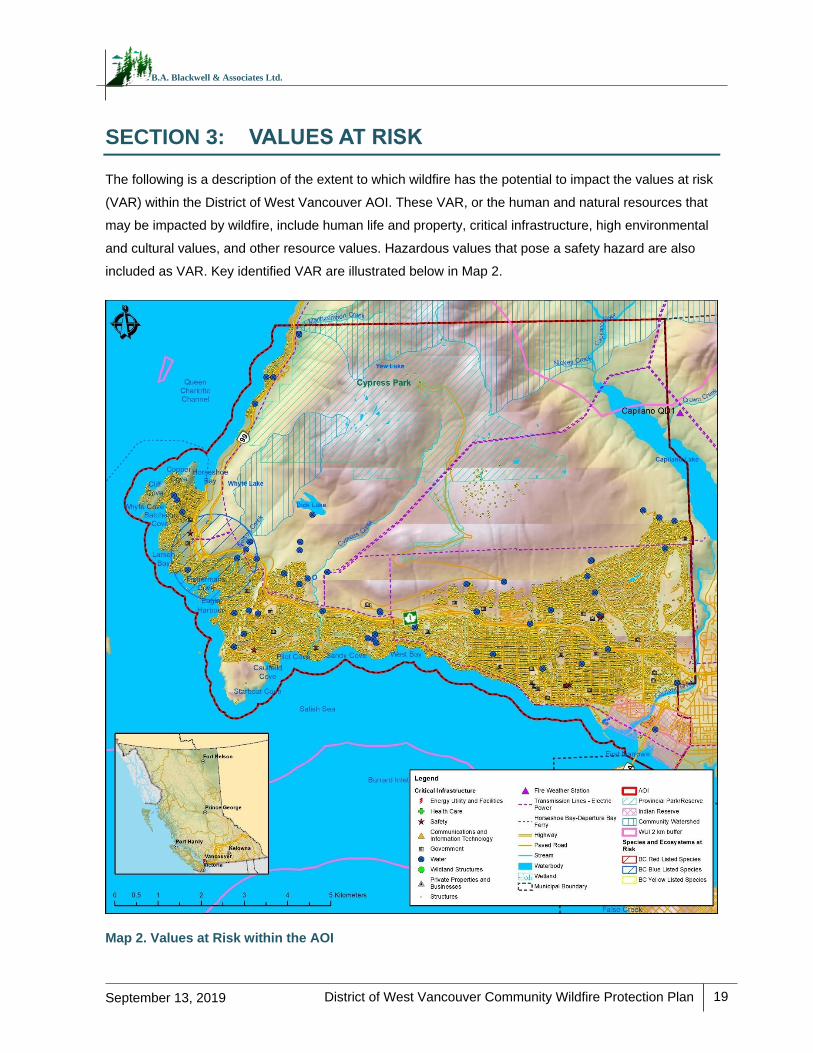
District of West Vancouver Community Wildfire Protection Plan
19
September 13, 2019
B.A. Blackwell & Associates Ltd.
SECTION 3: VALUES AT RISK
The following is a description of the extent to which wildfire has the potential to impact the values at risk
(VAR) within the District of West Vancouver AOI. These VAR, or the human and natural resources that
may be impacted by wildfire, include human life and property, critical infrastructure, high environmental
and cultural values, and other resource values. Hazardous values that pose a safety hazard are also
included as VAR. Key identified VAR are illustrated below in Map 2.
Map 2. Values at Risk within the AOI
District of West Vancouver Community Wildfire Protection Plan
20
September 13, 2019
B.A. Blackwell & Associates Ltd.
3.1 HUMAN LIFE AND SAFETY
One of the primary goals of the BCWS is to support emergency response and provide efficient wildfire
management on behalf of the BC government. BCWS aims to protect life and values at risk, while
ensuring the maintenance and enhancing the sustainability, health, and resilience of BC ecosystems.18
Human life and safety are the first priority in the event of a wildfire. A key consideration is the evacuation
of at-risk areas and safe egress. Evacuation can be complicated by the dynamic nature of wildfire,
which can move quickly. Evacuation takes time and safe egress routes can be compromised by
wildfire, causing limited visibility, or by traffic congestion and/or accidents.
The population distribution (both people and structures) within the AOI is important in determining the
wildfire risk and identifying mitigation activities. The population of the District has remained steady in
recent years. It was last measured at 42,473 residents in 2016, down 0.5% from 2011.19 This compares
to 5.6% growth in the province of British Columbia during the same years. According to the 2016
Census, there are 18,649 private dwellings in the District, approximately 1,716 of which are occupied on
a part-time basis. The aforementioned figures are calculated using the 2016 Census population
statistics for the District of West Vancouver.
The District of West Vancouver is a major destination for outdoor recreation in the Lower Mainland,
including, hiking, mountain biking, kayaking, and paddle boarding. These activities can occur year-
round, but are especially popular during the fire season (April to October). Several parks throughout the
AOI experience high-use throughout the year: Cypress Provincial Park, Lighthouse Park, Whytecliff
Park, Cypress Falls Park, and Ambleside Park. Additionally, the seasonal increase in population due to
tourism within the AOI also raises concern with regards to potential evacuation in the event of a wildfire.
The Trans-Canada Highway acts as a main travel route for commuters, tourists, and recreationalists
who may be travelling along the Sea-to Sky Corridor or south/east to other Metro Vancouver
municipalities. This may lead to additional pressures on emergency management resources in the event
of an evacuation.
Knowledge of and access to updated structure locations within an area is a critical step in efficient and
successful emergency response planning and the development of mitigation strategies and
recommendations. Field visits to the AOI and access to recent orthophotography and spatial data from
18 BC Provincial Coordination Plan for Wildland Urban Interface Fires. 2016. Retrieved online at: www2.gov.bc.ca/assets/gov/public-safety-and-emergency-services/emergency-preparedness-response-recovery/provincial-emergency-planning/bc-provincial-coord-plan-for-wuifire_revised_july_2016.pdf 19 Statistics Canada. 2016 Census.
District of West Vancouver Community Wildfire Protection Plan
21
September 13, 2019
B.A. Blackwell & Associates Ltd.
the District has enabled the development of an updated structures dataset that accounts for new
development in the interface.
3.2 CRITICAL INFRASTRUCTURE
Protection of critical infrastructure during a wildfire event is an important consideration for emergency
response effectiveness, ensuring that coordinated evacuation can occur if necessary, and that essential
services can be maintained or restored quickly in the case of an emergency. Critical infrastructure
includes emergency and medical services, electrical and gas services, transportation, water, social
services, and communications infrastructure. Table 3 provides an inventory of critical infrastructure
identified by the District staff and during field visits, while Map 2 provides a visual depiction of the critical
infrastructure within the AOI.
The District of West Vancouver Fire and Rescue Services (WVFR), the West Vancouver Police
Department, and the Emergency Operations Centre (EOC) located in the North Shore Emergency
Management Office are critical to emergency response services in the community. However, in the
event of a localized emergency within the District, adjacent municipalities with health care and
emergency response facilities may also be able to provide rapid emergency response. As mentioned
previously, WVFR has automatic aid agreements in place with other Fire Services, jurisdictions, and
agencies. These facilities provide the foundation for incident command and response during a large fire
event and therefore must be prepared to deal with large and complex situations.
Protection of critical infrastructure is an essential wildfire preparedness function. Survival and continued
functionality of these facilities not only support the community during an emergency, but also determine
to a great degree, the extent and cost of wildfire recovery and economic and public disruption during
post wildfire reconstruction. Critical infrastructure provides important services that may be required
during a wildfire event or may require additional considerations or protection. As outlined in Section 5.2,
FireSmart principles are important when reducing wildfire risk to critical infrastructure and are reflected
in the outlined recommendations. During field visits, it was observed that the District’s critical
infrastructure (e.g., fire halls, ambulance station, water pump stations, etc.) is in various levels of
compliance with FireSmart principles. While some structures may be relatively FireSmart with respect to
landscaping within the immediate FireSmart priority zones, many are located adjacent to and within
forest lands.
District of West Vancouver Community Wildfire Protection Plan
22
September 13, 2019
B.A. Blackwell & Associates Ltd.
RECOMMENDATION #12: The use of fire-resistant construction materials, building design, and
landscaping should be considered for all CI when completing upgrades or establishing new
infrastructure. Additionally, vegetation setbacks around critical infrastructure should be compliant with
FireSmart guidelines. Secondary power sources are important to reduce critical infrastructure
vulnerability in the event of an emergency, which cuts power for days or even weeks.
RECOMMENDATION #13: It is recommended that formal FireSmart assessments (by a Qualified
Professional) be completed of critical infrastructure such as the fire halls, water infrastructure, and
others as identified in this CWPP (Table 3) and by the District.
RECOMMENDATION #14: The District should develop a plan for post fire rehabilitation that
considers the procurement of seed, seedlings, and materials required to regenerate an extensive
burn area (1,000 to 5,000 ha). The opportunity to conduct meaningful rehabilitation post-fire will be
limited to a short fall season (September to November). The focus of initial rehabilitation efforts
should be on slope stabilization and infrastructure protection. These issues should form the
foundation of an action plan that lays out the necessary steps to stabilize and rehabilitate the burn
area.
3.2.1 Electrical Power
Electrical service for the District is received through a network of wood pole and underground
distribution infrastructure supplied by a BC Hydro transmission line, which runs in the east‐west
direction through the District. Neighbourhoods with small, street-side wooden poles connecting homes
are particularly vulnerable to fire. In the British Properties, distribution lines are located in easements
between homes and the adjacent forest land. It is recommended that utility right-of-way best
management practices (BMP), such as regular brushing and clearing of woody debris and shrubs, be
employed to help reduce fire risk, utility pole damage, and subsequent outages. It is also recommended
that the District take steps to increase enforcement of anti-dumping bylaws and notification to the public
in order to reduce this activity within District easements, parks, and right-of-ways.
A large fire has the potential to impact electrical service by causing a disruption in network distribution
through direct or indirect means. For example, heat from the flames or fallen trees associated with a fire
event may cause power outages. Consideration must be given to protecting this critical service and
providing power back-up at key facilities to ensure that the emergency response functions are reliable.
Metro Vancouver and District owned pump stations that rely on electricity to distribute water and
maintain hydrant pressure for suppression activities are of particular concern.
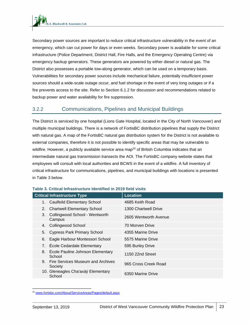
District of West Vancouver Community Wildfire Protection Plan
23
September 13, 2019
B.A. Blackwell & Associates Ltd.
Secondary power sources are important to reduce critical infrastructure vulnerability in the event of an
emergency, which can cut power for days or even weeks. Secondary power is available for some critical
infrastructure (Police Department, District Hall, Fire Halls, and the Emergency Operating Centre) via
emergency backup generators. These generators are powered by either diesel or natural gas. The
District also possesses a portable tow-along generator, which can be used on a temporary basis.
Vulnerabilities for secondary power sources include mechanical failure, potentially insufficient power
sources should a wide-scale outage occur, and fuel shortage in the event of very long outages or if a
fire prevents access to the site. Refer to Section 6.1.2 for discussion and recommendations related to
backup power and water availability for fire suppression.
3.2.2 Communications, Pipelines and Municipal Buildings
The District is serviced by one hospital (Lions Gate Hospital, located in the City of North Vancouver) and
multiple municipal buildings. There is a network of FortisBC distribution pipelines that supply the District
with natural gas. A map of the FortisBC natural gas distribution system for the District is not available to
external companies, therefore it is not possible to identify specific areas that may be vulnerable to
wildfire. However, a publicly available service area map20 of British Columbia indicates that an
intermediate natural gas transmission transects the AOI. The FortisBC company website states that
employees will consult with local authorities and BCWS in the event of a wildfire. A full inventory of
critical infrastructure for communications, pipelines, and municipal buildings with locations is presented
in Table 3 below.
Table 3. Critical Infrastructure Identified in 2019 field visits
Critical Infrastructure Type Location
1. Caulfeild Elementary School 4685 Keith Road
2. Chartwell Elementary School 1300 Chartwell Drive
3. Collingwood School - Wentworth Campus
2605 Wentworth Avenue
4. Collingwood School 70 Morven Drive
5. Cypress Park Primary School 4355 Marine Drive
6. Eagle Harbour Montessori School 5575 Marine Drive
7. École Cedardale Elementary 595 Burley Drive
8. École Pauline Johnson Elementary School
1150 22nd Street
9. Fire Services Museum and Archives Society
965 Cross Creek Road
10. Gleneagles Cha'axáý Elementary School
6350 Marine Drive
20 www.fortisbc.com/About/ServiceAreas/Pages/default.aspx
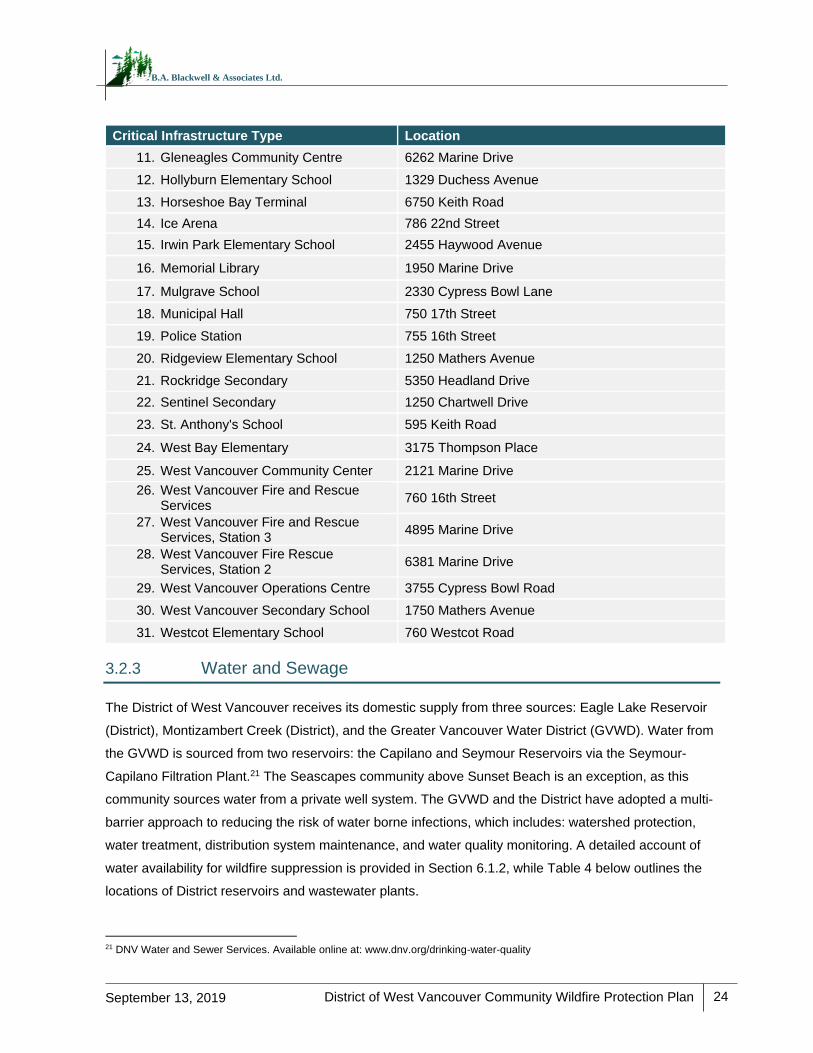
District of West Vancouver Community Wildfire Protection Plan
24
September 13, 2019
B.A. Blackwell & Associates Ltd.
Critical Infrastructure Type Location
11. Gleneagles Community Centre 6262 Marine Drive
12. Hollyburn Elementary School 1329 Duchess Avenue
13. Horseshoe Bay Terminal 6750 Keith Road
14. Ice Arena 786 22nd Street
15. Irwin Park Elementary School 2455 Haywood Avenue
16. Memorial Library 1950 Marine Drive
17. Mulgrave School 2330 Cypress Bowl Lane
18. Municipal Hall 750 17th Street
19. Police Station 755 16th Street
20. Ridgeview Elementary School 1250 Mathers Avenue
21. Rockridge Secondary 5350 Headland Drive
22. Sentinel Secondary 1250 Chartwell Drive
23. St. Anthony's School 595 Keith Road
24. West Bay Elementary 3175 Thompson Place
25. West Vancouver Community Center 2121 Marine Drive
26. West Vancouver Fire and Rescue Services
760 16th Street
27. West Vancouver Fire and Rescue Services, Station 3
4895 Marine Drive
28. West Vancouver Fire Rescue Services, Station 2
6381 Marine Drive
29. West Vancouver Operations Centre 3755 Cypress Bowl Road
30. West Vancouver Secondary School 1750 Mathers Avenue
31. Westcot Elementary School 760 Westcot Road
3.2.3 Water and Sewage
The District of West Vancouver receives its domestic supply from three sources: Eagle Lake Reservoir
(District), Montizambert Creek (District), and the Greater Vancouver Water District (GVWD). Water from
the GVWD is sourced from two reservoirs: the Capilano and Seymour Reservoirs via the Seymour-
Capilano Filtration Plant.21 The Seascapes community above Sunset Beach is an exception, as this
community sources water from a private well system. The GVWD and the District have adopted a multi-
barrier approach to reducing the risk of water borne infections, which includes: watershed protection,
water treatment, distribution system maintenance, and water quality monitoring. A detailed account of
water availability for wildfire suppression is provided in Section 6.1.2, while Table 4 below outlines the
locations of District reservoirs and wastewater plants.
21 DNV Water and Sewer Services. Available online at: www.dnv.org/drinking-water-quality
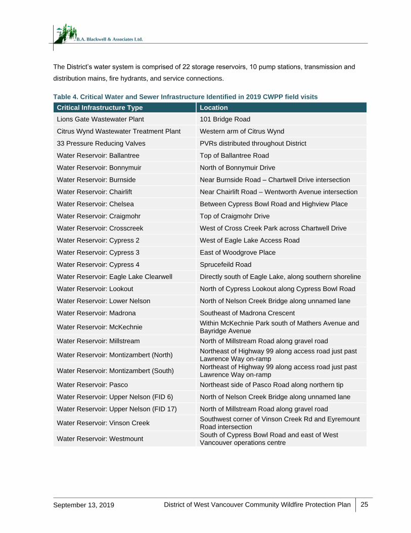
District of West Vancouver Community Wildfire Protection Plan
25
September 13, 2019
B.A. Blackwell & Associates Ltd.
The District’s water system is comprised of 22 storage reservoirs, 10 pump stations, transmission and
distribution mains, fire hydrants, and service connections.
Table 4. Critical Water and Sewer Infrastructure Identified in 2019 CWPP field visits
Critical Infrastructure Type Location
Lions Gate Wastewater Plant 101 Bridge Road
Citrus Wynd Wastewater Treatment Plant Western arm of Citrus Wynd
33 Pressure Reducing Valves PVRs distributed throughout District
Water Reservoir: Ballantree Top of Ballantree Road
Water Reservoir: Bonnymuir North of Bonnymuir Drive
Water Reservoir: Burnside Near Burnside Road – Chartwell Drive intersection
Water Reservoir: Chairlift Near Chairlift Road – Wentworth Avenue intersection
Water Reservoir: Chelsea Between Cypress Bowl Road and Highview Place
Water Reservoir: Craigmohr Top of Craigmohr Drive
Water Reservoir: Crosscreek West of Cross Creek Park across Chartwell Drive
Water Reservoir: Cypress 2 West of Eagle Lake Access Road
Water Reservoir: Cypress 3 East of Woodgrove Place
Water Reservoir: Cypress 4 Sprucefeild Road
Water Reservoir: Eagle Lake Clearwell Directly south of Eagle Lake, along southern shoreline
Water Reservoir: Lookout North of Cypress Lookout along Cypress Bowl Road
Water Reservoir: Lower Nelson North of Nelson Creek Bridge along unnamed lane
Water Reservoir: Madrona Southeast of Madrona Crescent
Water Reservoir: McKechnie Within McKechnie Park south of Mathers Avenue and Bayridge Avenue
Water Reservoir: Millstream North of Millstream Road along gravel road
Water Reservoir: Montizambert (North) Northeast of Highway 99 along access road just past Lawrence Way on-ramp
Water Reservoir: Montizambert (South) Northeast of Highway 99 along access road just past Lawrence Way on-ramp
Water Reservoir: Pasco Northeast side of Pasco Road along northern tip
Water Reservoir: Upper Nelson (FID 6) North of Nelson Creek Bridge along unnamed lane
Water Reservoir: Upper Nelson (FID 17) North of Millstream Road along gravel road
Water Reservoir: Vinson Creek Southwest corner of Vinson Creek Rd and Eyremount Road intersection
Water Reservoir: Westmount South of Cypress Bowl Road and east of West Vancouver operations centre
District of West Vancouver Community Wildfire Protection Plan
26
September 13, 2019
B.A. Blackwell & Associates Ltd.
3.3 HIGH ENVIRONMENTAL AND CULTURAL VALUES
The following section identifies high environmental and cultural values and where they are located.
Environmental, cultural, and recreational values are high throughout the AOI. A more detailed account
of environmental and biodiversity aspects of this region is presented in Section 3.3.3.
3.3.1 Drinking Water Supply Area and Community Watersheds
As outlined above, the District receives its potable water from the Eagle Lake Reservoir, Montizambert
Creek, and the Greater Vancouver Water District reservoirs. Protection from contamination for the
GVWD reservoirs is ensured through the following avenues: 1) restricted access to watersheds, 2)
restoration of disturbed areas and deactivation of watershed roads that are no longer in use, 3)
management of watershed via minimal intervention (i.e., in the event infrastructure is required), and 4)
cooperative management with adjoining municipalities to preserve water quality.22
District staff did not express immediate concerns related to water availability from the Greater
Vancouver Water District distribution system. Each year since 2010 the District has produced a
comprehensive drinking water quality report, which includes information regarding microbiological
quality, physical parameters, chemical parameters, operator training and certification, and an
emergency response plan. This report is then submitted to Vancouver Coastal Health’s Medical Health
Officer for review.
The AOI overlaps the Montizambert, Capilano, and Nelson community watersheds. The first two are
located in the northern portions of the AOI, while the latter is located west of Eagle Lake. Due to their
status as a community watershed, special management considerations are required within and adjacent
to their perimeter to maintain timing of flow and the volume and quality of the water source.
RECOMMENDATION #15: Conduct future assessments to explore the potential hydrologic and
geomorphic impacts of wildfire on the watersheds and community. Alternatively, there may be an
option to complete a stand-alone assessment to help identify and quantify the post-fire hazards,
levels of risk to the community, and mitigation options. Exploration of potential funding opportunities
through the province and the National Disaster Mitigation Program may be worthwhile.23
22 Metro Vancouver Drinking Water Management Plan 2011. Available online at: www.metrovancouver.org/services/water/WaterPublications/DWMP-2011.pdf 23 Public Safety Canada, National Disaster Mitigation Program. Retrieved online at: www.publicsafety.gc.ca/cnt/mrgnc-mngmnt/dsstr-prvntn-mtgtn/ndmp/index-en.aspx
District of West Vancouver Community Wildfire Protection Plan
27
September 13, 2019
B.A. Blackwell & Associates Ltd.
3.3.2 Cultural Values
The Coast Salish are the main First Nations group whose territory overlaps the District. Within this
group, a total of 15 First Nations with aboriginal interests were identified in the AOI using the BC
Consultative Areas Database. These include the following mainland-based First Nations: Squamish
Nation, Musqueam Indian Band, Tsleil-Waututh Nation, Kwikwetlem First Nation, Sto:lo Nation, Sto:lo
Tribal Council, Soowahlie First Nation, Shxw’ow’hamel First Nation, Skawahlook First Nation, and
Seabird Island Band, and the following Vancouver Island based First Nations: Halalt First Nation,
Stz’uminus First Nation, Cowichan Tribes, Lake Cowichan First Nation, Lyackson First Nation, and
Penelakut Tribe.
Archaeological sites and remains in BC that pre-date 1846 are protected from disturbance, intentional
and inadvertent, by the Heritage Conservation Act (HCA), which applies on both private and public
lands. Sites that are of an unknown age that have a likely probability of dating prior to 1846 (i.e., lithic
scatters), as well as Indigenous pictographs, petroglyphs, and burials (which are likely not as old but are
still considered to have historical or archaeological value) are also protected. Under the HCA, protected
sites may not be damaged, altered, or moved in any way without a permit. It is a best practice that
cultural heritage resources such as culturally modified tree (CMT) sites be inventoried and considered in
both operational and strategic planning.
Due to site sensitivity, the locations of archaeological sites may not be made publicly available. However,
data provided by the MFLNRORD Archaeology Branch confirms that numerous sites exist in the AOI. The
District should ensure that they have direct access to Remote Access to Archaeological Data (RAAD),
which allows users to look up or track any archeological sites in the area.24 Prior to stand modification for
fire hazard reduction, and depending on treatment location, preliminary reconnaissance surveys may be
undertaken to ensure that cultural heritage features are not inadvertently damaged or destroyed.
Pile burning and the use of machinery have the potential to damage artifacts that may be buried in the
upper soil horizons. Above ground archaeological resources may include features such as CMTs, which
could be damaged or accidentally removed during fire hazard reduction activities. Fuel treatment
activities should include consultation with all identified First Nations and include sufficient time for review
and input regarding their rights and interests prior to prescription finalization or implementation. The
Squamish Nation requests that Cultural Monitors be made available whenever stand modification occurs
within 50 m of any known cultural heritage feature or when previously unknown sites are identified
during treatments.
24 MFLNRORD, Archaeology. Retrieved online at: www.for.gov.bc.ca/archaeology/accessing_archaeological_data/obtaining_access.htm
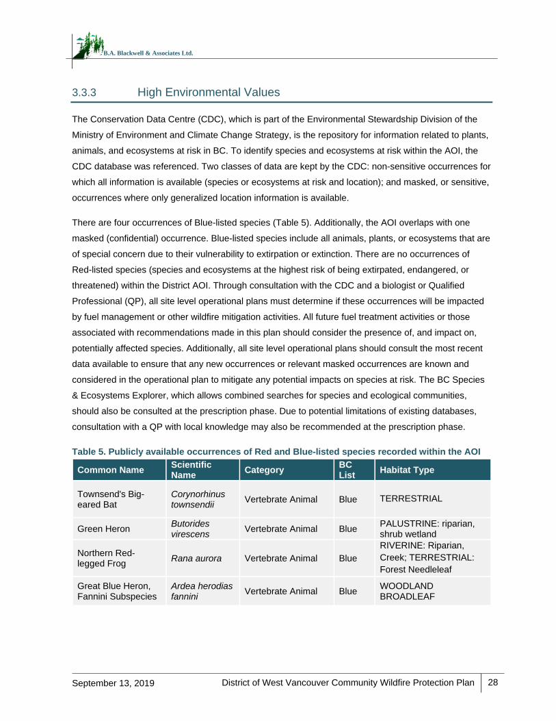
District of West Vancouver Community Wildfire Protection Plan
28
September 13, 2019
B.A. Blackwell & Associates Ltd.
3.3.3 High Environmental Values
The Conservation Data Centre (CDC), which is part of the Environmental Stewardship Division of the
Ministry of Environment and Climate Change Strategy, is the repository for information related to plants,
animals, and ecosystems at risk in BC. To identify species and ecosystems at risk within the AOI, the
CDC database was referenced. Two classes of data are kept by the CDC: non-sensitive occurrences for
which all information is available (species or ecosystems at risk and location); and masked, or sensitive,
occurrences where only generalized location information is available.
There are four occurrences of Blue-listed species (Table 5). Additionally, the AOI overlaps with one
masked (confidential) occurrence. Blue-listed species include all animals, plants, or ecosystems that are
of special concern due to their vulnerability to extirpation or extinction. There are no occurrences of
Red-listed species (species and ecosystems at the highest risk of being extirpated, endangered, or
threatened) within the District AOI. Through consultation with the CDC and a biologist or Qualified
Professional (QP), all site level operational plans must determine if these occurrences will be impacted
by fuel management or other wildfire mitigation activities. All future fuel treatment activities or those
associated with recommendations made in this plan should consider the presence of, and impact on,
potentially affected species. Additionally, all site level operational plans should consult the most recent
data available to ensure that any new occurrences or relevant masked occurrences are known and
considered in the operational plan to mitigate any potential impacts on species at risk. The BC Species
& Ecosystems Explorer, which allows combined searches for species and ecological communities,
should also be consulted at the prescription phase. Due to potential limitations of existing databases,
consultation with a QP with local knowledge may also be recommended at the prescription phase.
Table 5. Publicly available occurrences of Red and Blue-listed species recorded within the AOI
Common Name Scientific Name
Category BC List
Habitat Type
Townsend's Big-eared Bat
Corynorhinus townsendii
Vertebrate Animal Blue TERRESTRIAL
Green Heron Butorides virescens
Vertebrate Animal Blue PALUSTRINE: riparian, shrub wetland
Northern Red-legged Frog
Rana aurora Vertebrate Animal Blue
RIVERINE: Riparian,
Creek; TERRESTRIAL:
Forest Needleleaf
Great Blue Heron, Fannini Subspecies
Ardea herodias fannini
Vertebrate Animal Blue WOODLAND BROADLEAF
District of West Vancouver Community Wildfire Protection Plan
29
September 13, 2019
B.A. Blackwell & Associates Ltd.
3.4 OTHER RESOURCE VALUES
There are multiple resources values associated with the land base in the AOI, including recreation and
tourism, wildlife habitat, drinking water supplies, and many others.
The Fraser Timber Supply Area (TSA) encompasses the District of West Vancouver, although no
primary forestry activities occur within the District. As such, higher level planning documents associated
with the TSA do not apply and fuel reduction treatments will not have an effect on the timber harvesting
land base due to the fact that the AOI does not currently contribute to this measure.
3.5 HAZARDOUS VALUES
Hazardous values are defined as values that pose a safety hazard to emergency responders. Generally,
the District does not have a significant number of industrial sites or facilities that can be considered
hazardous values at risk. A comprehensive list of hazardous values within the AOI is included in Table 6.
The management and treatment of fuels in proximity to hazardous infrastructure is critical in order to
reduce the risks associated with both structural fire and wildfire. Specifically, best management
practices recommended for management of hazardous values include: 1) incorporating FireSmart
planning and setback requirements for all infrastructure in this category and 2) maintaining emergency
fuel/propane emergency shut off procedures to be enacted immediately in the event of an approaching
wildfire or ember shower.
Table 6. Hazardous Infrastructure Identified in CWPP field visits
Critical/Hazardous Infrastructure Name 2018 Location
North Shore Wastewater Treatment Plant 101 Bridge Road
Citrus Wynd Sewage Treatment Plan Citrus Wynd, Sunset Beach
SECTION 4: WILDFIRE THREAT AND RISK
This section summarizes the factors that contribute to and were assessed in the determination of
wildfire threat around the community. These factors include the natural fire regime and ecology, the
Provincial Strategic Threat Analysis, and the local wildfire risk analysis completed for the AOI.
4.1 FIRE REGIME, FIRE DANGER DAYS AND CLIMATE CHANGE
The ecological context of wildfire and the role of fire in the local ecosystem under historical conditions is an
important basis for understanding the current conditions and the potential implications of future conditions
District of West Vancouver Community Wildfire Protection Plan
30
September 13, 2019
B.A. Blackwell & Associates Ltd.
on wildfire threat to the community. Historical conditions may be altered by the interruption of the natural
fire cycle (i.e., due to fire exclusion, forest health issues, human development) and/or climate change.
4.1.1 Fire Regime
Ecological Context and Forest Structure
The Biogeoclimatic Ecosystem Classification (BEC) system describes zones by vegetation, soils, and
climate. Map 3 outlines the BEC zones found within the AOI. Regional subzones are derived from
relative precipitation and temperature. Subzones may be further divided into variants based upon
climatic variation and the resulting changes in the vegetative communities; variants are generally slightly
drier, wetter, snowier, warmer, or colder than the climate of the regional subzone.25 The following
section is synthesized from information found on MFLRNORD’s Research Branch BECWeb.25
BEC zones have been used to classify the Province into five Natural Disturbance Types (NDTs). NDTs
have influenced the vegetation dynamics and ecological functions and pathways that determine many of
the characteristics of our natural systems. The physical and temporal patterns, structural complexity,
vegetation communities, and other resultant attributes should be used to help design fuel treatments,
and where possible, to help ensure that treatments are ecologically and socially acceptable.26
The District of West Vancouver AOI is characterized by the following BEC subzones, in order of highest
to lowest occurrence within the AOI:
Coastal Western Hemlock Dry Maritime Subzone (CWHdm) – NDT 2
The CWHdm is the dominant BEC subzone, comprising 41% of the District AOI at lower to mid
elevations (0-650 m). The CWHdm is characterized by relatively mild winters and warm, dry summers.
Moisture deficiencies occur uncommonly on zonal sites. These ecosystems support Douglas-fir, western
redcedar, and western hemlock forest stands. The CWHdm is classified as a Natural Disturbance Type
2 – forest ecosystems with infrequent stand initiating events where fires are often of moderate size (20
to 1000 ha) with a mean return interval of fire of approximately 200 years.26 Many of these fires occur
after periods of extended drought and produce a forested landscape characterized by extensive areas
of mature forest with intermixed patches of younger forests.26
Coastal Western Hemlock Very Dry Maritime Eastern Variant (CWHxm1) – NDT 2
The CWHxm1 comprises 21% of the AOI and is located at low elevation sites (below 100 m) along the
coastline. CWHxm is the driest subzone of the CWH and extends as far up the Sunshine Coast as
Desolation Sound. The elevational range of this subzone is from sea level to approximately 700 m,
although the upper limit may be as low as 150 m in the wetter parts of the subzone. CWHxm1 is also
25 www.for.gov.bc.ca/HRE/becweb/resources/classificationreports/subzones/index.html 26 Province of British Columbia, 1995. Biodiversity Guidebook, s.l.: s.n.
District of West Vancouver Community Wildfire Protection Plan
31
September 13, 2019
B.A. Blackwell & Associates Ltd.
found on the south side of the Fraser River as far as Chilliwack and in pockets on the east side of
Vancouver Island.27 The climate is characterized by warm, dry summers and mild winters with little
snowfall. Water deficits on zonal sites are common during the growing season. As with the CWHdm, the
disturbance regime of the CWHxm1 is NDT 2 – forest ecosystems with infrequent stand initiating events.
Coastal Western Hemlock Very Wet Maritime Subzone Montane Variant (CWHvm2) – NDT 1
The CWHvm2 is the second most common BEC subzone in the AOI, representing approximately 20% of
the District AOI, occupying sites above CHWvm1 within the AOI. In southern BC it occurs at elevations of
approximately 650 to 1000 m.28 The climate of the CWHvm2 is wet and humid, with cool short summers
and cool winters with substantial snowfall.28 Western hemlock, amabilis fir, yellow cedar and mountain
hemlock are common tree species in these ecosystems. The CWHvm2 is classified as NDT 1 – forest
ecosystems with rare stand-initiating events. These are forest ecosystems that experience relatively small
disturbances in terms of spatial extent. They have historically resulted in uneven-aged, heterogeneous
stand structures from rare and small disturbances caused by fire, wind and/or landslides. The CWH
ecosystems in this NDT experience a mean disturbance interval of 250 years.26
Coastal Western Hemlock Very Wet Maritime Subzone Submontane Variant (CWHvm1) – NDT 1
The CWHvm1 represents approximately 12% of the AOI at lower to mid elevations (0-650 m) above the
CWHdm. The CWHvm1 is characterized by wet and humid climate with relatively mild and warm winters
and cool summers. This BEC subzone and variant receive a high level of precipitation, though variability
exists and is highly dependent on topography. These ecosystems support western hemlock, amabilis fir
and to a lesser extent, western redcedar forest stands. The CWHvm1 has a similar NDT as the CWHvm2.
Mountain Hemlock Moist Maritime Subzone Windward Variant (MHmm1) – NDT 1
The MHmm1 makes up a small proportion (approximately 6%) of the District AOI and occupies the
highest elevation sites within the AOI at approximately 800-1350 m, above the CWHvm2. The MHmm1
is characterized by a wet climate with cold, wet winters and cool, moist summers. This BEC subzone
and variant receives a high level of precipitation, typically in the form of snow, and snowpacks can
persist well into the summer months. These ecosystems support stands of mountain hemlock, amabilis
fir and, to a lesser extent, yellow cedar. The MHmm1 is classified as NDT 1 – forest ecosystems with
rare stand-initiating events. These are forest ecosystems that experience relatively small disturbances in
terms of spatial extent. They have historically resulted in uneven-aged, heterogeneous stand structures
from rare and small disturbances caused by fire, wind and/or landslides. The MH ecosystems in this
NDT experience a mean disturbance interval of 350 years.26
27 Green and Klinka, 1994; iMap BC 28 Green and Klinka, 1994.
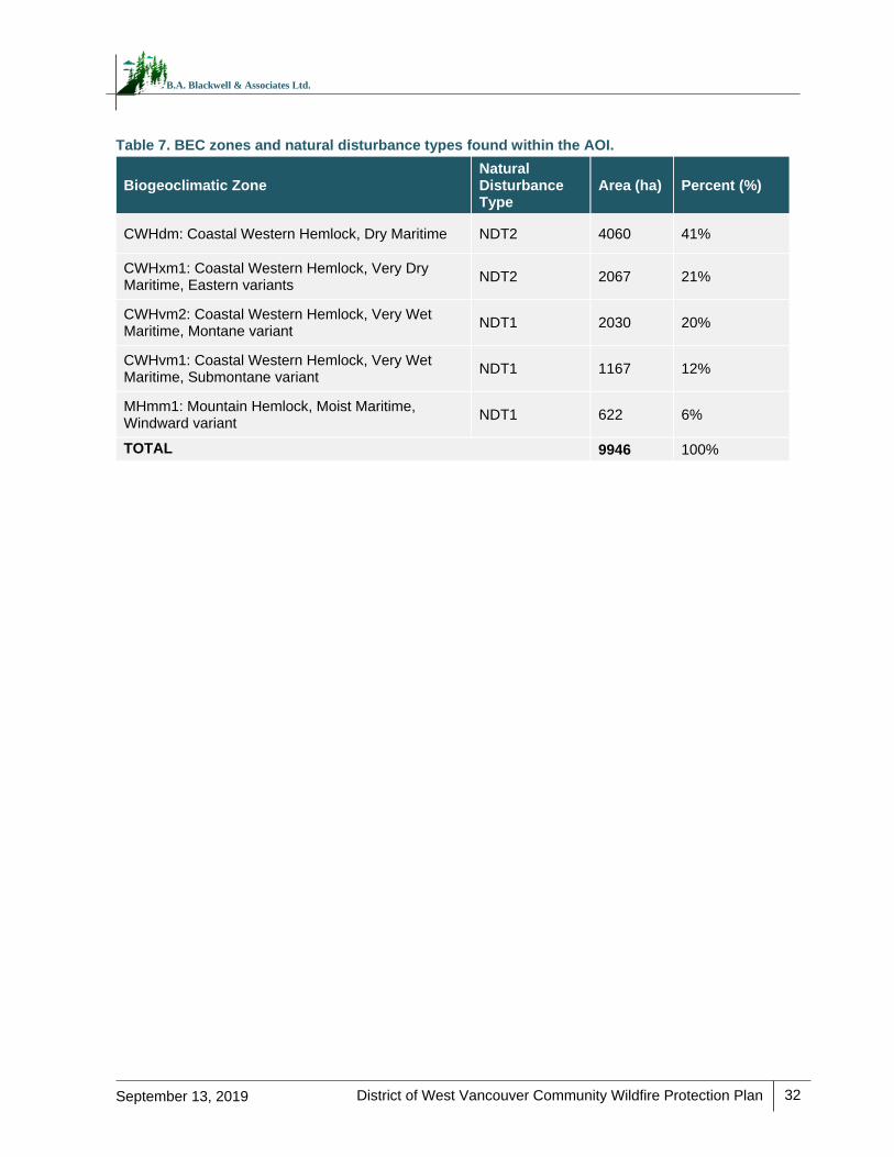
District of West Vancouver Community Wildfire Protection Plan
32
September 13, 2019
B.A. Blackwell & Associates Ltd.
Table 7. BEC zones and natural disturbance types found within the AOI.
Biogeoclimatic Zone Natural Disturbance Type
Area (ha) Percent (%)
CWHdm: Coastal Western Hemlock, Dry Maritime NDT2 4060 41%
CWHxm1: Coastal Western Hemlock, Very Dry Maritime, Eastern variants
NDT2 2067 21%
CWHvm2: Coastal Western Hemlock, Very Wet Maritime, Montane variant
NDT1 2030 20%
CWHvm1: Coastal Western Hemlock, Very Wet Maritime, Submontane variant
NDT1 1167 12%
MHmm1: Mountain Hemlock, Moist Maritime, Windward variant
NDT1 622 6%
TOTAL 9946 100%
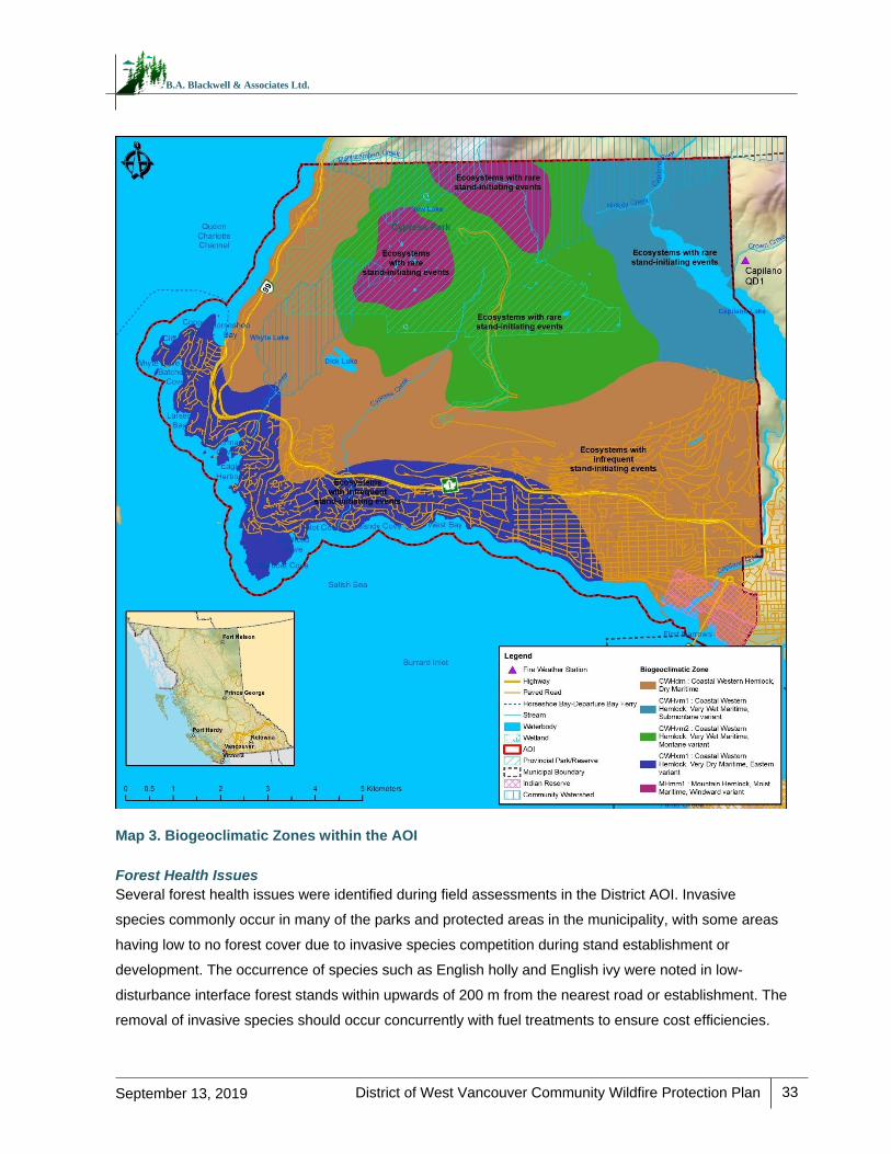
District of West Vancouver Community Wildfire Protection Plan
33
September 13, 2019
B.A. Blackwell & Associates Ltd.
Map 3. Biogeoclimatic Zones within the AOI
Forest Health Issues
Several forest health issues were identified during field assessments in the District AOI. Invasive
species commonly occur in many of the parks and protected areas in the municipality, with some areas
having low to no forest cover due to invasive species competition during stand establishment or
development. The occurrence of species such as English holly and English ivy were noted in low-
disturbance interface forest stands within upwards of 200 m from the nearest road or establishment. The
removal of invasive species should occur concurrently with fuel treatments to ensure cost efficiencies.
District of West Vancouver Community Wildfire Protection Plan
34
September 13, 2019
B.A. Blackwell & Associates Ltd.
Site monitoring should occur post-treatment to evaluate treatment efficacy and assess further mitigation
requirements. English holly treatment may be in the form of manual removal, with small plants being
pulled to remove the roots and large plants cut at the root collar to suppress the growth of future
sprouts. English ivy mitigation can occur via manual pruning or pilling of the plant at the root and
removal of resulting plant material from the site, avoiding cuttings, as those can sprout. Areas treated for
English ivy removal should be mulched or covered in chips produced during the fuel treatment, and
frequently monitored and managed post-treatment.
Impacts of hemlock dwarf mistletoe were noted throughout many second-growth, western hemlock
leading stands. Dwarf mistletoe causes stem and branch swelling, with research showing that hemlock
mistletoe results in significant reductions in radial growth, annual volume, and height increment in
mature hemlock trees29 and increased susceptibility to other disturbances such as windthrow. Highly
infected stems and limbs represent a hazard from both a fuel management and public safety
perspective. Given the potential for windthrow and increased surface fuel loading resulting from
hemlock dwarf mistletoe, it is imperative that the District consider strategies to reduce the hazard
associated with these types of stands. Strategies could include implementing patchy gap openings,
where hemlock dwarf mistletoe infected trees are targeted for removal, followed by low-density planting
of other site-appropriate species. Post-treatment planting will help ensure that the natural hemlock infill
process is delayed or mitigated.
The Coast Forest Health Overview outlines forest health issues present within the Fraser TSA.30 This
overview and forest health strategy (2015 to 2017) outlines several forest health issues that are most
prevalent within the timber supply area. Of particular concern, due to the severity or extent of outbreaks,
are the Douglas-fir beetle, Swiss needle cast and Douglas-fir needle cast, mountain pine beetle, root
diseases (primarily laminated root disease and Armillaria spp.), drought, and windthrow. Outbreaks of
western hemlock looper and western spruce budworm were a concern in the past, however,
occurrences of these pests have declined in recent years.
Spatial data available through DataBC31 indicates one instance of balsam woolly adelgid (2012, trace
severity infection of 8.7 ha) at the northwest end of Capilano Lake. One moderate severity unidentifiable
needle cast, blight or rust was noted north of Highway 1 in 2011 (4.6 ha) and one low severity instance
of windthrow was noted off of Highway 1 near Horseshoe Bay in 2008 (5.9 ha). Mortality and reduced
vigour of western redcedar was also noted during field assessments of the AOI, particularly on dry sites
in the CWHxm1. These forest health factors have implications for the fire behaviour potential, level of
29 Thomson, Alan & B. Smith, R & Alfaro, Rene. (2011). Growth patterns in immature and mature western hemlock stands infected
with dwarf mistletoe. Canadian Journal of Forest Research. 14. 518-522. 10.1139/x84-096. 30 2015-17 Coastal Timber Supply Areas Forest Health Overview. 2015. 31 catalogue.data.gov.bc.ca/pt_BR/dataset/pest-infestation-polygons (current as of September, 2017)
District of West Vancouver Community Wildfire Protection Plan
35
September 13, 2019
B.A. Blackwell & Associates Ltd.
surface fuel accumulation in affected stands, as well as access and working conditions for fire fighters in
the event of wildfire.
Human Development and Natural Events
Since the establishment of communities in the AOI, there have been numerous anthropogenic and
natural changes that have occurred on the landscape. Most land cover change in the AOI in recent
years can be described as residential and commercial development, which entails land clearing and
road building. Abiotic and biotic natural events have typically occurred at small geographic scales. The
overall implication of human development is an increase in human ignition potential with a decrease in
hazardous fuels cover as land clearing for human development generally increases the non-fuel and O-
1a/b fuel types.
The following is a list of notable changes observed within the AOI and a description of associated
implications regarding wildfire behaviour.
Residential land development has occurred in the AOI since the mid-19th century, following
settlement by early pioneers engaging in resource-based activities. Over the past 50 years, new
residential development has expanded from the existing shoreline neighborhoods of Ambleside,
Dundarave, Caulfeild, and Horseshoe Bay, as well as the British Properties, which was
established in 1932.32 This has resulted in an increased wildland-urban interface in particular
areas (Section 5.2.3) and an increase in fire suppression in ecosystems that had a historic fire
interval of 200 to 350 years. Population growth is expected to continue and the District’s
favourable climate, high recreational and landscape values, development opportunities, and
proximity to Vancouver make it a desirable place to live and work or retire.
Frontcountry and backcountry use of trails within the District has increased in recent years, with
one study citing a six-fold increase in use on the North Shore mountain biking trails since
2006.33 Increased recreational use of forested areas has implications for human caused
ignitions, particularly when these activities are undertaken during the dry summer months.
Backcountry activities have the added complication of being areas with poor access for
evacuation and suppression efforts.
32 West Vancouver: Yesterday and Today. Accessed from westvancouver.ca/arts-culture/heritage/west-vancouver-yesterday-and-today 33 ‘Regional economic impact study shows major growth of mountain bike tourism in Sea to Sky Corridor.’ Independent Sports
News. Accessed from www.independentsportsnews.com/2018/06/21/regional-economic-impact-study-shows-major-growth-
mountain-bike-tourism-sea-sky-corridor/
District of West Vancouver Community Wildfire Protection Plan
36
September 13, 2019
B.A. Blackwell & Associates Ltd.
4.1.2 Fire Weather Rating
The Canadian Forest Service developed the Canadian Forest Fire Danger Rating System (CFFDRS) to
assess fire danger and potential fire behaviour. Fire Danger Classes provide a relative index of the ease
of ignition and the difficulty of suppression. A network of fire weather stations is maintained during the
fire season by MFLNRORD and the recorded data are used to determine fire danger, represented by
Fire Danger Classes, on forestlands within a community. The information can be obtained from the
BCWS and is most commonly utilized by municipalities and regional districts to monitor fire weather,
restrict high risk activities when appropriate, and to determine hazard ratings associated with bans and
closures.
The BC Wildfire Act [BC 2004] and Wildfire Regulation [BC Reg. 38/2005] specify responsibilities and
obligations with respect to fire use, prevention, control and rehabilitation, and restrict high risk activities
based on these classes. Fire Danger Classes are defined as follows:
Class 1 (Very Low): Fires are likely to be self-extinguishing and new ignitions are unlikely. Any
existing fires are limited to smoldering in deep, drier layers.
Class 2 (Low): Creeping or gentle surface fires. Ground crews easily contain fires with pumps
and hand tools.
Class 3 (Moderate): Moderate to vigorous surface fires with intermittent crown involvement.
They are challenging for ground crews to handle; heavy equipment (bulldozers, tanker trucks,
and aircraft) are often required to contain these fires.
Class 4 (High): High-intensity fires with partial to full crown involvement. Head fire conditions
are beyond the ability of ground crews; air attack with retardant is required to effectively attack
the fire’s head.
Class 5 (Extreme): Fires with fast spreading, high-intensity crown fire. These fires are very
difficult to control. Suppression actions are limited to flanks, with only indirect actions possible
against the fire’s head.
It is important for the development of appropriate prevention programs that the average exposure to
periods of high fire danger is determined. ‘High fire danger’ is considered as Danger Class ratings of 4
(High) and 5 (Extreme). Danger class days were summarized to provide an indication of the fire weather
in the AOI. Considering fire danger varies from year to year, historical weather data can provide
information on the number and distribution of days when the AOI is typically subject to high fire danger
conditions, which is useful information in assessing fire risk.
Figure 1 displays the average frequency of Fire Danger Class days between the months of April and
October. The data summarized comes from the Capilano weather station (daily data for the years 2002
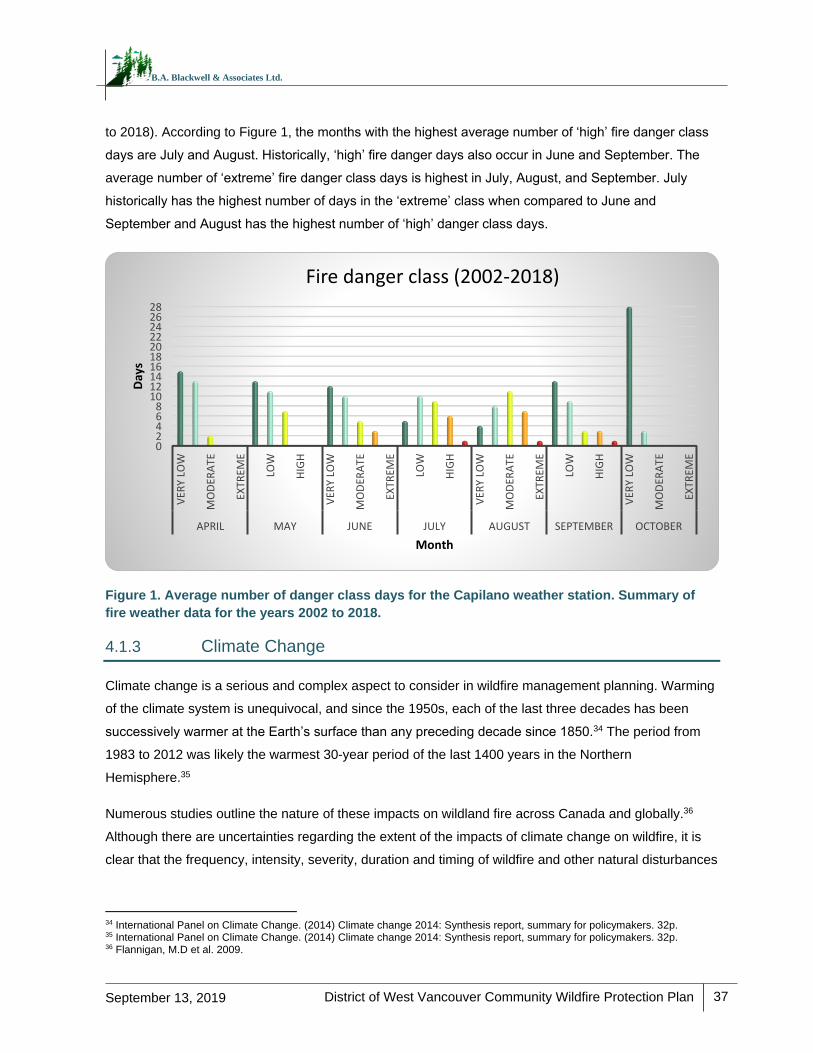
District of West Vancouver Community Wildfire Protection Plan
37
September 13, 2019
B.A. Blackwell & Associates Ltd.
to 2018). According to Figure 1, the months with the highest average number of ‘high’ fire danger class
days are July and August. Historically, ‘high’ fire danger days also occur in June and September. The
average number of ‘extreme’ fire danger class days is highest in July, August, and September. July
historically has the highest number of days in the ‘extreme’ class when compared to June and
September and August has the highest number of ‘high’ danger class days.
Figure 1. Average number of danger class days for the Capilano weather station. Summary of
fire weather data for the years 2002 to 2018.
4.1.3 Climate Change
Climate change is a serious and complex aspect to consider in wildfire management planning. Warming
of the climate system is unequivocal, and since the 1950s, each of the last three decades has been
successively warmer at the Earth’s surface than any preceding decade since 1850.34 The period from
1983 to 2012 was likely the warmest 30-year period of the last 1400 years in the Northern
Hemisphere.35
Numerous studies outline the nature of these impacts on wildland fire across Canada and globally.36
Although there are uncertainties regarding the extent of the impacts of climate change on wildfire, it is
clear that the frequency, intensity, severity, duration and timing of wildfire and other natural disturbances
34 International Panel on Climate Change. (2014) Climate change 2014: Synthesis report, summary for policymakers. 32p. 35 International Panel on Climate Change. (2014) Climate change 2014: Synthesis report, summary for policymakers. 32p. 36 Flannigan, M.D et al. 2009.
02468
10121416182022242628
VER
Y LO
W
MO
DER
ATE
EXTR
EME
LOW
HIG
H
VER
Y LO
W
MO
DER
ATE
EXTR
EME
LOW
HIG
H
VER
Y LO
W
MO
DER
ATE
EXTR
EME
LOW
HIG
H
VER
Y LO
W
MO
DER
ATE
EXTR
EME
APRIL MAY JUNE JULY AUGUST SEPTEMBER OCTOBER
Day
s
Month
Fire danger class (2002-2018)
District of West Vancouver Community Wildfire Protection Plan
38
September 13, 2019
B.A. Blackwell & Associates Ltd.
is expected to be altered significantly with the changing climate.37 Despite the uncertainties, trends
within the data are visible. As outlined by BC Agriculture Climate Change Adaptation Risk & Opportunity
Assessment Series Fraser Valley and Metro Vancouver Snapshot Report38, the following climate
projections for the Fraser Valley and Metro Vancouver are made:
Increases in average annual temperature consistent with temperature increases for the province
of BC (approximately 1.8oC increase from 1961 to 1990 baseline by 2050).
Decline in summer precipitation (up to 14% decrease by 2050) leading to drier fuels and soils
(increasing fire behaviour potential).
Increase in winter precipitation (6% by 2050) in the form of rain and significant decreases in
snowfall (-25% in the winter and -56% in the spring).
In the province as a whole, as average winter temperatures increase, more intense winter
precipitation is expected to fall as rain during extreme events, and less falling as snow;
potentially influencing watershed and groundwater storage ability, timing and amount of run-off,
and soil and fuel moisture during early fire season.
An increased frequency of natural disturbance events is expected to occur as a result of climate change
with coincident impacts to ecosystems. These include:
Storm events, including catastrophic blowdown and damage to trees from snow and ice.
Wildfire events and drought.
Increased winter precipitation may result in slope instability, mass wasting, increased peak
flows (loss of forest cover from fire or other disturbance may increase the chance of mass
wasting.
Insect and disease occurrence of spruce beetle, western hemlock looper, and Swiss needle cast may
increase.39 Other research regarding the intricacies of climate change and potential impacts on wildfire
threats to Canadian forests has found that:
Fuel moisture is highly sensitive to temperature change and projected precipitation increases
will be insufficient to counteract the impacts of the projected increase in temperature. Results
conclude that future conditions will include drier fuels and a higher frequency of extreme fire
weather days.40
The future daily fire severity rating (a seasonally cumulative value) is expected to have higher
peak levels and head fire intensity is expected to increase significantly in Western Canada. A
bi-modal (spring to late summer) pattern of peak values may evolve to replace the historical
37 Dale, V. et al. 2001. 38 British Columbia Agriculture & Food Climate Action Initiative, 2010. pics.uvic.ca/sites/default/files/uploads/publications/Adapt-FraserMetroVan%20Crawford.pdf 39 MFLNRO, 2016. 40 Flannigan, M.D et al. 2016.
District of West Vancouver Community Wildfire Protection Plan
39
September 13, 2019
B.A. Blackwell & Associates Ltd.
late summer peak which is the current norm.41 The length of fire seasons is expected to
increase and the increase will be most pronounced in the northern hemisphere, specifically at
higher latitude northern regions. Fire season severity seems to be sensitive to increasing global
temperatures; larger and more intense fires are expected and fire management will become
more challenging.42, 43
More extreme precipitation events (increased intensity and magnitude of extreme rainfall) are
expected, particularly in April, May and June, along with dry periods between major events
(increased summer drought periods). Annual runoff is also expected to increase and the timing
of peak flows are anticipated to occur earlier in the spring.44
Future climatic conditions may be more suitable for, or give competitive advantage to, new
species of plants, including invasive species.45
In summary, climate scientists expect that the warming global climate will trend towards wildfires that
are increasingly larger, more intense and difficult to control. Furthermore, it is likely that these fires will
be more threatening to WUI communities due to increased potential fire behaviour, fire season length,
and fire severity. This trend is expected to be disproportionately felt in northern latitudes.46
41 deGroot, W. J. et al. 2013. 42 Flannigan, M.D et al. 2013. 43 Jandt, R. 2013. Alaska Fire Science Consortium Research Brief 2013-3. 44 British Columbia Agriculture & Food Climate Action Initiative, 2012. pics.uvic.ca/sites/default/files/uploads/publications/Adapt-FraserMetroVan%20Crawford.pdf 45 Picketts, I., A. Werner, and T. Murdock for Pacific Climate Impacts Consortium. 2009. Climate Change in Prince George Summary of Past Trends and Future Projections. 46 All research noted was completed for Canada or globally, not for the AOI. Direct application of trends may not be appropriate, although general expectations for Canada were noted to be consistent across multiple studies.
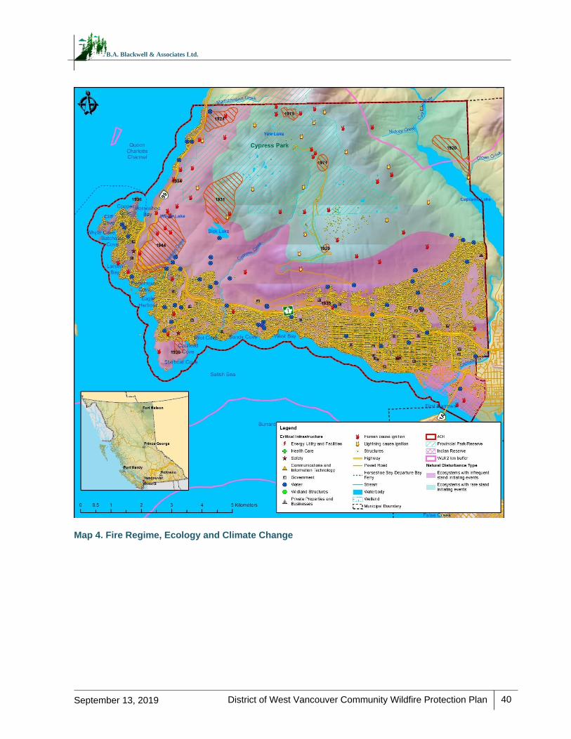
District of West Vancouver Community Wildfire Protection Plan
40
September 13, 2019
B.A. Blackwell & Associates Ltd.
Map 4. Fire Regime, Ecology and Climate Change
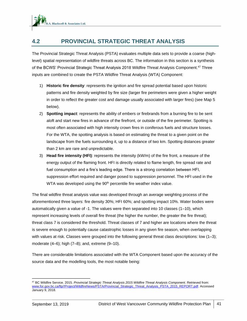
District of West Vancouver Community Wildfire Protection Plan
41
September 13, 2019
B.A. Blackwell & Associates Ltd.
4.2 PROVINCIAL STRATEGIC THREAT ANALYSIS
The Provincial Strategic Threat Analysis (PSTA) evaluates multiple data sets to provide a coarse (high-
level) spatial representation of wildfire threats across BC. The information in this section is a synthesis
of the BCWS’ Provincial Strategic Threat Analysis 2018 Wildfire Threat Analysis Component.47 Three
inputs are combined to create the PSTA Wildfire Threat Analysis (WTA) Component:
1) Historic fire density: represents the ignition and fire spread potential based upon historic
patterns and fire density weighted by fire size (larger fire perimeters were given a higher weight
in order to reflect the greater cost and damage usually associated with larger fires) (see Map 5
below).
2) Spotting impact: represents the ability of embers or firebrands from a burning fire to be sent
aloft and start new fires in advance of the firefront, or outside of the fire perimeter. Spotting is
most often associated with high intensity crown fires in coniferous fuels and structure losses.
For the WTA, the spotting analysis is based on estimating the threat to a given point on the
landscape from the fuels surrounding it, up to a distance of two km. Spotting distances greater
than 2 km are rare and unpredictable.
3) Head fire intensity (HFI): represents the intensity (kW/m) of the fire front, a measure of the
energy output of the flaming front. HFI is directly related to flame length, fire spread rate and
fuel consumption and a fire’s leading edge. There is a strong correlation between HFI,
suppression effort required and danger posed to suppression personnel. The HFI used in the
WTA was developed using the 90th percentile fire weather index value.
The final wildfire threat analysis value was developed through an average weighting process of the
aforementioned three layers: fire density 30%; HFI 60%; and spotting impact 10%. Water bodies were
automatically given a value of -1. The values were then separated into 10 classes (1–10), which
represent increasing levels of overall fire threat (the higher the number, the greater the fire threat);
threat class 7 is considered the threshold. Threat classes of 7 and higher are locations where the threat
is severe enough to potentially cause catastrophic losses in any given fire season, when overlapping
with values at risk. Classes were grouped into the following general threat class descriptions: low (1–3);
moderate (4–6); high (7–8); and, extreme (9–10).
There are considerable limitations associated with the WTA Component based upon the accuracy of the
source data and the modelling tools, the most notable being:
47 BC Wildfire Service. 2015. Provincial Strategic Threat Analysis 2015 Wildfire Threat Analysis Component. Retrieved from: www.for.gov.bc.ca/ftp/!Project/WildfireNews/PSTA/Provincial_Strategic_Threat_Analysis_PSTA_2015_REPORT.pdf. Accessed January 9, 2018.
District of West Vancouver Community Wildfire Protection Plan
42
September 13, 2019
B.A. Blackwell & Associates Ltd.
Limited accuracy and variability of the fire history point data
Sensitivity to fuel type and the associated limitations of using fuel type approximations for fire
behaviour modelling
90th percentile rating for HFI, which represents a near worst-case scenario which may be
artificial in some circumstances
The WTA serves to provide a provincial-level threat assessment for resource and land managers and
local governments in order to complete landscape fire management planning and strategically plan
efficient and effective wildfire risk reduction initiatives (i.e., placement or prioritization of fuel treatment
areas, identification of values at risk, FireSmart planning, etc.). The WTA is then validated at the stand
level in order to produce a finer, more accurate assessment of local threat.
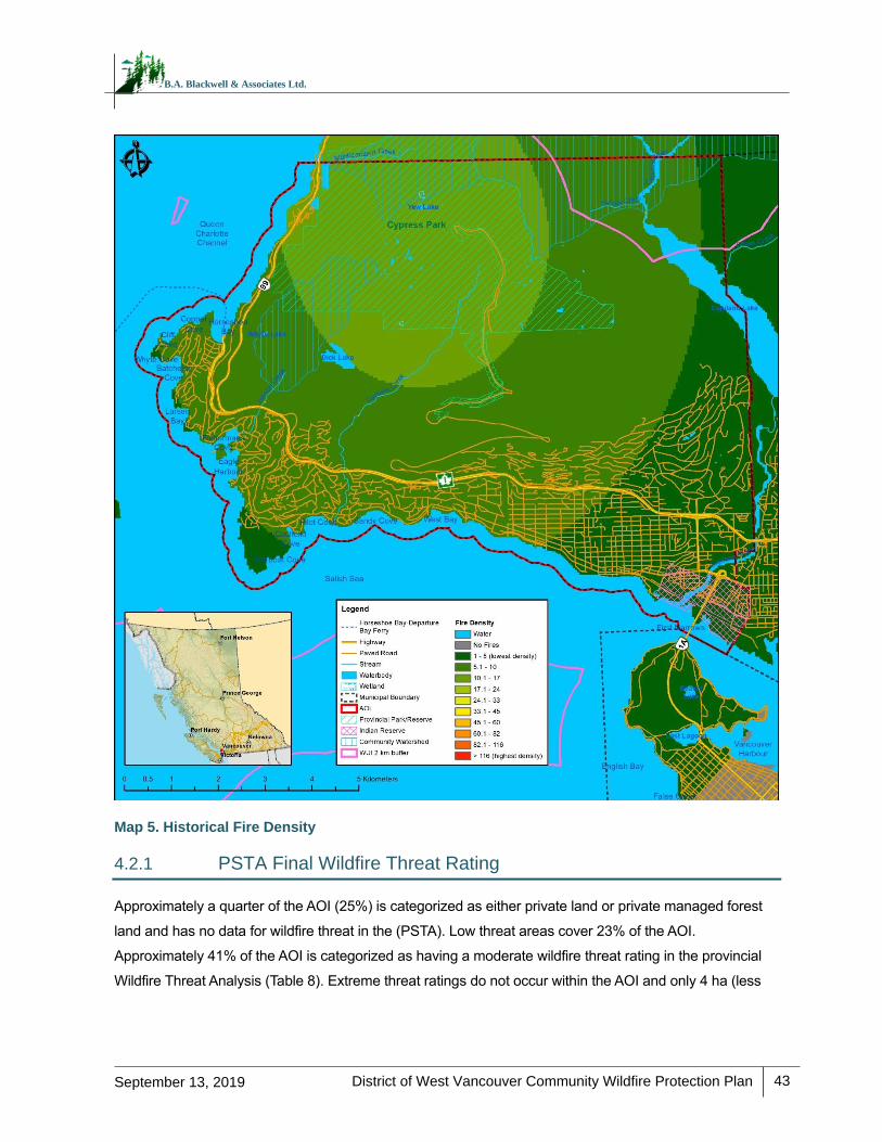
District of West Vancouver Community Wildfire Protection Plan
43
September 13, 2019
B.A. Blackwell & Associates Ltd.
Map 5. Historical Fire Density
4.2.1 PSTA Final Wildfire Threat Rating
Approximately a quarter of the AOI (25%) is categorized as either private land or private managed forest
land and has no data for wildfire threat in the (PSTA). Low threat areas cover 23% of the AOI.
Approximately 41% of the AOI is categorized as having a moderate wildfire threat rating in the provincial
Wildfire Threat Analysis (Table 8). Extreme threat ratings do not occur within the AOI and only 4 ha (less

District of West Vancouver Community Wildfire Protection Plan
44
September 13, 2019
B.A. Blackwell & Associates Ltd.
than 1% of the AOI) are categorized as high treat. Threat class 6 (the highest moderate rating) areas are
most prevalent around Cypress Mountain and east of Highway 99 in the northern part of the AOI (Map 6).
Table 8. Overall PSTA Wildfire Threat Analysis for the AOI (rounded to the nearest hectare)
Threat Class Area (ha) Threat Class Description Percent of AOI
-3 2,484 No Data (Private Land) 25%
-2 0 No Data (Private Managed Forest Land)
0%
-1 1,049 Water 11%
0 0 No Threat 0%
1 37
Low 23% 2 706
3 1,591
4 3,388
Moderate 41% 5 659
6 29
7 4 High <1%
8 0
9 0 Extreme 0%
10 0
Total 9,946 - 100%
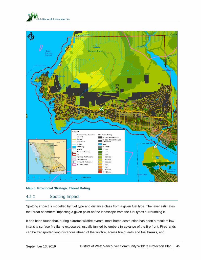
District of West Vancouver Community Wildfire Protection Plan
45
September 13, 2019
B.A. Blackwell & Associates Ltd.
Map 6. Provincial Strategic Threat Rating.
4.2.2 Spotting Impact
Spotting impact is modelled by fuel type and distance class from a given fuel type. The layer estimates
the threat of embers impacting a given point on the landscape from the fuel types surrounding it.
It has been found that, during extreme wildfire events, most home destruction has been a result of low-
intensity surface fire flame exposures, usually ignited by embers in advance of the fire front. Firebrands
can be transported long distances ahead of the wildfire, across fire guards and fuel breaks, and
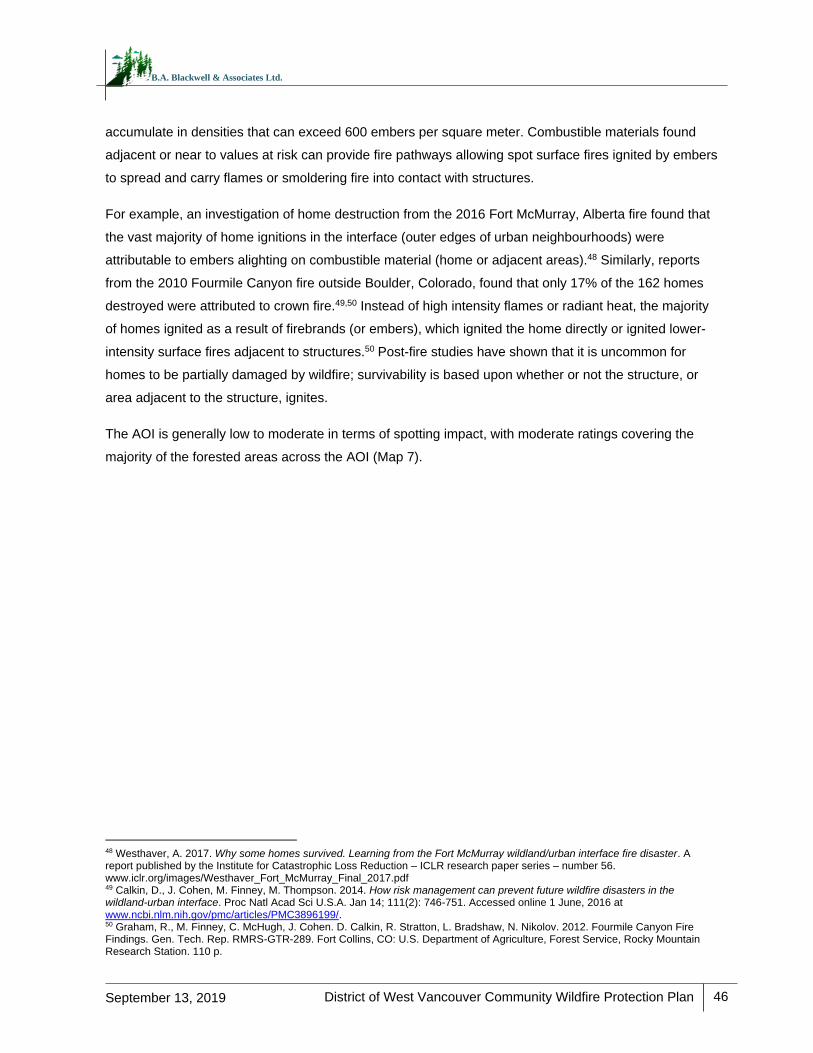
District of West Vancouver Community Wildfire Protection Plan
46
September 13, 2019
B.A. Blackwell & Associates Ltd.
accumulate in densities that can exceed 600 embers per square meter. Combustible materials found
adjacent or near to values at risk can provide fire pathways allowing spot surface fires ignited by embers
to spread and carry flames or smoldering fire into contact with structures.
For example, an investigation of home destruction from the 2016 Fort McMurray, Alberta fire found that
the vast majority of home ignitions in the interface (outer edges of urban neighbourhoods) were
attributable to embers alighting on combustible material (home or adjacent areas).48 Similarly, reports
from the 2010 Fourmile Canyon fire outside Boulder, Colorado, found that only 17% of the 162 homes
destroyed were attributed to crown fire.49,50 Instead of high intensity flames or radiant heat, the majority
of homes ignited as a result of firebrands (or embers), which ignited the home directly or ignited lower-
intensity surface fires adjacent to structures.50 Post-fire studies have shown that it is uncommon for
homes to be partially damaged by wildfire; survivability is based upon whether or not the structure, or
area adjacent to the structure, ignites.
The AOI is generally low to moderate in terms of spotting impact, with moderate ratings covering the
majority of the forested areas across the AOI (Map 7).
48 Westhaver, A. 2017. Why some homes survived. Learning from the Fort McMurray wildland/urban interface fire disaster. A report published by the Institute for Catastrophic Loss Reduction – ICLR research paper series – number 56. www.iclr.org/images/Westhaver_Fort_McMurray_Final_2017.pdf 49 Calkin, D., J. Cohen, M. Finney, M. Thompson. 2014. How risk management can prevent future wildfire disasters in the wildland-urban interface. Proc Natl Acad Sci U.S.A. Jan 14; 111(2): 746-751. Accessed online 1 June, 2016 at www.ncbi.nlm.nih.gov/pmc/articles/PMC3896199/. 50 Graham, R., M. Finney, C. McHugh, J. Cohen. D. Calkin, R. Stratton, L. Bradshaw, N. Nikolov. 2012. Fourmile Canyon Fire Findings. Gen. Tech. Rep. RMRS-GTR-289. Fort Collins, CO: U.S. Department of Agriculture, Forest Service, Rocky Mountain Research Station. 110 p.
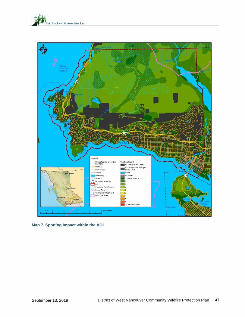
District of West Vancouver Community Wildfire Protection Plan
47
September 13, 2019
B.A. Blackwell & Associates Ltd.
Map 7. Spotting Impact within the AOI
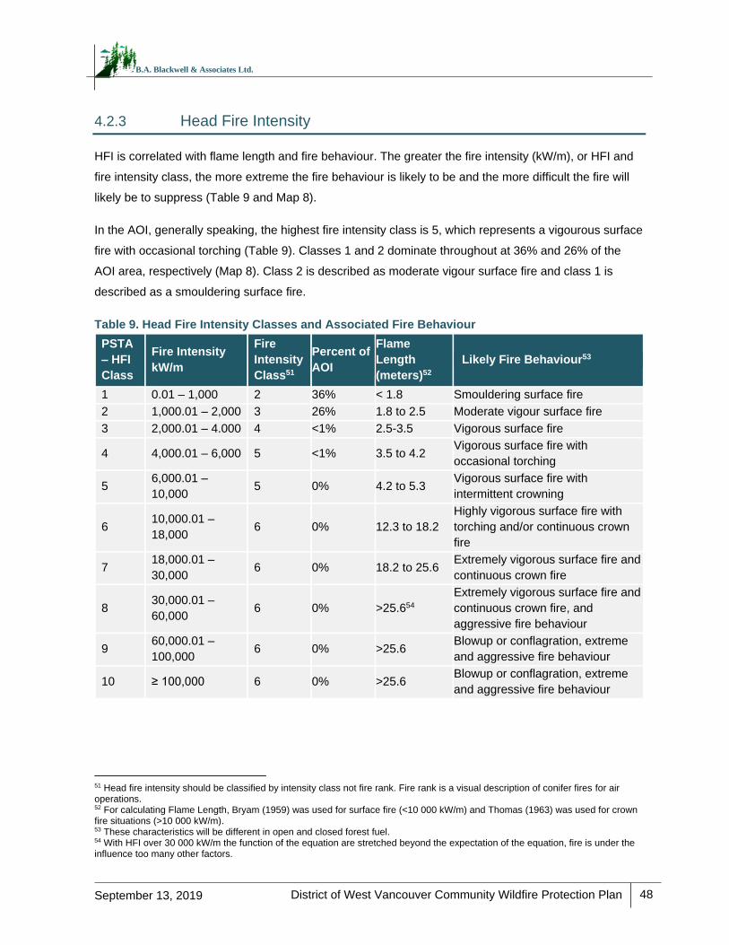
District of West Vancouver Community Wildfire Protection Plan
48
September 13, 2019
B.A. Blackwell & Associates Ltd.
4.2.3 Head Fire Intensity
HFI is correlated with flame length and fire behaviour. The greater the fire intensity (kW/m), or HFI and
fire intensity class, the more extreme the fire behaviour is likely to be and the more difficult the fire will
likely be to suppress (Table 9 and Map 8).
In the AOI, generally speaking, the highest fire intensity class is 5, which represents a vigourous surface
fire with occasional torching (Table 9). Classes 1 and 2 dominate throughout at 36% and 26% of the
AOI area, respectively (Map 8). Class 2 is described as moderate vigour surface fire and class 1 is
described as a smouldering surface fire.
Table 9. Head Fire Intensity Classes and Associated Fire Behaviour
PSTA
– HFI
Class
Fire Intensity
kW/m
Fire
Intensity
Class51
Percent of
AOI
Flame
Length
(meters)52
Likely Fire Behaviour53
1 0.01 – 1,000 2 36% < 1.8 Smouldering surface fire
2 1,000.01 – 2,000 3 26% 1.8 to 2.5 Moderate vigour surface fire
3 2,000.01 – 4.000 4 <1% 2.5-3.5 Vigorous surface fire
4 4,000.01 – 6,000 5 <1% 3.5 to 4.2 Vigorous surface fire with
occasional torching
5 6,000.01 –
10,000 5 0% 4.2 to 5.3
Vigorous surface fire with
intermittent crowning
6 10,000.01 –
18,000 6 0% 12.3 to 18.2
Highly vigorous surface fire with
torching and/or continuous crown
fire
7 18,000.01 –
30,000 6 0% 18.2 to 25.6
Extremely vigorous surface fire and
continuous crown fire
8 30,000.01 –
60,000 6 0% >25.654
Extremely vigorous surface fire and
continuous crown fire, and
aggressive fire behaviour
9 60,000.01 –
100,000 6 0% >25.6
Blowup or conflagration, extreme
and aggressive fire behaviour
10 ≥ 100,000 6 0% >25.6 Blowup or conflagration, extreme
and aggressive fire behaviour
51 Head fire intensity should be classified by intensity class not fire rank. Fire rank is a visual description of conifer fires for air operations. 52 For calculating Flame Length, Bryam (1959) was used for surface fire (<10 000 kW/m) and Thomas (1963) was used for crown fire situations (>10 000 kW/m). 53 These characteristics will be different in open and closed forest fuel. 54 With HFI over 30 000 kW/m the function of the equation are stretched beyond the expectation of the equation, fire is under the influence too many other factors.
District of West Vancouver Community Wildfire Protection Plan
49
September 13, 2019
B.A. Blackwell & Associates Ltd.
Map 8. Head Fire Intensity within the AOI
4.2.4 Fire History
Fire ignition and perimeter data are depicted in Map 4. Fire ignition data for the area is available for
1950 to 2018 and fire perimeter data from 1919 to 2018. Based on the fire ignition data, there have
been 60 fire incidents within the AOI during that time period; 57% of which were human-caused. Small
and large historical wildfires have burned throughout the AOI, with a range in area from 0.9 ha to 2085
ha. Based on the fire perimeter data, of the 12 fires that burned within the AOI, 11 were human-caused
District of West Vancouver Community Wildfire Protection Plan
50
September 13, 2019
B.A. Blackwell & Associates Ltd.
and one was lightning-caused. All but three of these fires occurred between 1920 and 1944. The most
recent fire occurred on the west side of the AOI adjacent to Whyte Lake in 2018. This fire history
demonstrates that the vast majority of fires in the AOI occurred due to humans and that the common
fires and relatively large scales seen in the first half of the 20th century have not occurred since.
4.3 LOCAL WILDFIRE THREAT ASSESSMENT
WUI Threat Assessments were completed over five field days in April and May 2019, in conjunction with
verification of fuel types. WUI Threat Assessments were completed in interface (i.e., abrupt change from
forest to urban development) and intermix (i.e., where forest and structures are intermingled) areas of
the AOI to support development of priority treatment areas, and in order to confidently ascribe threat to
polygons which may not have been visited or plotted, but which have similar fuel, topographic, and
proximity to structure characteristics to those that were visited.
Field assessment locations were prioritized based upon:
PSTA WTA class – field assessments were clustered in those areas with WTA classes of 5 or
higher.
Proximity to values at risk – field assessments were clustered in the intermix and interface, as
well as around critical infrastructure.
Prevailing fire season winds – more field time was spent assessing areas upwind of values at
risk.
Slope position of value – more field time was spent assessing areas downslope of values at
risk. Similarly, values at top of slope or upper third of the slope were identified as particularly
vulnerable.
Land ownership – Crown provincial and municipal land were the main focus of field
assessments.
Local knowledge – areas identified as hazardous, potentially hazardous, with limited
access/egress, or otherwise of particular concern due to vulnerability to wildfire, as
communicated by local fire officials.
Observations – additional areas potentially not recognized prior to fieldwork were visually
identified as hazardous and assessed during the week.
A total of 25 WUI threat plots were completed and over 200 other field stops (i.e., qualitative notes, fuel
type verification, and/or photograph documentation) were made across the AOI (see Appendix E for
WUI threat plot locations).
District of West Vancouver Community Wildfire Protection Plan
51
September 13, 2019
B.A. Blackwell & Associates Ltd.
4.3.1 Fuel Type Verification
The Canadian Forest Fire Behaviour Prediction (FBP) System outlines five major fuel groups and
sixteen fuel types based on characteristic fire behaviour under defined conditions.55 Fuel typing is
recognized as a blend of art and science. Although a subjective process, the most appropriate fuel type
was assigned based on research, experience, and practical knowledge; this system has been used
within BC, with continual improvement and refinement, for 20 years.56 It should be noted that there are
significant limitations with the fuel typing system which should be recognized. Major limitations include:
a fuel typing system designed to describe fuels which do not occur within the AOI, fuel types which
cannot accurately capture the natural variability within a polygon, and limitations in the data used to
create initial fuel types.56 Details regarding fuel typing methodology and limitations are found in
Appendix F. There are several implications of the aforementioned limitations, which include: fuel typing
further from the developed areas of the study has a lower confidence, generally; and, fuel typing should
be used as a starting point for more detailed assessments and as an indicator of overall wildfire threat,
not as an operational, or site-level, assessment.
Table 10 summarizes the fuel types by general fire behaviour (crown fire and spotting potential) that
exist within the District AOI. In general, the fuel type that may be considered hazardous in terms of fire
behaviour and spotting potential in the AOI is the C-3 fuel type, particularly if there are large amounts of
woody fuel accumulations or denser understory ingrowth. The C-5 fuel type has a moderate potential for
active crown fire when wind-driven.56 An M-1/2 fuel type can sometimes be considered hazardous,
depending on the proportion of conifer stems within the forest stand; conifer fuels include those in the
overstory, as well as those in the understory. An O-1b fuel type often can support a rapidly spreading
grass or surface fire capable of damage or destruction of property, and jeopardizing human life,
although it is recognized as a highly variable fuel type dependent upon level of curing.57 These fuel
types were used to guide the threat assessment.
Forested ecosystems are dynamic and change over time: fuels accumulate, stands fill in with
regeneration, and forest health outbreaks occur. Regular monitoring of fuel types and wildfire threat
assessment should occur every 5 to 10 years to determine the need for threat assessment updates and
the timing for their implementation.
55 Forestry Canada Fire Danger Group. 1992. Development and Structure of the Canadian Forest Fire Behavior Prediction System: Information Report ST-X-3. 56 Perrakis, D. and G. Eade. 2015. BC Wildfire Service. Ministry of Forests, Lands, and Natural Resource Operations. British Columbia Wildfire Fuel Typing and Fuel Type Layer Description 2015 Version. 57 Ibid.
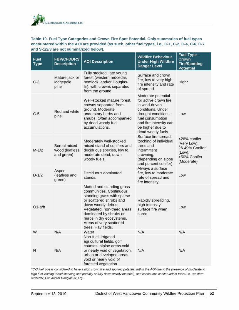
District of West Vancouver Community Wildfire Protection Plan
52
September 13, 2019
B.A. Blackwell & Associates Ltd.
Table 10. Fuel Type Categories and Crown Fire Spot Potential. Only summaries of fuel types
encountered within the AOI are provided (as such, other fuel types, i.e., C-1, C-2, C-4, C-6, C-7
and S-1/2/3 are not summarized below).
Fuel Type
FBP/CFDDRS Description
AOI Description Wildfire Behaviour Under High Wildfire Danger Level
Fuel Type – Crown Fire/Spotting Potential
C-3 Mature jack or lodgepole pine
Fully stocked, late young forest (western redcedar, hemlock, and/or Douglas-fir), with crowns separated from the ground.
Surface and crown fire, low to very high fire intensity and rate of spread
High*
C-5 Red and white pine
Well-stocked mature forest, crowns separated from ground. Moderate understory herbs and shrubs. Often accompanied by dead woody fuel accumulations.
Moderate potential for active crown fire in wind-driven conditions. Under drought conditions, fuel consumption and fire intensity can be higher due to dead woody fuels
Low
M-1/2 Boreal mixed wood (leafless and green)
Moderately well-stocked mixed stand of conifers and deciduous species, low to moderate dead, down woody fuels.
Surface fire spread, torching of individual trees and intermittent crowning, (depending on slope and percent conifer)
<26% conifer (Very Low); 26-49% Conifer (Low); >50% Conifer (Moderate)
D-1/2 Aspen (leafless and green)
Deciduous dominated stands.
Always a surface fire, low to moderate rate of spread and fire intensity
Low
O1-a/b
Matted and standing grass communities. Continuous standing grass with sparse or scattered shrubs and down woody debris. Vegetated, non-treed areas dominated by shrubs or herbs in dry ecosystems. Areas of very scattered trees. Hay fields.
Rapidly spreading, high-intensity surface fire when cured
Low
W N/A Water N/A N/A
N N/A
Non-fuel: irrigated agricultural fields, golf courses, alpine areas void or nearly void of vegetation, urban or developed areas void or nearly void of forested vegetation.
N/A N/A
*C-3 fuel type is considered to have a high crown fire and spotting potential within the AOI due to the presence of moderate to
high fuel loading (dead standing and partially or fully down woody material), and continuous conifer ladder fuels (i.e., western
redcedar, Cw, and/or Douglas-fir, Fd).
District of West Vancouver Community Wildfire Protection Plan
53
September 13, 2019
B.A. Blackwell & Associates Ltd.
During field visits, six recurring patterns of fuel type errors were found in the provincial dataset. They
were:
M-1/2 fuel types being incorrectly identified by the PSTA as C-5
C-3 fuel types identified as C-5
M-1/2 fuel types identified as D-1/2
C-3 fuel types identified as D-1/2
O1-a/b fuel types identified as D-1/2
M-1/2 fuel types identified as C-2
All fuel type updates were approved by BCWS, using stand and fuel descriptions and photo
documentation for the review process (see Appendix A for submitted fuel type change rationales).
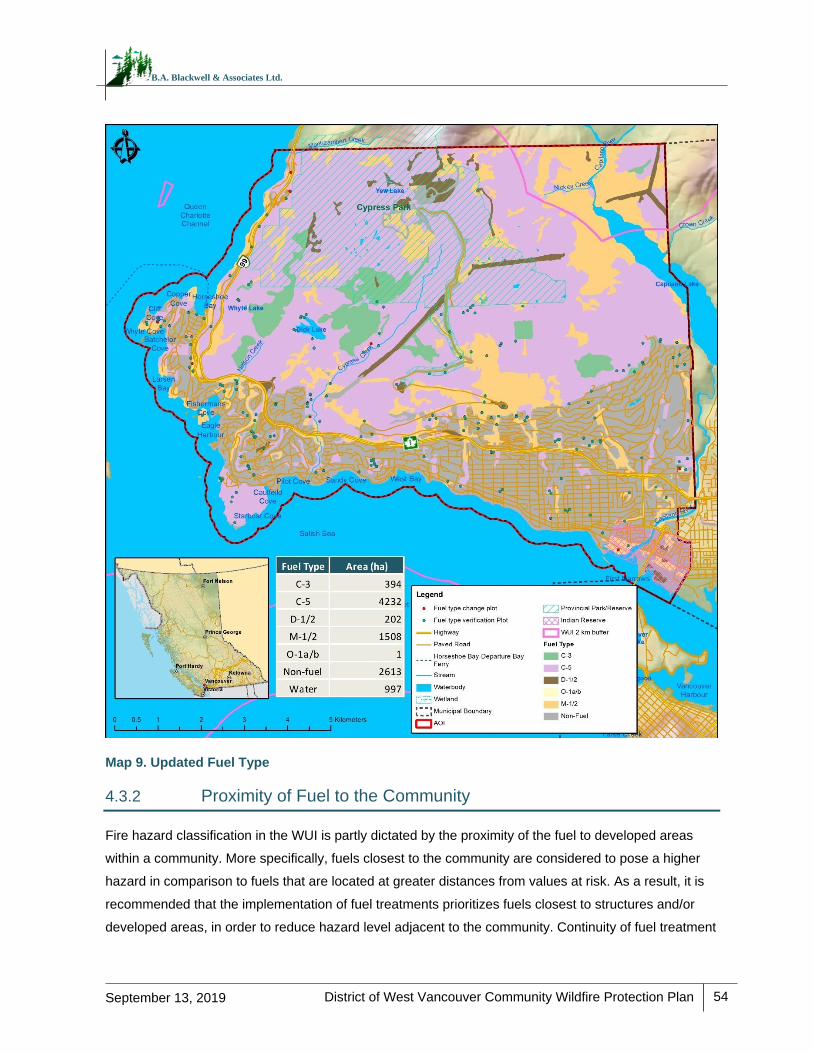
District of West Vancouver Community Wildfire Protection Plan
54
September 13, 2019
B.A. Blackwell & Associates Ltd.
Map 9. Updated Fuel Type
4.3.2 Proximity of Fuel to the Community
Fire hazard classification in the WUI is partly dictated by the proximity of the fuel to developed areas
within a community. More specifically, fuels closest to the community are considered to pose a higher
hazard in comparison to fuels that are located at greater distances from values at risk. As a result, it is
recommended that the implementation of fuel treatments prioritizes fuels closest to structures and/or
developed areas, in order to reduce hazard level adjacent to the community. Continuity of fuel treatment
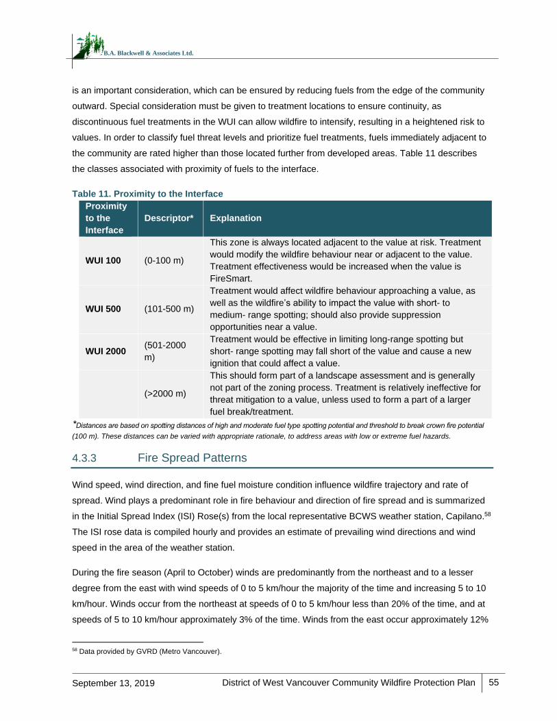
District of West Vancouver Community Wildfire Protection Plan
55
September 13, 2019
B.A. Blackwell & Associates Ltd.
is an important consideration, which can be ensured by reducing fuels from the edge of the community
outward. Special consideration must be given to treatment locations to ensure continuity, as
discontinuous fuel treatments in the WUI can allow wildfire to intensify, resulting in a heightened risk to
values. In order to classify fuel threat levels and prioritize fuel treatments, fuels immediately adjacent to
the community are rated higher than those located further from developed areas. Table 11 describes
the classes associated with proximity of fuels to the interface.
Table 11. Proximity to the Interface
Proximity
to the
Interface
Descriptor* Explanation
WUI 100 (0-100 m)
This zone is always located adjacent to the value at risk. Treatment
would modify the wildfire behaviour near or adjacent to the value.
Treatment effectiveness would be increased when the value is
FireSmart.
WUI 500 (101-500 m)
Treatment would affect wildfire behaviour approaching a value, as
well as the wildfire’s ability to impact the value with short- to
medium- range spotting; should also provide suppression
opportunities near a value.
WUI 2000 (501-2000
m)
Treatment would be effective in limiting long-range spotting but
short- range spotting may fall short of the value and cause a new
ignition that could affect a value.
(>2000 m)
This should form part of a landscape assessment and is generally
not part of the zoning process. Treatment is relatively ineffective for
threat mitigation to a value, unless used to form a part of a larger
fuel break/treatment.
*Distances are based on spotting distances of high and moderate fuel type spotting potential and threshold to break crown fire potential
(100 m). These distances can be varied with appropriate rationale, to address areas with low or extreme fuel hazards.
4.3.3 Fire Spread Patterns
Wind speed, wind direction, and fine fuel moisture condition influence wildfire trajectory and rate of
spread. Wind plays a predominant role in fire behaviour and direction of fire spread and is summarized
in the Initial Spread Index (ISI) Rose(s) from the local representative BCWS weather station, Capilano.58
The ISI rose data is compiled hourly and provides an estimate of prevailing wind directions and wind
speed in the area of the weather station.
During the fire season (April to October) winds are predominantly from the northeast and to a lesser
degree from the east with wind speeds of 0 to 5 km/hour the majority of the time and increasing 5 to 10
km/hour. Winds occur from the northeast at speeds of 0 to 5 km/hour less than 20% of the time, and at
speeds of 5 to 10 km/hour approximately 3% of the time. Winds from the east occur approximately 12%
58 Data provided by GVRD (Metro Vancouver).
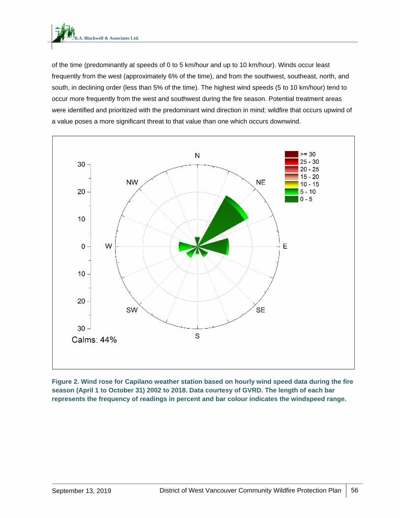
District of West Vancouver Community Wildfire Protection Plan
56
September 13, 2019
B.A. Blackwell & Associates Ltd.
of the time (predominantly at speeds of 0 to 5 km/hour and up to 10 km/hour). Winds occur least
frequently from the west (approximately 6% of the time), and from the southwest, southeast, north, and
south, in declining order (less than 5% of the time). The highest wind speeds (5 to 10 km/hour) tend to
occur more frequently from the west and southwest during the fire season. Potential treatment areas
were identified and prioritized with the predominant wind direction in mind; wildfire that occurs upwind of
a value poses a more significant threat to that value than one which occurs downwind.
Figure 2. Wind rose for Capilano weather station based on hourly wind speed data during the fire
season (April 1 to October 31) 2002 to 2018. Data courtesy of GVRD. The length of each bar
represents the frequency of readings in percent and bar colour indicates the windspeed range.
District of West Vancouver Community Wildfire Protection Plan 2019
57
September 13, 2019
B.A. Blackwell & Associates Ltd.
4.3.4 Topography
Topography is an important environmental component that influences fire behaviour. Considerations
include slope percentage (steepness) and slope position where slope percentage influences the fire’s
trajectory and rate of spread and slope position relates to the ability of a fire to gain momentum uphill.
Other factors of topography that influence fire behaviour include aspect, elevation and land
configuration.
Slope Class and Position
Slope steepness affects solar radiation intensity, fuel moisture (influenced by radiation intensity) and
influences flame length and rate of spread of surface fires. Table 12 summarizes the fire behaviour
implications for slope percentage (the steeper the slope the faster the spread). In addition, slope
position affects temperature and relative humidity as summarized in Table 13. A value placed at the
bottom of the slope is equivalent to a value on flat ground (see Table 12). A value on the upper 1/3 of
the slope would be impacted by preheating and faster rates of spread (Table 13). Just under half of the
AOI (41%) is on less than 20% slope and will likely not experience accelerated rates of spread due to
slope class. Approximately 59% percent of the AOI is likely to experience an increased or high rate of
spread. On the larger topographic scale, the District and its commercial, recreational, and residential
developments would be considered to be at the bottom of the slope through to the upper slope in the
higher elevation residential areas in the AOI.
Table 12. Slope Percentage and Fire Behaviour Implications
Slope Percent of AOI
Fire Behaviour Implications
<20% 41% Very little flame and fuel interaction caused by slope, normal rate of spread.
21-30% 19% Flame tilt begins to preheat fuel, increase rate of spread.
31-45% 19% Flame tilt preheats fuel and begins to bathe flames into fuel, high rate of spread.
46-60% 10% Flame tilt preheats fuel and bathes flames into fuel, very high rate of spread.
>60% 11% Flame tilt preheats fuel and bathes flames into fuel well upslope, extreme rate of spread.
Table 13. Slope Position of Value and Fire Behaviour Implications
Slope Position of Value Fire Behaviour Implications
Bottom of Slope/ Valley Bottom
Impacted by normal rates of spread.
Mid Slope – Bench Impacted by increased rates of spread. Position on a bench may reduce
the preheating near the value. (Value is offset from the slope).
District of West Vancouver Community Wildfire Protection Plan 2019
58
September 13, 2019
B.A. Blackwell & Associates Ltd.
Slope Position of Value Fire Behaviour Implications
Mid slope – continuous Impacted by fast rates of spread. No break in terrain features affected by
preheating and flames bathing into the fuel ahead of the fire.
Upper 1/3 of slope Impacted by extreme rates of spread. At risk to large continuous fire run,
preheating and flames bathing into the fuel.
4.3.5 Local Wildfire Threat Classification
Using the verified and updated fuel types combined with field wildfire threat assessments, local wildfire
threat for the AOI was updated. Using the 2016 methodology, there are two main components of the
threat rating system: the wildfire behaviour threat class (fuels, weather and topography sub-
components) and the WUI threat class (structural sub-component).
The result of the analysis shows that the AOI is composed of a mosaic of all threat classes but
dominated by moderate threat class stands. The variability in wildfire threat is dictated primarily by the
level of natural and anthropogenic disturbances that have historically occurred and persist on the
landbase. The AOI is 3% extreme threat class rating, 9% high, 34% moderate, 14% low and 10% very
low/water (Table 14). The remaining 30% of the AOI is classified as private land and private managed
forest land and as such has not been allocated fire threat data. Assessment of fire threat on private land
outside the scope of this CWPP. Table 14 indicates the differences between the original PSTA threat
rating and this CWPP’s corrected fire behaviour threat.
The areas that represent the highest wildfire behavior potential and greatest risk to values within the
District of West Vancouver AOI are areas of high and extreme threat class between Cypress Creek and
Eagle Lake, east of Whyte Lake, and surrounding Capilano Lake.
For detailed methodology on the local threat assessment and classification, please see Appendix G –
WUI Threat Assessment Methodology.
Table 14. Fire behaviour threat summary for the AOI
Wildfire Behaviour Threat Class 2017 PSTA Data 2019 CWPP
Percent of AOI Percent of AOI
Extreme 0% 3%
High <1% 9%
Moderate 41% 34%
Low 23% 14%
Very Low/ No Threat (Water) 11% 10%
No Data (Private Land and Private Managed Forest Land)
25% 30%
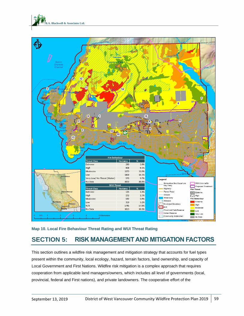
District of West Vancouver Community Wildfire Protection Plan 2019
59
September 13, 2019
B.A. Blackwell & Associates Ltd.
Map 10. Local Fire Behaviour Threat Rating and WUI Threat Rating
SECTION 5: RISK MANAGEMENT AND MITIGATION FACTORS
This section outlines a wildfire risk management and mitigation strategy that accounts for fuel types
present within the community, local ecology, hazard, terrain factors, land ownership, and capacity of
Local Government and First Nations. Wildfire risk mitigation is a complex approach that requires
cooperation from applicable land managers/owners, which includes all level of governments (local,
provincial, federal and First nations), and private landowners. The cooperative effort of the
District of West Vancouver Community Wildfire Protection Plan 2019
60
September 13, 2019
B.A. Blackwell & Associates Ltd.
aforementioned parties is crucial in order to develop and proactively implement a wildfire risk mitigation
program. Development of a successful wildfire risk mitigation strategy is dependent on hazard
identification within the community, which accounts for forest fuels, high risk activities, frequency and
type of human use, and other important environmental factors. The resulting wildfire risk management
and mitigation strategy aims to build more resilient communities and produces strategic
recommendations or actionable items that can be categorized as follows:
1. Fuel management opportunities to reduce fire behaviour potential in the WUI.
2. Applications of FireSmart approaches to reduce fire risk and impacts within the community.
3. Implementation of communication and education programs to inform and remind the public of
the important role it plays in reducing fire occurrence and impacts within its community.
5.1 FUEL MANAGEMENT
Fuel management, also referred to as vegetation management or fuel treatment, is a key element of
wildfire risk reduction. For the purpose of this discussion, fuel management generally refers to native
vegetation/fuel modifications in forested areas greater than 30 m from homes and structures. The
principles of fuel management are outlined in detail in Appendix H.
No fuel treatments have been completed by the District within the AOI. In 2018, Metro Vancouver
assessed the area between the District and the Capilano Watershed and removed trees and brush to
reduce the risk of trees falling close to homes and to reduce the fire risk. This treatment area was
observed during field data collection and was found to have reduced the wildfire behaviour threat in the
area by reducing crown, ladder, and surface fuels. Treatments proposed in this CWPP (Section 5.1.1)
will begin the process of reducing the wildfire risk in the AOI, where the objectives for fuel management
are to:
Reduce wildfire threat on private and public lands nearest to values at risk.
Reduce potential fire intensity, rate of spread, and ember/spot fire activity such that the
probability of fire containment increases and the impacts on the forested landscape and
watersheds are reduced (create more fire resilient landscapes).
Ideally, these objectives will enhance protection to homes and critical infrastructure. Caveats associated
with this statement include: 1) wildfire behaviour will only be reduced if the fire burns in the same
location as treatments occurred and 2) protection of homes and critical infrastructure is highly
dependent upon the vulnerability to ignition by embers (ignition potential) directly around the value at
risk. In summary, fuel treatments alone should not be expected to protect a community from the effects
of wildfire, namely structure loss. Fuel treatments are designed to reduce the possibility of
uncontrollable crown fire through the reduction of surface fuels, ladder fuels and crown fuels. However,
District of West Vancouver Community Wildfire Protection Plan 2019
61
September 13, 2019
B.A. Blackwell & Associates Ltd.
the degree of fire behaviour reduction achieved by fuel management varies by ecosystem type, current
fuel type, fire weather, slope and other variables and it is important to note that it does not stop wildfire.
Historically, funds from public sources, such as the Forest Enhancement Society of BC (FESBC) and
the Union of British Columbia Municipalities (UBCM), were only eligible to be used on Crown lands and
could not be used to treat private land. While this is still the case for the FESBC program, the new
Community Resiliency Investment (CRI) Program (formerly SWPI) provides funding for selected
FireSmart activities and planning on private land (subject to program requirements and limits).59 It is
important to recognize that more than a quarter of the AOI (26%) is located on private land, which
increases some of the challenges encountered in mitigation of fuels on private lands. The best approach
to mitigate fuels on private lands is to urge private landowners to comply with FireSmart guidelines (as
described below in Section 5.2) and to conduct appropriate fuel modifications using their own resources
(CRI program funding may be available). In general, when considering fuel management to reduce fire
risk, the following steps should be followed:
Carefully anticipate the likely wildfire scenarios to properly locate fuel modification areas.
Acquire an understanding of local ecological, archaeological, and societal values of the site
Prescriptions should be developed by a qualified Registered Professional Forester (RPF) or
Registered Forest Technician (RFT) working within their field of competence.
Public consultation should be conducted during the process to ensure community support
Potential treatment areas and draft prescriptions should be referred to First Nations with
sufficient time for meaningful review and input.
Treatment implementation should weigh the most financially and ecologically beneficial
methods of fulfilling the prescription’s goals.
Treatment implementation should consider the possibility of invasive species spread during
treatments and mitigation options should be considered.
Pre- and post-treatment plots should be established to monitor treatment effectiveness; and
A long-term maintenance program should be in place or developed to ensure that the fuel
treatment is maintained in a functional state.
The fuel treatment opportunities identified in this document include the use of interface fuel breaks,
trailside treatments, and primary fuel breaks as defined in Section 5.1.1, to reduce the wildfire potential
around the AOI. Potential treatment activities include fuel removal, thinning, stand conversion, pruning,
and chipping, or a combination of two or more of these activities. Stand conversion has been shown to
be effective at reducing wildfire potential in mixed-wood or conifer dominated stands and is
59 2019 CRI FireSmart Community Funding & Supports – Program & Application Guide. Retrieved online on Sept 20, 2018. www.ubcm.ca/assets/Funding~Programs/LGPS/CRI/cri-2019-program-guide.pdf
District of West Vancouver Community Wildfire Protection Plan 2019
62
September 13, 2019
B.A. Blackwell & Associates Ltd.
recommended as a BMP to encourage a higher deciduous component. This approach generally
involves a thin-from-below to reduce ladder fuels and crown fuels continuity, targeting the removal of
conifer species and the retention of broadleaf species.
In addition to the treatment units proposed in the following section, it is recommended that the District
recognize important fuel treatment opportunities to improve emergency access and public safety along
Highway 1 (Upper Levels) and Highway 99 in the event of evacuation through reduction of hazardous
fuels and landscape level fuel treatment.
RECOMMENDATION #16: Work with the Ministry of Transportation and Infrastructure (MOTI) to assess
the area suitable for treatment (i.e., high hazard and non-private) along Highway 1 (Upper Levels) and
Highway 99 and reduce hazardous fuels within 150 m of either side of the road, where possible. This is
to increase public safety/improve emergency access in the event of an evacuation or wildfire event.
5.1.1 Proposed Treatment Units
Funding opportunities from UBCM have historically been limited to Crown provincial, Regional District,
or municipal land under the SWPI Program. The UBCM SWPI funding stream has transitioned, as of
September 2018, into a new provincial program, the Community Resiliency Investment (CRI) Program,
that will consider fire prevention activities on provincial Crown land and private land, in addition to local
government and reserve land.60 Fire prevention activities on private land that may be funded under this
program are related to FireSmart activities (including FireSmart planning and assessments, local rebate
programs for completion of eligible FireSmart activities, and provision of off-site disposal of vegetation
management debris), subject to program requirements. This does not preclude other current and future
funding opportunities or potential industrial partnerships and changes to existing programs.
The potential treatment areas represent moderate or high fire hazard areas which are either close to
values at risk (structures or infrastructure) or have been identified as landscape level fuel treatments
and are located on provincial or municipal Crown land. It should be noted that the location of proposed
treatment units on these land ownership types does not imply that high and extreme hazard areas do
not exist on private land within the AOI. As stated in Section 5.1, mitigation approaches should also be
pursued on private land where hazard exists, bearing in mind the different funding resources and
objectives on these land types. Recommendation for treatment in areas of moderate fire hazard were
limited to areas which would increase efficacy of, and/or create continuity between areas of low
60 This new funding program (up to $50 million over three years) was initiated as per recommendations from the 2017 BC Flood and Wildfire Review Report by Abbott and Chapman (www2.gov.bc.ca/assets/gov/public-safety-and-emergency-services/emergency-preparedness-response-recovery/embc/bc-flood-and-wildfire-review-addressing-the-new-normal-21st-century-disaster-management-in-bc-web.pdf). Program details are available on the UBCM’s website: www.ubcm.ca/EN/main/funding/lgps/community-resiliency-investment.html
District of West Vancouver Community Wildfire Protection Plan 2019
63
September 13, 2019
B.A. Blackwell & Associates Ltd.
threat/no fuel areas. All polygons identified for potential treatment have been prioritized based on fire
hazard, operational feasibility, estimated project cost, type and number of values at risk, common fire
weather (wind direction), and expected efficacy of treatment. Although potential treatment areas have
been ground-truthed during field work, additional refinement of the polygons will be required at the time
of prescription development. Polygons will require detailed site-level assessment to stratify treatment
areas (and areas of no treatment), identify values and constraints, and identify and engage all
appropriate provincial agencies, First Nations, and stakeholders.
Recommended potential treatment areas within the AOI are outlined in Table 15, in order of priority, and
are displayed in Map 11. These fuel treatment opportunities include the use of trailside treatments,
interface fuel treatments (the treatment of both patches of fuels and linear interface fuel breaks), and
primary fuel breaks, as defined below.
Fuel Treatment Types
The intent of establishing a fuel break (and associated treated patches) is to modify fire behaviour and
create a fire suppression option that is part of a multi-barrier approach to reduce the risk to values (e.g.,
structures). A fuel break in and of itself, is unlikely to stop a fire under most conditions. The application
of appropriate suppression tactics in a timely manner with sufficient resources, is essential for a fuel
break to be effective. Lofting of embers (i.e., ‘spotting’) over and across a fuel break is a possibility
(increasing with more volatile fuel types and fire weather) and has the potential to create spot fires
beyond the fuel break that can expand in size and threaten values at risk, or land directly on or near
structures and ignite them. To address spotting, fuels between the fuel break and the values at risk
should be evaluated and treated to create conditions where extinguishment of spot fires is possible.
FireSmart standards should also be applied to structures and associated vegetation and other fuel to
reduce the risk of structures igniting. A multi-barrier approach that reduces the risk to values can
include: establishing multiple fuel breaks (Interface Fuel Break and Primary Fuel Break), addressing
fuels between the fuel break and structures (Interface Fuel Treatments), and applying FireSmart
Standards to structures and the surrounding vegetation. Fuel breaks require periodic maintenance to
retain their effectiveness.
Trailside Treatments
Trailside treatments are implemented to address hazardous fuels adjacent to publicly used trails, where
ignition potential may be higher due to increased recreational use by hikers and both motorized and
non-motorized off-road vehicles. The primary objective of these treatments is to reduce potential fire
intensity and the probability of ignition, which is achieved through the creation of a defensible space
surrounding the feature. Potential strategies include reducing ladder and surface fuels, increasing crown
base height of retained trees, and retaining fire-resistant tree species. Trailside treatments vary in size
and are typically in the form of linear features which follow trail systems.
District of West Vancouver Community Wildfire Protection Plan 2019
64
September 13, 2019
B.A. Blackwell & Associates Ltd.
Interface Fuel Breaks
Fuel breaks immediately adjacent to private land and in close proximity to the wildland urban interface
and/or intermix areas, are termed ‘interface fuel breaks’. These are designed to modify fire behaviour,
create fire suppression options, and improve suppression outcomes. Interface fuel treatments are
relatively small (approximately 100 metres wide) and when treated with appropriate fuel reduction
measures, can break the crown fire threshold and reduce the risk of a crown fire reaching values at risk.
Treatment widths can be varied to allow for alignment and to take advantage of natural and man-made
fire resilient features that enhance effectiveness. Surface fire spread across the fuel treatment and
spotting across the fuel treatment are both concerns and rely on suppression actions to be effective. In
order to reduce potential fire intensity and spotting, fuel on private land between the interface fuel
treatment and structures should be treated according to FireSmart vegetation management
standards. Structures in interface areas should be constructed or retrofitted to FireSmart design
standards.
Primary Fuel Break
Primary fuel breaks are located in strategic locations beyond the interface fuel treatments. Primary fuel
breaks are designed to modify fire behaviour and create fire suppression options that reduce the risk of
a crown fire reaching a community and/or adjacent private lands. Primary fuel breaks may be located to
completely surround a community or be strategically placed upwind of communities and perpendicular
to fire season winds. Primary fuel breaks have sufficient width and appropriate fuel reduction measures
to break the crown fire threshold and reduce fire intensity such that overstory fire moves to the ground
surface and spread rates are reduced. While there are no absolute standards for fuel break width or fuel
manipulation in the literature and fuel break width will vary based on fuel type, topography, and
expected fire behaviour61, a 300-metre fuel break width is generally recommended. Fuel breaks should
be designed to take advantage of natural and manmade fire resilient features and topography to
enhance effectiveness. Surface fire spread across, and spotting over the fuel break are both concerns,
and depend on the application of suppression resources to be effective.
RECOMMENDATION #17: Proceed with detailed assessment, prescription development, and treatment
of proposed treatment units identified and prioritized in this CWPP.
61 Agee, J.K., Bahro, B., Finney, M.A., Omi, P.N., Sapsis, D.B., Skinner, C.N., van Wagtendonk, J.W., Weatherspoon, C.P. The use of shaded fuelbreaks in landscape fire management. Forest Ecology and Management, 127 (2000), 55-66.
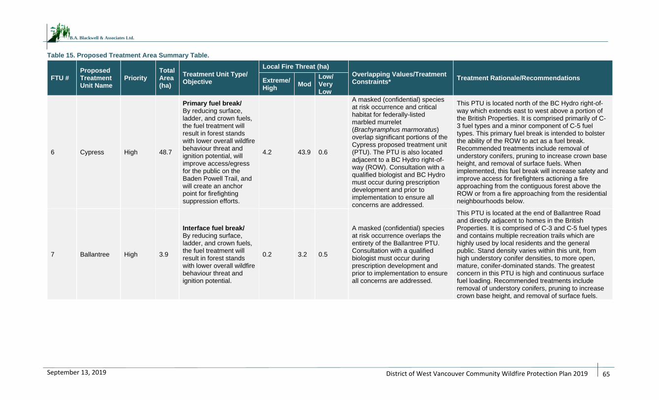
District of West Vancouver Community Wildfire Protection Plan 2019
65
September 13, 2019
B.A. Blackwell & Associates Ltd.
Table 15. Proposed Treatment Area Summary Table.
FTU # Proposed Treatment Unit Name
Priority Total Area (ha)
Treatment Unit Type/ Objective
Local Fire Threat (ha)
Overlapping Values/Treatment Constraints*
Treatment Rationale/Recommendations Extreme/High
Mod Low/ Very Low
6 Cypress High 48.7
Primary fuel break/ By reducing surface, ladder, and crown fuels, the fuel treatment will result in forest stands with lower overall wildfire behaviour threat and ignition potential, will improve access/egress for the public on the Baden Powell Trail, and will create an anchor point for firefighting suppression efforts.
4.2 43.9 0.6
A masked (confidential) species at risk occurrence and critical habitat for federally-listed marbled murrelet (Brachyramphus marmoratus) overlap significant portions of the Cypress proposed treatment unit (PTU). The PTU is also located adjacent to a BC Hydro right-of-way (ROW). Consultation with a qualified biologist and BC Hydro must occur during prescription development and prior to implementation to ensure all concerns are addressed.
This PTU is located north of the BC Hydro right-of-way which extends east to west above a portion of the British Properties. It is comprised primarily of C-3 fuel types and a minor component of C-5 fuel types. This primary fuel break is intended to bolster the ability of the ROW to act as a fuel break. Recommended treatments include removal of understory conifers, pruning to increase crown base height, and removal of surface fuels. When implemented, this fuel break will increase safety and improve access for firefighters actioning a fire approaching from the contiguous forest above the ROW or from a fire approaching from the residential neighbourhoods below.
7 Ballantree High 3.9
Interface fuel break/ By reducing surface, ladder, and crown fuels, the fuel treatment will result in forest stands with lower overall wildfire behaviour threat and ignition potential.
0.2 3.2 0.5
A masked (confidential) species at risk occurrence overlaps the entirety of the Ballantree PTU. Consultation with a qualified biologist must occur during prescription development and prior to implementation to ensure all concerns are addressed.
This PTU is located at the end of Ballantree Road and directly adjacent to homes in the British Properties. It is comprised of C-3 and C-5 fuel types and contains multiple recreation trails which are highly used by local residents and the general public. Stand density varies within this unit, from high understory conifer densities, to more open, mature, conifer-dominated stands. The greatest concern in this PTU is high and continuous surface fuel loading. Recommended treatments include removal of understory conifers, pruning to increase crown base height, and removal of surface fuels.
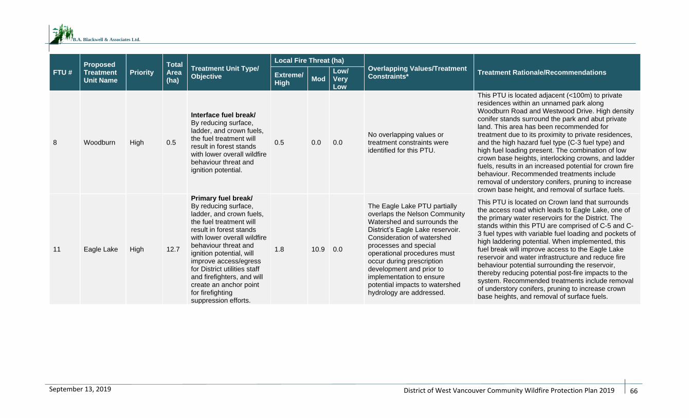
District of West Vancouver Community Wildfire Protection Plan 2019
66
September 13, 2019
B.A. Blackwell & Associates Ltd.
FTU # Proposed Treatment Unit Name
Priority Total Area (ha)
Treatment Unit Type/ Objective
Local Fire Threat (ha)
Overlapping Values/Treatment Constraints*
Treatment Rationale/Recommendations Extreme/High
Mod Low/ Very Low
8 Woodburn High 0.5
Interface fuel break/ By reducing surface, ladder, and crown fuels, the fuel treatment will result in forest stands with lower overall wildfire behaviour threat and ignition potential.
0.5 0.0 0.0 No overlapping values or treatment constraints were identified for this PTU.
This PTU is located adjacent (<100m) to private residences within an unnamed park along Woodburn Road and Westwood Drive. High density conifer stands surround the park and abut private land. This area has been recommended for treatment due to its proximity to private residences, and the high hazard fuel type (C-3 fuel type) and high fuel loading present. The combination of low crown base heights, interlocking crowns, and ladder fuels, results in an increased potential for crown fire behaviour. Recommended treatments include removal of understory conifers, pruning to increase crown base height, and removal of surface fuels.
11 Eagle Lake High 12.7
Primary fuel break/ By reducing surface, ladder, and crown fuels, the fuel treatment will result in forest stands with lower overall wildfire behaviour threat and ignition potential, will improve access/egress for District utilities staff and firefighters, and will create an anchor point for firefighting suppression efforts.
1.8 10.9 0.0
The Eagle Lake PTU partially overlaps the Nelson Community Watershed and surrounds the District’s Eagle Lake reservoir. Consideration of watershed processes and special operational procedures must occur during prescription development and prior to implementation to ensure potential impacts to watershed hydrology are addressed.
This PTU is located on Crown land that surrounds the access road which leads to Eagle Lake, one of the primary water reservoirs for the District. The stands within this PTU are comprised of C-5 and C-3 fuel types with variable fuel loading and pockets of high laddering potential. When implemented, this fuel break will improve access to the Eagle Lake reservoir and water infrastructure and reduce fire behaviour potential surrounding the reservoir, thereby reducing potential post-fire impacts to the system. Recommended treatments include removal of understory conifers, pruning to increase crown base heights, and removal of surface fuels.
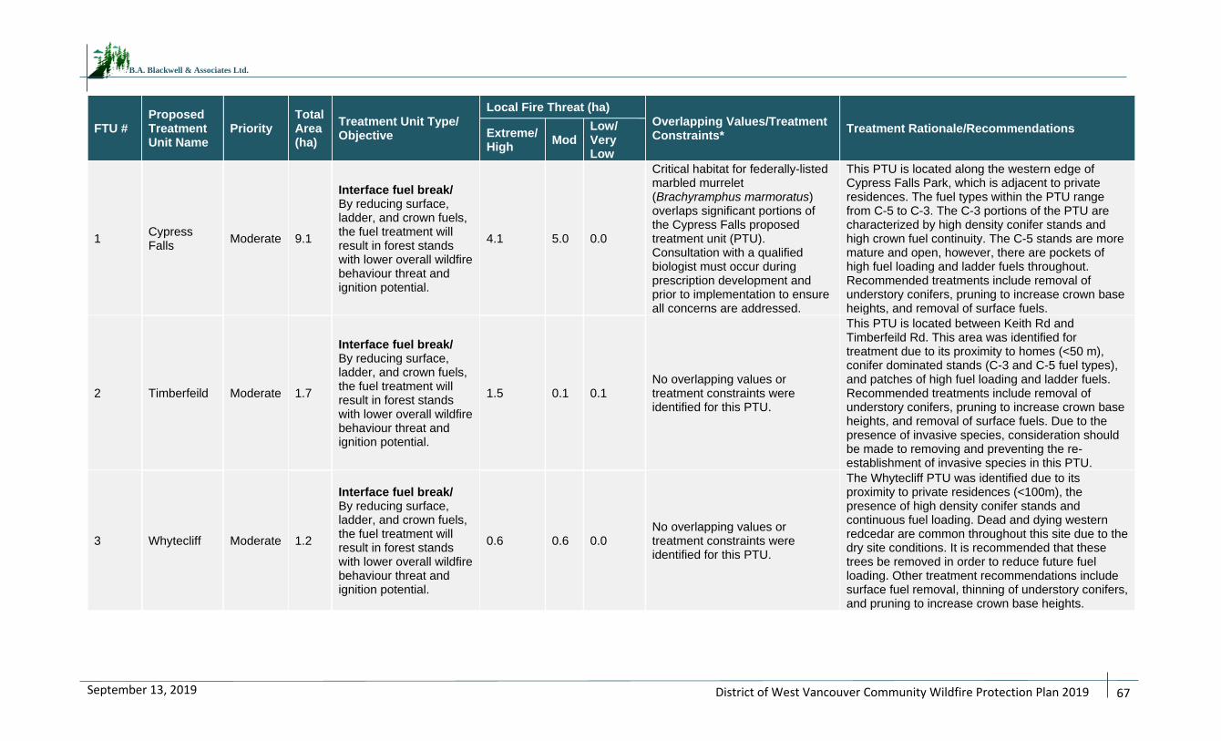
District of West Vancouver Community Wildfire Protection Plan 2019
67
September 13, 2019
B.A. Blackwell & Associates Ltd.
FTU # Proposed Treatment Unit Name
Priority Total Area (ha)
Treatment Unit Type/ Objective
Local Fire Threat (ha)
Overlapping Values/Treatment Constraints*
Treatment Rationale/Recommendations Extreme/High
Mod Low/ Very Low
1 Cypress Falls
Moderate 9.1
Interface fuel break/ By reducing surface, ladder, and crown fuels, the fuel treatment will result in forest stands with lower overall wildfire behaviour threat and ignition potential.
4.1 5.0 0.0
Critical habitat for federally-listed marbled murrelet (Brachyramphus marmoratus) overlaps significant portions of the Cypress Falls proposed treatment unit (PTU). Consultation with a qualified biologist must occur during prescription development and prior to implementation to ensure all concerns are addressed.
This PTU is located along the western edge of Cypress Falls Park, which is adjacent to private residences. The fuel types within the PTU range from C-5 to C-3. The C-3 portions of the PTU are characterized by high density conifer stands and high crown fuel continuity. The C-5 stands are more mature and open, however, there are pockets of high fuel loading and ladder fuels throughout. Recommended treatments include removal of understory conifers, pruning to increase crown base heights, and removal of surface fuels.
2 Timberfeild Moderate 1.7
Interface fuel break/ By reducing surface, ladder, and crown fuels, the fuel treatment will result in forest stands with lower overall wildfire behaviour threat and ignition potential.
1.5 0.1 0.1 No overlapping values or treatment constraints were identified for this PTU.
This PTU is located between Keith Rd and Timberfeild Rd. This area was identified for treatment due to its proximity to homes (<50 m), conifer dominated stands (C-3 and C-5 fuel types), and patches of high fuel loading and ladder fuels. Recommended treatments include removal of understory conifers, pruning to increase crown base heights, and removal of surface fuels. Due to the presence of invasive species, consideration should be made to removing and preventing the re-establishment of invasive species in this PTU.
3 Whytecliff Moderate 1.2
Interface fuel break/ By reducing surface, ladder, and crown fuels, the fuel treatment will result in forest stands with lower overall wildfire behaviour threat and ignition potential.
0.6 0.6 0.0 No overlapping values or treatment constraints were identified for this PTU.
The Whytecliff PTU was identified due to its proximity to private residences (<100m), the presence of high density conifer stands and continuous fuel loading. Dead and dying western redcedar are common throughout this site due to the dry site conditions. It is recommended that these trees be removed in order to reduce future fuel loading. Other treatment recommendations include surface fuel removal, thinning of understory conifers, and pruning to increase crown base heights.
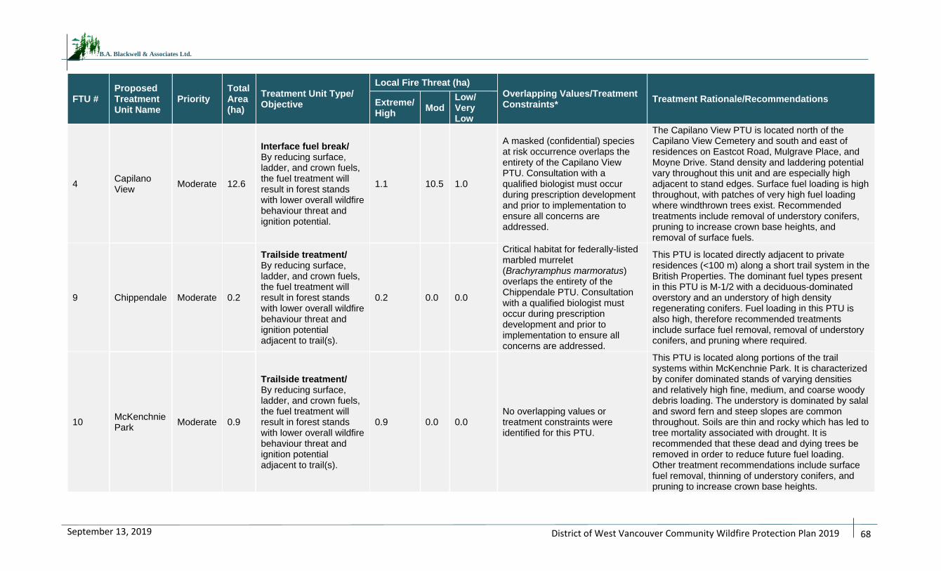
District of West Vancouver Community Wildfire Protection Plan 2019
68
September 13, 2019
B.A. Blackwell & Associates Ltd.
FTU # Proposed Treatment Unit Name
Priority Total Area (ha)
Treatment Unit Type/ Objective
Local Fire Threat (ha)
Overlapping Values/Treatment Constraints*
Treatment Rationale/Recommendations Extreme/High
Mod Low/ Very Low
4 Capilano View
Moderate 12.6
Interface fuel break/ By reducing surface, ladder, and crown fuels, the fuel treatment will result in forest stands with lower overall wildfire behaviour threat and ignition potential.
1.1 10.5 1.0
A masked (confidential) species at risk occurrence overlaps the entirety of the Capilano View PTU. Consultation with a qualified biologist must occur during prescription development and prior to implementation to ensure all concerns are addressed.
The Capilano View PTU is located north of the Capilano View Cemetery and south and east of residences on Eastcot Road, Mulgrave Place, and Moyne Drive. Stand density and laddering potential vary throughout this unit and are especially high adjacent to stand edges. Surface fuel loading is high throughout, with patches of very high fuel loading where windthrown trees exist. Recommended treatments include removal of understory conifers, pruning to increase crown base heights, and removal of surface fuels.
9 Chippendale Moderate 0.2
Trailside treatment/ By reducing surface, ladder, and crown fuels, the fuel treatment will result in forest stands with lower overall wildfire behaviour threat and ignition potential adjacent to trail(s).
0.2 0.0 0.0
Critical habitat for federally-listed marbled murrelet (Brachyramphus marmoratus) overlaps the entirety of the Chippendale PTU. Consultation with a qualified biologist must occur during prescription development and prior to implementation to ensure all concerns are addressed.
This PTU is located directly adjacent to private residences (<100 m) along a short trail system in the British Properties. The dominant fuel types present in this PTU is M-1/2 with a deciduous-dominated overstory and an understory of high density regenerating conifers. Fuel loading in this PTU is also high, therefore recommended treatments include surface fuel removal, removal of understory conifers, and pruning where required.
10 McKenchnie Park
Moderate 0.9
Trailside treatment/ By reducing surface, ladder, and crown fuels, the fuel treatment will result in forest stands with lower overall wildfire behaviour threat and ignition potential adjacent to trail(s).
0.9 0.0 0.0 No overlapping values or treatment constraints were identified for this PTU.
This PTU is located along portions of the trail systems within McKenchnie Park. It is characterized by conifer dominated stands of varying densities and relatively high fine, medium, and coarse woody debris loading. The understory is dominated by salal and sword fern and steep slopes are common throughout. Soils are thin and rocky which has led to tree mortality associated with drought. It is recommended that these dead and dying trees be removed in order to reduce future fuel loading. Other treatment recommendations include surface fuel removal, thinning of understory conifers, and pruning to increase crown base heights.
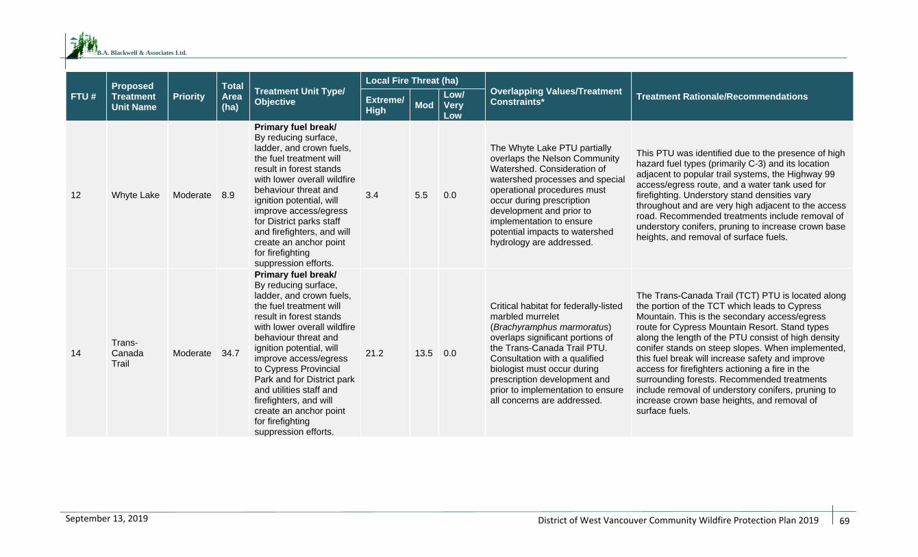
District of West Vancouver Community Wildfire Protection Plan 2019
69
September 13, 2019
B.A. Blackwell & Associates Ltd.
FTU # Proposed Treatment Unit Name
Priority Total Area (ha)
Treatment Unit Type/ Objective
Local Fire Threat (ha)
Overlapping Values/Treatment Constraints*
Treatment Rationale/Recommendations Extreme/High
Mod Low/ Very Low
12 Whyte Lake Moderate 8.9
Primary fuel break/ By reducing surface, ladder, and crown fuels, the fuel treatment will result in forest stands with lower overall wildfire behaviour threat and ignition potential, will improve access/egress for District parks staff and firefighters, and will create an anchor point for firefighting suppression efforts.
3.4 5.5 0.0
The Whyte Lake PTU partially overlaps the Nelson Community Watershed. Consideration of watershed processes and special operational procedures must occur during prescription development and prior to implementation to ensure potential impacts to watershed hydrology are addressed.
This PTU was identified due to the presence of high hazard fuel types (primarily C-3) and its location adjacent to popular trail systems, the Highway 99 access/egress route, and a water tank used for firefighting. Understory stand densities vary throughout and are very high adjacent to the access road. Recommended treatments include removal of understory conifers, pruning to increase crown base heights, and removal of surface fuels.
14 Trans-Canada Trail
Moderate 34.7
Primary fuel break/ By reducing surface, ladder, and crown fuels, the fuel treatment will result in forest stands with lower overall wildfire behaviour threat and ignition potential, will improve access/egress to Cypress Provincial Park and for District park and utilities staff and firefighters, and will create an anchor point for firefighting suppression efforts.
21.2 13.5 0.0
Critical habitat for federally-listed marbled murrelet (Brachyramphus marmoratus) overlaps significant portions of the Trans-Canada Trail PTU. Consultation with a qualified biologist must occur during prescription development and prior to implementation to ensure all concerns are addressed.
The Trans-Canada Trail (TCT) PTU is located along the portion of the TCT which leads to Cypress Mountain. This is the secondary access/egress route for Cypress Mountain Resort. Stand types along the length of the PTU consist of high density conifer stands on steep slopes. When implemented, this fuel break will increase safety and improve access for firefighters actioning a fire in the surrounding forests. Recommended treatments include removal of understory conifers, pruning to increase crown base heights, and removal of surface fuels.
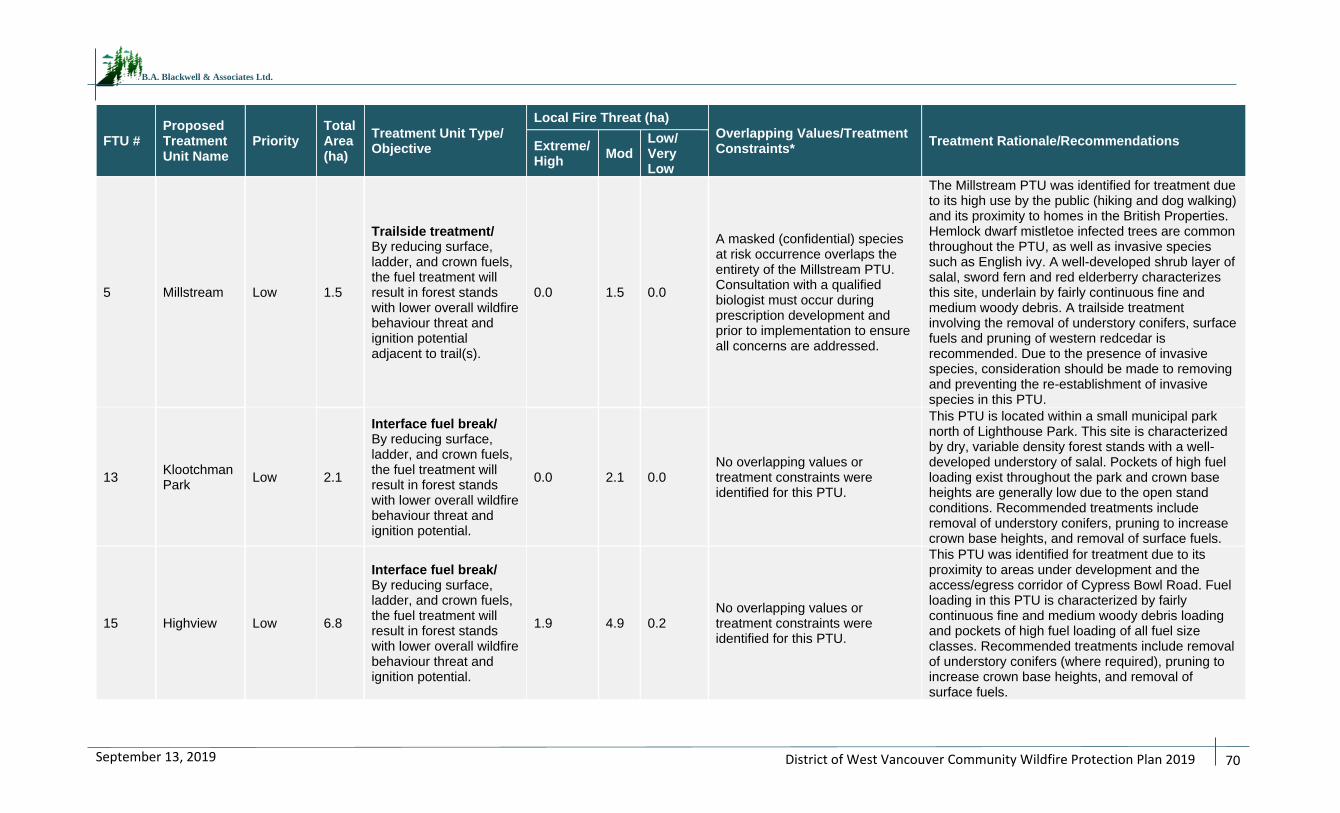
District of West Vancouver Community Wildfire Protection Plan 2019
70
September 13, 2019
B.A. Blackwell & Associates Ltd.
FTU # Proposed Treatment Unit Name
Priority Total Area (ha)
Treatment Unit Type/ Objective
Local Fire Threat (ha)
Overlapping Values/Treatment Constraints*
Treatment Rationale/Recommendations Extreme/High
Mod Low/ Very Low
5 Millstream Low 1.5
Trailside treatment/ By reducing surface, ladder, and crown fuels, the fuel treatment will result in forest stands with lower overall wildfire behaviour threat and ignition potential adjacent to trail(s).
0.0 1.5 0.0
A masked (confidential) species at risk occurrence overlaps the entirety of the Millstream PTU. Consultation with a qualified biologist must occur during prescription development and prior to implementation to ensure all concerns are addressed.
The Millstream PTU was identified for treatment due to its high use by the public (hiking and dog walking) and its proximity to homes in the British Properties. Hemlock dwarf mistletoe infected trees are common throughout the PTU, as well as invasive species such as English ivy. A well-developed shrub layer of salal, sword fern and red elderberry characterizes this site, underlain by fairly continuous fine and medium woody debris. A trailside treatment involving the removal of understory conifers, surface fuels and pruning of western redcedar is recommended. Due to the presence of invasive species, consideration should be made to removing and preventing the re-establishment of invasive species in this PTU.
13 Klootchman Park
Low 2.1
Interface fuel break/ By reducing surface, ladder, and crown fuels, the fuel treatment will result in forest stands with lower overall wildfire behaviour threat and ignition potential.
0.0 2.1 0.0 No overlapping values or treatment constraints were identified for this PTU.
This PTU is located within a small municipal park north of Lighthouse Park. This site is characterized by dry, variable density forest stands with a well-developed understory of salal. Pockets of high fuel loading exist throughout the park and crown base heights are generally low due to the open stand conditions. Recommended treatments include removal of understory conifers, pruning to increase crown base heights, and removal of surface fuels.
15 Highview Low 6.8
Interface fuel break/ By reducing surface, ladder, and crown fuels, the fuel treatment will result in forest stands with lower overall wildfire behaviour threat and ignition potential.
1.9 4.9 0.2 No overlapping values or treatment constraints were identified for this PTU.
This PTU was identified for treatment due to its proximity to areas under development and the access/egress corridor of Cypress Bowl Road. Fuel loading in this PTU is characterized by fairly continuous fine and medium woody debris loading and pockets of high fuel loading of all fuel size classes. Recommended treatments include removal of understory conifers (where required), pruning to increase crown base heights, and removal of surface fuels.
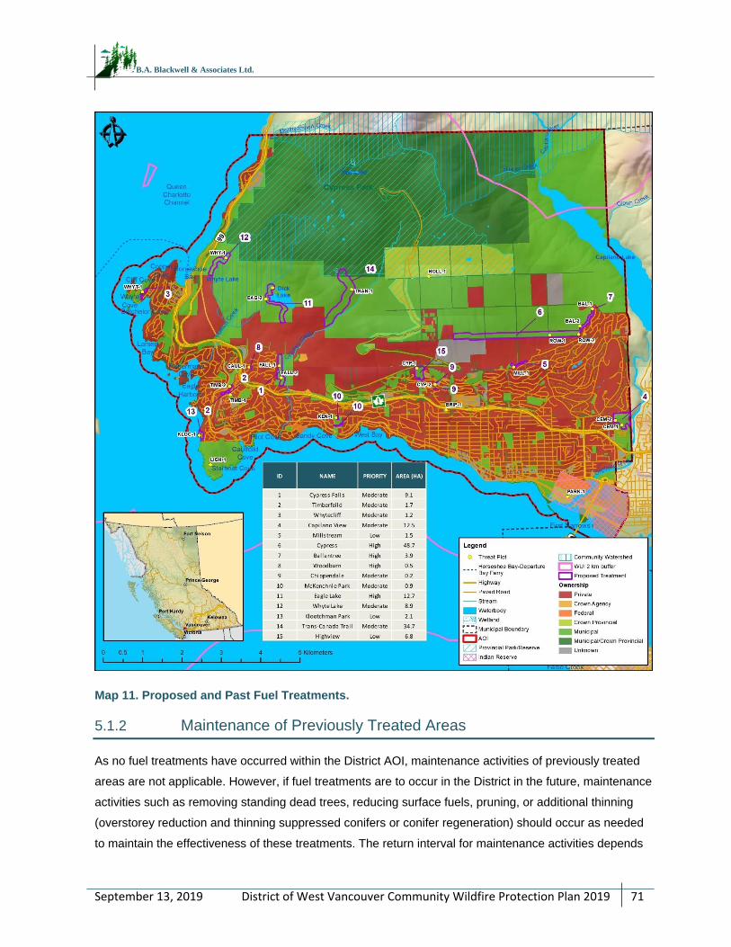
District of West Vancouver Community Wildfire Protection Plan 2019
71
September 13, 2019
B.A. Blackwell & Associates Ltd.
Map 11. Proposed and Past Fuel Treatments.
5.1.2 Maintenance of Previously Treated Areas
As no fuel treatments have occurred within the District AOI, maintenance activities of previously treated
areas are not applicable. However, if fuel treatments are to occur in the District in the future, maintenance
activities such as removing standing dead trees, reducing surface fuels, pruning, or additional thinning
(overstorey reduction and thinning suppressed conifers or conifer regeneration) should occur as needed
to maintain the effectiveness of these treatments. The return interval for maintenance activities depends
District of West Vancouver Community Wildfire Protection Plan 2019
72
September 13, 2019
B.A. Blackwell & Associates Ltd.
on site productivity and the type and intensity of treatment. Less productive areas can likely withstand a
longer frequency between maintenance activities, while more productive areas would require treatments
more often.
RECOMMENDATION #18: If and when operational fuel treatments are conducted within the District
AOI, treatment monitoring should be completed by a Qualified Professional in order to schedule the
next set of maintenance activities (5 to 10 years out). This can be completed with a CWPP update or
as a stand-alone exercise.
District of West Vancouver Community Wildfire Protection Plan 2019
73
September 13, 2019
B.A. Blackwell & Associates Ltd.
5.2 FIRESMART PLANNING AND ACTIVITIES
This section provides detail on: 1) the current level of FireSmart implementation and uptake within the
community, 2) identified FireSmart subdivisions and/or acceptance into the FireSmart Canada
Community Recognition Program (FSCCRP), and 3) recommended potential FireSmart activities that can
be applied within the AOI at a future date.
5.2.1 FireSmart Goals and Objectives
FireSmart® is the comprehensive nationally accepted set of principles, practices and programs for
reducing losses from wildfire.62 FireSmart spans the disciplines of hazard/threat assessment; regional
planning and collaboration; policy and regulations; public communication and education; vegetation/fuel
management; training and equipment; and, emergency preparedness and response. FireSmart concepts
provide a sound framework for advancing the goal of wildfire loss reduction, as it is a common goal
shared with CWPPs.
The FireSmart approach and concepts, including recommended FireSmart guidelines63, have been
formally adopted by almost all Canadian provinces and territories, including British Columbia in 2000;
FireSmart has become the de facto Canadian standard. FireSmart is founded in standards published by
the National Fire Protection Association (NFPA). The objective of FireSmart is to help homeowners,
neighbourhoods, whole communities and agencies with fire protection and public safety mandates to
work together to prepare for the threat of wildfire in the WUI. Coordinated efforts between all levels of
planning and action are integral to effectively and efficiently reducing the risk to communities.
The following are key principles of FireSmart:
Wildland fires are a natural process and critical to the health of Canadian ecosystems.
Mitigation and response efforts must be carefully coordinated through all stages of planning and
implementation.
Threats and losses due to wildfires can be reduced by working together. Responsibility for
effectively mitigating hazards must be shared between many entities including homeowners,
industry, businesses and governments.64
There are seven broad disciplines to help address the threat of wildfire: education, vegetation
management, legislation and planning, development considerations, interagency cooperation,
emergency planning, and cross training.64
62 FireSmart is the registered trademark held by the Partners in Protection Association. 63 FireSmart guidelines first published in the 1999 manual ‘FireSmart: Protecting Your Community from Wildfire,’ with a second edition published in 2003. 64 www.firesmartcanada.ca
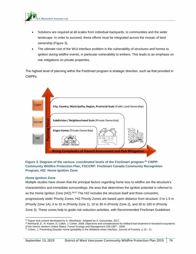
District of West Vancouver Community Wildfire Protection Plan 2019
74
September 13, 2019
B.A. Blackwell & Associates Ltd.
Solutions are required at all scales from individual backyards, to communities and the wider
landscape. In order to succeed, these efforts must be integrated across the mosaic of land
ownership (Figure 3).
The ultimate root of the WUI interface problem is the vulnerability of structures and homes to
ignition during wildfire events, in particular vulnerability to embers. This leads to an emphasis on
risk mitigations on private properties.
The highest level of planning within the FireSmart program is strategic direction, such as that provided in
CWPPs.
Figure 3. Diagram of the various, coordinated levels of the FireSmart program.65 CWPP:
Community Wildfire Protection Plan, FSCCRP: FireSmart Canada Community Recognition
Program, HIZ: Home Ignition Zone.
Home Ignition Zone
Multiple studies have shown that the principal factors regarding home loss to wildfire are the structure’s
characteristics and immediate surroundings; the area that determines the ignition potential is referred to
as the Home Ignition Zone (HIZ).66,67 The HIZ includes the structure itself and three concentric,
progressively wider Priority Zones. HIZ Priority Zones are based upon distance from structure: 0 to 1.5 m
(Priority Zone 1A), 0 to 10 m (Priority Zone 1), 10 to 30 m (Priority Zone 2), and 30 to 100 m (Priority
Zone 3). These zones help to guide risk reduction activities, with Recommended FireSmart Guidelines
65 Figure and content developed by A. Westhaver. Adapted by A. Duszynska, 2017. 66 Reinhardt, E., R. Keane, D. Calkin, J. Cohen. 2008. Objectives and considerations for wildland fuel treatment in forested ecosystems of the interior western United States. Forest Ecology and Management 256:1997 - 2006. 67 Cohen, J. Preventing Disaster Home Ignitability in the Wildland-urban Interface. Journal of Forestry. p 15 - 21.
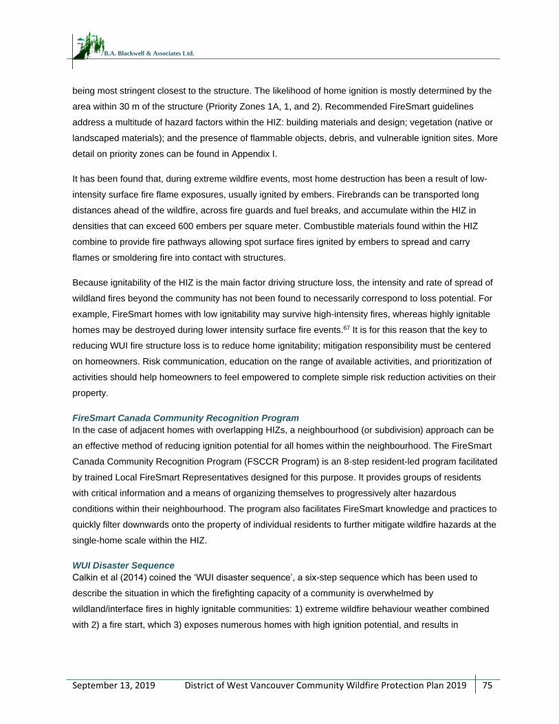
District of West Vancouver Community Wildfire Protection Plan 2019
75
September 13, 2019
B.A. Blackwell & Associates Ltd.
being most stringent closest to the structure. The likelihood of home ignition is mostly determined by the
area within 30 m of the structure (Priority Zones 1A, 1, and 2). Recommended FireSmart guidelines
address a multitude of hazard factors within the HIZ: building materials and design; vegetation (native or
landscaped materials); and the presence of flammable objects, debris, and vulnerable ignition sites. More
detail on priority zones can be found in Appendix I.
It has been found that, during extreme wildfire events, most home destruction has been a result of low-
intensity surface fire flame exposures, usually ignited by embers. Firebrands can be transported long
distances ahead of the wildfire, across fire guards and fuel breaks, and accumulate within the HIZ in
densities that can exceed 600 embers per square meter. Combustible materials found within the HIZ
combine to provide fire pathways allowing spot surface fires ignited by embers to spread and carry
flames or smoldering fire into contact with structures.
Because ignitability of the HIZ is the main factor driving structure loss, the intensity and rate of spread of
wildland fires beyond the community has not been found to necessarily correspond to loss potential. For
example, FireSmart homes with low ignitability may survive high-intensity fires, whereas highly ignitable
homes may be destroyed during lower intensity surface fire events.67 It is for this reason that the key to
reducing WUI fire structure loss is to reduce home ignitability; mitigation responsibility must be centered
on homeowners. Risk communication, education on the range of available activities, and prioritization of
activities should help homeowners to feel empowered to complete simple risk reduction activities on their
property.
FireSmart Canada Community Recognition Program
In the case of adjacent homes with overlapping HIZs, a neighbourhood (or subdivision) approach can be
an effective method of reducing ignition potential for all homes within the neighbourhood. The FireSmart
Canada Community Recognition Program (FSCCR Program) is an 8-step resident-led program facilitated
by trained Local FireSmart Representatives designed for this purpose. It provides groups of residents
with critical information and a means of organizing themselves to progressively alter hazardous
conditions within their neighbourhood. The program also facilitates FireSmart knowledge and practices to
quickly filter downwards onto the property of individual residents to further mitigate wildfire hazards at the
single-home scale within the HIZ.
WUI Disaster Sequence
Calkin et al (2014) coined the ‘WUI disaster sequence’, a six-step sequence which has been used to
describe the situation in which the firefighting capacity of a community is overwhelmed by
wildland/interface fires in highly ignitable communities: 1) extreme wildfire behaviour weather combined
with 2) a fire start, which 3) exposes numerous homes with high ignition potential, and results in
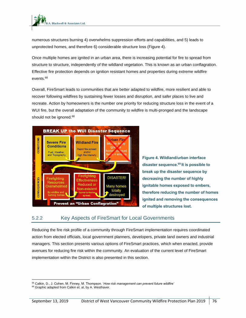
District of West Vancouver Community Wildfire Protection Plan 2019
76
September 13, 2019
B.A. Blackwell & Associates Ltd.
numerous structures burning 4) overwhelms suppression efforts and capabilities, and 5) leads to
unprotected homes, and therefore 6) considerable structure loss (Figure 4).
Once multiple homes are ignited in an urban area, there is increasing potential for fire to spread from
structure to structure, independently of the wildland vegetation. This is known as an urban conflagration.
Effective fire protection depends on ignition resistant homes and properties during extreme wildfire
events.68
Overall, FireSmart leads to communities that are better adapted to wildfire, more resilient and able to
recover following wildfires by sustaining fewer losses and disruption, and safer places to live and
recreate. Action by homeowners is the number one priority for reducing structure loss in the event of a
WUI fire, but the overall adaptation of the community to wildfire is multi-pronged and the landscape
should not be ignored.68
Figure 4. Wildland/urban interface
disaster sequence.69 It is possible to
break up the disaster sequence by
decreasing the number of highly
ignitable homes exposed to embers,
therefore reducing the number of homes
ignited and removing the consequences
of multiple structures lost.
5.2.2 Key Aspects of FireSmart for Local Governments
Reducing the fire risk profile of a community through FireSmart implementation requires coordinated
action from elected officials, local government planners, developers, private land owners and industrial
managers. This section presents various options of FireSmart practices, which when enacted, provide
avenues for reducing fire risk within the community. An evaluation of the current level of FireSmart
implementation within the District is also presented in this section.
68 Calkin, D., J. Cohen, M. Finney, M. Thompson. ‘How risk management can prevent future wildfire’ 69 Graphic adapted from Calkin et. al, by A. Westhaver.
District of West Vancouver Community Wildfire Protection Plan 2019
77
September 13, 2019
B.A. Blackwell & Associates Ltd.
Communication, Education and Partnerships
Communicating effectively is a key aspect of any education strategy. Communication materials must be
audience specific and delivered in a format and through mediums that reach the target audience. Audiences
should include home and landowners, students, local businesses, elected officials, District staff, and local
utilities providers. Education and communication messages should be simple yet comprehensive. A basic
level of background information is required to enable a solid understanding of fire risk issues and the level
of complexity and detail of the message should be specific to the target audience.
FireSmart information material is readily available and simple for municipalities to disseminate. It provides
concise and easy-to-use guidance that allows homeowners to evaluate their homes and take measures
to reduce fire risk. However, the information needs to be supported by locally relevant information that
illustrates the vulnerability of individual houses to wildfire.
The District (primarily the WVFR) has undertaken some public education outreach in the community to
date. This can be expanded upon and/or adapted to further enhance wildfire preparedness and
education. The District should consider developing a school fire education program to include an element
of wildfire preparedness education to be presented annually in elementary or high schools. Programming
could include volunteer/advocacy work from professional foresters, wildland firefighters or prevention
officers, and District staff. The District should consider holding a wildland specific Fire Prevention Day or
Week, or similarly formatted event, in the spring prior to the wildfire season. Timely educational materials
to increase preparedness would be most effective immediately prior to the fire season.
A full list of recommendations pertaining to the Communication, Education and Partnerships strategy is
presented in Section 5.3.
FireSmart Vegetation Management
Some examples of actionable items for the District with regards to vegetation or fuel management and
the FireSmart approach include: 1) policy development and implementation of FireSmart maintenance for
community parks and open spaces 2) implementing fire resistive landscaping requirements as part of the
development permitting process 3) provision of collection services for private landowners with a focus on
pruning, yard and thinning debris.
The District does not currently enforce FireSmart landscaping requirements within a wildfire development
permit area. The District provides yard trimmings bin collection service to all residents within the District,
which may reduce the likelihood of these materials accumulating on private properties by reducing
barriers to removal. Yard trimmings that exceed the size of the yard trimmings limit of six cans, bins or
bundles (20 kg limit per item) can be dropped off at the North Shore Transfer Station for a tipping fee of
District of West Vancouver Community Wildfire Protection Plan 2019
78
September 13, 2019
B.A. Blackwell & Associates Ltd.
$95/tonne. More detailed recommendations regarding municipal policies and bylaws are provided below
in Planning and Development.
RECOMMENDATION #19: Apply for a FireSmart demonstration grant through the CRI program. This
type of fuel treatment can display the practices and principles of FireSmart activities to the public in the
form of demonstration treatments. These small projects are not necessarily completed to reduce fire
behaviour or increase stand resiliency in any measurable way, but instead are prioritized more by their
visibility to the public and combining the treatment with elements of public education (signage, community
work days, public tours, active demonstrations of operations, etc.).
RECOMMENDATION #20: Continue to offer yard waste pick-up and disposal opportunities and consider
developing and implementing a community chipper program with the help of neighbourhood
representatives. As a demonstration, this program can begin twice per year in two separate
neighbourhoods. This program can also be implemented in conjunction with community clean-up days.
Planning and Development
Municipal policies and bylaws are tools available to mitigate wildfire risk to a community. It is recognized
that, to be successful, all levels of government (municipal, provincial, and federal) and individual landowners
need to work together to successfully reduce their risk. To that end, local government can use a range of
policy tools to help the community to incrementally increase FireSmart compliance over the mid-term (5 to
20 years) and therefore play a role in reducing the chance of structure loss from wildfire.
The planning and development objectives for the District of West Vancouver are:
To include wildfire considerations in the planning and acquisition strategy for parks and
recreational areas.
To utilize regulatory and administrative tools to reduce wildfire hazard on private land and
increase number of homes compliant with FireSmart guidelines (with low ignition potential).
In 2015, the province passed the Building Act as the new legislation to guide building and construction in
BC (Spring 2015). This Act establishes the province as the sole authority to set building requirements and
limits local government authority to set building requirements in their bylaws. Section 5 of the Building Act
provides an exception to the above limitation to local governments by giving them the authority to set
local building bylaws for unrestricted and temporarily unrestricted matters, such as exterior design and
finish of buildings in relation to wildfire hazard and within a development permit area. The British
Columbia Building Code does not have any wildfire-specific fire-resistant design components. Until
revisions of the Building Code to include requirements specific to prevention of wildfire spread are
District of West Vancouver Community Wildfire Protection Plan 2019
79
September 13, 2019
B.A. Blackwell & Associates Ltd.
completed, local governments can set exterior requirements within an established development permit
area for wildfire risk mitigation.70
RECOMMENDATION #21: Review the Official Community Plan (OCP) and include wildfire as a natural
hazard development permit area. The DP should be continually updated to incorporate changes in zoning
and the wildland urban interface (WUI). Review similar DPs established in other jurisdictions and use as
models for various aspects of the DP process. The following aspects should be considered in the OCP
review and wildfire DP development: 1) Establish DP objectives (e.g. minimize risk to property and people
from wildland fires; minimize risk to forested area surrounding the AOI; and conserve the visual and
ecological assets of the forests surrounding communities; etc. and 2) Where possible, it is recommended
to mandate FireSmart construction materials, some of which may be beyond BC Building Code within the
established wildfire hazard development permit area. In order to meet objectives, consider including the
following elements: 1) minimum setbacks from forested edge based on FireSmart, 2) fuel management
based upon Qualified Professional recommendations, 3) landscaping to FireSmart guidelines, 4) building
materials and design based on NFPA 1144 or FireSmart standards, 5) underground servicing, 6) prompt
removal of combustible construction materials or thinning/ fuel management waste, 7) management of
non-compliant hedging in proximity to homes after the post-development inspection has been signed-off
by a QP, 8) setting a procedure for fire testing standards of alternative and novel non-flammable exterior
building materials. These materials should be reviewed by the consultant with consideration for recent and
applicable research findings prior to granting approval for use in the WUI. Consider reviewing and
updating the fire testing standards and materials section of the OCP (Wildfire Hazard DPA Guidelines) on
an annual or bi-annual basis.
RECOMMENDATION #22: Ensure that DP applications are provided to the fire department for opportunity
for input prior to approval. As more wildfire DP applications are received, the importance of communication
and integration between the fire department and the Development Services department will increase.
RECOMMENDATION #23: Develop a landscaping standard which lists flammable non-compliant
vegetation and landscaping materials, non-flammable drought and pest resistant alternatives, and tips on
landscape design to reduce maintenance, watering requirements, avoid wildlife attractants, and reduce
wildfire hazard. Consider making it publicly available for residents and homeowners outside of the planned
DP area (can be provided at issue of building permit and made available at the District office or other
strategic locations). For further assistance in creating a FireSmart landscape and to obtain a list of fire
70 Building and Safety Standards Branch. 2016. Bulletin No. BA 16-01 Building Act Information Bulletin: Update for Local Governments.
District of West Vancouver Community Wildfire Protection Plan 2019
80
September 13, 2019
B.A. Blackwell & Associates Ltd.
resistant plants, refer to the FireSmart Guide to Landscaping at www.firesmartcanada.ca/resources-
library/firesmart-guide-to-landscaping.71
Other helpful links for finding fire resistant landscaping options can be found at:
• www.wacdpmc.org/images/Fire-Resistant-Plants.pdf
• www.firefree.org/wp-content/uploads/2016/02/Fire-Resistant-Plants.pdf
• www2.gov.bc.ca/gov/content/safety/wildfire-status/prevention/for-your-home-community
• articles.extension.org/pages/32729/selecting-firewise-plants
RECOMMENDATION #24: Engage the development/building community (may include developers,
builders, landscapers, and architects) in DP development process. This can be accomplished through a
series of workshops/ informational sessions to: 1) increase awareness of wildfire risk, 2) demonstrate that
there are a variety of actions which can be undertaken to immediately and measurably reduce the risk to
the homeowner and community, 3) discuss various strategies and actions which could be implemented to
meet DP objectives, 4) educate and inform regarding the DP process and expectations.
RECOMMENDATION #25: Incorporate Qualified Professional (QP) reports and sign-off as part of the
guidelines associated with a Wildfire Development Permit Area.
Additional recommendations for amendments to policies and bylaws were discussed in Section 2.5.3.
Subdivision Design
Subdivision design should include consideration to decrease the overall threat of wildfire. Aspects of
subdivision design that influence wildfire risk are access, water pressure and hydrant locations. The
number of access points and the width of streets and cul‐de‐sacs determine the safety and efficiency of
evacuation and emergency response. In communities and/or developed areas within the District, on‐
street parking can contribute hazards on narrow or dead-end roads, which are already unlikely to have a
high capacity under heavy smoke conditions.72 When the time for evacuation is limited, poor access has
contributed to deaths associated with entrapments and vehicle collisions during wildfires.73 Methods for
access design at the subdivision level can provide tools that help manage the volume of cars that need to
egress an area within a given period of time.72 These factors should be considered during the review of
applications for new developments occurring on vacant lots within the District’s wildland urban interface.
71 Government of Alberta ‘FireSmart Guide to Landscaping’
72 Cova, T. J. 2005. Public safety in the wildland-urban interface: Should fire-prone communities have a maximum occupancy? Natural Hazards Review. 6:99-109. 73 De Ronde, C. 2002. Wildland fire-related fatalities in South Africa – A 1994 case study and looking back at the year 2001. Forest Fire Research & Wildland Fire Safety, Viegas (ed.), www.fire.uni-freiburg.de/GlobalNetworks/Africa/Wildland.cdr.pdf
District of West Vancouver Community Wildfire Protection Plan 2019
81
September 13, 2019
B.A. Blackwell & Associates Ltd.
For new development in remote areas where hydrants are limited or unavailable (or it is otherwise
determined by the District that adequate or reliable water supply systems may not exist), the NFPA 1142
can be used to help determine minimum requirements for alternative water supply (natural or artificial).
Alternative water sources, such as dry hydrant systems, water usage agreements for accessing water on
private land, private wells or cisterns, etc., should be reviewed by the District and the fire department
prior to development approval.
Recommendations relating to subdivision design were discussed in Section 2.5.3.
Increasing Local Capacity
Local capacity for emergency management and efficient response to wildland urban interface fires can be
enhanced by addressing the following steps:
Development and/or maintenance of Structural Protection Units (SPUs) which can be
deployed in the event of a WUI fire.
Conducting a comprehensive review of Emergency Management BC SPU deployment
procedures for the purpose of fighting interface fires.
Provision of sprinkler kits to community residents (at a cost).
Engagement in annual cross-training exercises with adjacent fire departments and/or BCWS
in order to increase both local and regional emergency preparedness with regards to
structural fire and wildfire training.
A detailed account of current local capacity for the District of West Vancouver and recommendations to
address gaps is provided in SECTION 6:
FireSmart Compliance within the Area of Interest
As could be expected, there is a wide range of FireSmart compliance on private properties in the AOI.
There are large differences in the degree to which FireSmart best practices are visible within individual
HIZs, and in neighbourhoods throughout the District. Landscaping in the AOI is also in a range of FireSmart
compliance. Many homes in across the District’s wildland urban interface are predominantly wood
construction and lack defensible space between property footprints and adjacent forested areas. Similarly,
some homes that are boat access only (i.e. Eagle Island) or have single road access do not maintain 10 m
defensible space. Storage of combustible items under decks, carports, and other horizontal surfaces was
also noted. On the other hand, many residences in the District are surrounded by lawn, 10 m defensible
space, and/or hardscaping (rocks), all of which are FireSmart compliant. Furthermore, accumulations of
conifer foliage in roof corners and gutters was fairly uncommon across the AOI and many yards were found
to be well maintained. Most neighbourhoods within the District represent the full spectrum of FireSmart
compliance rates, from no defensible space and wood constructions to completely FireSmart compliant
District of West Vancouver Community Wildfire Protection Plan 2019
82
September 13, 2019
B.A. Blackwell & Associates Ltd.
homes. Large developments such as those on Meadfield Road, north of Park Royal Shopping Centre, and
parts of the British Properties display the highest FireSmart compliance rate.
Aside from differing levels of awareness, understanding and acceptance of recommended FireSmart
guidelines by residential and commercial property owners, there are a number of other factors that add
variability to the level of FireSmart compliance within the AOI. Ultimately, these also impact the
vulnerability of structures and the amount of effort required to achieve a FireSmart rating for individual
homes, neighbourhoods or the communities as a whole. These factors include but are not limited to: the
age of homes or subdivision; design features and favored building materials of the era; proximity to
forested area (both on private land and adjacent provincial or municipal Crown land); density, lot size and
lay-out of the subdivision; positioning of the home or neighbourhood in relation to slope, aspect and
prevailing winds; and the stage and maturity of landscaping.
Neighbourhoods in the District AOI were unofficially surveyed during field work. The following
observations were made:
Wildfire hazard levels range from low to high across neighbourhoods within the AOI.
The bulk of hazards are associated with conditions of natural and landscaped vegetation
immediately surrounding residential properties.
The use of non-FireSmart compliant building materials is common in many neighbourhoods,
particularly wooden shingles.
For new development, where landscaping is not yet completed, educational approaches may aid
in promoting fire resistant landscaping options and achieving defensible space in the HIZ.
Hazards are magnified in some neighbourhoods due to poor access (e.g. presence of private and
gated roads, dead-ends, etc.) and distance from nearest water supply or fire hydrant location.
All neighbourhoods have good opportunities to mitigate risk through individual and collective action.
RECOMMENDATION #26: Conduct FireSmart assessments of the Hollyburn cabins. Particular attention
should be paid to the location and vegetation surrounding propane tanks.
RECOMMENDATION #27: The District should hire a Qualified Professional (QP) or consider training
local fire department staff members as Local FireSmart Representatives to assist the various
communities in complying with FireSmart principles at the neighbourhood and individual home-level.
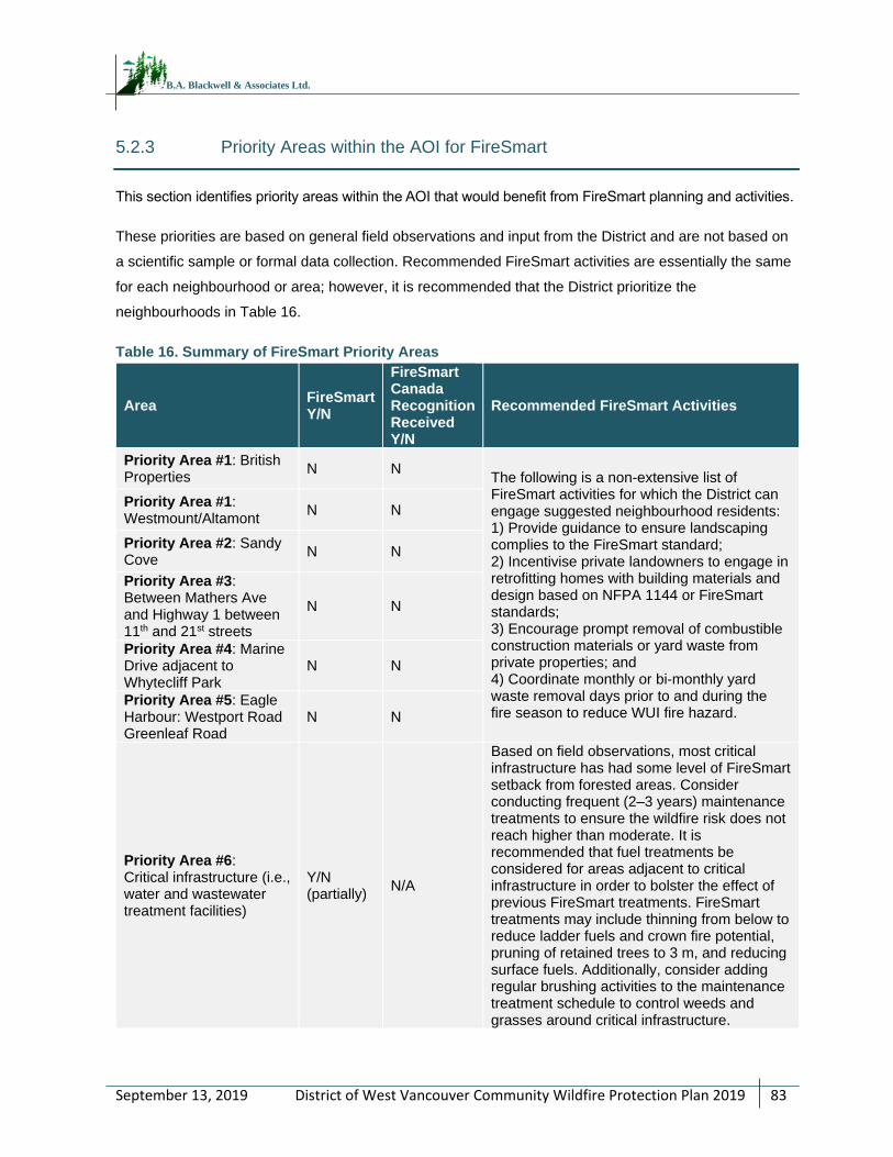
District of West Vancouver Community Wildfire Protection Plan 2019
83
September 13, 2019
B.A. Blackwell & Associates Ltd.
5.2.3 Priority Areas within the AOI for FireSmart
This section identifies priority areas within the AOI that would benefit from FireSmart planning and activities.
These priorities are based on general field observations and input from the District and are not based on
a scientific sample or formal data collection. Recommended FireSmart activities are essentially the same
for each neighbourhood or area; however, it is recommended that the District prioritize the
neighbourhoods in Table 16.
Table 16. Summary of FireSmart Priority Areas
Area FireSmart Y/N
FireSmart Canada Recognition Received Y/N
Recommended FireSmart Activities
Priority Area #1: British Properties
N N The following is a non-extensive list of FireSmart activities for which the District can engage suggested neighbourhood residents: 1) Provide guidance to ensure landscaping complies to the FireSmart standard; 2) Incentivise private landowners to engage in retrofitting homes with building materials and design based on NFPA 1144 or FireSmart standards; 3) Encourage prompt removal of combustible construction materials or yard waste from private properties; and 4) Coordinate monthly or bi-monthly yard waste removal days prior to and during the fire season to reduce WUI fire hazard.
Priority Area #1: Westmount/Altamont
N N
Priority Area #2: Sandy Cove
N N
Priority Area #3: Between Mathers Ave and Highway 1 between 11th and 21st streets
N N
Priority Area #4: Marine Drive adjacent to Whytecliff Park
N N
Priority Area #5: Eagle Harbour: Westport Road Greenleaf Road
N N
Priority Area #6: Critical infrastructure (i.e., water and wastewater treatment facilities)
Y/N (partially)
N/A
Based on field observations, most critical infrastructure has had some level of FireSmart setback from forested areas. Consider conducting frequent (2–3 years) maintenance treatments to ensure the wildfire risk does not reach higher than moderate. It is recommended that fuel treatments be considered for areas adjacent to critical infrastructure in order to bolster the effect of previous FireSmart treatments. FireSmart treatments may include thinning from below to reduce ladder fuels and crown fire potential, pruning of retained trees to 3 m, and reducing surface fuels. Additionally, consider adding regular brushing activities to the maintenance treatment schedule to control weeds and grasses around critical infrastructure.
District of West Vancouver Community Wildfire Protection Plan 2019
84
September 13, 2019
B.A. Blackwell & Associates Ltd.
5.3 COMMUNICATION AND EDUCATION
Establishing effective communications and actively engaging key stakeholders in risk reduction activities
are keystones to building a FireSmart community. Without the support and involvement of residents,
businesses, public officials, and industry, the efforts of public officials, fire department, and others to
reduce wildfire losses will be hindered. In many communities, there is a general lack of understanding
about interface fire, the relationship between ignition potential and loss of homes, and the simple steps
that can be taken to minimize risk on private land. In addition, public perceptions regarding responsibility
for risk reduction and the ability of firefighters to safely intervene to protect homes during a wildfire are
often underdeveloped or inaccurate.
Based on the consultation completed during the development of this Plan, it is evident that District staff
and many residents have a good level of awareness of interface fire risk and a strong level of
commitment to continue to grow their understanding. However, field observations highlighted the need to
further educate the community at large on what private land owners can do to build a FireSmart
community and take personal responsibility for the ignition potential of their homes, businesses, lands,
and neighbourhoods. Often, the risk of wildfire is at the forefront of public awareness during or after major
wildfire events, whether close to home or further afield. The challenge is to retain this level of awareness
beyond these times. The communication and education objectives for the District are:
To improve public understanding of fire risk and personal responsibility by increasing resident
and property owner awareness of the wildfire threat in their community, to establish a sense of
responsibility for risk mitigation among property owners, and to empower them to act.
To enhance the awareness of, and participation by, elected officials and all WUI stakeholders
regarding proactive WUI risk mitigation activities.
To reduce or avoid ignitions from industrial sources.
Bringing organizations together to address wildfire issues that overlap physical, jurisdictional or
organizational boundaries is a good way to help develop interagency structures and mechanisms to
reduce wildfire risk. Engagement of various stakeholders can help with identifying valuable information
about the landscape and help provide unique and local solutions to reducing wildfire risk. The District
should consider building upon the existing Interface Steering Committee to coordinate wildfire risk
reduction efforts. The steering committee could include key stakeholders such as District staff, District of
West Vancouver representatives, Squamish Nation, Tsleil-Waututh First Nation, WVFR, Metro
Vancouver, BCWS, BC Hydro, BC Parks, recreational groups/representatives, local environmental
groups, and industrial operators.
District of West Vancouver Community Wildfire Protection Plan 2019
85
September 13, 2019
B.A. Blackwell & Associates Ltd.
Moving from the CWPP to implementation of specific activities requires that the community is well
informed of the reasons for, and the benefits of specific mitigation activities. In order to have successful
implementation, the following communication and public education recommendations are made:
RECOMMENDATION #28: This report and associated maps should be made publicly available through
webpage, social media, and public FireSmart meetings.
RECOMMENDATION #29: Complete or schedule periodic updates of the CWPP to gauge progress and
update the threat assessment (hazard mapping) for changes in fuels, forest health, land planning, stand
structure or changes to infrastructure in the interface. The frequency of updates is highly dependent upon
major changes which would impact the District’s wildfire threat assessment or the rate at which wildfire risk
reduction efforts are implemented. An evaluation of major changes (including funding program changes
that may lead to new opportunities) and the potential need for a CWPP update should be initiated every
five to seven years.
RECOMMENDATION #30: Develop a social media strategy and ensure that its full power is leveraged to
communicate fire bans, high or extreme Fire Danger days, wildfire prevention initiatives and programs,
easily implementable FireSmart activities, updates on current fires and associated air quality, road
closures, and other real-time information in an accurate and timely manner.74
RECOMMENDATION #31: Promote FireSmart approaches for wildfire risk reduction and the DPA process
to District residents through various engagement and education events. Aim to conduct the
engagement/promotion campaign prior and during the fire season. Continue supplying FireSmart materials
to homeowners in the interface during these engagement campaigns.
RECOMMENDATION #32: Develop a FireSmart webpage for the District of West Vancouver website.
This could include the current Fire Danger Rating, DPA guidelines and application procedures, contact
information for the BCWS fire information line and reporting wildfires line, information about FireSmart
workshops or other events, a link to the FireSmart Manual, and information about purchasing sprinkler
protection systems.
RECOMMENDATION #33: Work towards FireSmart community recognition, at the neighbourhood level
and facilitate uptake into the FireSmart Canada Community Recognition Program (FSCCRP). This will
help reduce fire risk and aid in further funding applications.
74 Appendix K has general communication and social media information.
District of West Vancouver Community Wildfire Protection Plan 2019
86
September 13, 2019
B.A. Blackwell & Associates Ltd.
RECOMMENDATION #34: Facilitate the FSCCRP uptake within the District and enhance its applications
by including the following: 1) inviting BCWS crews to participate in and support the annual FireSmart
events set up by participating neighbourhoods, 2) encourage individual homeowner participants to
complete the self-administered FireSmart home assessment tool, 3) include within the FireSmart Canada
Community Assessment Report the standard recommendation that participating neighbourhoods hold a
home hazard assessment workshop as one of their FireSmart events.
RECOMMENDATION #35: Promote the use of the FireSmart Home Partners Program offered by the
Partners in Protection Association, which facilitates voluntary FireSmart assessments on private property.
Use the opportunity to educate the home or business owner about the hazards which exist on their
property and provide easy improvements to reduce their risk. Ensure DPA guidelines are communicated
during these assessments.
RECOMMENDATION #36: Encourage schools to adopt and deploy existing school education programs to
engage youth in wildfire management and risk reduction. There is emergency preparedness curriculum
available provincially, which includes preparedness for a variety of natural hazards, including wildfire
(Master of Disaster). Other options/value-added activities include consulting with Association of BC Forest
Professionals (ABCFP) and British Columbia Wildfire Service (BCWS) (Fraser Fire Zone), as well as local
fire department and FireSmart representatives to facilitate and recruit volunteer teachers and experts to
help with curriculum development to be delivered in elementary and/or secondary schools (field trips,
guest speakers, etc.).
RECOMMENDATION #37: Develop and work with all key stakeholders (BCWS, BC Parks, recreational
groups/representatives, District staff, industrial operators, Metro Vancouver staff, and local First Nations)
to review current Interface Steering Committee processes and members. The purpose of the steering
committee is to identify wildfire related issues in the area and to develop collaborative solutions to
minimize wildfire risks. The following subject areas are recommended for the group to explore: 1)
development of large, landscape level fuel breaks, 2) public education and awareness needs, 3) multi-
disciplinary, multi-jurisdictional fuel treatment projects/hazard abatement projects, 4) development of a
funding strategy, and 5) reduction of human-caused fires, fire prevention and right-of-way management.
RECOMMENDATION #38: Work towards educating homeowners within fire limits areas (i.e., outside of
the road accessible fire service area). This is particularly applicable to the Hollyburn cabins and boat
access only areas. It is common, especially in the case of second homeowners/vacation owners, for them
to be unaware of the lack of fire services in their area (in the event they call 911).
District of West Vancouver Community Wildfire Protection Plan 2019
87
September 13, 2019
B.A. Blackwell & Associates Ltd.
5.4 OTHER PREVENTION MEASURES
In addition to fuel treatment and community communication and education, fire prevention in the AOI is
also addressed via the following avenues: 1) public display of danger class rating signs throughout the
District, 2) fire ban alignment with provincial fire bans, 3) ability to restrict access to back country areas
similar to provincial requirements, if necessary, and 4) enforcement of local bylaws such as the Fire
Protection And Emergency Response, Parks Regulation, North Shore Emergency Management Office
Agreement, Emergency Plan, and North Shore Disaster bylaws. The aforementioned activities are either
currently being applied or have potential to be applied in order to reduce the potential and threat of
wildfire ignitions within the AOI.
Risk of human-caused ignition within the AOI is not limited to private property owners and individual
residents. Power lines and industrial activities pose a risk of ignition, particularly in areas where cured fuels
or fuel accumulations exist. Tree failures adjacent to power lines (transmission and distribution) are
common occurrences and represent significant risks to ignition within the AOI. A cooperative approach for
addressing the industrial area concerns must be undertaken by the District and pertinent industrial partners.
RECOMMENDATION #39: Work with industrial operators such as BC Hydro and Fortis BC to ensure that
high risk activities, such as grubbing/brushing and right-of-way mowing work do not occur during high fire
danger times to reduce chance of ignitions as per the Wildfire Act. Ensure that rights-of-way do not contain
fine fuel accumulations (easily cured) prior to and during the wildfire season and are maintained in a low
hazard state in order to serve as fuel breaks.
SECTION 6: WILDFIRE RESPONSE RESOURCES
This section provides a high-level overview of the local government resources accessible for
emergency response and preparedness use. Accordingly, in emergency situations when
multiple fires are burning in different areas of the Province, resource availability may be scarce.
Therefore, local government preparedness and resource availability are critical components of
efficient wildfire prevention and planning. Deployment of provincial resources occurs as per the
process detailed in the Provincial Coordination Plan for Wildland Urban Interface Fires
document.75 The aforementioned document establishes a protocol for collaborative and
integrated emergency management in the event of WUI fires within British Columbia.
75 Provincial Coordination Plan for Wildland Urban Interface Fires. 2016. Available online at: www2.gov.bc.ca/assets/gov/public-safety-and-emergency-services/emergency-preparedness-response-recovery/provincial-emergency-planning/bc-provincial-coord-plan-for-wuifire_revised_july_2016.pdf
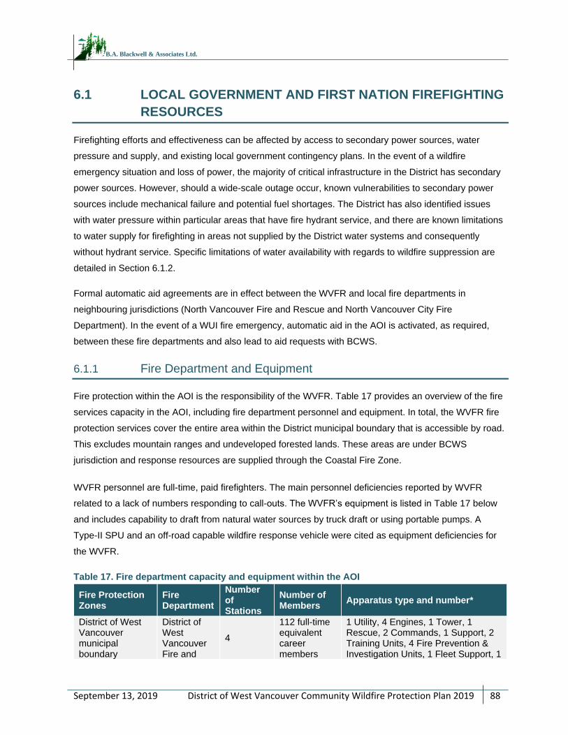
District of West Vancouver Community Wildfire Protection Plan 2019
88
September 13, 2019
B.A. Blackwell & Associates Ltd.
6.1 LOCAL GOVERNMENT AND FIRST NATION FIREFIGHTING
RESOURCES
Firefighting efforts and effectiveness can be affected by access to secondary power sources, water
pressure and supply, and existing local government contingency plans. In the event of a wildfire
emergency situation and loss of power, the majority of critical infrastructure in the District has secondary
power sources. However, should a wide-scale outage occur, known vulnerabilities to secondary power
sources include mechanical failure and potential fuel shortages. The District has also identified issues
with water pressure within particular areas that have fire hydrant service, and there are known limitations
to water supply for firefighting in areas not supplied by the District water systems and consequently
without hydrant service. Specific limitations of water availability with regards to wildfire suppression are
detailed in Section 6.1.2.
Formal automatic aid agreements are in effect between the WVFR and local fire departments in
neighbouring jurisdictions (North Vancouver Fire and Rescue and North Vancouver City Fire
Department). In the event of a WUI fire emergency, automatic aid in the AOI is activated, as required,
between these fire departments and also lead to aid requests with BCWS.
6.1.1 Fire Department and Equipment
Fire protection within the AOI is the responsibility of the WVFR. Table 17 provides an overview of the fire
services capacity in the AOI, including fire department personnel and equipment. In total, the WVFR fire
protection services cover the entire area within the District municipal boundary that is accessible by road.
This excludes mountain ranges and undeveloped forested lands. These areas are under BCWS
jurisdiction and response resources are supplied through the Coastal Fire Zone.
WVFR personnel are full-time, paid firefighters. The main personnel deficiencies reported by WVFR
related to a lack of numbers responding to call-outs. The WVFR’s equipment is listed in Table 17 below
and includes capability to draft from natural water sources by truck draft or using portable pumps. A
Type-II SPU and an off-road capable wildfire response vehicle were cited as equipment deficiencies for
the WVFR.
Table 17. Fire department capacity and equipment within the AOI
Fire Protection Zones
Fire Department
Number of Stations
Number of Members
Apparatus type and number*
District of West Vancouver municipal boundary
District of West Vancouver Fire and
4
112 full-time equivalent career members
1 Utility, 4 Engines, 1 Tower, 1 Rescue, 2 Commands, 1 Support, 2 Training Units, 4 Fire Prevention & Investigation Units, 1 Fleet Support, 1
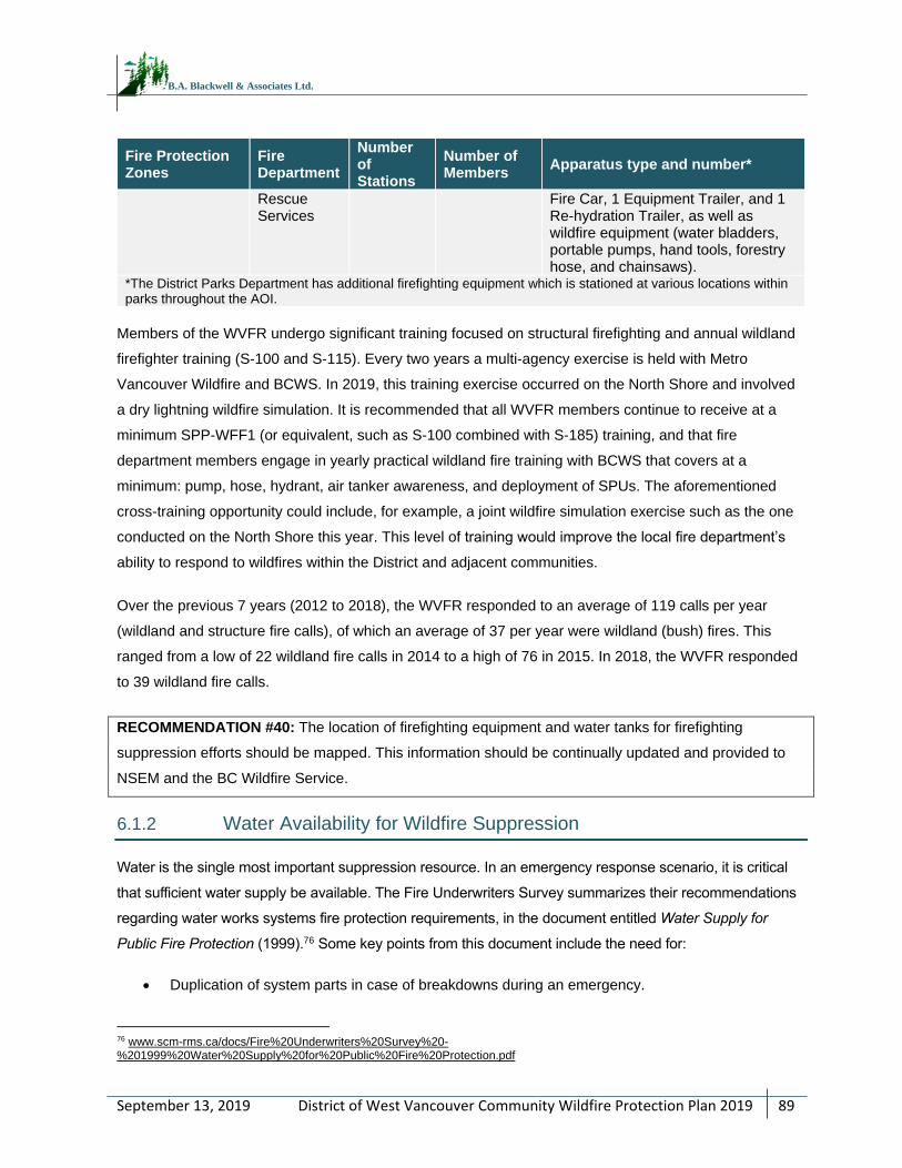
District of West Vancouver Community Wildfire Protection Plan 2019
89
September 13, 2019
B.A. Blackwell & Associates Ltd.
Fire Protection Zones
Fire Department
Number of Stations
Number of Members
Apparatus type and number*
Rescue Services
Fire Car, 1 Equipment Trailer, and 1 Re-hydration Trailer, as well as wildfire equipment (water bladders, portable pumps, hand tools, forestry hose, and chainsaws).
*The District Parks Department has additional firefighting equipment which is stationed at various locations within parks throughout the AOI.
Members of the WVFR undergo significant training focused on structural firefighting and annual wildland
firefighter training (S-100 and S-115). Every two years a multi-agency exercise is held with Metro
Vancouver Wildfire and BCWS. In 2019, this training exercise occurred on the North Shore and involved
a dry lightning wildfire simulation. It is recommended that all WVFR members continue to receive at a
minimum SPP-WFF1 (or equivalent, such as S-100 combined with S-185) training, and that fire
department members engage in yearly practical wildland fire training with BCWS that covers at a
minimum: pump, hose, hydrant, air tanker awareness, and deployment of SPUs. The aforementioned
cross-training opportunity could include, for example, a joint wildfire simulation exercise such as the one
conducted on the North Shore this year. This level of training would improve the local fire department’s
ability to respond to wildfires within the District and adjacent communities.
Over the previous 7 years (2012 to 2018), the WVFR responded to an average of 119 calls per year
(wildland and structure fire calls), of which an average of 37 per year were wildland (bush) fires. This
ranged from a low of 22 wildland fire calls in 2014 to a high of 76 in 2015. In 2018, the WVFR responded
to 39 wildland fire calls.
RECOMMENDATION #40: The location of firefighting equipment and water tanks for firefighting
suppression efforts should be mapped. This information should be continually updated and provided to
NSEM and the BC Wildfire Service.
6.1.2 Water Availability for Wildfire Suppression
Water is the single most important suppression resource. In an emergency response scenario, it is critical
that sufficient water supply be available. The Fire Underwriters Survey summarizes their recommendations
regarding water works systems fire protection requirements, in the document entitled Water Supply for
Public Fire Protection (1999).76 Some key points from this document include the need for:
Duplication of system parts in case of breakdowns during an emergency.
76 www.scm-rms.ca/docs/Fire%20Underwriters%20Survey%20-%201999%20Water%20Supply%20for%20Public%20Fire%20Protection.pdf
District of West Vancouver Community Wildfire Protection Plan 2019
90
September 13, 2019
B.A. Blackwell & Associates Ltd.
Adequate water storage facilities.
Distributed hydrants, including hydrants at the ends of dead‐end streets.
Piping that is correctly installed and in good condition.
Water works planning should always take worst‐case‐scenarios into consideration. The water
system should be able to serve more than one major fire simultaneously, especially in larger
urban centers.
Water service within the District of West Vancouver is an important component of emergency response
for a wildland urban interface fire in the event of a large-scale emergency, and in particular for structural
fires. As previously noted in Sections 3.2.3 and 3.3.1, water service is provided by a District operated
system which relies on surface water from West Vancouver’s Eagle Lake reservoir and Montizambert
Creek, as well as Metro Vancouver reservoirs (Seymour and Capilano). For suppression within the AOI,
hydrant (and draft well) service in the AOI is limited to the extent of the District water system. In
consultation with the WVFR, it was noted that hydrants are available throughout the majority of the
District, and water supply and pressure are generally good. However, there are portions of the District
without hydrant protection or with poor supply or pressure.
Water supply for North Shore communities has been susceptible to drought events in past years,
sometimes resulting in a reduction of reservoir levels to 60% capacity.77 As noted in Section 4.1.3, the
combination of reduced snowpack and drought events could have a considerable effect on water supply
into the future, particularly during the summer months.78 To supplement water availability for firefighting,
the WVFR can draft from natural static water sources such lakes, rivers, and ponds using either truck
mounted or portable pumps. However, these sources are also at risk of drying or experiencing reduced
water levels during drought events, which typically coincide with high and extreme fire danger rating
days. These natural water sources are known and mapped.
The WWG stated that in the event of prolonged power outage, the capacity of the District water system
and reservoirs to operate under these conditions is limited. Utility department staff estimated that supply
would last less than 5 days, but would depend on conservation efforts and water restrictions. Backup
power is available for all pump stations via portable generators.
RECOMMENDATION #41: Commission a scenario-based cost/benefit analysis of improving the
limitations of the water system so that it can support domestic water needs, structural firefighting, and
wildland firefighting demands in the event of an emergency both currently and into the future.
77 District of North Vancouver. 2017. Climate Change Adaptation Strategy: Acting Now for a Resilient Future. 78 Metro Vancouver. 2018. Climate 2050 Discussion Paper.
District of West Vancouver Community Wildfire Protection Plan 2019
91
September 13, 2019
B.A. Blackwell & Associates Ltd.
RECOMMENDATION #42: All new development outside existing District water systems should have a
water system which meets or exceeds minimum standards of NFPA 1142, Standard on Water Supplies for
Suburban and Rural Fire Fighting79. The fire department should review the water supply to ensure it
provides sufficient placement, flow, and reliability for suppression needs and that secondary power is
available in the event of power outages.
6.1.3 Access and Evacuation
Road networks in a community serve several purposes including providing access for emergency
vehicles, providing escape/evacuation routes for residents, and creating fuel breaks. Access and
evacuation during a wildfire emergency often must happen simultaneously and road networks should
have the capacity to handle both. In the event of a wildfire emergency, main egress routes include
Highway 1 (Upper Levels), Highway 99 (Sea to Sky), as well as arterial roads such as Marine Drive,
Cypress Bowl, 21st Street, 15th Street, and Taylor Way, which provide access to and from developments
located in interface areas within the District. Significant emergency evacuation concerns have been
identified for Sunset Beach, Cypress Provincial Park, and the cabins on Hollyburn Mountain. There is
currently no reliable secondary exit or bypass from these areas to provide egress for large numbers of
residents and visitors. Cypress Bowl Road and the alternate access/egress route for the park, a gated
District Service road, are vulnerable to wildfires, vehicular accidents, and rockfall/geotechnical hazards. If
a wildfire were to impact these roads or any of the major evacuation routes described above, smoke and
poor visibility, car accidents, wildlife, and other unforeseen circumstances can further complicate
evacuations and hinder safe passage. Other issues related to access and evacuation include long
distance responses to some more remote areas of the AOI.
Within the AOI, some of the critical infrastructure is reached via narrow and/or private, forested roads,
which may impede suppression efforts and response times. Furthermore, there is a significant portion of
land within the AOI which is inaccessible by roads. As such, a review of the fire protection area,
accessibility issues, and the risks and benefits associated with the current fire protection jurisdiction is
suggested.
Emergency access and evacuation planning is of particular importance in the event of a wildfire event or
other large-scale emergency. The District of West Vancouver has developed an evacuation map. In
consultation with the Wildfire Working Group, it was determined that the North Shore will be updating its
evacuation plan next year (personal communication, John Chapman). Evacuation would be conducted by
first responders, the West Vancouver Police Department, NSEM, and the North Shore Rescue team. In
79 National Fire Protection Association (NFPA). 2017. Standard on Water Supplies for Suburban and Rural Fire Fighting. Retrieved online on October 1, 2018 at: www.nfpa.org/codes-and-standards/all-codes-and-standards/list-of-codes-and-standards/detail?code=1142
District of West Vancouver Community Wildfire Protection Plan 2019
92
September 13, 2019
B.A. Blackwell & Associates Ltd.
the event of a wildfire emergency within the AOI, the Gerry Brewer Building (North Vancouver RCMP
detachment and North Shore Emergency Management office), at 147 E 14th Street in the City of North
Vancouver, can be designated as the EOC for the three North Shore municipalities. It is recommended
that the NSEM evacuation plan includes the following provisions:
Mapping and identification of safe zones, marshaling points and aerial evacuation locations.
Planning of traffic control and accident management.
Identification of volunteers that can assist during and/or after evacuation.
Development of an education/communication strategy to deliver emergency evacuation
procedures to residents.
Recreation trails built to support ATVs can provide access for ground crews and act as fuel breaks for
ground fires, particularly in natural areas. Strategic recreational trail development to a standard that
supports ATVs, and further to install gates or other barriers to minimize access by unauthorized users
can be used as a tool that increases the ability of local fire departments to access interface areas.
The creation of a map book or spatial file that displays the trail network available for fire departments to
access during an emergency or for fire suppression planning must accompany any fire access trail
building activities. In order to effectively use the trails as crew access or fuel breaks during suppression
efforts, it is recommended that a Total Access Plan be developed. This plan should be made available to
the WVFR, other local fire departments (under mutual aid agreement), and the BCWS in the event that
they are aiding suppression efforts on an interface fire in the AOI. The plan should include georeferenced
maps with associated spatial data and ground-truthed locations of potential optimal firebreaks, identify
the type of access available for each access route, identify those trails that are gated or have barriers,
and provide information on how to unlock or remove barriers. The plan should also identify those natural
areas where access is insufficient. Access assessment should consider land ownership, proximity of
values at risk, wildfire threat, opportunities for use as fuel break or control lines, trail and road network
linkages where fuel-free areas or burn off locations can be created or used as potential sprinkler
locations; and requirements for future maintenance activities such as operational access for fuel
treatments and other hazard reduction activities.
In addition to providing the safest, quickest, and easiest access routes for emergency crews, a Total
Access Plan would minimize the need for using machinery or motorized access in an otherwise
undisturbed area. This would reduce the risk of soil disturbance and other environmental damage, as well
as reduce rehabilitation costs.
RECOMMENDATION #43: Complete and participate in regular testing of, and updates to, the North Shore
evacuation plan once completed in 2020.
District of West Vancouver Community Wildfire Protection Plan 2019
93
September 13, 2019
B.A. Blackwell & Associates Ltd.
RECOMMENDATION #44: Consider developing a community wildfire pre-planning brochure that
addresses the following: 1) locations of staging areas, 2) identifies water reservoirs, communications
requirements (i.e., radio frequencies), minimum resource requirements for structure protection in the event
of an interface fire, and values at risk, and 3) maps of the area of interest.
RECOMMENDATION #45: Develop a Total Access Plan for the District to map and inventory trail and
road network in natural areas for suppression planning, identify areas with insufficient access and to aid in
strategic planning. This plan may also be used to inform future access improvements within the District.
The plan should include identification of access infrastructure (i.e. roads and bridges), location, widths,
and weight limits. It should also include the location of all structures within the District, including the cabins
on Hollyburn Mountain. This would help to facilitate appropriate suppression equipment allocation during a
wildfire event. Georeferenced maps with ground-truthed locations of potential optimal firebreaks should
also be developed as part of the Total Access Plan and shared with fire suppression personnel and BCWS
to support emergency response in the event of a wildfire. The plan should be updated every five years, or
more regularly, as needed to incorporate additions and/or changes.
RECOMMENDATION #46: Include a Qualified Professional (QP) with experience in operational
wildland/interface fire suppression in the planning and strategic siting of future trails and parks.
6.1.4 Training
The WVFR maintains a current level of structural protection training as described in Section 6.1.1. It is
recommended that the WVFR consider providing members with SPP-WFF1 (or equivalent), to ensure
currency with techniques, applications and procedures for wildland urban interface fire suppression.
Provision of training opportunities for structural firefighters in the realm of wildland firefighting is critical to
building capacity for suppression and emergency management at the local level. Until these course
developments are complete, it is recommended that the fire department engage in yearly practical
wildland fire training with BCWS.
The current level of communication between the WVFR and BCWS is dictated by fire season demands
and includes the pre-season dry lightning exercise. Cross-training with the BCWS would enable the
WVFR to prepare its responders with the technical and practical firefighting experience in order to action
both structural and wildland fires.
It is recommended that the WVFR work cooperatively with the BCWS (Fraser Fire Zone, Cultus/Haig Fire
Base) to conduct yearly mock exercises, where information and technical/practical knowledge are
District of West Vancouver Community Wildfire Protection Plan 2019
94
September 13, 2019
B.A. Blackwell & Associates Ltd.
shared, such as: fireline construction, Mark 3 pump operations, sprinkler protection, skid pack operations,
portable water tank deployment, and wildland hose operations. These practices could also provide
training to wildland crews on hydrant hookup methods, as well as provide an avenue to discuss working
together on inter-agency fires. Additional training options could include engaging adjacent Fire
Departments outside the AOI (i.e., District of North Vancouver Fire and Rescue, Lions Bay Fire Rescue,
and North Vancouver City FD) to conduct joint training so as to further strengthen regional emergency
response and firefighting training. Operationally, the WVFR provided initial attack on a 2018 wildfire near
Whyte Lake which resulted in a valuable debrief and shared learning.
RECOMMENDATION #47: The WVFR should work with BCWS to initiate and maintain an annual
structural and interface training program. As part of the training, it is recommended that annual reviews
are conducted to ensure PPE and wildland equipment resources are complete, in working order, and the
crews are well-versed in their set-up and use. It is recommended the WVFR engage in yearly practical
wildland fire training with BCWS that covers at a minimum: pump, hose, hydrant, air tanker awareness,
and deployment of SPUs. Interface training should include completion of a joint wildfire simulation exercise
and safety training specific to wildland fire and risks inherent with natural areas. It is recognized that
BCWS crew resources are limited and their availability and is highly dependent upon the current fire
season and other BCWS priorities.
RECOMMENDATION #48: The WVFR should engage in regular cadence of communication with the
BCWS Fraser Fire Zone, Cultus/Haig Fire Base to foster a strong relationship and identify potential
cooperative wildfire risk reduction opportunities.
RECOMMENDATION #49: Ensure that the WVFR maintains the capability to effectively suppress wildland
fires, through wildfire-specific training sessions. Ensure all WVFR members continue to have SPP-WFF 1
at a minimum. Consider expanding the training program to maintain a high level of member education and
training specific to interface and wildland fires. The Office of the Fire Commissioner (OFC) also offers SPP
115 (formerly S-115) to train structural firefighters on the use of wildfire pumps and hose, and fire service
hose and hydrants in the application of structural protection units (SPUs). The fire department should
continue the practice of staying up to date on wildfire training opportunities, and to train members in this
capacity, as training resources/budgets allow.
District of West Vancouver Community Wildfire Protection Plan 2019
95
September 13, 2019
B.A. Blackwell & Associates Ltd.
RECOMMENDATION #50: Train District parks and utilities staff in S-100, particularly those who undertake
a considerable amount of work in the wildland urban interface and in forested areas within the District. The
nature of their jobs may allow these District staff members to have an opportunity to provide immediate
initial response and suppression before the WVFR or BCWS are able to respond.
6.2 STRUCTURE PROTECTION
The WVFR is well-resourced in both structural and wildland suppression equipment and the fire
department maintains a current level of training in both wildfire and structural firefighting (see Section
6.1.1 for additional detail). However, the WVFR is not equipped with a Structural Protection Unit (SPU).
The UBCM owns four complete SPUs, each equipped to protect 30 to 35 structures. The kits are
deployed by the MFLNRORD/BCWS incident command structure and are placed strategically across the
province during the fire season based on fire weather conditions and fire potential. When the kits are not
in use, they may be utilized by fire departments for training exercises. SPUs can be useful tools in the
protection of rural/ interface homes in the event of a wildfire. An important consideration in protecting the
WUI zone from fire is ensuring that homes can withstand an interface fire event. Structure protection is
focused on ensuring that building materials and construction standards are appropriate to protect
individual homes from interface fire. Materials and construction standards used in roofing, exterior siding,
window and door glazing, eaves, vents, openings, balconies, decks, and porches are primary
considerations in developing FireSmart neighbourhoods. Housing built using appropriate construction
techniques and materials in combination with fire resistant landscaping are less likely to be impacted by
interface fires.
While many BC communities established to date were built without significant consideration of interface
fire, there are still ways to reduce home vulnerability. Changes to roofing materials, siding, and decking
can be achieved over the long-term through voluntary upgrades, as well as changes in bylaws and
building codes. The FireSmart approach has been adopted by a wide range of governments and is a
recognized process for reducing and managing fire risk in the wildland urban interface. More details on
FireSmart construction can be found in Appendix J.
It is recommended that homeowners take a building envelope-out approach, that is, starting with the
home and working their way out. Addressing little projects first can allow for quick, easy, and cost-
effective risk reduction efforts to be completed sooner, while larger, more costly projects can be
completed as resources and planning allow. For example, prior to the fire season, clearing roofs and
gutters of combustible materials (leaves and needles), clean out any combustible accumulations or
stored materials from under decks, moving large potential heat sources such as firewood, spare building
materials or vehicles as far from the structure as possible, maintaining a mowed and watered lawn,
District of West Vancouver Community Wildfire Protection Plan 2019
96
September 13, 2019
B.A. Blackwell & Associates Ltd.
removing dead vegetation, and pruning trees are actionable steps that residents can start working on
immediately. The following link accesses an excellent four-minute video demonstrating the importance of
FireSmart building practices during a simulated ember shower:
www.youtube.com/watch?v=_Vh4cQdH26g.
The structure protection objectives for the District of West Vancouver are to:
Encourage private homeowners to voluntarily adopt FireSmart principles on their properties and
to reduce existing barriers to action.
Enhance protection of critical infrastructure from wildfire (and post-wildfire impacts).
Enhance protection of residential/commercial structures from wildfire.
RECOMMENDATION #51: Work with the other North Shore communities (City of North Vancouver,
District of North Vancouver), NSEM, local distributors, and homeowners within the District with the
objective of improving education of homeowners and removing some barriers to FireSmart action. Local
distributors can include: hardware stores, garden centers, and aggregate providers. Initiatives may
include:
1) Developing and delivery of FireSmart workshop(s) for local distributors on FireSmart issues and
solutions/advice for homeowners. These distributors can be educated upon which supplies are FireSmart
and in what configuration they can be used (for example, external sprinkler system equipment, aggregates
and ground cover, wire mesh for vents, deck skirting).
2) Advocating for a FireSmart branding in the retail stores (could be stickers on shelf pricing or a
FireSmart-specific section) to increase public exposure to projects that can be done at a relatively low
cost.
3) Compile a database of local service providers and retailers which can help to install or complete
FireSmart home improvements. These providers may be able to further partner to flesh out a list of
FireSmart options for various home improvements, based upon a range of variables (for example, price,
time to deliver, installation costs, and aesthetics).
4) Develop general cost implications of improvements so property owners can prioritize replacements.
RECOMMENDATION #52: Expand on existing programs which serve to remove barriers to action for
homeowners by providing methods for them to cheaply and easily dispose of wood waste removed from
their property. This could include scheduled community chipping opportunities, and/or yard waste
dumpsters available by month in neighbourhood. Programs should be available during times of greatest
resident activity (likely spring and fall).
District of West Vancouver Community Wildfire Protection Plan 2019
97
September 13, 2019
B.A. Blackwell & Associates Ltd.
RECOMMENDATION #53: Complete a vulnerability assessment of all critical infrastructure, secondary
power sources, and fuel availability. Review current capability of secondary power sources, identify
vulnerabilities, and prioritize needs, in the case of prolonged or extensive power outages. Upgrade or
realign resources, as prioritized.
RECOMMENDATION #54: Acquire a Type II Structural Protection Unit (SPU), which provides protection
for 25 to 30 residences, and an off-road capable wildfire response vehicle to improve wildfire response.
District of West Vancouver Community Wildfire Protection Plan 2019
98
September 13, 2019
B.A. Blackwell & Associates Ltd.
REFERENCES
BCWS. 2018. Wildfire Causes. Retrieved from: www2.gov.bc.ca/gov/content/safety/wildfire-status/about-
bcws/wildfire-response/fire-characteristics/causes
Dale, V., L. Joyce. S. McNulty, R. Neilson, M. Ayres, M. Flannigan, P. Hanson, L. Irland, A. Lugo. C.
Peterson, D. Simberloff, F. Swanson, B. Stocks, B. Wotton. 2001. Climate Change and Forest
Disturbances. BioScience 2001 51 (9), 723-734.
Flannigan, M.D., B.M. Wotton, G.A. Marshall, W.J. deGroot, J. Johnston, N. Jurko, A.S. Cantin. 2016.
Fuel moisture sensitivity to temperature and precipitation: climate change implications. Climatic
Change (2016) 134: 59 -71. Retrieved from: link.springer.com/content/pdf/10.1007%2Fs10584-
015-1521-0.pdf.
Flannigan M.D., M.A. Krawchuk, W. J. de Groot, B.M. Wotton, L.M. Gowman, 2009. Implications of
changing climate for global wildland fire. International Journal of Wildland Fire 18, 483-507.
Government of Canada. Wildfire Season Summary. Retrieved from:
www2.gov.bc.ca/gov/content/safety/wildfire-status/about-bcws/wildfire-history/wildfire-season-
summary
Green, R. N., and K. Klinka. 1994. A Field Guide for Site Identification and Interpretation for the
Vancouver Forest Region. Land Management Handbook Number 28. Retrieved from:
www.for.gov.bc.ca/hfd/pubs/docs/lmh/lmh28.pdf
Ministry of Forests, Lands, and Natural Resource Operations. 2016. BC Provincial Government extension
note ‘Adapting natural resource management to climate change in the West and South Coast
Regions’. Accessed online at: www2.gov.bc.ca/assets/gov/environment/natural-resource-
stewardship/nrs-climate-change/regional-extension-notes/coasten160222.pdf
Perrakis, D. and G. Eade. 2015. BC Wildfire Service. Ministry of Forests, Lands, and Natural Resource
Operations. British Columbia Wildfire Fuel Typing and Fuel Type Layer Description 2015 Version.
The Province of British Columbia. 1995. Biodiversity Guidebook. Retrieved from:
www.for.gov.bc.ca/hfd/library/documents/bib19715.pdf
Metro Vancouver. 2018. Climate 2050 Discussion Paper. Retrieved from:
www.metrovancouver.org/services/air-quality/AirQualityPublications/AQ_C2050-
DiscussionPaper.pdf
Ministry of Forests, Lands and Natural Resource Operations. 2015. Coast Area 2015-17 Coastal Timber
Supply Area Forest Health Overview. Retrieved from:
www.for.gov.bc.ca/ftp/HFP/external/!publish/Forest_Health/TSA_FH_Strategies/2015-
Coast%20FH%20Strategy.pdf
District of West Vancouver Community Wildfire Protection Plan 2019
99
September 13, 2019
B.A. Blackwell & Associates Ltd.
APPENDIX A – WILDFIRE THREAT ASSESSMENT – FBP
FUEL TYPE CHANGE RATIONALE
Provided separately as PDF package.
District of West Vancouver Community Wildfire Protection Plan 2019
100
September 13, 2019
B.A. Blackwell & Associates Ltd.
APPENDIX B – WILDFIRE THREAT ASSESSMENT
WORKSHEETS AND PHOTOS
Provided separately as PDF package.
District of West Vancouver Community Wildfire Protection Plan 2019
101
September 13, 2019
B.A. Blackwell & Associates Ltd.
APPENDIX C – MAPS
Provided separately as PDF package.
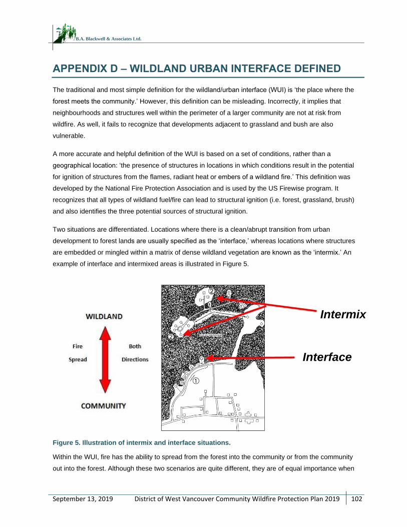
District of West Vancouver Community Wildfire Protection Plan 2019
102
September 13, 2019
B.A. Blackwell & Associates Ltd.
APPENDIX D – WILDLAND URBAN INTERFACE DEFINED
The traditional and most simple definition for the wildland/urban interface (WUI) is ‘the place where the
forest meets the community.’ However, this definition can be misleading. Incorrectly, it implies that
neighbourhoods and structures well within the perimeter of a larger community are not at risk from
wildfire. As well, it fails to recognize that developments adjacent to grassland and bush are also
vulnerable.
A more accurate and helpful definition of the WUI is based on a set of conditions, rather than a
geographical location: ‘the presence of structures in locations in which conditions result in the potential
for ignition of structures from the flames, radiant heat or embers of a wildland fire.’ This definition was
developed by the National Fire Protection Association and is used by the US Firewise program. It
recognizes that all types of wildland fuel/fire can lead to structural ignition (i.e. forest, grassland, brush)
and also identifies the three potential sources of structural ignition.
Two situations are differentiated. Locations where there is a clean/abrupt transition from urban
development to forest lands are usually specified as the ‘interface,’ whereas locations where structures
are embedded or mingled within a matrix of dense wildland vegetation are known as the ‘intermix.’ An
example of interface and intermixed areas is illustrated in Figure 5.
Figure 5. Illustration of intermix and interface situations.
Within the WUI, fire has the ability to spread from the forest into the community or from the community
out into the forest. Although these two scenarios are quite different, they are of equal importance when
Interface
Intermix
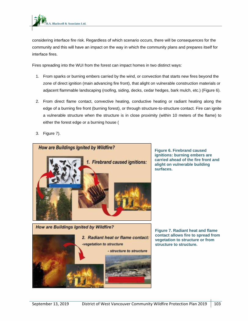
District of West Vancouver Community Wildfire Protection Plan 2019
103
September 13, 2019
B.A. Blackwell & Associates Ltd.
considering interface fire risk. Regardless of which scenario occurs, there will be consequences for the
community and this will have an impact on the way in which the community plans and prepares itself for
interface fires.
Fires spreading into the WUI from the forest can impact homes in two distinct ways:
1. From sparks or burning embers carried by the wind, or convection that starts new fires beyond the
zone of direct ignition (main advancing fire front), that alight on vulnerable construction materials or
adjacent flammable landscaping (roofing, siding, decks, cedar hedges, bark mulch, etc.) (Figure 6).
2. From direct flame contact, convective heating, conductive heating or radiant heating along the
edge of a burning fire front (burning forest), or through structure-to-structure contact. Fire can ignite
a vulnerable structure when the structure is in close proximity (within 10 meters of the flame) to
either the forest edge or a burning house (
3. Figure 7).
Figure 6. Firebrand caused ignitions: burning embers are carried ahead of the fire front and alight on vulnerable building surfaces.
Figure 7. Radiant heat and flame contact allows fire to spread from vegetation to structure or from structure to structure.
District of West Vancouver Community Wildfire Protection Plan 2019
104
September 13, 2019
B.A. Blackwell & Associates Ltd.
Current research confirms that the majority of homes ignited during major WUI events trace back to
embers as their cause (50% to 80+ %). Firebrands can be transported long distances ahead of the
wildfire, across any practicable fire guards, and accumulate on horizontal surfaces within the home
ignition zone in densities that can reach 600+ /m2. Combustible materials found within the home ignition
zone combine to provide fire pathways allowing spot fires ignited by embers to spread and carry flames
or smoldering fire into contact with structures.
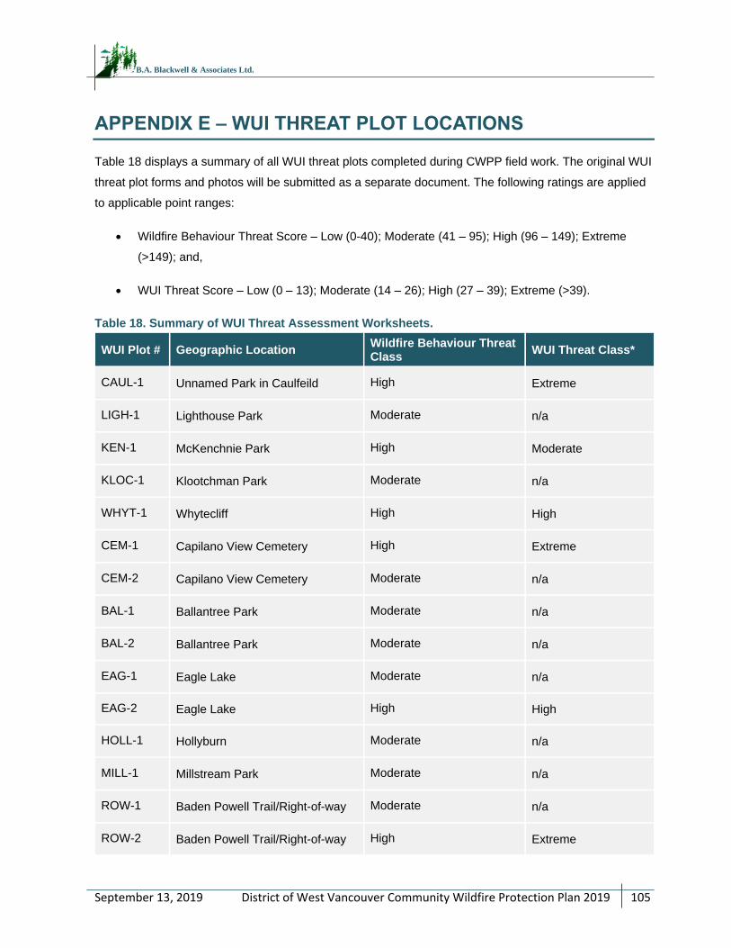
District of West Vancouver Community Wildfire Protection Plan 2019
105
September 13, 2019
B.A. Blackwell & Associates Ltd.
APPENDIX E – WUI THREAT PLOT LOCATIONS
Table 18 displays a summary of all WUI threat plots completed during CWPP field work. The original WUI
threat plot forms and photos will be submitted as a separate document. The following ratings are applied
to applicable point ranges:
Wildfire Behaviour Threat Score – Low (0-40); Moderate (41 – 95); High (96 – 149); Extreme
(>149); and,
WUI Threat Score – Low (0 – 13); Moderate (14 – 26); High (27 – 39); Extreme (>39).
Table 18. Summary of WUI Threat Assessment Worksheets.
WUI Plot # Geographic Location Wildfire Behaviour Threat Class
WUI Threat Class*
CAUL-1 Unnamed Park in Caulfeild High Extreme
LIGH-1 Lighthouse Park Moderate n/a
KEN-1 McKenchnie Park High Moderate
KLOC-1 Klootchman Park Moderate n/a
WHYT-1 Whytecliff High High
CEM-1 Capilano View Cemetery High Extreme
CEM-2 Capilano View Cemetery Moderate n/a
BAL-1 Ballantree Park Moderate n/a
BAL-2 Ballantree Park Moderate n/a
EAG-1 Eagle Lake Moderate n/a
EAG-2 Eagle Lake High High
HOLL-1 Hollyburn Moderate n/a
MILL-1 Millstream Park Moderate n/a
ROW-1 Baden Powell Trail/Right-of-way Moderate n/a
ROW-2 Baden Powell Trail/Right-of-way High Extreme
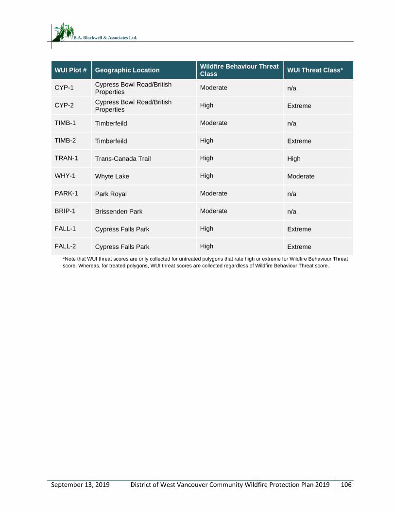
District of West Vancouver Community Wildfire Protection Plan 2019
106
September 13, 2019
B.A. Blackwell & Associates Ltd.
WUI Plot # Geographic Location Wildfire Behaviour Threat Class
WUI Threat Class*
CYP-1 Cypress Bowl Road/British Properties
Moderate n/a
CYP-2 Cypress Bowl Road/British Properties
High Extreme
TIMB-1 Timberfeild Moderate n/a
TIMB-2 Timberfeild High Extreme
TRAN-1 Trans-Canada Trail High High
WHY-1 Whyte Lake High Moderate
PARK-1 Park Royal Moderate n/a
BRIP-1 Brissenden Park Moderate n/a
FALL-1 Cypress Falls Park High Extreme
FALL-2 Cypress Falls Park High Extreme
*Note that WUI threat scores are only collected for untreated polygons that rate high or extreme for Wildfire Behaviour Threat
score. Whereas, for treated polygons, WUI threat scores are collected regardless of Wildfire Behaviour Threat score.
District of West Vancouver Community Wildfire Protection Plan 2019
107
September 13, 2019
B.A. Blackwell & Associates Ltd.
APPENDIX F – FUEL TYPING METHODOLOGY AND LIMITATIONS
The initial starting point for fuel typing for the AOI was the 2017 provincial fuel typing layer provided by
BCWS as part of the 2017 Provincial Strategic Threat Analysis (PSTA) data package. This fuel type layer
is based on the FBP fuel typing system. PSTA data is limited by the accuracy and availability of
information within the Vegetation Resource Inventory (VRI) provincial data; confidence in provincial fuel
type data is very low on private land. The PSTA threat class for all private land within the AOI was not
available. Fuel types within the AOI have been updated using orthoimagery of the AOI with
representative fuel type calls confirmed by field fuel type verification. Polygons not field-verified were
assigned fuel types based upon similarities visible in orthophotography to areas field verified. Where
polygons were available from the provincial fuel typing layer, they were utilized and updated as
necessary for recent harvesting, development, etc.
It should be noted that fuel typing is intended to represent a fire behaviour pattern; a locally observed fuel
type may have no exact analog within the FBP system. The FBP system was almost entirely developed
for boreal and sub-boreal forest types, which do not occur within the AOI. As a result, the AOI fuel typing
is a best approximation of the Canadian Forest Fire Danger Rating System (CFFDRS) classification,
based on the fire behaviour potential of the fuel type during periods of high and extreme fire danger within
the South Coast region. Additionally, provincial fuel typing depends heavily on Vegetation Resource
Inventory (VRI) data, which is gathered and maintained in order to inform timber management objectives,
not fire behaviour prediction. For this reason, VRI data often does not include important attributes which
impact fuel type and hazard, but which are not integral to timber management objectives. Examples
include: surface fuels and understory vegetation.
In some cases, fuel type polygons may not adequately describe the variation in the fuels present within a
given polygon due to errors within the PSTA and VRI data, necessitating adjustments required to the
PSTA data. In some areas, aerial imagery is not of sufficiently high resolution to make a fuel type call.
Where fuel types could not be updated from imagery with a high level of confidence, the original PSTA
fuel type polygon and call were retained.
For information on the provincial fuel typing process used for PSTA data, as well as aiding in fuel type
updates made in this document, please refer to Perrakis and Eade, 2015.80
80Ibid.
District of West Vancouver Community Wildfire Protection Plan 2019
108
September 13, 2019
B.A. Blackwell & Associates Ltd.
APPENDIX G – WUI THREAT ASSESSMENT METHODOLOGY
As part of the CWPP process, spatial data submissions are required to meet the defined standards in the
Program and Application Guide. As part of the program, proponents completing a CWPP or CWPP
update are provided with the Provincial Strategic Threat Analysis (PSTA) dataset. This dataset includes:
Current Fire Points
Current Fire Polygons
Fuel Type
Historical Fire Points
Historical Fire Polygons
Mountain pine beetle polygons (sometimes not included)
PSTA Head Fire Intensity
PSTA Historical Fire Density
PSTA Spotting Impact
PSTA Threat Rating
Structure Density
Structures (sometimes not included)
Wildland Urban Interface Buffer Area
The required components for the spatial data submission are detailed in the Program and Application
Guide Spatial Appendix. These include:
AOI
Fire Threat
Fuel Type
Photo Location
Proposed Treatment
Structures
Threat Plot
Wildland Urban Interface
District of West Vancouver Community Wildfire Protection Plan 2019
109
September 13, 2019
B.A. Blackwell & Associates Ltd.
The provided PSTA data does not necessarily transfer directly into the geodatabase for submission, and
several PSTA feature classes require extensive updating or correction. In addition, the Fire Threat
determined in the PSTA is fundamentally different than the Fire Threat feature class that must be
submitted in the spatial data package. The Fire Threat in the PSTA is based on provincial scale inputs -
fire density; spotting impact; and head fire intensity, while the spatial submission Fire Threat is based on
the components of the Wildland Urban Interface Threat Assessment Worksheet. For the scope of this
project, completion of WUI Threat Assessment plots on the entire AOI is not possible, and therefore an
analytical model has been built to assume Fire Threat based on spatially explicit variables that
correspond to the WUI Threat Assessment worksheet.
Field Data Collection
The primary goals of field data collection are to confirm or correct the provincial fuel type, complete WUI
Threat Assessment Plots, and assess other features of interest to the development of the CWPP. This is
accomplished by traversing as much of the AOI as possible (within time, budget and access constraints).
Threat Assessment plots are completed on the 2012 version form, and as per the Wildland Urban
Interface Threat Assessment Guide.
For clarity, the final threat ratings for the AOI were determined through the completion of the following
methodological steps:
1. Update fuel-typing using orthophotography provided by the client and field verification.
2. Update structural data using critical infrastructure information provided by the client, field visits to
confirm structure additions or deletions, and orthophotography.
3. Complete field work to ground-truth fuel typing and threat ratings (completed 41 WUI threat plots
on a variety of fuel types, aspects, and slopes and an additional 200+ field stops with qualitative
notes, fuel type verification, and/or photographs).
4. Threat assessment analysis using field data collected and rating results of WUI threat plots—see
next section.
Spatial Analysis
Not all attributes on the WUI Threat Assessment form can be determined using a GIS analysis on a
landscape/polygon level. To emulate as closely as possible the threat categorization that would be
determined using the Threat Assessment form, the variables in Table 19 were used as the basis for
building the analytical model. The features chosen are those that are spatially explicit, available from
existing and reliable spatial data or field data, and able to be confidently extrapolated to large polygons.
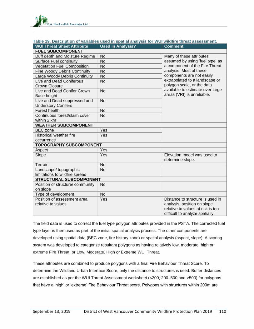
District of West Vancouver Community Wildfire Protection Plan 2019
110
September 13, 2019
B.A. Blackwell & Associates Ltd.
Table 19. Description of variables used in spatial analysis for WUI wildfire threat assessment.
WUI Threat Sheet Attribute Used in Analysis? Comment
FUEL SUBCOMPONENT
Duff depth and Moisture Regime No Many of these attributes assumed by using ‘fuel type’ as a component of the Fire Threat analysis. Most of these components are not easily extrapolated to a landscape or polygon scale, or the data available to estimate over large areas (VRI) is unreliable.
Surface Fuel continuity No
Vegetation Fuel Composition No
Fine Woody Debris Continuity No
Large Woody Debris Continuity No
Live and Dead Coniferous Crown Closure
No
Live and Dead Conifer Crown Base height
No
Live and Dead suppressed and Understory Conifers
No
Forest health No
Continuous forest/slash cover within 2 km
No
WEATHER SUBCOMPONENT
BEC zone Yes
Historical weather fire occurrence
Yes
TOPOGRAPHY SUBCOMPONENT
Aspect Yes
Slope Yes Elevation model was used to determine slope.
Terrain No
Landscape/ topographic limitations to wildfire spread
No
STRUCTURAL SUBCOMPONENT
Position of structure/ community on slope
No
Type of development No
Position of assessment area relative to values
Yes Distance to structure is used in analysis; position on slope relative to values at risk is too difficult to analyze spatially.
The field data is used to correct the fuel type polygon attributes provided in the PSTA. The corrected fuel
type layer is then used as part of the initial spatial analysis process. The other components are
developed using spatial data (BEC zone, fire history zone) or spatial analysis (aspect, slope). A scoring
system was developed to categorize resultant polygons as having relatively low, moderate, high or
extreme Fire Threat, or Low, Moderate, High or Extreme WUI Threat.
These attributes are combined to produce polygons with a final Fire Behaviour Threat Score. To
determine the Wildland Urban Interface Score, only the distance to structures is used. Buffer distances
are established as per the WUI Threat Assessment worksheet (<200, 200–500 and >500) for polygons
that have a ‘high’ or ‘extreme’ Fire Behaviour Threat score. Polygons with structures within 200m are
District of West Vancouver Community Wildfire Protection Plan 2019
111
September 13, 2019
B.A. Blackwell & Associates Ltd.
rated as ‘extreme’, within 500m are rated as ‘high’, within 2km are ‘moderate’, and distances over that are
rated ‘low’.
There are obvious limitations in this method, most notably that not all components of the threat
assessment worksheet are scalable to a GIS model, generalizing the Fire Behaviour Threat score. The
WUI Threat Score is greatly simplified, as determining the position of structures on a slope, the type of
development and the relative position are difficult in an automated GIS process. This method uses the
best available information to produce the initial threat assessment across the AOI in a format which is
required by the UBCM SWPI program.
Upon completion of the initial spatial threat assessment, individual polygon refinement was completed. In
this process, the WUI threat plots completed on the ground were used in the following ways:
Fuel scores were reviewed and applied to the fuel type in which the threat plot was completed.
Conservative fuel scores were then applied to the polygons by fuel type to check the initial
assessment.
High Wildfire Behaviour Threat Class polygons were reviewed in Google Earth to confirm their
position on slope relative to values at risk.
In this way, we were able to consider fuel attributes outside the fuel typing layer, as well as assessment
area position on slope relative to structures, which are included in the WUI threat plot worksheet.
Limitations
The threat class ratings are based initially upon geographic information systems (GIS) analysis that best
represents the WUI wildfire threat assessment worksheet and are updated with ground-truthing WUI
threat plots. WUI threat plots were completed in a variety of fuel types, slopes, and aspects in order to be
able to confidently refine the GIS analysis. It should be noted that there are subcomponents in the
worksheet which are not able to be analyzed using spatial analysis; these are factors that do not exist in
the GIS environment.
The threat assessment is based largely on fuel typing, therefore the limitations with fuel typing accuracy
(as detailed in Section 4.3.1) impacts the threat assessment, as well.
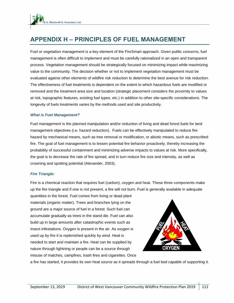
District of West Vancouver Community Wildfire Protection Plan 2019
112
September 13, 2019
B.A. Blackwell & Associates Ltd.
APPENDIX H – PRINCIPLES OF FUEL MANAGEMENT
Fuel or vegetation management is a key element of the FireSmart approach. Given public concerns, fuel
management is often difficult to implement and must be carefully rationalized in an open and transparent
process. Vegetation management should be strategically focused on minimizing impact while maximizing
value to the community. The decision whether or not to implement vegetation management must be
evaluated against other elements of wildfire risk reduction to determine the best avenue for risk reduction.
The effectiveness of fuel treatments is dependent on the extent to which hazardous fuels are modified or
removed and the treatment area size and location (strategic placement considers the proximity to values
at risk, topographic features, existing fuel types, etc.) in addition to other site-specific considerations. The
longevity of fuels treatments varies by the methods used and site productivity.
What is Fuel Management?
Fuel management is the planned manipulation and/or reduction of living and dead forest fuels for land
management objectives (i.e. hazard reduction). Fuels can be effectively manipulated to reduce fire
hazard by mechanical means, such as tree removal or modification, or abiotic means, such as prescribed
fire. The goal of fuel management is to lessen potential fire behavior proactively, thereby increasing the
probability of successful containment and minimizing adverse impacts to values at risk. More specifically,
the goal is to decrease the rate of fire spread, and in turn reduce fire size and intensity, as well as
crowning and spotting potential (Alexander, 2003).
Fire Triangle:
Fire is a chemical reaction that requires fuel (carbon), oxygen and heat. These three components make
up the fire triangle and if one is not present, a fire will not burn. Fuel is generally available in adequate
quantities in the forest. Fuel comes from living or dead plant
materials (organic matter). Trees and branches lying on the
ground are a major source of fuel in a forest. Such fuel can
accumulate gradually as trees in the stand die. Fuel can also
build up in large amounts after catastrophic events such as
insect infestations. Oxygen is present in the air. As oxygen is
used up by fire it is replenished quickly by wind. Heat is
needed to start and maintain a fire. Heat can be supplied by
nature through lightning or people can be a source through
misuse of matches, campfires, trash fires and cigarettes. Once
a fire has started, it provides its own heat source as it spreads through a fuel bed capable of supporting it.
District of West Vancouver Community Wildfire Protection Plan 2019
113
September 13, 2019
B.A. Blackwell & Associates Ltd.
Forest Fuels:
The amount of fuel available to burn on any site is a function of biomass production and decomposition.
Many of the forest ecosystems within BC have the potential to produce large amounts of vegetation
biomass. Variation in the amount of biomass produced is typically a function of site productivity and
climate. The disposition or removal of vegetation biomass is a function of decomposition. Decomposition
is regulated by temperature and moisture. In wet maritime coastal climates, the rates of decomposition
are relatively high when compared with drier cooler continental climates of the interior. Rates of
decomposition can be accelerated naturally by fire and/or anthropogenic means.
A hazardous fuel type can be defined by high surface fuel loadings, high proportions of fine fuels (<1 cm)
relative to larger size classes, high fuel continuity between the ground surface and overstory tree
canopies, and high stand densities. A fuel complex is defined by any combination of these attributes at
the stand level and may include groupings of stands.
Surface Fuels:
Surface fuels consist of forest floor, understory vegetation (grasses, herbs and shrubs, and small trees),
and coarse woody debris that are in contact with the forest floor. Forest fuel loading is a function of
natural disturbance, tree mortality and/or human related disturbance. Surface fuels typically include all
combustible material lying on or immediately above the ground. Often roots and organic soils have the
potential to be consumed by fire and are included in the surface fuel category.
Surface fuels that are less than 7 cm in diameter contribute to surface fire spread; these fuels often dry
quickly and are ignited more easily than larger diameter fuels. Therefore, this category of fuel is the most
important when considering a fuel reduction treatment. Larger surface fuels greater than 7 cm are
important in the contribution to sustained burning conditions, but, when compared with smaller size
classes, are often not as contiguous and are less flammable because of delayed drying and high
moisture content. In some cases, where these larger size classes form a contiguous surface layer, such
as following a windthrow event or wildfire, they can contribute an enormous amount of fuel, which will
increase fire severity and the potential for fire damage.
Aerial Fuels:
Aerial fuels include all dead and living material that is not in direct contact with the forest floor surface. The
fire potential of these fuels is dependent on type, size, moisture content, and overall vertical continuity.
Dead branches and bark on trees and snags (dead standing trees) are important aerial fuels.
Concentrations of dead branches and foliage increase the aerial fuel bulk density and enable fire to move
from tree to tree. The exception is for deciduous trees where the live leaves will not normally carry fire.
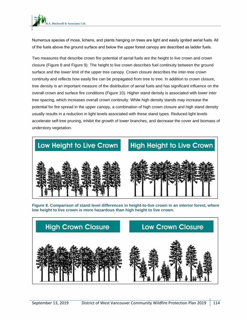
District of West Vancouver Community Wildfire Protection Plan 2019
114
September 13, 2019
B.A. Blackwell & Associates Ltd.
Numerous species of moss, lichens, and plants hanging on trees are light and easily ignited aerial fuels. All
of the fuels above the ground surface and below the upper forest canopy are described as ladder fuels.
Two measures that describe crown fire potential of aerial fuels are the height to live crown and crown
closure (Figure 8 and Figure 9). The height to live crown describes fuel continuity between the ground
surface and the lower limit of the upper tree canopy. Crown closure describes the inter-tree crown
continuity and reflects how easily fire can be propagated from tree to tree. In addition to crown closure,
tree density is an important measure of the distribution of aerial fuels and has significant influence on the
overall crown and surface fire conditions (Figure 10). Higher stand density is associated with lower inter
tree spacing, which increases overall crown continuity. While high density stands may increase the
potential for fire spread in the upper canopy, a combination of high crown closure and high stand density
usually results in a reduction in light levels associated with these stand types. Reduced light levels
accelerate self-tree pruning, inhibit the growth of lower branches, and decrease the cover and biomass of
understory vegetation.
Figure 8. Comparison of stand level differences in height-to-live crown in an interior forest, where low height to live crown is more hazardous than high height to live crown.
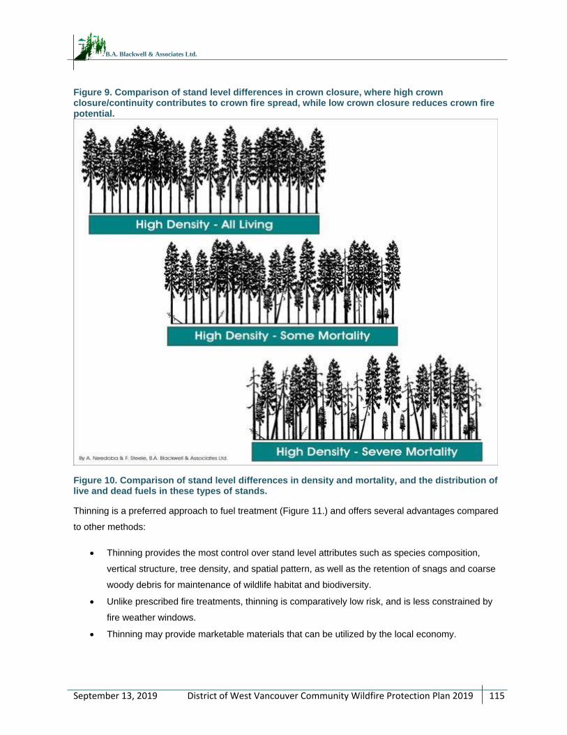
District of West Vancouver Community Wildfire Protection Plan 2019
115
September 13, 2019
B.A. Blackwell & Associates Ltd.
Figure 9. Comparison of stand level differences in crown closure, where high crown closure/continuity contributes to crown fire spread, while low crown closure reduces crown fire potential.
Figure 10. Comparison of stand level differences in density and mortality, and the distribution of live and dead fuels in these types of stands.
Thinning is a preferred approach to fuel treatment (Figure 11.) and offers several advantages compared
to other methods:
Thinning provides the most control over stand level attributes such as species composition,
vertical structure, tree density, and spatial pattern, as well as the retention of snags and coarse
woody debris for maintenance of wildlife habitat and biodiversity.
Unlike prescribed fire treatments, thinning is comparatively low risk, and is less constrained by
fire weather windows.
Thinning may provide marketable materials that can be utilized by the local economy.
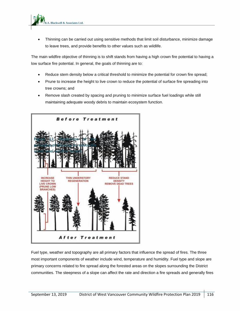
District of West Vancouver Community Wildfire Protection Plan 2019
116
September 13, 2019
B.A. Blackwell & Associates Ltd.
Thinning can be carried out using sensitive methods that limit soil disturbance, minimize damage
to leave trees, and provide benefits to other values such as wildlife.
The main wildfire objective of thinning is to shift stands from having a high crown fire potential to having a
low surface fire potential. In general, the goals of thinning are to:
Reduce stem density below a critical threshold to minimize the potential for crown fire spread;
Prune to increase the height to live crown to reduce the potential of surface fire spreading into
tree crowns; and
Remove slash created by spacing and pruning to minimize surface fuel loadings while still
maintaining adequate woody debris to maintain ecosystem function.
Fuel type, weather and topography are all primary factors that influence the spread of fires. The three
most important components of weather include wind, temperature and humidity. Fuel type and slope are
primary concerns related to fire spread along the forested areas on the slopes surrounding the District
communities. The steepness of a slope can affect the rate and direction a fire spreads and generally fires
Figure 11. Illustration of the
principles of thinning to reduce the
stand level wildfire hazard.
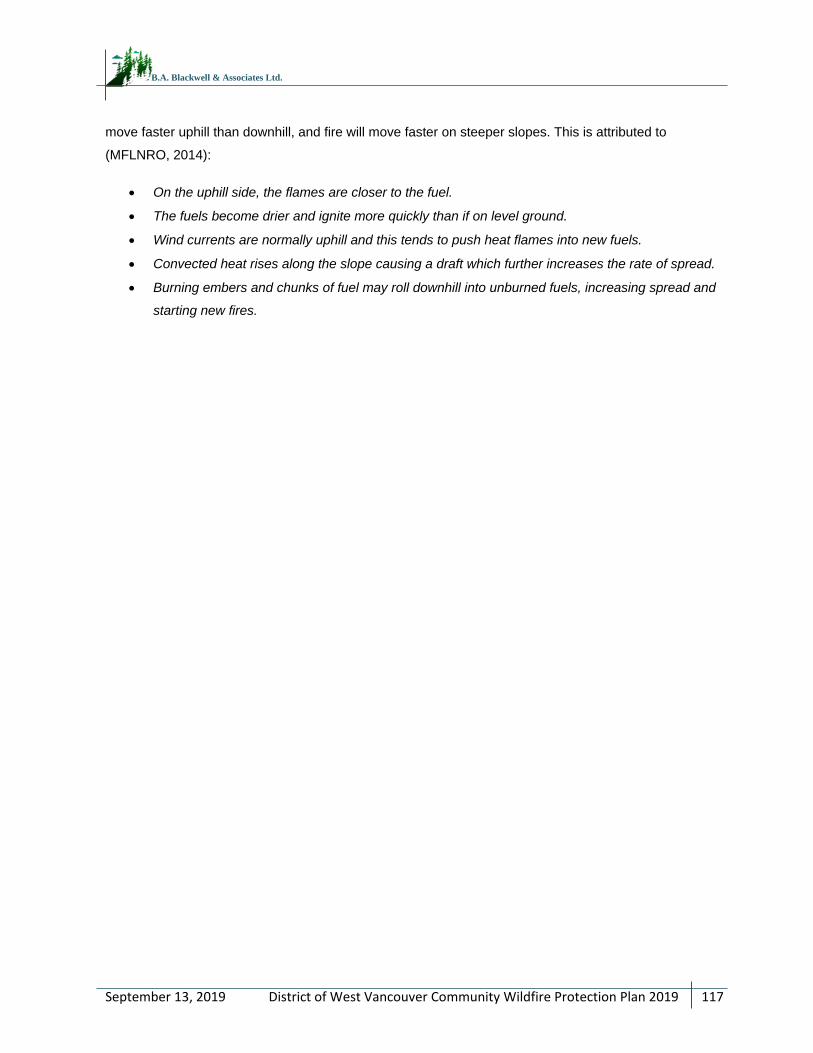
District of West Vancouver Community Wildfire Protection Plan 2019
117
September 13, 2019
B.A. Blackwell & Associates Ltd.
move faster uphill than downhill, and fire will move faster on steeper slopes. This is attributed to
(MFLNRO, 2014):
On the uphill side, the flames are closer to the fuel.
The fuels become drier and ignite more quickly than if on level ground.
Wind currents are normally uphill and this tends to push heat flames into new fuels.
Convected heat rises along the slope causing a draft which further increases the rate of spread.
Burning embers and chunks of fuel may roll downhill into unburned fuels, increasing spread and
starting new fires.
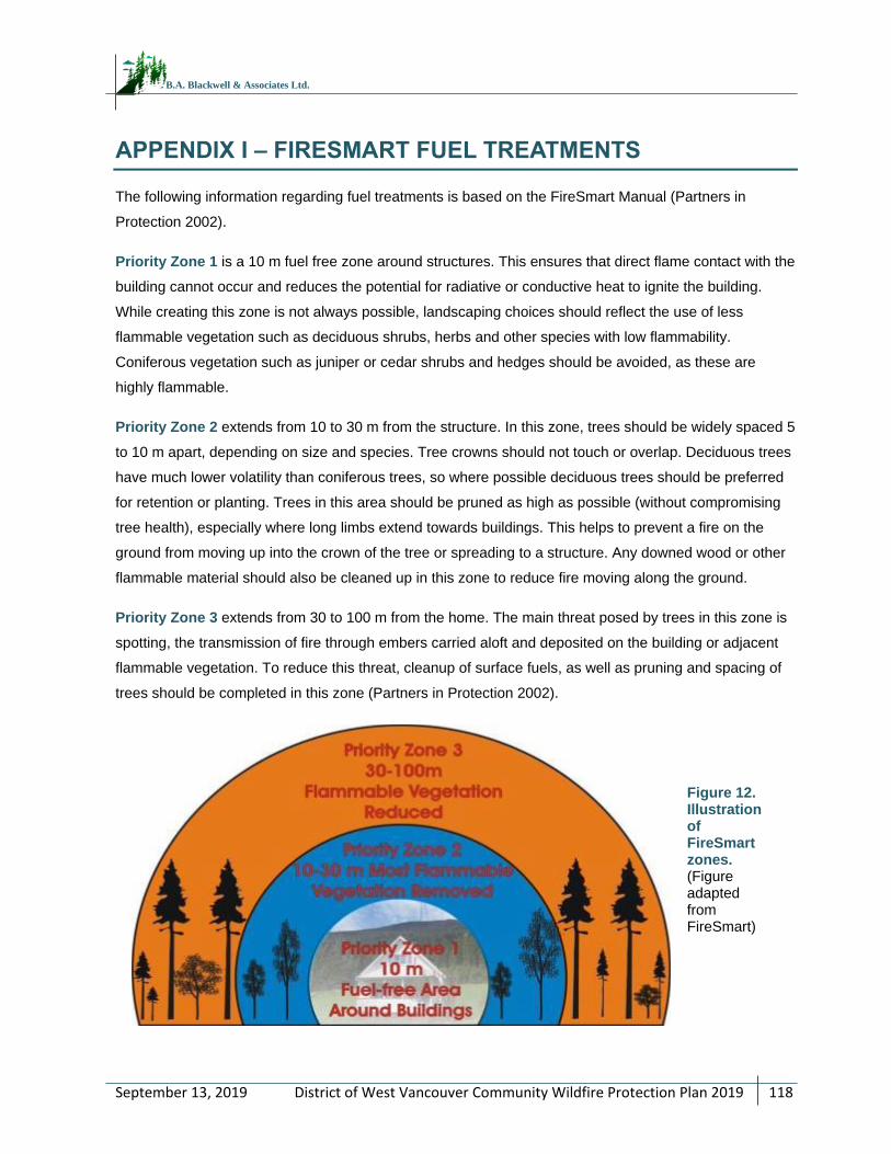
District of West Vancouver Community Wildfire Protection Plan 2019
118
September 13, 2019
B.A. Blackwell & Associates Ltd.
APPENDIX I – FIRESMART FUEL TREATMENTS
The following information regarding fuel treatments is based on the FireSmart Manual (Partners in
Protection 2002).
Priority Zone 1 is a 10 m fuel free zone around structures. This ensures that direct flame contact with the
building cannot occur and reduces the potential for radiative or conductive heat to ignite the building.
While creating this zone is not always possible, landscaping choices should reflect the use of less
flammable vegetation such as deciduous shrubs, herbs and other species with low flammability.
Coniferous vegetation such as juniper or cedar shrubs and hedges should be avoided, as these are
highly flammable.
Priority Zone 2 extends from 10 to 30 m from the structure. In this zone, trees should be widely spaced 5
to 10 m apart, depending on size and species. Tree crowns should not touch or overlap. Deciduous trees
have much lower volatility than coniferous trees, so where possible deciduous trees should be preferred
for retention or planting. Trees in this area should be pruned as high as possible (without compromising
tree health), especially where long limbs extend towards buildings. This helps to prevent a fire on the
ground from moving up into the crown of the tree or spreading to a structure. Any downed wood or other
flammable material should also be cleaned up in this zone to reduce fire moving along the ground.
Priority Zone 3 extends from 30 to 100 m from the home. The main threat posed by trees in this zone is
spotting, the transmission of fire through embers carried aloft and deposited on the building or adjacent
flammable vegetation. To reduce this threat, cleanup of surface fuels, as well as pruning and spacing of
trees should be completed in this zone (Partners in Protection 2002).
Figure 12. Illustration of FireSmart zones. (Figure adapted from FireSmart)
District of West Vancouver Community Wildfire Protection Plan 2019
119
September 13, 2019
B.A. Blackwell & Associates Ltd.
APPENDIX J – FIRESMART CONSTRUCTION AND LANDSCAPING
Two recent studies by Westhaver (2015, 2017) found that certain ‘fatal flaws,’ such as high-flammability
landscaping like bulky ornamental junipers and large, easily ignited fuel sources (e.g. motorized vehicles,
firewood, construction materials, etc.) were sufficiently influential to result in structure ignition of homes
otherwise assessed as ‘Low’ hazard by overwhelming the advantages provided by highly fire resistant
structures81.
In the 2017 Fort McMurray investigations (Westhaver) it was found that the most notable observed
attributes of the surviving interface homes were: vegetation and fuels within the HIZ which were
compliant with FireSmart practices, HIZs with relatively few combustible objects and ignition sites
(examples of ignition sites include: combustible accumulations on roofs, gutters, etc.) , and Low to
Moderate structural hazard ratings.82,83 This investigation, and other similar investigations, indicate that
the FireSmart principles can be effective at reducing structure loss, particularly in the urban perimeter
where fire initially spreads from the forest to structures. .
The following link accesses an excellent four-minute video demonstrating the importance of FireSmart
building practices during a simulated ember shower: www.youtube.com/watch?v=IvbNOPSYyss.
FireSmart Construction
Roofing Material:
Roofing material is one of the most important characteristics influencing a home’s vulnerability to fire.
Roofing materials that can be ignited by burning embers increases the probability of fire related damage
to a home during an interface fire event.
In many communities, there is no fire vulnerability standard for roofing material. Homes are often
constructed with unrated materials that are considered a major hazard during a large fire event. In
addition to the vulnerability of roofing materials, adjacent vegetation may be in contact with roofs, or roof
surfaces may be covered with litter fall from adjacent trees. This increases the hazard by increasing the
ignitable surfaces and potentially enabling direct flame contact between vegetation and structures.
Soffits and Eaves
Open soffits or eaves provide locations for embers to accumulate, igniting a structure. Soffits and eaves
should be closed. Vents which open into insulated attic space are of particular concern, as they provide a
81 Westhaver, A. 2017. Why some homes survived. Learning from the Fort McMurray wildland/urban interface fire disaster. A report published by the Institute for Catastrophic Loss Reduction – ICLR research paper series – number 56. www.iclr.org/images/Westhaver_Fort_McMurray_Final_2017.pdf 82 Ibid. 83 Using the FireSmart hazard assessment system.
District of West Vancouver Community Wildfire Protection Plan 2019
120
September 13, 2019
B.A. Blackwell & Associates Ltd.
clear path for embers to a highly flammable material inside the structure. Any exhaust or intake vents that
open into attic spaces should resist ember intrusion with non-combustible wire mesh no larger than 3
mm.
Building Exterior - Siding Material:
Building exteriors constructed of vinyl or wood are considered the second highest contributor to structural
hazard after roofing material. These materials are vulnerable to direct flame or may ignite when
sufficiently heated by nearby burning fuels. The smoke column will transport burning embers, which may
lodge against siding materials. Brick, stucco, or heavy timber materials offer much better resistance to
fire. While wood may not be the best choice for use in the WUI, other values from economic and
environmental perspectives must also be considered. It is significantly less expensive than many other
materials, supplies a great deal of employment in BC, and is a renewable resource. New treatments and
paints are now available for wood that increase its resistance to fire and they should be considered for
use.
Balconies and Decking:
Open balconies and decks increase fire vulnerability through their ability to trap rising heat, by permitting
the entry of sparks and embers, and by enabling fire access to these areas. Closing these structures off
limits ember access to these areas and reduces fire vulnerability. Horizontal surfaces, such as decks, of
flammable materials are vulnerable to ignition from embers. Fire resistant decking/ patio materials will
reduce the ignitability of the home.
Combustible Materials:
Combustible materials stored within 10 m of residences are also considered a significant issue.
Woodpiles, propane tanks, recreational motorized vehicles, and other flammable materials adjacent to
the home provide fuel and ignitable surfaces. Locating these fuels away from structures helps to reduce
structural fire hazards and makes it easier and safer for suppression crews to implement suppression
activities adjacent to a house or to multiple homes.
FireSmart Landscaping
Future landscaping choices should be limited to plant species with low flammability within 10 m of the
building. Coniferous vegetation such as Juniper, Cypress, Yew or Cedar hedging or shrubs of any height
should not be planted within this 10 m zone as these species are considered highly flammable under
extreme fire hazard conditions.
District of West Vancouver Community Wildfire Protection Plan 2019
121
September 13, 2019
B.A. Blackwell & Associates Ltd.
Decorative bark mulch, often used in home landscapes is easily ignitable from wildfire embers or errant
cigarettes and can convey fire to the home. Alternatives to bark mulch include gravel, decorative rock, or
a combination of wood bark and decorative rock.84
Landscaping Alternatives
The landscaping challenges faced by many homeowners pertain to limited space, privacy and the desire
to create visually explicit edge treatments to demarcate property ownership from adjacent lots with
evergreen vegetation screens. Ornamental plant characteristics fulfilling these criteria have an upright
branching habit, compact form, dense foliage, as well as a moderate growth rate. Dwarf and ornamental
conifers such as Arborvitae hedging are popular choices, yet conifers such as these which have needle
or scale-like foliage are highly flammable and not compliant with FireSmart principles and should be
omitted from the 10 m Fire Priority Zone of the planned home footprint.
There are a number of broadleaved deciduous and evergreen plants with low flammability which can be
used for landscaping within FireSmart PZ 1 (within 10 m of structures). Landscaping should be selected
for the appropriate Canadian Plant Hardiness Zone (see www.planthardiness.gc.ca for the Hardiness
Zone specific to the various AOI). The majority of the areas would be within Zone 3b.
Plants that are fire resistant/ have low flammability generally have the following characteristics:
Foliage with high moisture content (moist and supple).
Little dead wood and do not tend to accumulate dry and dead foliage or woody materials.
Sap that is water-like and without a strong odour.3
It is important to note that even fire resistant plants can burn if not maintained. Grass, shrubs, and herbs
must be maintained in a state that reduces fire hazard by maintaining foliar moisture content. This can be
accomplished by:
Choosing plant species that are well-adapted to the site (microclimate and soil conditions of the
parcel).
Incorporating a landscape design where shrubs, herbs, and grasses are planted in discrete units
manageable by hand watering.
Removal of dead and dying foliage, and/or
Installing irrigation.
84 Fire Resistant Plants for Home Landscapes: Selecting plants that may reduce your risk from wildfire. 2006. A Pacific Northwest Extension Publication (PNW 590).
District of West Vancouver Community Wildfire Protection Plan 2019
122
September 13, 2019
B.A. Blackwell & Associates Ltd.
Depending solely on irrigation to maintain landscaping in a low flammability state can be limiting and may
actually increase the fire hazard on the parcel, particularly in times of drought and watering restrictions.
Lack of irrigation in times of watering restrictions may create a landscape which is unhealthy, unsightly,
as well as dead, dry, and highly flammable.
There are a number of resources available to aid in development of FireSmart compliant landscaping
curriculum or educational material; links can be found below.
The Canadian and U.S. systems for determining Plant Hardiness Zones differ.
The USDA bases hardiness zones on minimum winter temperatures only:
planthardiness.ars.usda.gov/PHZMWeb/Default.aspx,
The Canadian system bases them on seven climatic factors including frost free days, and
minimum and maximum temperature: www.planthardiness.gc.ca/
District of West Vancouver Community Wildfire Protection Plan 2019
123
September 13, 2019
B.A. Blackwell & Associates Ltd.
APPENDIX K – COMMUNICATION AND EDUCATION
Communicating effectively is the key aspect of education. Communication materials must be
audience specific and delivered in a format and through a medium that will reach the target
audience. Audiences should include home and landowners and occupiers, school students,
local businesses, municipal officials and staff, community members, and other community
groups. Education and communication messages should be engaging, empowering, simple yet
comprehensive. A basic level of background information is required to enable a solid
understanding of fire risk issues and the level of complexity and detail of the message should
be specific to the target audience.
Websites and social media are some of the most cost-effective methods of communication
available. Pew Research Center recently found that approximately 60% of Americans get their
news from social media; 44% get their news from Facebook.85 Twitter, LinkedIn, and Instagram
are other social media platforms which can be used to provide real-time information to a large
audience and are used, albeit to a lesser extent, by users as their primary news source.86
The challenge of all social media is to ensure that your message reaches the intended
audience, accomplished by having users ‘like’ the page, engage with the posts, or re-share
information to an even larger audience. There are communication experts who specialize in
social media who can evaluate an organization’s goals and offer tips to increase engagement
and create compelling content to communicate the message. Likewise, it is important to be
aware of the demographic of the community; a younger, more digitally connected community is
more likely to use social media to get updates on ‘newsworthy items’.87
85 Pew Research Center Journalism and Media. Social media news use: Facebook leads the pack. May 25, 2016. Accessed December 17, 2017 from www.journalism.org/2016/05/26/news-use-across-social-media-platforms-2016/pj_2016-05-26_social-media-and-news_0-03/. 86 Although the research cited in this document is of American social media users, it can be cautiously assumed that, while data and numbers are not likely exact to the Canadian demographic, similar trends in Canada likely occur. 87 The Pew Research Center finds that 69% of Facebook users are 49 and younger. Only 8% of Facebook users are older than 65.