North-South 400 kV Interconnection Development
71
North-South 400 kV Interconnection Development An Bord Pleanála Reference: PCI001 Volume 5 Natura Impact Statement (DRAFT) DRAFT
-
Upload
khangminh22 -
Category
Documents
-
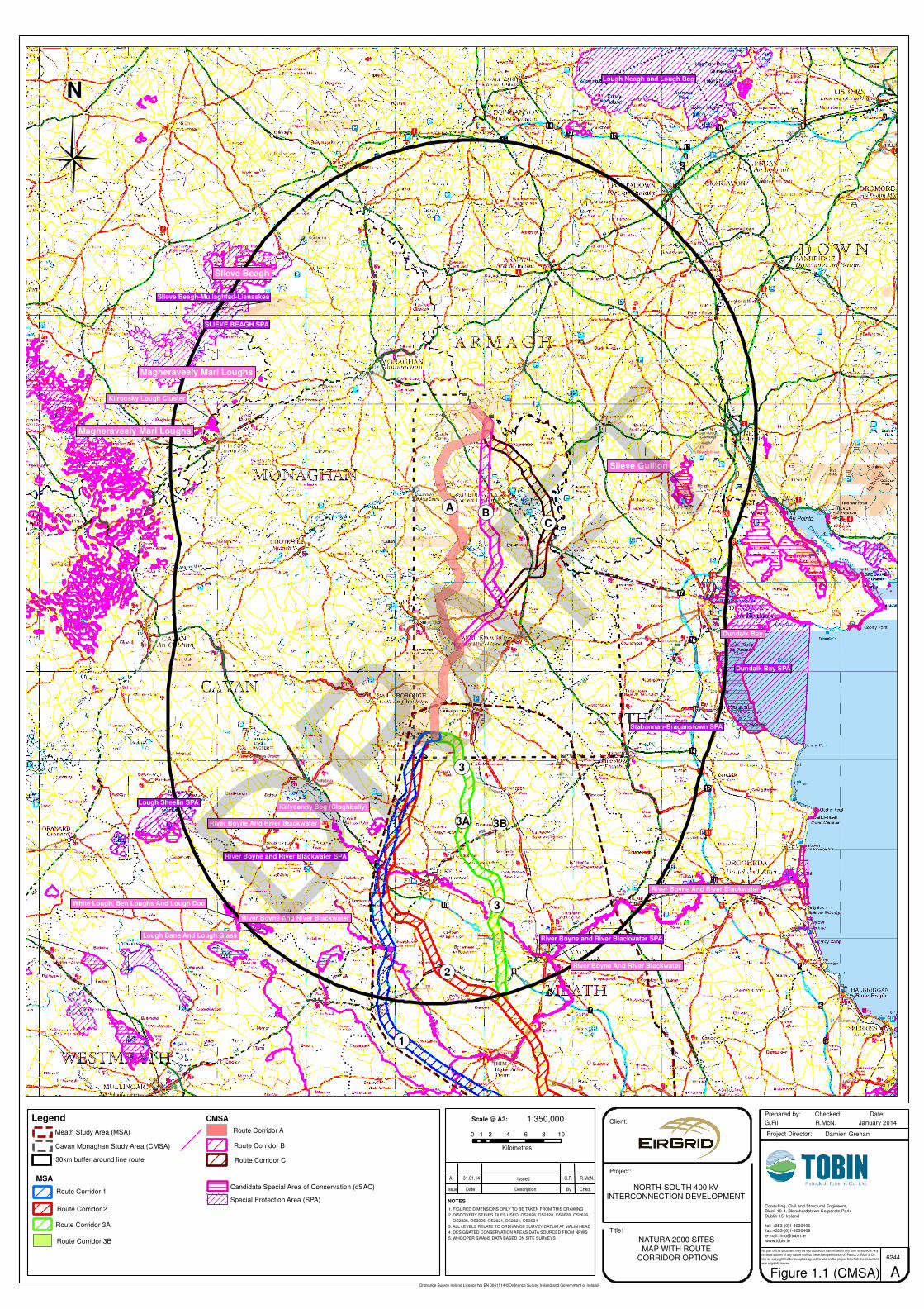
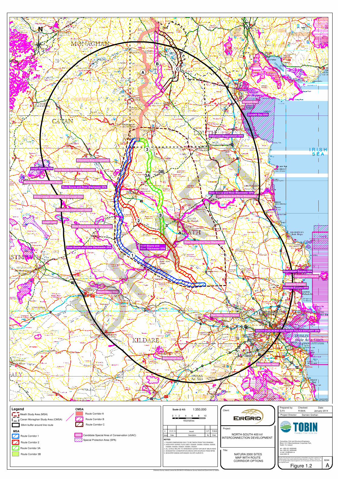
view
1 -
download
0
Transcript of North-South 400 kV Interconnection Development
North-South 400 kV Interconnection Development
An Bord Pleanála Reference: PCI001
Volume 5
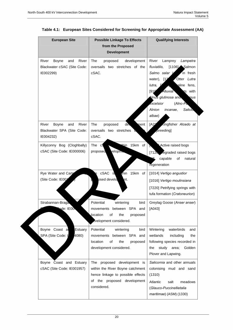
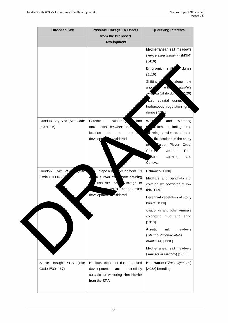
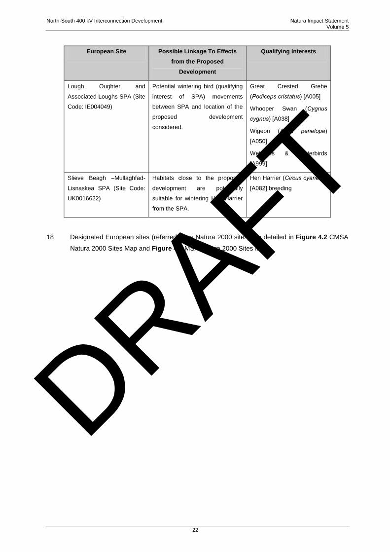
Natura Impact Statement (DRAFT)
DRAFT

DRAFT

North-South 400 kV Interconnection Development Natura Impact Statement Volume 5
i
TABLE OF CONTENTS
1 INTRODUCTION ........................................................................................................................ 1
1.1 BACKGROUND TO THE PROPOSED DEVELOPMENT ............................................................... 3
1.2 CONSULTATION................................................................................................................ 6
2 STATUTORY CONTEXT ........................................................................................................... 7
3 GUIDANCE ................................................................................................................................ 9
4 STAGE ONE: SCREENING STAGE ....................................................................................... 12
4.1 INTRODUCTION .............................................................................................................. 12
4.2 DESCRIPTION OF THE PROPOSED DEVELOPMENT ............................................................. 12
4.2.1 Overhead Line Elements (OHL) ..................................................................... 14
4.2.2 Project Phases ............................................................................................... 17
4.3 IDENTIFICATION OF RELEVANT EUROPEAN SITES AND COMPILATION OF INFORMATION ON THEIR
QUALIFYING INTERESTS AND CONSERVATION OBJECTIVES ................................................ 19
4.4 ASSESSMENT OF LIKELY SIGNIFICANT EFFECTS .......................................................... 26
5 STAGE TWO APPROPRIATE ASSESSMENT ....................................................................... 32
5.1 CHARACTERISTICS OF EUROPEAN SITES ......................................................................... 32
5.1.1 River Boyne and River Blackwater cSAC ...................................................... 33
5.1.2 River Boyne and River Blackwater SPA ........................................................ 34
5.2 POTENTIAL IMPACTS ...................................................................................................... 35
5.2.1 Proposed Development .................................................................................. 35
5.2.2 Potential In-Combination Effects .................................................................... 42
6 MITIGATION MEASURES ....................................................................................................... 48
6.1 DESIGN STAGE MITIGATION (AVOIDANCE) ........................................................................ 48
6.2 CONSTRUCTION PHASE MITIGATION................................................................................. 49
6.2.1 Protection of Terrestrial Qualifying Fauna Breeding Sites ............................. 50
6.2.2 Protection of Water Quality and Qualifying Aquatic Fauna ............................ 51
6.2.3 Appraisal of Effectiveness of Construction Stage Mitigation .......................... 54
6.3 OPERATIONAL PHASE MITIGATION ................................................................................... 55
7 APPROPRIATE ASSESSMENT - CONCLUSION .................................................................. 56
DRAFT
North-South 400 kV Interconnection Development Natura Impact Statement Volume 5
ii
LIST OF FIGURES
Figure 1.1: CMSA Route Corridor Options in Relation to Natura 2000 Sites ..................................... 4
Figure 1.2: MSA Route Corridor Options in relation to Natura 2000 Sites ......................................... 5
Figure 4.1: General Arrangement of a C-IVI-1 (IVI) Tower .............................................................. 15
Figure 4.2: CMSA Natura 2000 Sites Map ....................................................................................... 23
Figure 4.3: MSA Natura 2000 Sites Map .......................................................................................... 24
Figure 5.1: River Boyne crossing between Towers 355 and 356 ..................................................... 37
Figure 5.2: River Blackwater crossing between Towers 310 and 311 ............................................. 38
LIST OF TABLES
Table 4.1: European Sites Considered for Screening for Appropriate Assessment (AA) ........................................................................................................................................ 20
Table 4.2: Summary of Screening for Appropriate Assessment ........................................................................................................................................ 28
Table 5.1: Qualifying Interests of the River Boyne and River Blackwater cSAC and Current Conservation Status Based on Available Information .................................................... 34
Table 5.2: Key Sensitive Locations, Qualifying Interests, Potential Impacts and Mitigation Measures ........................................................................................................................ 39
Table 5.3: Permitted and Proposed Transmission, Major and SID Projects ........................................................................................................................................ 43
DRAFT
North-South 400 kV Interconnection Development Natura Impact Statement Volume 5
1
1 INTRODUCTION
1 EirGrid plc (EirGrid) and System Operator Northern Ireland Ltd (SONI) (the respective
applicants)1are jointly planning a major cross-border electricity transmission development
between the existing high-voltage transmission networks of Ireland2 and Northern Ireland. The
overall interconnection project (which is termed the „proposed interconnector‟) is a 400 kV
overhead line (OHL) circuit linking the existing 400 kV substation in Woodland, County Meath
with a planned substation in Turleenan, County Tyrone. The proposed interconnector will
provide a second high capacity electricity interconnector between Ireland and Northern Ireland.
The existing interconnector is a 275 kV double circuit OHL which connects the existing
Tandragee and Louth substations. The proposed interconnector is planned to traverse the
counties of Tyrone, Armagh, Monaghan, Cavan and Meath.
2 Given its location across two jurisdictions, the proposed interconnector consists of two related
and complementary developments, as follows:
1) A development being proposed by SONI for that portion of the overall interconnection
project located in Northern Ireland (the SONI proposal); and
2) A development being proposed by EirGrid for that portion of the overall interconnection
project located in Ireland (i.e. in counties Monaghan, Cavan and Meath) which forms
the subject matter for this application for planning approval. The application is titled the
„North-South 400 kV Interconnection Development‟ or „the proposed development‟ for
the purposes of this Natura Impact Statement (NIS) (the EirGrid proposal).
3 This NIS has been prepared to address the likely or possible significant effects, if any, of the
proposed development located in counties Monaghan, Cavan and Meath on sites designated as
Natura 2000 conservation areas, also defined in Irish legislation as „European sites‟. The NIS
is, accordingly, submitted with the application submitted to An Bord Pleanála (the Board) for
planning approval of the proposed development.
4 Given the overall geographical extent of this linear development, the proposed development is
presented in two sections for the purposes of the application to the Board and, in particular, the
Environmental Impact Statement (EIS) and this NIS. This approach will facilitate public
1 The planning function in respect of that portion of the proposed interconnector within Northern Ireland was originally undertaken
by Northern Ireland Electricity (NIE). However, NIE was obligated by the European Commission to transfer its investment planning function (the “Planning Function”) to SONI. The SONI transmission system operator licence (the “Licence”) was amended on 28th March 2014 to take account of the transfer of the Planning Function following a consultation process by the Northern Ireland Authority for Utility Regulation (NIAUR). The Licence amendments took effect on 30th April 2014. Accordingly, responsibility for the pursuance of the planning application in respect of the proposed interconnector within Northern Ireland has been transferred from NIE to SONI.
2 Often referred to as „Republic of Ireland‟.
DRAFT
North-South 400 kV Interconnection Development Natura Impact Statement Volume 5
2
participation in respect of that portion of the proposed development which is of most
importance, rather than necessarily having to seek this information as part of a much larger
study area. The development study areas comprise: the Cavan Monaghan Study Area (CMSA)
and the Meath Study Area (MSA).
5 The SONI proposal for that portion of the proposed interconnector located in Northern Ireland
also considers those European sites which have been assessed as being relevant to that
specific section of the proposed interconnector. The NIE assessment is detailed in the Tyrone
to Cavan Interconnector Consolidated ES Addendum Habitats Regulations Assessment Stage
2: Statement to Inform Appropriate Assessment.
6 This NIS considers identified relevant European sites in both jurisdictions insofar as there is the
possibility of there being a significant effect on those European sites from that portion of the
interconnection development between the crossing points of the jurisdictional border with
Northern Ireland (in the townlands of Doohat or Crossreagh, County Armagh, and Lemgare,
County Monaghan), to the townland of Bogganstown (Electoral District (ED) Culmullin), County
Meath including the substation at Woodland, County Meath. Given the nature and scale of this
linear electricity transmission development, EirGrid considered that there is the possibility for
the proposed development to have significant direct, indirect or cumulative effects, on European
sites, or to sensitive ecological receptors which are qualifying interests for specific European
sites in the vicinity of the proposed development. Consideration was also given to possible
adverse effects to qualifying interests beyond the boundaries of the proposed interconnector
development, which may be linked to activities associated with that development. Therefore, as
is set out below, a Stage One screening exercise was undertaken by the developer and EirGrid
concluded that a Stage Two Appropriate Assessment is required to be undertaken by the
competent authority (i.e. An Bord Pleanála in this instance) pursuant to Article 6(3) of Directive
92/43/EEC (Habitats Directive). Notwithstanding the consideration of these issues by the
developer, the Board is required to carry out a screening for appropriate assessment prior to
giving consent and, in circumstances where the application for planning approval is
accompanied by this NIS, there is an implicit acceptance that it is possible that the proposed
development may have a significant effect on a European site. Accordingly, this NIS provides
information to enable the Board to carry out both a Stage One screening for appropriate
assessment and, thereafter, a Stage Two appropriate assessment (AA), having considered the
NIS and other information submitted to the Board from prescribed authorities, planning
authorities and persons who make submissions or observations on the application for planning
approval.
DRAFT
North-South 400 kV Interconnection Development Natura Impact Statement Volume 5
3
7 The NIS has been informed by a detailed desk review together with extensive field surveys.
Importantly, as part of the overall process, various route alternatives were considered.
8 Extensive consultation has also been conducted with the National Parks and Wildlife Services
(NPWS), Inland Fisheries Ireland (IFI) and BirdWatch Ireland (BWI) to ensure that any concerns
which these prescribed authorities and Non-governmental Organisations (NGOs) had could be
addressed at an early stage. This NIS report has been prepared and reviewed by experienced,
qualified ecologists from TOBIN Consulting Engineers and Wetland Surveys Ireland. The
ecologists are full members of the Chartered Institute of Ecology and Environmental
Management (CIEEM).
1.1 BACKGROUND TO THE PROPOSED DEVELOPMENT
9 A number of European sites, comprised of candidate Special Conservation Areas (cSACs) and
Special Protection Areas (SPAs) are located in the vicinity of the proposed development (see
Section 4.3 of this report). The initial identification of European sites in the study areas and
potentially sensitive ecological receptors enabled a precautionary approach to be taken from
route selection to final design for the proposed alignment, with the aim of avoiding, where
possible, possible significant effect on the identified sites by routing all Route Corridor options,
as far as possible, away from European sites and other identified sensitive ecological receptors.
10 The Route Corridor selection process considered 3 options in the CMSA (routes A, B and C)
and 3 options in the MSA (routes 1, 2 and 3 (including two sub-options 3A and 3B)). Figure 1.1
(CMSA) and Figure 1.2 (MSA) indicate all route corridors, in each study area, in relation to
European sites
11 All Route Corridor options required crossing of the River Boyne and River Blackwater cSAC /
SPA. Route option 1 crossed this site three times and Options 2 and 3 (the preferred option)
crossed twice. All other European sites were avoided by all corridor options. In all cases, as is
set out in section 6 below, suitable precautionary mitigation will be implemented in the event
that planning approval is granted, so as to avoid significant adverse effects on European sites.
12 The final line design within the selected corridors (Option A in the CMSA and 3 / 3B in the MSA)
was informed by the consideration of a number of technical, planning and environmental topics,
including ecology, and involves 2 separate crossings of the River Boyne and River Blackwater
cSAC and SPA. All other European sites are avoided; however, crossing of these rivers / sites
cannot be avoided altogether. Potential impacts have been mitigated by ensuring that these
European sites are merely oversailed by conductors at very narrow stretches where sensitive
woodland type qualifying habitat is avoided and that no structures are located within any
designated site.
DRAFT
0 2 4 6 8 101
Kilometres
NORTH-SOUTH 400 kVINTERCONNECTION DEVELOPMENT
G.Fil R.McN. January 2014
Damien Grehan
Figure 1.1 (CMSA) A
1. FIGURED DIMENSIONS ONLY TO BE TAKEN FROM THIS DRAWING
2. DISCOVERY SERIES TILES USED: OS2628, OS2828, OS3028, OS2626,
OS2826, OS3026, OS2624, OS2824, OS3024
3. ALL LEVELS RELATE TO ORDNANCE SURVEY DATUM AT MALIN HEAD
4. DESIGNATED CONSERVATION AREAS DATA SOURCED FROM NPWS
5. WHOOPER SWANS DATA BASED ON SITE SURVEYS
NOTES
Ordnance Survey Ireland Licence No EN 0061514 ©Ordnance Survey Ireland and Government of Ireland
Dundalk Bay SPA
Lough Sheelin SPA
River Boyne and River Blackwater SPA
Stabannan-Braganstown SPA
SLIEVE BEAGH SPA
River Boyne and River Blackwater SPA
Dundalk Bay
River Boyne And River Blackwater
Killyconny Bog (Cloghbally)
Lough Bane And Lough Glass
River Boyne And River Blackwater
White Lough, Ben Loughs And Lough Doo
River Boyne And River Blackwater
Kilroosky Lough Cluster
River Boyne And River Blackwater
Slieve Beagh
Slieve Gullion
Magheraveely Marl Loughs
Magheraveely Marl Loughs
Lough Neagh and Lough Beg
Slieve Beagh-Mullaghfad-Lisnaskea
A
Scale @ A3:
Issue Date Description By Chkd.
Client:
Project:
Title:
Prepared by: Checked: Date:
Project Director:
Consulting, Civil and Structural Engineers,Block 10-4, Blanchardstown Corporate Park, Dublin 15, Ireland
No part of this document may be reproduced or transmitted in any form or stored in any
retrieval system of any nature without the written permission of Patrick J. Tobin & Co.
Ltd. as copyright holder except as agreed for use on the project for which the document
was originally issued.
1:350,000
tel: +353-(0)1-8030406fax:+353-(0)1-8030409e-mail: [email protected] 2000 SITES
MAP WITH ROUTE CORRIDOR OPTIONS 6244
31.01.14 Issued G.F. R.McN.
Legend
Candidate Special Area of Conservation (cSAC)
Special Protection Area (SPA)
Meath Study Area (MSA)
Cavan Monaghan Study Area (CMSA)
30km buffer around line route
N
¬«3A ¬«3B
¬«2
¬«1
¬«A ¬«B¬«C
Route Corridor 3B
Route Corridor 1
Route Corridor 2
Route Corridor 3A
MSA
CMSA
Route Corridor A
Route Corridor B
Route Corridor C
¬«3
¬«3DRAFT
0 2 4 6 8 101
Kilometres
NORTH-SOUTH 400 kVINTERCONNECTION DEVELOPMENT
G.Fil R.McN. January 2014
Damien Grehan
Figure 1.2 A
1. FIGURED DIMENSIONS ONLY TO BE TAKEN FROM THIS DRAWING
2. DISCOVERY SERIES TILES USED: OS2628, OS2828, OS3028, OS2626,
OS2826, OS3026, OS2624, OS2824, OS3024
3. ALL LEVELS RELATE TO ORDNANCE SURVEY DATUM AT MALIN HEAD
4. DESIGNATED CONSERVATION AREAS DATA SOURCED FROM NPWS
5. WHOOPER SWANS DATA BASED ON SITE SURVEYS
NOTES
Ordnance Survey Ireland Licence No EN 0061514 ©Ordnance Survey Ireland and Government of Ireland
Dundalk Bay SPA
Malahide Estuary SPA
Rogerstown Estuary SPA
Lough Sheelin SPA
River Boyne and River Blackwater SPA
Stabannan-Braganstown SPA
River Boyne and River Blackwater SPA
River Boyne and River Blackwater SPA
River Boyne and River Blackwater SPA
SOUTH DUBLIN BAY AND RIVER TOLKA ESTUARY SPA
Dundalk Bay
Malahide Estuary
River Boyne And River Blackwater
Lough Lene
Rogerstown Estuary
Mount Hevey Bog
Ballynafagh Bog
River Boyne And River Blackwater
Glenasmole Valley
Killyconny Bog (Cloghbally)
Moneybeg And Clareisland Bogs
Lough Bane And Lough Glass
River Boyne And River Blackwater
Rye Water Valley/Carton
White Lough, Ben Loughs And Lough Doo
River Boyne And River Blackwater
A
Scale @ A3:
Issue Date Description By Chkd.
Client:
Project:
Title:
Prepared by: Checked: Date:
Project Director:
Consulting, Civil and Structural Engineers,Block 10-4, Blanchardstown Corporate Park, Dublin 15, Ireland
No part of this document may be reproduced or transmitted in any form or stored in any
retrieval system of any nature without the written permission of Patrick J. Tobin & Co.
Ltd. as copyright holder except as agreed for use on the project for which the document
was originally issued.
1:350,000
tel: +353-(0)1-8030406fax:+353-(0)1-8030409e-mail: [email protected] 2000 SITES
MAP WITH ROUTE CORRIDOR OPTIONS 6244
31.01.14 Issued G.F. R.McN.
Legend
Candidate Special Area of Conservation (cSAC)
Special Protection Area (SPA)
Meath Study Area (MSA)
Cavan Monaghan Study Area (CMSA)
30km buffer around line route
N
¬«3A¬«3B
¬«2
¬«1
¬«A¬«B
¬«C
Route Corridor 3B
Route Corridor 1
Route Corridor 2
Route Corridor 3A
MSA
CMSA
Route Corridor A
Route Corridor B
Route Corridor C
¬«3
¬«3
DRAFT
North-South 400 kV Interconnection Development Natura Impact Statement Volume 5
6
1.2 CONSULTATION
13 The lead project ecologist consulted directly with the Northern and Eastern Divisional Ecologists
of NPWS in relation to the possible impacts of the project on ecological receptors including
designated sites. IFI was also consulted throughout each stage of the consideration of the
proposed development and, in particular, regarding the River Boyne and River Blackwater and
associated tributaries. Consultation meetings were also undertaken with BWI regarding
wintering and breeding birds and areas / habitats utilised by protected species.
14 The consultation process highlighted particular sensitive areas and species to the team of
project ecologists. These meetings confirmed that avoidance of designated areas was the
primary mitigation approach. Thereafter, appropriate mitigation for possible indirect effects
arising during the construction phase would be implemented regarding water pollution controls
in agreement with IFI.
DRAFT
North-South 400 kV Interconnection Development Natura Impact Statement Volume 5
7
2 STATUTORY CONTEXT
1 The requirements for Appropriate Assessment (AA) are set out in Article 6 of the Habitats
Directive (92/43/EEC) and Part XAB of the Planning and Development Act 2000, as amended
[the 2000 Act].
2 The overall aim of the Habitats Directive is to maintain or restore the favourable conservation
status of habitats and species of community interest, and has two strands: a requirement for
the creation of a coherent EU ecological network of designated Natura 2000 sites (e.g. SACs
and SPAs); and a requirement to take the requisite measures to establish a system of
protection for the species listed. The maintenance of habitats and species within European
sites at favourable conservation condition will contribute to the overall maintenance of
favourable conservation status of those habitats and species at a national and international
level.
3 The Habitats Directive outlines that habitats and species qualifying interests protected by the
Directive must be maintained in „favourable conservation status‟ within their range. The
conservation status of qualifying interests will be taken as „favourable‟ when:
Its natural range, and area it covers within that range, are stable or increasing;
The specific structure and functions which are necessary for its long-term maintenance
exist and are likely to continue to exist for the foreseeable future; and
The conservation status of its typical species is favourable.
4 Favourable conservation status of a species (as defined in Article 1 of the Habitats Directive) is
achieved when:
Population dynamics data on the species concerned indicate that it is maintaining itself
on a long term basis as a viable component of its natural habitats;
The natural range of the species is neither being reduced nor is likely to be reduced for
the foreseeable future; and
There is, and will probably continue to be, a sufficiently large habitat to maintain its
populations on a long term basis.
DRAFT
North-South 400 kV Interconnection Development Natura Impact Statement Volume 5
8
5 Neither the Habitats Directive nor Part XAB of the 2000 Act provide a stand-alone definition of
an „appropriate assessment‟. Moreover, there is no set form for an AA required under Article
6(3) as recognised by, the relevant guidance from the European Commission3. According to
the Habitats Directive, an AA is required of the implications for the European site concerned of
the project prior to its approval and to take into account the cumulative effects which result from
the combination of that project with other projects (in-combination effects) in view of the
European site‟s conservation objectives. European Sites include Special Areas of
Conservation (SAC) designated under the Habitats Directive, Special Protection Areas (SPA)
designated under the Birds Directive (2009/147/EEC) and candidate SACs (cSACs) or
proposed SPAs (pSPAs), all of which are afforded the same level of protection as fully adopted
sites. Both the Habitats and Birds Directives have been transposed into Irish law. Moreover,
the provisions of Part XAB of the 2000 Act require, inter alia, that an AA “shall include a
determination by the competent authority under Article 6.3 of the Habitats Directive as to
whether or not a… proposed development would adversely affect the integrity of a European
site.”
3 Office for Official Publications of the European Communities, Luxembourg (EC, 2001). Assessment of Plans and Projects
Significantly Affecting Natura 2000 Sites: Methodological guidance on the provisions of Article 6(3) and (4) of the Habitat Directive 92/43/EEC.
DRAFT
North-South 400 kV Interconnection Development Natura Impact Statement Volume 5
9
3 GUIDANCE
1 This Natura Impact Statement (NIS) has been carried out in accordance with the following
guidance:
Department of the Environment, Heritage and Local Government (DoEHLG) (2009, as
amended). Appropriate Assessment of Plans and Projects in Ireland, Guidance for
Planning Authorities;
Office for Official Publications of the European Communities, Luxembourg (EC, 2000).
Managing Natura 2000 Sites: the provisions of Article 6 of the ‘Habitats’ Directive
92/43/EEC;
Office for Official Publications of the European Communities, Luxembourg (EC, 2001).
Assessment of Plans and Projects Significantly Affecting Natura 2000 Sites:
Methodological guidance on the provisions of Article 6(3) and (4) of the Habitat
Directive 92/43/EEC;
Office for Official Publications of the European Communities, Luxembourg (EC, 2007).
Guidance document on Article 6(4) of the 'Habitats Directive' 92/43/EEC – Clarification
of the concepts of: alternative solutions, imperative reasons of overriding public
interest, compensatory measures, overall coherence, opinion of the commission;
EirGrid (2012). Ecology Guidelines for Electricity Transmission Projects. A Standard
Approach to Ecological Impact Assessment of High Voltage Transmission Project; and
National Roads Authority (2009). Guidelines for Assessment of Ecological Impacts of
National Road Schemes.
2 The assessment procedure is based on a four-stage approach, where the outcome at each
successive stage determines whether a further stage in the process is required.
Stage One: Screening
3 The purpose of the screening stage is to determine, on the basis of a preliminary assessment
and objective criteria, whether a plan or project, alone and in combination with other plans or
projects, could have significant effects on a Natura 2000 site in view of the site‟s conservation
objectives. There is no necessity to establish such an effect; it is merely necessary for An Bord
Pleanála (the Board) to determine that there may be such an effect. The need to apply the
precautionary principle in making any key decisions in relation to the tests of Appropriate
Assessment (AA) has been confirmed by the case law of the Court of Justice of the European
DRAFT
North-South 400 kV Interconnection Development Natura Impact Statement Volume 5
10
Union (CJEU). Plans or projects that have no appreciable effect on a designated site may be
excluded. The threshold at this first stage is a very low one and operates as a trigger in order
to determine whether a Stage Two AA must be undertaken by the competent authority on the
implications of the proposed development for the conservation objectives of a designated site.
Therefore, where significant effects are likely, uncertain or unknown at screening stage, a
second stage AA will be required. Screening determines whether AA is necessary by
examining:
1) Whether a plan or project can be excluded from AA requirements because it is directly
connected with or necessary to the management of the European site; and
2) The possible significant effects of a project or plan, either alone or in combination with
other projects or plans, on a European site in view of its conservation objectives, and
considering whether these effects will be significant.
Stage Two: Appropriate Assessment
4 A Stage Two AA only arises where the first stage (or screening process) has either determined
(or it was at least implicitly accepted) that the proposed development, alone or in combination
with other plans or projects, is likely to have a significant effect on a European site. Thus, a
stage two AA is a focused and detailed examination, analysis and evaluation carried out by the
competent authority (in this case, the Board) of the implications of the plan or project, alone
and in combination with other plans and projects, on the integrity of a European site in view of
its conservation objectives. Case law has established that such an appropriate assessment, to
be lawfully conducted, in summary:
(i) must identify, in the light of the best scientific knowledge in the field, all aspects of the
proposed development which can, by itself or in combination with other plans or
projects, affect the conservation objectives of the European site;
(ii) must contain complete, precise and definitive findings and conclusions and may not
have lacunae or gaps; and
(iii) may only include a determination that the proposed development will not adversely
affect the integrity of any relevant European site where the Board decides (on the basis
of complete, precise and definitive findings and conclusions) that no reasonable
scientific doubt remains as to the absence of the identified potential effects. If adverse
impacts can be satisfactorily avoided or successfully mitigated at this stage, so that no
reasonable doubt remains as to the absence of the identified potential effects, then the
process is complete. If the assessment is negative, i.e. adverse effects on the integrity
of a site cannot be excluded, and then the process must proceed to stage three and, if
necessary, stage four.
DRAFT

North-South 400 kV Interconnection Development Natura Impact Statement Volume 5
11
Stage Three: Assessment of Alternative Solutions
5 This stage of the potential process examines alternative ways of achieving the objectives of the
project or plan that avoid adverse impacts on the integrity of the European site, however, the
developer places no reliance upon this stage of the process in the context of the application for
approval for the proposed development.
Stage Four: Imperative Reasons of Overriding Public Interest
6 This is the derogation process of Article 6(4), which examines whether there are imperative
reasons of overriding public interest [IROPI] for allowing a project to proceed where adverse
effects on the integrity of a European site have been predicted. Compensatory measures must
be proposed and assessed as part of this stage and the EU Commission must be informed of
the compensatory measures. Again, EirGrid the developer places no reliance upon this stage
of the process in the context of the application for approval for the proposed development.
DRAFT
North-South 400 kV Interconnection Development Natura Impact Statement Volume 5
12
4 STAGE ONE: SCREENING STAGE
4.1 INTRODUCTION
1 Screening for Appropriate Assessment (AA) was undertaken for this project based on the
following:
1) Description of plan or project;
2) Identification of relevant European sites, and compilation of information on their
qualifying interests and conservation objectives;
3) Assessment of likely significant effects – direct, indirect and cumulative – undertaken
on the basis of available information; and
4) Screening conclusions.
4.2 DESCRIPTION OF THE PROPOSED DEVELOPMENT
2 The proposed development comprises that portion of the proposed interconnector occurring
within Ireland in counties Monaghan, Cavan and Meath. The proposed development consists
of the following elements:
i. A new single circuit 400 kV overhead transmission line (covering a distance of
approximately 100.5km in the counties of Monaghan, Cavan and Meath) extending in
a generally southerly alignment from a point at the jurisdictional border with Northern
Ireland (in the townlands of Doohat or Crossreagh, County Armagh, and Lemgare,
County Monaghan) to the townland of Bogganstown (Electoral District (ED) Culmullin),
County Meath. In addition the proposed transmission line crosses the jurisdictional
border with Northern Ireland at two points - from the townland of Lemgare, County
Monaghan into the townland of Crossbane, County Armagh and back into the
townland of Lemgare, County Monaghan. This transmission line comprises 299 No.
new lattice steel support structures (ranging in height from approximately 26m to 43m
over ground level), with associated conductors, insulators, and other apparatus.
ii. The addition of a new 400 kV circuit for approximately 2.85km along the currently
unused northern side of the existing Oldstreet to Woodland 400 kV transmission line,
extending eastwards from the townland of Bogganstown (ED Culmullin) to the existing
ESB Woodland Substation, in the townland of Woodland, County Meath. The existing
double circuit lattice steel support structures along this existing line range in height
from approximately 52m to 61m over ground level.
DRAFT
North-South 400 kV Interconnection Development Natura Impact Statement Volume 5
13
iii. Associated works on a site of approximately 0.544ha within and immediately adjacent
to the existing ESB Woodland Substation, in the townland of Woodland, County Meath
to include: a western extension of the existing compound (of approximately 0.231ha)
including associated modifications to the existing 2.6m high palisade boundary fence;
the addition of electrical equipment and apparatus including circuit breaker, current
transformers, inductive voltage transformers, pole disconnectors, pantograph
disconnecting switches, surge arresters, support insulators and support insulator bars
(all ranging in height from approximately 7.4m to 13.7m); gantry structures
(approximately 28m); and a lightning monopole (approximately 28m); and all
associated ancillary construction and site development works.
iv. An associated temporary construction material storage yard to be located in the
townlands of Monaltyduff and Monaltybane, Carrickmacross, County Monaghan, on a
site of approximately 1.42ha, including associated site works, new site entrance onto
the L4700 Local Road, and associated 2.6m high boundary palisade fencing.
v. All associated and ancillary development (including permanent and temporary
construction and excavation works).
3 The two study areas are:
Cavan Monaghan Study Area (CMSA): previously termed Cross Border Study Area
(CBSA) in the application for planning approval of the Meath-Tyrone 400 kV
Interconnection Development. The CMSA is primarily situated between the
jurisdictional border with Northern Ireland to the north and the area of the existing
Flagford-Louth 220 kV overhead transmission line (west of Kingscourt, County Cavan)
to the south.
Meath Study Area (MSA): previously termed North East Study Area (NESA) in the
application for approval of the Meath-Tyrone 400 kV Interconnection Development.
The MSA is situated on a generally north-south axis between the area of the Flagford-
Louth 220 kV overhead transmission line (west of Kingscourt, County Cavan) in the
north and the existing Woodland 400 kV Substation in County Meath in the south.
4 The proposed development located within these two study areas comprises the following:
CMSA – New 400 kV Line: The proposed development in the CMSA comprises a
single circuit 400 kV overhead transmission circuit supported by 134 towers (Tower 103
to Tower 236) extending generally southwards from a point at the jurisdictional border
with Northern Ireland (in the townlands of Doohat or Crossreagh, County Armagh, and
Lemgare, County Monaghan) to the townland of Clonturkan, County Cavan for a
distance of approximately 46km. It includes lands traversed by the conductor from the
DRAFT
North-South 400 kV Interconnection Development Natura Impact Statement Volume 5
14
jurisdictional border to Tower 103, and from Tower 103 to Tower 236 inclusive and
lands traversed by the conductor strung from Tower 236 to Tower 237 (the first tower
on the MSA section of the proposed development)5.
It also includes an associated temporary construction material storage yard to be
located on a site of approximately 1.42ha in the townlands of Monaltyduff and
Monaltybane, Carrickmacross, County Monaghan.
MSA – New and Existing 400 kV Line: The proposed development in the MSA
comprises a new single circuit 400 kV overhead transmission circuit supported by 165
new towers (Tower 237 to Tower 401) extending for a distance of approximately
54.5km from Tower 237 in the townland of Clonturkan, County Cavan to Tower 402 (an
existing double circuit tower on the Oldstreet to Woodland 400 kV transmission line) in
the townland of Bogganstown (ED Culmullin), County Meath.
It includes the addition of a new 400 kV circuit for some 2.85km along the currently
unused (northern) side of the existing double circuit 400 kV overhead transmission line
(the Oldstreet to Woodland 400 kV transmission line) extending eastwards from Tower
402 in the townland of Bogganstown (ED Culmullin), County Meath to Tower 410 and
the Woodland Substation in the townland of Woodland, County Meath.
It also includes an extension to and works within the existing ESB Woodland
Substation, in the townland of Woodland, County Meath
4.2.1 Overhead Line Elements (OHL)
5 An Overhead Line (OHL) is made up of the following main elements:
Steel lattice towers and associated foundations; and
Conductors & shield wires (earth wires) and associated hardware (including insulators
and fittings).
6 The general arrangement for the C-IVI-1 tower design (including conductors and associated
infrastructure as described above) is illustrated in Figure 4.1.
5 Between Tower 106 and Tower 107 the proposed transmission line crosses the jurisdictional border with Northern Ireland at two points - from the townland of Lemgare, County Monaghan into the townland of Crossbane, County Armagh and back into the townland of Lemgare, County Monaghan. This results in a section of the span between Tower 106 and Tower 107 oversailing Northern Ireland. The oversail section forms part of the SONI proposal.
DRAFT
North-South 400 kV Interconnection Development Natura Impact Statement Volume 5
15
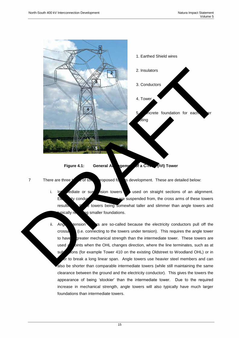
1. Earthed Shield wires
2. Insulators
3. Conductors
4. Tower
5. Concrete foundation for each tower
footing
Figure 4.1: General Arrangement of a C-IVI-1 (IVI) Tower
7 There are three types of tower proposed for this development. These are detailed below:
i. Intermediate or suspension towers are used on straight sections of an alignment.
Electricity conductors hang on, or are suspended from, the cross arms of these towers
resulting in these towers being somewhat taller and slimmer than angle towers and
typically requiring smaller foundations.
ii. Angle / tension towers are so-called because the electricity conductors pull off the
crossarms (i.e. connecting to the towers under tension). This requires the angle tower
to have a greater mechanical strength than the intermediate tower. These towers are
used at points when the OHL changes direction, where the line terminates, such as at
substations (for example Tower 410 on the existing Oldstreet to Woodland OHL) or in
order to break a long linear span. Angle towers use heavier steel members and can
also be shorter than comparable intermediate towers (while still maintaining the same
clearance between the ground and the electricity conductor). This gives the towers the
appearance of being „stockier‟ than the intermediate tower. Due to the required
increase in mechanical strength, angle towers will also typically have much larger
foundations than intermediate towers.
1
2
3
4
5
DRAFT
North-South 400 kV Interconnection Development Natura Impact Statement Volume 5
16
iii. Transposition towers change the physical position of the conductors on a transmission
line (known as phases) while maintaining electrical phase separation and clearance.
Transposition phases can be important over long linear lengths as it balances the
electrical impedance6 between phases of a circuit. Analysis by EirGrid shows that the
operating performance of the proposed interconnector will benefit from a single point of
transposition. Transposition is the practice of transposing or rearranging the spatial
arrangement of the three electricity wires or conductors that make up the three-phase
circuit. The transposition takes place over four structures (the transposition alignment).
8 Conductors are the wires that carry the electricity and comprise a number of conducting
aluminium wires around a high-strength core consisting of steel wire. Each phase typically
consists of a number of single conductors forming a conductor bundle. Generally, the higher
the voltage level, the higher the number of conductors in the bundle. To achieve the required
power capacity of the proposed interconnector, it will be necessary to install a pair of
conductors per phase (known as a twin bundle). These conductors will be separated by
spacers at regular intervals. For the proposed 400 kV OHL, the minimum conductor height
above ground has been designed to 9m.
9 Earth / ground wire or shield wire and optical fibres (OPGW) are installed above the live
conductors at the top of the tower to minimise the likelihood of direct lightning strikes to the
conductors. Shield wires are also conductors but serve a different purpose to live conductors.
Should lightning strike the line it will in all likelihood strike a shield wire rather than a live
conductor (as they are installed above the live conductor). This will not necessarily prevent the
line from tripping out but it will protect the line from being damaged by very quickly dissipating
the energy in the lightning strike away from the line and into the ground. In such
circumstances, if the line did trip out it can be restored automatically in less than a second.
Shield wires may include OPGWs used in respect of controlling the power system and
communication.
Insulators support the conductors and have to withstand both normal operating voltage and surges as a
result of switching and lightning strikes. For transmission lines these tend to be suspended below the
structure and comprise a number of glass or composite discs, the number of which increases for the
higher voltages. The proposed insulator for the proposed development is the composite type. It is
proposed to install earth wire marking in the form of bird flight diverters. The type of flight diverters
recommended are swan flight diverter markers constructed from high impact grey PVC (UV stabilised)
fitted approximately 5m apart along each earth wire. This line marking is proposed for the earth wires to
increase visibility of the earth wires to flying birds. Locations where flight diverters are proposed are
6 Electrical impedance is a measure of the opposition that a circuit presents to the passage of the electrical current as the length
of the circuit increases.
DRAFT
North-South 400 kV Interconnection Development Natura Impact Statement Volume 5
17
detailed in Section 6.6.2.2.2 of Volume 3C and Section 6.6.2.3.2 of Volume 3D of the EIS, and shown
in Figures 6.3.3 and 6.3.4, in Volume 3C Figures and Volume 3D Figures of the EIS.
4.2.2 Project Phases
10 The site clearance works and construction of foundations were identified as the main source of
potential ecological impacts. Other elements of the project are considered as part of the
appraisal which may give rise to possible significant effects on designated sites include
stringing of conductors, access to tower construction, operational stage maintenance /
refurbishment (of towers and conductors). The key phases of the project and a summary
description of key works activities which require consideration regarding potential adverse
effects to European sites are summarised as follows:
4.2.2.1 Construction Phase
11 The following activities that will be undertaken during the construction phase need to be given
due consideration in the assessment of possible significant effects on European sites:
Site clearance and any drainage requirements at tower locations to facilitate
construction;
Excavations required for tower bases;
Excavations required for guard pole structures;
The use of machinery and associated disturbance within the „works area‟ during
construction;
The use of concrete at each construction site;
Management, storage and disposal of excavated material during the construction
phase;
Locations to be used by machinery during the stringing phase;
Access routes to be used by machinery during construction; and
Trimming and lopping of woody vegetation to facilitate clearance beneath the line
between towers.
12 The works for each tower is contained within an area of approximately 900m2. The permanent
direct impact for each tower varies depending on the tower type. Tower foundations typically
range from 2m to 3.5m in depth to the invert level of the foundation and anywhere from 2 x 2
DRAFT
North-South 400 kV Interconnection Development Natura Impact Statement Volume 5
18
metres squared to 9 x 9 metres squared in plan area depending on tower type. Each of the four
corners of the tower stubs (i.e. lower part of the tower leg) are separately anchored below
ground in a block of concrete. The standard construction practice is to use a concrete pipe in
the foundation holes, which is as an integral part of the foundation. Vegetation between tower
foundations under each tower is cleared / disturbed during construction; however it can re-grow
post construction.
13 The key possible significant construction phase effects identified as relevant to European sites
include:
Pollution runoff risks to surface water quality through drains and other watercourses
close to the works area, potentially linked to more ecologically important streams,
rivers and lakes;
Pollution runoff / risks to ground water quality in the vicinity of works area potentially
linked to ground fed wetlands and other surface water features linked to European
sites; and
Disturbance impacts from vegetation clearance and associated disturbance at riparian
areas linked to downstream European sites.
4.2.2.2 Operation Phase
14 The following activities that will be undertaken during the operation phase which will require due
consideration regarding protection of European sites conservation interests:
Occasional tree trimming at riparian areas will be required beneath the alignment with
regard to protection of qualifying interest fauna;
Surface water protection measures during maintenance and occasional refurbishment
of towers throughout the lifetime of the project; and
Risk of Collision with the OHL for sensitive bird species.
4.2.2.3 Decommissioning Phase
15 The proposed development will become a permanent part of the transmission infrastructure.
The expected lifespan of the proposed development is in the region of 50 to 80 years. This will
be achieved by routine maintenance and replacement of hardware as required. There are no
plans for the decommissioning of the OHL or existing substation. In the event that part of, or
the entire, proposed infrastructure is to be decommissioned, all towers, equipment and material
to be decommissioned will be removed off site and the land reinstated.
DRAFT
North-South 400 kV Interconnection Development Natura Impact Statement Volume 5
19
4.3 IDENTIFICATION OF RELEVANT EUROPEAN SITES AND COMPILATION
OF INFORMATION ON THEIR QUALIFYING INTERESTS AND
CONSERVATION OBJECTIVES
16 To inform an appraisal as to which European sites require to be considered in the context of the
proposed development, a review of all European sites within 30km of the overall project study
area was undertaken. It is considered that the 30km buffer adequately identifies all European
sites requiring consideration regarding potential linkage to effects from the proposed
development. Based on this review the following European Sites were considered for
Screening for AA:
Whooper Swan was identified as a species of concern in early consultation, therefore
all SPAs within 30km of the study area where Whooper Swan is a qualifying species
were included in this screening assessment to examine the potential for links to
populations within the study area.
European Sites within the same river catchment of the proposed development, within
30km of the study area.
Lough Oughter and Associated Loughs SPA (Site Code: 004049) are also included
(even though they are located at a distance of 32km from the proposed development)
as Whooper Swan are a qualifying interest for this site, and therefore a species
common to both the SPA and the study area.
All SAC‟s and SPA‟s within 15km of the study area (following recommended distance in
NPWS (2009) Appropriate Assessment Guidance).
17 The list of relevant European sites and their qualifying interests are detailed in Table 4.1.
DRAFT
North-South 400 kV Interconnection Development Natura Impact Statement Volume 5
20
Table 4.1: European Sites Considered for Screening for Appropriate Assessment (AA)
European Site Possible Linkage To Effects
from the Proposed
Development
Qualifying Interests
River Boyne and River
Blackwater cSAC (Site Code:
IE002299)
The proposed development
oversails two stretches of the
cSAC.
River Lamprey Lampetra
fluviatilis, [1106] Salmon
Salmo salar (only in fresh
water), [1355] Otter Lutra
lutra, [7230] Alkaline fens,
[91E0] Alluvial forests with
Alnus glutinosa and Fraxinus
excelsior (Alno‐Padion,
Alnion incanae, Salicion
albae)
River Boyne and River
Blackwater SPA (Site Code:
IE004232)
The proposed development
oversails two stretches of the
cSAC.
[A229] Kingfisher Alcedo at
this [breeding]
Killyconny Bog (Cloghbally)
cSAC (Site Code: IE000006)
The cSAC is within 15km of
proposed development.
[7110] Active raised bogs
[7120] Degraded raised bogs
still capable of natural
regeneration
Rye Water and Carton cSAC
(Site Code: IE001398)
The cSAC is within 15km of
proposed development.
[1014] Vertigo angustior
[1016] Vertigo moulinsiana
[7220] Petrifying springs with
tufa formation (Cratoneurion)
Strabannan-Braganstown
SPA (Site Code: IE004091)
Potential wintering bird
movements between SPA and
location of the proposed
development considered.
Greylag Goose (Anser anser)
[A043]
Boyne Coast and Estuary
SPA (Site Code: IE004080)
Potential wintering bird
movements between SPA and
location of the proposed
development considered.
Wintering waterbirds and
wetlands including the
following species recorded in
the study area; Golden
Plover and Lapwing.
Boyne Coast and Estuary
cSAC (Site Code: IE001957)
The proposed development is
within the River Boyne catchment
hence linkage to possible effects
of the proposed development
considered.
Salicornia and other annuals
colonising mud and sand
(1310)
Atlantic salt meadows
(Glauco-Puccinellietalia
maritimae) (ASM) (1330)
DRAFT
North-South 400 kV Interconnection Development Natura Impact Statement Volume 5
21
European Site Possible Linkage To Effects
from the Proposed
Development
Qualifying Interests
Mediterranean salt meadows
(Juncetaliea maritimi) (MSM)
(1410)
Embryonic shifting dunes
(2110)
Shifting dunes along the
shoreline with Ammophila
arenaria (white dunes) (2120)
Fixed coastal dunes with
herbaceous vegetation (grey
dunes) (2130)
Dundalk Bay SPA (Site Code
IE004026)
Potential wintering bird
movements between SPA and
location of the proposed
development considered.
Wetlands and wintering
Waterbirds including the
following species recorded in
specific locations of the study
area; Golden Plover, Great
Crested Grebe, Teal,
Mallard, Lapwing and
Curlew.
Dundalk Bay cSAC (Site
Code IE000455)
The proposed development is
within a river catchment draining
into this site hence linkage to
possible effects of the proposed
development considered.
Estuaries [1130]
Mudflats and sandflats not
covered by seawater at low
tide [1140]
Perennial vegetation of stony
banks [1220]
Salicornia and other annuals
colonizing mud and sand
[1310]
Atlantic salt meadows
(Glauco-Puccinellietalia
maritimae) [1330]
Mediterranean salt meadows
(Juncetalia maritimi) [1410]
Slieve Beagh SPA (Site
Code IE004167)
Habitats close to the proposed
development are potentially
suitable for wintering Hen Harrier
from the SPA.
Hen Harrier (Circus cyaneus)
[A082] breeding
DRAFT
North-South 400 kV Interconnection Development Natura Impact Statement Volume 5
22
European Site Possible Linkage To Effects
from the Proposed
Development
Qualifying Interests
Lough Oughter and
Associated Loughs SPA (Site
Code: IE004049)
Potential wintering bird (qualifying
interest of SPA) movements
between SPA and location of the
proposed development
considered.
Great Crested Grebe
(Podiceps cristatus) [A005]
Whooper Swan (Cygnus
cygnus) [A038]
Wigeon (Anas penelope)
[A050]
Wetlands & Waterbirds
[A999]
Slieve Beagh –Mullaghfad-
Lisnaskea SPA (Site Code:
UK0016622)
Habitats close to the proposed
development are potentially
suitable for wintering Hen Harrier
from the SPA.
Hen Harrier (Circus cyaneus)
[A082] breeding
18 Designated European sites (referred to as Natura 2000 sites) are detailed in Figure 4.2 CMSA
Natura 2000 Sites Map and Figure 4.3 MSA Natura 2000 Sites Map.
DRAFT
0 2 4 6 8 101Kilometres
NORTH-SOUTH 400 kVINTERCONNECTION DEVELOPMENT
G.Fil O.McAlister December 2014Damien Grehan
Figure 4.2 (CMSA) B
1. FIGURED DIMENSIONS ONLY TO BE TAKEN FROM THIS DRAWING2. DISCOVERY SERIES TILES USED: OS2628, OS2828, OS3028, OS2626, OS2826, OS3026, OS2624, OS2824, OS30243. ALL LEVELS RELATE TO ORDNANCE SURVEY DATUM AT MALIN HEAD4. DESIGNATED CONSERVATION AREAS DATA SOURCED FROM NPWS5. WHOOPER SWANS DATA BASED ON SITE SURVEYS
NOTES
Ordnance Survey Ireland Licence No EN 0016014 ©Ordnance Survey Ireland and Government of Ireland
Dundalk Bay SPA
Lough Sheelin SPA
River Boyne and River Blackwater SPA
Stabannan-Braganstown SPA
SLIEVE BEAGH SPA
River Boyne and River Blackwater SPA
Dundalk Bay
River Boyne And River Blackwater
Killyconny Bog (Cloghbally)
Lough Bane And Lough Glass
River Boyne And River BlackwaterWhite Lough, Ben Loughs And Lough Doo
River Boyne And River Blackwater
Kilroosky Lough Cluster
River Boyne And River Blackwater
Slieve Beagh
Slieve Gullion
Magheraveely Marl Loughs
Magheraveely Marl Loughs
Lough Neagh and Lough Beg
Slieve Beagh-Mullaghfad-Lisnaskea
A
Scale @ A3:
Issue Date Description By Chkd.
Client:
Project:
Title:
Prepared by: Checked: Date:
Project Director:
Consulting, Civil and Structural Engineers,Block 10-4, Blanchardstown Corporate Park, Dublin 15, Ireland
No part of th is document may be reproduced or transmitted in any form or stored in any retrieval system of any nature without the written permission of Patrick J. Tobin & Co. Ltd. as copyright holder except as agreed for use on the project for which the document was originally issued.
1:350,000
tel: +353-(0)1-8030406fax:+353-(0)1-8030409e-mail: [email protected]
NATURA 2000 SITES MAP6244
JAN 2014 Issued G.F. R.McN.
Legend
Route Corridor (MSA)Route Corridor (CMSA)
Candidate Special Area of Conservation (cSAC)Special Protection Area (SPA)
Meath Study Area (MSA)Cavan Monaghan Study Area (CMSA)
30km buffer around line route
N
IssuedB DEC 2014 G.F. O.McA.
DRAFT
0 2 4 6 8 101Kilometres
NORTH-SOUTH 400 kVINTERCONNECTION DEVELOPMENT
G.Fil O.McAlister December 2014Damien Grehan
Figure 4.3 (MSA) B
1. FIGURED DIMENSIONS ONLY TO BE TAKEN FROM THIS DRAWING2. DISCOVERY SERIES TILES USED: OS2628, OS2828, OS3028, OS2626, OS2826, OS3026, OS2624, OS2824, OS30243. ALL LEVELS RELATE TO ORDNANCE SURVEY DATUM AT MALIN HEAD4. DESIGNATED CONSERVATION AREAS DATA SOURCED FROM NPWS
NOTES
Ordnance Survey Ireland Licence No EN 0016014 ©Ordnance Survey Ireland and Government of Ireland
Dundalk Bay SPA
Malahide Estuary SPA
Rogerstown Estuary SPA
Lough Sheelin SPA
River Boyne and River Blackwater SPA
Stabannan-Braganstown SPA
River Boyne and River Blackwater SPA
River Boyne and River Blackwater SPA
River Boyne and River Blackwater SPA
SOUTH DUBLIN BAY AND RIVER TOLKA ESTUARY SPA
Dundalk Bay
Malahide Estuary
River Boyne And River Blackwater
Lough Lene
Rogerstown Estuary
Mount Hevey Bog
Ballynafagh Bog
River Boyne And River Blackwater
Glenasmole Valley
Killyconny Bog (Cloghbally)
Moneybeg And Clareisland Bogs
Lough Bane And Lough Glass
River Boyne And River Blackwater
Rye Water Valley/Carton
White Lough, Ben Loughs And Lough Doo
River Boyne And River Blackwater
A
Scale @ A3:
Issue Date Description By Chkd.
Client:
Project:
Title:
Prepared by: Checked: Date:
Project Director:
Consulting, Civil and Structural Engineers,Block 10-4, Blanchardstown Corporate Park, Dublin 15, Ireland
No part of th is document may be reproduced or transmitted in any form or stored in any retrieval system of any nature without the written permission of Patrick J. Tobin & Co. Ltd. as copyright holder except as agreed for use on the project for which the document was originally issued.
1:350,000
tel: +353-(0)1-8030406fax:+353-(0)1-8030409e-mail: [email protected]
NATURA 2000 SITES MAP6244
JAN 2014 Issued G.F. R.McN.
Legend
Route Corridor (MSA)Route Corridor (CMSA)
Candidate Special Area of Conservation (cSAC)Special Protection Area (SPA)
Meath Study Area (MSA)Cavan Monaghan Study Area (CMSA)
30km buffer around line route
N
B DEC 2014 Issued G.F. O.McA.
DRAFT
North-South 400 kV Interconnection Development Natura Impact Statement Volume 5
25
19 To determine if the development posed any significant, possible significant effects on any of the
listed European sites, the following process was undertaken:
1) All European sites were examined regarding their location with respect to the
development using the NPWS Mapviewer7 and GIS mapping produced for the project,
which displays all designated site boundaries relative to the development. The
conservation objectives and qualifying interests were carefully reviewed. No
management plans are currently available for European sites detailed. It was then
considered whether possible significant adverse effects on these European sites could
arise taking into consideration the characteristics of the proposed development.
2) Qualifying interests (i.e. habitats / species) for all European sites detailed were
reviewed and possible linkages (e.g. via surface and groundwater) to effects of the
development were identified and assessed. In particular, consideration is required
regarding very sensitive qualifying interests and / or those whose conservation status is
„unfavourable‟ based on recent NPWS (2013) status assessments8. Key sensitive
habitats within identified European sites include wetland habitats such as raised bog,
lakes, rivers and fens. Key sensitive species9 at unfavourable conservation status
include Marsh Fritillary, three Vertigo (whorl snail) species, and Freshwater Pearl
Mussel. Species at more favourable conservation status including Otter were also
considered.
20 Additional considerations and information gathering exercises informed the screening appraisal
including:
Understanding that a best practice approach is being implemented for design /
construction; and
Extensive desk study, consultation (with statutory authorities (including NPWS and
BWI) and findings of extensive multi-year ecological field surveys. In particular 7 years
of winter bird studies and breeding bird studies (4 years) which informed the usage of
the study area for bird species possibly linked to SPA sites.
21 The outcome of this aspect of the screening process is to identify European sites in respect of
which the proposed development is likely to have a significant effect (in the sense that there
may be such an effect) and which must be therefore be the subject of a Stage Two appropriate
assessment conducted by the Board. As a corollary, European sites upon which the proposed
7 http://webgis.npws.ie/npwsviewer/ 8 NPWS (2013). The Status of EU Protected Habitats and Species in Ireland. Habitat Assessments Volume 2. Version 1.0. Unpublished Report, National Parks & Wildlife Services. Department of Arts, Heritage and the Gaeltacht, Dublin, Ireland. 9 NPWS (2013). The Status of EU Protected Habitats and Species in Ireland. Species Assessments Volume 3, Version 1.0. Unpublished Report, National Parks & Wildlife Services. Department of Arts, Heritage and the Gaeltacht, Dublin, Ireland.
DRAFT
North-South 400 kV Interconnection Development Natura Impact Statement Volume 5
26
development will have no appreciable effect are excluded from the requirements of a Stage
Two AA. The results of the AA screening are summarised in Table 4.2.
4.4 ASSESSMENT OF LIKELY SIGNIFICANT EFFECTS
22 Possible significant effects from a high voltage overhead transmission line development in the
context of the qualifying interests and European sites detailed may include the following which
are considered in the screening assessment:
Direct impacts (loss / damage) to qualifying habitats associated with the construction of
support towers, guard pole structures, temporary access tracks, and possibly stringing
areas. Typical impacts include habitat loss / degradation and / or changes to qualifying
habitat species composition.
Indirect impacts (loss / damage) to qualifying habitats associated with the construction
of support towers, guard pole structures, temporary access tracks and possibly
stringing areas. Typical impacts include habitat degradation and / or changes to
qualifying habitat species composition.
Indirect impacts such as water pollution risks during the construction phase such as
increased siltation or contamination by fuel or other harmful substances. These risks
significantly increase in sensitive habitats / soils e.g. peat land habitats and in particular
in upland areas with high concentrations of small streams linked to or included in
European sites.
Possible impacts to groundwater flows linked to designated wetland sites caused by
construction activities.
Fragmentation of non-designated habitats linked to similar qualifying habitat in a
designated area.
Disturbance / displacement of qualifying species in and outside designated sites yet
linked to these sites e.g. wintering and breeding birds and otter.
Introduction of non-native / invasive species or creation of conditions that allow the
spread of non-native / invasive e.g. through soil disturbance.
Collision / displacement risks to bird species.
Direct disturbance to species and habitats during management / maintenance.
DRAFT

North-South 400 kV Interconnection Development Natura Impact Statement Volume 5
27
23 For the proposed development, the screening appraisal conducted as to likely AA requirements
and key ecological considerations are detailed in Table 4.2. All qualifying interests of European
sites detailed are considered. In addition, for features where a possible link occurs outside of
sites, such as for mobile species or connecting watercourses, possible effects from the
development are assessed. This assessment considers both the possible significant impacts
from the project alone, and in-combination with other projects.
DRAFT
North-South 400 kV Interconnection Development Natura Impact Statement Volume 5
28
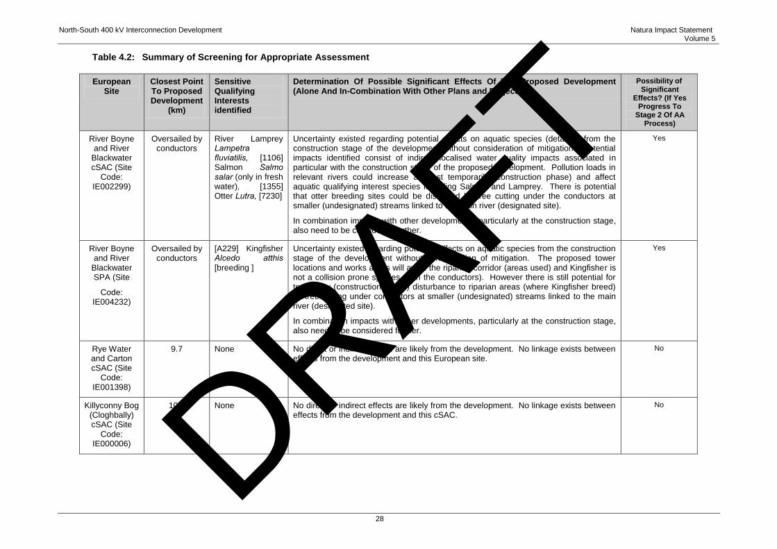
Table 4.2: Summary of Screening for Appropriate Assessment
European Site
Closest Point To Proposed Development
(km)
Sensitive Qualifying Interests identified
Determination Of Possible Significant Effects Of The Proposed Development (Alone And In-Combination With Other Plans and Projects)
Possibility of Significant
Effects? (If Yes Progress To
Stage 2 Of AA Process)
River Boyne and River
Blackwater cSAC (Site
Code: IE002299)
Oversailed by conductors
River Lamprey Lampetra fluviatilis, [1106] Salmon Salmo salar (only in fresh water), [1355] Otter Lutra, [7230]
Uncertainty existed regarding potential effects on aquatic species (detailed) from the construction stage of the development without consideration of mitigation. Potential impacts identified consist of indirect localised water quality impacts associated in particular with the construction stage of the proposed development. Pollution loads in relevant rivers could increase at least temporarily (construction phase) and affect aquatic qualifying interest species including Salmon and Lamprey. There is potential that otter breeding sites could be disturbed by tree cutting under the conductors at smaller (undesignated) streams linked to the main river (designated site).
In combination impacts with other developments, particularly at the construction stage, also need to be considered further.
Yes
River Boyne and River
Blackwater SPA (Site
Code: IE004232)
Oversailed by conductors
[A229] Kingfisher Alcedo atthis [breeding ]
Uncertainty existed regarding potential effects on aquatic species from the construction stage of the development without consideration of mitigation. The proposed tower locations and works areas will avoid the riparian corridor (areas used) and Kingfisher is not a collision prone species (with the conductors). However there is still potential for temporary (construction phase) disturbance to riparian areas (where Kingfisher breed) by tree cutting under conductors at smaller (undesignated) streams linked to the main river (designated site).
In combination impacts with other developments, particularly at the construction stage, also need to be considered further.
Yes
Rye Water and Carton cSAC (Site
Code: IE001398)
9.7 None No direct or indirect effects are likely from the development. No linkage exists between effects from the development and this European site.
No
Killyconny Bog (Cloghbally) cSAC (Site
Code: IE000006)
10.7 None No direct or indirect effects are likely from the development. No linkage exists between effects from the development and this cSAC.
No DRAFT
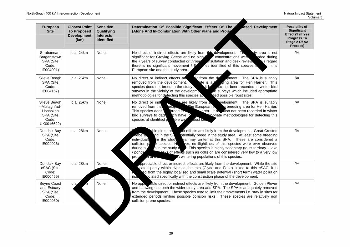
North-South 400 kV Interconnection Development Natura Impact Statement Volume 5
29
European Site
Closest Point To Proposed Development
(km)
Sensitive Qualifying Interests identified
Determination Of Possible Significant Effects Of The Proposed Development (Alone And In-Combination With Other Plans and Projects)
Possibility of Significant
Effects? (If Yes Progress To
Stage 2 Of AA Process)
Strabannan-Braganstown
SPA (Site Code:
IE004091)
c.a. 24km None No direct or indirect effects are likely from the development. The study area is not significant for Greylag Geese and no significant concentrations were recorded during the 7 years of survey conducted or through consultation and desk review. In this regard there is no significant movement / flightlines identified of this species between this European site and the study area.
No
Slieve Beagh SPA (Site
Code: IE004167)
c.a. 25km None No direct or indirect effects are likely from the development. The SPA is suitably removed from the development. The site is a breeding area for Hen Harrier. This species does not breed in the study area. It has also not been recorded in winter bird surveys in the vicinity of the development to date surveys which included appropriate methodologies for detecting this species at identified possible roost sites.
No
Slieve Beagh –Mullaghfad-
Lisnaskea SPA (Site
Code: UK0016622)
c.a. 25km None No direct or indirect effects are likely from the development. The SPA is suitably removed from the development. The European site is a breeding area for Hen Harrier. This species does not breed in the study area. It has also not been recorded in winter bird surveys to date which have included appropriate methodologies for detecting this species at identified possible winter roost sites.
No
Dundalk Bay SPA (Site
Code: IE004026)
c.a. 28km None No appreciable direct or indirect effects are likely from the development. Great Crested Grebe wintering in the SPA potentially breed in the study area. At least some breeding individuals from the study area may winter at this SPA. These are considered a collision prone species. However, no flightlines of this species were ever observed during surveys in the study area. This species is highly sedentary (to its territory – lake / pond) meaning risks of effects such as collision are considered very low to a very low proportion of the overall SPA wintering populations of this species.
No
Dundalk Bay cSAC (Site
Code: IE000455)
c.a. 28km None No appreciable direct or indirect effects are likely from the development. While the site is located partly within river catchments (Glyde and Fane) linked to this cSAC; it is removed from the highly localised and small scale potential (short term) water pollution risks associated specifically with the construction phase of the development.
No
Boyne Coast and Estuary SPA (Site
Code: IE004080)
c.a. 29km None No appreciable direct or indirect effects are likely from the development. Golden Plover and Lapwing use both the wider study area and SPA. The SPA is adequately removed from the development. These species tend to limit their movements i.e. stay in sites for extended periods limiting possible collision risks. These species are relatively non collision prone species.
No DRAFT
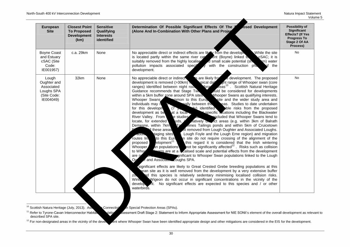
North-South 400 kV Interconnection Development Natura Impact Statement Volume 5
30
European Site
Closest Point To Proposed Development
(km)
Sensitive Qualifying Interests identified
Determination Of Possible Significant Effects Of The Proposed Development (Alone And In-Combination With Other Plans and Projects)
Possibility of Significant
Effects? (If Yes Progress To
Stage 2 Of AA Process)
Boyne Coast and Estuary cSAC (Site
Code: IE001957)
c.a. 29km None No appreciable direct or indirect effects are likely from the development. While the site is located partly within the same river catchment (Boyne) linked to this cSAC; it is suitably removed from the highly localised and small scale potential (short term) water pollution impacts associated specifically with the construction phase of the development.
No
Lough Oughter and Associated
Loughs SPA (Site Code: IE004049)
32km None No appreciable direct or indirect effects are likely from the development. The proposed development is removed (>30km) from typical daily flight range of Whooper swan (core ranges) identified between night roost to forage areas10 . Scottish Natural Heritage Guidance recommends that Stage Two AA should be considered for developments within a 5km buffer zone around SPA sites with Whooper Swans as qualifying interests. Whooper Swans are common to this European site and the wider study area and individuals may move occasionally between these areas. Studies to date undertaken for this development (7 year study) identified possible risks from the proposed development as being at a local scale, at specific locations including the Blackwater River Valley. From these studies, it was also concluded that Whooper Swans tend to locate, for extended periods, in relatively distinct areas (e.g. within 3km of Balrath Demesne, within 7km of Tara Mines Tailings ponds and within 5km of Cruicetown Estate). All these areas are well removed from Lough Oughter and Associated Loughs. In addition, staging sites (e.g. Lough Foyle and the Lough Erne region) and migration routes linked to this European site do not require crossing of the alignment of the proposed development11 . In this regard it is considered that the Irish wintering Whooper Swan populations will not be significantly affected12 . Risks such as collision to Whooper Swans are at a localised scale and potential effects from the development are not considered to be significant to Whooper Swan populations linked to the Lough Oughter and Associated Loughs SPA.
No significant effects are likely to Great Crested Grebe breeding populations at this European site as it is well removed from the development by a very extensive buffer zone and this species is relatively sedentary minimising localised collision risks. Wintering Wigeon do not occur in significant concentrations in the vicinity of the development. No significant effects are expected to this species and / or other waterbirds.
No
10 Scottish Natura Heritage (July, 2013). Assessing Connectivity with Special Protection Areas (SPAs). 11 Refer to Tyrone-Cavan Interconnector Habitats Regulations Assessment Draft Stage 2: Statement to Inform Appropriate Assessment for NIE SONIi‟s element of the overall development as relevant to
described SPA site. 12 For non-designated areas in the vicinity of the development where Whooper Swan have been identified appropriate design and other mitigations are considered in the EIS for the development. DRAFT
North-South 400 kV Interconnection Development Natura Impact Statement Volume 5
31
24 Based on the information contained in Table 4.2, it was not considered possible to rule out
significant effects of the proposed development on the River Boyne and River Blackwater cSAC and
SPA, alone or in combination with other developments, without employing mitigation measures.
Whilst it may well be appropriate to consider certain mitigation measures at the Stage 1 screening,
for the purposes of this proposed development, it has been concluded that, in respect of these two
European sites, the proposed development should proceed to Stage 2 of the AA process, as
described in Section 5 of this NIS. Of course, pursuant to the provisions of Part XAB of the 2000
Act, there is a mandatory obligation on the Board, as competent authority, to carry out screening for
appropriate assessment before consent is given for this, or any, project. However, it is concluded
that all other European sites (apart from the River Boyne and River Blackwater cSAC and SPA)
detailed in this section of the NIS have been correctly screened out or excluded from further
consideration on the basis of objective information that the proposed development, individually or in
combination with other plans or projects, will have no, or no appreciable, effects on those sites.
DRAFT
North-South 400 kV Interconnection Development Natura Impact Statement Volume 5
32
5 STAGE TWO APPROPRIATE ASSESSMENT
1 In the circumstances set out above, the developer has concluded that the River Boyne and River
Blackwater cSAC and River Boyne and River Blackwater SPA are the only two European sites in
respect of which there is the possibility of a significant effect from the proposed development and
which, therefore, generate the need for an Appropriate Assessment (AA). Thus, in carrying out an
AA under Article 6(3) of the Habitats Directive and Part XAB of the 2000 Act, An Bord Pleanála (the
Board) is obliged to make a determination as to whether or not the proposed development would
adversely affect the integrity of those two European sites, in view of their conservation objectives.
1 The first steps in such a Stage Two AA process are to identify the conservation objectives of the
Natura 2000 site and to identify those aspects of the plan or project (alone and in combination with
other plans or projects) that have the potential to affect those objectives.
2 Accordingly, this NIS contains a comprehensive appraisal of the potential ecological impacts of the
proposed development on the two European sites, which examines the direct and indirect impacts of
the proposed development (including any „in-combination‟ effects) on the two European sites
concerned, in view of those sites‟ conservation objectives. However, as the competent authority
must carryout the AA, based on the NIS and any other information it may consider necessary, in
order to facilitate the AA to be conducted by the Board, the potential impacts arising from the
proposed development are assessed in relation to the conservation objectives of the River Boyne
and River Blackwater cSAC and River Boyne and River Blackwater SPA Appropriately, mitigation
measures are detailed and assessed where the potential for adverse effects to arise exists. It
should be noted that a number of these measures are integral to the overall design of the project, so
as to avoid or mitigate potential effects by design.
3 In these circumstances, the NIS submitted shall assist the Board to:
(i) identify, in the light of the best scientific knowledge in the field, all aspects of the proposed
development which can, by itself or in combination with other plans or projects, affect the
conservation objectives of the European site;
(ii) formulate complete, precise and definitive findings and conclusions; and
(iii) thereafter, to determine that the proposed development will not adversely affect the
integrity of any relevant European site.
5.1 CHARACTERISTICS OF EUROPEAN SITES
4 The River Boyne and River Blackwater cSAC and SPA boundaries overlap to a large degree, with
the SPA largely confined to the area within the river channels, whereas the cSAC boundary partly
extends beyond the river channels to include the more extensive riparian habitats.
DRAFT

North-South 400 kV Interconnection Development Natura Impact Statement Volume 5
33
5.1.1 River Boyne and River Blackwater cSAC
5 A full description of the River Boyne and River Blackwater cSAC (site code IE002299) and
conservation objectives is detailed in Appendix A of this report. The assessment of vulnerability to
threats is identified from relevant Natura 2000 forms referenced16 and a review of the most recent
information on conservation status of described qualifying interests detailed in Table 5.1.
6 The main threats to the ecological interests of this site identified by the National Parks and Wildlife
Service (NPWS) are further drainage schemes and water pollution. NPWS Natura 2000 Data Form
and Site Synopsis Form17 note that in the past, where drainage occurred, it altered the character of
the river and removed natural bankside structure and vegetation. Ongoing maintenance dredging is
carried out along stretches of the river system where the gradient is low. This can be extremely
destructive to salmonid habitat. Drainage also impacts on the many small wetland areas throughout
the site. Water quality is impaired in parts of the system through agricultural runoff and inputs from
domestic and industrial sources. A reduction in the input of pollutants to the system is required to
preserve the important aquatic interests in this site as sensitive aquatic qualifying interests in
particular Atlantic Salmon depend on high water quality in the cSAC. The conservation objective of
this site designation is to maintain or restore the favourable conservation condition of the Annex I
habitat(s) and / or the Annex II species for which the River Boyne and River Blackwater cSAC has
been selected. Qualifying interests identified as relevant and conservation status are summarised in
Table 5.1.
16 http://www.npws.ie/media/npwsie/content/images/protectedsites/natura2000/NF002299.pdf. 17 http://www.npws.ie/protectedsites/specialareasofconservationsac/riverboyneandriverblackwatersac/.
DRAFT
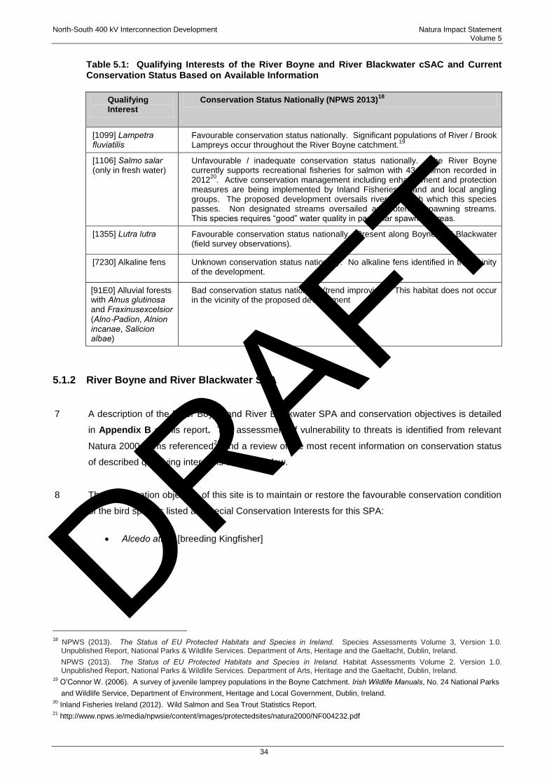
North-South 400 kV Interconnection Development Natura Impact Statement Volume 5
34
Table 5.1: Qualifying Interests of the River Boyne and River Blackwater cSAC and Current Conservation Status Based on Available Information
Qualifying Interest
Conservation Status Nationally (NPWS 2013)18
[1099] Lampetra fluviatilis
Favourable conservation status nationally. Significant populations of River / Brook Lampreys occur throughout the River Boyne catchment.19
[1106] Salmo salar (only in fresh water)
Unfavourable / inadequate conservation status nationally. The River Boyne currently supports recreational fisheries for salmon with 434 salmon recorded in 201220. Active conservation management including enhancement and protection measures are being implemented by Inland Fisheries Ireland and local angling groups. The proposed development oversails rivers through which this species passes. Non designated streams oversailed are potential spawning streams. This species requires “good” water quality in particular spawning areas.
[1355] Lutra lutra
Favourable conservation status nationally. Present along Boyne and Blackwater (field survey observations).
[7230] Alkaline fens
Unknown conservation status nationally. No alkaline fens identified in the vicinity of the development.
[91E0] Alluvial forests with Alnus glutinosa and Fraxinusexcelsior (Alno‐Padion, Alnion incanae, Salicion albae)
Bad conservation status nationally (trend improving). This habitat does not occur in the vicinity of the proposed development
5.1.2 River Boyne and River Blackwater SPA
7 A description of the River Boyne and River Blackwater SPA and conservation objectives is detailed
in Appendix B of this report. The assessment of vulnerability to threats is identified from relevant
Natura 2000 forms referenced21 and a review of the most recent information on conservation status
of described qualifying interest is detailed below.
8 The conservation objective of this site is to maintain or restore the favourable conservation condition
of the bird species listed as Special Conservation Interests for this SPA:
Alcedo atthis [breeding Kingfisher]
18 NPWS (2013). The Status of EU Protected Habitats and Species in Ireland. Species Assessments Volume 3, Version 1.0.
Unpublished Report, National Parks & Wildlife Services. Department of Arts, Heritage and the Gaeltacht, Dublin, Ireland. NPWS (2013). The Status of EU Protected Habitats and Species in Ireland. Habitat Assessments Volume 2. Version 1.0.
Unpublished Report, National Parks & Wildlife Services. Department of Arts, Heritage and the Gaeltacht, Dublin, Ireland. 19 O‟Connor W. (2006). A survey of juvenile lamprey populations in the Boyne Catchment. Irish Wildlife Manuals, No. 24 National Parks
and Wildlife Service, Department of Environment, Heritage and Local Government, Dublin, Ireland. 20 Inland Fisheries Ireland (2012). Wild Salmon and Sea Trout Statistics Report. 21 http://www.npws.ie/media/npwsie/content/images/protectedsites/natura2000/NF004232.pdf
DRAFT

North-South 400 kV Interconnection Development Natura Impact Statement Volume 5
35
9 There are no known threats identified in the NPWS assessment of vulnerability to Kingfisher
populations in this SPA22. However Kingfishers, as a species which nest in riverside bank holes, are
vulnerable during the breeding season to predation (e.g. Mink) and possible disturbance at the nest
site e.g. resulting from the removal of riparian vegetation etc.
10 Kingfisher are an „Amber‟ listed breeding species of medium conservation concern in Ireland, as
listed on BWI‟s list of Birds of Conservation Concern In Ireland (BoCCI list)23.
5.2 POTENTIAL IMPACTS
5.2.1 Proposed Development
11 The overhead line (OHL) will oversail the River Boyne and River Blackwater cSAC and SPA at two
locations see Figures 5.1 and 5.2:
The River Boyne between Towers 355 and 356 in the townlands of Rathnally and Trubley
near Trim; and
The River Blackwater between Towers 310 and 311 in the townlands of Castlemartin and
Teltown close to Donaghpatrick Village.
12 It is important to note that no towers or guard poles will be located within the European sites and
that tower locations are at a remove from the European site boundaries. Table 5.2 identifies a
number of key sensitive locations where potentially sensitive qualifying receptors may require
mitigation.
13 The key activities identified which may affect water quality are identified during the construction
phase only and include:
Laying of temporary access routes (using aluminium panels / rubber mats), where
necessary;
Excavation of tower foundations and construction of towers;
Excavation of guard pole foundations;
Works near watercourses;
Construction materials;
22 http://www.npws.ie/media/npwsie/content/images/protectedsites/natura2000/NF004232.pdf 23 BirdWatch Ireland (2013)
http://www.birdwatchireland.ie/OurWork/SpeciesHabitatConservationinIreland/BirdsofConservationConcern/tabid/178/Default.aspx
DRAFT
North-South 400 kV Interconnection Development Natura Impact Statement Volume 5
36
Stockpiling material; and
Stringing of Cables.
14 These activities have the potential, without mitigation, to impact on the water environment and
associated qualifying aquatic species in the River Boyne and River Blackwater cSAC and SPA by
causing:
Sediment Discharges associated with dewatering at tower locations, soil water runoff and
more direct discharges to water courses;
Erosion of banksides;
Disturbance to otter / Kingfisher breeding sites (riparian areas crossed); and
Contaminant discharges e.g. petroleum runoff.
15 A number of tributary rivers (non-designated) linked to this site are also oversailed and general
locations are also detailed in Table 5.1. Potential impacts have been identified, together with
mitigation measures recommended to overcome any uncertainty regarding whether such impacts
will arise. Moreover, the effectiveness of these proposed mitigation measures have also been
detailed. A detailed description of this proposed mitigation is described in Section 6 of this report.
DRAFT
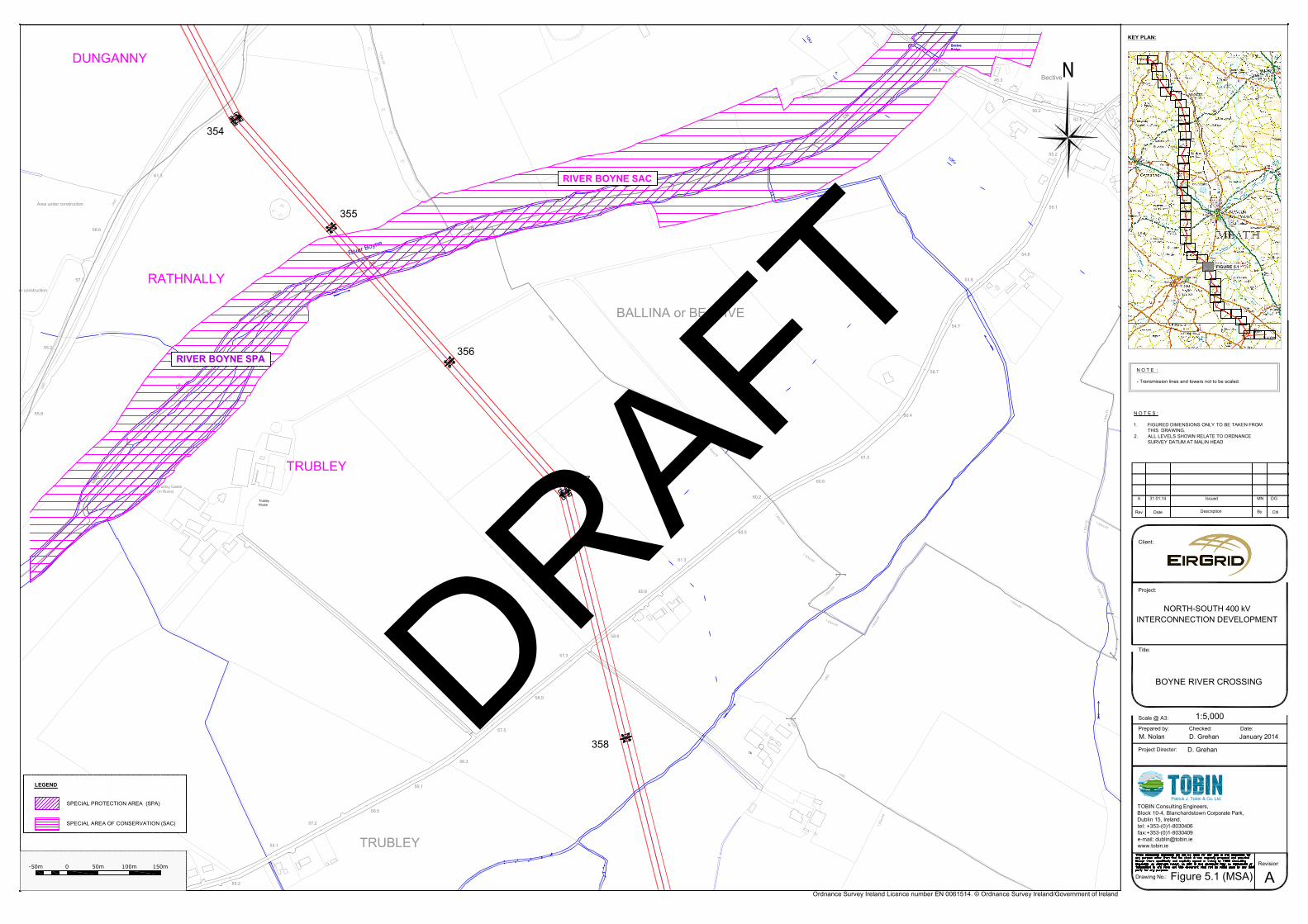
TrubleyHouse
CR
CR
UND
CR
CR
CR
UND
UND
Trubley Castle(In Ruins)
Area under construction
er construction
10kv
T
58.6
60.2
60.5
55.2
57.1
61.3
60.6
61.0
60.9
55.8
River Boyne
CR
CR
UND
UND
1.83m FF
UND
CR
CR
CR
1.83m FF
UND
1.83m FF
UND
UND
BALLINA or BECTIVE
60.4
56.7
52.5
50.2
45.3
44.8
46.4
55.1
55.2
54.7
53.8
54.8
Bective
10Kv
BectiveBridgeBectiveBridge
1.83m FF
1.83
m F
F
1.83
m F
F
Spri
1.83m FF
1.83m FF
Tk
61.3
60.8
57.3
56.5
57.2
58.0
57.5
56.3
55.1
58.6
55.2
55.1
1.83
m F
F
1.83m FF
1.83m FF
1.83m FF
1.83
m FF
UND
1.83m
FF
UND
TRUBLEY
DUNGANNY
TRUBLEY
358
357
355
354
356
RATHNALLY
Ordnance Survey Ireland Licence number EN 0061514. © Ordnance Survey Ireland/Government of Ireland
Client:
Project:
Title:
Scale @ A3:
Prepared by: Checked:
Project Director:
Drawing No.:
Revision:
Rev Date Description By Chkd.
TOBIN Consulting Engineers,Block 10-4, Blanchardstown Corporate Park,Dublin 15, Ireland.tel: +353-(0)1-8030406fax:+353-(0)1-8030409e-mail: [email protected]
Patrick J. Tobin & Co. Ltd.
Date:
NORTH-SOUTH 400 kVINTERCONNECTION DEVELOPMENT
BOYNE RIVER CROSSING
1:5,000
M. Nolan D. Grehan January 2014
D. Grehan
Figure 5.1 (MSA) A
A 31.01.14 Issued MN DG
N O T E S :
1. FIGURED DIMENSIONS ONLY TO BE TAKEN FROMTHIS DRAWING.
2. ALL LEVELS SHOWN RELATE TO ORDNANCESURVEY DATUM AT MALIN HEAD
KEY PLAN:
N O T E :
- Transmission lines and towers not to be scaled.
0-50m 50m 100m 150m
FIGURE 5.1
RIVER BOYNE SAC
RIVER BOYNE SPA
SPECIAL AREA OF CONSERVATION (SAC)
SPECIAL PROTECTION AREA (SPA)
LEGEND
DRAFT
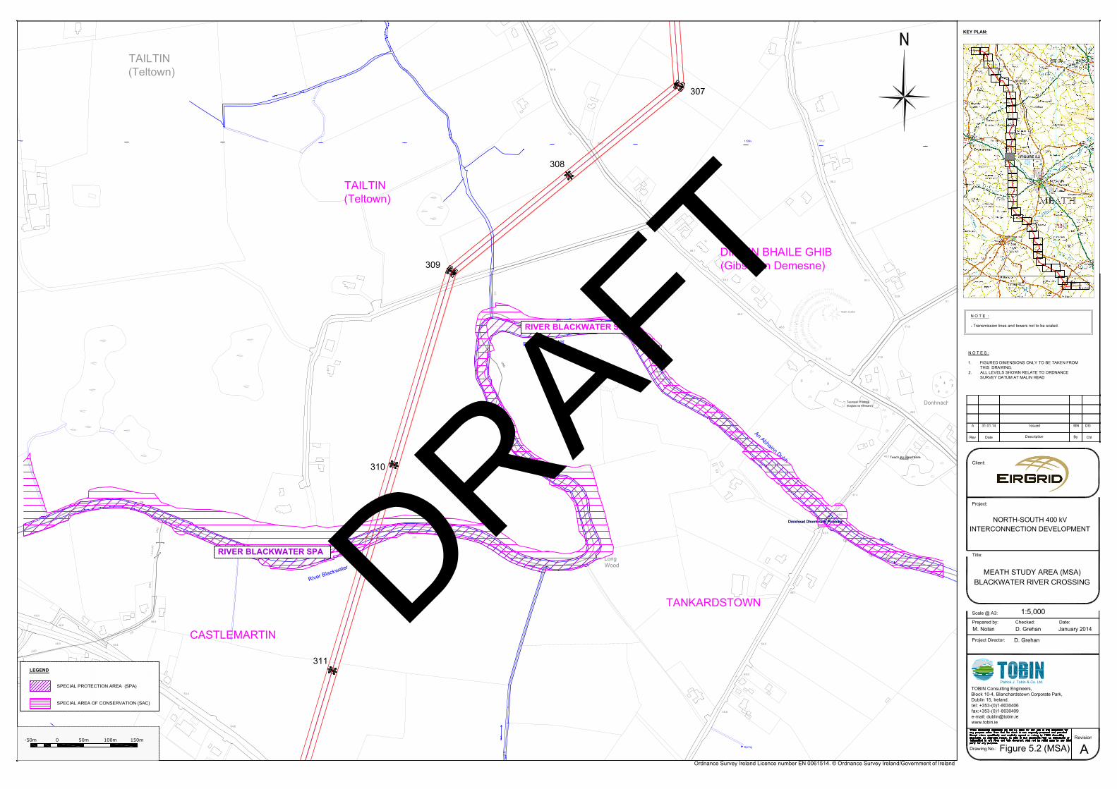
CR
UND
Teach An ReachtaireRectory45.5
CR
UND
Teampall Phádraig(Eaglais na hÉireann)
UND
UNDRáth Oirthir
River Blackwater
48.8
51.2
53.6
56.2
58.2
62.0
52.3
51.6
50.6
47.1
48.1
48.2
48.0
110Kv
TAILTIN(Teltown)
UND
UND
CR
CS
CR
52.9
51.0
49.2
53.3
51.6
51.4
51.8
Donhnach PhCR
48.5
48.0
48.0
46.8
46.6
49.0
50.5
48.1
43.0
41.4
42.5
54.6
53.4
51.5
49.4
Droichead Dhomhnach Phádraig
River Blackwater
An Abhainn Dubh
Spring
Droichead Dhomhnach Phádraig
CR
CR
CR
CR
LongWood
UN
D
1.83
m F
F
CR
CR
CR
CR
UN
D
CR
CR
UND
TANKARDSTOWN
CASTLEMARTIN
DIMÉIN BHAILE GHIB(Gibstown Demesne)
TAILTIN(Teltown)
311
310
309
308
307
Ordnance Survey Ireland Licence number EN 0061514. © Ordnance Survey Ireland/Government of Ireland
Client:
Project:
Title:
Scale @ A3:
Prepared by: Checked:
Project Director:
Drawing No.:
Revision:
Rev Date Description By Chkd.
TOBIN Consulting Engineers,Block 10-4, Blanchardstown Corporate Park,Dublin 15, Ireland.tel: +353-(0)1-8030406fax:+353-(0)1-8030409e-mail: [email protected]
Patrick J. Tobin & Co. Ltd.
Date:
NORTH-SOUTH 400 kVINTERCONNECTION DEVELOPMENT
MEATH STUDY AREA (MSA)BLACKWATER RIVER CROSSING
1:5,000
M. Nolan D. Grehan January 2014
D. Grehan
Figure 5.2 (MSA) A
A 31.01.14 Issued MN DG
N O T E S :
1. FIGURED DIMENSIONS ONLY TO BE TAKEN FROMTHIS DRAWING.
2. ALL LEVELS SHOWN RELATE TO ORDNANCESURVEY DATUM AT MALIN HEAD
KEY PLAN:
N O T E :
- Transmission lines and towers not to be scaled.
0-50m 50m 100m 150m
FIGURE 5.2
RIVER BLACKWATER SAC
RIVER BLACKWATER SPA
SPECIAL AREA OF CONSERVATION (SAC)
SPECIAL PROTECTION AREA (SPA)
LEGEND
DRAFT
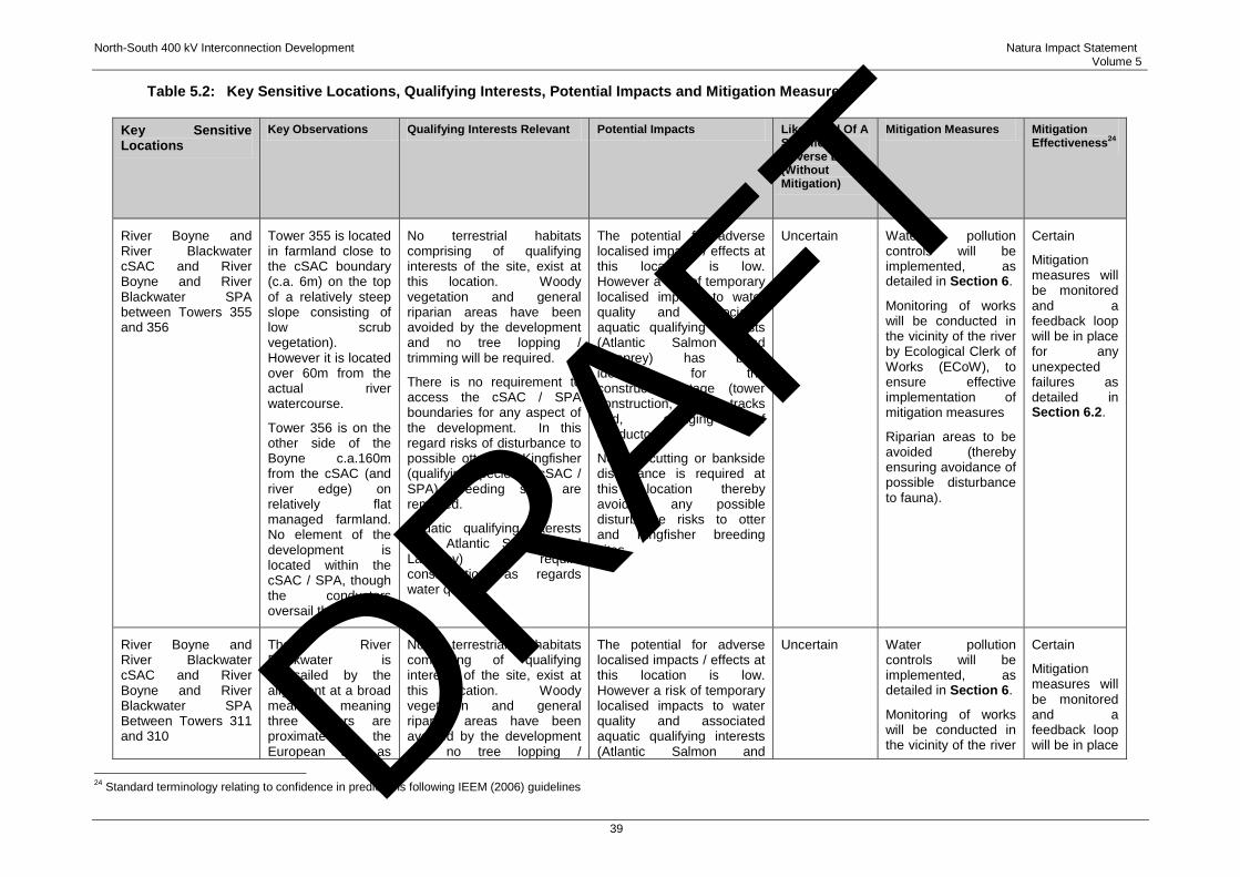
North-South 400 kV Interconnection Development Natura Impact Statement Volume 5
39
Table 5.2: Key Sensitive Locations, Qualifying Interests, Potential Impacts and Mitigation Measures
Key Sensitive Locations
Key Observations Qualifying Interests Relevant Potential Impacts Likelihood Of A Significant Adverse Effect (Without Mitigation)
Mitigation Measures Mitigation Effectiveness
24
River Boyne and River Blackwater cSAC and River Boyne and River Blackwater SPA between Towers 355 and 356
Tower 355 is located in farmland close to the cSAC boundary (c.a. 6m) on the top of a relatively steep slope consisting of low scrub vegetation). However it is located over 60m from the actual river watercourse.
Tower 356 is on the other side of the Boyne c.a.160m from the cSAC (and river edge) on relatively flat managed farmland. No element of the development is located within the cSAC / SPA, though the conductors oversail the site.
No terrestrial habitats comprising of qualifying interests of the site, exist at this location. Woody vegetation and general riparian areas have been avoided by the development and no tree lopping / trimming will be required.
There is no requirement to access the cSAC / SPA boundaries for any aspect of the development. In this regard risks of disturbance to possible otter and Kingfisher (qualifying species of cSAC / SPA) breeding sites are removed.
Aquatic qualifying interests (e.g. Atlantic Salmon and Lamprey) require consideration as regards water quality.
The potential for adverse localised impacts / effects at this location is low. However a risk of temporary localised impacts to water quality and associated aquatic qualifying interests (Atlantic Salmon and Lamprey) has been identified for the construction stage (tower construction, access tracks and, stringing of conductors).
No tree cutting or bankside disturbance is required at this location thereby avoiding any possible disturbance risks to otter and Kingfisher breeding sites.
Uncertain Water pollution controls will be implemented, as detailed in Section 6.
Monitoring of works will be conducted in the vicinity of the river by Ecological Clerk of Works (ECoW), to ensure effective implementation of mitigation measures
Riparian areas to be avoided (thereby ensuring avoidance of possible disturbance to fauna).
Certain
Mitigation measures will be monitored and a feedback loop will be in place for any unexpected failures as detailed in Section 6.2.
River Boyne and River Blackwater cSAC and River Boyne and River Blackwater SPA Between Towers 311 and 310
The River Blackwater is oversailed by the alignment at a broad meander meaning three towers are proximate to the European site as
No terrestrial habitats comprising of qualifying interests of the site, exist at this location. Woody vegetation and general riparian areas have been avoided by the development and no tree lopping /
The potential for adverse localised impacts / effects at this location is low. However a risk of temporary localised impacts to water quality and associated aquatic qualifying interests (Atlantic Salmon and
Uncertain Water pollution controls will be implemented, as detailed in Section 6.
Monitoring of works will be conducted in the vicinity of the river
Certain
Mitigation measures will be monitored and a feedback loop will be in place
24 Standard terminology relating to confidence in predictions following IEEM (2006) guidelines DRAFT
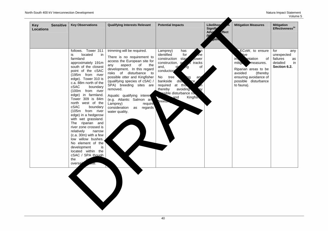
North-South 400 kV Interconnection Development Natura Impact Statement Volume 5
40
Key Sensitive Locations
Key Observations Qualifying Interests Relevant Potential Impacts Likelihood Of A Significant Adverse Effect (Without Mitigation)
Mitigation Measures Mitigation Effectiveness
24
follows. Tower 311 is located in farmland approximately 191m south of the closest point of the cSAC (195m from river edge). Tower 310 is c.a. 88m north of the cSAC boundary (100m from river edge) in farmland. Tower 309 is 84m north west of the cSAC boundary (105m from river edge) in a hedgerow with wet grassland. The riparian and river zone crossed is relatively narrow (c.a. 30m) with a few low willow bushes. No element of the development is located within the cSAC / SPA though the conductors oversail the site.
trimming will be required.
There is no requirement to access the European site for any aspect of the development. In this regard risks of disturbance to possible otter and Kingfisher (qualifying species of cSAC / SPA) breeding sites are removed.
Aquatic qualifying interests (e.g. Atlantic Salmon and Lamprey) require consideration as regards water quality.
Lamprey) has been identified for the construction stage (tower construction, access tracks and, stringing of conductors).
No tree cutting and bankside disturbance is required at this location thereby avoiding any possible disturbance risks to otter and Kingfisher breeding sites.
by ECoW, to ensure effective implementation of mitigation measures.
Riparian areas to be avoided (thereby ensuring avoidance of possible disturbance to fauna).
for any unexpected failures as detailed in Section 6.2.
DRAFT
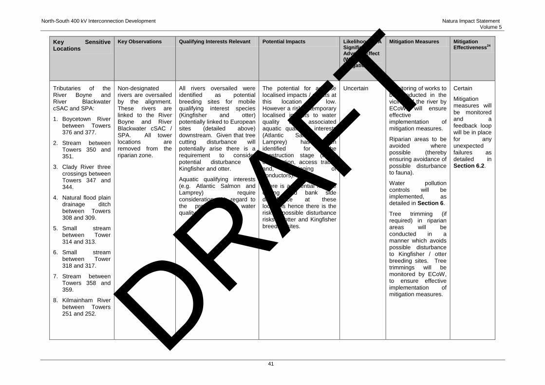
North-South 400 kV Interconnection Development Natura Impact Statement Volume 5
41
Key Sensitive Locations
Key Observations Qualifying Interests Relevant Potential Impacts Likelihood Of A Significant Adverse Effect (Without Mitigation)
Mitigation Measures Mitigation Effectiveness
24
Tributaries of the River Boyne and River Blackwater cSAC and SPA:
1. Boycetown River between Towers 376 and 377.
2. Stream between Towers 350 and 351.
3. Clady River three crossings between Towers 347 and 344.
4. Natural flood plain drainage ditch between Towers 308 and 309.
5. Small stream between Tower 314 and 313.
6. Small stream between Tower 318 and 317.
7. Stream between Towers 358 and 359.
8. Kilmainham River between Towers 251 and 252.
Non-designated rivers are oversailed by the alignment. These rivers are linked to the River Boyne and River Blackwater cSAC / SPA. All tower locations are removed from the riparian zone.
All rivers oversailed were identified as potential breeding sites for mobile qualifying interest species (Kingfisher and otter) potentially linked to European sites (detailed above) downstream. Given that tree cutting disturbance will potentially arise there is a requirement to consider potential disturbance to Kingfisher and otter.
Aquatic qualifying interests (e.g. Atlantic Salmon and Lamprey) require consideration with regard to the protection of water quality.
The potential for adverse localised impacts / effects at this location is low. However a risk of temporary localised impacts to water quality and associated aquatic qualifying interests (Atlantic Salmon and Lamprey) has been identified for the construction stage (tower construction, access tracks and, stringing of conductors).
There is a potential for tree cutting and bank side disturbance at these locations hence there is the risk of possible disturbance risks to otter and Kingfisher breeding sites.
Uncertain Monitoring of works to be conducted in the vicinity of the river by ECoW, will ensure effective implementation of mitigation measures.
Riparian areas to be avoided where possible (thereby ensuring avoidance of possible disturbance to fauna).
Water pollution controls will be implemented, as detailed in Section 6.
Tree trimming (if required) in riparian areas will be conducted in a manner which avoids possible disturbance to Kingfisher / otter breeding sites. Tree trimmings will be monitored by ECoW, to ensure effective implementation of mitigation measures.
Certain
Mitigation measures will be monitored and a feedback loop will be in place for any unexpected failures as detailed in Section 6.2.
DRAFT

North-South 400 kV Interconnection Development Natura Impact Statement Volume 5
42
16 No adverse effects have been identified for qualifying interests of the sites during the operational
stage of the project. This ecological appraisal has considered relevant potential impacts including:
Disturbance associated with riparian woodland trimming (infrequent trimming of riparian
vegetation); and
Possible water quality perturbations associated with maintenance works.
17 These effects will be of a very limited scale and, for example, not require disturbance to river banks
and lower vegetation where potential otter / Kingfisher breeding sites occur.
5.2.2 Potential In-Combination Effects
18 In-combination or cumulative effects may arise from the impacts of other developments in
combination with the proposed development and can include, but is not limited to, multiple effects of
the same or similar type from a number of developments upon the same receptor / resource. This
NIS considers effects that may potentially arise on the River Boyne and River Blackwater cSAC and
SPA from the proposed development in combination with a number of other existing and proposed
developments.
19 For this purpose, the categories of other developments included in the impact assessment include:
Permitted development with the potential for significant in-combination / cumulative effects
with the proposed development (e.g. major linear infrastructure development, such as road
proposals, windfarms or other Strategic Infrastructure Development (SID));
Other permitted and proposed developments with the potential for significant in-combination
effects with the proposed development; and
All permitted and proposed development which have been considered as part of the in-
combination assessment are summarised in Table 5.3. DRAFT
North-South 400 kV Interconnection Development Natura Impact Statement Volume 5
43
Table 5.3: Permitted and Proposed Transmission, Major and SID Projects
PLANNING APPLICATION REFERENCE
PLANNING AUTHORITY
NAME OF APPLICANT
DEVELOPMENT ADDRESS OF THE PROPOSAL
DECISION / STATUS
DATE OF FINAL GRANT
09447 Cavan County Council
ESB Networks To build a 38 kV OHL from existing Shercock 38 kV Station
Shinan, Shercock and across the townlands Lecks, Croley, Lisdrumskea, and to a point at Lisdrumfad, Shercock
Grant with conditions
22/07/2010
09561 Monaghan County Council
ESB Networks To build a 38 kV OHL from existing Shercock 38 kV Station
Shinan, Shercock and across the townlands Lecks, Croley, Lisdrumskea, and to a point at Lisdrumfad, Shercock
Grant with conditions
23/06/2010
PL17.PA0013 Meath County Council
College Proteins Biomass Combined Heat And Power (CHP) Plant
College Road, Nobber, County Meath
Grant with conditions
28/02/2013
PL25.VA0013 Westmeath County Council & Meath County Council
EirGrid Proposed 110 kV Circuit From Mullingar 110 kV Station, Co. Westmeath to Kinnegad 110 kV Station at Killaskillen Townland, County Meath
County Westmeath and County Meath
Grant with conditions
10/01/2013
PL17.PA0026 Meath County Council
Indaver Ireland Limited
Amendments to existing Permissions for Waste Energy Plant
Carranstown, Duleek, County Meath
Grant with conditions
04/02/2013
Ka / 120679 Meath County Council
SSE Renewables Ireland Ltd.
Five wind turbines of up to 80m hub height and up to 82.5m rotor diameter with a total tip height not exceeding 121.25m, a transformer and crane handstand area at each turbine, underground electrical and communication cables linking the turbines, internal site tracks, a permanent meteorological mast 80m high, drainage works, a substation and associated equipment and control building with a wastewater treatment system and associated works.
Teevurcher and Agheragh, Tierworker, Kells (see Figure 10.1, Volume 3B of the EIS).
Granted 06/06/2013
DRAFT
North-South 400 kV Interconnection Development Natura Impact Statement Volume 5
44
PLANNING APPLICATION REFERENCE
PLANNING AUTHORITY
NAME OF APPLICANT
DEVELOPMENT ADDRESS OF THE PROPOSAL
DECISION / STATUS
DATE OF FINAL GRANT
PA0038 An Bord Pleanála North Meath Windfarm Limited
Construction of 3 windfarm clusters comprising inter alia: a combined total of 46 no. wind turbines with a maximum tip height of up to 169 metres and associated turbine foundations, hardstanding areas and drainage; 1 meteorological mast (80 metres in height); a 110 kV substation; 6 no. borrow pits, new entrances and site tracks; cabling between turbines and on-site substation and the existing Gorman substation; and all associated site development works. Details of the proposed development including an EIS are available at www.emlaghwindfarm.ie.
County Meath (north-east of Kells).
[It is located in the vicinity of the North South 400 kV Interconnector between Towers 282 and 295. Refer to Figure 10.2, Voluem 3B of the EIS.]
An application for planning approval was lodged with An Bord Pleanála on 6th October 2014.
N/A N/A National Transport Authority
Phase II of the Dublin to Navan rail link. The Railway Order was substantially complete but was deferred by the Infrastructure and Capital Investment 2012–2016 Medium Term Exchequer Framework (November 2011).
Dublin to Navan rail link
On hold N/A
N/A N/A NRA Leinster Orbital Route (LOR) - in the vicinity of Trim.
Feasibility / On hold
N/A Cavan and Meath County Council
NRA The improvement / replacement of a section of the N3.
From a location south of the Cavan / Meath County boundary (in the townland of Derver, County Meath), to an appropriate location on the existing network between the townlands of Thomas Court or Drumroosk and Kilnaleck, Butlersbridge County Cavan, a potential distance of 46km
Suspended N/A
DRAFT
North-South 400 kV Interconnection Development Natura Impact Statement Volume 5
45
PLANNING APPLICATION REFERENCE
PLANNING AUTHORITY
NAME OF APPLICANT
DEVELOPMENT ADDRESS OF THE PROPOSAL
DECISION / STATUS
DATE OF FINAL GRANT
N/A Louth and Meath County Council
NRA The N52 Ardee bypass consists of 4.48km of reduced single carriageway roadway and commences to the west of Ardee running east to the N2 road North of Ardee. The scheme includes two river crossings of the River Dee and River Garra, a staggered junction at Silver Hill road and a T-junction with the Mullinstown Road.
North of Ardee, County Louth Planning Stage
N/A
N/A Monaghan County Council
NRA Upgrade approximately 28km of the N2 in north County Monaghan between the village of Clontibret and the border of County Tyrone.
Clontibret to the border of County Tyrone.
Suspended N/A
DRAFT
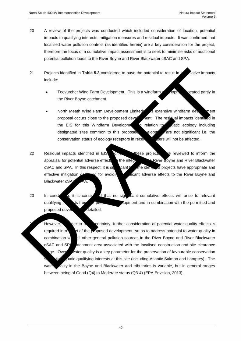
North-South 400 kV Interconnection Development Natura Impact Statement Volume 5
46
20 A review of the projects was conducted which included consideration of location, potential
impacts to qualifying interests, mitigation measures and residual impacts. It was confirmed that
localised water pollution controls (as identified herein) are a key consideration for the project,
therefore the focus of a cumulative impact assessment is to seek to minimise risks of additional
potential pollution loads to the River Boyne and River Blackwater cSAC and SPA.
21 Projects identified in Table 5.3 considered to have the potential to result in cumulative impacts
include:
Teevurcher Wind Farm Development. This is a windfarm development located partly in
the River Boyne catchment.
North Meath Wind Farm Development Limited: This extensive windfarm development
proposal occurs close to the proposed development. The residual impacts identified in
the EIS for this Windfarm Development in relation to aquatic ecology including
designated sites common to this proposed development are not significant i.e. the
conservation status of ecology receptors in receiving waters will not be affected.
22 Residual impacts identified in EIS and NIS for these projects were reviewed to inform the
appraisal for potential adverse effects on the integrity of the River Boyne and River Blackwater
cSAC and SPA. In this respect, it is significant that the identified projects have appropriate and
effective mitigation designed for avoiding significant adverse effects to the River Boyne and
Blackwater cSAC / SPA.
23 In conclusion, it is considered that no significant cumulative effects will arise to relevant
qualifying interests from the proposed development and in-combination with the permitted and
proposed development detailed.
24 However, in order to attain certainty, further consideration of potential water quality effects is
required in respect of the proposed development so as to address potential to water quality in
combination with all other general pollution sources in the River Boyne and River Blackwater
cSAC and SPA catchment area associated with the localised construction and site clearance
stage. Overall water quality is a key parameter for the preservation of favourable conservation
status for aquatic qualifying interests at this site (including Atlantic Salmon and Lamprey). The
water quality in the Boyne and Blackwater and tributaries is variable, but in general ranges
between being of Good (Q4) to Moderate status (Q3-4) (EPA Envision, 2013).
DRAFT

North-South 400 kV Interconnection Development Natura Impact Statement Volume 5
47
25 In this regard water quality protection measures during the construction stage are identified as
a key consideration for the project so as not to add to temporary pollutant loads in relevant river
systems (River Boyne and River Blackwater and associated tributaries) in combination with
other projects / plans / and existing land uses which influence water quality (e.g. agriculture,
forestry, waste water etc.). These mitigation measures are noted in Table 5.2 and are detailed
in Section 6 of this report.
DRAFT
North-South 400 kV Interconnection Development Natura Impact Statement Volume 5
48
6 MITIGATION MEASURES
1 As part of a Stage Two AA, the competent authority must consider mitigation measures
necessary to avoid, reduce or offset potentially adverse effects. Indeed, the European
Commission Guidance (2000) details how mitigation is a central part of the appropriate process.
Moreover, recent guidance emphasises the importance of mitigation. Thus, mitigation
measures are aimed at minimising or even cancelling the negative impact of a project.
Avoidance or reduction of impacts at source should be the preferred options (European
Commission Guidance 2000). Mitigation measures are an integral part of the specifications of a
plan or project and should be considered during the appropriate assessment by the competent
authority.
2 Accordingly, this section of the NIS identifies mitigation measures aimed at minimising or,
where practicable, avoiding any potential negative impact of the proposed development before,
during or after its completion or implementation. The mitigation measures which have been
developed and recommended for implementation shall ensure that the two European sites and
their qualifying interests will not be subject to adverse effects. The Environmental Impact
Statement (EIS) submitted with the application for approval (refer to Volume 3 of the
application documentation) has outlined an extensive suite of mitigation measures that have
been proposed in order to minimise or eliminate the potential effects of the proposed
development. This NIS has further refined these measures to ensure that the mitigation
measures proposed by the developer and / or ultimately required by An Bord Pleanála (the
Board) as competent authority will be implemented so as to ensure the absence of adverse
effects on the integrity of the identified European sites (i.e. River Boyne and River Blackwater
cSAC / SPA).
3 Based on the outcomes of these EIS and NIS appraisals, mitigation measures have been
recommended at specific sensitive locations identified and detailed in Table 5.2. Moreover, the
mitigation incorporated into the design of the proposed development and recommended for
implementation in relation to the construction and operation stages are summarised below.
6.1 DESIGN STAGE MITIGATION (AVOIDANCE)
4 The following mitigation measures or criteria were included at the design stage of the proposed
development:
No tower bases or other support elements of the development will be located within the
boundary of the European sites (although conductors will oversail the sites). Tower
bases and all associated construction activity will be located at least 50m from the
DRAFT
North-South 400 kV Interconnection Development Natura Impact Statement Volume 5
49
designated site river boundaries and will be located outside the actual cSAC boundary.
Riparian semi-natural habitat will be retained undisturbed.
The transmission line oversailing locations are selected at a relatively narrow section of
the European sites at each of the two river crossings.
Towers and all associated construction activity will be located away from all tributaries
of designated rivers.
No in-stream or bankside works will be required within the European site or their
tributaries.
No vegetation clearance will take place within European sites oversailed by the
proposed development (River Boyne and River Blackwater cSAC / SPA). The design
of adjacent towers and sag of the lowest conductor wire is such that it rules out
potential interference from vegetation, particularly at the Boyne crossing, and thus no
cutting of vegetation is required. There is potential for tree cutting only at non-
designated streams crossed and linked to the River Boyne and River Blackwater cSAC
and SPA (main channel).
Stringing of the transmission line will be conducted without a requirement to conduct
works within the boundaries of the European sites and all stringing locations are at a
remove from the European sites. All access by machinery will be marshalled so as to
avoid habitats contained within the designated site boundaries, such as river and
riparian woodlands. Stringing of conductors across the European sites will be
achieved by manually pulling (on foot) a light drawrope across the site and then using
this drawrope to pull in a heavier draw wire from one tower to the next. Other than the
transporting of the drawrope no work will be required at ground level in a European
site.
6.2 CONSTRUCTION PHASE MITIGATION
5 The key potential effects identified during the construction phase of the proposed development
are disturbance to protected fauna (Kingfisher and otter) breeding sites and potential localised
perturbations to water quality (which has potential to adversely affect protected aquatic species
including Salmon and River Lamprey) which have the potential to add to overall in-combination
effects (with other projects / plans / land uses). In this regard specific mitigation measures for
each of the identified relevant categories are detailed below.
DRAFT
North-South 400 kV Interconnection Development Natura Impact Statement Volume 5
50
6 A general mitigation measure is to employ an Ecological Clerk of Works (ECoW) on site during
the construction phase. The ECoW will monitor all construction activities in the vicinity of the
River Boyne and River Blackwater and will monitor and ensure the implementation and
effectiveness of mitigation measures. In addition, all tributaries (refer to Table 5.2) will be
monitored in the vicinity of the crossings in particular to ensure there is no disturbance to
protected fauna (Kingfisher and otter breeding sites) and that reduction in water quality, which
has potential to adversely affect salmon spawning sites, is also avoided. In the unlikely event
of mitigation measures failing, emergency measures will be implemented to prevent impacts to
designated sites / features (e.g. spill kits, bunding) and all works will cease. This will be
coordinated by the ECoW. This feedback loop will ensure mitigation is responsive to any
unexpected issues that arise and therefore the construction phase of the proposed
developlement will not adversely affect the integrity of either European sites concerned.
6.2.1 Protection of Terrestrial Qualifying Fauna Breeding Sites
Kingfisher
7 Riparian areas at the following locations were identified as potential breeding sites for
Kingfisher where disturbance of breeding sites associated with woody vegetation trimming /
tree lopping may arise. These areas include:
Boycetown River between Towers 376 and 377;
Stream between Towers 358 and 359;
Stream between Towers 350 and 351;
Clady River three crossings between Towers 344 and 347;
Small stream between Towers 313 and 314;
Small stream between Towers 317 and 318; and
Kilmainham River between Towers 251 and 252.
8 Confirmatory pre-construction surveys will be undertaken at watercourses linked to the River
Boyne and River Blackwater, where tree felling may lead to disturbance risks to Kingfisher
breeding sites, in order to verify the magnitude of the impacts which have been predicted.
Such confirmatory surveying is required given the likely timescale between the date upon which
planning approval might be granted and the commencement of construction activities in the
material locations, given the dynamic nature / changes in Kingfisher breeding site locations. If
tree cutting is required at a breeding Kingfisher site, then this work will only take place once
Kingfishers have finished breeding (as confirmed by ECoW) or outside the Kingfisher breeding
DRAFT
North-South 400 kV Interconnection Development Natura Impact Statement Volume 5
51
season (typically March to end August). Thus, tree-cutting will be conducted in a manner which
does not damage the breeding site / river bank through careful pollarding of tree limbs and
retention of tree root structures and lower vegetation under which this species typically breeds.
Otter
9 Riparian areas at the following locations were identified as potential breeding sites for otter
where disturbance of breeding sites associated with woody vegetation trimming / tree lopping
may arise.
Boycetown River between Towers 376 and 377;
Stream between Towers 358 and 359;
Stream between Towers 350 and 351;
Clady River three crossings between Towers 344 and 347;
Small stream between Towers 313 and 314;
Small stream between Towers 317 and 318; and
Kilmainham River between Towers 251 and 252.
10 Again, confirmatory pre-construction surveys will be undertaken at watercourses linked to the
River Boyne and River Blackwater where tree felling may lead to disturbance risks to otter
breeding sites. Again, given the dynamic nature / changes in otter breeding site status /
locations, such confirmatory surveying is required given the likely timescale between the date
upon which planning approval might be granted and the commencement of construction
activities in the relevant locations. If an otter breeding site is determined that may possibly be
disturbed, then tree trimming activities will be suspended until such time that the otter breeding
site is vacated and breeding activity is finished, as confirmed by ECoW. As stated above, tree
trimming will be conducted in a manner which does not damage the breeding site / river bank
through careful pollarding of tree limbs and retention of tree root structures and lower
vegetation under which this species typically breeds.
6.2.2 Protection of Water Quality and Qualifying Aquatic Fauna
11 In order to mitigate potential impacts from water pollutants during the construction phase, all
works associated with the construction of the proposed development will be undertaken with
due regard to water quality protection. Mitigation measures to protect water quality have been
incorporated into the outline Construction Environment Management Plan (CEMP) for the
DRAFT
North-South 400 kV Interconnection Development Natura Impact Statement Volume 5
52
proposed development, (included as Appendix 7.1, Volume 3B of the EIS. These mitigation
measures to protect water quality will be implemented and are summarised below.
12 All site works, including temporary access routes, excavation of tower foundations, construction
of towers and stringing will be conducted in an environmentally-responsible manner, so as to
minimise or , insofar as is practicable, eliminate any adverse impacts on water quality that may
potentially occur as a result of works associated with the construction phase. The outline
CEMP, and the detailed CEMP which will be produced by the contractor engaged to construct
the proposed development (which will, itself, contain all mitigation measures set out in the
outline CEMP and the Schedule of Mitigation Measures set out in the EIS) will be employed to
ensure all mitigation measures detailed in the EIS and NIS are implemented and that there is
adequate protection and monitoring of the water environment. Thus, general construction
practices will adhere to the requirements for the protection of fisheries habitat during
construction and development works in the vicinity of river sites published by Inland Fisheries
Ireland (IFI) (Requirements for the Protection of Fisheries Habitat during Construction and
Development Works at River Sites25). Sediment and pollution control measures will be also
undertaken in all work areas located near drains and / or watercourses within catchments of
European sites.
13 Accordingly, for the avoidance of doubt, the following mitigation measures (which are set out in
the draft CEMP and Schedule of Mitigation Measures in the EIS) will be implemented in respect
of specific works locations, including the towers in the vicinity of the two crossings of the River
Boyne and River Blackwater cSAC and SPA and will include a requirement to implement the
following measures:
Silt barrier / silt curtains will be used where towers are to be located and / or works are
to be undertaken near watercourses, such as in the vicinity of the two crossings of the
River Boyne and River Blackwater cSAC and SPA. Correct installation of silt fences is
vital and will be supervised by the construction manager and ECoW. The silt barrier /
silt curtain should be shaped and installed so that it will catch runoff, without the water
flowing underneath or around the edge. The silt barrier will be located down-gradient
of the works and inspected on a regular basis including during and after rainfall events.
For steep slopes, such as in the vicinity of Tower 355, more than one silt curtain will be
used. The edges of the silt curtain will be turned upslope to prevent water going
around the edges. Grips, sumps, straw bales and sediment traps will be installed to
capture silt where applicable. Each of these should be maintained daily by the
25 http://www.fishingireland.net/environment/constructionanddevelopment.htm
DRAFT
North-South 400 kV Interconnection Development Natura Impact Statement Volume 5
53
contractor to ensure that they remain effective and do not increase the likelihood of an
incident occurring.26
It is not anticipated that any localised groundwater dewatering will be required at tower
construction locations in the vicinity of the two crossings of the River Boyne and River
Blackwater cSAC and SPA. However, if localised groundwater dewatering is required
(at tower construction locations) significant impacts on the groundwater level will be
realised only in close proximity to the point of abstraction. Any impacts will be
restricted to the short period of pumping. The resultant water will be filtered before
discharge. In such circumstances, groundwater can be filtered using bunds / tanks
filled with filter material. Single sized aggregates 5–10 mm, geotextiles or straw bales
can be used as a filter. Monitoring will be undertaken on the discharge water quality.
Treated water discharged is likely to be at a very small scale and can be discharged
onto the adjacent field. No discharge will take place directly to water courses linked to
European Sites.
Precautionary measures will be taken to avoid spillages of contaminants including oils /
fuels and concrete or cement (at tower construction sites). These include:
o use of secondary containment, e.g. bunds around oil storage tanks;
o use of drip trays around mobile plant;
o supervising all deliveries and refuelling activities; and
o designating and using specific impermeable refuelling areas isolated from
surface water drains.
With regard to on site storage facilities and activities, any raw materials and fuels, will
be stored within bunded areas, to guard against potential accidental spills or leakages
entering local watercourses linked to the SAC‟s. All equipment and machinery will
have regular checking for leakages and quality of performance. No raw materials or
fuels will be stored within, or in the vicinity of, the SAC‟s.
All site personnel will be trained and aware of the appropriate action in the event of an
emergency, such as the spillage of potentially polluting substances. Spill kits are
retained to ensure that all spillages or leakages are dealt with immediately and staff are
trained in their proper use. Any servicing of vehicles will be confined to designated and
suitably protected areas, and there will be no servicing or refuelling of vehicles within,
or in the vicinity of, the SAC‟s. Any pollution incident or spill will be reported to the
regulator and remediated to their original condition.
26 CIRIA Document 650
DRAFT
North-South 400 kV Interconnection Development Natura Impact Statement Volume 5
54
Temporary access roads used will be temporary rubber or aluminium road panels at
locations in the vicinity of European sites or rivers draining into these sites detailed.
Tracks will be up to 4m wide and routed away from drains in those locations. In
addition, silt barriers will be used at those sensitive locations to prevent direct runoff to
local watercourses. All temporary access routes will be removed at the end of the
construction phase and the land will be restored to its original condition.
Wash down and washout of concrete transporting vehicles will not be permitted at the
location of construction. Such wash down and washout activities will take place at an
appropriate facility offsite or at the location where concrete was sourced.
Water quality monitoring will be undertaken prior to the commencement of construction
to confirm baseline data and ensure that, during the construction phase of the
proposed development, there is no deterioration in water quality. In particular, such
confirmatory monitoring will be targeted at watercourses considered to be at a higher
risk of pollution (e.g. towers where there are watercourses within 20m of the
construction works). At these locations, water quality monitoring will include daily
inspection of adjacent watercourses. Regular sampling for pH and conductivity will be
undertaken in order to ensure the implementation and effectiveness of the
recommended mitigation measures with sampling for suspended solids and
hydrocarbons if any change in the appearance is identified. Daily observations of
watercourses close to construction works will be logged and details of observations
including photographs will be recorded. In the unlikely event that any pollution event is
suspected to have occurred, samples will be collected upstream and downstream of
this point, and sent to an appropriately accredited laboratory for analysis. All works will
halt until the source has been identified, controlled and any remediation undertaken.
6.2.3 Appraisal of Effectiveness of Construction Stage Mitigation
14 Following effective implementation of the above mitigation measures, it is the opinion of the
authors of this NIS that the construction phase of proposed development will not adversely
affect the integrity of any relevant European site on the basis of complete, precise and
definitive findings and that no scientific doubt remains as to the absence of the identified
potential effects in circumstances where the mitigation measures identified in this NIS will be
implemented.
DRAFT

North-South 400 kV Interconnection Development Natura Impact Statement Volume 5
55
6.3 OPERATIONAL PHASE MITIGATION
15 Standard water pollution protection measures, such as those identified in the context of the
construction phase will be implemented during operation of the overhead line (OHL), i.e. during
times of maintenance where any works are undertaken in the vicinity of the River Boyne and
River Blackwater cSAC and SPA.
16 In circumstances where those mitigation measures will be effectively implemented, the
operational phase of the proposed development will not have adverse effects on the integrity of
the European sites considered, i.e. the River Boyne and River Blackwater cSAC and SPA.
DRAFT
North-South 400 kV Interconnection Development Natura Impact Statement Volume 5
56
7 APPROPRIATE ASSESSMENT - CONCLUSION
1 This NIS has been submitted on behalf of the developer of the proposed development to enable
the Board as competent authority to conduct a Stage 1 Screening Assessment in relation to the
designated sites outlined above and the Stage 2 Appropriate Assessment (AA) in relation to the
River Boyne and River Blackwater cSAC and SPA.
2 As established by recent case law, in order for such an AA, to be lawfully conducted, the
competent authority (in this case An Bord Pleanála (the Board)):
(i) must identify, in the light of the best scientific knowledge in the field, all aspects of
the proposed development which can, by itself or in combination with other plans or
projects, affect the conservation objectives of the European site;
(ii) must contain complete, precise and definitive findings and conclusions and may not
have lacunae or gaps; and
(iii) may only include a determination that the proposed development will not adversely
affect the integrity of any relevant European site where the Board decides (on the basis
of complete, precise and definitive findings and conclusions) that no reasonable
scientific doubt remains as to the absence of the identified potential effects.
3 In light of the information described within this Natura Impact Statement (NIS) and appraisal of
the implications of the project for the European sites concerned, it can be concluded that with
the effective implementation of the mitigation measures detailed above and in the EIS, the
proposed development, either alone or in-combination with other plans or projects will not result
in any adverse effects to the integrity of any European Sites, in view of their conservation
objectives.
4 In particular, with reference to the River Boyne and River Blackwater cSAC and SPA, applying
the precautionary principle, the authors of this NIS have demonstrated objectively, with
supporting evidence, that there will be no adverse effects on the integrity of the European sites
concerned, as defined by the conservation objectives and status of those sites.
DRAFT

APPENDIX A
[RIVER BOYNE AND RIVER BLACKWATER CSAC]
DRAFT
North-South 400 kV Interconnection Development Natura Impact Statement Volume 5
A - 1
SITE NAME: RIVER BOYNE AND RIVER BLACKWATER cSAC
SITE CODE: 002299
This site comprises the freshwater element of the River Boyne as far as the Boyne Aqueduct, the
Blackwater as far as Lough Ramor and the Boyne tributaries including the Deel, Stoneyford and
Tremblestown Rivers. These riverine stretches drain a considerable area of Meath and Westmeath and
smaller areas of Cavan and Louth. The underlying geology is Carboniferous Limestone for the most part
with areas of Upper, Lower and Middle well represented. In the vicinity of Kells Silurian Quartzite is
present while close to Trim are Carboniferous Shales and Sandstones. There are many large towns
adjacent to but not within the site. Towns both small and large, include Slane, Navan, Kells, Trim,
Athboy and Ballivor.
The site is a candidate Special Area of Conservation (cSAC) selected for alkaline fen and alluvial
woodlands, both habitats listed on Annex I of the E.U. Habitats Directive. The site is also selected for
the following species listed on Annex II of the same directive – Atlantic Salmon, Otter and River
Lamprey.
The main areas of alkaline fen are concentrated in the vicinity of Lough Shesk, Freehan Lough and
Newtown Lough. The hummocky nature of the local terrain produces frequent springs and seepages
which are rich in lime. A series of base-rich marshes have developed in the poorly-drained hollows,
generally linked with these three lakes. Open water is usually fringed by Bulrush (Typha latifolia),
Common Club-rush (Scirpus lacustris) or Common Reed (Phragmites australis) and this last species
also extends shorewards where a dense stand of Great Fen Sedge or Saw Sedge (Cladium mariscus)
frequently occurs. This in turn grades into a sedge and grass community (Carex spp., Molinia caerulea)
or one dominated by the Black Bog- rush (Schoenus nigricans). An alternative direction for the aquatic
/ terrestrial transition to take is through a floating layer of vegetation. This is normally based on
Bogbean (Menyanthes trifoliata) and Marsh cinquefoil (Potentilla palustris). Other species gradually
become established on this cover; especially plants tolerant of low nutrient status e.g. bog mosses
(Sphagnum spp.).
Diversity of plant and animal life is high in the fen and the flora, includes many rarities. The plants of
interest include Narrow-leaved Marsh Orchid (Dactylorhiza traunsteineri), Fen Bedstraw (Galium
uliginosum), Cowbane (Cicuta virosa), Frogbit (Hydrocharis morsus-ranae) and Least Bur-reed
(Sparganium minimum). These species tend to be restricted in their distribution in Ireland. Also
notable is the abundance of aquatic Stoneworts (Chara spp.) which are characteristic of calcareous
wetlands.
DRAFT
North-South 400 kV Interconnection Development Natura Impact Statement Volume 5
A - 2
The rare plant, Round-leaved Wintergreen (Pyrola rotundifolia) occurs around Newtown Lough. This
species is listed in the Red Data Book and is protected under the Flora Protection Order, 1999, and this
site is its only occurrence in Co. Meath.
Wet woodland fringes many stretches of the Boyne. The Boyne River Islands are a small chain of three
islands situated 2.5km west of Drogheda. The islands were formed by the build-up of alluvial sediment
in this part of the river where water movement is sluggish. All of the islands are covered by dense
thickets of wet, Willow (Salix spp.) woodland, with the following species occurring: Osier (S. viminalis),
Crack Willow (S. fragilis), White Willow (S. alba), Purple Willow (Salix purpurea) and Grey Willow (S.
cinerea). A small area of Alder (Alnus glutinosa) woodland is found on soft ground at the edge of the
canal in the north-western section of the islands. Along other stretches of the rivers of the site Grey
Willow scrub and pockets of wet woodland dominated by Alder have become established, particularly at
the river edge of mature deciduous woodland. Ash (Fraxinus excelsior) and Birch (Betula pubescens)
are common in the latter and the ground flora is typical of wet woodland with Meadowsweet (Filipendula
ulmaria), Angelica (Angelica sylvestris), Yellow Iris, Horsetail (Equisetum spp.) and occasional tussocks
of Greater Tussock- sedge (Carex paniculata).
The dominant habitat along the edges of the river is freshwater marsh - the following plant species occur
commonly here: Yellow Flag (Iris pseudacorus), Creeping Bent (Agrostis stolonifera), Canary Reed-
grass (Phalaris arundinacea), Marsh Bedstraw (Galium palustre), Water Mint (Mentha aquatica) and
Water Forget-me-not (Myosotis scorpioides). In the wetter areas of the marsh Common Meadow-rue
(Thalictrum flavum) is found. In the vicinity of Dowth, Fen Bedstraw (Galium uliginosum), a scarce
species mainly confined to marshy areas in the midlands, is common in this vegetation. Swamp
Meadow-grass (Poa palustris) is an introduced plant which has spread into the wild (naturalised) along
the Boyne approximately 5km south-west of Slane. It is a rare species which is listed in the Red Data
Book and has been recorded among freshwater marsh vegetation on the banks of the Boyne in this site.
The only other record for this species in the Ireland is from a site in Co. Monaghan.
The secondary habitat associated with the marsh is wet grassland and species such as Tall Fescue
(Festuca arundinacea), Silverweed (Potentilla anserina), Creeping Buttercup (Ranunculus repens),
Meadowsweet (Filipendula ulmaria) and Meadow Vetchling (Lathyrus pratensis) are well represented.
Strawberry Clover (Trifolium fragiferum), a plant generally restricted to coastal locations in Ireland, has
been recorded from wet grassland vegetation at Trim. At Rossnaree river bank on the River Boyne, is
Round-Fruited Rush (Juncus compressus) found in alluvial pasture, which is generally periodically
flooded during the winter months. This rare plant is only found in three counties in Ireland.
Along much of the Boyne and along tributary stretches are areas of mature deciduous woodland on the
steeper slopes above the floodplain marsh or wet woodland vegetation. Many of these are planted in
origin. However the steeper areas of King Williams Glen and Townley Hall wood have been left
unmanaged and now have a more natural character. East of Curley Hole the woodland has a natural
DRAFT
North-South 400 kV Interconnection Development Natura Impact Statement Volume 5
A - 3
appearance with few conifers. Broad-leaved species include Oak (Quercus spp.), Ash (Fraxinus
excelsior), Willows, Hazel (Corylus avellana), Sycamore (Acer pseudoplatanus), Holly (Ilex aquifolium),
Horse chestnut (Aesculus sp.) and the shrubs Hawthorn (Crataegus monogyna), Blackthorn (Prunus
spinosa) and Elder (Sambucus nigra). South-west of Slane and in Dowth, the addition of some more
exotic tree species such as Wych Elm (Ulmus glabra), Beech (Fagus sylvatica), and occasionally Lime
(Tilia cordata), are seen. Coniferous trees, Larch (Larix sp.) and Scots Pine (Pinus sylvestris) also
occur.
The woodland ground flora includes Barren Strawberry (Potentilla sterilis), Enchanter‟s Nightshade
(Circaea lutetiana) and Ground-ivy (Glechoma hederacea), along with a range of ferns. Variation
occurs in the composition of the canopy, for example, in wet patches alongside the river, White Willow
and Alder form the canopy. Other habitats present along the Boyne and Blackwater include lowland dry
grassland, improved grassland, reedswamp, weedy waste ground areas, scrub, hedge, drainage ditches
and canal. In the vicinity of Lough Shesk, the dry slopes of the morainic hummocks support grassland
vegetation which, in some places, is partially colonised by Gorse (Ulex europaeus) scrub. Those
grasslands which remain unimproved for pasture are species-rich with Common Knapweed (Centaurea
nigra), Creeping Thistle (Cirsium arvense) and Ribwort Plantain (Plantago lanceolata) commonly
present. Fringing the canal alongside the Boyne south-west of Slane, are Reed Sweet-grass (Glyceria
maxima), Great Willowherb (Epilobium hirsutum) and Meadowsweet.
The Boyne and its tributaries is one of Ireland‟s premier game fisheries and it offers a wide range of
angling from fishing for spring salmon and grilse to sea trout fishing and extensive brown trout fishing.
Atlantic Salmon (Salmo salar) use the tributaries and headwaters as spawning grounds. Although this
species is still fished commercially in Ireland, it is considered to be endangered or locally threatened
elsewhere in Europe and is listed on Annex II of the Habitats Directive. Atlantic Salmon run the Boyne
almost every month of the year. The Boyne is most important as it represents an eastern river which
holds large three-sea-winter fish from 20 –30lb. These fish generally arrive in February with smaller
spring fish (10lb) arriving in April / May. The grilse come in July, water permitting. The river gets a
further run of fish in late August and this run would appear to last well after the fishing season. The
salmon fishing season lasts from 1st March to 30th September.
The Blackwater is a medium sized limestone river which is still recovering from the effects of the arterial
drainage scheme of the 70‟s. Salmon stocks have not recovered to the numbers pre drainage. The
Deel, Riverstown, Stoneyford and Tremblestown Rivers are all spring fed with a continuous high volume
of water. They are difficult to fish in that some are overgrown while others have been affected by
drainage with the resulting high banks. The site is also important for the populations of two other
species listed on Annex II of the E.U. Habitats Directive, namely River Lamprey (Lampetra fluviatilis)
which is present in the lower reaches of the Boyne River while the Otter (Lutra lutra) can be found
throughout the site. In addition, the site also supports many more of the mammal species occurring in
Ireland. Those which are listed in the Irish Red Data Book include Pine Marten, Badger and Irish Hare.
DRAFT
North-South 400 kV Interconnection Development Natura Impact Statement Volume 5
A - 4
Common Frog, another Red Data Book species, also occurs within the site. All of these animals with
the addition of the Stoat and Red Squirrel, which also occur within the site, are protected under the
Wildlife Act. Whooper Swans winter regularly at several locations along the Boyne and Blackwater
Rivers. Parts of these areas are within the cSAC site.
Known sites are at Newgrange (c.a. 20 in recent winters), near Slane (20+ in recent winters),
Wilkinstown (several records of 100+) and River Blackwater from Kells to Navan (104 at Kells in winter
1996/97, 182 at Headfort in winter 1997/98, 200-300 in winter 1999/00). The available information
indicates that there is a regular wintering population of Whooper Swans based along the Boyne and
Blackwater River valleys. The birds use a range of feeding sites but roosting sites are not well known.
The population is substantial, certainly of national, and at times international, importance. Numbers are
probably in the low hundreds.
Intensive agriculture is the main land use along the site. Much of the grassland is in very large fields
and is improved. Silage harvesting is carried out. The spreading of slurry and fertiliser poses a threat
to the water quality of this salmonid river and to the lakes. In the more extensive agricultural areas
sheep grazing is carried out. Fishing is a main tourist attraction on the Boyne and Blackwater and there
are a number of Angler Associations, some with a number of beats. Fishing stands and styles have
been erected in places. The Eastern Regional Fishery Board has erected fencing along selected
stretches of the river as part of their salmonid enhancement programme. Parts of the river system have
been arterially dredged. In 1969 an arterial dredging scheme commenced and disrupted angling for 18
years. The dredging altered the character of the river completely and resulted in many cases in leaving
very high banks. The main channel from Drogheda upstream to Navan was left untouched, as were a
few stretches on the Blackwater. Ongoing maintenance dredging is carried out along stretches of the
river system where the gradient is low and is extremely destructive to salmonid habitat in the area.
Drainage of the adjacent river systems also impacts on the many small wetland areas throughout the
site. The River Boyne is a designated Salmonid Water under the EU Freshwater Fish Directive. The
site supports populations of several species listed on Annex II of the EU Habitats Directive, and habitats
listed on Annex I of this directive, as well as examples of other important habitats. Although the wet
woodland areas appear small there are few similar examples of this type of alluvial wet woodland
remaining in the country, particularly in the north-east. The semi-natural habitats, particularly the strips
of woodland which extend along the river banks and the marsh and wet grasslands, increase the overall
habitat diversity and add to the ecological value of the site as does the presence of a range of Red Data
Book plant and animal species and the presence of nationally rare plant species.
6.10.2006 DRAFT

North-South 400 kV Interconnection Development Natura Impact Statement Volume 5
A - 5
Conservation Objectives for River Boyne and River Blackwater cSAC [002299]
European and national legislation places a collective obligation on Ireland and its citizens to maintain
habitats and species in the European network at favourable conservation condition. The Government
and its agencies are responsible for the implementation and enforcement of regulations that will ensure
the ecological integrity of these sites.
Favourable conservation status of a habitat is achieved when:
its natural range, and area it covers within that range, are stable or increasing,
the specific structure and functions which are necessary for its long‐term maintenance exist and
are likely to continue to exist for the foreseeable future, and
the conservation status of its typical species is favourable.
Favourable conservation status of a species is achieved when:
population dynamics data on the species concerned indicate that it is maintaining itself on a
long term basis as a viable component of its natural habitats,
the natural range of the species is neither being reduced nor is likely to be reduced for the
foreseeable future, and
there is, and will probably continue to be, a sufficiently large habitat to maintain its populations
on a long term basis.
Objective: To maintain or restore the favourable conservation condition of the Annex I habitat(s) and / or
the Annex II species for which the Special Areas of Conservation (SAC) has been selected:
The overall aim of the Habitats Directive is to maintain or restore the favourable conservation status of
habitats and species of community interest. These habitats and species are listed in the Habitats and
Birds Directives and SAC and Special Protection Areas (SPAs) are designated to afford protection to
the most vulnerable of them. These two designations are collectively known as the Natura 2000
network.
The maintenance of habitats and species within Natura 2000 sites at favourable conservation condition
will contribute to the overall maintenance of favourable conservation status of those habitats and
species at a national level.
[1099] Lampetra fluviatilis
DRAFT

North-South 400 kV Interconnection Development Natura Impact Statement Volume 5
A - 6
[1106] Salmo salar (only in fresh water)
[1355] Lutra lutra
[7230] Alkaline fens
[91E0] * Alluvial forests with Alnus glutinosa and Fraxinus excelsior (Alno‐Padion, Alnion
incanae, Salicion albae)
DRAFT

DRAFT
APPENDIX B
[RIVER BOYNE AND RIVER BLACKWATER SPA]
DRAFT
North-South 400 kV Interconnection Development Natura Impact Statement Volume 5
B - 1
SITE NAME: RIVER BOYNE AND RIVER BLACKWATER SPA
SITE CODE: 004232
The River Boyne and River Blackwater Special Protection Areas (SPA) is a long, linear site that
comprises stretches of the River Boyne and several of its tributaries; most of the site is in Co. Meath,
but it extends also into counties Cavan, Louth and Westmeath. It includes the following river sections:
the River Boyne from the M1 motorway bridge, west of Drogheda, to the junction with the Royal Canal,
west of Longwood, Co Meath; the River Blackwater from its junction with the River Boyne in Navan to
the junction with Lough Ramor in Co. Cavan; the Tremblestown River / Athboy River from the junction
with the River Boyne at Kilnagross Bridge west of Trim to the bridge in Athboy, Co. Meath; the
Stoneyford River from its junction with the River Boyne to Stonestown Bridge in Co. Westmeath; the
River Deel from its junction with the River Boyne to Cummer Bridge, Co. Westmeath. The site includes
the river channel and marginal vegetation.
Most of the site is underlain by Carboniferous limestone but Silurian quartzite also occurs in the vicinity
of Kells and Carboniferous shales and sandstones close to Trim. The site is a SPA under the E.U.
Birds Directive of special conservation interest for the following species: Kingfisher.
A survey in 2010 recorded 19 pairs of Kingfisher (based on 15 probable and 4 possible territories) in the
River Boyne and River Blackwater SPA. A survey conducted in 2008 recorded 20-22 Kingfisher
territories within the SPA. Other species which occur within the site include Mute Swan (90), Teal
(166), Mallard (219), Cormorant (36), Grey Heron (44), Moorhen (84), Snipe (32) and Sand Martin (553)
– all figures are peak counts recorded during the 2010 survey.
The River Boyne and River Blackwater SPA is of high ornithological importance as it supports a
nationally important population of Kingfisher, a species that is listed on Annex I of the E.U. Birds
Directive.
25.11.2010DRAFT
North-South 400 kV Interconnection Development Natura Impact Statement Volume 5
B - 2
Conservation Objectives for River Boyne and River Blackwater SPA [004232]
European and national legislation places a collective obligation on Ireland and its citizens to maintain
habitats and species in the Natura 2000 network at favourable conservation condition. The
Government and its agencies are responsible for the implementation and enforcement of regulations
that will ensure the ecological integrity of these sites.
Favourable conservation status of a habitat is achieved when:
its natural range, and area it covers within that range, are stable or increasing, and
the specific structure and functions which are necessary for its long term maintenance exist and
are likely to continue to exist for the foreseeable future, and
the conservation status of its typical species is favourable.
Favourable conservation status of a species is achieved when:
population dynamics data on the species concerned indicate that it is maintaining itself on a
long term basis as a viable component of its natural habitats, and
the natural range of the species is neither being reduced nor is likely to be reduced for the
foreseeable future, and
there is, and will probably continue to be, a sufficiently large habitat to maintain its populations
on a long term basis.
Objective: To maintain or restore the favourable conservation condition of the bird species listed as
Special Conservation Interests for this Special Protection Areas (SPA): The overall aim of the Habitats
Directive is to maintain or restore the favourable conservation status of habitats and species of
community interest. These habitats and species are listed in the Habitats and Birds Directives and
Special Areas of Conservation and SPA are designated to afford protection to the most vulnerable of
them. These two designations are collectively known as the Natura 2000 network.
The maintenance of habitats and species within Natura 2000 sites at favourable conservation condition
will contribute to the overall maintenance of favourable conservation status of those habitats and
species at a national level.
Alcedo atthis
DRAFT