NORTH OCONEE RIVER: TANYARD CREEK TO LILLY ...
183
9-ELEMENT WATERSHED MANAGEMENT PLAN FOR THE NORTH OCONEE RIVER: TANYARD CREEK TO LILLY BRANCH A TOWN/GOWN PARTNERSHIP
-
Upload
khangminh22 -
Category
Documents
-
view
3 -
download
0
Transcript of NORTH OCONEE RIVER: TANYARD CREEK TO LILLY ...

9-ELEMENT WATERSHED MANAGEMENT PLAN FOR THE NORTH OCONEE RIVER:
TANYARD CREEK TO LILLY BRANCH
A TOWN/GOWN PARTNERSHIP
TABLE OF CONTENTS
I. Goals
II. Watershed Overview A. Lilly Branch B. Tanyard Creek C. The Steam Plant Stream
III. Impairment Summary
A. Monitoring Results B. Official Impairment
1. Fecal Coliform 2. Leaking Underground Storage Tank
C. Other Impairments 1. pH 2. Nutrients 3. Copper 4. Lead 5. Conductivity 6. Turbidity 7. Suspended Solids 8. Invasive Species
IV. Current and Proposed Management Strategies
A. Implement Best Practices 1. Manage Stormwater 2. Collect Dog Waste 3. Minimize Dumpster Runoff 4. Enforce Illicit Discharge Ordinances
B. Repair Leaking Sewer Lines and Stubs C. Restore Targeted Streams and Riparian Buffers D. Educate and Reach Out
1. Continue and Expand Partnership with Elementary Schools 2. Involve UGA classes 3. Engage the Community
E. Monitor to Identify Sources of Pollution and Effectiveness of Management Strategies
V. Next Steps A. Review Plan in Fall 2013 B. Amend Monitoring Plan and Explore Modeling Opportunities C. Develop More Informed Funding Strategy and Procure Funding D. Milestones / Schedule
VI. Plan Review
VII. Appendices
Appendix A. List of Advisory Committee Members Appendix B. Water Quality Monitoring Plan Appendix C. Spring 2012 Practicum Invasive Species Report Appendix D. Stormwater Management: A Plan for the Basins from Tanyard Creek to Lilly Branch on the North Oconee River Appendix E. Spring 2013 Practicum Stormwater Control Measures (SCM) Plan

Appendix F. Spring 2013 Practicum Stormwater BMP Modeling Results Appendix G. Fall 2011 Practicum Report on Pet Waste Collection Appendix H. Watershed Dumpster Survey
Appendix I (a). Tanyard Stream Enhancement and Restoration for the 2030 Athens Downtown Master Plan; (b). Lower Reach Lily Branch Stream Enhancement Appendix J. Draft Tanyard Restoration Trajectory Abstracted From the Natural Communities of Georgia
Appendix K. Spring 2013 Practicum Lesson Plan and Strategy for Barrow School Outreach Appendix L. Watershed History
4
I. GOALS
The Lilly Branch Advisory Committee (Advisory Committee) was formed in December 2011 to oversee the development of this 9-Element Watershed Management Plan for Lilly Branch, Tanyard Creek and Steam Plant watersheds (referred to collectively as the Campus Watershed). The committee is made up of UGA faculty from multiple departments with expertise in water quality or watershed planning; staff from the Office of University Architects, the Grounds Department, the Office of Sustainability, and the River Basin Center; staff from the Athens-Clarke County Stormwater Management Program; leaders of the community non-profit organizations Friends of Five Points and the Upper Oconee Watershed Network; graduate students; and student organization representatives. For a complete list of committee members, see Appendix A. The Campus Watershed is highly developed and includes portions of the University of Georgia campus and residential and commercial neighborhoods in Athens-Clarke County. Major sections of the three streams flow under parking lots, roads and buildings where “out-of-sight, out-of-mind” has been the rule. The overarching goal of the Advisory Committee is to “daylight” the Campus Watershed in the minds of the University and Athens-Clarke County community, motivating the improvement of water quality and aquatic ecosystem health through increased knowledge and public involvement. Within this goal, the following objectives inform the direction of the Advisory Committee:
1. Protect public health and welfare by meeting water quality standards for pollutants that threaten or impair physical, chemical, or biological integrity of the watershed. This includes identifying and eliminating pollution sources and reducing storm-water runoff.
2. Engage the university and ACC as well as residential and commercial occupants to implement Best Management Practices (BMPs) to enhance watershed health.
3. Create more defined public access to waterways in order to increase and deepen people’s interactions with streams.
4. Increase public awareness and involvement in water quality issues through outreach to those who live, work, study, and recreate in the watershed.
5. Restore native buffers, flood plains, and habitat throughout the watershed.
5
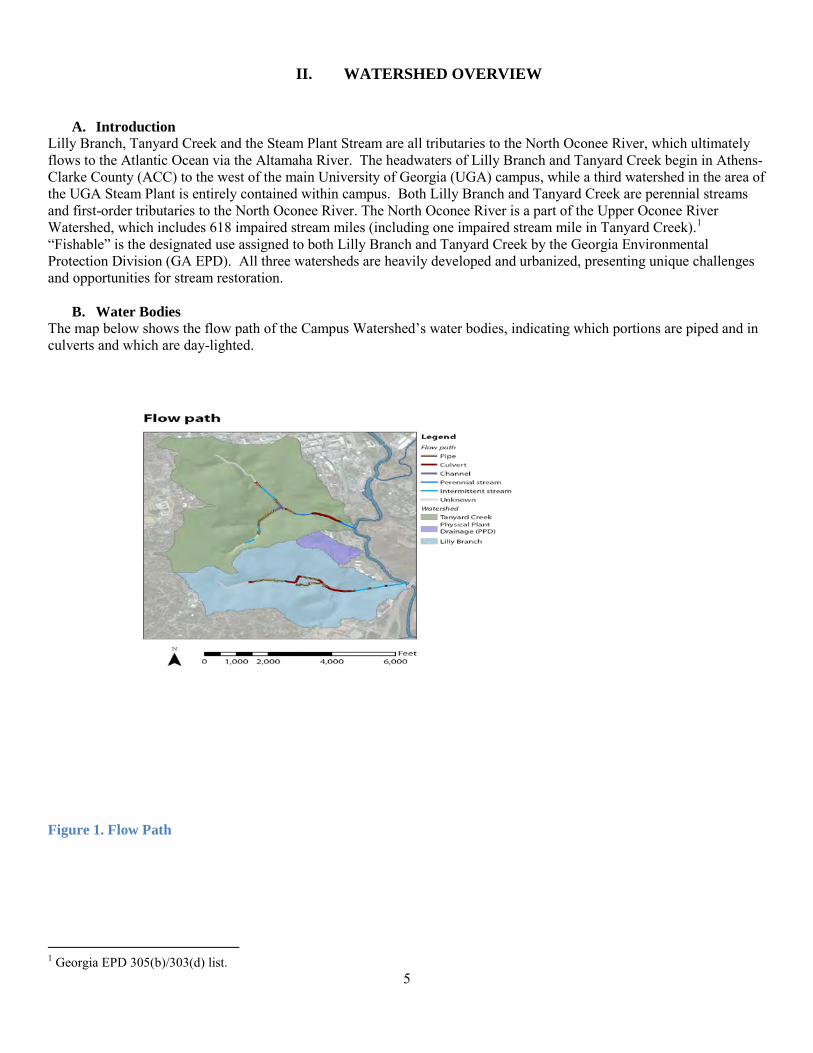
II. WATERSHED OVERVIEW
A. Introduction Lilly Branch, Tanyard Creek and the Steam Plant Stream are all tributaries to the North Oconee River, which ultimately flows to the Atlantic Ocean via the Altamaha River. The headwaters of Lilly Branch and Tanyard Creek begin in Athens-Clarke County (ACC) to the west of the main University of Georgia (UGA) campus, while a third watershed in the area of the UGA Steam Plant is entirely contained within campus. Both Lilly Branch and Tanyard Creek are perennial streams and first-order tributaries to the North Oconee River. The North Oconee River is a part of the Upper Oconee River Watershed, which includes 618 impaired stream miles (including one impaired stream mile in Tanyard Creek).1 “Fishable” is the designated use assigned to both Lilly Branch and Tanyard Creek by the Georgia Environmental Protection Division (GA EPD). All three watersheds are heavily developed and urbanized, presenting unique challenges and opportunities for stream restoration.
B. Water Bodies The map below shows the flow path of the Campus Watershed’s water bodies, indicating which portions are piped and in culverts and which are day-lighted.
Figure 1. Flow Path
1 Georgia EPD 305(b)/303(d) list.
6
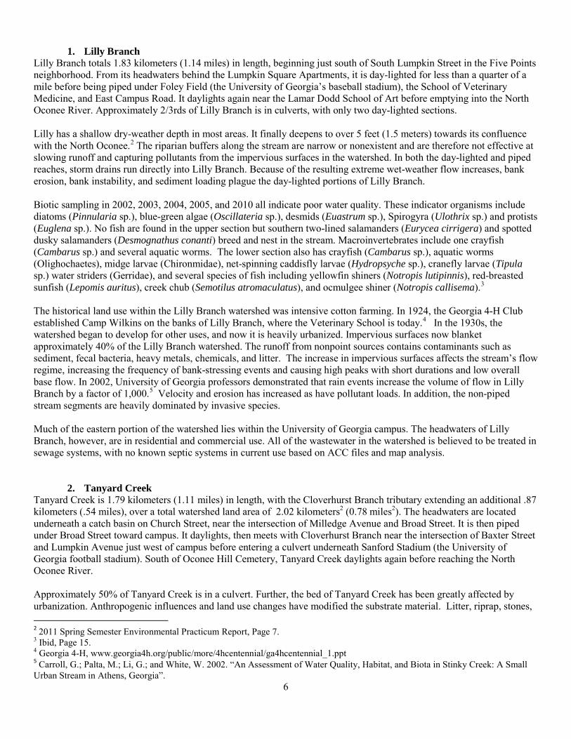
1. Lilly Branch
Lilly Branch totals 1.83 kilometers (1.14 miles) in length, beginning just south of South Lumpkin Street in the Five Points neighborhood. From its headwaters behind the Lumpkin Square Apartments, it is day-lighted for less than a quarter of a mile before being piped under Foley Field (the University of Georgia’s baseball stadium), the School of Veterinary Medicine, and East Campus Road. It daylights again near the Lamar Dodd School of Art before emptying into the North Oconee River. Approximately 2/3rds of Lilly Branch is in culverts, with only two day-lighted sections. Lilly has a shallow dry-weather depth in most areas. It finally deepens to over 5 feet (1.5 meters) towards its confluence with the North Oconee.2 The riparian buffers along the stream are narrow or nonexistent and are therefore not effective at slowing runoff and capturing pollutants from the impervious surfaces in the watershed. In both the day-lighted and piped reaches, storm drains run directly into Lilly Branch. Because of the resulting extreme wet-weather flow increases, bank erosion, bank instability, and sediment loading plague the day-lighted portions of Lilly Branch. Biotic sampling in 2002, 2003, 2004, 2005, and 2010 all indicate poor water quality. These indicator organisms include diatoms (Pinnularia sp.), blue-green algae (Oscillateria sp.), desmids (Euastrum sp.), Spirogyra (Ulothrix sp.) and protists (Euglena sp.). No fish are found in the upper section but southern two-lined salamanders (Eurycea cirrigera) and spotted dusky salamanders (Desmognathus conanti) breed and nest in the stream. Macroinvertebrates include one crayfish (Cambarus sp.) and several aquatic worms. The lower section also has crayfish (Cambarus sp.), aquatic worms (Olighochaetes), midge larvae (Chironmidae), net-spinning caddisfly larvae (Hydropsyche sp.), cranefly larvae (Tipula sp.) water striders (Gerridae), and several species of fish including yellowfin shiners (Notropis lutipinnis), red-breasted sunfish (Lepomis auritus), creek chub (Semotilus atromaculatus), and ocmulgee shiner (Notropis callisema).3 The historical land use within the Lilly Branch watershed was intensive cotton farming. In 1924, the Georgia 4-H Club established Camp Wilkins on the banks of Lilly Branch, where the Veterinary School is today.4 In the 1930s, the watershed began to develop for other uses, and now it is heavily urbanized. Impervious surfaces now blanket approximately 40% of the Lilly Branch watershed. The runoff from nonpoint sources contains contaminants such as sediment, fecal bacteria, heavy metals, chemicals, and litter. The increase in impervious surfaces affects the stream’s flow regime, increasing the frequency of bank-stressing events and causing high peaks with short durations and low overall base flow. In 2002, University of Georgia professors demonstrated that rain events increase the volume of flow in Lilly Branch by a factor of 1,000.5 Velocity and erosion has increased as have pollutant loads. In addition, the non-piped stream segments are heavily dominated by invasive species. Much of the eastern portion of the watershed lies within the University of Georgia campus. The headwaters of Lilly Branch, however, are in residential and commercial use. All of the wastewater in the watershed is believed to be treated in sewage systems, with no known septic systems in current use based on ACC files and map analysis.
2. Tanyard Creek Tanyard Creek is 1.79 kilometers (1.11 miles) in length, with the Cloverhurst Branch tributary extending an additional .87 kilometers (.54 miles), over a total watershed land area of 2.02 kilometers2 (0.78 miles2). The headwaters are located underneath a catch basin on Church Street, near the intersection of Milledge Avenue and Broad Street. It is then piped under Broad Street toward campus. It daylights, then meets with Cloverhurst Branch near the intersection of Baxter Street and Lumpkin Avenue just west of campus before entering a culvert underneath Sanford Stadium (the University of Georgia football stadium). South of Oconee Hill Cemetery, Tanyard Creek daylights again before reaching the North Oconee River. Approximately 50% of Tanyard Creek is in a culvert. Further, the bed of Tanyard Creek has been greatly affected by urbanization. Anthropogenic influences and land use changes have modified the substrate material. Litter, riprap, stones, 2 2011 Spring Semester Environmental Practicum Report, Page 7. 3 Ibid, Page 15. 4 Georgia 4-H, www.georgia4h.org/public/more/4hcentennial/ga4hcentennial_1.ppt 5 Carroll, G.; Palta, M.; Li, G.; and White, W. 2002. “An Assessment of Water Quality, Habitat, and Biota in Stinky Creek: A Small Urban Stream in Athens, Georgia”.

7
manmade gravel, asphalt, and sand from the roads and parking lots that border much of the day-lighted segments is present in the channel.6 Stream walks were conducted in the Tanyard Creek watershed in February of 2010 by staff with the Athens Clarke-County Stormwater Management Program, who rated Tanyard Creek’s overall stream condition as poor due to degradation of the bed, banks, and stream buffer. The development history of the Tanyard Creek watershed is similar to that of Lilly Branch. It was originally cleared for agriculture, but began urbanizing in the 1930s as a result of its proximity to downtown Athens and expansion of the University. In 1831, the first botanic garden in the state was created along Tanyard Creek. There were also several tanneries along the creek near Lumpkin Street today. Like Lilly Branch, Tanyard Creek is highly developed with 90% of its 2.02 kilometers2 (0.78 mile2) land area covered by surfaces of 40% imperviousness or greater with the same resulting impacts as described above. Most of the land in this drainage basin is in commercial or University use with some residential areas and transportation corridors.
3. The Steam Plant Stream The Steam Plant Stream is 0.15 kilometers (0.09 miles) in length, originating near Boyd Hall and the Ecology Building and flowing past the UGA Steam Plant and Facilities Management staging area. Headwaters are culverted near the Facilities Management parking lot. The infrastructure actually failed in 2010, and the culverts had to be re-constructed at significant depth. Historic maps show a livestock pond in this area which may explain the depth. The stream enters a culvert under East Campus Road and then daylights at River Road where it enters another culvert before emptying into the Oconee River. This day-lighted portion is heavily overgrown and infested with invasive plant species. The water here has a distinctive yellow hue that may result from iron-oxidizing bacteria. The Steam Plant Stream watershed is much smaller than Lilly Branch or Tanyard Creek. It sits entirely within University of Georgia property. The easternmost corner of the watershed is a small wooded area where signs of raccoons and feral cats are evident, and the stream daylights at this sliver. Originally cleared for agricultural uses, the rest of the watershed is now covered by roads, parking lots, university buildings, and lawns. This stream was impounded for farm use at some point in time.
6 Tanyard Creek 2011 Athens-Clarke County Water Management Plan.
8
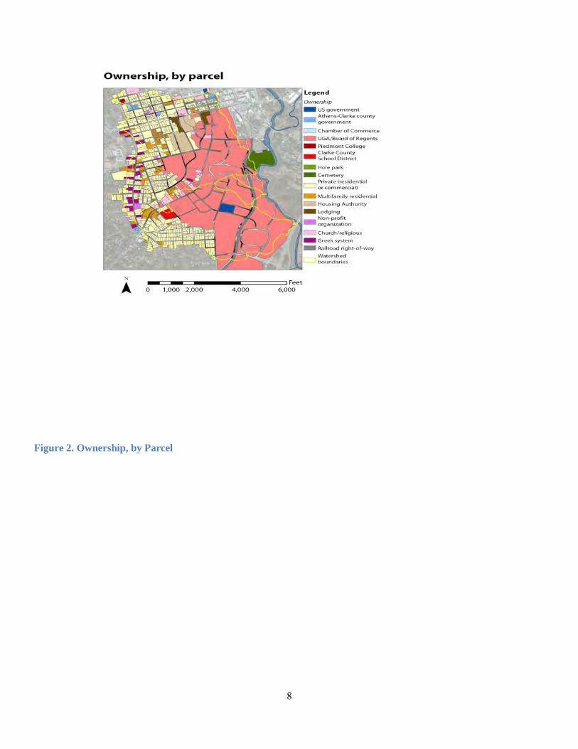
Figure 2. Ownership, by Parcel

9
Figure 3. Impervious Surface Cover
10
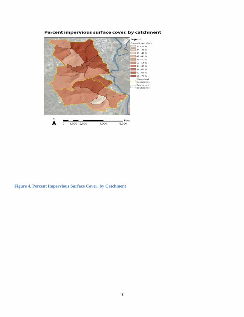
Figure 4. Percent Impervious Surface Cover, by Catchment

11
III. IMPAIRMENT SUMMARY In addition to data collected by the GA EPD and the U.S. Environmental Protection Agency (US EPA), water quality data has been collected for the three Campus Watershed streams for many years by UGA researchers and students, non-profits, and consultants. The most consistent monitoring has been the Upper Oconee Watershed Network’s (UOWN) annual sampling event beginning in 2001, and the UGA Grounds Department’s contract with Brown and Caldwell, which includes quarterly wet and dry sampling since 2004. The Advisory Committee examined and compiled this data in addition to reports and classroom assignments performed by faculty and students. It conducted targeted stream walks throughout the grant period and additional sampling at the following locations to identify pollutant sources. For a full description of monitoring techniques, the Water Quality Monitoring Plan is attached as Appendix B.
Figure 5. Water Quality Monitoring Locations
12
A. Monitoring Results
Monitoring reveals levels of fecal coliform and E. coli, pH, nutrients (Total P and Total N), metals, and invasive species that exceed mandated or recommended benchmarks. Higher in the headwaters than downstream:
• Fecal coliform bacteria at base flow (dry sampling conditions only) • Total nitrogen (Tanyard Creek watershed only) • Lead (Tanyard Creek watershed only) • Copper (Tanyard Creek watershed only) • Acidic conditions (indicated by lower pH)
Higher moving downstream: • Total nitrogen (Lilly Branch watershed only, small increase) • Total phosphorus (Lilly Branch watershed only, small increase) • Lead (Lilly Branch watershed only) • Copper (Lilly Branch watershed only) • Total suspended solids (Lilly Branch and Tanyard Creek) • Turbidity (Tanyard Creek watershed; in the Lilly Branch watershed, there was an apparent increase from point MP-9 to downstream, but upstream point MP-8 did not fit this pattern)
Higher in the Tanyard Creek main stem than in its tributary, Cloverhurst Branch: • Conductivity
Higher in the Steam Plant Stream watershed than elsewhere:
• Total suspended solids (especially during dry sampling) • Turbidity (dry sampling conditions only; under wet conditions, this site had among the lowest levels) • Conductivity (especially during dry sampling)
Lower in the Steam Plant Stream watershed than elsewhere:
• Fecal coliform bacteria (cool season, wet sampling conditions only)
High at all sites: • Fecal coliform bacteria (warm season, wet sampling conditions only) • Total phosphorus (exception: site MP-8 under dry conditions)
B. Official Impairments
1. Fecal Coliform Coliform bacteria are relatively harmless microorganisms that are present in large numbers in the digestive system and feces of humans and warm-blooded animals. Fecal coliform itself is not pathogenic but is considered an indicator species for other pathogenic organisms. Pathogens are typically present in such small amounts that it is impractical to monitor them directly. A common type of pathogenic organism associated with fecal coliform is E. coli, some types of which cause severe cramps and diarrhea in humans and can be very harmful and even deadly to young children and the elderly. While the presence of E. coli does not guarantee threats to human health, it is an indicator of the potential existence of such threats.
A Total Maximum Daily Load (TMDL) is a calculation of the maximum amount of a pollutant that a water body can receive and minimally achieve designated use. TMDLs are established for all state waters on the 305(b)/303(d) integrated List of Waters that do not meet their designated uses. Each TMDL limits the maximum amount of a pollutant by requiring a reduction (usually a percentage) in the current pollutant loading.
13
In 2002, US EPA Region 4 established fecal coliform TMDLs for streams with a designated use of fishing in the Oconee River Basin. The TMDL for fecal coliform is 100 colony-forming units per 100 milliliter in May – October, and 1000 colony-forming units per 100 milliliter in November through April. For Tanyard Creek this required a reduction of 76% in bacteria loadings. That reduction was increased to 94% in 2007 by GA EPD. The US EPA Region 4’s 2002 TMDL also required a reduction of 72% in fecal coliform loadings for eight miles of the North Oconee River (Trail Creek to Oconee River). That reduction was increased to 76% by GA EPD in 2007. The eight-mile segment includes the Tanyard Creek to Lilly Branch reach described in this Watershed Management Plan. There are additional smaller streams, including the Steam Plant Stream and Lilly Branch, that contribute to fecal coliform loadings, but are not tested by EPD so are not posted on the List of Waters. Subsequent water quality sampling in Tanyard Creek and throughout the rest of the Campus Watershed continues to indicate levels of fecal coliform in excess of water quality standards. In Tanyard Creek, during dry weather events from January through April 2012, fecal coliform values ranged from 14 to 27,213 CFUs / 100ml and from 220 to 11,493 CFUs / 100ml during wet weather events. With a mean of 4,762 CFUs / 100ml in dry weather and 4,702 CFUs / 100ml in wet weather, Tanyard greatly exceeds the state limit of a 1,000 CFUs / 100ml mean. Especially high levels of fecal coliform have been found at MP-1u, the point where Tanyard daylights at Ben’s Bikes and at MP-1, the point where the stream daylights just north of Baxter Street. Thus, fecal contamination is occurring while the stream is still underground. The high concentrations that occur during dry weather conditions indicate that point sources of wastewater may be entering Tanyard Creek through leaking sewer lines near the stream. In fact, as described later in this report, the Advisory Committee discovered two leaking sewer pipes in this area pursuant to the development of this plan. High concentrations during wet weather events indicate the presence of bacteria typical in non-point source urban stormwater runoff. It may also indicate increased pressure on the sewer system during rain events due to infiltration and inflow. Lilly Branch also showed extremely high levels of fecal coliform, ranging from 110 to 21,487 CFUs / 100ml in dry weather samples and 2200 to 23,000 CFUs / 100ml in wet samples. Its mean was 3,112 CFUs / 100ml in dry weather and 14,300 CFUs / 100ml in wet weather. The Advisory Committee identified contamination from fecal coliform and E. coli as a principal problem facing the watershed. Furthermore, they identified four candidate sources of the extremely high levels of fecal coliform present. (1) One potential source is leakage from faulty sewage pipes. Sewage piping (constructed of terra cotta, polyvinyl chloride, or ferrous metal) develops clogs, cracks, and breaks due to age and poor installation or maintenance. This allows the release of raw, untreated sewage into the stormwater system and eventually into streams. Much of the sewage infrastructure in the Campus Watershed is aging. (2) Another candidate for the source of high fecal coliform levels in the watershed is animal waste. Especially in Lilly Branch, dog waste is often visible on the stream banks. Stormwater runoff then carries the waste into the streams—a process that is exacerbated by the Campus Watershed’s high volume of impervious surface. (3) Furthermore, businesses, university facilities, and residential apartments dispose of waste in over 200 outdoor dumpsters in the Campus Watershed. These dumpsters are often inadequately covered or plugged, and they are susceptible to animal infestation and stormwater runoff. (4) Finally, multiple food service businesses are located at the upper reaches of both Lilly Branch and Tanyard Creek. Near Lilly Branch’s headwaters, witnesses have observed grease and other food waste being improperly disposed of. As a result, food waste directly infiltrates the stormwater system, drawing vermin and other animals. The second principal problem identified by the Advisory Committee is the volume of stormwater rushing into the streams during and immediately after rain events which undercuts stream banks. The volume is a result of the vast impervious cover across the watersehd. The lack of health riparian buffers to intercept and filter the stormwater is a contributing factor to both principal problems.
14
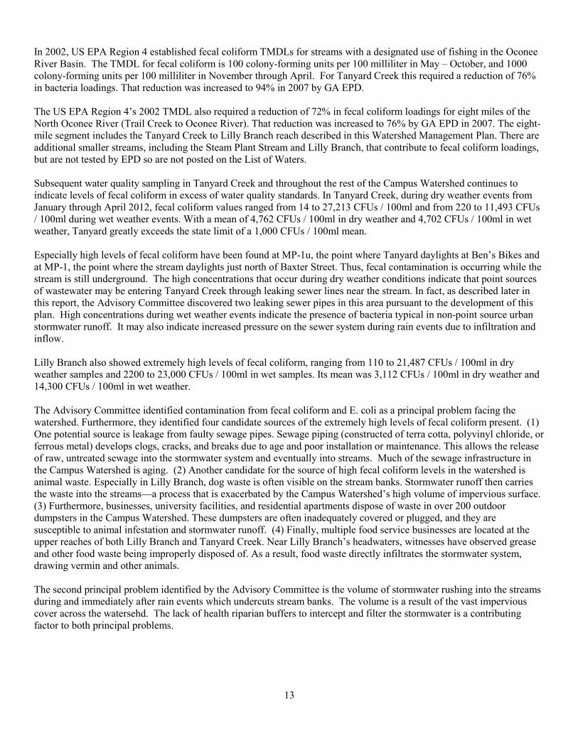
Figure 6. Fecal Coliform Bacteria, Dry Sampling

15
2. Leaking Underground Storage Tank In 1993, an oil sheen in Lilly Branch was first reported to GA EPD. Results of sampling both in the creek and in wells within the watershed indicated levels of MTBE (methyl tert-butyl ether, a gasoline additive) exceeding state standards. Based on historical and recent groundwater data, the dissolved plume extends approximately 400 feet from the source, a tank pit area of a former gas station in the Five Points neighborhood, and it has migrated in a general east-southeastern direction, where it intersects Lilly Branch. The plume covers the majority of the center and eastern portion of the property and has migrated offsite, impacting several. Lilly Branch is the receiving water body for this plume. This contamination has led to a major remediation effort by the property owner, initiated in the spring of 2012. The aim of the effort is to remove free product from the smear zone to the extent that measurable free product will not migrate to wells in low water table conditions nor accumulate to greater than one-eighth of an inch thickness. To ensure removal of free product trapped below the water table, dewatering is being used to expose the smear zone.7 The remediation process is contracted to take 24 months from start to finish, beginning around April 1, 2013.8
C. Other Impairments 1. pH
The pH measurements in aquatic systems generally vary between 6.0 and 9.0 Standard Units (s.u.) due to reactions with the atmosphere. Areas with large amounts of decaying vegetation can develop humic acid which decreases pH levels while areas with limestone or karst geology add bicarbonate that results in an increase in alkalinity and an increase in pH. The State of Georgia has issued regulations on the range of pH values allowed in waterways designated for fishing uses: 6.0 to 8.5 s.u. Values for pH in the Tanyard Creek watershed during the Spring of 2012 ranged from 3.03 from 7.27 s.u. Dry weather results ranged from 5.26 to 7.27 s.u. Wet weather values ranged from 3.03 to 6.76 s.u. Results from dry and wet weather monitoring indicated that two sites did not meet the state’s criteria of a pH between 6 to 8.5 s.u.: (1) MP-1u - where Tanyard Creek daylights at Ben’s Bikes – had a dry weather pH value of 5.86 s.u., and a wet weather value of 3.03 s.u. and (2) MP-3u – where Cloverhurst Branch daylights at Chadsworth and South Church Street – had a dry weather pH value of 5.26 s.u., and a wet weather value of 3.94 s.u.
7 Spring 2012 Environmental Practicum Report on Lilly Branch Leaking Underground Storage Tank. 8 Phone interview with Michael Coughlan, EPD Underground Storage Tank Management Program Advanced Geologist, 03/18/2013.
16
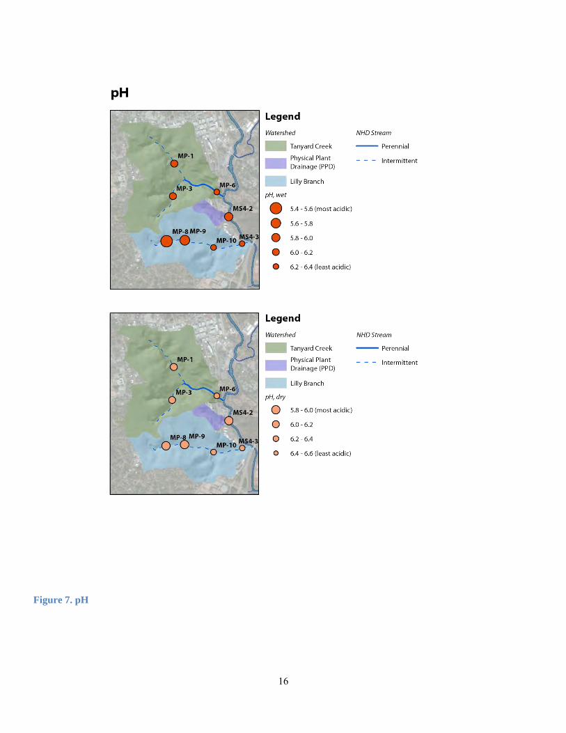
Figure 7. pH
17
Values for pH in the Lilly Branch watershed ranged from 5.86 from 7.34 s.u. Dry weather results ranged from 5.86 to 7.34 s.u. Wet weather values ranged from 6.06 to 6.769 s.u. Results from dry and wet weather monitoring indicated one site did not meet the State’s criteria of a pH between 6.0 to 8.5 s.u. MP-8u – the headwaters of Lilly Branch – had a dry weather pH value of 5.86 s.u. Several monitoring point values were above GA EPD criteria, but near the minimum. Potential sources of low pH levels include acid rain, decomposition of organic matter, or runoff from coal burning or other polluting facilities. The extremely low pH strikes the Advisory Committee as abnormal. Dialogue with Brown and Caldwell reveals confidence in the validity of the data. While equipment problems can distort measurements taken in the field and necessitates quality assurance, pH is usually not a parameter associated with such problems. Also, pH is calculated both in the field and lab, making a calculating or sampling error unlikely. The extremely low pH levels recorded at a few sites on a few occasions indicates unique conditions at these sites and on these dates. The location suggests a source high in the watershed. Since this is a residential area, fertilizer application or decomposition of organic matter (such as leaking sewer pipes, which as indicated have been discovered and addressed) may be cause for the low levels. Aside from the infrequent low levels recorded on a few occasions, historical dry weather mean pH levels are low. This suggests a persistent stressor such as a long undiscovered leaking sewer line; continual use or fertilizers, bleach or other cleaning products; or some other source, possibly including the coal fired boiler at the UGA Steam Plant.
2. Nutrients In developed areas, high concentrations of phosphorous in stormwater runoff can increase stream productivity, resulting in an increase in algal blooms. As the blooms die off, decomposition triggers a reduction in oxygen, which can endanger aquatic life and processes. Elevated concentrations of phosphorus are commonly found in lakebed sediments in the Georgia Piedmont, transported from upstream tributaries. There are legal standards regarding phosphorus in Georgia’s surface waters. However, in 2000 the US EPA published guidelines based on ecoregions to be used in the development of nutrient criteria.9 These guidelines will be used by the State of Georgia in the coming years to develop phosphorus limits. Georgia is located in Ecoregion IX, which is the southeastern Temperate Forested Plains and Hills. For this ecoregion, the US EPA recommends a total phosphorous (TP) limit of 0.03656 mg/L. According to GA EPD, studies are currently being performed on TP, and preliminary results indicate the average value for the state is 0.13 mg/L. GA EPD also uses 0.5 mg/L as a general guidance to indicate an elevated level of TP. There are, likewise, no state or federal standards for nitrogen levels in surface waters. However, the nutrient criteria guidelines developed by the US EPA described above include guidance for nitrogen concentrations. Again, the State of Georgia will likely use this guidance in the coming years to develop water quality standards for nitrogen concentrations. The recommended guideline from the US EPA for Ecoregion IX is 0.69 mg/L for total nitrogen (TN). Recent TP monitoring data collected in the Tanyard Creek watershed was only for wet weather conditions at MP-1, MP-3, and MP-6. The wet weather data ranged from .115 to .224 mg/L. More data is needed, during both dry and wet conditions, to determine if TP is a problem in the watershed. Phosphorus sampling was also limited for Lilly Branch; only MP-8, the site upstream from Foley Baseball Field, was sampled for TP in the Lilly Branch watershed during a wet weather event. The value was 0.693 mg/L, which the US EPA indicates as an elevated level. Under conditions of low dissolved oxygen (DO), phosphorous can be released from clay, but DO levels at MP-8 during wet conditions were healthy. Possible sources of elevated TP levels include runoff of lawn fertilizer heavy in phosphorous. TN monitoring data collected in the Tanyard Creek watershed was only for wet weather conditions at MP-1, MP-3, and MP-6. The wet weather data ranged from 1.70 to 8.10 mg/L. The US EPA recommends a limit of 0.69 mg/L. More data is needed, during both dry and wet conditions, to determine if TN is a problem in the watershed. However, our monitoring
9 US EPA, http://water.epa.gov/scitech/swguidance/standards/criteria/nutrients/ecoregions/index.cfm.
18
results indicate a strong possibility of high TN levels in stormwater runoff, which could be a product of fertilizer from landscaping and turf maintenance flowing into stream bodies or of bacterial contamination. As with phosphorus levels, only MP-8, the site upstream from Foley Baseball Field, was sampled for TN in the Lilly Branch watershed during a wet weather condition. The value was 3.0 mg/L. Possible sources of elevated TN levels include bacterial contamination and lawn fertilizer heavy in nitrogen. Nutrient levels, although measured only for wet weather conditions and only at MP-1, MP-3, and MP-6 in Tanyard Creek and MP-8 in Lilly Branch, are high, with recorded levels at all sites exceeding state guidelines. Stormwater runoff, again exacerbated by the watershed’s high volume of impervious surface, can carry fertilizer into the streams. Many areas on campus are characterized by manicured turf which requires fertilizer and pesticide inputs, as are some residential areas. Illicit discharge from businesses is another potential source. Many of the strategies that address fecal coliform contamination will also reduce the nutrient load. BMPs that address lawn runoff, dumpsters, and illicit discharge should also reduce nutrient inputs as will education campaigns aimed at homeowners and UGA employees.
3. Copper For all sites except for the headwaters of Lilly Branch, Brown and Caldwell measured mean copper levels that exceeded Georgia DNR’s water quality standard in wet weather conditions in years 2010-2012. The standard set by the state for copper is 5 ug/L, while mean concentrations for sampling sites reached as high as 24 ug/L at MP-1 of Tanyard Creek. Results from dry weather sampling events, however, remain below the state’s limit at all sites within the watershed. This suggests significant non-point sources of copper contamination. Typical sources of copper contamination include runoff from building materials treated with preservatives, paint, outdoor storage of scrap metal and automotive deposits that accumulate on pavement.10
4. Lead From 2010-2012, lead levels of 1.5ug/L in wet-weather mean concentration exceeded Georgia DNR’s water quality standards of 1.2ug/L at the MP-1 sampling site on Tanyard Creek and the MS4-3 site on Lilly Branch, while results from the rest of the sites were within the standard. Lead stormwater piping can be a potential source of lead pollution. Other sources include waste from industrial facilities, paint, runoff from automobiles, and batteries.11
5. Conductivity Conductivity is defined as the ability of water to conduct an electrical current. Conductivity is greatly affected by the presence of minerals or other ions in the water column. It is used as a general ionic measurement for the purity of water. Conductivity itself is not a human or aquatic health concern, but it can indicate the presence of organic matter or other pollutants. While conductivity levels vary greatly among water bodies, a comparative look at conductivity levels throughout the same watershed can yield water quality insights. Conductivity at the sampling site in PPD is significantly higher than for the other two watersheds over the 2010-2012 sampling period.
6. Turbidity Turbidity measures a water sample’s capacity to scatter light. Increased turbidity indicates higher levels of organic matter and suspended sediments. Georgia does not set standards for turbidity, since turbidity does not indicate specific pollution as an isolated variable. However, US EPA has documented and shared reference concentrations for each ecoregion. Under dry weather conditions, only one site exceeded the reference condition for turbidity in Ecoregion IX: MS4-2 in PPD. In wet weather, on the other hand, all sites exceed the reference condition, consistent with a watershed with prevalent impervious surface and insufficient riparian buffers. Increased turbidity indicates higher levels of organic matter and suspended sediments. The watershed’s inadequate riparian buffers and prevalent impervious surface allow for more such particles to enter the streams in wet weather events, and this, likely, accounts for the high mean turbidity in wet weather events from 2010-2012.
10 http://www.oeconline.org/our-work/water/stormwater/stormwater%20report/impacts. 11 Ibid.
19
7. Suspended Solids
Used as one parameter to detect elevated levels of sediment in a stream system, suspended solids refers to mineral and organic material suspended in the water column. Georgia does not regulate suspended solid levels, but some states use 50 mg/L as a limit for potential impairment. In wet weather conditions, MS4-2 in PPD and MS4-3 in Lilly exceed the 50 mg/L guideline. Suspended solid levels in Steam Plant Stream and Lilly Branch indicate erosion problems. These exceed the impairment baseline of 50 mg/L adopted by some states, but not Georgia12. The loss of riparian buffers that protect stream banks and the high concentration of impervious surfaces that contributes to the velocity of stormwater as it reaches the streams are contributing factors.
8. Invasive Species Throughout the watershed, invasive species dominate the ecosystem, greatly altering the natural habitat. They out-compete indigenous species for nutrients, water and space. Many of the natural predators that maintain aggressive exotic species in their native settings are not present in the new settings; which alters the natural plant communities and perturbs dependent species. Chinese privet, periwinkle, bush honeysuckle, Oregon grape, kudzu, Japanese honeysuckle, and Carolina geranium are the major invasives identified by the Spring 2012 Environmental Practicum Class. That class’s report on invasive species is attached as Appendix C. Chinese privet was singled out as an especially problematic invasive, as it grows on most of the watershed’s stream banks and is prolific.
12 State of Oregon Department of Environmental Quality, 2001. “Restoring Soil Health to Urbanized Lands: The Critical Link Between Waste Prevention, Land Use, Construction, Stormwater Management, and Salmon Habitat Restoration”.
20
IV. CURRENT AND PROPOSED MANAGEMENT ACTIVITIES The Advisory Committee has developed a four-pronged watershed management strategy:
A. Implement best management practices that reduce stormwater flow and eliminate the pollution sources identified through targeted sampling and stream walks;
B. Repair leaking sewer lines and stubs C. Restore targeted stream segments and effective riparian buffers; D. Provide and facilitate ongoing education, outreach and community engagement on watershed stewardship and
best practices to an audience that includes the UGA community, businesses and residents within the watershed, and k-12 students;
E. Continue targeted water quality monitoring and stream walks to identify additional pollution sources and determine the effectiveness of management activities.
A. Implement Best Practices
1. Manage Stormwater
Stormwater control measures (SCMs) or Best Management Practices for Stormwater (BMPs) are structures or practices that control and manage stormwater by promoting infiltration and groundwater recharge, protecting or improving surface water quality, minimizing the use of potable water, and capturing runoff for reuse. Instead of focusing solely on maintaining a pre-development peak flow rate, sustainable stormwater development attempts to mimic the entire pre-development water cycle, including groundwater infiltration, evaporation, and total peak flow volume. To accomplish its goals, sustainable stormwater management uses small, distributed systems that retain runoff.13 These include rain gardens and bioretention areas, green roofs, vegetated swales, rain barrels and cisterns, pervious pavement, and impervious surface reduction and disconnection.14 On-site SCMs are now commonly implemented during new development to control the stormwater runoff generated on an individual project; however, adding on-site SCMs to previously developed areas is more challenging. In these areas, it can be especially beneficial to evaluate potential SCMs as an interconnected system, rather than as individual structures. Doing this requires the inclusion of regional SCMs that capture water from far beyond the property they are located on, as well as consideration of how SCMs can work together in series.15 Sequencing structural SCMs to achieve optimal flow management and pollutant removal is sometimes referred to as a “treatment train”.16 SCMs have different abilities to reduce runoff volume and promote infiltration and to remove certain kinds of pollutants.17 The effectiveness of SCMs at removing a contaminant can be measured in either concentration or load. The effect of SCMs on contaminant concentration is determined by comparing the concentration of the water flowing into the SCM (influent) with the water that leaves it (effluent). As a part of this Watershed Management Plan, a suitability analysis for future SCMs in the Lilly Branch, Tanyard Creek, and Steam Plant Stream watersheds was performed and is attached as Appendix D. The analysis identifies the regions where SCMs are most needed and feasible and suggests the types of SCMs that are most appropriate within those regions. Recommendations are based on several weighted overlay analyses, using ArcGIS. Regions in need of stormwater control were determined by taking into account impervious surfaces, physical site conditions, and water pollution levels.
13Carter, T.; Fowler, L.; Vick, A.; Wenger, S., 2008. “Runoff Limits: An Ecologically Based Stormwater Management Program”. Stormwater, the Journal for Surface Water Quality Professionals, March / April 2008. 14Alvi, K.; Cheng, M.; Riverson, J.; Shoemaker, L.; Zhen, J., 2006. “BMP Analysis System for Watershed-Based Stormwater Management”. Journal of Environmental Science and Health, Vol. 41, No. 7, Page 1391-1403.
15 Bengtsson, L.; Semadeni-Davies, A.; Villarreal, E.L., 2004. “Inner-city Stormwater Control Using a Combination of Best Management Practices”. Ecological Engineering, Vol. 22, No. 4-5, Page 279-298. 16 Lloyd, S.D.; Porter, B.; Wong, T.H., 2002. “The Planning and Construction of an Urban Stormwater Management Scheme”. Water Science and Technology: A Journal of the International Association on Water Pollution Research, Vol. 45, No. 7, Page 1-10. 17 Lloyd, Porter, and Wong 2002.
21
Locations suggested as suitable for specific SCMs were determined by correlating site conditions with design criteria for each type of SCM. Land ownership was also taken into account regarding the feasibility of installing SCMs on a given property. Information about SCM function, both in general and as it relates to specific water quality goals, is also included in the analysis to assist with future stormwater control decisions. The results will allow the University of Georgia to target SCMs in areas where they will be most effective and will assist the ACC Stormwater Management Program with SCM implementation and land owner education. Choosing appropriate SCMs depends on understanding how each type of SCM fits a site’s conditions and stormwater improvement goals as well as slope, soil infiltration rate, and water table depth. The following are the SCMs that will be pursued by the Advisory Committee in the Campus Watershed:
Green roofs consist of waterproofing and drainage mats, a lightweight growing media and plants suitable for the climate. They decrease runoff, encourage evapotranspiration, and reduce peak flows. They also prolong roof life, reduce energy costs within the building and reduce urban heat island effects. Disconnect roof drains from storm systems and instead direct them to vegetation, permeable soils, and SCMs. This reduces peak flows and encourages infiltration. Rain gardens and bioretention areas are shallow (6 to 8 inches deep) depressed areas that use vegetation and permeable soil to collect water and allow it to infiltrate which promotes groundwater recharge while reducing runoff volume and peak flow. Pervious pavement includes pores in the surface which allow water to collect in underlying storage areas, and then either infiltrate the soil directly or release slowly to an underdrain system. They are most appropriate for areas with low vehicular traffic volume, such as sidewalks, patios, residential parking pads, driveways, fire lanes, overflow parking areas, and some daily parking areas, such as those with infrequent turnover. Level spreaders are SCMs that can help protect receiving waters by converting concentrated runoff to slow, shallow sheet flow over the surface of the land. This enables infiltration and some evaporation. These are commonly used in conjunction with vegetative filter strips and riparian buffers. Rain barrels and cisterns collect excess water on roofs and other hard surfaces for nonpotable reuse for irrigation, cooling, vehicle washing, and toilet flushing. Rain barrels are typically above ground, small (holding less than 100 gallons), and are frequently used to harvest water from the roofs of small buildings such as residences. Cisterns are larger and can be located above or below ground. Water harvesting can have a moderate impact on runoff frequency and peak discharge, as well as a small impact on water quality.18 A vegetative filter strip is an area of closely planted vegetation, usually grass, onto which runoff is directed for filtration. They provide moderate infiltration and groundwater recharge, as well as some control of runoff volume and runoff frequency. Infiltration basins and trenches are shallow cells without underdrains, typically filled with porous media (e.g. riprap), to enable infiltration. They encourage infiltration, groundwater recharge, runoff volume reduction, and protection of water and stream quality. They also offer moderate improvements to depression storage, peak discharge, and runoff frequency. Swales are used to convey runoff using an open drainage system, which alleviates flooding and reduces the need for conventional stormwater infrastructure. Vegetated swales are often planted with turf grass, though densely planted native plants with fibrous roots are preferred.19 Bioswales incorporate engineered soil and underdrains like a bioretention area to promote infiltration.
18 Prince George’s County, Maryland, 1999. 19 Carter, T.; Fowler, L.; Vick, A.; Wenger, S., 2008.
22
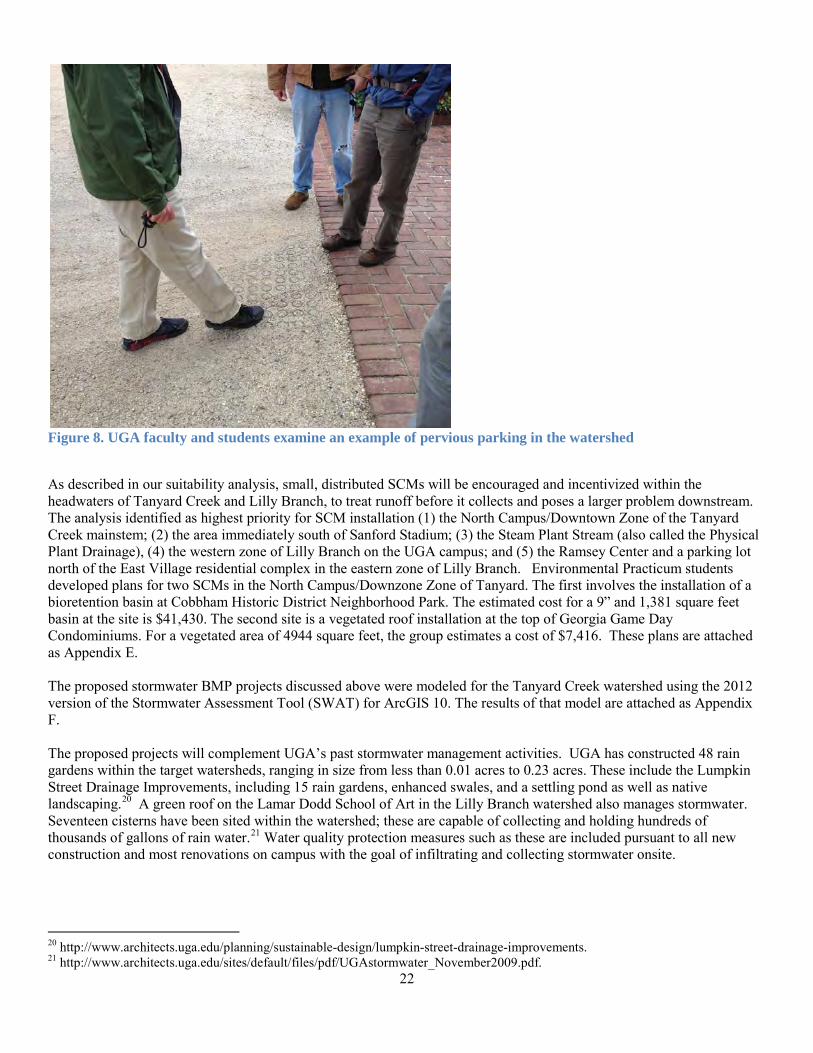
Figure 8. UGA faculty and students examine an example of pervious parking in the watershed
As described in our suitability analysis, small, distributed SCMs will be encouraged and incentivized within the headwaters of Tanyard Creek and Lilly Branch, to treat runoff before it collects and poses a larger problem downstream. The analysis identified as highest priority for SCM installation (1) the North Campus/Downtown Zone of the Tanyard Creek mainstem; (2) the area immediately south of Sanford Stadium; (3) the Steam Plant Stream (also called the Physical Plant Drainage), (4) the western zone of Lilly Branch on the UGA campus; and (5) the Ramsey Center and a parking lot north of the East Village residential complex in the eastern zone of Lilly Branch. Environmental Practicum students developed plans for two SCMs in the North Campus/Downzone Zone of Tanyard. The first involves the installation of a bioretention basin at Cobbham Historic District Neighborhood Park. The estimated cost for a 9” and 1,381 square feet basin at the site is $41,430. The second site is a vegetated roof installation at the top of Georgia Game Day Condominiums. For a vegetated area of 4944 square feet, the group estimates a cost of $7,416. These plans are attached as Appendix E. The proposed stormwater BMP projects discussed above were modeled for the Tanyard Creek watershed using the 2012 version of the Stormwater Assessment Tool (SWAT) for ArcGIS 10. The results of that model are attached as Appendix F. The proposed projects will complement UGA’s past stormwater management activities. UGA has constructed 48 rain gardens within the target watersheds, ranging in size from less than 0.01 acres to 0.23 acres. These include the Lumpkin Street Drainage Improvements, including 15 rain gardens, enhanced swales, and a settling pond as well as native landscaping.20 A green roof on the Lamar Dodd School of Art in the Lilly Branch watershed also manages stormwater. Seventeen cisterns have been sited within the watershed; these are capable of collecting and holding hundreds of thousands of gallons of rain water.21 Water quality protection measures such as these are included pursuant to all new construction and most renovations on campus with the goal of infiltrating and collecting stormwater onsite.
20 http://www.architects.uga.edu/planning/sustainable-design/lumpkin-street-drainage-improvements. 21 http://www.architects.uga.edu/sites/default/files/pdf/UGAstormwater_November2009.pdf.
23
2. Collect Dog Waste
A potential source of nutrients and fecal coliform is pet waste. Large amounts of dog waste were identified in several stream walks conducted over the course of the project through the upper, residential portions of the watershed. The Fall 2011 Environmental Practicum Class undertook an extensive study of pet waste practices and preferences in the Lilly Branch headwaters. Their report is attached as Appendix G. The Spring 2013 Environmental Practicum Class, in conjunction with the ACC Stormwater Management Program, began implementing these recommendations.
The Fall 2011 practicum students conducted a focus group and two surveys and ultimately recommended the installation of waste bags and receptacles with motivating signage as the most effective strategy for promoting waste pickup. They also recommended a targeted social outreach campaign to affect the behavior of dog-owners through PSAs, newspaper articles, and other vehicles. They analyzed the existing ACC ordinance relating to the collection of pet waste and found it generally adequate if enforced though they suggested some specific improvements. The Advisory Committee identified three areas for piloting the waste receptacles based on elevated fecal counts in water quality samples, high volumes of observed dogwalkers, and high volumes of dog waste observed close to streams or stormwater systems: (1) The upper reaches of Lilly Branch is mostly in private ownership and the Advisory Committee has been unable to find a property owner willing to host such a receptacle at this point. (2) ACC owns a small parcel of property in the Upper Cloverhurst Branch. Students in the Spring 2013 Practicum Class assisted by staff from the ACC Stormwater Management Program developed an agreement with the ACC Solid Waste Department to erect and maintain pet waste receptacles on this property; (3) A large lawn on UGA’s North Campus near the corner of Broad Street and Lumpkin Avenue at Herty Drive is frequently used as a dog run by downtown residents. Spring 2013 Practicum students worked with the UGA Grounds Department to assure the installation of a receptacle here after the field is restored subsequent to a construction project in Spring 2014. Our next actions will include developing a media campaign to promote the use of these receptacles and to explore the potential for more active enforcement of the pet waste disposal ordinance by ACC.
3. Minimize Dumpster Runoff
During Fall 2012, a River Basin Center employee surveyed the 226 dumpster sites in the watershed. He recorded the location of and property served by each dumpster, the ground cover directly below the dumpster (if any), the barrier surrounding the dumpster (if any), and the number of dumpsters at each site. Additionally, he recorded whether (1) there was refuse surrounding the dumpster, (2) the roof covered the dumpster, (d) side doors were closed, (4) the dumpster was plugged, and (5) the presence of other leaks or extreme rust. For complete results, see the Watershed Dumpster Survey attached as Appendix H. BMPs for dumpster runoff include placing the dumpster on an impervious platform to mitigate spills, covering the dumpster, posting signage regarding appropriate dumpster management practices, keeping the dumpsters plugged, keeping the roof and side doors closed, and keeping animals out of the garbage by enclosing the dumpster with walls and fences.22 68 of the dumpsters surveyed were elevated on a platform, while the remaining 158 were at ground level. Around a quarter of the dumpsters were either completely uncovered, or half-covered, and more than half had open side doors. Only a few were surrounded on four sides to prevent wildlife access. Over 30 of the dumpster sites had refuse outside of the dumpster. 38 dumpsters were badly rusted, leaking, or otherwise in disrepair. Finally, nearly half of the dumpsters were missing the plugs that prevent leachate from entering the watershed during rain events. The UGA Services Department has already used the dumpster survey to target the dumpsters most in need of replacement and repair while furthering watershed protection goals. In 2013, five leaking dumpsters were replaced and 15 were plugged. Among our next steps is the development of a similar education and replacement effort for the dumpsters located outside campus on private land.
22State of Connecticut Department of Public Health. “Best Management Practices for Location and Management of Dumpsters Relative to Public Water Supply Wells”.
24
4. Enforce Ilicit Discharge Ordinances Several restaurants in the watershed are in visible violations of current ACC illicit discharge ordinances which can lead to high fecal coliform and other contaminant levels. The Fall 2012 Environmental Practicum Class developed and tested a “soft enforcement” campaign explaining the ordinances and the ramifications of their violation to owners and managers of a cluster of food businesses in the Five Points area, just upstream from the first day-lighting of Lilly Branch. This audience was selected after reports of leaks from dumpsters and grease retention units at these businesses. The ACC Stormwater Management Program staff will determine whether future targeted outreach efforts are needed; regardless they maintain a stormwater hotline where residents can report illicit discharges and they conduct educational programs for all ages on problems caused by, and methods for controlling, stormwater runoff.
B. Repair Leaking Sewer Lines and Stubs
In an attempt to identify the source of the high levels of fecal coliform at the headwaters of Lilly Branch disclosed through targeted sampling, the Advisory Committee walked the stream in the fall of 2012. They found a smelly, dry-weather flow in one of the storm drains and alerted the ACC Public Utilities Department which investigated with dye and remote vehicles and identified two leaks. The department shut down Broad Street for several hours in order to repair a leaking sewer line underneath one of the buildings and another under Broad Street. The following photographs tell the story:

25
1 2
3
1
3 4
5 6
Figure 8a. ACC staff and UGA Environmental Practicum students and faculty Figure 8b. Flow in dry weather in a
stormwater pipe suggests sewage leak
Figure 8c. Looking into stormwater system for flow
Figure 8f. ACC Stormwater workers repair the leaks
Figure 8d. Green dye is flushed down the toilet of a nearby business, helping hone exact location of leak
Figure 8e. ACC Stormwater worker uses a camera to find the exact location and extent of the two damaged sewage pipes
26
Due to the high levels of E. coli found at sampling locations where nonpoint sources are not implicated as well as the detection of leaking sewer pipes in the headwaters of Tanyard Branch pursuant to this project, the Advisory Committee believes that human waste from sewage is a major source of impairment. The Advisory Committee will continue to monitor for hotspots in order to help the ACC Public Utilities Department find and repair these sewage leaks. Given the extent of the aging sewer systems in these neighborhoods, the costs to the ACC government to repair the lines and to individual homeowners to repair or replace the stubs that connect their toilets and appliances to the sewer lines, may be extensive. In Fall 2013, the Advisory Committee will consult with county staff and commissioners to develop strategies for determining the extent of the problem and for funding repairs.
C. Restore Targeted Streams and Effective Riparian Buffers
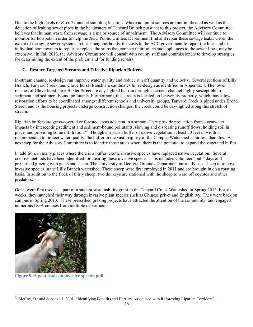
In-stream channel re-design can improve water quality and reduce run off quantity and velocity. Several sections of Lilly Branch, Tanyard Creek, and Cloverhurst Branch are candidates for re-design as identified in Appendix I. The lower reaches of Cloverhurst, near Baxter Street are day-lighted but run through a cement channel highly susceptible to sediment and sediment-bound pollutants. Furthermore, this stretch is located on University property, which may allow restoration efforts to be coordinated amongst different schools and university groups. Tanyard Creek is piped under Broad Street, and as the housing projects undergo construction changes, the creek could be day-lighted along this stretch of stream. Riparian buffers are grass-covered or forested areas adjacent to a stream. They provide protection from stormwater impacts by intercepting sediment and sediment-bound pollutants, slowing and dispersing runoff flows, holding soil in place, and providing some infiltration.23 Though a riparian buffer of native vegetation at least 50 feet in width is recommended to protect water quality, the buffer in the vast majority of the Campus Watershed is far less than this. A next step for the Advisory Committee is to identify those areas where there is the potential to expand the vegetated buffer. In addition, in many places where there is a buffer, exotic invasive species have replaced native vegetation. Several creative methods have been identified for clearing these invasive species. This includes volunteer “pull” days and prescribed grazing with goats and sheep. The University of Georgia Grounds Department currently uses sheep to remove invasive species in the Lilly Branch watershed. These sheep were first employed in 2011 and are brought in on a rotating basis. In addition to the flock of thirty sheep, two donkeys are stationed with the sheep to ward off coyotes and other predators. Goats were first used as a part of a student sustainability grant in the Tanyard Creek Watershed in Spring 2012. For six weeks, they munched their way through invasive plant species such as Chinese privet and English ivy. They were back on campus in Spring 2013. These prescribed grazing projects have attracted the attention of the community and engaged numerous UGA courses from multiple departments.
Figure 9. A goat leads an invasive species pull
23 McCoy, D.; and Sobecki, J, 2001. “Identifying Benefits and Barriers Associated with Reforesting Riparian Corridors”.
27
Our work plan for future years includes community engagement in invasive “pulls” and native replanting as described in Appendix C. Spring 2012 Practicum Invasive Species Report.
D. Educate and Reach Out The Advisory Committee targets its education efforts at residents living within the watershed including school children, homeowners, and University students as well as the University community that works and studies in the watershed. Schoolchildren are seen as a particularly valuable audience due to the effect they have on the actions of their parents.
1. Continue and expand teaching partnership with elementary schools Students in three recent UGA Environmental Practicum classes taught classes on watershed health at Barrow Elementary School which is located at the headwaters of Lilly Branch. These programs focused on pollution problems and solutions and the aquatic ecosystem. They were developed to meet Georgia Performance Standards for multiple grade levels. The program, developed in collaboration with Barrow teachers, is intended as a model for elementary school students and will serve the greater community by educating our youth, encouraging them to take ownership over their interactions with the environment. The students then spread that message to their families and friends. Students in the Spring 2013 Environmental Practicum developed a new lesson plan for watershed outreach as detailed in Appendix K and facilitated a partnership with EcoReach, an organization of graduate students at the Odum School of Ecology whose goal is to share ecological lessons with K-12 students and Barrow School teachers to continue these watershed education efforts. Since Chase Street Elementary School serves students in the Tanyard Creek watershed, educational efforts will be extended to that school in 2014.
2. Involve UGA Classes The graduate-level Environmental Practicum class offers students the chance to apply their studies to real-world problems, including the development of this watershed plan. The fall course is made up of law students who look at policy aspects of watershed restoration, while the Spring course includes students in law, environmental design, engineering, ecology, and other programs. Students in future Practicum classes will be involved in the implementation of this plan. Numerous classes in the College of Environment and Design have addresses projects in these watersheds. An undergraduate design studio has been using the stream site next to Ben’s Bikes for several years. Initially they focused on creating a community garden and cleaning out the stream area. The next studio class will focus more directly on restoration options for the channel and surrounding flood plain.24 A graduate studio focused on restoration plans for the Cloverhurst branch of Tanyard Creek near Bolton Dining Hall in fall 2013. Previous studios have created green infrastructure plans for campus, much of which would impact stream health and water quality. Future studio courses can help implement aspects of this plan. Restoration also presents opportunities in Independent Study and Internships. An undergraduate history intern investigated the history of the watersheds. See Appendix L for this history. Finally, flow levels, IDEXX testing, and other fields offer real-world experience for a field-monitoring class in the School of Forestry. In conclusion, the restoration of the watershed offers a real-life laboratory for stream restoration methods and policies for many disciplines.
3. Engage the Community Our community engagement strategy includes making watershed information and water quality data available to the public electronically and targeted educational meetings, activities and outreach campaigns. Pursuant to this grant, the Advisory Committee has established a web presence for this information, hosted at the Office of Sustainability’s site. The web presence catalogues projects and studies completed by UGA faculty and students from an array of schools and programs. It also includes the history of the watershed and historic uses of the water bodies.
24 http://www.youtube.com/watch?v=GyWqRHSGDHY
28
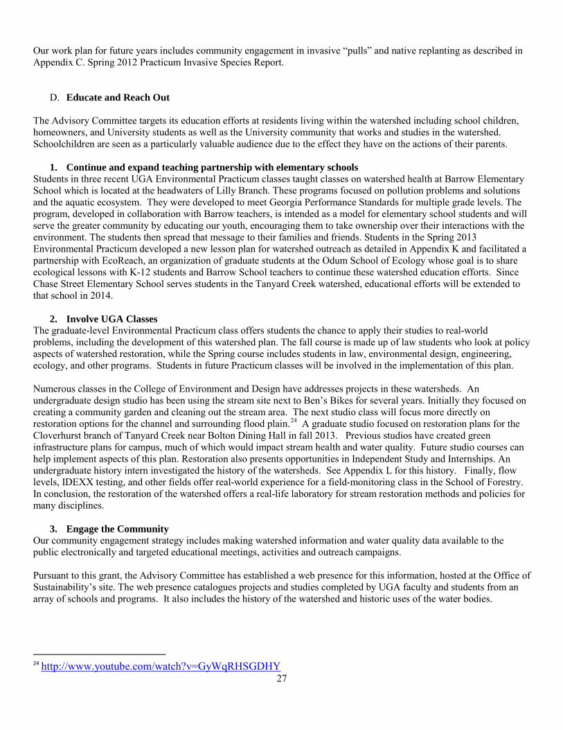
The Advisory Committee hosted two community meetings, one in Spring 2012 and another in Spring 2013 to elicit input for and disseminate the results of this watershed protection plan. At the 2013 meeting, around 20 attendees, including the Athens-Clarke County commissioner who represents the district that contains the campus watershed, heard presentations on the progress of the grant and a range of watershed issues including the general history of the watershed; illicit discharge, dumpster runoff and pet waste issues and methods to deal with them; the underground storage tank remediation taking place in Lilly; and best management practices for lawn care to reduce nutrient and pesticide pollution and promote water efficiency. A number of the efforts described previously in this document have already stimulated community interest and engagement. For example, the UGA Chew Crew prescribed grazing project generated enormous press and many smiles as Athenians walked and drove by the goats at work. The Environmental Practicum convened several focus groups around issues involving disposal of dog waste and control of illicit discharges and in Spring 2013 they engaged students, teachers and community members in lessons on aquatic life and stormwater management at Science Night at Barrow School. In Spring 2012, University of Georgia alumni organized and conducted a cleanup of Tanyard Creek near Sanford Stadium. Community involvement will continue to be essential to implement this watershed protection plan. The plan relies, for example, on the installation of rain gardens and bioswales on private property in the headwaters of the campus streams. Invasive pulls require many hands (or mouths in the case of the Chew Crew) and the plan anticipates several of these activities over the next ten years. Future stream clean-ups offer an opportunity for the Advisory Committee to bring the community together, observing and participating in positive change for the watershed.
Figure 10 Part of the audience at the April 17 2013 Community Meeting on the 9-Key Element Plan
29
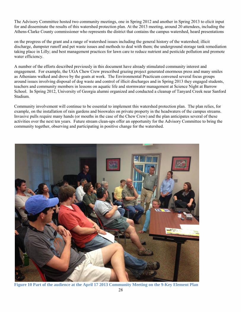
Figure 11 Advisory Committee member Dr. Elizabeth Little presents at the April 17 community meeting
Figure 12 Environmental Practicum students interact with Barrow Elementary students at Science Night
E. Monitor to Identify Sources of Pollution and Effectiveness of Management Strategies
By monitoring water quality and walking streams consistently over a period of months to identify “hot spots” for closer investigation, the Advisory Committee has eliminated several sources of pollution. These efforts must be ongoing in order to assure that new problems are quickly identified and addressed.
30
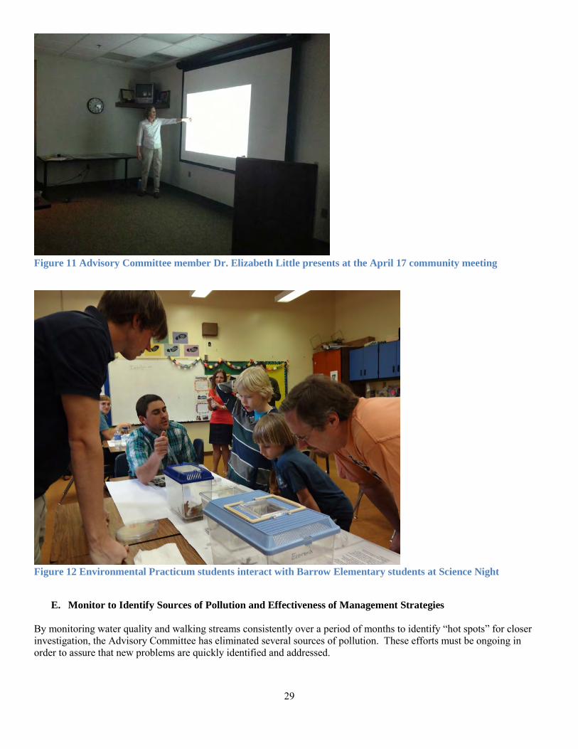
Figure 13. UGA faculty member leads Environmental Practicum students on a walk of the watershed in Spring 2012
In the spring of 2014, the Advisory Committee will be joined by a new faculty member at the Odum School of Ecology who specializes in urban stream issues. At this point the committee will reevaluate the existing water quality monitoring plan and update it in order to more effectively identify hotspots and sources of pollution. The Advisory Committee will continue to use Brown and Caldwell’s data for eight sampling points throughout the watershed and will add new sampling sites as reflected in the updated water quality monitoring plan. The Advisory Committee will continue to work closely with the UGA Grounds Department which has its own monitoring program in place. In previous years, their sampling found elevated flows and bacteria downstream of Sanford Stadium during a home game. Upon entering the culvert to identify the source, they found a crossover flow caused by a crushed sanitary sewer line and a leaking line draining from an office in the bowels of the stadium which were quickly repaired. Subsequent testing during the fall 2012 football season shows bacteria and flow levels within accepted limits. In addition to identifying pollution sources, monitoring data will help evaluate the effectiveness of BMPs and SCMs over time, as measured against criteria established in the Plan Review section of this document.

31
V. NEXT STEPS
A. Review Plan in Fall 2013 When UGA classes resume in Fall 2013 the Advisory Committee will convene to review and supplement this plan, to include the addition of a table which shows each impairment to be addressed, the associated source, the intended control measure/s and the parties responsible for implementing and maintaining the control measure. We will review the timetables and cost estimates with project partners to assure accuracy and commitment. We will assure that every action that is described in the plan is somewhere addressed in the Milestones/Schedule section. We will also take into account participation of new parties who joined our effort late in Spring 2013, namely the ACC Commissioner for the watershed district and new leadership of the Upper Oconee Watershed Network, in reviewing proposed activities and timetables. This will specifically include the identification and repair/replacement of leaking sewer lines which we suspect may be extensive.
B. Amend Monitoring Plan and Explore Modeling Options With input from the RBC Director for Science, who assumes his position in January 2014, the Advisory Committee will reevaluate the water quality monitoring plan and investigate new modeling tools and partners to help us prioritize installation of SMCs.
C. Develop More Informed Funding Strategy and Procure Funding
To fund the BMPs and educational component of the Plan, the Advisory Committee seeks to find initiatives that overlap with the goals of other entities, including the organizations represented by the Steering Committee. These include at UGA the Grounds Department, University Architects, the Office of Sustainability, the River Basin Center, and at Athens-Clarke County the Public Utilities Department, the Stormwater Management Program and the Water Conservation Office. We will continue to find ways to incorporate the watershed restoration activities proposed in this plan into both the routine work plans and in special projects of these organizations. In addition, we will pursue grant opportunities. We expect to reapply for a Clean Water Act Section 319 grant to implement this plan in 2014. We will investigate the feasibility of a Five Star Restoration grant, which support riparian restoration while also emphasizing local environmental stewardship and environmental education grants. We will encourage students to apply for UGA Campus Sustainability Grants to fund restoration projects in the watershed. This program funds competitive, student-proposed projects and initiatives designed to advance campus sustainability through education, research, service, and operations. BMPs specific to the UGA campus that cost $5,000 or less are eligible. We have a pending application before Wells Fargo and the National Fish & Wildlife Foundation (NFWF). Their program, Wells Fargo Environmental Solutions for Communities, helps communities create a more sustainable future through responsible environmental stewardship. (More information at:http://www.nfwf.org/AM/Template.cfm?Section=Charter_Programs_List&CONTENTID=26041&TEMPLATE=/CM/ContentDisplay.cfm) We will continue to rely on UGA’s great intellectual resources to undertake monitoring and restoration activities at no or low-cost. Class projects and thesis work have and may continue to aid water quality monitoring, implementation, and outreach steps.
32
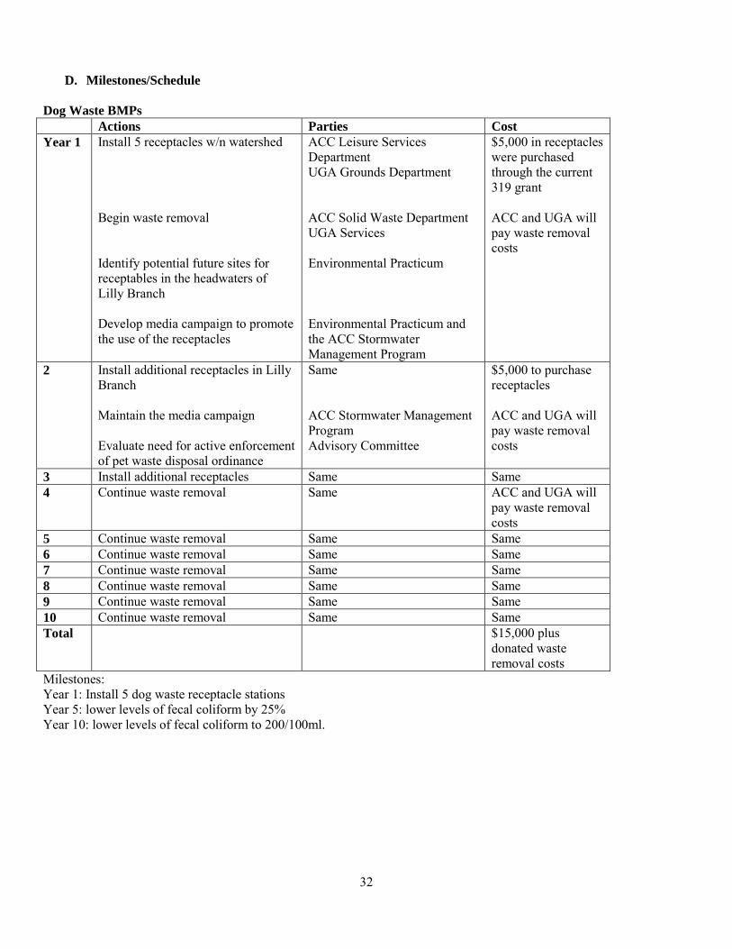
D. Milestones/Schedule Dog Waste BMPs Actions Parties Cost Year 1 Install 5 receptacles w/n watershed
Begin waste removal Identify potential future sites for receptables in the headwaters of Lilly Branch Develop media campaign to promote the use of the receptacles
ACC Leisure Services Department UGA Grounds Department ACC Solid Waste Department UGA Services Environmental Practicum Environmental Practicum and the ACC Stormwater Management Program
$5,000 in receptacles were purchased through the current 319 grant ACC and UGA will pay waste removal costs
2 Install additional receptacles in Lilly Branch Maintain the media campaign Evaluate need for active enforcement of pet waste disposal ordinance
Same ACC Stormwater Management Program Advisory Committee
$5,000 to purchase receptacles ACC and UGA will pay waste removal costs
3 Install additional receptacles Same Same 4 Continue waste removal Same ACC and UGA will
pay waste removal costs
5 Continue waste removal Same Same 6 Continue waste removal Same Same 7 Continue waste removal Same Same 8 Continue waste removal Same Same 9 Continue waste removal Same Same 10 Continue waste removal Same Same Total $15,000 plus
donated waste removal costs
Milestones: Year 1: Install 5 dog waste receptacle stations Year 5: lower levels of fecal coliform by 25% Year 10: lower levels of fecal coliform to 200/100ml.

33
Dumpster BMPs Action Parties Cost Year 1 Continue to replace and repair
dumpsters Initiate dumpster education and repair/replacement campaign for dumpsters on privately owned land. Train University and ACC personnel regarding dumpster maintenance and management
UGA Services Advisory Committee Advisory Committee, UGA Services, ACC Solid Waste Department
?
2 Same Same 3 Same Same 4 Same Same 5 Same Same 6 Same Same 7 Same Same 8 Same Same 9 Same Same 10 Same Same Total $ Milestones: Year 2: Repair and/or replace 10 dumpsters Year 3: Repair and/or replace 10 dumpsters Year 4; Repair and/or replace 10 dumpsters Year 5: Review survey and evaluate needs

34
Outreach and Education Action Parties Cost Year 1
Continue to develop watershed website Update online database EcoReach takes over the Environmental Practicum’s elementary education campaign at Barrow School Continue education and outreach to the community Continue illicit discharge hotline Continue extension program for home owners in areas of reduced fertilizer and pesticide use and water efficiency Develop and host workshops and/or educational materials for facilities staff to improve nursery management and materials storage to reduce pollutants
UGA Office of Sustainability University Architects All partners EcoReach at UGA Odum School of Ecology ACC Stormwater Management Program ACC Stormwater Management Program UGA Cooperative Extension Service UGA Grounds Department and Office of Sustainability
$200 for EcoReach elementary education campaign supplies
2 Maintain web site and online database Continue EcoReach education campaign at Barrow and initiate the campaign at Chase Street School Continue education and outreach to the community through Athens-Clarke County Stormwater Office Continue illicit discharge hotline Continue extension program for home owners in areas of reduced fertilizer and pesticide use and water efficiency Continue training for facilities staff to improve nursery management and materials storage to reduce pollutants
UGA Office of Sustainability EcoReach at UGA Odum School of Ecology ACC Stormwater Management Program ACC Stormwater Management Program UGA Cooperative Extension Service UGA Grounds Department
$300, same
3 Maintain web site Continue Eco-reach education campaign Continue stormwater education and outreach to the community through
UGA Office of Sustainability EcoReach at UGA Odum School of Ecology ACC Stormwater Management Program
$300, same

35
Continue the illicit discharge hotline Continue extension program for home owners in areas of reduced fertilizer and pesticide use and water efficiency Continue training for facilities staff to improve nursery management and materials storage to reduce pollutants
ACC Stormwater Management Program UGA Cooperative Extension Program UGA Grounds Department
4 Same Same $300, same 5 Same Same $300, same 6 Same Same $300, same 7 Same Same $300, same 8 Same Same $300, same 9 Same Same $300, same 10 Same Same $300, same Total $2,900 for
EcoReach. Milestones: Year 1: Transition from Environmental Practicum to EcoReach carrying out the education campaign at Barrow Elementary Year 2: Initiate education campaign at Chase Street School (Tanyard)

36
Water Quality Monitoring Action Parties Cost Year 1
Update the current water quality monitoring plan to better identify hotspots, pollution sources and trends Continue current monitoring efforts Conduct additional monitoring to evaluate progress Identify hot spots and areas of concern and work with project partners to repair leaking infrastructure and fix problems
Advisory Committee UGA Services Brown and Caldwell Advisory Committee Environmental Practicum, UGA classes Athens-Clarke County Public Utilities and Stormwater Management Programs
Annual contract fees for Brown and Caldwell to conduct quarterly sampling $1000 per year for targeted monitoring
2 Same Same same 3 Same Same same 4 Same Same same 5 Same Same same 6 Same Same same 7 Same Same same 8 Same Same same 9 Same Same same 10 Same Same same Total Annual
contract fees with Brown and Caldwell, plus $10,000
Milestones: Years 1-10: evaluate monitoring and identify hot spots. Fix leaks and address new nonpoint sources as they arise.
37
Stormwater Control Measures Action Parties Cost Year 1
Meet with Senior UGA administrators to discuss the importance of a concerted UGA strategy to manage stormwater in order to restore Campus Streams and protect water quality in the Oconee River with the goal being a stated commitment of intent and funding for restoration Meet with the ACC Commissioners whose districts comprise the watershed, and relevant ACC staff for the same purpose as outlined above Based on the results of these two conversations effort, revisit this ten year timeline Start dialogue with Georgia Game Day Condominiums Install bioretention basin at Cobbham Historic Neighborhood Park Conduct outreach on cisterns and on-campus water reuse Identify additional target SCM areas in the upper third of each watershed section Work with UGA Grounds department and University Architects toimplement SCMs on campus. Coordinate with UGA classes in the College of Environment and Design on projects in the watershed
Advisory Committee University Architects UGA Grounds Department Advisory Committee Advisory Committee Advisory Committee Advisory Committee ACC Water Conservation Program UGA Office of Sustainability Advisory Committee ACC Stormwater Management Program Advisory Committee Advisory Committee UGA Office of Sustainability
$7,416 for green roof; $41,430 for bioretention basin
2 If feasible, begin construction of green roof at Georgia Game Day Condominums Daylight area of Tanyard Creek under Hope Public Housing Install new SCMs at individual businesses and sites in upper third of each watershed section Continue outreach
Same, with new property owners TBD
$25,000-$50,000

38
3 Evaluate, design and install new SCMs at individual businesses and sites in the upper third of each watershed section Identify projects for the more downstream reaches of the watershed Continue outreach
Same $25,000-$50,000
4 Evaluate, design and install new SCMs at individual sites and businesses in more downstream areas of the watershed Continue outreach
Same $25,000-$50,000
5 Evaluate, design and install new SCMs at individual sites and businesses in more downstream areas of the watershed Continue outreach
Same $25,000-$50,000
6 Evaluate, design and install new SCMs at individual sites and businesses in more downstream areas of the watershed Continue outreach
Same $25,000-$50,000
7 Evaluate, design and install new SCMs at individual sites and businesses in more downstream areas of the watershed Continue outreach
Same $25,000-$50,000
8 Evaluate, design and install new SCMs at individual sites and businesses in more downstream areas of the watershed Continue outreach
Same $25,000-$50,000
9 Evaluate, design and install new SCMs at individual sites and businesses in more downstream areas of the watershed Continue outreach
Same $25,000-$50,000
10 Evaluate, design and install new SCMs at individual sites and businesses in more downstream areas of the watershed Continue outreach
Same $25,000-$50,000
Total $273,846 - $498,846

39
Milestones: Years 1-3: identify, design and begin implementation of SCMs Year 3: lower levels of fecal coliform at up-stream sampling sites by 25% Years 4-10: move down into the rest of the watersheds. Lower levels of fecal coliform at all sampling sites to the state standard of 200 cfu/100 ml. Lower levels of TP, TN and Copper to State Standards or equivalent.
40
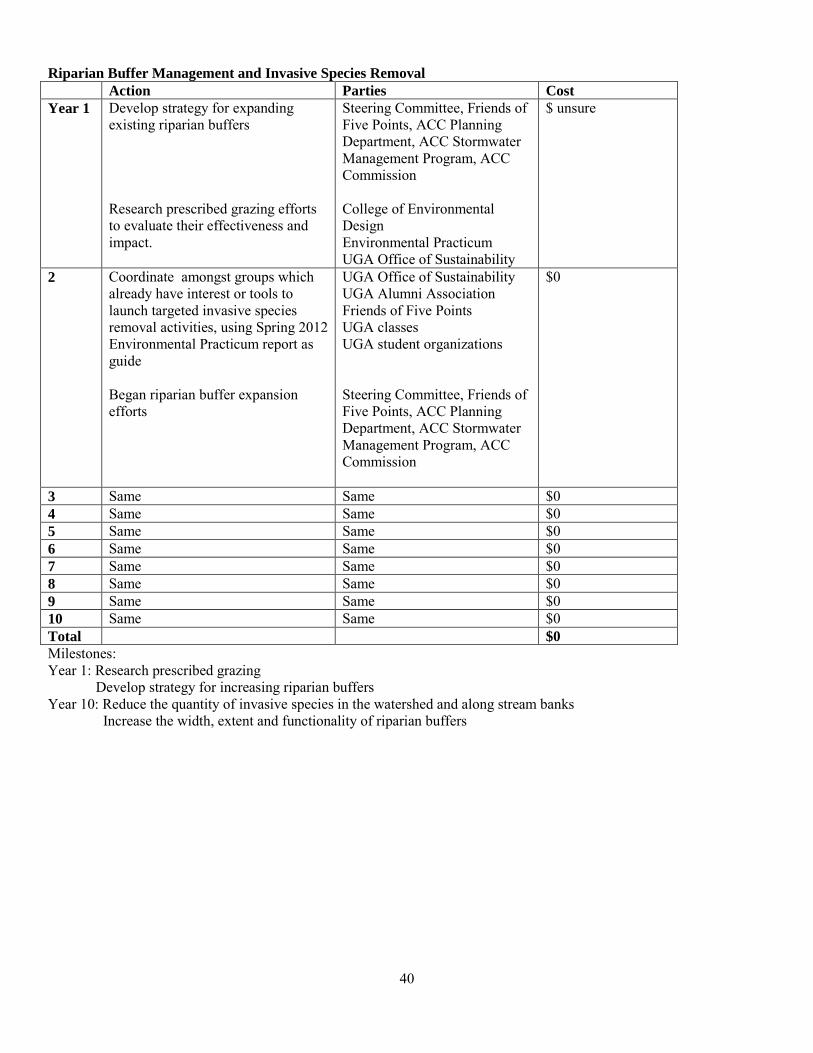
Riparian Buffer Management and Invasive Species Removal Action Parties Cost Year 1 Develop strategy for expanding
existing riparian buffers Research prescribed grazing efforts to evaluate their effectiveness and impact.
Steering Committee, Friends of Five Points, ACC Planning Department, ACC Stormwater Management Program, ACC Commission College of Environmental Design Environmental Practicum UGA Office of Sustainability
$ unsure
2 Coordinate amongst groups which already have interest or tools to launch targeted invasive species removal activities, using Spring 2012 Environmental Practicum report as guide Began riparian buffer expansion efforts
UGA Office of Sustainability UGA Alumni Association Friends of Five Points UGA classes UGA student organizations Steering Committee, Friends of Five Points, ACC Planning Department, ACC Stormwater Management Program, ACC Commission
$0
3 Same Same $0 4 Same Same $0 5 Same Same $0 6 Same Same $0 7 Same Same $0 8 Same Same $0 9 Same Same $0 10 Same Same $0 Total $0 Milestones: Year 1: Research prescribed grazing Develop strategy for increasing riparian buffers Year 10: Reduce the quantity of invasive species in the watershed and along stream banks Increase the width, extent and functionality of riparian buffers
41
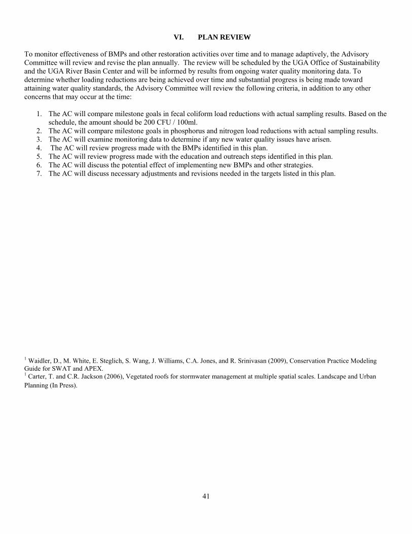
VI. PLAN REVIEW
To monitor effectiveness of BMPs and other restoration activities over time and to manage adaptively, the Advisory Committee will review and revise the plan annually. The review will be scheduled by the UGA Office of Sustainability and the UGA River Basin Center and will be informed by results from ongoing water quality monitoring data. To determine whether loading reductions are being achieved over time and substantial progress is being made toward attaining water quality standards, the Advisory Committee will review the following criteria, in addition to any other concerns that may occur at the time:
1. The AC will compare milestone goals in fecal coliform load reductions with actual sampling results. Based on the schedule, the amount should be 200 CFU / 100ml.
2. The AC will compare milestone goals in phosphorus and nitrogen load reductions with actual sampling results. 3. The AC will examine monitoring data to determine if any new water quality issues have arisen. 4. The AC will review progress made with the BMPs identified in this plan. 5. The AC will review progress made with the education and outreach steps identified in this plan. 6. The AC will discuss the potential effect of implementing new BMPs and other strategies. 7. The AC will discuss necessary adjustments and revisions needed in the targets listed in this plan.
1 Waidler, D., M. White, E. Steglich, S. Wang, J. Williams, C.A. Jones, and R. Srinivasan (2009), Conservation Practice Modeling Guide for SWAT and APEX. 1 Carter, T. and C.R. Jackson (2006), Vegetated roofs for stormwater management at multiple spatial scales. Landscape and Urban Planning (In Press).
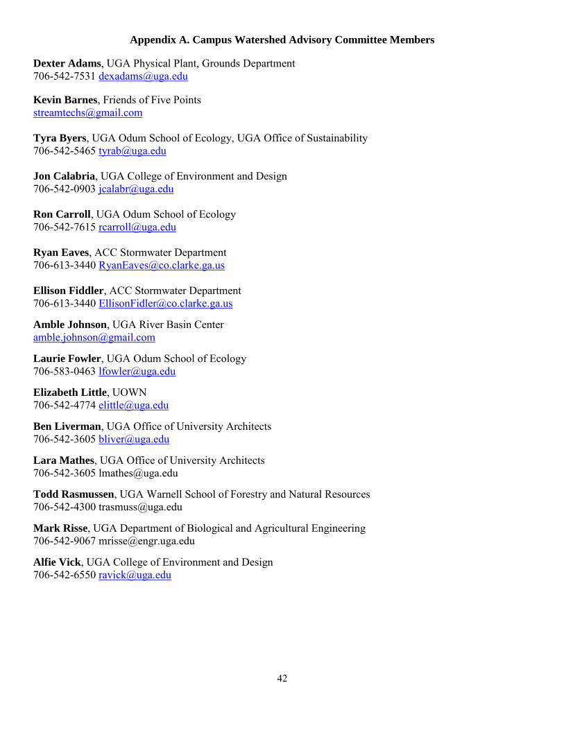
42
Appendix A. Campus Watershed Advisory Committee Members
Dexter Adams, UGA Physical Plant, Grounds Department 706-542-7531 [email protected]
Kevin Barnes, Friends of Five Points [email protected] Tyra Byers, UGA Odum School of Ecology, UGA Office of Sustainability 706-542-5465 [email protected] Jon Calabria, UGA College of Environment and Design 706-542-0903 [email protected] Ron Carroll, UGA Odum School of Ecology 706-542-7615 [email protected] Ryan Eaves, ACC Stormwater Department 706-613-3440 [email protected] Ellison Fiddler, ACC Stormwater Department 706-613-3440 [email protected] Amble Johnson, UGA River Basin Center [email protected] Laurie Fowler, UGA Odum School of Ecology 706-583-0463 [email protected] Elizabeth Little, UOWN 706-542-4774 [email protected] Ben Liverman, UGA Office of University Architects 706-542-3605 [email protected] Lara Mathes, UGA Office of University Architects 706-542-3605 [email protected] Todd Rasmussen, UGA Warnell School of Forestry and Natural Resources 706-542-4300 [email protected] Mark Risse, UGA Department of Biological and Agricultural Engineering 706-542-9067 [email protected] Alfie Vick, UGA College of Environment and Design 706-542-6550 [email protected]
43
Appendix B. Water Quality Monitoring Plan
WATER QUALITY MONITORING PLAN
NORTH OCONEE RIVER (TRAIL CREEK TO MIDDLE OCONEE RIVER)
TANYARD CREEK TO LILLY BRANCH
TARGETED / BMP WATER QUALITY MONITORING PLAN
SECTION 319(h) GRANT
APRIL 2012
Created for: Georgia Environmental Protection Division Non-Point Source Program
Watershed Protection Branch Grants Unit 4220 International Parkway, Suite 101
Atlanta GA 30354 Attn: Mary Gazaway
Communications / Outreach Specialist [email protected]
(404) 675-1745
Submitted on behalf of the Advisory Committee by: Tyra Byers, Sustainability Coordinator
River Basin Center and Office of Sustainability University of Georgia
1800 East Broad Street Athens GA 30606 [email protected] (706) 542-1301

44
TABLE OF CONTENTS
INTRODUCTION ............................................................................................................. 1
SECTION 1. WATERSHED DESCRIPTION ......................................................................... 1
SECTION 2. SAMPLING SITES AND DESCRIPTIONS ........................................................... 3
SECTION 3. SAMPLING PROCEDURES AND PARAMETERS ................................................ 5
3.1 UNIVERSITY OF GEORGIA VIA BROWN AND CALDWELL ............................. 6
3.2 UNIVERSITY STUDENTS AND UPPER OCONEE WATERSHED NETWORK ...... 8
SECTION 4. SCHEDULE ................................................................................................. 9
SECTION 5. QUALITY ASSURANCE AND QUALITY CONTROL ............................................. 10
SECTION 6. DATA RETENTION AND SUBMISSION ............................................................. 11
REFERENCES ............................................................................................................... R-1
APPENDICES
APPENDIX 1: CAMPUS WATERSHEDS ADVISORY COMMITTEE MEMBERS ........................... A-1
APPENDIX 2: ROLES AND RESPONSIBILITIES OF PARTICIPATING ORGANIZATIONS ............... A-2
APPENDIX 3: CHAIN-OF-CUSTODY FORM USED BY BROWN AND CALDWELL ....................... A-5
APPENDIX 4: BROWN AND CALDWELL FIELD DATA SPREADSHEET .................................... A-6
APPENDIX 5: GEORGIA ADOPT-A-STREAM DATA FORM ................................................... A-7
1
INTRODUCTION
This document has been developed by the University of Georgia (University) North Oconee River Tanyard Creek to Lilly Branch Watersheds Advisory Committee (member list provided in Appendix A-1) to serve as technical guidance for conducting water quality monitoring, as required for all 319(h) grant-funded projects. It is intended to provide consistency in how water quality data are collected, analyzed and managed by the University, the Athens-Clarke County (ACC) government, non-governmental organizations, including the Upper Oconee Watershed Network, and others. A list of project participants and their responsibilities is provided in Appendix A-2.
This Targeted/BMP Water Quality Plan will be used to detect the most likely sources of impairment within the watershed and assess the effectiveness of BMPs and/or restoration efforts by comparing pre- and post-installation water quality data to determine reduction in pollutant loads. Current, accurate data will help in deciding where and which BMPs and/or restoration efforts are most needed to better control impairment causes. Once BMPs and/or restorations are installed, follow-up water quality data can point to the most effective long-term management practices for removing certain pollutant loads from non-point source runoff. Additionally, the Georgia Environmental Protection Division (GAEPD) can use qualified, updated data in appropriate, scientific-based reports of water quality evaluations within the State.
SECTION 1. WATERSHED DESCRIPTION
Several segments of the North Oconee River are subjects of Total Maximum Daily Load (TMDL) Implementation Plans to reduce loadings of fecal coliform in the (HUC#10) watershed. This includes the portion of the North Oconee River (Trail Creek to Middle Oconee River) that converges with Lilly Branch, Tanyard Creek, and the Physical Plant Drainage. The 2002 TMDL Implementation Plan for Tanyard Creek (Upstream North Oconee River, ACC) requires bacterial load reductions of 70%. The 2003 TMDL Implementation Plan for the North Oconee River (Trail Creek to Middle Oconee River) calls for bacterial load reductions of 72%.
Tanyard Creek bisects the University’s campus and drains a 2.02-square-kilometer watershed that is covered with approximately 74% of impervious surfaces. Approximately 50% of the stream is piped, including that which runs beneath Sanford Stadium. It is listed on Georgia’s 303(d) list for failure to meet its designated use of fishing as a result of fecal coliform levels. Macroinvertebrate sampling indicates very poor water quality. Turbidity readings range from 2 to 220 nephelometric turbidity units
2
(NTU). Tanyard Creek often exceeds levels recommended by the United States Environmental Protection Agency (USEPA) for turbidity and conductivity. Several years ago, the University’s Office of University Architects installed rain gardens along Lumpkin Avenue to slow the flow of storm water and improve quality of storm water discharges to Tanyard Creek via infiltration. The University’s Physical Plant has also made repairs at Sanford Stadium to eliminate illicit discharges to the stream from toilet facilities located in the Stadium’s skyboxes.
An unnamed tributary to the North Oconee River, referred to as “Physical Plant Drainage,” is a small stream with headwaters near the School of Ecology (Ecology) building and flows mostly through culverts located deep underground. In early 2011, a large sinkhole formed along this piped stream system and damaged the Georgia Museum of History’s parking lot near the intersection of East Campus Road and Cedar Street, requiring repair by the University’s Physical Plant.
Lilly Branch is a tributary of the North Oconee River with a 1.66-square-kilometer watershed that includes the Five Points neighborhood of Athens, Georgia and the eastern portion of the University’s campus. Approximately two-thirds of the 1830-meter stream is encased in culverts. The longest stretch of day-lighted stream occurs on the east campus of the University where it travels by the University’s new Lamar Dodd School of Art complex (Art School), through a culvert, and then into an open channel before flowing into the North Oconee River that is listed on the 303(d) list for fecal coliform.
Lilly Branch is an impaired stream with a long history of alteration beginning with intensive cotton farming over a century ago, and more recently, with urbanization of the watershed. Approximately 40% of the Lilly Branch watershed is impervious, with limited riparian zones. This urbanization generates high storm water flows that scour the day-lighted portions of Lilly Branch and pollutes the North Oconee with sediment. Eight years of data collected by the University via consulting firm Brown and Caldwell, University students, and UOWN show that Lilly Branch is heavily-sedimented, highly-polluted with fecal coliform, and polluted with hydrocarbon products. Ongoing biological assessments for invertebrates show that only the most pollution-tolerant organisms survive in Lilly Branch. In addition, the day-lighted section of the stream near the Art School is heavily incised, disconnected from the floodplain, and infested with invasive, exotic plant species.
The University’s Office of University Architects is actively improving the Lilly Branch watershed by installing storm water BMPs near the Art School complex and other areas around campus. Installed improvements include bioswales, bioretention areas, and other landscape features designed to slow the flow of storm water and improve quality of storm water discharges to Lilly Branch via infiltration. They have also removed many
3
of the invasive, exotic plant species around the 110-meter day-lighted section of the stream.
Pollution by hydrocarbons, attributed to leaking underground storage tanks located at old and derelict gasoline service stations in the Five Points neighborhood, is being actively monitored by GAEPD. GAEPD is in the process of preparing final remediation plans for abatement and removal of extant gasoline components.
SECTION 2. SAMPLING LOCATIONS AND DESCRIPTIONS
Project participants, including the University, its students, and UOWN, have and will continue to conduct water quality sampling and monitoring activities for the watershed. Existing sampling locations are indicated on Figure 1. Locations for “hot spot” sampling, BMP and/or restoration installations, and post-installation sampling will be determined and reported as an amendment to this Plan as the project progresses. All sampling locations are and will be within the North Oconee Watershed.
Existing sampling locations along Tanyard Creek (and its tributary Cloverhurst Branch):
MP-1u: Tanyard Creek, Pope Street Park community garden; MP-1: Tanyard Creek, north side of Baxter Street; MP-3u: Cloverhurst Branch, Chadsworth Commons at South Church Street; MP-3: Cloverhurst Branch, south side of Baxter Street behind Oglethorpe House; MP-3d: Cloverhurst Branch, just prior to confluence with Tanyard Creek; and MP-6: Tanyard Creek, downstream of stadium, prior to confluence with North Oconee
River.
Existing sampling location along “Physical Plant Discharge:”
MS4-2: Outlet from Steam Plant and surrounding areas, east of River Road, approximately 250-feet prior to confluence with North Oconee River.
Existing sampling locations along Lilly Branch:
MP-8u: Five Points neighborhood, just downstream of Lumpkin Square Apartments at East Rutherford Road and represents the headwaters of Lilly Branch;
MP-8: Just upstream of the University’s Foley Baseball Field and represents the watershed upstream of the University’s campus;
MP-9: Between the Coverdell Center and the Dan Magill Tennis Complex’s indoor courts building;
MP-10: Just downstream of East Campus Drive where the stream daylights for a short distance of approximately 20-feet; and
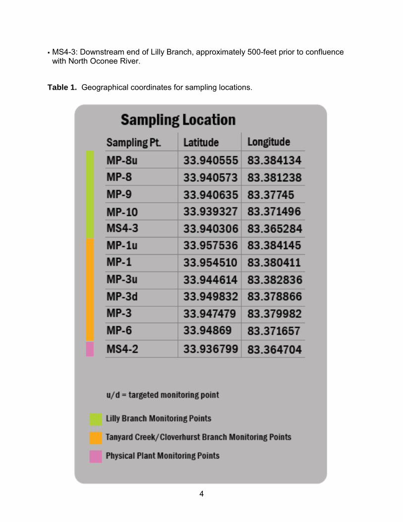
4
MS4-3: Downstream end of Lilly Branch, approximately 500-feet prior to confluence with North Oconee River.
Table 1. Geographical coordinates for sampling locations.
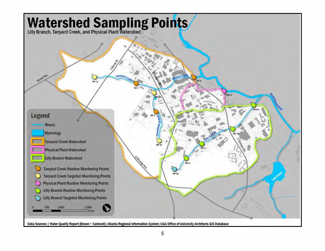
5

6
SECTION 3. SAMPLING PROCEDURES AND PARAMETERS
The collection of water samples and field parameter data will be conducted by several parties, including the University via Brown and Caldwell, University students, UOWN, and others. Brown and Caldwell has been conducting water quality monitoring since 2004 and has developed standard protocols that follow guidelines in GAEPD’s Water Protection Branch Quality Assurance Manual. Brown and Caldwell will continue to follow these established protocols for their role in this Project. Other parties, such as University students, UOWN, and others, will collect water samples and field parameter data in accordance with Georgia’s Adopt-A-Stream (AAS) guidelines and/or IDEXX Colilert® for fecal coliform and E. coli.
Section 3.1. University of Georgia via Brown and Caldwell
Brown and Caldwell has developed standard protocols for the collection of water quality samples and field data that follow the guidelines in GAEPD’s Water Protection Branch Quality Assurance Manual (GAEPD, 2005), Title 40 of the Code of Federal Regulations (40 CFR), and USEPA guidelines. These protocols have and will be used to ensure that samples and field data are collected using the same processes for each sampling event. All field personnel are properly trained in these protocols before arriving at the sampling site to collect samples and field data.
The sampling protocol requires all field personnel to wear latex gloves to prevent contamination while water quality samples are collected. Additional procedures include labeling each sample bottle in indelible ink with the appropriate project name, sampling location, sampling personnel, date and time, type of preservative (if necessary), and the analysis requested. Samples will be collected by submerging a sample bottle in the middle of the stream (when possible) with the mouth pointing upstream. Once an adequate amount of water has been collected, the sample bottle will be sealed and placed on ice until delivery to an analytical lab. During transportation, a Chain of Custody (COC) form will be filled-out for each type of analysis requested. The COC will ensure that the laboratory conducts the proper type of analysis for each sample and will provide each party with a record of when the samples were collected and delivered. The COC form includes the sample time and date, type of analysis requested, and sample location identification. Brown and Caldwell’s standard COC form can be found in Appendix A-3.
A standard protocol is also employed for the collection of all field parameters. Field parameters and notes are recorded in a field notebook. Information recorded in the notebook includes personnel names, date, type of sampling event (wet or dry), sampling-point-specific information, field parameter monitoring results, notes for points-of-interest, and unusual conditions (if encountered). A Horiba U-53 (or equivalent) water
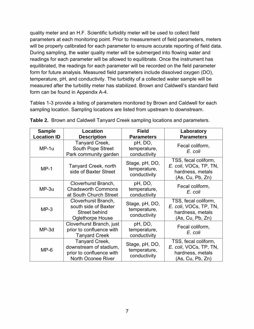
7
quality meter and an H.F. Scientific turbidity meter will be used to collect field parameters at each monitoring point. Prior to measurement of field parameters, meters will be properly calibrated for each parameter to ensure accurate reporting of field data. During sampling, the water quality meter will be submerged into flowing water and readings for each parameter will be allowed to equilibrate. Once the instrument has equilibrated, the readings for each parameter will be recorded on the field parameter form for future analysis. Measured field parameters include dissolved oxygen (DO), temperature, pH, and conductivity. The turbidity of a collected water sample will be measured after the turbidity meter has stabilized. Brown and Caldwell’s standard field form can be found in Appendix A-4.
Tables 1-3 provide a listing of parameters monitored by Brown and Caldwell for each sampling location. Sampling locations are listed from upstream to downstream.
Table 2. Brown and Caldwell Tanyard Creek sampling locations and parameters.
Sample Location ID
Location Description
Field Parameters
Laboratory Parameters
MP-1u Tanyard Creek,
South Pope Street Park community garden
pH, DO, temperature, conductivity
Fecal coliform, E. coli
MP-1 Tanyard Creek, north side of Baxter Street
Stage, pH, DO, temperature, conductivity
TSS, fecal coliform, E. coli, VOCs, TP, TN,
hardness, metals (As, Cu, Pb, Zn)
MP-3u Cloverhurst Branch,
Chadsworth Commons at South Church Street
pH, DO, temperature, conductivity
Fecal coliform, E. coli
MP-3
Cloverhurst Branch, south side of Baxter
Street behind Oglethorpe House
Stage, pH, DO, temperature, conductivity
TSS, fecal coliform, E. coli, VOCs, TP, TN,
hardness, metals (As, Cu, Pb, Zn)
MP-3d Cloverhurst Branch, just prior to confluence with
Tanyard Creek
pH, DO, temperature, conductivity
Fecal coliform, E. coli
MP-6
Tanyard Creek, downstream of stadium, prior to confluence with
North Oconee River
Stage, pH, DO, temperature, conductivity
TSS, fecal coliform, E. coli, VOCs, TP, TN,
hardness, metals (As, Cu, Pb, Zn)

8
Table 3. Brown and Caldwell Physical Plant sampling location and parameters.
Sample Location ID
Location Description
Field Parameters
Laboratory Parameters
MS4-2
Outlet from Steam Plant and surrounding areas,
east of River Road, approximately 250-feet prior to confluence with
North Oconee River
Stage, pH, DO, temperature, conductivity
TSS, fecal coliform, E. coli, VOCs, TP, TN,
hardness, metals (As, Cu, Pb, Zn)
Table 4. Brown and Caldwell Lilly Branch sampling locations and parameters.
Sample Location ID
Location Description
Field Parameters
Laboratory Parameters
MP-8u
Just downstream of Lumpkin Square
Apartments at East Rutherford Road
pH, DO, temperature, conductivity
Fecal coliform, E. coli
MP-8 Upstream of Foley Field
Stage, pH, DO, temperature, conductivity
TSS, fecal coliform, E. coli, VOCs, TP, TN,
hardness, metals (As, Cu, Pb, Zn)
MP-9 Between Coverdell Center and Magill Tennis Complex
pH, DO, temperature, conductivity
Fecal coliform, E. coli
MP-10 Just downstream of East Campus Drive
Stage, pH, DO, temperature, conductivity
Fecal coliform, E. coli
MS4-3
East of River Road near new dormitories,
500-feet prior to confluence with North
Oconee River
Stage, pH, DO, temperature, conductivity
TSS, fecal coliform, E. coli, VOCs, TP, TN,
hardness, metals (As, Cu, Pb, Zn)
Laboratory analysis of water samples have and will be conducted by Analytical Environmental Services, Inc. (AES), located in Atlanta, Georgia. AES’s certifications include:
NELAC/Florida Certification number E87582 for analysis of Environmental Water, soil/hazardous waste, and Drinking Water Microbiology, effective 07/01/11-06/30/12; and

9
AIHA Certification ID #100671 for Industrial Hygiene samples (Organics, Inorganics), Environmental Lead (Paint, Soil, Dust Wipes, Air), and Environmental Microbiology (Fungal) effective until 09/01/13.
Section 2.1. University Students and UOWN
The collection of water samples and field parameter data by University students, UOWN, and others will follow guidelines for the appropriate procedures and materials or instruments from the most current Georgia AAS’s Visual Stream Survey, Biological & Chemical Stream Monitoring, and Bacterial Monitoring manuals, Table 4 of GAEPD’s “How to Plan for and Proceed with 319(h) Grant-Funded Monitoring” (GAEPD, 2011), GAEPD’s Water Protection Branch Quality Assurance Manual (GAEPD, 2005), Title 40 of the Code of Federal Regulations (40 CFR), and USEPA.
University students will conduct monitoring at the existing sampling locations and along streams (at locations to be determined) to prioritize sources or areas of pollutant loadings (“hot spots”) for pre-BMP monitoring. University students will monitor fecal coliform and E. coli and may monitor other parameters on occasion. UOWN and others will monitor temperature, conductivity, pH, dissolved oxygen, turbidity, total suspended solids, fecal coliform, E. coli, macroinvertabrates, fish index of biotic integrity (IBI), habitat, and exotic plant species.
Data acquired from “hot spot” sampling will be used to determine locations and performance standards for BMPs. BMPs will be identified through the 9-Key Element Watershed Plan. As storm water runoff is a source of substantial impairment to these streams, it is likely that BMPs, such as level spreaders, constructed wetlands, and riparian restoration, will be located along campus surface parking areas to slow the flow of storm water and allow infiltration. After BMPs have been installed, post-BMP installation monitoring will be conducted to evaluate whether the BMPs are effective in improving the water quality of receiving streams. For post-BMP monitoring, sampling sites will be located upstream and/or downstream of BMP installations.
To designate future sampling locations, University students and staff will perform a field reconnaissance to confirm accessibility, safety and travel time. Sampling sites will be located, where possible, near road crossings, on public rights-of-way, or along utility easements to make access easier, as well as simplify potential private property and safety issues. Travel from site to site will be made to plot the time commitment necessary to collect and process all samples. Directions for getting to each site will be verified and permission from any private property owners will be obtained prior to accessing the sampling locations.
10
SECTION 4. SCHEDULE
Each quarter, Brown and Caldwell will conduct one dry-weather sampling event for all parameters, one wet-weather sampling event for all parameters, and two additional bacterial (fecal coliform and E. coli) sampling events at existing locations on dates to be determined by field conditions.
UOWN will conduct annual sampling and analyses at locations and dates to be determined.
When school is in session, University students will conduct quarterly sampling at existing locations for all parameters (as indicated in Section 3.2) on dates to be determined and in concert with Brown and Caldwell. Students will also conduct sampling along Lilly Branch for all parameters (as indicated in Section 3.2) to identify pollutant “hot spots.” The first “hot spot” sampling event will be conducted by students of the University’s Environmental Practicum class and has been scheduled for April 11-13, 2012 at locations to be determined by field reconnaissance.
To assess the effectiveness of BMPs in achieving their expected load reductions, post-BMP sampling plans will be developed and implemented as BMPs are installed and based on funding availability.
SECTION 5. QUALITY ASSURANCE AND QUALITY CONTROL
As described in Section 2.1, Brown and Caldwell, a consulting firm contracted by the University, has and will utilize existing protocols for sample collection, field parameter collection, and laboratory analyses. Therefore, the following Quality Control/Quality Assurance (QA/QC) statement, as provided and required by GAEPD’s “How to Plan for and Proceed with 319(h) Grant-Funded Monitoring” (GAEPD, 2011), will not apply to Brown and Caldwell’s monitoring activities, but will apply to monitoring activities by University students, UOWN, and others:
“All sample collection, field parameters, and lab analysis will be conducted in accordance with the GAEPD Adopt-A-Stream Program’s Quality Assurance Project Plan (QAPP) and Quality Monitoring Plan (QMP) developed and maintained by GAEPD Adopt-A-Stream and previously approved by USEPA. Copies of the QAPP and QMP will be provided by GAEPD and will be kept on site to be used as reference and provide future guidance on water quality monitoring procedures. Any additional agencies, organizations, or subcontractors that participate in the aforementioned water quality monitoring activities shall also adhere to GAEPD Adopt-A-Stream procedures and this guidance.”

11
Prior to beginning monitoring activities, field personnel or volunteers will be trained in QA/QC techniques for sample collection, handling, analysis, disposal, and other components of monitoring. Anyone who plans to assist with sample collection and analysis will receive certified training and renew their certification annually to be eligible to continue monitoring. All certificates awarded will be kept on file, by the sponsoring party, for reference.
Students of the University’s Environmental Practicum class of Spring 2012 have been certified for performing AAS physical, chemical, and bacterial sampling and analytical techniques. The training workshop was held on February 8, 2012 at the University’s Red Clay Café, located in the Joe Frank Harris Commons building, in short distance of Lilly Branch. ACC Naturalist, Kate Mowbray, conducted the workshop. The following students attended the workshop and achieved AAS certification:
Brad Brizendine Blake Conant Mindy Edelson William Gulsby
Michael Henson Justin Holloway Jennifer Kobylus Hunter Knowles
Melinda Nelson Brad Valentine John Wiles, Jr.
All existing and future University students acquiring data for this project will be required to have current certifications for AAS methods, as applicable to their assigned duties.
UOWN will be charged with ensuring that participants involved with UOWN monitoring activities have satisfied AAS training and certification requirements, as applicable to their assigned duties.
SECTION 6. DATA RETENTION AND SUBMISSION
Data will be submitted to and shared by the University’s Office of Sustainability (Tyra Byers, Sustainability Coordinator and Project Lead Contact).
.A database will be created to incorporate historical and future water quality data collected by participating parties, including ACC, Brown and Caldwell, University students, UOWN, and others.
Data will be submitted, if collected, to the Grants Unit by the University’s Office of Sustainability with each invoice or Quarterly Report. Data will be retained for a period of three years from the conclusion of the project and available for review.
R-1
REFERENCES Brown and Caldwell. University of Georgia: Tanyard Creek, Lilly Branch, and MS4 Locations; Water Quality Monitoring Report. November 2011.
Georgia Department of Natural Resources, Environmental Protection Division, Watershed Protection Branch. 2005. Quality Assurance Manual. Available online at: http://www.gaepd.org/Files_PDF/techguide/wpb/Water_Protection_Branch_Quality_Assurance_Manual_Revision2005.pdf. Accessed 04/02/2012.
Georgia Department of Natural Resources, Environmental Protection Division, Watershed Protection Branch, Non-Point Source Program, Georgia Adopt-A-Stream. Available online at: http://georgiaadoptastream.org/db/Default.asp. Accessed 04/02/2012.
Georgia Department of Natural Resources, Environmental Protection Division, Watershed Protection Branch, Non-Point Source Program, Grants Unit. How to Plan for and Proceed with 319(h) Grant-Funded Monitoring. August 2011.

1
Appendix C. 2012 Environmental Practicum Invasive Species Report
Invasive Species Management Plan for Lilly Branch and Tanyard Creek, Athens, Georgia Background As part of a larger effort to restore Lilly Branch and Tanyard Creek (henceforth Lilly and Tanyard) and provide watershed education to the Athens community, we were asked by the River Basin Center to identify invasive exotic flora along the streams and develop a plan for managing these plants that incorporated volunteer labor. Problems and Solutions The overarching goal of this project is to improve water quality (e.g., decrease fecal coliforms, turbidity, erosion, etc.). However, due to the nature of storm water management, efforts in this direction would be wasted without community involvement. Therefore, this project also has a strong educational component, designed to improve public awareness of the fact that storm water dumps directly into streams without receiving any treatment. Although careful application, handling and disposal of liquid and solid wastes is the best way to prevent stream contamination, myriad factors likely affect the public’s perception of water quality as well as their willingness to change habits that negatively impact it. We believe that two of these factors are visibility/aesthetic value and awareness of stream locations. Through a series of discussions, we identified a volunteer-based community effort as the most effective way of achieving the goals of improving the ecosystem and educating the public. While volunteer labor improves the ecosystem at little to no cost, it also improves the aesthetics of the watersheds while making citizens aware of the streams’ locations. Simply put, we hope that members of the community will be less likely to participate in actions that contribute to stream impairment when: 1) they are aware of stream locations and, thus, how careless handling of pollutants results in runoff, 2) stream ways are aesthetically appealing and visible, and 3) they have invested their own time and energy into improving the streams. Additionally, we believe that the effects of such a volunteer event will not be limited to those who directly participate, but also by participants “protecting” their investment by sharing what they have learned and done with others. Goals This management plan is designed to improve the overall function of the riparian ecosystems found along Lilly and Tanyard by reducing or eliminating invasive exotic plant species at carefully selected sites along each stream. However, by involving the community in this effort, we hope to also affect the public’s perception of water quality and willingness to change habits negatively impacting it. Site Selection Sites were selected by representatives of both the River Center (Laurie Fowler and Tyra Byers) and the Environmental Law Practicum course (William Gulsby and Melinda Nelson) after careful discussion and consideration of the following factors: 1) Property ownership 2) Public visibility 3) Probability of successful control/eradication Only properties owned by the University of Georgia Board of Regents or Athens Clarke County were considered. We believe that, because these properties are publicly owned, they will be easier to access both for the control effort and for the community post-control. Therefore, selection of properties meeting this criterion will likely result in the most favorable outcomes for our goals.
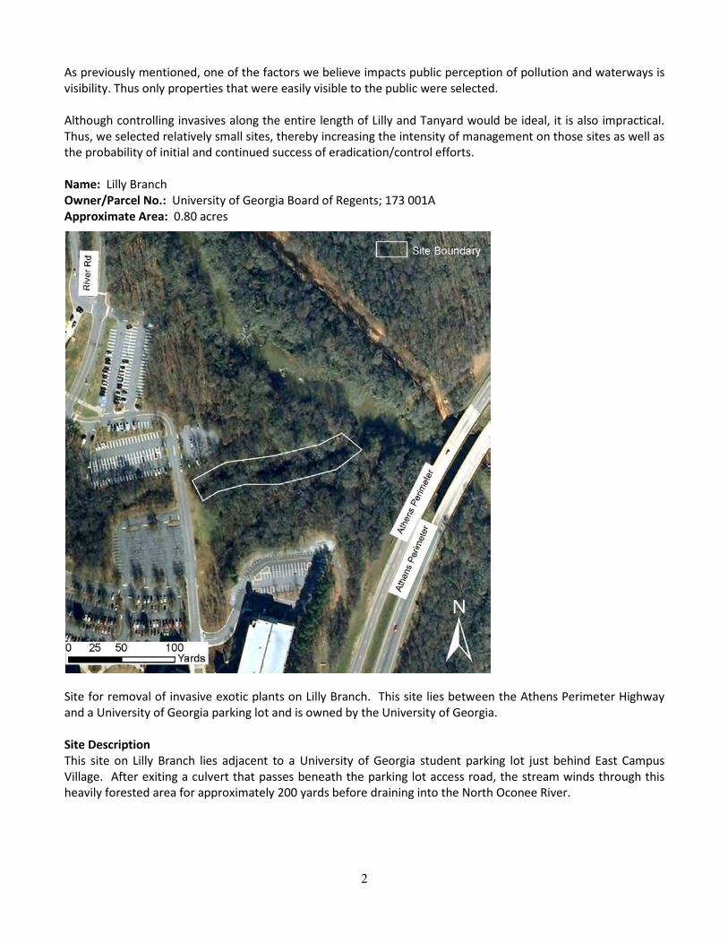
2
As previously mentioned, one of the factors we believe impacts public perception of pollution and waterways is visibility. Thus only properties that were easily visible to the public were selected. Although controlling invasives along the entire length of Lilly and Tanyard would be ideal, it is also impractical. Thus, we selected relatively small sites, thereby increasing the intensity of management on those sites as well as the probability of initial and continued success of eradication/control efforts.
Name: Lilly Branch Owner/Parcel No.: University of Georgia Board of Regents; 173 001A Approximate Area: 0.80 acres
Site for removal of invasive exotic plants on Lilly Branch. This site lies between the Athens Perimeter Highway and a University of Georgia parking lot and is owned by the University of Georgia. Site Description This site on Lilly Branch lies adjacent to a University of Georgia student parking lot just behind East Campus Village. After exiting a culvert that passes beneath the parking lot access road, the stream winds through this heavily forested area for approximately 200 yards before draining into the North Oconee River.

3
Special Considerations Because the Lilly Branch site is connected to a relatively large, uninterrupted tract of forest, especially for such an urban area, wildlife is abundant there. During site visits, we identified abundant white-tailed deer, opossum, raccoon, and beaver sign. A variety of songbird species could also be heard. Due to the high abundance of white-tailed deer on this site, careful planning must be taken to ensure that any plant species used in site restoration be resistant or tolerant to deer herbivory. However, deer may also be of benefit to this site. The most prevalent invasive plant species at this location is Chinese Privet, which also happens to be a preferred food item of whitetails. Thus, deer may help to prevent reestablishment of privet following control efforts. Invasive Plant Management Recommendations Chinese Privet (Ligustrum sinense), overwhelms the edges of Lilly Branch at this site and control or eradication of this plant should be the main focus of restoration efforts. The primary justification for this recommendation is that the invasion, left unchecked for many years, has resulted in tall, dense stands of privet which shades out all native vegetation that would potentially occupy the site. With regards to water quality, this has resulted in little to no vegetation growth along banks and led to substantial erosion of the already steep banks. Because of the size of the privet plants, the extent of the invasion at this site, and the concern for surrounding non-target vegetation, we recommend mechanical control immediately followed by herbicide application. Thus, plants should first be cut near their base and removed from the site. Then, stumps should be immediately treated with a glyphosate herbicide with a surfactant. In areas directly over the stream, glyphosate labeled for use in wetlands (Rodeo) should be used. The addition of a dye is helpful because it allows workers and volunteers to visualize which stumps have already been treated. Other Concerns During our site visit, we also noted severely eroded banks. Removal of privet will allow increased sunlight penetration, encouraging reestablishment of native plant species that will aid in soil stabilization. However, we also noticed that, at one time, silt fencing had been placed along the bank edges but was no longer functioning. We believe that repair or replacement of this fencing will not only slow erosion, but will also allow time for native plant species to take hold and perform their natural ecological function. Additionally, we suggest referring to the guide on native riparian plant species at the end of this management plan for ideas on plants that will aid in reaching the goals of this effort. Name: Cemetery Owner/Parcel No.: University of Georgia Board of Regents; 173 001A Approximate Area: 0.91 acres

4
“Cemetery” site for removal of invasive exotic plants on Tanyard Creek. This site lies between East Campus Road and the historic Oconee Hill Cemetery and is owned by the University of Georgia. Site Description This site on Tanyard Creek lies just to the southeast of Sanford Stadium and is bordered by Oconee Hill Cemetery to the north. After exiting a culvert that routes the stream beneath Sanford Stadium and East Campus Road, it winds through this forested area between the cemetery and River Road for approximately 200 yards before draining into the North Oconee River. Special Considerations Efforts to control or eradicate invasive plant species on this site will be difficult due to the high, sharply rising banks on this section of Tanyard. Additionally, long term control of invasive plants will be complicated by the presence of a variety of escaped ornamental plants whose source is the Oconee Hill Cemetery. A cooperative or partnership between the River Center, volunteers, and the historic cemetery would likely result in improved outcomes for goals at this site. Invasive Plant Management Recommendations Chinese Privet (Ligustrum sinense) and Periwinkle (Vinca major) are the two main species of concern at this site and control or eradication of these plants should be the main focus of restoration efforts. The invasion of privet, left unchecked for many years, has resulted in tall, dense stands that shade out native vegetation that would normally occupy the site. With regards to water quality, this has resulted in little to no
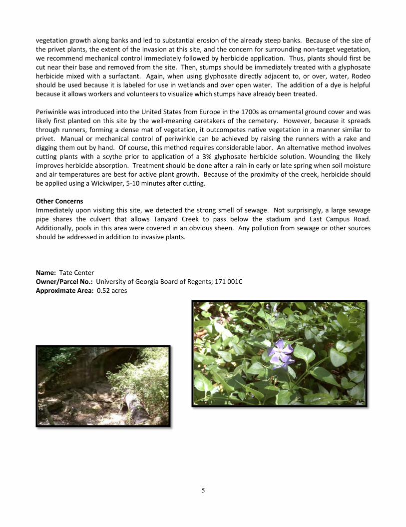
5
vegetation growth along banks and led to substantial erosion of the already steep banks. Because of the size of the privet plants, the extent of the invasion at this site, and the concern for surrounding non-target vegetation, we recommend mechanical control immediately followed by herbicide application. Thus, plants should first be cut near their base and removed from the site. Then, stumps should be immediately treated with a glyphosate herbicide mixed with a surfactant. Again, when using glyphosate directly adjacent to, or over, water, Rodeo should be used because it is labeled for use in wetlands and over open water. The addition of a dye is helpful because it allows workers and volunteers to visualize which stumps have already been treated. Periwinkle was introduced into the United States from Europe in the 1700s as ornamental ground cover and was likely first planted on this site by the well-meaning caretakers of the cemetery. However, because it spreads through runners, forming a dense mat of vegetation, it outcompetes native vegetation in a manner similar to privet. Manual or mechanical control of periwinkle can be achieved by raising the runners with a rake and digging them out by hand. Of course, this method requires considerable labor. An alternative method involves cutting plants with a scythe prior to application of a 3% glyphosate herbicide solution. Wounding the likely improves herbicide absorption. Treatment should be done after a rain in early or late spring when soil moisture and air temperatures are best for active plant growth. Because of the proximity of the creek, herbicide should be applied using a Wickwiper, 5-10 minutes after cutting. Other Concerns Immediately upon visiting this site, we detected the strong smell of sewage. Not surprisingly, a large sewage pipe shares the culvert that allows Tanyard Creek to pass below the stadium and East Campus Road. Additionally, pools in this area were covered in an obvious sheen. Any pollution from sewage or other sources should be addressed in addition to invasive plants. Name: Tate Center Owner/Parcel No.: University of Georgia Board of Regents; 171 001C Approximate Area: 0.52 acres
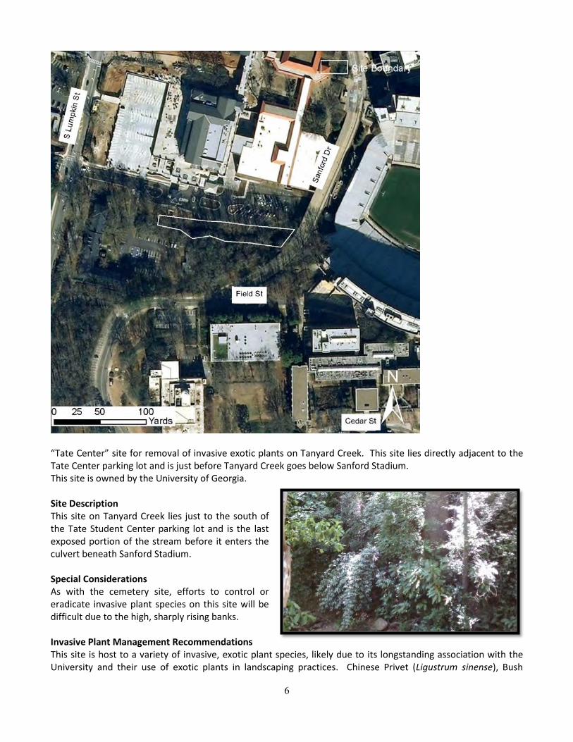
6
“Tate Center” site for removal of invasive exotic plants on Tanyard Creek. This site lies directly adjacent to the Tate Center parking lot and is just before Tanyard Creek goes below Sanford Stadium. This site is owned by the University of Georgia. Site Description This site on Tanyard Creek lies just to the south of the Tate Student Center parking lot and is the last exposed portion of the stream before it enters the culvert beneath Sanford Stadium. Special Considerations As with the cemetery site, efforts to control or eradicate invasive plant species on this site will be difficult due to the high, sharply rising banks. Invasive Plant Management Recommendations This site is host to a variety of invasive, exotic plant species, likely due to its longstanding association with the University and their use of exotic plants in landscaping practices. Chinese Privet (Ligustrum sinense), Bush
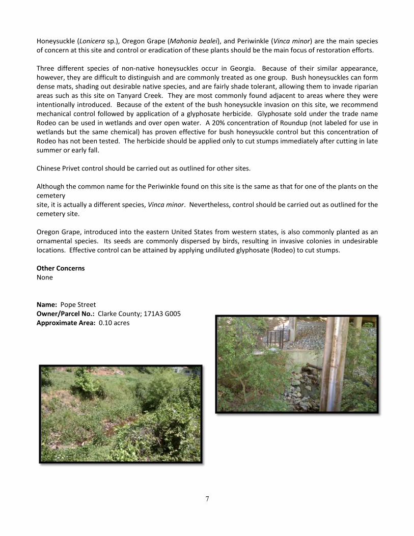
7
Honeysuckle (Lonicera sp.), Oregon Grape (Mahonia bealei), and Periwinkle (Vinca minor) are the main species of concern at this site and control or eradication of these plants should be the main focus of restoration efforts. Three different species of non-native honeysuckles occur in Georgia. Because of their similar appearance, however, they are difficult to distinguish and are commonly treated as one group. Bush honeysuckles can form dense mats, shading out desirable native species, and are fairly shade tolerant, allowing them to invade riparian areas such as this site on Tanyard Creek. They are most commonly found adjacent to areas where they were intentionally introduced. Because of the extent of the bush honeysuckle invasion on this site, we recommend mechanical control followed by application of a glyphosate herbicide. Glyphosate sold under the trade name Rodeo can be used in wetlands and over open water. A 20% concentration of Roundup (not labeled for use in wetlands but the same chemical) has proven effective for bush honeysuckle control but this concentration of Rodeo has not been tested. The herbicide should be applied only to cut stumps immediately after cutting in late summer or early fall. Chinese Privet control should be carried out as outlined for other sites. Although the common name for the Periwinkle found on this site is the same as that for one of the plants on the cemetery site, it is actually a different species, Vinca minor. Nevertheless, control should be carried out as outlined for the cemetery site. Oregon Grape, introduced into the eastern United States from western states, is also commonly planted as an ornamental species. Its seeds are commonly dispersed by birds, resulting in invasive colonies in undesirable locations. Effective control can be attained by applying undiluted glyphosate (Rodeo) to cut stumps. Other Concerns None Name: Pope Street Owner/Parcel No.: Clarke County; 171A3 G005 Approximate Area: 0.10 acres
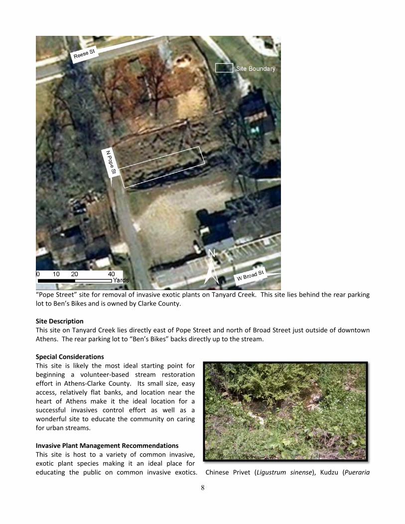
8
“Pope Street” site for removal of invasive exotic plants on Tanyard Creek. This site lies behind the rear parking lot to Ben’s Bikes and is owned by Clarke County. Site Description This site on Tanyard Creek lies directly east of Pope Street and north of Broad Street just outside of downtown Athens. The rear parking lot to “Ben’s Bikes” backs directly up to the stream. Special Considerations This site is likely the most ideal starting point for beginning a volunteer-based stream restoration effort in Athens-Clarke County. Its small size, easy access, relatively flat banks, and location near the heart of Athens make it the ideal location for a successful invasives control effort as well as a wonderful site to educate the community on caring for urban streams. Invasive Plant Management Recommendations This site is host to a variety of common invasive, exotic plant species making it an ideal place for educating the public on common invasive exotics. Chinese Privet (Ligustrum sinense), Kudzu (Pueraria
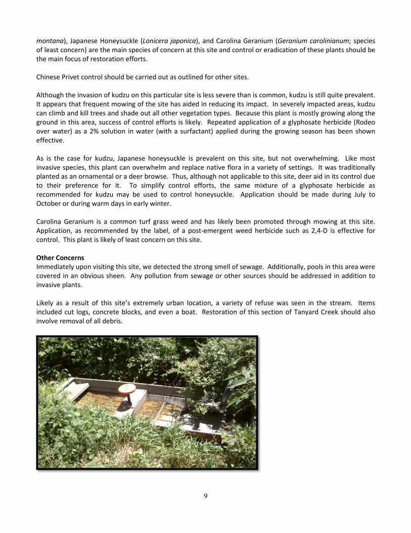
9
montana), Japanese Honeysuckle (Lonicera japonica), and Carolina Geranium (Geranium carolinianum; species of least concern) are the main species of concern at this site and control or eradication of these plants should be the main focus of restoration efforts. Chinese Privet control should be carried out as outlined for other sites. Although the invasion of kudzu on this particular site is less severe than is common, kudzu is still quite prevalent. It appears that frequent mowing of the site has aided in reducing its impact. In severely impacted areas, kudzu can climb and kill trees and shade out all other vegetation types. Because this plant is mostly growing along the ground in this area, success of control efforts is likely. Repeated application of a glyphosate herbicide (Rodeo over water) as a 2% solution in water (with a surfactant) applied during the growing season has been shown effective. As is the case for kudzu, Japanese honeysuckle is prevalent on this site, but not overwhelming. Like most invasive species, this plant can overwhelm and replace native flora in a variety of settings. It was traditionally planted as an ornamental or a deer browse. Thus, although not applicable to this site, deer aid in its control due to their preference for it. To simplify control efforts, the same mixture of a glyphosate herbicide as recommended for kudzu may be used to control honeysuckle. Application should be made during July to October or during warm days in early winter. Carolina Geranium is a common turf grass weed and has likely been promoted through mowing at this site. Application, as recommended by the label, of a post-emergent weed herbicide such as 2,4-D is effective for control. This plant is likely of least concern on this site. Other Concerns Immediately upon visiting this site, we detected the strong smell of sewage. Additionally, pools in this area were covered in an obvious sheen. Any pollution from sewage or other sources should be addressed in addition to invasive plants. Likely as a result of this site’s extremely urban location, a variety of refuse was seen in the stream. Items included cut logs, concrete blocks, and even a boat. Restoration of this section of Tanyard Creek should also involve removal of all debris.
10
References Bush Honeysuckles Control. Missouri Department of Conservation. 17 Apr. 2012 <http://www.mdc.mo.gov>. Invasive, Exotic Plants of the Southeast. 2012. NC State University. 5 Apr. 2012
<http://www.ncsu.edu/goingnative/howto/mapping/invexse>. Invasive Exotic Plant Tutorial for Natural Lands Managers. 2002. Pennsylvania Department of Conservation of
Natural Resources. 6 Apr. 2012 <http://www.dcnr.state.pa.us/forestry/invasivetutorial> Miller, J. H. and K. V. Miller. 2005. Forest Plants of the Southeast and their Wildlife Uses. 2nd Edition University
of Georgia Press. Athens, GA. 454. pp. Miller, James H. 2003. Nonnative invasive plants of southern forests: a field guide for identification and control.
Gen. Tech. Rep. SRS–62. Asheville, NC: U.S. Department of Agriculture, Forest Service, Southern Research Station. 93 p.
NC State University TurfFiles. 2012. Crop Science Department at NCSU. 17 Apr. 2012 <http://turffiles.ncsu.edu>.

11
Appendix D.
Stormwater Management: A Plan for the Basins from Tanyard Creek to Lilly Branch on the North Oconee River
(204 pages provided on disk)
12
Appendix E. Spring 2013 Practicum Stormwater Control Measures (SCM) Plan
SCM and Stream Restoration Modeling, Analysis, Design – April 2013
Brian Chernoff Tyler Johnson Shannon Bonney
As referenced in the background on stormwater control measures and stream restoration section, modeling and analysis provided site specific characterization for existing conditions information and proposed SCM implementation that compliments the regional suitability analysis of the Lilly Branch, Tanyard Creek, and PPD watersheds for SCMs (Flaute 2013). Doing so helps identify individual parcels where SCMs and which type of SCMs are most needed, feasible and/or most appropriate.
Consistent with methods used in Flaute’s watershed suitability method for the entire watershed, specific locations for site demonstration of SCMs were determined by correlating site conditions, design criteria and land ownership. Models were run for areas where vegetated roofs and bioretention basins could be designed and implemented. The methods to model, analyze and design vegetated roofs and bioretention basins can be applied across the entire watershed to create “treatment trains” (Lloyd, Wong, and Porter 2002).
The Soil and Water Assessment Tool (SWAT) was used to model our demonstration sites. ARCSWAT is a public domain graphical user interface extension that allows integration of SWAT and GIS software from ESRI. Output of ARCSWAT provides characterization data of the site for existing and proposed conditions. Manipulating data based on desired goals (of water infiltration) allows ARCSWAT to output the results of implementing various SCMs. Among many inputs, ARCSWAT uses soil types, the amount of impervious cover, quantity and volumes of precipitation, which allows calculation of curve numbers. An area's curve number indicates how well water can infiltrate the ground. The higher the curve number, the worse infiltration is for an area.
Implementing an SCM can lower curve numbers to levels that more closely mimic natural levels of water infiltration prior to urbanization and development. Good infiltration helps replenish groundwater and diminishes and stormwater runoff.
Our ARCSWAT model output reflects potential pollutant removal: sediment, nitrogen, phosphorus. The Conservation Practice Modeling guide (Waidler et al 2009) suggests typical removal by a rain garden, also called a bioretention basin, for sediment is 65%, nitrogen is 10%m and phosphorus is 25%.
ArcSWAT output data is available here for download and viewable in Microsoft Access:
https://www.dropbox.com/sh/q8jzvwg1q1p0zmj/z1s9ZVAxBT
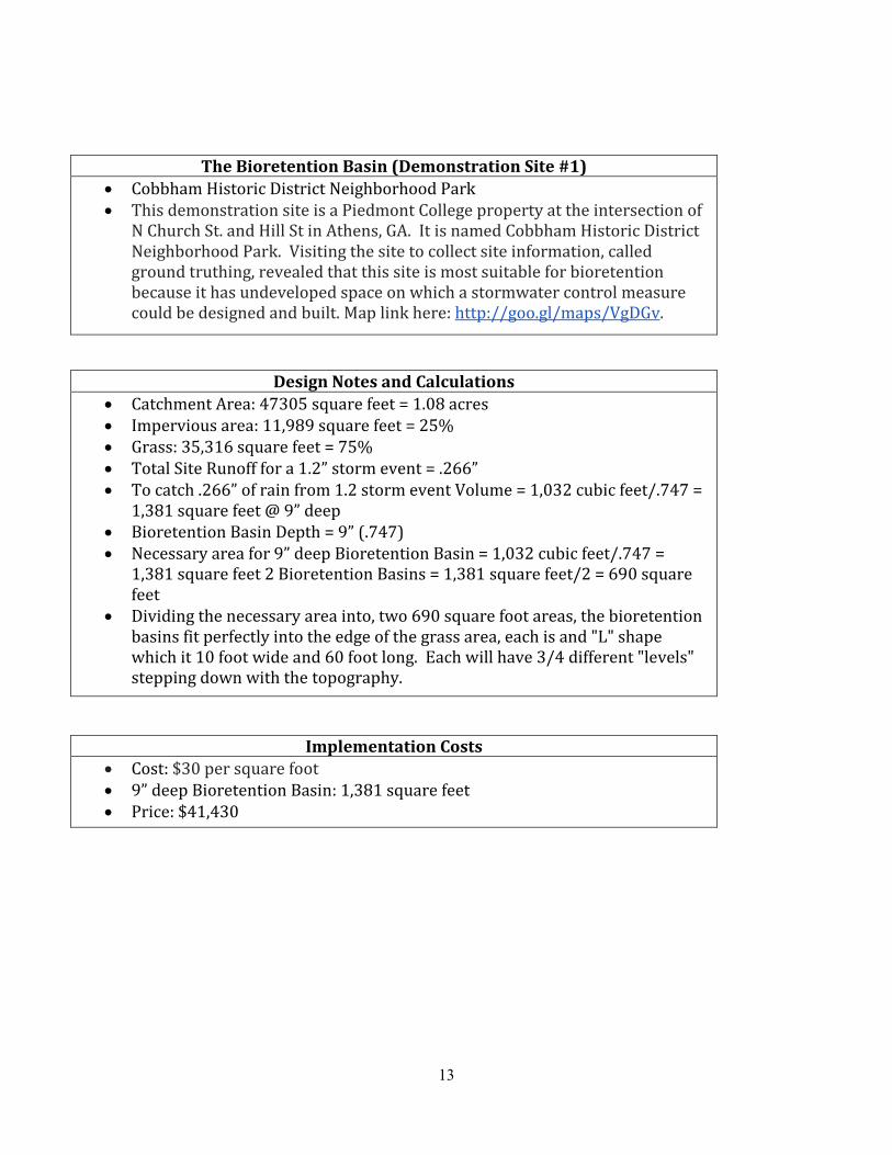
13
The Bioretention Basin (Demonstration Site #1) • Cobbham Historic District Neighborhood Park • This demonstration site is a Piedmont College property at the intersection of
N Church St. and Hill St in Athens, GA. It is named Cobbham Historic District Neighborhood Park. Visiting the site to collect site information, called ground truthing, revealed that this site is most suitable for bioretention because it has undeveloped space on which a stormwater control measure could be designed and built. Map link here: http://goo.gl/maps/VgDGv.
Design Notes and Calculations • Catchment Area: 47305 square feet = 1.08 acres • Impervious area: 11,989 square feet = 25% • Grass: 35,316 square feet = 75% • Total Site Runoff for a 1.2” storm event = .266” • To catch .266” of rain from 1.2 storm event Volume = 1,032 cubic feet/.747 =
1,381 square feet @ 9” deep • Bioretention Basin Depth = 9” (.747) • Necessary area for 9” deep Bioretention Basin = 1,032 cubic feet/.747 =
1,381 square feet 2 Bioretention Basins = 1,381 square feet/2 = 690 square feet
• Dividing the necessary area into, two 690 square foot areas, the bioretention basins fit perfectly into the edge of the grass area, each is and "L" shape which it 10 foot wide and 60 foot long. Each will have 3/4 different "levels" stepping down with the topography.
Implementation Costs • Cost: $30 per square foot • 9” deep Bioretention Basin: 1,381 square feet • Price: $41,430
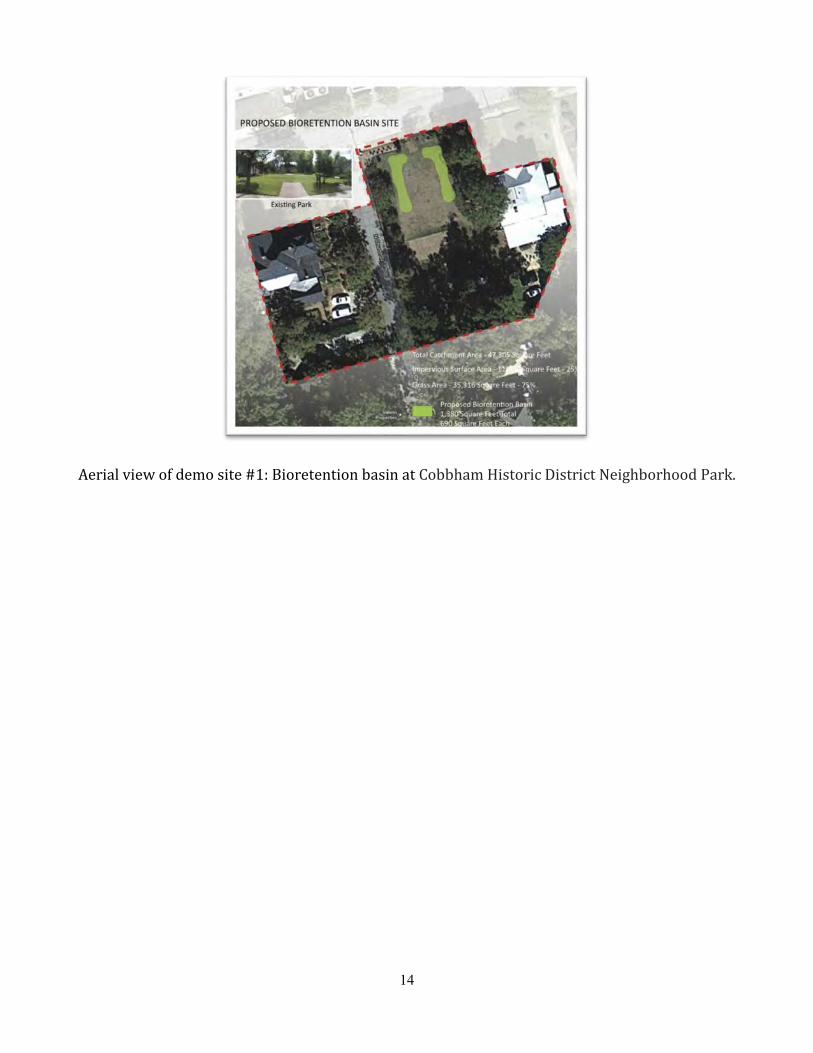
14
Aerial view of demo site #1: Bioretention basin at Cobbham Historic District Neighborhood Park.

15
Plan view of demo site #1: Bioretention basin at Cobbham Historic District Neighborhood Park.

16
Planting plan demo site #1: Bioretention basin at Cobbham Historic District Neighborhood Park
Grading plan demo site #1: Bioretention basin at Cobbham Historic District Neighborhood Park.
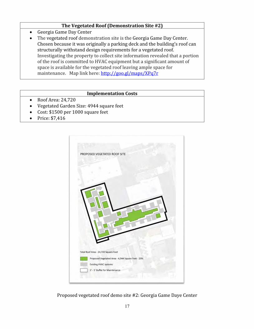
17
The Vegetated Roof (Demonstration Site #2) • Georgia Game Day Center • The vegetated roof demonstration site is the Georgia Game Day Center.
Chosen because it was originally a parking deck and the building’s roof can structurally withstand design requirements for a vegetated roof. Investigating the property to collect site information revealed that a portion of the roof is committed to HVAC equipment but a significant amount of space is available for the vegetated roof leaving ample space for maintenance. Map link here: http://goo.gl/maps/XPq7r
Implementation Costs • Roof Area: 24,720 • Vegetated Garden Size: 4944 square feet • Cost: $1500 per 1000 square feet • Price: $7,416
Proposed vegetated roof demo site #2: Georgia Game Daye Center

18
Citations
Flaute-Myers, C. 2012. Stormwater Management A Plan for the Basins from Tanyard Creek to Lilly Branch on the North Oconee River. [Masters of Environmental Planning and Design] Thesis, University of Georgia. Athens.
Lloyd, S.D., T.H.F. Wong, and B. Porter. 2002. “The Planning and Construction of an Urban Stormwater Management Scheme.” Water Science & Technology 45, no. 7: 1.
Waidler, David, Mike White, Evelyn Steglich, Susan Wang, Jimmy Williams, C. A. Jones, and Raghavan Srinivasan. 2011. “Conservation Practice Modeling Gu
19
Appendix F. Spring 2013 Practicum Stormwater BMP Modeling Results
The proposed stormwater BMP projects discussed were modeled for the Tanyard Creek watershed using the 2012 version of the Stormwater Assessment Tool (SWAT) for ArcGIS 10. Data was obtained from the USDA Natural Resource Conservation Service. These data include: the National Elevation Dataset 10-meter digital elevation model for Clarke County, the National Land Cover Dataset for the state of Georgia, and the Soil Survey Geographic database for Clarke County. Weather station data was obtained from the Texas A&M SWAT weather data website. All layers were projected in NAD 1983 UTM Zone 17N.
For a parcel of land owned by Piedmont College, a bioretention basin was designed that will retain the volume of stormwater runoff created by a 1.2” storm event. To model the bioretention structure in SWAT a retention pond with the same dimensions was added to the pond (.pnd) input database for sub-basin 116. The fraction of runoff that goes into the pond was set to 0 for scenario “retention1”, 1 for scenario “retention2”, and 0.5 for scenario “retention3”. The magnitude of reduction in surface water runoff was greater for the scenarios with a high fraction of runoff that goes into the pond. Although a reduction in surface runoff was seen in sub-basin 116, widespread changes in surface runoff or stream water quality were not seen in any of the bioretention simulations.
To approximate the best possible conditions for the watershed a SWAT scenario was created with “mixed forest” land-cover for all sub-basins. The hydrology of this simulation was characterized by lower surface runoff and greater infiltration.
A number of SWAT scenarios were created to simulate the effects of implementing green roof projects. Methods for simulating urban BMPs with SWAT, described in Waidler et al. (2009)25 were used for scenarios “ind50”, and those methods described in and Carter and Jackson (2006)26 for “roof_ind_108” and “roof_ind_all”. For these simulations the urban (.urb) input database was modified for industrial land uses. In “ind50” the fraction of impervious area associated with industrial land uses was reduced to 50 percent. The curve number associated with industrial land use was changed to 86 for sub-basin 108, the location of the Game Day Condominiums, in “roof_ind_109=8” and for all sub-basins in “roof_ind_all”. The largest reductions in surface runoff were seen in the “roof_ind_all” simulation. Green roof simulations affected hydrology more than sediment, phosphorus, and nitrogen cycles.
Multiple attempts were made to model fecal coliform with SWAT, but were unsuccessful in capturing the wide range of observed bacterial colonies. The parameter “pet waste” was added to the fertilizer database. SWAT runs that included applications of “pet waste” were unable to account for all of the observed fecal coliform. Other sources of fecal coliform, such as leaking sewer pipes and wildlife waste, are predicted to exist. The SWAT model was unable to accurately account for these fecal coliform sources. Since fecal coliform is a major impairment in this watershed, future efforts of the Advisory Committee will include increasing the accuracy of model predictions for fecal coliform.
Based solely on the SWAT model runs, installing green roofs appear to be the most effective BMP. The green roof simulations had the most impact on hydrology, as compared to the other BMP simulations. The bioretention basin did have a minor localized effect on the sediment cycle. However, no simulated BMPs had a significant effect on sediment, nitrogen, and phosphorus cycles at a watershed scale.
25 Waidler, D., M. White, E. Steglich, S. Wang, J. Williams, C.A. Jones, and R. Srinivasan (2009), Conservation Practice Modeling Guide for SWAT and APEX. 26 Carter, T. and C.R. Jackson (2006), Vegetated roofs for stormwater management at multiple spatial scales. Landscape and Urban Planning (In Press).
20
Appendix G. Fall 2011 Report on Pet Waste Collection
Environmental Practicum:
Lilly Branch Restoration Phase II
Fall Semester 2011
Nicole Babcock Brad Brizendine Alex Robertson
Denise Yen

21
Table of Contents
I. Introduction
II. Background a. Fecal Coliform and Lilly Branch b. EPA Funding
III. Preliminary Research
a. Surveying Lilly Branch and the Surrounding Community b. Meeting with Ellison Fidler – ACC Stormwater Program Education Specialist c. Meeting with Tyra Byers – UGA Office of Sustainability d. Meeting with Hollie Hall -- NSF-IGERT Adaptive Management of Water Resources Fellow
IV. Focus Group a. Research and Design b. Implementation of Focus Group c. Focus Group Results d. Focus Group Reflections
V. Survey
a. Research and Design b. First Distribution of Survey c. Results from the First Survey Distribution d. Reflections on the First Survey Distribution e. Attempted Second Distribution of Survey f. Reflections on the Attempted Second Survey Distribution
VI. Project Proposal
a. Bag Dispensers b. Implementation of Ordinance c. Social Marketing Campaign and Signage d. Invasive Species Removal e. Working with Barrow Elementary School
VII. Conclusion
22
I. Introduction
Lilly Branch is a tributary of the North Oconee River.27 The stream is 2.5 miles in length, beginning near
the intersection of East Rutherford Street and South Lumpkin Street and flowing through the University of
Georgia campus before finally reaching the North Oconee River.28 Increased urbanization in the area has
compromised the water quality of the stream.29 Prior testing of Lilly Branch revealed that reduced water quality
was likely due to storm water runoff caused by an increase in impervious surfaces near the stream and a
reduction in riparian buffers, which would prevent storm water runoff from reaching the stream.30 Of particular
concern to students conducting tests of Lilly Branch water quality was the level of fecal coliform in the water.31
Upon conducting a walking survey of Lilly Branch, students determined that the most likely cause of
contamination was domestic dog feces.32
Based on these findings, EPA granted the University of Georgia funding to research, design, and
implement a method by which to reduce the amount of fecal coliform in Lilly Branch waters. This report
presents potential solutions to the problem of increased fecal coliform due to domestic dog feces. Our
proposed solutions are based on results from a focus group and surveys we conducted.
II. Background
a. Fecal Coliform and Lilly Branch
The EPA has determined the levels at which stream waters may contain total coliform, fecal coliform,
and E. Coli before the stream is no longer suitable for human use.33 Water containing only total coliform—
27 “Environmental Practicum: Lilly Branch Restoration Plan Phase I, Spring Semester 2011” at 5. 28 Id. at 5-6. 29 Id. 30 Id. 31 Id. at 9-11. 32 Id. at 12. 33 Id. at 9.
23
bacteria from natural biological sources—will not usually impair stream waters so significantly as to make them
unsuitable for human use.34 Conversely, the presence of fecal coliform, which is usually derived from sewage
and pet and/or wild animal waste, and the presence of E. Coli, a bacterium found in human and other warm-
blooded animal waste that can be dangerous to humans, may make a stream unsuitable for human use.35
During testing of the levels of total coliform, fecal coliform, and E. Coli in Lilly Branch stream water from
May 2009 to March 2011, it was discovered that levels of fecal coliform greatly exceeded EPA’s allowable levels
for drinking water and fishing use.36 In addition, E. Coli levels exceeded the EPA’s allowable levels for infrequent
swimming use.37 Because fecal coliform and E. Coli levels are usually attributable to the presence of fecal
matter, students in the Spring 2011 Environmental Practicum, in addition to testing Lilly Branch water,
conducted walking surveys of the watershed.38 Students reported finding a large amount of dog feces near the
watershed, indicating that dog feces is the likely cause of increased fecal coliform and E. Coli in Lilly Branch
waters.39 A large amount of impervious surfaces near the headwaters, due to the Lumpkin Square condominium
complex parking lot, likely exacerbates the problem as any fecal material not removed by dog owners is easily
swept into the stream, contaminating Lilly Branch waters.40
b. EPA Funding
The Lilly Branch Phase II Project is designed to function as one component of a larger restoration project
(the FY10 Section 319(h) Project) aimed at reducing the overall loading of fecal coliform within Lilly Brach as well
as within Tanyard Creek and the section of the North Oconee between Trail Creek and its confluence with the
Middle Oconee.41 The stated goals of the FY10 Section 319(h) Project are 1) to update the previously adopted
34 Id. 35 Id. at 9-10. 36 Id. at 10. 37 Id. at 10. 38 Id. at 12. 39 Id. 40 Id. at 5-6. 41 TYRA BYERS, REVISE TMDL IMPLEMENTATION PLANS FOR TANYARD CREEK, NORTH OCONEE RIVER (TRAIL CREEK TO MIDDLE OCONEE RIVER), AND LILLY BRANCH INTO A WATERSHED MANAGEMENT PLAN CONSISTENT WITH USEPA’S NINE KEY ELEMENTS OF WATERSHED PLANNING 1

24
2002/2003 TDML implementation plans in a manner that satisfies the EPA’s nine minimum elements to be
included in a watershed plan for impaired waters42 as well as 2) to educate the Athens community on practices
that will reduce the fecal coliform loads of local water resources going forward.43 As the EPA’s Nine Elements
require the initial steps of 1) building partnerships, 2) characterizing the watershed, 3) finalizing goals and
identifying solutions, and 4) designing an implementation program prior to physical implementation, the FY10
Section 319(h) Project is envisioned as a precursor to the future administration of management strategies
developed though the FY10 Section 319(h) Project. The lead organization for the FY10 Section 319(h) Project is
the River Basin Center, with various other University of Georgia organizations (including future environmental
practicums) expected to contribute to the program in various ways.
Funding for the FY10 Section 319(h) Project is to be drawn from Clean Water Act 319(h) grant monies44
(maximum 60% contribution) as well as non-federal matching funds. The total amount allocated for the project
stands at $60,900. As mentioned above, the resulting implementation plan will be eligible for further 319(h)
grant money based upon compliance with the EPA’s Nine Elements.
The Lilly Branch Phase II Project will aid in the design of the FY10 Section 319(h) project in several ways.
First, one of the listed tasks (Task 19) under the FY10 Section 319(h) Project is to “[c]onvene three (3) focus
(2011). The watersheds in question include the HUC#10 comprising sections and tributaries of the North Oconee between Trail Creek and the Middle Oconee confluence as well as Tanyard Creek. 42 UNITED STATES ENVIRONMENTAL PROTECTION AGENCY, HANDBOOK FOR DEVELOPING WATERSHED PLANS TO RESTORE AND PROTECT OUR WETLANDS 2.6 (2008), available at http://water.epa.gov/polwaste/nps/handbook_index.cfm#contents. The EPA’s nine minimum elements are required for CWA section 319 funding and it is recommended that they be included in all watershed plans regardless of funding. Elements include “1) identification of causes of impairment and pollutant sources, 2) an estimate of the load reductions expected from management measures, 3) a description of the nonpoint source management measures that will be implemented, 4) an estimate of the amounts of technical and financial assistance needed, 5) an information and education component used to enhance public understanding of the project, 6) a schedule for implementing nonpoint source management measures…that is reasonably expeditious, 7) a description of interim measurable milestones for determining whether nonpoint source measures or other control actions are being implemented 8) a set of criteria that can be used to determine whether loading reductions are being achieved over time and substantial progress is being made toward attaining water quality standards, and 9) a monitoring component to evaluate the effectiveness of implementation efforts over time.” 43 Id. 44 The 319(h) grant program was added to the Clean Water Act in 1987 in order to address nonpoint source pollution and authorizes the EPA, through approved state programs, to provide funds to “implement programs and projects designed to reduce nonpoint source pollution.” Applying for and Administering CWA Section 319 Grants, UNITED STATES ENVIRONMENTAL PROTECTION AGENCY, http://water.epa.gov/grants_funding/cwa319/319Guide.cfm#Chapter1 (Last visited Nov. 26, 2011).

25
groups to identify barriers to implementing behaviors that positively impact surface water quality such as
cleaning up pet waste and reducing home chemical use.”45 Lessons learned through trial and error in
conducting the Lilly Branch Phase II survey will help guide participants of the FY10 Section 319(h) project in
maximizing the effectiveness of future focus groups. Additionally, a stated goal of the FY10 Section 319(h)
Project is to provide education to the community about how stakeholders can reduce water contamination in
impacted streams and rivers. By passing around flyers, conducting focus groups, and distributing surveys,
participants in the Lilly Branch Phase II project were able to draw attention to the dog waste problem near Lilly
Branch and educate local citizens on the importance of proper pet waste disposal as a means of preserving
stream health. Finally, the results from the Lilly Branch Phase II survey will aid in the channeling of potential
recommendations for the future cleanup of Lilly Branch as well as the watershed as a whole.
III. Preliminary Research
Our first steps included surveying the Lilly Branch headwaters and the community surrounding the
headwaters, and making contact with community members and a student familiar with survey development.
a. Surveying Lilly Branch and the Surrounding Community
Prior to beginning our research, we surveyed the area surrounding Lilly Branch’s headwaters. We
determined the streets that surround the headwaters (Pinecrest, Rutherford, Northview, Woodrow, Lumpkin)
and discovered that two complexes surround the watershed: Northview Place and Lumpkin Square. Lumpkin
Square and its parking lot sit directly above the headwaters.
While surveying the area, we also came across one of the neighbors who lives in the watershed. Her
name is Ms. Hancock and she lives at 130 Rutherford Street. She said that there are about ten to twelve dogs
that defecate in her backyard or near her backyard, which drains into the headwaters of Lilly Branch. She allows
45 Byers, supra note 5, at 5.
26
dog owners in the area to walk in her backyard as long as they pick up after their dogs. Unfortunately, some of
the dogs defecate in the kudzu on the banks of the stream, making it difficult for dog owners to pick up their
dogs’ feces. Ms. Hancock expressed a desire to have the kudzu removed, but this desire was mainly based on
aesthetic reasons. While we would not consider removing the kudzu for solely aesthetic reasons, the fact that
dogs frequently defecate in the kudzu (and that fact that owners do not pick up after dogs that defecate in the
kudzu) might suggest that one reasonable solution to the problem of increased fecal coliform in the stream is to
remove the kudzu. Removal of the kudzu might encourage dog owners to pick up after their pets.
b. Meeting with Ellison Fidler –
ACC Stormwater Program Education Specialist
We also met with Ellison Fidler, the Athens-Clarke County Stormwater Program
Education Specialist. We spoke with her about a number of different aspects of the project, including: 1)
surveying the community to determine whether community members pick up pet waste and whether they are
aware of the potential for pet waste to impair Athens streams; 2) coordination with Barrow Elementary School
to disseminate our message; and 3) the legal means by which to encourage pet owners to pick up dog waste.
1) Surveying the Community
Ms. Fidler had previously conducted a small survey at the EarthFare Supermarket in
the Five Points neighborhood, located near Lilly Branch headwaters. The survey included the following five
questions:
• Do you pick up after your dog when it poops? • Would you give a dog poop baggie to a neighbor/friend to use? • Have you ever heard of fecal coliform or E. Coli bacteria? • Did you know that fecal coliform and E. Coli are found in dog poop? • Did you know that some streams in Athens have elevated levels of fecal coliform and E. Coli?
27
Although she collected less than ten survey responses, most of the participants did not know that local streams
could be impaired by fecal coliform and E. Coli from dog waste. The survey questions were helpful in designing
our own focus group questions and survey questions.
2) Coordination with Barrow School
Ms. Fidler also suggested that we consider coordinating with Barrow Elementary School as part of our
plan to disseminate our message. Environmental Practicum students during the previous semester worked with
Barrow Elementary to encourage intergenerational learning which can lead to “changes in thought processes
and behaviors” of adults in the community as a result of students speaking with parents about what they learn
in school. Because our goal this semester was to determine the reasons people do or do not pick up after their
pets, we decided that this semester’s focus would be on information gathering rather than message
dissemination. Once all survey results have been gathered and we have determined the reasons people do not
pick up after their pets, it will be easier to determine what message we want to deliver to elementary school
children and their parents.
3) Contractual Means to Encourage Pet Waste Removal
During the meeting, we discussed contractual means by which to encourage pet waste removal. Based
on this discussion, we decided that reviewing residents’ lease agreements with what we initially believed to be
nearby apartment complexes might help us determine whether residents were under any legal obligation to pick
up dog feces.
We suspected that a large percentage of the dog feces along Lilly Branch was attributable to the dogs
residing in the Lumpkin Square condominiums, located at 1515 South Lumpkin Street, and/or Northview Place
condominiums, located at 170 Northview Drive. The fact that the complexes are condominiums and not
apartments, as we initially assumed, complicated the situation; we had planned on contacting the complexes’
leasing offices to obtain copies of the leases, and were hoping that the leases contained a provision regarding

28
pets and pet feces cleanup on the property. With condominiums, however, each unit is individually owned, and
owners each possess an undivided interest in the complex’s common areas. Thus, there may be fewer
restrictions and rules on condominium owners than there would be on tenants of an apartment.
One method of determining the rules placed on a complex’s condominium owners is to look at the
complex’s Declaration of Condominium, which addresses the rights and responsibilities of unit owners. The
declaration also establishes an owners association for the condominium, which can enact additional rules and
regulations on the complex. The owners associations for both Lumpkin Square and Northview Place are
managed by Parker & Associates. We contacted Parker & Associates by telephone, to obtain more information
about the complexes, to see if the management company had received any complaints about dog feces, and to
inquire as to whether it could provide us with both condominium complexes’ declarations. The day-to-day
manager of Lumpkin Square and Northview Place was not in the office the day we telephoned, but our call was
forwarded to Mr. Ken Parker, who is one of the company’s co-founders.
One question we had for Mr. Parker was whether the condominium units were inhabited by the units’
owners, or whether the owners typically leased the condominiums to tenants. Mr. Parker told us that, since his
company only manages the condominium associations, he did not have any information about the number of
condominiums that are leased out; however, he did say that most of the condominiums are likely leased out by
their owners, under private lease agreements that may or may not include pet restrictions. A parcel search on
Athens-Clarke County’s Board of Tax Assessors website showed that many of the condominium units are owned
by the same individuals, thus strengthening Mr. Parker's assessment. The prevalence of private lease
agreements for the condominium units can be problematic, as we will likely be unable to obtain copies of those
agreements for purposes of pet provision evaluation.
When asked whether he could provide us with the condominium declarations for Lumpkin Square and
Northview Place, Mr. Parker confirmed that all condominium declarations are recorded and thus public
information, and could be accessed via the Georgia Superior Court Clerks’ Cooperative Authority (GSCCCA)

29
website. However, we discovered that the GSCCCA website charges a fee for its use, so alternatively, the
declarations could be obtained from the county’s courthouse. We have yet to acquire the declarations for two
intertwined reasons. First, though upon reviewing the parcel map we discovered that Lilly Branch is partially
located on both Lumpkin Square’s and Northview Place’s properties, we have not determined that the dog feces
are actually located on either property. We attempted to match up the parcel map with the sampling point map
on page thirty-two of last semester’s practicum report, but the latter does not show the individual parcels;
consequently, we were unable to conclude that the feces were ever actually on the properties. Second, Mr.
Parker stated that he is unaware of the existence of dog feces on either condominium complexes’ properties,
and furthermore, in the past few years, he has not heard of any complaints regarding dog feces on either
property.
At the conclusion of our conversation with Mr. Parker, we informed him that we were organizing a focus
group, and asked whether he or anyone else at Parker & Associates would be willing to attend. He answered in
the negative.
c. Meeting with Tyra Byers – UGA Office of Sustainability
In addition to meeting with Ellison Fidler, we met with Tyra Byers, the Sustainability Coordinator for the
Odum School of Ecology and the UGA Office of Sustainability. She suggested that one possible way to
disseminate our message is through the use of social-media marketing. Social-media marketing is marketing for
the public good. It is normally done on a peer-to-peer basis and is used for establishing social norms. During our
meeting, Ms. Byers described the four steps involved in designing and implementing an effective social-media
marketing campaign.
1) Identify the Behavior.
2) Distribute a Survey in which you:
a. Identify the benefits of refraining from or partaking in a particular behavior.
b. Identify the barriers to refraining from or partaking in a particular behavior.
30
3) Design a campaign based on the benefits and barriers identified. The campaign should include: prompts,
commitments, and signage.
4) Pilot the campaign in a small area, and then expand.
This information was helpful in designing survey questions and in designing possible concepts for our social-
media marketing campaign.
d. Meeting with Hollie Hall –
NSF-IGERT Adaptive Management of Water Resources Fellow
Ms. Hollie Hall, University of Florida Ph.D. student and NSF-IGERT Adaptive
Management of Water Resources Fellow, spoke with us about survey creation and distribution.
1) Survey Creation
Ms. Hall’s first suggestion was that we look for previously tested survey questions relating to the
removal of pet waste, meaning that the questions had already been used in a successfully distributed survey in
the past. Although we had already conducted our focus group, we took her advice when designing our survey
questions. Additionally, she suggested that we test our survey on a small sample of people to make sure that it
was easy to understand and to ensure that questions were not biased. Her last suggestion was that we only
survey individuals with dogs. We had previously considered asking non-dog owners to consider our questions as
hypotheticals; however, Ms. Hall advised against this.
2) Survey Distribution
We expressed to her our concerns regarding the dissemination of the survey, and she suggested that if
we had difficulty finding survey participants, we should consider using a snowball sample, in which we find an
ideal survey participant and ask him to refer us to our next participant.

31
IV. Focus Group
a. Research and Design
Focus groups are designed to provide the researcher with insight into a problem rather than a definitive
solution or rule for solving the problem.46 Because the emphasis of a focus group is on the collective experiences
of several participants, the data collected is less individualized and yields themes and perspectives on a given
issue (qualitative data), rather than numbers or percentages (quantitative data).47 Quantitative data, often
produced by way of a survey, is useful in that it provides researchers with facts that can be used “to make
predictions about the occurrence of a phenomenon on a large scale.”48 On the other hand, qualitative data,
often collected by administering a focus group, helps researchers determine the meaning behind the facts by
allowing researchers to consider “emotions, ironies, contradictions, and tensions.”49
While focus groups can yield useful information for researchers, there are a number of things to keep in
mind when creating a focus group. First, because focus groups are essentially a “group interview” in which
multiple people are asked to respond to questions in front of one another, people may not answer honestly in
order to avoid social stigma.50 Additionally, because “no-shows” are common, it is important to invite and select
twice as many people as needed for the focus group.51 Also, in selecting participants, it is important to choose
participants who are similar so that they do not feel as though they must censor their ideas.52 In order to
provide for more diverse focus group responses, researchers should conduct several focus groups, each with
participants who are similar to one another.53
46 Focus Group Fundamentals, Iowa State University, May 2004, http://www.extension.iastate.edu/ publications/pm1969b.pdf. 47 Id. 48 Id. 49 Id. 50 Id. 51 Id. 52 Id. 53 Id.
32
In designing our focus group, we took the above information into consideration and also included some
of the insight we gained from our preliminary research. We asked open-ended questions, so as to encourage the
focus group participants to provide us with insights we may not have considered when designing the focus
group questionnaire. We also used some of the questions asked by Ms. Fidler in her questionnaire to determine
whether the participants knew that Lilly Branch was contaminated with fecal coliform. In addition, we chose
focus group participants who were similar – all were students who lived near Lilly Branch headwaters and
owned pets – in order to minimize the risk that participants might censor their answers.
The ultimate purpose of the focus group was to glean information in the following three areas:
1. The habits of dog owners who live in the watershed regarding the pick-up and disposal of dog feces;
2. Potential incentives and/or penalties that might encourage dog owners to pick up their pet waste;
and
3. How to incentivize participation in a survey based on the results of the focus group.
The focus group questionnaire is attached as Appendix A.
b. Implementation of Focus Group
After drafting our focus group questions, we created a flyer (a copy of the flyer is attached as Appendix
B) and offered a $25 incentive to encourage dog owners living in the Lilly Branch watershed to participate in the
focus group. We distributed the flyer throughout the area surrounding the Lilly Branch headwaters as seen on
the map below. At the condominium complexes, we taped the flyer to each condominium door, and at single-
family homes, we left the flyer in the mailboxes.
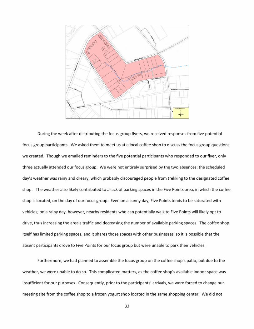
33
During the week after distributing the focus group flyers, we received responses from five potential
focus group participants. We asked them to meet us at a local coffee shop to discuss the focus group questions
we created. Though we emailed reminders to the five potential participants who responded to our flyer, only
three actually attended our focus group. We were not entirely surprised by the two absences; the scheduled
day’s weather was rainy and dreary, which probably discouraged people from trekking to the designated coffee
shop. The weather also likely contributed to a lack of parking spaces in the Five Points area, in which the coffee
shop is located, on the day of our focus group. Even on a sunny day, Five Points tends to be saturated with
vehicles; on a rainy day, however, nearby residents who can potentially walk to Five Points will likely opt to
drive, thus increasing the area’s traffic and decreasing the number of available parking spaces. The coffee shop
itself has limited parking spaces, and it shares those spaces with other businesses, so it is possible that the
absent participants drove to Five Points for our focus group but were unable to park their vehicles.
Furthermore, we had planned to assemble the focus group on the coffee shop’s patio, but due to the
weather, we were unable to do so. This complicated matters, as the coffee shop’s available indoor space was
insufficient for our purposes. Consequently, prior to the participants’ arrivals, we were forced to change our
meeting site from the coffee shop to a frozen yogurt shop located in the same shopping center. We did not
34
have any of the participants’ phone numbers and it was too late to email them regarding the location change, so
two of our group members waited at the entrance of the coffee shop, until approximately fifteen minutes after
the designated time, to intercept the participants and lead them to our new location.
After the participants arrived at the frozen yogurt shop, we provided them with a Fecal Coliform Fact
Sheet, attached as Appendix C, to educate them as to the subject and purpose of the focus group. We then gave
a brief introduction to and explanation of our project, before dividing up so that we could converse one-on-one
with the participants and administer the focus group questionnaire to them.
c. Focus Group Results
NOTE: please refer to Appendix D for charted results.
1) General
Our focus group participants ranged from 23 to 25 years of age. Two of the participants were male, and
one was female. All were students. Of the three, only one participant indicated a “high interest” in the
environment; the other two indicated that they had no interest in the environment.
All three participants were dog owners, and all walked their dogs in the Five Points area. One
participant also walked his dog in his yard and around the University of Georgia campus. Every participant
walked his or her dog recreationally, and one also walked his dog so it could defecate or urinate. The dogs were
all leashed on their walks; one participant stated that he only unleashed his dog when the dog was in his
backyard. Additionally, all three participants said that their dogs typically defecated or urinated in grassy
locations.
Two participants asserted that they picked up their dogs’ feces using plastic bags. The third participant
stated that he did not pick up his dog’s feces, because his dog only defecated in his backyard. When asked
whether they would, upon witnessing someone fail to pick up after his or her dog, confront that person, all
35
three responded “probably not”. However, one participant qualified his response by stating that if he stepped
in the dog’s feces, he would confront the person.
Two participants stated that if they didn’t currently pick up their dogs’ feces, they would possibly be
influenced by peer pressure. One participant stated that she would also be influenced by the threat of a fine,
and after the focus group, she may be motivated by environmental reasons. However, she expressed that
neither aesthetics nor the fear of stepping in dog feces would motivate her to pick up her dog’s feces.
The three participants’ responses varied somewhat when they were asked about the options that would
most incentivize them to pick up their dogs’ feces. While one participant answered that he thought the
availability of bag receptacles with attached trash cans would be the most incentivizing, another participant
emphatically asserted that the receptacles do not work.
Similarly, one participant stated that a signage campaign would likely incentivize him to pick up his dogs’
feces, while another participant felt that signage campaigns are overdone in Athens. Two participants felt that
an environmental campaign would influence their decisions to pick up their dogs’ feces, while one participant
said that an environmental campaign would have no impact. However, the participants agreed that dog parks
are incentivizing, and their responses seem to indicate that the availability of a pooper scooper would have little
impact on them.
The participants’ responses also varied when they were asked what would best incentivize them to
complete a survey regarding dog feces and Lilly Branch’s contamination. Two participants preferred the
guaranteed $5 compensation; the other preferred the chance of winning $200. Furthermore, one participant
admitted that if he received a survey through his University of Georgia email account, he would ignore it.
Another participant said that he would fill out the survey if he could tell that it was pertinent to him. The third
participant stated that she would fill it out only if she was incentivized to do so.
36
2) Interesting Observations
• One participant noted that when he disposed of his dog’s feces, he threw the feces-filled plastic bag into
the nearest trash can. Thus, the availability of disposal receptacles may be something to consider.
• One participant mentioned that there was nothing in her lease regarding pet feces cleanup. The
majority of leases probably will not have a provision specifically addressing pet feces; instead, it is more
likely that there will simply be a no-pet provision. Consequently, tenants who are allowed pets may not
feel obligated to pick up their dogs’ feces.
• One participant revealed that she would not pick up her dog’s feces if it was located in leaves, in the
bushes, or if there were branches in the way. We interpreted this more broadly to mean that if the
feces were hidden or difficult to reach, she would not pick it up. Portions of the Lilly Branch area are
currently overrun with kudzu; if dogs tend to defecate in the kudzu and their owners, like our focus
group participant, are discouraged from picking up hidden or difficult to reach feces, it may explain the
existence of some of the feces in the area.
• One participant said she would be incentivized to fill out a survey if she received a coupon to a pet store.
Thus, coupons could be offered as an alternative, and perhaps less costly, incentive.
• One participant noted the prevalence of feral cats, raccoons, and possums near his residence. These
animals could also be contributing to the feces problem in the Lilly Branch area.
• One participant stated that he believes many of the dog walkers in the Lilly Branch area do not reside
there. If he is correct, it will be more difficult to communicate with those dog walkers, as we do not
have their addresses. Furthermore, non-resident dog walkers may not feel as obligated to pick up their
dogs’ feces, since they are not invested in the area.
• One participant noted that an ordinance would likely have a significant impact on dog feces cleanup, as
police officers have a prominent presence in the Lilly Branch area. If another ordinance is passed, future
practicum students should ensure that policemen in the area are aware of and will enforce the
ordinance.
37
d. Focus Group Reflections
Though we were, overall, generally pleased with our focus group, there are a few things we would
probably do differently. One possible change was brought to our attention by a focus group participant who
said his initial reaction to our $25 incentive was that it was “too good to be true”. He explained that after
reading our flyer, he was slightly suspicious of the ease with which the relatively large amount of money would
be earned, and he doubted that he would actually receive the $25. After he mentioned this, we realized it could
be another possible explanation for the two potential participants’ absences. When asked why he chose to
participate despite his wariness, he answered that, given the amount of money, it was worth a try.
Nevertheless, we probably should have included “UGA Law Students” or something similar on our flyer, to give it
more credibility.
Another change we would likely make is to pick a different location—in particular, one that was not
weather-dependent—for our meeting. We chose the coffee shop mostly because of its location, as it is in very
close proximity to Lilly Branch. Furthermore, it is well known, has tables and chairs, and tends not to be
excessively noisy. Unfortunately, as we discovered, the coffee shop also has insufficient space.
We did not have a problem with space at the frozen yogurt shop, despite its small size; however, the
set-up and noise at the shop made it difficult to conduct the focus group appropriately. Originally, we intended
to sit around a table, with Environmental Law Practicum students sitting between focus group participants in
order to create a casual dynamic. We also hoped to ask the questions to the entire table and then note
participants’ responses to one another’s answers, and encourage a conversational environment rather than a
question and answer session. Unfortunately, due to the set-up of the space and the amount of noise at the
yogurt shop, we were not able to achieve a conversational environment. Instead, we asked each participant the
questions on the questionnaire individually and then convened at the end to discuss the most notable insights
with all of the participants. In the future, a quieter space with a more predictable set-up might have made the
focus group more successful.

38
Additionally, although we would have liked to conduct a larger focus group, only five participants
responded. While we hoped that all five participants would actually participate, we knew that based on our
research, all five were not likely to attend. In the future, we would suggest waiting to conduct the focus group
until at least twice as many individuals as were wanted agreed to participate. We would also suggest, based on
our research, that several additional focus groups be conducted. Perhaps a focus group with participants who do
not live in Lilly Branch, but who walk their dogs there, would provide additional insight into the problem.
V. Survey
a. Research and Design
A survey is a useful tool for generating quantitative data relating to the “characteristics of a large
population.”54 Because surveys are administered to a large population, the results are statistically significant and
are, perhaps, more persuasive than qualitative data for that very reason.55 Additionally, survey results are
usually very reliable and the cost of obtaining responses is typically fairly minimal.56
While the benefits of conducting a survey are great, in order to conduct a survey properly, a number of
issues must be taken into consideration. First, researchers must choose a survey population.57 Questions
designed for the survey should take into consideration the possible biases and attitudes of the individual
participants. Second, researchers must determine how the survey will be disseminated, which may have an
impact on the type of questions designed.58 Once a survey population and a dissemination method have been
chosen, the researcher should design questions appropriate for both the population and the dissemination
method. Using questions that have already been tested – questions that have been used by other researchers in
54 Writing Guide: Survey Research, Colorado State University, http://writing.colostate.edu/ guides/research/survey/index.cfm. 55 Id. 56 Id. 57 Id. 58 Id.
39
surveys – is also recommended. Finally, before distributing the survey, the researcher should test the survey on
a small sample of individuals to determine whether the survey contains mistakes or is difficult to understand.
In creating our survey, we determined that our goal was to survey only individuals with dogs. While we
considered surveying individuals who did not have dogs, Ms. Hollie Hall suggested that we avoid asking
individuals without dogs hypothetical questions about what their habits might be if they had dogs, as these
responses are less concrete and less useful. In order to target only individuals with dogs, we decided to
distribute the survey at a local dog park near Lilly Branch headwaters. This decision was partly motivated by a
focus group participant, who told us that many of the people who walk their dogs near Lilly Branch likely live in
adjoining neighborhoods, which is where the dog park is located. We decided to also conduct a second survey
distribution in the Lilly Branch area by asking individuals walking their dogs in the area if they would participate
in our survey. Our hope with the second distribution of the survey was to get responses from dog walking
individuals who undoubtedly walk in, and whose dogs may use the bathroom in, Lilly Branch headwaters.
After determining where we would distribute our survey, we designed survey questions. Our questions,
based on our meeting with Tyra Byers regarding social-media marketing, were designed to elicit from survey
participants the barriers and benefits to picking up dog waste. Many of the questions in the survey were based
on questions in the focus group questionnaire. The results of the focus group also helped us design additional
questions. For example, based on the results of the focus group, we added additional questions about the
difficulty of picking up after dogs that defecate in kudzu.
Additionally, we researched questions that had already been tested in the past. We modeled many of
our questions after previously tested questions. For example, below is a sample question, which we adapted for
our own survey, from the “Leave No Trace” Campaign geared at encouraging those who use the outdoors to
clean up after themselves and their pets in Boulder, Colorado:
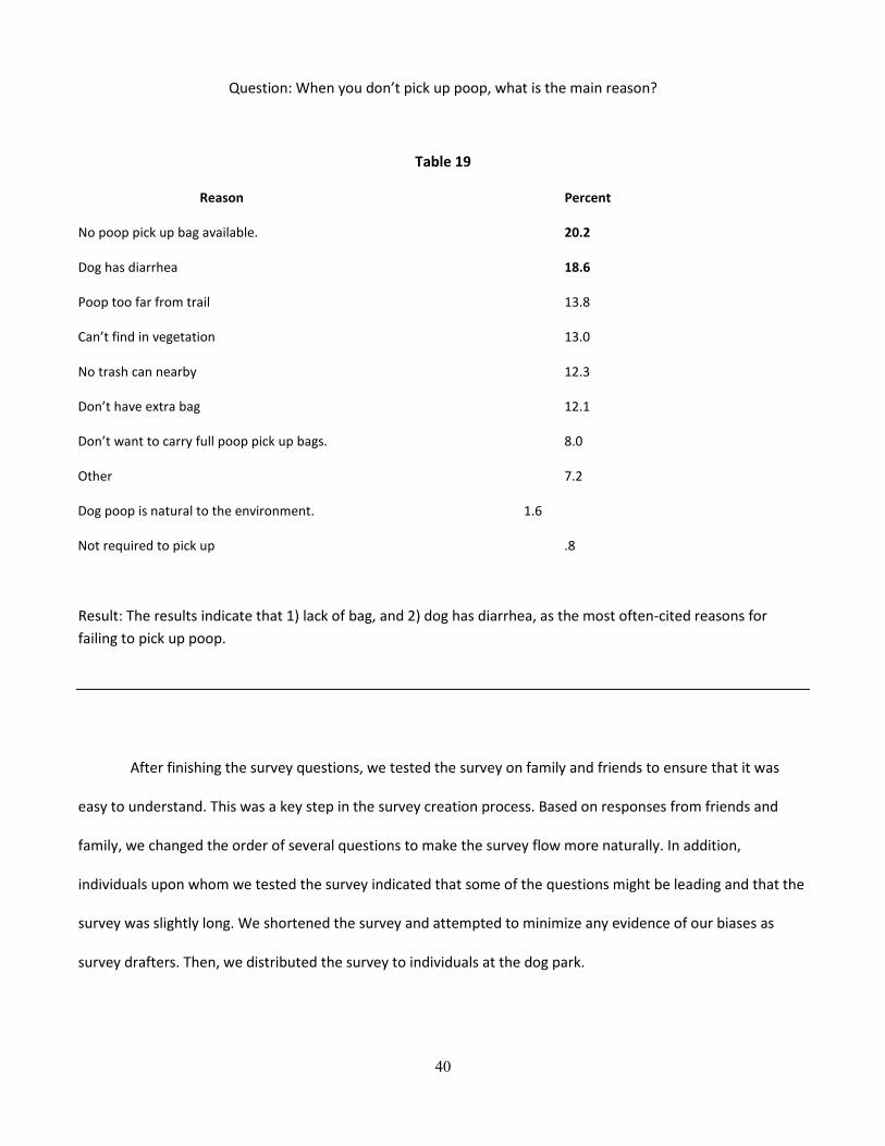
40
Question: When you don’t pick up poop, what is the main reason?
Table 19
Reason Percent
No poop pick up bag available. 20.2
Dog has diarrhea 18.6
Poop too far from trail 13.8
Can’t find in vegetation 13.0
No trash can nearby 12.3
Don’t have extra bag 12.1
Don’t want to carry full poop pick up bags. 8.0
Other 7.2
Dog poop is natural to the environment. 1.6
Not required to pick up .8
Result: The results indicate that 1) lack of bag, and 2) dog has diarrhea, as the most often-cited reasons for failing to pick up poop.
After finishing the survey questions, we tested the survey on family and friends to ensure that it was
easy to understand. This was a key step in the survey creation process. Based on responses from friends and
family, we changed the order of several questions to make the survey flow more naturally. In addition,
individuals upon whom we tested the survey indicated that some of the questions might be leading and that the
survey was slightly long. We shortened the survey and attempted to minimize any evidence of our biases as
survey drafters. Then, we distributed the survey to individuals at the dog park.

41
b. First Distribution of Survey
After considering various ways to distribute the survey, we decided to go to the dog park at Athens
Memorial Park, located on 293 Gran Ellen Drive (please see Appendix E for a map of the dog park in relation to
Lilly Branch). We went on a Wednesday at 5:45 P.M., which we felt was a good time to get an optimum number
of respondents, because it was after standard work and school hours but before dinnertime. We brought twelve
printed copies of the survey, three clipboards, three pens, and also $60 in cash, so that we could offer $5
incentives to each survey respondent.
After meeting in the upper parking lot, we immediately encountered two individuals walking with their
dog toward their vehicle. Both were willing to complete our survey, which took them approximately five to
eight minutes to finish. We then came across two more dog walkers who also agreed to complete our survey.
Once they were finished, we headed toward the dog park in search of more survey respondents.
We were pleased to discover that the dog park was full of dogs and their owners. All of the dogs were
unleashed, and their owners were sitting on benches and chairs located within the dog park. Consequently, the
dog park was the ideal place to obtain survey responses—the dogs were entertaining themselves and each
other, and their owners had time to spare. We split up and approached various owners, all of whom agreed to
complete our survey. By the time we left the dog park approximately half an hour later, we had responses on all
copies of our printed survey.
c. Results from the First Survey Distribution
NOTE: please refer to Appendix F for charted results.
Our first group of survey respondents ranged from 18 to 31 years old, with a median age of 23.4 years.
41.7 percent of respondents were male, and 58.3 percent were female. Half were students, while the other half
were employed in various capacities. 58.3 percent of respondents indicated that they were “interested” in
environmental issues, 25 percent stated that they were “neutral”, and just under 17 percent expressed that they
42
were “very interested”. No respondents indicated that they were “not interested” or “not interested at all” in
environmental issues. Of the respondents we asked, half lived or walked around the Lilly Branch area.
All respondents were dog owners, but only 83.3 percent stated that they walked their dogs. The
remaining 16.7 percent walked their dogs only “sometimes”, with one respondent explaining that she had a
backyard. All of the dog-walking respondents walked their dogs in their neighborhoods, 91.7 percent walked
their dogs in dog parks, 66.7 percent walked their dogs in recreational parks, 41.7 walked their dogs on the
streets, and the same number of respondents walked their dogs in the woods. All walked their dogs for
exercise, 75 percent walked their dogs so their dogs could defecate or urinate, and 66.7 percent walked their
dogs recreationally.
Nearly all respondents (91.6 percent) unleashed their dogs at some point. Of this 91.6 percent, over half
(58.3 percent) of the respondents unleashed their dogs in areas other than on their properties; every one of
these respondents unleashed their dogs in dog parks, one also unleashed her dog in recreational parks, and
another unleashed his dog in the woods. The remaining 33.3 percent unleashed their dogs only on their
properties. 8.3 percent of respondents never unleashed their dogs.
When asked whether their dogs typically defecated in the same general area, 66.7 percent of
respondents replied in the negative. The remaining 33.3 percent replied in the affirmative, with 83.3 percent of
dogs showing a preference for grassy areas, 50 percent favoring overgrown, kudzu-filled, and/or leaf covered
areas, and one respondent specifying that her dog preferred ivy-abundant areas.
Less than half of respondents (41.7 percent) stated that they picked up their dogs’ feces all the time.
The remaining 58.3 percent answered “it depends”, and then qualified their statements by explaining that if the
environment called for it, if they had a bag, if they were being watched, if their dog defecated on a friend or
acquaintance’s yard, or if they were in public, then they would pick up their dogs’ feces; however, they would
not pick up their dogs’ feces if the dogs defecated in their yards, if they did not have bags, or if the feces were
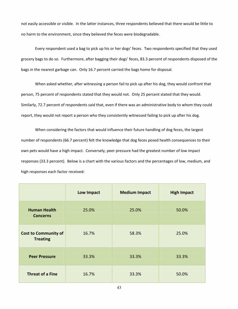
43
not easily accessible or visible. In the latter instances, three respondents believed that there would be little to
no harm to the environment, since they believed the feces were biodegradable.
Every respondent used a bag to pick up his or her dogs’ feces. Two respondents specified that they used
grocery bags to do so. Furthermore, after bagging their dogs’ feces, 83.3 percent of respondents disposed of the
bags in the nearest garbage can. Only 16.7 percent carried the bags home for disposal.
When asked whether, after witnessing a person fail to pick up after his dog, they would confront that
person, 75 percent of respondents stated that they would not. Only 25 percent stated that they would.
Similarly, 72.7 percent of respondents said that, even if there was an administrative body to whom they could
report, they would not report a person who they consistently witnessed failing to pick up after his dog.
When considering the factors that would influence their future handling of dog feces, the largest
number of respondents (66.7 percent) felt the knowledge that dog feces posed health consequences to their
own pets would have a high impact. Conversely, peer pressure had the greatest number of low impact
responses (33.3 percent). Below is a chart with the various factors and the percentages of low, medium, and
high responses each factor received:
Low Impact
Medium Impact
High Impact
Human Health
Concerns
25.0%
25.0%
50.0%
Cost to Community of
Treating
16.7%
58.3%
25.0%
Peer Pressure
33.3%
33.3%
33.3%
Threat of a Fine
16.7%
33.3%
50.0%
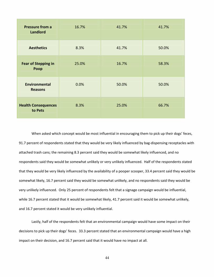
44
Pressure from a
Landlord
16.7%
41.7%
41.7%
Aesthetics
8.3%
41.7%
50.0%
Fear of Stepping in
Poop
25.0%
16.7%
58.3%
Environmental
Reasons
0.0%
50.0%
50.0%
Health Consequences
to Pets
8.3%
25.0%
66.7%
When asked which concept would be most influential in encouraging them to pick up their dogs’ feces,
91.7 percent of respondents stated that they would be very likely influenced by bag-dispensing receptacles with
attached trash cans; the remaining 8.3 percent said they would be somewhat likely influenced, and no
respondents said they would be somewhat unlikely or very unlikely influenced. Half of the respondents stated
that they would be very likely influenced by the availability of a pooper scooper, 33.4 percent said they would be
somewhat likely, 16.7 percent said they would be somewhat unlikely, and no respondents said they would be
very unlikely influenced. Only 25 percent of respondents felt that a signage campaign would be influential,
while 16.7 percent stated that it would be somewhat likely, 41.7 percent said it would be somewhat unlikely,
and 16.7 percent stated it would be very unlikely influential.
Lastly, half of the respondents felt that an environmental campaign would have some impact on their
decisions to pick up their dogs’ feces. 33.3 percent stated that an environmental campaign would have a high
impact on their decision, and 16.7 percent said that it would have no impact at all.
45
d. Reflections on the First Survey Distribution
Although we were pleased with the survey results, access to a larger pool of individuals might have
made the survey responses more representative. Because we did not have access to a large number of email
addresses, we had to disseminate the survey in a face-to-face manner. While this allowed us to make sure that
individuals taking the survey actually had pets, there are several disadvantages to this method. First, we did not
obtain a large number of results in order to definitively say that these responses are indicative of a large
population. Second, because we administered the surveys in person, people may have felt obligated to respond
to certain questions in ways that would not bring about social stigma.
e. Attempted Second Distribution of Survey
For our second survey distribution, we decided to target dog walkers in the Lilly Branch area. We went
on a Thursday at 5:00 P.M. because we wanted to ensure that we collected all survey responses prior to sunset.
Again, we brought twelve surveys, twelve $5 bills to incentivize potential respondents, and clipboards and pens.
While we initially wandered around the back of the Lumpkin Square condominium complex where Lilly Branch is
located, we did not encounter any dog walkers in that area, so we eventually shifted to the corner of South
Lumpkin Street and Woodrow Street. Unfortunately, our new location also failed to yield any dog walkers
whom we could survey. In the entire time we were there, we only witnessed one person with a dog, and that
person was wearing headphones while jogging with her dog on the opposite side of the street; consequently, we
were unable to survey her.
f. Reflections on the Attempted Second Survey Distribution
We were disappointed that we were unable to obtain survey responses during our attempted second
survey distribution. There are two main reasons why we feel there were no dog walkers in the Lilly Branch area.
First, though it was relatively sunny that day, it was quite cold outside, and dog owners likely just let their dogs

46
out in their backyards. Second, the sky began to darken around 5:15 P.M., so perhaps dog owners were
reluctant to take their dogs out for walks.
We also realized how difficult it would be to survey people while they are exercising with their dogs. For
example, had we been able to cross the street to catch the woman jogging with her dog, she probably would
have been disinclined to stop, pull out her headphones, and take a survey. We would likely only be able to
survey those on leisurely walks with their dogs. This is why surveying at the dog park was advantageous – the
dog owners were sitting and relaxing, and had the time to take the surveys. Unfortunately, however, there are
no dog parks in the Lilly Branch area, so the only way we could think of to survey those who walked around the
creek was to stop dog walkers in the area.
VI. Project Proposal
a. Bag Dispensers
Based on the survey results, we believe bag dispensers might be one effective solution to resolving the
problem of fecal coliform in Lilly Branch. Still, several factors must be taken into consideration before the
decision to implement installation of bag dispensers is undertaken. First, although commercial bag dispensers
with attached trashcans are available for sale, they are expensive. Second, it is unclear, given the size of the
dispensers, whether the property owners would allow them to be placed on their property. Third, it would need
to be determined how the waste deposited in the trashcans attached to the dispensers would ultimately be
disposed.
The bag dispensers or “Dogipots” range from $225 - $339 each. Below are two examples of Dogipots
available for purchase:
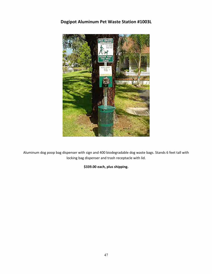
47
Dogipot Aluminum Pet Waste Station #1003L
Aluminum dog poop bag dispenser with sign and 400 biodegradable dog waste bags. Stands 6 feet tall with locking bag dispenser and trash receptacle with lid.
$339.00 each, plus shipping.
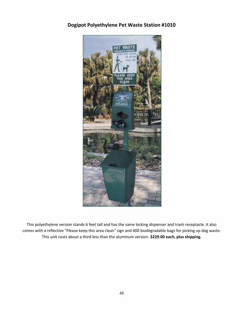
48
Dogipot Polyethylene Pet Waste Station #1010
This polyethylene version stands 6 feet tall and has the same locking dispenser and trash receptacle. It also comes with a reflective "Please keep this area clean" sign and 400 biodegradable bags for picking up dog waste.
This unit costs about a third less than the aluminum version. $229.00 each, plus shipping.
49
b. Implementation of Ordinance
1) Legal Authority to Regulate Dog Waste
Another strategy that could aid in the restoration of Lilly Branch is a re-working of the Athens-Clarke
County (ACC) Code of Ordinances. A well-written municipal ordinance can be an effective means to regulate
nonpoint pollution sources such as pet waste. In Georgia, local authorities are granted broad authority to draft
such regulations through the Home Rule Doctrine of the State Constitution. Under the Home Rule Doctrine,
local governments may adopt “clearly reasonable ordinances, resolutions, or regulations relating to its property,
affairs, and local government for which no provision has been made by general law and which is not inconsistent
with this constitution or any local law applicable thereto.”59 No provision exists in the Georgia Code that
preempts local regulation of pet waste.60 Additionally, the State Constitution extends supplementary powers to
local authorities in regulating “[p]ublic health facilities and services” and specifically mentions supplementary
authority to regulate animal control.61 As such, state constitutional language prima facie supports local pet
waste regulation.
Furthermore, the Supreme Court of Georgia has held local ordinances can survive a due process
challenge as a valid exercise of police power if there is a rational basis to determine the regulation is
“substantially related to public health, safety, or general welfare.”62 Under this rational basis test, described by
the court as “the least rigorous test of constitutional scrutiny,” an ordinance does not have to be “the best, or
even the least intrusive, means available to achieve its objective” but rather “need only be reasonable in relation
to the goal [it] seek[s] to achieve.”63 Given animal feces’ potential impact on public health, ACC authorities
seemingly possess broad discretion to enact regulations regarding pet waste.
59 GA. CONST. art. IX, § 2, para. 1,2. 60 Under § 4 of the O.C.G.A. titled “Animals,” there are no provisions regarding the disposal of pet waste. GA. CODE ANN § 4 (West 2011). Searches of the entire O.C.G.A on Westlaw using the terms “dog waste,” “pet waste,” and “pet feces” provided no references to state regulations regarding the management of pet waste. 61 GA. CONST. art. IX, § 2, para. 3. 62 City of Lilburn v. Sanchez, 491 S.E.2d 520, 522 (Ga. 1997). 63 Id.
50
Regulation in Athens-Clarke County
Currently, ACC provides for regulation of dog waste through § 4-1-6 of the ACC Code (Code), which
states:
(a) It shall be unlawful for the owner of any animal to refuse or fail to immediately remove any feces
deposited by such animal upon public sidewalks, public streets, public parks or other public property
in Athens-Clarke County, or upon any private property within Athens-Clarke County not under the
exclusive use and control of said owner or keeper.
(b) It shall be unlawful for the owner of any animal to permit such animal to defecate or urinate upon
any private property except that upon which he or she resides or owns unless he or she has the
permission of the owner of such other private property.64
Enforcement of § 4-1-6 falls under general penalty provisions of the code, which provide that violations are to
be punished by “a fine not to exceed $1000.00 or imprisonment for a term not exceeding six months.”65 While §
4-1-6 establishes a clear intent to manage pet waste, several modifications would enhance the effectiveness and
enforceability of the ordinance. Such changes include specifically addressing waste at apartment complexes and
similar residential developments, the addition of a provision requiring pet owners to carry a means of waste
disposal, a modification of the fine structure, the addition of a preamble addressing the need for enforcement,
and the possible regulation of dog waste on exclusively controlled private property.
2) Proposed Modifications
In the case of Lilly Branch, one major source of contamination appears to be dog waste originating at the
condominium complexes. While the current ordinance attempts to address such waste through its reference to
“private property within Athens-Clarke County not under the exclusive use and control of said owner or
64 ATHENS-CLARKE COUNTY, GA. CODE § 4-1-6 (2011), http://library.municode.com/HTML/12400/level4/PTIIICOOR_TIT4PUHE_CH4-1ANCO_ART2DUPRRECOAN.html. 65 ATHENS-CLARKE COUNTY, GA. CODE § 1-1-5 (2011), http://library.municode.com/HTML/12400/level3/PTIIICOOR_TIT1GEGO_CH1-1GEPR.html#PTIIICOOR_TIT1GEGO_CH1-1GEPR_S1-1-5GEPECOVINOORVI.
51
keeper,”66 such language could be greatly improved. In 2008 guidelines released by the University of Georgia
Land Use Clinic titled Drafting Local Ordinances for Natural Resource Protection, drafters are advised to use
direct phrasing and utilize language that is no more complicated than necessary.67 Proper language can help
avoid the creation of unintentional loopholes as well as prevent misinterpretation by parties enforcing the
ordinance.68 In the case of the ACC ordinance, such concerns could be ameliorated by explicitly stating common
areas of condominium and apartment complexes fall under the control of § 4-1-6. Such provisions can be found
within dog waste ordinances for other municipalities, notably § 7.36.040 of the Municipal Code of the City of Las
Vegas, Nevada.69
Another modification that might increase the effectiveness of ACC’s ordinance is the addition of a
requirement that dog owners possess some means of waste disposal. A walking survey of the streets
surrounding Lilly Branch revealed numerous dog owners walking their pets as well as an abundance of left
behind dog waste. A requirement that citizens walking their pets along public roadways possess some means
for waste disposal would address such left behind feces. Such provisions have been put in place in various
locales across the country. In Salem, Massachusetts, local regulations provide that “[n]o person who owns,
possesses or controls such dog shall appear with such dog on any sidewalk, street, park, public area or private
property of another without the means of removal of any feces left by such dog.”70 Likewise, in Beaumont,
66 ATHENS-CLARKE COUNTY, GA. CODE § 4-11-16 (2011), http://library.municode.com/HTML/12400/level4/PTIIICOOR_TIT4PUHE_CH4-1ANCO_ART2DUPRRECOAN.html. Interestingly, while the Athens-Clarke County Department of Animal Control has expressly interpreted the current statute to apply to pet waste at apartment complexes and similar developments, the language on its face appears less than clear. Animal Control: Quality of Life Issues, ATHENS-CLARKE COUNTY UNIFIED GOVERNMENT, http://www.athensclarkecounty.com/index.aspx?NID=264 (last visited Nov. 25, 2011). 67 JAMIE BAKER ROSKIE ET. AL., DRAFTING LOCAL ORDINANCES FOR NATURAL RESOURCE PROTECTION 3 (2008), available at http://www.law.uga.edu/landuseclinic/research/ordinance_drafting.pdf. 68 Id. Such language may take on greater importance given the fact enforcement of animal control ordinances in ACC falls upon both animal control officers as well as traditional police authorities. ATHENS-CLARKE COUNTY, GA. CODE § 4-1-15 (2011) http://library.municode.com/HTML/12400/level4/PTIIICOOR_TIT4PUHE_CH4-1ANCO_ART5OFPOAUANCO.html. While animal control officials may be aware that the pet waste ordinance applies to apartment complexes, traditional police authorities may not interpret the current language to clearly apply to common areas at apartment complexes. 69 MUNICIPAL CODE OF THE CITY OF LAS VEGAS, NEVADA § 7.36.040 (2011), http://library.municode.com/index.aspx?clientID=14787&stateID=28&statename=Nevada. 70 SALEM, MASS. CODE § 8-36(b) (2010), http://library.municode.com/index.aspx?clientID=11521&stateID=21&statename=Massachusetts; See also METFORD, MASS.
52
California an ordinance was passed November 1, 2011 that requires pet owners to carry bags and other disposal
equipment when walking a pet on public land or land not owned by the pet owner.71 Given the prevalence of
dog waste along the streets surrounding Lilly Branch, such a requirement should be considered for inclusion in
ACC’s ordinance.72
Athens Unified Government officials may also consider adding language to the current version of § 4-1-6
that establish specific fines for dog waste violations. In the model pet waste ordinance developed for use by
local governments in the state of New Jersey73 as well as in several municipal ordinances74, specific penalties
exist for dog waste violations. Likewise, in guidelines put forth by the Association of New Jersey Environmental
Commissions, it is recommended that a “clear and comprehensive” penalty be outlined, as “local officials will
refer to this section when enforcing the ordinance.”75 Ideally, a fine amount should be established that serves
as notice to citizens while not being so onerous or ambiguous as to discourage enforcement by authorities.
CODE § 6-72 (2010), http://library.municode.com/index.aspx?clientID=13043&stateID=21&statename=Massachusetts (paralleling language of the provision from Salem, Mass.). 71 Erin Waldner, Beaumont: Dog Waste Ordinance Passes; Horses added, too, THE PRESS-ENTERPRISE, http://www.pe.com/local-news/riverside-county/the-pass/the-pass-headlinesindex/20111102-beaumont-dog-waste-ordinance-passes-horses-added-too.ece. 72 If such a modification is included in the Athens-Clarke County Code, it is important to ensure terms are clear and unambiguous. For a situation where unclear municipal language leads to discontent, see Eric Lacitis, Dog Owner Says Rules about Droppings Stink, SEATTLE TIMES, Jan 15, 2009, http://seattletimes.nwsource.com/html/localnews/2008630413_dogdroppings15m.html (profiling citizen complaints and enforcement issues associated with Seattle ordinance that required dog owner to carry “equipment for removing feces” but failed to elaborate further). 73 The referenced model ordinance was developed through the State of New Jersey Department of Environmental Protection and is listed by various local governments and organizations throughout the country as a starting point for developing a pet waste ordinance. Model Ordinance – Pet Waste, NEW JERSEY DEPARTMENT OF ENVIRONMENTAL PROTECTION, http://www.nj.gov/dep/dwq/pdf/Tier_A/pet%20waste%20ordinance.pdf. The model ordinance includes sections specifically delegating enforcement authority to both the police department and the local board of health and contains a separate section on penalties that establishes a fine not to exceed a chosen amount. 74 See METFORD, MASS. CODE § 6-75 (2010), http://library.municode.com/index.aspx?clientID=13043&stateID=21&statename=Massachusetts (establishing a $50.00 fine for each violation of the ordinance); CITY OF OSHKOSH, WI. CODE § 6-9, 6-21 (2011), http://www.ci.oshkosh.wi.us/Municipal_Codes/assets/pdf/Chapter_06.PDF (establishing a forfeiture of not less than $50.00 nor more than $500.00 for violations of pet waste laws). 75Environmental Ordinances: Using Environmental Ordinances to Protect Local Natural Resources, ASSOCIATION OF NEW JERSEY ENVIRONMENTAL COMMISSIONS, http://www.anjec.org/html/ordinances.htm (last visited Nov. 25, 2011).

53
Given that specific fines relating to animal control already exist under § 4-1-14 of the ACC Code,76 the addition of
specific penalties for pet waste under § 4-1-14 would be a simple process.
A fourth modification that should be considered is the inclusion of a preamble detailing the purpose of
the pet waste ordinance within the ACC Code. According to the UGA Land Use Clinic’s guidelines, such a
preamble can serve to state the purpose and history behind the ordinance as well as to “describe any findings of
environmental degradation the ordinance intends to remedy.”77 Such a section is included in New Jersey’s
Model Pet Waste Ordinance that justifies the ordinance on the grounds of “public health, safety, and welfare.”78
In ACC, a preamble that cites both environmental concerns related to elevated levels of E. coli in area waters as
well as human health concerns related to improperly disposed of dog waste would educate citizens and
regulators on the link between pet waste and environmental contamination.
The final and most controversial issue that drafters must address is the question of whether a local
ordinance should regulate the cleanup of dog waste on private property under the exclusive control of the pet
owner. Such activity is currently unregulated by § 4-1-6, but given the pattern of private property ownership
along Lilly Branch, landowner pet waste is likely a major source of fecal coliform contamination in the
restoration area. While the vast majority of animal waste statutes do not regulate private property owners, a
few statutes do address these individuals. In Bangor Borough, Pennsylvania, a 2010 ordinance was passed that,
in addition to mandating the immediate cleanup of pet waste on another’s property, also requires pet owners to
pick up waste on their own properties within twenty-four hours.79 A similar ordinance exists in Seattle,
Washington, where fecal contamination has raised concerns about the health of shellfish beds in the Puget
Sound. Under Seattle Municipal Code § 9.25.082, it is unlawful to “[a]llow the accumulation of animal feces in
any open area, run, cage or yard wherein animals are kept and to fail to remove or dispose of feces at least once
76 See ATHENS-CLARKE COUNTY, GA. CODE § 4-1-14 (2011), http://library.municode.com/HTML/12400/level4/PTIIICOOR_TIT4PUHE_CH4-1ANCO_ART4FEPE.html (establishing specific penalties for violations of dangerous or menacing dog regulations in addition to general penalties allowed under § 1-1-5). 77 ROSKIE, supra note 9 at 4. 78 NEW JERSEY DEPARTMENT OF ENVIRONMENTAL PROTECTION, supra note 15. 79 Christopher Baxter, Pet Rules on Waste Cleanup, Shelter are Passed in Bangor, THE MORNING CALL, Apr 30, 2010, http://articles.mcall.com/2010-04-13/news/all-a8_3bangor.7237397apr13_1_pet-owners-pet-limit-pen-argyl.
54
every twenty-four (24) hours.”80 The Seattle Animal Shelter (the organization charged with enforcing the
ordinance) has interpreted such language as requiring that “all pet waste must be scooped every [twenty four]
hours from the pet owner’s property.”81 While similar proposals in ACC would likely face significant opposition
from landowners as well as create enforcement issues, such an ordinance modification, if effectively
implemented, could lead to a major reduction in fecal coliform loads in local streams and rivers.82
3) Potential Modifications to § 4-1-6
Listed below is a draft ordinance that draws upon the modifications previously discussed. It should be
noted that while such modifications complement each other and will likely prove most effective if adopted in
concert, future drafters of the ACC code would have the ability to sever portions of the following draft if
complete adoption is deemed untenable:
Proposed ACC Code § 4-1-6
(a) Whereas pet animal feces poses a risk to public health, safety, and welfare, and has been shown to
contribute significant amounts of E. coli, fecal coliform, and other biological contaminants to area
streams, rivers, and other aquatic resources,
(b) It shall be unlawful for the owner any person owning or having custody or possession of any animal
to refuse or fail to immediately remove any feces deposited by such animal upon public sidewalks,
public streets, public parks or other public property in Athens-Clarke County, or upon any private
property within Athens-Clarke County not under the exclusive use and control of said owner or
keeper, including the common area of an apartment complex or any similar residential community.
80 Seattle Municipal Code § 9.25.082 (2011), http://library.municode.com/index.aspx?clientID=13857&stateID=47&statename=Washington. 81 SEATTLE ANIMAL SHELTER, Animal Control, http://www.seattle.gov/animalshelter/animal-control-overview.htm (last visited Nov. 14, 2011). It should be noted that in the case of Seattle, numerous articles and opinion pieces can be found online profiling how Seattle’s dog waste laws are not effectively enforced. See Lacitis, supra note 14 (mentioning how in 2007 only sixty-five tickets related to dog waste were issued in the city and suggesting low fines coupled with minimal enforcement are not sufficient to ensure compliance). 82 If county-wide implementation is deemed infeasible, there is the possibility of limiting such an ordinance to areas that create particular vulnerability for local watersheds.
55
(c) It shall be unlawful for any person owning or having custody or possession of any animal to appear
upon public sidewalks, public streets, public parks, or any other public property in Athens-Clarke
County, or upon any private property not under the exclusive use and control of said owner or
keeper, including the common area of an apartment complex or any similar residential community,
without means for feces removal including but not limited to a disposable bag for feces disposal.
(d) It shall be unlawful for the owner any person owning or having custody or possession of any animal
to permit such animal to defecate or urinate upon any private property except that upon which he
or she resides or owns unless he or she has the permission of the owner of such other private
property.
(e) It shall be unlawful for any person owning or having custody or possession of any animal to allow
the accumulation or animal feces in any yard, run, kennel, or open area where pets are walked or
kept and fail to dispose of feces at least every twenty-four hours.
(f) Exemptions. Feral cat colony caretakers are exempt from the requirements of this section.
c. Social Marketing Campaign and Signage
After speaking with Tyra Byers and researching successful social marketing campaigns, such as the
Boulder, Colorado campaign mentioned previously, we thought a social marketing campaign might be an
additional way to improve the water quality of Lilly Branch. In order to design a successful Social Marketing
Campaign, the following questions must be answered:
1) What is the behavior that needs to be addressed?
2) What are the benefits of refraining from or partaking in the behavior?
3) What are the barriers to refraining from or parking in the behavior?
In terms of designing a social marketing campaign for Lilly Branch, the behavior that needs to be
addressed is the unwillingness of dog owners who walk in the Lilly Branch area to pick up after their dogs. As
determined by the focus group and surveys, the benefits to picking up dog poop include reducing human and
pet health risks, reducing environmental impact, reducing the likelihood that one might step in pet waste, and
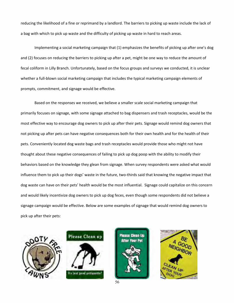
56
reducing the likelihood of a fine or reprimand by a landlord. The barriers to picking up waste include the lack of
a bag with which to pick up waste and the difficulty of picking up waste in hard to reach areas.
Implementing a social marketing campaign that (1) emphasizes the benefits of picking up after one’s dog
and (2) focuses on reducing the barriers to picking up after a pet, might be one way to reduce the amount of
fecal coliform in Lilly Branch. Unfortunately, based on the focus groups and surveys we conducted, it is unclear
whether a full-blown social marketing campaign that includes the typical marketing campaign elements of
prompts, commitment, and signage would be effective.
Based on the responses we received, we believe a smaller scale social marketing campaign that
primarily focuses on signage, with some signage attached to bag dispensers and trash receptacles, would be the
most effective way to encourage dog owners to pick up after their pets. Signage would remind dog owners that
not picking up after pets can have negative consequences both for their own health and for the health of their
pets. Conveniently located dog waste bags and trash receptacles would provide those who might not have
thought about these negative consequences of failing to pick up dog poop with the ability to modify their
behaviors based on the knowledge they glean from signage. When survey respondents were asked what would
influence them to pick up their dogs’ waste in the future, two-thirds said that knowing the negative impact that
dog waste can have on their pets’ health would be the most influential. Signage could capitalize on this concern
and would likely incentivize dog owners to pick up dog feces, even though some respondents did not believe a
signage campaign would be effective. Below are some examples of signage that would remind dog owners to
pick up after their pets:
57
d. Invasive Species Removal
During the ground survey and focus group portions of the Lilly Branch Phase II Project, it became clear
that one of the significant barriers hindering dog waste removal is the presence of thick areas of groundcover
throughout the watershed. Such growth is dominated by English Ivy, Kudzu and other invasive species, and
during the original ground survey the growth appeared virtually impenetrable. While as of December 2011 the
onset of winter has lessened the groundcover to some degree, the vegetation remains thick enough that
removing dog waste from such areas would still prove a difficult—if not impossible—task. During the focus
group portion of the project, one participant suggested he would be less likely to pick up his pet’s waste if
hindered by groundcover, and a second participant suggested that thick groundcover would play a role in
discouraging cleanup if he were in a public place. Such habits mirrored the reports of Mrs. Hancock,83 who
suggested that residents of the Lumpkin Square condominium complex often fail to clean up after their dogs
when the dogs defecate in the Kudzu and English Ivy in and around her property.
As such, future participants in the Lilly Branch Cleanup should consider organizing an invasive species
removal project along Lilly Branch. Ideally, a re-vegetation of the site with less dense native groundcover would
lead to higher rates of waste pickup. While primary efforts of such a project should probably be focused on the
area behind the Lumpkin Square condominiums given its heavy usage by defecating dogs, efforts could be
83 Ms. Hancock resides at 130 Rutherford Street, which sits adjacent to the Lumpkin Square condominium complex.

58
expanded depending upon landowner approval. One possible barrier to carrying out such a project would be
gaining permission of landowners, as the area is entirely privately owned. While Ms. Hancock suggested she
would welcome such actions, she also stated she has in the past attempted to get management of the Lumpkin
Square condominium complex to remove such growth to no avail. Therefore, it may be necessary to develop
further connections with condominium management through various community avenues in order to gain
permission to conduct species removal and re-vegetation efforts.
If landowner approval can be obtained, an invasive species pull coupled with the planting of less dense
native species could serve not only to encourage dog owners to clean up after their pets, but also to improve the
ecological health of the Lilly Branch watershed. Additionally, allowing public volunteers to participate would
encourage parties who live in the area to take an ownership interest in the preservation of Lilly Branch, as well
as provide a valuable avenue for publicity for the project. A similar re-vegetation project aimed at protecting
Lilly Branch was conducted in the mid-2000s on an adjacent site, and while there has been some re-colonization
by invasive species, the groundcover in the area allows for much greater accessibility by dog owners than
portions of the watershed overrun by invasive species. It is important to remember that for any re-vegetation
project, designers must carefully select plant species that will both enhance the ecosystem of the watershed
while maintaining a growth pattern that will allow easy feces retrieval by dog owners. As such, it is suggested
that future participants in the Lilly Branch Restoration Project reach out to additional parties in the University of
Georgia or greater Athens area to provide technical assistance for future ground cover modifications.
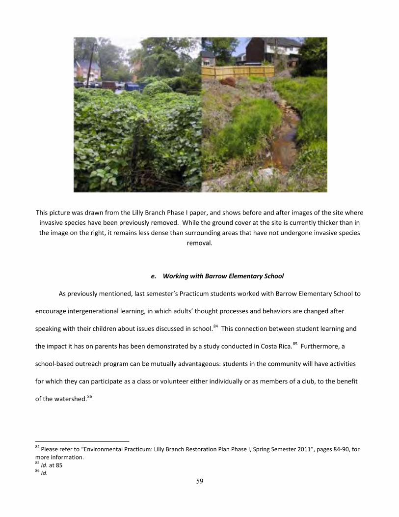
59
This picture was drawn from the Lilly Branch Phase I paper, and shows before and after images of the site where invasive species have been previously removed. While the ground cover at the site is currently thicker than in the image on the right, it remains less dense than surrounding areas that have not undergone invasive species
removal.
e. Working with Barrow Elementary School
As previously mentioned, last semester’s Practicum students worked with Barrow Elementary School to
encourage intergenerational learning, in which adults’ thought processes and behaviors are changed after
speaking with their children about issues discussed in school.84 This connection between student learning and
the impact it has on parents has been demonstrated by a study conducted in Costa Rica.85 Furthermore, a
school-based outreach program can be mutually advantageous: students in the community will have activities
for which they can participate as a class or volunteer either individually or as members of a club, to the benefit
of the watershed.86
84 Please refer to “Environmental Practicum: Lilly Branch Restoration Plan Phase I, Spring Semester 2011”, pages 84-90, for more information. 85 Id. at 85 86 Id.
60
The outreach program implemented last semester involved approximately forty students who were in
the 3rd and 5th grades’ gifted programs, entitled the Extended Learning Time (ELT) Spectrum groups.87 The
students participated in one evaluation activity lead by Ms. Fidler, whereby Ms. Fidler utilized an EnviroScape
model and had students propose best management practices (BMPs) to mitigate nonpoint source pollution.88
The students also participated in two educational activities: a guided stream walk89, and the design of eye-
catching bumper stickers that would make people think about how they could help keep Lilly Branch clean90.
Based upon the success of last semester’s program and upon Ms. Fidler’s suggestion, we recommend
that future Practicum students develop an outreach program with Barrow Elementary that is similar to the one
formerly implemented. However, as our project focused on fecal coliform, we advocate the establishment of a
program geared primarily toward educating students about the impact of dog feces on Lilly Branch, in contrast
to last semester’s program, which was much broader and covered multiple impairments. Yet despite the
narrowing of scope, we suggest that when developing their outreach program, future Practicum students review
the recommendations on pages 87, 88, and 90 of the “Environmental Practicum: Lilly Branch Restoration Plan
Phase I, Spring Semester 2011” report, as a preliminary resource.
VII. Conclusion
Based on research done by Environmental Law Practicum students during the spring of 2011, it was
determined that Lilly Branch was contaminated with fecal coliform. Students also determined that the increased
levels of fecal coliform in Lilly Branch in recent years is due to dog owners’ failures to pick up after their pets
that defecate near Lilly Branch waters. Due to increased urbanization, a larger number of impervious surfaces
and decreased riparian buffers have allowed storm water to carry fecal matter containing fecal coliform into the
87 Id. at 86 88 Id. 89 Id. 90 Id. at 87

61
stream and contaminate it. In order to reduce contamination of Lilly Branch, we propose that a number of
measures be implemented: the use of bag dispensers, a signage campaign, an ordinance with higher penalties
and more enforcement options, an invasive species removal, and a program with Barrow Elementary School to
disseminate the messages developed following additional focus group and survey results. We believe that this
combination of proposals will be most effective in reducing the amount of fecal coliform contamination in Lilly
Branch.
62
APPENDIX A:
Focus Group Questionnaire
Demographic Information
1. Name
2. Address/Location relative to Lilly Branch stream
3. Age
4. Occupation
5. Interest in environment
Habits re: Dog Walking
1. Do you walk your dog?
• If so, where do you walk your dog? Do you walk your dog for pleasure or just so that it will go “to the restroom”?
• If not, do you let it out off the leash? In a backyard? Loose to wander? • If it depends, what does it depend on?
2. Does your dog normally go “to the restroom” in a particular place?
• Kudzu? • Grass? • Stream?
3. Do you pick up your dog’s poop?
• If so, how and why? (Maybe run through reasons listed in question 4) • How do you dispose of your dog’s poop? • If you saw someone who didn’t pick up their dog’s poop, would you say something to them?
63
• If not, why not? -- Gross?
-- Nothing with which to pick up poop?
-- No incentive because living there only short time?
4. If you do not pick up your dog’s poop currently, what would make you pick up your dog’s poop in the future?
• Peer pressure? • Threat of a fine? • Aesthetics? • Fear of stepping in poop? • Environmental reasons?
5. If you were told that the stream near your house was contaminated with fecal coliform due in part to dog’s pooping near the water, would you pick up your dog’s poop?
6. Of the following concepts to encourage removal of dog waste, which would most incentivize you to pick up your dog’s poop?
• Poop bag receptacle/Attached Trash cans • Dog Park • Availability of a pooper scooper • Signage campaign • Bumper sticker/larger social marketing campaign
7. Would an environmental campaign influence your decision to pick up poop?
• If not, does it have to do with the fact that you will only live in Athens for a short period of time? • If that is the issue, how do you suggest we incentivize people to pick up dog poop?
8. We will be creating and distributing a survey regarding dog poop and contamination of Lilly Branch.
• Would you be more motivated to participate in a survey if you were paid $5? • Would you be more motivated to participate in a survey if you had the possibility of winning a $200 prize? • Would you fill out an online survey sent to your UGA email address or would you just ignore it?
64
APPENDIX B:
Focus Group Flyer
Dog Owners!
Want to make $25 cash?
Come participate in a Focus Group about Dog Poop!!
When: Monday, October 10 at 6:00pm
Where: Outdoors at Jittery Joe’s in Five Points
To participate please send an email to [email protected] by Friday, October 7.
Participants will be chosen on a first come, first served basis.
The focus group will take 1 hour after which each participant will be given $25 cash!
65
APPENDIX C:
Fecal Coliform Fact Sheet
• General Facts
o Type of bacterium derived directly from fecal matter E. coli a sub-group of bacterium associated with humans and other warm-blooded animals that
can cause to serious health consequences o Common Urban Sources
Sewage discharge Pet Waste Wild animal waste
o Georgia has designated maximum daily threshold levels for various activities Drinking/Fishing Use (Fecal Coliform): 4,000 cfu/100mL Infrequent Swimming (E. Coli): 576 cfu/100mL
o The North Oconee River, into which Lilly Branch flows, is listed as impaired for Fecal Coliform under Section 303(d) of the Clean Water Act
• History of Contamination on Lilly Branch
o 2002 – community members report problems relating to smell of Lilly Branch o 2004 – previously unnoticed sewage leak is capped and diverted o 2005 – leaking gasoline tanks in 5 points area identified and removed o 2005 – studies initiated along campus portion of Lilly Branch to identify contaminants; results suggest
fecal coliform contamination originating upstream of Foley Field
• Statistics and Observations
o Brown and Caldwell (Nov. 2010) E. Coli: 20,000 mpn/100mL Fecal Coliform: 24,000 cfu/100mL
o Brown and Caldwell (2011) E. Coli: 5200 mpn/100mL Fecal Coliform: 5700 cfu/100mL
o Environmental Practicum (2011) Assessed total coliform Noticeable coliform spikes between sample points with no pipes feeding stream suggest non-
point source of contamination Associated walking survey suggested dog feces as possible contaminant

66
APPENDIX D:
Focus Group Results
Responses
Address
Northview Drive
Lumpkin Square Condominiums
Lumpkin Square Condominiums
Age
23
24
25
Occupation
Student
Student
Student
Interest in
Environment
High interest
No interest
No interest
Dog Walking Location(s)
Yard;
Five Points; UGA campus
Five Points
Five Points
Purpose of
Dog Walking
Exercise;
Defecation/Urination
Exercise
Exercise
Unleashing the Dog
Yes, but only in the
backyard
No
No
Dog’s Typical
Defecation Location
Grass
Grass
Grass
Feces Pick Up
No, because dog only
defecates in the backyard
Yes
Yes
Method of Pick Up
and Disposal
N/A
Plastic bag
Plastic bag;
Nearest trash can
67
Confronting
Someone Who Did Not Pick Up
Probably not, unless
stepped in
Probably not
Probably not
Incentives to Pick Up
Peer Pressure, possibly
Peer Pressure;
Threat of a fine; Environmental Reasons,
possibly
N/A
Fecal Coliform
Contamination as Incentive to Pick Up
Yes
Possibly
Unanswered
Concepts to
Incentivize Pick Up
Bag receptacle with attached trash can;
Dog park
Dog Park
Pooper scooper,
possibly; Signage campaign,
possibly
Environmental Campaign to
Incentivize Pick Up
Probably
Yes
No
Survey Participation
Motivators
Guaranteed payment
of $5
Guaranteed payment
of $5
Chance to win $200
Likelihood of
Participating in Emailed Survey
If clearly pertinent
If there was an incentive
Would ignore

68
APPENDIX E:
Satellite Image of Upper Lilly Branch and Dog Park
69
APPENDIX F:
Results from First Survey Distribution
AGE RANGE
18 to 21 Years
GENDER
Male
Female
41.7%
58.3%
LIVE OR WALK AROUND LILLY BRANCH
Yes
No
50.0%
50.0%
70
INTEREST IN ENVIRONMENTAL ISSUES
Not Interested at All
Not Interested
Neutral
Interested
Very Interested
0.0%
0.0%
25.0%
58.3%
16.7%
DOG WALKING
All the Time
Never
Sometimes
83.3%
0.0%
16.7%
DOG WALKING LOCATIONS
Neighborhood
Road
Park
Dog Park
Woods
100%
41.7%
66.7%
91.7%
41.7%
PURPOSE OF DOG WALKING
Exercise
Defecation/Urination
Recreation
100%
75.0%
66.7%
71
UNLEASHING
Yes
Yes, but only on own property
No
58.3%
33.3%
8.3%
DOG DEFECATES IN SAME LOCATION
Yes
No
33.3%
66.7%
FECES PICK UP
Yes
No
It Depends
41.7%
0.0%
58.3%
METHOD OF PICK UP
Bag
Pooper Scooper
100%
0.0%

72
DISPOSAL AFTER PICK UP
Nearest Trashcan
Home
83.3%
16.7%
CONFRONTING SOMEONE WHO DID NOT PICK UP
Yes
No
25.0%
75.0%
REPORTING TO ADMINISTRATIVE BODY
Yes
No
27.3%
72.7%

73
FACTORS THAT INFLUENCE FUTURE PICK UP
Low Impact
Medium Impact
High Impact
Human Health
Concerns
25.0%
25.0%
50.0%
Cost to Community of
Treating
16.7%
58.3%
25.0%
Peer Pressure
33.3%
33.3%
33.3%
Threat of a Fine
16.7%
33.3%
50.0%
Landlord Pressure
16.7%
41.7%
41.7%
Aesthetics
8.3%
41.7%
50.0%
Fear of Stepping in
Poop
25.0%
16.7%
58.3%
Environmental
0.0%
50.0%
50.0%
Health Consequences
to Pets
8.3%
25.0%
66.7%
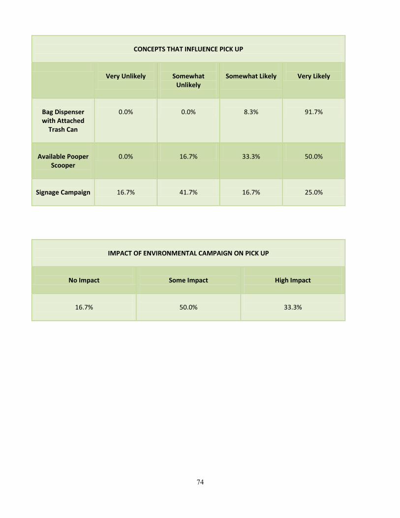
74
CONCEPTS THAT INFLUENCE PICK UP
Very Unlikely
Somewhat
Unlikely
Somewhat Likely
Very Likely
Bag Dispenser with Attached
Trash Can
0.0%
0.0%
8.3%
91.7%
Available Pooper
Scooper
0.0%
16.7%
33.3%
50.0%
Signage Campaign
16.7%
41.7%
16.7%
25.0%
IMPACT OF ENVIRONMENTAL CAMPAIGN ON PICK UP
No Impact
Some Impact
High Impact
16.7%
50.0%
33.3%
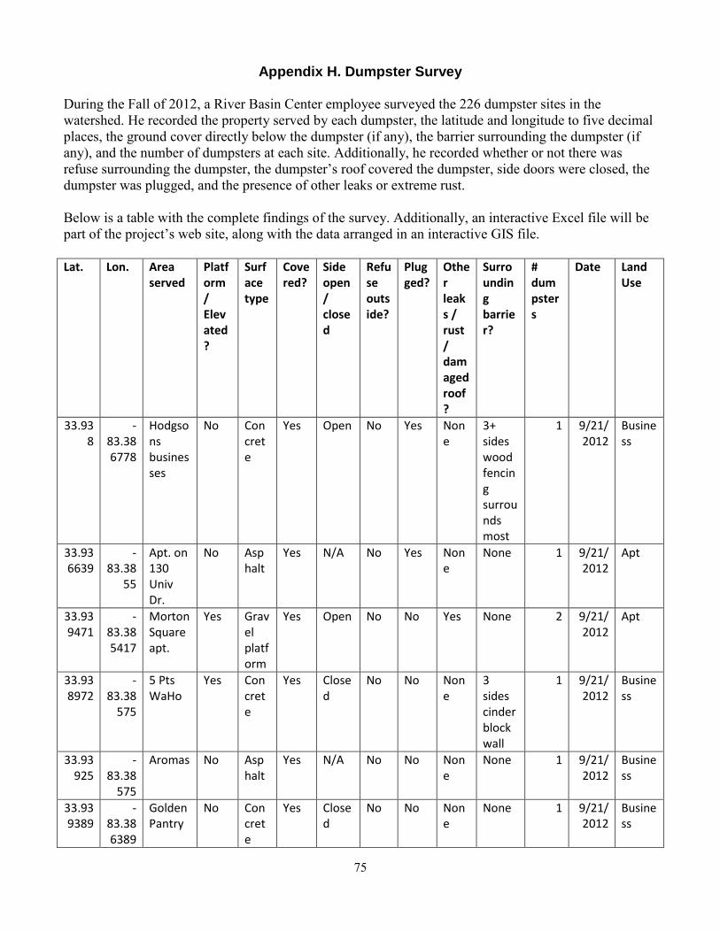
75
Appendix H. Dumpster Survey During the Fall of 2012, a River Basin Center employee surveyed the 226 dumpster sites in the watershed. He recorded the property served by each dumpster, the latitude and longitude to five decimal places, the ground cover directly below the dumpster (if any), the barrier surrounding the dumpster (if any), and the number of dumpsters at each site. Additionally, he recorded whether or not there was refuse surrounding the dumpster, the dumpster’s roof covered the dumpster, side doors were closed, the dumpster was plugged, and the presence of other leaks or extreme rust. Below is a table with the complete findings of the survey. Additionally, an interactive Excel file will be part of the project’s web site, along with the data arranged in an interactive GIS file. Lat. Lon. Area
served Platform / Elevated?
Surface type
Covered?
Side open / closed
Refuse outside?
Plugged?
Other leaks / rust / damaged roof?
Surrounding barrier?
# dumpsters
Date Land Use
33.938
-83.386778
Hodgsons businesses
No Concrete
Yes Open No Yes None
3+ sides wood fencing surrounds most
1 9/21/2012
Business
33.936639
-83.38
55
Apt. on 130 Univ Dr.
No Asphalt
Yes N/A No Yes None
None 1 9/21/2012
Apt
33.939471
-83.385417
Morton Square apt.
Yes Gravel platform
Yes Open No No Yes None 2 9/21/2012
Apt
33.938972
-83.38
575
5 Pts WaHo
Yes Concrete
Yes Closed
No No None
3 sides cinder block wall
1 9/21/2012
Business
33.93925
-83.38
575
Aromas No Asphalt
Yes N/A No No None
None 1 9/21/2012
Business
33.939389
-83.386389
Golden Pantry
No Concrete
Yes Closed
No No None
None 1 9/21/2012
Business
76
33.939417
-83.386056
Your Pie, Smoothie King, Hubie D's
Yes Concrete
Yes Open Yes Yes None
4 sides wood fence
1 9/21/2012
Business
33.939806
-83.385556
Kelly's Jerk and Subway
No Open ground
Yes Open Yes Yes None
None 1 9/21/2012
Business
33.940306
-83.385583
Butler's Auto and Shuman Services
No Concrete
Yes Closed
No Yes None
None 1 9/21/2012
Business
33.94 -83.385167
5 Pts. Villa Condos
No Concrete
Yes Closed
No No None
4 sides fence and retaining wall
1 9/21/2012
Apt
33.939889
-83.384472
Oakwood Apts.
No Concrete and asphalt
Yes Open No Yes None
None 1 9/21/2012
Apt
33.939639
-83.383194
Apts on Northview Dr.
No Open ground
Yes Open Yes No None
None 1 9/21/2012
Apt
33.94 -83.382417
Northview Place condos
Yes Concrete
Yes Open No No None
None 1 9/21/2012
Apt
33.940111
-83.383361
Apts around 170 E. Rutherford
Yes Concrete
Yes Open Yes No Yes None 1 9/21/2012
Apt
33.941389
-83.384417
Lumpkin Square Apt.
No Asphalt
Yes Open Yes No None
None 3 9/21/2012
Apt
33.941917
-83.38
Classic City Car
No Concret
Yes Closed
Yes Yes None
4 sides
1 9/21/2012
Business
77
3778 Wash and Cali 'N Titos
e wood fence
33.942333
-83.382806
Lumpkin BP
No Asphalt
Yes Open No Yes Yes None 1 9/21/2012
Business
33.94722
-83.38
932
Towne Club Apts.
No Concrete
Yes Open No No None
None 3 9/23/2012
Apt
33.94797
-83.38
872
Businesses on Milledge near 5 Pts.
No Asphalt
No N/A No No None
None 1 9/23/2012
Business
33.94 -83.38
623
Jewish Fraternity
No Concrete
Yes N/A No Yes None
None 1 9/23/2012
UGA Greek / organization
33.9406
-83.38
666
Apts near Milledge / Lumpkin intersection
No Asphalt
Yes Open No N/A None
None 1 9/23/2012
Apt
33.94195
-83.38
64
Apts near Milledge / Lumpkin intersection
No Asphalt
Yes Closed
No Yes None
4 sides wood fence
1 9/23/2012
Apt
33.94288
-83.38
687
Businesses on Milledge near 5 Pts.
No Gravel
Yes Open No No None
None 1 9/23/2012
Business
33.94274
-83.38
7
Businesses on Milledge near 5 Pts.
No Concrete
Yes Closed
Yes Yes None
4 sides brick walls and fence
1 9/23/2012
Business
33.94284
-83.38
Fraternity
No Asphalt
Half N/A No No None
4 sides
1 9/23/2012
UGA Greek
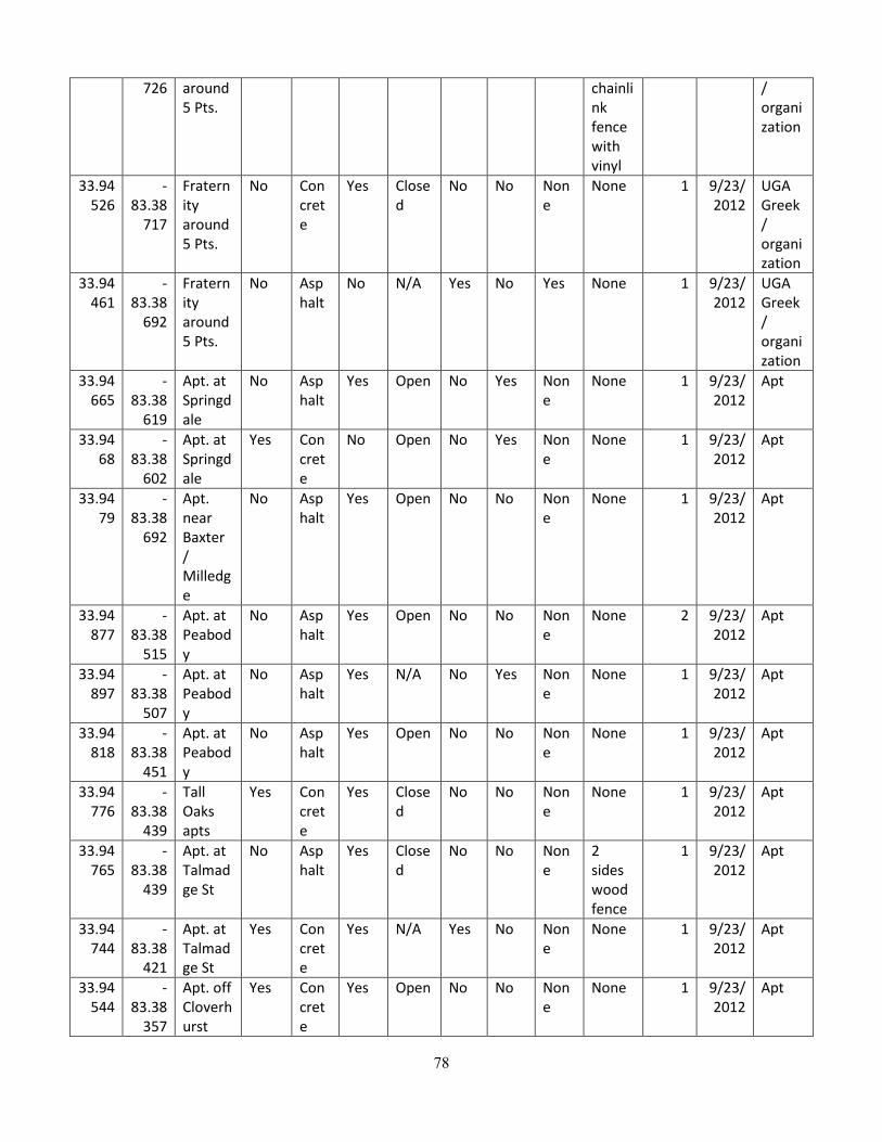
78
726 around 5 Pts.
chainlink fence with vinyl
/ organization
33.94526
-83.38
717
Fraternity around 5 Pts.
No Concrete
Yes Closed
No No None
None 1 9/23/2012
UGA Greek / organization
33.94461
-83.38
692
Fraternity around 5 Pts.
No Asphalt
No N/A Yes No Yes None 1 9/23/2012
UGA Greek / organization
33.94665
-83.38
619
Apt. at Springdale
No Asphalt
Yes Open No Yes None
None 1 9/23/2012
Apt
33.9468
-83.38
602
Apt. at Springdale
Yes Concrete
No Open No Yes None
None 1 9/23/2012
Apt
33.9479
-83.38
692
Apt. near Baxter / Milledge
No Asphalt
Yes Open No No None
None 1 9/23/2012
Apt
33.94877
-83.38
515
Apt. at Peabody
No Asphalt
Yes Open No No None
None 2 9/23/2012
Apt
33.94897
-83.38
507
Apt. at Peabody
No Asphalt
Yes N/A No Yes None
None 1 9/23/2012
Apt
33.94818
-83.38
451
Apt. at Peabody
No Asphalt
Yes Open No No None
None 1 9/23/2012
Apt
33.94776
-83.38
439
Tall Oaks apts
Yes Concrete
Yes Closed
No No None
None 1 9/23/2012
Apt
33.94765
-83.38
439
Apt. at Talmadge St
No Asphalt
Yes Closed
No No None
2 sides wood fence
1 9/23/2012
Apt
33.94744
-83.38
421
Apt. at Talmadge St
Yes Concrete
Yes N/A Yes No None
None 1 9/23/2012
Apt
33.94544
-83.38
357
Apt. off Cloverhurst
Yes Concrete
Yes Open No No None
None 1 9/23/2012
Apt
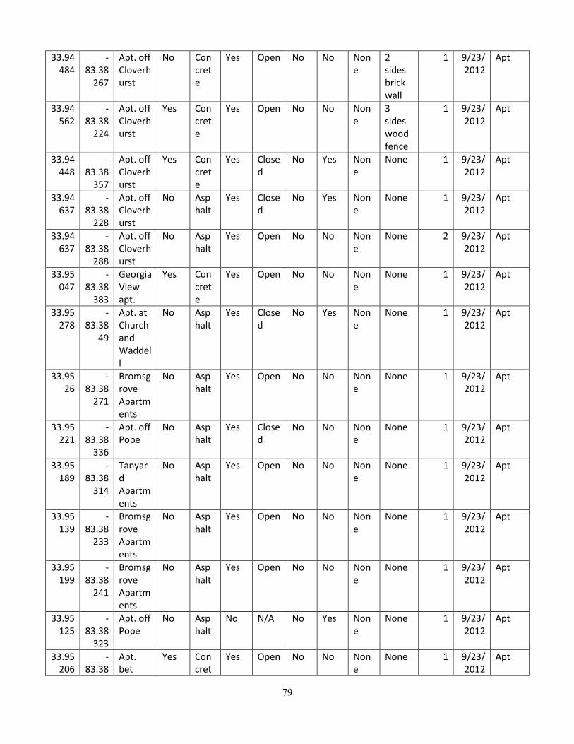
79
33.94484
-83.38
267
Apt. off Cloverhurst
No Concrete
Yes Open No No None
2 sides brick wall
1 9/23/2012
Apt
33.94562
-83.38
224
Apt. off Cloverhurst
Yes Concrete
Yes Open No No None
3 sides wood fence
1 9/23/2012
Apt
33.94448
-83.38
357
Apt. off Cloverhurst
Yes Concrete
Yes Closed
No Yes None
None 1 9/23/2012
Apt
33.94637
-83.38
228
Apt. off Cloverhurst
No Asphalt
Yes Closed
No Yes None
None 1 9/23/2012
Apt
33.94637
-83.38
288
Apt. off Cloverhurst
No Asphalt
Yes Open No No None
None 2 9/23/2012
Apt
33.95047
-83.38
383
Georgia View apt.
Yes Concrete
Yes Open No No None
None 1 9/23/2012
Apt
33.95278
-83.38
49
Apt. at Church and Waddell
No Asphalt
Yes Closed
No Yes None
None 1 9/23/2012
Apt
33.9526
-83.38
271
Bromsgrove Apartments
No Asphalt
Yes Open No No None
None 1 9/23/2012
Apt
33.95221
-83.38
336
Apt. off Pope
No Asphalt
Yes Closed
No No None
None 1 9/23/2012
Apt
33.95189
-83.38
314
Tanyard Apartments
No Asphalt
Yes Open No No None
None 1 9/23/2012
Apt
33.95139
-83.38
233
Bromsgrove Apartments
No Asphalt
Yes Open No No None
None 1 9/23/2012
Apt
33.95199
-83.38
241
Bromsgrove Apartments
No Asphalt
Yes Open No No None
None 1 9/23/2012
Apt
33.95125
-83.38
323
Apt. off Pope
No Asphalt
No N/A No Yes None
None 1 9/23/2012
Apt
33.95206
-83.38
Apt. bet
Yes Concret
Yes Open No No None
None 1 9/23/2012
Apt
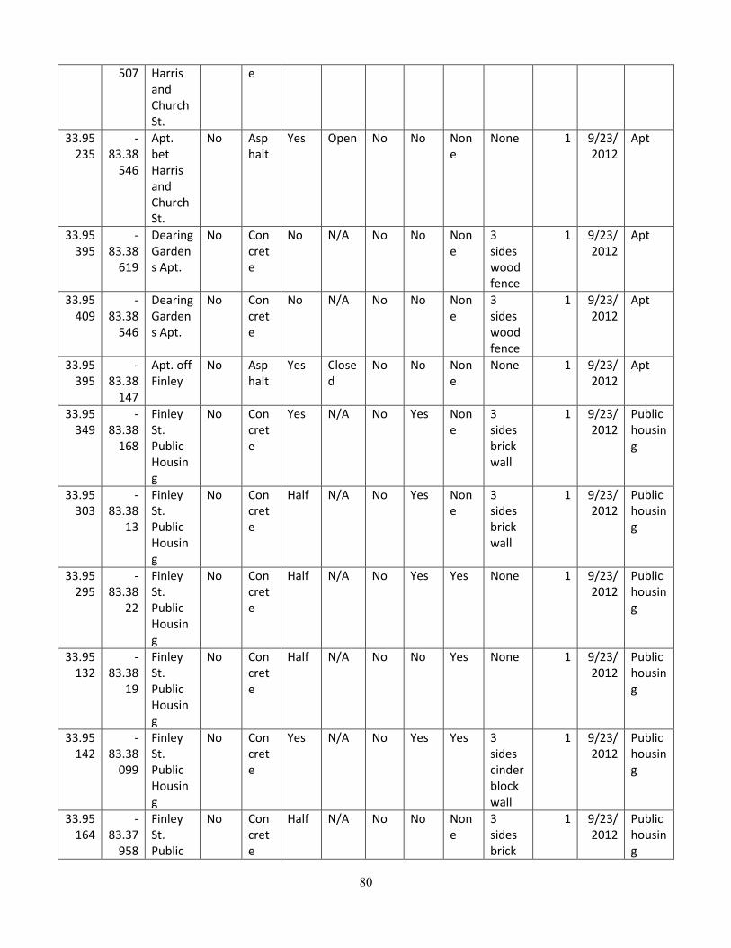
80
507 Harris and Church St.
e
33.95235
-83.38
546
Apt. bet Harris and Church St.
No Asphalt
Yes Open No No None
None 1 9/23/2012
Apt
33.95395
-83.38
619
Dearing Gardens Apt.
No Concrete
No N/A No No None
3 sides wood fence
1 9/23/2012
Apt
33.95409
-83.38
546
Dearing Gardens Apt.
No Concrete
No N/A No No None
3 sides wood fence
1 9/23/2012
Apt
33.95395
-83.38
147
Apt. off Finley
No Asphalt
Yes Closed
No No None
None 1 9/23/2012
Apt
33.95349
-83.38
168
Finley St. Public Housing
No Concrete
Yes N/A No Yes None
3 sides brick wall
1 9/23/2012
Public housing
33.95303
-83.38
13
Finley St. Public Housing
No Concrete
Half N/A No Yes None
3 sides brick wall
1 9/23/2012
Public housing
33.95295
-83.38
22
Finley St. Public Housing
No Concrete
Half N/A No Yes Yes None 1 9/23/2012
Public housing
33.95132
-83.38
19
Finley St. Public Housing
No Concrete
Half N/A No No Yes None 1 9/23/2012
Public housing
33.95142
-83.38
099
Finley St. Public Housing
No Concrete
Yes N/A No Yes Yes 3 sides cinder block wall
1 9/23/2012
Public housing
33.95164
-83.37
958
Finley St. Public
No Concrete
Half N/A No No None
3 sides brick
1 9/23/2012
Public housing
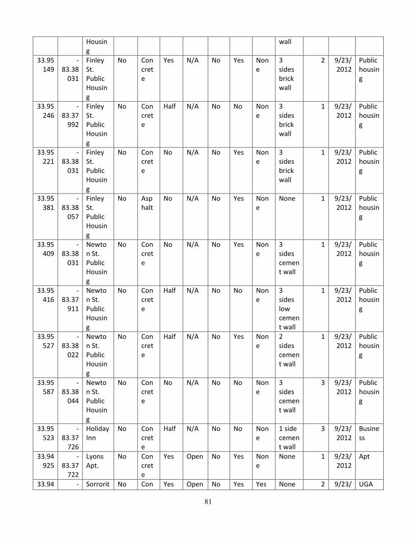
81
Housing
wall
33.95149
-83.38
031
Finley St. Public Housing
No Concrete
Yes N/A No Yes None
3 sides brick wall
2 9/23/2012
Public housing
33.95246
-83.37
992
Finley St. Public Housing
No Concrete
Half N/A No No None
3 sides brick wall
1 9/23/2012
Public housing
33.95221
-83.38
031
Finley St. Public Housing
No Concrete
No N/A No Yes None
3 sides brick wall
1 9/23/2012
Public housing
33.95381
-83.38
057
Finley St. Public Housing
No Asphalt
No N/A No Yes None
None 1 9/23/2012
Public housing
33.95409
-83.38
031
Newton St. Public Housing
No Concrete
No N/A No Yes None
3 sides cement wall
1 9/23/2012
Public housing
33.95416
-83.37
911
Newton St. Public Housing
No Concrete
Half N/A No No None
3 sides low cement wall
1 9/23/2012
Public housing
33.95527
-83.38
022
Newton St. Public Housing
No Concrete
Half N/A No Yes None
2 sides cement wall
1 9/23/2012
Public housing
33.95587
-83.38
044
Newton St. Public Housing
No Concrete
No N/A No No None
3 sides cement wall
3 9/23/2012
Public housing
33.95523
-83.37
726
Holiday Inn
No Concrete
Half N/A No No None
1 side cement wall
3 9/23/2012
Business
33.94925
-83.37
722
Lyons Apt.
No Concrete
Yes Open No Yes None
None 1 9/23/2012
Apt
33.94 - Sorrorit No Con Yes Open No Yes Yes None 2 9/23/ UGA
82
626 83.37924
y on Lumpkin
crete and asphalt
2012 Greek / organization
33.94441
-83.38
168
UGA International Education Building
Yes Concrete
Yes Open No Yes None
4 sides wood fence
2 9/23/2012
UGA Greek / organization
33.94448
-83.38
288
UGA Catholic Center
No Concrete
Yes N/A No No None
3 sides wood fence
1 9/23/2012
UGA Greek / organization
33.94384
-83.38
258
UGA Baptist Center
No Open ground
Yes Open No Yes None
None 1 9/23/2012
UGA Greek / organization
33.94334
-83.38
456
Apts on Lumpkin
No Open ground
Yes Closed
No No None
None 1 9/23/2012
Apt
33.94295
-83.38
43
UGA Mormon Center
Yes Concrete
Yes N/A No Yes None
None 1 9/23/2012
UGA Greek / organization
33.94106
-83.38
009
Foley Field Parking Lot
No Asphalt
Yes Open No No Yes None 2 9/24/2012
UGA Campus
33.94167
-83.38
099
Butts-Meyer Building
No Concrete
No Closed
No No None
None 1 9/24/2012
UGA Campus
33.94338
-83.37
893
College of Agriculture and Environmental Sciences
No Concrete
Yes Open No No None
None 1 9/24/2012
UGA Campus
33.94195
-83.37
Student Athlete
No Open
Yes Open No No None
4-side marbl
1 9/24/2012
UGA Camp
83
863 Academic Building
ground
e-looking pillars and fence
us
33.9411
-83.37
361
UGA Vet School
No Concrete
Yes Giant compactor
No Yes None
None 1 9/24/2012
UGA Campus
33.93921
-83.37
456
Driftmeyer
No Asphalt
No Open No No None
None 2 9/24/2012
UGA Campus
33.93565
-83.37
615
UGA Family Housing
Yes Concrete
Yes Open Yes No None
None 1 9/24/2012
UGA Housing
33.93554
-83.37
464
UGA Family Housing
No Concrete
Yes Open No Yes None
None 1 9/24/2012
UGA Housing
33.93679
-83.37
516
UGA Family Housing
Yes Concrete
Yes Open Yes Yes None
None 1 9/24/2012
UGA Housing
33.93697
-83.37
477
UGA Family Housing
Yes Concrete
Yes Open Yes Yes None
None 1 9/24/2012
UGA Housing
33.93683
-83.37
417
UGA Family Housing
No Asphalt
Yes Open Yes No Yes None 1 9/24/2012
UGA Housing
33.93636
-83.37
348
UGA Family Housing
No Asphalt
No Open Yes No Yes None 1 9/24/2012
UGA Housing
33.93562
-83.37
396
UGA Family Housing
Yes Concrete
Yes Open Yes No None
None 1 9/24/2012
UGA Housing
33.93483
-83.37
481
UGA Family Housing
Yes Concrete
No Open Yes No None
None 2 9/24/2012
UGA Housing
33.93508
-83.37
554
UGA Family Housing
Yes Concrete
Yes Open Yes No Yes None 1 9/24/2012
UGA Housing
33.93 - UGA Yes Con Yes Open No Yes Yes None 1 9/24/ UGA

84
366 83.37512
Family Housing
crete
2012 Housing
33.93248
-83.37
168
UGA IM Fields
No Concrete
Yes N/A No Yes None
None 1 9/24/2012
UGA Campus
33.93355
-83.37
28
UGA IM Fields
No Asphalt
Yes Open No No Yes None 1 9/24/2012
UGA Campus
33.93597
-83.37
07
UGA Visitor Center
Yes Concrete
Yes Open No No Yes None 1 9/24/2012
UGA Campus
33.93633
-83.37
22
Health Center
No Concrete
No Closed
No No None
None 2 9/24/2012
UGA Campus
33.9369
-83.37
203
Ramsey Center
No Concrete
Yes Giant compactor
No Yes None
1 side brick wall
1 9/24/2012
UGA Campus
33.93533
-83.36
881
Animal and Dairy Science Building
Yes Concrete
Half Closed
No Yes None
3 sides metal loose fence
1 9/24/2012
UGA Campus
33.93633
-83.36
761
Physical Plant East
No Concrete
No Closed
No No None
None 1 9/24/2012
UGA Campus
33.93647
-83.36
812
Meat Building
No Open ground
Yes Closed
No Yes None
None 1 9/24/2012
UGA Campus
33.93697
-83.36
7
East Campus dorms
No Concrete
Yes Open No No None
3 sides brick lattice wall
2 9/24/2012
UGA Housing
33.93911
-83.36
692
East Campus dorms
No Concrete
Yes Open No Yes None
3 sides brick lattice wall
1 9/24/2012
UGA Housing
33.93939
-83.37
074
Joe E Frank Commons
Yes Concrete
Yes Open No N/A None
2 sides brick wall
2 9/24/2012
UGA Campus
33.94544
-83.37
027
River Rd Fraternities
No Concrete
Yes Giant compactor
Yes No None
4 sides brick and
1 9/25/2012
UGA Greek / organi
85
fence zation 33.94
356 -
83.36967
AE Pi Frat River Rd
No Asphalt
No Open No N/A None
None 1 9/25/2012
UGA Greek / organization
33.94085
-83.36
808
Performing Arts Center Complex
No Concrete
Yes Closed
Yes No None
3 sides concrete wall
1 9/25/2012
UGA Campus
33.94299
-83.36
962
University Printing Building
No Asphalt
No Closed
No Yes None
2 sides cement wall
1 9/25/2012
UGA Campus
33.94252
-83.36
945
Performing Arts Center Complex
No Concrete
Yes Closed
No Yes None
3 sides brick wall
1 9/25/2012
UGA Campus
33.94128
-83.37
039
Performing Arts Center Complex
No Concrete
Yes Closed
No Yes None
3 sides cement wall
1 9/25/2012
UGA Campus
33.94046
-83.36
829
School of Art
No Concrete
Yes Open Yes No None
1 side chain link fence
1 9/25/2012
UGA Campus
33.94623
-83.38
687
Imagine Studio Hair Salon
No Asphalt
Yes N/A No N/A None
None 1 10/15/2012
Business
33.94669
-83.38
76
Milledge fraternity
No Asphalt
No N/A No N/A None
None 1 10/15/2012
UGA Greek / organization
33.9479
-83.38
649
Milledge sorority
Yes Concrete
Yes Open No No None
None 1 10/15/2012
UGA Greek / organization
33.94 - Mitchel No Gro Yes Open No Yes Non None 1 10/15 Busine
86
829 83.38692
l Investing Group
und e /2012 ss
33.9489
-83.38
662
Milledge sorority
No Gravel
Yes N/A No Yes None
None 1 10/15/2012
UGA Greek / organization
33.94897
-83.38
675
Milledge sorority
No Gravel
Yes Open No Yes None
None 1 10/15/2012
UGA Greek / organization
33.94911
-83.38
627
Baxter St. offices
No Ground
Yes N/A No No None
None 1 10/15/2012
Business
33.94939
-83.38
653
Raising Canes
Yes Concrete
Yes Giant compactor
No N/A None
4 sides metal and brick wall
1 10/15/2012
Business
33.94918
-83.38
537
Campus Loft apartments
No Concrete
Yes Open No Yes None
None 1 10/15/2012
Apt
33.94922
-83.38
43
Loco's No Asphalt
Yes Closed
No Yes None
None 3 10/15/2012
Business
33.94929
-83.38
43
Dominos
Yes Concrete
Yes Closed
No Yes None
None 1 10/15/2012
Business
33.94996
-83.38
404
Jimbo's gas station
No Asphalt
Yes Open No No None
None 2 10/15/2012
Business
33.95135
-83.38
142
East Baxter Shell station
Yes Concrete
Yes Closed
No Yes None
None 1 10/15/2012
Business
33.9506
-83.38
181
Baxter Street Bookstore
Yes Concrete
Yes Open No No None
1 side cement wall
1 10/15/2012
Business
33.95032
-83.38
327
Sunshine Tan
Yes Concrete
Yes Open No Yes None
1 side cement wall
1 10/15/2012
Business
33.95043
-83.38
Papa Johns
No Concret
Yes Closed
No Yes Yes 3 sides
1 10/15/2012
Business
87
361 e wood fence
33.95039
-83.38
396
University Cuts
No Ground
No N/A No Yes None
None 1 10/15/2012
Business
33.95028
-83.338516
Jimmy Johns
Yes Concrete
Yes Closed
No Yes None
4 sides wood fence
1 10/15/2012
Business
33.95043
-83.38
524
Off-campus Bookstore
No Concrete
Yes Closed
No No None
2 sides cement wall
1 10/15/2012
Business
33.95018
-83.38
64
Top Dog Scooters
No Asphalt
Yes Closed
No Yes None
None 1 10/15/2012
Business
33.94986
-83.38
683
Bulldog Coin Laundry
No Concrete
Yes N/A No Yes None
None 1 10/15/2012
Business
33.94947
-83.38
683
Baxter - Milledge intersection apartments
Yes Concrete
Yes Open No Yes None
None 1 10/15/2012
Apt
33.95071
-83.38
61
Milledge sorority
Yes Concrete
Yes Closed
Yes Yes None
4 sides wood fence
1 10/15/2012
UGA Greek / organization
33.95242
-83.38
606
Milledge office building
No Asphalt
Yes Open No No None
None 1 10/15/2012
Business
33.95253
-83.38
614
Milledge fraternity
No Ground
Yes Closed
No N/A None
None 1 10/15/2012
UGA Greek / organization
33.95293
-83.38
623
Milledge fraternity
Yes Concrete
Yes Closed
No Yes None
None 2 10/15/2012
UGA Greek / organization
33.95303
-83.38
Milledge
Yes Concret
No Open Yes Yes None
None 1 10/15/2012
UGA Greek
88
67 fraternity
e / organization
33.95349
-83.38
67
Milledge office building
No Asphalt
Yes N/A No No None
None 1 10/15/2012
Business
33.94573
-83.37
645
South Parking Deck
No Concrete
Yes Open No No None
3 sides brick lattice wall
1 10/15/2012
UGA Campus
33.94505
-83.37
735
Center for Continuing Education
Yes Concrete
Yes Open Yes N/A Yes None 1 10/15/2012
UGA Campus
33.94409
-83.37
739
Center for Continuing Education
No Concrete
Yes Closed
No Yes Yes 2 sides brick lattice wall
2 10/15/2012
UGA Campus
33.94608
-83.37
808
Myers Dorm
No Concrete
Yes Closed
No Yes None
None 1 10/15/2012
UGA Campus
33.94751
-83.37
756
Myers Dorm
No Concrete
Yes Closed
No No None
None 1 10/15/2012
UGA Campus
33.94655
-83.37
563
Dawson Hall
No Concrete
Half Open No Yes None
3 sides brick lattice wall
2 10/15/2012
UGA Campus
33.94491
-83.37
563
Dance Building
No Concrete
Yes Closed
Yes No None
3 sides wood fence
1 10/15/2012
UGA Campus
33.9443
-83.37
61
Snelling Dining Hall
Yes Concrete
Yes Closed
No Yes None
2 sides wood fence
1 10/15/2012
UGA Campus
33.94341
-83.37
619
UGA Pharmacy Building
No Concrete
Yes Giant compactor
No N/A None
None 1 10/15/2012
UGA Campus
33.94 - Parking No Asp Yes Open No N/A Non None 1 10/15 UGA
89
224 83.37619
lot across from Colisseum
halt e /2012 Campus
33.94249
-83.37
464
Plant Sciences Building
No Concrete
Yes Open Yes No None
2 sides cement wall
1 10/15/2012
UGA Campus
33.94217
-83.37
366
USFS Building
No Concrete and asphalt
Yes Closed
No No None
None 1 10/15/2012
USFS
33.94195
-83.37
203
Aderhold Hall
Yes Concrete
No Open No No Yes 1 side cement wall
2 10/15/2012
UGA Campus
33.94256
-83.37
117
School of Social Work
Yes Concrete
Yes Open No No Yes None 1 10/15/2012
UGA Campus
33.94316
-83.37
194
Life Sciences Complex
No Concrete
No Open No No Yes 2 sides cement wall
3 10/15/2012
UGA Campus
33.94395
-83.37
276
Ecology Building
Yes Concrete
Yes Open No Yes None
1 side low wood fence
1 10/15/2012
UGA Campus
33.94416
-83.37
357
Forestry Building
Yes Concrete
Yes Open No N/A Yes None 1 10/15/2012
UGA Campus
33.94345
-83.37
447
UGA Creamery
Yes Concrete
Yes Closed
Yes No None
None 2 10/15/2012
UGA Campus
33.9453
-83.37
37
Air Force ROTC Building
Yes Concrete
Yes Open Yes Yes Yes None 1 10/15/2012
UGA Campus
33.94548
-83.37
447
Science Library
No Asphalt
No Open No No None
None 2 10/15/2012
UGA Campus
33.94708
-83.37
Conner Hall
No Asphalt
Yes Closed
No Yes Yes None 1 10/15/2012
UGA Camp

90
426 us 33.94
672 -
83.37336
Conner Hall parking lot
No Concrete
Yes Closed
No Yes None
None 1 10/15/2012
UGA Campus
33.94526
-83.37
301
Physical Plant
No Concrete
Yes Open No Yes Yes 1 side cement wall
1 10/15/2012
UGA Campus
33.94509
-83.37
211
Physical Plant
No Asphalt
Yes Open No Yes Yes None 1 10/15/2012
UGA Campus
33.9447
-83.37
142
Statistics Building
No Asphalt
No Open No No None
None 1 10/15/2012
UGA Campus
33.94633
-83.37
37
Food Processing Lab
No Concrete
No Open No N/A None
None 1 10/15/2012
UGA Campus
33.94669
-83.37
863
O-House Dining Hall
No Asphalt
Yes Closed
No N/A None
1 side cement wall
1 10/16/2012
UGA Campus
33.94826
-83.37
889
Dorm parking lot
Yes Concrete
Yes Open No Yes None
None 1 10/16/2012
UGA Housing
33.9485
-83.37
851
O-House Dorm
No Asphalt
Yes Closed
No No None
None 1 10/16/2012
UGA Housing
33.94833
-83.37
941
Dorm parking lot
Yes Concrete
No Open No No None
None 2 10/16/2012
UGA Housing
33.94915
-83.37
838
Hill Residential Dorm
Yes Concrete
Yes Open No No None
3 sides wood fence
1 10/16/2012
UGA Housing
33.94947
-83.37
778
Hill Residential Dorm
No Asphalt
Yes Open No Yes None
None 1 10/16/2012
UGA Housing
33.95103
-83.37
803
Lipscomb Hall Dorm
No Asphalt
Yes Closed
No N/A None
None 1 10/16/2012
UGA Housing
33.95096
-83.37
915
Mell Hall Dorm
No Asphalt
Yes Closed
No Yes Yes None 1 10/16/2012
UGA Housing
33.95096
-83.37
915
Bolton Dining Hall
No Asphalt
Yes Closed
No N/A None
None 1 10/16/2012
UGA Campus
33.94 - Creswel No Con No N/A No Yes Non None 1 10/16 UGA
91
989 83.38044
l Hall Dorm
crete
e /2012 Housing
33.94939
-83.38
314
Russell Hall Dorm
Yes Concrete
No Open No Yes None
None 3 10/16/2012
UGA Housing
33.95185
-83.37
512
Student Learning Center
Yes Concrete
Yes Giant compactor
No Yes None
3 sides brick wall
1 10/17/2012
UGA Campus
33.95032
-83.37
529
Tate Student Center
No Concrete
Yes Giant compactor
No Yes None
None 1 10/17/2012
UGA Campus
33.94943
-83.37
675
Clark Howell Hall
Yes Concrete
Yes Closed
No Yes None
None 1 10/17/2012
UGA Campus
33.94833
-83.37
584
Physics Building
No Asphalt
No Closed
No Yes None
None 1 10/18/2012
UGA Campus
33.94918
-83.37
464
Chemistry Building
No Asphalt
No Open No Yes None
None 2 10/18/2012
UGA Campus
33.94808
-83.37
22
Biology Building
Yes Concrete
No Open No Yes None
None 1 10/18/2012
UGA Campus
33.94754
-83.37
194
Biology Building
No Asphalt
Yes Open No N/A Yes None 1 10/18/2012
UGA Campus
33.94676
-83.37
22
Poultry Science Building
No Concrete
Yes Open No Yes None
None 1 10/18/2012
UGA Campus
33.94608
-83.37
173
Food Science Building
Yes Concrete
Yes Open No No Yes None 1 10/18/2012
UGA Campus
33.95196
-83.37
284
Reed Hall Dorm
No Concrete
Yes Open No No Yes None 2 10/18/2012
UGA Housing
33.9521
-83.37
237
Milledge Hall Dorm
Yes Concrete
Yes Open No Yes Yes None 1 10/18/2012
UGA Housing
33.95249
-83.37
233
Psychology Building
No Asphalt
No Closed
Yes Yes Yes None 1 10/18/2012
UGA Campus
33.95758
-83.37
323
UGA Business
No Concrete
No Open No N/A Yes None 1 10/25/2012
UGA Campus
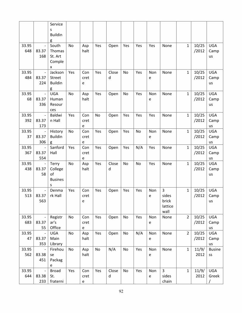
92
Services Building
33.95648
-83.37
168
South Thomas St. Art Complex
No Asphalt
Yes Open Yes Yes Yes None 1 10/25/2012
UGA Campus
33.95484
-83.37
224
Jackson Street Building
Yes Concrete
Yes Closed
No Yes None
None 1 10/25/2012
UGA Campus
33.9568
-83.37
336
UGA Human Resources
No Asphalt
Yes Open No Yes None
None 1 10/25/2012
UGA Campus
33.95392
-83.37
173
Baldwin Hall
Yes Concrete
No Open Yes Yes Yes None 1 10/25/2012
UGA Campus
33.9537
-83.37
306
History Building
No Concrete
Yes Open Yes No None
None 1 10/25/2012
UGA Campus
33.95367
-83.37
554
Sanford Hall
Yes Concrete
Yes Open Yes N/A Yes None 1 10/25/2012
UGA Campus
33.95438
-83.37
58
Terry College of Business
No Asphalt
Yes Closed
No No Yes None 1 10/25/2012
UGA Campus
33.95513
-83.37
563
Denmark Hall
Yes Concrete
Yes Open Yes Yes None
3 sides brick lattice wall
1 10/25/2012
UGA Campus
33.95683
-83.37
55
Registrar's Office
No Concrete
Yes Open No Yes None
None 2 10/25/2012
UGA Campus
33.9547
-83.37
353
UGA Main Library
No Asphalt
Yes Open No N/A None
None 2 10/25/2012
UGA Campus
33.95562
-83.38
451
Firehouse Package
No Asphalt
No N/A No Yes None
None 1 11/9/2012
Business
33.95644
-83.38
233
Broad St. fraterni
Yes Concrete
Yes Closed
No Yes None
3 sides chain
1 11/9/2012
UGA Greek /
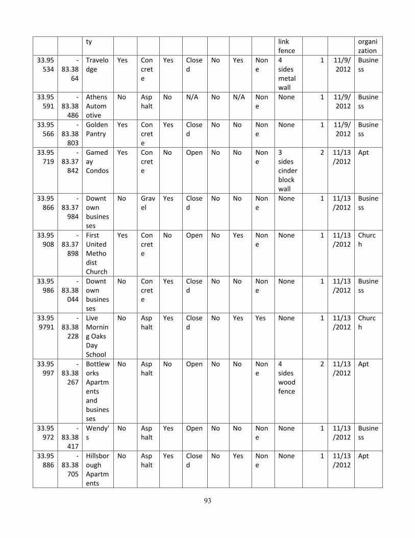
93
ty link fence
organization
33.95534
-83.38
64
Travelodge
Yes Concrete
Yes Closed
No Yes None
4 sides metal wall
1 11/9/2012
Business
33.95591
-83.38
486
Athens Automotive
No Asphalt
No N/A No N/A None
None 1 11/9/2012
Business
33.95566
-83.38
803
Golden Pantry
Yes Concrete
Yes Closed
No No None
None 1 11/9/2012
Business
33.95719
-83.37
842
Gameday Condos
Yes Concrete
No Open No No None
3 sides cinder block wall
2 11/13/2012
Apt
33.95866
-83.37
984
Downtown businesses
No Gravel
Yes Closed
No No None
None 1 11/13/2012
Business
33.95908
-83.37
898
First United Methodist Church
Yes Concrete
No Open No Yes None
None 1 11/13/2012
Church
33.95986
-83.38
044
Downtown businesses
No Concrete
Yes Closed
No No None
None 1 11/13/2012
Business
33.959791
-83.38
228
Live Morning Oaks Day School
No Asphalt
Yes Closed
No Yes Yes None 1 11/13/2012
Church
33.95997
-83.38
267
Bottleworks Apartments and businesses
No Asphalt
No Open No No None
4 sides wood fence
2 11/13/2012
Apt
33.95972
-83.38
417
Wendy's
No Asphalt
Yes Open No No None
None 1 11/13/2012
Business
33.95886
-83.38
705
Hillsborough Apartments
No Asphalt
Yes Closed
No Yes None
None 1 11/13/2012
Apt
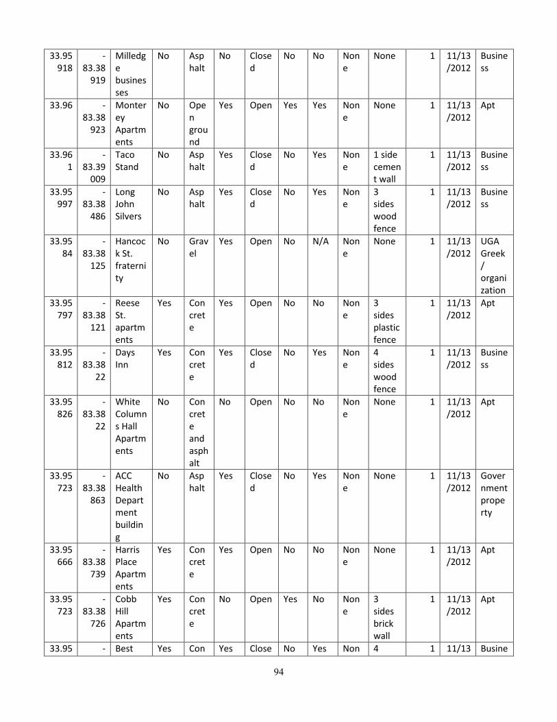
94
33.95918
-83.38
919
Milledge businesses
No Asphalt
No Closed
No No None
None 1 11/13/2012
Business
33.96 -83.38
923
Monterey Apartments
No Open ground
Yes Open Yes Yes None
None 1 11/13/2012
Apt
33.961
-83.39
009
Taco Stand
No Asphalt
Yes Closed
No Yes None
1 side cement wall
1 11/13/2012
Business
33.95997
-83.38
486
Long John Silvers
No Asphalt
Yes Closed
No Yes None
3 sides wood fence
1 11/13/2012
Business
33.9584
-83.38
125
Hancock St. fraternity
No Gravel
Yes Open No N/A None
None 1 11/13/2012
UGA Greek / organization
33.95797
-83.38
121
Reese St. apartments
Yes Concrete
Yes Open No No None
3 sides plastic fence
1 11/13/2012
Apt
33.95812
-83.38
22
Days Inn
Yes Concrete
Yes Closed
No Yes None
4 sides wood fence
1 11/13/2012
Business
33.95826
-83.38
22
White Columns Hall Apartments
No Concrete and asphalt
No Open No No None
None 1 11/13/2012
Apt
33.95723
-83.38
863
ACC Health Department building
No Asphalt
Yes Closed
No Yes None
None 1 11/13/2012
Government property
33.95666
-83.38
739
Harris Place Apartments
Yes Concrete
Yes Open No No None
None 1 11/13/2012
Apt
33.95723
-83.38
726
Cobb Hill Apartments
Yes Concrete
No Open Yes No None
3 sides brick wall
1 11/13/2012
Apt
33.95 - Best Yes Con Yes Close No Yes Non 4 1 11/13 Busine

95
626 83.3873
Western
crete
d e sides wood fence
/2012 ss
33.9558
-83.38
808
Shane's Rib Shack
Yes Concrete
Yes Closed
No Yes None
4 sides chainlink fence with vinyl
1 11/13/2012
Business
33.95598
-83.38
765
Cobb Square Apartments
No Open ground
Yes Open No No None
None 1 11/13/2012
Apt

96
Appendix I (a) Tanyard Stream Enhancement and Restoration for the 2030 Athens Downtown Master Plan from “Urban Stream Enhancement: A Conceptual Design for Tanyard Creek’s Upper Reaches” Master Thesis by Page, John C., 2013.

97
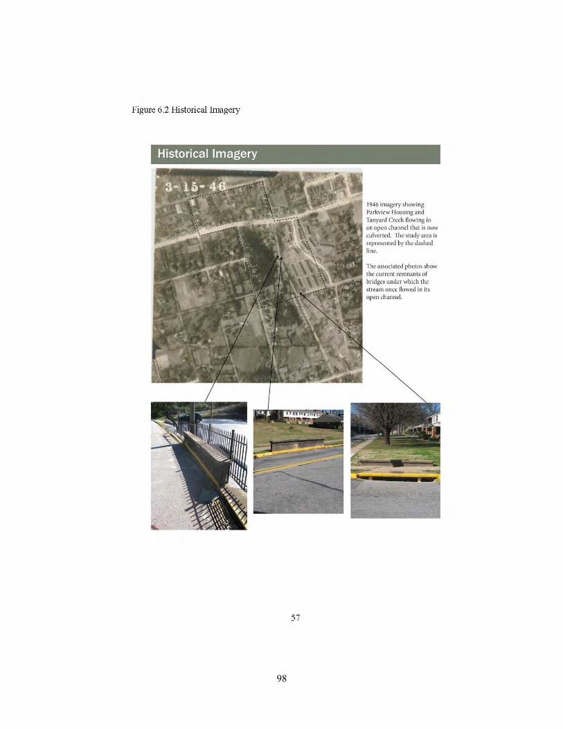
98
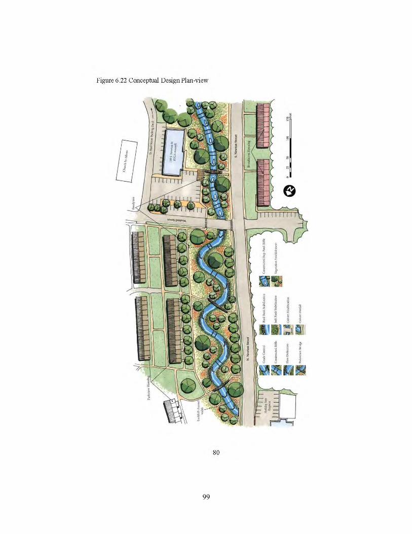
99

100

101
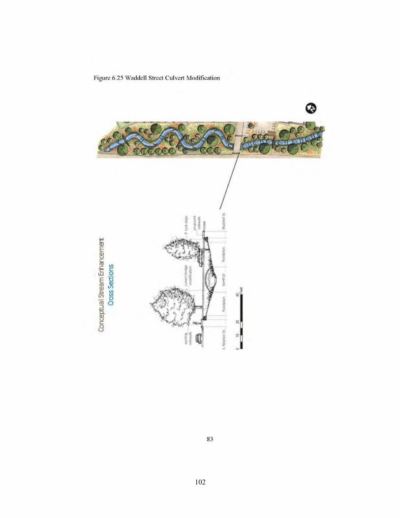
102
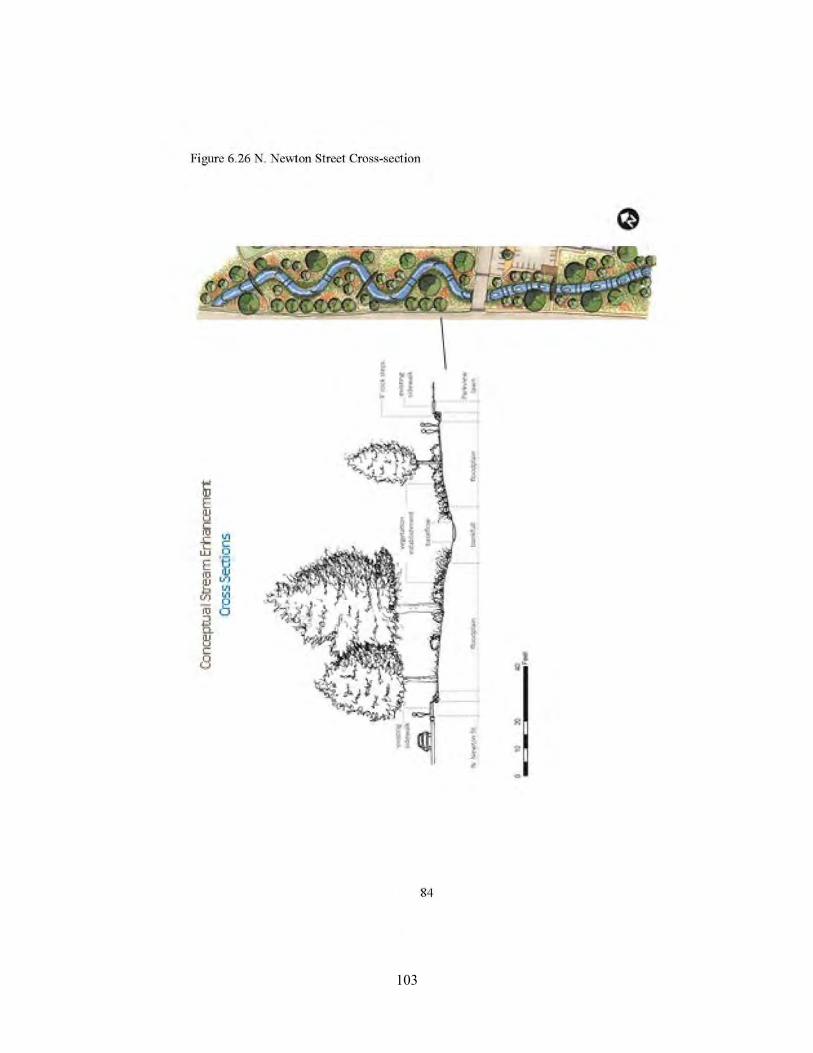
103
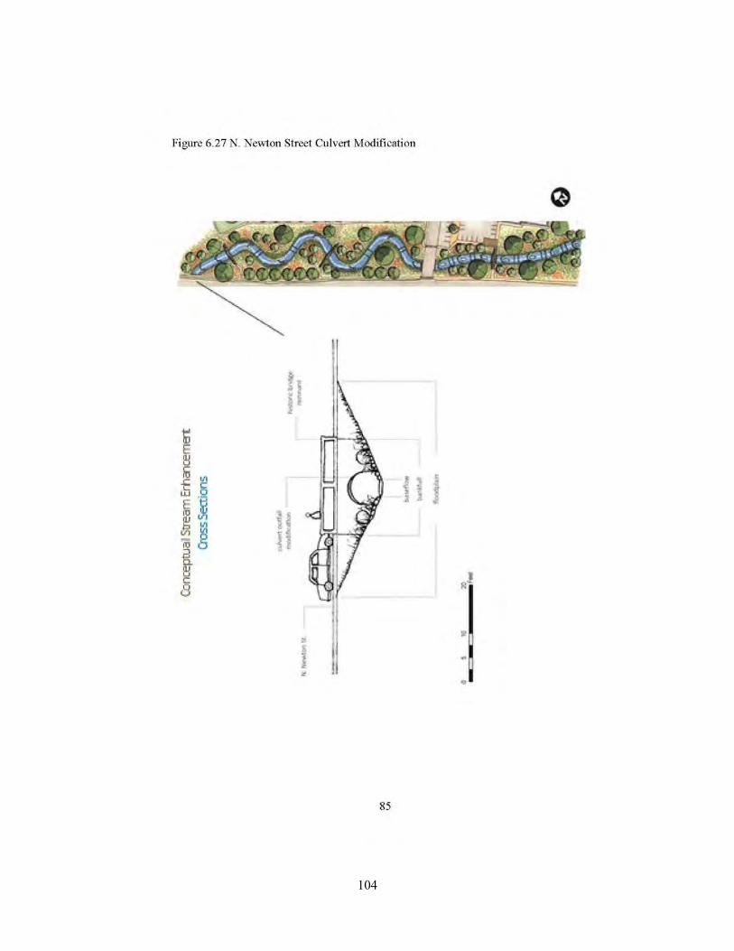
104
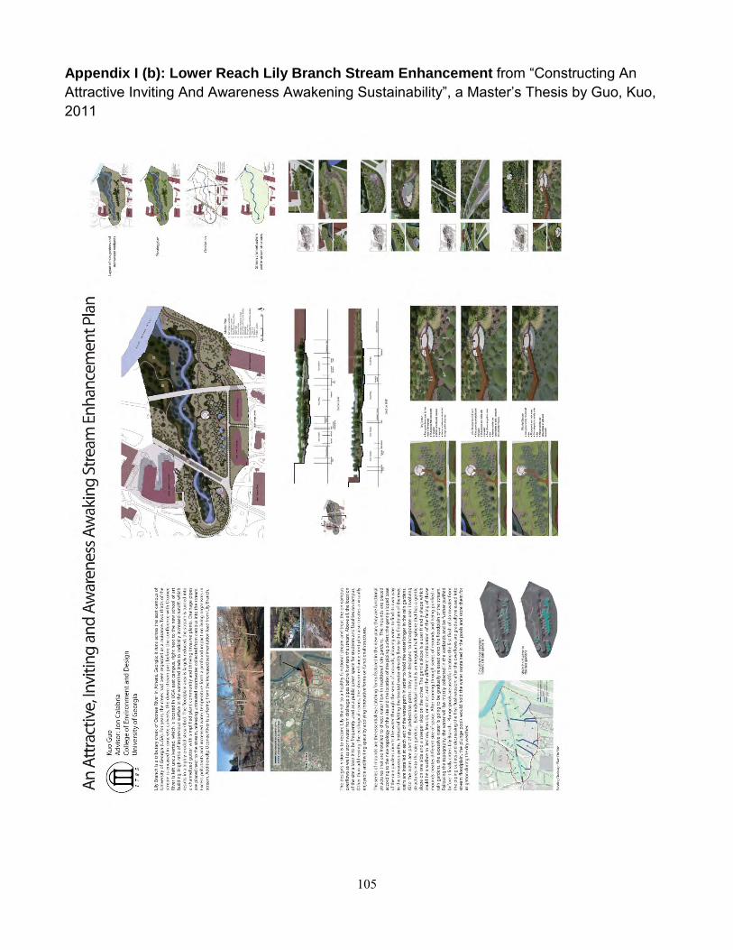
105
Appendix I (b): Lower Reach Lily Branch Stream Enhancement from “Constructing An Attractive Inviting And Awareness Awakening Sustainability”, a Master’s Thesis by Guo, Kuo, 2011

106
Appendix J. Draft Tanyard Restoration Trajectory
Abstracted from The Natural Communities of Georgia, 2013 by students from the Spring 2013 LAND 6350 Ecological Landscape Restoration Class.
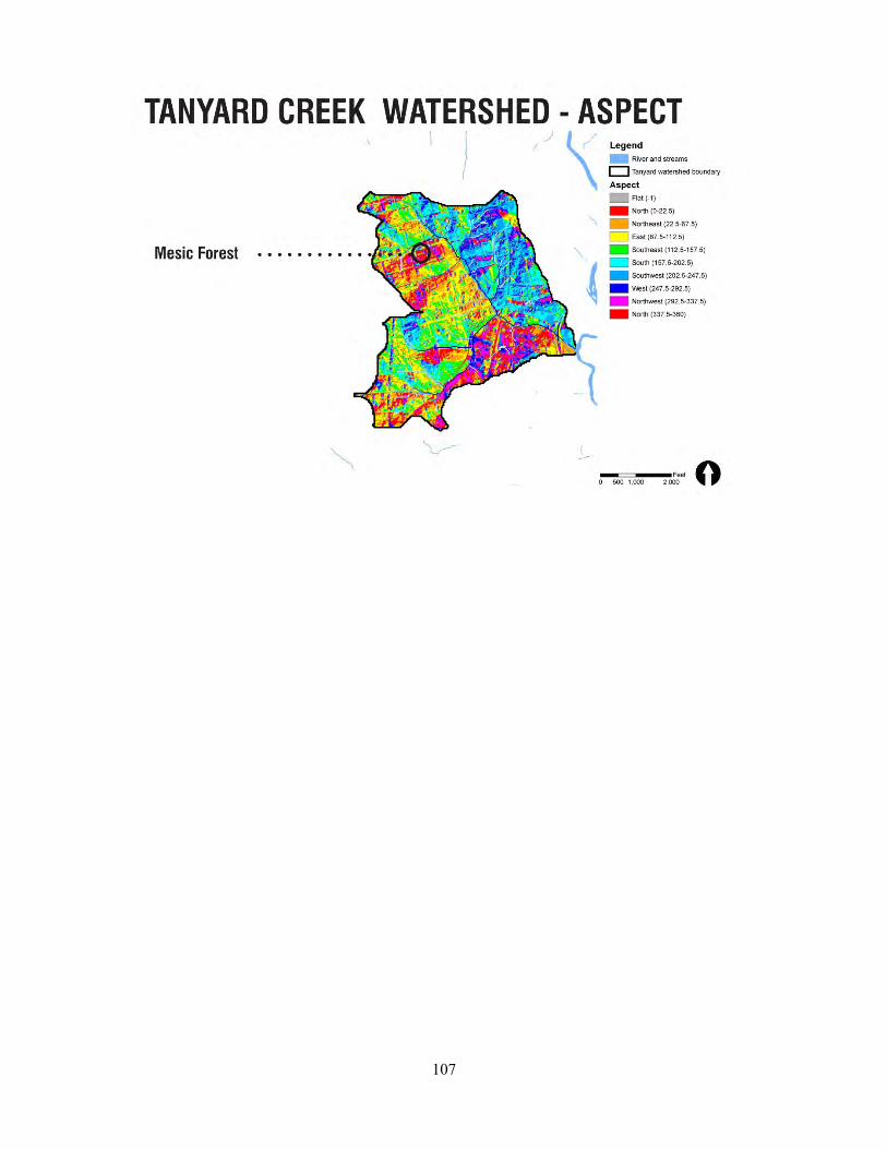
107

108
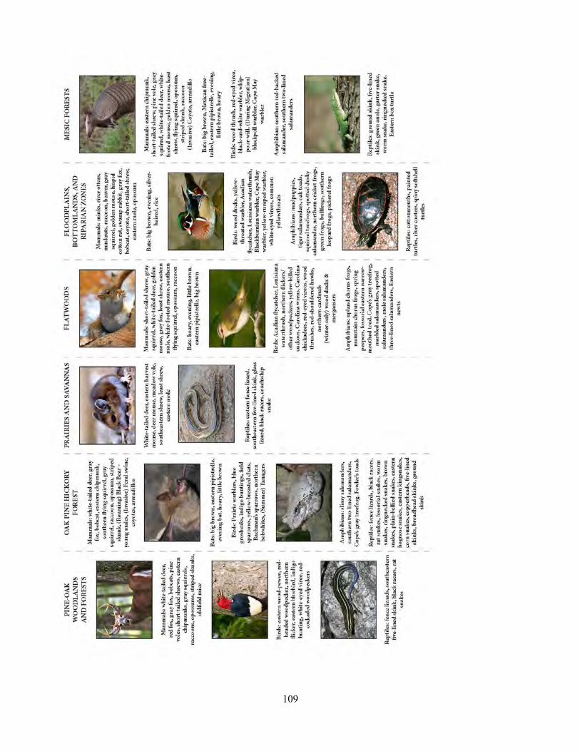
109

110
111
Appendix K. Spring 2013 Practicum
Lesson Plan and Education Strategy for Barrow Elementary School
MEMORANDUM
To: EcoReach, Environmental Law Practicum students, and Laurie Fowler
From: Brian Crawford and Sam Woolford, University of Georgia Environmental Practicum
Date: 17 April 2013
Re: Local Stream Conservation: Stormwater Issues, Lesson Plan
Draft: first
As part of the University of Georgia Campus Stream Restoration group of the University of Georgia Environmental Practicum – a partner in a collaborative effort to develop a 9-key element watershed protection plan for the restoration of streams running through the UGA campus – we were primarily responsible for organizing an educational program with Barrow Elementary School. This effort continues and improves past work of Environmental Law Practicum students to increase elementary students’ knowledge of stormwater issues that threaten local streams and foster critical thinking about conservation actions that could be taken by students’ families, local businesses, and the greater Athens community. Through establishing a collaborative network between Barrow Elementary School teachers, EcoReach undergrad and graduate students from the Odum School of Ecology (UGA), and Athens Clarke County Transportation and Public Works Department education specialists, we envision this education program being carried out in each of the coming school years. Because of pending issues regarding potential alterations to the state core curriculum and class scheduling at the Barrow School, we currently cannot plan a fixed schedule for the upcoming 2013-2014 academic year. Sam Woolford (memo co-author) will be responsible for coordinating scheduling and facilitating communication between EcoReach and the Barrow School in late July and early August, and will pass responsibilities to another EcoReach member in future years.
I. CONTACTS
Natalie Hicks, 3rd grade Educator at Barrow Elementary School. [email protected]
112
Christine Fox, Stormwater Education Specialist, Athens Clarke County Transportation and Public Works Department. [email protected]
Tyra Byers, Sustainability coordinator, Office of Sustainability, University of Georgia. [email protected]
Sarah Budischak, EcoReach president, Odum School of Ecology, University of Georgia. [email protected]
Vanessa Kinney, Maerz Herpetology Lab coordinator, Warnell, University of Georgia. [email protected]
II. BACKGROUND
II.A. Overview of Conservation Issues
Lilly Branch, located in Athens, GA, is a first-order tributary of the North Oconee River with a watershed that contains significant amounts of roads, apartments, neighborhoods, parking lots, and other impervious surfaces. The stream’s headwaters begin near the Five Points area, and from there, the stream runs mostly underground across UGA’s south campus including Foley Field, the Veterinary School of Medicine, and the Lamar Dodd School of Art. Barrow Elementary School is located adjacent to a day-lighted portion of Lilly Branch making students, staff, and faculty key stakeholders to stream health and conservation issues. Because Lilly Branch is located near neighborhoods and urbanized areas, stream health has been impacted by trash, fertilizers, dog feces, and other pollutants that quickly enter the stream during rain events. These threats have reduced water quality as well as the diversity of aquatic wildlife at this site compared to local streams in less developed areas (such as in Sandy Creek Park or Whitehall Forest). The health of Lilly Branch has improved significantly since 2002 as some issues such as sewage leaks from pipelines have been addressed. However, public awareness and management practices still need to be improved in order to achieve a healthier, more ecologically resilient stream. For more information, consult the report by Environmental Law Practicum students in 2011, found at http://www.rivercenter.uga.edu/education/practicum/documents/lily_branch_final_pts_1_2.pdf and the report from students in 2012, found at http://www.rivercenter.uga.edu/education/practicum/documents/nine_key_brizendine_etal_2012.pdf.

113
II.B. Need
The entire campus stream restoration project is, by definition and necessity, a community-wide effort. Without members of the Athens community committed to improving the health of our streams, we could accomplish very little. Pollution sources such as illicit discharges into the stormwater system or pet waste in overland runoff are often a problem simply due to a lack of awareness on the part of the polluters, and the perceived inconvenience of the alternative. It is easier to leave dog waste where it lies than to pick it up, and simpler to pour used motor oil down the storm drain than dispose of it properly. The destination of these pollutants is often unclear to most community members, as are the damaging effects on the streams and rivers we depend on. Available information and active education regarding the impact of the surrounding community on the local streams, how behavior change can improve stream health, and, importantly, why the local community should care about stream health, are the tools we have to affect community change. For this reason, the education component of the project is imperative.
This particular incarnation of our education efforts addresses these community education needs from the bottom up. By introducing school-age children to the effects of stormwater pollution on streams in their neighborhood, the diversity of life that lives in those streams, and the benefits we garner from healthy streams, we hope to promote behavior change in households throughout the neighborhoods surrounding Lily Branch, as well as foster a future community of environmentally literate citizens who will continue to protect our streams.
This latter goal also supports a broader need addressed by the in-school education component of the streams restoration project. Throughout the nation, school time devoted to science and inquiry is decreasing, and the amount of time children spend outdoors during out-of-school time is declining even faster.i In a world that is rapidly modernizing and urbanizing, our children often do not develop strong connections to the natural world around them and do not understand the ways in which we depend on or impact our environment. Especially in an urban area such as Athens, it is important to develop childhood connections with nature to promote future sound environmental stewardship. This education program will develop scientific thinking through hands-on inquiry activities, and connect children with nature in their local community, both of which are increasingly needed during the school day to foster an environmentally literate society.ii
II.C. Limitations
As in years past, the main limitations for collaborative initiatives between elementary schools, graduate students, and other organizations were time and scheduling issues that affect all parties. It is difficult for elementary school teachers to schedule additional activities in the springtime given the amount of time already dedicated to preparing students for the standardized tests (CRCTs), district benchmarks and
114
performance tasks, and unit assessments. One limitation solely impacting the 2013 school year was the temporary relocation of the school for renovations of the campus near E. Rutherford St. and Lumpkin Street. During fall 2012 and spring 2013, Barrow Elementary School is operating from a temporary location on Gaines School Rd. requiring logistical barriers for planning any program containing a field trip component to the Lily Branch site. Despite these limitations, we worked with educators from Barrow, EcoReach, and Athens Clarke County Transportation and Public Works Department to conduct several activities at Barrow’s Science Night in April and create a 3-part campus stream restoration lesson plan that will be conducted via members of this network in future school years.
II.D. Future Organization, Scheduling, and Communication
This three part lesson plan has been created in order to implement the program for the first time in the 2013-2014 academic year. We made the decision to shift the education responsibilities away from the Environmental Practicum class members to the graduate student outreach group EcoReach within the Odum School of Ecology (although Environmental Practicum students would be welcome to observe and/or teach the programs as well). We believe this will facilitate a more permanent and year-long partnership with the Barrow School in the future. Due to the nature of the academic calendar, we are not currently able to complete planning for the execution of the program starting in Fall 2013, but have made preparations for the continuation of our work this semester.
In order to carry out the lessons next year, scheduling issues on both sides (EcoReach and Barrow School) need to be addressed in August 2013. Many EcoReach volunteers will not return to Athens until then, and the Barrow School will not know of 3rd grade staff and grade level allocations or alterations to the state common core curriculum that would affect scheduling of science education activities. Despite this interim period, both groups are eager to implement the program next year. To this end, Sam Woolford will continue to facilitate active communication between EcoReach and the Barrow School’s 3rd grade staff through the summer and into the academic year, with the goal of planning the timing and order of the three lessons by the Fall of 2013 and subsequently teaching the lessons throughout the school year. With the 2013-2014 school as a model for future years, Sam will pass responsibilities for communication and scheduling to the EcoReach president or another member.
II.E. Curriculum
The lesson plan was designed as a three-part series, spanning fall, winter, and spring, with the fall and spring lessons each containing in-class and field activities and the winter lesson conducted entirely in class. If time or logistical constraints occur, educators may forego the winter lesson. The whole program was designed to create opportunities for inquiry-based, hands-on learning where students formed questions and hypotheses, gathered data from the stream, and reflected on their findings relative to other seasons or areas. These areas were addressed in particular because of requests by the third-grade education team at the Barrow School (communicated through Natalie Hicks).
115
Each lesson was allocated for the 3rd grade classes at Barrow for an hour time slot, due to correlation between programming and 3rd grade Georgia Performance Standards (see below). Complete lesson plans are outlined in the next section: LILLY BRANCH EDUCATION PROGRAM. Lesson 1 introduces students to stream conservation and other key terms, such as watersheds, biodiversity, and ecosystem. Students are asked to form questions about the biodiversity of Lilly Branch, knowing it was near a developed area, relative to streams in forests or other habitats. Students then travel to Lilly Branch to collect stream organisms and sample the water to observe its clarity. During the sampling period, students are asked to actively search for organisms and record their observations on a worksheet. Lesson 1 concludes by having students reflect on what they found, and the instructor should give a teaser introduction to the next lesson by explaining that not every species native to local streams was found in Lilly Branch due to negative impacts from stormwater and pollution issues.
Lesson 2 allows students to learn how different stormwater issues can impact local streams in their community and explore the dynamics of stormwater flow on mode landscapes using a hands-on, in-classroom activity. Students will learn key terms such as watershed, stormwater, and impervious surface. Students will also understand why water flows in streams and what it can pick up as it travels over land. Students will then discuss how stormwater in developed landscapes can transport various types of pollutants into streams. These concepts will be reinforced using model watersheds to investigate stormwater issues and different sources of pollution entering streams.
Lesson 3 follows a similar format to Lesson 1 in that it contains in-classroom and field components. The lesson begins by learning/reviewing key terms pertaining to stormwater issues of local streams, including conservation, stormwater, watershed, runoff, pollution, ecosystem, and biodiversity. Students will again form hypotheses about the biodiversity and health of Lilly Branch given what they know about stormwater issues in the area. The class will travel to Lilly Branch to sample the stream for organisms and water quality, record their findings, and compare what they found to the previous Fall. The class will collect a few pieces of trash that has been discarded by the stream to reinforce the importance of actions by any person in the community that can benefit the surrounding environment. Students will draw conclusions based on these findings and what they observed in the surrounding landscape related to stormwater/development issues. It is likely that results will be similar between seasons, which will be expected if no major actions were taken in the interim to manage stormwater and pollution entering the stream.
The lesson plan we designed fit in nicely with the 3rd grade conservation unit and met several Georgia Performance Standards. This program touched on standards in science and social studies, as well as contributing a ‘service learning’ component. The GPS that correlated with the lesson plan are as follows:
S3L1d - Students will investigate the habitats of different organisms and the dependence of organisms on their habitat: Explain what will happen to an organism if the habitat is changed.
116
S3L2 - Students will recognize the effects of pollution and humans on the environment.
a. Explain the effects of pollution (such as littering) to the habitats of plants and animals.
b. Identify ways to protect the environment.
• Conservation of resources
• Recycling of materials
SS3E1a - The student will describe the four types of productive resources:
a. Natural (land)
b. Human (labor)
c. Capital (capital goods)
d. Entrepreneurship (used to create goods and services)
III. LILLY BRANCH EDUCATION PROGRAM
Overall Program Objective: Using the context of stormwater issues of the Lilly Branch stream and local watersheds, we plan to give students the opportunity to 1) conduct hands-on, inquiry-based learning to hone their observational and data-collecting skills, 2) understand the process of scientific research, and 3) investigate the impacts people have on their surrounding environment.
III.A. LESSON 1: Introduction to Local Stream Conservation and Field Sampling of Lilly Branch
Topic: water conservation, stream health and biodiversity
Objectives
● Students will learn and/or review key terms pertaining to local streams, including conservation, watershed, ecosystem, and biodiversity.
● Students will create questions and hypotheses regarding the biodiversity of Lilly Branch relative to streams in other ecosystems such as less developed areas.
● Students will sample Lilly Branch for aquatic organisms and record data from the field. ● Students will draw conclusions about stream health and biodiversity based on their findings.
Materials & equipment
117
Field trip to Lilly Branch
● Small mesh dip nets ● Leaf litter traps ● Empty paint bucket ● Clear plastic zip-lock bags ● Map of Lilly Branch and surrounding watersheds (Appendix 1) ● Worksheets for students (Appendix 2) ● Clipboards (or have students bring their notebooks) for writing on worksheets in field ● Laminated color pictures and key of aquatic stream salamanders and invertebrates (Appendix 3) ● Clear vial for water sample collection ● Camera
Lesson Outline (total time with class: 55 minutes plus walk back to school)
1. Field Preparation: Prior to day of lesson, set 2-3 leaf litter traps in section of Lilly Branch that will be visited by students. Consult Vanessa Kinney (Maerz Herpetology Lab, UGA) to obtain traps, nets, and buckets that will be used in sampling. Note: traps will make it more likely you will catch more species, but only using nets to sample would be adequate.
2. Introduction & Background: (10 mins) After arriving to Barrow Elementary School, begin the lesson by introducing yourselves, what you do, and say you will learn, as a class, about the conservation of streams that are right in our own backyards, specifically Lilly Branch; the class will discuss things like biodiversity in local streams, and then we will travel to Lilly Branch to make observations and collect data (including live animals) that will indicate stream health.
Ask students if they have heard the term conservation, facilitate a discussion of its meaning, and write a working definition on the board. Next, put up (either a hard copy or an image on the computer) the map of Lilly Branch and the surrounding streets and watersheds (Appendix 1). Point out Barrow Elementary School’s location proximate to the stream. Discuss other important terms such as watershed, biodiversity, and ecosystem (or review of these terms if students have already been exposed to them in previous lessons) while referencing Lilly Branch.
3. Question/Hypothesis Formation: (5 mins) Based on these concepts, Have students think about and predict how Lilly Branch’s ecosystem and biodiversity might be different from a stream in a forest, or a different climate or part of the world. Guide students to form hypotheses about what they expect to find at Lilly Branch compared to streams in more pristine habitats. Write down a few hypotheses that students agree about on the board.
4. Data Collection: (30 mins) Walk to the stream with the class and other instructors. As you walk, ask students if any live in the area, if they knew that Lilly Branch was located near them, and if they had ever visited it. Have them look for things that might affect Lilly Branch on the way (e.g., roads, houses, businesses, etc.). Once at the stream, break students into small groups. Each group should get a dip net, a worksheet (Appendix 2), and a clear collecting bag. They may collect the specimen on their own and
118
place it in their bag, or the student can inform an instructor to catch the animal if it is submerged in water or out of reach. Sample the stream for invertebrates (aquatic insects, crayfish, snails, etc.) and vertebrates (salamanders) using dip nets and leaf litter traps for 20-25 minutes. Instructors will perform the actual sampling of leaf litter traps with kids help (i.e., removing leaf litter traps from stream, shaking contents into bucket). Also collect water in a clear vial/bottle to have kids look at it and describe its appearance. Have one of the instructors take a picture of the vial in front of a clean white piece of paper that will be included in the class’s dataset to be used for comparisons in the Spring lesson. When specimens are collected, place each into zip lock bags for students to examine. Instruct them to consult the field guides (Appendix 3) and pictures of salamander species to determine what was caught, and they should record the type and number of each individual caught on their worksheets.
5. Reflection: (10 mins) After students have had enough time collecting specimens, congregate around the stream and review the different types of species caught and make sure all are recorded on worksheets. Have students look at field guides and consider what species or kinds of animals were not found at Lilly Branch. Guide students in thinking why not all species that we know CAN live in streams near Athens were found. The end of this lesson should tease concepts that this and many other local streams have been negatively impacted by pollution issues, including stormwater issues, from nearby communities. End the session by thanking students for their cooperation and participation and remind them that what happens in their homes, neighborhoods, and communities can impact nearby streams and the larger ecosystem to which they are members. Walk back to the classroom and depart.
III.B. LESSON 2: Build, Pollute, and Conserve Your Own Watershed
Topic: Water conservation, stream health, stormwater issues
Objectives
● Students will learn what a watershed is, and how streams are affected by the land around them. ● Students will learn about different forms of pollution that can impact the health of streams. ● Students will compare stormwater effects in our urban watershed with other environments, and
learn about ways to manage stormwater. ● Students will formulate their own best management practices for stormwater.
Materials & equipment
● Disposable aluminum cake pan ● Newspaper ● Permanent markers ● Paper towels ● Spray bottle ● Tin foil
119
● Food coloring ● Worksheets/paper ● Watershed Map
Lesson Outline (total time with class: 1 hour)
1. Introduction: (5-10 min) Reintroduce who we are and review what we did in the fall. If possible, project pictures of Lily, the kids sampling, what we caught, the watershed around it. Try to tie some of the things the kids remember about what we found or how the stream looked into the surrounding watershed (i.e. if we didn’t find anything, or if it was dirty).
2. What is a watershed?: (10-15 min) Ask students if they can define what a watershed is. Try to break the word into 2 pieces--we all know what water is, what is ’shed’? A watershed is the area of land that ‘sheds’ its water into a river or a stream.
One potentially helpful visual: have student make a cup with their hands, ask what would happen if water landed on their index finger? Their pinky finger? What about their arm, would the water go up and over into their hands? Since water drains from your fingers to your hands, all fingers are in the same watershed, but your arm is not.
Show students a map of the watersheds around the school, with the location of Barrow shown. Explain that water that lands on their school or near it flows into Lily Branch, so we’re in the Lily Branch watershed. IMPORTANT: what makes water flow? Why does water flow into the stream and not stay on the land? They should get gravity. Ask them how they think people know where a watershed begins and ends. This is a good time to mention that we all live in a watershed, and everywhere you go you are in a watershed--water is always flowing downhill, usually to the ocean.
Other things to bring up if you want or have time: What do you think the water takes with it into the streams (i.e., what do you see on the ground?). Ususally kids think of pollution; Also make sure to mention that nutrients from plants and animals wash into streams and make them healthy, and that life in streams depends on the land around them.
3. Making watersheds: (25 min) Break into small groups and hand out a cake pan and some tin foil to each group. Tell kids to make their tin foil into a landscape in their pans. Walk around and help groups having trouble, and make sure groups have good relief in their pans. Once everyone is done, hand out washable markers and ask them to predict where the water will go, and the path it will take. Have them draw the path or paths on the model. Ask if they think they have more than one watershed in their pan?
Next hand out a spray bottle to each group and have each kid do 10 sprays onto their model. Walk around and ask about how the water is flowing, where it’s going, After they’re done ask kids to report back if their predictions were correct, and what happened.
Next hand out a paper towel to each group to represent vegetation. They can put it anywhere on their model. Here talk about impervious and pervious surfaces (define on the board, and write some examples) and ask about what we have more of around Lily Branch. Each kid can do 5 more spray once
120
the paper towel is down. Talk about what happens to the water, how this is like an impervious surface and plants outside. What else comes from plants that is good for our streams (nutrients, oxygen)?
Next give out markers so that kids can draw their house, school, and anything else they want in their landscape (cars, roads, farms, businesses). Ask them what they see on the ground in Athens that might get washed into our streams (trash, oil/gas, dog poop). What might they not see (chemicals, fertilizer)? What do they think would be on their landscapes? These are all forms of pollution, and when it rains in our city, they get washed into the streams with stormwater. Define stormwater on the board. What are the differences in stormwater between the impervious and pervious surfaces on their models?
Lastly, walk around with some food coloring and ask them to tell you where to put a few drops - the food coloring can be anything the kids want. Talk about what happens with pollution in our watershed, and the effect on Lily Branch.
4. Conclusions and next steps: (10-15 min) What can we do to prevent stormwater from causing pollutants to enter our streams? How can we make sure Lilly Branch stays healthy? Also tell students about some of the things people do to manage storm water (rain barrels, green roofs, rain gardens). After brainstorming a list on the board, hand out paper to the kids to have them draw or write about something they or their family could do to keep Lily healthy. Thank the students for listening and participating, and depart.
III.C. LESSON 3: Lilly Branch Revisited
Topic: water conservation, stream health and biodiversity
Objectives
● Students will learn and/or review key terms pertaining to stormwater issues of local streams, including conservation, stormwater, watershed, runoff, pollution, ecosystem, and biodiversity
● Students will create questions and hypotheses regarding the biodiversity and overall health of Lilly Branch relative to streams in less developed areas given local stormwater issues and their negative impacts
● Students will sample Lilly Branch for aquatic organisms and record data from the field ● Students will compare data from spring and previous fall and draw conclusions about trends in
stream health and biodiversity based on their findings
Materials & equipment
Field trip to Lilly Branch
● Small mesh dip nets ● Leaf litter traps ● Empty paint bucket

121
● Clear plastic zip-lock bags ● Map of Lilly Branch and surrounding watersheds (Appendix 1) ● Worksheets for students (Appendix 2) ● Clipboards (or have students bring their notebooks) for writing on worksheets in field ● Laminated color pictures and key of aquatic stream salamanders and invertebrates (Appendix 3) ● Hand sanitizer ● Trash bags ● Class data from sampling in the previous Fall (and past years, eventually) ● Clear vial for water sample collection ● Camera
Lesson Outline (total time with class: 1 hour)
1. Field Preparation: Prior to day of lesson, set 2-3 leaf litter traps in section of Lilly Branch that will be visited by students. Consult Vanessa Kinney (Maerz Herpetology Lab, UGA) to obtain traps, nets, and buckets that will be used in sampling. Note: traps will make it more likely you will catch more species, but only using nets to sample would be adequate.
2. Introduction & Background: (10 mins) After arriving to Barrow Elementary School, begin the lesson by introducing yourselves again, what you do, and say you will learn, as a class, about the conservation of streams that are right in our own backyards, specifically Lilly Branch; the class will discuss things like pollution that impact local streams, and then we will travel to Lilly Branch to make observations and collect data (including live animals) that will indicate stream health and allow us to make comparisons with the status of the stream from the previous fall.
Ask students if they remember the definition of conservation, facilitate a discussion of its meaning, and write a working definition on the board. Next, put up (either a hard copy or an image on the computer) the map of Lilly Branch and the surrounding streets and watersheds (Appendix 1) to remind them what we discussed in the previous lessons. Tell students that we will be combining what we know about the life in Lily Branch and the watershed around it to see what we can tell about the health of the stream. Briefly review other important terms such as watershed, stormwater, impervious surfaces, pollution, biodiversity, and ecosystem (or review of these terms if students have already been exposed to them in previous lessons), if needed. Lastly, briefly review the data the class gathered from stream sampling the previous fall, including number of species caught and general water clarity.
3. Question/Hypothesis Formation: (5 mins) Based on these concepts, Lilly Branch is adjacent to – and likely impacted by – developed areas and the resulting issues related to stormwater runoff and pollution. Guide students to form hypotheses about how our urban watershed affects the stream and what they expect to find at Lilly Branch in the Spring compared to what was found last fall. Have there been changes to the stream that will make it healthier (clearer water, fewer indicators of stormwater/pollution issues, higher biodiversity)? Without any changes, should the stream continue to have fewer species and more turbid water? Write down a few hypotheses that students agree about on the board.

122
4. Data Collection: (25 min) Walk to the stream with the class and other instructors. As you walk, ask students to again take notice of anything they see that might help or harm Lilly Branch (e.g., forest around stream, roads, houses nearby, runoff, etc.). Once at the stream, break students into small groups. Each group should get a dip net, a worksheet (Appendix 2), and a clear collecting bag . Tell all students to look carefully in the stream and surrounding bank for any organism. They may collect the specimen on their own and place it in their bag, or the student can inform an instructor to catch the animal if it is submerged in water and a net is needed. Sample stream for invertebrates (aquatic insects, crayfish, snails, etc.) and vertebrates (salamanders) using dip nets and leaf litter traps for 5 minutes. Instructors will perform the actual sampling of leaf litter traps (i.e., removing leaf litter traps from stream, shaking contents into bucket). When specimens are collected, place each into zip lock bags for students to examine. Instruct them to consult the field guides and pictures of salamander species to determine what was caught, and they should record the type and number of each individual caught on their worksheets.
5. Service: (5 mins) Have each student pick up 1 or 2 pieces of trash to emphasize actions they can take to improve stream health in their community. Collect trash in bags and distribute hand sanitizer to students afterwards.
6. Reflection: (15 mins) After students have had enough time collecting specimens and trash, congregate around the stream and review the different types of species caught and jot down a list on the board. Have students look at field guides (Appendix 3) and consider what species or kinds of animals were not found at Lilly Branch. Show class data from previous fall and have students draw comparisons based on species seen or total animals caught. Guide students in thinking why not all species that we know CAN live in streams near Athens were found (e.g., stream has been negatively impacted by stormwater and pollution issues from nearby community, we only sampled a little portion of the stream, etc.). Reinforce that it often takes ecosystems and their species a long time to improve even after threats caused by humans have been removed, so it may take years to see more species in Lilly Branch if we take action today. End the session by thanking students for their cooperation and participation and remind them that what happens in their homes, neighborhoods, and communities can impact nearby streams and the larger ecosystem to which they are members.
123
Appendix L. Tanyard Branch and Lily Branch: A Cultural History of The University of Georgia’s Most Prominent Watersheds
By: Jack Spalding, Intern-UGA Office of Sustainability
4 December, 2012
Tanyard Branch and Lilly Branch are the two most prominent streams running through the University Campus. Their significance with regards to the history of Athens and the University should not be overlooked. As of 2012, these streams for the most part have not been allowed to retain their original, natural courses and appearance. Indeed, this alteration of the streams is certainly not unique to recent decades, but has in fact been common occurrence since Athens and the University were founded in the last decades of the 1700’s. Generally, in the early days of the University, the streams were much more heavily incorporated into the daily lives of students, faculty, and citizens—even when their natural courses and appearances were altered. Unfortunately today these streams, while having been significantly altered and degraded, offer little in the way of recreational benefit. It is tragic that these streams which once played important roles in the community, have been relegated to obscurity. It is crucial that the colorful histories of these streams be more readily available to members of the Athens and University communities.
Tanyard Branch’s headwaters are located a few blocks back in the Hancock neighborhood just to the north of Broad Street. According to Rev. Samuel Boykin, once a student of Franklin College from 1848-1851, in his speech to the Athens Historical Society in 1899, he muses about how in 1831, the University purchased a plot of land of which would become the first botanical garden in the State of Georgia, which today roughly corresponds to the land encompassed by Broad, Finley, Pope, and Reese Streets.91 This plot of land—most importantly—was bisected by Tanyard Branch.
Abraham Baldwin, the founder of Franklin College, is quoted as suggesting the development of “a plot of land where agricultural experiments might be made and observations on botany and natural history be taken.”92 Not only was Baldwin’s suggestion made a reality, but the garden quickly became one of the most popular spots on campus for students, faculty, as well as local Athenians. The garden was founded in 1831, and was maintained by the University until 1856, when it was sold due to budget restraints.93 It was placed under the direction of the professor of natural history, Malthus Ward, and with the help and appropriation of the Trustees of the University, the botanical garden was allowed to flourish.
Early on, it was evident that Tanyard Branch would be the foundation on which the garden would grow. As E. Merton Coulter, a well-known Univerity of Georgia history professor from 1918-1958, so eloquently put it, the garden became “a veritable Garden of Eden with hills and valleys, two sparkling brooks, a lake containing a few perch and a harmless alligator, and over 2,000 plants, shrubs, and trees from every corner of the globe.”94 The beauty of “the little fairyland” should not be understated, as Rev. Boykin asserts, in his speech to the Athens Historical Society in 1899:
The garden was cool and shady, and many benches in localities of rural beauty, invited rest and quiet conversation. The eye roamed with delight through the winding walks into shady dells and over flowerbeds of
91 , Samuel. “Letter to Athens Historical Society.” Porter-Kellam Collection circa 1804-1891, Special Collections Hargrett Manuscripts, p. 2.
92 Coulter, E. Merton. College Life in the Old South. Athens: University of Georgia Press, 1928. Print. p. 41.
93 Ibid, 42. 94 Ibid, 42.
124
exquisite beauty. Near the center of the garden was a cool spring, delightfully shaded by trees with benches around it, where the college boys, after quenching their thirst were fond of sitting, to chat and crack jokes. At almost every turn some pleasant surprise greeted the eye… as of a charming retreat or a splashing waterfall or a placid little lake with a graceful willow growing beside it.95
Boykin also mentions that shortly after a professor by the name of McCay dammed Tanyard Branch to make the lake; the ice which formed on the lake during winter was often used by locals for household purposes.96 Another point of intrigue is that Coulter claims that the botanical garden was the “first and only park” in Athens during its existence.
Aside from the local admiration that the garden received due to its natural beauty, it actually gained a fair amount of widespread fame, for newspapers “as far away as New York wrote descriptions of it.”97 It also was notable for its weeping willow, which grew out of a cutting from the willow upon Napoleon’s Grave in St. Helena.98 William H. Crawford, the notable American statesman from Georgia, was able to have the cutting transplanted from Napoleon’s grave to the botanical garden, in appreciation for his service as Minister to France near the end of Napoleon’s reign.99 This willow as well as plant specimens from the Cape of Good Hope, and cuttings from the Washington Elm on Cambridge Commons and the Charter Oak were certainly paramount to the praise which the garden received. Unfortunately, great things must come to an end, and in 1854 budget restraints forced the University to sell the garden for $1000. It is intriguing to note that the $1000 from the sale was used to pay for the iron fence which still encloses North Campus to this day. 100
An account from the 1870’s by Sylvanus Morris, in his book The Stroller of Athens, paints a slightly different picture of Tanyard Branch and the land where the garden once existed in elegant grandeur. By the 1870’s, the garden was no longer, but the area was still a point of interest for Morris. During his walk, as he “reaches the Tanyard Branch, he is reminded that the Botanical Garden extended along the ravine above and below Broad Street” but that nothing remained of it “except for some rare trees.”101 Morris appears more intrigued by the gold mine which once existed at the same location. As he stands on the culvert over Tanyard Branch, he recalls:
Just above the street, on the branch, is a gold mine from which once citizen panned a living for a long time. But that was before the stroller came to Athens. The mine is still there. As to the gold, well that is another story.102
After musing about Tanyard Creek by Broad Street, Morris continues on his walk and ends up where Tanyard crosses under Lumpkin Street. At this point, Morris directs his attention towards the east, claiming that there were once “two, perhaps three tanneries—Kirkpatrick’s and Doyal’s” along Tanyard Branch, but Morris admits that he steered clear of them due to their stench.103 He also mentions that Doyal’s tannery is no longer and is now the location of the new athletic field (which is in the same valley, but adjacent to the present day location of Sanford Stadium). Morris definitely seems conscious of the fact that the new athletic field has been blessed with a prime natural location, due to its position in the valley of Tanyard Creek, as he bemuses that the “field” in
95 Boykin, 6. 96 Ibid, 5. 97 Coulter, 42 98 Ibid, 42. 99 Ibid, 42. 100 Coulter, 43. 101 Morris, Sylvanus. Strolls About Athens During the early seventies. Athens Historical Quarterly, 1969. Print. p. 9.
102 Ibid, 10. 103 Ibid, 41.

125
“Sanford Field” sounds to usual, and that he believes it should be given a more natural name, such as “Sanford Meade” or “Sanford Bottom.”104 In the article “The Cathedrals” in Sports Illustrated, by Dick Friedman (27, August 2012) Coach Vince Dooley makes remarks similar to Morris as he states, “Georgia's been blessed with having a location set in a valley . . . There's Tanyard Creek that flows under Sanford Stadium. The stadium itself was built on the side of two hills, so there's a natural, beautiful scene that blends into the environment.” To build Sanford Stadium, according to University of Georgia history professor, Dr. Nash Boney, “Tanyard Branch ... was diverted a little southward and sealed in a concrete tunnel, and over it gangs of convict laborers constructed a new football stadium seating thirty-three thousand people.”105
The Cloverhurst Branch of Tanyard intersects the main branch right next to Mell Hall, and today is largely obscured by culverting and realignment. The headwaters start near the western end of Cloverhurst Street, and for a short length are day-lighted, until the stream hits the Oglethorpe House parking lot. From this point, the stream is culverted as it flows under one side of Legion Field, and as the stream reaches Legion Pool, the stream is then day-lighted again until it intersects the main Tanyard Branch. Where it is day-lighted from Legion Pool down past Mell hall, the stream parallels a path which is heavily used by students heading to and from Bolton Dining Commons. The stream, though day-lighted, is certainly not in its natural state, for it has been straightened, and its edges are armored with stones and concrete.
The first known manipulation of the Cloverhurst branch came in 1880, when a private water company built a pond for the Athens municipal waterworks, in the valley in which Legion Pool and Legion Field now occupy.106 This waterworks was primitive in nature and was not used for more than a few decades, as Athens built a new waterworks around 1900. In 1933, the site of the old waterworks was transformed yet again by the construction of Legion Pool.107 This project was the idea of Alan R. Fleming of Post 20 of the American Legion, and the project also received $18,000 in funding as well as labor from the Federal Emergency Relief Administration, like many other projects during the Great Depression.108 According to Gary Doster’s book of historic Athens postcards:
In 1933, the Legion identified a suitable spot at an old waterworks property on Lumpkin Street. Resting in a natural bowl, the location was perceived to require very little grading or alteration to the site. The only significant physical obstacle on the site was a small stream that required realignment. The land was acquired and cleared, and by 1934, concrete had been poured and the erection of a swimming pool was underway.109
It is likely that the most significant, and permanent alterations to Cloverhurst Branch occurred during the construction of Legion Pool. The armored banks as well as other stone structures in the vicinity resemble the masonry work from other federal projects undertaken during the Great Depression.
Like Tanyard Branch, Lily Branch has had an intriguing past, and even more-so than Tanyard, its present state is quite obscure and degraded. It is located in the southwestern corner of campus, and today, it is largely culverted, especially where it runs underneath Foley Field (constructed in 1966), the Dan Magill Tennis Complex (constructed in 1977), and then underneath the Veterinary School (constructed in 1951). It then remains largely culverted throughout much East Campus before it empties into the Oconee River. According to Lee Shearer (Athens Banner Herald, 27 June, 2005) this is not the only problem that has plagued Lilly Branch. Raw sewage 104 Morris, 41. 105 Boney, F. N. A Pictorial History of the University of Georgia. Athens: University of Georgia Press, 1984. Print. p. 118.
106 ACC. Your Drinking Water 2012. http://www.athensclarkecounty.com/index.aspx?nid=1246. 107 Steve Eliot-Gower. “History of Legion Pool.” file:///Volumes/NO%20NAME/Save%20Legion%20Pool.webarchive 108 Ibid. 109 Ibid.
126
spills from some apartment complexes off of Woodrow Street and petroleum seepage from a now defunct filling station on Lumpkin Street have been identified as the main culprits with regards to high levels of contaminants in the stream. In the past few years, there have been significant cleanup efforts, along “Stinky Creek,” as some have come to call it, and as of very recently, the filling station in question has been demolished, and cleanup efforts appear to be underway. Indeed, there was a time that Lilly Branch was used for recreational purposes and was even safe enough to swim in.
In 1924, the Georgia 4-H Club established Camp Wilkins on the banks of Lilly Branch, where the Veterinary School is today.110 A small lake was constructed by damming Lilly Branch, and according to Dexter Adams, head of the UGA Physical Plant, it was given the name “Lake Kirota” which was meant to be a combination of Kiwanis and Rotary.111 During the summer camp, the lake was used for swimming and other activities.112 Today the summer camp and lake are no more, and the Veterinary Building occupies most of that land.
There is also a heavily wooded parcel of University land which lies immediately to the south of the Veterinary complex, and there is a small stream which flows east through these woods and then under East Campus Road, where it then empties into Lily Branch. This wooded plot, which is surrounded by Agriculture Drive, Family Housing, the Vet Building, and East Campus road, is strikingly beautiful, and appears to be almost untouched by humans—especially compared to all of the development around it. According to Dorinda G. Dallmeyer, Director of the UGA Environmental Ethics Certificate Program, this plot of land is known as “Beech Glade,” due to the large beech trees, and old—some of the trees are from 150-200 years old—which can be found in the ravine by the creek.113 Dallmeyer surmises that it was because of the steep nature of the ravine which runs through the land, that it was never used for agriculture, while much of the land surrounding it was used for agriculture by the University.114 What is so significant about this ravine and the stream that flows through it is that it can help paint a picture of the past—especially with regards to Lily Branch. The land is seemingly untouched, except for a few jogging trails, 3 old concrete picnic tables, and an old, small chimney, and it is certainly plausible that this is how Lily Branch probably appeared prior to the intense development around and on top of it.
Both of these creeks have rich histories and have shared importance in the Athens and University Communities. It is unfortunate though that their early glory has not been adequately preserved. Neither of these streams is particularly accessible for those seeking out a peaceful, natural setting in which to recreate or just relax, but there was certainly a time in their histories when people flocked to these streams for just that purpose. That being said, football fans are blessed with the opportunity to view football games from the pleasant valley which Tanyard Creek has provided for Sanford Stadium, just as students and faculty can still cool off at Legion Pool during the muggy Athens summers. It is the hope of many in the University and Athens communities that these streams can be better incorporated into peoples’ daily lives, and that through their rich histories, new ideas and as well as old lessons can be applied when deciding how to better incorporate these branches—Tanyard and Lily.
Works Cited
ACC. Your Drinking Water 2012. http://www.athensclarkecounty.com/index.aspx?nid=1246.
110 Georgia 4-H, www.georgia4h.org/public/more/4hcentennial/ga4hcentennial_1.ppt 111 Dexter Adams, Facebook, file:///Volumes/NO%20NAME/Lake%20Kirota.webarchive 112 Georgia 4-H, www.georgia4h.org/public/more/4hcentennial/ga4hcentennial_1.ppt 113 Dallmeyer, Dorinda G. “Sand County on Campus: A walking tour of the University of Georgia Campus inspired by Aldo Leopold’s ‘A Sand County Almanac.’” March, 2008. p. 34. 114 Ibid, p. 34.

127
Adams, Dexter. Facebook. file:///Volumes/NO%20NAME/Lake%20Kirota.webarchive
Boney, F. N. A Pictorial History of the University of Georgia. Athens: University of Georgia Press, 1984. Print.
Boykin, Samuel. “Letter to Athens Historical Society.” Porter-Kellam Collection circa 1804-1891, Special Collections Hargrett Manuscripts.
Coulter, E. Merton. College Life in the Old South. Athens: University of Georgia Press, 1928. Print.
Dallmeyer, Dorinda G. “Sand County on Campus: A walking tour of the University of Georgia Campus inspired by Aldo Leopold’s ‘A Sand County Almanac.’” March, 2008.
Eliot-Gower, Steve. “History of Legion Pool.” file:///Volumes/NO%20NAME/Save%20Legion%20Pool.webarchive
Georgia 4-H, www.georgia4h.org/public/more/4hcentennial/ga4hcentennial_1.ppt
Morris, Sylvanus. Strolls About Athens During the early seventies. Athens Historical Quarterly, 1969. Print.
i Louv, Richard. Last child in the woods: Saving our children from nature-deficit disorder. Algonquin Books, 2008 ii Smith, Gregory A., and David Sobel. Place-and community-based education in schools. London: Routledge, 2010