North By Northwest: The Strange Case of Giza's Misalignments
7
T he first impression made by a map of Giza is one of order. The bases of the pyramids appear perfectly square and precisely aligned with cardinal points. Yet a closer look at some of Giza’s other monuments and structures, including Khentkawes and the Lost City of the Pyramids site (aka Heit el-Ghurab), reveal something different. Many seem to share a common pattern of misalignment; on a map they are rotated a few degrees counter-clockwise from cardinal points. It is as if the Egyptians thought that north was a little to the west of where it really was. Nor is the effect confined to Giza. We find the same turn, north by northwest, at many other places in Egypt’s pyramid fields. The Giza Pyramids are aligned to cardinal points with uncanny precision. But many of Giza’s other monuments share a strange, systematic alignment error. North by Northwest: The Strange Case of Giza’s Misalignments e Egyptians chose the orientation of their tombs, temples, and civic buildings for both practical and ceremonial reasons. ey aligned many of their structures to the Nile. Others they built along ridge lines. Sometimes they chose cardinal direc- tions for alignment (oſten to the east, the direction of the rising sun). At Giza, cardinal orientations prevail. e Great Pyramid of Khufu is oriented to cardinal points to better than seven minutes of arc, an extraordinary achievement in the age before optical instruments. Only within the last few hundred years have builders been able to do better. Working at night, sighting on Polaris and using special star charts known as ephemeris E500,500 E500,600 E500,700 E500,400 E500,300 E500,200 E500,100 N99,000 N99,200 N99,300 N99,400 N99,100 Khafre Pyramid Khufu Pyramid Menkaure Pyramid Khentkawes Town Khentkawes Monument Menkaure Valley Temple Heit el-Ghurab Site (“Lost City”) Wall of the Crow Heit el-Ghurab Site (“Lost City”) Khentkawes Town Sphinx 0 50 100 200 meters A map of Giza. While on a broad scale Giza looks orderly and rectilinear, upon closer examination many of its structures exhibit counter-clockwise rotation. Maps prepared by Rebekah Miracle, AERA GIS. N N N
Transcript of North By Northwest: The Strange Case of Giza's Misalignments

The first impression made by a map of Giza is one of order. The bases of the pyramids appear perfectly square and
precisely aligned with cardinal points. Yet a closer look at some of Giza’s other monuments and structures, including Khentkawes and the Lost City of the Pyramids site (aka Heit el-Ghurab), reveal something different. Many seem to share a common pattern of misalignment; on a map they are rotated a few degrees counter-clockwise from cardinal points. It is as if the Egyptians thought that north was a little to the west of where it really was. Nor is the effect confined to Giza. We find the same turn, north by northwest, at many other places in Egypt’s pyramid fields.
The Giza Pyramids are aligned to cardinal points with uncanny precision. But many of Giza’s other monuments share a strange, systematic alignment error.
North by Northwest: The Strange Case of Giza’s Misalignments
The Egyptians chose the orientation of their tombs, temples, and civic buildings for both practical and ceremonial reasons. They aligned many of their structures to the Nile. Others they built along ridge lines. Sometimes they chose cardinal direc-tions for alignment (often to the east, the direction of the rising sun).
At Giza, cardinal orientations prevail. The Great Pyramid of Khufu is oriented to cardinal points to better than seven minutes of arc, an extraordinary achievement in the age before optical instruments. Only within the last few hundred years have builders been able to do better. Working at night, sighting on Polaris and using special star charts known as ephemeris
E500
,500
E500
,600
E500
,700
E500
,400
E500
,300
E500
,200
E500
,100
N99,000
N99,200
N99,300
N99,400
N99,100
Khafre Pyramid
KhufuPyramid
Menkaure Pyramid
Khentkawes Town
Khentkawes Monument
Menkaure Valley Temple
Heit el-Ghurab Site
(“Lost City”)Wall of the Crow
Heit el-Ghurab Site
(“Lost City”)
Khentkawes Town
Sphinx
0 50 100 200 meters
A map of Giza. While on a broad scale Giza looks orderly and rectilinear, upon closer examination many of its structures exhibit counter-clockwise rotation. Maps prepared by Rebekah Miracle, AERA GIS.
N
N
N

Spring 2012 11
tables, a surveyor today using a Total Station can lay out a line accurate to bet-ter than 20 seconds of arc.
Such precision, though, is only required for certain structures. Today that might mean a highway or a capitol building. More ordinary structures do not require such precision. To lay out a residence or office building, a builder might choose to align the new build-ing with an existing building, a nearby road, or a natural feature such as a river. Absent those, the builder will need some instrument to provide orientation. A magnetic compass is a common choice. However, even adjusting for magnetic declination, a builder using a handheld compass can achieve an accuracy of no better than about two degrees of arc. That is, however, good enough to orient a building aesthetically, allowing for sunlight to stream in at the right time of the day or to catch the cooler breezes.
The Egyptians faced similar choices. They appear to have reserved precision alignments for royal structures. Other structures called for no such precision. But the Egyptians had no magnetic compasses to guide them. Instead, they may have used the sun.
All it takes to determine true north, and therefore all cardinal points, is an upright rod or pole. Even today, Boy Scouts are taught the “shadow method,” shown on the right. The method uses a rod set vertically in the ground. As the day passes, one marks the tip of the
0.00 1.00 2.00 3.00 4.00 5.00 6.00 7.00
10.00
8.00
6.00
4.00
2.00
0.00
-4.00
-4.00
-6.00
-8.00
-10.00North (meters)
Wes
t (m
eter
s)
Base of vertical rod
Circle drawn from base of vertical rod intercepts shadow line at two points
Intersection marks East-West line
Pattern formed by the tip of the rod’s shadow as the sun moves east to west
String
The Shadow Method for Finding North
1. Set a rod set vertically in the ground.
2. As the day passes, mark the tip of the shadow as it moves in an arc along the ground. Here it is shown marked at one-hour intervals with sticks.
3. Fix a string to the base of the rod and draw a circular arc across the shadow pattern. The circular arc will cross the shadow arc at two points.
4. Draw a line through these points. It will run east-west.
5. Bisect the line and draw a ray to the base of the rod. That line will run north-south.
String
Intersection marks the east-west line
Shadow arc
Above: The shadow method and shadow arc shown graphically.
N
W
E
Below: The values for the shadow arc mathematically calculated.
Rod 2 meters high
AERAGRAM 13-112
1. C. Ghilani. 2004. “Astronomical Observations.” Astronomical Observation Handbook, Pennsyl-vania State University. http://surveying.wb.psu.edu/sur351/CelestialCoords/ASTRO.pdf, Accessed August 25, 2011.
2. G. Dash, 2011. “North by Northwest: The Strange Case of Giza’s Misalignments,” Dash Foundation. http://www.DashFoundation.org/North_by_Northwest.pdf. This version includes supporting mathematical formulas.
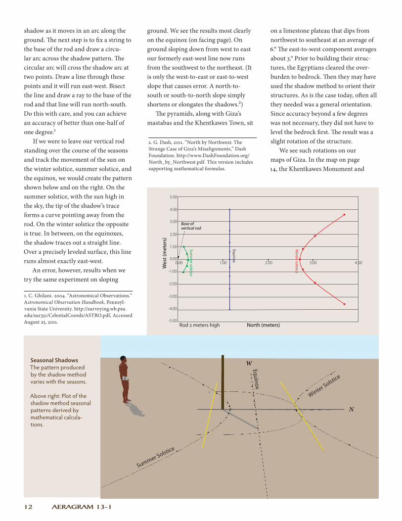
shadow as it moves in an arc along the ground. The next step is to fix a string to the base of the rod and draw a circu-lar arc across the shadow pattern. The circular arc will cross the shadow arc at two points. Draw a line through these points and it will run east-west. Bisect the line and draw a ray to the base of the rod and that line will run north-south. Do this with care, and you can achieve an accuracy of better than one-half of one degree.1
If we were to leave our vertical rod standing over the course of the seasons and track the movement of the sun on the winter solstice, summer solstice, and the equinox, we would create the pattern shown below and on the right. On the summer solstice, with the sun high in the sky, the tip of the shadow’s trace forms a curve pointing away from the rod. On the winter solstice the opposite is true. In between, on the equinoxes, the shadow traces out a straight line. Over a precisely leveled surface, this line runs almost exactly east-west.
An error, however, results when we try the same experiment on sloping
ground. We see the results most clearly on the equinox (on facing page). On ground sloping down from west to east our formerly east-west line now runs from the southwest to the northeast. (It is only the west-to-east or east-to-west slope that causes error. A north-to-south or south-to-north slope simply shortens or elongates the shadows.2)
The pyramids, along with Giza’s mastabas and the Khentkawes Town, sit
on a limestone plateau that dips from northwest to southeast at an average of 6.° The east-to-west component averages about 3.° Prior to building their struc-tures, the Egyptians cleared the over-burden to bedrock. Then they may have used the shadow method to orient their structures. As is the case today, often all they needed was a general orientation. Since accuracy beyond a few degrees was not necessary, they did not have to level the bedrock first. The result was a slight rotation of the structure.
We see such rotations on our maps of Giza. In the map on page 14, the Khentkawes Monument and
Seasonal Shadows The pattern produced by the shadow method varies with the seasons.
Above right: Plot of the shadow method seasonal patterns derived by mathematical calcula-tions.
0.00 1.00 2.00 3.00 4.00
5.00
4.00
3.00
2.00
1.00
0.00
-1.00
-2.00
-3.00
-4.00
-5.00North (meters)
Wes
t (m
eter
s)
Base of vertical rod
Summ
er solstice
Winter solstice
Equinox
Summer Solstice
Winter Solstice
Equinox
N
W
Rod 2 meters high

Spring 2012 13
The Effect of a Slope on the Shadow Method
On the left: a plot of the distance of the equinox sun shadow arc mathematically calculated. The results (in green) show that a north-south slope does not affect the line. True north is still derived correctly using the shadow method.
However, the sun shadow arc taken on an east-west slope of 3° causes the tip of the shadow to rotate counterclockwise (in red). Thus, deriving north from data accumulated over a west-east slope will result in an error.
Below: on the left the shadow method used on the equinox on a 3° slope. On the right, the image of the shadow method on the 3° slope is superimposed over the shadow method used on level ground on the equinox.
0.00 0.60 1.00 1.50 2.00
5.00
4.00
3.00
2.00
1.00
0.00
-1.00
-2.00
-3.00
-4.00
-5.00North (meters)
Wes
t (m
eter
s)
Level
3° N-S Slope
3° E-W Slope
Base of vertical rod
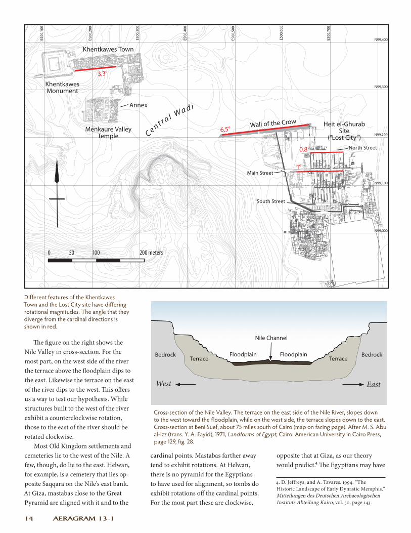
Khentkawes Town are rotated counter-clockwise by a little more than 3.° However, the Khentkawes Monument was the tomb of a queen, and the reason Khentkawes did not end up with a precise orientation may have to do with the monument’s history. Mark Lehner believes that Khentkawes was originally a “quarry cube,” a section of the plateau channeled out on four sides in order to prepare it for further quarrying into building blocks.3 A lowly quarry cube did not call for precise align-ment. When Khentkawes Town was built, it was aligned to the Khentkawes Monument and shared its misalignment.
Standing on the ground at Giza these misalignments are hardly noticeable. They only become plainly visible in a bird’s eye view, such as on a map. For the Egyptians, they may only have become a problem when one set of structures met another. One such case was in the so-called Annex of the Menkaure
Valley Temple. Here, the foot of Khentkawes Town meets the temple, which is oriented to the cardinal directions. The floor plans of intermediate structures needed to adjust for the difference.
The main thoroughfares of the Lost City, Main Street and North Street, are also rotated slightly, but only by a degree or so (see map, page 14). The Lost City was not built on bedrock like Khentkawes Town, but on the low desert terrace, which slopes gently down to the Nile floodplain. Thus, the Lost City exhibits a slight dip to the east which resulted in a one degree or so rota-tion off the cardinal points.
The Wall of the Crow runs 6.5° north of east. This devia-tion is so great that it is probably not a product of the shadow method. While we do not know the exact purpose of the Wall, it may have functioned in part as a flood diversion dam. As such, it may have been deliberately built to parallel the course of the Central Wadi, rather than being oriented to the sun or aligned to the rest of the Lost City.
3. M. Lehner. 2008. “Khentkawes and the Great Circle of Quarrying.” AERAGRAM 9-2: 14–15.
3° slo
pe
3° slo
pe
Drawn on flat surfa
ce
Drawn on slope
Rod 2 meters high
N
W
N
W
E500
,500
E500
,600
E500
,700
E500
,400
E500
,300
E500
,200
E500
,100
N99,000
N99,200
N99,300
N99,400
N99,100
AERAGRAM 13-114
Different features of the Khentkawes Town and the Lost City site have differing rotational magnitudes. The angle that they diverge from the cardinal directions is shown in red.
Cross-section of the Nile Valley. The terrace on the east side of the Nile River, slopes down to the west toward the floodplain, while on the west side, the terrace slopes down to the east. Cross-section at Beni Suef, about 75 miles south of Cairo (map on facing page). After M. S. Abu al-Izz (trans. Y. A. Fayid), 1971, Landforms of Egypt, Cairo: American University in Cairo Press, page 129, fig. 28.
4. D. Jeffreys, and A. Tavares. 1994. “The Historic Landscape of Early Dynastic Memphis.” Mitteilungen des Deutschen Archaeologischen Instituts Abteilung Kairo, vol. 50, page 143.
The figure on the right shows the Nile Valley in cross-section. For the most part, on the west side of the river the terrace above the floodplain dips to the east. Likewise the terrace on the east of the river dips to the west. This offers us a way to test our hypothesis. While structures built to the west of the river exhibit a counterclockwise rotation, those to the east of the river should be rotated clockwise.
Most Old Kingdom settlements and cemeteries lie to the west of the Nile. A few, though, do lie to the east. Helwan, for example, is a cemetery that lies op-posite Saqqara on the Nile’s east bank. At Giza, mastabas close to the Great Pyramid are aligned with it and to the
cardinal points. Mastabas farther away tend to exhibit rotations. At Helwan, there is no pyramid for the Egyptians to have used for alignment, so tombs do exhibit rotations off the cardinal points. For the most part these are clockwise,
Nile Channel
Floodplain Floodplain
West East
TerraceTerraceBedrock Bedrock
3.3°
6.5°
0.8°
1°
Ce n t r a l W a d i
Khentkawes Town
Khentkawes Monument
Heit el-Ghurab Site
(“Lost City”)
Wall of the Crow
Annex
Main Street
North Street
South Street
opposite that at Giza, as our theory would predict.4 The Egyptians may have
0 50 100 200 meters
Menkaure Valley Temple

R
0 50 100 150 200 km
R
0 50 100 150 200 km
Request AERA's E-Bulletin Keep up with AERA by signing up for our E-Bulletin, sent out periodically. Please e-mail: [email protected]. In the subject line type: “E-Bulletin.”
AERAGRAMVolume 13 Number 1, Spring 2012
Executive Editor: Dr. Mark LehnerScience & Arts Editor: Dr. Wilma WetterstromManaging Editor: Alexandra Witsell
AERAGRAM is published by AERA , Ancient Egypt Research Associates, Inc.,a 501(c) (3), tax-exempt, non-profit organization.
Ancient Egypt Research Associates26 Lincoln St. Ste. 5, Boston, MA 02135
E-mail: [email protected]: http://www.aeraweb.org
AERA Board Members President: Dr. Mark LehnerVice President & Treasurer:Matthew McCauleyAssistant Treasurer: Dr. John NolanSecretary: Glen DashDr. James AllenEd FriesJon JerdeBruce LudwigAnn LurieLouis HughesDr. Richard Redding
© Ancient Egypt Research Associates 2012
Follow AERA on Twitter @AERA_EGYPT
Visit AERA's Websitehttp://www.aeraweb.org
Detail of the northern part of Helwan Cemetery. Hatching indicates the extent of the cemetery. Contours are at 1-meter vertical intervals and grid values at 100- meter intervals. The grid is oriented to the cardinal directions. The rectangles are large tombs.
The Helwan Cemetery lies on the east bank of the Nile, where the prevailing slope is opposite that at Giza, resulting in a prevail-ing clockwise rotation of features. Figure from D. Jeffreys and A. Tavares, 1994, “The Historic Landscape of Early Dynastic Memphis,” Mitteilungen des Deutschen Archaeologischen Instituts Abteilung Kairo, vol. 50, fig. 11. Used with permission.
Spring 2012 15
Now In Boston! At the Museum of Science: The Lost Egypt exhibition, featuring AERA as an exemplary archaeological mission. The show highlights AERA’s use of science and technology to understand the people and culture of ancient Egypt.
Lost Egypt was created and produced by COSI (the Center of Science and Industry in Columbus, Ohio) and built by the Science Museum of Minnesota.
May 27 to September 3, 2012 Museum of Science Boston
used the shadow method the way today’s builders use a compass. A compass is not a precision instrument. If more precision is required, the builder can use a Total Station and sight Polaris at night. The Egyptians had similar options. When precision was required they could sight on the stars. But where precision was not required, and there were no local landmarks to align with, they may have used the shadow method. The evidence of that is preserved today in the errors they left behind. ~ Glen Dash
Cairo HelwanCemetery
Beni Suef
Giza

JOIN AERA TODAY
Your membership directly supports the main pillars of our mission at Ancient Egypt Research Associates: archaeological excavation, analysis, publication, and educational outreach.
Donors who contribute at the level of basic member ($55) or senior/student member ($30) receive our AERAGRAM newsletter twice a year and the AERA Annual Report hot off the presses, months before we post these publications to our website. Donors also receive invitations to special events and regional lectures, as well as firsthand updates on research from the field.
By contributing to AERA, you’ ll receive the benefit of knowing that you’ve made a valuable investment in us all, helping to broaden our knowledge of the past, make an impact in the education of our students, and strengthen the future of our global community.
Please join or contribute online at: http://www.aeraweb.org/support. Or send your check to the address below. AERA is a 501(c)(3) tax exempt, nonprofit organization. Your membership or donation is tax deductible.
Be Part of our Global Past, Present, and Future
MEMBERSHIPS: Basic: $55 Student/Senior: $30 Non-US: $65 Egyptian National: LE100 Supporting $250
Name ________________________________________________
Address ______________________________________________
_____________________________________________________
Phone _______________________________________________
Email address _________________________________________
Please make check payable to AERA.
Or charge your membership to a credit card:
Name on card _________________________________________
Card number _________________________________________
Verification Security number (on back) _____________________
Expiration date ________________________________________
Signature _____________________________________________
Please send application with payment to AERA at:26 Lincoln Street, Suite 5, Boston MA, 02135 USA
Zip Country