M/s Jemby Chem Limited is a working unit at Plot No. C-1/335 ...

ISLANDS OFF THE BEATEN TRACI( ... An archaeological journey to the Greek islands of Kastellorizo, Symi, Halki, Tilos and Nisyros
EDITED BY
Nicholas Chr. Stampolidis- Yorgos Tassoulas- Melina Filimonos-Tsopotou
MUSEUM OF CYCLADIC ART NICHOLAS AND DOLLY GOULANDRIS FOUNOA TION
Athens 2011
Ynoupye:io Ilo.Amop.ou Km Toupwp.ou Hellenic Ministry of Culture and Tourism

( Yali
' - Nisyros Pyrqousa
N ~ym>,fa' aut at >ea, accmding to Stcabo {XIV, 2, 15), ho> an am of 412 >q.""'
and is situated opposite Knidos and west of Tilos; Strabo also describes it as being "abot<~
60 stadia distant from Kos" (X, 5. 16)1 Pseudo-Skyllax (99, 8) places the island in Caria.
Stephanus Byzantinus (477, 7) in the Cyclades. In antiquity it was also called PorphlJT'_:
(Pliny, Nat. Hist. V 36) "from the porphyry in it" (Stephanus Byzantinus 477, 11), owing rc
the presence in its waters of the Mediterranean shellfish Murex that produce the famous
purple dye, and are also found around the neighbouring islands of Kos and Rhodes.
The island is at the east end of the active volcanic arc in the southern Aegean, whicb.
extends from the Megarid to the peninsula of Halicarnassus, passing through Methana.
Melos and SantorinF. Nisyros and the nearby islets of Yali and Strongyli to the north.
Kandeleousa, Pyrgousa and Pachia to the west, were created by volcanic eruptions, the
most recent of which has been dated to about 15,000 years ago. It was then that the calderc
was created in the centre of the island of Nisyros which, after repeated hydrothermic
eruptions, today comprises ten craters, the largest and most imposing of which is callec
"Stephanos", widely known as "the Nisyros volcano" (fig. 1).
The myth about the genesis of Nisyros, as handed down by the ancient authors certain ly
reflects the way in which the island was formed: "They say that Nisyros is a fragment of Kos.
and relate the myth that Poseidon, when he was pursuing one of the giants, Polybotes, broke off a
fragment of Kos with his trident and hurled it at him, and the missile became an island, Nisyros,
with the giant lying beneath it. But some say that he lies beneath Kos." (Strabo, X, 5, 16 ); "Polybotes
was chased through the sea by Poseidon and came to Kos; and Poseidon, breaking off that piece
of the island which is called Nisyros, threw it at him" (Pseudo-Apollodorus, Bibliotecha I, 38,
1. Regarding Nisyros in general, see RE XVII.l (1936), s.v. Nisyros, 761-767 [R. Herbst]; Papakostas 1969; Papakostas 1972; Konstantinopoulos 1976; Buchholz- Althaus 1982, 14-20; Papachristodoulou 1993; Oikonomakis 2001; Reger 2004, 763-764; Filimonos-Tsopotou 2005a. 2. See Fytikas - Vougioukalakis 2005.

Fig. 1: The crater of the volcano. On this Attic black-figure amphora depicted is Poseidon crushing Polybotes (Museum of Cycladic Art [MCAl. inv. no. Ln 98)
Fig. 2: Early Cycladic figurine from Nisyros. Berlin Museum. inv. no. 8428 (22"0 EPCA photo archive).
4) . A favourite theme of Attic vase-painters was the
myth of Poseidon plucking an enormous boulder fror:::
Kos, hurling it at the giant Polybotes and crushing
him, thus creating Nisyros (see fig. 1). The island is a
high volcanic cone with a crater in the centre that is
surrounded by mountain massifs, the highest of whiC.:::
is Profitis Ilias, or Diavatis, with an elevation of 698
m. Strabo described Nisyros (X, 5, 16) as follows: • :
is round and high and rocky, the rock being that of which
millstones are made".
Owing to its volcanic origin, the island is highly fertile
and forested, although it has no natural sources of
drinking water. From antiquity to the beginning of the
20th century, its inhabitants exploited every bit of arable land, and on all the steep slopes
created tillable terraces (tavles), which are supported by low stone retaining walls, cal lee
vastadia. Thyme, prickly broom, savoury, heather, Campanula nisyria and trees such as
oak, Pistachia terebinthus (called agramythia locally), olive, almond and fig trees, are just a
few of the indigenous plants and trees that make the island green.
FROM THE STONE AGE TO THE BRONZE AGE
Indications that Nisyros was inhabited in the Neolithic period, at least from the 4-"
millennium BC. exist only in sporadic finds 3. Certainly the location of Nisyros - anothe~
bridge to the Aegean sea routes that link the islands to various points on the mainland -
favoured its early habitation, contemporary with the buildings that have been confirmed
by excavations on the neighbouring islet of Yali. The island's volcanic rock, which is
suitable for making tools, and its fertile soil must have contributed to the development of
the first agricultural and stock-farming installations. To this period belong the blades of
obsidian from Melos that were found in Mandraki, as well as an intact clay skyphos from
the region of Emporia (cat. no. 19).
The Early Cycladic marble figurine (fig. 2) that was acquired by the Berlin Museum in
1874 (inv. no. 8428)4 dates to the Early Bronze Age, circa mid-3'd millennium BC; from the
same period are three intact clay pots that were found in the Mandraki region (cat. nos. 20
and 21). Also in Mandraki, in the Palaiokastro area, a stirrup amphora was found dating
to the Mycenaean period with a depiction of octopuses and birds. This vase is the sole
evidence we have to date that the area was inhabited in the Late Bronze Age5. Indications
of contemporary human activity have also come from the Nyphios valley, a site that
should perhaps be associated with the later cult of the Nymphs.
3. Regarding prehistoric Nisyros, see Marketou 2009c. 4 . Rohde 1974, 152, no. 7, pl. 9:1. 5. The vase was handed in to the Nisyros Museum in July 2011 by Mr. Antonios Karpathakis, son of Met. Karpathakis, who had found it some decades earlier on his property. The existence of the amphora was known to the 22"ct ECPA through its precise description by the antiquity-lover Dinos Papadelias, who had joined the parts together; see C. Doumas in All 29 (1973-74), Xpov., 964-965.

Fig. 3: General view of the excavation. 1984 (22"" ::PCA photo archive).
Fig. 4: Ashes from cremation in an oinochoe. (22"" ::_=>(A photo archive).
FROM THE GEOMETRIC PERIOD TO LATE ANTIQUITY
Diodorus (V, 54) refers to the first inhabitants of Nisyros as Carians; they were followed
by Dorians from Kos and later, at some indeterminate period, by Rhodians. According
to Herodotus (VII, 99), the island had a Dorian population from Epidaurus. In the
Catalogue of Ships in the Iliad (II, 676, ff.) it is reported that Nisyros, together with Kos
Karpathos, Kasos and Kalymnos, took part in the Trojan expedition with thirty ships.
under the command of Pheidippos and Antiphos, the two sons of Thessalos, king of Kos.
Homer's reference is the oldest written reference to the island, which shows that at this
early period, Nisyros already had a significant naval force. It is possible that the islam:
was subject to the neighbouring island of Kos at that time6 Indicative of the old bonds
between these two islands is likewise the existence of the aristocratic family of Nisyriads
in Kos in the Hellenistic period7.
The first archaeological remains that tell the story of Nisyros in the early historical perioc
date to the 8th and especially the 7th cent. BC. This was the period when the Greeks we::e
opening out to the west establishing colonies, and to the east developing trade. At the enG.
of the 8th century BC, city-states were created on the Greek mainland and on the islanci.s
Fragments of archaic pottery from Palaiokastro testify that the town of Nisyros, with the
same name as the island, was established on the hill overlooking the modern settleme.;:;:
of Mandraki. But the most important source of knowledge about the island's archaic
period (7th-6th cent. BC) lies in the rich finds from the extensive necropolis, which prove
the existence of an organised and prosperous community that maintained commercia.
relations with the nearby islands, the cities of the eastern Mediterranean and the opposi e
coast of Asia Minor.
The first systematic excavations on Nisyros took place in April of 1932 under the Italia=
archaeologist G. Jacopi, during the period of Italian rule in the Dodecanese. The excavatior:
that took place then on the Kostas property in the vicinity of Ai-Yiannis above Mandrak:
revealed a significant section of the ancient necropolis. Twenty-two funeral pyres and t\ ·o
burials in pithos jars were investigated from the archaic period, as well as l2 burials ir:
pithos jars from the classical era and two built graves from Hellenistic and Roman times~
Another part of the same large cemetery was discovered between l 981 and 1984, when the
island's Municipal Stadium was being built. In the rescue excavation that was conductec
by the 22nd Ephorate of Prehistoric and Classical Antiquities (EPCA), 36 funeral pyres were
found dating from the 7th to the 5th cent. BC, one burial of a child in a pithos jar from the
6th cent. BC, 41 pithoi and 11 sarcophagi with burials from the 5'h and 4th cent. BC, as we~
as 13 built graves and built-in containers from the Hellenistic period (fig. 3)9.
The customary burial practice in the 7th and 6th century BC was cremation for adults and
interment in earthenware vessels for children, who had not yet become full members of the
society10. Cremation of the dead must have taken place in a separate part of the cemetery.
6. See also Paton - Hicks 1891, XII; Herzog 1928, 45. 7. Sherwin-White 1978,32, n. 16. 8. Jacopi 1932-33a. 9. Filimonos (-Tsopotou) 1993,143-144. 10. Regarding the custom of cremation, with the related bibliography, see Stampolidis 1996, 93-1 20.

Fig. 5a-b: The stele of the athlete in the Istanbul Archaeological Museum. and the extant part of the stele of a seated female figure in the Nisyros Archaeological Museum. (22"' EPCA photo archive).
after which the remains -together with the grave goods that accompanied the corruptible
body, mainly clay pots, some with offerings of liquid or solid food- were placed in shal lm··
rectangular or oval pits11 . In the deepest part of the cinerary pit, together with the fe\'·
remaining charred bones, were usually the smallest pots and utensils (lamps, perfume
jars and drinking cups), while on the upper part would be a plate and the fragmen ts of the
oinochoe that the family of the deceased would break after the last libation was pouree
on the grave to extinguish the pyre (fig. 4) 12 Most of the clay vases, with vivid painteC.
scenes, belonged to the local ceramic output of eastern Doris. In fact, the oinochoai ar:c especially the plates with their characteristic decoration in two semi-circles have bee::
attributed to the "Nisyros workshop" (cat. nos. 47, 50). Also significant is the presence
of Corinthian vases, mainly the small globular aryballoi containing aromatic oils ca:_
nos. 57, 58), with fewer pots originating from the workshops of Miletus (cat. nos. 46, 61
In about the mid-6th century BC, the first vases from Attic workshops (cat. nos. 53, 62
appeared on Nisyros, and gradually prevailed there as they were to do in the rest of '-e
Mediterranean.
The expansionism of the Persians and their conquest of cities along the coast of As::C.
Minor also determined the fate of this small island. Thus, in 480 BC, Nisyros, togethe::
with Kos and Kalymnos, was under the rule of Artemisia I, queen of Halicarnassus, a.u.C.
took part in the naval battle of Salamis on the side of the Persians (Herodotus, VII, 9
After the victorious outcome of the war for the Greeks, Nisyros was liberated from ce
Persian yoke and joined the Delian or First Athenian League, paying an initial uibt-:.e
of one talent and 3000 drachmas and, from 442/441 BC on, one talent. Altogether i ...s
mentioned nine times in tax rolls, in the category of tax on islands or Ionian
In about the mid-5th cent. BC, burial customs on Nisyros changed. The dead ceased to ~
cremated, and throughout the 4th cent. BC were buried in large clay vessels. To date, U:.e
excavation research has brought to light just a few, but particularly wealthy 5th cenL
interments in clay jars, accompanied exclusively by vases from Attic workshops. T ··
exceptional examples of marble reliefs from this period are the grave stele of the ath e:.e
with a disk and javelin, today in the Istanbul Museum14 (fig. Sa), and the section :
a grave stele with the scene of a seated female figure (fig. Sb) in the Archaeologica..
Museum of Nisyros 15.
After Athens was defeated in the Peloponnesian war, Nisyros became politically depende::.:
on Sparta, from which it was liberated after the naval battle of I<nidos in 394 BC, fo llowi;:;5
Rhodes, which had driven out the Spartan fleet (Diodorus, XIV, 84, 3-4). The name o:
Nisyros, as well as those of Kos and Kalymnos, did not appear on the tax rolls of the Seco- C.
11. These were simple cinerary pits, with average dimensions of 1.20 x 0.80 m. that differ from tl:.e pyre graves on Rhodes and neighbouring Kos, in which the deceased was cremated on the buriC.: ground (Gates 1983, 22-24; Bosnakis 2001; Skerlou 2001). Cf. the pits with a round perimeter o~ Pithikoussai (Ridgway 1992, 84-85). 12. According to the rites performed in the Homeric description of the funeral of Patroclus (Iliad, XXl!I 13. See Fraser- Bean 1954, 147 and Reger 2004, 763-764. 14. Reinach 1901; Pfuhl- Mobius 1977, 14, no. 14, pl. 5. 15. Jacopi 1932-33a, 550, pl. 3, fig. 95; Pfuhl- Mobius 1977, 28, no. 64, pl. 17.

Fig. 6 : Aerial photograph of the Nisyros wall. (22"" O: ;::>(A photo archive).
Delian League, which the island apparently did no
join16. Now independent, Nisyros was to enjoy some
two centuries of autonomy, as proved by the silver
and bronze coins it minted in the 4th century BC
bearing the place name Nll:Y17 (cat. nos. 37 - 39
and the decrees issued by the independent deme o:'
the Nisyrians (cat. no. 22), which were carved o;:
stelae placed in the agora or in the island's ma.i::i
sanctuary, that of Argive Poseidon18. The ruling
body was the assembly of the deme, which maC:e
decisions on the proposals drafted by the Boule. T;:;e
eponymous archon of the state of the Nisyrians
was the damiourgos, while the body of the prosrare:
(chiefs) may have wielded executive power.
Between the years 355 and 332 BC, Nisyros, togethe::
with Rhodes, Tilos, Kos and Kalymnos, came unde~
the control of Mausolus, satrap of Caria, and his
successors, who were aiming to create a powerful political entity and a strong defensive
front in the region19. The period of Carian sovereignty coincides chronologically \\iLL
the building of the strong defensive wall around the city of Nisyros, as preserved tocta:·
and thus most scholars attribute this significant fortification work to the dynasty of r:!:e
Hecatomids20• The victorious descent of Alexander the Great into Asia put an end to the
Caro-Persian rule of the islands.
The wall on the low hill over Mandraki demarcated the ancient city that had existed ear · e:
on the same naturally fortified site, since at least the 8th-7th century BC, and occupied the
flatland and the western slope of the hill looking out to sea. The city's houses were bliL:
on this hill, which ends in steep cliff. as attested by the retaining walls and tanks fo::
collecting rainwater that can be discerned here and there. The same terraced layout c.ar:
be found on the steep grade in the ancient cities of the neighbouring islands of Halki an ·
Tilos. The area of the city of Nisyros has been calculated at approximately 10 hectares.
and its population at some 2000 residents21 . The archaeologist Ludwig Ross, who visin~C.
the island from 9-11 August in 1841, found 500 families and 2,500 inhabitants22. -:-o
16. Fraser- Bean 1954, 140. 17. See Head 1911, 635 and Ashton 1999. 18. For a catalogue of known decrees issued by the deme of the Nisyrians see Papachristodoulou 2004,444. 19. See Sherwin-White 1978, 70, n. 212. Regarding the "fortification" policy of the Hecatomids, see Pimouguet-Pedarros 2000, 314-321. In addition to their military reasons, the expansion by the satraps of Caria to the islands ensured them a safe maritime region that would allow them to share the profits of trade in the eastern Mediterranean, which Rhodes and Kos had taken into their hands after their synoekismos in 408/7 and 366 BC respectively (Pimouguet-Pedarros 2000, 316, n. 1310). 20. Bean- Cook 1957, 138-143; Sherwin-White 1978, 70, and n. 212; Hornblower 1982, 331-332; Pimouguet-Pedarros 2000, 31, 296, 298-299. Karlsson 1994, 151, 153, believes that the walls of Nisyros, Tilos. Amyzon and Kaunas belonged to the period in which Idrieus. dynast of Caria, ruled (351-344 BC). 21. Hoepfner 1999, 135. 22. Ross 1843, 70-72.

Fig. 7: The inscribed blocks in the Nisyros wall. (22"" EPCA photo archive). -·----·-··---- -------------
Ross, moreover, is owed the first description of the
visible ancient remains in Palaiokastro, the state of
which, fortunately, has not changed perceptibly up to
the present day. The most significant public buildings
and sanctuaries would certainly have been built on
the flatland at the edge of the city. Religious worshi;:;
continued on the site of the acropolis, as attested by the
presence of a large early Christian basilica dating fran:;.
the 6th century AD.
The ancient harbour was located in a fertile region cal lee
Limnes today, which has been silted over for centuries.
The name was passed on by Ross, who described the
region as swampy. Stout walls of basaltic andesi:e
near the present-day cemetery and in the region of Ai·
Savvas should be interpreted as retaining walls relatee
to the harbour of Nisyros23.
The wall of the ancient city (fig. 6) is one of the best preserved ancient fortifications in t!:!e
Aegean region24. Built on the brow of the hill, it extended northward to the rock on wh!ci:
the medieval fortress and the monastery of Panayia Spiliani stand today. In the acropo--=s
region, the wall was built with coursed trapezoidal masonry on two faces and filled ..::
with rough stones and rubble. Basaltic andesite, the local black volcanic rock, was used :c
build it. The width of the wall ranges between 2 metres in the south to 3.65 m. in its eas:
section. To reinforce its defensive capabilities, rectangular towers were built at regllic.:
intervals, six of which have been preserved on the south and two on the east section of d:e
wall. The towers are almost square on plan, with the length of one side being from 6.- ~
to 9 m; they are solid up to the height of the parodos, i.e. the ramparts around the weLls
The relatively small dimensions and the design of the towers, without loopholes or roocs
in which to place catapults, argue for an early dating of the wall to the 4th century BC, :.e. before the development of siege technology25
This dating is confirmed by a significant inscription L-.AMOI:ION TO XOPION TIE:\ . .::.
I10L-.E2: ATIO TO TEIXE(02:) that is carved on the outside of the eastern section of r.he
wall (fig. 7), north of the gate, and dates to the third quarter of the 4th century BC26. -=::e
inscription stipulates the minimum width of the public zone around the wall that mus_
for defensive reasons, remain free of all other uses, as about 1.50 m. (five feet) . The widd:
defined is unusually small, but not unique. Two archaic inscriptions from Paras de5.r:.e
23. See Filimonos-Tsopotou 1980, 61-62. 24. Regarding the wall, see Dawkins- Wace 1905-06, 165-168; Bean- Cook 1957; Pimouguet-Pecic:ros 2000, 298-299; M. Filimonos (-Tsopotou) in At! 54 (1999), Xpov. , 958. 25. Towers of like dimensions can be found in the defensive walls of early fortifications of the Hecatomids in Caria on the opposite coast, such as in Halicarnassus, Alinda, Alavanda and Myndus; see McNicoll 1986, 309. According to Winter 1994, 33, in the walls of western Asia Minor, there are no examples of rooms in towers prior to the early Hellenistic period. 26. IG XII.3, 86 = Syll.3 936 =Majer 1959-61, 178-180, no. 47 (with the earlier bibliography); Hellmann 1999, 13, no. 1; Pimouguet-Pedarros 2000, 31.

Fig. 8 : ne qate in the Nisyros wall. (MCA photo
- r;. 9: One of the stairways on the wall; in the -<=-' ~ u'lO ;s the qate. (MCA photo archive).
the public zone as a distance of three feet around the walP7_ The width of the free zone
around the fortification wall of Ephesus and of Skotoussa in Thessaly is larger, as stated
by epigraphic texts of the 3'd and 2"d century BC respectively28.
The only surviving gate is located in a recess in the southeast corner of the wall, on a
protected site unseen by the enemy (fig. 8). To increase its protection, the corner tower
was built facing it, from which the defenders could comfortably attack any would-be
invaders. The gate, which has been preserved intact, has a width of 2.10 and a height of
3.20 m., and is covered by oblong stone blocks, whose length exceeds 3 m. It closed with
a two-leaf wooden door that was secured by a horizontal bar. The socket in which the bar
was inserted is visible on the inner side of the inner side of the gateway.
Inside the wall, the stairs leading up to the ramparts have been preserved in excellent
condition. On its eastern section, two stairways have been preserved to an impressive
height of 16 and 18 steps (fig. 9). On the south side of the wall, there are more stairways
that facilitate access to the corresponding towers. The stairs leading to the second towe:
on the south side of the wall have been preserved in very good condition to a height of
15 steps.
The fifth tower on the south side, which has been preserved over its entire height of 10
m., is the only one with different masonry. It was a later addition in order to reinforce
the existing tower that had partially collapsed. The new tower was built in the pseudo
isodomic system, with the insertion of headers at regular intervals between the stretchers.
according to the emplekton construction system. This feature of the masonry, which lends
stability to the walls, can be encountered on many fortifications in Caria and dates the
tower to about 300 BC29.
Both this tower and several sections of the wall presented dilapidation problems thar
have been exacerbated by the minor seismic tremors that continue to plague the island to
this day. In 1999, the design and topographic mapping of the wall was conducted by the
22"d EPCN°, and between 2003 and 2008, with funding from the South Aegean Regiona..
Operational Programme, the Ephorate undertook restoration works with original materia.
and consolidation interventions, while at the same time works were carried out to enhance
and landscape the ancient fortification wall (fig. 10)31.
The strong wall around the city of Nisyros was by no means the state's sole line of
27. IG XII.5, no. 115. 28. Majer 1959-61, no. 71; Missaelidou-Despotidou 1993,212-213. See also Winter 1971, 125, n. 6C. On the Hellenistic defensive wall of Rhodes, the free zone inside the wall was 30 m. wide, and cor· responds to the theoretical advice of Philon of Byzantium, A 10; see Filimonos-Tsopotou 2004, 74. 29. Regarding masonry see Karlsson 1992, 67-95. Cf. the contemporary fortifications of Herakleia at Latmos and part of the Miletus wall (Karlsson 1994, 147-150. A different view in Pimouguet· Pedarros 2000, 76-77, 89-91. 30. Mapping was done by the architect-engineer Nilos Pitsinos and the surveyor Eleni Vassileiadou. with funding from the Ministry of the Aegean; see Filimonos-Tsopotou in AL'l 54 (1999), Xpov. 958. 31. The work was done as part of the project "Consolidation, restoration and enhancement of the an cient wall of Nisyros". Archaeologists Christina Kiamou and Maria Halkiti were responsible for the archaeological documentation; the architect-engineer Anna Apostolou was responsible for drawing up the plans and supervising the works to restore and landscape the wall, with civil engineer Dr Kostas Zampas as consultant on static issues. Regarding the project see Filimonos-Tsopotou - Apostolou 2009 and the reports in the AL'l (Xpov.) from 2001 on.
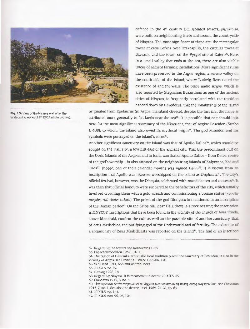
Fig. 1 0: View of the Nisyros wall after the ,andscaping works (22"" EPCA photo archive).
defence in the 4th century BC. Isolated towers, phryktoria,
were built on neighbouring islets and around the countryside
of Nisyros. The most significant of these are: the rectangular
tower at cape Lefkos over Drakospilio, the circular tower at
Diavatis, and the tower on the Pyrgoi site at Katero32. Here,
in a small valley that ends at the sea, there are also visible
traces of ancient farming installations. More significant ruins
have been preserved in the Argos region, a serene valley on
the south side of the island, where Ludwig Ross noted the
existence of ancient walls. The place name Argos, which is
also reported by Stephanus Byzantinus as one of the ancient
cities of Nisyros, is frequently correlated with the tradition
handed down by Herodotus, that the inhabitants of the island
originated from Epidaurus (in Argos, mainland Greece), despite the fact that the name is
attributed more generally to flat lands near the sea33. It is possible that one should lao ·
here for the most significant sanctuary of the Nisyrians, that of Argive Poseidon (Strabo
I, 488), to whom the island also owed its mythical origin34 . The god Poseidon and his
symbols were portrayed on the island's coins35.
Another significant sanctuary on the island was that of Apollo Dalios36, which should be
sought on the Dali site, a low hill east of the ancient city. That the predominant cult o=
the Doric islands of the Aegean and in Ionia was that of Apollo Dalios- from Delos, centre
of the god's worship - is also attested on the neighbouring islands of Kalymnos, Kos anci
Tilos37. Indeed, one of their calendar months was named Dalios38. It is known from a.:::
inscription that Apollo was likewise worshipped on the island as Delphinios39. The ci~'s
official festival, however, was the Dionysia, celebrated with round dances and contests.:;:. :c was then that official honours were rendered to the benefactors of the city, which usual.:.. ·
involved crowning them with a gold wreath and commissioning a bronze statue (xpvof.<:..
an:rpavqy Kal £iK6vr xaJtK£a). The priest of the god Dionysos is mentioned in an inscrip ·a=
of the Roman period4 1. On the Krios hill, near Dali, there is a rock bearing the inscrip io=
t.IONYL:OY. Inscriptions that have been found in the vicinity of the church of Ayia TriaG..
above Mandraki, confirm the cult as well as the possible site of another sanctuary, ~:
of Zeus Meilichios, the purifying god of the Underworld and of fertility. The existence o:'
a community of Zeus Meilichiasts was reported on the island42. The find of an inscribeC.
32. Regarding the towers see Kontoveros 1959. 33. Papachristodoulou 1969, 10-11. 34. The region of Hellenika, where the local tradition placed the sanctuary of Poseidon, is also in :l:e vicinity of Argos; see Dawkins - Wace 1905-06, 170. 35. See Head 1911, 635 and Ashton 1999. 36. IG XII.3, no. 92. 37. Herzog 1928, 18. 38. Regarding Nisyros. it is mentioned in decree IG XII.3, 89. 39. Chaviaras 1913, 8, no. 6. 40. "avayop£Dacu 6£ rov ari cpavov tv r4J a[y]wvz rwv L1zovvaiwv rq nparq Ctfiipq rwy KVKAiwv" ; see Cha\'ia:-c.S 1913, 7, no. l. See also the decree, Peek 1969, 27-28, no. 63. 41. IG XII.3, no. 164. 42. IG XII.3, nos. 95, 96, 104.

base of a votive offering to Aphrodite Pontia on the north coast of the island near Loutr2
shows that the sanctuary of the goddess must have been near the sea, as is the case on
neighbouring Kos.
During the Classical and Hellenistic period, the same cemetery continued to be in use
in the region of Ai-Yiannis, and also on the slopes of the hill outside the wall. On the
Kampi site, south of Palaiokastro, when the field belonging to Hatzinikolaou-Lentis was
being ploughed, part of the classical necropolis was brought to light in 1969 by the late.
unforgettable archaeologist Eos Zervoudaki, then curator at the Ephorate. Twenty-foe
graves were excavated, dating to the 4th and y ct century BC43. Most recently, while the
foundations were being laid for the archaeological site guardhouse in 2007, a sm<L..:
section of the same necropolis was unearthed; three funeral pyres, and seven interments
in pithos jars and amphorae of the 5th and 4'h cent. BC have since been investigated44.
In the 4th cent. BC burials were mainly in large undecorated broad-mouthed storage ja.-s
(pithoi) . There were fewer burials in terracotta sarcophagi45. Grave pithoi were placed o=
their side, all facing in the same direction, and were supported by stones, their mout::
was closed by another vase or, more rarely, a stone slab. The abundant, mostly clay gra ·e
goods were usually placed inside the jar, but sometimes outside it as well, touching its
walls. Children were buried in smaller pithoi or pointed amphorae, accompanied to the::
journey to the Netherworld by many terracotta figurines (cat. nos. 71 - 78). The figurines
were made in local workshops and belong to the coroplastic tradition of the easte:::
Mediterranean, in contrast to the clay vases that originated almost exclusively from A ~
workshops, and indeed from workshops that manufactured vases primarily for expon ca:.
nos. 70, 82, 86).
In the early 3'ct cent. BC, people ceased to be buried in clay jars and sarcophagi, and we:e
now being buried in built cist graves. With a flat or vaulted roof, these graves sometimes
took on a monumental form, were plastered inside with white stucco and marked \ "i::.:::
noteworthy monuments, grave statues, relief stelae, cylindrical altars, and touching 1~-::c
epigrams46 (cat. no. 28). Their grave gifts were not luxury goods; clay pots produceG. :;_
local workshops are predominant and jewellery is minimal. There are some remarkable
glass vases from graves of the early Christian period that have been found in the sarr:e
extensive necropolis.
During the y ct cent. BC, the course of Nisyros was determined by the policy of the
Hellenistic states. The island maintained close relations with neighbouring Kos and \\i~
the kingdoms of the Ptolemies and the Macedonians. Among the great kingdoms, the
Rhodian state - with a democratic political system and a new capital on the north par:
of the island, the city of Rhodes, with five safe harbours - evolved in the late 3'ct cent. BC
into the primary naval power in the Aegean with a strong economy. With its swift, agi e
ships, Rhodes hounded the pirates out of the region and became known as the guaranto:
43. Zervoudaki in AL'l (25) 1970, Xpov., 518. 44. Bairami in AL'l 2007, Xpov., (at press). 45. Filimonos-Tsopotou 1980, 64-73. 46. Peek 1967, 369-376.

of maritime freedom. From the 4th cent. BC on, in addition to part of the Peraia (Rbodian
controlled sites on the Asiatic mainland), the islands of Halki, Symi, Megisti and Karpathos
were subjugated to the Rhodian state. Neighbouring Tilos, an ally of Rhodes from tbe
early 3'ct cent. BC. also became subject to the Rhodian state politically in the second h~
of the same century. The leading role of Rhodes, strengthened by the dwindling power :
the Ptolemies and its own interests in the region, inevitably brought it into conflict \\i "
Philip V of Macedonia, who was endeavouring to extend his rule into the eastern Aegea::
Incited by Philip, the attack by Cretan pirates on the islands, which may have induce-C.
Nisyros, precipitated the First Cretan war (205-201 BC) and changed the political scene il::
the region. One of the episodes in the war was the naval battle fought opposite -is~--:-os
near today's Kardamaina, on cape Lakitiras of Kos47. And inevitably for the Greeks, tl::e
decision of Rhodes and Pergamum to call on Rome for help against the Macedonia::s
brought about the Romans' active involvement in the affairs of the Greek cities and pavee
the way for the latter's full subjugation to Rome just a few decades later.
From the epigraphic evidence, it can be concluded that Nisyros came under the Rhodia.::.
state in 201-200 BC48. To the same period dates an excerpt from a letter written by ?·- ·'~
V to the Nisyrians, delivered by their compatriot Kallias, and the relevant decree issued:.._·
the deme of the Nisyrians49• The text shows either that the Macedonian king had dedce:::
to disengage the island from the sovereignty of Rhodes for a brief period, allm :::5
the inhabitants to obey the ancestral and established laws (ro'fc; v6)Amc; rofc; rrarofoz
imcipxovmv xpfiaBat), or that Nisyros had a brief period of Macedonian rule before ::s final submission to the Rhodian state50. In the end, Philip V was defeated in 197 C :..
the Romans at Cynoscephalae, with the help of Rhodes, thereby reinforcing its pos!...: -
territorially, after which it assumed the leadership of the Koinon of the Islanders.
Three significant inscriptions confirm the fact that the Nisyrians who had served in :.::::
Rhodian fleet occupied significant offices after the island's submission to the Rboei2!=
state. The first is the inscription on the pedestal of a statue, a work by the sculp;:c::
Epicharmos from Soloi, in honour of a Nisyrian strategos (general, commander) ded.icc.:eC.
by his grandchildren to Argive Poseidon and to Ares, dating to the mid-2nct cenL B0 .
The honoured man, "arparnyfzaavroc; tv vaval KarC!. rr6A£)AOV rov KpnnKov", had served ir: == Rhodian fleet during the first or second Cretan war (155-153 BC), and under the commc.:::::::
of the Rhodian admirals Kleonaios, Akesimbrotos and Eudamos52.
The second inscription honours Euthraptidas son of Simias (arparwaaci)A£VOV tv iuppciKrozc;) who had twice been awarded a gold wreath by the members of the koino= _:
the Panathenaistai, and served on two Rhodian triemioliai (long, undecked ships nan:.e-C.
Euandria and Polias (1" cent. BC- 1" cent. AD)53.
47. Karanastasis 1963. 48. See Fraser- Bean 1954, 151; Wiemer 2002, 196-197, n. 43; Papachristodoulou 2004, 441. 49. IG XII.3, 91 = Syll. 572. 50. See Fraser- Bean 1954, 152; Wiemer 2002, 197; Papachristodoulou 2004,441-442. 51. IG XII.3, 103 = Syll .3 673. 52. On dating the inscription see Fraser- Bean 1954, 148-151; Sherwin-White 1978, 127, no. 239; Rice :9 222-224; Papachristodoulou 1993, 44-45; Wiemer 2002, 153-154; Bairami 2004, 459; Gabrielsen 1997, 166. :::.. ~ 53. Chaviaras 1913, 9-10, no. 9.

The third honorary inscription, on a cylindrical base, refers to Gnomagoras son of Dorotheos
from Nisyros who had served on a triemiolia named Euandria Sebasta (Tvw11ay6pav !1wpo8w.
Newvpwv arparwaa11evov £v rp11111IDi\iq q: ovo11a Evavc5pia l:ef3aara)54. Gnomagoras had bee.::
honoured with a gold wreath frequently by the Boule in Rhodes, but also in his homela::C:
with the offices of priest of the Sebastoi (emperors), damiourgos and gymnasiarchos :. "'
cent. AD). Given that the crews of Rhodian warships were almost exclusively Rhodia::
citizens, for whom service in the navy was a supreme patriotic duty55, it is natural that ce
recognition of a Nisyrian in this service would also be expressed on his island accordi::5
to the Rhodian tradition, by putting up statues in celebrated sanctuaries, or after death·::::
erecting impressive grave monuments. The base in the shape of a warship's prow (caL:::
26) that was found in the vicinity of the ancient necropolis obviously belonged to sud: c.
monument
In the 2nct cent. BC, Nisyros, as a deme incorporated into the large Rhodian state, followee
its own destiny. As the inscriptions testify, many Nisyrians moved to the capital of the
united state, to the "city", but also to other regions of Rhodes, which was then in the
heyday of its financial and political power. In 164 BC, Rhodes was obliged to conclude c.
treaty with the Romans, abandoned its independent policy and, despite being formall_ ·
autonomous, became bound to the chariot of Rome. The fate of Rhodes, as well as tha~
neighbouring Kos, was also followed by Nisyros.
The few epigraphical texts that have been preserved show that Nisyros remained c.
deme in the united Rhodian state until the late imperial era 56. The Roman thermal baths
complex proves that the Romans were interested in exploiting the hot sulphurous wate::
that bubbled up on the volcanic island. Strabo refers to the thermal springs (X. 5, 16: ;~
has also a city of the same name and a harbour and hot springs and a temple of Poseidon.) The
Roman Thermae were discovered in 1886 on the coast of Paloi57, which then offered a safe
anchorage, as indicated by the name of the site from the Latin word pal us, from the poles
to which ships were moored58. The large vaulted rectangular chamber - within which.
in a cave-like hollow, there is a spring with subsaline mineral water - was excavatee
by the antiquity-loving Nisyrian doctor P Pantelidis59. Today part of the ceiling vault
has collapsed, and in 1871 a small single-aisle chapel was built on the site with the
characteristic name "Panayia Thermiani". The complex of the Roman thermal baths on
Nisyros, which can be dated to the 2"ct-3rct cent AD, together with the large complexes of
the Thermae in the Asklepieion and the city of neighbouring Kos, must have occupied
a significant area. This at least is shown by the sections of strong walls that are visible
behind the last houses in today's settlement, but also by the stone-paved room with walls
that have preserved a coating of hydraulic stucco that was revealed by excavations in
54. IG XIL3, 104. The name of the ship is likewise mentioned in other contemporary Rhodian inscriptions; see Blinkenberg 1938, 18-19, nos. 40, 41 , 43. 55. See Gabrielsen 1997, 96, n. 70. 56. See Rice 1984, 185. 57. Andriotakis 1888. 58. Papachristodoulou 1969, 12, n. 4. 59. Pantelidis 1891.

1986 and, in all likelihood, belongs to a bath complex60. Very near the Roman baths, on
the coast of Paloi, new bathing facilities were built at the end of the 19th century by Dr.
Pantelidis; but their refurbishment, which was attempted recently, was unfortunately no:
completed.
During the Roman period, the city gradually moved away from the fortified site a:
Palaiokastro towards the coast, a common phenomenon on the Aegean islands. Rescue
excavations near the Limnes site, a region which, according to Ross, was initially a mars:::
and which in antiquity would have been washed by the sea61 , revealed building remair:s
dating to the y ct and 4 th cent. BC, confirming that the silting up of the ancient port hac
already begun then, as of course had habitation62. On the same site, after the harboCI
was completely covered by alluvial deposits, the present day picturesque settlement o:
Mandraki was established and developed along the coastline, and now constitutes ~e
island's main settlement.
Melina Filimonos-Tsopo ro·
FROM THE EARLY CHRISTIAN PERIOD TO MODERN TIMES
In the late 2nct century AD, life continued on the islands without any special prob:e:uJ.S
given that the pax Romana had ensured the safety of the sea routes. The sources do :::10:
mention Nisyros in particular, which means that it was not afflicted by either a m<:5o~
earthquake, as Rhodes was, or by infectious disease.
A group of fifty relief grave stelae was found in the necropolis region. Fairly simil~ j:
typology and technique, they were roughly made grave stones depicting standing :':'a::: :c._
draped figures with one hand on the chest, and characterised by stylised, simplified :'a:=:
of expression, in accordance with the sculptural tradition of the y ct century AD. The :E\' '
inscriptions bear the usual greeting XPHETE or XPHETA XAIPE accompanied by :.::e
name of the dead person (cat. no. 30). These reliefs have been carved on re-used sro:::es
and architectural members from earlier periods owing to the lack of marble on the is.a::::.
(cat. no. 31). Such works are rare in the Dodecanese and in the Aegean region gene~a.:.:: ·
The reading of the inscriptions, the discovery of a Phrygian curse, and the use of war.:.:
and letters that suggest the existence of Christians among the occupants of the gra\'es "e:.
to the formulation of the hypothesis that the reliefs were products of a local works:::.c::
of foreign artists, very probably from Asia Minor, where the closest parallels ha\'e ~
found, at a time when the new religion was steadily gaining ground in the empire6;.
After Christianity prevailed as the official religion of the Roman state in 313 AD. o:::
Nisyros, as in the rest of the empire, pictorial scenes were gradually abolishec a:::c
decoration was restricted to a relief cross (cat. no. 128).
Little is known about Nisyros in this early Christian period. Like the other islands of C::::e
60. Filimonos (-Tsopotou) in AL'l42 (1987), Xpov. 652-653; Filimonos (-Tsopotou) 1993, 140-14: : srr Skaraki in AL'l 54 (1999), Xpov. 954-955. 61. Ross 1843, 72-73. 62. Filimonos (-Tsopotou) 1993, 139-140; Paleologou in AL'l 50 (1995), Xpov. 807; Bairami in A..o s: (1996), Xpov. 697. 63. Bairami- Katsioti 2006, 581-635.

N. nrPrOTEA
1g. 1: - opoqraphic plan of Pyrqousa with the two :: e-s marked (22"" EPCA photo archive).
Fi g. 2 : The southwest tower (MCA phot. archive).
PYRGOUSA The islet of Pyrgousa or Pergousa (fig. 1) with an area of just 2 sq. km. is about 6
nautical miles west of Nisyros. This little island, which is uninhabited today, also owes
its existence to volcanic activity, as does the neighbouring islet of Pachia, which however
is mountainous with an elevation of 137 m. and without a harbour1. Pyrgousa, on the
contrary, has more hospitable shores and its central section, which is today covered by
dense bushes and scrub, is flat. The islet belongs to the municipality of Mandraki to which
it was transferred under Turkish rule, through a compromise agreement signed on 12
September 1869 by 25 Nisyrians, who waived their property rights on the islet "f or the
benefit of the poor and destitute inhabitants of our Community"2.
Fragments of clay pots, obsidian and three obsidian blades from Melos that were found
on the surface prove that Pyrgousa too had been inhabited during the Neolithic period, as
had neighbouring Yali.
When Ludwig Ross visited Nisyros in 1841, he did not stop at Pyrgousa; but did repon
the existence of "two old Greek fortresses" on the island3, to which the islet owes its name
(pyrgos ; tower). The second reference to the towers was by Lazaros Kontoveros, founder
of the Society of Antiquity-Lovers of Nisyros, who visited Pyrgousa on 17 September
1959, and measured the dimensions of the towers for the first time4.
These two towers, with a distance of 420
m. between them, were built on the tv.·o
highest points of the islet, which has a
maximum elevation of 80 m5.
The southwestern tower (fig. 2) looks over
the flatland, which in antiquity and up to
the early decades of the 20th century was
cultivated by the inhabitants of Nisyros,
as shown by the abandoned stables,
threshing floors and low stone walls,
the so-called vastadia that punctuate the
fields. The tower is square on plan, each
side measuring 8.70 m, and was built with
pseudo-isodomic masonry using large
blocks of volcanic stone. Here, the blocks
show some swelling on their exterior
faces, and the orthogonal guides were
1. Regarding the many islands around Nisyros, see Skandalidis 1994, 65-75. 2. See Skandalidis 1994, 65-75 and Logothetis 1987. 3. Ross 1843, 68. 4. See Kontoveros 1959, 22, n. 3. For other references, see Dawkins - Wace 1905-06, 171 and Young 1956a, 143, n. 62. See also Sampson 1988, 250-252 and Vernikos- Daskalopoulou 2001. 5. Topographic mapping and design of the two towers was done in November 2001 under the 22nd ECPA, with funding from the Ministry of the Aegean, by K. Zampas, E. Pavlidis, G. Thomas, G. Georgopoulos and E. Teleionis; see Filimonos-Tsopotou in A-6 56 (2001-2004), Xpov. (at press).

fig. 3: The door posts from the enclosure gate of the ::J-thwestern tower (MCA photo archive).
fig 4: ~e northeastern tower. To the right is s ros. to the left Yali and in the background is Kos
-- :ne !eft (MCA photo archive).
hewn and cut carefully on the cornerstones
of the tower. The tower has been preserved.
to a maximum height of 10 courses, i.e. S
m., and must have had at least two fl.oo:-s.
At the height of the ceiling i.e. on the 3--o
course from the uppermost part thar ::as been preserved, there are narrow openings
15-20 em. wide, one each on the no::-..::
west and south wall. At the edge of d:.e
south and east wall of the tower rhe~e
were two door openings 1 m. wide. :.=e
upper part of which alone is visible roda_
to a height of two courses. The doors leC. :
a ground floor room, which was emp _·. ::.:::
contrast to the defence towers in the \ '2..:..:.5
of Nisyros that were solid.
Outside the tower there must have been a courtyard, as shown by the sections o: c.::.
enclosure that have been identified, in which was a door opening marked by its _ s= (fig. 3). Traces of walls that have been discerned in places can be attributed to a~--:
structures. The complex is covered by vegetation which, together with the accumula:e:.
stones that have fallen from the crumbling monument, has made it difficult to locare c.::.:.
identify the ruins. However, the walls with regular masonry in the immediate enviro::J..=e:::
of the tower are easily distinguishable from the more recent vastadia that supponee :.::e
arable land. The identification of ancient wine presses, a tank, a stone mill and a g
number of shards of utilitarian vessels, mainly from the Hellenistic period, led to :.::e
recognition of the tower as the fortified part of an organised agricultural settleme=: :.::.
the countryside of the state of Nisyros, to which the neighbouring islet surely beloncreC.
The northeastern tower is larger, also square on plan, each side being 13 m. lo g; := foundation was laid on a natural rocky height (fig. 4); its walls exploited the co : --"5
of the terrain and used the rock o ;-
lower sections, sometimes unworked c.::.:.
at others very carefully dressed, so ~
the joints of the stones would be flaw.ess
Then their side walls were built regu:~: _
using pseudo-isodomic trapezoid maso:::..--: ·
of volcanic rock, and have been prese:Te:.
to a height of between 4 and 6 courses
Right in the middle of the south side o~ ~e
tower is a door opening, 1 m. wide, mar' ·e:.
by door posts, that leads to a stair.··c._
upwards of the same width, 7 meues :
which has been preserved. If we calcula::e
that the average width of each stair was

about 40 em., then the stairway must have had 17 or 18 stairs. Most of the stairway was
built on a rocky ridge whose apex is right in the centre of the tower. Here we should
assume the existence of a ceiling or a flat roof on the tower.
Surface investigation of the surrounding area provided no data about the existence of
outbuildings other than part of a wall with polygonal masonry to the south, which could
have belonged to an enclosure. Thus it appears that the north tower was an isolated
structure.
The purpose of such structures in many regions of Helladic territory - especially on the
islands of the Cyclades, given their high density there - has preoccupied archaeological
research since the early 20th century6. On Kea alone no fewer than 77 towers have been
counted today7, on Amorgos 248, and on Sifnos 55 towers have been recorded9• A similar
density is also observed of towers in the region of Lycia10, whereas Megisti (Kastellorizo) is
the only island in the Dodecanese on which a large number of towers has been reported!!_
Chronologically, most towers date to the period between the mid-4th and 3'ct century BC,
when the Athenian fleet no longer held sway in the Aegean, independent states were
developing, the islands were becoming economically prosperous and pirate raids created
feelings of insecurity among the inhabitants.
It was initially believed that the towers were strictly defensive in nature, comprising pan
of a broad system to defend the cities and their territories. Today, an exclusively defensive
function is ascribed to just a few of these towers; on the contrary most of them have been
identified as the fortified part of an autonomous farm. The position of the towers in the
countryside around the city, always in the immediate vicinity of a flat arable expanse.
the existence of a courtyard or enclosure and outbuildings - which usually included
parts of millstones, presses, and other stone and clay objects of a utilitarian nature - and
the presence of wine presses, tanks for collecting rainwater and olive presses all argue
in favour of this interpretation. Moreover, the agricultural nature of the towers in the
countryside is attested in both literary sources and papyrus manuscripts.
The auxiliary buildings were designed to house the people working in the fields, to stable
6. See mainly Haselberger 1978; Konecny 1997, 85-103; Mendoni 1998; Marangou 2005, 311 -314 (with all the relevant bibliography). 7. See Mendoni 1998,277-278. 8. See Marangou 2005, 189-314. 9. See Ashton- Pantazoglou 1991. 10. See Konecny 1997. 11. See Ashton 1995, 68-91. The other towers known to date in the Dodecanese are the following: at Vathy on Astypalaia (Dawkins- Wace 1905-06, 154-158); on Agathonisi, on the Kastraki site (Trian· tafyllidis 2010); at Arkioi over the port (Michalaki-Kollia 2005, 331); on Leros on the Partheni and Xerokampos sites (Dawkins- Wace 1905-06, 172-173, figs . 16-17 and Dreliosi-Herakleidou - Michaelidou 2006, 18-20, figs. 13, 14); two towers on Farmakonisi (Dreliossi-Herakleidou- Michaelidou 2006, 38); on Kalymnos at Pothia, on the Empolas and Phylakes sites at Vathy, and on the Kastri site at Emporia (Paton- Myres 1898, 214; Bean- Cook 1957, 128-131; Dreliossi-Herakleidou 2005, 338-339); on Tilos on the rocky hill of Kastello, above Livadia (Dawkins - Wace 1905-06, 163 and Filimonos-Tsopotou 2005b, 357); on Symi on various sites (Farmakidou 2005, 359); on Rho (Wurster 1981, 232-235 and Bairami 2005, 375). It appears that fortifications of this type are encountered more rarely in the countryside of the large island of Rhodes. To date, walled farms have been recognised on two sites: at Ayios Abbakoum in the region of Archangelos (Inglieri 1936, 37, no. FN 85; Papachristodoulou 1989, 135-137; Gabrielsen 1997, 105-106) and on the Staphylia site of Lardos (Ingliere 1936, 65, no. FS 59). For an early list of towers, see Young 1956a, 144-145. For a fuller list of the towers in the Dodecanese, see Marangou 2005, 323-326 (including the fortifications of cities).

animals, to store goods or process the produce of the earth. The fortified section of the
farm would certainly have offered the necessary protection to people, animals and gooG..s
in the event of pirate raids.
The islet's northeastern tower appears to be isolated, without other nearby buildings
and its ground floor area, which is important in the operation of a farm that requires c.
lot of storage area, had not been completed. Built on the northeast tip of the islet, tl:e
tower had a broad visual field looking out over the ancient city of Nisyros, the islet o:
Yali, and Kephalos on Kos (see jig. 4), while at the same time monitoring sea lanes fro=
the Cyclades to I<nidos. These observations suggest that the nature of the tower m~
have been military, i.e. it functioned as an observation post and as a phryktorion, a
from which light signals were sent to the fortresses with which it had visual contacr a:::.. above all, to the city on the opposite shore. Therefore it would have constituted par: o:
the defence system of the state of Nisyros in the 4th cent. BC. What is certain is that bo:= towers on this little islet of Pyrgousa have similar masonry and must have been btlli: c.:
the same time as the wall of the prosperous city. It is reasonable to conclude that ::.:e:::
location on these particular strategic observation points of the sea routes constituted a::
imperative in the central defence planning for this highly sensitive region of the Aegea.:: ..:
The human settlement organised just once in the history of Pyrgousa, in the 4th century r
the type of construction material, which is difficult to hew and reuse, and the surroun ·-g
sea that made transportation of stone blocks very difficult in later times, have mace ~:
certain that any future attempt to excavate and restore these two towers will face ve---:
few difficulties, since all the primary material has remained in place. At the same ~e
investigation will shed light on the nature of these two island fortresses and will p~o\~~
an opportunity to create a unique archaeological site, a modern open-air museum o c._
uninhabited island in a strategic part of the Archipelago.
Melina Filimonos-Tsopo
12. Inasmuch as the construction of the Nisyros wall is attributed to the dynasts of Caria, who cc::trolled Rhodes, Tilos, Nisyros, Kos and Kalymnos from 355 to 332 BC, both the Pyrgousa towers m:.:s: have been built in the same period, as part of the defense policy of the Hecatomids. See above in tl:e Introduction to Nisyros, p. 312.
Copyright © 2022 FDOKUMEN