Nickel Plate District Code - Fishers, IN
108
Nickel Plate District Code Adopted: February 17, 2014 - Ordinance #111813A Amended: December 15, 2014 - Ord. #110514C September 21, 2015 - Ord. #081715E April 18, 2016 - Ord. #041816F September 19, 2016 - Ord. #071816C March 20, 2017 - Ord. #011717D February 19, 2018 - Ord. 091817
-
Upload
khangminh22 -
Category
Documents
-
view
1 -
download
0
Transcript of Nickel Plate District Code - Fishers, IN
Nickel Plate District CodeAdopted: February 17, 2014 - Ordinance #111813A
Amended:December 15, 2014 - Ord. #110514CSeptember 21, 2015 - Ord. #081715E
Apri l 18, 2016 - Ord. #041816FSeptember 19, 2016 - Ord. #071816C
March 20, 2017 - Ord. #011717DFebruary 19, 2018 - Ord. 091817
Page 2 | Nickel Plate District Code
How to Use this Document
Preface
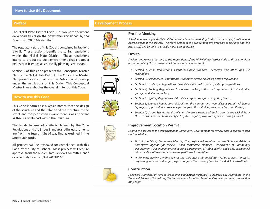
The Nickel Plate District Code is a two part document developed to create the downtown envisioned by the Downtown 2030 Master Plan.
The regulatory part of this Code is contained in Sections 1 to 8. These sections identify the zoning regulations within the Nickel Plate District. These regulations intend to produce a built environment that creates a pedestrian-friendly, aesthetically pleasing streetscape.
Section 9 of this Code presents the Conceptual Master Plan for the Nickel Plate District. The Conceptual Master Plan presents a vision of how the District could develop under the regulations of this Code. This Conceptual Master Plan embodies the overall intent of this Code.
How to use this Code
This Code is form-based, which means that the design of the structure and the relation of the structure to the street and the pedestrian environment is as important as the use contained within the structure.
The buildable area of a site is defined by the Zone Regulations and the Street Standards. All measurements are from the future right-of-way line as outlined in the Street Standards.
All projects will be reviewed for compliance with this Code by the City of Fishers. Most projects will require approval from the Nickel Plate Review Committee and/or other City boards. (Ord. #071816C)
Development Process
Pre-file MeetingSchedule a meeting with Fishers’ Community Development staff to discuss the scope, location, and overall intent of the project. The more details of the project that are available at this meeting, the more staff will be able to provide input and guidance.
DesignDesign the project according to the regulations of the Nickel Plate District Code and the submittal requirements of the Department of Community Development.
• Section 1, Zone Regulations: Establishes bulk standards, setbacks, and other land use regulations.
• Section 2, Architecture Regulations: Establishes exterior building design regulations.
• Section 3, Landscape Regulations: Establishes site and streetscape design regulations.
• Section 4, Parking Regulations: Establishes parking ratios and regulations for street, site, garage, and shared parking.
• Section 5, Lighting Regulations: Establishes regulations for site lighting levels.
• Section 6, Signage Regulations: Establishes the number and type of signs permitted. (Note: Signage is approved in a process separate from the initial Improvement Location Permit).
• Section 7, Street Standards: Establishes the cross section of each street in the Nickel Plate District. The cross sections identify the future right-of-way width for measuring setbacks.
Improvement Location PermitSubmit the project to the Department of Community Development for review once a complete plan set is available.
• Technical Advisory Committee Meeting: The project will be placed on the Technical Advisory Committee agenda for review. Each committee member (Department of Community Development, Department of Engineering, Department of Public Works, and utility companies) will provide written comments to the petitioner for revision.
• Nickel Plate Review Committee Meeting: This step is not mandatory for all projects. Projects requesting waivers and larger projects require this meeting (see Section 8, Administration).
ConstructionFollowing submittal of revised plans and application materials to address any comments of the Technical Advisory Committee, the Improvement Location Permit will be released and construction may begin.

Nickel Plate District Code | Page 3
Table of Contents
Section 1 - Zone Regulations 5
1.1: Intent1.2: Zone Map1.3: Right-of-Way1.4: First Floor Commercial1.5: Building Frontages
Section 2 - Architecture Regulations 19
2.1: Intent2.2: General Requirements2.3: Materials2.4: Facade2.5: Entrances2.6: Windows, Doors, & Massing2.7: Roofing2.8: Mechanical Equipment2.9: Accessory Structures, Outdoor Seating and
Display2.10: Anti-monotony 2.11: Appropriate Transitions2.12: Gateway Features (Ord. 091817)
Section 3 - Landscape Regulations 25
3.1: Intent3.2: General Requirements3.3: Tree Lawn / Street Trees3.4: Foundation & Lot Plantings3.5: Parking Lot Plantings3.6: Parking Structure Plantings3.7: Buffering3.8: Street Furnishings3.9: Fencing3.10: Installation & Maintenance
Section 4 - Parking Regulations 35
4.1: Intent4.2: General Requirements4.3: Number of Spaces Required4.4: Accessible Parking Spaces4.5: Bicycle Parking4.6: Shared Parking4.7: Public Parking4.8: Driveway Standards4.9: Loading Areas4.10: Surface Parking
Section 5 - Lighting Regulations 41
5.1: Intent5.2: Submission of Plans & Compliance5.3: General Requirements5.4: Light Level Maximums by Zone5.5: Exemptions5.6: Prohibitions5.7: Light Measurements
Section 6 - Signage Regulations 45
6.1: Intent6.2: Compliance, Permits & Applications6.3: Prohibited Signs6.4: General Standards6.5: Temporary Signs6.6: Types of Signs
Section 7 - Street Standards 53
7.1: Intent7.2: Design Criteria (Ord. 071816C)
Section 8 - Administration 69
8.1: Interpretation8.2: Review8.3: Nonconforming Lots, Sites, Structures, and
Uses8.4: Prohibited Uses8.5: Review8.6: Design Standards8.7: Subdivision8.8: Encroachments
Section 9 - Master Plan 83
9.1: Nickel Plate District9.2: Purpose9.3: Planning Process9.4: Regional Precedent and Character9.5: Regional Character9.6: Existing Land Use9.7: Existing Conditions9.8: Existing Street Network9.9: Conceptual Master Plan9.10: Nickel Plate District9.11: Future Street Network9.12: Open Space 9.13: Future Pedestrian Network9.14: Regional Pedestrian Network
Section 10 - Definitions 103
Select elements of this Code are from the SmartCode, 9.2.


SECTION 1.0Introduction
Section 1 - Zone Regulations
Page 6 | Nickel Plate District Code
Zone Regulations
1.1: Intent
The Nickel Plate District Code provides strict design requirements but the Code intends to provide flexibility to allow for flexible design and to accommodate adequate parking as the district redevelops.
• A traditional “main-street” walkable and vibrant downtown feel with pedestrian-scaled storefront building designs. (Ord. 110514C)
• Retail on ground floor with living, retail, or office on upper floors.
• Two to four story buildings adjacent to the street.
• No large surface parking lots are allowed in the DC or VC Neighborhoods. Temporary surface lots are allowed as a mechanism to provide parking before a parking structure is available.
• Limited parking in rear of structures for deliveries and trash enclosures to be serviced off of existing alleys.
• Promote designs that show durability and permanence through the use of brick and masonry.
• Allow flexibility in design for buildings that will be adjacent or nearly adjacent.
• When a façade is longer than 150 feet, it should look like two or more buildings to maintain small downtown atmosphere.
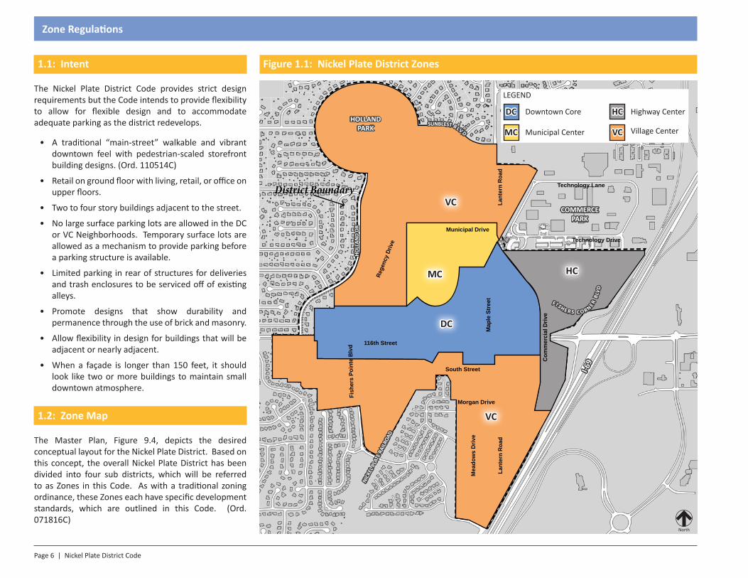
1.2: Zone Map
The Master Plan, Figure 9.4, depicts the desired conceptual layout for the Nickel Plate District. Based on this concept, the overall Nickel Plate District has been divided into four sub districts, which will be referred to as Zones in this Code. As with a traditional zoning ordinance, these Zones each have specific development standards, which are outlined in this Code. (Ord. 071816C)
116th Street
Municipal Drive
Lant
ern
Roa
d
South Street
Morgan Drive
Rege
ncy
Driv
e
Map
le S
tree
t
Mea
dow
s D
rive
Fish
ers
Poin
te B
lvd
Com
mer
cial
Driv
e
Technology Lane
Technology Drive
Lant
ern
Roa
d
LEGEND
Downtown Core
Municipal Center Village Center
Highway CenterDC HC
VCMC
DC
MC
VC
VC
North
HOLLAND PARK
COMMERCE PARK
I-69
HOLL
AND
DRNI
CKEL
PLA
TE R
AILR
OAD
F I S H E R S C O R NER BL
VD
SUNBLEST B LV D
HC
Figure 1.1: Nickel Plate District Zones
District Boundary
Nickel Plate District Code | Page 7
Zone Regulations
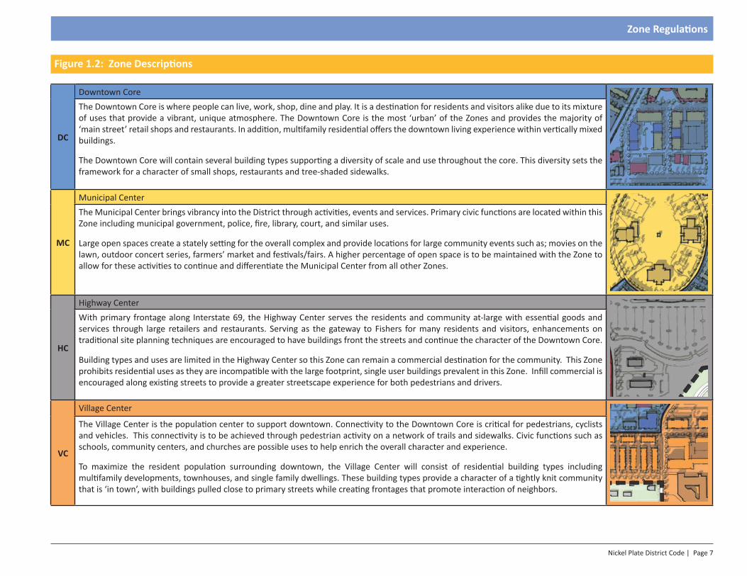
Figure 1.2: Zone Descriptions
DC
Downtown CoreThe Downtown Core is where people can live, work, shop, dine and play. It is a destination for residents and visitors alike due to its mixture of uses that provide a vibrant, unique atmosphere. The Downtown Core is the most ‘urban’ of the Zones and provides the majority of ‘main street’ retail shops and restaurants. In addition, multifamily residential offers the downtown living experience within vertically mixed buildings.
The Downtown Core will contain several building types supporting a diversity of scale and use throughout the core. This diversity sets the framework for a character of small shops, restaurants and tree-shaded sidewalks.
MC
Municipal CenterThe Municipal Center brings vibrancy into the District through activities, events and services. Primary civic functions are located within this Zone including municipal government, police, fire, library, court, and similar uses.
Large open spaces create a stately setting for the overall complex and provide locations for large community events such as; movies on the lawn, outdoor concert series, farmers’ market and festivals/fairs. A higher percentage of open space is to be maintained with the Zone to allow for these activities to continue and differentiate the Municipal Center from all other Zones.
HC
Highway CenterWith primary frontage along Interstate 69, the Highway Center serves the residents and community at-large with essential goods and services through large retailers and restaurants. Serving as the gateway to Fishers for many residents and visitors, enhancements on traditional site planning techniques are encouraged to have buildings front the streets and continue the character of the Downtown Core.
Building types and uses are limited in the Highway Center so this Zone can remain a commercial destination for the community. This Zone prohibits residential uses as they are incompatible with the large footprint, single user buildings prevalent in this Zone. Infill commercial is encouraged along existing streets to provide a greater streetscape experience for both pedestrians and drivers.
VC
Village Center
The Village Center is the population center to support downtown. Connectivity to the Downtown Core is critical for pedestrians, cyclists and vehicles. This connectivity is to be achieved through pedestrian activity on a network of trails and sidewalks. Civic functions such as schools, community centers, and churches are possible uses to help enrich the overall character and experience.
To maximize the resident population surrounding downtown, the Village Center will consist of residential building types including multifamily developments, townhouses, and single family dwellings. These building types provide a character of a tightly knit community that is ‘in town’, with buildings pulled close to primary streets while creating frontages that promote interaction of neighbors.
Page 8 | Nickel Plate District Code
Zone Regulations
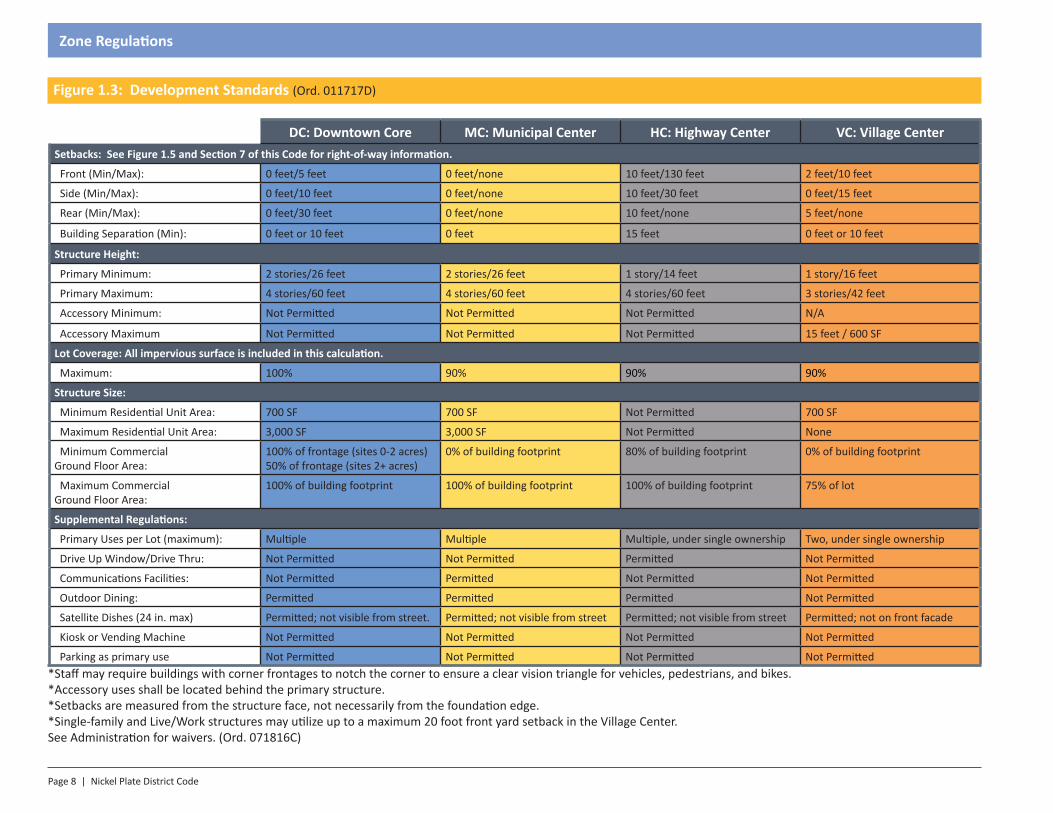
Figure 1.3: Development Standards (Ord. 011717D)
DC: Downtown Core MC: Municipal Center HC: Highway Center VC: Village CenterSetbacks: See Figure 1.5 and Section 7 of this Code for right-of-way information.
Front (Min/Max): 0 feet/5 feet 0 feet/none 10 feet/130 feet 2 feet/10 feet
Side (Min/Max): 0 feet/10 feet 0 feet/none 10 feet/30 feet 0 feet/15 feet
Rear (Min/Max): 0 feet/30 feet 0 feet/none 10 feet/none 5 feet/none
Building Separation (Min): 0 feet or 10 feet 0 feet 15 feet 0 feet or 10 feet
Structure Height:
Primary Minimum: 2 stories/26 feet 2 stories/26 feet 1 story/14 feet 1 story/16 feet
Primary Maximum: 4 stories/60 feet 4 stories/60 feet 4 stories/60 feet 3 stories/42 feet
Accessory Minimum: Not Permitted Not Permitted Not Permitted N/A
Accessory Maximum Not Permitted Not Permitted Not Permitted 15 feet / 600 SF
Lot Coverage: All impervious surface is included in this calculation.
Maximum: 100% 90% 90% 90%
Structure Size:
Minimum Residential Unit Area: 700 SF 700 SF Not Permitted 700 SF
Maximum Residential Unit Area: 3,000 SF 3,000 SF Not Permitted None
Minimum Commercial Ground Floor Area:
100% of frontage (sites 0-2 acres)50% of frontage (sites 2+ acres)
0% of building footprint 80% of building footprint 0% of building footprint
Maximum Commercial Ground Floor Area:
100% of building footprint 100% of building footprint 100% of building footprint 75% of lot
Supplemental Regulations:
Primary Uses per Lot (maximum): Multiple Multiple Multiple, under single ownership Two, under single ownership
Drive Up Window/Drive Thru: Not Permitted Not Permitted Permitted Not Permitted
Communications Facilities: Not Permitted Permitted Not Permitted Not Permitted
Outdoor Dining: Permitted Permitted Permitted Not Permitted
Satellite Dishes (24 in. max) Permitted; not visible from street. Permitted; not visible from street Permitted; not visible from street Permitted; not on front facade
Kiosk or Vending Machine Not Permitted Not Permitted Not Permitted Not Permitted
Parking as primary use Not Permitted Not Permitted Not Permitted Not Permitted*Staff may require buildings with corner frontages to notch the corner to ensure a clear vision triangle for vehicles, pedestrians, and bikes.*Accessory uses shall be located behind the primary structure.*Setbacks are measured from the structure face, not necessarily from the foundation edge.*Single-family and Live/Work structures may utilize up to a maximum 20 foot front yard setback in the Village Center.See Administration for waivers. (Ord. 071816C)
Nickel Plate District Code | Page 9
Zone Regulations
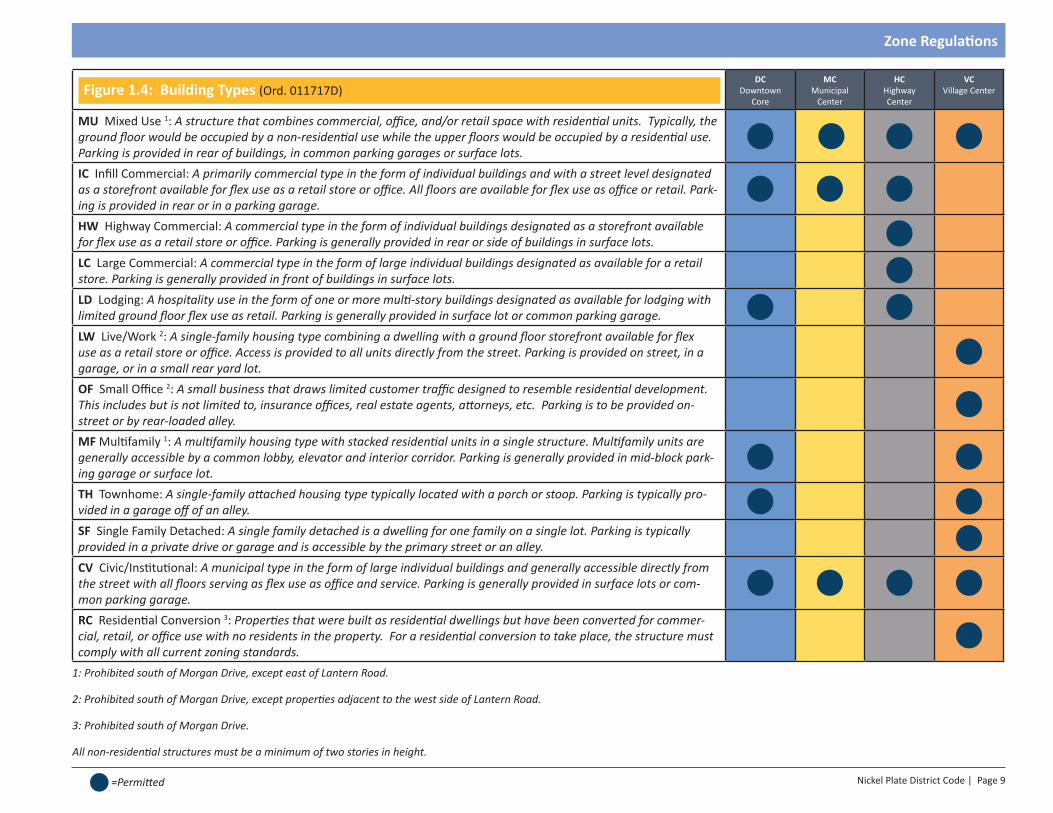
Figure 1.4: Building Types (Ord. 011717D)DC
Downtown Core
MC Municipal
Center
HC Highway Center
VC Village Center
MU Mixed Use 1: A structure that combines commercial, office, and/or retail space with residential units. Typically, the ground floor would be occupied by a non-residential use while the upper floors would be occupied by a residential use. Parking is provided in rear of buildings, in common parking garages or surface lots.
IC Infill Commercial: A primarily commercial type in the form of individual buildings and with a street level designated as a storefront available for flex use as a retail store or office. All floors are available for flex use as office or retail. Park-ing is provided in rear or in a parking garage.HW Highway Commercial: A commercial type in the form of individual buildings designated as a storefront available for flex use as a retail store or office. Parking is generally provided in rear or side of buildings in surface lots.LC Large Commercial: A commercial type in the form of large individual buildings designated as available for a retail store. Parking is generally provided in front of buildings in surface lots. LD Lodging: A hospitality use in the form of one or more multi-story buildings designated as available for lodging with limited ground floor flex use as retail. Parking is generally provided in surface lot or common parking garage.LW Live/Work 2: A single-family housing type combining a dwelling with a ground floor storefront available for flex use as a retail store or office. Access is provided to all units directly from the street. Parking is provided on street, in a garage, or in a small rear yard lot. OF Small Office 2: A small business that draws limited customer traffic designed to resemble residential development. This includes but is not limited to, insurance offices, real estate agents, attorneys, etc. Parking is to be provided on-street or by rear-loaded alley.MF Multifamily 1: A multifamily housing type with stacked residential units in a single structure. Multifamily units are generally accessible by a common lobby, elevator and interior corridor. Parking is generally provided in mid-block park-ing garage or surface lot.TH Townhome: A single-family attached housing type typically located with a porch or stoop. Parking is typically pro-vided in a garage off of an alley.SF Single Family Detached: A single family detached is a dwelling for one family on a single lot. Parking is typically provided in a private drive or garage and is accessible by the primary street or an alley.CV Civic/Institutional: A municipal type in the form of large individual buildings and generally accessible directly from the street with all floors serving as flex use as office and service. Parking is generally provided in surface lots or com-mon parking garage.RC Residential Conversion 3: Properties that were built as residential dwellings but have been converted for commer-cial, retail, or office use with no residents in the property. For a residential conversion to take place, the structure must comply with all current zoning standards.
1: Prohibited south of Morgan Drive, except east of Lantern Road.
2: Prohibited south of Morgan Drive, except properties adjacent to the west side of Lantern Road.
3: Prohibited south of Morgan Drive.
All non-residential structures must be a minimum of two stories in height.
=Permitted
Page 10 | Nickel Plate District Code
Zone Regulations
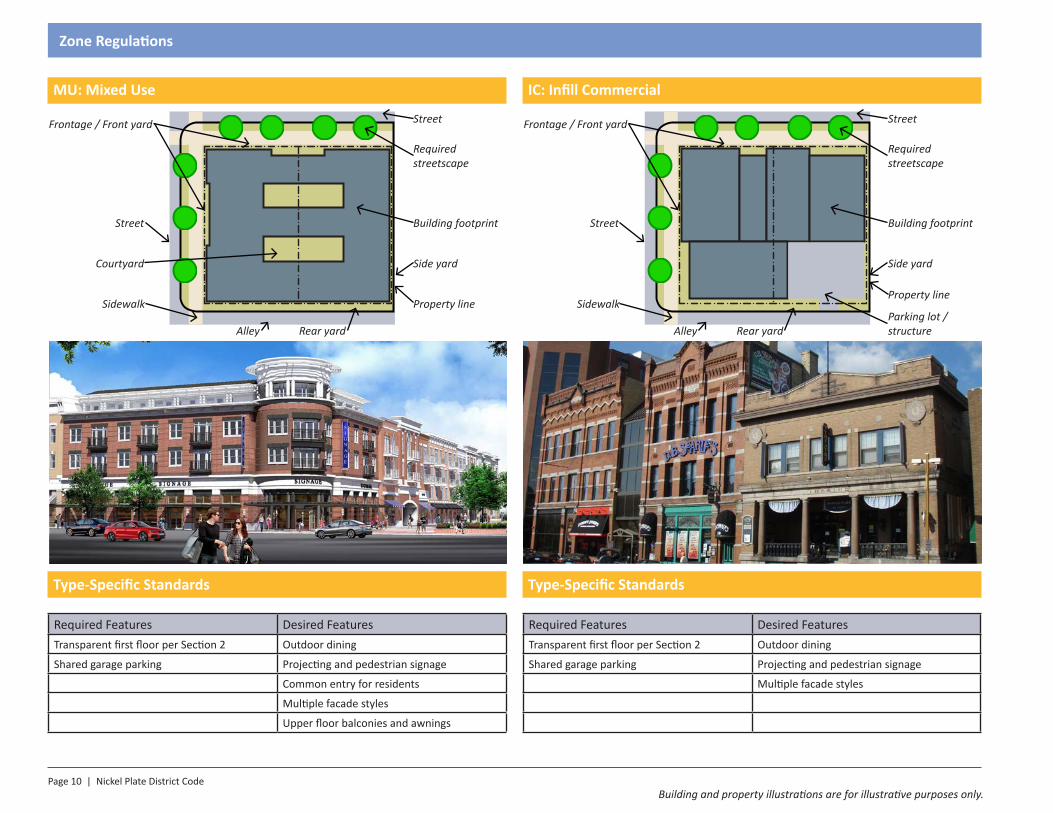
MU: Mixed Use
Type-Specific Standards
Required Features Desired FeaturesTransparent first floor per Section 2 Outdoor dining
Shared garage parking Projecting and pedestrian signage
Common entry for residents
Multiple facade styles
Upper floor balconies and awnings
IC: Infill Commercial
Type-Specific Standards
Required Features Desired FeaturesTransparent first floor per Section 2 Outdoor dining
Shared garage parking Projecting and pedestrian signage
Multiple facade styles
Mixed Use
Infill Commercial
Large Commercial
Highway Commer-cial
CivicLodging
Multifamily
Live/Work
Townhouse
Single Family
Mixed Use
Infill Commercial
Large Commercial
Highway Commer-cial
CivicLodging
Multifamily
Live/Work
Townhouse
Single Family
Property line
Building footprint
Required streetscape
Frontage / Front yard
Sidewalk
Alley Rear yard
Side yard
Street
Courtyard
Street
Property line
Building footprint
Required streetscape
Frontage / Front yard
Sidewalk
Alley Rear yard
Side yard
Street
Street
Parking lot / structure
Building and property illustrations are for illustrative purposes only.
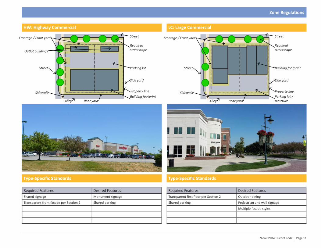
Nickel Plate District Code | Page 11
Zone Regulations
HW: Highway Commercial
Type-Specific Standards
Required Features Desired FeaturesShared signage Monument signage
Transparent front facade per Section 2 Shared parking
LC: Large Commercial
Type-Specific Standards
Required Features Desired FeaturesTransparent first floor per Section 2 Outdoor dining
Shared parking Pedestrian and wall signage
Multiple facade styles
Mixed Use
Infill Commercial
Large Commercial
Highway Commer-cial
CivicLodging
Multifamily
Live/Work
Townhouse
Single Family
Mixed Use
Infill Commercial
Large Commercial
Highway Commer-cial
CivicLodging
Multifamily
Live/Work
Townhouse
Single Family
Property line
Parking lot
Required streetscape
Frontage / Front yard
Sidewalk
Alley Rear yard
Side yard
Street
Street
Building footprintProperty line
Building footprint
Required streetscape
Frontage / Front yard
Sidewalk
Alley Rear yard
Side yard
Street
Street
Parking lot / structure
Outlot buildings
Page 12 | Nickel Plate District Code
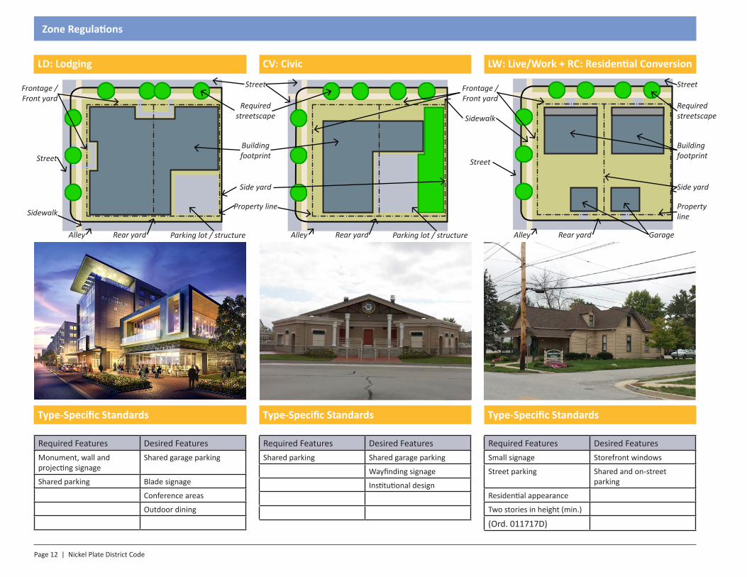
Zone Regulations
LD: Lodging
Type-Specific Standards
Required Features Desired FeaturesMonument, wall and projecting signage
Shared garage parking
Shared parking Blade signage
Conference areas
Outdoor dining
LW: Live/Work + RC: Residential Conversion
Type-Specific Standards
Required Features Desired FeaturesSmall signage Storefront windows
Street parking Shared and on-street parking
Residential appearance
Two stories in height (min.)
(Ord. 011717D)
CV: Civic
Type-Specific Standards
Required Features Desired FeaturesShared parking Shared garage parking
Wayfinding signage
Institutional design
Mixed Use
Infill Commercial
Large Commercial
Highway Commer-cial
CivicLodging
Multifamily
Live/Work
Townhouse
Single Family
Mixed Use
Infill Commercial
Large Commercial
Highway Commer-cial
CivicLodging
Multifamily
Live/Work
Townhouse
Single Family
Mixed Use
Infill Commercial
Large Commercial
Highway Commer-cial
CivicLodging
Multifamily
Live/Work
Townhouse
Single Family
Property line
Building footprint
Required streetscape
Frontage / Front yard
Sidewalk
Alley Rear yard
Side yard
Street
Street
Parking lot / structure
Frontage / Front yard
Sidewalk
Alley Rear yard
Street
Parking lot / structure
Property line
Building footprint
Required streetscape
Side yard
Street
Alley Rear yard Garage
Nickel Plate District Code | Page 13
Zone Regulations
MF: Multi Family
Type-Specific Standards
Required Features Desired FeaturesMonument signage Shared garage parking
Shared parking Balconies
TH: Townhome
Type-Specific Standards
Required Features Desired FeaturesVarying facades Stoops
On-street parking Rear garage
Rear patios
SF: Single Family
Type-Specific Standards
Required Features Desired FeaturesStreet parking Front porches
Rear garage
Mixed Use
Infill Commercial
Large Commercial
Highway Commer-cial
CivicLodging
Multifamily
Live/Work
Townhouse
Single Family
Mixed Use
Infill Commercial
Large Commercial
Highway Commer-cial
CivicLodging
Multifamily
Live/Work
Townhouse
Single Family
Mixed Use
Infill Commercial
Large Commercial
Highway Commer-cial
CivicLodging
Multifamily
Live/Work
Townhouse
Single Family
Property line
Building footprint
Required streetscape
Frontage / Front yard
Sidewalk
Alley Rear yard
Side yard
Street
Street
Parking lot / structure
Frontage / Front yard
Sidewalk
Alley Rear yard
Street
Garage
Property line
Building footprint
Required streetscape
Side yard
Street
Alley Rear yard Garage
Page 14 | Nickel Plate District Code
Zone Regulations
North
C
C
C
H
H
H
J
J
H
H
B G
E
EE
D
F
F
I A
H
H
HOLLAND PARK
COMMERCE PARK
116TH ST
LAN
TERN
RD
I-69
COMM
ERCIAL DR
MUNICIPAL DR
MAP
LE S
T
LAN
TERN
RD
HOLL
AND
DRFI
SHER
S PO
INT
BLVD
NICK
EL P
LATE
RAI
LROA
D
FISHERS CENTER DR
F I S H E R S C O R NER BL
VD
SOUTH ST
SUNBLEST B LV D
MORGAN DR
L
LM
M
K
M
K
LAN
TERN
RD
K
K
K
K
K
K
H
MEA
DOW
S DR
M
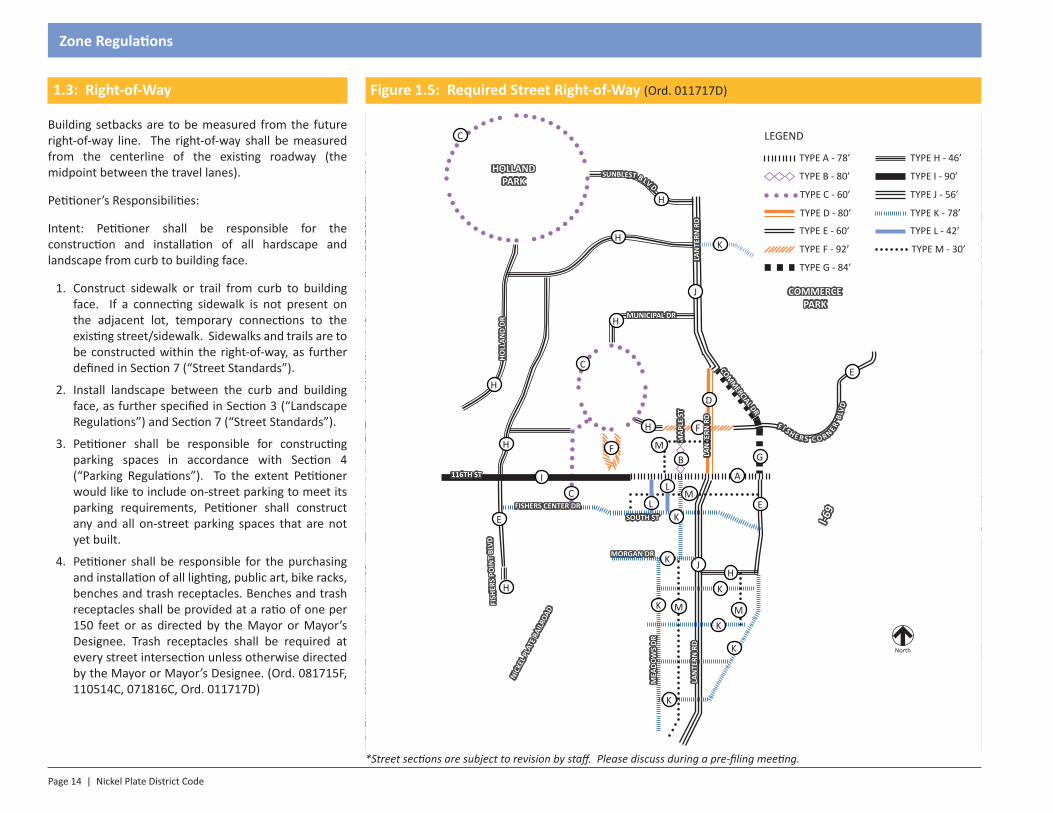
1.3: Right-of-Way
Building setbacks are to be measured from the future right-of-way line. The right-of-way shall be measured from the centerline of the existing roadway (the midpoint between the travel lanes).
Petitioner’s Responsibilities:
Intent: Petitioner shall be responsible for the construction and installation of all hardscape and landscape from curb to building face.
1. Construct sidewalk or trail from curb to building face. If a connecting sidewalk is not present on the adjacent lot, temporary connections to the existing street/sidewalk. Sidewalks and trails are to be constructed within the right-of-way, as further defined in Section 7 (“Street Standards”).
2. Install landscape between the curb and building face, as further specified in Section 3 (“Landscape Regulations”) and Section 7 (“Street Standards”).
3. Petitioner shall be responsible for constructing parking spaces in accordance with Section 4 (“Parking Regulations”). To the extent Petitioner would like to include on-street parking to meet its parking requirements, Petitioner shall construct any and all on-street parking spaces that are not yet built.
4. Petitioner shall be responsible for the purchasing and installation of all lighting, public art, bike racks, benches and trash receptacles. Benches and trash receptacles shall be provided at a ratio of one per 150 feet or as directed by the Mayor or Mayor’s Designee. Trash receptacles shall be required at every street intersection unless otherwise directed by the Mayor or Mayor’s Designee. (Ord. 081715F, 110514C, 071816C, Ord. 011717D)
*Street sections are subject to revision by staff. Please discuss during a pre-filing meeting.
Figure 1.5: Required Street Right-of-Way (Ord. 011717D)
LEGEND
TYPE A - 78’
TYPE D - 80’
TYPE B - 80’
TYPE C - 60’
TYPE E - 60’
TYPE F - 92’
TYPE G - 84’
TYPE H - 46’
TYPE I - 90’
TYPE J - 56’
TYPE K - 78’
TYPE L - 42’
TYPE M - 30’
Nickel Plate District Code | Page 15
Zone Regulations
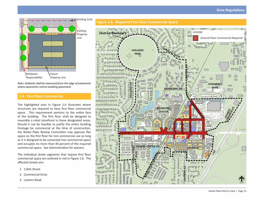
1.4: First Floor Commercial
The highlighted area in Figure 1.6 illustrates where structures are required to have first floor commercial space. This requirement pertains to the entire face of the building. The first floor shall be designed to resemble a retail storefront in these designated areas. Should it not be feasible to justify the entire building frontage be commercial at the time of construction, the Nickel Plate Review Committee may approve flex space on the first floor for non-commercial use so long as it is designed to be converted into commercial space and occupies no more than 40 percent of the required commercial space. See Administration for waivers.
The individual street segments that require first floor commercial space are outlined in red in Figure 1.6. The affected streets are:
1. 116th Street
2. Commercial Drive
3. Lantern Road
Figure 1.6: Required First Floor Commercial Space
HOLLAND PARK
MUNICIPAL CENTER
COMMERCE PARK
116TH ST
LAN
TERN
RD
LAN
TERN
RD
I-69
COMM
ERCIAL DR
MUNICIPAL DR
MAP
LE S
T
LAN
TERN
R
D
JAYC
EE S
T
HOLL
AND
DRFI
SHER
S PO
INT
BLVD
NICK
EL P
LATE
RAI
LROA
D
FISHERS CENTER DR SOUTH ST
FISH
ERS
CORN
ER B
LVD
SUNBLEST BLVD
North
Existing Property Line
Petitioner Responsibility
Future Property Line
Existing Curb
District Boundary LEGEND
Ground Floor Commercial Required
Note: Setbacks shall be measured from the edge of easements where easements restrict building placement.
Page 16 | Nickel Plate District Code
Zone Regulations
4. Maple Street
5. Fishers Corner Boulevard
6. Municipal Drive
7. Jaycee Street
Permitted ground floor commercial uses include:
1. Retail
2. Restaurant
3. Personal Service
4. Office (Office, Business/Financial Services; Office, General Services; Office, Professional) (Ord. 091817)
5. Grocery / Deli / Specialty Food Store
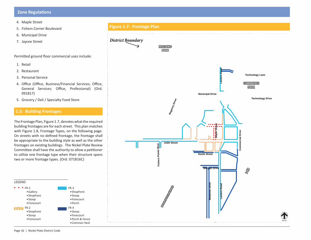
1.5: Building Frontages
The Frontage Plan, Figure 1.7, denotes what the required building frontages are for each street. This plan matches with Figure 1.8, Frontage Types, on the following page. On streets with no defined frontage, the frontage shall be appropriate to the building style as well as the other frontages on existing buildings. The Nickel Plate Review Committee shall have the authority to allow a petitioner to utilize one frontage type when their structure spans two or more frontage types. (Ord. 071816C)
116th Street
Municipal Drive
Lant
ern
Roa
d
South Street
Morgan DriveRe
genc
y Dr
ive
Map
le S
tree
t
Mea
dow
s D
rive
Fish
ers
Poin
te B
lvd
Com
mer
cial
Driv
e
Technology Lane
Technology Drive
Lant
ern
Roa
d
FR-1• Gallery• Shopfront• Stoop• Forecourt
LEGEND
FR-3• Shopfront• Stoop • Forecourt• Porch
FR-2• Shopfront• Stoop• Forecourt
FR-4• Stoop • Forecourt• Porch & Fence• Common Yard
North
HOLLAND PARK
COMMERCE PARK
I-69
NICK
EL P
LATE
RAI
LROA
D
Figure 1.7: Frontage Plan
District Boundary
Nickel Plate District Code | Page 17
Zone Regulations
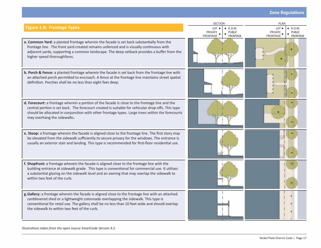
Figure 1.8: Frontage Types SECTION PLAN
LOT PRIVATE
FRONTAGE
R.O.W.PUBLICFRONTAGE
LOT PRIVATE
FRONTAGE
R.O.W.PUBLIC FRONTAGE
a. Common Yard: a planted frontage wherein the facade is set back substantially from the frontage line. The front yard created remains unfenced and is visually continuous with adjacent yards, supporting a common landscape. The deep setback provides a buffer from the higher speed thoroughfares.
b. Porch & Fence: a planted frontage wherein the facade is set back from the frontage line with an attached porch permitted to encroach. A fence at the frontage line maintains street spatial definition. Porches shall be no less than eight feet deep.
d. Forecourt: a frontage wherein a portion of the facade is close to the frontage line and the central portion is set back. The forecourt created is suitable for vehicular drop-offs. This type should be allocated in conjunction with other frontage types. Large trees within the forecourts may overhang the sidewalks.
e. Stoop: a frontage wherein the facade is aligned close to the frontage line. The first story may be elevated from the sidewalk sufficiently to secure privacy for the windows. The entrance is usually an exterior stair and landing. This type is recommended for first-floor residential use.
f. Shopfront: a frontage wherein the facade is aligned close to the frontage line with the building entrance at sidewalk grade. This type is conventional for commercial use. It utilizes a substantial glazing on the sidewalk level and an awning that may overlap the sidewalk to within two feet of the curb.
g. Gallery: a frontage wherein the facade is aligned close to the frontage line with an attached cantilevered shed or a lightweight colonnade overlapping the sidewalk. This type is conventional for retail use. The gallery shall be no less than 10 feet wide and should overlap the sidewalk to within two feet of the curb.
Illustrations taken from the open source SmartCode Version 9.2.

SECTION 1.0Introduction
Section 2 - Architecture Regulations
Page 20 | Nickel Plate District Code
Architecture Regulations
2.1: Intent
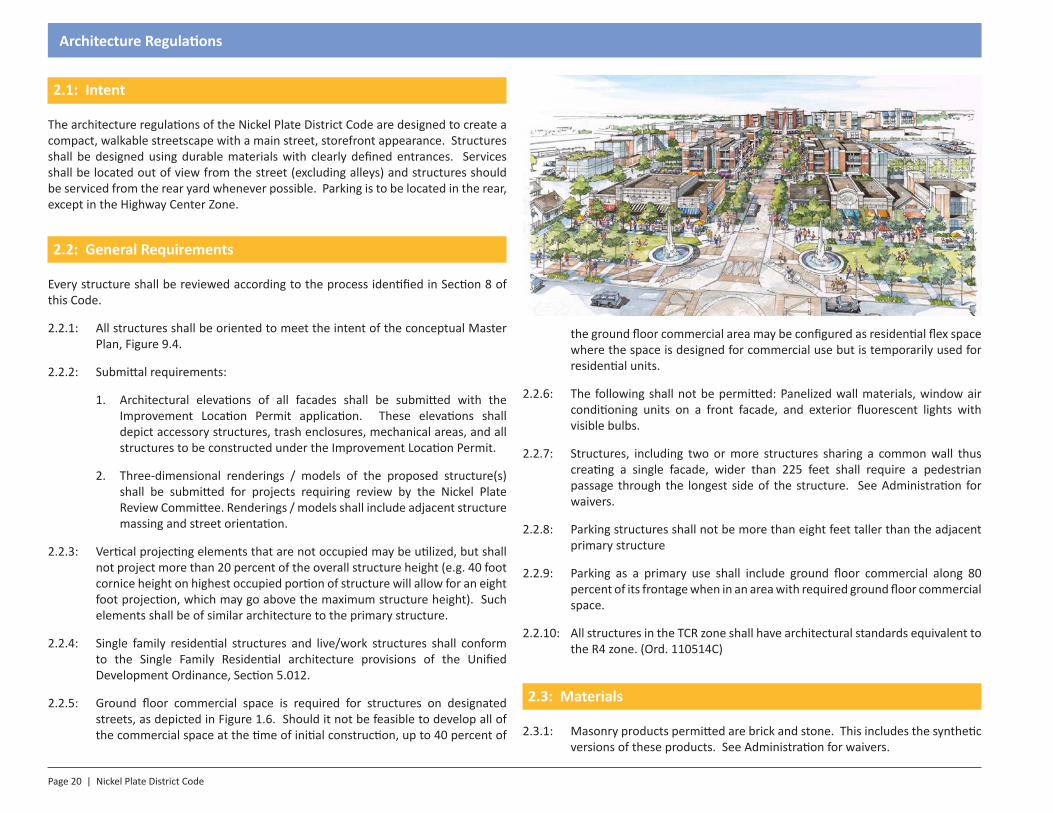
The architecture regulations of the Nickel Plate District Code are designed to create a compact, walkable streetscape with a main street, storefront appearance. Structures shall be designed using durable materials with clearly defined entrances. Services shall be located out of view from the street (excluding alleys) and structures should be serviced from the rear yard whenever possible. Parking is to be located in the rear, except in the Highway Center Zone.
2.2: General Requirements
Every structure shall be reviewed according to the process identified in Section 8 of this Code.
2.2.1: All structures shall be oriented to meet the intent of the conceptual Master Plan, Figure 9.4.
2.2.2: Submittal requirements:
1. Architectural elevations of all facades shall be submitted with the Improvement Location Permit application. These elevations shall depict accessory structures, trash enclosures, mechanical areas, and all structures to be constructed under the Improvement Location Permit.
2. Three-dimensional renderings / models of the proposed structure(s) shall be submitted for projects requiring review by the Nickel Plate Review Committee. Renderings / models shall include adjacent structure massing and street orientation.
2.2.3: Vertical projecting elements that are not occupied may be utilized, but shall not project more than 20 percent of the overall structure height (e.g. 40 foot cornice height on highest occupied portion of structure will allow for an eight foot projection, which may go above the maximum structure height). Such elements shall be of similar architecture to the primary structure.
2.2.4: Single family residential structures and live/work structures shall conform to the Single Family Residential architecture provisions of the Unified Development Ordinance, Section 5.012.
2.2.5: Ground floor commercial space is required for structures on designated streets, as depicted in Figure 1.6. Should it not be feasible to develop all of the commercial space at the time of initial construction, up to 40 percent of
the ground floor commercial area may be configured as residential flex space where the space is designed for commercial use but is temporarily used for residential units.
2.2.6: The following shall not be permitted: Panelized wall materials, window air conditioning units on a front facade, and exterior fluorescent lights with visible bulbs.
2.2.7: Structures, including two or more structures sharing a common wall thus creating a single facade, wider than 225 feet shall require a pedestrian passage through the longest side of the structure. See Administration for waivers.
2.2.8: Parking structures shall not be more than eight feet taller than the adjacent primary structure
2.2.9: Parking as a primary use shall include ground floor commercial along 80 percent of its frontage when in an area with required ground floor commercial space.
2.2.10: All structures in the TCR zone shall have architectural standards equivalent to the R4 zone. (Ord. 110514C)
2.3: Materials
2.3.1: Masonry products permitted are brick and stone. This includes the synthetic versions of these products. See Administration for waivers.
Nickel Plate District Code | Page 21
Architecture Regulations
2.3.2: Other permitted exterior materials shall be fiber cement (or other simulated wood synthetic excluding vinyl siding) and stucco.
2.3.3: EFIS is permitted for the top floor of multi-story structures and accent areas only. EFIS shall not cover more than 15 percent of the exterior of the structure, excluding window and door openings.
2.3.4: Roofing materials permitted for residential development shall be architectural shingles or a flat roof. Commercial developments shall use standing seam metal or a flat roof.
2.3.5: Awnings shall be consistent with the structure’s architectural style and be constructed of canvas.
2.4: Facade
2.4.1: Any structure façade facing a public right-of-way (except for alleys) shall be treated as a front facade.
2.4.2: A finished elevation (four-sided architecture) is required on every side of the structure. There shall be no blank facades and each side of a structure shall be architecturally similar to the other sides.
1. Zero lot line structures: When using zero lot line construction, the adjoining wall shall be constructed of maintenance-free masonry and the adjoining facade is exempt from the four-sided architecture requirement provided:
a. A public art installation is permitted in lieu of the four-sided architecture requirement on one of the facades. This can include, but is not limited to, murals and sculptures. Nickel Plate Review Committee approval is needed to approve the use and location of the art.
b. Public art shall be approved by the Fishers Community Art Selection Committee.
c. If intended to be located on the zero lot line wall, art installations shall be designed to be removed and/or relocated at such time as the adjacent property is developed.
2. Facades facing alleys: Rear facades that face alleys shall be constructed of masonry but are exempt from the requirement for four-sided architecture provided:
a. Public art installation is provided. (Art used to meet the requirements for Section 2.4.2.1.a. may not also be used to meet the masonry exemption.)
b. Public art shall be approved by the Fishers Community Art Selection Committee.
c. Installations may be on or off site in a location approved by the Nickel Plate Review Committee and the Fishers Community Art Selection Committee.
2.4.3: Structures shall have a defined base, middle, and top section that is broken along horizontal lines. The heavier (i.e. masonry) materials shall be used at the base. See Administration Section for waivers.
2.4.4: Parking garages shall be architecturally similar to the primary structure. The garage does not have to resemble a storefront, but shall retain the architectural elements and style of the primary structure. A green screen (see Landscape Section) may be used as an alternative solution.
2.4.5: All structures shall be at least 75 percent masonry on frontages facing public rights-of-way, excluding window and door openings. Other sides shall be at least 50 percent masonry. Single family homes may substitute fiber cement or wood siding in lieu of the masonry requirement.
2.4.6: Permitted projections from the structure’s façade shall be balconies, awnings, signs, flags, and cornice elements.
2.4.7: Projections from the front of the structure shall be self-supporting and require no street level poles or supports. Gallery frontages are exempt provided the structure is self supporting in case right-of-way maintenance is required.
2.4.8: Balconies shall be a minimum of three feet deep.
2.4.9: Windows shall have decorative headers of stone or other masonry.
2.4.10: The structure itself may not project over a sidewalk or other public right-of-way.
2.4.11: The ground floor of structures requiring first floor commercial shall be transparent storefronts consisting of a minimum of 60 percent glass on front facades and 20 percent on other facades.
2.4.12: Structures shall articulate horizontally and vertically a minimum of two feet for every 50 feet of width.
Page 22 | Nickel Plate District Code
Architecture Regulations
2.4.13: Structure facades wider than 90 feet shall change architectural styles along the offset created in Section 2.4.12 to create the appearance of multiple structures rather than one large structure of the same style.
2.4.14: All structures utilizing a flat roof shall have a cornice or other finished treatment to complete the top of all structure walls.
2.4.15: Colors shall be muted tones which are compatible with surrounding structures. No fluorescent, neon, or other high intensity colors shall be used as a primary structure color. Accent colors of brighter hues are permitted.
2.4.16: See Administration Section for waivers from the provisions of Section 2.4.
2.5: Entrances
2.5.1: Each street frontage greater than 30 feet shall have an entry from that street. This entry shall be clearly defined from the façade using an awning of different material or scale than any other awnings present, structure articulation, or similar architectural features that accentuate the entrance.
2.5.2: All structures (excluding single-family) with frontages on two public streets shall be required to create a corner feature that addresses the corner as a focal point. This corner shall feature at least two of the following options:
1. Glass canopy extending at least eight feet from the facade.
2. Angled structure entry that addresses both streets.
3. Blade sign on a 45 degree angle at the corner of the structure.
4. Decorative masonry on structure facade that highlights the corner uniquely.
2.5.3: All structures in the Downtown Core shall incorporate a cornerstone which identifies both the Nickel Plate District and the year of construction. Specifications for the cornerstone are available from the Department of Community Development.
2.6: Windows, Doors, & Massing
2.6.1: Windows and doors may be recessed into a structure to create definition or a usable patio/balcony.
2.6.2: Any facades facing a public right-of-way shall have a minimum of 25 percent transparent glass.
2.6.3: All facades, except on adjoining walls, shall have a minimum of 10 percent transparent glass.
2.7: Roofing
2.7.1: Pitched roofs shall be at least a 5/12 slope.
2.7.2: Flat roofs are allowed in all Zones.
2.7.3: Green roofs are allowed in all Zones.
2.7.4: Standing seam metal roofing is allowed as an accent material only and shall not comprise more than 25 percent of the overall roof area.
2.7.5: For every 90 feet of facade width, the structure shall incorporate a change in roof height of five feet or 10 percent of the overall building height, whichever is greater. (Ord. 011717D)
2.8: Mechanical Equipment
2.8.1: All mechanical equipment, including but not limited to HVAC, communications equipment, exhaust systems, and other systems, shall be screened from view from the street centerline with architecture matching the primary structure and landscaping, where applicable. Visibility is gauged from the opposite side of the right-of-way at an elevation of 20 feet. On sides with no right-of-way frontage, visibility shall be measured 40 feet from the building face, at an elevation of 20 feet. (Ord. 071816C, Ord. 091817)
2.8.2: Mechanical equipment shall not be located in any front yard or side yard. Mechanical equipment shall be located on the roof of the structure or in an integral location within the structure.
2.8.3: Mechanical equipment may be located in a rear yard when surrounded by a masonry wall of similar architecture to the primary structure.
Nickel Plate District Code | Page 23
Architecture Regulations
2.9: Accessory Structures, Outdoor Seating and Display
2.9.1: When possible, trash enclosures should be integral to the structure or the structure’s parking garage.
2.9.2: Trash enclosures shall not be placed in any front yard.
2.9.3: Free standing trash enclosures shall be masonry to match the primary structure.
2.9.4: Outdoor storage is prohibited.
2.9.5: Sidewalk displays are permitted during business hours and shall not cover more than eight square feet. The display shall leave at least six feet of clear space on the sidewalk for pedestrians.
2.9.6: Outdoor seating areas shall maintain at least six feet of clear space on the sidewalk for pedestrians in all directions.
2.10: Anti-monotony
2.10.1: All non-residential structures in the Nickel Plate District are to have unique architectural facades.
2.10.2: Residential structures should have unique architectural facades. Where unique facades are not used, UDO standards shall apply, as amended.
2.10.3: Residential and live-work structures should use differing roof designs, differing roof heights, and should be oriented to create push/pull in the street scape (buildings set to slightly different front yard setbacks). (Ord. 071816C)
2.10.4: All structures over 80 feet wide should use multiple roof heights as a component of their design. (Ord. 071816C)
2.11: Appropriate Transitions
2.11.1: Where the Nickel Plate District abuts other zoning Districts of the Fishers UDO (such as TCR, R-1, C-1, etc.), structure height shall be restricted to a maximum of 16 feet taller than the adjacent, non-Nickel Plate District property. This height may be increased at a rate of one foot in height for every four feet in distance from the closest property line of the non-Nickel Plate District property.
2.12: Gateway Features (Ord. 091817)
2.12.1: The gateways shall be defined as the intersection of Fishers Pointe Blvd and Lantern Road, 116th Street and Maple Drive, Lantern Road and 121st Street, and 116th Street and Commercial Drive. Gateway features are not required on single-family attached and single-family detached structures.
2.12.2: Structures at gateway locations shall address the thoroughfare (Lantern Road or 116th Street) in a prominent way and shall include at least two (2) of the following elements:
1. Public Courtyard: A public space constructed of landscape with seating, gathering space, and activity space (e.g. fire pit, sports/activity areas, or other activities as approved by staff) that is at least 600 square feet in size and is visible from the gateway location.
2. Public Plaza: A public space constructed of hardscape with seating, lighting, and gathering space that is at least 400 square feet in size and is visible from the gateway location.
3. Corner Architectural Feature: 45 degree corner, rounded corner, taller corner feature, or other features approved by staff.
4. Public Art: An art installation provided by the developer at a location on the site adjacent to the gateway location. Art installations must be of a significant scale to be seen from around the gateway location and must be approved by the Nickel Plate Review Committee.
5. Other architectural feature as approved by the Nickel Plate Review Committee.


SECTION 1.0Introduction
Section 3 - Landscape Regulations
Page 26 | Nickel Plate District Code
Landscape Regulations
3.1: Intent
The Landscaping Standards are intended to improve the aesthetic character of the Nickel Plate District through an improved vegetated environment and to foster development that will protect and preserve the appearance, character, health, safety and welfare of the community. Additionally, the standards are intended to foster aesthetically pleasing development that encourages native species and ecosystems. Trees, vegetation, irrigation systems, fences, walls, and other landscape elements are essential components of a project. These components act to enhance the visual quality of developments, screen land uses, and better integrate the built and natural environments.
3.2: General Requirements
3.2.1: Process: The following standards shall apply to any development proposal within the boundary of the Nickel Plate District, as shown in Section 1.
3.2.2: Placement: With the exception of street trees, landscape material shall not be planted or placed in rights-of-way or easements without permission from the Town or the easement holder unless otherwise required by these standards.
1. Vision Clearance: Materials shall be located to avoid interference with visibility per Article 05: VC: Vision Clearance Standards of the Town of Fishers Unified Development Ordinance.
2. Utility Infrastructure: Trees shall be located to avoid significant interference with overhead or underground utilities, including lateral connections. Trees shall be planted at least ten (10) feet from sanitary sewer and water service lines. A tree canopy may project over a right-of-way or easement.
3. Vehicular and Pedestrian Movement: Plant materials shall be located to avoid interference with vehicular and pedestrian movement. Plant materials shall not project over sidewalks, paths, or trails below a height of eight (8) feet. Plant materials shall not project over street curbs or pavement within rights-of-way or access easements below a height of fifteen (15) feet.
4. Energy Conservation: Plantings are encouraged to be arranged to promote energy conservation.
a. Deciduous Trees: Tall deciduous trees should be placed on the south and west sides of buildings to provide shade from the summer sun, and provide warmth from the winter sun.
b. Evergreens: Evergreens should be planted on the north side of buildings to dissipate the effect of winter winds.
c. Distribution: Required landscaping shall be reasonably distributed throughout all open space areas. It is suggested that the required plantings be planted in clusters or irregular patterns, and that native grasses and other native species be used for ornamentation in addition to the required plantings.
5. Landscape quantities are aggregate. Double counting landscape material is not permitted (e.g. street trees counting for lot plantings).
3.2.3: Plant Material Standards: When wooded areas, tree rows or specimen trees are designated to be conserved or have been included in the commitments, the petitioner shall take the following measures:
1. Live Plantings: All plant material shall be living species. Dead, diseased or artificial plants shall not be recognized as contributing to required landscaping.
2. Species Diversity: On sites that require an aggregate total of twenty (20) or more new trees, any given species of tree shall be limited to a maximum of thirty-three percent (33%) of the total number of newly planted trees on site.
3. Permitted Plant Material: All plant material shall be selected from the Fishers’ Approved List of Recommended Species, as amended. Proposals for additions and substitutions to the list may be submitted to the Department of Community Development for approval as the list is intended as a guide and is not inclusive of all appropriate selections available.
4. Prohibited Plant Material: Species identified in Fishers’ Approved List of Recommended Species: Invasive & Poor Characteristic Species shall be avoided and shall not be counted toward landscaping requirements.
5.
6.
Nickel Plate District Code | Page 27
Landscape Regulations
3.2.4: Landscape Plan: Landscape Plans shall be submitted to Fishers for approval and shall include the following features:
1. Property lines;
2. North arrow;
3. Scale;
4. Existing and proposed structures;
5. Existing and proposed pavement;
6. Rights-of-way;
7. Easements;
8. Topography;
9. Mounds/berms shown by one-foot contour lines;
10. Utilities;
11. Fences and walls;
12. Existing wooded areas and individual trees greater than eight (8) inches in caliper; and
13. Proposed plant material with:
a. Identification of botanical and common name;
b. Caliper/size;
c. Quantity; and
d. Planting details.
3.2.5: Substitution for Public Art: The Department of Community Development may reduce the landscaping requirement by up to twenty-five percent (25%) if it is replaced with public art. Public art shall not replace required buffer yard landscaping as required.
3.3: Tree Lawn / Street Trees
3.3.1: Intent: The intent of this section is to maintain district character and enhance aesthetics along public streets; provide a barrier between pedestrians on sidewalks and vehicles on the streets; provide pedestrians shelter and relief from rain, sun and wind; and better define the edge of streets for vehicular safety and flow.
3.3.2: Tree lawns, street trees, and tree grates shall be required per the detailed street sections in Nickel Plate District Code Section 7.
3.3.3: Trees and tree grates shall be installed at forty feet (40 ft.) on center. It is permissible to allow twenty to fifty feet (20 ft. – 50 ft.) spacing on center to adjust for utilities and other infrastructure that may interfere with the placement of trees. Tree grates must be a minimum of five by eight feet (5 x 8 ft.). (Ord. 110514C)
3.3.4: Trees installed within sidewalks shall include tree vaults to contain the roots.
3.3.5: Electrical: Electrical connections are required in every tree grate and tree lawn with a maximum spacing of 50 feet between boxes.
3.3.6: Interstates and Highways:
1. Properties that abut an Interstate or a State Highway shall install a minimum on one (1) canopy deciduous or evergreen tree per sixty (60) feet of property that is contiguous to the roadway. If the abutting property has more than five (5) feet and less than seventy-five (75) feet contiguous to the roadway, then a minimum of one (1) tree shall be planted.
2. Street trees along an Interstate or State Highway shall be planted within fifteen (15) feet of the property line that abuts the right-of-way.
3.3.7: District Arterial and District Collector Streets: Street trees for district arterial and district collector streets shall be required at a ratio of one (1) canopy tree per fifty (50) feet of frontage. Street trees may be planted with a maximum distance of seventy-five (75) feet between street trees. Street trees along the same street shall maintain as consistent spacing as possible based upon intersections, driveways and utilities.
3.3.8: District Local Streets: Street trees for local streets shall be required at a ratio of one (1) canopy tree per forty (40) feet. Street trees may be planted with a maximum distance of sixty (60) feet between them. Street trees along
Page 28 | Nickel Plate District Code
Landscape Regulations
the same street shall maintain as consistent spacing as possible based upon intersections, driveways and utilities.
3.3.9: District Arterial, Collector and Local Streets: Trees along and arterial, collector or local street shall be planted in a minimum five (5) foot wide planting strip between the curb and sidewalk if available. If a planting strip is not available then the trees shall be planted within the outer ten (10) feet of right-of-way. If space is not available within the outer ten (10) feet of right-of-way, then the trees shall be planted on the abutting property within ten (10) feet of the right-of-way.
3.3.10: Minimum Distance from Sidewalk and Curb: Trees shall be planted at least two and one-half feet (2 ½’) from sidewalk and curb.
3.3.11: Tree Grates: Where there is not adequate clearance for open soil areas and where it is not allowed within the Street Standards, trees shall be planted in a paved area in a minimum twenty-five (25) square-foot cutout covered with a tree grate to maintain a flush grade with the sidewalk. The style and finish of the grate shall be approved by the Mayor or Mayor’s Designee and/or match existing grates along the same street. (Ord. 081715F)
3.4: Foundation & Lot Plantings
3.4.1: Foundation plantings shall be required for all structures except those in the Downtown Core Zone.
3.4.2: Lot Plantings shall be required for all lots inclusive of both disturbed and undisturbed area.
3.4.3: Single Family Detached, Townhome and Multifamily building types in all zones except Downtown Core shall follow Landscaping Standards per UDO Article 5 for residential or multifamily use.
3.4.4: Municipal Center, Highway Center, Village Center zones:
1. Lots over 15,000 square feet but less than 30,000 square feet shall be required to plant at least one (1) canopy tree.
2. Lots over 30,000 square feet but less than 45,000 square feet shall be required to plant at least two (2) trees, at least one (1) of which shall be a canopy tree.
3. Lots over 45,000 square feet shall be required to plant three (3) trees plus one (1) more per every 15,000 square feet over 45,000 square feet. At least one-third (1/3) of all trees planted shall be canopy trees.
4. Foundation Plantings:
a. Foundation plantings shall be located within ten (10) feet of the foundation wall.
b. Foundation plantings shall be sixty percent (60%) evergreen.
c. Foundation shrubs shall be continuous along all street frontages, excluding building access points.
d. For every twenty (20) feet of building frontage, fifteen (15) one-gallon shrubs or eighteen (18) inches tall from the adjacent ground level shall be provided.
e. At least two (2) shrubs or one (1) ornamental tree shall be planted for every twelve (12) lineal feet of building circumference exclusive of building street frontage, doors and loading dock openings.
5. Trash enclosures and ground mounted mechanical equipment shall be completely screened with a fence or wall constructed of similar materials as the primary structure, and be supplemented with landscaping.
3.4.5: Downtown Core Zone and building types other than single family, townhome or multifamily in all other zones, the following standards apply:
1. Trees:
a. Number: Any areas of a site not covered by a structure, parking lot, or required buffer yard shall be planted with a minimum of one (1) tree per five hundred (500) square feet.
b. Type: All of the required trees shall be canopy trees.
c. Substitution: Open areas less than ten (10) feet wide may substitute ornamental trees for required canopy trees.
2. Shrubs:
a. Number: Any areas of a site not covered by a building, parking lot, or required buffer yard shall be planted with a minimum of six (6) shrubs per five hundred (500) square feet.
Nickel Plate District Code | Page 29
Landscape Regulations
b. Type: A minimum of fifty percent (50%) of the required shrubs shall be evergreen.
c. Substitution: One (1) ornamental tree may be substituted for every three (3) shrubs and ornamental grasses may be substituted; however, substitution shall not exceed fifty percent (50%) of the required shrubs.
d. Foundation Plantings: Shrubs and ornamental trees along foundation walls of structures shall be planted no closer than two (2) feet and eight (8) feet respectively from the foundation wall.
3.4.6: Downtown Core Parking Lot Perimeter Plantings: Parking lots shall be screened from streets and adjacent uses using a combination of plant materials and decorative walls or decorative fences. Parking lots with six (6) or more spaces shall have the following perimeter planting and decorative wall or fence requirements:
1. Trees:
a. Number: One (1) tree shall be planted per six (6) parking spaces.
b. Type: Required trees shall be canopy or ornamental trees.
c. Location: Trees shall be planted within ten (10) feet of the parking lot edge.
2. Shrubs:
a. Number: Three (3) shrubs shall be planted per one (1) parking space.
b. Type: A minimum of fifty percent (50%) of the shrubs shall be evergreen.
c. Location: Shrubs shall be planted within five (5) feet of the parking lot edge.
d. Height: Shrubs planted in parking lot perimeter areas shall be selected from species that grow to a minimum height of four (4) feet.
3.4.7: Downtown Core Parking Lot Landscape Bumpouts and Islands:
1. Number: Parking lot areas with sixteen (16) or more spaces shall provide one (1) landscape bumpout or island per every sixteen (16) consecutive parking spaces.
2. Minimum Area: Each landscape bumpout or island shall be at least three hundred twenty-four (324) square feet in size. Graphic showing what counts as bumpout or island
3. Minimum Planting: Each landscape bumpout or island shall contain at least one (1) large canopy tree.
4. Placement: Landscape islands shall be installed to control vehicular circulation and define major drives. Such islands shall be placed at intervals of no more than sixteen (16) consecutive spaces.
5. Lots over 30,000 square feet but less than 45,000 square feet shall be required to plant two (2) trees, one (1) of which shall be a canopy tree.
6. Foundation Plantings:
a. Foundation plantings shall be located within ten (10) feet of the foundation wall.
b. Foundation plantings shall be sixty percent (60%) evergreen at maturity.
c. Foundation plantings shall not be required when building is located within five (5) feet of public rights-of-way and where the public sidewalk extends to the entire building foundation.
d. Foundation shrubs shall be required when building is setback greater than five (5) feet and/or the public sidewalk does not extend to the entire building foundation.
e. When required, at least fifteen (15) one-gallon shrubs or eighteen (18) inches tall from the adjacent ground level shall be planted for every twenty (20) lineal feet of building frontage exclusive of door openings.
7. Trash enclosures and ground mounted mechanical equipment shall be completely screened with a fence or wall constructed of similar materials as the primary structure, and be supplemented with landscaping.
3.5: Parking Lot Plantings
3.5.1: Parking Lot Plantings
1. Parking lot plantings are required for all surface lots.
Page 30 | Nickel Plate District Code
Landscape Regulations
2. Surface lots shall provide all perimeter landscape regardless of lot location.
3. Surface lots may elect to provide half of the required perimeter parking through incorporation into interior landscape islands.
4. Parking lot plantings shall include landscape islands.
3.5.2: Perimeter Landscaping: Surface parking lots with six (6) or more spaces shall have the following perimeter planting:
1. Parking lots shall be screened from adjacent uses and the street. Screening shall consist of a fence, masonry wall, evergreen or deciduous plant material or a combination of such elements.
2. When plant material is utilized, shrubs shall be planted at a maximum ratio of one (1) shrub per four (4) lineal feet around the perimeter and be maintained at a height of at least thirty-six (36) inches tall at maturity in order to minimize headlights projecting into adjacent properties. Minimum size at planting shall be twenty-four (24) inches in height. A minimum of sixty percent (60%) of shrubs shall be evergreen.
3. When a fence or wall is used they shall be a minimum of thirty (30) inches and a maximum of thirty-six (36) inches in height when adjacent to a street or public sidewalk. Walls and fences shall be a minimum of thirty-six (36) inches in height between adjacent properties when no sidewalk or street is present.
4. The visual screen may be broken into segments to allow for pedestrian movement.
3.5.3: Interior Parking Lot Landscaping: Surface parking lots with twenty (20) or more parking spaces are required to have the following interior planting:
1. One (1) landscape island or peninsula shall be provided per twenty (20) spaces and the islands shall be distributed equally throughout the parking lot.
2. Each island or peninsula shall be at least one hundred eighty (180) square feet in size and a minimum of nine (9) feet in width.
3. Each island or peninsula shall contain at least one (1) canopy tree per one hundred eighty (180) square feet.
4. Each landscape island or peninsula shall be designed such that any tree is not within three and one-half (3 ½’) of a curbed or paved edge.
5. Parking lot landscape areas shall not be filled with gravel or impervious surface. They shall be free of litter and be maintained with plant materials and mulch.
3.5.4: Graphic Depiction: The Department of Community Development may require a graphic depiction (perspective sketch or elevation) of the parking lot landscaping as seen from the street.
3.6: Parking Structure Plantings
3.6.1: Parking Structure Plantings
1. Parking structures shall be required to provide street plantings equal to an occupied building in that Zone.
2. Parking structures do not have to provide interior landscape islands.
3. Parking structures shall incorporate perimeter landscape or a green screen where the garage is visible from another property or public right-of-way.
3.6.2: Parking Deck Landscaping: All parking decks on a street frontage or adjacent property are required to have the following planting:
1. Foundation plantings shall be located within ten (10) feet of the foundation wall.
2. Foundation plantings shall be sixty percent (60%) evergreen at maturity.
3. At least five (5) three-gallon shrubs or twenty-four (24) inches tall from the adjacent ground level shall be planted for every twenty (20) lineal feet of building frontage exclusive of door openings.
4. At least fifteen (15) one-gallon shrubs or eighteen (18) inches tall from the adjacent ground level shall be planted for every twenty (20) lineal feet of building frontage exclusive of door openings.
5. When a parking deck is located along an adjacent property line, a small-sized buffer yard shall be provided in addition to the required foundation planting. The following quantities are minimums:
Nickel Plate District Code | Page 31
Landscape Regulations
a. Minimum fifteen (15) feet buffer yard.
b. Two (2) canopy trees and two (2) evergreen trees per one Hundred (100) lineal feet. Trees shall be prorated and rounded up to the nearest whole number for every foot over the initial one hundred (100) feet of contiguous boundary with the adjacent property.
c. A reasonable attempt to screen the most obnoxious, noise producing, tallest, most intrusive or most visible parts of the parking deck shall be made.
3.6.3: Green Screen: Parking structures may elect to use a green screen to offset architectural and buffer yard requirements. Such a screen shall be approved by the Nickel Plate Review Committee and shall completely cover the garage face in plant material. The plantings shall be a minimum of 50 percent evergreen.
3.6.4: Graphic Depiction: The Department of Community Development may require a graphic depiction (perspective sketch or elevation) of the parking lot landscaping as seen from the street.
3.7: Buffering
3.7.1: Buffer Yard Requirements: A Buffer Yard shall be provided along the side and rear property lines of any property as specified in the Buffer Yard Requirements Table below. New landscaping that is required to meet these Buffer Yard requirements shall not count toward other site or parking landscaping requirements. The Buffer Yard Requirements Table below shall be used to determine the type of buffer yard to be installed on the subject property. The following requirements shall apply to all buffer yards:
1. Responsibility: The developer or owner of the property being developed is responsible for installing the buffer yard at the time of that development. The adjacent property owner shall not be required to participate in the installation of the buffer yard.
2. Location: All required buffer yard areas shall be provided entirely on the subject property and shall be in addition to setbacks required by this Ordinance. The required buffer yards shall be installed despite the presence of streets, alleys, streams or other features that may separate the two properties.
3. Plant Material: All plant material used to meet the buffer yard requirements shall be selected from the Fishers Approved List of Recommended Species. Proposals for additions and substitutions to the list may be submitted to the Department of Community Development for approval as the list is intended as a guide and is not inclusive of all appropriate selections available.
4. Groundcover: All portions of a buffer yard not planted with trees, shrubs, or other required landscape materials shall be covered with grass or similar ground-covering vegetation. Landscaping stone or other non-vegetative materials may not be substituted for ground-covering vegetation. Decorative mulch or stone planting beds may be used around trees, provided that such planting beds are no greater than six (6) feet in diameter.
3.7.2: Buffer Yard Types: Required buffer yards shall be installed according to the following standards:
1. Buffer Yard Type 1:
a. A minimum setback of ten (10) feet shall be provided in addition to the setback otherwise required by this Ordinance.
b. One (1) deciduous canopy tree shall be planted in the buffer yard for every thirty (30) feet of boundary between the subject and adjoining properties.
2. Buffer Yard Type 2:
a. A minimum setback of fifteen (15) feet shall be provided in addition to the setback otherwise required by this Ordinance.
b. One (1) deciduous canopy tree and two (2) evergreen trees shall be planted in the buffer yard for every twenty-five (25) feet of boundary between the subject and adjoining properties.
3. Buffer Yard Type 3:
a. A minimum setback of twenty (20) feet shall be provided in addition to the setback otherwise required by this Ordinance. (Ord. 091817)
b. A row of deciduous canopy trees shall be planted parallel to the property line within the buffer yard with one (1) tree placed every twenty (20) feet along the boundary between the subject and adjoining properties.
Page 32 | Nickel Plate District Code
Landscape Regulations
c. One (1) of the following shall also be provided: A six (6) foot tall opaque fence or brick/stone wall; A five (5) foot tall undulating berm planted with shrubs; or a row of evergreen trees, comprised of one (1) tree placed every ten (10) feet along the property boundary.
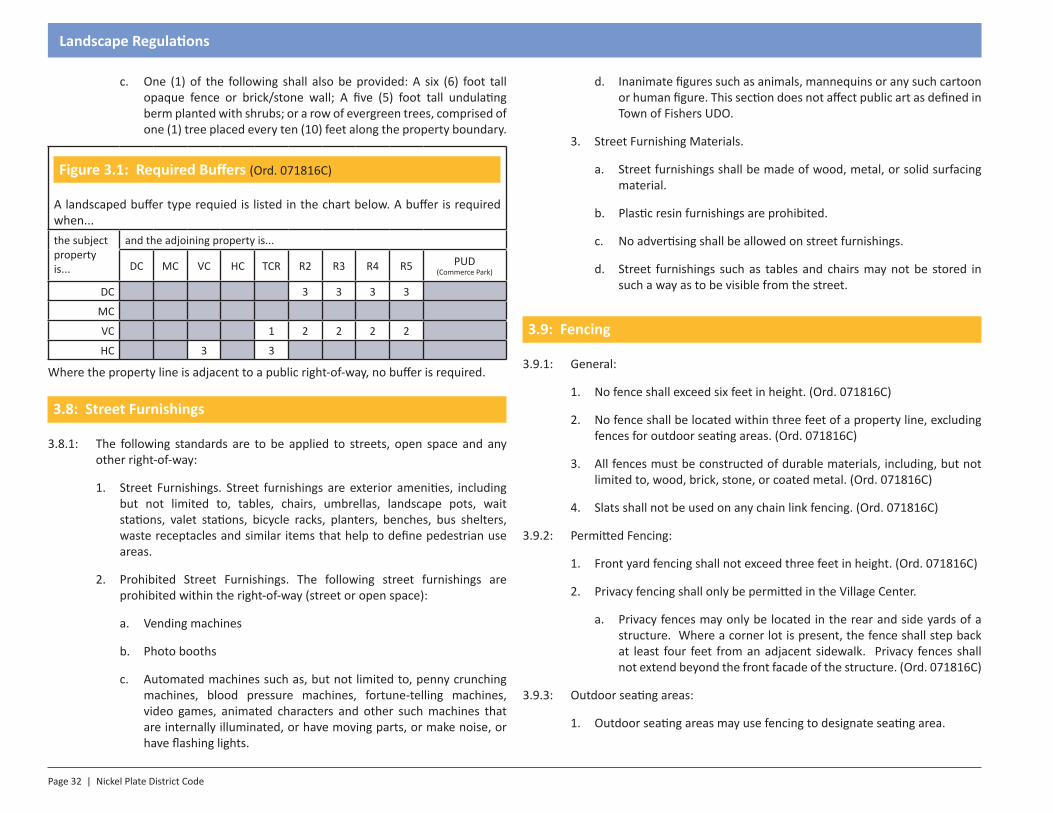
Figure 3.1: Required Buffers (Ord. 071816C)
A landscaped buffer type requied is listed in the chart below. A buffer is required when...the subject property is...
and the adjoining property is...
DC MC VC HC TCR R2 R3 R4 R5 PUD (Commerce Park)
DC 3 3 3 3
MC
VC 1 2 2 2 2
HC 3 3
Where the property line is adjacent to a public right-of-way, no buffer is required.
3.8: Street Furnishings
3.8.1: The following standards are to be applied to streets, open space and any other right-of-way:
1. Street Furnishings. Street furnishings are exterior amenities, including but not limited to, tables, chairs, umbrellas, landscape pots, wait stations, valet stations, bicycle racks, planters, benches, bus shelters, waste receptacles and similar items that help to define pedestrian use areas.
2. Prohibited Street Furnishings. The following street furnishings are prohibited within the right-of-way (street or open space):
a. Vending machines
b. Photo booths
c. Automated machines such as, but not limited to, penny crunching machines, blood pressure machines, fortune-telling machines, video games, animated characters and other such machines that are internally illuminated, or have moving parts, or make noise, or have flashing lights.
d. Inanimate figures such as animals, mannequins or any such cartoon or human figure. This section does not affect public art as defined in Town of Fishers UDO.
3. Street Furnishing Materials.
a. Street furnishings shall be made of wood, metal, or solid surfacing material.
b. Plastic resin furnishings are prohibited.
c. No advertising shall be allowed on street furnishings.
d. Street furnishings such as tables and chairs may not be stored in such a way as to be visible from the street.
3.9: Fencing
3.9.1: General:
1. No fence shall exceed six feet in height. (Ord. 071816C)
2. No fence shall be located within three feet of a property line, excluding fences for outdoor seating areas. (Ord. 071816C)
3. All fences must be constructed of durable materials, including, but not limited to, wood, brick, stone, or coated metal. (Ord. 071816C)
4. Slats shall not be used on any chain link fencing. (Ord. 071816C)
3.9.2: Permitted Fencing:
1. Front yard fencing shall not exceed three feet in height. (Ord. 071816C)
2. Privacy fencing shall only be permitted in the Village Center.
a. Privacy fences may only be located in the rear and side yards of a structure. Where a corner lot is present, the fence shall step back at least four feet from an adjacent sidewalk. Privacy fences shall not extend beyond the front facade of the structure. (Ord. 071816C)
3.9.3: Outdoor seating areas:
1. Outdoor seating areas may use fencing to designate seating area.
Nickel Plate District Code | Page 33
Landscape Regulations
2. Fencing shall be wood, brick, stone, or black coated metal (excluding chain link) with a maximum height of three feet. (Ord. 071816C)
3. An encroachment permit is required.
4. A minimum of six feet of clear space on the adjacent sidewalk must be maintained at all times. (Ord. 071816C)
5. See administration for waivers. (Ord. 071816C)
3.10: Installation & Maintenance
3.10.1: Minimum Size at Installation: Minimum sizes shall apply to plant materials throughout these Landscape Standards.
3.10.2: Street Tree: Two and one-half inch (2 ½”) caliper measured using standard nursery practices.
3.10.3: Deciduous Tree: One and one-half inch (1 ½”) caliper measured using standard nursery practices.
3.10.4: Evergreen Tree: Six (6) feet tall.
3.10.5: Shrub: One-gallon or greater container size or a minimum eighteen (18) inches from the adjacent ground level.
3.10.6: Landscape Plan Installation Extension:
1. Time Limit: Upon request, the Mayor or Mayor’s Designee may grant an extension of up to one hundred eighty (180) days for the complete installation of landscaping materials due to seasonal or weather conditions which preclude the quality installation of plant materials. (Ord. 081715F)
2. Performance Guarantee: As a condition of the extension, the Mayor or Mayor’s Designee may require a performance bond, letter of credit or other satisfactory assurance from the person requesting the extension. (Ord. 081715F)
3.10.7: Irrigation Systems: The installation of irrigation systems is strongly encouraged to ensure establishment and long term survivability of plant material. The use of low volume systems (drip, micro spray, sub-surface, etc.) is highly recommended to minimize water runoff.
3.10.8: Live Plantings: All plant material shall be living species. Dead, diseased or artificial plants shall not be recognized by Fishers as contributing to the required landscaping.
3.10.9: Maintenance: Trees, vegetation, irrigation systems, fences, walls and other landscape material are essential elements of the Nickel Plate District. The petitioner and/or landowner, and their successors in interest are responsible for the regular maintenance of all landscaping elements such that they are kept in good condition. Specifically:
1. All plant material shall be maintained alive, healthy and free from disease and pests.
2. All landscaped areas shall be free of weeds, litter, graffiti and similar signs of deferred maintenance.
3. All landscape structures such as fences and walls shall be repaired or replaced periodically to maintain a structurally sound condition.
4. The maintenance and routine care of plant material located within the rights-of-way shall be the responsibility of the adjacent property owners. For purposes of these Landscape Standards, maintenance and care shall include but not be limited to pruning, watering, fertilizing and mulching, or any item that would constitute a safety hazard to pedestrian or vehicular traffic.
5. Maintenance of all trees and landscape shall conform to accepted industry standards as set forth by a minimum of one of following entities: the Landscape Contractors Association, American Society of Landscape Architects, The International Society of Aboriculture, or the American Natural Standards Institute.
3.10.10: Landscape installed within the public right-of-way shall be the responsibility of the petitioner for a period of one year from installation.


SECTION 1.0Introduction
Section 4 - Parking Regulations
Page 36 | Nickel Plate District Code
Parking Regulations
4.1: Intent
The intent of these Parking Standards is to assure that each developed or utilized lot has adequate parking spaces within either dedicated, shared, public or on-street locations. Private lots are discouraged in the Downtown Core and Municipal Center. Lots should be located within the rear setback whenever possible. The use of on-street and shared parking is preferred within the Downtown Core, Municipal Center and Village Center.
4.2: General Requirements
4.2.1: Surface: All permanent parking areas shall utilize a paved surface of concrete, asphalt, brick pavers, or the like.
4.2.2: Parking of motor vehicles is not permitted on lawns or other pervious-surfaced areas on a lot, unless approved by the Mayor or Mayor’s Designee. See Administration for waivers. (Ord. 081715F)
4.2.3: Parking Space Dimensions:
1. Minimum Width: Each parking space shall be a minimum of nine feet wide.
2. Minimum Length:
a. Standard: Each parking space shall be a minimum of 18 feet long.
b. Adjacent to Landscape Areas: The minimum length of a parking space may be reduced to 16 feet if the parking space extends into a landscape area such that a car’s front end may project into the landscape area. Landscape areas shall be two feet wider to accommodate.
c. Adjacent to Sidewalks: The minimum length of a parking space may be reduced to 16 feet if the parking space extends into a sidewalk such that a car’s front end may project over the sidewalk. In the event that a car projects over a sidewalk, the sidewalk shall be two feet wider than the required width. Under no circumstance shall a sidewalk have less then six feet of clear area for pedestrians to pass when a vehicle’s front end is projecting over part of the sidewalk; however, under no circumstance shall an off-street parking space overhang into an public or private street right-of-way.
4.2.4: Compact Parking Spaces may be used to address unique site constraints, which shall be approved by the Mayor or Mayor’s Designee. See Administration for waivers. (Ord. 081715F)
1. Compact spaces may be provided at a maximum of 10 percent of the total number of required parking spaces.
2. Compact parking spaces shall be a minimum of eight feet in width and 16 feet in length.
3. All compact parking spaces shall be clearly identified through signage and pavement markings.
4.2.5: Access: Off-street parking spaces shall not be fully or partially in a public or private right-of-way or access easement.
4.2.6: Driving Lanes: Driving lanes in parking lots that provide access to parking aisles shall be clearly striped and shall be curbed.
4.2.7: Parking Layout: The Nickel Plate Review Committee shall review the parking layout to ensure that vehicular circulation to and within the parking lot is managed in a logical manner thereby confirming: (Ord. 011717D)
1. That the design and location of proposed street access points minimize safety hazards and congestion;
2. That the access points, streets, and internal traffic circulation facilities are compatible with existing and planned streets and adjacent developments.
3. Wheel stops are required for spaces facing a designated walkway without a curb.
4. Where a surface parking lot is within 15 feet of a property line, a vehicular connection shall be provided to any adjacent property. This requirement may be waived by the Mayor or Mayor’s Designee should the adjacent property already be developed. (Ord. 081715F)
5. Parking garages shall be located within the building envelope, and surface parking lots may encroach into the setback, but shall be at least five feet away from a property line.
6. Parking lots must be located in the rear yard, except for temporary lots. (Ord. 011717D)
Nickel Plate District Code | Page 37
Parking Regulations
4.2.8: Parking Lot Striping: Parking spaces in parking lots shall be striped so as to clearly show each parking space. These stripes shall be maintained in clearly visible condition.
4.2.9: Display and Storage: Parking spaces shall not be used for display or storage of merchandise or similar.
4.2.10: Surface lots shall not be permitted in the Village Center Zone. See Administration for waivers. (Ord. 011717D, Ord. 091817)
4.2.11: All developments over 35,000 square feet and/or 50 residential units shall provide a minimum of two drop-off/delivery/pick-up parking spaces. (Ord. 091817)
4.3: Number of Spaces Required
4.3.1: The number of spaces required shall be determined by Figure 4.1.
4.3.2: Administrative Adjustments: The minimum or maximum number of parking spaces may be adjusted by the Mayor or Mayor’s Designee or the Nickel Plate Review Committee. See Administration for waivers. (Ord. 081715F)
4.3.3: Use Determination: If a use is not clearly noted in Figure 4.1, the Director of Community Development shall determine into which use(s) the proposed development best fits, therefore determining the minimum parking spaces required.
4.3.4: Storage: Any parking space that is used for a cart corral or similar use shall not be counted toward the minimum number of required parking spaces.
4.3.5: Parking funded with municipal assistance is exempt from the maximum parking standards.
4.3.6: Single family homes may count attached or detached garage spaces as off-street parking spaces.
4.3.7: All parking is not required to be off-street. Use of Shared Parking and Public Parking is encouraged. Spaces in a municipal garage may be available with the approval of the Mayor or Mayor’s Designee. (Ord. 081715F)
4.3.8: An entire development may satisfy its parking requirement through the use of shared and/or public parking with no individual off-street parking.
1. If at least two (2) on-street spaces which are dedicated and striped are not available within 50 feet of a structure’s entrance, then at least four
(4) spaces shall be provided on the subject property. See administration for waivers. (Ord. 011717D)
4.4: Accessible Parking Spaces
4.4.1: The requirements for accessible parking shall be regulated according to Americans with Disabilities Act guidelines.
4.5: Bicycle Parking
4.5.1: Minimum number of bicycle parking spaces: A minimum of three bicycle parking spaces are required for each development.
4.5.2: One additional space shall be provided per 30 vehicle parking spaces. No more than 20 bicycle parking spaces shall be required for any development.
4.5.3: The bicycle parking spaces shall be located in close proximity to the main entryway into the primary structure or within the primary structure.
4.5.4: Bike Rack Requirement: A bike rack shall be installed to hold and secure the bicycles or other means for security shall be provided.
4.5.5: Pedestrian Ways: Bicycle parking areas shall be designed such that when fully occupied, the bicycles, including trailers, shall not obstruct an adjacent sidewalk, path, or other pedestrian way.
4.6: Shared Parking
4.6.1: Two or more adjacent properties may establish a shared parking area when the following criteria are met:
1. Administrative Approval: The Mayor or Mayor’s Designee shall approve the use of shared parking. (Ord. 081715F)
2. Reciprocal Parking Agreement: A written reciprocal parking agreement signed by all property owners involved is required and shall include provisions concerning at least the following items: maintenance, snow removal, ownership, and liability and shall be recorded in the Hamilton County Recorder’s office. The agreement may be reviewed and approved by the Fishers Attorney. A copy of the recorded agreement shall also be
Page 38 | Nickel Plate District Code
Parking Regulations
submitted to and kept in the Department of Community Development office.
3. Shared parking facilities shall be fully located within 600 feet of the structures the parking intends to serve.
4.6.2: Shared parking is calculated in Figure 4.2. The required parking is divided by the parking factor for each use in the area to be shared.
4.6.3: Petitioners wishing to construct parking above their required ratio with the intent to accommodate future businesses may build the increased parking with the approval of the Mayor or Mayor’s Designee. See Administration for waivers. (Ord. 081715F)
4.7: Public Parking
4.7.1: On-street parking may be used to satisfy the parking demand for a property given the following requirements.
1. Parking spaces shall be within 600 feet of the subject property.
2. Parking spaces immediately adjacent to the property count one-to-one toward the required parking.
3. All other parking spaces within 600 feet apply at a ratio of two public, on-street spaces per one required space.
4.7.2: Municipal Parking Structure(s) may be used to satisfy a portion or all of the parking requirements for a property given the following requirements:
1. Use of spaces in a Municipal structure requires approval of the Mayor or Mayor’s Designee. (Ord. 081715F)
2. Shared parking shall be calculated according to Section 4.6.
4.8: Driveway Standards
4.8.1: Private driveways shall be no wider than 34 feet.
4.8.2: Driveways for the may be no closer than 70 feet apart.
4.9: Loading Areas
4.9.1: Loading areas, if necessary, shall be located integral to parking areas.
4.9.2: If not feasible to locate loading within the site, loading may be along the adjacent roadway with the lowest functional classification.
4.9.3: Loading utilizing on-street spaces is discouraged. However, loading may use on-street parking areas with the approval of the Mayor or Mayor’s Designee. (Ord. 081715F)
4.10: Surface Parking
4.10.1: Intent: Surface parking lots are to be a temporary use in DC and MC when no municipal parking structure or sufficient street parking is not available. No permanent surface parking lots are to be allowed in DC and MC. However, small lots behind primary structures are encouraged within the rear building setback. This situation will allow buildings to be built before all of the necessary infrastructure is built. This will also allow for future redevelopment of any surface lot in MC or DC. (Ord. 071816C)
4.10.2: All surface parking lots, including temporary parking lots, shall be buffered and landscaped according to the Fishers UDO, as amended.
4.10.3: Temporary parking lots shall provide streetscape elements (i.e. tree grates, sidewalk, etc.) in accordance with the Street Standards.
4.10.4: Surface lots shall be approved by the Mayor or Mayor’s Designee. (Ord. 081715F)
4.10.5: Temporary surface lots shall be sold to Fishers at the current market value at such time as garage, street, or other temporary parking is available within 550 feet of the existing, temporary surface lot. At the time of the sale, a perpetual easement for an equal number of spaces shall be granted to the property owner.
1. Parking for businesses north of 116th Street shall not be moved to an area south of 116th Street or vice versa.
2. The distance of 550 feet is measured as the walking distance along public rights-of-way or easements from the nearest corner of the existing lot (or adjacent business that it serves, whichever is closer) to the nearest corner of the new parking area.
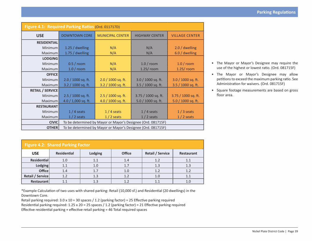
Nickel Plate District Code | Page 39
Parking Regulations
Figure 4.1: Required Parking Ratios (Ord. 011717D)
USE DOWNTOWN CORE MUNICIPAL CENTER HIGHWAY CENTER VILLAGE CENTER
RESIDENTIALMinimum 1.25 / dwelling N/A N/A 2.0 / dwellingMaximum 1.75 / dwelling N/A N/A 6.0 / dwellingLODGINGMinimum 0.5 / room N/A 1.0 / room 1.0 / roomMaximum 1.0 / room N/A 1.25/ room 1.25/ room
OFFICEMinimum 2.0 / 1000 sq. ft. 2.0 / 1000 sq. ft. 3.0 / 1000 sq. ft. 3.0 / 1000 sq. ft.Maximum 3.2 / 1000 sq. ft. 3.2 / 1000 sq. ft. 3.5 / 1000 sq. ft. 3.5 / 1000 sq. ft.
RETAIL / SERVICEMinimum 2.5 / 1000 sq. ft. 2.5 / 1000 sq. ft. 3.75 / 1000 sq. ft. 3.75 / 1000 sq. ft.Maximum 4.0 / 1,000 sq. ft. 4.0 / 1000 sq. ft. 5.0 / 1000 sq. ft. 5.0 / 1000 sq. ft.
RESTAURANTMinimum 1 / 4 seats 1 / 4 seats 1 / 4 seats 1 / 3 seatsMaximum 1 / 2 seats 1 / 2 seats 1 / 2 seats 1 / 2 seats
CIVIC To be determined by Mayor or Mayor’s Designee (Ord. 081715F)OTHER To be determined by Mayor or Mayor’s Designee (Ord. 081715F)
Figure 4.2: Shared Parking Factor
USE Residential Lodging Office Retail / Service Restaurant
Residential 1.0 1.1 1.4 1.2 1.1Lodging 1.1 1.0 1.7 1.3 1.3
Office 1.4 1.7 1.0 1.2 1.2Retail / Service 1.2 1.3 1.2 1.0 1.1
Restaurant 1.1 1.3 1.2 1.1 1.0
*Example Calculation of two uses with shared parking: Retail (10,000 sf.) and Residential (20 dwellings) in the Downtown Core.Retail parking required: 3.0 x 10 = 30 spaces / 1.2 (parking factor) = 25 Effective parking requiredResidential parking required: 1.25 x 20 = 25 spaces / 1.2 (parking factor) = 21 Effective parking requiredEffective residential parking + effective retail parking = 46 Total required spaces
• The Mayor or Mayor’s Designee may require the use of the highest or lowest ratio. (Ord. 081715F)
• The Mayor or Mayor’s Designee may allow petitions to exceed the maximum parking ratio. See Administration for waivers. (Ord. 081715F)
• Square footage measurements are based on gross floor area.


SECTION 1.0Introduction
Section 5 - Lighting Regulations
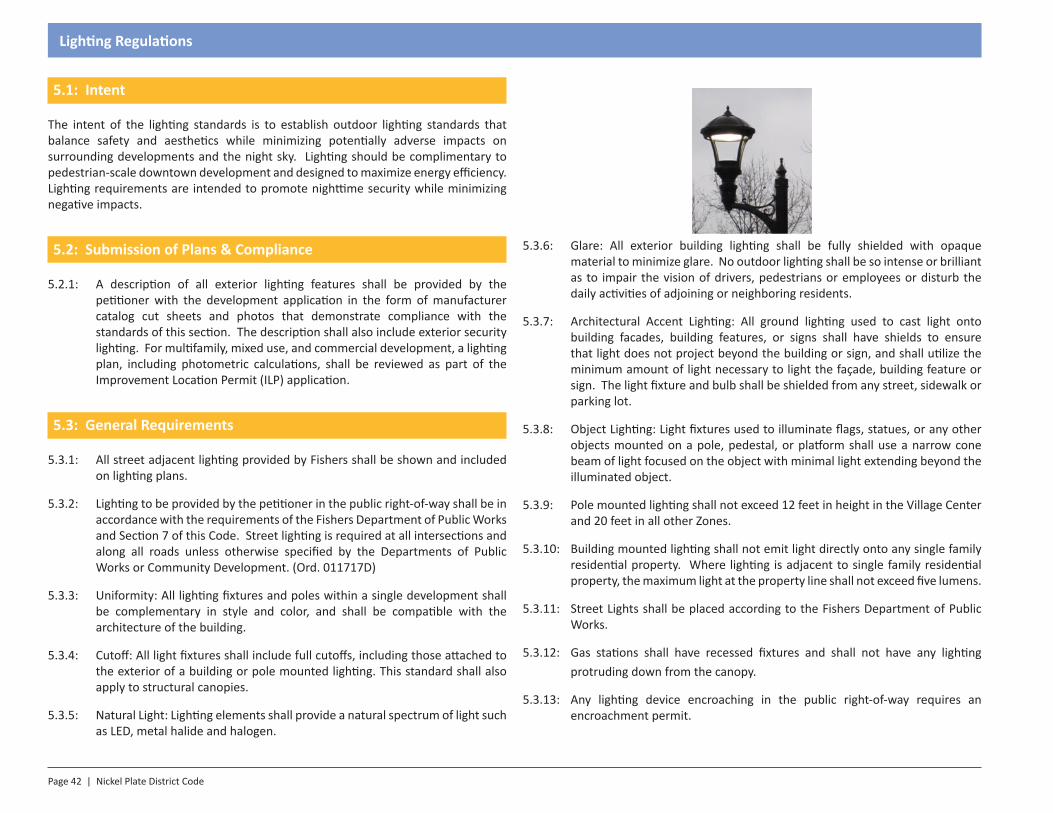
Page 42 | Nickel Plate District Code
Lighting Regulations
5.1: Intent
The intent of the lighting standards is to establish outdoor lighting standards that balance safety and aesthetics while minimizing potentially adverse impacts on surrounding developments and the night sky. Lighting should be complimentary to pedestrian-scale downtown development and designed to maximize energy efficiency. Lighting requirements are intended to promote nighttime security while minimizing negative impacts.
5.2: Submission of Plans & Compliance
5.2.1: A description of all exterior lighting features shall be provided by the petitioner with the development application in the form of manufacturer catalog cut sheets and photos that demonstrate compliance with the standards of this section. The description shall also include exterior security lighting. For multifamily, mixed use, and commercial development, a lighting plan, including photometric calculations, shall be reviewed as part of the Improvement Location Permit (ILP) application.
5.3: General Requirements
5.3.1: All street adjacent lighting provided by Fishers shall be shown and included on lighting plans.
5.3.2: Lighting to be provided by the petitioner in the public right-of-way shall be in accordance with the requirements of the Fishers Department of Public Works and Section 7 of this Code. Street lighting is required at all intersections and along all roads unless otherwise specified by the Departments of Public Works or Community Development. (Ord. 011717D)
5.3.3: Uniformity: All lighting fixtures and poles within a single development shall be complementary in style and color, and shall be compatible with the architecture of the building.
5.3.4: Cutoff: All light fixtures shall include full cutoffs, including those attached to the exterior of a building or pole mounted lighting. This standard shall also apply to structural canopies.
5.3.5: Natural Light: Lighting elements shall provide a natural spectrum of light such as LED, metal halide and halogen.
5.3.6: Glare: All exterior building lighting shall be fully shielded with opaque material to minimize glare. No outdoor lighting shall be so intense or brilliant as to impair the vision of drivers, pedestrians or employees or disturb the daily activities of adjoining or neighboring residents.
5.3.7: Architectural Accent Lighting: All ground lighting used to cast light onto building facades, building features, or signs shall have shields to ensure that light does not project beyond the building or sign, and shall utilize the minimum amount of light necessary to light the façade, building feature or sign. The light fixture and bulb shall be shielded from any street, sidewalk or parking lot.
5.3.8: Object Lighting: Light fixtures used to illuminate flags, statues, or any other objects mounted on a pole, pedestal, or platform shall use a narrow cone beam of light focused on the object with minimal light extending beyond the illuminated object.
5.3.9: Pole mounted lighting shall not exceed 12 feet in height in the Village Center and 20 feet in all other Zones.
5.3.10: Building mounted lighting shall not emit light directly onto any single family residential property. Where lighting is adjacent to single family residential property, the maximum light at the property line shall not exceed five lumens.
5.3.11: Street Lights shall be placed according to the Fishers Department of Public Works.
5.3.12: Gas stations shall have recessed fixtures and shall not have any lighting protruding down from the canopy.
5.3.13: Any lighting device encroaching in the public right-of-way requires an encroachment permit.
Nickel Plate District Code | Page 43
Lighting Regulations
5.4: Light Level Maximums by Zone
5.4.1: Downtown Core: 5.0 lumens (max) per square foot of hardscape
5.4.2: Municipal Center: 7.5 lumens (max) per square foot of hardscape.
5.4.3: Highway Center: 2.5 lumens (max) per square foot of hardscape.
5.4.4: Village Center: 1.25 lumens (max) per square foot of hardscape.
5.5: Exemptions
5.5.1: Residential Homes – Soffit or wall-mounted lights that are permanently attached to single-family residential dwellings, This lighting shall include full cut offs.
5.5.2: Temporary Lighting
1. Decorative seasonal lighting provided that individual lamps have a light output of 200 lumens or less.
2. Lighting for emergency work or construction work.
3. Lighting for special events authorized through a permit.
4. Lighting required and regulated by the Federal Aviation Administration.
5.6: Prohibitions
5.6.1: Mercury vapor and metal halide light sources, searchlights, and strobe lights.
5.6.2: Low pressure sodium lights.
5.6.3: Fluorescent lights (except compact fluorescent bulbs that screw into standard sockets) on building exteriors.
5.6.4: Blinking, flashing or flickering lights, or any lighting used to depict action or create a special effect or scene, except for decorative seasonal lighting.
5.6.5: Visible bands of lighting at the cornice and or around building elements. However, the glow from a light ribbon is permitted.
5.6.6: Sport field lighting
5.7: Light Measurements
5.7.1: Measurements of light readings shall be taken along any portion of a property line of the subject property at a height of five feet with a light meter laid on the property line and facing the center of the property.
Life safety devices are exempt from the provisions of this section.
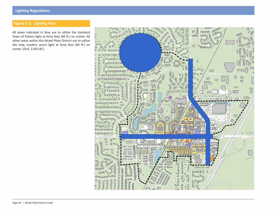
Page 44 | Nickel Plate District Code
Lighting Regulations
Figure 5.1: Lighting Plan
All areas indicated in blue are to utilize the standard Town of Fishers light at forty feet (40 ft.) on center. All other areas within the Nickel Plate District are to utilize the new, modern acorn light at forty feet (40 ft.) on center. (Ord. 110514C)

SECTION 1.0Introduction
Section 6 - Signage Regulations
Page 46 | Nickel Plate District Code
Signage Regulations
6.1: Intent
The intent of the signage standards of the Nickel Plate Code is to encourage the effective use of signage as a means of communication while also enhancing the aesthetics of a walkable downtown environment. The standards aim to ensure the compatibility of signs with a downtown streetscape, to encourage the use of signs appropriate to residential and commercial activities, to ensure the safety of vehicular and pedestrian traffic, and to support the economic development within Fishers.
The signage standards are a supplement to the standards of the Fishers UDO, as amended. Where conflicts exist, this Code shall prevail. Where standards are not addressed by this Code, the UDO, as amended, shall prevail.
6.1.1: Use:
6. Multi-tenant buildings should identify the structure/project with projecting signs and/or upper wall signage. Individual tenants should be identified with lower wall signs and/or upper wall signs. (Ord. 071816C)
6.1.2: Design:
7. Sign size, shape, color, height, and placement must be compatible and harmonious with the building to which it is affixed. (Ord. 071816C)
8. Signage must be compatible with the visual characteristics of the surrounding area. (Ord. 071816C)
9. Signage location and design of its visual elements (text, logos, proportions) must be legible under normal viewing conditions. (Ord. 071816C)
10. Signage must not obscure or unduly detract from existing signage. (Ord. 071816C)
See Administration for waivers. (Ord. 071816C)
6.2: Compliance, Permits & Applications
6.2.1: Compliance: All signs shall comply with the general rules, regulations, and requirements governing their placement, type, number, and size as outlined and contained in the provisions of this section. The only signs permitted are those stated within this section; all other signs are prohibited unless otherwise stated.
6.2.2: All applications for design review or Improvement Location Permits shall show the location of proposed signage.
6.2.3: Permit Required:
1. All signs are required to have a permit to erect, alter, or relocate except as otherwise provided herein.
2. When a sign permit has been issued, it shall be unlawful to change, modify, alter or otherwise deviate from the terms and conditions of said permit without prior approval of the Department of Community Development. A written record of such approval shall be entered upon the original permit application and maintained in the files of the Department of Community Development.
3. A permanent sign permit shall not be issued before a change of use, change of occupancy, or tenant finish permit has been filed.
4. Applications shall be made available by the Department of Community Development.
5. All applications requiring Nickel Plate Review Committee approval shall submit a complete signage package for review. (Ord. 071816C)
6.2.4: Permit Not Required:
1. Activity Signs: For single family residential use only, school activities and the like are permitted with a maximum sign area of eight square feet.
2. Construction Area Signs: Construction signs such as construction entrance only, concrete washout, hard hat area, caution area, low wires, and the like are permitted with a maximum sign area of eight square feet per sign.
3. Corner Stones: Names of buildings, dates of erection, monumental citations, or commemorative tablets not to exceed nine square feet, and the like, when carved into stone, concrete, or similar material or made of bronze, aluminum, or other permanent type construction and made an integral part of the structure.
4. Credit/Debit Signage: Each ATM may include identification signs and a list of accepted cards. These signs shall be limited to 20 percent of the ATM machine.
5. Cultural Elements: Artwork, murals, sculpted elements, and the like that do not refer to a commercial activity shall be reviewed by the Town of Fishers or designee.
Nickel Plate District Code | Page 47
Signage Regulations
6. Delivery Entrance: Decorative name plates which shall not exceed two square feet in area per building or tenant space in order to identify a specific delivery entrance.
7. Flags: One corporate flag, provided it is flown in conjunction with a United States of America flag, is permitted per site.
8. Holiday Decorations and Special Events: Decorations which directly relate to an individual achievement, specifically noncommercial in nature, such as, birthday, anniversary, birth announcement, recognized holidays, or civic events.
9. Public Signs: Signs of a noncommercial nature and in the public interest, erected by or on the order of an official of the Town, County, State, or Federal government acting in the performance of his/her duty, such as safety signs, danger signs, trespassing signs, traffic signs and memorial plaques.
10. Replacing Copy: Making a change to the sign copy in a manner that will not alter or relocate the sign structure in any manner is permitted.
11. Residential Nameplate: A nameplate which shall not exceed one square foot in area is permitted for each dwelling unit of a single family or row structure; such nameplate shall indicate nothing other than name and/or address of the occupant.
12. Sign Maintenance: Painting, repainting, cleaning and other normal maintenance and repair of a sign or a sign structure shall not require a permit unless a structural change or change in lighting is made.
13. Special Event: Signage which has been approved by the Town Council or its designee for the purpose of displaying a sign on Fishers property shall be exempt from the Nickel Plate District Code.
14. Municipal Property: Signs established on Fishers owned property or within the public right-of-way that have been reviewed and approved by Fishers.
15. Sandwich Board Signs: Sandwich Board Signs do not require a sign permit, however an encroachment permit may be required.
16. Pedestrian Signs: Pedestrian-oriented signs less than two square feet in area shall not require a permit.
17. Art Installations: Installations approved by the Fishers Community Art Selection Committee shall not be considered signage.
18. All wayfinding signage within the right-of-way may be approved by the Mayor or Mayor’s Designee. (Ord. 081715F, 110514C)
6.2.5: Permit Application: A sign permit application is required to erect, construct, alter, or relocate a sign under the provisions of this section. The application shall include:
1. The names, addresses, and contact information of the contractor, business, or other persons responsible for the placement of the sign.
2. A detailed site plan drawing indicating the lot size, tenant space frontage, placement, location, landscaping, and address of the sign.
3. A scaled elevation drawing indicating the size of the sign, and sign structure.
4. The property owners contact information and signature. Consent from the owner of the subject property or an affidavit of agency signed by the owner are permissible if a sign company is securing a permit.
5. Fees for a sign permit shall be fixed by ordinances adopted by the Town Council.
6.3: Prohibited Signs
6.3.1: Prohibited Signs:
1. No sign or other advertising device with visible moving parts or with flashing, animated, or intermittent illumination shall be erected except signs indicating the time, date, or weather conditions provided this area does not exceed 20 percent of the permitted sign area and shall not flash, blink, or have moving illumination. This excludes required life safety devices.
2. No sign or sign structure shall be erected at any location where it may interfere with, obstruct the view of, or be confused with any authorized traffic sign, signal or device. No rotating beam, beacon, or flashing illumination resembling emergency lights shall be used in connection with a sign display, nor shall a sign make use of the words “Stop,” “Look,” “Danger,” or any other word, phrase, symbol, or character in such a manner as to interfere with, mislead, or confuse traffic. No sign shall emit any form of sound or sounds.
Page 48 | Nickel Plate District Code
Signage Regulations
3. No permanent sign shall contain fluorescent paint or the like, including mirrors, which has the effect of intensifying reflected light.
4. No permanent or temporary sign shall be affixed to any fence, tree, or any utility structure.
5. Ribbon, pennants, balloons, streamers, strings of light bulbs, spinners, or the like are not permitted.
6. No sign shall obstruct a window, door, fire escape, stairway, or any opening intended to provide air, egress, or ingress for a building or structure.
7. No sign shall be placed within the right-of-way of a public street without the approval of the Town Council or designee.
8. No sign shall be placed on vehicles or trailers which are parked or located for the primary purpose of displaying said sign. This does not apply to signs or lettering on buses, taxis or vehicles operating during the normal course of business.
9. Billboard: Not permitted in any zone.
10. Digital signage shall not be permitted in the Nickel Plate District. Clocks and temperature readouts are exempt but may be no larger than two square feet and shall be a single color, on a black background, and have no animation.
6.4: General Standards
This sign standards section applies to all Zones:
6.4.1: All signs shall complement the materials of the building which they identify, be architecturally compatible with the related structure, and shall be constructed of durable materials.
6.4.2: No signs or signage illumination shall be so designed, located, unshielded, or directed to cast glare or direct light from artificial illumination upon adjacent publicly dedicated streets and surrounding property.
6.4.3: At such time that a wall sign is removed from the facade of a building and replaced with a new sign, the facade shall be restored to match the existing condition of the wall area. All previous mounting holes and ghosting images
shall be removed and the facade shall match the existing condition of the building. Such persons or companies requesting issuance of a Sign Permit shall be required to assume sole responsibility for the restoration of the building facade at the time the existing sign is removed.
6.4.4: Design: Individually mounted letters constructed of an opaque material such as wood or metal may be used in conjunction with an architecturally enhanced background which shall define the sign area. The source of such backlighting shall be internal to each letter (e.g. reverse channel neon) and shall illuminate the wall to which they are attached. Other lighting sources include external uplighting, gooseneck downlighting. In no instance shall light be emitted directly from the sign letters nor the lighting source visible from passing vehicles. (Ord. 071816C)
6.4.5: Signage shall not project above the finished height of any facade.
6.4.6: All signs shall maintain a minimum of eight feet of vertical clearance from the sidewalk.
6.4.7: Vision clearance shall be maintained for motorists at all times.
6.4.8: Illumination of signs shall only occur on facades facing a public right-of-way except as otherwise provided herein.
6.5: Temporary Signs
6.5.1: Temporary signs are permissible in all zones and shall be subject to the Unified Development Ordinance regulations for temporary signage, as amended.
6.5.2: Project identification signs: Signs to identify new projects are required. These are to be temporary signs that must be removed before a certificate of occupancy is issued. In no instance can a sign remain for more than one year. Signs may be a maximum of four feet by eight feet (4 ft. x 8 ft.) with one per roadway frontage. Alternate project identification sign standards may be approved by the Mayor or Mayor’s Designee. (Ord. 081715F, 110514C)
6.6: Types of Signs
6.6.1: Figure 6.1 identifies the allowed signage types and the Zones that permit each type of signs.
6.6.2: Projecting Sign:
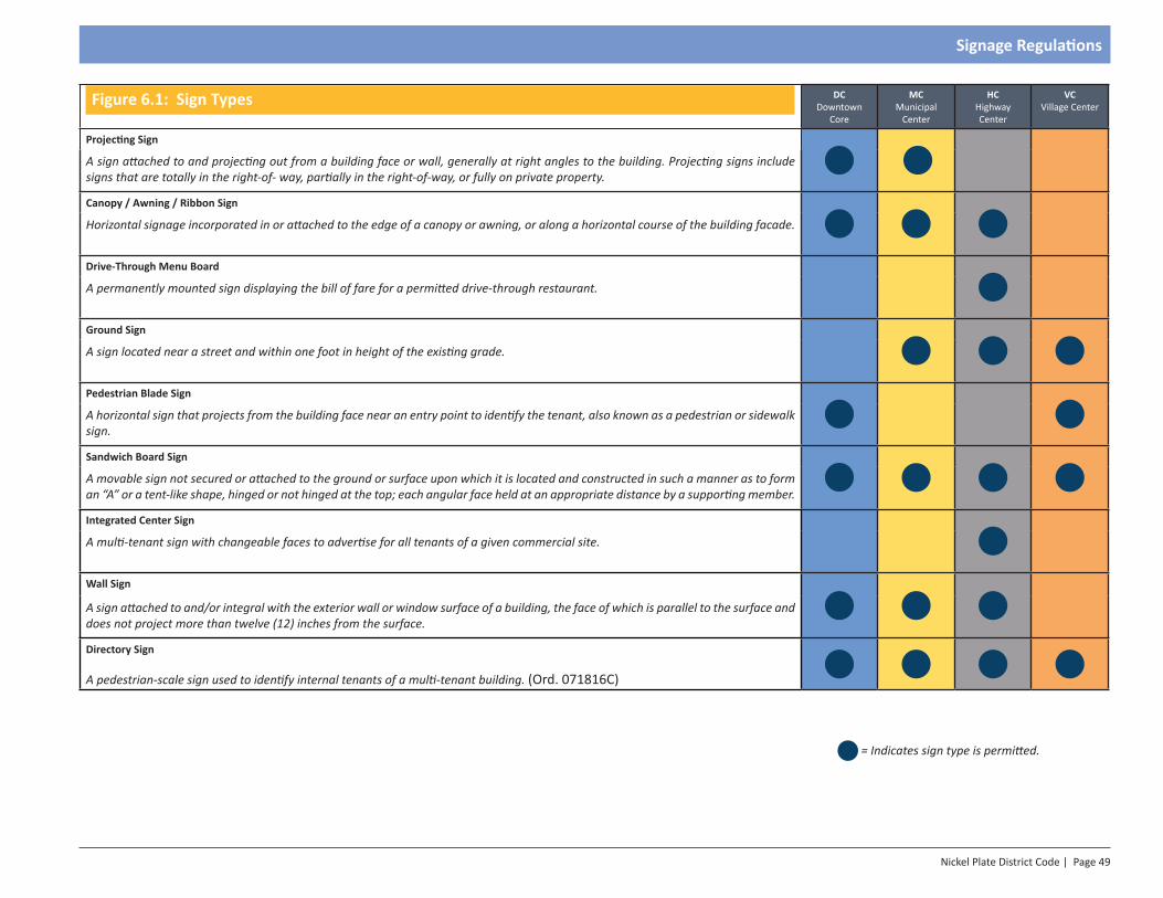
Nickel Plate District Code | Page 49
Signage Regulations
Figure 6.1: Sign Types DC Downtown
Core
MC Municipal
Center
HC Highway Center
VC Village Center
Projecting Sign
A sign attached to and projecting out from a building face or wall, generally at right angles to the building. Projecting signs include signs that are totally in the right-of- way, partially in the right-of-way, or fully on private property.
Canopy / Awning / Ribbon Sign
Horizontal signage incorporated in or attached to the edge of a canopy or awning, or along a horizontal course of the building facade.
Drive-Through Menu Board
A permanently mounted sign displaying the bill of fare for a permitted drive-through restaurant.
Ground Sign
A sign located near a street and within one foot in height of the existing grade.
Pedestrian Blade Sign
A horizontal sign that projects from the building face near an entry point to identify the tenant, also known as a pedestrian or sidewalk sign.
Sandwich Board Sign
A movable sign not secured or attached to the ground or surface upon which it is located and constructed in such a manner as to form an “A” or a tent-like shape, hinged or not hinged at the top; each angular face held at an appropriate distance by a supporting member.
Integrated Center Sign
A multi-tenant sign with changeable faces to advertise for all tenants of a given commercial site.
Wall Sign
A sign attached to and/or integral with the exterior wall or window surface of a building, the face of which is parallel to the surface and does not project more than twelve (12) inches from the surface.
Directory Sign
A pedestrian-scale sign used to identify internal tenants of a multi-tenant building. (Ord. 071816C)
= Indicates sign type is permitted.
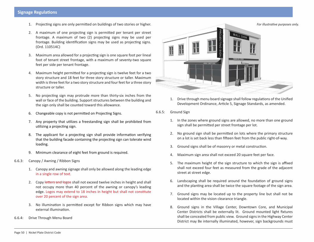
Page 50 | Nickel Plate District Code
Signage Regulations
1. Projecting signs are only permitted on buildings of two stories or higher.
2. A maximum of one projecting sign is permitted per tenant per street frontage. A maximum of two (2) projecting signs may be used per frontage. Building identification signs may be used as projecting signs. (Ord. 110514C)
3. Maximum area allowed for a projecting sign is one square foot per lineal foot of tenant street frontage, with a maximum of seventy-two square feet per side per tenant frontage.
4. Maximum height permitted for a projecting sign is twelve feet for a two story structure and 18 feet for three story structure or taller. Maximum width is three feet for a two story structure and four feet for a three story structure or taller.
5. No projecting sign may protrude more than thirty-six inches from the wall or face of the building. Support structures between the building and the sign only shall be counted toward this allowance.
6. Changeable copy is not permitted on Projecting Signs.
7. Any property that utilizes a freestanding sign shall be prohibited from utilizing a projecting sign.
8. The applicant for a projecting sign shall provide information verifying that the building facade containing the projecting sign can tolerate wind loading.
9. Minimum clearance of eight feet from ground is required.
6.6.3: Canopy / Awning / Ribbon Signs
1. Canopy and awning signage shall only be allowed along the leading edge in a single row of text.
2. Copy letters and logos shall not exceed twelve inches in height and shall not occupy more than 40 percent of the awning or canopy’s leading edge. Logos may extend to 18 inches in height but shall not constitute over 20 percent of the sign area.
3. No illumination is permitted except for Ribbon signs which may have external illumination.
6.6.4: Drive Through Menu Board
1. Drive through menu board signage shall follow regulations of the Unified Development Ordinance, Article 5, Signage Standards, as amended.
6.6.5: Ground Sign
1. In the zones where ground signs are allowed, no more than one ground sign shall be permitted per street frontage per lot.
2. No ground sign shall be permitted on lots where the primary structure on a lot is set back less than fifteen feet from the public right-of-way.
3. Ground signs shall be of masonry or metal construction.
4. Maximum sign area shall not exceed 20 square feet per face.
5. The maximum height of the sign structure to which the sign is affixed shall not exceed four feet as measured from the grade of the adjacent street at street edge.
6. Landscaping shall be required around the foundation of ground signs and the planting area shall be twice the square footage of the sign area.
7. Ground signs may be located up to the property line but shall not be located within the vision clearance triangle.
8. Ground signs in the Village Center, Downtown Core, and Municipal Center Districts shall be externally lit. Ground mounted light fixtures shall be concealed from public view. Ground signs in the Highway Center District may Be internally illuminated, however, sign backgrounds must
For illustrative purposes only.
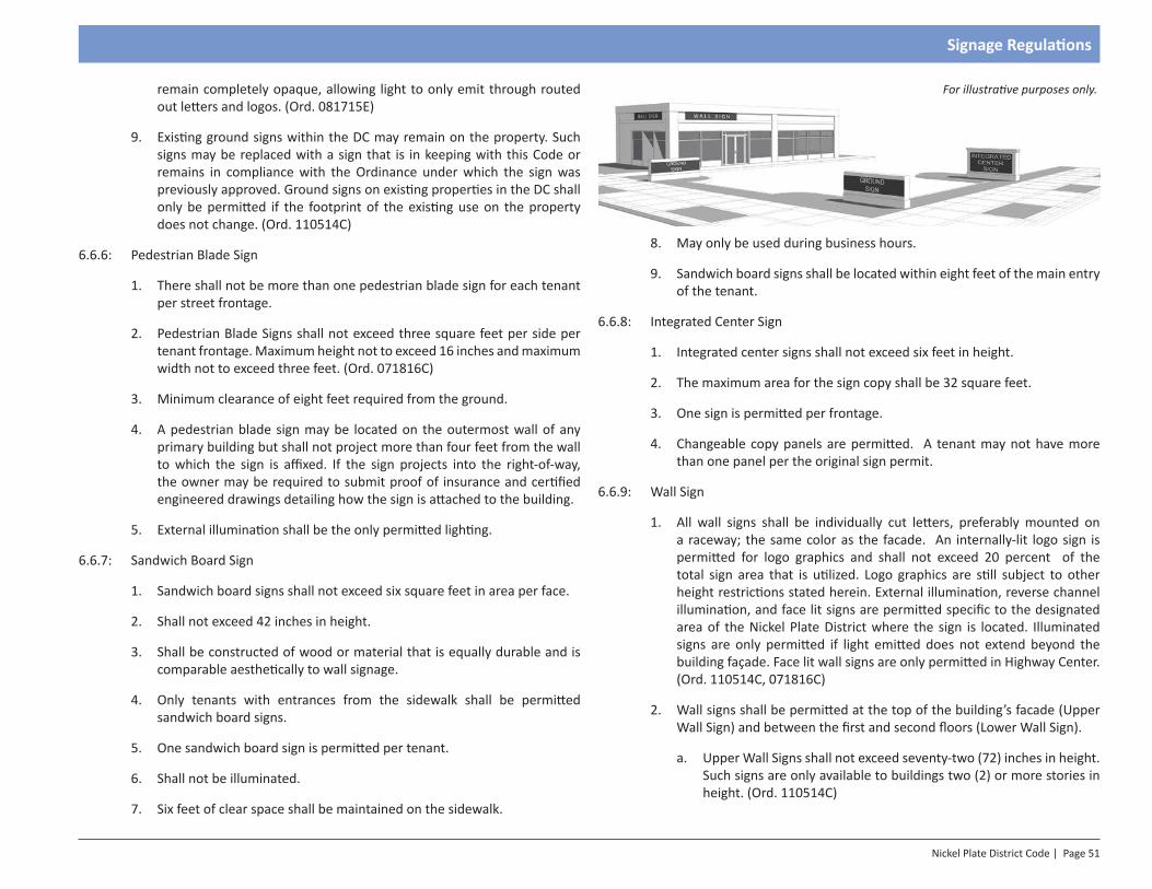
Nickel Plate District Code | Page 51
Signage Regulations
For illustrative purposes only. remain completely opaque, allowing light to only emit through routed out letters and logos. (Ord. 081715E)
9. Existing ground signs within the DC may remain on the property. Such signs may be replaced with a sign that is in keeping with this Code or remains in compliance with the Ordinance under which the sign was previously approved. Ground signs on existing properties in the DC shall only be permitted if the footprint of the existing use on the property does not change. (Ord. 110514C)
6.6.6: Pedestrian Blade Sign
1. There shall not be more than one pedestrian blade sign for each tenant per street frontage.
2. Pedestrian Blade Signs shall not exceed three square feet per side per tenant frontage. Maximum height not to exceed 16 inches and maximum width not to exceed three feet. (Ord. 071816C)
3. Minimum clearance of eight feet required from the ground.
4. A pedestrian blade sign may be located on the outermost wall of any primary building but shall not project more than four feet from the wall to which the sign is affixed. If the sign projects into the right-of-way, the owner may be required to submit proof of insurance and certified engineered drawings detailing how the sign is attached to the building.
5. External illumination shall be the only permitted lighting.
6.6.7: Sandwich Board Sign
1. Sandwich board signs shall not exceed six square feet in area per face.
2. Shall not exceed 42 inches in height.
3. Shall be constructed of wood or material that is equally durable and is comparable aesthetically to wall signage.
4. Only tenants with entrances from the sidewalk shall be permitted sandwich board signs.
5. One sandwich board sign is permitted per tenant.
6. Shall not be illuminated.
7. Six feet of clear space shall be maintained on the sidewalk.
8. May only be used during business hours.
9. Sandwich board signs shall be located within eight feet of the main entry of the tenant.
6.6.8: Integrated Center Sign
1. Integrated center signs shall not exceed six feet in height.
2. The maximum area for the sign copy shall be 32 square feet.
3. One sign is permitted per frontage.
4. Changeable copy panels are permitted. A tenant may not have more than one panel per the original sign permit.
6.6.9: Wall Sign
1. All wall signs shall be individually cut letters, preferably mounted on a raceway; the same color as the facade. An internally-lit logo sign is permitted for logo graphics and shall not exceed 20 percent of the total sign area that is utilized. Logo graphics are still subject to other height restrictions stated herein. External illumination, reverse channel illumination, and face lit signs are permitted specific to the designated area of the Nickel Plate District where the sign is located. Illuminated signs are only permitted if light emitted does not extend beyond the building façade. Face lit wall signs are only permitted in Highway Center. (Ord. 110514C, 071816C)
2. Wall signs shall be permitted at the top of the building’s facade (Upper Wall Sign) and between the first and second floors (Lower Wall Sign).
a. Upper Wall Signs shall not exceed seventy-two (72) inches in height. Such signs are only available to buildings two (2) or more stories in height. (Ord. 110514C)
For illustrative purposes only.
Page 52 | Nickel Plate District Code
Signage Regulations
b. Lower Wall Signs shall not exceed forty-eight (48) inches in height.
c. One (1) Upper Wall Sign is permitted per every sixty (60) foot increment of facade width with a maxium of two (2) upper wall signs per frontage. (Ord. 110514C)
d. One Lower Wall Sign is permitted per every 20 foot increment of facade with.
e. Upper and lower wall signs may only be used in combination when a structure is at least three stories in height.
3. When used with a Projecting Sign, the Upper Wall Sign shall be at least 30 percent smaller than the Blade Sign.
4. Signs installed on or within a foot of a window pane shall be considered a wall sign. Window signage may not cover more than fifty percent of the glass area. Signs that are illuminated shall not cover more than ten percent of the window area and shall not flash.
5. Ground level tenants may have one and one-half square feet (1.5 sq. ft.) of signage per linear foot of frontage for a lower wall sign. (Ord. 110514C)
6. Sign area shall not exceed:
a. 1.5 square feet per lineal foot of structure width.
b. Allowable wall sign space shall be reduced by 30 percent when used in combination with a Projecting Sign.
7. Minimum separation:
a. Upper Wall Sign: 60 feet on center.
b. Lower Wall Sign: 20 feet on center.
8. All upper wall signs shall have text of approximately the same height (within ten percent (10%)) in each development. All lower wall signs shall have text of approximately the same height (within ten percent (10%)) in each development. (Ord. 110514C)
9. Lower wall sign areas may be allotted for use on awnings or canopies. In no instance shall the wall sign be allowed when the sign area has been allotted to the canopy or awning. (Ord. 110514C)
10. Wall signs shall not project more than eight inches from the wall to which they are to be affixed.
11. In no instance shall an upper wall sign and a lower wall sign be used to represent the same entity on the same façade. (Ord. 110514C)
12. No signs, except window signs, shall be placed more than one foot above the finish floor level of the second floor of a multistory building to which they are attached. In no case shall a sign be placed more than 14 feet above the lowest point where the sidewalk meets the building line on the facade to which the sign is affixed.
6.6.10: Window Sign
1. Window signs are permitted in all zones.
2. Window signs may not occupy more than 75 percent of the glass to which they are affixed.
3. Shall not exceed eight inches in height.
4. Shall only be permitted on ground floor windows.
5. Signs that are illuminated shall not cover more than ten percent of the window area and shall not flash.
6.6.11: Fueling Stations: In addition to the above mentioned signs fueling station may incorporate the following signs into their gas pumps.
1. Fueling stations may place one fueling pump decal on each of the vehicle fueling dispensers (double sided) having a maximum of one square foot in sign area per decal.
2. Animated TV screens may be incorporated into fueling station pumps with a maximum size of two square feet.
3. Public safety information signage may be placed under the canopy or next to the appropriate emergency safety areas.
6.6.12: Parking garages: Only directional signage shall be permitted. Shall be allowed one wall sign per entrance with no more than two wall signs per street frontage. Pricing signage less than two square feet shall be exempt from this Code.
6.6.13: Directory Sign
1. Permitted one per multi-tenant entry point mounted to the building exterior. Size not to exceed four square feet. (Ord. #071816C)
SECTION 1.0Introduction
Section 7 - Street Standards
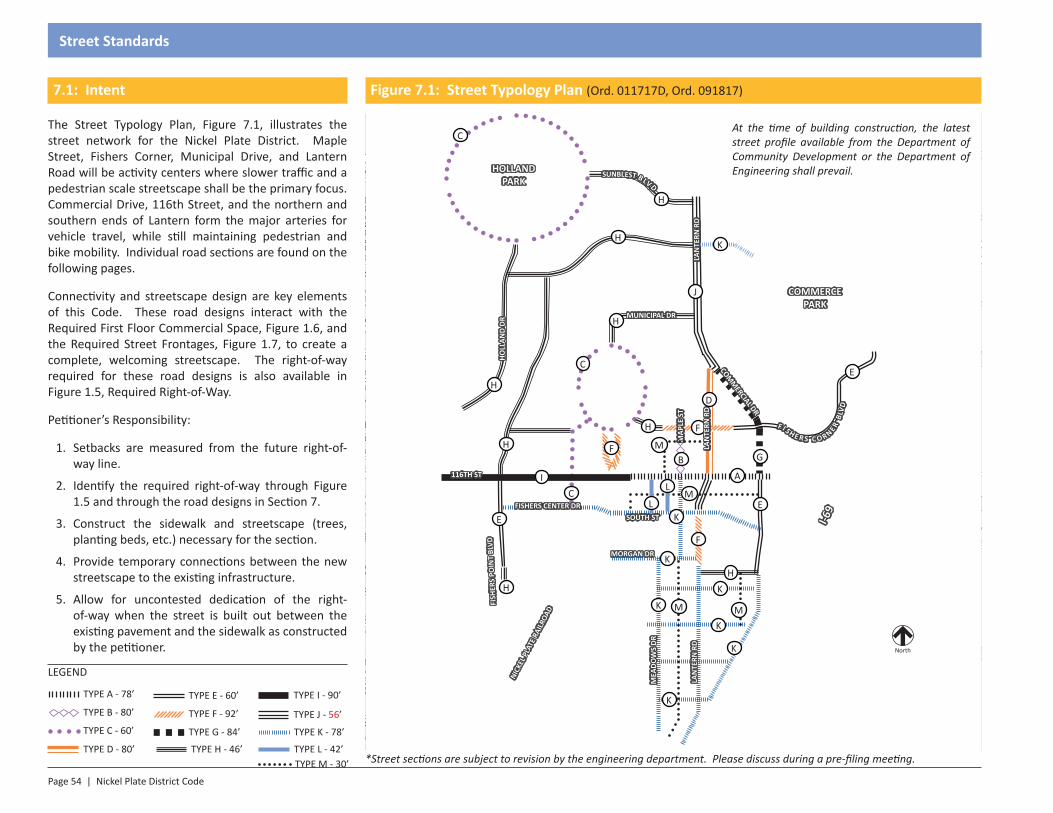
Page 54 | Nickel Plate District Code
Street Standards
LEGEND
TYPE A - 78’
TYPE D - 80’
TYPE B - 80’
TYPE C - 60’
TYPE E - 60’
TYPE F - 92’
TYPE G - 84’
TYPE H - 46’
7.1: Intent
The Street Typology Plan, Figure 7.1, illustrates the street network for the Nickel Plate District. Maple Street, Fishers Corner, Municipal Drive, and Lantern Road will be activity centers where slower traffic and a pedestrian scale streetscape shall be the primary focus. Commercial Drive, 116th Street, and the northern and southern ends of Lantern form the major arteries for vehicle travel, while still maintaining pedestrian and bike mobility. Individual road sections are found on the following pages.
Connectivity and streetscape design are key elements of this Code. These road designs interact with the Required First Floor Commercial Space, Figure 1.6, and the Required Street Frontages, Figure 1.7, to create a complete, welcoming streetscape. The right-of-way required for these road designs is also available in Figure 1.5, Required Right-of-Way.
Petitioner’s Responsibility:
1. Setbacks are measured from the future right-of-way line.
2. Identify the required right-of-way through Figure 1.5 and through the road designs in Section 7.
3. Construct the sidewalk and streetscape (trees, planting beds, etc.) necessary for the section.
4. Provide temporary connections between the new streetscape to the existing infrastructure.
5. Allow for uncontested dedication of the right-of-way when the street is built out between the existing pavement and the sidewalk as constructed by the petitioner.
TYPE I - 90’
TYPE J - 56’
Figure 7.1: Street Typology Plan (Ord. 011717D, Ord. 091817)
North
C
C
C
H
H
H
J
H
H
B G
E
EE
F
F
I A
H
H
*Street sections are subject to revision by the engineering department. Please discuss during a pre-filing meeting.
At the time of building construction, the latest street profile available from the Department of Community Development or the Department of Engineering shall prevail.HOLLAND
PARK
COMMERCE PARK
116TH ST
LAN
TERN
RD
I-69
COMM
ERCIAL DR
MUNICIPAL DR
MAP
LE S
T
HOLL
AND
DRFI
SHER
S PO
INT
BLVD
NICK
EL P
LATE
RAI
LROA
D
FISHERS CENTER DR
F I S H E R S C O R NER BL
VD
SOUTH ST
SUNBLEST B LV D
MORGAN DR
L
LM
M
K
M
K
LAN
TERN
RD
K
K
K
K
K
K
H
MEA
DOW
S DR
M
TYPE K - 78’
TYPE L - 42’TYPE M - 30’
LAN
TERN
RD
D
F
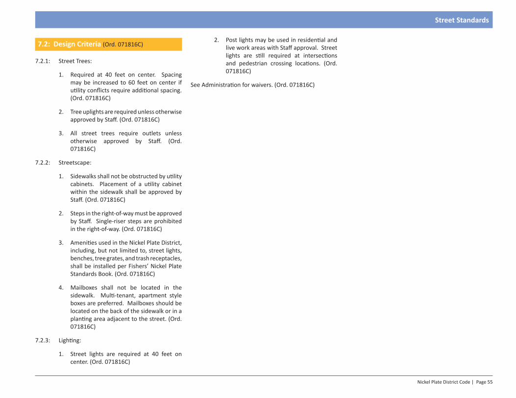
Nickel Plate District Code | Page 55
Street Standards
7.2: Design Criteria (Ord. 071816C)
7.2.1: Street Trees:
1. Required at 40 feet on center. Spacing may be increased to 60 feet on center if utility conflicts require additional spacing. (Ord. 071816C)
2. Tree uplights are required unless otherwise approved by Staff. (Ord. 071816C)
3. All street trees require outlets unless otherwise approved by Staff. (Ord. 071816C)
7.2.2: Streetscape:
1. Sidewalks shall not be obstructed by utility cabinets. Placement of a utility cabinet within the sidewalk shall be approved by Staff. (Ord. 071816C)
2. Steps in the right-of-way must be approved by Staff. Single-riser steps are prohibited in the right-of-way. (Ord. 071816C)
3. Amenities used in the Nickel Plate District, including, but not limited to, street lights, benches, tree grates, and trash receptacles, shall be installed per Fishers’ Nickel Plate Standards Book. (Ord. 071816C)
4. Mailboxes shall not be located in the sidewalk. Multi-tenant, apartment style boxes are preferred. Mailboxes should be located on the back of the sidewalk or in a planting area adjacent to the street. (Ord. 071816C)
7.2.3: Lighting:
1. Street lights are required at 40 feet on center. (Ord. 071816C)
2. Post lights may be used in residential and live work areas with Staff approval. Street lights are still required at intersections and pedestrian crossing locations. (Ord. 071816C)
See Administration for waivers. (Ord. 071816C)
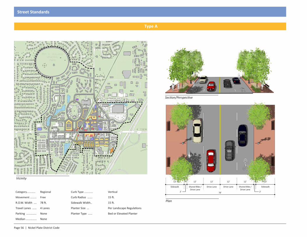
Page 56 | Nickel Plate District Code
Street Standards
Section/Perspective
Plan
13’12’
SidewalkShared Bike / Drive Lane
12’
Drive Lane
12’
Shared Bike / Drive Lane
13’
Sidewalk Drive Lane
78’ 2’2’
12’
Category………… Regional Curb Type ........... Vertical
Movement ……… Free Curb Radius ……. 15 ft.
R.O.W. Width .… 78 ft. Sidewalk Width.. 15 ft.
Travel Lanes …… 4 Lanes Planter Size … Per Landscape Regulations
Parking ………….. None Planter Type …… Bed or Elevated Planter
Median …………… None
Vicinity
Type A
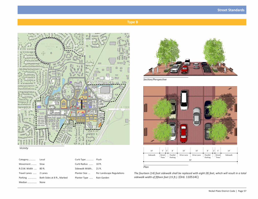
Nickel Plate District Code | Page 57
Street Standards
Section/Perspective
Plan
14’5’
SidewalkStreet Trees
2’8’
Parallel Parking
8’
Parallel Parking
2’5’
Street Trees
14’
Sidewalk
10’
Drive Lane
10’
Drive Lane
80’Category………… Local Curb Type ........... Flush
Movement ……… Slow Curb Radius ……. 10 ft.
R.O.W. Width .… 80 ft. Sidewalk Width.. 21 ft.
Travel Lanes …… 2 Lanes Planter Size … Per Landscape Regulations
Parking ………….. Both Sides at 8 ft., Marked Planter Type …… Rain Garden
Median …………… None
Vicinity
Type B
The fourteen (14) foot sidewalk shall be replaced with eight (8) feet, which will result in a total sidewalk width of fifteen feet (15 ft.). (Ord. 110514C)
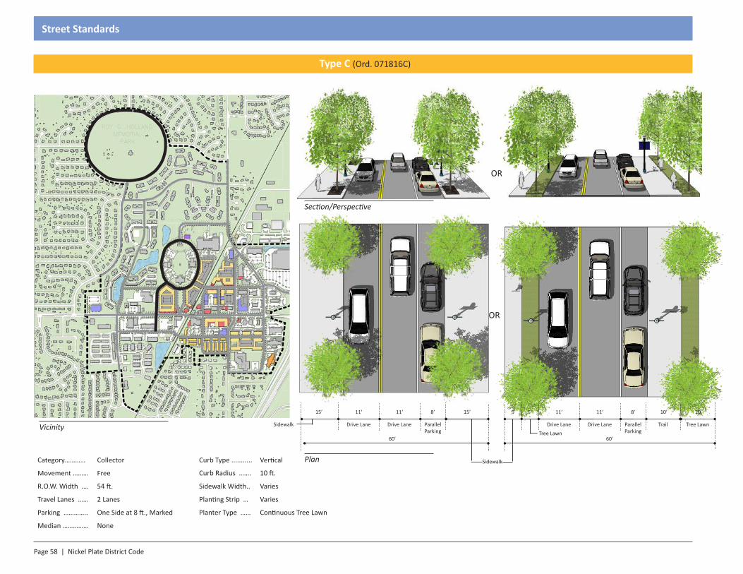
Page 58 | Nickel Plate District Code
Street Standards
Category………… Collector Curb Type ........... Vertical
Movement ……… Free Curb Radius ……. 10 ft.
R.O.W. Width .… 54 ft. Sidewalk Width.. Varies
Travel Lanes …… 2 Lanes Planting Strip … Varies
Parking ………….. One Side at 8 ft., Marked Planter Type …… Continuous Tree Lawn
Median …………… None
Section/Perspective
Plan Sidewalk
11’
Sidewalk Drive Lane
60’
15’15’ 11’
Drive Lane
8’
ParallelParkingVicinity
Type C (Ord. 071816C)
OR
OR
Trail
11’5’
Drive Lane
60’
10’5’
Tree Lawn
11’
Drive Lane
8’
ParallelParking
Tree Lawn
10’
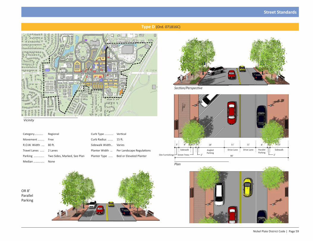
Nickel Plate District Code | Page 59
Street Standards
Vicinity
Category………… Regional Curb Type ........... Vertical
Movement ……… Free Curb Radius ……. 15 ft.
R.O.W. Width .… 80 ft. Sidewalk Width.. Varies
Travel Lanes …… 2 Lanes Planter Width … Per Landscape Regulations
Parking ………….. Two Sides, Marked, See Plan Planter Type …… Bed or Elevated Planter
Median …………… None
Section/Perspective
Plan
13’
Sidewalk
11’
Drive Lane
11’8’
Sidewalk Drive LaneAngled Parking
80’ 2’2’
8’18’
Parallel Parking
Type D (Ord. 071816C)
3’ 4’3”
Site Furnishings Street Trees
OR 8’ Parallel Parking
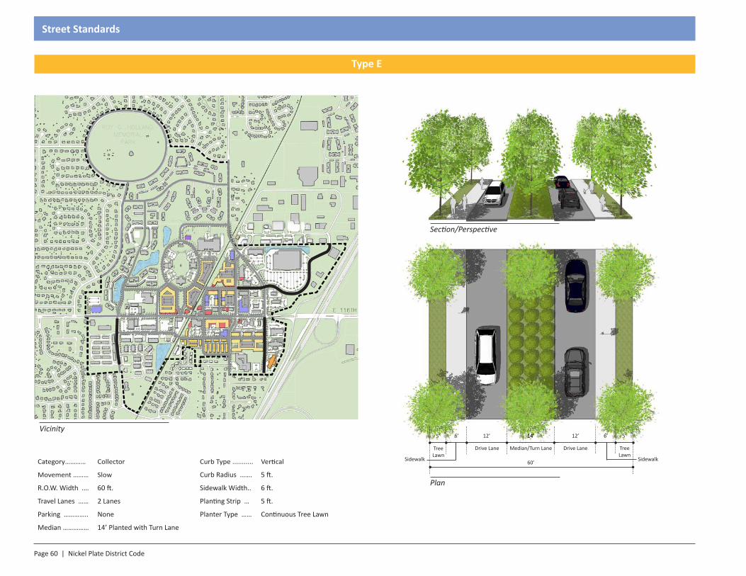
Page 60 | Nickel Plate District Code
Street Standards
Section/Perspective
Plan
Category………… Collector Curb Type ........... Vertical
Movement ……… Slow Curb Radius ……. 5 ft.
R.O.W. Width .… 60 ft. Sidewalk Width.. 6 ft.
Travel Lanes …… 2 Lanes Planting Strip … 5 ft.
Parking ………….. None Planter Type …… Continuous Tree Lawn
Median …………… 14’ Planted with Turn Lane
6’
Sidewalk
12’
Drive Lane
12’6’
Sidewalk
Median/Turn LaneDrive Lane
60’
14’14’5’
Tree Lawn
5’
Tree Lawn
Vicinity
Type E

Nickel Plate District Code | Page 61
Street Standards
Category………… Collector Curb Type ........... Vertical
Movement ……… Slow Curb Radius ……. 5 ft.
R.O.W. Width .… 92-102 ft. Sidewalk Width.. 15 ft.
Travel Lanes …… 2 Lanes Planter Size … Per Landscape Regulations
Parking ………….. Both Sides at 20 ft., Marked Planter Type …… Grate
Median …………… None
Vicinity 13’20’
SidewalkReverse Angled Parking
11’
Drive Lane
13’-23’
Sidewalk
92-102’ 2’2’
11’
Drive Lane
20’
Reverse Angled Parking
Section/Perspective
Plan
Type F
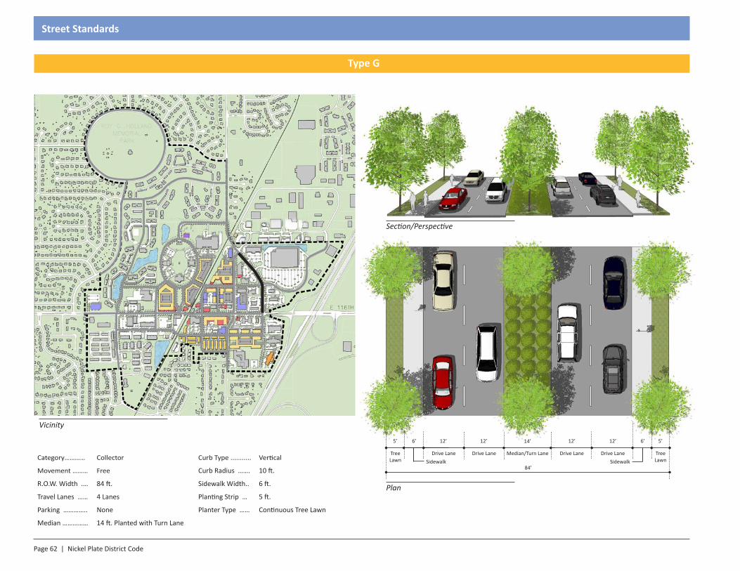
Page 62 | Nickel Plate District Code
Street Standards
Section/Perspective
Plan
Category………… Collector Curb Type ........... Vertical
Movement ……… Free Curb Radius ……. 10 ft.
R.O.W. Width .… 84 ft. Sidewalk Width.. 6 ft.
Travel Lanes …… 4 Lanes Planting Strip … 5 ft.
Parking ………….. None Planter Type …… Continuous Tree Lawn
Median …………… 14 ft. Planted with Turn Lane
6’
Sidewalk
12’
Drive Lane
12’6’
SidewalkMedian/Turn LaneDrive Lane
84’
14’12’
Drive Lane
12’
Drive Lane
5’
Tree Lawn
5’
Tree Lawn
Vicinity
Type G
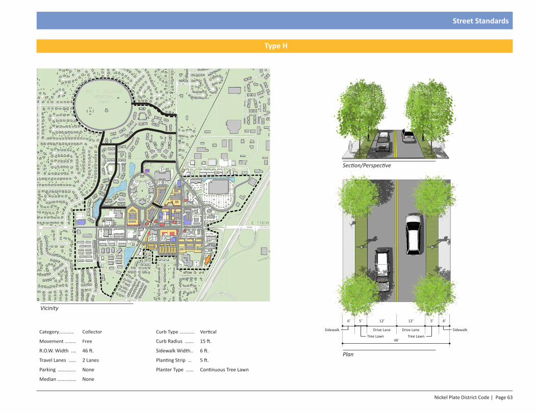
Nickel Plate District Code | Page 63
Street Standards
6’
Sidewalk
12’
Drive Lane
12’6’
Sidewalk Drive Lane
46’
5’5’
Tree Lawn Tree Lawn
Section/Perspective
Plan
Category………… Collector Curb Type ........... Vertical
Movement ……… Free Curb Radius ……. 15 ft.
R.O.W. Width .… 46 ft. Sidewalk Width.. 6 ft.
Travel Lanes …… 2 Lanes Planting Strip … 5 ft.
Parking ………….. None Planter Type …… Continuous Tree Lawn
Median …………… None
Vicinity
Type H
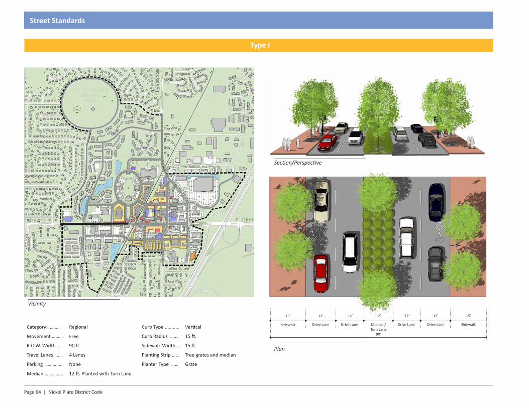
Page 64 | Nickel Plate District Code
Street Standards
Category………… Regional Curb Type ........... Vertical
Movement ……… Free Curb Radius ……. 15 ft.
R.O.W. Width .… 90 ft. Sidewalk Width.. 15 ft.
Travel Lanes …… 4 Lanes Planting Strip …... Tree grates and median
Parking ………….. None Planter Type …… Grate
Median …………… 12 ft. Planted with Turn Lane
Vicinity
Section/Perspective
Plan
12’
Drive LaneMedian /Turn Lane
90’
12’ 12’
Drive Lane
15’
Sidewalk Sidewalk
15’12’
Drive Lane
12’
Drive Lane
Type I
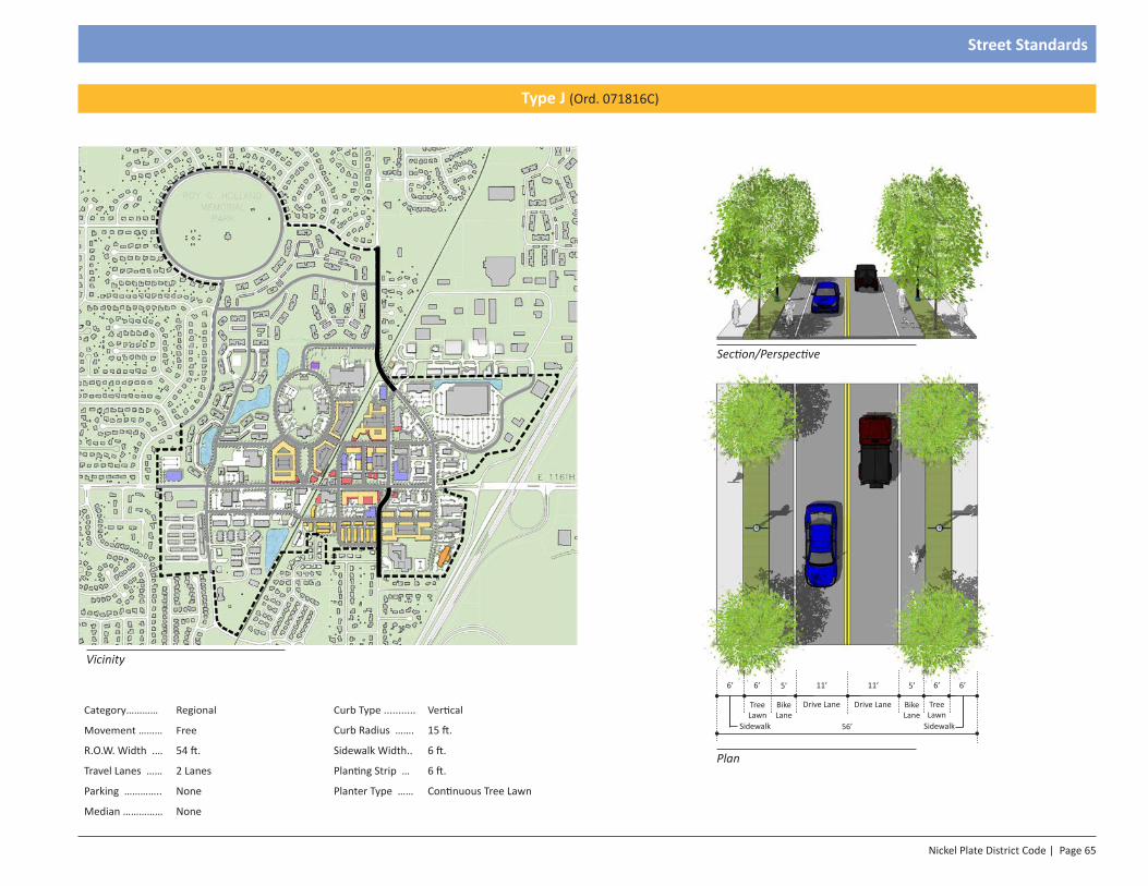
Nickel Plate District Code | Page 65
Street Standards
Section/Perspective
Plan
11’
Drive Lane
11’
Drive Lane
56’
6’
Sidewalk
6’
Tree Lawn
5’
Bike Lane
6’
Sidewalk
6’
Tree Lawn
5’
Bike LaneCategory………… Regional Curb Type ........... Vertical
Movement ……… Free Curb Radius ……. 15 ft.
R.O.W. Width .… 54 ft. Sidewalk Width.. 6 ft.
Travel Lanes …… 2 Lanes Planting Strip … 6 ft.
Parking ………….. None Planter Type …… Continuous Tree Lawn
Median …………… None
Vicinity
Type J (Ord. 071816C)
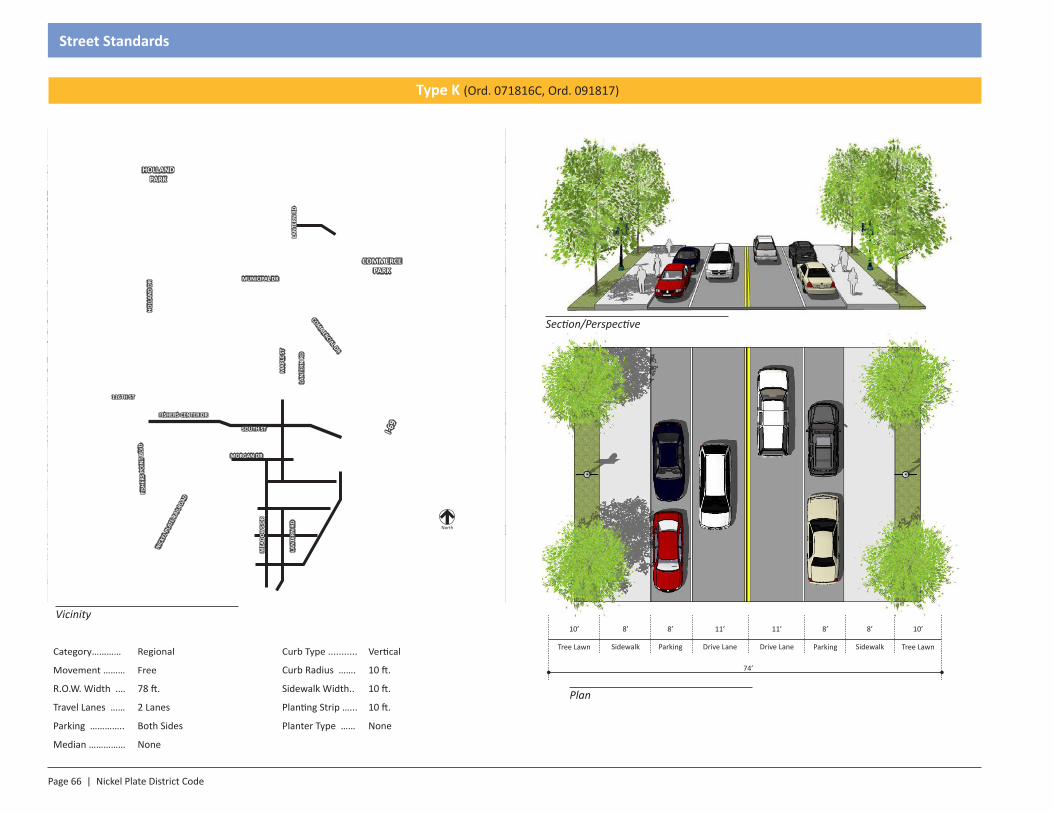
Page 66 | Nickel Plate District Code
Street Standards
Category………… Regional Curb Type ........... Vertical
Movement ……… Free Curb Radius ……. 10 ft.
R.O.W. Width .… 78 ft. Sidewalk Width.. 10 ft.
Travel Lanes …… 2 Lanes Planting Strip …... 10 ft.
Parking ………….. Both Sides Planter Type …… None
Median …………… None
Vicinity
Section/Perspective
Plan
8’
ParkingDrive Lane
74’
11’ 8’
Sidewalk
8’
Sidewalk Tree Lawn
10’8’
Parking
11’
Drive Lane
Type K (Ord. 071816C, Ord. 091817)
Tree Lawn
10’
North
HOLLAND PARK
COMMERCE PARK
116TH ST
LAN
TERN
RD
I-69
COMM
ERCIAL DR
MUNICIPAL DRM
APLE
ST
LAN
TERN
RD
HOLL
AND
DRFI
SHER
S PO
INT
BLVD
NICK
EL P
LATE
RAI
LROA
D
FISHERS CENTER DR
SOUTH ST
MORGAN DR
LAN
TERN
RD
MEA
DOW
S DR
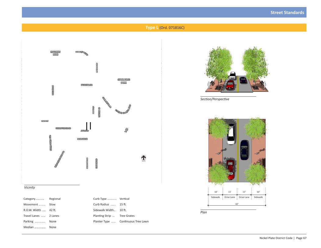
Nickel Plate District Code | Page 67
Street Standards
Section/Perspective
Plan
11’
Drive Lane
11’
Drive Lane
42’
Sidewalk
10’
Sidewalk
10’
Category………… Regional Curb Type ........... Vertical
Movement ……… Slow Curb Radius ……. 15 ft.
R.O.W. Width .… 42 ft. Sidewalk Width.. 10 ft.
Travel Lanes …… 2 Lanes Planting Strip … Tree Grates
Parking ………….. None Planter Type …… Continuous Tree Lawn
Median …………… None
Vicinity
Type L (Ord. 071816C)
North
HOLLAND PARK
COMMERCE PARK
116TH ST
LAN
TERN
RD
I-69
COMM
ERCIAL DR
MUNICIPAL DR
MAP
LE S
T
LAN
TERN
RD
HOLL
AND
DRFI
SHER
S PO
INT
BLVD
NICK
EL P
LATE
RAI
LROA
D
FISHERS CENTER DR
F I S H E R S C O R NER BL
VDSOUTH ST
SUNBLEST B LV D
MORGAN DR
LAN
TERN
RD
MEA
DOW
S DR
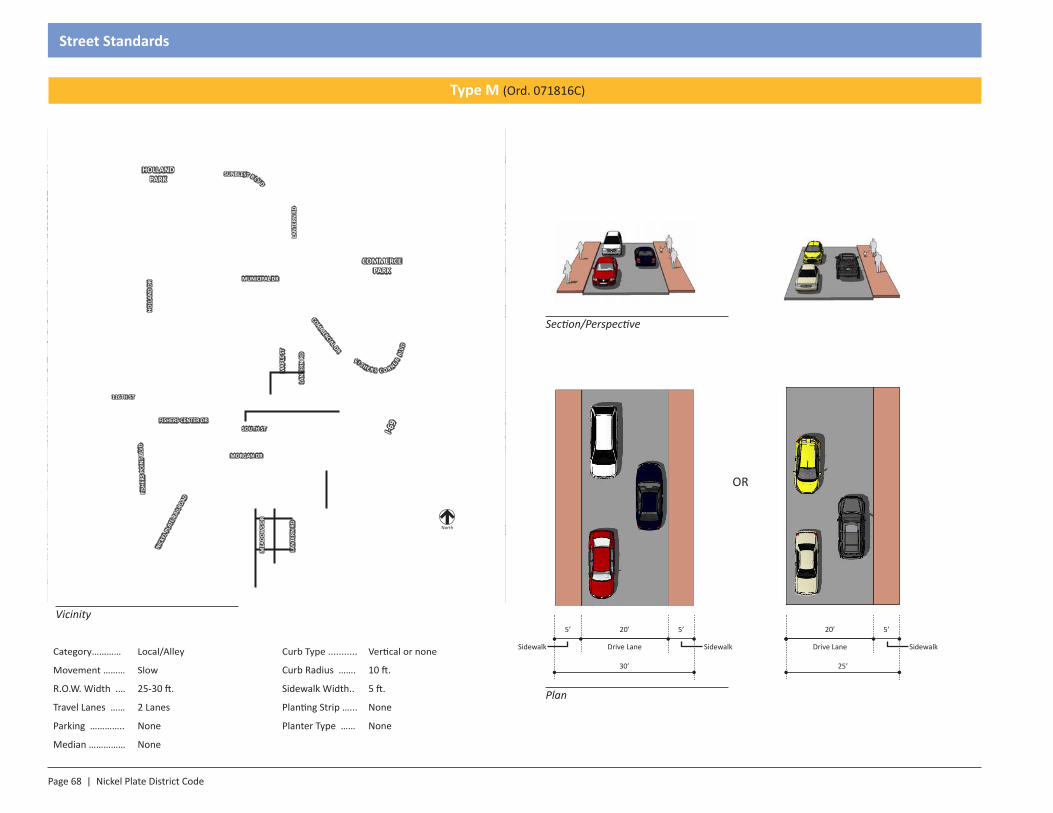
Page 68 | Nickel Plate District Code
Street Standards
Category………… Local/Alley Curb Type ........... Vertical or none
Movement ……… Slow Curb Radius ……. 10 ft.
R.O.W. Width .… 25-30 ft. Sidewalk Width.. 5 ft.
Travel Lanes …… 2 Lanes Planting Strip …... None
Parking ………….. None Planter Type …… None
Median …………… None
Vicinity
Section/Perspective
Plan
30’
5’
Sidewalk
20’
Drive Lane
5’
Sidewalk
Type M (Ord. 071816C)
North
HOLLAND PARK
COMMERCE PARK
116TH ST
LAN
TERN
RD
I-69
COMM
ERCIAL DR
MUNICIPAL DRM
APLE
ST
LAN
TERN
RD
HOLL
AND
DRFI
SHER
S PO
INT
BLVD
NICK
EL P
LATE
RAI
LROA
D
FISHERS CENTER DR
F I S H E R S C O R NER BL
VD
SOUTH ST
SUNBLEST B LV D
MORGAN DR
LAN
TERN
RD
MEA
DOW
S DR
25’
20’
Drive Lane
5’
Sidewalk
OR

SECTION 1.0Introduction
Section 8 - Administration
Page 70 | Nickel Plate District Code
Administration
8.1: Interpretation
8.1.1: Interpretation: This Article shall be referred to as Nickel Plate District Code or the Code. Notwithstanding any other provision in the Unified Development Ordinance, in the event of any conflict between any provision of the Nickel Plate District Code and any other provision of the Unified Development Ordinance, the Nickel Plate District Code shall control with respect to the Nickel Plate District only. In the event the Nickel Plate District Code is silent as to fees, permits, sign regulations, or any other similar provision relating to development standards, the applicable provision of the Unified Development Ordinance shall control.
8.2: Review
8.2.1: Purpose & Intent: The review procedure set out herein is conducted under the direction of the Department of Community Development to ensure compliance with the objective development standards of the Nickel Plate District Code and the Unified Development Ordinance. It is the intent of this section to:
1. Off-set the high level of detailed standards in the Nickel Plate District with an efficient process for approval of projects that meet the general goals, vision, and intent of the Nickel Plate District; and
2. Ensure consistency and quality of design through use of professional review procedures.
8.2.2: Nickel Plate Review Committee Established: There is hereby created the Nickel Plate Review Committee (Nickel Plate Review Committee). The purpose of the Nickel Plate Review Committee is to aid in the review and approval of all projects within the Nickel Plate District and the Town Center Residential District.
8.2.3: Pre-submittal Meeting: Prior to submitting an application, the petitioner shall meet with the Department of Community Development to review the zoning classification of the site, applicable regulations, and procedures, and examine the proposed use and development of the property. The Department of Community Development shall assist the petitioner in preparing the application and supportive documents as necessary.
8.2.4: Applicability: Proposed projects located in the Nickel Plate District and the Town Center Residential Zoning District are required to be reviewed by the
Nickel Plate Review Committee pursuant to Section 8.2.9.4, Nickel Plate Review Committee (Nickel Plate Review Committee). As used in Section 8, Administration, the terms “proposed project” or “project” refer to any remodel, alteration, or similar construction project that involves removal, alteration, or substantial revision of fifty percent (50%) or more of the exterior or façade of any structure. (Ord. 110514C)
8.2.5: Application:
1. Filing Deadline: The petitioner shall refer to the Schedule of Meeting Dates included in the application packet to determine the filing deadline for any given meeting of the Nickel Plate Review Committee.
2. Application Packet: The petitioner shall submit the completed application to the Department of Community Development.
3. Supporting Information: The application shall include the following documents:
a. Pre-submittal Meeting: The application shall include all documentation specified by the Department of Community Development during the pre-submittal meeting.
b. Application Packet: The application shall include all documentation specified on the application packet unless waived by the Department of Community Development due to the specific circumstances of the particular project.
c. Additional Information: Such other additional information as may be required by the Department of Community Development or other members of the Technical Advisory Committee to evaluate the application. This may include material samples and three dimensional modeling of the development proposal showing massing of the proposal as it relates to adjacent structures.
8.2.6: Fees: Per the Fishers fee ordinance.
8.2.7: Department of Community Development:
1. Review: The Department of Community Development shall review a petition upon receipt of a complete application, supporting documents, and payment of the applicable fees.
Nickel Plate District Code | Page 71
Administration
2. Complete Submittal: Once the Department of Community Development has determined that the petitioner has submitted a complete application, the Department of Community Development shall:
a. Docket Number: Assign a docket number;
b. Agenda: Place the item on an agenda of the Nickel Plate Review Committee and/or the Technical Advisory Committee;
c. Notification: Inform the petitioner of the time, date, and place of the Nickel Plate Review Committee meeting or Technical Advisory Committee meeting.
3. Technical Advisory Committee: Once the Department of Community Development has processed a complete submittal as outlined above, the Department of Community Development shall place the item on an agenda of the Technical Advisory Committee and inform the petitioner of the time, date, and place of the meeting.
4. Inspection: The Department of Community Development may inspect at any reasonable time any structure, other improvement, or site that is the subject of a Nickel Plate District petition.
5. Department Report: The Department of Community Development shall prepare a written report outlining its findings with respect to the project.
6. Surety Requirement: In conjunction with the approval of a Nickel Plate District project, the petitioner shall provide financial surety for all public improvements pursuant to Article 10; §Surety Standards.
7. Record: The Department of Community Development shall maintain records of all applications, plans, and permits filed for a Nickel Plate District review.
8.2.8: Technical Advisory Committee (TAC)
1. Determination: The Technical Advisory Committee shall review Nickel Plate District Code projects that have been forwarded by the Department of Community Development.
2. Copies: The petitioner shall refer to the application packet to determine the format and number of copies of the plans to be delivered to the Department of Community Development for distribution to the members of the Technical Advisory Committee.
3. Meeting Date: The petitioner shall refer to the Schedule of Meeting Dates to determine the filing deadline for any given meeting of the Technical Advisory Committee. Incomplete submittals may result in the application being held off the Technical Advisory Committee agenda to allow the petitioner time to submit a completed application.
4. Attendance: The petitioner and the project engineer are required to be present at the Technical Advisory Committee meeting to address and discuss comments and concerns posed by the committee members. Failure to appear may result in continuance.
5. Revisions: Following Technical Advisory Committee review, the petitioner shall submit revised copies of the plans that address the comments and concerns of the Technical Advisory Committee. The petitioner shall refer to the application packet to determine the format and number of copies of the revised plans to be delivered to the Department of Development.
8.2.9: Nickel Plate Review Committee:
1. Nickel Plate Review Committee: The Nickel Plate Review Committee membership shall be established by Ordinance 041816F, as amended. (Ord. 071816C)
2. Submittal: The petitioner shall refer to the application packet to determine the format and number of copies of the informational packet to be delivered to the Department of Community Development for distribution to the members of the Nickel Plate Review Committee. Incomplete submittals shall result in the petition being removed from the agenda to allow the petitioner time to complete the submittal. Materials submitted by the petitioner after the informational packets have been distributed shall be provided to Committee members at the discretion of the Department of Community Development according to the Plan Commission Rules of Procedure. (Ord. 110514C)
3. Attendance: The petitioner is required to be present at the Nickel Plate Review Committee meeting to address and discuss comments and concerns posed by the Nickel Plate Review Committee members. Failure to appear may result in the petition being dealt with as outlined in the Plan Commission Rules of Procedure.
4. Review: Projects requiring Nickel Plate Review Committee review are;
a. Any proposal that does not comply with any of the standards of the Nickel Plate District Zoning Code require review by the Nickel
Page 72 | Nickel Plate District Code
Administration
Plate Review Committee, unless the granting of a minor waiver(s), per Section 8.2.11.4.a, bring the proposal into compliance.
b. Any project that requires a major waiver pursuant to Section 8.2.11.5, Major Waivers.
c. Any project that includes any of the following uses in the Downtown Core Zone:
i. Residential dwelling: Total units above 30 (Ord. 071816C)
ii. Retail/Service: Greater than 20,000 square feet gross floor area
iii. Any proposal adjacent to a property that is within the Village Center District and is residential in use
iv. Any proposal adjacent to a school
d. Any project that includes any of the following uses in the Municipal Center Zone:
i. Residential dwelling: Total units above 30 (Ord. 071816C)
ii. Retail/Service: Greater than 20,000 square feet gross floor area
e. Any project that includes any of the following uses in the Highway Center Zone:
i. Retail/Service: Greater than 40,000 square feet gross floor area
ii. Any proposal adjacent to the Village Center District or residential zoning district
iii. Any proposal adjacent to a school
f. Any project that includes any of the following uses in the Village Center Zone:
i. Residential dwelling: Total units above 10 (determined by plat submittal) (Ord. 071816C) For single-family homes that have been approved through plat by the Nickel Plate Review Committee, staff may approve architecture that is consistent with designs presented during review of the plat. (Ord. 011717D)
ii. Any proposed retail or service use:
iii. Any proposal adjacent to a residential zoning district
iv. Any proposal adjacent to a school
g. Any project that includes any of the following uses in the Town Center Residential Zoning District:
i. Residential dwelling: More than one unit
5. The Nickel Plate Review Committee shall base its review on the following criteria:
a. Conformance with the intent of the Nickel Plate District Code;
b. Thorough design that addresses circulation both inside and around the site; (Ord. 110514C)
c. Appropriate use of the space designated for the public and conformance with Section 7, Street Standards and Section 3, Landscape Regulations; (Ord. 110514C)
d. Conformance with Section 2, Architecture Regulations; (Ord. 110514C)
e. Material and color usage that is similar, but not necessarily identical, to neighboring projects as proposed in the Master Plan; (Ord. 110514C)
f. Harmony and compatibility with surrounding development;
g. Conformance with Section 4, Parking Regulations, and incorporation of logical Circulation both internally and through the site. This is for both pedestrian and vehicular traffic, including service and delivery in accordance with the Nickel Plate District Code and the Transportation Plan, as amended. (Ord. 110514C)
6. Decision: The Nickel Plate Review Committee shall either approve, approve with conditions, or deny the application. The Nickel Plate Review Committee may continue the petition to the next meeting date if more information is needed. The Nickel Plate Review Committee shall make its decision on an application within ninety (90) calendar days of the receipt of a completed application, fee, and supporting documents. The Committee may grant one (1) 45 extension. (Ord. 110514C)
7. Duration:
Nickel Plate District Code | Page 73
Administration
a. The work or use authorized by Nickel Plate Review Committee approval is valid for the period stated in the applicable permit or approval.
b. Extension: A Nickel Plate Review Committee approval shall not be extended separately from the permit or approval with which it is associated. An extension granted to a permit or approval with which a Nickel Plate Review Committee approval is associated shall automatically include extension of the Nickel Plate Review Committee approval.
8.2.10: Waivers Review Process:
1. Intent: The waivers review process provides a mechanism by which the regulations of the Nickel Plate District Code may be modified if the development proposal is determined to meet the intended purposes of the Nickel Plate District Code. Each waiver shall be considered on a case by case basis, and a waiver shall not apply to a project other than the project for which it was sought. If a project in not completed for which a waiver was granted, the waiver(s) becomes null and void. (Ord. 110514C) Any costs incurred as a result of a granted waiver are the sole responsibility of the applicant. (Ord. 071816C)
2. Application requirements: A waiver application shall be accompanied by documentation that establishes how the application meets the criteria set forth in Section 8.2.9.4, Review and other applicable sections of the Nickel Plate District Code.
3. Staff review and report: The Department of Community Development shall review the application for the waiver and shall prepare a written staff analysis of the issues raised by the application.
4. Review criteria: Minor waivers shall be reviewed by the Mayor or Mayor’s Designee. Major waivers shall be reviewed by the Nickel Plate Review Committee. A written determination shall be produced that determines whether the following criteria have been met (Ord. 081715F, 110514C):
a. Meets the eligibility requirements of 8.2.10, Wavier Review Process. (Ord. 110514C)
b. Will not conflict with the Conceptual Master Plan. (Ord. 110514C)
c. Will result in an improved project which will be an attractive contribution to the Nickel Plate District. (Ord. 110514C)
d. Will not compromise the quality of the public realm or discouraged pedestrian use. (Ord. 110514C)
5. Minor waivers eligibility: Minor waivers are modest changes to design standards that are determined to meet the goals and intent of the Nickel Plate District and achieve substantial, though not complete, compliance with the Nickel Plate District Code. Minor waivers shall not compromise the project’s ability to meet the goals and intent of the district as stated in the Nickel Plate District Code. Minor waivers may be approved administratively by the Mayor or Mayor’s Designee or the Director’s designee. The following design standards are eligible for a minor waiver: (Ord. 081715F)
a. Increase or decrease in the amount of parking spaces between 0-10% of permitted range.
b. Dimensional standards: request that is within ten percent (10%) of standard. For example, where a build-to line of ten (10) feet is required, a minor waiver may be requested for a proposed build-to line of nine (9) feet. Any request greater than ten percent (10%) of the standard would require approval of a major waiver.
c. Pedestrian pass-through: structures that require a pedestrian passage through the longest side of the structure (per section 2) may request a minor waiver provided adequate alternative pedestrian circulation routes are available and use of the pass through will not increase the connectivity of the site (e.g. pass-through would lead to the railroad tracks). (Ord. 011717D)
d. Four-sided architecture: A minor waiver may be requested from four-sided architecture requirements if public art is substituted (per section 2.4). This waiver may only apply to one façade.
e. Landscaping: Requirement may be reduced by up to twenty-five percent (25%) if it is replaced with public art. Public art shall not replace required buffer yard landscaping as required (per section 3.2).
f. Compact parking spaces may be approved to address unique site considerations. No more than ten percent (10%) of the required spaces may be compact spaces.
g. Surface parking lots in the DC and MC may be approved as a temporary solution to parking concerns. Surface lots shall be
Page 74 | Nickel Plate District Code
Administration
designed such that the lot will make a viable redevelopment site when adequate street or structure parking is available. Use of a temporary parking lot grants the reduction in the side or rear setback be reduced to less than half of the property width or depth.
h. Fencing: Approval of alternate fencing designs to address the unique constraints of project sites or building orientation. (Ord. 071816C)
i. Street Design: Altering the design standards of the Street Standards section to allow for a coordinated, functional street network. (Ord. 071816C)
j. Pedestrian Blade Sign: Allowing a Pedestrian Blade Sign up to five square feet in size. (Ord. 071816C)
k. Individual Creative Sign: Approval of a single sign exceeding the provisions of this Code. Approval of multiple signs requires Nickel Plate Review Committee approval. (Ord. 071816C)
l. Fencing: Alternate fencing materials, heights, and locations may be approved for the purposes of public safety. (Ord. 071816C)
m. Parking: Allow for reduction of the four (4) required spaces on a property if no on-street parking is available. (Ord. 011717D)
n. Building height: Allow for buildings to meet the minimum required height but not the number of stories indicated. (Ord. 011717D)
o. Landscape modification: Approval of alternate landscape for properties undergoing maintenance which have already received approval. (Ord. 011717D)
6. Major Waivers Eligibility: The granting of major waivers shall be determined in writing by the Nickel Plate Review Committee. The following are eligible for a major waiver:
a. Dimensional standards, except that no waiver to a dimensional standard shall be granted which would result in a reduction of a Code requirement or an increase in a Code limitation by more than twenty-five percent (25%). On sites deeper than 170 feet, the Nickel Plate Review Committee may completely waive the rear yard setback requirement. On sites wider than 250 feet, the Nickel Plate Review Committee may allow for the side yard setback to be an aggregate of 40 feet (e.g. 30 feet and 10 feet on either side of the building). (Ord. 071816C)
b. Building design standards for street walls, windows, shape of openings, roofs and exterior finish standards.
c. Placement of signs. Lower wall sign areas may be allocated to canopies and awnings provided no other wall signage is permitted.
d. Increase or decrease in amount of parking spaces required by greater than ten percent (10%) of standard.
e. Parking Structure Screening: Green screens may be used on parking structures to offset architectural or buffer yard requirements if deemed an acceptable substitute by the Nickel Plate Review Committee (see Section 3.6).
f. Building Materials: The Nickel Plate Review Committee may allow material substitution if substitution provides comparable or superior aesthetic quality to permitted material. In no instance shall the substituted materials comprise more than forty percent (40%) of the façade.
g. Building Height: The Nickel Plate Review Committee may approve up to two additional stories above the maximum on a primary structure. The additional floor(s) may only be approved if an offset is provided at the third (3rd) or fourth (4th) floors to break up the appearance of the façade’s height. In lieu of the offset, the top floor can be structured to fit within the building’s roofline. This waiver would allow the maximum building height to be increased to 75 feet. (Ord. 011717D)
h. Flex Space: The Nickel Plate Review Committee may approve flex space on the first (1st) floor for non-commercial use in areas that require first (1st) floor commercial use (per section 1.4). This shall comprise no more than sixty percent (60%) of the required commercial frontage.
i. Signage: An alternate, creative signage program exceeding the provisions of this Code may be approved by the Nickel Plate Review Committee for an entire building/project. The submitted plans must be reflective of all signage to be used for all tenants in the building/project. The Nickel Plate Review Committee may approve the use of signage not specifically identified in this Code through this waiver. (Ord. 071816C)
Nickel Plate District Code | Page 75
Administration
i. Purpose. The purpose of a creative sign program is to integrate all signs with the overall site design and the structures’ design into a unified architectural statement. A creative sign program provides a means for the flexible application of sign regulations in order to provide incentive and latitude in the design and display of multiple signs and to achieve, not circumvent, the purpose of the Nickle Plate code. Approval of a creative sign program may modify the standards provided in this chapter as to sign number, size, height, illumination, location, orientation, or other aspects of signs within the limits of this section. (Ord. 071816C)
ii. Application requirements. A sign permit application for a creative sign program shall include all information and materials required by the Mayor or Mayor’s Designee. (Ord. 071816C)
iii. Standards. A creative sign program shall comply with the following standards: (Ord. 071816C)
1. The proposed sign program shall comply with the intent of this chapter. (Ord. 071816C)
2. The proposed signs shall enhance the overall development, be in harmony with, and relate visually to other signs included in the creative sign program, to the structures and/or developments they identify, and to surrounding development when applicable. (Ord. 071816C)
3. The sign program shall address all permanent signs. (Ord. 071816C)
4. The sign program shall accommodate future revisions that may be required because of changes in use or tenants. (Ord. 071816C)
5. The sign program shall comply with the standards of the Nickle Plate code, except that deviations are allowed with regard to sign area, total number, location, illumination, and/or height of signs to the extent that the creative sign program will enhance the overall development and will more fully accomplish the purposes and intent of the Nickle Plate code. (Ord. 071816C)
6. Approval of a creative sign program shall not authorize the use of signs prohibited by this chapter. (Ord. 071816C)
7. Review and approval of a creative sign program shall not consider the signs’ proposed message content. (Ord. 071816C)
viii. Findings. In order to approve a creative sign program the following findings shall be made: (Ord. 071816C)
1. The creative sign program complies with the purpose of the Nickle Plate code. (Ord. 071816C)
2. Proposed signs enhance the overall development and are in harmony with other signs included in the plan with the structures they identify and with surrounding development. (Ord. 071816C)
3. The creative sign program contains provisions to accommodate future revisions that may be required because of changes in use or tenants. (Ord. 071816C)
4. The creative sign program complies with the standards of the Nickle Plate code, except that flexibility is allowed with regard to sign area, number, location, and/or height to the extent that the signs proposed under the creative sign program will enhance the overall development, achieve superior quality design, and will more fully accomplish the purposes of this chapter. (Ord. 071816C)
v. Revisions to creative sign programs. The Mayor or Mayor’s Designee may approve revisions to a creative sign program if the intent of the original approval is not affected. Revisions that would substantially deviate from the original approval shall require the approval of a new/revised creative sign program by the Nickel Plate Review Committee. (Ord. 071816C)
j. Landscape: An alternate, creative landscape package may be approved by the Nickel Plate Review Committee. (Ord. 071816C)
k. Park: The Nickel Plate Review Committee may grant a waiver to allow a structured, aesthetically pleasing park or green space area to be used to meet a required yard setback for one side of a structure. (Ord. 071816C)
Page 76 | Nickel Plate District Code
Administration
b. An appeal of the Council’s decision shall be made to the Board of Zoning Appeals by filing the appeal with the Mayor or Mayor’s Designee of the Director’s designee within thirty (30) days of the approved or denial. The appeal shall be included on the Board of Zoning Appeals’ agenda for a regularly scheduled meeting within thirty (30) days of the date the appeal is received. At the meeting, the Board of Zoning Appeals shall hear from all interested persons. After considering the evidence, the Board of Zoning Appeals shall determine and make findings regarding whether the application meets the intent of the Nickel Plate District Code and the Nickel Plate District Master Plan and shall approve, approve with conditions, or deny the application. (Ord. 081715F, 110514C)
c. An appeal of the Board of Zoning Appeal’s decision shall be made pursuant to and consistent with Indiana law. (Ord. 110514C)
2. Minor Waivers
a. An appeal of a minor waiver approval or denial by the Mayor or Mayor’s Designee shall be made to the Nickel Plate Review Committee by filing the appeal with the Mayor or Mayor’s Designee or the Director’s designee within thirty (30) days of the approval or denial. The appeal shall be included on the Nickel Plate Review Committee’s agenda for a regularly scheduled meeting within thirty (30) days of the date the appeal is received. At the meeting, the Nickel Plate Review Committee shall hear from all interested persons. After considering the evidence, the Nickel Plate Review Committee shall determine and make findings regarding whether the application meets the intent of the Nickel Plate District Code and the Nickel Plate District Master Plan and shall approve, approve with conditions, or deny the application. (Ord. 081715F, 110514C)
b. An appeal of the Board of Zoning Appeal’s decision shall be made pursuant to and consistent with Indiana law. (Ord. 110514C)
8.3: Nonconforming Lots, Sites, Structures, and Uses
8.3.1: PURPOSE: Upon adoption of the Nickel Plate District Code, some previously lawful lots, sites, structures, and land uses may no longer conform to the regulations of the Code. For this reason, Section 8.3, Nonconforming Lots, Sites, Structures, and Uses specifies the rules, policies, and regulations that apply to these lots, sites, structures, and land uses referred to as lawfully nonconforming within the Nickel Plate District. The purpose of this section is
l. Parking lots in VC and MC: The Nickel Plate Review Committee may approve the use of surface parking lots in the Village Center and Municipal Center zones. Approval is contingent on:
i. These lots shall not be located in a front yard, except where a parcel has more than two front yards. Where a lot has more than two front yards, the Nickel Plate Review Committee shall determine the least impactful frontage for the parking lot to be placed.
ii. If this waiver is granted, building setbacks shall be measured from the edge of the parking lot and its associated walkways and/or landscape areas.
iii. Parking lots may only be granted for projects larger than two (2) acres.
iv. Parking lots may not negatively impact the streetscape or adjacent properties.
v. The intent of the Conceptual Master Plan must be maintained.(Ord. 091817)
7. Public Meeting: The Nickel Plate Review Committee shall conduct a public meeting in accordance with the Indiana Open Door Law. The Nickel Plate Review Committee shall review the written staff report and may grant the application, grant with conditions, or deny the application.
8.2.11: Appeals:
1. Petitions and Major Waivers
a. An appeal of the Nickel Plate Review Committee’s denial or approved of a petition or Major Waiver shall be made to the City Council by filing the appeal with the Mayor or Mayor’s Designee of the Director’s designee within thirty (30) days of the approval or denial. The appeal shall be included on the City Council’s agenda for a regularly scheduled meeting within (30) days of the date the appeal is received. At the meeting, the Council shall hear from all interested persons. After considering the evidence, the Council shall determine and make findings regarding whether the application meets the intent of the Nickel Plate District Code and the Nickel Plate District Master Plan and shall approve, approve with conditions, or deny the application. (Ord. 081715F, 110514C)
Nickel Plate District Code | Page 77
Administration
2. Discontinuance of Abandoned Nonconforming Use:
a. If a legal nonconforming use is discontinued or abandoned for six (6) consecutive months, except when government action impedes access to the premises or the building or structures in which such legal nonconforming use is conducted are damaged or destroyed by fire, flood, wind, or other calamity or act of God, any subsequent use of such land, structure or land and structure shall conform to the provisions of the Code.
b. When a legal nonconforming use is superseded by a permitted use, it shall thereafter conform to regulations of the Code, and the legal nonconforming use shall not thereafter be resumed.
3. Accessory Buildings: The requirements for nonconforming uses of nonconforming buildings or structures shall apply to all accessory buildings, structures, or buildings located on the same zoning lot.
4. Expansion of Nonconforming Use: Any continuous, lawful use of structures, land, or structures and land in combination established prior to the effective date of the Nickel Plate District Code or its subsequent amendments that is no longer a permitted use in the Zone where it is located shall be deemed a legal nonconforming use. A legal nonconforming use may continue provided that it remains otherwise lawful, subject to the following conditions:
a. No existing structure devoted to a legal nonconforming use shall be enlarged, expanded, increased, extended, constructed, reconstructed, moved, or structurally altered unless it:
i. Complies with Section 8.3.3.4.d for limited and small expansions; or
ii. Changes the use of the structure to a use permitted in the zoning district in which it is located, or
iii. Changes the use to a less intensive nonconforming use and is approved by the Mayor or Mayor’s Designee or Plan Commission. (Ord. 081715F)
b. No new building or structure shall be constructed in connection with an existing legal nonconforming use of land.
c. Any legal nonconforming use of a structure may be extended throughout any parts of a building which were plainly arranged
to allow nonconforming lots, structures, and uses to continue to the extent consistent with the health, safety, and public welfare purposes of the District, and to provide for the following:
1. Continuing maintenance of nonconforming uses, buildings, structures and site elements, uses which do not conform to the provisions of the District but which complied with applicable laws when established;
2. Provide for the gradual replacement of nonconforming uses with uses that conform to the provisions of the District;
3. Provide standards for the expansion of nonconforming uses;
4. Provide standards for the continuance of nonconforming uses of land; and,
5. Provide standards for the continuance and expansion of nonconforming buildings, structures, and site elements.
8.3.2: Establishing Legal Nonconformity:
1. Any lot, site, structure, or land use which does not conform with one or more provisions of the Nickel Plate District Code, but which lawfully existed upon the effective date of the provisions of this Code with which the lot, structure or use does not conform, shall be a lawful nonconforming lot, site, use or structure within the meaning of this section.
2. In order to protect the lawful nonconforming status of a nonconforming use, a person who owns or operates a nonconforming use may request a Certificate of Nonconforming Use from the Mayor or Mayor’s Designee. The applicant shall demonstrate that the use is a lawful nonconforming use prior to the issuance of the certificate. The applicant shall provide sufficient proof that the use or structure was established prior to the adoption of the ordinance and that there was continuous operation of the nonconforming use. Such other proof may be deemed necessary by the Mayor or Mayor’s Designee. (Ord. 081715F)
8.3.3: NONCONFORMING USE OF A BUILDING, STRUCTURE OR LAND
1. Any continuous, lawful nonconforming use of structures, land, or structures and land in combination established prior to the effective date of the Code that is no longer a permitted use in the Zone where it is located shall be deemed a legal nonconforming use. A legal nonconforming use may continue provided that it remains otherwise lawful, subject to the provisions within this chapter.
Page 78 | Nickel Plate District Code
Administration
b. A legal nonconforming building or structure may continue provided that it remains the same or fits within the below described tolerances:
i. Except as provided in Section 8.3.3.4.d for limited and small expansions, any legal nonconforming building or structure shall not be enlarged or altered in a manner that the enlargement or alteration increases its nonconformity, but the building or structure, or portion thereof, may be altered to maintain or decrease its nonconformity.
ii. Any legal nonconforming building or structure which is not part of a multifamily residential development having more than two buildings or structures and is damaged or destroyed by more than fifty percent (50%) of the fair market value of all primary structures on the land shall thereafter conform to the regulations of the zoning district in which it is located.
iii. If a building or structure is moved for any reason, for any distance, it shall thereafter conform to the provisions of the Code.
7. Nonconforming Sites and Structures; Limited Compliance, Nonresidential Uses: A lawful nonconforming site or structure, where any use is nonresidential, shall be brought into compliance with the Code to the extent required by this Code whenever the following occurs upon the site: any change in use, expansion, enlargement, or relocation of any use; reestablishment of a prior conforming use that has been discontinued for a period of twelve (12) months or longer; or addition to any building of more than ten percent (10%) of the gross floor area.
a. Structure Setback/Height: Existing structures shall not be subject to current setback or height standards and shall remain lawful nonconforming unless completely demolished and replaced.
b. Parking Setback/Impervious Surface Coverage: If a site can be brought closer to compliance with required setbacks or impervious surface coverage standards through the removal of excess parking above the maximum number of permitted spaces, then such setbacks or impervious surface coverage standards shall be met with the removal of paved and gravel covered areas and the addition of vegetation. If all setbacks cannot be achieved through the removal of such paved and gravel covered areas, priority shall be given to the front setback.
or designed for such use at the effective date of the Unified Development Ordinance, but no such use shall be extended to occupy any land outside the building.
d. In the case of the legal nonconforming use of a structure, the structure may be expanded up to two times, with total expansions not to exceed twenty percent (20%) of the existing floor area. The expansion shall conform to all applicable development standards in existence at the time such structure was initially constructed.
e. If no structural alterations are made, a legal nonconforming use of structure or structure and land in combination may be changed to another legal nonconforming use, provided that the Mayor or Mayor’s Designee shall make specific findings that the proposed use is equally appropriate or more appropriate to the zoning district than the existing legal nonconforming use. However, if the new use requires more parking area than the previous use, such new use will comply with the appropriate parking standards, as determined by the Mayor or Mayor’s Designee. (Ord. 081715F)
f. When a legal nonconforming use is superseded by a permitted use, it shall thereafter conform to regulations of the Zone, and the legal nonconforming use shall not thereafter be resumed.
5. USE OF NONCONFORMING LOTS OF RECORD
a. Erection of new single-family dwellings in residential districts on nonconforming lots of record shall be permitted if such proposed structure meets all of the requirements of the district in which it is sought to be located except for lot area.
b. Erection of new structures or buildings in nonresidential districts shall be permitted on nonconforming lots of record if such proposed structure meets all of the requirements of the district in which it is sought to be located except for lot area.
6. NONCONFORMING BUILDING OR STRUCTURE
a. Any continuously occupied, lawfully established structure or building, excluding telecommunication towers and signs, prior to the effective date of the Code, or its subsequent amendments, that no longer meets the development standards due to the reasons listed below shall be deemed a legal nonconforming building or structure.
Nickel Plate District Code | Page 79
Administration
n. Entrances and Drives: All entrances and drives shall be brought into compliance with the Code and UDO.
8. Nonconforming Sites and Structures; Limited Compliance, Multifamily Uses: A lawful nonconforming site or structure, where the principal use is multifamily residential, shall be brought into compliance with current development standards to the extent required by this Subsection whenever the following occurs upon the site, other than as provided in Section 8.3.3.4.d for limited and small expansions: any addition to an existing building, any change of use, or any expansion, enlargement, or relocation of any use, which shall include but not be limited to addition of bedrooms or units:
a. Structure Setback/Height: Existing structures shall not be subject to current setback standards and shall remain lawful nonconforming unless completely demolished and replaced.
b. Parking Setback/Impervious Surface Coverage: If a site can be brought closer to compliance with required setbacks or impervious surface coverage standards through the removal of excess parking above the maximum number of permitted spaces, then such setbacks or impervious surface coverage standards shall be met with the removal of paved and gravel covered areas and the addition of vegetation. If all setbacks cannot be achieved through the removal of such paved and gravel covered areas, priority shall be given to the front setback.
c. Parking: The degree of nonconformity regarding the required number of parking spaces shall not be increased.
d. Paving: Any substandard parking surfaces shall be brought into compliance with UDO Parking Standards.
e. Striping: All parking areas shall be striped in accordance with UDO Parking Standards.
f. Bike Parking: All required bicycle parking shall be installed per the requirements of the Code.
g. Landscaping: If full compliance with Section 3, Landscaping, cannot be achieved due to lack of adequate planting area, all yard areas shall be landscaped to the maximum practicable density with a priority given to shade tree installation.
c. Parking: Any change in use or reestablishment of an abandoned conforming use shall meet parking requirements of this Code. Any expansion, enlargement, or relocation of an existing conforming use, or addition to any building of more than ten percent (10%) of the gross floor area may not increase the degree of nonconformity regarding the required number of parking spaces.
d. Paving: Any substandard parking surfaces shall be brought into compliance with Parking Standards of the Code and applicable UDO parking standards.
e. Striping: All parking areas shall be striped in accordance with UDO Parking Standards.
f. ADA Parking: All required handicap parking spaces shall be installed in accordance with UDO Parking Standards. If no additional room for parking is available, the number of parking spaces provided may be decreased enough to provide adequate ADA parking aisles.
g. Bike Parking: All required bicycle parking shall be installed per requirements of the Code.
h. Landscaping: If full compliance with Section 3, Landscaping cannot be achieved due to lack of adequate planting area, all yard areas shall be landscaped to the maximum practicable density with a priority given to shade tree installation.
i. Pedestrian Facilities: Any street frontage without existing pedestrian facilities shall be required to install pedestrian facilities per the Code. If substandard pedestrian facilities exist, new facilities shall not be required if existing facilities are in functional condition.
j. ADA Ramps: Any existing sidewalks that do not have adequate ADA ramps shall install required ramps per the UDO and other applicable standards.
k. Signage: All signage shall be brought into compliance with Section 6, Signage to the extent practicable, although freestanding signs may utilize existing setbacks where the sign is not located within a restricted vision clearance area.
l. Dumpster Enclosures: All outdoor waste collection facilities shallshall be brought into compliance with the Code and UDO.
m. Lighting: All lighting shall be brought into compliance with the Code.
Page 80 | Nickel Plate District Code
Administration
or modification may not increase the degree of nonconformity regarding parking requirements. Enlargement or modification of an existing driveway shall be subject to UDO standards.
10. RESTORATION: If a nonconforming building or structure is damaged or partially destroyed by fire, flood, wind, or other calamity or act of God, structural alternation or other repairs for the purpose or reconstruction may be carried out so long as they are repaired or replaced no more than their original size (i.e. no additional floor area shall be added).
11. REPAIR: Repair of nonconforming building or other structure repairs required for restoration of damaged or partially destroyed buildings, may be carried out.
12. BUILDING PERMIT: Any owner who is authorized to replace, rebuild, or otherwise restore a damaged or destroyed structure such that the replacement, rebuild, or restoration results in the structure retaining its lawful nonconforming status under this Section shall first obtain a building permit within twelve (12) months from the date the damage or destruction occurs. The Mayor or Mayor’s Designee or a designee may extend this time period for good cause shown. (Ord. 081715F)
8.4: Prohibited Uses
8.4.1: The following uses shall be prohibited in the Nickel Plate District:
1. Agriculture
2. Alternative financial services (e.g. refund anticipation lenders, short-term loan providers, cash for precious metal stores, or pawn shops)
3. Auto sales
4. Boarding house
5. Food processing
6. Heavy industry
7. Massage parlor
8. Machine Shop / Manufacturing
9. Nail salon (not including nail services that are part of a day spa or similar use)
h. Pedestrian Facilities: Any street frontage without existing pedestrian facilities shall be required to install pedestrian facilities per the requirements of the Code. If substandard pedestrian facilities exist, new facilities shall not be required if existing facilities are in functional condition.
i. ADA Ramps: Any existing sidewalks that do not have adequate handicap ramps shall install required ramps per the UDO and other applicable standards.
j. Signage: All signage shall be brought into compliance with Section 6, Signage to the extent practicable, although freestanding signs may utilize existing setbacks where the sign is not located within a restricted vision clearance area.
k. Dumpster Enclosures: All outdoor waste collection facilities shall be brought into compliance with the Code and UDO.
l. Lighting: All lighting shall be brought into compliance with the Code.
m. Accessory Structures: Construction of an accessory structure of less than 580 square feet shall be permitted within compliance with this section, provided that the accessory structure does not increase the degree of nonconformity regarding required maximum impervious surface coverage or required number of parking spaces.
n. Entrances and Drives: All entrances and drives shall be brought into compliance with the Code and UDO.
o. Notwithstanding anything contained in Section 9 or this Ordinance to the contrary, (a) any building, structure, or land which is part of a multifamily residential development having more than four buildings or structures may be converted, superseded or developed in conformity with the Code, and (b) the remaining buildings, structures and land of such multifamily residential development shall continue to be deemed a legal nonconforming use and legal nonconforming buildings and structures and shall not be required to be brought into conformity with the Code so long as such remaining development consists of at least two buildings.
9. Nonconforming Sites and Structures: Limited Compliance, Single-family Uses: A lawful nonconforming site or structure for a single-family use shall not be brought into compliance with current development standards at such time as an addition or modification occurs, except that the addition
Nickel Plate District Code | Page 81
Administration
10. Outdoor sales areas over 60 square feet.
11. Outdoor storage
12. Package goods store (alcohol)
13. Piercing Studio
14. Sexually-oriented business
15. Storage as a primary use
16. Tattoo parlor
17. Tobacco shop, cigar lounge, head, or other smoke shop
8.4.2: The following uses shall be prohibited in any property in the Nickel Plate District that is adjacent to a school:
1. Bar or tavern
8.5: Review
8.5.1: All new, detached structures over 200 square feet shall require an Improvement Location Permit. Application materials shall be provided in accordance with the application packet. A permit is required for all other new and renovated structures.
8.5.2: All new structures over 10,000 square feet shall include a three-dimensional rendering of the structure that shows the architecture of the new structure as well as the massing of adjacent, existing structures.
8.5.3: All development and/or redevelopment within the Nickel Plate District shall be reviewed and approved according to the following procedure:
1. Pre-file Meeting
2. Application
3. Technical Advisory Committee
4. Nickel Plate Review Committee (if applicable)
5. Waivers / Variance Request (if applicable)
6. Approval / Denial (within 26 weeks of application)
7. Building Permit
8. As-built Plans
8.5.4: All changes of use shall require an improvement location permit. (Ord. 011717D)
8.5.5: Maintenance shall not require an Improvement Location Permit or Nickel Plate Committee review, unless deemed necessary by the Mayor or Mayor’s Designee. (Ord. 011717D)
8.6: Design Standards
8.6.1: Article 7, Design Standards, of the Fishers Unified Development Ordinance shall apply, as amended. Where conflicts exist, this Code shall prevail.
8.6.2: Vision triangles shall be measured from the edge of curb.
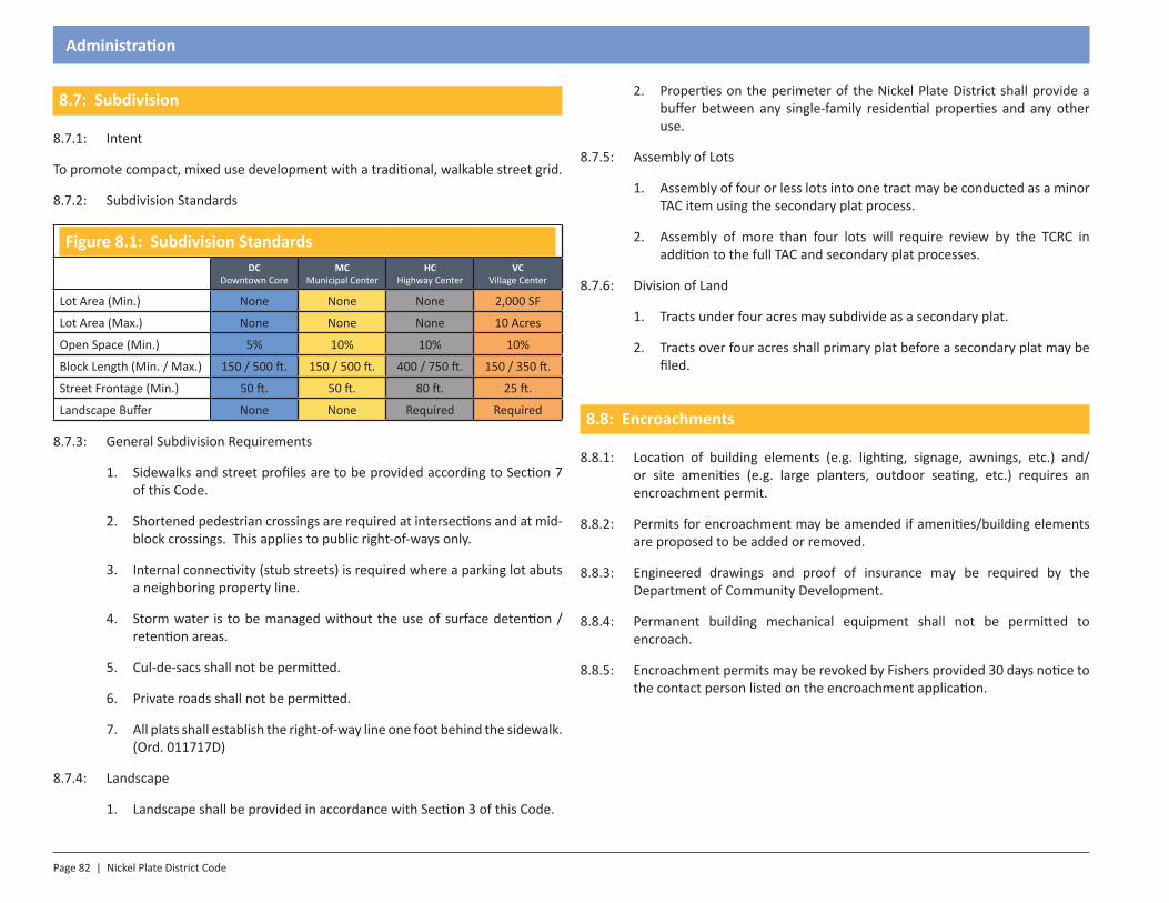
Page 82 | Nickel Plate District Code
Administration
8.7: Subdivision
8.7.1: Intent
To promote compact, mixed use development with a traditional, walkable street grid.
8.7.2: Subdivision Standards
Figure 8.1: Subdivision StandardsDC
Downtown CoreMC
Municipal CenterHC
Highway CenterVC
Village Center
Lot Area (Min.) None None None 2,000 SF
Lot Area (Max.) None None None 10 Acres
Open Space (Min.) 5% 10% 10% 10%
Block Length (Min. / Max.) 150 / 500 ft. 150 / 500 ft. 400 / 750 ft. 150 / 350 ft.
Street Frontage (Min.) 50 ft. 50 ft. 80 ft. 25 ft.
Landscape Buffer None None Required Required
8.7.3: General Subdivision Requirements
1. Sidewalks and street profiles are to be provided according to Section 7 of this Code.
2. Shortened pedestrian crossings are required at intersections and at mid-block crossings. This applies to public right-of-ways only.
3. Internal connectivity (stub streets) is required where a parking lot abuts a neighboring property line.
4. Storm water is to be managed without the use of surface detention / retention areas.
5. Cul-de-sacs shall not be permitted.
6. Private roads shall not be permitted.
7. All plats shall establish the right-of-way line one foot behind the sidewalk. (Ord. 011717D)
8.7.4: Landscape
1. Landscape shall be provided in accordance with Section 3 of this Code.
2. Properties on the perimeter of the Nickel Plate District shall provide a buffer between any single-family residential properties and any other use.
8.7.5: Assembly of Lots
1. Assembly of four or less lots into one tract may be conducted as a minor TAC item using the secondary plat process.
2. Assembly of more than four lots will require review by the TCRC in addition to the full TAC and secondary plat processes.
8.7.6: Division of Land
1. Tracts under four acres may subdivide as a secondary plat.
2. Tracts over four acres shall primary plat before a secondary plat may be filed.
8.8: Encroachments
8.8.1: Location of building elements (e.g. lighting, signage, awnings, etc.) and/or site amenities (e.g. large planters, outdoor seating, etc.) requires an encroachment permit.
8.8.2: Permits for encroachment may be amended if amenities/building elements are proposed to be added or removed.
8.8.3: Engineered drawings and proof of insurance may be required by the Department of Community Development.
8.8.4: Permanent building mechanical equipment shall not be permitted to encroach.
8.8.5: Encroachment permits may be revoked by Fishers provided 30 days notice to the contact person listed on the encroachment application.

SECTION 1.0Introduction
Section 9 - Master Plan
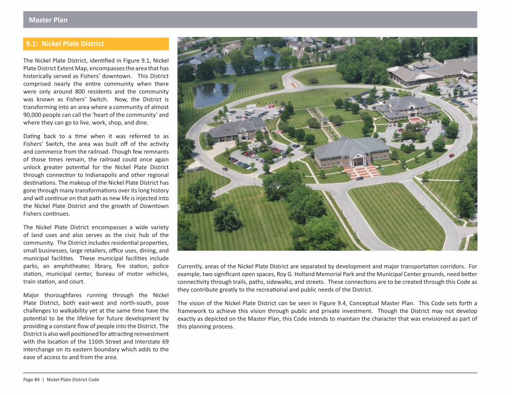
Page 84 | Nickel Plate District Code
Master Plan
9.1: Nickel Plate District
The Nickel Plate District, identified in Figure 9.1, Nickel Plate District Extent Map, encompasses the area that has historically served as Fishers’ downtown. This District comprised nearly the entire community when there were only around 800 residents and the community was known as Fishers’ Switch. Now, the District is transforming into an area where a community of almost 90,000 people can call the ‘heart of the community’ and where they can go to live, work, shop, and dine.
Dating back to a time when it was referred to as Fishers’ Switch, the area was built off of the activity and commerce from the railroad. Though few remnants of those times remain, the railroad could once again unlock greater potential for the Nickel Plate District through connection to Indianapolis and other regional destinations. The makeup of the Nickel Plate District has gone through many transformations over its long history and will continue on that path as new life is injected into the Nickel Plate District and the growth of Downtown Fishers continues.
The Nickel Plate District encompasses a wide variety of land uses and also serves as the civic hub of the community. The District includes residential properties, small businesses, large retailers, office uses, dining, and municipal facilities. These municipal facilities include parks, an amphitheater, library, fire station, police station, municipal center, bureau of motor vehicles, train station, and court.
Major thoroughfares running through the Nickel Plate District, both east-west and north-south, pose challenges to walkability yet at the same time have the potential to be the lifeline for future development by providing a constant flow of people into the District. The District is also well positioned for attracting reinvestment with the location of the 116th Street and Interstate 69 interchange on its eastern boundary which adds to the ease of access to and from the area.
Currently, areas of the Nickel Plate District are separated by development and major transportation corridors. For example, two significant open spaces, Roy G. Holland Memorial Park and the Municipal Center grounds, need better connectivity through trails, paths, sidewalks, and streets. These connections are to be created through this Code as they contribute greatly to the recreational and public needs of the District.
The vision of the Nickel Plate District can be seen in Figure 9.4, Conceptual Master Plan. This Code sets forth a framework to achieve this vision through public and private investment. Though the District may not develop exactly as depicted on the Master Plan, this Code intends to maintain the character that was envisioned as part of this planning process.
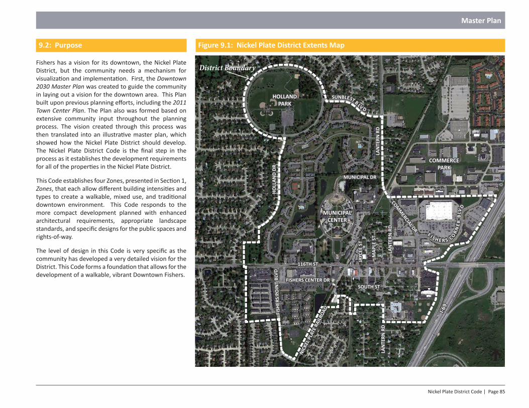
Nickel Plate District Code | Page 85
Master Plan
9.2: Purpose
Fishers has a vision for its downtown, the Nickel Plate District, but the community needs a mechanism for visualization and implementation. First, the Downtown 2030 Master Plan was created to guide the community in laying out a vision for the downtown area. This Plan built upon previous planning efforts, including the 2011 Town Center Plan. The Plan also was formed based on extensive community input throughout the planning process. The vision created through this process was then translated into an illustrative master plan, which showed how the Nickel Plate District should develop. The Nickel Plate District Code is the final step in the process as it establishes the development requirements for all of the properties in the Nickel Plate District.
This Code establishes four Zones, presented in Section 1, Zones, that each allow different building intensities and types to create a walkable, mixed use, and traditional downtown environment. This Code responds to the more compact development planned with enhanced architectural requirements, appropriate landscape standards, and specific designs for the public spaces and rights-of-way.
The level of design in this Code is very specific as the community has developed a very detailed vision for the District. This Code forms a foundation that allows for the development of a walkable, vibrant Downtown Fishers.
North
HOLLAND PARK
MUNICIPAL CENTER
COMMERCE PARK
116TH ST
LAN
TERN
RD
LAN
TERN
RD
I-69
COMM
ERCIAL DR
MUNICIPAL DR
MAP
LE S
T
LAN
TERN
RD
JAYC
EE S
T
HOLL
AND
DRFI
SHER
S PO
INT
BLVD
NICK
EL P
LATE
RAI
LROA
D
FISHERS CENTER DRSOUTH ST
F I S H E R S COR
NE R
BLV
D
SUNBLEST BLV D
Figure 9.1: Nickel Plate District Extents Map
District Boundary
Page 86 | Nickel Plate District Code
Master Plan
• June 27, 2013: Staff presented on the Code to the ULI breakfast series (approx. 50 in attendance)
• July 9, 2013: Staff presented the draft Code at the Advisory Plan Commission public hearing
• July 9, 2013: Staff mailed a letter to all property owners (406 total) within the proposed boundary of the Code with staff contact information, access to draft document, and upcoming meeting dates.
• July 9, 2013: Draft Code uploaded to Town’s webpage
• July 24, 2013: Staff held a public meeting with property owners (24 in attendance) to discuss the Code
• July 25, 2013: Staff held a public meeting with property owners (12 in attendance) to discuss the Code
• July 30, 2013: Staff presented the draft to the Chamber Economic Development Advisory Committee
• September 9, 2013: Staff held a public meeting to review the draft Code with members of Town Council, Advisory Plan Commission and the Boards of Zoning Appeals
• October 15, 2013: Staff presented the revised draft to the Advisory Plan Commission in a public meeting
• November 5, 2013: Staff presented the draft to the Town Center Review Committee in a public meeting
• November 18, 2013: First Reading was held at the Town Council
• December 12, 2013: Plan Commission reviewed the document at a public hearing
• January 14, 2014: The Plan Commission hearing was continued to this meeting where a favorable recommendation was provided
• February 3, 2014: Second Reading was held at the Town Council
• February 17, 2014: Third Reading was held at the Town Council
• Community Development staff has met with interested community members and property owners to discuss the draft document
9.4: Regional Precedent and Character
This regional precedent study reviews neighboring communities and their current downtown and town center developments. These areas support more traditional urbanism in that they promote centers of increased density that are walkable and inclusive of all of an individual’s daily needs. The layout of these urban centers is based on the feel of individual Zones, blocks, streets, and buildings. These individual elements cannot be exclusive of one another as, collectively, they make up the overall feeling of a community.
Central Indiana is widely known for the small town atmosphere generated by its towns and cities. Historically, these downtown areas usually have a collection of no more
9.3: Planning Process
Fishers residents have been interested in planning for the downtown area for many years. Downtown planning efforts from the 1992 HNTB Town Center Plan and 2001 Town Center Plan helped to lay the groundwork for the current downtown planning efforts. The recently completed 2011 Town Center Plan was an important step for downtown planning, and provided a guide for development of the downtown core of Fishers. It establishes a framework for private development projects and provides a foundation for public and private investment. The 2011 Town Center Plan was a result of efforts on the part of the Town Council, the Plan Commission, a citizen steering committee, residents and Staff.
The Downtown 2030 Master Plan was the next step in realizing the vision for the downtown area. This Master Plan was developed through extensive public input in 2012 and 2013, and through ongoing coordination among the Department of Community Development, multiple other Town departments, and the professional design consultant teams of Land Design Inc. and Context Landscape Architecture. This plan uses the guidelines set forth in the 2011 Town Center Plan and the input received throughout the Downtown 2030 Master Plan public process to graphically illustrate the proposed downtown.
In order to translate the Downtown 2030 Master Plan to a codified form, the Department of Community Development reached out to the public, property owners, multiple other Town departments, and the membership of the Town Boards. Staff held individual meetings with interested property owners and also held general information meetings where all property owners and the public were invited to attend.
A highlight of the meetings held for this Downtown 2030 Master Plan and Nickel Plate District Code include:
• Downtown 2030 open houses (Code was highlighted at each of the 6 meetings)
• December 10, 2012 (approx. 70 in attendance)
• January 17, 2013 (approx. 80 in attendance)
• February 6, 2013 (approx. 50 in attendance)
• February 8, 2013: Code overview placed on Town webpage
• February 12, 2013: Staff presented the Downtown 2030 Master Plan and Code to Advisory Plan Commission public hearing
• February 14, 2013: Staff presented the Downtown 2030 Master Plan to Fishers UMC (approx. 20 in attendance)
• March 25, 2013: Staff presented the Downtown 2030 Master Plan to HSE school board
Nickel Plate District Code | Page 87
Master Plan
Brazil, Indiana
Shelbyville, Indiana Franklin, Indiana Pendleton, Indiana
Noblesville, Indiana Greencastle, Indiana
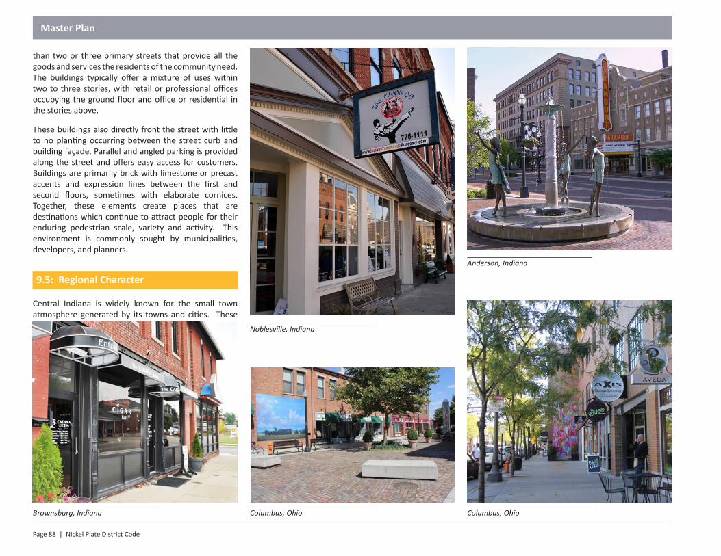
Page 88 | Nickel Plate District Code
Master Plan
than two or three primary streets that provide all the goods and services the residents of the community need. The buildings typically offer a mixture of uses within two to three stories, with retail or professional offices occupying the ground floor and office or residential in the stories above.
These buildings also directly front the street with little to no planting occurring between the street curb and building façade. Parallel and angled parking is provided along the street and offers easy access for customers. Buildings are primarily brick with limestone or precast accents and expression lines between the first and second floors, sometimes with elaborate cornices. Together, these elements create places that are destinations which continue to attract people for their enduring pedestrian scale, variety and activity. This environment is commonly sought by municipalities, developers, and planners.
9.5: Regional Character
Central Indiana is widely known for the small town atmosphere generated by its towns and cities. These
Anderson, Indiana
Columbus, Ohio Columbus, OhioBrownsburg, Indiana
Noblesville, Indiana
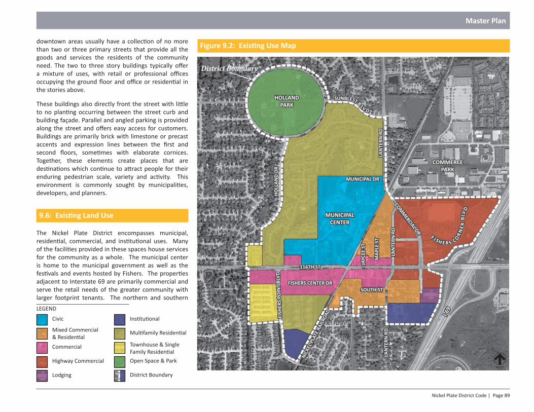
Nickel Plate District Code | Page 89
Master Plan
downtown areas usually have a collection of no more than two or three primary streets that provide all the goods and services the residents of the community need. The two to three story buildings typically offer a mixture of uses, with retail or professional offices occupying the ground floor and office or residential in the stories above.
These buildings also directly front the street with little to no planting occurring between the street curb and building façade. Parallel and angled parking is provided along the street and offers easy access for customers. Buildings are primarily brick with limestone or precast accents and expression lines between the first and second floors, sometimes with elaborate cornices. Together, these elements create places that are destinations which continue to attract people for their enduring pedestrian scale, variety and activity. This environment is commonly sought by municipalities, developers, and planners.
9.6: Existing Land Use
The Nickel Plate District encompasses municipal, residential, commercial, and institutional uses. Many of the facilities provided in these spaces house services for the community as a whole. The municipal center is home to the municipal government as well as the festivals and events hosted by Fishers. The properties adjacent to Interstate 69 are primarily commercial and serve the retail needs of the greater community with larger footprint tenants. The northern and southern
North
HOLLAND PARK
MUNICIPAL CENTER
COMMERCE PARK
116TH ST
LAN
TERN
RD
LAN
TERN
RD
I-69
COMM
ERCIAL DR
MUNICIPAL DR
MAP
LE S
T
LAN
TERN
RD
JAYC
EE S
T
HOLL
AND
DRFI
SHER
S PO
INT
BLVD
NICK
EL P
LATE
RAI
LROA
D
FISHERS CENTER DRSOUTH ST
F I S H E R S COR
NE R
BLV
D
SUNBLEST BLV D
Figure 9.2: Existing Use Map
Civic
Mixed Commercial & Residential
Institutional
LEGEND
Multifamily Residential
Commercial Townhouse & Single Family Residential
Highway Commercial
Lodging
Open Space & Park
District Boundary
District Boundary
Page 90 | Nickel Plate District Code
Master Plan
A remnant of the railroad and agriculture commerce, the grain elevator is the tallest structure in Town.
edges of the District are home to residents and small businesses in smaller buildings, such as single family homes, businesses, small shops, apartments, and converted homes for small offices.
9.7: Existing Conditions
The following pictures illustrate the existing conditions in the Nickel Plate District at the adoption of the Nickel Plate District Code.
Local restaurant adds to the streetscape of 116th Street and serves as a destination for residents.
Nickel Plate Railroad and passenger platform could serve commuters in the future.
Brick buildings along 116th Street reflect historic architectural character.
Nickel Plate District Code | Page 91
Master Plan
Municipal Center: Town Hall anchors the primary axis and entrance from 116th Street to the Municipal Center.
Municipal Center: Fire StationMunicipal Center: Fishers public library and LAUNCH Fishers, a small business and entrepreneur incubator.
Municipal Center: Fishers police station.
Page 92 | Nickel Plate District Code
Master Plan
Existing single family home along Maple Street. Maple Street looking north from 116th Street.
Professional office redevelopment on Maple Street using traditional architecture.Maple Street: Repurposed existing single family homes; however, infrastructure has fallen into disrepair.
Nickel Plate District Code | Page 93
Master Plan
Stand alone retail storefront addresses the streetscape with a landscaped foundation and building entrances.
Streetscape along 116th Street offers brick sidewalks, acorn streetlights and site furnishings.
116th Street at Jaycee Street looking west.
In-fill retail shops along 116th Street setback from the street with parking in front.
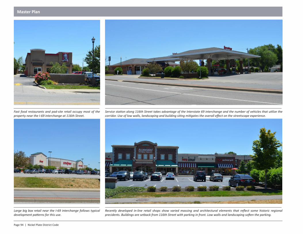
Page 94 | Nickel Plate District Code
Master Plan
Service station along 116th Street takes advantage of the Interstate 69 interchange and the number of vehicles that utilize the corridor. Use of low walls, landscaping and building siting mitigates the overall effect on the streetscape experience.
Recently developed in-line retail shops show varied massing and architectural elements that reflect some historic regional precidents. Buildings are setback from 116th Street with parking in front. Low walls and landscaping soften the parking.
Large big box retail near the I-69 interchange follows typical development patterns for this use.
Fast food restaurants and pad-site retail occupy most of the property near the I-69 interchange at 116th Street.
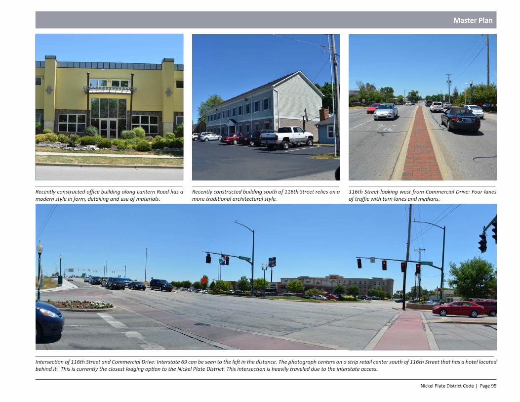
Nickel Plate District Code | Page 95
Master Plan
Recently constructed building south of 116th Street relies on a more traditional architectural style.
116th Street looking west from Commercial Drive: Four lanes of traffic with turn lanes and medians.
Intersection of 116th Street and Commercial Drive: Interstate 69 can be seen to the left in the distance. The photograph centers on a strip retail center south of 116th Street that has a hotel located behind it. This is currently the closest lodging option to the Nickel Plate District. This intersection is heavily traveled due to the interstate access.
Recently constructed office building along Lantern Road has a modern style in form, detailing and use of materials.
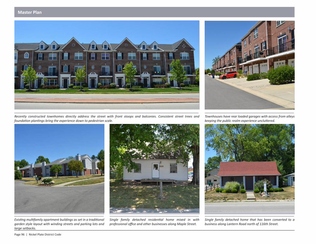
Page 96 | Nickel Plate District Code
Master Plan
Townhouses have rear loaded garages with access from alleys keeping the public realm experience uncluttered.
Single family detached residential home mixed in with professional office and other businesses along Maple Street.
Single family detached home that has been converted to a business along Lantern Road north of 116th Street.
Existing multifamily apartment buildings as set in a traditional garden style layout with winding streets and parking lots and large setbacks.
Recently constructed townhomes directly address the street with front stoops and balconies. Consistent street trees and foundation plantings bring the experience down to pedestrian scale.
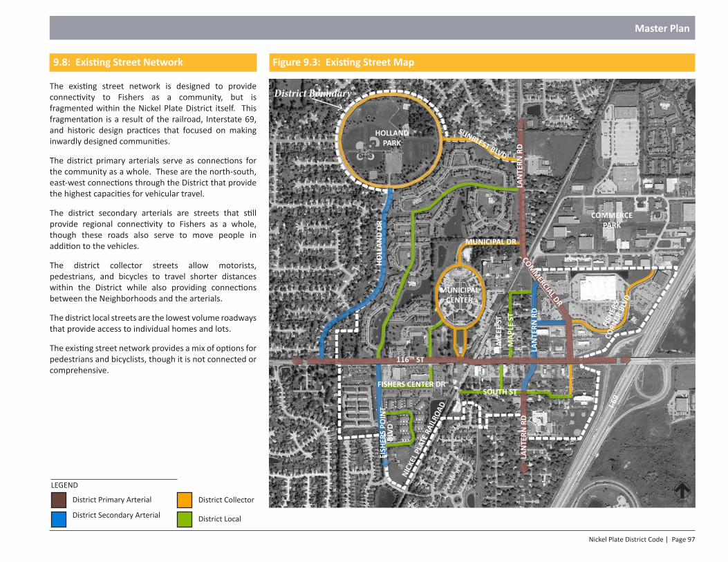
Nickel Plate District Code | Page 97
Master Plan
North
HOLLAND PARK
MUNICIPAL CENTER
COMMERCE PARK
116TH ST
LAN
TERN
RD
LAN
TERN
RD
I-69
COMM
ERCIAL DR
MUNICIPAL DR
MAP
LE S
T
LAN
TERN
RD
JAYC
EE S
T
HOLL
AND
DRFI
SHER
S PO
INT
BLVD
NICK
EL P
LATE
RAI
LROA
D
FISHERS CENTER DRSOUTH ST
FISH
ERS
CORN
ER B
LVD
SUNBLEST BLVD
District Primary Arterial
District Secondary Arterial
District Collector
LEGEND
District Local
Figure 9.3: Existing Street Map
District Boundary
9.8: Existing Street Network
The existing street network is designed to provide connectivity to Fishers as a community, but is fragmented within the Nickel Plate District itself. This fragmentation is a result of the railroad, Interstate 69, and historic design practices that focused on making inwardly designed communities.
The district primary arterials serve as connections for the community as a whole. These are the north-south, east-west connections through the District that provide the highest capacities for vehicular travel.
The district secondary arterials are streets that still provide regional connectivity to Fishers as a whole, though these roads also serve to move people in addition to the vehicles.
The district collector streets allow motorists, pedestrians, and bicycles to travel shorter distances within the District while also providing connections between the Neighborhoods and the arterials.
The district local streets are the lowest volume roadways that provide access to individual homes and lots.
The existing street network provides a mix of options for pedestrians and bicyclists, though it is not connected or comprehensive.
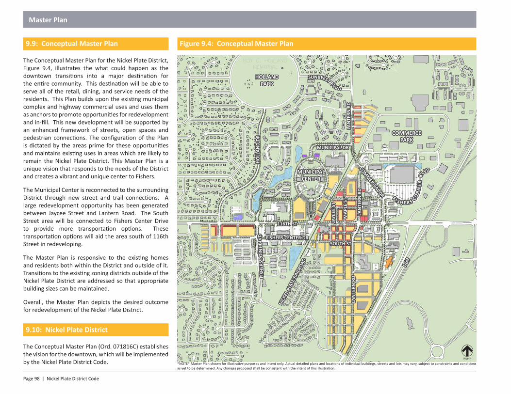
Page 98 | Nickel Plate District Code
Master Plan
9.9: Conceptual Master Plan
The Conceptual Master Plan for the Nickel Plate District, Figure 9.4, illustrates the what could happen as the downtown transitions into a major destination for the entire community. This destination will be able to serve all of the retail, dining, and service needs of the residents. This Plan builds upon the existing municipal complex and highway commercial uses and uses them as anchors to promote opportunities for redevelopment and in-fill. This new development will be supported by an enhanced framework of streets, open spaces and pedestrian connections. The configuration of the Plan is dictated by the areas prime for these opportunities and maintains existing uses in areas which are likely to remain the Nickel Plate District. This Master Plan is a unique vision that responds to the needs of the District and creates a vibrant and unique center to Fishers.
The Municipal Center is reconnected to the surrounding District through new street and trail connections. A large redevelopment opportunity has been generated between Jaycee Street and Lantern Road. The South Street area will be connected to Fishers Center Drive to provide more transportation options. These transportation options will aid the area south of 116th Street in redeveloping.
The Master Plan is responsive to the existing homes and residents both within the District and outside of it. Transitions to the existing zoning districts outside of the Nickel Plate District are addressed so that appropriate building sizes can be maintained.
Overall, the Master Plan depicts the desired outcome for redevelopment of the Nickel Plate District.
9.10: Nickel Plate District
The Conceptual Master Plan (Ord. 071816C) establishes the vision for the downtown, which will be implemented by the Nickel Plate District Code.
North
*NOTE* Master Plan shown for illustrative purposes and intent only. Actual detailed plans and locations of individual buildings, streets and lots may vary, subject to constraints and conditions as yet to be determined. Any changes proposed shall be consistent with the intent of this illustration.
HOLLAND PARK
MUNICIPAL CENTER
COMMERCE PARK
116TH ST
LAN
TERN
RD
LAN
TERN
RD
I-69
COMM
ERCIAL DR
MUNICIPAL DR
MAP
LE S
T
LAN
TERN
RD
JAYC
EE S
T
HOLL
AND
DRFI
SHER
S PO
INT
BLVD
NICK
EL P
LATE
RAI
LROA
D
FISHERS CENTER DRSOUTH ST
F IS H E R S CO
RN
ER
BLVD
SUNBLEST B LV D
Figure 9.4: Conceptual Master Plan
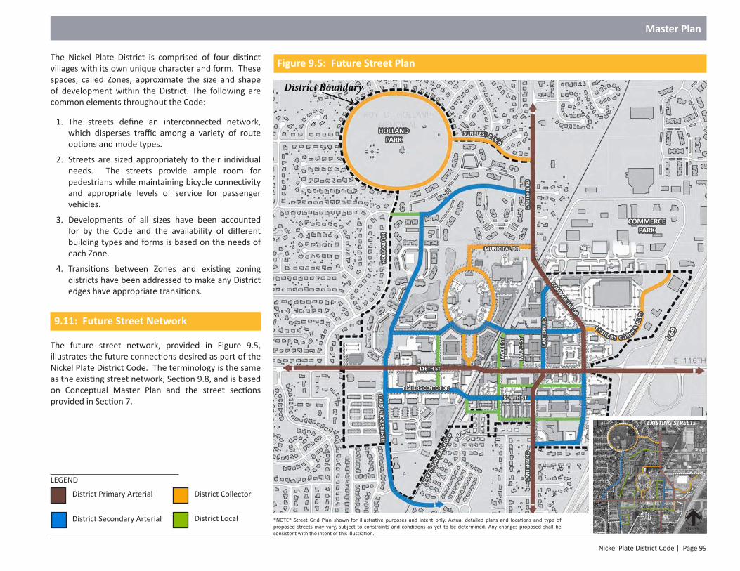
Nickel Plate District Code | Page 99
Master Plan
The Nickel Plate District is comprised of four distinct villages with its own unique character and form. These spaces, called Zones, approximate the size and shape of development within the District. The following are common elements throughout the Code:
1. The streets define an interconnected network, which disperses traffic among a variety of route options and mode types.
2. Streets are sized appropriately to their individual needs. The streets provide ample room for pedestrians while maintaining bicycle connectivity and appropriate levels of service for passenger vehicles.
3. Developments of all sizes have been accounted for by the Code and the availability of different building types and forms is based on the needs of each Zone.
4. Transitions between Zones and existing zoning districts have been addressed to make any District edges have appropriate transitions.
9.11: Future Street Network
The future street network, provided in Figure 9.5, illustrates the future connections desired as part of the Nickel Plate District Code. The terminology is the same as the existing street network, Section 9.8, and is based on Conceptual Master Plan and the street sections provided in Section 7.
District Primary Arterial
District Secondary Arterial
District Collector
LEGEND
District Local *NOTE* Street Grid Plan shown for illustrative purposes and intent only. Actual detailed plans and locations and type of proposed streets may vary, subject to constraints and conditions as yet to be determined. Any changes proposed shall be consistent with the intent of this illustration.
EXISTING STREETS
North
HOLLAND PARK
COMMERCE PARK
116TH ST
LAN
TERN
RD
LAN
TERN
RD
I-69
COMM
ERCIAL DR
MUNICIPAL DR
MAP
LE S
T
LAN
TERN
RD
JAYC
EE S
T
HOLL
AND
DRFI
SHER
S PO
INT
BLVD
NICK
EL P
LATE
RAI
LROA
D
FISHERS CENTER DR
F I S H E R S C O R NER BL
VD
SOUTH ST
SUNBLEST B LV D
Figure 9.5: Future Street Plan
District Boundary
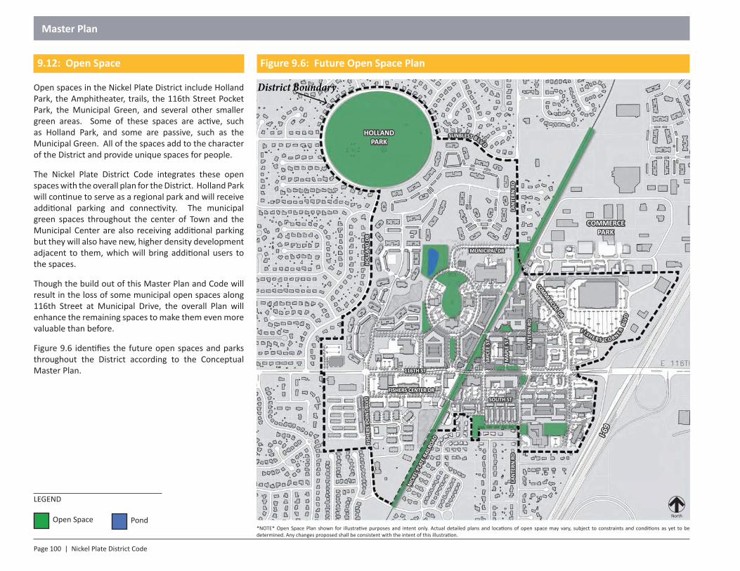
Page 100 | Nickel Plate District Code
Master Plan
Open Space
LEGEND
*NOTE* Open Space Plan shown for illustrative purposes and intent only. Actual detailed plans and locations of open space may vary, subject to constraints and conditions as yet to be determined. Any changes proposed shall be consistent with the intent of this illustration.
Pond North
HOLLAND PARK
COMMERCE PARK
116TH ST
LAN
TERN
RD
LAN
TERN
RD
I-69
COMM
ERCIAL DR
MUNICIPAL DR
MAP
LE S
T
LAN
TERN
RD
JAYC
EE S
T
HOLL
AND
DRFI
SHER
S PO
INT
BLVD
NICK
EL P
LATE
RAI
LROA
D
FISHERS CENTER DR
F I S H E R S C O R NER BL
VD
SOUTH ST
SUNBLEST B LV D
9.12: Open Space
Open spaces in the Nickel Plate District include Holland Park, the Amphitheater, trails, the 116th Street Pocket Park, the Municipal Green, and several other smaller green areas. Some of these spaces are active, such as Holland Park, and some are passive, such as the Municipal Green. All of the spaces add to the character of the District and provide unique spaces for people.
The Nickel Plate District Code integrates these open spaces with the overall plan for the District. Holland Park will continue to serve as a regional park and will receive additional parking and connectivity. The municipal green spaces throughout the center of Town and the Municipal Center are also receiving additional parking but they will also have new, higher density development adjacent to them, which will bring additional users to the spaces.
Though the build out of this Master Plan and Code will result in the loss of some municipal open spaces along 116th Street at Municipal Drive, the overall Plan will enhance the remaining spaces to make them even more valuable than before.
Figure 9.6 identifies the future open spaces and parks throughout the District according to the Conceptual Master Plan.
Figure 9.6: Future Open Space Plan
District Boundary
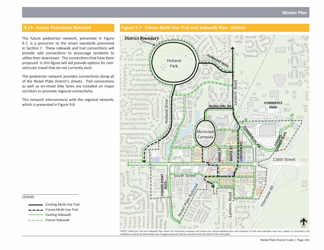
Nickel Plate District Code | Page 101
Master Plan
9.13: Future Pedestrian Network
The future pedestrian network, presented in Figure 9.7, is a precursor to the street standards presented in Section 7. These sidewalk and trail connections will provide safe connections to encourage residents to utilize their downtown. The connections that have been proposed in this figure will aid provide options for non-vehicular travel that do not currently exist.
The pedestrian network provides connectivity along all of the Nickel Plate District’s streets. Trail connections as well as on-street bike lanes are included on major corridors to promote regional connectivity.
This network interconnects with the regional network, which is presented in Figure 9.8.
*NOTE* Multi-Use Trail and Sidewalk Plan shown for illustrative purposes and intent only. Actual detailed plans and locations of trails and sidewalks may vary, subject to constraints and conditions as yet to be determined. Any changes proposed shall be consistent with the intent of this illustration.
Future Multi-Use TrailExisting Sidewalk
Existing Multi-Use Trail
LEGEND
116th Street
North
South Street
Holland Park
MunicipalComplex
Inte
rstat
e 69
Lant
ern
Roa
d
Nick
el P
late
Railr
oad
Lant
ern
Roa
d
Holla
nd D
rive
Future Sidewalk
SUNBLEST BLVD
COMMERCE PARK
COMM
ERCIAL DR
MAP
LE S
T
LAN
TERN
RD
JAYC
EE S
T
FISH
ERS
POIN
T BL
VD
FISH
ERS
CORN
ER B
LVD
MUNICIPAL DR
Figure 9.7: Future Multi-Use Trail and Sidewalk Plan - District
District Boundary
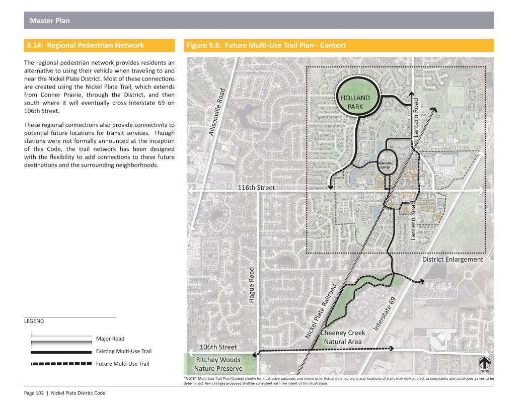
Page 102 | Nickel Plate District Code
Master Plan
*NOTE* Multi-Use Trail Plan-Context shown for illustrative purposes and intent only. Actual detailed plans and locations of trails may vary, subject to constraints and conditions as yet to be determined. Any changes proposed shall be consistent with the intent of this illustration.
9.14: Regional Pedestrian Network
The regional pedestrian network provides residents an alternative to using their vehicle when traveling to and near the Nickel Plate District. Most of these connections are created using the Nickel Plate Trail, which extends from Conner Prairie, through the District, and then south where it will eventually cross Interstate 69 on 106th Street.
These regional connections also provide connectivity to potential future locations for transit services. Though stations were not formally announced at the inception of this Code, the trail network has been designed with the flexibility to add connections to these future destinations and the surrounding neighborhoods.
Major Road
Existing Multi-Use Trail
Future Multi-Use Trail
LEGEND
116th Street
North
Hagu
e Ro
ad
Allis
onvi
lle R
oad
106th Street
Ritchey WoodsNature Preserve
Cheeney Creek Natural AreaNi
ckel
Plat
e Ra
ilroa
d
Inte
rstat
e 69
District Enlargement
Lant
ern
Road
HOLLAND PARK
Lant
ern
Road
MUNICIPAL CENTER
Figure 9.8: Future Multi-Use Trail Plan - Context
SECTION 1.0Introduction
Section 10 - Definitions
Page 104 | Nickel Plate District Code
Definitions
Common Yard: a planted Private Frontage wherein the Facade is set back from the Frontage line. It is visually continuous with adjacent yards.
Configuration: the form of a building, based on its massing, Private Frontage, and height.
Courtyard Building: a building that occupies the boundaries of its Lot while internally defining one or more private patios.
Creative Signage Package: A signage plan for an entire structure that identifies all locations for signage, the type of signage used, and the materials used that exceeds the standards of the Code. (Ord. 071816C)
D
Development Proposal: Any new construction, including accessory structures of at least 200 square feet, or any building addition larger than ten percent (10%) of the gross floor area of a structure.
Digital Message Board: An electronic display that shows images, advertisements, or other messages.
Director: The Mayor or Mayor’s Designee for Fishers, Indiana.
E
Edgeyard Building: a building that occupies the center of its Lot with Setbacks on all sides.
Effective Parking: the amount of parking required for Mixed Use after adjustment by the Shared Parking Factor.
Elevation: an exterior wall of a building not along a Frontage Line.
Enfront: to place an element along a Frontage, as in “porches Enfront the street.”
Expression Line: a horizontal line that is carried through a major part of the facade of a building, which is expressed as a variation in material or by a limited projection such as a molding or balcony.
F
Fenestration: The amount of a wall surface area consisting of windows and doors.
Fiber Cement: A manufactured product that simulates traditional wood exterior finishes.
Finished Elevation: A building elevation that is architecturally similar to all other sides of a structure and includes the location of all mechanical equipment including meters.
Forecourt: a Private Frontage wherein a portion of the Facade is close to the Frontage
This Section provides definitions for terms in this Code that are technical in nature or that otherwise may not reflect a common usage of the term. Where no definition is present, the UDO shall prevail. Where conflict exists between this section and the UDO, this section shall prevail.
A
Accent Material: A building material that covers 15 percent or less of a facade excluding door and window openings.
Accessory Use: A secondary use on a property that is not connected to the primary structure. This includes vending machines and self-service kiosks.
Accessory Unit: an Apartment not greater than 440 square feet sharing ownership and utility connections with a Primary Building; it may or may not be within an Outbuilding.
Affordable Housing: dwellings consisting of rental or for-sale units that have a rent (including utilities) or mortgage payment typically no more than 30% of the income of families earning no more than 80% of median incomes by family size for the county.
Allee: a regularly spaced and aligned row of trees usually planted along a Thoroughfare or Path.
Apartment: a Residential unit sharing a building and a Lot with other units and/or uses; may be for rent, or for sale as a condominium.
Attic: the interior part of a building contained within a pitched roof structure.
B
Backbuilding: a single-Story structure connecting a Primary Building to an Outbuilding.
Blank facade: A building face lacking architecture
Block Face: the aggregate of all the building Facades on one side of a Block.
Brick: Unit masonry consisting of clay.
C
Centerline: The mid point between the travel lanes of a roadway.
Civic: the term defining not-for-profit organizations dedicated to arts, culture, education, recreation, government, transit, and municipal parking.
Commercial: the term collectively defining workplace, Office, Retail, and Lodging Functions.
Nickel Plate District Code | Page 105
Definitions
Line and the central portion is set back.
Front: Any side of a lot facing a public right-of-way, such as an alley, trail, or train track. (Ord. 091817)
Frontage Encroachment: any structural element that breaks the plane of a vertical or horizontal regulatory limit, extending into a Setback, into the Public Frontage, or above a height limit.
Frontage Line: a Lot line bordering a Public Frontage. Facades facing Frontage Lines define the public realm and are therefore more regulated than the Elevations facing other Lot Lines.
Function: the use or uses accommodated by a building and its Lot, categorized as Restricted, Limited, or Open, according to the intensity of the use.
G
Gallery: a Private Frontage conventional for Retail use wherein the Facade is aligned close to the Frontage Line with an attached cantilevered shed or lightweight colonnade overlapping the Sidewalk.
Greenscreen: A wall of plant material attached to a building/structure that serves as the facade for the building/structure to which it is attached.
I
Infill: noun - new development on land that had been previously developed, including most Greyfield and Brownfield sites and cleared land within Urbanized areas. verb- to develop such areas.
K
Kiosk, Self-Service: A free-standing machine that dispenses movies, music, or other consumer goods without a full-time, on-site staff.
L
Layer: a range of depth of a Lot within which certain elements are permitted.
Life Safety Devices: fire detection and fire suppression equipment and any related lighting or signage as required by the police department, fire department, or Indiana Code.
Live-Work: a Mixed Use unit consisting of a Commercial and Residential Function. It
typically has a substantial Commercial component that may accommodate employees and walk-in trade. The unit is intended to function predominantly as work space with incidental Residential accommodations that meet basic habitability requirements.
Lodging: premises available for daily and weekly renting of bedrooms.
M
Maintenance: Structural and aesthetic changes to a structure which do not require a building permit. (Ord. 011717D)
Mixed Use: multiple Functions within the same building through superimposition or adjacency, or in multiple buildings by adjacency, or at a proximity determined by Warrant.
Municipal Parking Structure: A parking facility funded partially, or entirely by municipal bonds, funds, or land transfers.
O
Outbuilding: an Accessory Building, usually located toward the rear of the same Lot as a Primary Building, and sometimes connected to the Primary Building by a Backbuilding.
P
Parking Structure: a building containing one or more Stories of parking above grade.
Parking Deck: a structured parking facility that is up to two stories in height from grade. This may be a component of another structure and the parking deck height will be calculated by the levels which park cars exclusive of overall structure height. (Ord. 011717D)
Placement: the placement of a building on its Lot.
Planting Strip: The lawn located between the sidewalk and the curb.
Plaza: a Civic Space type designed for Civic purposes and Commercial activities in the more urban Neighborhood Zones, generally paved and spatially defined by building Frontages.
Primary Entrance: the main point of access for pedestrians into a building.
Primary Frontage: On corner Lots, the Private Frontage designated to bear the address and Primary Entrance to the building; or where facing streets are not of the same thoroughfare classification, the street of higher classification shall be the Primary Frontage. Prescriptions for the parking Layers pertain only to the Primary Frontage. Prescriptions for the first Layer pertain to both Frontages of a corner Lot.
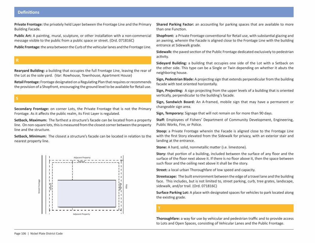
Page 106 | Nickel Plate District Code
Definitions
Private Frontage: the privately held Layer between the Frontage Line and the Primary Building Facade.
Public Art: A painting, mural, sculpture, or other installation with a non-commercial message visible to the public from a public space or street. (Ord. 071816C)
Public Frontage: the area between the Curb of the vehicular lanes and the Frontage Line.
R
Rearyard Building: a building that occupies the full Frontage Line, leaving the rear of the Lot as the sole yard. (Var: Rowhouse, Townhouse, Apartment House)
Retail Frontage: Frontage designated on a Regulating Plan that requires or recommends the provision of a Shopfront, encouraging the ground level to be available for Retail use.
S
Secondary Frontage: on corner Lots, the Private Frontage that is not the Primary Frontage. As it affects the public realm, its First Layer is regulated.
Setback, Maximum: The farthest a structure’s facade can be located from a property line. On non-square lots, this is measured from the closest corner between the property line and the structure.
Setback, Minimum: The closest a structure’s facade can be located in relation to the nearest property line.
Shared Parking Factor: an accounting for parking spaces that are available to more than one Function.
Shopfront: a Private Frontage conventional for Retail use, with substantial glazing and an awning, wherein the Facade is aligned close to the Frontage Line with the building entrance at Sidewalk grade.
Sidewalk: the paved section of the Public Frontage dedicated exclusively to pedestrian activity.
Sideyard Building: a building that occupies one side of the Lot with a Setback on the other side. This type can be a Single or Twin depending on whether it abuts the neighboring house.
Sign, Pedestrian Blade: A projecting sign that extends perpendicular from the building facade with text oriented horizontally.
Sign, Projecting: A sign projecting from the upper levels of a building that is oriented vertically, perpendicular to the building’s facade.
Sign, Sandwich Board: An A-framed, mobile sign that may have a permanent or changeable sign area.
Sign, Temporary: Signage that will not remain on for more than 90 days.
Staff: Employees of Fishers’ Department of Community Development, Engineering, Public Works, Fire, or Police.
Stoop: a Private Frontage wherein the Facade is aligned close to the Frontage Line with the first Story elevated from the Sidewalk for privacy, with an exterior stair and landing at the entrance.
Stone: A hard, solid, nonmetallic matter (i.e. limestone).
Story: that portion of a building, included between the surface of any floor and the surface of the floor next above it. If there is no floor above it, then the space between such floor and the ceiling next above it shall be the story.
Street: a local urban Thoroughfare of low speed and capacity.
Streetscape: The built environment between the edge of a travel lane and the building face. This includes, but is not limited to, street parking, curb, tree grates, landscape, sidewalk, and/or trail. (Ord. 071816C)
Surface Parking Lot: A place with designated spaces for vehicles to park located along the existing grade.
T
Thoroughfare: a way for use by vehicular and pedestrian traffic and to provide access to Lots and Open Spaces, consisting of Vehicular Lanes and the Public Frontage.
Adjacent Property
Adjacent Property
Stre
et F
ront
age
Alle
y
Building Placement
Setback
Setb
ack
Setb
ack
Nickel Plate District Code | Page 107
Definitions
Townhouse: one of a number of individual housing units constructed with a common roof, front wall and rear wall.
Trail: A pedestrian area to convey people, similar to a sidewalk. This facility may be installed parallel to a roadway or through a natural area, park, or other pedestrian corridor. (Ord. 071816C)
Tree Lawn: See planting strip.
Turning Radius: the curved edge of a Thoroughfare at an intersection, measured at the inside edge of the vehicular tracking. The smaller the Turning Radius, the smaller the pedestrian crossing distance and the more slowly the vehicle is forced to make the turn.
V
Vending Machine: A mechanized device that dispenses goods, such as sodas, snacks, or other consumable goods.
W
Waiver: An adjustment of a development standard intended to allow unique and creative design. (Ord. 110514C)
Y
Yard, Rear: The yard opposite the lot’s narrowest frontage.
Yard, Front: A yard facing a public street or right-of-way. (Ord. 071816C)
Yard, Side: A yard facing a neighboring property that is neither a front nor side yard. (Ord. 071816C)