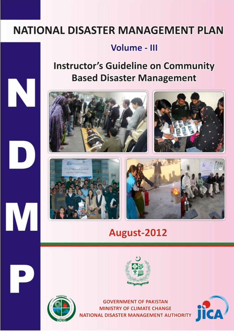
NDMP-Instructor's Guidelines on Based Community Disaster ...
167
-
Upload
khangminh22 -
Category
Documents
-
view
5 -
download
0
Transcript of NDMP-Instructor's Guidelines on Based Community Disaster ...

The following foreign exchange rate is applied in the study:
US$ 1.00 = PKR 88.4
PREFACE
The National Disaster Management Plan (NDMP) is a milestone in the history of the Disaster
Management System (DRM) in Pakistan. The rapid change in global climate has given rise to many
disasters that pose a severe threat to human life, property and infrastructure. Disasters like floods,
earthquakes, tsunamis, droughts, sediment disasters, avalanches, GLOFs, and cyclones with storm surges
are some prominent manifestations of climate change phenomenon. Pakistan, which is ranked in the top
ten countries that are the most vulnerable to climate change effects, started planning to safeguard and
secure the life, land and property of its people in particular the poor, the vulnerable and the marginalized.
However, recurring disasters since 2005 have provided the required stimuli for accelerating the efforts
towards capacity building of the responsible agencies, which include federal, provincial, district
governments, community organizations, NGOs and individuals.
Prior to 2005, the West Pakistan National Calamities Act of 1958 was the available legal remedy
that regulated the maintenance and restoration of order in areas affected by calamities and relief against
such calamities. An Emergency Relief Cell within the Cabinet Division has been serving since 1971 as an
institutional disaster relief support at the national level. Similar institutional arrangements existed at the
provincial level in the form of relief commissioners. However, that regime provided a reactive approach
towards emergency response only.
The United Nations International Strategy for Disaster Reduction (UNISDR) introduced the
paradigm shift from a reactive to a proactive approach in the form of the Hyogo Framework of Action
(2005-2015) signed by 168 countries including Pakistan. To fulfill the global obligations as well as cope
with the challenges emerged in the aftermath of October 2005 earthquake, the Government of Pakistan
promulgated the National Disaster Management Ordinance in 2007 to introduce a comprehensive
National Disaster Management System in the country. The Ordinance became the Act called the National
Disaster Management Act in December 2010. The Act establishes three tiers for the disaster management
system: i.e., national, provincial and district levels.
Under the Act, the National Disaster Management Commission (NDMC) was established at the
national level, and has the responsibility for laying down policies and guidelines for disaster risk
management and approval of the National Plan. The National Disaster Management Authority (NDMA)
was subsequently established in 2007 in line with the Act, and serves as the implementing, coordinating
and monitoring body for disaster risk management at the national level. Along with the Ordinance (now
Act), the National Disaster Risk Management Framework (NDRMF) was prepared by the NDMA in
March 2007. The NDRMF served as an overall guideline for disaster risk management at national,
provincial and district levels. In March 2010, the NDMA formulated the National Disaster Response Plan
(NDRP) identifying specific roles and responsibilities of the relevant stakeholders in emergency response
including Standard Operation Procedures (SOPs).
Concurrently, NDMA, in collaboration with national and international partners, had been in the
process of strengthening the DRM system in the country. In order to support this new approach in
Pakistan, the Japan International Cooperation Agency (JICA) dispatched a series of missions from the
year 2008 to 2009 based on the request from the Government of Pakistan. It studied the whole legal and
administrative system of DRM in Pakistan and held meetings with all stakeholders to identify the needs
and requirements to enhance the capacity of the national DRM system. Based on thorough bilateral
consultations, a project document on formulation of a National Disaster Management Plan (NDMP) for
Pakistan was conceived for implementation through Japanese Grant-in-Aid. A PC-II was prepared
accordingly and was approved by the Planning Commission in the meeting of Central Development
Working Party held on 19-11-2009. For implementation through Grant-in-Aid, the scope of work for the
project was discussed, agreed and signed between the Government of Pakistan and JICA on 11-12-2009
and the project Inception Report was prepared in April 2010. The Plan, aimed at enhancing the capacity
of the country to prepare for and respond to disasters by defining the measures to be considered necessary
for disaster management and risk reduction in line with the provision of the National Disaster
Management Act (Chapter II, Section 10), was finalized in June 2012.
The overall NDMP is a comprehensive plan, having a total investment cost of USD 1040.9
million (PKR 92.02 Bn with 1 USD = PKR 88.4), consisting of the “Main Plan” document along with
three supporting volumes besides the Executive Summary, which identifies macro level hazards and risk
assessment, development of the multi hazard early warning system to reduce the vulnerability to disasters
by enhancing and strengthening the early warning capacity, identification of the roles and responsibilities
of the stakeholders, including federal, provincial and district governments, community organizations,
NGOs, businesses, and individuals who are involved in the disaster management. The Community Based
Disaster Risk Management (CBDRM) approach, in view of its universal reorganization and importance in
DRM planning, has been given due place in the Plan. Based on pilot activities tested in different hazard
contexts and social settings, best practices and guidelines have been documented in the Plan to serve as
models for future CBDRM activities in Pakistan. The Plan also provides strategic direction for systematic
human resource development in the field of disaster management and the operational plan for the
National Institute of Disaster Management (NIDM).
The components of NDMP published in one main document with three supporting volumes,
besides the Executive Summary, are entitled:
• National Disaster Management Plan Main Plan
• Human Resource Development Plan on Disaster Management Vol. I
• Multi-Hazard Early Warning System Plan Vol. II
• Instructors’ Guidelines on Community Based Disaster Risk Management Vol. III
Instructor's Guideline on Community Based Disaster Risk Management
ES-1
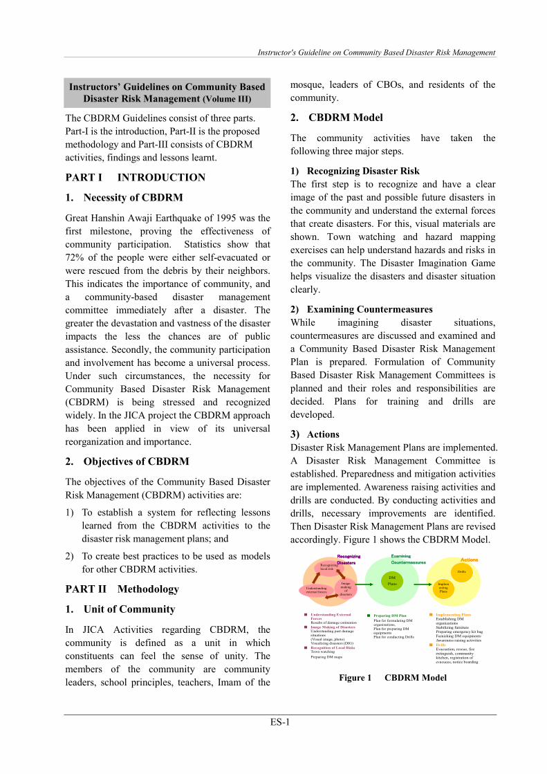
The CBDRM Guidelines consist of three parts.
Part-I is the introduction, Part-II is the proposed
methodology and Part-III consists of CBDRM
activities, findings and lessons learnt.
PART I INTRODUCTION
1. Necessity of CBDRM
Great Hanshin Awaji Earthquake of 1995 was the
first milestone, proving the effectiveness of
community participation. Statistics show that
72% of the people were either self-evacuated or
were rescued from the debris by their neighbors.
This indicates the importance of community, and
a community-based disaster management
committee immediately after a disaster. The
greater the devastation and vastness of the disaster
impacts the less the chances are of public
assistance. Secondly, the community participation
and involvement has become a universal process.
Under such circumstances, the necessity for
Community Based Disaster Risk Management
(CBDRM) is being stressed and recognized
widely. In the JICA project the CBDRM approach
has been applied in view of its universal
reorganization and importance.
2. Objectives of CBDRM
The objectives of the Community Based Disaster
Risk Management (CBDRM) activities are:
1) To establish a system for reflecting lessons
learned from the CBDRM activities to the
disaster risk management plans; and
2) To create best practices to be used as models
for other CBDRM activities.
PART II Methodology
1. Unit of Community
In JICA Activities regarding CBDRM, the
community is defined as a unit in which
constituents can feel the sense of unity. The
members of the community are community
leaders, school principles, teachers, Imam of the
mosque, leaders of CBOs, and residents of the
community.
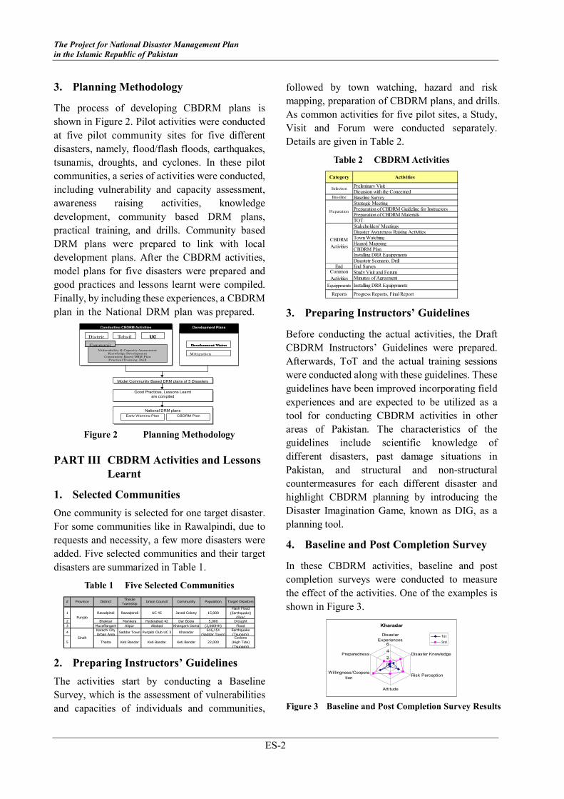
2. CBDRM Model
The community activities have taken the
following three major steps.
1) Recognizing Disaster Risk
The first step is to recognize and have a clear
image of the past and possible future disasters in
the community and understand the external forces
that create disasters. For this, visual materials are
shown. Town watching and hazard mapping
exercises can help understand hazards and risks in
the community. The Disaster Imagination Game
helps visualize the disasters and disaster situation
clearly.
2) Examining Countermeasures
While imagining disaster situations,
countermeasures are discussed and examined and
a Community Based Disaster Risk Management
Plan is prepared. Formulation of Community
Based Disaster Risk Management Committees is
planned and their roles and responsibilities are
decided. Plans for training and drills are
developed.
3) Actions
Disaster Risk Management Plans are implemented.
A Disaster Risk Management Committee is
established. Preparedness and mitigation activities
are implemented. Awareness raising activities and
drills are conducted. By conducting activities and
drills, necessary improvements are identified.
Then Disaster Risk Management Plans are revised
accordingly. Figure 1 shows the CBDRM Model.
Recognizing
local risk
Image making
of disasters
Understanding external forces
Implementing Plans
Drills
DM
Plans
■ Preparing DM Plan
Plan for formulating DM organizations, Plan for preparing DM equipments Plan for conducting Drills
■ Understanding External
Forces
Results of damage estimation
■ Image Making of Disasters
Understanding past damage situations (Visual image, photo) Visualizing disasters (DIG)
■ Recognition of Local Risks Town watching
Preparing DM maps
■ Implementing Plans
Establishing DM organizations Stabilizing furniture Preparing emergency kit bag Furnishing DM equipments Awareness raising activities
■ Drills
Evacuation, rescue, fire extinguish, community kitchen, registration of evacuees, notice boarding
RecogniRecogniRecogniRecognizing zing zing zing
DisasterDisasterDisasterDisasterssss
Examining Examining Examining Examining
CountermeasureCountermeasureCountermeasureCountermeasuressss ActionsActionsActionsActions
Figure 1 CBDRM Model
Instructors’ Guidelines on Community Based
Disaster Risk Management (Volume III)
The Project for National Disaster Management Plan
in the Islamic Republic of Pakistan
ES-2
3. Planning Methodology
The process of developing CBDRM plans is
shown in Figure 2. Pilot activities were conducted
at five pilot community sites for five different
disasters, namely, flood/flash floods, earthquakes,
tsunamis, droughts, and cyclones. In these pilot
communities, a series of activities were conducted,
including vulnerability and capacity assessment,
awareness raising activities, knowledge
development, community based DRM plans,
practical training, and drills. Community based
DRM plans were prepared to link with local
development plans. After the CBDRM activities,
model plans for five disasters were prepared and
good practices and lessons learnt were compiled.
Finally, by including these experiences, a CBDRM
plan in the National DRM plan was prepared.
Conducting CBDRM Activities
UCUCUCUC Tehsil Distric
Vulnerability & Capacity Assessment
Knowledge Development
Community Based DRM Plan
Practical Training, Drill
Development Development Development Development VisionVisionVisionVision
Good Practices, Lessons Learnt
are compiled
National DRM plans
Model Community Based DRM plans of 5 Disasters
Mitigation
Development Plans
at local level
Communit
Early Warning Plan CBDRM Plan
Figure 2 Planning Methodology
PART III CBDRM Activities and Lessons
Learnt
1. Selected Communities
One community is selected for one target disaster.
For some communities like in Rawalpindi, due to
requests and necessity, a few more disasters were
added. Five selected communities and their target
disasters are summarized in Table 1.
Table 1 Five Selected Communities
1 Rawalpindi Rawalpindi UC 45 Javed Colony 15,000
Flash Flood
(Earthquake)
(Fire)2 Bhakkar Mankera Hyderabad 42 Dar Boola 5,000 Drought
3 Muzaffargarh Alipur Aliabad Khangarh Doma (2,000HH) Flood
4Karachi City
Urban AreaSaddar Town Punjabi Club UC 3 Kharadar
616,151
(Saddar Town)
Earthquake
(Tsunami)
5 Thatta Keti Bandar Keti Bandar Keti Bandar 22,000
Cyclone
(High Tide)
(Tsunami)
Punjab
Sindh
# DistrictThesile
TownshipUnion Council Target DisastersProvince PopulationCommunity
2. Preparing Instructors’ Guidelines
The activities start by conducting a Baseline
Survey, which is the assessment of vulnerabilities
and capacities of individuals and communities,
followed by town watching, hazard and risk
mapping, preparation of CBDRM plans, and drills.
As common activities for five pilot sites, a Study,
Visit and Forum were conducted separately.
Details are given in Table 2.
Table 2 CBDRM Activities
Preliminary VisitDicussion with the Concerned
Baseline Baseline SurveyStrategic MeetingPreparation of CBDRM Guideline for InstructorsPreparation of CBDRM MaterialsTOTStakeholders' MeetingsDisaster Awareness Raising ActivitiesTown WatchingHazard MappingCBDRM PlanInstalling DRR EquippmentsDisastetr Scenario, Drill
End End SurveyStudy Visit and ForumMinuites of Agreement
Equippments Installing DRR Equippments
Reports Progress Reports, Final Report
CBDRM
Activities
Common
Activities
Selection
Preparation
Category Activities
3. Preparing Instructors’ Guidelines
Before conducting the actual activities, the Draft
CBDRM Instructors’ Guidelines were prepared.
Afterwards, ToT and the actual training sessions
were conducted along with these guidelines. These
guidelines have been improved incorporating field
experiences and are expected to be utilized as a
tool for conducting CBDRM activities in other
areas of Pakistan. The characteristics of the
guidelines include scientific knowledge of
different disasters, past damage situations in
Pakistan, and structural and non-structural
countermeasures for each different disaster and
highlight CBDRM planning by introducing the
Disaster Imagination Game, known as DIG, as a
planning tool.
4. Baseline and Post Completion Survey
In these CBDRM activities, baseline and post
completion surveys were conducted to measure
the effect of the activities. One of the examples is
shown in Figure 3.
Kharadar
0
2
4
6
Disaster
Experiences
Disaster Knowledge
Risk Perception
Attitude
Willingness/Coopera
tion
Preparedness
1st
3rd
Figure 3 Baseline and Post Completion Survey Results

Instructor's Guideline on Community Based Disaster Risk Management
ES-3
Characteristics of the findings are summarized
below.
1) Increase in Risk Perception, Knowledge
and Preparedness
After implementing CBDRM training, awareness
about risk perception, preparedness and knowledge
was observed. The greatest impact was found in
Karachi compared to the other communities. The
reason being that earlier, the risks of earthquakes
were not widely disseminated to community
people in Karachi.
2) Increase of Risk Perception in Urban
Scenarios
Compared with the rural Areas of Bhakkar,
Muzaffargarh, and Thatta, risk perception was
initially quite low in the urban areas of Rawalpindi
and Karachi. Now, an increase in risk perception
can be observed more in the urban settings after
conducting CBDRM activities.
3) Similarity among the Target Communities
There are similar tendencies in the radar charts.
The r i s k perception and the willingness are
higher than the disaster knowledge and
preparedness.
5. Lessons Learnt
Key findings are listed below.
Participation
• Encouraging participation in the rural areas is
not a problem, while in urban areas, it is
extremely difficult.
• There should be various efforts from not only
the public but also private entities to
encourage the participation in urban areas.
Exhibitions, seminars, workshops,
symposiums and poster presentations on
DRM can be organized as an attraction to
increase participation in urban areas.
• Females participated very actively and took
leadership of the Community Disaster
Management Committee (CDMC).
Delivery of Activities
• Practical activities increase and retain the
interest and attention of the participants.
• There was little scientific knowledge on
disasters. Considering the low literacy rate,
visual materials, visual demonstrations of
experiments, town watching and mapping
exercises can be used to draw the attention
and interest of the participants.
• Both males and females in equal numbers
participated in the drills on the last day and
tested putting the knowledge gained into
practice.
Mapping Exercise
• Risk and resource mapping increases the
enthusiasm of participants and a large number
of participants were involved.
Continuation of the DRM Activities
• Some intervention by public officials is
necessary to ensure sustainability of DRM
activities at the community level. To realize
this, a budget for travel and technical support
needs to be secured.
Intervention of Public Officials
• Discussions among public officials were
effective and also gave local government
officials a clear image of ground realities.
• The community and the Community Disaster
Management Committee (CDMC) wish to
have a permanent link with the implementing
organizations, so a comprehensive community
DRM plan for follow up would help retain the
cohesion in the newly formed Committee and
the level of collaboration between the
government and local stakeholders. A budget
for such activities needs to be secured at the
district level.
Establishing a Mechanism for Incorporating Local
Needs into Planning
• DRM plans were effectively discussed among
the community and local government officials
for implementation. However, establishment
of a mechanism for incorporating village
DRM needs into local government
development plans it requires more time and
effort.
Implementing Mitigation Measures
• Participants at the drought site in Bhakkar
were keen to learn about drought and its

The Project for National Disaster Management Plan
in the Islamic Republic of Pakistan
ES-4
impacts and asked a lot of questions to the
drought impact assessment expert. They were
also interested in changing crop patterns and
methods of cultivation.
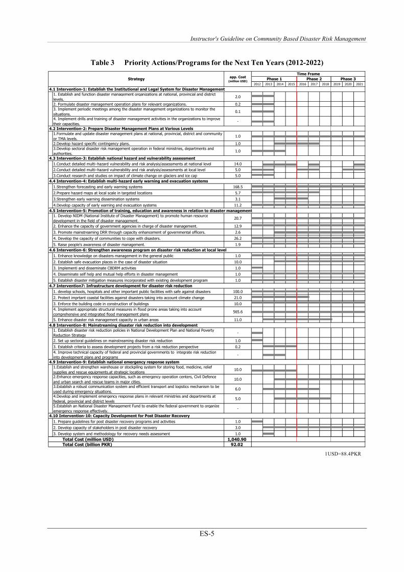
The time frame and the cost for implementation of
interventions, over the next ten years (2012-2022)
under the overall NDMP (Main Plan to Vol.-III)
have been shown in Table 3 (a) whereas Priority
Actions/Programs under CBDRM (Vol.-III)
including Cost are shown in Table 3. (b).
Instructor's Guideline on Community Based Disaster Risk Management
ES-5
Table 3 Priority Actions/Programs for the Next Ten Years (2012-2022)
2012 2013 2014 2015 2016 2017 2018 2019 2020 2021
1. Establish and function disaster management organizations at national, provincial and district
levels.2.0
2. Formulate disaster management operation plans for relevant organizations. 0.2
3. Implement periodic meetings among the disaster management organizations to monitor the
situations.0.1
4. Implement drills and training of disaster management activities in the organizations to improve
their capacities.-
1.Formulate and update disaster management plans at national, provincial, district and community
or TMA levels.1.0
2.Develop hazard specific contingency plans. 1.0
3.Develop sectoral disaster risk management operation in federal ministries, departments and
authorities.1.0
1.Conduct detailed multi–hazard vulnerability and risk analysis/assessments at national level 14.0
2.Conduct detailed multi–hazard vulnerability and risk analysis/assessments at local level 5.0
3.Conduct research and studies on impact of climate change on glaciers and ice cap 5.0
1.Strengthen forecasting and early warning systems 168.5
2.Prepare hazard maps at local scale in targeted locations 5.7
3.Strengthen early warning dissemination systems 3.1
4.Develop capacity of early warning and evacuation systems 11.2
1. Develop NIDM (National Institute of Disaster Management) to promote human resource
development in the field of disaster management.20.7
2. Enhance the capacity of government agencies in charge of disaster management. 12.9
3. Promote mainstreaming DRR through capacity enhancement of governmental officers. 2.6
4. Develop the capacity of communities to cope with disasters. 26.2
5. Raise people's awareness of disaster management. 1.9
1. Enhance knowledge on disasters management in the general public 1.0
2. Establish safe evacuation places in the case of disaster situation 10.0
3. Implementi and disseminate CBDRM activities 1.0
4. Disseminate self help and mutual help efforts in disaster management 1.0
5. Establish disaster mitigation measures incorporated with existing development program 1.0
1. develop schools, hospitals and other important public facilities with safe against disasters 100.0
2. Protect imprtant coastal facilities against disasters taking into account climate change 21.0
3. Enforce the building code in construction of buildings 10.0
4. Implement appropriate structural measures in flood prone areas taking into account
comprehensive and integrated flood management plans565.6
5. Enhance disaster risk management capacity in urban areas 11.0
1. Establish disaster risk reduction policies in National Development Plan and National Poverty
Reduction Strategy-
2. Set up sectoral guidelines on mainstreaming disaster risk reduction 1.0
3. Establish criteria to assess development projects from a risk reduction perspective 0.2
4. Improve technical capacity of federal and provincial governments to integrate risk reduction
into development plans and programs-
1.Establish and strengthen warehouse or stockpiling system for storing food, medicine, relief
supplies and rescue equipments.at strategic locations10.0
2.Enhance emergency response capacities, such as emergency operation centers, Civil Defence
and urban search and rescue teams in major cities.10.0
3.Establish a robust communication system and efficient transport and logistics mechanism to be
used during emergency situations.6.0
4.Develop and implement emergency response plans in relevant ministries and departments at
federal, provincial and district levels5.0
5.Establish an National Disaster Management Fund to enable the federal government to organize
emergency response effectively.-
1. Prepare guidelines for post disaster recovery programs and activities 1.0
2. Develop capacity of stakeholders in post disaster recovery 3.0
3. Develop system and methodology for recovery needs assessment 1.0
Total Cost (million USD) 1,040.90
Total Cost (billion PKR) 92.02
4.9 Intervention-9: Establish national emergency response system
Time Frame
Phase 1 Phase 2app. Cost
(million USD)
4.3 Intervention-3: Establish national hazard and vulnerability assessment
4.1 Intervention-1: Establish the Institutional and Legal System for Disaster Management
4.5 Intervention-5: Promotion of training, education and awareness in relation to disaster management
Strategy
4.10 Intervention-10: Capacity Development for Post Disaster Recovery
4.7 Intervention7: Infrastructure development for disaster risk reduction
Phase 3
4.8 Intervention-8: Mainstreaming disaster risk reduction into development
4.2 Intervention-2: Prepare Disaster Management Plans at Various Levels
4.4 Intervention-4: Establish multi-hazard early warning and evacuation systems
4.6 Intervention-6: Strengthen awareness program on disaster risk reduction at local level
1USD=88.4PKR

The Project for National Disaster Management Plan
in the Islamic Republic of Pakistan
ES-6
Table 3 (b) Priority Actions/Programs/Cost of CBDRM for the Next Ten Years (2012-2022)
2012 2013 2014 2015 2016 2017 2018 2019 2020 2021
1. Enhance knowledge on disasters management in the general public 1.0
2. Establish safe evacuation places in the case of disaster situation 10.0
3. Implementi and disseminate CBDRM activities 1.0
4. Disseminate self help and mutual help efforts in disaster management 1.0
5. Establish disaster mitigation measures incorporated with existing development program 1.0
Total Cost (million USD) 14.00Total Cost (billion PKR) 1.24
4.6 Intervention-6: Strengthen awareness program on disaster risk reduction at local level
Strategyapp. Cost
(million USD)
Time Frame
Phase 1 Phase 2 Phase 3
1USD=88.4PKR
Instructor's Guideline on Community Based Disaster Risk Management
i
TABLE OF CONTENTS
PREFACE
EXECUTIVE SUMMARY
TABLE OF CONTENTS
LIST OF FIGURES
LIST OF TABLES
LIST OF ABBREVIATIONS
LIST OF BASIC TERMS
Page
INTRODUCTION .........................................................................................................................1
INTRODUCTION .........................................................................................................................1
Target Audience........................................................................................................................................ 1
How to Use the Instructor’s Guidelines.................................................................................................... 1
Structure of these Guidelines.................................................................................................................... 2
Target Disasters ........................................................................................................................................ 2
Target Unit for CBDRM........................................................................................................................... 2
Pilot Activities for Augmentation............................................................................................................. 3
How the Guidelines are Developed .......................................................................................................... 3
Conducted CBDRM Activities ................................................................................................................. 3
Lessons Learnt .......................................................................................................................................... 4
Model Schedule of Training ..................................................................................................................... 7
MODULE 1 BASIC KNOWLEDGE ON CBDRM ..................................................................9
Basic Terminology on Risk Management ................................................................................................ 9
Necessity of CBDRM............................................................................................................................. 10
Basic Philosophy of CBDRM................................................................................................................. 10
What is CBDRM?................................................................................................................................... 11
Aim of CBDRM ..................................................................................................................................... 11
Principles of CBDRM............................................................................................................................. 11
Community Unit ..................................................................................................................................... 12
Actors of CBDRM.................................................................................................................................. 12
Target Groups ......................................................................................................................................... 12
Process of CBDRM ................................................................................................................................ 12
The Project for National Disaster Management Plan
in the Islamic Republic of Pakistan
ii
MODULE 2 BASIC KNOWLEDGE REGARDING DISASTERS......................................17
Earthquake ..............................................................................................................................................17
Tsunami ..................................................................................................................................................30
Flood / Flash Flood .................................................................................................................................40
Drought ...................................................................................................................................................53
Cyclone ...................................................................................................................................................66
Landslide.................................................................................................................................................79
Debris Flow.............................................................................................................................................82
MODULE 3 RISK ASSESSMENT / VULNERABILITY AND CAPACITY
ASSESSMENT.....................................................................................................85
Risk Assessment Process ........................................................................................................................85
Hazard Assessment .................................................................................................................................86
Recent Emphasis on Vulnerability..........................................................................................................86
Pressure and Release Model ...................................................................................................................86
VCA Framework.....................................................................................................................................87
Vulnerability Assessment .......................................................................................................................88
Capacity Assessment ..............................................................................................................................89
VCA Tools..............................................................................................................................................89
Analyzing Risk .......................................................................................................................................89
Evaluating Risk.......................................................................................................................................90
MODULE 4 PARTICIPATORY COMMUNITY BASED DISASTER MANAGEMENT
PLANNING..........................................................................................................91
Setting Objectives ...................................................................................................................................91
Continuous Cycle of Preparing DRM Plans ...........................................................................................91
Planning Steps and Planning Components .............................................................................................92
Action Planning ......................................................................................................................................93
Preparing Annual Plans ..........................................................................................................................93
Participatory Planning Tool: Disaster Imagination Game (DIG) ...........................................................94
Some Ideas to Minimize the Budget for CBDRM..................................................................................96
Compiling Database at District...............................................................................................................97
MODULE 5 FORMULATING A COMMUNITY DISASTER RISK MANAGEMENT
COMMITTEE....................................................................................................101
Necessity of a Community Disaster Risk Management Committee.....................................................101
Unit of Community Disaster Risk Management Committee ................................................................101
Structure of Committee.........................................................................................................................102

Instructor's Guideline on Community Based Disaster Risk Management
iii
Roles of Leaders ................................................................................................................................... 102
Roles / Responsibilities of Task Force Teams...................................................................................... 103
Equipment for Disaster Risk Management........................................................................................... 104
MODULE 6 EMERGENCY MANAGEMENT AND RESPONSE ....................................105
Fire Extinguishing ................................................................................................................................ 105
Basic First Aid ...................................................................................................................................... 110
Basic Search and Rescue ...................................................................................................................... 119
Information Collection and Dissemination........................................................................................... 131
References: ........................................................................................................................................... 133
Evacuation ............................................................................................................................................ 134
Supplying Food and Water ................................................................................................................... 136
MODULE 7 CONDUCTING SIMULATION DRILLS.......................................................137
Necessity............................................................................................................................................... 137
Objectives ............................................................................................................................................. 137
Things to Review in the Drills.............................................................................................................. 137
Planning the Drills ................................................................................................................................ 137
Instruction by Civil Defence, Rescue 1122, DDMA............................................................................ 138
Conducting Reviewing Session ............................................................................................................ 138
Types of Drills ...................................................................................................................................... 138
Different Types of Drills considering Local Characteristics ................................................................ 139
Response Type Drill ............................................................................................................................. 140
Scenario of the Drill.............................................................................................................................. 140
MODULE 8 MONITORING AND EVALUATION ............................................................145
Steps...................................................................................................................................................... 145
Monitoring ............................................................................................................................................ 145
Evaluation............................................................................................................................................. 145
ANNEX
ANNEX 1 BASELINE SURVEY/ VULNERABILITY AND CAPACITY ASSESSMENT
ANNEX 2 PARTICIPATORY COMMUNITY DISASTER MANAGEMENT PLANNING
ANNEX 3 DIG MANUAL
The Project for National Disaster Management Plan
in the Islamic Republic of Pakistan
iv
LIST OF FIGURES
Page
Figure 0.1 How to Use the Guidelines.....................................................................................................1
Figure 0.2 Structure of the Guideline ......................................................................................................2
Figure 1.1 Disaster Management Cycle.................................................................................................10
Figure 1.2 Three Actors of Disaster Management.................................................................................11
Figure 2.1 Damages of Pakistan Earthquake 2005................................................................................17
Figure 2.2 Major Plates .........................................................................................................................18
Figure 2.3 Epicentre and Hypocentre ....................................................................................................18
Figure 2.4 Types of Faults .....................................................................................................................19
Figure 2.5 Inner Structure of the Earth..................................................................................................20
Figure 2.6 Plate Movements ..................................................................................................................20
Figure 2.7 Seismic Wave.......................................................................................................................20
Figure 2.8 Difference of P Wave and S Wave.......................................................................................20
Figure 2.9 Location of Plats and Epicentres of Major Earthquakes Along the Arabian Coast .............21
Figure 2.10 Earthquake Risk Map of Pakistan ........................................................................................22
Figure 2.11 Affected Areas of Pakistan Earthquake................................................................................23
Figure 2.12 Glimpse of Devastation in Kashmir and Margala Tower, Islamabad Collapsed by
2005 Pakistan Earthquake ....................................................................................................24
Figure 2.13 Inertia Forces through the Structure.....................................................................................25
Figure 2.14 Infrastructural Damage of Earthquake .................................................................................25
Figure 2.15 Images of Avalanches ..........................................................................................................26
Figure 2.16 Ataabad Landslide on Jan 04, 2010, in Hunza caused flooding in the river and
created a lake more than 300 feet deep. ...............................................................................27
Figure 2.17 Tsunami Generation .............................................................................................................27
Figure 2.18 Example of Retrofitting........................................................................................................28
Figure 2.19 Non-Structural Measures Preventing from Falling ..............................................................28
Figure 2.20 Outline of PMD’s Earthquake Observation / Tsunami Warning System.............................29
Figure 2.21 Image of Tsunami.................................................................................................................30
Figure 2.22 Tsunami Generation Mechanisms ........................................................................................30
Figure 2.23 Amplification of Tsunami at the Coast ................................................................................32
Figure 2.24 Size of Amplification at the Coast .......................................................................................33
Figure 2.25 Damage of Tsunami after Tohoku Earthquake ....................................................................34
Figure 2.26 Reach of Tsunami.................................................................................................................34
Figure 2.27 Location of Tsunami Occurrence.........................................................................................36
Figure 2.28 Location of Tsunami in 1945 ...............................................................................................36
Figure 2.29 Damages by Indian Ocean Tsunami in 2004........................................................................37

Instructor's Guideline on Community Based Disaster Risk Management
v
Figure 2.30 Mangrove Plantation for Reducing Impacts......................................................................... 38
Figure 2.31 Current Dissemination of Early Warning ............................................................................ 38
Figure 2.32 Early Warning System and Three Essential Components of Tsunami ................................ 39
Figure 2.33 Evacuation Drill in Muzaffargarh ........................................................................................ 39
Figure 2.34 Flash Flood........................................................................................................................... 41
Figure 2.35 Normal Situation of Rivers and Tributaries ...................................................................... 41
Figure 2.36 Internal Flooding Situation .................................................................................................. 41
Figure 2.37 Storm Surge.......................................................................................................................... 42
Figure 2.38 Situation of Flood................................................................................................................. 42
Figure 2.39 Dumped Garbage in a Channel ............................................................................................ 43
Figure 2.40 The Areas Under Threat of Floods in Pakistan.................................................................... 45
Figure 2.41 The Areas Affected by 2011 Flood in Sindh, Pakistan ........................................................ 45
Figure 2.42 2010 Floods in Indus............................................................................................................ 47
Figure 2.43 Pictures of Severe Flood July 23, 2001................................................................................ 47
Figure 2.44 Skin Disease......................................................................................................................... 48
Figure 2.45 Situations of Flood ............................................................................................................... 49
Figure 2.46 Flood Proofing of Individual Building by Construction of Protection Wall and
Evacuation Shelter ............................................................................................................... 50
Figure 2.47 Situation of Drought............................................................................................................. 53
Figure 2.48 Situation of Drought Area.................................................................................................... 53
Figure 2.49 Drought Risk Map of Pakistan............................................................................................. 55
Figure 2.50 Gender Issues on Drought.................................................................................................... 56
Figure 2.51 Alley Cropping..................................................................................................................... 59
Figure 2.52 Furrow System ..................................................................................................................... 59
Figure 2.53 Rain Harvesting System....................................................................................................... 59
Figure 2.54 Mulching and No Tillage Method........................................................................................ 60
Figure 2.55 Rainwater Harvesting........................................................................................................... 61
Figure 2.56 Tube Well Recharging ......................................................................................................... 61
Figure 2.57 Traditional Karez System..................................................................................................... 62
Figure 2.58 Well...................................................................................................................................... 62
Figure 2.59 Water Dripping Irrigation .................................................................................................... 64
Figure 2.60 Cyclone Storm on Thatta and Badin on 20/05/1999............................................................ 66
Figure 2.61 Generating Mechanism of Cyclone...................................................................................... 69
Figure 2.62 Situations of Tropical Storm by Categories ......................................................................... 70
Figure 2.63 Situation of Surge................................................................................................................. 73
Figure 2.64 Community Cyclone Shelter ................................................................................................ 75
The Project for National Disaster Management Plan
in the Islamic Republic of Pakistan
vi
Figure 2.65 Annual Frequency of Tropical Cyclones and Depressions over the Arabian Sea
(1891-2010)..........................................................................................................................76
Figure 2.66 Atabad Landslide Area.........................................................................................................79
Figure 2.67 Satellite Image after 2005 Earthquake .................................................................................80
Figure 3.1 Risk Management Framework .............................................................................................85
Figure 3.2 Pressure and Release Model.................................................................................................87
Figure 3.3 Vulnerability and Capacity Framework ...............................................................................87
Figure 4.1 Cycle of Preparing DRM Plans............................................................................................91
Figure 4.2 Sample Data Sheet Compiling at District.............................................................................98
Figure 5.1 Community People Are Saved by Community ..................................................................101
Figure 5.2 Structure of Community Disaster Risk Management Committee (Example) ....................104
Figure 6.1 Flow of Information Collection..........................................................................................131
Figure 6.2 Flow of Information Dissemination ...................................................................................132
Figure 6.3 Procedures of Supplying Foods..........................................................................................136
Figure 7.1 Types of Drills....................................................................................................................139
Figure 7.2 Incident Settings.................................................................................................................140
*Unless otherwise specified, the sources of figures in this report belong to JICA Expert Team.
Instructor's Guideline on Community Based Disaster Risk Management
vii
LIST OF TABLES
Page
Table 0.1 Pilot Community and Target Disasters .................................................................................. 3
Table 0.2 Schedule of CBDRM Activities............................................................................................. 4
Table 0.3 Model Training Schedule....................................................................................................... 7
Table 2.1 Past Historical Earthquakes in Pakistan............................................................................... 23
Table 2.2 Damage Statistics from the 2005 Earthquake ...................................................................... 24
Table 2.3 Historical Tsunami Records................................................................................................. 35
Table 2.4 Classification of Floods ....................................................................................................... 40
Table 2.5 Classification of Floods Issued by Flood Forecasting Division........................................... 44
Table 2.6 Historical Flood Damages in Pakistan ................................................................................. 46
Table 2.7 Impact of 1997-2001 Drought on Agriculture in Balochistan ............................................. 56
Table 2.8 Major Types of Cyclone ...................................................................................................... 67
Table 2.9 Categories of Cyclone.......................................................................................................... 68
Table 2.10 Years Having Cyclone Occurrence in Pakistan ................................................................... 77
Table 3.1 Disaster Management Process and Contents........................................................................ 85
Table 3.2 Hazard Assessment ............................................................................................................ 86
Table 3.3 Vulnerability and Capacity Framework and its Contents .................................................... 88
Table 3.4 Vulnerability Assessment................................................................................................... 88
Table 3.5 VCA Tools ........................................................................................................................... 89
Table 4.1 Planning Components .......................................................................................................... 92
Table 4.2 Action Planning Sheet.......................................................................................................... 93
Table 4.3 Format of Annual Plan......................................................................................................... 94
Table 5.1 Community Equipment for Disaster Risk Management .................................................... 104
Table 6.1 Classification of Fires ........................................................................................................ 105
Table 6.2 Types of Fire Extinguishers ............................................................................................... 106
Table 6.3 How to Use a Fire Extinguisher ......................................................................................... 106
Table 6.4 Evacuation Tips in Case of Fire ......................................................................................... 107
Table 6.5 Gather Facts – Guidelines .................................................................................................. 121
Table 6.6 Planning Questions ............................................................................................................ 122
Table 6.7 Steps of Emergency Evacuation......................................................................................... 124
Table 7.1 Contents of Drills ............................................................................................................... 140
Table 7.2 Example of Simple Drill Scenario ..................................................................................... 141
*Unless otherwise specified, the sources of tables in this report belong to JICA Expert Team.
The Project for National Disaster Management Plan
in the Islamic Republic of Pakistan
viii
LIST OF ABBREVIATIONS
ACCT. Accountant
AJ & K Azad Jammu and Kashmir
BHU Basic Health Unit
CBDRM Community Based Disaster Risk Management
CBDRMC Community Based Disaster Risk
Management Committee
CBOs Community Based Organizations
CCB Citizen Community Boards
CDMC Community Disaster management Committee
CIDA Canadian International Development Agency
CO Community Organization
CRED Centre for Research on Epideminology and
Disasters
C.R.I Control Room in Charge
CSOs Civil Society Organizations
C.T.W.O Computer, Telephone, Wireless Operator
DCO District Coordination Officer
DDMA District Disaster Management Authority
DDMU District Disaster Management Unit*
DDO Deputy District Officer
D.E.O District Emergency Officer
DEOC District Emergency Operation Centre
DG Direction General
D.G. Khan Dera Ghazi Khan
D.I. Khan Dera Ismail Khan
DIG Disaster Imagination Game
DMCs Disaster Management Committees
DO District Officer
D.R Disaster Rescuer
DRAP-P Drought Recovery Assistance Program Project
DRM Disaster Risk Management
DRR Disaster Risk Reduction
EDO Executive District Officer
EEC Emergency Coordination Centre
EEFIT Earthquake Engineering Field Investigation team
EMS Emergency Medical Service
E.M.T Emergency Medical Technician
EOC Emergency Operations Centre
E.T Electrician
FATA Federally Administrated Tribal Areas
FFC Federal Flood Commission
GRAP Gender Reform Action Plan
INGOs International Non-governmental
Organizations
ISDR International Strategy for Disaster Reduction
IWMI International Water Management Institute
JICA Japan International Cooperation Agency
KP Khyber Pakhtunkhwa
LPP Literature Panjab Program
LGO Local Government Ordinance
LTST Literacy through Skill Training
L.T.V Light Transport Vehicle
* In case of KP, ‘DDMA’ may be read as ‘DDMU’.
MBT Main Boundary Thrust
NCEG National Centre of Excellence in Geology
NDMA National Disaster Management Authority
NDMF National Disaster Management Framework
NGDC National Geophysical Date Centre
NGOs Non-governmental Organizations
NLC National Logistics Cell
NOAA National Oceanic and Atmospheric Administration
NPO Nonprofit Organization
PMD Pakistan Meteorological Department
PRA Participatory Rural Appraisal
PVC Poly Vinyl Chloride
RDA Rawalpindi Development Authority
RSMC Regional Specialized Meteorological Centre
SAO Senior Administrative Officer
S.C Station Coordinator
S.I Shift in Charge
SLBAP Sustainable Livelihood in Barani Areas Project
SOP Standard Operating Procedure
S.S.K Senior Stock Keeper
SUPARCO Space and Upper Atmospheric Research Corporation
TDMC Town Disaster Management Committee
TMA Tehsil Municipal Administration
T.M.I Transport Maintenance Inspector
TMO Tehsil Municipal Officer
TO Town Officer
TOT Training of Trainers
TRDP Thardeep Rural Development Program
T.T Tube well Technician
UC Union Council
UN United Nations
UNDP United Nations Development Program
UNDRM United Nations Disaster Risk Management
UNESCO United Nations Educational, Scientific and Cultural Organization
UNICEF United Nations Children’s Fund
UNHCR United Nations High Commission for Refugees
UNOCHA United Nations Office for the Coordination of
Humanitarian Affairs
USGS United States Geological Survey
UTC Universal Time Coordinated
VCA Vulnerability and Capacity Assessment
WAPDA Water and Power Development Authority
WASA Water and Sanitation Agency
WB World Bank
WFP World Food Program
WHO World Health Organization
W.T Wireless Technician
Instructor's Guideline on Community Based Disaster Risk Management
ix
LIST OF BASIC TERMS
Acceptable risk
The level of loss a society or community considers it can live with and for which it does not need to invest in mitigation
Biological hazard
Biological vectors, micro-organisms, toxins and bioactive substances, which may cause the loss of life or injury, property damage, social and economic disruption or environmental degradation.
Capacity
A combination of all the strengths and resources available within a community, society or organization that can reduce the level of risk, or the effects of a disaster.
Capacity may include physical, institutional, social or economic means as well as skilled personnel or collective attributes such as leadership and management. Capacity may also be described as capability.
Capacity building
Efforts aimed to develop human skills or societal infrastructure within a community or organization needed to reduce the level of risk. In extended understanding, capacity building also includes development of institutional, financial, political and other resources, at different levels of the society.
Climate change
The climate of a place or region is changed if over an extended period (typically decades or longer) there is a statistically significant change in measurements of either the mean temperature or variability of the climate for that region.
Coping capacity
The means by which people or organizations use available resources and abilities to face a disaster. In general, this involves managing resources, both in normal times as well as during crises or adverse conditions.
Disaster
A serious disruption of the functioning of a community or society causing widespread human, material, economic or environmental losses which exceed the ability of the affected community or society to cope using its own resources. It results from the combination of hazards, conditions of vulnerability and insufficient capacity to reduce the potential negative consequences of risk.
Disaster risk management (DRM)
The comprehensive approach to reduce the adverse impacts of a disaster. DRM encompasses all actions taken before, during, and after the disasters. It includes activities on mitigation, preparedness, emergency response, recovery, rehabilitation, and reconstruction.
Disaster risk reduction/disaster reduction
The measures aimed to minimize vulnerabilities and disaster risks throughout a society, to avoid (prevention) or to limit (mitigation and preparedness) the adverse impacts of hazards, within the broad context of sustainable development.
Early warning
The provision of timely and effective information, through identified institutions, to communities and individuals so that they could take action to reduce their risks and prepare for effective response.
Emergency management
The management and deployment of resources for dealing with all aspects of emergencies, in particularly preparedness, response and rehabilitation
Forecast
Estimate of the occurrence of a future event (UNESCO, WMO). The term is used with different meanings in different disciplines.
Geological hazard
Natural earth processes that may cause the loss of life or injury, property damage, social and economic disruption or environmental degradation. For example earthquakes, tsunamis, volcanic activity and emissions, landslides, rockslides, rock falls or avalanches, surface collapses, expansive soils and debris or mudflows.
The Project for National Disaster Management Plan
in the Islamic Republic of Pakistan
x
Hazard
potentially damaging physical event or phenomenon that may cause the loss of life or injury, property damage, social and economic disruption or environmental degradation.
Hazards can include natural (geological, hydro meteorological and biological) or induced by human processes (environmental degradation and technological hazards). Hazards can be single, sequential or combined in their origin and effects. Each hazard is characterized by its location, intensity, frequency and probability.
Hazard analysis
Identification, studies and monitoring of any hazard to determine its potential, origin, characteristics and behavior.
Land-Use planning
Branch of physical and socio-economic planning that determines the means and assesses the values or limitations of various options in which land is to be utilized, with the corresponding effects on different segments of the population or interests of a community taken into account in resulting decisions. Land-use planning can help to mitigate disasters and reduce risks by discouraging high-density settlements and construction of key installations in hazard-prone areas, control of population density and expansion
Mitigation
Structural and non-structural measures undertaken to limit the adverse impact of natural hazards, environmental degradation and technological hazards.
Natural hazards
Natural processes or phenomena occurring on the earth that may constitute a damaging event. Natural hazards can be classified by origin namely: geological, hydro meteorological or biological. Hazardous events can vary in magnitude or intensity, frequency, duration, area of extent, speed of onset, spatial dispersion and temporal spacing.
Preparedness
Activities and measures taken in advance to ensure effective response to the impact of hazards, including the issuance of timely and effective early warnings and the temporary evacuation of people and property from threatened locations.
Prevention
Activities to ensure complete avoidance of the adverse impact of hazards.
Public awareness
The processes of informing the general population, increasing levels of consciousness about risks and how people can reduce their exposure to hazards. This is particularly important for public officials in fulfilling their responsibilities to save lives and property in the event of a disaster.
Recovery
Decisions and actions taken after a disaster with a view to restoring or improving the pre-disaster living conditions of the stricken community, while encouraging and facilitating necessary adjustments to reduce disaster risk.
Relief / response
The provision of assistance during or immediately after a disaster to meet the life preservation and basic subsistence needs of those people affected. It can be of an immediate, short-term, or protracted duration.
Resilience / resilient
The capacity of a community, society or organization potentially exposed to hazards to adapt, by resisting or changing in order to maintain an acceptable level of functioning. Resilience can be increased by learning from past disasters for better future protection and to improve risk reduction measures.
Retrofitting (or upgrading)
Reinforcement of existing buildings and structures to become more resistant and resilient to the forces of natural hazards.
Risk
The chances of losses (deaths, injuries, property, livelihoods, economic activity disrupted or environment damaged) resulting from interactions between hazards and vulnerable social conditions. Risk is expressed as Risk = Hazards x Vulnerability. Some experts also include the concept of exposure to refer to the physical aspects of vulnerability.
Risk assessment/analysis
A methodology to determine the nature and extent of risk by analyzing potential hazards and evaluating existing vulnerability that could pose a potential threat to people, property, livelihoods and the environment.
Instructor's Guideline on Community Based Disaster Risk Management
xi
Structural/non-structural measures
Structural measures refer to any physical construction to reduce or avoid possible impacts of hazards, which include engineering measures and construction of hazard-resistant and protective structures and infrastructure.
Non-structural measures refer to policies, awareness, knowledge development, public commitment, and methods and operating practices, including participatory mechanisms and the provision of information, which can reduce risk and related impacts.
Sustainable development
Development that meets the needs of the present without compromising the ability of future generations to meet their own needs. It contains within it two key concepts: the concept of "needs", in particular the essential needs of the world's poor, to which overriding priority should be given; and the idea of limitations imposed by the state of technology and social organization on the environment's ability to meet present and the future needs. ( Brundtland Commission, 1987).
Technological hazards
Danger originating from technological or industrial accidents, infrastructure failures or certain human activities, which may cause the loss of life or injury, property damage, social and economic disruption or environmental degradation. Some examples: industrial pollution, nuclear activities and radioactivity, toxic wastes, dam failures; transport, explosions, fires, spills.
Vulnerability
The conditions determined by physical, social, economic and environmental factors or processes, which increase the susceptibility of a community or society to the impact of hazards.
Wildland fire
Any fire occurring in vegetation areas regardless of ignition sources, damages or benefits.


Instructor's Guideline on Community Based Disaster Risk Management
1
Introduction
Target Audience This instructors’ guidelines are designed for instructors and facilitators who work with the communities
to raise awareness and build capacities in disaster risk management. The facilitators are expected to be
community workers of Civil Society Organizations (CSOs), Community Based Organizations (CBOs),
disaster managers and district experts, such as officials of the Fata Disaster Management Authority /
Gilgit Baltistan Disaster Management Authority / State Disaster Management Authority-Azad Jammu
Kashmir / Provincial Disaster Management Authorities, (F/G/S/C/PDMAs), District Disaster
Management Authorities (DDMAs), Rescue 1122, and Civil Defence.
The approach of the Community Based Disaster Risk Management (CBDRM) activities is participatory,
and these guidelines are written based on the participatory approach being prerequisite; thus, the
facilitators are expected to have basic knowledge on the participatory approach.
How to Use the Instructor’s Guidelines These guidelines consist of eight modules in the sequence of conducting CBDRM activities. In each
module, basic information on the topics and some worksheets are provided to make conducting each
workshop easier.
The guidelines are expected to make it possible for the community to be able to conduct the following 4
key items.
Figure 0.1 How to Use the Guidelines
How should we react during an emergency?
What kinds of activities are necessary?
What kinds of plans are needed for community?
What types of strategies are needed for leaders and community?
To decide strategies of community DRM activities
To prepare Community Based Disaster Management Plan
To enhance knowledge on DRM and conduct drills
To be able to act properly in during an emergency
The Project for National Disaster Management Plan
in the Islamic Republic of Pakistan
2
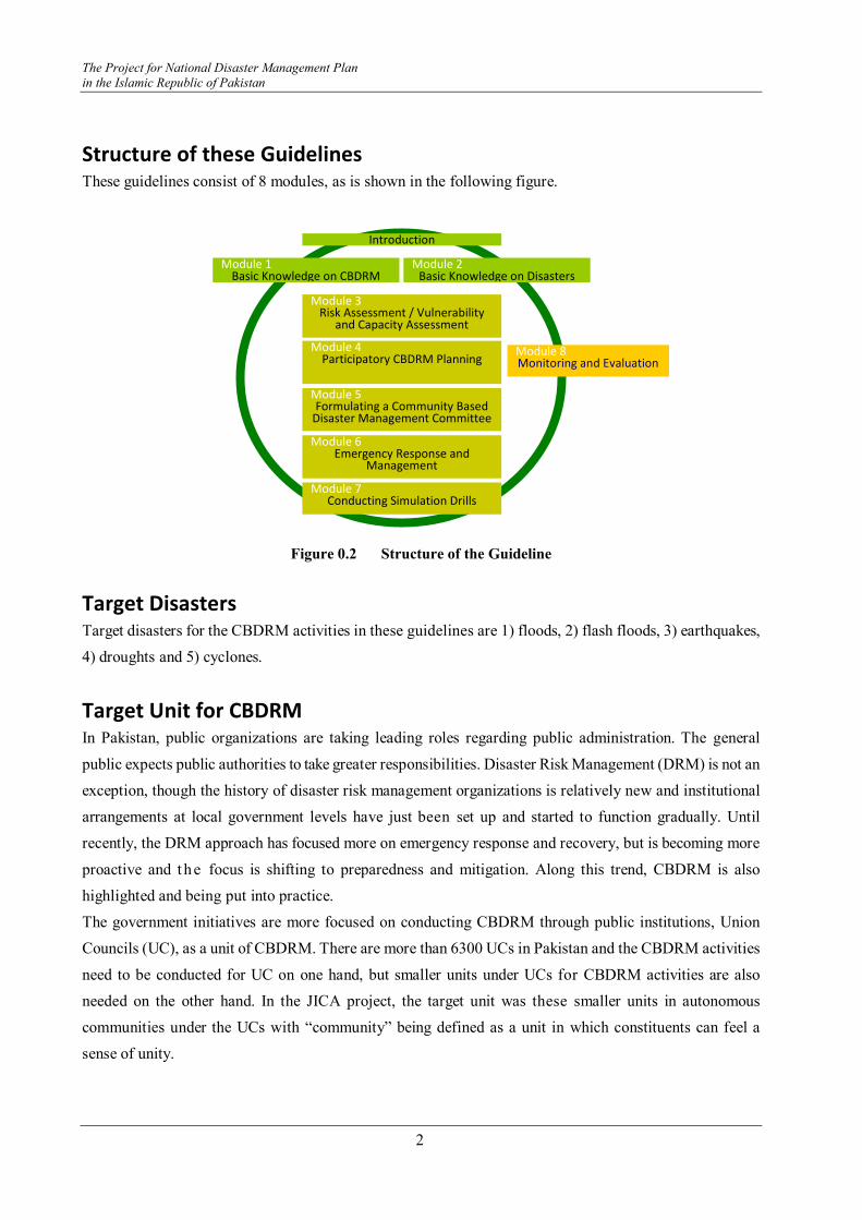
Structure of these Guidelines These guidelines consist of 8 modules, as is shown in the following figure.
Figure 0.2 Structure of the Guideline
Target Disasters Target disasters for the CBDRM activities in these guidelines are 1) floods, 2) flash floods, 3) earthquakes,
4) droughts and 5) cyclones.
Target Unit for CBDRM In Pakistan, public organizations are taking leading roles regarding public administration. The general
public expects public authorities to take greater responsibilities. Disaster Risk Management (DRM) is not an
exception, though the history of disaster risk management organizations is relatively new and institutional
arrangements at local government levels have just been set up and started to function gradually. Until
recently, the DRM approach has focused more on emergency response and recovery, but is becoming more
proactive and t he focus is shifting to preparedness and mitigation. Along this trend, CBDRM is also
highlighted and being put into practice.
The government initiatives are more focused on conducting CBDRM through public institutions, Union
Councils (UC), as a unit of CBDRM. There are more than 6300 UCs in Pakistan and the CBDRM activities
need to be conducted for UC on one hand, but smaller units under UCs for CBDRM activities are also
needed on the other hand. In the JICA project, the target unit was these smaller units in autonomous
communities under the UCs with “community” being defined as a unit in which constituents can feel a
sense of unity.
Introduction
Module 1 Basic Knowledge on CBDRM
Module 2 Basic Knowledge on Disasters
Module 3
Risk Assessment / Vulnerability and Capacity Assessment
Module 4
Participatory CBDRM Planning
Module 5 Formulating a Community Based
Disaster Management Committee Module 6
Emergency Response and Management
Module 7
Conducting Simulation Drills
Module 8 Monitoring and Evaluation
Instructor's Guideline on Community Based Disaster Risk Management
3
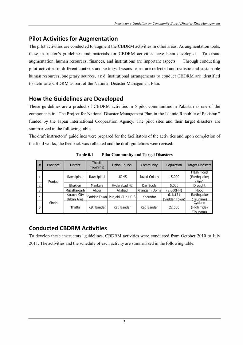
Pilot Activities for Augmentation The pilot activities are conducted to augment the CBDRM activities in other areas. As augmentation tools,
these instructor’s guidelines and materials for CBDRM activities have been developed. To ensure
augmentation, human resources, finances, and institutions are important aspects. Through conducting
pilot activities in different contexts and settings, lessons learnt are reflected and realistic and sustainable
human resources, budgetary sources, a n d institutional arrangements to conduct CBDRM are identified
to delineate CBDRM as part of the National Disaster Management Plan.
How the Guidelines are Developed These guidelines are a product of CBDRM activities in 5 pilot communities in Pakistan as one of the
components in “The Project for National Disaster Management Plan in the Islamic Republic of Pakistan,”
funded by the Japan International Cooperation Agency. The pilot sites and their target disasters are
summarized in the following table.
The draft instructors’ guidelines were prepared for the facilitators of the activities and upon completion of
the field works, the feedback was reflected and the draft guidelines were revised.
Table 0.1 Pilot Community and Target Disasters
1 Rawalpindi Rawalpindi UC 45 Javed Colony 15,000
Flash Flood
(Earthquake)
(Fire)2 Bhakkar Mankera Hyderabad 42 Dar Boola 5,000 Drought
3 Muzaffargarh Alipur Aliabad Khangarh Doma (2,000HH) Flood
4Karachi City
Urban AreaSaddar Town Punjabi Club UC 3 Kharadar
616,151
(Saddar Town)
Earthquake
(Tsunami)
5 Thatta Keti Bandar Keti Bandar Keti Bandar 22,000
Cyclone
(High Tide)
(Tsunami)
Punjab
Sindh
# DistrictThesile
TownshipUnion Council Target DisastersProvince PopulationCommunity
Conducted CBDRM Activities To develop these instructors’ guidelines, CBDRM activities were conducted from October 2010 to July
2011. The activities and the schedule of each activity are summarized in the following table.
The Project for National Disaster Management Plan
in the Islamic Republic of Pakistan
4
Table 0.2 Schedule of CBDRM Activities
(1) Preliminary Visit
(2) Dicussion with the Concerned
(3) Baseline Baseline Survey
(4) Strategic Meeting
(5)Preparation of CBDRM Guideline for
InstructorsRevision Printing
(6) Preparation of CBDRM Materials
(7) TOT
(8) Stakeholders' meetings
(9) Disaster Awareness Raising Activities
(10) Town Watching
(11) Hazard Mapping Basemap Compiling Data
(12) CBDRM Plan
(13) Installing DRR Equippments 1 site
(14) Disastetr Scenario, Drill
(15) End End Survey
(16) Study Visit and Forum SVForum
(17) Minutes of Agreement
(18) Reports Progress Reports, Final Report 24 Dec 10 Feb 15 May 30 June
Common
Activities
Feb
Selection
Preparation
CBDRM
Activities
AgendaMay Sep OctMar DecAprFeb
2011
NovJuly JanAug
2012#
2010
Jan JuneNovTheme
Oct Dec
Receiving
Comments
Revising
Lessons Learnt Key findings on lessons learnt through conducting CBDRM are summarized below by categories.
Participation
� There should be various efforts from public and private sectors to encourage participation in urban
areas. At present, UC Nazim is not functioning fully, and relying only on public channels is not
adequate.
� Encouraging participation in rural areas is not a problem, while in urban areas it is very difficult to
motivate the residents to participate. There was a suggestion to remunerate the participants, but in
our project, we do not want to pay in the urban areas. Based on the contact information of the
individuals who have answered the baseline survey, we contacted them to encourage participation,
but it did little help to increase the participation in the urban areas.
� Since the community resides in an urban setting and most of the people remain busy with their day
to day affairs, advocacy for such a community needs to be more aggressive, and implemented well
beforehand. Exhibitions and poster presentations on DRM can be organized as a starter of the
CBDRM activities in urban areas to increase participation.
� Female participants participated very actively and took their share of leadership by becoming
leaders of the CDMC. This shows that women could be mobilized to take leadership roles related to
their affairs in terms of Disaster Management.
Instructor's Guideline on Community Based Disaster Risk Management
5
� The women of village Dar Boola of Bhakkar were encouraged to speak in class and they did. It was
one of the achievements because they participated in such training for the first time.
� Women took more interest in working in female groups.
Delivery of Activities
� Practical activities increase and retain the interest and attention of the participants.
� There was little knowledge on scientific aspects of disasters. Considering the low literacy rate,
visual materials such as videos and visual demonstrations of experiments draw attention and
interests of the participants.
� For some participants, theory was not very interesting. The method of delivery needs to be
interesting and unique, which requires more interaction.
� Schedule of sessions has to be flexible and as per the actual ground conditions.
� Town Watching and Mapping exercises draw attention, but more facilitators are needed to monitor
the work of each group.
� Since the contents of the session were designed to tailor to the needs of the community, it was
appreciated by the participants throughout.
� Lecture based sessions using white boards and writing on the board were appreciated by
participants.
� The successful mob drill on the last day with both males and females participating in equal numbers
stands as towering evidence that the community had learned from the workshop.
Mapping Exercise
� Risk and resource mapping increases enthusiasm of participants
� A large number of participants were involved in the risk and resource mapping group activity.
Continuation of the DRM Activities
� Evacuation drills, Information Distribution Drills and other DRM activities should be carried out
within the community to maintain the level of sensitization. Some intervention by public officials is
necessary to monitor their activities. To realize this, a budget for travel and technical support needs
to be secured.
Intervention of Public Officials
� Participation of local government officials adds to the credits of the program
� Discussions among public officials were effective and gave local government officials a clear
image of actual ground conditions.
The Project for National Disaster Management Plan
in the Islamic Republic of Pakistan
6
� The community and the Community Disaster Management Committee (CDMC) wish to have a
permanent link with the implementing organizations of this project, so a comprehensive plan for
follow up would help retain the cohesion in the newly formed committee and the level of
interaction between the government and local stakeholders.
� The action plan formulated during this workshop needs serious attention and a full-fledged
mechanism of follow up to ensure that the activities go smoothly by the concerned organizations
identified therein.
� Government departments should come up with mechanisms/strategies that keep the committee
involved in activities on similar subjects.
� The link between the government and the CDMC, which until now has been in the papers
communicated with the responding agencies, should be strengthened through programs/activities of
mutual interest. The budget for such activities needs to be secured at the district level.
� DRM Plan should be considered seriously by the government officials to ensure structural and
non-structural mitigation measures for the community.
Establishing Mechanism of Incorporating Local Needs into Planning
� DRM plans were effectively discussed among community and local government officials to move
ahead for implementation. However, establishing a mechanism of incorporating village DRM needs
into local government development plans needs more time and effort. Establishment of community
DRM needs into DRM plans in the local governments has materialized to an extent.
Implementing Mitigation Measures
� Participants are willing to implement mitigation methods at micro levels.
� Participants in the drought site of Bhakkar are keen to learn about droughts and ask a lot of questions
to the drought expert. They are also interested in changing crop patterns and methods of cultivation
instructed by the expert, though we were initially worried that the farmers might want to continue
their conventional methods of agriculture.

Instructor's Guideline on Community Based Disaster Risk Management
7
Model Schedule of Training The CBDRM activities were conducted for 5-7 days consecutively. The methodologies of the activities
were a combination of presentations, brainstorming, group discussions and works, map preparation,
participatory planning, practical exercises, simulations, games, etc.
The model training program is summarized in the following table.
Table 0.3 Model Training Schedule
S.#S.#S.#S.# TASKTASKTASKTASK CONTENTCONTENTCONTENTCONTENT SUB CONTENTSUB CONTENTSUB CONTENTSUB CONTENT TIMING/minsTIMING/minsTIMING/minsTIMING/mins TIMING/hrsTIMING/hrsTIMING/hrsTIMING/hrs1 Introduction 15
Sharing Baseline Survey Facts & Figures 15
Introduction of DRM Terminologies, DRM cycle 40
Scientific Knowledge on Targetdisaster (PPT,Video
Earthquake,Flood,Cyclone& Heavy rain,Tsunami,Drought
45
Formulation of DRM committee Introduction of Community based DisasterManagement Committee (CDMC), Role &Responsibilities, Involvement ofstakeholders
45 2 hr40 mins
2 Introduction of vulnerability Explaining examples 20
Vulnerability Preparing matrices 40
Capacity Preparing matrices 40 1 hr 40 mins
3Introduction risks and resources inthe community
give idea to community regarding resources& risk of area
20
Breifing on Town watching andGrouping
Briefing on task 20
Town Watching Field Group activity 60 1 hr40 mins
4MappingMappingMappingMapping Inputting information in a map Group Work input information of their given
area90
Preparation of Map Community area final map with all giveninformation
30 1 hr 20 mins
5
Disaster Imagination Game Group Activity with given scenario usingmaterial
120
Preparation of Community DRMplans
Early warning, Pre-, during, post- DRM,Information, Evacuation route, Safe Heaven,Resources, Land & Infrastructure plan,Stock management, etc
60 3 hrs
6 Search and Rescue Basic Search and Rescue 15Theory & Practical Victim Evacuation Technique 45
Rope Management 120First Aid Basic First Aid 10Theory & Practical wounds & Bleeding 10
Bandages 40Spinal Injury 30
Fire Fighting Fire Safety 15Theory & Practical Fire Response 75Camp Management Camp Safety 20
Camp Data 20Camp Committee 20 6 hrs 20 min
7 Preparation Briefing on task 30Task Distribution 60
Action Demonstration 90 3 hrs1160 19 hrs 40 mins
CBDRMCBDRMCBDRMCBDRMPlanningPlanningPlanningPlanning
PracticalPracticalPracticalPracticalTraining ofTraining ofTraining ofTraining ofCBDRMCBDRMCBDRMCBDRM
Drill (ExpectDrill (ExpectDrill (ExpectDrill (ExpectDrought)Drought)Drought)Drought)
BasicBasicBasicBasicKnowledge onKnowledge onKnowledge onKnowledge onDRMDRMDRMDRM
TownTownTownTownWatchingWatchingWatchingWatching
VulnerabilityVulnerabilityVulnerabilityVulnerabilityand Capacityand Capacityand Capacityand CapacityAssessmentAssessmentAssessmentAssessment

Instructor's Guideline on Community Based Disaster Risk Management
9
Module 1 Basic Knowledge on CBDRM
Basic Terminology on Risk Management Some of the key basic terminologies on disaster management are listed as basic knowledge by referring to
NDMA, IFRC and UNISDR.
Disaster Management is defined as A collective term of all disaster related activities
Disaster Management is a collective term encompassing all aspects of planning for and responding to
disasters. It refers to the management of both the risks and consequences of disasters.
Disaster Risk Management is defined as A systematic process of using resources to manage the risk of
disasters.
The comprehensive approach to reduce the adverse impacts of a disaster. DRM encompasses all actions
taken before, during, and after the disasters. It includes activities on mitigation, preparedness, emergency
response, recovery, rehabilitation, and reconstruction.
Disaster Risk Reduction is defined as A conceptual framework to reduce vulnerabilities in the context
of sustainable development.
The conceptual framework to: minimize vulnerabilities and disaster risks throughout a society; to avoid or
limit the adverse impacts of hazards; done within the broad context of sustainable development.
Mitigation is defined as The lessening or minimizing of the adverse impacts of hazards and related
disasters.
Preparedness is defined as Activities and measures taken in advance to ensure effective response to the
impact of hazards, including the issuance of timely and effective early warnings and the temporary
evacuation of people and property from threatened locations.
Disaster Management Cycle is defined as A cycle with phases that reduce or prevent disasters
Disaster management is a cyclical process; the end of one phase is the beginning of another (see figure
below), although one phase of the cycle does not necessarily have to be completed in order for the next to
take place. Often several phases are taking place concurrently. Timely decision-making during each phase
results in greater preparedness, better warnings, reduced vulnerability and/or the prevention of future
disasters. The complete disaster management cycle includes the shaping of public policies and plans that
either addresses the causes of disasters or mitigates their effects on people, property, and infrastructure.
The mitigation and preparedness phases occur as improvements are made in anticipation of an event. By
embracing development, a community’s ability to mitigate against and prepare for a disaster is improved.
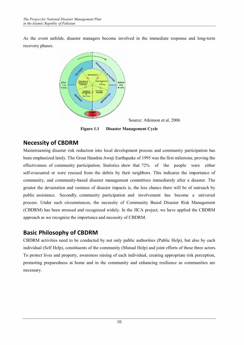
The Project for National Disaster Management Plan
in the Islamic Republic of Pakistan
10
As the event unfolds, disaster managers become involved in the immediate response and long-term
recovery phases.
Source: Atkinson et al, 2006
Figure 1.1 Disaster Management Cycle
Necessity of CBDRM Mainstreaming disaster risk reduction into local development process and community participation has
been emphasized lately. The Great Hanshin Awaji Earthquake of 1995 was the first milestone, proving the
effectiveness of community participation. Statistics show that 72% of the people were either
self-evacuated or were rescued from the debris by their neighbors. This indicates the importance of
community, and community-based disaster management committees immediately after a disaster. The
greater the devastation and vastness of disaster impacts is, the less chance there will be of outreach by
public assistance. Secondly, community participation and involvement has become a universal
process. Under such circumstances, the necessity of Community Based Disaster Risk Management
(CBDRM) has been stressed and recognized widely. In the JICA project, we have applied the CBDRM
approach as we recognize the importance and necessity of CBDRM.
Basic Philosophy of CBDRM CBDRM activities need to be conducted by not only public authorities (Public Help), but also by each
individual (Self Help), constituents of the community (Mutual Help) and joint efforts of these three actors.
To protect lives and property, awareness raising of each individual, creating appropriate risk perception,
promoting preparedness at home and in the community and enhancing resilience as communities are
necessary.

Instructor's Guideline on Community Based Disaster Risk Management
11
Figure 1.2 Three Actors of Disaster Management
What is CBDRM? The most quoted definition of CBDRM is “Community-based disaster risk management. CBDRM is a
process in which at-risk communities are actively engaged in the identification, analysis, treatment,
monitoring and evaluation of disaster risks in order to reduce their vulnerabilities and enhance their
capacities. This means that people are at the heart of decision-making and implementation of disaster risk
management activities. The involvement of the most vulnerable social groups is considered as paramount
in this process, while the support of the least vulnerable groups is necessary for successful
implementation.” (Abarquez and Murshed, 2004)
Aim of CBDRM CBDRM aims at involving the community in the disaster risk management process to 1) reduce
vulnerability; 2) increase/strengthen community capacity to prepare for and respond to disasters; and 3)
undertake sustainable development and poverty reduction.
Principles of CBDRM Key principles for conducting CBDRM are listed below.
� People’s participation is a must
� Priority is given to the most vulnerable people
� Interventions are based on Vulnerability and Capacity Assessment (VCA)
� Different perceptions of risk are recognized
� Risk reduction measures are community specific
� CBDRM activities are managed/operated/sustained by the communities themselves.
Mutual
Help
Self
Help
Public
Help
Preparation by
individuals,
families,
schools
Preparation
by local
communities Preparatio
n by
Public
CooCooCooCooperationperationperationperation

The Project for National Disaster Management Plan
in the Islamic Republic of Pakistan
12
Community Unit In these guidelines, community is defined as a unit in which constituents can feel a sense of unity. Thus, it
is a much smaller unit than a Union Council. The members of the community are community leaders,
school principals, teachers, Imam of the mosques, leaders of CBOs, and residents of the community.
Actors of CBDRM Actors of the CBDRM are at first hand, community constituents, the Union Council, Tehsil, Township,
and District.
However, CBDRM requires a high level of coordination and cooperation and it is important to develop
relationships between the communities and the government national disaster management authorities
focusing on disaster risk reduction to instill sustainability measures for continued activity support.
Target Groups Target groups for CBDRM activities include a diverse group of people: representatives of residents,
mosque leaders, school teachers and representatives of CBOs, NGOs, and volunteer groups in the
localities. The workshops should be held jointly for them all.
Process of CBDRM To develop these instructors’ guidelines, CBDRM activities were conducted from October 2010 to July
2011. The activities and the schedule of each activity are summarized in the following table.
Step 1 Identifying Participants
Identifying appropriate participants is vital for understanding the social and institutional context. From
the beginning, it is important to consider who will be affected, who can influence others, which
individuals, groups, and organizations need to be involved, and how and whose capacities should be
enhanced. At the first meeting, clarifying whose plan it will be and setting the planning goals can be
discussed. Stakeholders of the planning exercise include community leaders, health and medical
representatives, social workers, health workers, schools, mosques, community-based organizations, local
private enterprises, officials from the district, tehsils, union councils etc. The following questions are
useful to draw a preliminary road map for guidance.
� Who can contribute financial and technical resources?
� Whose behavior will be influential for the effort to succeed?
� Who is responsible for overall direction and intent?
� Who can mobilize support or opposition for/against what is intended?
� Who are the voiceless?
Instructor's Guideline on Community Based Disaster Risk Management
13
Step 2 Establishing Planning Committee
A planning committee consisting of core members is a practical way to begin formulating community
plans. This committee will act as the secretariat of planning activities and its roles will be identified. Be
sure that representatives from the community and key persons from local organizations are involved.
Step 3 Mapping Out Stakeholders’ Commitment
Once the participants are identified, it is useful to categorize the degree of participation and roles and
responsibilities for the entire planning effort. Each individual and institution needs to be committed to the
planning process and if they cannot attend a meeting or workshop, alternative persons should be
identified and the process needs to be handed over.
Step 4 Needs Analysis
To know the local stakeholders’ needs is an essential factor. To prepare for disasters requires not only
disaster risk management, but also attaining overall development. For sustainable development, local
needs and priorities should be researched and analyzed. Development needs, problem identification,
constraints and driving forces for each problem need to be identified.
Step 5 Disseminating Damage Estimation (if any)
Identification of the possible local hazards and the possible effects from them on each and every
community is essential. This process provides the basis for risk management planning. This enables local
people to set planning objectives and identify problems in planning. In this step, this information is
disseminated at a meeting or workshop with the participation and explanation ideally given by an expert
from a relevant organization.
Step 6 Identifying Vulnerability and Capacity
Vulnerability and Capacity Assessment (VCA) is the starting point of disaster risk management. It is
important to know weaknesses and strengths to overcome disasters. VCA aims to identify, analyze and
evaluate disaster response capacities, for not only physical resources but also social, attitudinal, and
organizational aspects. It involves the community’s participation to analyze their own capacities, which
will encourage the community to build a sense of ownership.
In the participatory risk assessment, various survey methods such as semi-structured interviews, focus
group discussions, and tools for Participatory Rural Appraisal such as maps, seasonal calendars, historical
profiles, institutional and social network analysis, and problem trees can be employed.
Vulnerability and capacity assessment is a good opportunity to develop local skills and capacity.
Involve community people in this survey to understand their own situation, and get community
participants involved in assessing the results. It is important for them to realize their own capacities and
vulnerabilities. This self-evaluation process is essential to create motivation to reduce local vulnerability.
The Project for National Disaster Management Plan
in the Islamic Republic of Pakistan
14
Step 7 Locating the Vulnerabilities and Capacities
After identifying the vulnerabilities and capacities, locating them on a map will help participants to
visualize local situations more clearly. The location of the vulnerability and capacity will make it easier to
discuss how to manage the disaster situation and make a plan for it. To accomplish this, “Town
Watching” and “Risk and Resource Mapping” are two useful tools.
Step 8 Setting Planning Objectives
After gathering all the necessary information about hazards, vulnerabilities, and capacities, the areas for
special attention and support will become clear. Setting planning objectives is recommended in the earlier
stage of the planning session. If it is difficult to agree on certain objectives, a practical approach is
setting provisional objectives and in the course of the planning process they can be revised and finalized
upon the consensus of each stakeholder.
Step 9 Allocation of Responsibilities
Responsibilities for each task will be decided. Functions of control, command and coordination will be
crosschecked to avoid overlap between teams / task forces and other actors.
Step 10 Documenting the Plan
After the plan has been developed, putting it in the document is the most important process. A common
format can be developed within the same district. The statement should be simple and clear.
Organizational charts, lists of equipment, and risk and resource maps can be attached. Even though the
initial plan seems perfect at the time, it can be developed further through the regular drills. Steps 8-10 can
be done through use of a Disaster Imagination Game as a tool.
Step 11 Testing and Reviewing the Plan
After completion of the plan, exercises are important to ensure that the plans are effective and workable.
In this exercise it is essential to involve, not only community people but also planners and members of
disaster response organizations. These opportunities will enable the testing of each disaster response
agency’s abilities and cooperation with each other. Moreover, testing the plan can identify any gray zones
where more than two agencies are involved. Exercises can suggest the boundaries of tasks.
One cost effective exercise is a Table Top map maneuver, which can be conducted indoors employing a
precisely planned scenario. The other option is an on-site exercise, which provides communities with first
hand practical experience. On-site drills have two types: one is the training exercise and the other is a
scenario-type drill. The training exercise is a basic thematic training on tasks such as search and rescue,
first aid, fire extinguishing, and information management. Teams / Task force teams will be organized
and the exercise will be based on a plan.
The scenario-type drill is an advanced practice. In this exercise, only the controllers will know the
scenario, and the rest of the people (called players) will react to the scenario provided by the controllers.
Drawings of fires, road blockages, fallen trees, and dolls will be prepared. This training will be conducted

Instructor's Guideline on Community Based Disaster Risk Management
15
in the community and include simulated fire and road blockage; human casualties will be set in the real
community. Players need to search for fire extinguishers and first aid kits to identify the places where
they are located. The process can be video taped and a debriefing session should be organized to share
suggestions and opinions to improve the plan. Finally the plan should be revised. It is important to make
and keep a schedule for reviewing and updating the plan. Regular exercises should be conducted to
update the plan and to provide the community members with an opportunity to practice the proper
response to the disaster, ensuring that they know how to protect themselves and assist their neighbors.

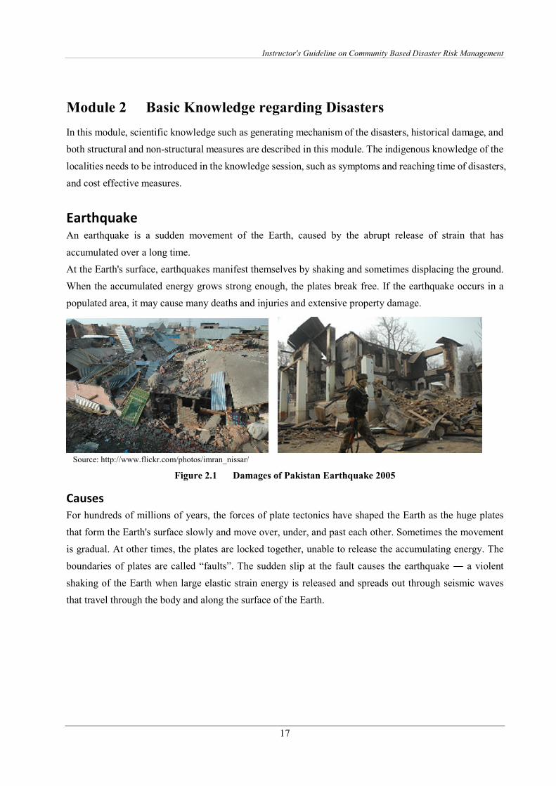
Instructor's Guideline on Community Based Disaster Risk Management
17
Module 2 Basic Knowledge regarding Disasters
In this module, scientific knowledge such as generating mechanism of the disasters, historical damage, and
both structural and non-structural measures are described in this module. The indigenous knowledge of the
localities needs to be introduced in the knowledge session, such as symptoms and reaching time of disasters,
and cost effective measures.
Earthquake An earthquake is a sudden movement of the Earth, caused by the abrupt release of strain that has
accumulated over a long time.
At the Earth's surface, earthquakes manifest themselves by shaking and sometimes displacing the ground.
When the accumulated energy grows strong enough, the plates break free. If the earthquake occurs in a
populated area, it may cause many deaths and injuries and extensive property damage.
Source: http://www.flickr.com/photos/imran_nissar/
Figure 2.1 Damages of Pakistan Earthquake 2005
Causes
For hundreds of millions of years, the forces of plate tectonics have shaped the Earth as the huge plates
that form the Earth's surface slowly and move over, under, and past each other. Sometimes the movement
is gradual. At other times, the plates are locked together, unable to release the accumulating energy. The
boundaries of plates are called “faults”. The sudden slip at the fault causes the earthquake ― a violent
shaking of the Earth when large elastic strain energy is released and spreads out through seismic waves
that travel through the body and along the surface of the Earth.
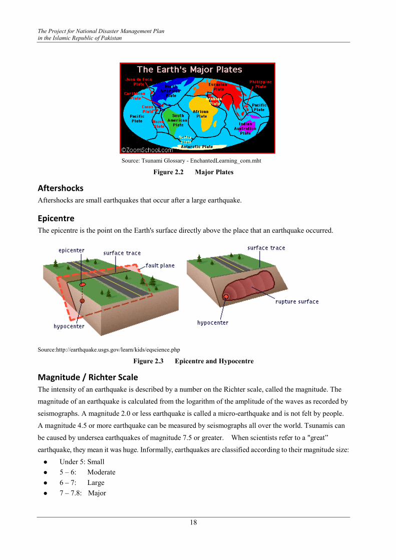
The Project for National Disaster Management Plan
in the Islamic Republic of Pakistan
18
Source: Tsunami Glossary - EnchantedLearning_com.mht
Figure 2.2 Major Plates
Aftershocks
Aftershocks are small earthquakes that occur after a large earthquake.
Epicentre
The epicentre is the point on the Earth's surface directly above the place that an earthquake occurred.
Source:http://earthquake.usgs.gov/learn/kids/eqscience.php
Figure 2.3 Epicentre and Hypocentre
Magnitude / Richter Scale
The intensity of an earthquake is described by a number on the Richter scale, called the magnitude. The
magnitude of an earthquake is calculated from the logarithm of the amplitude of the waves as recorded by
seismographs. A magnitude 2.0 or less earthquake is called a micro-earthquake and is not felt by people.
A magnitude 4.5 or more earthquake can be measured by seismographs all over the world. Tsunamis can
be caused by undersea earthquakes of magnitude 7.5 or greater. When scientists refer to a "great”
earthquake, they mean it was huge. Informally, earthquakes are classified according to their magnitude size:
� Under 5: Small
� 5 – 6: Moderate
� 6 – 7: Large
� 7 – 7.8: Major

Instructor's Guideline on Community Based Disaster Risk Management
19
� 7.8 or above: Great
What is a Fault?
The crust of the Earth is broken into plates. The plates are enormous chunks of rock that float atop the
soft mantle. The plates are moving at a speed that has been estimated at 1 to 10 cm per year. Oceanic
plates (those that are under the ocean) are thinner and denser than continental plates.
Earthquakes occur on faults. A fault is a thin zone of crushed rock between two blocks of rock, and can
be any length, from centimeters to thousands of kilometers. When an earthquake occurs on one of these
faults, the rock on one side of the fault slips with respect to the other. The fault surface can be vertical,
horizontal, or at some angle to the surface of the earth. The slip direction can also be at any angle. We
classify these into two basic cases: strike slip and dip-slip motion.
Picture Source: http://earthquake.usgs.gov/learn/kids/eqscience.php
Figure 2.4 Types of Faults
Tectonic Plates
Plate tectonics is the now-established theory that chunks of the Earth's crust (plates) float on the surface
and change both position and size over time. The Earth's crust is its outermost, rocky layer.
Plate Movements
The plates are moving at a speed that has been estimated at 1 to 10 cm per year. Oceanic plates (those that
are under the ocean) are thinner, younger, and denser than continental plates. These underwater plates are
about 75 kilometers thick and are made of basalt rock. They are relatively young since plate formation
(seafloor spreading) occurs at the margins of oceanic plates
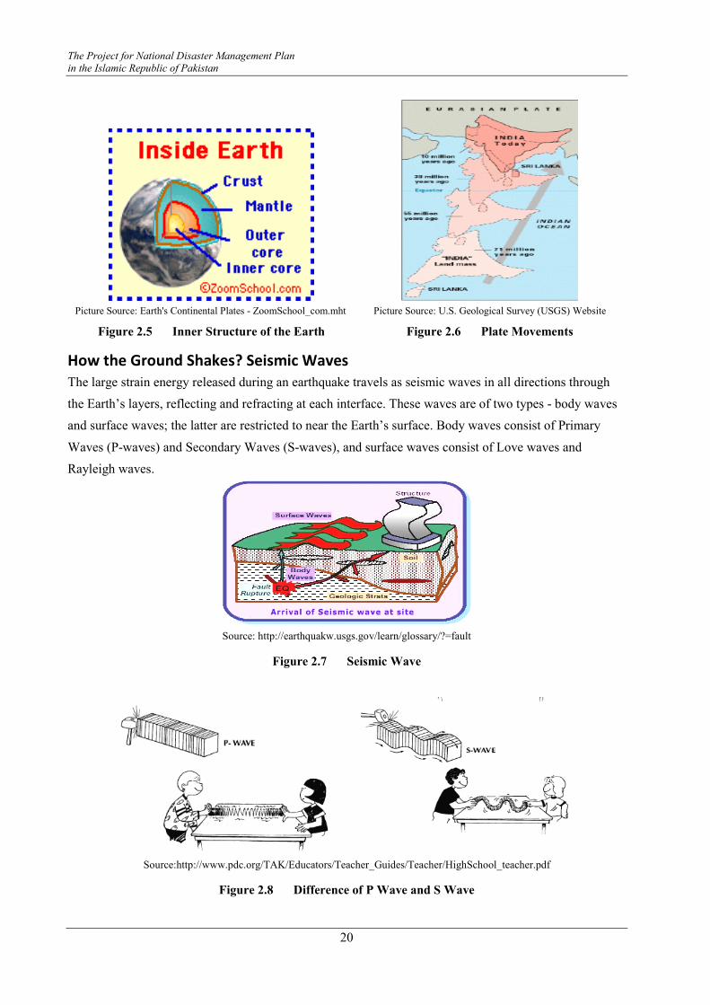
The Project for National Disaster Management Plan
in the Islamic Republic of Pakistan
20
Picture Source: Earth's Continental Plates - ZoomSchool_com.mht Picture Source: U.S. Geological Survey (USGS) Website
Figure 2.5 Inner Structure of the Earth Figure 2.6 Plate Movements
How the Ground Shakes? Seismic Waves
The large strain energy released during an earthquake travels as seismic waves in all directions through
the Earth’s layers, reflecting and refracting at each interface. These waves are of two types - body waves
and surface waves; the latter are restricted to near the Earth’s surface. Body waves consist of Primary
Waves (P-waves) and Secondary Waves (S-waves), and surface waves consist of Love waves and
Rayleigh waves.
Source: http://earthquakw.usgs.gov/learn/glossary/?=fault
Figure 2.7 Seismic Wave
Source:http://www.pdc.org/TAK/Educators/Teacher_Guides/Teacher/HighSchool_teacher.pdf
Figure 2.8 Difference of P Wave and S Wave
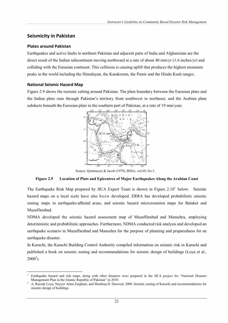
Instructor's Guideline on Community Based Disaster Risk Management
21
Seismicity in Pakistan
Plates around Pakistan
Earthquakes and active faults in northern Pakistan and adjacent parts of India and Afghanistan are the
direct result of the Indian subcontinent moving northward at a rate of about 40 mm/yr (1.6 inches/yr) and
colliding with the Eurasian continent. This collision is causing uplift that produces the highest mountain
peaks in the world including the Himalayan, the Karakoram, the Pamir and the Hindu Kush ranges.
National Seismic Hazard Map
Figure 2.9 shows the tectonic setting around Pakistan. The plate boundary between the Eurasian plate and
the Indian plate runs through Pakistan’s territory from southwest to northeast, and the Arabian plate
subducts beneath the Eurasian plate in the southern part of Pakistan, at a rate of 19 mm/year.
Source: Quittmeyer & Jacob (1979), BSSA, vol.69, No.3.
Figure 2.9 Location of Plats and Epicentres of Major Earthquakes Along the Arabian Coast
The Earthquake Risk Map prepared by JICA Expert Team is shown in Figure 2.101 below. Seismic
hazard maps on a local scale have also b e e n developed. ERRA has developed probabilistic seismic
zoning maps in earthquake-affected areas, and seismic hazard microzonation maps for Balakot and
Muzaffarabad.
NDMA developed the seismic hazard assessment map of Muzaffarabad and Mansehra, employing
deterministic and probabilistic approaches. Furthermore, NDMA conducted risk analysis and developed an
earthquake scenario in Muzaffarabad and Mansehra for the purpose of planning and preparedness for an
earthquake disaster.
In Karachi, the Karachi Building Control Authority compiled information on seismic risk in Karachi and
published a book on seismic zoning and recommendations for seismic design of buildings (Loya et al.,
20002).
1 Earthquake hazard and risk maps, along with other disasters were prepared in the JICA project for “National Disaster
Management Plan in the Islamic Republic of Pakistan” in 2010. 2 A. Razzak Loya, Nayyer Alam Zaigham, and Mushtaq H. Dawood, 2000, Seismic zoning of Karachi and recommendations for
seismic design of buildings
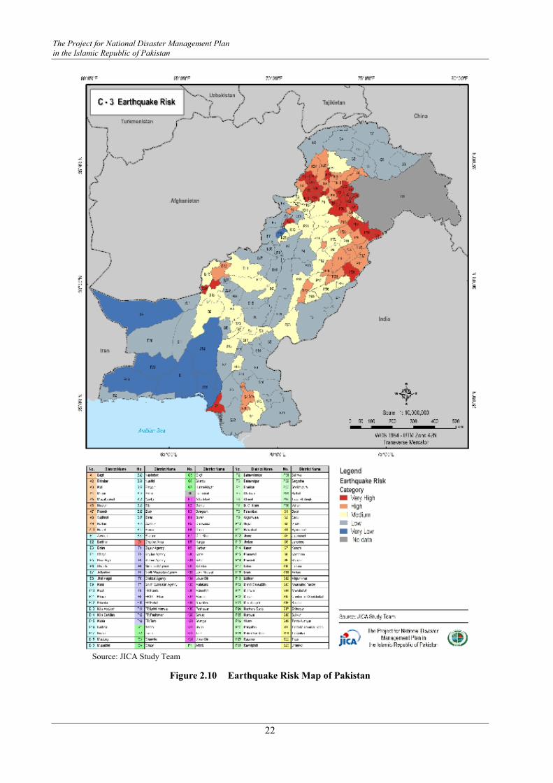
The Project for National Disaster Management Plan
in the Islamic Republic of Pakistan
22
Source: JICA Study Team
Figure 2.10 Earthquake Risk Map of Pakistan

Instructor's Guideline on Community Based Disaster Risk Management
23
Impact
Historical Earthquakes in Pakistan
The historical database comprises of 58 earthquakes from year 25 A.D. to 1905. A concentration of
earthquakes has been observed in the northern belt from Islamabad/Rawalpindi to Peshawar, around
Quetta, four earthquakes in the Karachi-Ahmadabad and regions of low historical activity are Makran,
Chagai hills, Toba-kakar range north of Quetta and Punjab. In 1935, in Quetta, the great earthquake of
Magnitude 7.7 was felt at 3:03 A.M. on 31st May 1935, and 30,000 people died. On 28th December, 1974
at 12:11 Universal Time, Coordinated (UTC) a strong earthquake was felt in Swat, Peshawar, Islamabad
and Lahore, and its epicentre was in Pattan. This left 5300 persons dead, 17,000 injured and thousands of
houses destroyed.
Table 2.1 Past Historical Earthquakes in Pakistan
Date M Location Killed Affected
31/ 05/ 1935 7.5 Quetta ( Balochistan ) 60,000
27/ 11/ 1945 8 Makran (+ Tsunami) 4,000
28/ 12/ 1974 6.2 North Indus R. Valley 4,700 50,200
12/ 09/ 1981 6.1 Karakoram, Darel, 250 2,000
31/ 01/ 1991 6.4 Malakand, Chitral, 300 204,794
08/ 10/ 2005 7.7 Bagh, Muzzafarabad, 73,338 5,128,000
29/ 10/ 2008 6.4 Khanozai, Rod Mulazai, 166 75,320
Source: EM-DAT, Center for Research on Epidemiology and Disasters (CRED)
2005 Pakistan Earthquake
The most recent and deadliest earthquake occurred on 8th October 2005 in northern parts of Pakistan
measuring 7.6 on the Richter scale. The focal depth of the earthquake was 10 km and its epicentre was in
the north of Muzaffarabad (Azad Kashmir) about 90km north of Islamabad. The earthquake occurred at
08:50:30 PST.
Source: after rnews.bbc.co.uk
Figure 2.11 Affected Areas of Pakistan Earthquake
KhybKhybKhybKhyber Pakhtunkhwaer Pakhtunkhwaer Pakhtunkhwaer Pakhtunkhwa
MansehraMansehraMansehraMansehra
□□□□
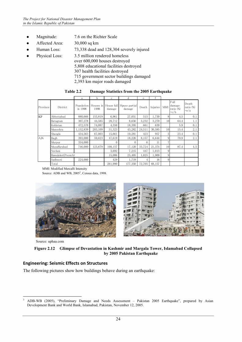
The Project for National Disaster Management Plan
in the Islamic Republic of Pakistan
24
� Magnitude: 7.6 on the Richter Scale
� Affected Area: 30,000 sq km
� Human Loss: 73,338 dead and 128,304 severely injured
� Physical Loss: 3.5 million rendered homeless over 600,000 houses destroyed
5,808 educational facilities destroyed 307 health facilities destroyed 715 government sector buildings damaged 2,393 km major roads damaged
Table 2.2 Damage Statistics from the 2005 Earthquake
a b c d e f
Province DistrictPopulation
in 1998Houses in
1998House fulldamage
Hpuse partialdamage
Death Injuries MMI
Fulldamageratio (%)=c/b
Deathratio (%)=e/a
NWFP Abbottabad 880,666 153,819 6,961 27,051 515 1,730 8 4.5 0.1
Batagram 307,278 44,585 28,712 8,656 3,232 3,279 10 64.4 1.1
Kohistan 472,570 74,087 4,350 18,395 661 639 5.9 0.1
Mansehra 1,152,839 203,109 31,323 43,282 24,511 30,585 10 15.4 2.1
Shangla 434,563 67,003 15,661 10,281 423 957 5 23.4 0.1
AJK Bagh 393,000 59,623 47,619 18,226 8,157 6,644 9 79.9 2.1
Murpur 334,000 0 0 6 11 7
Muzaffarabad 746,000 123,679 108,157 17,120 33,724 21,374 10 87.4 4.5
Neelum 3,692 7,215 447 1,013 9
Rawalakot(Poonch) 15,086 25,405 1,025 1,909 9
Sudhnoti 224,000 429 1,719 4 16 9
Total 261,990 177,350 72,705 68,157 MMI: Modified Mercalli Intensity
Source: ADB and WB, 20053, Census data, 1998.
Source: uphaa.com
Figure 2.12 Glimpse of Devastation in Kashmir and Margala Tower, Islamabad Collapsed
by 2005 Pakistan Earthquake
Engineering: Seismic Effects on Structures
The following pictures show how buildings behave during an earthquake:
3 ADB-WB (2005), “Preliminary Damage and Needs Assessment – Pakistan 2005 Earthquake”, prepared by Asian
Development Bank and World Bank, Islamabad, Pakistan, November 12, 2005.
KP
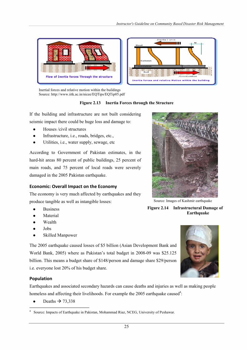
Instructor's Guideline on Community Based Disaster Risk Management
25
Inertial forces and relative motion within the buildings Source: http://www.iitk.ac.in/nicee/EQTips/EQTip05.pdf
Figure 2.13 Inertia Forces through the Structure
If the building and infrastructure are not built considering
seismic impact there could be huge loss and damage to:
� Houses /civil structures
� Infrastructure, i.e., roads, bridges, etc.,
� Utilities, i.e., water supply, sewage, etc
According to Government of Pakistan estimates, in the
hard-hit areas 80 percent of public buildings, 25 percent of
main roads, and 75 percent of local roads were severely
damaged in the 2005 Pakistan earthquake.
Economic: Overall Impact on the Economy
The economy is very much affected by earthquakes and they
produce tangible as well as intangible losses:
� Business
� Material
� Wealth
� Jobs
� Skilled Manpower
The 2005 earthquake caused losses of $5 billion (Asian Development Bank and
World Bank, 2005) where as Pakistan’s total budget in 2008-09 was $25.125
billion. This means a budget share of $148/person and damage share $29/person
i.e. everyone lost 20% of his budget share.
Population
Earthquakes and associated secondary hazards can cause deaths and injuries as well as making people
homeless and affecting their livelihoods. For example the 2005 earthquake caused4:
� Deaths � 73,338
4 Source: Impacts of Earthquake in Pakistan, Mohammad Riaz, NCEG, University of Peshawar.
Source: Images of Kashmir earthquake
Figure 2.14 Infrastructural Damage of
Earthquake
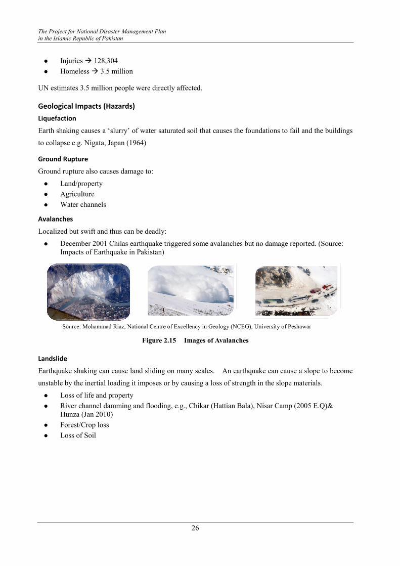
The Project for National Disaster Management Plan
in the Islamic Republic of Pakistan
26
� Injuries � 128,304
� Homeless � 3.5 million
UN estimates 3.5 million people were directly affected.
Geological Impacts (Hazards)
Liquefaction
Earth shaking causes a ‘slurry’ of water saturated soil that causes the foundations to fail and the buildings
to collapse e.g. Nigata, Japan (1964)
Ground Rupture
Ground rupture also causes damage to:
� Land/property
� Agriculture
� Water channels
Avalanches
Localized but swift and thus can be deadly:
� December 2001 Chilas earthquake triggered some avalanches but no damage reported. (Source: Impacts of Earthquake in Pakistan)
Source: Mohammad Riaz, National Centre of Excellency in Geology (NCEG), University of Peshawar
Figure 2.15 Images of Avalanches
Landslide
Earthquake shaking can cause land sliding on many scales. An earthquake can cause a slope to become
unstable by the inertial loading it imposes or by causing a loss of strength in the slope materials.
� Loss of life and property
� River channel damming and flooding, e.g., Chikar (Hattian Bala), Nisar Camp (2005 E.Q)& Hunza (Jan 2010)
� Forest/Crop loss
� Loss of Soil

Instructor's Guideline on Community Based Disaster Risk Management
27
Figure 2.16 Ataabad Landslide on Jan 04, 2010, in Hunza caused flooding in the river and
created a lake more than 300 feet deep.
Tsunami
Earthquakes cause tsunamis when the seafloor rises or falls. This occurs when two tectonics plates collide
into each other at a plate boundary. The denser plate would subduct under the other plate, which leads to a
rise or fall of the seafloor. This movement of the seafloor will cause a rapid displacement of water, and a
wave would form. As the wave approaches a coastline, it would get higher as the seafloor gets shallower,
causing a tsunami.
Source: Impacts of Earthquake in Pakistan, Mohammad Riaz, NCEG, University of Peshawar
Figure 2.17 Tsunami Generation
Mitigation and Preparedness
Structural
Building codes/designing (critical)
When constructing a new building, seismic provisions need to be catered for. From experience, the cost of
construction of a seismically resilient building is only 5-8% more than that of a conventional building.
Following are some of the structural elements that need to be incorporated to make buildings seismically
resilient.
Retrofitting
Existing buildings/ structures should be strengthened with retrofitting
� Land use restrictions
� Hazard mapping and land use zonation
� Geological surveys before development
Source: Source: Impacts of Earthquake in Pakistan, Mohammad Riaz, NCEG, University of Peshawar
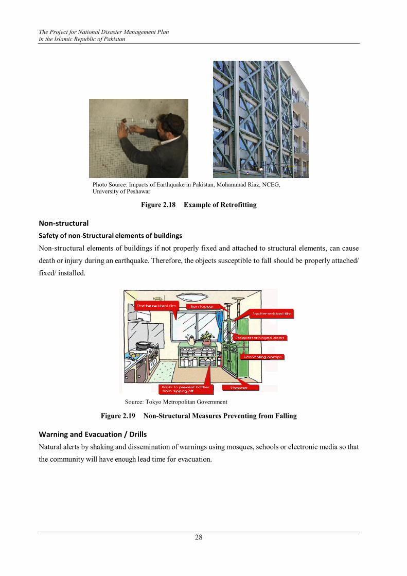
The Project for National Disaster Management Plan
in the Islamic Republic of Pakistan
28
Figure 2.18 Example of Retrofitting
Non-structural
Safety of non-Structural elements of buildings
Non-structural elements of buildings if not properly fixed and attached to structural elements, can cause
death or injury during an earthquake. Therefore, the objects susceptible to fall should be properly attached/
fixed/ installed.
Source: Tokyo Metropolitan Government
Figure 2.19 Non-Structural Measures Preventing from Falling
Warning and Evacuation / Drills
Natural alerts by shaking and dissemination of warnings using mosques, schools or electronic media so that
the community will have enough lead time for evacuation.
Photo Source: Impacts of Earthquake in Pakistan, Mohammad Riaz, NCEG, University of Peshawar
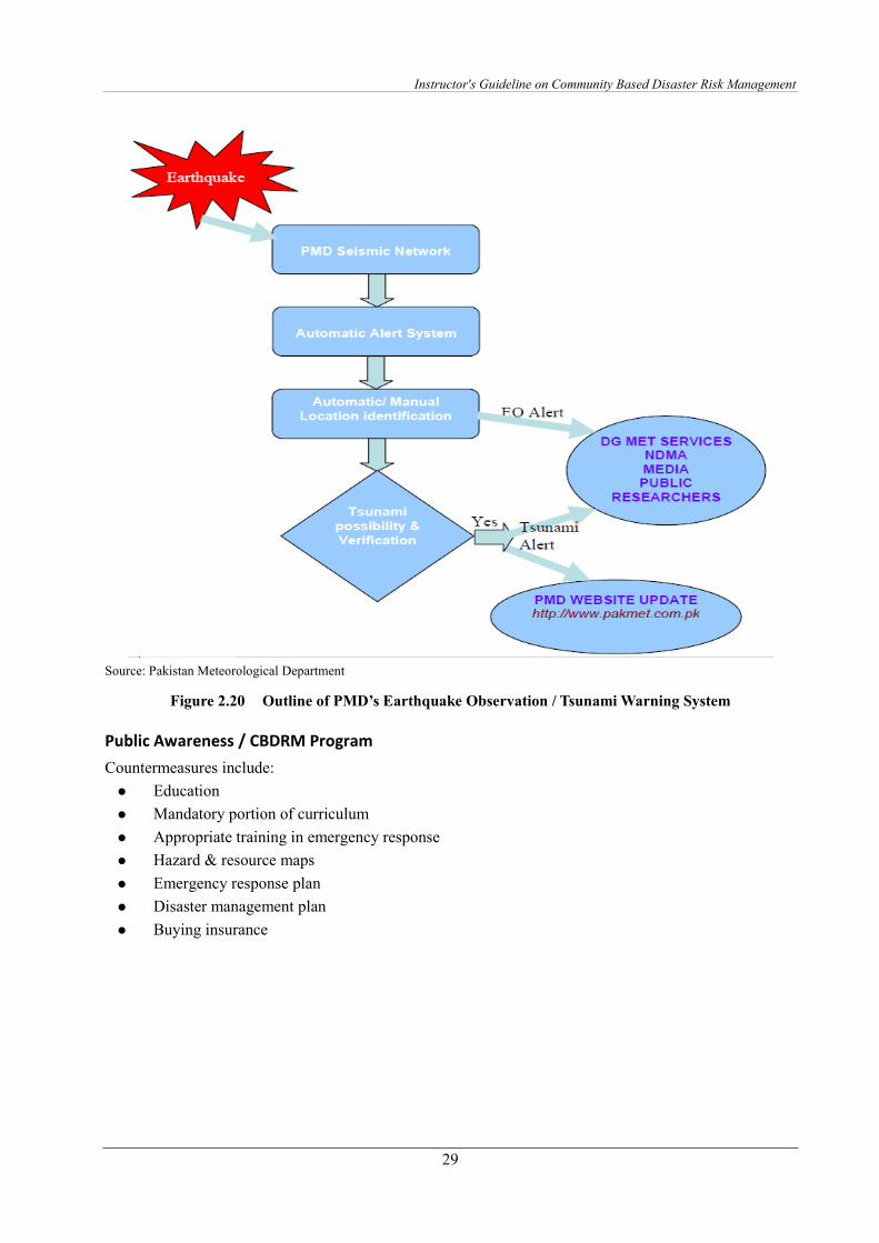
Instructor's Guideline on Community Based Disaster Risk Management
29
Source: Pakistan Meteorological Department
Figure 2.20 Outline of PMD’s Earthquake Observation / Tsunami Warning System
Public Awareness / CBDRM Program
Countermeasures include:
� Education
� Mandatory portion of curriculum
� Appropriate training in emergency response
� Hazard & resource maps
� Emergency response plan
� Disaster management plan
� Buying insurance
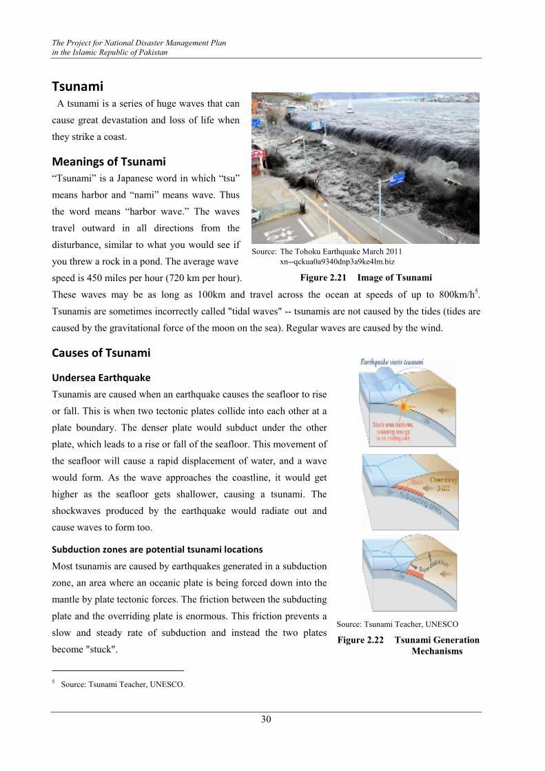
The Project for National Disaster Management Plan
in the Islamic Republic of Pakistan
30
Tsunami A tsunami is a series of huge waves that can
cause great devastation and loss of life when
they strike a coast.
Meanings of Tsunami
“Tsunami” is a Japanese word in which “tsu”
means harbor and “nami” means wave. Thus
the word means “harbor wave.” The waves
travel outward in all directions from the
disturbance, similar to what you would see if
you threw a rock in a pond. The average wave
speed is 450 miles per hour (720 km per hour).
These waves may be as long as 100km and travel across the ocean at speeds of up to 800km/h5.
Tsunamis are sometimes incorrectly called "tidal waves" -- tsunamis are not caused by the tides (tides are
caused by the gravitational force of the moon on the sea). Regular waves are caused by the wind.
Causes of Tsunami
Undersea Earthquake
Tsunamis are caused when an earthquake causes the seafloor to rise
or fall. This is when two tectonic plates collide into each other at a
plate boundary. The denser plate would subduct under the other
plate, which leads to a rise or fall of the seafloor. This movement of
the seafloor will cause a rapid displacement of water, and a wave
would form. As the wave approaches the coastline, it would get
higher as the seafloor gets shallower, causing a tsunami. The
shockwaves produced by the earthquake would radiate out and
cause waves to form too.
Subduction zones are potential tsunami locations
Most tsunamis are caused by earthquakes generated in a subduction
zone, an area where an oceanic plate is being forced down into the
mantle by plate tectonic forces. The friction between the subducting
plate and the overriding plate is enormous. This friction prevents a
slow and steady rate of subduction and instead the two plates
become "stuck".
5 Source: Tsunami Teacher, UNESCO.
Source: The Tohoku Earthquake March 2011
xn--qckua0a9340dnp3a9ke4lm.biz
Figure 2.21 Image of Tsunami
Source: Tsunami Teacher, UNESCO
Figure 2.22 Tsunami Generation
Mechanisms
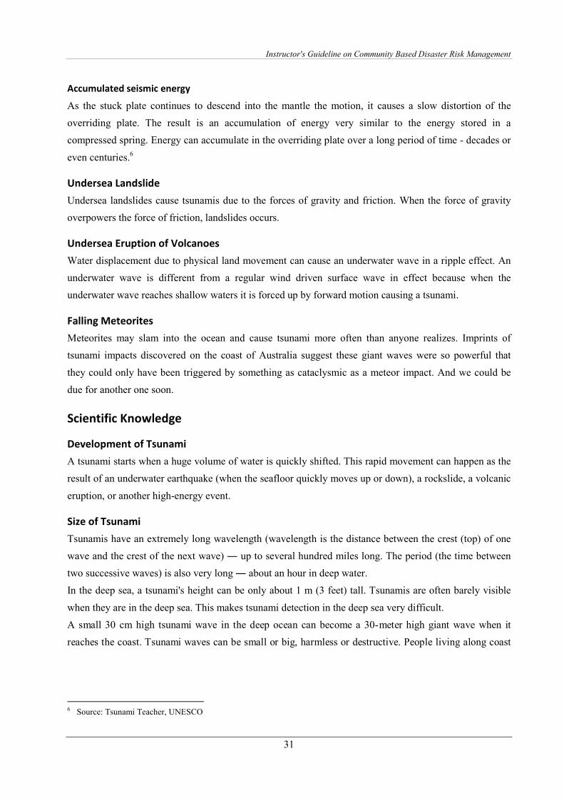
Instructor's Guideline on Community Based Disaster Risk Management
31
Accumulated seismic energy
As the stuck plate continues to descend into the mantle the motion, it causes a slow distortion of the
overriding plate. The result is an accumulation of energy very similar to the energy stored in a
compressed spring. Energy can accumulate in the overriding plate over a long period of time - decades or
even centuries.6
Undersea Landslide
Undersea landslides cause tsunamis due to the forces of gravity and friction. When the force of gravity
overpowers the force of friction, landslides occurs.
Undersea Eruption of Volcanoes
Water displacement due to physical land movement can cause an underwater wave in a ripple effect. An
underwater wave is different from a regular wind driven surface wave in effect because when the
underwater wave reaches shallow waters it is forced up by forward motion causing a tsunami.
Falling Meteorites
Meteorites may slam into the ocean and cause tsunami more often than anyone realizes. Imprints of
tsunami impacts discovered on the coast of Australia suggest these giant waves were so powerful that
they could only have been triggered by something as cataclysmic as a meteor impact. And we could be
due for another one soon.
Scientific Knowledge
Development of Tsunami
A tsunami starts when a huge volume of water is quickly shifted. This rapid movement can happen as the
result of an underwater earthquake (when the seafloor quickly moves up or down), a rockslide, a volcanic
eruption, or another high-energy event.
Size of Tsunami
Tsunamis have an extremely long wavelength (wavelength is the distance between the crest (top) of one
wave and the crest of the next wave) ― up to several hundred miles long. The period (the time between
two successive waves) is also very long ― about an hour in deep water.
In the deep sea, a tsunami's height can be only about 1 m (3 feet) tall. Tsunamis are often barely visible
when they are in the deep sea. This makes tsunami detection in the deep sea very difficult.
A small 30 cm high tsunami wave in the deep ocean can become a 30-meter high giant wave when it
reaches the coast. Tsunami waves can be small or big, harmless or destructive. People living along coast
6 Source: Tsunami Teacher, UNESCO
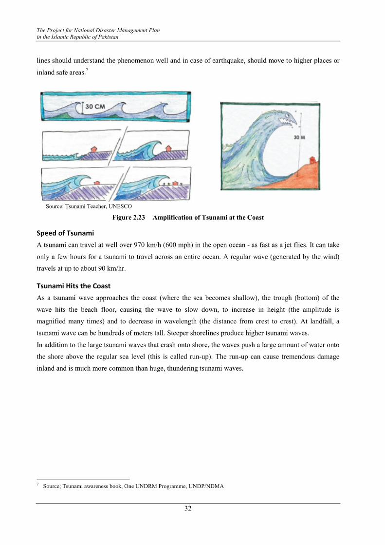
The Project for National Disaster Management Plan
in the Islamic Republic of Pakistan
32
lines should understand the phenomenon well and in case of earthquake, should move to higher places or
inland safe areas.7
Source: Tsunami Teacher, UNESCO
Figure 2.23 Amplification of Tsunami at the Coast
Speed of Tsunami
A tsunami can travel at well over 970 km/h (600 mph) in the open ocean - as fast as a jet flies. It can take
only a few hours for a tsunami to travel across an entire ocean. A regular wave (generated by the wind)
travels at up to about 90 km/hr.
Tsunami Hits the Coast
As a tsunami wave approaches the coast (where the sea becomes shallow), the trough (bottom) of the
wave hits the beach floor, causing the wave to slow down, to increase in height (the amplitude is
magnified many times) and to decrease in wavelength (the distance from crest to crest). At landfall, a
tsunami wave can be hundreds of meters tall. Steeper shorelines produce higher tsunami waves.
In addition to the large tsunami waves that crash onto shore, the waves push a large amount of water onto
the shore above the regular sea level (this is called run-up). The run-up can cause tremendous damage
inland and is much more common than huge, thundering tsunami waves.
7 Source; Tsunami awareness book, One UNDRM Programme, UNDP/NDMA
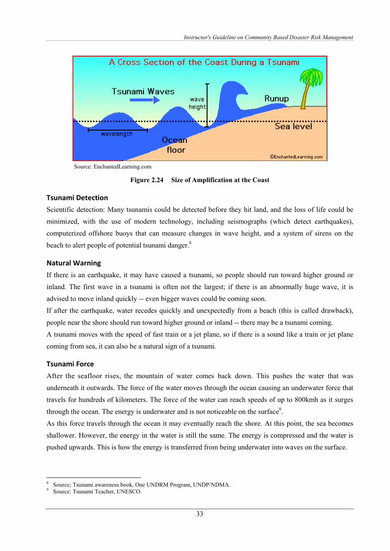
Instructor's Guideline on Community Based Disaster Risk Management
33
Source: EnchantedLearning.com
Figure 2.24 Size of Amplification at the Coast
Tsunami Detection
Scientific detection: Many tsunamis could be detected before they hit land, and the loss of life could be
minimized, with the use of modern technology, including seismographs (which detect earthquakes),
computerized offshore buoys that can measure changes in wave height, and a system of sirens on the
beach to alert people of potential tsunami danger.8
Natural Warning
If there is an earthquake, it may have caused a tsunami, so people should run toward higher ground or
inland. The first wave in a tsunami is often not the largest; if there is an abnormally huge wave, it is
advised to move inland quickly -- even bigger waves could be coming soon.
If after the earthquake, water recedes quickly and unexpectedly from a beach (this is called drawback),
people near the shore should run toward higher ground or inland -- there may be a tsunami coming.
A tsunami moves with the speed of fast train or a jet plane, so if there is a sound like a train or jet plane
coming from sea, it can also be a natural sign of a tsunami.
Tsunami Force
After the seafloor rises, the mountain of water comes back down. This pushes the water that was
underneath it outwards. The force of the water moves through the ocean causing an underwater force that
travels for hundreds of kilometers. The force of the water can reach speeds of up to 800kmh as it surges
through the ocean. The energy is underwater and is not noticeable on the surface9.
As this force travels through the ocean it may eventually reach the shore. At this point, the sea becomes
shallower. However, the energy in the water is still the same. The energy is compressed and the water is
pushed upwards. This is how the energy is transferred from being underwater into waves on the surface.
8 Source; Tsunami awareness book, One UNDRM Program, UNDP/NDMA. 9 Source: Tsunami Teacher, UNESCO.
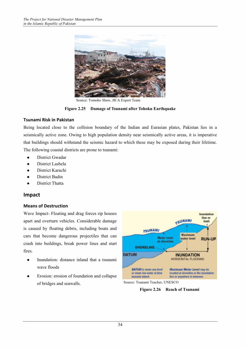
The Project for National Disaster Management Plan
in the Islamic Republic of Pakistan
34
Source: Tomoko Shaw, JICA Expert Team
Figure 2.25 Damage of Tsunami after Tohoku Earthquake
Tsunami Risk in Pakistan
Being located close to the collision boundary of the Indian and Eurasian plates, Pakistan lies in a
seismically active zone. Owing to high population density near seismically active areas, it is imperative
that buildings should withstand the seismic hazard to which these may be exposed during their lifetime.
The following coastal districts are prone to tsunami:
� District Gwadar
� District Lasbela
� District Karachi
� District Badin
� District Thatta
Impact
Means of Destruction
Wave Impact- Floating and drag forces rip houses
apart and overturn vehicles. Considerable damage
is caused by floating debris, including boats and
cars that become dangerous projectiles that can
crash into buildings, break power lines and start
fires.
� Inundation: distance inland that a tsunami
wave floods
� Erosion: erosion of foundation and collapse
of bridges and seawalls.
Source: Tsunami Teacher, UNESCO
Figure 2.26 Reach of Tsunami
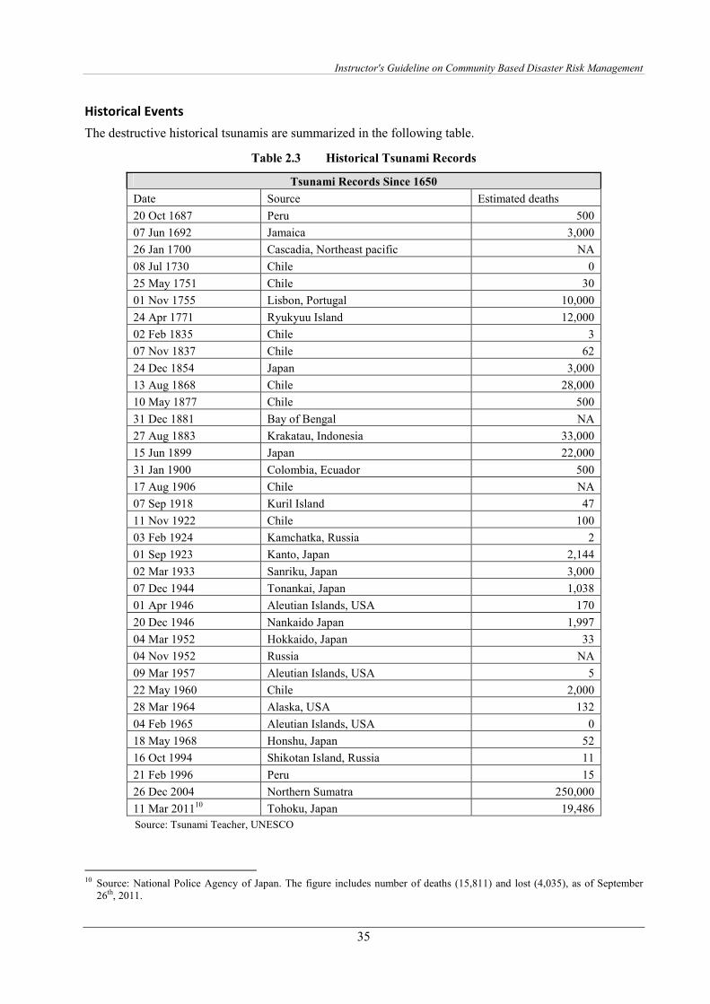
Instructor's Guideline on Community Based Disaster Risk Management
35
Historical Events
The destructive historical tsunamis are summarized in the following table.
Table 2.3 Historical Tsunami Records
Tsunami Records Since 1650
Date Source Estimated deaths
20 Oct 1687 Peru 500
07 Jun 1692 Jamaica 3,000
26 Jan 1700 Cascadia, Northeast pacific NA
08 Jul 1730 Chile 0
25 May 1751 Chile 30
01 Nov 1755 Lisbon, Portugal 10,000
24 Apr 1771 Ryukyuu Island 12,000
02 Feb 1835 Chile 3
07 Nov 1837 Chile 62
24 Dec 1854 Japan 3,000
13 Aug 1868 Chile 28,000
10 May 1877 Chile 500
31 Dec 1881 Bay of Bengal NA
27 Aug 1883 Krakatau, Indonesia 33,000
15 Jun 1899 Japan 22,000
31 Jan 1900 Colombia, Ecuador 500
17 Aug 1906 Chile NA
07 Sep 1918 Kuril Island 47
11 Nov 1922 Chile 100
03 Feb 1924 Kamchatka, Russia 2
01 Sep 1923 Kanto, Japan 2,144
02 Mar 1933 Sanriku, Japan 3,000
07 Dec 1944 Tonankai, Japan 1,038
01 Apr 1946 Aleutian Islands, USA 170
20 Dec 1946 Nankaido Japan 1,997
04 Mar 1952 Hokkaido, Japan 33
04 Nov 1952 Russia NA
09 Mar 1957 Aleutian Islands, USA 5
22 May 1960 Chile 2,000
28 Mar 1964 Alaska, USA 132
04 Feb 1965 Aleutian Islands, USA 0
18 May 1968 Honshu, Japan 52
16 Oct 1994 Shikotan Island, Russia 11
21 Feb 1996 Peru 15
26 Dec 2004 Northern Sumatra 250,000
11 Mar 201110 Tohoku, Japan 19,486
Source: Tsunami Teacher, UNESCO
10 Source: National Police Agency of Japan. The figure includes number of deaths (15,811) and lost (4,035), as of September
26th, 2011.

The Project for National Disaster Management Plan
in the Islamic Republic of Pakistan
36
Indian Ocean,
1%
Mediterranean,
Black, Red &
NW Atlantic, 10%
Pacific, 83%
Carribbean &
SW Atalantic, 5%
SE Atlantic, 1%
Figure 2.27 Location of Tsunami Occurrence
1945 Tsunami
An internationally well-known, large tsunami that impacted the Peninsula was the 1945 Makran tsunami.
This tsunami devastated the coasts of Iran,
Pakistan, and possibly Oman (Berninghausen,
1966).
On 28th November 1945, a great earthquake off
Pakistan’s Makran coast (Balochistan) generated a
destructive tsunami in the Northern Arabian sea
and Indian ocean. More than 4,000 people were
killed along the Makran coast of Pakistan by both
the earthquake and tsunami.
Indian Ocean 2004 Tsunami
On Dec 26, 2004 a massive earthquake off Sumatra generated a tsunami that quickly and violently hit
Indonesia –Andaman island (30 min), Thailand (90 min), Sri Lanka and India (2 hrs), Maldives and
finally the east coast of Africa (7 hrs later). The Sumatra earthquake turned out to be more powerful than
initially believed.
US seismologists put it at 9.3 and not M8.0 as initially measured in the first few minutes. Wave height
along the coastline of Banda Aceh averaged over 75 feet (22.9 meter) with run-ups often reaching 90 feet
(27.4 meter) and the tsunami’s average speed on the shore was 42 feet/sec (12.8 meter/sec).
Source: Pakistan Meteorological Department (PMD)
Figure 2.28 Location of Tsunami in 1945
Source: world data centre for solid Earth Geophysics

Instructor's Guideline on Community Based Disaster Risk Management
37
Figure 2.29 Damages by Indian Ocean Tsunami in 2004
Mitigation and Preparedness
Structural
Sea walls
Sea walls, which protect the coast from tsunamis striking land, are fundamental to mitigation for tsunami.
Their crest height should be determined by construction standards of the particular area in which they are
built, but planners should bear in mind that a tsunami could still breach the walls and in that event, the
effectiveness and safety of the levee walls must be taken into consideration11.
Embankments
Embankment may refer to a protection band in Pakistan, which is levee or dike, an artificial bank raised
above the immediately surrounding land to redirect or prevent flooding by a river, lake or sea.
For transportation, a raised bank to carry a road, railway, or canal across a low-lying or wet area.
Embankment dam: a dam made of mounded earth and rock.
Land reclamation along the banks of a river, usually marked by roads and walkways running along it,
parallel to the river.
Breakwater
Tsunami breakwaters alleviate rises of the water level within a designated area. They also are effective in
altering tsunami wave reverberation. They are already in place at harbors for large vessels and are being
built at various ports.
Bio shields (vegetation)
Coastal vegetation is recognized as a comprehensive strategy to mitigate the destructive force of tsunami
events, although it cannot completely stop the tsunami itself and the effectiveness depends on the
magnitude of the tsunami and the vegetation structure.
Danielsen et al., (2005) pointed out that mangroves and other coastal vegetation have been cleared or
degraded along many coastlines, increasing their vulnerability to storm and tsunami damage and
11 Source: Tsunami Teacher, UNESCO.
Source: Tsunami Teacher,
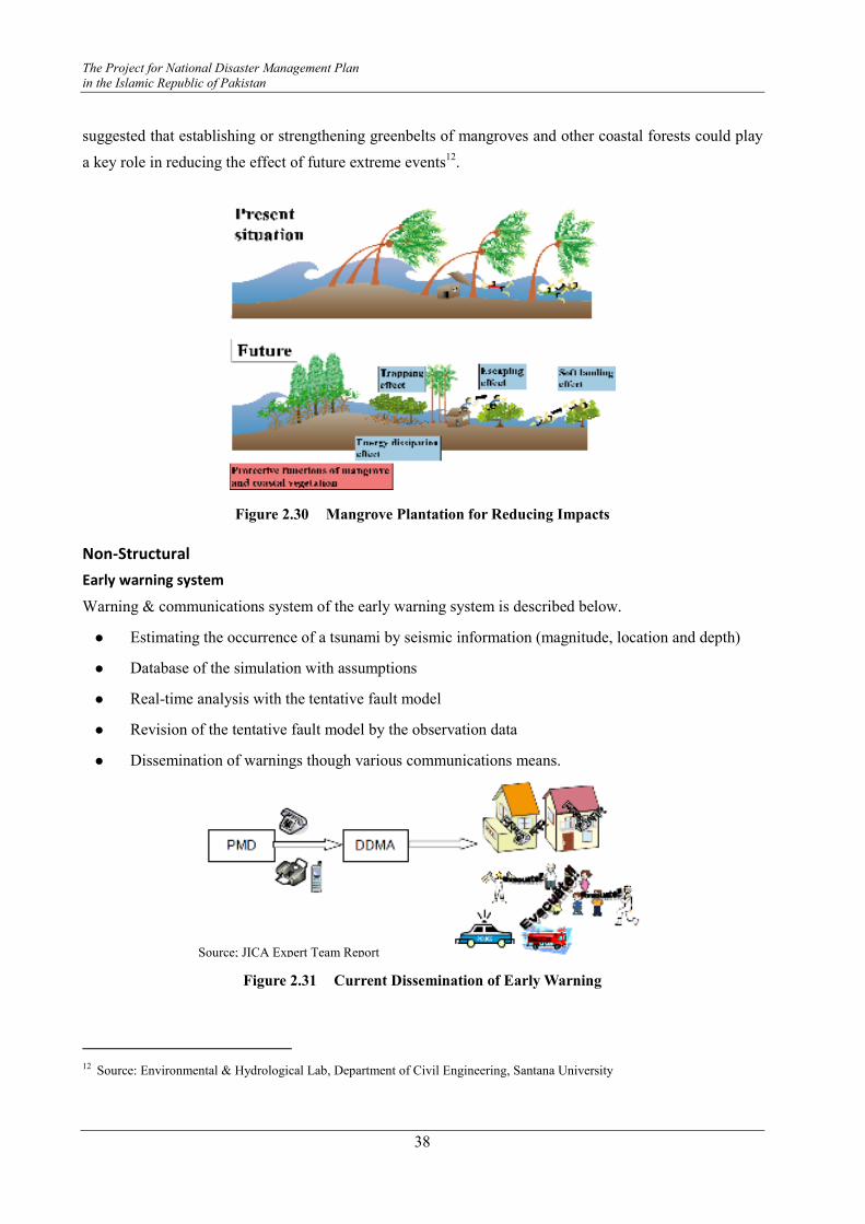
The Project for National Disaster Management Plan
in the Islamic Republic of Pakistan
38
suggested that establishing or strengthening greenbelts of mangroves and other coastal forests could play
a key role in reducing the effect of future extreme events12.
Figure 2.30 Mangrove Plantation for Reducing Impacts
Non-Structural
Early warning system
Warning & communications system of the early warning system is described below.
� Estimating the occurrence of a tsunami by seismic information (magnitude, location and depth)
� Database of the simulation with assumptions
� Real-time analysis with the tentative fault model
� Revision of the tentative fault model by the observation data
� Dissemination of warnings though various communications means.
Figure 2.31 Current Dissemination of Early Warning
12 Source: Environmental & Hydrological Lab, Department of Civil Engineering, Santana University
Source; JICA Expert Team Report
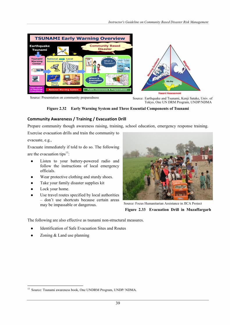
Instructor's Guideline on Community Based Disaster Risk Management
39
Earthquake
Tsunami
Tsunami
Warning Center
International/Regional Framework
National Warning System Public Awareness & Preparedness
National Government
Local
Government
People
Mass Media
Where is Evacuation Route?
What is Tsunami?
Community Based
Disaster
Reduction
TSUNAMI Early Warning Overview
Figure 2.32 Early Warning System and Three Essential Components of Tsunami
Community Awareness / Training / Evacuation Drill
Prepare community though awareness raising, training, school education, emergency response training.
Exercise evacuation drills and train the community to
evacuate, e.g.,
Evacuate immediately if told to do so. The following
are the evacuation tips13:
� Listen to your battery-powered radio and follow the instructions of local emergency officials.
� Wear protective clothing and sturdy shoes.
� Take your family disaster supplies kit
� Lock your home.
� Use travel routes specified by local authorities – don’t use shortcuts because certain areas may be impassable or dangerous.
Figure 2.33 Evacuation Drill in Muzaffargarh
The following are also effective as tsunami non-structural measures.
� Identification of Safe Evacuation Sites and Routes
� Zoning & Land use planning
13 Source: Tsunami awareness book, One UNDRM Program, UNDP/ NDMA.
Source: Presentation on community preparedness Source: Earthquake and Tsunami, Kenji Satake, Univ. of Tokyo, One UN DRM Program, UNDP/NDMA
Source: Focus Humanitarian Assistance in JICA Project
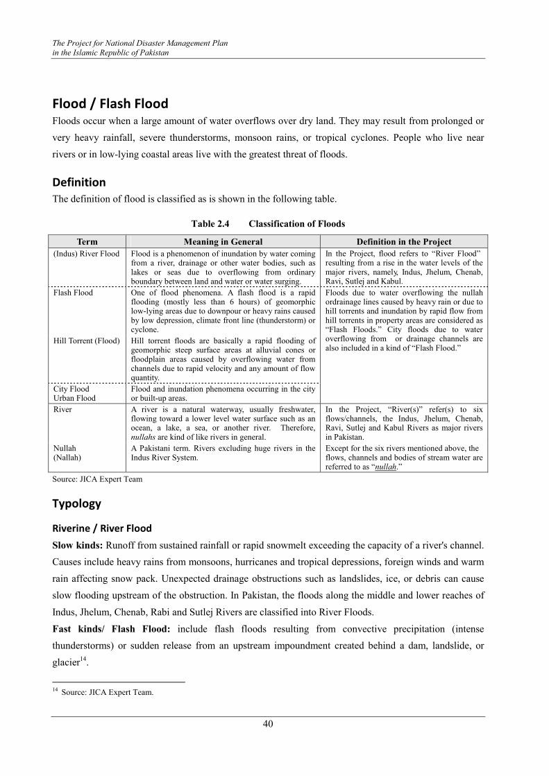
The Project for National Disaster Management Plan
in the Islamic Republic of Pakistan
40
Flood / Flash Flood Floods occur when a large amount of water overflows over dry land. They may result from prolonged or
very heavy rainfall, severe thunderstorms, monsoon rains, or tropical cyclones. People who live near
rivers or in low-lying coastal areas live with the greatest threat of floods.
Definition
The definition of flood is classified as is shown in the following table.
Table 2.4 Classification of Floods
Term Meaning in General Definition in the Project
(Indus) River Flood Flood is a phenomenon of inundation by water coming from a river, drainage or other water bodies, such as lakes or seas due to overflowing from ordinary boundary between land and water or water surging.
In the Project, flood refers to “River Flood” resulting from a rise in the water levels of the major rivers, namely, Indus, Jhelum, Chenab, Ravi, Sutlej and Kabul.
Flash Flood One of flood phenomena. A flash flood is a rapid flooding (mostly less than 6 hours) of geomorphic low-lying areas due to downpour or heavy rains caused by low depression, climate front line (thunderstorm) or cyclone.
Hill Torrent (Flood) Hill torrent floods are basically a rapid flooding of geomorphic steep surface areas at alluvial cones or floodplain areas caused by overflowing water from channels due to rapid velocity and any amount of flow quantity.
City Flood Urban Flood
Flood and inundation phenomena occurring in the city or built-up areas.
Floods due to water overflowing the nullah ordrainage lines caused by heavy rain or due to hill torrents and inundation by rapid flow from hill torrents in property areas are considered as “Flash Floods.” City floods due to water overflowing from or drainage channels are also included in a kind of “Flash Flood.”
River A river is a natural waterway, usually freshwater, flowing toward a lower level water surface such as an ocean, a lake, a sea, or another river. Therefore, nullahs are kind of like rivers in general.
In the Project, “River(s)” refer(s) to six flows/channels, the Indus, Jhelum, Chenab, Ravi, Sutlej and Kabul Rivers as major rivers in Pakistan.
Nullah (Nallah)
A Pakistani term. Rivers excluding huge rivers in the Indus River System.
Except for the six rivers mentioned above, the flows, channels and bodies of stream water are referred to as “nullah.”
Source: JICA Expert Team
Typology
Riverine / River Flood
Slow kinds: Runoff from sustained rainfall or rapid snowmelt exceeding the capacity of a river's channel.
Causes include heavy rains from monsoons, hurricanes and tropical depressions, foreign winds and warm
rain affecting snow pack. Unexpected drainage obstructions such as landslides, ice, or debris can cause
slow flooding upstream of the obstruction. In Pakistan, the floods along the middle and lower reaches of
Indus, Jhelum, Chenab, Rabi and Sutlej Rivers are classified into River Floods.
Fast kinds/ Flash Flood: include flash floods resulting from convective precipitation (intense
thunderstorms) or sudden release from an upstream impoundment created behind a dam, landslide, or
glacier14.
14 Source: JICA Expert Team.

Instructor's Guideline on Community Based Disaster Risk Management
41
As the name suggests, flash floods are events with little
time occurring between the start of the flood and the
peak discharge.
These floods normally occur within six hours of the
beginning of heavy rainfall and are usually associated
with intensive localized showers and severe
thunderstorms.
These floods are particularly dangerous because of the
suddenness and speed with which they occur.
Internal Flood
Source: Foundation of River & Basin Integrated Communications, Japan
Figure 2.35 Normal Situation of Rivers
and Tributaries
Figure 2.36 Internal Flooding Situation
There is another flood pattern known as an internal flood. In the picture on the right, there is a floodgate and
the flood in the mainstream cannot flow into the residential area. But there are no gates in the nullah system
in Pakistan. Therefore, the flood flows backward into the tributaries and drainage areas. This worsens the
situation.
To mitigate internal floods, structural measures, such as the main channel improvement first and then
installation of floodgates and pumping stations at the confluence of the tributaries, are needed.
Estuarine Coastal floods/Storm surges
Storm Surges: These are commonly caused by a combination of sea tidal surges, caused by storm-force
winds. A storm surge, from either a tropical cyclone or an extra tropical cyclone, falls within this
category.
Source: Nature and causes of floods and associated
secondary hazards, Prof. Amir Nawaz Khan, CDPM, University of Peshawar
Figure 2.34 Flash Flood
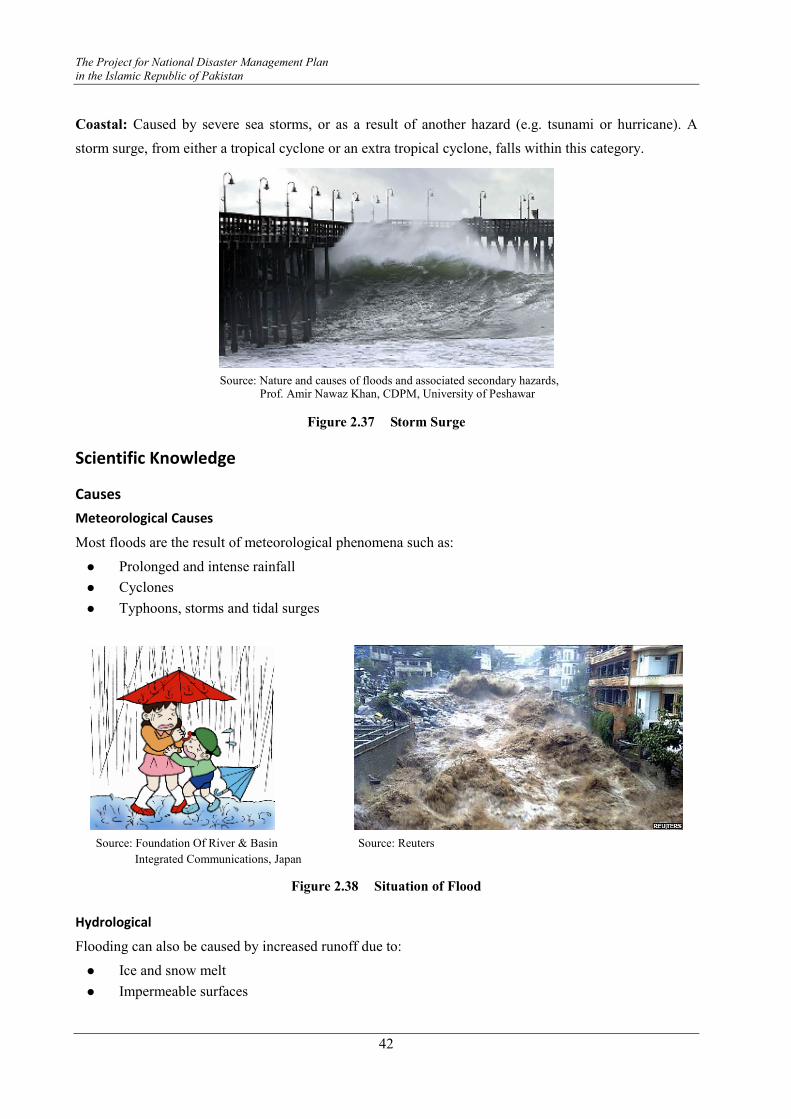
The Project for National Disaster Management Plan
in the Islamic Republic of Pakistan
42
Coastal: Caused by severe sea storms, or as a result of another hazard (e.g. tsunami or hurricane). A
storm surge, from either a tropical cyclone or an extra tropical cyclone, falls within this category.
Figure 2.37 Storm Surge
Scientific Knowledge
Causes
Meteorological Causes
Most floods are the result of meteorological phenomena such as:
� Prolonged and intense rainfall
� Cyclones
� Typhoons, storms and tidal surges
Source: Foundation Of River & Basin Source: Reuters
Integrated Communications, Japan
Figure 2.38 Situation of Flood
Hydrological
Flooding can also be caused by increased runoff due to:
� Ice and snow melt
� Impermeable surfaces
Source: Nature and causes of floods and associated secondary hazards, Prof. Amir Nawaz Khan, CDPM, University of Peshawar
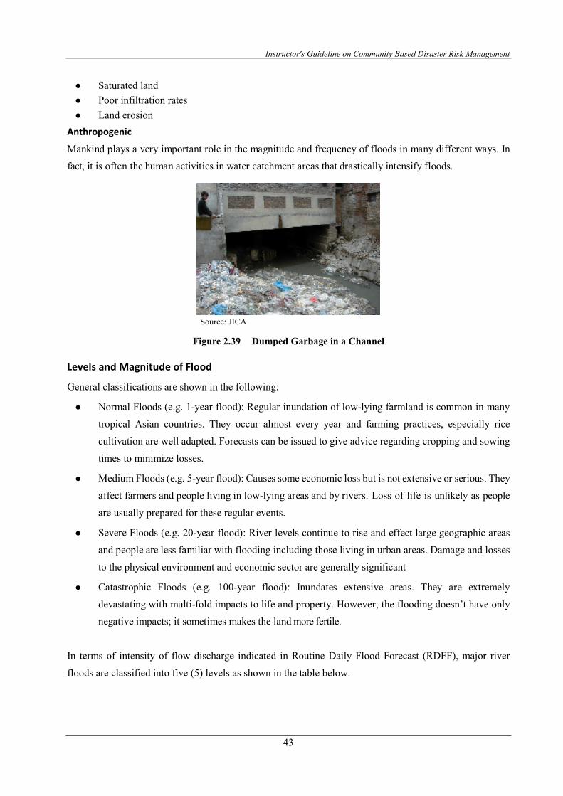
Instructor's Guideline on Community Based Disaster Risk Management
43
� Saturated land
� Poor infiltration rates
� Land erosion
Anthropogenic
Mankind plays a very important role in the magnitude and frequency of floods in many different ways. In
fact, it is often the human activities in water catchment areas that drastically intensify floods.
Source: JICA
Figure 2.39 Dumped Garbage in a Channel
Levels and Magnitude of Flood
General classifications are shown in the following:
� Normal Floods (e.g. 1-year flood): Regular inundation of low-lying farmland is common in many
tropical Asian countries. They occur almost every year and farming practices, especially rice
cultivation are well adapted. Forecasts can be issued to give advice regarding cropping and sowing
times to minimize losses.
� Medium Floods (e.g. 5-year flood): Causes some economic loss but is not extensive or serious. They
affect farmers and people living in low-lying areas and by rivers. Loss of life is unlikely as people
are usually prepared for these regular events.
� Severe Floods (e.g. 20-year flood): River levels continue to rise and effect large geographic areas
and people are less familiar with flooding including those living in urban areas. Damage and losses
to the physical environment and economic sector are generally significant
� Catastrophic Floods (e.g. 100-year flood): Inundates extensive areas. They are extremely
devastating with multi-fold impacts to life and property. However, the flooding doesn’t have only
negative impacts; it sometimes makes the land more fertile.
In terms of intensity of flow discharge indicated in Routine Daily Flood Forecast (RDFF), major river
floods are classified into five (5) levels as shown in the table below.
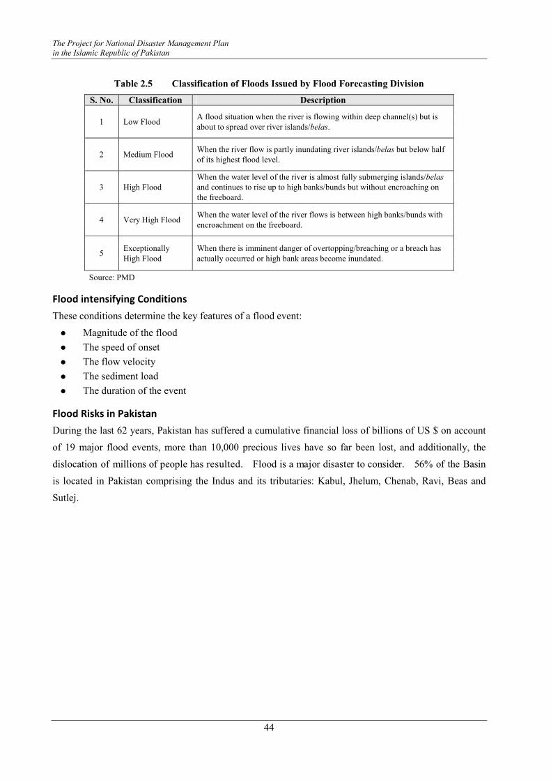
The Project for National Disaster Management Plan
in the Islamic Republic of Pakistan
44
Table 2.5 Classification of Floods Issued by Flood Forecasting Division
S. No. Classification Description
1 Low Flood A flood situation when the river is flowing within deep channel(s) but is
about to spread over river islands/belas.
2 Medium Flood When the river flow is partly inundating river islands/belas but below half
of its highest flood level.
3 High Flood
When the water level of the river is almost fully submerging islands/belas
and continues to rise up to high banks/bunds but without encroaching on
the freeboard.
4 Very High Flood When the water level of the river flows is between high banks/bunds with
encroachment on the freeboard.
5 Exceptionally
High Flood
When there is imminent danger of overtopping/breaching or a breach has
actually occurred or high bank areas become inundated.
Source: PMD
Flood intensifying Conditions
These conditions determine the key features of a flood event:
� Magnitude of the flood
� The speed of onset
� The flow velocity
� The sediment load
� The duration of the event
Flood Risks in Pakistan
During the last 62 years, Pakistan has suffered a cumulative financial loss of billions of US $ on account
of 19 major flood events, more than 10,000 precious lives have so far been lost, and additionally, the
dislocation of millions of people has resulted. Flood is a major disaster to consider. 56% of the Basin
is located in Pakistan comprising the Indus and its tributaries: Kabul, Jhelum, Chenab, Ravi, Beas and
Sutlej.
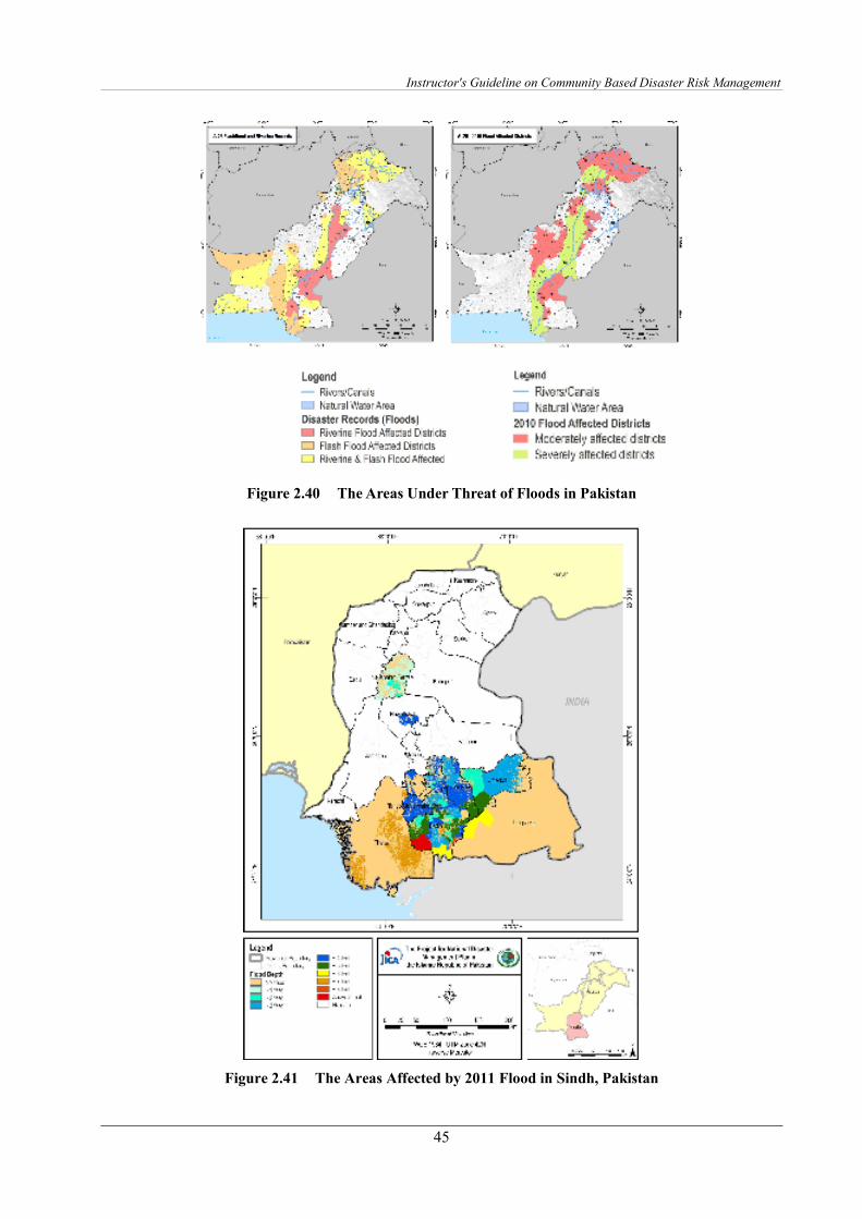
Instructor's Guideline on Community Based Disaster Risk Management
45
Figure 2.40 The Areas Under Threat of Floods in Pakistan
Figure 2.41 The Areas Affected by 2011 Flood in Sindh, Pakistan

The Project for National Disaster Management Plan
in the Islamic Republic of Pakistan
46
Features of the floods in Pakistan are summarized as follows:
� These floods occur as a consequence of the monsoon rains.
� Northern areas of Pakistan provide the main water source to the river Indus with snowmelt providing an 80% contribution and rainfall a 20% contribution.
� In the Chenab and Jhelum Rivers, besides flash floods, the main source of water is snowmelt from India and occupied Jammu & Kashmir.
� Similarly, in the Sutlej and Ravi Rivers, water inflows are due to rainfall in the upper catchments in Indian territory
Perspectives of flood risk situations in Pakistan are described below:
� River floods
� Torrential rains in the hills
� Flash rains and consequent flash floods
� Cyclones
� Drainage issues
� Ill conceived and implemented projects
� Lack of forecasting facilities and coordination
� Haphazard land development
Impact
Historical Events
The following table summarizes the historical flood damages in Pakistan.
Table 2.6 Historical Flood Damages in Pakistan
Value of Property Damaged (In Million Rs) Year
Unadjusted Adjusted
Lives Lost (persons)
Villages Affected (number)
Rivers Mainly Affected
2011 324,533 520 38,700 (Local Rainfll in Sindh/Balochistan)
2010 854,771 1,985 17,533 Kabul, Indus, Jhelum
2009 Not Reported 99 89
2008 Not Reported 157 800
2007 7,208.23 586 6,498
2006 Not Reported 541 2,477
2005 Not Reported 59 1,931 Indus
2004 15.00 15.00 85 47
2003 5,175.00 5,175.00 484 4,376
2001 450.00 450.00 219 50 Lai Nullah
1995 6,125.00 8,698.00 591 6,852
1992 34,751.00 69,580.00 1,008 13,208 Indus, Jhelum, and Chenab
1988 6,879.00 25,630.00 508 1,000 Indus/Jhelum, & Chenab/Ravi/Sutlej
1978 4,478.00 51,489.00 393 9,199
1976 5,880.00 80,504.00 425 18,390 Indus, Jhelum, Chenab and Ravi
(Tarbela Dam completed in 1974)
1973 5,137.00 118,684.00 474 9,719 Indus, Jhelum, Chenab, Ravi and Sutlej
(Chashma Reservoir completed in 1971)
(Mangla Dam completed in 1967)
(Warsak Dam completed in 1960)
1957 152.50 6,958.00 83 4,498 Chenab and Ravi
1956 155.50 7,356.00 160 11,609 Indus, Jhelum
1950 199.80 11,282.00 2,190 10,000 Chenab, Ravi and Sutlej
Total 1,565,125.00 10,563 156,926
Source: Federal Flood Commission (FFC) for 1950 – 2010., Preliminary DNA Floods 2010,2011, and NDMA
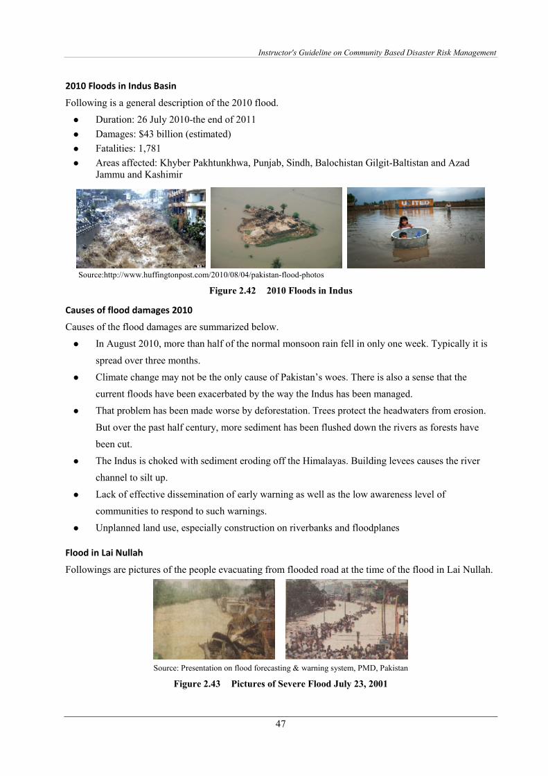
Instructor's Guideline on Community Based Disaster Risk Management
47
2010 Floods in Indus Basin
Following is a general description of the 2010 flood.
� Duration: 26 July 2010-the end of 2011
� Damages: $43 billion (estimated)
� Fatalities: 1,781
� Areas affected: Khyber Pakhtunkhwa, Punjab, Sindh, Balochistan Gilgit-Baltistan and Azad Jammu and Kashimir
Source:http://www.huffingtonpost.com/2010/08/04/pakistan-flood-photos
Figure 2.42 2010 Floods in Indus
Causes of flood damages 2010
Causes of the flood damages are summarized below.
� In August 2010, more than half of the normal monsoon rain fell in only one week. Typically it is
spread over three months.
� Climate change may not be the only cause of Pakistan’s woes. There is also a sense that the
current floods have been exacerbated by the way the Indus has been managed.
� That problem has been made worse by deforestation. Trees protect the headwaters from erosion.
But over the past half century, more sediment has been flushed down the rivers as forests have
been cut.
� The Indus is choked with sediment eroding off the Himalayas. Building levees causes the river
channel to silt up.
� Lack of effective dissemination of early warning as well as the low awareness level of
communities to respond to such warnings.
� Unplanned land use, especially construction on riverbanks and floodplanes
Flood in Lai Nullah
Followings are pictures of the people evacuating from flooded road at the time of the flood in Lai Nullah.
Source: Presentation on flood forecasting & warning system, PMD, Pakistan
Figure 2.43 Pictures of Severe Flood July 23, 2001
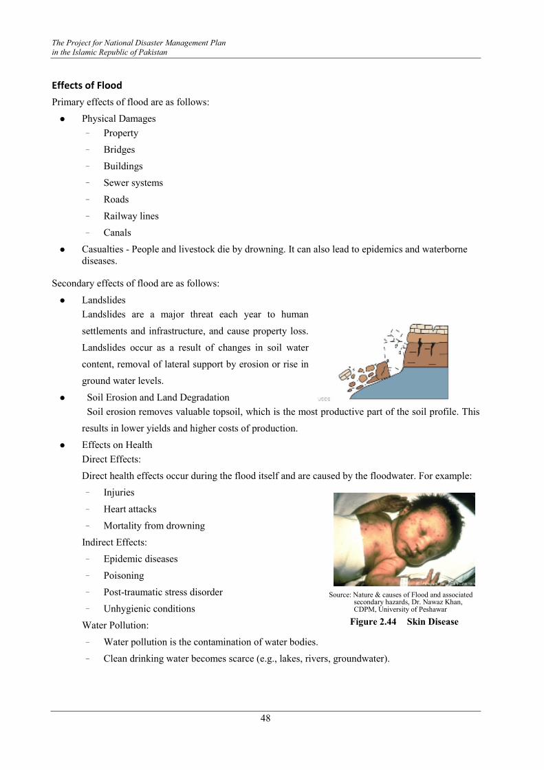
The Project for National Disaster Management Plan
in the Islamic Republic of Pakistan
48
Effects of Flood
Primary effects of flood are as follows:
� Physical Damages
- Property
- Bridges
- Buildings
- Sewer systems
- Roads
- Railway lines
- Canals
� Casualties - People and livestock die by drowning. It can also lead to epidemics and waterborne diseases.
Secondary effects of flood are as follows:
� Landslides
Landslides are a major threat each year to human
settlements and infrastructure, and cause property loss.
Landslides occur as a result of changes in soil water
content, removal of lateral support by erosion or rise in
ground water levels.
� Soil Erosion and Land Degradation
Soil erosion removes valuable topsoil, which is the most productive part of the soil profile. This
results in lower yields and higher costs of production.
� Effects on Health
Direct Effects:
Direct health effects occur during the flood itself and are caused by the floodwater. For example:
- Injuries
- Heart attacks
- Mortality from drowning
Indirect Effects:
- Epidemic diseases
- Poisoning
- Post-traumatic stress disorder
- Unhygienic conditions
Water Pollution:
- Water pollution is the contamination of water bodies.
- Clean drinking water becomes scarce (e.g., lakes, rivers, groundwater).
Source: Nature & causes of Flood and associated
secondary hazards, Dr. Nawaz Khan, CDPM, University of Peshawar
Figure 2.44 Skin Disease
Instructor's Guideline on Community Based Disaster Risk Management
49
- Water pollution affects plants and organisms living in these bodies of water and in almost all
cases, the effect is damaging to individual species and populations, and to the natural
biological communities.
Tertiary/long-term effects of flood are as follows:
� Economic hardship: e.g., due to temporary decline in tourism
� Rebuilding costs
� Food shortage leading to price increase etc.
� Loss of production and provision of services
� Impact on country's debt position
� Loss of economic growth
� Delay in development programs
Figure 2.45 Situations of Flood
Mitigation and Preparedness
Structural Measures
Measures to increase flood flow capacity of waterways are:
� River channel improvement
� Drainage channel improvement
� Construction of flood diversion channels
Measures to control flood runoff from river basins are:
� Construction of dams/and storage facilities
� Construction of off-site flood retarding basins
� Construction of on-site flood regulation ponds in the new subdivisions
� Erosion control and sabo works
Flood proofing measures of individual buildings/ units are:
� Raising floor levels of homesteads and industrial facilities above flood levels
� Provision of refuge areas or flood shelters
� Ensuring that water supplies and other health related facilities operate throughout floods
Non-structural Measures
Measures to increase flood flow capacity of waterways are:
Source: Nature & causes of Flood and associated secondary hazards, Dr. Nawaz Khan, CDPM, University of Peshawar

The Project for National Disaster Management Plan
in the Islamic Republic of Pakistan
50
� Management for removal of garbage and other drifting materials in the waterway
� Prevention of encroachment into river area
Measures to control of flood runoff from river basin are:
� Control of excessive land development in the river basin
� Legal arrangement for construction of on-site flood regulation pond by land developers
� Reforestation
� Flood warning and evacuation system
� Evacuation awareness
� Guidance to waterproof construction
� Development and dissemination of flood hazard maps
� Unification of related agencies for flood mitigation (such as establishment of a “Flood Mitigation Committee”)
Figure 2.46 Flood Proofing of Individual Building by Construction
of Protection Wall and Evacuation Shelter
Flood Risk Management
General descriptions of flood risk management are summarized as follows.
Purpose
� Reduce the flood damage and number of victims
Activities by communities
� Experience and Knowledge
� Poster Contest, Pamphlet
� Drills and Exercises
� Hazard Maps
� Information and Communication
� Awareness Program, etc.
Responsibilities and main stakeholders of flood risk management
� Emergence Response
- NDMA, F/G/S/PDMAs, DDMA (Operation), FFC Rescue1122, Police, Fire Fighting,
Armed Force, Civil Defence, etc.
Source: 5-day course on flood mitigation (Feb 17, 2010), Islamabad, NDMA/UNDP

Instructor's Guideline on Community Based Disaster Risk Management
51
� Recovery & Reconstruction
- NDMA, F/G/S/PDMAs, DDMA (Rehabilitation & Reconstruction), FFC, Irrigation Dept.,
WASA, RDA, Armed Forces, etc.
� Preparedness
- NDMA, F/G/S/PDMAs, DDMA (Management & Planning), Rescue1122, Civil Defence
- FFC, PMD, Irrigation Dept., WASA and other concerned agencies
Classification of Flood related disasters
� River Flood: “River Flood” includes flooding along the INDUS, JHELUM, CHENAB, RAVI,
SUTLEJ and KABUL Rivers in the downstream stretches of major dams (Tarbela, Mangla).
� Flash Flood: Flash Flood” includes not only Hill Torrent/Nullah Flood but also city floods.
Compared to River Flood, the flooding period is shorter but their flows have comparatively rapid
velocities. “Flash Flood” results from short-time extreme rainfall phenomena within a narrow
range.
� Landslide: Strictly speaking from geological engineering aspects, “Slope Failure” and “Landslide”
have differences in the mechanism of collapse. These phenomena are treated as “Landslide” in
the Project since methodology of public awareness and public evacuation regarding EWS is
mostly the same approach.
Besides, “Landslides” result from not only from the soil in the slope being saturated with water
but also from earthquakes. As for an early warning system, a “Landslide” caused by saturated
slopes due to heavy rainfall may be considered.
� Cyclone: A cyclone is a low/depression beyond a certain intensification of closed, circular fluid
motion rotating in the same direction as the Earth. While tropical cyclones can produce
extremely powerful winds and torrential rain, they are also able to produce high waves and
damaging storm surges.
� Storm Surge: A storm surge is the phenomena of sea level rise associated with a low-pressure
weather system, typically a tropical cyclone. Therefore, an early warning plan for “Storm Surge”
should be incorporated with that of “Cyclone”.
� Drought: A drought is an extended period of weeks, months or years when a region/province notes
a deficiency in its water supply. Generally, this occurs when a region receives consistently
below-average precipitation. In addition, extreme climate conditions may occur in the future due
to global warning. This could have a substantial impact on the ecosystem and agriculture of the
affected region.

The Project for National Disaster Management Plan
in the Islamic Republic of Pakistan
52
Additional Information
Safety Measures before and During Floods
Safety measures before and during floods are summarized below.
Before floods
� Know your local flood history.
� Find out from local government agencies or experts at what river height you are unsafe.
� Avoid building in a floodplain unless you elevate and reinforce your home.
� Find out the evacuation route.
� Elevate the furnace, water heater, and electric panel if susceptible to flooding.
� Install "check valves" in sewer traps to prevent floodwater from backing up into the drains of your
home.
� Construct barriers (levees, berms, floodwalls) to stop floodwater from entering the building.
� Seal walls in basements with waterproofing compounds to avoid seepage.
During a flood
� Listen to the radio or television or local/government authorities (if present) for information.
� Be aware that flash flooding can occur. If there is any possibility of a flash flood, move
immediately to higher ground. Do not wait for instructions to move.
� Be aware of streams, drainage channels, canyons, and other areas known to flood suddenly. Flash
floods can occur in these areas with or without such typical warnings as rain clouds or heavy rain.

Instructor's Guideline on Community Based Disaster Risk Management
53
Drought
Definition
Drought has many definitions. One of the most commonly accepted definitions is that drought occurs in
circumstances arising due to “temporary reduction in water availability below the normal or expected
level for a specified period”.
Figure 2.47 Situation of Drought
A drought is an extended period of months or years when a region notes a deficiency in its water supply.
Generally, this occurs when a region receives consistently below-average precipitation.
Types
Meteorological
Meteorological drought is brought about when there is a prolonged period with less than average
precipitation. Meteorological drought usually precedes the other kinds of drought. Meteorological drought
is defined as occurring when the seasonal rainfall received over an area is less than 75% of its long-term
average value.
Agricultural
Agricultural droughts affect crop production or the
ecology of the range. This condition can also arise
independently from any change in precipitation
levels when soil conditions and erosion triggered by
poorly planned agricultural endeavors cause a
shortfall in water available to the crops. However, in
a traditional drought, it is caused by an extended
period of below average precipitation.
An agricultural drought occurs when there is not
Figure 2.48 Situation of Drought Area
Source: Presentation on disaster preparedness by Naveed Shahad
Source: Presentation on disaster preparedness by Naveed Shahad
The Project for National Disaster Management Plan
in the Islamic Republic of Pakistan
54
enough soil moisture and the rainfall isn't adequate to support crops. Agriculture drought happens after
meteorological drought.
Hydrological
Hydrological drought is brought about when the water reserves available in sources such as aquifers,
lakes and reservoirs fall below the statistical average. Hydrological drought tends to show up more slowly
because it involves stored water that is used but not replenished. This refers to marked depletion of
surface water and fall in water tables. Generally, hydrological drought follows agriculture drought.
Socio-economic
Socioeconomic drought occurs when the demand for an economic good exceeds supply as a result of a
weather-related shortfall in water supply. The supply of many economic goods, such as water, forage,
food grains, fish, and hydroelectric power, depends on the weather. Due to variability of climate, water
supply is sufficient in some years but not satisfactory to meet human and environmental needs in other
years. The demand for economic goods is increasing as a result of increasing population. Supply may also
increase because of improved production efficiency and technology.
Scientific Knowledge
Causes
Natural
Generally, rainfall is related to the amount of water vapor in the atmosphere, combined with the upward
forcing of the air mass containing that water vapor. If either of these is reduced, the result is drought.
Factors include:
� Above average prevalence of high pressure systems
� Winds carrying continental, rather than oceanic air masses (ie. reduced water content)
� El Nino (and other oceanic temperature cycles)
� Deforestation
� Some speculate that global warming will have a substantial impact on agriculture throughout the world, especially in developing nations.
Human induced causes
Environmental degradation, especially the loss of green cover fields, affects rainfall received in the region,
increasing the possibility of water scarcity.

Instructor's Guideline on Community Based Disaster Risk Management
55
Drought Risk Situation in Pakistan
Figure 2.49 describes the drought risk situation in Pakistan by areas15.
Source: JICA Expert Team
Figure 2.49 Drought Risk Map of Pakistan
15 Earthquake hazard and risk maps, along with other disasters were prepared in the JICA project for “National Disaster
Management Plan in the Islamic Republic of Pakistan” in 2010.

The Project for National Disaster Management Plan
in the Islamic Republic of Pakistan
56
Impact
Agricultural growth suffered a severe setback during 2000-2002 as a result of drought. The majomr crops
registered a reduction of almost 10 % while the overall agriculture recorded a reduction of 2.6 %. The
drought persisted throughout 2001-2002, resulting in a water shortage of as much as 51% of normal
supplies against 40% in the previous year. The total flow of water in major rivers declined (to 109 billion
m³ against an average of 162 billion m³) 33% from the average. Rainfall had also been below normal. The
canal head withdrawals had also witnessed significant decline.
Source: Gender issues in disaster management, glimpse from South Asia,
Madhavia, IIDG South Asia, Colombo
Figure 2.50 Gender Issues on Drought
Historical Review
Features of drought of 1997-2001 in Pakistan are summarized below.
� This drought caused a loss of Pak. Rs. 71.50 billion in the agricultural and livestock sector in the
year 1999-2000.
� About 2.21 million people and 23.51 million livestock were affected due to severe drought
conditions during 1999-2000.
� Sindh had to face Pak. Rs. 33 billion losses due to drought and water shortage.
� The loss of livestock to drought was about 40% in Balochistan and 60 % in Sindh
Table 2.7 Impact of 1997-2001 Drought on Agriculture in Balochistan
% of Farmers that
Grow Crops
Average Area Sown
(ha)
Average Area
Damaged (ha) Crop
Rainfed Irrigated Rainfed Irrigated Rainfed Irrigated
Wheat 38.2 96.7 5.6 2.5 4.8 0.0
Cotton 1.8 1.7 0.4 8.1 0.2 3.2
Fodder 2.8 4.9 2.2 2.0 1.4 0.6
Vegetable 25.4 7.0 1.7 1.6 1.3 0.6
Orchards 32.0 0.0 0.0 2.8 0.0 2.1
Source: Presentation on: Drought in Pakistan by JICA Study Team
Instructor's Guideline on Community Based Disaster Risk Management
57
Effects
Economic effects of droughts are as follows:
� Loss of national economic growth, slowing down of economic development
� Damage to crop quality, less food production
� Increase in food prices
� Increased importation of food (higher costs)
� Increased infestation
� Plant disease
� Loss from dairy and livestock production
� Unavailability of water and feed for livestock which leads to high livestock mortality rates
� Range fires and wild land fires
� Damage to fish habitat, loss from fishery production
� Income loss for farmers and others affected
� Unemployment from production declines
� Loss to recreational and tourism industry
� Loss of hydroelectric power
� Loss of navigability of rivers and canals
Environmental effects of droughts are as follows:
Physical
� Scarcity of water for drinking, domestic and irrigation purposes
� Depletion in ground water level
� Reduced flow from perennial water sources
� Land degradation
Bio-physical
� Increase in deforestation
� Scarcity of fodder
� Damage to crop quality
� Livestock death or incapacitation
� Unusual movements of flocks and herds in search of pasture
� Impaired productivity of forestlands
� Direct loss of trees, especially young ones
� Extinction of endangered species and loss of bio-diversity
� Drying up of water sources and deterioration in water quality
� Damage to fish habitat
� Decline in crop production / negative impacts on agricultural economy
Social effects of droughts are as follows:
� Food shortages
� Loss of human life from food shortages, heat, suicides, violence
� Mental and physical stress
� Water user conflicts
The Project for National Disaster Management Plan
in the Islamic Republic of Pakistan
58
� Political conflicts
� Social unrest
� Public dissatisfaction with government regarding drought response
� Inequity in the distribution of drought relief
� Loss of cultural sites
� Reduced quality of life, which leads to changes in lifestyle
� Increased poverty
� Population migrations
� Negative impacts on nutritional status
Effects on increased mental & physical stress (e.g. anxiety, depression, loss of security, domestic violence
etc.) and morbidity are as follows:
� Increase in crime rate
� Social cost of migration, e.g., breakup of communities and families
� Inability of certain groups within the population to afford increased food prices results in switch to cheaper and sometimes less preferred foods / reduction in overall food intake, etc.
� Loss of education due to reduction in school attendance by children lacking energy and/or money for fees, and increase in child labor
Mitigation and Preparedness
Drought is a natural hazard, it has a slow onset, and it evolves over months or even years. It may affect a
large region and causes little structural damage. The impacts of drought can be reduced through
preparedness and mitigation. Some of the preparedness and mitigation measures are
Water Conservation
Means of water conservation are as follows:
Water-Saving Devices - should be incorporated into daily life for using less water (low-flow toilets and
showerheads, etc.).
Water Recycling -Former wastewater (sewage) that has been treated and purified for reuse.
Land Use- Carefully planned crop rotation can help to minimize erosion and allow farmers to plant less
water-dependent crops in drier years.
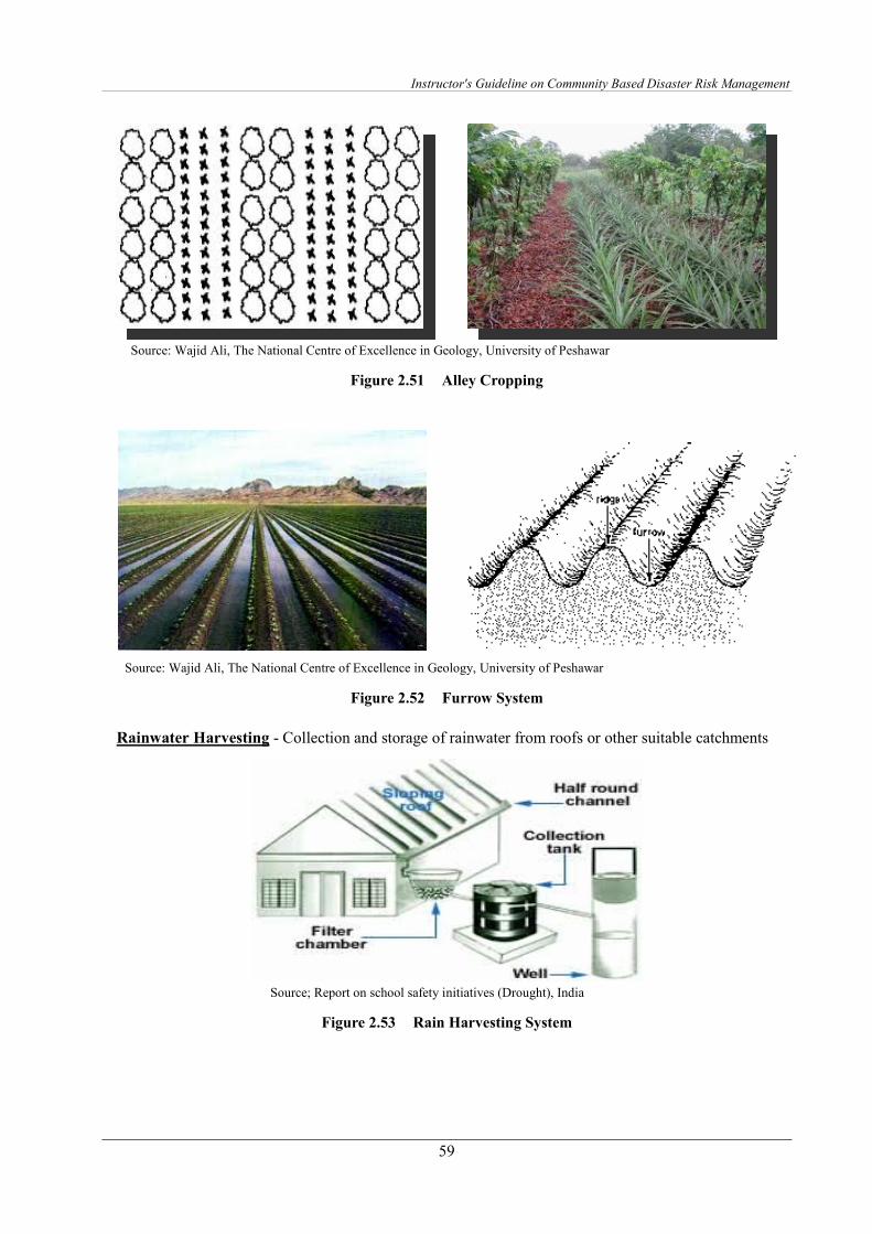
Instructor's Guideline on Community Based Disaster Risk Management
59
Source: Wajid Ali, The National Centre of Excellence in Geology, University of Peshawar
Figure 2.51 Alley Cropping
Source: Wajid Ali, The National Centre of Excellence in Geology, University of Peshawar
Figure 2.52 Furrow System
Rainwater Harvesting - Collection and storage of rainwater from roofs or other suitable catchments
Source; Report on school safety initiatives (Drought), India
Figure 2.53 Rain Harvesting System
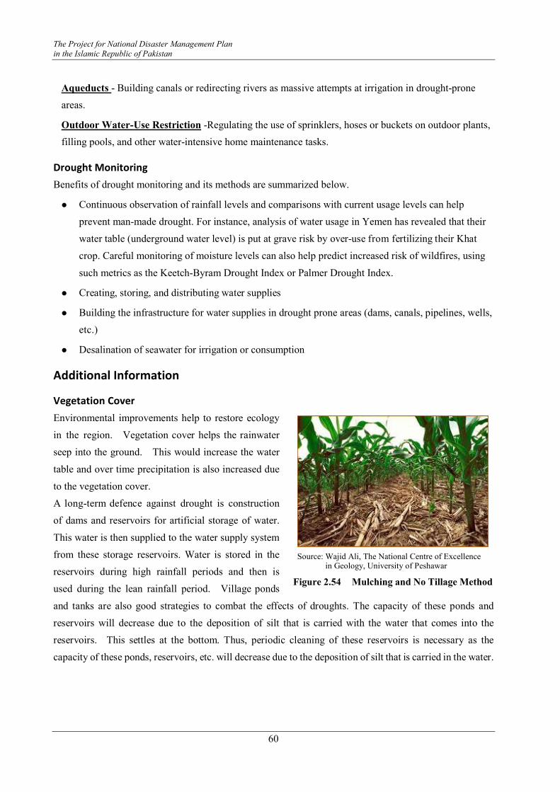
The Project for National Disaster Management Plan
in the Islamic Republic of Pakistan
60
Aqueducts - Building canals or redirecting rivers as massive attempts at irrigation in drought-prone
areas.
Outdoor Water-Use Restriction -Regulating the use of sprinklers, hoses or buckets on outdoor plants,
filling pools, and other water-intensive home maintenance tasks.
Drought Monitoring
Benefits of drought monitoring and its methods are summarized below.
� Continuous observation of rainfall levels and comparisons with current usage levels can help
prevent man-made drought. For instance, analysis of water usage in Yemen has revealed that their
water table (underground water level) is put at grave risk by over-use from fertilizing their Khat
crop. Careful monitoring of moisture levels can also help predict increased risk of wildfires, using
such metrics as the Keetch-Byram Drought Index or Palmer Drought Index.
� Creating, storing, and distributing water supplies
� Building the infrastructure for water supplies in drought prone areas (dams, canals, pipelines, wells,
etc.)
� Desalination of seawater for irrigation or consumption
Additional Information
Vegetation Cover
Environmental improvements help to restore ecology
in the region. Vegetation cover helps the rainwater
seep into the ground. This would increase the water
table and over time precipitation is also increased due
to the vegetation cover.
A long-term defence against drought is construction
of dams and reservoirs for artificial storage of water.
This water is then supplied to the water supply system
from these storage reservoirs. Water is stored in the
reservoirs during high rainfall periods and then is
used during the lean rainfall period. Village ponds
and tanks are also good strategies to combat the effects of droughts. The capacity of these ponds and
reservoirs will decrease due to the deposition of silt that is carried with the water that comes into the
reservoirs. This settles at the bottom. Thus, periodic cleaning of these reservoirs is necessary as the
capacity of these ponds, reservoirs, etc. will decrease due to the deposition of silt that is carried in the water.
Source: Wajid Ali, The National Centre of Excellence in Geology, University of Peshawar
Figure 2.54 Mulching and No Tillage Method
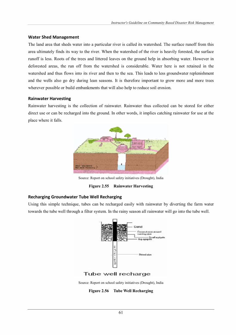
Instructor's Guideline on Community Based Disaster Risk Management
61
Water Shed Management
The land area that sheds water into a particular river is called its watershed. The surface runoff from this
area ultimately finds its way to the river. When the watershed of the river is heavily forested, the surface
runoff is less. Roots of the trees and littered leaves on the ground help in absorbing water. However in
deforested areas, the run off from the watershed is considerable. Water here is not retained in the
watershed and thus flows into its river and then to the sea. This leads to less groundwater replenishment
and the wells also go dry during lean seasons. It is therefore important to grow more and more trees
wherever possible or build embankments that will also help to reduce soil erosion.
Rainwater Harvesting
Rainwater harvesting is the collection of rainwater. Rainwater thus collected can be stored for either
direct use or can be recharged into the ground. In other words, it implies catching rainwater for use at the
place where it falls.
Source: Report on school safety initiatives (Drought), India
Figure 2.55 Rainwater Harvesting
Recharging Groundwater Tube Well Recharging
Using this simple technique, tubes can be recharged easily with rainwater by diverting the farm water
towards the tube well through a filter system. In the rainy season all rainwater will go into the tube well.
Source: Report on school safety initiatives (Drought), India
Figure 2.56 Tube Well Recharging
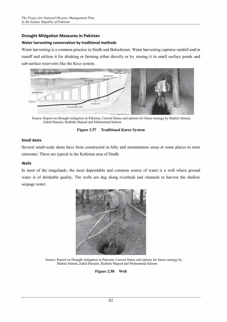
The Project for National Disaster Management Plan
in the Islamic Republic of Pakistan
62
Drought Mitigation Measures in Pakistan
Water harvesting conservation by traditional methods
Water harvesting is a common practice in Sindh and Balochistan. Water harvesting captures rainfall and/or
runoff and utilizes it for drinking or farming either directly or by storing it in small surface ponds and
sub-surface reservoirs like the Krez system.
Source: Report on Drought mitigation in Pakistan, Current Status and options for future strategy by Shahid Ahmed,
Zahid Hussain, Rashida Majeed and Mohammad Saleem
Figure 2.57 Traditional Karez System
Small dams
Several small-scale dams have been constructed in hilly and mountainous areas at some places to store
rainwater. These are typical in the Kohistan area of Sindh.
Wells
In most of the rangelands, the most dependable and common source of water is a well where ground
water is of drinkable quality. The wells are dug along riverbeds and channels to harvest the shallow
seepage water.
Source: Report on Drought mitigation in Pakistan, Current Status and options for future strategy by Shahid Ahmed, Zahid Hussain, Rashida Majeed and Mohammad Saleem
Figure 2.58 Well

Instructor's Guideline on Community Based Disaster Risk Management
63
Artificial recharge to ground water
A possible solution is artificial recharge of groundwater. The artificial recharge techniques include:
� planting of appropriate plant species
� inverted wells
� recharge dams
� loose stone check dams
� deep dug wells
� ponds and recharge basins
� depressions
� benching
� spreading of water
Watercourse improvement
Considerable wastage of water occurs in watercourses. In Sindh Province, such losses were in the range
of 44%. After lining with Poly Vinyl Chloride (PVC) Geo-membrane, water losses were reduced to 33%.
Overall in Pakistan, about 33% of total watercourses have been improved.
Improved furrow-ridge planting
The basin irrigation method is commonly used in the Sindh and Balochistan provinces, with the highest
water consumption and the lowest water efficiency. Furrow-bed irrigation is considered the most efficient
method of water application. Raising row crops like cotton on beds with row-to-row spacing of 75cm is
gaining popularity amongst the farmers, mainly because it saves water; the cost of crop production is also
substantially reduced. Planting of cotton in beds and furrow irrigation has resulted in a 30-35% increase
in yield with around a 40-45% saving in water (International Water Management Institute:IWMI 1999a).
The technique is also being evaluated for rice production and has the potential to enable growing rice with
less water (Gill et al., 2002)
Adjusting cropping patterns
Sindh: Cotton instead of rice, sugarcane instead of mango and banana orchards
Balochistan: Apple orchards replaced with pomegranate
Drought monitoring
Monitoring of drought related hydro-meteorological and other variables in Pakistan is carried out by
several agencies, including the Pakistan Meteorological Department, Water and Power Development
Authority, Provincial Irrigation and Drainage Authorities and district governments.

The Project for National Disaster Management Plan
in the Islamic Republic of Pakistan
64
Developing regional drought monitoring systems
The success of drought preparedness and mitigation depends, to a large extent, upon timely information
on the components of any drought management program. Drought monitoring and early warning systems
should be the major national initiatives emphasize this need.
Analysis of drought related policies and institutions
The success of drought mitigation is determined by the effectiveness of drought related policies and
institutions.
A number of issues for policy development will certainly also emerge from the results of socio-economic
surveys described in the next section.
All studies emphasize that a shift is needed from the current emphasis on ad-hoc relief measures to
drought preparedness with a focus on measures taken in advance of a drought.
A Pakistan study revealed that no national-level
integrated institutional mechanism is operational in the
country at present and that drought related programs at
federal and provincial levels and the efforts of civil
society and NGO’s are not coordinated. The suggestion
was made to develop a National Drought Policy
Commission, which will guide the relevant policy and
institutional development for drought mitigation and will
coordinate the different ministries and line agencies
involved. For implementation of the National Drought
Policy to be developed, it is suggested to establish an
apex organization, which would coordinate and monitor policy interventions at the federal level and
motivate provincial governments to establish similar organizational set-ups. A drought expert's input will
be useful to prepare the outline for the proposed organization at all levels.
Socio-economic surveys
Where livelihoods of the large strata of population are directly dependent on agriculture, physical water
availability and access to reliable water sources are the two fundamental factors influencing the level of
poverty in general and the magnitude of detrimental impacts of droughts and responses to drought in
particular. The agricultural sector is the most vulnerable to drought. Traditional irrigation systems get
completely exhausted during prolonged droughts and rehabilitation of such systems should be given a
priority.
Consequences of Droughts
The present drought situation in Pakistan is as follows.
� Diminished crop growth or yield productions and carrying capacity for livestock
� Dust bowls, themselves a sign of erosion, which further erode the landscape
Source: Wajid Ali, The National Centre of Excellence in Geology, University of Peshawar
Figure 2.59 Water Dripping Irrigation

Instructor's Guideline on Community Based Disaster Risk Management
65
� Dust storms, when drought hits an area suffering from desertification and erosion
� Famine due to lack of water for irrigation
� Habitat damage, affecting both terrestrial and aquatic wildlife
� Malnutrition, dehydration and related diseases
� Mass migration, resulting in internal displacement and international refugees
� Reduced electricity production due to insufficient available coolant for power stations; and reduced
water flow through hydroelectric dams
� Shortages of water for industrial users
� Snake migrations and increases in snakebites
� Social unrest
� War over natural resources, including water and food
Present Drought Situation in Pakistan
The present drought situation in Pakistan is as follows.
� The Government of Balochistan has declared all 22 districts as calamity-hit on account of drought.
The only exceptions are the urban parts of Quetta and Pat Feeder regions. The affected districts are
Quetta, Chagai, Kharan, Khuzdar, Kalat, Mastung, Loralai, Killa Saifullah, Pishin, Zhob, Kohlu,
Lasbela, Sibi, Dera Bugti, Ziarat, Awaran, Kech, Panjgoor, Killa Abdullah, Gwadar, Kachhi and
non-irrigated areas of Tehsils Chattar and Tamboo of Nasirabad District.
� The Government of Sindh has likewise declared the entire Tharparkar and Dadu districts
calamity-hit along with parts of 10 other districts as well as the defunct Malir district. The districts
declared calamity-hit are: Tharparkar, Dadu, Thatta, Mirpurkhas, Badin, Ghotki, Sanghar, Larkana,
Jacobabad, Sukkur, Khairpur, Shikarpur and parts of the defunct Malir district.
� Attock District in Punjab has also been declared c calamity-hit by the provincial government due to
the drought. Additionally, the rain fed regions of Punjab province namely: Pothohar belt, Mianwali,
D.G. Khan, Rajanpur and southern districts of Punjab province continue to suffer from serious
drought affects.
� The Khyber-Pakhtoonkhwa Government has declared Haripur and Mansehra districts as
calamity-hit. The southern districts of the province, namely: Kohat, Karak, Bannu and D.I. Khan,
are also impacted by the ill effects of drought.
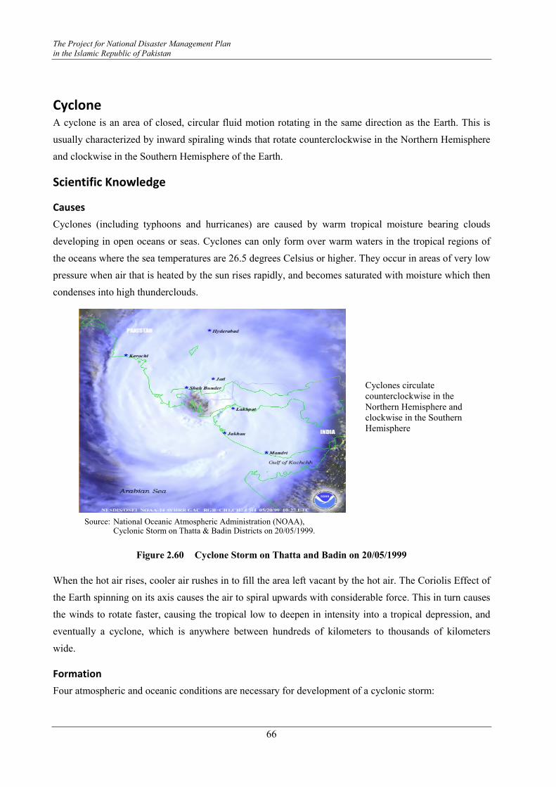
The Project for National Disaster Management Plan
in the Islamic Republic of Pakistan
66
Cyclone A cyclone is an area of closed, circular fluid motion rotating in the same direction as the Earth. This is
usually characterized by inward spiraling winds that rotate counterclockwise in the Northern Hemisphere
and clockwise in the Southern Hemisphere of the Earth.
Scientific Knowledge
Causes
Cyclones (including typhoons and hurricanes) are caused by warm tropical moisture bearing clouds
developing in open oceans or seas. Cyclones can only form over warm waters in the tropical regions of
the oceans where the sea temperatures are 26.5 degrees Celsius or higher. They occur in areas of very low
pressure when air that is heated by the sun rises rapidly, and becomes saturated with moisture which then
condenses into high thunderclouds.
Figure 2.60 Cyclone Storm on Thatta and Badin on 20/05/1999
When the hot air rises, cooler air rushes in to fill the area left vacant by the hot air. The Coriolis Effect of
the Earth spinning on its axis causes the air to spiral upwards with considerable force. This in turn causes
the winds to rotate faster, causing the tropical low to deepen in intensity into a tropical depression, and
eventually a cyclone, which is anywhere between hundreds of kilometers to thousands of kilometers
wide.
Formation
Four atmospheric and oceanic conditions are necessary for development of a cyclonic storm:
Cyclones circulate counterclockwise in the Northern Hemisphere and clockwise in the Southern Hemisphere
Source: National Oceanic Atmospheric Administration (NOAA), Cyclonic Storm on Thatta & Badin Districts on 20/05/1999.
Instructor's Guideline on Community Based Disaster Risk Management
67
� A warm sea temperature in excess of 26 °C, to a depth of 60 m
� High relative humidity (degree to which the air is saturated by water vapor) of the atmosphere to a
height of about 7000 m
� Atmospheric instability (an above average decrease of temperature with altitude)
� A location of at least 4-5 degrees of latitude from the Equator allows the influence of the forces due
to the earth’s rotation (Coriolis force) to take effect in inducing cyclonic wind circulations around
low pressure centres.
Types of Cyclones
Types of cyclones are categorized as follows:
� A tropical cyclone is the generic term for non-frontal synoptic scale low-pressure systems over
tropical or sub-tropical waters with organized convection (i.e. thunderstorm activity) and definite
cyclonic surface wind circulation.
� Tropical Depressions is a cyclone with maximum sustained surface winds of less than 17 m/s (34
kt, 39 mph).
� If a Tropical Storm is with winds of at least 17 m/s (34 kt, 39 mph), a name is assigned. If winds
reach 33 m/s (64 kt, 74 mph), then they are called as follows.
- "Hurricane": occurs in the north Atlantic Ocean, the northeast Pacific Ocean east of the
dateline, or the south Pacific Ocean east of 160oE
- "Typhoon": occurs in the northwest Pacific Ocean, west of the dateline
- "Severe tropical cyclone": occurs in the southwest Pacific Ocean, west of 160oE or
Southeast Indian Ocean east of 90oE
- "Severe cyclonic storm": occurs in the north Indian Ocean
- "Tropical cyclone": occurs in the southwest Indian Ocean
Tropical cyclones are classified according to the maximum winds that accompany them as indicated in
the following:
Table 2.8 Major Types of Cyclone
Type Classification
Depression winds up to 33 Knots
Storm winds from 34 to 47 Knots
Severe Tropical Storm winds from 48 to 63 Knots Cyclone
Categorized Cyclone (Hurricane) winds of 64 Knots or more
Source: PMD
Scales of Intensity
Intensity of a “tropical cyclone” is determined according to:
� the Saffir-Simpson Scale in the United States, and
� the Beaufort Scale.

The Project for National Disaster Management Plan
in the Islamic Republic of Pakistan
68
The intensity of a cyclone with winds of 64 knots or more has been divided into the following five
categories shown in the Table 2.9.
Table 2.9 Categories of Cyclone
Category Sustained Winds Storm Surge (feet) Central Pressure (mbar)
Category-1 64-82 4-5 980-989
Category-2 83-95 6-8 965-979
Category-3 96-113 9-12 945-964
Category-4 114-135 13-18 920-944
Category-5 >136 >19 <920
Source: PMD
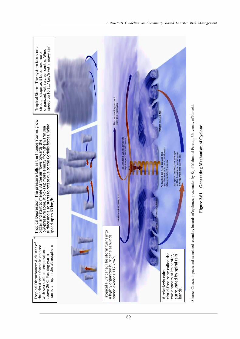
69
Instructor's Guideline on Community Based Disaster Risk Management
So
urc
e: C
ause
s, i
mp
acts
an
d a
ssoci
ated
sec
on
dar
y h
azar
ds
of
cycl
on
es,
pre
sen
tati
on
by S
ajid
Mah
mo
od
Far
ooq
i, U
niv
ersi
ty o
f K
arac
hi.
Fig
ure
2.6
1
Gen
erati
ng M
echanis
m o
f C
ycl
one
Tro
pic
al
Sto
rm:
Th
e s
yst
em
ta
ke
s o
n a
ci
rcu
lar
sha
pe
as
it b
eco
me
s m
ore
o
rga
niz
ed
, w
ith
a c
lea
r ce
ntr
e.
Win
d
spe
ed
up
to
11
7 k
m/h
wit
h h
ea
vy
rain
.
Tro
pic
al
De
pre
ssio
n:
Th
e p
ress
ure
fa
lls
as
the
th
un
de
rsto
rms
gro
w
big
ge
r a
nd
sta
rt t
o m
erg
e.
As
the
air
flo
ws
tow
ard
s th
e
low
-pre
ssu
re z
on
e,
it p
ick
s u
p m
ore
en
erg
y f
rom
th
e w
arm
se
a
surf
ace
an
d a
lso
sta
rts
to r
ota
te d
ue
to
th
e C
ori
oli
s fo
rce
s. W
ind
sp
ee
d u
p t
o 6
3 k
m/h
.
Tro
pic
al
Dis
turb
an
ce:
A c
lust
er
of
thu
nd
ers
torm
s fo
rms
in a
n a
rea
w
ith
se
a s
urf
ace
te
mp
era
ture
a
bo
ve
26
C.
Pu
shin
g w
arm
h
um
id a
ir u
p i
n t
he
atm
osp
he
re
Tro
pic
al
Hu
rric
an
e;
Th
e s
torm
tu
rns
into
a
hig
hly
org
an
ize
d h
urr
ica
ne
as
win
ds
spe
ed
exc
ee
ds
11
7 k
m/h
.
A r
ela
tiv
ely
ca
lm
clo
ud
-fre
e z
on
e c
all
ed
th
e
ey
e a
pp
ea
rs a
t it
s ce
nte
r,
surr
ou
nd
ed
by
sp
ira
l ra
in
ba
nd
s.

70
The Project for National Disaster Management Plan
in the Islamic Republic of Pakistan
S
ou
rce:
Cau
ses,
im
pac
ts a
nd
ass
oci
ated
sec
on
dar
y h
azar
ds
of
cycl
on
es,
pre
sen
tati
on
by S
ajid
Mah
mo
od
Far
ooq
i , U
niv
ersi
ty o
f K
arac
hi.
Fig
ure
2.6
2
Sit
uati
ons
of
Tro
pic
al Sto
rm b
y C
ate
gori
es
Instructor's Guideline on Community Based Disaster Risk Management
71
Cyclone Warning Centres
There are six Regional Specialized Meteorological Centres (RSMCs) worldwide. These organizations are
designated by the World Meteorological Organization and are responsible for tracking and issuing
bulletins, warnings, and advisories about tropical cyclones in their designated areas of responsibility.
Additionally, there are six Tropical Cyclone Warning Centres (TCWCs) that provide information to
smaller regions.
Pakistan Meteorological Department (PMD) is responsible for issuing cyclone warnings and updates at
the national, provincial and district levels.
Cyclone Risks in Pakistan
Features of cyclone risks in Pakistan are summarized below.
� Due to the rarity of the phenomena this hazard has gotten little attention and usually only after the
hazard strikes.
� Only three tropical cyclones of different intensities have made landfall on Pakistani coasts.
� Changing global climatic patterns are showing a change in the trend of occurrences of weather
related hazards.
� The Pakistani coast being in a subtropical location and in close vicinity to warm waters might be hit
by tropical cyclones in the future.
� There is an ever increasing need to be prepared in advance to cope with any such disastrous event
in the future.
Areas Vulnerable to Cyclones
Areas that are vulnerable to cyclones are as follows:
� Sindh Province (Karachi, Thatta, Badin)
� Balochistan Province (Gwadar, Kech, Lasbella)
Impacts
Historical review
The history of cyclone occurrences is described as below.
� The Cyclone of 1999 seriously impacted Thatta and Badin Districts (affected 0.6 million people
and caused the loss of 202 lives)
� Cyclone Yemyin in 2007 affected 26 districts of Balochistan and Sindh (affected 2.5 million
people and caused loss of 400 lives).
Damages in Sindh
- 110 dead
- Approx 50,000 homeless
The Project for National Disaster Management Plan
in the Islamic Republic of Pakistan
72
- Over two dozen missing at sea
- Severe electric power disruption; especially in Karachi
- Damage to crops, orchards, poultry farms, livestock and fishing boats
- Over 3000 kacha houses damaged
Damage in Balochistan
- 132 dead
- 170 people missing
- Total affected population was one million
- Over 100,000 homeless due to collapsed/ damaged houses
- Severe disruption of electric power, water and communications
- Large-scale damage to Makran coastal highway
� Phet Cyclone 2010
- On 31 May 2010, a tropical depression in the Central Arabian Sea resulted in formation of
tropical cyclone “Phet”. “Phet” struck the northeast tip of Oman coast during the night of
June 4, 2010 and moved towards the coastal areas of Balochistan and Sindh. Cyclone Phet
entered Pakistan’s coastal areas on June 6, 2010 with a sustained wind speed of 60 to 80
km/hour. Phet had already lost much of its intensity after hitting the Omani coastal areas
two days prior to reaching landfall in Pakistan. By the time it hit the coastal area of Pakistan,
the cyclone had been downgraded to a tropical storm. Nevertheless, Phet caused heavy
rainfalls – as much as 370 mm in the coastal town of Gwadar in Balochistan.
- The cyclone narrowly missed Karachi and made landfall near the fishing town of Keti
Bandar and then it hit Thatta, Badin and Hyderabad Districts in Sindh. The storm disrupted
life in the coastal areas of Balochistan and Sindh, where several hundred mud houses
collapsed and roads were blocked and damaged. Thousands of coastal communities were
evacuated before the cyclone hit the coastal areas and as a result, the loss of lives was greatly
reduced.
Means of Destruction
Tropical cyclones are characterized by their destructive winds, storm surges and exceptional level of
rainfall that may cause flooding.
Destructive winds
� The strong winds generated by a tropical cyclone circulate counterclockwise in the Northern
Hemisphere, while spiraling inwards and increasing toward the cyclone centre. Wind speeds
progressively increase toward the core.
� 150 to 300 km from the centre of a typical mature cyclone, winds of 63-88 km/h
� 100-150 km from the centre, storm force winds of 89-117 km/h
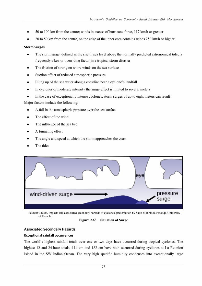
Instructor's Guideline on Community Based Disaster Risk Management
73
� 50 to 100 km from the centre; winds in excess of hurricane force, 117 km/h or greater
� 20 to 50 km from the centre, on the edge of the inner core contains winds 250 km/h or higher
Storm Surges
� The storm surge, defined as the rise in sea level above the normally predicted astronomical tide, is
frequently a key or overriding factor in a tropical storm disaster
� The friction of strong on-shore winds on the sea surface
� Suction effect of reduced atmospheric pressure
� Piling up of the sea water along a coastline near a cyclone’s landfall
� In cyclones of moderate intensity the surge effect is limited to several meters
� In the case of exceptionally intense cyclones, storm surges of up to eight meters can result
Major factors include the following:
� A fall in the atmospheric pressure over the sea surface
� The effect of the wind
� The influence of the sea bed
� A funneling effect
� The angle and speed at which the storm approaches the coast
� The tides
Source: Causes, impacts and associated secondary hazards of cyclones, presentation by Sajid Mahmood Farooqi, University of Karachi.
Figure 2.63 Situation of Surge
Associated Secondary Hazards
Exceptional rainfall occurrences
The world’s highest rainfall totals over one or two days have occurred during tropical cyclones. The
highest 12 and 24-hour totals, 114 cm and 182 cm have both occurred during cyclones at La Reunion
Island in the SW Indian Ocean. The very high specific humidity condenses into exceptionally large

The Project for National Disaster Management Plan
in the Islamic Republic of Pakistan
74
raindrops and giant cumulus clouds, resulting in high precipitation rates. When a cyclone makes landfall,
the rain rapidly saturates even dry catchment areas and rapid runoff may explosively flood the usual
watercourses and create new ones.
Physical damage
Structures can be damaged or destroyed by wind force, through collapse from pressure differentials, by
flooding, storm surge and landslides. Standing crops may be lost to floods, storm surges, and seawater
salinity. Salt from storm surges may also be deposited on agricultural lands and increase groundwater
salinity. Fruit, nut or lumber trees may be damaged or destroyed by winds, flood or storm surges.
Plantation type crops such as banana and coconut are extremely vulnerable.
Erosion could occur from flooding and storm surges. Additional items subject to severe damage include
overhead power lines, bridges, culverts and drainage systems, jetties and retaining walls, embankments
and coastal dikes, general lack of weatherproofing of buildings, huge losses to building work in progress,
scaffolding, marinas, and roofs of most structures. Falling trees, wind-driven rain and flying debris cause
considerable damage.
Casualties and public health
There are usually relatively few fatalities but there may be numerous casualties requiring hospital
treatment due to the high winds associated with cyclonic storms. Storm surges may cause many deaths
but usually few injuries among the survivors. Due to flooding and possible contamination of water
supplies, malaria and other viruses may be prevalent several weeks after the flooding.
Contamination of water supplies
Open wells and other ground water supplies may be temporarily contaminated by floodwaters and storm
surges. They may be contaminated by pathogenic (disease producing) organisms if bodies of people or
animals are lying in the sources or sewage is swept in. Normal water sources may be unavailable for
several days.
Disruption of communications and logistics
Communications may be severely disrupted as telephone lines, radio antennas and satellite disks are
brought down, usually by wind. Roads and railroad lines may be blocked by fallen trees or debris and
aircraft movements will be curtailed for at least 12 to 24 hours after the storm. Modes of transportation
such as trucks, carts and small boats may be damaged by wind or flooding. The cumulative effect of all
damage will be to impede information gathering and transport networks.
Mitigation and Preparedness
Structural
Sea walls and embankments
A sea wall is a coastal defence constructed usually of reinforced concrete on the inland part of a coast to
prevent the ingress of storm surges arising out of cyclones. The height of the sea wall is determined
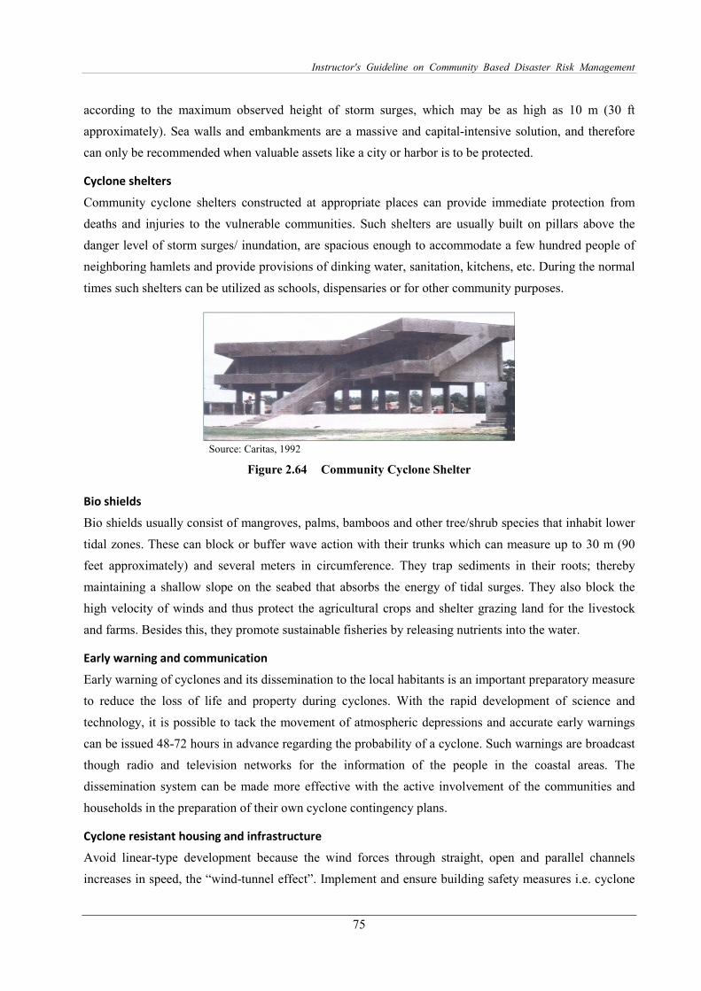
Instructor's Guideline on Community Based Disaster Risk Management
75
according to the maximum observed height of storm surges, which may be as high as 10 m (30 ft
approximately). Sea walls and embankments are a massive and capital-intensive solution, and therefore
can only be recommended when valuable assets like a city or harbor is to be protected.
Cyclone shelters
Community cyclone shelters constructed at appropriate places can provide immediate protection from
deaths and injuries to the vulnerable communities. Such shelters are usually built on pillars above the
danger level of storm surges/ inundation, are spacious enough to accommodate a few hundred people of
neighboring hamlets and provide provisions of dinking water, sanitation, kitchens, etc. During the normal
times such shelters can be utilized as schools, dispensaries or for other community purposes.
Source: Caritas, 1992
Figure 2.64 Community Cyclone Shelter
Bio shields
Bio shields usually consist of mangroves, palms, bamboos and other tree/shrub species that inhabit lower
tidal zones. These can block or buffer wave action with their trunks which can measure up to 30 m (90
feet approximately) and several meters in circumference. They trap sediments in their roots; thereby
maintaining a shallow slope on the seabed that absorbs the energy of tidal surges. They also block the
high velocity of winds and thus protect the agricultural crops and shelter grazing land for the livestock
and farms. Besides this, they promote sustainable fisheries by releasing nutrients into the water.
Early warning and communication
Early warning of cyclones and its dissemination to the local habitants is an important preparatory measure
to reduce the loss of life and property during cyclones. With the rapid development of science and
technology, it is possible to tack the movement of atmospheric depressions and accurate early warnings
can be issued 48-72 hours in advance regarding the probability of a cyclone. Such warnings are broadcast
though radio and television networks for the information of the people in the coastal areas. The
dissemination system can be made more effective with the active involvement of the communities and
households in the preparation of their own cyclone contingency plans.
Cyclone resistant housing and infrastructure
Avoid linear-type development because the wind forces through straight, open and parallel channels
increases in speed, the “wind-tunnel effect”. Implement and ensure building safety measures i.e. cyclone
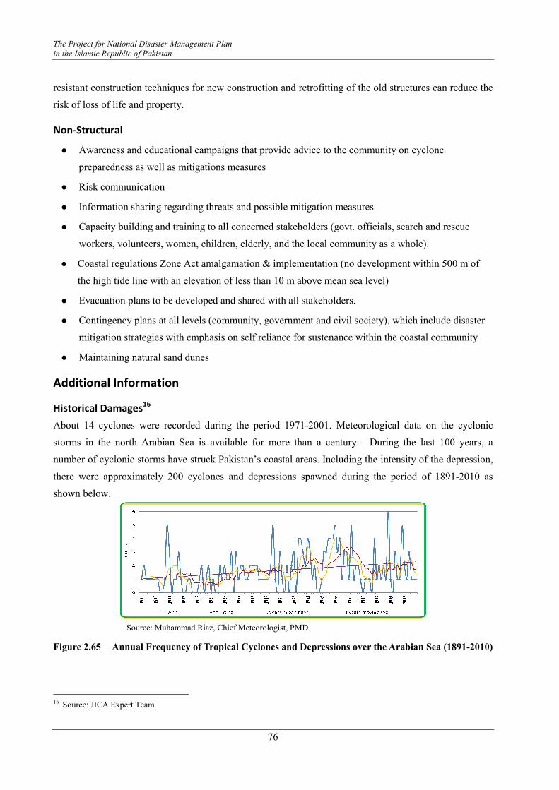
The Project for National Disaster Management Plan
in the Islamic Republic of Pakistan
76
resistant construction techniques for new construction and retrofitting of the old structures can reduce the
risk of loss of life and property.
Non-Structural
� Awareness and educational campaigns that provide advice to the community on cyclone
preparedness as well as mitigations measures
� Risk communication
� Information sharing regarding threats and possible mitigation measures
� Capacity building and training to all concerned stakeholders (govt. officials, search and rescue
workers, volunteers, women, children, elderly, and the local community as a whole).
� Coastal regulations Zone Act amalgamation & implementation (no development within 500 m of
the high tide line with an elevation of less than 10 m above mean sea level)
� Evacuation plans to be developed and shared with all stakeholders.
� Contingency plans at all levels (community, government and civil society), which include disaster
mitigation strategies with emphasis on self reliance for sustenance within the coastal community
� Maintaining natural sand dunes
Additional Information
Historical Damages16
About 14 cyclones were recorded during the period 1971-2001. Meteorological data on the cyclonic
storms in the north Arabian Sea is available for more than a century. During the last 100 years, a
number of cyclonic storms have struck Pakistan’s coastal areas. Including the intensity of the depression,
there were approximately 200 cyclones and depressions spawned during the period of 1891-2010 as
shown below.
Source: Muhammad Riaz, Chief Meteorologist, PMD
Figure 2.65 Annual Frequency of Tropical Cyclones and Depressions over the Arabian Sea (1891-2010)
16 Source: JICA Expert Team.

Instructor's Guideline on Community Based Disaster Risk Management
77
The years when these cyclones and depressions occurred in Pakistan are as follows:
Table 2.10 Years Having Cyclone Occurrence in Pakistan
Item Years
Years Involved 1895, 1902, 1907, 1948, 1964, 1965, 1985, 1993, 1998, 1999, 2007 and 2010
Source: JICA Study Team
The cyclonic storms in 1895 struck the Mehran coast near Pasni and Jiwani. In the early 1900s, three
cyclonic storms–two in 1902 (13 May and 16 June) and one in 1907 (6 June) - struck the coast in the
vicinity of Karachi within a short span of six years. The cyclonic storm in 1964, which actually entered
the Indian coast, caused great loss of life and property in Hyderabad and Tharparkar districts as it moved
northeastward into south eastern areas of Sindh. The cyclonic storms in 1984 struck the Mehran coast
near Pasni and Jiwani, similar to the cyclone of 1895. In 1998 and 1999, southwestern districts in Sindh
were affected by the Cyclones Gujarat and 2A in 1998 and 1999, respectively.
The 2007 cyclone (Cyclone Yemyin) killed at least 213 people in Karachi from rains and winds that
might have been associated with an outer band of the cyclone, packing at least 70 mph (112 km/h) winds
that lashed at the city on 23 June 23 2007. PMD had warned of heavy rains and wind from the system as
early as 22 June. The heavy downpour also flooded the Kech Korandi riverine, inundating the city of
Turbat and forcing more than 10,000 people to evacuate their houses. At least another 380 people died in
Balochistan, with another 250 dead in Sindh and 100 in KP. More rains associated with the remnants of
the cyclone hampered rescue efforts. The cyclone affected at least 10 districts of Balochistan and 4
districts of Sindh, affecting the lives of at least 1.5 million people. At least 2 million people were
indirectly affected by the cyclone from power outages and water shortages in Balochistan. More than 2
million livestock, worth over Rs.4 billion, were killed by the cyclone. Property losses from the storm
were estimated at Rs.24 billion.
In 2010, Cyclone Phet brought extremely heavy rainfall over the
coastal areas of Balochistan (Gwadar 370 mm, Jiwani 208 mm, Pasni
139 mm) accompanied with very strong winds gusting to 120 km/h. On
6 June, rain started in Karachi (Masroor 133 mm, Faisal 92 mm,
Saddar 84 mm up to midday of 6 June) with 35 mph (56 km/h) winds
under the influence of the cyclone, disrupting the city's railways and
electricity transmission systems. At least 15 people were killed, mostly
by electrocution, and dozens were injured. Cyclone Phet has also left
thousands of Pakistanis homeless. In the evening, the storm moved
past Karachi about 50 km away and made landfall between the
coastlines of Thatta and Badin, causing heavy rains in the area. The
Hyderabad power supply was also disrupted from the downpour.

The Project for National Disaster Management Plan
in the Islamic Republic of Pakistan
78
References:
1. Sajid Mahmood Farooqi, Research Student University of Karachi, Presentation presented in cyclone
training, April 26, 2010, Organized by NIDM
2. Wajid Ali, National Centre of Excellence in Geology, University of Peshawar
3. Power Point Presentation: Scientific Knowledge on Cyclones in Pakistan, JICA Expert Team
4. NOAA Technical memorandum
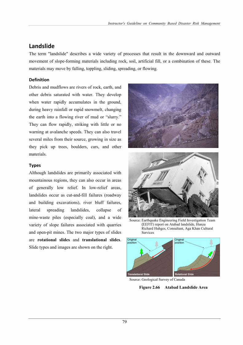
Instructor's Guideline on Community Based Disaster Risk Management
79
Landslide The term "landslide" describes a wide variety of processes that result in the downward and outward
movement of slope-forming materials including rock, soil, artificial fill, or a combination of these. The
materials may move by falling, toppling, sliding, spreading, or flowing.
Definition
Debris and mudflows are rivers of rock, earth, and
other debris saturated with water. They develop
when water rapidly accumulates in the ground,
during heavy rainfall or rapid snowmelt, changing
the earth into a flowing river of mud or “slurry.”
They can flow rapidly, striking with little or no
warning at avalanche speeds. They can also travel
several miles from their source, growing in size as
they pick up trees, boulders, cars, and other
materials.
Types
Although landslides are primarily associated with
mountainous regions, they can also occur in areas
of generally low relief. In low-relief areas,
landslides occur as cut-and-fill failures (roadway
and building excavations), river bluff failures,
lateral spreading landslides, collapse of
mine-waste piles (especially coal), and a wide
variety of slope failures associated with quarries
and open-pit mines. The two major types of slides
are rotational slides and translational slides.
Slide types and images are shown on the right.
Source: Earthquake Engineering Field Investigation Team
(EEFIT) report on Atabad landslide, Hunza Richard Huhges, Consultant, Aga Khan Cultural Services
Source: Geological Survey of Canada
Figure 2.66 Atabad Landslide Area
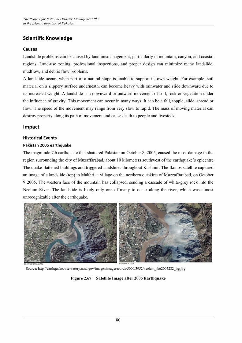
The Project for National Disaster Management Plan
in the Islamic Republic of Pakistan
80
Scientific Knowledge
Causes
Landslide problems can be caused by land mismanagement, particularly in mountain, canyon, and coastal
regions. Land-use zoning, professional inspections, and proper design can minimize many landslide,
mudflow, and debris flow problems.
A landslide occurs when part of a natural slope is unable to support its own weight. For example, soil
material on a slippery surface underneath, can become heavy with rainwater and slide downward due to
its increased weight. A landslide is a downward or outward movement of soil, rock or vegetation under
the influence of gravity. This movement can occur in many ways. It can be a fall, topple, slide, spread or
flow. The speed of the movement may range from very slow to rapid. The mass of moving material can
destroy property along its path of movement and cause death to people and livestock.
Impact
Historical Events
Pakistan 2005 earthquake
The magnitude 7.6 earthquake that shattered Pakistan on October 8, 2005, caused the most damage in the
region surrounding the city of Muzaffarabad, about 10 kilometers southwest of the earthquake’s epicentre.
The quake flattened buildings and triggered landslides throughout Kashmir. The Ikonos satellite captured
an image of a landslide (top) in Makhri, a village on the northern outskirts of Muzzaffarabad, on October
9 2005. The western face of the mountain has collapsed, sending a cascade of white-grey rock into the
Neelum River. The landslide is likely only one of many to occur along the river, which was almost
unrecognizable after the earthquake.
Figure 2.67 Satellite Image after 2005 Earthquake
Source: http://earthquakeobservatory.nasa.gov/images/imagerecords/5000/5952/neelum_iko2005282_irg.jpg
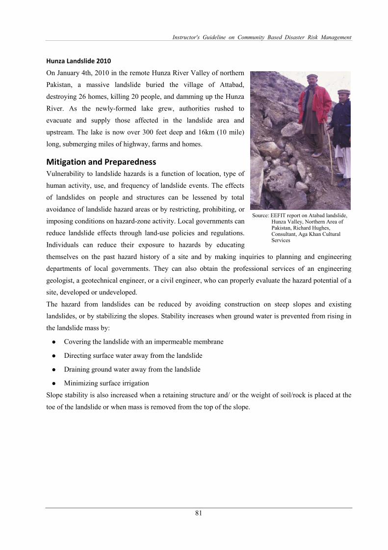
Instructor's Guideline on Community Based Disaster Risk Management
81
Hunza Landslide 2010
On January 4th, 2010 in the remote Hunza River Valley of northern
Pakistan, a massive landslide buried the village of Attabad,
destroying 26 homes, killing 20 people, and damming up the Hunza
River. As the newly-formed lake grew, authorities rushed to
evacuate and supply those affected in the landslide area and
upstream. The lake is now over 300 feet deep and 16km (10 mile)
long, submerging miles of highway, farms and homes.
Mitigation and Preparedness
Vulnerability to landslide hazards is a function of location, type of
human activity, use, and frequency of landslide events. The effects
of landslides on people and structures can be lessened by total
avoidance of landslide hazard areas or by restricting, prohibiting, or
imposing conditions on hazard-zone activity. Local governments can
reduce landslide effects through land-use policies and regulations.
Individuals can reduce their exposure to hazards by educating
themselves on the past hazard history of a site and by making inquiries to planning and engineering
departments of local governments. They can also obtain the professional services of an engineering
geologist, a geotechnical engineer, or a civil engineer, who can properly evaluate the hazard potential of a
site, developed or undeveloped.
The hazard from landslides can be reduced by avoiding construction on steep slopes and existing
landslides, or by stabilizing the slopes. Stability increases when ground water is prevented from rising in
the landslide mass by:
� Covering the landslide with an impermeable membrane
� Directing surface water away from the landslide
� Draining ground water away from the landslide
� Minimizing surface irrigation
Slope stability is also increased when a retaining structure and/ or the weight of soil/rock is placed at the
toe of the landslide or when mass is removed from the top of the slope.
Source: EEFIT report on Atabad landslide, Hunza Valley, Northern Area of Pakistan, Richard Hughes, Consultant, Aga Khan Cultural Services
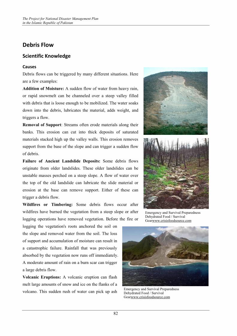
The Project for National Disaster Management Plan
in the Islamic Republic of Pakistan
82
Debris Flow
Scientific Knowledge
Causes
Debris flows can be triggered by many different situations. Here
are a few examples:
Addition of Moisture: A sudden flow of water from heavy rain,
or rapid snowmelt can be channeled over a steep valley filled
with debris that is loose enough to be mobilized. The water soaks
down into the debris, lubricates the material, adds weight, and
triggers a flow.
Removal of Support: Streams often erode materials along their
banks. This erosion can cut into thick deposits of saturated
materials stacked high up the valley walls. This erosion removes
support from the base of the slope and can trigger a sudden flow
of debris.
Failure of Ancient Landslide Deposits: Some debris flows
originate from older landslides. These older landslides can be
unstable masses perched on a steep slope. A flow of water over
the top of the old landslide can lubricate the slide material or
erosion at the base can remove support. Either of these can
trigger a debris flow.
Wildfires or Timbering: Some debris flows occur after
wildfires have burned the vegetation from a steep slope or after
logging operations have removed vegetation. Before the fire or
logging the vegetation's roots anchored the soil on
the slope and removed water from the soil. The loss
of support and accumulation of moisture can result in
a catastrophic failure. Rainfall that was previously
absorbed by the vegetation now runs off immediately.
A moderate amount of rain on a burn scar can trigger
a large debris flow.
Volcanic Eruptions: A volcanic eruption can flash
melt large amounts of snow and ice on the flanks of a
volcano. This sudden rush of water can pick up ash
Emergency and Survival Preparedness Dehydrated Food / Survival Gearwww.crisisfoodsource.com
Emergency and Survival Preparedness Dehydrated Food / Survival Gearwww.crisisfoodsource.com
Instructor's Guideline on Community Based Disaster Risk Management
83
and pyroclastic debris as it flows down the steep volcano and carry them rapidly downstream for great
distances. In the 1877 eruption of Cotopaxi Volcano in Ecuador, debris flows traveled over 300
kilometers down a valley at an average speed of about 27 kilometers per hour. Debris flows are one of the
deadly "surprise attacks" of volcanoes.
Impact
141 Houses (1652 individuals) of Village Attabad & Sarat were displaced due to a landslide on 4 January
2010. The following have been displaced due to inundation (starting from 10 January onwards as of
November, 2010):
Village Ainabad 32 Houses
Village Shishkat 130 Houses
Part of Village Gulmit 61 Houses
Hussaini 10 Houses
Gulkin 7 Houses
Total 240 Houses
Grand Total: (including Atta Abad & Sarat) 381 Houses
Mitigation and Preparedness
The following are steps you can take to protect yourself from the effects of a land/debris flow.
� Do not build near steep slopes, close to mountain edges, near drainage ways, or natural erosion
valleys.
� Get a ground assessment of your property.
� Consult an appropriate professional expert for advice on corrective measures.
� Minimize home hazards by having flexible pipefittings installed to avoid gas or water leaks, as
flexible fittings are more resistant to breakage (only the gas company or professionals should install
gas fittings).

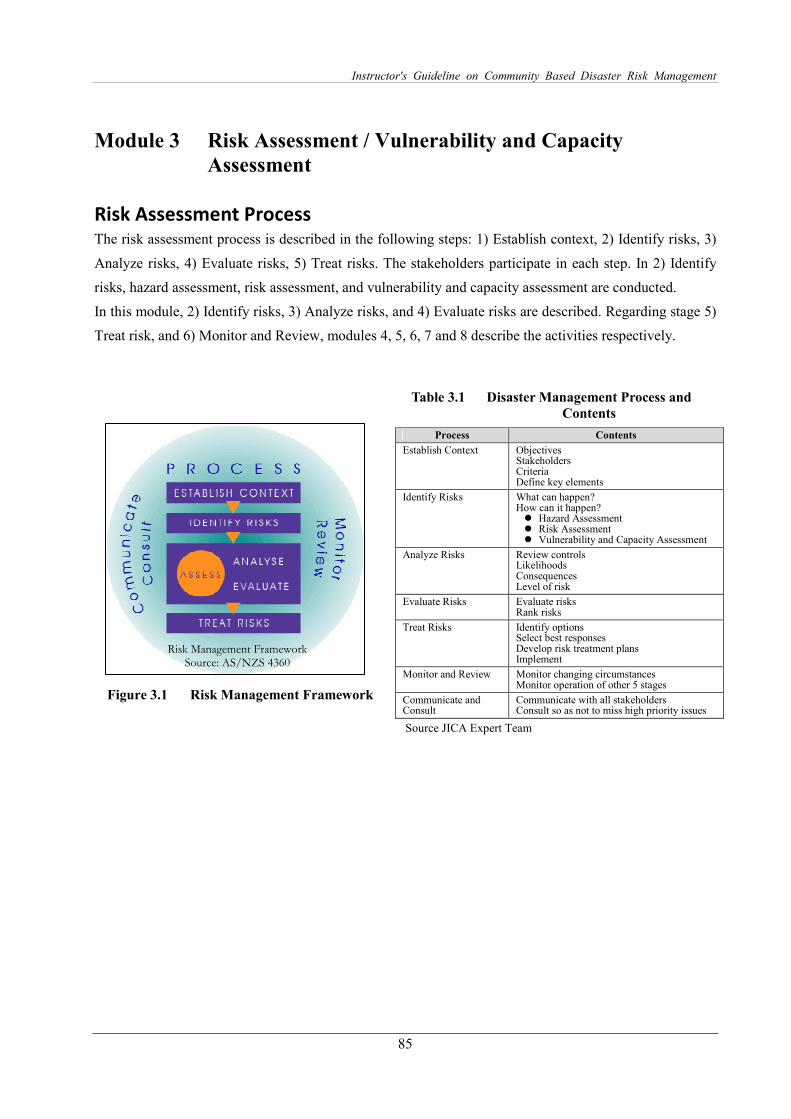
Instructor's Guideline on Community Based Disaster Risk Management
85
Module 3 Risk Assessment / Vulnerability and Capacity
Assessment
Risk Assessment Process The risk assessment process is described in the following steps: 1) Establish context, 2) Identify risks, 3)
Analyze risks, 4) Evaluate risks, 5) Treat risks. The stakeholders participate in each step. In 2) Identify
risks, hazard assessment, risk assessment, and vulnerability and capacity assessment are conducted.
In this module, 2) Identify risks, 3) Analyze risks, and 4) Evaluate risks are described. Regarding stage 5)
Treat risk, and 6) Monitor and Review, modules 4, 5, 6, 7 and 8 describe the activities respectively.
Table 3.1 Disaster Management Process and
Contents
Figure 3.1 Risk Management Framework
Source JICA Expert Team
Process Contents
Establish Context Objectives Stakeholders Criteria Define key elements
Identify Risks What can happen? How can it happen? � Hazard Assessment � Risk Assessment � Vulnerability and Capacity Assessment
Analyze Risks Review controls Likelihoods Consequences Level of risk
Evaluate Risks Evaluate risks Rank risks
Treat Risks Identify options Select best responses Develop risk treatment plans Implement
Monitor and Review Monitor changing circumstances Monitor operation of other 5 stages
Communicate and Consult
Communicate with all stakeholders Consult so as not to miss high priority issues
Risk Management Framework Source: AS/NZS 4360
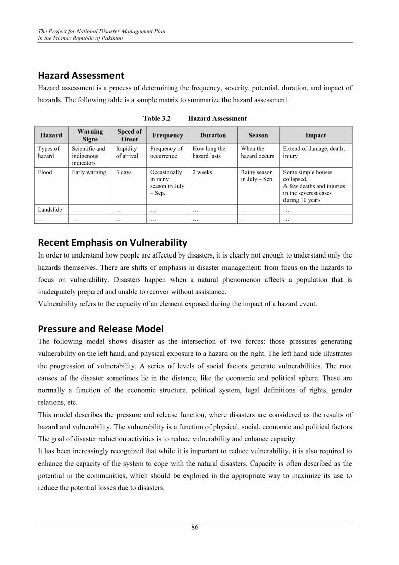
The Project for National Disaster Management Plan
in the Islamic Republic of Pakistan
86
Hazard Assessment Hazard assessment is a process of determining the frequency, severity, potential, duration, and impact of
hazards. The following table is a sample matrix to summarize the hazard assessment.
Table 3.2 Hazard Assessment
Hazard Warning
Signs
Speed of
Onset Frequency Duration Season Impact
Types of hazard
Scientific and indigenous indicators
Rapidity of arrival
Frequency of occurrence
How long the hazard lasts
When the hazard occurs
Extend of damage, death, injury
Flood Early warning 3 days Occasionally in rainy season in July – Sep.
2 weeks Rainy season in July – Sep.
Some simple houses collapsed,
A few deaths and injuries in the severest cases during 10 years
Landslide … … … … … …
… … … … … … …
Recent Emphasis on Vulnerability In order to understand how people are affected by disasters, it is clearly not enough to understand only the
hazards themselves. There are shifts of emphasis in disaster management: from focus on the hazards to
focus on vulnerability. Disasters happen when a natural phenomenon affects a population that is
inadequately prepared and unable to recover without assistance.
Vulnerability refers to the capacity of an element exposed during the impact of a hazard event.
Pressure and Release Model The following model shows disaster as the intersection of two forces: those pressures generating
vulnerability on the left hand, and physical exposure to a hazard on the right. The left hand side illustrates
the progression of vulnerability. A series of levels of social factors generate vulnerabilities. The root
causes of the disaster sometimes lie in the distance, like the economic and political sphere. These are
normally a function of the economic structure, political system, legal definitions of rights, gender
relations, etc.
This model describes the pressure and release function, where disasters are considered as the results of
hazard and vulnerability. The vulnerability is a function of physical, social, economic and political factors.
The goal of disaster reduction activities is to reduce vulnerability and enhance capacity.
It has been increasingly recognized that while it is important to reduce vulnerability, it is also required to
enhance the capacity of the system to cope with the natural disasters. Capacity is often described as the
potential in the communities, which should be explored in the appropriate way to maximize its use to
reduce the potential losses due to disasters.
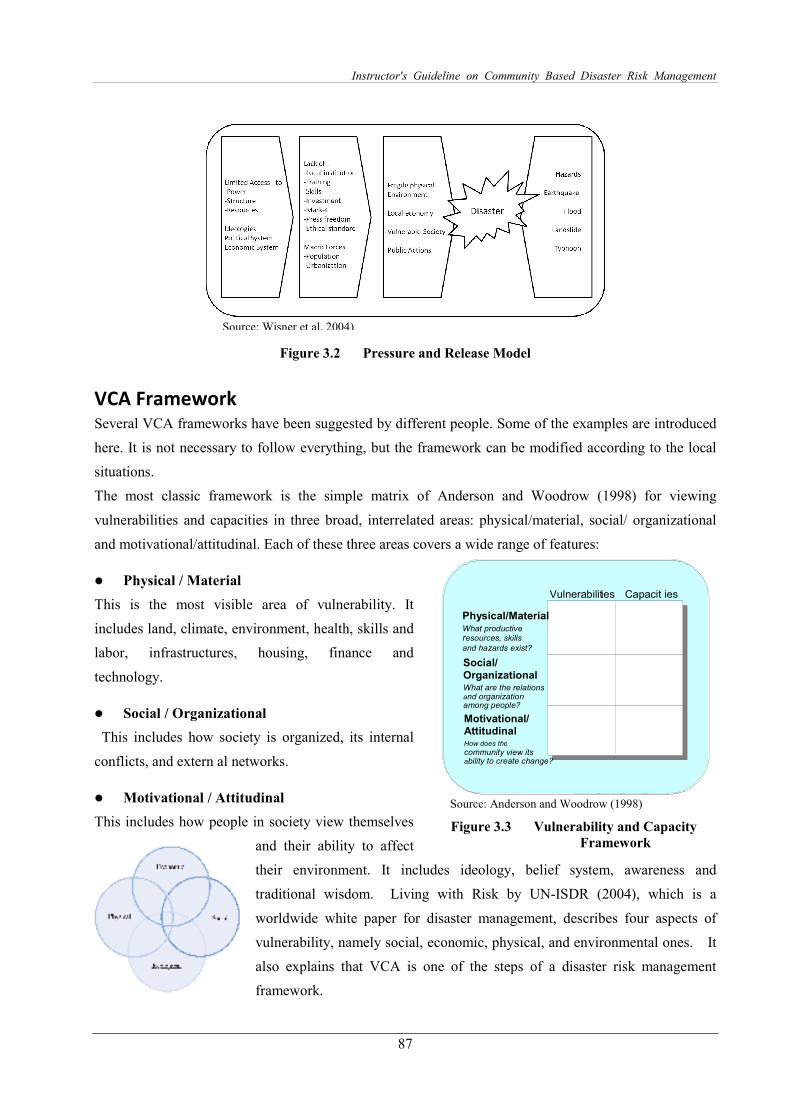
Instructor's Guideline on Community Based Disaster Risk Management
87
Figure 3.2 Pressure and Release Model
VCA Framework Several VCA frameworks have been suggested by different people. Some of the examples are introduced
here. It is not necessary to follow everything, but the framework can be modified according to the local
situations.
The most classic framework is the simple matrix of Anderson and Woodrow (1998) for viewing
vulnerabilities and capacities in three broad, interrelated areas: physical/material, social/ organizational
and motivational/attitudinal. Each of these three areas covers a wide range of features:
� Physical / Material
This is the most visible area of vulnerability. It
includes land, climate, environment, health, skills and
labor, infrastructures, housing, finance and
technology.
� Social / Organizational
This includes how society is organized, its internal
conflicts, and extern al networks.
� Motivational / Attitudinal
This includes how people in society view themselves
and their ability to affect
their environment. It includes ideology, belief system, awareness and
traditional wisdom. Living with Risk by UN-ISDR (2004), which is a
worldwide white paper for disaster management, describes four aspects of
vulnerability, namely social, economic, physical, and environmental ones. It
also explains that VCA is one of the steps of a disaster risk management
framework.
Vulnerabilities Capacities
Physical/MaterialWhat productiveResources, skillsAnd hazards e?
ist Social/
OrganizationalWhat are the relations
And organization
Among people?
Motivational/ AttitudinalHow does the
Community view its
Ability to create change?
Vulnerabilities Capacit ies
Physical/MaterialWhat productiveresources, skillsand hazards exist?
Social/
OrganizationalWhat are the relationsand organizationamong people?
Motivational/ AttitudinalHow does the
community view its ability to create change?
Source: Anderson and Woodrow (1998)
Figure 3.3 Vulnerability and Capacity
Framework
Source: Wisner et al. 2004)
The Project for National Disaster Management Plan
in the Islamic Republic of Pakistan
88
Table 3.3 Vulnerability and Capacity Framework and its Contents
Categories Contents
Physical The location considerations and susceptibilities of the built environment
density levels, remoteness of a settlement, its sitting, design and materials used for critical
infrastructure and for housing
Economic Economic status / levels of individual, community and national economic reserves, levels of
debt and the degree of access to credit and loans, insurance, economy lacking in diversity
inadequate access to critical and basic socio-economic infrastructure, including
communication networks, utilities and supplies, transportation, water, sewage and health care
facilities
Social Level of well being of individuals, communities and society, levels of literacy and education,
the existence of peace and security, access to basic human rights, systems of good governance,
social equity, positive traditional values,
knowledge structures, customs, ideological beliefs, overall collective organizational systems,
less privileged in class and caste structures,
ethnic minorities, the very young and very old, disadvantaged and marginalized segments of
the population, gender, public health concerning physical, mental and psychological well
being, disabilities, predisposition to infection, exaggerated exposure to communicable
diseases, lack of defensive mechanisms, insufficient basic infrastructure, especially water
supply, sanitation, inadequate health care facilities and supplies, levels of literacy and training,
traditional knowledge, systems, and access to information on disaster risk and measures,
cultural aspects, such as indigenous beliefs, traditions and ways of coping, deeply rooted
beliefs that are destiny oriented or pose a fatalistic vision of disasters, the state of domination
and power relations in the concerned society, social cohesion and regulation, social insecurity,
decline of traditional structures, civic groups or communities formerly engaged in the
collective well being, protection of the weakest people
Ecological The extent of natural resource depletion,
the state of resource degradation,
loss of resilience of the ecological systems, loss of biodiversity,
exposure to toxic and hazardous pollutants
Source: after ISDR Living with Risk 2004
Vulnerability Assessment The vulnerability assessment is a process of estimating the susceptibility of ‘elements at risk’ (people,
households, community, facilities, services, livelihood, economic, social activities, natural environment
etc.) to various hazards and analyzing the causes due to which they are at risk.
The following table is a sample matrix to summarize the vulnerability assessment.
Table 3.4 Vulnerability Assessment
Hazard Category Vulnerability Impact of Hazard to
the Element at Risk
Characteristics of Elements
at Risk
Types of hazard
Types of vulnerability
Vulnerable elements
Consequences by the elements at risk
Reasons, root causes, situations of the vulnerabilities
Flood Physical Physically challenged
Evacuation difficulties may cause death
Disabilities to evacuate alone
… … … … …
… … … … …
Instructor's Guideline on Community Based Disaster Risk Management
89
Capacity Assessment Capacity Assessment is the process to determine how people cope in times of crisis to reduce the
damaging effects of hazards. Through capacity assessment, the community’s coping strategies and
resources that are available for disaster preparedness, mitigation and prevention are identified. The
capacity assessment process involves 1) understanding people’s previous experiences and actions
involving hazards, 2) the coping strategies they have developed, and 3) analyzing available resources
used and that can be used by the community to reduce the disaster impact.
VCA Tools Different tools are utilized to assess the vulnerabilities and capacities in a participatory manner as is
shown in the following table. Most of the tools have their origin in the Participatory Rural Appraisal
(PRA) tools. A number of vulnerability and capacity assessment tools exist, and are practiced by different
agencies. Among these, the most prominent one is that of the International Federation of the Red Cross
for in-depth study.
Table 3.5 VCA Tools
Tools Description
Reviewing Secondary Data Compiling different existing data and information
Community Baseline Survey Interview / Questionnaire survey to be conducted to learn the situation before
starting CBDRM activities
Semi-structured Interview Survey Guided interview in which most questions are open (not decided before hand). It can be conducted to disseminate knowledge and collect information.
Focus Group Discussions Resource person in the community discusses given topics. Participants can
also share views among them. Excellent quality of facilitation Skill is required for the moderator.
Town Watching
(Transect Walk)
Observing the situations of the community by walking through to be recorded
on a map.
Mapping Information collected in the town watching is drawn on a map.
Seasonal Calendar Monthly activities such as harvesting patterns, disasters, economic activities taking place through the year by month are prepared in a chart to analyze the
stresses and vulnerabilities.
Historical Profile The important events and activities are listed and described to understand the community development and social cohesion.
Livelihood Analysis Livelihood activities, assets, resources and threats to them are described.
Venn Diagram
(Institutional and social network analysis)
Local organizations, linkage, and networks are illustrated to learn the
institution and social networks.
Problem Trees Problems are summarized by cause and effect relationship.
Analyzing Risk After completion of the vulnerability and capacity assessment, potential impact of the different possible
disasters on elements at risk is analyzed.
� What kind of impacts will a hazard have on various elements at risk?

The Project for National Disaster Management Plan
in the Islamic Republic of Pakistan
90
� How many people will be injured, killed?
� How much land will be affected?
Evaluating Risk Evaluating risks is done to decide how to prioritize the actions to treat risks. When risk maps are prepared
by Union Council level, for example, priority Union Councils can be identified to conduct certain
countermeasures. By conducting risk evaluation, decision-making can determine whether any
countermeasures are required, and which places should be prioritized.

Instructor's Guideline on Community Based Disaster Risk Management
91
Module 4 Participatory Community Based Disaster Management
Planning
Setting Objectives The CBDRM activities can have effect only when community residents become aware of the disaster risk
management activities and continue working on increasing the resilience of the community. Therefore, it
is important to set mid-term and long-term objectives and prepare annual plans to attain the objectives. By
setting such objectives, the motivation of the residents is expected to increase and eventually help
increase the capacity for disaster management. It is important to prepare continuous and sustainable plans
and activities, by considering the level of the community disaster management committee to increase the
community resilience gradually.
Before setting objectives, it is advisable to learn the basic knowledge on disaster management and local
vulnerabilities and capacities. It is advised to pay special attention to the following points.
Continuous Cycle of Preparing DRM Plans First of all, the current capacities are examined. Considering the current situations, once objectives and
community disaster management plans are prepared, which include mid and long-term plans, and annual
plans, they will be implemented and put into activities. After that, progress and capacity are going to be
monitored and evaluated. Based on the situations, the level of the targets and plans will be upgraded.
Figure 4.1 Cycle of Preparing DRM Plans
� Acquire basic DRM knowledge from DRM experts of districts, tehsil, UC � Understand local vulnerabilities and capacities by preparing VCA reports and risk
and resource maps � Set concrete viable objectives considering institutional capacity
Important Points
Upgrading the plans
Implementing activities to attain
the objectives Preparing viable
plans
Evaluating current
capacities and activities
Setting objectives and preparing mid,
long term, and annual plans
Implementing
the CBDRM plans
The Project for National Disaster Management Plan
in the Islamic Republic of Pakistan
92
Planning Steps and Planning Components The planning steps and components of community disaster risk management plans are summarized in the
following table. In the participatory planning, all the participants are encouraged to express their opinions
and to discuss the measures to be taken as community actions.
Table 4.1 Planning Components
Institutionalization
Community Boundary ・ Demarcate the community boundary
Stakeholders ・ Identify stakeholders such as schools, enterprises, CBOs, mosque leaders
Key Persons ・ Identify key persons for the CBDRM activities
Members of CBDRM ・ Call for core members 10-20 people for preparing DRM plan
Institutionalization
Leader
Sub-leaders
Teams / Task Forces leaders
・ Decide leaders, sub-leaders, and teams/task force leaders ・ Allocating responsibilities in ordinary and emergency time ・ Nominating / deciding members of teams / task forces
Countermeasures
Listing Measures List all the possible measures without thinking of viabilities ・ Mitigation measures (measures which can be conducted before
disasters) ・ Preparedness measures ・ Emergency response which community can conduct ・ Recovery works which community can conduct ・ (after 2 weeks of the disasters)
Categorize Measures Categorize the above measures by themes, shown as examples. ・ Awareness raising and disaster knowledge development ・ Infrastructure measures ・ CBDRM activities, community responses ・ Evacuation places, public facilities ・ Publicity work ・ Early warning ・ Landuse plan ・ Budget
Preparing Community Disaster Risk Management Plan
Objectives ・ Set overall objectives of CBDRM
Action Planning ・ Discuss community actions to realize the measures ・ Make a list of actions ・ Identify each action in detail: timeframe (by when), responsible person
(by who), resources available and needed (how it will be conducted), budget (how much)
Prioritization Prioritize the actions ・ Viable actions within a year ・ Actions which everyone wants to conduct within 2-3 years ・ Actions which require 3-5 years ・ Actions which require longer perspective (more than 5 years)
Documentation Document the discussions to cover the following ・ Objectives ・ Types of disasters to tackle ・ Vulnerability and Capacity Assessment (see module 3) ・ Countermeasures ・ Actions ・ Schedule for implementation ・ Responsible persons, institutions to realize the actions
Instructor's Guideline on Community Based Disaster Risk Management
93
Implementing the Plan
Resource Mobilization Discuss how to secure human, physical, and monetary resources ・ Identify affordable resources ・ Identify unaffordable resources and think about possible ways of
acquiring them (consult with external assistance)
Implementation Document activities to improve the future activities ・ Documentation of activities, difficulties, lessons learnt
Collaboration and Coordination
Coordination with public authorities ・ Report CBDRM activities ・ Submit maps, diagnosis information, DRM plans ・ Request regular, refresher training Cooperation with local enterprises ・ Plan for sharing resources and equipment ・ Involve enterprises in CBDRM activities and DRM planning ・ Plan and conduct joint training Cooperation with other communities ・ Share knowledge, lessons learnt on CBDRM activities ・ Plan and conduct joint training
Annual Activity Plan Plan annual activity
Monitoring and Evaluation
Evaluate the Activities Review the validity of the activities ・ Appropriate stakeholders ・ Appropriate schedule ・ Are activities completed within the budget? ・ Achievement of countermeasures? ・ Achievement of objectives
Evaluate the Plans Review the community based disaster management plan annually and revise it according to the following points ・ Necessity to change the plan after conducting activities ・ Necessity to change the plan after lessons learnt ・ Necessity to change the plan after changing geographical, physical, or
environmental conditions
Action Planning During action planning, the following tables can be developed to clarify the plan in detail for
implementation.
Table 4.2 Action Planning Sheet
Measures
Action Time frame
(when) Resources (how)
available & needed Budget
(how much) Quantity
(how many) Responsible
persons (who)
Action 1 … … … … …
Action 2 … … … … …
Preparing Annual Plans In the actual situation, it is neither realistic to think that community residents immediately have become
aware of the disaster management, nor that level of the activities will have been upgraded rapidly.
Continuous efforts are especially important. Even though the level of activities is upgraded, if activities
are not continuous, the interest of the residents cannot be maintained. To make the DRM activity

The Project for National Disaster Management Plan
in the Islamic Republic of Pakistan
94
sustainable, it is very important that the action plans are developed and implemented to attain the
objectives.
In preparing the action plans, review the DRM activities in the past or previous year and think about what
kind of actions are needed and select necessary actions. Even though they are simple, annual plans need
to be developed. The following are the important points to pay attention to.
Table 4.3 Format of Annual Plan
Month Date Activity Resource Budget Responsible
Person
January 12th Lecture of basic CBDRM DDMA expert 3000Rs XXX
February 10th Conducting DRM games DDMA expert 3000Rs YYY
March 3rd Conducting VCA DDMA expert 3000Rs ZZZ
April 20th Preparing DRM map DDMA expert Base maps
Printing 500Rs ZZZ
… … … … … …
Participatory Planning Tool: Disaster Imagination Game (DIG) Disaster Imagination Game (DIG) is a map maneuver, which can be used as a tool for participatory
disaster management planning at community workshops (see DIG Manual in Annex).
What is DIG?
DIG stands for Disaster Imagination Game, which is a training program for disaster risk management.
The English term ‘dig’ has meanings of “understand”, thus it is expected to imply “understand disaster”,
“raising awareness of disaster management”, and “explore the locality”.
Overall Program and Target Outputs
The activity of DIG is at first, to understand possible damage situations in the locality and eventually to
prepare disaster management plans after discussing how to deal with issues of different themes. The
overall program, workflow, and target outputs are summarized in the following figures.
� Get as many opinions as possible. Get opinions from all the teams / task forces. � Categorize the opinions by theme and prioritize. � Select the actions and make an annual activity plan considering time, budget, and
responsible persons. � Make sure to continue the activities. � Select the main special feature actions yearly to distinguish their importance.
Important Points
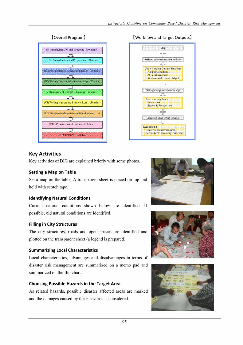
Instructor's Guideline on Community Based Disaster Risk Management
95
【Overall Program】 【Workflow and Target Outputs】
(I) Introducing DIG and Grouping(10 mins)
(II) Self-introduction and Preparation(20 mins)
(III) Explanation of Damage Estimation(20 mins)
(IV) Writing Current Situations on map(20 mins)
(VI) Writing Human and Physical Loss (30 mins)
(VIII) Presentation of Outputs(30mins)
(IX) Summary(10mins)
(V) Summary of Current Situations(10 mins)
(VII) Discussions under certain conditions&summary(30)
mins)
Writing current situation on Map
Map
Understanding Current Situation ・Natural Conditions ・Physical structures ・Resources of Disaster Mgmt.
Writing damage estimation on map
Understanding theme ・Evacuation ・Search & Rescue etc.
Discussion under certain condition
Recognizing ・Effective countermeasures ・Necessity of increasing resiliences
Key Activities
Key activities of DIG are explained briefly with some photos.
Setting a Map on Table
Set a map on the table. A transparent sheet is placed on top and
held with scotch tape.
Identifying Natural Conditions
Current natural conditions shown below are identified. If
possible, old natural conditions are identified.
Filling in City Structures
The city structures, roads and open spaces are identified and
plotted on the transparent sheet (a legend is prepared).
Summarizing Local Characteristics
Local characteristics, advantages and disadvantages in terms of
disaster risk management are summarized on a memo pad and
summarized on the flip chart.
Choosing Possible Hazards in the Target Area
As related hazards, possible disaster affected areas are marked
and the damages caused by these hazards is considered.

The Project for National Disaster Management Plan
in the Islamic Republic of Pakistan
96
Writing Risk and Resources / Damage Estimation
Damage is estimated by grid. The estimated location, numbers, characteristics of damage to buildings,
infrastructure, and possible human losses are colored in red (high
risk), orange (medium risk), yellow (low risk).
� Filling in risks and resources
� Estimating and recording possible human and physical losses
� Discussion by providing set-conditions
� Providing estimated conditions / situations of post disasters
Discussion and Preparing Disaster Risk Management
Plans
Participants are given issues of different themes. The solutions
are discussed among the participants over the map. Realistic
plans are expected to be prepared by considering distances,
existing infrastructures, etc. An example of a guiding question is
listed as below.
Example: Theme: Communication Method
Think about the situation when most of the roads are blocked. Landlines and mobile phones are out of
order. How do you inform district, Union Councils, and local community leaders? Think about the
information flow such as DCO, District DRM coordinators, UC Secretary, Community Disaster
Management Committee leader, etc.
Expected Outcome
At the end of the exercise the participants train themselves by imagining the situations of the target area
from pre-conditions and plan countermeasures and community actions.
Some Ideas to Minimize the Budget for CBDRM To make the CBDRM activities sustainable, the budget for the activities needs to be minimized and new
ideas created to make use of the budget and conduct the activities effectively. To minimize the costs for
conducting activities, consider alternative ways of conducting them economically, and consider
substitutions such as for disaster management equipment. It is advisable to collaborate with other
communities and enterprises for certain equipment to borrow and thereby reduce both budgets.
� District Coordination Officer (DCO) wants to issue an evacuation order to the
residents of District Thatta. Both land lines and mobiles are cut off. � How do you communicate with the necessary persons? � Think about TO WHOM, TO WHERE, and HOW do you announce the message? �
Questions
Source: DIG Manual JICA Study Team
Instructor's Guideline on Community Based Disaster Risk Management
97
It is important to start some activities that cost little or nothing. The important point is to implement all
possible actions. Basically the autonomous DRM activities need to be organized and self supported.
However, technical support may be sought from DDMA, Rescue 1122, and Civil Defence.
Compiling Database at District It is advisable to prepare data and information on community based disaster management. This
information is not only useful for the community as a summary of the vulnerability and capacity
assessment, and participatory DRM planning, but it is also valuable for district relevant organizations to
prepare concrete and realistic disaster risk management plans at district level. In some districts,
organizations specialized in disaster management such as DDMA, Rescue 1122, and Civil Defence exist.
In terms of collaboration and coordination, such locally based information needs to be compiled for
sharing.
Currently, districts are the key organizations for implementing CBDRM; however, after some years of
decentralization they are dispersed. At that point, tehsil can possibly take over handling such basic data.
For example, the tehsil could compile such data from the communities and submit it to the district
regularly every few years. As for providing base maps and dispatching disaster management experts to
guide CBDRM activities, the district can play such roles in the near future, and the tehsil is also a good
option to be empowered in the longer term.
The following shows a sample format of data to be compiled as a result of CBDRM activities. The first
sheet describes basic information on disaster management, the second one is a simple summary for a
community disaster management plan, and the third one is a risk and resource map / disaster management
map of the community.
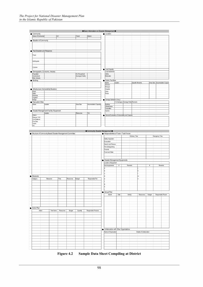
The Project for National Disaster Management Plan
in the Islamic Republic of Pakistan
98
■ Community ■ Location
Name of Community UC Tehsil District
■ Situation of Community
■ Past Disasters and Response
Flood
Earthquake
Cyclone
■ Local Capacity
■ Demographic, Economic, Industry Local leadership
Population # of Household CBOs
Income level Average # family Motivation
Main Industry
■ Building ■ Public Facilities
Name location Specific Remarks Area Size Accomodation Capacity
Schools
Mosque
■ Infrastructure (Vulnerability Situation) Hospital
Road Clinic
Water Police
Electricity
Irrigation
Bridge ■ Damage Estimation (if any)
■ Evacuation Sites # of damages Damage Ratio Remarks
Name location Area Size Accomodation Capacity Building
Infrastructure
Casualties
■ Disaster Management Facility / Equipment Injuries
location Resources Tel
District ■ General Evaluation of Vulnerability and Capacity
Rescue 1122
Civil Defence
Fire Dep.
Tehsil
UC
◆Basic Information on Disaster Management◆
■ Structure of Community Based Disaster Management Committee ■ Responsibilities of Team / Task Forces
Safety Inspection
Evacuation
Search and Rescue
Fire Extinguishing
First Aid
Food and Water
■ Disaster Management Equipments
Location of Equipment
list of equipments # #
a j
b k
c l
■ Measures d m
Category Time Resources Budget e n
f
g
h
i
■ Annual Plan
Month Date Resources Budget
■ Action Plan
Time frame Resources Budget Quantity
■ Collaboration with Other Organizations
Name of Organization
Remarks Remarks
Details of Collaboration
◆Community Disaster Management◆
Activity
Measures Responsible Psn
Responsible Person
Action Responsible Persons
Ordinary Time Emergency Time
Figure 4.2 Sample Data Sheet Compiling at District

Instructor's Guideline on Community Based Disaster Risk Management
99

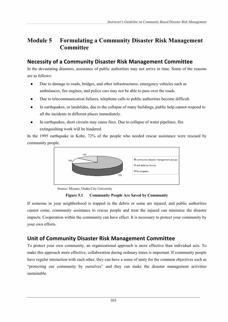
Instructor's Guideline on Community Based Disaster Risk Management
101
Module 5 Formulating a Community Disaster Risk Management
Committee
Necessity of a Community Disaster Risk Management Committee In the devastating disasters, assistance of public authorities may not arrive in time. Some of the reasons
are as follows:
� Due to damage to roads, bridges, and other infrastructures, emergency vehicles such as
ambulances, fire engines, and police cars may not be able to pass over the roads.
� Due to telecommunication failures, telephone calls to public authorities become difficult.
� In earthquakes, or landslides, due to the collapse of many buildings, public help cannot respond to
all the incidents in different places immediately.
� In earthquakes, short circuits may cause fires. Due to collapse of water pipelines, fire
extinguishing work will be hindered.
In the 1995 earthquake in Kobe, 72% of the people who needed rescue assistance were rescued by
community people.
72%
14%
14%
community disaster management groups
self defense forces
fire brigades
Source: Miyano, Osaka City University
Figure 5.1 Community People Are Saved by Community
If someone in your neighborhood is trapped in the debris or some are injured, and public authorities
cannot come, community assistance to rescue people and treat the injured can minimize the disaster
impacts. Cooperation within the community can have effect. It is necessary to protect your community by
your own efforts.
Unit of Community Disaster Risk Management Committee To protect your own community, an organizational approach is more effective than individual acts. To
make this approach more effective, collaboration during ordinary times is important. If community people
have regular interaction with each other, they can have a sense of unity for the common objectives such as
“protecting our community by ourselves” and they can make the disaster management activities
sustainable.
The Project for National Disaster Management Plan
in the Islamic Republic of Pakistan
102
It is advised that one Community Disaster Risk Management Committee be formulated for each
community. If the community organizes festivals and religious activities during ordinary times, the
existing community unit can be utilized, since community risk management activities need to be based on
the regular collaboration networks that exist during ordinary times. Community people need to feel a
sense of unity within the community unit.
Structure of Committee The Community Disaster Risk Management Committee needs to be structured to allocate clear
responsibilities to the members and to relate their responsibilities. If there are existing groups within the
community such as youth groups or women’s groups, the Community Disaster Risk Management
Committee can be structured by utilizing such existing groups.
The committee is designed with necessary teams / task forces by analyzing necessary activities and local
situations. The structure consists of a committee leader, sub-leaders, and teams / task forces. It is advised
to conduct regular drills in order to improve the suitable compositions for each community. In emergency
situations, things may not work as planned. Flexibility to react to different situations is necessary. It is
also important to decide responsibilities for both ordinary times and emergency times. The reason for
deciding responsibilities during ordinary time is that practicing and conducting responsibilities regularly
makes the team / task forces active and well united.
The community needs to be divided into smaller units, considering the size of the population. It is
advisable to identify members of all task forces / teams for each small unit. The manageable size of one
small unit is about 20 households.
Try to ask participation of professional persons such as medical practitioners in the community. If there
are enterprises, factories in the neighborhood, try to collaborate with them for providing heavy machinery,
equipment, food, water etc.
Roles of Leaders The leaders are expected to be interested in disaster management activities, gain knowledge of and
techniques for disaster management, and cooperate with local residents. In ordinary times, leaders need to
take leadership for safety inspections of the community, knowledge dissemination and awareness raising
activities for residents, installing and maintenance of disaster management equipment, understanding
risks and resources in the community, understanding people who have difficulties in evacuation, and
conducting drills. During an emergency, the leaders take initiative for protecting the safety of the
residents, minimizing the disaster impacts, and take leadership of task forces / teams for effective disaster
risk management activities.
To achieve this, leaders need to cooperate and collaborate with relevant public organizations. It is also
important for sub-leaders to link with women, children and challenged persons. Females are also
encouraged to assume responsibilities.
Instructor's Guideline on Community Based Disaster Risk Management
103
Requirements for leaders
� Interest in disaster risk management
� Experience with disaster risk management activities
� Vitality
� Popularity among community members
� Coordination capacity with different people
� Considerate of others and not an egocentric
� Considerate of minor opinions
Roles / Responsibilities of Task Force Teams One of the examples of the structure of community disaster risk management committee and roles and
responsibilities of Task Force Teams under the committee is delineated in Figure 5.2. The important thing
is to set roles and responsibilities before the disasters. Setting responsibilities in pre-disaster time is more
important than setting them in emergency time. Since task force members need to be familiarized with
their own tasks and know each other from pre-disaster time.
As for the Task Force for Safety Inspection, the responsibilities for pre-disaster time can be decided as 1)
checking locations of vulnerable areas, and hazardous materials. 2) identifying local resources, and 3)
preparing risk and resource maps. Responsibilities in emergency time can be assigned as 1) inspecting
vulnerable areas and 2) announcing dangerous areas and hazardous materials. For the recovery phase, it
can be assigned as 1) inspecting and preparing a list of repairing points and 2) requesting repairs to
relevant authorities. Refer to Figure 5.2 for responsibilities of other task forces.

The Project for National Disaster Management Plan
in the Islamic Republic of Pakistan
104
Figure 5.2 Structure of Community Disaster Risk Management Committee (Example)
Equipment for Disaster Risk Management It is ideal to install community equipment for disaster risk management at village/community level, for
each unit of community disaster risk management committee. Equipment for disaster risk management is
differentiated from different target disasters. Thus, at each community, based on the community disaster
risk management plan, equipment needs to be customized. An example of equipment installed for a
flood-prone pilot village in Muzaffargarh is shown in Table 5.1.
Table 5.1 Community Equipment for Disaster Risk Management
S.# ITEM USED FOR ITEM NAME # Remarks
1 Axes 4
2 Hammers 4
3 Shawals 4
4 Picks 4
5 Crowbars 4
6Tool Boxes
( 10 Items)4
Screw driver set, Small hammer, wire
cutter, pliers, saw, chiesel , taster, tin
cutter, inchi tape, squash tape
7 Torches 10
8 Helmets 10
9 Figure of Eight 2
10 D Rings 4
11 Polls 8
12 Blanket 4
13 Spinal Bpard 2
14First Aid Boxes
( 8 Items)
4
Crape Bandage 4 inch, 3 inch 12 pcs
each, Cotton Bandage 12 pcs Triangular
Bandage 8 Pcs, Sunny plast 100 pcs ,
Alcholaic swab 100 pcs, splints, sissors
15 Fire Stand 1
16 Fire Bucket 6
17 Fire Blanket 4
18 Life Jacket 12
19 Life Buoy 4
20 Ropes (9 mm) 2 45 meter each
21 Ropes(7 mm) 1 100 meter
22 Gloves 24
23 Tarpal 2
24 Mega Phone 2
25 Battery 12
OTHER ITEM
SEARCH AND RESCUE
FIRST AID
FIRE FIGHTING ITEM
WATER RESCUE ITEM
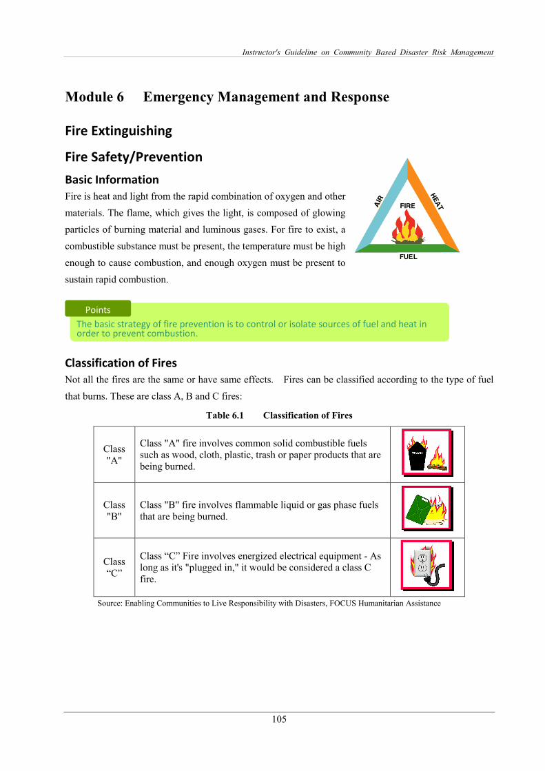
Instructor's Guideline on Community Based Disaster Risk Management
105
Module 6 Emergency Management and Response
Fire Extinguishing
Fire Safety/Prevention
Basic Information
Fire is heat and light from the rapid combination of oxygen and other
materials. The flame, which gives the light, is composed of glowing
particles of burning material and luminous gases. For fire to exist, a
combustible substance must be present, the temperature must be high
enough to cause combustion, and enough oxygen must be present to
sustain rapid combustion.
Classification of Fires
Not all the fires are the same or have same effects. Fires can be classified according to the type of fuel
that burns. These are class A, B and C fires:
Table 6.1 Classification of Fires
Class "A"
Class "A" fire involves common solid combustible fuels such as wood, cloth, plastic, trash or paper products that are being burned.
Class "B"
Class "B" fire involves flammable liquid or gas phase fuels that are being burned.
Class “C”
Class “C” Fire involves energized electrical equipment - As long as it's "plugged in," it would be considered a class C fire.
Source: Enabling Communities to Live Responsibility with Disasters, FOCUS Humanitarian Assistance
The basic strategy of fire prevention is to control or isolate sources of fuel and heat in order to prevent combustion.
Points
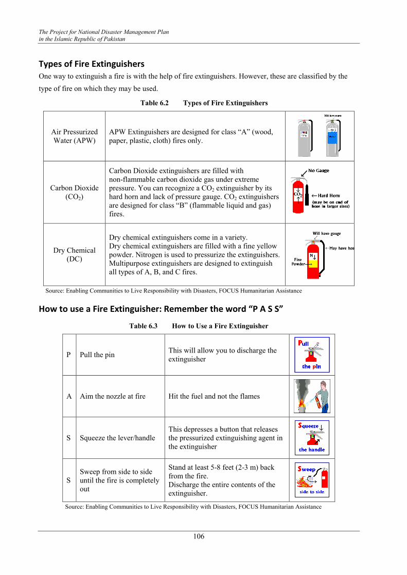
The Project for National Disaster Management Plan
in the Islamic Republic of Pakistan
106
Types of Fire Extinguishers
One way to extinguish a fire is with the help of fire extinguishers. However, these are classified by the
type of fire on which they may be used.
Table 6.2 Types of Fire Extinguishers
Air Pressurized Water (APW)
APW Extinguishers are designed for class “A” (wood, paper, plastic, cloth) fires only.
Carbon Dioxide (CO2)
Carbon Dioxide extinguishers are filled with non-flammable carbon dioxide gas under extreme pressure. You can recognize a CO2 extinguisher by its hard horn and lack of pressure gauge. CO2 extinguishers are designed for class “B” (flammable liquid and gas) fires.
Dry Chemical (DC)
Dry chemical extinguishers come in a variety. Dry chemical extinguishers are filled with a fine yellow powder. Nitrogen is used to pressurize the extinguishers. Multipurpose extinguishers are designed to extinguish all types of A, B, and C fires.
Source: Enabling Communities to Live Responsibility with Disasters, FOCUS Humanitarian Assistance
How to use a Fire Extinguisher: Remember the word “P A S S”
Table 6.3 How to Use a Fire Extinguisher
P Pull the pin This will allow you to discharge the extinguisher
A Aim the nozzle at fire Hit the fuel and not the flames
S Squeeze the lever/handle This depresses a button that releases the pressurized extinguishing agent in the extinguisher
S Sweep from side to side until the fire is completely out
Stand at least 5-8 feet (2-3 m) back from the fire. Discharge the entire contents of the extinguisher.
Source: Enabling Communities to Live Responsibility with Disasters, FOCUS Humanitarian Assistance
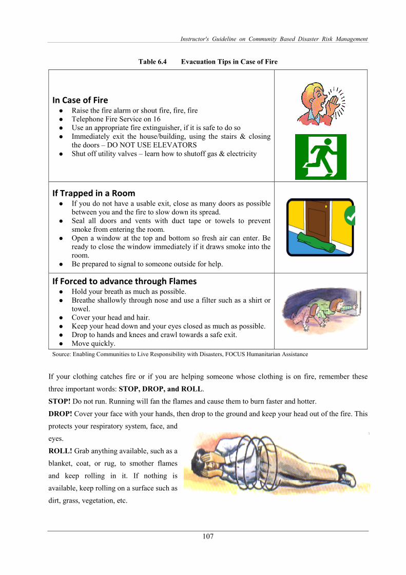
Instructor's Guideline on Community Based Disaster Risk Management
107
Table 6.4 Evacuation Tips in Case of Fire
In Case of Fire � Raise the fire alarm or shout fire, fire, fire � Telephone Fire Service on 16 � Use an appropriate fire extinguisher, if it is safe to do so � Immediately exit the house/building, using the stairs & closing
the doors – DO NOT USE ELEVATORS � Shut off utility valves – learn how to shutoff gas & electricity
If Trapped in a Room � If you do not have a usable exit, close as many doors as possible
between you and the fire to slow down its spread. � Seal all doors and vents with duct tape or towels to prevent
smoke from entering the room. � Open a window at the top and bottom so fresh air can enter. Be
ready to close the window immediately if it draws smoke into the room.
� Be prepared to signal to someone outside for help.
If Forced to advance through Flames � Hold your breath as much as possible. � Breathe shallowly through nose and use a filter such as a shirt or
towel. � Cover your head and hair. � Keep your head down and your eyes closed as much as possible. � Drop to hands and knees and crawl towards a safe exit. � Move quickly.
Source: Enabling Communities to Live Responsibility with Disasters, FOCUS Humanitarian Assistance
If your clothing catches fire or if you are helping someone whose clothing is on fire, remember these
three important words: STOP, DROP, and ROLL.
STOP! Do not run. Running will fan the flames and cause them to burn faster and hotter.
DROP! Cover your face with your hands, then drop to the ground and keep your head out of the fire. This
protects your respiratory system, face, and
eyes.
ROLL! Grab anything available, such as a
blanket, coat, or rug, to smother flames
and keep rolling in it. If nothing is
available, keep rolling on a surface such as
dirt, grass, vegetation, etc.

The Project for National Disaster Management Plan
in the Islamic Republic of Pakistan
108
When Responding to a Fire Incident!
Use the following guidelines when approaching and suppressing a fire:
� Do not attempt to suppress a fire that is clearly too large for the equipment at hand. Save the
equipment for where it will be effective.
� Use safety equipment (helmet, goggles, dust mask,
all-leather work gloves, and heavy shoes).
� Work in a buddy system.
� Have a backup team when possible.
� Always have two ways to exit the fire area.
� Approach smoke-filled areas correctly.
(Feel closed doors with the back of the hand, working
from the bottom of the door up. If the door is hot, DANGER! - There is fire behind it! DO NOT
OPEN THE DOOR or you will risk the door hitting you, being sucked into the fire, the fire
flashing out at you, or creating an explosion.)
� Confine the fire by keeping doors closed.
� Stay low to the ground.
� Always know a second escape route.
� Use natural ventilation techniques [when there is no risk of a fire flare-up] to clear smoke: Open
windows if possible, and create cross-ventilation by channeling natural wind flow.
� Maintain a safe distance, remembering the effective extinguisher range.
� Move around the perimeter of the fire to maximize coverage of the extinguisher agent.
� Prevent rekindling of the fire:
� Locate hidden burning material.
� Extinguish and safely remove it.
� Remove heat by cooling.
FIRE RISK CONTROL
� Always store wood for woodstoves and fireplaces away from your home.
� Store all flammable liquids such as gasoline outside the home.
� Prepare a floor plan of your home showing at least two ways out of each room; primary and
alternate escape routes.
Instructor's Guideline on Community Based Disaster Risk Management
109
� Most fires occur at night when people are sleeping. A smoke detector can alert you in time
whenever there is a fire and save your life. Therefore, it is good to install smoke detectors on
every level of your home and outside of sleeping areas.
� Store paints, thinners and other flammables in original containers, away from heat, sparks or
flame.
� Check all electrical outlets and extension as well as appliance cords. Check for exposed wires,
frayed or damaged cords, loose connections, and loose wall receptacles. If any damage is
discovered, repair or replace the item.
� Never run electrical cords under a carpet or rug.
� Store matches and lighters out of the reach of small children.
� Extinguish all candles and gas heaters when leaving the room or going to sleep.
� Cooking is the leading cause of home fires; practice fire safety when cooking.
� Keep a portable fire extinguisher in the house, especially in the kitchen.
� Designate a meeting place outside the home where family members can gather for a head count.
The Project for National Disaster Management Plan
in the Islamic Republic of Pakistan
110
Basic First Aid
The First Responder As a first responder, any individual or community volunteer must understand his/her role. It is most
important to understand that the first responder is not medical help. Having basic knowledge and skills
as a first responder can save lives in case of a disaster. This section covers the basic first aid for
disasters/emergencies. These skills can increase self-sufficiency in a disaster and enable the community
to provide emergency assistance to their families and neighbors in the event of a disaster before external
help arrives.
Role of Emergency First Responder
As the first person to arrive on the disaster scene, you will need to do a quick assessment and provide
support to the people injured in the disaster. You would not only be required to administer first aid but
also know the basic search and rescue techniques. This section provides basic information about both
these roles.
First Aid First aid is the immediate medical assistance given to an injured person, within the available resources
before getting qualified medical help.
The Purpose of First Aid is to:
� Sustain life
� Prevent suffering
� Prevent secondary complications
� Promote speedy recovery
Role of First Aid Provider
If you are the first to arrive on the scene of an accident that results in an injury or serious illness, you may
be the only link between a victim and emergency medical care.
Your role is to take action, whether by providing first aid, seeking medical help or calling 15 or 1122
(where this is available)
Your actions may improve the victim’s chance of recovery.
Responsibilities of a First Aid Provider
� To assess the situation quickly and safely, and call for appropriate help.
� To identify the level of injury or the nature of the illness affecting the casualty/victim.
Instructor's Guideline on Community Based Disaster Risk Management
111
� To give early and appropriate treatment in a sensible order of priority.
� To arrange for the safe removal of the casualty.
� To remain with the casualty and reassess his condition from time to time until handing it over to
the care of a medical person.
� To make and file a report and give further help if required.
Assessment Procedures
All victims must undergo an assessment, even those that are awake.
� Verbal assessments: This is for those who are able to speak and consists of asking the person
about any injuries, pain, bleeding, or other symptoms he/she is aware of and can express.
� Hands-on assessments consist of asking the person for permission to assess them if they are awake
and coherent and paying close attention: Look, listen, and feel for anything unusual.
- What to check: Perform the assessment always in the same order so that you will complete
each assessment quickly and accurately, checking body parts from top to bottom. Treat
victims as if they have a spinal injury until you are certain they do not. Examine the:
Head, Neck & Shoulders
Chest, Arms & Abdomen
Pelvis, Legs & Back
- What to look for: Look for anything indicating an injury. Most common injuries include
lacerations, fractures, and bruises, but anything out of the ordinary may be an indicator, such
as changes in color, temperature and pulse.
Dos & Don’ts
� DOs
- Before handling the casualty use
Mask
Gloves
Head cover
Apron
� DONTs: A First Aid Provider should never
- Prescribe medicine
- Declare death
Principles of First Aid (Four Cs)
� Call for help
� Calmly take charge
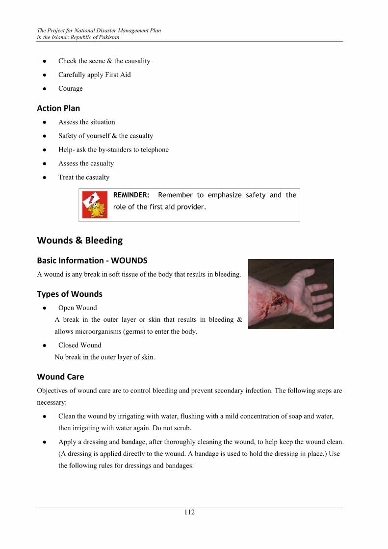
The Project for National Disaster Management Plan
in the Islamic Republic of Pakistan
112
� Check the scene & the causality
� Carefully apply First Aid
� Courage
Action Plan
� Assess the situation
� Safety of yourself & the casualty
� Help- ask the by-standers to telephone
� Assess the casualty
� Treat the casualty
REMINDER: Remember to emphasize safety and the
role of the first aid provider.
Wounds & Bleeding
Basic Information - WOUNDS
A wound is any break in soft tissue of the body that results in bleeding.
Types of Wounds
� Open Wound
A break in the outer layer or skin that results in bleeding &
allows microorganisms (germs) to enter the body.
� Closed Wound
No break in the outer layer of skin.
Wound Care
Objectives of wound care are to control bleeding and prevent secondary infection. The following steps are
necessary:
� Clean the wound by irrigating with water, flushing with a mild concentration of soap and water,
then irrigating with water again. Do not scrub.
� Apply a dressing and bandage, after thoroughly cleaning the wound, to help keep the wound clean.
(A dressing is applied directly to the wound. A bandage is used to hold the dressing in place.) Use
the following rules for dressings and bandages:
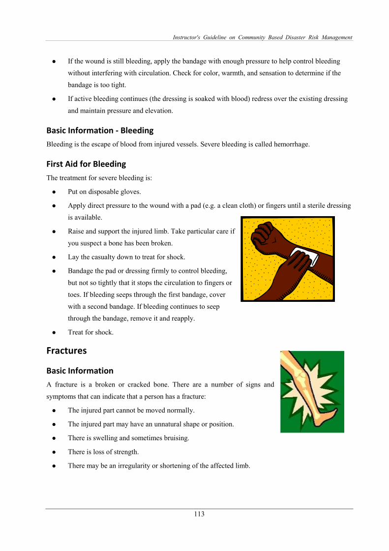
Instructor's Guideline on Community Based Disaster Risk Management
113
� If the wound is still bleeding, apply the bandage with enough pressure to help control bleeding
without interfering with circulation. Check for color, warmth, and sensation to determine if the
bandage is too tight.
� If active bleeding continues (the dressing is soaked with blood) redress over the existing dressing
and maintain pressure and elevation.
Basic Information - Bleeding
Bleeding is the escape of blood from injured vessels. Severe bleeding is called hemorrhage.
First Aid for Bleeding
The treatment for severe bleeding is:
� Put on disposable gloves.
� Apply direct pressure to the wound with a pad (e.g. a clean cloth) or fingers until a sterile dressing
is available.
� Raise and support the injured limb. Take particular care if
you suspect a bone has been broken.
� Lay the casualty down to treat for shock.
� Bandage the pad or dressing firmly to control bleeding,
but not so tightly that it stops the circulation to fingers or
toes. If bleeding seeps through the first bandage, cover
with a second bandage. If bleeding continues to seep
through the bandage, remove it and reapply.
� Treat for shock.
Fractures
Basic Information
A fracture is a broken or cracked bone. There are a number of signs and
symptoms that can indicate that a person has a fracture:
� The injured part cannot be moved normally.
� The injured part may have an unnatural shape or position.
� There is swelling and sometimes bruising.
� There is loss of strength.
� There may be an irregularity or shortening of the affected limb.
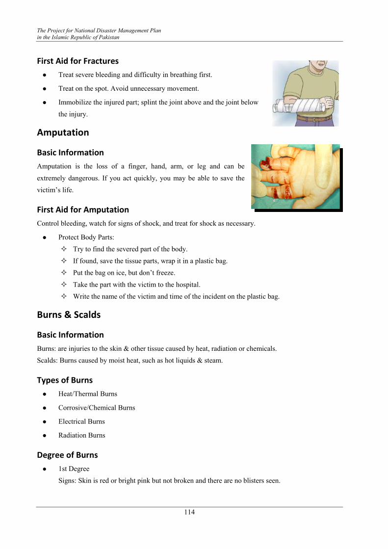
The Project for National Disaster Management Plan
in the Islamic Republic of Pakistan
114
First Aid for Fractures
� Treat severe bleeding and difficulty in breathing first.
� Treat on the spot. Avoid unnecessary movement.
� Immobilize the injured part; splint the joint above and the joint below
the injury.
Amputation
Basic Information
Amputation is the loss of a finger, hand, arm, or leg and can be
extremely dangerous. If you act quickly, you may be able to save the
victim’s life.
First Aid for Amputation
Control bleeding, watch for signs of shock, and treat for shock as necessary.
� Protect Body Parts:
� Try to find the severed part of the body.
� If found, save the tissue parts, wrap it in a plastic bag.
� Put the bag on ice, but don’t freeze.
� Take the part with the victim to the hospital.
� Write the name of the victim and time of the incident on the plastic bag.
Burns & Scalds
Basic Information
Burns: are injuries to the skin & other tissue caused by heat, radiation or chemicals.
Scalds: Burns caused by moist heat, such as hot liquids & steam.
Types of Burns
� Heat/Thermal Burns
� Corrosive/Chemical Burns
� Electrical Burns
� Radiation Burns
Degree of Burns
� 1st Degree
Signs: Skin is red or bright pink but not broken and there are no blisters seen.

Instructor's Guideline on Community Based Disaster Risk Management
115
� 2nd Degree
Signs: Skin is red, tender, swollen, and blistered.
� 3rd Degree
Signs: Skin will look white and leathery or charred.
First Aid for Burns and Scalds
First-aid treatment for burns involves removing the source of the burn, cooling the burn, and covering it.
To treat a burn victim, the following procedure may be applied:
� Remove the victim from the burn source. Put out any flames and remove smoldering clothing.
� Cool skin or clothing that is still hot by immersing in cool water for no
longer than one minute or covering with clean compresses that have
been wrung out in cool water. Water may be obtained from the
bathroom, kitchen or garden hose.
� Use soaked towels, sheets, or other cloths. Use clean water. Do not
apply water to third-degree burns except to put out flames. Treat all victims of third-degree burns
for shock. WATCH FOR SIGNS OF HYPOTHERMIA. Cover loosely with dry, sterile dressings
that keep air out, reduce pain, and prevent infection.
� Elevate burned extremities high above the victim's heart.
� Cool the burnt area with running water.
� If clothing sticks to the skin, leave it there and cut away the remaining
fabric.
� Do not break blisters.
� Do not apply lotions, ointments or fat to the injured area.
� Cover the burnt area with a plastic bag.
� Cover the burn with a sterile bandage.
� Remove the chemical from the skin or eyes by flushing the area with
large amounts of cool running water.
� CALL a doctor or emergency medical services (EMS).
BANDAGING A bandage is a strip of material used mainly to support and immobilize a part of the body. It has several
uses such as to:
� Support – fractured bone
� Immobilize – dislocated shoulder/jaw
� Apply pressure – stop bleeding & improve venous blood flow
The Project for National Disaster Management Plan
in the Islamic Republic of Pakistan
116
� Secure a dressing in place
� Retain splints in place
Principles & Procedures for Applying Bandages
� Wash your hands and wherever necessary, wear gloves.
� Assist victim to assume a comfortable position on a bed or chair and support the body part to be
bandaged.
� Always stand in front of the part/victim to be bandaged except when applying a bandage to the
head, eye or ear.
� Be sure the bandage is rolled firmly.
� Make sure the body part to be bandaged is clean and dry.
� Assess the skin before applying the bandage for any breakdown.
� Observe circulation by noting the pulse, surface temperature, skin color and sense of touch of the
body part to be wrapped.
� Always start bandaging from the inner to the outer aspect and from the far to the near end.
� When bandaging a joint, ensure flexibility of the joint (unless immobilization of the joint is
required).
� Always start and end with two circular turns.
� Cover the area 5 centimeters above and 5 centimeters below the affected area (wound).
� Overlap turns and slightly stretch the bandage.
� Cover two thirds of the previous turn.
� Where possible, leave fingertips or toe tips exposed for observation (adequacy of blood
circulation).
� End the bandage on the outer side of the body. Do not end a bandage on a wound or at the back of
the body.
Methods of Applying Bandages
Bandages can be applied in the following methods.
� Circular
� Spiral
� Reverse Spiral
� Figure of Eight
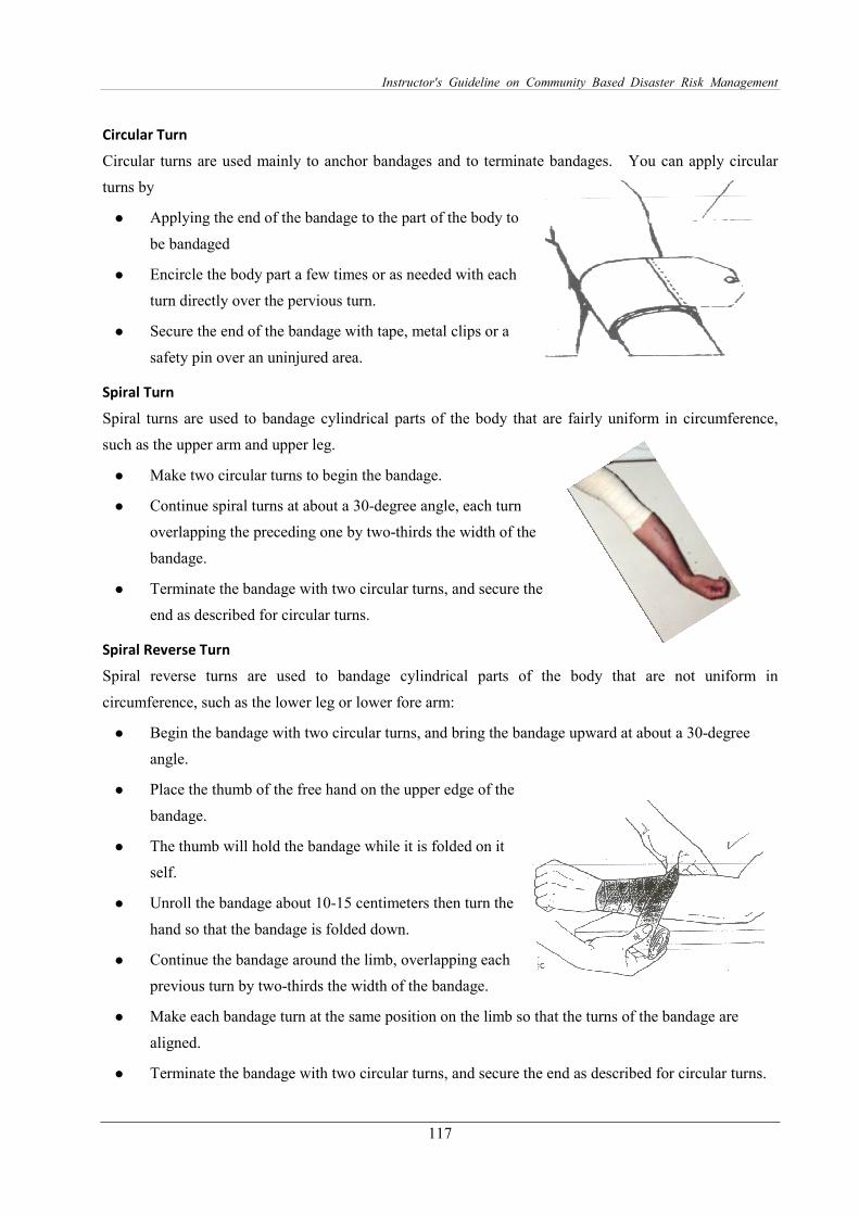
Instructor's Guideline on Community Based Disaster Risk Management
117
Circular Turn
Circular turns are used mainly to anchor bandages and to terminate bandages. You can apply circular
turns by
� Applying the end of the bandage to the part of the body to
be bandaged
� Encircle the body part a few times or as needed with each
turn directly over the pervious turn.
� Secure the end of the bandage with tape, metal clips or a
safety pin over an uninjured area.
Spiral Turn
Spiral turns are used to bandage cylindrical parts of the body that are fairly uniform in circumference,
such as the upper arm and upper leg.
� Make two circular turns to begin the bandage.
� Continue spiral turns at about a 30-degree angle, each turn
overlapping the preceding one by two-thirds the width of the
bandage.
� Terminate the bandage with two circular turns, and secure the
end as described for circular turns.
Spiral Reverse Turn
Spiral reverse turns are used to bandage cylindrical parts of the body that are not uniform in
circumference, such as the lower leg or lower fore arm:
� Begin the bandage with two circular turns, and bring the bandage upward at about a 30-degree
angle.
� Place the thumb of the free hand on the upper edge of the
bandage.
� The thumb will hold the bandage while it is folded on it
self.
� Unroll the bandage about 10-15 centimeters then turn the
hand so that the bandage is folded down.
� Continue the bandage around the limb, overlapping each
previous turn by two-thirds the width of the bandage.
� Make each bandage turn at the same position on the limb so that the turns of the bandage are
aligned.
� Terminate the bandage with two circular turns, and secure the end as described for circular turns.
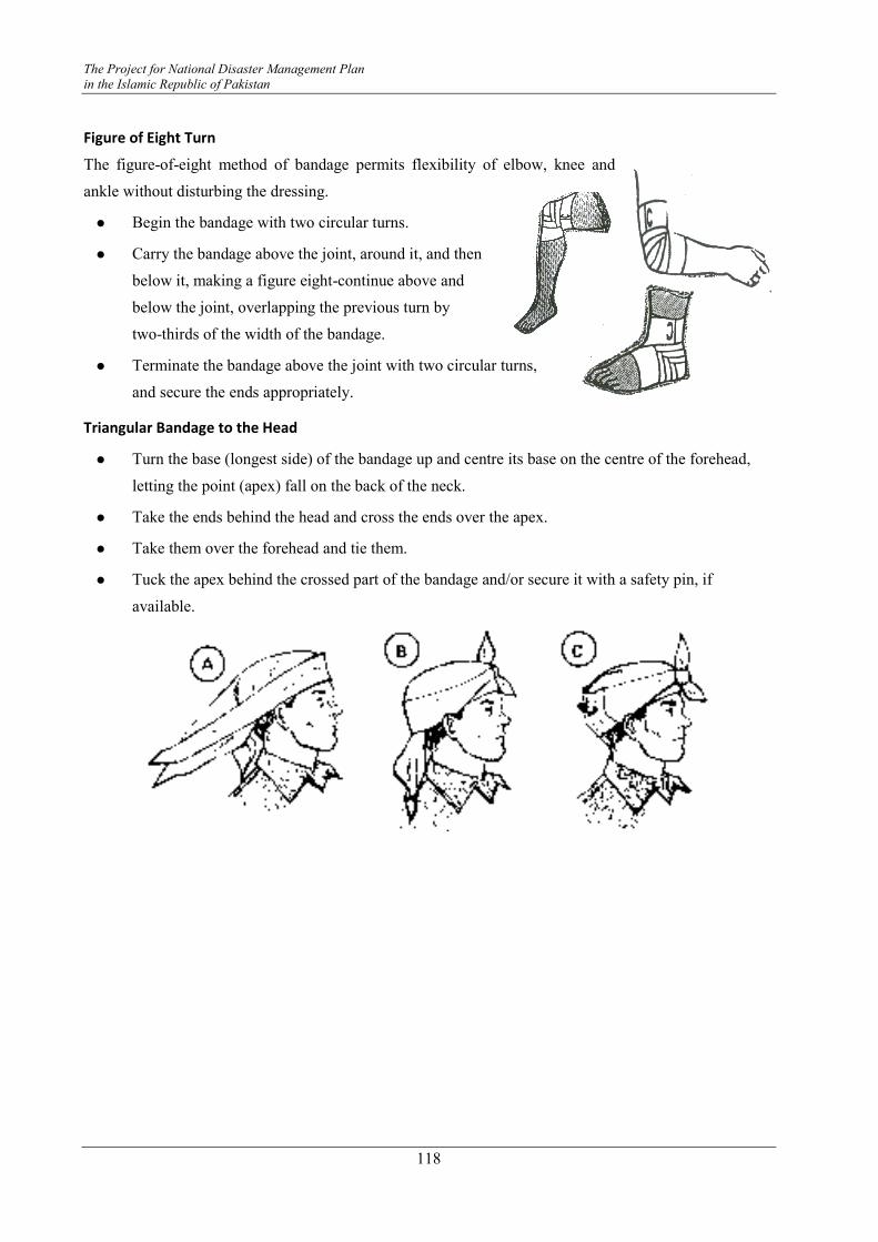
The Project for National Disaster Management Plan
in the Islamic Republic of Pakistan
118
Figure of Eight Turn
The figure-of-eight method of bandage permits flexibility of elbow, knee and
ankle without disturbing the dressing.
� Begin the bandage with two circular turns.
� Carry the bandage above the joint, around it, and then
below it, making a figure eight-continue above and
below the joint, overlapping the previous turn by
two-thirds of the width of the bandage.
� Terminate the bandage above the joint with two circular turns,
and secure the ends appropriately.
Triangular Bandage to the Head
� Turn the base (longest side) of the bandage up and centre its base on the centre of the forehead,
letting the point (apex) fall on the back of the neck.
� Take the ends behind the head and cross the ends over the apex.
� Take them over the forehead and tie them.
� Tuck the apex behind the crossed part of the bandage and/or secure it with a safety pin, if
available.

Instructor's Guideline on Community Based Disaster Risk Management
119
Basic Search and Rescue
Basic Information Natural and human-made disasters are increasing rapidly and likewise their intensity has also increased
over the last century resulting in an increase in the risk to lives and properties.
The first 12 hours of any disaster are regarded as the golden hours. This means that the sooner the
search and rescue operations starts the better are the chances for survival. While specialized search and
rescue teams may take some time to arrive at the scene of a disaster, some basic techniques of search and
rescue can help the communities to start the search and rescue operations as soon as the disaster strikes.
Understanding of these basic techniques and of how to handle a casualty can save lives.
Generally, search and rescue terms are used interchangeably. However and
in reality, these are two separate functions as described below:
Search: This means to carefully look in order to find someone missing or
lost. In a disaster scenario, it involves locating victims and documenting
their locations.
Rescue: To free a trapped victim from confinement or from under the
rubble during a disaster is called rescue. Search and rescue operations
require and consist of three significant components:
� Rescuers: These include trained personnel and volunteers.
� Tools: These depend on availability and as per the needs of a
particular situation. For example, storm or earthquake damage may
require tools for lifting debris whereas flood damage may
require boats, ropes, and life preservers.
� Time may be very limited for some victims. The first 24
hours after a disaster is called the “Golden Day” - the period
during which injured or trapped victims have an 80 percent
chance of survival if rescued appropriately and in time.
Survival Rates for Persons Trapped in a
Collapsed Structure
� 30 Minutes: 91.0% Survival
� 1 Day: 81.0% Survival
� 2 Days: 36.7% Survival
� 3 Days: 33.7% Survival
� 4 Days: 19.0% Survival
RESCUERS
TOOLS
TIME
VICTIM
The Project for National Disaster Management Plan
in the Islamic Republic of Pakistan
120
� 5 Days: 7.4% Survival
Before undertaking search and rescue, it is important to set certain objectives. The foremost objectives
of search and rescue are to:
� Safeguard the life of the rescuer – The most important person in a rescue attempt is the rescuer!
� Rescue and save the greatest number of people in the shortest amount of time.
Basic Principles of Search & Rescue As mentioned above, the safety of the rescuer is the first priority. These basic principals will help the
rescuer to carry out search and rescue in a safe way:
� Damaged buildings and facilities should only be approached from the least dangerous side
� While surveying indoor space in buildings, DO NOT use open fire (matches, kerosene lamps) for
lighting
� When searching for casualties, DO NOT walk or stay near badly damaged and collapse-prone
buildings
� DO NOT allow people to gather in one spot, in shafts, or floors.
� DO NOT go near collapse-prone walls or other constructions.
� Move very carefully over building ruins (only if it is absolutely necessary) as they are unstable
heaps of fragments.
� When removing rubble from ruins, DO NOT permit abrupt jerks, shaking, or strong blows at the
site.
� When clearing ruins, first drag away and extinguish any smoldering or burning objects.
� Open doors to burning rooms very cautiously. Beware of possible flames or hot gas ejection.
� In burning spaces move by bending low or on your knees. Try to stay near windows, making it
possible to get quickly out of the danger zone if need be.
� If an electrical cable is discovered, suspend the operation in order to avoid further damage; DO
NOT step on wires.
Search and rescue in a rural setting may be simpler as it usually does not involve multiple story buildings.
Some of the following steps may be less relevant to the rural, but more and significantly relevant for the
urban areas
Instructor's Guideline on Community Based Disaster Risk Management
121
Planning Search and Rescue
Search & Rescue Assessment
Assessment is a continuous analysis of facts that form the basis for decision-making and planning. It
includes the following steps:
� Gathering of facts
� Assessment of damage to the building
� Identification of resources
� Establishment of the rescue priorities
� Development of a rescue plan
� Conducting the rescue
� Evaluating your progress
Each of the assessment steps will provide information that may be critical to search and rescue efforts
Gather Information:
External inspection of the affected building:
� Has anyone been reported missing?
� Is the building structure damaged?
� Identify the more difficult tasks.
� Identify the exit and entry routes and points.
� Locate the Main Utilities Switches.
� Does the building have a special importance/status?
� Number of people resident in the building.
Table 6.5 Gather Facts – Guidelines
Planning Factor Questions
Time of Day/Week • Does the time of day/week affect the number of people possibly trapped in the area?
• Victims likely to be at home, work, in bed, on the road? • Is daylight available for search and rescue efforts or not? • How long would it be until sunrise? • Artificial lighting available and practical?
Occupancy Type • Where are potential victims likely to be in the structure? • How many potential victims are likely to be trapped?
Construction Type • Types of construction that have been affected? • What are the implications for search and rescue? • Is the age of construction significant?
Weather • What is the current and forecast weather? • How would the weather affect rescue efforts? • How would it affect the victims? • How will it affect the rescuers?
Hazards • What are the other or secondary hazards prevalent in the area, e.g. utilities, fire or hazardous materials?
• What steps are necessary to mitigate these hazards? • How long would mitigation efforts take? • What effect might the delay have on the victims?
The Project for National Disaster Management Plan
in the Islamic Republic of Pakistan
122
Assessing Damage to the Building
There are no established rules for assessing damage. However, the damage categories would serve as a
reference point for defining the primary search and rescue mission.
Light Damage:
� Superficial or cosmetic damage
� Broken windows
� Fallen or cracked plaster
� Minor damage to the contents of the structure
Moderate Damage:
� Visible signs of damage
� Decorative work damage
� Many visible cracks in plaster
� Major damage to the contents of the structure
Heavy Damage:
� Obvious structural instability
� Partial or total collapse
� Titling
� Building off foundation
Assessing Resources
The very first step in search and rescue operations is to identify local resources available to assist in
rescuing victims, which include personnel, equipment and tools.
Table 6.6 Planning Questions
Resource Planning Questions
Personnel • Who lives and/or works in the area? • During which hours are those people most likely to be available? • What skills or hobbies do they have that might be useful in search and rescue
operations? • What might be the most effective means of mobilizing their efforts?
Equipment • What equipment is available locally that might be useful for search and rescue? • Where is it located? • How can it be accessed? • On which structures (or types of structures) might it be most effective?
Tools • What tools are available that might be useful for lifting, moving, or cutting disaster debris?
Rescue Operation Once the decision is made to initiate search operations within a specific structure or area, Search and
Rescue members must systematically inspect the place for searching and rescuing the victims: they must
take care of the following:
� The safety of the Search & Rescue Team members
� The safety of the lives of the victims and others
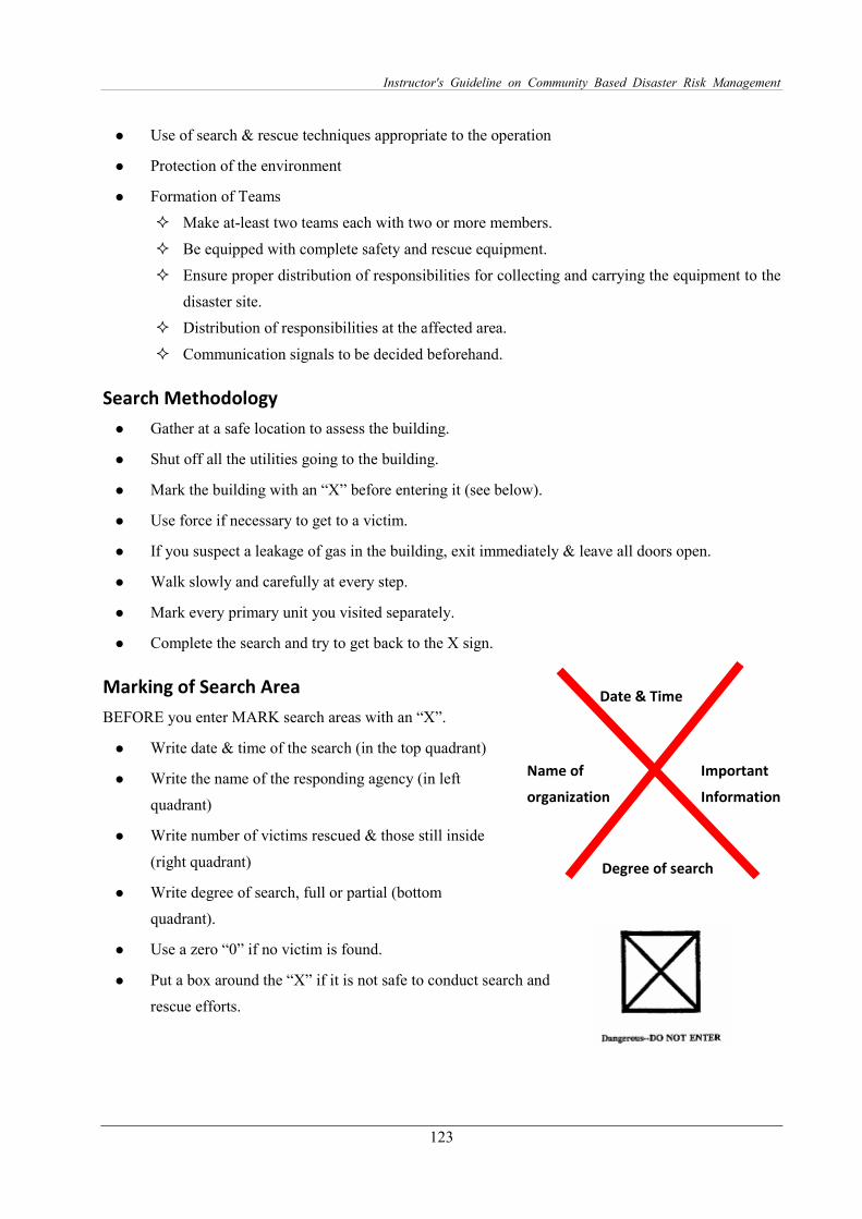
Instructor's Guideline on Community Based Disaster Risk Management
123
� Use of search & rescue techniques appropriate to the operation
� Protection of the environment
� Formation of Teams
� Make at-least two teams each with two or more members.
� Be equipped with complete safety and rescue equipment.
� Ensure proper distribution of responsibilities for collecting and carrying the equipment to the
disaster site.
� Distribution of responsibilities at the affected area.
� Communication signals to be decided beforehand.
Search Methodology
� Gather at a safe location to assess the building.
� Shut off all the utilities going to the building.
� Mark the building with an “X” before entering it (see below).
� Use force if necessary to get to a victim.
� If you suspect a leakage of gas in the building, exit immediately & leave all doors open.
� Walk slowly and carefully at every step.
� Mark every primary unit you visited separately.
� Complete the search and try to get back to the X sign.
Marking of Search Area
BEFORE you enter MARK search areas with an “X”.
� Write date & time of the search (in the top quadrant)
� Write the name of the responding agency (in left
quadrant)
� Write number of victims rescued & those still inside
(right quadrant)
� Write degree of search, full or partial (bottom
quadrant).
� Use a zero “0” if no victim is found.
� Put a box around the “X” if it is not safe to conduct search and
rescue efforts.
Date & Time
Name of
organization
Degree of search
Important
Information

The Project for National Disaster Management Plan
in the Islamic Republic of Pakistan
124
Search Strategy
� Call Out: Begin the search by shouting something like, “Can anyone can hear my voice?” If any
victims respond, then give them further directions such as “Stay calm & wait”.
� Listen Carefully: Stop frequently and just listen carefully for any tapping sounds, movements
or voices.
� Be Systematic: Use a systematic search pattern to ensure that all areas of the building are
covered.
� Bottom-Up/Top-Down: Searching from the bottom of the building up and/or from the top down
is well suited to a multi-story building.
� Right Wall/Left Wall: Moving systematically from one side to the other is well suited to
single-floor structures and avoids repetition.
� The wall is the rescuer’s lifeline: If you or your partner become disoriented, reverse your steps,
staying close to the wall until you get back to the doorway.
� Throughout your search: Maintain voice contact with your partner so you do not get separated.
Evaluate Progress
� This is the most important step from a safety standpoint.
� The rescuers must continually monitor the situation to prevent any harm to the rescuers.
� Also, they must determine if their plan is working, and if not, how it can be altered to make it
work better.
Emergency Evacuation
Evacuation is the process of identifying a threat to public safety, warning people of the danger, instructing
them on what action to take to ensure their safety, and moving all or part of the population in the affected
area to a place of safety. Some evacuations involve a small number of people and some may involve a
very large number. In the event an evacuation becomes necessary, use the following steps:
Table 6.7 Steps of Emergency Evacuation
Step Action
1. Determine the need Determine whether there is a need for total or partial evacuation.
2. Identify a relocation area Select an area that is free of hazards and easily accessible.
3. Communicate Communicate with everyone involved the need to evacuate and inform them of the location of the shelters.
4. Pre-designated routes Designate the routes from the area to be evacuated to the area of relocation. Consider alternatives.
5. Report the evacuation Be sure to inform emergency management personnel about the evacuation to avoid unnecessary duplication of effort and risk.

Instructor's Guideline on Community Based Disaster Risk Management
125
Victim Evacuation/Casualties Handling - Manual Techniques
Manual techniques for victim evacuation are required for the following purposes:
� It is necessary to evacuate an injured person from an emergency scene to a location of safety.
� Manual carrying could be tiring for the rescuer and
involve the risk of increasing the severity of
casualty's injury.
� Choose the evacuation techniques that would be
least harmful, both to the rescuer and the victim.
� Causalities must be carried carefully and correctly
handled, otherwise their injuries may become more
serious or possibly fatal.
� The situation for evacuation of a causality should
be organized and un-hurried.
� Each movement should be performed as deliberately and gently as possible.
Types of Drag and Carry Techniques
Tied-Hands Crawl
The tied-hands crawl may be used to drag an unconscious
casualty for a short distance.
� It is particularly useful when you must crawl
underneath a low structure, but it is the least
desirable because the casualty's head is not
supported.
� Use a triangular bandage, a torn shirt, etc to tie the
casualty's hands together and place them around your neck. This way
you can even move a person much heavier than yourself.
One Person Arm Carry
This involves a single rescuer lifting a victim safely in his arms. During
this process, the rescuer holds the victim around the victim’s back and
under the knees.
One Person Pack-Strap Carry
This method is more appropriate to carry a victim safely for longer
distances.
� Place both the victim's arms over your shoulders.
� Cross the victim's arms, grasping the victim's opposite wrist.
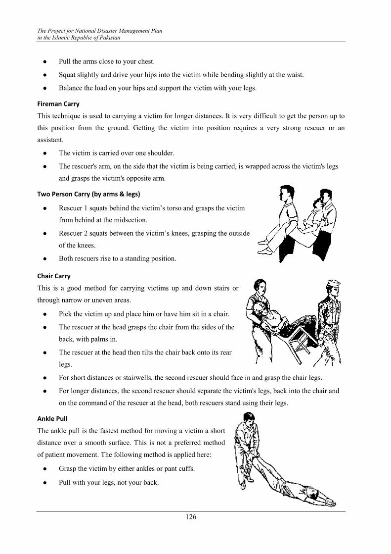
The Project for National Disaster Management Plan
in the Islamic Republic of Pakistan
126
� Pull the arms close to your chest.
� Squat slightly and drive your hips into the victim while bending slightly at the waist.
� Balance the load on your hips and support the victim with your legs.
Fireman Carry
This technique is used to carrying a victim for longer distances. It is very difficult to get the person up to
this position from the ground. Getting the victim into position requires a very strong rescuer or an
assistant.
� The victim is carried over one shoulder.
� The rescuer's arm, on the side that the victim is being carried, is wrapped across the victim's legs
and grasps the victim's opposite arm.
Two Person Carry (by arms & legs)
� Rescuer 1 squats behind the victim’s torso and grasps the victim
from behind at the midsection.
� Rescuer 2 squats between the victim’s knees, grasping the outside
of the knees.
� Both rescuers rise to a standing position.
Chair Carry
This is a good method for carrying victims up and down stairs or
through narrow or uneven areas.
� Pick the victim up and place him or have him sit in a chair.
� The rescuer at the head grasps the chair from the sides of the
back, with palms in.
� The rescuer at the head then tilts the chair back onto its rear
legs.
� For short distances or stairwells, the second rescuer should face in and grasp the chair legs.
� For longer distances, the second rescuer should separate the victim's legs, back into the chair and
on the command of the rescuer at the head, both rescuers stand using their legs.
Ankle Pull
The ankle pull is the fastest method for moving a victim a short
distance over a smooth surface. This is not a preferred method
of patient movement. The following method is applied here:
� Grasp the victim by either ankles or pant cuffs.
� Pull with your legs, not your back.
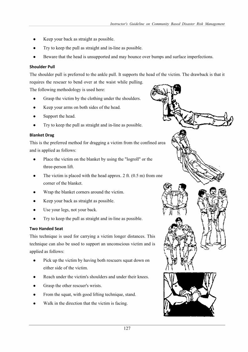
Instructor's Guideline on Community Based Disaster Risk Management
127
� Keep your back as straight as possible.
� Try to keep the pull as straight and in-line as possible.
� Beware that the head is unsupported and may bounce over bumps and surface imperfections.
Shoulder Pull
The shoulder pull is preferred to the ankle pull. It supports the head of the victim. The drawback is that it
requires the rescuer to bend over at the waist while pulling.
The following methodology is used here:
� Grasp the victim by the clothing under the shoulders.
� Keep your arms on both sides of the head.
� Support the head.
� Try to keep the pull as straight and in-line as possible.
Blanket Drag
This is the preferred method for dragging a victim from the confined area
and is applied as follows:
� Place the victim on the blanket by using the "logroll" or the
three-person lift.
� The victim is placed with the head approx. 2 ft. (0.5 m) from one
corner of the blanket.
� Wrap the blanket corners around the victim.
� Keep your back as straight as possible.
� Use your legs, not your back.
� Try to keep the pull as straight and in-line as possible.
Two Handed Seat
This technique is used for carrying a victim longer distances. This
technique can also be used to support an unconscious victim and is
applied as follows:
� Pick up the victim by having both rescuers squat down on
either side of the victim.
� Reach under the victim's shoulders and under their knees.
� Grasp the other rescuer's wrists.
� From the squat, with good lifting technique, stand.
� Walk in the direction that the victim is facing.
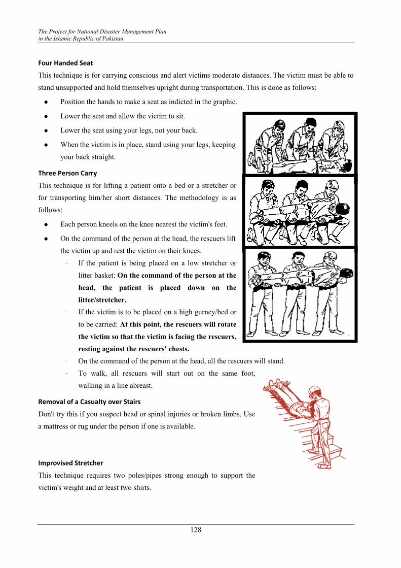
The Project for National Disaster Management Plan
in the Islamic Republic of Pakistan
128
Four Handed Seat
This technique is for carrying conscious and alert victims moderate distances. The victim must be able to
stand unsupported and hold themselves upright during transportation. This is done as follows:
� Position the hands to make a seat as indicted in the graphic.
� Lower the seat and allow the victim to sit.
� Lower the seat using your legs, not your back.
� When the victim is in place, stand using your legs, keeping
your back straight.
Three Person Carry
This technique is for lifting a patient onto a bed or a stretcher or
for transporting him/her short distances. The methodology is as
follows:
� Each person kneels on the knee nearest the victim's feet.
� On the command of the person at the head, the rescuers lift
the victim up and rest the victim on their knees.
- If the patient is being placed on a low stretcher or
litter basket: On the command of the person at the
head, the patient is placed down on the
litter/stretcher.
- If the victim is to be placed on a high gurney/bed or
to be carried: At this point, the rescuers will rotate
the victim so that the victim is facing the rescuers,
resting against the rescuers' chests.
- On the command of the person at the head, all the rescuers will stand.
- To walk, all rescuers will start out on the same foot,
walking in a line abreast.
Removal of a Casualty over Stairs
Don't try this if you suspect head or spinal injuries or broken limbs. Use
a mattress or rug under the person if one is available.
Improvised Stretcher
This technique requires two poles/pipes strong enough to support the
victim's weight and at least two shirts.
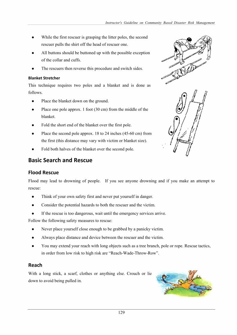
Instructor's Guideline on Community Based Disaster Risk Management
129
� While the first rescuer is grasping the litter poles, the second
rescuer pulls the shirt off the head of rescuer one.
� All buttons should be buttoned up with the possible exception
of the collar and cuffs.
� The rescuers then reverse this procedure and switch sides.
Blanket Stretcher
This technique requires two poles and a blanket and is done as
follows.
� Place the blanket down on the ground.
� Place one pole approx. 1 foot (30 cm) from the middle of the
blanket.
� Fold the short end of the blanket over the first pole.
� Place the second pole approx. 18 to 24 inches (45-60 cm) from
the first (this distance may vary with victim or blanket size).
� Fold both halves of the blanket over the second pole.
Basic Search and Rescue
Flood Rescue
Flood may lead to drowning of people. If you see anyone drowning and if you make an attempt to
rescue:
� Think of your own safety first and never put yourself in danger.
� Consider the potential hazards to both the rescuer and the victim.
� If the rescue is too dangerous, wait until the emergency services arrive.
Follow the following safety measures to rescue:
� Never place yourself close enough to be grabbed by a panicky victim.
� Always place distance and device between the rescuer and the victim.
� You may extend your reach with long objects such as a tree branch, pole or rope. Rescue tactics,
in order from low risk to high risk are “Reach-Wade-Throw-Row”.
Reach
With a long stick, a scarf, clothes or anything else. Crouch or lie
down to avoid being pulled in.
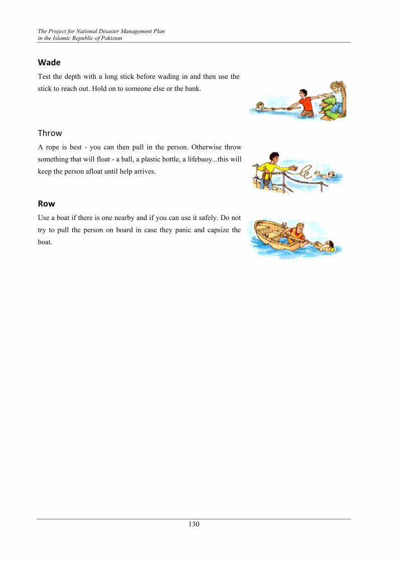
The Project for National Disaster Management Plan
in the Islamic Republic of Pakistan
130
Wade
Test the depth with a long stick before wading in and then use the
stick to reach out. Hold on to someone else or the bank.
Throw
A rope is best - you can then pull in the person. Otherwise throw
something that will float - a ball, a plastic bottle, a lifebuoy...this will
keep the person afloat until help arrives.
Row
Use a boat if there is one nearby and if you can use it safely. Do not
try to pull the person on board in case they panic and capsize the
boat.
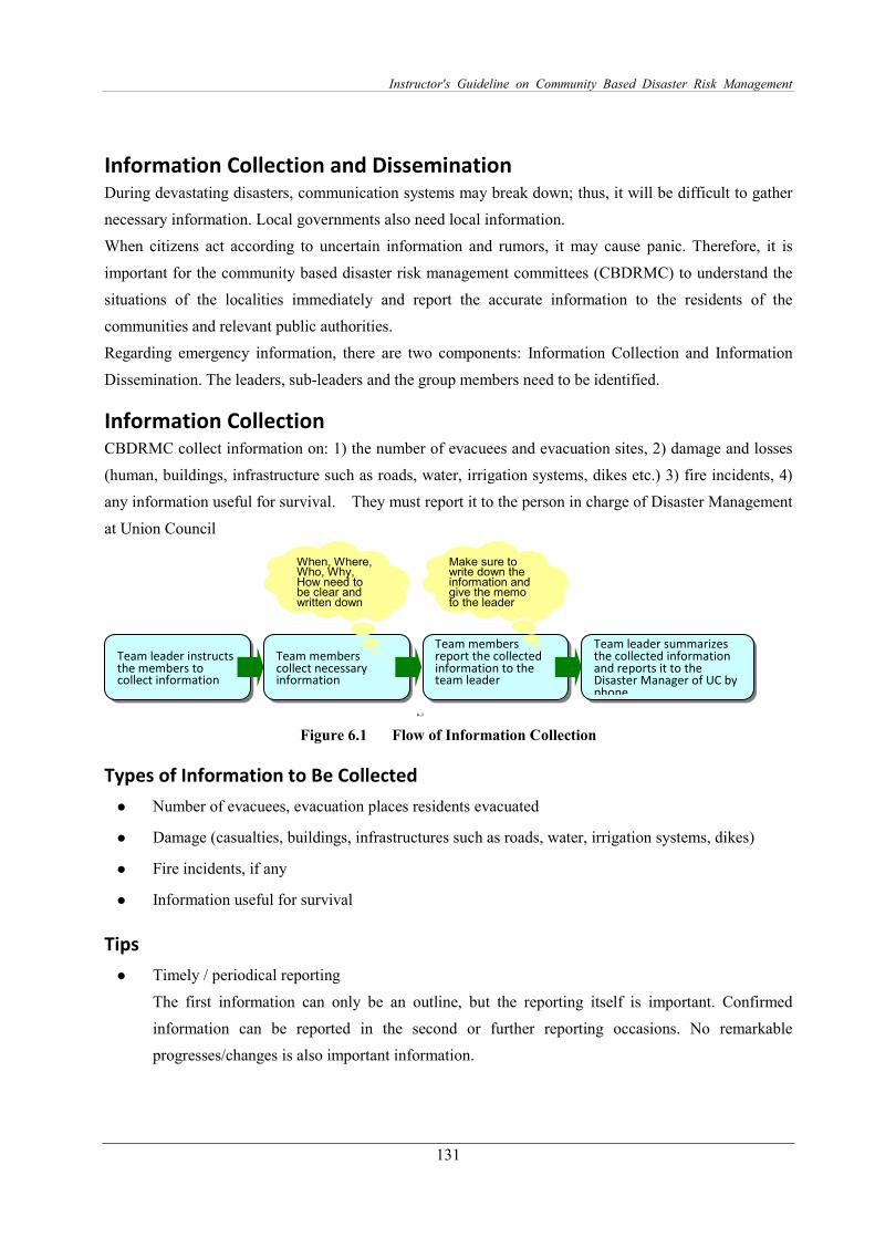
Instructor's Guideline on Community Based Disaster Risk Management
131
Information Collection and Dissemination During devastating disasters, communication systems may break down; thus, it will be difficult to gather
necessary information. Local governments also need local information.
When citizens act according to uncertain information and rumors, it may cause panic. Therefore, it is
important for the community based disaster risk management committees (CBDRMC) to understand the
situations of the localities immediately and report the accurate information to the residents of the
communities and relevant public authorities.
Regarding emergency information, there are two components: Information Collection and Information
Dissemination. The leaders, sub-leaders and the group members need to be identified.
Information Collection CBDRMC collect information on: 1) the number of evacuees and evacuation sites, 2) damage and losses
(human, buildings, infrastructure such as roads, water, irrigation systems, dikes etc.) 3) fire incidents, 4)
any information useful for survival. They must report it to the person in charge of Disaster Management
at Union Council
6..1
Figure 6.1 Flow of Information Collection
Types of Information to Be Collected
� Number of evacuees, evacuation places residents evacuated
� Damage (casualties, buildings, infrastructures such as roads, water, irrigation systems, dikes)
� Fire incidents, if any
� Information useful for survival
Tips
� Timely / periodical reporting
The first information can only be an outline, but the reporting itself is important. Confirmed
information can be reported in the second or further reporting occasions. No remarkable
progresses/changes is also important information.
Team leader instructs the members to collect information
Team members collect necessary information
Team members report the collected information to the team leader
Team leader summarizes the collected information and reports it to the Disaster Manager of UC by phone
When, Where, Who, Why, How need to be clear and written down
Make sure to write down the information and give the memo to the leader
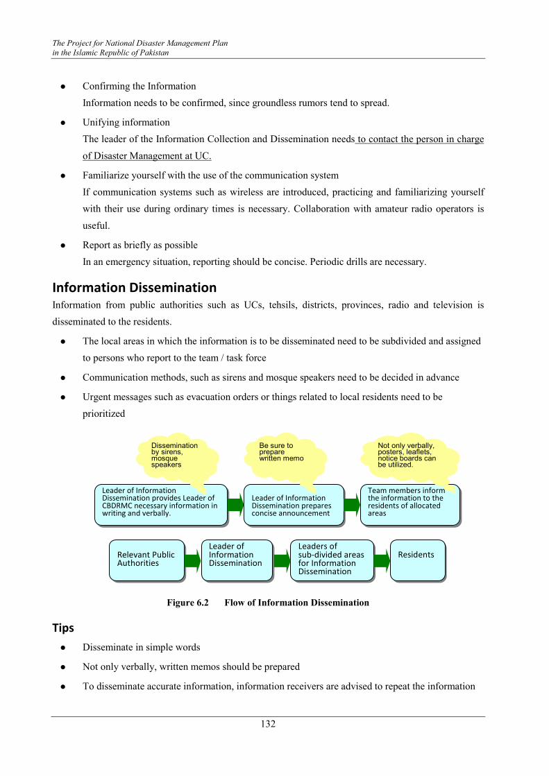
The Project for National Disaster Management Plan
in the Islamic Republic of Pakistan
132
� Confirming the Information
Information needs to be confirmed, since groundless rumors tend to spread.
� Unifying information
The leader of the Information Collection and Dissemination needs to contact the person in charge
of Disaster Management at UC.
� Familiarize yourself with the use of the communication system
If communication systems such as wireless are introduced, practicing and familiarizing yourself
with their use during ordinary times is necessary. Collaboration with amateur radio operators is
useful.
� Report as briefly as possible
In an emergency situation, reporting should be concise. Periodic drills are necessary.
Information Dissemination Information from public authorities such as UCs, tehsils, districts, provinces, radio and television is
disseminated to the residents.
� The local areas in which the information is to be disseminated need to be subdivided and assigned
to persons who report to the team / task force
� Communication methods, such as sirens and mosque speakers need to be decided in advance
� Urgent messages such as evacuation orders or things related to local residents need to be
prioritized
Figure 6.2 Flow of Information Dissemination
Tips
� Disseminate in simple words
� Not only verbally, written memos should be prepared
� To disseminate accurate information, information receivers are advised to repeat the information
Leader of Information Dissemination provides Leader of CBDRMC necessary information in writing and verbally.
Leader of Information Dissemination prepares concise announcement
Team members inform the information to the residents of allocated areas
Dissemination by sirens, mosque speakers
Be sure to prepare written memo
Not only verbally, posters, leaflets, notice boards can be utilized.
Relevant Public Authorities
Leader of Information Dissemination
Residents
Leaders of sub-divided areas for Information Dissemination
Instructor's Guideline on Community Based Disaster Risk Management
133
� Take special care in disseminating numerical information
� To disseminate the information efficiently, dissemination routes need to be identified beforehand
� Take special care for those who have hearing difficulties, foreigners, etc.
� Regularly inspect the communication system.
References:
Enabling Communities to Live Responsibility with Disasters, FOCUS Humanitarian Assistance
The Project for National Disaster Management Plan
in the Islamic Republic of Pakistan
134
Evacuation During an emergency, if residents know the evacuation routes and evacuation sites, they can evacuate
smoothly and safely. It is very important to learn how to assist those who have difficulties in evacuating
by themselves. Especially for tsunami, the speed is extremely fast; thus, periodic practice will prevent
people from being late for the evacuation. Simulation exercises during the night are also recommended.
Confirming the Evacuation Sites
� Confirming the evacuation routes and evacuation sites by all the family members is recommended
� Decide where to meet finally, in case all your family members are separated
Timing of Evacuation
When you are facing pressing dangers such as earthquakes and tsunami, the earliest possible evacuation is
needed. Evacuate immediately in the following cases:
� When you think it is dangerous
� When there are instructions from public authorities such as police, Rescue 1122, Civil Defence,
UC, Tehsil, district, etc.
� When there are instructions from a leader or members of CBDRMC
Procedures
Procedures for evacuation are as follows:
� The Information Team gives evacuation guidance to the residents.
� The Evacuation Team asks residents to evacuate.
� Determine the rough number of evacuees and the situation of those who have difficulties.
� Make pre-defined smaller groups for evacuation, and identify persons who will guide the
evacuees.
� The leader of the Evacuation Team announces the appropriate evacuation routes and evacuation
sites.
� Members of the Evacuation Team provide ropes for those who have difficulty in evacuation to
hold, so that they can easily follow the group.
� Gather information from the radio during evacuation
� On reaching the evacuation sites, members of the Evacuation Team count the number of evacuees
and make sure that all the evacuees have reached the evacuation site.
Instructor's Guideline on Community Based Disaster Risk Management
135
Points of Evacuation
Points of evacuation are described below.
� Set several evacuation routes in advance and decide the safest routes based on the situation, such
as road blockages, wind, etc.
� If there are injured, patients, or physically challenged who cannot walk by themselves, the
residents must cooperate and carry them using instant stretchers, chairs, etc.
� During evacuation in groups, keep the pace of the slowest one. The first person in the queue pays
attention to the last person in the queue.
� During evacuation, be careful about the wind, sudden change of weather, fire, etc.
� Try to wear walking shoes with thick soles.
� Keep both your hands free by carrying back packs with emergency kit bags.

The Project for National Disaster Management Plan
in the Islamic Republic of Pakistan
136
Supplying Food and Water During devastating disasters, power failure, loss of water or gas supply, a shortage of food, water, and
commodities is to be expected. If the affected areas are across a wide area, relief supply may not be
adequate and slow in coming. It is advisable to keep stocks at home. It is advisable to train on community
kitchens and food distribution within the community.
Tips
� Confirm the number of evacuees to equally distribute the supplies.
� Keep the access way and service space for water supply trucks open.
� At the very initial stage, items that do not require cooking can be distributed.
� Keep water for cooking.
� To prevent disease, make sure to wash and disinfect hands.
� While setting up an outside kitchen, try to eliminate obstacles on the ground which cause slipping
and stumbling. Keep infants and small children away.
� Avoid keeping the relief goods in areas with moisture or bad drainage.
Procedures
Figure 6.3 Procedures of Supplying Foods
Preparation
Cooking pans, gas cooking stoves, water, towels, rice, flour, vegetables, meat etc. are prepared.
Team Supplying Food
and Water prepares
logistics
Setting up tents and
tables
Cooking chosen menu
Guidelines and Materials for Community Based Disaster Risk Management Activities
137
Module 7 Conducting Simulation Drills
Necessity To minimize the impact of disasters, calm and appropriate actions are important. To be able to take calm
and appropriate actions, knowing how to react and practicing how to react is very important since most of
the time, people cannot do something that they have never done before. By practicing practical training,
capacity for emergency action is enhanced and the hazardous impact can be minimized.
Objectives To be able to act appropriately, practical drills need to be conducted periodically among the different age
groups of the residents, by coordinating with disaster management organizations and enterprises in the
locality. The objectives of conducting drills are summarized below.
� Become familiar with the systematic emergency responses and disaster management procedures,
responsibilities of different team members of CBDRMC among committee members and
community members.
� Test the operability and efficiency of the disaster management plan in place.
� Enhance coordination of all stakeholders to implement existing disaster management plans.
� Generate preparedness and enhance confidence among residents and public officials concerned.
Things to Review in the Drills Many participants can be expected in a drill; thus, it is a great opportunity to provide basic information
and knowledge for the participants during drills. Following are the points of information/knowledge that
can be reviewed and practiced. Such review and training needs to be conducted repeatedly.
� Basic and practical knowledge on different types of disasters
� Understanding vulnerabilities of the localities
� Conducting countermeasures for each stage of disasters
� Knowledge dissemination on disaster management equipment
� Understanding and practicing the responsibilities of each person
� Understanding evacuation sites
Planning the Drills Be sure to make a plan for the drills. Plan the menu of the drills carefully so that many people can
participate in different types of activities. Also plan the composition of the participants for the types of
The Project for National Disaster Management Plan
in the Islamic Republic of Pakistan
138
activities. The activities need to be structured from easy to difficult activities. Conducting the activities
repeatedly is recommended.
Drills can be combined with some amusement events such as movies or festivals. The drill can be
organized as a sports festival.
� Plan what types of training are to be conducted
� The target groups and target number of participants
� Suitable date and time
� Venue
� Method of announcing the drill
� Preparing disaster management equipment
Instruction by Civil Defence, Rescue 1122, DDMA It is advisable to coordinate with disaster management organizations, and if it is possible, the instructors
can be sent from such professional organizations.
Conducting Reviewing Session At the end of the drill, it is important to have a reviewing session among all the participants of the drill
and feedback for the next drill.
Types of Drills There are different types of drills, such as information collection and distribution, fire extinguishing, basic
search and rescue, first aid, evacuation, supplying food and water, and a combination of these. Map
maneuvers are also one of the drills but in this section, only practical on-site training is introduced.
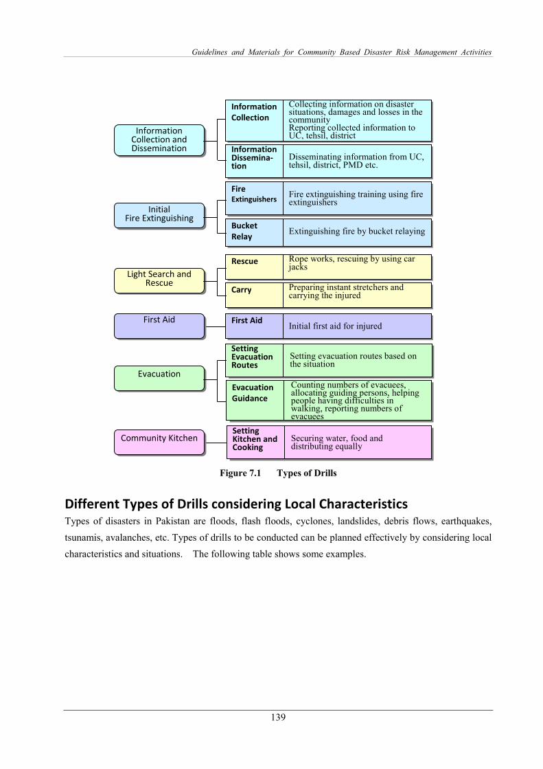
Guidelines and Materials for Community Based Disaster Risk Management Activities
139
Figure 7.1 Types of Drills
Different Types of Drills considering Local Characteristics Types of disasters in Pakistan are floods, flash floods, cyclones, landslides, debris flows, earthquakes,
tsunamis, avalanches, etc. Types of drills to be conducted can be planned effectively by considering local
characteristics and situations. The following table shows some examples.
Initial Fire Extinguishing
Light Search and Rescue
Securing water, food and distributing equally
Setting Kitchen and Cooking
Counting numbers of evacuees, allocating guiding persons, helping people having difficulties in walking, reporting numbers of evacuees
Evacuation
Guidance
Setting evacuation routes based on the situation
Setting Evacuation Routes
Preparing instant stretchers and carrying the injured
Carry
Initial first aid for injured
First Aid
Rope works, rescuing by using car jacks
Rescue
Extinguishing fire by bucket relaying
Bucket
Relay
Fire extinguishing training using fire extinguishers
Fire Extinguishers
Information Collection and Dissemination
Disseminating information from UC, tehsil, district, PMD etc.
Information Dissemina- tion
Collecting information on disaster situations, damages and losses in the community Reporting collected information to UC, tehsil, district
Information
Collection
Evacuation
Community Kitchen
First Aid

The Project for National Disaster Management Plan
in the Islamic Republic of Pakistan
140
Table 7.1 Contents of Drills
Characteristics of the Areas Contents of Drills
Coastal Areas For tsunami and high tide
・ Information dissemination regarding dangers and evacuation orders
・ Evacuation in shortest time
・ Evacuation announcement and guidance for tourists
Area adjacent to Steep Slopes For landslide, debris flow
・ Information dissemination of dangers and evacuation order
・ Evacuation in shortest time
Congested Area For earthquake
・ Initial fire extinguishing
・ Evacuation
・ Light Search and Rescue in a collapsed structure
Tourist Places For evacuation of tourists
・ Information dissemination training (announcing dangers, evacuation order)
・ Emergency evacuation
Neighborhood of Special
Facilities
For collaborating kindergartens / schools
・ Information dissemination training
・ Emergency evacuation of infants
Business cum Residential Area For collaborating residents and enterprises
・ Evacuation training
・ Light search and rescue
・ Setting community kitchen and cooking
Response Type Drill The drills can be conducted by setting different incidents such as flooding, fire, falling objects, road
blockage, drowning persons, and injured in the different parts of the community. Each scenario is
prepared by only a small number of organizers and participants are given instructions to react according
to the given situations. This method provides a good opportunity to enhance the capacity of
decision-making under an emergency situation.
Figure 7.2 Incident Settings
Scenario of the Drill The drill scenario is developed considering a timeline, responsible persons, and necessary equipment. An
example of a drill scenario is shown in Table 7.2.
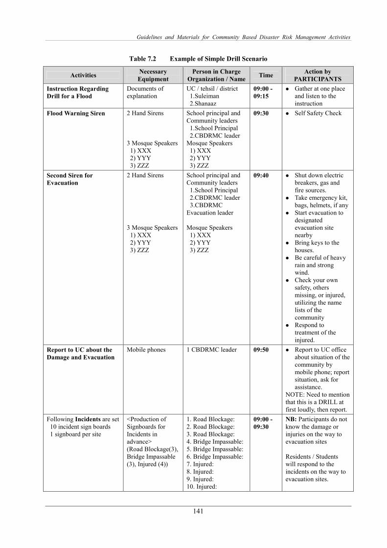
Guidelines and Materials for Community Based Disaster Risk Management Activities
141
Table 7.2 Example of Simple Drill Scenario
Activities Necessary
Equipment
Person in Charge
Organization / Name Time
Action by
PARTICIPANTS
Instruction Regarding
Drill for a Flood
Documents of explanation
UC / tehsil / district 1.Suleiman 2.Shanaaz
09:00 -
09:15
� Gather at one place and listen to the instruction
Flood Warning Siren 2 Hand Sirens 3 Mosque Speakers
1) XXX 2) YYY 3) ZZZ
School principal and Community leaders
1.School Principal 2.CBDRMC leader
Mosque Speakers 1) XXX 2) YYY 3) ZZZ
09:30 � Self Safety Check
Second Siren for
Evacuation
2 Hand Sirens 3 Mosque Speakers
1) XXX 2) YYY 3) ZZZ
School principal and Community leaders
1.School Principal 2.CBDRMC leader 3.CBDRMC
Evacuation leader Mosque Speakers
1) XXX 2) YYY 3) ZZZ
09:40
� Shut down electric breakers, gas and fire sources.
� Take emergency kit, bags, helmets, if any
� Start evacuation to designated evacuation site nearby
� Bring keys to the houses.
� Be careful of heavy rain and strong wind.
� Check your own safety, others missing, or injured, utilizing the name lists of the community
� Respond to treatment of the injured.
Report to UC about the
Damage and Evacuation
Mobile phones 1 CBDRMC leader 09:50 � Report to UC office about situation of the community by mobile phone; report situation, ask for assistance.
NOTE: Need to mention that this is a DRILL at first loudly, then report.
Following Incidents are set 10 incident sign boards 1 signboard per site
<Production of Signboards for Incidents in advance> (Road Blockage(3), Bridge Impassable (3), Injured (4))
1. Road Blockage: 2. Road Blockage: 3. Road Blockage: 4. Bridge Impassable: 5. Bridge Impassable: 6. Bridge Impassable: 7. Injured: 8. Injured: 9. Injured: 10. Injured:
09:00 -
09:30
NB: Participants do not know the damage or injuries on the way to evacuation sites Residents / Students will respond to the incidents on the way to evacuation sites.
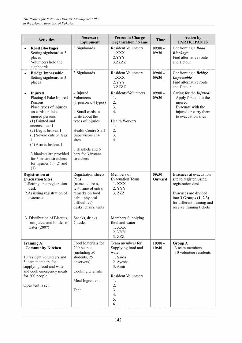
The Project for National Disaster Management Plan
in the Islamic Republic of Pakistan
142
Activities Necessary
Equipment
Person in Charge
Organization / Name Time
Action by
PARTICIPANTS
• Road Blockages
Setting signboard at 3 places Volunteers hold the signboards
3 Signboards
Resident Volunteers 1.XXX 2.YYY 3.ZZZZ
09:00 -
09:30
Confronting a Road
Blockage Find alternative route and Detour
• Bridge Impassable
Setting signboard at 3 places
3 Signboards
Resident Volunteers 1.XXX 2.YYY 3.ZZZZ
09:00 -
09:30
Confronting a Bridge
Impassable Find alternative route and Detour
• Injured
Placing 4 Fake Injured Persons Place types of injuries on cards on fake injured persons (1) Fainted and unconscious:1 (2) Leg is broken:1 (3) Severe cuts on legs: 1 (4) Arm is broken:1
3 blankets are provided for 3 instant stretchers for injuries (1) (2) and (3)
4 Injured Volunteers (1 person x 4 types) 4 Small cards to write about the types of injuries Health Centre Staff Supervisors at 4 sites 3 Blankets and 6 bars for 3 instant stretchers
Residents/Volunteers 1. 2. 3. 4.
Health Workers
1. 2. 3. 4.
09:00 -
09:30
Caring for the Injured:
Apply first aid to the injured Evacuate with the injured or carry them to evacuation sites
Registration at
Evacuation Sites
1.Setting up a registration desk
2.Assisting registration of evacuees
Registration sheets Pens (name, address, tel#, time of entry, remarks on food habit, physical difficulties) desks, chairs, tents
Members of Evacuation Team
1. XXX 2. YYY 3. ZZZ
09:50
Onward
Evacuees at evacuation site to register, using registration desks Evacuees are divided into 3 Groups (1, 2 3)
for different training and receive training tickets
3. Distribution of Biscuits, fruit juice, and bottles of water (200?)
Snacks, drinks 2 desks
Members Supplying food and water
1. XXX 2. YYY 3. ZZZ
Training A:
Community Kitchen
10 resident volunteers and 3 team members for supplying food and water and cook emergency meals for 200 people. Open tent is set.
Food Materials for 200 people (including 50 students, 25 observers) Cooking Utensils Meal Ingredients Tent
Team members for Supplying food and water
1. Saida 2. Ayesha 3. Amir
Resident Volunteers
1. 2. 3. 4. 5. 6.
10:00 -
10:40
Group A
3 team members 10 volunteer residents
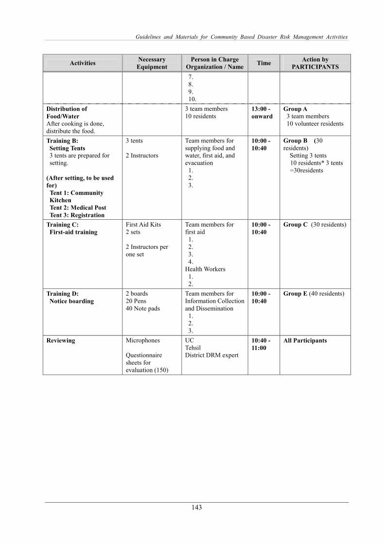
Guidelines and Materials for Community Based Disaster Risk Management Activities
143
Activities Necessary
Equipment
Person in Charge
Organization / Name Time
Action by
PARTICIPANTS
7. 8. 9. 10.
Distribution of
Food/Water
After cooking is done, distribute the food.
3 team members 10 residents
13:00 -
onward
Group A
3 team members 10 volunteer residents
Training B:
Setting Tents
3 tents are prepared for setting.
(After setting, to be used
for)
Tent 1: Community
Kitchen
Tent 2: Medical Post
Tent 3: Registration
3 tents 2 Instructors
Team members for supplying food and water, first aid, and evacuation
1. 2. 3.
10:00 -
10:40
Group B (30 residents)
Setting 3 tents 10 residents* 3 tents =30residents
Training C:
First-aid training
First Aid Kits 2 sets 2 Instructors per one set
Team members for first aid
1. 2. 3. 4.
Health Workers 1. 2.
10:00 -
10:40
Group C (30 residents)
Training D:
Notice boarding
2 boards 20 Pens 40 Note pads
Team members for Information Collection and Dissemination
1. 2. 3.
10:00 -
10:40
Group E (40 residents)
Reviewing Microphones Questionnaire sheets for evaluation (150)
UC Tehsil District DRM expert
10:40 -
11:00
All Participants

Guidelines and Materials for Community Based Disaster Risk Management Activities
145
Module 8 Monitoring and Evaluation
Steps The steps of the Monitoring and Evaluations are summarized below.
1. Identifying what kinds of information need to be collected, considering available human and financial
resources
2. Identifying how the information will be collected
3. Identifying who will collect, analyze, and use the information
4. Setting up the Monitoring and Evaluation system with a participatory approach
5. Collecting data and information
6. Analyzing and evaluating data
7. Documentation, communication and sharing findings
Monitoring Monitoring is the process of reviewing the activities periodically and assessing how the progress and the
planned schedules are progressing, and how many achievements have been realized. There are two types
of monitoring: 1) process monitoring, and 2) effect monitoring. In the process monitoring, the
implementing process is assessed; thus, if it is behind the planned schedule, more inputs/actions are added
to catch up with the timeline. For process monitoring, indicators at key stages can be developed. In the
case of effect monitoring, the impacts are assessed. If there are negative impacts, stakeholders are to take
appropriate actions to stop the negative effects.
Evaluation Evaluation is the assessment of achievements, results, and effects, usually conducted at the end of the
project, but sometimes it can be done during the implementation phase. Evaluations are conducted to
know: how many of the objectives are achieved, how successfully the project contributed to disaster risk
reduction, what were the effects of the project to the community people, and accountabilities. If the set
objectives are not achieved, additional inputs need to be considered.
It is also important to set indicators for evaluation at the beginning of the project. The result of the VCA
can be baseline data to assess the changes before and after the project. If a baseline survey is conducted at
� Direct observation by visiting the field � Interviewing survey with the key persons � Conducting review meetings among the stakeholders � Monitoring with indicators, by reviewing the existing activity reports, progress
Method of Monitoring


![[Phillip C. Wankat] Instructor's Solution Manual - baixardoc](https://static.fdokumen.com/doc/165x107/63276b14cedd78c2b50d90d6/phillip-c-wankat-instructors-solution-manual-baixardoc.jpg)