Positive health effects of the natural outdoor environment in ...
Upload
khangminh22Category
view
0download
0
Pit Level 1 and 2 Natural Environment Technical Report Ecological Services
1
NATURAL ENVIRONMENT
TECHNICAL REPORT: LEVEL 1 and 2
GPP Pit
Prepared for
Glen and Pete McNichols
McNichols Construction Ltd.
1238 Westport Road
Godfrey Ontario
K0H 1T0
ECOLOGICAL SERVICES
Rob Snetsinger
February 28, 2020
Pit Level 1 and 2 Natural Environment Technical Report Ecological Services
2
Table of Contents 1. Summary ...............................................................................................................................................3
2. Legislative Requirements ......................................................................................................................4
3. Methodology .........................................................................................................................................6
4. Ecological Land Classification ..............................................................................................................7
5. Assessment of Natural Features ..........................................................................................................11
5.0 Species at Risk (Threatened and Endangered) ............................................................................11
5.1 Wetland .......................................................................................................................................14
5.2 Area of Natural and Scientific Interest (ANSI) ...........................................................................14
5.3 Valleylands ..................................................................................................................................14
5.4 Woodlands ...................................................................................................................................14
5.5 Wildlife Habitat ...........................................................................................................................15
5.6 Fish Habitat .................................................................................................................................21
6.0 Natural Environment Level 2: Impact Assessment ...........................................................................22
6. References ...........................................................................................................................................30
7. Qualifications ......................................................................................................................................31
8. Appendix 1: Plant List .........................................................................................................................33
9. Appendix 2: Bird List ..........................................................................................................................38
10. Appendix 2: Herp and Mammal List ...............................................................................................42
Pit Level 1 and 2 Natural Environment Technical Report Ecological Services
3
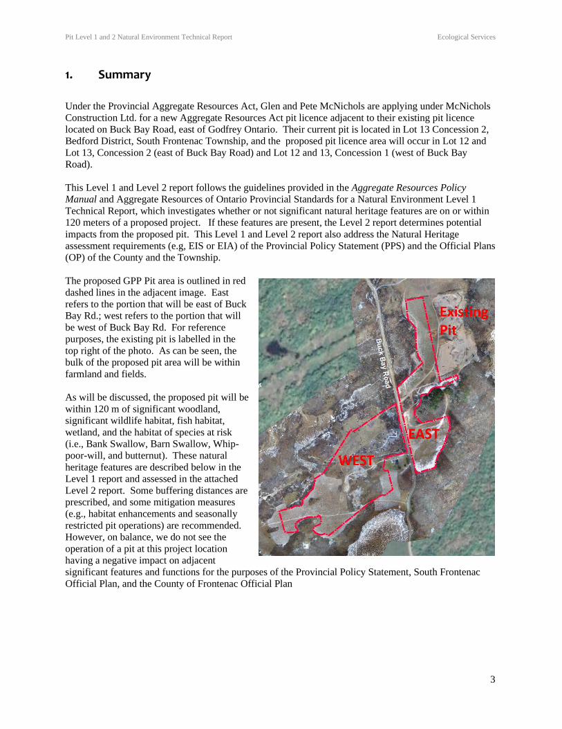
1. Summary
Under the Provincial Aggregate Resources Act, Glen and Pete McNichols are applying under McNichols
Construction Ltd. for a new Aggregate Resources Act pit licence adjacent to their existing pit licence
located on Buck Bay Road, east of Godfrey Ontario. Their current pit is located in Lot 13 Concession 2,
Bedford District, South Frontenac Township, and the proposed pit licence area will occur in Lot 12 and
Lot 13, Concession 2 (east of Buck Bay Road) and Lot 12 and 13, Concession 1 (west of Buck Bay
Road).
This Level 1 and Level 2 report follows the guidelines provided in the Aggregate Resources Policy
Manual and Aggregate Resources of Ontario Provincial Standards for a Natural Environment Level 1
Technical Report, which investigates whether or not significant natural heritage features are on or within
120 meters of a proposed project. If these features are present, the Level 2 report determines potential
impacts from the proposed pit. This Level 1 and Level 2 report also address the Natural Heritage
assessment requirements (e.g, EIS or EIA) of the Provincial Policy Statement (PPS) and the Official Plans
(OP) of the County and the Township.
The proposed GPP Pit area is outlined in red
dashed lines in the adjacent image. East
refers to the portion that will be east of Buck
Bay Rd.; west refers to the portion that will
be west of Buck Bay Rd. For reference
purposes, the existing pit is labelled in the
top right of the photo. As can be seen, the
bulk of the proposed pit area will be within
farmland and fields.
As will be discussed, the proposed pit will be
within 120 m of significant woodland,
significant wildlife habitat, fish habitat,
wetland, and the habitat of species at risk
(i.e., Bank Swallow, Barn Swallow, Whip-
poor-will, and butternut). These natural
heritage features are described below in the
Level 1 report and assessed in the attached
Level 2 report. Some buffering distances are
prescribed, and some mitigation measures
(e.g., habitat enhancements and seasonally
restricted pit operations) are recommended.
However, on balance, we do not see the
operation of a pit at this project location
having a negative impact on adjacent
significant features and functions for the purposes of the Provincial Policy Statement, South Frontenac
Official Plan, and the County of Frontenac Official Plan
Pit Level 1 and 2 Natural Environment Technical Report Ecological Services
4
2. Legislative Requirements
Aggregate Resources of Ontario Provincial Standards (AROPS) for Category 3 Licence
Applications
Aggregate Resources Program Policies and Procedures Manual section 2.01.07, relates to natural
environment report standards as prescribed by AROPS. Specifically:
“A Natural Environment Level 1 report determines whether one or more of the following features exist
on-site or within 120 metres of the site:
• significant wetlands (including significant coastal wetlands);
• significant habitat of endangered and threatened species;
• significant Areas of Natural and Scientific Interest (ANSIs);
• significant woodlands (south and east of the Canadian Shield)
• significant valleylands (south and east of the Canadian Shield)
• significant wildlife habitat; and
• fish habitat.
The Level 1 report must clearly conclude whether each of the features above exists on or is
within 120m of the site. If any of these features are identified, then an impact assessment (i.e. Natural
Environment Level 2 report) is required to determine any negative impacts on the natural features or
ecological functions, and any proposed preventative, mitigation or remedial measures.
Provincial Policy Statement (PPS)
Issued under the Planning Act, the 2014 version of the PPS requires that municipalities consider natural
heritage features in assessing development proposals. Guidance on the extent of adjacent lands is
provided in a Natural Heritage Reference Manual (OMNR 2010). The adjacent land width for significant
natural heritage features is 120 m. From the PPS:
2.1.4 Development and site alteration shall not be permitted in:
a) significant wetlands in Ecoregions 5E, 6E and 7E1; and
2.1.5 Development and site alteration shall not be permitted in:
b) significant woodlands in Ecoregions 6E; (NOTE: the proposed pit is in Ecoregion 5E)
c) significant valleylands in Ecoregions 6E;
d) significant wildlife habitat;
e) significant areas of natural and scientific interest;
… unless it has been demonstrated that there will be no negative impacts on the natural features or
their ecological functions.
2.1.6 Development and site alteration shall not be permitted in fish habitat except in accordance with
provincial and federal requirements.
2.1.7 Development and site alteration shall not be permitted in habitat of endangered species and
threatened species, except in accordance with provincial and federal requirements. Note: Adjacent
Pit Level 1 and 2 Natural Environment Technical Report Ecological Services
5
lands do not apply to the habitat of endangered species and threatened species, as impacts are based
on a species by species basis in accordance with federal and provincial requirements.
2.1.8 Development and site alteration shall not be permitted on adjacent lands to the natural
heritage features and areas identified in policies 2.1.4, 2.1.5, and 2.1.6 unless the ecological function
of the adjacent lands has been evaluated and it has been demonstrated that there will be no negative
impacts on the natural features or on their ecological functions.
South Frontenac Township and County of Frontenac Official Plan Requirements
Although we understand no Official Plan (OP) Amendment is required for the proposed GPP Pit,
relevant Natural Heritage policies from the County Official Plan and Environmental Protection policies
from the Township Official Plan require consideration through an Environmental Impact Statement
(EIS), and an Environmental Impact Assessment (EIA), respectively. This is due to the proximity of the
proposed pit to OP prescribed natural heritage features.
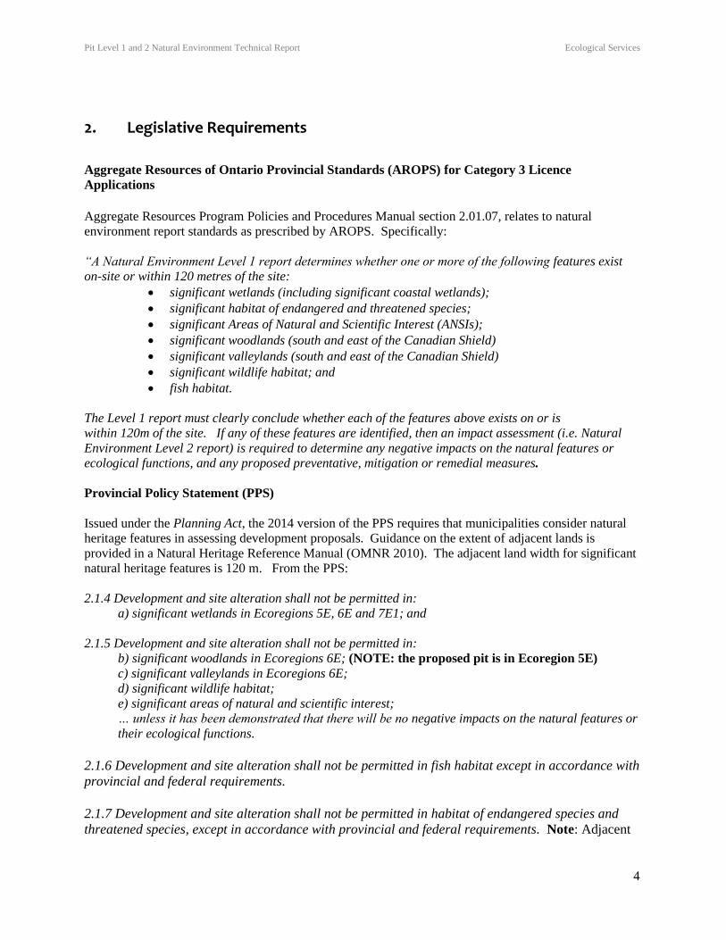
Relevant Images from the County and Township Official Plans and Township Zoning
The image to the left is
from the Township of
South Frontenac
Zoning By-Law 2003-
75 Schedule ‘D’. The
white area is a Rural
(RU) Zone, the light
blue area is Pit “B”
Zone (PB). The image
to the right is from
Frontenac County
Official Plan Aggregate Resources Sand and Gravel where the yellow
area is Sand and Gravel Tertiary. The black hatched lines are the
proposed licence area.
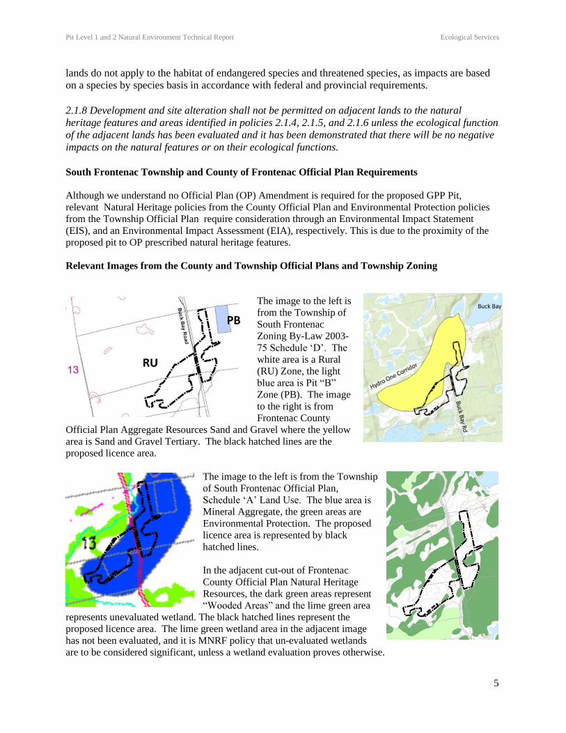
The image to the left is from the Township
of South Frontenac Official Plan,
Schedule ‘A’ Land Use. The blue area is
Mineral Aggregate, the green areas are
Environmental Protection. The proposed
licence area is represented by black
hatched lines.
In the adjacent cut-out of Frontenac
County Official Plan Natural Heritage
Resources, the dark green areas represent
“Wooded Areas” and the lime green area
represents unevaluated wetland. The black hatched lines represent the
proposed licence area. The lime green wetland area in the adjacent image
has not been evaluated, and it is MNRF policy that un-evaluated wetlands
are to be considered significant, unless a wetland evaluation proves otherwise.

Pit Level 1 and 2 Natural Environment Technical Report Ecological Services
6
3. Methodology
On June 19, 2018 we received the list of potential significant features that would need to be considered
during field work from Henry Penyk of the Peterborough office of the Ontario Ministry of Natural
Resources and Forestry (MNRF). Field work commenced on April 27 and focused on taxa that we felt
were likely to be on the MNRF list.
The site visits are provided in Table 1 and listed by the primary focus of the visit. However, incidental
taxa of note would be recorded during all visits. For example, Barn Swallows (Threatened) were
observed nesting on April 27, but this was not the primary focus of the visit that day. Habitat
communities are described following the methodology outlined in the Ecological Land Classification
(ELC) manual for Southern Ontario (Lee et al., 1998) and if applicable, the Ontario Wetland Evaluation
System Southern Manual (MNR 2002). Photographs of the site were also taken to document natural
features observed during the site investigation.
Significant natural features were identified following the criteria outlined in the Natural Heritage
Reference Manual (MNR 2010), Significant Wildlife Habitat Ecoregion Criteria Schedules (MNRF 2015)
and Significant Wildlife Habitat Technical Guide (MNR 2000).
Breeding bird point count surveys were conducted using methods described in the Ontario Breeding Bird
Atlas Guide for Participants (Cadman and Kopysh, 2001) and the Canadian Wildlife Service Forest Bird
Monitoring Program. Evening visits were also included to provide a greater level of effort for species
active at night such as nightjars and amphibians.
Snakes were assessed by examining areas of appropriate habitat such as rock piles, potential basking sites,
and potential hibernacula. Other wildlife species of interest (e.g., butterflies, mammals) were noted as
encountered, either directly or from other evidence (tracks, scat, den sites, etc.). Vascular plant species
were used to characterize ELC community types. If specimens could not be identified they would be
assessed later using appropriate references (e.g., Gleason and Cronquist 1991; Queen`s University Fowler
Herbarium records).
MNRF protocols for targeted surveys were applied when necessary. For example:
Bobolink and Eastern Meadowlark: OMNR (2011) Bobolink Survey Methodology.
Bats: MNR (2011a)
Barn and Bank Swallows: Standard avifaunal surveys, with focus on prospective nest sites.
Whip-poor-will: OMNR (2012) Whip-poor-will Survey Methodology.
Butternut: 10 m transect search pattern.
Turtles: Survey for basking sites and nesting specific substrates.
Rat Snakes: OMNRF (2016) and OMNRF (undated)
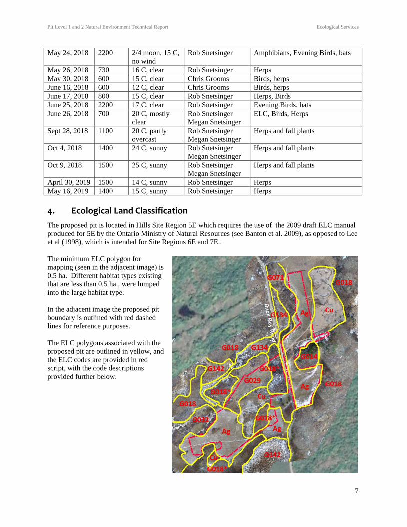
Table 1 Site visit summary. Survey Date Starting
Time
Weather
Conditions
Surveyor Main Purpose of Visit
April 27, 2018 1000 14 C, clear Rob Snetsinger Initial Site Inspection
April 30, 2018 2100 Full Moon, 7 C Rob Snetsinger Evening Birds, Amphibians
May 5, 2018 700 8 C, clear Rob Snetsinger
Chris Grooms
Birding, Herps
May 15, 2018 2200 New Moon,10
C
Rob Snetsinger Amphibians, Evening Birds, bats
Pit Level 1 and 2 Natural Environment Technical Report Ecological Services
7
May 24, 2018 2200 2/4 moon, 15 C,
no wind
Rob Snetsinger Amphibians, Evening Birds, bats
May 26, 2018 730 16 C, clear Rob Snetsinger Herps
May 30, 2018 600 15 C, clear Chris Grooms Birds, herps
June 16, 2018 600 12 C, clear Chris Grooms Birds, herps
June 17, 2018 800 15 C, clear Rob Snetsinger Herps, Birds
June 25, 2018 2200 17 C, clear Rob Snetsinger Evening Birds, bats
June 26, 2018 700 20 C, mostly
clear
Rob Snetsinger
Megan Snetsinger
ELC, Birds, Herps
Sept 28, 2018 1100 20 C, partly
overcast
Rob Snetsinger
Megan Snetsinger
Herps and fall plants
Oct 4, 2018 1400 24 C, sunny Rob Snetsinger
Megan Snetsinger
Herps and fall plants
Oct 9, 2018 1500 25 C, sunny Rob Snetsinger
Megan Snetsinger
Herps and fall plants
April 30, 2019 1500 14 C, sunny Rob Snetsinger Herps
May 16, 2019 1400 15 C, sunny Rob Snetsinger Herps
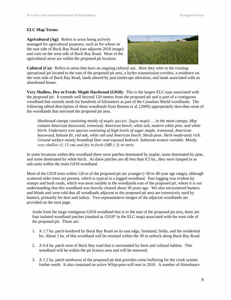
4. Ecological Land Classification
The proposed pit is located in Hills Site Region 5E which requires the use of the 2009 draft ELC manual
produced for 5E by the Ontario Ministry of Natural Resources (see Banton et al. 2009), as opposed to Lee
et al (1998), which is intended for Site Regions 6E and 7E..
The minimum ELC polygon for
mapping (seen in the adjacent image) is
0.5 ha. Different habitat types existing
that are less than 0.5 ha., were lumped
into the large habitat type.
In the adjacent image the proposed pit
boundary is outlined with red dashed
lines for reference purposes.
The ELC polygons associated with the
proposed pit are outlined in yellow, and
the ELC codes are provided in red
script, with the code descriptions
provided further below.
Pit Level 1 and 2 Natural Environment Technical Report Ecological Services
8
ELC Map Terms:
Agricultural (Ag): Refers to areas being actively
managed for agricultural purposes, such as for wheat on
the east side of Buck Bay Road (see adjacent 2018 image)
and corn on the west side of Buck Bay Road. Most of the
agricultural areas are within the proposed pit location.
Cultural (Cu): Refers to areas that have an ongoing cultural use. Here they refer to the existing
operational pit located to the east of the proposed pit area, a hydro transmission corridor, a residence on
the west side of Buck Bay Road, lands altered by past landscape alteration, and lands associated with an
abandoned house.
Very Shallow, Dry to Fresh: Maple Hardwood (G018): This is the largest ELC type associated with
the proposed pit. It extends well beyond 120 meters from the proposed pit and is part of a contiguous
woodland that extends north for hundreds of kilometers as part of the Canadian Shield woodlands. The
following edited description of these woodlands from Banton et al. (2009) appropriately describes most of
the woodlands that surround the proposed pit area.
Hardwood canopy consisting mostly of maple species. Sugar maple … in the main canopy. May
contain American basswood, ironwood, American beech, white ash, eastern white pine, and white
birch. Understory tree species consisting of high levels of sugar maple, ironwood, American
basswood, balsam fir, red oak, white ash and American beech. Shrub poor. Herb moderately rich.
Ground surface mostly broadleaf litter and exposed bedrock. Substrate texture variable. Mostly
very shallow (≤ 15 cm) and dry to fresh (MR ≤ 3) or xeric.
In some locations within this woodland there were patches dominated by poplar, some dominated by pine,
and some dominated by white birch. As these patches are all less than 0.5 ha., they were lumped in as
sub-units within the main G018 woodland.
Most of the G018 trees within 120 m of the proposed pit are younger (~30 to 40-year age range), although
scattered older trees are present, which is typical in a logged woodland. Past logging was evident by
stumps and bush roads, which was most notable in the woodlands east of the proposed pit, where it is our
understanding that this woodland was heavily cleared about 30 years ago. We also encountered hunters
and blinds and were told that all woodlands adjacent to the proposed pit area are extensively used by
hunters, primarily for deer and turkey. Two representative images of the adjacent woodlands are
provided on the next page.
Aside from the large contiguous G018 woodland that is to the east of the proposed pit area, there are
four isolated woodland patches (marked as G018* in the ELC map) associated with the west side of
the proposed pit. These are:
1. A 1.7 ha. patch bordered by Buck Bay Road on its east edge, farmland, fields, and the residential
lot. About 1 ha. of this woodland will be retained within the 30 m setback along Buck Bay Road.
2. A 0.4 ha. patch west of Buck Bay road that is surrounded by farm and cultural habitat. This
woodland will be within the pit licence area and will be removed.
3. A 1.2 ha. patch northwest of the proposed pit that provides some buffering for the creek system
further north. It also contained an active Whip-poor-will nest in 2018. A number of disturbance
Pit Level 1 and 2 Natural Environment Technical Report Ecological Services
9
impacts occur to this patch from tree harvesting, hunting, and bush roads. This patch is outside of
the pit licence area.
4. A 3.8 ha. patch located south of the proposed pit that provides some buffering for the Mineral
Meadow Marsh (G142) further to the southeast. Disturbance indicators include the abandoned
house and past agricultural use, but of the four isolated woodlands associated with the proposed
pit area, this one is the least disturbed. This patch is outside of the pit licence area.
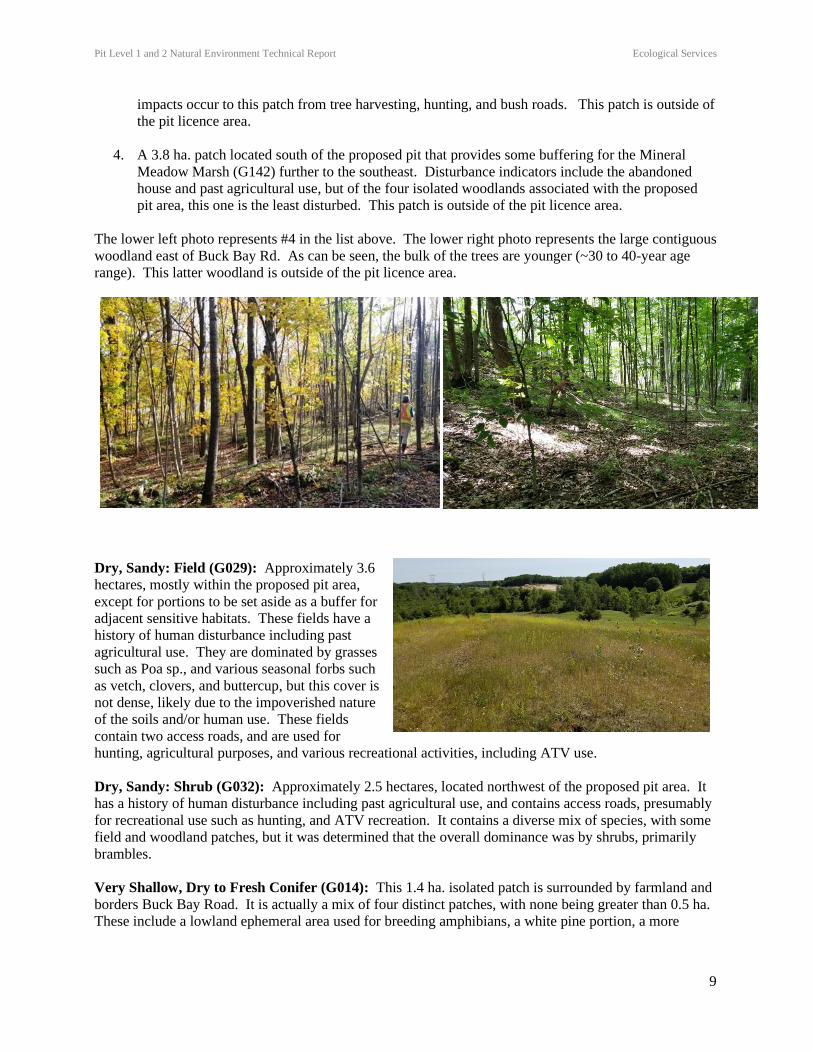
The lower left photo represents #4 in the list above. The lower right photo represents the large contiguous
woodland east of Buck Bay Rd. As can be seen, the bulk of the trees are younger (~30 to 40-year age
range). This latter woodland is outside of the pit licence area.
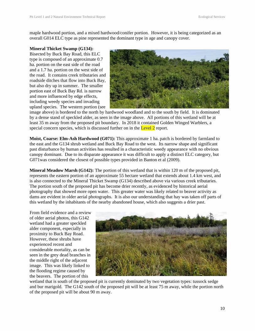
Dry, Sandy: Field (G029): Approximately 3.6
hectares, mostly within the proposed pit area,
except for portions to be set aside as a buffer for
adjacent sensitive habitats. These fields have a
history of human disturbance including past
agricultural use. They are dominated by grasses
such as Poa sp., and various seasonal forbs such
as vetch, clovers, and buttercup, but this cover is
not dense, likely due to the impoverished nature
of the soils and/or human use. These fields
contain two access roads, and are used for
hunting, agricultural purposes, and various recreational activities, including ATV use.
Dry, Sandy: Shrub (G032): Approximately 2.5 hectares, located northwest of the proposed pit area. It
has a history of human disturbance including past agricultural use, and contains access roads, presumably
for recreational use such as hunting, and ATV recreation. It contains a diverse mix of species, with some
field and woodland patches, but it was determined that the overall dominance was by shrubs, primarily
brambles.
Very Shallow, Dry to Fresh Conifer (G014): This 1.4 ha. isolated patch is surrounded by farmland and
borders Buck Bay Road. It is actually a mix of four distinct patches, with none being greater than 0.5 ha.
These include a lowland ephemeral area used for breeding amphibians, a white pine portion, a more
Pit Level 1 and 2 Natural Environment Technical Report Ecological Services
10
maple hardwood portion, and a mixed hardwood/conifer portion. However, it is being categorized as an
overall G014 ELC type as pine represented the dominant type in age and canopy cover.
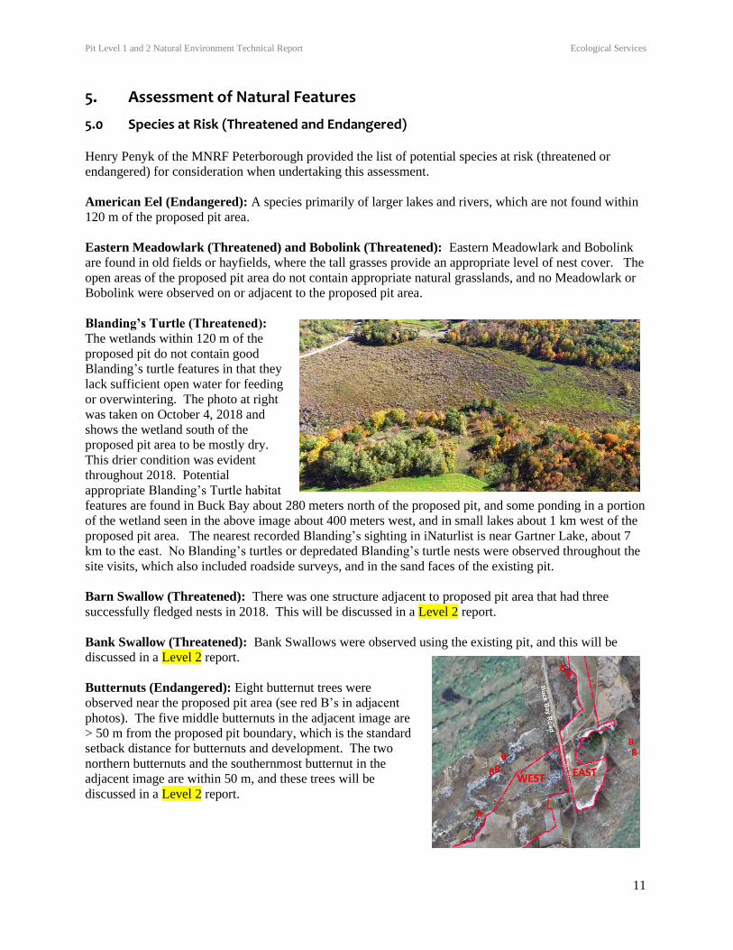
Mineral Thicket Swamp (G134):
Bisected by Buck Bay Road, this ELC
type is composed of an approximate 0.7
ha. portion on the east side of the road
and a 1.7 ha. portion on the west side of
the road. It contains creek tributaries and
roadside ditches that flow into Buck Bay,
but also dry up in summer. The smaller
portion east of Buck Bay Rd. is narrow
and more influenced by edge effects,
including weedy species and invading
upland species. The western portion (see
image above) is bordered to the north by hardwood woodland and to the south by field. It is dominated
by a dense stand of speckled alder, as seen in the image above. All portions of this wetland will be at
least 35 m away from the proposed pit boundary. In 2018 it contained Golden Winged Warblers, a
special concern species, which is discussed further on in the Level 2 report.
Moist, Coarse: Elm-Ash Hardwood (G071): This approximate 1 ha. patch is bordered by farmland to
the east and the G134 shrub wetland and Buck Bay Road to the west. Its narrow shape and significant
past disturbance by human activities has resulted in a characteristic weedy appearance with no obvious
canopy dominant. Due to its disparate appearance it was difficult to apply a distinct ELC category, but
G071was considered the closest of possible types provided in Banton et al (2009).
Mineral Meadow Marsh (G142): The portion of this wetland that is within 120 m of the proposed pit,
represents the eastern portion of an approximate 55 hectare wetland that extends about 1.4 km west, and
is also connected to the Mineral Thicket Swamp (G134) described above via various creek tributaries.
The portion south of the proposed pit has become drier recently, as evidenced by historical aerial
photography that showed more open water. This greater water was likely related to beaver activity as
dams are evident in older aerial photographs. It is also our understanding that hay was taken off parts of
this wetland by the inhabitants of the nearby abandoned house, which also suggests a drier past.
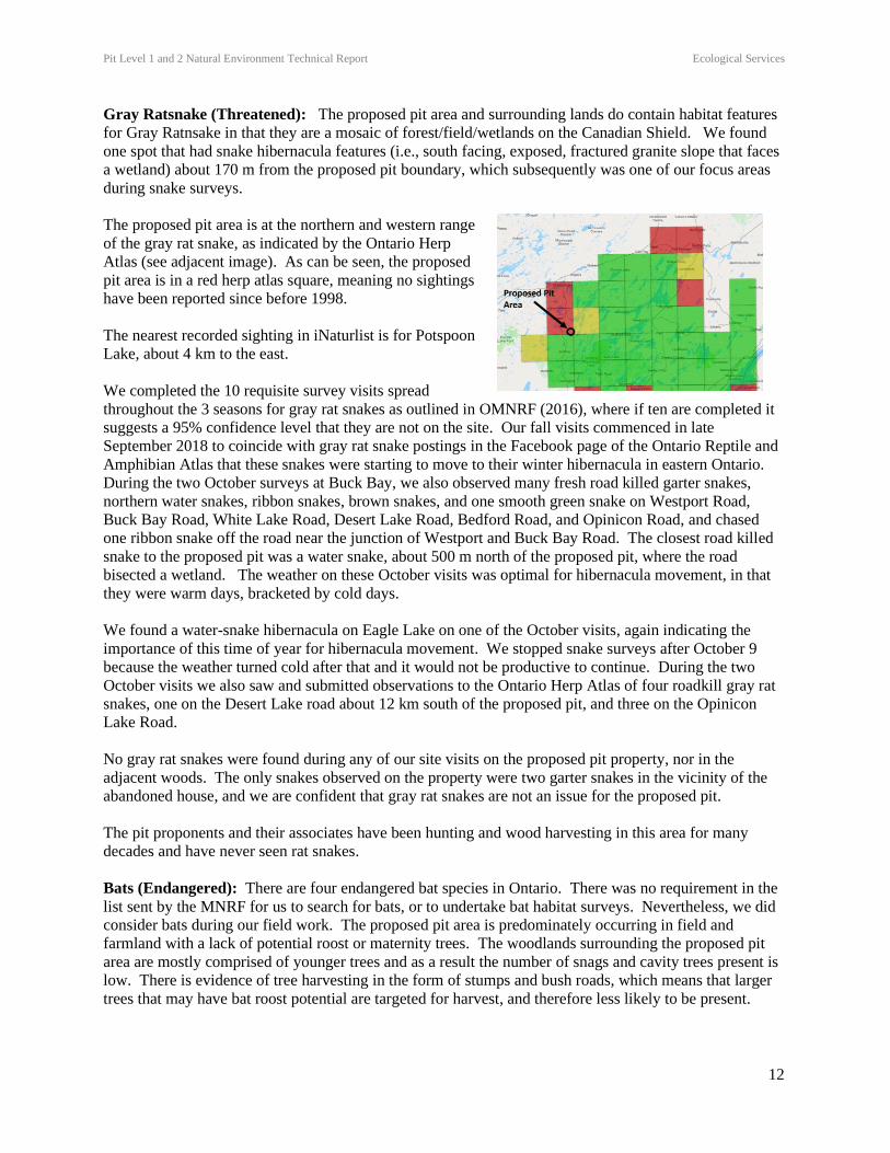
From field evidence and a review
of older aerial photos, this G142
wetland had a greater speckled
alder component, especially in
proximity to Buck Bay Road.
However, these shrubs have
experienced recent and
considerable mortality, as can be
seen in the grey dead branches in
the middle right of the adjacent
image. This was likely linked to
the flooding regime caused by
the beavers. The portion of this
wetland that is south of the proposed pit is currently dominated by two vegetation types: tussock sedge
and bur marigold. The G142 south of the proposed pit will be at least 75 m away, while the portion north
of the proposed pit will be about 90 m away.
Pit Level 1 and 2 Natural Environment Technical Report Ecological Services
11
5. Assessment of Natural Features
5.0 Species at Risk (Threatened and Endangered) Henry Penyk of the MNRF Peterborough provided the list of potential species at risk (threatened or
endangered) for consideration when undertaking this assessment.
American Eel (Endangered): A species primarily of larger lakes and rivers, which are not found within
120 m of the proposed pit area.
Eastern Meadowlark (Threatened) and Bobolink (Threatened): Eastern Meadowlark and Bobolink
are found in old fields or hayfields, where the tall grasses provide an appropriate level of nest cover. The
open areas of the proposed pit area do not contain appropriate natural grasslands, and no Meadowlark or
Bobolink were observed on or adjacent to the proposed pit area.
Blanding’s Turtle (Threatened):
The wetlands within 120 m of the
proposed pit do not contain good
Blanding’s turtle features in that they
lack sufficient open water for feeding
or overwintering. The photo at right
was taken on October 4, 2018 and
shows the wetland south of the
proposed pit area to be mostly dry.
This drier condition was evident
throughout 2018. Potential
appropriate Blanding’s Turtle habitat
features are found in Buck Bay about 280 meters north of the proposed pit, and some ponding in a portion
of the wetland seen in the above image about 400 meters west, and in small lakes about 1 km west of the
proposed pit area. The nearest recorded Blanding’s sighting in iNaturlist is near Gartner Lake, about 7
km to the east. No Blanding’s turtles or depredated Blanding’s turtle nests were observed throughout the
site visits, which also included roadside surveys, and in the sand faces of the existing pit.
Barn Swallow (Threatened): There was one structure adjacent to proposed pit area that had three
successfully fledged nests in 2018. This will be discussed in a Level 2 report.
Bank Swallow (Threatened): Bank Swallows were observed using the existing pit, and this will be
discussed in a Level 2 report.
Butternuts (Endangered): Eight butternut trees were
observed near the proposed pit area (see red B’s in adjacent
photos). The five middle butternuts in the adjacent image are
> 50 m from the proposed pit boundary, which is the standard
setback distance for butternuts and development. The two
northern butternuts and the southernmost butternut in the
adjacent image are within 50 m, and these trees will be
discussed in a Level 2 report.
Pit Level 1 and 2 Natural Environment Technical Report Ecological Services
12
Gray Ratsnake (Threatened): The proposed pit area and surrounding lands do contain habitat features
for Gray Ratnsake in that they are a mosaic of forest/field/wetlands on the Canadian Shield. We found
one spot that had snake hibernacula features (i.e., south facing, exposed, fractured granite slope that faces
a wetland) about 170 m from the proposed pit boundary, which subsequently was one of our focus areas
during snake surveys.
The proposed pit area is at the northern and western range
of the gray rat snake, as indicated by the Ontario Herp
Atlas (see adjacent image). As can be seen, the proposed
pit area is in a red herp atlas square, meaning no sightings
have been reported since before 1998.
The nearest recorded sighting in iNaturlist is for Potspoon
Lake, about 4 km to the east.
We completed the 10 requisite survey visits spread
throughout the 3 seasons for gray rat snakes as outlined in OMNRF (2016), where if ten are completed it
suggests a 95% confidence level that they are not on the site. Our fall visits commenced in late
September 2018 to coincide with gray rat snake postings in the Facebook page of the Ontario Reptile and
Amphibian Atlas that these snakes were starting to move to their winter hibernacula in eastern Ontario.
During the two October surveys at Buck Bay, we also observed many fresh road killed garter snakes,
northern water snakes, ribbon snakes, brown snakes, and one smooth green snake on Westport Road,
Buck Bay Road, White Lake Road, Desert Lake Road, Bedford Road, and Opinicon Road, and chased
one ribbon snake off the road near the junction of Westport and Buck Bay Road. The closest road killed
snake to the proposed pit was a water snake, about 500 m north of the proposed pit, where the road
bisected a wetland. The weather on these October visits was optimal for hibernacula movement, in that
they were warm days, bracketed by cold days.
We found a water-snake hibernacula on Eagle Lake on one of the October visits, again indicating the
importance of this time of year for hibernacula movement. We stopped snake surveys after October 9
because the weather turned cold after that and it would not be productive to continue. During the two
October visits we also saw and submitted observations to the Ontario Herp Atlas of four roadkill gray rat
snakes, one on the Desert Lake road about 12 km south of the proposed pit, and three on the Opinicon
Lake Road.
No gray rat snakes were found during any of our site visits on the proposed pit property, nor in the
adjacent woods. The only snakes observed on the property were two garter snakes in the vicinity of the
abandoned house, and we are confident that gray rat snakes are not an issue for the proposed pit.
The pit proponents and their associates have been hunting and wood harvesting in this area for many
decades and have never seen rat snakes.
Bats (Endangered): There are four endangered bat species in Ontario. There was no requirement in the
list sent by the MNRF for us to search for bats, or to undertake bat habitat surveys. Nevertheless, we did
consider bats during our field work. The proposed pit area is predominately occurring in field and
farmland with a lack of potential roost or maternity trees. The woodlands surrounding the proposed pit
area are mostly comprised of younger trees and as a result the number of snags and cavity trees present is
low. There is evidence of tree harvesting in the form of stumps and bush roads, which means that larger
trees that may have bat roost potential are targeted for harvest, and therefore less likely to be present.

Pit Level 1 and 2 Natural Environment Technical Report Ecological Services
13
During the survey nights for night birds we also operated the Wildlife Acoustics EMT2 Pro with a
particular focus on the abandoned house at the western edge of the proposed pit. From our 2019 field
work in the region, it has been our experience with overnight sets with the Wildlife Acoustics SM4 Bat
Monitor that bats are present throughout the region, and therefore likely undertake feeding flights in
association with the proposed pit area. However, the fact that no bats were picked up by the EMT2Pro
during the night bird surveys suggests a low use by bats. We can also be reassured that bats would
unlikely be at risk from the proposed pit operation due to the lack of the trees and pit only operates during
the day when the bats are dormant.
Eastern Whip-poor-will (Threatened): Eastern Whip-poor-will
were observed in association with the proposed pit licence area.
In the image to the right, the left most whip-poor-will (red wh)
was about 250 m from the proposed pit area. The other two red
wh’s were calling within 120 m. Other Whip-poor-wills were
calling at greater distances and these are summarized in Table 1.
A nest was found (image below) in the calling area (wh) top right
in the adjacent image.
The Whip-poor-wills calling and
nesting within 120 of the
proposed pit will be discussed in
a Level 2 report.
Table 1. Whip-poor-will results of four site visits.
Date
(2018)
Beaufort
Scale Background
Noise
Moon Call Detail
April 30 0 Nil (calling
amphibians)
Full No calls
May 15 0 Nil (calling
amphibians)
No
moon
No calls
May 24 0 Nil (calling
amphibians)
¾
moon.
1 on west side of Buck Bay Rd. in small woodlot <120
m north of proposed pit boundary (nest found, shown
in image above)
1 on west side <120 m south of pit boundary
1 ~ 250 west of proposed pit boundary
1 ~ 400 m south of proposed pit boundary, west side of
Buck Bay Road (not shown in above image)
1 on west side of Buck Bay Road, ~500 m north of
proposed pit boundary
1 ~ km south of proposed pit boundary, west of Buck
Bay Road (not shown in above image)
June 25 0 Nil (calling
amphibians)
Nearly
full
Same first three in May 24 box above
1 on west side >300 m north
1 ~ km south of proposed pit boundary
Pit Level 1 and 2 Natural Environment Technical Report Ecological Services
14
5.1 Wetland There is no wetland within the proposed pit area, but there is wetland within 120 m of the proposed pit area that contains two ELC types: Mineral Thicket Swamp (G134) and Mineral Meadow Marsh (G142). This wetland has not been evaluated, but it is noted as an Environmental Protection Area in Schedule “A” of the Township of South Frontenac Official Plan. When an unevaluated wetland is adjacent to a proposed pit, it is the policy of the MNRF that it will be considered as significant, unless an evaluation can show otherwise. As a result we will consider the adjacent G134 and G142 wetland to be significant, and as such, move discussion of potential impacts to a Level 2 report.
5.2 Area of Natural and Scientific Interest (ANSI) There are no ANSI’s on or within 120 m of the proposed pit.
5.3 Valleylands
There are no valleyland features on or within 120 m of the proposed pit.
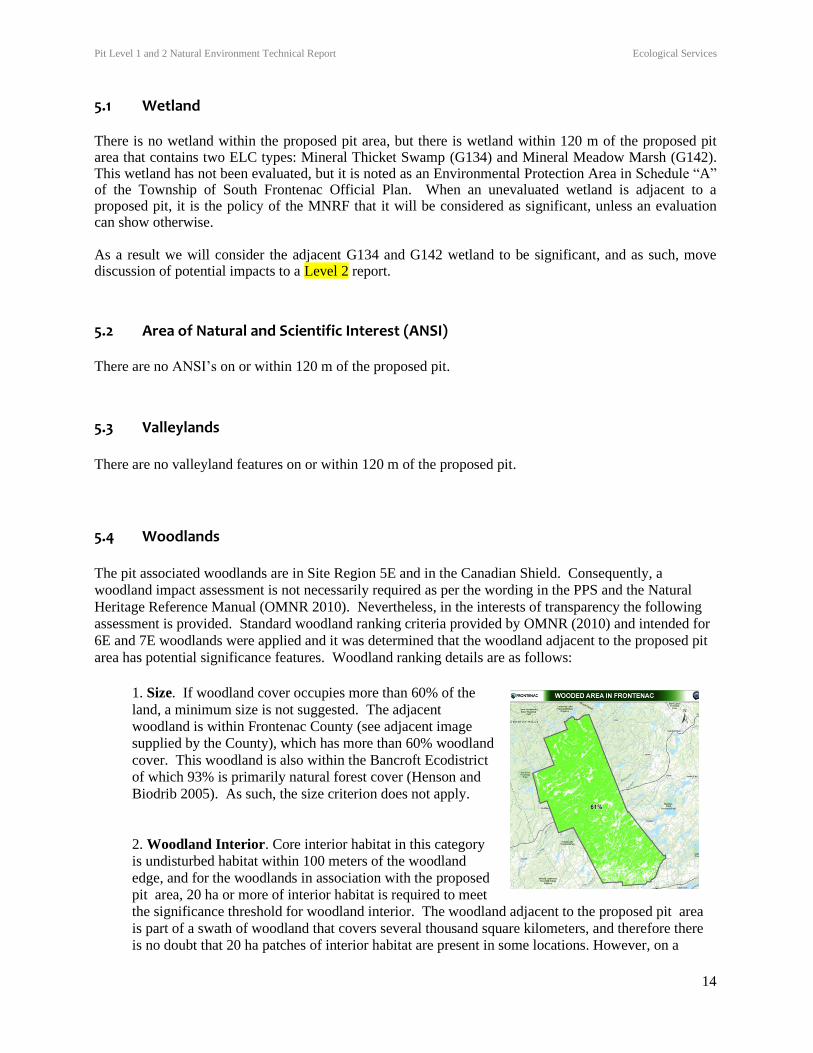
5.4 Woodlands
The pit associated woodlands are in Site Region 5E and in the Canadian Shield. Consequently, a
woodland impact assessment is not necessarily required as per the wording in the PPS and the Natural
Heritage Reference Manual (OMNR 2010). Nevertheless, in the interests of transparency the following
assessment is provided. Standard woodland ranking criteria provided by OMNR (2010) and intended for
6E and 7E woodlands were applied and it was determined that the woodland adjacent to the proposed pit
area has potential significance features. Woodland ranking details are as follows:
1. Size. If woodland cover occupies more than 60% of the
land, a minimum size is not suggested. The adjacent
woodland is within Frontenac County (see adjacent image
supplied by the County), which has more than 60% woodland
cover. This woodland is also within the Bancroft Ecodistrict
of which 93% is primarily natural forest cover (Henson and
Biodrib 2005). As such, the size criterion does not apply.
2. Woodland Interior. Core interior habitat in this category
is undisturbed habitat within 100 meters of the woodland
edge, and for the woodlands in association with the proposed
pit area, 20 ha or more of interior habitat is required to meet
the significance threshold for woodland interior. The woodland adjacent to the proposed pit area
is part of a swath of woodland that covers several thousand square kilometers, and therefore there
is no doubt that 20 ha patches of interior habitat are present in some locations. However, on a
Pit Level 1 and 2 Natural Environment Technical Report Ecological Services
15
smaller scale, there is no woodland block with 20 ha of interior habitat that is within 120 m of the
proposed pit area, when accounting for habitat breaks caused by roads, wetlands, transmission
corridors, and water bodies.
3. Proximity. Woodlands are considered significant if they are located within 30 m of an
important natural feature, such as fish habitat. The woodlands adjacent to the proposed pit area
border water bodies that contain fish habitat. However, none of these water bodies are within 30 m
of the proposed pit area.
4. Linkages. The woodland does not provide a link between two other designated significant
features.
5. Water Protection: Woodlands are considered significant if they are located within a sensitive
watershed or near the top of bank from a sensitive groundwater discharge, recharge, or headwater
area. The woodlands adjacent to the proposed pit area border water bodies, and one small
woodland patch within 120 m of the proposed pit area borders a creek that may contain fish habitat.
This implies some significance, and this will be discussed in a Level 2 report.
6. Woodland Diversity. The woodlands within 120 m of the proposed pit area mostly represent a
common type in the region (i.e., sugar maple dominated), and display disturbance features resulting
from logging and recreational activities.
7. Uncommon Characteristics. Woodlands with a unique species composition, species with a
high Coefficient of Conservatism, vegetation communities with S1, S2, S3 rankings, or a certain
percentage of larger older trees can be considered significant. The woodlands that we observed are
mostly young and comprised of common species that do not have a high Coefficient of
Conservatism. However, they also contain butternuts, which implies significance, and this will be
discussed in a Level 2 report.
5.5 Wildlife Habitat
The Significant Wildlife Habitat Criteria for Site Region 5E (MNRF 2015) describes thresholds for
habitat significance. Analysis of each wildlife habitat type is provided as follows:
Seasonal Concentration Areas:
Habitats of seasonal concentrations of animals apply when they occur in high densities for specific
periods in their life cycles and/or in particular seasons. As described in MNRF (2015), these areas are
generally localized and small in relation to the area of habitat used at other times of the year. MNRF
(2015) lists 13 types of seasonal concentration habitats for consideration.
Waterfowl stopover and staging areas (terrestrial): Suitable stopover and staging habitat for migrating
waterfowl include cultural meadow and thicket communities that are seasonally flooded. There are no
appropriate seasonally flooded terrestrial communities within 120 m of the proposed pit area.
Waterfowl stopover and staging areas (aquatic): These areas include ponds, marshes, lakes, bays,
coastal inlets, and watercourses used during migration. Specific ecosites (G142-G152) listed by MNRF
(2015) are present within 120 m of the proposed pit.
Pit Level 1 and 2 Natural Environment Technical Report Ecological Services
16
To be significant, the site must have aggregates of 100 or more of the listed species for 7 days, which
results in more than 700 waterfowl use days. Areas with annual staging of ruddy ducks, canvasbacks, and
redheads are also WSH.
Waterfowl stopover and staging (aquatic) may occur near the proposed pit at the southern tip of Buck Bay
(part of Bob’s Lake), however it is more than 120 m from the proposed pit area and was therefore not
surveyed for migrating waterfowl.
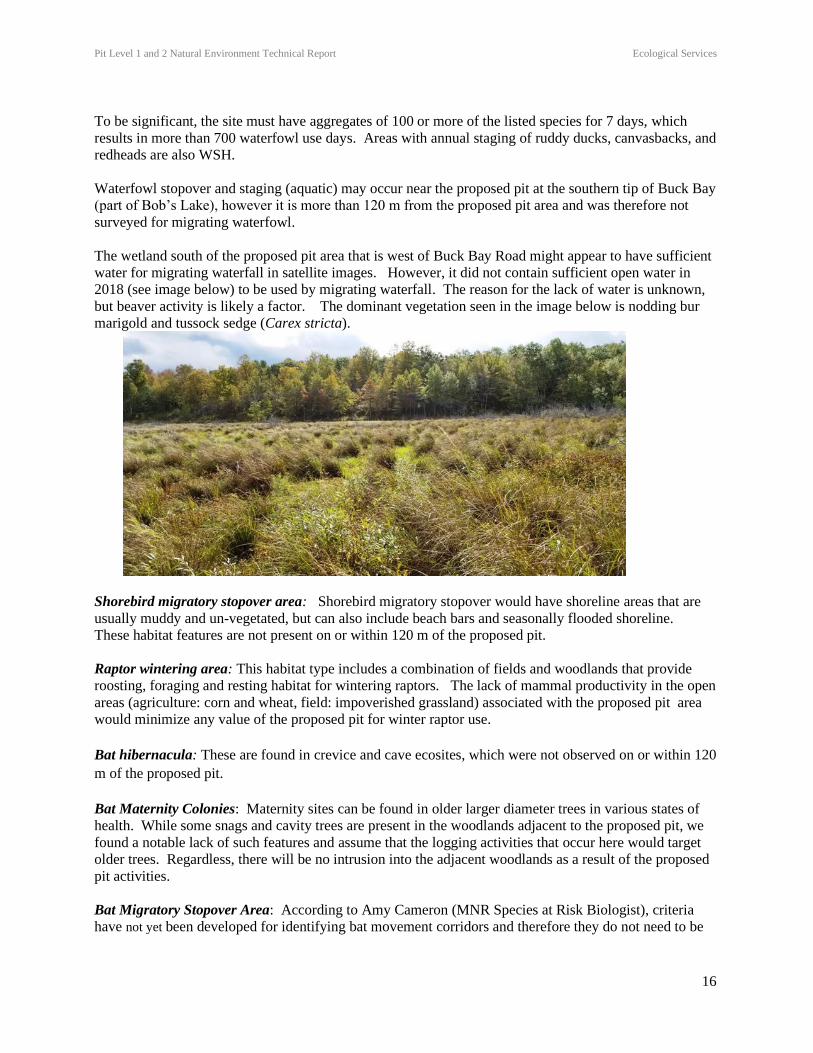
The wetland south of the proposed pit area that is west of Buck Bay Road might appear to have sufficient
water for migrating waterfall in satellite images. However, it did not contain sufficient open water in
2018 (see image below) to be used by migrating waterfall. The reason for the lack of water is unknown,
but beaver activity is likely a factor. The dominant vegetation seen in the image below is nodding bur
marigold and tussock sedge (Carex stricta).
Shorebird migratory stopover area: Shorebird migratory stopover would have shoreline areas that are
usually muddy and un-vegetated, but can also include beach bars and seasonally flooded shoreline.
These habitat features are not present on or within 120 m of the proposed pit.
Raptor wintering area: This habitat type includes a combination of fields and woodlands that provide
roosting, foraging and resting habitat for wintering raptors. The lack of mammal productivity in the open
areas (agriculture: corn and wheat, field: impoverished grassland) associated with the proposed pit area
would minimize any value of the proposed pit for winter raptor use.
Bat hibernacula: These are found in crevice and cave ecosites, which were not observed on or within 120
m of the proposed pit.
Bat Maternity Colonies: Maternity sites can be found in older larger diameter trees in various states of
health. While some snags and cavity trees are present in the woodlands adjacent to the proposed pit, we
found a notable lack of such features and assume that the logging activities that occur here would target
older trees. Regardless, there will be no intrusion into the adjacent woodlands as a result of the proposed
pit activities.
Bat Migratory Stopover Area: According to Amy Cameron (MNR Species at Risk Biologist), criteria
have not yet been developed for identifying bat movement corridors and therefore they do not need to be
Pit Level 1 and 2 Natural Environment Technical Report Ecological Services
17
considered at this time. The only place in the province currently identified as SWH for bat movement
corridors is Long Point (Ecoregion 7E) for silver-haired bats
Turtle Wintering Areas: There are no turtle appropriate wintering areas within 120 m of the proposed pit
area. The immediate areas of wetland (within 120 m) that are adjacent to the west portion of the area
lack sufficient open water for overwintering.
Snake hibernaculum: MNRF (2015) notes that sites located below the frost line in burrows, rock
crevices, and other natural locations are needed. These areas should also have proper moisture levels to
keep reptile from drying out during the winter, and south facing slopes are preferred in providing more
moderate winter conditions. We most often find snake hibernacula in close proximity to a nearby
waterbody, most typically a swamp.
The proposed pit will be mostly within agricultural lands and fields containing deep sandy soils, and no
cover, which would have poor potential for containing reptile hibernacula.
No hibernacula were found in the adjacent 120 m lands, but some hibernacula features were observed
more than 120 m southwest of the proposed pit.
During all site visits only two garter snakes were observed in association with the proposed pit. These
were within the vicinity of the abandoned house. It may be that the house is being used, but we found no
evidence of such.
Colonially -Nesting Bird Breeding Habitat (Bank and Cliff): Nesting sites for these species includes
eroding banks/cliffs, sandy hills, quarries, steep slopes, rock faces or piles. Bank Swallow nesting was
observed in the existing pit to the east of the proposed pit area, and this will be discussed in a Level 2
report.
Colonially -Nesting Bird Breeding Habitat (Trees/Shrubs): No Heronries were observed on or within
120 m of the proposed pit.
Colonially -Nesting Bird Breeding Habitat (Ground): Nesting occurs on rocky islands or peninsula
within a lake or large river. These features are not present on or within 120 m of the proposed pit.
Deer Yarding Areas: In general, the MNRF determines the location of significant deer yards and deer
winter congregation areas, and the woodlands next to the proposed pit area have not been identified as
such. Regional deeryards are also identified in the County of Frontenac Natural Heritage Study (2012),
and none were identified on or within 120 m of the proposed pit.
Some deer use was observed in association with the proposed pit area, and local hunters do hunt here.
However, we saw no evidence of significant deer use (e.g., well warn trails, scats, browse damage) that
would indicate significant yarding or winter congregations.
Rare Vegetation Communities:
Rare vegetation community types are those with SRANKS of S1 to S3 (i.e., extremely rare - rare -
uncommon in Ontario). MNRF (2015) lists the following rare types for site region 5E: Beach/Beach
Ridge/Bar/Sand Dunes, Shallow Atlantic Coastal Marsh, Cliffs and Talus Slopes, Rock Barren, Sand
Barren, Alvar, Old Growth Forest, Bog, Tallgrass Prairie, Savannah, Red Spruce Forest, White Oak
Forest. None of these types is present on or within 120 m of the proposed pit.
Pit Level 1 and 2 Natural Environment Technical Report Ecological Services
18
The proposed pit extension is found within the Bancroft Ecodistrict 5E-11, where Henson and Brodribb
(2005) identify the following significant habitat types:
Atlantic Coastal Plain Shallow Marsh Type S2
Dry Black Oak – Pine Tallgrass Savannah Type S1
Dry Tallgrass Prairie Type S1
None of these habitat types were observed on or adjacent to the proposed pit area.
Specialized Habitats for Wildlife
OMNR (2015) lists 11 categories of Specialized Habitat for Wildlife for Site Region 5E, discussed as
follows:
Waterfowl Nesting Area: The potential waterfowl nesting area extends 120 m into the upland from
wetland habitats G129-G135, and G142-G152. To be considered SWH, there needs to be at least 3 or
more nesting pairs of the listed species, excluding Mallards, or 10 or more nesting pairs of the listed
species, including Mallards. Only Wood Ducks were observed in a flyover, and therefore the threshold
for possible significant waterfowl nesting was not observed.
Bald Eagle and Osprey Nesting, Foraging and Perching Habitat: Although both species are known to
occur in this region, neither were observed within 120 m of the proposed pit area. Ospreys were observed
flying over Buck Bay, more than 120 m to the north.
Woodland Raptor Nesting Habitat: None of the candidate raptor species were observed during the field
work.
Turtle and Lizard Nesting Areas: Road surveys within 120 m of the proposed pit area were undertaken
and no depredated nests were found. The sandy soils of the existing pit areas are appropriate for turtle
nesting and given its proximity to Buck Bay (Bob’s Lake) we spent some time within the existing pit and
in sandy slopes next to the wetland areas west of Buck Bay Rd. Four depredated painted turtle nests, and
one painted turtle shell were observed in a sandy slope west of Buck Bay Rd. and north of the proposed
pit area. This does not meet the threshold of five needed for significance wildlife habitat. Nevertheless,
this will be discussed in a Level 2 report.
Seeps and Springs: Forested areas with seeps and springs. No forested seeps and springs were found.
Aquatic Feeding Habitat: There are no appropriate aquatic feeding areas within 120 m. As well, this
category is mainly intended for aquatic areas used by feeding moose, which would not be relevant here as
moose are mostly confined to areas north of Hwy. 7. We know of no reliable consistent sightings for
moose in the area associated with the proposed pit.
Mineral Licks: Refers to mineral licks that are used by white-tailed deer and moose. However, for the
proposed pit area it would only be deer, as moose are mostly confined to areas north of Hwy. 7. Deer are
found in forested ecosites with upwelling or seepage areas, typically in association with sedimentary rock,
or calcareous glacial till. Such sites were not observed in the adjacent forests, which consist of primarily
of shallow granitic rock, typical of Canadian Shield woodlands. No seepage areas were observed, and
Pit Level 1 and 2 Natural Environment Technical Report Ecological Services
19
there were no track concentrations which might suggest that of features being exploited by White-tailed
Deer.
Denning Sites for Mink, Otter, Marten, Fisher, and Eastern Wolf: Found in all forested ecosites and
mink, otter, and fisher are present in the region, but no potential dens were observed, nor evidence of
extensive use by these species such as otter runs, scat piles, or tracks.
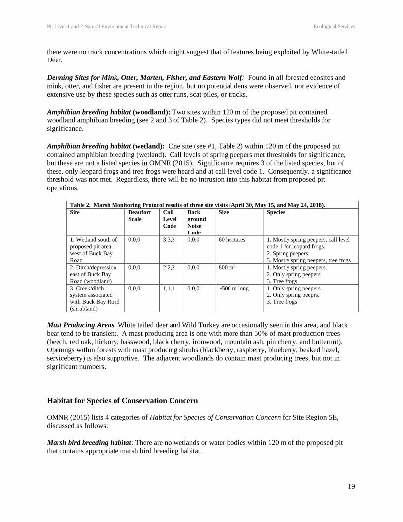
Amphibian breeding habitat (woodland): Two sites within 120 m of the proposed pit contained
woodland amphibian breeding (see 2 and 3 of Table 2). Species types did not meet thresholds for
significance.
Amphibian breeding habitat (wetland): One site (see #1, Table 2) within 120 m of the proposed pit
contained amphibian breeding (wetland). Call levels of spring peepers met thresholds for significance,
but these are not a listed species in OMNR (2015). Significance requires 3 of the listed species, but of
these, only leopard frogs and tree frogs were heard and at call level code 1. Consequently, a significance
threshold was not met. Regardless, there will be no intrusion into this habitat from proposed pit
operations.
Table 2. Marsh Monitoring Protocol results of three site visits (April 30, May 15, and May 24, 2018).
Site Beaufort
Scale
Call
Level
Code
Back
ground
Noise
Code
Size Species
1. Wetland south of
proposed pit area,
west of Buck Bay
Road
0,0,0 3,3,3 0,0,0 60 hectares 1. Mostly spring peepers, call level
code 1 for leopard frogs.
2. Spring peepers.
3. Mostly spring peepers, tree frogs
2. Ditch/depression
east of Buck Bay
Road (woodland)
0,0,0 2,2,2 0,0,0 800 m2 1. Mostly spring peepers.
2. Only spring peepers
3. Tree frogs
3. Creek/ditch
system associated
with Buck Bay Road
(shrubland)
0,0,0 1,1,1 0,0,0 ~500 m long 1. Only spring peepers.
2. Only spring peeprs.
3. Tree frogs
Mast Producing Areas: White tailed deer and Wild Turkey are occasionally seen in this area, and black
bear tend to be transient. A mast producing area is one with more than 50% of mast production trees
(beech, red oak, hickory, basswood, black cherry, ironwood, mountain ash, pin cherry, and butternut).
Openings within forests with mast producing shrubs (blackberry, raspberry, blueberry, beaked hazel,
serviceberry) is also supportive. The adjacent woodlands do contain mast producing trees, but not in
significant numbers.
Habitat for Species of Conservation Concern
OMNR (2015) lists 4 categories of Habitat for Species of Conservation Concern for Site Region 5E,
discussed as follows:
Marsh bird breeding habitat: There are no wetlands or water bodies within 120 m of the proposed pit
that contains appropriate marsh bird breeding habitat.
Pit Level 1 and 2 Natural Environment Technical Report Ecological Services
20
Open country bird breeding habitat: Requires grassland habitat 30 ha or larger in size. This is not
present within 120 m of the proposed pit area.
Shrub/early successional bird breeding habitat: This requires large fields (>30 ha) succeeding to shrub
and thicket habitat. This is not present within 120 m of the proposed pit area.
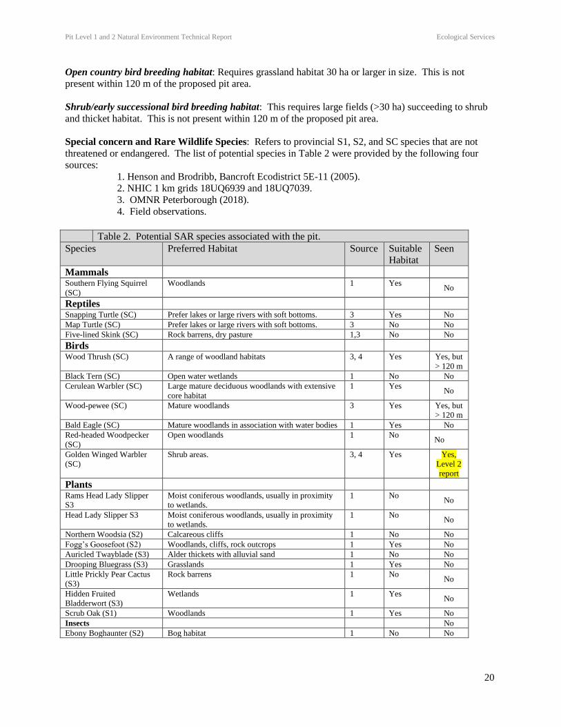
Special concern and Rare Wildlife Species: Refers to provincial S1, S2, and SC species that are not
threatened or endangered. The list of potential species in Table 2 were provided by the following four
sources:
1. Henson and Brodribb, Bancroft Ecodistrict 5E-11 (2005).
2. NHIC 1 km grids 18UQ6939 and 18UQ7039.
3. OMNR Peterborough (2018).
4. Field observations.
Table 2. Potential SAR species associated with the pit.
Species Preferred Habitat Source Suitable
Habitat
Seen
Mammals
Southern Flying Squirrel
(SC)
Woodlands 1 Yes No
Reptiles
Snapping Turtle (SC) Prefer lakes or large rivers with soft bottoms. 3 Yes No
Map Turtle (SC) Prefer lakes or large rivers with soft bottoms. 3 No No
Five-lined Skink (SC) Rock barrens, dry pasture 1,3 No No
Birds
Wood Thrush (SC) A range of woodland habitats 3, 4 Yes Yes, but
> 120 m
Black Tern (SC) Open water wetlands 1 No No
Cerulean Warbler (SC) Large mature deciduous woodlands with extensive
core habitat
1 Yes No
Wood-pewee (SC) Mature woodlands 3 Yes Yes, but
> 120 m
Bald Eagle (SC) Mature woodlands in association with water bodies 1 Yes No
Red-headed Woodpecker
(SC)
Open woodlands 1 No No
Golden Winged Warbler
(SC)
Shrub areas. 3, 4 Yes Yes,
Level 2
report
Plants
Rams Head Lady Slipper
S3
Moist coniferous woodlands, usually in proximity
to wetlands.
1 No No
Head Lady Slipper S3 Moist coniferous woodlands, usually in proximity
to wetlands.
1 No No
Northern Woodsia (S2) Calcareous cliffs 1 No No
Fogg’s Goosefoot (S2) Woodlands, cliffs, rock outcrops 1 Yes No
Auricled Twayblade (S3) Alder thickets with alluvial sand 1 No No
Drooping Bluegrass (S3) Grasslands 1 Yes No
Little Prickly Pear Cactus
(S3)
Rock barrens 1 No No
Hidden Fruited
Bladderwort (S3)
Wetlands 1 Yes No
Scrub Oak (S1) Woodlands 1 Yes No
Insects No
Ebony Boghaunter (S2) Bog habitat 1 No No
Pit Level 1 and 2 Natural Environment Technical Report Ecological Services
21
Animal Movement Corridors
MNRF (2015) list three types of animal movement corridors; amphibian movement corridors and deer
movement corridors.
Amphibian Movement Corridors: Amphibian movement corridors refer to areas that provide movement
zones between breeding and summer habitat. To be significant, corridors should consist of native
vegetation, not be crossed by roads, and have no gaps such as fields or waterways. The fields and various
gaps (eg., roads) of the proposed pit areas do not have these features and therefore would not act as
amphibium movement corridors as defined in OMNR (2015).
Cervid Movement Corridors: Deer movement corridors are those associated with deer wintering habitat.
Regional deer linkages and winter deeryards have been identified for the County of Frontenac (2012), and
these are not associated with the proposed pit.
Furbearer Movement Corridor: Intended to protect otter and mink denning sites and movement to and
from those sites. These are typically found within a riparian area of a lake, river, stream, or wetland. Any
movement of mink or otter in association with the proposed pit would follow around the pit area, and not
through it, due to the nature of the surrounding habitat. Consequently, corridor interference would be
unlikely.
No sign of otters was observed on site, and the limited open water and associated fish habitat within 100
m (i.e., the denning site distance threshold) limits its potential as SWH for otter. Likewise, the wetland
areas to the south of the proposed pit do not represent good mink habitat due to a lack of open water. A
riparian system is located mostly more than 100 m to the north of the proposed pit, except where it dips
down in one spot to be within about 65 m away. However, this area dries up in summer, making it less
than ideal as mink habitat or as a corridor. No mink were observed during the site visits.
Exceptions for EcoRegion 5E
Eco-District 5E-11 – Rare Forest Types: Jack Pine: Any forest stand with more than 40% jack pine
coverage is to be considered significant. This is not present within 120 m of the proposed pit area.
5.6 Fish Habitat
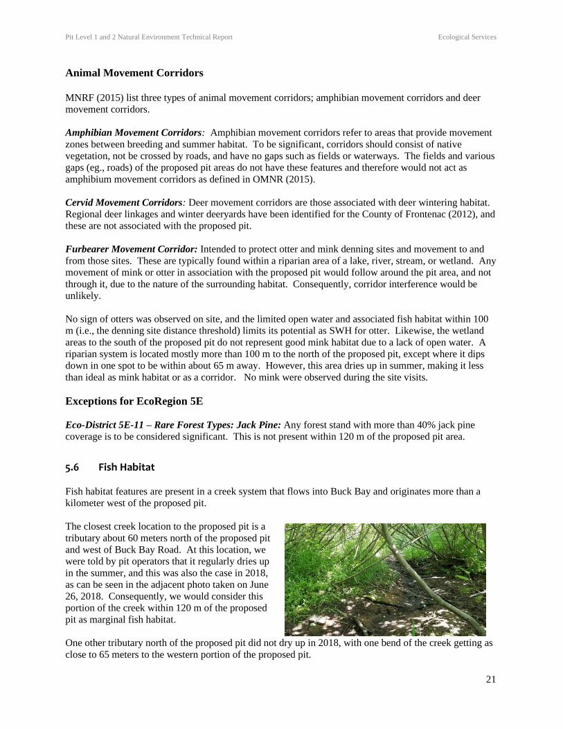
Fish habitat features are present in a creek system that flows into Buck Bay and originates more than a
kilometer west of the proposed pit.
The closest creek location to the proposed pit is a
tributary about 60 meters north of the proposed pit
and west of Buck Bay Road. At this location, we
were told by pit operators that it regularly dries up
in the summer, and this was also the case in 2018,
as can be seen in the adjacent photo taken on June
26, 2018. Consequently, we would consider this
portion of the creek within 120 m of the proposed
pit as marginal fish habitat.
One other tributary north of the proposed pit did not dry up in 2018, with one bend of the creek getting as
close to 65 meters to the western portion of the proposed pit.
Pit Level 1 and 2 Natural Environment Technical Report Ecological Services
22
The creek eventually crosses Buck Bay Road, where it enters a ditch that runs north along the side of the
road for about 240 meters, before crossing back west across the road for a short distance, before passing
back east across the road. From there it is an approximate 500 m to Buck Bay, via a creek channel and a
pond. The ditch portion of this creek is about 80 meters from the eastern portion of the proposed pit, and
portions of it were dry in the summer and so we would consider it marginal fish habitat.
As the creek, and potential fish habitat is within 120 meters of fish habitat, it will be discussed in a Level
2 report.
6.0 Natural Environment Level 2: Impact Assessment
Significant Feature – Species at Risk
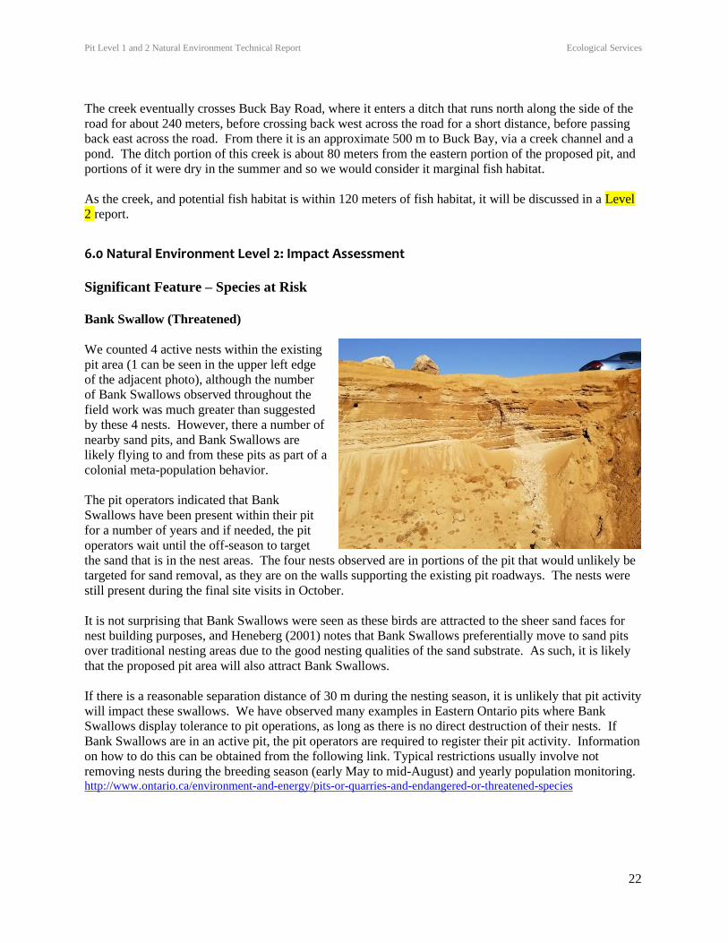
Bank Swallow (Threatened)
We counted 4 active nests within the existing
pit area (1 can be seen in the upper left edge
of the adjacent photo), although the number
of Bank Swallows observed throughout the
field work was much greater than suggested
by these 4 nests. However, there a number of
nearby sand pits, and Bank Swallows are
likely flying to and from these pits as part of a
colonial meta-population behavior.
The pit operators indicated that Bank
Swallows have been present within their pit
for a number of years and if needed, the pit
operators wait until the off-season to target
the sand that is in the nest areas. The four nests observed are in portions of the pit that would unlikely be
targeted for sand removal, as they are on the walls supporting the existing pit roadways. The nests were
still present during the final site visits in October.
It is not surprising that Bank Swallows were seen as these birds are attracted to the sheer sand faces for
nest building purposes, and Heneberg (2001) notes that Bank Swallows preferentially move to sand pits
over traditional nesting areas due to the good nesting qualities of the sand substrate. As such, it is likely
that the proposed pit area will also attract Bank Swallows.
If there is a reasonable separation distance of 30 m during the nesting season, it is unlikely that pit activity
will impact these swallows. We have observed many examples in Eastern Ontario pits where Bank
Swallows display tolerance to pit operations, as long as there is no direct destruction of their nests. If
Bank Swallows are in an active pit, the pit operators are required to register their pit activity. Information
on how to do this can be obtained from the following link. Typical restrictions usually involve not
removing nests during the breeding season (early May to mid-August) and yearly population monitoring. http://www.ontario.ca/environment-and-energy/pits-or-quarries-and-endangered-or-threatened-species
Pit Level 1 and 2 Natural Environment Technical Report Ecological Services
23
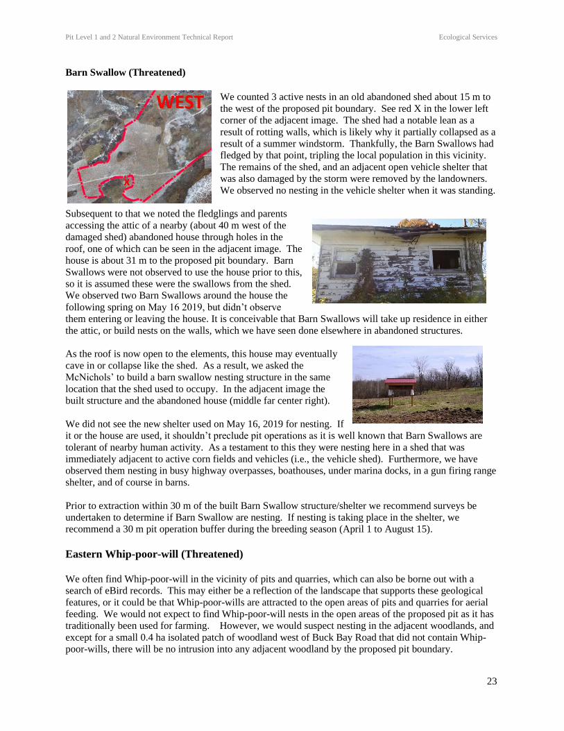
Barn Swallow (Threatened)
We counted 3 active nests in an old abandoned shed about 15 m to
the west of the proposed pit boundary. See red X in the lower left
corner of the adjacent image. The shed had a notable lean as a
result of rotting walls, which is likely why it partially collapsed as a
result of a summer windstorm. Thankfully, the Barn Swallows had
fledged by that point, tripling the local population in this vicinity.
The remains of the shed, and an adjacent open vehicle shelter that
was also damaged by the storm were removed by the landowners.
We observed no nesting in the vehicle shelter when it was standing.
Subsequent to that we noted the fledglings and parents
accessing the attic of a nearby (about 40 m west of the
damaged shed) abandoned house through holes in the
roof, one of which can be seen in the adjacent image. The
house is about 31 m to the proposed pit boundary. Barn
Swallows were not observed to use the house prior to this,
so it is assumed these were the swallows from the shed.
We observed two Barn Swallows around the house the
following spring on May 16 2019, but didn’t observe
them entering or leaving the house. It is conceivable that Barn Swallows will take up residence in either
the attic, or build nests on the walls, which we have seen done elsewhere in abandoned structures.
As the roof is now open to the elements, this house may eventually
cave in or collapse like the shed. As a result, we asked the
McNichols’ to build a barn swallow nesting structure in the same
location that the shed used to occupy. In the adjacent image the
built structure and the abandoned house (middle far center right).
We did not see the new shelter used on May 16, 2019 for nesting. If
it or the house are used, it shouldn’t preclude pit operations as it is well known that Barn Swallows are
tolerant of nearby human activity. As a testament to this they were nesting here in a shed that was
immediately adjacent to active corn fields and vehicles (i.e., the vehicle shed). Furthermore, we have
observed them nesting in busy highway overpasses, boathouses, under marina docks, in a gun firing range
shelter, and of course in barns.
Prior to extraction within 30 m of the built Barn Swallow structure/shelter we recommend surveys be
undertaken to determine if Barn Swallow are nesting. If nesting is taking place in the shelter, we
recommend a 30 m pit operation buffer during the breeding season (April 1 to August 15).
Eastern Whip-poor-will (Threatened)
We often find Whip-poor-will in the vicinity of pits and quarries, which can also be borne out with a
search of eBird records. This may either be a reflection of the landscape that supports these geological
features, or it could be that Whip-poor-wills are attracted to the open areas of pits and quarries for aerial
feeding. We would not expect to find Whip-poor-will nests in the open areas of the proposed pit as it has
traditionally been used for farming. However, we would suspect nesting in the adjacent woodlands, and
except for a small 0.4 ha isolated patch of woodland west of Buck Bay Road that did not contain Whip-
poor-wills, there will be no intrusion into any adjacent woodland by the proposed pit boundary.
Pit Level 1 and 2 Natural Environment Technical Report Ecological Services
24
The closest distance of the proposed pit boundary to the observed Whip-poor-will nest north of the pit
boundary is 65 m. This exceeds the 20 m distance (Category 1) that is noted as highly sensitive to
disturbance outlined in the General Habitat Description for the Eastern Whip-poor-will (Caprimulgus
vociferous) produced by the OMNRF (undated). The intervening distance will include maple dominated
woodland, which will provide a good site and sound barrier. As well, the intervening field slopes upward
and away from the nest, such that pit operations (once they go below grade) will be mostly out of visual
site of the nest by the height of this intervening slope.
Habitat alteration might have a greater negative outcome to breeding Whip-poor-wills for certain types of
development, such as for housing, but the level of impact between a pit operation and the current use of
these fields (occasional cultivation, hunting, ATV use, recreational use) is considered negligible,
especially considering the pit will not operate at night when Whip-poor-wills are active.
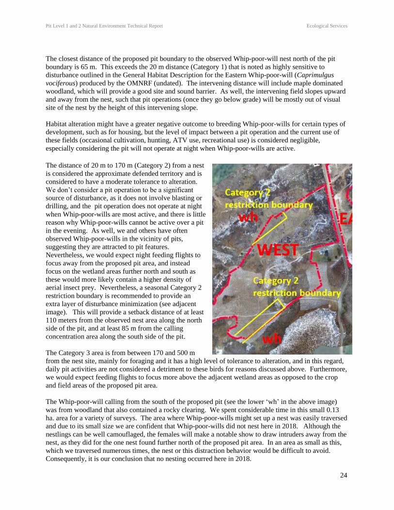
The distance of 20 m to 170 m (Category 2) from a nest
is considered the approximate defended territory and is
considered to have a moderate tolerance to alteration.
We don’t consider a pit operation to be a significant
source of disturbance, as it does not involve blasting or
drilling, and the pit operation does not operate at night
when Whip-poor-wills are most active, and there is little
reason why Whip-poor-wills cannot be active over a pit
in the evening. As well, we and others have often
observed Whip-poor-wills in the vicinity of pits,
suggesting they are attracted to pit features.
Nevertheless, we would expect night feeding flights to
focus away from the proposed pit area, and instead
focus on the wetland areas further north and south as
these would more likely contain a higher density of
aerial insect prey. Nevertheless, a seasonal Category 2
restriction boundary is recommended to provide an
extra layer of disturbance minimization (see adjacent
image). This will provide a setback distance of at least
110 meters from the observed nest area along the north
side of the pit, and at least 85 m from the calling
concentration area along the south side of the pit.
The Category 3 area is from between 170 and 500 m
from the nest site, mainly for foraging and it has a high level of tolerance to alteration, and in this regard,
daily pit activities are not considered a detriment to these birds for reasons discussed above. Furthermore,
we would expect feeding flights to focus more above the adjacent wetland areas as opposed to the crop
and field areas of the proposed pit area.
The Whip-poor-will calling from the south of the proposed pit (see the lower ‘wh’ in the above image)
was from woodland that also contained a rocky clearing. We spent considerable time in this small 0.13
ha. area for a variety of surveys. The area where Whip-poor-wills might set up a nest was easily traversed
and due to its small size we are confident that Whip-poor-wills did not nest here in 2018. Although the
nestlings can be well camouflaged, the females will make a notable show to draw intruders away from the
nest, as they did for the one nest found further north of the proposed pit area. In an area as small as this,
which we traversed numerous times, the nest or this distraction behavior would be difficult to avoid.
Consequently, it is our conclusion that no nesting occurred here in 2018.
Pit Level 1 and 2 Natural Environment Technical Report Ecological Services
25
Nevertheless, good nesting features (Category 1) at this southern site will be from 50 to 65 m to the
proposed pit boundary, and at least 85 from a proposed seasonal Category 2 restriction zone with an
intervening woodland to provide a sight and sound buffer.
In summary, it is recommended that no pit activities occur in these Category 2 restriction boundary areas
during the regional Whip-poor-will season extending from April 15 to July 31, as surveyed by Weir
(2008). Whip-poor-will surveys will need to be conducted if pit operators are interested in bypassing
these timing boundaries during any particular year. If it is determined that Whip-poor-wills are not
present, we see no need for a restriction boundary during that particular year.
Finally, there is no intention to intrude into the adjacent Whip-poor-will woodlands for pit operations and
the pit boundary is proposed to be at least 20 m from any woodland edge.
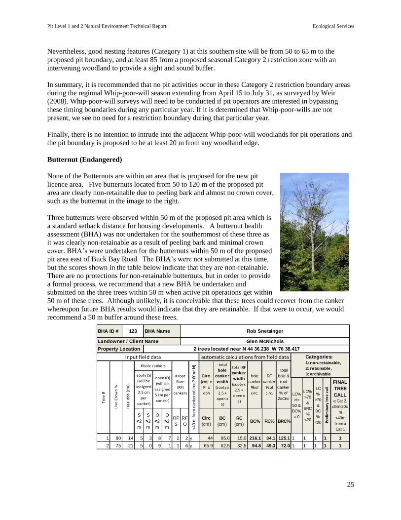
Butternut (Endangered)
None of the Butternuts are within an area that is proposed for the new pit
licence area. Five butternuts located from 50 to 120 m of the proposed pit
area are clearly non-retainable due to peeling bark and almost no crown cover,
such as the butternut in the image to the right.
Three butternuts were observed within 50 m of the proposed pit area which is
a standard setback distance for housing developments. A butternut health
assessment (BHA) was not undertaken for the southernmost of these three as
it was clearly non-retainable as a result of peeling bark and minimal crown
cover. BHA’s were undertaken for the butternuts within 50 m of the proposed
pit area east of Buck Bay Road. The BHA’s were not submitted at this time,
but the scores shown in the table below indicate that they are non-retainable.
There are no protections for non-retainable butternuts, but in order to provide
a formal process, we recommend that a new BHA be undertaken and
submitted on the three trees within 50 m when active pit operations get within
50 m of these trees. Although unlikely, it is conceivable that these trees could recover from the canker
whereupon future BHA results would indicate that they are retainable. If that were to occur, we would
recommend a 50 m buffer around these trees.
S
<2
m
S
>2
m
O
<2
m
O
>2
m
RF
S
RF
O
Circ
(cm)
BC
(cm)
RC
(cm)BC% RC% BRC%
1 80 14 5 3 8 7 2 2 y 44 95.0 15.0 216.1 34.1 125.1 1 1 1 1 1
2 75 21 5 0 9 1 1 6 y 65.9 62.5 32.5 94.8 49.3 72.0 1 1 1 1 1
2 trees located near N 44 36.238 W 76 38.417
Landowner / Client Name
Property Location
BHA ID # 123 BHA Name Rob Snetsinger
Glen McNichols
sooty (S)
(will be
assigned
2.5 cm
per
canker)
open (O)
(will be
assigned
5 cm per
canker)
total
bole
canker
width
(sooty x
2.5 +
open x
5)
total RF
canker
width
(sooty x
2.5 +
open x
5)
input field data automatic calculations from field data
# root
flare
(RF)
cankers
<40 m
fro
m c
ankere
d tre
e? (Y
or
N)
bole
canker
% of
circ.
RF
canker
% of
circ.
total
bole &
root
canker
% of
2xCirc
Circ.
(cm) =
Pi x
dbh
# bole cankers
Tree
#
Live
Cro
wn
%
Tre
e d
bh
(cm
)
Categories: 1: non-retainable,
2: retainable,
3: archivable
LC%
>/=
50 &
BC%
= 0
LC%
>70
&
BRC
%
<20
LC
%
>70
&
BC
%
<20 Pre
lim
inar
y tr
ee
cal
l
FINAL
TREE
CALLa Cat 2,
dbh>20c
m
<40m
from a
Cat 1
Pit Level 1 and 2 Natural Environment Technical Report Ecological Services
26
Significant Feature – Significant Wetland
As previously discussed, wetland areas within 120 m of the proposed pit have not been evaluated and the
policy of the MNRF in such situations is that these wetlands are to be considered significant, unless a
wetland evaluation proves otherwise.
There are four wetland areas within 120 m of the proposed pit. These are:
1. Mineral Thicket Swamp (G134) north of the West proposed pit area. The bulk of this wetland is
located just west of Buck Bay Road and the closest distance of the main body of this wetland area
to the proposed pit is approximately 55 m, but also includes a small (0.1 ha) finger further west,
that is approximately 35 m from the proposed pit boundary. The intervening distance in all cases is
a combination of field, shrub, and treed buffer.
2. Mineral Thicket Swamp (G134) west of the East proposed pit area. The distances to the
proposed pit vary, but the closest distance is about 40 m. The intervening distance is all shrub and
treed buffer.
3. Mineral Meadow Marsh (G142) north of the West proposed pit area. The distances to the
proposed pit vary, but the closest distance is about 60 m. The intervening distance is a combination
of field, shrub, and treed buffer. If seasonal Category 2 Whip-poor-will boundary is applied, the
minimum distance to the Mineral Meadow Marsh would be about 80m during the active season of
the wetland.
4. Mineral Meadow Marsh (G142) south of the West proposed pit area. The closest distance to the
wetland from the proposed pit boundary is about 60 m, with the intervening distance being a
combination of field, shrub, and treed buffer.
Wetland features that pertain to wildlife habitat and fish habitat are discussed under the Level 2 categories
of wildlife habitat and fish habitat.
Biological features, such as diversity are not expected to be impacted by the proposed pit due to a lack of
the biological interactions that are feasible for the type of upland present here and the adjacent wetland.
The lands to be converted to pit are predominantly soybean and corn field. These would have little value
to wetland species in their needs for life cycle completion, and thus the conversion to pit would have little
impact. Furthermore, significant changes to wetland features such as diversity appear to be controlled by
factors (i.e., beaver activity) unrelated to adjacent upland land use. These activities that are unrelated to
the use of the proposed pit lands would also be significant controlling factors to wetland hydrological
function. As a result, the pit will offer little hydrological risk, especially as it will not operate below the
water table, and there will be no water diversion away from these wetlands from the pit operations.
Finally, no wetland species at risk were noted, nor expected due to the nature of the wetland within 120 m
of the proposed pit.
In summary, no impacts from the proposed pit activities to the adjacent unevaluated wetland are expected
due to a lack of potential wetland/upland interactions, the length and nature of the intervening buffers,
and the relative benign nature of normal pit operations. In our opinion, no recommendations are
warranted for the pit as it relates to nearby wetlands.
Pit Level 1 and 2 Natural Environment Technical Report Ecological Services
27
Significant Feature – Woodland
In Ontario, woodlands in Site Region 5E extend over 800 km north in a continuous band, thus reducing
the potential for significant impact from local activities. However, important woodland features and
functions can still occur at a local level. In this regard, we discuss one feature (uncommon
characteristics) and one function (water protection) below.
Uncommon Characteristics: This feature is discussed because the adjacent woodlands contain butternut
trees. There will be no intrusion into the woodlands containing these butternuts for the purposes of the
proposed pit area, and thus the woodlands ability to provide this feature will be little impacted. Details in
regard to these trees is discussed under the Species at Risk section.
Water Protection: There are two woodland areas within 120 m of the proposed pit that are near the top
of bank from water areas, and thus are considered under the Water Protection function. These include:
1. G018 woodland north of the proposed pit area that is west of Buck Bay Road. It is located to
the south of a creek system, with the closest distance of the woodland being about 38 m to the main
creek channel. This woodland is about 77 m wide, which is more than wide enough for buffering
purposes. Furthermore, there will be no intrusion into this woodland from the proposed pit activity,
and thus its buffering function should be unimpeded.
2. G071 woodland west of the proposed pit area that is east of Buck Bay Road. It borders the
creek system that runs north beside Buck Bay Road. The creek has little to no buffering from Buck
Bay Road. In contrast, the G071 woodland provides varying widths (i.e., 40 to 80 m) of buffering
from potential pit operations. This is more than adequate, especially considering the lack of
impacts that could come from the relatively benign activities associated with a pit.
In summary, no impacts from the proposed pit activities to the water protection function of these
woodlands are expected. In our opinion, no recommendations are warranted for the pit as it relates to
nearby woodlands.
Significant Feature – Significant Wildlife Habitat
Colonially -Nesting Bird Breeding Habitat (Bank and Cliff): See the Level 2 assessment
above for species at risk regarding Bank Swallows.
Turtle and Lizard Nesting Areas: As discussed in the Level 1 assessment, the number of
painted turtle nests observed did not meet the threshold for significance. In our opinion these
were painted turtle nests due to the size and shape of the discarded eggs, and because an old
painted turtle shell was found at this location.
It is unlikely that impacts will occur to turtle nests from the proposed pit as all nests were
observed in the intervening area between the wetland/creek system and the proposed pit
boundary. This nesting also occurred north of the proposed Category 2 Whip-poor-will seasonal
restriction zone. This timing coincides with the turtle nesting period, and this will provide an
even greater setback distance for nesting turtles.
Rare Species – Golden Winged Warbler (Special Concern): Up to four Golden Winged
Warblers were observed and heard calling in both portions of the Mineral Thicket Swamp that is
bisected by Buck Bay Road.
Pit Level 1 and 2 Natural Environment Technical Report Ecological Services
28
Impacts to these birds is not expected as there will be no intrusion into their habitat and there will
be at least a 40 m forested and shrub setback from the proposed pit boundary. As well, the
densely growing speckled alder where they were found provides good cover. Finally, the
presence of these birds adjacent to Buck Bay Road (which is closer to their habitat than the
proposed pit areas) suggests that they are tolerant of a level of disturbance that exceeds the level
of disturbance expected for this pit.
In summary, no impacts to significant wildlife habitat are expected from the proposed pit activities. In
our opinion, no recommendations are warranted for the pit as it relates to nearby Golden Winger warbler
habitat.
Significant Feature – Fish Habitat
Due to their open exposure and wetland associations, the creek systems within 120 m of the proposed pit
are considered warm water fish habitat. They eventually flow into the west basin of Bob’s Lake, via a
small shallow lake, and Buck Bay. The west basin contains lake trout (mostly stocked), as a result of its
depth, but the outer edges, and especially Buck Bay are more known for their warm water associated
fisheries such as for bass and pike.
The fish habitat that would be within 120 m of the proposed pit is considered marginal habitat because
portions dry up in summer and other portions operate as roadside ditches.
Negative impacts to fish habitat from nearby pit operations are unlikely, because there will be no
intrusion into fish habitat and pit operations are mostly benign in this regard. The only likely impact
would be from sand sedimentation via storm induced runoff. However, the setbacks are considered more
than adequate with the distances ranging from 66 m to beyond 120 m, and all containing intervening
vegetated buffers.
In summary, no impacts to significant wildlife habitat are expected from the proposed pit activities. In
our opinion, no recommendations are warranted for the pit as it relates to nearby fish habitat.
LEVEL 2 SUMMARY OF RECOMMENDATIONS
Species at Risk
1. Register any pit activity with the Ministry of Natural Resources and Forestry that occurs within 120 m
of Bank Swallow nests.
2. Prior to extraction within 30 m of the built Barn Swallow structure/shelter we recommend surveys be
undertaken to determine if Barn Swallow are nesting. If nesting is taking place in the shelter, we
recommend a 30 m pit operation buffer during the breeding season (April 1 to August 15).
3. It is recommended that no pit activities occur in these Category 2 restriction boundary areas during
the regional Whip-poor-will season extending from April 15 to July 31, as surveyed by Weir (2008).
Whip-poor-will surveys will need to be conducted if pit operators are interested in bypassing these timing
Pit Level 1 and 2 Natural Environment Technical Report Ecological Services
29
boundaries during any particular year. If it is determined that Whip-poor-wills are not present, we see no
need for a restriction boundary during that particular year.
4. We recommend that a new BHA be submitted on the three identified butternuts trees that are within 50
m of the proposed licence area when active pit operations get within 50 m of these trees. All these trees
were heavily cankered, but if the BHA determines that these trees are retainable, we recommend a 50 m
buffer around these trees, until when or if they are no longer retainable.
Significant Wetland
No impacts expected and therefore no recommendations are provided.
Significant Woodland
No recommendations are provided, other than those that may apply to butternuts, which are provided
above under the Species at Risk heading.
Significant Wildlife Habitat
No recommendations are provided, other than those that may apply to Bank Swallows, which are
provided above under the Species at Risk heading.
Fish Habitat
No impacts expected and therefore no recommendations are provided.
Pit Level 1 and 2 Natural Environment Technical Report Ecological Services
30
6. References
Banton, E., J. Johnson, H. Lee, G. Racey, P. Uhlig, and Monique Wester. 2009. Draft ELC manual for
Zone 5e, produced by the Ecological Land Classification Working Group of the Ontario Ministry
of Natural Resrouces.
Cadman M. and N. Kopysh. 2001. Ontario Breeding Bird Atlas Guide for Participants. Bird Studies
Canada, Environment Canada: Canadian Wildlife Service, Federation of Ontario Naturalists,
OFO, Ontario Ministry of Natural Resources.
County of Frontenac. 2012. Natural Heritage Study Final Report. Produced by Dillon Consulting
Limited.
Gleason, Henry A. and Arthur Cronquist. 1991. Manual of the Vascular Plants of Northeastern United
States and Adjacent Canada, Second Edition. D. Van Nostrand, N.Y.
Henson, B.L. and K.E. Brodribb 2005. Great Lakes Conservation Blueprint for Terrestrial Biodiversity,
Volume 2: Ecodistrict Summaries. Nature Conservancy of Canada.
Heneberg, P. 2001. Size of sand grains as a significant factor affecting the nesting of banks swallows
(Riparia riparia). Biologia. 56:205-210.
Lee, H., W. Bakowsky, J. Riley, J. Bowles, M. Puddister, P. Uhlig, and S. McMurray. 1998. Ecological
Land Classification for Southern Ontario. Natural Heritage Information Centre, OMNR
Peterborough.
Ontario Ministry of Natural Resources. 2000. Significant Wildlife Habitat Technical Guide. 151 pp. Fish
and Wildlife Branch, Technical Section.
Ontario Ministry of Natural Resources. 2010. Natural Heritage Reference Manual for Natural Heritage
Policies of the Provincial Policy Statement, 2005. Second Edition. Toronto: Queen’s Printer
for Ontario 248 pp.
Ontario Ministry of Natural Resources. 2011. Survey Methodology under the Endangered Species Act,
2007: Dolichonyx oryzivorus (Bobolink). Ministry of Natural Resources Policy Division
Species at Risk Branch.
MNR, Ministry of Natural Resources (OMNR). 2011a. Bats and Bat Habitats: Guidelines for Wind Power
Projects. Second Edition.
Ontario Ministry of Natural Resources and Forestry. 2015. Significant Wildlife Habitat Ecoregion 5E
Criterion Schedule. MNRF Peterborough Regional Office.
Ontario Ministry of Natural Resources. 2012. Survey Protocol for Eastern Whip-poor-will (Caprimulgus
vociferous) in Ontario. Ontario Ministry of Natural Resources, Species at Risk Branch,
Peterborough, Ontario. ii + 10 pp.
OMNRF. 2016. Survey Protocol for Ontario’s Species at Risk Snakes. Ontario Ministry of Natural
Resources and Forestry, Species Conservation Policy Branch. Peterborough, Ontario. ii + 17 pp.
Pit Level 1 and 2 Natural Environment Technical Report Ecological Services
31
OMNRF. (undated). Proposed Gray Ratsnake Survey Guidance.
Weir, R. 2008. Birds of the Kingston Region. Kingston Field Naturalists. 610 pp.
7. Qualifications
Ecological Services has been in operation in eastern Ontario since 1985. Our experience includes
environmental impact assessments, management plans, wetland evaluations, and municipal land use
planning. We have research experience in aquatic ecology and chemistry, forest fragmentation, avian
ecology, and fisheries ecology.
We have worked with government at the federal, provincial, local and international levels. Other clients
have included Crown corporations, planning and engineering firms, developers, and local groups. Our
association with Queen’s University provides us access to current and broad-based research, and also
provides us with a pool of expert associates. A work prospectus is available at
http://ecologicalservices.webs.com.
Report preparation was carried out by Rob Snetsinger.
1. Rob Snetsinger: 3803 Sydenham Rd. Elginburg, Ontario KOH 1M0 (613) 376-6916
Employment
1985 - present: Environmental Consultant.
Specializing in floral and faunal resource inventories, wetland evaluations, woodland/forest
assessments, environmental impact assessments, and habitat restoration.
1985 - present: Adjunct Academic. Department of Biology at Queen's University.
Development and instruction of various courses at Queen’s University:
Education
M.Sc., Biology, Queen's University. Kingston, Ontario.
B. Sc., Biology, Queen's University. Kingston, Ontario.
Forestry Diploma. Lakehead University. Thunder Bay, Ontario
Technical
Wetland Evaluation Certification
Butternut Health Assessor
Ecological Land Classification Certification
2. Chris Grooms: 4388 Florida Rd. Harrowsmith, Ontario K0H 1V0 (613) 386-7969
Employment
1995 – present: Environmental Consultant
Pit Level 1 and 2 Natural Environment Technical Report Ecological Services
32
Specializing in breeding bird and amphibian surveys.
2006 - present: Research Assistant. Paleoecological Environmental Assessment and Research
Laboratory, Queen’s University.
2003- 2005: Coordinator, Eastern Region. Ontario Nature – Federation of Ontario Naturalists.
1992- 2003. Habitat Stewardship and Ornithological Experience. Contracts with the Canadian Wildlife
Service, Ontario Ministry of Natural Resources (MNR), Wildlife Preservation Trust Canada, and Bird
Studies Canada.
Education
B.Sc., 1998 (Biology), Queen's University. Kingston, Ontario.
Affiliations
Former President, Kingston Field Naturalists
3. Megan Snetsinger: 929 Victoria St., Kingston Ontario, K7K 4T9, 539-1316 [email protected]
Employment
2016 - present: Environmental Consultant.
Specializing in floral and faunal resource inventories, wetland evaluations, woodland/forest
assessments, environmental impact assessments, and habitat restoration.
To be filled in
Education
M.Sc., Biology, Queen's University. Kingston, Ontario.
B. Sc., Biology, Queen's University. Kingston, Ontario.
Technical
Wetland Evaluation Certification
Ecological Land Classification Certification
Pit Level 1 and 2 Natural Environment Technical Report Ecological Services
33
8. Appendix 1: Plant List
Plants found within 120 m of the proposed pit: Please note that this is not an exhaustive plant list as the EIS was focused on habitat characterization and significant features analysis.
McNichol Pit
Acer rubrum Maple, red S5
Acer negundo Maple, Manitoba S5
Acer saccharum Maple, sugar S5
Achillea millefolium Yarrow, common SNA
Actaea pachypoda Baneberry, white S5
Actaea rubra Baneberry, red S5
Adlumia fungosa Fumitory, Climbing S4
Agalinis paupercula Agalinis, Small-flowered S4/S5
Agrostis stolonifera Bentgrass, Spreading S5
Alisma triviale Water-plantain, Northern S5
Alnus rugosa Speckled alder S5
Ambrosia artemisiifolia Ragweed, annual SNA
Amelanchier arborea Serviceberry S5
Amphicarpaea bracteata Hog-peanut, American S5
Anemone acutiloba Hepatica, sharp lobed S5
Anemone canadensis Anemone, Canada S5
Antennaria neglecta Pussytoes, field S5
Apocynum androsaemifolium Dogbane, spreading
S5
Aquilegia canadensis Columbine, wild S5
Arabis hirsuta Rock-cress, Hairy S5
Aralia nudicaulis Sarsaparilla, Wild S5
Arctium lappa Burdock, greater SNA
Arctium minus Burdock, common SNA
Asclepias incarnata Milkweed, swamp S5
Asclepias syriaca Milkweed, common S5
Aster annuus Daisy fleabane S5
Aster cordifolius Aster, heart leaved S5
Aster lanceolatus Aster, panicled S5
Aster macrophyllus Aster, large leaved S5
Aster novi-belgii Aster, New England S5
Athyrium filix-femina Fern, lady S5
Betula papyrifera Birch, paper S5
Bidens cernua Beggar-ticks, Nodding S5
Brassica nigra Black mustard SNA
Bromus inermis Brome, Awnless SNA
Calamagrostis canadensis Blue-joint, Canada S5
Campanula rotundifolia Harebell, American S5
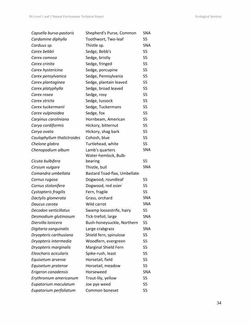
Pit Level 1 and 2 Natural Environment Technical Report Ecological Services
34
Capsella bursa-pastoris Shepherd's Purse, Common SNA
Cardamine diphylla Toothwort, Two-leaf S5
Carduus sp. Thistle sp. SNA
Carex bebbii Sedge, Bebb's S5
Carex comosa Sedge, bristly S5
Carex crinita Sedge, fringed S5
Carex hystericina Sedge, porcupine S5
Carex pensylvanica Sedge, Pennsylvania S5
Carex plantaginea Sedge, plantain leaved S5
Carex platyphylla Sedge, broad leaved S5
Carex rosea Sedge, rosy S5
Carex stricta Sedge, tussock S5
Carex tuckermanii Sedge, Tuckermans S5
Carex vulpinoidea Sedge, fox S5
Carpinus caroliniana Hornbeam, American S5
Carya cordiformis Hickory, bitternut S5
Carya ovata Hickory, shag bark S5
Caulophyllum thalictroides Cohosh, blue S5
Chelone glabra Turtlehead, white S5
Chenopodium album Lamb's quarters SNA
Cicuta bulbifera Water-hemlock, Bulb-bearing S5
Cirsium vulgare Thistle, bull SNA
Comandra umbellata Bastard Toad-flax, Umbellate
Cornus rugosa Dogwood, roundleaf S5
Cornus stolonifera Dogwood, red osier S5
Cystopteris fragilis Fern, fragile S5
Dactylis glomerata Grass, orchard SNA
Daucus carota Wild carrot SNA
Decodon verticillatus Swamp loosestrife, hairy S5
Desmodium glutinosum Tick-trefoil, large SNA
Diervilla lonicera Bush-honeysuckle, Northern S5
Digitaria sanguinalis Large crabgrass SNA
Dryopteris carthusiana Shield fern, spinulose S5
Dryopteris intermedia Woodfern, evergreen S5
Dryopteris marginalis Marginal Shield Fern S5
Eleocharis acicularis Spike-rush, least S5
Equisetum arvense Horsetail, field S5
Equisetum pratense Horsetail, meadow S5
Erigeron canadensis Horseweed SNA
Erythronium americanum Trout-lily, yellow S5
Eupatorium maculatum Joe pye weed S5
Eupatorium perfoliatum Common boneset S5
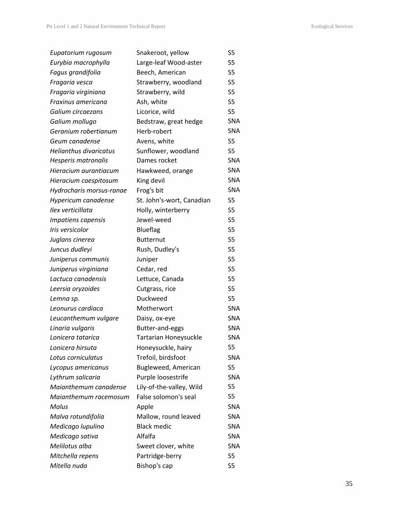
Pit Level 1 and 2 Natural Environment Technical Report Ecological Services
35
Eupatorium rugosum Snakeroot, yellow S5
Eurybia macrophylla Large-leaf Wood-aster S5
Fagus grandifolia Beech, American S5
Fragaria vesca Strawberry, woodland S5
Fragaria virginiana Strawberry, wild S5
Fraxinus americana Ash, white S5
Galium circaezans Licorice, wild S5
Galium mollugo Bedstraw, great hedge SNA
Geranium robertianum Herb-robert SNA
Geum canadense Avens, white S5
Helianthus divaricatus Sunflower, woodland S5
Hesperis matronalis Dames rocket SNA
Hieracium aurantiacum Hawkweed, orange SNA
Hieracium caespitosum King devil SNA
Hydrocharis morsus-ranae Frog's bit SNA
Hypericum canadense St. John's-wort, Canadian S5
Ilex verticillata Holly, winterberry S5
Impatiens capensis Jewel-weed S5
Iris versicolor Blueflag S5
Juglans cinerea Butternut S5
Juncus dudleyi Rush, Dudley's S5
Juniperus communis Juniper S5
Juniperus virginiana Cedar, red S5
Lactuca canadensis Lettuce, Canada S5
Leersia oryzoides Cutgrass, rice S5
Lemna sp. Duckweed S5
Leonurus cardiaca Motherwort SNA
Leucanthemum vulgare Daisy, ox-eye SNA
Linaria vulgaris Butter-and-eggs SNA
Lonicera tatarica Tartarian Honeysuckle SNA
Lonicera hirsuta Honeysuckle, hairy S5
Lotus corniculatus Trefoil, birdsfoot SNA
Lycopus americanus Bugleweed, American S5
Lythrum salicaria Purple loosestrife SNA
Maianthemum canadense Lily-of-the-valley, Wild S5
Maianthemum racemosum False solomon's seal S5
Malus Apple SNA
Malva rotundifolia Mallow, round leaved SNA
Medicago lupulina Black medic SNA
Medicago sativa Alfalfa SNA
Melilotus alba Sweet clover, white SNA
Mitchella repens Partridge-berry S5
Mitella nuda Bishop's cap S5
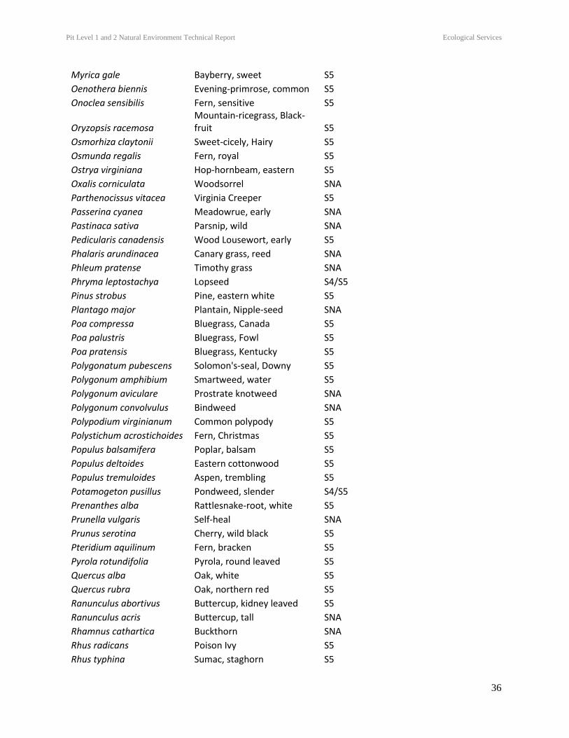
Pit Level 1 and 2 Natural Environment Technical Report Ecological Services
36
Myrica gale Bayberry, sweet S5
Oenothera biennis Evening-primrose, common S5
Onoclea sensibilis Fern, sensitive S5
Oryzopsis racemosa Mountain-ricegrass, Black-fruit S5
Osmorhiza claytonii Sweet-cicely, Hairy S5
Osmunda regalis Fern, royal S5
Ostrya virginiana Hop-hornbeam, eastern S5
Oxalis corniculata Woodsorrel SNA
Parthenocissus vitacea Virginia Creeper S5
Passerina cyanea Meadowrue, early SNA
Pastinaca sativa Parsnip, wild SNA
Pedicularis canadensis Wood Lousewort, early S5
Phalaris arundinacea Canary grass, reed SNA
Phleum pratense Timothy grass SNA
Phryma leptostachya Lopseed S4/S5
Pinus strobus Pine, eastern white S5
Plantago major Plantain, Nipple-seed SNA
Poa compressa Bluegrass, Canada S5
Poa palustris Bluegrass, Fowl S5
Poa pratensis Bluegrass, Kentucky S5
Polygonatum pubescens Solomon's-seal, Downy S5
Polygonum amphibium Smartweed, water S5
Polygonum aviculare Prostrate knotweed SNA
Polygonum convolvulus Bindweed SNA
Polypodium virginianum Common polypody S5
Polystichum acrostichoides Fern, Christmas S5
Populus balsamifera Poplar, balsam S5
Populus deltoides Eastern cottonwood S5
Populus tremuloides Aspen, trembling S5
Potamogeton pusillus Pondweed, slender S4/S5
Prenanthes alba Rattlesnake-root, white S5
Prunella vulgaris Self-heal SNA
Prunus serotina Cherry, wild black S5
Pteridium aquilinum Fern, bracken S5
Pyrola rotundifolia Pyrola, round leaved S5
Quercus alba Oak, white S5
Quercus rubra Oak, northern red S5
Ranunculus abortivus Buttercup, kidney leaved S5
Ranunculus acris Buttercup, tall SNA
Rhamnus cathartica Buckthorn SNA
Rhus radicans Poison Ivy S5
Rhus typhina Sumac, staghorn S5
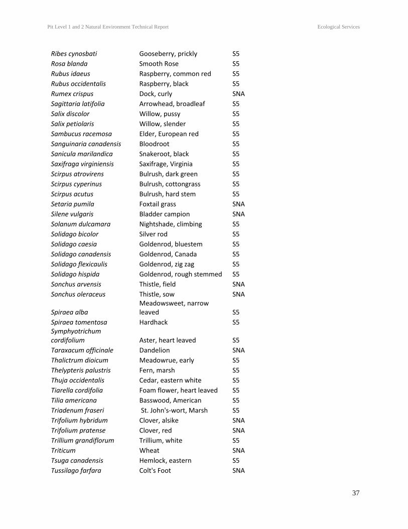
Pit Level 1 and 2 Natural Environment Technical Report Ecological Services
37
Ribes cynosbati Gooseberry, prickly S5
Rosa blanda Smooth Rose S5
Rubus idaeus Raspberry, common red S5
Rubus occidentalis Raspberry, black S5
Rumex crispus Dock, curly SNA
Sagittaria latifolia Arrowhead, broadleaf S5
Salix discolor Willow, pussy S5
Salix petiolaris Willow, slender S5
Sambucus racemosa Elder, European red S5
Sanguinaria canadensis Bloodroot S5
Sanicula marilandica Snakeroot, black S5
Saxifraga virginiensis Saxifrage, Virginia S5
Scirpus atrovirens Bulrush, dark green S5
Scirpus cyperinus Bulrush, cottongrass S5
Scirpus acutus Bulrush, hard stem S5
Setaria pumila Foxtail grass SNA
Silene vulgaris Bladder campion SNA
Solanum dulcamara Nightshade, climbing S5
Solidago bicolor Silver rod S5
Solidago caesia Goldenrod, bluestem S5
Solidago canadensis Goldenrod, Canada S5
Solidago flexicaulis Goldenrod, zig zag S5
Solidago hispida Goldenrod, rough stemmed S5
Sonchus arvensis Thistle, field SNA
Sonchus oleraceus Thistle, sow SNA
Spiraea alba Meadowsweet, narrow leaved S5
Spiraea tomentosa Hardhack S5 Symphyotrichum cordifolium Aster, heart leaved S5
Taraxacum officinale Dandelion SNA
Thalictrum dioicum Meadowrue, early S5
Thelypteris palustris Fern, marsh S5
Thuja occidentalis Cedar, eastern white S5
Tiarella cordifolia Foam flower, heart leaved S5
Tilia americana Basswood, American S5
Triadenum fraseri St. John's-wort, Marsh S5
Trifolium hybridum Clover, alsike SNA
Trifolium pratense Clover, red SNA
Trillium grandiflorum Trillium, white S5
Triticum Wheat SNA
Tsuga canadensis Hemlock, eastern S5
Tussilago farfara Colt's Foot SNA
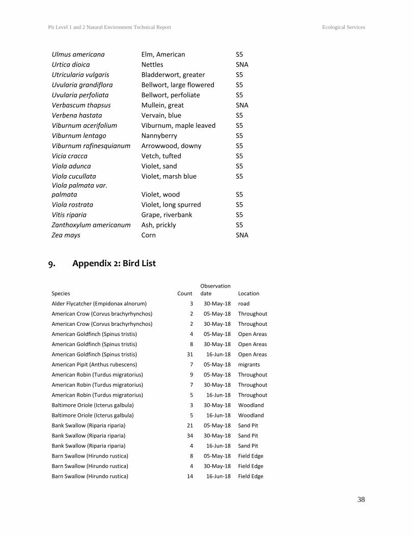
Pit Level 1 and 2 Natural Environment Technical Report Ecological Services
38
Ulmus americana Elm, American S5
Urtica dioica Nettles SNA
Utricularia vulgaris Bladderwort, greater S5
Uvularia grandiflora Bellwort, large flowered S5
Uvularia perfoliata Bellwort, perfoliate S5
Verbascum thapsus Mullein, great SNA
Verbena hastata Vervain, blue S5
Viburnum acerifolium Viburnum, maple leaved S5
Viburnum lentago Nannyberry S5
Viburnum rafinesquianum Arrowwood, downy S5
Vicia cracca Vetch, tufted S5
Viola adunca Violet, sand S5
Viola cucullata Violet, marsh blue S5 Viola palmata var. palmata Violet, wood S5
Viola rostrata Violet, long spurred S5
Vitis riparia Grape, riverbank S5
Zanthoxylum americanum Ash, prickly S5
Zea mays Corn SNA
9. Appendix 2: Bird List
Species Count Observation date Location
Alder Flycatcher (Empidonax alnorum) 3 30-May-18 road
American Crow (Corvus brachyrhynchos) 2 05-May-18 Throughout
American Crow (Corvus brachyrhynchos) 2 30-May-18 Throughout
American Goldfinch (Spinus tristis) 4 05-May-18 Open Areas
American Goldfinch (Spinus tristis) 8 30-May-18 Open Areas
American Goldfinch (Spinus tristis) 31 16-Jun-18 Open Areas
American Pipit (Anthus rubescens) 7 05-May-18 migrants
American Robin (Turdus migratorius) 9 05-May-18 Throughout
American Robin (Turdus migratorius) 7 30-May-18 Throughout
American Robin (Turdus migratorius) 5 16-Jun-18 Throughout
Baltimore Oriole (Icterus galbula) 3 30-May-18 Woodland
Baltimore Oriole (Icterus galbula) 5 16-Jun-18 Woodland
Bank Swallow (Riparia riparia) 21 05-May-18 Sand Pit
Bank Swallow (Riparia riparia) 34 30-May-18 Sand Pit
Bank Swallow (Riparia riparia) 4 16-Jun-18 Sand Pit
Barn Swallow (Hirundo rustica) 8 05-May-18 Field Edge
Barn Swallow (Hirundo rustica) 4 30-May-18 Field Edge
Barn Swallow (Hirundo rustica) 14 16-Jun-18 Field Edge
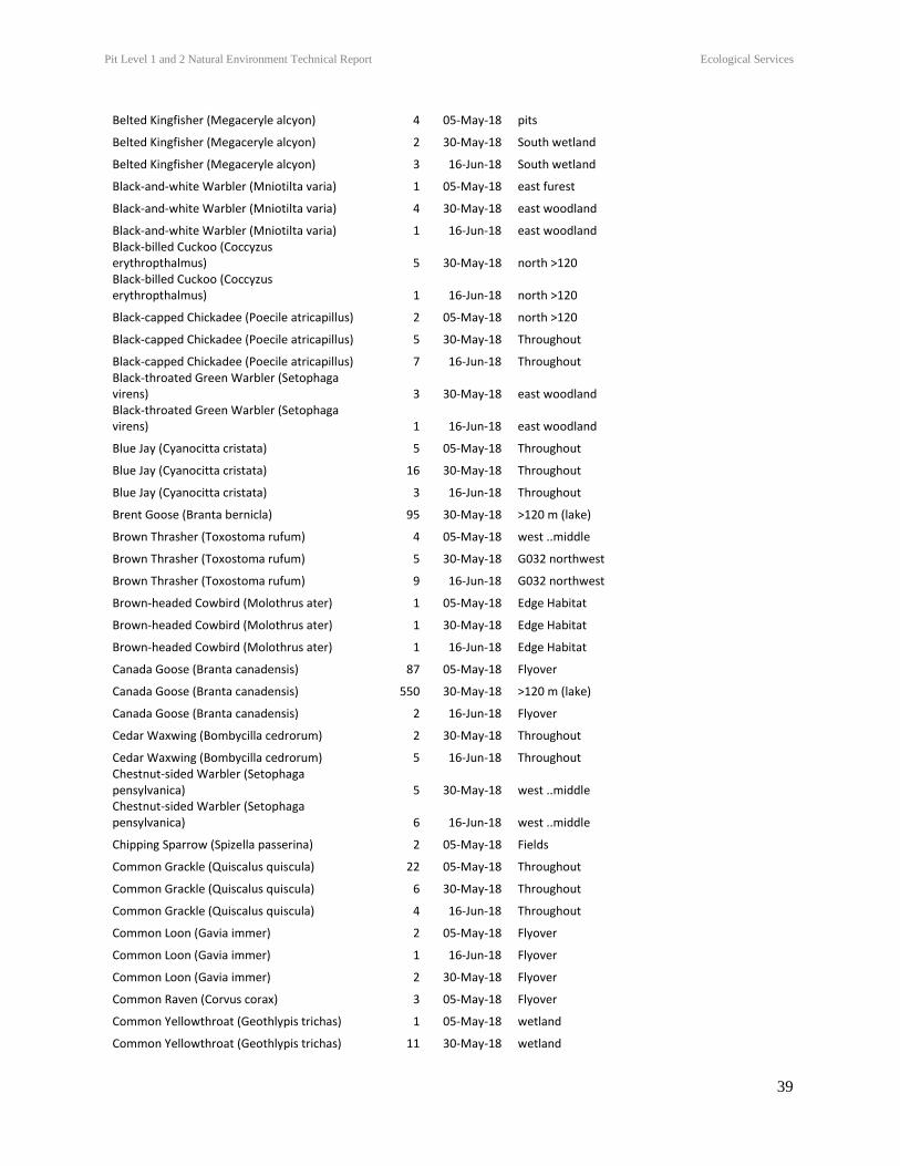
Pit Level 1 and 2 Natural Environment Technical Report Ecological Services
39
Belted Kingfisher (Megaceryle alcyon) 4 05-May-18 pits
Belted Kingfisher (Megaceryle alcyon) 2 30-May-18 South wetland
Belted Kingfisher (Megaceryle alcyon) 3 16-Jun-18 South wetland
Black-and-white Warbler (Mniotilta varia) 1 05-May-18 east furest
Black-and-white Warbler (Mniotilta varia) 4 30-May-18 east woodland
Black-and-white Warbler (Mniotilta varia) 1 16-Jun-18 east woodland Black-billed Cuckoo (Coccyzus erythropthalmus) 5 30-May-18 north >120 Black-billed Cuckoo (Coccyzus erythropthalmus) 1 16-Jun-18 north >120
Black-capped Chickadee (Poecile atricapillus) 2 05-May-18 north >120
Black-capped Chickadee (Poecile atricapillus) 5 30-May-18 Throughout
Black-capped Chickadee (Poecile atricapillus) 7 16-Jun-18 Throughout Black-throated Green Warbler (Setophaga virens) 3 30-May-18 east woodland Black-throated Green Warbler (Setophaga virens) 1 16-Jun-18 east woodland
Blue Jay (Cyanocitta cristata) 5 05-May-18 Throughout
Blue Jay (Cyanocitta cristata) 16 30-May-18 Throughout
Blue Jay (Cyanocitta cristata) 3 16-Jun-18 Throughout
Brent Goose (Branta bernicla) 95 30-May-18 >120 m (lake)
Brown Thrasher (Toxostoma rufum) 4 05-May-18 west ..middle
Brown Thrasher (Toxostoma rufum) 5 30-May-18 G032 northwest
Brown Thrasher (Toxostoma rufum) 9 16-Jun-18 G032 northwest
Brown-headed Cowbird (Molothrus ater) 1 05-May-18 Edge Habitat
Brown-headed Cowbird (Molothrus ater) 1 30-May-18 Edge Habitat
Brown-headed Cowbird (Molothrus ater) 1 16-Jun-18 Edge Habitat
Canada Goose (Branta canadensis) 87 05-May-18 Flyover
Canada Goose (Branta canadensis) 550 30-May-18 >120 m (lake)
Canada Goose (Branta canadensis) 2 16-Jun-18 Flyover
Cedar Waxwing (Bombycilla cedrorum) 2 30-May-18 Throughout
Cedar Waxwing (Bombycilla cedrorum) 5 16-Jun-18 Throughout Chestnut-sided Warbler (Setophaga pensylvanica) 5 30-May-18 west ..middle Chestnut-sided Warbler (Setophaga pensylvanica) 6 16-Jun-18 west ..middle
Chipping Sparrow (Spizella passerina) 2 05-May-18 Fields
Common Grackle (Quiscalus quiscula) 22 05-May-18 Throughout
Common Grackle (Quiscalus quiscula) 6 30-May-18 Throughout
Common Grackle (Quiscalus quiscula) 4 16-Jun-18 Throughout
Common Loon (Gavia immer) 2 05-May-18 Flyover
Common Loon (Gavia immer) 1 16-Jun-18 Flyover
Common Loon (Gavia immer) 2 30-May-18 Flyover
Common Raven (Corvus corax) 3 05-May-18 Flyover
Common Yellowthroat (Geothlypis trichas) 1 05-May-18 wetland
Common Yellowthroat (Geothlypis trichas) 11 30-May-18 wetland
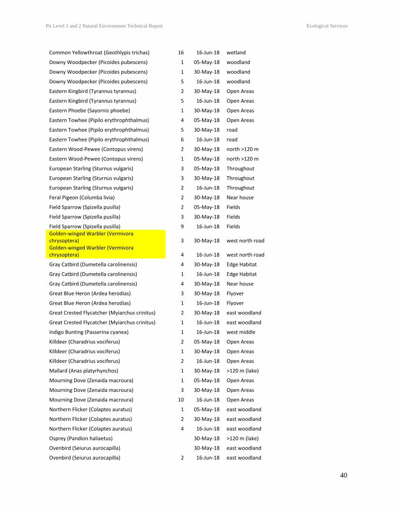
Pit Level 1 and 2 Natural Environment Technical Report Ecological Services
40
Common Yellowthroat (Geothlypis trichas) 16 16-Jun-18 wetland
Downy Woodpecker (Picoides pubescens) 1 05-May-18 woodland
Downy Woodpecker (Picoides pubescens) 1 30-May-18 woodland
Downy Woodpecker (Picoides pubescens) 5 16-Jun-18 woodland
Eastern Kingbird (Tyrannus tyrannus) 2 30-May-18 Open Areas
Eastern Kingbird (Tyrannus tyrannus) 5 16-Jun-18 Open Areas
Eastern Phoebe (Sayornis phoebe) 1 30-May-18 Open Areas
Eastern Towhee (Pipilo erythrophthalmus) 4 05-May-18 Open Areas
Eastern Towhee (Pipilo erythrophthalmus) 5 30-May-18 road
Eastern Towhee (Pipilo erythrophthalmus) 6 16-Jun-18 road
Eastern Wood-Pewee (Contopus virens) 2 30-May-18 north >120 m
Eastern Wood-Pewee (Contopus virens) 1 05-May-18 north >120 m
European Starling (Sturnus vulgaris) 3 05-May-18 Throughout
European Starling (Sturnus vulgaris) 3 30-May-18 Throughout
European Starling (Sturnus vulgaris) 2 16-Jun-18 Throughout
Feral Pigeon (Columba livia) 2 30-May-18 Near house
Field Sparrow (Spizella pusilla) 2 05-May-18 Fields
Field Sparrow (Spizella pusilla) 3 30-May-18 Fields
Field Sparrow (Spizella pusilla) 9 16-Jun-18 Fields Golden-winged Warbler (Vermivora chrysoptera) 3 30-May-18 west north road Golden-winged Warbler (Vermivora chrysoptera) 4 16-Jun-18 west north road
Gray Catbird (Dumetella carolinensis) 4 30-May-18 Edge Habitat
Gray Catbird (Dumetella carolinensis) 1 16-Jun-18 Edge Habitat
Gray Catbird (Dumetella carolinensis) 4 30-May-18 Near house
Great Blue Heron (Ardea herodias) 3 30-May-18 Flyover
Great Blue Heron (Ardea herodias) 1 16-Jun-18 Flyover
Great Crested Flycatcher (Myiarchus crinitus) 2 30-May-18 east woodland
Great Crested Flycatcher (Myiarchus crinitus) 1 16-Jun-18 east woodland
Indigo Bunting (Passerina cyanea) 1 16-Jun-18 west middle
Killdeer (Charadrius vociferus) 2 05-May-18 Open Areas
Killdeer (Charadrius vociferus) 1 30-May-18 Open Areas
Killdeer (Charadrius vociferus) 2 16-Jun-18 Open Areas
Mallard (Anas platyrhynchos) 1 30-May-18 >120 m (lake)
Mourning Dove (Zenaida macroura) 1 05-May-18 Open Areas
Mourning Dove (Zenaida macroura) 3 30-May-18 Open Areas
Mourning Dove (Zenaida macroura) 10 16-Jun-18 Open Areas
Northern Flicker (Colaptes auratus) 1 05-May-18 east woodland
Northern Flicker (Colaptes auratus) 2 30-May-18 east woodland
Northern Flicker (Colaptes auratus) 4 16-Jun-18 east woodland
Osprey (Pandion haliaetus) 30-May-18 >120 m (lake)
Ovenbird (Seiurus aurocapilla) 30-May-18 east woodland
Ovenbird (Seiurus aurocapilla) 2 16-Jun-18 east woodland
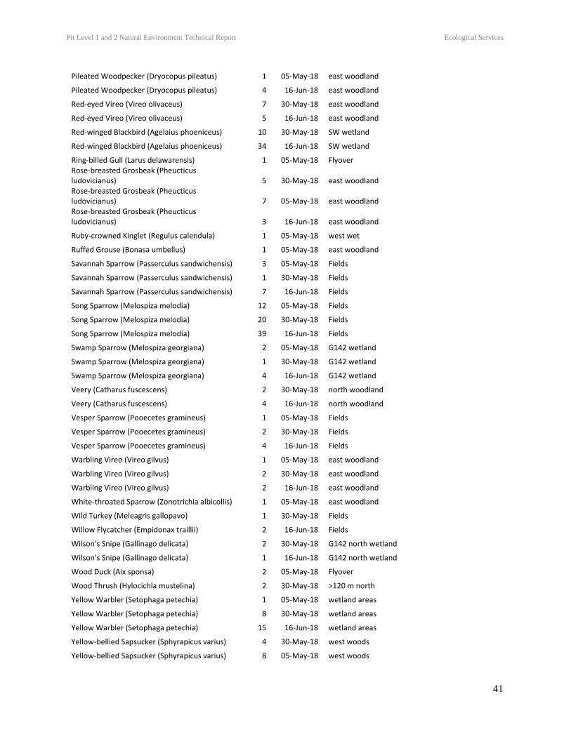
Pit Level 1 and 2 Natural Environment Technical Report Ecological Services
41
Pileated Woodpecker (Dryocopus pileatus) 1 05-May-18 east woodland
Pileated Woodpecker (Dryocopus pileatus) 4 16-Jun-18 east woodland
Red-eyed Vireo (Vireo olivaceus) 7 30-May-18 east woodland
Red-eyed Vireo (Vireo olivaceus) 5 16-Jun-18 east woodland
Red-winged Blackbird (Agelaius phoeniceus) 10 30-May-18 SW wetland
Red-winged Blackbird (Agelaius phoeniceus) 34 16-Jun-18 SW wetland
Ring-billed Gull (Larus delawarensis) 1 05-May-18 Flyover Rose-breasted Grosbeak (Pheucticus ludovicianus) 5 30-May-18 east woodland Rose-breasted Grosbeak (Pheucticus ludovicianus) 7 05-May-18 east woodland Rose-breasted Grosbeak (Pheucticus ludovicianus) 3 16-Jun-18 east woodland
Ruby-crowned Kinglet (Regulus calendula) 1 05-May-18 west wet
Ruffed Grouse (Bonasa umbellus) 1 05-May-18 east woodland
Savannah Sparrow (Passerculus sandwichensis) 3 05-May-18 Fields
Savannah Sparrow (Passerculus sandwichensis) 1 30-May-18 Fields
Savannah Sparrow (Passerculus sandwichensis) 7 16-Jun-18 Fields
Song Sparrow (Melospiza melodia) 12 05-May-18 Fields
Song Sparrow (Melospiza melodia) 20 30-May-18 Fields
Song Sparrow (Melospiza melodia) 39 16-Jun-18 Fields
Swamp Sparrow (Melospiza georgiana) 2 05-May-18 G142 wetland
Swamp Sparrow (Melospiza georgiana) 1 30-May-18 G142 wetland
Swamp Sparrow (Melospiza georgiana) 4 16-Jun-18 G142 wetland
Veery (Catharus fuscescens) 2 30-May-18 north woodland
Veery (Catharus fuscescens) 4 16-Jun-18 north woodland
Vesper Sparrow (Pooecetes gramineus) 1 05-May-18 Fields
Vesper Sparrow (Pooecetes gramineus) 2 30-May-18 Fields
Vesper Sparrow (Pooecetes gramineus) 4 16-Jun-18 Fields
Warbling Vireo (Vireo gilvus) 1 05-May-18 east woodland
Warbling Vireo (Vireo gilvus) 2 30-May-18 east woodland
Warbling Vireo (Vireo gilvus) 2 16-Jun-18 east woodland
White-throated Sparrow (Zonotrichia albicollis) 1 05-May-18 east woodland
Wild Turkey (Meleagris gallopavo) 1 30-May-18 Fields
Willow Flycatcher (Empidonax traillii) 2 16-Jun-18 Fields
Wilson's Snipe (Gallinago delicata) 2 30-May-18 G142 north wetland
Wilson's Snipe (Gallinago delicata) 1 16-Jun-18 G142 north wetland
Wood Duck (Aix sponsa) 2 05-May-18 Flyover
Wood Thrush (Hylocichla mustelina) 2 30-May-18 >120 m north
Yellow Warbler (Setophaga petechia) 1 05-May-18 wetland areas
Yellow Warbler (Setophaga petechia) 8 30-May-18 wetland areas
Yellow Warbler (Setophaga petechia) 15 16-Jun-18 wetland areas
Yellow-bellied Sapsucker (Sphyrapicus varius) 4 30-May-18 west woods
Yellow-bellied Sapsucker (Sphyrapicus varius) 8 05-May-18 west woods
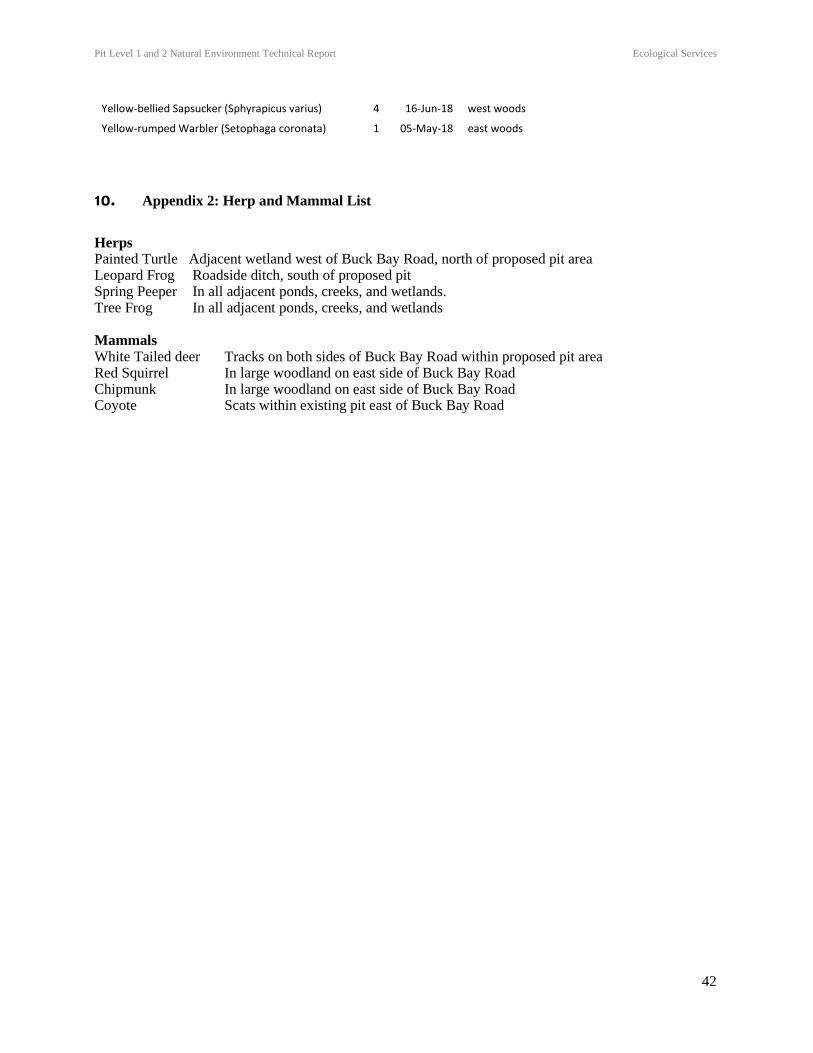
Pit Level 1 and 2 Natural Environment Technical Report Ecological Services
42
Yellow-bellied Sapsucker (Sphyrapicus varius) 4 16-Jun-18 west woods
Yellow-rumped Warbler (Setophaga coronata) 1 05-May-18 east woods
10. Appendix 2: Herp and Mammal List
Herps Painted Turtle Adjacent wetland west of Buck Bay Road, north of proposed pit area Leopard Frog Roadside ditch, south of proposed pit Spring Peeper In all adjacent ponds, creeks, and wetlands. Tree Frog In all adjacent ponds, creeks, and wetlands Mammals White Tailed deer Tracks on both sides of Buck Bay Road within proposed pit area Red Squirrel In large woodland on east side of Buck Bay Road Chipmunk In large woodland on east side of Buck Bay Road Coyote Scats within existing pit east of Buck Bay Road
Copyright © 2022 FDOKUMEN