Environment of Gaur
12
′ ′ ′
Transcript of Environment of Gaur

115
Environment of Gaur
SHARMI CHAKRABORTY
This study was undertaken to find out the raison
d�etre of Gaur. Explanation should be sought on the
emergence of Gaur as the capital of the Bengal
Sultanate from the fifteenth century which contin-
ued its prominence as the political seat of Bengal
till the middle of the sixteenth century. The begin-
ning of Gaur as the favoured locus for governing
Bengal was possibly much earlier though no con-
clusive evidence has yet been found. Being the
capital of a populous kingdom, it required ameni-
ties befitting its status. This is a combination of po-
litical and economic advantages that its situation
could exploit. Important elements are with regard
to security in respect of natural calamities, protec-
tion from invasion, supply of food and water, and
control over its possession.
The term environment connotes both physical
and cultural aspects. This work deals mainly with
the physical environment. Our knowledge of physi-
cal environment suffers from lack of reliable
sources on this area. It is beyond the scope of
present work to undertake the required extensive
geological/geomorphological and biological sur-
veys that could have generated adequate data.
Sketchy report from the excavation undertaken by
the Archaeological Survey of India from 2003 to
2005 does not give insight into the nature of settle-
ment. This study aims at building up a preliminary
understanding of the context of the archaeological
site of Gaur.
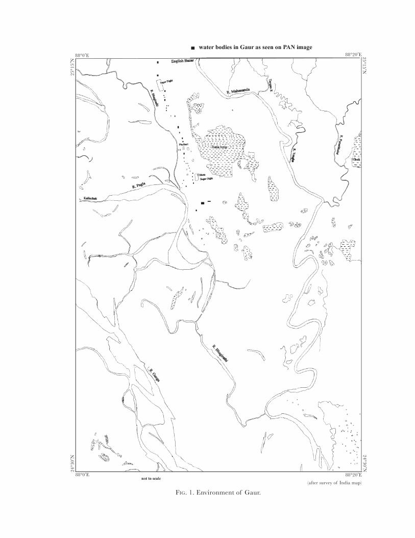
GENERAL ELEMENTS OF GEOGRAPHY
Defining the geography of Gaur is not an easy
proposition. It could include the whole of the re-
gion over which the Bengal Sultanate wielded
power. But in a restricted sense, it could mean the
region around Gaur, which had a direct bearing on
the ecology of the site (Fig. 1). Here this restricted
version has been taken because it is more relevant
in addressing the issue of the context of the ar-
chaeological site. The environmental zone de-
scribed here approximately stretches from 88º to
Pratna Samiksha, New Series 3, 2012. © Centre for Archaeological
Studies & Training, Eastern India, Kolkata, pp. 115�26.
88º45′ E and 24º30′ to 25º15′ N. This area is not by
any means a watertight compartment, natural
boundaries are hardly linear and in the great
Gangetic plains not even fixed. But the area under
consideration hopes to capture adequately the es-
sence of this diverse region.
Geology
The sites of Gaur and Pandua are situated on the
alluvial tract. But the area lacks homogenity. The
region to the east of the Mahananda river consists
of the Barind formation which belongs to the Pleis-
tocene period. At the surface, this older alluvium is
covered by the floodplain of the Mahananda,
Punarbhava, and Tangan rivers. Where these riv-
ers flow through Barind, they have developed en-
trenched meanders. The Barind consists of alfisol,
pedalfer with iron oxide, mottled, greyish red-
brown cumulative soil developed over flood silts
and clay, gley hydromorphic soils, ferruginized
floodplain which are carbonate free (Panja 2002).
The Barind formation broadly dates between early
and late-Pleistocene period. It gives the land an un-
dulating appearance though nowhere it rises above
30 m. It forms hills and ravines on an otherwise flat
plain. The presence of ferruginous elements in the
soil gives it a reddish colour.
The Older Baikunthapur formation also con-
tains iron pellets, but much lesser than Barind, and
belongs to a later period. Its features are somewhat
similar to those of alfisol which is pedalfer mottled
reddish brown grey soil with reddish horizon grad-
ing to greyish mottled clay. It also contains buried
soil, erosional soil with profile development, par-
tially ferruginized floodplain from recycled Barind.
It belongs to late-Pleistocene period. Older
Baikunthapur belonging to the terminal Pleis-
tocene period and is characterized by yellowish/
grey loamy with calcrete nodules.
To the south and the east of these Pleistocene
alluviums is the Younger Baikunthapur formation
ENVIRONMENT, ARCHAEOLOGY, AND SETTLEMENT PATTERN
11688°0′E
88°0′E
88°20′E
25
°15
′N
25
°15
′N
24
°30
′N
24
°30
′N
88°20′E
FIG. 1. Environment of Gaur.
(after survey of India map)

117
consisting of weakly developed soils over channel
sands, levees and floodplain silts and clays. It is
weakly pedogenized near channel with levees,
flood-loams, backswamps, etc. This formation be-
longs to a geological period stretching from mid to
late-Holocene (3000�500 BP). Gaur is situated on
this formation. The ash-coloured clayey silt, locally
called khair, is a soft sticky loam in the rainy season
but becomes hard in the dry period and unsuitable
for cultivation. Along the banks of the rivers, the
soil consists of sandy loam.
To the west is the Shaugaon formation, which is
less than 500 year old and has no soil formation. It
consists of modern floodplain with conspicuous
channel development and levees. It is during
Younger Baikunthapur and Shaugaon formation
of floodplain environment the channel system be-
came strong and dynamics.
River system
The region is drained by rivers like the Ganges,
Mahananda, Kalindri, Tangan, Atrai, and Punar-
bhava. The general gradient of the region is to-
wards south and south-east.
The river Mahananda rises from the hills of
Darjeeling. During the greater part of the year, the
river flows through a narrow channel leaving most
of the bed dry. Only during the monsoon, it fills up
the entire channel and occasionally overflows its
banks. The channel is very deep and the river bed
is sandy. The banks of the river are abrupt and
steep or sloping according to the direction of cur-
rent and the channels have not in recent times (i.e.
in the modern period) changed their directions.
There has been little deposition and erosion of al-
luvium. Its tributary river Nagar also has a wide
channel, which consists mostly of the dry bed, ex-
cept during rainy months. Sui is a branch of the
Nagar. The latter joins the Mahananda river at
Itahar police station. The Sui river joins the
Mahananda river further downstream. The
Gamari river originates from Randhanipara Bil
area. It has a meandering course and joins the Sui.
Both the rivers are navigable in the monsoon. The
Mahananda river discharges its flow in the Ganges
further downstream.
River Chiramati has a sandy bed with sloping
banks and rises from a marsh in Hemtabad police
station. It is called Shrimati in the lower reaches
and gets water from the marshes to the south-west-
ern part of Kaliaganj police station. It has two
principal tributary streams, which join together to
form the main river. It is a sluggish stream.
The Tangan river rises in Bangladesh, which
was earlier a part of Jalpaiguri district. It is a fairly
large river. The river bed is sandy and the channel
is narrower than others. During the rainy season, it
overflows its banks and inundates the adjoining
stretches. But it never poses any serious threat to
the habitation. It is navigable throughout the year.
The river brings down huge quantity of silt and
had suffered channel changes in the recent past.
Mara Tangan � an old course of the river � flows
close to it till it joins the main stream. There is an-
other old channel that joins the main river north of
Bulbulchandi ferry. The floods in this river are
linked with floods in the Mahananda into which it
discharges.
The Punarbhava is another important river of
the region. The bed of this river is sandy and the
banks are steep or sloping according to the flow of
the current. There are instances of deposition and
erosion of alluvium leading to changes of the
course of the river. During rainy season the river
spills over from its channel and spread out into a
large bil. It splits and gives rise to a shallow stream
called Brahmani. In some places, the Punarbhava
throws out side streams. Two of such side-channels
combine to form the Haria river, which runs paral-
lel to the parent steam before joining the river
Mahananda. The flood in the river Punarbhava
too is associated with the flood in the Mahananda.
Both the Tangan and Punarbhava flow from 50
to 100 m below the Barind surface and rise by 30 m
after monsoon entirely filling the broad sloping ba-
sin.
The river Atrai has a wide channel, which is full
only during the monsoon but never goes dry com-
pletely. It is a sluggish river with sandy bed. It
changed its course quite frequently in recent past.
Prior to 1785, both the Atrai and Punarbhava
had been a part of Tista system (Sengupta 1969).
But since the water of the Tista has turned to river
Brahmaputra they have suffered a considerable de-
cline. Beds of many smaller rivers have choked and
silted up. However, silting is the general tendency
Environment of Gaur
118
of the rivers of this region and in many places
these ancient river beds have formed marshes.
The Kalindri is mentioned in early colonial ac-
count as an offshoot of the Ganges. Though it is
connected to that river, it rises in the hills of Sikkim
and is a tributary of river Mahananda, which by
the name Phulhar passes through the district of
Purnea. It flows in south-easterly direction and join
the main stream at Old Malda. In the north, it re-
ceives tributary streams of Kalkos, Kankar, Kos, and
Baromasia, draining the Tal at rainy season. The
river has altered its course quite often. The banks
are steep where the river is eroding and low-shelv-
ing accretion is noticed in the opposite bank. It is
navigable only in rainy season and in dry period, it
is fordable.
The Ganges in this part is wide and large islands
(diara) have formed by deposition in the river-bed.
It flows in two channels, the main channel running
on the Rajmahal side. The river has shifted its po-
sition in recent past. At the time when W. W.
Hunter was writing about the river, its main flow
was on the Malda side. It shifted to town of
Rajmahal in 1810 during the time of Pemberton�s
survey in 1848 (Map 2). In 1810, it flowed again to-
wards the side of Malda during the Buchanan-
Hamilton survey (Buchanan-Hamilton 1986). The
old channel can be noticed running parallel to the
ruins of medieval city of Gaur. It is narrow and
looks more like a canal than a river at present and
is called the Chhoto Bhagirathi (Pl. 32a). Further
downstream the Ganges sends out another channel
in which the Chhoto Bhagirathi falls known as
Pagla. A little further downstream, the Ganges di-
vides itself into the Bhagirathi and Padma. The
bed of the river Ganges is sandy and the bank on
the Malda side is rather abrupt except areas where
there are sandbanks.
The southern part of this region has a large
number of large lakes or bils formed by abandoned
river channel and backwater left behind levees. A
chain of such can be found along the course of the
river Ganges. Some are also found on the lower
course of the Mahananda, Tangan, and Punar-
bhava rivers. Some of the important bils are:
Bamangola, Jagdal, Raniganj, Bhariar, Chachar,
Saulmari, Dagun, Khawa Khon, Sabdalpur,
Mirzapur, Karun Khali, Sukur Bari, Baragharia,
Haripur, Kammar, Nadahi, Sarjon Mallakpur,
Chana Parasan, Dhajon, Madhaipur, and Gondail.
Thus rivers in general show meandering and
other features associated with loss of gradient like
sandy beds, branching off channels, and marshes.
They are semi-perennial with high flood and water
drain off very slowly.
Climate
The climate of this region is hot and humid. The
cold season begins in the middle of November and
continues till February. The hot season starts from
March and continues till the onset of the monsoon
in the first week of June. The monsoon continues
till the end of September. It is followed by post-
monsoon season. The annual average rainfall in
this region is about 156 cm. About 78 per cent of
this rain falls during the monsoon. Winter rainfall
is scarce. In the summer months, thundershowers
and hail are frequent which are locally known as
kalbaishakhi. There is very little year to year varia-
tion in rainfall. During the 50-year period from
1900 to 1950 the highest annual rainfall was 137
per cent of the normal and lowest was 59 per cent
of the normal. In eight years the rainfall had been
80 per cent of the normal, two being consecutive
year. In summer the mean maximum temperature
is 35 °C though it is known to rise to 45 °C. The
winter is mild.
Therefore, this is a region of high monsoon
rainfall with very few failures. The rest of the year
is generally dry (Sengupta 1969).
Tanks and ponds
A very striking feature of the region is the presence
of large tanks and innumerable ponds that have
dotted the Barind surface and almost its total
absence of the feature in the floodplains of the
river Ganges. These anthropogenic elements in the
environment need special attention to understand
the context. These ponds and tanks were and still
used for various purposes for the household and
economic activities. Each of them has separate
functions. The smaller ponds are usually owned by
individuals and are for domestic use. Larger tanks
often serve the purpose of irrigation and fisheries.
However, these functions are not exclusive to each
other. The colonial writers, like Buchanan-
SHARMI CHAKRABORTY
119Environment of Gaur
Hamilton, have considered the tanks with north-
south orientation as excavated by Brahmanical or
Buddhist rulers and those with west-east
orientation as excavated by Muslim rulers.
One of such large tanks is Mahipal Dighi on
Kushmandi police station (Chattopadhyay 2003).
As the local tradition goes, the excavation of this
tank is associated to the Pala emperor Mahipala.
The survey of 1938� 40 have shown the length of
the tank is 1225 m and breadth is 308 m. Tapan
Dighi under Tapan police station is another big
tank measuring 1298 m in length and 366 m in
breadth. Though local traditions consider it to be
excavated by mythical King Bana, it possibly dates
back to early medieval period. The Gangesrampur
police station has two large tanks situated close to
each other, called Kal Dighi and Dhal Dighi. Dhal
Dighi is 1288 m long and 265 m broad. It was con-
structed by the Sultan of Gaur, Ruknuddin Kaikas,
in around AD 1291 and 1301. Kal Dighi is 1207 m
in length and 293 m in breadth. Nanda Dighi of
Jagjivanpur was excavated before Vajrapaladeva
who built the vihara in ninth century AD
(Bhttacharya 1992). Pandab Rajar Dighi or
Sataishghara Dighi or Arjun Dighi is situated
about 2½ km from Adina masjid (Jana 2003). It is
181.5 m long and 149.5 m broad. Nasir Shah Dighi
is also situated in the site of Pandua and was sup-
posedly excavated by Nasiruddin Nusrat Shah. It is
326.5 m long and 255 m wide. Ajma Dighi is situ-
ated to the west of Kona masjid, the original size of
this tank is difficult to ascertain because years of
neglect have transformed it into several small
ponds full of water hyacinth. Mitha Dighi is on the
darga of Kazi Nur and supposed to have been exca-
vated in the time of Alaul Haq. Sukan Dighi of
Bajpur is 567 m long and 249.5 m broad. On the
way from Old Malda to Devkot by a causeway dat-
ing back to the medieval times is another tank
called Para Dighi. Raykhan Dighi is to the west of
Pandua, near Eklakhi station. It is difficult to give a
proper date of its excavation, but mound of early
medieval period nearby suggests that it belonged to
that period. There is another big tank in Kaligram
under Chachal police station. It was excavated by
the queen of some local dynasty of Purnea district
with a Shiva temple. There are some smaller tanks
in Old Malda. Local landowner excavated a tank
beside which once stood the first English office.
Another was excavated with the money donated by
Queen Victoria. It is locally known as Bibi pukur.
There is also a large tank beside Sarbamangala po-
lice station.
A floodprone region with large and small tanks
strikes a note of discord. This region is regularly
flooded in the monsoon and the water takes a long
time to drain off. But after it was drained off there
is scarcity of water as the water table is very low for
wells to be dug. Many of these larger tanks have
high banks with sloping sides to give it a wider
catchment area with greater storage. This is a typi-
cal feature of the Barind. Lambourn (1918) men-
tions that water supply in Barind were derived from
tanks, which are filled annually by rain and dew
(Lambourn 1918). Wells are infrequent as the soil
is hard and so instead, people have dug shallow wa-
ter holes in which surface water accumulates.
Where river water is available, it is given prefer-
ence and elsewhere on newer alluvium ring-wells
are found. In this context, perhaps the poetic allu-
sion in the copperplate grant from Tarpan Dighi
acquires some significance. To quote: �May the
germ of your prosperity develop by the cloud,
which is cluster hair of Sambho by whom the sor-
rows and pains of the world are done away, O the
cloud � whose water is the river of heaven and
along which a row of heron fly� (Westmacott 1918).
Tanks in the city of Gaur. There are many tanks and
ponds within this city. In the northern part of the
site are Tarpan or Tamna Dighi which 14 m long
and 7 m wide. It is situated in a region known as
Bagbari, which is believed to have been a garden
resort of Sena king, Ballala Sena (1158�79). At
present, the tank is much silted. Another tank of
this area is Kajal Dighi about 16 m long and 12 m
wide. The map produced by Pemberton shows that
there are many other ponds scattered around
Bagbari area.
The largest tank of the city is (Baro) Sagar Dighi,
which is about 2900 m in length and 1300 m in
width (measurement of this tank and those of the
following are obtained from satellite images and
are therefore only approximate). At present it has
been subdivided into various plots and used for pi-
sciculture. There is a narrow ledge that runs some
120
quarter distance parallel to the length. This seems
to have been constructed before the divisions but is
absent in Pemberton�s map. This ledge is usually
made to protect the sides of the large tanks from
waves. This tank has high banks. It had paved stairs
at six different places � one each in northern and
southern side and two each on the longer eastern
and western sides. The importance of such a mas-
sive tank in the medieval period is quiet apparent.
There is a mausoleum of a Muslim saint and
Jhanjhania mosque medieval sultans and two gate-
ways. Nothing of earlier period is visible today
although forty years ago typical early medieval re-
mains like pillars with human figurines (though dis-
figured) were found (Basak 2003).
Near the Mekha mosque, some 1 km south of
Sagar Dighi, there is another pond of 700 m in
length and 400 m in breadth. It has high banks.
There are several smaller tanks with paved sides.
Other than these tanks, there are numerous smaller
ponds dotted all over the landscape other than
these tanks.
The next large tank is Piyasbari (Pl. 32b). Abul
Fazl in Ain-i-Akbari describes this tank as poisonous
and the cruel Sultan used to kill his prisoner by
forcing them to drink its water (Blochmann and
Jarrett 1927). This was of course been a figment of
his imagination to show his master Akbar�s magna-
nimity. The size of this tank is 900 m in length and
550 m width. To the west of this tank is a much
smaller pond, which is a shallow depression con-
taining water. Beyond that is the moat before the
first of the double wall. There are two other impor-
tant tanks � Rup Sagar and Sanatan Sagar, which
according to local legend are after the two great
disciples of Chaitanya � Rup and Sanatan
Goswami. These tanks are around 400/250 m and
500/250 m respectively. Rup Sagar has suffered
erosion of its banks in recent years. To the east of
Baro Sona mosque there is another tank approxi-
mately 450/300 m. The gate of the mosque faces
the tank. There are other smaller ponds in the area.
Further south lies the Firuz Minar. To the west
of this monument, a series of ponds run towards
Qadam Rasul monument. There is also a pond be-
side Qadam Rasul (Falal Dighi?). But the pond in
front of the Minar distinctly separate from the se-
ries mentioned earlier. The former series probably
belong to some ancient channel system while the
latter, beside the Minar and the Qadam Rasul are
artificial. There is a large tank at the back of
Chamkatti mosque.
The palace has three tanks, each attached to the
three compartments of the palace, nothing of the
palace is visible at present. These tanks are all of
respectable size and their sides were paved by
blocks of basalt, portions of which still can be no-
ticed at places.
To the south of the palace lies the Tantipara
mosque. From there, chain of ponds can be noticed
running north to west. The Chhoto Sagar Dighi is
the largest tank of the area after the Baro Sagar
Dighi. It is about 1400 m in length and 800 m in
width with raised bank. Some small ponds can be
noticed on the east. Between the Chhoto Sagar
Dighi and Lattan masjid there is another series of
ponds, some of which are connected, bifurcating to
the north. This also seems to a reminiscent of an
old channel. The Gunmant mosque, which is situ-
ated close to the river Bhagirathi, has two tanks,
one to the south and the other to the east.
However, the present site is full of many other
tanks and ponds. Their dates cannot be ascertained
with any certainty. It can be noticed from the topo-
graphic sheets of this region that this large number
of ponds and tanks of Gaur are an aberration of
the pattern noticed along the banks of the Ganges.
Most of the larger tanks and water-bodies are no-
ticed in the settlements along the bank of smaller
rivers and scattered all over the Barind. The
smaller rivers of the Barind did not originate from
glaciers and carry little water in the summer. For
some reason, even though large settlements are no-
ticed in the recent times on the Ganges, they have
less number of ponds. The emphasis is given more
on wells. One explanation could be that there the
water table is higher and so it is less expensive to
draw water and another factor could be the peren-
nial nature of the Ganges, which always holds
enough water for the population residing on its
banks. However, all the tanks and ponds of Gaur
are not old. Many of the ponds are of very recent
origin. These are used in various types of house-
hold requirements and even for fishing. But many
of the older larger tanks were constructed for sup-
plying the needs of the city. However, a medieval
SHARMI CHAKRABORTY

121Environment of Gaur
city might need tanks, specially the larger ones, also
for other purposes other than only for domestic
ones. In a pattern noticed even outside Bengal they
were equipped to be a self-sufficient unit in case of
long siege.
GEOMORPHOLOGY OF GAUR
The geomorphology of Gaur is complex. Due to
oscillating movements of the river Ganges, deposi-
tion and erosion of landform are a part of the
landscape process. The depositions of alluvium are
of varied nature which leads to a considerable
change in stratigraphy from one point to the other
over a small area. Though it is difficult to recon-
struct the history of the landforms with present
amount of data, it can be said with some amount
of certainty that the city of Gaur in its totality does
not have a uniform process of site formation. The
natural processes working on different area of the
site of Gaur are different as well as the cultural
processes and they are interlinked. Both will have a
bearing on the surface scatter that will be discussed
later.
The landforms are never static, this is emphati-
cally so in case of the floodprone North Bengal. It
is known from earlier accounts that the Ganges
once flowed beside the palace of Sultan Allauddin
Hussain Shah at Gaur. But the depositional envi-
ronment has reached a degree of stability with the
shifting of the course of the Ganges to Rajmahal,
where the Ganges is flowing through for the last
300 years. Likewise, as any land higher than its sur-
rounding is liable to erosion, the higher parts of
Gaur is certainly undergoing some amount of deg-
radation as torrential rain wash off the surface
cover and expose pottery and architectural ele-
ments.
It is known from several accounts that the main
course of the river Ganges or Bhagirathi flowed
along the western wall of the city. At present al-
most dry channel with stagnant water covered with
water hyacinth can be seen. In fact Stapleton felt
that it might have been a canal maintained by the
kings (Stapleton 1930). But there is a reference in
Sri Chaitanya Charitamrita of that Sultan Allauddin
Hussain Shah watching Sri Chaitanya from his pal-
ace, walking up the river Ganges (Kaviraj BS 1386).
There is another stream of thought, including
Stapleton�s that suggests that the Ganges flowed to
the east of the city around 1550. Some maps drawn
by early European travellers show the city to the
west of the river Ganges. But there is no geomor-
phological evidence to support this view. The city
of Gaur is situated on what is called Younger
Baikunthapur surface. The region to the east of the
Ganges is much older (personal communication
with Arunabha Das, Geological Survey of India).
The walled city has been artificially divided into
several blocks by the causeways and fortification
walls and canals running from west to east. The
Bagbari region is on a higher ground. Baro Sagar
Dighi is lower than the northern region and the
land seem to dip towards south-east. The section
containing the Mekha mosque is the lowest. At
present, it is covered by paddy field unlike most of
Gaur, which has extensive mango orchards. It is
apparent that after one crosses the metal road from
Piyasbari the land rises towards west, i.e. towards
the river. The Phulbari region, including the pal-
ace, is on a higher ground. The general slope of the
ground is towards east and north-east. The land
rises towards the palace and continues till the
Gunmant mosque and slopes down to Mahadipur.
In general there is downward slope towards the
Bhagirathi river. This is noticed at Badlabari and
also to the west of the Palace. The water table also
rises as one move towards the river. Beyond the
Kotwali gate, lie the southern suburbs of Gaur. It
also contains a few tanks and mosques. This is a
low-lying area beyond the city walls with a number
of marshes or bils. Presently, it is located in
Bangladesh.
Satellite images clearly shows that a chain of
marshy lands exist along the river Ganges, which
are the backwaters of the high levees it has built.
This is also present between the city of Gaur and
the river Mahananda. In fact, the city has a double
wall in that direction. Ain-i-Akbari of Abul Fazl
mentions that Chatia Patia, a lake to the east of the
city, is contained by a dam, which if breached
would inundate the city (Blochmann and Jarrett
1927). The field survey in that area reveals that the
low-land extends within the wall. It has been men-
tioned in many writing of the colonial period, that
flood in this area is caused not by local heavy rain
122
but freshets caused by melting snow and heavy rain
higher up in the mountains (Lambourn 1918).
Therefore the marshland, called Chatia Patia, is
not a serious threat for causing flood. In contrast
the western side running along the river Ganges
has single wall though the river is known to cause
devastation. This may have been a foil against un-
derground seepage of water. The moat would be
filled by ground water.
The present survey also reveals that a vast ma-
jority of the ponds in the present Gaur ruins are in
some sort of alignment. These ponds are running
in north-south direction as seen near Firuz Minar,
Tantipara, and Lattan mosque. These tanks evi-
dently represent parts of palaeochannels, which
have water table nearer to the surface.
The sedimentary pattern of Gaur is differential.
But predominantly, the habitation is on brown
sandy-silt. The evidence of stream movement can
be noticed right in the palace area. Kolkata Circle
of Archaeological Survey of India has excavated a
few trenches there in recent times. The excavated
section show a top layer of rubbles on silt followed
by bricks arranged in random manner, which is as-
sociated with flood disturbance. There is a layer of
silt devoid of cultural material. Then there is silt
deposition associated with regular brick structures.
It was followed by sandy layer dipping to the west.
This layer has pillar like structures with channels.
It is followed by a structural layer associated with
sandy-silt, below which lies the foundation of boul-
der. The layer of sand is about 1 and 3 m thick.
This suggests that the river was either flowing
through this place or very near. The levee on which
the palace stood was built later. The section at
Badlapur shows silt on top with few potsherds
which indicates an effect of low-energy regular
floods in the area.
THE LOCATIONAL ADVANTAGE OF GAUR
To understand the rise of Gaur as an urban centre
and capital of the Bengal Sultanate, a study of
present-day circumstances of its situation is not
enough. Post-independence period has seen many
changes in this region. To utilize the water re-
sources properly, various river valley projects have
been undertaken, which include construction of
dam to store water from river and large-scale irri-
gation canals. This has affected the character of
the river system to a great extent and with it, the
life of the people there. Other than this, the tech-
nology of deep tube-wells and the use of electric
pumps etc. have lessened the dependence on river
water and rainfall. With the relatively assured sup-
ply of water is the growth of metalled road and
railway lines the settlement pattern and subsis-
tence had changed forever. With very little written
record in hand that addresses this very important
issue of subsistence and settlement in this region
during Sultanate and Mughal periods, colonial ac-
counts are the only window to the pre-mechanized
age to understand the possibilities of land and
people relationship.
The growth of Gaur as the political capital pos-
sibly lay in its ability to command a diverse envi-
ronment. The Ganges and Mahananda are two
rivers that had played a crucial role in its develop-
ment of Gaur as an urban centre and seat of
power. As mentioned in the colonial records, near
the Ganges the adjoining fields could undergo ma-
jor changes from season to season. One year it
might be overlaid by fertile mud, the next season
the Ganges might deposit sand. On the whole the
land watered by the Mahananda river is richer. In
most parts the floodwater rises three to four times
a year and covers the area for two to three days. In
some low-lying areas water stays for two to three
months. Only winter crop including rice and pulses
were grown in the colonial period on the bank of
the Ganges. Mango and mulberry are grown on
the higher ground. The last mentioned crop is sen-
sitive to sand deposited by the river to prevent that
often the land is artificially raised by digging deep
broad dykes and depositing the excavated earth to
make an elevated surface. The cultivation of mul-
berry here for silk finds mention in the Mughal
records too (Habib 1999). Between the ruins of the
medieval city of Gaur and the Mahananda lies ex-
tensive swampy tract that was largely uncultivated
at the end of the nineteenth century.
The country to the east of the Mahananda was
�less thickly cultivated and less civilized� (Hunter
1984). It only grows boro crop, which is grown with
water taken out from the river by means of jant (a
trough that can be lowered and raised), a method
perhaps in use over centuries. At that time, the top
SHARMI CHAKRABORTY
123Environment of Gaur
of the Barind was a jungle of dry deciduous veg-
etation consisting mostly of trees of low stature.
Rabi crop transplanted rice is grown on the slope
between the river basin and the highlands. But
most of this land is a jungle of thorny trees locally
known as katal. Thus a wide variety of agriculture
was practised depending on the vastly differenti-
ated conditions experienced within this region
though by no means extensive.
Fishing has always been widely practised in this
region supported by the rivers that are rich in re-
sources. Buchanan-Hamilton, in a monograph
written in 1809�10 (1986), mentions that some of
the fishermen folks are essentially boatmen who in-
dulge in fishing when the ferry is not available
(Buchanan-Hamilton 1986). W. W. Hunter�s enu-
meration of ethnic inhabitants of Malda and
Dinajpur show that boating and fishing castes form
a large group. Many agricultural groups also un-
dertake fishing when the opportunity arises
(Hunter 1984).
The products peculiar to the region supported
some local enterprise in the colonial period and
are mentioned in the accounts. The most impor-
tant product of the marshes is the nal reed. Some
other products are sola used in making hats,
palanquin, floats for fishing and lime from the
shells used in making stucco and polished surface
of pillars (Buchanan-Hamilton 1986).
The katal covers a large part of the region but
hardly has any timber-yielding tree. Pali and Koch,
the original inhabitants of the land, live in more
open part of the katal, heavily dependent on hunt-
ing and gathering for subsistence (Buchanan-
Hamilton 1986).
Colonial accounts mention trade in grain from
Malda region (Lambourn 1918). The rivers
Ganga, Mahananda, Kalindri, and Punarbhava
are navigable throughout the year on which boat
carrying 100 mounds (about 4 tons) can ply
throughout the year. Dr Buchanan-Hamilton men-
tioned that boats of 500 mounds could ply on the
Mahananda but in the dry season even 200
mounds would not pass above Malda town
(Cortesao 1945). The other rivers like the Tangan,
Pagla, Sonakhali, and Suarmasa are navigable
only in the rainy season and carry only up to 50
mounds. Both the Tangan and Punarbhava can
carry 200 mounds even in the dry season further
upstream. The Nagar is navigable by large cargo
boats (100 mounds) in rainy season and small boats
and canoes throughout the year. The Atrai too in
this part is navigable even in dry season by small
boats. Jaharpur Danra is a khal which is a natural
channel which has been artificially deepened, so
that large boats can ply in the rainy season that
connects river the Pagla with river Mahananda at
Kansat. A considerable amount of trade especially
in grain takes place down the channels of the
Mahananda and Ganges. About 2 million mounds
of rice, surplus of Malda and Dinajpur were ex-
ported to Bihar and the North-Western Frontier
Province as well as to Calcutta. A lot of local trade
is also carried out in khar grass for thatching and nal
reed, which are converted to charcoal and used by
the blacksmiths.
On one hand, the trade carried out in this re-
gion signifies agricultural surplus and on the other
hand reveals connectivity of the region, which sup-
ported such enterprise. The location of Gaur on
the Ganges gave the advantage of being located on
the highroad to North India. It could control all
the traffic to and from the Ganges valley. There are
accounts also left by the Portuguese merchants and
a French traveller, which clearly show the impor-
tance of the city as a trading entrepot. Archaeo-
logical evidences of such trade with East Asia can
be visualized through the porcelain sherds scat-
tered in the site.
As mentioned in the colonial literature, a prov-
erb goes that Malda will never starve as it lies
between Barind and Rarh (Hunter 1876). It is un-
likely that the monsoon would fail in both these re-
gions simultaneously. This also holds true of Gaur.
The Sultans from Gaur could easily command re-
sources from Rarh and South Bengal by virtue of
its position. Thus through the Mahananda-Tista
and the Ganges system it was possible to establish
communication almost throughout Bengal and
harness a huge resources to build their political
power. The Sultanate of Bengal, known to have
strong fleet, was in a position to follow this policy.
Trade and to some extent agriculture of that pe-
riod has been mentioned in literature and also cor-
roborated by archaeological evidences. Colonial
accounts also mention various smaller or fringe
124
enterprises which depended on local environment.
One such activity is hunting gathering. It is diffi-
cult to say with the present state of research in
what way, if at all, it had any impact on urban
Gaur. But there are some other small crafts depen-
dent on local products like nal reeds, sola or even
mollusca shells, which might have been an integral
part of the urban set-up (Lambourn 1918).
It is no wonder that such a prosperous state
should have a gorgeous capital. There are foreign
accounts praising the Sultan�s palace as better than
those of Europe. They speak of busy streets
thronging with people and shops on both the sides.
For centuries, these structures had been robbed of
the brick and what is left is still impressive. But this
is only a part of the story. Another account (The
Suma Oriental of Thome Pires) states that in Gaur,
there are some 40,000 hearths and most of the
houses other than that of the king is made of palm
leaves (Khan 1986).
These records on one hand also indicate that
there were a large number of city dwellers who
were not rich. The low-lying regions within the
wall, which did not yield brick but only potsherds
as archaeological record in the habitation area.
These areas experienced regular low-energy flood
as revealed by some sections which showed ran-
domly distributed pottery in silt. W. W. Hunter, de-
scribing the dwelling of the people of Malda dis-
trict, once remarked that it depends upon the easy
facility of obtaining bricks from the ruins of Gaur,
as done in English Bazaar (Pemberton 1854). In
other parts, it would be made of grass mat, the
number of rooms remaining the same. Houses
made of mud are rarely found in the district. This
is also the feature of the southern part of Dinajpur.
This is true for well-to-do shopkeepers, cultivators
or average husbandman. The common people
dwelt mostly in single-storied hut made of bamboo
with earthen plinth. In extreme heat, when dry
winds blow, there are normally extensive fires and
whole village is regularly burnt down (Lambourn
1918). This impermanent nature of residence was
perhaps more a cause of hazard posed by the shift-
ing channels than local availability of raw materi-
als. There were possibly other groups living near
the bank of Bhagirathi, who lived in smaller struc-
tures of bricks, which at places lie under deposition
of 2 m thick silt.
Some low-lying areas within the city and out-
side were possibly used for cultivation of rice as
being used at present. The large tanks were not
possibly used for domestic purpose only. Other
than facilitating the ease of construction, the fact
that the large tanks are all situated on the low-ly-
ing areas could serve the purpose of irrigation bet-
ter, do suggest such an intention. The smaller tanks
were constructed by individuals or local communi-
ties to satisfy their individual or local needs.
Hussain Shahs inscription found from Sagar Dighi
suggests (Khan 1986) that the large tanks were con-
structed and/or maintained by administration of
the Sultanate as a resource of the capital, a vital
lifeline in times of siege.
The tanks of Gaur were excavated mostly by
taking advantage of the high water table. Both the
Sagar Dighis were excavated near the backwaters
of the Ganges. Piyasbari also draws on that re-
source. Rup Sagar, Sanatan Sagar and tank behind
the Baro Sona mosque were probably dug on a
palaeochannel as the linear arrangement of north-
south aligned row of ponds suggests. While some
other like that beside the Firuz Minar or Gunmant
mosque were guided by the contemporary practice
of manufacturing bricks required for the construc-
tion on site and religious need of having tanks be-
side the monument.
It is evident from the map produced by
Pemberton that the city was criss-crossed by cause-
ways some ten feet above the ground and some fif-
teen feet wide (Pemberton 1854). Such high roads
were built in a way so that flood does not disrupt
road traffic totally. According to local information,
people still take refuge on these walls or causeways
during flood. These causeways are noticed beyond
the limits of Gaur to Pandua and even farther in
the north-east, where water submerges the land for
three months after rain, and through the southern
suburbs as well, and it joins the Mahananda some-
where near Sultanpur.
Other than the road there are canals cut from
the Bhagirathi in the west running across the city
joining the moat before the inner wall on the east.
This allowed river traffic right into the city and
also a better drainage of the flood-water from the
lower parts of the city to go back into the
Bhagirathi river as the floodwater subsides.
SHARMI CHAKRABORTY

125Environment of Gaur
It is apparent to any one visiting the ruins of
Gaur that the major monuments of the medieval
city are situated on a higher ground. This was cer-
tainly done by the then administration to save them
from impact of flood as they were deemed valu-
able. These obviously included especially the Royal
Palace, which was built on the highest terrace of
the Ganges which is the highest surface. The
Gunmant mosque is also situated at a high ground.
Both of them are on old levee. But many of the
other mosques, like the Baraduari, Tantipara,
Lattan, and the Firuz Minar are constructed on an
artificially upraised ground. These monuments are
not exactly on low ground but on the slope.
CONCLUSION
It appears, therefore, that Gaur was indeed strate-
gically well placed in the Barind landscape to take
advantage of the Ganges and Mahananda river
systems. But such advantage did come at a price.
The rivers, which are source of wealth, would
regularly flood endangering the city and isolating
the countryside. But so long as the location is ad-
vantageous people could stay. They built embank-
ments causeways and canals to fight the floods and
constructed their most important structure like the
palace above the level of regular floods. For one
hundred year (from c. AD 1333�39 to 1450) they
tried to use Pandua as the capital, which is away
from the river and flood but at the same time dis-
connected from the arterial route of communica-
tion. Once the river Ganges abandoned the site,
leaving it isolated but vulnerable to flood, the
locational advantage was lost and possibly for that
reason the city was abandoned.
There are, however, some accounts, which sug-
gest epidemic that claimed lives including that of
Munim Khan, as the cause of abandonment (Khan
1986). They blamed the city�s location beside
Chatia Patia. The exact nature of the disaster re-
mains unknown. But the final abandonment must
have had something to do with ever-oscillating
channel of the Ganges which finds mention in vari-
ous gazetteers and satellite images (personal com-
munication with Sunando Bandyopadhyay, Univer-
sity of Calcutta). In this context, Colebrooke�s
remark is significant: �in Bengal there are few
places where a town or village can be established
on the Ganges with any certainty of long retaining
the advantage of such a situation, as it would be li-
able either to be destroyed by the river, or, on the
contrary, to be totally abandoned by it�
(Colebrooke 1979).
Gaur is, like in most of the urban centres of its
time, an expression of how the people harnessed
their natural resources as the technology of the
time would allow them to do. But within those lim-
its the medieval man showed his ingenuity and
common sense � an understanding of the land
handed down by thousand years of adaptation to
this specific environment and technique acquired
from ever-expanding cultural horizon. However,
once the Ganges shifted its course Gaur lost its
logic of continuation and was subsequently aban-
doned.
REFERENCES
Basak, Kamal (2003). �Maldaher Sagar Dighi�, Lok:
Banglar Dighi O Jalashay (in Bengali), pp. 402�8.
Bhattacharya, Gauriswar (1992). �The New Pala Ruler
Mahendrapala�, Pratna Samiksha 1: 161�5.
Blochmann, H. and H. S. Jarrett (tr.) (1927). The Ain-i-
Akbari by Abul Fazl Allami. Calcutta: The Asiatic
Society of India (reprint 1993).
Buchanan-Hamilton, Francis (1986). An Account of the
District of Purnea in 1809�10. First published by
Bihar and Orissa Research Society, Patna (1928).
New Delhi: Usha.
Chattopadhyay, Nilanjan (2003). �Dighir Jela Dakshin
Dinajpur�, Lok: Banglar Dighi O Jalashay (in Bengali),
pp. 319�28.
Colebrooke, Major R. H. (1808). �On the Course of
the Ganges through Bengal�, Asiatic Researches
Comprising History and Antiquities, the Arts, Sciences and
Literature of Asia 7: 1�31 (reprint 1979, New Delhi).
Cortesao, A. (1945). �The �City of Bangala� in Early
Reports�, Journal of the Royal Asiatic Society of Bengal
11: 10�14.

126
Habib, Irfan (1999). The Agrarian System of Mughal India
1556�1707. New Delhi (first edition 1963).
Hunter, W. W. (1876). A Statistical Account of Bengal,
Volume VII, Districts of Malda, Rangpur and Dinajpur.
London: Trubner & Co. (reprint 1984, Delhi:
Concept Publishing Company).
Jana, Byomkesh (2003). �Maldaha Jelar Kayekti Dighi-
Sarobar�, Lok: Banglar Dighi O Jalashay (in Bengali),
pp. 409�18.
Kaviraj, Krishnadas (BS 1386). Chaitanya Charitamrita (in
Bengali), Basumati edn.
Khan, Khan Sahib M. Abid Ali (reprint 1986). Memoirs
of Gaur and Pandua. Calcutta.
Lambourn, G. E. (1918). Bengal District Gazetteers, Malda.
Calcutta.
Panja, Sheena (2002). �Understanding Early Medieval
Sites of North Bengal�, Gautam Sengupta and
Sheena Panja (eds), Archaeology of Eastern India: New
Perspectives, pp. 225�76. Kolkata: Centre for Ar-
chaeological Studies & Training, Eastern India.
Pemberton, J. J. (1854). Geographical and Statistical Report
of the District of Maldah. Calcutta.
Sengupta, Jatindra Chandra (1969). West Bengal
Gazetteers, Malda. Calcutta.
Stapleton, H. E. (1930). �Introduction�, Memoirs of Gaur
and Pandua of Khan Sahib M. Abid Ali Khan.
Department of Cultural Affairs, Government of
West Bengal (reprint 1986).
Westmacott, E. V. (1918). �A Copperplate Containing
Land-grant by Lakshmansena Found Near Torpon
Dighi, District Dinajpur�, Journal of the Asiatic Society
of Bengal 44(1): 99�105.
SHARMI CHAKRABORTY


![Euskal nazionalismoaren diskurtsoa gaur egungo immigrazioaren aurrean [doktorego tesia]](https://static.fdokumen.com/doc/165x107/63149c8dfc260b71020fa420/euskal-nazionalismoaren-diskurtsoa-gaur-egungo-immigrazioaren-aurrean-doktorego.jpg)