National Strategy for Nature Protection 2017-2027
228
REPUBLIC OF MACEDONIA MINISTRY OF ENVIRONMENT AND PHYSICAL PLANNING Skopje, 2018 (2017 - 2027) NATIONAL STRATEGY FOR NATURE PROTECTION
-
Upload
khangminh22 -
Category
Documents
-
view
1 -
download
0
Transcript of National Strategy for Nature Protection 2017-2027

REPUBLIC OF MACEDONIAMINISTRY OF ENVIRONMENT AND PHYSICAL PLANNING
Skopje, 2018(2017 - 2027)
NATIONAL STRATEGY FOR NATURE PROTECTION

NATIONAL STRATEGY FOR NATURE PROTECTION
(2017– 2027)
REPUBLIC OF MACEDONIA
MINISTRY OF ENVIRONMENT AND PHYSICAL PLANNING
Skopje, 2018

Ministry of Environment and Physical Planning
2
The National Strategy for Nature Protection was prepared within the Nature Conserva-tion Programme in Macedonia, a project of the Swiss Agency for Development and Coopera-tion (SDC), coordinated by Helvetas Swiss Intercooperation and Farmahem.
The Government of the Republic of Macedonia, on its fifty eight session, held on 13.03.2018 adopted the National Strategy for Nature Protection (2017-2027).
The translation and printing of this publication have been supported by Deutsche Gesellschaft für Internationale Zusammenarbeit (GIZ) GmbH – German International Cooperation (GIZ), on behalf of the German Federal Ministry of Economic Cooperation and Development (BMZ), and within the Project “Conservation and Sustainable Use of Biodiversity at Lakes Prespa, Ohrid and Shkodra/Skadar (CSBL)”.
Министерство за животна средина и просторно планирање на Република Македонија,
2
Националната стратегија за заштита на природата е подготвена во рамките на Програмата за зачувување на природата во Македонија, проект на Швајцарската
агенција за развој и соработка (SDC), кој е координиран од Helvetas Swiss Intercooperation и Фармахем.
Преводот и печатењето на оваа публикација се поддржани од Deutsche Gesellschaft für Internatio-nale Zusammenarbeit (GIZ) GmbH - Германско друштво за меѓународна соработка (ГИЗ), во име на Сојузното министерство за економскa соработка и развој (BMZ), и во рамките на Проектот „Заштита и одржливо користење на биодиверзитетот на Преспанското, Охридското и Скадарското Езеро (CSBL)“.
Националната стратегија за заштита на природата е подготвена во рамките на Програмата за зачувување на природата во Македонија, проект на Швајцарската агенција за развој и соработка (SDC), кој е координиран од Helvetas Swiss Intercooperation и Фармахем.
Владата на Република Македонија на Педесет и осмата седница, одржана на 13.03.2018 година ја донесе Националната стратегија за заштита на природата (2017-2027)

National Strategy for Nature Protection
3
Title: NATIONAL STRATEGY FOR NATURE PROTECTION
Contractor: Ministry of Environment and Physical Planning
Prepared by: Geomap, DOO, Skopje
PROJECT MANAGER
Milorad Jovanovski, Faculty of Civil Engineering, Skopje
MEMBERS OF THE WORKING TEAM
Authors:
Blagoja Markoski, Institute of Geography, Faculty of Natural Sciences and Mathematics (PMF), SkopjeMilorad Jovanovski, Faculty of Civil Engineering, SkopjeIvica Milevski, Institute of Geography, PMF, SkopjeVlado Matevski, Institute of Biology, PMF, SkopjeLjupco Melovski, Institute of Biology, PMF, SkopjeCvetanka Popovska, Faculty of Civil Engineering, SkopjeSlavcho Hristovski, Institute of Biology, PMF, Skopje
Associates:
Mitko Kostadinoski, Institute of Biology, PMF, SkopjeSvemir Gorin, Institute of Geography, PMF, SkopjeIgor Peshevski, Faculty of Civil Engineering, SkopjeMarjan Temovski, Institute of Nuclear Research, UAN, DebrecenDaniela Jovanovska, Institute of Biology, PMF, SkopjeNatasha Nedelkovska, Faculty of Civil Engineering, SkopjeDragan Ivanovski, Faculty of Civil Engineering, SkopjeDenis Jankulovski, Faculty of Civil Engineering, SkopjeVladimir Zlatanovski, Institute of Geography, PMF, SkopjeTome Jovanovski, GISDATA - Skopje
Photography on the title page:Golden eagle (Aquila chrysaetos), round- leaved sundew (Drosera rotundifolia), Sage (Salvia jurisicii) –Ljubomir Stefanov, Large Copper (Lycaena dispar) – Dime Melovski
We would like to express our sincere gratitude to the Department of Nature at the Ministry of Environment and Physical Planning for the support and cooperation in the preparation of the National Strategy for Nature Protection.

Ministry of Environment and Physical Planning
4
CIP - Cataloging in a publicationNational and University Library “St. Clement of Ohrid”, Skopje 502/504(497.7)”2017-2027” NATIONAL Strategy for Nature Protection: (2017-2027) : draft / [Milorad Jovanovski, project manager; authors BlagojaMarkoski... [et al]; associates Mitko Kostadinoski... [et al]; ; editor Blagoja Markoski]. - Skopje: Ministry of Environmentand Physical Planning, 2016. - 208 p.: illustration; 30 cm Footnotes. - Authors: Blagoja Markoski, Milorad Jovanovski,Ivica Milevski, Vlado Matevski, Ljupco Melovski, Cvetanka Popovska,Slavcho Hristovski. - Bibliography: p. [140-163]. - Registry. - Contains:Annex 1-6 ISBN 978-9989-110-91-7 a) Environment - Protection - Strategies - Macedonia - 2017-2027COBISS.MK-ID 101935370
New redesigned edition
Reproduction of this publication or its parts in any form and their distribution is not permitted without the prior written consent of the authors, Geomap DOO from Skopje or the Ministry of Environment and Physical Planning

National Strategy for Nature Protection
5
TABLE OF CONTENTS
GENERAL INFORMATION ABOUT THE PROJECT NATIONAL STRATEGY FOR NATURE PROTECTION ..........13PART 1 ......................................................................................................................................................................... 171. VISION, MAIN OBJECTIVES AND ROLE OF THE STRATEGY FOR NATURE PROTECTION ...................... 17
1.1. VISION ............................................................................................................................................................ 171.2. MAIN OBJECTIVES OF THE STRATEGY .................................................................................................... 171.3. GENERAL ROLE OF THE STRATEGY ......................................................................................................... 181.4. ROLE OF THE STRATEGY WITHIN THE NATURE PROTECTION POLICY ............................................. 181.5. SIGNIFICANCE OF THE STRATEGY IN RELATION TO THE ECONOMIC DEVELOPMENT POLICY .... 19
2. ANALYSIS OF THE LEGAL AND INSTITUTIONAL FRAMEWORK FOR NATURE PROTECTION ................. 202.1. LEGAL FRAMEWORK FOR NATURE PROTECTION ............................................................................... 20RATIFIED INTERNATIONAL AGREEMENTS IN THE AREA of NATURE PROTECTION .................................. 23EU DIRECTIVES AND REGULATIONS ............................................................................................................... 23STRATEGIC DOCUMENTS, PLANS AND PROGRAMMES RELATEDTO THE NATURE PROTECTION STRATEGY ..252.2. INSTITUTIONAL FRAMEWORK FOR NATURE PROTECTION ................................................................. 26
2.2.1. COMPETENT AUTHORITIES FOR NATURE PROTECTION ........................................................... 262.2.2 SCIENTIFIC AND TECHNICAL INSTITUTIONS INVOLVED IN THE STUDY AND PROTECTION OF NATURE .......................................................................................................... 312.2.3 NON-GOVERNMENTAL ORGANIZATIONS INVOLVED IN ACTIVITIES FOR THE PROTECTION AND PROMOTION OF NATURAL HERITAGE ........................................................... 31
2.3. STAKEHOLDERS’ AWARENESS .................................................................................................................. 312.4. ECONOMIC ISSUES ...................................................................................................................................... 31
3. ANALYSIS AND ASSESSMENT OF THE CURRENT SITUATION WITH RESPECT TO NATURE PROTECTION IN THE REPUBLIC OF MACEDONIA ................................................................................................................. 323.1. Geography of the Republic of Macedonia ...................................................................................................... 32
3.1.1. GEOGRAPHIC POSITION, BORDERS AND SIZE OF THE REPUBLIC OF MACEDONIA ............ 323.1.2. PHYSICAL AND GEOGRAPHICAL CHARACTERISTICS OF THE REPUBLIC OF MACEDONIA........ 333.1.2.1. Geological structure and tectonics ................................................................................................... 333.1.2.2. Relief structure .................................................................................................................................. 343.1.2.3. Climate .............................................................................................................................................. 363.1.2.4. Hydrography ..................................................................................................................................... 373.1.2.5. Pedogeography ................................................................................................................................ 403.1.2.6. Biogeography.................................................................................................................................... 423.1.3. POPULATION AND SETTLEMENTS ................................................................................................. 423.1.3.1. Population ......................................................................................................................................... 423.1.3.2. Settlements ....................................................................................................................................... 423.1.4. ECONOMIC AND GEOGRAPHIC CHARACTERISTICS .................................................................. 423.1.4.1. Primary activities ............................................................................................................................... 423.1.4.2. Secondary activities .......................................................................................................................... 433.1.4.3. Tertiary activities ............................................................................................................................... 43
3.2. GEODIVERSITY AND GEOHERITAGE ......................................................................................................... 443.2.1. GEOLOGY ........................................................................................................................................... 443.2.1.1. Occurrence of volcanism during the Neogene ................................................................................. 453.2.1.2. Neotectonic development stage and earthquakes .......................................................................... 463.2.1.3. Minerals ............................................................................................................................................ 473.2.1.4. Fossils ............................................................................................................................................... 493.2.1.5. Mineral resources in the Republic of Macedonia ............................................................................. 493.2.2. GEOMORPHOLOGY .......................................................................................................................... 513.2.2.1. The situation with geodiversity ......................................................................................................... 513.2.2.2. List of national geoheritage .............................................................................................................. 57

Ministry of Environment and Physical Planning
6
3.2.3. HYDROLOGY ...................................................................................................................................... 573.2.3.1 General hydrographic characteristics ................................................................................................ 573.2.3.2. Significant geology in the area of hydrology in the Republic of Macedonia ................................... 62
3.3. LANDSCAPE DIVERSITY .............................................................................................................................. 623.3.1. IDENTIFIED LANDSCAPE AND LANDSCAPE TYPES IN MACEDONIA ......................................... 623.3.2. LANDSCAPE SIGNIFICANCE IN THE CONTEXT OF NATURE PROTECTION ............................. 65
3.4. BIODIVERSITY ............................................................................................................................................... 673.4.1. GENERAL INFORMATION ON BIODIVERSITY ................................................................................ 673.4.1.1. Status and trends of biodiversity in the Republic of Macedonia (2003-2014) ................................. 683.4.1.2. Diversity of species in the Republic of Macedonia .......................................................................... 693.4.1.3. Endemism ......................................................................................................................................... 723.4.1.4. Diversity of ecosystems/habitats ...................................................................................................... 74
3.5. SYSTEM OF PROTECTED AREAS IN THE REPUBLIC OF MACEDONIA ................................................ 753.5.1. LEGAL FRAMEWORK ........................................................................................................................ 753.5.2. NATIONAL SYSTEM OF PROTECTED AREAS ................................................................................ 763.5.3. PROTECTED AREAS WITH INTERNATIONAL PROTECTION REGIME ........................................ 793.5.3.1. Ramsar sites ..................................................................................................................................... 793.5.3.2 World Heritage Sites (UNESCO) ...................................................................................................... 793.5.4. MANAGEMENT OF PROTECTED AREAS ........................................................................................ 803.5.5. COMPETENCES OF ENTITIES FOR THE MANAGEMENT OF PROTECTED AREAS ................. 803.5.6. PROTECTED AREA MANAGEMENT PLANS ................................................................................... 813.5.7. FINANCING OF PROTECTED AREAS .............................................................................................. 813.5.8. ENvironmentAL INVESTMENT PROGRAMME ................................................................................. 823.5.9. FINANCIAL MODELS FOR SUSTAINABLE FINANCING OF PROTECTED AREAS .............................82
3.6. ECOLOGICAL NETWORKS .......................................................................................................................... 833.6.1. NATIONAL EMERALD NETWORK .................................................................................................... 833.6.2. Macedonian National Ecological Network (MAK-NEN) ...................................................................... 843.6.3. BALKAN GREEN BELT ....................................................................................................................... 843.6.4. NATURA 2000 ECOLOGICAL NETWORK ......................................................................................... 853.6.5. NATURAL RARITIES .......................................................................................................................... 85
3.7. GEOGRAPHIC INFORMATION SYSTEMS .................................................................................................. 873.7.1. GENERAL INFORMATION ABOUT GIS ............................................................................................ 87
4. MAIN THREATS TO NATURE AND ANALYSIS OF IDENTIFIED ISSUES .......................................................... 894.1. SOCIO-ECONOMIC ASPECTS (IMPACT OF ECONOMIC SECTORS ON NATURE) ............................... 894.2. DIRECT AND INDIRECT THREATS TO NATURE ........................................................................................ 90
4.2.1. THREATS TO GEODIVERSITY (GEOLOGY) .................................................................................... 904.2.2. THREATS TO GEODIVERSITY (GEOMORPHOLOGY) ................................................................... 924.2.3. THREATS AND CHALLENGES to HYDROLOGICAL VALUES ........................................................ 964.2.4. THREATS to landscape DIVERSITY .................................................................................................. 994.2.5. MAIN threats to BIODIVERSITY ....................................................................................................... 1014.2.5.1. The impact of economic sectors on biodiversity ............................................................................ 1014.2.5.2. Other threats to biodiversity............................................................................................................ 1024.2.6. THREATS TO PROTECTED AREAS ............................................................................................... 1034.2.6.1. Endangered ecosystems ................................................................................................................ 1034.2.6.2. Rare, endangered and extinct species .......................................................................................... 1044.2.6.3. Ecosystem services ........................................................................................................................ 1074.2.6.4. Endagered economically significant species ................................................................................. 1084.2.6.5. Protection of species ...................................................................................................................... 1094.2.6.6. Red lists and red books .................................................................................................................. 1094.2.6.7. Strictly protected and protected wild species ................................................................................. 1104.2.6.8. Biodiversity monitoring ................................................................................................................... 110

National Strategy for Nature Protection
7
PART 2 ....................................................................................................................................................................... 1135. STRATEGY FOR NATURE PROTECTION .......................................................................................................... 113
5.1. IDENTIFICATION OF THE STATE-OF-PLAY, WEAKNESSES AND STRENGHTS, OPPORTUNITIES AND THREATS IN THE AREA OF NATURE PROTECTION (SWOT ANALYSIS) ............................................ 1135.2. PRINCIPLES, NATIONAL TARGETS, MEASURES AND ACTIONS OF THE NATIONAL STRATEGY FOR NATURE PROTECTION...................................................................................................................................... 113
5.2.1. PRINCIPLES OF ENVIRONMENTAL PROTECTION ...................................................................... 1135.2.2 NATIONAL TARGETS ........................................................................................................................ 1135.2.3 MEASURES FOR IMPROVEMENT OF NATURE PROTECTION .................................................. 1145.2.4 ACTION PLAN .................................................................................................................................... 115
ACTION PLAN ........................................................................................................................................................... 116NATIONAL TARGET 1 ......................................................................................................................................... 116NATIONAL TARGET 2 ......................................................................................................................................... 123NATIONAL TARGET 3 ......................................................................................................................................... 129NATIONAL TARGET 4 ......................................................................................................................................... 133NATIONAL TARGET 5 ......................................................................................................................................... 137NATIONAL TARGET 6. ........................................................................................................................................ 144NATIONAL TARGET 7 ......................................................................................................................................... 149
5.2.5. MONITORING OF THE IMPLEMENTATION OF THE NATIONAL STRATEGY FOR NATURE PROTECTION AND THE ACTION PLAN (2017-2027) .............................................................................. 153
BIBLIOGRAPHY ........................................................................................................................................................ 1546. ANNEXES .............................................................................................................................................................. 177
ANNEX 1. ............................................................................................................................................................. 177LIST OF SELECTED SIGNIFICANT GEOHERITAGE IN THE AREA OF GEOLOGY, GEOMORPHOLOGY AND HYDROLOGY IN THE REPUBLIC OF MACEDONIA ............................................ 177ANNEX 2 .............................................................................................................................................................. 188GLOSSARY ......................................................................................................................................................... 188ANNEX 3 .............................................................................................................................................................. 214OTHER LEGAL ACTS RELEVANT TO THE NATURE PROTECTION .............................................................. 214ANNEX 4 .............................................................................................................................................................. 218STRUCTURE OF THE MINISTRY OF ENVIRONMENT AND PHYSICAL PLANNING AND THE ADMINISTRATION OF ENVIRONMENT .................................................................................................... 218ANNEX 5 .............................................................................................................................................................. 221ECONOMIC ISSUES ........................................................................................................................................... 221ANNEX 6 .............................................................................................................................................................. 224SWOT ANALYSIS ................................................................................................................................................ 224

Ministry of Environment and Physical Planning
8

National Strategy for Nature Protection
9
National Strategy for Nature Protection
6
ABBREVIATIONS: JSC Joint Stock Company GIS Geographic Information Systems GEF Global Environment Fund SSO State Statistical Office EU European Union EUNIS European Information System of Nature ЕЕА European Environment Agency IMA International Mineralogical Association IZIIS Institute of Earthquake Engineering and Engineering Seismology IUCN International Union for Conservation of Nature MANU Macedonian Academy of Sciences and Arts MCS Mercalli scale MAFWE Ministry of Agriculture, Forestry and Water Economy MoEPP Ministry of Environment and Physical Planning MoE Ministry of Economy MF Ministry of Finance MTV Macedonian Television MEPSO Electricity Transmission System Operator of Macedonia MAK-NEN Macedonian National Ecological Network NGO Non-governmental Organizations NP National Park EIA Environmental Impact Assessment SPA Specially Protected Areas SAC Special Areas of Conservation WA Wilderness Area NP Nature Park MpA Multi-purpose Area RM Republic of Macedonia SNR Strict Nature Reserve NM Natural Monument PA Protected Area SDC Swiss Agency for Development and Cooperation UNEP United Nations Environment Programme UNDP United Nations Development Programme HWRP Hydrology and Water Resources ProgrammeWMO World Meteorological Organization WB World Bank WWF World Wildlife Fund WDPA World Database for Protected Areas

Ministry of Environment and Physical Planning
10

National Strategy for Nature Protection
11
Mr. Sadulla Duraki,
Minister of Environment and Physical Planning
PREFACERepublic of Macedonia possesses an
exceptional natural heritage, above all, great biological diversity and resources, characterized with high level of indigenousness and rarity.
Diverse geomorphological heritage, geological phenomena and hydrological resources and characteristics of the terrain contribute to the impressive natural values. The role of the different areas and their function as habitats for wildlife is of special importance in the context of environmental protection.
Yet, a great challenge to the sustainability of the natural wealth is the threat coming from other sectors: Forestry, agriculture, energy, transport, industry, mining, construction, tourism, etc.
In order to respond to these threats on a national level, we have developed tools and mechanisms for protection, preservation and sustainable use of natural resources. The development and promotion of management of the protected areas (covering around 9% of the territory of the country), establishment of the concept of ecosystem services, identification of the areas, identification and mapping of ecosystems, drafting National Red Lists for different taxonomic categories, preparation of an inventory for the European Ecological network Natura 2000, through the identification of potential areas to be included in Natura 2000, drafting of an inventory of the geological heritage, are just part of the activities which contribute
to the promotion of the activity for environmental protection.
On an international level, the Republic of Macedonia participates in the global activities and initiatives for environmental protection, especially protection of biological diversity. The Republic of Macedonia has ratified the international conventions and agreements in the field of protection of the environment, such as the Convention on biological diversity, the Convention on the conservation of European wildlife and natural habitats, the Ramsar Convention, the World Heritage Convention (UNESCO), etc., and through their implementation actively contributes to the fulfillment of the global goals for environmental protection.
Emphasis should be put on the activities of the Ministry of Environment and Physical Planning in the segment of harmonization of the national legislation on protection of the environment with the relevant EU legislation, i.e. the Directive on conservation of natural habitat and wild fauna and flora and the Directive on conservation of wild birds, as the two most important instruments of the EU for environmental protection. The identification and selection of habitats, types of birds important for the EU, and identification of potential future areas for Natura 2000 is one of the top priority activities in the field of environmental protection.
In order to respond with concrete action and measures to the potential threats to the nature, as it is stipulated with the Law on protection of the environment, and with the support of the Swiss Agency for Development and Cooperation (SDC), we have prepared a National Strategy for Protection of the Environment with an Action Plan (2017-2027).
The Strategy includes the most important aspects related to the natural values in the field of geology, geomorphology, hydrology, biological diversity and areas/regions. Through analysis of the conditions and identification of the threats we have incorporated adequate measures and activities for protection and sustainable environmental management. The Strategy unifies actions based on a synthesis of analysis of strategies for waters, biological diversity, mineral raw materials, tourism, energy and other fields, as well as actions arising from the obligations from international ratified documents (conventions and agreements) by the Republic of Macedonia in the field of environmental protection and the relevant EU legislation.
Provision of an integral protection of the environment requires a holistic approach involving all stakeholders.
The Ministry of Environment and Physical Planning shall be the driving force and creator of policies for environmental protection and it shall put efforts to always involve all stakeholders.
We hereby invite you to join us on our mission to jointly contribute to the fulfilment of the strategic vision for protection of nature i.e. sustaining a diverse and preserved nature in Macedonia, as the baseline for a healthy and prosperous society.

Ministry of Environment and Physical Planning
12

National Strategy for Nature Protection
13
GENERAL INFORMATION ABOUT THE PROJECT
NATIONAL STRATEGY FOR NATURE PROTECTION
The Republic of Macedonia, based on its area of 25,713 km2, has a very diverse na-ture, represented by various elements of geodiversity, biodiversity and landscape. Some of the geological and geomorphological forms, hydrological objects, natural habitats and wild species, because of their diversity and uniqueness, not only are they significant at the na-tional level, but also regionally and worldwide. The question often arises as to how to pro-vide protection, conservation and sustainable use of these natural resources. In a series of documents which have been prepared in the past period, the domain of nature has been dealt with separately. Hence, it is necessary to develop an integral strategic document for the protection and sustainable use of nature which will cover all components of nature, as well as the objects and areas that are characterized by special natural values and therefore deserve to be treated with appropriate degree of protection.
In order to achieve this goal, the Ministry of Environment and Physical Planning (MoEPP) in July 2015 launched activities for the preparation of the National Strategy for Nature Protection.
The National Strategy for Nature Protection has been developed within the Project: “Nature Conservation Programme of Macedonia”, which is being realized with financial assistance by the Swiss Agency for Development and Cooperation (SDC). The Strategy has been developed on the basis of an Agreement (No. 11-3562/8 of 29.07.2015) for the Preparation of a National Strategy for Nature Protection, which regulates the cooperation between the MoEPP as the contractor of the strategy, the Trade company for publishing, cartography, construction and services GEOMAP DOO-Skopje, as the developer of the National Strategy for Nature Protection and the Trading and Consulting Company Farma-hem DOOEL, Skopje, as a programme coordinator of the Nature Protection Programme of Macedonia. This agreement is based on the already signed agreements between the Swiss Agency for Development and Cooperation (SDC) and Helvetas Swiss Intercooperation (HSI), the agreement between HSI and Farmahem, the Memorandum of Understanding for the Nature Conservation Programme in Macedonia, signed between the Government of the Swiss Confederation represented by the Foreign Affairs Department acting through the SDC and the Government of the Republic of Macedonia represented by the Ministry of En-vironment and Physical Planning, as well as the agreement for the preparation of the Na-tional Strategy for Nature Protection and the Strategic Environmental Assessment Report of the National Strategy for Nature Protection, concluded between MoEPP and Farmahem Skopje, (No. 02-11469/1 of 03.12.2013) and Annex No. 1 to this agreement (No. 11- 903/2 of 28.01.2015).
The national legislation requires the preparation and adoption of a National Strategy for Nature Protection. According to Article 159 of the Law on Nature Protection (“Official Gazette of the Republic of Macedonia” No. 67/04, 14/06, 84/07, 35/10, 47/11, 148/11, 59/12, 13/13, 163/13, 41/14, 146/15, 39/16 and 63/16), the Government of the Republic of Macedonia, on the proposal of the Minister of Environment and Physical Planning, adopts a National Strategy for Nature Protection. The strategy is valid for 10 years and contains long-term foundations of the nature protection policy.
The need for preparing a National Strategy for Nature Protection has been noted in the Work Programme of the Government of the Republic of Macedonia for the period 2014-2018, with a deadline for the preparation of this strategic document by March 2017. At the same time, the Plan of Activities of the Department of Nature at the Ministry of En-vironment and Physical Planning for 2016 also encompasses activities for the preparation

Ministry of Environment and Physical Planning
14
of the National Strategy for Nature Protection as one of the most important priority issues. The need for preparing the strategy has been noted in the Second National Environ-
mental Action Plan (2006), the National Programme for the Adoption of the Acquis (Revi-sion-2016) and the European Commission Progress Report on the Republic of Macedonia (2015).
From the methodological point of view, within the Project: Preparation of a National Strategy for Nature Protection, through which the strategy in question has been developed by the Trade company for publishing, cartography, construction and services GEOMAP DOO-Skopje in cooperation with experts, MoEPP and Farmahem, two basic documents have been prepared:
• Study on the State of Geodiversity and Geological Heritage of the Republic of Macedonia and other Components of Nature (Biological and Landscape Diversity) and
• National Strategy for Nature Protection with Action PlanThese documents should be considered integrally and serve as the basis where the
objects of nature protection interest are identified, thus forming a complete picture of the state of nature protection in the Republic of Macedonia.
In the past period, the natural values in the area of hydrology and biodiversity have been separately managed, and the area of geology and geomorphology, as well as the areas in the Republic of Macedonia are subject to the first integral consideration within this Study on Geodiversity and Heritage of the Republic of Macedonia and other Components of Nature (biological and landscape diversity). The study has been prepared through sev-eral separate parts that form a single whole.
In the context of the above, the Study deals with geodiversity, i.e. geology, geo-morphology and hydrology, as well as with biodiversity and landscape in the Republic of Macedonia. All data are subject to integral consideration, whereby the data are organized at the appropriate level of the GIS environment.
The study covers the general geographical characteristics of the Republic of Mace-donia such as the geographical position and frontiers, general features of tectonics, geol-ogy, relief, climate, hydrography, pedological composition and population on the territory of the Republic of Macedonia. In addition, the Study includes the following separate parts:
• Geology with the characteristics of tectonics and the geological structure of the territory with all the features of the lithological stratigraphic units;
• Geomorphology with a more detailed description of the geomorphological types of structural relief, paleo-volcanic relief, fluvial, karst, abrasive (coastal), glacial and periglacial relief;
• Hydrology with water treatment in the Republic of Macedonia including groundwater, springs, rivers and lakes with their hydrometric characteristics and signifi-cance;
• Biodiversity covering a large number of flora and fauna species present on the territory of the Republic of Macedonia;
• Landscapes on the territory of the country with areas with distinctive fea-tures, which are separately covered (forests, pastures, urban areas, industrial areas, etc.).
• Geographic information systems are a separate whole covered in the study, and there is an explanation of how GIS is organized and established at the objects and areas of nature protection interest in the Republic of Macedonia.
The specified separate parts of the Study are the basis for identifying the objects of nature protection interest.
The National Strategy for Nature Protection has been developed on the basis of the data and information of the Study on the State of Geodiversity and Geological Heritage of the Republic of Macedonia and other Components of Nature (biological and landscape di-versity), which includes the most important aspects related to the natural values in the field of geology, geomorphology, hydrology, as well as biodiversity and landscapes. The Strate-gy, by means of analysis of the situation and identification of threats, proposes appropriate

National Strategy for Nature Protection
15
measures and activities for protection and sustainable management of nature. The Strategy also summarizes actions based on synthetic analysis of the strategies
related to water, biodiversity, mineral resources, tourism, energy and other areas, as well as actions arising from the obligations of the international ratified documents (conventions, agreements and protocols) of the Republic of Macedonia, in the field of nature protection and the relevant EU legislation.
The stated goals only reflect the global concept of the Strategy. The practical real-ization implies covering a number of other details, which are defined in the Action Plan, in order to enable sustainable development of nature.

Ministry of Environment and Physical Planning
16

National Strategy for Nature Protection
17
PART 1
1. VISION, MAIN OBJECTIVES AND ROLE OF THE STRATEGY FOR NATURE PROTECTION
1.1. VISION
The vision of the Strategy for Nature Protection until 2027 has been established in the process of drafting the National Strategy for Nature Protection, taking into account the vision of the European Union for biodiversity as well as the ratified international agreements of the Republic of Macedonia in the field of nature protection and the national needs, through the process of involving the relevant stakeholders:
1.2. MAIN OBJECTIVES OF THE STRATEGY The main objectives of the National Strategy for Nature Protection are identifica-
tion, study, protection and permanent monitoring of the implementation in the protection of objects and phenomena of protection interest in the area of geodiversity and geological heritage of the Republic of Macedonia and other components of nature (biological and landscape diversity). In the context of the aforementioned, the objectives encompass un-derstanding of:
• the situation and problems in the realm of nature protection,• the guidelines for establishing an integrated system for protection of geodiversity
and geoheritage of the Republic of Macedonia and other components of nature (bi-ological and landscape diversity), preservation and management of protected areas,
• the responsibilities of all nature protection stakeholders,• the legal and financial mechanisms for the protection and management of nature,
etc.The National Strategy also defines a number of specific goals that cover:
• preservation of the natural entities in terms of the geological and geomorphological properties of nature,
• rational use of mineral resources,• ensuring the sustainable use of wild species and ecosystems,• strengthening and improving the system of protected areas,• preservation of landscape diversity in accordance with the requirements of the Land-
scape Convention,• strengthening the institutional capacities for nature protection at the central and local
level,
MACEDONIA’S DIVERSE AND PROTECTED NATURE IS THE BASIS FOR A HEALTHY AND PROSPEROUS SOCIETY

Ministry of Environment and Physical Planning
18
• establishing and developing ecological networks for effective protection and man-agement of natural heritage,
• aligning the Strategy for Nature Protection with other strategic development docu-ments of other sectors (forestry, agriculture, animal husbandry, fisheries, transport, energy, industry, mining, tourism, civil engineering, etc.) by integrating the nature protection policy,
• achieving integrated nature protection by promoting a holistic approach to protecting biodiversity, geodiversity and landscape diversity.
1.3. GENERAL ROLE OF THE STRATEGY
This Strategy is the result of the efforts to create conditions for increasing public awareness of the need for nature protection in the Republic of Macedonia in a clear, com-plete and long-term concept that will be consistently applied.
The consideration of the situation and the analyses demonstrate the need for im-provement of the conditions related to the protection of geodiversity and geoheritage of the Republic of Macedonia and other components of nature (biological and landscape di-versity) as well as all the interacting elements of the ecological system, i.e. the soil, water and air.
Two interconnected aspects are very important for meeting this need: (1) adapting the conditions in the Republic of Macedonia to the concept of sustainable development of the society as a whole and (2) approximating and integrating the Republic of Macedonia in the European Union (EU). In both cases, nature protection is an important link which would contribute to the development of the country as a whole.
The National Strategy for Nature Protection will contribute to more efficient imple-mentation of the national legislation and the obligations arising from the EU legislation, that is, the implementation of the EU Birds and Habitats Directives.
Undoubtedly, the strategy will also have a positive impact on the implementation of the three UN Framework Conventions (Convention for the Protection of Biodiversity, the Convention on Climate Change and the Convention to Combat Desertification), as well as the international ratified documents in the area of nature protection.
In terms of establishing integral nature protection (geodiversity and biodiversity), the strategy will contribute to the promotion of the implementation of the UNESCO Con-vention Concerning the Protection of the World Cultural and Natural Heritage and the European Landscape Convention aimed at protection, management and planning of land-scapes and the organization of European cooperation on landscape issues.
1.4. ROLE OF THE STRATEGY WITHIN THE NATURE PROTECTION POLICY
The role of the strategy is in accordance with the concept defined by the needs of the Re-public of Macedonia, as well as the obligations arising from the EU directives, regulations and recommendations in the process of accession of our country to the EU. The Ministry of Environment and Physical Planning should identify the needs and strengthen its ca-pacities for programming and implementation of projects and activities for the protection of geodiversity and geoheritage of the Republic of Macedonia and other components of nature (biological and landscape diversity). In that sense, the adoption of strategic de-

National Strategy for Nature Protection
19
velopment documents as instruments for improving the state of nature protection at the national level is a priority objective of the Ministry of Environment and Physical Planning. In this respect, the National Strategy for Nature Protection is an important document that will determine the priorities, measures and activities for integral nature protection.
The Strategy for Nature Protection in general explains the vision, main objectives and strategic goals for nature protection and represents an integrated framework based on a series of strategic components and approaches.
The Strategy defines the guidelines for nature conservation, the manner of its im-plementation in accordance with the overall economic, social and cultural development of the Republic of Macedonia, and is prepared on the basis of the Study on the State of Geological Diversity and Geological Heritage of the Republic of Macedonia and other Components of Nature (biological and landscape diversity).
By applying the benefits defined in the Strategy, it has been assessed that, if con-sistently implemented, it will play a significant role in the following areas:
• determining the basic guidelines in the field of nature protection in the upcoming period, guided by the idea that inadequate management of the ecosystem elements, in the past or in the present, can bring about serious consequences for nature in the future;
• determining the basic guidelines for the gradual establishment of a nature manage-ment system in the coming period, taking into account the opportunities for econom-ic development;
• setting out the basic principles for the sustainable use of natural mineral resources, as well as waste management
• guiding the system of activities regarding the harmonization of legislation as an in-evitable process in Macedonia’s approximation to EU membership;
• determining the basic nature management competencies, the significance and the role of the ownership of capital, and the roles and tasks of the individual stakehold-ers in society;
• establishing the framework of the activities in the field of management of environ-mental elements and nature as part of the environmental protection policy for eco-nomic and social development;
• setting out the main objectives in the management system for a period of 10 years, and then, through institutional, organizational, technical and economic measures reducing, mitigating and ceasing the impacts on nature;
• providing guidelines for solving the problem of already deposited tailings as an on-going strain on nature, so-called “environmental hot spots” that cause negative im-pacts on nature and require special remediation measures;
• roughly representing an estimate of the required investments for the realization of the strategic goals.
1.5. SIGNIFICANCE OF THE STRATEGY IN RELATION TO THE ECONOMIC DEVELOPMENT POLICY
The Strategy for Nature Protection introduces a number of fundamental princi-ples that are essential for achieving the nature protection objectives of the Republic of Macedonia, which means that through the sustainable use of mineral resources and the valorization of geodiversity and geoheritage and other components of nature (biological and landscape diversity) it will provide an optimal balance for reducing the sources of degradation and pollution of nature.

Ministry of Environment and Physical Planning
20
All recommendations in the Strategy should contribute to the process of approxima-tion of the Republic of Macedonia to the EU, development of the national economy and quality of the environment.
In accordance with the Law on Nature Protection, the strategies for protection and use of natural resources and natural heritage are harmonized with the National Strategy for Nature Protection.
In the early stages of planning the use of mineral resources, it is important to in-clude measures for nature protection. It is necessary to further increase the incorporation of nature protection measures into national legislation on the use of mineral resources and in the Strategy on Geological Research, Sustainable Use and Exploitation of Mineral Resources (2010-2030), as well as to follow recommendations and guidelines from the Strategy for Nature Protection and other strategic documents in the field of nature protec-tion. It is certainly necessary to make efforts to also include nature protection measures in the strategic documents of other sectors in the area of forestry, agriculture, fisheries and aquaculture, infrastructure, energy, tourism, etc.
2. ANALYSIS OF THE LEGAL AND INSTITUTIONAL FRAMEWORK FOR NATURE PROTECTION
2.1. LEGAL FRAMEWORK FOR NATURE PROTECTION
The natural resources on the territory of the Republic of Macedonia were recognized as early as in the 1950s. Hence, one can freely state that nature protection in the Repub-lic of Macedonia has a very long tradition. Consequently, in 1948, due to the exquisite beauties of nature, the historical and scientific significance of the forests and forest areas, part of Pelister Mountain was proclaimed a national park, which is also the first protected natural resource in Macedonia and the former Yugoslavia. Furthermore, in 1949, the for-est landscapes around Mavrovo Lake were proclaimed a national park, followed by the proclamation of Mount Galichica as a national park in 1958.
Until the adoption of the Law on Nature Protection in 2004, the protection of nature was regulated in accordance with the Law on Protection of Natural Rarities (1973) and the Law on Protection of National Parks (1980). In 1996, the Law on Environment and Nature Protection and Promotion (“Official Gazette of the Republic of Macedonia” No. 69/96, 13/39/41/00, 96/00 and 45/02) was adopted.
In the Republic of Macedonia, the grounds for nature protection have been estab-lished in the Constitution of the Republic of Macedonia (“Official Gazette of the Repub-lic of Macedonia” No. 52/91 and Amendments I-XXXII). The Constitution provides for the right to a healthy environment (Article 43, paragraph 1); every citizen is obligated to pro-mote and protect the environment and nature (Article 43, paragraph 2); and determines the natural resources of the country, flora and fauna as goods of general interest that are under special protection (Article 56, paragraph 1); and certain goods of general interest for the country can be devolved to use in a manner and under conditions determined by law (Article 56, paragraph 3).
In the last decade, the Ministry of Environment and Physical Planning has worked on the development of a number of environmental laws, including the Law on Environment
National Strategy for Nature Protection
21
as a framework law in the area of the environment, which has been transposed into the segment of the Acquis Communitaire, known as horizontal legislation in the process of approximation of national legislation to EU legislation.
The Framework Law on Environment (“Official Gazette of the Republic of Mace-donia” No. 53/05, 81/05, 24/07, 159/08, 83/09, 48/10, 124/10, 51/11, 123/12, 93/13, 187/13, 42/14, 44/15, 129/15, 192/15, 39/16) includes the basic principles of environmen-tal protection on the basis of which the appropriate environment management procedures are regulated. The Law regulates the rights and obligations of the Republic of Macedonia, the municipality, the City of Skopje and the municipalities in the City of Skopje, as well as the rights and duties of the legal entities and natural persons in providing conditions for protection and promotion of the environment, aimed at exercising citizens’ right to a healthy environment. In addition to this law, the provisions of the separate laws regulating certain environmental media and areas also apply to the protection and promotion of the quality and condition of the environmental media: soil, water, air; as well as the areas in the environment, biodiversity and other natural resources, and the protection of the ozone layer and protection against negative anthropogenic impacts on the climate system. The Law also regulates the procedure for environmental impact assessment (EIA) and the procedure for strategic environmental assessment of certain strategies, plans and programmes, which include measures and activities for protection and sustainable use of nature. These procedures (SEA and EIA) are particularly important for preventing the fragmentation of habitats in the implementation of road construction projects, dams, airports, etc.
The Law on Nature Protection (“Official Gazette of the Republic of Macedonia” No. 67/04, 14/06, 84/07, 35/10, 47/11, 148/11, 59/12, 13/13, 163/13, 41/14, 146/15, 39/16 and 63/16) regulates the protection of nature through protection of biological and landscape diversity and protection of natural heritage, in protected areas including outside protect-ed areas, as well as protection of natural rarities. The main objectives of the law are the following:
- Establishing and monitoring the state of nature;- Preserving and restoring the existing biological and landscape diversity in a state
of natural balance;- Establishing a network of protected areas for permanent protection of the proper-
ties on the basis of which they have acquired the status of natural heritage;- Ensuring the sustainable use of natural resources in the interest of current and fu-
ture development, without significant damage to the parts of nature and as few as possible disruptions of natural balance;
- Prevention of harmful activities by natural and legal persons and disruptions in nature as a consequence of technological development and performance of activities, i.e. providing as favorable conditions as possible for the protection and development of nature and ensuring the right of citizens to a healthy environment.
The Law on Nature Protection regulates the protection of wild species of plants, fungi and animals, natural habitats and ecosystems, as well as the protection of the landscape, minerals and fossils. A separate portion of the law refers to the system of protected areas established for the protection of biodiversity within natural habitats, processes occurring in nature, as well as abiotic characteristics and landscape diversity. The Law contains pro-visions that refer to the categories of protected areas, the manner of their proclamation, zoning and management.
The Law transposes the provisions of the EU Directive on the Conservation of Natu-ral Habitats and Wild Fauna and Flora (92/43/EEC), the EU Directive on the Conservation

Ministry of Environment and Physical Planning
22
of Wild Birds (2009/147/EC), as well as the Regulation on the Protection of Species of Wild Fauna and Flora by Regulating Trade Therein (338/97/EEC). In separate chapters, the Law contains provisions that refer to the organization of nature protection, the records on nature protection (the Register of Protected Areas and the Register of Natural Heritage), the monitoring of the state of nature, provisions related to the National Biodiversity Information System, the National Strategy for Nature Protec-tion, provisions related to financing nature protection with special emphasis on protected areas, inspection supervision and penal provisions.
In accordance with Article 187 of the Law on Nature Protection, the competent body for carrying out expert activities for nature protection is obliged to revalorize the protect-ed areas protected before the date of the application of this Law (2005) and to draft new proclamation acts.
List of enacted laws for proclaiming protected areas
• Law on the Proclamation of Smolare Falls as a Natural Monument (“Official Gazette of the Republic of Macedonia” No. 35/06);
• Law on the Proclamation of the Site of Markovi Kuli as a Natural Monument (“Official Gazette of the Republic of Macedonia” No. 49/06);
• Law on the Proclamation of Part of Pelister Mountain a National Park (Official Ga-zette of the Republic of Macedonia No. 150/07);
• Law on the Proclamation of the Site of Kuklica as a Natural Monument (“Official Ga-zette of the Republic of Macedonia” No. 103/08);
• Law on the Proclamation of the Site of Lokvi-Golemo Konjari as a Natural Monument (“Official Gazette of the Republic of Macedonia” No. 124/10);
• Law on the Proclamation of the site of Ploche Litotelmi as a Strict Nature Reserve (“Official Gazette of the Republic of Macedonia” No. 145/10);
• Law on the Proclamation of a Part of Galichica Mountain as a National Park (“Official Gazette of the Republic of Macedonia” No. 171/10);
• Law on the Proclamation of the Cave Slatinski Izvor as a Natural Monument (“Offi-cial Gazette of the Republic of Macedonia” No. 23/11);
• Law on the Proclamation of Prespa Lake as a Natural Monument (“Official Gazette of the Republic of Macedonia” No. 51/11, 79/13);
• Law on the Proclamation of Dojran Lake as a Natural Monument (“Official Gazette of the Republic of Macedonia” No. 51/11);
• Law on the Proclamation of the Site of Ezerani at Prespa Lake as a Nature Park (“Official Gazette of the Republic of Macedonia” No. 24/12);
• Law on the Proclamation of Vevchani Springs as a Natural Monument (“Official Ga-zette of the Republic of Macedonia” No. 39/12);The Law on Nature Protection provides a legal basis for certain natural sites to be
proclaimed natural rarities. Certain rare, endangered and endemic species of flora and fauna, their parts and communities, relief forms, geological profiles, paleontological and speleological objects can be proclaimed natural rarities. In accordance with this Law, a Decision was adopted for the Proclamation of the Dona Duka Cave as a Natural Rarity (“Official Gazette of the Republic of Macedonia” No. 182/11) and the Decision for the Proclamation of Sycamore Trees (Platanus orientalis) - Morodvis as a Natural Rarity (“Of-ficial Gazette of the Republic of Macedonia” No. 65/16).
The Law on Protection of Ohrid, Prespa and Dojran Lake (“Official Gazette of the SFRY” No. 45/77, 8/80, 51/88, 10/90 and “Official Gazette of the Republic of Macedo-nia” No. 62/93), the waters of these three lakes, coastal areas, springs and watercourses,

National Strategy for Nature Protection
23
due to their characteristic features and beauties of nature, have been proclaimed natural monuments of particular importance to the community and are placed under special pro-tection.
The Law on the Management of the World Natural and Cultural Heritage in the Ohrid Region (“Official Gazette of the Republic of Macedonia” No. 75/10) regulates the management of the natural and cultural heritage in the Ohrid region, recorded in the World Natural and Cultural Heritage List of the Convention Concerning the Protection of the World Cultural and Natural Heritage (UNESCO Convention). The Law regulates the rights and duties of the Republic of Macedonia, the municipalities of Ohrid, Struga and Debarca, as well as the rights and duties of the legal entities and natural persons in relation to the management of the world natural and cultural heritage in the Ohrid region. In accordance with this Law, a Plan for Natural and Cultural Heritage Management in the Ohrid Region has been prepared.
In addition to the aforementioned laws, provisions that apply to nature issues have been prescribed by other laws and by-laws. A summary of these is provided in Annex 3 of this Strategy.
RATIFIED INTERNATIONAL AGREEMENTS IN THE AREA OF NATURE PROTECTION
• Convention on Biological Diversity (Rio, 1992);• Cartagena Protocol on Biosafety to the Convention on Biological Diversity (Carta-
gena, 2000);• Convention on Wetlands of International Importance especially as Waterfowl Habitat
(Ramsar, 1971);• Convention on the Conservation of Migratory Species of Wild Animals (Bonn, 1979);• Convention on the Conservation of European Wildlife and Natural Habitats (Berne,
1979);• Convention Concerning the Protection of the World Cultural and Natural Heri-
tage (UNESCO, 1972);• Convention on International Trade in Endangered Species of Wild Fauna and Flora
- CITES Convention (Washington, 1972);• European Convention for the Protection of Vertebrate Animals used for Experimen-
tal and Other Scientific Purposes (Strasbourg, 1986);• European Landscape Convention (Florence, 2000);• Agreement on the Conservation of Bats in Europe (London, 1991);• African-Eurasian Migratory Waterbird Agreement (The Hague, 1995);
Other relevant conventions• Convention on Access to Information, Public Participation in Decision-Making and
Access to Justice on Environmental Matters (Aarhus, 1998);• United Nations Framework Convention on Climate Change (New York, 1992);• United Nations Convention to Combat Desertification in Those Countries Experienc-
ing Serious Drought and/or Desertification, Particularly in Africa (Paris, 1994).
EU DIRECTIVES AND REGULATIONS
The Law on Nature Protection includes provisions transposed from the two most important EU instruments for nature protection, i.e. biodiversity, namely: The Directive on the Conservation of Natural Habitats and of Wild Fauna and Flora (92/43/EEC) and the

Ministry of Environment and Physical Planning
24
Directive on the Conservation of Wild Birds (147/2009/EC). The Law also transposes the Regulation on the Protection of Species of Wild Fauna and Flora by Regulating Trade Therein (338/97/EC).
Directive on the Conservation of Natural Habitats and of Wild Fauna and Flora (Habitat Directive). The purpose of the Directive is to contribute to the conserva-tion of biodiversity through the conservation of natural habitats and of wild fauna and flora on the territory of EU Member States. Measures taken in accordance with this Directive are intended to maintain or restore to a favorable conservation status of natural habitats and of species of wild fauna and flora of Community interest.
In accordance with this Directive, EU Member States are obliged to establish the European ecological network Natura 2000, which includes “Specially Protected Areas” (SPAs) - defined in accordance with the Birds Directive and “Special Areas of Conserva-tion” - defined in accordance with the Habitats Directive.
Around 55% of this Directive has been transposed into the national legislation.
The Directive on the Conservation of Wild Birds provides a framework for the conservation and management of wild birds in Europe and their interaction with humans. It sets out broad goals with many activities, although specific legal mechanisms are the discretion of each member state. The Directive applies to birds, their eggs, nests and hab-itats. In accordance with this Directive, EU Member States are obligated to take all neces-sary measures to maintain the population of bird species at a level appropriate primarily to the environmental, scientific and cultural requirements, taking into account economic and recreational requirements, or adapt the population of those species to that level.
For the EU Member States, the most important obligations arising from the Birds Directive are:
•To identify “Special Protected Areas” (SPAs) that are most suitable for sur-vival of bird species as per Annex 1 to the Directive,
•To regulate the hunting of bird species as per Annex 2 and •To regulate the trade in bird species as per Annex 3 to the Directive.
Around 84% of the Directive on the Conservation of Wild Birds has been trans-posed in the national legislation.
The Zoos Directive aims to protect wild animals and preserve biodiversity in EU Member States by implementing measures, issuing permits and inspection of zoos in the community, thereby enhancing the role of zoos in conserving biodiversity.
The purpose of the Regulation on the Protection of Species of Wild Fauna and Flora by Regulating Trade Therein is to provide protection of the species of wild fauna and flora and guarantee that they will be preserved through regulation of trade therein. The Regulation applies only to EU Member States and applies in accordance with the ob-jectives, principles and provisions of the Convention on International Trade in Endangered Species of Wild Fauna and Flora - the CITES Convention.
The Law on Waters transposes the requirements of the following EU Directives in the field of water resources management:
• Directive 2000/60/EC of the European Parliament and of the Council establishing a framework for Community action in the field of water policy;
National Strategy for Nature Protection
25
• Directive of the European Parliament and of the Council 98/83/EEC on the quality of water intended for human consumption;
• Directive of the European Parliament and of the Council 76/160/EEC on the bathing water quality;
• Directive of the European Parliament and of the Council 1991/271/EEC concerning urban waste-water treatment;
• Directive of the European Parliament and of the Council 86/278/EEC on the protec-tion of the environment, and in particular the soil, when sewage sludge is used in agriculture;
• Directive of the European Parliament and of the Council 91/676/EEC on the protec-tion of waters against pollution caused by nitrates from agricultural sources.
STRATEGIC DOCUMENTS, PLANS AND PROGRAMMES RELATED TO THE NATURE PROTECTION STRATEGY
List of adopted strategic documents in the field of environment
• Spatial Plan of the Republic of Macedonia (2002-2020);• National Water Strategy (2012-2042);• Water Management Master Plan of the Republic of Macedonia;• Waste Management Strategy of the Republic of Macedonia (2008-2020);• Plan for the Management of Waste Electric and Electronic Equipment in the Repub-
lic of Macedonia with Feasibility Study for the period 2013-2020;• National Plan for the Ambient Air Quality Protection in the Republic of Macedonia for
the period 2013-2018;• National Strategy for Sustainable Development (2009-2030);• Prespa Lake Watershed Management Plan;• Third National Communication/Climate Change Plan (2014);• Communication Strategy and Action Plan on Climate Change (2013);• Programme for the Gradual Reduction of Emissions of Certain Polluting Substances
in the Republic of Macedonia (2012);• National Implementation Plan for Reducing and Removing Persistent Organic Pol-
lutants (POPs) in the Republic of Macedonia (2004) (2014-second-updated);• National Action Plan for the Strategic Management of Chemicals in the Republic of
Macedonia (2010);• Spatial Plan of the Ohrid-Prespa Region 2005-2020 (“Official Gazette of the Repub-
lic of Macedonia” No.22/2010).
List of strategic documents in the field of environment which are under preparation or pending adoption
• Strategy and Action Plan for the Protection of Biodiversity in the Republic of Mace-donia – the adoption of a new strategy is in progress;
• National Strategy on Environment and Climate Change – pending adoption;• National Action Plan to Combat Desertification – under preparation;• Spatial Plan for the East Planning Region – under preparation;• Management Plan for Bregalnica River Watershed – under preparation;• Management Plan for Strumica River Watershed – under preparation;
Ministry of Environment and Physical Planning
26
List of strategic documents in the field of environment the timeframe of which has expired
• National Strategy for Environmental Approximation (2008);• Strategy with an Action Plan for the Implementation of the Aarhus Convention in
the Republic of Macedonia (2005);• National Waste Management Plan (2009-2015);• Second National Environmental Action Plan (NEAP II) (2006-2012);• National Strategy for Environmental Investment (2009-2013);• National Strategy for the Clean Development Mechanism for the first commitment
period under the Kyoto Protocol (2008-2012);• Environmental Data Management Strategy (2005);• Environmental Monitoring Strategy (2004);• Environmental Awareness Raising Strategy (2003).
List of planning documents from other sectors related to the Nature Protection Strategy
• Strategy for Geological Exploration, Sustainable Use and Exploitation of Mineral Resources (2010-2030);
• National Programme for Development of Agriculture and Rural Development for the period 2013-2017;
• Strategy for Energy Development in the Republic of Macedonia for the period 2008-2020 with vision until 2030 (update underway);
• Strategy for the Utilization of Renewable Energy Sources in the Republic of Mace-donia until 2020;
• Strategy for the Promotion of Energy Efficiency in the Republic of Macedonia until 2020;
• National Transport Strategy (2007-2017) – a new one is underway;• Strategy for the Sustainable Development of Forestry in the Republic of Macedonia
(adopted in 2006 for a period of 20 years);• National Strategy for Tourism Development in the Republic of Macedonia – a new
one is underway;• National Strategy for Rural Tourism (2012-2017);• Strategy for Regional Development of the Republic of Macedonia (2009-2019);• Strategy for the Adaptation of the Health Sector to Climate Change in the Republic
of Macedonia with an Action Plan (2011).
2.2. INSTITUTIONAL FRAMEWORK FOR NATURE PROTECTION
2.2.1. COMPETENT AUTHORITIES FOR NATURE PROTECTION
The existing institutional set-up for the conservation of nature in the Republic of Mace-donia is mainly centralized within the government institutions. Although the decentralization process started in 2005, only a limited number of competences in relation to environmental and nature protection have been transferred to the local level.
The Assembly of the Republic of Macedonia (through the Committee on Transport, Communications and Environment) and the Government of the Republic of Macedonia (through the ministries and through the Secretariat on Legislation, the General Secretariat and the Commission on Economic System and Current Economic Policy) play a major role in the adoption of the legislation and strategic documents in the field of nature protection.

National Strategy for Nature Protection
27
In accordance with the Law on Nature Protection, the Ministry of Environment and Physical Planning (MoEPP) is the governmental authority responsible for carrying out the activities in the field of environment and nature protection. The MoEPP carries out activities related to the implementation and creation of the policy of nature protection, protection of biological and landscape diversity and protection of natural heritage; man-agement of biological and landscape diversity and natural heritage and control and super-vision over the implementation of the provisions of this law. The structure of the MoEPP by bodies, departments and divisions is presented in more detail in the Organogram, included in Annex 4 to this Strategy.
The Administration of Environment is the competent authority for performing ex-pert activities in the field of nature protection; it performs the activities related to keeping a register of protected areas, a register of natural heritage and records of trade and other activities with protected species, monitors the situation in nature and performs other activi-ties in accordance with the provisions of the Law on Nature Protection. The Administration of Environment was established in 2008 as a competent authority for carrying out expert activities in the area of environment and nature protection, the main purpose of which is to establish an efficient and integrated system of environmental and nature protection, which would improve the quality of the environment in the Republic of Macedonia. The structure of the Office, along with sectoral responsibilities, is presented in Annex 4 to this Strategy.
The State Inspectorate of Environment and Nature performs inspection super-
vision over the application of technical and technological measures for the protection of the air, water, land, flora and fauna against degradation and pollution, protection of geo and biodiversity, special natural resources (national parks, natural monuments, forest parks, ornithological reserves and other areas protected by law), protection of the ozone layer, protection against harmful noise in the environment and protection against non-ion-izing radiation in protected areas, prevention of environmental incidents. Since 2014, the State Inspectorate of Environment and Nature at the MoEPP operates as a separate legal entity.

Ministry of Environment and Physical Planning
28
Table 1. National Committees, Councils and Working Groups on Nature Protection1National Strategy for Nature Protection
23
Name of the committee/council
Establishment and activities
National Committee on Biological Diversity
established in 1997, in accordance with the requirements of the Convention on Biological Diversity
composed of about twenty scientists and experts National Committee for the Protection of Migratory Species of Wild Animals
established in 2001, in accordance with the requirements of the Bonn Convention
includes 13 members from relevant institutions it is necessary to ensure its operability
National Ramsar Committee
established in 1994, in accordance with the requirements of the Ramsar Convention
includes 7 members, representatives of line ministries, scientific institutions and the non-governmental sector
National Nature Protection Council
established in accordance with the Law on Nature Protection (Article 145, paragraph 1)
advisory body of the minister includes a total of 8 members from relevant institutions appointed for a
period of 4 years (2009-2013) it is necessary to update the members of the council and to ensure its
operability National Biosafety Coordination Committee
established in September 2012 for the implementation of the GEF/UNEP Project "Support for the Implementation of the National Biosafety Framework of the Republic of Macedonia"
includes 18 members from relevant ministries and scientific institutions and non-governmental organizations
National Council for Sustainable Development
established in 2010 by the Government of the Republic of Macedonia includes 16 members from relevant state and scientific institutions,
chairman, the Deputy Prime Minister of the Government of the Republic of Macedonia responsible for economic affairs
an advisory body of the Government of the Republic of Macedonia holds regular sessions, looks at issues and gives opinions on sustainable
development policies in the country, monitors the implementation of the Strategy for Sustainable Development, gives opinions on documents in the field of economy, social development, environmental protection, agriculture and other relevant documents, cooperates with relevant institutions within the country and abroad on issues related to sustainable development and
National Commission for UNESCO
holds regular meetings and monitors the implementation of the Convention Concerning the Protection of the World Cultural and Natural Heritage (UNESCO, 1972)
National Committee on UNESCO Man and Biosphere Programme, or MAB Committee
National Committee on UNESCO Man and Biosphere Programme, or MAB Committee. The Committee has been established by a Decision of the Government (“Official Gazette of the Republic of Macedonia” No. 118/13). The Committee is composed of 11 members of relevant institutions and a president.
Expert Interdepartmental Group for the Assessment of Advantages and Disadvantages of Proclaiming New Protected Areas
established in 2013 by a decision of the Minister of Environment and Physical Planning in accordance with the mandate of the Government of the Republic of Macedonia of 2011
the working group includes 9 members of relevant state institutions the working group is responsible for filling out the List for the Assessment
of Advantages and Disadvantages of Proclaiming a New Protected Area
Councils for river watershed management on the Vardar, Bregalnica, Strumica and Crn Drim rivers
comprised of representatives of relevant state bodies participates in the preparation and implementation of river watershed
management plans
1 Source: Fifth National Report to the Convention on Biological Diversity (MoEPP, 2014)

National Strategy for Nature Protection
29
Ministry of Agriculture, Forestry and Water Economy. It plays a significant role in the conservation and sustainable use of biodiversity, in particular through:
• protection and sustainable use of forests and other forest products, regulation of hunting and fishing (Department of Forestry and Hunting, State Inspectorate of For-estry and Hunting),
• development of organic agricultural production (Department of Agriculture, Division of Organic Production, State Agriculture Inspectorate),
• protection of agrobiodiversity (Department of Animal Husbandry, Seed and Planting Material Directorate),
• rural development (Department of Rural Development), • protection of animals and plants from diseases and pests (Veterinary Directorate,
Phytosanitary Directorate, State Veterinary Inspectorate, Plant Protection Director-ate),
• management and consolidation of agricultural land (Department for the Registration and Management of Agricultural Land, Department for the Consolidation of Agricul-tural Land, Exchange and Identification of Land Plots), etc.
Ministry of Economy. It plays a significant role in the conservation and sustainable use of natural resources through activities of the Department of Mineral Resources. Fur-thermore, through the Energy Department, this ministry can play an important role in the provision of nature protection measures, and this also applies to the Tourism Department.
Ministry of Transport and Communications. It has significant competences in the construction of infrastructure facilities, road corridors, tourist infrastructure, etc. Also, due to certain construction activities, it is imperative to implement the measures of nature protection consistently.
Ministry of Culture, Cultural Heritage Protection Directorate. It was established in 2004, in accordance with the Law on Protection of Cultural Heritage. The Directorate has significant competences in the area of studying, protection and promotion of cultural heritage in the Republic of Macedonia. Bearing in mind that there is an interaction between natural and cultural heritage and they represent an integral whole, the role of the Cultural Heritage Protection Directorate is very important in safeguarding and protecting nature, especially in the areas that are part of UNESCO World Heritage.
Geological Survey of Macedonia. It was re-established in 2012. It conducts re-search, expert analytical and other activities in the field of basic geological research that are of public interest to the Republic of Macedonia, and refer to the preparation of the ba-sic geological, hydrogeological, engineering geological, geochemical and seismotectonic maps and other geological maps and prepares their printing; determines the regularity of concentration and displacement of natural mineral resources in the earth’s crust; prepares geological bases for physical planning, construction, water supply, agriculture, forestry, urbanization and construction of infrastructure facilities; participates in the development of the strategy for geological research, sustainable use and exploitation of mineral resourc-es; proposes the programme for basic geological research on the territory of the Republic of Macedonia to the Government of the Republic of Macedonia; archives, manages and publishes data from basic and detailed geological research; archives, manages and pub-lishes data from scientific and prospecting geological research and creates and develops the single geological information system and provides information and data to users of the results of geological research.
Ministry of Environment and Physical Planning
30
Agency for Spatial Planning. It implements the policy of spatial planning and arrangement of the Republic of Macedonia by carrying out the following tasks:
• developing and monitoring the implementation of the Spatial Plan of the Republic of Macedonia;
• elaborating the Spatial Plan of the Republic of Macedonia;• carrying out a study on the conditions for spatial planning; • maintaining and updating the single spatial-information system of data;• developing urban plans and urban planning documentation;• preparing urban plans, regulation plans of general urban plans, urban planning doc-
umentation and urban-design documentation, which is defined in the annual pro-gramme for financing the preparation of urban plans, regulation plans of general urban plans, urban planning documentation and urban-design documentation;
• developing architectural-urban projects and infrastructure projects; and• preparing expert analyses and information on the planning situation for the needs of
the state bodies and the state administration bodies.
Local Self-Governments. In accordance with the Law on Nature Protection, local self-governments have competences in the area of nature protection and management. Consequently, they can make proposals for proclaiming a protected area and a natural rarity. They can also be designated as protected area management entities and in that case, they are obliged to develop management plans and annual programmes for nature protection. Regarding the management of the National Parks, the municipality is directly in-volved through its representative in the National Park Steering Committee. The municipal-ities may be involved in procedures for conducting the EIA and SEA for various projects and activities, in accordance with the Law on Environment and thus to participate in the planning and protection of natural heritage
Public institutions/enterprises involved in nature protection and manage-ment:
• Public institution “Pelister” National Park, Bitola;• Public institution “Mavrovo” National Park, Mavrovi Anovi;• Public institution “Galichica” National Park, Ohrid;• Public enterprise for the management and protection of the multipurpose area –
“Jasen”, Skopje;• Public Enterprise for the Management of Pastures, Skopje• Public Enterprise “Makedonski Shumi”, Skopje.
Public scientific institutions involved in the study and protection of nature Scientific institutions directly involved in the study and protection of nature are:
• Natural History Museum of Macedonia, Skopje;• National Museum – “Dr. Nikola Nezlobinski”, Struga• Hydrobiological Institute, Ohrid.

National Strategy for Nature Protection
31
2.2.2 SCIENTIFIC AND TECHNICAL INSTITUTIONS INVOLVED IN THE STUDY AND PROTECTION OF NATURE
• Macedonian Academy of Sciences and Arts (MANU);• Faculty of Natural Sciences and Mathematics, Institute of Biology, Skopje;• Faculty of Natural Sciences and Mathematics, Institute of Geography, Skopje;• Faculty of Natural and Technical Sciences, University “Goce Delchev”, Shtip;• Faculty of Forestry, Skopje;• Faculty of Agricultural Sciences and Food, Skopje;• Faculty of Veterinary Medicine, Skopje;• Institute of Animal Husbandry, Skopje and• Agricultural Institute, Skopje
2.2.3 NON-GOVERNMENTAL ORGANIZATIONS INVOLVED IN AC-TIVITIES FOR THE PROTECTION AND PROMOTION OF NATURAL HERI-TAGE
The civil sector plays a very important role in promoting the environment and na-ture. Numerous activities and environmental events, workshops, forums and seminars in-dicate the involvement of non-governmental organizations in national environmental and nature protection activities. No less important is the role of the civil sector internationally through the participation of events of particular importance to the environment and nature.
Particularly important is the role of the non-governmental sector in the area of na-ture protection, that is, the activities aimed at promoting and raising the public awareness of nature protection, as well as the activity of individual expert NGOs aimed at improving the scientific database of geodiversity and biodiversity.
2.3. STAKEHOLDERS’ AWARENESS
The protection of nature, where, among other things, the overall social, economic, cultural and spiritual life of people is carried out, implies high awareness among citizens, professionalism of the staff in the institutions and respect for the values of nature on the part of the administrative institutions, and accordingly, adoption of the necessary legisla-tion.
Awareness of nature protection must be raised comprehensively – covering social, educational, health, cultural and spiritual aspects. Awareness of nature protection is a benefit that nature repeatedly reciprocates.
2.4. ECONOMIC ISSUES In the context of nature protection, and in accordance with the situation of dis-
ruption of its components, concrete investments in prevention and remediation of the situation in nature are absolutely necessary. In the light of the aforementioned, in the Re-public of Macedonia, there have been concrete investments thus far. However, given the importance and benefits of nature protection, it is estimated that the investments should significantly increase. It is important to note that in the field of nature protection, signifi-cant funds from foreign donations are allocated; however, it is necessary to invest more national funds (Annex 5).

Ministry of Environment and Physical Planning
32
3. ANALYSIS AND ASSESSMENT OF THE CURRENT SITUATION WITH RESPECT TO NATURE PROTECTION IN THE REPUBLIC OF MACEDONIA
3.1. GEOGRAPHY OF THE REPUBLIC OF MACEDONIA
3.1.1. GEOGRAPHIC POSITION, BORDERS AND SIZE OF THE REPUBLIC OF MACEDONIA
Geographic position. - Republic of Macedonia is a country with an area of 25,713 km2 geographically located in the central part of the Balkan Peninsula. After the Second World War, it acquired the status of an independent state of the Republic of Macedonia.
а b
Figure 1. Geographic position of the Republic of Macedonia
a) in Europe, b) on the Balkan Peninsula The territory of the Republic of Macedonia geographically extends between the coordi-nates 400 51’ and 420 22’N and 200 27’ and 230 02’E. This means that it is located north of the Equator and east of the Greenwich Meridian. The territory lies in the temperate zone, with pronounced four seasons; hence, there are favorable conditions for the existence of a diverse flora and fauna, and accordingly for human life. It is mainly connected with neighboring countries by roads that extend over the river valleys and basins. Such are the roads along the valley of the Vardar River, through which the Republic of Macedonia connects with Thessaloniki and the Aegean Sea in the south, and through the Kumanovo-Presevo pass in the north, it connects with Serbia and further with Central Europe and beyond. Along the valleys of Kriva Reka, Bregalnica and the Strumica River, it connects with Bulgaria, in the Dojran, Pelagonia and Prespa Valleys, it connects with Greece, then in the Prespa Valley, Ohrid-Struga Valley and the valley of the Crn Drim River, it connects with Albania, and along the valley the Radika River, the Polog Valley and along the valley of the Pchinja River, it connects with Kosovo. Borders. – The Republic of Macedonia borders Kosovo and Serbia in the north, Bul-garia in the east, Greece in the south and Albania in the west. Territory size. – Within its borders, the Republic of Macedonia covers a statistical area of 25,713 km2.

National Strategy for Nature Protection
33
3.1.2. PHYSICAL AND GEOGRAPHICAL CHARACTERISTICS OF THE REPUBLIC OF MACEDONIA
3.1.2.1. Geological structure and tectonics
Geological structure. – The Republic of Macedonia, although having a relatively small territory, is characterized by a complex geological structure. Geological formations are found almost from all geological periods, starting from the Precambrian to the latest quarter, hence the various types of rocks.
The geological structure on the territory of the Republic of Macedonia is very di-verse; however, the following prevails: spaces with Precambrian high-grade metamorphic rocks; granitoids; amphibolites and marbles; Riphean-Cambrian shale and metabasites; Paleozoic shale; volcanites and limestones; Mesozoic clastic and carbonate sediments and basic magmatites; Cenosoic-tertiary sediments; volcanites and quaternary sedi-ments, as well as other geological stratigraphic formations.
Tectonics. – The territory of the Republic of Macedonia is characterized by a com-plex tectonic structure. The oldest tectonic zones were formed in the Precambrium, and the final tectonic assembly was formed in the Alpine orogeny.
With the final formation of the tectonic assembly on the territory of the Republic of Macedonia, there are 6 separate tectonic zones (Arsovski, 1997), as follows: Tsuka-li-Krasta zone; West-Macedonian zone; Pelagonian horst anticlinorium; Vardar zone; Ser-bian-Macedonian massif, and Kraishtid zone.
Figure 2. Simplified geological map of the Republic of Macedonia (Source: BGM-500)

Ministry of Environment and Physical Planning
34
3.1.2.2. Relief structureThe territory of the Republic of Macedonia, in accordance with the complex geolog-
ical structure and tectonic structure, is characterized by a very complex and varied relief. It consists of mountains, basins, valleys, gorges, passes and other landforms.
Mountains. – On the territory of the Republic of Macedonia, there are as many as about 40 mountains and mountain ranges, which extend in height from about 50 m to 2753 m above sea level (Korab peak). A typical mountainous area occupies 50% of the total ter-ritory of the country. Of this number of mountains, 13 are higher than 2000 m, which in the context of Macedonia, and even the Balkans, they are considered high mountains. Those are the following: Korab (2753 m), Shar Mountain (2747 m), Pelister (2601 m), Mount Mokra (Jakupica-2539 m), Nidje (2520 m), Galichica (2288 m), Stogovo (2268 m), Jablan-ica 2257 m), Osogovo Mountains (2252 m), Kozuf (2165 m), Bistra (2163 m), Dobra Voda (2061 m) and Belasica (2029 m). By highest prominence, the 5 first-mentioned mountain ranges are higher than 2500 m and are considered to be extremely high mountains.
Figure 3. Relief structure of the territory of the Republic of Macedonia, mountains, basins, valleys, gorges, passes (Markoski, 2003)
Thirteen mountains and mountain ranges in the Republic of Macedonia are higher than 1500 m and are considered medium high mountains. This group includes the mountain range of Ilinska, Plakenska and Bigla (1998 m), the mountains of Vlaina (1932 m), Suva Gora (1857 m), the Maleshevo Mountains (1803 m), Mount Busheva (1791 m), Plach-kovica (1754 m) Babuna (1746 m), Ograzden (1744 m), Bilino with German and Kozjak (1703 m), Mount Selechka with Dren (1664 m), Skopska Crna Gora (1651 m), Golak with Obozna (1538 m) and Bukovikj (1528 m).

National Strategy for Nature Protection
35
Twelve mountains are lower than 1500 m and fall into the group of low mountains. Those are the following: Drevenik (1494 m), Oblakovska Mountain (1430 m), Bejaz Tepe (1348 m), Zheden (1264 m), Konecka with Gradeshka and Plaush (1159 m), Klepa (1149 m), Vodno (1066 m), Smrdesh (971 m), Ruen (968 m), Gradishtanska Mountain (861 m) and Mangovica (875 m).
Basins. – Among the mountain ranges in the Republic of Macedonia, as macrorelief spa-tial units, there are 24 basin units with a large number of fields, landscapes and regions. Accord-ing to the time and conditions of formation, the Republic of Macedonia features the following: typical basins (areas limited by water divides that cut river flows in the most suitable places on the gorges and straits); river-basin erosive extensions and fields. They have different territorial location, size and altitude. Basins are mainly located along the composite river valleys.
Polog Basin, Skopje Basin, the Veles river erosive hollow, Tikvesh Basin, Gevgeli-ja-Valandovo Basin are located along the composite valley of the Vardar River, starting from the spring area.
Demir Hisar Basin, Pelagonia with Prilepsko Pole and Bitolsko Pole and Mariovo Basin are located along the valley of Crna Reka.
Berovo-Delchevo Basin, Kochani Basin, Ovchepole Basin, the Shtip region and the watershed of Kriva Lakavica are located along the valley of the Bregalnica River.
Kumanovo Basin and Krivapalanka Basin with Slavishte are located along the val-ley of the Pchinja River.
Kichevo Basin and Porech Basin extend along the Treska valley. Ohrid-Struga Basin and Debar-Reka Basin are located along the valley of the Crni
Drim, reaching the state border with Albania. Strumica-Radovish Basin, Dojran Basin and Prespa Basin are distinguished as
separate basin spatial units. The spring area of the Binachka Morava, the spring areas of the Dvorska and the
Lebnichka River and the section of the Pchinja river watershed that gravitates towards Serbia, and belongs to the Republic of Macedonia, are parts of other basins that extend in the neighboring countries.
Gorges. – In the Republic of Macedonia, the mountain ranges are most often divid-ed by river valleys, which are usually deeply rifted and in the form of gorges. In fact, due to the alternation of mountains and basins, the valleys of the larger rivers are composite, with a number of gorges and extensions. The most typical gorges in Macedonia are the Demir Kapija, the Taor and the Derven Gorge on the Vardar River, the Great (Shishevo) Gorge with the Matka Canyon on the Treska, the gorge on the Radika (with the Barich Canyon), the Skochivir Gorge on the Crna Reka etc. Apart from the typical gorges longer than 5-10 km, in the Republic of Macedonia, numerous small (short) gorges known as straits have been formed. More distinctive are Smokvica and Gjavato Strait on the Vardar River in the Gevgelija-Valandovo Basin, then the Peshti Gorge at the estuary of the Babuna River into the Vardar, the strait on the Topolka River also at the estuary into the Vardar, the Shtip Strait between Merit and Isar on the Bregalnica River, etc.
Passes. – The mountain ranges as macrorelief forms along with the valleys, are separated from each other by depressions known as passes or passages. The passes are very important for communication between the basin spatial units.
In the Republic of Macedonia, the most important are the following passes: Prese-ka (1082 m), Strazha (1212 m), Pletvar (994 m), Gjavato (1167 m), Bukovo (1207 m), Grupchin (515 m), Stracin (692 m) Prisad (1093 m), Jama (1507 m), Bunec (1318 m), Deve Bair (1162 m), Smilat (678 m), Obel (1291 m), Suvi Laki (1394 m), Kosturino (457 m) Barbaras (846 m), Preslap (936 m), Kjafasan (931 m), etc.

Ministry of Environment and Physical Planning
36
3.1.2.3. Climate The extreme differences in altitudes, the interweaving of the area with composite
river valleys, the differences in the size of basin areas and lake surfaces, in the relatively small area of the Republic of Macedonia bring about specific climatic conditions. Accord-ing to Lazarevski A. (1993), there are several climate types:
Modified Mediterranean climate is typical of the Gevgelija-Valandovo Basin, ex-tending to Demir Kapija and Dojran Basin. Summers are warm and clear with about 2400 hours of sunshine, with a mean annual temperature of 14.5 0C and a mean annual amount of precipitation of about 650 mm.
Figure 4. Mean annual air temperatures Mixed Mediterranean and continental climate is felt in the valleys of the Vardar with
tributaries, more specifically, in the areas of Tikvesh, Veles, Skopje, Ovche Pole, Shtip and Kochani Basin, along the valleys of the Struma and the Strumica in Strumica-Ra-dovish Basin and along the valley of the Crn Drim in the Debar Basin. In these regions, the mean annual air temperature is around 12 0C, and the average annual precipitation amounts are about 500 mm.
The continental climate is typical of isolated basins such as the Ohrid-Struga and Prespa Basin with influences on the lake basins, and it is typically pronounced in the Kichevo Basin, the Poreche area, the Pelagonia, Polog, Kumanovo, Kriva Palanka and the Berovo-Delchevo Basin. In these basins, there are cool summers and cold and longer winters. The mean annual temperature is around 11 0C. The average amount of precipita-tion tends to exceeds 700 and 800 mm.
The mountainous climate in the Republic of Macedonia is typical of the moun-tainous areas, more precisely of the territories with altitude of above 1000 m. Typical

National Strategy for Nature Protection
37
mountainous climate is found in the high mountains such as Shar Mountain, the Korab Range, Bistra, Stogovo, Jablanica, Baba with Pelister, Mount Mokra, Nidje, Kozhuf, Oso-govo Mountains, the Maleshevo Mountains, etc. The mean annual air temperatures range from around 8 0C at an altitude of 1200 m to about 0 0C in the highest parts (over 2500 m). The average amount of precipitation tends to range from 1000 to 1300 mm.
Figure 5. Mean annual amount of precipitation in the Republic of Macedonia
The mean annual air temperatures measured at meteorological stations at differ-ent altitudes range from 14.5 0C in Nov Dojran and Gevgelija at about 48 m asl. up to 6.7 0C in Lazaropole at about 1000 m asl. on Mount Bistra.
The mean annual amounts of precipitation range from 440 mm in Veles to 1068 mm in Lazaropole, and in the valley of the Radika River reach up to 1400 mm.
3.1.2.4. Hydrography The hydrographic characteristics of the Republic of Macedonia principally cover
groundwater, rivers and lakes.
Groundwater and springs The waters that lie in the porous part of the land beneath the earth surface are
called groundwater. In the Republic of Macedonia, groundwater is present almost all over the territory, and from a hydrogeological point of view, it is located both in confined and unconfined aquifers.
Confined aquifers may be phreatic and artesian and are mainly accumulated in

Ministry of Environment and Physical Planning
38
flatland basins (in basins such as Skopsko Pole, Kochansko Pole, Strumichko Pole, Va-landovsko Pole, Gevgelisko Pole, Prilepsko Pole, Bitolsko Pole, Prespansko Pole, Strus-hko Pole and other fields).
Unconfined aquifers may be fissure and karst aquifers. They manifest on the land’s surface as springs. More than 4400 springs with varied capacity are recorded in the Re-public of Macedonia. Particularly distinctive are the springs with capacity greater than 100 l/s, such as the springs of Saint Naum (5-10 m3/s), Rashche (1-6 m3/s), Rosoki (2.5 m3/s), Vrutok (0.5-5 m3/s), the spring of the Beleshnica (1.5 m3/s), Vevchani Springs (0.2-1.5 m3/s), the spring of the Treska (0.28-3.5 m3/s), Pitran (0.2-0.7 m3/s), Biljanini Springs (0.05-0.3 m3/s), the spring of Shum (0.5 m3/s), Belichki Springs (0.32-1.0 m3/s), the springs of the Studenchica (0.5-4.3 m3/s) and so on. (Ilijoski Z. 2015).
Thermo-mineral springs are also present in the Republic of Macedonia. Some of them are adapted as spas, such as Katlanovo Spa, Kumanovo Spa, Kochani Spa, Shtip Spa, Bansko Spa, Negorci Spa, Debar Spa (Kosovrasti and Banjishte) and there are other thermo-mineral springs used for other purposes.
Figure 6. Groundwater and springs. Vevchani Springs (photo: Bl.Markoski)
Surface waters Surface waters are mainly found as streams or rivers and accumulated waters or
lakes.
Rivers: At present, the river network in the Republic of Macedonia branches into three watersheds:
• Aegean, • Adriatic and • Black Sea watershed.

National Strategy for Nature Protection
39
Table 2. Sea and river watersheds in the Republic of Macedoniawatershed/watershed
areakm2 river watersheds
Adriatic watershed
CRN DRIM WATERSHED 3320
The Crn Drim with the waters of Prespa Lake, Ohrid Lake, the Sateska River and the Radika River.
Black Sea watershed
MORAVA WATERSHED 36 The spring area of Binachka MoravaAegean watershed
STRUMA WATERSHED 1616
The Strumica (the waters of Strumica-Radovish Basin), the Dvorska River and Dojran Lake
VARDAR WATERSHED 20459 The Vardar with tributaries Lepenec, Pchinja, Bregalnica, Boshava, Crna Reka, Babuna, Topolka, Kadina Reka and Tres-ka
Aegean watershed 22075TOTAL (RM) 25432 (The data is not statistical)
Source: Markoski B. (1995)
Figure 7. Hydrographic network of the Republic of Macedonia
Lakes in the Republic of Macedonia. – According to the place and date of lake ba-sins, lakes in the Republic of Macedonia are principally classified into: natural and artificial lakes.
Natural lakes. – Natural lakes are classified into: tectonic, glacial and other natural lakes.

Ministry of Environment and Physical Planning
40
Table 3. Overview of natural and artificial lakes in the Republic of Macedonia
Classification Name/locationNatural lakes
Tectonic lakes Ohrid, Prespa and Dojran LakeGlacial lakes on Shar Mountain (18), Korab (8), Deshat (5), Jablanica (4), Stogovo
(3), Pelister (2) and Mount Mokra (2)Landslide lake Moklishko Lake (v. Vatasha near Kavadarci)Riparian-shore lake Ostrovo Lake (on the southern shore of Ohrid Lake, near the monas-
tery of St. Naum)Marshy lakes Belchiski Sin Vir, Novoselski Vir 1, Novoselski Vir 2 and Edeglav Lake
in the area of Debarca, Katlanovo Lake in Skopje Basin and Stenjsko Lake – Marsh in Prespa, Monospitovo Marsh
Cave lakes the lake in Bela Voda Cave near Demir KapijaArtificial lakesConstructed (larger) reservoirs
Mavrovo Lake, Debar Lake, Globochica Lake, Poreche Lake – Kozjak, Sveta Petka Lake and Matka Lake, Strezhevo Lake, Tikvesh Lake, Pri-lep Lake, Lisiche Lake, Glazhnja Lake, Lipkovo Lake, Kalimanci Lake, Ratevsko Lake, Mantovo Lake, Turija Lake, Vodocha Lake, Paljurci Lake on the Bogdanska River and more than 100 small reservoirs with monofunctional purpose
Formed reservoirs by excavating the land by man for different purposesReservoirs for spe-cial purposes (land-fills)
reservoirs at the Sasa mines near Makedonska Kamenica, Toranica near Kriva Palanka, the landfill near Probishtip, the landfill at the Bu-chim mine near Radovish, etc.
3.1.2.5. Pedogeography In the Republic of Macedonia, based on the geological composition, relief struc-
ture, climatic conditions, hydrographic features and characteristics of the flora and fauna, a mosaic of various types of soils was formed.
The pedological foundation of the land surface is formed depending on the location of a particular site, through the processes of physical decomposition, chemical dissolution and biological decomposition. It is influenced by numerous erosive and accumulative pro-cesses. According to the pedological map, 24 basic types of soils with 66 soil types and varieties are found on the territory of the Republic of Macedonia (Filipovski et al., 2015).
The geographical distribution of the soil types in the Republic of Macedonia is largely dependent on the geological substrate, hence one can identify pedogeographic areas with soils on carbonate substrate (on the mountains of Bistra, Bukovikj, Suva Gora, Karadjica, Dautica, Demir-Hisar region, Mount Plakenska and Galichica) and areas with soils on silicate substrate (they are located in most of the western region, almost the entire Vardar and East region of the country).
Soils on mountain terrains, soils on hilly terrains, soils on slopes and soils on flat-lands are identified as separate pedogeographic regions. The most distinctive soil types are:
Leptosols or screes are most widespread in the highest parts of the mountains in the western part of the Republic of Macedonia (Korab, Shar Mountain, Bistra, Suva Gora, Mount Mokra, Jablanica, Galichica and Pelister); the region of Mount Babuna, Mount Se-lechka, Dren and the Mariovo area.
Rankers or humus silicate soils are formed mainly in the areas of high mountain

National Strategy for Nature Protection
41
pastures on Shar Mountain, Stogovo, Baba with Pelister and the higher parts of the Oso-govo and the Maleshevo Mountains. They are found in combination with brown forest soils and regosols and as such prevail on Skopska Crna Gora, Gloshnica, Jakupica, Babuna, Mount Selechka, Mount Busheva, Stogovo and Mount Ilinska.
Brown forest soils are prevalent mainly on the territories with forest vegetation on Shar Mountain, Bistra, Dobra Voda (Cheloica), the eastern slopes of Pelister, Mount Mokra (especially the Dautica, Jakupica and Gonesnica branches), Nidje, Kozhuf, Mount Konechka, Belasica, Plachkovica, Ograzhden, the Maleshevo Mountains, Osogovo Mountains and Mount German with Bilina. Practically on the same territories, they appear in combination with regosol and leptosol, but this combination is more prevalent on Mount Busheva, the branches of Ilinska, Plakenska and Mount Bigla and the northeast parts of Galichica.
The dolomite limestone soil is a type of soil widespread in limestone terrains such as Bistra, Zheden, Suva Gora, Karadjica, Dautica, the western branch of Mount Busheva (Baba Sach, Luben and Cersko Pole), Galichica and Jablanica.
Brown soil on limestones and dolomites is present in the lower parts of the moun-tains of Karadjica, Bistra, Baba Sach with Cersko Pole, Mount Ilinska and Galichica. Spe-cifically, it covers the forested territories of the listed mountains.
Cinnamon forest soil is typical of the mountainous sides of Dobra Voda with Suva Gora, Bistra, Stogovo, the western slopes of Galichica, the northern parts of Plachkovica and the western slopes of Mount Selechka.
Vertisol is a type of soil that prevails in Kumanovo Basin (especially in the lower parts of the basin), and in combination with regosol and cinnamon forest soils also occurs in the northern parts of Ovche Pole.
Rendzina and combinations of rendzina and regosol are types of soils that prevail in the Tikvesh region, Mount Konechka and the southwestern branches of Plachkovica.
Colluvial soil is typical of the foothills of the mountains which touch the larger fields in the Republic of Macedonia. Such are the foothills of Shar Mountain with parts of the plain in Polog, the foothills of Jablanica, Karaorman and Mount Ilinska in the Ohrid-Struga Field, the foothills of Galichica and Pelister in the Prespa Basin, the foothills of the moun-tains around the Pelagonija Plain, the foothills of the Osogovo Mountains and Plachkovica in Kochani Basin, the foothills of Plachkovica, Ograzhden, Belasica and Smrdesh in the Strumica-Radovish Basin and the foothills of the mountains around the Gevgelija-Valand-ovo Basin.
Fluvial soils are typical of the territories along the currents of the larger rivers and the flatlands of the basins. They are present in the plains of Polog, Kichevsko Pole, Strus-hko Pole, Prespansko Pole, Pelagonia plain, Skopsko Pole, Ovche Pole, Kochansko Pole, Strumichko Pole, Valandovsko Pole, Gevgelisko Pole and along the Vardar River and the Crna Reka River in Tikvesh.
Humogley is found in the plain of Prilepsko Pole. Fluvial meadow soil is present in the flatlands of the territory of Prilepsko Pole and
Bitolsko Pole in Pelagonija. Wetland soils in the Republic of Macedonia are found in the lakeside areas of Pre-
spa Lake, Struga Lake, large parts of Bitolsko Pole, Dojransko Pole, Monospitovo Marsh in Strumica region, Katlanovo Marsh and the swamps in Debarca.
Saline soils are found in Ovche Pole and Prilepsko Pole and Bitolsko Pole (espe-cially along the western slopes of Mount Selechka).
Other types of soils are also found, such as peat soils, luvic soils, red soils and so on. In the Republic of Macedonia, there are a number of other soil types and combi-
nations (www.maksoil.ukim.mk/masis) that are typical of smaller enclaves throughout the territory, but as such, in this case, they will not be covered in more detail.

Ministry of Environment and Physical Planning
42
3.1.2.6. Biogeography Various climatic types and geological composition on silicate and carbonate sub-
strate are present in the Republic of Macedonia, hence the variety of flora and fauna. The geographical distribution of plant and animal species varies vertically and horizontally.
3.1.3. POPULATION AND SETTLEMENTS
3.1.3.1. Population On the territory of the Republic of Macedonia, the prevailing relief is mountainous
(12,254 km2) and hilly (7,599 km2) (flatlands occupy 5,065 km2), with various climatic and hydrographic features; therefore, there has been distinctive population development over time.
The data point to the fact that the number of households recorded in the population censuses is ever-increasing, with a relatively faster pace than the population dynamics.
In regard to the sex structure, the population in the Republic of Macedonia is char-acterized by about 0.5% higher representation of the male population.
The age structure of the population amid intergenerational transfers is character-ized by a certain degree of population aging. The share of the elderly population is signifi-cantly above the theoretical figure of 12% (when the population is considered an elderly nation). The natural movement of the population is below 5 per mile.
In regard to the economic structures, in the Republic of Macedonia, the number of economically inactive population is decreasing or is at least stagnant, and the number of economically active population is still relatively large, but there is growing tendency towards its reduction due to the transfer into persons with personal income.
3.1.3.2. Settlements The population was located in 1752 settlements (RGA, 1976) of which 1723 rural
and 29 urban settlements. The rural settlements were distributed throughout the territory; hence the more even population distribution throughout the country. With the processes of industrialization and urbanization, there was a great disproportion in the population con-centration. The regions of Skopje, Polog and Kumanovo were immensely inhabited, and the Mariovo region with Raec, Poreche, Debarca, Kozjachija, Lakavica, the river basins of the Babuna and Topolka and other areas were almost completely unpopulated.
Based on the field observations and surveys, it can be concluded that there are about 750 rural settlements with less than 100 inhabitants, of which about 400 have less than 50 inhabitants. The remaining circa 1000 settlements do exist, yet with a reduced level of activities and a tendency of population reduction.
The reasons for this should be sought in the absence of utility, commercial and institutional infrastructure. Sustainable management is abandoned, and mass utilization of various natural resources has commenced; hence the growing pressure on the environ-ment.
3.1.4. ECONOMIC AND GEOGRAPHIC CHARACTERISTICS
3.1.4.1. Primary activities The economic and geographical development of the Republic of Macedonia main-
ly depends on the agrarian industrial complex. Of the total territory (25713 km2) according to the cadastral records, 7075 km2 are arable land. Therefore, the population is mainly engaged in agricultural activity in all agricultural branches.
Farming is mainly developed in the Pelagonia Basin, Polog, Ovche Pole, Kumano-vo Basin, Kochani Basin, Strumica-Radovish Basin and the Gevgelija-Valandovo Basin.

National Strategy for Nature Protection
43
Pomiculture prevails in the Prespa Basin and Tikvesh. Viticulture is present in the Tikvesh Basin, Gevgelija-Valandovo Basin, Veles re-
gion and Ovche Pole. Animal husbandry is practiced in the high mountainous pastures of Shar Mountain,
Bistra, Mount Mokra, the Osogovo Mountains, the Maleshevo Mountains, Mariovo and other areas.
Forestry relies on the exploitation of wood almost in all forest areas in the Republic of Macedonia. It is oriented towards the exploitation of firewood.
In the context of primary activities and based on the field observations, there is a clear decrease in the interest in engaging in these activities, thereby abandoning sus-tainable development, and putting emphasis on the exploitative irreversible development process.
3.1.4.2. Secondary activities After the Second World War, the primary activities were the basic sources of raw
materials for the beginning of the development of industrial production. In the Republic of Macedonia, there were also a large number of industrial enterprises in the field of the heavy industry.
Today, special industrial zones are being established in different regions of the country, such as Bunardzik in Skopje, Shtip, Prilep and other places. In this process, there is a severe degradation of the environment, as it mainly affects agricultural land, which is rendered permanently unproductive.
Mining facilities for lead and zinc, copper, iron, nickel and chromium continue to operate. Many facilities are oriented towards the exploitation of mineral resources such as marble, dolomites, construction separation materials, and the like. This causes severe degradation of the environment.
In the energy sector, the power plants of Suvodol near Bitola and Oslomej near Kichevo and all hydropower plants on the larger reservoirs in the Republic of Macedonia are operational.
3.1.4.3. Tertiary activities Nearly all of the tertiary activities (traffic, trade, tourism) are operational, yet with
inadequate capacity and reduced functionality. All activities have an impact on the environment in their own way; therefore, their
impacts must be taken into consideration in their treatment.

Ministry of Environment and Physical Planning
44
3.2. GEODIVERSITY AND GEOHERITAGE3.2.1. GEOLOGY The territory of the Republic of Macedonia features very specific geological phe-
nomena and processes that can rightly be treated as rarities in the world scientific and cultural heritage. Details of the geological structure are shown in part 1 of the National Strategy for Nature Protection, i.e. in the Study on Geodiversity and Geoheritage of the Republic of Macedonia and other Components of Nature (biological and landscape diver-sity) which should be considered as an integral part of the Strategy. It is worth noting that in the analyzed area, at a relatively short distance, there are a multitude of different geo-logical and geomorphological phenomena, which indicate that this region has undergone significant and very complex changes throughout the geological history, thus, one can find rock masses ranging from geologically oldest to youngest dated.
Figure 8. Map of Geotectonic Reonization of Macedonia (M. Arsovski, 1997)
It should be noted that some of the geological phenomena are considered unique in the world. One important example is the antimony mine, Alshar, located on Mount Kozhuf, where unique thallium minerals have been discovered. Certain mineral associa-tions, in the area of the village of Nezhilovo, are also sites where new minerals have been discovered, which have been recognized by the International Association of Mineralogy (IAM). Within the so-called Serbian-Macedonian and Pelagonian massifs, the oldest met-amorphic and magmatic rocks are preserved aged eight hundred million to one billion years.
Generally speaking, on the territory of the Republic of Macedonia, there are re-gions with very distinctive development and structure, which enables their division in sev-

National Strategy for Nature Protection
45
eral special large first-order geotectonic units such as: Tsukali-Krasta zone; West-Mace-donian zone; Pelagonian horst anticlinorium; Vardar zone; Serbian-Macedonian massif and Kraishtid zone.
In addition to the above geotectonic units, the figure depicts ordered neotectonic valleys-graben depressions (1) and neogene-quaternary volcanic regions (2).
3.2.1.1. Occurrence of volcanism during the Neogene During the Neogene, the territory of the Republic of Macedonia was characterized
by significant volcanic activity. Certain volcanic activities date back to the time of the Oli-gocene, Miocene, Pliocene, and the Quaternary.
Geological literature identifies the following areas of extinct volcanic activity:• Osogovo-Maleshevo volcanic area;• Kratovo-Zletovo volcanic area;• Kumanovo-Sveti Nikole volcanic area;• Buchim-Borov Dol volcanic area;• Kozhuf volcanic area;• Mariovo-Kajmakchalan volcanic area and• Ohrid-Kosel volcanic area.
Figure 9. Areas of extinct volcanoes in Macedonia (according to M. Stojanovikj)

Ministry of Environment and Physical Planning
46
3.2.1.2. Neotectonic development stage and earthquakes In the neotectonic development stage, the territory of Macedonia was exposed to
intense destructive processes manifested by fault dislocations. These processes were typical of the entire territory of the Balkan Peninsula. During this period, the territory of Macedonia was exposed mainly to the regime of dominant gravity faulting and the emer-gence of morphostructures of elevation and sinking. From a practical point of view, the analyses of J. Janchevski (1987), who classified the faults and gave a review of their seis-micity, are worth noting.
Figure 10. Classification of fault structures and their seismicity
(according to J. Janchevski, 1987)
The territory of the Republic of Macedonia is part of the seismically active area on the Balkan Peninsula, i.e. the Alpine-Himalayan Seismic Belt. This has been confirmed by

National Strategy for Nature Protection
47
the numerous catastrophic earthquakes that have taken place over the last 1500 years. It is characterized by high seismic activity and relatively frequent occurrence of strong and catastrophic earthquakes. The magnitude typically reaches up to M = 5.5 and the intensity of I-VIII on the MCS scale. There are less frequent occurrences of stronger earthquakes.
The emergence of earthquakes in Macedonia is related to movements along the active tectonic structures, which means that they are largely tectonic in nature. There are several epicenter areas of strong earthquakes, namely: Skopje, Valandovo, Pehchevo, Tetovo, Bitola, Debar, Ohrid, Mrezhichko, etc. In addition to the above areas of strong earthquakes, there are many other epicenter areas on the territory of Macedonia where weaker earthquakes occur, and it is exposed to strong seismic effects, originating from the epicenter areas in the wider region of the Balkans. The following figure shows epicenter locations measured in the last 40 years.
.
.
.
. .
.
.
.
.
.
.
.
.
.
.
.
.
.
.
.
.
.
.
.
.
.
.
.
.
999999999
888888888
999999999
888888888
777777777666666666
888888888999999999
777777777
666666666 888888888
888888888
777777777
888888888
999999999
999999999
101010101010101010
101010101010101010
DEBAR
OHRID
STRUGA
GOSTIVAR
KICEVO
TETOVO
RESEN
KRUSEVO
BROD
BITOLA
D. HISAR
PRILEP
SKOPJE
KUMANOVO
T. VELES
SV. NIKOLE
STIP
KAVADARCI
NEGOTINO
PROBISTIP
K. PALANKA
KRATOVO
KOCANI
GEVGELIJA
RADOVIS
VALANDOVO
DELCEVO
VINICA
BEROVO
STRUMICA
250 50 km
41.0°
41.5°
42.0°
23.0
°
22.5
°
21.5
°
21.0
°
Magnitude
4.0 - 4.54.6 - 5.05.1 - 5.55.6 - 6.0
6.1 - 6.5
6.6 - 7.0
7.1 - 7.5
7.6 - 8.0
Figure 11. Epicentral map of the Republic of Macedonia with an overview of the basic fault structures (IZIIS, Skopje)
3.2.1.3. Minerals The complex geological processes that formed the structure of the Republic of
Macedonia have led, among other things, to the creation of distinctive minerals, which is one of the significant components of our geological heritage. A review of the important minerals in our country is presented in the paper: Minerals from the Republic of Macedo-nia with an Introduction to Mineralogy (Jovanovski G., Boev B. and Makreski P., 2012).

Ministry of Environment and Physical Planning
48
Figure 12. Main locations of distinctive mineral associations in the Republic of Macedonia (according to G. Stojkovski, B. Boev and Makreski P., 2012):
1. Alinci, 2. Alshar, 3.Belutche, 4.Beshishte, 5.Bogoslovec, 6.Bonche, 7.Brest, 8.Buchim, 9.Budinarci, 10.Bukovik, 11.Crni vrv, 12.Chanishte, 13 .Cheshinovo, 14.Chumovo, 15.Dam-
jan, 16.Debar, 17.Drenovci, 18.Dunje, 19.Ginovci, 20.Ilovica, 21.Kobilino Pole, 22.Kokre, 23.Koshino, 24.Kozjak, 25. Krastov Kamen, 26. Krstov Dol, 27.Lagovo,
28. Lojane, 29. Mrezhichko, 30. Mrzen, 31. Nebregovo, 32. Nezhilovo, 33. Nistrovo, 34. Nizhe Pole, 35. Osojnica, 36. Pchinja, 37. Pehchevo, 38. Peklishte, 39. Pelagon,
40. Petrova Reka, 41. Plavica, 42. Pleshenci, 43. Prilepec, 44. Rabrovo, 45, Radusha, 46. Ramna Niva, 47. Rzhanovo, 48. Sasa, 49. Sazhdevo, 50. Mount Selechka, 51. Sivec, 52. Staro Bonche, 53. Strelci, 54.Shopur, 55. Shtavica, 56.Tajmishte, 57.Toranica, 58. Trojaci,
59. Vasov Grad, 60. Veprchani, 61. Veselchani, 62. Vitolishte, 63. Vodno, 64.Vrbsko, 65. Zletovo, 66.Zvegor.
There are various minerals in our country, and more important are the mineral as-
sociations of our metal mines and some crystals of non-metallic raw materials. For the world and national geological heritage, the examples of the Alshar mine and the site of Nezhilovo are worth noting. It should be emphasized that for several years, the Alshar mine has been treated as an antimony-arsenic-thallium mine. In the last two decades, the US Company Nassau has identified Carlin-type gold mineralization. It is especially important that rare metals of thallium have been discovered, of which 5 are present exclusively at this site. A new mineral of epidote-piemontite series near the village of Nezhilovo, Mace-donia, has been registered by IMA under No. 2011-087. The major locations of the more significant mineral sites are shown in Figure 17.

National Strategy for Nature Protection
49
3.2.1.4. Fossils In the Republic of Macedonia, fossil remains are found on numerous locations, and
the most important are fossil sites near: Veles, Tikvesh, Skopje and Delchevo with the so-called “Pikermian fauna”. More distinctive are the sites of Karaslari, Bashibos, Bashino Selo, Belushka, Brca, Veshe and others. A more extensive list is given in Annex 1 to this Strategy.
Figure 13 (left) A fossils example: - am-monite in the Upper Cretaceous sedi-ments at the site of Mocharnik-Shtip;
Figure 14 (right) Elephant teeth in the Upper Miocene sediments at the site of v. Veshje-
Negotino
Figure 15. Remains of Pikermian fauna in the Republic of Macedonia
3.2.1.5. Mineral resources in the Republic of Macedonia From the period after the 1950s until 1980, as a result of intensive research in the
Republic of Macedonia, a total of 697 sites and deposits of solid mineral resources were registered and established. These include numerous sites and deposits of metals, non-metals and energy raw materials. A large number of the total number of sites and deposits are still found only as registered deposits, and are underresearched, even though they are a good potential. Moreover, only 47 sites of solid mineral resources are of greater significance nowadays. Some of these sites are also active mines such as Zletovo, Bu-chim, Sasa and other metal mines, then Opalit, Bentomak, Ograzhden, Sivec and other non-metallic mines, while the uranium sites are still considered as merely a potential with identified qualitative-quantitative features. In this group, the most prominent are the urani-um sites of Zletovska Reka and Podaresh.
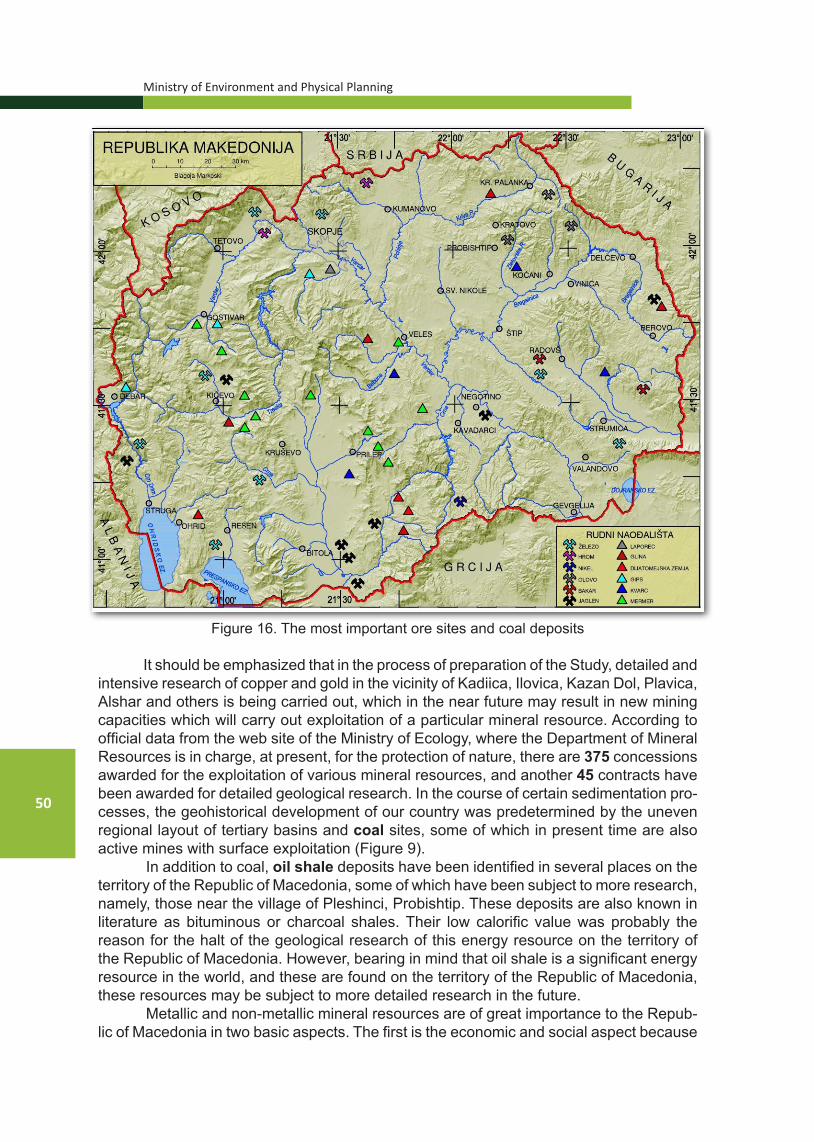
Ministry of Environment and Physical Planning
50
Figure 16. The most important ore sites and coal deposits It should be emphasized that in the process of preparation of the Study, detailed and
intensive research of copper and gold in the vicinity of Kadiica, Ilovica, Kazan Dol, Plavica, Alshar and others is being carried out, which in the near future may result in new mining capacities which will carry out exploitation of a particular mineral resource. According to official data from the web site of the Ministry of Ecology, where the Department of Mineral Resources is in charge, at present, for the protection of nature, there are 375 concessions awarded for the exploitation of various mineral resources, and another 45 contracts have been awarded for detailed geological research. In the course of certain sedimentation pro-cesses, the geohistorical development of our country was predetermined by the uneven regional layout of tertiary basins and coal sites, some of which in present time are also active mines with surface exploitation (Figure 9).
In addition to coal, oil shale deposits have been identified in several places on the territory of the Republic of Macedonia, some of which have been subject to more research, namely, those near the village of Pleshinci, Probishtip. These deposits are also known in literature as bituminous or charcoal shales. Their low calorific value was probably the reason for the halt of the geological research of this energy resource on the territory of the Republic of Macedonia. However, bearing in mind that oil shale is a significant energy resource in the world, and these are found on the territory of the Republic of Macedonia, these resources may be subject to more detailed research in the future.
Metallic and non-metallic mineral resources are of great importance to the Repub-lic of Macedonia in two basic aspects. The first is the economic and social aspect because

National Strategy for Nature Protection
51
they are the basis for the development of industry, while the second aspect is that with their exploitation, there might be certain consequences for nature.
3.2.2. GEOMORPHOLOGYThe Republic of Macedonia features rich and diverse geomorphological heritage
as part of its overall heritage. Above all, it is a result of the extremely turbulent geotectonic activity and dynamics of this part of the Balkan Peninsula, which is in the collision zone of the vast African and European (Eurasian) continental plate and their sub-segments. Ad-ditionally, the significant climate change, especially in the last several hundred thousand years, has had an impact on the diversity of geoheritage. Therefore, almost all genetic types of relief are present, with the exception of typical eolian forms. Regarding geodiver-sity, mountains, which occupy half of the total area of the country, are especially important, and the rest of the territory is occupied by fields, valley plains, and the hilly and wavy relief in some basins. Given the differences in surface area, height, position, geotectonic struc-ture and dominant geomorphological processes, mountains are the “basis” of geodiversity in the Republic of Macedonia. Regardless of all these differences, each mountain has its own geomorphological values and features. For some mountains, it is the karst relief, for others it is the fossil glacial and periglacial relief, or the fluvioweathering, and there are also those that are characterized by several different geo-values.
3.2.2.1. The situation with geodiversityOf almost 40 mountains and mountain ranges, 12 are higher than 2000 m (13 with
Mount Belasica whose highest peak is in Bulgaria), and 5 are even higher than 2500 m: Korab (2753 m), Shar Mountain (2747 m), Baba (2601 m), Mokra (2539 m) and Nidje (2520 m). Considering that during the Pleistocene glacial period, the lower snow limit was about 2000 m, the high-mountain areas of most of the mentioned (high) mountains are characterized by a highly pronounced fossil-glacial relief complex. This is especially true for the Korab range, Shara Mountain, the Mokra range (Jakupica), Jablanica and Mount Baba (Pelister), and somewhat less for the mountains of Bistra, Stogovo, Galichica (Stara Galichica) and Kozhuf. This geocomplex is represented by cirques, valley glaciers, mo-raines, sharp cliffs and peaks, traces of the movement of the former glaciers, glacier beds, and so on.
Figure 17. The valley of Leshnica river in Shar Mountain, with the siteLeshnica and Titov Vrv in the background (Photo by: Milevski I.)
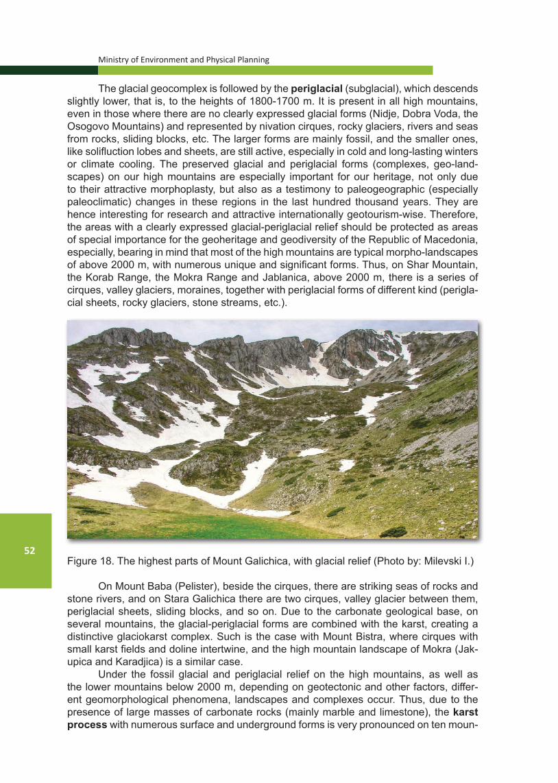
Ministry of Environment and Physical Planning
52
The glacial geocomplex is followed by the periglacial (subglacial), which descends slightly lower, that is, to the heights of 1800-1700 m. It is present in all high mountains, even in those where there are no clearly expressed glacial forms (Nidje, Dobra Voda, the Osogovo Mountains) and represented by nivation cirques, rocky glaciers, rivers and seas from rocks, sliding blocks, etc. The larger forms are mainly fossil, and the smaller ones, like solifluction lobes and sheets, are still active, especially in cold and long-lasting winters or climate cooling. The preserved glacial and periglacial forms (complexes, geo-land-scapes) on our high mountains are especially important for our heritage, not only due to their attractive morphoplasty, but also as a testimony to paleogeographic (especially paleoclimatic) changes in these regions in the last hundred thousand years. They are hence interesting for research and attractive internationally geotourism-wise. Therefore, the areas with a clearly expressed glacial-periglacial relief should be protected as areas of special importance for the geoheritage and geodiversity of the Republic of Macedonia, especially, bearing in mind that most of the high mountains are typical morpho-landscapes of above 2000 m, with numerous unique and significant forms. Thus, on Shar Mountain, the Korab Range, the Mokra Range and Jablanica, above 2000 m, there is a series of cirques, valley glaciers, moraines, together with periglacial forms of different kind (perigla-cial sheets, rocky glaciers, stone streams, etc.).
Figure 18. The highest parts of Mount Galichica, with glacial relief (Photo by: Milevski I.)
On Mount Baba (Pelister), beside the cirques, there are striking seas of rocks and stone rivers, and on Stara Galichica there are two cirques, valley glacier between them, periglacial sheets, sliding blocks, and so on. Due to the carbonate geological base, on several mountains, the glacial-periglacial forms are combined with the karst, creating a distinctive glaciokarst complex. Such is the case with Mount Bistra, where cirques with small karst fields and doline intertwine, and the high mountain landscape of Mokra (Jak-upica and Karadjica) is a similar case.
Under the fossil glacial and periglacial relief on the high mountains, as well as the lower mountains below 2000 m, depending on geotectonic and other factors, differ-ent geomorphological phenomena, landscapes and complexes occur. Thus, due to the presence of large masses of carbonate rocks (mainly marble and limestone), the karst process with numerous surface and underground forms is very pronounced on ten moun-

National Strategy for Nature Protection
53
tains. These are Bistra, Galichica, Suva Gora, the western part of the Mokra Range (Jak-upica), Luben with Kafchal, Zheden, Bukovikj, etc.
There are typical karst forms on the above-mentioned mountains: karst fields, uva-las, doline, karren, caves, precipices, some of which are significant at the national lev-el and beyond. Particularly important are the karst systems of the Jakupica Range and the terrains to the west and north, with deep precipices (Slovachka Jama, the deepest precipice in Macedonia), the deepest underwater cave in Macedonia, Matka Vrelo (Korit-ishte), the deep cavern system, the Krapa-Peshna, the longest cave, Slatinski Izvor and a number of various surface karst forms. The karst system of Galichica is also distinctive, through which Prespa Lake fills Ohrid Lake, as well as the specific occurrences of hypo-gene karst, which were further explored in Mariovo, where caves formed with hydrother-mal and sulfur speleogenesis (Provalata) were registered.
Figure 19. Location of caves in R. Macedonia (according to the data from the registry of SC “Zlatovrv” - Prilep) and the location of some of the more significant caves: 1 - Jaorec; 2 -
Provalata; 3 - Karshi Podot; 4 - Budimirica; 5 - Makarovec; 6 - Krapa; 7 – Slatinski Izvor ; 8 - Solunska 5; 9 – Izvor na Babuna (Golema Peshtera); 10 -
Slovachka Jama; 11 - Golema Pesht; 12 - Matka Vrelo (Koritishte) Source: SC “Zlatovrv” – Prilep, 2015.
On the other hand, the karst terrains are also of hydrological significance, given their waterproofing and accumulation of rich groundwater reserves, which often gushes out in the form of springs. Some of these springs are used for water supply of cities and rural settlements in the Republic of Macedonia (Rashche, Rosoki, Kazani, etc.). Given the aspects stated above, these mountains, more precisely, their karst areas, are very import-ant for the geoheritage of the Republic of Macedonia. Considering its specificity, accord-ing to the recommendations of IUCN (Watson et al., 1997), the development of a strategy for karst protection is a complex task, which should primarily emphasize the characteris-tics of the karst and the related need of a special (holistic) treatment for karst protection.

Ministry of Environment and Physical Planning
54
In the geological structure of some mountains, prevalent forms are the gneisses, granites, granodiorites, andesites, ignimbrites and other rocks that are susceptible to the so-called “selective erosion” or weathering. Therefore, they feature weathering relief, which is strikingly pronounced in a number of places. There are particularly significant oc-currences of weathering relief (boulders, rock masses, small weathering forms, scattered stone blocks, etc.) on Mount Selechka, Mount Babuna with Zlatovrv, the eastern branches of the Mokra Range, the southern slopes of Ograzhden, the southern slopes of Kozjak to-wards Stracin and others. The weathering relief of these mountains, especially on Mount Selechka and Zlatovrv, constitutes a large morphocomplex with numerous and exception-ally varied forms. Due to the vastness and diversity of forms, it is considered unique not only at the national level, but beyond. These and other areas with a typical weathering relief are very important for the geoheritage of the Republic of Macedonia, and as such should be comprehensively protected and promoted.
Figure 20. Some of the more typical weathering phenomena in the Republic of Macedonia: A. Markovi Kuli, B. Mount Selechka, C. Kukulje, D. Gjavolski Dzid,
Е. Kuklica (Photo: Milevski I.)
A B
C D
E
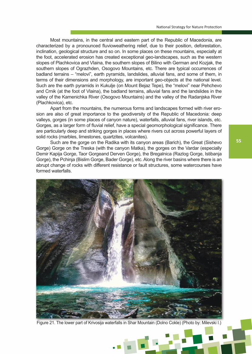
National Strategy for Nature Protection
55
Most mountains, in the central and eastern part of the Republic of Macedonia, are characterized by a pronounced fluvioweathering relief, due to their position, deforestation, inclination, geological structure and so on. In some places on these mountains, especially at the foot, accelerated erosion has created exceptional geo-landscapes, such as the western slopes of Plachkovica and Vlaina, the southern slopes of Bilino with German and Kozjak, the southern slopes of Ograzhden, Osogovo Mountains, etc. There are typical occurrences of badland terrains – “melovi”, earth pyramids, landslides, alluvial fans, and some of them, in terms of their dimensions and morphology, are important geo-objects at the national level. Such are the earth pyramids in Kukulje (on Mount Bejaz Tepe), the “melovi” near Pehchevo and Crnik (at the foot of Vlaina), the badland terrains, alluvial fans and the landslides in the valley of the Kamenichka River (Osogovo Mountains) and the valley of the Radanjska River (Plachkovica), etc.
Apart from the mountains, the numerous forms and landscapes formed with river ero-sion are also of great importance to the geodiversity of the Republic of Macedonia: deep valleys, gorges (in some places of canyon nature), waterfalls, alluvial fans, river islands, etc. Gorges, as a larger form of fluvial relief, have a special geomorphological significance. There are particularly deep and striking gorges in places where rivers cut across powerful layers of solid rocks (marbles, limestones, quartzites, volcanites).
Such are the gorge on the Radika with its canyon areas (Barich), the Great (Sishevo Gorge) Gorge on the Treska (with the canyon Matka), the gorges on the Vardar (especially Demir Kapija Gorge, Taor Gorgeand Derven Gorge), the Bregalnica (Razlog Gorge, Istibanja Gorge), the Pchinja (Bislim Gorge, Bader Gorge), etc. Along the river basins where there is an abrupt change of rocks with different resistance or fault structures, some watercourses have formed waterfalls.
Figure 21. The lower part of Krivosija waterfalls in Shar Mountain (Dolno Cokle) (Photo by: Milevski I.)

Ministry of Environment and Physical Planning
56
Most of the waterfalls are of low height or low water flow, but about 50 are considered genuinely significant phenomena. Such are the waterfalls of a number of watercourses on Mount Belasica (Koleshino Falls, Smolare Falls, Gabrovo Waterfall), then on the Korab Range (Projfel Waterfall, Duf Waterfall), on Bistra (Tresonche-Biljana Fall) and others.
Figure 22. Some geomorphologically important gorges in the Republic of Macedonia: A. Demir Kapija, B. Bislim, C. Istibanja, D. Zletovo. (Photo: Milevski I.)
Due to the torrential nature of most watercourses, the valleys are highly eroded, and in the downstream areas there is an excessive accumulation of sediment. Both pro-cesses pose a serious threat to the relief, water, soils, and human activities in the area. With the high accumulation of sediment, some relief forms are created, which are valuable in terms of geodiversity. Such are the river islands and meanders of the Vardar, the cut off fossil and recent meanders of the Vardar and the Bregalnica, the alluvial fans in the valley of the Radanjska River, the Kamenichka River and others.
Former (Pliocene) and existing larger natural lakes have created numerous forms and occurrences of coastal (abrasive) relief. Of the fossil type, the larger lake terraces that are still well preserved in some basins (Skopje, Berovo, Tikvesh etc.) are especially important. Today’s coastal processes and shapes are mainly connected with the three largest natural lakes: Ohrid, Prespa and Dojran. Particularly valuable for the geodiversity in the Republic of Macedonia are the typical shores with cliffs, sandy beaches, peninsula, Golem Grad Island and so on. Certain coastal microforms occur even on older and larger artificial lakes, such as Tikvesh, Mavrovo, Kalimanci and others, and especially interesting are the few small islands in them (Gradishte, Kalata, etc.).
In the last several hundred years, the human factor has a major direct and indirect impact on the relief in the Republic of Macedonia. By degrading and changing the natural
A B
C D

National Strategy for Nature Protection
57
vegetation, and especially by deforestation, the favorable, predisposed and already bare terrains become exposed to excessive erosion. It causes a strong modification of the pre-vious normal (natural) relief, in certain places to the degree of destruction, thereby forming a whole system of erosive furrows, slopes, gullies, erosion pavements, landslides, bad-land terrains, ”melovi”, earth pyramids, alluvial fans, etc. The territory of the Republic of Macedonia became among the most endangered by erosion in Europe, which is evident from the map of erosion of the Republic of Macedonia (Djordjevic et al., 1993). In addition to the destructive effect on the relief, the soils, the waters, the vegetation and the geologi-cal substrate, the excessive erosion has caused the creation of some unique forms, which are significant as geoheritage.
3.2.2.2. List of national geoheritage The previous review shows that the territory of the Republic of Macedonia has
numerous, significant and unique geomorphological areas, phenomena and objects. In fact, rarely does it happen for a country to feature such rich relief diversity on the relatively small area it occupies. However, regardless of this richness of geomorphological geodi-versity, in the past period, in our country, insufficient attention has been paid to its protec-tion and promotion (as geo-values). Attention has been mostly paid to biological diversity, which may be justified given the dramatically increased threats to it and the irreversible damage to the biosphere. Perhaps this is the reason why the existing strategies for the protection of certain elements of nature have not covered protection of the geodiversity, i.e. the non-living nature of the Republic of Macedonia; instead, those elements have been mentioned merely as part of other documents and action plans, mostly through the preservation of landscapes and the protection of habitats. In the last decades, one of the EU’s top priorities, along with biodiversity, is the protection (geo-conservation) and promo-tion of geoheritage, as well as sustainable exploitation of geo-values.
According to the analyses of the available data, as well as our own research, the Republic of Macedonia features important sites, areas, phenomena and objects as signif-icant geoheritage. In Annex 1 to the Strategy, there is a list of selected significant geoher-itage sites in the field of geology, geomorphology and hydrology that should be taken into account in the preparation of the new Spatial Plan of the Republic of Macedonia.
3.2.3. HYDROLOGY
The main objective of the Hydrology Component in the Nature Strategy is to as-sess the state of waters in the country and to provide guidelines for long-term practical steps for achieving sustainable development of water resources, satisfying all users in the social community and nature.
3.2.3.1 General hydrographic characteristics There are numerous springs, rivers and lakes on the territory of the Republic of
Macedonia. Surface waters are the most important part of ecosystems in the country. Springs. In the Republic of Macedonia, a total of 4414 springs have been reg-
istered with a total capacity of 991.9 million m3/per annum, of which 58 have a capacity exceeding 100 l/s.

Ministry of Environment and Physical Planning
58
Table 4. Main watersheds in the Republic of Macedonia
River/Lake Watershed area (km2)
Watershed area (%)
1 Main watersheds:Vardar 6,813 26.5Treska 2,068 8.0Pcinja 2,373 9.2Bregalnica 4,307 16.8Crna 4,985 19.4Total: 1 20,546 79.9
2 Crn Drim 3,355 13.03 Strumica 1,520 5.9
Total: 1 to 3 25,421 98.84 Smaller watersheds:
Dojran Lake 120 0.5Cironska and Lebnica 128 0.5the South Morava 44 0.2Total: 4 292 1.2Total: 1 to 4 25,713 100
Source: Integrated Water Resources Development and Management Master Plan in the Republic of Macedonia, Nippon Koei Co., Ltd. KRI International Corporation, Japan Interna-
tional Cooperation Agency - JICA, (1999)
Rivers. The rivers penetrate the mountains in a general direction northwest-south-east or perpendicularly to this direction. From the northeast to the southwest run the river courses of the Vardar (middle and low flow), the Lepenec, the Strumica and the middle course of the Crna Reka. From the south to the north flow the rivers of the Crn Drim, the upper course of the Vardar and the Treska. From the southwest towards the northeast flow the Babuna and the lower course of the Crna Reka, and the Pchinja and the Bregal-nica run opposite of the northeast towards the southwest.
The Vardar is the longest and largest river in Macedonia (301.6 km) with an av-erage altitude of 793 m with amplitude of 2748 m at Titov Vrv to 48 m near Gevgelija. The spring is located on the Sharplanina Range near the village of Vrutok near Gostivar at an altitude of 683 m. Annual precipitation is between 500 mm in the central part up to more than 1000 mm in the west. The average amount of precipitation mostly range from 600 to 900 mm. The total annual outflow near Gevgelija is 4.56 million m3. Due to the hydrographic features of the Vardar River watershed, it is divided into the upper part (above Skopje), central (between Skopje and Veles) and the lower part (between Veles and Gevgelija). The main tributaries of the Vardar are the Treska, Pchinja, Bregalnica and Crna Reka rivers.
The remaining rivers that drain the territory of the Republic of Macedonia are the Crn Drim and the Strumica. The rest are with insignificant watershed surface.

National Strategy for Nature Protection
59
Figure 23. Larger watershed areas in the Republic of Macedonia
Lakes. Lakes are primarily divided into natural and artificial. The natural lakes in the Republic of Macedonia are extremely important hydrographic objects. Such are Ohrid, Prespa and Dojran Lake. They originated in the Mid-Tertiary.
Ohrid Lake is one of the most important aquatic ecosystems in Europe whose age is estimated at 2-3 million years. In 1980, Ohrid Lake and the city of Ohrid were pro-claimed World Heritage Sites and are under the protection of UNESCO. The lake has an area of 358 km2 of which 251 km2 belong to Macedonia, and 107 km2 to Albania.
Prespa Lake is the second largest lake. Great Prespa Lake has an area of 278 km2 at a lake level of 844 m, of which 65.7% belong to Macedonia. The mean depth of the lake is 15 m, and the maximum is 54 m.
Dojran Lake is the smallest tectonic lake and is located at an altitude of 148 m. It is almost circular in shape. The surface of the lake at a normal level is 42.2 km2, of which 63.6% belong to Macedonia, and the lake watershed is 271.8 km2, of which 32% belong to Macedonia.
In the Republic of Macedonia, there are glacial lakes as a subcategory of the natural lakes, of which 44 are permanent. They are located on the high mountains at an altitude of 1500 to 2500 m. They are located in cirques of diluvial glaciers: on Shar Moun-tain (19), Korab (8), Deshat (5), Jablanica (4), Stogovo (3), Pelister (3) and Karadjica (2).
On the rivers in the Republic of Macedonia, more than 20 large and more than 120 small dams with reservoirs have been built. The oldest reservoir is “Matka” (1938), and “Kozjak” (2004), “Lisiche” (2008), “Knezhevo” (2013) and “Sveta Petka “(2014) were more recently built.

Ministry of Environment and Physical Planning
60
Table 5. Dams built in the Republic of Macedonia with basic characteristics
Dam/reservoir RiverDam
height
(m)Type of dam
Volume of reservoir
(m3)106
Purpose
The Vardar watershed:Kozjak* The Treska 114.0 rock-fill embankment 550.0 E, RMatka The Treska 29.5 concrete 2.6 ESveta Petka* The Treska 47.5 concrete 9.1 Е, RGlazhnja The Lipkovo 74.0 concrete 23.6 I, W, ELipkovo The Lipkovo 32.2 concrete 1.2 I, W, EMavrovica The Mavrovica 25.0 earthfill 2.8 I, WKalimanci The Bregalnica 85.0 rock-fill embankment 127.0 I, W, EKnezhevo* The Zletovo 75.0 rock-fill embankment 23.5 W, I, Е, RGradche The Kochni 29.0 concrete 1.8 I, WRatevska The Ratevo 46.0 concrete 10.5 I, WPaljurci The Luda Mara 21.1 earthfill 2.9 I, ROtovica The Otovica 27.0 concrete 8.0 I, WPrilep The Oreovo 36.0 concrete 6.0 I, WTikvesh The Crna Reka 104.0 rock-fill embankment 475.0 I, EStrezhevo The Shemnica 76.0 earthfill 119.0 I, W, ESuvodol The Sonovirska 33.9 earthfill 7.9 W, РLisiche* The Topolka 65.0 rock-fill embankment 26.8 W, I, ЕThe Strumica watershed:Turija The Turija 77.5 earthfill 50.3 I, W, EVodocha The Vodocha 44.0 earthfill 27.0 I, WMantovo The Kriva
Lakavica37.5 earthfill 47.5 I, W
The Crn Drim watershed:Globochica The Crn Drim 82.0 rock-fill embankment 58.0 EShpilje The Crn Drim 101.0 rock-fill embankment 520.0 E, IMavrovo The Crn Drim 54.0 earthfill 357.0 E, I
Explanation: E-energy, I-irrigation, W-water supply, R-retentionSource: Water management of the Republic of Macedonia (1999)
Note: The dams and reservoirs marked with (*) are not listed in the data source given the fact that they have been built after 1999
The waters in the Republic of Macedonia are also used for electricity generation by means of small hydropower plants. For this purpose, “Feasibility study about justi-fication of concession for the use of water for electricity generation by constructing small hydropower plants” was prepared (Civil Engineering Institute MACEDONIA, 2008). In this study, a total of 406 locations have been identified. Their immediate construction may pose a threat to nature.
Even more so if we take into account that the economic benefits are quite limited not only for the population but also for the economy. Namely, all small HPPs are planned

National Strategy for Nature Protection
61
on small tributaries, mostly in the upper parts of their watersheds where the streams are small, and the vulnerability of the natural terrain and ecosystems is very high. Moreover, taking into consideration the low environmental awareness for the implementation of the measures for protection and restoration of the river beds and their watersheds, it is neces-sary to re-examine the possible locations for the construction of small HPPs and strength-en the control over awarding concessions.
Figure 24. Glacial lakes, Podgorci Lake (left) and Bogovina Lake (right) Source: Samir Demishi, 2014 and MoEPP, 2015
The Republic of Macedonia features thermal waters as well. Such are found in the v. Bansko (Strumica), v. Banja (Kochani), v. Negorci (Gevgelija), v. Katlanovo (Skopje), v. Kezhovica (Shtip), Banjishte and Kosovrasti (Debar), which are intended for balneological purposes, and there are other thermal waters for other purposes.
In the Republic of Macedonia, adequate meteorological and hydrological moni-toring is carried out. It is mainly managed by the National Hydrometeorological Service (NHMS), where, among other things, water quality is registered.
For the purpose of the Strategy for Nature Protection, the term environmental flow has been defined, which is a flow regime that is provided in a given water system (river, water habitat, coastal zone) in order to maintain the ecosystems and the benefits thereof, when there are competing purposes of the water and where the flow is regu-lated. In most EU countries, the concept of environmental flow, its interpretation and implementation are part of different guidelines or regulations.
The introduction of environmental flow requires consideration of all aspects of the river and its watershed area. This involves analyzing the watershed of the spring to the estuary of the river and includes mud systems, floodplains and associated ground-water. It also involves taking into account the environmental, social and cultural values associated with the given system. Therefore, in determining the environmental flows, consideration should be given to a whole range of possible effects – from environmental protection to meeting the needs of the economy and people.
However, environmental flows are not the only characteristic of a healthy river ecosystem. There are other objectives, such as reducing pollution and controlling ac-tivities in the river bed, such as fishing and recreation. Therefore, environmental flows should be considered an integral part of a contemporary approach to river watershed management.

Ministry of Environment and Physical Planning
62
3.2.3.2. Significant geology in the area of hydrology in the Republic of Macedonia The Republic of Macedonia has a very rich geoheritage in the field of hydrology. In
Annex 1 there is a list of selected significant geoheritage sites in the field of geology that should be taken into account in the preparation of the new Spatial Plan of the Republic of Macedonia.
3.3. LANDSCAPE DIVERSITY
Landscapes are a mosaic of anthropogenic and natural ecosystems shaped by the long-standing interaction of man and nature. Thousands of years ago, man played an important role in shaping natural ecosystems in Macedonia and contributed to the specific characterization of landscapes (landscape patterns).
In the context of nature protection in the Republic of Macedonia, the roles of the landscapes in the sustainable use of natural resources and their role as habitats for wild species, in addition to the remaining roles, are of particular importance. Therefore, the identification and characterization of landscape diversity on the territory of the Re-public of Macedonia will result in data that will complement the current knowledge of nat-ural resources and will make a significant contribution to the integrated and sustainable preservation of natural values in the region. The analysis of human-induced changes at the landscape level in recent history should be an integral part of the national strategy for nature protection in order to determine the ecosystems’ suitability for supporting the preserved biodiversity, revitalizing the degraded components and providing the necessary ecosystem services. Structural analysis of landscapes should be the basis for integrated spatial planning that would ensure sustainable community development without serious damage to natural ecosystems and the overall biodiversity.
Hence, it is necessary to make a detailed analysis of the landscapes in Macedonia that will include typification of landscape types, analysis of their structural characteristics and their functionality in terms of biodiversity and ecosystem processes.
Scientific data on the type and characteristics of the landscapes in Macedonia thus far are virtually non-existent. The only exceptions are a single defended doctoral disserta-tion and a scientific paper, as well as several professional studies.
The ultimate goal of the action plan for landscape conservation, within the nature strategy, would be the development of an effective natural resource management plan in the country (through the implementation of landscape values in the country’s spatial plan), which will include action plans for the conservation of the most significant “distinguished” species, ecosystems and habitats along with traditional and other human activities.
3.3.1. IDENTIFIED LANDSCAPE AND LANDSCAPE TYPES IN MACEDONIA
According to research thus far, eight basic groups of landscapes are identified in Macedonia:
1. Urban and industrial and mining landscapes (with two landscape types: urban land-scape and industrial and mine landscape)
2. Agricultural landscapes [with 11 landscape types: Plain sub-Mediterranean agricul-tural landscape, Plain sub-Mediterranean-continental agricultural landscape – typ-ical shape, Plain sub-Mediterranean continental agricultural landscape of saline soils (Ovche Pole plain landscape), Plain sub-Mediterranean-continental agricultural landscape of rice paddies (Kochani landscape), Plain-hilly sub-Mediterranean-conti-nental agricultural landscape of vineyards (Tikvesh landscape), Plain subcontinental

National Strategy for Nature Protection
63
agricultural landscape of cereals (Pelagonia landscape), Plain sub-continental agri-cultural-rural landscape of mixed crops (Polog landscape), Plain-hilly subcontinental agricultural-rural landscape, Plain-hilly continental rural-agricultural landscape (Male-shevo-Pijanec landscape, Hilly sub-Mediterranean-continental agricultural landscape (Hilly agricultural landscape) and Hilly sub-Mediterranean-continental agricultural-ru-ral landscape (Hilly agricultural-rural landscape)
3. Rural landscapes [with six landscape types: Hilly sub-Mediterranean-continental ru-ral landscape (Hilly rural landscape), Hilly sub-Mediterranean-continental rural land-scape with borderlines (Hilly rural landscape with borderlines), Hilly subcontinental rural landscape (Hilly rural landscape), Hilly sub-Mediterranean-continental rural landscape with hilly pastures (Mariovo landscape), Mountainous continental rural-for-est landscape (Osogovo mountainous rural landscape or Osogovo landscape) and Mountainous continental rural landscape (including Maleshevo mountainous rural landscape)]
4. Landscape of hilly pastures [with five landscape types: Hilly subcontinental land-scape of hilly pastures on a silicate substrate (Hilly pasture landscape on a silicate surface), Hilly subcontinental landscape of hilly pastures on a limestone substrate (Hilly pasture landscape on a limestone substrate), Hilly sub-Mediterranean-conti-nental landscape of hilly pastures on a marl substrate (Hilly pastures landscape on a marl substrate), Hilly subcontinental landscape of hilly pastures on granite screes (Treskavec landscape) and Hilly sub-Mediterranean-continental landscape of hilly pastures on serpentinite (Hilly pasture landscape on serpentinite)]
5. Forest landscapes [with seven landscape types: Hilly sub-Mediterranean landscape of sclerophilic shrubs (Pseudomacia landscape), Hilly sub-Mediterranean-continental landscape of thermophilic degraded forests ( Landscape of thermophilic degraded for-ests), Hilly-mountainous subcontinental landscape of mixed forests with coniferous plantations (Mixed forest landscape with coniferous plantations), Mountainous conti-nental landscape of mesophilic broadleaf forests (Landscape of mesophilic broadleaf forests), Mountainous subcontinental-continental landscape of pine forests (Pine for-est landscape), Mountainous continental landscape of fir-spruce forests (Landscape of fir-spruce forests) and Mountainous landscapes of Krivobor shrubland (Landscape of Krivobor shrubland)]
6. Landscapes of high mountain pastures [with two landscape types: Mountainous land-scape of pasture on a silicate substrate (Landscape of high mountain pastures on a silicate substrate) and Mountainous landscape of pastures on a carbonate substrate (Landscape of high mountain pastures on a carbonate substrate)]
7. High mountain landscapes and screes [with two landscape types: High mountain landscape of silicate rocks and screes (Landscape of silicate rocks and screes) and High mountain landscape of carbonate rocks and screes (Landscape of carbonate rocks and screes)]
8. Lake landscapes [with three landscape types: Sub-Mediterranean lake landscape (Dojran landscape), Sub-Mediterranean continental lake landscape (Ohrid land-scape) and Subcontinental lake landscape (Prespa landscape)].
A total of 38 types of landscapes identified on the basis of the applied methodolo-gy have been identified. Each of them may contain different variants, but generally they feature certain common structural and functional characteristics. Some of the landscape types are distributed discontinuously in many areas in Macedonia, and some are a com-pact whole only in some part of the country. The main reasons for such conditions are the specific climatic and biogeographical characteristics of certain areas, the zonal schedule of climate-biogeographical characteristics along the vertical gradient in most of the coun-
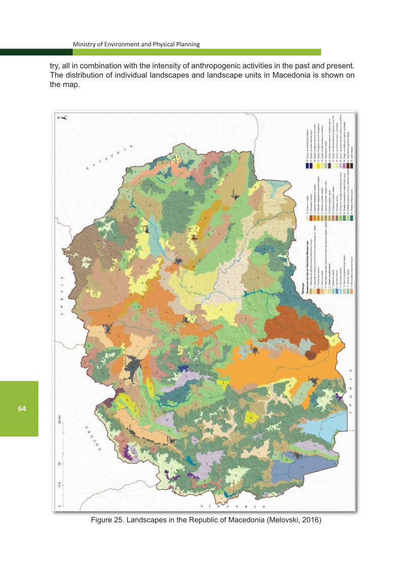
Ministry of Environment and Physical Planning
64
try, all in combination with the intensity of anthropogenic activities in the past and present. The distribution of individual landscapes and landscape units in Macedonia is shown on the map.
Figure 25. Landscapes in the Republic of Macedonia (Melovski, 2016)

National Strategy for Nature Protection
65
3.3.2. LANDSCAPE SIGNIFICANCE IN THE CONTEXT OF NATURE PROTECTION Valorization of landscapes can be defined as the process of “determining the
significance of a particular landscape or landscape characteristic, by reference to specified value criteria”. Valuation criteria on the basis of which valorization of the landscape is done vary depending on the needs for which the valorization is carried out. In this study, landscapes are valued mainly in terms of their functional value for the conservation of biodiversity. In addition, landscape values are also valorized, as well as the cultural values and landscape uniqueness.
Valorization is carried out in two steps: first, landscape types were evaluated, and then within the landscapes that have high importance for biodiversity or have high aesthetic value, the landscape units were evaluated in different parts of Mace-donia.
The following value criteria were selected as the basic criteria for valorization based on the needs of this study: landscape character, landscape status, landscape value in relation to biodiversity, landscape value in relation to people, landscape sen-sitivity, connectivity of core patches in the landscape and landscape uniqueness in Macedonia.
Value assessment according to the above criteria was made by awarding 0 to 3 points for each criterion separately, and separately for each landscape. In this case, 0 indicates that the landscape has no value for the given criterion, while 3 denotes a very high value. The basic principle in assigning the scores was the preservation and representativeness of the landscape structure shown tabularly for each landscape separately in Chapter 3 of the Study on Nature. For a fully objective assessment of this kind, especially with regard to the connectivity and significance of each land-scape unit to biodiversity, much more thorough analysis is needed in the course of a much longer period. Therefore, for some criteria, assessment was based on expert judgment.
According to the results of the valorization of the landscape types (Table 6.40 of the Study on Nature), in accordance with the above-explained valorization criteria, several significant landscapes can be identified in Macedonia: Landscape of fir-spruce forests (the highest valued landscape units are the landscapes of fir-spruce forests of Shar Mountain and Bistra); Pine forests landscape (the highest valued landscape units are the pine forests landscapes on Pelister, Karadjica and Kozhuf-Kajmakcha-lan); Sub-Mediterranean lake landscape (Dojran landscape), Landscape of hilly pas-tures on a marl substrate; Mountainous landscape of Krivobor shrubland (Landscape of Krivobor shrubland); Landscape of carbonate rocks and screes; Landscape of high mountain pastures on a carbonate substrate (the highest valued landscape units are Karadjica-Dautica, Bistra, Galichica and Shar Mountain); Hilly rural landscape with borderlines (the highest valued landscape units are Serta, Osogovo-Kriva Palanka and Shar Mountain); Subcontinental lake landscape (Prespa landscape), Hilly pas-ture landscape on serpentinite, Osogovo mountainous rural landscape, Plain agri-cultural landscape of rice paddies (Kochani landscape); Mariovo landscape; Land-scape of hilly pastures on granite screes; Mountainous rural landscape (where Reka, Ograzden, Shar Mountain-Mazracha and Karadjica are identified as more significant landscape units); Sub-Mediterranean-continental lake landscape (Ohrid landscape) and Landscape of hilly pastures on limestone.
The group of significant areas may also include Hilly rural landscape (with Plac-hkovica, Ljuboten, Shar Mountain and Porechje as highly valued landscape units); Hilly sub-Mediterranean area of sclerophilic shrubs (Pseudomacia landscape); Plain

Ministry of Environment and Physical Planning
66
subcontinental agricultural landscape of cereals (Pelagonia landscape); Landscape of mesophilic broadleaf forests; Landscape of high mountain pastures on a silicate substrate (with Shar Mountain-Korab, Shar Mountain, Pelister and Deshat as more significant landscape units) as well as the Maleshevo-Pijanec rural-agricultural land-scape; Plain-hilly subcontinental agricultural-rural landscape; Plain sub-Mediterra-nean-continental agricultural landscape (Ovche Pole landscape).
Figure 26. Plain sub-Mediterranean-continental agricultural landscape of rice paddies (Kochani landscape) – Kocansko Pole (photo: Lj. Stefanov)
Figure 27. Hilly sub-Mediterranean-continental agricultural landscape (Hilly agricultural landscape – Ovche Pole hilly agricultural landscape with field-protective belts) – Ovche
Pole, near Sveti Nikole (photo: Bl. Markoski)
Many of these important landscapes are under various threats that degrade them both structurally (overgrowing of open landscapes, deforestation by means of illegal fell-ing, uncontrolled urbanization, etc.) and functionally (disruptions in the circulation of mat-ter and energy in ecosystems, and hence the degradation of basic ecosystem services, especially the regulating ecosystem services).

National Strategy for Nature Protection
67
3.4. BIODIVERSITY3.4.1. GENERAL INFORMATION ON BIODIVERSITY
Biodiversity of the Republic of Macedonia is characterized by great heterogeneity and high degree of relictness and endemism and is at the very top of the list of European coun-tries, designated as “European Hotspots”. This is due to its central geographical position on the Balkan Peninsula, as well as the impacts on its territory in the past, especially during Pleistocene. Great temperature oscillations before, during, and after the end of the ice age, have caused multiple dramatic migrations of wildlife, which have greatly affected these ar-eas. Such mass movements have left deep traces on the recent flora and fauna on the wider European area, including on the area of the Republic of Macedonia.
Biodiversity research on the territory of Macedonia started about 180 years ago. Since the beginning of floristic and faunistic studies, which began with Frivaldsky (1835, 1836) and Grisebach (1843, 1844) to date, more than 3500 scientific papers have been published.
According to today’s knowledge of the study of individual taxonomic groups that are part of the species biological diversity, thus far about 2000 algae species, over 2000 fungi and 450 lichens, 3200 types of vascular plants, about 500 moss taxa, 13000 invertebrate taxa, 85 species of fish and cyclostomata, 14 species of amphibians, 32 species of reptiles, 335 bird and 89 mammal species have been registered on the territory of the Republic of Macedonia. Of particular importance are the endemic species – about 150 endemic algae, about 120 endemic vascular plants, over 700 invertebrates and 27 endemic fish species.
The vegetation diversity of higher plants is represented by over 30 vegetation classes, 60 vegetation orders, 90 alliances, and about 300 plant associations.
About 120 types of habitats are present on the territory of the Republic of Macedonia, of the third level of the EUNIS classification, which belong to 28 types of ecosystems. Some of them, such as Ohrid and Prespa Lakes, are of exceptional significance not only nationally, but also globally.
Given that the knowledge about certain biodiversity components (taxonomic groups, syntaxons, habitats, etc.) is limited, the image of the rich biodiversity in the Republic of Macedonia is not yet complete.
Figure 28. Fritillaria macedonica
Ministry of Environment and Physical Planning
68
3.4.1.1. Status and trends of biodiversity in the Republic of Macedonia (2003-2014) The first Study on the State of Biodiversity in the Republic of Macedonia was pre-pared and published in 2003 as the First National Report to the Convention on Biological Diversity, while the Strategy and Action Plan for the Protection of Biodiversity of the Re-public of Macedonia was prepared in 2004.
In the period 2003-2014, three national reports to the Convention on Biological Di-versity were prepared, and in 2014 the process of revision of the National Strategy on Bio-logical Diversity with an Action Plan was initiated. In 2014, the Fifth National Report to the Convention on Biological Diversity was prepared, which was adopted by the Government of the Republic of Macedonia, and at the same time the process of revision of the National Strategy on Biological Diversity with an Action Plan was initiated.
In the period between the First and the Fifth National Report (2003-2014), there has been an increase in the quantum of knowledge about biodiversity, especially in some of its components. For example, in the past period, about 250 new taxa have been de-scribed for science (6 higher plants, over 170 diatomaceous algae taxa, and 69 species of invertebrates). For the first time, hundreds of previously unregistered species have been registered on the territory of the Republic of Macedonia (23 higher plants, 237 fungi species, a dozen vertebrates, and the estimation of the number of invertebrates has been raised from about 10000 to over 13000 species). Quantitative estimates have been made of the populations of some of the most endangered species (for example, the Balkan lynx, a number of bird species) and the trends of the populations of some bird species (white-headed vulture, Egyptian vulture, lesser kestrel, eastern imperial eagle) have been documented.
In the past couple of years, significant progress has been made in the knowledge of algae diversity, primarily the diversity of silica algae (diatoms). In 2007, a monograph on diatoms of Ohrid and Prespa Lakes was published (Levkov et al., 2007), describing 75 new species for science. Thus far, the results show that over 900 diatom taxa (Levkov & Williams 2012) have been registered in Ohrid and Prespa Lakes only, while about 1200 diatoms are known on the territory of Macedonia.
With the latest research on the diversity of fungi in Macedonia, especially the mac-romycetes, over 2000 taxa have been found, making the Republic of Macedonia one of the better explored European countries today. Several new papers have been published covering numerous new and rare species of fungi in Macedonia (Karadelev et al. 2007a, 2007b, 2008b, 2009; Karadelev & Murati 2008a, Dogan & Karadelev 2009). Separate sys-tematic studies on the mycodiversity have been carried out in the mountains of Ograzh-den, Jablanica, Jakupica, Korab and Dobrova Voda (Karadelev et al. 2009 d, e, f). At the same time, intensive work is being done on the protection of fungi and a basic Red List of fungi of Macedonia has been prepared (Karadelev & Rusevska 2012), in which 213 species of fungi were categorized according to the IUCN criteria. Synthetic review of the bryophora of the Republic of Macedonia has been published (Cekova 2005), supplemented with the data of Martinchić (2009) and Papp & Erzberger (2012), according to which the bryoflora of the Republic of Macedonia consists of over 500 taxa. Of these, 400 taxa belong to genuine mosses (Musci), while about 100 taxa belong to representatives of the Hepaticae class. In the area of plant diversity, the publication of two new issues of the edition “Flora of the Republic of Macedonia” is worth noting (Micevski and Matevski, 2005; Matevski, 2010), as well as two monographic studies on the Macedonian steppe (Matevski et al., 2008) and the forest vegetation on the mountain range of Galichica (Matevski et al. 2011), as well as the monographs on the natural values of Monospitovo Marsh and Shar Moun-tain covered by Melovski et al. (2008, 2010). Over 20 vegetation articles and two mono-

National Strategy for Nature Protection
69
graphs have been published – Flora and Vegetation of the Macedonian Steppe (Matevski et al., 2008) and Forest Vegetation of the Galichica Mountain Range in Macedonia (Mat-evski et al., 2011). They describe over 15 plant communities (associations) which are new to science, 3 new alliances and suballiances, and syntaxonomic and nomenclature revi-sions of over 15 plant communities have been made, which have not been harmonized yet with the provisions of the International Code for Phytocenological Nomenclature.
In addition, a Report with Analysis and Valorization of Biodiversity as well as a Cat-alog of Species in digital format have been prepared (Petkovski, 2009).
Biodiversity of invertebrates in Macedonia in the last 10 years has been covered in over 300 scientific papers. An attempt has been made to catalog the fauna of Macedonia (Petkovski, 2009), lists of species of snails (Stanković et al. 2006), Orthoptera (Chobanov & Mihajlova, 2010) and ants (Karaman, 2009) have been prepared. Among the most im-portant publications related to invertebrates in Macedonia are the editions on Orthoptera (Micevski et al., 2003) and Rhopalocera in NP Pelister (Micevski & Micevski, 2005) and Rhopalocera in NP Galichica (Krpač et al., 2011).
Quantitative research of herpetofauna on the island of Golem Grad on the Prespa Lake has been carried out, with an emphasis on Hermann’s tortoise, the dice snake and the horned viper, as well as the distribution of reptiles in Macedonia (Sterijovski et al., 2011, 2014; Ajtić et al., 2013).
Velevski et al. (2016) provide data on 89 species of mammals in Macedonia, while comments on the distribution and review of endemism are given by Krystufek & Petkovski (2003, 2006).
The database on biological diversity at the national level in the last 10 years is sig-nificantly enhanced with new scientifically verified information and data on biodiversity within the developed studies of valorization/revalorization of protected areas: (Pelister, Mavrovo, Prespa Lake, Ezerani, Tikvesh, Matka Canyon, Alshar, Jasen, Vodno and Gazi Baba and Katlanovo landscape), as well as part of the unprotected areas (Osogovo, Be-lasica, Zheden, Studenchishte Marsh, etc.). It is also important to mention the thematic reports on biodiversity which have been prepared for the purposes of the preparation of the management plans for NP Galichica and NP Mavrovo, as well as the gap analysis report of the environmental data and preparation of an environmental sensitivity map for the Bregalnica river watershed area (2015).
According to the Law on Nature Protection in the Ministry of Environment and Phys-ical Planning in 2011, a National Information System for Biological Diversity (NISB) was established with a web application. The NIBS Central Database contains a large number of data on species and habitats, threats as well as spatial and other data on protected areas.
3.4.1.2. Diversity of species in the Republic of Macedonia Bacteria are very poorly studied in terms of taxonomy. According to data thus far, there
are about 100 identified taxa (together with pathogenic bacteria). Algae are considered a group whose diversity on the territory of the Republic of Mace-
donia is still considered to be insufficiently known. In the period 2004-2015, over 160 new types of silica algae, mainly from Ohrid and Prespa Lakes, have been described, and more intense research has been done in these lakes on the group of Chari (Charophyceae).
Fungi in the Republic of Macedonia are relatively well researched, with over 2000 regis-tered fungi. Of the lichens that are relatively poorly researched, about 450 species are known.
The flora of the higher plants is represented with over 3700 species. The most numer-ous groups are the angiosperm plants with about 3200 species and mosses with about 500 species, while the other groups (lycopodium, equisetopsida, ferns and gymnosperms) are represented with fewer species.

Ministry of Environment and Physical Planning
70
Invertebrates are the largest fauna group, which is represented on the territory of the Republic of Macedonia with over 13000 species.
Sponges are studied only in our three natural lakes. A total of 10 taxa have been iden-tified, of which 6 taxa are endemic. The endemic species of sponges of Ohrid Lake (Ochri-daspongia rotunda, Ochridaspongia interlithonis, Spongilla stankovici, Ohridospongilla stan-kovici), as well as the endemic species of Prespa Lake (Spongilla prespensis) are especially interesting.
The Nemathelminthes type is represented with about 870 species, of the Mollusca type, a total of 320 taxa (of which 92 are endemic) have been registered, while Annelida type consists of about 180 taxa (53 endemics).
The most numerous group among them is the Arthropoda type with 11800 species. Of the Arachnida class, 560 species are known, and 825 taxa have been identified of the Cheli-cerata. The Crustacea class is one of the best studied groups of organisms in Macedonia, with about 490 taxa, while of the class of insects (Insecta), among the better studied groups is the order Lepidoptera (butterflies), with a total of 2295 taxa registered thus far. A catalog of Co-leoptera, Carabidae has been published featuring data on 571 species and 234 subspecies (Hristovski & Guéorguiev, 2015).
Figure 29. Onychogomphus forcipatus Photo by: MES
The underground fauna of the Republic of Macedonia is poorly explored and, ac-cording to the data available, it is more deficient compared to the fauna of the Western Balkan countries, but it is characterized by a high percentage of endemism (about 90%). Stigobionts (troglohydrobionts) are represented with 57 species. Of the other troglobionts, pseudoscorpiones (14), beetles (12) and woodlouse (10) are represented with more spe-cies, and in the last decade, 6 new species of troglobionts (2 types of woodlouse, 3 pseu-doscorpiones and 2 beetles) have been described. The richest cave fauna is encountered in the caves in western Macedonia, especially the caves of the Radika River watershed, on the mountains of Galichica and Jakupica, as well as in Porechje.

National Strategy for Nature Protection
71
А Б
В Г
Figure 30.A Green toad (Pseudepidalea viridis) B. Greek frog(Rana graeca) C. Ursini’s viper (Vipera ursinii) D. Hermann’s tortoise (Testudo hermanni)
Photo by: Bogoljub Sterjovski
Vertebrates in the Republic of Macedonia are represented with 552 species, 28 of which are allochthonous. Lampreys are represented with two species, while fish with about 85 species (19 introduced). Amphibians are represented with 14 species, while 32 species are known of reptiles. The fauna of birds consists of 349 taxa (335 species and 14 subspecies), 10-11 species of which are considered uncertain, and the number of resident nesting and migratory nesting species is 215. On the territory of the Republic of Macedonia, 90 species of mammals have been confirmed, 81 species of which are au-tochthonous, while nine species are considered allochthonous.
Figure 31.A Lesser Kestrel (Falco naumanni), B. Pelecanus crispusC. Neophron percnopterus D. Aquila heliaca Photo: MES

Ministry of Environment and Physical Planning
72
Figure 32.A. Brown bear – Mavrovo B. Lynx (Balkan Luynx, site Rosoki)C. Wild goat – Mavrovo, Photo by: MES
3.4.1.3. EndemismIn addition to the presence of numerous Balkan endemics in almost all plant and animal groups of organisms, on the territory of the Republic of Macedonia, there is a large num-ber of local endemics that exclusively develop on its territory.Among the lower plants, the group with the highest degree of endemism is algae with about 200 endemic taxa. Most of them are registered in Ohrid and Prespa Lakes, and a smaller number in Dojran Lake and on Shar Mountain. About 158 taxa are considered endemic to Ohrid Lake. Higher plants have numerous Balkan and southern Balkan endemics, as well as many local endemics and subendemics. The highest number of (sub)endemics have been reg-istered in angiosperm plants (over 110 species). The most important centers of endemism are the high mountains – Galichica, Jakupica-Karadjica, Korab, Pelister, Shar Mountain, the gorges of the rivers of Vardar, Treska, Crna Reka, Pchinja, Babuna, as well as some parts of the lowland belt – Mariovo, the area of Prilep-Treskavec, Kozjak, Pletvar, Sivec, the area of Kavadarci – Alshar and the steppe-like area, between Veles, Shtip and Nego-tino.

National Strategy for Nature Protection
73Figure 33.A Viola alshariensis B. Viola kosaninii Photo by: Ljupcho Melovski
With around 550 endemic faunistic taxa, the Republic of Macedonia, with its small territory, is one of the most important centers of faunistic endemism in Europe. Of the group of sponges, there are 6 known endemic taxa. Of the type Mollusca, there are 92 known endemics – 88 of the class of Gastropoda (snails) and four of the Bivalvia class (shells). Within the Annelida type, 38 endemics of the Oligochaeta class have been reg-istered, and 11 endemics of the Hirudinea class, all limited to Ohrid Lake. Of the type Ar-thropoda – the Pseudoscorpiones orders with 16 endemics, Opiliones with 19 endemics and Chelicerata with 60 endemics have a markedly high degree of endemism. The Crus-tacea class is represented with 113 endemics, with the degree of endemism being most pronounced in benthic organisms. Eighteen endemics are known of the Diplopoda order (Myriapoda class).
One of the largest centers of endemism of aquatic invertebrates is Ohrid Lake. Ac-cording to the data available on endemism in Ohrid Lake, 30 endemic species Ciliophora, 4 Porifera species, 35 endemic species Platyhelminthes, 3 endemic species Nematoda, 17 endemic taxa Oligochaeta, 12 endemic species Hirudinea, 1 endemic species Cladoc-era, 33 endemic species Ostracoda, 6 endemic species Copepoda, 3 endemic species Isopoda, 9 endemic species Amphipoda, 56 endemic species Gastropoda and 2 endemic species Bivalvia have been registered.
In Prespa Lake, there are 7 known endemic species of snails, as well as the endemic shell Pisidium maassani. For other groups of invertebrates, there are incomplete data.
Within the fauna of vertebrates, endemism in fish is distinctive. In Ohrid and Prespa Lakes, there are 8 endemic fish species, while in Dojran Lake, there is an endemic spe-cies. A number of endemics are also found in river ecosystems belonging to the Adriatic and Aegean watersheds. Amphibians and reptiles on the territory of the Republic of Mace-donia have two Balkan endemics each.
According to the existing data (Krystufek & Petkovski, 2003; Kryštufek, 2004; Kryštufek & Petkovski, 2006), large parts of the areas of four Balkan endemic species (Apodemus epimelas, Dynaromis bogdanovi, Microtus felteni and Talpa stankovici) are present on the territory of the Republic of Macedonia, while two Balkan endemics (Spalax leucodon and Spermophilus citellus) are localized on its territory. Endemism is higher at the subspecies level (there are two subspecies of the European souslik Spermophillus citellus gradojevici and S. citellus karamani, the core population of the Balkan lynx Lynx

Ministry of Environment and Physical Planning
74
lynx balcanicus and the Balkan chamois Rupicapra rupicapra balcanica). Species diversi-ty is highest in the mountains of western Macedonia.
3.4.1.4. Diversity of ecosystems/habitats Main (key) ecosystems
In defining the most important (key) types of ecosystems in the Republic of Macedo-nia, the EUNIS classification of habitats was taken as the foundation in the Draft Study on the State of Biological Diversity (2014). The Habitats Directive (Annex I) and Resolution no. 4 of the Berne Convention (1996) are important international legal instruments for the protection of habitats at the European level.
According to the EUNIS classification, there are 11 habitat groups of the first level (A-X), of which the following are found on the territory of Macedonia: C: Inland surface waters, D: Mires, bogs and fens, E: Grasslands and lands dominated by forbs, mosses and lichens, F: Heathland, scrub and tundra, G: Woodland, forest and other wooded land, H: Inland unvege-tated or sparsely vegetated habitats, I: Regularly or recently cultivated agricultural, horticultural and domestic habitats, J: Constructed, industrial and other artificial habitats and X: Habitat complex.
The first six habitat groups (C, D, E, F, G, H) and to a lesser extent the last one (X), cover natural habitats, while groups I, J and most of the X group are habitats created by human activity. Natural habitats are of particular significance for autochthonous biodiversity, and an-thropogenic habitats most commonly appear as cores where allochthonous species population begins.
Genetic diversityThe genetic diversity of flora and fauna, as one of the biodiversity components, has not
been sufficiently studied in the Republic of Macedonia. In the chromosome atlas of angiosperm plants of the flora of Macedonia, about 600 species and subspecies taxa belonging to 30 fam-ilies have been processed, which is a good basis for developing a database. Certain genetic studies of the fauna have been carried out on some species of Ohrid and Prespa Lakes, in-cluding the Ohrid trout (Salmo letnica). The molecular studies of the gastropod fauna, which have shown the existence of several types of complexes with a high degree of endemicity, are of particular importance.
Agro-biological diversity The National Institution with a mandate for managing, preserving and protecting the
genetic resources used in food production is the Ministry of Agriculture, Forestry and Water Economy (MAFWE).
The activities for preserving plant agro-biological diversity in the Republic of Macedonia have been initiated long ago, as part of the selection programmes for the creation of new vari-eties. Most of the samples collected during 1969-1971 are still stored in the United States gene banks; however, repatriation is not considered a priority, as it requires funds, which are lacking.
In the last decade or so, institutional activities have been undertaken to improve the protection of agro-biological diversity – a database has been developed, the equipment and infrastructure at the Gene Bank at the Agricultural Institute in Skopje has been upgraded, and in accordance with the Law on Seeds and Seedlings, a National Gene Bank Division has been established. A Rulebook has been prepared on the quantities, conditions and manner of keep-ing reference samples of species and varieties of agricultural plants, as well as the manner of operation of the gene bank (Official Gazette No. 144/11). In MAFWE, there is a Commission for the Protection of Autochthonous Varieties as of 2012, and a Programme for the Protection of Autochthonous Varieties according to the EU Regulation 870/2004 is currently being devel-oped.
National Strategy for Nature Protection
75
The goals and priorities for the protection of biodiversity in domestic animals in the Re-public of Macedonia are based on the Global Action Plan and the Law on Animal Husbandry of the Republic of Macedonia (2008/2013). Their specific definition has been adopted by the Programme for the Protection of Biodiversity in Animal Husbandry (2011-2017). Although the Law on Animal Husbandry (Article 54) confirms the presence of several indigenous autoch-thonous breeds or types, the information is indicative, because the work protocol is currently being developed. In accordance with the Programme for the Protection of Biodiversity in Animal Husbandry (2011-2017), characterization and inventorization of biological diversity in animal husbandry, monitoring in the field of biodiversity conservation in animal husbandry, In-situ and Ex-situ protection and conservation - gene banks are underway.
3.5. SYSTEM OF PROTECTED AREAS IN THE REPUBLIC OF MACEDONIA3.5.1. LEGAL FRAMEWORKProtected areas as part of the natural heritage are an important tool for the protec-
tion and management of geodiversity, biodiversity and landscapes.According to Article 65 of the Law on Nature Protection (“Official Gazette of the Re-
public of Macedonia” No. 67/04, 14/06, 84/07, 35/10, 47/11, 148/11, 59/12, 13/13, 163/13, 41/14, 146/15, 39/16 and 63/16), the protected area system is established for the protec-tion of biodiversity within natural habitats, processes occurring in nature, as well as abiotic features and landscape diversity. By proclaiming the protected area, it acquires the status of natural heritage.
Pursuant to Article 66 of the Law on Nature Protection, six (6) categories of protect-ed areas have been accepted, in line with the categorization of the International Union for Conservation of Nature (IUCN):
1) Category I - (Ia) Strict Nature Reserve (SNR) (Ib) Wilderness Area (WA).
2) Category II – National Park (NP) 3) Category III – Natural Monument (NM),4) Category IV – Nature Park (NP),5) Category V – Protected Area (PA) and 6) Category VI – Multi-purpose Area (MpA)
In the period until the adoption of the Law on Nature Protection (2004) and its entry into force (2005), the proclamation of protected areas was carried out in accordance with the 1973 Law on Protection of Natural Rarities (out of force) and under the old categori-zation of protected areas.
The procedure for proclamation of protected areas, manner of management and financing is prescribed by the Law on Nature Protection.
In accordance with Article 92 of the Law on Nature Protection, strict nature reserves, wildlife areas, national parks, natural monuments and nature parks are proclaimed pro-tected areas by law, while protected landscapes and multi-purpose areas are proclaimed protected areas by the Government of the Republic Macedonia.
For the purpose of determining the real situation and providing an expert basis for the preparation of the act proclaiming protected areas, a Study for the Valorization or Re-valorization of a Protected Area is being prepared. The preparation of the study is required by law and is the basis for initiating a procedure for proclaiming a protected area. The con-

Ministry of Environment and Physical Planning
76
tent and the chapters of the study are prescribed in accordance with the bylaw - Rulebook on the Content of the Study of Valorization or Revalorization of a Protected Area (“Official Gazette of R.Macedonia” No. 26/12).
The act proclaiming а protected area contains: protected area name, protected area category, geographical characteristics and other basic features, cartographic representa-tion with boundaries of the protected area, types of zones in the protected area, boundar-ies of the zones that exist in the protected area within the protected area, the protection regime, the entity that will manage the protected area and other issues determined by the proclamation act.
Pursuant to Article 187 of the Law on Nature Protection, the MoEPP is obliged to carry out revalorization of the protected areas protected before the date of application of this Law and to draft new acts. Furthermore, the Law on Nature Protection stipulates in Article 184 that protected areas, protected before the date of entry into force of this Law (2005) as natural rarities, continue to enjoy the protection of protected areas in accordance with the provisions of this Law.
For these reasons, the protected area system is in a transitional state and includes areas:
- proclaimed under the old categorization in accordance with the Law on Pro-tection of Natural Rarities and
- proclaimed under the new categorization in accordance with the Law on Na-ture Protection (re-proclaimed areas, newly proclaimed areas and areas in the stage of proclamation and re-proclamation).
3.5.2. NATIONAL SYSTEM OF PROTECTED AREASBeginning in 1948, when due to the exquisite beauties of nature, the historic and
scientific importance of forests and forest landscapes, part of the Pelister Mountain was proclaimed as a national park, which at the same time is the first protected natural resource in Macedonia; continuing with the proclamation of forest landscapes around the Mavrovo Lake as a national park (1949) and the proclamation of Mount Galichica as a national park (1958); encompassing the period before and after the adoption of the Law on Nature Pro-tection, the number of protected areas is increasing at the national level. The figure shows the trend of increasing the number of protected areas for the period 1990-2013.
Figure 34. Number of protected areas in the Republic of Macedoniafor the period 1990-2013 (MoEPP, http://www.moepp.gov)

National Strategy for Nature Protection
77
Table 6. Number and area of protected areas by categories of protection
Categories of protection
according to IUCN Number of
areas Area
(ha)% of the territory
of RM
Ia. Strict Nature Reserve (SNR) 2 7787 0.3
Ib. Wilderness Area (WA) - - -II. National Park (NP) 3 114870 4.48III. Natural Monument (NM) 67 78967.5 3.0IV. Nature Park (NP) 12 3045 0.12V. Protected Area 1 108 0.004VI. Multi-purpose Area 1 25305 0.98 Total 86 230083 8.9
Source: Fifth National Report to the Convention on Biological Diversity (MoEPP, 2014)
According to the Law on Nature Protection, the protected area system consists of protected areas and areas proposed for protection.
The protected area system includes 86 areas, covering an area of 230083 ha or about 8.9% of the territory of the Republic of Macedonia (Table 6). National parks occupy about 4.5% of the territory of the Republic of Macedonia, followed by natural monuments with 3.0%, while all other categories of protected areas cover about 1.4% of the territory of the country.
The Study on the Protection of Natural Heritage (1999), prepared for the needs of the Spatial Plan of the Republic of Macedonia (“Official Gazette of the Republic of Mace-donia” No. 39/04) includes 193 areas proposed for protection, distributed according to the old categories of protection.
Figure 35. Distribution of protected areas (without individual plants) in the Republic of Macedonia (MoEPP, 2015)

Ministry of Environment and Physical Planning
78
The Sectoral Study for the Protection of Natural Heritage for the Period until 2020 stipulates an increase of the percentage of protected areas of the current around 9% to 11.5% of the territory of the Republic of Macedonia.
Aichi Global Target 11 of the Convention on Biological Diversity regarding protect-ed areas is incorporated in the Action Plan of the Biodiversity Protection Strategy (in the phase of adoption). In line with this target, it is proposed that the area of protected areas be increased to 15%, ensure their functional connectivity as an ecological network and establish effective management of protected areas in cooperation with local communities.
In the period 2009-2011, an analysis of the existing protected area system was made on the basis of the proposals given in the Spatial Plan of the Republic of Macedonia, the initiatives for the proclamation of protected areas arising from the local or state level, as well as on the basis of new identified areas for protection. Arising from this analysis, the Representative Network of Protected Areas in Macedonia (Macedonian Ecological Society, 2011) has been proposed. The network includes 99 areas, 34 of which are repre-sentative protected areas, 42 representative areas selected from a total of 193 proposed areas for protection listed in the Spatial Plan of the Republic of Macedonia and addition-ally identified 23 more important areas for protection (Table 7).
Table 7. Draft Representative Network of Protected Areas
Category
Number of areas by cat-
egory% of the terri-
tory of RM
Protected areas
SNR 2NP 3NM 20NP 7MpA 2
Total 34 9.19
Proposed areas for protection (accord-ing to the Spatial Plan of RM)
NP 2NM 21NP 17PA 2
Total 42 5.90
Newly proposed areas for protection
NP 1NM 10NP 8PA 4
Total 23 5.15
Within the project: “Gap Analysis of the Environmental Data and Preparation of an Environmental Sensitivity Map for the Bregalnica River Watershed Area”, which is part of the Programme for Nature Conservation, financed by the Swiss Agency for Development and Cooperation, a thematic report on the status of protected areas in the East Planning Region was prepared in the course of 2015. The report presents the state of the existing protected areas. Moreover, an analysis has been made according to different planning and strategic documents and research aimed at defining proposed areas for protection.

National Strategy for Nature Protection
79
The proposed protected area system in the Bregalnica region covers 36 areas, of which five (5) areas are already protected. Twelve (12) areas have been proposed to be proclaimed natural rarities.
3.5.3. PROTECTED AREAS WITH INTERNATIONAL PROTECTION REGIME3.5.3.1. Ramsar sites
In accordance with the obligations of the Convention on Wetlands of Interna-tional Importance especially as Waterfowl Habitat (Ramsar, 1971), the Ramsar List includes two protected areas of the Republic of Macedonia: Prespa Lake (1995) and Dojran Lake (2007) – Figure 35.
Figure 36. World heritage sites and Ramsar sites in the Republic of Macedonia (GEF/UNDP/MoEPP Project “Strengthening the Ecological, Institutional and Financial Sustain-
ability of Macedonia’s National Protected Areas System”)
3.5.3.2 World Heritage Sites (UNESCO)World Heritage Sites are established as part of the implementation of the Con-
vention Concerning the Protection of the World Cultural and Natural Heritage (UNESCO, 1972).
Of the Republic of Macedonia, the UNESCO World Heritage List includes the natural monument - Ohrid Lake (1979), while the preliminary list of UNESCO in 2004 included the natural monuments Markovi Kuli and the Cave Slatinski Izvor.
Pursuant to Article 67 of the Law on Nature Protection, there may be transbound-

Ministry of Environment and Physical Planning
80
ary connection of categories of protection with protected areas on the territories of the neighboring countries of the Republic of Macedonia.
In the past few years in the Ohrid-Prespa region, there has been significant co-operation between the Republic of Macedonia and the Republic of Albania for the nom-ination and establishment of a transboundary biosphere reserve Ohrid-Prespa. In 2014, UNESCO proclaimed a transboundary biosphere reserve “Ohrid-Prespa” according to the criteria of the UNESCO Man and Biosphere Programme. The Ministry of Environment and Physical Planning participates in the implementation of the Convention Concerning the Protection of the World Cultural and Natural Heritage in the area of natural heritage.
3.5.4. MANAGEMENT OF PROTECTED AREAS The management and protection of protected areas is carried out by entities in
charge of management under conditions and manner determined by the Law on Nature Protection and the proclamation act. Supervision over the management and protection of protected areas is carried out by the MoEPP. The management, supervision and pro-tection of national parks are carried out by public institutions - National Park, which are established for this purpose by the Government of the Republic of Macedonia.
Bodies of the public institution - National Park are: Steering Committee, executive body, expert collegial body and material and financial control board. The Steering Com-mittee consists of five members, two representatives of the MoEPP, a representative of the municipalities in the area where the national park is located and two representatives of the expert body.
The National Park Management Board adopts a statute of the Public Institution - National Park and a plan for managing the National Park, monitors their execution, deter-mines the amount of fees, defines the financial plan and adopts a final account and elects a president from among its members.
The management and protection of the multi-purpose area is performed by a pub-lic enterprise established by the Government of the Republic of Macedonia.
In accordance with the Law on Nature Protection, the local self-governments have competences in the area of protection and management of protected areas. They can also be designated as protected area management entities and in that case they are obliged to develop management plans and annual programmes for nature protection.
In the Republic of Macedonia, there are several examples where local self-govern-ments are designated to manage a protected area. These are the following: Municipality of Resen, which is assigned to manage the Nature Park - Ezerani and the Natural Monu-ment - Prespa Lake. Municipality of Dojran is assigned to manage the Natural Monument - Dojran Lake; Municipality of Kratovo to manage the Strict Nature Reserve - Ploche Lito-telmi and the Natural Monument - Kuklica; Municipality of Novo Selo manages the Natural Monument - Smolare Falls; Municipality of Vevchani to manage the Natural Monument - Vevchani Springs; Municipality of Prilep to manage the Natural Monument - Lokvi Golemo Konjare, Municipality of Makedonski Brod to manage the cave Slatinski Izvor, etc.
Regarding the management of the National Parks, the municipality is directly in-volved through its representative in the National Park Steering Committee.
3.5.5. COMPETENCES OF ENTITIES FOR THE MANAGEMENT OF PROTECT-ED AREAS
For the purpose of efficient management of the protected area, the entity in charge of protected area management, in accordance with Article 135-a of the Law on Nature Protection, is obliged within three months of its appointment to establish:
- Stakeholder Council and- Scientific Council, as consultative bodies

National Strategy for Nature Protection
81
The Stakeholder Council is composed of different stakeholders that are related to the protected area and can give opinions and suggestions regarding the proposal of the protected area management plan, the proposal for the revision of the protected area management plan and the implementation of the individual programmes of the protected area management plan taking into consideration the interests of the stake-holders.
The Scientific Council is established for all categories of protected areas except for protected areas with an area of less than 100 ha and for a multi-purpose area. The Scientific Council provides opinions and suggestions from a scientific point of view regarding the proposal of the protected area management plan, the proposal for the re-vision of the protected area management plan and the implementation of the individual programmes of the management plan for the protected area.
The Law on Nature Protection prescribes that the entities in charge of protected area management manage the whole protected area integrally. Article 135-a of the Law gives a legal basis for the entities in charge of protected area management, in order to achieve integral management, to conclude agreements for regulating mutual rights and obligations with entities performing an activity in the protected area, who are granted consent by the Government of the Republic of Macedonia.
3.5.6. PROTECTED AREA MANAGEMENT PLANS Article 98 of the Law on Nature Protection stipulates that for the purpose of pro-
tection of protected areas, the entities responsible for the implementation of manage-ment and protection activities shall adopt management plans and annual programmes for nature protection. The Rulebook on the Content of the Protected Area Management Plans and the Annual Nature Protection Programmes (“Official Gazette of the Republic of Macedonia”, No.26/2012) have been adopted, as stipulated by the law. Management plans for NP Pelister, NP Galichica and Nature Park Ezerani have been developed and adopted, while the plan for NP Mavrovo has been developed, yet it has not been ad-opted. For other categories of protected areas (SNR Tikvesh, NM Canyon-Matka, NM Markovi Kuli, MpA Jasen, NM Smolare Falls and NM Koleshino Falls), draft manage-ment plans have been prepared, and a Management Plan for the NM Prespa Lake is under preparation.
3.5.7. FINANCING OF PROTECTED AREAS The financing of the protection and management of protected areas is regulated
by the Law on Nature Protection (“Official Gazette of the Republic of Macedonia” No. 67/04, 14/06, 84/07, 35/10, 47/11, 148/11, 59/12, 13/13, 163/13, 41/14, 146/15, 39/16 and 63/16).
Article 161 of the Law covers the fees through which nature protection, that is, protected areas can be financed. In this respect, as the Law stipulates, funds for the protected areas may be provided from:
• protected area entrance and visit fee,• parking fee in the protected area,• fee for visits to special facilities in the protected area,• fee for collection of wild plant species, fungi and animals and their parts and sus-
tainable use of natural resources (management of forest habitats and ecosystems in protected areas),
• fee for the stay in a protected area,• funds acquired through activities in a zone of active management (Article 105 of the
Law) and a zone of sustainable management (Article 106 of the Law), • fee for performing an activity in a protected area,

Ministry of Environment and Physical Planning
82
• fee for the use of the logo of a protected area on products and services for commer-cial purposes,
• fee for sailing in a protected area,• fee from ecosystem services • other sources (donations, grants, loans, renewable loans, gifts, etc.).
In addition, Article 141-a of the Law on Nature Protection specifies the same fees, but refers to the financing of public institutions – national parks. Article 162 of the Law prescribes that the funds for nature protection, and therefore for the protected areas, may be provided from the Budget of the Republic of Macedonia and the budgets of the local self-government units.
In 2013, in accordance with the Law on Nature Protection, the public institutions NP Pelister, NP Mavrovo and NP Galichica prepared Decisions for determining the amount of entrance, visit and parking fees at a national park, fees for the stay in the park at special designated places for that purpose, fees for the visit of special facilities and collection of wild plant species. The Government of the Republic of Macedonia has adopted the deci-sions for granting consent to the decisions for determining the amount of fees at the NP Pelister, NP Galichica and NP Mavrovo. This has enabled national parks to generate rev-enues from alternative funding sources, which is realized in practice through the collection of national park entrance fees.
This example with national parks regarding the provision of funds for the protection, management and sustainable use of nature should also be applied to other proclaimed protected areas.
The Law on Nature Protection provides a legal basis for the collection of fees to be performed by the entities that manage the protected areas. The funds from the fees are the income of the entities in charge of the management of the protected area, and are used for performing the activities of nature protection and management in the protected area in which they are collected.
3.5.8. ENVIRONMENTAL INVESTMENT PROGRAMME Funding activities in the field of environment and nature is carried out on the basis
of the Annual Environmental Investment Programme (Article 172 of the Law on Environ-ment). The programme is prepared in accordance with NEAP, Spatial Plan of the Republic of Macedonia, other strategies, programmes and acts in the field of environment and in accordance with international agreements ratified by the Republic of Macedonia.
The programme includes the preparation of educational, research and development studies, programmes and projects for the protection and improvement of the environment and nature, including projects for the protection of biological diversity and nature, support-ing scientific research and raising public awareness and education. The beneficiaries of the programme funds are municipalities or associations of municipalities, legal and natural persons, universities and other scientific institutions, non-profit and non-governmental or-ganizations, non-governmental organizations that implement programmes and projects in the field of environment and nature protection.
3.5.9. FINANCIAL MODELS FOR SUSTAINABLE FINANCING OF PROTECTED AREAS
In order to ensure sustainable financing of nature protection, and thus of protected areas at the national level, it is necessary to develop various models for providing funding.
Payment for ecosystem services is a good opportunity for providing funding for pro-tected areas. Pursuant to Article 164-a of the Law on Nature Protection, the payment for ecosystem services is regulated by means of negotiations and is carried out on the basis of a contract. The entity that manages the protected area concludes contracts for collecting

National Strategy for Nature Protection
83
ecosystem service fee with all operators who benefit from the ecosystem services. The payment for ecosystem services is, in fact, the implementation of the “User pays” principle.
Payments for ecosystem services have two main objectives• mobilization of funds for the entities in charge of protected area management and• providing financial incentives for land owners to engage in the preservation of eco-
systems.In order to ensure efficient and sustainable financing of protected areas, it is neces-
sary to introduce the following additional financial instruments:• payments for carbon emissions,• establishment of a Renewable Nature Fund,• various types of trusts,• redistribution of existing revenues from taxes, fees and payments from the production
and trade in fossil fuels, from the registration of vehicles, water management, etc.,• Public Private Partnership,• compensation for damage caused to ecosystems in protected areas,• fees for bioprospecting, i.e. for the use of resources, paid by companies that cultivate
wild species, intended for commercial purposes, etc.• Using funding opportunities from Prespa-Ohrid Nature Trust
3.6. ECOLOGICAL NETWORKS3.6.1. NATIONAL EMERALD NETWORK
In accordance with the provisions of the Convention on the Conservation of European Wildlife and Natural Habitats (Berne, 1979) and the Law on Nature Protection, in the period 2002-2008, four projects were implemented for the identification of the National Emerald Network of Areas of Special Conservation Interest (ASCI).
Figure 37. National Emerald Network (2011 GEF/UNDP/MoEPP Project “Strengthening the Ecological, Institutional and Financial Sustainability of Macedonia’s
National Protected Areas System”)

Ministry of Environment and Physical Planning
84
The National Emerald Network covers 35 areas, which make up 29% of the territory of the Republic of Macedonia. It is necessary to update the data on the species and habitats in the areas of the National Emerald Network, in accordance with the resolutions of the Berne Convention.
3.6.2. MACEDONIAN NATIONAL ECOLOGICAL NETWORK (MAK-NEN)In 2011, a Draft National Ecological Network (MAK-NEN) was prepared for the
brown bear (Ursus arctos), which is considered a protected and distinguished species. A map of the Draft National Environmental Network has been prepared, which in-
cludes • 13 core areas (crucial for maintaining a stable bear population),• corridors (12 line, 11 landscape and 3 corridors with crossings) and• protective belts and areas for revitalization have been identified
In 2013, the Government of the Republic of Macedonia reviewed the Information on the Establishment of a National Ecological Network as information material.
3.6.3. BALKAN GREEN BELT The Balkan Green Belt is an initiative of the International Union for the Conser-
vation of Nature (IUCN) to establish an ecological network along the former iron curtain in order to protect and preserve natural values, taking into account the economic, social and cultural needs of local communities. The aim of the initiative is to connect protected areas in the region of Southeast Europe for the purpose of integral protection of nature and biodiversity and improvement of the cooperation among countries for nature protection.
Figure 38. Map of the Balkan Green Belt in the Republic of Macedonia (MoEPP, 2004)

National Strategy for Nature Protection
85
The Balkan Green Belt covers the border regions of the Republic of Macedonia with the neighboring countries (Albania, Greece and Bulgaria) and includes 11 protected areas including the three national parks Pelister, Mavrovo and Galichica; natural lakes (Ohrid, Prespa and Dojran Lakes) which are proclaimed protected areas in the catego-ry of natural monument; then the nature park Ezerani on the Prespa Lake; the natural monuments – Vevchani Springs, Smolare Falls, Koleshino Falls and the floristic site of Majdan.
3.6.4. NATURA 2000 ECOLOGICAL NETWORKNatura 2000 ecological network has been established on the territories of the EU
Member States in order to ensure biodiversity by conserving natural habitats and wild fauna and flora.
The requirement to establish Natura 2000 stems from Article 3 of the Directive on the Conservation of Natural Habitats and Wild Fauna and Flora (92/43/EEC). Measures taken under this Directive are intended to maintain/or restore to a favorable conser-vation status of natural habitats and of wild plant and animal species which are in the interest of the EU.
Natura 2000 ecological network includes “Specially Protected Areas” (SPC) – defined in accordance with the Directive on the Conservation of Wild Birds and “Special Areas of Conservation” (SAC) – defined in accordance with the Directive on the Conser-vation of Natural Habitats and of Wild Fauna and Flora (Habitat Directive).
Article 52 of the Law on Nature Protection provides a legal basis for the establish-ment of Natura 2000 Ecological Network.
In 2016, the MoEPP started implementing the IPA Project: “Strengthening Natura 2000 Capacity for Implementation”.
The aim of the project is to achieve further harmonization and coordination of the national legislation on nature protection with EU legislation, that is, with directives on habitats and birds; to launch the inventorization of data on natural habitats and species of interest for EU protection and the initial selection of several potential areas of the Re-public of Macedonia to be included in the Natura 2000 network; to develop GIS for Natura 2000, to strengthen administrative capacities and to carry out public awareness activities for Natura 2000.
3.6.5. NATURAL RARITIESThe Law on Nature Protection in Article 90-a provides a legal basis for the protec-
tion of certain parts of nature as natural rarities. Certain rare, endangered and endemic species of flora and fauna, their parts and communities, relief forms, geological profiles, paleontological and speleological objects may be proclaimed natural rarities.
Relief forms, geological profiles, paleontological and speleological objects may be proclaimed a natural rarity if their surface is less than 100 hectares.
According to Article 92 of the Law on Nature Protection, natural rarities are pro-claimed by the Minister of Environment and Physical Planning, and with the proclamation of parts of nature a natural rarity, they acquire the status of natural heritage. Pursuant to Article 94 of the Law, proposals for the proclamation of a natural rarity may be given by the state administration bodies, the municipal council, the municipal council of the City of Skopje and the Council of the City of Skopje on the territory of which they are located, as well as other scientific institutions, other bodies, organizations, institutions and associa-tions of citizens and legal and natural persons.
In order to protect the natural rarity, in the act of proclaiming a natural rarity, the MoEPP prescribes the manner of protection and management of the natural rarity.
The proposals for the proclamation of a natural rarity should include the basis

Ministry of Environment and Physical Planning
86
for submitting the proposal, a cartographic representation and a study of valorization or revalorization of the natural rarity containing a description of the natural rarity, a descrip-tion of the value of the natural rarity for which protection of the natural rarity is proposed, proposal of measures of protection and promotion of the natural rarity.
Figure 39. Weathering relief forms in Mariovo, an example of a natural rarity(Photo: Bl.Markoski, 2015)
Pursuant to the Law on Nature Protection, the Dona Duka Cave (“Official Ga-zette of the Republic of Macedonia” No. 182/2011) and sycamore trees (Platanus orientalis) in Morodvis (“Official Gazette of the Republic of Macedonia” No. 65/2016) have been proclaimed natural rarities.
The project activity for the development of the Representative Network of Pro-tected Areas in Macedonia, which has been implemented by the Macedonian Eco-logical Society (2011) as part of the GEF/UNDP/MoEPP Project “Strengthening the Ecological, Institutional and Financial Sustainability of Macedonia’s National Protect-ed Areas System”, has proposed a total of 91 areas to be proclaimed natural rarities, namely:
• 27 protected areas which are proposed to be proclaimed natural rarities, • 53 proposed areas for protection according to the Spatial Plan of the Republic
of Macedonia, which are proposed to be proclaimed a natural rarity and• 11 newly identified areas for protection as natural rarities,
These are mainly individual or group of stems (sycamore, pin oak, pubescent oak, Hungarian oak, etc.), speleological objects, small sites of geomorphological (volcanic bombs, Pilav Tepe, etc.), hydrological (Studenchica, Popolzhani Spring) or paleontological significance (Stamer, Belushka, Dechki Kamen, etc.), or small forest stands (Golem Kozjak – Scots pine reserve, Gornjan – Turkey oak reserve, Murite – mixed stand of fir, beech, Scots pine and spruce, Temniot Andak – black pine reserve, etc.).
In the Bregalnica river watershed, a total of 16 areas are proposed for protection as natural rarities of which Kiselica Cave and the Pehchevo River are newly identi-fied.
National Strategy for Nature Protection
87
3.7. GEOGRAPHIC INFORMATION SYSTEMS3.7.1. GENERAL INFORMATION ABOUT GIS Geographic information systems are a relatively new scientific methodology and technology which is also functional in the field of nature protection. Geographic information systems as a concept encompass the realization of the following operations: cartographic preparation, database creation and establishment of interactional connection between cartographic and alphanumeric data on objects of in-terest for nature protection. In this sense, in addition to the existing digital-cartographic and alphanumeric documentation, regarding nature protection, it is necessary to raise the level of treatment by organizing and establishing a more complex geographic information system. The development of GIS for the purposes of the Strategy for Nature Protection is based on cartographic and alphanumeric data on the identified objects of interest for pro-tection in the area of:
• geology, • geomorphology, • hydrology, • biological diversity and • landscape diversity.
However, as the issue of nature protection is quite complex (that is, it goes beyond the objects of interest for protection), the organization and the establish-ment of GIS on nature should also include objects that pose a threat to nature and the environment, enabling automated monitoring of the situation and spatial anal-ysis of the situation. For that purpose, a special approach and development of a dedicated geographic information system with significantly more complex contents is needed. Such a Geographic Information System should encompass:
1. Establishment of a unified large-scale cartographic base in the process of organiza-tion of geographic information systems through the realization of:
• establishment of a cartographic electronic raster base for the territory of the Re-public of Macedonia and
• establishment of a cartographic georeferenced base of the locations of all identi-fied objects and areas in the field of geodiversity and geoheritage with other com-ponents of nature (landscape and biological diversity) of interest for protection, but also of the objects and areas that endanger nature, in electronic vector format,
2. Organization of a relational database in the specific Geographic Information System of nature through the realization of:
• identification of the necessary attribute data for establishing a relational database for objects of interest for protection, but also for objects that endanger nature,
• immediate establishment of a database for each identified object in the area of geodiversity and biodiversity.
3. Establishment of identification numbers for interaction links between digital-carto-graphic and alphanumeric data; thus care must be taken of:
• the system of identification numbers and• compatibility of the system with pre-established other (separate and dedicated) sys-
tems in order to make the appropriate adjustment.
GIS for natural values in the Republic of Macedonia should provide various function-alities such as searching, reading of terms and values, generating new data, data anal-ysis, etc., enabling the Ministry of Environment and Physical Planning of the Republic of Macedonia (and other institutions) to prepare valid documentation regarding the utilization

Ministry of Environment and Physical Planning
88
of natural resources. The efficiency of geographic information systems depends on the promptness of data related to nature protection in the Republic of Macedonia according to professional standards. It is common knowledge that in the current practice of organization and establish-ment of certain (mostly separate) GIS in the sphere of geodiversity and biodiversity in the Republic of Macedonia, various institutions, organized groups and individuals apply differ-ent GIS-oriented software packages. This leads to communication distortion, compatibility problems and incomplete application of such systems. In the context of the aforementioned, the direct organization and establishment of GIS on nature, should be oriented towards the most used software packages in the Re-public of Macedonia, as well as (considering the conditions) towards free software pack-ages as the most affordable solution. A separate option is the orientation towards the Quantum GIS software package (Q-GIS), which is free software and as such available to a wider range of users, and according to its performance, it almost does not lag behind the strictly commercial GIS software packages. It is particularly important that in most cases, the design companies use Auto CAD-oriented software packages, which, for the purposes of GIS, have developed a dedi-cated Auto CAD Map software package, which besides the standard cartographic graphic drawing capabilities provides organization and establishment of GIS for various specific areas, with connectivity options and external databases. There are other high-performance software packages, which are consequently less affordable and more difficult to maintain and upgrade. On the other hand, there are GIS software packages that supposedly have lower performance, but they are not established in practice in the Republic of Macedonia, hence full compatibility can not be established in the operation of the institutions.

National Strategy for Nature Protection
89
4. MAIN THREATS TO NATURE AND ANALYSIS OF IDENTIFIED ISSUES
4.1. SOCIO-ECONOMIC ASPECTS (IMPACT OF ECONOMIC SECTORS ON NATURE)
In the Republic of Macedonia, protection of nature primarily depends on the social and economic conditions in the country.
Social aspects have an impact through the education level of the population on the one hand, and through the social and economic security of the citizens on the other hand.
The education of the population directly impacts the understanding of nature pro-tection, as the better one understands nature and the laws governing it, the more one appreciates the significance and value of natural goods in the area of geodiversity and heritage with the accompanying elements of biological and landscape diversity. In this context, special attention should be paid to critical natural resources such as water, land and ecosystems. Accordingly, the institutions of education, health, culture, information and science, in their programmes and plans, are obliged to envisage and realize content for acquiring knowledge and building an active attitude towards the protection of nature and biological resources.
The social and economic security of the citizens impacts the protection of nature in that in conditions of unorganized and inadequately secured economic livelihood and well-being, citizens turn to the exploitation of natural goods and resources to the degree of their destruction. Therefore, in society, in accordance with the constitutional principles of the state, it is necessary to organize and provide adequate work and earnings for each entity, thereby providing the conditions for safe livelihood and well-being.
The analysis by individual economic sectors shows that nature protection affects the areas of agriculture, forestry, water economy, civil engineering, mining, industry, ener-gy, transport, tourism and other activities.
In agriculture, there is a decrease in the utilization of productive agricultural land, so pressure is made on the more accessible agricultural land instead. As a result, the ar-eas under the pastures are growing. A particular problem arises when industrial facilities are built on agricultural land, contaminating these areas on the long term.
In forestry, the problem is more pronounced, since in the absence of real work en-gagements and adequate earnings in some of the economic sectors, the population turns to illegal exploitation of forests.
In the area of water economy, there is increased exploitation and pollution of clean waters along the river flows.
Civil engineering has an impact in that through the construction of various residen-tial and infrastructure facilities, fertile agricultural areas are taken away, at the same time destroying entire ecosystems, causing unstable terrains, and so on.
Mining is a separate activity that negatively affects nature in that through the ex-ploitation of metallic raw materials on the land surface, large amounts of harmful materials are deposited, and in the exploitation of non-metallic raw materials, multiple disruptions of nature occur both landscape and ecology-wise.
Industry, especially the industry based on non-renewable sources, has an impact through the permanent destruction of certain resources, as well the contamination of many productive areas with various materials and physical objects or waste. Therefore, the de-velopment aspects of the industry which is based on renewable sources, non-polluting industry and the like are significant.

Ministry of Environment and Physical Planning
90
Energy is a sector that due to exploitation of energy fuels greatly endangers nature by land degradation, as well as by immersion of certain areas (for the purposes of hydro-power) and so on. Therefore, the approach must be directed towards the exploitation of renewable and alternative types of energy.
Transport is an activity that in long line-infrastructure routes, in addition to the con-struction, permanently affects the natural setting through various failures.
Tourism is a separate activity where the mass movement of people in nature caus-es the deposition of various materials in all states of matter. Construction of various facil-ities is carried out in the most attractive natural settings, etc.
4.2. DIRECT AND INDIRECT THREATS TO NATURE4.2.1. THREATS TO GEODIVERSITY (GEOLOGY) Nature, in terms of geological values, is under direct and indirect threats from:
landslides; exploitation of mineral resources; erosion; landfills; immersion or overloading of significant geological sites; abandoned mines or tailings dams.
Figure 40. Locations of landslides in the Republic of Macedonia
Landslide hazards Landslides have a great impact on the natural environment, most often as a factor
that negatively affects it and leads to disruption of natural processes and flows. In our country, landslides can occur as a result of earthquakes, intense and long-lasting precip-itation, or as a result of human activity. Cases of past landslides in our country indicate huge losses in nature and society; such are the landslides of Pehcevo, Gradot, Poroj, etc.

National Strategy for Nature Protection
91
Hazards arising from the exploitation of mineral resources In the exploitation of mineral resources, as a result of complex activities, there is a
great potential for damage to nature. Some of the many hazards are the following:
• Opening of new or expansion of existing surface pits (quarries, pits for metallic or non-metallic ores, for coal, exploitation of mineral and thermomineral waters, etc.), especially if it is on or near geologically significant objects;
• Granting concessions for the exploitation of sites of special geological significance;• Granting concessions for the exploitation of sites of special paleontological signifi-
cance;• Transport and processing of mineral resources;• Filtration of harmful materials from landfills and tailings sites (tailings dams) in the
underground;• Major failures at a landfill or tailings sites;• Air pollution;• Pollution of underground and surface waters;• Excessive drainage of groundwater (for various purposes) and disruption of the nat-
ural hydrological cycle of water in nature;• Disruption of the natural setting of flora and fauna;• Negative impact on soil quality in wider zones around mines;
Hazards arising from the illegal exploitation of mineral resources The illegal exploitation of mineral resources has multiple negative effects on geo-
logical values and on nature. As a result of such exploitation, the following adverse im-pacts arise in terms of geological values and nature:
• Illegal exploitation of all solid metallic and non-metallic mineral raw materials, as well as natural gas (CO2) and groundwater.
• Disruption of natural river banks or lake shores and the conditions of natural animal and plant species due to illegal exploitation of sand and gravel.
• Illegal exploitation and sale of rare minerals of important mineralogical sites
Landfill hazards• Landfills as waste storage sites pose a significant threat to the geological environ-
ment, especially as a potential source of pollution of the underground water and soil resources.
• Construction of landfills near significant geological sites or rarities.
Hazards arising from immersion or overloading of significant geological sites • As a result of the formation of artificial reservoirs or artificial immersion of terrains on
which there is an established occurrence of metallic or non-metallic mineral resourc-es, loss of significant geological values may occur.
• Construction of tailings sites, tailings dams or landfills of useless mass on terrains having geological potential (for research/exploitation of mineral resources)

Ministry of Environment and Physical Planning
92
Hazards arising from abandoned mines or tailings dams• As a result of the abandonment of some mines after the period of exploitation and
their inadequate closure (recultivation), natural environment can be endangered in many respects.
• The same threat occurs due to the abandonment of old tailings dams, tailings sites and landfills of useless material.
Erosion hazards Hazards arising from erosion are presented in more detail in the section geomor-phology and hydrology.
4.2.2. THREATS TO GEODIVERSITY (GEOMORPHOLOGY)Apart from its great values, our geoheritage is exposed to numerous threats, and
some of it has already been destroyed or degraded. More notable threats are the follow-ing:
Construction-technical and exploitation hazards• Opening of new or expansion of existing surface pits (quarries, pits for metallic or
non-metallic ores, for coal, etc.), especially if they are on or near significant objects or areas of geodiversity;
• Transport and processing of mineral resources;• Construction of buildings and structures in areas with significant geo-values (build-
ings, factories, power plants),• Construction of roads with numerous clefts, through areas with particular geo-values
or in an unstable terrain,• Adaptations and construction interventions on significant geo-objects or their imme-
diate surroundings (caves, canyons, weathering forms, etc.)• Partial or complete immersion of significant geomorphological objects and areas
with the construction of artificial reservoirs,• Construction of canals, inlets, drains through, from or towards valuable geomorpho-
logic objects and phenomena (glacial lakes, cirques),
Hazards arising from direct mechanical, chemical and biological pollution• Setting up landfills and tailings sites near or on significant geomorphologic objects,• Dispersal and disposal of waste in geo-valuable or geoheritage areas,• Discharge of wastewater and pollutants on karst terrains.
Geohazards (directly or indirectly caused by man) • Excessive, anthropogenic accelerated erosion, which destroys geo-values (geo-land-
scapes), activating landslides, floods, and poses a threat to the man himself,• Occurrence/activation of landslides by improper use of potentially unstable terrain,
which can disrupt/destroy part of the geoheritage,• Floods, which may temporarily immerse, pollute or destroy valuable geo-objects
(caves, precipices, weathering forms, alluvial fans, etc.).• Fires, which may disturb certain geo-values, forms and sites.• Local quakes caused by strong mining, collapses and other phenomena, which en-
danger geo-values.

National Strategy for Nature Protection
93
Figure 41. Threats to geodiversity through: A. enhanced erosion along a newly formed coast-al zone (Glazhnja reservoir); B. immersion of gorge and canyon parts with karst relief (Kozjak reservoir); C. activation of landslide on clefts at v. Stracin; D. activation of rockfall of distinctly cleft shale at v. Kalimanci; E. formation of tailings site in the valley of the Kamenichka River.
Photo: Milevski I.
Climate change hazards• Hazards arising directly or indirectly from climate change (increased erosion, de-
struction of fossil glacial and periglacial forms, changes in the karst process, etc.).
Tourism hazards• Constructing or erecting tourist facilities and complexes in areas with significant
geo-values (ski centers, catering and accommodation facilities, cable cars, fisher-ies),
• Inadequate or excessive visit and stay at geomorphologically significant objects (due to the limited capacity of a cave, an island, a weathering form, etc.)
• Inadequate tourist organization of significant geomorphologic objects and sites (in-adequate trails, bulletin boards, fences, panoramas, signposts, etc.)
• Performing tourist activities in geo-sensitive areas (on alluvial fans, river terraces, landslides, erosive terrains, moraines, etc.).
A B
C D
E

Ministry of Environment and Physical Planning
94
In fact, the stated numerous threats to geodiversity cause the following adverse effects:
• Mechanical disruption, degradation, immersion or destruction of the natural geo-land-scape. In many cases, these processes are irreversible, that is, the loss is perma-nent. These consequences are most often associated with construction-technical (roads, dams, facilities) and exploitation hazards (pits, mines), but also with tourism hazards (tourist centers, ski and other trails), geohazards (rockfalls, avalanches, floods), etc.
• Accelerating the intensity of erosion and accumulation of eroded sediment, with an-thropogenic (destructive) relief forms (furrows, gullies, badland terrains, rockfalls), as well as loss, degradation, complete sweeping away or overloading of soils. These processes are widespread in the Republic of Macedonia, with markedly adverse ef-fects on nature, but also on the socio-economic and demographic conditions.
• Increased occurrence of landslides that negatively affect nature itself, but also cause great harm, and in some cases even human losses. In that sense, it is necessary to determine the zones of potential landslides, and then implement preventive and offensive measures (construction-technical, biotechnical and hydrotechnical), edu-cation, etc.
• Pollution of geo-valuable phenomena and sites – mechanical, chemical or biogen-ic pollution (through water, solid waste, landfills, tailings sites, construction waste, etc.). Carbonate terrains, through which pollutants can easily and almost directly penetrate the groundwater, are particularly sensitive to such pollution. The effects of pollution in the karst can be catastrophic, both for the karst (especially speleo) objects, and for the groundwater and karst springs, which are often used for water supply.
• Destructions and losses arising from total and excessive exploitation (legal or illegal) of rare and unique mineral phenomena, loss of fossil sites (through construction work, illegal or inadequate excavations and trade, etc.)
• The end effects include not only the loss of geo-values and geoheritage, but also reduced possibilities for the utilization of the area for any purpose. This reduces the national natural wealth, with numerous long-term negative consequences. The degradation and destruction of geoheritage, either by natural processes or by anthropogenic influences, permanently changes landscape appearance and reduc-es geodiversity. Certain parts of the geoheritage in the Republic of Macedonia are indeed very important phenomena not only at the national level, but beyond (Mar-kovi Kuli, Cave Provala, Alshar mine, Matka Canyon, tectonic lakes with their coastal zones, etc.). Regardless of the various documents at the local, regional and national level for the protection of certain geo-phenomena, the protection of geoheritage thus far has lacked a particular idea and strategy.
Since certain areas of geoheritage serve as the foundation for various buildings, the exploitation of mineral resources and other natural goods (tourist exploitation, etc.), the comprehensive protection of this heritage is related to almost all areas of human activi-ties. Geological and geomorphological phenomena and objects can be very attractive for tourism purposes. Such are the huge rocky rifts, prominent mountain peaks, caves and precipices, “melovi”, etc. Key problems for the protection and preservation of geodiversity i.e. geoheritage in the Republic of Macedonia are the insufficient knowledge of their val-ues and importance and their non-renewability, i.e. easy and rapid damage, destruction and permanent loss. In the past period, some of the significant geo-values have already been protected in the respective category, within the national parks or as part of the pro-tected areas on another basis (biological significance and diversity). Of those which have not been covered by any protection, the significant geo-objects in the sparsely populated

National Strategy for Nature Protection
95
areas are best preserved, which are far from the main communications, and most endan-gered are those in the urban areas and their surroundings.
To prevent, reduce or remediate the aforementioned hazards and effects, more ac-tivities and measures are needed (which are also listed in the strategic objectives and action plans). They refer to:
• Preparing a Strategy for the Protection of Geodiversity, with a previous study in which all significant geo-values in the Republic of Macedonia will be clearly and thoroughly identified, as well as a set up GIS of the identified and inventoried geo-objects, areas and sites. The impact of certain sectors and activities on geodiversity and geoheri-tage (mining, agriculture, industry, tourism, etc.) should be particularly covered in this strategy.
• Preparing a Strategy for the Protection of the karst in the Republic of Macedonia, considering its importance, especially for current and future water supply of almost ½ of the population, as well as for certain important speleo-objects, karst hydro-objects (St. Naum Springs, Vevchani Springs, springs of the Crna, Babuna, Vrelo-Koritishte and many others) with an appropriate National Cadastre.
• Preparing a preliminary expert study and/or providing expert opinion by appropriate experts on the impact on geoheritage before the start of construction and hydro-tech-nical, exploitation and any other activities in areas that have been identified as signifi-cant or have had indications to be significant for the national geoheritage. In addition, the study and/or opinions should be publicly presented and widely available.
• Improving the institutional and human resources in the institutions in the area of geo-diversity protection in the Republic of Macedonia, which will enable to adequately and timely address potential threats.
• Improving the inter-institutional cooperation among the ministries and bodies (MoEPP, MAFWE, MTC, Crisis Management Center, etc.), as well as with the scientific institu-tions in the area of geodiversity protection from the mentioned threats.
• Connecting with international organizations (governmental, non-governmental, sci-entific, educational, etc.) that deal with geodiversity protection.
• Preparing a Study on Potential Geohazards, Sensitive and Risk Areas, i.e. a Ca-dastre of Areas Threatened by Geohazards in the Republic of Macedonia with an assessment of the degree of risk and zoning.
• Preparing a new erosion map-model (and accumulation of sediment) of the Republic of Macedonia, since the existing one is more than 25 years old (mainly prepared in the period from the 1960s to the 1980s, under different conditions).
• Preparing a map of landslides and map-model of potential landslide zones in the Republic of Macedonia.
• Introducing an SOS number for detected illegal disruptions of geoheritage, with the possibility of prompt intervention on the field by the relevant services
• Increasing the level of education about the meaning and possibilities of permanent loss of a phenomenon or object of geoheritage.
• Preparing a publicly available GIS web portal with marked valuable geo-objects, phe-nomena and areas, as well as potential threats to them, etc.
• Activities and works for remediation of degraded significant geo-landscapes (excava-tions, quarries, illegal landfills, tailings sites, etc.).
• Activities and works for the protection against excessive erosion, accumulation of sediment, landslides, floods, fires and other geohazards.
• Maximum control, monitoring and prevention of potential pollution of national geodi-versity, or, geoheritage.
• Sustainable use of national geoheritage and prudence regarding tourism or other exploitation.
Ministry of Environment and Physical Planning
96
For efficient protection and preservation of geoheritage, it is necessary to sup-plement the legal regulations and to support the staff of institutions and units for the protection of geodiversity. It is also necessary to intensify professional and scientific research, to raise media awareness of the public regarding the value and significance of the geoheritage of the Republic of Macedonia and to ensure long-term support to the public and the institutions in the protection of geoheritage. In this regard, it is necessary to monitor processes and activities that endanger geodiversity and ensure mecha-nisms for preservation and protection of geoheritage. It is important to note that karst, as the most sensitive part of geoheritage, has been least studied so far, and therefore, it is necessary to significantly expand its detailed and comprehensive research.
4.2.3. THREATS AND CHALLENGES TO HYDROLOGICAL VALUES Threats to nature by water use-related activities may be identified as large, me-
dium, and small. They may occur due to climate change, activities on large and small dams, small hydropower plants, irrigation and water supply systems, river channeling, flood protection activities, mining, use of rivers for sand and gravel extraction, tourism, etc. The assessment of the threat level from some activities depends on the location and the implementation of projects.
Water bodies (rivers, lakes, marshes) are an extremely important and vulner-able part of nature and the pressures on them violate ecosystem balance in nature. Pressures on water bodies can be assessed as natural (climatic conditions, climate change, meteorological characteristics, geological structure), and anthropogenic (hu-man activities). The biggest threats to water bodies are, indeed, anthropogenic, which not only disturb the balance of aquatic ecosystems and nature, but also trigger adverse implications in many sectors (climate change, forestry, agriculture, water management, health).
In the last decade, the floods that have occurred in the region have increased in frequency and intensity. As a result of intense rainfall and increase in the level of groundwater, combined with inadequate maintenance of river basins, floods occur in Polog, Pelagonija, Skopsko Pole and Strumichko Pole. The frequency, affected popula-tion and high economic losses indicate that the country is vulnerable to floods, in terms of their size and intensity.
The use of river basins for sand and gravel extraction also poses a major threat to the ecological status of water bodies and the sustainable river watershed manage-ment. This phenomenon is a common cause for the demolition of bridges and other infrastructure such as water supply, gas pipelines and telecommunication systems, which is particularly prominent in combination with the occurrence of floods.
Precipitation and floods are associated with another threat – erosion. According to the erosion map of the Republic of Macedonia, 9423 km2 or 36.65% of the total area belong to the highest categories of soil erosion. The total annual erosion is about 17 million m3 or 685 m3/km2 per year, with 7.5 million m3 or 303 m3/km2 of annual eroded ma-terials being lost from the place of its occurrence (Blinkov et al. 2006). A significant portion of these deposits, about 3 million m3 per year, is not transported downstream along the rivers, but is retained in natural lakes and reservoirs.
The assessment of the threat level is an extremely complex procedure and is most often based on the analysis of indicators that depend on the monitoring of a number of parameters. In the water sector, the basic indicators are mostly: land use, population density in the watershed area, water capacity/balance, river flow, annual rainfall, out-flow ratio, water use, ecological status of surface waters, chemical status of surface waters, groundwater quality and water management.
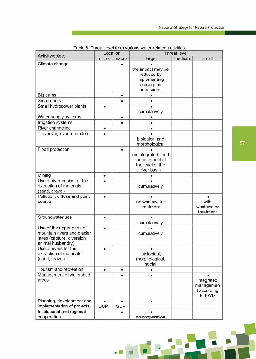
National Strategy for Nature Protection
97
National Strategy for Nature Protection
88
Table 8. Threat level from various water-related activities
Activity/object Location Threat level micro macro large medium small
Climate change the impact may be
reduced by implementing action plan measures
Big dams Small dams Small hydropower plants
cumulatively
Water supply systems Irrigation systems River channeling Traversing river meanders
biological and morphological
Flood protection no integrated flood
management at the level of the
river basin
Mining Use of river basins for the extraction of materials (sand, gravel)
cumulatively
Pollution, diffuse and point source
no wastewater
treatment
with
wastewater treatment
Groundwater use cumulatively
Use of the upper parts of mountain rivers and glacier lakes (capture, diversion, animal husbandry)
cumulatively
Use of rivers for the extraction of materials (sand, gravel)
biological,
morphological, social
Tourism and recreation Management of watershed areas
integrated
management according
to FWD Planning, development and implementation of projects
DUP
GUP
Institutional and regional cooperation
no cooperation

Ministry of Environment and Physical Planning
98
Figure 42. Formation of gullies from surface erosion on the mountain landscapesIn Debar (up) and Pehchevo (down).
(Source: I. Minchev, 2016, and I. Blinkov, 2013)
National Strategy for Nature Protection
99
In addition to these, for the purposes of identifying the strategic goals, it is very of-ten necessary to assess the conditions of erosion in the watershed area, the amount of sediment, the production of wastewater, wastewater treatment, irrigated surfaces, water traffic and the number and the extent of modified water bodies.
4.2.4. THREATS TO LANDSCAPE DIVERSITY Threats to the landscapes are complex and stimulated by socio-economic and polit-
ical-development policies at the local and national level. This complexity is reflected in the fact that each landscape consists of a number of ecosystems that are affected by a series of specific processes for each ecosystem separately.
The following may be identified as key threats to the landscapes:
• Overgrowing of the areas of high mountain pastures, as well as of screes with shrub and forest vegetation, which is a consequence of the abandonment of traditional practices of sheep grazing. In this way, the areas under high mountain pastures are reduced;
• Overgrowing of hilly pasture landscapes with shrub vegetation and thermophilic oak forests. This process is similar to that taking place in the high mountain zone;
• A special problem is the afforestation of hilly pasture landscapes, which is most often done with allochthonous coniferous species that completely change the landscape appearance, reduce biodiversity and increase the danger of fire;
• Overgrowing of rural landscapes due to the abandonment of traditional agricultural practices leading to loss of visual values and degradation of some components of biological diversity – habitats, plant species and invertebrates;
• Overgrowing of the borderlines in the hilly rural landscape with borderlines with nat-ural forest vegetation due to the abandonment of agricultural practices (emigration) leading to loss of visual values;
• Overgrowing of meadows in the mountainous rural landscapes due to the abandon-ment of traditional practices – loss of visual values or loss of areas for feeding wild animals – ungulates, especially roe deer;
• Intensifying agricultural practices by expanding parcels and loss of borderlines lead-ing to loss of visual values and loss of corridors for some types of organisms;
• Reducing rice paddies – rice areas have significantly varied over the last few de-cades due to a change in the market price of rice (Kochani region);
• Urbanization and industrialization are processes that reduce the visual and func-tional characteristics of landscapes, which particularly depend on their absorption capacity. In this context, the construction and operation of overground mines and quarries may also be relocated;
• Fragmentation of forest landscapes is the result of the construction and operation of line infrastructure (especially highways), often associated with improper forest management (deforestation, erosion) and forest fires;
The table shows the landscapes and the manner in which the threats affect them.

Ministry of Environment and Physical Planning
100
National Strategy for Nature Protection
91
Table 9. Connection between major threats and significant landscape types Type of threat Type of landscape Type of disruption
Overgrowing of landscapes with shrub and mesophilic forest vegetation
Landscape of high mountain pastures on a carbonate substrate
Landscape of high mountain pastures on a silicate substrate
Structural and functional disruptions
Overgrowing of hilly pasture landscapes with shrub vegetation and thermophilic oak forests
Landscape of hilly pastures on granite screes
Landscape of hilly pastures on limestone
Structural and functional disruptions
Afforestation in hilly pasture landscapes, which is most often done with allochthonous coniferous species
Landscape of hilly pastures on a marl substrate
Landscape of hilly pastures on granite screes
Landscape of hilly pastures on limestone
Structural and functional disruptions
Overgrowing of rural landscapes due to the abandonment of traditional agricultural practices
Osogovo mountainous rural landscape
Mariovo landscape Maleshevo-Pijanec rural-agricultural
landscape Hilly rural landscape Plain-hilly subcontinental
agricultural-rural landscape
Structural and functional disruptions
Overgrowing of borderlines Hilly rural landscape with borderlines Structural and functional disruptions
Overgrowing of meadows in the mountainous rural landscapes
Osogovo mountainous rural landscape
Mountainous rural landscape
Structural and functional disruptions
Intensifying agricultural practices by expanding parcels and loss of borderlines
Hilly rural landscape with borderlines Structural and functional disruptions
Reducing rice paddies Kochani landscape Aesthetic disruptions
Urbanization and industrialization; Intensive tourism, including winter sports
Dojran landscape Prespa landscape Ohrid landscape Pelagonija landscape Landscape of fir-spruce forests Plain-hilly subcontinental
agricultural-rural landscape (partially)
Aesthetic disruptions
Fragmentation of forest landscapes
Landscape of mesophilic broadleaf forest
Structural and functional disruptions
Illegal felling Landscape of mesophilic broadleaf forest
Structural and functional disruptions
Quarries and mines
Hilly pasture landscape on serpentinite
Landscape of carbonate rocks and screes
Landscape of hilly pastures on limestone
Landscape of hilly pastures on granite screes
Mainly aesthetic disruptions
Fires Landscape of Krivobor shrubland Structural and functional
disruptions

National Strategy for Nature Protection
101
4.2.5. MAIN THREATS TO BIODIVERSITY4.2.5.1. The impact of economic sectors on biodiversityIn the first couple of decades after the Second World War, the melioration and
the drying out of the majority of swamps, as well as the expansion of agricultural lands, posed serious threats to biodiversity, which significantly reduced the areas of relict marshy vegetation, that is, the belts with natural vegetation along the borders of fields were destroyed, thereby losing significant biocoridors. The existing threats to biodiver-sity related to the agriculture sector derive from the abandonment of traditional ways of utilizing the meadows and pastures, resulting in a change in the landscape through successions, and changes in the composition of biodiversity.
By means of the activities in the industry sector, large areas were degraded by deposition of tailings, technological waste, industrial landfills of harmful and hazardous waste and the absence of re-cultivation of abandoned pits and landfills. All this has caused permanent loss of habitats of many specific plant and animal species.
One of the priority threats to biodiversity is mining, that is, the utilization of min-eral and non-mineral raw materials. These activities cause permanent loss of habitats of a number of specific plant species, as well as invertebrates, typical of limestone geological substrate. The situation of the wider Prilep area is alarming particularly in this respect, where a number of areas have been granted concession for marble ex-ploitation (Pletvar, Sivec, Belovodica, Kozjak, etc.). This part of the territory of the Republic of Macedonia is known for its endemism, with several floristic endemics de-scribed, such as Stachys iva (Trojaci), Seseli vandasii (Kozjak), Armeria vandasii (Koz-jak), Centaurea kozjakensis (Kozjak), Silene prilepensis (Kozjak), Allium bornmulleri (Drenovo), Potentilla pletvarensis (Pletvar), Centaurea marmorea (Sivec) Centaurea grbavacensis (Grbavec, Kozjak, Pletvar, Sivec), Astragalus sericophyllus (Kozjak), He-lianthemum marmoreum (Pletvar, Kozjak), and others. Populations of these endemic species have been recorded in the vicinity of all old marble mines, as well as in the mines which have been granted concession more recently. The expansion of the ex-ploitation area and the deposition of waste, unused raw materials is a serious problem in the conservation of this endemic plant genetic fund. The situation is similar with the Alshar site, where several local endemics have been developing - Viola arsenica, Viola allchariensis, Thymus alsarensis, Centaurea leucomala, Onobrychis degenii, Knautia caroli-rechingeri and several others, which are under permanent threat from taking fu-ture mining activities in this area.
The threats associated with the development of urbanization are manifested in the direct occupation of habitats and harassment of species, caused by frequently un-controlled and discontinuous urbanization and the discharge of untreated wastewater into water bodies.
Civil engineering, through the conversion of agricultural land with high grade credit rating for non-productive purposes, especially in the vicinity of larger settlements and cities on the one hand, and leaving arable land in rural areas on the other, leads to loss of productive land, which is significant to the agro-biological diversity.
The priority threats in the hunting sector are related to all forms of poaching, enclosing hunting grounds, introduction of alien species and the like, which directly or indirectly cause the reduction of populations of many species of special interest. Fur-thermore, the illegal use of poison baits has led to the disappearance of the bearded and black vulture, and to a drastic reduction in the populations of the Egyptian and white-headed vulture. Given that all of these species have a significant share in the circulation of biomass and energy in ecosystems, the consequences of their extinction (or decrease in population) will undoubtedly affect the functioning of the entire related ecosystems.

Ministry of Environment and Physical Planning
102
Fisheries, especially illegal fishing, as well as the introduction of allochthonous fish species pose a serious threat to fish diversity in our natural lakes, especially in Ohrid Lake.
The impact of tourism on biodiversity leads to a number of adverse consequenc-es. One of the threats is related to tourism activities (recreation or targeted observation of nature) in protected areas, which are not regulated by protected area management plans, or there are insufficient resources to deal with them successfully, or the pre-scribed measures are insufficiently implemented. The cases of unplanned construction of certain tourist facilities, which degrade neighboring ecosystems (intensive infrastruc-ture activities in the coastal areas of Ohrid, Prespa and Dojran Lakes) pose a much more serious threat.
Biodiversity is adversely affected by the energy sector in several aspects: air, water and land pollution in the production of electricity (REK Bitola and REK Oslomej); disruption and change of the total landscape and biodiversity in the construction of transmission lines; change of pH and increase of concentrations of heavy metals in groundwater (landfills of ash and slag); reducing the areas of plant communities, as well as relict, endemic and rare species.
The construction of hydropower reservoirs in the river gorges leads to immersion of large areas of the gorges, which are refugiums of relict flora and vegetation, resulting in degradation and partial destruction of the existing phytocenoses of the lower vertical river profiles, as well as to the reduction of the area of relict, endemic and rare plant species. The loci classici of about 15 plant species are found in the gorge of the Treska river, where the hydro accumulations of Kozjak and Sveta Petka were built, as well as Matka prior to that. Of these, the endemo-relict species of Thymus oehmianus and Vi-ola kosaninii are particularly endangered. The envisaged construction of the Chebren hydropower reservoir in the strait of the Crna Reka in Mariovo will likely result in the immersion of the majority of habitats of the stenoendemic species of Silene paeonien-sis. The construction of Mavrovo Lake has resulted in the extinction of one species - Lysimachia thyrsiflora, which previously existed in Mavrovsko Pole.
The intensive development of the transport sector in the Republic of Macedonia often leads to the fragmentation of habitats, thereby being one of the most significant threats to biodiversity.
4.2.5.2. Other threats to biodiversity Natural ecosystems may be modified under the influence of certain threats
that have no sectoral origin, or it is not clearly expressed, such as, for example, fires, which often pose a real threat to protected areas, then the spread of invasive plant and animal species that are intentionally introduced or spread spontaneously on the territo-ry of the Republic of Macedonia, etc.
The loss of natural habitats (their conversion) is most pronounced in aquatic habitats (marshes and swamps). In the course of several decades after the Second World War, almost all larger marshes and swamps dried up, mainly for two reasons - the acquisition of new agricultural areas and the fight against malaria. Thus, marsh biocenoses became particularly endangered, and some of them are fragmented and threatened with extinction.
Due to the widespread use of chemical protective agents in agriculture, as well as the lack of sanitary landfills with an impermeable layer, the fact that our natural lakes and rivers receive such wastewater is a widespread and irreversible problem, especially in relation to certain fauna groups of organisms. By utilizing these waters (for example, for irrigation) or because of their connection to lake basins (for example, Prespa Lake), the risk is transmitted to a number of aquatic organisms.

National Strategy for Nature Protection
103
The impact of climate change on biodiversity has been assessed in the three national reports to the United Nations Framework Convention on Climate Change, with action plans for adaptation to change (MoEPP 2003, 2008, 2014). These reports have identified the refugiums and refugium areas that are susceptible to climate change impacts, and have provided expert assessment of the vulnerability of vulnerable habi-tats and species, identifying a total of 18 vulnerable habitats, 58 plant and 224 animal species. According to the expert assessments provided, one can expect changes in the distribution and even extinction of some habitats (lowland marshes) and species (plant and animal species related to mountain, marshy and coastal habitats).
Conservation of biological diversity in the Republic of Macedonia is facing cer-tain challenges as well. Coordination between sectoral strategies and the Biodiversity Protection Strategy should be strengthened, and ensure capacity building by providing expert staff in the local and central government, responsible for environmental and na-ture issues, etc. Due to the intertwined threats, negative trends may be changed only by integrating the principles of sustainable development into other sectoral policies, without slowing down the projected economic growth. They will contribute to the im-provement of the quality of life and will enable long-term survival of the most important components of biodiversity.
4.2.6. THREATS TO PROTECTED AREASThe threats to protected areas may be of different origin, duration and impact
on the integrity of natural values of protected areas. Some of the threats may occur inside the protected areas or come from the outside. However, the threats to protected areas generally coincide with the threats to geodiversity, biodiversity, and landscape (explained in previous chapters on threats). Furthermore, not all sectors affect protect-ed areas equally.
Pursuant to the Law on Nature Protection, the threats to a protected area are elaborated in more detail in the preparation of the Study on Revalorization of a Protect-ed Area and its management plan.
For threat assessment in protected areas, internationally, the World Bank and the World Wildlife Fund (WWF) tool is used.
4.2.6.1. Endangered ecosystemsIn the past period, the biggest changes in biodiversity have been registered with-
in water and marshy ecosystems. Macrophytic floating vegetation, in a large portion of Ohrid Lake, is found only in a fragmentary state, while in terms of fauna, fish are the most endangered. The constant oscillations in the water level in Prespa Lake have led to disruptions of the conditions of the floating and submersed vegetation, as well as the faunistic communities in the littoral zone of the Lake. In the past nearly 30 years, the state of Dojran Lake has been most alarming due to the drastic decrease in water level in 1988. The introduction of additional quantities of water as a result of the efforts and activities of the Ministry of Environment and Physical Planning has led to improvement of the hydrological state, and therefore, the situation of the biological communities is expected to improve as well. Comparative research is needed to show what the state of biodiversity in the Lake is, compared with previous comparative research conducted in 1989 and 2001.
The situation with river ecosystems in the Republic of Macedonia is also alarm-ing. The most frequent causes are the inflow of wastewater, the construction of res-ervoirs, inadequate stocking and utilization, and the like. Benthic communities in river ecosystems are with markedly reduced abundance, leading to a reduction in popula-tions in different fish species.

Ministry of Environment and Physical Planning
104
Figure 43. Caricetum elatae - a relict community in Studenchishte Marsh (photo: Hristovski S.)
The marshy vegetation in the Republic of Macedonia has suffered serious disrup-tions resulting from the ameliorative activities after the Second World War, when the former marshes and swamps were converted into arable land. The most vulnerable are the relict marshy communities that today are mainly found in fragmentary state (Negorci Spa, Gostivar Marsh, Katlanovo Marsh, Struga Marsh, Studenchishta Marsh, Monospitovo Marsh, Pelagonija, v. Chepigovo, etc.), or are under continuous pres-sure (Monospitovo Marsh, Belchishta Marsh, etc.). The marshy habitats (Struga Marsh, Monospitovo Marsh, Studenchishta Marsh, Belshishko Marsh, Katlanovo Marsh, etc.) are under continuous pressure. The marshy vegetation of the mountain swamps and fens, which is often dried by the impoundment of water from mountain springs and streams (Shar Mountain, Mount Mokra (Jakupica), Korab, Pelister, etc.) is also under serious threat.
Almost all forests in the Republic of Macedonia are affected by the wide range of natural or anthropogenic threats which forest ecosystems are exposed to, such as forest fires, uncontrolled felling, inadequate afforestation, unplanned construction and exploitation activities and so on.
Some forest communities may be disrupted by specific threats, such as drying forests (Tetovo RIver, Bistra – Senechka Mountain and Pelister – Brajchino RIver).
Nine forest communities are very rare, as well as endangered – Ephedro-Prune-tum tenellae (Kavadarechko-Ljubash, due to afforestation), Juglando-Aesculetum hip-pocastani (Suv Dol at Izvor, Gari River, Crn Drim), Tilio cordatae-Fagetum (Drevenich-ka Mountain), Aceri heldreichii-Fagetum (Jakupica, Shar Mountain), Periploco-Alnetum glutinosae (Monospitovo Marsh) Periploco-Fraxinetum angustifoliae-pallisae (Negorci Spa), Carici elongatae-Alnetum glutinosae (Polog, Debarca), Alnetum viridis (Belasi-ca), Daphno-Cytisanthetum radiate calcicolum (Galichica, Jablanica).

National Strategy for Nature Protection
105
Ecosystems in the hilly pasture belt (dry grassland ecosystems) show different trends in different plant communities – while some are constantly expanding, other communities are highly endangered and are in a fragmentary state. Typical examples of endangered plant communities are halophytic communities that develop on saline soils (small areas in Ovche Pole and in the steppe-like area between Veles, Shtip and Negotino in central Macedonia), communities that develop on an arsenic and antimony substrate (Alshar near Kavadarci) and the communities on limestone and dolomite (the wider area of Prilep).
Mountain ecosystems are not, as a rule, endangered to such an extent as low-land ecosystems. The most common causes that lead to the degradation of some plant communities of this belt are excessive grazing, frequently uncontrolled exploitation of individual species, the construction of ski lifts, mountain top towers, TV repeaters and other transmission, antenna systems, and the like.
4.2.6.2. Rare, endangered and extinct speciesAccording to the information so far, three floristic species are considered extinct:
Acorus calamus (Struga area, Crn Drim), Sagittaria sagitifolia (Pelagonija Marsh near the village of Novaci), Lysimachia thyrsiflora (former Mavrovo Pole), while extremely endangered and on the brink of extinction are Senecio paludosus and Carex elata, which only develop in the coast of Ohrid Lake (Studenchishta and Struga Marsh). Inad-equate protection is the main reason for the fragmentation of the populations of some rare and/or endemic plant species - Nuphar lutea (Ohrid Lake, near v. Kalishta), Thy-mus oehmianus and Viola kosaninii (the Kozjak reservoir) and Phyllitis scolopendrium (the Svetka Petka reservoir).
The most endangered species of fish in Ohrid Lake are salmonid species, while in Prespa Lake it is a carp (Cyprinus carpio), which according to IUCN, is included in the category of critically endangered species (CR). Of the ornithofauna of Macedonia in the last 60 years, at least 20 species of nesting birds have disappeared, including the bearded and black vulture, the white-tailed eagle, the glossy ibis, the Eurasian spoon-bill, the wild goose, the western capercaillie, the common crane, the little bustard and others (Velevski M. et al., 2013).
In the spacious forest and mountain ecosystems in the western part of the country, there is a small population of the Balkan lynx (Lynx lynx balcanicus). The species has been classified by IUCN as “critically endangered species” (CR (C2a (i, ii) D) (Melovski et al., 2015).
On the other hand, positive changes have been observed in some species. Namely, the species of Gentiana pneumonanthe, which was considered to be extinct, has been registered on the coast of Mavrovo Lake. The species of Ranunculus lingua, whose population near Ohrid Lake is on the brink of extinction, has also been regis-tered near the village of Bansko (Strumica area) (Matevski, 2005). With the gradual normalization of the situation with Dojran Lake, the populations of the floating plants Salvina natans and Nuphar lutea that were destroyed on the coast of Dojran Lake after the discharge of the water from the lake in 1988 have been gradually revitalized so that biologically vital populations have already been registered at the sites where these plants were previously developed.
A positive example in the past 10-year period in terms of taking timely measures for the preservation of endangered ecosystems and species is the Lokuf swamp, on Deshat Mountain, where the species of Menyanthes trifoliata is developed, which has limited distribution on the territory of the Republic of Macedonia. The swamp and this species were endangered due to its eutrophication by the sheepfold that was located in its vicinity, which in the meantime was dislocated.

Ministry of Environment and Physical Planning
106
In order to protect the Prespa trout, the necessary actions have been identified that are to be undertaken to document the current ecological status of this species’ popu-lations, estimate the density and the number, assess the threats and propose measures to improve the situation and promote sustainable use and species protection (Crivelli et al., 2008).
A series of protection activities (BIOEKO 2008) have been proposed for the criti-cally endangered subspecies of the European ground squirrel found in Macedonia (Sper-mophillus citellus karamani) on Mount Mokra, among which are the protection and man-agement of natural habitats and raising public awareness.
Regarding the fauna of bats, a report “Research on the Status and Action Plan for the Protection of Bats and Caves in Prespa” was prepared in 2012, within the GEF/UNDP/MoEPP Project for Prespa Basin Management, which presents data on the status and distribution of bats in all three countries that enter the Prespa region, as well as a list of priorities for research and protection in order to achieve favorable conservation status of bats in Prespa.
Measures have been taken by the municipality of Pehcevo and a part of the local population for improvement and preservation of the population and habitat of the rare plant species of Drosera rotundifolia, which exists at the site of Judovi Livadi in the mu-nicipality of Pehchevo, which until recently was the only site of this species on the terri-tory of Macedonia (in 2015 it was found at several other nearby sites).
Preliminary studies were carried out on the marshy terrains in the region of De-barca during 2007 by the Macedonian Limnological Society (through the Environmental Investment Programme for 2007). In addition, special attention was paid to the site of Belchishte Marsh and a recommendation was given for the proclamation of Belchishte Marsh as protected area (Talevski, 2007).
In 2002, a decision was adopted by the Municipality of Negotino to proclaim the floristic site of “Orlovo Brdo” as a natural monument, due to the abundance of signifi-cant flora consisting of endemic and rare plants such as the following species: Tulipa mariannae Lindt., Hedysarum macedonicum Bornm., Salvia jurisicii Kos., Convolvulus holosericeus M.B., Capparis sicula Duh., Morina persica L.), Astragalus parnassi Boiss. and others.
The assessment of the state of biodiversity of Dojran Lake as a transboundary area was made in 2004 (Katsavouni & Petkovski, 2004) within a cross-border project with neighboring Greece.
For the protection of Prespa Lake, as of 2004, a comprehensive programme (GEF/UNDP/MoEPP Project for Prespa Basin Management) is being implemented to improve the ecological status of aquatic and other related ecosystems and to preserve the glob-ally significant biodiversity. At the transboundary level, key plans, programmes and strat-egies have been developed that now provide the basis for the implementation of specific measures to protect biodiversity. At the national level, the activities have been aimed at improving the active protection and management of “Ezerani” Nature Park and “Prespa Lake” Natural Monument, the management of which was assigned to the Municipality of Resen.
The valorization of the natural values of the former Strict Nature Reserve of Ezer-ani has established the need to change the level of its protection, aimed at its proper management and zoning, and the management plan includes measures for rehabilitation of ecosystems and species. This resulted in the need to change the category from the Strict Nature Reserve to the Nature Park. On the basis of the valorization of the protected area of Ezerani, in 2012, it was proclaimed a Nature Park. The activities were aimed at improving the active protection and proper management (zoning) and providing condi-tions for undertaking specific measures for rehabilitation of ecosystems and habitats.

National Strategy for Nature Protection
107
Aimed at nature preservation and local development of the Bregalnica region, during 2013, activities within the SDC/MoEPP Nature Conservation Programme started to be implemented as an umbrella programme that unites all the activities carried out in the Bregalnica region for the conservation of nature and sustainable local develop-ment. During 2014/15, an analysis was made of the shortcomings in the ecological data and a map of the ecological sensitivity of the Bregalnica river watershed was prepared, which enabled the identification and valorization of the biodiversity in the region and gives directions and recommendations for its preservation (including establishment of a system of protected areas) and sustainable use.
At the same time, a draft Bregalnica River Watershed Management Plan (SECO/MoEPP Project) was drafted, through which the implementation of the Law on Waters would be promoted and the protection and sustainable management of water resourc-es, rational use of waters, and improvement of the water quality and sanitation would be achieved.
4.2.5.3. Ecosystem servicesSince the end of the 1990s, in the Republic of Macedonia, there has been a
growing interest of the expert public in applying the principles of the ecosystem ap-proach in the management of natural resources in the country. The first attempts have been recorded within the projects for integral management of Prespa and Ohrid Lakes, and more recently the Bregalnica river watershed.
The term “ecosystem services” encompasses the instrumental value of ecosys-tems as a means of achieving human well-being-related goals (Costanaza, 2008). As a result of the approach whereby problems are treated comprehensively, the concept of ecosystem services has great potential for application in the management of natural resources and the environment. The application of the concept of ecosystem services in the management of ecosystems in the Republic of Macedonia is, however, modest. Thus far, two studies have been prepared based on the concept of ecosystem ser-vices and economic valuation of the environment - the “economic value” of the natural resources of Shar Mountain (Melovski & Hristovski, 2008) and “Ezerani” Nature Park. The “Ezerani” Nature Park management project provides a good example of how the concept of ecosystem services can be applied in the management of degraded eco-systems in protected areas.
However, the conservation of biodiversity in our country can not be achieved only through measures and activities in protected areas. Namely, significant parts of ecosystems that are particularly important for human well-being (which provide ser-vices related to food, drugs, drinking water, raw materials, erosion control, circulation of substances, etc.) are under significant human influence and are not covered by the system of protected areas. A typical example is the forest and agricultural ecosystems that are actively managed. By applying the ecosystem approach in some of these ecosystems, basic environmental processes and functions can be renewed, especially those providing services that are essential to humans.
Therefore, it is necessary to identify the pressures on ecosystems that provide essential services for the well-being of people. For the critical ecosystems that provide important services, it is necessary to take measures for conservation or revitalization. Indeed, protection is preferred to revitalization, which is usually more expensive and longer.
Activities to reduce pressures on ecosystems, such as those from the agriculture and forestry sectors, will help in the spontaneous renewal of some of the degraded

Ministry of Environment and Physical Planning
108
ecosystems. In certain cases, however, coherent and coordinated activities and mea-sures are needed to restore their functions, that is, the services they produce. Resto-ration efforts should focus, above all, on ecosystems whose services have a crucial or critical impact on human well-being.
The inclusion of key stakeholders in the activities for identifying key ecosystem services and in the implementation of the revitalization activities of the ecosystems that provide them will contribute to a more equitable approach to ecosystem services. The revitalization of these ecosystems will undeniably contribute to the preservation of biodiversity in the country.
4.2.6.4. Endangered economically significant speciesCollection and trade in threatened and protected wild species of plants, fungi and
animals and their parts is prescribed in the Law on Nature Protection and is performed only after previously obtained collection permit (Article 23) or trade permit/certificate (Ar-ticle 30), issued by the Minister of Environment and Physical Planning.
Pursuant to the Law, the total quantity of threatened and protected wild species of plants, fungi, animals and their parts collected for commercial purposes should be estab-lished on the basis of the previous assessment of the species status and the opinion of scientific and professional organizations regarding the density of populations of endan-gered species in natural habitats for each year.
Concerning the implementation of the Convention on International Trade in En-dangered Species of Wild Fauna and Flora - CITES Convention, on the proposal of the Ministry of Environment and Physical Planning, the Government of the Republic of Macedonia has adopted a Decree on the manner and procedure for issuing the permit or certificate, as well the type of permit or certificate and determining the border crossings through which the trade in threatened and protected wild species of plants, fungi, ani-mals and their parts can be performed (“Official Gazette of the Republic of Macedonia” No.135/10), Decree on the manner of handling the trade in threatened and protected wild species of plants, fungi, animals and their parts by the customs authorities, other compe-tent authorities and offices at the border crossings and scientific and expert institutions, as well as the authorized depositor of seized samples in illicit trade (“Official Gazette of the Republic of Macedonia” No.177/11), Rulebook on the issuing a permit for the collec-tion of threatened and protected wild species of plants, fungi and animals and their parts (“Official Gazette of the Republic of Macedonia” No.102/09) and Lists of threatened and protected wild species of plants, fungi and animals and their parts were adopted in 2012 (“Official Gazette of the Republic of Macedonia” No. 15/12). The last by-law includes:
• the threatened and protected wild species of plants, animals and their parts contained in CITES Appendices 1, 2 and 3 whose trade is regulated by a certificate of import and/or export and/or transit and/or re-export (List 1)
• the wild species of plants, fungi and animals and their parts proclaimed as being threatened and/or protected at the level of the European Union whose trade is regulated by a trade permit (List 2) and
• the wild species of plants, fungi and animals and their parts of the Republic of Macedonia whose trade is regulated by a D4 or CITES trade permit (List 3).
However, despite the recommendations of scientific experts, the species of Gen-tiana lutea and Gentiana punctata continue to be illegally collected. Population depletion also occurs in the species of Sideritis scardica and Sideritis raeseri, due to their mass and inappropriate collection. To overcome this situation, it is necessary to extend the period of prohibition to collect these species, as well as to prohibit the purchase of this plant.

National Strategy for Nature Protection
109
Populations of the species of pinemat manzanita (Arctostaphylos uva-ursi) are endangered due to mass and inappropriate collection of this plant in the area of the villages of Patishka Reka, Elovo, Drzhilovo and Crn Vrv (Karadjica), despite the rec-ommendation by scientific experts to temporarily stop the collection of this plant, ac-cording to the study on the condition of the population of this species on the territory of Macedonia (Matevski, 2003), which was prepared at the request of the MoEPP.
Further population depletion of the species of Sideritis scardica (on Mount Bis-tra) and Sideritis raeseri (on Mount Galichica) is evident due to the traditionally mass and inappropriate collection of these plants.
The development of biopotential assessment studies for the wild species of plants, fungi, animals and their parts, which are used for commercial purposes at the national level, is an important issue aimed at establishing quotas for the sustainable use of these species.
4.2.6.5. Protection of speciesThe Law on Nature Protection prescribes measures for the protection of species
that include adopting a red list of species based on the extent to which they are threat-ened, declaring strictly protected and protected wild species, controlling the collection and trade in threatened and protected wild species of plants, fungi and animals, and the breeding of wild animal species in captivity, introduction and reintroduction of spe-cies in nature.
4.2.6.6. RED LISTS AND RED BOOKSRed Listing provides scientific information and analyzes of the status, trend and
extent to which the species are threatened in order to draw the attention of the public, especially decision-makers (at national and global level) to the endangered species, in order to design appropriate strategies/programmes and take actions to preserve biodi-versity. It is prepared according to the evaluation criteria developed by IUCN, whereby the species are categorized into 7 categories according to the extent to which they are threatened: extinct (EX), extinct in the wild (EW), critically endangered (CR), endan-gered (EN), vulnerable/sensitive (VU), near threatened (NT), least concern (LC), and additionally the data deficient (DD) category. These categories have been accepted in the Law on Nature Protection (Article 34).
In recent years, several attempts have been made to make red list proposals. An application has been prepared and in the course of 2015 it was submitted to UNEP.
In the meantime, a Red List of fungi has been proposed by the scientific experts Karadelev & Rusevska (2012). This list contains 213 species of the Ascomycota and Basidiomycota groups. The species are categorized according to IUCN criteria, with 21 species in the critically endangered category, endangered (EN) – 30 species, vul-nerable (VU) - 71 species, near threatened (NT) – 40 species, least concern (LC) – 9 species and 42 species are data deficient (DD).
Krpač & Darcemont (2012) have proposed a red list of Rhopalocera of the Re-public of Macedonia. This list includes 69 species, of which 1 is classified as endan-gered (EN), 15 are classified as vulnerable (VU), 24 as near threatened (NT), and the remaining 27 are not assigned status according to IUCN, but are considered of conser-vation significance due to endemism or the small area of distribution.
Lemonnier-Darcemont et al. (2014) have developed a red list of Macedonian orthoptera according to IUCN criteria. The guiding criterion for assessing the status is an estimate of the population size and the trend, but also the area of distribution. The list includes 17 taxa (about 10% of the total Macedonian fauna): 1 critically endangered - CR (Bradyporus macrogaster macrogaster), 4 endangered - EN (Saga pedo, Brady-
Ministry of Environment and Physical Planning
110
porus oniscus, Paracinema tricolor and Stethophyma grossum), 8 vulnerable - VU, as well as 4 threatened - NT. Additionally, 10 taxa are categorized as “data deficient” - DD. All other species of orthoptera of Macedonia are considered least concern - LC.
4.2.6.7. STRICTLY PROTECTED AND PROTECTED WILD SPECIESAccording to Article 35 of the Law on Nature Protection, wild species can be pro-
claimed strictly protected or protected wild species, thus acquiring the status of natural heritage.
Within the GEF/UNDP/MEPP Protected Areas Project in 2010, a List indicating the conservation status of the species of the Republic of Macedonia was prepared as a comparative review of the species which are on the lists of international conventions, EU directives on habitats and birds and IUCN Red List of globally endangered species. Based on the list, the by-law - Lists for establishing strictly protected and protected wild species has been prepared.
In 2011, pursuant to Article 35 of the Law on Nature Protection, the by-law - Lists for establishing strictly protected and protected wild species was adopted (“Official Ga-zette of the Republic of Macedonia” No.139/2011). The adoption of this by-law was an obligation arising from the National Programme for the Adoption of the Acquis (NPAA). Despite the negative reaction of the scientific public in relation to the by-law, this legal act is a good mechanism for legal protection of the species. In the coming period, it is necessary to revise the Lists for establishing strictly protected and protected wild species on the basis of previous scientific researches and analyzes of the state, trend and the extent to which the species are threatened. In this regard, the preparation and adoption of national red lists is a priority issue.
4.2.6.8. Biodiversity monitoring The MoEPP is responsible for conducting the monitoring of the state of biodiver-
sity and geoheritage and undertaking measures for protection and conservation. The entities responsible for protected area management should be included in biodiversity monitoring, and expert assistance should be provided by the faculties, institutes and museums. The entities responsible for biodiversity monitoring tend to lack sufficient capacity; therefore, it is necessary to strengthen the capacities both from the technical and expert point of view. In addition to the necessary knowledge of biology and ecology of target species and habitats/ecosystems, appropriate knowledge of spatial and tem-poral statistical analyzes is necessary. Monitoring data is not collected in an integral database.
In practice, specific monitoring activities of components of biological diversity are carried out only within various projects, implemented by various organizations. Since 2010, the Public Institution National Park “Galichica” has implemented activities of the Programme for long-term monitoring in the park, which consists of 5 thematic units: 1) monitoring the non-living nature; 2) monitoring of forest plant communities/habitats; 3) monitoring of herbaceous plant communities/habitats; 4) monitoring of plant species; and 5) monitoring of animal species.
As far as aquatic ecosystems and their biodiversity are concerned, the com-petent institution is the National Hydrometeorological Service (NHMS). The Hydrobi-ological Institute of Ohrid participates in the monitoring of the lakes, especially Ohrid, Prespa and Dojran Lakes. In addition, measurements have been made of the rivers flowing into the lakes, their littoral, and one measuring point in the pelagic zone of each of the two lakes. There is a monitoring network established on Prespa Lake consisting
National Strategy for Nature Protection
111
of 8 monitoring points in the rivers of surface water bodies and 5 monitoring points in the lake itself. According to the data, the surface waters of the lake are classified as acceptable, and the upper courses of the Brajchinska and the Kranska are assigned excellent status, while poor status is noted in the lower course of the Golema Reka and the Istochka Reka.
Within the various projects, certain studies are carried out following certain specific changes that affect the state of the forests. For instance, in “Pelister” National Park, the revitalization of the old Macedonian pine forest has been observed by moni-toring the course of the renewal process of the Macedonian pine. The Diagnostic-Prog-nostic Reporting Service (DPR service) at the Faculty of Forestry in Skopje, at the state level, through a network of bioindicating points, monitors the changes in the health condition of the forests. For the purpose of protection of forests and forest lands, on the entire territory of the Republic of Macedonia, measures and activities are undertaken which are intended for protection from biotic, abiotic and other factors that can cause harmful consequences in the forest.
Complete monitoring of forest habitats and species living in them (forest biodi-versity) is not fully implemented because the monitoring is directed primarily toward forest diseases and insects causing calamitous events and more serious damage to the forest, that is, it mainly refers to the forest as a resource. In the future, it is neces-sary to extend the monitoring to cover biodiversity.
Aimed at the improvement of the monitoring of forest fires, preventive measures, factors and causes, type and size of the fire, participants in the extinguishing and costs of extinguishing, caused damages, the body of the state administration responsible for the affairs of the forestry is planning to establish and lead a Single Information System and Register of Forest Fires.
The monitoring of some important species is carried out within the project activ-ities. Thus, since 2003, the continuous monitoring of vultures in Macedonia has been carried out by the Macedonian Ecological Society within the Vulture Conservation Proj-ect in Macedonia. Lynx monitoring has been carried out continuously since 2006 (photo traps method) within the Balkan Lynx Recovery Programme by the Macedonian Eco-logical Society.
The winter census of waterfowl of the three natural lakes, as well as some ar-tificial lakes and fishponds, is not carried out continuously, but with interruptions de-pending on the funding opportunities, although the intensity has increased in the last couple of years. The winter census of the waterfowl of Prespa Lake in Macedonia has also not been carried out continuously, but valuable data exist for 1987-1990, 1997-2002, 2004-2006 and 2009-2012 (Micevski & Schneider-Jacoby, 1997; Velevski et al., 2010; Catsadorakis et al., 2013). According to the monitoring results for 2010-2012, the total number of wintering waterfowl by far exceeds the Ramsar criterion of 20000 individuals; therefore, the lakes qualify as water habitats of international importance (Catsadorakis et al., 2013).
In the “Galichica” National Park, 22 standard operational procedures (SOP or monitoring protocols) have been developed for monitoring the components of biolog-ical diversity, of which 5 refer to the following habitats: peony forest with foya, Helle-no-Moesian Quercus frainetto forests, southwestern Moesian fir-beech forests, Balkan bare pastures and Helleno-Balkan bare pastures. Plant species monitoring includes 4 protocols relating to endemic plant species (Crocus cvijicii, Centaurea tomorosii, Nepeta ernesti-mayeri and Sideritis raeseri) and 1 protocol for incidental observation of significant species of vascular plants. Animal species monitoring includes 2 proto-cols for invertebrates (Helix secernenda schlaeflii and Parnassius apollo), 7 protocols for vertebrates (Triturus macedonicus, Algyroides nigropunctatus, Phalocrocorax car-

Ministry of Environment and Physical Planning
112
bo, Mergus merganser, Alectoris graeca, Pyrrhocorax graculus and Caprimulgus euro-paeus), a protocol for monitoring frequent species of bats (Pipistrellus spp., Nyctalus leisleri and Eptesicus serotinus) and protocols for incidental observation of significant species of mammals and birds.
Hunting associations and hunting concessionaires monitor the game’s quantity.

National Strategy for Nature Protection
113
PART 25. STRATEGY FOR NATURE PROTECTION
5.1. IDENTIFICATION OF THE STATE-OF-PLAY, WEAKNESSES AND STRENGHTS, OPPORTUNITIES AND THREATS IN THE AREA OF NATURE PRO-TECTION
(SWOT ANALYSIS) The working team composed of experts from various fields and representatives of
the Ministry of Environment and Physical Planning of the Republic of Macedonia, by us-ing the experiences and applying modern analysis methods for comprehensive overview of the nature protection issue, conducted SWOT analysis where strengths, weaknesses, opportunities and threats of the geodiversity and geoheritage were presented, together with the other components of the nature protection (biological and landscape diversity).
The direct analysis identified several numerous strengths related to the values of the geodiversity, landscape and biodiversity. The analysis also identified certain weak-nesses which encompass the capacities of the institutional framework, national legisla-tion, adopted strategic documents, research, monitoring and treatment of protected areas.
Opportunities and threats were identified during the conducted SWOT analysis, that is, the gaps which exist in view of the nature protection (Annex 6).
5.2. PRINCIPLES, NATIONAL TARGETS, MEASURES AND ACTIONS OF THE NATIONAL STRATEGY FOR NATURE PROTECTION
5.2.1. PRINCIPLES OF ENVIRONMENTAL PROTECTION The National Strategy for Nature Protection is based on and in compliance with the
principles of environmental protection, as defined in the Environmental Law, as follows:
1. Principle of high level of protection; 2. Principle of integration; 3. Principle of sustainable development; 4. Precautionary principle; 5. Principle of prevention; 6. User pays principle; 7. Public participation principle; and 8. Principle of cooperation
5.2.2 NATIONAL TARGETS In order to identify and define the national targets of the Strategy for Nature
Protection of the Republic of Macedonia, a process of consultations with the relevant stakeholders was conducted and numerous strategic documents in the field of envi-ronmental protection and other sectors, values of the nature, as well as the threats to the geodiversity, geoheritage, biological and landscape diversity were reviewed and considered.

Ministry of Environment and Physical Planning
114
Based on the analysis, 7 national targets were identified, and they are integral to separate thematic areas (geodiversity, geoheritage, biological and landscape diversity) and they are further elaborated through activities within the Action Plan of the Strategy for Nature Protection. National targets are:
NATIONAL TARGET 1. To protect, conserve and monitor the components of the geo-diversity, geoheritage, biological and landscape diversity.
NATIONAL TARGET 2. To properly identify, research, monitor and make inventory of the geodiversity and geoheritage and other components of nature (biological and landscape diversity).
NATIONAL TARGET 3. By 2022, to embed the nature protection policies into the strategies, plans and programmes of other sectors.
NATIONAL TARGET 4. To establish and practice sustainable use of the geodiversity and geoheritage and other components of nature (biological and landscape diver-sity) through the use of traditional knowledge, innovations, best practices and pos-itive incentives related to conservation and sustainable use of the nature.
NATIONAL TARGET 5. To improve the legislation framework in accordance with the EU legislation and relevant ratified international treaties for nature protection and to provide adequate institutional framework by strengthening the administrative capacities.
NATIONAL TARGET 6. To raise the level of information, education and promotion of the value of the geodiversity and geoheritage and other components of nature (biological and landscape diversity).
NATIONAL TARGET 7. To provide continuous and increased financing of the nature protection by budget finances at central and local level, by investments and other sources of financing, through establishment of appropriate sustainable and effi-cient financing models for protection and sustainable use of nature.
5.2.3 MEASURES FOR IMPROVEMENT OF NATURE PROTECTION In lieu of the main objective of the strategy for protection of the geodiversity and geoheritage and other components of nature (biological and landscape diversity), national targets in these areas are further presented in more details. In the context of previously defined national targets, concrete measures to improve the nature protection are accen-tuated as follows:
1. Measures for research and monitoring of the state of the nature;2. Strengthening the measures for inclusion of the nature protection in other sec-
tors;3. Measures for amending the institutional and legal frameworks;4. Measures for education and education improvement in order to protect the na-
ture;5. Measures for inclusion of the local population in the process of nature protection
and advancement; and 6. Measures for usage of mechanisms to stimulate external financing in the area of
nature protection;

National Strategy for Nature Protection
115
5.2.4 ACTION PLANVision and national targets of the Strategy are elaborated in details in the Action
Plan.Action plan contains numerous actions to be undertaken in order to meet and achieve
the Vision and national targets of the Strategy.Actions in the Action Plan integrally refer to the whole nature, that is, the geodiversity
and geoheritage and other components of nature (biological and landscape diversity), and they include:
1. protection, conservation and monitoring; 2. identification, research and inventory of objects of interest for protection;3. sustainable use of the geodiversity and geoheritage and other components of
nature (biological and landscape diversity);4. embedding of nature protection policies into the strategies, plans and programmes
of other sectors;5. improvement of legal framework and strengthening the institutional capacities; 6. raising the level of information, education and promotion of the value of the geo-
diversity and geoheritage and other components of nature (biological and land-scape diversity); and
7. provision of continuous and increased financing of the nature protection. The Plan for realization of the actions related to each national target is provided in the table containing the following information:
1. denomination/number of the action;2. implementing institution;3. implementation timeframe;4. Funding (possible sources of finances - Budget of the RM, foreign grants, EU
funds and other sources); 5. draft indicator (s) to monitor the implementation progress.
Budget assessment
Assessment of the amount of required finances for each action in the action plan is determined though approximate finances divided into three categories:
I Category budget to MKD 10,000,000.00 II Category budget from MKD 10,000,000.00 to MKD 30,000,000.00 III Category budget over MKD 30,000,000.00
Detailed financial plan shall be broken down in five-year implementation plan of the Strategy drafted by the MoEPP.

Ministry of Environment and Physical Planning
116
ACTION PLAN
NATIONAL TARGET 1“To properly identify, research, monitor and make inventory of the geodi-
versity and geoheritage and other components of nature (biological and land-scape diversity)”
Numerous areas, sites and phenomena of nature conservation interest, that is, related to geodiversity and geoheritage and other components of nature (biological and landscape diversity) have been identified in the Republic of Macedonia. Various objects from various areas, such as geology (volcano objects and phenomena, minerals, fossils), geomorphology (various reliefs, fluvial, abrasive, karst, glacial and denuvolcanoforms) and hydrology (wells, rivers, lakes, waterfalls) have been identified.
So far, 1,700 species of algae, 3,200 vascular plants, over 2,000 fungi and 450 lichens, 13,000 invertebrates, 85 fish and cyclostomata, 15 amphibians, 32 reptiles, 333 birds and 84 species of mammals have been registered in different ecosystems and types of habitats in the country. There is a multitude of endemic species among them: at least 150 endemic algae, 120 endemic vascular plants, over 700 invertebrates and 27 endemic species of fish. Considering that knowledge for certain taxonomic groups is modest or lacking, the real image of the rich biodiversity in the country is still incomplete.
If values of the geodiversity and geoheritage are added to the values of the eco-systems and species, we can say the Republic of Macedonia possesses extremely rich and unique natural resources.
As is the case with the biodiversity, other thematic areas, such as geodiversity, geoheritage, hydrology and landscapes are not fully explored and researched.
As regards the biodiversity, a very important monitoring tool is introduction of biodiversity indicators to monitor the trend of certain wild animals and plants populations, as well as the trend of protected areas in the Republic of Macedonia.
It is essential to conduct monitoring of other components of nature in order to identify integral measures and actions to protect and to conserve the geodiversity, geoheritage, biological and landscape diversity.
National target 2 contains concrete actions intended to study, research, monitor and inventorize the geodiversity and geoheritage and other components of nature (biological and landscape diversity), and it is linked to National target 1 and 5 of the present Action Plan.

National Strategy for Nature Protection
117
NATI
ONA
L TA
RGET
1
To p
rope
rly id
entif
y, re
sear
ch, m
onito
r and
mak
e in
vent
ory
of th
e ge
odiv
ersi
ty a
nd g
eohe
ritag
e an
d ot
her c
ompo
nent
s of
nat
ure
(bio
logi
cal
and
land
scap
e di
vers
ity).
No.
Actio
nRe
spon
sibl
e in
stitu
tion
Impl
emen
-ta
tion
perio
dFu
ndin
gCa
tego
ryAc
tion
impl
emen
tatio
n in
dica
tor
1. 1
Geo
dive
rsity
and
geo
herit
age
(geo
logy
, geo
mor
phol
ogy
and
hydr
olog
y)
1.1.
1 In
vent
oriz
e an
d as
sess
geo
dive
rsity
and
ge
oher
itage
M
oEPP
in c
oope
ratio
n w
ith
scie
ntifi
c in
stitu
tions
and
ex
perts
2017
-202
7 Bu
dget
of t
he
RM
, va
rious
do
natio
ns
III
Elem
ents
of g
eodi
vers
ity a
nd
geoh
erita
ge a
re in
vent
orie
d an
d as
sess
ed
1.1.
2 D
evel
opm
ent g
eodi
vers
ity a
nd
geoh
erita
ge m
onito
ring
prog
ram
me
MoE
PP in
coo
pera
tion
with
sc
ient
ific
inst
itutio
ns a
nd
expe
rts
2017
-202
0 Bu
dget
of t
he
RM
, va
rious
do
natio
ns
I G
eodi
vers
ity a
nd g
eohe
ritag
e m
onito
ring
prog
ram
me
is a
dopt
ed
1.1.
3 Es
tabl
ishm
ent a
nd im
plem
enta
tion
of
geod
iver
sity
and
geo
herit
age
natio
nal
mon
itorin
g
MoE
PP in
coo
pera
tion
with
sc
ient
ific
inst
itutio
ns a
nd
expe
rts
2020
-202
7 Bu
dget
of t
he
RM
, va
rious
do
natio
ns
III
Geo
dive
rsity
and
geo
herit
age
natio
nal m
onito
ring
is e
stab
lishe
d
1.1.
4 D
evel
opm
ent o
f geo
dive
rsity
and
ge
oher
itage
dat
abas
e M
oEPP
in c
oope
ratio
n w
ith
Geo
logi
cal S
urve
y, s
cien
tific
in
stitu
tions
and
exp
erts
2017
-202
7 Bu
dget
of t
he
RM
, va
rious
do
natio
ns
II G
eodi
vers
ity a
nd g
eohe
ritag
e da
taba
se is
est
ablis
hed
1.1.
5 D
evel
opm
ent o
f geo
dive
rsity
and
ge
oher
itage
nat
iona
l cad
astre
M
oEPP
in c
oope
ratio
n w
ith
Geo
logi
cal S
urve
y, s
cien
tific
in
stitu
tions
and
exp
erts
2017
-202
7 Bu
dget
of t
he
RM
, va
rious
do
natio
ns
II G
eodi
vers
ity a
nd g
eohe
ritag
e na
tiona
l cad
astre
is d
evel
oped
1.1.
6 C
reat
ion
of a
map
of g
eo-o
bjec
ts a
nd
site
s w
ith im
porta
nt n
atur
al v
alue
s M
oEPP
in c
oope
ratio
n w
ith
Geo
logi
cal S
urve
y, s
cien
tific
in
stitu
tions
and
exp
erts
2020
-202
2 Bu
dget
of t
he
RM
, for
eign
do
natio
ns
I M
ap o
f geo
-obj
ects
and
site
s w
ith
impo
rtant
nat
ural
val
ues
is c
reat
ed
1.1.
7 C
reat
ion
of a
map
of r
are
min
eral
s,
rock
s, fo
ssils
M
oEPP
, ME
in c
oope
ratio
n w
ith G
eolo
gica
l Sur
vey,
sc
ient
ific
inst
itutio
ns a
nd
expe
rts
2020
-202
2 Bu
dget
of t
he
RM
, for
eign
do
natio
ns
I M
ap o
f rar
e m
iner
als,
rock
s,
foss
ils is
cre
ated
1.1.
8 C
ondu
ctin
g st
udy
on th
e ut
ilizat
ion
pote
ntia
l of t
herm
al a
nd p
etro
ther
mal
en
ergy
MoE
PP, M
E in
coo
pera
tion
with
Geo
logi
cal S
urve
y,
scie
ntifi
c in
stitu
tions
and
ex
perts
2020
-202
2 Bu
dget
of t
he
RM
, var
ious
do
natio
ns
II St
udy
on th
e ut
ilizat
ion
pote
ntia
l of
ther
mal
and
pet
roth
erm
al e
nerg
y is
con
duct
ed
Act
ions
in o
rder
to a
ccom
plis
h N
atio
nal t
arge
t 1:

Ministry of Environment and Physical Planning
118
1.1.
9 C
reat
ion
of a
nat
iona
l map
of s
ites
subj
ect t
o la
ndsl
ides
M
oEPP
in c
oope
ratio
n w
ith
Geo
logi
cal S
urve
y, s
cien
tific
in
stitu
tions
and
exp
erts
2017
-201
8 Bu
dget
of t
he
RM
, var
ious
do
natio
ns
II N
atio
nal m
ap o
f site
s su
bjec
t to
land
slid
es is
cre
ated
1.1.
10
Dev
elop
men
t of a
dos
sier
of g
eo-o
bjec
ts
and
site
s on
Eur
opea
n an
d W
orld
C
ultu
ral a
nd N
atur
al H
erita
ge s
ites
and
thei
r pro
mot
ion
Gov
ernm
ent o
f the
RM
, M
oEPP
in c
oope
ratio
n w
ith
scie
ntifi
c in
stitu
tions
and
ex
perts
2022
Bu
dget
of t
he
RM
, var
ious
gr
ants
II D
ossi
ers
of a
t lea
st 2
geo
-obj
ects
an
d si
tes
on E
urop
ean
and
Wor
ld
Cul
tura
l and
Nat
ural
Her
itage
site
s an
d pr
omot
ion
have
bee
n de
velo
ped
1.1.
11
Dev
elop
men
t of a
stu
dy to
det
erm
ine
the
hydr
olog
ical
sta
te o
f mou
ntai
n riv
ers
and
glac
ial l
akes
Gov
ernm
ent o
f the
RM
, M
inis
try o
f Fin
ance
and
M
oEPP
2023
Bu
dget
of t
he
RM
, var
ious
do
natio
ns
III
Stud
y is
dev
elop
ed
1.1.
12
Dev
elop
men
t of a
stu
dy to
det
erm
ine
the
char
acte
ristic
s of
gro
undw
ater
s re
sulti
ng fr
om p
ollu
tion,
par
ticul
arly
in
mou
ntai
n an
d ru
ral a
reas
Gov
ernm
ent o
f the
RM
, M
inis
try o
f Fin
ance
and
M
oEPP
, Geo
logi
cal S
urve
y of
RM
2019
Bu
dget
of t
he
RM
, var
ious
do
natio
ns
II St
udy
is d
evel
oped
1.1.
13
Envi
ronm
enta
l ass
essm
ent o
f the
ch
arac
teris
tics
of u
rban
rive
rs a
imed
at
prot
ectio
n of
the
eco-
syst
ems
Gov
ernm
ent o
f the
RM
, M
inis
try o
f Fin
ance
and
M
oEPP
2019
Bu
dget
of t
he
RM
, var
ious
do
natio
ns
II As
sess
men
t is
cond
ucte
d
1.1.
14
Stud
y of
env
ironm
enta
l flo
w o
f mou
ntai
n aq
uatic
eco
-sys
tem
s G
over
nmen
t of t
he R
M,
MoE
PP, M
AFW
E 20
21
Budg
et o
f the
R
M, v
ario
us
dona
tions
III
Stud
y of
env
ironm
enta
l flo
w o
f m
ount
ain
aqua
tic e
co-s
yste
ms
is
deve
lope
d 1.
1.15
C
reat
ion
of n
atio
nal s
pele
olog
ical
ca
dast
re w
ith c
ontin
uous
upd
atin
g pr
ogra
mm
e
MoE
PP in
coo
pera
tion
with
sp
eleo
logi
cal o
rgan
izat
ions
, sc
ient
ific
inst
itutio
ns a
nd
expe
rts
2017
-202
7 Bu
dget
of t
he
RM
, var
ious
do
natio
ns
I N
atio
nal s
pele
olog
ical
cad
astre
w
ith c
ontin
uous
upd
atin
g pr
ogra
mm
e is
est
ablis
hed
1.1.
16
Dev
elop
men
t of a
pro
gram
me
for
spel
eolo
gica
l res
earc
h M
oEPP
in c
oope
ratio
n w
ith
scie
ntifi
c in
stitu
tions
, exp
erts
an
d sp
eleo
logi
cal
orga
niza
tions
2017
-202
0 Bu
dget
of t
he
RM
, var
ious
do
natio
ns
I Pr
ogra
mm
e fo
r spe
leol
ogic
al
rese
arch
is a
dopt
ed
1.1.
17
Iden
tific
atio
n of
rare
, uni
que
and
enda
nger
ed s
oil t
ypes
in th
e R
epub
lic o
f M
aced
onia
and
pro
pose
d m
easu
res
for
thei
r pro
tect
ion
(con
serv
atio
n).
MoE
PP in
coo
pera
tion
with
sc
ient
ific
inst
itutio
ns
2017
-202
0 Bu
dget
of t
he
RM
, var
ious
do
natio
ns
II St
udy
is d
evel
oped
1.1.
18
Esta
blis
hmen
t of n
atio
nal c
adas
ter –
la
ndsl
ides
dat
abas
e M
oEPP
in c
oope
ratio
n w
ith
Geo
logi
cal S
urve
y, s
cien
tific
in
stitu
tions
and
exp
erts
2017
-202
7 Bu
dget
of t
he
RM
, var
ious
do
natio
ns
I N
atio
nal c
adas
tre –
land
slid
es
data
base
is e
stab
lishe
d
1.1.
19
Prog
ram
me
to d
eter
min
e th
e su
itabi
lity
of g
eolo
gica
l env
ironm
ents
for
deve
lopm
enta
l pro
ject
s
Gov
ernm
ent o
f RM
, MoE
PP,
ME
in c
oope
ratio
n w
ith
Geo
logi
cal S
urve
y, s
cien
tific
in
stitu
tions
and
exp
erts
2023
Bu
dget
of t
he
RM
, var
ious
do
natio
ns
I Pr
ogra
mm
e to
det
erm
ine
the
suita
bilit
y of
geo
logi
cal
envi
ronm
ents
for d
evel
opm
enta
l pr
ojec
ts is
ado
pted

National Strategy for Nature Protection
119
1.2
Land
scap
e di
vers
ity
1.2.
1 D
evel
opm
ent o
f a c
ompr
ehen
sive
stu
dy
on s
truct
ural
and
func
tiona
l fea
ture
s of
id
entif
ied
land
scap
e ty
pes
MoE
PP in
coo
pera
tion
with
sc
ient
ific
inst
itutio
ns a
nd
expe
rts
2024
Bu
dget
of t
he
RM
, var
ious
do
natio
ns
III
Stud
y on
the
feat
ures
of i
dent
ified
la
ndsc
ape
type
s is
dev
elop
ed
1.2.
2 Es
tabl
ishm
ent o
f spa
tial a
rrang
emen
t of
land
scap
e el
emen
ts
MoE
PP in
coo
pera
tion
with
sc
ient
ific
inst
itutio
ns a
nd
expe
rts
2025
Bu
dget
of t
he
RM
, var
ious
do
natio
ns
II Sp
atia
l arra
ngem
ent o
f lan
dsca
pe
elem
ents
is e
stab
lishe
d
1.2.
3 D
eter
min
atio
n of
con
nect
ivity
of e
ach
iden
tifie
d la
ndsc
ape
type
M
oEPP
in c
oope
ratio
n w
ith
scie
ntifi
c in
stitu
tions
and
ex
perts
2025
Bu
dget
of t
he
RM
, var
ious
do
natio
ns
II C
onne
ctiv
ity o
f eac
h id
entif
ied
land
scap
e ty
pe is
det
erm
ined
1.2.
4 D
eter
min
atio
n of
the
capa
city
of a
giv
en
land
scap
e ty
pe to
sup
port
biod
iver
sity
; flo
w (m
ovem
ent)
of m
atte
r and
ene
rgy;
MoE
PP in
coo
pera
tion
with
sc
ient
ific
inst
itutio
ns a
nd
expe
rts
2026
Bu
dget
of t
he
RM
, var
ious
do
natio
ns
II C
apac
ity o
f a g
iven
land
scap
e ty
pe to
is d
eter
min
ed
1.2.
5 D
evel
opm
ent o
f man
agem
ent p
lans
for
the
mos
t im
porta
nt la
ndsc
ape
type
s M
oEPP
in c
oope
ratio
n w
ith
scie
ntifi
c in
stitu
tions
and
ex
perts
2027
Bu
dget
of t
he
RM
, var
ious
do
natio
ns
III
Man
agem
ent p
lans
for t
he m
ost
impo
rtant
land
scap
e ty
pes
are
deve
lope
d 1.
2.6
Id
entif
icat
ion
of la
ndsc
apes
at n
atio
nal
leve
l G
over
nmen
t of t
he R
M,
MoE
PP, M
E, M
AFW
E co
ntin
uous
Bu
dget
of t
he
RM
, var
ious
do
natio
ns
I Id
entif
icat
ion
and
expl
ored
la
ndsc
apes
1.3
Bio
dive
rsity
1.
3.1
D
evel
opm
ent o
f red
list
s
MoE
PP in
coo
pera
tion
with
sc
ient
ific
inst
itutio
ns
2017
-202
3 Bu
dget
of t
he
RM
, var
ious
do
natio
ns
III
Red
list
s de
velo
ped
1.3.
2 D
evel
opm
ent o
f red
boo
ks
MoE
PP in
coo
pera
tion
with
sc
ient
ific
inst
itutio
ns
2017
-202
3 Bu
dget
of t
he
RM
, var
ious
do
natio
ns
III
Red
boo
ks d
evel
oped
1.3.
3 R
evis
ion
of th
e Li
sts
of s
trict
ly p
rote
cted
an
d pr
otec
ted
wild
spe
cies
M
oEPP
in c
oope
ratio
n w
ith
scie
ntifi
c in
stitu
tions
20
17-2
020
Budg
et o
f the
R
M, v
ario
us
dona
tions
I Li
sts
revi
sed
1.3.
4 Pr
epar
atio
n an
d im
plem
enta
tion
of
actio
n pl
ans
for c
onse
rvat
ion
of
thre
aten
ed s
peci
es id
entif
ied
in re
d lis
ts
MoE
PP in
coo
pera
tion
with
sc
ient
ific
inst
itutio
ns
2024
-202
7 Bu
dget
of t
he
RM
, var
ious
do
natio
ns
II Ac
tion
plan
s ar
e im
plem
ente
d
1.3.
5 D
evel
opm
ent o
f ass
essm
ent s
tudi
es o
f th
e bi
opot
entia
l of w
ild p
lant
s sp
ecie
s,
fung
i, an
imal
s an
d co
mm
erci
ally
si
gnifi
cant
par
ts th
ereo
f
MoE
PP in
coo
pera
tion
with
sc
ient
ific
inst
itutio
ns
2017
-202
0 Bu
dget
of t
he
RM
, var
ious
do
natio
ns
II N
umbe
r of d
evel
oped
stu
dies
1.3.
6 D
evel
opm
ent o
f act
ion
plan
s fo
r ex-
situ
co
nser
vatio
n of
indi
geno
us w
ild s
peci
es
MoE
PP in
coo
pera
tion
with
sc
ient
ific
inst
itutio
ns
cont
inuo
us
Budg
et o
f the
R
M, v
ario
us
dona
tions
I Ac
tion
plan
s fo
r ex-
situ
cons
erva
tion
of in
dige
nous
wild
sp
ecie
s ar
e de
velo
ped
1.
3.7
Dev
elop
men
t of D
atab
ase
of n
atio
nal
biod
iver
sity
indi
cato
rs
MoE
PP, s
cien
tific
inst
itutio
ns,
expe
rts, M
AFW
E 20
18-2
023
Vario
us g
rant
s,
EU fu
nds
II In
dica
tors
are
dev
elop
ed

Ministry of Environment and Physical Planning
120
1.3.
8 D
evel
opm
ent o
f nat
iona
l act
ion
plan
s de
rivin
g fro
m th
e ob
ligat
ions
und
er
inte
rnat
iona
l tre
atie
s an
d in
itiat
ives
(e.g
. Bi
rds
and
bats
und
er th
e Bo
nn
Con
vent
ion)
MoE
PP in
coo
pera
tion
with
sc
ient
ific
inst
itutio
ns, C
SOs
2018
-202
2 Bu
dget
of t
he
RM
, var
ious
gr
ants
II Pl
ans
are
deve
lope
d
1.3.
9 Es
tabl
ishm
ent o
f nat
iona
l reg
iste
r and
bi
rd ri
ngin
g
MoE
PP in
coo
pera
tion
with
sc
ient
ific
inst
itutio
ns, C
SOs
cont
inuo
us
Budg
et o
f the
R
M, v
ario
us
gran
ts
II R
egis
ter i
s es
tabl
ishe
d
1.3.
10
Dev
elop
men
t of s
tudi
es o
n va
loris
atio
n/re
valo
rizat
ion
of p
rote
cted
ar
eas
MoE
PP in
coo
pera
tion
with
in
stitu
tions
resp
onsi
ble
for
data
gat
herin
g
cont
inuo
us
Budg
et o
f the
R
M, v
ario
us
gran
ts, E
U
fund
s
III
Num
ber o
f stu
dies
1.3.
11
Dev
elop
men
t of p
rote
cted
are
as
man
agem
ent p
lans
M
oEPP
in c
oope
ratio
n w
ith
inst
itutio
ns re
spon
sibl
e fo
r da
ta g
athe
ring
cont
inuo
us
Budg
et o
f the
R
M, v
ario
us
gran
ts, E
U
fund
s
III
Num
ber o
f man
agem
ent p
lans
1.3.
12
Dev
elop
men
t of s
patia
l pla
ns fo
r the
na
tiona
l par
ks
MoE
PP in
coo
pera
tion
with
in
stitu
tions
resp
onsi
ble
for
data
gat
herin
g, n
atio
nal
park
s
2020
Bu
dget
of t
he
RM
, var
ious
gr
ants
, EU
fu
nds
II N
umbe
r of d
evel
oped
spa
tial
plan
s
1.3.
13
Dev
elop
men
t of s
ecto
ral s
tudi
es o
n Sp
atia
l Pla
n of
the
RM
M
oEPP
in c
oope
ratio
n w
ith
inst
itutio
ns re
spon
sibl
e fo
r da
ta g
athe
ring,
nat
iona
l pa
rks
2019
Bu
dget
of t
he
RM
, var
ious
gr
ants
, EU
fu
nds
III
Num
ber o
f dev
elop
ed s
patia
l pl
ans
1.3.
14
Iden
tific
atio
n of
Spe
cial
Are
as o
f C
onse
rvat
ion
(SAC
s) a
nd S
peci
al
Prot
ectio
n Ar
eas
(SPA
s) w
ithin
the
proc
ess
of e
stab
lishm
ent o
f Nat
ura
2000
MoE
PP in
coo
pera
tion
with
sc
ient
ific
and
expe
rt in
stitu
tions
, CSO
s
2017
-202
2 Bu
dget
of t
he
RM
, var
ious
gr
ants
, EU
fu
nds
II Id
entif
ied
area
s fo
r NAT
UR
A 20
00
1.3.
15
Dev
elop
men
t of s
tudy
on
allo
chth
onou
s sp
ecie
s, p
artic
ular
ly in
vasi
ve s
peci
es
MoE
PP, s
cien
tific
inst
itutio
ns,
Hyd
robi
olog
ical
inst
itute
, PAs
20
24
Budg
et o
f the
R
M, v
ario
us
gran
ts
III
Stud
y is
dev
elop
ed
1.3.
16
Dev
elop
men
t of d
raft
natio
nal l
ist o
f ha
bita
t typ
es a
s re
ferre
d to
in A
nnex
I of
th
e H
abita
ts D
irect
ive,
for e
ach
of th
e tw
o bi
o-ge
ogra
phic
al re
gion
s (c
ontin
enta
l and
alp
ine
regi
on)
MoE
PP, s
cien
tific
and
exp
ert
inst
itutio
ns, i
nter
natio
nal a
nd
natio
nal e
xper
ts
2017
IP
A fu
nds
I D
raft
list i
s de
velo
ped

National Strategy for Nature Protection
121
1.3.
17
Dev
elop
men
t of d
raft
natio
nal l
ist o
f an
imal
and
pla
nt s
peci
es a
s re
ferre
d to
in
Ann
ex II
of t
he H
abita
ts D
irect
ive,
for
each
of t
he tw
o bi
o-ge
ogra
phic
al
regi
ons
(con
tinen
tal a
nd a
lpin
e re
gion
)
MoE
PP, s
cien
tific
and
exp
ert
inst
itutio
ns, i
nter
natio
nal a
nd
natio
nal e
xper
ts
2017
IP
A fu
nds
I D
raft
list i
s de
velo
ped
1.3.
18
Dev
elop
men
t of d
raft
natio
nal l
ist o
f bi
rds
as re
ferre
d to
in A
nnex
I of
the
Bird
s D
irect
ive
(bird
s an
d ot
her r
egul
arly
oc
curri
ng m
igra
tory
bird
s), f
or e
ach
of
the
two
bio-
geog
raph
ical
regi
ons
(con
tinen
tal a
nd a
lpin
e re
gion
)
MoE
PP, s
cien
tific
and
exp
ert
inst
itutio
ns, i
nter
natio
nal a
nd
natio
nal e
xper
ts
2017
IP
A fu
nds
I D
raft
list i
s de
velo
ped
1.3.
19
Sele
ctio
n/id
entif
icat
ion
of p
ropo
sed
pote
ntia
l pilo
t are
as fo
r Nat
ura
2000
ne
twor
k at
nat
iona
l lev
el
MoE
PP, s
cien
tific
and
exp
ert
inst
itutio
ns, i
nter
natio
nal a
nd
natio
nal e
xper
ts
2017
-202
2 IP
A fu
nds,
va
rious
don
ors
III
Prop
osed
pot
entia
l pilo
t are
as fo
r N
atur
a 20
00 n
etw
ork
are
sele
cted
/iden
tifie
d 1.
3.20
C
ompl
etio
n of
Sta
ndar
d D
ata
Form
for
Nat
ura
2000
dat
a re
gard
ing
the
pote
ntia
l pilo
t are
as in
the
RM
MoE
PP, s
cien
tific
and
exp
ert
inst
itutio
ns, i
nter
natio
nal a
nd
natio
nal e
xper
ts
2017
-202
2 IP
A fu
nds,
va
rious
don
ors
II St
anda
rd D
ata
Form
for N
atur
a 20
00 d
ata
rega
rdin
g th
e po
tent
ial
pilo
t are
as in
the
RM
is c
ompl
eted
1.
3.21
D
evel
opm
ent o
f eva
luat
ion,
sor
ting
and
stor
ing
met
hodo
logy
for N
atur
a 20
00
data
MoE
PP, s
cien
tific
and
exp
ert
inst
itutio
ns, i
nter
natio
nal a
nd
natio
nal e
xper
ts
2017
IP
A fu
nds
I Ev
alua
tion,
sor
ting
and
stor
ing
met
hodo
logy
for N
atur
a 20
00 d
ata
is d
evel
oped
1.
3.22
D
evel
opm
ent o
f Mon
itorin
g G
uide
lines
fo
r pop
ulat
ion
of th
e m
ost i
mpo
rtant
ha
bita
ts a
nd ta
xono
mic
gro
ups
rele
vant
to
Hab
itats
and
Bird
s D
irect
ives
MoE
PP, s
cien
tific
and
exp
ert
inst
itutio
ns, i
nter
natio
nal a
nd
natio
nal e
xper
ts
2017
IP
A fu
nds
I M
onito
ring
Gui
delin
es fo
r po
pula
tion
of th
e m
ost i
mpo
rtant
ha
bita
ts a
nd ta
xono
mic
gro
ups
rele
vant
to H
abita
ts a
nd B
irds
Dire
ctiv
es a
re d
evel
oped
1.
3.23
C
ondu
ctin
g St
udy
on th
e de
velo
pmen
t of
Geo
grap
hic
Info
rmat
ion
Syst
em (G
IS)
for p
rote
cted
are
as re
late
d to
Nat
ura
2000
net
wor
k
MoE
PP, s
cien
tific
and
exp
ert
inst
itutio
ns, i
nter
natio
nal a
nd
natio
nal e
xper
ts
2017
IP
A fu
nds
I G
IS s
tudy
is c
ondu
cted
1.3.
24
Dev
elop
men
t of d
igita
l GIS
map
for
prop
osed
pot
entia
l pilo
t are
as fo
r Nat
ura
2000
net
wor
k at
nat
iona
l lev
el
MoE
PP, s
cien
tific
and
exp
ert
inst
itutio
ns, i
nter
natio
nal a
nd
natio
nal e
xper
ts
2017
IP
A fu
nds
I D
igita
l GIS
map
for p
ropo
sed
pote
ntia
l pilo
t are
as fo
r Nat
ura
2000
net
wor
k at
nat
iona
l lev
el is
de
velo
ped
1.3.
25
Inve
ntar
izat
ion
and
upda
ting
of d
ata
on
iden
tifie
d en
viro
nmen
tally
impo
rtant
ar
eas
for b
irds,
pla
nt a
nd b
utte
rflie
s, e
tc.
MoE
PP, n
atio
nal p
arks
, sc
ient
ific
and
expe
rt in
stitu
tions
, exp
erts
2020
Bu
dget
of t
he
RM
, var
ious
do
natio
ns
II D
ata
on id
entif
ied
envi
ronm
enta
lly
impo
rtant
are
as a
re u
pdat
ed
1.3.
26
Con
duct
ing
mon
itorin
g of
sel
ecte
d ke
y ha
bita
ts o
f wild
spe
cies
at n
atio
nal l
evel
M
oEPP
, nat
iona
l par
ks, o
ther
en
titie
s m
anda
ted
to m
anag
e pr
otec
ted
area
s, s
cien
tific
an
d ex
pert
inst
itutio
ns, e
xper
t
cont
inuo
us
Budg
et o
f the
R
M, v
ario
us
dona
tions
II M
onito
ring
of s
elec
ted
key
habi
tats
of w
ild s
peci
es a
t nat
iona
l le
vel i
s co
nduc
ted
Num
ber o
f dra
fted
repo
rts o
n ke
y ha
bita
ts a
nd w
ild s
peci
es

Ministry of Environment and Physical Planning
122
1.3.
27
Dev
elop
men
t of n
atio
nal b
ird a
tlas
MoE
PP, n
atio
nal p
arks
, oth
er
entit
ies
man
date
d to
man
age
prot
ecte
d ar
eas,
sci
entif
ic
and
expe
rt in
stitu
tions
, exp
ert
2023
Bu
dget
of t
he
RM
, var
ious
do
natio
ns
II At
las
is d
evel
oped
1.3.
28
Esta
blis
hmen
t of n
atio
nal m
onito
ring
syst
em fo
r the
Bal
kans
lynx
G
over
nmen
t of t
he R
M,
MoE
PP, n
atio
nal p
arks
, oth
er
entit
ies
man
date
d to
man
age
prot
ecte
d ar
eas
2017
-202
7 Bu
dget
of t
he
RM
, var
ious
do
natio
ns
III
Nat
iona
l mon
itorin
g sy
stem
for t
he
Balk
ans
lynx
is e
stab
lishe
d
1.3.
29
Valo
risat
ion
stud
y of
nat
ural
val
ues
of
the
Ohr
id L
ake
Gov
ernm
ent o
f the
RM
, M
oEPP
, Hyd
robi
olog
ical
In
stitu
te, n
atio
nal p
arks
, ot
her e
ntiti
es m
anda
ted
to
man
age
prot
ecte
d ar
eas
2017
-201
9 Bu
dget
of t
he
RM
, var
ious
do
natio
ns
II Va
loris
atio
n st
udy
of n
atur
al
valu
es o
f the
Ohr
id L
ake
is
deve
lope
d
1.4
Geo
grap
hic
Info
rmat
ion
Syst
em
1.4.
1
Upd
atin
g of
dat
a on
obj
ects
and
ph
enom
ena
of n
atur
e co
nser
vatio
n in
tere
st (r
evisi
on o
f obj
ect n
umbe
r, lo
catio
n an
d da
ta)
MoE
PP in
coo
pera
tion
with
sc
ient
ific
inst
itutio
ns a
nd
expe
rts
cont
inuo
us
Budg
et o
f the
R
M, v
ario
us
dona
tions
I D
ata
are
upda
ted
1.4.
2 C
reat
ion
and
upda
ting
of G
eogr
aphi
c In
form
atio
n Sy
stem
on
terri
torie
s,
obje
cts
and
phen
omen
a of
nat
ure
cons
erva
tion
inte
rest
MoE
PP in
coo
pera
tion
with
sc
ient
ific
inst
itutio
ns a
nd
expe
rts
cont
inuo
us
Budg
et o
f the
R
M, v
ario
us
dona
tions
II G
eogr
aphi
c In
form
atio
n Sy
stem
is
crea
ted
and
upda
ted
1.4.
3 D
evel
opm
ent o
f a m
ap w
ith R
-1:2
0000
0 w
ith lo
catio
n of
obj
ects
and
site
s of
na
ture
con
serv
atio
n in
tere
st
MoE
PP in
coo
pera
tion
with
sc
ient
ific
inst
itutio
ns a
nd
expe
rts
2017
-201
8
Budg
et o
f the
R
M, b
udge
t of
MoE
PP, v
ario
us
dona
tions
I M
ap w
ith lo
catio
n of
obj
ects
and
si
tes
of n
atur
e co
nser
vatio
n in
tere
st is
dev
elop
ed
1.4.
4 D
evel
opm
ent o
f a m
ap w
ith R
-1:2
0000
0 w
ith lo
catio
n of
obj
ects
and
site
s w
here
na
ture
is d
egra
ded
MoE
PP in
coo
pera
tion
with
sc
ient
ific
inst
itutio
ns a
nd
expe
rts
2017
-201
9
Budg
et o
f the
R
M, B
udge
t of
MoE
PP, v
ario
us
dona
tions
I M
ap w
ith lo
catio
n of
obj
ects
and
si
tes
whe
re n
atur
e is
deg
rade
d is
de
velo
ped
1.4.
5
Dev
elop
men
t of d
igita
l map
s fo
r pr
ojec
ts b
y ec
onom
y-re
late
d se
ctor
s (m
iner
als
and
min
ing
reso
urce
s,
hydr
oene
rgy,
win
d en
ergy
etc
.) fo
r pr
even
tive
iden
tific
atio
n of
are
as o
f na
ture
con
serv
atio
n in
tere
st.
Gov
ernm
ent o
f the
RM
, M
oEPP
, MAF
WE,
ME
2017
-202
0 Bu
dget
of t
he
RM
, var
ious
gr
ants
II D
igita
l map
s fo
r pro
ject
s of
ec
onom
y-re
late
d se
ctor
s ar
e de
velo
ped
1.4.
6 D
evel
opm
ent o
f com
plet
e G
IS w
ith
rela
tiona
l dat
abas
e w
ith in
ter-
inst
itutio
nal r
elat
ions
sci
entif
ic in
stitu
tions
and
ex
perts
20
20
Budg
et o
f the
R
M, v
ario
us
dona
tions
II N
atur
al h
erita
ge G
IS is
es
tabl
ishe
d an
d ha
rmon
ized

National Strategy for Nature Protection
123
NATIONAL TARGET 2“To protect, conserve and monitor the components of the
geodiversity, geoheritage, biological and landscape diversity”
The Republic of Macedonia, with its modest area of 25.713 km2, owns extremely diverse nature, represented with various elements of geodiversity, geoheritage, biological and landscape diversity. Due to their diversity and uniqueness, certain geological and geomorphological forms, hydrological objects, habitats and wild species go beyond their national importance and they have regional and global importance.
The issue of provision of long-term protection of such natural riches is often posed. Therefore, the need of planning the nature protection and embedding it in the policies of other sectors is imposed.
Implementation of nature protection and conservation measures is one the highest priorities of the Action Plan related to the Strategy for Nature Protection.
Furthermore, one of the vital activities to ensure nature protection and conservation is to conduct continuous state monitoring of geodiversity, geoheritage, biological and landscape diversity. Establishment and implementation of a national monitoring system should be regulated with the national legislation, where the methodology and entities mandated to implement the monitoring will be precisely defined.
In this context, the National Target 1 contains actions which ensure protection, conservation and monitoring of the components of the geodiversity, geoheritage, biological and landscape diversity.
Actions under the National target 2 are linked to the actions under all national targets presented in the Action Plan.

Ministry of Environment and Physical Planning
124
N
ATI
ON
AL
TAR
GET
2
To p
rote
ct, c
onse
rve
and
mon
itor t
he c
ompo
nent
s of
the
geod
iver
sity
, geo
herit
age,
bio
logi
cal a
nd la
ndsc
ape
dive
rsity
No.
Act
ion
Res
pons
ible
inst
itutio
n
Impl
emen
-ta
tion
perio
dFu
ndin
gC
ateg
ory
Act
ion
Impl
emen
tatio
n In
dica
tor
2.1
Geo
dive
rsity
and
geo
herit
age
(geo
logy
, geo
mor
phol
ogy
and
hydr
olog
y)
2.1.
1 D
evel
opm
ent o
f a S
trate
gy fo
r G
eodi
vers
ity (G
eolo
gy a
nd
Geo
mor
phol
ogy)
Pro
tect
ion
in th
e R
M
Gov
ernm
ent o
f the
RM
, M
oEP
P in
coo
pera
tion
with
sci
entif
ic a
nd
com
pete
nt in
stitu
tion
and
expe
rts, G
eolo
gica
l S
urve
y
202
0-20
21
Bud
get o
f the
R
M, v
ario
us
gran
ts
II S
trate
gy fo
r Geo
dive
rsity
(G
eolo
gy a
nd G
eom
orph
olog
y)
Pro
tect
ion
in th
e R
M is
de
velo
ped
2.1.
2
Dev
elop
men
t of a
Stra
tegy
for K
arst
P
rote
ctio
n in
the
RM
G
over
nmen
t of R
M,
MoE
PP
, Geo
logi
cal
Sur
vey,
sci
entif
ic a
nd
com
pete
nt in
stitu
tions
an
d ex
perts
2021
-202
2 B
udge
t of t
he
RM
, var
ious
gr
ants
II S
trate
gy fo
r Kar
st P
rote
ctio
n in
th
e R
M is
dev
elop
ed
2.1.
3 N
omin
atio
n of
geo
-obj
ects
and
site
s fo
r Eur
opea
n an
d W
orld
Cul
tura
l and
N
atur
al H
erita
ge li
sts
and
thei
r pr
omot
ion
Gov
ernm
ent o
f the
RM
, M
oEP
P in
coo
pera
tion
with
sci
entif
ic in
stitu
tion
and
expe
rts
2020
-202
2 B
udge
t of t
he
RM
, var
ious
gr
ants
I A
t lea
st 2
geo
-obj
ects
and
site
s ar
e no
min
ated
for E
urop
ean
and
Wor
ld C
ultu
ral a
nd N
atur
al
Her
itage
list
s an
d th
eir
prom
otio
n 2.
1.4
Dev
elop
men
t of a
Pro
gram
me
for
prev
entiv
e pr
otec
tion
of u
niqu
e or
en
dang
ered
geo
herit
age
(loca
tions
of
rare
min
eral
s, ro
cks,
foss
ils, c
aves
an
d ot
her g
eom
orph
olog
ical
ph
enom
ena)
MoE
PP
in c
oope
ratio
n w
ith G
eolo
gica
l Sur
vey,
sc
ient
ific
inst
itutio
n an
d ex
perts
2020
B
udge
t of t
he
RM
, var
ious
gr
ants
I P
rogr
amm
e fo
r pre
vent
ive
prot
ectio
n of
uni
que
or
enda
nger
ed g
eohe
ritag
e (lo
catio
ns o
f rar
e m
iner
als,
ro
cks,
foss
ils, c
aves
and
oth
er
geom
orph
olog
ical
phe
nom
ena)
is
ado
pted
2.
1.5
D
evel
opm
ent o
f a p
rogr
amm
e fo
r m
iner
alog
ical
exp
lora
tion
in ra
re
min
eral
are
as in
ord
er to
iden
tify
new
m
iner
als
or m
iner
al a
ssoc
iatio
ns
MoE
PP
, ME
in
coop
erat
ion
with
G
eolo
gica
l Sur
vey,
sc
ient
ific
inst
itutio
n an
d ex
perts
2022
-202
5 B
udge
t of t
he
RM
, var
ious
do
natio
ns
II P
rogr
amm
e fo
r min
eral
ogic
al
expl
orat
ion
in ra
re m
iner
al
area
s in
ord
er to
iden
tify
new
m
iner
als
or m
iner
al
asso
ciat
ions
is a
dopt
ed
2.1.
6 P
roje
cts
by n
atur
e pr
otec
tion
stak
ehol
ders
G
over
nmen
t of t
he R
M,
MoE
PP
, nat
iona
l par
ks,
othe
r pro
tect
ed a
reas
, m
unic
ipal
ities
, NG
Os
2017
-202
0 B
udge
t of t
he
RM
, var
ious
gr
ants
I N
atur
e pr
otec
tion
capa
citie
s ar
e st
reng
then
ed
Act
ions
in o
rder
to a
ccom
plis
h N
atio
nal T
arge
t 2:

National Strategy for Nature Protection
125
2.1.
7 Im
plem
enta
tion
of b
est w
ater
m
anag
emen
t pra
ctic
es a
nd th
eir
prom
otio
n
Gov
ernm
ent o
f the
RM
, M
oEPP
20
22
Budg
et o
f the
R
M,
II Be
st p
ract
ices
are
impl
emen
ted
2.1.
8 In
trodu
ctio
n an
d im
plem
enta
tion
of
actio
ns a
imed
at l
ands
cape
pro
tect
ion,
m
anag
emen
t and
pla
nnin
g th
roug
h im
plem
enta
tion
of c
oncr
ete
mea
sure
s;
Gov
ernm
ent o
f the
RM
, M
oEPP
20
22
Budg
et o
f the
R
M,
I Ac
tions
for l
ands
cape
pro
tect
ion
are
impl
emen
ted
2.1.
9 Im
prov
emen
t of t
he p
rote
cted
are
as
man
agem
ent s
yste
m a
nd m
itiga
tion
of
clim
ate
chan
ges
adve
rse
impa
cts.
MoE
PP in
coo
pera
tion
with
sci
entif
ic
inst
itutio
ns a
nd e
xper
ts
2022
Bu
dget
of t
he
RM
, var
ious
gr
ants
III
Man
agem
ent i
s im
prov
ed
2.1.
10
Stre
ngth
enin
g th
e ca
paci
ties
of th
e ju
dici
ary
to ta
ckle
env
ironm
enta
l crim
e.
MoE
PP in
coo
pera
tion
with
sci
entif
ic
inst
itutio
ns a
nd e
xper
ts
2022
Bu
dget
of t
he
RM
, var
ious
gr
ants
II C
apac
ities
are
stre
ngth
ened
2.1.
11
Iden
tific
atio
n of
val
uabl
e si
tes
and
phen
omen
a w
hich
are
, or m
ight
be,
af
fect
ed b
y cl
imat
e ch
ange
s
MoE
PP, M
E in
co
oper
atio
n w
ith
scie
ntifi
c in
stitu
tions
an
d ex
perts
2025
Bu
dget
of t
he
RM
, var
ious
do
natio
ns
II Va
luab
le s
ites
and
phen
omen
a w
hich
are
, or m
ight
be,
affe
cted
by
clim
ate
chan
ges
are
iden
tifie
d
2.1.
12
Prot
ectio
n of
upp
er p
ortio
ns o
f mou
ntai
n riv
ers
and
glac
ial l
akes
aga
inst
impr
oper
an
d ex
cess
ive
utiliz
atio
n.
Gov
ernm
ent o
f the
RM
, M
inis
try o
f Fin
ance
and
M
oEPP
cont
inuo
us
Bu
dget
of t
he
RM
, II
Upp
er p
ortio
ns o
f mou
ntai
n riv
ers
and
glac
ial l
akes
are
pro
tect
ed
2.1.
13
Prot
ectio
n of
gro
und
wat
ers
agai
nst
pollu
tion,
par
ticul
arly
in m
ount
ain
and
rura
l are
as
Gov
ernm
ent o
f the
RM
, M
inis
try o
f Fin
ance
and
M
oEPP
2020
Bu
dget
of t
he
RM
, var
ious
do
natio
ns
II G
roun
d w
ater
s ar
e pr
otec
ted
agai
nst p
ollu
tion
2.1.
14
Prot
ectio
n of
urb
an ri
vers
aim
ed a
t pr
otec
tion
of th
e ec
o-sy
stem
s G
over
nmen
t of t
he R
M,
Min
istry
of F
inan
ce a
nd
MoE
PP
2020
Bu
dget
of t
he
RM
, var
ious
do
natio
ns
II U
rban
wat
ers
are
prot
ecte
d
2.1.
15
Iden
tific
atio
n of
env
ironm
enta
l flo
w o
f m
ount
ain
aqua
tic e
co-s
yste
ms
Gov
ernm
ent o
f the
RM
, M
oEPP
, MAF
WE
2020
Bu
dget
of t
he
RM
, var
ious
do
natio
ns
I En
viro
nmen
tal f
low
of m
ount
ain
aqua
tic e
co-s
yste
ms
is id
entif
ied
2.1.
16
Dev
elop
men
t of s
umm
arie
s fo
r pr
otec
tion
of u
npro
tect
ed s
igni
fican
t ka
rst p
heno
men
a
MoE
PP in
coo
pera
tion
with
sci
entif
ic
inst
itutio
ns a
nd e
xper
ts
2017
-202
7 Bu
dget
of t
he
RM
, I
At le
ast 1
0 ne
w s
umm
arie
s fo
r pr
otec
tion
of u
npro
tect
ed
sign
ifica
nt k
arst
phe
nom
ena
are
deve
lope
d 2.
1.17
D
evel
opm
ent o
f a p
rogr
amm
e fo
r cav
e m
onito
ring
(air,
gro
und
wat
ers,
cav
e de
cora
tions
) par
ticul
arly
aim
ed a
t pa
leoe
nviro
nmen
tal r
esea
rch.
MoE
PP in
coo
pera
tion
with
sci
entif
ic
inst
itutio
ns a
nd e
xper
ts
2017
-202
0 Bu
dget
of t
he
RM
, var
ious
do
natio
ns
I Pr
ogra
mm
e fo
r cav
e m
onito
ring
(air,
gro
und
wat
ers,
cav
e de
cora
tions
) par
ticul
arly
aim
ed a
t pa
leoe
nviro
nmen
tal r
esea
rch
is
adop
ted.

Ministry of Environment and Physical Planning
126
2.1.
18
Dev
elop
men
t of s
tudy
for p
rote
ctio
n an
d co
nser
vatio
n of
rare
, uni
que
and
enda
nger
ed s
oil t
ypes
in th
e R
epub
lic o
f M
aced
onia
(sal
ine
and
halo
mor
phic
so
ils, r
ed s
oils
and
eol
ian
soils
).
MoE
PP in
coo
pera
tion
with
sci
entif
ic
inst
itutio
ns
2017
-202
0 Bu
dget
of t
he
RM
, var
ious
do
natio
ns
II
Indi
cato
r: St
udy
is d
evel
oped
2.2
Land
scap
e di
vers
ity
2.2.
1 D
etai
led
asse
ssm
ent o
f ide
ntifi
ed
land
scap
es (t
akin
g in
to c
onsi
dera
tion
spec
ial v
alue
s at
tribu
ted
to la
ndsc
apes
by
sta
keho
lder
s an
d po
pula
tion)
Gov
ernm
ent o
f the
RM
, M
oEPP
, ME,
MAF
WE
cont
inuo
us
Budg
et o
f the
R
M, v
ario
us
dona
tions
II D
etai
led
land
scap
e as
sess
men
t is
con
duct
ed
2.2.
2 D
efin
ition
of i
mpl
emen
tatio
n gu
idel
ines
re
late
d to
bio
dive
rsity
pro
tect
ion
crite
ria
at th
e le
vel o
f lan
dsca
pe w
ithou
t lim
itatio
ns to
bor
ders
of a
cer
tain
pr
otec
ted
area
Gov
ernm
ent o
f the
RM
, M
oEPP
co
ntin
uous
Bu
dget
of t
he
RM
, var
ious
do
natio
ns
I C
riter
ia a
re s
et
2.2.
3 Ev
alua
tion
of b
ioco
rrido
rs a
nd
unde
rtaki
ng m
easu
res
for t
heir
revi
taliz
atio
n th
roug
h an
alys
es o
f the
st
ate
in th
e ha
bita
ts,
Gov
ernm
ent o
f the
RM
, M
oEPP
, ME,
MAF
WE
cont
inuo
us
Budg
et o
f the
R
M, v
ario
us
dona
tions
I Bi
ocor
ridor
s ar
e ev
alua
ted
2.2.
4 D
evel
opm
ent o
f mon
itorin
g in
dica
tors
re
late
d to
the
stat
e in
bio
corri
dors
and
im
plem
enta
tion
of m
onito
ring
Gov
ernm
ent o
f the
RM
, M
oEPP
, ME,
MAF
WE
cont
inuo
us
Budg
et o
f the
R
M, v
ario
us
dona
tions
II In
dica
tors
are
dev
elop
ed a
nd
mon
itorin
g is
impl
emen
ted
2.2.
5 Ec
onom
ic a
nd s
ocia
l stu
dy o
n th
e ne
eds
of ru
ral a
reas
/land
scap
es a
imed
at
cons
erva
tion
of la
ndsc
ape
feat
ures
Gov
ernm
ent o
f the
RM
, M
oEPP
, ME,
MAF
WE
2025
Bu
dget
of t
he
RM
, var
ious
do
natio
ns
I St
udy
is d
evel
oped
2.2.
6 M
aint
enan
ce o
f the
trad
ition
al
appe
aran
ce o
f the
set
tlem
ents
and
co
nser
vatio
n of
inge
nuou
snes
s of
rura
l ar
eas
Gov
ernm
ent o
f the
RM
, M
oEPP
, MAF
WE
cont
inuo
us
Budg
et o
f the
R
M, v
ario
us
dona
tions
II Tr
aditi
onal
app
eara
nce
is
mai
ntai
ned
2.2.
7 In
tegr
atio
n of
cul
tura
l val
ues
in
land
scap
es o
f nat
ure
cons
erva
tion
inte
rest
Gov
ernm
ent o
f the
RM
, M
oEPP
, MAF
WE
cont
inuo
us
Budg
et o
f the
R
M, v
ario
us
dona
tions
I C
ultu
ral v
alue
s of
impo
rtant
la
ndsc
apes
are
inte
grat
ed
2.3
Bio
dive
rsity
2.
3.1
Pr
otec
tion
and
revi
taliz
atio
n of
w
etla
nds/
aqua
tic h
abita
ts a
nd ri
paria
n ha
bita
ts
Gov
ernm
ent o
f the
RM
, M
oEPP
co
ntin
uous
Bu
dget
of t
he
RM
, var
ious
do
natio
ns
III
Num
ber o
f pro
tect
ed w
etla
nds
2.3.
2 Im
plem
enta
tion
of a
ctio
n pl
ans
for
cons
erva
tion
of th
reat
ened
spe
cies
id
entif
ied
in re
d lis
ts
MoE
PP in
coo
pera
tion
with
sci
entif
ic
inst
itutio
ns
2024
-202
7 Bu
dget
of t
he
RM
, var
ious
do
natio
ns
II Ac
tion
plan
s ar
e im
plem
ente
d

National Strategy for Nature Protection
127
2.3.
3 Im
plem
enta
tion
of e
x-si
tu
cons
erva
tion
of in
dige
nous
wild
sp
ecie
s
MoE
PP in
coo
pera
tion
with
sci
entif
ic
inst
itutio
ns
cont
inuo
us
Budg
et o
f the
R
M, v
ario
us
dona
tions
II Ex
-situ
cons
erva
tion
is
impl
emen
ted
2.3.
4 D
evel
opm
ent o
f nat
iona
l bio
dive
rsity
in
dica
tors
M
oEPP
, sci
entif
ic
inst
itutio
ns, e
xper
ts,
MAF
WE
2022
-202
4 Va
rious
gr
ants
, EU
fu
nds
II In
dica
tors
are
dev
elop
ed
2.3.
5 Im
plem
enta
tion
of a
ctio
n pl
ans
deriv
ing
from
inte
rnat
iona
l tre
atie
s an
d in
itiat
ives
(e.g
. bird
s an
d ba
ts
unde
r Bon
n C
onve
ntio
n)
MoE
PP in
coo
pera
tion
with
sci
entif
ic
inst
itutio
ns, C
SOs
cont
inuo
us
Budg
et o
f the
R
M, v
ario
us
gran
ts
II Pl
ans
are
impl
emen
ted
2.3.
6 M
aint
enan
ce o
f (cl
earin
g ho
use
mon
itorin
g) C
HM
mec
hani
sm
MoE
PP in
coo
pera
tion
with
inst
itutio
ns
resp
onsi
ble
for d
ata
gath
erin
g
cont
inuo
us
Budg
et o
f the
R
M, v
ario
us
gran
ts
II C
HM
mec
hani
sm u
pdat
ed
2.3.
7 U
pdat
e an
d m
aint
enan
ce o
f the
na
tiona
l inf
orm
atio
n sy
stem
with
bi
olog
ical
div
ersi
ty d
atab
ase
and
its
upgr
adin
g to
incl
ude
mon
itorin
g da
ta
MoE
PP in
coo
pera
tion
with
inst
itutio
ns
resp
onsi
ble
for d
ata
gath
erin
g
cont
inuo
us
Budg
et o
f the
R
M, v
ario
us
gran
ts
II N
atio
nal I
nfor
mat
ion
Syst
em is
up
date
d
2.3.
8 U
pdat
e of
nat
iona
l reg
iste
r of n
atur
al
herit
age
and
cada
stre
of p
rote
cted
ar
eas
MoE
PP, s
cien
tific
in
stitu
tions
, M
aced
onia
n M
useu
m o
f N
atur
al H
isto
ry
2017
-202
6 Bu
dget
of t
he
RM
, var
ious
gr
ants
, EU
fu
nds
I N
atio
nal r
egis
ter o
f nat
ural
he
ritag
e an
d ca
dast
re o
f pr
otec
ted
area
s is
upd
ated
2.3.
9 Pr
oced
ures
for d
esig
natio
n of
pr
otec
ted
area
s an
d na
tura
l rar
ities
As
sem
bly
of th
e R
M,
Gov
ernm
ent o
f the
RM
, M
oEPP
cont
inuo
us
Budg
et o
f the
R
M, v
ario
us
gran
ts, E
U
fund
s
I N
umbe
r of d
esig
nate
d pr
otec
ted
area
s an
d na
tura
l ra
ritie
s
2.3.
10
Impl
emen
tatio
n of
pro
tect
ed a
reas
m
anag
emen
t pla
ns
MoE
PP in
coo
pera
tion
with
inst
itutio
ns
resp
onsi
ble
for d
ata
gath
erin
g
cont
inuo
us
Budg
et o
f the
R
M, v
ario
us
gran
ts, E
U
fund
s
II N
umbe
r of p
lans
2.3.
11
Esta
blis
hmen
t of S
peci
al A
reas
of
Con
serv
atio
n (S
ACs)
and
Spe
cial
Pr
otec
tion
Area
s (S
PAs)
with
in th
e pr
oces
s of
est
ablis
hmen
t of N
atur
a 20
00
MoE
PP in
coo
pera
tion
with
sci
entif
ic a
nd
expe
rt in
stitu
tions
, C
SOs
2022
- Bu
dget
of t
he
RM
, var
ious
gr
ants
, EU
fu
nds
I Es
tabl
ishe
d N
ATU
RA
2000
ar
eas
2.3.
12
Det
aile
d m
appi
ng a
nd m
odel
ling
of
chan
ges
of c
erta
in m
ount
ain
past
ures
, as
a pi
lot-s
tudy
on
clim
ate
chan
ges
Scie
ntifi
c in
stitu
tions
, M
oEPP
, oth
er
stak
ehol
ders
2017
-202
6 Bu
dget
of t
he
RM
, var
ious
gr
ants
II N
umbe
r of r
egio
ns m
appe
d

Ministry of Environment and Physical Planning
128
2.3.
13
Iden
tifica
tion,
mon
itorin
g an
d co
ntro
l of
allo
chth
onou
s sp
ecie
s, p
artic
ular
ly in
vasiv
e sp
ecie
s
MoE
PP, s
cient
ific
inst
itutio
ns,
Hydr
obio
logi
cal
inst
itute
, PAs
cont
inuo
us
Budg
et o
f the
RM
, var
ious
gr
ants
II Nu
mbe
r of i
dent
ified
spec
ies
2.3.
14
Esta
blish
men
t of n
atio
nal m
onito
ring
syst
em o
n th
e st
ate
of n
atur
e in
pr
otec
ted
area
s an
d be
yond
them
Gov
ernm
ent o
f the
RM
, M
oEPP
2018
- Bu
dget
of t
he
RM, v
ario
us
dona
tions
II Na
tiona
l mon
itorin
g sy
stem
is
esta
blish
ed
2.3.
15
Ope
ning
repr
oduc
tion
cent
res
for
larg
e wi
ld a
nim
als
Gov
ernm
ent o
f the
RM
, M
oEPP
, nat
iona
l par
ks
2020
Bu
dget
of t
he
RM, v
ario
us
dona
tions
II Re
prod
uctio
n ce
ntre
is o
pene
d
2.3.
16
Ope
ning
resc
ue a
nd re
habi
litatio
n ce
ntre
s fo
r lar
ge w
ild a
nim
als
Gov
ernm
ent o
f the
RM
, M
oEPP
, NG
Os
2021
Bu
dget
of t
he
RM, v
ario
us
dona
tions
II Re
scue
and
reha
bilita
tion
cent
res
for l
arge
wild
ani
mal
s is
open
ed

National Strategy for Nature Protection
129
NATIONAL TARGET 3To embed the nature protection policies into the strategies, plans
and programmes of other sectors by 2020.
Establishment of balance between the need for social growth and nature conservation poses a great challenge for responsible policy-makers and implementing institutions both at state and local level.
In 2012, the cornerstone of the post-2015 sustainable development process was set on the UN Conference on Sustainable Development (Rio + 20) and the world should undertake a historical action to change people’s lives and protect the planet. Commitments deriving from all major UN conferences and summits related to economic, social and environmental issues were once again reaffirmed and strengthening of the international cooperation when tackling the existing challenges related to sustainable development, in particular, in the developing countries, was emphasized. Nevertheless, each country bears a primary responsibility for its own economic and social development, and the role of national policies, national resources and development strategies cannot be emphasized enough.
Integration of issues related to conservation and sustainable utilization of natural resources in the relevant sectoral policies and plans is one of the main requirements of the Convention on Biological diversity of the parties thereof.
Inclusion of the stakeholders links the planning and the implementation process; it enables access to larger number of necessary information and knowledge; it raises public awareness; consensus is built and policy on nature conservation issues is fully harmonized.
Seven main groups of stakeholders have been identified: state institutions (various ministries, agencies, institutes), state companies, public enterprises, scientific community, non-governmental organizations, private sector and local communities.
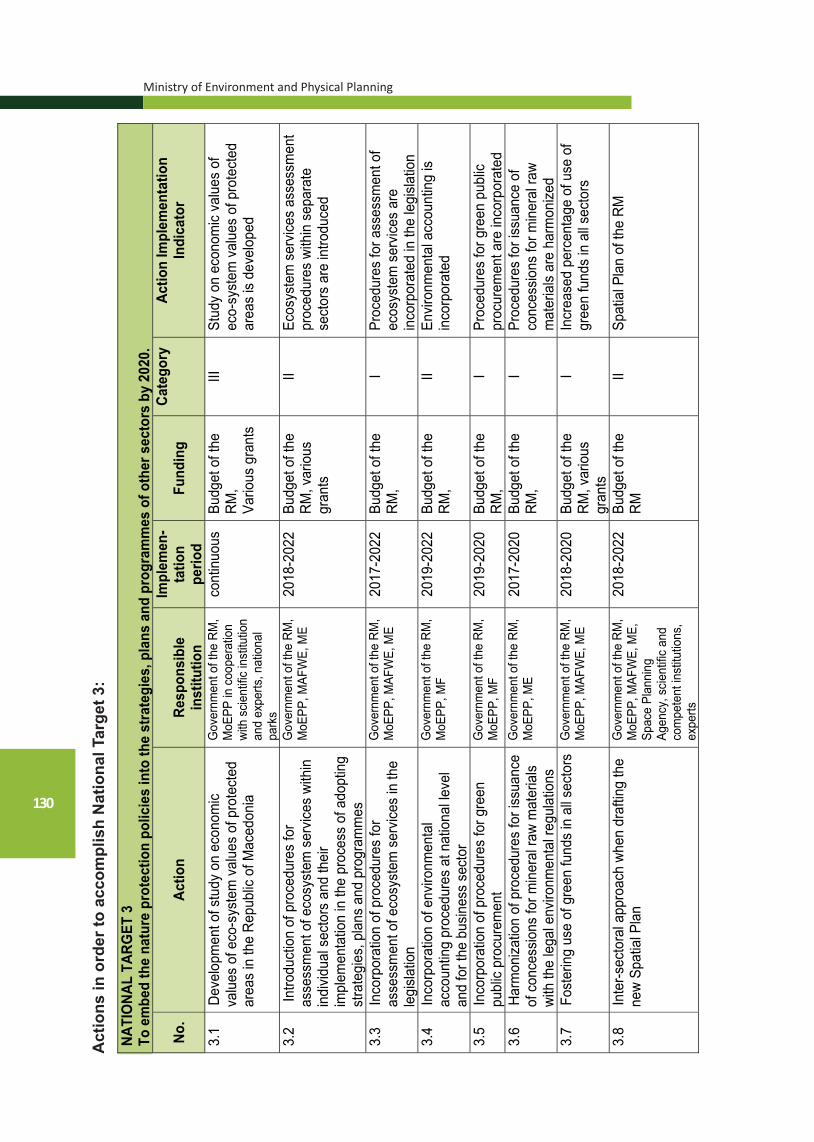
Ministry of Environment and Physical Planning
130
NA
TIO
NAL
TARG
ET 3
To
em
bed
the
natu
re p
rote
ctio
n po
licie
s in
to th
e st
rate
gies
, pla
ns a
nd p
rogr
amm
es o
f oth
er s
ecto
rs b
y 20
20.
No.
Actio
nRe
spon
sibl
ein
stitu
tion
Impl
emen
-ta
tion
perio
dFu
ndin
gCa
tego
ry
Actio
n Im
plem
enta
tion
Indi
cato
r
3.1
Deve
lopm
ent o
f stu
dy o
n ec
onom
ic va
lues
of e
co-s
yste
m v
alue
s of
pro
tect
ed
area
s in
the
Repu
blic
of M
aced
onia
Gov
ernm
ent o
f the
RM
, M
oEPP
in c
oope
ratio
n wi
th s
cient
ific in
stitu
tion
and
expe
rts, n
atio
nal
park
s
cont
inuo
us
Budg
et o
f the
RM
, Va
rious
gra
nts
III
Stud
y on
eco
nom
ic va
lues
of
eco-
syst
em v
alue
s of
pro
tect
ed
area
s is
deve
lope
d
3.2
Intro
duct
ion
of p
roce
dure
s fo
r as
sess
men
t of e
cosy
stem
ser
vices
with
in
indi
vidua
l sec
tors
and
thei
r im
plem
enta
tion
in th
e pr
oces
s of
ado
ptin
g st
rate
gies
, pla
ns a
nd p
rogr
amm
es
Gov
ernm
ent o
f the
RM
, M
oEPP
, MAF
WE,
ME
2018
-202
2 Bu
dget
of t
he
RM, v
ario
us
gran
ts
II Ec
osys
tem
ser
vices
ass
essm
ent
proc
edur
es w
ithin
sep
arat
e se
ctor
s ar
e in
trodu
ced
3.3
Inco
rpor
atio
n of
pro
cedu
res
for
asse
ssm
ent o
f eco
syst
em s
ervic
es in
the
legi
slatio
n
Gov
ernm
ent o
f the
RM
, M
oEPP
, MAF
WE,
ME
2017
-202
2 Bu
dget
of t
he
RM,
I Pr
oced
ures
for a
sses
smen
t of
ecos
yste
m s
ervic
es a
re
inco
rpor
ated
in th
e le
gisla
tion
3.4
In
corp
orat
ion
of e
nviro
nmen
tal
acco
untin
g pr
oced
ures
at n
atio
nal le
vel
and
for t
he b
usin
ess
sect
or
Gov
ernm
ent o
f the
RM
, M
oEPP
, MF
2019
-202
2 Bu
dget
of t
he
RM,
II En
viron
men
tal a
ccou
ntin
g is
inco
rpor
ated
3.5
Inco
rpor
atio
n of
pro
cedu
res
for g
reen
pu
blic
proc
urem
ent
Gov
ernm
ent o
f the
RM
, M
oEPP
, MF
2019
-202
0 Bu
dget
of t
he
RM,
I Pr
oced
ures
for g
reen
pub
lic
proc
urem
ent a
re in
corp
orat
ed
3.6
Harm
oniza
tion
of p
roce
dure
s fo
r iss
uanc
e of
con
cess
ions
for m
iner
al ra
w m
ater
ials
with
the
lega
l env
ironm
enta
l reg
ulat
ions
Gov
ernm
ent o
f the
RM
, M
oEPP
, ME
2017
-202
0 Bu
dget
of t
he
RM,
I Pr
oced
ures
for i
ssua
nce
of
conc
essio
ns fo
r min
eral
raw
mat
eria
ls ar
e ha
rmon
ized
3.7
Fo
ster
ing
use
of g
reen
fund
s in
all s
ecto
rsG
over
nmen
t of t
he R
M,
MoE
PP, M
AFW
E, M
E 20
18-2
020
Budg
et o
f the
RM
, var
ious
gr
ants
I In
crea
sed
perc
enta
ge o
f use
of
gree
n fu
nds
in a
ll sec
tors
3.8
Inte
r-sec
tora
l app
roac
h wh
en d
rafti
ng th
e ne
w Sp
atia
l Pla
n G
over
nmen
t of t
he R
M,
MoE
PP, M
AFW
E, M
E,
Spac
e Pl
anni
ng
Agen
cy, s
cient
ific a
nd
com
pete
nt in
stitu
tions
, ex
perts
2018
-202
2 Bu
dget
of t
he
RM
II Sp
atia
l Pla
n of
the
RM
Act
ions
in o
rder
to a
ccom
plis
h N
atio
nal T
arge
t 3:

National Strategy for Nature Protection
131
3.9
Esta
blish
men
t of p
rope
r env
ironm
enta
l impa
ct
asse
ssm
ent i
n th
e na
tiona
l legi
slatio
n in
ac
cord
ance
with
the
EU d
irect
ives
MoE
PP
2020
Bu
dget
of t
he
RM
I Pr
oper
env
ironm
enta
l impa
ct
asse
ssm
ent i
n ac
cord
ance
with
the
EU d
irect
ives
is es
tabl
ished
3.
10
Iden
tifica
tion
of o
ppor
tuni
ties
for d
evel
opm
ent
of a
ltern
ative
tour
ism a
nd it
s im
plem
enta
tion
in c
oncr
ete
area
s of
env
ironm
enta
l im
porta
nce
Gov
ernm
ent o
f the
RM
, MoE
PP, M
E,
Agen
cy fo
r Pro
mot
ion
and
Supp
ort o
f To
urism
, nat
iona
l pa
rks
2020
Bu
dget
of t
he
RM, v
ario
us
gran
ts
II O
ppor
tuni
ties
for d
evel
opm
ent o
f al
tern
ative
tour
ism a
re id
entif
ied
3.11
De
velo
pmen
t of s
tudy
on
rene
wabl
e en
ergy
so
urce
s an
d cu
mul
ative
env
ironm
enta
l effe
cts
Gov
ernm
ent o
f the
RM
, MoE
PP, M
E 20
20
Budg
et o
f the
RM
, var
ious
gr
ants
I St
udy
on re
newa
ble
ener
gy s
ourc
es
and
cum
ulat
ive e
nviro
nmen
tal
effe
cts
is de
velo
ped
3.12
Ha
rmon
izatio
n of
SEA
and
EIA
pro
cedu
res
rela
ted
to n
atur
e pr
otec
tion
with
EU
dire
ctive
s M
oEPP
20
20
Budg
et o
f the
RM
, I
SEA
and
EIA
proc
edur
es a
re
harm
onize
d 3.
13
Enco
urag
ing
the
use
of e
nviro
nmen
tally
-fri
endl
y so
lutio
ns in
ord
er to
redu
ce n
atur
al
disa
ster
s
Gov
ernm
ent o
f the
RM
, MoE
PP, M
AFW
E 20
17-2
020
Budg
et o
f the
RM
, var
ious
gr
ants
III
Use
of e
nviro
nmen
tally
-frie
ndly
solu
tions
in o
rder
to re
duce
nat
ural
di
sast
ers
3.14
Es
tabl
ishm
ent o
f par
tner
rela
tion
betw
een
the
gove
rnm
ent i
nstit
utio
ns, l
ocal
sel
f-go
vern
ance
, pla
nnin
g re
gion
s, n
on-
gove
rnm
enta
l org
aniza
tions
, eco
nom
y et
c. in
vie
w of
nat
ure
prot
ectio
n an
d co
nser
vatio
n
Gov
ernm
ent o
f the
RM
, MoE
PP, M
AFW
E,
mun
icipa
lities
, pl
anni
ng re
gion
s,
NGO
s
2020
Bu
dget
of t
he
RM, v
ario
us
gran
ts
II Pa
rtner
ship
s fo
r nat
ure
prot
ectio
n an
d co
nser
vatio
n ar
e es
tabl
ished
3.15
Ha
rmon
izatio
n of
fore
st e
cosy
stem
s m
anag
emen
t and
utili
zatio
n of
fore
st fr
uits
M
oEPP
, nat
iona
l pa
rks,
MAF
WE,
PE
Mac
edon
ian
Fore
sts
2017
-202
0 Bu
dget
of t
he
RM, v
ario
us
gran
ts
II Fo
rest
eco
syst
ems
man
agem
ent
and
utiliz
atio
n of
fore
st fr
uits
are
ha
rmon
ized
3.16
Cr
eatio
n of
a g
reen
lobb
y gr
oup
amon
g al
l st
akeh
olde
rs
Gov
ernm
ent o
f the
RM
, MoE
PP, p
rote
cted
ar
eas,
mun
icipa
lities
, NG
Os
2020
Bu
dget
of t
he
RM, v
ario
us
gran
ts
I G
reen
lobb
y gr
oup
is cr
eate
d
3.17
Es
tabl
ishm
ent o
f a n
atio
nal b
ody
to c
ontro
l th
e ex
ploi
tatio
n an
d qu
ality
of g
roun
d wa
ter i
n ar
eas
wher
e it
is in
tens
ively
used
for
agric
ultu
ral p
urpo
ses
Gov
ernm
ent o
f the
RM
, MoE
PP, M
AFW
E 20
20
Budg
et o
f the
RM
II
Natio
nal b
ody
to c
ontro
l the
ex
ploi
tatio
n an
d qu
ality
of g
roun
d wa
ter i
n ar
eas
wher
e it
is in
tens
ively
used
for a
gricu
ltura
l pur
pose
s is
esta
blish
ed
3.18
De
velo
pmen
t of m
easu
res
and
guid
elin
es
for d
evel
opm
ent o
f cav
e to
urism
G
over
nmen
t of t
he
RM, M
oEPP
, Age
ncy
for D
evel
opm
ent a
nd
Supp
ort o
f Tou
rism
2022
Bu
dget
of t
he
RM, v
ario
us
gran
ts
I M
easu
res
and
guid
elin
es a
re
deve
lope
d
Ministry of Environment and Physical Planning
132
3.19
In
tegr
atio
n of
the
conc
ept o
f lan
dsca
pe
into
the
polic
ies
for r
egio
nal a
nd u
rban
pl
anni
ng, s
ocia
l and
eco
nom
ic p
olic
ies,
cu
ltura
l, en
viro
nmen
tal,
agric
ultu
ral
polic
ies,
as
wel
l as
othe
r pol
icie
s w
hose
im
plem
enta
tion
may
dire
ctly
or i
ndire
ctly
im
pact
the
land
scap
e;
Gov
ernm
ent o
f the
R
M, M
oEP
P
2022
B
udge
t of t
he
RM
, II
Sec
tora
l lan
dsca
pe p
olic
ies
are
harm
oniz
ed
3.20
E
stab
lishm
ent o
f int
egra
ted
geog
raph
ic
info
rmat
ion
syst
em w
ith re
latio
nal
data
base
abo
ut o
bjec
ts a
nd p
heno
men
a of
nat
ure
cons
erva
tion
inte
rest
to b
e us
ed
by th
e co
mpe
tent
ser
vice
s an
d de
partm
ents
in s
tate
inst
itutio
ns, a
s w
ell
as p
ublic
pla
nnin
g an
d de
sign
or
gani
zatio
ns.
MoE
PP
, ME
, M
AFW
E, M
TC in
co
oper
atio
n w
ith
scie
ntifi
c in
stitu
tions
an
d ex
perts
2020
B
udge
t of t
he
RM
, var
ious
gr
ants
II G
eogr
aphi
c In
form
atio
n S
yste
m
is e
stab
lishe
d
3.21
In
tegr
atio
n of
Geo
grap
hic
Info
rmat
ion
Sys
tem
on
terr
itorie
s, o
bjec
ts a
nd
phen
omen
a of
nat
ure
cons
erva
tion
inte
rest
with
the
Geo
grap
hic
Info
rmat
ion
Sys
tem
on
anth
ropo
geni
c cu
ltura
l and
tra
ditio
nal h
erita
ge.
MoE
PP
, MC
in
coop
erat
ion
with
sc
ient
ific
inst
itutio
ns
and
expe
rts
2020
B
udge
t of t
he
RM
, var
ious
gr
ants
II G
IS is
inte
grat
ed

National Strategy for Nature Protection
133
NATIONAL TARGET 4“To establish and practice sustainable use of the geodiversity
and geoheritage and other components of nature (biological and landscape diversity) through the use of traditional knowledge, innovations, best practices and positive incentives related to conservation and sustainable use of the nature”
Improper use of natural resources often leads to their depletion and it poses a direct threat to their survival. The ecosystem approach in the utilization of natural resources is still insufficiently understood and accepted. Improper utilization of mineral resources leads to degradation of landscapes, destruction of natural habitats and wild species. Traditional agricultural practices are abandoned and improper practices are used, and herbicides, hormones and chemical substances are applied, while, in the forestry sector, illegal logging practices may be noticed. Also, improper gathering of medicinal herbs, fungi and animals often occurs.
Therefore, one of the priority issues to be solved is to eliminate such occurrences and to establish sustainable utilization of natural resources. In that context, in the recent years in Macedonia, various incentives through various forms of support have been provided for the agricultural sector.

Ministry of Environment and Physical Planning
134
NATI
ONA
L TA
RGET
4
“To
esta
blis
h an
d pr
actic
e su
stai
nabl
e us
e of
the
geod
iver
sity
and
geo
herit
age
and
othe
r co
mpo
nent
s of
nat
ure
(bio
logi
cal a
nd la
ndsc
ape
dive
rsity
) th
roug
h th
e us
e of
tra
ditio
nal
know
ledg
e, i
nnov
atio
ns,
best
pra
ctic
es a
nd p
ositi
ve i
ncen
tives
rel
ated
to
cons
erva
tion
and
sust
aina
ble
use
of th
e na
ture
”
No.
Actio
nRe
spon
sibl
e in
stitu
tion
Impl
emen
-ta
tion
perio
dFu
ndin
gCa
tego
ry
Actio
n Im
plem
enta
tion
Indi
cato
r
4.1
Sust
aina
ble
use
of n
atur
al re
sour
ces
4.1.
1 Id
entif
icat
ion
of a
reas
for E
urop
ean
and
Wor
ld G
eopa
rks
Net
wor
k M
oEPP
in c
oope
ratio
n w
ith
scie
ntific
inst
itutio
ns a
nd
expe
rts
2021
Bu
dget
of t
he
RM
, var
ious
do
natio
ns
I 2-
3 ar
eas
are
iden
tifie
d an
d ap
plic
atio
ns fo
r Eur
opea
n an
d W
orld
Geo
park
s N
etw
orks
, w
hich
are
bas
es fo
r geo
dive
rsity
co
nser
vatio
n an
d pr
omot
ion,
are
co
mpl
eted
4.
1.2
Incl
usio
n of
the
geoh
erita
ge in
to th
e to
uris
t offe
r of t
he R
epub
lic o
f M
aced
onia
and
pro
mot
ion
of th
e ge
otou
rism
MoE
PP in
coo
pera
tion
with
sc
ient
ific in
stitu
tions
and
ex
perts
2018
-202
5 Bu
dget
of t
he
RM
, var
ious
do
natio
ns
I Va
rious
form
s of
geo
tour
ism
are
de
velo
ped
and
prom
otes
, in
clud
ing
visi
ts to
attr
activ
e ge
o-si
tes,
ext
rem
e sp
orts
tour
ism
, sp
eleo
-tour
ism
, etc
. 4.
1.3
Setti
ng n
atio
nal q
uota
s fo
r su
stai
nabl
e ga
ther
ing
of w
ild p
lant
s sp
ecie
s, fu
ngi,
anim
als
and
com
mer
cial
ly s
igni
fican
t par
ts
ther
eof
MoE
PP in
coo
pera
tion
with
sc
ient
ific in
stitu
tions
and
ex
perts
2021
Bu
dget
of t
he
RM
, var
ious
do
natio
ns
II N
atio
nal q
uota
s fo
r sus
tain
able
ga
ther
ing
of w
ild p
lant
s sp
ecie
s,
fung
i, an
imal
s an
d co
mm
erci
ally
si
gnifi
cant
par
ts th
ereo
f, ar
e se
t
4.1.
4 Se
tting
quo
tas
for n
atio
nal a
nd
inte
rnat
iona
l tra
de w
ith w
ild p
lant
sp
ecie
s, fu
ngi a
nd c
omm
erci
ally
si
gnifi
cant
ani
mal
s
MoE
PP in
coo
pera
tion
with
sc
ient
ific in
stitu
tions
and
ex
perts
2017
-202
3 Bu
dget
of t
he
RM
, var
ious
do
natio
ns
I Q
uota
s fo
r nat
iona
l and
in
tern
atio
nal t
rade
with
wild
pl
ant s
peci
es, f
ungi
and
co
mm
erci
ally
sig
nific
ant a
nim
als
are
set
4.1.
5
Wild
life
harv
estin
g lic
ense
s
MoE
PP, M
AFW
E, n
atio
nal
park
s, P
E M
aced
onia
n Fo
rest
s, o
ther
ent
ities
m
anda
ted
to m
anag
e pr
otec
ted
area
s, w
ild
spec
ies
purc
hase
co
mpa
nies
2017
-201
9 Bu
dget
of t
he
RM
, var
ious
gr
ants
I N
umbe
r of i
ssue
d lic
ense
s
Act
ions
in o
rder
to a
ccom
plis
h N
atio
nal T
arge
t 4:

National Strategy for Nature Protection
135
4.1.
6 Su
ppor
t to
the
man
agem
ent o
f fo
rest
s of
hig
h bi
olog
ical
div
ersi
ty
MAF
WE,
MoE
PP, P
E M
aced
onia
n Fo
rest
s,
natio
nal p
arks
and
oth
er
prot
ecte
d ar
eas,
sci
entif
ic
inst
itutio
ns
2017
-201
9 Bu
dget
of t
he
RM
, var
ious
gr
ants
II M
anag
emen
t of f
ores
ts o
f hig
h bi
olog
ical
div
ersi
ty is
impr
oved
4.1.
7 Se
tting
quo
tas
for s
usta
inab
le u
se o
f fis
h st
ock
MAF
WE,
MoE
PP,
Hyd
robi
olog
ical
Inst
itute
in
Ohr
id
2017
-202
0 Bu
dget
of t
he
RM
, var
ious
gr
ants
I Q
uota
s fo
r sus
tain
able
use
of
fish
stoc
k ar
e se
t
4.1.
8 Se
tting
quo
tas
for s
usta
inab
le u
se o
f pa
stur
es
MoE
PP, M
AFW
E, n
atio
nal
park
s, P
E of
Pas
ture
M
anag
emen
t in
coop
erat
ion
with
sci
entif
ic
and
expe
rt in
stitu
tions
2017
-202
1 Bu
dget
of t
he
RM
, var
ious
do
natio
ns
I Q
uota
s fo
r sus
tain
able
use
of
past
ures
are
set
4.1.
9 U
pdat
ing
annu
al p
rogr
amm
es fo
r pr
otec
tion,
bre
edin
g an
d m
anag
emen
t of w
ildlif
e in
nat
iona
l pa
rks
MAF
WE,
MoE
PP, n
atio
nal
park
s, s
cien
tific
and
exp
ert
inst
itutio
ns, e
xper
ts
cont
inuo
us
Budg
et o
f the
R
M
I An
nual
pro
gram
mes
for
prot
ectio
n, b
reed
ing
and
man
agem
ent o
f wild
life
in
natio
nal p
arks
are
upd
ated
4.
1.1
0
Det
erm
inat
ion
of L
ist o
f are
as to
be
avoi
ded
whe
n op
enin
g m
ines
and
qu
arrie
s fo
r min
eral
reso
urce
s ex
ploi
tatio
n
MoE
PP, M
inis
try o
f Ec
onom
y, s
cien
tific
and
ex
pert
inst
itutio
ns, e
xper
ts
2017
-201
9 Bu
dget
of t
he
RM
, var
ious
do
natio
ns
I Li
st o
f are
as to
be
avoi
ded
whe
n op
enin
g m
ines
and
qu
arrie
s fo
r min
eral
reso
urce
s ex
ploi
tatio
n is
det
erm
ined
4.
2 Us
age
of tr
aditi
onal
kno
wle
dge,
inno
vatio
ns a
nd b
est p
ract
ices
4.
2.1
Tr
ansf
er o
f kno
wle
dge,
inno
vatio
ns
and
good
pra
ctic
es in
sus
tain
able
use
of
nat
ural
reso
urce
s (w
ater
, for
ests
, so
il, p
astu
res
and
min
eral
s)
MAF
WE,
MoE
PP, n
atio
nal
park
s, P
E M
aced
onia
n Fo
rest
s, P
E of
Pas
ture
s M
anag
emen
t, pr
otec
ted
area
s, s
cien
tific
and
exp
ert
inst
itutio
ns, e
xper
ts
cont
inuo
us
Budg
et o
f the
R
M, v
ario
us
dona
tions
II N
umbe
r of d
eliv
ered
trai
ning
s on
sus
tain
able
use
of n
atur
al
reso
urce
s (w
ater
, for
ests
, soi
l, pa
stur
es a
nd m
iner
als)
4.2.
2
Supp
ort t
o im
plem
enta
tion
of g
ood
agric
ultu
ral p
ract
ice
in a
reas
with
si
gnifi
cant
nat
ural
val
ues
MAF
WE,
MoE
PP, n
atio
nal
park
s, s
cien
tific
and
exp
ert
inst
itutio
ns, e
xper
ts
cont
inuo
us
Budg
et o
f the
R
M, v
ario
us
dona
tions
II Ac
tiviti
es fo
r im
plem
enta
tion
of
good
agr
icul
tura
l pra
ctic
e in
ar
eas
with
sig
nific
ant n
atur
al
valu
es a
re s
uppo
rted
4.2.
3 Tr
ansf
er o
f kno
wle
dge
and
inte
rnat
iona
l pra
ctic
es in
the
man
agem
ent a
nd s
usta
inab
le u
se o
f fo
rest
s
MAF
WE,
MoE
PP,
PE M
aced
onia
n Fo
rest
s,
natio
nal p
arks
, sci
entif
ic
and
expe
rt in
stitu
tions
, ex
perts
cont
inuo
us
Budg
et o
f the
R
M, v
ario
us
dona
tions
I N
umbe
r of d
eliv
ered
trai
ning
s fo
r tra
nsfe
r of k
now
ledg
e an
d in
tern
atio
nal p
ract
ices
in th
e m
anag
emen
t and
sus
tain
able
us
e of
fore
sts
4.1.
1.0

Ministry of Environment and Physical Planning
136
4.2.
4 Tr
ansf
er o
f kno
wle
dge
and
inte
rnat
iona
l pra
ctic
es in
the
land
scap
e m
anag
emen
t
MoE
PP
, Min
istry
of
Cul
ture
, sci
entif
ic a
nd
expe
rt in
stitu
tions
, exp
erts
cont
inuo
us
Bud
get o
f the
R
M, v
ario
us
dona
tions
I N
umbe
r of d
eliv
ered
trai
ning
s fo
r tra
nsfe
r of k
now
ledg
e an
d in
tern
atio
nal p
ract
ices
in th
e la
ndsc
ape
man
agem
ent
4.3.
Ince
ntiv
es fo
r sus
tain
able
use
of n
atur
e 4.
3.1
Intro
duct
ion
of in
cent
ives
for p
over
ty
redu
ctio
n th
roug
h su
stai
nabl
e us
e of
na
ture
and
pay
men
t of e
cosy
stem
se
rvic
es
MoE
PP
, MA
FWE
, nat
iona
l pa
rks,
oth
er e
ntiti
es
man
date
d to
man
age
prot
ecte
d ar
eas
2017
-202
3 B
udge
t of t
he
RM
, var
ious
do
natio
ns
II In
cent
ives
are
intro
duce
d N
umbe
r of i
ntro
duce
d m
easu
red
for p
aym
ent o
f eco
syst
em
serv
ices
4.
3.2
In
trodu
ctio
n of
agr
i-env
ironm
ent
mea
sure
s in
agr
icul
ture
M
AFW
E, M
oEP
P, f
arm
ers,
lo
cal p
opul
atio
n 20
18-2
022
Bud
get o
f the
R
M, v
ario
us
gran
ts, E
U
fund
s
III
Agr
i-env
ironm
ent m
easu
res
are
intro
duce
d
4.3.
3 E
ncou
ragi
ng s
usta
inab
le u
se o
f na
tura
l res
ourc
es a
nd c
reat
ion
of
gree
n jo
bs
Gov
ernm
ent o
f the
RM
, M
oEP
P, M
AFW
E
2020
B
udge
t of t
he
RM
, var
ious
gr
ants
II S
usta
inab
le u
se o
f nat
ural
re
sour
ces
and
crea
tion
of g
reen
jo
bs
4.3.
4 E
ncou
ragi
ng tr
aditi
onal
use
of
biod
iver
sity
M
AFW
E, M
oEP
P, f
arm
ers,
lo
cal p
opul
atio
n co
ntin
uous
B
udge
t of t
he
RM
, var
ious
gr
ants
, EU
fu
nds
II Tr
aditi
onal
use
of b
iodi
vers
ity
4.3.
5 E
ncou
ragi
ng m
easu
res
for
mai
nten
ance
and
impr
ovem
ent o
f en
viro
nmen
tal v
alue
s of
rura
l la
ndsc
apes
MoE
PP
, MA
FWE
, Fe
dera
tion
of F
arm
ers,
fa
rmer
s
2018
-202
3 B
udge
t of t
he
RM
, var
ious
gr
ants
, EU
fu
nds
II M
easu
res
for m
aint
enan
ce a
nd
impr
ovem
ent o
f env
ironm
enta
l va
lues
of r
ural
land
scap
es a
re
intro
duce
d

National Strategy for Nature Protection
137
NATIONAL TARGET 5„To improve the legislation framework in accordance with the EU
legislation and relevant ratified international treaties for nature protection and to provide adequate institutional framework by strengthening the administrative capacities”
In order to provide integral protection and conservation of the geodiversity, geoheritage, biological and landscape diversity, it is important to enhance the national legislation on nature protection and to systematically strengthen capacities at central and local level. Undertaking concrete actions is a priority in view of provision of long-term nature protection and conservation.
National Target 5 contains actions whose implementation will result in more efficient implementation of the national legislation on nature protection, its harmonization to EU acquis in the area of nature protection and adoption of the most important strategic documents.
Moreover, National Target 5 contains actions aimed at establishment of a new national competent body for nature protection, nature protection fund, as well as strengthening the MoEPP’s capacities, other ministries, agencies, public enterprises, national parks and other entities mandated to manage protected areas, self-government units, non-governmental organizations and civil society organization and local population.
This Target also contains actions on strengthening the capacities of existing bodies, as well as establishment of new committees/bodies on nature protection related issues.

Ministry of Environment and Physical Planning
138
NA
TIO
NA
L TA
RG
ET 5
“T
o im
prov
e th
e le
gisl
atio
n fr
amew
ork
in a
ccor
danc
e w
ith t
he E
U le
gisl
atio
n an
d re
leva
nt r
atifi
ed in
tern
atio
nal t
reat
ies
for
natu
re p
rote
ctio
n an
d to
pro
vide
ade
quat
e in
stitu
tiona
l fra
mew
ork
by s
tren
gthe
ning
the
adm
inis
trat
ive
capa
citie
s”
No.
Act
ion
Res
pons
ible
inst
itutio
nIm
plem
en-
tatio
npe
riod
Fund
ing
Cat
egor
y A
ctio
n Im
plem
enta
tion
Indi
cato
r
5.1
Prom
otio
n of
nat
iona
l leg
isla
tion
5.
1.1
Adop
tion
of n
ew N
atur
e Pr
otec
tion
Law
, har
mon
ized
with
EU
acq
uis
in
the
area
of n
atur
e pr
otec
tion
and
adop
ted
conv
entio
ns, a
s w
ell a
s w
ith
the
prov
isio
ns o
f the
Eur
opea
n La
ndsc
ape
Con
vent
ion
Asse
mbl
y of
the
RM
, G
over
nmen
t of t
he R
M,
MoE
PP in
coo
pera
tion
with
sci
entif
ic in
stitu
tion
and
expe
rts
201
7 Bu
dget
of t
he
RM
, va
rious
gra
nts
/ N
ew N
atur
e Pr
otec
tion
Law
is
adop
ted
5.1.
2 Ad
optio
n of
spe
cial
Law
on
Prot
ectio
n of
Kar
sts
and
Cav
es
Asse
mbl
y of
the
RM
, G
over
nmen
t of t
he R
M,
MoE
PP in
coo
pera
tion
with
sci
entif
ic in
stitu
tion
and
expe
rts
2018
Bu
dget
of t
he
RM
, var
ious
gr
ants
I Sp
ecia
l Law
on
Prot
ectio
n of
Ka
rsts
and
Cav
es is
ado
pted
5.1.
3 Ad
optio
n of
law
s fo
r des
igna
tion
of
prot
ecte
d ar
eas
Asse
mbl
y of
the
RM
, G
over
nmen
t of t
he R
M,
MoE
PP in
coo
pera
tion
with
sci
entif
ic in
stitu
tion
and
expe
rts
cont
inuo
us
Budg
et o
f the
R
M, v
ario
us
gran
ts
/ N
umbe
r of a
dopt
ed la
ws
for
desi
gnat
ion
of p
rote
cted
are
as
5.1.
4 Ad
optio
n of
by-
law
s fo
r pro
tect
ion
and
sust
aina
ble
man
agem
ent o
f ge
odiv
ersi
ty, g
eohe
ritag
e, b
iolo
gica
l an
d la
ndsc
ape
dive
rsity
Gov
ernm
ent o
f the
RM
, M
oEPP
in c
oope
ratio
n w
ith s
cien
tific
inst
itutio
n an
d ex
perts
cont
inuo
us
Budg
et o
f the
R
M, v
ario
us
gran
ts
/ N
umbe
r of a
dopt
ed b
y-la
ws
5.1.
5 Ad
optio
n of
act
s fo
r des
igna
tion
of
certa
in p
arts
of n
atur
e as
nat
ural
ra
ritie
s
MoE
PP in
coo
pera
tion
with
sci
entif
ic in
stitu
tions
an
d ex
perts
cont
inuo
us
Budg
et o
f the
R
M, v
ario
us
gran
ts
/ N
umbe
r of a
dopt
ed a
cts
for
desi
gnat
ion
of c
erta
in p
arts
of
natu
re a
s na
tura
l rar
ities
5.
1.6
Har
mon
izat
ion
of n
atio
nal l
egis
latio
n of
fore
stry
, pas
ture
s, a
gric
ultu
re,
hunt
ing,
fish
ery
and
aqua
cultu
re, u
se
of m
iner
al re
sour
ces
and
prot
ectio
n of
cul
tura
l her
itage
with
the
natu
re
prot
ectio
n le
gisl
atio
n
MoE
PP in
coo
pera
tion
with
Min
istry
of
Agric
ultu
re, F
ores
try a
nd
Wat
er E
cono
my,
M
inis
try o
f Eco
nom
y an
d M
inis
try o
f Cul
ture
2017
-201
8 Bu
dget
of t
he
RM
, var
ious
gr
ants
I N
atio
nal l
egis
latio
n fro
m o
ther
se
ctor
s is
har
mon
ized
with
nat
ure
prot
ectio
n le
gisl
atio
n N
umbe
r of a
dopt
ed a
nd a
men
ded
law
s an
d by
law
s
5.1.
7 Ad
optio
n of
Nat
iona
l Bio
dive
rsity
St
rate
gy w
ith A
ctio
n Pl
an
Gov
ernm
ent o
f the
RM
, M
oEPP
in c
oope
ratio
n w
ith s
cien
tific
inst
itutio
n an
d ex
perts
2017
Bu
dget
of t
he
RM
, var
ious
gr
ants
/ N
atio
nal B
iodi
vers
ity S
trate
gy w
ith
Actio
n Pl
an is
ado
pted
Act
ions
in o
rder
to a
ccom
plis
h N
atio
nal T
arge
t 5:

National Strategy for Nature Protection
139
5.1.
8 Ad
optio
n of
Nat
iona
l Stra
tegy
for
Geo
dive
rsity
Pro
tect
ion
with
Act
ion
Plan
Gov
ernm
ent o
f the
RM
, M
oEPP
in c
oope
ratio
n w
ith
scie
ntifi
c in
stitu
tion
and
expe
rts
2022
Bu
dget
of t
he
RM
, var
ious
gr
ants
I N
atio
nal S
trate
gy fo
r Geo
dive
rsity
Pr
otec
tion
with
Act
ion
Plan
is
adop
ted
5.1.
9 Ad
optio
n of
Nat
iona
l Stra
tegy
for K
arst
Pr
otec
tion
with
Act
ion
Plan
G
over
nmen
t of t
he R
M,
MoE
PP in
coo
pera
tion
with
sc
ient
ific
inst
itutio
n an
d ex
perts
2023
Bu
dget
of t
he
RM
, var
ious
gr
ants
I N
atio
nal S
trate
gy fo
r Kar
st
Prot
ectio
n w
ith A
ctio
n Pl
an is
ad
opte
d
5.1.
10
Adop
tion
of n
atio
nal r
ed li
sts
G
over
nmen
t of t
he R
M,
MoE
PP in
coo
pera
tion
with
sc
ient
ific
inst
itutio
n an
d ex
perts
2024
Bu
dget
of t
he
RM
, va
rious
do
natio
ns
/ N
umbe
r of a
dopt
ed n
atio
nal r
ed
lists
5.1.
11
Adop
tion
of n
atio
nal r
ed b
ooks
Gov
ernm
ent o
f the
RM
, M
oEPP
in c
oope
ratio
n w
ith
scie
ntifi
c in
stitu
tion
and
expe
rts
2024
Bu
dget
of t
he
RM
, va
rious
do
natio
ns
/ N
umbe
r of a
dopt
ed n
atio
nal r
ed
book
s
5.1.
12
Adop
tion
of p
rote
cted
are
as
man
agem
ent p
lans
MoE
PP in
coo
pera
tion
with
ot
her e
ntiti
es m
anda
ted
to
man
age
prot
ecte
d ar
eas,
sc
ient
ific
inst
itutio
ns a
nd
expe
rt
cont
inuo
us
Budg
et o
f the
R
M,
vario
us
dona
tions
/ N
umbe
r of p
rote
cted
are
as
man
agem
ent p
lans
5.1.
13
Adop
tion
of n
ew S
patia
l Pla
n of
the
Rep
ublic
of M
aced
onia
Asse
mbl
y of
the
RM
, G
over
nmen
t of t
he R
M,
MoE
PP in
coo
pera
tion
with
sc
ient
ific
inst
itutio
n an
d ex
perts
, Spa
ce P
lann
ing
Agen
cy
2020
-202
1 Bu
dget
of t
he
RM
, va
rious
do
natio
ns
I Sp
atia
l Pla
n of
the
RM
is a
dopt
ed
5.1.
14
Adop
tion
of s
patia
l pla
ns fo
r all
plan
ning
regi
ons
Asse
mbl
y of
the
RM
, G
over
nmen
t of t
he R
M,
loca
l sel
f-gov
ernm
ent u
nits
fro
m p
lann
ing
regi
ons,
M
oEPP
in c
oope
ratio
n w
ith
scie
ntifi
c in
stitu
tion
and
expe
rts, S
pace
Pla
nnin
g Ag
ency
2017
-202
2 Bu
dget
of t
he
RM
, var
ious
do
natio
ns
/ Sp
atia
l pla
ns fo
r all
plan
ning
re
gion
s ar
e ad
opte
d
5.1.
15
Adop
tion
of s
patia
l pla
ns fo
r Pel
iste
r, G
alilc
hica
and
Mav
rovo
nat
iona
l par
ks
Asse
mbl
y of
the
RM
, G
over
nmen
t of t
he R
M,
MoE
PP in
coo
pera
tion
with
sc
ient
ific
inst
itutio
n an
d ex
perts
2017
-202
0 Bu
dget
of t
he
RM
, var
ious
do
natio
ns
/ Th
ree
spat
ial p
lans
for t
he n
atio
nal
park
s ar
e ad
opte
d
5.1.
16
Adop
tion
of N
atio
nal E
colo
gica
l N
etw
ork
Gov
ernm
ent o
f the
RM
, M
AFW
E, M
oEPP
, ME,
M
TC
2017
-202
0 Bu
dget
of t
he
RM
, I
Nat
iona
l Eco
logi
cal N
etw
ork
is
adop
ted
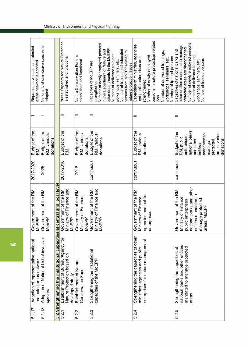
Ministry of Environment and Physical Planning
140
5.1.
17
Adop
tion
of re
pres
enta
tive
natio
nal
prot
ecte
d ar
eas
netw
ork
Gov
ernm
ent o
f the
RM
, M
oEPP
20
17-2
020
Budg
et o
f the
R
M,
I R
epre
sent
ativ
e na
tiona
l pro
tect
ed
area
s ne
twor
k is
ado
pted
5.
1.18
Ad
optio
n of
Nat
iona
l Lis
t of i
nvas
ive
spec
ies
Gov
ernm
ent o
f the
RM
, M
oEPP
20
25
Budg
et o
f the
R
M, v
ario
us
dona
tions
I N
atio
nal L
ist o
f inv
asiv
e sp
ecie
s is
ad
opte
d
5.2
Stre
ngth
enin
g th
e in
stitu
tiona
l cap
aciti
es a
t cen
tral
and
loca
l lev
el
5.2.
1
Esta
blis
hmen
t of B
urea
u/Ag
ency
for
Nat
ure
Prot
ectio
n ba
sed
on
deve
lope
d st
udy
Gov
ernm
ent o
f the
RM
, M
inis
try o
f Fin
ance
and
M
oEPP
2017
-201
8 Bu
dget
of t
he
RM
, III
Bu
reau
/Age
ncy
for N
atur
e Pr
otec
tion
is e
stab
lishe
d an
d fu
nctio
nal
5.2.
2 Es
tabl
ishm
ent o
f Nat
ure
Con
serv
atio
n Fu
nd
Gov
ernm
ent o
f the
RM
, M
inis
try o
f Fin
ance
, M
oEPP
2018
Bu
dget
of t
he
RM
, var
ious
do
natio
ns
III
Nat
ure
Con
serv
atio
n Fu
nd is
es
tabl
ishe
d an
d fu
nctio
nal
5.2.
3 St
reng
then
ing
the
inst
itutio
nal
capa
citie
s of
the
MoE
PP
Gov
ernm
ent o
f the
RM
, M
inis
try o
f Fin
ance
and
M
oEPP
cont
inuo
us
Budg
et o
f the
R
M, v
ario
us
dona
tions
III
Cap
aciti
es o
f MoE
PP a
re
stre
ngth
ened
N
umbe
r of n
ewly
em
ploy
ed p
erso
ns
in th
e D
epar
tmen
t of N
atur
e an
d ot
her d
epar
tmen
ts in
the
MoE
PP
Num
ber o
f del
iver
ed tr
aini
ngs,
w
orks
hops
, sem
inar
s, e
tc.
Num
ber o
f tra
ined
and
edu
cate
d pe
rson
s fro
m M
oEPP
rela
ted
to
natu
re p
rote
ctio
n is
sues
5.
2.4
Stre
ngth
enin
g th
e ca
paci
ties
of o
ther
m
inis
tries
, age
ncie
s an
d pu
blic
en
terp
rises
for n
atur
e m
anag
emen
t
Gov
ernm
ent o
f the
RM
, M
inis
try o
f Fin
ance
, ag
enci
es a
nd p
ublic
en
terp
rises
cont
inuo
us
Budg
et o
f the
R
M, v
ario
us
dona
tions
II C
apac
ities
of m
inis
tries
, age
ncie
s an
d pu
blic
ent
erpr
ises
are
st
reng
then
ed
Num
ber o
f new
ly e
mpl
oyed
pe
rson
s in
nat
ure
prot
ectio
n re
late
d jo
bs
Num
ber o
f del
iver
ed tr
aini
ngs,
w
orks
hops
, sem
inar
s, e
tc.
Num
ber o
f tra
ined
per
sons
5.
2.5
St
reng
then
ing
the
capa
citie
s of
na
tiona
l par
ks a
nd o
ther
ent
ities
m
anda
ted
to m
anag
e pr
otec
ted
area
s
Gov
ernm
ent o
f the
RM
, M
inis
try o
f Fin
ance
, pu
blic
ent
erpr
ises
na
tiona
l par
ks a
nd o
ther
en
titie
s m
anda
ted
to
man
age
prot
ecte
d ar
eas,
MoE
PP
cont
inuo
us
Budg
et o
f the
R
M, p
ublic
en
terp
rises
na
tiona
l par
ks
and
othe
r en
titie
s m
anda
ted
to
man
age
prot
ecte
d ar
eas,
var
ious
do
natio
ns
II C
apac
ities
of n
atio
nal p
arks
and
ot
her e
ntiti
es m
anda
ted
to m
anag
e pr
otec
ted
area
s ar
e st
reng
then
ed
Num
ber o
f new
ly e
mpl
oyed
per
sons
N
umbe
r of d
eliv
ered
trai
ning
s,
wor
ksho
ps, s
emin
ars,
etc
. N
umbe
r of t
rain
ed p
erso
ns

National Strategy for Nature Protection
141
5.2.
6
Stre
ngth
enin
g th
e ca
paci
ties
of
scie
ntifi
c an
d ex
pert
inst
itutio
ns
wor
king
in th
e fie
ld o
f nat
ure
expl
orat
ion,
stu
dy a
nd p
rote
ctio
n
Gov
ernm
ent o
f the
RM
, M
inis
try o
f Fin
ance
, M
inis
try o
f Edu
catio
n,
scie
ntifi
c an
d ex
pert
inst
itutio
ns
cont
inuo
us
Budg
et o
f the
R
M, B
udge
t of
sci
entif
ic
and
expe
rt in
stitu
tions
, va
rious
do
natio
ns
III
Cap
aciti
es o
f sci
entif
ic a
nd e
xper
t in
stitu
tions
are
stre
ngth
ened
N
umbe
r of n
ewly
em
ploy
ed
pers
ons
Num
ber o
f del
iver
ed tr
aini
ngs,
w
orks
hops
, sem
inar
s, e
tc.
Num
ber o
f tra
ined
per
sons
5.
2.7
St
reng
then
ing
the
capa
citie
s of
non
-go
vern
men
tal o
rgan
izat
ions
, civ
il so
ciet
y or
gani
zatio
ns a
nd lo
cal
popu
latio
n
Non
-gov
ernm
enta
l or
gani
zatio
ns, c
ivil
soci
ety
orga
niza
tions
an
d lo
cal p
opul
atio
n
cont
inuo
us
Budg
et o
f the
R
M, v
ario
us
dona
tions
II C
apac
ities
of n
on-g
over
nmen
tal
orga
niza
tions
, civ
il so
ciet
y or
gani
zatio
ns a
nd lo
cal p
opul
atio
n ar
e st
reng
then
ed
Num
ber o
f del
iver
ed tr
aini
ngs,
w
orks
hops
, sem
inar
s, e
tc.
Num
ber o
f tra
ined
per
sons
5.
2.8
Es
tabl
ishm
ent o
f nat
ure
prot
ectio
n de
partm
ents
with
in th
e un
its o
f loc
al
self-
gove
rnm
ent u
nits
(ULS
G)
Gov
ernm
ent o
f the
RM
, M
inis
try o
f Fin
ance
and
U
LSG
2017
-202
0 Bu
dget
of t
he
RM
, bud
get o
f U
LSG
III
Nat
ure
prot
ectio
n de
partm
ents
w
ithin
the
units
of l
ocal
sel
f-go
vern
men
t (U
LSG
) are
es
tabl
ishe
d.
5.2.
9
Stre
ngth
enin
g th
e na
ture
pro
tect
ion
capa
citie
s of
uni
ts o
f loc
al s
elf-
gove
rnm
ent (
ULS
G)
Gov
ernm
ent o
f the
RM
, M
inis
try o
f Fin
ance
, U
LSG
, Ass
ocia
tion
of
units
of l
ocal
sel
f-go
vern
men
t
cont
inuo
us
Budg
et o
f the
R
M, b
udge
t of
the
ULS
G
vario
us
dona
tions
II N
atur
e pr
otec
tion
capa
citie
s of
un
its o
f loc
al s
elf-g
over
nmen
t (U
LSG
) are
stre
ngth
ened
N
umbe
r of n
ewly
em
ploy
ed
pers
ons
in n
atur
e pr
otec
tion
rela
ted
jobs
N
umbe
r of d
eliv
ered
trai
ning
s,
wor
ksho
ps, s
emin
ars,
etc
. N
umbe
r of t
rain
ed p
erso
ns
5.2.
10
Prov
isio
n of
ope
rabi
lity
and
func
tiona
lity
of th
e N
atio
nal C
ounc
il fo
r Nat
ure
Prot
ectio
n
MoE
PP in
coo
pera
tion
with
sci
entif
ic in
stitu
tions
an
d ex
perts
cont
inuo
us
Budg
et o
f the
R
M, v
ario
us
dona
tions
I N
atio
nal C
ounc
il fo
r Nat
ure
Prot
ectio
n is
ope
ratio
nal a
nd
func
tiona
l N
umbe
r of i
ssue
d op
inio
ns
rela
ted
to v
ario
us n
atur
e pr
otec
tion
issu
es
5.2.
11
Prov
isio
n of
ope
rabi
lity
and
func
tiona
lity
of th
e N
atio
nal
Com
mitt
ee fo
r Bio
logi
cal D
iver
sity
MoE
PP in
coo
pera
tion
with
MAS
A, s
cien
tific
in
stitu
tions
and
exp
erts
cont
inuo
us
Budg
et o
f the
R
M, v
ario
us
dona
tions
I N
atio
nal C
omm
ittee
for B
iolo
gica
l D
iver
sity
is o
pera
tiona
l and
fu
nctio
nal
Num
ber o
f iss
ued
opin
ions
re
late
d to
var
ious
bio
dive
rsity
pr
otec
tion
issu
es
Num
ber o
f dev
elop
ed n
atio
nal
and
them
atic
pap
ers

Ministry of Environment and Physical Planning
142
5.2.
12
Prov
isio
n of
ope
rabi
lity
and
func
tiona
lity
of n
atio
nal c
omm
ittee
s fo
r rat
ified
inte
rnat
iona
l bio
dive
rsity
-re
late
d tre
atie
s
MoE
PP in
coo
pera
tion
with
sci
entif
ic in
stitu
tions
an
d ex
perts
cont
inuo
us
Budg
et o
f the
R
M, v
ario
us
dona
tions
I N
atio
nal c
omm
ittee
s fo
r rat
ified
in
tern
atio
nal b
iodi
vers
ity-re
late
d tre
atie
s (R
amsa
r, Be
rn, B
onn
Con
vent
ion,
UN
ESC
O, e
tc.)
are
esta
blis
hed
Num
ber o
f iss
ued
opin
ions
rela
ted
to
vario
us b
iodi
vers
ity p
rote
ctio
n is
sues
N
umbe
r of d
evel
oped
nat
iona
l and
th
emat
ic p
aper
s 5.
2.13
Es
tabl
ishm
ent a
nd o
pera
bilit
y N
atio
nal G
eodi
vers
ity C
omm
ittee
M
oEPP
in c
oope
ratio
n w
ith s
cien
tific
inst
itutio
ns
and
expe
rts
cont
inuo
us
Budg
et o
f the
R
M, v
ario
us
dona
tions
I N
atio
nal G
eodi
vers
ity C
omm
ittee
is
esta
blis
hed
and
oper
atio
nal
Num
ber o
f iss
ued
opin
ions
rela
ted
to v
ario
us g
eodi
vers
ity p
rote
ctio
n is
sues
N
umbe
r of d
evel
oped
repo
rts
5.2.
14
Esta
blis
hmen
t of N
atio
nal E
xper
t C
ounc
il fo
r Pro
tect
ion
of K
arst
and
Ka
rst P
heno
men
a
MoE
PP in
coo
pera
tion
with
sci
entif
ic in
stitu
tions
an
d ex
perts
cont
inuo
us
Budg
et o
f the
R
M, v
ario
us
dona
tions
I N
atio
nal E
xper
t Cou
ncil
for
Prot
ectio
n of
Kar
st a
nd K
arst
Ph
enom
ena
is e
stab
lishe
d an
d op
erat
iona
l N
umbe
r of i
ssue
d op
inio
ns re
late
d to
var
ious
issu
es o
n pr
otec
tion
of
kars
t and
kar
st p
heno
men
a 5.
2.15
Es
tabl
ishm
ent o
f a n
atio
nal b
ody
to
cont
rol t
he e
xplo
itatio
n an
d qu
ality
of
grou
nd o
f wat
er in
are
as w
here
it is
in
tens
ivel
y us
ed fo
r agr
icul
tura
l pu
rpos
es
MoE
PP in
coo
pera
tion
with
sci
entif
ic in
stitu
tions
an
d ex
perts
cont
inuo
us
Budg
et o
f the
R
M,
I N
atio
nal b
ody
to c
ontro
l the
ex
ploi
tatio
n an
d qu
ality
of g
roun
d of
w
ater
is e
stab
lishe
d an
d op
erat
iona
l N
umbe
r of i
ssue
d op
inio
ns re
late
d to
var
ious
issu
es o
n th
e co
ntro
l of
expl
oita
tion
and
qual
ity o
f gro
und
wat
er
5.2.
16
Stre
ngth
enin
g th
e ca
paci
ties
of th
e G
eolo
gica
l Sur
vey
of th
e R
epub
lic o
f M
aced
onia
Gov
ernm
ent o
f the
RM
, M
inis
try o
f Fin
ance
co
ntin
uous
Bu
dget
of t
he
RM
II
Geo
logi
cal S
urve
y of
the
Rep
ublic
of
Mac
edon
ia is
func
tiona
l N
umbe
r of n
ewly
em
ploy
ed
pers
ons
Num
ber o
f del
iver
ed tr
aini
ngs,
w
orks
hops
, sem
inar
s, e
tc.
Num
ber o
f tra
ined
per
sons
N
umbe
r of d
evel
oped
exp
ert
stud
ies,
repo
rts e
tc.
Geo
logy
rela
ted
pape
rs
Num
ber o
f iss
ued
opin
ions
rela
ted
to v
ario
us g
eolo
gy is
sues

National Strategy for Nature Protection
143
5.2.
17
Func
tiona
l Cou
ncils
for m
anag
emen
t of
rive
r wat
ersh
eds
of V
arda
r, Br
egal
nica
, Stru
mic
a an
d C
rn D
im
river
s
Gov
ernm
ent o
f the
RM
, M
inis
try o
f Fin
ance
co
ntin
uous
Bu
dget
of t
he
RM
, I
Esta
blis
hmen
t of C
ounc
ils fo
r m
anag
emen
t of r
iver
wat
ersh
eds
of V
arda
r, Br
egal
nica
, Stru
mic
a an
d C
rn D
im ri
vers
N
umbe
r of h
eld
and
adop
ted
deci
sion
s 5.
2.18
C
onst
ruct
ion
of a
Cen
tre fo
r ge
odiv
ersi
ty/g
eohe
ritag
e w
ithin
the
Mus
eum
of N
atur
al H
isto
ry
Gov
ernm
ent o
f the
RM
in
coop
erat
ion
with
sci
entif
ic
inst
itutio
n an
d ex
perts
2020
Bu
dget
of t
he
RM
, var
ious
do
natio
ns
II C
entre
for
geod
iver
sity
/geo
herit
age
is
cons
truct
ed
5.2.
19
Esta
blis
hmen
t of a
bod
y to
che
ck,
proc
ess
and
diss
emin
ate
info
rmat
ion
in re
al-ti
me
at n
atio
nal a
nd
inte
rnat
iona
l lev
el (W
orld
M
eteo
rolo
gica
l Org
aniz
atio
n –W
MO
, H
ydro
logy
and
Wat
er R
esou
rces
Pr
ogra
mm
e –
HW
RP)
.
Gov
ernm
ent o
f the
RM
, M
oEPP
20
22
Budg
et o
f the
R
M,
I C
oord
inat
ive
body
is e
stab
lishe
d
5.2.
20
Incr
ease
the
incl
usio
n of
loca
l co
mm
uniti
es a
nd s
take
hold
ers
in th
e pr
otec
ted
area
s m
anag
emen
t
MoE
PP, n
atio
nal p
arks
, lo
cal c
omm
uniti
es, o
ther
en
titie
s m
anda
ted
to
man
age
prot
ecte
d ar
eas,
N
GO
s
cont
inuo
us
Budg
et o
f the
R
M, v
ario
us
dona
tions
I In
clus
ion
of lo
cal c
omm
uniti
es
and
stak
ehol
ders
in th
e m
anag
emen
t of p
rote
cted
are
as
is in
crea
sed
5.2.
21
Inte
nsify
coo
pera
tion
with
in
tern
atio
nal i
nstit
utio
ns a
nd
orga
niza
tions
wor
king
in th
e fie
ld o
f na
ture
pro
tect
ion
(ЕЕА
, sec
reta
riats
of
con
vent
ions
, IU
CN
, WW
F, W
DPA
, U
NEP
, UN
DP,
SD
C, G
EF, e
tc.)
MoE
PP, n
atio
nal p
arks
, lo
cal c
omm
unity
, oth
er
entit
ies
man
date
d to
m
anag
e pr
otec
ted
area
s,
NG
Os
cont
inuo
us
Budg
et o
f the
R
M, v
ario
us
dona
tions
II C
oope
ratio
n is
inte
nsifi
ed
5.2.
22
Dev
elop
men
t of t
rain
ing
plan
for
stre
ngth
enin
g ad
min
istra
tive
capa
citie
s re
quire
d fo
r Nat
ura
2000
im
plem
enta
tion
MoE
PP, i
nter
natio
nal a
nd
natio
nal e
xper
ts
2017
Bu
dget
of t
he
RM
, var
ious
gr
ants
, IPA
fu
nds
I Tr
aini
ng p
lan
is d
evel
oped
5.2.
23
Impl
emen
tatio
n of
long
-term
trai
ning
pl
an o
n N
atur
a 20
00 in
tend
ed fo
r st
akeh
olde
rs
MoE
PP, n
atio
nal p
arks
, ot
her e
ntiti
es m
anda
ted
to
man
age
prot
ecte
d ar
eas,
m
unic
ipal
ities
, MAF
WE,
M
TC, M
E, M
C, a
genc
ies
and
publ
ic e
nter
pris
es,
scie
ntifi
c an
d ex
pert
inst
itutio
ns, A
D E
lem
, M
EPSO
, EVN
, NG
Os,
and
C
SOs,
bus
ines
s se
ctor
cont
inuo
us
Budg
et o
f the
R
M, v
ario
us
gran
ts, I
PA
fund
s
I Lo
ng-te
rm tr
aini
ng p
lan
on N
atur
a 20
00 in
tend
ed fo
r sta
keho
lder
s is
im
plem
ente
d

Ministry of Environment and Physical Planning
144
NATIONAL TARGET 6. “To raise the level of information, education and promotion of
the value of the geodiversity and geoheritage and other components of nature (biological and landscape diversity)”
The main goal is to improve the level of information, education and promotion of values, of conducting exploration activities, as well as to raise the public awareness in the country, in order to include target groups at national and local level and to raise the awareness on nature protection related issues. Detailed actions in the Action Plan will enable MoEPP to improve communications and to conduct serious of targeted, tailored communication activities to raise the public awareness level on nature protection among the key target groups, and to encourage further activities initiated by various stakeholders. Joint activities with other sectors (in particular, the tourism sector) will contribute to promotion and rising of public awareness of the values of the geodiversity and geoheritage and other components of nature (biological and landscape diversity).

National Strategy for Nature Protection
145
Act
ions
in o
rder
to a
ccom
plis
h N
atio
nal T
arge
t 6:
NA
TIO
NA
L TA
RG
ET 6
. To
rai
se th
e le
vel o
f inf
orm
atio
n, e
duca
tion
and
prom
otio
n of
the
valu
e of
the
geod
iver
sity
and
geo
herit
age
and
othe
r co
mpo
nent
s of
nat
ure
(bio
logi
cal a
nd la
ndsc
ape
dive
rsity
).
No.
Act
ion
Res
pons
ible
inst
itutio
n Im
plem
en-
tatio
npe
riod
Fund
ing
Cat
egor
yA
ctio
n Im
plem
enta
tion
Indi
cato
r
6.1
Educ
atio
n an
d pr
omot
ion
of n
atur
e pr
otec
tion
6.1.
1 D
evel
opm
ent o
f a S
trate
gy a
nd
Com
mun
icat
ion
Actio
n Pl
an fo
r na
ture
pro
tect
ion
at n
atio
nal l
evel
MoE
PP in
coo
pera
tion
with
sc
ient
ific
inst
itutio
ns a
nd
expe
rts
2017
-201
9 Bu
dget
of t
he
RM
, var
ious
do
natio
ns
I St
rate
gy a
nd C
omm
unic
atio
n Ac
tion
Plan
for n
atur
e pr
otec
tion
at n
atio
nal l
evel
is
adop
ted
6.1.
2 Im
plem
enta
tion
of S
trate
gy a
nd
Com
mun
icat
ion
Actio
n Pl
an fo
r na
ture
pro
tect
ion
at n
atio
nal l
evel
MoE
PP in
coo
pera
tion
with
sc
ient
ific
inst
itutio
ns a
nd
expe
rts
2019
-202
7 Bu
dget
of t
he
RM
, var
ious
do
natio
ns
II St
rate
gy a
nd C
omm
unic
atio
n Ac
tion
Plan
for n
atur
e pr
otec
tion
at n
atio
nal l
evel
is
impl
emen
ted
6.1.
3 St
reng
then
ing
the
capa
citie
s fo
r co
mm
unic
atio
n on
nat
ure
prot
ectio
n (a
t nat
iona
l and
loca
l lev
el)
MoE
PP in
coo
pera
tion
with
sc
ient
ific
inst
itutio
ns a
nd
expe
rts, p
ublic
inst
itutio
n N
atio
nal P
arks
, m
unic
ipal
ities
and
oth
er
entit
ies
man
date
d to
m
anag
e pr
otec
ted
area
s
cont
inuo
us
Budg
et o
f the
R
M, v
ario
us
dona
tions
II C
apac
ities
for c
omm
unic
atio
n on
nat
ure
prot
ectio
n ar
e st
reng
then
ed
6.1.
4 D
eter
min
atio
n of
the
know
ledg
e an
d pu
blic
aw
aren
ess
of th
e va
lues
of
the
geod
iver
sity
and
geo
herit
age
and
othe
r com
pone
nts
of n
atur
e (b
iolo
gica
l and
land
scap
e di
vers
ity)
of v
ario
us ta
rget
gro
ups.
MoE
PP in
coo
pera
tion
with
pu
blic
inst
itutio
n N
atio
nal
Park
s, m
unic
ipal
ities
and
ot
her e
ntiti
es m
anda
ted
to
man
age
prot
ecte
d ar
eas,
sc
ient
ific
inst
itutio
ns a
nd
expe
rts,
cont
inuo
us
Budg
et o
f the
R
M, v
ario
us
dona
tions
I Kn
owle
dge
and
publ
ic
awar
enes
s of
the
valu
es o
f the
ge
odiv
ersi
ty a
nd g
eohe
ritag
e an
d ot
her c
ompo
nent
s of
nat
ure
(bio
logi
cal a
nd la
ndsc
ape
dive
rsity
) is
incr
ease
d
6.1.
5 Pr
epar
atio
n of
a p
lan
for e
duca
tion
in th
e ar
ea o
f bio
logi
cal d
iver
sity
(for
fo
rmal
and
info
rmal
edu
catio
n)
MoE
PP in
coo
pera
tion
with
M
inis
try o
f Edu
catio
n,
scie
ntifi
c in
stitu
tions
and
ex
perts
2019
-202
0 Bu
dget
of t
he
RM
, var
ious
do
natio
ns
I Pl
an fo
r edu
catio
n in
the
area
of
biol
ogic
al d
iver
sity
(for
form
al
and
info
rmal
edu
catio
n) is
de
velo
ped
6.1.
6
Intro
duct
ion
of to
pics
rela
ted
to
geod
iver
sity
and
geo
herit
age
and
othe
r com
pone
nts
of n
atur
e (b
iolo
gica
l and
land
scap
e di
vers
ity)
in k
inde
rgar
tens
MoE
PP in
coo
pera
tion
with
M
inis
try o
f Edu
catio
n,
scie
ntifi
c in
stitu
tions
and
ex
perts
2021
-202
7 Bu
dget
of t
he
RM
, var
ious
do
natio
ns
I To
pics
rela
ted
to g
eodi
vers
ity
and
geoh
erita
ge a
nd o
ther
co
mpo
nent
s of
nat
ure
(bio
logi
cal
and
land
scap
e di
vers
ity) i
n ki
nder
garte
ns a
re in
trodu
ced

Ministry of Environment and Physical Planning
146
6.1.
7 In
trodu
ctio
n of
topi
cs re
late
d to
ge
odiv
ersi
ty a
nd g
eohe
ritag
e an
d ot
her c
ompo
nent
s of
nat
ure
(bio
logi
cal a
nd la
ndsc
ape
dive
rsity
) in
prim
ary
and
seco
ndar
y sc
hool
s
MoE
PP
in c
oope
ratio
n w
ith
Min
istry
of E
duca
tion,
sc
ient
ific
inst
itutio
ns a
nd
expe
rts
2021
-202
7 B
udge
t of t
he
RM
, var
ious
do
natio
ns
I To
pics
rela
ted
to g
eodi
vers
ity
and
geoh
erita
ge a
nd o
ther
co
mpo
nent
s of
nat
ure
(bio
logi
cal a
nd la
ndsc
ape
dive
rsity
) in
prim
ary
and
seco
ndar
y sc
hool
s ar
e in
trodu
ced
6.
1.8
Del
iver
y of
them
atic
and
edu
catio
nal
lect
ures
on
topi
cs re
late
d to
ge
odiv
ersi
ty a
nd g
eohe
ritag
e an
d ot
her c
ompo
nent
s of
nat
ure
(bio
logi
cal a
nd la
ndsc
ape
dive
rsity
) in
prim
ary
and
seco
ndar
y sc
hool
s
MoE
PP
in c
oope
ratio
n w
ith
Min
istry
of E
duca
tion,
sc
ient
ific
inst
itutio
ns a
nd
expe
rts
cont
inuo
us
Bud
get o
f the
R
M, v
ario
us
dona
tions
I N
umbe
r of d
eliv
ered
them
atic
an
d ed
ucat
iona
l lec
ture
s in
pr
imar
y an
d se
cond
ary
scho
ols
6.1.
9 O
rgan
izat
ion
of e
duca
tiona
l fie
ld
trips
on
topi
cs re
late
d to
ge
odiv
ersi
ty a
nd g
eohe
ritag
e an
d ot
her c
ompo
nent
s of
nat
ure
(bio
logi
cal a
nd la
ndsc
ape
dive
rsity
) fo
r prim
ary
and
seco
ndar
y sc
hool
s
MoE
PP
in c
oope
ratio
n w
ith
Min
istry
of E
duca
tion,
pub
lic
inst
itutio
ns n
atio
nal p
arks
, m
unic
ipal
ities
, sci
entif
ic
inst
itutio
ns a
nd e
xper
ts
cont
inuo
us
Bud
get o
f the
R
M, v
ario
us
dona
tions
II N
umbe
r of r
ealiz
ed fi
eld
and
educ
atio
nal t
rips
6.1.
10
Cre
atio
n an
d m
aint
enan
ce o
f web
po
rtals
for p
rom
otio
n of
the
geod
iver
sity
and
geo
herit
age
and
othe
r com
pone
nts
of n
atur
e (b
iolo
gica
l and
land
scap
e di
vers
ity).
MoE
PP
in c
oope
ratio
n w
ith
Min
istry
of E
cono
my
– D
epar
tmen
t of T
ouris
m,
Min
istry
of C
ultu
re, A
genc
y fo
r P
rom
otio
n of
Tou
rism
, m
unic
ipal
ities
, sci
entif
ic
inst
itutio
ns a
nd e
xper
ts
cont
inuo
us
Bud
get o
f the
R
M, v
ario
us
dona
tions
I N
umbe
r of c
reat
ed w
eb p
orta
ls
for p
rom
otio
n of
the
geod
iver
sity
and
geo
herit
age
and
othe
r com
pone
nts
of n
atur
e (b
iolo
gica
l and
land
scap
e di
vers
ity)
Num
ber o
f upl
oade
d an
d pr
omot
ed m
ater
ials
6.
1.11
E
lect
roni
c pr
omot
ion
of th
e im
porta
nce
and
valu
es o
f the
ge
odiv
ersi
ty a
nd g
eohe
ritag
e an
d ot
her c
ompo
nent
s of
nat
ure
(bio
logi
cal a
nd la
ndsc
ape
dive
rsity
)
MoE
PP
in c
oope
ratio
n w
ith
Min
istry
of E
cono
my
– D
epar
tmen
t of T
ouris
m,
Min
istry
of C
ultu
re, A
genc
y fo
r P
rom
otio
n of
Tou
rism
, m
unic
ipal
ities
, sci
entif
ic
inst
itutio
ns a
nd e
xper
ts
cont
inuo
us
Bud
get o
f the
R
M, v
ario
us
dona
tions
I Im
porta
nce
and
valu
es o
f the
ge
odiv
ersi
ty a
nd g
eohe
ritag
e an
d ot
her c
ompo
nent
s of
nat
ure
(bio
logi
cal a
nd la
ndsc
ape
dive
rsity
) are
pro
mot
ed
6.
1.12
C
eleb
ratio
n of
inte
rnat
iona
l day
s re
late
d to
nat
ure
prot
ectio
n
MoE
PP
in c
oope
ratio
n w
ith
publ
ic in
stitu
tion
Nat
iona
l P
arks
, mun
icip
aliti
es a
nd
othe
r ent
ities
man
date
d to
m
anag
e pr
otec
ted
area
s,
scie
ntifi
c in
stitu
tions
and
ex
perts
, NG
Os
and
CS
Os,
m
edia
, etc
.
cont
inuo
us
Bud
get o
f the
R
M, v
ario
us
dona
tions
I In
tern
atio
nal d
ays
rela
ted
to
natu
re p
rote
ctio
n ar
e pr
omot
ed

National Strategy for Nature Protection
147
6.1.
13
Prep
arat
ion
and
publ
icat
ion
of
voca
tiona
l and
pop
ular
bo
oks/
man
uals
/bro
chur
es o
n th
e va
lues
of t
he g
eodi
vers
ity a
nd
geoh
erita
ge a
nd o
ther
com
pone
nts
of
natu
re (b
iolo
gica
l and
land
scap
e di
vers
ity)
MoE
PP in
coo
pera
tion
with
sc
ient
ific
inst
itutio
ns a
nd
expe
rts, M
inis
try o
f Ed
ucat
ion
and
Scie
nce,
M
inis
try o
f Cul
ture
, MAS
A
cont
inuo
us
Budg
et o
f the
R
M, v
ario
us
dona
tions
II Vo
catio
nal
book
s/m
anua
ls/b
roch
ures
are
pu
blis
hed
6.1.
14
Org
aniz
atio
n an
d im
plem
enta
tion
of
natio
nal c
ampa
ign
on p
rese
rvat
ion
of
valu
es o
f the
geo
dive
rsity
and
ge
oher
itage
and
oth
er c
ompo
nent
s of
na
ture
(bio
logi
cal a
nd la
ndsc
ape
dive
rsity
) are
pro
mot
ed
Gov
ernm
ent o
f the
RM
, M
oEPP
co
ntin
uous
Bu
dget
of t
he
RM
, var
ious
do
natio
ns
II N
atio
nal c
ampa
igns
are
co
nduc
ted
6.1.
15
Esta
blis
hmen
t of a
ssoc
iatio
n of
st
akeh
olde
rs (l
obby
gro
up) –
nat
ure
prot
ectio
n su
ppor
ters
Gov
ernm
ent o
f the
RM
, M
oEPP
, Ass
ocia
tion
of
jour
nalis
ts (j
ourn
alis
ts,
hunt
ers,
gat
here
rs o
f m
edic
inal
pla
nts,
fung
i and
an
imal
s, C
SOs
and
loca
l po
pula
tion,
etc
.
2020
Bu
dget
of t
he
RM
, var
ious
do
natio
ns
II As
soci
atio
n of
sta
keho
lder
s (lo
bby
grou
p) –
nat
ure
prot
ectio
n su
ppor
ters
is
esta
blis
hed
6.1.
16
Ope
ning
of r
egio
nal i
nfo
cent
res
for
prom
otio
n of
the
impo
rtanc
e an
d va
lues
of t
he g
eodi
vers
ity a
nd
geoh
erita
ge a
nd o
ther
com
pone
nts
of
natu
re (b
iolo
gica
l and
land
scap
e di
vers
ity)
MoE
PP, A
ssoc
iatio
n of
U
nits
of L
ocal
Sel
f-G
over
nmen
t, C
entre
s fo
r re
gion
al d
evel
opm
ent
2021
-202
7 Bu
dget
of t
he
RM
, var
ious
do
natio
ns
II N
umbe
r of r
egio
nal i
nfo
cent
res
for p
rom
otio
n of
the
impo
rtanc
e an
d va
lues
of t
he g
eodi
vers
ity
and
geoh
erita
ge a
nd o
ther
co
mpo
nent
s of
nat
ure
(bio
logi
cal a
nd la
ndsc
ape
dive
rsity
) 6.
1.17
Pa
rtici
patio
n in
dom
estic
and
in
tern
atio
nal e
vent
s fo
r nat
ure
prom
otio
n (c
onfe
renc
es, w
orks
hops
, se
min
ars,
roun
d ta
bles
, fai
rs, e
tc.)
MoE
PP
cont
inuo
us
Budg
et o
f the
R
M,
II Va
lue
of n
atur
e is
pro
mot
ed a
t na
tiona
l and
inte
rnat
iona
l ev
ents
6.1.
18
Film
ing
and
pres
enta
tion
of
docu
men
tary
film
s on
val
ues
of th
e ge
odiv
ersi
ty a
nd g
eohe
ritag
e an
d ot
her c
ompo
nent
s of
nat
ure
(bio
logi
cal a
nd la
ndsc
ape
dive
rsity
)
MoE
PP, M
oTC
, sci
entif
ic
inst
itutio
ns
cont
inuo
us
Budg
et o
f the
R
M,
II N
umbe
r of f
ilmed
sho
ws
on
natu
re v
alue
s
Num
ber o
f pre
sent
ed s
how
s on
na
ture
val
ues
6.1.
19
Enco
urag
ing
and
prov
idin
g in
cent
ives
fo
r est
ablis
hmen
t of e
duca
tiona
l eco
-pa
rks
MoE
PP, M
oES,
sci
entif
ic
inst
itutio
ns
2020
Bu
dget
of t
he
RM
, I
Ince
ntiv
es p
rovi
ded

Ministry of Environment and Physical Planning
148
6.1.
20
Dev
elop
men
t of t
ools
and
gui
danc
e fo
r def
initi
on, r
ecog
nitio
n an
d pr
omot
ion
of v
alue
s of
m
ount
ain/
upst
ream
rive
r flo
ws
MoE
PP, s
cien
tific
in
stitu
tions
, exp
erts
20
23
Budg
et o
f the
R
M, v
ario
us
dona
tions
I G
uida
nce
is d
evel
oped
6.1.
21
Impl
emen
tatio
n of
pub
lic a
war
enes
s ra
isin
g ca
mpa
ign
abou
t the
si
gnifi
canc
e of
Nat
ura
2000
MoE
PP, N
atio
nal P
arks
, an
d ot
her e
ntiti
es
man
date
d to
man
age
prot
ecte
d ar
eas,
m
unic
ipal
ities
and
oth
er
stak
ehol
ders
cont
inuo
us
Budg
et o
f the
R
M, v
ario
us
gran
ts, I
PA
fund
s
I N
ATU
RA
2000
cam
paig
n is
im
plem
ente
d
6.1.
22
Mai
nten
ance
and
upd
ate
of
inte
ract
ive
Nat
ura
2000
web
por
tal
MoE
PP
cont
inuo
us
Budg
et o
f the
R
M, v
ario
us
dona
tions
I In
tera
ctiv
e N
atur
a 20
00 w
eb
porta
l
6.1.
23
Prod
uctio
n of
info
rmat
ive
tool
s on
N
atur
a 20
00 (l
eafle
ts, b
roch
ures
. po
ster
s, C
Ds,
etc
.)
MoE
PP, N
atio
nal P
arks
, an
d ot
her e
ntiti
es
man
date
d to
man
age
prot
ecte
d ar
eas,
m
unic
ipal
ities
, exp
erts
, etc
.
cont
inuo
us
Budg
et o
f the
R
M, v
ario
us
gran
ts, I
PA
fund
s
I N
atur
a 20
00 in
form
ativ
e to
ols
are
prod
uced

National Strategy for Nature Protection
149
NATIONAL TARGET 7“To provide continuous and increased financing of the nature
protection by budget finances at central and local level, by investments and other sources of financing, through establishment of appropriate sustainable and efficient financing models for protection and sustainable use of nature”
Provision of funds both at central and local level is one the main prerequisites priorities for implementation of all national targets and actions prescribed within the Action Plan of the Strategy for Nature Protection. In accordance of the Law on Nature Protection („Official Gazette of the RM“ no.67/04, 14/06, 84/07, 35/10, 47/11, 148/11, 59/12, 13/13, 163/13, 41/14, 146/15, 39/16 and 63/16) funds for nature protection shall be provided by the Budget of the Republic of Macedonia and budgets of the units of local self-government.
Funding nature protection is related to „user-pays“ principle as referred to in Article 7 of the Law on Nature Protection, meaning that the user of natural capital bears the costs for maintenance of ecological balance when utilizing and benefiting from the natural heritage, as well for repair of environmental degradation accompanying exploitation and enjoyment of natural heritage.
Article 161 of the Law on Nature Protection stipulates compensations that may be used for funding nature protection, or protected area, while Article 141-a stipulates the same compensations, but they refer to funding public institutions national parks.
National Target 7 contains actions whose main goal is to provide continuous and increased funding of nature protection from the Budget of the Republic of Macedonia, budget of the municipalities and various donations, as well as by introduction of additional financial instruments for nature protection.

Ministry of Environment and Physical Planning
150
NA
TIO
NAL
TA
RG
ET 7
“T
o pr
ovid
e co
ntin
uous
and
incr
ease
d fin
anci
ng o
f the
nat
ure
prot
ectio
n by
bud
get f
inan
ces
at c
entr
al a
nd lo
cal l
evel
, by
inve
stm
ents
and
ot
her
sour
ces
of fi
nanc
ing,
thro
ugh
esta
blis
hmen
t of a
ppro
pria
te s
usta
inab
le a
nd e
ffici
ent f
inan
cing
mod
els
for
prot
ectio
n an
d su
stai
nabl
eus
e of
nat
ure"
No
.A
ctio
nR
espo
nsib
le in
stitu
tion
Impl
emen
-ta
tion
perio
dFu
ndin
gC
ateg
ory
Act
ion
Impl
emen
tatio
n In
dica
tor
7.1
Con
tinuo
us in
crea
se o
f fin
anci
al a
sset
s fo
r nat
ure
prot
ectio
n fro
m th
e B
udge
t of t
he R
epub
lic o
f Mac
edon
ia, b
udge
ts o
f the
uni
ts o
f loc
al
self-
gove
rnm
ent a
nd v
ario
us d
onat
ions
7.
1.1
Prov
isio
n of
fina
ncia
l ass
ets
for
oper
atio
ns o
f Nat
ure
Con
serv
atio
n Fu
nd
Gov
ernm
ent o
f the
RM
, M
inis
try o
f Fin
ance
and
M
oEPP
2020
Bu
dget
of t
he
RM
, var
ious
do
natio
ns
III
Nat
ure
Con
serv
atio
n Fu
nd is
es
tabl
ishe
d an
d fu
nctio
nal
7.1.
2
Incr
ease
d fu
ndin
g of
nat
ure
prot
ectio
n pr
ojec
ts th
roug
h th
e Pr
ogra
mm
e fo
r Env
ironm
enta
l In
vest
men
ts
Min
istry
of F
inan
ce a
nd
MoE
PP
Con
tinuo
us
Budg
et o
f the
R
M
III
Num
ber o
f fin
ance
d na
ture
pr
otec
tion
proj
ects
7.1.
3 In
crea
sed
finan
cial
sup
port
for
scie
ntifi
c ex
plor
atio
n, re
sear
ch a
nd
inve
ntar
izat
ion
in th
e ar
ea o
f ge
odiv
ersi
ty a
nd g
eohe
ritag
e an
d ot
her c
ompo
nent
s of
nat
ure
(bio
logi
cal a
nd la
ndsc
ape
dive
rsity
).
Min
istry
of F
inan
ce,
Min
istry
of E
duca
tion
and
Scie
nce
and
MoE
PP
Con
tinuo
us
Budg
et o
f the
R
M, v
ario
us
dona
tions
III
Incr
ease
d nu
mbe
r of f
inan
ced
scie
ntifi
c ex
plor
atio
n, re
sear
ch
and
inve
ntar
izat
ion
in th
e ar
ea
of g
eodi
vers
ity a
nd
geoh
erita
ge a
nd o
ther
co
mpo
nent
s of
nat
ure
(bio
logi
cal a
nd la
ndsc
ape
dive
rsity
). 7.
1.4
Incr
ease
d fin
anci
al s
uppo
rt fo
r m
onito
ring
of g
eodi
vers
ity a
nd
geoh
erita
ge a
nd o
ther
com
pone
nts
of n
atur
e (b
iolo
gica
l and
land
scap
e di
vers
ity) a
re p
rom
oted
Min
istry
of F
inan
ce,
MoE
PP, N
atio
nal P
arks
, m
unic
ipal
ities
and
oth
er
entit
ies
man
date
d to
m
anag
e pr
otec
ted
area
s
Con
tinuo
us
Budg
et o
f the
R
M, v
ario
us
dona
tions
II In
crea
sed
finan
cial
sup
port
for
mon
itorin
g of
geo
dive
rsity
and
ge
oher
itage
and
oth
er
com
pone
nts
of n
atur
e (b
iolo
gica
l and
land
scap
e di
vers
ity)
7.1.
5 In
crea
sed
finan
cial
sup
port
for
man
agem
ent o
f pro
tect
ed a
reas
Min
istry
of F
inan
ce,
MoE
PP, N
atio
nal P
arks
, m
unic
ipal
ities
and
oth
er
entit
ies
man
date
d to
m
anag
e pr
otec
ted
area
s
Con
tinuo
us
Budg
et o
f the
R
M, v
ario
us
dona
tions
II Fi
nanc
ial s
uppo
rt fo
r m
anag
emen
t of p
rote
cted
ar
eas
is in
crea
sed
Act
ions
in o
rder
to a
ccom
plis
h N
atio
nal T
arge
t 7:
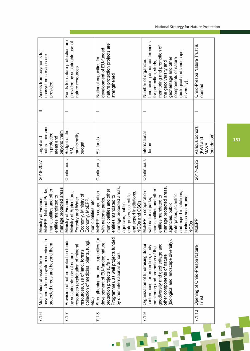
National Strategy for Nature Protection
151
7.1.
6 M
obiliz
atio
n of
ass
ets
from
pa
ymen
ts fo
r eco
syst
em s
ervi
ces
in
prot
ecte
d ar
eas
and
beyo
nd th
em
Min
istry
of F
inan
ce,
MoE
PP, N
atio
nal P
arks
, m
unic
ipal
ities
and
oth
er
entit
ies
man
date
d to
m
anag
e pr
otec
ted
area
s
2018
-202
7 Le
gal a
nd
natu
ral p
erso
ns
in p
rote
cted
ar
eas
and
beyo
nd th
em
II As
sets
from
pay
men
ts fo
r ec
osys
tem
ser
vice
s ar
e pr
ovid
ed
7.1.
7
Prov
isio
n of
nat
ure
prot
ectio
n fu
nds
by s
usta
inab
le u
se o
f nat
ure
reso
urce
s (e
xplo
itatio
n of
min
eral
re
sour
ces,
use
of l
and,
fore
sts,
co
llect
ion
of m
edic
inal
pla
nts,
fung
i, et
c.)
Min
istry
of F
inan
ce,
Min
istry
of A
gric
ultu
re,
Fore
stry
and
Wat
er
Econ
omy,
Min
istry
of
Econ
omy,
MoE
PP,
mun
icip
aliti
es, e
tc.
Con
tinuo
us
Budg
et o
f the
R
M,
mun
icip
ality
bu
dget
I Fu
nds
for n
atur
e pr
otec
tion
are
prov
ided
by
sust
aina
ble
use
of
natu
re re
sour
ces
7.1.
8 St
reng
then
ing
natio
nal c
apac
ities
for
deve
lopm
ent o
f EU
-fund
ed n
atur
e pr
otec
tion
proj
ects
(Life
+
Prog
ram
me)
, as
wel
l pro
ject
s fu
nded
by
oth
er in
tern
atio
nal d
onor
s
MoE
PP in
coo
pera
tion
with
nat
iona
l par
ks,
mun
icip
aliti
es a
nd o
ther
en
titie
s m
anda
ted
to
man
age
prot
ecte
d ar
eas,
ag
enci
es, p
ublic
en
terp
rises
, sci
entif
ic
and
expe
rt in
stitu
tions
, N
GO
s an
d C
SOs
Con
tinuo
us
EU fu
nds
I N
atio
nal c
apac
ities
for
deve
lopm
ent o
f EU
-fund
ed
natu
re p
rote
ctio
n pr
ojec
ts a
re
stre
ngth
ened
7.1.
9 O
rgan
izat
ion
of fu
ndra
isin
g do
nor
conf
eren
ces
for p
rote
ctio
n, s
tudy
, m
onito
ring
and
prom
otio
n of
the
geod
iver
sity
and
geo
herit
age
and
othe
r com
pone
nts
of n
atur
e (b
iolo
gica
l and
land
scap
e di
vers
ity).
MoE
PP in
coo
pera
tion
with
nat
iona
l par
ks,
mun
icip
aliti
es a
nd o
ther
en
titie
s m
anda
ted
to
man
age
prot
ecte
d ar
eas,
ag
enci
es, p
ublic
en
terp
rises
, sci
entif
ic
and
expe
rt in
stitu
tions
, bu
sine
ss s
ecto
r and
N
GO
s
Con
tinuo
us
Inte
rnat
iona
l do
nors
I
Num
ber o
f org
aniz
ed
fund
rais
ing
dono
r con
fere
nces
fo
r pro
tect
ion,
stu
dy,
mon
itorin
g an
d pr
omot
ion
of
the
geod
iver
sity
and
ge
oher
itage
and
oth
er
com
pone
nts
of n
atur
e (b
iolo
gica
l and
land
scap
e di
vers
ity).
7.1.
10
Ope
ning
of O
hrid
-Pre
spa
Nat
ure
Trus
t M
oEPP
20
17-2
025
Vario
us d
onor
s (K
Wf a
nd
MAV
A fo
unda
tion)
I O
hrid
-Pre
spa
Nat
ure
Trus
t is
open
ed

Ministry of Environment and Physical Planning
152
7.1.
11
Purc
hase
of h
ardw
are
and
softw
are
equi
pmen
t com
patib
le to
the
mos
t us
ed s
oftw
are
appl
icat
ion
used
by
bene
ficia
ry in
stitu
tions
MoE
PP
2020
Bu
dget
of t
he
RM
, var
ious
do
natio
ns
II Ad
equa
te IT
equ
ipm
ent i
s pr
ocur
ed
7.2
Intro
duct
ion
of a
dditi
onal
fina
ncia
l ins
trum
ent f
or n
atur
e pr
otec
tion
7.2.
1
Intro
duct
ion
of in
cent
ive
mec
hani
sm
and
rein
vest
men
t allo
wan
ce in
na
ture
pro
tect
ion
Min
istry
of F
inan
ce,
MoE
PP, N
atio
nal P
arks
, m
unic
ipal
ities
and
oth
er
entit
ies
man
date
d to
m
anag
e pr
otec
ted
area
s,
scie
ntifi
c an
d ex
pert
inst
itutio
ns
2018
-201
9 Bu
dget
of t
he
RM
II
Ince
ntiv
e m
echa
nism
and
re
inve
stm
ent a
llow
ance
in
natu
re p
rote
ctio
n ar
e in
trodu
ced
7.2.
2 In
trodu
ctio
n of
tax
ince
ntiv
es a
nd
subs
idie
s fo
r ser
vice
s an
d pr
oduc
ts
from
pro
tect
ed a
reas
Min
istry
of F
inan
ce, t
ax
auth
oriti
es a
nd M
oEPP
20
18-2
023
Budg
et o
f the
R
M
I Ta
x in
cent
ives
and
sub
sidi
es
for s
ervi
ces
and
prod
ucts
from
pr
otec
ted
area
s ar
e in
trodu
ced
7.2.
3 In
trodu
ctio
n of
tax
alle
viat
ions
for
finan
cing
nat
ure
prot
ectio
n m
easu
res
unde
rtake
n by
the
busi
ness
sec
tor
Min
istry
of F
inan
ce, t
ax
auth
oriti
es a
nd M
oEPP
20
18-2
023
Budg
et o
f the
R
M
I Ta
x al
levi
atio
ns fo
r fin
anci
ng
natu
re p
rote
ctio
n m
easu
res
unde
rtake
n by
the
busi
ness
se
ctor
are
intro
duce
d 7.
2.4
Rei
mbu
rsem
ent f
or d
amag
es to
ec
osys
tem
s in
pro
tect
ed a
reas
and
be
yond
them
Min
istry
of F
inan
ce a
nd
MoE
PP
Con
tinuo
us
Lega
l and
na
tura
l per
sons
in
pro
tect
ed
area
s an
d be
yond
them
I Fu
nds
for r
eim
burs
emen
t for
da
mag
es to
eco
syst
ems
in
prot
ecte
d ar
eas
and
beyo
nd
them
are
pro
vide
d
7.2.
5 Pr
ovis
ion
of fi
nanc
es b
y im
plem
entin
g co
mpe
nsat
ory
mea
sure
s in
ord
er to
com
pens
ate
for
or m
itiga
te n
atur
e de
grad
atio
n
Min
istry
of F
inan
ce a
nd
MoE
PP
Con
tinuo
us
Budg
et o
f the
R
M,
mun
icip
ality
bu
dget
III
Fina
nces
from
com
pens
ator
y m
easu
res
are
prov
ided
7.2.
6
Prov
isio
n of
nat
ure
prot
ectio
n fin
ance
s by
redi
strib
utio
n of
exi
stin
g ta
x in
com
es, f
ees
and
taxe
s fro
m
foss
il fu
el p
rodu
ctio
n an
d tra
de,
vehi
cle
regi
stra
tion,
wat
er
man
agem
ent a
nd e
lect
ricity
ge
nera
tion
Min
istry
of F
inan
ce a
nd
MoE
PP
2018
-201
7 Bu
dget
of t
he
RM
, m
unic
ipal
ity
budg
et
I N
atur
e pr
otec
tion
finan
ces
are
prov
ided
by
redi
strib
utio
n of
ex
istin
g ta
x in
com
es, f
ees
and
taxe
s fro
m fo
ssil
fuel
pr
oduc
tion
and
trade
, veh
icle
re
gist
ratio
n, w
ater
m
anag
emen
t and
ele
ctric
ity
gene
ratio
n

National Strategy for Nature Protection
153
5.2.5. MONITORING OF THE IMPLEMENTATION OF THE NATIONAL STRATEGY FOR NATURE PROTECTION AND THE ACTION PLAN (2017-2027)
An extremely important tool for continuous monitoring of the implementation of na-tional targets’ actions as referred to in the Strategy is to found a Supervisory Committee which will be approved by the Government of the Republic of Macedonia. It is crucial to provide finances for the operations of such body composed of high representatives of min-istries aimed at providing funds and smooth implementation of activities by development of monitoring indicators for strategy implementation.
In accordance with Article 160 of the Law on Nature Protection, five-year plans and annual programmes are adopted to ensure Strategy’s full implementation.
Five-year nature protection plans are adopted by the Minister in charge of the state administration body responsible for the pursuit of nature protection activities.
Annual nature protection programmes are adopted by the body competent to pur-sue expert activities in the field of nature protection.
The Department of Nature within the Ministry of Environment and Physical Plan-ning, as a main organizational unit, shall prepare and propose annual action programmes related to the strategy implementation.
The Department of Nature shall draft annual reports on strategy implementation, in cooperation with relevant ministries, agencies, public enterprises, scientific and expert institutions, experts, NGOs and other entities involved in the implementation of the Strat-egy’s actions and it shall inform the Government thereof.
Based on the annual reports, the Department of Nature, in cooperation with other entities implementing strategy’s activities, shall draft two five-year (midterm) reports on the strategy implementation, considering that the duration of the Strategy is 10 years.
The Ministry of Environment and Physical Planning of the Republic of Macedonia, in cooperation with the Supervisory Committee, shall submit the midterm reports for ap-proval to the Government of the Republic of Macedonia.

Ministry of Environment and Physical Planning
154
BIBLIOGRAPHY
Cyrillic
Авукатов, В., Велевски, М., Христовски, С. (2015). Карта на еколошка сензитивност за сливот на реката Брегалница. Завршен извештај по проектот „Анализа на недостатоци во еколошки податоци и изработка на карта на еколошка сензитивност за подрачјето на сливот на река Брегалница“, Книга 5, Скопје.
Ажиевска М. И др. (2008): Втор национален план за климатски промени. Министерство за животна средина и просторно планирање на Република Македонија. Скопје.
Ангеличин-Жура Г. (2006): Пештерните цркви во Охридско-Преспанскиот регион (Р. Македонија, Р. Албанија, Р. Грција), Зборник радова, Ниш и Византија, IV, 385-402.
Андоновски Т. (1977): Поземни карстни облици во долината на Радика, Годишен зборник, Институт за географија, ПМФ, Скопје, 23.
Андоновски Т. (1980): Пештерски систем Алилица. 7-ми југословенски спелеолошки конгрес, Титоград.Андоновски Т. (1981): Преглед на подземните карстни облици во СР Македонија. 8-ми југословенски
спелеолошки конгрес, Белград, 207-213.Андоновски Т. (1982): Лизгање на тлото кај месноста „Сурнати Ридој“ во близина на Битола. Геогр. раз., Кн.
20, Скопје, стр. 43-52.Андоновски Т. (1984); Абразивни и флувијални елементи во Кичевска Котлина. Год. збор. на ГФ, Кн. 27-28,
Скопје, стр. 3-75.Андоновски Т. (1985): Некои релјефни елементи во Кичевска Котлина (II дел). Год. збор. на ПМФ, Инст. за
геогр., Кн. 29, Скопје, стр. 13-56.Андоновски Т. (1989a): Церско Поле, Speleobih, 1-2, 127-137Андоновски Т. (1989b): Карстни полиња во СР Македонија, Географски Разгледи, 27, Скопје, 1-16Андоновски Т. (1995): Карактеристики на релјефот во Р Македонија. Географски разгледи, 30, 5-12.Андоновски Т., Василески Д. (1996): Лизгање (урнис) на тлото кај селото Параленик во Дебарска Жупа.
Географски разгледи кн. 31, Скопје, 11-20.Андоновски Т., Колчаковски Д. (1989): Потенцијални можности за развој на Козјачија - геоморфологија. Пос.
изд. на ПМФ, Инст. за геогр., стр. 24-30, Скопје.Андоновски Т., Милевски И. (1998): Карстот во Република Македонија и неговата заштита, Зборник на
трудови од I-от Конгрес на еколозите на Македонија, 844-854.Андоновски Т., Милевски И. (1999): Подземни карстни форми во Бислимската клисура. Географски разгледи
кн. 34 Скопје, стр. 5-21Андоновски Т., Милевски И. (2001): Геоморфолошки карактеристики на Кумановската котлина. Географски
разгледи кн. 36, Скопје, стр. 35-58Андоновски Т., Милевски И. (2001): Геоморфолошки карактеристики на Пелистер. Зборник на ДНУ, Научна
Мисла, Битола, стр. 23-32Апелтон, M. (2008). Заштитени подрачја во Македонија: преглед. Извештај во рамки на ГЕФ/УНДП/МЖСПП
проектот „Зајакнување на еколошката, институционалната и финансиската одржливост на системот на заштитени подрачја во Македонија“, Скопје.
Арсовски М. (1997): Тектоника на Македонија, РГФ Штип.Арсовски М. (1997): Тектонска карта и Тектоника на Македонија. Посебно изданите на Рударско-геолошки
факултет, ШтипАрсовски М., Петковски Р. (1975): Неотектоника на СР Македонија. Публ. 49, ИЗИС, Скопје.Блинков И. (1998): Влијание на врнежите врз интензитетот на ерозијата во сливот на река Брегалница до
профил “Брана Калиманци”, докторска дисертација, ракопис, СкопјеБрајаноска, Р., Меловски, Љ., Христовски, С., Саров, А., Авукатов, В. (2011). План за управување со
коридорите на кафеавата мечка. Извештај од проектот „Развој на национална еколошка мрежа во Република Македонија (МАК-НЕН)“. МЕД, Скопје, 114 стр.
Брајаноска, Р. Христовски, С. (eds). (2015) Извештај за состојбата со заштитените подрачја подрачја во сливот на реката Брегалница. Завршен извештај по проектот „Анализа на недостатоци во еколошки податоци и изработка на карта на еколошка сензитивност за подрачјето на сливот на

National Strategy for Nature Protection
155
река Брегалница“, Книга 4, Скопје.Василески Д. (1997): Радика. АД Напредок, Тетово.Василески Д. (1999): Типови на водопади во Република Македонија според начинот на нивниот постанок.
Годишен зборник на Институтот за географија, ПМФ, Скопје, 39-46Василески Д. (2011): Геоморфолошки карактеристики на НП Маврово. Во: Стојановска М. et al: Студија
за ревалоризација на Заштитено Подрачје Маврово. Oxfam Italia во соработка со НП Маврово, општина Маврово и Ростуше и МЖСПП на РМ, Скопје, стр. 38-62
Василески, Д. (1995): Малите акумулации и нивната просторна разместеност во Република Македонија, Прв Македонски географски конгрес, Охрид;
Велевски М, Путилин К, Узунова Д, Штумбергер Б, Лисичанец Е, Грубач Б, Шкорпикова В. 2013. Состојба со птиците во Македонија 2012. Македонско еколошко друштво, Скопје.
Велевски, М., Путилин, К., Узунова, Д., Шумбергер, Б., Лисичанец, Е., Грубач, Б., Шкорпикова, В. (2013). Состојба со птиците во Македонија 2012. Македонско еколошко друштво (посебно издание), Скопје
Гаревски Р. (1969): Стратиграфско и палеонтолошко значење на плеистоценската фауна од пештерата Макаровец во клисурата на реката Бабуна во околината на Велес. Природонаучен музеј Скопје, 6.
Гаревски Р. (1970): Остатоци на мечка од пештерата „Јаорец“ во околината на селото Велмеј (Охридско). Петти југословенски спелеолошки конгрес, Скопје.
Гашевски М. (1953): Дебарска Котлина - геоморфолошки проучувања. Глас. XXXIII, Бр. 1, Београд.Гашевски М. (1962): Карстен релјеф на планината Бистра. Геогр. раз. Кн. 1, Скопје, стр. 59, 67. Гашевски М. (1968): Некои основни карактеристики на коритото на Вардар од изворот до грчката граница.
Збор. на VIII Конг. на геогр. од СФРЈ, стр. 177-188, Скопје.Гашевски, М. (1979). Основни хидрографски особености на главните притоки на Вардар во СР Македонија.
Сојуз на Географските здруженија на СР Македонија 17: 1–53. ГЕФ/УНДП/МЖСПП (2008-2011). „Зајакнување на еколошката, институционалната и финансиската
одржливост на системот на заштитени подрачја во Македонија“, проект финансиран од ГЕФДржавен завод за статистика (2002). Попис на населението, домаќинствата и становите во Република
Македонија. Скопје, 52 p. Државен завод за статистика (2012a). Регионите во Република Македонија. Скопје, 114 p. Државен завод за статистика (2012b). Статистички преглед: Население и социјални статистики. Миграции,
2011. Скопје, 108 p. Државен завод за статистика (2013). Статистика на животната средина на Република Македонија, 167 стр.Државен завод за статистика (2014). Статистички годишник на Република Македонија за 2013, Скопје.Думурџанов Н., Ивановски Т. (1978). Основна геолошка карта (ОГК) на Република Македонија во размер
1:100000, Лист Охрид 34-102 и лист Поградец К 34-114, Геолошки завод на СРМ, Скопје.Думурџанов Н., Петров Г. (1992). Литостратиграфски карактеристики на офиолитскиот комплекс Демир
Капија – Гевгелија (Македонија) Geological Macedonica, Т. 6, св.1, Штип.Думурџанов Н., Петров Г., и др. (2002): Генеза на неогенско-квартерните депресии и нивните формациско-
стратиграфски карактеристики на територијата на Македонија. Рударско- геолошки факултет, Штип.
Думурџанов Н., Стојанов Р., Петровски К. (1979). Основна геолошка карта (ОГК) на Република Македонија во размер 1:100000, Лист Крушево К 34-91, Геолошки завод на СРМ, Скопје.
Думурџанов Н., Христов С., Павловски Б., Иванова В. (1981). Основна геолошка карта (ОГК) на Република Македонија во размер 1:100000, Лист Витолиште К 34-104 и Кајмакчалан К 34-116,Геолошки завод на СРМ, Скопје.
Ѓорѓевиќ М.; Трендафилов А.; Јелиќ Д.; Ѓорѓиевски С.; Поповски А. (1993): Карта на ерозија на Република Македонија, текстуален дел, Завод за водостопанство на Република Македонија, Скопје.
Ѓорѓевиќ Н. (2008): Можните геолошки, хидрогеолошки, седиментолошки и геохемиски промени во пештерските седименти за случај на потопување на пештерата Голема Пешт, Maced. Acta. Archaeol., 18, 39-43.
Ѓузелковски Д. (1999): Подземните води (издан) за решавањето на водоснабдувањето во Р. Македонија и нивната заштита, Институт „Геохридропроект“, Скопје
Закон за заштита на природата («Службен весник на РМ» бр.67/04, 14/06, 84/07, 35/10, 47/11, 148/11, 59/12, 13/13, 163/13, 41/14, 146/15, 39/16 и 63/16).
Ministry of Environment and Physical Planning
156
Зиков М., Анастасовски В. (1993): Природното наследство на Република Македонија и начините на негова заштита. Екологија и заштита на животната средина. Том1, Бр.1-2, Скопје, стр. 30-42
Зиков, М. (1988). Компонентите на природниот комплекс во просторното планирање. НИО „Студентски збор”, Скопје, 140 p.
Зиков, М. (1995). Клима и климатска регионализација во Република Македонија. Географски разгледи, Скопје 30: 13–21.
Златаноски, В. (2014): Географски информациски систем на вештачките акумулации во Република Македонија (магистерски труд), Скопје;
Ивановски Т., Ракиќевиќ Т. (1970). Основна геолошка карта (ОГК) на Република Македонија во размер 1:100000, Лист Гевгелија К 34-106, Геолошки завод на СРМ, Скопје.
Измајлов Н. (1958): Тиквешки угљоносни басен (са нарочитим освртом на фазе језерског стања Повардарја). Труд. на ГЗ на СРМ, Св. 6, Скопје, стр. 5-62.
Измајлов Н. (1963): Кретања у котлинама Македоније за време терциера и почетком квартара. Труд на ГЗ на СРМ, Св.10, Скопје, стр. 77-94.
Измајлов Н. (1965): О старости језерских тераса и о палеосеизмодислокација у Македонији (увод у подели квартара). Труд. на ГЗ на НРМ, Св. 12, Скопје, стр. 5-22.
Илијоски З. (2015): Методологија за проучување на ранливоста на подземни води, Скопје. Илијоски, З. 2015. Методологија за проучување на ранливоста на подземните води. Институт за
истражување во животната средина, градежништво и енергетика (ИЕГЕ), Градежен институт “Македонија“ ((ГИМ), Скопје
Јанчевски Ј. (1987): Класификација на раседните структури по генеза, старост и морфологија со ос-врт на нивната сеизмичност на територијата на Македонија. Докт. дис., РГФ, Штип, стр. 1-247.
Јанчевски Ј., Попвасилев В. 1984. Основна геолошка карта (ОГК) на Република Македонија во размер 1:100000, Лист Скопје К 34-79, Геолошки завод на СРМ, Скопје.
Јовановић П.С (1928б): Карстне појаве у Поречу. Глас. СНД, Књ. IV. Св 1, Скопље, стр. 1-46. Јовановић П.С. (1925): Жеденска пећина «Дона Дука». Глас. ГД, Св. 11, Београд, стр. 127-130. Јовановић П.С. (1927): Абразиони и флувијални елементи у Поречком басену. Глас. СГД, Св. 13, Београд,
стр. 169-194.Јовановић П.С. (1928a): Глацијација Јакупице Пос. из. ГД, Св. 4, Београд, стр. 1-86.Јовановић П.С. (1931): Рељеф Скопске котлине. Глас. СНД, Књ. XI, Св. 4, Скопље, стр. 62-116. Јовановска, Д. (2010). Состојба со рипариските хабитати по течението на река Вардар во Скопско Поле.
Дипломска работа, Унивезитет „Св. Кирил и Методиј“, Природно-математички факултет – Институт за биологија, Скопје. Стр. 1-37.
Јовановска, Д. (2014).Брза проценка на еколошкиот интегритет на водните текови во сливот на реката Брегалница. Магистерска работа – во постапка.Унивезитет „Св. Кирил и Методиј“, Природно-математички факултет – Институт за биологија, Скопје. Стр. 1-117.
Јовановски М., Гапковски Н. (2007). Општа геологија (основен универзитетски учебник). Универзитет Кирил и Методиј. Градежен факултет Скопје
Караделев, М., Колчаковски, Д., Ацевски, Ј., Јанчев, С., Костадиновски, М. (2009). Студија за утврдување на природните вредности и просторна идентификација на границите на парк-шумата Водно и карактеристичниот пејзаж Гази Баба. Унига Стил ДООЕЛ
Карајовановиќ М. Хаџи-Митрова С. (1982). Основна геолошка карта (ОГК) на Република Македонија во размер 1:100000, Лист Велес К 34-80 Геолошки завод на СРМ, Скопје.
Карајовановиќ М., Ивановски Т. (1979): Основна геолошка карта (ОГК) на Република Македонија во размер 1:100000, Лист Битола К 34-103 и Лист Лерин К 34-115 Геолошки завод на СРМ, Скопје.
Карајовановиќ М., Христов С. (1976). Основна геолошка карта (ОГК) на Република Македонија во размер 1:100000, Лист Куманово К 34-68 Геолошки завод на СРМ, Скопје.
Карлин Р., Ангелов Н., Октавиан М. Ч., Гроздановски Х., Жежовска Д., Жежовски И. (2011): Непознати природни реткости во Македонија, СД «Пеони», Скопје, 1-63.
Карович Ј., Кошчал М., Менкович Љ. (1982). Основна геолошка карта (ОГК) на Република Македонија во размер 1:100000, Лист Призрен К 34-66 Завод за геолошки, хидрогеолошки, геофизички и геотехнички истражувања - “Геозавод” Белград.
Качески, З. 2015. Методологија за примена на интеракциски анализи при проценка на ризик за загадување

National Strategy for Nature Protection
157
на подземните води, Докторска дисертација, Градежен факултет, Скопје.Климашевски М. (1978): Услови во плеистоцената глацијација на планините во СР Македонија. Геог. раз.,
Кн. 15-16, стр. 13-29, Скопје.Ковачевиќ М. Петковски П., Темкова В. (1981). Основна геолошка карта (ОГК) на Република Македонија во
размер 1:100000, Лист Делчево К 34-82. Геолошки завод на СРМ, Скопје.Колчаковски Д. (1982): Природно-географски карактеристики на Кадина Река. Дипл. раб. ГФ, стр. 1-72,
Скопје.Колчаковски Д. (1989): Историски преглед на спелеолошките проучувања на територијата од СР Македонија
со бибилиографски приказ. Географски разгледи, 27, 133-144.Колчаковски Д. (1996a): Геоморфолошки карактеристики на високопланинскиот предел на Стара Галичица.
Географски разгледи, Кн.31, Скопје, 53-65.Колчаковски Д. (1996b): Карстен релјеф во Скопската Котлина. Посебно издание на ПМФ, Скопје, 1-47.Колчаковски Д. (1996в): Морфогенетски процеси и нивните релјефни форми на високопланинските предели
на планините Јабланица, Стогово, Стара Галичица и Пелистер. Докторска дисертација одбранета на ПМФ-Скопје, ракопис.
Колчаковски Д. (2001а): Спелеоморфолошки карактеристики на карстниот релјеф во Република Македонија. Географски разгледи, Кн. 36, стр. 23-34.
Колчаковски Д. (2001б): Периглацијален релјеф на планината Пелистер, Научна мисла, IV, ДНУ -Битола, Битола, стр. 45-54.
Колчаковски Д. (2002): Глацијален релјеф на планината Стогово. Геог. раз., кн. 37, Скопје, стр. 159-166.Колчаковски Д. (2003): Основни природногеографски карактеристики на Шар Планина (геологија,
геоморфологија и хидрологија). Билт. истраж. друш. студ. биол. 2, стр. 3-7, Скопје.Колчаковски Д. (2004а): Физичка географија на Република Македонија, УКИМ, ПМФ, СкопјеКолчаковски Д. (2004б): Планина Бистра (Меденица, 2.163 m) - морфоструктурни карактеристики.. Билт.
истраж. друш. студ. биол. 2, Скопје, стр. 3-7.Колчаковски Д. (2004в): Геотектонски основи на релјефот во Република Македонија. Билтен ЗФГ, кн. 1,
Скопје, стр. 7 - 23.Колчаковски Д. (2004г): Планина Ниџе (Кајмакчалан 2.521 m) - основни геоморфолошки карактеристики.
Географски разгледи, кн. 37, Скопје, стр. 123-126.Колчаковски Д. (2005а): Геоморфологија, (ракопис), Скопје, стр. 1-418.Колчаковски Д. (2005б): 80 години спелеолошки проучувања во Република Македонија (1925-2005). Билтен
за физичка географија, ПМФ – Институт за географија, 2, 125-131, Скопје.Колчаковски Д. (2010): Геоморфолошки карактеристики на планината Јабланица, Билт. Истраж. Друш.
Студ. Биол., Vol. 4, Скопје, стр. 3-9.Колчаковски Д. (2010): Категоризација и валоризација на подземните карстни форми на националниот парк
Галичица, Год. Збор., кн. 38, Скопје, стр, 61-75.Колчаковски Д., Алоски Ќ. (1984): Пештера Слатинско Врело. Деветти југословенски спелеолошки конгрес,
Загреб, 337-344.Колчаковски, Д., Христовски, С., Караман, И, Гичевски, О, Самет, А., Петреска, Б., Темоски, М., Комненов,
М. (2009). Студија за определување на степенот на заштита на спелеолошките објекти: Срт, Врело, Убава и Крштална на подрачјето на Споменикот на природата Кањонот Матка
Колчаковски, Д., Христовски, С., Караман, И, Гичевски, О, Самет, А., Петреска, Б., Темоски, М., Комненов, М. (2009). Студија за определување на степенот на заштита на пештерата Дона Дука кај селото Рашче.
Костов, В. (координатор) (2011). Програма за унапредување на рибарството и аквакултурата во Република Македонија за период од 12 години, Институт за сточарство, Универзитет Св. Кирил и Методиј – Скопје
Лазаревски А. (1993): Климата во Македонија, Култура, Скопје, 253. Лилиенберг Д.А. (1965): О современных движениях земной коры в Македонии. ДОК. АН СССР, геология. Т.
165, Но. 1, Москва, стр. 159-162.Лилиенберг Д.А. (1966): Основни закономерности в проявите на сьвремените движения в централната част
на Балканския полуостров. Изв. на Геог. инс., Т.Х стр. 5-23, София.Македонско еколошко друштво (2008). Моноспитовско Блато: последното мочуриште во Македонија.

Ministry of Environment and Physical Planning
158
Струмица, 56 стр.Македонско еколошко друштво (2011). Репрезентативна мрежа на заштитени подрачја, завршен извештај,
(ГЕФ/УНДП/МЖСПП проект „Зајакнување на еколошката, институционалната и финансиската одржливост на системот на заштитени подрачја во Македонија“), Скопје
Манаковић Д. (1960): Урнис брда Градот. Зборник радова ГИ САНУ, Књ. 17, Београд, 121-128Манаковиќ Д. (1957а): Пећине у Демир Капији. Зборник радова САНУ, 13, Београд, 77-93. Манаковиќ Д. (1957б): Планина Жеден (морфолошко-хидрографски приказ). Год. збор. на ФФ, прир.
математ. оддел. Кн. 10, стр. 169-192, Скопје.Манаковиќ Д. (1962а): Нивациони процеси и облици на планината Јакупица. Год. збор. на ПМФ, Кн. 13, стр.
47-57. Скопје.Манаковиќ Д. (1962б): Хидрографски врски на реката Крапа и изворот Асаноец. Географски разгледи, 1,
51-58.Манаковиќ Д. (1963а): Абразиони и флувијални елементи во поречието на Бабуна и Тополка со
Титоввелешката Котлина. Год. збор. на ПМФ, Кн. 14 геолог. и географ., Св. 2, Скопје, стр. 121-196. Манаковиќ Д. (1963б): Некои релјефни елементи во поречието на Бабуна и Тополка со Титовелешката
Котлина. Год. збор. на ПМФ, Кн. 15 геолог. и географ., Св. 3, Скопје, стр. 87-139.Манаковиќ Д. (1967): Геоморфологија на Мавровската Котлина. Геог. раз., Кн. 5, Скопје, стр. 5-32. Манаковиќ Д. (1968) Средно Вардарско Езеро. Зборник на VIII конгрес на географите од СФРЈ, Скопје,
155-164Манаковиќ Д. (1968): Геоморфологија на Сува Гора, Сува Планина и нивните северни ограноци. Год. збор.
на ПМФ, ГИ, Кн. 16. Св. 4, Скопје, стр. 129-177.Манаковиќ Д. (1970): Пештера Убавица. Петти југословенски спелеолошки конгрес, Скопје. Манаковиќ Д. (1979): Геоморфологија на поречието на Коњска Река. Годишен зборник на ПМФ, кн. 25
Скопје, 43-72Манаковиќ Д. (1980): Оазни тип карстне хидрографије Македоније. Седми југословенски спелеолошки
конгрес, Титоград, 293-309.Манаковиќ Д. (1983): Нивациони процеси и облици со посебен осврт на СР Македонија. Zbornik XI Kongr.
Geogr. SFRJ, Titograd, ѕtг 111-119.Манаковиќ Д., Андоновски Т. (1979а): Геоморфологија на планината Буковиќ. Год. збор. на ГФ, Кн. 25,
Скопје, стр. 43-71.Манаковиќ Д., Андоновски Т. (1979б): Релјефни карактеристики на Источна Македонија. Геог. раз. Кн. 17,
Скопје, стр. 5-32.Манаковиќ Д., Андоновски Т. (1983): Релјефот на планината Бистра. Бистра I, МАНУ, Скопје, стр. 37-73.Манаковиќ Д., Андоновски Т., Колчаковски Д. (1993): Подземни карстни форми во националниот парк
„Галичица“, Годишен зборник, Институт за географија, ПМФ, Скопје, 37-71.Манаковиќ Д., Андоновски Т., Стојановиќ М., Стојмилов А. (1998): Геоморфолошка карта на Република
Македонија, текстуален дел. Географски разгледи, 32-33, Скопје, 37-70.Манасиев Ј., Јовановски М., Гапковски Н., Новачески Т., Петревски Љ. (2002): Свлечиште во СИ дел од
површинскиот коп за јаглен “Суводол”, феноменологија на појавата и искуства, I Симпозиум за геотехника на Македонија, Охрид, 26-28 јуни, 2002
Маркоски Б. (2003): Картографија, ГЕОМАП, Скопје. 1-383. ISBN 9989-2127-0-1Маркоски Б., Тодорова А. (2015): Regionalization of the Republic of Macedonia from the aspect of agricultural
lands, Proceedings, V Congress of geographers from Republic of Macedonia, Skopje 26-29.IX.2015, Macedonian geographical society, Skopje.
Маркоски Б., Димитровска О., Апостоловска-Тошевска Б. Младеновска Ј. (2015): Картографско-географска регионализација на Република Македонија од аспект на животната средина, Proceedings, V Con-gress of geographers from Republic of Macedonia, Skopje 26-29.IX.2015, Macedonian geographical so-ciety, Skopje.
Маркоски Б., Чепреганов Т., Грозданоски Р., Николовски Д. Д. (2013): МАКЕДОНИЈА – ТУРИСТИЧКИ БИСЕР, туристички потенцијали и културно-историски знаменитости, Информативно-деловен бизнис центар-ИДБЦ, Скопје. стр. 1-592 (македонски, англиски). ISBN 978-9989-2631-3-2, COBIS.MK-ID 93211914.
Маркоски Б., Милевски И. (2013): Методологија за формирање катастар на природни туристички
National Strategy for Nature Protection
159
атрактивности и организација на географски информациски системи. Годишен зборник, Институтот за географија, Кн. 34, Скопје. (na makedonski i angliski).
Маркоски Б. (1992): Картографско картометриски проучувања на хипсометриската струкрура на просторот и разместеноста на населението во Република Македонија, докторска дисертација одбранета на институтот за географија при ПМФ, Скопје. (ракопис).
Маркоски Б. (1995): Хипсометрија на просторот и населеноста во Република Македонија - картографски метод. Македонска ризница – Куманово, 1-315;
Маркоски Б. (2004): Картогрсфско дефинирање и диференцирање на планинските просторни целини во Република Македонија, Билтен за физичка географија, бр.1. ПМФ, Институт за географија, Скопје.
Маркоски Б. (2006): Картогрсфско дефинирање и диференцирање на котлинските просторни целини во Република Македонија, Билтен за физичка географија, бр.2. ПМФ-Институт за географија, Скопје.
Маркоски Б. (2008): Регионализација во Република Македонија, Билтен за физичка географија, бр.5, ПМФ-Институт за географија, Скопје;
Маркоски Б. (2012): Дојранска Котлина, Зборник на трудови од научно стручна трибина Туризмот во Дојранскиот регион, 20.04.2012, Дојран, Штип;
Маркоски Б., (2005): Општа методологија и концепција за изработка на географски информациски системи, Географски разгледи, кн. 40, Скопје;
Маркоски Б., (2011): Географски информациски системи, Универзитет Св. Кирил и Методиј, Скопје. стр. 1-235;
Маркоски, Б., (2011): Географските информациски системи во функција на животната средина. Маркоски Б.,: Езерата во Република Македонија - Географски информациски системи, Геомап, Скопје,
ракопис во печат;Матвејев, С. (1973). Предели Југославије и њихов живи свет. Научна књига, Београд. Матвејева, Ј. (1982). Рудералната вегетација на СР Македонија. МАНУ, Скопје, 70 стр.Матевски, В. (2003). Студија за проценка на состојбата на популациите и количините на мечкино уво
(Arctostaphylos uva-ursi) во Република Македонија.. Министерство за животна средина и просторно планирање, Скопје
Матевски, В. (2010). Флора на Република Македонија. МАНУ, 2/1, 1-190, СкопјеМатевски, В. (2013). Разновидност и потекло на флората на Република Македонија. МАНУ-Пристапни
предавања, прилози и библиографија на новите членови на МАНУ.Матевски, В. и Костадиновски, М. (1997). Типолошки истражувања на вегетацијата на ливадите и брдските
пасишта во Мариово и нивниот генофонд. Завршен извештај на научно-истражувачки проект. Универзитет «Св. Кирил и Методиј» - скопје, Природно-математички факултет, Институт за биологија.
Матевски, В. и Костадиновски, М. (1998). Biserrulo-Scleranthetum dichotomae Matevski et Kostadinovski ass. nova во вегетацијата на брдските пасишта во Република Македонија. Год. зб., Биол.-Прир.-мат. фак. Унив. «Св. Кирил и Методиј» Скопје, том 51, с. 25-35.
Матевски, В., Ѓукиќ, Ѓ., Колчаковски, Д., Блинков, И., Велевски, М., Шушлевска, М., Сидоровски, В. (2010). Студија за ревалоризација на прирoдните вредности на заштитеното подрачје Споменик на природата «Кањон Матка». Проект на УНДП: 00058373 „Јакнење на еколошката, институционалната и финансиската одржливост на системот на национални заштитени подрачја на Македонија”
Melovski, Lj., Markovski, B., Hristovski, S., Jovanovska, D., Anastasovski, V., Klincharov, S., Velevski, M., Velkovs-ki, N., Trendafilov, A., Matevski, V., Kostadinovski, M., Karadelev, M., Levkov, Z., Kolchakovski, D. (2013). Regional division of the Republic of Macedonia for the needs of biological databases. Macedonian Journal of Ecology and Environment, Vol. 15: 2, pp. 81-111.
Меловски, Љ., Иванов, Ѓ, Ангелова, Н., Велевски, М., Христовски, С. (уредници) (2008). Моноспитовско Блато - последното мочуриште во Македонија. Општина Босилово, 56 стр.
Меловски, Љ., Јовановска, Д., Авукатов, В. (2015). Пределска разновидност во сливот на реката Брегалница. Завршен извештај по проектот „Анализа на недостатоци во еколошки податоци и изработка на карта на еколошка сензитивност за подрачјето на сливот на река Брегалница“, Книга 3, Скопје.
Меловски, Љ., Матевски, В., Костадиновски, М., Караделев, М., Ангелова, Н., Радфорд, Е. (2010). Значајни растителни подрачја во Македонија. Македонско еколошко друштво, Скопје, 128 стр.
Меловски, Љ., Христовски, С. (2008). Валоризација на природните вредности на Шар Планина и проценка на нивната пазарна вредност (завршен извештај). Министерство за животна средина и просторно
Ministry of Environment and Physical Planning
160
планирање, Скопје, 186 стр.МЖСПП (2003). Прв Национален Извештај на Р Македонија кон Рамковната Конвенција за Климатски
Промени на Обединетите Нации. Министерство за животна средина и просторно планирање, Скопје.
МЖСПП (2008). Втор национален план за климатски промени. Министерство за животна средина и просторно планирање, Скопје, 124 стр.
МЖСПП (2008). Развој на Национална Емералд мрежа во Република МакедонијаМЖСПП (2009). Национална стратегија за инвестиции во животната средина (2009-2013), Скопје, 34 стр.МЖСПП (2011). Индикатори за животна средина на Република Македонија 2010. Скопје, 222 стр.МЖСПП (2014). Петти Национален извештај кон Конвенција за биолошка разновидност. МЖСПП (2012). Акциски План за имплементација на Програма за работа за заштитени подрачја на
Конвенцијата за биолошка разновидност.МЖСПП (2011). Насоки за воспоставување и развој на системот на заштитени подрачја.. Извештај во рамки
на ГЕФ/УНДП/МЖСПП проект:»Зајакнување на еколошката, институционалната и финансиската одржливост на системот на заштитени подрачја во Македонија».
МЖСПП (2014). CDDA - Common database on designated areas (European Environmental Agency), извештај 2014 година.
МЖСПП (2014). Трет национален план за климатски промени. Министерство за животна средина и просторно планирање, Скопје, 275 стр
Милевски И. (2006): Ерозивните процеси и развојот на руралните подрачја во Република Македонија. Зборник од меѓународниот симпозиум за рурален развој, Охрид стр. 539-556
Милевски И. (2000): Земјани пирамиди во Куклица - Кратовско. Географски разгледи кн. 35. Скопје, стр. 13-28
Милевски И. (2001): Рецентна ерозија во Кумановската Котлина и нејзиниот третман во просторното планирање. Магистерска работа, ракопис. ПМФ, Скопје.
Милевски И. (2004): Рецентна ерозија во сливот на Желевица, Билтен на заводот за физичка географија бр. 1, Скопје, стр. 59-75
Милевски И. (2005): Палеовулкански релјеф во западниот дел на Осоговскиот Масив. Географски разгледи бр. 40. Скопје стр. 47-67
Милевски И. (2006): Геоморфологија на Осоговскиот планински масив. Докторска дисертација одбранета на ПМФ-Скопје, ракопис.
Милевски И. (2008a): Фосилен глацијален релјеф и периглацијални појави на Осоговскиот планински масив Годишен зборник на Институтот за географија, Кн. 37, Скопје. стр. 25-49
Милевски И. (2008б): Геоморфолошки карактеристики на плавините во сливот на Радањска Река. Географски разгледи кн. 42-43, Скопје стр. 43-61
Милевски И. (2009): Геоморфолошки карактеристики на Богословец и локалитетот Ѓаволски Ѕид. Географски разгледи кн. 43, Скопје стр. 27-39
Милевски И. (2011): 10-те можеби најубави високи врвови во Република Македонија. Објавено на ИГЕО-портал: www.portal.igeografija.mk (18.11.2011).
Милевски И. (2011a): Значајни геоморфолошки локалитети на Осоговскиот планински масив. Билтен за физичка географија 7-8, Институт за географија, Скопје, 29-44
Милевски И. (2011a): Нови истражувања на Куклица. Објавено на ИГЕО-портал: www.portal.igeografija.mk (20.11.2011).
Милевски И. (2011б): Викенд предлог: Скопска Црна Гора. Објавено на ИГЕО-портал: www.portal.igeografija.mk (25.11.2011).
Милевски И. (2011в): Кукуљето-втора Куклица во Република Македонија. Објавено на ИГЕО-портал: www.portal.igeografija.mk (27.11.2011).
Милевски И. (2012а): Покрај Голем Град, во Македонија има уште десетици други острови! Објавено на ИГЕО-портал: www.portal.igeografija.mk (14.01.2012).
Милевски И. (2012б): Козјак, Герман и Билино - неоткриена планинска убавина на севроистокот на Македонија. www.portal.igeografija.mk (22.02.2012).
Милевски И. (2012в): Плачковица - планина која треба да се посети и доживее. www.portal.igeografija.mk (24.03.2012).

National Strategy for Nature Protection
161
Милевски И. (2012г): Водопадите на Бабакарина Река кај Кратово. Објавено на ИГЕО-портал: www.portal.igeografija.mk (31.03.2012).
Милевски И. (2012д): Камените столбови („цуцки“) во „Долината на плодноста“ кај Конопиште. www.portal.igeografija.mk (1.05.2012)
Милевски И. (2014б): Македонија има 13 „вистински“ острови! Објавено на ИГЕО-портал: www.portal.ig-eografija.mk (13.10.2014).
Милевски И. (2015а): Влаина, неправедно „заборавена“ планина! Објавено на ИГЕО-портал: www.portal.igeografija.mk (5.01.2015).
Милевски И. (2015б): Викенд предлог: Јабланица – една од најубавите планини во Македонија. Објавено на ИГЕО-портал: www.portal.igeografija.mk (3.11.2015).
Милевски И., Димитровска В. (2011): Геоморфолошко-геоархеолошки карактеристики на Цоцев Камен. Географски разгледи кн. 44-45. Скопје, 5-19
Милевски И., Маркоски Б., Димитровска О. (2012): Физичко-географски атрактивности во североисточниот дел на Република Македонија. Географски разгледи кн 46, Скопје, 79-97
Милевски И., Милошевски В. (2008): Денудациски форми во сливот на Мавровица. Билтен за физичка географија бр. 5, Скопје стр. 87-100
Милевски И., Тунтев З., Ружин И., Јанкова В., Вртески Ј., Наумоски З. (2015): Студија за состојбата со потенцијалите за развој на туризмот во ИПР. Центар за развој на ИПР-Штип, преку Идеа ОК и БДС Консалтинг, Скопје, 1-184
Милојевић Б.Ж. (1941): Долина Брегалнице - геоморфолошка испитивања. Глас. СКА, Књ. CLXХХVIII, Београд, стр. 1-66.
Мицевски, Б. (1985): Измени во составот и карактеристики на орнитофауната во градскиот парк во Скопје. Магистерски труд. ПМФ, Универзитет «Св. Кирил и Методиј», Скопје.
Мицевски, Б. (1986/1987): Измени во составот и карактеристики на орнитофауната на градскиот парк во Скопје (1982/1983). Годишен Зборник на Природно-математичкиот факултет 39/40: 87-115.
Мицевски, К. (1972). Tunico-Trisetetum myrianthi Micev. ass. nov. во вегетацијата на брдските пасишта во Македонија. Годишен зборник на Природно-математичкиот факултет, Скопје, Книга 24 (1971).
Мицевски, К. (1973). Helianthemo-Euphorbietum tessalae Micev. ass. nov. во вегетацијата на брдските пасишта во Македонија. Годишен зборник на Природно-математичкиот факултет на Универзитетот во Скопје, Книга 25 (1972), с. 149-155.
Мицевски, К. (1985). Флора на Република Македонија 1 (1). МАНУ, Скопје, 1 – 152.Мицевски, К. (1993). Флора на Република Македонија 1 (2). МАНУ, Скопје, 153 – 391.Мицевски, К. (1995). Флора на Република Македонија 1 (3). МАНУ, Скопје, 401 –772.Мицевски, К. (1998). Флора на Република Македонија 1 (4). МАНУ, Скопје, 781 –1113.Мицевски, К. (2001). Флора на Република Македонија 1 (5). МАНУ, Скопје, 1121 –1430.Мицевски, К., Матевски, В. (2005). Флора на Република Македонија 1 (6). МАНУ, Скопје, 1437 – 1716Мицевски, Љ. и Ризовски, Р. (1987). Шумско-вегетациска карактеристика на Мариово. Во: Башески, И. и
сор. (уредници): Мариово - природни и социо-економски обележја и можности за развој. Зборник на материјали од научниот собир одржан на 30 и 31 октомври 1986 година во Прилеп и Витолиште, стр. 311-326. Друштво за наука и уметност - Прилеп; Друштво за наука и умeтност - Битола.
Мицевски, Н., Мицевски, Б. (2005): Фауна на пеперутките (Lepidoptera) во Националниот парк Пелистер. Друштво за проучување и заштита на птиците на Македонија - ДПЗПМ, 102 стр.
Национална стратегија за води (2011-2041). Влада на Република Македонија, Министерство за животна средина и просторно планирање. Хидроинженеринг д.о.о. Љубљана, РИКО д.о.о. Љубљана.
Николић Р.С. (1912): Глацијација Шар Планине и Кораба. Глас. СКА, Књ. LXXXVII, св, 36, Београд, 50-80.Панов М. (1976): Географија на СР Македонија – природни и социо-географски карактеристики, кн. 1,
Просветно Дело, Скопје.Пенџерковски Ј., Ракиќевиќ Т., Ивановски Т., Ѓузелковски Д. (1970). Основна геолошка карта (ОГК) на
Република Македонија во размер 1:100000, Лист Кожуф К 34-105 Геолошки завод на СРМ, Скопје.Петковски П., Ивановски Т. (1980): Основна геолошка карта (ОГК) на Република Македонија во размер
1:100000, Лист Кичево К 34-90 Геолошки завод на СРМ, Скопје.Петковски П., Поповски С. (1982). Основна геолошка карта (ОГК) на Република Македонија во размер
1:100000, Лист Гостивар К 34-78 Геолошки завод на СРМ, Скопје.
Ministry of Environment and Physical Planning
162
Петковски П., Поповски С. (1985). Основна геолошка карта (ОГК) на Република Македонија во размер 1:100000, Лист Качаник К 34-67 Геолошки завод на СРМ, Скопје.
Петковски Р. (1992): Сеизмотектонски карактеристики на Македонија. Докторска дисертација. Рударско-геолошки факултет, Белград.
Петковски Р. (1998): Врска помеѓу неотектонските движења и езерските стадиуми во Македонија. Зборник на трудови од I Конгрес на еколозите на Македонија со меѓународно учество, Охрид, 855-867.
Петковски, С. (2009). Анализа и валоризација на биолошката разновидност на национално ниво (извештај) со национален каталог (листа) на видови во дигитална форма. Скопје, 100 стр.
Петрушевски И., Маркоски Б. (2014): Реките во Република Македонија, ГЕОМАП, Скопје. стр. 1-82, ISBN 978-9989-2117-6-8, COBISS.MK-ID 97372426.
Петревска, Б. (2010). Значењето на туризмот во економската активност на Македонија, Зборник на трудови на МИТ Универзитет – Скопје,1(1): 249-258
Петреска Б. (2008): Подземни карстни форми во Поречкиот Басен и нивна валоризација за потребите на Просторното планирање, магистерски труд, Природно математички факултет, Скопје, во ракопис.
Петреска Б., Темовски M. (2007): Деградација на подземните карстни форми во Поречкиот Басен, Зборник на трудови од III-от Конгрес на еколозите на Македонија со меѓународно учество, 555-561.
Пешевски И., (2015). Пристап за моделирање на подложноста кон свлекување на теренот со примена на ГИС технологија. Докторска дисертација. УКиМ Градежен факултет-Скопје
Радовановић В.С. (1928): Мали денудациони облици гнајсног земљишга. Глас. СНД, Књ IV. Св. 1, Скопље, Радовановић В.С. (1931): Холокарст хуме под Кожуфом. Глас. СНД, Књ IX. Св. 3, Скопље, стр. 108-159.Радовановић В.С. (1932): Гипсни рељеф Косовраста у долини Радике више Дебра. Глас. ГД, Св. XVIII,
Скопље, стр. 59-78.Ракиќевиќ Т., Думурџанов Н., Петковски П. (1976). Основна геолошка карта (ОГК) на Република Македонија
во размер 1:100000, Лист Штип К 34-81 Геолошки завод на СРМ, Скопје.Ракиќевиќ Т., Пенџерковски Ј., Ковачевиќ. (1980). Основна геолошка карта (ОГК) на Република Македонија
во размер 1:100000, Лист Струмица К 34-94 Геолошки завод на СРМ, Скопје.Ракиќевиќ Т., Стојанов Р., Арсовски М. (1973): Основна геолошка карта (ОГК) на Република Македонија во
размер 1:100000, Лист Прилеп К 34-92 Геолошки завод на СРМ, Скопје.РГУ (1982): СР Македонија низ катастарска евиденција, Скопје.Реџовиќ, E. (2011). Промени во искористување на земјиштето на Осогово. Дипломска работа, Унивезитет
„Св. Кирил и Методиј“, Природно-математички факултет – Институт за биологија, Скопје. Стр. 1-53.СДЦ/УНДП проект „Ревитализација на екосистемите на Преспанското Езеро“. http://www.mk.undp.org/
content/the_former_yugoslav_republic_of_macedonia/en/home/operations/projects/environment_and_energy/restoration-of-the-prespa-lake-ecosystem.html
СДЦ/Фармахем/МЖСПП „Програма за зачувување на природата во Македонија“. www.bregalnica-ncp.mkСековски, Д. 2014. Екохидролошки пристап во интегралното управување со речните сливови, Докторска
дисертација, Градежен факултет, Скопје.Серафимовски Т. (1993): Структурно-металогенетски карактеристики на зоната Леце-Халкидики. Посебно
издание бр. 2, РГФ Штип.Спировска и др. (2012): Интегрирана студија за состојбата на остатокот од Студенчишко Блато и преземање
мерки за негова ревитализација, Стојадиновић Ч. (1951): Трагови преграбенске Ђаватске долине од преседлине Ђавата до Битоља и
развитак долине Шемнице и Драгора. Год. збор. на ФФ природномат. одд., Кн. 4, Скопје, стр. 1-38. Стојадиновић Ч. (1952): Трагови прелиминског релјефа југозападне Македоније. II Конгрес на геог. од
ФНРЈ, Скопје, стр. 41-47.Стојадиновиќ Ч. (1958): Геоморфолошка проматрања на гипсном релјефу у долини Радике. Год. збор. на
ФФ природномат. одд., Кн. 11, Скопје, стр. 75-86.Стојадиновиќ Ч. (1962): Камени реки и сипои на Пелистер. Геог. раз., Кн. 1, Скопје, стр. 45-51. Стојадиновиќ Ч. (1968): Генеза на литоралниот релјеф на базенот од Охридското Езеро и неговите
тектонски и абразиони елементи. Год. збор. на ПМФ, Кн. 16, ГИ, Св. 4, Скопје, стр. 103-127. Стојадиновиќ Ч. (1968): Геоморфолошки црти на островот Голем Град во Преспанското Езеро. Геог. раз.,
Кн. 6, Скопје, стр. 117-122.Стојановиќ М. (1986): Области на изгаснати вулкани на територијата на СР Македонија. Год. збор. на ПМФ

National Strategy for Nature Protection
163
- географија, Кн. 30, Скопје, стр. 148-166.Стојановиќ М. (1995): Дојранско Езеро – постанок, еволуција, одумирање. Географски разгледи кн. 30,
Скопје, 81-90. Стојановиќ, М. (1986): Области на изгаснати вулкани на територија на СР Македонија, Год. збор. ИГ, ПМФ,
Кн. 30, 148 – 166, СкопјеСтојмилов А. (2011): Географија на Република Македонија, Скопје.Студија за заштита на природното наследство (1999). Просторен План на Република Македонија (Сл.
весник на Република Македонија бр.39/04)Студија за подземни води на територијта на Р Македонија. 1999. Градежен институт “Македонија“, СкопјеТалевски, Т. (2007). Прелиминарни истражувања на мочурливите терени во регионот на Дебарца и
предлагање на мерки за нивна заштита како делови на природата од посебен интерес (завршен извештај). Македонско лимнолошко друштво, Охрид
Темовски М. (2012): Површинска распространетост на карстните карпи во Република Македонија. Географски разгледи, 46, 21-35
Темовски М. (2013b): Карактеристики на хипогената карстификација и појава на хипоген карст во Република Македонија, Географски Разгледи, 47, 11-29.
Темовски М. (2013б): Карактеристики на хипогената карстификација и појава на хипоген карст во Република Македонија. Географски Разгледи, 47, 11-29.
Темовски М. (2014): Карстот и пештерите во Република Македонија и нивното значење за животната средина. Прв симпозиум – истражувања од областа на животната средина и материјалите, 21-22.11.2014, МАНУ, Скопје, 47-48
Темовски М. (2015a) Извештај од спелео кампот „Галичица“ (04-09.08.2015), Спелеолошки клуб „Златоврв“, Прилеп, 1-19. http://zlatovrv.speleo.mk/?p=529
Трендафилов А. (1996): Ерозија на сливот на Црна Река и засипување на акумулацијата на Тиквеш со ерозивен нанос. Докторска дисертација, Шумарски факултет, Скопје, ракопис.
Урсус Спелеос (2011). Студија за валоризација на природните вредности во повеќенаменското подрачје „Јасен“.Ref. RFP 31/2010 (re-announcement of RFP 24/2010) Проект на УНДП: 00058373 „Јакнење на еколошката, институционалната и финансиската одржливост на системот на национални заштитени подрачја на Македонија“
Физибилити студија за оправданост на доделување на концесија за користење на вода за производство на електрична енергија со изградба на мали хидроелектрични централи. 2008. Градежен институт МАКЕДОНИЈА, Скопје
Филиповски, Ѓ. Ризовски, Р. Ристевски, П. (1996): Карактеристики на климатско-вегетациско-почвените зони (региони) во Република Македонија, МАНУ, Скопје, 178 стр.
Филиповски, Ѓ., Митрикески, Ј., Петковски, Д. (1985). Малеш и Пијанец VI. Почви. Услови за образување, генеза, еволуција, класификација, својства и распространетост на почвите во Малеш и Пијанец. МАНУ, Скопје, 187 p.
Христов С. Карајовановиќ М., Јанчевски Ј. (1976). Основна геолошка карта (ОГК) на Република Македонија во размер 1:100000, Лист Кратово К 34-69 и Лист Ќустендил К 34-70 Геолошки завод на СРМ, Скопје.
Христов С. Карајовановиќ М., Страчков М. (1973). Основна геолошка карта (ОГК) на Република Македонија во размер 1:100000, Лист Кавадарци К 34-93 Геолошки завод на СРМ, Скопје.
Христовски, С. (2009). Разновидноста на тркачите (Carabidae, Coleoptera) на Осоговските Планини. Сепаратна студија, во рамките на проектот „Осоговските Планини во Балканскиот зелен појас“. Македонско еколошко друштво, Скопје.
Цвијић Ј. (1906): Основе за географију и геологију Македоније и Старе Србије. СКА, Књ. I, Београд, стр. 1-387.
Цвијић Ј. (1911): Основе за географију и геологију Македоније и Старе Србије. СКА, Књ. III, Београд, стр. 689-1272.
Цвијић Ј. (1924): Геоморфологија (књига прва), стр. 1-558, Београд.Цекова, М. (2005): Преглед на бриофлората на Република Македонија. ПМФ, Скопје, 1-40.Џилвиџиев Г. (2016): „Прстенски Водопади“- убавина која треба да се види. Објавено на ИГЕО-портал:
www.portal.igeografija.mk (19.03.2016).

Ministry of Environment and Physical Planning
164
Шаламанов-Коробар Љ. (2008): Пештера Голема Пешт, Село Здуње. Македонски Археолошки Преглед, 1, Скопје, 5-9
Шаламанов-Коробар Љ. Ѓуричиќ Љ. (2005): Палеолитско-мезолитски локации по течението на Бабуна и Треска. Maced. Acta Archaeol., 16, 9-21.
Шопова-Алушоска, Б. (2013). Влијание на енергетските објекти врз животната средина. Универзитет „Св. Климент Охридски„, Битола, 177 стр.
Latin alphabet
Ahmed, Kulsum; Sánchez-Triana, Ernesto. 2008. Strategic Environmental Assessment for Policies : An Instru-ment for Good Governance. © Washington, DC : World Bank. (https://openknowledge.worldbank.org/handle/10986/6461)
Ajtić, R., Tomović, L., Sterijovski, B.,Crnobrnja-Isailović, J., Djordjević, S., Djurakić, M., Golubović, A., Simović, A., Arsovski, D., Andjelković, M., Krstić, M., Šukalo, G., Gvozdenović, S., Aïdam, A., Michel, C. L., Ballouard, J.-M.& Bonnet, X. (2013): Unexpected life history traits in a very dense population of dice snakes. Zoolo-gischer Anzeiger,
Albrecht, C., Hauffe, T., Schreiber, K., Wilke, T. (2012). Mollusc biodiversity in a European ancient lake system: lakes Prespa and Mikri Prespa in the Balkans. Hydrobiologia, 682, 47-59.
Albrecht, C., Wilke, T. (2008). Ancient Lake Ohrid: biodiversity and evolution. Hydrobiologia, 615: 103-140.Albrecht, Ch., Hauffe, T., Schreiber, K., Wilke, T. (2012). Mollusc biodiversity in a European ancient lake system:
lakes Prespa and Mikri Prespa in the Balkans. Hydrobiologia, 682: 47–59.Amataj S., Anovski T., Benischke R., Eftimi R., Gourcy L.L., Kola L., Leontiadis I., Micevski E., Stamos A., Zoto J.
(2007): Tracer methods used to verify the hypothesis of Cvijic about the underground connection between Prespa and Ohrid lake. Environ Geol (2007) 51: 749–753, DOI 10.1007/s00254-006-0388-9
Angelovski, P., Sapkarev, J., Karaman, B., Smiljkov, S. (1994). Qualitative composition and quantitative relations of the Macrozoobentos from Lake Prespa. God.zb. Biol., Skopje-47: 5-21.
Annual Report on Water. 2006. Hydro Meteorological Administration of the Republic of Macedonia (www.meteo.gov.mk).
Anovski T., Hadzievski L.J., Andonovski B. (1985): Contribution to the study of dynamics in karst springs. Karst Wa-ter Resources (Proceedings of the Ankara - Antalya Symposium, July 1985), IAHS Publ. no. 161, 511-521.
Apostolova et al., 2016: Studenchishte Marsh as an Integral part of Lake Ohrid: Current status and Need for Pro-tection.
Aspen Institute. 2002. Dam Removal: A New Option for a New Century. The Aspen Institute, Washington, DC. 68 B. Markoski, S. Gorin, “GEOGRAPHIC INFORMATION SYSTEMS IN FUNCTION OF ENVIRONMENTAL PRO-
TECTION”, Contributions, Sec. Nat. Math. Biotech. Sci., MASA, ISSN 1857-9027, Vol. 36, no.2, 2015, pp.135–143.
Barandovski, L., Cekova, M., Frontasyeva, M. V., Pavlov, S. S., Stafilov, T., Steinnes, E., Urumov, V. (2008). Atmo-spheric deposition of trace element pollutants in Macedonia studied by the moss biomonitoring technique, Environmental Monitoring and Assessment, 138, 107-118
Bauer-Petrovska, B., Karadelev, M., Kulevanova, S. (2006). Medicinal species of macromycetes recorded in the Republic of Macedonia. Proceedings of 4th Conference of Medicinal and Aromatic Plants of South-East European Countries, Iasi, Romania, pp 31-37.
Berkamp, G., McCartney, M., Dugan, P., McNeely, J., Acreman, M. 2000. Dams, Ecosystem Functions and En-vironmental Restoration Thematic Review II.1 prepared as an input to the World Commission on Dams, Cape Town, (www.dams.org)
Bernáldez, F. G. (1991). Ecological consequences of the abandonment of traditional land use systems in central Spain. Options Méditerranéennes, 15, 23-29.
Boev B, Yanev Y (2001) Tertiary magmatism within the Republic of Macedonia: A review. Acta Volcanologica 13(1–2): 57–71
Bornmüller, J. (1925). Beiträge zur Flora Mazedoniens, I. Engl.Bot.Jahrb., 59:294-504, Leipzig.Bornmüller, J. (1926). Beiträge zur Flora Mazedoniens, II. Engl.Bot.Jahrb., 60:1-125, Leipzig.Bornmüller, J. (1928). Beiträge zur Flora Mazedoniens III. Engler’s Bot.Jahrbücher, 61:1-195 Boue A.A. (1828): Zusammenstalllung der bekanten geognostischen Tatsachen uber die europaische Turkei und

National Strategy for Nature Protection
165
Klein-Asien. Leonards Zeitschr-fur Min., 1.Boue A.A. (1840). Geologie de la Macedoine. Bull. Soc. geol. de France. ParisBoue A.A. (1936): Resultats da me premiere journee dans le nord et le center da la Turquie d Europe, fait en partie
en companie de M.M. de Montalembert et Viquesnel. Bull. Soc. geol. France, 8 Paris.Brajanoska R., Čivić, K., Hristovski, S., Jones-Walters, L., Levkov, Z., Melovski, Lj., Melovski, D. and Velevski, M
(2009) Background document on Ecological Networks - Project : Development of the National Ecological Network in FYR Macedonia (MAK-NEN). MES, Skopje, Republic of Macedonia; ECNC, Tilburg, the Neth-erlands.
Brajanoska, R., Cil, A., Civic, K., Jones-Walters, L., Heinrichs, A.K.,Hristovski, S., Melovski, Lj., Schwaderer, G. (2013). Synthesis report ofthe project “Realisation of the Balkan Regional Ecological Network”.ECNC-Eu-ropean Centre for Nature Conservation, EuroNaturFoundation, Macedonian Ecological Society, Skopje, pp. 77.
Brajanoska, R., Melovski, Lj., Hristovski, S., Sarov, А., Avukatov, V. (2011). Brown Bear Corridors management plan. Report under the Project: “Development of the National Ecological Network in the Republic of Mace-donia (MAK-NEN)”. Macedonian Ecological Society, Skopje, 114 pp.
Bunn, S.E. and A.H. Arthington. 2002. Basic principles and ecological consequences of altered flow regimes for aquatic diversity. Environmental Management 30: 492-507
Burchfiel BC, Dumurdzanov N, Serafimovski T, Nakov R (2004) The Southern Balkan Cenozoic Extensional Re-gion and its relation to extension in the Aegean Realm. Geol. Soc. Am. Abs. with Prog. 36(5):52
Burel, F. and Baudry, J. (2003). Landscape ecology - Concepts, Methods and Applications. Science Publishers, Inc., Enfield, New Hampshire. (French edition 1999)
Bureš, I. (1941). Risove v Makedonija (Lynx in Macedonia). Priroda, 42 (3): 51-52 (in Bulgarian). Carlin R. (2004): Compte-rendu MACEDOINE 2004, ASBTP, Nice, 1-21.Carlin R. (2009): Macedoine 2008 – Expedition Speleologique en Republique de Macedoine, ASBTP, Nice, 1-43.Carlin R. (2011): Macedoine 2010 – Expedition Speleologique en Republique de Macedoine, ASBTP, Nice, 1-29.Čarni A., Kostadinovski, M., Matevski, V., 2002. Vegetacija na pohojenih rastiščih v Republiki Mekedoniji. Hacquetia
1, 2: 209-221.Čarni, A., Kostadinovski, M., Matevski, V., 1997. Les assotiations des ourlets nitrophiles en Macédonie. IIe Congrès
de la Fédération Internationale de Phytosociologie. «Les Données de la Phytosociologie sigmatiste. Structure, gestion, utilisation». p. 47. Bailleul (France).
Catsadorakis, G., Aleksi, P., Avramoski,O., Bino, T., Bojadzi, A., Brajanoski, Z., Fremuth, W., Kazoglou, Y., Koutseri, I., Logotheti, A., Malakou, M., Nikolaou, H., Nikolaou, L., Putilin, K., Shumka, S., Uzunova, D., Velevski, M. (2013). Waterbirds wintering at the Prespa lakes as revealed by simultaneous counts in the three adjoin-ing littoral states. Macedonian Journal of Ecology and Environment 15(1): 23-31.
Ceroni, M. (2013). Breaking new grounds in conservation in the Republic of Macedonia: The economic case for long-term protection of the Ezerani Nature Park. Skopje: Ministry of Environment and Physical Planning.
Chobanov, D. P., Mihajlova, B. (2010). Orthoptera and Mantodea in the collection of the Macedonian Museum of Natural History (Skopje) with an annotated check-list of the groups in Macedonia. Articulata 25(1): 73-107
CITES Secretariat & Jyoti Mathur-Fillip (2011). Contributing to the development, review, updating and revision of national biodiversity strategies and action plans, 94 pages.
Dedov, I. (2015). A new Gyralina species from the Republic of Macedonia (Gastropoda: Pulmonata: Pristilomati-dae). Arch. Molluskenkunde 144(2): 239–242.
Dedov, I. K. (2012). Two new and rare mountain door-snails (Gastropoda, Pulmonata, Clausiliidae) from high mountain areas in Macedonia. ZooKeys doi: 10.3897/zookeys.168.1919.
Dedov, I., Subai, P. (2012). On Gyralina species from the Macedonian Republic and Greece, with description of new species (Gastropoda: Pulmonata: Pristilomatidae). Arch. Molluskenkunde 141(2): 209–215.
Despodovska, A., Arsovska, B., Melovski, Lj. &Hristovski, S. (2013). Land use changes on Galicica Mountain. Proceedings of the 4th Congress of Ecologists of Macedonia withInternational Participation, Ohrid, 11-15 October2012. Macedonian Ecological Society,Special issue 28, Skopje, 163-166.
Dimovski, A., Grupče, R. (1975). Morfometriski karakteristiki na Alburnus alburnus macedonicus Kar. (Pisces: Cyprinidae) od Dojranskoto Ezero i nivna promena za vreme na rastot. Ann. Fac. Sci. Univer. Skopje. Ser. Biol. 27/28: 267-279.
Directive 2000/60/EC of the European Parliament and of the Council establishing a framework for Community

Ministry of Environment and Physical Planning
166
action in the field of water policy. Directive 2007/60/EC of the European Parliament and of the Council on the Assessment and Management of
Flood Risks, October 2007.Djilvidjiev G. Stojceski D. (2015): Natural-geographic features of the upper basin of the river Bashiboska and
tourist valorization of hidromorphological structures (waterfalls) on Bashiboska River. Proceedings of Vth Congress of geographers of the Republic of Macedonia; Skopje,
Dogan, H., Karadelev, M. (2009). Xeromphalina junipericola a rare species new to Southeastern Europe. Myco-taxon 110: 247-251.
Dragičević S. Milevski I. (2010): Human impact on the landscape – examples from Serbia and Macedonia. In: Zlatic M (Ed), Global Change – Challenges for Soil Management, Ed.. Advances in Geoecology 41, Cat-ena Verlag GMBH, 298-309
Dumurdzanov N, Serafimovski T, Burchfiel C (2004) Evolution of the Neogene-Pleistocene Basins of Macedonia. Geological Society of America, Boulder, CO. 1–20
Dumurdžanov N. (1995): Lacustrine Neogene and Pleistocene in Macedonia. IV Meeting of the IGCP project 329 “Neogene of Paratethys”, abstracts on p. 13, Bucharest.
Dumurdžanov N., et al. (2005): Cenozoik tectonics of Macedonia and its relation to the South Balkan extensional regime. Geosphere, Geological Society of America, p.p. 1-22.
Dzekov, S., Rizovski, R. (1978). Šumskata rastitelnost vo Maleš i Pijanec. Poseb.izd. MANU-Vegetacija, Skopje.Džukić, G., Kalezić, M.L. (2004): The biodiversity of amphibiansand reptiles in the Balkan Peninsula. pp. 167-
192. In: Griffiths,H.I., Kryštufek, B., Reed, J.M. (eds.), Balkan biodiversity. KluwerAcademic Publishers, Amsterdam.
Em H., Dzhekov S. and Rizovski R., Refugial forest vegetation in the SR Macedonia, Contributions VI (1-2), 5-20, Skopje, 1985
Em, H. (1959). Diviot ili konskiot kosten vo NR Makedonija. God.zborn., Zemj.-šum. fak., 12, Skopje. Em, H. (1967). Pregled na dendroflorata na Makedonija. Spontani i subspontani vidovi. Soj.Inž.teh.Sum.ind. SRM,
125. European Environmental Agency. 2011. Country information on resources efficiency policies, instruments, objec-
tives, targets and indicators, institutional setup and information needs.Filipovski, Gj., Rizovski, R., Ristevski, P. (1996). The characteristics of the climate-vegetation-soil zones (regions)
in the Republic of Macedonia. 178 pp + map, MASA, Skopje. (in Macedonian)First National Communication on Climate Change. 2003. Ministry of Environment and Physical Planning of the
Republic of Macedonia. Fischer, T. B. 2007. Theory and Practice of Strategic Environmental Assessment, Earthscan, London.Fremuth, W., Bino, T., Bego, F. Jorgo, G., Micevski, B., Anastasovski, V.,Tzvetkov, P. Hristov, I, Schnaider–Jacoby,
M., Shumka, S. (2000). Four Years of Simultaneus Winterig Waterbird Census at the Ohrid and Prespa Lakes 1997-2000. Proceedings of the International Symposium “Sustainable Develeopment of Prespa region”, 30-39.
Frivaldszky von Frivald И.(1835): Koczléáek a Balkány vidékén tett természettudományi utazásrd. Magyar Tudós társaságěvkonyvei2[1832-1834]: 235-276, pl. 1-7.
Gams I. (1978): The polje: the problem of its definition. Zeitschrift für Geomorphologie N.F. 22, 170-181Garevski R., Malez M. (1984) Kvartarna fauna vertebrate iz spiljskih naslaga Makedonije. Deveti jugoslovenski
speleološki kongres, Zagreb, 667-680.Garevski, R. (1956). Neue Fundstelle der Pikermifauna in Mazedonien: Skopje, Acta Museum Macedonia Scientifi
c Natural, tome IV, no. 4–35. Garevski, R. (1960). Neuer Fund von Mastodon in Diatomeen-schechten bei Barovo, Mazedonien: Skopje, Frag-
menta Balcanica tome no. 16. Garevski, R. (1976). Weiterer Beitrag zur Kenntnis der Pikermifauna Mazedoniens, Der Mastodonschädel von
der Umgebung des Dorfes Dolni Disan (Negotino): Skopje, Special edition of Acta Museum Macedonia Scientifi c Natural, no. 7.
Garevski, R. (1985). Die Mastodonreste aus Umgebung der stadt Skopje in Mazedonian: Ljubljana, Zbornik Ivana Rakavca, XXVI.
Garevski, R. (1990). Beitrag zur Kenntnis der Pikermifauna-Mazedoniens, Die Nashornreste (Mammalia): Stip, Macedonia, Geologica Macedonica, tome 5. no. 1

National Strategy for Nature Protection
167
Georgiev SB. 2004. Sadašnje poznavanje endemizma ihtiofaune Republike Makedonije. Croatian Journal of Fish-eries 62:43–58.
Georgiev, S. B. (2004). Sadašnje poznavanje endemizma ihtiofaune Republike Makedonije. Ribarstvo, 62, 2.Georgiev, V. B. (1977). La faune troglobie terrestrede la peninsuleBalkanique: Origine, formation etzoogeographie.
Bulgarian Academy of Sciences,182 pp.Glöer, P., Slavevska-Stamenković, V. (2015). Bythinella melovskii n.sp., a new species from R. Macedonia (Gas-
tropoda: Hydrobiidae). Ecologica Montenegrina 2(2): 150–154.Gorgievska A.C., Preliќ D. & Hristovski S. (2008а): Spatial variation of terrestrial macrofauna along an urban-rural
gradient in Skopje city and its surrounding. Proceedings of the III Congress of Ecologists of the Republic of Macedonia with International Participation, 06-09.10.2007, Struga. Special issues of Macedonian Eco-logical Society, Vol. 8, Skopje.
Gorgievska C. A., Prelić D., Hristovski S. & Georgiev, B. (2009). Comparative analysis of structural characteristics of ground beetles community (Carabidae: Coleoptera) along an urban-rural gradient in Skopje city and its surrounding. Ecol. Prot. Env.12 (1/2): 31-44.
Gorgievska C. A., Prelić D., Hristovski S. & Stoev, P. (2008b). Spatial variation of myriapods along an urban-rural gradient in Skopje city and it surrounding. Ekol. Zašt. Život. Sred., Vol. 11, No 1/2, 43-54.
Gorin S., Radevski I., Markoski B., Milevski I. (2013): GIS assessment of the landscape changes in the Gevgeli-ja-Valandovo basin. Proceedings, International scientific symposium „Hilly mountain areas - problems and perspectives“, Ohrid 13-15 September, Macedonian Geographical Society, p. 575-580, Skopje. http://issuu.com/mgssymposium/docs/kn.2_web_final;
Grisebach, A. (1843-44). Spicilegium florae Rumelicae et Bithynicae. Brunsvigae. Hahn, J.G. von. (1876). Reise durch die Gebiete des Drin und Vardar (Putovanje korz precinu Drima I Vardara. Im
Auftrage der kaiserlichen Akademi der Wissenschaften undernommen im Jahre 1863. Denkschriften der Kaiserlichen Akademie der Wissenschaften in Wien. Belgrade.
Heath, M.F. and M.I. Evans (Eds) (2000) Important bird areas in Europe: Priority sites for conservation. – 2 vols. Cambridge, UK, BirdLife International, BirdLife Conservation Series No. 8)
Hristovski, S., Brajanoska, R. (eds) (2015). Biological diversity of the Bregalnica River Watershed. Final project report “Ecological Data Gap Analysis and Ecological Sensitivity Map Development for the Bregalnica River Watershed”, Book 2, Skopje.
Hristovski, S., Cvetkovska-Gjorgievska, A., Mitev., T. (2015b). Microhabitats and fragmentation effects on ground beetle community (Coleoptera: Carabidae) in a mountainous beech forest landscape. Turkish Journal of Zoology 39 (in press). DOI: 10.3906/zoo-1404-13.
Hristovski, S., Guéorguiev, B. V. (2015). Annotated catalogue of the carabid beetles of the Republic of Macedonia (Coleoptera: Carabidae). Zootaxa 4002 (1): 1–190.
Hristovski, S., Slavevska-Stamenković, V., Hristovski, N., Arsovski, K., Bekchiev, R., Chobanov, D., Dedov, I., Devetak, D., Karaman, I., Kitanova, D., Komnenov, M., Ljubomirov, T., Melovski, D., Pešić, V., Simov, N. (2015). Diversity of invertebrates in the Republic of Macedonia. Macedonian Journal of Ecology and Environment 17(1): 5–44.
http://speleodiver.sk (пристапено на: 30.10.2015 г.): Податоци за експедицијата во пештерата Извор на Бабуна (20-26.8. 2014).
http://www.prometeoricerche.eu(пристапено на 30.10.2015 г.): Податоци за спелеонуркачките истражувања во пештерата Матка Врело (Коритиште).
http://www.speleo.mk/(пристапено на 30.10.2015 г.): Податоци за спелеонуркачкото истражување во пештерата Бела Вода.
Illies, J. (1978). Limnofauna Europaea. Eine Zusammenstellung aller die europäischen Binnengewässer be-wohnenden mehrzelligen Tierarten. Gustav Fischer Verlag, Stuttgart-New York, Swets & Zeitlinger B. V. Amsterdam, Germany, p. 532.
IUCN (2014). The IUCN Red List of Threatened Species. Version 2014.2. <www.iucnredlist.org>. Downloaded on 26 September 2014.
IUCN-CMP (2002). Unified Classification of Direct Threats. Version 1.0 Jakšić, P. (1998). Dnevni leptiri Balkanskog Poluostrva. Bionet 8: 22-24.Janic M. (1979). Inzenerska geodinamika, Rudarsko-geoloski fakultet, Beograd. JK “Speleos” Velenje (1995): Slovenska jamarska odprava “Makedonija 95”, 1-67.

Ministry of Environment and Physical Planning
168
Jones, G. 2002. Setting environmental flows to sustain a healthy working river. Watershed, Cooperative Research Centre for Freshwater Ecology, Canberra (http://freshwater.canberra.edu.au)
Jovanovska, D. &Melovski, Lj. (2013). Land cover succession as a result of changing land use practices in north-east Macedonia. Proceedings of the 4thCongress of Ecologists of Macedonia withInternational Participa-tion, Ohrid, 11-15 October2012. Macedonian Ecological Society,Special issue 28, Skopje, 185-197.
Jovanovska, E., Nakov, T., Levkov, Z. (2013): Observations of the genus Diploneis (Ehrenberg) Cleve from lake Ohrid, Macedonia. Diatom Research 28(3): 237-262.
Jovanovski G., and Boev B., and Makreski P. (2012) Minerals from the Republic of Macedonia: with an Introduction to Mineralogy. Manual. Macedonian Academy of Sciences and Arts.
Jovanovski M., Milevski I., Papic Br.J., Pesevski I., Markoski B. (2013): Landslide Hazards in the Republic of Macedonia due to the Extreme Events in 2010. In: Geomorphological impacts of extreme weather: Case studies from central and eastern Europe, Ed. Denes Loczy, Springer, 265-280
Jovanovski, M. et all. (2011). Landslides and rockfall occurrences and Processes in R. Macedonia, Croatia-Japan project on risk identification and land-use planning for disaster mitigation of landslides and floods in Cro-atia, 1 st Project workshop “International experience, Dubrovnik.
Karadelev, M., Kost, G., Rexer, K. (2007a). New macromycetes species (Ascomycetes and Basidiomycetes) for mycota of the Republic of Macedonia. Collection of papers dedicated to Academician Kiril Micevski. Maced. Acad. Sci. Arts. Skopje. pp. 311-327.
Karadelev, M., Murati, Е. (2008a). Ecology and distribution of macromicetes (Basidiomycota) on Dobra Voda Mountain in the Republic of Macedonia. Proceedings of International conference on Biological and Enve-ronmental Sciences, Tirana, Albania, 26.-29.09.2008. Tirana, pp. 459–466.
Karadelev, M., Rusevska, K. (2009c). Ecology and distribution of species from genus Tulostoma (Gasteromycetes) in the Republic of Macedonia. – In: Ivanova, D. (ed.), Plant, fungal and habitat diversity investigation and conservation. Proceedings of IV Balkan Botanical Congress, 20–26 June 2006. Sofia, Bulgaria. pp. 437–440
Karadelev, M., Rusevska, K., Markova, N. (2008b). Distribution and ecology of genus Tricholoma (Tricholomatace-ae) in the of Macedonia. Ekol. Zašt. Život. Sred., 11(1-2): 27-42. (in Macedonian).
Karadelev, M., Rusevska, K., Spasikova, S. (2007b). The family Boletaceae s.l. (excluding Boletus) in the Republic of Macedonia. Turk. J. Bot. 31 (6): 539-550. IF=0.593
Karadelev, M., Rusevska, K., Stojkoska, K. (2009b). Distribution and ecology of the gasteromycete fungi – orders Phallales and Sclerodermatales in the Republic of Macedonia. Proceedings of III Congress of Ecologists of the Republic of Macedonia with International Participation. Struga, 06-09.10.2007. Macedonian Ecolog-ical Society, Skopje, Macedonia. pp. 208–216
Karadelev, M., Rusevska, K., Stojkoska, K. (2009e). First data of mycodiversity on Jablanica Mountain. Proceed-ings of III Congress of Ecologists of the Republic of Macedonia with International Participation. Struga, 06-09.10.2007. Macedonian Ecological Society, Skopje, Macedonia. pp. 175–181.
Karadelev, M., Rusevska, K.. (2012). Contribution to Macedonian Red list of fungi. Poceedings of the 4th Congress of Ecologists of Macedonia with International Participation, Ohrid, 12-15 October 2012. Macedonian Eco-logical Society, Skopje, 68-73
Karadelev, M., Rusevska, К., Taukcieva, L. (2009d). Diversity and ecology of macromycetes on Ograzden Moun-tain, Republic of Macedonia. Biol. Macedonica 61: 29 - 45. Skopje, Macedonia
Karadelev, M., Spasikova, S. (2009a). Second contribution to hallucinogenic fungi in the Republic of Macedonia. – In: Ivanova, D. (ed.), Plant, fungal and habitat diversity investigation and conservation. Proceedings of IV Balkan Botanical Congress, 20–26 June 2006. Sofia, Bulgaria. pp. 441–449.
Karadelev, M., Sylejmani, S., Murati, E. (2009f). Ecology and distribution of macromycetes (Basidiomycota and Ascomycota) in Quercetum frainetto-cerris macedonicum association on Dobra Voda Mountain. Proceed-ings of III Congress of Ecologists of the Republic of Macedonia with International Participation. Struga, 06-09.10.2007. Macedonian Ecological Society, Skopje, Macedonia. pp. 217–223.
Karaman, M. G (2009). An introduction to the ant fauna of Macedonia (Balkan Peninsula), a check list (Hymenop-tera, Formicidae). Natura Montenegrina 8(3): 151-162
Karaman, S. (1924). Pisces Macedoniae. Derzeit am Institut Z. Enforschung und Bekampfung D. Malaria, Trogir (Dalmatien) Hrvatska stamparija, Split. Pp.: 1-90.

National Strategy for Nature Protection
169
Karaman, S. (1931). IV. Beitrag zur Kenntnis der Susswasser-amphipoden. Glasnik Naucnog Drustva, Skopje. 9 (3): 93-107.
Karaman, S. (1954). Weitere Beitrage zur Kenntnis der Microparaselliden Mazedoniens, das Genus Microcharon Karaman. Ibid. 1(12): 107-114.
Karaman, S. (1955). Die fishe der Strumica (Struma-System). Acta . Mus. Mac. Sci. Nat., Skopje. 3(7).Karaman, S.,.Karaman, 1959. Gammarus (Fluviogammarus) triacanthus Schaft., argaeus Vavra und roeselii Gevr.
am Balkan. Izdanija. Zavod za Ribarstvo Maked., Skopje, 2(9): 183-211.Katsavouni, S., Petkovski, P. (editors) (2004). Lake Doiran-An overview of the current situation. Greek Biotope/
Wetland Centre (EKBY), Society for the Investigation and Conservation of Biodiversity and the Sustain-able Development of Natural Ecosystems (BIOECO).Thermi, 117 p.
Kekić A. (1976): Prilog poznavanju karsta i karstne izdani na gornjem slivu reke Bošave (planina Kožuf). 8. jugoslo-vanski geološki kongres, Ljubljana, 71-94.
Кing, J.M., Tharme, R.E. de Villiers M.S. (eds.) 2000. Environmental flow assessments for rivers: manual for the Building Block Methodology. Water Research Commission Report TT 131/00, Pretoria, South Africa
King, J., Brown, C., and Sabet, H. 2003. A scenario-based holistic approach to environmental flow assessments for rivers. River Research and Applications 19(5-6):619-639.
Knez M., Petrič M., Slabe T., Sebela S. (eds.) (2015): The Beka-Ocizla Cave System, Karstological Railway Plan-ning in Slovenia, Springer, 1-102.
Kolcakovski D., Milevski I. (2012): Recent Landform Evolution in Macedonia. In: Recent Landform Evolution. The Carpatho-Balkan-Dinaric Region. Eds. Loczy D., Stankoviansky M., Kotarba A., Springer, 413-442
Kosmat F. (1924). Geologie der zentralen Balkanhalbinsel mit einer Ubersicht des dinarishen Gebirgsbaues. Die Kriegschauplatze 1914-1918 geol. Dargestellt. Heft 12-198 mit 1 goel. Karte 18 text ig.
Krpač, T. V., Dercemont, C., Krpač, M., Lemonnier-Dercemont, M. (2011). Fauna of butterfl ies (Papilionoidea) in the Naional Park Galičica, Republic of Macedonia. Nota lepid. 34 (1): 49 – 78
Krstić, S., Levkov, Z., Stojanovski, P. (1997). Saprobiological characteristics of diatom microflora in river ecosys-tems in Macedonia as a parameter for determination of the intensity of anthropogenic influence. In: Prygiel J, Whitton BA Bukowska J. (eds). Use of Algae for Monitoring Rivers III.145-153.
Krstić, S., Melovski, Lj., Levkov, Z., Stojanovski, P. (1994). Complex investigations on the river Vardar. II. The most polluted sites in the first 3 months. Ekol.Zast.Zivot.Sred., Tome 2, No.2, 13-29. Skopje.
Krystufek B, Petkovski S. 2003. Annotated checklist of the mammals of the Republic of Macedonia. Bonner zool-ogische Beitrage 51:229–254.
Kryštufek B, Petkovski S. 2006. Mammals of Macedonia - Current State of Knowledge. Pages 95–104 Anniversary Proceedings (1926-2006). Mac. Mus. Sci. Nat. Macedonian Museum of Natural History, Skopje.
Kryštufek B. 2004. A quantitative assessment of Balkan mammal diversity. Pages 79–108 in H. I. Griffiths, B. Kryštufek, and J. M. Reed, editors. Balkan Biodiversity: Pattern and proces in the European Hotspot. Kluwer Academic Publishers, Dordrecht-Boston-London.
Kryštufek, B., Petkovski, S. (2003). Annotated Checklist of the Mammals of the Republic of Macedonia. Bonner zoologische Beitrage 51(4): 229-254.
Kryštufek, B., Petkovski, S (2006). Mammals of Macedonia – current state of knowledge. pp 95-104 In Anniversary proceedings (1926-2006). Mac.Mus.Sci.Nat
Kryštufek, B., Reed, J. M. (2004). Balkan biodiversity:pattern and process in the European hotspot.SpingerVerlag, 357 pp.
Laskarev V. (1921). Sur la converte de la fauna de Pikermie prés de Veles (Serbie meridinale): Belgrade, Glasnik Geograf. drus., 6.
Laskarev V. (1937):, Mastodon angustidens Guv. iz okoline Skoplja i drugih mesta Jugoslavije: Skoplje, Glasnik Skop. nauc. drus. kn. XVII.
Laskarev V. (l950): Tapirus priscus Kaup. Var. macedonica from coal seams of Zivojno village: Belgrade, Zbornik radova SAN, v. 1, p. 7–14.
Lemonnier-Darcemont, M., Chobanov, D., Krpač, V. T. (2014). Red List of Orthoptera of the Republic of Macedo-nia. Rev. Écol. (Terre Vie) 69: 151-158.
Levkov, Z. (2009): Amphora sensu lato. In: Lange-Bertalot, H. (ed.), Diatoms of Europe, Diatoms of the European Inland waters and comparable habitats. A.R.G. Gantner Verlag K.G., Vol: 5: 1–916.
Levkov, Z., Caput-Mihalic, K., Ector, L. (2010). A taxonomical study of Rhoicosphenia Grunow (Bacillariophyceae)

Ministry of Environment and Physical Planning
170
with a key for identification of taxa. Fottea 10: 1–56. Levkov, Z., Krstic, S., Metzeltin, D., Nakov, T. (2007). Diatoms of Lakes Prespa and Ohrid (Macedonia). Icono-
graphia Diatomologica 16: 1–603. R.G. Gantner Verlag K.G.Levkov, Z., Metzeltin, D., Pavlov, A. (2013). Luticola and Luticolopsis. In: Lange-Bertalot, H. (ed.), Diatoms of
Europe, Diatoms of the European Inland waters and comparable habitats. A.R.G. Gantner Verlag K.G., Vol: 7: 1–696.
Levkov, Z., Williams, D.M. (2011). Fifteen new diatom (Bacillariophyta) species from Lake Ohrid, Macedonia. Phytotaxa 30: 1–41.
Levkov, Z., Williams, D.M. (2012). Checklist of diatoms (Bacillariophyta) from Lake Ohrid and Lake Prespa (Mace-donia), and their watersheds. Phytotaxa 45: 1–76.
Lindenmayer, D. at al. (2008). A checklist for ecological management of landscapes for conservation. Ecology Letters, 11 (1), 18-91.
Lowe J., Barton N., Blockley S., Ramsey C.B., Cullen V.L., Davies W., Gamble C., Grant K., Hardiman M., Housley R., Lane C.S., Lee S., Lewis M., Macleod A., Menzies M., Müller W., Pollard M., Price C., Roberts A.P., Rohling E.J., Satow C., Smith V.C., Stringer C.B., Tomlinson E.L., White D., Albert P., Arienzo I., Barker G., Boric D., Carandente A., Civetta L., Ferrier C., Guadelli J.L., Karkanas P., Koumouzelis M., Müller U.C., Orsi G., Pross J., Rosi M., Shalamanov-Korobar L., Sirakov N., Tzedakis P.C. (2012): Volcanic ash layers illuminate the resilience of Neanderthals and early modern humans to natural hazards. Proc Natl Acad Sci USA, 109(34), 13532–13537, doi: 10.1073/pnas.1204579109.
Lu, D., Mausel, P., Brondizio, E. and Moran, E. (2004). Change detection techniques. Int. J. Remote Sens., 25(12): 2365-2407.
Lyell Ch. (1830): Principles of Geology 1st edition, 1st vol. Jan. 1830 (John Murray, London).Majerničkova F., Imrich P., (2009), Snehulienka. Spravodaj SSS, 2009:1, 62-65.Manaković D. (1977): Des meandres polymorphes etrangles et glisses de Topolka et Bregalnica. Годишен зборник
на ГФ, кн. 23. Скопје, 121-128Manconi, R., Pronzato, R. (2007). Gemmules as a key structure for the adaptive radiation of freshwater sponges:
a morphofunctional and biogeographical study. Proceedings of the 7th International Symposium. Porifera Research: Biodiversity, Innovation and Sustainability, p. 61-77.
Marini, L., Fontana, P., Battisti, A., Gaston, K. J. (2009). Response of orthopteran diversity to abandonment of semi-natural meadows. Agriculture, ecosystems & environment, 132(3), 232-236.
Markoski B., Milevski I. (2013): Weathering micro-forms on vertical rock sides in the Republic of Macedonia - brief remarks. Geographical Reviews, 47, Skopje, 5-10
Martinčič, A. (2009). Contributions to the Bryophyte Flora of Republic of Macedonia. Hacquetia 8,2: 97–114Matevski, V., Čarni, A, Avramovski, O., Juvan, N., Kostadinovski, M., Košir, P., Marinšek, A., Paušič, A., Šilc, U.
(2011). Forest vegetation of the Galičica mountain range in Macedonia. Zalozba ZRC, ZRC SAZU, 1-200, Ljubljana.
Matevski, V., Čarni, A. (2003). Spomladanska nitrofilna vegetacija na južnem delu Balkanskega polotoka. Hladni-kia, 15-16:73-83, Lubljana, Slovenija.
Matevski, V., Čarni, A., Kostadinovski, M., Košir, P., Šilc, U., Zelnik, I. (2008). Flora and vegetation of the Macedo-nian steppe. ZRC SAZU, Biološki inštitut Jovana Hadžija, Ljubljana, Slovenija, 1-94.
Matevski, V., Čarni, A., Kostadinovski, M., Marinšek, A., Mucina, L., Paušič, A., Šilc, U. (2010). Notes on phytoso-ciology of Juniperus excelsa in Macedonia (southern Balkan Peninsula). Hacquetia, 9,1: 93-97, Ljubljana.
Matevski, V., Lozanovski, R., Kostadinovski, M. (2007). Sileno-Thymetum ciliatopubescentis ass. nova vo veg-etacijata na brdskite pasišta na Republika Makedonija. Zbornik na trudovi posveten na akademik Kiril Micevski po povod 80-god. od radjanjeto, MANU, Skopje, 223-235.
Matvejev, S. & Puncer, I. J. (1989) : Karta bioma. Predeli Jugoslavije. – Prirodnjački muzej u Beogradu, Posebna izdanja 36, Beograd.
Matvejev, S. (1973). The landscapes of Yugoslavia and their life forms. Naučna knjiga, Beograd. (in Serbian)Matvejev, S. D. & Jaksic, P. N. (2002). The term biome (landscape tpe) and its use (our contribution in acceptance
of the term in the world). Protecction of Nature, No. 53/2, p. 5-19. Beograd. (In Serbian)Matvejev, S. D. & Lopatin, A. K. (1995) Biomes of Balkan Peninsula. (in Serbian)Matvejev, S. D. (1995). Biomes of Balkan Peninsula. In: Lopatin, I.K & Matvejev, S.D. (1995): Zoogeography,
Principles of Biogeography and ecology of the Balkan peninsula (distribution of biomes, distribution laws,

National Strategy for Nature Protection
171
elements of flora and fauna. University textbook. S.D. Matvejev self-publishing, 166 pp, Ljubljana. Meeus, J., Stanners, D. and Wascher, D. (principal authors (1995). Landscapes. In: Stanners, D. and Bourdeau, P.
(Eds.) Europe’s Environment, The Dobříš Assessment. European Environmental Agency, Copenhagen,.Meeus, J., Wijermans, M. and Vroom, M. (1990). Agricultural landscapes in Europe and their transformation. Land-
scape and Urban Planning, 18 (3/4), 289-352.Megan Dyson, Ger Bergkamp, John Scanlon. 2003. Flow-The essentials of environmental flows. IUCN, Gland,
Switzerland and Cambridge, UKMelovski D, Breitenmoser U, von Arx M, Breitenmoser-Würsten C, Lanz T. 2015. Lynx lynx ssp. balcanicus. The
IUCN Red List of Threatened Species 2015: e.T68986842A68986849. http://dx.doi.org/10.2305/IUCN.UK.2015-4.RLTS.T68986842A68986849.en. Downloaded on 21 March 2016.
Melovski L, Velevski M, Matevski V, Avukatov V, Sarov A. 2012. Using important plant areas and important bird ar-eas to identify Key Biodiversity Areas in the Republic of Macedonia. Journal of Threatened Taxa 4:2766–2778.
Melovski, D., Ivanov, Gj., Stojanov, A., Avukatov, V., Trajce, A., Hoxha, B., Von Arx, M., Breitenmoser-Wursten, Ch., Hristovski, S., Shumka, S., Breitenmoser, U. (2013). Poceedings of the 4th Congress of Ecologists of Macedonia with International Participation, Ohrid, 12-15 October 2012. Macedonian Ecological Society, Special issue 28, Skopje.
Melovski, Lj. (2010). Landscapes on Osogovo. Separate Report on the project “Osogovo Mountains in the Balkan Green Belt”. Macedonian Ecological Society, Skopje.
Melovski, Lj., Hristovski, S., Matevski, V., Ivanov, Gj. (2014). Biodiversity. In: Third national communication on climate change. Ministry of Environment and Physical Planning, 231 pp.
Melovski, Lj., Hristovski, S., Melovski D., Kolchakovski, D., Velevski, M., Angelova, N., Levkov, Z., and Karadelev M. (2010). Natural Values of ŠarPlanina Mt. Macedonian Ecological Society, Special issues Vol. 10, Sko-pje, 82pp. (Printed in Macedonian, Albanian and English)
Melovski, Lj., Hristovski, S., Brajanoska, R., Velevski, M., Sarov, S., Avukatov, V. (2011). Development of represen-tative protected areas’ system in the Republic of Macedonia based on GIS methodology. Proceedings of the conference: Nature protection in XXI century, 95-109. Zhabljak, Montenegro, 20-23.09.2011.
Micevski, B. & Schneider-Jacoby, M. (1997). Winter census of waterfowl in Macedonian Part of Prespa lake in January 1997. In: Gjiknuri, L., Miho, A., Shumka, S. (eds). Proceedings of the International Symposium “Towards Integrated Conservation and Sustainable Development of Trans-boundary Macro and Micro Prespa Lakes”, 24-26 October 1997, 160-164. Korcha, Albania
Melovski, Lj., Markovski, B., Hristovski, S., Jovanovska, D., Anastasovski, V., Klincharov, S., Velevski, M., Velkovs-ki, N., Trendafilov, A., Matevski, V., Kostadinovski, M., Karadelev, M., Levkov, Z., Kolchakovski, D. (2013). Regional division of the Republic of Macedonia for the needs of biological databases. Macedonian Journal of Ecology and Environment, Vol. 15: 2, pp. 81-111.
Micevski, B. (1996). Ohrid Lake winter ornithofauna (faunistical and structural characteristics). Ann.Biol.49:85-93.Micevski, B. (1999). Winter census of the waterfowl on the macedonian part of Ohrid Lake in January 1998 (with
structural, dietary and evaluation analyses). I Congress of Ecologist of the Republic of Macedonia with International Participation, Ohrid, 20-24.09.1998, 313-323.
Micevski, B., Micevski, N. (2008). Contribution to the knowledge of butterfly fauna of Macedonia. 2. Osogovo Mountains. Biologica Macedonica 61: 85-92.
Micevski, K. (1963). Tipološki istražuvanja na blatnata vegetacija vo Makedonija. God.zbor. PMF-biologija, Skopje, 14:79-130.
Micevski, K. (1963). Vodnata i blatnata vegetacija na Dojranskoto Ezero. Acta Musei Macedonici Scientarum Naturalium, 8 (76): 175-192.
Micevski, K. (1964). Tipološki istražuvanja na vegetacijata na nizinskite livadi vo Makedonija. God.zbor. PMF-bi-ologija, Skopje, 15:121-174
Micevski, K. (1965). Halofitska vegetacija Ov~eg Polja. Acta Musei macedonici scientiarum nat., 10(3):67-90 Micevski, K. (1966). Blatna i livadska vegetacija na Poloska Kotlina. God.zbor. PMF-biologija, Skopje, 16:43-52Micevski, K. (1967). Blatnata vegetacija kaj Negorska Banja i nejzinoto znacenje za singenezata na blatnata veg-
etacija vo Makedonija. God.zbor. Prirodno-matematicki fakultet-biologija, Skopje, 19:31-45. Micevski, K. (1969). Vodna vegetacija na Ohridskoto i Prespanskoto Ezero. Acta Musei Macedonici Scientarum
Naturalium, 4 (94): 61-80.

Ministry of Environment and Physical Planning
172
Micevski, K. (1970). Astragalo-Potentilletalia, nov vegetaciski red na brdskite pasišta vo Makedonija. “Prilozi”, MANU, odd. za prir. matem. nauki, 2(2):15-23.
Micevski, K. (1970). Nov endemičen sojuz vo vegetacijata na Makedonija-Artemision maritimae Micevski fed.nov. God.zbor. PMF-biologija, Skopje, 22:157-166.
Micevski, K. (1971). “Stepska” vegetacija vo Makedonija. God.zbor. PMF-biologija, Skopje, 23:131-150 Micevski, K. (1988). Osmunda regalis L. i njena pripadnost mocvarnoj vegetaciji Jugoslavije. Zbor.referata nau~.
skupa “Minerali, stijene, izumrli i zivi svijet BiH, Sarajevo. Micevski, B, Popstojanov, D., Chobanov, D. (2003). Fauna of Orthoptera of National Park Pelister. BSPSM special
issue nr. 4/03.Michev, T., Simeonov, D., Porfirov, L. (2012). Birds of the Balkan Peninsula – field guide.Ecotan, BulgariaMihevc A., Slabe T., Šebela S. (1998): Denuded caves – an inherited element in the karst morphology; the case
from Kras. Acta Carsologica, 27 (1), 165-174.Milevski I. (2009): Some Aspects of Human Impact on the Landscape in the Republic of Macedonia. Билтен за
физичка географија бр. 6, Скопје стр. 37-49Milevski I. (2010): Geomorphological Characteristics of Kratovo-Zletovo Palaeovolcanic Area. Proceedings of the
XIX Congress of CBGA-2010, Thessalonica, Greece, 475-482Milevski I. (2011b): Morphometric classification of high mountain ranges in the Republic of Macedonia. Geomor-
phologia Slovaca et Bohemica 2/2011, 32-45Milevski I. (2013): About the islands in the Republic of Macedonia. Geographical Reviews, 47, Skopje, 31-46Milevski I. (2014а): Slope Values Accuracy vs Resolution of the Digital Elevation Models (Example of the Republic
of Macedonia). BANDROVA T., KONECNY M. (eds): Proceedings of 5th ICC-GIS Conference, Vol. 2, Varna, 568-575.
Milevski I. (2015): An Approach of GIS Based Assessment of Soil Erosion Rate on Country Level in the Case of Macedonia. Proceedings from the International Scientific Conference Geobalcanica 2015, Skopje, 111-118
Milevski I. (2015г): General Geomorphological Characteristics of the Republic of Macedonia. Geographical Re-views, 48, Skopje, 5-25
Millennium Ecosystem Assessment (2005). Ecosystems and Human Well-being: Biodiversity Synthesis. World Resources Institute, Washington, DC.
Minna Torsner. 2014. Ecological flows in the context of the EU Water Framework Directive implementation. 10th International Symposium on Ecohydraulics, Trondheim, Norway
Mirić, Dj. (1978). Lynx lynx martinoi ssp. nova (Carnivora, Mammalia) – neue Luchsunterart. MoEPP (2003). Country study for biodiversity of the Republic of Macedonia -First national report. Ministry of Envi-
ronment and Physical Planning, Skopje, 217 pp.MoEPP (2003). Coutry study for biodiversity of the Republic of Macedonia, MoEPP, 1-217, Skopje. MoEPP (2004). Biodiversity strategy and action plan of the Republic of Macedonia, MoEPP, 1-128, SkopjeMоEPP (2010). Assessment and Evaluation of Biodiversity on National Level. REPORT and National Catalogue
(Check List) of Species. UNDP, 100 pp.MoEPP (2012). Prespa lakes watershed management plan. GEF/UNDP project ‘Integrated Ecosystem manage-
ment in the Prespa Lakes Basin. SkopjeMoEPP (2014). Common database on designated areas, EEAMoore, M. 2004. Perceptions and interpretations of environmental flows and implications for future water resource
management: A survey study. Masters Thesis, Department of Water and Environmental Studies, Linköping University, Sweden
Mücher, C. A., Klijin, J. A., Wascher, D. M., Schaminée, J. H. J. (2010). A new European Landscape Classification (LANMAP): A transparent, flexible and user-oriented methodology to distinguish landscapes. Ecological Indicators, Vol. 10, pp/ 87-103.
National Waste Management Plant and Ficibilities Studies, European Agency for Reconstruction, MoEPP, Sko-p je, 2005.
Nikolov, S. C. (2010). Effects of land abandonment and changing habitat structure on avian assemblages in upland pastures of Bulgaria. Bird conservation international 20:200–213
Nikolov, S. C., Demerdzhiev, D. A., Popgeorgiev, G. S., Plachiyski, D. G. (2011). Bird community patterns in sub–Mediterranean pastures: the effects of shrub cover and grazing intensity. Animal Biodiversity and

National Strategy for Nature Protection
173
Conservation 34:11–21.Nilsson, C., Reidy, C. A., Dynesius, M., and Revenga, C. 2005. Fragmentation and flow regulation of the world’s
large river systems. Science 308:405-408.Papp, Erzberger (2012). Contribution to the Bryophyte Flora of the former Yugoslav Republic of Macedonia. Polish
Botanical Journal 57(1): 205–221, 2012Pavlov A., Levkov, Z. (2013). Observations on the genus Pinnularia section Distantes (Bacillariophyta) from Mace-
donia; diversity and distribution. Contributions, Section of Natural, Mathematical and Biotechnical Scienc-es, MASA Vol. 34: 33–57
Pavlov, A., Levkov, Z. (2013). Diversity and distribution of Eunotia Ehrenberg in Macedonia. Phytotaxa 86: 1–117.Pavlov, A., Levkov, Z., Williams, D.M., Edlund M.B. (2013). Observations on Hippodonta (Bacillariophyceae) in
selected ancient lakes. Phytotaxa 90: 1–53.Peck, P., Zinke, A. (2006). Draft of the refined assessment of South Eastern European mining-related risks: Identifi-
cation and verification of “environmental hot spots” in Albania , Bosnia & Herzegovina , Macedonia , Mon-tenegro and Serbia . Report prepared as a part of the UNEP Vienna coordinated ADA project “Improving regional cooperation for risk management from pollution hotspots as well as transboundary management of shared natural resources”. 63 pp. and annexes.
Perennou, C., Gletsos, M., Chauvelon, P., et al. (2009). Development of a Trans-boundary Monitoring System for the Prespa Park Area. SPP, Agios Germanos, Greece.
Peshevski I., et all. (2013). Landslide inventory map of the Republic of Macedonia, statistics and description of main historical landslide events, Proceedings of the first regional Symposium on Landslides in the Adriat-ic-Balkan Region. 6-9 march, 2013, Zagreb, Croatia.
Petkovski S. (2009). National Catalogue (Check List) of Species. Ref. UNDP Contract: Biodiversity and Protected Areas Consultant (National) within the Project 00058373 “Strenghtenening theEcological, Institutional and Financial Sustainability of Macedonia’s National Protected Areas System”., 325 S.
Petkovski S. 2009. National Catalogue (Check List) of Species. Page 325. Strengthening the Ecological, Insti-tutional and Financial Sustainability of Macedonia’s National Protected Areas System. United Nations Development Program and Ministry of Environment and Physical Planning of the R of Macedonia, Skopje.
Petkovski, T. (1960b). Zur Kenntnis der Crustaceen des Prespasees. Fragm. balc., Mus. Mac. Sci. Nat., Skopje. 3(15): 117-131.
Petkovski, T. (1983). Calanoida (Crustacea: Copepoda) Fauna na Makedonija. Mus. maced. sci. nat., Skopje, 5: 1-182.
Petkovski, T. (1995). Interesting Freshwater Ostracoda from Macedonia. Bull. Sci. Nat. Luxemburg. 96 (1995): 167-183.
Petkovski, T. (1995). Neue und seltene limnische Ostracoden aus Mazedonien (Crustacea: Ostracoda). Mitt. Hamb. Zool. Mus. Inst. Hamburg. 92: 295-314.
Petkovski, T. (1997). Two new Copepod species (Crustacea: Copepoda) from the Ohrid Lake. Annales Limnol. 33: 245-253.
Petkovski, T. (1998). Ostracodi (Crustacea: Ostracoda) na Makedonija. In: Fauna na Makedonija 5. Zav. Izvestaj. Mus. Mac. Sci. Nat., Skopje. pp.60-77.
Petkovski, T. K. (1960a). Zwei neue Ostracoden aus dem Ohrid- und Prespa -See.- Izdanija Inst. Piscicult. Maced. Skopje 3 (2), 57-65
Petrovska Lj, Stojanov P. (1975): Algenata flora na Monospitovsko blato. MANU VII, 2: 25-43. Petrovska, Lj. (1997). Modrozeleni algi (Cyanophyta) na Republika Makedonija. MANU, 141.Petrovska, Lj., (1966). Prilog kon poznavanjeto na termalnata mikroflora na Makedonija. God. Zb. PMF, Skopje,
19: 61-106. Popovska, C. 2009. Surface Water in Macedonia, German Development Cooperation GTZ, Coordination Office
Macedonia.Postel, S., and Richter, B. 2003. Rivers for Life: Managing Water for People and Nature. Island Press, Washington,
D.C.Psotka J., Sluka M., Šmoll J. (2009): Slovačka Jama in Karadžici -524 m. Spravodaj SSS, 2009:1, 42-47.Radevski I., Gorin S., Markoski B., Dimitrovska O., Todorovska S. (2013): Spatial precipitation distribution in Pre-
spa basin. Proceedings, International scientific symposium „Hilly mountain areas - problems and per-spectives“, Ohrid 13-15 September, Macedonian Geographical Society, p. 9-13, Skopje. http://issuu.com/

Ministry of Environment and Physical Planning
174
mgssymposium/docs/kn.1_web_final_f523345ff78655;Radford, E.A.,Odé, B. (Eds) (2009) Important Plant Areas in South East Europe – conserving priority sites for
plants. – UK, Plantlife International.Šapkarev, J. (1962). Faunata na oligohetite od pribreznite vodi na Prespanskata kotlina. Fragm. balc., Skopje. 16:
123-128.Šapkarev, J. (1963). Die fauna Hirudinea Mazedoniens. Systematik und Okologie der Hirudinea des Prespa Sees.
Bull. Scient. Zagreb. 8.Šapkarev, J. (1975). Sistematika i rasprostranjenje pijavica (Hirudinea) Makedonije. Biosistematika, Beograd, 1.Šapkarev, J. (1978). Fauna na Makedonija - Dozdovni glisti Lumbricidae (Oligochaeta, Annelida). Mac. Mus. Sci.
Nat., Skopje. 4: 1-116.Šapkarev, J. (1987). Endemicna fauna oligohaeta Jugoslavije. Akad. nauk.umetn. BiH, Sarajevo. 14: 253-260.Šapkarev, J. Angelovski, P., Petkovski, T., Stankovic, S. (1991). Segašnata sostojba na zoobentosot na Dojranskoto
Ezero sporedena so taa od poranešnite istrazuvanja. In: Gaševski, M. (Ed.): Sostojbite i perspektivite za zaštita na Dojranskoto Ezero. Zbornik na trudovi od Sovetuvanjeto vo Star Dojran. DEM., Skopje. pp.: 99-118.
Second National Communication on Climate Change. 2008. Ministry of Environment and Physical Planning of the Republic of Macedonia.
Secretariat of the Convention on Biological Diversity (2010). Global Biodiversity Outlook 3. Montreal, 94 pp.Slavkovik, D. (2011). Landscape ecological principles in integrated landscape management (case study on Nation-
al Park Mavrovo). Dizertačná pracá, Univezita Komeského v Bratislave, Prírodovedecká Fakulta. Pp.1-156.
Šmoll J., Sluka M. (2007): Slovenska jama na Karadžici (Slovačka jama, Ceki 1). Spravodaj SSS, 2007:4, 50-54.Šmoll J., Szunyog J. (2005): Priepast’ Solunska jama. Spravodaj SSS, 2005:1, 51-56.Spatial Plan of the Republic of Macedonia. 1998. Public Enterprise for Spatial Planning, Skopje.Spirkovski, Z., Talevski, T., Ilic-Boeva, D., Kostoski, G., Sandlund, O.T. (2007). A summary of the environmental
and socio-economic characteristics of the Crna Reka (Crna River) watershed, Macedonia. – NINA Report 293. 37pp + 12 Annexes
Stafilov, T., Balabanova, B., Šajn, R. (2014). Geochemical atlas of the region of the Bregalnica River Basin, Faculty of Natural Sciences and Mathematics, Skopje
Stafilov, T., Balabanova, B., Šajn, R., Bačeva, K., Boev, B. (2010). Geochemical atlas of Radoviš and the environs and the distribution of heavy metals in the air, Faculty of Natural Sciences and Mathematics, Skopje.
Stafilov, T., Peeva, L., Nikov, B., de Koning, A. (2009). Industrial Hazardous Waste in the Republic of Macedonia. Proceedings of Applied Environmental Geochemistry – Anthropogenic impact on the human environment in the SE Europe Ljubljana, 6-9 October 2009, pp. 108-112
Stafilov, T., Šajn, R., Boev, B., Cvetković, J., Mukaetov, D., Andreevski, M. (2008b). Geochemical atlas of Kavadar-ci and the environs, Faculty of Natural Sciences and Mathematics, Skopje.
Stafilov, T., Šajn, R., Pančevski, Z., Boev, B., Frontasyeva, M.V., Strelkova, L.P. (2008a). Geochemical atlas of Veles and the environs, Faculty of Natural Sciences and Mathematics, Skopje.
Stafilov, T., Šajn, R., Sulejmani, F., Bačeva, K. (2011). Geochemical atlas of Kičevo and the environs, Faculty of Natural Sciences and Mathematics, Skopje.
Stafilov, Т., Škrbić, B., Klanova, J., Čupr, P., Holoubek, I., Kočov, M., Đurišić-Mladenović, N. (2011). Chemometric assessment of the semivolatile organic contaminants content in the atmosphere of the selected sites in the Republic of Macedonia, Journal of Chemometrics, 25(6), 262–274
Stampfli, A., & Zeiter, M. (1999). Plant species decline due to abandonment of meadows cannot easily be reversed by mowing. A case study from the southern Alps. Journal of Vegetation Science, 10(2), 151-164
Stankovic, S. V., Stojkoska, E., Norris, A. (2006). Annotated Checklist of the Terrestrial Gastropods (Gastropoda) of the Republic of Macedonia. Anniversary Proceedings (1926-2006). Mac. Mus. Sci. Nat.: 43-55. Skopje,
Sterijovski B, Tomović L, Ajtić R. 2014. Contribution to the knowledge of the Reptile fauna and diversity in FYR of Macedonia. North-Western Journal of Zoology 10:83–92.
Sterijovski, B., Ajtić, R., Tomović, L., Djordjević, S., Djurakić, M., Golubović, A., Crnobrnja-Isailović, J., Ballouard, J.M., Groumpf, F., Bonnet, X. (2011): Natrix tessellata on Golem Grad, FYR of Macedonia: a natural for-tress shelters a prosperous snake population. Mertensiella 18: 298-301.
Sterijovski, B., Tomović, Lj. & Ajtić, R. (2014): Contribution to the knowledge of the Reptile fauna and diversity in

National Strategy for Nature Protection
175
FYR of Macedonia. North-Western Journal of Zoology 10: 83-92.Sterijovski,B.,Tomović,Lj. And Ajtić, R. (in prep). Contribution to the knowledge of the Reptile fauna and diversity in
the FYR of Macedonia.North-Western Journal of Zoology 10 (1): 83-92 Stojanov, P. (1975). Prilog kon poznavaweto na fitoplanktotnot vo Dojranskoto Ezero. God. Zb. PMF, Univ. Skopje,
Kn. 27-28: 221-236.Stojanov, P. (1982a). Dijatomeje vodenih ekosistema Nacionalnog Parka “Pelister”. Biosistematika, Vol. 8 (1): 1-17. Stojanov, P. (1982b). Dijatomejskata mikroflora na nekoi vodeni ekosistemi na planinata Jakupica, Makedonija.
God. Zb.Biol. Kn.35: 115-129. Stojanov, P. (1982c). Dijatomejskata mikroflora vo nekoi termalni izvori na Makedonija, Jugoslavija. God. Zb. Biol.
Kn. 35: 175-182. Stojanov, P. (1983a). Dijatomejskata mikroflora na tresetištata na Nacionalniot park “Mavrovo”. God. Zb. Biol. Kn.
36, 87-94. Stojanov, P. (1983b). Algenata flora vo perifitonot na Dojranskoto Ezero. God.zb., Biol. Kn.36, 95-109.Stojanov, P., Petrovska, Lj. (1980). Algenata flora na tresetistata vo istocna Makedonija, (Bukovik - Pehcevo). God.
zb. Biol. Skopje, Kn. 33: 143-158.Stojanovski, P. (1991). Promeni vo mikroflorata na Dojranskoto ezero poradi prekumernoto opadjanje na vodnoto
nivo. Zbornik trudovi. Sostojbite i perspektivite za zaštita na Dojranskoto Ezero. Star Dojran 1991, 90-99.Stojanovski, P., Krstić, S. (1995). Zabrzanata distrofija na Dojranskoto Ezero kako direktna posledica na antropog-
enoto vlijanie. God.Zb.Biol. Kn 48, Skopje, 139-173. Study on Integrated Water Resources Development and Management Master Plan in the Republic of Macedo-
nia-Final Report. 1999. Japan International Cooperation Agency (JICA) and Ministry of Development of the Republic of Macedonia.
Talevski T, Milosevic D, Maric D, Petrovic D, Talevska M, Talevska A. 2009. Biodiversity of ichthyofauna from Lake Prespa, Lake Ohrid and Lake Skadar. Biotechnology & Biotechnological Equipment 23:400–404.
Talevski, Т., Milosevic, D., Maric, D., Petrovic, D., Talevska, M., Talevska, A. (2009). Biodiversity of ichthyofauna from lake Prespa, lake Ohrid and lake Skadar. XI Anniversary Scientific Conference Biotechnol. & Bio-technol. 120 years of academic education in biology special edition/on-line. 45 years faculty of biology, 400-404.
Taylor, P. D., L. Fahrig, and K. A. With. 2006. Landscape connectivity: A return to the basics. In Connectivity con-servation, ed. K. R. Crooks and M. Sanjayan, 29-43. Cambridge, UK: Cambridge University Press.
Taylor, P. D., L. Fahrig, K. Henein, and G. Merriam. 1993. Connectivity is a vital element of landscape structure. Oikos 68: 571-573.
Temovski M. (2013а): Karst in Mariovo - extension, characteristics and importance, Symposium with international participation „Problems and perspectives of hilly-mountain areas“, Ohrid 12-15.IX.2013, 53-62
Temovski M. (2015б) Krasta – the Macedonian name for karst? V Congress of Geographers of the Republic of Macedonia, 26-27.09.2015, Skopje
Temovski M. (2016): Evolution of karst in the lower part of Crna Reka river basin. 1-265, Springer.Temovski M., Bosak P., Pruner P., Hercman H. (2015): Study of cave sediments in Budimirica Cave, Macedonia –
Correlation to late pleistocene environmental changes. 23st International Karstological School “Caves-ex-ploratio and studies”, 15-21.06.2015, Postojna, Slovenia
Temovski M., Milevski I. (2015): DEM based geomorphometric analyses of karst surface in the Republic of Mace-donia. In: JASIEWICZ J., ZWOLIŃSKI Zb., MITASOVA H., HENGL T. (eds), Geomorphometry for Geosci-ences. Adam Mickiewicz University in Poznań - Institute of Geoecology and Geoinformation, International Society for Geomorphometry, Poznań, 65-68
Temovski М., Audra Ph., Mihevc A., Spangenberg J., Polyak V., Mcintosh W., Bigot J-Y. (2013): Hypogenic origin of Provalata Cave, Republic of Macedonia: a distinct case of successive thermal carbonic and sulfuric acid speleogenesis. International Journal of Speleology, 42 (3), 235-264,
Third National Communication on Climate Change. (2014. Ministry of Environment and Physical Planning of the Republic of Macedonia.
Tischendorf, L., and L. Fahrig. 2000. On the usage of landscape connectivity. Oikos 90: 7-19.UNEP (2011). Pan-European 2020 Strategy for BiodiversityUNEP/CBD/COP/DEC/X/2 (2010). The Strategic Plan for Biodiversity 2011-2020 and the Aichi Biodiversity Tar-
gets.

Ministry of Environment and Physical Planning
176
USAID Water and Development Strategy (2013-2018). U.S.Agency for International Development 1300 Pennsyl-vania Avenue, NW Washington, DC 20523 (www.usaid.gov)
Van Beynen, P.E. (Ed.) (2011): Karst Management. Springer, 1-489.Van Swaay, C., Warren, M. (Eds) (2003) Prime Butterfly Areas in Europe. Priority sites for conservation. – National
Reference Centre for Agriculture, Nature and Fisheries, Netherlands Ministry of Agriculture, Nature Man-agement and Fisheries
Velevski M, Janevski R, Sterijovski B, Stojanov A, Tomović L. 2016. Vertebrate fauna of the Republic of Macedo-nia: Species richness, endemism and conservation. Skopje.
Velevski, M., Hallmann, B., Grubač, B., Lisičanec, T., Stoynov, E., Lisičanec, E., Avukatov, V., Božič, L., Štumberg-er, B. (2010). Important bird areas in Macedonia: Sites of Global and European importance.Acrocephalus 31, 147: 181-282
VGI (1975-1985): Topografski karti, razmer 1:25000, 1:50000, 1:100000, 1:200000, Beograd. Viquesnel A., 1842. Journal d un voyage dans la Turguie d Europe. Mem. Soc. geol. De France, 5. Paris.Walter and Gillet (1998). IUCN global red list from 1997. Watson J., Hamilton-Smith E., Gillieson D., Kernan K. (1997): Guidelines for cave and karst protection. Internation-
al Union for Conservation of Nature and Natural Resources (IUCN), Gland and Cambridge, 1-63.Wilke, T., Vainola, R., and Riedel, F. 2008. Preface. In: T. Wilke, R. Vainola, and F. Riedel (eds.) Patterns and
Processes of Speciation in Ancient Lakes, 1-3. Hydrobiologia, 615Wood, A., Stedman-Edwards, P. & Mang, J. (eds). (2000). The root causes of biodiversity loss. WWF and Earths-
can, London and Sterling, VA. 399 pp.www.cervenevrchy-speleo.sk (пристапено на: 30.10.2015 г.): Скица (профил) од пештерата Словачка Јама и
фотографии за пропастите Ледник и Солунска 5.www.jakupica.speleo.sk (пристапено на: 30.10.2015 г.): Податоци за пештерите Миленков Камен 2, Миленков
Камен 3, Извор на Бабуна.Zhang XC, Nearing MA (2005): Impact of climate change on soil erosion, runoff, and wheat productivity in central
Oklahoma. Catena 61(2–3): 185–195Zlatanoski V., Markoski B., Dimitrovska O., Gorin S., Radevski I. (2013): Inventory of small artificial lakes in func-
tion of hilly-mountain areas development on the territory of Republic of Macedonia. Proceedings, Interna-tional scientific symposium „Hilly mountain areas - problems and perspectives“, Ohrid 13-15 September, Macedonian Geographical Society, p. 599-612, Skopje.
http://issuu.com/mgssymposium/docs/kn.2_web_final;

National Strategy for Nature Protection
177
6. ANNEXES
ANNEX 1.
LIST OF SELECTED SIGNIFICANT GEOHERITAGE IN THE AREA OF GEOLOGY, GEOMORPHOLOGY AND HYDROLOGY IN THE REPUBLIC OF MACEDONIA
List of selected significant geoheritage sites in the field of geology that should be taken into account in the preparation of the new Spatial Plan of the Republic of Macedonia
Name of the site DescriptionPalaeontologyAlipashica macro and micro fossil fauna from lower Cambrian periodBabin srt Trilobite fauna, characteristic for Ordovician periodManastir Important vertebrate and macroflora fossil sitesToni voda fauna fossils of nautiloids, shells, brachiopods, tentaculites, ostra-
cods, conodonts. Fauna is typical of lower Devonian Zmijarnik (Lozovo) Upper Eocene fossilsKale Banjichko Fossil fauna is found in banked limestone, Upper CretaceousKalnica Fossil records of vertebrate bones, mainly from Pikermian fauna.Karaslari Pikermian faunaKale – Skopje’s Fortress Pliocene sediments with flora and fauna remainsOrashac Mediterranean marine province from Upper JurassicPrevalec Pikermian faunaZvegor Thrusting of Triassic limestones through Paleogene sediments –
flysch and presence of young volcano vents. 3-7 million old fossil fauna
Stamer Paleontological significanceBashibos Pikermian faunaBashino Selo Pikermian faunaBelushka Pikermian faunaBrca Pikermian faunaDechki Kamen Facies from the Upper Cretaceous period with fauna remainsDobovjani Red limestone fossil site, occurring as intercalations in series of
Middle Triassic sandstones, aleurolite and claysKorica Profile is illustrated by the development of Cenomanian and Turoni-
an stage of Cretaceous period in Vardar zoneMiklina Cheshma Eocene flysch – 1 meter thick sandstones highly rich in fossil fauna.Mocharnik Upper Cretaceous form Albian-Cenomanian period rich in marine
faunaNemanjica Upper Eocene flysch complex rich in fossil flora and faunaVeshje Pikermian faunaMachevo Paleontological significance

Ministry of Environment and Physical Planning
178
Paleo-volcanismKatlanovo region volcano phenomena and thermal springsMramor Parallelepiped structures of trachyandesite lava discharge in a
shape of a large hornPillow lavas Gradec Specific phenomenon of magmatites (spilites), so called Pillow
lavasVolcanic bombs, Probishtip Pyroclastic deposit – volcanic bombs.Kokino (Tatikjev kamen) Effusion of pyroxene andesites and andensites, 32-33 million years
old.(Mlado Nagorichane) Striking basalt platesPelagic profile near Demir Kapija
Transition from magmatic-sedimentary rocks into purely marine (pelagic) portion of oceanic crust in Vardar zone
Post-volcanismDuvalo (Kosel) Mofetta, solfataraStructural geologyPashin Most fold forms with metre and decametre dimensions (synclines, anti-
clines). Paleontological significanceUlanci Micro-relief forms in spherical and oval forms, and stone slabsShtavica Dome Rare structural phenomenon of a dome in MacedoniaBobishte brachysynclinal Typical brachysynclinal made of mica minerals rich in granites,
dystens and staurolitesKlepa Tectonic block of oceanic crust of Jurassic Vardar OceanVeles ravine on Vardar River
Epigenetic ravine, GEOLOGICAL VALUES
MineralogyRogachevo (Plocha)Alshar (Maidan) Mineral resources site of world importancePrilepec Pegmatite vein rich in dysten, granite, staurolite, tourmaline, apatite
and rutileMachevo Quartz crystals – rock crystalKarst hydrogeologyBelchishte Marsh Marsh with an area of 0.5 km2 Historical and geological importanceGramadite-Konsko Heaps of gravel material, bundled in a form of mine dumps (tails)
dating from gold exploitation in ancient times

National Strategy for Nature Protection
179
List of selected significant geoheritage sites in the field of geomorphology that should be taken into account in the preparation of the new Spatial Plan of the Repub-
lic of Macedonia
Structural landforms DescriptionMajor ridges and peaks on Shar Mountain
Striking ridges and peaks (Titov Vrv, Mal Turchin, Bakrdan, Ljuboten)
Major ridges and peaks on Mokra Mountain
Striking ridges and peaks (Solunska Glava, Karadjica)
Major ridges and peaks on Korab, Deshat and Krchin
Ridges, Golem Korab, Kabash, Velivar, Golem Krchin
Major ridges and peaks on Jablanica
Main ridge, Crn Kamen, Strizhak
Major ridges and peaks on Kozhuf Narrow ridge on Kozhuf, with several striking peaksHigh peaks on Stogovo Golem Rid, Kamesh, Babin SrtHigh peaks on Bistra Medenica, Kjurkov DolHigh peaks on Osogovo Mountains
Ruen (2252m) and Carev Vrv (2085m), striking, rounded, with glacial and periglacial landforms
Main ridge on Belasica Striking, straight ridge on Belasica, 1500-1881 m highNezhilovski karpi 800 m high tectonic gap on the Jakupica Mountain, south
of Solunska GlavaKarov Kamen 500 m high tectonic gap on the western side of GalichicaKaradjica gap 500-800 m high tectonic gap on the western side of Karad-
jica-MokraRatkova Skala Tectonic fluvial gap by quartzite, with ‘quartzite relief’ on
Osogovo, near ZletovoPaleovolcanic landforms Lesnovo cone and caldera Fossil volcanic cone with partially preserved calderaBasalt plates Mlado N. 8 basalt plates, remains of a single plateVolcanic cone Pilav Tepe Protruding fossil volcanic coneVolcanic cone Plavica Protruding fossil volcanic cone with traces of calderaVolcanic neck Kokino Volcanic neck with typical lava dischargeVolcanic neck Zdravchi Kamen
Typical volcanic neck with denudation forms
Volcanic cone Vasov Grad (western Kozhuf)
Protruding fossil volcanic cone (andesite) 500-700 m high
Vitachevo Volcanogenic (tuff) sedimentary plain-plateauVolcanic bombs Volcanic bombs as stone andesite ballsPre-graben valleys Kaldrmi Bogaz Typical urstromtalGjavato Preserved paleo-terraces?Pletvar Pre-graben passCoastal (abrasive) landforms Ohrid Lake coast Bays, peninsulas, cliffs, sandy beaches
Prespa Lake coast Bays, peninsulas, cliffs, sandy beachesDojran Lake coast Sandy beaches, biogenic coasts

Ministry of Environment and Physical Planning
180
Golem Grad Island The biggest island in RM, cliffs, karst landformsGradishte Island Island in Tikvesh LakeKalata Island Island in Kalimanci LakeFluvial landforms Gorge and canyon valley of Radika River
System of several deep gorges and canyon portions with karst landforms to the side walls
Golema Gorge of Treska River
Deep gorge on Treska River with canyon portions (Matka) and karst landforms to the side walls
Demir Kapija Gorge of Vardar River
Vardar river gorge with canyon portions (Demir Kapija) and karst landforms to the side walls
Taor gorge on Vardar River Vardar river Gorge with erosive extensionsDerven Gorge of Vardar River Vardar river gorge rifted in limestones on the northern side
of Zheden, with karst landforms to the side wallsIstibanja Gorge of Bregalnica River
Bregalnica river Gorge with denudation forms to the side walls and several small ‘hanging’ waterfalls
Skochivir Gorge of Crna River Long gorge of Crna River, tectonic (Mariovo)Zletovo Gorge of Zletovo River
Zletovo river Gorge rifted in volcanic rocks and paleo-vol-canic landforms; denudation forms and screes; numerous small waterfalls
Bislim Gorge of Pchinja River Pchinja river gorge rifted in limestones; with incised mean-ders and karst landforms
Bader Gorge of Pchinja River Epigenetic gorge with incised meanders and denudation forms
Pena River Gorge Deeply rifted in gorge (up to 1500m) of the Pena river through Shar Mountain, with numerous waterfalls and gla-cial landforms in the top
Chelevec River canyon Iberli River Gorge – left tributary to Vardar near Demir Kapija – rifted almost vertically into limestones
Kamnik Canyon of Radanjska River
Radanjska river canyon, shallow, yet vertically rifted in gneisses and amphibolites
Dolna Bregalnica Gorge Gorge with many incised meandersZrnovo River Gorge Deep gorge with numerous small waterfalls and giant’s
kettles (potholes)Peshti Gorge of Babuna River Short gorge on Babuna river rifted in limestones, with karst
landforms to the side wallsDrenovo Gorge of Raec River Short epigenetic gorge with cavesBelichka River valley Gorge-like valley in the southern part of Jablanica with
glacial and karst elementsLipkovo River Gorge with Kamenica
Gorge with canyon portion, denudation and karst land-forms
Turija Gorge Gorge of Turija River – tributary to Strumica RiverLakavica River Gorge Gorge of Lakavica River – tributary to Vardar near GostivarKonjska River valley Fluvio-glacial sedimentWaterfalls Koleshino waterfall (Belasica) Perpetual tectonic waterfalls on the Baba river (Belasica),
17m high

National Strategy for Nature Protection
181
Smolare waterfall (Belasica) Perpetual tectonic waterfalls on the Smolare river (north-ern Belasica), 39m high
Gjavolski waterfall (Belasica) Perpetual tectonic waterfalls on the Bashiboska river (south-western Belasica), 17m high
Gabrovo waterfalls (Belasica) 3 waterfalls on Gabrovo River, Belasica, 4-8m high Prsten waterfalls (Belasica) 3 waterfalls on Prsten Dere river (south-west Belasica),
jointly 44m high Belovishte waterfalls (Shar Mountain)
3 waterfalls on Belovishte river (Shar Mountain), 75m high in total
Projfel waterfall (Korab) Intermittent tectonic waterfall on Dlaboka River, 1398m high: the highest waterfall in Macedonia
Duf waterfall (Deshat) Perpetual tectonic waterfalls on the Rostushe river, 23m high
Biljana waterfall (Bistra) System of several waterfalls on Tresonche RiverStanci waterfall (Osogovo Mt.) Perpetual erosive waterfalls on Kozja river (north Osogo-
vo), 11m highWaterfall on Babuna River Perpetual erosion waterfall 14m high, with 2m deep giant’s kettle River islands Demir Kapija Island One of the largest, relatively perpetual river islands in
Macedonia, on Vardar riverVeleshka Ada One of the largest, relatively perpetual river islands in
Macedonia, on Vardar riverUdovo island One of the largest, relatively perpetual river islands in
Macedonia, on Vardar riverMeander cutoffs (oxbow lakes) near Gevgelija
2 typical meander cutoffs near Vardar, east of Gevgelija
Karst landforms Jakupica Range High mountain karst on Jakupica range (glacial-karst forms,
fossil fields, slopes, sinkholes intertwine, caves, precipices)
Galichica fossil fields, cavesKamenica River valley partially covered by nature reserve Tikvesh – caves, Zelen
Izvor, fossil decorationsKarst near Huma (Uma) vil-lage, Kozhuf
karst field, caves, springs
Cersko Pole and springs of Crna River
karst field, springs, caves, sinkholes intertwine, slopes
Melnica (Mariovo) Hypogenic caves, thermal springPodot (Crna River, Mariovo) Hypogenic and epigenic caves, springs (cold, hot), travertine terracesTurtel - Plachkovica Several short caves, up to 150m long.Gorna Slatinska cave caveMlechnik caveSlatinski Izvor caveUbavica caveDona Duka caveAlena caveAlilica cave

Ministry of Environment and Physical Planning
182
Alchia – gypsum cave caveAramiska cave caveBela Voda caveVrelo caveGallishte Cave caveGincheica caveGolubarnik caveGoren Zmejovec caveDamjanica caveDrachevo cave caveZmejovica caveBabuna River spring (Golema cave) caveJaorec caveKalilna Dupka caveKamenolom caveKonjska Dupka caveKrapa cavesKrshtalna caveLeskovec cave caveMatka Vrelo (Koritishte) caveMakarovec caveMomichek caveNad Vrelo caveOrle cavePeshna caveLednik precipice precipiceSamoska Dupka caveSvetla cave (Ledena) caveBudimirica cave Cave sediments with determined Upper Pleistocene age
and fossil remains.Golema Pesht Cave of archaeological and paleo environmental significanceGolem Grad Cave on Golem Grad island in Prespa LakeKiselichka cave Rare cave phenomenon in the eastern part of MacedoniaChulejca Fossil phreatic cave, aragonite decorations, underwater
decorationsSimka caveSolunska Glava 5 precipiceUtova Dupka caveHristijanova Cave caveChurch of ‘St. Marko (Markova Crkva) caveCrkviche caveChetiri Vrati caveShpela Bozguni caveProvalata Cave Hypogenic cave (hydrothermal, sulphur speleogenesis)

National Strategy for Nature Protection
183
Melnichka Cave 1 and 2 Hypogenic cave (hydrothermal speleogenesis in carbonate breccia)Karshi Podot Cave Hypogenic cave (hydrothermal, phantom speleogenesis)Krapa 2 Fossil sinkhole on Krapa river Deep pit hole.Slovachka Pit The deepest explored precipice in Macedonia. Perpetual
ice deposits.Matka Vrelo (Koritishte) Deep underwater (phreatic) cave.Solunska Jama (pit) Deep precipice. Perpetual ice deposits.Brce Karst fieldKrchin-Kosovrasti Gypsum karstSuffosion sinkholes intertwine – Cersko Pole
Typical sinkholes
Slepa valley on Krapa river Blind valley on Krapa riverLishkov Peshter Cave in Bislim Gorge with ornaments and artefactsWeathering (denudation) landforms
Markovi Kuli Boulders, rock masses, cups, holes, rocky bedsPloche-Stracin rocky potholes, bedlike shallow bodies occasionally filled
with waterSelchka Mountain Boulders, rock masses, cups, holes, rocky bedsEarth pyramids - Kuklica Earth pyramids of different forms in tuffsEarth pyramids - Kukulje Earth pyramids of different forms in sedimentsEarth pyramids - Boshava rocky pillars and earth pyramids in tuffs and brecciaMelovi - Crnik amphitheatrical rifts in sands, badland terrainsMelovi - Parkach amphitheatrical rifts in sands, badland terrainsScrees – Zletovo River large screes along the Zletovo river valley above the vil-
lage of ZletovoScrees - Karadjica scree belt – plot on the west side of KaradjicaGjavolski Dzid-Bogoslovec bare and eroded wall-shaped rocky belt Stone balls and plates near the village of Ulanci
stone spherical and plate-like forms with dimensions – 0.5 – 1 m
South slopes of Ograzhden Boulders, rock masses, cups, holes, rocky bedsIstibanja Gorge boulders in gneiss, typical formsGradot landslide one of the largest recent landslides-fallings in MacedoniaAlluvial fans of Radanjska River Around 20 typical and developed alluvial fansGlacial High mountain belt of Shar Mountain above 2000 m
around 50 cirques, 20 valley glaciers, moraines, glacises
High mountain belt of Korab Range above 1800 m
around 30 cirques, 16 valley glaciers, moraines, glacises
High mountain belt of Jakupi-ca above 2100 m
around 10 cirques, 3 valley glaciers, moraines, glacises
High mountain belt of Jablani-ca above 1900 m
6 cirques, 1 valley glacier, moraines, glacises
High mountain belt of Galichi-ca above 1900 m
2 cirques, 1 short valley glacier, moraines

Ministry of Environment and Physical Planning
184
High mountain belt of Ba-ba-Pelister above 2100 m
5 cirques, moraines, fluvioglacial terraces
High mountain belt of Stogovo above 1900 m
5 cirques, 2 short valley glaciers, moraines, glacises
High mountain belt of Bistra above 1900 m
6 cirques, moraines, glacises
Kozhuz (not morphologically prominent)
large cirque, remnants of valley glacier, moraines and fluvoglacial
Periglacial phenomena, landforms and areas
High mountain belt of Shar Mountain above 1900 m
nivation cirques, rocky flows, solifluction tongues, sliding blocks
High mountain belt of Korab Range above 1700 m
nivation cirques, rocky flows, solifluction tongues, sliding blocks
High mountain belt of Jakupi-ca above 1900 m
rock glacier, nivation cirques
High mountain belt of Jablani-ca above 1800 m
rock glaciers, nivation cirques, polygonal soils, rocky flows
High mountain belt of Galichi-ca above 1900 m
solifluction tongues, sliding blocks
High mountain belt of Ba-ba-Pelister above 1800 m
nivation cirques, solifluction tongues, hollows, sliding blocks
High mountain belt of Stogovo above 1900 m
nivation cirques, solifluction tongues, hollows, sliding blocks
High mountain belt of Bistra above 1800 m
nivation cirques, solifluction tongues, hollows, sliding blocks
High mountain belt of Kozhuf above 1800 m
nivation cirques, solifluction tongues, hollows, sliding blocks
High mountain belt of Osogo-vo Mountains above 1800 m
nivation cirques, rocky flows, solifluction tongues, sliding blocks
High mountain belt of Dobra Voda above 1800 m
solifluction tongues and terraces
High mountain belt of Nidje above 2000 m
solifluction tongues, sliding blocks

National Strategy for Nature Protection
185
List of selected significant geoheritage sites in the field of hydrology that should be tak-en into account in the preparation of the new Spatial Plan of the Republic of Macedonia
Name of the site Location and descriptionSpringsNegorci Spa Thermo-mineral spring, v. Negorci, GevgelijaMokrino Springs Springs on Belasica, near v. MokrinoIzdeglavje Springs and marsh in Debarca Springs and marsh in Debarca, v. IzdeglavjePopolzhani Spring Spring near v. Popolzhani, KichevoRiver Babuna Spring ChashkaRiver Treska Spring KichevoVevchani Spring VevchaniPitran Spring PlasnicaRosoki Spring Mavrovi Anovi - RostusheShum Spring StrugaBelica Springs Makedonski BrodBiljanini Springs OhridSveti Naum Springs OhridZheleznec Spring Demir HisarSwampsBelchishta Marsh with Sini Viroj Swamp in Debarca, v. BelchistaKatlanovsko Marsh Swamp near v. Katlanovo, SkopjeMonospitovo Marsh Swamp near v. Monospitovo, StrumicaKundino Lake Swamp near v. Kundino, ProbishtipMezdra and Gjeram (saline swamps near Sveti Nikole) Saline swamps near v. Mezdra, Sveti NikoleMokro and Suvo Lake on Kozjak, near Stracin Swamp-like lakes near v. Stracin, KumanovoSwamps between Chengino Kale and Klepalo
swamp near Chengino Kale, Maleshevo Mountains, Berovo
Elensko marsh on Bukovik near Pehchevo
Elensko swamp on Bukovik, between Kadiica and Maleshevo Mountains
Studenchishte marsh near Ohrid Swamp along Ohrid Lake, Ohrid Remnants of Struga swamp near Radolishta Swamp along Ohrid Lake, near v. Radolishta, StrugaPeatbog near Slana Bara under Carev Vrv on Osogovo
Peatbog on Osogovo Mountains under Carev Vrv, Kriva Palanka
Kravja Mlaka on Karaorman Swamp on Karaorman, DebarcaLakesDojran Lake DojranOhrid Lake OhridPrespa Lake ResenBogovinje Lake glacial lakes on Shar MountainVevchani Lake glacial lakes on Jablanica, v. VevchaniPodgorci Lake glacial lakes on Jablanica, v. Podgorci, VevchaniDedelbeshko Lake on Shar Mountain glacial lake on Shar Mountain

Ministry of Environment and Physical Planning
186
Zendelbeshko Lake on Shar Mountain glacial lake on Shar MountainGorno and Dolno Dobroshko Lake glacial lakes on Shar MountainKazan (under Chaushica) glacial lake on Shar MountainGorno and Dolno Karanikolichko Lake glacial lakes on Shar MountainSorupa (under Klech on Shar Mt.) glacial lakes on Shar Mountain (under Klech on Shar Mt.)Skakalo Lake (under Skakalo Peak on Shar Mountain)
glacial lakes on Shar Mountain (under Skakalo Peak on Shar Mt.)
Krivoshisko Lake glacial lakes on Shar MountainBelo Lake glacial lakes on Shar MountainBogovinje Lake glacial lakes on Shar MountainSwamp lakes above Bogovinje Lake glacial lakes on Shar MountainChelepino Lake (under Chelepino peak towards Rudoka)
glacial lakes on Shar Mountain (under Chelepino Peak on Shar Mt.)
Crno Lake glacial lakes on Shar MountainRudoka Lakes (above Crno Lake on Shar Mt,. the highest lakes in the RM)
glacial lakes (above Crno Lake on Shar Mt,. the highest lakes in the RM)
Vrachansko Lake (between two Vraci) glacial lake on Shar MountainRadika lakes (above Mazdracha) glacial lakes on Shar MountainGorno and Dolno Labunishta Lake glacial lake on JablanicaPodgorci Lake glacial lake on JablanicaLokuf on Deshat glacial lake on DeshatGashovi lakes on Deshat glacial lake on DeshatSalakovo Lake glacial lake on KaradjicaGolemo and Malo Lakes on Pelister glacial lakes on JablanicaOrlova Bara on Baba - Pelister glacial lake on JablanicaKorab Lakes on Shkrtec on Korab glacial lakes on KorabTrebenishte Lake near Ohrid Landslide lake near v. Trebenishte, OhridMoklishte Lake near Ohrid Landslide lake near v. Vatasha, KavadarciRiversPesochani River River above v. Pesochani, DebarcaBeleshnica River SamokovVevchani Springs VevchaniGari River Mavrovi Anovi Adjina River River on Bistra Mountain, Mavrovi AnoviTrebishte River River above v. Trebishte, Mavrovi AnoviCrvena River River on Osogovo Mountains, Makedonska Kamenica Zajas River (above Tajmishte) River on Bistra Mountain, KichevoKonsko River River on Kozhuf, v. Konsko, Gevgelija Javorica River Demir HisarGabrovnica River River on Shar Mt., v. DobroshteBelovishte RIver River on Shar Mt., v. BelovishteLjuboten with Vratnica River rivers on Shar Mt., near v. VratnicaTearechka Bistrica with Chaushica Rivers on Shar Mt., v. TearceLeshnica, Krivoshija and Pena Rivers on Shar Mt., v. Brodec
National Strategy for Nature Protection
187
Kovanci River River on Kozhuf, v. Kovanci, GevgelijaSermenin River on Kozhuf River on Kozhuf, v. Sermenin, GevgelijaDrenska with Kopishte River on Kozhuf River on Kozhuf, v. Dren, Demir KapijaMala and Golema Javorica Rivers on Maryanska MountainPetrushka River River above v. MiravciMazdracha River River on Shar MountainJelovce River River on Shar Mountain, near Gorno Jelovce Konjari River River on NidjeTrnovchica and Bela rivers Rivers on Nidje, near v. BudimirciGradeshnica River River in Mariovo, near v. GradeshnicaButurica River River in Mariovo, near v. VitolishteSatoka River River in Mariovo, near v. BeshishteMaydanska River (Blashtica) River in Mariovo, near v. MrezhickoKadina River (upper portion of river basin) River on Mokra Mountain (Karadjica), near v. AldinciBabuba (springs) River on Mokra Mountain (Jakupica), near v. BogomilaBelica River River on Karadjica in Poreche, v. BelicaKrapa River River on Dautica, near v. Krapa, BrodGari River River on Stogovo, near v. Gari, RostusheModrich River River on Jablanica, near v. Modrich, StrugaLakavica River River on Jablanica with Ezerca swamp, near v. JablanicaBelica River River on Jablanica with Krstec peatbog, near v. Gorna BellicaVelmej River River with springs near v. Velmej in DebarcaVirovo River River on Plakenska Mt., near v. Virovo in Zheleznec, Demir HisarBoishte River River on Plakenska Mt., near v. BoishteZrnovci River with Lomija Rivers on Plachkovica above v. ZrnovciSmiljanci River River on Plachkovica, near v. Smiljanci up to flow into river PlavajaDvorishte River River on Ograzhden, near v. DvorishteUpstream Bregalnica river to Ablanica River on Maleshevski Mt., BerovoDurachka River River above Kriva Palanka with its tributaries on Osogovo Mt.Mala and Golema (Kochanska) River Rivers above Gradche lake, near KochaniOrizari River River above v. Orizari, KochaniZletovo River River above Knezhevo Lake on Osogovo MountainsChelevec River River on Kochka Mountain near Demir KapijaKiselica River River on Bilina Mountain, near v. KiselicaBanjani River River on Skopska Crna Gora, near v. BanjaniSmolare River River on Belasica, near village of SmolareBaba River River above Koleshino, Strumica regionVodeshnica River on Belasica, above v. BanskoLakavica River River on Dobra Voda Mountain, above v. Lakavica near GostivarRabetino River River above v. Oslomej, on Dobra Voda Mountain, near KichevoMala River River above v. Samokov on Dobra Voda Mountain
Selce RiverRiver on Busheva Mountain, between villages of Selce and Belushino

Ministry of Environment and Physical Planning
188
ANNEX 2
GLOSSARY
The Glossary contains the most usual or most frequently used terms in the Study. The Glossary is listed alphabetically, and not according to the importance and the order in
which the terms occur in the text. Some of the terms that are not found in the text are explained due to their significance for natural and human resources.
Each term is explained by its meaning, in order to facilitate the reading of the Study. Wherever several terms are used with the same meaning, both in Macedonian or English
terminology, they are separated by comma.
COASTAL LANDSCAPE (RELIEF) means landforms (erosive and accumulative, recent and fossil) caused by mechanical activity of waves along seas, oceans and larger lakes.
COASTAL TERRACE means raised terrace of significant width, regardless of tectonic struc-tures, degradation and age of layers.
AUTOCHTHONOUS refers to organisms which originate (occurred, are indigenous) in a cer-tain area, community, habitat or ecosystem.
AGGREGATE 1A mixture of various materials that may be separated mechanically 2Miner-alogical and petrographic material (e.g., sandy gravel, crushed stone, etc.) which may be mixed with cement, bitumen or epoxides in order to create concrete or asphalt.
AGROBIOLOGY/AGROBIOLOGICAL refers to the scientific discipline which studies the plants in the agriculture, particularly their genetics, nutrition and yield.
AGROBIOLOGICAL DIVERSITY refers to diversity and variability of animals, plants and mi-croorganisms that, directly or indirectly) are used as food or agricultural processed products (crops, cattle, forest plants and fishery) and are necessary to maintain the structure and processed in agro-ecosystems as a support to the production and pro-vision of food. Diversity encompasses various agro-ecosystems and species, as well as intraspecies genetic variations (breed, race). It also covers species that support agricultural production (soil microorganisms, predators, pollinators) and parts of the environment that support agro-ecosystems (agricultural areas, forests, aquatic sys-tems and pastures).
RIVER ISLAND refers to a river island created by accumulation of river deposits on suitable places in the river: underwater obstacles, interactions with other rivers etc. (e.g., down-streams of river Vardar, Crna and Pchinja).
ADMINISTRATIVE TERRITORIAL UNITS are conventionally determined territories that be-long to a certain settlement or group of settlements grouped in administrative units of higher order (municipalities, regions, etc.).
DATA ACQUISITION refers to data collection from various sources and through various meth-ods.
ACTIVE FAULT refers to a structure along which movement occurs and where seismic energy is released as earthquakes even today.
ALLOCHTHONOUS SPECIES refers to species present in a certain area, but originating from a different area. Alien, non-native species in a certain region or ecosystem which is often introduced by human activity, either deliberate or accidental, cf. autochthonous.
ALPINE refers to species, communities, habitat and ecosystems which inhabit/pertain to alpine belt.
ALTERATION refers to alterations of the mineralogical composition of a rock, typically under the influence of hydrothermal solutions. The term also refers to alterations of crevasse walls in a form of decay.
ALLUVIAL SINKHOLE refers to a sinkhole in a deposition of sediment (alluvium) created by sinking of the ground due to newly opened crevasses in the underlying carbonate rocks.
ALLUVIAL PLAIN refers to an alluvial plain around river bed, that is, flat floor of a river valley

National Strategy for Nature Protection
189
created by alluvial material (silt, sand, gravel). Alluvial plains usually occur in the low-er course of the river where the gradient is less steep, lateral erosion is greater, and accumulation of river material is significant. In fact, alluvial plains are the lowest fluvial terraces where when the water level is high the river floods.
ALLUVIUM refers to a detritic material of various granulometric and mineralogical and petro-graphic composition that is transported and deposited by a river or a stream in a recent geological time.
ALPHANUMERIC SOURCES refers to a group of data sources in alpha, numeric and alpha-numeric form from various hard copy and tabular presentations which may be used for the purposes of GIS to complement the cartographic basis as well as to create and to augment databases.
ALPHANUMERIC DATA refers to various data in alpha, numeric and alphanumeric form gained through different research methods and measurements.
ANALYTICAL HYDROLOGY is a part of the hydrology which studies the interrelations be-tween hydrological phenomena with the assistance of algebraic analysis and equa-tions.
ANALOGUE MAP is a cartographic form which mainly refers to hard copy editions of different scale, purpose and content.
APPLANATION is a process of general lowering and flattening of Earth’s surface under the activity of exogenous erosive factors.
RANGE is a geographic area, part of the biosphere, where a certain taxon or vegetation unit (syntaxon) is widespread. The term usually refers to population of the same species, nevertheless, it often refers to lower (subspecies, variety), or higher taxonomic units (alliance, family, etc.)
ARTESIAN AQUIFER is an underground layer which holds groundwater under pressure.ASSOCIATION is a plant community recognizable for its characteristic and differential spe-
cies with certain floristic composition, uniform physiognomy and uniform habitat condi-tions. Association is defined by its characteristic combination of species which covers characteristic and differential species as well as associates with high percentage val-ues (over 60%).
ATTRIBUTE DATA refers to descriptive non-graphical data contained in digital maps or in external databases which may be linked to the digital map.
AUTODESK MAP is AutoCAD-based automated software package for creation of cartograph-ic and other type of products.
DATABASES (about concrete Geographic Information System) are immediate attributes re-lated to all necessary and identified entities organized in one or several independent or interrelated tabular presentations.
BASE RUNOFF refers to the quantity of water discharged in surface streams directly from the underground or from the lakes when there are no rains or snowmelt for a longer period of time.
BATRACHOFAUNA refers to a fauna of amphibians (class of Amphibia) in a single space.BADLAND is a term taken directly from the English language referring to steep and barren
slopes with extensive erosion in softer sedimentary rocks (melovi near Pehchevo is typical example of badland).
BERN CONVENTION is a Convention on the Conservation of the European Wildlife and Nat-ural Habitats (Bern, 1979) and it is an international legal instrument whose goal is to conserve wild flora and fauna and their natural habitats of European importance, par-ticularly species and habitats whose conservation relies on the cooperation of several countries.
BIOGEOGRAPHY is a biological science whose goal is to describe and explain the reasons for today’s taxons ranges, their distribution patterns, both in the past and today and to discover the natural regionalization of the biosphere. Today, particularly important is the so-called ‘conservation biogeography’ and the first three theories in the conserva-

Ministry of Environment and Physical Planning
190
tion biology (e.g., the theory of island biogeography) originate from it. Biogeography covers three different frameworks: time (time period from the beginning of life until today); spatial (spatial span which covers both local habitats and entire Earth); and taxonomic (span of organism variability from the simplest microbes to the largest plants and animals). Elements of numerous closely related biological (systematics, evolution, ecology) and non-biological (geography, geology, mathematics, IT) disciplines are in-tertwined within the complex structure of this science.
BIOGEOGRAPHIC REGION is an area of animal and plant distribution having similar or shared characteristics throughout which make it distinct from other regions. There are several classifications of biogeographic regions and mainly they are as follows: Pale-arctic, Nearctic, Afrotropic, Indomalaya, Oceania, Australasia, Antarctic and Neotropic realms.
BIODIVERSITY/BIOLOGICAL DIVERSITY refers to the variability of all living organisms as an integral part of ecosystems, and this includes diversity within species, between spe-cies and of ecosystems.
BIOME is a main type of environmental community or an area characterized by more or less prominent uniform physiognomy of its potential natural vegetation and characteristic flora and fauna (e.g., tropical rainforest, deserts, temperate grasslands, etc.).
BIOMASS refers to the total mass of living biological organisms (producers, consumers and reducers) or dead organic matter in a certain ecosystem in a given moment. It is usu-ally expressed as dry mass per unit-area or volume of habitat.
BIOMONITORING, or biological monitoring, refers to the use of biological responses to as-sess the changes in the environment and which are mainly caused by human activities. See also: Monitoring
BIОSPHERE refers to the Earth’s layer which covers all ecosystems and living organisms in the atmosphere, soil and in the oceans.
BIOSPHERE RESERVE is an area designated within the UNESCO’s ‘Man and the Bio-sphere’ Programme which supports the interaction between people and their environ-ment in order to ensure sustainable development of the area through participatory dialogue. Biosphere reserve has several functions – conservation, sustainable devel-opment, research and monitoring, training and education.
BIOTOPE refers to the non-living part of the ecosystem characterized by certain environmen-tal conditions. cf ecosystem, bioceonosis.
BIOCENOSIS/BIOCOENOSIS is one of the three main habitats of the biosphere: sea, land and sheltered waters.
MARSH is an ecosystem with mineral soil which is intermittently flooded, with surface grass plants, without accumulated surface of peat. It is often mistaken with swamp. cf. peat-bog.
BLOCK SIGN is a set of items that jointly create a whole, or single sign (regardless of the complexity of the sign) which is marked by a single fundamental point of the sign. The user decides which elements will be put in block. The block may be embedded into a drawing, may be rotated, rescales or unformed, remodified and once again formed as a sign.
BONN CONVENTION is a Convention on the Conservation of the Migratory Species of Wild Animals (Bonn, 1979) and it is an agreement to protect the environment under the aus-pices of the United Nation Environment Protection which provides for a global platform for cooperation of the countries in lieu of conservation and sustainable use of migratory species and their habitats.
DAM is a manmade facility intended for water accumulation, protection against floods and other uses.
WAVE CUT NOTCH is a flat narrow area where the destructive power of the waves is the strongest (cut notch). The wave cut notch is found at the base of the cliff.
MONTANE PASTURES refer to vegetation type which covers communities who often develop

National Strategy for Nature Protection
191
at secondary pastures which occurred by gradual and long lasting degradation of forest phytocoenosis. Montane pastures on the territory of the Republic of Macedonia are located at the height belt of 70-1200 m and they are maintained by grazing.
WELL is a structure used to extract groundwater.GLACIAL VALLEY is a flat valley floor with steep sides and broad and concave floor through
which the glacier (fossil glacial valley) once moved.VEGETATION refers to the assemblage of autochthonous (spontaneously growing) plant or-
ganisms which inhabit a certain area. Communities of plant species at a given area.VECTOR refers to an ordered set of coordinate pairs which define the polygon boundaries.
Polygons may be of various shapes and sizes, but minimum mapping unit (resolution) matches the size of the minimum polygon of the habitat subject to the mapping.
VECTORIZATION refers to a process in which the contents of points, linear and surface ob-jects are written as coordinate pairs (most often rectangular), and open set of points connected through a vector form a line, while closed set of points form a plane.
VECTOR DATA MODEL refers to a model which represents the objects and phenomena in spatial signs, or components, composed of points, lines, planes and volumes written in digital (vector) forms with rectangular x and y coordinates.
FOLDED MOUNTAINS are genetic category of mountains formed by tangent orogenous movements, that is, by ‘folding’ process, and in the later evolutionary phase, by thrust-ing of the layers.
VERIFICATION OF DATA refers to matching of digitized data with the source documents. Attention should be paid in order to ensure that all necessary features to be digitized comply with a certain acceptable level of accuracy.
SPECIES is a taxonomic category lower than genus, the basic unit in the biological classifi-cation.
HIGH MOUNTAIN BELT see also: Alpine BeltINCISED MEANDERS are meanders which have been cut deeply into solid rock mass, and
they cannot develop, that is, migrate freely, but they become ‘incised’. They occur in narrow, deeply cut rock valleys and gorges (e.g., Bregalnica, Pchinja, Babuna etc.).
INTERIOR may differ within the corridors and pits - it has poor or no interaction at all with the matrix.
WATER RESOURCES are natural sources of water that are potentially useful. Rivers, lakes and groundwaters are the sole source of fresh water to meet the basic needs of water supply, irrigation, energy sector, leisure, etc.
WATERFALL is a cascade of gravitational falling of river water.WATERFALL is a morphological element in the relief of a river bed. It represents a steep or
vertical rock drop set crosswise to the course of the river bed. The river water falls vertically through it. In genetic terms, waterfalls may be divided into: tectonic, erosive and accumulative.
РERMEABILITY is a trait of a rock mass to allow the groundwater to pass through its struc-ture.
CONDUCTIVITY is a parameter used to characterize hydrological conditions, more precisely defined as hydraulic conductivity.
WATERCOURSE refers to the course of the water which serves as a natural irrigation channel of the watershed.
VOXEL DATA MODEL is a three-dimensional cell matrix and each cell stores data which de-fine the identity, class or value of the phenomenon which is studied.
SCALING OF A CARTOGRAPHIC IMAGE refers to the scaling of a cartographic raster image into a scale, which due to various anomalies during the image scanning and process-ing, was disrupted/displaced in relation to the analogue source map.
HEATHS are shrubby or dwarf shrub-like vegetation which grows in the Subalpine and Alpine Belt where low mountain shrubs or dwarfs shrubs dominate (Juniperus communis sub-sp. nana, Vaccinium myrtillus, Vaccinium uliginosum, Empetrum nigrum, Bruckenthalia

Ministry of Environment and Physical Planning
192
spiculifolia, Erica carnea etc.).DOLINE refers to an enclosed depression into the karst surface and its diameter may range
from a few to a hundred metres. Dolines are the most characteristic and typical phe-nomenon of the surface karst relief.
GENE is the basic physical and functional unit of hereditary, consisted of a specific part of DNA strands, with a specific function and it is located in a characteristic position of the CHROMOSOME. Most genes contain information on the creation of a specific protein.
GENE-BANK 1. Collection of seeds, plant, pumpkin crops, etc. of potentially useful species, particularly species which contain important genes in plant breeding. 2. (agri.) A place where the entire or most of the species/varieties of cultivated plants and plants within the same family, which are of particular importance for the selection, are stored.
GENETIC DIVERSITY is one of the aspects of the biological diversity. It refers to the variability of the genetic structure of a given species, which allows to the populations to adapt and to evolve as a response to the changes in the environment and pressure of the natural selection.
GENETIC MATERIAL is each material of plants, animals, microorganisms or of other origin which contains functional units of heredity - GENES.
GENETIC MODIFIED ORGANISAMS – GMO are organisms, apart from humans, whose ge-netic material is changes in a manner which does not occur in the nature – by mating and/or by natural recombination.
GENETIC RESOURCES refer to the genetic material of plants, animals and other organisms which contains useful traits of current or potential importance.
LONGITUDE λ of any given point Т is the angle created by the plane of a given meridian al-located as a prime meridian with the plane of the meridian where the point is located.
LATITUDE ϕ latitude at a given point T is the angle formed by the vector perpendicular (or normal) to the ellipsoidal surface from that point, and the equatorial plane, that is, lati-tude ϕ at a given point T of a sphere is the angle formed by the radius of the Earth and the respective point in the equatorial plane.
GEOGRAPHIC FEATURES are natural or built object presented on a map with points, lines or surfaces. They may be relief, hydrographic, vegetation, infrastructure features, names and titles, etc.
GEOGRAPHICAL INFORMATION is characterized by concrete spatial dimensions such as: geographic coordinates, rectangular coordinates, name of the place, address, descrip-tion of the position, distance, angle, etc.
GEOGRAPHIC INFORMATION SYSTEM is a scientific methodology and technology which uses computer assistance to collect, enter, save, process, update, analyse, interrelate (programme) and display spatial and other data in cartographic, graphic, photographic, tabular, alpha, numeric and alphanumeric form in order to create new data and outputs in: alpha, numeric, alphanumeric, tabular, graphic and cartographic form.
GEOGRAPHIC COORDINATE SYSTEM is a system of meridians and parallels used to deter-mine geographic coordinates of a given point.
GEOLOGICAL STRUCTURE is a fold, fault, or other structure formed as a result of internal or external geographic influences.
GEOLOGICAL INVESTIGATIONS are set of methods and techniques used in order to obtain data based on which the geological landforms of a given place on Earth are defined.
GEOLOGICAL CROSS-SECTION is a graphic representation of the lithological composition of a given cross-section, usually vertical one.
GEOMETRIC RELATIONSHIP is a geometric element which connects nodes, or lines, polylines, arch, etc.
GEOMETRIC SYMBOLS are symbols in a form of proper features (square, rectangle, trian-gle, circle, rhomb, or combinations of linear and curved sections).
GEO-POSITIONING is a procedure where cartographic raster image is transformed in a real coordinate system (SCS – State Coordinate System) in accordance with the applied

National Strategy for Nature Protection
193
cartographic projection.GEOSPHERE covers all areas of natural and geographic disciplines and their related disci-
plines, such as geology, geomorphology, climatology, hydrology, pedogeography, bio-geography, etc.
GLACIAL LANDSCAPE (RELIEF) refers to landforms formed by the activities of the glacial mass (glaciers). Glacial landforms may be erosive (cirques, glacier valley) and accu-mulative (moraines), that is, recent and fossil.
GLACIAL RELICTS are boreal and arctic species which in the period of glacial activities in Pleistocene found shelter in the southern parts of the North hemisphere and are con-served until today (on adequate locations). Southern populations of those relicts are of a disjunct nature or they present single species finding sites. Glacial relicts are a type of climate relicts. They are species of Pleistocene fauna and flora which have survived, typical for limited sites or habitats (Pleistocene refugium).
GLACIAL FORMS are landforms formed as a result of the influence of glacial processes.GLACIATION is a time interval within an ice age marked by colder average annual tempera-
tures which allow for accumulation of large quantities of ice sheets.GLACIOLOGY is a science which studies the ice and glaciers in all of their forms.GLACIER is a ice mass with a specific weight higher than the specific weight of the regular
ice which moves as a result of its own stress and strain and under the influence of the Earth’s gravitation.
CLAY is unconsolidated material which acts as a plastic material when wet and loses its plas-ticity and maintains the shape when dried or heated (grains of ?;0,002mm).
TIMBERLINE refers to the upper limit of arboreal growth in mountains or high latitudes.MONTANE refers to the beech forest belt distributed within the montane continental area and
in that climate zone the community of montane beech occurs.GRID-NETWORK refers to a properly distributed points with known three-dimensional coordi-
nates as a network of squares, or sometimes, rectangulars.GROHOT is an area covered with large carbonate blocks and debris formed by degradation
and crushing of the rocks. According to Cvijik, it is the ultimate stage in the evolution of the karrens.
TWO DIMENSIONAL VISUALIZATION refers to a created analogue or digital image based on to dimensions, geographic, rectangular or polar coordinates.
DEGRADATION refers to any disruption of the naturality of ecosystems or other natural phe-nomena (geological, geomorphological, etc.). It includes destruction of habitats and species, fragmentation and modification of habitats, etc.
DELTA is a vast alluvial plain formed by larger rivers at their mouth as they empty into the lakes, seas or oceans. It usually occurs with rivers which transport larger amount of deposit, that is, there is strong erosion in their watershed.
DENUDATION is a process of wearing away the rocks from the surface due to dispersion of the surface slack layer.
WEATHERING LANDSCAPE (RELIEF) is a complex of landforms formed by the process of crushing and demolition of solid rock masses and by washing of the slack substrate.
DIGITALIZATION OF DATA is a procedure through which analogue alphanumeric, carto-graphic, graphic, photographic or audio files are transformed into digital electronic ras-ter, vector and audio-visual format.
DIGITAL DATA are data which are entered into electronic textual or image raster or vector format by using the computer technique and technology.
DIGITAL-CARTOGRAPHIC PROCESSING is a procedure through which the graphic original (a map, a plan) is transformed into digital electronic (raster or vector) format.
HABITATS DIRECTIVE, the Directive on the Conservation of Natural Habitats and of Wild Fauna and Flora (92/43/EEC) as of 21 May 1992 is the base of nature conservation policy in Europe (together with the Birds). It is based on two pillars: establishment of a network of protected areas Natura 2000, and a system of strict conservation of spe-

Ministry of Environment and Physical Planning
194
cies. The Directive provides protection of more than 1000 animal and plant species and over 200 habitats of European importance.
BIRDS DIRECTIVE, Directive (2009/147/EC) of the European Parliament and the Council of 30 November 2009 on the Conservation of Wild Birds (replacing Council’s Directive 79/409/ЕЕС) is one of the oldest and one of the most important pieces of EU legislation in the field of nature conservation through which a comprehensive plan for protection of all species of wild birds which naturally occur in the EU is provided. It was adopted as a response to the increased concern regarding the decrease of wild birds population in Europe as a result from the pollution, habitat loss and not sustainable use.
GULLY is the largest landform created during deep erosion of the land. Gullies resemble large ditches or small valleys among mountain streams, but their width is mainly smaller than their depth, that is, they have steep and barren sides.
VALLEY GLACIER is the basic morphological type of glacier of mountain glaciation. Valley glacier contains of a snowdrift located in the cirque, ice tongue located in the glacier valley and front of the glacier located in the terminal basin.
BASE LEVEL refers to the existing level of the World Sea towards which the entire erosion of the land is directed. Local base level is the level of a given lake or a main watercourse towards which the erosion of the tributaries is directed.
BOREHOLE, DRILLHOLE is exploration work related to entering deeply into rocks or soils. DRILLING is an exploration procedure by drilling into rocks, soil or other unconsolidated ma-
terial.EVAPORATION is a process of releasing the water back into the atmosphere as a steam.EVAPOTRANSPIRATION is a total loss of water due to the evaporation of the water mass,
soil, artificial areas and transpiration.ECOLOGY is the interaction of the air, soil, water, animals and plants in a certain area, or a
scientific study of that interaction.ECOLOGICAL NETWORK is a system of natural or semi-natural areas which are the cores of
the important species population, interrelated (ecologically or physically) with corridors in a manner which allows for exchange between populations of species and migration and expansion of populations from one to another core area. Ecological network is characterized by a specific spatial architecture with the following elements: key (core) areas, green corridors, protected belts and revitalization areas.
ENVIRONMENTAL FLOW is a flow regime that is provided in a given water system (river, wa-ter habitat, coastal zone) in order to maintain the ecosystems and the benefits thereof, when there are competing purposes of the water and where the flow is regulated.
ECOSYSTEM is an area where plants, animals and humans live together in the environment, and their mutual relationship may be considered a system. Boundaries of the system depend on the focus of interest, and the size of the ecosystem may vary from very small areas to the entire planet Earth.
ECOSYSTEM DIVERSITY is a subset of biological diversity and it refers to diversity of eco-systems in a certain area. There is a mosaic of interrelated ecosystems within any wider landscape.
ECOSYSTEM SERVICES according to the Millennium Ecosystem Assessment, ecosystems services are defined as ‘benefits (goods and products) people gain from ecosystems, or contribute to the well-being of the society’, and these may be grouped as follows: provisioning, regulating, supporting and cultural services.
EXPLOITATION OF MINERAL RESOURCES refers to the activity of obtaining, or extracting mineral resources from their natural state.
ELECTRONIC VECTOR FORMAT is a transfer of electronic raster format into a vector format where data are entered as coordinates (geographic or rectangular) of points which are connected via vector.
ELECTRONIC RASTER FORMAT is a transfer of a certain image analogue format into elec-tronic format as a two-dimensional identification of the model as a matrix of cells in

National Strategy for Nature Protection
195
the pixel network. Such transfer usually is performed with the assistance of scanners. Electronic data are entered as pixels which define the identity, class or value of the image.
ENDEMIC is a species or other taxonomic rank limited or noticed only at a certain geograph-ic area or region. The size of the territory occupied by the endemic taxon may vary; endemic species restricted to a narrow geographical area are called stenoendemic. According to the time of occurrence, they may be paleoendemic (old endemic) and neoendemic (new endemic).
ENDEMORELICT, or paleoendemic – evolutionary old taxon formerly widespread but now restricted to a smaller area. They are taxonomically isolated species whose recent ranges present remnants of a past wider range, which was reduced as a result of the various changes that happened in the geological history of the Earth.
ENDOGEAN FAUNA is fauna which lives in the soil; the term is often used to denote special-ized fauna living in the soil and micropores of the rocks - such fauna shares similarities with cave fauna; cave fauna is considered to be a part of the endogean fauna.
ENTITIES are types of information for which concrete data (attributes) are recorded. Certain traits of a phenomenon, such as total, male, female, length, width, water flow, etc., are identified as entities.
AEOLIAN DEPOSIT is a term used for landforms made by the activity of the wind.EPIGENY is a morphological phenomenon where upper edges of the valley are higher than
the neighbouring and surrounding terrains. Depending on the manner of occurrence of solid rocks, epigenies are classified as: dome-like, edge-like, and ridge-like. Most often, they are gorges cleft in rocks harder than the surrounding area.
EROSIVE WATERFALL is a waterfall formed by caving softer rocks of the slope, and above them, harder rocks are found. Due to the selective erosion process softer rocks are carried away faster which results in erosive rock section through which the water falls.
ЕROSION is a process of removal and transport of elements of geological origin (soil and rocks) due to exposure to natural phenomena, influence of floods, glaciers, waves, winds and groundwaters.
EPHEMERAL PLANTS are plants with a very short life cycle which may be terminated more than once during the course of a year. Such plants are also called annual plants (for example, Capsella bursa-pastoris). Compare: perennial; biennial; annual plants.
EX-SITU CONSERVATION 1. ‘Off-site’ conservation; process of protecting certain species or population by removing them from their natural habitat and placing it in a protected environment, such as zoo, botanical garden or nursery gardens, or their conservation in a form of a hibernated seed material or gametes in order to use them in the future. 2. Breeding programme in an artificial environment similar to the organisms’ natural environment.
BEACH is a low, widespread and flat sandy shore.HABITAT is ecological category introduced to explain and define conditions where a given
species lives and enters into all relations deriving from biotic and abiotic factors in the environment where it grows. According to EUNIS it is defined as ‘a place where plants or animals normally live, characterized primarily by its physical features (topography, plant or animal physiognomy, soil characteristics, climate, water quality etc.) and sec-ondarily by the species of plants and animals that live in it’
HOT SPOT OF BIOLOGICAL DIVERSITY is used in the context of biological diversity and it refers to biologically rich restricted area.
ACCELERATED EROSION is erosion much faster than the regular erosion (natural, geolog-ical) and most often, it is a result of human activities in the space. Large areas in the Republic of Macedonia are characterized by accelerated erosion.
POLLUTION refers to the changes of the natural state of natural resources under the influ-ence of various point-source and diffuse polluters.
COMMUNITY refers to a group of organisms which belong to different species and they all to-

Ministry of Environment and Physical Planning
196
gether live in the same HABITAT or area, and they are trophically and spatially closely interrelated. They are characterized by one or several typical species (see Biocenosis).
UMBRELLA SPECIES is a term taken from the conservation biology – it refers to species selected for making conservation-related decisions, typically because protecting these species indirectly protects the many other species that make up the ecological com-munity of its habitat.
PROTECTION OF BIOLOGICAL DIVERSITY is a system of measures and procedures which regulate and implement the management and conservation of components of biologi-cal and landscape diversity.
PROTECTED SPECIES plant and animal species under legal protection and they encompass: autochthonous wild species which are affected or rare, but not in danger of extinction on the territory of the Republic of Macedonia; wild species not affected at national level, but due to their appearance they may be easily replaced by some affected wild species; and wild species for which the proper conservation manner is prescribed in the international treaties ratified by the Republic of Macedonia, including the protected species at the EU-level.
PROTECTED LANDSCAPE is a category of protected area managed mainly for the protec-tion of the landscape and recreation. A protected area where the interaction of people and nature over time has produced an area of distinct character with significant aes-thetic, ecological and/or cultural values.
EARTH PILLAR/EARTH PYRAMID refers to a natural column formed by a soft substrate (sandstone, tuff) subject to sheet-wash. A solid stone block is found on its top and it pro-tects the soft substrate underneath from washing (e.g., Kuklica, Kukulje, Konopishte).
ЕARTHQUAKE is a sudden and quick energy release from stress and strain in the Earth’s crust formed for a longer period of time.
FLAGSHIP SPECIES refers to species which raise positive feelings with people and a strong desire to protect it; moreover, they are representative of the living conditions, and they are popular, charismatic species – they are selected due to their vulnerability, attrac-tiveness, uniqueness, and serve as symbols and rallying points to stimulate conserva-tion awareness and action
PRIME BUTTERFLY AREA (PBA) is an area important for protection of butterfly diversity in Europe; PBAs are identified on the basis of several target species of daily butter-flies, and in Macedonia there are five species of such butterflies (Euphydryas aurin-ia, Euphydryas maturna, Lycaena ottomana, Maculinea arion и Parnassius apollo); in Macedonia, total of eight Prime Butterfly Areas have been identified: Shar Mountain, Galichica, river Radika Canyon, Struga, Ograzhden, Kozhuf, Baba Mountain and river Babuna Canyon.
IMPORTANT BIRD AREA (IBA) is an area which supports important or representative pop-ulations of one or several species of birds, identified in compliance with internationally agreed set of criteria. Such areas are also known as important birds and biodiversity areas.
IMPORTANT PLANT AREA (IPA) is globally important habitats for plant conservation. They are identified in accordance with predefined set of criteria, such as: presence of glob-ally, European, or nationally endangered plant species or presence of endangered habitats at European level.
ZOOGEOGRAPHY is a science of geodiversity of animals and their COMMUNITIES.ZOOGEOGRAPHIC REGION is a large world area where organisms evolved relatively in-
dependently from the neighbouring areas from which it is geographically isolated and today it is marked by a specific combination of animal species and faunal complexes.
IDENTIFICATION NUMBERS (ID) are alpha, numeric or alphanumeric entries used to identify certain objects, phenomena or processes, for the purposes of more appropriate and unique identification.
IDENTIFICATION NUMBER (ID-NUMBER) is a single identifier and it is a relation between

National Strategy for Nature Protection
197
the spatial (cartographic) element and the respective characteristic data contained in the database.
IDENTIFICATION MARKS or codes, usually are shorter than the large texts they refer to. They may be numeric, alpha, or alphanumeric. Special codes are developed for such marks (glossary with explanation for each identification mark-code).
SPRING refers to the phenomenon where groundwater naturally emerges from the Earth’s subsurface.
AQUIFER permeable layer, water-bearing.AQUICLUDE impermeable zone (hydrogeological). INVASIVE SPECIES is any kind of living organism that invades and prevails in a given eco-
system and causes harm to other species, often as a result of manipulation with the environment.
INVERTEBRATES see: Not vertebrateINDICATOR SPECIES is species whose presence/absence in a given ecosystem is an indi-
cator of its quality.INITIAL RELIEF is the basic tectonic or structural relief which serves as a base on which
exogenic processes build (or already built) various genetic categories and relief types.INTERVAL SCALES related to data indicate the distance, remoteness or interspace or time
intervals during observations.INTЕRACTIVE RELATIONSHIPS are specific technical and technological procedure for con-
necting each cartographic object (point, linear and surface) with its respective data/entities in the database.
INTRODUCTION is arrival of an allochthonous species or subspecies to an area (ecosystem/habitat) where there are almost equal environmental conditions as in their natural hab-itat. Cultivation of allochthonous species in controlled conditions which do not allow introduction to the nature is not considered to be introduction.
INTRODUCED SPECIES are allochthonous species transferred to a certain area from other remote phytogeographic areas outside of their natural range (introduction) by various by human activities that may be described as either intentional or deliberate. Some of them have negative effect on populations of the local autochthonous species and eco-systems, therefore they are called invasive species.
INFILTRATION is the process by which water on the ground surface enters the soil up to wa-ter-bearing strata.
INFRASTRUCTURAL SYSTEMS are a network of points and linear infrastructure elements in the space. Infrastructural system may be linear and institutional. Special infrastruc-tural systems are traffic, energy, public utilities infrastructure and various institutional infrastructural systems (educational infrastructure, health infrastructure, administrative infrastructure, etc.).
IN VITRO means ‘outside a living organism’ is a term for biological processes performed ex-perimentally outside of the organism.
IN VIVO means ‘inside a living organism’ is a term for biological processes happening inside the organism.
IN-SITU CONSERVATION means conservation of ecosystems and habitats and restoration of vital populations of species in their natural surrounding. With regards to domesticated or cultivated species, it refers to their conservation in the natural surroundings where they have acquired their distinctive properties.
IN-SITU CONDITIONS are conditions in which genetic resources coexist in the natural eco-systems. With regards to domesticated or cultivated species, it refers to their develop-ment in the surroundings where they have developed their distinctive properties.
IUCN - INTERNATIONAL UNION FOR CONSERVATION OF NATURE is one of the major international organizations that directs and coordinates the conservation of biological diversity through programmes for conservation of species and habitats.
USE OF LAND refers to the manner how people use the land, including management and

Ministry of Environment and Physical Planning
198
modification of land cover: natural and seminatural habitats as well as largely changed/anthropogenous areas.
RUNOFF is part of the stormwater which turns into surface flow.ICHTHYOFAUNA means ‘fish fauna’ (class of Pisces) in a certain area/in a certain water
body/watershed.CORE (KEY) AREA is an area under certain level of protection whose goal is to conserve the
biological diversity, that is, to conserve a representative group of characteristic habitats and populations of species.
NODE is a line in which two or several lines interconnect.NODE TOPOLOGY is a description of point objects that present certain geographic objects.
Such examples of node topology are road signalization, road junctions, holes, etc.GULLY is a modern geological phenomenon created by running water, typically on a hillside.STONE RUN, STONE RIVER is a rock mass (blocks and pieces of rocks) created by myriad
freezing-thawing cycles. They usually occur in the so-called ‘periglacial zone’ and they may be fossil and active (recent). Stone rivers on Pelister are good example of stone runs.
CANYON is a deep cleft with almost vertical sides. Compared to its depth, the width of the canyon is rather small. Canyon is usually made of very hard (resistant) rocks with ver-tical incision into the river flow.
ROCK GLACIER is a landform created by slow-moving glacial ice covered in debris (blocks) along steep slope. It may be fossil (formed in past, different climate conditions) and recent in active formation phase (e.g., on Jakupica, Jablanica).
KARST is a term of Slavic origin meaning ‘stone’ or ‘stone area’. As a scientific term it ap-peared in the middle of XIX century according to the region east of Trieste (Slove-nia). This term was later used to mark all morphologically and hydrologically similar terrains. There are several lithological types of karst: limestone, dolomite, gypsum, cretaceous, silicate, sandstone, clastokarst, thermokarst, etc. Morphological-hydrolog-ical and genetic types of karst are: surface, underground, nude, bare, covered, fossil, pockmarked, shallow, deep, crack, holokarst, merokarst, fluviokarst, glaciokarst. Also, there are several climate types of karst: polar, high mountain, nival*, Mediterranean, desert and tropic karst.
KARST terrain is a terrain marked with the presence of karst landforms such as: uvala, dol-ines, caves and major underground drainage systems. It is typical of limestones and other rocks.
KARST POLJE is the largest landform of surface karst relief. It is a deep, closed or semi-closed depression in a form of elongated basin with flat floor and steep sides. The length of karst polje may be from few to over 60 km, while its width is from few hundred metres to 10-15 km. Karst polje occurs only in those area s where carbonates are sig-nificantly power (thick), widespread and very pure.
MAP is a detailed sketch of a given area presented in a certain scale (ratio).CARTOGRAPHIC GENERALIZATION in automated cartography becomes a greater chal-
lenge and it encompasses the processes of simplification, merging and displacement of linear and surface features and reorganization of cartographic symbol in order to avoid their overlapping.
CARTOGRAPHIC PREPARATION in the context of GIS is a special and larger topic that creates the bases for the establishment of the GIS. Cartographic preparation embeds the following procedures: selection of cartographic sources, scanning of cartographic background, insertion of scanned cartographic raster backgrounds in tailormade GIS programme package, orientation of cartographic image, scaling of cartographic image, geopositioning in state coordinate system, drafting manuals for digital cartographic processing, digital processing, creation of cartographic product in digital vector format for the needs of GIS, coding of digital data and removal of mistakes in the image.
ROCK MASS is a rock body intersected by discontinuities.

National Strategy for Nature Protection
199
IUCN SPECIES CATEGORIZATION – according to the IUCN Species Categorization, there are the following categories of threatened species: extinct, extinct in the wild, critically endangered, endangered, vulnerable, near threatened, least concern. Wild species with sufficient number of individuals in their natural range, but due to the decrease of their number (density of POPULATION), are included in one of the three categories: CRITICALLY ENDANGERED, ENDANGERED or VULNERABLE are known as ‘spe-cies of concern’. A data deficient (DD) species is one which has been categorized by the International Union for Conservation of Nature (IUCN) as offering insufficient infor-mation for a proper assessment of conservation status to be made.
–Extinct species (EX) - a taxon is extinct when there is no reasonable doubt that the last in-dividual has died. A taxon is presumed extinct when exhaustive surveys in known and/or expected habitat, at appropriate times (diurnal, seasonal, annual), throughout its historic range have failed to record an individual. Surveys should be over a time frame appropriate to the TAXON’s life cycle and life form.
–Extinct in the wild (EW) is a taxon when it is known only to survive in cultivation, in captiv-ity or a naturalized population (or populations) well outside the past range. A taxon is presumed extinct in the wild when exhaustive surveys in the appropriate habitats and at appropriate times have failed to record an individual or other forms of life.
–Critically endangered (CR) – is a taxon facing an extremely high risk of extinction in the wild, that is, it meets the classification criteria for this category (IUCN Red List catego-ries and criteria).
–Endangered (EN) – is a taxon facing a very high risk of extinction in the wild, that is, it meets the classification criteria for this category (IUCN Red List categories and criteria).
–Vulnerable (VU) – is a taxon facing a high risk of extinction in the wild, that is, it meets the classification criteria for this category (IUCN Red List categories and criteria).
–Near Threatened (NT) – a taxon when it has been evaluated against the IUCN Red List Cri-teria, but does not qualify for CRITICALLY ENDANGERED, ENDANGERED or VUL-NERABLE now, but is likely to qualify for a threatened category in the near future.
–Least Concern (LC) – a taxon when it has been evaluated against the IUCN Red List Crite-ria, but does not qualify for Critically Endangered, Endangered or Vulnerable or Near Threatened. This category includes widespread and abundant species.
–Data Deficient – refers to a taxon with insufficient data regarding: its distribution and/or pop-ulation status in order to make a direct or indirect assessment of its risk of extinction. A taxon in this category may be well studied, but, appropriate data on abundance and/or distribution are lacking. Inclusion of taxa in this category indicates that there are more data and evidence needed in order to determine the necessity to include them in one of the categories of species of concern. It is crucial to collect all existing reliable data on a species. Special attention should be paid when making the choice between this category and one of the categories of species of concern. If the range of a taxon is suspected to be relatively circumscribed, if a considerable period of time has elapsed since the last record of the taxon, threatened status may well be justified.
IUCN CATEGORISATION OF PROTECTED АRЕАЅ – According to the IUCN Categorisation, following PROTECTED AREAS have been designated in the Republic of Macedonia: Ia Strict Nature Reserve, Ib Wilderness Area, II National Park, III Natural Monument, IV Park of Nature, V Protected landscape and VI Multipurpose Area.
– Ia. Strict Nature Reserve – protected area, mainly managed for scientific study, environ-mental monitoring and education; landscape and/or seascape that possesses extraor-dinary or representative ecosystems and/or species, as well as geological or PHYSI-OLOGICAL features.
– Ib Wilderness area – category of protected area managed mainly to preserve the wilder-ness; large unmodified or slightly modified areas, retaining their natural character and influence, without permanent or significant human habitation, which are protected and managed so as to preserve their natural condition.
Ministry of Environment and Physical Planning
200
– II. National park – protected area managed mainly for protection of ecosystems and rec-reation; natural land or seaside area intended for following purposes: а) PROTECT the ecological integrity of one or more ecosystems for this and future generations; б) exclude exploitation or occupation inimical to the purposes of designation of the area and; в) provide a foundation for spiritual, scientific, educational, recreational and visitor opportunities, all of which must be environmentally compatible.
– III. – Ib Natural monument – protected area managed mainly for PRESERVATION of spe-cific natural features; area which covers one or several natural or natural cultural sites with a special or unique value due to its rarity, representativeness or due to its aesthetic and cultural features.
– IV. Park of nature – area which possesses one or more indigenous, rare and typical com-ponents of nature (plant, fungi and animal species and communities, relief features, hydrological values, etc.). The Park of nature may be botanical, zoological, geological, geomorphological and hydrological. This category is established in the national leg-islation, and according to the IUCN management categories, it belongs to the fourth category of protected areas.
– V. Protected landscape - a clearly defined geographical space, recognized, dedicated and managed, through legal or other effective means, to achieve the long-term conser-vation of nature with associated ecosystem services and cultural values. In fact, the interaction of people and nature over time has produced an area of distinct character with significant aesthetic, ecological and/or cultural values, and very often, with high biological diversity.
– VI. Multipurpose area – large natural landscape or seascape area, rich in waters, forests, or meadows, and it may be used for hunting, fishing and tourism, or reproduction of wild animals. It is designated in accordance with the needs for conservation of nature and implementation of economic activities and exploitation of natural resources, and particularly, to provide completeness of the ecological network as ecological corridor. According to the IUCN protected area management categories, it belongs to the VI category ‘Protected area with sustainable use of natural resources’.
CLASS/CLASSES 1. Category within the taxonomic classification hierarchy; basic category between “phylum” and “order”. 2. Category of phytocoenological classification which involves one or more orders, and it ends in the suffix –еа.
CLIMATE may be defined as average weather conditions, or more precisely, as a statistical description of relevant quantities over periods of time (from months to thousands or millions of years).
CLIMATE-ZONAL refers to the final stadium of the succession of vegetation in a given area which is characterized by a stable, long-lasting plant community which is in balance with the main climate in the area.
CLIMATE IMPACTS refer to the consequences of climate changes on the natural systems and people.
CLIMATE CHANGE refers to a change in the state of the climate that can be identified by changes in the mean and/or the variability of its properties, and that persists for an extended period, typically decades or centuries. Climate changes are result of natural processes, or external disturbances, or long-lasting anthropogenic disturbances in the atmosphere, or changes in the land use.
CLIMATE SYSTEM is consisted of the atmosphere, hydrosphere, cryosphere, lithosphere and biosphere, as well as interactions between them.
CLIMATE-VEGETATION-SOIL REGIONS (ZONES) – depending on the regional climate, arrangement of soils and vegetation, there are eight climate vegetation-soil regions in the Republic of Macedonia (Filipovski et al., 1996): 1). Sub-Mediterranean (modi-fied Mediterranean) zone where dominant climate-zonal plant community is Coccifero carpinetum-orientalis, located at the height of 50-500 metres above the sea level, 2). Continental-submediterranean zone where prevailing community is Querco-Carpine-

National Strategy for Nature Protection
201
tum orientalis, up to 600 m.a.s.l., 3). Warm continental zone where prevailing com-munity is Quercetum frainetto-cerris, at 600-900 m.a.s.l., 4). Cold continental zone where prevailing community is Orno-Quercetum petraeae, at 900-1100 m.a.s.l., 5). Sub-mountainous continental-mountainous zone where prevailing community is Festu-co heterophyllae-Fagetum, at 1100-1300 m.a.s.l., 6). Forest continental-mountainous zone where prevailing community is Calamintho grandiflorae-Fagetum, at 1300-1500 m.a.s.l., 7). Sub-alpine mountainous zone with forests of sub-alpine beech, the Mace-donian pine, the Norway spruce and the mugo (mountain) pine, sub-alpine pastures, at 1650-2250 m.a.s.l., and 8). Alpine mountainous zone, that is, high mountainous grass communities and rocks, above 2250 m.a.s.l.
GORGE is deep cleft with steep sides, built in harder rocks. Mountainous gorges occur most often, but, epigenetic and gorges between valleys are also present.
CLIFF is a steep or vertical rock exposure which raises as a wall over a sea or lake shore (e.g., on the Golem Grad island, or, between Peshtani and Trpejca on Ohrid Lake, etc.). The cliff is formed by long and constant impact of strong waves hitting the shore.
KEY ECOSYSTEMS – in environmental context, no ecosystems may be considered to be ‘key’ ecosystems (unlike ‘key species’ – without key species the ecosystem will stop functioning). However, since there is no comprehensive classification of ecosystems, and on the other hand, there are endless ecosystem types, for practical reasons eco-systems should be generalized up to the level where conservation practices are appli-cable. Generalization inevitably leads to definition of so-called ‘key ecosystems’ (such as, beech forests, lakes, pastures, etc.).
KEY BIODIVERSITY AREAS are areas of international importance in terms of biodiversity conservation using globally standardized criteria based on the sites needs for biodiver-sity protection, and they are characterized by a) vulnerability (presence of endangered or critically endangered species) and/or b) irreplaceability (presence of species with limited distribution, endemites, places of gathering a great number of individuals, con-gregations and/or biogeographically restricted communities).
DATA CODING is a process of attributing features to all geometric objects which contain points, lines and planes.
INFILTRATION COEFFICIENT is the ratio of the infiltration rate to rainfall intensity.COEFFICIENT OF PERMEABILITY (K) is a basic measure which quantitatively marks filtra-
tion capacities of rock masses.COMPOSITE VALLEY is a valley composed of sequence of narrow portions - gorges and wid-
er portions - valleys and fluviodenudation expansions. Almost all valleys of the bigger rivers in Macedonia are composite valleys.
CONVENTION ON BIOLOGICAL DIVERSITY is an international treaty signed by more than 190 countries in the world that committed to cooperate for conservation and sustain-able use of biological diversity and fair distribution of the benefits of genetic resources.
CONSERVATION is a measure for protection of natural resources to the degree deemed to be satisfactory to protect them from adverse influences.
Conservation/Protection – See: ConservationCONSERVATION BIOLOGY – is a discipline of biology which studies the threats and protec-
tion of the biological diversity.COORDINATE SYSTEM is a sum of interrelated dependant lines and planes whose purpose
is to determine the position of a point on different planes.CORRIDORS are linear elements (for example, alley along borders between the fields).CORROSION (KARST CORROSION; SOLUTIONAL EROSION) is a process of dissolution
of rocks. Corrosion mainly occurs under the influence of the water rich in carbon car-bonic and other acids. Most often it occurs on limestone, dolomite, gypsum and rock salt.
SLOPE is inclined surface of a terrain built from rocks or soils, and it is often analysed in terms of its stability.

Ministry of Environment and Physical Planning
202
COSMOPOLITAN is species whose distribution extends beyond geographical limits. RIPARIAN VEGETATION, riparian zone is a vegetation belt of trees, shrubs and herbaceous
plants along both sides of water masses and it touches or it is under the influence of the water body. It is a transition borderline between the land and water. In encompasses the shores and surrounding land, as well as the surfaces which are the most exposed to great floods. Typical examples are river banks, floodplains, lake shores and swamp edges.
DISCHARGE CURVE, graphic presentation of the ratio of the discharge to the water level, diagram Q-h of a profile of a watercourse, also called consumption curve.
FAN is detritic material deposited on locations where there is sharp gradient decrease and sharp flattening of the terrain where there are fast water flows.
MEADOW is a vegetation formation consisted of mesophilic grasslands maintained by mow-ing (at least once during the growing season - vegetation period). Meadows may be naturally occurring (self-seeding species) or by human intervention (mainly fodder to provide animal feed).
ROCK SLIDE is a landslide in a rock slope with volume > 10,000 m3.LIQUEFACTION refers to the process by which water-saturated, unconsolidated sediments
are transformed into a substance that acts like a liquid, often in an earthquake.LIMNIGRAPH, WATER LEVEL RECORDER is an automatic instrument used to record the
water level of a given profile.LIMNOLOGY is a science that studies lakes and reservoirs.LIMNOFAUNA refers to the fauna in lakes, morasses and other still waters.LINE is one-dimensional or linear element that is intuitively imagined as length element. It is
the basic term of vector data model. A node is located at the beginning and at the end of the line. Two or more lines may be connected in a node, and more lines may create a polyline. Lines are used to present rivers, roads, railways, etc.
LINE SIGN is a composition of inter-connected points in a sequence. They may be straight lines and curved lines.
LITOSPHERE refers to the Earth’s crustal rocks and its thickness is approximately 120 km.LOGICAL DATA MODEL is the manner in which the database management system arranges
the conceptual models in terms of specific concepts, such as files, indices Tf0.2514 and similar.
LOCAL ENDEMIT is a native species found only in a particular area (a mountain, gorge, lake, etc.).
MAQUIS refers to sclerophyll or lauriphyll shrublands with, more or less, closed structure of the crown, and annual and geophyte plants; few trees are shrub-like plants. Prevailing species in the woodlands are species with no high growth potential. Dominant species in the high maquis belong to genus Arbutus spp., Erica arborea, Erica scoparia, Ju-niperus oxycedrus, Phillyrea spp. Dominant species in the low maquis belong to the genus of Cistus spp., Erica spp., Genista spp., Lavandula spp. (EUNIS)
MACROPHYTES are aquatic plants growing in or near aquatic ecosystems. They may be found on the water surface (free-floating) or may grow under the water surface (sub-merged).
MATRIC is a dominant and comprehensive element (for example, fields in agricultural re-gions).
MEANDER is a part of a river bed in a form of sinuous curves or windings. Meander is pro-duced by a stream or river swinging from side to side as it flows across its floodplain or shifts its channel within a valley. The bed material of the affected bank is scoured by the slow and laterally shifted, and the opposite bank is slightly inclined and sedimentary deposit is accumulated there.
SOIL MECHANICS is a scientific and technical discipline which studies soils and laws of me-chanics and related disciplines in the process of solving technical problems when soil are used as a foundation or as a construction material.

National Strategy for Nature Protection
203
MYCOBIOTA refers to all fungi present in a particular geographic area (e.g., mycobiota of Macedonia).
MYCODIVERSITY refers to the diversity of fungi.MYCOLOGY is a branch of biology which studies fungi.MINERAL is a natural or artificial body with fixed structure and chemical composition. MINERAL WATERS are ground waters whose mineralization, chemical and gas composi-
tions, content of specific components, radioactive elements or increased temperature make them different from other ground waters.
MINERAL RESOURCES are all organic and inorganic mineral matters in a solid, liquid or gas state in primary and secondary borrow pits.
MODEL is an abstract presentation of a system or a process which enables more precise definition of problems and clearer perception of the concepts. Models provide tools to analyse data and communicate the results.
NETWORK-BASED MODELS are characteristic interaction between objects perceived through the network connectivity with various relations and paths that have actual dis-tances and certain obstacles in their mutual existence and functioning.
OBJECT-BASED SPATIAL MODELLING are focused on a discrete presentation of the phe-nomenon and they are characterized by emphasizing special phenomena that may be studied individually.
FIELD-BASED SPATIAL MODELLING is modelling of phenomena which are manifested (treated) as constant variables in a given space. Typical examples of such modelling is the level of soil moisture, state of the same temperature on a specific territory of Earth’s surface, concentration of pollutants in the atmosphere, etc.
MOSAIC is a set of patches.MORAINE is a characteristic form of the accumulative glacial relief resembling arched and
elongated elevations. Moraines are formed by eroded glacial debris deposited laterally and at the end of the glacial valley, at the site where glacier melted.
SWAMP is an ecosystem of mineral soil with one section that is permanently soaked in water, without accumulated organic matters. It is often confused with the term MARSH, cf. peatbog.
NETWORK TOPOLOGY is a network of linear elements connected in a node. Resistance, permeability and orientation of the phenomenon are added to the nodes and linear ele-ments. For instance, network topology is used to present networks of pipelines, roads, streets, electrical lines, rivers, and similar.
MULTIMEDIA MODELS IN GIS is presentation of various information and content as audio and video files, apart from the traditional textual, numerical, photographic and graphic presentation.
FOLD is a tectonic structure formed by bending and folding of previously horizontal strata.DEPOST, SEDIMENT is a material transported by the river flow or eroded material accu-
mulated on appropriate sites where erosive or transportation power of the water is decreased.
BORROW PIT is an area where material has been dug to be used for various purposes.NATIVE, see: Autochthonous SUPRA-CATEGORICAL SETS is a term used for the processes of urbanization, regionaliza-
tion, land use, environment protection and sustainable development.NON-GEOGREPHIC INFORMATION is spatially undetermined information important per se,
for example, clients’ banking data.NON-SPATIAL DATA are data that assume certain identification, classification and presenta-
tion of objects through their name, address or code.NIVATION CIRQUE is a semi-circular (amphitheatrical) landform with steep sides and mild
and slightly flat floor. Nivation cirque looks like glacial cirques, but they are significantly smaller, shallower and less prominent in morphological terms. They usually occur in the so-called ‘periglacial zone’ and in Macedonia those terrains are usually located

Ministry of Environment and Physical Planning
204
above 2000 m. GROUND WATER TABLE refers to the level under which the geological formation is perma-
nently saturated with water.STAGE HYDROGRAPH is graphical presentation of the changes of the level over the period
of time.NOMINAL MEASURES are measures undertaken to record data under the name.SUSTAINABLE DEVELOPMENT refers to sustaining the ecological processes in order to
secure long-lasting use of renewable resources.ROCKFALL is a fragment of rock that falls along steep slopes.ABANDONED MEANDER is a meander that has been abandoned by it stream by formation
of a neck cutoff and it is out of its hydrographic function. In that manner the river flow is shortened and the meander becomes fossil (e.g., abandoned meanders in the lower part of Bregalnica river).
ORDINAL MEASUREMENT SYSTEMS imply certain order of classification in terms from-to, for instance, first, second, third, etc.
ORIENTATION OF A CARTOGRAPHIC RASTER IMAGE is a process of shifting the direction North of the applied cartographic projection into direction on Y, or X-axes in the applied software package.
ORNITHOFAUNA – Birds FAUNA.OROGRAPHY is a description of hilly and mountainous terrains.BEDROCK is a solid rock found under soil or other unconsolidated material.ROCK PILLAR is a single and protruding upright structure whose height may be few to sev-
eral tens of metres. PALAEARCTIC REGION (REALM) is a biogeographic area which includes almost entire Eu-
roasia (excluding the south and southeast part of the Arabian Peninsula, Hindustan and Indochina) and North Africa (south of the Northern Tropic). It is divided into several subregions: European, Manjurian, Mediterranean and Siberian.
PASTURES are communities with secondary grassland, usually formed by forest degrada-tion; they are used for gazing by domestic herbivores.
PAYSAGE is a visual feature of the natural characteristics of the landscape.PERIGLACIAL LANDSCAPE (RELIEF) is a complex of landforms (nivation, cryoturbation,
solifluctional) formed in the polar and high mountainous regions.HABITAT PATCHES – habitat patches are any discrete areas distributed within the matrix
(e.g., forest stands, settlements).CAVE FAUNA is fauna found in caves. Specialised cave animals may be: 1) troglobionts (tro-
globites) – real cave organisms always found only in caves and never outside caves; оsuch species usually possess specific adaptations (absence or reduction of eyesight, depigmentation of the body, long sense organs) which allows them to survive in cave ecosystems, troglobionts that live in groundwaters are called stygobionts or troglohyd-robionts; 2) troglophiles – organisms that prefer caves, but they can be found outside caves, as well. They share similar features as troglobionts, but they are less prominent; troglophiles that spend most of their lives in caves are called eutroglophiles, and spe-cies that are only cave visitors are called subtroglophiles, and 3) trogloxenes – species that cannot live in caves perpetually, but sometimes they find shelter in the caves; typical example are bats.
РIEZOMETER is a device for measuring the groundwater level.PENEPLAIN is a vast undulating plain where small elevations of hard rocks rise. It is the final
stadium of the erosion cycle after a longer period of tectonic inactivity. RIVER PIRACY is a geomorphological phenomenon occurring when a stream or river drain-
age system or watershed is diverted from its own bed, and flows instead down the bed of a neighbouring stream.
TALUS refers to screes whose upper and lower edges are almost parallel. Fine rock material is accumulated in the upper parts, while more massive debris is accumulated in the

National Strategy for Nature Protection
205
lower parts (foot) of the taluses. PLANAR is a geological term used to denote a flat surface without any curves or raggedness.MOUNTAIN ECOSYSTEMS is a term sometimes used to cover all ecosystems found in the
mountains (in Macedonia, usually above 1800 m.a.s.l.). In ecological context, the term is inappropriate because numerous and, often, drastically different types of ecosys-tems are found in the mountains.
WEED COMMUNITIES/WEEDS IN CROPS are vegetation grass communities that grow spontaneously on cultivated lands (they often grow in habitats where grains and gar-den crops are cultivated).
RETURN PERIOD is an estimate of the likelihood of an event, such as an earthquake, flood, landslide, or a river discharge flow to occur.
CONNECTIVITY refers to the spatial relationship between two habitat patches of the same time.
CONNECTABILITY are individuals or propagules that may move from one to another patch, even if they are distant; key factor is the propagating capacity of the individuals.
SURFACE / POLYGONAL AREA is an area encircled by a closed polyline. It is used to de-scribe spatial elements such as houses, administrative or political units. Polygonal areas in the topology contain a centroid.
SURFACE SIGNS are signs that present a surface of an object, for instance, a lake, forest complex, plantation, etc. Surface signs are closed lines.
SUBSPECIES is a lower TAXONOMIC category than species; it is the lowest TAXONOMIC category in the zoological classification.
SUBMOUNTAIN BEECH FOREST is the lower part of beech forest belt widespread within the sub-mountainous continental-mountainous zone where the climate-zonal community of submountain beech forest is located.
GROUND WATER refers to waters found under the terrain surface.GROUND FAUNA, see: Endogean FaunaOCCURRENCE-BASED SEARCH is a search of unique phenomenon independent from oth-
er phenomena, or search of regions with combinations of phenomena. LAND COVER is usually defined as vegetation (natural or anthropogenic) cover of the surface
area, including significantly altered anthropogenic areas. It is distinct from the term ‘land use’ - the same type of land cover may be managed/used in a different manner.
POLAR COORDINATES refer to the radius vector and azimuth of a given point.POLYGONAL TOPOLOGY is a topology consisted of polygons used to define areas. Polyg-
onal topology contains nodes and centroids. Examples of polygonal topology are city blocks, vegetation maps, lithostratigraphic units, maps of political and administrative boundaries, etc.
SEMI-NATURAL ECOSYSTEMS is a term frequently used today to refer to ecosystems where human intervention is limited, that is, the ecosystem maintained its, more or less, natural appearance/function. The term is not supported by the ecological science.
SINK, SINKHOLE are geomorphological phenomena typical of karst relief, occurring on the terrain surface.
FLOOD refers to the increase of water level and discharge quantities. It is also defined as high water. High waters or floods occur as a result of heavy rains, long rains, sudden snow-melt and in extraordinary events of catastrophes of hydrotechnical facilities (demolition of dams and embankments, evacuation of high waters in reservoirs, etc.).
POPULATION is a group of organisms (individuals) of one species that populate a certain area which are capable of interbreeding, but, they are also ISOLATED from other sim-ilar groups.
POTAMOLOGY is a part of hydrology which studies surface river flows and their regimes, including their dynamics and occurrence of erosion.
RECTANGULAR COORDINATES SYSTEM consists of two straight coordinate axes inter-secting at right angle in a point which is considered to be the origin point.

Ministry of Environment and Physical Planning
206
ANCIENT FORESTS / VIRGIN FORESTS are old growth forests with unique natural features, great age and a large number of live and dead trees and snags that have grown without human interference. Ancient forests are characterized by several development stages, as follows: optimal phase, aging phase, decay phase, selection phase and rejuvena-tion phase.
LANDSCAPE is a topographically defined territory consisted of a characteristic mosaic of interacting ecosystems, that are or may be subject to specific human activities.
LANDSCAPE TYPE is a landscape characterized by a specific structure and functional rela-tions which make it distinct from other landscape types.
PRELIMINARY DATA PROCESSING refers to the creation of topographically structured data according to the model based on object, grid or field.
PRIMARY DATABASE is basically generated with the assistance of measuring methods, surveys and observation.
NATURAL RARITY refers to parts of living or non-living nature that are under special pro-tection by the state due to their scientific, aesthetic, medical and other significance, cultural, educational and tourism and recreational function.
NATURAL ECOSYSTEMS are ecosystems where material and energetic metabolism is bal-anced and there is no visible anthropogenic modification. Today, such ecosystems do not exist in Europe, or there are only small fragments.
NATURAL HERITAGE refers to parts of nature and site that can be geological, physical-geo-logical or biological formations or group of such formation that contain extraordinary value of aesthetic, conservation or scientific point of view. Natural heritage may be: protected area, strictly protected or protected wild species, typical minerals and fossils, speleological object or natural rarities.
PROXIMAL SEARCH refers to the search of the closest distance.SPATIAL ANALYSIS is a procedure of extraction of information or creating new information
on the set of geographical elements, or a technique for determination of the distribu-tion of elements in the network of a given area and relation between those elements. Following may be subject to spatial analyses: position, distance, closeness and orien-tation of the object. Spatial analyses are useful for the assessment of opportunities and possibilities, forecasts and interpretation.
PSEUDOMAQUIS is a mixed sclerophyllous deciduous and evergreen shrub thickets of the periphery of the range of Mediterranean sclerophyllous shrublands. They include, in particular, shrub formations of the Balkan and Italian peninsulas resulting from the degradation of thermophilic deciduous woodland with a mixture of evergreen and de-ciduous bushes. It is an intermediate between Mediterranean maquis and schibljak (South-eastern sub-Mediterranean deciduous thickets).
PSEUDOSTEPPE (or steppe-like vegetation) refers to vegetation grasslands whose physiog-nomy looks like a steppe. It grows in habitats where forest vegetation grew primarily, but its longlasting destruction resulted in prevailing grasslands, but some woodlands have been preserved. According to the definition, in a real steppe, grasslands are pre-vailing and they grow on pedological soil chernozem and woodlands are absent. On the territory of the Republic of Macedonia, real steppe vegetation is absent, while typ-ical areas of pseudosteppe (steppe-like vegetation) can be found in the central parts (barren regions at both banks of the river Vardar, in the area between Veles, Shtip and Negotino).
EDGE is the external (peripheral) part of habitat patch. Edges may be distinguished within the habitat patches and corridors – there is strong interaction with the matrix in the edge part.
SCALE (PROPORTIONAL) MEASUREMENTS refer to interrelations of certain sizes.RAMSAR CONVENTION is a Convention on Wetlands of International Importance especially
as Waterfowl Habitat (Ramsar, 1971) is an international treaty that obliges the parties to commit to protection and sustainable use of wetland.

National Strategy for Nature Protection
207
RAMSAR SITE is a wetland site designated to be of international importance under the Ram-sar Convention (adopted in 1991). Ramsar sites are important for biodiversity protec-tion and to sustain people’s lives through maintenance of components, processes and benefits / services of ecosystems.
BREED is a group of animals of the same species with clearly defined characteristics.FAULT is a major rupture structure with width of several decimetres to several hundreds of
metres, sometimes even thousand metres. Fault walls are often striated and polished as a result of the movement. The rock on both sides of the fault is degraded and mod-ified, and so-called ‘fault breccia’ is often formed.
RASTER is a grid of square or hexagonal cells of equal size. The size of the cell determines the resolution.
RASTERIZATION is a process dividing well-defined dots, lines or surface objects into cells by simultaneous cutting of horizontal and vertical pieces (pixels) by their length.
RASTER DATA MODEL is a model which presents objects and phenomena as a cell grid/pixels written down in a digital (raster) format as binary data made of zeros and ones.
LOOSE DEPOSITS is a general term used for all types of soil.RE-VALORIZATION is renewed valorisation.REVITALISATION, in broader sense, refers to the action of imbuing something with new life
and revival from inactivity. In ecological context, it refers to the process of restoring the function of the ECOSYSTEM in its primary or undisturbed conditions.
ORDER refers to 1. taxonomic category between ‘class’ and ‘family’; 2. Closed category in the classification of vegetation which includes one or several alliances.
GROUND WATER REGIME is a process of changes in the quality and quantity of ground waters (discharge, ground water level, speed, temperature, viscosity, chemical, radio-logical, microbiological and gas composition) under the influence of natural and anthro-pogenic factors in space and time.
RESOLUTION is a level of sharpness of an image. Resolution is defined as a matrix of pixels on a certain area.
REINTRODUCTION is the action of putting species, varieties and breeds that where extinct by the humans back into their former habitat.
RECLASSIFICATION of data is necessary in order to simplify the contents obtained from various sources, use of two or more classifications or coding schemes that refer to the same phenomenon, international differences in the practice of presenting the same content, changes in the schemes over a period of time, etc.
RECULTIVATION is a process of returning a land that was degraded by geological exploration or by exploitation of mineral resources in useful state.
RELICT SPECIES is a surviving species of extinct taxonomic group (taxonomic relict); 2. Sur-viving species of once diverse and widespread taxonomic group, today restricted to a small area (geographic relict).
RELICT-ENDEMIC is a surviving taxon of old taxonomic group restricted to a narrow geo-graphic area.
REPATRIATION is a term which in his context refers to returning of genetic resources (seed, seedlings) from old local varieties and populations that where collected in Macedonia and which are kept in foreign gene-banks. Once the repatriation is executed, the coun-try is obligated to maintain the seed material in a gene bank.
RESOURCES are phenomena or reserves with geological, hydrological and/or economic characteristics that are potentially renewable with a possibility of technological and economic development.
RARE SPECIES is a group of unusual organisms that are rarely found. The term may be used for any plant, animal or other taxon and it is necessary to make distinction between the term ‘rare species’ and ‘endangered species’. The term is usually used without respecting the established specific criteria that are defined, for instance, in the IUCN categorization, but it is not used in the said categorization, however, it may be used in

Ministry of Environment and Physical Planning
208
the scientific discussions. REFUGIAL AREA are sites with specific ecological characteristics where isolated populations
of relict species with different evolutionary origin may be found, and which in the past were much more widely spread. Such refugial areas on the territory of the Republic of Macedonia are found in lower plain parts (river gorges, hill pastures), as well as in the mountainous belt (snowdrifts, steep vales, forests, etc.).
REFUGIUM is an area where the climate and the vegetation remain relatively unchanged, while the neighbouring areas change drastically, and therefore, they serve as a refuge for the endangered species. Usually, the term refers to areas in the North-ern Hemisphere (North America, Europe, parts of Asia) that where not covered with glaciers in the period of Pleistocene glaciations and where species from fro-zen regions would find a shelter. The most famous refugiums for European species are located in the Southern Europe, Pyrenees, Apennine and Balkans Peninsula. There are numerous refugium areas on the territory of the Republic of Macedonia. A special type of refuges are small not frozen areas (mountain peaks, shore cliffs, etc.) in the region of ice sheets, known as ‘nunataks’ which remained unfrozen and allowed for a survival of small populations of plant and animal species.
RECENT refers to a taxon relating to, or being of Holocene epoch.RIVER TERRACE various granulated material close to today’s river beds (former river beds).RIVER BED is the lowest point of the river floor.RIPARIAN, see: On, of, or relating to the banks of a natural course of riverGENUS/GENERA is the basic taxonomic category between the family and species composed
of one or several species.RUDERAL refers to plant species that live near abandoned/disturbed places (roads, landfills,
ruins, etc.) and they require high concentration of NUTRIENTS.MINE is a restricted area of land, on or under its surface, where mineral resources are ex-
plored or exploited with the use of machines, equipment, mine dumps (places where mining waste is disposed) and mining infrastructure necessary for pursuit of mining activities.
BOULDERS are rocks which are larger than 200 mm.LANDSLIDE is a modern phenomenon of downslope movement of rock and/or rock caused
by natural or artificial factors.SEISMICITY is a phenomenon resulting from vibrations or movements of the terrain because
of earthquakes.SECONDARY DATABASE mainly comprise data obtained through a certain processing, for
instance, digitization, coding, scanning, calculations by combining different data, alter-ations, verification of various processing methods, etc.
SEMI-ARID refers to climate area with low precipitation quantities and scarce VEGETATION, and it often occurs in continental areas.
SCREE is a cone-shaped landform formed by rock material od steep slopes, and the small-size material is found on the top, and larger material near the foot of the scree.
TALUS, SCREE refers to loose deposits of broken rock fragments usually formed near incli-nations or gully aggregates
SYSTEM is a set of elements connected in an active (dynamic) whole.SYSTEMATICS (or biological systematics) is a biological science that groups the species
according to their family relations. Classification of species in various hierarchical sys-tematic category (genus, family, order, class, phylum) is a part of the systematics. Taxonomy is a tool of the systematics used to determine characteristics of species and other systematics category in order to group them, classify them and proper nomen-clature.
DATA STORAGE is a procedure of creation of a spatial database.ANGIOSPERMS/FLOWERING PLANTS is one of the most important group of land plants.
REPRODUCTIVE organs (anthers and filaments) are located inside the flower and

National Strategy for Nature Protection
209
they are enfolded with sterile petallike organ (sepals and petals). After the POLLINA-TION and fertilization, the closed filament turns into a fruit, where seeds grow. Haploid gametophyte generation is the most reduced among all LAND PLANTS.
RIVER BASIN, DRAINAGE BASIN, WATERSHED AREA, CATCHMENT AREA is flowing area of a stream, river or a lake. The river basin is orographic if only surface water are considered, or hydrological if ground waters are also considered.
PICTORIAL CLASSIFICATION is identification of spatial contents through colour separation of territories.
SHEETS AND LAYERS are sheets/layers that cover one or group of cartographic segments related to a specific GIS.
DATA COLLECTION refers to the process of obtaining data in a format that allows for their functional insertion into a specific GIS. They may be in alphanumeric, graphic, carto-graphic or photographic format.
CONTENT SEARCH OF A SPACIAL REGION refers to searching in order to find certain fea-tures, or part of them, in a given spatial region, for instance, search in: a rectangular window (4 coordinates) or two opposite angles, circle or as an existing range object (municipality, settlement, etc.).
ALLIANCE is a syntaxonomic category in the classification of vegetation which covers one or several related associations. The suffix –ion is added to the first word of the alliance’s name.
SALINE GRASSLANDS are grassland communities that grow on saline soils and in which halophytic plants prevail.
SOLAR RADIATION is a radiant energy emitted by the Sun, also known as short-wave radi-ation or infrared radiation.
VARIETY, See: VarietySTAND is a segment of a certain plant community (association, subassociation) characterized
by a specific floristic composition, qualitative and quantitative distribution of its typical, differential, or diagnostic species, which enable its syntaxonomic definition and recog-nition.
SOFTWARE / SUPPORT PROGRAM refers to all programmes contained in and executed by a personal computer.
SOCIO-SPHERE covers areas of socio-geographic and economic-geographic disciplines, such as demogeographic information, populated areas, urbanization processes, pri-mary, secondary, tertiary and quaternary activities.
SPECIATION is the evolutionary process by which populations evolve to become distinct species.
GREENHOUSE GASES are integral part of the atmosphere, natural or anthropogenic, which absorb and emit radiation from the spectre of infrared radiation emitted from the Earth’s surface, atmosphere and clouds. Such radiation causes the so-called ‘greenhouse ef-fect’. Basic greenhouse gases in the atmosphere are: steam (H2O), carbon dioxide (CO2), dinitrogen oxide (N2O), methаne (CH4) and ozone (О3).
HABITAT, See: HabitatSTATISTICAL DATA are data of the regular statistics, including data specially collected or
data created for specific purpose.STENO-ENDEMIC SPECIES refers to species with very local, restricted distribution in a de-
fined area (for instance, violets Viola alchariensis and Viola arsenica, that grow in soils with arsenic and antimony are restricted to a very small area of several hectares, at the Alshar site near Kavadarci. Their local distribution is conditioned by the soil where they grow)
STEPPE is a semi-arid area of grassland vegetation on chernozem without trees. Steppes are spread in the eastern parts of Europe and in the central parts of Asia.
STEPPE LIKE VEGETATION, See: PseudosteppeSTIGOBIONT, See: Cave fauna

Ministry of Environment and Physical Planning
210
STRATOSPHERE is a layer above the Earth’s atmosphere thick 10-11 km above the sea level.
STRICTLY PROTECTED SPECIES are endangered wild plant and animals species protect-ed by law and they include: wild species that may become extinct on the territory of the Republic of Macedonia, steno-endemic species, wild species whose protection regime is prescribed by the international treaties ratified by the Republic of Macedonia, including protected species at EU-level, and species that are sensitive to the specific changes in their habitat.
LANDSCAPE STRUCTURE is the structural pattern of the landscape consisted of three basic elements: habitat patches, corridors and matrix. These elements serve as a basis for comparison of different landscapes and development of general principles when creat-ing policies to regulate the use of land and nature protection.
SUBALPINE, See: climate-vegetation-soil zones (regions)SUBENDEMITE refers to species with limited distribution, whose range solely spreads in a
defined geographic area, or area defined in a different manner (country, island, pen-insula, lake, mountain, etc.), and some of its populations may be found beyond that defined area, however they still contact to the said area.
SUBTROGLOPHIL, See: Cave faunaSUCCESSION refers to non-cyclic, targeted changes in the vegetation of a certain area which
occur in a certain period. Depending on the conditions in which successions begin, they may be primary and secondary successions: primary succession begins on sub-strate without vegetations, and propagules may derive from various sources; second-ary successions occur on substrates with lower of higher level of disruption of the local vegetation and they tend to re-establish the initial state of the vegetation.
DROUGHT is a natural disaster of below-average precipitation, it lasts for a longer period of time and it causes serios hydrological disruptions.
ТАХОN/TАХА refers to TAXONOMIC category of any rank which covers all listed categories.TAXONOMY is a scientific discipline that sets the rules and principles for description and
naming of organisms. Classification of organisms is based on hierarchical system that starts with the category SPECIES and ends with the category KINGDOM.
THERMAL WATERS are mineral waters whose temperature is higher than the average annu-al temperature of a defined area.
THERMOPHILIC refers to organisms adapted to live in thermal waters.TERTIARY is a geological period from Cenozoic Era including Paleocene, Eocene, Oligo-
cene, Miocene and Pliocene epoch.TECHNOSPHERE covers areas related to the infrastructure (traffic, energy utilities), both
linear or institutional infrastructure.TIN-network is made up of irregularly distributed nodes and lines with three-dimensional co-
ordinates (x, y, and z) that are arranged in a network of non-overlapping triangles, and contours of the space are created by interpolation of their values.
PHYLUM/PHYLA is a category within the biological classification; TAXONOMIC category low-er than kingdom.
GROUND WATER FLOW refers to waters moving freely under the terrain surface.TOPOLOGY, if strictly defined, is a part of the mathematics. In GIS context, it is a collection
of objects and object data that define relations such as connectivity, adjacency and relative position of the point, line and area features of spatial objects. Therefore, there is particular point topology, linear bus topology, and spatial topology.
TOPOLOGICAL STRUCTURING refers to substantial segregation of data and regulation of ratios between their distinct elements.
TALUS SLOPE is a steep chute along which the (mainly gravitational) scree, or broken rock fragments flow.
POINT SIGNS are usually used to determine a location of a given object or phenomenon. Such signs may be a single point or creation of several points in a sequence or points

National Strategy for Nature Protection
211
distributed in an area. However, the basic characteristic of the sign is one fundamental point to determine the factual location and position.
PEAT BOG refers to a peat habitat.THREE-DIMENSIONAL VISUALIZATION is a presentation of a cartographic image by iden-
tification of the three dimensions, that is, length, width and height.TROPOSPHERЕ is the lowest part of the atmosphere where clouds are located.TUNDRA refers to a biom with grasslands in clod and dry regions in the world, mainly, in the
Arctic zone, as well as in the upper slopes of high mountains around the globe, and smaller areas can also be found in the Antarctica. It covers approximately 20% of the total Earth’s surface. It is characterized by perpetually frozen lower layer of the SOIL, without woody plants, and scarce VEGETATION is mainly MOSSES, LICHENS, grass-es, as well as dwarf SHRUBS.
UVALA is a larger closed karst depression whose diameter may be from few hundred metres to 1 - 2 km. Uvala may also be considered a transitional form between dolines and karst fields.
URBAN HYDROLOGY is a part of the hydrology which studies hydrological conditions in urban areas.
FAMILY is a TAXONOMIC category which encompasses one or more orders with common or-igin and there is a distinction (more or less) from other similar groups. In the taxonomic classification, family is ranked between the taxonomic categories ‘order’ and ‘genus.
FAUNA is the overall animal life present in a particular habitat, geological stratum or region. SEEPAGE refers to the movement of ground water through geological environment, bam,
embankment, etc.PHYTOGEOGRAPHY is a botanical discipline which studies the distribution of certain taxons
and phytocenosis, floristic composition and vegetation species of the entire Earth or certain geographical regions, as well as historical and ecological factors that determine the current dispersity of plant cover. Basic subject of phytogeography’s studies is the range. Today, it is mainly considered to be a part of the biogeography.
PHYTOCOENOSIS vegetation community.PHYTOCENOLOGY/PHYTOSOCIOLOGY is the science of plant communities.FLORA is the overall plant taxa present in a particular habitat, geological stratum or region.FLUVIAL LANDSCAPE (RELIEF) is a separate genetic landform type on the Earth’s surface
formed by erosion of rivers flowing towards the greatest downslope under the influence of Earth’s gravity.
FLUVIOKARST is a relief typical of terrains composed of soluble (carbonate) and insoluble rocks. Also, typical of fluviokarst is the process of denudation of slopes and plunging of the water, that is, karstification.
FORM is the lowest taxonomic category in the hierarchy of botanical classification.DATA INPUT FORMATS refers to a specially created window with predefined fields to enter
data in database.FOSSIL refers to remains or impression of an organism that lived in the past.FOSSILS natural petrified remains of past animals or plants embedded in some sedimentary
rocks.HABITAT FRAGMENTATION is a division of large habitat into two or several patches, usually
by human intervention (most often by infrastructural development). Generally, habitat fragmentation has an adverse impact on species because fragmentation of favourable habitat results in smaller patches which are not sufficient to sustain the survival of cer-tain species.
РHREATIC is a term used to denote ground water in saturated zone (extensive aquifier with free level - immediately under the terrain surface).
HABITATION, See: HabitatHABITAT COMPLEXES refers to the last habitat type in the EUNIS habitat classification (X :
Habitat complexes), which is still being developed. It covers portions of the landscape

Ministry of Environment and Physical Planning
212
with complex habitat structure, formed by several interrelated habitats.HALOPHYL COMMUNITIES are vegetation communities adapted to grow in habitats with
high salt concentrations.HARDWARE/TECHNICAL EQUIPMENT refers to all physical components of the personal
computers.HERPETOFAUNA refers to the fauna of amphibians and reptiles.HYDRAULIC GRADIENT refers to the piezometric-level difference over unit horizontal dis-
tance.DISCHARGE HYDROGRAPH is a graph showing the rate of flow (discharge) versus time
past a specific point in a river, channel, or conduit carrying flow, also known as Q-t diagram.
HYDROGRAPHY is a science that studies the description and measurement of surface flows (oceans, seas, rivers, lakes).
TAILING DAM is a mining construction facility used to store byproducts of mining operations after separating ore from the gangue in strictly defined and controlled conditions.
HYDROLOGY is a scientific discipline concerned with the water of the Earth, including its occurrence, time and spatial distribution and circulation.
HYDROMETRICS is the part of the hydrology concerned with the water analysis and mea-surement methods.
HYDROSPHERE encompasses all water covering the Earth, that is, the Earth’s layer of water.HYDROTECHNICS, HYDRAULIC ENGINEERING refers to the part of the civil engineering
concerned with the construction of hydro-facilities - dams, aqueducts, sewage sys-tems, meliorations, ports, hydroelectric power plants, etc.
CHOROLOGY is a scientific discipline concerned with the spatial distribution of organisms. It covers the description and definition of the boundaries of taxa distribution.
HUMUS refers to strongly altered organic materials, usually under the terrain surface.KINGDOM is the highest ranking taxonomic category within the classification of organisms.AICHI TARGETS are twelve global targets on biological diversity included in the Strategic
Plan for Biodiversity (2011-2020) adopted by the parties to the Convention on Biolog-ical Diversity of the parties thereof held in 2010 in Nagoya (capital of Aichi prefecture in Japan).
CENTROID is a single point centrally occurring in a certain polygon in the topology. Centroid contains information on the area and scope of the polygon.
CYCLONE, HURRICANE is a rapidly rotating storm system in the atmosphere characterized by a low-pressure centre, accompanied by heavy rains.
CIRQUE refers to a wide, amphitheatre-like valley in mountainous areas formed by glacial erosion, that is, under the influence of glacier.
CITES refers to the Convention on International Trade in Endangered Species of Wild Fauna and Flora - CITES Convention (Washington, 1972)
CORINE – LAND COVER, is a vector database with standardized land cover categories, established by the European Community (EC) as means of standardization and com-pliance of geographic spatial information on the environment throughout European continent.
RED DATA BOOK refers to multidisciplinary applicative papers containing comprehensive and significant information necessary to undertake measures for protection of popula-tions and species. Each species included in the Red Book should provide the following information: scientific name of the species, vernacular name, main synonyms, national endangered status, photography or image of the species, brief description, distribution, typical habitat, negative impact factors, proposed protection measures and bibliogra-phy references.
RED LIST is a list of endangered species (within a given area – at national, regional or global level) in accordance with the IUСN criteria. The document provides the following in-formation: scientific name of the species, vernacular name, main synonyms, national

National Strategy for Nature Protection
213
endangered status, distribution of the species at national level, DISTRIBUTION of the species at European level, European and global endangered species status.
POTHOLE, PLUNGE POOL is a depression at the bottom of the river bed formed by swirlhole movements of the water and corrosive and erosive influence of the material brought by the river. Its walls are smooth, almost polished, and gravel material and other larger rock pieces are found at the bottom.
SHRUBLANDS refers to the shrub-like vegetation developed under the influence of modified Sub-Mediterranean climate where broadleaf deciduous shrub species are prevailing – Carpinus orientalis, Coronilla emerus subsp. emeroides, Colutea arborescens, Pali-urus spina-christi, as well as individual trunks of Quercus pubescens, Fraxinus ornus and others.
KARREN is a small furrow on a baren rock area formed by corrosion of atmospheric water. Karrens usually do not form individually, but they contain densely spread and paral-lel furrows among which karren edges are found. According to their appearance and evolutionary stadium, they are divided as follows: rugged, cleftkarren, runnelkarren, etched, meander-like, pitted, etc.
HIGH NATURE VALUE (HNV) FORESTS are all natural forests those semi-natural forests in Europe where the management (historical or present) supports a high diversity of na-tive species and habitats, and/or those forests which support the presence of species of European, and/or national, and/or regional level.
NoteDefinitions of the terms related to biological, and some to landscape diversity, are taken from the glossary developed within the ‘Support to the Republic of Macedonia for revision the Na-tional Biodiversity Strategy and Action Plan and Development of the Fifth National Report to the Convention on Biological Diversity’ project.

Ministry of Environment and Physical Planning
214
ANNEX 3
OTHER LEGAL ACTS RELEVANT TO THE NATURE PROTECTION
Law on Waters (‘Official Gazette of RM’ no. 87/08, 6/09, 161/09, 83/10, 51/11, 44/12, 23/13, 163/13, 180/14, 146/15, 52/16) regulates the issues pertaining to surface waters, in-cluding the permanent watercourses or watercourses where the water flows occasionally, lakes, accumulations and springs, groundwaters, waterside land and water habitats and their management, including the distribution of waters, protection and conservation of waters, as well as protection against harmful effects of waters; water resources management facilities and services; organizational set up and financing of water resources management, as well as the conditions and the procedures under which the waters can be used and discharged. Water management is conducted for four river basin areas, as follows: areas of the river basins of the rivers Vardar, Crn Drim, Strumica and Juzna Morava.
Law on Waste Management (‘Official Gazette of the Republic of Macedonia’ no. 68/04, 71/04, 107/07, 102/08, 143/08, 124/10, 51/11, 123/12, 147/13, 163/13, 51/15, 146/15, 156/15, 192/15, 39/16, 63/16) regulates the waste management; principles and objectives of waste management; plans and programs for waste management; rights and obligations of the legal entities and natural entities related to waste management; requirements and obligations of legal and natural entities which produce products and packaging that pose environmental burden at the end of their life cycle; the manner of and conditions for waste collection, trans-portation, treatment, processing, storage and disposal; waste import, export and transit; mon-itoring; information system; financing and oversight of waste management.
Law on Ambient Air Quality (‘Official Gazette of the Republic of Macedonia’ no. 67/04, 92/07, 35/10, 47/11, 59/12, 163/13, 10/15, 146/15) regulates the measures for avoid-ance, prevention or reduction of harmful effects from ambient air pollution on human health, as well as environment as a whole, through establishment of limit values for the ambient air quality and alert thresholds, emission limit values, the establishment of unique system of am-bient air quality monitoring and control and monitoring of sources of emissions, comprehen-sive system of ambient air quality and sources of emissions management, information system, as well as other measures aimed at protection against certain activities by legal entities and individuals having direct or indirect impact on the quality of air.
Law on Forests (‘Official Gazette of the Republic of Macedonia’ no. 64/09, 24/11, 53/11, 25/13, 79/13, 147/13, 43/14, 160/14, 33/15, 44/15, 147/15, 7/16, 39/16) regulates the issues pertaining to planning, management, economy, cultivation, protection, use and conser-vation of forests as natural resources and forest land, exercise of socially beneficial functions of forests under the principle of biological, economic, social and ecological acceptability.
Hunting Law (‘Official Gazette of the Republic of Macedonia’ no. 26/09, 82/09, 136/11, 1/12, 69/13, 164/13, 187/13, 33/15, 147/15, 193/15) regulates the propagation, protection, hunting and use of game and parts thereof.
Law on Pastures (‘Official Gazette of the Republic of Macedonia’ no. 3/98, 101/00, 89/08, 105/09, 42/10, 116/10, 164/13, 193/15, 215/15) regulates the management, promotion and use of state-owned pastures.
Law on Fisheries and Aquaculture (‘Official Gazette of the Republic of Macedonia’ no. 7/08, 67/10, 47/11, 53/11, 95/12, 164/13, 116/14, 154/15, 193/15, 39/16) regulates the management, planning, economy and aquaculture of fishes and other aquatic animals in fishing waters, fish ponds, closed-pond systems, cages, rice paddy and other fisheries, placing into use, institutions and associations in the field of fishery, record keeping, protection of fish

National Strategy for Nature Protection
215
and other aquatic animals in the waters of the Republic of Macedonia, as well as other issues relevant to fishery and aquaculture.
Law on Mineral Resources (‘Official Gazette of the Republic of Macedonia’ no. 136/12, 25/13, 93/13, 44/14, 160/14, 129/15, 192/15, 39/16, 53/16, 120/16, 189/16) regu-lates the conditions and the manner of conducting geological explorations; the promotion and development of geological explorations with the aim of providing their optimal utilization in accordance with the principles of sustainable development and environmental protection; the promotion and the development of exploitation of mineral resources, as well as strengthening the measures for safety, environmental and human health protection; the promotion and the development of mineral processing, as well as strengthening the measures for safety, environ-mental protection and human health; the supervision and the conditions for conducting geo-logical explorations, mineral exploitation and processing, and the measures and the manner in which the harmful effects on the environment and human health caused by the management of waste that is created or is already created from the explorations, mineral exploitation and processing is prevented or reduced to the lowest possible extent.
In order to provide better overview, the laws of other sectors affecting the nature pro-tection are provided in the table below.

Ministry of Environment and Physical Planning
216
Area Law
Agricultural biodiversity
Law on Agriculture and Rural Development (‘Official Gazette of the Republic of Macedonia’ no. 49/10; 53/11, 126/12, 15/13, 69/13, 106/13, 177/14, 25/15, 73/15, 83/15, 154/15, 11/16, 53/16, 120/16, 163/16) Law on Seeds and Seeding Material (‘Official Gazette of the Republic of Mace-donia’ no. 55/11)Law on Quality of Agricultural Products (‘Official Gazette of the Republic of Macedonia’ no. 140/10, 53/11, 55/12, 106/13, 116/15, 149/15, 193/15, 39/16)Law on Animal Husbandry (‘Official Gazette of RM’ no. 7/08, 116/10, 23/13, 149/15, 39/16)
Use of natural resources
Law on Forests (‘Official Gazette of the Republic of Macedonia’ no. 64/09, 24/11, 53/11, 25/13, 79/13, 147/13, 43/14, 160/14, 33/15, 44/15, 147/15, 147/15, 7/16, 39/16)Hunting Law (‘Official Gazette of the Republic of Macedonia’ no. 26/09, 82/09, 136/11, 1/12, 69/13, 164/13, 187/13, 33/15, 147/15, 193/15) Law on Pastures (‘Official Gazette of the Republic of Macedonia’ no. 3/98, 101/00, 89/08, 105/09, 42/10, 164/13, 193/15, 215/15)Law on Fisheries and Aquaculture (‘Official Gazette of the Republic of Macedo-nia’ no. (7/08, 67/10, 47/11, 53/11, 95/12, 164/13, 116/14, 193/15, 39/16)Law on Mineral Resources (‘Official Gazette of the Republic of Macedonia’ no. 136/12, 25/13, 93/13, 44/14, 160/14, 129/15, 192/15, 39/16, 53/16, 120/16, 189/16)Law on Energy (‘Official Gazette of the Republic of Macedonia’ no. 16/11, 136/11, 79/13, 164/13, 41/14, 151/14, 33/15, 192/15, 215/15, 6/16, 53/16, 189/16)Law on Organic Agricultural Production (Official Gazette of the Republic of Macedonia, no. 146/09, 53/11, 149/15, 39/16, 132/16)
Land Use
Law on Spatial and Urban Planning (‘Official Gazette of the Republic of Mace-donia’ no. 199/14, 44/15, 193/15, 31/16, 163/16)Construction Law (‘Official Gazette of the Republic of Macedonia’ no. 130/09, 124/10, 18/11, 36/11, 54/11, 13/12, 144/12, 25/13, 79/13, 137/13, 163/13, 27/14, 28/14, 42/14, 115/14, 149/14, 187/14, 44/15)Law on Construction Land (‘Official Gazette of the Republic of Macedonia’ no. 15/15, 98/15, 193/15, 226/15, 31/16, 142/16, 190/16)Law on Agricultural Land (‘Official Gazette of the Republic of Macedonia’ no. 135/07, 17/08, 18/11, 148/11, 95/12, 79/13, 87/13, 106/13,164/13, 187/13, 39/14, 130/14, 166/14, 72/15, 98/15, 154/15, 215/15, 7/16, 39/16)Law on Concessions and Public-Private Partnership (‘Official Gazette of the Republic of Macedonia’ no. 76/12, 144/14, 33/15, 104/15, 215/15)Law on Autocamping (‘Official Gazette of the Republic of Macedonia’ no. 13/13, 152/15, 31/16)Law on Tourist Development Zones (‘Official Gazette of RM’ no. 141/12)
Genetically Modified Organism (GMS)
Law on Genetically Modified Organisms (GMO) (‘Official Gazette of the Repub-lic of Macedonia’ no. 35/08, 163/13, 146/15)
Food safety and animal protection
Law on Veterinary Health (‘Official Gazette of the Republic of Macedonia’ no. 113/07, 24/11, 136/11, 123/12, 123/15, 154/15, 53/16)Law on Protection and Welfare of Animals (‘Official Gazette of the Republic of Macedonia’ no. 149/14, 149/15, 53/16)Law on Food Safety (‘Official Gazette of the Republic of Macedonia’ no. 157/10)

National Strategy for Nature Protection
217
BYLAWS IN THE AREA OF NATURE PROTECTION• Rulebook on Issuance of permit for conducting scientific research in the nature (‘Official
Gazette of the Republic of Macedonia’ no 101/09, 68/14);• Rulebook on issuance of permit for collection of concerned and protected wild plants
species, fungi, animals and commercially significant parts thereof (‘Official Gazette of the Republic of Macedonia’ no.102/09);
• Rulebook on the measures and activities for protection of monuments of nature, format and content of the permit for conducting special measures and activities for protection and restoration of the monument of nature (‘Official Gazette of the Republic of Macedo-nia’ No. 126/10);
• Rulebook on the measures and activities for protection of the nature park (‘Official Ga-zette of the Republic of Macedonia’ no. 126/10);
• Rulebook on the content of Programme for taking professional exam for a guard in a protected area and the manner and the procedure for taking the professional exam (‘Of-ficial Gazette of the Republic of Macedonia’ no 126/10);
• Rulebook on the format and the content of the request form, permit and certificate for trading in concerned and protected wild plants species, fungi, animals and commercially significant parts thereof, as well as the necessary documentation attached to the re-quest (‘Official Gazette of the Republic of Macedonia’ no. 134/10);
• Decree on the manner and the procedure for issuance of the permit, or certificate, as well as the type of the permit, or certificate and determination of border crossings where trading in concerned and protected wild plants species, fungi, animals and commercially significant parts thereof is undertaken (‘Official Gazette of the Republic of Macedonia’ no. 135/10);
• Lists for identification of strictly concerned and protected wild plants species, fungi and animals (‘Official Gazette of the Republic of Macedonia’ no.139/11);
• Decree on the manner for acting during the trade in concerned and protected wild plants species, fungi, animals and commercially significant parts thereof by the customs offi-cials, other competent authorities and offices at the border crossings and scientific and competent institutions, as well as authorized depositories of specimen confiscated in the event of illegal trade (‘Official Gazette of the Republic of Macedonia’ no. 177/11);
• Lists of concerned and protected wild plants species, fungi, animals and parts thereof (‘Official Gazette of the Republic of Macedonia’ no. 15/12);
• Rulebook on the content of the study for protected area valorisation and revalorization (‘Official Gazette of the Republic of Macedonia’ no. 26/12);
• Rulebook on the content of protected areas management plans and nature protection annual plans (‘Official Gazette of the Republic of Macedonia’ no. 26/12);
• Rulebook on the record-keeping of the nature protection (‘Official Gazette of the Repub-lic of Macedonia’ no. 102/12);
• Rulebook on the design and the type of the official uniform, its duration and manner of use – equipment to be carried by the guards and the content and format of the official identity document, as well as the manner of issuance and revoking of the official identi-fication document (‘Official Gazette of the Republic of Macedonia’ no. 103/12);
• Rulebook on the measures and activities for protection of the speleological objects (‘Of-ficial Gazette of the Republic of Macedonia’ no 71/16);
• Order for prohibition of the collection of the plant species Gentiana lutea and Gentiana punctata for use and trade (‘Official Gazette of the Republic of Macedonia’ no. 86/06);
• Order for prohibition of the collection of the autochthonous self-grown fungi of the Morchella, Verpa and Pitchoverpa genera for their use and trade (‘Official Gazette of the Republic of Macedonia’ no. 161/08, 56/09, 86/10, 108/12);
• Decision for the establishment of National Council for Nature Protection (‘Official Ga-zette of the Republic of Macedonia’ no. 113/09);
• Decision for the establishment of National Committee on Biological Diversity (‘Official

Ministry of Environment and Physical Planning
218
Gazette of the Republic of Macedonia’ no. 36/99);• Decision for the establishment of National Committee on Protection of Migratory Wildlife
Species (‘Official Gazette of the Republic of Macedonia’ no. 64/01);• Decision for establishment of a public enterprise for management and conservation of
the multipurpose area ‘Jasen-Skopje’ (‘Official Gazette of the Republic of Macedonia’ no. 90/05, 101/05, 165/08, 99/12);
• Decision for establishment of a public enterprise for management and conservation of the National Park ‘Mavrovo’ (‘Official Gazette of the Republic of Macedonia’ no. 09/06);
• Decision for establishment of a public enterprise for management and conservation of the National Park ‘Galichica (‘Official Gazette of the Republic of Macedonia’ no. 09/06);
• Decision for establishment of a public enterprise for management and conservation of the National Park ‘Pelister (‘Official Gazette of the Republic of Macedonia’ no. 09/06).
ANNEX 4
STRUCTURE OF THE MINISTRY OF ENVIRONMENT AND PHYSICAL PLANNING AND THE ADMINISTRATION OF ENVIRONMENT
MINISTER Internal Audit Unit
Deputy Minister
State Advisor HRM UnitStrategic Planning Unit
State Advisor for Legal Affairs
Finances Deaprtment
Deaprtment of Public Relations
Department of Cooperation and Project
Coordination
Department of Macedonian Environmental
Information Centre
Department of Spatial Planning
Department of Sus-tainable Development
and Investments
Department of the European Union
Department of General Affairs
Department of Cooperation with Local Self-Government and
Oversight
Unit for Cooperation with Local Self-Government
Unit for Administrative and Oversight Proceedings
Protocol and Organization
Affairs Unit
Unit for Acting Upon SUbmission and
Proposals
Administrative Proceeding and Archiving Unit
Unit for Harmoniza-tion of Legislation and Negotiations
Unit for Standards
Unit for Coordina-tion, Monitoring and Evaluation
Project Development Unit
Investments Unit
Sustainable Development Unit
Climate Changes Unit
Plans and Spatial Policy Unit
Spatial Plan Implementation Unit
Strategic EIA Unit
Analytics and Reporting Unit
Cadastre and Modelling Unit
IT Unit
Air Quality Monitoring Unit
Bilateral and Multilateral Unit
IPA Unit
Public Relations Unit
Public Awareness Raising and
Education Unit
PR Regional Units (Bitola, Tetovo,
Gostivar, Kavadarci, Struga)
Budget Coordination
Unit
Budget Control Unit
Accounting and Payments Unit
Public Procurements Unit
State Advisor for Legal Affairs State Advisor for Climate Changes State Advisor for Industrial State Advisor for Waters and
Realization of Investments

National Strategy for Nature Protection
219
There are five sectors under the Administration of Environment: • Department of Nature;• Department of Environment; • Department of Waste Management; • Department of Waters, and• Department of Industrial Pollution and Risk Management.
Department of Nature. The Department of Nature is a single organisational structure at national level which pursues professional and administrative activities in the area of nature protection. The Department implements the protection of nature through protection of biolog-ical and landscape diversity and protection of natural heritage, in protected areas including outside protected areas, as well as protection of natural rarities.
The Department of Nature is composed of four units:• Unit for biological diversity,• Unit for protection of natural heritage, • Unit for spatial planning in protected areas and geodiversity, and• Unit for genetically modified organisms.
The Department of Nature is responsible for the implementation of the national legislation and international treaties in the area of nature protection; participates in the harmonization of the national legislation to the acquis communitaire; coordinates the de-velopment, adoption and implementation of strategies, programmes, action plans and measures for nature protection; establishes inter-institutional cooperation in the process of development and adoption of other legal and strategic documents related to the nature
Administration of Environment Department of Spatial Information System
Department of Industrial Pollution and Risk Management Department of Nature Department of Environment Department of Waste Management Department of Waters Unit of Spatial Information System
Unit of GIS
Unit of Cartography and Remote Sensing
Unit for Water Planning and Development
Unit for Concession and Intersectoral cooperation
Unit for Water Rights
Unit for Management of river Vardar Watershed
Unit for Management of river Crn Drim Watershed
Unit for Management of river Strumica and Juzhna Morava Watersheds
Unit for Hazardous and Hystorical Waste Management
Unit for Development of Waste manage-ment Plans and Programmes
Unit for Registration and recording of Waste Managers and Handlers
Unit for Treatment of Special Waste Flows
Unit for EIA
Unit for Soils
Unit for Laboratory
Archiving Unit
Unit for protection of natural heritage
Unit for spatial planning in protected areas and geodiversity
Unit for biological diversity
Unit for genetically modified organisms
Unit of IPPC
Unit of Chemicals and Industrial Accidents
Unit of Risk Management and Atmosphere
Public Procurements Unit
CONSTITUENT BODIES WITHIN THE MINISTRY OF ENVIRONMENT AND PHYSICAL PLANINING
Ministry of Environment and Physical Planning
220
protection; initiates and executes a procedure before the Government and the Assembly of the Republic of Macedonia for designation of protected areas; conducts procedures for adoption of acts for designation of certain parts of nature as natural rarities; oversees the work of the entities mandated to manage protected areas and implementation of protect-ed areas management plans; is in charge of the establishment and implementation of the system of measures for protection of natural heritage in order to provide sustainable use of the natural resources; establishes cross-sectoral cooperation in view of planning and arrangement of the protected areas space; cooperates with international organizations on issues related to nature protection; establishes cooperation with the state administra-tion bodies in order to implement strategic development documents related to the nature protection; participates in the implementation of international treaties on the nature pro-tection; keeps professional records on national heritage (register of natural heritage and cadastre of protected areas); monitors the state of the biodiversity and geoheritage and undertakes measures for protection and conservation; encourages scientific and research work in the area of nature protection; participates in activities for promotion of natural her-itage and raising public awareness on nature protection; implements measures for GMO and protection against deliberate discharge of GMO in the nature, implements activities related to the clearing house mechanism (biosafety), as well as other tasks in accordance with the provisions of the GMO regulation.
In accordance with the Law on Nature Protection, the Department of Nature con-ducts administrative proceeding for issuance of: permit to breed and promulgate wildlife in captivity; CITES permit/certificate for regulation of international trade in endangered wild plant species, fungi, animals and parts derivatives made thereof, and permit for sci-entific research in the nature. Furthermore, the Department issues professional opinions for issuance of collection of concerned and protected wild plants species, fungi and ani-mals and issuance of D4 permit (via the EXIM system) for export or import of wild plants, fungi, animals and parts thereof. As regards the protected areas, the Department of Na-ture issuance approval of management plans and nature protection annual programmes. Moreover, the Department issues approval on urban planning documentation; profession-al opinions on determination of legal status of illegally built buildings and professional opinions of detailed geological explorations and exploitation of mineral resources.
Department of Environment. The Department of Environment is responsible for the implementation of Environmental Impact Assessment procedures, implements the in-ternational conventions and laws and regulations pertaining to the natural resources pro-tection, air protection, water protection, soil protection and environment protection.
Department of Waste Management. The Department of Waste Management is responsible for achieving the waste-related goals and priorities arising out of the strategic and planning documents, then, it participates in the process of complete transposition of the EU acquis into the national legislation, and at local level, it provides high level of inte-grated waste management in the Republic of Macedonia.
The Department participates in the process of issuance of A-integrated environ-mental permits, responds to the requests for information of public character, develops the cooperation with the units of self-governance and non-governmental organizations in the area of waste management, and it regularly participates in national and international conferences and workshops related to the waste management.
Department of Waters. The Department of Waters is in charge of undertaking professional activities in the water protection areas in accordance with the water legislation which incorporates the concept of integrated management of watersheds. The Department

National Strategy for Nature Protection
221
engages and monitors the National Water Strategy, organizes and participates in the development of water economy bases, develops and monitors the realization of the Water Management Programme; participates in the procedure for issuance and awarding of concessions for water use, discharge of water, and extraction of sand, gravel and stone, as well as issuance of water economy approvals; participates in the procedure for development of water bodies management plans and in the work of the entities mandated to manage waters, etc.
Department of Industrial Pollution and Risk Management. The Department of Industrial Pollution and Risk Management implements the procedures for issuance of per-mits for harmonization with the operational plan and A-integrated environmental permits; keeps the register of A and B-integrated environmental permits, or A and B-permits for harmonization with the operational plan issued by the MAFWE and by the municipalities in the Republic of Macedonia, and it provides directional for implementation of the procedure for B-integrated environmental permits, or B-permits for harmonization with the operation-al plan, as well as processing of B-permits for installations in protected areas when the municipality lacks the capacity to process them in its own.
The role of the other departments (Department of Spatial Planning, Department of Spatial Information System, Department of Macedonian Environmental Information Cen-tre, Department of the European Union, Department of Sustainable Development, Depart-ment of Public Relations, etc.) in the MAFWE is to protect, conserve and promote natural heritage.
ANNEX 5 ECONOMIC ISSUES
In the context of nature protection, and in accordance with the situation of disruption of its components, concrete investments in prevention and remediation of the situation in nature are absolutely necessary. In the light of the aforementioned, in the Republic of Macedonia there have been concrete investments thus far. However, given the importance and benefits of nature protection, it is estimated that the investments should be significantly larger. It is important to note that in the field of nature protection, significant funds from foreign donations are allocated, but it is necessary to invest more national funds.
Statistics on the investments and costs in the nature protection conducted by the State Statistical Office of the Republic of Macedonia are drafted since 2013.
Costs of nature protection consist of two components:
• investments in the nature protection funds, and • costs to maintain the nature protection funds.
Total costs for nature protection in 2014 were lower than the costs in 2013 by approxi-mately 13%. Investments in nature protection have been reduced by 27%, and costs to main-tain the nature protection have been increased by approximately 4%.

Ministry of Environment and Physical Planning
222
Total costs for nature protection in 2014 Source: State Statistical Office (2014): Statistical Annual Book
The highest amount (25%) of the total costs for nature protection in 2014 was paid for the circulating water system.
The largest portion of payments and fees for delivered services in the area of nature protection for 2014 was paid for the waste treatment service.
Services for nature protection Source: State Statistical Office (2014): Statistical Annual Book
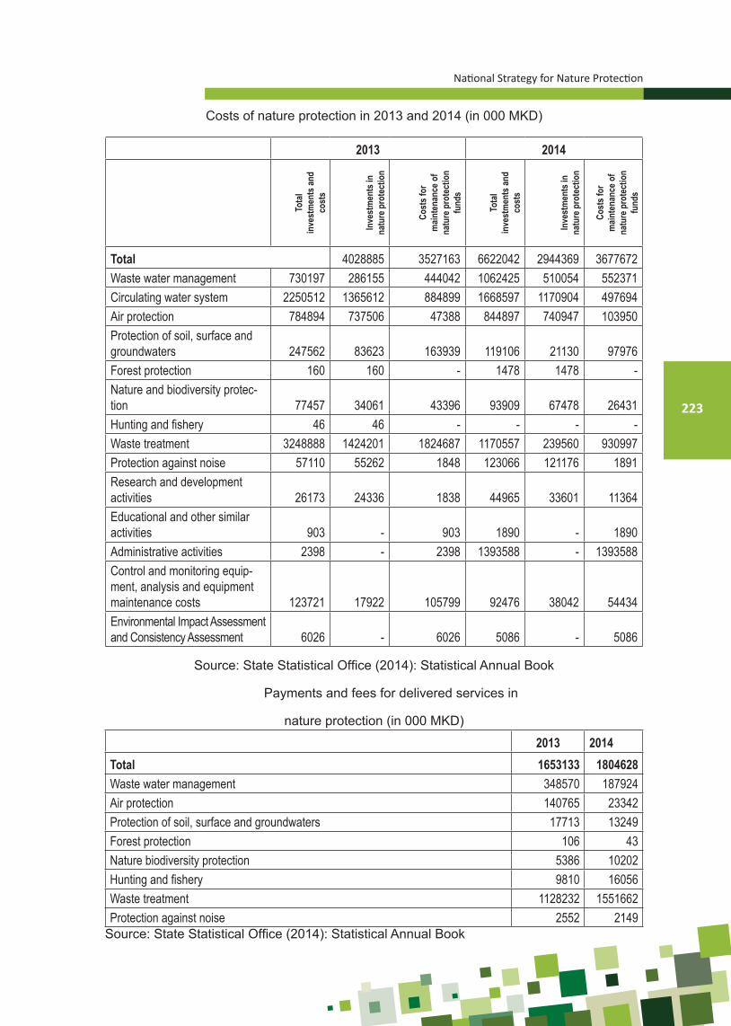
National Strategy for Nature Protection
223
Costs of nature protection in 2013 and 2014 (in 000 MKD)
2013 2014
Tota
l in
vest
men
ts an
d co
sts
Inve
stm
ents
in
natu
re p
rote
ctio
n
Cost
s for
m
ainte
nanc
e of
natu
re p
rote
ctio
n fu
nds
Tota
l in
vest
men
ts an
d co
sts
Inve
stm
ents
in
natu
re p
rote
ctio
n
Cost
s for
m
ainte
nanc
e of
natu
re p
rote
ctio
n fu
nds
Total 4028885 3527163 6622042 2944369 3677672Waste water management 730197 286155 444042 1062425 510054 552371Circulating water system 2250512 1365612 884899 1668597 1170904 497694Air protection 784894 737506 47388 844897 740947 103950Protection of soil, surface and groundwaters 247562 83623 163939 119106 21130 97976Forest protection 160 160 - 1478 1478 -Nature and biodiversity protec-tion 77457 34061 43396 93909 67478 26431Hunting and fishery 46 46 - - - -Waste treatment 3248888 1424201 1824687 1170557 239560 930997Protection against noise 57110 55262 1848 123066 121176 1891Research and development activities 26173 24336 1838 44965 33601 11364Educational and other similar activities 903 - 903 1890 - 1890Administrative activities 2398 - 2398 1393588 - 1393588Control and monitoring equip-ment, analysis and equipment maintenance costs 123721 17922 105799 92476 38042 54434Environmental Impact Assessment and Consistency Assessment 6026 - 6026 5086 - 5086
Source: State Statistical Office (2014): Statistical Annual Book
Payments and fees for delivered services in
nature protection (in 000 MKD)
2013 2014Total 1653133 1804628Waste water management 348570 187924Air protection 140765 23342Protection of soil, surface and groundwaters 17713 13249Forest protection 106 43Nature biodiversity protection 5386 10202Hunting and fishery 9810 16056Waste treatment 1128232 1551662Protection against noise 2552 2149
Source: State Statistical Office (2014): Statistical Annual Book

Ministry of Environment and Physical Planning
224
ANNEX 6SWOT ANALYSISTable 10. SWOT Analysis of the Protection of geodiversity and geological heritage and other
components of nature (biological and landscape diversity)
Strengths
- High geodiversity and biodiversity- High landscape diversity (+core areas
are relatively well connected)- System of protected areas is
established- Developed strategies/studies on:
biological diversity, protected areas, MAK-NEN, Spatial Plan, climate changes, water strategy, mineral resources strategy, sustainable development strategy, etc.
- EMERALD network is defined- Institutional legal framework is
established (including numerous signed conventions)
- - NGOs are involved in issues related to nature protection
- - MAFWE is a member of the International Union for Conservation of Nature (IUCN)
Weaknesses - Funding- No sufficient finances are provided for nature protection;- Not sufficient finances and protected areas (PA) management; - Lack of Nature Conservation Fund
Institutional framework- Lack of competent body responsible for nature protections, such as:
Bureau or Agency for Nature Protection;- Institutional capacities at central and local level are not sufficiently
strengthened;- Lack of appropriate competent stuffing potential at national and local level;- Lack of coordination among competent institutions; - Overlapping and lack of competences with relevant institutions;- Lack of stuffing of inspection services;
National legislation- National legislation is not fully transposed and adopted;- Nature Protection Law is not fully harmonized with EU acquis in the area
of nature protection - Not all by-laws are adopted- National Strategy for Geodiversity Protection with Action Plan is not
adopted- National red lists are not developed and adopted- National red books are not developed and adopted- NEN (National Ecological Network) is not adopted and implemented;
Strategic papers- Lack of compliance between the existing strategic documents;- Process of adoption of strategic documents (geodiversity, landscapes) is
not fully wrapped up
Research, monitoring and inventarization- Process of nature valorisation is not fully completed;- No continuous monitoring is established;- No monitoring methodology is developed;- Studies on commercial species and quotas are not developed;- Biodiversity indicators are not fully developed; - Surface waters and groundwaters are not sufficiently explored;- GIS data and databases are not unified;- National register of natural heritage and Cadastre of protected areas are
not updated;- National Biodiversity Information System (NBIS) is not operational;
Protected areas- Revalorization (designation and re-designation) of protected areas is not
completed; - Protected areas management plans are not developed for most of protect-
ed areas;- Protected areas are not properly arranged and managed;- The concept of ecosystem services is not developed and it is not applied;- The concept of eco-tourism is still insufficiently understood and applied;- Irrational use of natural resources;- Lack of education and promotion;

National Strategy for Nature Protection
225
Opportunities
- Candidate country for EU membership and availability of EU-funds (Life+)
- Geo-park
- Biosphere reserve (UNESCO)
- Development of green economy and eco-tourism
- Social responsibility
- Natura 2000, IUCN Green Belt
- Interested funds (Ohrid, Prespa Nature Fund, PONT, UN, GEF, donors)
- Cross-border and international coop-eration
- Greater use of capacities of NGOs working in the area of nature protewc-tion
Threats
- Lack of regulation on the use of finances for exploita-tion of mineral resources
- Monitoring in many sectors is not established
- Delayed implementation of action plans in all sectors
- Weak institutional capacities
- Depopulation
- Uncontrolled and increased urbanization
- Fragmentation of habitats
- Land conversion
- Climate changes
- Poor finances for nature protection (research, promo-tion), generally
- Low level of awareness on nature protection
- Lack of social consensus on solutions for nature issues

Ministry of Environment and Physical Planning
226

www.moepp.gov.mk