
Naghan (Chahar Mahal Bakhtiari-High Zagros, Iran) Earthquake of 6 April, 1977: A Preliminary Field...
28
GeoL Surv. Iran, 40, 51-77, 1977 NAGHAN (CHAHAR MAHAL BAKHTIARI-HIGH ZAGROS, IRAN) EARTHQUAKE OF 6 APRIL 1977: A PRELIMINARY FIELD REPORT AND A SEISMOTECTONIC DISCUSSION BY: M. BERBERIAN AND I. NAVAI GEOLOGICAL AND MINING SURVEY OF IRAN ABSTRACT The Naghan earthquake of magnitude 6 (Ms) occurred on 6 April 1977 in the mountainous area of Chahar Mahal Bakhtiaril in the High Zagros, south of Shahr-e- Kord. It killed 348 people, injured about 20£1, and caused destruction over an area of 150 Km 2. The shock damagedbeyond repair 2,100 houses and killed 0.7~ of live- stock in the area; eight schools collapsed and 37 were damaged. The maximum inten- sity of the main shock did not exceed VIII (MM). The earthquake was associated neither with any fresh surface faulting, nor with reactivation of the existing faults and salt domes at surface. Heavyrain fell before and during the earthquake and the destruction was more extensive where the saturated clay content of the alluvium was higher; it was also more extensive in water-logged areas or the areas with a shallower water table. Landslides occurred on steep slopes and destroyed or damagedsome villages built on slopes. Several aftershocks caused additional damage to the already destroyed or damaged villages. The Naghan earthquake was another instance of the "Subsedimentary Zagros- Type Earthquake"in the High Zagros part of the Zagros Active Folded Belt, indicating that the re-adjustment of the unexposed metamorphosed Precambrian Basement at depth caused no tectonic deformation (surface faulting) at the top of the sedimentary cover. This was due to the presence of the Upper Precambrian Hormoz layers (Salt deposits) acting as a slippage zone along the d~collement surface of the Zagros at depth.
-
Upload
independent -
Category
Documents
-
view
0 -
download
0
Transcript of Naghan (Chahar Mahal Bakhtiari-High Zagros, Iran) Earthquake of 6 April, 1977: A Preliminary Field...

GeoL Surv. Iran, 40, 51-77, 1977
NAGHAN (CHAHAR MAHAL BAKHTIARI-HIGH ZAGROS,IRAN) EARTHQUAKE OF 6 APRIL 1977:
A PRELIMINARY FIELD REPORT AND A SEISMOTECTONICDISCUSSION
BY:
M. BERBERIAN AND I. NAVAI
GEOLOGICAL AND MINING SURVEY OF IRAN
ABSTRACT
The Naghan earthquake of magnitude 6 (Ms) occurred on 6 April 1977 in themountainous area of Chahar Mahal Bakhtiaril in the High Zagros, south of Shahr-e-Kord. It killed 348 people, injured about 20£1, and caused destruction over an areaof 150 Km 2. The shock damaged beyond repair 2,100 houses and killed 0.7~ of live-stock in the area; eight schools collapsed and 37 were damaged. The maximum inten-sity of the main shock did not exceed VIII (MM).
The earthquake was associated neither with any fresh surface faulting, nor withreactivation of the existing faults and salt domes at surface. Heavy rain fell beforeand during the earthquake and the destruction was more extensive where the saturatedclay content of the alluvium was higher; it was also more extensive in water-loggedareas or the areas with a shallower water table. Landslides occurred on steep slopesand destroyed or damaged some villages built on slopes. Several aftershocks causedadditional damage to the already destroyed or damaged villages.
The Naghan earthquake was another instance of the "Subsedimentary Zagros-Type Earthquake"in the High Zagros part of the Zagros Active Folded Belt, indicatingthat the re-adjustment of the unexposed metamorphosed Precambrian Basement atdepth caused no tectonic deformation (surface faulting) at the top of the sedimentarycover. This was due to the presence of the Upper Precambrian Hormoz layers (Saltdeposits) acting as a slippage zone along the d~collement surface of the Zagros atdepth.

52 BERBERIAN, NAVAI
1. INTRODUCTION
A strong earthquake of magnitude 6.0 hit the northern Zagros range (the HighZagros or thrust zone), heart of the Bakhtiari tribal area (Chahar Mahal Bakhtiariprovince), 100 kilometres southwest of Esfahan (Figs. 1,2,3 and 4) .The earthquakeoccurred at 18.07.35 (local time Wednesday 17.1.2536), 13.36.35.5 GMT on 6 April1977, causing damage to houses and orchards in the area. The region, which serves asa summer resort for Bakhtiaris, was very sparsely populated at this time of the year.This was the first remembered destructive shock which shook this part of the country,except a minor shock which took place in 1975 southeast of the epicentral region (Fig 6).
Fig.
0
45 50
’,, High Zagros , Tehran
IRAQ ~ Fig.2
o
IRAN
0
Location of the Naghan (Chahar Mahal Bakhtiari, High Zagros, Iran) earthquake of April 1977.

Fig. 2. Zagros Active Folded Belt. Tectonic symbols as Fig. 4 (after Berberian 1976,b). The epi-central region of the Naghan (Chahar Mahal Bakhtiari, High Zagros, Iran) earthquakeof 6 April 1977 is shown by a circle, top-centre of the figure.
54 BERBER1AN, NAVAI
The Zagros Active Folded Belt, together with the northeast dipping "MainZagros Reverse Fault" (the former Zagros Thrust Line; Berberian 1976 a, b) whichbounds it in the north, extends some 1,500 km from the Taurus mountains in southernTurkey, through the whole of southern Iran, to a north-trending transcurrent (MinabFault) near the Strait of Hormoz at the mouth of the Persian Gulf (Fig. 2). The widthof the Belt is from 200 to 350 kin. Immediately southwest of the Main Zagros ReverseFault there is a "Thrust Zone" (or Imbricate Zone) containing strongly tectonizedseries with radiolarites and ophiolites as well as some limestone units.
The Imbricate Zone includes the highest mountains of the Zagros (the HighZagros) and the deepest exposures (Fig. 2). Further to the southwest begins the SimplyFolded Zagros s.st., formed of practically continuous sedimentary series from Cam-brian to Pliocene. The Thrust Zone is a complex zone of structures (rather than simple structure) and several reverse faults of different ages, namely Senonian andPliocene, are present within it.
The main shock of Naghan occurred at 13.36.35.5 GMT without any premonitoryforeshock. The shock killed 348 people and injured about 200. Destruction occurredover an area of 150 km2. It damaged beyond repair 2,100 houses.
The preliminary computation by the U.S. Geological Survey, National EarthquakeService, gives the following data:
Date : 6 April 1977Time : 13.36.35.5 GMTEpicentre : 31.92N, 50.64EMagnitude : 6.0 (Ms)Focal Depth : Restricted to 33 Km
The instrumental location places the epicentre of the main shock 9 km S.SWof the macroseismic epicentre. The macroseismic epicentre (taken as the centre of thea~-ea of maximum destruction) is located at 31.85N, 50.76E. Several aftershocks ofmagnitude 4-5 followed the destructive shock and worsened the condition of the al-ready damaged houses.
A preliminary examination of the area was made by a team of the Tectonic andSeismotectonic Research Section of the Geological Survey of Iran, which concentratedon observation of the effects of the earthquake in built-up areas and the surroundingcountry. Attention was particularly devoted to evidence of faulting or reactivation offaults and secondary effects such as cracks and openings in ground, lurching, tensioncracks, temporary springs, and any other disturbances. Aerial photographs at a scaleof I :20,000 and 1:55,000, together with the Landsat (A and B) imageries and geologicalmaps(B.P., 1963; IOOC, 1969) were used for locating the features observed and tracesof recent and late Alpine Faults.
The intensity of the earthquake effect was estimated using the Modified MercalliIntensity Scale. Conversation with inhabitants, their descriptions of the events, statis-tics, and information from the various authorities were used as guides.

Fig. 3. Location of lhe Nathan 6 April 1977epicentral region o~a the seismotectonic map of the~e~cn. ~I~e q~iccntral regien of the Nagh~n earthquake iis shown by a circle. (Berberian 1976a)
56 BERBERIAN, NAVAI
2. REGIONAL SEISMOTECTONIC SETTING
2.1. Regional Structure
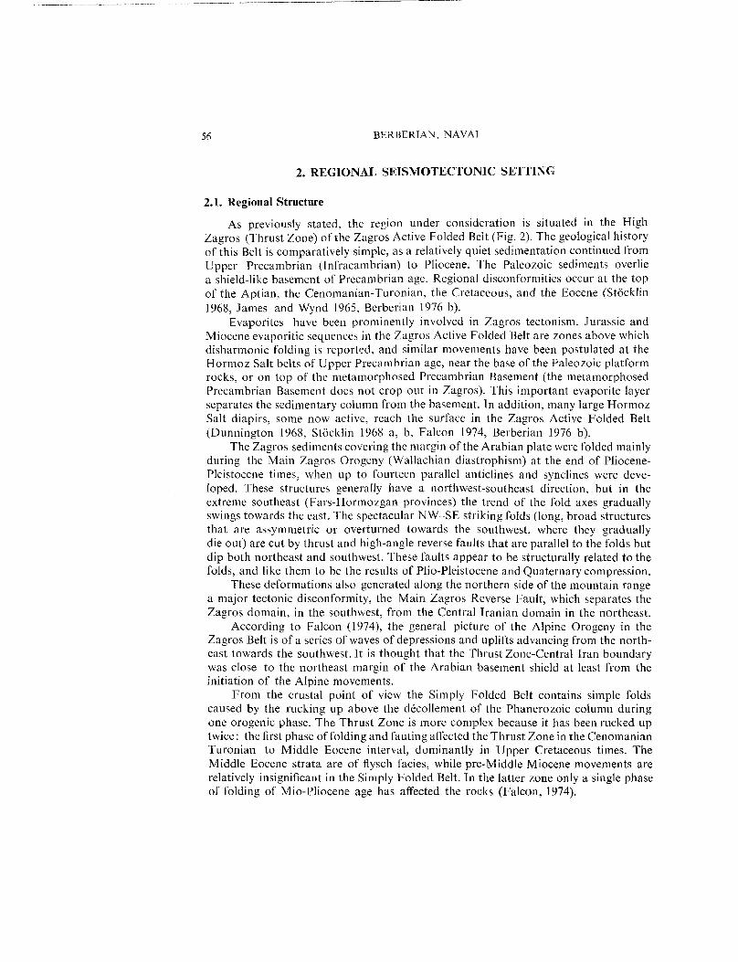
As previously stated, the region under consideration is situated in the HighZagros (Thrust Zone) of the Zagros Active Folded Belt (Fig. 2). The geological historyof this Belt is comparatively simple, as a relatively quiet sedimentation continued fromUpper Precambrian (lnfracambrian) to Pliocene. The Paleozoic sediments overliea shield-like basement of Precambrian age. Regional disconformities occur at the topof the Aptian, the Cenomanian-Turonian, the Cretaceous, and the Eocene (St6cklin1968, James and Wynd 1965, Berberian 1976 b).
Evaporites have been prominently involved in Zagros tectonism. Jurassic andMiocene evaporitic sequences in the Zagros Active Folded Belt are zones above whichdisharmonic folding is reported, and similar movements have been postulated at theHormoz Salt belts of Upper Precambrian age, near the base of the Paleozoic platformrocks, or on top of the metamorphosed Precambrian Basement (the metamorphosedPrecambrian Basement does not crop out in Zagros). This important evaporite layerseparates the sedimentary column from the basement. In addition, many large HormozSalt diapirs, some now active, reach the surface in the Zagros Active Folded Belt(Dunnington 1968, Stacklin 1968 a, b, Falcon 1974, Berberian 1976 b).
The Zagros sediments covering the margin of the Arabian plate were folded mainlyduring the Main Zagros Orogeny (Wallachian diastrophism) at the end of Pliocene-Pleistocene times, when up to fourteen parallel anticlines and synclines were deve-loped. These structures generally have a northwest-southeast direction, but in theextreme southeast (Fars-Hormozgan provinces) the trend of the fold axes graduallyswings towards the east. The spectacular NW-SE striking folds (long, broad structuresthat are assymmetric or overturned towards the southwest, where they graduallydie out) are cut by thrust and high-angle reverse faults that are parallel to the folds butdip both northeast and southwest. These faults appear to be structurally related to thefolds, and like them to be the results of Plio-Pleistocene and Quaternary compression.
These deformations also generated along the northern side of the mountain rangea major tectonic disconformity, the Main Zagros Reverse Fault, which separates theZagros domain, in the southwest, from the Central Iranian domain in the northeast.
According to Falcon (1974), the general picture of the Alpine Orogeny in theZagros Belt is of a series of waves of depressions and uplifts advancing from the north-east towards the southwest. It is thought that the Thrust Zone-Central Iran boundarywas close to the northeast margin of the Arabian basement shield at least from theinitiation of the Alpine movements.
From the crustal point of view the Simply Folded Belt contains simple foldscaused by the rucking up above the d6collement of the Phanerozoic column duringone orogenic phase. The Thrust Zone is more complex because it has been rucked uptwice: the first phase of folding and fauting affected the Thrust Zone in the CenomanianTuronian to Middle Eocene interval, dominantly in Upper Cretaceous times. TheMiddle Eocene strata are of flysch facies, while pre-Middle Miocene movements arerelatively insignificant in the Simply Folded Belt. In the latter zone only a single phaseof folding of Mio-Pliocene age has affected the rocks (Falcon, 1974).

Fig. 4. ERTS-A (Landsat-A) imagery of the Naghan (Chahar Mahal Bakhtiari) region in Zagros. The Naghan region of 6 April 1977 earthquake is shown by a circle.

58 BERBERIAN, NAVAI
2.2. Regional Seismicity
The very high twentieth century seismicity of the Zagros Active Folded Belt ischaracterized by a large number of shocks in the magnitude 5 or 6 range, and a very
small number with magnitude equal to or greater than 7 (Fig. 5). The precision depth calculation of the Zagros is very poor, and without :special studies little can besaid on the subject, except that most earthquakes occur in the crust, and that theydo not appear to exceed 100 kin. Series of earthquakes resembling swarms also seemto be characteristic of the Zagros (Berberian 1976 a, b).
The total thickness of the sediments above the metamorphosed Precambrianbasement cannot be more than 10 to 15 (or a possible maximum of 18) kilometres.Thus the earthquakes occurring within this depth range may be related to deformationof the sediments and or movements of the salt layers and their diapirism (?).
However, many earthquakes occur at greater depths, and salt diapirism wouldnot necessarily be associated with thrust faulting, whereas the focal mechanisms of mostearthquakes are thrust faults. It would therefore appear that most of the earthquakesare subsedimentary and probably related to the basement or upper mantle (Haghipouret al. 1972) and that reactivation of some basement faults during readjustment of thebasement causes subsedimentary earthquakes within the Zagros Active Folded Belt.
2.3. Previous Destructive Earthquakes of the Naghan Region
In 1976, July 27 an earthquake of magnitude 5 was strongly felt at Shalamzar.The instrumental epicentre was located at 31.60N, 50.36E and the estimated focaldepth was 77 km.
The only known semi-destructive earthquake in Naghan region is the Sarpir Earth-quake of 21 September 1975. The instrumeutal epicentre of this shock, which tookplace at 14.16.37.8 GMT (17.46.36 local time), is located at 31.599N, 51.037E. Themacroseismic epicentre was located at 31.63N, 51.13E (see southeastern corner ofFig. 6). The magnitude was 5.2 (Mb), the estimated focal depth 33 km (N) and maximum intensity VI-VII (MM). The earthquake destroyed Sarpir village and damag-ed Dorahan and Deh Bagh. Two people were killed in Sarpir.
3. EARTHQUAKE EFFECTS
The following descriptions of surface manifestations are represented in Fig. 6.
3.1. Faulting
Study of the Landsat imageries (A and B) at a scale of 1 :t,000,000 and 1:500,000,aerial photographs of the region at a scale of 1:20,000 and 1:55,000, the existing geolo-gical maps(B.P. 1963 IOOC 1969) and detailed field study shows that there are onlyfour major faults in or near the Naghan epicentral region, namely the Ardal Fault,Shalamzar Fault, Dopolan Fault and Dena Fault.
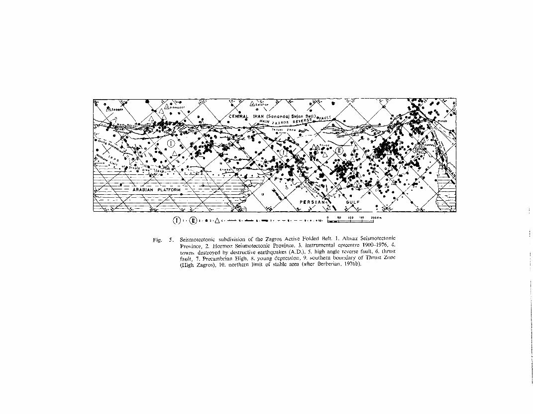
Fig. 5. Seismotectonic subdivision of the Zagros Active Folded Belt. l. Ahvaz SeismotectonicProvince, 2. Hormoz Seismotectonic Province, 3. instrumental epicentre 1900-1976, 4.towns destroyed by destructive earthquakes (A.D.), 5, high angle reverse fault, 6. thrustfault, 7. Precambrian High, 8. young depression, 9. southern boundary of Thrust Zone(High Zagros), 10. northern limit of stable area (after Berberian, 1976b).

6O BERBERIAN, NAVAl
Ardal Fault: This is a NW-SE reverse fault 80 km long, on the southeastern end o[~
which the epicentral region is situated (Figs. 6 and 7). It deepens towards the north-east. A linear Hormoz salt plug is intruded along its northwestern part. The fault iscovered by Quaternary alluvial deposits.
Shalamzar Fault: This fault is situated north of the epicentral region. Its length isabout 60 km and it deepens towards the northeast (Fig. 6).
Dopolan Fault: This is another northwest-southest fault 65 km long, southwest of theepicentra[ region. It starts from Dopolan in the NW and joins the Dena fault at itssoutheastern extremity (Figs. 6 and 8).
Dena Fault: a NNW-SSE fault about 30 km southeast of the epicentral region. Itseems that the macroseismic epicentre of Sarpir earthquake of 21.9.1975 was locatedon this fault (southeastern corner of Figure 6).
During a very careful investigation, these faults were checked in their entirety,and they were not reactivated at surface during the Naghan earthquake. Neither wasthe earthquake associated with the formation of new surface faults.
3.2. Salt Domes
There are two late Precambrian salt domes (Hormoz salt) in the Naghan regionintruded along Ardal and Dena faults: the Ardal salt dome in the northwestern partof the epicentral region, and the Dena salt dome in the southeastern part of the region(in Sarpir).
During the field investigation the contacts of the salt domes with the adjacentrocks have been carefully checked, but no fresh movement was found.
3.3° Landslides and Displacement of Stones
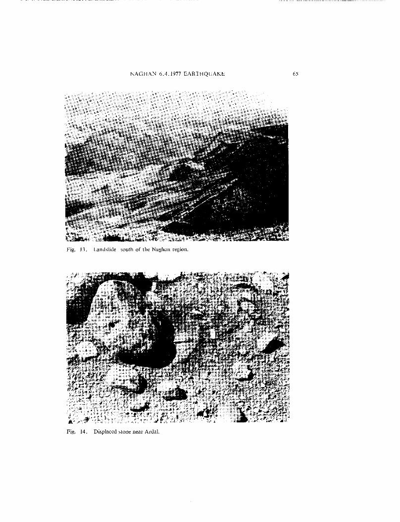
Several large scale landslides occurred during the Naghan earthquake, includingone about 1 km in length north and northwest of Ardal near the Ardal fault. Thestrike of this linear landslide is about N150°E (Fig. 9).
Another landslide destroyed a vineyard and moved towards Sakiabad village,pushing, fissuring and destroying a few houses in the village (Figs. 10 and 11). Somelandslides on the way to Ardal destroyed parts of the road (Figs. 12 and 13).
Many stones in Quaternary alluvial deposits were upthrown and displaced duringthe earthquake (Fig. 14).
(Facing page)Fig. 6. Map of the Naghan(Iran) earthquake area showing the main tectonic and damagefeatures. The intensity grades correspond to the Modified Mercalli Scale (Io = VIII).1. Severely damaged, 2. Considerable damage, 3. Light damage, 4. The shock stronglyfelt, 5. Instrumental epicentre, 6. Fault, 7. Isoseismals of Naghan 6.4. 1977 earthquake,8. Isoseismals of Sarpir 21.9.1975 earthquake, 9. Distance between macroseism~c andmicroseismic epicentres.

32.t5
32.00
3~45’
31.30
5o.3o 5o.45 51°.oo, 5{’.15’
,4ostam~ad * ~[imabad ~ ~nur~ad ~ ~Kharaji ~-, , ’r
/ TeShnl~ ~
0 Aziz~b~d I I~ .~ ~arya~ ....... ~. ~ ~Qaleh M e~ake x Boruje~
/ ~ ~ xx ~ "~ xTM~ Hossina~V[l I ~ ~Oondo~n
.. , ,
NAGHAN EARTHQUAKE OF 6APRIL 1977 ~ ~ I t{h :~ (N)Km
~ ~ -~C .... ~ ~o Abchenor ODareh R~zgeh ~ ~ ~
3 ~.15"
31.45
3~30"

Fig. Ardal Fault, NW of Ardal village at Ab-e-l?leheshtabad river. Note that this high anglereverse fault is covered by the Quaternary alluvial t~eposits. Looking west. No e~idenceof reactivation of this fault has been observed at sttrface during the Naghan earthquakeof 6 April 1977. The Sarvak Formation along the Ardal high angle reverse fault is upth-rusted and faces the southern Quaternary alluvial deposits. Looking NW.
Fig. Dopolan fault at Tang-e-Laghar, south of the epicentral region. No evidence of reactiva-tion of this fault has been observed at surface during the Naghan earthquake of 6 April1977. The Sarvak Formation (Middle Cretaceous limestones) in the north faces the Pab-deh Formation (Eocene) in the south. Looking NW.

62 I~ERI~ERIAN, NAVAl
Fig. 9. A long crack of N150°E direction northwest of Ardal formed due to a large la~dslide.Looking E.

NAGHAN 6.4.1977 EARTHQUAKE 63
Fig. 10. Landslide near Sakiabad which cut the vineyard and moved towards the village, damaginghouses, Looking SW.

64 BERBER|AN, NAVAl
Fig. 11. As Figure 10. Looking SW.
Fig. 12. Landslide cutting Arda! road.
NAGHAN 6.4.1977 EARTHQUAKE 65
Fig. 13. Landslide south of the Naghan region.
Fig. 14. Displaced stone near Ardal.

66 BERBERIAN, NAVAl
3.4. Rock Falls
Numerous rock falls occurred in different mountainous areas. Before and duringthe earthquake it was raining; consequently the rocks which fell during the earthquakeleft visible identations in the damp earth, clearly showing the path of the falling rocks.
Extensive Destruction on Saturated Clay
Due to the heavy rain before and during the earthquake, the clayey alluvium of theepicentral region was saturated with water. It has been observed that the destructionwas more extensive when the clay content of the alluvium was higher; it was alsohigher in water-logged areas or areas with a shallow water table, The northern partof Shalamzar village was not damaged but the southern part, which has a very shallowwater table (1 m), was damaged or partly destroyed.
3.5. Damage to Houses and Other Constructions
The buildings in the Naghan region may be divided into the following groups:
Fig. 15. Typical adobe-brick houses built on the slope of mountain at Naghan, which completelycollapsed during the earthquake.

NAGHAN 6.4.1977 EARTHQUAKE 67
a) Adobe-brick constructions with wooden beam ro~: These, together with the nextgroup, comprise 90~ of the houses in the area. The walls are of adobe-brick and
clay mortar, and the roofs of wooden beams covered by day and straw and tampedearth. New layers are added annually to the roof as a protection against rain and
snow percolation. Most of these constructions are now completely destroyed,or are seriously damaged and unsafe as dwellings (Fig. 15). The high ratio deaths to injuries emphasizes that the traditional adobe houses of the devastatedregion, with their weak walls and heavy earthen roofs, offer little resistance tostrong earthquakes. Total collapse and heavy loss of life were normal in thesebuildings. The adobe houses were completely destroyed at Jaghdan (Fig. 16),while the stone masonry communal bath, with reinforced concrete ring beamswas only slightly fissured (Fig. 17).
Fig. 16. Destruction of adobe houses at Jaghdan,

68 BERBERIAN, NAVAl
b) Masonry constructions with wooden beam ro@." The mortar used here is oftenclay, so these constructions had a resistance similar to adobe-brick houses. Theweakness of some of these buildings was further accentuated because each wallhad been built virtually from two unanchored facings between which was a fillingof earth (Fig. 18).
c) Masonry constructions with doomedroof~: In the area, there were a few structuresof this type with thick walls supporting the arch roof. The usual mortar is gypsumplaster, or a mixture of gypsum and clay.
d) Sundried brick constructions with wooden beam roofs’: These constructions survivedbetter than the previous ones. An interesting example is a two storied buildingat Naghan which stood up after the earthquake(Fig. 19)while all the adobe housescompletely collapsed (Fig. 15).
e) Modern buildings with brick masonry and steel beam-Jack arch roof~’." A fewbuildings of this type existed in the area. The school in Ardal was heavily damagedand partly destroyed (Figs. 20, 21, 22,23 and 24).
Fig. 17. Stone masonry bath at Jaghdan with reinforced concrete ring beam only slightly fissured,while all the adobe houses in the village collapsed completely,
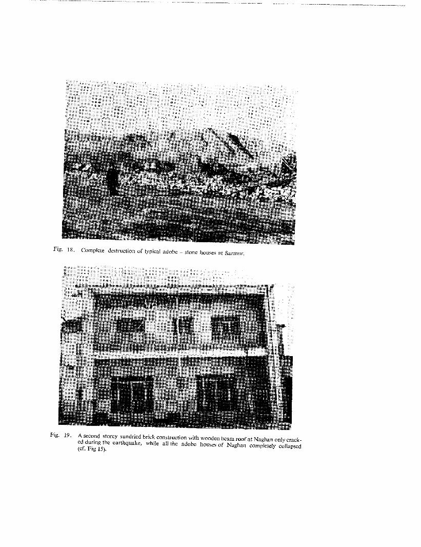
Fig. 18. Complete destruction of typical adobe - stone houses at Sarmur.
Fig. 19. A second storey sundried brick construction with wooden beam roof at Naghan only crack-ed during the earthquake, while all the adobe houses of Naghan completely collapsed(cf. Fig 15).

Fig. 20. Ardal school. A stee~ concrete frame school with arch type roof. Southern heavy wal! col-lapsed to the south, and the northern part of the building collapsed from the shallow rootsof the columns. Looking N.
Fgi. Damage to Ardal steel and concrete frame school.
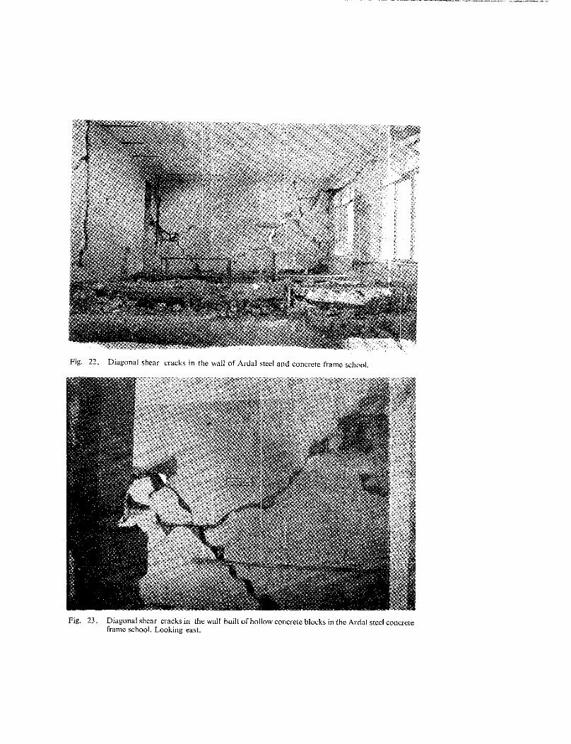
Fig. 22. Diagonal shear cracks in the wall of Ardal steel and concrete frame school.
Fig. 23. Diagonal shear cracks in the wall built of hollow concrete blocks in the Ardal steel concreteframe school. Looking east.

72 BERBERIAN, NAVAl
Fig. 24. Diagonal shear cracks in the wall of Ardal shoo!.
4. SEISMOTECTONIC DISCUSSION
Berberian and Tchalenko (1975) and Berberian (1976 b,c) stated that there is ,obvious relation between "Earthquakes" and "Structure" in the Zagros Active FoldedBelt, and that it is not possible to use seismicity to establish smaller seismotectonicunits with the information presently available. Neither the mountain/depressiondivision, nor the large scale fault-flexure zones and strongly folded arcs, nor the mappedfaults, seem to exert any strong earthquake locations in the Zagros.
According to Berberian (1976 b) the apparent lack of agreement between earth-quakes and structures may arise from two factors : "’D~ficiency of data" and "Unknownbasement - surface relation".
The "seismological data" is deficient because of the brevity of the observationperiod (about 70 years) and the inaccuracy of focal depth determination (+ 30 km).The "geologic-structural data" is deficient because the tectonic history of fundamentalstructures, such as the Kazerun zone, had not yet been established by detailed field
NAGHAN 6.4.1977 EARTHQUAKE 73
work. The major problem, however, is the unknown relation between the "Precambrianmetamorphosed basement" at depth where most earthquakes presumably occur, andthe "top of the sedimentary cover" where the geological structures are observed. Betweenbasement and cover, a "’highly plastic salt layer (#~e Hormoz Salt)" acts as a "’zoneof slippage" on the d6collement surface, disconnecting the cover structures from thoseat depth. Consequently surface structures may not ,’always reflect the underlying base-ment structures in a simple manner.
Even within the sedimentary cover, other plastic layers, such as the GachsaranFormation, are responsible for remarkable structural changes: synclines at surfacecorrespond to anticlines 1 km down; faults change from high angle reverse to nearhorizontal thrust, or die out altogether, etc.
The Naghan earthquake of 6 April 1977 of magnitude 7 is another "’SubsedimentaryZagros-Type Earthquake" case in the Zagros Active Folded Belt, showing that thereactivation of some basement faults at depth during the readjustment of the base-ment caused no tectonic deformation at the top of the sedimentary layers because ofthe presence of Hormoz plastic deposits. The, thickness of the top sedimentary coverin the Naghan region is about six kilometres (Morris 1977). This sedimentary coveroverlies the Hormoz salt beds and together overlie the metamorphosed Precambrianbasement.
As mentioned, the reactivation of the metamorphosed Precambrian basementcaused no structural effect on the top of these six kilometres of sedimentary foldedand faulted layers. No reactivation along fa~alts or salt domes has been observed,and no fresh surface break was formed. The subsedimentary Zagros-type earthquakeswhich are characteristic of the Zagros Actiw~ Folded Belt, while having no relationto the top of the sedimentary cover, represent an important phenomenon which createscarious problems in the seismic zoning of this part of the country. It seems that theZagros Active Folded Belt should neither be divided into several seismotectonic zonesin the manner of Nowroozi (1976; see Berberian 1977), nor give:a several expectedmaximum intensities for future earthquakes in different zones.
The Khurgu (North Bandar Abbas, Iran) earthquake of 21 March 1977 (Berberian,Papastamatiou and Qoraishi, 1977; see report No. 1, this volume) of magnitude 7.0,which occurred a few days before Naghan earthquake, was another "subsedimentaryZagros-type earthquake" which reinforces the present conclusions. These events showedthat earthquakes may occur anywhere in the Zagros Active Folded Belt and since nocorrelation could be established between the seismicity and the tectonic features withour present knowledge, it should be assumed that an event has the same probabilityof occurrence anywhere within the Zagros Active Folded Belt. That is to say, the seis-mic risk level is the same everywhere along the Belt. Hence 20th century epicentremaps may be dangerously unsuitable for the purpose of subdividing the Belt (and thecountry) into active and non-active regions. Reliably catalogued historical (pre-19t~0)earthquakes are so few as to be of little help. It would therefore be wrong to assumea very low risk rate in areas with no known record of a strong shock in the ZagrosActive Folded Belt.

74 BERBERIAN, NAVAI
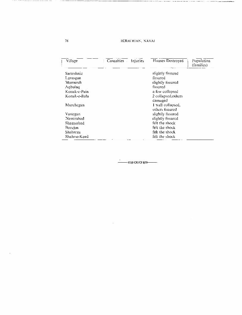
Table 1. Casualties and destruction of the Naghan earthquake of 6 April 1977.
Village Casualties i Injuries Houses Destroyed Population(families)
Naghan 202 100 mostlyMaryak 4 collapsed, others
damagedDareh-e-Gel-e-Gerd 3 2 1/3 collapsedKordan 7 4 mostlyDehno Olia 1/3 collapsedDamab 1 ¼ collapsedSarkhor (Parkhor) mostlyJaghdan 43 mostlyHajali mostlyKarch 1 4 destroyed, 2
fissuredArdal 64 mostlyDastgerd 11 25 115 collapsedGelugerd 2 46 collapsedSarmur 3 9 destroyedSangchin 1 half destroyedJahman damagedBajgiran 7 destroyedSeifabad 25 collapsedDehno Sofia damagedAliabad 10 coll apsedSoltanabad 1 2 ½ collapsedZeverdejan 31 partially collapsedZeverdejan 1 20 partially collapsedZeverdejan 31 fissuredBaraftab ½ partially collapsedOvergun 1 20 collapsedSakiabad 3 11 collapsedSibak 20 collapsedKhaniabad 2 37 collapsedKhederabad 2 50 collapsedKalbibak l collapsedHajiabad 40 badly fissuredQaleh Mamaka fissuredAsgarabad 1 partially collapsedGahru 1 fissuredJafarabad fissured
50O72
52l038668
13046
430800 persons
1860130
32202133
3
21200
68
92120
3650100

NAGHAN 6.4.1977 EARTHQUAKE 75
Village Casualties injuries i Houses Destroyed Populationi (families)
Shalamzar 50 partially collapsedGaytut badly fissuredChehraz I collapsedZolmabad .6 collapsedChahar Tagh damagedDopolan :slightly damagedGel-e-Sefid :slightly damagedHaftpiran 5 partly collapsedChelo fissuredBoldaji fissuredGandoman 1 ceiling collapsed
others fissuredCharmineh 5 collapsedHosseinabad 20 collapsedKatak (Olia and So.~?a) 2 collapsedSenagan 1~ fissuredKonarak fissuredBeheshtabad 1 collapsed, others fissuredKaj 2 walls collapsed,
others fissuredKarimabad houses fissuredRostamabad 10 partly collapsed,
others fissuredAbbasabad strongly feltJosib strongly feltCheshmeh Soleiman ’,strongly feltSarchah strongly feltHosseinabad slightly fissuredQaleh Darvish slightly fissuredQaleh Rashid slightly fissuredAIikuh a few fissuredSeikh Mahmud fissuredTang-e-Bill fissuredRigak fissuredDeh Kohneh 3 partly collapsed,
others fissured
Dastena fissured
Teshniz fissuredKharaji slightly fissured
640305065456540
76 BERBERIAN, NAVA[
Village Casualties Injuries Houses Destroyed Population, (families)
Sarteshniz slightly fissuredLavasgan fissuredMamureh slightly fissuredAqbulaq fissuredKonak-e-Pain a few collapsedKonak-e-l~ala 2 collapsed,others
damagedMurchegan 1 wall collapsed,
others fissuredVastegan slightly fissuredNassirabad slightly fissuredShamsabad felt the shockBorujen felt the shockShahreza felt the shockShahr-e-Kord felt the shock

NAGHAN 6.4.1977 EARTHQUAKE 77
REFERENCES
Berberian, M., 1976 a. Seismotectonic Map of Iran. Geological Survey of Iran. Gne coloured map.
Berberian, M., 1976 b. An explanatory note on the First Seismotectonic Map of Iran; a seismotectonicreview of the country. Geological Survey of lran, Report No. 39, 7-142, 53 figures, 5 maps,135 p.
Berberian, M., 1976 c. Contribution to the Seismotectonics of lran (Part II). Geological Survey of Iran,Report No. 39, 518 p., 5 maps, 259 figures.
Berberian, M., 1977. Discussion on the paper by Nowroozi, A.A., 1976, "Seismotectonic Provincesof Iran." Seism. Soc. Am. Bull. (in press).
Berberian, M., & Papastamatiou, 1977. Khurgu (north Bandar Abbas -/ran) earthquake of March21, 1977: A preliminary field report and a seismotect.onic discussion (In preparation).
Berberian M., & Tchalenko, J. S., 1975. On the tectonics and seismicity of the Zagros Active FoldedBelt. Geodynamics of South West Asia, Tehran Syrup., 8-15 September, Geological Surveyof Iran (Abst.).
British Petroleum Company (B.P.), 1963. Geological Map of Borujen region, 1:250,000, London, B.P.C.Ltd.
Dunnington, H. V., 1968. Salt-tectonic features of Northern lraq. Geol. Soc. Am., sp. Paper 88, p.183-227,
Falcon, N. L., 1974. Southern lran: Zagros Mountains. ,In Mesozoic-Cenozoic Orogenic Belts, Datafor orogenic studies. Geol. Soc. London, Sp. Pub. 4, 199--21 l (A.M. Spencer, Collection Editor,Scottish Academic Press),
Iranian Oil Operation Companies (IOOC), 1969. Geological Map of South-West Iran, Tehran.
James, G.A., & Wynd, J. G., 1965. Stratigraphic nomenclature of Iranian Oil Consortium AgreementArea. Am. Assoc. Petrol. Geol. BulL, 49 (12), 2182-2245.
Morris, P., 1977. Basement structure as suggested by aeromagnetic surveys in south west Iran. TheSecond Geological Symposium of lran. The Iranian Petroleum Institute (Abst.).
Nowroozi, A. A., 1976. Seismotectonic provinces of Iran. Bull. Seism. Soc. Am., 66 (4), 1249-1276.
St6cklin, J., 1968 a. Structural history and tectonics of Iran: A Review. Bull. Am. Assoc. Petrol. Geol.51 (7), 1229-1258.
StOcklin, J., 1968 b. Salt deposits of the Middle East. Geol. Soc. Am. Sp. Paper 88, 159-181.