Multi-Hazard Contingency Plan - Isingiro District
62
1 ISINGIRO DISTRICT LOCAL GOVERNMENT - MULTI-HAZARD CONTINGENCY PLAN REPUBLIC OF UGANDA ISINGIRO DISTRICT LOCAL GOVERNMENT 2020/21 CONTINGENCY PLAN MULTI-HAZARD
-
Upload
khangminh22 -
Category
Documents
-
view
0 -
download
0
Transcript of Multi-Hazard Contingency Plan - Isingiro District

1ISINGIRO DISTRICT LOCAL GOVERNMENT - MULTI-HAZARD CONTINGENCY PLAN
REPUBLIC OF UGANDA
ISINGIRO DISTRICT LOCAL GOVERNMENT
2020/21
CONTINGENCY PLANMULTI-HAZARD

2 ISINGIRO DISTRICT LOCAL GOVERNMENT - MULTI-HAZARD CONTINGENCY PLAN
iISINGIRO DISTRICT LOCAL GOVERNMENT - MULTI-HAZARD CONTINGENCY PLAN
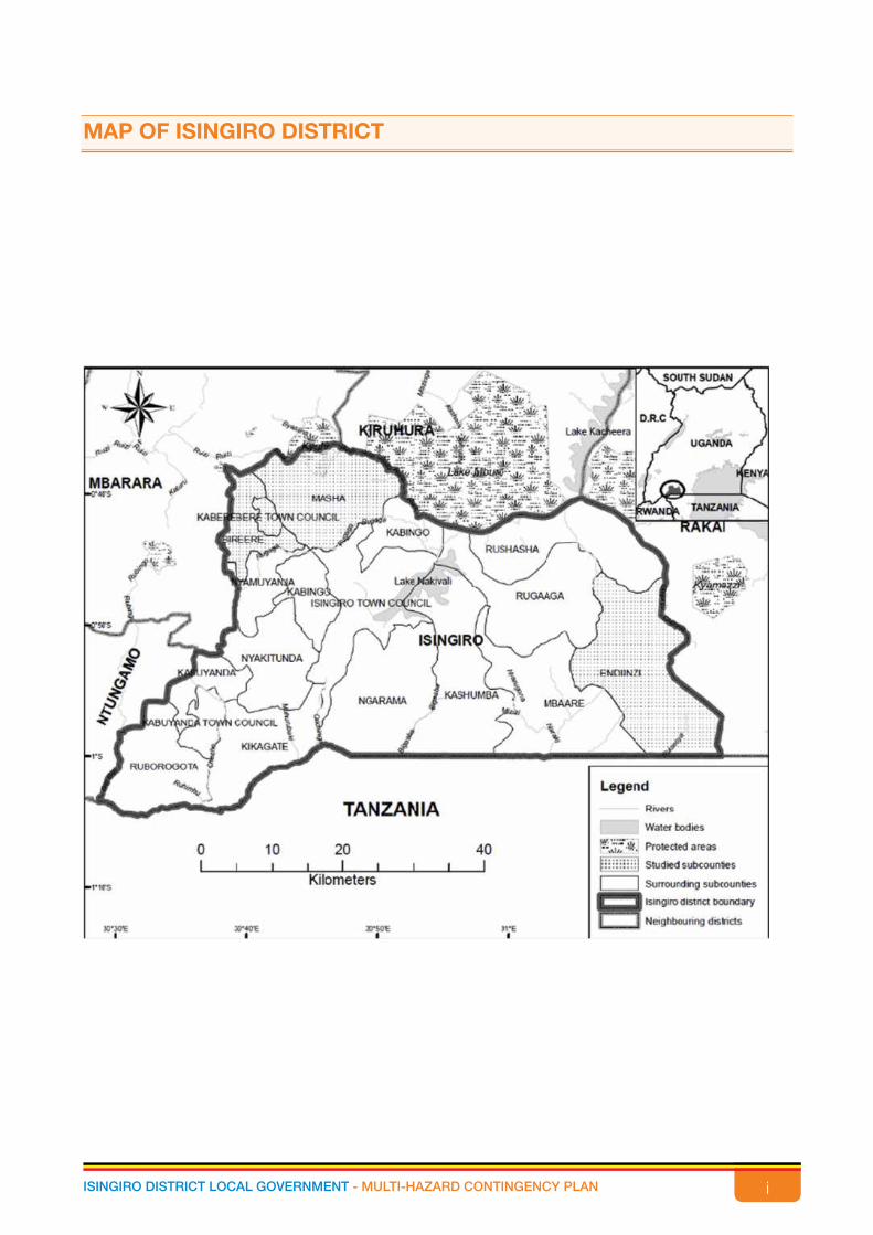
MAP OF ISINGIRO DISTRICT
ii ISINGIRO DISTRICT LOCAL GOVERNMENT - MULTI-HAZARD CONTINGENCY PLAN
APPROVAL STATEMENT
Isingiro District Local Government recognizes the importance of District Contingency Plan, which
is a mandatory requirement under the Ugandan Constitution and the National Policy for Disaster
Preparedness and Management, 2011.
The Isingiro District Multi-Hazard Contingency Plan provides for a coordinated response to the anticipated
potential emergencies to address the humanitarian needs of those adversely affected. In line with the
District vision, mission and in conformity to the National Development Plan (NDP) and Vision 2040, the
District Contingency Plan (DCP) 2020/2021 has formulated strategies that aim to integrate disaster and
climate issues in the District Development Plan 2020/21 – 2024/25
This document is for use by all stakeholders. The District Contingency Plan enjoys the support of
Isingiro District and Government of Uganda. The implementation and maintenance of the Plan is the
responsibility of Isingiro District Local Government.
…………………………………………
Eng. Hilary Onek (MP)
Minister of Relief, Disaster Preparedness and Refugees
………………………………………..
Kamuraali Jeremiah
Chairperson LCV - Isingiro District
…………………………………………
Asiimwe Alice Rushure
Chief Administrative Officer - Isingiro District
iiiISINGIRO DISTRICT LOCAL GOVERNMENT - MULTI-HAZARD CONTINGENCY PLAN
ACKNOWLEDGEMENT
Isingiro District Contingency Plan 2020/21 is meant to complement the Five-Year Development Plan
2020/21-24/25 in tandem with the National Development Plan III. In a participatory manner, the plan has
identified key hazards, their severity, occurrences and locations to enable all stakeholders to implement
the strategic directions for the reduction of the risks. Technical support from the Office of the Prime
Minister and Uganda Red Cross Society was given to the District Disaster Management Committee and
the identified stakeholders. This plan has been made as a Multi Hazard Disaster Risk Reduction Plan
at strategic level of governance of the District with clear focus on strategic and operational objectives,
strategies, activities and indicators of risk management and to address emergencies faced in Isingiro
District.
The plan outlines various reduction measures for the identified and analyzed risk hazards in Isingiro
District. These measures are specifically intended to reduce the current and prevent future risks in the
communities of Isingiro District.
My appreciation goes to all those who contributed to the formulation, preparation and production of
this Contingency Plan. I also thank the District Executive Committee for their inputs that improved and
directed the objectives and strategies of the plan.
I thank the District Disaster Management Committee which participated in the preparation and
formulation of this Plan.
I also wish to convey my thanks to the Office of the Prime Minister (OPM), Uganda Red Cross Society
(URCS), International Federation of Red Cross (IFRC) and Red Crescent Movement for their technical
support, guidance and facilitation during the development of the Plan. Their involvement has been
highly appreciated. Special thanks go to European Civil Protection and Humanitarian Aid Operations
(ECHO) for funding the process.
Asiimwe Alice Rushure
Chief Administrative Officer-Isingiro District Local Government

iv ISINGIRO DISTRICT LOCAL GOVERNMENT - MULTI-HAZARD CONTINGENCY PLAN
EXECUTIVE SUMMARY
This multi hazard contingency plan is in response to the National Policy for Disaster Preparedness and
Management, with the purpose to have a prepared District for disaster management by counteracting
vulnerability at community and local government levels, reducing the impact of hazards where possible
through mitigation, prediction, early warning, preparedness and response. This plan has been prepared
in close collaboration and coordination with OPM and Uganda Red Cross Society supporting its
facilitation.
The Plan is presented in five chapters:
Chapter 1 has details of the introduction and background literature of Isingiro District. It explains the
topography of the District, climate and vegetation, population size and distribution, and the purpose of
the formulation exercise of the contingency plan.
Chapter 2 gives an elaborate situational analysis of the disaster issues in Isingiro District. It gives the
assessment of the possible disasters in the District and the analysis of the top five. It explains the
vulnerability analysis of the hazards and priority areas for response in the eventuality of the hazards.
Chapter 3 looks at the general objective of the contingency plan. It has the vision, goal and strategic
objectives of the plan. The vision of the Plan is “An efficient and effective disaster - risk management
system developed in Isingiro District”. While the goal is “To establish a well-coordinated Multi-sectoral
approach to prevent and effectively respond to disasters in order to mitigate impact”.
Chapter 4 explains the management and coordination arrangements of this plan. It gives a clear
guidance on how the resilience capacities available will be guided to resist and respond to systematic
and sudden shocks the District may suffer. It identifies all development partners and programmes in
the District, the activities implemented, giving an understanding of the capacity Isingiro District has and
this has been done by enlisting the organisations/stakeholder, sector involved in and activities being
implemented. They include both local and international stakeholders.
This chapter also has an illustration of the organisational structure indicating how information will flow
among the different key stakeholders. It will guide management and coordination from the OPM down
to the VDMC and vice versa. The chapter also identifies some key challenges on District capacity
assessment gaps, which need addressed in preparation for readiness to manage the emergency
humanitarian situations, which may arise for an effective disaster management in the District.
Chapter 5 has the capacity-planning matrix. It seeks to operationalize the plan, basing on the District’s
capacity to respond to the possible hazards. It stipulates the strategic objectives, operational objectives,
activities, personnel, focal/supporting entities, disaster phase, location, time start, duration and budgets
for each of the five key sectors identified (Management and coordination, food security, water and
sanitation, health and education)
vISINGIRO DISTRICT LOCAL GOVERNMENT - MULTI-HAZARD CONTINGENCY PLAN
TABLE OF CONTENTS
Map of Isingiro District ...................................................................................................................... i
Approval Statement ......................................................................................................................... ii
Acknowledgment ............................................................................................................................ iii
Executive Summary ........................................................................................................................ iv
Table of contents ............................................................................................................................. v
List of Tables .................................................................................................................................. vii
Table of Figures ............................................................................................................................. viii
List of acronyms ............................................................................................................................ viii
Glossary of Key Words and Terminologies ..................................................................................... x
CHAPTER ONE – INTRODUCTION AND BACKGROUND .............................................................. 1
1.1 Overview of Isingiro District .................................................................................................... 1
1.2 Geographical Location ........................................................................................................... 1
1.3 Topography ........................................................................................................................... 1
1.4 Climate .................................................................................................................................. 1
1.5 Vegetation ............................................................................................................................. 1
1.6 Soil ........................................................................................................................................ 2
1.7 Population ............................................................................................................................. 2
1.8 Economic Activities ................................................................................................................ 3
1.9 Housing Conditions ............................................................................................................... 3
1.10 Status of Dwelling Units ....................................................................................................... 3
1.11 Health Infrastructure ............................................................................................................ 3
1.12 Education in general ............................................................................................................ 4
1.13 Roads ................................................................................................................................. 4
CHAPTER TWO – SITUATIONAL ANALYSIS ................................................................................... 5
2.1. Situational Analysis of disaster issues .................................................................................... 5
2.2 Isingiro District Hazard, Risk and Vulnerability Analysis .......................................................... 10
2.2.1 Drought .......................................................................................................................... 10
2.2.2 Human disease outbreak ................................................................................................ 12
2.2.3 Crop pest and diseases .................................................................................................. 13
2.2.4 Livestock pests and diseases ......................................................................................... 14
2.2.5 Environmental degradation ............................................................................................. 15
2.2.6 Population Movement / Influx .......................................................................................... 16
2.2.7 Floods ............................................................................................................................ 19
2.2.8 Land conflicts ................................................................................................................. 21
2.2.9 Road transport related accidents .................................................................................... 22

vi ISINGIRO DISTRICT LOCAL GOVERNMENT - MULTI-HAZARD CONTINGENCY PLAN
2.2.10 Famine ......................................................................................................................... 23
CHAPTER THREE – OBJECTIVES OF THE CONTINGENCY PLAN .............................................. 25
3.1. Vision, Goal and Objectives of the Plan ................................................................................ 25
3.2 Overall Goal ......................................................................................................................... 25
3.3 Strategic Objectives ............................................................................................................. 25
3.3.1 Strategic Objectives and actions ..................................................................................... 25
CHAPTER FOUR – MANAGEMENT AND CO-ORDINATION ARRANGEMENTS ......................... 27
4.1 Development Partner Projects/NGO implemented activities/other government programs ..... 27
4.2 Contingency structure .......................................................................................................... 28
4.3 Challenges on District capacity Assessment ......................................................................... 28
4.4 Roles and Responsibilities .................................................................................................... 29
4.4.1 Responsibilities of DDMC ............................................................................................... 29
4.4.2 Role of the District Council .............................................................................................. 29
4.4.3 Sub-County Disaster Management Committees ............................................................. 30
4.4.4 Village Disaster Management Committee ........................................................................ 30
4.4.5 Roles and Responsibilities .............................................................................................. 30
4.4.6 NGOs and CBOs ............................................................................................................ 30
4.4.7 Community .................................................................................................................... 30
4.4.8 Private sector ................................................................................................................. 31
CHAPTER FIVE – CAPACITY PLANNING MATRIX ........................................................................ 32
CHAPTER SIX – APPENDICES ...................................................................................................... 38
Appendix 1 - Isingiro District Contingency Plan Development Team ........................................... 38
Appendix 2 - Definition of Triggers & thresh holds ........................................................................ 39
viiISINGIRO DISTRICT LOCAL GOVERNMENT - MULTI-HAZARD CONTINGENCY PLAN
List of Tables
Table 1 District Population by LLG, 2018 .......................................................................................... 13
Table 2 Risk Assessment .................................................................................................................. 16
Table 3 Probability of Occurrence in Isingiro District ........................................................................... 18
Table 4 Mean Impact Assessment .................................................................................................... 20
Table 5 Potential Hazards, Status and Affected Areas ....................................................................... 21
Table 6 Hazard Analysis – Drought .................................................................................................... 23
Table 7 Vulnerability Analysis – Drought ............................................................................................. 23
Table 8 Coping Mechanisms to be Encouraged ................................................................................ 24
Table 9 Priority Areas for Response .................................................................................................. 25
Table 10 Hazard Analysis - Human Diseases ..................................................................................... 26
Table 11 Vulnerability Analysis - Human Diseases ............................................................................. 26
Table 12 Coping Mechanisms to be Encouraged .............................................................................. 27
Table 13 Priority Areas for Response ................................................................................................ 27
Table 14 Hazard Analysis - Crop Pests & Diseases ............................................................................ 28
Table 15 Vulnerability Analysis - Crop Pests & Diseases .................................................................... 28
Table 16 Coping Mechanisms to be Encouraged .............................................................................. 28
Table 17 Priority Areas for Response ................................................................................................ 29
Table 18 Hazard Analysis - Livestock Pests & Diseases ..................................................................... 29
Table 19 Vulnerability Analysis - Livestock Pests & Diseases .............................................................. 29
Table 20 Coping Mechanisms to be Encouraged .............................................................................. 30
Table 21 Priority Areas for Response ................................................................................................ 30
Table 22 Hazard Analysis - Environmental Degradation ..................................................................... 31
Table 23 Vulnerability Analysis - Environmental Degradation .............................................................. 31
Table 24 Coping Mechanisms to be Encouraged .............................................................................. 32
Table 25 Priority Areas for Response ................................................................................................ 32
Table 26 Hazard Analysis - Population Movement/Influx .................................................................... 32
Table 27 Vulnerability Analysis - Population Movements/ Influx .......................................................... 33
Table 28 Coping Mechanisms to be Encouraged .............................................................................. 34
Table 29 Priority Areas for Response ................................................................................................ 34
Table 30 Hazard Analysis – Floods .................................................................................................... 36
Table 31 Vulnerability Analysis – Floods ............................................................................................. 36
Table 32 Coping Mechanisms to be Encouraged .............................................................................. 37
Table 33 Priority Areas for Response ................................................................................................ 37
Table 34 Hazard Analysis - Land Conflicts ......................................................................................... 39
Table 35 Vulnerability Analysis - Land Conflicts ................................................................................. 39
Table 36 Coping Mechanisms to be Encouraged .............................................................................. 39
Table 37 Priority Areas for Response ................................................................................................ 39

viii ISINGIRO DISTRICT LOCAL GOVERNMENT - MULTI-HAZARD CONTINGENCY PLAN
Table 38 Hazard Analysis - Road Related Accidents .......................................................................... 40
Table 39 Vulnerability Analysis - Road Related Accidents .................................................................. 40
Table 40 Coping Mechanisms to be Encouraged .............................................................................. 40
Table 41Priority Areas for Response ................................................................................................ 40
Table 42 Hazard Analysis – Famine ................................................................................................... 41
Table 43 Vulnerability Analysis – Famine ............................................................................................ 41
Table 44 Coping Mechanisms to be Encouraged .............................................................................. 42
Table 45 Priority Areas for Response ................................................................................................ 42
Table 46 Stakeholders’ Analysis ....................................................................................................... 44
Table 47 Functions and Responsibilities of Individuals in the Private Sector ........................................ 48
TABLE OF FIGURES
Figure 1 The Contingency Structure ............................................................................................. 46
LIST OF ACRONYMS
AFO
ARC American Refugee Committee
CAO Chief Administrative Officer
CBS Community Based Services
DCO District Commercial Officer
DEC District Executive Committee
DMC Disaster Management Committee
DMMC District Disaster Management Committee
DEO District Education Officer
DHO District Heath Officer
DIO District Information Officer
DLG District Local Government
DNRO District Natural Resources Officer
ECD Early Childhood Development
FAO Food and Agricultural Organisation
GoU Government of Uganda
HCs Health Centres
HHs House Holds

ixISINGIRO DISTRICT LOCAL GOVERNMENT - MULTI-HAZARD CONTINGENCY PLAN
HRV Multi-hazard, Risk, and Vulnerability
IDDMC Isingiro District Disaster Management Committee
IDLG Isingiro District Local Government
ILO International Labour Organisation
LC Local Council
LLG Lower Local Government
MDAs Ministries, Departments and Agencies
MoH Ministry of Health
NGO Non-Governmental Organisation
NFA National Forestry Authority
OPM Office of the Prime Minister
PWDs People with Disabilities
PFO Principal Finance Officer
RDC Residence District Commissioner
RTP Right to Play
SCDMC Sub-County Disaster Management Committee
S/C Sub-County
SGBV Sexual Gender Based Violence
SAS Senior Assistant Secretary
TC Town Clerk
TPO Trans-cultural-Psychosocial Organisation
TVs Televisions
T/C Town Council
UNRA Uganda National Roads Authority
UNICEF United Nations Children’s Fund
UWA Uganda Wildlife Authority
UBOS Uganda Bureau of Statistics
UWESO Uganda Women’s Effort to Save Orphans
UNHCR United Nations High Commissioner for Refugees
VDMC Village Disaster Management Committee
VHT Village Health Teams
WASH Water Sanitation and Hygiene
WHO World Health Organisation
WFP World Food Programme

x ISINGIRO DISTRICT LOCAL GOVERNMENT - MULTI-HAZARD CONTINGENCY PLAN
GLOSSARY OF KEY WORDS AND TERMINOLOGIES
Hazard is a potentially damaging physical event, phenomenon or human activity that may cause the
loss of life or injury, property damage, social and economic disruption or environmental degradation
Risk is a probability of a hazard occurring or threatening to occur
Vulnerability refers to the propensity of exposed elements such as human beings, their livelihoods, and
assets to suffer adverse effects when impacted by hazard events
Climate variability refers to the climatic parameter of a region varying from its long-term mean. Every
year in a specific period, the climate of a location is different. Some years have below average rainfall,
some have average or above average rainfall
Disaster is a progressive or sudden widespread or localized, natural or human-caused occurrence,
which causes or threatens to cause death or injury, damage to property, infrastructure or environment,
disruption of life of a community and its magnitude exceeds the ability of those affected to cope using
only their own resources
Disaster management is a continual and integrated multi-sectorial and multidisciplinary process of
planning and implementation of measures aimed at disaster prevention, mitigation, preparedness,
response, recovery, and rehabilitation
Mitigation means structural and non-structural measures undertaken to limit the adverse impact of
natural hazards, environmental degradation, and technological hazards
Preparedness means activities and measures taken in advance to ensure effective response to the
impact of hazards, including the issuance of timely and effective early warnings and the temporary
evacuation of people and property from threatened locations
Response means measures taken during or immediately after an incident or a disaster in order to bring
relief to affected communities or individuals
Adaptation means the adjustment in natural or human systems in response to actual or expected
climatic stimuli or their effects, which moderates harm or exploits beneficial opportunities

1ISINGIRO DISTRICT LOCAL GOVERNMENT - MULTI-HAZARD CONTINGENCY PLAN
CHAPTERONEINTRODUCTION AND BACKGROUND
1.1 Overview of Isingiro DistrictIsingiro District is a District in Western Uganda boarded by Kiruhura District to the north, Rakai District to
the east, the Republican of Tanzania to the south, Ntungamo District to the west, and Mbarara District
to the northwest. Isingiro the chief town of the District is located approximately 35 kilometers by road,
southeast of the city of Mbarara, the main metropolitan area in Ankole sub-region. Isingiro District has
21 Sub-counties and 9 Town Councils, 131 parishes and 899 Villages by July2020. The following are
sub-counties in Isingiro District: Birere, Endinzi, Kabingo, Kabuyanda, Kashumba, Kikagate, Masha,
Mbaare, Ngarama, Nyakitunda, Nyamuyanja, Ruborogota, Rugaaga, Kakamba, Rushaha, Ruyanga,
Rwetango, Kagarama, Rwanjogyera, Rwambaga The Town Councils include Isingiro, Kaberebere,
Endiinzi, Kabuyanda, Bugango, Kikagate, Kaubeizi, Ruhiira and Rugaaga.
1.2 Geographical LocationIt is located in South Western Uganda and lies between Latitude 1-30o and 0-30o North Longitude 30-
20o East and 31-20o East. It lies between the altitude of 1200m – 1810 m.a.s.l. Areas west of the District
around Nyakitunda, Nyamuyaja, Kabingo and Kabuyanda hills have the highest altitudes up to 1810m
towards Mbarara and Ntungamo District boarder. The low altitudes are along areas east of the District
around Endiizi, Rushasha sub counties bordering with Rakai District and the lowest being at the main
L. Nakivale water body in Rugaga Sub-County.
Its Land area is approximately 3010 sq. Km and it is at 1800 meters above sea level.
1.3 TopographySteep hills and deep valleys especially in the sub-counties of Nyakitunda, Kabingo, Kabuyanda, Ngarama
Rugaaga and Kashumba mostly characterize Isingiro’s scenery. Gentle slope hills and low land areas for
the sub-counties of Mbaare, Endiinzi, Masha and Part of Birere characterize other areas.
1.4 ClimateThe District enjoys equatorial climate and receives average rainfall of 1200mm, temperature normally
ranges from 17-30 degrees Centigrade. It has two main rainy seasons during the months of March to
May and September to November in each Calendar year. Some areas however have recently been
faced with dry spell and chronic drought especially in Masha, Endiinzi and Kikagate Sub-counties.
Some parts of Bukanga are also sometimes unfortunate as they are hit by hailstorms especially at the
beginning of the September to November wet rainy season.
1.5 VegetationThe District’s ecological system is prone to chronic drought and the bare hills and rangelands

2 ISINGIRO DISTRICT LOCAL GOVERNMENT - MULTI-HAZARD CONTINGENCY PLAN
characterize the terrain. Thorny bushes and trees characterized mostly of Ruborogota, Kabingo, Masha
and Endiinzi Sub-Counties. Endiinzi and Rushasha are characterized by grassland savannah. There is
also a presence of scattered swamps and valleys in the Sub-Counties as well as bare hills with stone
deposits in most of the high lands.
1.6 SoilThe soils are mainly clay, late rite loam and sandy nature. The District natural resources include fertile
soils in almost all sub-counties, presence of Lake Nakivale, Mburo, Kakyera and Oruchinga, availability
of water springs in the sub-counties of Nyakitunda, Kabuyanda, Kabingo and Birere and greater
Tin deposits in the Sub-County of Kikagate. Isingiro District is generally a fertile land which could be
responsible for intense agriculture activity both crop growing and animal husbandry.
1.7 PopulationAs per the 2014 Population and Housing Census, Isingiro District Population was 486,360 people of
which 235,621 being females and 250,739 being males. The Current total population projection 2020
is 596,400 of which 305,600 are females and 290,800 are males.
Isingiro District also house two refugee settlement; Nakivale with a population of about 140,000 and
Oruchinga Refugee Settlement with about 6,700.
The table below shows the population size for each of the LLG in the District.
Table 1 District Population by LLG, 2020S/N LLG POPULATION 20201 NGARAMA S/C 41,1002 KAKAMBA 8,7003 RUGAAGA S/C 40,5004 KASHUMBA S/C 88,4005 ENDIINZI T/C 9,0006 ENDIINZI S/C 20,5007 MBAARE S/C 41,1009 RUSHASHA S/C 16,00010 BIRERE S/C 26,00011 ISINGIRO T/C 34,30012 KABEREBERE T/C 8,20013 KABINGO S/C 26,80014 KABUYANDA S/C 26,00015 KABUYANDA T/C 20,00016 KIKAGATE S/C 68,00017 MASHA S/C 32,00018 NYAKITUNDA S/C 51,00019 NYAMUYANJA S/C 19,30020 RUBOROGOTA S/C 21,500
TOTAL 596,400
Source: Planning Unit 2020
3ISINGIRO DISTRICT LOCAL GOVERNMENT - MULTI-HAZARD CONTINGENCY PLAN
From the above table, its shows that the total population by 2020 is 596,400 people. Kashumba Sub-
County has the highest population of 88,400 people and Kaberebere Town Council with the lowest
population of 8,200 people.
1.8 Economic ActivitiesEconomic activity refers to activity that people carry out to earn a livelihood. Agriculture is the dominant
economic activity.
According to the 2014 Census results, Subsistence farming remains the main source of livelihood with
78.5% of the household engaged in the industry. This is generally characterised by the engagement in
crop production, livestock rearing, and other associated activities mainly for own consumption. Around
87.8% of the HHs are engaged in crop growing and 52.2% in livestock. Generally, 90% of the HHs
are engaged in an agricultural activity. Subsistence farming is usually associated with risk, uncertainty
(especially when based on seasonal rains) and low productivity. Subsistence farmers produce primarily
for own consumption but may sell some of the produce.
1.9 Housing ConditionsThe public sector contribution to housing supply for accommodation is mainly limited to institutional
quarters for specific institutions such as the Army, the police, schools and Hospitals among others.
The 2014 census collected data on various aspects of household including the housing units they stay
in. the information is normally used to deliver the welfare of the households and such information was
however not collected for persons not enumerated in households namely those enumerated in hotels
or institutions. Therefore, information from such people is not included in the analysis. Housing is none
of the basic needs that have a profound impact on health, welfare, social attitudes and economic
productivity of the individual. It is also one of the best indicators of a person’s standard of living and his
or her place in society.
1.10 Status of Dwelling UnitsThe 2002 Census classified dwelling units as permanent, Semi-Permanent and temporary. Permanent
dwelling units are those built with construction materials (for roof, floor and wall) that can maintain
their stability for more than 15 years. The semi-permanent houses are those that are built with the
combination of permanent and temporary materials and require regular maintenance. On the other
hand, the temporary dwellings are those that are built with materials that cannot maintain their stability
for more than 3 years and require regular replacement. All Housing Units thatched with untreated natural
fibres are classified as temporary irrespective of wall and floor materials.
1.11 Health InfrastructureInfrastructure includes number of Health Sub-Districts, hospitals, Health Centres and basic equipment.
Isingiro District is made up of three Health Sub Districts namely, Bukanga, Isingiro North and Isingiro
South. In the three Sub-Districts, there are several health centres at different levels. Below is the table
4 ISINGIRO DISTRICT LOCAL GOVERNMENT - MULTI-HAZARD CONTINGENCY PLAN
showing the distribution of health units by LLG.
The distribution of health centers is considerably fair apart from Kabingo and Kabuyanda, each Sub-
County has at least a health Centre III and each Sub-District has a health Centre IV. However apart from
the only two Health Centre IIs which Kabingo and Kabuyanda have, have been joined by Birere, which
has 3-health center IIs.
1.12 Education in generalEducation is vital in promoting sustainable development by improving the people’s various skills as well
as raising awareness on various issues, which are important in human development like general living
standards. Isingiro District attaches great importance to the development of education as a service
as it trains children and adults in a range of skills from basic education to professional development.
Most programmes are based on the National Curriculum that enables children to transfer into the
public system more easily. Uganda’s education system includes formal and informal education. Formal
education comprises of training at primary, secondary and tertiary. Formal education trains beneficiaries
into basic skills of reading, writing and numeracy. Tertiary Education includes Universities, Colleges of
Commerce, technical and Vocational Colleges, Technical Institutes, Polytechnic and Teacher Training
Colleges.
1.13 RoadsIsingiro District has a total of approximately 2,049Km of District Urban and Community Access
roads (DUCAR) of which the District Feeder Roads are 684Km, 393Km are Urban Roads in Isingiro,
Kaberebere, Kabuyanda, Endiinzi, Bugango, Kikagate, Ruhiira and Kamubeizi Town Councils. There
are approximately 972Km of Community Access Roads (CARs) under the care of Sub-counties. The
District is in charge of maintaining the condition of Feeder roads yet Sub-Counties and Town Councils
maintain community Access and Urban roads respectively. Out of the 684Km District Roads, 21.07%
are in good condition, 35.06% Fair while 43.87% are in bad condition. About 540Km are in maintainable
condition while the remaining 144Km are bogged with bottlenecks, motorable with difficulty and due for
rehabilitation interventions.
The District is also home to 387.6Km of Trunk Roads, which are under the care of Central Government
under UNRA. Of this trunk road network in Isingiro, 20% is paved while 80% is unpaved. The paved
roads include Katete – Nsongezi 49Km, Isingiro – Mabona loop 6Km and Nsongezi – Kikagate and
Kikagate – Murongo Bridge road 19Km. The rest of the national roads are unpaved. Most of these roads
are characterized by heavy traffic especially the Isingiro – Ntantamuki road (54.2Km) which can only
be saved by up grading it to tarmac or bitumen standard. Most of these roads are under framework
contracts with UNRA and occasionally UNRA does direct maintenance works but still face challenges.

5ISINGIRO DISTRICT LOCAL GOVERNMENT - MULTI-HAZARD CONTINGENCY PLAN
SITUATIONAL ANALYSIS
2.1. Situational Analysis of disaster issuesCommon hazards in Isingiro District listed according to priority include:
1. Drought
2. Human disease outbreaks
3. Crop pests and diseases
4. Livestock pests and diseases
5. Drought fires, soil erosion, tree cutting e.t.c
6. Floods
7. Landslides and rock falls
8. Land conflicts
9. Earthquakes and faults
10. Road accidents
11. Vermin and wild- life animal attacks
12. Hailstorms and winds
13. Famine
14. Population movements
12. Population movements majorly due to refugee influx. Table 2 Risk Assessment
Hazard Probability Severity Of Impacts Relative Risk Vulnerable Sub- Counties
Relative likelihood this will occur
Overall Impact (Average)
Probability x Impact Severity
Hazard 1 = Not occur 2 = Doubtful 3 = Possible4=Probable 5 = Inevitable
1= Very Low2= Low3= Moderate4 = High5= Very High
1-10 = Low11-20 =Moderate 21-25 = High
Drought
5 5 25
Kikagate, Masha, Kashumba, Rugaga, Isingiro TC, Mbaare, Kashumba, Ruborogota, Endiinzi and Ngarama
Human disease outbreak
5 2 10
Kikagate, Kaberebere TC, Kashumba, Isingiro TC, Kabuyanda TC, Ngarama, Rugaaga, Kakamba and Rushasha
Crop pests and diseases 3 4 12
Kikagati, Isingiro TC,Masha,Birere, Ngarama, Kashumba, Rugaga and Kaberebere TC
4. Livestock pests and diseases 5 3 25
Endiinzi, Kashumba, Kikagate, Masha, Mbaare, Ruborogota, Rushasha and Rugaga
5. Drought fires, soil erosion, tree cutting etc. 5 2 10
Kikagate, Masha,Ngarama, Rugaaga, Rushasha, Nyakitunda, Kashumba and Isingiro TC
CHAPTERTWO

6 ISINGIRO DISTRICT LOCAL GOVERNMENT - MULTI-HAZARD CONTINGENCY PLAN
Hazard Probability Severity Of Impacts Relative Risk Vulnerable Sub- Counties
6. Hailstorms and winds 5 4 20
Mbaare, Nyakitunda, Ngarama, Kashumba, Masha, Nyamuyanja, Rugaaga, Kabuyanda, Kabingo, Isingiro T/C.
7. Earthquakes3 4 12
Mbaare, Kabingo, Isingiro T/C, Endiinzi.
8. Accidents
5 3 15
Kaberebere T/C, Kabingo, Isingiro T/C, Kikagate, Kabuyanda, Kabuyanda T/C, Ngarama, Kashumba, Rugaaga, Endiinzi, Endiinzi T/C.
9. floods4 3 12
Isingiro T/C, Kashumba, Kabingo, Kikagate, Kabuyanda, Rugaaga.
10. landslides and rock falls 3 3 9
Nyakitunda, Kabingo, Isingiro T/C,Kikagate, Kabuyanda, Nyamuyanja, Nyakitunda, Kashumba
11. land conflicts 5 5 25 District wide.
12. vermin and wildlife animal attacks
4 3 12Masha, Rushasha, Kabingo, Ngarama, Kashumba, Kikagate, Isingiro T/C, Ruborogota.
13.Famine4 3 12
Endiinzi, Endiinzi T/C, Mbaare, Rugaaga, Masha, Kakamba
14. Population movements 5 5 25
Rushasha, Rugaga, Kashumba, Ngarama, Isingiro TC, Kikagate, Mbare, Kakamba
Key for Relative RiskHighModerateLow
Table 3 Probability of Occurrence in Isingiro DistrictNo. Hazard Areas prone to specific
hazardsEffects of the hazards Number of
affected population/areas
1 Drought Kikagate, Masha, Kashumba, Rugaaga, Isingiro TC, Mbaare, Kashumba, Ruborogota, Endiinzi and Ngarama
Famines, Loss of complete harvests, malnutrition, loss of life both humans and animals, migration, poverty, scarcity of water, increased disease occurrence, reduced pastures and dust pollution, Reduced labour force, School dropout, Families disintegrate, SGBV,Prostitution
2 Human Disease outbreak
Kikagate, Kaberebere TC, Kashumba, Isingiro TC, Kabuyanda TC, Ngarama, Rugaaga, Kakamba and Rushasha
Loss of lives, low productivity, poverty, psychological stress, loss of revenue, school drop out

7ISINGIRO DISTRICT LOCAL GOVERNMENT - MULTI-HAZARD CONTINGENCY PLAN
No. Hazard Areas prone to specific hazards
Effects of the hazards Number of affected population/areas
3 Crop pests and diseases
Kikagati, Isingiro TC,Masha,Birere, Ngarama, Kashumba, Rugaga and Kaberebere TC
Low productivity, hunger, poverty, loss of lives, loss revenue, malnutrition, school dropout, domestic violence/SGBV
4 Livestock pests and diseases
Endiinzi, Kashumba, Kikagate, Masha, Mbaare, Ruborogota, Rushasha and Rugaga
Low productivity, hunger, poverty, loss of lives, loss revenue, malnutrition, school dropout, domestic violence/ SGBV
5 Drought fires, soil erosion, tree cutting etc.
Kikagate, Masha,Ngarama, Rugaaga, Rushasha, Nyakitunda, Kashumba and Isingiro TC
Pollution, loss of life for plants, humans and animals, drought, scarcity of water, famine, crop failure, shortage of pastures, forced migration and loss of soil fertility
6. Hailstorms and winds
Mbaare, Nyakitunda, Ngarama, Kashumba, Masha, Nyamuyanja, Rugaaga, Kabuyanda, Kabingo, Isingiro T/C.
Plants and property destruction, destruction of infrastructure, soil exhaustion, loss of lives.
7 Earthquakes and faults
Mbaare, Kabingo, Isingiro T/C, Endiinzi.
Loss of lives, crop destruction, infrastructure destruction
8 Road transport related accidents
Kaberebere T/C, Kabingo, Isingiro T/C, Kikagate, Kabuyanda, Kabuyanda T/C, Ngarama, Kashumba, Rugaaga, Endiinzi, Endiinzi T/C.
Loss of lives, destruction of vehicles, motorcycles and destruction of infrastructure, school dropouts, Disability.
9 Floods Isingiro T/C, Kashumba, Kabingo, Kikagate, Kabuyanda, Rugaaga.
Crop and livestock destruction, loss of lives, destruction of infrastructure, loss of arable land.
10. landslides and rock falls
Nyakitunda, Kabingo, Isingiro T/C,Kikagate, Kabuyanda, Nyamuyanja, Nyakitunda
Loss of lives, low harvests, land conflicts, blockage of roads,
11 Land conflicts Kashumba, Rugaaga, Masha, Kabuyanda, Isingiro T/C, Birere, Kabingo and
Loss of lives, Forced migration, violence, low development, Famine, poverty.
12 Vermin and wildlife animal attacks
Masha, Rushasha, Kabingo, Ngarama, Kashumba, Kikagate, Isingiro T/C, Ruborogota.
Loss of lives, loss of livestock, crop destruction, famine, spread of diseases, tourism interference.
13 Famine Endiinzi, Endiinzi T/C, Mbaare, Rugaaga, Masha, Kakamba
Loss of lives, Outbreak of diseases,
14 Population Movements Refugee influx
Rushasha, Rugaga, Kashumba, Ngarama, Isingiro TC, Kikagate and Mbare.
Pressure on social services, environment, infrastructure, disease outbreaks, ccultural conflicts
Below is the mean impact assessment to indicate the level of vulnerability by the hazard in the
District. This can be used as the basis for prioritization of the hazards.
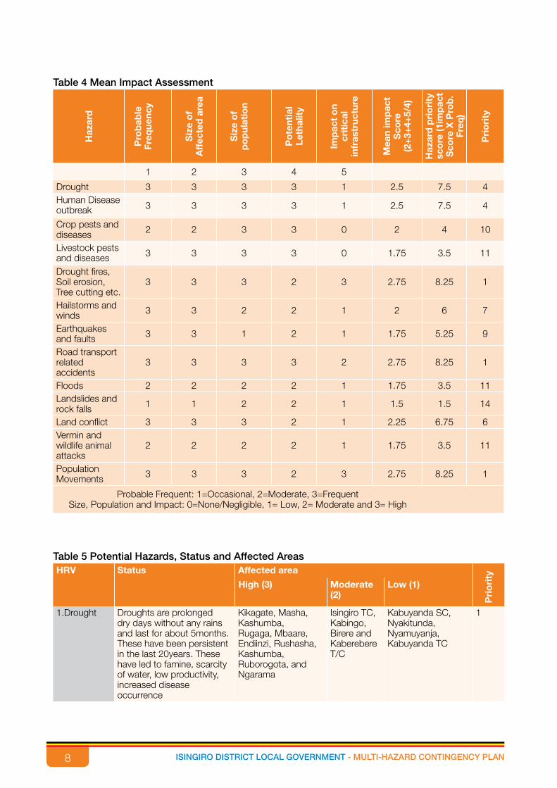
8 ISINGIRO DISTRICT LOCAL GOVERNMENT - MULTI-HAZARD CONTINGENCY PLAN
Table 4 Mean Impact AssessmentH
azar
d
Pro
bab
leFr
eque
ncy
Siz
e o
f A
ffec
ted
are
a
Siz
e o
fp
op
ulat
ion
Po
tent
ial
Leth
alit
y
Imp
act
on
crit
ical
in
fras
truc
ture
Mea
n im
pac
tS
core
(2
+3+
4+5/
4)
Haz
ard
pri
ori
ty
sco
re (1
imp
act
Sco
re X
Pro
b.
Freq
)
Pri
ori
ty
1 2 3 4 5
Drought 3 3 3 3 1 2.5 7.5 4Human Disease outbreak 3 3 3 3 1 2.5 7.5 4
Crop pests and diseases 2 2 3 3 0 2 4 10
Livestock pests and diseases 3 3 3 3 0 1.75 3.5 11
Drought fires, Soil erosion, Tree cutting etc.
3 3 3 2 3 2.75 8.25 1
Hailstorms and winds 3 3 2 2 1 2 6 7
Earthquakes and faults 3 3 1 2 1 1.75 5.25 9
Road transport related accidents
3 3 3 3 2 2.75 8.25 1
Floods 2 2 2 2 1 1.75 3.5 11Landslides and rock falls 1 1 2 2 1 1.5 1.5 14
Land conflict 3 3 3 2 1 2.25 6.75 6Vermin and wildlife animal attacks
2 2 2 2 1 1.75 3.5 11
Population Movements 3 3 3 2 3 2.75 8.25 1
Probable Frequent: 1=Occasional, 2=Moderate, 3=FrequentSize, Population and Impact: 0=None/Negligible, 1= Low, 2= Moderate and 3= High
Table 5 Potential Hazards, Status and Affected AreasHRV Status Affected area
Pri
ori
ty
High (3) Moderate (2)
Low (1)
1.Drought Droughts are prolonged dry days without any rains and last for about 5months. These have been persistent in the last 20years. These have led to famine, scarcity of water, low productivity, increased disease occurrence
Kikagate, Masha, Kashumba, Rugaga, Mbaare, Endiinzi, Rushasha, Kashumba, Ruborogota, and Ngarama
Isingiro TC, Kabingo, Birere and Kaberebere T/C
Kabuyanda SC, Nyakitunda, Nyamuyanja, Kabuyanda TC
1

9ISINGIRO DISTRICT LOCAL GOVERNMENT - MULTI-HAZARD CONTINGENCY PLAN
HRV Status Affected area
Pri
ori
ty
High (3) Moderate (2)
Low (1)
2.Human disease outbreak
These include HIV, TB, Brucella, STIs, and malaria. There are also reported cases of cholera outbreaks especially in congested areas like settlements of Nakivale and Oruchinga.Children are the most vulnerable for malaria and most sub counties are affected by the human epidemic diseases
Kikagate, Kashumba, Isingiro TC, Ngarama, Rugaaga, Kakamba and Rushasha
Kaberebere TC, Kabuyanda TC,
Birere, Endiinzi, Kabingo, Kabuyanda SC, Masha, Mbaare, Nyakitunda, Nyamuyanja, Ruborogota,
4
3. Crop pests and diseases
Since the Isingiro is a banana-coffee agro-ecological zone, crop disease has increased from the past 20years. These include: coffee wilt, twig borer among others
Kikagati, Isingiro TC,Ngarama, Kashumba, Rugaga
Birere, Kaberebere TC
Endiinzi, Kabingo, Kabuyanda, Masha, Mbaare, Nyakitunda, Nyamuyanja, Ruborogota, Rushasha, Kabuyanda TC
10
4. Livestock pests and diseases
Livestock diseases are a serious issue in the District since it is located in the cattle corridor. These include east coast fever, foot and mouth disease among others.
Endiinzi, Kashumba, Kikagate, Masha, Mbaare, Ruborogota, Rushasha, Ruborogota and Rushasha.
Rugaaga, Isingiro T/C
Birere, Kabingo, Ngarama, Nyakitunda, Nyamuyanja, Kaberebere TC and Kabuyanda TC.
4
5. Drought fires, Soil erosion, tree planting e.t.c
This is more common in the wetlands of the District, majorly the river and lake basins resulting from activities like sand mining among others.
Kikagate, Masha, Rugaaga, Nyakitunda, Kashumba and Isingiro TC
Ngarama, Rushasha,
Birere, Endiinzi, Kabingo, Kabuyanda, Mbaare, Nyamuyanja, Ruborogota, Kaberebere TC, Kabuyanda TC
1
6. Hailstorms and winds
Kabingo, Kabuyanda, Mbaare, Nyamuyanja, Ruborogota, Kaberebere TC, Kabuyanda TC, KikagatE002C
7
7. Road transport related accidents
Kabingo, Kabuyanda, Mbaare, Nyamuyanja, Ruborogota, Kaberebere TC, Kabuyanda TC, Kikagate,
1
8. Famine 79. Population movements
Rushasha, Rugaga, Kashumba, Ngarama, Isingiro TC, Kikagate and Mbare
1
10 ISINGIRO DISTRICT LOCAL GOVERNMENT - MULTI-HAZARD CONTINGENCY PLAN
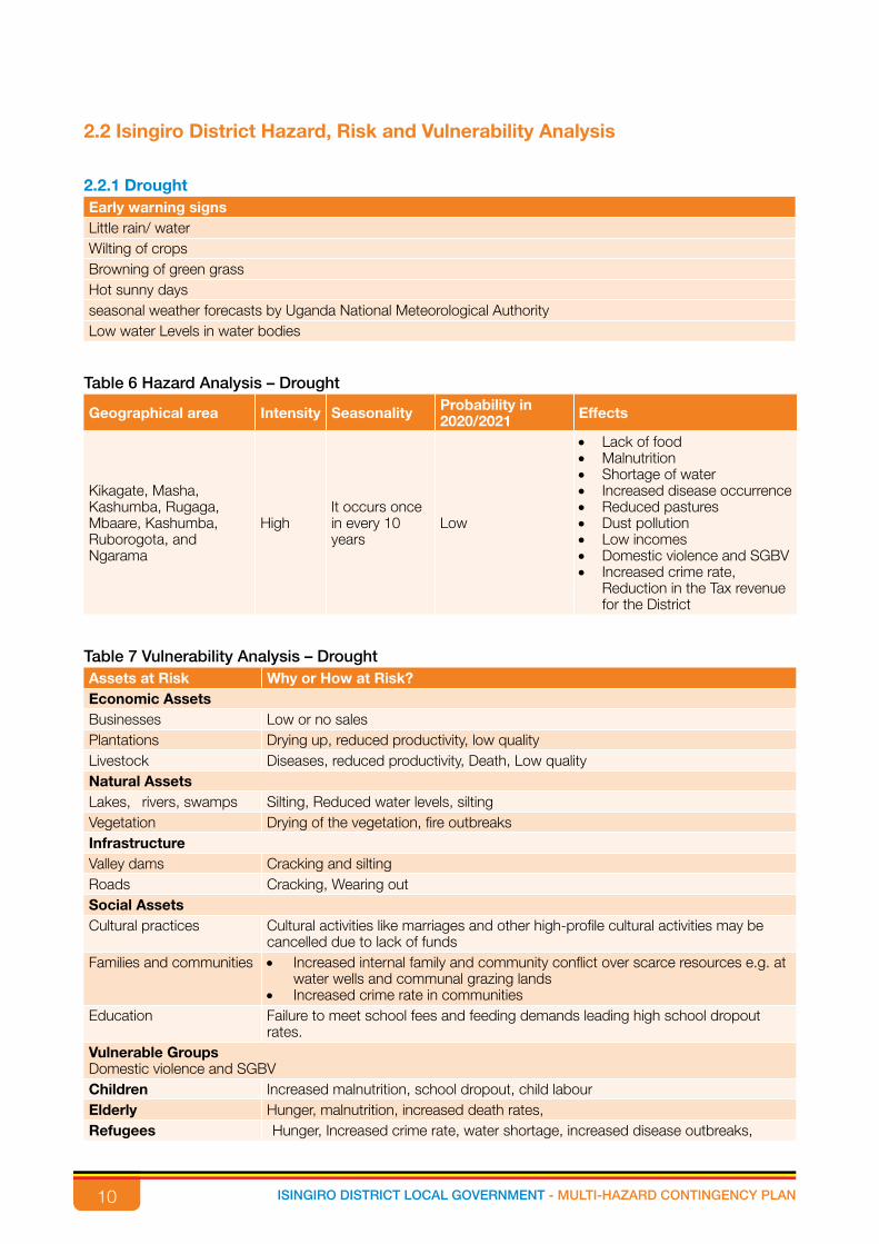
2.2 Isingiro District Hazard, Risk and Vulnerability Analysis
2.2.1 DroughtEarly warning signs Little rain/ waterWilting of cropsBrowning of green grassHot sunny daysseasonal weather forecasts by Uganda National Meteorological AuthorityLow water Levels in water bodies
l
Table 6 Hazard Analysis – Drought
Geographical area Intensity Seasonality Probability in 2020/2021 Effects
Kikagate, Masha, Kashumba, Rugaga, Mbaare, Kashumba, Ruborogota, and Ngarama
HighIt occurs once in every 10 years
Low
• Lack of food• Malnutrition• Shortage of water• Increased disease occurrence• Reduced pastures • Dust pollution• Low incomes• Domestic violence and SGBV• Increased crime rate,
Reduction in the Tax revenue for the District
Table 7 Vulnerability Analysis – DroughtAssets at Risk Why or How at Risk? Economic AssetsBusinesses Low or no salesPlantations Drying up, reduced productivity, low qualityLivestock Diseases, reduced productivity, Death, Low qualityNatural AssetsLakes, rivers, swamps Silting, Reduced water levels, siltingVegetation Drying of the vegetation, fire outbreaksInfrastructureValley dams Cracking and siltingRoads Cracking, Wearing outSocial AssetsCultural practices Cultural activities like marriages and other high-profile cultural activities may be
cancelled due to lack of fundsFamilies and communities • Increased internal family and community conflict over scarce resources e.g. at
water wells and communal grazing lands• Increased crime rate in communities
Education Failure to meet school fees and feeding demands leading high school dropout rates.
Vulnerable GroupsDomestic violence and SGBVChildren Increased malnutrition, school dropout, child labourElderly Hunger, malnutrition, increased death rates,Refugees Hunger, Increased crime rate, water shortage, increased disease outbreaks,

11ISINGIRO DISTRICT LOCAL GOVERNMENT - MULTI-HAZARD CONTINGENCY PLAN
Assets at Risk Why or How at Risk? Women Suffer from domestic violence, malnutrition, stress leading to low breast milk for
the breastfeeding mothers, forced marriages for the young girlsPWDs Malnutrition, neglected by community members and family, death
Table 8 Coping Mechanisms to be encouragedGeneral community Coping Mechanisms Individual Coping Mechanisms Leave wetland as water catchment areas Buy food elsewhere in case of shortagePlant trees as climate modifiers Buy water from the nearby areasFood storage especially dry grains Food storage especially dry grainsUse alternative sources of energy like Brickets, charcoal saving stoves,
Do food rationing
Crop diversification by planting of cereals Borrowing from self-help groupsForm self-help groups like SACCOS, village savings and loans association
Put up water harvesting facilities
Lobby for donations from GOU Out-migration of part or all of communitiesDoing of casual labor in return for money and foodConsumption of seed stocksSale of livestock to purchase food
Table 9 Priority Areas for ResponseCluster / Sector Priority Area/S For Response
Agriculture
• Irrigation schemes• Improved early maturing drought resistant varieties for crops and breeds for
livestock• Rotational grazing• Train people on silage and hay making of pasture• Do cross breeding of animals for better resistant breeds• Excavation of valley dams for water storage. • Strengthening statistical data collection
Health
• Do blanket supplementary feeding for the affected communities• Disease surveillance and mapping• Capacity building of the health workers on coping mechanism with the health
hazards
Water
• Establishment of community water tanks• Excavation of boreholes• Water purification• Motorized water tanks(water bowser)• Enhancement of natural water sources (water trapping). Strengthening
statistical data collection
Business and Market
• Establishment of VSLA and SACCO• Product cooperatives• Promoting value additions• Skills training and development• Business diversification• Market intelligence and information dissemination,• Using commodity warehouses.• Strengthening statistical data collection
Natural resources and Environment
• Re-forestation and Afforestation• Introduction of drought resistant tree species• Putting up conservation areas for indigenous of plants and animals• Sensitization, advocacy and reinforcement of bylaws on environmental
protection. • Strengthening statistical data collection

12 ISINGIRO DISTRICT LOCAL GOVERNMENT - MULTI-HAZARD CONTINGENCY PLAN
Cluster / Sector Priority Area/S For Response
Hygiene and sanitation Establishment of Communal latrines and sensitization on use, proper waste disposal.
Education• School feeding programmes to ensure pupil retention in drought-hit areas • Parents are encouraged to pack some food stuffs for the children• Introducing environmental conservation on school curriculum.
2.2.2 Human disease outbreakEarly warning signs Suspected casesPrevious trendsMortality ratesThresholds and confirmed cases
l
Table 10 Hazard Analysis - Human DiseasesGeographical area Intensity Seasonality Probability in
2020/2021 Effects
Kikagate, Kashumba, Isingiro TC, Ngarama, Rugaaga, Kakamba and Rushasha
Low
Any month in the year (intervals of6months)
inevitable
• Loss of lives• Low productivity• Poverty• Psychological stress• Loss of revenue• School drop out• Reduction in the Tax revenue
for the District
Table 11 Vulnerability Analysis - Human DiseasesAssets at Risk Why or How at Risk?
Economic Assets Labour force Limited capacity to engage in economic activities
(economic setback)InfrastructureHospital Pressure on the existing structuresSocial Assets Spread of epidemics among the population like cholera
Poor waste management
Vulnerable GroupsChildren,PWDs,Women,Elderly, youth School dropouts, increased absenteeism, poor
performances, physically inactive, late coming to schoolHealth workers They are the frontline workers to control the outbreaks
Displaced People Living in congested communities with limited facilities. Lack information on diseases
Table 12 Coping Mechanisms to be encouragedGeneral Community Individual Isolation of suspected cases MigrationsUse of preventive measures e.g. Mass vaccinations Seek medical attentionSensitisation of masses on the outbreak Use of VHTs on early identification of cases and referral
13ISINGIRO DISTRICT LOCAL GOVERNMENT - MULTI-HAZARD CONTINGENCY PLAN
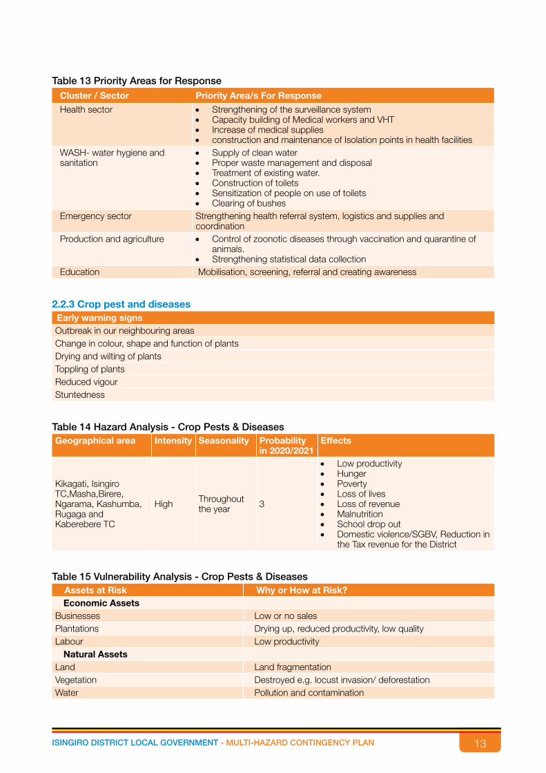
Table 13 Priority Areas for ResponseCluster / Sector Priority Area/s For Response
Health sector • Strengthening of the surveillance system• Capacity building of Medical workers and VHT• Increase of medical supplies• construction and maintenance of Isolation points in health facilities
WASH- water hygiene and sanitation
• Supply of clean water• Proper waste management and disposal• Treatment of existing water. • Construction of toilets• Sensitization of people on use of toilets• Clearing of bushes
Emergency sector Strengthening health referral system, logistics and supplies and coordination
Production and agriculture • Control of zoonotic diseases through vaccination and quarantine of animals.
• Strengthening statistical data collectionEducation Mobilisation, screening, referral and creating awareness
2.2.3 Crop pest and diseasesEarly warning signs Outbreak in our neighbouring areasChange in colour, shape and function of plantsDrying and wilting of plantsToppling of plantsReduced vigourStuntedness
l
Table 14 Hazard Analysis - Crop Pests & DiseasesGeographical area Intensity Seasonality Probability
in 2020/2021Effects
Kikagati, Isingiro TC,Masha,Birere, Ngarama, Kashumba, Rugaga and Kaberebere TC
High Throughout the year 3
• Low productivity• Hunger• Poverty• Loss of lives• Loss of revenue• Malnutrition• School drop out• Domestic violence/SGBV, Reduction in
the Tax revenue for the District
Table 15 Vulnerability Analysis - Crop Pests & DiseasesAssets at Risk Why or How at Risk? Economic Assets
Businesses Low or no salesPlantations Drying up, reduced productivity, low qualityLabour Low productivity
Natural AssetsLand Land fragmentationVegetation Destroyed e.g. locust invasion/ deforestationWater Pollution and contamination
14 ISINGIRO DISTRICT LOCAL GOVERNMENT - MULTI-HAZARD CONTINGENCY PLAN
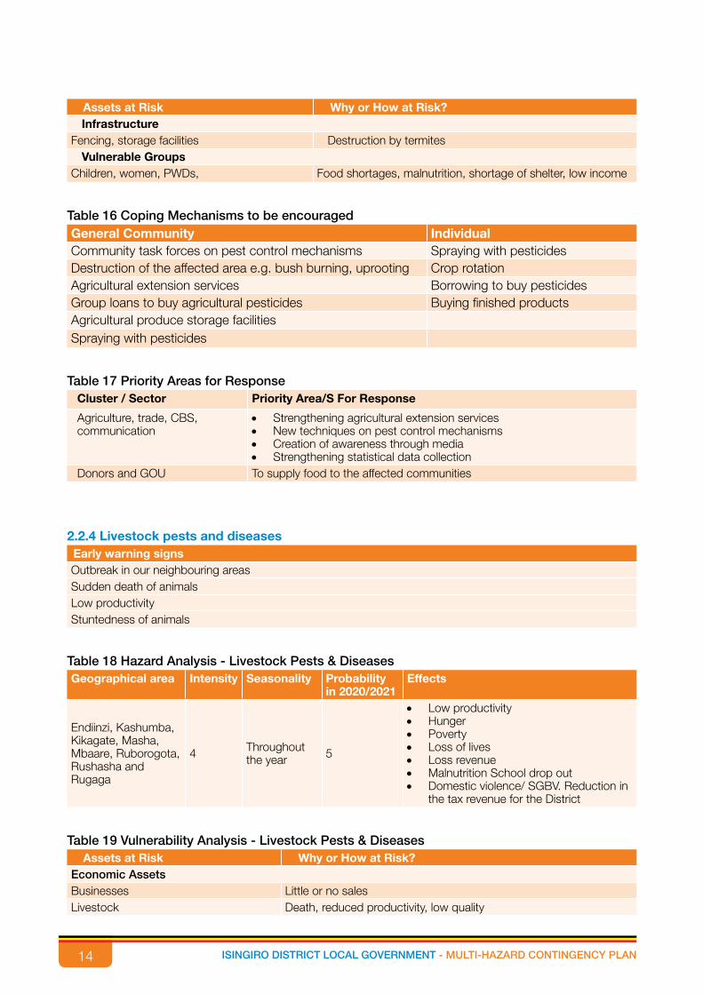
Assets at Risk Why or How at Risk? Infrastructure
Fencing, storage facilities Destruction by termitesVulnerable Groups
Children, women, PWDs, Food shortages, malnutrition, shortage of shelter, low income
Table 16 Coping Mechanisms to be encouragedGeneral Community IndividualCommunity task forces on pest control mechanisms Spraying with pesticidesDestruction of the affected area e.g. bush burning, uprooting Crop rotationAgricultural extension services Borrowing to buy pesticidesGroup loans to buy agricultural pesticides Buying finished productsAgricultural produce storage facilitiesSpraying with pesticides
Table 17 Priority Areas for ResponseCluster / Sector Priority Area/S For Response
Agriculture, trade, CBS, communication
• Strengthening agricultural extension services• New techniques on pest control mechanisms• Creation of awareness through media• Strengthening statistical data collection
Donors and GOU To supply food to the affected communities
2.2.4 Livestock pests and diseasesEarly warning signs Outbreak in our neighbouring areasSudden death of animalsLow productivityStuntedness of animals
l
Table 18 Hazard Analysis - Livestock Pests & DiseasesGeographical area Intensity Seasonality Probability
in 2020/2021Effects
Endiinzi, Kashumba, Kikagate, Masha, Mbaare, Ruborogota, Rushasha and Rugaga
4 Throughout the year 5
• Low productivity• Hunger• Poverty• Loss of lives • Loss revenue• Malnutrition School drop out • Domestic violence/ SGBV. Reduction in
the tax revenue for the District
Table 19 Vulnerability Analysis - Livestock Pests & DiseasesAssets at Risk Why or How at Risk?
Economic Assets Businesses Little or no salesLivestock Death, reduced productivity, low quality

15ISINGIRO DISTRICT LOCAL GOVERNMENT - MULTI-HAZARD CONTINGENCY PLAN
Labour Low productivity, laying off of workersNatural Assets
Land Low productivity, Land fragmentation as land is sold off to cater for the financial needs of families
Vulnerable GroupsChildren, women, pwds, Food shortages, malnutrition, low income
Table 20 Coping Mechanisms to be encouragedGeneral Community IndividualCommunity task forces on livestock pest and diseases mechanisms
Spraying of animals with acaricide
Killing and burying of sick animals Buying animal products from markets outside the District
Agricultural extension services Relying on other unaffected livestockGroup loans to buy animal acaricides and medicine Migration of people with their animals to safer areasSpraying with acaricides Rely on food cropsQuarantine Farmers harvest water at farms to avoid communal
wateringRestricted and protected water harvesting points for animals
Table 21 Priority Areas for ResponseCluster / Sector Priority Area/S For Response
Agriculture, trade, CBS, communication
• Strengthening agricultural extension services• New techniques on pest control mechanisms.• Creation of awareness through media• Strengthening statistical data collection
Donors and GOU To supply food to the affected communities Water sector Construction of dams and water harvesting facilities
2.2.5 Environmental degradationEarly warning signs Bare groundContinuous cutting of trees without replacement (Deforestation)Over grazingHaphazard bush- burningEncroachment on wetlandsFloods
l
Table 22 Hazard Analysis - Environmental Degradation
Geographical area Intensity Seasonality Probability in 2020/2021 Effects
Birere, Endiinzi, Kabingo, Kabuyanda, Mbaare, Nyamuyanja, Ruborogota, Kaberebere TC, Kabuyanda TC
2 Throughout the year
5 • Famine• Land slides• Drought• Diseases• Malnutrition

16 ISINGIRO DISTRICT LOCAL GOVERNMENT - MULTI-HAZARD CONTINGENCY PLAN
Table 23 Vulnerability Analysis - Environmental DegradationAssets at Risk Why or How at Risk?
Economic AssetsCrops Loss of soil fertility leading to loss of productivity and low or no sales.
Destruction of cropsLivestock Diseases, reduced productivity, Death, Low qualityNatural AssetsLakes, rivers, swamps Silting, Reduced water levels, siltingVegetation Drying of the vegetation, fire outbreaks, deforestationSoil Erosion, loss of fertilityInfrastructureValley dams Cracking and silting during droughtRoads Cracking, wearing out, washed away by floods e.g.Rushasha roadBuildings Washed away by Floods, and blown away by strong windsBridges Washed away by floodsVulnerable GroupsDomestic violence and SGBVChildren Increased malnutrition, school dropout, child labourElderly Hunger, malnutrition, increased death rates,
Refugees Hunger, Increased crime rate, water shortage, increased disease outbreaks, Women Suffer from domestic violence, malnutrition, stress leading to low breast milk for
the breastfeeding mothers, forced marriages for the young girls
PWDs Malnutrition, neglected by community members and family, death
Table 24 Coping Mechanisms to be encouragedGeneral Community IndividualLeave wetland as water catchment areas Use of fertilisers for soils that are depleted of fertility
Migration
Table 25 Priority Areas for ResponseCluster / Sector Priority Area/S For Response
Natural resources and environment • Enact laws and ordinances• Tree planting campaigns• Promotion of alternative sources of livelihood
Security/ Police/ Judiciary Enforcing the lawsHealth Free health services for affected populationsWash Construction of safe water bodies like boreholes as a back-up solution during
the crisis
2.2.6 Population Movement / InfluxEarly warning signs Elections in the neighbouring countries Civil conflicts Outbreak of diseases Existence of rebel groups of neighbouring countries Famine and hunger Inter-tribal clashesWar Unfavourable economic policies Hospitality of neighboring countries.
l

17ISINGIRO DISTRICT LOCAL GOVERNMENT - MULTI-HAZARD CONTINGENCY PLAN
Table 26 Hazard Analysis - Population Movement/Influx
Geographical area Intensity Seasonality Probability in 2020/2021 Effects
Rushasha, Rugaga, Kashumba, Ngarama, Isingiro TC, Kikagate, Mbare, Endizi,Kakambam , Ruborogota, Masha, Kabingo, Kaberere TC, Berere, Nyamuyanja, Nyakitunda, Kabuyanda, Kabuyanda TC, bugango TC, Endenzi TC, Rwambaga, Rwanjogyera, Kikagate, Hamubiizi TC, Ruhiira TC,
High
Every expiry of a presidential term of office.
Throughoutthe year
High
• Increased pressure on the existing social services.
• Increased pressure on natural resources.
• increase in crime rate• land and social conflicts• Congestion • Reduced pastures
Table 27 Vulnerability Analysis - Population Movements/ InfluxAssets at Risk Why or How at Risk?Economic Assets
Businesses Scarcity in local supplies.Natural Assets
Lakes, rivers, swamps Pollution, Silting, Reduced water levels, overfishingVegetation
Deforestation, over cultivation.Land
Land fragmentation, soil exhaustion.Infrastructure
Valley dams Reduced water levels, siltation, pollutionRoads Cracking, Wearing out
Social Assets
Cultural practices Cultural sites like burial grounds will be encroached upon. Mixing of cultures interrupting practices like dress code, eating habits, cultural dances.
Families and communities
• Alternative negative Coping Mechanisms to be encouraged like prostitution.
• Increased level of lawlessness• Increased internal family and community conflict over scarce
resources e.g. at water wells and communal grazing lands
Education Increased pressure on existing facilities like classroom space, student-teacher ratio, latrines
Communication Interference on the medium of communication.Vulnerable Groups
Domestic violence and SGBVChildren Increased malnutrition, school drop out, child labour, child marriages. Elderly Increased food scarcity, malnutrition, death
Refugees/IDPs Breaking of social structure, food preference, eating habits, lawlessness, and shortage of social resources, discrepancy in cultures, norms and customs.
Women Suffer from domestic violence, malnutrition, negative alternative coping mechanisms, forced marriages, division of labour.
PWDs Inability to access of social services, Malnutrition, death

18 ISINGIRO DISTRICT LOCAL GOVERNMENT - MULTI-HAZARD CONTINGENCY PLAN
Table 28 Coping Mechanisms to be encouraged
General community Individual
Employing advanced techniques of agriculture like zero grazing, paddocking in grazing areas and crop rotation.
Resorting to business in case of shortage of land for farming. (Use of natural resources as energy and fuel)
Skills training as an alternative mechanism for survival
Setting up small enterprises such as restaurants, salons, shops, vocational skills like bicycle/bodaboda repair, carpentry and joinery, sowing, brick laying
Village Savings and Loans Associations (VSLAs)
Borrowing from self-help groups
Support from GOU Offering casual labour services i.e. Community-based volunteers.
Plant trees for firewood; improve on the nutrition as well as climate modifiers.Construction of safe water bodies like wells to provide water to the massesDonor mobilisation for humanitarian aidCreation of employment opportunities
Table 29 Priority Areas for ResponseCluster / Sector Priority Area/s For Response
Nutrition • Provision of blanket feeding • Provision of quick maturing crops • Simple livestock • Supplementary feeding• Training in post-harvest handling • Provision of post-harvest handling equipment like silos
Water and Sanitation • Establishment of boreholes, shallow wells and protected springs. • Provision of water storage containers • Establishment of water tanks • Motorized water system. • Water purification
Education • Expansion of existing facilities • Construction of new schools • Increase on the existing human resource base. • Increasing the supply of instruction materials e.g. Textbooks, play
equipments. Shelter • Land allocation
• Provision of emergency shelter • Provision of construction materials
Health • Expand the existing health facilities • Deploy more health personnel • Empower community structures like VHTs • Increased outreaches and mobile clinics • Provision of ambulance services. • Deliberate screening and immunization programs
Economic empowerment • Training in financial literacy • Provision of startup kits • Programs like cash for work• Initiate saving methodology e.g. VSLAs• Provision of storage facilities for the produce • Improvement on the road network, existing and opening up new ones.
Natural resources and Environment • Provision of clean energy facilities for lighting and cooking • Re-forestation• Provision for waste management facilities

19ISINGIRO DISTRICT LOCAL GOVERNMENT - MULTI-HAZARD CONTINGENCY PLAN
Cluster / Sector Priority Area/s For Response Agriculture • Irrigation schemes
• Improved early maturing drought tolerant varieties for crops and breeds for livestock
• Rotational grazing• Train people on silage and hay making of pasture• Do cross breeding of animals for better resistant breeds
Hygiene and sanitation Establishment of Communal latrines and sensitization on use, proper waste disposal.
2.2.7 FloodsEarly warning signs Prolonged rains Seasonal changes Swelling of rivers
Table 30 Hazard Analysis – Floods
Geographical area Intensity Seasonality Probability in 2020/2021 Effects
Nyamiyanja, Kabingo, Isingiro TC, Kashumba, Rushasha, Kikagate, Birere, Mbare, Ruborogota, Kabuyanda SC, Kabuyanda TC.
Moderate
During the two annual rainy seasons
High
• Loss of lives • Destruction of Property and
infrastructure• Land degradation• Increased disease occurrence. • Malnutrition• Famine • Disruption of economic activities like
access to markets. • Increased government expenditure.
Table 31 Vulnerability Analysis – FloodsAssets at Risk Why or How at Risk? Economic Assets
Businesses Limited / no access to markets Markets Exploitation of farmers by middle businessmenPlantations Destruction of crop fields, reduced productivity, low quality, silting,
diseases and loss of soil fertility. Livestock Death, loss of pasture, destruction of water sources and high
livestock diseases. Natural Assets
Lakes, rivers, swamps Silting, reduced water quality, increased water levels, increased water weeds, turbidity loss of aquatic life
Vegetation Destruction of flora and faunaInfrastructure
Valley dams Washed away and others submerged. Roads Washed away, impassable roads. Bridges Washed away and others submerged.Buildings Collapsed buildings, cracking and weak Water sources e.g. wells, protected springs
Interference with the water quality and quantity, destruction of water recharge sources.

20 ISINGIRO DISTRICT LOCAL GOVERNMENT - MULTI-HAZARD CONTINGENCY PLAN
Assets at Risk Why or How at Risk? Social Assets
Cultural practices Reschedule of social – cultural events such as weddings Interruption of normal social cultural norms and practices.
Health Inaccessibility to the health facilities leading to increased death rates, destroyed
Recreation, religious and social service centres Inaccessible, destroyed
Education Inaccessible schools, destroyedVulnerable Groups
Domestic violence and SGBV
Children • Failure to go to school • High risks of drowning• Increased water born disease • Disruption in social roles e.g. fetching of water and firewood • Failure to access basic social resources such as water• Limited access to basic social services like HC. • Limited access to basic social services
Elderly
Women
PWDs
Table 32 Coping Mechanisms to be encouraged
General community Individual
Construction of temporary bridges Relocation from low lying to raised areasIdentification of alternative routes Improved farming techniques Relocation from low lying to raised areas Construction of water holding structures like trenches,
canals and terracing. Lobby for relief and donations Humanitarian support Advocacy from the government to raise awareness on early warning signs. Construction of water holding structures like trenches, canals and terracing.
Table 33 Priority Areas for Response
Cluster / Sector Priority Area/s For Response
Agriculture • Encourage irrigation in stony areas • Promotion of flood tolerant crops such as rice, trees
WASH
• Provision of HH water storage facilities.• Provision of HH water tanks • Promotion of rainwater harvesting at HH level • Avoid construction of water sources in flood prone areas. • Provision of alternative water sources • Provision of water treatment facilities like aqua tablets • Avoid construction of sanitary facilities in places with high water tables.
Infrastructure• Proper infrastructural designs that facilitate all kinds of weather • Provision of temporary shelter to affected populations • Employing the use of water transport to access the key social services.
Social services like health centres and schools
• Construction of alternative routes to social service centers• Construction of the service centers on areas not prone to drought • Proper landscaping • Mass deworming • Water purification • Sensitization of community on hygiene and sanitation • Increased outreaches to the affected communities

21ISINGIRO DISTRICT LOCAL GOVERNMENT - MULTI-HAZARD CONTINGENCY PLAN
Cluster / Sector Priority Area/s For Response
Business and Market • Empowering the affected HH with skills and knowledge in business management at local level
Natural resources and Environment
• Appropriate water shade management • Re-afforestation and afforestation• Introduction of flood resistant tree species• Enforcement of the NEMA green belt and conservation.
2.2.8 Land conflictsEarly warning signs Land fragmentationLack of clear boundary demarcationsLow level of documentationIncrease in number of squatters Increase in population and migration
Table 34 Hazard Analysis - Land Conflicts
Geographical area Intensity Seasonality Probability in 2020/2021 Effects
Table 35 Vulnerability Analysis - Land ConflictsAssets at Risk Why or How at Risk?
Human resource Loss of lives due to fights over landLivestock Loss of livestock. Fights tend to involve killings of animalsCrop Loss of crops due to destructionsInfrastructure Physical infrastructure such as schools and hospitals can end up getting burnt/
demolished during land conflicts
Table 36 Coping Mechanisms to be encouragedGeneral Community Individual Migration MigrationDialogue Marking of boundaries Marriages, usually intermarriages IntermarriagesImproving legal basis -land titles etc.Intervention of cultural leaders
Table 37 Priority Areas for ResponseCluster / Sector Priority Area/S For Response
Natural resources • Land demarcation• Sensitization of communities about land titles• Physical planning
Community services • Sensitization• Reconciliation • Supporting will making and its enforcement
Enforcement • Community engagement/policing• Arrests and prosecution of offenders• Secure land
22 ISINGIRO DISTRICT LOCAL GOVERNMENT - MULTI-HAZARD CONTINGENCY PLAN
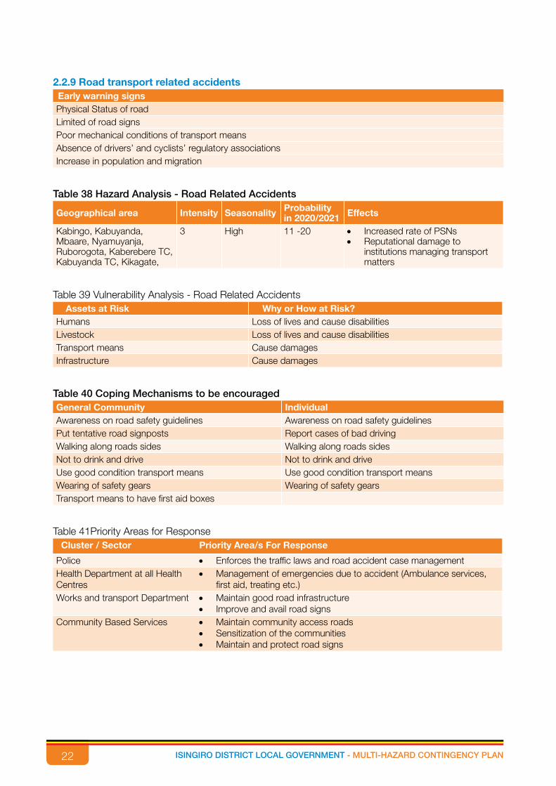
2.2.9 Road transport related accidentsEarly warning signs Physical Status of roadLimited of road signs Poor mechanical conditions of transport meansAbsence of drivers’ and cyclists’ regulatory associationsIncrease in population and migration
Table 38 Hazard Analysis - Road Related Accidents
Geographical area Intensity Seasonality Probability in 2020/2021 Effects
Kabingo, Kabuyanda, Mbaare, Nyamuyanja, Ruborogota, Kaberebere TC, Kabuyanda TC, Kikagate,
3 High 11 -20 • Increased rate of PSNs• Reputational damage to
institutions managing transport matters
Table 39 Vulnerability Analysis - Road Related AccidentsAssets at Risk Why or How at Risk?
Humans Loss of lives and cause disabilitiesLivestock Loss of lives and cause disabilitiesTransport means Cause damages Infrastructure Cause damages
Table 40 Coping Mechanisms to be encouragedGeneral Community Individual Awareness on road safety guidelines Awareness on road safety guidelinesPut tentative road signposts Report cases of bad drivingWalking along roads sides Walking along roads sidesNot to drink and drive Not to drink and driveUse good condition transport means Use good condition transport meansWearing of safety gears Wearing of safety gearsTransport means to have first aid boxes
Table 41Priority Areas for ResponseCluster / Sector Priority Area/s For Response
Police • Enforces the traffic laws and road accident case managementHealth Department at all Health Centres
• Management of emergencies due to accident (Ambulance services, first aid, treating etc.)
Works and transport Department • Maintain good road infrastructure• Improve and avail road signs
Community Based Services • Maintain community access roads • Sensitization of the communities • Maintain and protect road signs

23ISINGIRO DISTRICT LOCAL GOVERNMENT - MULTI-HAZARD CONTINGENCY PLAN
2.2.10 FamineEarly warning signs Prolonged droughtHeavy rains and hailstormsPests and disease outbreaks (crop and animals)Limited land for cultivation and rearing animalsProlonged insecurity and civil unrestPopulation increase like continues influx of refugeesCrop failurePossible shift from growing food crops to cash cropsLoss of soil fertilityPoor agricultural practices
Table 42 Hazard Analysis – FamineGeographical area Intensity Seasonality Probability in
2020/2021Effects
All sub counties in Isingiro District
3 High 11 -20 • High crime rate• Diseases especially among infants• Malnutrition of masses• Domestic violence • High rate of dropout from school• Civil riots• Poverty
Table 43 Vulnerability Analysis – FamineAssets at Risk Why or How at Risk?
Humans Loss of lives due to lack of food, death in the eventualityLivestock • Loss of lives for livestock due to lack of water and pasture
• Business collapse for livestockCrops Loss of crops due to prolonged drought and pest and diseasesInfrastructure Loss of infrastructure due to vandalization to acquire parts to sell for survivalLand Selling of pieces land cheaply as coping strategiesForests EncroachmentWetlands Encroachment
Table 44 Coping Mechanisms to be encouragedGeneral Community Coping Mechanisms Individual Coping Mechanisms Community social support MigrationMigration Reducing frequency of eatingAdjusting to a reasonable frequency of eating Eating of wild animals and plantsEating of wild animals and plants Borrowing
Relying on preserved food

24 ISINGIRO DISTRICT LOCAL GOVERNMENT - MULTI-HAZARD CONTINGENCY PLAN
Table 45 Priority Areas for ResponseCluster / Sector Priority Area/S For Response
OPM and CAO’s Office • Provision of relief food• Activates emergency response plan
Community Based Services • Information gathering and dissemination • Identify critical and priority areas and recommend to Government for
interventions Production department • Identify alternatives for livelihoods
• Provide pest resistant cropsNatural resource • Promoting sustainable use of natural resource (wetland, forest etc.)
• Encourage tree planting• Water recycling

25ISINGIRO DISTRICT LOCAL GOVERNMENT - MULTI-HAZARD CONTINGENCY PLAN
OBJECTIVES OF THE CONTINGENCY PLAN
3.1. Vision, Goal and Objectives of the Plan
An efficient and effective disaster - risk management system developed in Isingiro District.
3.2 Overall GoalTo establish a well-coordinated Multi-sectoral approach to prevent and effectively respond to disasters
in order to mitigate impact.
3.3 Strategic Objectivesi. To strengthen institutional arrangement in Isingiro District for effective planning and response to
Disaster Risk Reduction and Management.
ii. To assess, profile and monitor disaster risks and enhance early warnings.
iii. To develop a culture of safety and resilience at all levels through the targeted and effective
dissemination of information.
iv. To strengthen the capacity of the District to handle disasters.
3.3.1 Strategic Objectives and actions
Strategic objective 1: To strengthen institutional arrangement in Isingiro District for effective planning
and response to Disaster Risk Reduction and Management.
Actions
• Establish Disaster Management committees at lower local government.
• Strengthen District Disaster Management Committee.
• Capacity building to the Disaster Management Committees at the District and LLG.
• Conduct trainings on disaster preparedness and response.
• Resource mobilisation
Strategic objective 2: To assess, profile and monitor disaster risks and enhance early warnings.
Actions
• Identification potential risks/ hazards.
• Hazard mapping specifically for Isingiro District.
• Determine the seasonal occurrence of the identified hazards.
• Continuously monitor the risks of occurrence.
• Establish early warning – early response mechanisms.
CHAPTERTHREE

26 ISINGIRO DISTRICT LOCAL GOVERNMENT - MULTI-HAZARD CONTINGENCY PLAN
Strategy objective 3: To develop a culture of safety and resilience at all levels through the targeted and
effective dissemination of information.
Actions:
• Design health promotion messages in the different forms and legible language; role plays,
charts, etc
• Disseminate health messages on respective media platforms like radios, community dialogues,
barazas, print media and TVs, visibility materials
• Actively monitor and scale up of feedback and management systems
• Enforce the use of protective gears like helmets, seat belts etc.
Strategy objective 4: To strengthen the capacity of the District to handle disasters.
Actions:
• Lobby for disaster fund, infrastructure development and improvement i.e. isolation centers,
ambulances, standard laboratories for humans, livestock and crops through private-public
partnerships
• Identify target beneficiaries
• Procure and supply of food items
• Lobby for food items (Request for food aid)

27ISINGIRO DISTRICT LOCAL GOVERNMENT - MULTI-HAZARD CONTINGENCY PLAN
4.1 Development Partner Projects/NGO implemented activities/other government programs
Table 46 Stakeholders’ AnalysisGovernment/NGO/Agencies in the District
Sector Activity (ies)
Isingiro DLG All Sectors and LLGs Mobilization, Coordination and implementation.OPM All Sectors Disaster preparedness, response and recoveryUNICEF WASH, Education and
CBSVaccination, Water source development, Documentation, Setting up sanitation facilities.
UNHCR All Sectors Livelihood and Environment, educational activities, infrastructure development and maintenance, WASHactivities, Health and energy services, Relief items, Protection services.
RDC’s Office and Security Organs
All Sectors Response and prevention
MTI Health All Health and Nutrition ServicesUganda Red Cross society. (URCS)
All Sectors Disaster response services
WFP Production, Health and Energy
Food security and Nutrition, livelihoods, health, capacity strengthening, emergency handling, clean energy, infrastructure development, assets creation.
FAO Production Livestock Vaccination.ARC Protection and
community services.Support in Livelihood activities, promoting literacy, SGBV prevention, Psycho-Social support, Change makers, Other community services
Line Government Ministries, Departments and Agencies
All Sectors Response and Prevention.
Windle International Uganda. Education Recruitment, training and remunerating teachers, construction of structures and Provision of Scholastic materials.
Communities All Sectors Information sharing on disaster trends, reporting disaster incidences
Media All Sectors Awareness Creation, Providing information on Disasters.
UWA All Sectors Livelihoods, Community support, Infrastructure development.
World Bank All Sectors Infrastructure development, agriculture farm inputsILO-International Labour Organisation
Production and Marketing, Trade
Livelihoods
Religious Institutions CBS Spiritual support, Food and Non-Relief itemsRight to Play Education and CBS ECD Services, System strengthening, parenting
education, Provision and installation of play materials.
Tutapona and TPO CBS Psycho-social supportUWESO-Uganda Women Effort to save Orphans
Education Education and livelihoods
Nsamizi All sectors WASH activities, environment, Livelihoods, Energy.
MANAGEMENT AND CO-ORDINATION ARRANGEMENTS
CHAPTERFOUR

28 ISINGIRO DISTRICT LOCAL GOVERNMENT - MULTI-HAZARD CONTINGENCY PLAN
Government/NGO/Agencies in the District
Sector Activity (ies)
Banks and Saving institutions.
All sectors Financial support
NFA Natural Resources Provide tree seedlingsCare and Assistance for forced migrants (CAFOMI)
CBS Social protection
Humanitarian Initiative Just Relief Aid (HIJRA)
CBS Leads implementers for protection of refugees and Community Services. Targets the elderly and the vulnerable persons including SGBV Survivors. Provides legal counseling, legal support. Conducts sensitization against SGBV and reporting cases of SGBV.
Hunger Fighters Uganda (HFU)
Production Food distribution and Kitchen gardening (vegetable growing demonstrations)
Child Development Centers Education and Health Education, Medical, Psychosocial, Economic support under Compassion International
4.2 Contingency structure
4.3 Challenges on District capacity AssessmentBelow are some of the challenges Isingiro District faces in addressing the emergency humanitarian
situations:
i. Inadequate financial resources to handle emergency/disasters.
ii. Lack of reliable data to plan for emergencies.
iii. Bureaucracy in Local Government structures
Armed Forces
29ISINGIRO DISTRICT LOCAL GOVERNMENT - MULTI-HAZARD CONTINGENCY PLAN
iv. Uncoordinated activities between different sectors and offices.
v. Limited technical capacity in terms numbers and skills among LLG staff to handle emergencysituations.
4.4 Roles and ResponsibilitiesThe implementation of this plan is multi-sectoral and multidisciplinary. The Plan is to be implemented
by all Isingiro DLG departments in collaboration with the Government of Uganda, humanitarian and
development partners, the private sector, lower local governments and the community.
The District Disaster Management Committee will be the lead organ in coordinating all stakeholders
on Disaster Preparedness and Management in the District. Ultimately, Disaster Preparedness and
Management is a shared responsibility between the District, the State and the people of Isingiro and not
only those with defined roles and responsibilities.
Disaster Preparedness and Management at District Level
The lead agency for Disaster Preparedness and Management at the District level will be the District
Disaster Management Committee (DDMC). The DDMC shall be chaired by the CAO and the District
Disaster Response Coordinator (focal person) shall be its secretary. It will be composed of all District
Heads of Departments, Sub-county representative, head of security, heads of humanitarian and
development partner agencies (NGOs, CSOs) operating in the District, and the private sector.
4.4.1 Responsibilities of DDMC
i. The DDMC shall be the lead agency for Disaster Preparedness and Management in the District.
ii. Establishing and coordinating structures at the Sub-County level and lower levels.
iii. Assess particular hazards facing the District and keep under review sectoral early warning
reports.
iv. In the event of disaster-induced emergency, the DDMC shall coordinate and monitor multi-
sectoral disaster relief support and later post-disaster recovery measures.
v. Receive sectoral and District progress reports about disaster preparedness and management
from other structures.
vi. Draft and present budgets to the District Council for approval.
vii. Prepare, monitor and coordinate the implementation of Disaster Preparedness and Management
Plans.
viii. Prepare and submit reports to CAO.
4.4.2 Role of the District Council
i. Make policies and ordinances on disaster preparedness and management in the District.
ii. Receive and discuss Budgets, plans and other reports from DDMC.
iii. Sensitize the community about disaster preparedness and management.
30 ISINGIRO DISTRICT LOCAL GOVERNMENT - MULTI-HAZARD CONTINGENCY PLAN
iv. Oversee activities of DDMC.
v. Fundraise for Disaster Preparedness and Management in the District.
4.4.3 Sub-County Disaster Management Committees
i. Ensure that Disaster Preparedness and Management issues relevant to the Sub-County and
those that may occur based on the District early warning system are incorporated in the
development planning and budgeting processes.
ii. Facilitate, coordinate and oversee Disaster Preparedness and Management at Sub-County level.
iii. Present a report to the Chairperson of the DDMC on the state of Disaster Preparedness and
Management in its jurisdiction annually and whenever required.
iv. In the event of a disaster-induced emergency, the Sub-County Disaster Management Committee
shall coordinate and monitor disaster response at village level.
v. Awareness campaigns on disaster preparedness and management.
vi. Make bylaws.
4.4.4 Village Disaster Management Committee
i. The village councils shall be the first line community response mechanisms for Disaster
Preparedness and Management.
ii. All LC1 committee members will be on the Disaster Preparedness and Management Committee.
iii. The LC 1 Chairperson shall chair the committee.
4.4.5 Roles and Responsibilities
i. Collect early warning information and transmit it to Sub-County and District level
ii. Use early warning information to educate communities on risks and hazards that may potentially
cause disaster
iii. Facilitate, coordinate and oversee disaster risk reduction, preparedness, disaster relief support
and post-disaster recovery
iv. Collect data on disasters and report to S-CDMC
4.4.6 NGOs and CBOs
i. They play a role in mobilizing resources.
ii. They sit on the Disaster Management Committees at all levels.
iii. They participate in disaster risk assessments, formulation of Disaster Preparedness and
Management Plans, response, monitoring and evaluation initiatives at District and community
levels.
4.4.7 Community
i. They provide information on vulnerability and capacity assessment.
ii. They participate in trend monitoring using local knowledge and experience.
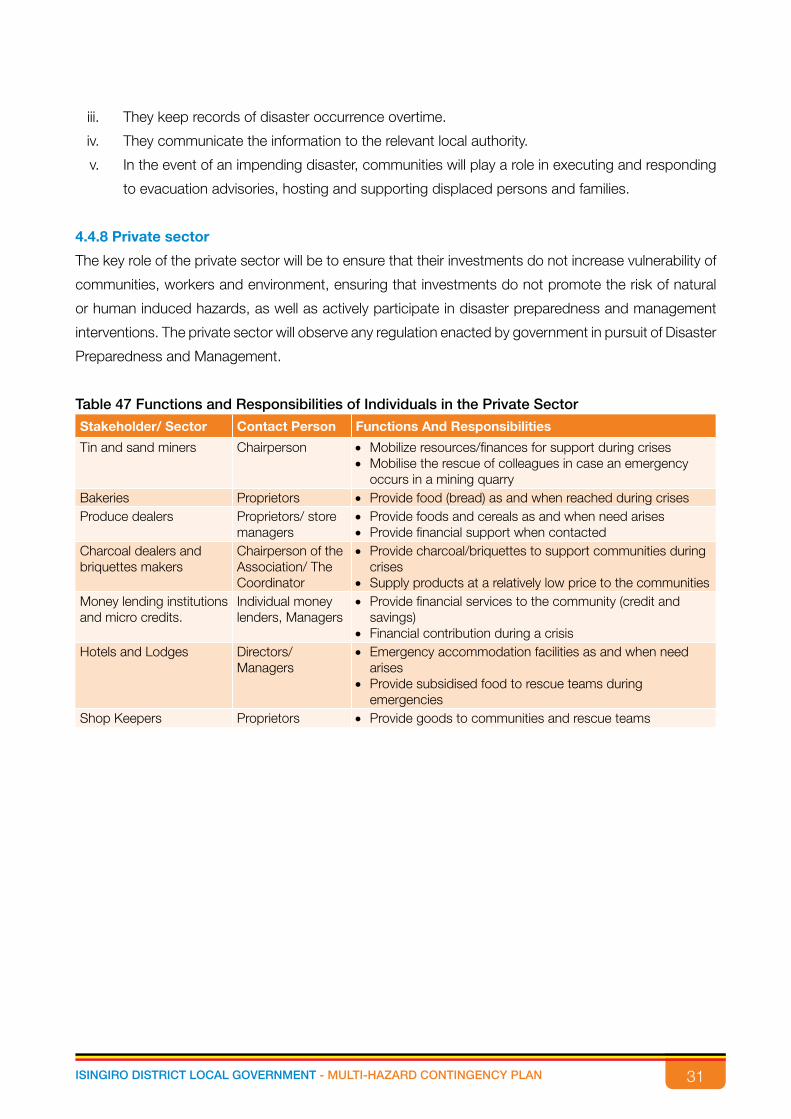
31ISINGIRO DISTRICT LOCAL GOVERNMENT - MULTI-HAZARD CONTINGENCY PLAN
iii. They keep records of disaster occurrence overtime.
iv. They communicate the information to the relevant local authority.
v. In the event of an impending disaster, communities will play a role in executing and responding
to evacuation advisories, hosting and supporting displaced persons and families.
4.4.8 Private sector
The key role of the private sector will be to ensure that their investments do not increase vulnerability of
communities, workers and environment, ensuring that investments do not promote the risk of natural
or human induced hazards, as well as actively participate in disaster preparedness and management
interventions. The private sector will observe any regulation enacted by government in pursuit of Disaster
Preparedness and Management.
Table 47 Functions and Responsibilities of Individuals in the Private Sector
Stakeholder/ Sector Contact Person Functions And Responsibilities
Tin and sand miners Chairperson • Mobilize resources/finances for support during crises • Mobilise the rescue of colleagues in case an emergency
occurs in a mining quarry Bakeries Proprietors • Provide food (bread) as and when reached during crisesProduce dealers Proprietors/ store
managers• Provide foods and cereals as and when need arises• Provide financial support when contacted
Charcoal dealers and briquettes makers
Chairperson of the Association/ The Coordinator
• Provide charcoal/briquettes to support communities during crises
• Supply products at a relatively low price to the communitiesMoney lending institutions and micro credits.
Individual money lenders, Managers
• Provide financial services to the community (credit and savings)
• Financial contribution during a crisisHotels and Lodges Directors/
Managers• Emergency accommodation facilities as and when need
arises• Provide subsidised food to rescue teams during
emergenciesShop Keepers Proprietors • Provide goods to communities and rescue teams
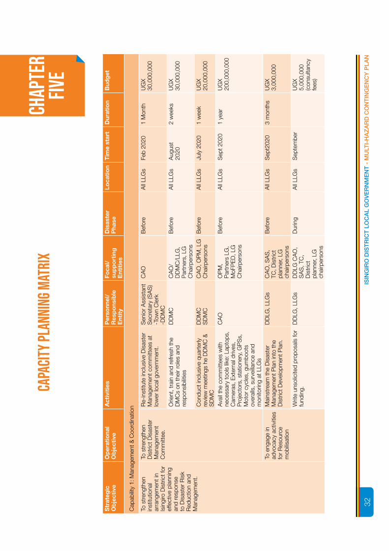
32 ISINGIRO DISTRICT LOCAL GOVERNMENT - MULTI-HAZARD CONTINGENCY PLAN
Str
ateg
ic
Ob
ject
ive
Op
erat
iona
l O
bje
ctiv
e A
ctiv
itie
s
Per
sonn
el/
Res
po
nsib
le
Ent
ity
Foca
l/
sup
po
rtin
g
Ent
itie
s
Dis
aste
r P
hase
Loca
tio
n T
ime
star
tD
urat
ion
Bud
get
Cap
abilit
y 1:
Man
agem
ent &
Coo
rdin
atio
n
To s
tren
gthe
n in
stitu
tiona
l ar
rang
emen
t in
Isin
giro
Dis
tric
t for
ef
fect
ive
plan
ning
an
d re
spon
se
to D
isas
ter
Ris
k R
educ
tion
and
Man
agem
ent.
To s
tren
gthe
n D
istr
ict D
isas
ter
Man
agem
ent
Com
mitt
ee.
Re-
inst
itute
incl
usiv
e D
isas
ter
Man
agem
ent c
omm
ittee
s at
lo
wer
loca
l gov
ernm
ent.
Sen
ior
Ass
ista
nt
Sec
reta
ry (S
AS
) -T
own
Cle
rk-D
DM
C
CA
OB
efor
eA
ll LL
Gs
Feb
2020
1 M
onth
UG
X 30
,000
,000
Orie
nt, t
rain
and
refre
sh th
e D
MC
s on
thei
r ro
les
and
resp
onsi
bilit
ies
DD
MC
CA
O/
DD
MC
/LLG
, P
artn
ers,
LG
C
hairp
erso
ns
Bef
ore
All
LLG
sA
ugus
t 20
202
wee
ksU
GX
30,0
00,0
00
Con
duct
incl
usiv
e qu
arte
rly
revi
ew m
eetin
gs h
e D
DM
C &
S
DM
C
DD
MC
SD
MC
CA
O, O
PM
, LG
C
hairp
erso
nsB
efor
eA
ll LL
Gs
July
202
01
wee
kU
GX
20,0
00,0
00
Ava
il th
e co
mm
ittee
s w
ith
nece
ssar
y to
ols
like:
Lap
tops
, C
amer
as, E
xter
nal d
rives
, P
roje
ctor
s, s
tatio
nery
, GP
Ss,
M
otor
cyc
les,
gum
boot
s ov
eral
ls, s
urve
illanc
e an
d m
onito
ring
at L
LGs
CA
OO
PM
, P
artn
ers
LG,
MoF
PE
D, L
G
Cha
irper
sons
Bef
ore
All
LLG
sS
ept 2
020
1 ye
arU
GX
200,
000,
000
To e
ngag
e in
ad
voca
cy a
ctiv
ities
fo
r R
esou
rce
mob
ilisat
ion
Mai
nstr
eam
the
Dis
aste
r M
anag
emen
t Pla
n in
to th
e D
istr
ict D
evel
opm
ent P
lan.
DD
LG, L
LGs
CA
O, S
AS
, TC
, Dis
tric
t pl
anne
r, LG
ch
airp
erso
ns
Bef
ore
All
LLG
sS
ept2
020
3 m
onth
sU
GX
3,00
0,00
0
Writ
e un
solic
ited
prop
osal
s fo
r fu
ndin
g.D
DLG
, LLG
sD
DLG
CA
O,
SA
S, T
C,
Dis
tric
t pl
anne
r, LG
ch
airp
erso
ns
Dur
ing
All
LLG
sS
epte
mbe
rU
GX
5,00
0,00
0 (c
onsu
ltanc
y fe
es)
CAPA
CITY
PLAN
NING
MAT
RIX
CHAP
TER
FIVE
32IS
ING
IRO
DIS
TR
ICT
LO
CA
L G
OV
ER
NM
EN
T -
MU
LTI-
HA
ZA
RD
CO
NT
ING
EN
CY
PLA
N
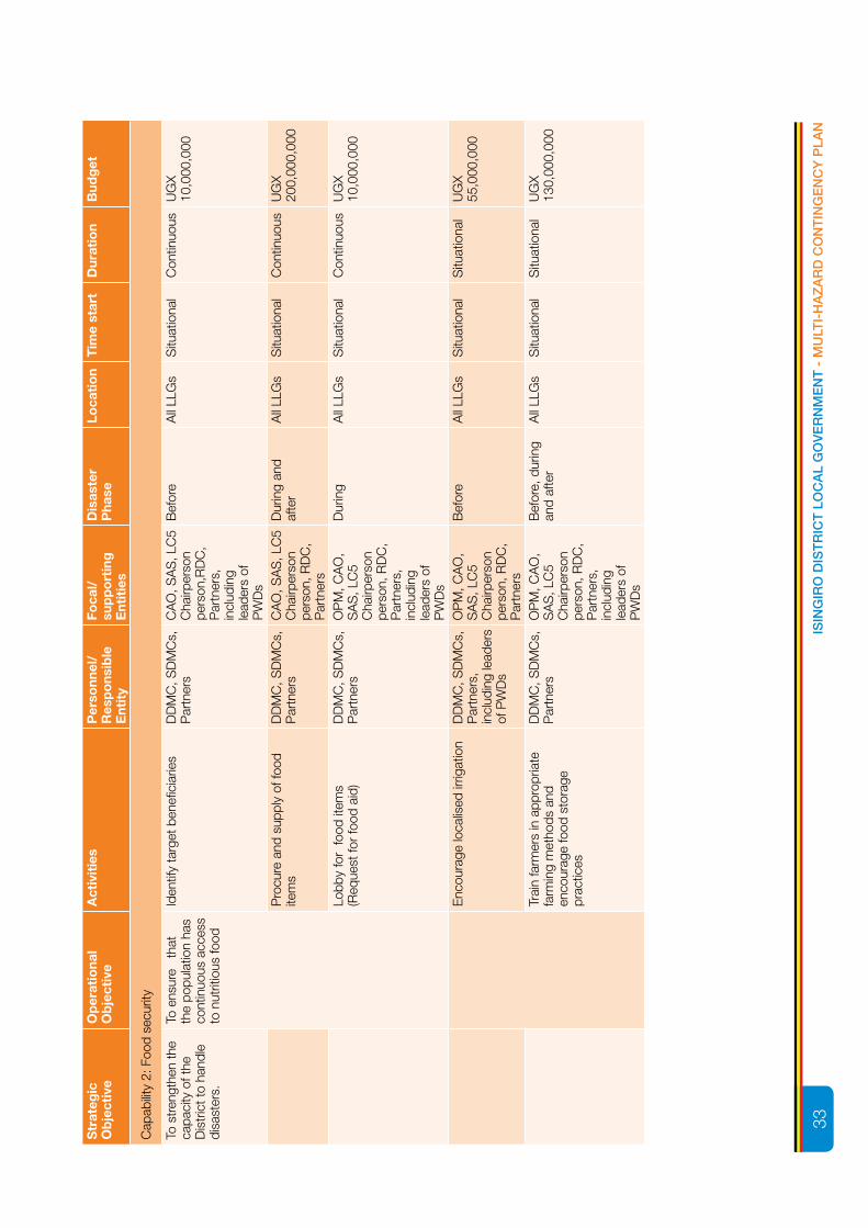
33ISINGIRO DISTRICT LOCAL GOVERNMENT - MULTI-HAZARD CONTINGENCY PLAN
Str
ateg
ic
Ob
ject
ive
Op
erat
iona
l O
bje
ctiv
e A
ctiv
itie
s
Per
sonn
el/
Res
po
nsib
le
Ent
ity
Foca
l/
sup
po
rtin
g
Ent
itie
s
Dis
aste
r P
hase
Loca
tio
n T
ime
star
tD
urat
ion
Bud
get
Cap
abilit
y 2:
Foo
d se
curit
y
To s
tren
gthe
n th
e ca
paci
ty o
f the
D
istr
ict t
o ha
ndle
di
sast
ers.
To e
nsur
e t
hat
the
popu
latio
n ha
s co
ntin
uous
acc
ess
to n
utrit
ious
food
Iden
tify
targ
et b
enefi
ciar
ies
DD
MC
, SD
MC
s,
Par
tner
sC
AO
, SA
S, L
C5
Cha
irper
son
pers
on,R
DC
, P
artn
ers,
in
clud
ing
lead
ers
of
PW
Ds
Bef
ore
All
LLG
sS
ituat
iona
lC
ontin
uous
UG
X 10
,000
,000
Pro
cure
and
sup
ply
of fo
od
item
sD
DM
C, S
DM
Cs,
P
artn
ers
CA
O, S
AS
, LC
5 C
hairp
erso
n pe
rson
, RD
C,
Par
tner
s
Dur
ing
and
afte
rA
ll LL
Gs
Situ
atio
nal
Con
tinuo
usU
GX
200,
000,
000
Lobb
y fo
r fo
od it
ems
(Req
uest
for
food
aid
)D
DM
C, S
DM
Cs,
P
artn
ers
OP
M, C
AO
, S
AS
, LC
5 C
hairp
erso
n pe
rson
, RD
C,
Par
tner
s,
incl
udin
g le
ader
s of
P
WD
s
Dur
ing
All
LLG
sS
ituat
iona
lC
ontin
uous
UG
X 10
,000
,000
Enc
oura
ge lo
calis
ed ir
rigat
ion
DD
MC
, SD
MC
s,
Par
tner
s,
incl
udin
g le
ader
s of
PW
Ds
OP
M, C
AO
, S
AS
, LC
5 C
hairp
erso
n pe
rson
, RD
C,
Par
tner
s
Bef
ore
All
LLG
sS
ituat
iona
lS
ituat
iona
lU
GX
55,0
00,0
00
Trai
n fa
rmer
s in
app
ropr
iate
fa
rmin
g m
etho
ds a
nd
enco
urag
e fo
od s
tora
ge
prac
tices
DD
MC
, SD
MC
s,
Par
tner
sO
PM
, CA
O,
SA
S, L
C5
Cha
irper
son
pers
on, R
DC
, P
artn
ers,
in
clud
ing
lead
ers
of
PW
Ds
Bef
ore,
dur
ing
and
afte
rA
ll LL
Gs
Situ
atio
nal
Situ
atio
nal
UG
X 13
0,00
0,00
0
33IS
ING
IRO
DIS
TR
ICT
LO
CA
L G
OV
ER
NM
EN
T -
MU
LTI-
HA
ZA
RD
CO
NT
ING
EN
CY
PLA
N

34 ISINGIRO DISTRICT LOCAL GOVERNMENT - MULTI-HAZARD CONTINGENCY PLAN
Str
ateg
ic
Ob
ject
ive
Op
erat
iona
l O
bje
ctiv
e A
ctiv
itie
s
Per
sonn
el/
Res
po
nsib
le
Ent
ity
Foca
l/
sup
po
rtin
g
Ent
itie
s
Dis
aste
r P
hase
Loca
tio
n T
ime
star
tD
urat
ion
Bud
get
Cap
abilit
y 3:
Wat
er &
San
itatio
n
To s
tren
gthe
n th
e ca
paci
ty o
f the
D
istr
ict t
o ha
ndle
di
sast
ers
To e
nsur
e pr
oper
was
te
man
agem
ent a
nd
disp
osal
Sen
sitis
e th
e po
pula
tion
on
prop
er h
uman
was
te d
ispo
sal
DD
MC
, SD
MC
s,
Par
tner
sD
DM
C,
SD
MC
s,
Par
tner
s
Bef
ore,
dur
ing
and
afte
rA
ll LL
Gs
Situ
atio
nal
Situ
atio
nal
UG
X 50
,000
,000
Pro
vide
was
te s
kips
DD
MC
, SD
MC
s,
Par
tner
sD
DM
C,
SD
MC
s,
Par
tner
s
Bef
ore,
dur
ing
and
afte
rA
ll LL
Gs
Situ
atio
nal
Situ
atio
nal
UG
X 10
,000
,000
Gaz
ette
was
te c
olle
ctio
n po
ints
DD
MC
, SD
MC
s,
Par
tner
sD
DM
C,
SD
MC
s,
Par
tner
s
Bef
ore,
dur
ing
and
afte
rA
ll LL
Gs
Situ
atio
nal
Situ
atio
nal
UG
X 30
,000
,000
Con
stru
ct s
tand
ard
acce
ssib
le
dum
ping
fill/
site
DD
MC
, SD
MC
s,
Par
tner
sD
DM
C,
SD
MC
s,
Par
tner
s,
incl
udin
g le
ader
s of
P
WD
s
Bef
ore
All
LLG
sS
ituat
iona
lS
ituat
iona
lU
GX
200,
000,
000
Con
stru
ct a
cces
sibl
e la
trin
esD
DM
C, S
DM
Cs,
P
artn
ers
DD
MC
, S
DM
Cs,
P
artn
ers,
in
clud
ing
lead
ers
of
PW
Ds
Bef
ore
All
LLG
sS
ituat
iona
lS
ituat
iona
lU
GX
300,
000,
000
To p
rovi
de
suffi
cien
t cle
an a
nd
acce
ssib
le w
ater
to
con
trol
the
spre
ad o
f dis
ease
s
Trac
k w
ater
DD
MC
, SD
MC
s,
Par
tner
sD
DM
C,
SD
MC
s,
Par
tner
s
Bef
ore
All
LLG
sS
ituat
iona
lS
ituat
iona
lU
GX
50,0
00,0
00
Pro
vide
acc
essi
ble
wat
er
harv
estin
g co
ntai
ners
in
resp
ectiv
e co
ntai
ners
DD
MC
, SD
MC
s,
Par
tner
sD
DM
C,
SD
MC
s,
Par
tner
s
Bef
ore
All
LLG
sS
ituat
iona
lS
ituat
iona
lU
GX
80,0
00,0
00
Con
duct
a h
ydro
-geo
logi
cal
surv
eyD
DM
C, S
DM
Cs,
P
artn
ers
DD
MC
, S
DM
Cs,
P
artn
ers
Bef
ore
All
LLG
sS
ituat
iona
lS
ituat
iona
lU
GX
15,0
00,0
00
Dril
l acc
essi
ble
bore
hole
s &
m
otor
izat
ion
of h
igh
yiel
ding
w
ater
sou
rces
.
DD
MC
, SD
MC
s,
Par
tner
sD
DM
C,
SD
MC
s,
Par
tner
s
Bef
ore
All
LLG
sS
ituat
iona
lS
ituat
iona
lU
GX
505,
000,
000
Dis
trib
ute
wat
er p
urify
ing
chem
ical
sD
HO
Par
tner
s im
plem
entin
g th
e W
AS
H
Pro
gram
Bef
ore,
dur
ing
and
afte
rA
ll LL
Gs
July
202
0R
outin
eU
GX
40,0
00,0
00
34IS
ING
IRO
DIS
TR
ICT
LO
CA
L G
OV
ER
NM
EN
T -
MU
LTI-
HA
ZA
RD
CO
NT
ING
EN
CY
PLA
N

35ISINGIRO DISTRICT LOCAL GOVERNMENT - MULTI-HAZARD CONTINGENCY PLAN
Str
ateg
ic
Ob
ject
ive
Op
erat
iona
l O
bje
ctiv
e A
ctiv
itie
s
Per
sonn
el/
Res
po
nsib
le
Ent
ity
Foca
l/
sup
po
rtin
g
Ent
itie
s
Dis
aste
r P
hase
Loca
tio
n T
ime
star
tD
urat
ion
Bud
get
Cap
abilit
y 3:
Wat
er &
San
itatio
n
To s
tren
gthe
n th
e ca
paci
ty o
f the
D
istr
ict t
o ha
ndle
di
sast
ers
To e
nsur
e pr
oper
was
te
man
agem
ent a
nd
disp
osal
Sen
sitis
e th
e po
pula
tion
on
prop
er h
uman
was
te d
ispo
sal
DD
MC
, SD
MC
s,
Par
tner
sD
DM
C,
SD
MC
s,
Par
tner
s
Bef
ore,
dur
ing
and
afte
rA
ll LL
Gs
Situ
atio
nal
Situ
atio
nal
UG
X 50
,000
,000
Pro
vide
was
te s
kips
DD
MC
, SD
MC
s,
Par
tner
sD
DM
C,
SD
MC
s,
Par
tner
s
Bef
ore,
dur
ing
and
afte
rA
ll LL
Gs
Situ
atio
nal
Situ
atio
nal
UG
X 10
,000
,000
Gaz
ette
was
te c
olle
ctio
n po
ints
DD
MC
, SD
MC
s,
Par
tner
sD
DM
C,
SD
MC
s,
Par
tner
s
Bef
ore,
dur
ing
and
afte
rA
ll LL
Gs
Situ
atio
nal
Situ
atio
nal
UG
X 30
,000
,000
Con
stru
ct s
tand
ard
acce
ssib
le
dum
ping
fill/
site
DD
MC
, SD
MC
s,
Par
tner
sD
DM
C,
SD
MC
s,
Par
tner
s,
incl
udin
g le
ader
s of
P
WD
s
Bef
ore
All
LLG
sS
ituat
iona
lS
ituat
iona
lU
GX
200,
000,
000
Con
stru
ct a
cces
sibl
e la
trin
esD
DM
C, S
DM
Cs,
P
artn
ers
DD
MC
, S
DM
Cs,
P
artn
ers,
in
clud
ing
lead
ers
of
PW
Ds
Bef
ore
All
LLG
sS
ituat
iona
lS
ituat
iona
lU
GX
300,
000,
000
To p
rovi
de
suffi
cien
t cle
an a
nd
acce
ssib
le w
ater
to
con
trol
the
spre
ad o
f dis
ease
s
Trac
k w
ater
DD
MC
, SD
MC
s,
Par
tner
sD
DM
C,
SD
MC
s,
Par
tner
s
Bef
ore
All
LLG
sS
ituat
iona
lS
ituat
iona
lU
GX
50,0
00,0
00
Pro
vide
acc
essi
ble
wat
er
harv
estin
g co
ntai
ners
in
resp
ectiv
e co
ntai
ners
DD
MC
, SD
MC
s,
Par
tner
sD
DM
C,
SD
MC
s,
Par
tner
s
Bef
ore
All
LLG
sS
ituat
iona
lS
ituat
iona
lU
GX
80,0
00,0
00
Con
duct
a h
ydro
-geo
logi
cal
surv
eyD
DM
C, S
DM
Cs,
P
artn
ers
DD
MC
, S
DM
Cs,
P
artn
ers
Bef
ore
All
LLG
sS
ituat
iona
lS
ituat
iona
lU
GX
15,0
00,0
00
Dril
l acc
essi
ble
bore
hole
s &
m
otor
izat
ion
of h
igh
yiel
ding
w
ater
sou
rces
.
DD
MC
, SD
MC
s,
Par
tner
sD
DM
C,
SD
MC
s,
Par
tner
s
Bef
ore
All
LLG
sS
ituat
iona
lS
ituat
iona
lU
GX
505,
000,
000
Dis
trib
ute
wat
er p
urify
ing
chem
ical
sD
HO
Par
tner
s im
plem
entin
g th
e W
AS
H
Pro
gram
Bef
ore,
dur
ing
and
afte
rA
ll LL
Gs
July
202
0R
outin
eU
GX
40,0
00,0
00
Str
ateg
ic
Ob
ject
ive
Op
erat
iona
l O
bje
ctiv
eA
ctiv
itie
sP
erso
nnel
/ R
esp
ons
ible
E
ntit
y
Foca
l/ s
upp
ort
ing
E
ntit
ies
Dis
aste
r P
hase
Loca
tio
nT
ime
star
tD
urat
ion
Bud
get
Cap
abilit
y 4:
Hea
lth
To s
tren
gthe
n th
e ca
paci
ty o
f the
D
istr
ict t
o ha
ndle
di
sast
ers
.
To d
eliv
er
incl
usiv
e an
d ac
cess
ible
he
alth
car
e se
rvic
es to
the
popu
latio
n
Con
duct
med
ical
sc
reen
ing,
dia
gnos
is
and
first
trea
tmen
t
WH
O, M
oH, H
Cs,
D
HO
MD
As,
Par
tner
s,
DH
O
Bef
ore,
du
ring
and
afte
rA
ll LL
Gs
Situ
atio
nal
Situ
atio
nal
UG
X 10
0,00
0,00
0
Hav
e in
clus
ive
and
acce
ssib
le e
mer
genc
y he
alth
care
ser
vice
s /
first
aid
in a
ll he
alth
fa
cilit
ies
WH
O, M
oH, H
Cs,
D
HO
MD
As,
Par
tner
s,
DH
O
Bef
ore,
du
ring
and
afte
rA
ll LL
Gs
Situ
atio
nal
Situ
atio
nal
UG
X 50
,000
,000
Bla
nket
Sup
plem
enta
ry
Feed
ing
Pro
gram
s
WH
O, M
oH, H
Cs,
D
HO
, Par
tner
sM
DA
s, P
artn
ers,
D
HO
Bef
ore,
du
ring
and
afte
rA
ll LL
Gs
Situ
atio
nal
Situ
atio
nal
UG
X 20
0,00
0,00
0
Pro
cure
and
con
stru
ct
of th
e di
lapi
date
d re
sour
ces
(HC
, A
mbu
lanc
es)
Dis
tric
t Eng
, DH
O,
Par
tner
s, N
atur
al
reso
urce
s de
pt,
MD
As
Dis
tric
t Eng
, DH
O,
Par
tner
s, N
atur
al
reso
urce
s de
pt,
MD
As
Bef
ore
All
LLG
sC
ontin
uous
Con
tinuo
usU
GX
600,
000,
000
Ret
ool t
he e
xist
ing
HC
an
d E
TU.
DH
O, P
artn
ers,
M
DA
sD
HO
, Par
tner
s,
dept
, MD
As
Bef
ore,
du
ring
and
afte
rA
ll LL
Gs
Con
tinuo
usC
ontin
uous
UG
X 45
,000
,000
To s
tren
gthe
n ca
paci
ty o
f th
e ex
istin
g H
ealth
pe
rson
nel
Ass
ess
and
iden
tify
kn
owle
dge
gaps
DH
O, P
artn
ers,
M
DA
s, D
MC
, S
DM
Cs
DH
O, P
artn
ers,
M
DA
s, D
MC
, S
DM
Cs
Bef
ore
All
LLG
sS
ituat
iona
lS
ituat
iona
lU
GX
30,0
00,0
00
Con
duct
the
trai
ning
. D
HO
, Par
tner
s,
MD
As,
DM
C,
SD
MC
s, O
PM
.
DH
O, P
artn
ers,
M
DA
s, D
MC
, S
DM
Cs,
OP
M
Bef
ore,
du
ring
and
afte
rA
ll LL
Gs
Situ
atio
nal
Situ
atio
nal
UG
X 20
0,00
0,00
0
35IS
ING
IRO
DIS
TR
ICT
LO
CA
L G
OV
ER
NM
EN
T -
MU
LTI-
HA
ZA
RD
CO
NT
ING
EN
CY
PLA
N

36 ISINGIRO DISTRICT LOCAL GOVERNMENT - MULTI-HAZARD CONTINGENCY PLAN
Str
ateg
ic
Ob
ject
ive
Op
erat
iona
l O
bje
ctiv
eA
ctiv
itie
sP
erso
nnel
/ R
esp
ons
ible
E
ntit
y
Foca
l/ s
upp
ort
ing
E
ntit
ies
Dis
aste
r P
hase
Loca
tio
nT
ime
star
tD
urat
ion
Bud
get
To d
evel
op a
cu
lture
of s
afet
y an
d re
silie
nce
at
all l
evel
s th
roug
h th
e ta
rget
ed
and
effe
ctiv
e di
ssem
inat
ion
of a
cces
sibl
e
info
rmat
ion
Sen
sitiz
e th
e m
asse
s th
roug
h es
tabl
ishe
d co
mm
unic
atio
n ch
anne
ls
Des
ign
incl
usiv
e he
alth
pr
omot
ion
mes
sage
s in
th
e di
ffere
nt fo
rms
and
legi
ble
lang
uage
; rol
e pl
ays,
cha
rts,
etc
DH
OP
artn
ers,
DD
MC
, S
DM
C, M
DA
s.
Bef
ore,
du
ring
and
afte
rA
ll LL
Gs
Situ
atio
nal
Situ
atio
nal
UG
X 50
,000
,000
Enf
orce
/Dis
trib
utio
n/en
cour
agin
g th
e us
e of
pro
tect
ive
gear
s lik
e he
lmet
s, s
eat b
elts
etc
.
DH
OP
artn
ers,
DD
MC
, S
DM
C, M
DA
s.
Bef
ore,
du
ring
and
afte
rA
ll LL
Gs
Situ
atio
nal
All
the
time
UG
X 30
,000
,000
Dis
sem
inat
e in
clus
ive
he
alth
mes
sage
s on
re
spec
tive
med
ia
plat
form
s lik
e ra
dios
, co
mm
unity
dia
logu
es,
bara
zas,
prin
t med
ia
and
TVs,
vis
ibilit
y m
ater
ials
Par
tner
s, D
DM
C,
SD
MC
, MD
As.
Par
tner
s, D
DM
C,
SD
MC
, MD
As.
Bef
ore,
du
ring
and
afte
rA
ll LL
Gs
Situ
atio
nal
Situ
atio
nal
UG
X 10
0,00
0,00
0
Act
ivel
y m
onito
r an
d sc
ale
up o
f fee
dbac
k an
d m
anag
emen
t sy
stem
s
DH
O
Par
tner
s, D
DM
C,
SD
MC
,
Bef
ore,
du
ring
and
afte
rA
ll LL
Gs
Situ
atio
nal
Situ
atio
nal
UG
X 30
,000
,000
Cap
abilit
y 5:
Edu
catio
nS
trat
egic
Obj
ectiv
e O
pera
tiona
l O
bjec
tive
Act
iviti
es
P
erso
nnel
/ R
espo
nsib
le E
ntity
Foca
l/ su
ppor
ting
Ent
ities
D
isas
ter
Pha
seLo
catio
n Ti
me
star
tD
urat
ion
Bud
get
36IS
ING
IRO
DIS
TR
ICT
LO
CA
L G
OV
ER
NM
EN
T -
MU
LTI-
HA
ZA
RD
CO
NT
ING
EN
CY
PLA
N

37ISINGIRO DISTRICT LOCAL GOVERNMENT - MULTI-HAZARD CONTINGENCY PLAN
Str
ateg
ic
Ob
ject
ive
Op
erat
iona
l O
bje
ctiv
eA
ctiv
itie
sP
erso
nnel
/ R
esp
ons
ible
E
ntit
y
Foca
l/ s
upp
ort
ing
E
ntit
ies
Dis
aste
r P
hase
Loca
tio
nT
ime
star
tD
urat
ion
Bud
get
To s
tren
gthe
n th
e ca
paci
ty o
f the
D
istr
ict t
o ha
ndle
di
sast
ers.
To p
rovi
de
optim
al a
cces
s to
incl
usiv
e
educ
atio
n
Pro
vide
a b
lank
et
scho
ol s
uppl
emen
tary
fe
edin
g.
DE
O, C
AO
, DH
O,
DD
MC
, D P
lann
er,
Par
tner
s, M
DA
sD
EO
, CA
OD
urin
g an
d af
ter
All
LLG
sS
ituat
iona
lS
ituat
iona
lU
GX
200,
000,
000
Put
bye
-law
s fo
r al
l ch
ildre
n be
twee
n 6
– 18
yea
rs to
be
in s
choo
l (in
clud
ing
child
ren
with
di
sabi
litie
s) a
nd e
nfor
ce
them
DE
O, O
PM
, DH
O,
DD
MC
, D P
lann
er,
Par
tner
s, M
DA
s,
polit
ical
lead
ers,
m
edia
DE
O, C
AO
, DH
O,
OP
M a
nd P
artn
ers
Bef
ore
All
LLG
sS
ituat
iona
l
All
the
time
UG
X 20
,000
,000
To p
rovi
de
psyc
ho-
soci
al
reha
bilit
atio
n
Offe
r co
unse
lling
and
guid
ance
for
the
scho
ol
goin
g st
uden
ts
DE
O, P
artn
ers,
D
DM
C, S
DM
C,
MD
As,
Hea
lth
med
ical
pr
actit
ione
rs
DE
O, C
AO
, DH
O,
and
Par
tner
s A
fter
All
LLG
sS
ituat
iona
l S
ituat
iona
lU
GX
20,0
00,0
00
Eng
age
stud
ents
and
yo
uth
in M
usic
Dan
ce
and
Dra
ma
as a
form
of
educ
atio
n
DE
O, P
artn
ers,
D
DM
C, S
DM
C,
MD
As,
Hea
lth
med
ical
pr
actit
ione
rs
DE
O, C
AO
, DH
O,
and
Par
tner
s B
efor
e an
d af
ter
All
LLG
s S
ituat
iona
l S
ituat
iona
lU
GX
58,0
00,0
00
Sch
ool d
ialo
gues
on
pre
vent
ion
and
resp
onse
of d
isas
ters
.
DE
O, P
artn
ers,
D
DM
C, S
DM
C,
MD
As,
Hea
lth
med
ical
pr
actit
ione
r
DE
O, C
AO
, DH
O,
and
Par
tner
s
Bef
ore,
du
ring
and
afte
rA
ll LL
Gs
Situ
atio
nal
Situ
atio
nal
UG
X 35
,000
,000
37IS
ING
IRO
DIS
TR
ICT
LO
CA
L G
OV
ER
NM
EN
T -
MU
LTI-
HA
ZA
RD
CO
NT
ING
EN
CY
PLA
N

38 ISINGIRO DISTRICT LOCAL GOVERNMENT - MULTI-HAZARD CONTINGENCY PLAN
Appendix 1 - Isingiro District Contingency Plan Development TeamThe team comprised of Isingiro District local government officials and other District stakeholders.S/N NAME ORGANISATION DESIGNATION CONTACTS
1 Kataama Clement ISDLG AFO 7742307372 Betunga Telly WIU PROGRAM ASSISTANT 7841471703 Muhwezi Richard ISDLG PLANNER 7038924684 Wobusobozi Rogers NSAMIZI ENVIRONMENT/LIVELIHOOD 7812908095 Oreeba Onesmas - AEO ISDLG AEO 7750447946 Twinokusiima Shillah URCS BDRO 7787636407 Twinomugisha Rogers ISDLG PLANNER 7009215008 Muhumuza Robert ISDLG ENVIRONMENT 7723301309 Kenneth Magomu MASHA S/C SAS 752786698
10 Jack Twerebere ISDLG DWO 78287307511 Kulu Samuel UNHCR -NAKIVALE FIELD ASSISTANT 77322910012 Ali Hauba UNHCR -NAKIVALE FIELD ASSOCIATE 70266400813 Janet Nayifu WFP- ISINGIRO COMM.ENGAMENT 75864925814 Ayorekire Fredric IDLG PFO 77249822315 Erimu Richard POLICE DPC 78835956516 Musinguzi Patrick Danny ISDLG D. Commercial Officer 70238884817 Mark June ISDLG D. Communication Officer 70336808018 Ainomujuni Abert ISDLG IT officer 75015046219 Turyaramya Catherine ISDLG PLANNER 70203755520 Tugume Julius ISDLG ROAD INSPECTOR 77236726521 Turibamwe Silver ISDLG CDO 77657182022 Sanyu Maclyn ISDLG PS CAO 78259205523 Bwengye Emmanuel ISDLG DNRO 77237705024 Natukunda Agatha ISDLG EO 77662624025 Tumusherure Edison ISDLG DHO 75339188826 Tumwesigye Patrick ISDLG DAO 77655100827 Mwebaze Andrew ISDLG PHRO 77251520428 Aryatuha Paulah RIGHT TO PLAY FF 70262544929 Nuwamanya Ruth VISION GROUP JOURNALIST 75281940030 Ankunda Robert IDLG COUNCILLOR 70110722131 Acola Amina ALIGHT LEGAL OFFICER 77858535532 Nassali Rehema ISDLG COUNCILLOR 77355174533 Mubangizi Pauson ISDLG AO 78250970134 Mildred Kiconco ALIGHT LEGAL ASSISTANT 78165198535 Ainomugisha Primah ISDLG DEO 75006830736 Innocent Byagageire ISDLG CFO 77255682537 Gumikiriza Aloysius ISDLG ACAO 78284378838 Birungi Nyakoojo UNICEF EMER 77228813339 Namara Frank URCS OPERATIONS MANAGER 77260522640 Otii Peter URCS DRIVER 77293091441 Ahimbisibwe Hillary OPM COMMANDANT 77799963842 Rhona Nantege COACH AFRICA RAPPOTEUR 77485457143 Ahumuza Joshua URCS BRANCH MANAGER 77297038444 Catherine Mugisha URCS ADMIN ASSISTANT 77243677445 Nimusiima Barbara URCS FOCAL PERSON 75563555846 Natuhwera Amos URCS VOLUNTEER 70231461247 Pamela Komujuni Kalule OPM Lead facilitator 782730186
APPENDICES
CHAPTERSIX

39ISINGIRO DISTRICT LOCAL GOVERNMENT - MULTI-HAZARD CONTINGENCY PLAN
Appendix 2 - Definition of Triggers& thresh holdsHazard Impact
Floods
Low impact- situation Medium impact- situation High impact -situation
• Above Normal rainfall
• Water logging• Some Roads not
accessible• Households
affected: 0 - 10
• Prolonged rainfall• Destruction of some crops
and households• Overflow of most rivers• Rise in water borne
diseases• Many roads are not
accessible• Households affected: 11-
50
• Heavy and prolonged rainy season and or Torrential rains across the District.
• Water logging and flooding will be experienced in low lying areas
• Overflow of main rivers and streams across the District
• Damage to / destruction of crops and animals
• Damage to / destruction of critical facilities such as health centers, schools, markets, roads, bridges
• Contamination of major water sources
• Damage to / destruction of dwellings and shelter and consequent displacement of families and communities in the areas experiencing the flooding and landslides
• Outbreak(s) of communicable diseases among affected population.
• Households affected: Above 50
Low impact - Response Medium impact - Response High impact – Response
• Opening of water channels
• Replacing broken crossing lines.
• Community sensitization and engagement
• Harvest crops to prevent rotting
• Opening of water channels• Replacing broken bridges• Community sensitization
and engagement• Harvest crops to prevent
rotting
• Activation of DDMC with CAO taking the lead.
• Deployment of first responders including URCS.
• First aid provision• Joint Rapid emergency
assessment with District and partners
• Provision of daily situational reports to Stakeholders.
• Registration of the affected persons plus damage to properties.
• Identify grounds or alternatives for accommodating displaced households
• Distribution of prepositioned NFIs or multipurpose cash
• Distribution of water purifying chemicals.
• Conduct daily coordination meetings by the DDMC.

40 ISINGIRO DISTRICT LOCAL GOVERNMENT - MULTI-HAZARD CONTINGENCY PLAN
Hazard Impact
Population Movement
Low impact - Situation Medium impact - Situation High impact – Situation• Increased tension in
the region• Influx between 0-50
people• Spontaneous
arrivals and departures to and from countries of origin.
• Situation escalates in the region; influx has peaked and increases at certain moments in the year.
• Influx of 100 persons.
• Increased tension in neighboring countries forces people to flee in great numbers
• Influx of more than 100 people, during various month of the year
Low impact - Response Medium impact - Response High impact – Response
• Community surveillance and report to relevant authorities.
• Continuation of ongoing response in the refugee settlements
• Activation ofDDMC (inclusive of all partners led by OPM)
• Conduct ongoing rapid and detailed assessment
• Identification of protection issues
• First Aid at entry points and transit centers
• Joint coordination meetings involving Districts and partners
• Distribution of NFIs or multipurpose cash
• Activation of daily situation reports
• Government through OPM alerts donors
• Activation of emergency/humanitarian cluster/sector response
• Activation of alert• Deployment of Branch
Action Teams• Rapid and detailed
assessment • Setting up First Aid post• Start social mobilization for
disease prevention• Psychosocial support
services• Upscale Restoring Family
Links capacity • Setting up beneficiary
feedback system• Identification of possible
distribution points• Distribution of prepositioned
NFIs or multipurpose cash• Deployment of WASH kit 5• Safe water provision• Distribution of water
purification chemicals• Provision of emergency pit
latrines• Hygiene promotion activities• Construction of communal
hygiene and sanitation facilities
• Sinking of emergency garbage disposal pits
• Deployment of surge personnel
• Development and release of satraps
• Active participation in stakeholder meetings
• Movement of prepositioned stock and emergency procurements

41ISINGIRO DISTRICT LOCAL GOVERNMENT - MULTI-HAZARD CONTINGENCY PLAN
Hazard Impact
Human diseases
Low impact - Situation Medium impact - Situation High impact – Situation
• One single confirmed case
• Presence of alerts through the CBDS structures.
• Occurrence of the epidemic or endemic in the surrounding communities or previous time frame.
• When WASH situation is not adequate
• A cluster of confirm cases• Increased number of alerts
of the same disease/epidemic
• When case incidence is same with the same period of time in previous years
• When attack rate is low• When the case-fatality is
low (CFR< 1%)• When WASH situation is
below standard • Outbreak declared
• A cluster of cases• When case incidence is
greater than expected (compared with the same period of time in previous years)
• When attack rate is high• When the case-fatality is
high CFR (>1%)• An area with endemic
cholera, or the occurrence of culture-confirmed cholera in the population during at least three of the past five year
• When WASH situation is inadequate
• Outbreak declared, with call for external support
Low impact - Response Medium impact - Response High impact – Response• Monitor situation • Collect information
from outbreak task force or a choleracoordination committee
• Make an inventory of available essential emergency supplies at URCS warehouse and pre-position in affected and at-risk branches
• Prepare or update disease specific emergency plan of action (EPoA)
• Train volunteers ready to commence health education campaigns
• Continue to support volunteers in passive CBS activities
• Tweak health education messages in accordance with the situation
• Initiate rapid assessment • Post alert on DMIS/SIMS• Participate in District
task forceor a cholera coordination committee
• Timely and adequate mobilization of emergency supplies from national or donor sources
• Update emergency plan of action (EPoA)
• Commence health education campaigns
• Activate Crisis Modifier • Monitor and evaluate
control measures• CBS scales up to active
mode? = recruitment and training of additional volunteers to ensure proper coverage
• Active monitoring and scale up of feedback and rumor management systems
• PSS support for volunteers• Movement ofprepositioned
stock and emergency procurements (Cholera response)
• Rapid and detailed assessment
• Post updates on DMIS/SIMS• Participate in District and
national task force or a cholera coordination committee
• Intensify health education campaigns
• Revise or update emergency plan of action (EPoA)
• Activate DREF • Deployment of ORP kit (if
cholera outbreak)• PSS activities in affected
communities • Deployment of surge
personnel• CBS scales up to active
mode? = recruitment and training of additional volunteers to ensure proper coverage
• Possible engagement in contact tracing activities
• SBD activities for VHFs?

42 ISINGIRO DISTRICT LOCAL GOVERNMENT - MULTI-HAZARD CONTINGENCY PLAN
Hazard Impact
Environmental degradation
Low impact - Situation Medium impact - Situation High impact – Situation• Aggregate
encroachingon gazetted areas by 1 acre
• Use of hand tools to encroach on gazette lands
• 1 – 3 workers excavating and quarrying existing hills (sand mining)
• ¼ acre wetland encroachment
• 0-5 people involved in wetland usage
• 1-3% Siltation of water bodies
• 1-2 acres of bare land
• ¼ acre Bushes burnt
• 2 kilns in a spot • 1-5 unauthorized
dumping sites in the village / a stretch of 50 meters
• 1-2 unauthorized dumping sites in urban setting/ a stretch of 10 meters
• 1 tree cut per acre - Indiscriminate tree cutting
• Encroaching on gazetted areas by 2 acres
• Use of hand saws to encroach on gazette lands
• 4 – 7 workers excavating and quarrying existing hills
• 1-acre wetland encroachment
• 6-8 people involved in wetland usage
• 4-5% Siltation of water bodies
• 3-5 acres of bare land • ½ acre of bushes burnt • 3-4 kilns in a spot • 6-8 unauthorized dumping
sites in the village / a stretch of 50 meters
• 3-4 unauthorized dumping sites in urban setting/ a stretch of 10 meters
• 2-3 trees cut per acre - Indiscriminate tree cutting
• Encroaching on gazetted areas more than 4 acres
• Use of power saws to encroach on gazette lands
• 1 household settling in gazette areas
• Above 8 workers excavating and quarrying existing hills
• Above 1-acre wetland encroachment
• Above 8 people involved in wetland usage
• Above 5% Siltation of water bodies
• Above 5 acres of bare land• Above ½ acre of bare
hectares• Above 1 acre of bushes
burnt • Above 4kilns in a spot • Above 8 unauthorized
dumping sites in the village / a stretch of 50 meters
• Above 4 unauthorized dumping sites in urban setting/ a stretch of 20 meters
• Above 3 trees cut per acre - Indiscriminate tree cutting
Low impact - Response Medium impact - Response High impact – Response• Community
sensitization and engagement.
• Environmental impact assessment
• Continuous monitoring of natural resources using environmental management committees and spatial technology
• Re-demarcation of gazetted natural resources
• Mandatory tree planting • Passing of ordnances and
by laws to conserve the environment
• Enforcement of ordnances and bylaws
• Eviction of encroachers• Aggressive tree planting
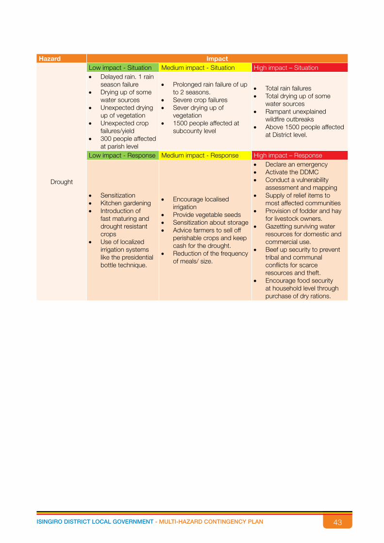
43ISINGIRO DISTRICT LOCAL GOVERNMENT - MULTI-HAZARD CONTINGENCY PLAN
Hazard Impact
Drought
Low impact - Situation Medium impact - Situation High impact – Situation• Delayed rain. 1 rain
season failure• Drying up of some
water sources• Unexpected drying
up of vegetation• Unexpected crop
failures/yield• 300 people affected
at parish level
• Prolonged rain failure of up to 2 seasons.
• Severe crop failures• Sever drying up of
vegetation• 1500 people affected at
subcounty level
• Total rain failures• Total drying up of some
water sources• Rampant unexplained
wildfire outbreaks • Above 1500 people affected
at District level.
Low impact - Response Medium impact - Response High impact – Response
• Sensitization• Kitchen gardening• Introduction of
fast maturing and drought resistant crops
• Use of localized irrigation systems like the presidential bottle technique.
• Encourage localised irrigation
• Provide vegetable seeds • Sensitization about storage• Advice farmers to sell off
perishable crops and keep cash for the drought.
• Reduction of the frequency of meals/ size.
• Declare an emergency• Activate the DDMC• Conduct a vulnerability
assessment and mapping• Supply of relief items to
most affected communities• Provision of fodder and hay
for livestock owners.• Gazetting surviving water
resources for domestic and commercial use.
• Beef up security to prevent tribal and communal conflicts for scarce resources and theft.
• Encourage food security at household level through purchase of dry rations.
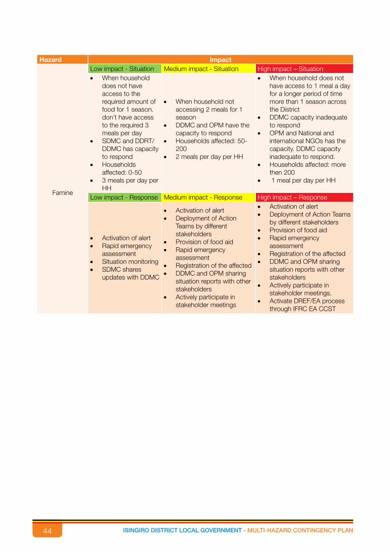
44 ISINGIRO DISTRICT LOCAL GOVERNMENT - MULTI-HAZARD CONTINGENCY PLAN
Hazard Impact
Famine
Low impact - Situation Medium impact - Situation High impact – Situation• When household
does not have access to the required amount of food for 1 season. don’t have access to the required 3 meals per day
• SDMC and DDRT/DDMC has capacity to respond
• Households affected: 0-50
• 3 meals per day per HH
• When household not accessing 2 meals for 1 season
• DDMC and OPM have the capacity to respond
• Households affected: 50-200
• 2 meals per day per HH
• When household does not have access to 1 meal a day for a longer period of time more than 1 season across the District
• DDMC capacity inadequate to respond
• OPM and National and international NGOs has the capacity. DDMC capacity inadequate to respond.
• Households affected: more then 200
• 1 meal per day per HH
Low impact - Response Medium impact - Response High impact – Response
• Activation of alert• Rapid emergency
assessment• Situation monitoring• SDMC shares
updates with DDMC
• Activation of alert• Deployment of Action
Teams by different stakeholders
• Provision of food aid • Rapid emergency
assessment• Registration of the affected• DDMC and OPM sharing
situation reports with other stakeholders
• Actively participate in stakeholder meetings
• Activation of alert• Deployment of Action Teams
by different stakeholders • Provision of food aid • Rapid emergency
assessment• Registration of the affected• DDMC and OPM sharing
situation reports with other stakeholders
• Actively participate in stakeholder meetings.
• Activate DREF/EA process through IFRC EA CCST

45ISINGIRO DISTRICT LOCAL GOVERNMENT - MULTI-HAZARD CONTINGENCY PLAN
Hazard Impact
Crop and Animal pests
Low impact - Situation Medium impact - Situation High impact – Situation
• When community starts observing the presence of crop pests (armyworm) and animal diseases that attack their animals (foot and mouth).
• This can be within one village and affected animals can be 0-5 and 1 acre of plantation.
• Reduction in milk production
• Death of 1 animal per HH
• Rampant movement of livestock in search of water and pasture in one Sub-County
• When communities realise an increase in the presence of crop pests and animal diseases, also death of animals, crops also die, a quarantine is put in place.
• This can happen in more than one village and this can attack more than 5 animals and 10 acres of plantation.
• Reduction in milk production
• Death of 1 animal in each of the 5 HH
• Rampant movement of livestock in search of water and pasture in 2 sub counties
Rapid increase of animal diseases and crop pests in communities leading to rapid deaths of animals, famine, high expenditure on animal drugs and pesticides, increased quarantines on animals along borders.The DDMC has limited response thus OPM, and other national NGOs come in to help.This can happen on a greater extent of more than one Sub-County, more than 10 acres of land and more than 10 animals can be attacked.
No milk production Death of 1 animal in more than 5 HH.
• Rampant movement of livestock in search of water and pasture more than 2 sub counties
Low impact - Response Medium impact - Response High impact – Response• Community
surveillance and report to relevant authorities.
• Local authority Sharing updates with the SDMC.
• The local leaders can respond.
• The local leaders can inform the SDMC of the situation.
• Activation of alert• Conduct ongoing rapid and
detailed assessment• Sensitization meetings on
quarantines.• The SDMC and DDMC can
respond to the situation.
• Activation of alert• Rapid and detailed
assessment • Start social mobilization
for disease prevention/vaccination.
• Setting up feedback system• Identification of possible
locations for vaccination
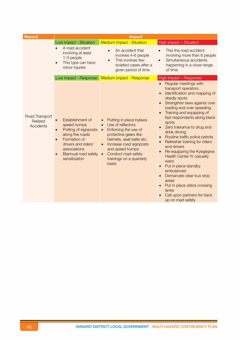
46 ISINGIRO DISTRICT LOCAL GOVERNMENT - MULTI-HAZARD CONTINGENCY PLAN
Hazard Impact
Road Transport Related
Accidents
Low impact - Situation Medium impact - Situation High impact – Situation• A road accident
involving at least 1-3 people
• This type can have minor injuries
• An accident that involves 4-6 people
• This involves few isolated cases after a given period of time
• This the road accident involving more than 6 people
• Simultaneous accidents happening in a close range of time
Low impact - Response Medium impact - Response High impact – Response
• Establishment of speed humps
• Putting of signposts along the roads
• Formation of drivers and riders’ associations
• Biannual road safety sensitization
• Putting in place bylaws• Use of reflectors• Enforcing the use of
protective gears like helmets, seat belts etc.
• Increase road signposts and speed humps
• Conduct road safety trainings on a quarterly basis
• Regular meetings with transport operators
• Identification and mapping of deadly spots
• Strengthen laws against over loading and over speeding
• Training and equipping of fast respondents along black spots
• Zero tolerance to drug and drink driving
• Routine traffic police patrols• Refresher training for riders
and drivers• Re-equipping the Kyegegwa
Health Center IV casualty ward
• Put in place standby ambulances
• Demarcate clear bus stop areas
• Put in place zebra crossing lanes
• Call upon partners for back up on road safety

47ISINGIRO DISTRICT LOCAL GOVERNMENT - MULTI-HAZARD CONTINGENCY PLAN
Hazard Impact
Earthquakes
Low impact - Situation Medium impact - Situation High impact – Situation
• This occurs on a very low frequency like once in a year and mild vibrations are experienced.
• The local authorities can respond.
• This is when cracks are visible both on the ground and in some structures, the impact of the vibrations can be felt physically though still on a minor extent. This can happen beyond once a year.
• The SDMC together with DDMC can handle.
• This is when structures start collapsing.
• The water table changes, the ground disintegrates and sometimes new water bodies are formed
• Miscarriages among women• Destruction of crop
plantations.• Death of people and
animals.• The OPM, both National
and International NGOs can respond.
Low impact - Response Medium impact - Response High impact – Response
• Assess the situation • Collect any available
information on the situation.
• Local leaders share information with SDMC.
• Initiate rapid assessment • Post alert on the situation.• Active monitoring and
scale up of feedback and management systems
• Involve the DDMC in meetings on the situation.
• Rapid and detailed assessment
• Participate in District and national coordination committee
• Revise or update emergency plan of action
• OPM and other National and International organizations should come in to help.
Hailstorms
Low impact - Situation Medium impact - Situation High impact – SituationAn unusual weather phenomenon in which balls of ice fall from the sky affecting 1-10 households
Hail falls from the sky with relatively strong winds and affects at least 11-20 households
• Strong Hail that affects more than 20 households
• The hail can come together with strong winds and creates massive distraction
Low impact - Response Medium impact - Response High impact – Response
• Providing psycho-social support
• Provision of planting materials
• Promoting safety net measures
• Sensitization on environment protection
• Provision of emergency food
• Avail planting materials• Promote planting of wind
breakers• Encourage formation of
community safety nets• Promote food storage
practices
• Provide monthly food support for at least one season
• Liaise with partners for support
• Provision of agricultural inputs
• Provision of fpinancial support (unconditional)
• Targeting affected communities for income generating activities
• Extending existing government support programmes in the affected areas

48 ISINGIRO DISTRICT LOCAL GOVERNMENT - MULTI-HAZARD CONTINGENCY PLAN

49ISINGIRO DISTRICT LOCAL GOVERNMENT - MULTI-HAZARD CONTINGENCY PLAN

50 ISINGIRO DISTRICT LOCAL GOVERNMENT - MULTI-HAZARD CONTINGENCY PLAN
Funded byEuropean UnionCivil Protectionand Humanitarian Aid