Application of BET_EF to Mount Etna: a retrospective analysis (years 2001-2005)
Upload
khangminh22Category
view
1download
0
Mount Etna: monitoring in the past, present and future
H A Z E L R Y M E R l, F A B R I Z I O F E R R U C C I 2 & C O R I N N E A. L O C K E 3
1 Department of Earth Sciences, The Open University, Walton Hall, Milton Keynes,
Bucks, MK7 6AA, UK
2 Dip. di Scienze della Terra, Universita della Calabria, 87036 Arcavacata di Rende,
Cosenza, ltah"
3 Department of Geology, The University of Auckland, Private Bag 92019,
Auckland, New Zealand
Abstract: Mount Etna is important to the economy of eastern Sicily, with agriculture and summer and winter tourism providing employment for thousands of people. Although there are no permanent homes within 10 km of the summit, year-round human activities on the upper slopes are proliferating and the risks from even a small eruption are consequently magnified. The earliest form of monitoring at Etna, as for other volcanoes, was direct observation. Modern volcano monitoring at its most effective is a synergy between basic science and hazard assessment. A prerequisite to effective monitoring is an understanding of volcanic structure and history. Sir Charles Lyell was among the first to make systematic observations of Mount Etna and laid the foundation of more modern studies. A huge array of monitoring techniques has been tested on Etna: methods that have proved successful in monitoring and sometimes in predicting eruptions include observations of seismicity, ground deformation and microgravity. These. together with electromagnetic, magnetic, gas geochemistry and various remote sensing techniques have also provided key information on the volcanic plumbing system and the eruption process. Monitoring techniques were formerly based on the most easily measured phenomena: other effects were either not recorded or were treated as noise. Future progress will be enhanced by taking account of these more subtle or complex effects and by the more comprehensive acquisition and real-time analysis of continuous data sets over extended periods. Important monitoring techniques and strategies available both now and in the near future are reviewed here in the context of Etna. The need to develop a reliable scientific platform for routine and inexpensive volcano monitoring throughout the world is highlighted.
Why monitor volcanoes?
Volcano monitoring serves two key functions: it provides basic scientific data to develop our understanding of the structure and dynamics of volcanoes and is crucial for hazard assessment, eruption prediction and risk mitigation at times of volcanic unrest. Monitoring provides the means to address questions of vital interest to communit ies affected by impending eruptions, such as: When and where will the volcano erupt? Which areas are safe or dangerous? When will eruptions cease? Optimal interpretation of data from monitoring, especially for the purpose of prediction, depends critically on an adequate scientific understanding of volcano structure and processes, both in general and for each specific volcano. Thus, volcano monitor ing at its most effective is a synergy between basic science and hazard assessment.
Historically, volcanic activity has been con- sidered to be primarily of local interest because
typically, with the exception of relatively infre- quent large explosive events, eruptions seriously affect only a few square kilometres at most. As populations expand, however, more people are at risk from the direct or indirect impact of volcanic eruptions. In addition to the immediate hazards posed by eruptive products to life, property and food production, volcanic activity of any kind may have a significant effect on the economy. During minor eruptions tourism may increase and boost the local economy. The loss, however, of agricultural farm land, farmhouses, communicat ion and service infrastructure (roads, ports, water supplies, electric cables, etc.) and permanent changes in the local ground water and drainage system can have severe economic consequences. A volcanic disaster on one side of the world can now have a significant eco- nomic impact on countries on the other. Insurance companies are particularly vulnerable because of this, but governments are also at risk. The National Plan for volcanic emergencies at Mount Vesuvius
RYMER, H., FERRUCC1, F. & LOCKE, C. A. 1998. Mount Etna: monitoring in the past, present and future. In: BLUNDELL. D. J. & SCOTT. A. C. (eds) Lvell: the Past is the Key to the Present. Geological Society. London, Special Publications. 143. 335-347.
335
by guest on July 20, 2022http://sp.lyellcollection.org/Downloaded from
336 H. RYMER ET AL.
for example forecasts that around 700 000 people would need to be evacuated during a period of unrest preceding an explosive eruption such as the one that occurred in 1631. The cost of evacuation and resettlement would represent a significant fraction of Italy's GNP and the rest of the EU would certainly suffer economically from such an event.
Links between global climate change and volcanic eruptions have been postulated and there is good evidence for a relationship between large explosive ash injection to the stratosphere and unseasonal weather. Well documented examples include the 1815 eruption of Tambora (Indonesia) which was followed by the 'year without a summer' in the northern hemisphere, and more recently E1 Chichon (1982) and Pinatubo (1991) (described for example in Francis 1993). In each case there is some doubt as to the extent of climate change (caused by cooling due to increased high altitude aerosols) during these short explosive eruptions, but it is likely that longer-lived eruptions such as the 1783 lava eruption at Laki (8 months)+ have a more prolonged effect on local and global temperatures.
A more recent hazard posed by volcanoes is the effect of volcanic ash clouds on transportation. There have been more than 80 incidents since 1982 of jet aircraft encountering volcanic ash, with tens of millions of dollars worth of damage done on each occasion (e.g. Casadevall 1994). Millions of US dollars have also been lost to the aviation industry as a result of disruption when flights have been diverted or made emergency unscheduled landings. Catania international airport has been closed on several occasions in the last 20 years as a result of ash on the runway and the plume inter- secting the flight path of planes. The Messina- Catania motorway was closed in 1995 when accumulating ash made the surface slippery and dangerous (J. B. Murray, pers. comm.).
It is therefore of interest to all nations that volcanoes are monitored so that eruptions can be predicted and mitigating action taken. Successful mitigation of the local effects of an eruption (such as lava flow diversion and community evacuation) requires a detailed understanding of the eruption process, for which monitoring data are a vital component. More widespread effects can be miti- gated to some degree with early warning, for
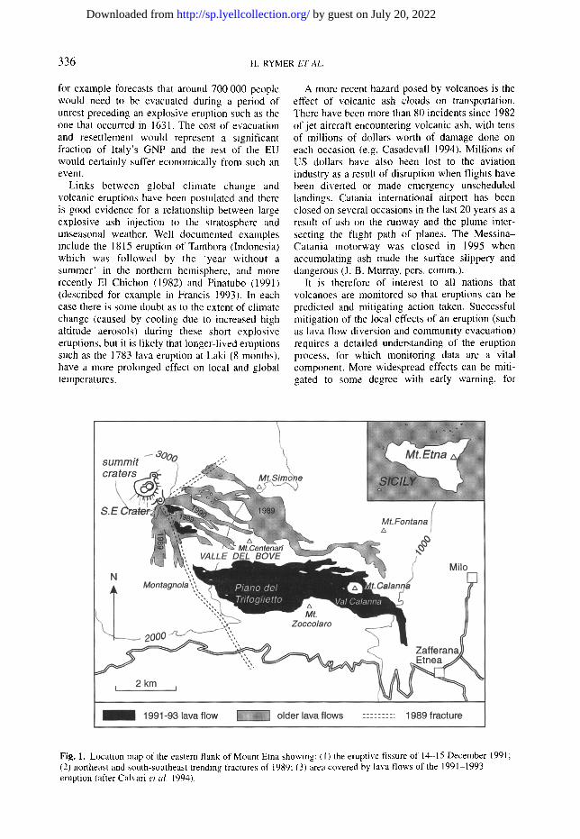
Fig. 1. Location map of the eastern flank of Mount Etna showing: (I) the eruptive fissure of 14-15 December 1991; (2) northeast and south-southeast trending fractures of 1989: (3) area covered by lava flows of the 1991-1993 eruption (after Calvari et al. 1994).
by guest on July 20, 2022http://sp.lyellcollection.org/Downloaded from

MOUNT ETNA 337
example allowing aircraft re-routing. Similarly, an appreciation of the climatic effects both locally and globally requires data from surveillance before, during and after eruptive activity.
Historical activity and observations at Etna
Volcanic activity in Sicily has been focused at Etna since the Mid-Pleistocene, resulting in the development of one of the largest active continental volcanoes in the world (Chester et al. 1985). The landscape of eastern Sicily is dominated by the edifice of the Etna volcano, which rises from sea level to over 3300 m. Its activity, which com- menced some 230 000 years ago (Kieffer 1985), has been recorded for the last 3500 years and in considerable detail for the last 400 years. Activity at this basaltic volcano occurs both at the summit and on the flanks. Effusion rates from the summit are generally moderate and at least one of the several vents appears to be open to the feeder system at any one time (Chester et al. 1985). As well as construction, there are periods of collapse at the summit vents resulting in ash clouds. Flank eruptions tend to be confined to specific rift zones (McGuire & Pullen 1989) and generally have a higher effusion rate (Kieffer 1975) producing extensive lava flows and cinder cones. Other types of activity at this volcano include ash eruptions, pyroclastic flows and slope fa i lure- which ranges from minor mud flows to major landslides. It may have been a series of such landslides that formed or catastrophically enlarged the Valle de Bove, an amphitheatre some 5 km across, 10 km long and up to 1 krn deep on the eastern flank of Etna (Fig. 1). One of the largest and most destructive historical eruptions was a flank eruption in 1669 from near Nicolosi (at 800 m a.s.1.) which produced the cinder cone Monti Rossi and a 14 km long lava flow responsible for destroying part of the city of Catania.
Whilst most Greeks and Romans held supernatural beliefs about Etna, some notable exceptions such as Empedocles (492-432 Be) made observations of the eruptive phenomena which unfortunately do not survive. It was not until the sixteenth century that such natural phenomena began to be studied systematically. In the early nineteenth century Leopold von Buch (of Neptunist fame) developed his idea of 'craters of elevation', i.e. that 'volcanic mountains formed by upwarping of formerly horizontal beds of basalt as a result of pressures exerted by molten materials at depth' (von Buch 1818-1819), a hypothesis which he deduced from observations in the Canary Islands. Whilst Scrope (1825) argued for 'craters of eruption', l~lie de Beaumont (1838) supported von
Buch by suggesting that Etna lavas had been erupted in thin sheets on to a subhorizontal surface above sea level accumulating to a considerable thickness. These were thought to have then been uplifted along the line of the Valle de Bove.
Elie de Beaumont's work focused Sir Charles Lyell's mind on how volcanoes formed; Lyell visited Etna on a number of occasions and in 1858 The Royal Society published a monograph titled: On the Structure of Lavas which have Consolidated on Steep Slopes: with Remarks on the Mode of Origin of Mount Etna and on the Theory of 'Craters o f Elevation ', in which he describes his own work and that of others and condemns the 'craters of elevation' hypothesis (Lyell 1858). From the morphology and flow characteristics of historic and ancient lava flows he deduced that they had solidified on steep slopes. He also determined from Valle de Bove exposures that there were two eruptive centres, the present summit (Mongibello) and the Trifoglietto centre to the east (Fig. 1 ). Lyell declared:
... we must abandon the elevation-crater hypo- thesis; for although one cone of eruption may envelop and bury another cone of eruption, it is impossible for a cone of upheaval to mantle round and overwhelm another cone of upheaval so as to reduce the whole mass to one conical mountain. (Lyell 1858)
Recent activity at Etna
In 1989, four months of strombolian activity at the summit craters was followed in September by an effusive eruption from the southeast crater and the opening of two fractures (Bertagnini et al. 1990). A non-eruptive south-southeast-trending fracture extended more than 7 km from the summit (Fig. 1), passed close to the headwall of the Valle del Bove and crossed the road between the Sapienza and Zafferana Etnea. The northeast-trending fracture extended about 2 km from the summit crater area and lava was erupted along much of its length. No further activity occurred until a small explosive eruption from the southeast crater in January 1990.
Activity on Etna was then unusually quiet until 14 December 1991 with the start of the most voluminous eruption since the end of the 1669 eruption. The activity was largely confined to a single bocca within the western wall of the Valle del Bove ( 2200 m a.s.1.) erupting 231 x 106 m 3 of lava at an average rate of 5.7 m 3 s -1 (Stevens et al. 1997). The flow was more than 8 km long and threatened the town of Zafferana Etnea when it was successfully diverted (Barberi & Villari 1994; Di Palma et al. 1994; Vassale 1994). The eruption ended on 31 March 1993, after 471 days.
by guest on July 20, 2022http://sp.lyellcollection.org/Downloaded from
338 H. RYMER ET AL.
Past and present monitoring on Etna
Volcano watchers have long ventured to the mouth of an erupting volcano and noted changing intensity of degassing, lava eruption, etc. New or increased hydrothermal activity, felt earthquakes and in some cases visible ground deformation (rifting or faulting), have been recognized for centuries as being associated with volcanic activity, but usually during or after the event. Until recently volcano monitoring has tended to be responsive in that resources were forthcoming only after the begin- ning of an eruption. In this review, the techniques applied during the 1989 and 1991-1993 Etna eruptions are taken as examples of volcano moni- toring today. The high level of activity at Etna and its easy accessibilty have led to most available techniques for volcano monitoring and some involving mitigation being tested there.
S e i s m o l o g y
A century of seismological data testifies that seismic unrest in the form of earthquakes and tremor almost always precedes and/or accompanies volcanic unrest at all types of volcanoes. Seismic activity is considered to be the best indicator, and often a reliable short to mid term (days to weeks) predictor, of the level, type and evolution of volcanic activity (Ferrucci 1995).
Seismic sources at volcanoes are highly complex and involve the interaction of gas, melt and solid. The role of the melt and gas may be either (i) active, giving rise to pressurized intrusions of magma into pre-existing or newly formed zones of weakness, or to sustained vibration of the melt and host rocks; or (ii) passive, where brittle failures and the consequent stress readjustments modify the distribution of melts in the crust. Since volcanic media comprise dense systems of pores, fractures and faults at all scales, sudden modification of the local stress field may induce seismic failure independent of melt propagation. These factors contribute to the substantial degree of ambiguity in volcano eruption prediction on the basis of seismology alone.
The first instruments set up to record earthquakes at Etna were deployed in the early 1900s, however the first network of seismometers was not estab- lished on Etna until 1973. This network, com- prising two to six stations recording the short period vertical component of seismic waves, was used to investigate eruption-related earthquakes and volcanic tremor (Cosentino et al. 1982). These studies showed that shallow (1-5 kin) seismic activity usually preceded flank fissure eruptions by a few days. In contrast precursory seismic activity
is not usually associated with summit eruptions, although they are often accompanied by tremor. Tremor is common at active volcanoes, but the process that sustains these low magnitude and frequency signals is poorly understood (Schick & Mugiono 1991). Analysis of seismicity at a large number of active volcanoes, however, has shown that in general an increase in the rate of low- frequency earthquakes gives an increased prob- ability that tremor episodes may follow. Increased levels of tremor energy are consistent with an increased probability that an eruption may occur within weeks, days or even hours (Ferrucci 1995). Modern seismometers detect ground vibration in 3 dimensions over a range typically of 0.1-10 Hz. High-frequency events are usually associated with deep (several kilometres) fracture events, while low-frequency and tremor events are thought to be caused by forced resonance of fluids in shallow (a few kilometres) volcanic conduits.
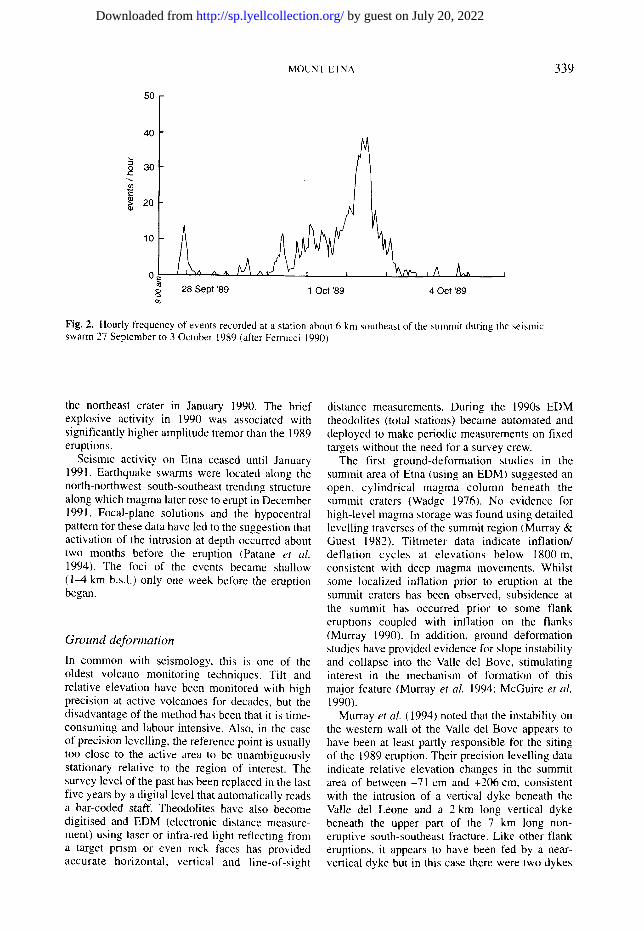
A new seismic array was being developed and expanded on Etna by the Istituto Internazionale di Vulcanologia, Catania prior to the 1989 activity and data from up to 22 seismometers were available for analysis and comparison. Seismicity at Etna remained at background levels until July 1989 when a I0 km deep (b.s.l.) magnitude 2.9 event beneath the southeastern Valle del Bove and later a seismic swarm heralded the onset of renewed activity. A second swarm in August 1989 originated only 5 km b.s.l. No noticeable seismicity occurred subsequently until the beginning of eruptive activity in the southeast crater in September 1989 when a further swarm and large individual events some of magnitude >3.0 to the northwest of the summit craters occurred. These events may have been linked to the opening of the northeast-trending fracture (Bertagnini et al. 1990) that erupted a small amount of magma (Fig. 1), while several hundred shallow seismic events over a two-day period (1-2 October) accompanied the opening of the non-eruptive south-southeast- trending fracture (Fig. 2). Although the causative mechanism of the seismicity is unclear (Ferrucci 1990), a temporal relationship exists between the occurrence of the swarm and the propagation of the fracture beyond the scarp of the Valle del Bove. No definitive evidence for shallow magma beneath this fracture was found (see below). Volcanic tremor throughout the 1989 eruption correlated strongly with eruptive activity; in particular a sharp increase in tremor amplitude always accompanied the change in activity from weak Strombolian, to strong Strombolian, to lava fountaining, to lava flows (Ferrucci 1990).
There was no further noteworthy seismic activity observed from the end of the 1989 eruption until one month before a small explosive eruption from
by guest on July 20, 2022http://sp.lyellcollection.org/Downloaded from
MOUNT ETNA 339
50
40
o 30
t ' -
~ 2o
N 28 Sept '89 1 Oct '89
,A A~ 4 Oct '89
Fig. 2. Hourly frequency of events recorded at a station about 6 km southeast of the summit during the seismic swarm 27 September to 3 October 1989 (after Ferrucci 1990).
the northeast crater in January 1990. The brief explosive activity in 1990 was associated with significantly higher amplitude tremor than the 1989 eruptions.
Seismic activity on Etna ceased until January 1991. Earthquake swarms were located along the north-northwest-south-southeast trending structure along which magma later rose to erupt in December 1991. Focal-plane solutions and the hypocentral pattern for these data have led to the suggestion that activation of the intrusion at depth occurred about two months before the eruption (Patane et al. 1994). The foci of the events became shallow (1-4 km b.s.l.) only one week before the eruption began.
G r o u n d d e f o r m a t i o n
In common with seismology, this is one of the oldest volcano monitoring techniques. Tilt and relative elevation have been monitored with high precision at active volcanoes for decades, but the disadvantage of the method has been that it is time- consuming and labour intensive. Also, in the case of precision levelling, the reference point is usually too close to the active area to be unambiguously stationary relative to the region of interest. The survey level of the past has been replaced in the last five years by a digital level that automatically reads a bar-coded staff. Theodolites have also become digitised and EDM (electronic distance measure- merit) using laser or infra-red light reflecting from a target prism or even rock faces has provided accurate horizontal, vertical and line-of-sight
distance measurements. During the 1990s EDM theodolites (total stations) became automated and deployed to make periodic measurements on fixed targets without the need for a survey crew.
The first ground-deformation studies in the summit area of Etna (using an EDM) suggested an open, cylindrical magma column beneath the summit craters (Wadge 1976). No evidence for high-level magma storage was found using detailed levelling traverses of the summit region (Murray & Guest 1982). Tiltmeter data indicate inflation/ deflation cycles at elevations below 1800 m, consistent with deep magma movements. Whilst some localized inflation prior to eruption at the summit craters has been observed, subsidence at the summit has occurred prior to some flank eruptions coupled with inflation on the flanks (Murray 1990). In addition, ground deformation studies have provided evidence for slope instability and collapse into the Valle del Bove, stimulating interest in the mechanism of formation of this major feature (Murray et al. 1994: McGuire et al. 1990).
Murray et al. (1994) noted that the instability on the western wall of the Valle del Bove appears to have been at least partly responsible for the siting of the 1989 eruption. Their precision levelling data indicate relative elevation changes in the summit area of between -71 cm and +206 cm, consistent with the intrusion of a vertical dyke beneath the Valle del Leone and a 2 km long vertical dyke beneath the upper part of the 7 km long non- eruptive south-southeast fracture. Like other flank eruptions, it appears to have been fed by a near- vertical dyke but in this case there were two dykes
by guest on July 20, 2022http://sp.lyellcollection.org/Downloaded from

340 H. RYMER ET AL.
radiating from the southeast crater. In the first, the magma travelled northeastwards and intersected the surface, erupting lava. In the second, the magma travelled south-southeastwards hut did not reach the surface though it did cause fracturing. There is evidence for dyke intrusion up to 3 km from the summit along the south-southeast fracture (Murray et al. 1994), but the pattern of ground deformation at the distal end of the fracture was characteristic of an elastoplastic medium, and therefore was not linked with magma intrusion (Luongo et al. 1990).
Precise levelling and triangulation measurements were made before, during and after the 1991-1993 event (Murray 1994). Data from over 300 stations in the summit region of Etna revealed a narrow trough of more than 1 m of subsidence running south-southeast from the summit, connecting the southeast crater with the eruption site, flanked by two zones of inflation up to 37 cm to the east and 7 cm to the west (Fig. 3a). This is interpreted in terms of a syn-eruption dyke intrusion at a depth of 450 m to its top and 1100 m to its base (Murray 1994).
G P S
The global positioning system (GPS) is now widely used: by placing two or more GPS receivers either permanently or for the duration of a survey at locations of interest, the user can obtain x, y and z coordinates for each location with centimetre or even sub-centimetre precision horizontally and vertically. Traditional geodetic techniques are not suitable for continuous observations, but GPS provides this opportunity. Feasibility studies on the possibility of using permanently fixed receivers capable of automatically tracking satellites, recording and transmitting data for automatic processing and storage began on Etna in 1988 (Nunnari & Puglisi 1995). Data collected during the 1991-1993 eruption on a network of stations over the summit of the volcano extending down the flanks as far as Catania indicate that contraction of the whole edifice occurred during the first months of 1992. This has been modelled in terms of depressurisation within a source (magma storage region) 1.5-3.5 km b.s.1. The volume of magma
Fig. 3. (a) Elevation changes over the summit and upper eastern flank of Mount Etna between 1990-1991. Contour interval is 1 cm (after Rymer et al. 1995). (b) Gravity changes over the summit and upper eastern flank of Mount Etna between 1990-1991. Contour interval is 50 mGal (after Rymer et at. 1995).
by guest on July 20, 2022http://sp.lyellcollection.org/Downloaded from

MOUNT ETNA 341
erupted during the same period exceeds the volume loss within the modelled region, suggesting this relatively superficial storage region may be linked to a deeper feeder system (Nunnari & Puglisi 1995).
GPS technology has improved dramatically since 1993, and permanent stations have now been established at several key locations on and around the volcanic edifice. In addition, twice yearly campaigns now aim to occupy stations in the summit and flank areas; results have shown consistent radial expansion since 1992 consistent with relaxation of the edifice (Murray 1997).
M i c r o - g r a v i t y
Etna was one of the first volcanoes to be studied using micro-gravity (Sanderson 1982; Sanderson et al. 1983). The technique typically involves repeated high-precision surveys in which the relative value of gravity at a number of stations is determined. Repeat micro-gravity surveys are used to investigate subsurface mass changes; since their effect is sensitive to variations in the distance from mass anomalies, micro-gravity data must be corrected for height changes and hence these surveys must always be accompanied by a ground deformation survey.
A micro-gravity increase (approximately 20 reGal) attributed to a shallow (a few hundred metres depth) source was observed across the southernmost end of the south-southeast-trending non-eruptive fracture a few days after formation in October 1989 (Budetta et al. 1990). However,
neither these data nor data from a network of micro-gravity stations around the volcano flank at an elevation of 1500-2000 m provided evidence in support of a magma intrusion associated with the fracture process.
The period June 1989- November 1989 was characterised by a gravity increase in the summit region (up to 100 mGal) and was followed by a decrease of similar magnitude between November 1989 and June 1990. These data imply subsurface mass increases of 109-101~ followed by decreases, and are consistent with the eruption of 109 kg of pyroclastic material in January 1990 (Rymer et al. 1993). Between June 1990 and June 1991. although there was no surface eruptive activity, there were significant gravity changes (Fig. 3b) in the summit area; the changes are too large by an order of magnitude to be caused by the minor deflation observed over the same period (Murray 1994). The data have been interpreted in terms of a passive (aseismic) intrusion of magma into the pre-stressed region beneath the 1989 south- southeast-trending fracture (Rymer et al. 1993). The intrusion must have occurred some time between June 1990 and June 1991, several months after the formation of the surface fractures and several months before the onset of the 1991-1993 eruption. The intrusion appeared to be in the location of the dyke that fed the later eruption (Fig. 4). Relative micro-gravity values remained constant in the vicinity of the fracture zone after the end of the 1991-1993 eruption, but decreased and subsequently increased again by 1994 in the summit crater region. This suggests that intruded
Fig. 4. Cross-section along a profile through the summit and along the south-southeast fracture zone showing a computed model of a 50 m diameter feeder pipe rising towards the summit and a 4 m wide dyke extending along the fracture zone, which can account for the gravity changes observed between June 1990 and June 1991.
by guest on July 20, 2022http://sp.lyellcollection.org/Downloaded from

342 H. RYMER ET AL.
magma solidified within the fracture zone, and the magma level within the summit feeder fell then rose again, which is consistent with the increased summit activity observed since 1994 (Rymer et al. 1995).
Tidal g rav i t y
Micro-gravity data are corrected for the effects of Earth tides (up to about 200 reGal peak to peak, diurnal) before interpretation. A predicted Earth tide can be calculated for any location (eg. Brouke et al. 1972) which represents the vertical com- ponent of gravitational acceleration on a solid, uniform Earth but does not account for variations due to topography, theological heterogeneities and ocean loading. Use of the predicted tide is satisfactory for many applications of micro-gravity (it is good to better than 8 ~Gal), but more accurate tidal corrections are possible if concurrent tidal observations are made or if tidal observations have already been made for at least three months and the phase lags and amplitudes of the key tidal components (Melchior 1978) have been determined for the specific location.
Mason et al. (1975) reported an anomalously large response to Earth tides at Etna for tidal observations accompanying a micro-gravity survey preceding an eruption, from which they suggested that the crust beneath Etna was elastically inhomo- geneous because of the presence of subsurface magma bodies. It has subsequently been shown using combined tiltmeter and gravity data that this observed anomalous behaviour was probably a transient response related to ground deformation and eruptive activity at Etna and that there is no anomalous tidal response under normal quiescent conditions (Davis 1981).
Continuous tidal measurements were made at the astrophysical observatory (Serra la Nave) near the Sapienza on the southern flank of Etna some 7 km from the summit in the period 1992-1994. i.e. during and after the 1991-1993 eruption (d'Oreye et al. 1994). However the station was too far from the active region to detect a volcanic response in the tidal signal.
Currently there are continuously recording tidal gravimeters operating at Serra la Nave (for control) and at the Torre del Filosofo (TDF) near the summit as part of an EU funded initiative. Clearly although the spatial resolution of tidal gravity data is very limited compared with that provided by a micro- gravity survey, the temporal resolution is consider- ably improved (typically one observation per minute rather than several per year) which allows the rates of processes (such as dyke intrusion. magma emplacement/drainage, etc.) to be deter- mined.
S e l f - p o t e n t i a l
Several electromagnetic techniques have been used to investigate variations in electrical conductivity due to sub-surface volcanic structures. Self- potential (SP) measurements for example, made across the lower part of the south-southeast- trending fracture (Patella et al. 1990) after the end of the 1989 eruption with an electrode separation of 110 m over a profile length of 1.32 km showed two large positive anomalies up to approximately 100 mV in magnitude and several hundred metres in wavelength. These were interpreted in terms of shallow (near-surface) fluid movements in response to magma intrusion (Patella et al. 1990). These data therefore suggest that magma was intruded at depth beneath the south-southeast-trending fracture during the 1989 active period although there was no eruption south of the summit. The SP anomaly was attributed to the heating of water in saturated rocks by volcanic gases from the intrusion. Regular SP observations (approximately monthly) between October 1989 and April 1993 (Di Maio & Patella 1994) showed that the anomaly gradually decreased which was considered to be consistent with such a heating process.
G a s g e o c h e m i s t o '
Magmatic intrusions can influence the concent- ration of soil gases. For a period of several days after the formation of the south-southeast-trending fracture, H,, CO-,, CO and 222Rn variations were monitored at the distal end of the fracture in an attempt to determine whether or not a magmatic intrusion was responsible. Continuous CO,, flux monitoring revealed a dramatic increase from-about 500 ppm to 2000 ppm about one week after the appearance of the fracture, but the flux returned to normal values after one day (Carapezza et al. 1990). Although the 222Rn activity was five times higher in the fractured region than in the adjacent unfractured areas, Chiodini et al. (1990) were unable to prove a link between the data and degas- sing of a magmatic body because their observations were in the range previously measured in Etnean soil gases (Seidel & Monnin 1984).
The 1991 eruption was preceded by a relative decrease in CO, flux across the distal part of the SSE trending [989 fracture, suggesting that as magma rises, degassing preferentially occurs through the main conduits in the summit area (Badalamenti et al. 1994). Some rapid fluctuations of soil gas fluxes across the south-southeast- trending 1989 fracture also occurred during the 1991-1993 eruption. These results suggest that soil gas monitoring along the flanks of Etna can be useful for detecting early phases of volcanic unrest,
by guest on July 20, 2022http://sp.lyellcollection.org/Downloaded from
MOUNT ETNA 343
while monitoring of degassing from the summit or fractures can provide early indications of near- surface magmatic intrusion (Badalamenti et al. 1994).
C O S P E C
The most widely used non-satellite based instru- ment for remote sensing of volcanic plume compo- sitions is the correlation spectrometer (COSPEC). The relative absorption of solar uv light by a volcanic plume is analysed along with plume width and wind speed to give an estimate of the flux of SO,, molecules. Relatively low SO, flux has been
-
identified previously as a precursor to eruptions on Etna (Malinconico 1979).
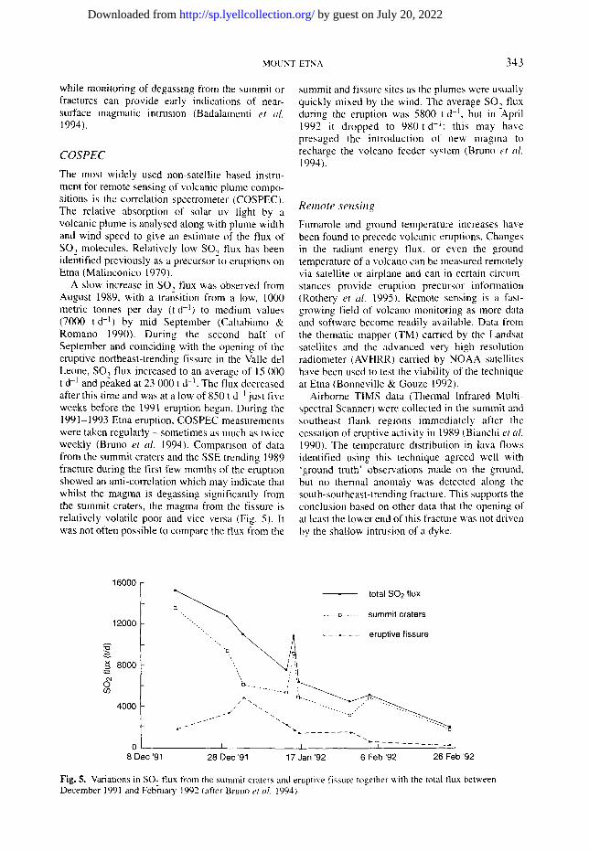
A slow increase in SO, flux was observed from August 1989, with a transition from a low, 1000 metric tonnes per day (t d q ) to medium values (7000 t d -I) by mid September (Caltabiano & Romano 1990). During the second half of September and coinciding with the opening of the eruptive northeast-trending fissure in the Valle del Leone, SO, flux increased to an average of 15 000 t d -1 and peaked at 23 000 t d -1. The flux decreased after this time and was at a low of 850 t d -I just five weeks before the 1991 eruption began. During the 1991-1993 Etna eruption, COSPEC measurements were taken regularly - sometimes as much as twice weekly (Bruno et al. 1994). Comparison of data from the summit craters and the SSE trending 1989 fracture during the first few months of the eruption showed an anti-correlation which may indicate that whilst the magma is degassing significantly from the summit craters, the magma from the fissure is relatively volatile poor and vice versa (Fig. 5). It was not often possible to compare the flux from the
summit and fissure sites as the plumes were usually quickly mixed by the wind. The average SO~ flux during the eruption was 5800 t d -1, but in-April 1992 it dropped to 980 td - I : this may have presaged the introduction of new magma to recharge the volcano feeder system (Bruno et al. 1994).
R e m o t e s e n s i n g
Fumarole and ground temperature increases have been found to precede volcanic eruptions. Changes in the radiant energy flux, or even the ground temperature of a volcano can be measured remotely via satellite or airplane and can in certain circum- stances provide eruption precursor information (Rothery et al. 1995). Remote sensing is a fast- growing field of volcano monitoring as more data and software become readily available. Data from the thematic mapper (TM) carried by the Landsat satellites and the advanced very high resolution radiometer (AVHRR) carried by NOAA satellites have been used to test the viability of the technique at Etna (Bonneville & Gouze 1992).
Airborne TIMS data (Thermal Infrared Multi- spectral Scanner) were collected in the summit and southeast flank regions immediately after the cessation of eruptive activity in 1989 (Bianchi et al. 1990). The temperature distribution in lava flows identified using this technique agreed well with 'ground truth' observations made on the ground, but no thermal anomaly was detected along the south-southeast-trending fracture. This supports the conclusion based on other data that the opening of at least the lower end of this fracture was not driven by the shallow intrusion of a dyke.
16000
12000
.~ 80o0 ..-,..
c7 C O
4 0 0 0
0 8 Dec '91
total SO2 flux
"--............. ~ ..... ~ ..... summit craters
""-......... ~ , ~ ~ . . . . . eruptive fissure
/ "-, - - . . . / " . \ - . .., - - .
/ ~ ' ( ~".. " ' " ' o ' " " ' " - - -
" I . _ . . . . . . .
28 Dec '91 17 Jan '92 6 Feb '92 26 Feb '92
Fig. 5. Variations in SO~ flux from the summit craters and eruptive fissure together with the total flux between December 1991 and February 1992 (after Bruno et aL 1994).
by guest on July 20, 2022http://sp.lyellcollection.org/Downloaded from

344 H. RYMER ET AL.
The possibility of real-time volcano monitoring using remote sensing came closer during analysis of the 1991-1993 lava flow field using AVHRR data. Ground truth data and lava flow maps were used to confirm remote sensing estimates of lava flow volume, active lava area, thermal flux and effusion rates (Harris et al. 1997). Although this technique does not have an application for eruption prediction, it could provide frequent information on the progress of an inaccessible lava flow, the sites of secondary breakouts and assessment of the associated hazards.
S A R in t e r f e rome t �9
Synthetic aperture radar satellites illuminate the Earth's surface with microwave radiation and can be used for mapping topography to high precision (Francis et al. 1996). Provided that a reliable digital elevation model (DEM) is available, images obtained on ascending and descending orbits of the host satellite can be obtained. Interferograms are obtained by combining two such images and removing the effects of topography. Images for Etna during the waning stages of the 1991-1993 eruption indicated possible volcano-wide deflation (Massonnet et al. 1995). There are concerns, how- ever, about the validity of this model (J. B. Murray, pers. comm.) as almost simultaneous ground surveys with GPS do not show the deflation, and there seems to be a strong correlation between apparent elevation change and topography.
Volcano monitoring in the future
The focus of Lyell's studies of Mt Etna was an understanding of the nature and evolution of volcanoes which has formed the foundation of more modern studies. These studies have provided the basis of the science of monitoring volcanic activity which is now an increasing imperative as both the density of population and air traffic increases in volcanic regions. Whilst monitoring solely for the purpose of risk mitigation may reduce loss of life or property to a degree, its effectiveness can be greatly improved through the concurrent development of scientific methods and enhanced understanding of volcanic processes. Given the average interval between eruptions at many volcanoes, volcano monitoring tends not to be a high spending priority of governments, yet major volcanic eruptions can be national (and inter- national) social and economic disasters.
Future developments in volcanic monitoring will depend on many factors including technological advances, improvements in analytical and interpretation methods, the ability to successfully integrate multiple datasets and having detailed
knowledge of volcanic structure and processes. The continued development of robust, inexpensive and effective technologies for monitoring volcanoes is a vital and sometimes urgent requirement for volcano-affected countries. Advances in electronics in recent decades have helped progress towards cheap expendable sensors for example, thus reducing the inherent financial risk of losing expensive monitoring equipment and greatly benefiting the monitoring of volcanoes in develop- ing countries.
The importance of a good knowledge of the nature of background activity at each particular volcano cannot be overemphasized; if what is "normal' is not known then the 'abnormal' cannot readily be recognized. Most of the world's potentially active volcanoes, however, are not currently monitored. Furthermore, since no reliable laws of prediction can be determined from the data collected by volcanologists to date (Scarpa & Tilling 1996) multiple integrated monitoring methods are needed at each volcano.
Monitoring techniques were, of course, originally based on the most easily measured phenomena; other phenomena were either not measured, or filtered from the signal as noise. Future progress will be made by the recording and analysis of these more subtle or complex effects using a variety of methods. For example, it is now recognized that three component and broad-band seismometers provide vital information on shallow magmatic processes and should be incorporated into any volcano-seismological network. In the case of micro-gravity monitoring, the effects of the Earth tides are subtracted from the data before analysis and modelling. Advances in technology and analytical methods, however, will allow model- ling of the response of both the volcanic edifice and the plumbing system to tidal effects, from which further insight could be gained into eruption precursors and processes at depth.
Traditionally, most types of data (e.g. for gravity or ground deformation) have been recorded periodically at a number of stations. Data collection in such cases is labour intensive, time consuming and hence expensive and provide only snapshots of the real picture. Ideally, continuously recorded data at numerous stations should be telemetered to an observatory at which initial analysis could take place automatically, in real time, as has been achieved at some seismic networks. Recent advances in telemetry (Lesage et al. 1995) make such systems more viable and once established would be less labour intensive and, in times of eruption, safer.
GPS and SAR have the potential to revolutionise ground deformation studies given the large areas that can be covered simultaneously. Since these
by guest on July 20, 2022http://sp.lyellcollection.org/Downloaded from

MOUNT ETNA 345
methods give information of broad-scale changes they would be particularly effective in determining the significant edifice-wide inflation that might be expected to precede a dramatic change in eruptive style. COSPEC data are likely to become more reliable and consistent as more instrumentation becomes available and data collection becomes automated (Andres & Rose 1995). Other promising techniques for remotely investigating volcanic gases, e.g. GASPEC (Williams & Dick 1997) which m e a s u r e s C O 2 flux, and Fourier transform infra-red (FTIR) spectroscopy which measures the ratio of various gas species (Moil et al. 1993), are currently being developed. For example, variations in the SO2:HCL and HCI:SOz:SiF 4 ratios have been measured using FTIR (Francis et aL 1995, 1996). Multispectral infrared instruments to be carried by the first Earth Observing System satellite, due for launch in 1998, will greatly expand the capabilities and accessibility of spacebome remote sensing for both thermal and gas studies (Francis et al. 1996).
Potential developments in analysis and interpretation include improvements to automatic detection and processing (ADP) of seismic data such that the large volume of data generated by an intense seismic swarm can be processed and that real events can be more reliably distinguished from noise. The effectiveness of ADP depends on the density and geometry of the array compared with the extent and depth of the active zones; data from the 1989 and 1991-1993 events on Etna suggest an array density of 1 seismometer per km 2 is required to resolve events associated with shallow magmatic intrusion.
The Integrated Mobile Volcano Monitoring System developed by the USGS for use in volcanic crises (Murray et al. 1996) was used to very good effect in the 1991 Pinatubo eruption, however, port- able seismometers do not constitute an adequate alternative to permanent recording stations (Ferrucci 1995). Whilst they provide satisfactory monitoring during volcanic events they have no role in background surveillance or in recording the onset of seismic activity.
Advances in interpretation will require more detailed knowledge of the structural complexities and heterogeneities typical of volcanoes in order to develop adequate models. Recent advances in non- linear, high-resolution three-dimensional seismic tomography, for example, may allow the detailed interpretation of broad-band seismic data. Such broad-band data with a period greater than a few seconds are considered to be associated with mass transport (Chouet 1996) and are currently the subject of much research into their causative mechanisms
Although seismology will remain the most important monitoring tool for the foreseeable
future, the integration of seismic data with results from other methods, e.g. geodesy, gravity, elec- trical, gas and temperature flux etc. will be far more powerful (McNutt 1996). Smart systems using artificial neural networks (ANNs) are now being developed to integrate the vast quantities of data resulting from technological developments, to produce the simplest best-fitting models consistent with as much of the data as possible (Cristaldi et al. 1997). Such systems, however, are only as good as the input data, hence the need for detailed structural models and background information.
Important questions in contemporary volcan- ology include: What are the processes that trigger eruptions? Can the timing and location of an eruption be predicted? Is it possible to determine in advance the nature of an eruption and its likely duration? These issues present pressing problems both to basic science and to affected societies; they are being studied on Mount Etna and other active volcanoes using a combination of geophysical and geochemical techniques.
The priority now in volcanic monitoring is the acquisition of more data and the development of rapid and reliable methods to collate, analyse and interpret them. We do have some basic under- standing of the mechanisms and processes oper- ating within the Etna volcano but we now need to expand this knowledge by integrating the experience gained from decades of independent researches. As well as technological and scientific advances, effective communication and interaction between volcanologists, civil authorities and the affected populace are required to improve the mitigation of volcanic disasters.
We are very grateful to John Cassidy, John B. Murray, Peter W. Francis, Dave A. Rothery and two anonymous reviewers for valuable comments.
References
ANDRES, R. J. & ROSE, W, I. 1995. Remote sensing spectroscopy of volcanic plumes and clouds. In: McGUIRE, W. J., KILBURN, C. R. J. & MURRAY, J. (eds) Monitoring Active Volcanoes. UCL Press, London, 301-314.
BADALAMENTI, B., CAPASSO, M., CARAPEZZA, M. L. ET AL. 1994. Soil gases investigations during the 1991- 1993 Etna eruption. Acta Vulcanologica, 4, 135-142.
BARBERI, E & VILLARI, L. 1994. Volcano monitoring and civil protection problems during the 1991-1993 Etna eruption. Acta Vulcanologica, 4, 157-166.
BIANCHI, R., CASSACCHIA, R., PICCHIOTTI, A. & SALVATORI, R. 1990. Airborne thermal IR survey. In: BARBERI, F., BERTAGNINI, A. & LANDI, P. (eds) Mt Etna: the 1989 Eruption. Giardini, Italy, 69-72.
BERTAGN1NI, A., CALVARI, S., COLTELLI, M., LANDI, P., POMPILO, M. & SCRIBANO, V. 1990. The 1989
by guest on July 20, 2022http://sp.lyellcollection.org/Downloaded from
346 H. RYMER ET AL.
eruptive sequence. In: BARBERI, E, BERTAGNINI, A. & LANDI, P. (eds) Mt Ema: The 1989 Eruption. Giardini, Italy, 10-22.
BONNEVILLE, A. & GOUZE, P. 1992. Thermal survey of Mount Etna volcano from space. Geophysical Research Letters, 19(7), 725-728.
BROUKE, R. A., ZURN, W. E. & SLICHTER, L. B. 1972. Lunar tidal acceleration on a rigid Earth. Geophysical Monograph Series, American Geophysical Union, 16, 319-324.
BRUNO, N., CALTABIANO, T., GRASSO, M. F., PORTO. M. & ROMANO, R. 1994. SO, flux from Mr. Etna volcano during the 1991-1993 eruption: correlations and considerations. Acta Vulcanologica, 4, 143-147.
BUDETrA, G., GRIMALDI, M. & LUONGO, G. 1990. Gravity variations. In: BARBERI, F., BERTAGNINI. A. & LANDI, E (eds) Mt. Etna: The 1989 Eruption. Giardini, Italy, 56-57.
CALTABIANO, Y. & ROMANO, R. 1990. Soil gas geochemistry (c) COSPEC. In: BARBERI, F., BERTAGNINI, A. & LANDI, P. (eds) Mt. Etna: The 1989 Eruption. Giardini, Italy, 68.
CALVARI, S., COLTELL1, M., NERI, M., POMPILIO, M. & SCRmANO, V. 1994. The 1991-1993 Etna eruption: chronology and lava flow-field evolution. Acta Vulcanologica, 4, 1-14.
CARAPEZZA, M. L., GIAMMANCO, S., GURRIERI, S., HAUSER, S., NuccIo, P. M., PARELLO, F. & VALENZA, M. 1990. Soil gas geochemsitry (a) CO~ In: -. BARBER1, F., BERTAGNINI, A. & LANDI, P. (eds) Mt. Etna: The 1989 Eruption. Giardini, Italy, 62-64.
CASADEVALL, T. J. 1994. The 1989-1990 eruption of Redoubt Volcano, Alaska: impacts on aircraft operations. Journal of Volcanology and Geothermal Research, 62, 301-316.
CHESTER, D. K., DUNCAN, A. M., GUEST, J. E. 8~ KILBURN, C. R. J. 1985. Mount Etna: The Anatomy of a Volcano. Chapman & Hall, London.
CHOUET, B. A. 1996. New methods and future trends in seismological volcano monitoring. In: SCARPA, R. & TILLING, R. I. (eds) Monitoring and Mitigation of Volcano Hazards. Springer, Berlin, 23-98.
CHIODINI, G., CIONI, R., PESCIA, A., RACO, B. & TADDEUCCI, G. 1990. Soil gas geochemistry-H, , CO and 222Rn. In: BARBERI, F., BERTAGNINI, A. LANDI, P. (eds) Mt. Etna: The 1989 Eruption. Giardini, Italy, 65-67.
COSENTINO, M., LOMBARDO, G., PATERNE, G., SCHICK, R. & SHARP, A. D. L. 1982. Seismological researches on Mount Etna: state-of-the-art and recent trends. Memorie della Societa Geologica haliana, 23, 159-202.
CRISTALDI, M., LANGER, H. & NUNNARI, G. 1997. Inverse and on-line modelling. In: Ferrucci, F. (ed.) TEKVOLC - Technique and Method bmovation in Geophysical Research, Monitoring and Early Warning at Active Volcanoes. Commission of European Communities Environment Program Interim Report Contract ENV4 CT95.
DAVIS, P. M. 1981. Gravity and tilt Earth tides measured on an active volcano, Mt. Etna, Sicily. Journal of Volcanology and Geothermal Research, 11. 213-223.
DI MAIO, R. & PATELLA, D. 1994. Self-potential anomaly
generation in volcanic areas. The Mt. Etna case history. Acta Vulcanologica, 4, 119-124.
DI PALMA, S., DRAGO, F., GALANTI, E. & PENNISI, V. 1994. Earthen barriers and explosion tests to delay the lava advance: the 1992 Mt. Etna experience. Acta Vulcanologica, 4, 167-172.
D'OREYE, N., DUCARME, B., HENDRICKX, M., LAURENT, R., SOMERHAUSEN, A. & VAN RUYMBEKE, M. 1994. Tidal gravity observations at Mount Etna volcano. In: Volcanic Deformation and Tidal Gravi O' Effects at Mt Etna, Sicily. EU Science Project No. ERB40002PL900491 Final report, 60-80.
ELIE DE BEAUMONT, E. J. B. A. L. 1838. Recherches sur la structure et sur l'origine du Mont Etna. In: DUFRESNOY, M. & DE BEAUMONT, E. (eds) Memoires pour Seta'ir a une Description Geologique de la France. Levrault, Paris, vol. 4, 1-226.
FERRUCCI, F. 1990. Seismicity. In: BARBERI, F., BERTAGNINI, A. & LAND1, P. (eds) Mt. Etna: The 1989 Eraption. Giardini, Italy, 36--43, 1995. Seismic monitoring at active volcanoes. In: McGUIRE, W. J., KILBURN, C. & MURRAY, J. B. (eds) Monitoring Active Volcanoes; Strategies, Procedures and Techniques. UCL Press, London, 60-92.
FRANCIS, E W. 1993. Volcanoes, a Planetary Perspective. Oxford University Press. Oxford.
- - , Maciejewski, A, & Oppenheimer, C. 1996. Remote determination of SiF 4 in volcanic plumes: a new tool for volcano monitoring. Geophysical Research Letters, 23, 249-252.
, CHAFFIN, C. 8s CALTABIANO, T. 1995. 'SO~:HCL ratios in the plumes from Mt Etna and Vu['cano determined by Fourier transform spectroscopy. Geophysical Research Letters, 22, 1717-1720.
- - - , WADGE, G. & MOUGIN1S-MARK, P. J. 1996. Satellite monitoring of volcanoes. In: SCARPA, R. & TILLING, R. J. (eds) Monitoring and Mmitigation of Volcano Hazards. Springer, Berlin, 257-298.
HARRIS, A. J. L., BLAKE, S., ROTHERY, D. A. & STEVENS, N. F. 1997. A chronology of the 1991 to 1993 Mount Etna eruption using advanced very high resolution radiometer data: Implications for real time thermal volcano monitoring. Journal of Geophysical Research, 102, 7985-8003.
KIEFFER, G. 1975. Sur l'existence d'une 'rift zone' a l'Etna (Sicile). Compte Rendu de l'Academie des Sciences, Paris, 280, 263-266. 1985. Evolution Structurale et Dynamique d'un
Grand Volcan Polygenique: Staeds d'Edification et Activitg Actuelle de l'Etna (Sicile). PhD thesis. Universite de Clermont-Ferrand II, Clermont- Ferrand.
LESAGE, P., VANDEMEULEBROUCK, J. • HALBWACHS, M. 1995. Data aquisition and telemetry. In: McGuire, W. J., Kilburn, C. R. J. & Murray, J. B. (eds) Monitoring Active Volcanoes. UCL Press, London, 32-59.
LUONGO, G., DEL GAUDIO, C., OBRIZZO, E 8r RICCO, C. 1990. Precision levelling. In: BARBERI, F., BERTAGNINI, A. 8~; LANDI, P. (eds) Mt. Etna: the 1989 Eruption. Giardini, Italy, 52-55.
LYELL, C. 1858. On the structure of lavas which have
by guest on July 20, 2022http://sp.lyellcollection.org/Downloaded from
MOUNT ETNA 347
consolidated on steep slopes; with remarks on the mode of origin of Mount Etna and on the theory of 'craters of elevation'. Philosophical Transactions of the Royal Society of London, 148, 703-786.
MAHNCONICO, L. L. 1979. Fluctuations in SO 2 emission during recent eruptions of Etna. Nature, 278. 43-45.
MASON, R .G., BILL, M. G. & MUNIRUZZAMANN, M. 1975. Microgravity and micro-earthquake studies. In: U.K. Research on Mount Etna, 1974. The Royal Society, London, 43.
MASSONNET, D., BRIOLE, P. & ARNAUD. A. 1995. Deflation of Mount Etna monitored by spaceborne interferometry. Nature, 375, 567-570.
McGUIRE. W. J. & PULLEN, A. D. 1989. Location and orientation of eruptive fissures and feeder-dykes at Mt Etna; influences of gravitational and regional tectonic stress regimes. Journal of Volcanology and Geothermal Research, 38, 325-344.
, PULLEN, A. D. & SAUNDERS S. J. 1990. Recent dyke-induced large-scale block movement at Mt Etna and potential slope failure. Nature, 343, 357- 359.
McNurr, S. R. 1996. Seismic monitoring and eruption forecasting of volcanoes: a review of the state-of- the-art. In: SCARPA, R. & TILLING. R. J. (eds) Monitoring and Mitigation of Volcano Hazards. Springer, Berlin, 99-146.
MELCHIOR, P. 1978. The Tides of the Planet Earth. Pergamon Press, Oxford.
MORI, T., NOTSU, K., TOHJIMA, Y. & WAKITI, H. 1993. Remote detection of HC1 and SO2 in volcanic gas from Unzen volcano, Japan. Geophysical Research Letters, 20, 1355-1358.
MURRAY, J. B. 1990. High-level magma transport at Mount Etna volcano, as deduced from ground deCoration measurements. In: RYAN, M. P. (ed.) Magma Transport and Storage. Wiley, Chichester�9 357-383.
- - 1994. Elastic model of the actively intruded dyke feeding the 1991-1993 eruption of Mr. Etna. derived from ground deformation measurements. Acta Vulcanologica, 4, 97-100.
1997. Deformation mega-network at Mt Etna Volcano. Journal of Conference Abstracts, 2( 1 ). 53.
- - & GUEST, J. E. 1982. Vertical ground deformation on Mount Etna, 1975-1980. Geological Socie txof America Bulletin, 93, 1160-1175.
- - , VOIGHT, B. & GLOT, J.-P. 1994. Slope movement crisis on the east flank of Mt. Etna volcano: Models for eruption triggering and forecasting. Engineering Geology, 38, 245-259.
MURRAY, T. L., EWERT, J. W., LOCKHART, A. B. & LAHUSEN, R. G. 1996. The Integrated Mobile Volcano-Monitoring System used by the Volcano Disaster Assistance Program (VDAP). hi: SCARPA�9 U. & TILLING, R. J. (eds) Monitoring and Mitigation of Volcano Hazards, Springer, Berlin, 315-364.
NUNNARI, G. & PUGLISl. G. 1995. GPS - monitoring volcanic deformation from space, h~: McGUIRE. W. J., KILBURN, C. R. J. & MURRAY, J. B. (eds) Monitoring Active Volcanoes. UCL Press, London, 151-184.
PATANE�9 D., PRIVITERA, E., FERRUCCI, F. & GRESTA, S. 1994. Seismic activity leading to the 1991-1993 eruption of Mt. Etna and its tectonic implications. Acta Vutcanologica, 4, 47-56.
PATELLA, b., TRAMACERE, m. & DI MAIO, R. 1990. Self potential anomalies. In: BARBERI, F., BERTAGNINI, A. & LANDI, P. (eds) Mt. Ema: the 1989 Eruption. Giardini. Italy. 58-61.
ROTHERY. D. A., OPPENHEIMER, C. ~; BONNEVILLE, A. 1995. Infrared thermal monitoring, hi: McGuIRE, W. J.. KILBURN. C. R. J. & MURRAY. J. (eds) Monitoring Active Volcanoes. UCL Press, London, 184-216.
RYMER, H.�9 CASSIDY, J., LOCKE, C. A. & MURRAY, J. B. 1995. Magma movements in Etna volcano associated with the major 1991-1993 lava eruption: evidence from gravity and deformation. Bulletin of Volcanology, 57, 451-461.
�9 MURRAY. J. B., BROWN, G. C., FERRUCCI, F & McGUIRE, W. J. 1993. Mechanisms of magma eruption and emplacement at Mt. Etna between 1989 and 1992. Nature, 351,439~,41.
SANDERSON, T. J. O. 1982. Direct gravimetric detection of magma movements at Mount Etna. Nature, 297, 487-490.
- - . BERRINO. G.. CORRADO, G. & GRIMALDI, M. 1983. Ground deformation and gravity changes accompanying the March 1981 eruption of Mount Etna. Journal of Volcanology and Geothermal Research. 16. 299-315.
SEIDEL. J. L. & MONNIN, M. 1984. Mesures de Radon-222 dans le sol de l'Ema (Sicile): 1980-1983. Bulletin of Volcanology, 22, 1071-1077.
SCARPA. R. & TILLING. R. I. 1996. Preface. In: SCARPA, R. & TILLING, R. J. (eds) Monitorblg and mitigation of volcano hazards. Springer, Berlin, v-xi.
SCHICK, R. & MUGIONO, R. 1991. Introduction. In: SCHICK. R. & MUGIONO, R. (eds) Volcanic Tremor and Magma Flow. Scientific Series of the International Bureau, Forschungszentrum Julich GmbH. Ji.ilich. no. 4, 1-3.
SCROPE. G. J. P. 1825. Considerations on Volcanoes, the Probable Causes of their Phenomena and their Connection with the Present State and Past History of the Globe;Leading to the Establishment of a New Theory of the Earth. W. Phillips & G. Yard, London.
STEVENS, N. E, MURRAY. J. B. & WADGE, G. 1997. The volume and shape of the 1991-1993 lava flow field at Mt Etna, Sicily. Bulletin of Volcanology, 58, 449-454.
VASSALE, R. 1994. The use of explosive for the diversion of the 1992 Mt. Etna lava flow. Acta Vulcanologica, 4, 173-177.
VON BL'CH, L. 1818-1819. Uber die Zusammensetzung der basaltischen bTseln und i,'ber Erhebungskrater. Abhandl. Preuss. Akad. Wiss.. Berlin, 51-68.
WADGE. G. 1976. Deformation of Mount Etna 1971-1974. Journal of Volcanology and Geothermal Research, 1. 237-263.
WILLIAMS. S. N. & DICK, R. 1997. The GASPEC remote sensor for quantification of CO~ flux by volcanoes. hi: Pre-Congress Short Course on Volcanic Gases. IAVCEI General Assembly, Mexico.
by guest on July 20, 2022http://sp.lyellcollection.org/Downloaded from
Copyright © 2022 FDOKUMEN