Morphosedimentary and hydrographic features of the northern Argentine margin: The interplay between...
18
Morphosedimentary and hydrographic features of the northern Argentine margin: The interplay between erosive, depositional and gravitational processes and its conceptual implications Benedict Preu a,n , F. Javier Herna ´ ndez-Molina b , Roberto Violante c , Alberto R. Piola d,e , C. Marcelo Paterlini f , Tilmann Schwenk a , Ines Voigt a , Sebastian Krastel g,1 , Volkhard Spiess a a MARUM – Center for Marine Environmental Sciences and Faculty of Geosciences, University of Bremen, Germany b Facultad de Ciencias de Mar, Universidad de Vigo, Vigo, Spain c Seccio ´n Geologı ´a Marina, Servicio de Hidrografia Naval (SHN), Buenos Aires, Argentina d Seccio ´n Dina ´mica Ocea ´nica, Servicio de Hidrografia Naval (SHN), Buenos Aires, Argentina e Universidad de Buenos Aires, and Instituto Franco-Argentino sobre Estudios de Clima y sus Impactos, CONICET, Buenos Aires, Argentina f Seccio ´n Geofı ´sica Marina, Servicio de Hidrografia Naval (SHN), Buenos Aires, Argentina g GEOMAR/Helmholtz Centre for Ocean Research Kiel, Kiel, Germany article info Article history: Received 9 July 2012 Received in revised form 14 December 2012 Accepted 23 December 2012 Available online 16 January 2013 Keywords: Contourite drift Contourite terraces Water mass interfaces Erosive surface Brazil–Malvinas Confluence abstract Bottom currents and their margin-shaping character became a central aspect in the research field of sediment dynamics and paleoceanography during the last decades due to their potential to form large contourite depositional systems (CDS), consisting of both erosive and depositional features. A major CDS at the northern Argentine continental margin was studied off the Rio de la Plata River by means of seismo- and hydro-acoustic methods including conventional and high-resolution seismic, parametric echosounder and single and swath bathymetry. Additionally, hydrographic data were considered allowing jointly interpretation of morphosedimentary features and the oceanographic framework, which is dominated by the presence of the dynamic and highly variable Brazil–Malvinas Confluence. We focus on three regional contouritic terraces identified on the slope in the vicinity of the Mar del Plata Canyon. The shallowest one, the La Plata Terrace ( 500 m), is located at the Brazil Current/ Antarctic Intermediate Water interface characterized by its deep and distinct thermocline. In 1200 m water depth the Ewing Terrace correlates with the Antarctic Intermediate Water/Upper Circumpolar Deep Water interface. At the foot of the slope in 3500 m the Necochea Terrace marks the transition between Lower Circumpolar Deep Water and Antarctic Bottom Water during glacial times. Based on these correlations, a comprehensive conceptual model is proposed, in which the onset and evolution of contourite terraces is controlled by short- and long-term variations of water mass interfaces. We suggest that the terrace genesis is strongly connected to the turbulent current pattern typical for water mass interfaces. Furthermore, the erosive processes necessary for terrace formation are probably enhanced due to internal waves, which are generated along strong density gradients typical for water mass interfaces. The terraces widen through time due to locally focused, partly helical currents along the steep landward slopes and more tabular conditions seaward along the terrace surface. Considering this scheme of contourite terrace development, lateral variations of the morphosedi- mentary features off northern Argentina can be used to derive the evolution of the Brazil–Malvinas Confluence on geological time scales. We propose that the Brazil–Malvinas Confluence in modern times is located close to its southernmost position in the Quaternary, while its center was shifted northward during cold periods. & 2013 Elsevier Ltd. All rights reserved. Contents lists available at SciVerse ScienceDirect journal homepage: www.elsevier.com/locate/dsri Deep-Sea Research I 0967-0637/$ - see front matter & 2013 Elsevier Ltd. All rights reserved. http://dx.doi.org/10.1016/j.dsr.2012.12.013 n Corresponding author. Tel.: þ49 421 218 65376, fax: þ49 421 218 65399. E-mail addresses: [email protected] (B. Preu), [email protected] (F.J. Herna ´ ndez-Molina), [email protected] (R. Violante), [email protected] (A.R. Piola), [email protected] (C.M. Paterlini), [email protected] (T. Schwenk), [email protected] (I. Voigt), [email protected] (S. Krastel), [email protected] (V. Spiess). 1 Now at Department of Geosciences, University of Kiel, Germany. Deep-Sea Research I 75 (2013) 157–174
-
Upload
independent -
Category
Documents
-
view
0 -
download
0
Transcript of Morphosedimentary and hydrographic features of the northern Argentine margin: The interplay between...
Deep-Sea Research I 75 (2013) 157–174
Contents lists available at SciVerse ScienceDirect
Deep-Sea Research I
0967-06
http://d
n Corr
E-m
mpaterl
vspiess@1 N
journal homepage: www.elsevier.com/locate/dsri
Morphosedimentary and hydrographic features of the northern Argentinemargin: The interplay between erosive, depositional and gravitationalprocesses and its conceptual implications
Benedict Preu a,n, F. Javier Hernandez-Molina b, Roberto Violante c, Alberto R. Piola d,e,C. Marcelo Paterlini f, Tilmann Schwenk a, Ines Voigt a, Sebastian Krastel g,1, Volkhard Spiess a
a MARUM – Center for Marine Environmental Sciences and Faculty of Geosciences, University of Bremen, Germanyb Facultad de Ciencias de Mar, Universidad de Vigo, Vigo, Spainc Seccion Geologıa Marina, Servicio de Hidrografia Naval (SHN), Buenos Aires, Argentinad Seccion Dinamica Oceanica, Servicio de Hidrografia Naval (SHN), Buenos Aires, Argentinae Universidad de Buenos Aires, and Instituto Franco-Argentino sobre Estudios de Clima y sus Impactos, CONICET, Buenos Aires, Argentinaf Seccion Geofısica Marina, Servicio de Hidrografia Naval (SHN), Buenos Aires, Argentinag GEOMAR/Helmholtz Centre for Ocean Research Kiel, Kiel, Germany
a r t i c l e i n f o
Article history:
Received 9 July 2012
Received in revised form
14 December 2012
Accepted 23 December 2012Available online 16 January 2013
Keywords:
Contourite drift
Contourite terraces
Water mass interfaces
Erosive surface
Brazil–Malvinas Confluence
37/$ - see front matter & 2013 Elsevier Ltd. A
x.doi.org/10.1016/j.dsr.2012.12.013
esponding author. Tel.: þ49 421 218 65376,
ail addresses: [email protected] (B. Preu)
[email protected] (C.M. Paterlini), tschwenk@u
uni-bremen.de (V. Spiess).
ow at Department of Geosciences, University
a b s t r a c t
Bottom currents and their margin-shaping character became a central aspect in the research field of
sediment dynamics and paleoceanography during the last decades due to their potential to form large
contourite depositional systems (CDS), consisting of both erosive and depositional features.
A major CDS at the northern Argentine continental margin was studied off the Rio de la Plata
River by means of seismo- and hydro-acoustic methods including conventional and high-resolution
seismic, parametric echosounder and single and swath bathymetry. Additionally, hydrographic data
were considered allowing jointly interpretation of morphosedimentary features and the oceanographic
framework, which is dominated by the presence of the dynamic and highly variable Brazil–Malvinas
Confluence.
We focus on three regional contouritic terraces identified on the slope in the vicinity of the Mar del
Plata Canyon. The shallowest one, the La Plata Terrace (�500 m), is located at the Brazil Current/
Antarctic Intermediate Water interface characterized by its deep and distinct thermocline. In �1200 m
water depth the Ewing Terrace correlates with the Antarctic Intermediate Water/Upper Circumpolar
Deep Water interface. At the foot of the slope in �3500 m the Necochea Terrace marks the transition
between Lower Circumpolar Deep Water and Antarctic Bottom Water during glacial times.
Based on these correlations, a comprehensive conceptual model is proposed, in which the onset and
evolution of contourite terraces is controlled by short- and long-term variations of water mass
interfaces. We suggest that the terrace genesis is strongly connected to the turbulent current pattern
typical for water mass interfaces. Furthermore, the erosive processes necessary for terrace formation
are probably enhanced due to internal waves, which are generated along strong density gradients
typical for water mass interfaces. The terraces widen through time due to locally focused, partly helical
currents along the steep landward slopes and more tabular conditions seaward along the terrace
surface.
Considering this scheme of contourite terrace development, lateral variations of the morphosedi-
mentary features off northern Argentina can be used to derive the evolution of the Brazil–Malvinas
Confluence on geological time scales. We propose that the Brazil–Malvinas Confluence in modern times
is located close to its southernmost position in the Quaternary, while its center was shifted northward
during cold periods.
& 2013 Elsevier Ltd. All rights reserved.
ll rights reserved.
fax: þ49 421 218 65399.
, [email protected] (F.J. Hernandez-Molina), [email protected] (R. Violante), [email protected] (A.R. Piola),
ni-bremen.de (T. Schwenk), [email protected] (I. Voigt), [email protected] (S. Krastel),
of Kiel, Germany.
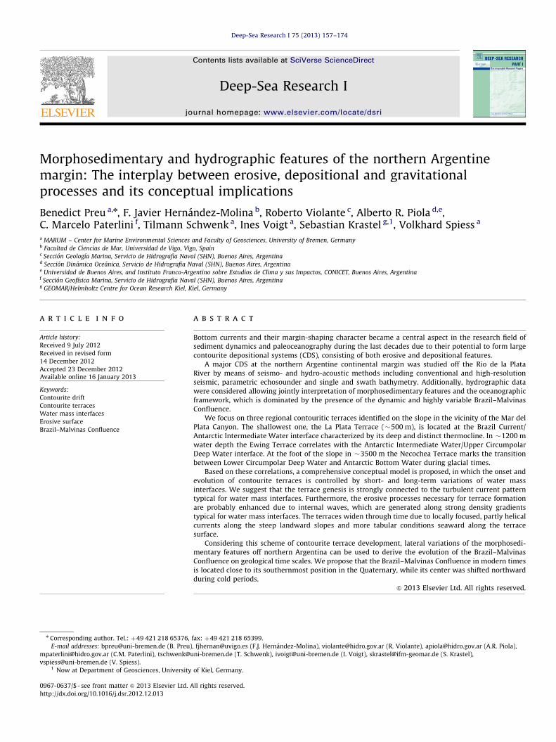
Fig. 1. Regional map of the NE Argentine continental margin, including its general
ocean circulation pattern; AABW—Antarctic Bottom Water; ACC—Antarctic Cir-
cumpolar Current; BMC—Brazil–Malvinas Confluence; M-F—Malvinas–Falkland;
NADW—North Atlantic Deep Water; GSI: South Georgia; black dashed box marks
the study area.
B. Preu et al. / Deep-Sea Research I 75 (2013) 157–174158
1. Introduction
Bottom currents represent a major force shaping ocean mar-gins (e.g. Heezen, 1959; Heezen and Hollister, 1964; Stow et al.,2009) through along-slope oceanographic processes, which arecapable of eroding, transporting, and depositing sediments at theseafloor (Rebesco and Camerlenghi, 2008). Depending on thebottom relief, local and regional hydrodynamic features (cores,branches, vortices, helical flows, etc.) might develop, which domi-nate sedimentary processes (Hernandez-Molina et al., 2008a).A sufficiently strong bottom current acting over an extended timeperiod will profoundly affect the seabed, ranging from winnowingof fine-grained sediments to large-scale erosion and deposition(e.g., Heezen, 1959; Heezen and Hollister, 1964; Stow and Lovell,1979; Viana and Faug�eres, 1998; Duarte and Viana, 2007; Rebescoand Camerlenghi, 2008; Stow et al., 2009).
The term ‘contourite’ is now generally accepted for thosesediments deposited or substantially reworked by bottom cur-rents (Stow et al., 2002; Rebesco, 2005; Rebesco and Camerlenghi,2008; Faug�eres and Mulder, 2011). Major accumulations ofcontourite deposits are referred to as drifts or contourite drifts,for which several classifications have been proposed based mainlyon their morphological, sedimentological and internal architec-ture (e.g.,: McCave and Tucholke, 1986; Faug�eres et al., 1993,1999; Stow et al., 2002; Rebesco, 2005; Rebesco and Camerlenghi,2008; Faug�eres and Mulder, 2011).
Where currents are strong enough, a variety of erosive featurescan develop. Extensive erosion or non-deposition leads to the devel-opment of widespread hiatuses in the depositional record. Althougherosive features are not as well studied as contourite drifts, severaltypes have been investigated to date (e.g., Nelson et al., 1993, 1999;Stow and Mayall, 2000; Hernandez-Molina et al., 2003, 2008a, 2009;Stow et al., 2008, 2009; Garcıa et al., 2009). The most common arerepresented by erosive surfaces associated with contourite terraces.An association of various drifts and related erosive features iscommonly termed a Contourite Depositional System (CDS), byanalogy with, and of equal importance as, Turbidite DepositionalSystems (e.g., Hernandez-Molina et al., 2003, 2008a).
A huge CDS extends along the Argentine margin characterizedby particularly well developed depositional and erosive features(Hernandez-Molina et al., 2009). In regional studies, contouritefeatures were so far mainly identified in the southernmost sectorof the margin (Hernandez-Molina et al., 2009, 2010; Lastras et al.,2011; Gruetzner et al., 2012). However, recently Violante et al.(2010), Bozzano et al. (2011), Krastel et al. (2011) and Preu et al.(2012) have also reported large contourite features along thenorthern Argentine margin.
The main objective of this work is to identify and discussmorphosedimentary features along the northern Argentine margin(Fig. 1) with special emphasis on contourite terraces, which arepresent in different depths along the slope. A regional correlationwith hydrographic features is presented and a new conceptual modelfor the onset and evolution of contourite terraces is discussed.
2. Regional setting
2.1. Physiography
The Argentine continental margin (Fig. 1) includes three majorphysiographic domains: the shelf, the slope and the rise. All threemargin segments, which were investigated in several regionalstudies (e.g., Ewing and Lonardi, 1971; Lonardi and Ewing, 1971;Parker et al., 1996, 1997; Hernandez-Molina et al., 2009) includemorphological features, which are relevant indicators for theinteraction between ocean dynamics, tectonic processes, sea level
fluctuations and partly gravitational processes (e.g., Urien andEwing, 1974; Violante and Parker, 2004; Hernandez-Molina et al.,2009, 2010; Henkel et al., 2011; Krastel et al., 2011).
The shelf varies in its width from north to south (Ewing andLonardi, 1971; Parker et al., 1996, 1997). The narrowest part ofthe shelf in the study area is located near Mar del Plata andfurther south where the shelf is �180 km wide (Fig. 1). South ofthis area the continental shelf width exceeds 200 km. The easternboundary of the shelf is close to a straight line, which runs in SSWdirection along the 130/150 m isobaths in the study area.
The slope strikes in a NE-SW direction in the study area. In thispart of the margin the slope extends over �180 km in width witha mean slope angle of 2–51. Located off the Rio de la Plata (Fig. 1),two major terraces result in a step-like slope morphology by theLa Plata Terrace (Urien and Ewing, 1974) and the Ewing Terrace(Hernandez-Molina et al., 2009). The latter encompasses signifi-cant sediment accumulations (Violante et al., 2010).
2.2. Oceanographic context
Interaction of highly active oceanographic processes with theseafloor is a ubiquitous characteristic of the Argentine margin,which is one of the most dynamic regions of the world ocean (e.g.,Chelton et al., 1990). This margin encompasses the Brazil–MalvinasConfluence (BMC, Fig. 1), as well as the encounter and interactionof northward flowing Antarctic water masses (Antarctic Intermedi-ate Water [AAIW], Upper Circumpolar Deep Water [UCDW], LowerCircumpolar Deep Water [LCDW] and Antarctic Deep Water[AABW]), with the southward flowing Brazil Current (BC), whichcontains fractions of Tropical Water and South Atlantic CentralWater (SACW), re-circulated AAIW and North Atlantic Deep Water(NADW, Saunders and King, 1995; Georgi, 1981; Piola and Matano,2001; Carter and Cortese, 2009) at different depths.
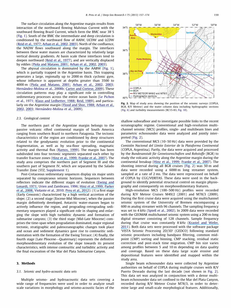
Fig. 2. Map of study area showing the position of the seismic surveys (COPLA,
BGR, R/V Meteor) and the water column data including hydrographic sections
(Fig. 6) and turbidity measurements (RC15-83, Fig. 10).
B. Preu et al. / Deep-Sea Research I 75 (2013) 157–174 159
The surface circulation along the Argentine margin results frominteraction of the northward flowing Malvinas Current with thesouthward flowing Brazil Current, which form the BMC near 381S(Fig. 1). South of the BMC the intermediate and deep circulation isconditioned by the northward flow of AAIW, UCDW and LCDW(Reid et al., 1977; Arhan et al., 2002, 2003). North of the confluence,the NADW flows southward along the margin. The interfacesbetween these water masses are characterized by relatively largevertical density gradients. At basin scale these interfaces tend todeepen northward (Reid et al., 1977), and are vertically displacedby eddies (Piola and Matano, 2001; Arhan et al., 2002, 2003).
The abyssal circulation is dominated by the AABW (Fig. 1),which is partially trapped in the Argentine basin. This trappinggenerates a large, regionally up to 2000 m thick cyclonic gyre,whose influence is apparent at depths greater than 3500 to4000 m (Piola and Matano, 2001; Arhan et al., 2002, 2003;Hernandez-Molina et al., 2008b; Carter and Cortese, 2009). Thesecirculation patterns may play a significant role in controllingsedimentary processes across the entire ocean basin (Le Pichonet al., 1971; Klaus and Ledbetter, 1988; Reid, 1989), and particu-larly on the Argentine margin (Flood and Shor, 1988; Arhan et al.,2002, 2003; Hernandez-Molina et al., 2009).
2.3. Geological context
The northern part of the Argentine margin belongs to thepassive volcanic rifted continental margin of South Americaranging from southern Brazil to northern Patagonia. The tectoniccharacteristics of the region are conditioned by deep structuresrelated to the geodynamic evolution prior to the continentalfragmentation, as well as by sea-floor spreading, magmaticactivity and thermal flux (Ramos, 1999). The margin has beensubdivided into four tectonic segments separated each other bytransfer fracture zones (Hinz et al., 1999; Franke et al., 2007). Thestudy area comprises the northern part of Segment III and thesouthern part of Segment IV, which are separated by the SaladoTransfer Zone (STZ, Supplement 1).
Post-Cretaceous sedimentary sequences display six major unitsseparated by conspicuous seismic horizons. Sequences betweenreflectors indicate the different stages of evolution (Ewing andLonardi, 1971; Urien and Zambrano, 1996; Hinz et al.,1999; Parkeret al., 2008; Violante et al., 2010; Preu et al., 2012): (1) a first stage(Early Cenozoic) characterized by a high vertical accretion of theslope; (2) a second stage (Eocene-Mid Miocene), when the passivemargin definitively developed, Antarctic water-masses began toactively influence the region, and prograding–retrograding sedi-mentary sequences played a significant role in shaping and enlar-ging the slope with high turbiditic dynamic and formation ofsubmarine canyons; (3) the third stage (Mid-Late Miocene) com-prises the time-span when progradation dominated, major regionaltectonic, stratigraphic and paleoceanographic changes took placeand ocean and sediment dynamics gave rise to contouritic sedi-mentation with the formation of the Ewing Terrace; (4) finally, thefourth stage (Late Pliocene—Quaternary) represents the definitivemorphosedimentary evolution of the slope towards its presentcharacteristics, with intense contouritic and turbiditic activity andthe final excavation of the Mar del Plata Submarine Canyon.
3. Methods
3.1. Seismic and hydro-acoustic data sets
Multiple seismo- and hydroacoustic data sets covering awide range of frequencies were used in order to analyze smallscale variations in morphology and seismo-acoustic facies of the
shallow subseafloor and to investigate possible links to the recentoceanographic regime. Conventional and high-resolution multi-channel seismic (MCS) profiles, single- and multibeam lines andparametric echosounder data were analyzed and jointly inter-preted (Fig. 2).
The conventional MCS (10–50 Hz) data were provided by theComision Nacional del Lımite Exterior de la Plataforma Continental
(COPLA, Argentina). Partly, the data were acquired and processedby the Bundesanstalt fur Geowissenschaften und Rohstoffe (BGR) tostudy the volcanic activity along the Argentine margin during thecontinental breakup (Hinz et al., 1999; Franke et al., 2007). Theshooting interval during all BGR cruises (Fig. 2) was 50 m anddata were recorded using a 6000 m long streamer system,sampled at a rate of 2 ms. The data were reprocessed on behalfof COPLA by CGG/VERITAS. These data were used in the back-ground to identify potential structural control on margin physio-graphy and consequently on morphosedimentary features.
High-resolution MCS (100–500 Hz) profiles were recordedduring R/V Meteor Cruises M49/2 (2001) and M78/3 (2009).During the first cruise data were acquired using the multichannelseismic system of the University of Bremen encompassing a600 m analog streamer with 96 channels. The sampling frequencywas set to 4 kHz (Spieß et al., 2002). In 2009 data were recordedwith the GEOMAR multichannel seismic system using a 200 m-longdigital streamer consisting of 128 channels. Sample frequencyduring that cruise was constantly 8 kHz (Krastel and Wefer,2011). Both data sets were processed with the software package‘VISTA Seismic Processing 2D/3D’ (GEDCO) following standardseismic procedures including bandpass filtering, common mid-point (CMP) sorting and binning, CMP stacking, residual staticcorrection and post-stack time migration. CMP bin size variesamong profiles between 5 and 10 m depending on data qualityand coverage. Based on these data large scale erosive anddepositional features were identified and mapped within thestudy area.
Single beam echosounder data were collected by Argentineauthorities on behalf of COPLA during multiple cruises with R/VPuerto Deseado during the last decade (not shown in Fig. 2).This data set was analyzed in conjunction with a dense multi-beam echosounder data set confined to the Mar del Plata Canyon,recorded during R/V Meteor Cruise M78/3, in order to deter-mine large and small-scale morphological features. Additionally,
B. Preu et al. / Deep-Sea Research I 75 (2013) 157–174160
parametric sediment echosounder data (PARASOUND P70 with alower parametric frequency of 4 kHz) acquired along the multi-beam tracks were used for detailed morphological and seismo-acoustic analysis of the uppermost tens of meters (Krastel andWefer, 2011).
To discuss the origin, evolution and lateral extent of themorphosedimentary features, acoustic data sets were jointlyinterpreted using the software package ‘The Kingdom Software’(SMT) and the software ‘GeoMapApp’ created at the Lamont-Doherty Earth Observatory (Ryan et al., 2009).
Identification of erosive and depositional features related toCDSs and the related nomenclature are based on previouscomprehensive and reviewing studies carried out by Faug�ereset al. (1999) and Rebesco (2005). Both publications were recentlysummarized and discussed by Rebesco and Camerlenghi (2008).
3.2. Hydrographic data sets
The detailed distribution of water masses down the northernportion of the Argentine margin is depicted by two full-depth,high-resolution cross-sections of potential temperature (y), salinity(S), dissolved oxygen (O2) and neutral density (gn) (locationindicated in Fig. 2). Section 1 was collected close to 381S in 1984as part of the Marathon Expedition (Camp et al., 1985) andSection 2, gathered further north during the SAVE-5 Expedition(Anonymous, 1992), runs southeastwards down the slope inter-secting the 2000 m isobath near 351S (Fig. 2). Note that the cross-slope resolution of Section 1 is about 30 km, while that of Section 2east of the 200 m isobath is quite lower and irregular. Both sectionswere used to identify lateral changes in circulation based ondistinct variations in water mass distributions over the study area.
As pointed out above, the abyssal Argentine Basin is subject tothe influence of the circulation of AABW; however, as bottomdepth decreases across the continental margin, various watermasses interact with the seafloor. To understand the role of thecirculation and water mass structure on the sediment redistribu-tion over the slope it is necessary to determine where each watermass interacts with the bottom across and along the slope. Forthis purpose we analyzed the distribution of near-bottom (within150 m) water mass properties based on all data available (WorldOcean Database, 2009) in the Argentine Basin. The choice of thedeepest 150 m slab arises from the need to determine the watermass in contact with the bottom and the need to have enoughobservations to depict their horizontal extent along the slope. Weadopted water mass property criteria as shown in Table 1.
To allow detailed analysis of the interplay between theoceanography and the morphosedimentary features, the hydro-graphic sections and seismic lines were combined into singleprofiles. These seismic/hydrographic intersections were calculatedusing the program ‘Ocean Data View 4.0’ (Schlitzer, 2011).
Table 1Selected criteria used to determine the ranges of the water masses interacting
with the ocean bottom on the western margin of the Argentine Basin. y7 potential
temperature (1C), S: salinity, O2: dissolved oxygen (ml/l), gn: neutral density
(kg/m3).
Water mass Criteria
SACW y48 S434.8
AAIW 33.90oSo34.25
AAIW (recirc.) O2o5.6 ml/l
UCDW 27.75ogno27.90 O2o4.5 ml/l
NADW 27.90ogno28.10 S434.8
LCDW 28.06ogno28.20 So34.8
AABW yo0 1C
Additionally, sea surface temperature (SST) measurementswere used for this study derived from published high-resolutionsatellite climatology (Casey and Cornillon, 1999). Based on thesedata, SST gradients were calculated and averaged to southernhemisphere summer (October–March) and winter (April–Septem-ber) to visualize the seasonal variability of the BMC.
4. Results
4.1. Physiography of the study area
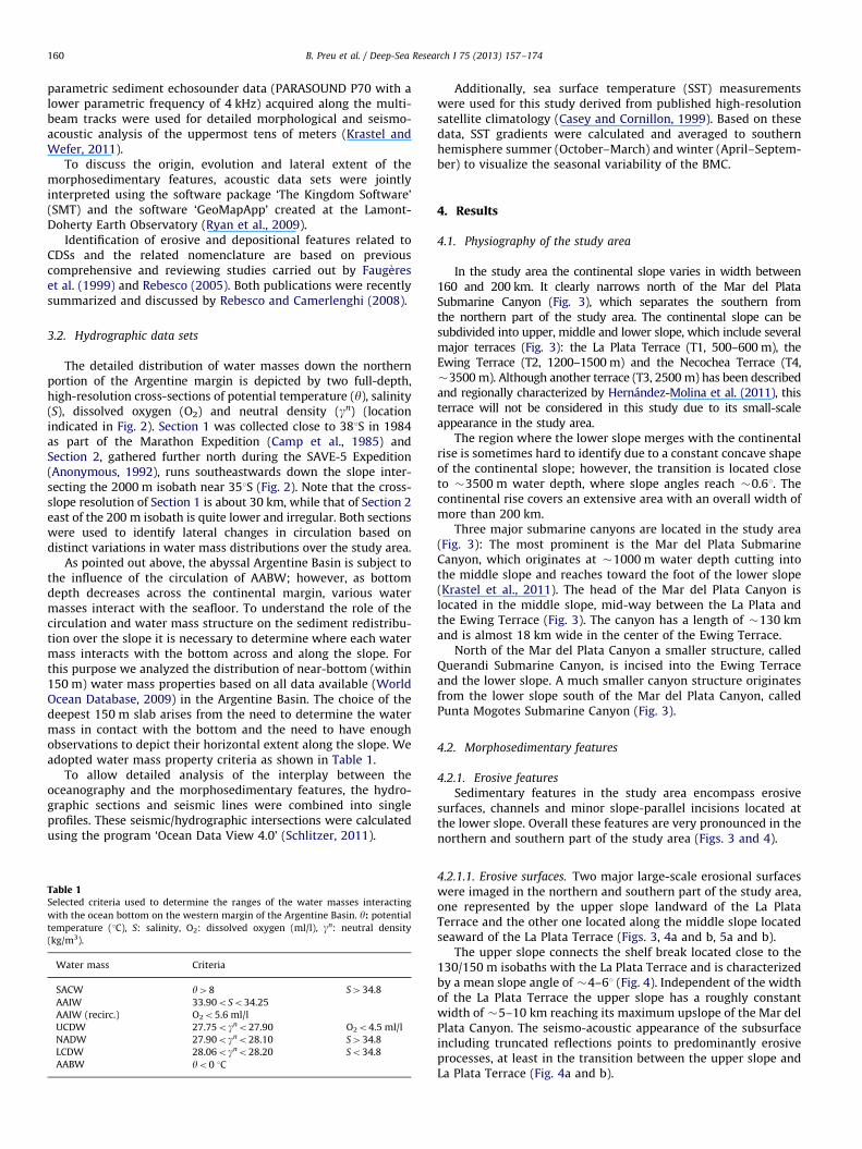
In the study area the continental slope varies in width between160 and 200 km. It clearly narrows north of the Mar del PlataSubmarine Canyon (Fig. 3), which separates the southern fromthe northern part of the study area. The continental slope can besubdivided into upper, middle and lower slope, which include severalmajor terraces (Fig. 3): the La Plata Terrace (T1, 500–600 m), theEwing Terrace (T2, 1200–1500 m) and the Necochea Terrace (T4,�3500 m). Although another terrace (T3, 2500 m) has been describedand regionally characterized by Hernandez-Molina et al. (2011), thisterrace will not be considered in this study due to its small-scaleappearance in the study area.
The region where the lower slope merges with the continentalrise is sometimes hard to identify due to a constant concave shapeof the continental slope; however, the transition is located closeto �3500 m water depth, where slope angles reach �0.61. Thecontinental rise covers an extensive area with an overall width ofmore than 200 km.
Three major submarine canyons are located in the study area(Fig. 3): The most prominent is the Mar del Plata SubmarineCanyon, which originates at �1000 m water depth cutting intothe middle slope and reaches toward the foot of the lower slope(Krastel et al., 2011). The head of the Mar del Plata Canyon islocated in the middle slope, mid-way between the La Plata andthe Ewing Terrace (Fig. 3). The canyon has a length of �130 kmand is almost 18 km wide in the center of the Ewing Terrace.
North of the Mar del Plata Canyon a smaller structure, calledQuerandi Submarine Canyon, is incised into the Ewing Terraceand the lower slope. A much smaller canyon structure originatesfrom the lower slope south of the Mar del Plata Canyon, calledPunta Mogotes Submarine Canyon (Fig. 3).
4.2. Morphosedimentary features
4.2.1. Erosive features
Sedimentary features in the study area encompass erosivesurfaces, channels and minor slope-parallel incisions located atthe lower slope. Overall these features are very pronounced in thenorthern and southern part of the study area (Figs. 3 and 4).
4.2.1.1. Erosive surfaces. Two major large-scale erosional surfaceswere imaged in the northern and southern part of the study area,one represented by the upper slope landward of the La PlataTerrace and the other one located along the middle slope locatedseaward of the La Plata Terrace (Figs. 3, 4a and b, 5a and b).
The upper slope connects the shelf break located close to the130/150 m isobaths with the La Plata Terrace and is characterizedby a mean slope angle of �4–61 (Fig. 4). Independent of the widthof the La Plata Terrace the upper slope has a roughly constantwidth of �5–10 km reaching its maximum upslope of the Mar delPlata Canyon. The seismo-acoustic appearance of the subsurfaceincluding truncated reflections points to predominantly erosiveprocesses, at least in the transition between the upper slope andLa Plata Terrace (Fig. 4a and b).
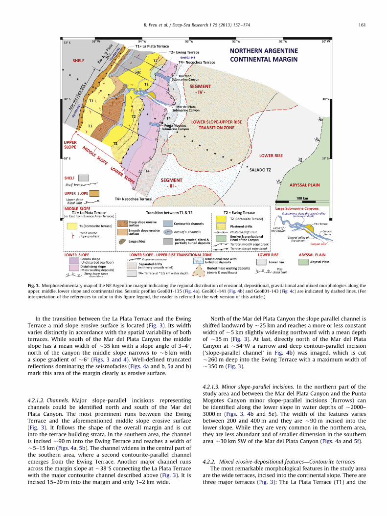
Fig. 3. Morphosedimentary map of the NE Argentine margin indicating the regional distribution of erosional, depositional, gravitational and mixed morphologies along the
upper, middle, lower slope and continental rise. Seismic profiles GeoB01-135 (Fig. 4a), GeoB01-141 (Fig. 4b) and GeoB01-143 (Fig. 4c) are indicated by dashed lines. (For
interpretation of the references to color in this figure legend, the reader is referred to the web version of this article.)
B. Preu et al. / Deep-Sea Research I 75 (2013) 157–174 161
In the transition between the La Plata Terrace and the EwingTerrace a mid-slope erosive surface is located (Fig. 3). Its widthvaries distinctly in accordance with the spatial variability of bothterraces. While south of the Mar del Plata Canyon the middleslope has a mean width of �35 km with a slope angle of 3–41,north of the canyon the middle slope narrows to �6 km witha slope gradient of �61 (Figs. 3 and 4). Well-defined truncatedreflections dominating the seismofacies (Figs. 4a and b, 5a and b)mark this area of the margin clearly as erosive surface.
4.2.1.2. Channels. Major slope-parallel incisions representingchannels could be identified north and south of the Mar delPlata Canyon. The most prominent runs between the EwingTerrace and the aforementioned middle slope erosive surface(Fig. 3). It follows the shape of the overall margin and is cutinto the terrace building strata. In the southern area, the channelis incised �90 m into the Ewing Terrace and reaches a width of�5–15 km (Figs. 4a, 5b). The channel widens in the central part ofthe southern area, where a second contourite-parallel channelemerges from the Ewing Terrace. Another major channel runsacross the margin slope at �381S connecting the La Plata Terracewith the major contourite channel described above (Fig. 3). It isincised 15–20 m into the margin and only 1–2 km wide.
North of the Mar del Plata Canyon the slope parallel channel isshifted landward by �25 km and reaches a more or less constantwidth of �5 km slightly widening northward with a mean depthof �35 m (Fig. 3). At last, directly north of the Mar del PlataCanyon at �541W a narrow and deep contour-parallel incision(‘slope-parallel channel’ in Fig. 4b) was imaged, which is cut�260 m deep into the Ewing Terrace with a maximum width of�350 m (Fig. 3).
4.2.1.3. Minor slope-parallel incisions. In the northern part of thestudy area and between the Mar del Plata Canyon and the PuntaMogotes Canyon minor slope-parallel incisions (furrows) canbe identified along the lower slope in water depths of �2000–3000 m (Figs. 3, 4b and 5e). The width of the features variesbetween 200 and 400 m and they are �90 m incised into thelower slope. While they are very common in the northern area,they are less abundant and of smaller dimension in the southernarea �30 km SW of the Mar del Plata Canyon (Figs. 4a and 5f).
4.2.2. Mixed erosive-depositional features—Contourite terraces
The most remarkable morphological features in the study areaare the wide terraces, incised into the continental slope. There arethree major terraces (Fig. 3): The La Plata Terrace (T1) and the
Fig. 4. High-resolution multi-channel seismic (MCS) profiles: (a) GeoB01-135 south of the Mar de Plata Canyon; (b) GeoB01-141 is directly located north of the Mar de
Plata Canyon; (c) GeoB01-143 is located at the northern boundary of the study area. Both the La Plata and Ewing terraces locations are highlighted in the MCS cross
sections. Locations of seismic profiles are indicated in Fig. 3. Black boxes indicate the position of close-ups shown in Fig. 5. VEEvertical exaggeration.
B. Preu et al. / Deep-Sea Research I 75 (2013) 157–174162
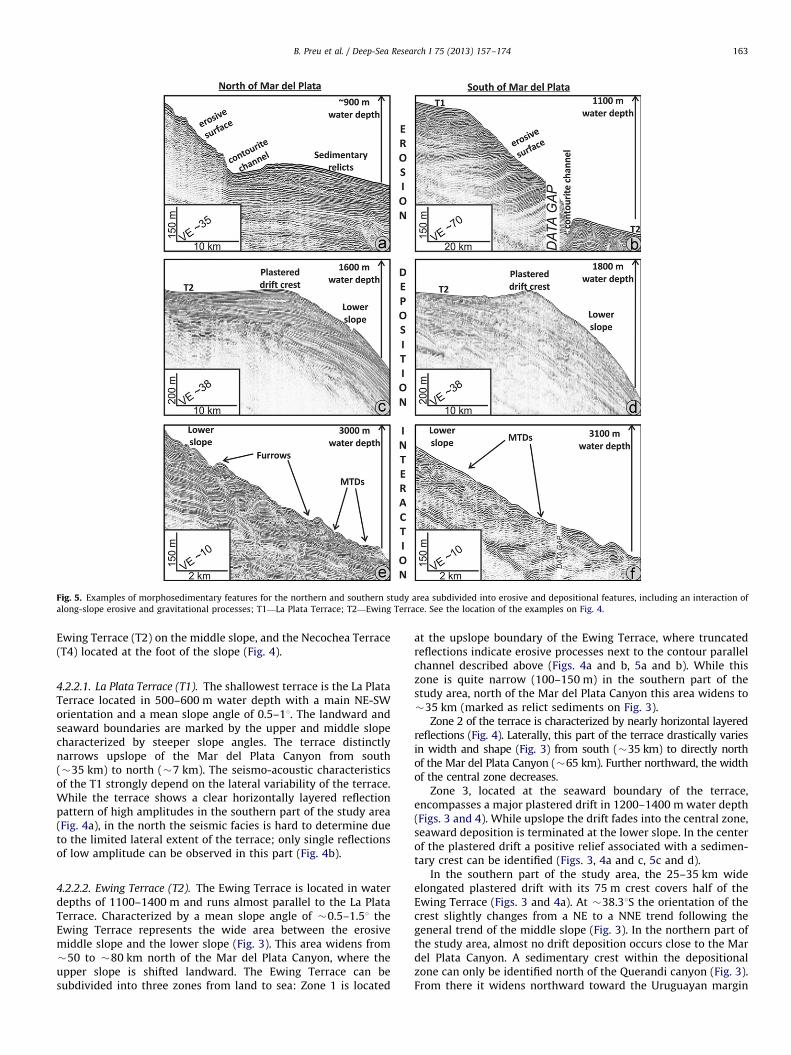
Fig. 5. Examples of morphosedimentary features for the northern and southern study area subdivided into erosive and depositional features, including an interaction of
along-slope erosive and gravitational processes; T1—La Plata Terrace; T2—Ewing Terrace. See the location of the examples on Fig. 4.
B. Preu et al. / Deep-Sea Research I 75 (2013) 157–174 163
Ewing Terrace (T2) on the middle slope, and the Necochea Terrace(T4) located at the foot of the slope (Fig. 4).
4.2.2.1. La Plata Terrace (T1). The shallowest terrace is the La PlataTerrace located in 500–600 m water depth with a main NE-SWorientation and a mean slope angle of 0.5–11. The landward andseaward boundaries are marked by the upper and middle slopecharacterized by steeper slope angles. The terrace distinctlynarrows upslope of the Mar del Plata Canyon from south(�35 km) to north (�7 km). The seismo-acoustic characteristicsof the T1 strongly depend on the lateral variability of the terrace.While the terrace shows a clear horizontally layered reflectionpattern of high amplitudes in the southern part of the study area(Fig. 4a), in the north the seismic facies is hard to determine dueto the limited lateral extent of the terrace; only single reflectionsof low amplitude can be observed in this part (Fig. 4b).
4.2.2.2. Ewing Terrace (T2). The Ewing Terrace is located in waterdepths of 1100–1400 m and runs almost parallel to the La PlataTerrace. Characterized by a mean slope angle of �0.5–1.51 theEwing Terrace represents the wide area between the erosivemiddle slope and the lower slope (Fig. 3). This area widens from�50 to �80 km north of the Mar del Plata Canyon, where theupper slope is shifted landward. The Ewing Terrace can besubdivided into three zones from land to sea: Zone 1 is located
at the upslope boundary of the Ewing Terrace, where truncatedreflections indicate erosive processes next to the contour parallelchannel described above (Figs. 4a and b, 5a and b). While thiszone is quite narrow (100–150 m) in the southern part of thestudy area, north of the Mar del Plata Canyon this area widens to�35 km (marked as relict sediments on Fig. 3).
Zone 2 of the terrace is characterized by nearly horizontal layeredreflections (Fig. 4). Laterally, this part of the terrace drastically variesin width and shape (Fig. 3) from south (�35 km) to directly northof the Mar del Plata Canyon (�65 km). Further northward, the widthof the central zone decreases.
Zone 3, located at the seaward boundary of the terrace,encompasses a major plastered drift in 1200–1400 m water depth(Figs. 3 and 4). While upslope the drift fades into the central zone,seaward deposition is terminated at the lower slope. In the centerof the plastered drift a positive relief associated with a sedimen-tary crest can be identified (Figs. 3, 4a and c, 5c and d).
In the southern part of the study area, the 25–35 km wideelongated plastered drift with its 75 m crest covers half of theEwing Terrace (Figs. 3 and 4a). At �38.31S the orientation of thecrest slightly changes from a NE to a NNE trend following thegeneral trend of the middle slope (Fig. 3). In the northern part ofthe study area, almost no drift deposition occurs close to the Mardel Plata Canyon. A sedimentary crest within the depositionalzone can only be identified north of the Querandi canyon (Fig. 3).From there it widens northward toward the Uruguayan margin
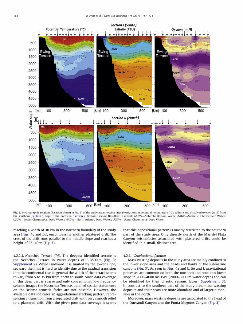
Fig. 6. Hydrographic sections (location shown in Fig. 2) of the study area showing lateral variations in potential temperature (1C), salinity and dissolved oxygen (ml/l) from
the southern (Section 1, top) to the northern (Section 2, bottom) sector; BC—Brazil Current; AABW—Antarctic Bottom Water; AAIW—Antarctic Intermediate Water;
LCDW—Lower Circumpolar Deep Water; NADW—North Atlantic Deep Water; UCDW—Upper Circumpolar Deep Water.
B. Preu et al. / Deep-Sea Research I 75 (2013) 157–174164
reaching a width of 30 km in the northern boundary of the studyarea (Figs. 4c and 5c), encompassing another plastered drift. Thecrest of the drift runs parallel to the middle slope and reaches aheight of 35–40 m (Fig. 3).
4.2.2.3. Necochea Terrace (T4). The deepest identified terrace isthe Necochea Terrace in water depths of �3500 m (Fig. 3;Supplement 2). While landward it is limited by the lower slope,seaward the limit is hard to identify due to the gradual transitioninto the continental rise. In general the width of the terrace seemsto vary from 5 to 35 km from north to south. Since data coveragein this deep part is sparse and only conventional, low frequencyseismic images the Necochea Terrace, detailed spatial statementson the seismo-acoustic facies are not possible. However, theavailable data indicates an aggradational stacking pattern, repre-senting a transition from a separated drift with very smooth reliefto a plastered drift. With the given poor data coverage it seems
that this depositional pattern is mostly restricted to the southernpart of the study area. Only directly north of the Mar del PlataCanyon seismofacies associated with plastered drifts could beidentified in a small, distinct area.
4.2.3. Gravitational features
Mass wasting deposits in the study area are mainly confined tothe lower slope area and the heads and flanks of the submarinecanyons (Fig. 3). As seen in Figs. 4a and b, 5e and f, gravitationalprocesses are common on both the northern and southern lowerslope in 2600–4000 ms TWT (2000–3000 m water depth) and canbe identified by their chaotic seismic facies (Supplement 3).In contrast to the southern part of the study area, mass wastingdeposits and their scars are more abundant and of larger dimen-sion in the north.
Moreover, mass wasting deposits are associated to the head ofthe Querandi Canyon and the Punta Mogotes Canyon (Fig. 3).
B. Preu et al. / Deep-Sea Research I 75 (2013) 157–174 165
4.3. Oceanographic features
4.3.1. Oceanographic Section 1—Mar del Plata Canyon
In the southern section (Section 1, Fig. 6 top) a wedge of cold(o7 1C) and fresh (So34.3) Subantarctic Waters is observed inthe near-surface region of the upper slope (o550 water depth).Satellite-derived sea surface temperature data reveal that thislatitude marks the mean northernmost penetration of the Mal-vinas Current (e.g., Piola and Matano, 2001; Saraceno et al., 2004).Thus, the warm-salty and relatively low oxygen Tropical Watersand South Atlantic Central Waters carried within the BC thatcharacterize the South Atlantic subtropical gyre are displacedoffshore and are not in contact with the bottom in Section 1.Below the subtropical thermocline the salinity minimum (Smin)and oxygen maximum of AAIW are well defined, but near theslope they connect with the slightly warmer and less dense outershelf waters (Fig. 6 top). At this latitude the cores of CircumpolarDeep Waters are split by the southward flowing NADW (Reidet al., 1977). The cores of these water masses along the slope arewell defined in the 1200–4000 m depth range by the low–high–low salinity (34.6, 434.8, 34.75) and oxygen (o4.25, 45.25,o5 ml/l) stratification sequences (Fig. 6 top). The core of UCDW(O2o4.25 ml/l) is observed at 1700 m and spans the 1500–2000 m depth range. UCDW also creates a relative potentialtemperature minimum matching the O2 minimum. The highsalinity core of NADW (S434.9) is located at 2450 m and appearsto be just separating from the slope while the NADW salinityrange (S434.8, Table 1) is found between 2500 and 3000 m waterdepths. At this location LCDW (So34.8, O2o5 ml/l) occupies the3000–3900 m depth range. Below this layer, most of the abyssalocean is covered by AABW (yo0 1C; Fig. 6 top).
4.3.2. Oceanographic Section 2—North of Mar del Plata Canyon
As expected from the general circulation patterns (Fig. 1), wefind a different structure of near-bottom water masses down theslope further north (Fig. 6 bottom). The upper layer (depths lessthan �500 m) is occupied by warm (410 1C), salty (S435)SACW, which flows southward associated with the Brazil Current.The salinity minimum of AAIW is clearly defined in the 700–1200 m depth range (Fig. 6 bottom). The core of AAIW in contactwith the bottom along the slope is thinner than further south anddisplays similar salinity and slightly lower O2 values, suggesting itis still part of a narrow northward flowing branch in contact withthe slope. At Section 2 the UCDW core is still present but theoxygen minimum layer, where O2 is less than 4.25 ml/l, is about400 km east of the slope. Similarly, the ymino2.8 1C observed inSection 1 close to the oxygen minimum is displaced offshore(Fig. 6). Consequently, in Section 2 the bulk of UCDW appears tohave shifted offshore and occupies a thinner layer interactingwith the bottom in the 1350–1650 m depth range (Fig. 6 bottom).The potential temperature maximum observed above the NADWmaximum is not displaced vertically, but is now warmer than3.5 1C, while the salinity maximum (S434.9) has expandedvertically to the 2150–2800 m depth range. The region withS434.8, our adopted definition for NADW in the Argentine Basin,spans the 1700–2900 m depth range, thus is thicker and shal-lower than observed further south (Fig. 6 bottom).
4.3.3. Near-bottom layers
To understand the role of the circulation and water massstructure on the described morphosedimentary features weanalyzed the distribution of near-bottom (within 150 m) watermass properties based on data available in the World OceanDatabase (2009) in the Argentine Basin (Fig. 7).
AAIW is confined to the upper slope, mostly between the 200and 1000 m isobath and its northernmost location is detected at311S (Fig. 7). The slope narrows northward considerably and thereare only two stations meeting the AAIW criteria in the narrowstrip between the 200 and 1000 m isobaths in the latitude rangebetween 341 and 311S. North of 291S we observe a narrow strip ofAAIW along the 1000 m isobath (Fig. 7). This northern core ofAAIW intersects the bottom at somewhat deeper levels than thesouthern core (850–1100 m), and flows as recirculated AAIWsouthward below the Brazil Current. The offshore limit of near-bottom UCDW closely follows the 2000 m isobath and the bulk ofthis water mass extends northward to about 351S. North of 381Sthere is evidence of near-bottom NADW in the depth range 1800–3000 m (Fig. 7). In the western Argentine Basin LCDW occupies anarrow near-bottom strip in the 2300–3400 m range. The inter-action of LCDW with the bottom appears to extend to thesouthern flank of the Rio Grande Rise, and a few observationssuggest isolated portions of near-bottom LCDW at depths ofnearly 4000 m north of 361S. As pointed out above, most ofthe bottom at depths greater than 4000 m are subjected to theinfluence of AABW (Fig. 7).
5. Discussion
5.1. Morphosedimentary and hydrographic features and their
oceanographic and tectonic implications
5.1.1. Margin physiography
The northern Argentine margin physiography is characterizedby peculiar differences in slope angle north and south of the Mardel Plata Canyon (red marks in Fig. 3). While the northern part ofthe study area shows a typical seaward margin inclinationoblique to the upper slope, the slope south of the canyon dipsnortheastward and therefore, in an �451 angle to its northerncounterpart. This change in physiography might be related to theSalado Transfer Zone (STZ), which runs as well perpendicular tothe upper slope in the center of the study area (Fig. 3, Supplement 1).The STZ was established during the initial opening of theSouth Atlantic (Hinz et al., 1999; Franke et al., 2007) and is prob-ably characterized by non-uniform cooling of adjacent marginSegments III and IV (Allen and Allen, 1990). Periods of strongersubsidence were described associated with this structure as, e.g.,during the middle Miocene (Kennett, 1982; Acenolaza, 2000;Potter and Szatmari, 2009). Consequently, the differential tiltingis presumably linked to the STZ, although its effect can mostly beobserved along the La Plata Terrace (Fig. 3). Further down-slope,uniform margin inclination over the study area indicates thedominance of erosive and depositional forces, which overprint thetectonic signature.
5.1.2. Upper slope—La Plata Terrace (T1)
The La Plata Terrace is located at the upper slope in waterdepths between 500 and 600 m and deepens toward the north(Figs. 3 and 8). Its sedimentary style points to a uniform andcontinuous forcing (Figs. 5 and 6), which can only be maintainedover long time periods by ocean bottom-currents, and excludesconsiderable downslope transport from the shelf.
Analysis of the hydrographic Section 1 (Fig. 6 bottom), whichspans the La Plata Terrace, indicates that the terrace is located close tothe interface between surface waters and the AAIW, which is inparticular well defined in the BC by the steep thermocline in �500 mwater depth north of the Mar del Plata Canyon (Fig. 6 bottom). Suchwater mass interfaces, in general, represent zones dominated byturbulent, energetic current patterns driven by major vertical densitygradients (Reid et al., 1977). Moreover, the high energetic
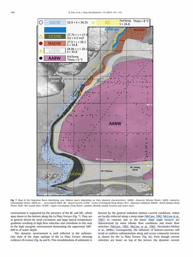
Fig. 7. Map of the Argentine Basin identifying near bottom layers depending on their physical characteristics; AABW—Antarctic Bottom Water; AAIW—Antarctic
Intermediate Water; AAIW rec. —recirculated AAIW; BC—Brazil Current; LCDW—Lower Circumpolar Deep Water; M-F—Malvinas–Falkland; NADW—North Atlantic Deep
Water; RGR—Rio Grande Rise; UCDW—Upper Circumpolar Deep Water; symbols identify sample location and water mass.
B. Preu et al. / Deep-Sea Research I 75 (2013) 157–174166
environment is supported by the presence of the BC and MC, whichspan down to the bottom along the La Plata Terrace (Fig. 7). They arein general driven by wind circulation and large lateral temperaturegradients resulting in high flow velocities and contribute in this wayto the high energetic environment dominating the uppermost 500–600 m of water depth.
This dynamic environment is well reflected in the sedimen-tary style of the slope upslope of the La Plata Terrace showingevidence of erosion (Fig. 4a and b). This remobilization of sediments is
favored by the general turbulent bottom current conditions, whichare locally enforced along a steep slope (McCave, 1982; McCave et al.,1982). In contrast, due to the lower slope angle terraces arecharacterized by more tabular flow conditions and lower flowvelocities (McCave, 1982; McCave et al., 1982; Hernandez-Molinaet al., 2008a). Consequently, the influence of bottom-currents willresult in uniform sedimentation along and across contourite terracesas shown for the La Plata Terrace (Fig. 4a). Even though currentvelocities are lower on top of the terrace, the dynamic current
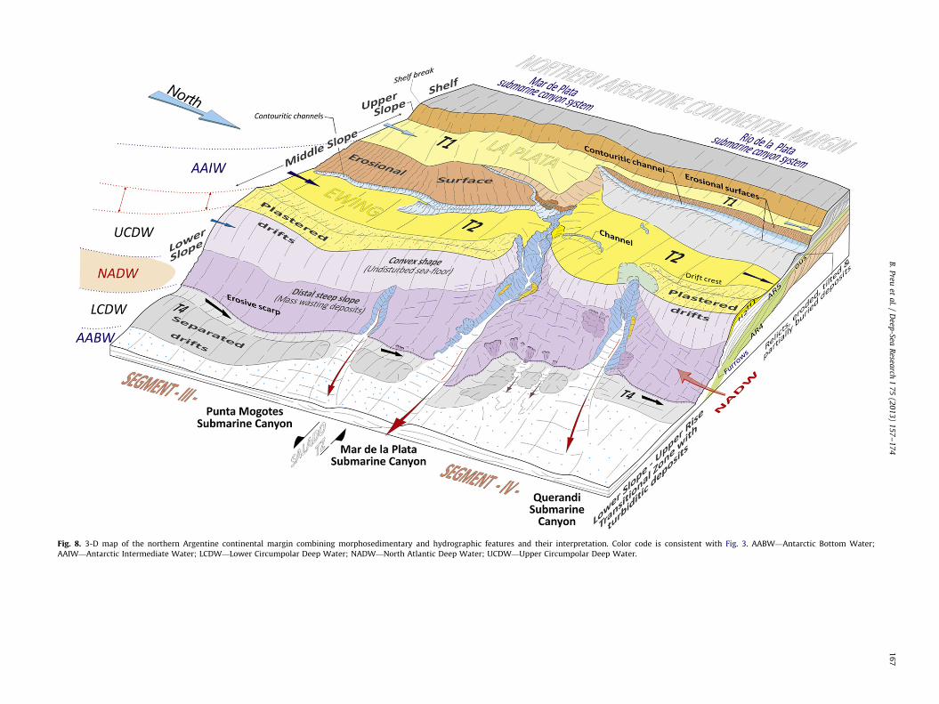
Fig. 8. 3-D map of the northern Argentine continental margin combining morphosedimentary and hydrographic features and their interpretation. Color code is consistent with Fig. 3. AABW—Antarctic Bottom Water;
AAIW—Antarctic Intermediate Water; LCDW—Lower Circumpolar Deep Water; NADW—North Atlantic Deep Water; UCDW—Upper Circumpolar Deep Water.
B.
Preu
eta
l./
Deep
-SeaR
esearch
I7
5(2
01
3)
15
7–
17
41
67
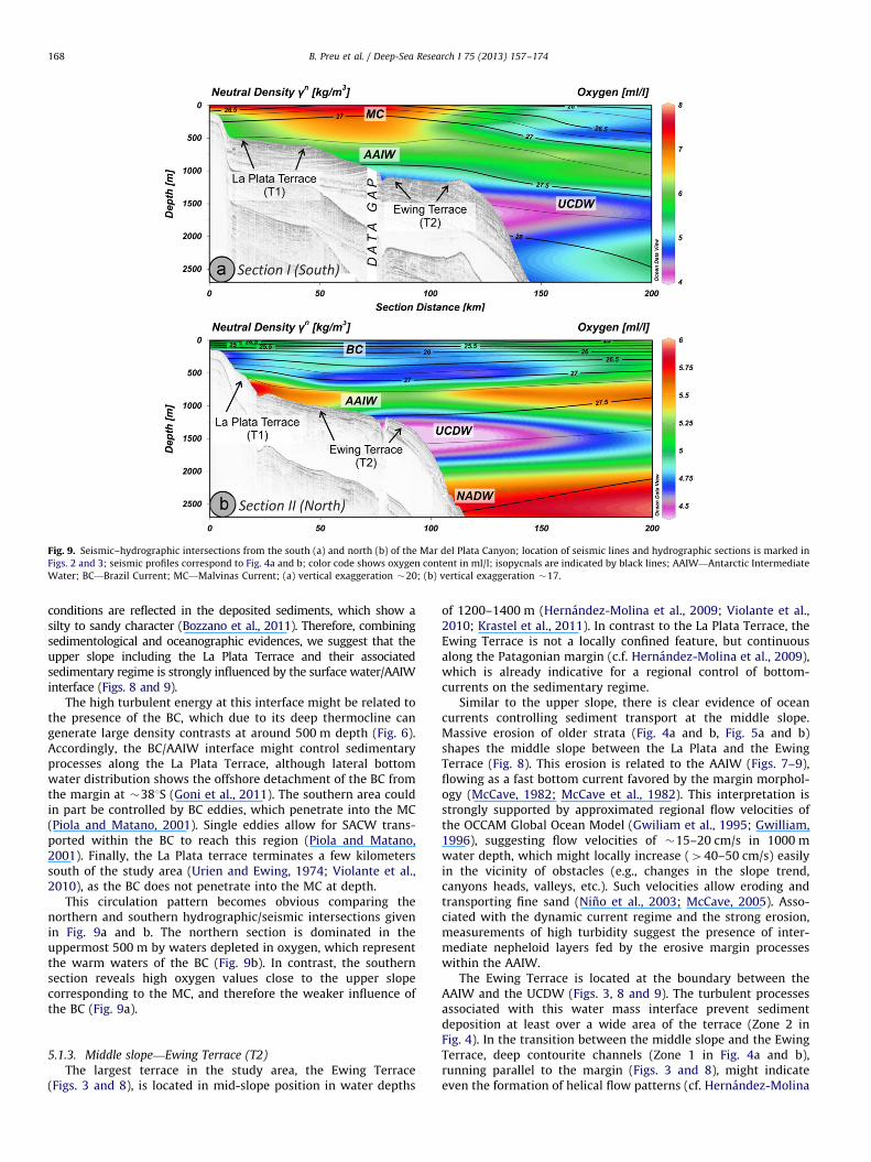
Fig. 9. Seismic–hydrographic intersections from the south (a) and north (b) of the Mar del Plata Canyon; location of seismic lines and hydrographic sections is marked in
Figs. 2 and 3; seismic profiles correspond to Fig. 4a and b; color code shows oxygen content in ml/l; isopycnals are indicated by black lines; AAIW—Antarctic Intermediate
Water; BC—Brazil Current; MC—Malvinas Current; (a) vertical exaggeration �20; (b) vertical exaggeration �17.
B. Preu et al. / Deep-Sea Research I 75 (2013) 157–174168
conditions are reflected in the deposited sediments, which show asilty to sandy character (Bozzano et al., 2011). Therefore, combiningsedimentological and oceanographic evidences, we suggest that theupper slope including the La Plata Terrace and their associatedsedimentary regime is strongly influenced by the surface water/AAIWinterface (Figs. 8 and 9).
The high turbulent energy at this interface might be related tothe presence of the BC, which due to its deep thermocline cangenerate large density contrasts at around 500 m depth (Fig. 6).Accordingly, the BC/AAIW interface might control sedimentaryprocesses along the La Plata Terrace, although lateral bottomwater distribution shows the offshore detachment of the BC fromthe margin at �381S (Goni et al., 2011). The southern area couldin part be controlled by BC eddies, which penetrate into the MC(Piola and Matano, 2001). Single eddies allow for SACW trans-ported within the BC to reach this region (Piola and Matano,2001). Finally, the La Plata terrace terminates a few kilometerssouth of the study area (Urien and Ewing, 1974; Violante et al.,2010), as the BC does not penetrate into the MC at depth.
This circulation pattern becomes obvious comparing thenorthern and southern hydrographic/seismic intersections givenin Fig. 9a and b. The northern section is dominated in theuppermost 500 m by waters depleted in oxygen, which representthe warm waters of the BC (Fig. 9b). In contrast, the southernsection reveals high oxygen values close to the upper slopecorresponding to the MC, and therefore the weaker influence ofthe BC (Fig. 9a).
5.1.3. Middle slope—Ewing Terrace (T2)
The largest terrace in the study area, the Ewing Terrace(Figs. 3 and 8), is located in mid-slope position in water depths
of 1200–1400 m (Hernandez-Molina et al., 2009; Violante et al.,2010; Krastel et al., 2011). In contrast to the La Plata Terrace, theEwing Terrace is not a locally confined feature, but continuousalong the Patagonian margin (c.f. Hernandez-Molina et al., 2009),which is already indicative for a regional control of bottom-currents on the sedimentary regime.
Similar to the upper slope, there is clear evidence of oceancurrents controlling sediment transport at the middle slope.Massive erosion of older strata (Fig. 4a and b, Fig. 5a and b)shapes the middle slope between the La Plata and the EwingTerrace (Fig. 8). This erosion is related to the AAIW (Figs. 7–9),flowing as a fast bottom current favored by the margin morphol-ogy (McCave, 1982; McCave et al., 1982). This interpretation isstrongly supported by approximated regional flow velocities ofthe OCCAM Global Ocean Model (Gwiliam et al., 1995; Gwilliam,1996), suggesting flow velocities of �15–20 cm/s in 1000 mwater depth, which might locally increase (440–50 cm/s) easilyin the vicinity of obstacles (e.g., changes in the slope trend,canyons heads, valleys, etc.). Such velocities allow eroding andtransporting fine sand (Nino et al., 2003; McCave, 2005). Asso-ciated with the dynamic current regime and the strong erosion,measurements of high turbidity suggest the presence of inter-mediate nepheloid layers fed by the erosive margin processeswithin the AAIW.
The Ewing Terrace is located at the boundary between theAAIW and the UCDW (Figs. 3, 8 and 9). The turbulent processesassociated with this water mass interface prevent sedimentdeposition at least over a wide area of the terrace (Zone 2 inFig. 4). In the transition between the middle slope and the EwingTerrace, deep contourite channels (Zone 1 in Fig. 4a and b),running parallel to the margin (Figs. 3 and 8), might indicateeven the formation of helical flow patterns (cf. Hernandez-Molina
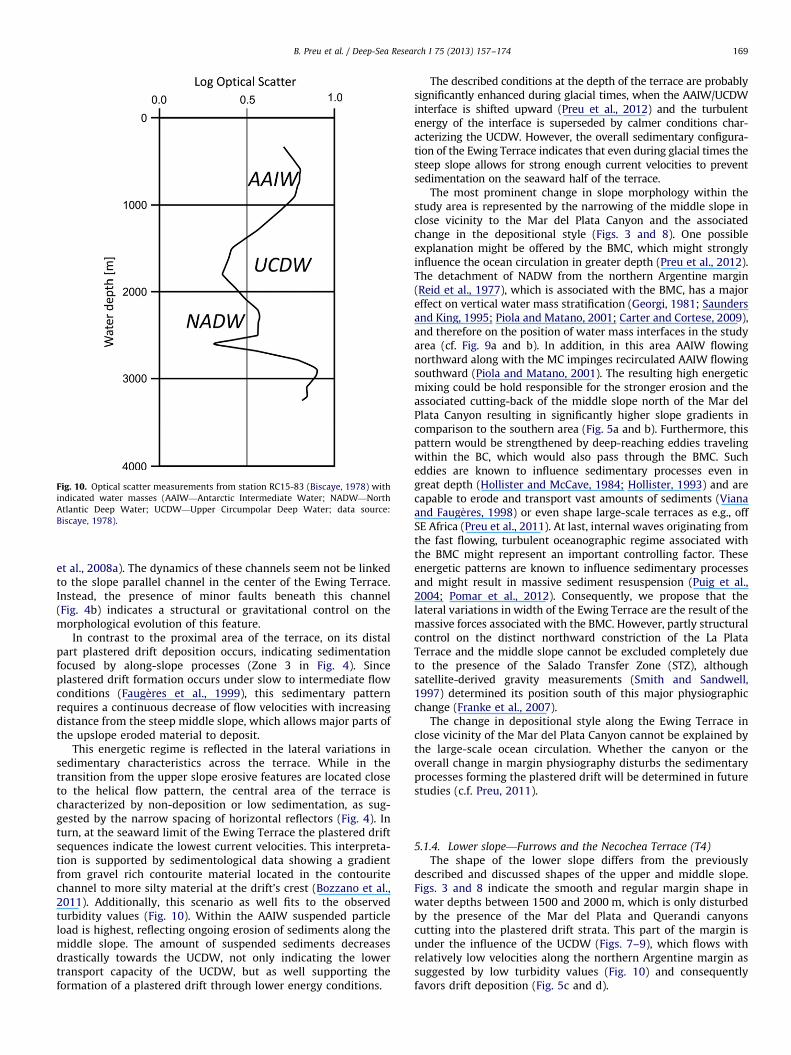
Fig. 10. Optical scatter measurements from station RC15-83 (Biscaye, 1978) with
indicated water masses (AAIW—Antarctic Intermediate Water; NADW—North
Atlantic Deep Water; UCDW—Upper Circumpolar Deep Water; data source:
Biscaye, 1978).
B. Preu et al. / Deep-Sea Research I 75 (2013) 157–174 169
et al., 2008a). The dynamics of these channels seem not be linkedto the slope parallel channel in the center of the Ewing Terrace.Instead, the presence of minor faults beneath this channel(Fig. 4b) indicates a structural or gravitational control on themorphological evolution of this feature.
In contrast to the proximal area of the terrace, on its distalpart plastered drift deposition occurs, indicating sedimentationfocused by along-slope processes (Zone 3 in Fig. 4). Sinceplastered drift formation occurs under slow to intermediate flowconditions (Faug�eres et al., 1999), this sedimentary patternrequires a continuous decrease of flow velocities with increasingdistance from the steep middle slope, which allows major parts ofthe upslope eroded material to deposit.
This energetic regime is reflected in the lateral variations insedimentary characteristics across the terrace. While in thetransition from the upper slope erosive features are located closeto the helical flow pattern, the central area of the terrace ischaracterized by non-deposition or low sedimentation, as sug-gested by the narrow spacing of horizontal reflectors (Fig. 4). Inturn, at the seaward limit of the Ewing Terrace the plastered driftsequences indicate the lowest current velocities. This interpreta-tion is supported by sedimentological data showing a gradientfrom gravel rich contourite material located in the contouritechannel to more silty material at the drift’s crest (Bozzano et al.,2011). Additionally, this scenario as well fits to the observedturbidity values (Fig. 10). Within the AAIW suspended particleload is highest, reflecting ongoing erosion of sediments along themiddle slope. The amount of suspended sediments decreasesdrastically towards the UCDW, not only indicating the lowertransport capacity of the UCDW, but as well supporting theformation of a plastered drift through lower energy conditions.
The described conditions at the depth of the terrace are probablysignificantly enhanced during glacial times, when the AAIW/UCDWinterface is shifted upward (Preu et al., 2012) and the turbulentenergy of the interface is superseded by calmer conditions char-acterizing the UCDW. However, the overall sedimentary configura-tion of the Ewing Terrace indicates that even during glacial times thesteep slope allows for strong enough current velocities to preventsedimentation on the seaward half of the terrace.
The most prominent change in slope morphology within thestudy area is represented by the narrowing of the middle slope inclose vicinity to the Mar del Plata Canyon and the associatedchange in the depositional style (Figs. 3 and 8). One possibleexplanation might be offered by the BMC, which might stronglyinfluence the ocean circulation in greater depth (Preu et al., 2012).The detachment of NADW from the northern Argentine margin(Reid et al., 1977), which is associated with the BMC, has a majoreffect on vertical water mass stratification (Georgi, 1981; Saundersand King, 1995; Piola and Matano, 2001; Carter and Cortese, 2009),and therefore on the position of water mass interfaces in the studyarea (cf. Fig. 9a and b). In addition, in this area AAIW flowingnorthward along with the MC impinges recirculated AAIW flowingsouthward (Piola and Matano, 2001). The resulting high energeticmixing could be hold responsible for the stronger erosion and theassociated cutting-back of the middle slope north of the Mar delPlata Canyon resulting in significantly higher slope gradients incomparison to the southern area (Fig. 5a and b). Furthermore, thispattern would be strengthened by deep-reaching eddies travelingwithin the BC, which would also pass through the BMC. Sucheddies are known to influence sedimentary processes even ingreat depth (Hollister and McCave, 1984; Hollister, 1993) and arecapable to erode and transport vast amounts of sediments (Vianaand Faug�eres, 1998) or even shape large-scale terraces as e.g., offSE Africa (Preu et al., 2011). At last, internal waves originating fromthe fast flowing, turbulent oceanographic regime associated withthe BMC might represent an important controlling factor. Theseenergetic patterns are known to influence sedimentary processesand might result in massive sediment resuspension (Puig et al.,2004; Pomar et al., 2012). Consequently, we propose that thelateral variations in width of the Ewing Terrace are the result of themassive forces associated with the BMC. However, partly structuralcontrol on the distinct northward constriction of the La PlataTerrace and the middle slope cannot be excluded completely dueto the presence of the Salado Transfer Zone (STZ), althoughsatellite-derived gravity measurements (Smith and Sandwell,1997) determined its position south of this major physiographicchange (Franke et al., 2007).
The change in depositional style along the Ewing Terrace inclose vicinity of the Mar del Plata Canyon cannot be explained bythe large-scale ocean circulation. Whether the canyon or theoverall change in margin physiography disturbs the sedimentaryprocesses forming the plastered drift will be determined in futurestudies (c.f. Preu, 2011).
5.1.4. Lower slope—Furrows and the Necochea Terrace (T4)
The shape of the lower slope differs from the previouslydescribed and discussed shapes of the upper and middle slope.Figs. 3 and 8 indicate the smooth and regular margin shape inwater depths between 1500 and 2000 m, which is only disturbedby the presence of the Mar del Plata and Querandi canyonscutting into the plastered drift strata. This part of the margin isunder the influence of the UCDW (Figs. 7–9), which flows withrelatively low velocities along the northern Argentine margin assuggested by low turbidity values (Fig. 10) and consequentlyfavors drift deposition (Fig. 5c and d).
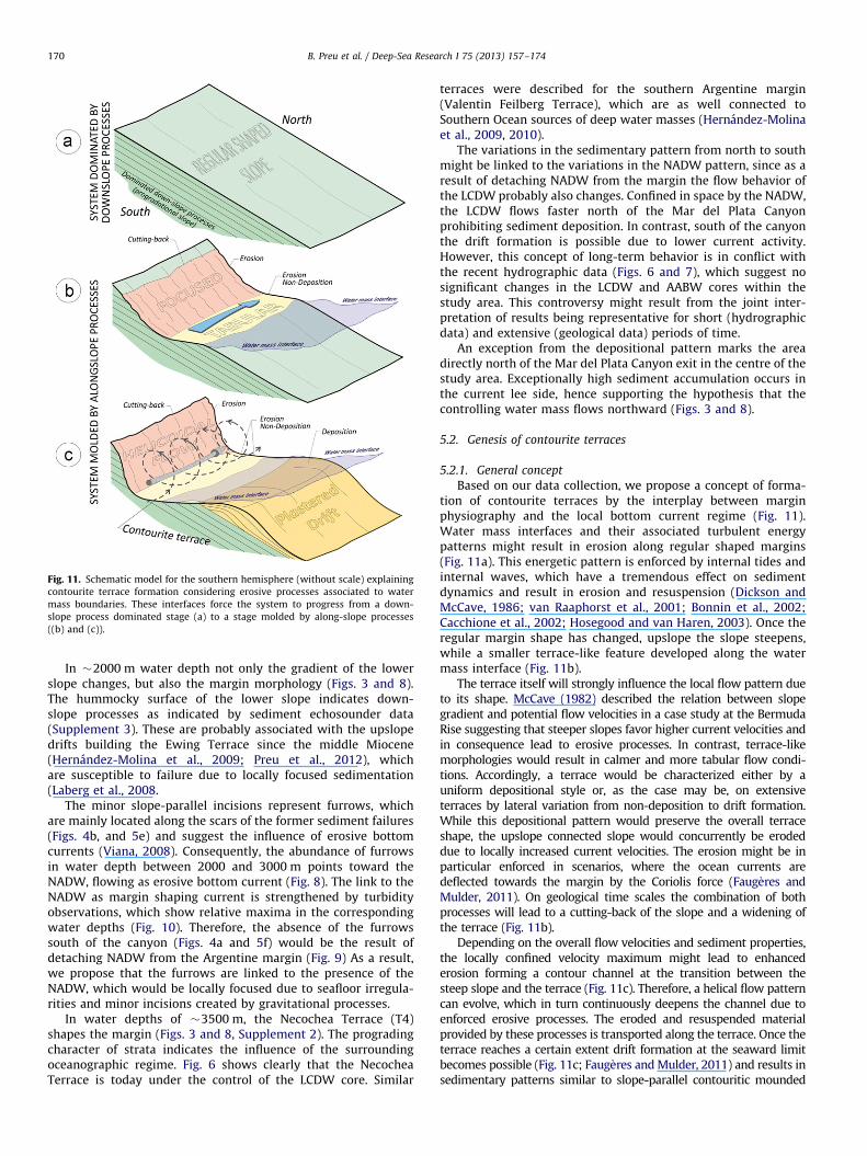
Fig. 11. Schematic model for the southern hemisphere (without scale) explaining
contourite terrace formation considering erosive processes associated to water
mass boundaries. These interfaces force the system to progress from a down-
slope process dominated stage (a) to a stage molded by along-slope processes
((b) and (c)).
B. Preu et al. / Deep-Sea Research I 75 (2013) 157–174170
In �2000 m water depth not only the gradient of the lowerslope changes, but also the margin morphology (Figs. 3 and 8).The hummocky surface of the lower slope indicates down-slope processes as indicated by sediment echosounder data(Supplement 3). These are probably associated with the upslopedrifts building the Ewing Terrace since the middle Miocene(Hernandez-Molina et al., 2009; Preu et al., 2012), whichare susceptible to failure due to locally focused sedimentation(Laberg et al., 2008.
The minor slope-parallel incisions represent furrows, whichare mainly located along the scars of the former sediment failures(Figs. 4b, and 5e) and suggest the influence of erosive bottomcurrents (Viana, 2008). Consequently, the abundance of furrowsin water depth between 2000 and 3000 m points toward theNADW, flowing as erosive bottom current (Fig. 8). The link to theNADW as margin shaping current is strengthened by turbidityobservations, which show relative maxima in the correspondingwater depths (Fig. 10). Therefore, the absence of the furrowssouth of the canyon (Figs. 4a and 5f) would be the result ofdetaching NADW from the Argentine margin (Fig. 9) As a result,we propose that the furrows are linked to the presence of theNADW, which would be locally focused due to seafloor irregula-rities and minor incisions created by gravitational processes.
In water depths of �3500 m, the Necochea Terrace (T4)shapes the margin (Figs. 3 and 8, Supplement 2). The progradingcharacter of strata indicates the influence of the surroundingoceanographic regime. Fig. 6 shows clearly that the NecocheaTerrace is today under the control of the LCDW core. Similar
terraces were described for the southern Argentine margin(Valentin Feilberg Terrace), which are as well connected toSouthern Ocean sources of deep water masses (Hernandez-Molinaet al., 2009, 2010).
The variations in the sedimentary pattern from north to southmight be linked to the variations in the NADW pattern, since as aresult of detaching NADW from the margin the flow behavior ofthe LCDW probably also changes. Confined in space by the NADW,the LCDW flows faster north of the Mar del Plata Canyonprohibiting sediment deposition. In contrast, south of the canyonthe drift formation is possible due to lower current activity.However, this concept of long-term behavior is in conflict withthe recent hydrographic data (Figs. 6 and 7), which suggest nosignificant changes in the LCDW and AABW cores within thestudy area. This controversy might result from the joint inter-pretation of results being representative for short (hydrographicdata) and extensive (geological data) periods of time.
An exception from the depositional pattern marks the areadirectly north of the Mar del Plata Canyon exit in the centre of thestudy area. Exceptionally high sediment accumulation occurs inthe current lee side, hence supporting the hypothesis that thecontrolling water mass flows northward (Figs. 3 and 8).
5.2. Genesis of contourite terraces
5.2.1. General concept
Based on our data collection, we propose a concept of forma-tion of contourite terraces by the interplay between marginphysiography and the local bottom current regime (Fig. 11).Water mass interfaces and their associated turbulent energypatterns might result in erosion along regular shaped margins(Fig. 11a). This energetic pattern is enforced by internal tides andinternal waves, which have a tremendous effect on sedimentdynamics and result in erosion and resuspension (Dickson andMcCave, 1986; van Raaphorst et al., 2001; Bonnin et al., 2002;Cacchione et al., 2002; Hosegood and van Haren, 2003). Once theregular margin shape has changed, upslope the slope steepens,while a smaller terrace-like feature developed along the watermass interface (Fig. 11b).
The terrace itself will strongly influence the local flow pattern dueto its shape. McCave (1982) described the relation between slopegradient and potential flow velocities in a case study at the BermudaRise suggesting that steeper slopes favor higher current velocities andin consequence lead to erosive processes. In contrast, terrace-likemorphologies would result in calmer and more tabular flow condi-tions. Accordingly, a terrace would be characterized either by auniform depositional style or, as the case may be, on extensiveterraces by lateral variation from non-deposition to drift formation.While this depositional pattern would preserve the overall terraceshape, the upslope connected slope would concurrently be erodeddue to locally increased current velocities. The erosion might be inparticular enforced in scenarios, where the ocean currents aredeflected towards the margin by the Coriolis force (Faug�eres andMulder, 2011). On geological time scales the combination of bothprocesses will lead to a cutting-back of the slope and a widening ofthe terrace (Fig. 11b).
Depending on the overall flow velocities and sediment properties,the locally confined velocity maximum might lead to enhancederosion forming a contour channel at the transition between thesteep slope and the terrace (Fig. 11c). Therefore, a helical flow patterncan evolve, which in turn continuously deepens the channel due toenforced erosive processes. The eroded and resuspended materialprovided by these processes is transported along the terrace. Once theterrace reaches a certain extent drift formation at the seaward limitbecomes possible (Fig. 11c; Faug�eres and Mulder, 2011) and results insedimentary patterns similar to slope-parallel contouritic mounded
B. Preu et al. / Deep-Sea Research I 75 (2013) 157–174 171
deposits following the depositional concepts introduced in Faug�ereset al. (1999).
This model does not require structural control on the originalformation of terraces. However, since terraces might as well bepredetermined by tectonic processes, a tectonic origin must be ruledout to explain their evolution exclusively from bottom currentactivity. Once the terrace was already formed, in both cases sedi-mentary processes would be similar to the above described (Fig. 11band c).
5.2.2. Contourite terraces along the northern Argentine margin
Since structural control on terrace formation can be excluded forthe northern Argentine margin based on deep reaching multichannelseismic data (Hinz et al., 1999), the evolution of contourite terraces ismost probably related to oceanographic processes.
Considering the above described deep thermocline associatedto the BC/AAIW interface (Figs. 6 and 7), the origin of the La PlataTerrace can be linked to water mass interface related processes(Fig. 8). Since changes in temperature go along with changes indensity, the BC/AAIW interface is particular susceptible for inter-nal wave generation and propagation, which are capable toinitiate or enforce erosive processes (Fig. 9a).
These high energetic patterns might not only influence the LaPlata Terrace but the Ewing Terrace as well. Since the Ewing Terracecorrelates with the AAIW/UCDW interface (Fig. 9), which represents aconvenient surface to reflect and focus internal wave energy, theinitial evolution of the Ewing Terrace might as well be related toprocesses in shallower water. Additionally, several studies suggestedthat the Ewing Terrace is controlled by the AAIW/UCDW interfacesince the middle Miocene (Hernandez-Molina et al., 2009; Violanteet al., 2010; Preu et al., 2012). These studies not only suggest a cuttingof the terrace into former strata but also a widening of the EwingTerrace due to drift deposition at the seaward limit of the terrace(Fig. 11c).
Since the Necochea Terrace is located within the LCDW, itsposition along the slope seems to exclude the water mass interfacemodel (Fig. 6). However, this is not completely true considering thatterrace formation is a process acting on longer geological times.During glacial times for example, the overall influence of Antarcticwater masses on the southern hemisphere increases (Duplessy et al.,1988; Mulitza et al., 2007). This includes probably an increase inAABW production (Ninnemann and Charles, 2002; Piotrowski et al.,2008), which is still under debate (e.g., Curry and Lohmann, 1982;Weber et al., 1994; Krueger et al., 2012). An overall strengthenedinfluence of southern sourced water will lead to a thickening of theAABW layer at the Argentine margin. In contrast, NADW productionis strongly reduced during cold periods (Oppo and Fairbanks, 1987;McCave et al., 1995; Rasmussen et al., 1996; Venz et al., 1999; Knutz,2008), which leads to a thinning of the NADW layer in the SWAtlantic (Kennett, 1982; Viana et al., 2002; Preu et al., 2012). Whilethe thickening of the AABW displaces the LCDW/AABW-interfaceupward, there is no counterforce given by the NADW, whichinfluence is significantly reduced. This scenario would place theLCDW/AABW interface close to the Necochea Terrace during glacialtimes and therefore suggest that the terrace formation processes aremainly active during cold periods in this part of the margin.Consequently, the forcing responsible for the development of theNecochea Terrace would be highly variable on geological timescales,which is reflected by its limited extent on the margin.
5.3. Implications on the position of the BMC on geological time scales
Linking of lateral variations in terrace morphology and theassociated erosive features to the regional oceanography(Figs. 8 and 9) allow not only terrace formation processes, but
also the history of the controlling oceanic regime to be recon-structed. This is in particular valid for the dynamics of the BMC,which marks the southernmost influence of the BC and the NADWalong the Argentine margin.
The lateral continuity and shape of the La Plata Terrace isstrongly bound to variations in the BC flow pattern. Since the LaPlata terrace terminates a few kilometers south of the study area(Urien and Ewing, 1974), this scenario would suggest that themodern situation of the BMC would be close to its southernmostposition on geological time scales. This might be at least valid forQuaternary times, when climate is dominated by glacial/inter-glacial cycles. While the modern position of the BMC would markthe location during interglacials, the BMC was probably shiftednorthward due to a stronger influence of southern-sourced watersduring glacials (Duplessy et al., 1988; Mulitza et al., 2007; Preuet al., 2012). This northward migration of the BMC can be shownby its seasonal variation on much shorter time scale. Seasonalvariability of the BMC (Supplement 4) derived from satelliteobservations (Saraceno et al., 2004) show a northward migrationfrom southern hemisphere summer to winter. This interpretationis in agreement with the location of the seasonal frontal prob-ability maxima, which was derived from very high-resolutionradiometer data (Saraceno et al., 2004). Following this concept,the position of the BMC would be located further northwardduring cold periods.
This interpretation is supported by the appearance of furrows atthe lower slope mainly in the northern part of the study area (Figs. 3,4b, 5f and 8). These features are probably produced by the interactionof NADW with the hummocky seafloor topography, which is theresult of mass wasting processes. The southern limit of the NADW ismarked by the location of the BMC, as well, where it is deflected andloses its margin constraint (Piola and Matano, 2001). Therefore, thenoticeable disappearance of these slope parallel incisions toward thesouth indicates the southernmost influence of the NADW, and in turnof the BMC on geological timescales.
6. Conclusion
Morphosedimentary analysis of the northern Argentine marginbased on seismo-acoustic and hydro-acoustic data were used tocharacterize erosive and depositional features including mass trans-port deposits and their lateral variability. Three major terraces weredescribed located in 500–600 m (La Plata Terrace), 1100–1400 m(Ewing Terrace) and 3500 m (Necochea Terrace) water depth, respec-tively. The two shallowest are connected upslope to particularly steeperosional slopes. The margin shape distinctly changes in the center ofthe study area close to the Mar del Plata Submarine Canyon. Whilethe La Plata Terrace narrows from south to north, the Ewing Terracewidens.
Correlation of the morphosedimentary features with the regionaloceanographic regime revealed a pronounced correlation betweendepths of the terraces and the depths of the water masses interfaces.While the La Plata Terrace reflects the Brazil Current/AntarcticIntermediate Water interface, the Ewing Terrace is located at theAntarctic Intermediate Water/Upper Circumpolar Deep Water transi-tion. The Necochea Terrace was probably located at the LowerCircumpolar Deep Water/Antarctic Bottom Water interface duringglacial times.
The presence of these terraces along water mass interfacessuggests turbulent energy associated to these zones as initialmechanism for terrace formation. Once the first smaller incision iscarved into the margin, the currents will be enforced along thesteeper segments of the slope. Calmer, tabular conditions willdominate on the seaward parts the terraces. The combinationof both flow patterns results in a cutting-back of the margin. Through
B. Preu et al. / Deep-Sea Research I 75 (2013) 157–174172
time the terrace may reach a size that the seaward boundary of theterrace is outside of the high velocity zone acting at the steeper partsof the slope, supporting then contourite drift deposition.
Since the lateral variability of erosive features dependsstrongly on the surrounding oceanographic regime, our dataindicates that the Brazil–Malvinas Confluence was located in itsmodern position or further northward during Quaternary times.
This study represents a clear example for synergies derivedfrom an interdisciplinary approach combining geological, geo-physical and oceanographic data sets for characterization ofdepositional and erosive features related to alongslope processeson a, what we think, type location for current-influenced con-tinental margins. Consequently, the depositional and erosive fea-tures described here may serve as a guideline for future studies toidentify reliable oceanographic indicators, being useful also forstudies on regional ocean circulation in oceanography.
Acknowledgements
The study was funded through DFG-Research Center/ Cluster ofExcellence ‘‘The Ocean in the Earth System‘‘ and was supported bythe Bremen International Graduate School for Marine Sciences(GLOMAR) that is funded by the German Research Foundation(DFG) within the frame of the Excellence Initiative by the Germanfederal and state governments to promote science and research atGerman universities.
The study is related to the CONTOURIBER project (CTM 2008-06399-C04/MAR) and MOWER projects (CTM 2012-39599-C03).Further this study is associated to the PICT 2010-0953 project fromthe Argentine Ministry of Science and Technology and the IGCPproject 619 (Contourites: geological record of ocean-driven paleocli-mate, accomplice of submarine landslides and reservoir of marinegeo-resources). Additional support was given by the Inter-AmericanInstitute for Global Change Research (IAI) CRN 2076 which issupported by the US National Science Foundation (Grant GEO-0452325).
Acoustic data were processed using ‘Vista 2D/3D SeismicProcessing’, which is a registered trademark of GEDCO. Seismicinterpretation and images were undertaken using ‘Seismic Micro-Technology KINGDOM Advanced’.
The authors particularly thank the participants of an ArgentineMargin Workshop held at MARUM in January, 2011, includingDr. D.A.W. Stow (Heriot-Watt Univ., Edinburgh, UK) for fruitfuldiscussions and support during the improvement of this manu-script. Constructive comments by an anonymous referees and theeditor significantly improved the quality of this manuscript.
We like to thank Captain Kull, Captain Baschek and the crew of R/V Meteor cruises M49/2 and M78/3 for their excellent work andsupport.
Appendix A. Supplementary materials
Supplementary data associated with this article can be found inthe online version at http://dx.doi.org/10.1016/j.dsr.2012.12.013.
References
Acenolaza, F.G., 2000. La Formacion Parana (Mioceno medio): estrati-grafıa, distribucion regional y unidades equivalentes. In: Acenolaza, F.G.,Herbst, R. (Eds.), El Neogeno de Argentina. INSUGEO, Tucuman, Argentina,pp. 9–27.
Allen, P., Allen, J., 1990. Basin Analysis. Blackwell Publishing, Malden.Anonymous, 1992, South Atlantic Ventilation Experiment (SAVE), Chemical,
Physical and CTD Data Report. Scripps Institution of Oceanography, Oceano-graphic Data Facility. ODF Publication 232, SIO Reference 92-10, 625 pp.
Arhan, M., Carton, X., Piola, A., Zenk, W., 2002. Deep lenses of circumpolar water inthe Argentine Basin. J. Geophys. Res. 107 (C1), 3007, http://dx.doi.org/10.1029/2001jc000963.
Arhan, M., Mercier, H., Park, Y.-H., 2003. On the deep water circulation of theeastern South Atlantic Ocean. Deep Sea Res. Part I 50 (7), 889–916.
Biscaye, P.E., 1978. Nepheloid Layer Composition. /http://www.geomapapp.org/database/neph_data/RC15/RC15-083.txtS.
Bonnin, J., van Raaphorst, W., Brummer, G., van Haren, H., Malschaert, H., 2002.Intense mid-slope resuspension of particulate matter in the Faeroe–ShetlandChannel: short-term deployment of near-bottom sediment traps. Deep Sea Res.Part I 49 (8), 1485–1505, http://dx.doi.org/10.1016/s0967-0637(02)00030-4.
Bozzano, G., Violante, R., Cerredo, M.E., 2011. Middle slope contourite deposits andassociated sedimentary facies off NE Argentina. Geo-Mar. Lett. 31 (5–6),495–507, http://dx.doi.org/10.1007/s00367-011-0239-x.
Cacchione, D.A., Pratson, L.F., Ogston, A.S., 2002. The shaping of continental slopesby internal tides. Science 296 (5568), 724–727, http://dx.doi.org/10.1126/science.1069803.
Camp, D., Haines, W., Huber, B., 1985. Marathon Leg 7 R/V Thomas WashingtonCTD/Hydrographic Data. Preliminary Report. Lamont-Doherty Geol. Observ..
Carter, L., Cortese, G., 2009. Change in the Southern Ocean: responding toAntarctica. In: Brigham-Grette, J., Powell, R., Newman, L., Kiefer, T. (Eds.),PAGES News: Change at the Poles, a Paleoscience Perspective. PAGES Interna-tional Project Office, pp. 30–32.
Casey, K.S., Cornillon, P., 1999. A comparison of satellite and in situ–based seasurface temperature climatologies. J. Climate 12 (6), 1848–1863, http://dx.doi.org/10.1175/1520-0442(1999)012o1848:acosai42.0.co;2.
Chelton, D.B., Schlax, M.G., Witter, D.L., Richman, J.G., 1990. Geosat Altimeterobservations of the surface circulation of the Southern Ocean. J. Geophys. Res.95 (C10), 17877–17903.
Curry, W.B., Lohmann, G.P., 1982. Carbon isotopic changes in benthic foraminiferafrom the western South Atlantic: Reconstruction of glacial abyssal circulationpatterns. Quat. Res. 18 (2), 218–235, http://dx.doi.org/10.1016/0033-5894(82)90071-0.
Dickson, R.R., McCave, I.N., 1986. Nepheloid layers on the continental slope west ofPorcupine Bank. Deep Sea Res. Part A 33 (6), 791–818, http://dx.doi.org/10.1016/0198-0149(86)90089-0.
Duarte, C.S.L, Viana, A.R., 2007. Santos Drift System: stratigraphic organization andimplications for late Cenozoic palaeocirculation in the Santos Basin, SWAtlantic Ocean. In: Viana, A.R., Rebesco, M. (Eds.), Economic and Palaeoceano-graphic Significance of Contourite Deposits, 276. Geological Society, London,pp. 171–198, Special Publications.
Duplessy, J.C., Shackleton, N.J., Fairbanks, R.G., Labeyrie, L., Oppo, D., Kallel, N.,1988. Deepwater source variations during the last climatic cycle and theirimpact on the global deepwater circulation. Paleoceanography 3 (3), 343–360.
Ewing, M., Lonardi, A.G., 1971. Sediment transport and distribution in theArgentine Basin. 5. Sedimentary structure of the Argentine margin, basin,and related provinces. Phys. Chem. Earth 8, 123–251.
Faug�eres, J.C., Mezerais, M.L., Stow, D.A.V., 1993. Contourite drift types and theirdistribution in the North and South Atlantic Ocean basins. Sediment. Geol.82 (1–4), 189–203.
Faug�eres, J.C., Mulder, T., 2011. Contour currents and contourite drifts. In: Huneke,H., Mulder, T. (Eds.), Developments in Sedimentology. Elsevier, Amsterdam,pp. 149–214.
Faug�eres, J.-C., Stow, D.A.V., Imbert, P., Viana, A., 1999. Seismic features diagnosticof contourite drifts. Mar. Geol. 162 (1), 1–38.
Flood, R.D., Shor, A.N., 1988. Mud waves in the Argentine Basin and theirrelationship to regional bottom circulation patterns. Deep Sea Res. Part A 35(6), 943–971, http://dx.doi.org/10.1016/0198-0149(88)90070-2.
Franke, D., Neben, S., Ladage, S., Schreckenberger, B., Hinz, K., 2007. Marginsegmentation and volcano-tectonic architecture along the volcanic marginoff Argentina/Uruguay, South Atlantic. Mar. Geol. 244 (1–4), 46–67, http://dx.doi.org/10.1016/j.margeo.2007.06.009.
Garcıa, M., Hernandez-Molina, F.J., Llave, E., Stow, D.A.V., Leon, R., Fernandez-Puga,M.C., Diaz del Rıo, V., Somoza, L., 2009. Contourite erosive features caused bythe Mediterranean Outflow Water in the Gulf of Cadiz: quaternary tectonicand oceanographic implications. Mar. Geol. 257 (1–4), 24–40, http://dx.doi.org/10.1016/j.margeo.2008.10.009.
Georgi, D.T., 1981. On the relationship between large-scale property variations andfinestructure in the Circumpolar Deep Water. J. Geophys. Res. 86, 6556–6566.
Goni, G.J., Bringas, F., DiNezio, P.N., 2011. Observed low frequency variability of theBrazil Current front. J. Geophys. Res. 116, C10037, http://dx.doi.org/10.1029/2011JC007198.
Gruetzner, J., Uenzelmann-Neben, G., Franke, D., 2012. Variations in sedimenttransport at the central Argentine continental margin during the Cenozoic.Geochem. Geophys. Geosyst. 13 (1–15), Q10003, http://dx.doi.org/10.1029/2012GC004266.
Gwilliam, C.S., 1996. Modelling the global ocean circulation on the T3D. In: Ecer, A.,Periaux, J., Satdfuka, N., TaylorA2 – A, S., Ecer, J.P.N.S., Taylor, S. (Eds.), ParallelComputational Fluid Dynamics 1995. North-Holland, Amsterdam, pp. 33–40.
Gwiliam, C.S., Coward, A.C., de Cuevas, B.A., Webb, D.J., Rourke, E., Thompson, S.R.,Doos, K., 1995. The OCCAM Global Model. In: Second UNAM-Cray Super-computing Conference on Numerical Simulations in the Envionmental andEarth Sciences.
Heezen, B.C., 1959. Dynamic processes of abyssal sedimentation: erosion, trans-portation, and redeposition on the deep-sea floor. Geophys. J. R. Astron. Soc.2 (2), 142–172, http://dx.doi.org/10.1111/j.1365-246X.1959.tb05790.x.
B. Preu et al. / Deep-Sea Research I 75 (2013) 157–174 173
Heezen, B.C., Hollister, C., 1964. Deep-sea current evidence from abyssalsediments. Mar. Geol. 1 (2), 141–174, http://dx.doi.org/10.1016/0025-3227(64)90012-X.
Henkel, S., Strasser, M., Schwenk, T., Hanebuth, T.J.J., Husener, J., Arnold, G.L.,Winkelmann, D., Formolo, M., Tomasini, J., Krastel, S., Kasten, S., 2011. Aninterdisciplinary investigation of a recent submarine mass transport deposit atthe continental margin off Uruguay. Geochem. Geophys. Geosyst. 12 (8),Q08009, http://dx.doi.org/10.1029/2011gc003669.
Hernandez-Molina, F.J., Llave, E., Somoza, L., Fernandez-Puga, M.C., Maestro, A.,Leon, R., Medialdea, T., Barnolas, A., Garcıa, M., del Rıo, V.D., Fernandez-Salas,L.M., Vazquez, J.T., Lobo, F., Dias, J.M.A., Rodero, J., Gardner, J., 2003. Looking forclues to paleoceanographic imprints: a diagnosis of the Gulf of Cadizcontourite depositional systems. Geology 31 (1), 19–22, http://dx.doi.org/10.1130/0091-7613(2003)031o0019:lfctpi42.0.co;2.
Hernandez-Molina, F.J., Llave, E., Stow, D.A.V., 2008a. Continental slope contour-ites. Developments in sedimentology.. In: Rebesco, M., Camerlenghi, A. (Eds.),Contourites. Elsevier, pp. 379–408 2008.
Hernandez-Molina, F.J., Maldonado, A., Stow, D.A.V., Rebesco, M., Camerlenghi, A.,2008b. Abyssal plain contourites. Developments in sedimentology.. In: Rebesco,M., Camerlenghi, A. (Eds.), Contourites. Elsevier, pp. 345 347–378, 2008.
Hernandez-Molina, F.J., Paterlini, M., Somoza, L., Violante, R., Arecco, M.A., de Isasi,M., Rebesco, M., Uenzelmann-Neben, G., Neben, S., Marshall, P., 2010. Giantmounded drifts in the Argentine continental margin: origins, and globalimplications for the history of thermohaline circulation. Mar. Pet. Geol.27 (7), 1508–1530, http://dx.doi.org/10.1016/j.marpetgeo.2010.04.003.
Hernandez-Molina, F.J., Paterlini, M., Violante, R., Marshall, P., de Isasi, M., Somoza,L., Rebesco, M., 2009. Contourite depositional system on the Argentine slope:an exceptional record of the influence of Antarctic water masses. Geology37 (6), 507–510, http://dx.doi.org/10.1130/g25578a.1.
Hernandez-Molina, F.J., Preu, B., Violante, R.A., Piola, A.R., Paterlini, C.M., 2011. Lasterrazas contornıticas en el Margen Continental Argentino: implicacionesmorfosedimentarias y oceanograficas. Geogaceta 50–52, 145–148.
Hinz, K., Neben, S., Schreckenberger, B., Roeser, H.A., Block, M., Souza, K.G.d.,Meyer, H., 1999. The Argentine continental margin north of 481S: sedimentarysuccessions, volcanic activity during breakup. Mar. Pet. Geol. 16 (1), 1–25.
Hollister, C.D., 1993. The concept of deep-sea contourites. Sediment. Geol. 82 (1–4),5–11.
Hollister, C.D., McCave, I.N., 1984. Sedimentation under deep-sea storms. Nature309 (5965), 220–225, http://dx.doi.org/10.1038/309220a0.
Hosegood, P., van Haren, H., 2003. Ekman-induced turbulence over the continentalslope in the Faeroe–Shetland Channel as inferred from spikes in current meterobservations. Deep Sea Res. Part I 50 (5), 657–680, http://dx.doi.org/10.1016/s0967-0637(03)00038-4.
Kennett, J., 1982. Marine Geology. Prentice Hall, New Jersey.Klaus, A., Ledbetter, M.T., 1988. Deep-sea sedimentary processes in the Argentine
Basin revealed by high-resolution seismic records (3.5 kHz echograms). Deep SeaRes. Part A 35 (6), 899–917, http://dx.doi.org/10.1016/0198-0149(88)90067-2.
Knutz, P.C., 2008. Palaeoceanographic significance of contourite drifts. In: Rebesco,M., Camerlenghi, A. (Eds.), Developments in Sedimentology. Elsevier, Oxford,pp. 511–535.
Krastel, S., Wefer, G., 2011. Sediment transport off Uruguay and Argentina: fromthe shelf to the deep sea. Meteorol. Ber., 58.
Krastel, S., Wefer, G., Hanebuth, T., Antobreh, A., Freudenthal, T., Preu, B., Schwenk,T., Strasser, M., Violante, R., Winkelmann, D., party, M.s.s., 2011. Sedimentdynamics and geohazards off Uruguay and the de la Plata River region(northern Argentina and Uruguay). Geo-Mar. Lett. 31 (4), 271–283, http://dx.doi.org/10.1007/s00367-011-0232-4.
Krueger, S., Leuschner, D.C., Ehrmann, W., Schmiedl, G., Mackensen, A., 2012. NorthAtlantic Deep Water and Antarctic Bottom Water variability during the last200 ka recorded in an abyssal sediment core off South Africa. Global Planet.Change 80–81, 180–189. http://dx.doi.org/10.1016/j.gloplacha.2011.10.001.
Laberg, J.S., Camerlenghi, A., 2008. The significance of contourites for submarineslope stability. Developments in sedimentology.. In: Rebesco, M., Camerlenghi,A. (Eds.), Contourites. Elsevier, pp. 537–556.
Lastras, G., Acosta, J., Munoz, A., Canals, M., 2011. Submarine canyon formationand evolution in the Argentine Continental Margin between 441300S and 481S.Geomorphology 128, 116–136.
Le Pichon, X., Eittreim, S.L., Ludwig, W.J., 1971. Sediment transport and distribu-tion in the Argentine Basin. 1. Antarctic Bottom current passage throughthe Falkland fracture zone. Phys. Chem. Earth 8 (0), 1–28, http://dx.doi.org/10.1016/0079-1946(71)90013-9.
Lonardi, A.G., Ewing, M., 1971. Sediment transport and distribution in theArgentine Basin. 4. Bathymetry of the continental margin, Argentine Basinand other related provinces. Canyons and sources of sediments. Phys. Chem.Earth 8, 79–121.
McCave, I.N., 1982. Erosion and deposition by currents on submarines slopes. Bull.Inst. Geol. Bassin d’Aquitaine 31, 47–55.
McCave, I.N., 2005. Deposition from suspension. In: Selley, R.C., Cocks, L.R.M.,Malone, M.J. (Eds.), Encyclopedia of Geology. Elsevier, Oxford, pp. 8–17.
McCave, I.N., Hollister, C.D., Laine, E.P., Lonsdale, P.F., Richardson, M.J., 1982.Erosion and deposition on the eastern margin of the Bermuda Rise in the lateQuaternary. Deep Sea Res. Part A 29 (5), 535–561, http://dx.doi.org/10.1016/0198-0149(82)90075-9.
McCave, I.N., Manighetti, B., Beveridge, N.A.S., 1995. Circulation in the glacialNorth Atlantic inferred from grain-size measurements. Nature 374 (6518),149–152.
McCave, I.N., Tucholke, B.E., 1986. Deep current controlled sedimentation in thewestern Atlantic. In: Vogt, P.R., Tucholke, B.E. (Eds.), The Geology of NorthAmerica. Geological Society of America, pp. 451–468.
Mulitza, S., Paul, A., Wefer, G., Scott, A.E., 2007. Late Pleistocene South Atlantic.Encyclopedia of Quaternary Science. Elsevier, Oxford, pp. 1816–1831.
Nelson, C.H., Baraza, J., Maldonado, A., 1993. Mediterranean undercurrent sandycontourites, Gulf of Cadiz, Spain. Sediment. Geol. 82 (1–4), 103–131, http://dx.doi.org/10.1016/0037-0738(93)90116-m.
Nelson, C.H., Baraza, J., Maldonado, A., Rodero, J., Escutia, C., Barber Jr, J.H., 1999.Influence of the Atlantic inflow and Mediterranean outflow currents onLate Quaternary sedimentary facies of the Gulf of Cadiz continentalmargin. Mar. Geol. 155 (1–2), 99–129, http://dx.doi.org/10.1016/s0025-3227(98)00143-1.
Ninnemann, U.S., Charles, C.D., 2002. Changes in the mode of Southern Oceancirculation over the last glacial cycle revealed by foraminiferal stable isotopicvariability. Earth Planet. Sci. Lett. 201 (2), 383–396, http://dx.doi.org/10.1016/s0012-821x(02)00708-2.
Nino, Y., Lopez, F., Garcia, M., 2003. Threshold for particle entrainment intosuspension. Sedimentology 50 (2), 247–263, http://dx.doi.org/10.1046/j.1365-3091.2003.00551.x.
Oppo, D., Fairbanks, R.G., 1987. Variability in the deep and intermediate watercirculation of the Atlantic Ocean during the past 25,000 years: NorthernHemisphere modulation of the Southern Ocean. Earth Planet. Sci. Lett. 86,1–15.
Parker, G., Paterlini, C.M., Violante, R., 1997. El fondo marino. In: Boschi, E. (Ed.), ElMar Argentino y sus Recursos Marinos, Mar del Plata, pp. 65–87.
Parker, G., Violante, R., Paterlini, C.M., 1996. Fisiografıa de la Plataforma Con-tinental. In: Ramos, V., Turic, M.A. (Eds.), Geologıa y Recursos Naturales de laPlataforma Continental Argentina. Buenos Aires, pp. 1–16.
Parker, G., Violante, R., Paterlini, C.M., Marcolini, S., Costa, I.P., Cavallotto, J.L., 2008.Las secuencias sismoestratigraficas del Plioceno-Cuaternario en la PlataformaSubmarina adyacente al litoral del este bonaerense. Lat. Am. J. Sedimentol.Basin Anal. 15 (2), 105–124.
Piola, A.R., Matano, R.P., 2001. Brazil and Falklands (Malvinas) currents. AcademicPress, London.
Piotrowski, A.M., Goldstein, S.L., Hemming, S.R., Fairbanks, R.G., Zylberberg, D.R.,2008. Oscillating glacial northern and southern deep water formation fromcombined neodymium and carbon isotopes. Earth Planet. Sci. Lett. 272 (1–2),394–405, http://dx.doi.org/10.1016/j.epsl.2008.05.011.
Pomar, L., Morsilli, M., Hallock, P., Badenas, B., 2012. Internal waves, an under-explored source of turbulence events in the sedimentary record. Earth Sci. Rev.111, 56–81.
Potter, P.E., Szatmari, P., 2009. Global Miocene tectonics and the modernworld. Earth Sci. Rev. 96 (4), 279–295, http://dx.doi.org/10.1016/j.earscirev.2009.07.003.
Preu, B., 2011. High-Resolution Seismo-Acoustic Studies of Alongslope and Down-slope Sediment Transport Processes Shaping Depositional Patterns at Con-tinental Margins. Ph.D. Thesis. University of Bremen. 128 pp.
Preu, B., Schwenk, T., Hernandez-Molina, F.J., Violante, R., Paterlini, M., Krastel, S.,Tomasini, J., Spieß, V., 2012. Sedimentary grwoth pattern on the northernArgentine slope: the impact of North Atlantic Deep Water on southernhemisphere slope architecture. Mar. Geol. 329–331, 113–125, http://dx.doi.org/10.1016/j.margeo.2012.09.009.
Preu, B., Spieß, V., Schwenk, T., Schneider, R., 2011. Evidence for current-controlledsedimentation along the southern Mozambique continental margin since EarlyMiocene times. Geo-Mar. Lett. 31 (5–6), 427–435, http://dx.doi.org/10.1007/s00367-011-0238-y.
Puig, P., Palanques, A., Guillen, J., El Khatab, M., 2004. Role of internal waves in thegeneration of nepheloid layers on the northwestern Alboran slope: implica-tions for continental margin shaping. J. Geophys. Res. 109 (C9), C09011, http://dx.doi.org/10.1029/2004jc002394.
Ramos, V., 1999. Rasgos Estructurales del Territorio Argentino. Evolucion Tecto-nica de la Argentina. In: Caminos, R. (Ed.), Geologıa Argentina. SEGEMAR.Buenos Aires, pp. 715–784.
Rasmussen, T.L., van Weering, T.C.E., Labeyrie, L., 1996. High resolution stratigra-phy of the Faeroe–Shetland Channel and its relation to North Atlanticpaleoceanography: the last 87 kyr. Mar. Geol. 131 (1–2), 75–88, http://dx.doi.org/10.1016/0025-3227(95)00145-x.
Rebesco, M., 2005. Contourites. In: Selley, R.C., Cocks, L.R.M., Plimer, I.R. (Eds.),Encyclopedia of Geology. Elsevier, Oxford, pp. 513–527.
Rebesco, M., Camerlenghi, A., 2008. Contourites. Developments in Sedimentology,60. Elsevier 663 pp.
Reid, J.L., 1989. On the total geostrophic circulation of the Indian Ocean: flowpatterns, tracers, and transports. Prog. Oceanogr. 23 (1), 149–244, http://dx.doi.org/10.1016/s0079-6611(02)00141-6.
Reid, J.L., Nowlin, W.D., Patzert, W.C., 1977. On the characteristics and circulationof the Southwestern Atlantic Ocean. J. Phys. Oceanogr. 7 (1), 62–91, http://dx.doi.org/10.1175/1520-0485(1977)007o0062:otcaco42.0.co;2.
Ryan, W.B.F., Carbotte, S.M., Coplan, J.O., O’Hara, S., Melkonian, A., Arko, R.,Weissel, R.A., Ferrini, V., Goodwillie, A., Nitsche, F., Bonczkowski, J., Zemsky,R., 2009. Global multi-resolution topography synthesis. Geochem. Geophys.Geosyst. 10 (3), Q03014, http://dx.doi.org/10.1029/2008gc002332.
Saraceno, M., Provost, C., Piola, A.R., Bava, J., Gagliardini, A., 2004. Brazil MalvinasFrontal System as seen from 9 years of advanced very high resolution radio-meter data. J. Geophys. Res. 109 (C5), C05027, http://dx.doi.org/10.1029/2003jc002127.
B. Preu et al. / Deep-Sea Research I 75 (2013) 157–174174
Saunders, P.M., King, B.A., 1995. Oceanic Fluxes on the WOCE A11 Section. J. Phys.Oceanogr. 25 (9), 1942–1958, http://dx.doi.org/10.1175/1520-0485(1995)025o1942:ofotwa42.0.co;2.
Schlitzer, R., 2011. Ocean Data View 4.0. /http://odv.awi.deS.Smith, W.H.F., Sandwell, D.T., 1997. Global Sea Floor Topography from Satellite
Altimetry and Ship Depth Soundings. Science 277 (5334), 1956–1962, http://dx.doi.org/10.1126/science.277.5334.1956.
Spieß, V., Albrecht, N., Bickert, T., Breitzke, M., Bruning, M., Dreyzehner, A., Groß,U., Kruger, D., von Lom-Keil, H., Moller, H.-J., Nimrich, M., Ochsenhirt, W.-T.,Rudolf, T., Seiter, C., Truscheit, T., Violante, R., Westerhold, T., 2002. ODPSudatlantik 2001 Part 2, Meteorol. Ber., 57.
Stow, D.A.V., Hernandez-Molina, F.J., Llave, E., Sayago-Gil, M., Daz del Rao, V.,Branson, A., 2009. Bedform-velocity matrix: the estimation of bottom currentvelocity from bedform observations. Geology 37 (4), 327–330, http://dx.doi.org/10.1130/g25259a.1.
Stow, D.A.V., Hunter, S., Wilkinson, D., Hernandez-Molina, F.J., Rebesco, M.,Camerlenghi, A., 2008. The nature of contourite deposition. In: Rebesco,Camerlenghi (Ed.), Developments in Sedimentology, 60. Elsevier, pp. 143–156.
Stow, D.A.V., Lovell, J.P.B., 1979. Contourites: Their recognition in modern andancient sediments. Earth Sci. Rev. 14 (3), 251–291.
Stow, D.A.V., Mayall, M., 2000. Deep-water sedimentary systems: new models forthe 21st century. Mar. Pet. Geol. 17 (2), 125–135.
Stow, D.A.V., Pudsey, C.J., Howe, J.A., Faug�eres, J.C., Viana, A.R., 2002. Deep-WaterContourite Systems: Modern Drifts and Ancient Series, Seismic and Sedimen-tary Characteristics. Geological Society, London.
Urien, C.M., Ewing, M., 1974. Recent sediments and environments of SouthernBrazil, Uruguay, Buenos Aires and Rio Negro continental shelf. In: Burk, C.A.(Ed.), The Geology of Continental Margins. Springer, Berlin, pp. 1009.
Urien, C.M., Zambrano, J.J., 1996. Estructura del Margen Continental. In: Ramos, V.,Turic, M.A. (Eds.), Geologıa y Recursos Naturales de la Plataforma ContinentalArgentina. Asociacion Geologica Argentina-Instituto Argentino del Petroleo.Buenos Aires, pp. 29–65.
van Raaphorst, W., Malschaert, H., van Haren, H., Boer, W., Brummer, G., 2001.Cross-slope zonation of erosion and deposition in the Faeroe–Shetland
Channel, North Atlantic Ocean. Deep Sea Res. Part A 48 (2), 567–591, http://dx.doi.org/10.1016/s0967-0637(00)00052-2.
Venz, K.A., Hodell, D.A., Stanton, C., Warnke, D.A., 1999. A 1.0 Myr record of
glacial North Atlantic intermediate water variability from ODP Site 982 in theNortheast Atlantic. Paleoceanography 14 (1), 42–52, http://dx.doi.org/10.1029/1998pa900013.
Viana, A.R., 2008. Economic relevance of contourites. Developments in sedimen-tology.. In: Rebesco, Camerlenghi (Ed.), Developments in Sedimentology, 60.
Elsevier, pp. 143–156, pp. 491, 493–510.
Viana, A.R., Faug�eres, J.-C., 1998. Upper Slope Sand Deposits: the Example of
Campos Basin, a Latest Pleistocene-Holocene Record of the InteractionBetween Alongslope and Downslope Currents, 129. Geological Society, London287–316.
Viana, A.R., Hercos, C.M., Almeida Jr., W., Magalh~aes, J.L.C., Andrade, S.B., 2002.Evidence of bottom current influence on the neogene to quaternary sedimen-tation along the Northern Campos slope, SW Atlantic Margin. In: Stow, D.A.V.,
Pudsey, C.J., Howe, J.A., Faugeres, J-C, Viana, A R (Eds.), Deep-Water ContouriteSystems: Modern Drifts and Ancient Series, Seismic and Sedimentary Char-
acteristics, 22. Geological Society Memoir, pp. 249–259.
Violante, R.A., Parker, G., 2004. The post-last glacial maximum transgression in thede la Plata river and adjacent Inner continental shelf, Argentina. Quat. Int. 114
(1), 167–181.
Violante, R.A., Paterlini, C.M., Costa, I.P., Hernandez-Molina, F.J., Segovia, L.M.,
Cavallotto, J.L., Marcolini, S., Bozzano, G., Laprida, C., Garcıa Chapori, N.,Bickert, T., Spieß, V., 2010. Sismoestratigrafia y evolucion geomorfologica deltalud continental adyacente al litoral del este bonaerense, Argentina. Lat. Am.
J. Sedimentol. Basin Anal 17, 33–62.
Weber, M.E., Bonani, G., Futterer, K.D., 1994. Sedimentation processes within
channel-ridge systems, Southeastern Weddell Sea, Antarctica. Paleoceanogra-phy 9 (6), 1027–1048, http://dx.doi.org/10.1029/94pa01443.
World Ocean Database, 2009. /http://www.nodc.noaa.gov/OC5/WOD/pr_wod.
htmlS.