Morphometric analysis of the drainage system and its hydrological implications in the rain shadow...
12
J. Geogr. Sci. 2011, 21(6): 1077-1088 DOI: 10.1007/s11442-011-0901-2 © 2011 Science Press Springer-Verlag Received: 2010-02-04 Accepted: 2010-08-30 Author: Jobin Thomas, E-mail: [email protected] * Corresponding author: Sabu Joseph, E-mail: [email protected] www.geogsci.com springerlink.com/content/1009-637X Morphometric analysis of the drainage system and its hydrological implications in the rain shadow regions, Kerala, India Jobin THOMAS 1 , * Sabu JOSEPH 1 , K.P. THRIVIKRAMJI 2 , George ABE 3 1. Department of Environmental Sciences, University of Kerala, Thiruvananthapuram-695 581, Kerala, India; 2. Department of Geology, University of Kerala, Thiruvananthapuram-695 581, Kerala, India; 3. Centre for Water Resources Development and Management, Sub-Centre, Kottayam, Kerala, India Abstract: The rain shadow regions requisite a comprehensive watershed development and management plan for sustainable water resources management. The Pambar River Basin (PRB) lies on the rain shadow region of the southern Western Ghats, India, where climate showed marked intra-basin variation. A morphometric analysis was done to evaluate the drainage characteristics of PRB using topographical maps and digital elevation data. PRB was divided into eighteen 4th order basins (SB1-SB18), distributed along various climatic gradients. Lower order streams mostly dominate PRB and drainage pattern is a function of relief and structure. The terrain is highly dissected and prone to soil erosion during heavy storms and the elongated shape of PRB enables easier flood management. The influence of climate on drainage characteristics was evidently emphasized in basin morphometry. Four distinctively different classes were identified based on the morphometric similarities. The significance of morphometric analysis on the hydrological characterization is discussed and the relevance of the present study in water harvesting has been explicated. Keywords: morphometry; drainage basin; Pambar River; Western Ghats; India 1 Introduction Among topography, geology and climate, climatic conditions, particularly intensity, rate and pattern of precipitation are responsible for the initiation and maintenance of drainage through surface runoff and erosion as well as deposition of sediments. Regardless of the in- adequate occurrence of precipitation in the rain shadow areas, the geomorphological sig- nificance of drainage characteristics should not be overlooked. Pioneering works by Horton (1932, 1945) explained the significance of quantitative geo- morphological analysis. Since then, methods of watershed morphometry were further de- veloped by several geomorphologists (Strahler, 1957, 1964; Schumm, 1956; Gregory, 1966). In India, many authors (Manu and Anirudhan, 2008; Sreedevi et al., 2005) used remote
Transcript of Morphometric analysis of the drainage system and its hydrological implications in the rain shadow...

J. Geogr. Sci. 2011, 21(6): 1077-1088 DOI: 10.1007/s11442-011-0901-2
© 2011 Science Press Springer-Verlag
Received: 2010-02-04 Accepted: 2010-08-30 Author: Jobin Thomas, E-mail: [email protected] *Corresponding author: Sabu Joseph, E-mail: [email protected]
www.geogsci.com springerlink.com/content/1009-637X
Morphometric analysis of the drainage system and its hydrological implications in the rain shadow regions, Kerala, India
Jobin THOMAS1, *Sabu JOSEPH1, K.P. THRIVIKRAMJI2, George ABE3 1. Department of Environmental Sciences, University of Kerala, Thiruvananthapuram-695 581, Kerala, India; 2. Department of Geology, University of Kerala, Thiruvananthapuram-695 581, Kerala, India; 3. Centre for Water Resources Development and Management, Sub-Centre, Kottayam, Kerala, India
Abstract: The rain shadow regions requisite a comprehensive watershed development and management plan for sustainable water resources management. The Pambar River Basin (PRB) lies on the rain shadow region of the southern Western Ghats, India, where climate showed marked intra-basin variation. A morphometric analysis was done to evaluate the drainage characteristics of PRB using topographical maps and digital elevation data. PRB was divided into eighteen 4th order basins (SB1-SB18), distributed along various climatic gradients. Lower order streams mostly dominate PRB and drainage pattern is a function of relief and structure. The terrain is highly dissected and prone to soil erosion during heavy storms and the elongated shape of PRB enables easier flood management. The influence of climate on drainage characteristics was evidently emphasized in basin morphometry. Four distinctively different classes were identified based on the morphometric similarities. The significance of morphometric analysis on the hydrological characterization is discussed and the relevance of the present study in water harvesting has been explicated.
Keywords: morphometry; drainage basin; Pambar River; Western Ghats; India
1 Introduction
Among topography, geology and climate, climatic conditions, particularly intensity, rate and pattern of precipitation are responsible for the initiation and maintenance of drainage through surface runoff and erosion as well as deposition of sediments. Regardless of the in-adequate occurrence of precipitation in the rain shadow areas, the geomorphological sig-nificance of drainage characteristics should not be overlooked.
Pioneering works by Horton (1932, 1945) explained the significance of quantitative geo-morphological analysis. Since then, methods of watershed morphometry were further de-veloped by several geomorphologists (Strahler, 1957, 1964; Schumm, 1956; Gregory, 1966). In India, many authors (Manu and Anirudhan, 2008; Sreedevi et al., 2005) used remote

1078 Journal of Geographical Sciences
sensing and GIS tools in morphometric analysis. However, a morphometric study, especially of a basin perched in the mountainous, rain shadow region of Kerala, so far failed to attract researchers. In this backdrop, our work focus on the morphometric evaluation of Pambar River Basin (PRB), located in the rain shadow region in the southern Western Ghats, India. This paper presents the results of morphometric analysis of PRB and their hydrological im-plications.
2 Study area
Pambar River Basin, PRB, (n=6th order, L=32.34 km, area=288.53 km2, elevation=2540–440 m) is located between latitudes 10°07′59″ and 10°21′05″N and longitudes 77°03′24″ and 77°15′32″E (Figure 1) in the rain shadow region of the southern Western Ghats. PRB was divided into eighteen 4th order basins (SB1-SB18) to evaluate the spatial variation of mor-phometrical parameters.
Figure 1 Study area
The mean annual rainfall in the downstream sector is 873 mm, while the upstream sector
enjoys a higher mean annual rainfall of 1514 mm. Metamorphic rocks of Proterozoic high-grade-southern Granulite facies like granite gneiss and hornblende-biotite gneiss, of highly sheared and fractured nature with well developed joint systems dominate the PRB (Soman, 2002), along with intrusive pegmatite and basic dolerite dykes. Three major syn-clinal-axial-traces, trending roughly along N-S and NE-SW are inferred from foliation trends of the hornblende-biotite gneiss and another major anticlinal-axial-trace of NE-SW trend
Jobin THOMAS et al.: Morphometric analysis of the drainage system and its hydrological implications 1079
appears in both hornblende-biotite gneiss and granite gneiss.
3 Methodology
The Survey of India topographic maps (1:50,000) and digital elevation data (Shuttle Radar Topography Mission) were used for the delineation of PRB (Fast Watershed Delineation method; ESRI, 1997) and drainage analysis was based on Horton (1945) and Strahler (1964). The morphometric variables were categorized into linear, areal and relief aspects (Table 1). Table 1 Linear, areal and relief aspects calculated for morphometric analysis
Sl. No. Parameters Definition Units Reference Linear aspects
1 Perimeter (P) Length of the drainage basin boundary km
2 Basin length (Lb)
Maximum length of the basin measured parallel to the main drainage line km
3 Stream order (Nu) Hierarchical ordering Dimensionless Strahler 1957
4 Stream length (Lu) Length of the major stream km Horton 1945
5 Bifurcation ratio (Rb)
NuRbN(u 1)
=+
, where Nu is number of streams of any given
order and Nu+1 is number in the next higher order. Dimensionless Horton 1945
6 Stream length ratio (Rl)
LuRlL(u 1)
=−
, where Lu is stream length order u and Lu-1 is
stream segment length of the next lower order. Dimensionless Horton 1945
Areal aspects 7 Area (A) Geographic area of river basin km2
8 Drainage density (Dd)
LtDd
A= ∑ , where ΣLt is the total length of
all the ordered streams. km km-2 Horton 1945
9 Stream fre-quency (Fs)
NtFs
A= ∑ , where Nt is total number of
stream segments of all orders. km-2 Horton 1945
10 Length of over-land flow (Lg)
1Lg2Dd
= km Horton 1945
11 Constant of channel main-tenance (C)
1CDd
= km Schumm 1956
12 Circularity ratio (Rc) 2
4πRcP
A= Dimensionless Miller 1953
13 Elongation ratio (Re)
1.128 AReLb
= Dimensionless Schumm 1956
Relief aspects
14 Bain relief (R) R H h= − , where H is maximum elevation and h is minimum elevation within the basin. m Schumm 1956
15 Relief ratio (Rr)
RRrLb
= Dimensionless Schumm 1956
16 Ruggedness number (Rn) Rn R Dd= × Dimensionless Strahler 1958
17 Gradient ratio (Rg)
Es EmRgLb−
= , where Es is the elevation at the source,
Em is the elevation at the mouth. Dimensionless Horton, 1932
18 Melton rugged-ness ratio (MRn) 0.5
H hMRnA−
= Dimensionless Melton 1965
19 Basin slope (Sb)
M NSb 100A×⎛ ⎞= ×⎜ ⎟
⎝ ⎠, where M is the total length of the con-
tours within the watershed in meters, N is the contour interval in meters and A is the basin area in m2
Percent Verstappen 1983

1080 Journal of Geographical Sciences
A hierarchical clustering (Ward’s method) was employed for cluster analysis using SPSS 10.0 and results were organized as a dendrogram.
4 Results
The results of morphometric analysis of PRB and 18 sub-basins (Tables 2–4) are discussed below.
4.1 Drainage pattern
The general drainage pattern of PRB is parallel, while trellis, rectangular and dendritic pat-terns also co-exist. The drainage system in some upstream sub-basins exhibit rectangular pattern, whereas downstream portion showed dendritic and modified-dendritic patterns. The straight courses and alignment of streams along preferred linear directions further empha-sizes fracture/lineament control on drainage organization. Some of the 3rd order tributaries in downstream follow an opposite trend to the mainstream course and these can be attribut-able to the tectonic history of the region.
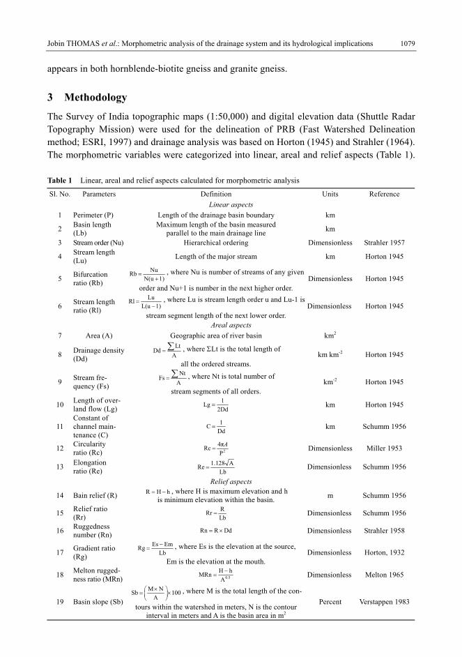
4.2 Linear aspects
4.2.1 Perimeter (P)
The P of PRB is 89.92 km and it varies between 9.78 (SB7) and 32.41 km (SB17) for the sub-basins (Table 2).
4.2.2 Basin length (Lb)
Lb is a measure of geometrical size and shape of a drainage basin. PRB has a Lb of 32.34 km and that of the sub-basins ranges between 3.22 and 13.40 km (Table 2).
4.2.3 Stream order (Nu)
PRB is a 6th order basin and its 4th order basins were considered for detailed study. The number of streams (N) of each order (u) is tabulated in Table 2. The 1st and 2nd order streams mostly dominate the basin (~95%).
4.2.4 Stream length (Lu)
The total length of streams (Lt) in PRB is 1098.08 km and that of the sub-basins varies from 18.24 to 103.50 (Table 2). In general, mean Lt of sub-basins increases with increase in stream order and the deviation from the general behaviour in some sub-basins suggests the influence of lithology and relief.
4.2.5 Bifurcation ratio (Rb)
The Rb of PRB is 4.26 and that of the sub-basins varies between 2.94 and 5.42 (Table 2), which indicate that the networks suffer moderate structural disturbances (Verstappen, 1983).
4.2.6 Stream length ratio (Rl)
Rl for PRB is 4.02 and that of the sub-basins ranges between 1.22 and 5.39 (Table 2) and the variation indicates the influence of regional geology. The increasing trend in Rl from lower to higher order (SB3, SB6, SB8, SB11, SB14 and SB15) indicate early mature stage whereas the rest demonstrate late youth stage of geomorphic development.
Table 2 Linear aspects of Pambar River Basin Parameters SB1 SB2 SB3 SB4 SB5 SB6 SB7 SB8 SB9 SB10 SB11 SB12 SB13 SB14 SB15 SB16 SB17 SB18 PRB
P 12.71 12.1 10.4 10.41 13.94 24.94 9.78 15.65 24.94 11.16 19.78 12.89 15.2 29.2 15.27 17.58 32.41 11.28 89.92Lb 4.32 3.55 5.09 4.86 5.77 11.87 3.22 6.72 11.23 6.33 6.44 5.71 6.12 13.4 4.87 7.53 10.03 5.38 32.34N1 23 40 39 34 25 105 29 57 86 32 47 25 46 128 51 51 95 25 1311 N2 6 8 11 9 7 20 7 16 22 8 10 8 10 25 12 10 21 7 296 N3 2 3 3 2 2 4 2 5 7 3 3 2 2 8 5 2 4 2 78 N4 1 1 1 1 1 1 1 1 1 1 1 1 1 1 1 1 1 1 18 N5 − − − − − − − − − − − − − − − − − − 4 N6 − − − − − − − − − − − − − − − − − − 1 Nt 32 52 54 46 35 130 39 79 116 44 61 36 59 162 69 64 121 35 1708 T1 0.54 0.55 0.48 0.44 0.53 0.47 0.49 0.55 0.51 0.56 0.53 0.6 0.56 0.53 0.59 0.6 0.6 0.49 0.54 T2 0.32 0.8 0.5 0.61 0.85 0.4 0.6 0.55 0.64 0.28 0.44 0.47 0.87 0.57 0.71 0.73 0.77 0.51 0.62 T3 1.18 0.84 0.84 1.65 2.51 0.76 1.24 0.84 0.76 0.97 1.16 1.44 1.98 1.09 1.07 3.16 2.51 1.03 1.3 T4 1.47 0.97 1.5 0.91 0.28 10.2 0.45 3.83 8.82 2.85 4.73 2.94 1.23 12.03 2.41 2.49 6.55 2.01 3.87 T5 − − − − − − − − − − − − − − − − − − 2.05 T6 − − − − − − − − − − − − − − − − − − 27.36
LT1 12.5 21.92 18.6 15.1 13.35 49.68 14.3 31.28 44.09 17.87 24.83 15.12 25.61 68.47 30.13 30.5 57.19 12.26 712.56LT2 1.92 6.39 5.45 5.45 5.97 8.02 4.21 8.82 13.97 2.25 4.4 3.77 8.67 14.28 8.57 7.25 16.26 3.58 182.43LT3 2.35 2.53 2.51 3.3 5.01 3.02 2.48 4.19 5.32 2.92 3.47 2.88 3.96 8.72 5.34 6.32 10.05 2.05 101.72LT4 1.47 0.97 1.5 0.91 0.28 10.2 0.45 3.83 8.82 2.85 4.73 2.94 1.23 12.03 2.41 2.49 6.55 2.01 65.74LT5 − − − − − − − − − − − − − − − − − − 8.21 LT6 − − − − − − − − − − − − − − − − − − 27.36LT 18.24 31.81 28.06 24.76 24.61 70.92 21.44 48.12 72.2 25.89 37.43 24.71 39.47 103.5 46.45 46.56 90.05 19.9 1098.08
Rb1-2 3.83 5.00 3.55 3.78 3.57 5.25 4.14 3.56 3.91 4.00 4.70 3.13 4.60 5.12 4.25 5.10 4.52 3.57 4.43 Rb2-3 3.00 2.67 3.67 4.50 3.50 5.00 3.50 3.20 3.14 2.67 3.33 4.00 5.00 3.13 2.40 5.00 5.25 3.50 3.79 Rb3-4 2.00 3.00 3.00 2.00 2.00 4.00 2.00 5.00 7.00 3.00 3.00 2.00 2.00 8.00 5.00 2.00 4.00 2.00 4.59 Rb4-5 � − − − − − − − − − − − − − − − − − 4.50 Rb5-6 − − − − − − − − − − − − − − − − − − 4.00
Rb 2.94 3.56 3.40 3.43 3.02 4.75 3.21 3.92 4.68 3.22 3.68 3.04 3.87 5.42 3.88 4.03 4.59 3.02 4.26 Rl2-1 0.59 1.45 1.04 1.39 1.60 0.85 1.22 1.00 1.25 0.50 0.83 0.78 1.55 1.08 1.20 1.22 1.28 1.04 1.15 Rl3-2 3.69 1.05 1.68 2.70 2.95 1.90 2.07 1.53 1.19 3.46 2.64 3.06 2.28 1.91 1.51 4.33 3.26 2.02 2.10 Rl4-3 1.25 1.15 1.79 0.55 0.11 13.42 0.36 4.56 11.61 2.94 4.08 2.04 0.62 11.04 2.25 0.79 2.61 1.95 2.98 Rl5-4 − − − − − − − − − − − − − − − − − − 0.53 Rl6-5 − − − − − − − − − − − − − − − − − − 13.35
Rl 1.84 1.22 1.50 1.55 1.56 5.39 1.22 2.36 4.68 2.30 2.51 1.96 1.48 4.67 1.65 2.11 2.38 1.67 4.02

Table 3 Areal aspects of Pambar River Basin
Parameters SB1 SB2 SB3 SB4 SB5 SB6 SB7 SB8 SB9 SB10 SB11 SB12 SB13 SB14 SB15 SB16 SB17 SB18 PRBA 5.2 7.48 6.69 5.26 7.39 17.6 5.02 9.88 17.95 5.96 9.19 5.95 10.59 28.36 12.42 13.09 30.23 5.16 288.53
Dd 3.51 4.25 4.19 4.71 3.33 4.03 4.27 4.87 4.02 4.34 4.07 4.15 3.73 3.65 3.74 3.56 2.98 3.86 3.81Fs 6.15 6.95 8.07 8.75 4.74 7.39 7.77 8.00 6.46 7.38 6.64 6.05 5.57 5.71 5.56 4.89 4.00 6.78 5.92Lg 0.14 0.12 0.12 0.11 0.15 0.12 0.12 0.10 0.12 0.12 0.12 0.12 0.13 0.14 0.13 0.14 0.17 0.13 0.13C 0.29 0.24 0.24 0.21 0.30 0.25 0.23 0.21 0.25 0.23 0.25 0.24 0.27 0.27 0.27 0.28 0.34 0.26 0.26Rc 0.40 0.64 0.78 0.61 0.48 0.36 0.66 0.51 0.36 0.60 0.30 0.45 0.58 0.42 0.67 0.53 0.36 0.51 0.45Re 0.60 0.87 0.57 0.53 0.53 0.40 0.78 0.53 0.43 0.44 0.53 0.48 0.60 0.45 0.82 0.54 0.62 0.48 0.59
Table 4 Relief aspects of Pambar River Basin
Parameters SB1 SB2 SB3 SB4 SB5 SB6 SB7 SB8 SB9 SB10 SB11 SB12 SB13 SB14 SB15 SB16 SB17 SB18 PRBR 860 860 940 960 1200 1160 1220 1580 1560 1280 1420 1320 1300 1680 1260 1740 1620 1260 2100Rr 0.20 0.24 0.18 0.20 0.21 0.10 0.38 0.24 0.14 0.20 0.22 0.23 0.21 0.13 0.26 0.23 0.16 0.23 0.06Rn 3.02 3.66 3.94 4.52 4.00 4.67 5.21 7.70 6.27 5.56 5.78 5.48 4.85 6.13 4.71 6.19 4.83 4.86 7.99ES 2300 2118 2508 2530 2310 2340 2340 2487 2511 2150 2115 2090 2111 2080 1840 2280 2324 2272 2508EM 1440 1440 1580 1580 1200 1200 1120 940 960 960 760 820 820 440 620 620 900 1040 440Rg 0.20 0.19 0.18 0.20 0.19 0.10 0.38 0.23 0.14 0.19 0.21 0.22 0.21 0.12 0.25 0.22 0.14 0.23 0.06
MRn 0.38 0.31 0.36 0.42 0.44 0.28 0.54 0.50 0.37 0.52 0.47 0.54 0.40 0.32 0.36 0.48 0.29 0.55 0.12Sb 39.10 43.67 43.10 42.84 42.27 43.05 54.07 54.13 39.07 45.16 37.59 45.02 42.91 36.16 38.42 43.09 40.97 47.76 41.02

Jobin THOMAS et al.: Morphometric analysis of the drainage system and its hydrological implications 1083
4.3 Areal aspects
4.3.1 Area (A)
The A of PRB is 288.53 km2 and it varies between 5.02 (SB7) and 30.23 km2 (SB17) for the sub-basins (Table 3).
4.3.2 Drainage density (Dd)
The Dd of PRB is 3.81 and that of the sub-basins ranges between 2.98 and 4.87 (Table 3). In general, the Dd values represent a highly dissected terrain with relatively lower infiltration capacity.
4.3.3 Stream frequency (Fs)
The Fs of PRB is 5.92 km−2, while that of the sub-basins is shown in Table 3 and possesses a strong positive correlation with Dd values (r = 0.91 significant at the 0.01 level).
4.3.4 Length of overland flow (Lg)
The Lg of PRB is 0.13 and that of the sub-basins vary from 0.10 to 0.17 (Table 3). Low Lg values of PRB and sub-basins indicate late youth to early mature stage of development.
4.3.5 Constant of channel maintenance (C)
The C of PRB is 0.26 and that of the sub-basins ranges between 0.21 and 0.34 (Table 3). The low C values indicate structural complexity and higher dissection of the terrain.
4.3.6 Circularity ratio (Rc)
The Rc is the ratio of A to area of a circle with same P as that of the basin (Miller, 1953). The Rc of PRB is 0.45, while that of the sub-basins ranges between 0.30 and 0.78 (Table 3). The lower Rc values of most of the sub-basins also indicate the elongated shape.
4.3.7 Elongation ratio (Re)
The Re of PRB is 0.59 and that of the sub-basins ranges from 0.40 to 0.87 (Table 3). Ac-cording to Strahler (1964), SB2 and SB15 belong to oval shaped (0.90 > Re > 0.80); SB7 to less elongated (0.80 > Re > 0.70) and the rest are highly elongated (Re < 0.70) basins.
4.4 Relief aspects
4.4.1 Basin relief (R)
The R of PRB is 2100 m and that of the sub-basins ranges between 1740 and 860 m (Table 4) indicating the mountainous physiography of the basin.
4.4.2 Relief ratio (Rr)
Rr is a dimensionless height-length ratio between R and Lb (Schumm, 1956). The Rr of PRB is 0.06, while the values of the sub-basins are shown in Table 4. SB6 has the lowest Rr value (0.10), whereas SB2, SB7, SB8, SB11, SB12, SB13, SB15, SB16 and SB18 have higher Rr values (Rr > 0.20), indicating steep terrain configuration.
4.4.3 Ruggedness Number (Rn)
The Rn of PRB is 7.99 and that of the sub-basins ranges between 3.02 and 7.70 (Table 4). The high Rn of PRB and most of the sub-basins indicate higher soil erosion susceptibility.

1084 Journal of Geographical Sciences
4.4.4 Gradient ratio (Rg)
The Rg of PRB is 0.06 and that of the sub-basins ranges between 0.10 and 0.38 (Table 4). The higher Rg values represent higher channel slope associated with steep V-shaped valleys.
4.4.5 Melton Ruggedness Number (MRn)
The MRn (Melton, 1965) differentiates basins with debris flow potential from basins with bed load sediment transport. The MRn of PRB is 0.12 and that of the sub-basins vary from 0.28 to 0.55 (Table 4). According to Wilford et al. (2004) classification, PRB, in general, is a water flood basin, whereas most of the sub-basins are debris floods basins.
4.4.6 Basin slope (Sb)
Slope analysis is a significant parameter in geomorphic studies and slope elements, which in turn, are controlled by the climatomorphogenic processes in the area. The Sb of PRB is 41.02% while that of the sub-basins ranges from 36.16 to 54.13 (Table 4), revealing the moderate to highly sloping terrain–characteristic of the mountainous river basins.
5 Discussion
The morphometric analysis of PRB and the 4th order tributaries was carried out to under-stand the spatial variation in the morphometric variables and its hydrological implications.
The drainage patterns and the linear alignment of the stream courses in PRB suggest structural control on drainage network. The high positive correlation between A and Lb (r = 0.87) suggest headward extension as the dominant mode of drainage development. Hack (1957) disclosed the relationship between A and stream length (L) as 0.61.4L A= × . In PRB,
similar relationship 0.511.969L A= × was observed and proximity of the exponent with Hack reaffirms the role of headward erosion. The Rb values suggest a relatively higher de-gree of drainage integration and it exhibited a variation from Giusti and Schneider’s (1965) hypothesis, indicative of the influence of geology and relief on drainage branching. More-over, the morphometric parameters suggest late youth to early mature stage of geomorphic development.
The spatial variability of Dd revealed that upstream of PRB is well drained, while down-stream is moderate- to poorly-drained. The higher Dd values in upstream are associated with higher relief and rainfall whereas downstream is characterized by lower Dd, result of rela-tively lower relief and rainfall. The positive correlation between Dd and Sb (r = 0.536) indi-cate that steeper slopes with impermeable rocks provide the ground for the initiation of more channels (Strahler, 1964). The shape parameters suggest an elongated shape of PRB and sub-basins; suggest lower peak flows of longer duration and hence easier flood management.
The relief aspects indicate the mountainous configuration of the basin and high relief pa-rameters can influence the soil erosion and flood patterns. The high Rg values of the drain-age channels in a late youth to early mature terrain system indicate highly incised valleys. Though, the terrain is prone to debris flow hazards, inadequate rainfall does not favour such conditions. The significant correlations between R and A (0.630), P (0.727), Lb (0.741), Nt (0.615), Lt (0.623), Rb (0.571) and Rl (0.508) indicate the significant role of relief in the basin geometry. Further, poor correlation of Rb with Dd (–0.223) and Fs (–0.259) clearly

Jobin THOMAS et al.: Morphometric analysis of the drainage system and its hydrological implications 1085
indicates the dependence over geological structure, climate and vegetation. The 4th order basins were classified into humid (SB1 to SB10 and SB18) and semi-arid
(SB11 to SB17) based on the rainfall pattern and the morphometric parameters are given in Table 5.
Table 5 Descriptive statistics of the morphometric parameters of the sub-basins with humid and semi-arid cli-mate
Humid Semi-arid
Mean SD Max Min Mean SD Max Min
P 14.30 5.53 24.94 9.78 20.33 7.52 32.41 12.89
Lb 6.21 2.85 11.87 3.22 7.73 3.00 13.40 4.87
N1 45 27 105 23 63 35 128 25
Nt 60 34 130 32 82 44 162 36
LT 35.09 19.73 72.20 18.24 55.45 29.41 103.50 24.71
Rb 3.56 0.64 4.75 2.94 4.07 0.75 5.42 3.04
Rl 2.30 1.41 5.39 1.22 2.39 1.07 4.67 1.48
A 8.51 4.80 17.95 5.02 15.69 9.60 30.23 5.95
Dd 4.13 0.46 4.87 3.33 3.70 0.38 4.15 2.98
Fs 7.13 1.10 8.75 4.74 5.49 0.84 6.64 4.00
Lg 0.12 0.01 0.15 0.10 0.14 0.02 0.17 0.12
C 0.25 0.03 0.30 0.21 0.27 0.03 0.34 0.24
Rc 0.54 0.13 0.78 0.36 0.47 0.13 0.67 0.30
Re 0.56 0.15 0.87 0.40 0.58 0.12 0.82 0.45
R 1170 251 1580 860 1477 198 1740 1260
Sb 44.93 5.14 54.13 39.07 40.59 3.28 45.02 36.16
The A, P and Lb values of the semi-arid basins are significantly higher than the humid
basins (P < 0.50; Table 5). The high rainfall and steep terrain gradient in the humid sub-basins supported an early bifurcation of the channels to form 4th order tributaries. Hence, the humid sub-basins possess low basin geometry. High N1, Nt and Lt values in the semi-arid basins are associated with high basin geometry. The Rb, Rl and R also illustrated considerable variation between the two groups.
The higher Lg and C values of the semi-arid sub-basins indicate the delay in the channel initiation, where the channel is maintained by larger watershed area. The Dd and Fs are comparatively higher in the humid than semi-arid sub-basins (P < 0.50). Many authors (Horton, 1932; Williams and Fowler, 1969; Verstappen, 1983) explained the role of rainfall intensity in terrain dissection. Hence, the variation in Dd can also be attributed to the rainfall variability along with relief factors. The shape parameters of semi-arid basins also demon-strate a more elongated shape than that of humid basins.
Further, the 4th order sub-basins were classified according to their morphometrical simi-larity. The dendrogram obtained as a result (Figure 2) and four distinctively different cluster groups were formed.

1086 Journal of Geographical Sciences
Figure 2 Dendrogram showing different cluster groups of sub-basins
Cluster 1 was characterized by lower values of basin geometry, mainly, linear properties
and higher relief aspects. In contrary, cluster 4 was characterized by higher basin geometry including linear aspects, lower relief characters and highly elongated plan view. The drain-age pattern and higher Rb and Rn values of cluster 4 indicate structural control over the drainage network.
Smaller sub-basins with higher dissection characterize cluster 3. Further, relatively higher values of Rc and Re indicate less elongated to oval shaped sub-basins. Cluster 2 was dis-criminated by the moderate values of the morphometric descriptors.
The humid sub-basins were primarily associated with clusters 1 and 3, while the semi-arid sub-basins with cluster 2. Cluster 4 has representations from both climatic groups. Though, both clusters 1 and 3 were connected with humid climate, the relief aspects showed variation between clusters.
Finally, four clusters were classified according to their morphometric properties viz., C1-high relief sub-basins in humid climate, C2-semi-arid sub-basins, C3-moderate relief sub-basins in humid climate and C4-highly elongated sub-basins with higher degree of structural control.
The spatial variability in rainfall pattern may put forth a hydrological stress, which varies in magnitude and morphometrical descriptors provide ample information about the hydro-logic bahaviour of PRB. The morphometric analysis indicates the mountainous configuration of PRB with highly variable hydrologic regime. The intermittent tributaries in PRB allow surface runoff to occur only during exceptionally higher precipitation. Hence, the drainage system in PRB significantly influences the hydrological conditions of the region.
Potential water harvesting is sometimes overlooked in semi-arid regions however, it is precisely in these areas that the value of water is very high, making efficient water harvest-ing economically viable. The climatic and edaphic factors of PRB necessitated the absorp-tion of micro-catchment techniques for runoff harvesting and rainwater conservation. Al-though, water harvesting in PRB is economically feasible, appropriate selection of harvest-

Jobin THOMAS et al.: Morphometric analysis of the drainage system and its hydrological implications 1087
ing sites is also very essential. It is therefore suggested that the result of the present study can be utilized for the formulation of a comprehensive watershed management plan for PRB.
6 Conclusions
The morphometric analysis of PRB disclosed the significance the morphometric studies in terrain analysis and their influence in river basin management. The drainage basin was de-veloped on high-grade Proterozoic metamorphic rocks of Southern Granulite Terrain, shows an altitudinal climatic zonation, in that, a humid climate prevails in the upstream, whereas semi-arid climate predominates in the downstream. PRB is characteristically dominated by the 1st and 2nd order streams enabling sufficient draining. The drainage network is generally of parallel type, prevalence of rectangular and modified dendritic patterns suggest the struc-tural influences on a regional scale.
The basin geometry indicates headward extension as the dominant mode of drainage development and stream bifurcation is jointly influenced by relief and structure. This highly dissected basin, displays a higher degree of drainage integration and the results of analysis point to a late youth to early mature stage of geomorphic development. The up-stream segment of PRB is well drained whereas the downstream is poorly to moderately drained and terrain configuration has an important role in determining the spatial variation. The elongated shape of the basin and the sub-basins reduces the risk of flood flows and consequently easier flood management.
The higher relief aspects due to a structurally complex mountainous configuration of PRB may augment soil erosion and flood patterns. The basin is vulnerable to debris flow hazards only during exceptional storms and the low ruggedness of the downstream sector signifi-cantly aids in the debris management.
The climatic variability, i.e., coexisting humid and semi-arid conditions in PRB is robus-tly reflected in the morphometry and the spatial variation in drainage properties is mainly because of the difference in relief and climate. The classification of the 4th order basins re-vealed four major groups of drainage system viz., high relief sub-basins in humid climate, moderate relief sub-basins in humid climate, semi-arid sub-basins and highly elongated sub-basins with higher degree of structural control.
The study clearly indicated certain relationships a) among several attributes of the mor-phometric aspects, b) helped in assessing the role in sculpturing the topography and c) im-mensely contributed a basis for water resource development and management. Though the region belongs to rain shadow region, effective micro-catchment techniques can be estab-lished for sustainable water resource management.
Acknowledgements
JT sincerely thanks Late Dr. Satheesh, R., Mahatma Gandhi University, Mr. Vijith, H., CGIST, University of Kerala (concept and assistance in data analysis), Kerala Forest De-partment (logistics support during work in wilderness) and Kerala State Council for Science, Technology and Environment (financial support).

1088 Journal of Geographical Sciences
References
ESRI, 1997. Watershed Delineator Application: User's Manual. Environmental Systems Research Institute, Red-lands, CA
Giusti E V, Schneider W J, 1965. The distribution of branches in river networks. USGS Professional Paper, 422G. Gregory K J, 1966. Dry valley and the composition of the drainage net. Journal of Hydrology, 4: 327–340. Hack J T, 1957. Studies of longitudinal stream profiles in Virginia and Maryland. USGS Professional Paper,
294B. Horton R E, 1932. Drainage basin characteristics. Transactions of American Geophysics Union, 13: 350–361. Horton R E, 1945. Erosional development of streams and their drainage basins: Hydrophysical approach to quan-
titative morphology. Geological Society of America Bulletin, 56(3): 275–370. Manu M S, Anirudhan S, 2008. Drainage characteristics of Achankovil River Basin, Kerala. Journal of Geologi-
cal Society of India, 71: 841–850. Melton M A, 1965. The geomorphic and paleoclimatic significance of alluvial deposits in Southern Arizona.
Journal of Geology, 73: 1–38. Miller, V.C., 1953. A quantitative geomorphic study of drainage basin characteristics in the Clinch mountain area,
Virginia and Tennessee. Technical Report 3, Office of Naval Research, Department of Geology, Columbia University, New York.
Schumm, S.A., 1956. Evolution of drainage systems and slopes in badlands at Perth Amboy, New Jersey. Geo-logical Society of America Bulletin, 67: 597–646.
Soman, K., 2002. Geology of Kerala. Bangalore: Geological Survey of India. Sreedevi P D, Subrahmanyam K, Ahmed S, 2005. The significance of morphometric analysis for obtaining
groundwater potential zones in a structurally controlled terrain. Environmental Geology, 47: 412–420. Strahler A N, 1957. Quantitative analysis of watershed geomorphology. Transactions of American Geophysical
Union, 38: 913–920. Strahler A N, 1958. Dimensional analysis applied to fluvially eroded landforms. Geological Society of America
Bulletin, 69: 279–300. Strahler A N, 1964. Quantitative geomorphology of drainage basin and channel networks. In: Chow V T. Hand-
book of Applied Hydrology. New York: McGraw Hill, 4–76. Verstappen H T H, 1983. Applied Geomorphology: Geomorphological Surveys for Environmental Development.
New York: Elsevier. Wilford D J, Sakals M E, Innes J L et al., 2004. Recognition of debris flow, debris flood and flood hazard through
watershed morphometrics. Landslides, 1: 61–66. Williams R E, Fowler P M, 1969. A preliminary report on an empirical analysis of drainage network adjustment to
precipitation input. Journal of Hydrology, 8: 227–238.