Morphological characteristics of the Basque continental shelf (Bay of Biscay, northern Spain); their...
65
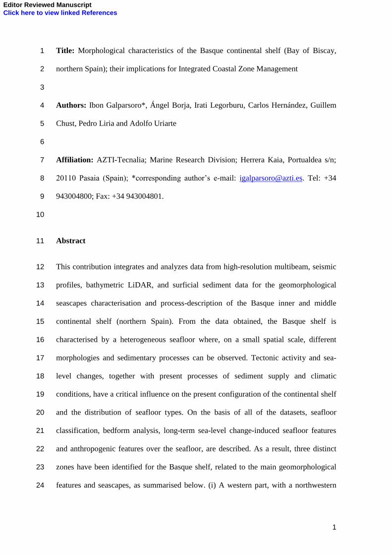
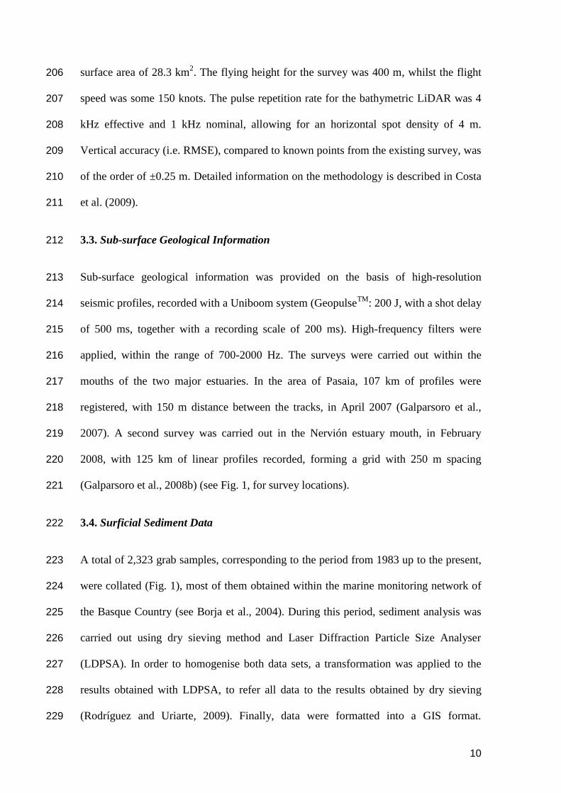
Elsevier Editorial System(tm) for Geomorphology Manuscript Draft Manuscript Number: GEOMOR-1653R2 Title: Morphological characteristics of the Basque continental shelf (Bay of Biscay, northern Spain); their implications for Integrated Coastal Zone Management Article Type: Research Paper Keywords: seafloor cartography, geomorphology, seascape, multibeam echosounder, bathymetric LiDAR, Integrated Coastal Zone Management, Basque shelf Corresponding Author: Mr. Ibon Galparsoro, M.D. Corresponding Author's Institution: First Author: Ibon Galparsoro, M.D. Order of Authors: Ibon Galparsoro, M.D.; Ángel Borja, PhD; Irati Legorburu; Pedro Liria; Carlos Hernández; Guillem Chust, PhD; Adolfo Uriarte, PhD Abstract: This contribution integrates and analyzes data from high-resolution multibeam, seismic profiles, bathymetric LiDAR, and surficial sediment data for the geomorphological seascapes characterisation and process-description of the Basque inner and middle continental shelf (northern Spain). From the data obtained, the Basque shelf is characterised by a heterogeneous seafloor where, on a small spatial scale, different morphologies and sedimentary processes can be observed. Tectonic activity and sea-level changes, together with present processes of sediment supply and climatic conditions, have a critical influence on the present configuration of the continental shelf and the distribution of seafloor types. On the basis of all of the datasets, seafloor classification, bedform analysis, long-term sea-level change-induced seafloor features and anthropogenic features over the seafloor, are described. As a result, three distinct zones have been identified for the Basque shelf, related to the main geomorphological features and seascapes, as summarised below. (i) A western part, with a northwestern orientation, which coincides with the prevailing wave direction. This zone is characterised by a predominantly rocky substrate, except within the mouth of the Nervión estuary, where sandy sediments appear to infill a paleo-channel. (ii) A central part, which is oriented towards the northeast and receives less wave energy. Within this zone, a sedimentary seabed is predominant. Sorted bedforms are well developed and can be detected in water depths in excess of 90 m. (iii) An eastern zone, which is characterised by sedimentary seafloor and shore terraces; here, a flat rocky seafloor is covered by a thin layer of sediments. Throughout the study area, the bathymetry and sedimentary features of the shoreface and inner shelf are controlled mainly by climatic conditions, coastal dynamics and the underlying geological framework. The integration of these data sets, together with their interpretation, is a valuable source of information for Integrated Coastal Zone Management (ICZM) and constitutes a useful tool for implementing various European Directives.
-
Upload
independent -
Category
Documents
-
view
0 -
download
0
Transcript of Morphological characteristics of the Basque continental shelf (Bay of Biscay, northern Spain); their...
Elsevier Editorial System(tm) for Geomorphology Manuscript Draft Manuscript Number: GEOMOR-1653R2 Title: Morphological characteristics of the Basque continental shelf (Bay of Biscay, northern Spain); their implications for Integrated Coastal Zone Management Article Type: Research Paper Keywords: seafloor cartography, geomorphology, seascape, multibeam echosounder, bathymetric LiDAR, Integrated Coastal Zone Management, Basque shelf Corresponding Author: Mr. Ibon Galparsoro, M.D. Corresponding Author's Institution: First Author: Ibon Galparsoro, M.D. Order of Authors: Ibon Galparsoro, M.D.; Ángel Borja, PhD; Irati Legorburu; Pedro Liria; Carlos Hernández; Guillem Chust, PhD; Adolfo Uriarte, PhD Abstract: This contribution integrates and analyzes data from high-resolution multibeam, seismic profiles, bathymetric LiDAR, and surficial sediment data for the geomorphological seascapes characterisation and process-description of the Basque inner and middle continental shelf (northern Spain). From the data obtained, the Basque shelf is characterised by a heterogeneous seafloor where, on a small spatial scale, different morphologies and sedimentary processes can be observed. Tectonic activity and sea-level changes, together with present processes of sediment supply and climatic conditions, have a critical influence on the present configuration of the continental shelf and the distribution of seafloor types. On the basis of all of the datasets, seafloor classification, bedform analysis, long-term sea-level change-induced seafloor features and anthropogenic features over the seafloor, are described. As a result, three distinct zones have been identified for the Basque shelf, related to the main geomorphological features and seascapes, as summarised below. (i) A western part, with a northwestern orientation, which coincides with the prevailing wave direction. This zone is characterised by a predominantly rocky substrate, except within the mouth of the Nervión estuary, where sandy sediments appear to infill a paleo-channel. (ii) A central part, which is oriented towards the northeast and receives less wave energy. Within this zone, a sedimentary seabed is predominant. Sorted bedforms are well developed and can be detected in water depths in excess of 90 m. (iii) An eastern zone, which is characterised by sedimentary seafloor and shore terraces; here, a flat rocky seafloor is covered by a thin layer of sediments. Throughout the study area, the bathymetry and sedimentary features of the shoreface and inner shelf are controlled mainly by climatic conditions, coastal dynamics and the underlying geological framework. The integration of these data sets, together with their interpretation, is a valuable source of information for Integrated Coastal Zone Management (ICZM) and constitutes a useful tool for implementing various European Directives.
1
Title: Morphological characteristics of the Basque continental shelf (Bay of Biscay, 1
northern Spain); their implications for Integrated Coastal Zone Management 2
3
Authors: Ibon Galparsoro*, Ángel Borja, Irati Legorburu, Carlos Hernández, Guillem 4
Chust, Pedro Liria and Adolfo Uriarte 5
6
Affiliation: AZTI-Tecnalia; Marine Research Division; Herrera Kaia, Portualdea s/n; 7
20110 Pasaia (Spain); *corresponding author‟s e-mail: [email protected]. Tel: +34 8
943004800; Fax: +34 943004801. 9
10
Abstract 11
This contribution integrates and analyzes data from high-resolution multibeam, seismic 12
profiles, bathymetric LiDAR, and surficial sediment data for the geomorphological 13
seascapes characterisation and process-description of the Basque inner and middle 14
continental shelf (northern Spain). From the data obtained, the Basque shelf is 15
characterised by a heterogeneous seafloor where, on a small spatial scale, different 16
morphologies and sedimentary processes can be observed. Tectonic activity and sea-17
level changes, together with present processes of sediment supply and climatic 18
conditions, have a critical influence on the present configuration of the continental shelf 19
and the distribution of seafloor types. On the basis of all of the datasets, seafloor 20
classification, bedform analysis, long-term sea-level change-induced seafloor features 21
and anthropogenic features over the seafloor, are described. As a result, three distinct 22
zones have been identified for the Basque shelf, related to the main geomorphological 23
features and seascapes, as summarised below. (i) A western part, with a northwestern 24
Editor Reviewed ManuscriptClick here to view linked References
2
orientation, which coincides with the prevailing wave direction. This zone is 25
characterised by a predominantly rocky substrate, except within the mouth of the 26
Nervión estuary, where sandy sediments appear to infill a paleo-channel. (ii) A central 27
part, which is oriented towards the northeast and receives less wave energy. Within this 28
zone, a sedimentary seabed is predominant. Sorted bedforms are well developed and can 29
be detected in water depths in excess of 90 m. (iii) An eastern zone, which is 30
characterised by sedimentary seafloor and shore terraces; here, a flat rocky seafloor is 31
covered by a thin layer of sediments. Throughout the study area, the bathymetry and 32
sedimentary features of the shoreface and inner shelf are controlled mainly by climatic 33
conditions, coastal dynamics and the underlying geological framework. The integration 34
of these data sets, together with their interpretation, is a valuable source of information 35
for Integrated Coastal Zone Management (ICZM) and constitutes a useful tool for 36
implementing various European Directives. 37
38
Keywords: seafloor cartography, geomorphology, seascape, multibeam echosounder, 39
bathymetric LiDAR, Integrated Coastal Zone Management, Basque shelf 40
41
3
1. Introduction 42
With the introduction of high-resolution mapping systems, such as the multibeam 43
echosounder (MBES) in the 1990s (Hughes Clarke et al., 1996) or the bathymetric 44
LiDAR (Irish and Lillycrop, 1999; Finkl and Andrews, 2009), new information has 45
been available on seafloor characteristics. The analysis of the MBES data results in the 46
generation of bathymetric models and acoustic backscatter mosaics. Such data can be 47
used to derive the spatial distribution of seafloor relief (with derivatives, such as slope 48
and rugosity), together with bottom type and composition (Fonseca et al., 2009). Such 49
information, in terms of bathymetry, seafloor type distribution and geomorphology, is a 50
valuable source of information for: (i) the description of seabed processes and 51
morphology (Hovland, 2003; Finkl et al., 2008; Hernández-Molina et al., 2008); (ii) 52
habitat mapping (Kostylev et al., 2001; Orpin and Kostylev, 2006; Ryan et al., 2007; 53
Wilson et al., 2007; Brown and Blondel, 2009); (iii) the distribution of benthic 54
biodiversity (Baptist et al., 2006; Thrush et al., 2006; Zajac, 2008); (iv) fish species 55
richness (Pittman et al., 2007); (v) the economic importance of species management 56
(Kostylev et al., 2003; Lucieer and Pederson, 2008; Galparsoro et al., 2009); and, 57
subsequently, (vi) the understanding of benthic ecosystems. Recently, such information 58
has been used for: (i) Integrated Coastal Zone Management (ICZM) (Kostylev et al., 59
2003; Borja et al., 2008b); (ii) the morphological long-term development of dredged 60
material disposal (Cooper et al., 2007; Marsh and Brown, 2009); (iii) the designation 61
and management of marine protected areas (Harris et al., 2008); and (iv) marine spatial 62
planning (Pickrill and Todd, 2003; Campbell and Hewitt, 2006). In particular, new uses 63
of the marine environment (i.e. wind farms, marine protected areas, aquaculture) have 64
triggered a pragmatic approach to the development of marine spatial planning (Douvere 65
and Ehler, 2009). 66
4
The study of the seafloor geomorphology and seascapes, within the Iberian Peninsula, 67
has been undertaken under different perspectives: geological and geomorphological 68
maps of Spain and the continental margin (IGME, 2005); the Prestige oil-spill area 69
(Llave et al., 2008; Vázquez et al., 2008); seascape-shaping mechanisms (Amblas et al., 70
2006); morphosedimentary features (Ercilla et al., 2008); identification of sedimentary 71
features, associated with river discharges (Lobo et al., 2006; Liquete et al., 2007); or 72
rifting (Muñoz et al., 2008). In turn, high quality information on the geology, 73
geomorphology and seafloor characteristics of the southeastern part of the Bay of 74
Biscay (incorporating the Basque continental shelf) is scarce, even absent. Hence, since 75
the first bathymetric charts were produced by the Spanish Marine Hydrographical 76
Institute, in the late 1960´s, only limited research has been undertaken within this 77
region. In the early 1990´s, seafloor characterisation was undertaken to locate and 78
characterise sand banks for beach nourishment purposes (Iberinsa, 1990; 1994). This 79
investigation used side-scan sonar, seismic reflection techniques, surficial grab samples 80
and vibro-core samples. In 2000, in response to an increasing interest in the 81
characterisation of fishing site biotopes, studies were carried out for the Department of 82
Agriculture and Fisheries, of the Basque Government (Galparsoro, 2005). These studies 83
provided an initial approach to seafloor classification, using the Acoustic Seafloor 84
Discrimination System, RoxAnnTM
and side-scan sonar. Other similar studies were 85
carried out, for different purposes, such as: dredged material disposal sites 86
characterisation; urban waste water outfalls inspection; submarine archaeology; and 87
harbour‟s depth of water management. Finally, in 2008, an overall map of the surface 88
sediment distribution of the Basque continental shelf was produced (Jouanneau et al., 89
2008) on the basis of grab sample data. 90
5
Hence, the objectives of the present investigation are: (i) to describe, in an integrative 91
way and at very high-resolution, the main representative geomorphology, seafloor 92
features and submarine seascapes of the Basque continental shelf; and (ii) to infer the 93
processes generating such features. The knowledge generated by this investigation is 94
high quality information to assist in integrated coastal zone management and decision-95
making for different European Directives, such as: ICZM decisions; the Habitats 96
Directive; the Water Framework Directive (WFD, (Borja, 2005); the Marine Strategy 97
Framework Directive (MSFD, (Borja, 2006)); and the NATURA2000 Network. 98
2. Study Area 99
The study area is located on the continental shelf of the Basque Country coast, in the 100
southeastern part of the Bay of Biscay (Fig. 1). The total length of this section of the 101
coast is ca. 150 km. The Cantabrian Sea continental shelf is characterised by its 102
narrowness; in the Basque Country, it ranges from 7 km off Matxitxako Cape, to 20 km 103
off the Oria River estuary (Uriarte, 1998) (Fig. 1). 104
2.1 Geological Framework 105
Tectonic events during the Paleocene and Eocene, together with the Tertiary alpine 106
orogeny, have resulted in deformation of the Cantabrian margin (Ercilla et al., 2008). 107
The entire Basque coastline is located within the Basque Arc domain, including the 108
following regions (or structures), ranging from north to south (Feuillée and Rat, 1971): 109
(i) the monocline of Zumaia, or San Sebastián, which occurs on the Basque coast at 110
Zumaia and extends towards the east; (ii) an anticline to the north of Biscay; (iii) in the 111
western part, the syncline of Bizkaia, which extends along the extensive layer of 112
marbles; and (iv) the anticline of Bilbao (Fig. 1). There are reverse folds and faults (e.g. 113
6
the fault of Bilbao), which form the southern boundary of the Basque Arc (for details, 114
see Fig. 1). 115
Structural features dominate the morphology of the continental shelf. Horsts and 116
anticlines, found generally in Cretaceous rocks, form areas starved of soft Neogene 117
sediments. Faults and synclines, filled with Tertiary materials, underlie sandy 118
depressions (Pascual et al., 2004). The outer section of the continental shelf is a 119
sedimentary Neogene and Pleistocene prism, developed by progradation (Boillot et al., 120
1984). 121
2.2 Oceanographic Setting 122
The maritime climate along the Basque coast is related mainly to its location within the 123
Bay of Biscay and the NE Atlantic (González et al., 2004). In relation to its location and 124
orientation, this part of the coast is exposed to large storms from the NW, produced by 125
evolution of the North Atlantic low pressure systems. Strong NW swell waves dominate 126
and are the most common sea state within the study area. During summer, with the 127
extension of the Azores high pressure system, the North Atlantic low pressure formation 128
sequence slows down, as its intensity lessens. The data used to describe the offshore 129
wave climate affecting the study area have been obtained from the Bilbao offshore buoy 130
(Boya de Bilbao-Vizcaya). On the basis of these data, Liria et al. (2009) summarised the 131
wave climate as described below (see Fig. 1, in Supplementary Material). 132
(i) Summer (June-August): Wave periods of under 10 s over 75% of the time, with 133
representative wave heights of 1.5 m, exceeding 2 m within less than 10% of the 134
measurements. 135
7
(ii) Winter (December-February): High wave periods (i.e. 13 sec), with wave heights 136
greater than 2 m over more than 50% of the time. 137
(iii) Spring and autumn are transitional periods, with intermediate characteristics. 138
(iv) Under extreme offshore wave conditions, significant wave heights can exceed 5 m 139
(several times a year) and, occasionally, 10 m (with return periods of 20 years). 140
The tidal wave is semi-diurnal in character within the Bay of Biscay (Uriarte et al., 141
2004). Along the Basque coast, the mean tidal range is approximately 1.65 m on neap 142
tides and 4.01 m on springs (REDMAR, 2005). Despite the importance of tidally-143
induced surface water fluctuations, the contribution of the tides to the generation of 144
currents is somewhat modest (except within the estuaries) (Uriarte et al., 2004). Away 145
from the estuaries, the tidal currents decrease, with water circulation being governed 146
mainly by wind forcing fluctuations, over a wide range of meteorological frequencies, 147
within the surface and sub-surface waters (Fontán, 2008; Fontán et al., 2009); however, 148
even these are incapable of generating littoral sediment transport along the Basque coast 149
(González et al., 2004). 150
In terms of sediment supply, the Basque Country is drained by 12 main rivers, which 151
discharge 1.57 106
t.yr-1
of suspended material (Uriarte et al., 2004; Ferrer et al., 2009). 152
The geomorphological and hydrological characteristics of the Basque estuarine water 153
bodies are described in Valencia et al. (2004) and Borja et al. (2006). 154
155
156
157
8
3. Material and Methods 158
The data set analysed in the present study was acquired within the framework of a 159
seafloor characterisation and marine habitat mapping programme, which commenced in 160
2004 (Galparsoro et al., 2008a). This investigation integrates different remote sensing 161
techniques, such as MBES (operating from approximately 10 to 100 m water depth), 162
topographic LiDAR (terrestrial land to mid-intertidal zone), bathymetric LiDAR (up to 163
20 m water depth), and aerial photography (Chust et al., 2007; 2008), to cover a 164
continuum from land to deep water environments. At the same time, a Marine 165
Biodiversity Observatory was established by the Basque Government, where 166
sedimentological, pollutant and biological data are collected and integrated into a 167
Marine Spatial Data Infrastructure (Borja et al., 2007; Sagarminaga et al., 2007). 168
3.1. Multibeam Echosounder Bathymetric Data 169
A ship-borne MBES survey was carried out between 2005 and 2008. Bathymetric and 170
seafloor backscatter information were acquired, using high-resolution SeaBat 8125 and 171
SeaBat 7125 MBESs (RESON, 2002, 2006); however, most of the work was carried out 172
using the latest SeaBat 7125 system. The operational frequency of the system was 400 173
kHz, producing 256 beams, in a 128º angle swath with a system depth resolution of 174
0.006 m. The beam width is 0.5º along-track and 1º across-track, producing very small 175
footprints; these, in turn, result in high horizontal resolution Digital Elevation Models 176
(DEM). Incorrect depth values were filtered and tidal correction was applied. As a 177
result, 1 m horizontal resolution DEM was produced. “Snippet” and “pseudo side-scan 178
sonar” non-calibrated backscatter signals were also recorded, together with bathymetric 179
information. Detailed information on the methodology can be found in Borja et al. 180
(2008b) and Galparsoro (2009). Taking into account the limitations of backscatter 181
9
intensity in quantifying and predicting seafloor composition, such a property was used 182
to determine relative differences in seafloor sediment types (Collier and Brown, 2005; 183
Amblas et al., 2006; Brown and Blondel, 2008; Medialdea et al., 2008). Seafloor 184
classification was carried out on the basis of acoustic and morphological facies, together 185
with collated sediment data. „Seafloor-type‟ signatures were extracted, in order to define 186
the seafloor types that could be identified using MBES records. 187
3.2. Topographic and bathymetric LiDAR Elevation Data 188
The digital elevation model used herein was obtained on the basis of a topographic 189
survey of the entire province of Gipuzkoa (1909 km2, in the eastern part of the Basque 190
Country) in 2005 (from January to May) and using Light Detection and Ranging 191
(LiDAR), carried out by the Local Government of Gipuzkoa (Diputación Foral de 192
Gipuzkoa). The sensor was a laser Optech Airborne Laser Terrain Mapper (ALTM) 193
3025, which belongs to the Cartographic Institute of Catalonia (Institut Cartogràfic de 194
Catalunya, ICC); it operates at the infrared wavelength of 1064 nm. The aerial flights 195
were carried out at mid-tide to low-tide (from 0.3 m to 1.6 m below MSL, in Alicante). 196
The 1 m resolution DEM was generated from the LiDAR ground points. It has a vertical 197
accuracy of 0.15 m RMS, in sparsely vegetated and low slope areas. Within this study, a 198
ground (bare-earth) DEM was used, i.e. excluding objects such as buildings, trees, and 199
shrubs. Detailed information on the methodology is described in Chust et al. (2008). 200
On the other hand, very shallow water bathymetric data acquisition was undertaken 201
using the HawkEye MK II airborne bathymetric LiDAR (ALB) system, along the 202
Gipuzkoan coast. This technique consists of two laser scanners: one green (532 nm), 203
used for capturing the bathymetric data; and one red, for the topographic data (1,064 204
nm). The data capture phase was completed in 2008 and 2009; this covered a total 205
10
surface area of 28.3 km2. The flying height for the survey was 400 m, whilst the flight 206
speed was some 150 knots. The pulse repetition rate for the bathymetric LiDAR was 4 207
kHz effective and 1 kHz nominal, allowing for an horizontal spot density of 4 m. 208
Vertical accuracy (i.e. RMSE), compared to known points from the existing survey, was 209
of the order of ±0.25 m. Detailed information on the methodology is described in Costa 210
et al. (2009). 211
3.3. Sub-surface Geological Information 212
Sub-surface geological information was provided on the basis of high-resolution 213
seismic profiles, recorded with a Uniboom system (GeopulseTM
: 200 J, with a shot delay 214
of 500 ms, together with a recording scale of 200 ms). High-frequency filters were 215
applied, within the range of 700-2000 Hz. The surveys were carried out within the 216
mouths of the two major estuaries. In the area of Pasaia, 107 km of profiles were 217
registered, with 150 m distance between the tracks, in April 2007 (Galparsoro et al., 218
2007). A second survey was carried out in the Nervión estuary mouth, in February 219
2008, with 125 km of linear profiles recorded, forming a grid with 250 m spacing 220
(Galparsoro et al., 2008b) (see Fig. 1, for survey locations). 221
3.4. Surficial Sediment Data 222
A total of 2,323 grab samples, corresponding to the period from 1983 up to the present, 223
were collated (Fig. 1), most of them obtained within the marine monitoring network of 224
the Basque Country (see Borja et al., 2004). During this period, sediment analysis was 225
carried out using dry sieving method and Laser Diffraction Particle Size Analyser 226
(LDPSA). In order to homogenise both data sets, a transformation was applied to the 227
results obtained with LDPSA, to refer all data to the results obtained by dry sieving 228
(Rodríguez and Uriarte, 2009). Finally, data were formatted into a GIS format. 229
11
Moreover, 78 new grab samples were collected during the spring of 2009 in those areas 230
where a spatial gap of sedimentological information was identified or in areas where 231
singular morphologies were identified with MBES records and no sedimentologial data 232
were available. Sedimentological data were integrated into the GIS, and a spline-with-233
barriers interpolation algorithm was applied. 234
235
4. Results 236
A 1 m horizontal resolution bathymetric elevation model and seafloor characterisation 237
was obtained, for a total area of 1,096 km2 (Fig. 2a and Supplementary Material from 238
Figs. 2 to 7). The seafloor classification obtained by means of morphology and MEBS 239
backscatter interpretation resulted in: (i) sedimentary seafloor, covering 35% of the 240
surface (Figs. 3a-d), where a sub-classification was undertaken by differentiating 241
between sedimentary cover and sorted bedforms (43 km2 out of the 383 km
2); (ii) mixed 242
rock and sediment seafloor (49% of the total) (Figs. 3e-f and Figs. 4a-b); (iii) rocky 243
seafloor (14% of the total) (Figs. 4c-d); and (iv) areas of dredged material disposal (2% 244
of the total, extending over 23 km2) (Figs. 4e-f); and other singular structures, such as 245
dredging marks and waste water disposal sites (Fig. 5). For details see Table 1 and Fig. 246
2c, for the seafloor classification map. 247
4.1. Morphological Features 248
From the MBES and bathymetric LiDAR data, morphological features have been 249
derived and grouped, taking into account the process that generates them: (i) erosional 250
features; (ii) depositional features; and (iii) anthropogenically-induced structures. 251
252
12
4.1.1. Erosional features 253
4.1.1.1. Rock outcrops 254
Rock seafloor represents 14% of the area surveyed. In the shallow water zone, a 255
continuous belt of rock is present, which is intersected only by sedimentary seafloor off 256
the major estuary mouths. This shallow and highly roughened bedrock is associated 257
with the coastal topography; it presents a slope of approximately 10%, following an 258
inflexion point at 35-40 m water depth (Fig. 2b). In very shallow water, the presence of 259
large rocky blocks is related to coastal cliff erosion (Fig. 4d). The rock strata present 260
different orientations in relation to the coastline. Over the western part, rock strata lie 261
mainly perpendicular to the coastline, producing a low slope seafloor: the presence of 262
coarse sand patches is common between the rock strata. Over the eastern part, the rock 263
strata lie mainly parallel to the coastline, with a high dip generating a rectilinear 264
coastline and the presence of cliffs. Farther offshore, the shelf extends with a milder 265
slope (varying between 1.5% and 2%) and the rock shows lower rugosity. In this zone, 266
the rock outcrop is overlain by a thin veneer of sand cover, but the structural features of 267
the underlying rock are still visible. This seafloor type is complex and patchy, so it has 268
been defined as a mixed bottom type (Fig. 2c and Table 2) here; this covers 49% of the 269
study area. 270
There are several localized zones of rock outcrops. For example, a tower rock has been 271
identified to seaward of Armintza (see Fig. 2c, for location), rising some 40 m above the 272
surrounding seabed and being 130 m in width. 273
274
275

13
4.1.1.2. Shore terraces 276
Eight shoreline terraces have been identified on the rocky seafloor, corresponding to 277
periods of sea-level still-stand, at approx.: -37 m, -52 m, -56 m, -70 m, -73 m, -75 m, -278
87 m and -92 m water depth (relative to the Local Datum, which is 2.016 m above 279
Spring Low Tide level). The shallower terrace is the steepest and longest and extends 280
continuously along the inner continental shelf (Fig. 4c). Above this water level, the 281
rocky seafloor is very rough and constitutes the shallow rock belt (as described 282
previously). Shore terraces located deeper are less steep and the rocky seafloor is more 283
flat, in response to erosion at still-stand periods (Fig. 6). 284
4.1.1.3. Paleo-river channels 285
The rocky seafloor shows numerous incisions, of various sizes, that correspond to 286
paleo-river channels. The channels are oriented generally shore-normal and are most 287
likely associated with geomorphological features of the modern shoreline. More than 40 288
paleo-channels have been identified within the study area (Fig. 2c). The paleo-channels 289
do not contain any tributaries; they are very sinuous (the sinuosity index of the channels 290
lay between 0.8 and 0.9), with a S-N orientation; some of them incise across the entire 291
width of the rocky shelf, up to a water depth of 85 m. The largest paleo-river channels 292
represent the offshore continuity of the present estuaries, within the sub-tidal area, being 293
200 m wide and 5 km long. The paleo-river channels are bifurcated, indicating different 294
routes corresponding to different periods; at present, most of them are covered partially 295
by recent sediments. 296
297
298
14
4.1.2. Depositional features 299
The sedimentary seafloor covers 35% of the total surface area. The predominant grain 300
size was classified as fine sand (median 2.1 Phi), whilst the mean composition of all of 301
the samples was: 75% sand, 18% mud and 4% gravel (Fig. 7). The mean organic matter 302
content was 4.1%, 161 mV for redox potential and 35% CO3 content. The mean grain 303
size was 2.2 Phi over the western part of the continental shelf, 2.3 Phi over the middle 304
part, and 2.0 Phi over the eastern part. 305
4.1.2.1. Infra-littoral Prograding Wedge 306
Infra-littoral Prograding Wedges (IPW) are present, associated with the mouths of major 307
rivers. The IPW forms a low-angle slope (0.6º on average), which represents the infra-308
littoral prograding environment, extending to a strong break in slope at water depths of 309
30-35 m. This water depth corresponds to the mean level of the storm wave base. To 310
seaward of this break point, a slope (2.10º to 4.4º, depending upon the wedge front 311
compared with the wave fetch) extends to 40-50 m water depth. Even farther to 312
seaward, a decrease in the angle of the slope characterises the slope toe, evolving 313
seawards to the inner continental shelf. 314
The seismic profiles recorded indicate different deposits of material; amongst these, the 315
IPW could be identified as a veneer of Holocene deposits, overlying the coarse-grained 316
deposits (Fig. 8). The layer shows low reflectivity and homogeneous material 317
composition. The maximum width observed for this layer was 9 m, at a 30-35 m water 318
depth, near Bilbao; it was observed also that this layer becomes thicker, to seawards. 319
320
321
15
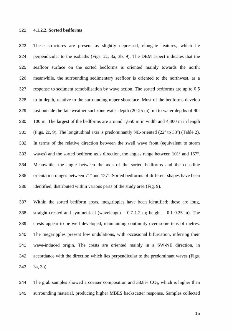
4.1.2.2. Sorted bedforms 322
These structures are present as slightly depressed, elongate features, which lie 323
perpendicular to the isobaths (Figs. 2c, 3a, 3b, 9). The DEM aspect indicates that the 324
seafloor surface on the sorted bedforms is oriented mainly towards the north; 325
meanwhile, the surrounding sedimentary seafloor is oriented to the northwest, as a 326
response to sediment remobilisation by wave action. The sorted bedforms are up to 0.5 327
m in depth, relative to the surrounding upper shoreface. Most of the bedforms develop 328
just outside the fair-weather surf zone water depth (20-25 m), up to water depths of 90-329
100 m. The largest of the bedforms are around 1,650 m in width and 4,400 m in length 330
(Figs. 2c, 9). The longitudinal axis is predominantly NE-oriented (22º to 53º) (Table 2). 331
In terms of the relative direction between the swell wave front (equivalent to storm 332
waves) and the sorted bedform axis direction, the angles range between 101º and 157º. 333
Meanwhile, the angle between the axis of the sorted bedforms and the coastline 334
orientation ranges between 71º and 127º. Sorted bedforms of different shapes have been 335
identified, distributed within various parts of the study area (Fig. 9). 336
Within the sorted bedform areas, megaripples have been identified; these are long, 337
straight-crested and symmetrical (wavelength = 0.7-1.2 m; height = 0.1-0.25 m). The 338
crests appear to be well developed, maintaining continuity over some tens of metres. 339
The megaripples present low undulations, with occasional bifurcation, inferring their 340
wave-induced origin. The crests are oriented mainly in a SW-NE direction, in 341
accordance with the direction which lies perpendicular to the predominant waves (Figs. 342
3a, 3b). 343
The grab samples showed a coarser composition and 38.8% CO3, which is higher than 344
surrounding material, producing higher MBES backscatter response. Samples collected 345
16
from the bedform areas showed a mean grain size of 1.25 Phi, 80.3% of sand, 11.7% of 346
gravel and shell debris, 7.7% of mud, and 3.2% of organic matter. Video records have 347
indicated that the boundary is sharp between the surrounding fine sand and coarse sand, 348
inside the bedform area. 349
4.1.2.3. Morphologic Wave Closure Depth 350
The water depth limit of significant wave energy levels interacting with a sand bed was 351
determined and mapped, by means of wave-induced seafloor morphology and 352
bathymetric irregularities identification and interpretation (Fig. 2c). A mean water depth 353
value was found to be 19.8±4.4 m (relative to the Alicante Mean Sea Level). Wave 354
closure depth was dependant upon coastline orientation to wave fetch and surrounding 355
rock outcrop configuration because the beaches are “pocket type”. 356
4.1.2.4. Rhythmic Surf zone Sandbars and Troughs 357
Longshore bars are identified in the bathymetric LiDAR data as crescentic bars (quarter-358
moon type patterns, with the horns of the moon facing shorewards), as a result of the 359
interaction with an alongshore rhythmic circulatory pattern. Water depths vary between 360
2 and 4 m and the bars occur from 230 to 250 m from the shoreline; they range in width 361
from 150 to 230 m. Bar crests in many of the locations follow the 4 m isobath (referred 362
to Local Datum). It has been observed that single to double longshore bars (Fig. 10), 363
together with troughs associated with the bars, originate as 1.5 m depressions. 364
365
366
367
17
4.1.3. Antropogenic structures 368
Several artificial structures have been mapped and characterised: (2) gas pipelines; an 369
aquaculture water pumping pipeline; (8) dredged material disposal areas (Figs. 4e, 4f); 370
suction dredging marks (Figs. 5a, 5b); (2) sewage outfalls (Figs. 5c, 5d); and numerous 371
shipwrecks. 372
Of the above, in terms of morphology and surface area, the dredged material disposal 373
areas are the largest anthropogenic seabed alterations. The disposal areas are easily 374
recognisable on the sedimentary seafloor, lying close to the most important harbours, in 375
terms of maritime traffic and dredging activity (e.g. Pasaia and Bilbao). In some areas, 376
the disposed material completely covers the seafloor, but the settled disposals show 377
distinctive “ring-like” structures (Fig. 4e, 4f). These features are usually around 40 m in 378
diameter and 0.5 m in height, in relation to the surrounding seafloor. The backscatter 379
indicates that such dredged material disposal areas are characterised by a very 380
heterogeneous seafloor, where very coarse-grained material is mixed with fine 381
sediments. In contrast, seismic profiles show that this disposed material is located 382
within the surficial part of the sand bank. 383
5. Discussion 384
5.1. Sectors 385
On the basis of the main geomorphological and morphosedimentary features mentioned 386
in the previous section, three sectors have been identified within the Basque continental 387
shelf (Fig. 2c), as described below. 388
(i) Over its western part, the coast has a northwestern orientation, which coincides 389
with the prevailing wave direction. Major faults and rock strata are NW–390
18
oriented, having a smooth slope (Fig. 2b). This sector is characterised by 391
predominantly rocky substrate (over 80% of the area) (Table 1), except at the 392
mouth of the Nervión estuary, where sandy sediments infill the paleo-channel 393
with thicknesses of > 20 m. 394
(ii) The middle part of the continental shelf receives relatively less wave energy than 395
the sector described previously, due to the coastal orientation towards the wave 396
energy direction. Sedimentary deposits cover 35% of the seabed surface and 397
morphosedimentary bedforms are common features over this sector (Table 1). 398
(iii) Within the eastern sector, sedimentary seafloor cover represents 54% of the 399
surface (Table 1). The rocky seafloor is characterised by tectonically-produced 400
morphologies, paleo-channel incisions and various well-developed shore 401
terraces. Rock strata lie parallel to the coastline and perpendicular to the 402
prevailing wave direction. A shallow and very rough rock belt is identifiable 403
along the coastline. 404
The seascapes described for the Basque continental shelf are the result of a combination 405
of processes, at different temporal and spatial scales. The major mechanisms controlling 406
the seascape shaping are deemed to be: (i) the present prevailing wave energy climate; 407
(ii) variations in sea-level, as a response to global eustatic changes; and (iii) local 408
subsidence and uplift of the continental margin, due to tectonic activity, related to plate 409
movements (Klingebiel and Gayet, 1995). Such neotectonic uplift movements have 410
been used to explain aspects of the evolution of the southern Bay of Biscay margin 411
during the Neogene and Pleistocene (Mary, 1983); they are responsible for the present 412
morphology of the continental shelf. Moreover, coastal rock lithologies (mainly 413
sandstone, calcareous sandstone, limestone, clay, limonites and marls and marly 414
19
limestones (EVE, 2003)), have permitted the rapid erosion of the rocky substrate during 415
sea-level change, throughout the Quaternary; consequently, the development of the 416
presently identifiable seascapes. 417
5.2. Seascapes on the Continental Shelf 418
The disposition of the sedimentary rock strata is an important factor controlling the 419
coastal and shelf configuration: (i) when the direction of the strata lies perpendicular to 420
the coastline, the formation of embayments is enhanced and a smooth slope shelf is 421
present, as described for the western zone; and (ii) when it lies parallel to the cliff front, 422
the coastline is rectilinear in shape, with well-developed abrasion platforms (Portero et 423
al., 1991) and a high gradient to seawards, as in the eastern zone. The inner shelf, up to 424
35-40 m water depth, is covered by an almost continuous belt of rocks, which 425
constitutes an extension of the rocks of the adjacent continental cliffs (Pascual et al., 426
2004). This rock belt has been identified along almost all of the continental shelf, 427
showing steep slope and high rugosity, which indicates a rapid phase of sea-level rise 428
(Fig. 11); this could correspond to the Younger Dryas period. This terrace has been 429
identified throughout almost all of the continental shelf. 430
The continental shelf is a sedimentary Neogene and Pleistocene prism, developed by 431
progradation (Boillot et al., 1984). The shelf is covered by sandy sediments; these, in 432
turn, isolate the exposed rocky areas of the seabed (Rey and Sanz, 1982). Ten major 433
sandbanks have been identified, which represent the extension of the present estuaries 434
(Fig. 2c) and have been identified as Infra-littoral Prografing Wedge (IPW). These types 435
of structures have been described for other parts of the Spanish Atlantic coast by 436
Hernández-Molina (2000). In all cases, a sedimentary deposit of high reflectance has 437
been identified at the base of the IPW, which has been characterised using sediment 438
20
core data. This deposit could correspond to a reworked transgressive gravel layer, which 439
separates this unit from Holocene marine sands. As stated by Cirac et al., (2000), since 440
ca. 4,000 years BP, sea-level has remained approximately constant and reworking has 441
affected mainly the upper 1–2 m of sediment on the inner shelf. However, as described 442
by Jouanneau et al. (2008), on the eastern part of the Basque coast, the middle and outer 443
shelves are covered by an extended shelf mud patch. This fine sedimentary unit is 444
bounded by rocky outcrops in a shoreward direction and, after Jouanneau et al. (2008), 445
the deeper and northward extent of the mud patch is indistinct, having no fixed 446
boundary. 447
On the other hand, coarse-grained sand patches have been identified, arranged in strips 448
and furrows (Fig. 2c). These features have been identified as rippled scour depressions, 449
or sorted bedforms as observed elsewhere (Cacchione et al., 1984; Thieler et al., 1995; 450
Ferrini and Flood, 2005; Diesing et al., 2006; Lo Iacono and Guillén, 2008). As 451
commented upon above, these bedforms are present as slightly depressed, elongate 452
features, consisting of gravelly and sandy gravel sediments; these form, usually, ripples 453
and dunes lying adjacent to medium to fine sand bodies (Figs. 3a-3b) (Murray and 454
Thieler, 2004; Gutierrez et al., 2005). For the Basque continental shelf, bottom stresses 455
related to wave-induced currents are probably the major component contributing to the 456
resuspension of sediment, together with the genesis of such morphosedimentary 457
structures. The principal evidence applied to this hypothesis is that they are present at 458
water depths which are deeper than the storm wave base. Previous studies undertaken 459
on the effect of tidal currents and waves upon the sediments of the French continental 460
shelf of the Bay of Biscay have confirmed that the prevailing wave climate is the 461
predominant agent affecting sediment dynamics; this is not only to areas lying adjacent 462
to the coastline but extends also to the continental shelf break (Barthe and Castaing, 463
21
1989). It has been observed that the direction of the longitudinal axis of the sorted 464
bedformswithin the coastal sectors facing the storm wave direction, lies nearly 465
perpendicular to the wave direction. Meanwhile, the coastal sectors that do not face the 466
prevailing storm wave direction show a higher angle between the wave and the sorted 467
bedform longitudinal axis directions (for details, see Table 2). Thus, it may be 468
concluded that the shape and direction of the sorted bedform is a combination of the 469
factors in which the storm wave direction and coastal orientation to the waves play a 470
major controlling role. Current measurements are required in order to analyse the role of 471
tidal currents in maintaining such features, as proposed by Diesing et al., (2006). The 472
measurement of currents during storm events and calm periods (to identify other types 473
of currents) and hydrodynamic modelling, together with an applied shear stress analysis 474
for the sediments, could explain the origin of the sorted bedforms of the Basque 475
continental shelf. On the other hand, gravel material identified in the sorted bedforms 476
could be explained as being outcropping material of a buried sediment layer lying 477
beneath the Holocene sands (as described by Browder and McNinch (2006)); this has 478
been identified in the seismic profiles from the study area. In water depths of 20–30 m 479
below present sealevel, present-day reworking appears to be limited to the upper tens of 480
centimetres of sediments, and mainly during major storms. Winnowing of Pleistocene 481
coarse-grained sediments, as well as of transgressive sand patches, provides the material 482
for this thin uppermost highstand deposit, still in equilibrium with contemporary 483
processes (Cirac et al., 2000). 484
Sorted bedforms are interesting features that connect very shallow water processes to 485
deeper water canyons; as such, they might be considered the initial part of more 486
complex structures present in deeper waters. Such features are the main pathways 487
through which shelf sediments are transported, in the form of sediment gravity flows, 488
22
into the abyssal plains; their geomorphology has been largely ignored, due mainly to 489
their complex terrain and the difficulty in studying the seafloor (Lastras et al., 2009). 490
In terms of artificial structures, dredged material disposal sites have been identified as 491
one of the most significant changes to the present seascape of the Basque continental 492
shelf, in terms of surface area. The origin of this disposed material is mainly from the 493
maintenance dredging of the harbours, during the last 100 years (Uriarte et al., 2004), 494
together with blast furnace slag disposal (Borja et al., 2008b) and material derived from 495
mining draining into the ports. Backscatter signals indicate that the deposited material is 496
composed of material coarser than the surrounding sediments. The majority of the 497
dredged material disposal sites have not been characterised, up until the present time; as 498
such, their extent and distribution have been essentially unknown. The distinctive `ring-499
like´ structures of these sediments reflect the transfer of vertical, into horizontal, 500
momentum when the disposal hits the seabed (Stockmann et al., 2009). It could be 501
inferred that the applied shear stress was insufficiently high to enhance erosional 502
processes of the coarser material. If the coarser sediments overlie the finer ones (as 503
could be seen also in the seismic profile), i.e. armouring, the lower layer deposit is no 504
longer susceptible to wave action. Even if marine sand extraction is very limited in 505
Spain, such material disposal sites reduce the availability of such sediment resources for 506
beach nourishment. Dumping areas should be monitored during future surveys, with 507
repetition sampling intervals of several years, as the observed processes occur slowly 508
(Stockmann et al., 2009). 509
510
511
23
5.3. Geomorphology as a source of information for Integrated Coastal Zone 512
Management 513
In recent years, much world-wide legislation has focused upon the protection and/or 514
restoration seas, by ensuring that human activities are carried out in a sustainable 515
manner, to provide safe, clean, healthy and productive marine waters (Borja et al., 516
2008a). As an example, in Europe, much legislation (e.g. ICZM, Habitats Directive, 517
WFD, and MSFD (European Commission, 2008) attempts to promote the sustainable 518
use of the seas and the conservation of marine ecosystems. The final objective of these 519
policies is to maintain a good environmental or ecological status for marine waters, 520
habitats and resources. The concept of environmental status takes into account the 521
structure, function and processes of marine ecosystems, bringing together physical, 522
chemical, physiographic, geographic and climatic factors; subsequently, integrating 523
such interactions, with anthropogenic impacts and activities undertaken in the area 524
concerned (Borja et al., 2008a). 525
Within this context, the mapping of geomorphological features within a regional sea is 526
highly relevant for ICZM. Hence, Borja and Collins (2009) have highlighted some 527
weaknesses in the present research undertaken within the Bay of Biscay, proposing a 528
future research agenda. Amongst the different research priorities, these authors remark 529
that although much effort has been devoted to the study of the geology and 530
sedimentology of this area, only limited knowledge is available for the continental shelf 531
and slope. Moreover, they call for a general definition and mapping of benthic and 532
pelagic habitats within the Bay of Biscay as being required for any further management 533
and spatial planning of this particular regional sea (Douvere and Ehler, 2009). 534
Hence, the information obtained from the geomorphological mapping presented in this 535
24
contribution can be (or is being) used for a variety of investigations, which converge 536
finally into an integrated management of this coastal region: (i) marine spatial planning, 537
including wave energy modelling, for renewable energy exploitation (see Galparsoro et 538
al., 2008c); (ii) essential fish habitat and economically-important species habitat 539
suitability, for fishing resources (Galparsoro et al., 2009); (iii) dredged sediment 540
disposal management; (iv) offshore aquaculture; (v) Marine Protected Areas and 541
biodiversity conservation (Castro et al., 2004); (vi) habitat mapping (Chust et al., 2007; 542
2008); (vii) ecosystem goods and services valuation; (viii) biological quality index 543
development, for large spatial scale application (Borja and Dauer, 2008); (ix) land-sea 544
exchange modelisation (Ferrer et al., 2009; Fontán et al., 2009); (x) the integration of 545
such information for environmental status assessment (Borja et al., 2009); and (xi) 546
human activity sensitivity maps. 547
Moreover, the three physiographic units identified here are coincident with the three 548
main water bodies identified in the Basque Country for ecological status assessment 549
within the WFD (Borja et al., 2004; 2006). Differences in grain size, between the units, 550
show slight differences in the depositional pattern, due probably to differences in wave 551
energy; this leads ultimately to differential transport within each of the units (Ferrer et 552
al., 2009). 553
Hence, Maritime Spatial Planning (MSP), which incorporates all the concepts and 554
investigations commented upon above, is an important tool for the development of an 555
integrated maritime policy in Europe (European Commission, 2008). Some of the key 556
principles of this MSP require strong basic scientific knowledge, applicable to the 557
different European directives, which are being or are to be implemented in the near 558
future. It is within this context that information on the geomorphology is a first-step in 559
25
an improved knowledge of habitats, uses, goods and services, and the ecosystem-based 560
management of marine waters (Borja et al., 2008a; Douvere and Ehler, 2009). 561
562
6. Conclusions 563
In this investigation, the latest high-resolution remote sensing and sediment sampling 564
techniques have been used and integrated for the Basque coastal, inner and middle 565
continental shelf mapping and seafloor characterisation. It has been observed that the 566
Basque continental shelf is characterised by a heterogeneous seafloor where, over a 567
relatively small spatial scale, diverse seascapes are present and have originated from the 568
interaction of different processes. It may be concluded that tectonic activity, basement 569
topography and sea-level changes, together with processes of sediment supply and 570
prevailing climatic conditions, have a critical influence on the configuration of the 571
continental shelf seascapes and the distribution of seafloor material. Tectonic activity 572
and erosional processes formed the present rock seafloor and shape, where more than 40 573
paleo-river channels and 9 shore terraces have been identified. In terms of depositional 574
features, IPW and sorted beforms are common features of the continental shelf. In terms 575
of anthropogenic structures, sediment disposal is the main seafloor alteration in the 576
study area. Here is the first detailed characterisation of the seascapes and morphologies 577
of the Basque inner and middle continental shelf, together with an initial description of 578
marine processes interacting upon the seafloor. The background scientific knowledge 579
produced in this investigation, together with the cartographic information generated, is 580
being used for the implementation of several European Directives; these are, ultimately, 581
needed for an effective ICZM and MSP. 582
583
26
Acknowledgments 584
This project was supported by the Department of Environment, Land Use, Agriculture 585
and Fisheries, of the Basque Government. The authors would like to thank: the Bilbao 586
and Pasaia Port Authorities, for the geophysical studies; PhD, Javier Hernández-Molina 587
(University of Vigo), for his useful comments to the manuscript; and Mikelo Elorza 588
(Diputación Foral de Gipuzkoa) and Blom Aerofilms for the technical support in 589
analysis of the topographic LiDAR and bathymetric LiDAR data. 590
Irati Legorburu was funded by the Fundación Centros Tecnológicos, with a Training, 591
Specialization and Technological Development grant. We wish to thank: Professor 592
Michael Collins (School of Ocean and Earth Science, University of Southampton (UK) 593
and AZTI-Tecnalia (Spain)) for kindly advising on some details of the manuscript; 594
likewise colleagues of AZTI-Tecnalia, especially Jon Berregi and Luis Cuesta, who 595
collaborated in the acquisition and processing of the MBES data. This paper is 596
contribution number 477 from AZTI-Tecnalia (Marine Research Division). 597
598
References 599
600
Amblas, D., Canals M., Urgeles R., Lastras G., Liquete C., Hughes-Clarke J. E., 601
Casamor J. L., Calafat A. M., 2006. Morphogenetic mesoscale analysis of the 602
northeastern Iberian margin, NW Mediterranean Basin. Marine Geology, 234, 3-20. 603
Baptist, M. J., van Dalfsen J., Weber A., Passchier S., van Heteren S., 2006. The 604
distribution of macrozoobenthos in the southern North Sea in relation to meso-scale 605
bedforms. Estuarine, Coastal and Shelf Science, 68, 538-546. 606
Barthe, X., Castaing P., 1989. Étude théorique de l‟action des courants de marée et des 607
houles sur les sédiments du plateau continental du Golfe de Gascogne. 608
Oceanologica Acta, 12, 325-334 (in French). 609
Boillot, G., Montadert L., Lemoine M., Biju-Duval B. (Eds.), 1984. Les marges 610
continentales actuelles et fossiles autour de la France. Paris. 342 pp. (in French). 611
27
Borja, Á., Franco J., Valencia V., Bald J., Muxika I., Belzunce M. J., Solaun O., 2004. 612
Implementation of the European water framework directive from the Basque 613
country (northern Spain): a methodological approach. Marine Pollution Bulletin, 48, 614
209-218. 615
Borja, Á. 2005. The European water framework directive: A challenge for nearshore, 616
coastal and continental shelf research. Continental Shelf Research, 25, 1768-1783. 617
Borja, Á. 2006. The new European Marine Strategy Directive: Difficulties, 618
opportunities, and challenges. Marine Pollution Bulletin, 52, 239-242. 619
Borja, Á., Galparsoro I., Solaun O., Muxika I., Tello E. M., Uriarte A., Valencia V., 620
2006. The European Water Framework Directive and the DPSIR, a methodological 621
approach to assess the risk of failing to achieve good ecological status. Estuarine, 622
Coastal and Shelf Science, 66, 84-96. 623
Borja, Á., Galparsoro I., Sagarmínaga Y., 2007. Observatorio de la Biodiversidad del 624
Medio Marino de la Costa Vasca: bienes y servicios proporcionados por la 625
biodiversidad marina. Informe inédito de la Fundación AZTI-Tecnalia para la 626
Dirección de Biodiversidad del Departamento de Medio Ambiente y Ordenación del 627
Territorio del Gobierno Vasco. 61 pp. (in Spanish). 628
Borja, Á., Dauer D. M., 2008. Assessing the environmental quality status in estuarine 629
and coastal systems: Comparing methodologies and indices. Ecological Indicators, 630
8, 331-337. 631
Borja, Á., Bricker S. B., Dauer D. M., Demetriades N. T., Ferreira J. G., Forbes A. T., 632
Hutchings P., Jia X., Kenchington R., Marques J. C., Zhu C., 2008a. Overview of 633
integrative tools and methods in assessing ecological integrity in estuarine and 634
coastal systems worldwide. Marine Pollution Bulletin, 56, 1519-1537. 635
Borja, Á., Tueros I., Belzunce M. J., Galparsoro I., Garmendia J. M., Revilla M., Solaun 636
O., Valencia V., 2008b. Investigative monitoring within the European Water 637
Framework Directive: a coastal blast furnace slag disposal, as an example. Journal 638
of Environmental Monitoring, 10, 453-462. 639
Borja, Á., Collins M., 2009. Regional Seas integrative studies, as a basis for an 640
ecosystem-based approach to management: The case of the Bay of Biscay. 641
Continental Shelf Research, 29, 951-956. 642
Borja, Á., Bald J., Franco J., Larreta J., Muxika I., Revilla M., Rodríguez J. G., Solaun 643
O., Uriarte A., Valencia V., 2009. Using multiple ecosystem components, in 644
assessing ecological status in Spanish (Basque Country) Atlantic marine waters. 645
Marine Pollution Bulletin, 59, 54-64. 646
Boya de Bilbao-Vizcaya, Longitud -3.052E; Latitud 43.640N; Profundidad 600 m. 647
Banco de Datos Oceanográficos de Puertos del Estado (www.puertos.es). Ministerio 648
de Fomento del Gobierno de España (in Spanish). 649
Browder, A. G., McNinch J. E., 2006. Linking framework geology and nearshore 650
morphology: Correlation of paleo-channels with shore-oblique sandbars and gravel 651
outcrops. Marine Geology, 231, 141-162. 652
Brown, C. J., P. Blondel, 2009. Developments in the application of multibeam sonar 653
backscatter for seafloor habitat mapping. Applied Acoustics, 70, 1242-1247. 654
28
Cacchione, D. A., Drake D. E., Grant W. D., Tate G. B., 1984. Rippled scour 655
depressions on the inner continental shelf of central California. Journal of 656
Sedimentary Petrology, 54, 1280-1291. 657
Campbell, M. L., Hewitt C. L., 2006. A hierarchical framework to aid biodiversity 658
assessment for coastal zone management and marine protected area selection. Ocean 659
& Coastal Management, 49, 133-146. 660
Castro, R., Uriarte, A. Martínez de Murguía A., Borja Á., 2004. Biodiversity and 661
conservation of wildlife and natural habitats. Elsevier Oceanography Series. 662
Oceanography and Marine Environment of the Basque Country. Á. Borja and M. 663
Collins (Eds.). Elsevier. 70, pp. 531-547. 664
Chust, G., Galparsoro I., Borja Á., Franco J., Beltrán B., Uriarte A., 2007. Detección de 665
cambios recientes en la costa vasca mediante ortofotografía. Lurralde, 30, 59-72 (in 666
Spanish). 667
Chust, G., Galparsoro I., Borja Á., Franco J., Uriarte A., 2008. Coastal and estuarine 668
habitat mapping, using LIDAR height and intensity and multi-spectral imagery. 669
Estuarine, Coastal and Shelf Science, 78, 633-643. 670
Cirac, P., Berne S., Castaing P., Weber O., 2000. Processus de mise en place et 671
d'évolution de la couverture sédimentaire superficielle de la plate-forme nord-672
aquitaine. Oceanologica Acta, 23, 663-686 (in French). 673
Collier, J. S., Brown C. J., 2005. Correlation of sidescan backscatter with grain size 674
distribution of surficial seabed sediments. Marine Geology, 214, 431-449. 675
Cooper, K., Boyd S., Eggleton J., Limpenny D., Rees H., Vanstaen K., 2007. Recovery 676
of the seabed following marine aggregate dredging on the Hastings Shingle Bank 677
off the southeast coast of England. Estuarine, Coastal and Shelf Science, 75, 547-678
558. 679
Costa, B. M., Battista T. A., Pittman S. J., 2009. Comparative evaluation of airborne 680
LiDAR and ship-based multibeam SoNAR bathymetry and intensity for mapping 681
coral reef ecosystems. Remote Sensing of Environment, 113, 1082-1100. 682
Diesing, M., Kubicki A., Winter C., Schwarzer K., 2006. Decadal scale stability of 683
sorted bedforms, German Bight, southeastern North Sea. Continental Shelf 684
Research, 26, 902-916. 685
Douvere, F., Ehler C. N., 2009. New perspectives on sea use management: Initial 686
findings from European experience with marine spatial planning. Journal of 687
Environmental Management, 90, 77-88. 688
Ercilla, G., Casas D., Estrada F., Vazquez J. T., Iglesias J., Garcia M., Gomez M., 689
Acosta J., Gallart J., Maestro-González A., 2008. Morphosedimentary features and 690
recent depositional architectural model of the Cantabrian continental margin. Marine 691
Geology, 247, 61-83. 692
European Commission, 2008. Communication from the Commission: Roadmap for 693
Maritime Spatial Planning: Achieving Common Principles in the EU. Commission 694
of the European Communities. Brussels. 12 pp. 695
EVE, 2003. Mapa geológico del País Vasco. Mapa, memoria y bases de datos. Escala 696
1/25.000. Ente Vasco de la Energía. ISBN: 84-8129-054-8 (in Spanish). 697
29
Ferrer, L., Fontán A., Mader J., Chust G., González M., Valencia V., Uriarte Ad., 698
Collins M. B., 2009. Low-salinity plumes in the oceanic region of the Basque 699
Country. Continental Shelf Research, 29, 970-984. 700
Ferrini, V. L., Flood R. D., 2005. A comparison of Rippled Scour Depressions 701
identified with multibeam sonar: Evidence of sediment transport in inner shelf 702
environments. Continental Shelf Research, 25, 1979-1995. 703
Feuillée, P., Rat P., 1971. Structures et paléogéographies Pyrénéo-Cantabriques. 704
Historie Structurale du Golfe de Gascogne. Publications de l‟Institut Français du 705
pétrole, Paris, pp. 1-48 (in French). 706
Finkl, C. W., Becerra J. E., Achatz V., Andrews J. L., 2008. Geomorphological 707
Mapping along the Upper Southeast Florida Atlantic Continental Platform; I: 708
Mapping Units, Symbolization and Geographic Information System Presentation of 709
Interpreted Seafloor Topography. Journal of Coastal Research, 24, 1388-1417. 710
Finkl, C. W., Andrews J. L., 2009. Shelf Geomorphology along the Southeast Florida 711
Atlantic Continental Platform: Interpretation of Airborne Laser Bathymetry. Journal 712
of Coastal Research, 2, 1494-1498. 713
Fonseca, L., Brown C., Calder B., Mayer L., Rzhanov Y., 2009. Angular range analysis 714
of acoustic themes from Stanton Banks Ireland: A link between visual interpretation 715
and multibeam echosounder angular signatures. Applied Acoustics, 70, 1298-1304. 716
Fontán, A., 2008. Physical processes governing water circulation in the southeastern 717
limit of the Bay of Biscay. University of Southampton, MPhil thesis in Physical 718
Oceanography, 136 pp. 719
Fontán, A., González M., Wells N., Collins M., Mader J., Ferrer L., Esnaola G., Uriarte 720
A., 2009. Tidal and wind-induced circulation within the Southeastern limit of the 721
Bay of Biscay: Pasaia Bay, Basque Coast. Continental Shelf Research, 29, 998-722
1007. 723
Galparsoro, I., 2005. Elaboración de una cartografía sedimentológica detallada y de 724
mapas de biotopos marinos del litoral vasco. Informe inédito de AZTI-Tecnalia para 725
la Viceconsejería de Desarrollo Agrario y Pesquero, Departamento de Agricultura, 726
Pesca y Alimentación, Gobierno Vasco. 28 pp (in Spanish). 727
Galparsoro, I., Hernández C., Rodríguez J. G., Liria P., Fontán A., González M., Uriarte 728
A., 2007. Trabajos de caracterización y medición de la arena existente en la 729
plataforma marina costera junto al monte Jaizkibel al este de la bocana de acceso al 730
puerto de Pasajes. Informe inédito elaborado por AZTI-Tecnalia para la Autoridad 731
Portuaria de Pasajes. 89 pp. + anexos. (in Spanish). 732
Galparsoro, I., Chust G., Hernández C., Borja Á., del Campo A., Uriarte A., 2008a. 733
Seafloor cartography and habitat mapping of the Basque inner continental shelf. XI 734
International Symposium on Oceanography of the Bay of Biscay. Unidad de 735
Investigación Marina de Tecnalia, Pasaia, pp. 102-103. 736
Galparsoro, I., Hernández C., Uriarte A., 2008b. Campaña de prospección geofísica en 737
la Zona II de la Autoridad Portuaria de Bilbao. Informe inédito elaborado por AZTI-738
Tecnalia para la Autoridad Portuaria de Bilbao. AZTI-Tecnalia. 33 pp (in Spanish). 739
Galparsoro, I., Liria P., Legorburu I., Ruiz-Minguela P., Pérez P., Marqués J., Torre-740
Enciso Y., González M., 2008c. Atlas de energía del oleaje. La planificación 741
30
espacial marina como herramienta en la selección de adecuadas para la instalación 742
de captadores. Revista de Investigación Marina, 8, 1-9 (in Spanish). 743
Galparsoro, I., Borja Á., Bald J., Liria P., Chust G., 2009. Predicting suitable habitat for 744
the European lobster (Homarus gammarus), on the Basque continental shelf (Bay of 745
Biscay), using Ecological-Niche Factor Analysis. Ecological Modelling, 220, 556-746
567. 747
González, M., Uriarte A., Fontán A., Mader J., Gyssels P., 2004. Chapter 6 Marine 748
Dynamics. Elsevier Oceanography Series. Oceanography and Marine Environment 749
of the Basque Country. Á. Borja and M. Collins (Eds.). Elsevier, pp. 133-157. 750
Gutierrez, B. T., Voulgaris G., Thieler E. R., 2005. Exploring the persistence of sorted 751
bedforms on the inner-shelf of Wrightsville Beach, North Carolina. Continental 752
Shelf Research, 25, 65-90. 753
Harris, P. T., Heap A. D., Whiteway T., Post A., 2008. Application of biophysical 754
information to support Australia's representative marine protected area program. 755
Ocean & Coastal Management, 51, 701-711. 756
Hernández-Molina, F. J., Fernandez-Salas L. M., Lobo F., Somoza L., Diaz-del-Rio V., 757
Dias J. M. A., 2000. The infralittoral prograding wedge: a new large-scale 758
progradational sedimentary body in shallow marine environments. Geo-Marine 759
Letters, 20, 109-117. 760
Hernández-Molina, F. J., Llave E., Ercilla G., Maestro A., Medialdea T., Ferrin A., 761
Somoza L., Gràcia E., Masson D. G., García M., Vizcaino A., León R., 2008. 762
Recent sedimentary processes in the Prestige site area (Galicia Bank, NW Iberian 763
Margin) evidenced by high-resolution marine geophysical methods. Marine 764
Geology, 249, 21-45. 765
Hovland, M., 2003. Geomorphological, geophysical, and geochemical evidence of fluid 766
flow through the seabed. Geofluids IV Meeting. Journal of Geochemical 767
Exploration., pp. 287-291. 768
Hughes Clarke, J. E., Mayer L. A., Wells D. E., 1996. Shallow-water imaging 769
multibeam sonars: A new tool for investigating seafloor processes in the coastal 770
zone and on the continental shelf. Marine Geophysical Researches, 18, 607-629. 771
Iberinsa, 1990. Estudio geofísico marino entre la frontera Francesa y Ondárroa. 772
Realizado para el Ministerio de Obras Públicas y Urbanismo (in Spanish). 773
Iberinsa, 1994. Estudio geofísico de la costa de Bizkaia. Realizado para el Ministerio de 774
Obras Públicas, Transporte y Medio Ambiente. Dirección General de Costas (in 775
Spanish). 776
IGME, 2005. Instituto Geológico y Minero de España. Área de Cartografía. Mapa 777
Geomorfológico de España y del margen continental. 1:1.000.000. 84-7840-591-7 778
(in Spanish). 779
Irish, J. L., Lillycrop W. J., 1999. Scanning laser mapping of the coastal zone: The 780
SHOALS system. ISPRS Journal of Photogrammetry and Remote Sensing, 54, 123-781
129. 782
Jouanneau, J.-M., Weber O., Champilou N., Cirac P., Muxika I., Borja Á., Pascual A., 783
Rodríguez-Lázaro J., Donard O., 2008. Recent sedimentary study of the shelf of the 784
Basque country. Journal of Marine Systems, 72, 397-406. 785
31
Klingebiel, A., Gayet J., 1995. Fluvio-lagoonal sedimentary sequences in Leyre delta 786
and Arcachon bay, and Holocene sea level variations, along the Aquitaine coast 787
(France). Quaternary International, 29, 111-117. 788
Kostylev, V. E., Todd B. J., Fader G. B. J., Courtney R. C., Cameron G. D. M., Pickrill 789
R. A., 2001. Benthic habitat mapping on the Scotian Shelf based on multibeam 790
bathymetry, surficial geology and sea floor photographs. Marine Ecology Progress 791
Series, 219, 121-137. 792
Kostylev, V. E., Courtney R. C., Robert G., Todd B. J., 2003. Stock evaluation of giant 793
scallop (Placopecten magellanicus) using high-resolution acoustics for seabed 794
mapping. Fisheries Research, 60, 479-492. 795
Lastras, G., Arzola R. G., Masson D. G., Wynn R. B., Huvenne V. A. I., Hühnerbach 796
V., Canals M., 2009. Geomorphology and sedimentary features in the Central 797
Portuguese submarine canyons, Western Iberian margin. Geomorphology, 103, 310-798
329. 799
Liquete, C., Canals M., Lastras G., Amblas D., Urgeles R., De Mol B., De Batist M., 800
Hughes-Clarke J. E., 2007. Long-term development and current status of the 801
Barcelona continental shelf: A source-to-sink approach. Continental Shelf Research, 802
27, 1779-1800. 803
Liria, P., Garel E., Uriarte A., 2009. The effects of dredging operations on the 804
hydrodynamics of an ebb tidal delta: Oka Estuary, northern Spain. Continental Shelf 805
Research, 29, 1983-1994. 806
Llave, E., García M., Pérez C., Sayago M., Farrán M., Ercilla G., Somoza L., León R., 807
Maestro A., Medialdea T., Hernández-Molina F. J., Álvarez R., Durán R., Mohamed 808
K., 2008. Morphological feature analyses of the Prestige half-graben on the SW 809
Galicia Bank. Marine Geology, 249, 7-20. 810
Lo Iacono, C., Guillén J., 2008. Environmental conditions for gravelly and pebbly 811
dunes and sorted bedforms on a moderate-energy inner shelf (Marettimo Island, 812
Italy, western Mediterranean). Continental Shelf Research, 28, 245-256. 813
Lobo, F. J., Fernandez-Salas L. M., Moreno I., Sanz J. L., Maldonado A., 2006. The 814
sea-floor morphology of a Mediterranean shelf fed by small rivers, northern Alboran 815
Sea margin. Continental Shelf Research, 26, 2607-2628. 816
Lucieer, V., Pederson H., 2008. Linking morphometric characterisation of rocky reef 817
with fine scale lobster movement. ISPRS Journal of Photogrammetry and Remote 818
Sensing. Theme Issue: Remote Sensing of the Coastal Ecosystems, 63, 496-509. 819
Marsh, I., Brown C., 2009. Neural network classification of multibeam backscatter and 820
bathymetry data from Stanton Bank (Area IV). Applied Acoustics. The Application 821
of Underwater Acoustics for Seabed Habitat Mapping, 70, 1269-1276. 822
Mary, G., 1983. Evolución del margen costero de la Cordillera Cantábrica en Asturias 823
desde el Mioceno. Trabajos de Geología, 13, 3-35 (in Spanish). 824
Medialdea, T., Somoza L., León R.,. Farrán M, Ercilla G., Maestro A., Casas D., Llave 825
E., Hernández-Molina F. J., Fernández-Puga M. C., Alonso B., 2008. Multibeam 826
backscatter as a tool for sea-floor characterization and identification of oil spills in 827
the Galicia Bank. Marine Geology., 249, 93-107. 828
32
Muñoz, A., Ballesteros M., Montoya I., Rivera J., Acosta J., Uchupi E., 2008. Alborán 829
Basin, southern Spain--Part I: Geomorphology. Marine and Petroleum Geology, 25, 830
59-73. 831
Murray, A. B., Thieler E. R., 2004. A new hypothesis and exploratory model for the 832
formation of large-scale inner-shelf sediment sorting and "rippled scour 833
depressions". Continental Shelf Research, 24, 295-315. 834
Orpin, A. R., Kostylev V. E., 2006. Towards a statistically valid method of textural sea 835
floor characterization of benthic habitats. Marine Geology, 225, 209-222. 836
Pascual, A., Cearreta A., Rodríguez-Lázaro J., Uriarte A., 2004. Geology and 837
Palaeoceanography. Elsevier Oceanography Series. Oceanography and Marine 838
Environment of the Basque Country. Á. Borja and M. Collins (Eds.). Elsevier, pp. 839
53-73. 840
Pickrill, R. A., Todd B. J., 2003. The multiple roles of acoustic mapping in integrated 841
ocean management, Canadian Atlantic continental margin. Ocean & Coastal 842
Management, 46, 601-614. 843
Pittman, S. J., Christensen J. D., Caldow C., Menza C., Monaco M. E., 2007. Predictive 844
mapping of fish species richness across shallow-water seascapes in the Caribbean. 845
Ecological Modelling, 204, 9-21. 846
Portero, G., Salazar A., Pascual M. H., Ortega I., Olivé A., 1991. Puntos de interés 847
geológico de Gipuzkoa. Diputación Foral de Gipuzkoa, San Sebastián, 167 pp. 848
REDMAR, 2005. Resumen de parámetros relacionados con el nivel del mar y la marea 849
que afectan a las condiciones de diseño y explotación portuaria. Puertos del Estado. 850
http://www.puertos.es. 19 pp. (in Spanish). 851
RESON, 2002. SeaBat 8125 Operator´s manual. Version 3.01, pp. 134. 852
RESON, 2006. SeaBat 7125 Operator´s manual. Version 3.0, pp. 89. 853
Rey, J. J., Sanz J. L., 1982. Estudio geológico submarino del litoral cantábrico con 854
sónar de barrido lateral (desde San Vicente de la Barquera a Punta San Emeterio). 855
Boletín del Instituto Español de Oceanografía, VII (I), 88-96 (in Spanish). 856
Rodríguez, J. G., Uriarte A., 2009. Laser Diffraction and Dry-Sieving Grain Size 857
Analyses Undertaken on Fine- and Medium-Grained Sandy Marine Sediments: A 858
Note. Journal of Coastal Research, 25, 257–264. 859
Ryan, D. A., Brooke B. P., Collins L. B., Kendrick G. A., Baxter K. J., Bickers A. N., 860
Siwabessy P. J. W., Pattiaratchi C. B., 2007. The influence of geomorphology and 861
sedimentary processes on shallow-water benthic habitat distribution: Esperance Bay, 862
Western Australia. Estuarine, Coastal and Shelf Science, 72, 379-386. 863
Sagarminaga, Y., Galparsoro I., Borja Á., Beltrán B., Rivas R., 2007. ItsasGIS, the SDI 864
in AZTI-Tecnalia: Evolution, Achievements and New Challenges. CoastGis´07. 865
COASTGIS07, Santander (Spain), pp. 85-91. 866
Stockmann, K., Riethmüller R., Heineke M., Gayer G., 2009. On the morphological 867
long-term development of dumped material in a low-energetic environment close to 868
the German Baltic coast. Journal of Marine Systems. Dynamics of Natural and 869
Anthropogenic Sedimentation, 75, 409-420. 870
33
Thieler, E. R., Brill A. L., Cleary W. J., Hobbs C. H., Gammisch R. A., 1995. Geology 871
of the Wrightsville Beach, North Carolina shoreface: Implications for the concept of 872
shoreface profile of equilibrium. Marine Geology, 126, 271-287. 873
Thrush, S., Dayton P., Cattaneo-Vietti R., Chiantore M., Cummings V., Andrew N., 874
Hawes I., Kim S., Kvitek R., Schwarz A. M., 2006. Broad-scale factors influencing 875
the biodiversity of coastal benthic communities of the Ross Sea. Deep Sea Research 876
Part II: Topical Studies in Oceanography. Ecology of the Antarctic Sea Ice Zone, 877
53, 959-971. 878
Uriarte, A., 1998. Sediment Dynamics on the Inner Continental Shelf of the Basque 879
Country (N. Spain). PhD. Thesis. University of Southampton. 302 pp. 880
Uriarte, A., Collins M., Cearreta A., Bald J., Evans G., 2004. Sediment supply, transport 881
and deposition: contemporary and Late Quaternary evolution. Elsevier 882
Oceanography Series. Oceanography and Marine Environment of the Basque 883
Country. Á. Borja and M. Collins (Eds.). Elsevier, pp. 97-131. 884
Valencia, V., Franco J., Borja Á., Fontán A., 2004. Hydrography of the southeastern 885
Bay of Biscay. Oceanography and Marine Environment of the Basque Country. Á. 886
B. a. M. Collins (Eds.). Elsevier, pp. 159-194. 887
Vázquez, J. T., Medialdea T., Ercilla G., Somoza L., Estrada F.,. Fernández Puga M. C, 888
Gallart J., Gràcia E., Maestro A., Sayago M., 2008. Cenozoic deformational 889
structures on the Galicia Bank Region (NW Iberian continental margin). Marine 890
Geology, 249, 128-149. 891
Wilson, M. F. J., O´Connell B., Brown C., Guinan J. C., Grehan A., 2007. Multiscale 892
Terrain Analysis of Multibeam Bathymetry Data for Habitat Mapping on the 893
Continental Slope. Marine Geodesy, 30, 3-35. 894
Zajac, R. N., 2008. Macrobenthic biodiversity and sea floor landscape structure. Journal 895
of Experimental Marine Biology and Ecology. Marine ecology: A tribute to the life 896
and work of John S. Gray, 366, 198-203. 897
898
899
34
Figure captions 900
Figure 1. Study area location, within the Bay of Biscay. Available geological and 901
geomorphological information in the terrestrial area (modified from (EVE, 2003; 902
Pascual et al., 2004)); the black dots represent the positions of the collected grab 903
samples. 904
Figure 2. (a) Bathymetry; (b) bathymetric gradient and (c) seafloor type distribution and 905
geomorphological map. 906
Figure 3. Seafloor signatures for each seafloor type, identified by integrating different 907
remote sensing techniques: (a) sedimentary seafloor with 1 m resolution shaded 908
relief model, in which sorted bedforms could be identified by the depression 909
they produce; (b) acoustic response of that features; (c) 0.2 m resolution shaded 910
relief, where mixed medium and coarse sand with megaripples at 60 m depth are 911
identifiable; (d) backscatter signal of the same area; (e) 0.2 m resolution shaded 912
relief model, with mixed coarse sand and rocky seafloor at 33 m water depth; 913
and (f) backscatter signal of the same area. 914
Figure 4. (a) Very shallow water depth mixed sandy and rocky seafloor, where 1 m 915
resolution shaded relief is overlapping aerial photography (seafloor feature 916
continuity can be identified); (b) flat rocky seafloor at 1 m resolution shaded 917
relief; (c) integrated topographic LiDAR, bathymetric LiDAR and MBES, on a 918
rocky seafloor (left picture: high rugosity seafloor and soft or low rugosity rocky 919
seafloor); (d) cliff erosion rock blocks, over rock substrate; (e) 1 m resolution 920
shaded relief, on sediment disposal area; (f) backscatter mosaic of the same area 921
(dumped material shows higher backscatter signal). 922
Figure 5. (a) 1 m resolution shaded relief, with suction dredging marks, in Bilbao 923
Harbour; (b) backscatter signal of the same area; (c) submarine outfall. 0.25 m 924
resolution shaded relief; some elements of the infrastructure could be identified: 925
(1 to 8) diffusers, (9) submarine outfall, (10) hard substrate covering and 926
protecting the outfall and (11) fine sand; (d) backscatter signal on the same area. 927
Figure 6. (a) water depth frequency histogram for the total digital elevation model; 928
arrows indicate high slope areas, which are representative of the shore borders 929
location. (b) Depth profile location over rocky seafloor. (c) Extracted depth 930
profile, where various shore borders are identifiable at different water depths. 931
Figure 7. Folk diagram, including all the collected grab samples. 932
Figure 8. Seismic profile record, perpendicular to the longitudinal axis of a sorted 933
bedform. 934
Figure 9. Sorted bedforms: (a) shaded relieve, bathymetry and superficial grab sample 935
positions; (b) bathymetric gradient; (c) seafloor aspect; (d) non-calibrated 936
backscatter mosaic. In the lower part of the Fig. (8) grab sample photographs are 937
presented, which correspond to the locations represented in the upper parts of the 938
Figure. 939
Figure 10. Surf zone sandbars and troughs, observed from 2 m horizontal resolution 940
shaded relief, derived from bathymetric LiDAR DEM. 941
35
Figure 11. Shaded relief of integrated terrestrial LiDAR, bathymetric LiDAR and 942
MBES digital elevation models, at 1 m grid resolution. Continuous lines 943
represent paleo-channel incisions, which are aligned with onshore drainages. 944
Dashed lines represent shore borders corresponding to different sea-level stand-945
still. 946
947
Dear Editor, Please, find below our response to the reviewers’ comments. In order to facilitate your editing work, we have included the lines of the manuscript in which changes have been included. We consider that all of the comments improve the text and we have accepted them. Only in the case of Section 5.3, we discuss the comments of Reviewer 2 (see below). Regards. Ms. Ref. No.: GEOMOR-1653 Title: Morphological characteristics of the Basque shelf (Bay of Biscay, northern Spain); and their implications for Integrated Coastal Zone Management Authors: Ibon Galparsoro*, Ángel Borja, Irati Legorburu, Carlos Hernández, Guillem Chust, Pedro Liria and Adolfo Uriarte Reviewer #1: The work would be improved if you make a small effort for a better characterization of waves and tides and revise the quality of the figures for a grayscale reproduction (see comments on the text and figures). Comments and minor changes suggested by Reviewer #1 in the attached pdf file have been undertaken. Major changes: As suggested by this Reviewer, the wave climate text has been extended (see lines 122-139). A wind rose diagram has been included as supplementary information. On the other hand, we do not think that it is necessary to increase the Section on tidal characterisation; as explained in the text, this is not a critical factor affecting processes on the continental shelf seafloor. Finally, two new references have been included in the text in relation to the mean geomorphological and hydrological characteristics of the Basque estuarine water bodies: Valencia et al. (2004) and Borja et al. (2006) (lines 150-152).
Reviewer #2: Figure 1 - Add European continent Done Line 205, item 3.4 the authors must say how they analyzed the sediment samples. And the methods that they used (Folk and Ward? Shepard?...) Done. A new paragraph has been included within the text and a new reference has been included (now in lines 221-225). Line 258 change above per previous section (it is necessary to check in others parts of paper as well) Done (now in line 275)
*Response to Reviewers
Line 484, item 5.3 must be rewrite (must be shortly) or must be deleted from the paper. The authors presented a very good review about the European legislations or directives , but it is not clear how the results of paper could be incorporated in the ICZM. The author must be direct to the point, because it is clear for all researches and different stakeholder that is important to obtain information about the seascape. This item is repetitive with the introduction as well. We disagree with these particular comments, but are in agreement with comments of Reviewers 3 and 1 (see: “These kind of interdisciplinary studies are becoming of interest to the correct management of coastal areas, according with recent European directives. The knowledge of the physical processes, and the bottom characteristics (rocky or sedimentary, sandy or muddy) and features constitutes the basis to understand the functioning of the supported habitats. In my opinion, State of art and Discussion chapters are very good”). In fact, the title of the paper is: “Morphological characteristics of the Basque shelf (Bay of Biscay, northern Spain); and their implications for Integrated Coastal Zone Management”, because importance is attached to the use of this kind of data for integrated management. Presently, very few studies focus upon this topic; there exists increasing need of applying this information to management (see Discussion). We consider that there is not repetition: in the Introduction we describe the present situation on a global scale (as highlighted by the reviewers) but, in the discussion, we focus on a regional scale (Bay of Biscay); this shows how all the information is being put together with the final objective of the ICZM and MSFD implementation. Hence, we consider that Marine Spatial Planning, within this context, is important and requires some extended explanation. Reviewer #3: a) Figures 2a,b,c are not clear, difficult to read the figure legends, (Needs clarity / modification) We think that this is because the Figures that were sent to the Reviewers have lower resolution than the original ones. The automatic quality control required by the manuscript submission was passed. b) Where are the paleaochannels in Fig 2b, Please show. Done. A new map has been edited and the paleo-river channel axis incorporated c) P.7, line 158 what are bad soundings not clear, is it false/pseudo images or simply noise? The term "bad soundings" used in the text corresponds to the depth values provided by the multibeam that are artefacts, produced by different reasons:e.g. noise, fish schools, underwater objects, bubbles, etc. The sentence used in the manuscript: "Bad soundings were filtered and tide correction was applied", has been changed to: "Incorrect depth values were filtered and tidal correction was applied" (now in line 173) d) P.9 line 185, how accurate are these shallow water bathymetric systems. Please provide latest reference. Two sentences have been included for each bathymetric systems: For the multibeam system: "The operational frequency of the system was 400 kHz, producing 256 beams, in a 128º angle swath with a system depth resolution of 6 mm." (now in lines 169-171)
For the bathymetric LiDAR, we think that the sentence already written is sufficient: "Vertical accuracy (i.e. RMSE), compared to known points from the existing survey, was of the order of ±0.25 m." (lines 204-206) e) The infra-littoral prograding wedge (p.14 and Fig 8) not clear. You may care to refer Hernandez Molina's (GML, 2000) work on this aspect Within the text, its morphology has been described according to seismic profile records and multibeam bathymetry. We consider that the feature morphology coincides with the IPW described in the cited Hernandez Molina´s paper. The reference has been included as an explanation of such type of morphology, process and location, at other locations on the Spanish continental shelf. (line 423). f) P.16, Line 344, it is "anthropogenic" rather than human induced, use accepted terms Done g) P.18, line 410, Are the sand banks the IPW?, then check e) The IPW is a morphological feature which has been identified in the major sand banks (line 423). i) P.18, line 395, what is meant by rock strata? Is it a sedimentary strata? Original text: "The disposition of the rock strata is an important factor controlling the coastal and shelf configuration". Corrected text: "The disposition of the sedimentary rock strata is an important factor controlling the coastal and shelf configuration". (line 406) j) P.18, line 407, delete "to seawards" and start word with "The continental shelf appears as a sedimentary Neogene and Pleistocene prism, developed by..(Reference....)". Done (line 418)
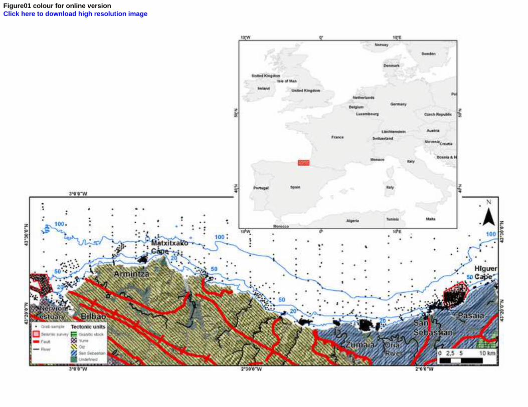
Figure01 colour for online versionClick here to download high resolution image
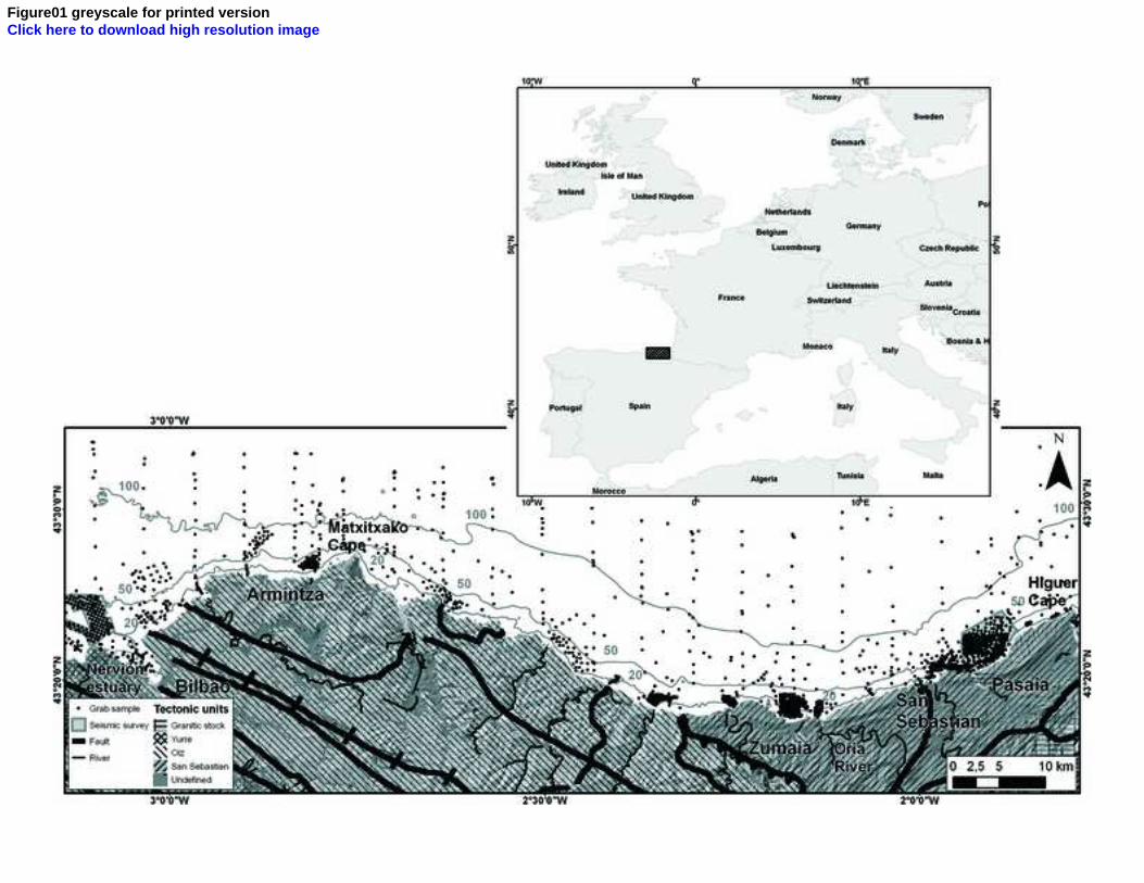
Figure01 greyscale for printed versionClick here to download high resolution image
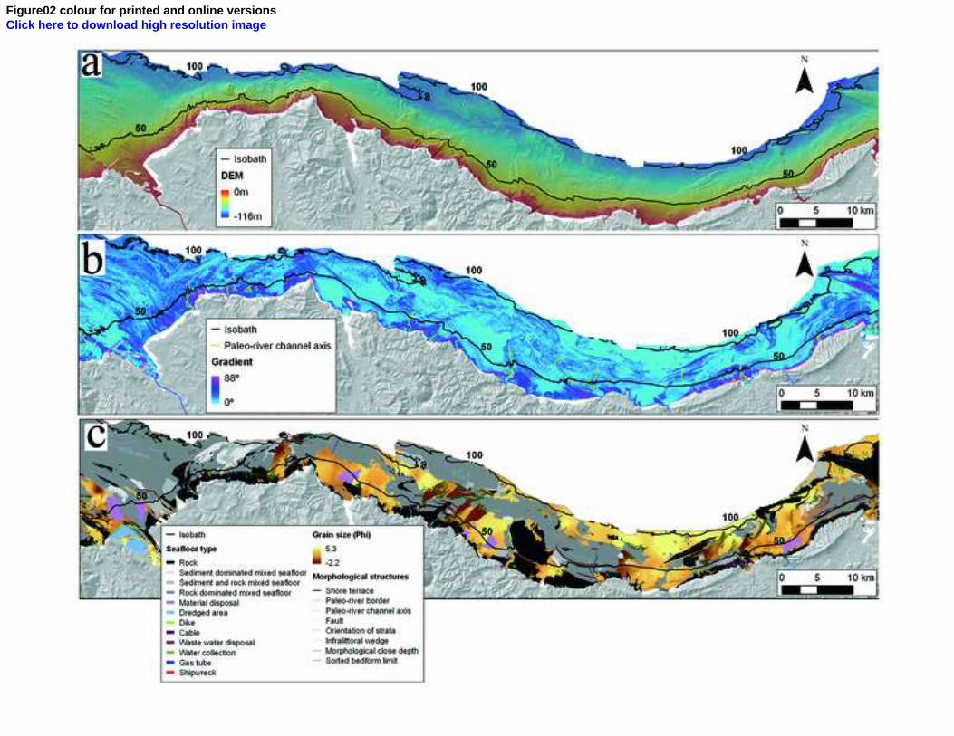
Figure02 colour for printed and online versionsClick here to download high resolution image
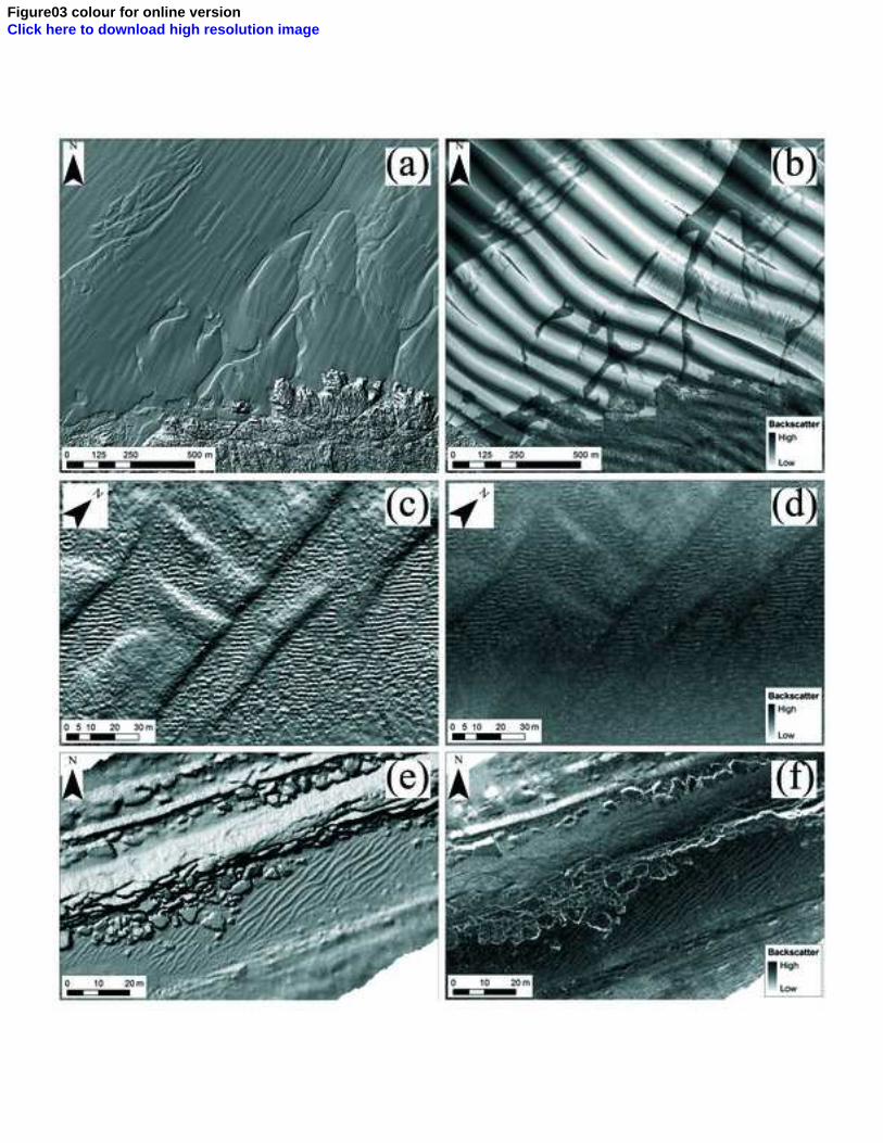
Figure03 colour for online versionClick here to download high resolution image
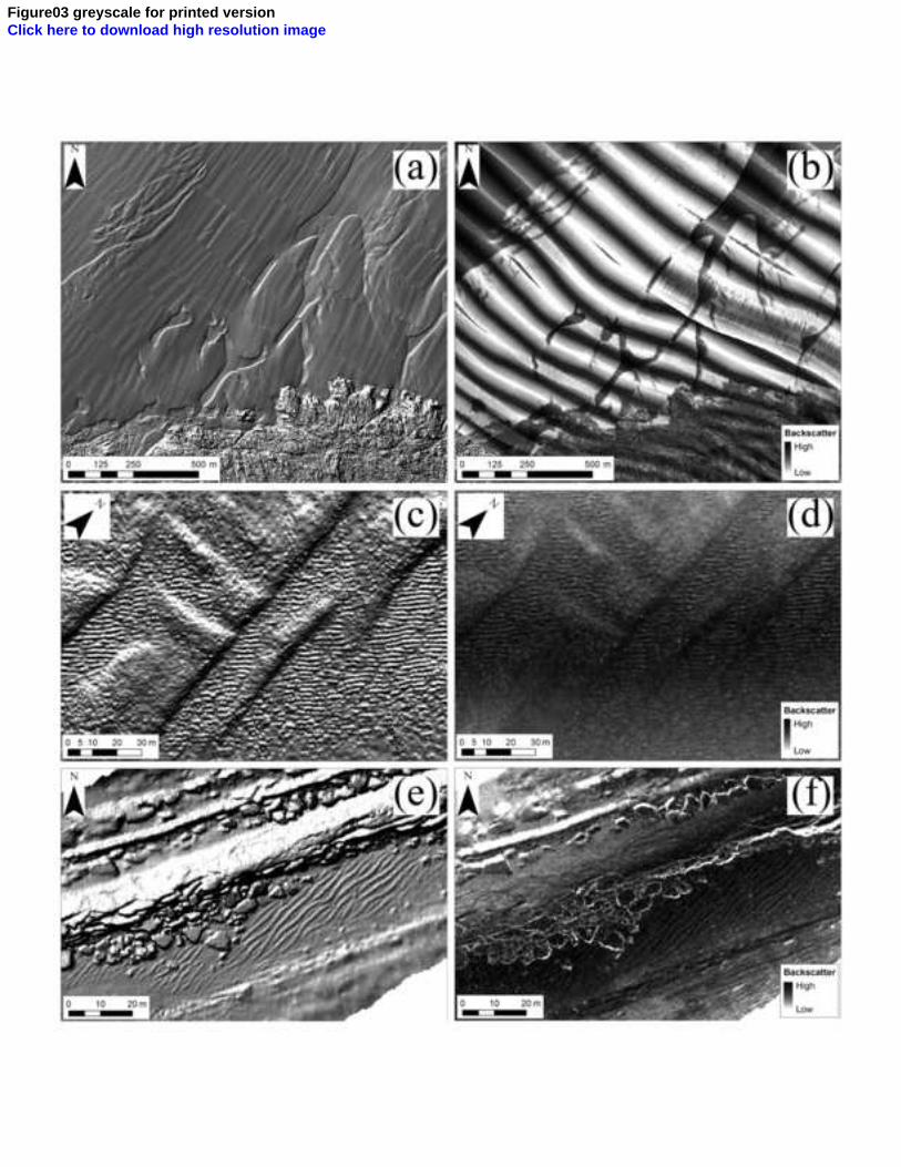
Figure03 greyscale for printed versionClick here to download high resolution image
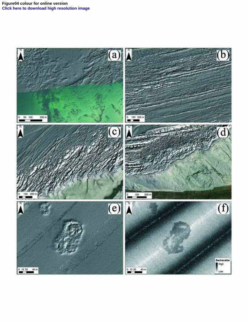
Figure04 colour for online versionClick here to download high resolution image
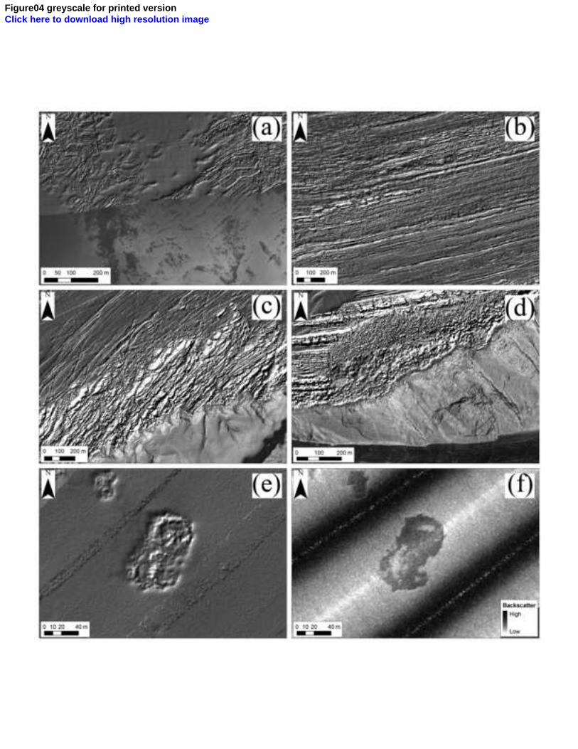
Figure04 greyscale for printed versionClick here to download high resolution image
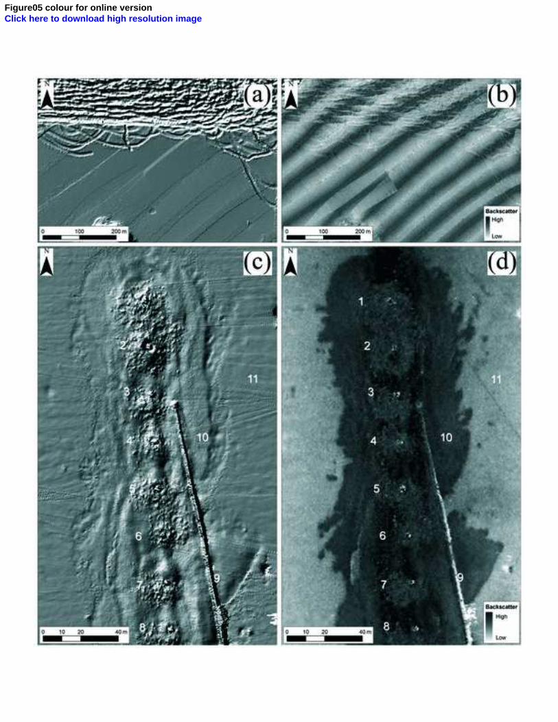
Figure05 colour for online versionClick here to download high resolution image

Figure05 greyscale for printed versionClick here to download high resolution image
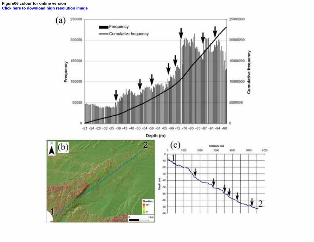
Figure06 colour for online versionClick here to download high resolution image
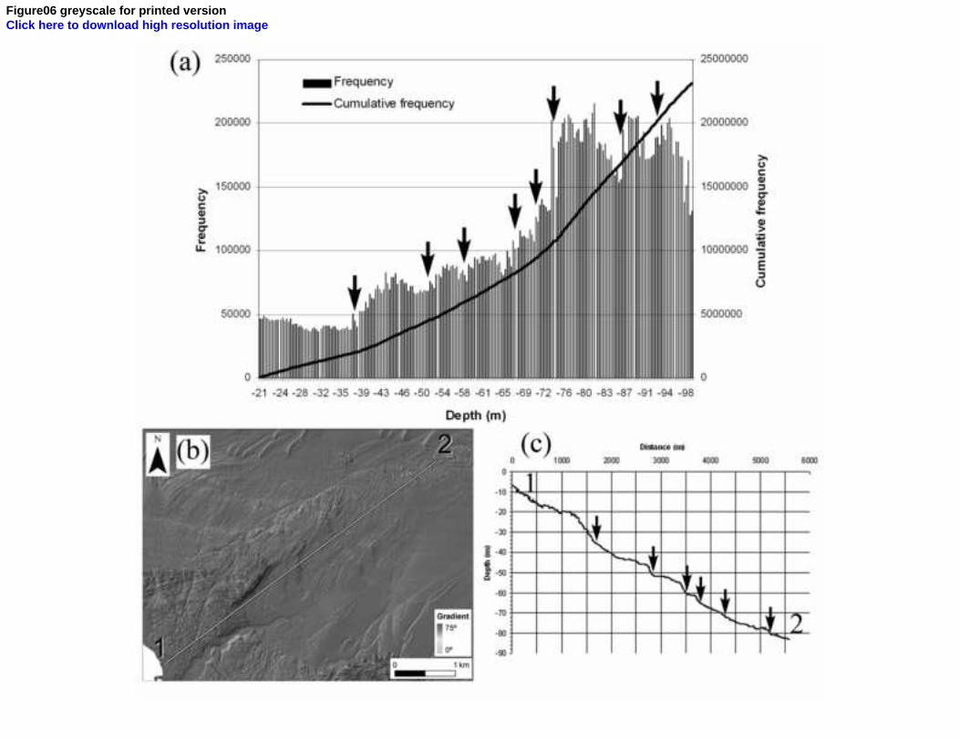
Figure06 greyscale for printed versionClick here to download high resolution image
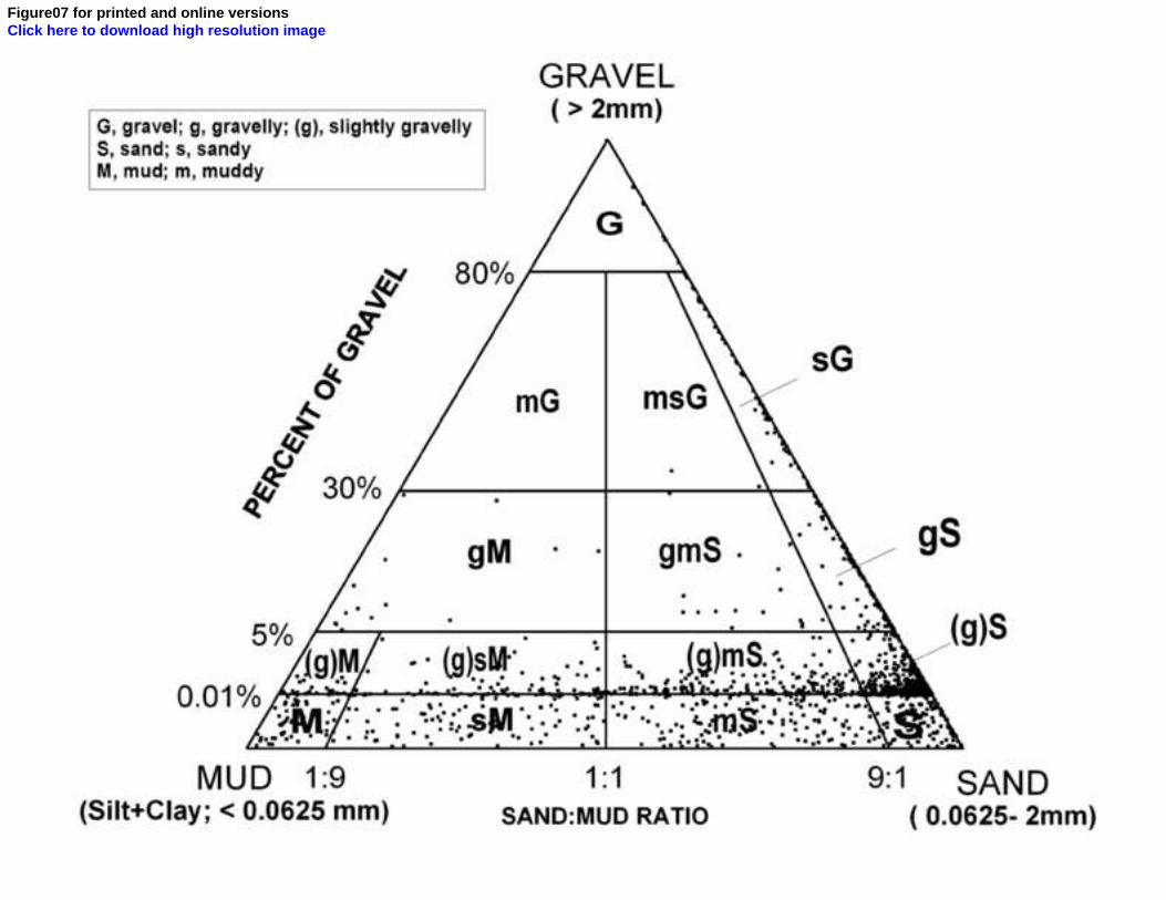
Figure07 for printed and online versionsClick here to download high resolution image
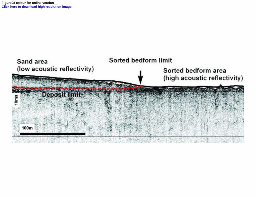
Figure08 colour for online versionClick here to download high resolution image
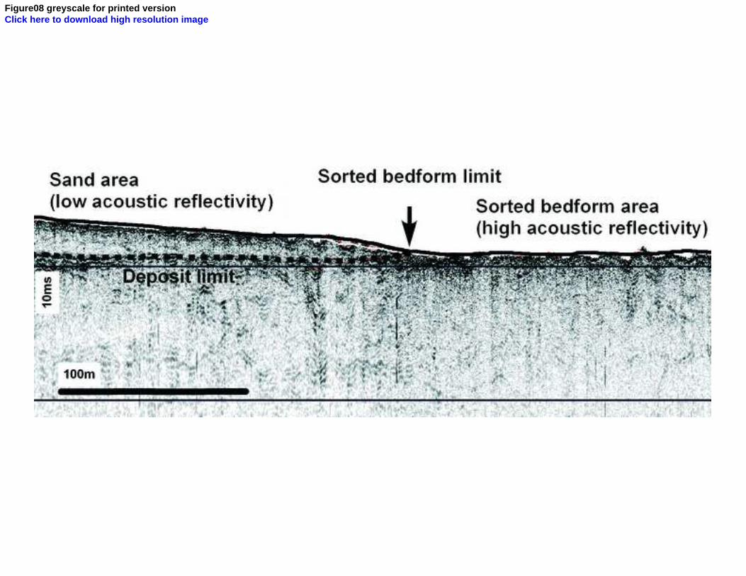
Figure08 greyscale for printed versionClick here to download high resolution image
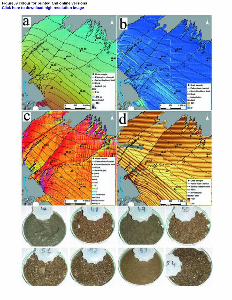
Figure09 colour for printed and online versionsClick here to download high resolution image
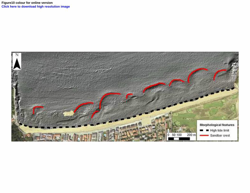
Figure10 colour for online versionClick here to download high resolution image
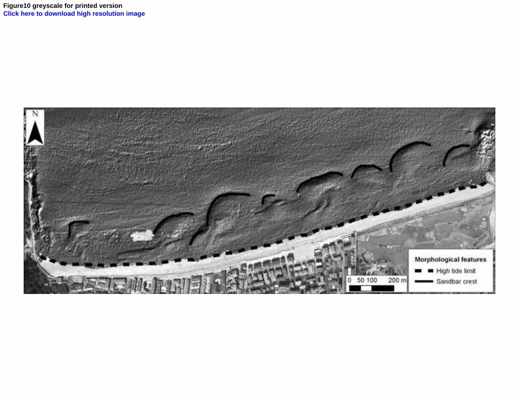
Figure10 greyscale for printed versionClick here to download high resolution image
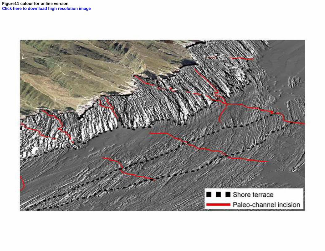
Figure11 colour for online versionClick here to download high resolution image
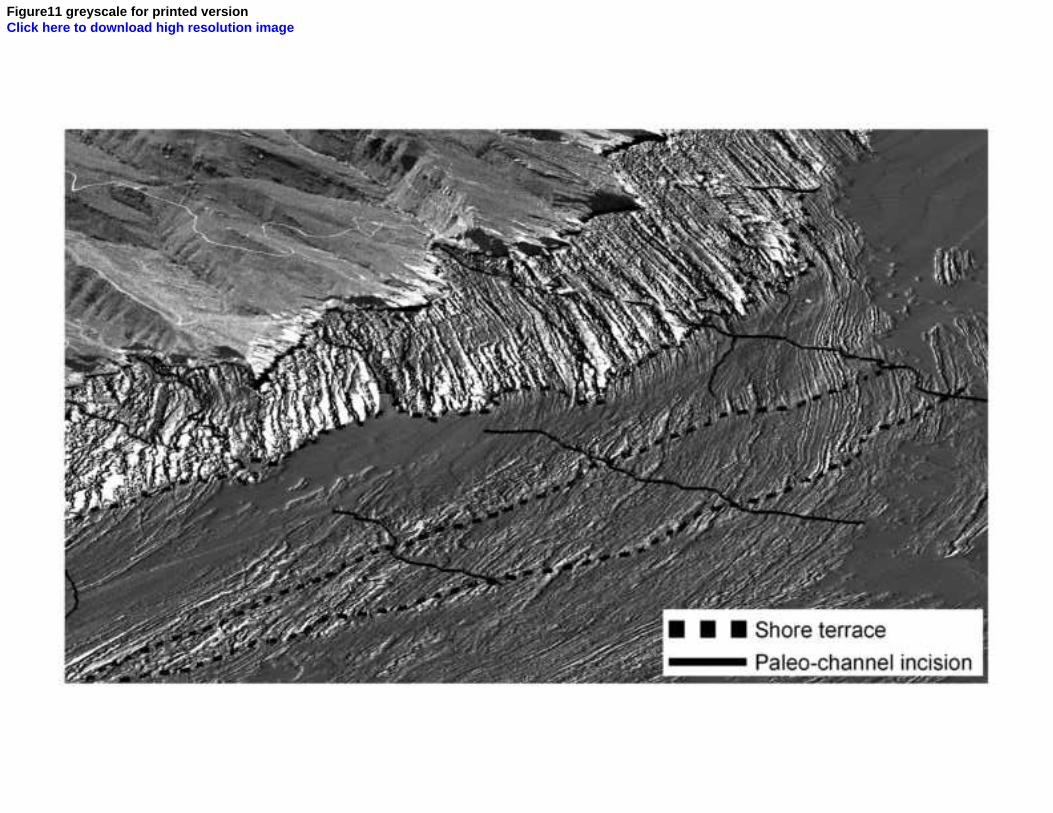
Figure11 greyscale for printed versionClick here to download high resolution image

Supplementary material for online Figure01Click here to download Supplementary material for online publication only: SupplMat_01.tif

Supplementary material for online Figure02Click here to download Supplementary material for online publication only: SupplMat_02.tif

Supplementary material for online Figure03Click here to download Supplementary material for online publication only: SupplMat_03.tif

Supplementary material for online Figure04Click here to download Supplementary material for online publication only: SupplMat_04.tif

Supplementary material for online Figure05Click here to download Supplementary material for online publication only: SupplMat_05.tif

Supplementary material for online Figure06Click here to download Supplementary material for online publication only: SupplMat_06.tif

Supplementary material for online Figure07Click here to download Supplementary material for online publication only: SupplMat_07.tif

![Towards a phonetically grounded diachronic phonology of Basque [Thesis]](https://static.fdokumen.com/doc/165x107/63226867078ed8e56c0a658e/towards-a-phonetically-grounded-diachronic-phonology-of-basque-thesis.jpg)