Molecular data as a possible tool for tracing groundwater flow in karst environment: example of...
7
Molecular data as a possible tool for tracing groundwater flow in karst environment: example of Delminichthys adspersus in Dinaric karst system Anja Palandačić, 1 * Ognjen Bonacci 2 and Aleš Snoj 1 1 Biotechnical Faculty, Department for Animal Science, University of Ljubljana, Groblje 3, SI-1230 Domžale, Slovenia 2 Faculty of Civil Engineering and Architecture, University of Split, Matice hrvatske 15, 21000 Split, Croatia ABSTRACT Karst areas have some of the most complex aquifers in the world. Because of extreme groundwater oscillations, different hydrological connections are active depending on the season. Therefore, the complex water network remains poorly investigated, despite many geological, hydrological and geomorphological studies performed. The methodology of water tracing was developed especially to determine water interconnections in karst. In addition to tracing with salt, dye or temperature, the use of rich endemic fauna, their dispersion and population structure is lately considered. In this paper, we used population structure of endemic fish species Delminichthys adspersus to confirm hydrological data as well as suggest new underground water connections in part of central Dinaric karst. Moreover, we propose a holistic approach of karst area studies, combining hydrology with biology to develop a better strategy for the protection of vulnerable karst ecosystems. Copyright © 2011 John Wiley & Sons, Ltd. KEY WORDS karst; groundwater tracing; biological tracers; fish; Delminichthys adspersus; Dinaric karst Received 19 May 2011; Revised 17 October 2011; Accepted 18 October 2011 INTRODUCTION Karst is a type of landscape with many different surface and underground features, which facilitate and accelerate the exchange of ground and surface water, resulting in a complex and unpredictable aquifer (Bonacci et al., 2009). The unpredictability is due to extreme oscillations of groundwater levels (more than 200 m) that cover a large temporal range from minutes to decades and enable various possibilities of water flow in neighbouring parts of karst systems. Determining water circulation is crucial for explaining hydrological and hydrogeological processes and their influence on resident biota. The interconnections of water sources also add to the vulnerability of the flora and fauna, because pollution of apparently isolated springs can lead to extensive consequences (Bonacci, 1995; Bonacci and Roje-Bonacci, 2000). Heterogeneous karst landscape creates a variety of aquatic and terrestrial habitats, which are, because of their inaccess- ibility, one of the least known ecosystems on the planet, giving home to often endemic and endangered species (Culver and Sket, 2000; Pipan and Culver, 2007; Deharveng et al., 2009). For the survival of permanent or occasional karst inhabitants, water transport of suspended sediment and organic materials, food, (micro) organisms, seeds, eggs and contaminants from surface to underground and vice versa is of great importance. Resident fish species are no exception. Their population structure and physiological activity (food sources, reproduction) is highly influenced by a variety of hydrological characteristics. The challenging environment of temporal karst springs and underground streams supplies a frame for different possibilities of adaptation. For instance, some populations of freshwater fish species of Central and North American karst areas, such as Astyanax fasciatus, Cottus carolinae and Forbesichthys (Chologaster) agassizi, evolved in stygobionts (obligates in subterranean groundwater and cave streams), losing their eyes and pigmentation, yet retaining the ability to interbreed with surface-dwelling populations (Romero and Paulson, 2001; Strecker et al., 2004; Kinziger et al., 2007). In Dinaric karst, endemic fish species with a vernacular name ‘gaovice’ evolved to actively follow the withdrawing water of the intermittent springs and periodically occupy the subterranean environment, which provides them long-term shelter during dry periods. These minnow-like fish belong to three distinctive lineages, Telestes, Phoxinellus and Delminichthys (Cyprinidae), and inhabit small karstic basins in Croatia and in Bosnia and Herzegovina (Bogutskaya and Zupančič, 2003; Freyhof et al., 2006; Palandačić et al., 2010; Perea et al., 2010). There were some indications in the literature suggesting ‘gaovice’ can migrate underground. For instance, Telestes croaticus is known to populate Ličko polje but was also found in the springs of Gatsko polje (Zupančič, 2008), whereas Bonacci (2008) gave proof of hydrological links between Lika and Gacka Rivers. Inspired by such presump- tions along with our own field observations, we employed a population genetic study on several superficially isolated populations of D. adspersus, and using this approach *Correspondence to: Anja Palandačić, Biotechnical Faculty, Department of Animal Science, University of Ljubljana, Groblje 3, SI-1230 Domžale, Slovenia. E-mail: [email protected] ECOHYDROLOGY Ecohydrol. 5, 791–797 (2012) Published online 6 December 2011 in Wiley Online Library (wileyonlinelibrary.com) DOI: 10.1002/eco.269 Copyright © 2011 John Wiley & Sons, Ltd.
Transcript of Molecular data as a possible tool for tracing groundwater flow in karst environment: example of...

ECOHYDROLOGYEcohydrol. 5, 791–797 (2012)Published online 6 December 2011 in Wiley Online Library(wileyonlinelibrary.com) DOI: 10.1002/eco.269
Molecular data as a possible tool for tracing groundwater flowin karst environment: example of Delminichthys adspersus in
Dinaric karst system
Anja Palandačić,1* Ognjen Bonacci2 and Aleš Snoj11 Biotechnical Faculty, Department for Animal Science, University of Ljubljana, Groblje 3, SI-1230 Domžale, Slovenia
2 Faculty of Civil Engineering and Architecture, University of Split, Matice hrvatske 15, 21000 Split, Croatia
*Cof ASlo
Co
ABSTRACT
Karst areas have some of the most complex aquifers in the world. Because of extreme groundwater oscillations, differenthydrological connections are active depending on the season. Therefore, the complex water network remains poorly investigated,despite many geological, hydrological and geomorphological studies performed. The methodology of water tracing wasdeveloped especially to determine water interconnections in karst. In addition to tracing with salt, dye or temperature, the use ofrich endemic fauna, their dispersion and population structure is lately considered. In this paper, we used population structure ofendemic fish species Delminichthys adspersus to confirm hydrological data as well as suggest new underground waterconnections in part of central Dinaric karst. Moreover, we propose a holistic approach of karst area studies, combining hydrologywith biology to develop a better strategy for the protection of vulnerable karst ecosystems. Copyright © 2011 John Wiley &Sons, Ltd.
KEY WORDS karst; groundwater tracing; biological tracers; fish; Delminichthys adspersus; Dinaric karst
Received 19 May 2011; Revised 17 October 2011; Accepted 18 October 2011
INTRODUCTION
Karst is a type of landscape with many different surface andunderground features, which facilitate and accelerate theexchange of ground and surface water, resulting in a complexand unpredictable aquifer (Bonacci et al., 2009). Theunpredictability is due to extreme oscillations of groundwaterlevels (more than 200m) that cover a large temporal range fromminutes to decades and enable various possibilities of waterflow in neighbouring parts of karst systems. Determiningwatercirculation is crucial for explaining hydrological andhydrogeological processes and their influence on residentbiota. The interconnections of water sources also add to thevulnerability of the flora and fauna, because pollution ofapparently isolated springs can lead to extensive consequences(Bonacci, 1995; Bonacci and Roje-Bonacci, 2000).Heterogeneous karst landscape creates a variety of aquatic
and terrestrial habitats, which are, because of their inaccess-ibility, one of the least known ecosystems on the planet,giving home to often endemic and endangered species(Culver and Sket, 2000; Pipan and Culver, 2007; Deharvenget al., 2009). For the survival of permanent or occasional karstinhabitants, water transport of suspended sediment andorganic materials, food, (micro) organisms, seeds, eggs andcontaminants from surface to underground and vice versa is ofgreat importance. Resident fish species are no exception.
orrespondence to: Anja Palandačić, Biotechnical Faculty, Departmentnimal Science, University of Ljubljana, Groblje 3, SI-1230 Domžale,
venia. E-mail: [email protected]
pyright © 2011 John Wiley & Sons, Ltd.
Their population structure and physiological activity (foodsources, reproduction) is highly influenced by a variety ofhydrological characteristics. The challenging environment oftemporal karst springs and underground streams supplies aframe for different possibilities of adaptation. For instance,some populations of freshwater fish species of Central andNorth American karst areas, such as Astyanax fasciatus,Cottus carolinae and Forbesichthys (Chologaster) agassizi,evolved in stygobionts (obligates in subterraneangroundwater and cave streams), losing their eyes andpigmentation, yet retaining the ability to interbreed withsurface-dwelling populations (Romero and Paulson, 2001;Strecker et al., 2004; Kinziger et al., 2007). In Dinaric karst,endemic fish species with a vernacular name ‘gaovice’evolved to actively follow the withdrawing water of theintermittent springs and periodically occupy the subterraneanenvironment, which provides them long-term shelter duringdry periods. These minnow-like fish belong to threedistinctive lineages, Telestes, Phoxinellus and Delminichthys(Cyprinidae), and inhabit small karstic basins in Croatia andin Bosnia andHerzegovina (Bogutskaya and Zupančič, 2003;Freyhof et al., 2006; Palandačić et al., 2010; Perea et al.,2010). There were some indications in the literaturesuggesting ‘gaovice’ can migrate underground. For instance,Telestes croaticus is known to populate Ličko polje but wasalso found in the springs of Gatsko polje (Zupančič, 2008),whereas Bonacci (2008) gave proof of hydrological linksbetween Lika and Gacka Rivers. Inspired by such presump-tions along with our own field observations, we employed apopulation genetic study on several superficially isolatedpopulations of D. adspersus, and using this approach

792 A. PALANDAČIĆ, O. BONACCI AND A. SNOJ
provided the first molecular evidence of undergrounddispersal of the studied fish (Palandačić, 2012).The main objective of this paper is to establish whether
the genetic data, acquired from different geographicallyseparated populations of ‘gaovice’, are comparable withhydrological measurements and therefore can be used toinfer underground water connections. Moreover, we aim toassess the suitability of aquatic organisms as possiblebiological tracers of groundwater flow. Finally, we tend tocut across the boundaries of hydrology and biology andpropose an example of synergistic supplementation of karsthydrology and population genetics expertise in an attemptto study underground water system in the central part ofDinaric karst.
TRACINGANDTRACERS –ANECESSARYTOOLFORDETERMINATION OF POSSIBLE CONNECTIONS IN
KARST MASSIF
Sinking, losing and underground karst streams as well asswallow holes and springs play a crucial role in hydrology andecology of karst systems (Yuan, 1991; Ray, 2005; Bonacci,2010). The connections between different parts of karstsystems and the position of the karst catchment boundariesdepend upon the rapidly fluctuating groundwater levels. Whengroundwater level is extremely high, the fossil and inactiveunderground karst conduits become functional, causing theredistribution of catchment areas, that is, overflow from one tothe other catchment. Hydrogeological conditions can change ina very short time as a consequence of natural (precipitation) oranthropogenic influences (building of dams and reservoirs,inter-basin water transfer, etc.). For investigation of thiscomplex conduit organization, water-tracing techniques arevery useful.Tracing tests provide information on the inaccessible and
unexplored underground parts of karst systems (Goldscheideret al., 2008). They are generally regarded as being the mostreliable and efficient means of gathering karst subsurfacehydraulic information (Field, 1999). Goldscheider (2005)considers tracer tests in combination with other geologicaland hydrological observations as themost powerfulmethod fordelineating the catchment areas in karst, which is of greatimportance in scientific disciplines such as geology, hydrology,chemistry, physics, water management, biology and limnology(Käs, 1998). Tracing tests can be classified according todifferent criteria (Ford and Williams, 2007): (1) quantitativeand (2) qualitative; or (1) artificial labels, (2) particulates,(3) natural labels and (4) pulses. The natural labels are(1)microorganism, (2) ions and solution and (3) environmentalisotopes. Smart and Worthington (2004b) classify tracers as(1) physical, (2) chemical, (3) isotopic and (4) biological.Biological tracers are defined as organisms inadvertently
present in the water such as coliform bacteria in the wells(Smart and Worthington, 2004b). However, a possibility ofcomplementing other tracing techniques with more system-atized use of biological tracers is lately considered. WhereasSmart and Worthington (2004a) only speculate about thedispersion of organisms via underground water connections,
Copyright © 2011 John Wiley & Sons, Ltd.
Pipan and Culver (2007) make more concrete suggestion toapply biological findings in hydrology by using rich epikarsticfauna as possible water tracers. Because the biological tracersare natural and already present in the system, there is no needfor the introduction of possibly harmful tracers that disrupt theenvironment (dye, salt). Besides quantitative measurements,biological tracers also give qualitative information about thetype of water connection and its suitability for dispersion oforganisms. Already 70years ago, Hawes (1939) recognizedimportant ecological effects of hydrological processes (floods)in karst, which operate as distribution agents of species andhelp maintain a regular food supply of the underground.However, a concrete attempt to link biological data withfindings of other tracer techniques has to our knowledge not yetbeen presented.
STUDY AREA
The study area, shown in Figure 1, is located in Croatia andin Bosnia and Herzegovina between 43�10′ and 43�60′Nand 17�10′ and 17�60′E in the central part of bare and deepDinaric karst region.
The climate of the area represents a combination of theMediterranean and continental climates, because it isseparated from the Adriatic Sea by the Biokovo mountainchain with maximum altitude of 1762m a. s. l. The averageannual air temperature varies from under 10 (northern higherpart) to 14 �C (southern lower part) with a minimum dailytemperature in January below�10 �C and a maximum dailytemperature in July and August over 35 �C. The annualrainfall ranges from 750 to 2350mm with a 1500mmaverage. The maximum rainfall occurs in October andNovember and the minimum in July and August. Thegroundwater levels oscillate with maximum amplitude ofmore than 130m, with the maximum intensities up to 3mper hour after heavy rains in October and November(Bonacci, 1987; Bonacci and Roje-Bonacci, 2008). Thepredominant rocks in the area are carbonate limestones withsome dolomites of Tertiary and Cretaceous formations,which do not obstruct groundwater circulation considerably.
More than 100 temporary and permanent karst springsemerge along the longer axes of the karst poljes (fields),forming temporary or permanent stream flows. Despiteabundant precipitation, most of the streams in the area areintermittent (or sinking), going underground at the end of afield and emerging on another. D. adspersus is present inabout 10% of the springs in the area (personal observation).
Figure 2 presents cross section through two exceptionalkarst phenomena from the study area – Red Lake and BlueLake (Bonacci, 2006). Bögli (1980) and Williams (2004)describe Red Lake as the deepest known case of a collapsedolina containing a permanent lake. Garašić (1999)speleohydrogeological expedition has found an activeunderground river that crosses the lake at its bottom, 6mbelow the Adriatic Sea level. Detailed speleologicalinvestigations confirmed that the lake is connected directlyto two karst conduits through which water constantly flowsin and out from the upper to the lower part of the karst aquifer
Ecohydrol. 5, 791–797 (2012)
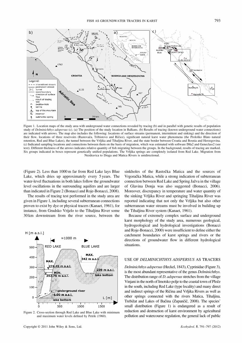
Figure 1. Location maps of the study area with underground water connections revealed by tracing (b) and in parallel with genetic results of populationstudy of Delminichthys adspersus (c). (a) The position of the study location in Balkans. (b) Results of tracing (known underground water connections)are indicated with arrows. The map also includes the following: locations of surface streams (permanent, intermittent and sinking) and the direction oftheir flow, locations of three reservoirs (Rastovača, Tribistovo and Ričice), significant natural karst water phenomena (the Prološko Blato naturalretention, Red and Blue Lakes), the tunnel between the Vrljika and Tihaljina River, and the state border between Croatia and Bosnia and Herzegovina.(c) Indicated sampling locations and connections between them on the basis of migration, which was estimated with software IMa2 and Geneclass2 (seetext). Different thickness of the arrows indicates relative quantity of fish migrating between the groups. In the background, results of tracing are marked.Six groups indicated in boxes represent genetically unified populations. The Vrljika springs are completely isolated from Red Lake. Migration from
Nezdravica to Draga and Matica Rivers is unidirectional.
793FISH AS GROUNDWATER TRACERS IN KARST
(Figure 2). Less than 1000m far from Red Lake lays BlueLake, which dries up approximately every 5 years. Thewater-level fluctuations in both lakes follow the groundwaterlevel oscillations in the surrounding aquifers and are largerthan indicated in Figure 2 (Bonacci and Roje-Bonacci, 2008).The results of tracing test performed in the study area are
given in Figure 1, including several subterranean connectionsproven to exist by dye or physical tracers (Kanaet, 1961), forinstance, from Grudsko Vrijelo to the Tihaljina River some30 km downstream from the river source, between the
Figure 2. Cross-section through Red Lake and Blue Lake with minimumand maximum water levels defined by Petrik (1960).
Copyright © 2011 John Wiley & Sons, Ltd.
sinkholes of the Rastočka Matica and the sources ofVrgoračka Matica, while a strong indication of subterraneanconnection between Red Lake and Spring Jažva in the villageof Glavina Donja was also suggested (Bonacci, 2006).Moreover, discrepancy in temperature and water quantity ofthe sinking Vrljika River and springing Tihaljina River wasreported indicating that not only the Vrljika but also othersubterranean water streams must be involved in building upthe Tihaljina River system (Kanaet, 1961).
Because of extremely complex surface and undergroundkarst morphology of the study area, numerous geological,hydrogeological and hydrological investigations (Bonacciand Roje-Bonacci, 2000) were insufficient to define either thecatchment boundaries of karst springs and rivers or thedirections of groundwater flow in different hydrologicalsituations.
USE OF DELMINICHTHYS ADSPERSUS AS TRACERS
Delminichthys adspersus (Heckel, 1843), Cyprinidae (Figure 3),is the most abundant representative of the genusDelminichthys.The distribution range ofD.adspersus stretches from the villageVinjani in the north of Imotsko polje to the coastal town of Pločein the south, including Red Lake (type locality) and many directand indirect springs of the Ričina and Vrljika Rivers as well asother springs connected with the rivers Matica, Tihaljina,Trebižat and Lakes of Bačina (Zupančič, 2008). The species’small distribution (Figure 1) is endangered as a result ofreduction and destruction of karst environment by agriculturalpollution and watercourse regulation, the general lack of public
Ecohydrol. 5, 791–797 (2012)

Figure 3. Delminichthys adspersus.
794 A. PALANDAČIĆ, O. BONACCI AND A. SNOJ
awareness and occasional occurrences of overfishing by localinhabitants. The species is listed as vulnerable on theInternational Union for Conservation of Nature Red List ofThreatened Species (Mrakovčić et al., 2006).The population genetic structure of D. adspersus was
determined using molecular methods based on deoxyribo-nucleic acid (DNA). DNA in the cell is partitioned betweenthe nucleus and two other sub-compartments, mitochondriaand chloroplasts. Whereas chloroplasts are only present inplants and in some algae, mitochondria are components ofalmost all eukaryotic cells. Despite very effective cellmechanisms that provide DNA maintenance and repair,errors may nevertheless occur during DNA replication. Sucherrors (DNA mutations) give rise to abundant number ofgenetic variants (called alleles in diploidDNA and haplotypesin haploid DNA), which can be used in assessing geneticdifferentiation between individuals, populations, species andso forth. From studying genetic change, one can inferevolutionary history (phylogeny) of organisms or studyevolutionary processes of populations such as naturalselection, genetic drift, mutation and migration (gene flow).Mitochondrial DNA (mtDNA) is a small circular molecule
(15–20 kb), which is in most multicellular organismsinherited only from the mother. It replicates separately andindependently from the nuclear DNA, does not recombineand possesses fragments of very different mutational rates,whichmakes mtDNA convenient model for phylogenetic andphylogeographic studies (for details, see Avise, 2000). Inaddition, mtDNA has the potential to reveal geographicclusters and demographic expansions (Moritz et al., 1987);therefore, we used a rapidly evolving segment of mtDNA,cytochrome b gene, to obtain some basic information aboutthe population structure of D. adspersus. First, haplotypenetwork (distribution of allelic variants in the sample set) wasbuilt on the basis of phylogenetic tree constructed with TrNmodel of sequence evolution (Tamura and Nei, 1993) and themaximum-likelihood method implemented in PAUP* 4�0(Swofford, 2003). Subsequently, population differentiationwas determined by calculating the net sequence divergencesbetween sampling locations using Φ-statistics (Wright 1978)and hierarchical nested analysis of molecular variance bothperformed with Arlequin (Excoffier, 2007).However, to study the genetic structure of D.adspersus
more precisely, we applied bi-parentally inherited nuclearDNA (nDNA)markers, which accumulatemoremutations and
Copyright © 2011 John Wiley & Sons, Ltd.
therefore give more detailed information about populationcharacteristics. We used microsatellites, that is, stretches ofnDNA composed of tandem repeats [e.g. (GAC)n, for details,seeGoldstein and Schlötterer, 1999], which have proven as oneof fastest-evolving DNA sections. Closely related individualsgenerally differ in number of tandem repeats (DNA finger-printing), which represents the basis for inferring an array ofpopulation genetic parameters. To determine geneticallyhomogenous groups among the sampled material and to testif these groups exchange their genes or not (i.e. if migrationoccurs between them), we analysed data by using differentapproaches and methods. First, traditional FST analysis wasused for pairwise population comparisons (Arlequin, Excoffier,2007) followed by creating a population tree on the basis ofallele sharing distances with the software Populations(Chakraborty and Jin, 2004). Because FST -based methodshave been criticized a lot (Jost, 2008), the most probablenumber of groups in the sample set was determined also withBayesian methods implemented in software Structure(Pritchard et al. 2000; Falush et al. 2003; Falush et al. 2007;Hubisz et al. 2009) and BAPS (Corander et al. 2003; Coranderand Marttinen 2006; Corander et al. 2006; Corander et al.2008), which instead of averaging over the information fromthe markers, determine patterns of population structure withcombining information from multiple markers into a singleprobability model. Finally, combined data set of mitochondrialand nuclear DNA was used to estimate how many fish (if any)migrate and in which direction. For this purpose,Markov chainMonte Carlo-based software IMa2 (Hey and Nielsen, 2007),which determinesmigration rates,was applied to the data set. Inaddition, the number offishmigrating in the last generationwasassessed using software Geneclass2 (Piry et al., 2004).
All the methods used in this study were in detailsdescribed in Palandačić (2012). Here, we give a compre-hensible methodological overview in order to illuminatethe main principles of the applied molecular approach.
The results of molecular analysis revealed complexpopulation structure. Analysis of mtDNA cytochrome bdiscovered no completely isolated populations, thusindicating connectivity between sampling locations.Microsatellite analysis revealed genetic similarity betweenthe fish from Red Lake and Vrljika river system andbetween Vrljika and Tihaljina river systems, which are allgeographically (physically) isolated. More specifically,FST -based analysis revealed six groups, which almostcompletely correspond to geographic division presented inTable 1. It confirmed that fish from sampling locationsVrgoračka Matica, Rastočka Matica and Draga form one,uniform population and also revealed genetically similarunit composed of the fish from seven Imotski springs andtwo springs from Grude. Bayesian approaches confirmedunity of the two groups and further detected similaritiesbetween Prološko Blato and Imotski +Grude Springs aswell as between Red Lake and Imotski +Grude Springs.Finally, IMa2 detected migration of fish among all of thesix proposed groups, except between Vrljika Springs andRed Lake, and from Nezdravica to the Imotski +GrudeSprings. The fact that migration is recent (detection ofindividual migration in the last generation) was confirmed
Ecohydrol. 5, 791–797 (2012)

Table I. Genetically defined groups of Delminichthys adspersus sampled across the entire species range. Note that genetically definedgroups correspond well with geographically unified sites. Short description of the sampling sites is also given (for details, see
Kanaet, 1961).
Genetically defined groupNumber ofsampling sites Description
Prološko Blato 1 Natural retentionVrljika Springs 3 Vrljika River is supplied with several springs; three of them sampled in this study turned out
to be same populationRed Lake 1 See Figure 2Imotski Springs 7 Several springs emerge in the town of Imotski and in its close vicinity, most of them being
temporal. As inferred from genetic analysis, fish of these springs mix freely with those ofGrudsko Vrijelo and Jamine despite considerable geographic distance and were thereforeunified within the same group
Grudsko Vrijelo, Jamine 2 Two springs in Hercegovina belonging to the Vrljika river system. Whereas GrudskoVrijelo is permanent, Jamine is active only during high rainfall
Nezdravica 1 A left tributary to Tihaljina River in Herzegovina, containing high concentrations ofmagnesium salts. It is populated with the most isolated and genetically particularpopulation of Delminichthys adspersus
Rastočka, VrgoračkaMatica and Draga
3 Molecular results pointed to a physical connection between the rivers Rastočka Matica andVrgoračka Matica even though there are no direct surface connections between them.Brook Draga was on the basis of molecular analysis also assigned to this group
795FISH AS GROUNDWATER TRACERS IN KARST
also using Geneclass2. Detailed results including thedirection and migration rates are given in Figure 1c.The described molecular data and specific configuration of
the studied area, which physically prevent surface communi-cation between many genetically similar populations(Palandačić et al., in submission), as well as the adaptation ofD.adspersus to long-term subterranean dwelling (Mrakovčićet al., 2006) represent persuasive evidence that D. adspersusmigrate underground and use this particular behaviour tomaintain the species gene flow. Considering these notions, webelieve that migration patterns ofD.adspersus faithfully reflectseveral underground water connections and thus justify theirpotential role as a biological groundwater tracer.
DISCUSSION
In the present study, we aimed to compare hydrologicalfindings with biological ones to confirm known waterconnections and add qualitative information about the typesof connections. Underground gene flow was suggestedbetween most evidently surface-separated locations: (1) RedLake and the spring of Jažva (Imotski Springs, Table 1), (2) therivers Vrgoračka and Rastočka Matica and (3) Vrljika andTihaljina River systems. The undergroundwater ways betweenthe three location pairs have been proven using hydrologicalmeasurements and water tracers: in his review, Bonacci (2006)cited several authors who mention an underground canalbetween Red Lake and Jažva (Cvijić, 1926; Bonacci and Roje-Bonacci, 2000; Garašić, 2001), whereas Kanaet (1961)described water connection between Rastočko and Vrgoračkopolje and between Vrljika and Tihaljina River systemsdetermined with dying. Therefore, concordance of biologicaland hydrological data is evident. Besides corroborating knownunderground water links, this study also suggests some newones such as between Imotski and Grude, Vrljika Springs andProloškoBlato aswell asDraga and bothMaticaRivers.On the
Copyright © 2011 John Wiley & Sons, Ltd.
other hand, hydrologists provided tracing data for water linksbetween reservoirs Ričice and Tribistvo (Figure 1), which arefarther north from the identified range of D.adspersus andVrljika River. Because these springs were not yet investigatedfor fish species, further research could be extended to this area.
This study also aims to estimate biological tracers incomparison with physical and chemical ones. In contrast tophysical or chemical tracers, fish are live objects with theirown energy and instincts and are therefore not simplyinfluenced by environmental physical forces such as watercurrent but are capable of their own mobility. Actually,these are the only tracers that can, to some extent, defygravity, thereby providing new dimension of tracingsubterranean water flows. In karst, low ground and surfacewaters represent the most common condition throughout ayear (more than 80%); this is the period when active andself-driven mobility of the fish is most obvious. Whereas intimes of overflow, fish can be either passively carriedaround by strong currents or hiding from the flood, in thedry season, they swim according to their instincts, thusexhibiting underground water connections that are activeduring that period. Possibly, this is the case with Imotskiand Grude, where fish are completely mixed, indicatingthat they migrate between them most part of the year ratherthan on isolated occasions of overflow. In addition, fishneed a certain amount of room to be able to swim through;therefore, on the basis of their presence or absence, one canestimate the transition capability of a certain terrain. Forinstance, Red Lake is a fish residence, from where fish candisperse underground to other springs; on the other hand,the nearby located Blue Lake is fishless, most likelybecause its porous ground and the fissures appear torepresent impassable barrier for fish to enter the lake.
Finally, the intention of this study was to point out theimportance of holistic research approaches in karst areas.Because the karst surface aquatic environment andunderground water circulation strongly influence the
Ecohydrol. 5, 791–797 (2012)

796 A. PALANDAČIĆ, O. BONACCI AND A. SNOJ
biological functioning of the Delminichthys, closelyinterrelated researches including population and ecologicalstudies in connection with hydrological findings are crucialfor protection of not just the species but whole vulnerablekarst underground ecosystems. The new combined methoddiscussed here can be used to create specific vulnerabilitymaps of the area (Goldscheider, 2010) and to aid inprotection of often endemic karst fauna, which is anindicator of water quality (Culver, 2001).
CONCLUSION
This paper is an attempt to use biological tracers to betterunderstand the regional water movement in an extremelycomplex part of the Dinaric karst system. The resultsindicate that tracing of groundwater flow using moleculardata can help in identification of active conduit networksand delineation of catchment areas. Researches of karstareas call for complex interdisciplinary investigationsbased on detailed monitoring of many different physical,chemical and biological parameters. The proposed tracertechnique represent a ‘window’ into the karst undergroundand makes possible new detailed insight in its hydrologicaland biological characteristics. This is a typical method ofthe karst ecohydrology (Bonacci et al., 2009), a newemerging interdisciplinary scientific concept, which willplay an active role in better understanding, explanation andsustainable development of karst areas.
ACKNOWLEDGEMENTS
The authors would like to thank all researchers and localinhabitants for their assistance in the field, especiallyGašper Pustovrh and Arne Hodalič, who also contributedthe amazing photograph of D. adspersus. We would alsolike to thank Irena Oven for her writing assistance.
REFERENCES
Avise JC. 2000. Phylogeography: the history and formation of species.Harvard University Press: Cambridge.
Bögli A. 1980. Karst Hydrology and Physical Speleology. SpringerVerlag: Berlin; 284.
Bogutskaya NG, Zupančič P. 2003. Phoxinellus pseudalepidotus(Telostei: Cyprinidae), a new species from the Neretva basin with anoverview of the morphology of Phoxinellus species of Croatia andBosnia-Herzegovina. Ichthyological Exploration of Freshwater 14:359–383.
Bonacci O. 1987. Karst Hydrology with Special Reference to the DinaricKarst. Springer Verlag: Berlin; 184.
Bonacci O. 1995. Ground water behavior in karst: example of the OmblaSpring (Croatia). Journal of Hydrology 165: 113–134.
Bonacci O. 2006. Crveno i Modro jezero kod Imotskog [Red and BlueLakes near Imotski]. Hrvatske Vode 14: 45–54.
Bonacci O. 2010. Sinking, losing and underground karst streamflows.IHP-VII Series on Groundwater 2: 9–16.
Bonacci O, Andric I. 2008. Sinking karst river hydrology: case of the Likaand Gacka (Croatia). Acta Carsologica 37: 185–196.
Bonacci O, Roje-Bonacci T. 2000. Interpretation of groundwater levelmonitoring results in karst aquifers: examples from the Dinaric karst.Hydrological Processes 14: 2423–2438.
Bonacci O, Roje-Bonacci T. 2008. Water losses from the Ričice reservoirbuilt in the Dinaric karst. Engineering Geology 99: 121–127. DOI:10.1016/j.enggeo.2007.11.014
Copyright © 2011 John Wiley & Sons, Ltd.
Bonacci O, Pipan T, Culver D. 2009. A framework for karstecohydrology. Environmental Geology 56: 891–900. DOI: 10.1007/s00254-008-1189-0
Chakraborty R, Jin L. 2004. A unified approach to study hypervariablepolymorphicism: statistical considerations of determining relatednessand population distances. In DNA Fingerprinting: State of the Science,Pena, SDJ, Chakraborty R, Epplen JT, Jeffreys AJ(eds.). BerkhauserVerlag, Basel, Switzerland; 153–175.
Corander J, Marttinen P. 2006. Bayesian identification of admixtureevents using multi-locus molecular markers. Molecular Ecology 15:2833–2843. DOI: 10.1111/j.1365-294X.2006.02994.x
Corander J, Marttinen P, Mäntyniemi S. 2006. Bayesian identification ofstock mixtures from molecular marker data. Fishery Bulletin 104:550–558.
Corander J,Marttinen P, Sirén J, Tang J. 2008. Enhanced Bayesianmodellingin BAPS software for learning genetic structures of populations. BMCBioinformatics 9: 539. DOI: 10.1186/1471-2105-9-539
Corander J, Waldmann P, Sillanpää MJ. 2003. Bayesian analysis ofgenetic differentiation between populations. Genetics 163: 367–374.
Culver DC. 2001. The dark zone. Science 41: 30–35.Culver DC, Sket B. 2000. Hotspots of biodiversity in caves and wells.Journal of Cave and Karst Studies 62: 11–17.
Cvijić J. 1926. Geomorfologija 2, Beograd.Deharveng L, Stoch F, Gibert J, Bedos A, Galassi D, Zagmajster M,Brancelj A, Camacho A, Fiers F, Martin P, Giani N, Magniez G,Marmonier P. 2009. Groundwater biodiversity in Europe. FreshwaterBiology 54: 709–726. DOI: 10.1111/j.1365-2427.2008.01972
Excoffier L. 2007. Arlequin ver. 3.11. An integrated software package forpopulation genetics data analysis. Evolutionary Bioinformatics Online1: 47–50. http://cmpg.unibe.ch/software/arlequin3
Falush D, Stephens M, Pritchard JK. 2003. Inference of populationstructure using multilocus genotype data: linked loci and correlatedallele frequencies. Genetics 164: 1567–1587.
Falush D, Stephens M, Pritchard JK. 2007. Inference of populationstructure using multilocus genotype data: dominant markers and nullalleles. Molecular Ecology Notes 7: 574–578. DOI: 10.1111/j.1471-8286.2007.01758.x
Field MS. 1999. The QTRACER Program for Tracer-Breakthrough CurveAnalysis for Karst and Fractured Aquifers. USEPA:WashingtonDC; 137.
Ford D, Williams P. 2007. Karst Hydrogeology and Geomorphology.John Wiley: Chichester; 562.
Freyhof J, Lieckfeldt D, Bogutskaya, NG, Pitra C, Ludwig A. 2006.Phylogenetic position of the Dalmatian genus Phoxinellus anddescription of the newly proposed genus Delminichthys (Teleosti:Cyprinidae). Molecular Phylogenetics and Evolution 38: 416–425.DOI: 10.1016/j.ympev.2005.07.024
Garašić M. 1999. Međunarodna speleoronilačka ekspedicija u Crvenojezero kraj Imotskog (International speleodiving investigation of theRed Lake near Imotski). Hrvatska Vodoprivreda VIII: 40–42.
Garašić M. 2001. New speleohydrogeological research of Crveno jezero(Red Lake) near Imotski in Dinaric karst area (Croatia, Europe).Proceedings 13th International Congress of Speleology. Brasilia;168–171.
Goldscheider N. 2005. Fold structure and underground drainage pattern inthe alpine karst system Hochifen-Gottesacker. Ecologae GeologicaeHelvetiae 98: 1–17. DOI: 10.1007/s00015-005-1143-z
Goldscheider N. 2010. Delineation of spring protection zones. InGroundwater Hydrology of Springs, Kresic N, Stevanovic Z (eds).Elsevier: Amsterdam; 305–338.
Goldscheider N, Meiman J, Pronk M, Smart C. 2008. Tracer test in karsthydrogeology and speleology. International Journal of Speleology 37:27–40.
Goldstein D, Schlötterer C. 1999. Microsatellites: Evolution andApplications. Oxford University Press: Oxford, UK.
Hawes RS. 1939. The flood factor in the ecology of caves. Journal ofAnimal Ecology 1: 1–5.
Hey J, Nielsen R. 2007. Integration within the Felsenstein equation forimproved Markov chain Monte Carlo methods in population genetics.Proceedings of the National Academy of Sciences 104: 2785–279. DOI:10.1073/pnas.0611164104
Hubisz MJ, Falush D, Stephens M, Pritchard JK. 2009. Inferring weakpopulation structure with the assistance of sample group information.Molecular Ecology Resources 9: 1322–1332. DOI: 10.1111/j.1755-0998.2009.02591.x
Jost L. 2008. GST and its relatives do not measure differentiation. MolecularEcology 17: 4015–4026. DOI: 10.1111/j.1365-294X.2008.03887.x
Kanaet T. 1961. Hidrografske prilike u slivu Tihaljina-Mlade-Trbižat(Hydrography of the Tihaljina-Mlade-Trbižat catchment), Sarajevo.
Ecohydrol. 5, 791–797 (2012)

797FISH AS GROUNDWATER TRACERS IN KARST
KäsW. 1998. Tracing Techniques in Geohydrology. Balkema: Rotterdam: 600.Kinziger AP, Goodman DH, Studebaker RS. 2007. Mitochondrial DNAvariation in the Ozark Highland members of the banded sculpin Cottuscarolinae complex. Transactions of the American Fisheries Society136: 1742–1749. DOI: 10.1577/T06-025.1
Moritz C, Dowling TE, Brown WM. 1987. Evolution of animalmitochondrial DNA: relevance for population biology and systematics.Annual Reviews of Ecology Evolution and Systematics 18: 269–292.DOI: 10.1146/annurev.es.18.110187.001413
Mrakovčić M, Brigić A, Buj I, Ćaleta M, Mustafić P, Zanella D. 2006.Crvena knjiga sladkovodnih riba hrvatske. Ministrstvo kulture: Državnizavod za zaštitu prirode, Republika Hrvatska.
Palandačić A, Zupančič P, Snoj A. 2010. Revised classification of formergenus Phoxinellus using nuclear DNA sequences. BiochemicalSystematics and Ecology 38: 1069–1073. DOI: 10.1016/j.bse.2010.09.021
Palandačić A. 2012. Molecular ecology of imotska gaovica (Delmi-nichthys adspersus (Heckel, 1843)). Doctoral dissertation, BiotechnicalFaculty, University of Ljubljana, Ljubljana.
Perea S, Bohme M, Zupančič P, Freyhof J, Šanda R, Ozulug M, Abdoli A,Doadrio I. 2010. Phylogenetic relationships and biogeographicalpatterns in Circum-Mediterranean subfamily Leuciscinae (Teleostei,Cyprinidae) inferred from both mitochondrial and nuclear data. BMCEvolutionary Biology 10: 265. DOI: 10.1186/1471-2148-10-265
Petrik M. 1960. Hidrografska mjerenja u okolici Imotskog (Hydrographicmeasurements near Imotski). Ljetopis JAZU 64: 266–286.
Pipan R, Culver DC. 2007. Epikarst communities: biodiversity hotspotsand potential water tracers. Environmental Geology 53: 265–269. DOI:10.1007/s00254-007-0640-y
Piry S, Alapetite A, Cornuet JM, Baudou L, Estoup A. 2004.GENECLASS2: A software for genetic assignment and first-generationmigrant detection. Journal of Heredity 95: 536–539. DOI: 10.1093/jhered/esh074
Copyright © 2011 John Wiley & Sons, Ltd.
Pritchard JK, Stephens M, Donnelly P. 2000. Inference of populationstructure using multilocus genotype data. Genetics 155: 945–959.
Ray JA. 2005. Sinking streams and losing streams. In Encyclopedia ofCaves, Culver DC, White WB (eds). Elsevier: Amsterdam; 509–514.
Romero A, Paulson KM. 2001. It’s a wonderful hypogean life: a guide tothe troglomorphic fishes of the world. Environmental Biology of Fishes62: 13–41. DOI: 10.1023/A:1011844404235
Smart C, Worthington SRH. 2004a. Groundwater in karst. InEncyclopedia of Caves and Karst Science, Gunn J (ed). FitzroyDearborn: New York; 394–397.
Smart C, Worthington SRH. 2004b. Water tracing. In Encyclopedia ofCaves and Karst Science, Gunn J (ed). Fitzroy Dearborn: New York;777–779.
Strecker U, Faúndez VH, Wilkens H. 2004. Phylogeography of surfaceand cave Astyanax (Teleostei) from Central and North America basedon cytochrome b sequence data. Molecular Phylogenetics andEvolution 33:469–8. DOI: 10.1016/j.ympev.2004.07.001
Swofford DL. 2003. PAUP*. Phylogenetic Analysis Using Parsimony(*and Other Methods), ed. 4.04a. Sinauer Associates: Sunderland,Massachusetts.
Tamura K, Nei M. 1993. Estimation of the number of nucleotidesubstitutions in the control region of mitochondrial DNA in humans andchimpanzees. Molecular Biology and Evolution 10: 512–526.
Williams P. 2004. Dolines. In Encyclopedia of Caves and Karst Science,Gunn J (ed). Fitzroy Dearborn: New York; 304–310.
Wright S. 1978. Evolution and the Genetics of Populations, 4. Universityof Chicago Press: Chicago, Illinois.
Yuan D. 1991. Karst of China. Geological Publishing House: Beijing:232.
Zupančič P. 2008. Rijetke i ugrožene slatkovodne ribe jadranskog slijevaHrvatske, Slovenije i Bosne i Hercegovine (Rare and endangeredfreshwater fishes of Croatia, Slovenia and Bosnia and Hercegovina)Atlas u boji, Dolsko.
Ecohydrol. 5, 791–797 (2012)