Mixter 2014: Mapping at Actuncan during the 2013 Field Season
11
The Actuncan Archaeological Project: Report of the 2013 Field Seasons Lisa J. LeCount Department of Anthropology, University of Alabama Report submitted to the Belize Institute of Archaeology May 2014
-
Upload
binghamton -
Category
Documents
-
view
1 -
download
0
Transcript of Mixter 2014: Mapping at Actuncan during the 2013 Field Season
The Actuncan Archaeological Project:
Report of the 2013 Field Seasons
Lisa J. LeCount
Department of Anthropology, University of Alabama
Report submitted to the Belize Institute of Archaeology
May 2014
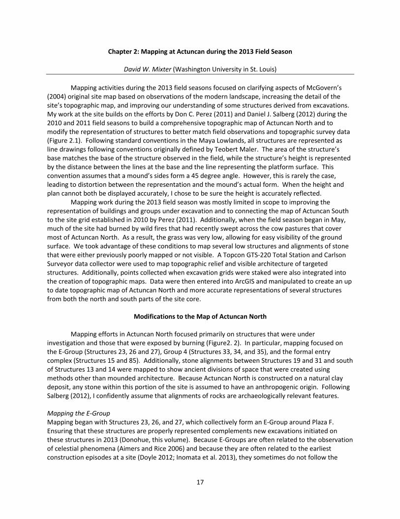
Chapter 2: Mapping at Actuncan during the 2013 Field Season
David W. Mixter (Washington University in St. Louis) Mapping activities during the 2013 field seasons focused on clarifying aspects of McGovern’s (2004) original site map based on observations of the modern landscape, increasing the detail of the site’s topographic map, and improving our understanding of some structures derived from excavations. My work at the site builds on the efforts by Don C. Perez (2011) and Daniel J. Salberg (2012) during the 2010 and 2011 field seasons to build a comprehensive topographic map of Actuncan North and to modify the representation of structures to better match field observations and topographic survey data (Figure 2.1). Following standard conventions in the Maya Lowlands, all structures are represented as line drawings following conventions originally defined by Teobert Maler. The area of the structure’s base matches the base of the structure observed in the field, while the structure’s height is represented by the distance between the lines at the base and the line representing the platform surface. This convention assumes that a mound’s sides form a 45 degree angle. However, this is rarely the case, leading to distortion between the representation and the mound’s actual form. When the height and plan cannot both be displayed accurately, I chose to be sure the height is accurately reflected. Mapping work during the 2013 field season was mostly limited in scope to improving the representation of buildings and groups under excavation and to connecting the map of Actuncan South to the site grid established in 2010 by Perez (2011). Additionally, when the field season began in May, much of the site had burned by wild fires that had recently swept across the cow pastures that cover most of Actuncan North. As a result, the grass was very low, allowing for easy visibility of the ground surface. We took advantage of these conditions to map several low structures and alignments of stone that were either previously poorly mapped or not visible. A Topcon GTS-220 Total Station and Carlson Surveyor data collector were used to map topographic relief and visible architecture of targeted structures. Additionally, points collected when excavation grids were staked were also integrated into the creation of topographic maps. Data were then entered into ArcGIS and manipulated to create an up to date topographic map of Actuncan North and more accurate representations of several structures from both the north and south parts of the site core.
Modifications to the Map of Actuncan North Mapping efforts in Actuncan North focused primarily on structures that were under investigation and those that were exposed by burning (Figure2. 2). In particular, mapping focused on the E-Group (Structures 23, 26 and 27), Group 4 (Structures 33, 34, and 35), and the formal entry complex (Structures 15 and 85). Additionally, stone alignments between Structures 19 and 31 and south of Structures 13 and 14 were mapped to show ancient divisions of space that were created using methods other than mounded architecture. Because Actuncan North is constructed on a natural clay deposit, any stone within this portion of the site is assumed to have an anthropogenic origin. Following Salberg (2012), I confidently assume that alignments of rocks are archaeologically relevant features. Mapping the E-Group Mapping began with Structures 23, 26, and 27, which collectively form an E-Group around Plaza F. Ensuring that these structures are properly represented complements new excavations initiated on these structures in 2013 (Donohue, this volume). Because E-Groups are often related to the observation of celestial phenomena (Aimers and Rice 2006) and because they are often related to the earliest construction episodes at a site (Doyle 2012; Inomata et al. 2013), they sometimes do not follow the
17
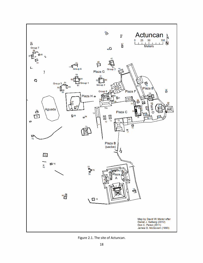
Figure 2.1. The site of Actuncan.
18
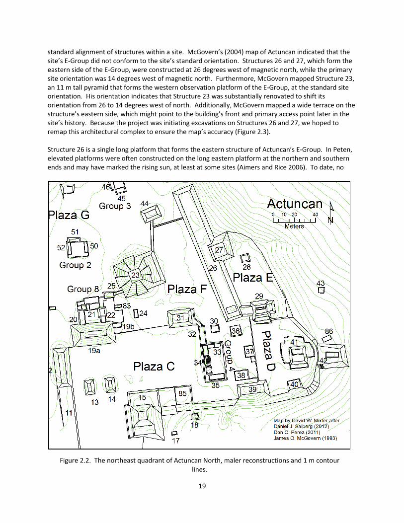
standard alignment of structures within a site. McGovern’s (2004) map of Actuncan indicated that the site’s E-Group did not conform to the site’s standard orientation. Structures 26 and 27, which form the eastern side of the E-Group, were constructed at 26 degrees west of magnetic north, while the primary site orientation was 14 degrees west of magnetic north. Furthermore, McGovern mapped Structure 23, an 11 m tall pyramid that forms the western observation platform of the E-Group, at the standard site orientation. His orientation indicates that Structure 23 was substantially renovated to shift its orientation from 26 to 14 degrees west of north. Additionally, McGovern mapped a wide terrace on the structure’s eastern side, which might point to the building’s front and primary access point later in the site’s history. Because the project was initiating excavations on Structures 26 and 27, we hoped to remap this architectural complex to ensure the map’s accuracy (Figure 2.3). Structure 26 is a single long platform that forms the eastern structure of Actuncan’s E-Group. In Peten, elevated platforms were often constructed on the long eastern platform at the northern and southern ends and may have marked the rising sun, at least at some sites (Aimers and Rice 2006). To date, no
Figure 2.2. The northeast quadrant of Actuncan North, maler reconstructions and 1 m contour lines.
19

raised platform has been identified on the northern end of Actuncan’s Structure 26; however, this end of the structure has been covered in dense secondary growth during the duration of the Actuncan Archaeological Project. The southern platform is very low and McGovern did not designate a separate structure number for it, although he did test it. In contrast, the central platform rises 2.8 m above Structure 26 and was designated Structure 27 because it protrudes from the east side of Structure 26. This platform likely supported a perishable superstructure. Based on our remapping of the structure, I slightly modified the angle of Structure 26 to 22 degrees west of magnetic north and shortened its length to 127 m. Additionally, I determined that the surface of Structure 27 was slightly narrower than mapped by McGovern, and I measured it at 12.5 m wide by 12.5 m deep. These dimensions and orientation were confirmed by excavations in 2013 (Donohue, this volume). Personal observations of Structure 23 during the 2012 and 2013 field seasons suggested to Lisa LeCount and I that Structure 23 might not have as simple a form as previously mapped. Indeed, walking around the structure it is difficult to clearly identify its corners, as the structure appeared more conical or possibly octagonal. The only feature that clearly identifies the structure as pyramidal is the terrace mapped by McGovern. Because of the round or octagonal shape, LeCount and I hypothesized that Structure 23 was a radial structure with large outset staircases that obscured the mound’s original shape as they collapsed. LeCount claims to have seen the northern outset staircase in the spring of 2013 after the fires. The western structures of E-Groups are often radial structures, as at Tikal (LaPorte and Fialko 1995), and my new reconstruction reflects this hypothesis. Additionally, I created a detailed topographic map across half of Structure 23 and carefully mapped the visible terrace to determine if the orientation of the building conformed to Structure 26 or the remainder of the site as mapped by McGovern. Based on the orientation of Structure 23’s eastern terrace, we determined that the pyramid did conform to the orientation of Structure 26 at 22 degrees west of north, not the remainder of the site’s architecture as originally mapped. Future research may lead to additional modifications to the map of Structure 23. Mapping Structures 29 and 73 During the 2013 field season, intensive excavations were initiated on Structures 29 and 73 for the first time (Nordine, this volume; Simova, this volume). Each of these structures are hypothesized to be large single elite houses based on their form and similarity to each other and Structure 41 (Mixter 2011, 2012). Correspondingly, I aimed to ensure that the
Figure 2.3. Map of Actuncan’s E-Group composed of Structures 23, 26, 27, 31, and 44 surrounding Plaza F.
20
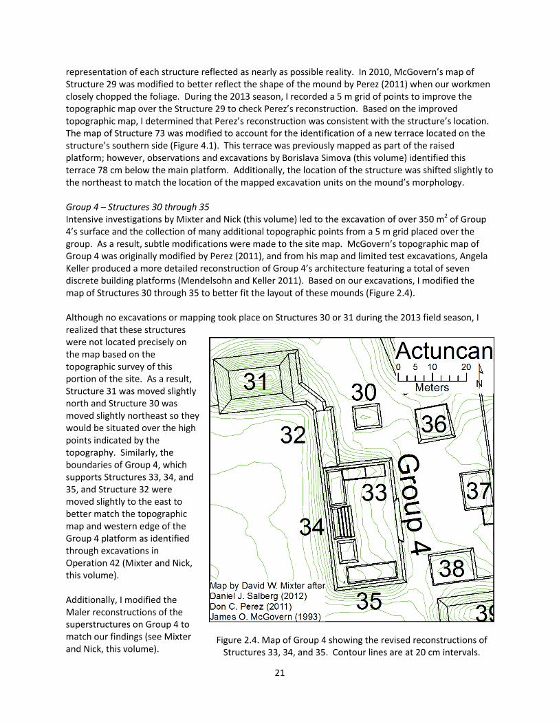
representation of each structure reflected as nearly as possible reality. In 2010, McGovern’s map of Structure 29 was modified to better reflect the shape of the mound by Perez (2011) when our workmen closely chopped the foliage. During the 2013 season, I recorded a 5 m grid of points to improve the topographic map over the Structure 29 to check Perez’s reconstruction. Based on the improved topographic map, I determined that Perez’s reconstruction was consistent with the structure’s location. The map of Structure 73 was modified to account for the identification of a new terrace located on the structure’s southern side (Figure 4.1). This terrace was previously mapped as part of the raised platform; however, observations and excavations by Borislava Simova (this volume) identified this terrace 78 cm below the main platform. Additionally, the location of the structure was shifted slightly to the northeast to match the location of the mapped excavation units on the mound’s morphology. Group 4 – Structures 30 through 35 Intensive investigations by Mixter and Nick (this volume) led to the excavation of over 350 m2 of Group 4’s surface and the collection of many additional topographic points from a 5 m grid placed over the group. As a result, subtle modifications were made to the site map. McGovern’s topographic map of Group 4 was originally modified by Perez (2011), and from his map and limited test excavations, Angela Keller produced a more detailed reconstruction of Group 4’s architecture featuring a total of seven discrete building platforms (Mendelsohn and Keller 2011). Based on our excavations, I modified the map of Structures 30 through 35 to better fit the layout of these mounds (Figure 2.4). Although no excavations or mapping took place on Structures 30 or 31 during the 2013 field season, I realized that these structures were not located precisely on the map based on the topographic survey of this portion of the site. As a result, Structure 31 was moved slightly north and Structure 30 was moved slightly northeast so they would be situated over the high points indicated by the topography. Similarly, the boundaries of Group 4, which supports Structures 33, 34, and 35, and Structure 32 were moved slightly to the east to better match the topographic map and western edge of the Group 4 platform as identified through excavations in Operation 42 (Mixter and Nick, this volume). Additionally, I modified the Maler reconstructions of the superstructures on Group 4 to match our findings (see Mixter and Nick, this volume).
Figure 2.4. Map of Group 4 showing the revised reconstructions of Structures 33, 34, and 35. Contour lines are at 20 cm intervals.
21
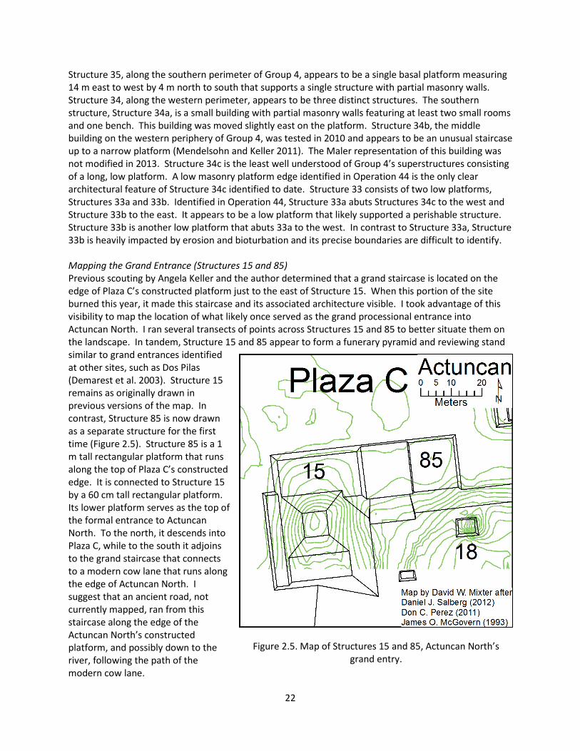
Structure 35, along the southern perimeter of Group 4, appears to be a single basal platform measuring 14 m east to west by 4 m north to south that supports a single structure with partial masonry walls. Structure 34, along the western perimeter, appears to be three distinct structures. The southern structure, Structure 34a, is a small building with partial masonry walls featuring at least two small rooms and one bench. This building was moved slightly east on the platform. Structure 34b, the middle building on the western periphery of Group 4, was tested in 2010 and appears to be an unusual staircase up to a narrow platform (Mendelsohn and Keller 2011). The Maler representation of this building was not modified in 2013. Structure 34c is the least well understood of Group 4’s superstructures consisting of a long, low platform. A low masonry platform edge identified in Operation 44 is the only clear architectural feature of Structure 34c identified to date. Structure 33 consists of two low platforms, Structures 33a and 33b. Identified in Operation 44, Structure 33a abuts Structures 34c to the west and Structure 33b to the east. It appears to be a low platform that likely supported a perishable structure. Structure 33b is another low platform that abuts 33a to the west. In contrast to Structure 33a, Structure 33b is heavily impacted by erosion and bioturbation and its precise boundaries are difficult to identify. Mapping the Grand Entrance (Structures 15 and 85) Previous scouting by Angela Keller and the author determined that a grand staircase is located on the edge of Plaza C’s constructed platform just to the east of Structure 15. When this portion of the site burned this year, it made this staircase and its associated architecture visible. I took advantage of this visibility to map the location of what likely once served as the grand processional entrance into Actuncan North. I ran several transects of points across Structures 15 and 85 to better situate them on the landscape. In tandem, Structure 15 and 85 appear to form a funerary pyramid and reviewing stand similar to grand entrances identified at other sites, such as Dos Pilas (Demarest et al. 2003). Structure 15 remains as originally drawn in previous versions of the map. In contrast, Structure 85 is now drawn as a separate structure for the first time (Figure 2.5). Structure 85 is a 1 m tall rectangular platform that runs along the top of Plaza C’s constructed edge. It is connected to Structure 15 by a 60 cm tall rectangular platform. Its lower platform serves as the top of the formal entrance to Actuncan North. To the north, it descends into Plaza C, while to the south it adjoins to the grand staircase that connects to a modern cow lane that runs along the edge of Actuncan North. I suggest that an ancient road, not currently mapped, ran from this staircase along the edge of the Actuncan North’s constructed platform, and possibly down to the river, following the path of the modern cow lane.
Figure 2.5. Map of Structures 15 and 85, Actuncan North’s grand entry.
22

Lines of Stone and Assorted Alterations to the Actuncan North Map Because of the burning within Plaza C, I was able to map stones that may have had anthropogenic origins within Plaza C (Figure 2.6). The first set of stones form an alignment running east to west from Structure 19 to Structure 31. Although a low elevation change was indicated as running part way across Plaza C in previous versions of the map, the visibility of these stones indicate the presence of a low wall or plaza elevation change that ran the entire way across Plaza C. This alignment may have divided the open, public southern part of Plaza C from the multi-patio palace complex assembled focused on Structure 19 (Mixter et al. 2013). The second set of mapped stones was located just south of Structures 13 and 14, Actuncan’s only known ballcourt. Although I originally suspected that these stones might form an end zone for the ballcourt, they do not clearly form alignments. Perhaps excavations could aid in evaluating this hypothesis. Additionally, several buildings were moved slightly to better match their topographic outlines from the survey map. Structure 13 was moved slightly west and Structure 18 was moved just northeast.
Mapping in Actuncan South
During the 2013 field season, excavations and survey of Actuncan South were initiated for the first time by members of the Actuncan Archaeological Project. Mapping focused on ensuring that Structures 7, 8, and 9 were properly represented (Figure 2.7). Because Actuncan South is covered by old growth forest, clearing activities only removed the underbrush to allow for more detailed assessments of the low platforms encountered therein. Although McGovern’s drawing approximates the location of Structures 7, 8, and 9, I found that they were somewhat different in shape than he indicated. Furthermore, in the space where he located Structure 8, I identified two distinct platforms. I named the smaller eastern platform Structure 93, following the sequential labeling system used across the site. Additionally, I adjusted the location of Actuncan South approximately 8 m to the northwest to better match the ArcGIS grid location of our mapped structures. As work continues within Actuncan South, the remainder of the temple complex will eventually need to be remapped and a detailed topographic map created; however, this year I focused on the low structures within Plaza A.
Figure 2.6. Map of stones recorded in Plaza C between Structures 19 and 31 and south of Structures 13 and 14.
23
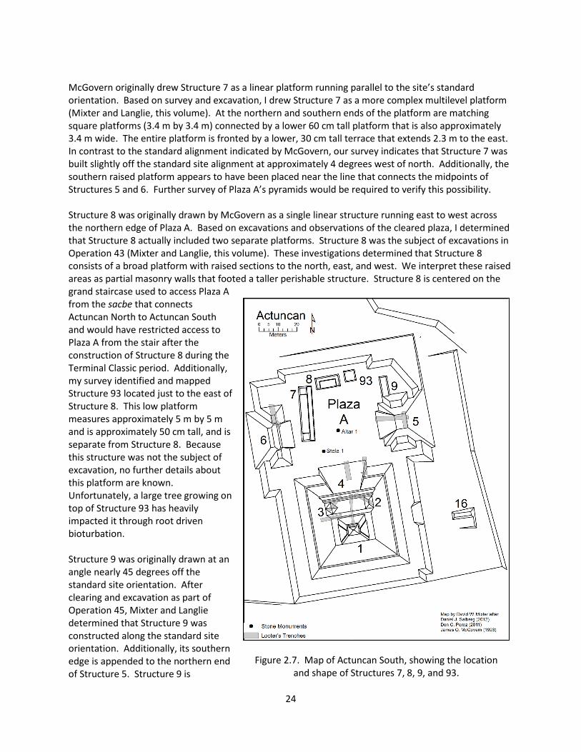
McGovern originally drew Structure 7 as a linear platform running parallel to the site’s standard orientation. Based on survey and excavation, I drew Structure 7 as a more complex multilevel platform (Mixter and Langlie, this volume). At the northern and southern ends of the platform are matching square platforms (3.4 m by 3.4 m) connected by a lower 60 cm tall platform that is also approximately 3.4 m wide. The entire platform is fronted by a lower, 30 cm tall terrace that extends 2.3 m to the east. In contrast to the standard alignment indicated by McGovern, our survey indicates that Structure 7 was built slightly off the standard site alignment at approximately 4 degrees west of north. Additionally, the southern raised platform appears to have been placed near the line that connects the midpoints of Structures 5 and 6. Further survey of Plaza A’s pyramids would be required to verify this possibility. Structure 8 was originally drawn by McGovern as a single linear structure running east to west across the northern edge of Plaza A. Based on excavations and observations of the cleared plaza, I determined that Structure 8 actually included two separate platforms. Structure 8 was the subject of excavations in Operation 43 (Mixter and Langlie, this volume). These investigations determined that Structure 8 consists of a broad platform with raised sections to the north, east, and west. We interpret these raised areas as partial masonry walls that footed a taller perishable structure. Structure 8 is centered on the grand staircase used to access Plaza A from the sacbe that connects Actuncan North to Actuncan South and would have restricted access to Plaza A from the stair after the construction of Structure 8 during the Terminal Classic period. Additionally, my survey identified and mapped Structure 93 located just to the east of Structure 8. This low platform measures approximately 5 m by 5 m and is approximately 50 cm tall, and is separate from Structure 8. Because this structure was not the subject of excavation, no further details about this platform are known. Unfortunately, a large tree growing on top of Structure 93 has heavily impacted it through root driven bioturbation. Structure 9 was originally drawn at an angle nearly 45 degrees off the standard site orientation. After clearing and excavation as part of Operation 45, Mixter and Langlie determined that Structure 9 was constructed along the standard site orientation. Additionally, its southern edge is appended to the northern end of Structure 5. Structure 9 is
Figure 2.7. Map of Actuncan South, showing the location and shape of Structures 7, 8, 9, and 93.
24
approximately 60 cm tall, 3 m wide and 10 m long. In the chapter by Mixter and Langlie in this volume, we further discuss the arrangement of Structures 7, 8, 9, and 93 in combination. In short, we hypothesize that these created a more limited ritual space within Plaza A that focused attention on Structure 5 during the Terminal Classic period. In the eastern position, Structure 5 would have represented the ancestral rulers of Actuncan and is known to have been used as a site of ritual in the Terminal Classic period.
Summary During the 2014 field season, wild fires in Actuncan North, a concerted chopping effort in Actuncan South, and excavations on selected structures provided additional information that allowed us to modify several distinct sections of Actuncan’s map and to increase the topographic detail within certain segments of Actuncan North. In particular, research focused on redefining the architecture around Plaza F, Actuncan’s E-Group. We determined that Structures 23, 26, and 27 are indeed constructed on the similar orientation, but one that is different from the site in general, and that Structure 23 is likely a radial structure. Additionally, excavations within Group 4 led to modifications to our reconstruction of Structures 33, 34, and 35. Structure 85 was substantially redrawn to show the alignment of the formal entrance to Actuncan North, and Structure 73 was slightly modified to show a newly understood terrace. Finally, Structures 7, 8, and 9 were each redrawn to reflect findings from excavation, and the newly identified Structure 93 was drawn between Structures 8 and 9. The map of Actuncan continues to be a work in progress and will doubtless be modified with continued work during 2014. Acknowledgements: I would like to thank the Institute of Archaeology and especially Drs. Jaime Awe and John Morris for providing permission for this research. During 2013, survey research was funded by the National Science Foundation (BCS-0923747), the National Geographic Society Committee for Research and Exploration, the Wenner-Gren Foundation, and the Washington University in St. Louis Graduate School of Arts and Sciences. Thanks to Lisa LeCount for supporting all aspects of my research at Actuncan. Thank you to the directors of individual excavations who contributed to the drawing of specific buildings: Borislava Simova, Kelsey Nordine, Luke Donohue, Allison Nick, and BrieAnna Langlie. A special thanks goes to Santo Penados Jr. of Succotz Village who worked holding the prism pole for most of the survey.
Works Cited Aimers, James J., and Prudence M. Rice 2006 Astronomy, Ritual, and the Interpretation of "E-Group" Architectural Assemblages. Ancient
Mesoamerica 17:79-96. Demarest, Arthur A., Kim Morgan, Claudia Wolley, and Héctor Escobedo 2003 The Political Acquisition of Sacred Geography: The Murciélagos Complex at Dos Pilas. In Maya
Palaces and Elite Residences: An Interdisciplinary Approach, edited by Jessica Joyce Christie, pp. 120-153. University of Texas Press, Austin.
Doyle, James A. 2012 Regroup on "E-Groups": Monumentality and Early Centers in the Middle Preclassic Maya
Lowlands. Latin American Antiquity 23(4):355-379. Inomata, Takeshi, Daniela Triadan, Kazuo Aoyama, Victor Castillo, and Hitoshi Yonenobu 2013 Early Ceremonial Constructions at Ceibal, Guatemala, and the Origins of Lowland Maya
Civilization. Science 340:467-471. LaPorte, Juan Pedro, and Vilma C. Fialko 1995 Unreencuentro Con Mundo Perdido, Tikal, Guatemala. Ancient Mesoamerica 6(1):41-94.
25
McGovern, James O. 2004 Monumental Ceremonial Architecture and Political Autonomy at the Ancient Maya City of
Actuncan, Belize. Unpublished Ph.D. dissertation, Department of Anthropology, University of California, Los Angeles.
Mendelsohn, Rebecca, and Angela H. Keller 2011 2010 Excavations at Group 4. In Actuncan Early Classic Maya Project: Report of the Third Season,
edited by Lisa J. LeCount and Angela H. Keller. On File at the Belize Insitute of Archaeology, Belmopan.
Mixter, David W. 2011 The 2010 Excavations on Structure 41. In Actuncan Early Classic Maya Project: Report of the
Third Season, edited by Lisa J. LeCount and Angela H. Keller, pp. 47-67. On file at the Belize Institute of Archaeology, Belmopan.
2012 The 2011 Excavations at Structures 40 and 41. In Actuncan Early Classic Maya Project: Report of the Fourth Season, edited by Lisa J. LeCount and John H. Blitz, pp. 61-138. On file at the Belize Institute of Archaeology, Belmopan.
Mixter, David W., Thomas R. Jamison, and Lisa J. LeCount 2013 Actuncan's Noble Court: New Insights into Political Strategies of an Enduring Center in the Upper
Belize River Valley. Research Reports in Belizean Archaeology 10:91-103. Perez, Don C. 2011 Mapping Actuncan. In Actuncan Archaeological Project: Report of the Third Season, edited by
Lisa J. LeCount and Angela H. Keller, pp. 10-14. On file at the Belize Insititute of Archaeology, Belmopan.
Salberg, Daniel J. 2012 Mapping Actuncan During the 2011 Season. In Actuncan Early Classic Maya Project: Report of
the Fourth Season, edited by Lisa J. LeCount and John H. Blitz, pp. 25-32. On file at the Belize Institute of Archaeology, Belmopan.
26