Miuccio frixa et alii SGI 2000
8
1 Mem. Soc. Geol. THE TRAPANESE STRUCTURAL DOMAIN IN THE TERMINI IMERESE MOUNTAIN AREA (SICILY) G. MIUCCIO (*), A. FRIXA (**), & M. BERTAMONI (***) ABSTRACT According to past publications, Mesozoic outcrops in the Sicilian chain area can be referred to different stratigraphic-structural domains. These domains were investigated in the subsurface by means of many oil wells, most of which were drilled in the sixties. A petrographic-stratigraphic review of the Mesozoic series drilled by wells was carried out, together with the study of some surface successions sampled in typical locations (e.g. Vallone S. Leonardo). The aim of the study was to reconstruct the margin of the Triassic-Liassic carbonate platform in its current structural location. This platform pertaining to the Trapanese domain, is formed by the Sciacca and the Inici Fms. In the central-western sector of Sicily, surface data and past publications (ABATE et al., 1992) place this margin west of Cerda 2 well. According to our study, however, it certainly has to be extended to include this well. Cerda 2 is located south of Monte S. Calogero which belongs to the Imerese structural domain. The surface geological study shows that Monte S. Calogero, like other lithologically similar structures trending NW-SE, could be interpreted as a ramp anticline. Between Monte S. Calogero and Cerda 2 well there is the Pizzo Bosco syncline, constituted by units belonging to the “Gessoso-Solfifera” Fm.. The extension of the Triassic-Liassic carbonate platform domain, which on the basis of the Cerda 2 well data certainly includes the subsurface of the southern sector of the Termini Imerese Mountains, could also involve the latter’s northern and eastern sectors (Monte S. Calogero and Monte dei Cervi), below the Imerese units. KEY WORDS: Sicilian chain, platform domains, subsurface data, ramp anticline, Sicily, carbonate platform, stratigraphy. ________ (*) ENI Agip/DIGE-GELG Geological dept., Distretto di Gela (CL) E-mail: [email protected] (**) ENI Agip/LABO-PETR Petrographic-Sedimento- logical dept., S. Donato M. E-mail:[email protected] (***) ENI Agip/LABO-STIG Stratigraphic dept., S.Donato M. E-mail: [email protected] RIASSUNTO In Sicilia nell’area di catena affiorano terreni mesozoici che, in base alla letteratura, sono riferibili a differenti domini stratigrafico-strutturali. In sottosuolo gli stessi terreni sono stati indagati da un certo numero di pozzi petroliferi, perforati in buona parte negli anni ‘60. Con la revisione petrografico-stratigrafica delle successioni mesozoiche di quei pozzi e per riferimento e confronto delle serie di superficie campionate in località tipo (es. Vallone S. Leonardo) si è tentato di ricostruire in sottosuolo il limite della piattaforma triassico-liassica, nell’attuale collocazione strutturale. Tale piattaforma, che caratterizza il dominio Trapanese, è costituita dalle Formazioni Sciacca ed Inici. Nel settore centro-occidentale della Sicilia, questo limite veniva posizionato dai dati di superficie e dalla letteratura (ABATE et al., 1992) ad ovest del pozzo Cerda 2. In base al nostro studio può essere sicuramente esteso verso est, quanto meno sino a comprendere il pozzo stesso. Il sondaggio è ubicato a sud di Monte S. Calogero, formato da terreni riferibili al Dominio strutturale Imerese. Monte S. Calogero, come altri rilievi litostratigraficamente analoghi ad esso allineati in direzione NW-SE, è interpretabile come un’anticlinale di rampa. Tra Monte S. Calogero ed il pozzo Cerda 2 si osserva la sinclinale di Pizzo Bosco, formata da terreni appartenenti alla Fm. Gessoso-Solfifera. L’estensione del dominio di piattaforma triassico- liassica che, sulla base dei dati del pozzo Cerda 2, riguarda con certezza il sottosuolo del settore meridionale dei Monti di Termini Imerese non è escluso che possa riguardare anche il settore settentrionale (Monte San Calogero) e quello orientale (Monte dei Cervi), al di sotto delle Unità Imeresi . TERMINI CHIAVE: Sicilia area di Catena, domini di piattaforma, dati di sottosuolo, anticlinale di rampa, Sicilia, piattaforma carbonatica, stratigrafia.
-
Upload
independent -
Category
Documents
-
view
0 -
download
0
Transcript of Miuccio frixa et alii SGI 2000

1
Mem. Soc. Geol.
THE TRAPANESE STRUCTURAL DOMAIN IN THE TERMINI IMERESE MOUNTAIN AREA (SICILY)
G. MIUCCIO (*), A. FRIXA (**), & M. BERTAMONI (***)
ABSTRACT According to past publications, Mesozoic outcrops in the Sicilian chain area can be referred to different stratigraphic-structural domains. These domains were investigated in the subsurface by means of many oil wells, most of which were drilled in the sixties. A petrographic-stratigraphic review of the Mesozoic series drilled by wells was carried out, together with the study of some surface successions sampled in typical locations (e.g. Vallone S. Leonardo). The aim of the study was to reconstruct the margin of the Triassic-Liassic carbonate platform in its current structural location. This platform pertaining to the Trapanese domain, is formed by the Sciacca and the Inici Fms. In the central-western sector of Sicily, surface data and past publications (ABATE et al., 1992) place this margin west of Cerda 2 well. According to our study, however, it certainly has to be extended to include this well. Cerda 2 is located south of Monte S. Calogero which belongs to the Imerese structural domain. The surface geological study shows that Monte S. Calogero, like other lithologically similar structures trending NW-SE, could be interpreted as a ramp anticline. Between Monte S. Calogero and Cerda 2 well there is the Pizzo Bosco syncline, constituted by units belonging to the “Gessoso-Solfifera” Fm.. The extension of the Triassic-Liassic carbonate platform domain, which on the basis of the Cerda 2 well data certainly includes the subsurface of the southern sector of the Termini Imerese Mountains, could also involve the latter’s northern and eastern sectors (Monte S. Calogero and Monte dei Cervi), below the Imerese units. KEY WORDS: Sicilian chain, platform domains, subsurface data, ramp anticline, Sicily, carbonate platform, stratigraphy. ________ (*) ENI Agip/DIGE-GELG Geological dept., Distretto di
Gela (CL) E-mail: [email protected] (**) ENI Agip/LABO-PETR Petrographic-Sedimento- logical dept., S. Donato M. E-mail:[email protected] (***) ENI Agip/LABO-STIG Stratigraphic dept., S.Donato M. E-mail: [email protected]
RIASSUNTO
In Sicilia nell’area di catena affiorano terreni mesozoici che, in base alla letteratura, sono riferibili a differenti domini stratigrafico-strutturali. In sottosuolo gli stessi terreni sono stati indagati da un certo numero di pozzi petroliferi, perforati in buona parte negli anni ‘60. Con la revisione petrografico-stratigrafica delle successioni mesozoiche di quei pozzi e per riferimento e confronto delle serie di superficie campionate in località tipo (es. Vallone S. Leonardo) si è tentato di ricostruire in sottosuolo il limite della piattaforma triassico-liassica, nell’attuale collocazione strutturale. Tale piattaforma, che caratterizza il dominio Trapanese, è costituita dalle Formazioni Sciacca ed Inici. Nel settore centro-occidentale della Sicilia, questo limite veniva posizionato dai dati di superficie e dalla letteratura (ABATE et al., 1992) ad ovest del pozzo Cerda 2. In base al nostro studio può essere sicuramente esteso verso est, quanto meno sino a comprendere il pozzo stesso. Il sondaggio è ubicato a sud di Monte S. Calogero, formato da terreni riferibili al Dominio strutturale Imerese. Monte S. Calogero, come altri rilievi litostratigraficamente analoghi ad esso allineati in direzione NW-SE, è interpretabile come un’anticlinale di rampa. Tra Monte S. Calogero ed il pozzo Cerda 2 si osserva la sinclinale di Pizzo Bosco, formata da terreni appartenenti alla Fm. Gessoso-Solfifera. L’estensione del dominio di piattaforma triassico-liassica che, sulla base dei dati del pozzo Cerda 2, riguarda con certezza il sottosuolo del settore meridionale dei Monti di Termini Imerese non è escluso che possa riguardare anche il settore settentrionale (Monte San Calogero) e quello orientale (Monte dei Cervi), al di sotto delle Unità Imeresi . TERMINI CHIAVE: Sicilia area di Catena, domini di piattaforma, dati di sottosuolo, anticlinale di rampa, Sicilia, piattaforma carbonatica, stratigrafia.
2
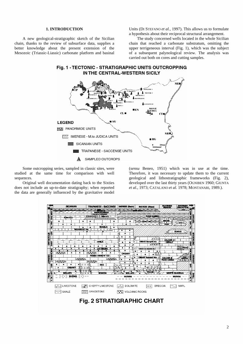
1. INTRODUCTION A new geological-stratigraphic sketch of the Sicilian chain, thanks to the review of subsurface data, supplies a better knowledge about the present extension of the Mesozoic (Triassic-Liassic) carbonate platform and basinal
Units (DI STEFANO et al., 1997). This allows us to formulate a hypothesis about their reciprocal structural arrangement. The study concerned wells located in the whole Sicilian chain that reached a carbonate substratum, omitting the upper terrigeneous interval (Fig. 1), which was the subject of a subsequent palynological review. The analysis was carried out both on cores and cutting samples.
Some outcropping series, sampled in classic sites, were studied at the same time for comparison with well sequences. Original well documentation dating back to the Sixties does not include an up-to-date stratigraphy; when reported the data are generally influenced by the gravitative model
(sensu Beneo, 1951) which was in use at the time. Therefore, it was necessary to update them to the current geological and lithostratigraphic frameworks (Fig. 2), developed over the last thirty years (OGNIBEN 1960; GIUNTA et al., 1973; CATALANO et al. 1978; MONTANARI, 1989.).
3
The carbonate substratum can be divided into the following three different sectors: - a central-eastern sector, investigated by several wells (Platani 2, Creta 1, Avanella 1, Valledolmo 1, Colla 1, Pastonello 1, Pizzo Bella Fontana 1, Gagliano 101 and Mistretta 1), where a carbonate basinal substratum belonging to Imerese-Sicanian Units was reached; - a northern-eastern sector, investigated by two wells (Maragone 1 and Pollina 1), where a carbonate platform substratum belonging to the Panormide Unit was reached; - a western sector, investigated by some wells (Poggioreale 1, Segesta 1, Alcamo 1, Marineo 1 and Cerda 2) where a carbonate platform substratum belonging to the Trapanese Unit was reached. It is important to specify that the difference between the Panormide and the Trapanese Units is connected with the type of sequence above the Liassic platform; the former is generally related to a carbonate platform sedimentation, the latter to a sea-mount environment.
2. PETRO-STRATIGRAPHIC ANALYSIS Mesozoic carbonates were sampled in many northern and western Sicily outcrops. These series are representative of almost all the tectonic units and enable us to compare them with cuttings or cores. In many cases we observe similar facies and sequences, in others it is possible to recognize transitions. 2.1 OUTCROP SAMPLES Most of the sampled outcrops are located in western Sicily, only a few in central-northern (Madonie Mts.) and the central-eastern (Judica Mt.) part of the island. In the Madonie Mts. and in the Palermo Mts., the Panormide structural Unit is made up of a carbonate platform succession from Norian through Eocene time, with rare environmental changes after lower Jurassic; the succession of this last period includes not only platform but also slope and sea-mounth deposits (OGNIBEN, 1960; GRASSO et al. 1978; ABATE et al., 1982 a) b), c); BROQUET, 1970; CATALANO et al., 1982). In the Palermo Mts (Cozzo di Lupo), during the Dogger, the deposition of condensed sections happened in sea mount conditions (Rosso Ammonitico Fm.), developing into slope conditions during the early Cretaceous (Lattimusa Fm.). During the late Cretaceous, carbonate platform drowning episodes occured in the whole Panormide structural domain (Scaglia Fm.). Outcrops of the Imerese structural Unit show a sedimentary sequence related to a slope environment, ranging from the late Triassic through the Eocene. In the basinal series, it is possible to observe two intervals, which are very rich in reworked platform carbonates, namely the Fanusi Fm. (early Triassic-early Liassic) and the Calcari ad Ellipsactinia Member of the Crisanti Fm (Malm-early Cretaceous). There is no basinal sequence belonging to the Imerese Unit on the surface. The Monte Judica structural Unit is similar to the Imerese structural Unit, but it is related to a basinal
environment and there are no reworked sediments present (LENTINI et al., 1991).
In the Triassic-Liassic, the Sicanian structural Unit (MASCLE,1973; DI STEFANO et al., 1991; LENTINI et al., 1996) is a basinal sequence, like the coeval interval of the Imerese and Monte Judica structural Units. The post-Liassic is characterized by the deposition of basinal successions in an epibatial environment. A layer of reworked platform carbonate is present at the Triassic-Liassic boundary and is related to a slope event (DI STEFANO et al., 1996). The Trapanese structural Unit, like the Saccense one, is formed by Triassic-Liassic platform carbonates, covered by a condensed Liassic-Cretaceous succession of sea-mount environment. In the present structural units distribution, Trapanese is deformed and belong to the chain, while Saccense is slightly deformed and represents the Sicilian western foreland.
2.2 WELL SAMPLES In the subsurface, the Panormide structural Unit outcropping in the Madonie Mts. extends eastward to reach at least the geographical boundary of Peloritani/Nebrodi Mts., where Maragone 1 well is located. The top of this unit deepens gradually, while its facies is constantly concerning a carbonate platform edge. In Maragone 1 and Pollina 1 wells, (the latter located in the Madonie Mts. area), the Panormide Unit is made up of fine to medium dolomite with no recognizable fossil remains. Above the Panormide carbonates, Maragone 1 drilled a series similar to the Sicilide structural Unit. The Imerese structural Unit, known on the surface, was encountered by many wells (Colla 1, Pastonello 1, Pizzo Bella Fontana 1 and Mistretta 1) localised immediately south of the Madonie and Nebrodi Mts (BIANCHI et al., 1989). These wells show a slope sequence similar to the Madonie and Palermo Mts. series, particularly for two periods: - Jurassic-early Cretaceous (Calcari ad Ellipsactinia and Spongoliti Mbrs. of the Crisanti Fm.); - Paleocene-Eocene (Caltavuturo Fm.). A basinal sequence, not present on the surface, was drilled by Avanella 1, Valledolmo 1, Creta 1 and Gagliano 101 wells, located in the central-northern part of Sicily. It’s an eteropic sequence among Monte Judica, Sicanian and Imerese structural Units, attributed, for geographic reasons, to the Imerese one. Creta 1 well is differentiated from the other wells because in the upper part of the carbonate series many platform-derived clastics are shown. Based on present day knowledge, the origin of these sediments is hardly explained; reworked clasts are late Triassic in age, while the matrix is early Liassic. Probably, the source area of the resedimented deposits was located to the south-east, in the Iblean-Trapanese-Saccense domains. The present structural location of this source area could be placed north of Creta 1 well. A typical Sicanian sequence was drilled by Platani 2 well, which is located east of Monte Cammarata.

4
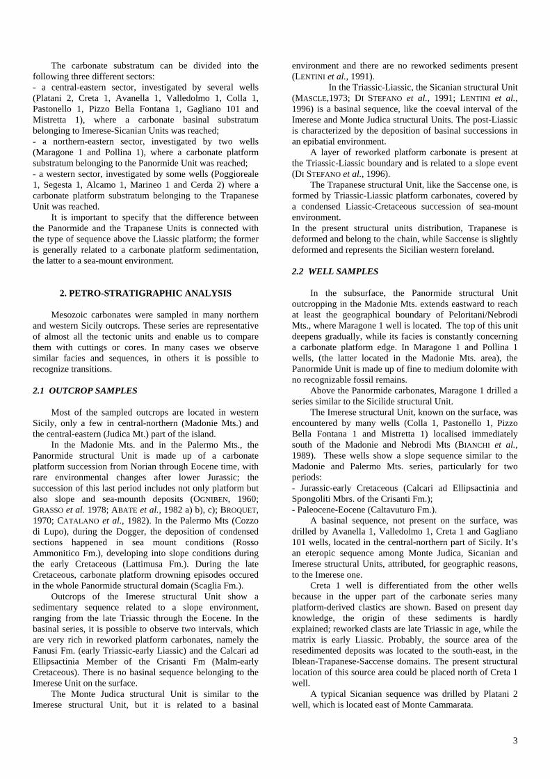
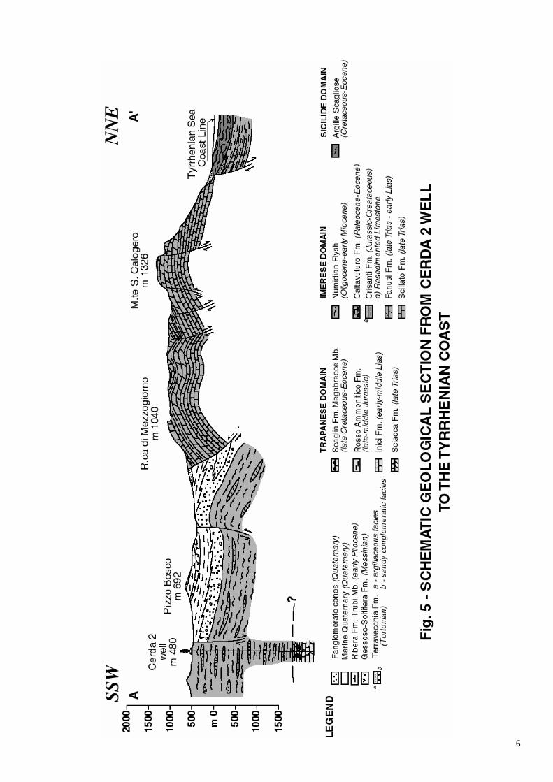
The Trapanese Unit is present in all the western wells of the Sicilian chain: Alcamo 1, Poggioreale 1, Segesta 1, Marineo 1, Cerda 2 and probably Vicari 1. The latter ended in early Cretaceous strata, after crossing a basinal condensed succession which could be ascribed to the Sicanian-Trapanese Units. As the location of the well (Vicari village, near a Trapanese Unit outcrop) suggests, a Trapanese Triassic-Liassic carbonate platform sequence could be present in the Vicari 1 area, not reached by the well. Cerda 2 represents the focal point of the study. The petrostratigraphic review of this well allowed us to define the present subsurface extension of the Trapanese structural Unit boundary. 2.3 CERDA 2 WELL Cerda 2 is located south of Termini Imerese Mountains (the top is Monte S. Calogero; 1326 m). The sequence outcropping in this area belongs to the Imerese Unit and extends as far as Rocca di Mezzogiorno (1040 m), on the southern side. Between Rocca di Mezzogiorno and Cerda 2 well there is a hill, Pizzo Bosco (692 m), which is prevailingly made of evaporites of the Gessoso-Solfifera Fm. (Messinian). The upper part of the succession drilled by Cerda 2 well belongs to the Imerese structural Unit, while the lower one to the Trapanese structural Unit. The Imerese interval (0-2345 m) is represented by the Flysch Numidico Fm. (early Oligocene-early Miocene), that outcrops on the surface nearby the well. The upper part of this formation (0-1700 m) is a typical succession of alternating shale and sandstone, while the lower one (1700-2345 m) is made of marly shales with limestone interbeddings. It only contains Radiolaria and Sponge spicules and perhaps belongs to Mufara Fm (Carnian Flysch). The Trapanese interval (2345-2742 m T.D.) consists of a basinal succession (Scaglia and Rosso Ammonitico Fm.) superimposed to a carbonate shallow platform one (Inici and Sciacca Fms.). The Scaglia Fm (2345-2475 m) could be divided into the following two parts: - “Pelagic limestones” (2345-2445 m): white to grey mudstones/wackestones (Eocene) reddish at the bottom (Paleocene), rich in planktic foraminifera (Turborotalia cerroazulensis, Chiloguembelina, Acarinina rohri, A. topilensis, Morozovella aragonensis, M. spinulosa, M. velascoensis); - “Megabreccia” (2445-2475 m): grey recrystallized and dolomitized breccia, formed by algal boundstones and intraclastic packstones with interbeddings of green and reddish shales. Valvulinidae, Textulariidae, Dasycladaceae, Solenoporaceae, Codiaceae, Mollusca, Echinodermata rests,
are in the elements of the breccia, while Cretaceous planktic Foraminifera (Globotruncana) are in the shales. A hyatus at 2475 m separates the Scaglia Fm. from the Rosso Ammonitico Fm. (2475-2545 m). The latter formation could be divided into two parts: - upper part (Malm): nodular, brown with reddish shades, fossiliferous (Globochaete alpina, Sponge spicules, Crinoidea, Aptychus, Saccocoma) mudstones/wackestones; - lower part (Dogger): grey, green and red sicilized mudstones/wackestones, containing Radiolaria, Sponge spicules and Ostracoda. Megabreccia levels at the bottom of Scaglia Fm, as seen at Rocca Busambra, and a condensed Rosso Ammonitico Fm, related to a seamount enviroment, are two typical elements that characterize the Trapanese succession (CATALANO et al., 1990). The shallow platform carbonates of the lowermost part of Cerda 2 well (Fig. 3) belongs to Inici (early-middle Liassic) and Sciacca (Norian-Rhaetian) Fms. The Inici Fm. (2545-2590 m) is made up of fine peloidal fossiliferous packstone, passing upwards to fine to medium intra-bioclastic packstone/grainstone (“coarsening upwards cycles”). Common fossil remains are represented by benthic forams, echinoids fr. and Codiacean algae. The Sciacca Fm. (2590-2742 m T.D.) as at Monte Genuardo (DI STEFANO et al., 1987), is divided into the two following parts: - the upper one (2590-2675 m) consists of “reefal”, partly dolomitic, fossiliferous (Galeanella panticae, Algae, Calcisponges, Corals and Hydrozoans) whitish packstones and boundstones; - the lower one (2675-2742 m) is characterised by whitish, fine to medium grained dolomite, with Mollusca fr.; green dolomitic marl fillings vugs and fractures (probable neptunian dykes) and traces of pyrite have been also observed.
3. SURFACE STRUCTURE
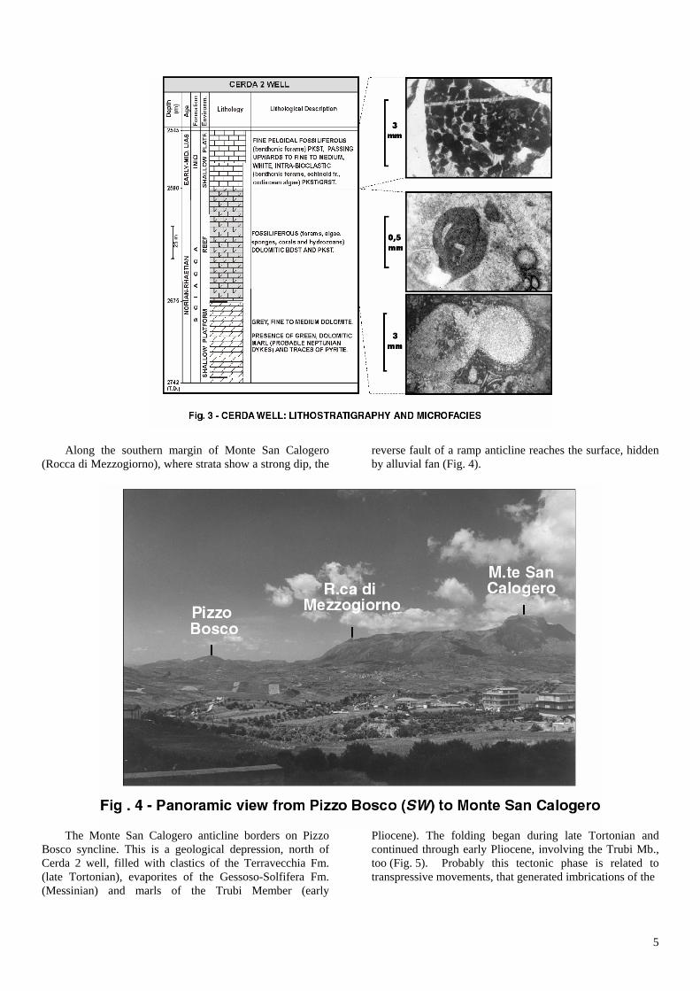
The Termini Imerese Mountains, and in particular Monte San Calogero, belong to the Imerese structural domain. On the surface, this domain extends NW-SE along the northern Sicily belt and forms major structural culminations, from the Madonie to the Palermo Mountains, according to an interpretation model based on a system of ramp anticlines, trending NW-SE (CATALANO et al., 1998). The Monte San Calogero anticline can be related to other structures: the Pizzo Trigna anticline to the north-west and the Monte dei Cervi anticline to the south-east.
5
Along the southern margin of Monte San Calogero (Rocca di Mezzogiorno), where strata show a strong dip, the
reverse fault of a ramp anticline reaches the surface, hidden by alluvial fan (Fig. 4).
The Monte San Calogero anticline borders on Pizzo Bosco syncline. This is a geological depression, north of Cerda 2 well, filled with clastics of the Terravecchia Fm. (late Tortonian), evaporites of the Gessoso-Solfifera Fm. (Messinian) and marls of the Trubi Member (early
Pliocene). The folding began during late Tortonian and continued through early Pliocene, involving the Trubi Mb., too (Fig. 5). Probably this tectonic phase is related to transpressive movements, that generated imbrications of the
6
7
Imerese Units, redeforming ancient thrusts (CATALANO et al., 1996).
4. CONCLUSION The Trapanese Unit, in its present structural location, outcropping at Monte Kumeta and Rocca Busambra ridges, certainly can be extended eastward in the subsurface to include Cerda 2 well; this is the main result obtained form the revision of several wells along the Sicilian chain. Other findings are: - the probable extension of the Trapanese Unit to Vicari 1 well, located near the homonymous village.
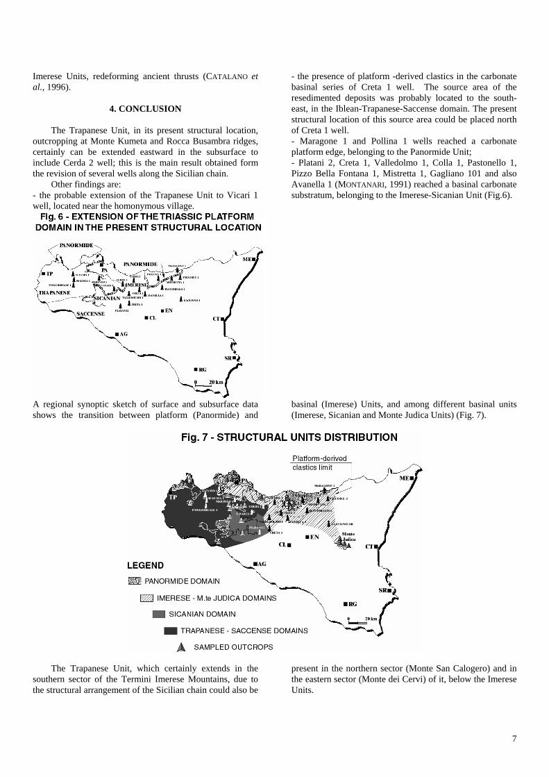
- the presence of platform -derived clastics in the carbonate basinal series of Creta 1 well. The source area of the resedimented deposits was probably located to the south-east, in the Iblean-Trapanese-Saccense domain. The present structural location of this source area could be placed north of Creta 1 well. - Maragone 1 and Pollina 1 wells reached a carbonate platform edge, belonging to the Panormide Unit; - Platani 2, Creta 1, Valledolmo 1, Colla 1, Pastonello 1, Pizzo Bella Fontana 1, Mistretta 1, Gagliano 101 and also Avanella 1 (MONTANARI, 1991) reached a basinal carbonate substratum, belonging to the Imerese-Sicanian Unit (Fig.6).
A regional synoptic sketch of surface and subsurface data shows the transition between platform (Panormide) and
basinal (Imerese) Units, and among different basinal units (Imerese, Sicanian and Monte Judica Units) (Fig. 7).
The Trapanese Unit, which certainly extends in the southern sector of the Termini Imerese Mountains, due to the structural arrangement of the Sicilian chain could also be
present in the northern sector (Monte San Calogero) and in the eastern sector (Monte dei Cervi) of it, below the Imerese Units.

8
ACKNOWLEDGEMENTS
The Authors are grateful to the Management of Eni/Divisione Agip for permission to publish this paper.
REFERENCES ABATE B., CATALANO R. & RENDA P. (1982a) - I Monti di
Palermo; In: Catalano R. & D’Argenio B. (Eds.) - Guida alla geologia della Sicilia Occidentale. S.G.I. Guide Geol. Reg., 43-48.
ABATE B., CATALANO R., D’ARGENIO B., DI STEFANO E.,
DI STEFANO P., LO CICERO G., MONTANARI L., PECORARO C. & RENDA P. (1982b) - Evoluzione delle zone di cerniera tra Piattaforme Carbonatiche e Bacini nel Mesozoico e nel Paleogene della Sicilia Occidentale. In: R. CATALANO & D’ARGENIO B. (Eds.) - Guida alla geologia della Sicilia occidentale. S.G.I. Guide Geol. Reg., 53-81.
ABATE B., CATALANO R., D’ARGENIO B., DI STEFANO P. &
RENDA P. (1982c) - Facies sedimentarie e lineamenti strutturali delle Madonie orientali. In: Catalano & D’Argenio B. (Eds.) - Guida alla geologia della Sicilia occidentale. S.G.I. Guide Geol. Reg., 49-52.
ABATE B., RENDA P. & TRAMUTOLI M. (1992) - Carta
Geologica dei Monti di Termini Imerese e delle Madonie occidentali. Scala 1:50.000. Dipartimento di Geologia e Geodesia dell’Università di Palermo.
BENEO E. (1951) - Appunti sulla elaborazione di una
diagnosi strutturale della Sicilia. Boll. Soc. Geol. It., 68, 66-80.
BIANCHI F., CARBONE S., GRASSO M., INVERNIZZI G.,
LENTINI F., LONGARETTI G., MERLINI S. & MOSTARDINI F. (1989) - Sicilia orientale: profilo geologico Nebrodi-Iblei. Mem. Soc. Geol. It. 38, 127-135.
BROQUET P. (1970) - The Geology of Madonie mountains of
Sicily. In: Alvarez W. & Gohrbandt K.H.A.(Eds.) - Geology and history of Sicily. Petrol. Expl. Soc. Lybia , 201-230.
CATALANO R. & D’ARGENIO B. (1982) - Schema geologico
della Sicilia. In: Catalano R. & D’Argenio B. (Eds.) - Guida alla geologia della Sicilia occidentale. S.G.I. Guide Geol. Reg., 9-41.
CATALANO R. & D’ARGENIO B., (1990) - Hammering a
seismic section. In Catalano R. & D’Argenio B., (Eds.) Field-trip in Western Sicily. Guide Book, 3-79.
CATALANO R., DI STEFANO P., SULLI A. & VITALE F.P.
(1996) - Paleogeography and structure of the central Mediterranean: Sicily and its off-shore area. Tectonophysics, 260, 291-323.
CATALANO R. (1998) - Atti 79° Congresso Società
Geologica - Struttura della Catena Siciliana - Introduzione, Guidebook, 7-12.
DI STEFANO P. & GULLO M. (1987) - Late Triassic-Early
Jurassic sedimentation and tectonics in the Monte Genuardo Unit (Saccense Domain, Western Sicily). Rend. Soc. Geol. It., 9, 179-188.
DI STEFANO P. & VITALE F.P. (1991) - Carta Geologica dei
Monti Sicani. Scala 1:50.000. Dipartimento di Geologia e Geodesia dell’Università di Palermo.
DI STEFANO P., ALESSI A. & GULLO M. (1996) - Mesozoic
and Paleogene Megabreccias in Southern Sicily: new data on the triassic paleomargin of the siculo-tunisian platform. Facies, 34, 101-122, pl.28-33, 16 figs., Erlangen 1996.
DI STEFANO P. & GULLO M. (1997) - Late Paleoeozoic-
Early Mesozoic stratigraphy and paleogeography of Sicily. 8th ILP workshop, Palermo, 11-13 Giugno 1997. Guidebook 87-99.
GIUNTA G. & LIGUORI V. (1973) - Evoluzione
paleotettonica della Sicilia. Boll. Soc. Geol. It., 92, 903-924.
GRASSO M., LENTINI F. & VEZZANI L. (1978) - Lineamenti
stratigrafico-strutturali delle Madonie (Sicilia centro-settentrionale). Geol. Rom., Vol. XVII, 45-69.
LENTINI F., CARBONE S., Catalano S., Grasso M. & Monaco
C. (1991) - Carta Geologica della Sicilia centro orientale. Scala 1:50.000, Univ. di Catania.
LENTINI F., CARBONE S., CATALANO S. & GRASSO M.,
(1996) - Elementi per la ricostruzione del quadro strutturale della Sicilia orientale. Mem. Soc. Geol. It., 51, 179-195.
MASCLE G.H. (1973) - Etude geologique des Monti Sicani.
These Doctorat, Paris. MONTANARI L. (1989) - Lineamenti stratigrafico-
paleogeografici della Sicilia durante il Ciclo Alpino. Mem. Soc. Geol. It. 38, 361-406.
MONTANARI L. (1991) - Denudamenti tettonici e sostituzioni
nelle coperture in Sicilia durante il Miocene. Mem. Soc. Geol. It., 47, 181-190.
OGNIBEN L. (1960) - Nota illustrativa dello Schema geologico della Sicilia nord-orientale. Riv. Min. Sic., 64-65, 183-212.