Mississippian Feature Patterning, Site Structure, and Community Organization at the Cox Site...
29
VOLUME 42, NUMBER 2 FALL 2014 EARLY GEORGIA VOLUME 42, NUMBER 2 FALL 2014 THE SOCIETY FOR GEORGIA ARCHAEOLOGY VOLUME 42, NUMBER 2 FALL 2014 THE SOCIETY FOR GEORGIA ARCHAEOLOGY Guest Editor’s Introduction by Daniel P. Bigman ...................................................................................................................... 119 Peer-Reviewed Articles Ground-Penetrating Radar at The Leake Site: Investigations, Results, and Interpretations by Pamela Baughman and Scot Keith ............................................................................................ 123 Archaeological Prospection and Investigation at the Dabbs Site, Bartow County, Georgia by Jeffrey Turner, Keener Smith, Jessie Griggs Burnette, Sheldon Skaggs, and Terry G. Powis .............. 143 Archaeological and Geophysical Investigations of Raccoon Ridge, a transitional Late Woodland-Early Mississippian Village in the Georgia Piedmont by Jennifer Birch and Jacob Lulewicz ............................................................................................ 163 Ground Penetrating Radar and Resistivity Results from Mounds D and F at Singer-Moye (9SW2) by Stefan Brannan and Daniel P. Bigman ..................................................................................... 179 Investigating the Effects of Agricultural and Archaeological Disturbance at the Hollywood Site (9RI1) by Christopher L. Thornock .......................................................................................................... 193 Mississippian Feature Patterning, Site Structure, and Community Organization at the Cox Site (1JA176), Jackson County, Alabama: Geophysical Survey Results by Shawn M. Patch, Sarah Lowry, and Erin Pritchard ...................................................................211 PEER REVIEWED ARTICLES SHALLOW GEOPHYSICS OF PREHISTORIC SITES OF GEORGIA
-
Upload
independent -
Category
Documents
-
view
0 -
download
0
Transcript of Mississippian Feature Patterning, Site Structure, and Community Organization at the Cox Site...

Volume 42, Number 2Fall 2014
ea
rly G
eo
rG
ia Vo
lum
e 42, Nu
mb
er 2 F
all 2014 T
he S
oc
ieT
y For G
eo
rG
ia ar
ch
ae
olo
Gy Volume 42, Number 2 Fall 2014The SocieTy For GeorGia archaeoloGy
Guest Editor’s Introduction by Daniel P. Bigman ......................................................................................................................119
Peer-Reviewed Articles
Ground-Penetrating Radar at The Leake Site: Investigations, Results, and Interpretations by Pamela Baughman and Scot Keith ............................................................................................123
Archaeological Prospection and Investigation at the Dabbs Site, Bartow County, Georgia by Jeffrey Turner, Keener Smith, Jessie Griggs Burnette, Sheldon Skaggs, and Terry G. Powis ..............143
Archaeological and Geophysical Investigations of Raccoon Ridge, a transitional Late Woodland-Early Mississippian Village in the Georgia Piedmont by Jennifer Birch and Jacob Lulewicz ............................................................................................163
Ground Penetrating Radar and Resistivity Results from Mounds D and F at Singer-Moye (9SW2) by Stefan Brannan and Daniel P. Bigman .....................................................................................179
Investigating the Effects of Agricultural and Archaeological Disturbance at the Hollywood Site (9RI1) by Christopher L. Thornock ..........................................................................................................193
Mississippian Feature Patterning, Site Structure, and Community Organization at the Cox Site (1JA176), Jackson County, Alabama: Geophysical Survey Results by Shawn M. Patch, Sarah Lowry, and Erin Pritchard ...................................................................211
Peer reViewed arTicleS
Shallow GeoPhySicS oF PrehiSToric SiTeS oF
GeorGia

Early Georgia
Copyright © 2014 by the Society for Georgia Archaeology. All rights reserved.
M. Jared Wood, EditorDaniel P. Bigman, Guest EditorDavid J. Hally, Managing Editor
Officers of The Society for Georgia Archaeology2011-2013
President: Joseph RobertsVice President/President Elect: Tom Lewis
Secretary: Misity Y. DunnTreasurer: Rick SellersParliamentarian: TBD
Board of Directors: Joseph Roberts, Amanda Morrow, Phillip T. “PT” Ashlock, Lance Green, Corey Mc-Quinn, Richard Moss, Amanda D. Roberts Thompson, 2015-2018Matt Newberry, Leslie Perry, Don Thieme, Inger Wood, 2011-2014
Tammy Forehand Herron (ex-officio)
Early Georgia Editor: M. Jared Wood, Department of Sociology and AnthropologyGeorgia Southern University, Statesboro, GA 30460, [email protected].
Early Georgia Managing Editor: David J. Hally, Department of Anthropology, University of Georgia,Athens, GA 30602-1619
The Profile Editor: Benjamin Steere, [email protected]
Information for Subscribers
Early Georgia is published semi-annually in the Spring and Fall by the Society for Georgia Archaeology.Postage is paid at Athens, Georgia. Subscription is by membership in the Society for Georgia Archaeology.
Annual dues for individual members are $25.00, $30.00 for family, $15.00 for students, $500.00 forbenefactors, and $75.00 for institutions. One membership includes two issues of Early Georgia and thequarterly newsletter, The Profile. Single copies of Early Georgia may be purchased for $10.00 per issue forSociety for Georgia Archaeology members and $15.00 for non-members. Georgia residents must includeapplicable sales tax. Address all inquiries concerning membership and change of address to the Secretary.Address requests for back issues of Early Georgia to Publications, Department of Anthropology, University
of Georgia, Athens, GA 30602-1619.
ISSN 0422-0374 www.thesga.org
Information for Authors
Early Georgia publishes papers on the archaeology of Georgia and closely related subjects. While allsubmissions are subject to editorial review, authors may request to have their papers reviewed througha formal peer review process. Papers accepted for publication through the peer review process will be
designated as Peer-Reviewed Articles.
Style should conform to the guidelines published in American Antiquity, available from the website ofthe Society for American Archaeology web site at:
http://www.saa.org/publications/Styleguide/styframe.html.
All tabular material should be separated from the text. Each table should be typed on a separate pageand numbered consecutively in the order that they are referred to in the manuscript. Tables can be
included in the same electronic file as the text. If they are separated from the text, give them each aneasily-understood descriptive name (e.g., wood_table_1).
Photos and illustrations should consist of either high quality prints or scans in TIF, JPG or BMP format with a minimum resolution of 600 dpi. Graphics should be sent in separate files using descriptive
file names (e.g., wood_figure_1). Do not shrink or compress photos in any way beforesubmitting. Convert color photos to grayscale before submitting.
Authors are responsible for securing written permission for the use of materials protected by U.S. or Inter-national copyright laws. Written permission is also required to publish material that did not originate
with the author, including photographs, illustrations, and unpublished data. Evidence of permission topublish copyrighted materials or the work of others must be submitted to the Editor with the author’s
manuscript.
Articles for peer review should be submitted directly to the Editor in electronic format at [email protected]. Submitting the article in pdf format, including all tables and figures in a single file, will
expedite the review process. However, submission in Word is also acceptable.
Final submission of peer review articles, as well as submission of articles that are not for formal peerreview, should be sent to the editor in MS Word format. Submissions with few tables and figures can be submitted via email to [email protected]. If numerous tables and figures are to be
submitted in electronic format, place all of the electronic files on a CD or DVD and mail them tothe editor:
M. Jared WoodDepartment of Sociology and Anthropology
Georgia Southern UniversityStatesboro, GA 30460
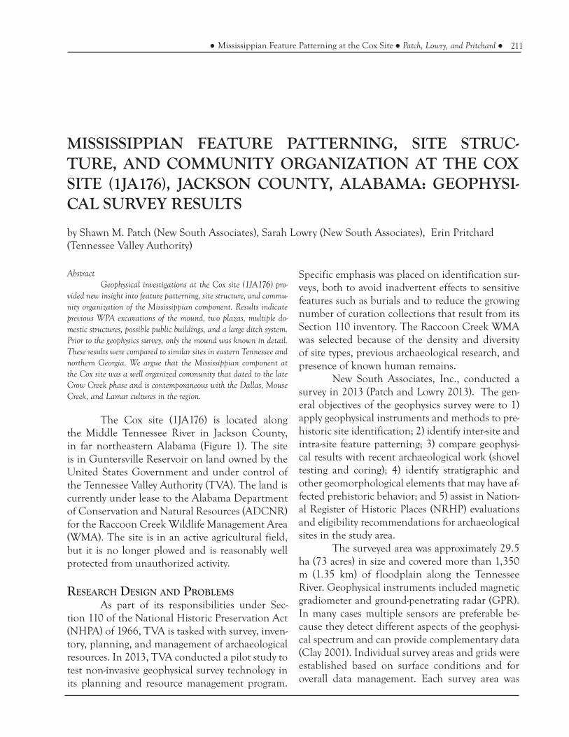
211Mississippian Feature Patterning at the Cox Site Patch, Lowry, and Pritchard
AbstractGeophysical investigations at the Cox site (1JA176) pro-
vided new insight into feature patterning, site structure, and commu-nity organization of the Mississippian component. Results indicate previous WPA excavations of the mound, two plazas, multiple do-mestic structures, possible public buildings, and a large ditch system. Prior to the geophysics survey, only the mound was known in detail. These results were compared to similar sites in eastern Tennessee and northern Georgia. We argue that the Mississippian component at the Cox site was a well organized community that dated to the late Crow Creek phase and is contemporaneous with the Dallas, Mouse Creek, and Lamar cultures in the region.
The Cox site (1JA176) is located along the Middle Tennessee River in Jackson County, in far northeastern Alabama (Figure 1). The site is in Guntersville Reservoir on land owned by the United States Government and under control of the Tennessee Valley Authority (TVA). The land is currently under lease to the Alabama Department of Conservation and Natural Resources (ADCNR) for the Raccoon Creek Wildlife Management Area (WMA). The site is in an active agricultural field, but it is no longer plowed and is reasonably well protected from unauthorized activity.
ReseaRch Design anD PRoblemsAs part of its responsibilities under Sec-
tion 110 of the National Historic Preservation Act (NHPA) of 1966, TVA is tasked with survey, inven-tory, planning, and management of archaeological resources. In 2013, TVA conducted a pilot study to test non-invasive geophysical survey technology in its planning and resource management program.
MISSISSIPPIAN FEATURE PATTERNING, SITE STRUC-TURE, AND COMMUNITY ORGANIZATION AT THE COX SITE (1JA176), JACKSON COUNTY, ALABAMA: GEOPHYSI-CAL SURVEY RESULTS
by Shawn M. Patch (New South Associates), Sarah Lowry (New South Associates), Erin Pritchard (Tennessee Valley Authority)
Specific emphasis was placed on identification sur-veys, both to avoid inadvertent effects to sensitive features such as burials and to reduce the growing number of curation collections that result from its Section 110 inventory. The Raccoon Creek WMA was selected because of the density and diversity of site types, previous archaeological research, and presence of known human remains.
New South Associates, Inc., conducted a survey in 2013 (Patch and Lowry 2013). The gen-eral objectives of the geophysics survey were to 1) apply geophysical instruments and methods to pre-historic site identification; 2) identify inter-site and intra-site feature patterning; 3) compare geophysi-cal results with recent archaeological work (shovel testing and coring); 4) identify stratigraphic and other geomorphological elements that may have af-fected prehistoric behavior; and 5) assist in Nation-al Register of Historic Places (NRHP) evaluations and eligibility recommendations for archaeological sites in the study area.
The surveyed area was approximately 29.5 ha (73 acres) in size and covered more than 1,350 m (1.35 km) of floodplain along the Tennessee River. Geophysical instruments included magnetic gradiometer and ground-penetrating radar (GPR). In many cases multiple sensors are preferable be-cause they detect different aspects of the geophysi-cal spectrum and can provide complementary data (Clay 2001). Individual survey areas and grids were established based on surface conditions and for overall data management. Each survey area was

212 Early Georgia volume 42, number 2
covered fully with the magnetometer. GPR data ac-quisition was based on a sampling strategy because it is more labor-intensive.
Multiple sites were surveyed over a very large area. Details on the field data collection, data processing, anomaly classification, and overall interpretations can be found in Patch and Lowry (2013). The results provided significant informa-tion about prehistoric site structure, feature pat-terning, and landscape archaeology, as well as rec-ommendations for the use of geophysics to assist
in planning and management (Patch and Lowry 2013).
enviRonment
The study area is locat-ed in the upper end of Gun-tersville Reservoir, which is part of the Sequatchie Valley of the Cumberland Plateau. The valley itself is relatively flat, with a broad floodplain and multiple terraces asso-ciated with the Tennessee River. In many places there are natural levees created by overbank flooding and the deposition of suspended sedi-ment loads. Natural levees are low, broad ridges that slope gently away from the parent channel to the level of the adjacent flood plain or back-swamp (Lowe 2005; Russel 1936; Saucier 1994). Because of their higher elevation and fertile soils, these areas were often intensively occupied by prehistoric groups (Phillips et al. 1951; Walthall 1980; Webb and Wilder 1951). Soils in the study area consist of Bruno fine sandy loam, Egam silt loam, Huntington silt loam, Lindside silt loam, and Melvin silt loam.
PRevious aRchaeological ReseaRch
Like many sites in the Middle Tennessee River Valley, the Cox site has multiple components (Webb and Wilder 1951). It is best known for the strong Mississippian manifestations and distinc-tive shell gorget motif (Kneberg 1959; Moore 1915; Walthall 1980). Walthall (1980:256) further identi-fied the Cox site as particularly important because of its strong Crow Creek phase component and possible association with Muscogee groups. Be-
Figure 1. Location of Cox site (1JA176) in Jackson County, Alabama.

213Mississippian Feature Patterning at the Cox Site Patch, Lowry, and Pritchard
archaeological survey of an area that included the Cox site (Gaffin et al. 2012). This was a Section 110 project that resulted in the identification of new sites and revisits to several previously recorded sites. A few of the sites were very large and covered broad areas of the floodplain. Results indicated the presence of human remains, deep cultural deposits, high artifact frequencies and densities, silt/clay soils, and a water table at approximately 1 m. In addition to NRHP evaluations, TVAR also recommended finding innovative methods for in-vestigating high density, deeply buried sites with a specific focus on the broader landscape rather than individual sites. The extremely large collection of artifacts that were recovered from this survey was a major factor in TVA’s decision to consider non-invasive techniques when investigating sites in this type of setting.
mississiPPian manifestations in the miD-Dle tennessee RiveR valley
The Mississippian period is generally dated to A.D. 900 and A.D. 1600, although significant regional and local variations exist throughout the Southeast (Griffin 1967; Jennings 1974; Peebles 1978; Phillips 1970). It is widely recognized by a number of new manifestations and significant changes from the preceding Woodland period. These include decreased reliance on shellfish re-sources; a dependence on maize agriculture; larger and more complex sites; increased population, trade and exchange networks; increased social and political complexity; shell tempered ceramics; small projectile points; and greater frequencies of exotic goods (Chapman 1985; Lewis and Kneberg 1946; Walthall 1980).
The presence of large, complex, and planned communities is interpreted as a sign of ranked societies associated with chiefdoms (Ander-son 1994; Blitz 2010; Emerson 1997; King 2003; Milanich 1998; Pauketat 1994; Smith 1992; Sul-livan 2001). Mississippian settlements and territo-ries tended to be located on rich alluvial bottoms along major rivers and streams (Chapman 1985; Lewis and Kneberg 1946; Lewis and Stout 1998; Walthall 1980). Common site elements included
cause of its shared similarities with Etowah and other sites from northern Georgia, the Cox site may have served as a conduit or gateway for ideas, information, and material culture into northeast Alabama (Walthall 1980).
C. B. Moore (1915) was the first to conduct excavations at the Cox site. At the time of his visit in 1915, the site consisted of a flat-topped mound approximately 13 feet high with basal dimensions of 90 x 103 feet. The mound itself was not inves-tigated because of a standing barn on top. High densities of artifacts were noted across the surface all around the mound. Probing indicated extensive midden and shell deposits. Over 40 burials were excavated in the village area east of the mound.
Prior to completion of Guntersville Lake by TVA, salvage excavations were carried out by the WPA (Webb and Wilder 1951). At that time the Cox site was described as being well known and easily recognized because of the high river bank and prominent natural levee (Webb and Wilder 1951). Between the time of Moore’s (1915) visit and the WPA investigations, the mound had been impacted by a commercial artifact collector and agriculture. By the 1930s, it was reported as approximately eight feet high and 100 feet in di-ameter and having a conical shape. Excavations were conducted of both the mound (1JA176) and the associated village (1JA176A). In addition to numerous features, approximately 109 burials were identified (16 from the mound and 93 from the village).
Multiple zones, floors, and structures were identified in the mound that reflected different building episodes (Figure 2). Four of the structures were square and a fifth was rounded, but all con-sisted of wall trench construction. In several cases there were clear hearths, clay banquettes, and buri-als. There was no evidence for the presence of a structure below the mound’s first zone, although burials and other pits were noted. Webb and Wild-er (1951) suggested the mound was built late in Gunterlands IV (i.e., Late Mississippian) with oc-cupancy into the historic period.
Most recently, Tennessee Valley Archaeo-logical Research (TVAR) conducted an intensive

214 Early Georgia volume 42, number 2
Figure 2. Com
posite drawing of structures identified in the C
ox mound.

215Mississippian Feature Patterning at the Cox Site Patch, Lowry, and Pritchard
earthen platform mounds with temples, elite resi-dences, council buildings, individual households arranged around an open plaza, and palisades or ditch enclosures (Chapman 1985; Lewis and Kne-berg 1946; Lewis and Stout 1998; Walthall 1980). House types tended to be square or rectangular with individual posts set in wall trenches (Lewis and Stout 1998). Political organization was highly complex, with large centers, controlled by chiefs, that were in themselves aggregates of much smaller mounds, villages, and farmsteads.
Mississippian sites are well known in all sections of the Tennessee River valley and many of its tributaries. This is largely the result of dam and reservoir construction and corresponding salvage excavations that have been conducted (Lewis and Kneberg 1946; Lewis and Lewis 1995; Polhemus 1987; Webb 1938; Webb 1939; Webb and DeJar-nette 1942; Webb and Wilder 1951). However, most of these investigations were highly focused on mound centers with particular emphasis on the mounds themselves. That is not a criticism, but merely an acknowledgment of the limited time, funds, and labor that were available, particulary during the WPA years.
The only synthesis of Mississippian ar-chaeology for the Guntersville area is Walthall (1980). The Mississippian period is divided into the Langston (AD 900-1200), Henry Island (AD 1200-1500), and Crow Creek phases (AD 1500-1700). Hally (2008) shows slight variations on these dates in northwest Georgia. Although differ-ent phases have been identified, the typical Mis-sissippian characteristics such as fortified villages, substructure mounds, shell tempered pottery, and elaborate burials appeared relatively early and then grew in complexity and sophistication. The Langston phase is equivalent to an emergent or incipient Mississippian development that is coeval with the Martin Farm and Hiwasee Island phases (Hally 2008; Walthall 1980). The Henry Island phase is presumed to represent “mature” Mississip-pian developments that are coeval with the Late Hiwasee, Dallas, and Mouse Creek phases (Hally 2008; Walthall 1980). A large number of sites from this phase are known for the Guntersville Basin,
which suggests that there was a sizeable population during that time. One of the major developments during this time was the appearance of stone box graves (Walthall 1980; Webb and Wilder 1951). The Crow Creek phase represents protohistoric groups and coincides with the late Mouse Creek phase (Hally 2008; Walthall 1980). Walthall (1980) noted the presence of distinctive McKee Island se-ries ceramics and very elaborate burials as unique trends in the Crow Creek phase and that the Cox site was probably the best example of these mani-festations.
aRchaeological geoPhysics
The use of geophysical instruments for archaeological investigations of prehistoric sites in North America is widely recognized as a major source of information (Aspinall et al. 2009; Cony-ers 2010; Conyers 2012; Johnson 2006; Kvamme 2003; Perttula 2010; Thompson 2014; Toom and Kvamme 2002). Geophysical surveys are particu-larly valuable because they are non-invasive, can cover very large areas, and generate data that are useful for understanding spatial patterning, inter-nal site structure, community organization, and broad patterns of landscape archaeology.
Kvamme (2003) promoted the idea that geophysical surveys can provide primary data for the study of cultural structures and features at the landscape scale (e.g., tens of hectares). Geophysical surveys can map entire villages and surrounding landscapes, allowing examination of interrelation-ships between individual site components such as house or house clusters, dumping grounds, public structures, storage and borrow pits, gardens, plazas, and fortifications (C. Gaffney et al. 2000; Kvamme 2003; Toom and Kvamme 2002). Archaeo-geo-physical mapping is sometimes the best way to ob-tain information about site plans, structures, and layout (Toom and Kvamme 2002).
In the broader southeast there has been a flurry of recent geophysical studies of prehistoric sites (Bigman 2012; Bigman et al. 2011; Butler et al. 2011; Haley 2014; Hammerstedt et al. 2011; Hargrave 2011; Henry et al. 2014; Horsely et al. 2014; Kassabaum et al. 2014; Lockhart 2010; Lock-

216 Early Georgia volume 42, number 2
hart et al. 2011; McKinnon 2010; McNutt et al. 2012; Nelson 2014; Patch and Lowry 2013; Pert-tula 2010; Samuelson 2010; Thompson 2014; Walker and Perttula 2010). Several recent, large-scale archaeological geophysics surveys have been conducted in Tennessee (Goddard 2011; Guidry 2013; Hadley 2013; Patch and Gregory 2009; Patch and Gregory 2010; Yerka 2010). To our knowledge, no prior archaeological geophysics survey had been conducted in Guntersville Reservoir or northeast Alabama prior to Patch and Lowry (2013) and the closest proximity was approximately 15 miles upriv-er just below Nickajack Dam (Patch and Gregory 2009, 2010).
Extensive archaeological work has been conducted in the general vicinity of the study area over the past several decades. In addition, there is a substantial body of archaeological literature for other TVA reservoirs. A full review and synthesis is well beyond the scope of this paper. However, many sources were consulted, particularly those about similar site types and/or sites in close physi-cal proximity, to develop expectations on the types of the features that might be identified in the geo-physical datasets. Common feature types include pits (storage and refuse), burials, hearths, posts, middens (refuse and shell), house floors, and many other types. Taking Kvamme et al.’s (2006) recom-mendations into account, it was possible to sim-plify the range of expected types into a few broad classes.
Classification of geophysical anomalies var-ied by instrument. Gradiometer anomalies were classified by their nT values and sorted into seven classes. Previous research with gradiometer data compared with excavations has indicated correla-tions between certain feature types and their corre-sponding nT values (Kvamme et al. 2006; Pacheco et al. 2005; Pacheco et al. 2009a; Pacheco et al. 2009b). In general, physically smaller, less magnet-ically enhanced features tend to have lower values and physically larger, more magnetically enhanced features tend to have higher values. For example, unburned posts and pits are generally expected to fall in the range of 2-10 nT, whereas a burned mid-den, house, or hearth, is expected to fall well above 10 nT.
GPR anomalies were classified as middens, pits, or surfaces. A midden consisted of large ac-cumulations of shell or other organic debris that could have resulted from processing or refuse. Large features such as shell midden appear as flat bands with very strong reflections (Patch and Greg-ory 2010). The pit category included a broad range of feature types such as storage/refuse pits, posts, hearths, and burials. These tend to have hyperbol-ic reflections because of the smaller size and mor-phology. Surfaces are areas of intact stratigraphy and/or possible house floors that may have been buried. Stratigraphic layers will typically appear as banding with weak to moderate positive and nega-tive zones.
Archaeological interpretations were then developed to help distill the geophysics results into meaningful information. The ultimate goal was to produce graphics that were easier to understand for most archaeologists. The first step was to de-velop simple archaeological categories. These in-cluded: processing area (e.g., shell midden), habita-tion (e.g., hearth, storage and refuse pits, surfaces, probable house location), and high density occupa-tion areas (e.g., clusters of geophysical anomalies at a higher level such as multiple habitations), as well as very specific classes for secure interpretations such as ditch/palisade, mound, and plaza.
geoPhysical Results
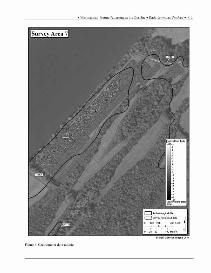
The majority of the Cox site is located in Survey Area 7, which measured approximately 9.3 ha (23 acres) in size (Figure 3)(Patch and Lowry 2013). Portions of the Cox mound itself are still visible as a low rise. Gradiometer coverage includ-ed 82 contiguous grids totalling approximately 6.9 ha (17 acres). GPR coverage included a sample of the survey area that totalled approximately 2.7 ha (6.7 acres).
A few grids in the magnetic data have sources of intereference that could not be identi-fied or removed with processing filters. Other than causing minor visual distractions, they do not ap-pear to affect the underlying data and anomalies are still visible. Review of field notes on data collec-tion parameters did not identify any obvious errors such as metallic interference on the operator. This suggests problems with one or both of the sensors.

217Mississippian Feature Patterning at the Cox Site Patch, Lowry, and Pritchard
Figure 3. Map showing geophysical survey grid locations in Survey Area 7

218 Early Georgia volume 42, number 2
Gradiometer anomalies (n=2,385) indicate a high density distribution of features among all nT classes (Table 1). Spatially, these are located across the entire survey area. However, there are patterns and dense clustering that are relatively clear in the composite imagery (Figure 4). The densest con-centration of anomalies is along the river near the center of the survey area. A secondary cluster is present on the southern end. The far northwest corner has far fewer magnetic anomalies. There is also one smaller concentration in the northeast corner. Pattern analysis of these data indicates an intensively occupied landform. Approximately 90 percent of the gradiometer anomalies fall in the range of 2-10 nT. This distribution suggests a high frequency of small features such as posts and pits, which in turn is probably an indication of houses and long-term occupation.
GPR anomalies (n=349) include midden (n=6), pit (n=328), and surface (n=15) features (Table 2). Spatially, these follow similar patterns as the gradiometer data, with a high density concen-tration along the river. Vertically, approximately 83 percent of these are found between 30 and 60 cm and another 16 percent between 60 and 90 cm. Figure 5 is an example of a GPR slice map that shows the distribution of high amplitude reflec-tions from 30-60 cm.
Midden features tend to be circular and vary in size from only a few meters to several me-ters and are all clustered in the southern section. They are different from midden features noted in other survey areas in terms of morphology. This suggests they formed as a result of different ac-tivities. Rather than large processing middens for temporary or seasonal visits, the middens at the Cox site are likely refuse deposits from domestic habitations.
Pits occur in such high frequencies that it is difficult to pick out particular patterns. In ar-eas with more GPR coverage, the density is signifi-cantly higher. However, there are real differences between the southern/central sections (relatively high) and the far north section (relatively low). Ap-proximately 82 percent of these are found between 30 and 60 cm, which suggests these are likely asso-ciated with the Mississippian component.
Surface features are likely associated with both intact soil horizons and individual houses or habitations (Figure 6). They vary in size from only a few meters to several tens of meters and all are located between 30 and 60 cm. In certain cases of intact soil horizons, the reflections may have been caused either by a thin band of shell that accumulated as midden or enhanced soils with higher moisture content. In profile, many surfaces appeared to have discontinuities that may have been the result of prehistoric activity (i.e., pits that intruded through an otherwise continuous layer)(Figure 7).
cox site mississiPPian comPonent oRga-nization
These interpretations of the geophysical datasets and interpretation of archaeological exca-vations show intensive occupation at the Cox site (Figures 8-9). As a result, several inferences can be made regarding the Mississippian component. However, there are additional features outside the primary Mississippian central area that are more difficult to place within the site’s context. At this point there is insufficient data without further ex-cavation to determine with reasonable certainty whether these particular features are Woodland or Mississippian. We are not prepared to offer specif-ic intepretations of features outside of the Missis-
NanoTesla Class
2-3 nT 4-6 nT 7-10 nT 11-36 nT 37-60 nT 61-85 nT 86-109 nT Grand Total
Count 772 1138 246 180 23 12 14 2385
Percent 32.37% 47.71% 10.31% 7.55% 0.96% 0.50% 0.59% 100.00%
Table 1. Summary of gradiometer anomalies by NanoTesla class.
219Mississippian Feature Patterning at the Cox Site Patch, Lowry, and Pritchard
Figure 4. Gradiometer data mosaic.

220 Early Georgia volume 42, number 2
sippian site core beyond the fact that they are cul-tural. The following discussion focuses specifically on the major Mississippian architectural features, spatial patterning, and overall community organi-zation.
MoundThe Cox mound was completely excavated
in the 1930s (Webb and Wilder 1951). Excavations indicated the presence of at least five distinct struc-tural remains on the mound, although they were not necessarily all present at the same time (see Figure 2). The gradiometer data has an outline of the WPA excavation area, including four approach trenches and the large square area on top of the mound (Figure 10). Using the approximate bound-aries of the trenches, the mound dimenensions are estimated to have been 28 by 20 m. The mound excavation trenches are oriented roughly north to south. Neither geophysical dataset shows any indi-cation of the base of the mound at its interface with the original ground surface. Several gradiom-eter anomalies are visible in the excavated area, but it is difficult to determine whether they are intact or previously excavated.
PlazaThe Cox site also contains two fairly well
defined plazas. They are located southwest and northeast of the mound. The southwestern plaza is the larger of the two and measures approximately 40 by 35 m in size (0.36 acres) (Figure 11). The northeastern plaza is approximately 18 x 32 m (0.18 acres). Compared to other areas of the site they are both relatively devoid of features. Both are immediately adjacent to the mound and are sur-rounded by likely house structures.
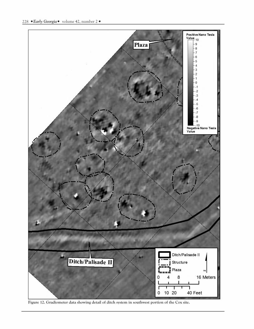
Ditch/PalisadeOne of the most noticeable features in the
gradiometer data is a large ditch system that would have been associated with a palisade (Figure 12). The GPR data show a particularly strong negative impression or void along the northeast section of the ditch (Figure 13). In fact, a large surface feature in the GPR data is present here that stops abruptly at the ditch. With the river as one boundary, the ditch system forms a large D-shape that encloses approximately 16,187 m2 (4 acres). It is approxi-mately 340 m long. The size of the area enclosed by the ditch system is well within the range of Missis-sippian sites in the region (Hally 2008; Hally and Kelly 1998; Schroedl 1998; Sullivan 1987).
The relatively consistent and strong mag-netic signature suggests this ditch system was con-structed at one time. There is no clear evidence of a wooden palisade in the gradiometer data, al-though one is certainly expected. Given the strong magnetic signature of the ditch system, individual postholes would likely be difficult to image unless they were exceptionally large or burned. However, there is good reason to suspect that the palisade itself would be visible archaeologically just inside the ditch.
Bastions have been noted at several Mis-sissippian sites in the region, including Gunters Landing and Etowah (Bigman et al. 2011; Webb and Wilder 1951). There is no evidence for bas-tions along any segment of the ditch system, which suggests it may not have been used exclusively, if at all, for defense.
A second ditch system is visible northeast of the mound. It has a much weaker signature and was cut off by the larger ditch system. These two factors suggest it was built at an earlier stage and
Depth Midden Pit Surface Grand Total
Count % Count % Count % Count %
0-30 cm 0.00 1 0.30 0.00 1 0.29
30-60 cm 6 100.00 268 81.71 15 100.00 289 82.81
60-90 cm 0.00 57 17.38 0.00 57 16.33
90-120 cm 0.00 2 0.61 0.00 2 0.57
Grand Total 6 100.00 328 100.00 15 100.00 349 100.00
Table 2. Summary of GPR Features by Depth for SA 7.

221Mississippian Feature Patterning at the Cox Site Patch, Lowry, and Pritchard
Figure 5. GPR slice map of 30-60 cmbs.

222 Early Georgia volume 42, number 2
Figure 6. GPR amplitude slice map from 30 to 60 cm showing detail of surface features (dashed lines).

223Mississippian Feature Patterning at the Cox Site Patch, Lowry, and Pritchard
Figure 7. GPR profile showing surface features.
was less well developed. The relationship of the two ditch systems is unknown based solely on the geophysics data. It seems unlikely that the fainter ditch was an earlier extension of the larger ditch and that it was rebuilt to enclose a smaller space, although that has been noted at other Mississip-pian sites (Bigman 2012; Polhemus 1987; Schroedl 1998). We propose that these two ditch systems represent different building episodes.
StructuresFollowing Butler et al. (2011), we use the
term structure, but in reality most of these are likely houses. Multiple structures were identified throughout the site. A few structures are very well defined and exhibit regular outlines in the gradi-ometer data. Other structures, however, are less well defined and are inferred based on feature dis-tributions and patterning.
One factor that may influence structure size is how well defined these are in the gradiom-eter data (Haley 2014). In certain cases structure boundaries were relatively easy to define because of their shape and magnetic signatures (many of these were likely burned). In other cases structure boundaries were defined based on the observed spatial patterning of multiple features of varying magnetic strength in close physical proximity in light of expectations based on previous archaeolog-ical research. We recognize there is inherent error
in drawing polygons in this manner. The most like-ly outcome is that inferred structures are probably larger than their true footprints in the ground. This is one of the limitations of using only geophysical data to derive archaeological interpretations.
Inside the ditch system 27 structures have been inferrred and they are evenly distributed. There are several examples in the southwestern portion of the site with square or rectangular out-lines (Figure 12). The stronger magnetic signatures may be the result of burning or later building epi-sodes in the site’s history (Haley 2014). However, their shapes and sizes are consisent with excavated houses at other Mississippian sites (Hally 2008; Hally and Kelly 1998; Schroedl 1998; Steere 2011; Sullivan 1995).
Mean sizes in square meters were calcu-lated for the 27 structures inside the ditch system. These were ranked into four groups and displayed spatially (Figure 14). Nineteen of the 27 structures (70%) average 25-100 m2, six (22%) average 100-150 m2, and two (8%) average 150-200 m2 (Figure 15, Table 3). Spatially, structures in the 25-100 m2 category are distributed throughout the enclosure, with a slight concentration immediately east of the mound. Structures in the 100-150 m2 category are all clustered in the southwest portion of the site. The two largest structures are both located at the edge of a plaza closer to the mound, which suggests they may have been public buildings. These pat-

224 Early Georgia volume 42, number 2
Figure 8. Spatial distribution of geophysical anomalies.

225Mississippian Feature Patterning at the Cox Site Patch, Lowry, and Pritchard
Figure 9. Map showing interpretations of geophysical anomalies.

226 Early Georgia volume 42, number 2
Figure 10. Gradiometer data showing detail of mound and WPA excavation trenches.

227Mississippian Feature Patterning at the Cox Site Patch, Lowry, and Pritchard
Figure 11. Gradiometer data showing detail of southwestern plaza.
228 Early Georgia volume 42, number 2
Figure 12. Gradiometer data showing detail of ditch system in southwest portion of the Cox site.

229Mississippian Feature Patterning at the Cox Site Patch, Lowry, and Pritchard
Figure 13. GPR amplitude slice map from 30 to 60 cm showing surface feature and void space associated with ditch system.

230 Early Georgia volume 42, number 2
Discussion
The Mississippian component at the Cox site shows clear community patterns (Figure 14). The geophysical data indicate it had a single mound, two associated plazas, multiple individual structures, and that it was surrounded by a ditch enclosure and likely palisade. In addition, there is a very high density of structures on the north end of the site outside the ditch system. The lack of large midden deposits and presence of so many structures immediately north of the ditch system suggest a probable Mississippian association. The high frequency of features and structures may have been an associated village with the mound, another common feature of Mississippian mound centers. At this point, however, there is insufficient clarity on the cultural relationships/association of these areas to offer further inferences.
The geophysics data alone do not provide sufficient evidence for dating the Mississippian community. However, when combined with previ-ous archaeological investigations and through com-parisons with other regional studies, a circumstan-tial case can be made. Webb and Wilder (1951) noted the presence of a strong Crow Creek phase component, construction of the mound on top of earlier Mississippian midden deposits, and Mckee Island ceramics. This led them to conclude that the mound was constructed late in the Gunterlands IV period (i.e., Mississippian) and site occupancy may have extended into the early historic period.
Feature patterning and spatial organization of the Cox site fit very well with the Mississippian pattern known for other sites in eastern Tennessee and northern Georgia (Hally 2008; Hally and Kelly 1998; Lewis and Kneberg 1946; Polhemus 1987; Schroedl 1998; Steere 2011; Sullivan 1995). The Hiwassee Island, Ledford Island, King, and Toqua sites all share broad similarities. That is, they are defined by one or more platform mounds, a cen-tral plaza, multiple structures, and ditches and/or palisades (among other features). The Cox site patterns are almost identical to those sites. These different lines of evidence suggest that the major town features at the Cox site date to the late Mis-sissippian period. That would make them contem-
terns are consistent with those observed for both Toqua and Ledford Island (Polhemus 1987; Sulli-van 1987; Sullivan 1995).
Variation in house size has important implications for inter-site comparisons. Sullivan (1995) noted significant variation in house size at both Ledford Island and Toqua. At the Toqua site, structures larger than approximately 138 m2 in size were found in one area and interpreted as public buildings (Polhemus 1987). At Ledford Island, structures in the same size range were not spatially segregated (Sullivan 1995). Sullivan (1995:115) provided summary statistics for houses at the Cho-ta-Tanasee, Ledford Island, and Toqua sites and concluded that smaller structures less than 90 m2 in size were domestic houses and those larger than approximately 138 m2 were public buildings.
Comparing these patterns to the geophys-ics data at the Cox site indicates strong similiari-ties (Table 3). Although there is more variation in structure size at the Cox site, it appears to be on the higher end, with three structures over 138 m2 in size. Mean structure size at the Cox site is 87.6 m2, which is significantly larger than pub-lished data for other sites (Hally 2008:200; Hally and Kelly 1998; Steere 2011; Sullivan 1995). The larger structures are certainly skewing the mean size to the high side. However, the minimum sizes are very consistent among the sites. The slightly larger structure sizes at the Cox site may be due in part to the way polygons were drawn. If the actual footprints of structures in the ground are on aver-age slightly smaller than the sizes given here, they would be even more closely related to other sites in the region.
There are a few open areas that give the ap-pearance of clustering. However, it is difficult to say with certainty that all of these were occupied at the same time. They may represent many genera-tions of building. Absent more concrete informa-tion on specific structures (e.g., artifacts, radiocar-bon dates, clear outlines), we are not prepared to argue that these apparent clusters have true anthro-pological significance. The possibility of individual neighborhoods is intriguing and should be investi-gated further (Nelson 2014).

231Mississippian Feature Patterning at the Cox Site Patch, Lowry, and Pritchard
Figure14. Map showing distribution of mean structure size.

232 Early Georgia volume 42, number 2
poraneous with Dallas, Mouse Creek, and Lamar phase cultures of east Tennessee and north Geor-gia.
conclusions
The interpretations of geophysical results at the Cox site identified new features and signifi-cant patterning that were previously unknown. Al-though the mound has been known for more than 100 years, very little was actually known about its associated features or overall site structure (aside from high feature density and numerous burials and Mississippian affiliation), and there was little effort to place the site in a broader context. As a result of the geophysics survey, we are able to con-clude that the Cox site patterns fit well with typical Mississippian centers throughout the Middle Mis-sissippian and South Appalachian culture areas (Hally 2008; Hally and Kelly 1998; Polhemus 1987; Schroedl 1998; Sullivan 1987; Sullivan 1995).
Future WorkThe results presented here demonstrate
the practical benefits of geophysical methods for Mississippian sites in the southeast. The geophysi-cal datasets allowed the acquisition of unique and important information that would not have been feasible with any other methods. Today, it is dif-ficult to conceive of a large-scale archaeological excavation of the type that was conducted in previ-ous decades (Lewis and Kneberg 1946; Polhemus 1987). The practical impediments to traditional excavations at such a broad scale are numerous, in-cluding cost, time, curation requirements, and Na-tive American concerns. Given these constraints, geophysical methods represent a tremendous op-portunity for addressing research questions related to feature patterning, site structure, and commu-nity organization.
Figure 15. Bar chart showing frequencies of structures by size class.
Cox Site Chota-Tanasee Site Mouse Creek Sites Toqua Site
Range 29.1-171.2 m2 29-42 m2 28-89 m2 27-86 m2
Mean 87.6 m2 37 m2 50 m2 46 m2
Standard Deviation 34.1 m2 3 m2 18 m2 16 m2
Count (N) 27 14 55 26
Table 3. Summary statistics for Cox site structures and comparisons with other published data.
0 2 4 6 8 10 12 14 16 18 20
18-27
28-37
38-47
48-57
58-67
68-77
78-87
88-97
98-107
108-117
108-128
>138
Cox Mound Site - Structure Sizes

233Mississippian Feature Patterning at the Cox Site Patch, Lowry, and Pritchard
Acknowledgments. We thank Michaelyn Harle and two anonymous reviewers for their con-structive comments and helpful advice that helped improve the overall quality of this paper.
RefeRences citeD
Anderson, David G.1994 The Savannah River Chiefdoms Political
Change in the Late Prehistoric Southeast. Uni-versity of Alabama Press, Tuscaloosa, Ala-bama.
Aspinall, Arnold, Chris Gaffney, and Armin Schmidt2009 Magnetometry for Archaeologists. Rowman Al-
tamira, New York, New York.
Bigman, Daniel P.2012 An Early Mississippian Settlement History of
Ocmulgee. Unpublished Ph.D. Disserta-tion, University of Georgia, Athens, GA.
Bigman, Daniel P., Adam King, and Chester P. Walker2011 Recent Geophysical Investigations and
New Interpretations of Etowah’s Palisade. Southeastern Archaeology 30(1): 38–50.
Blitz, John H.2010 New Perspectives in Mississippian Archae-
ology. Journal of Archaeological Research 18(1): 1–39.
Butler, Brian M., R. Berle Clay, Michael L. Har-grave, Staffan D. Peterson, John E. Schwegman, John A. Schwegman, and Paul D. Welch2011 A New Look at Kincaid: Magnetic Survey
of a Large Mississippian Town. Southeastern Archaeology 30(1): 20–37.
C. Gaffney, J.A. Gater, P. Linford, V.L. Gaffney, and R. White2000 Large-Scale Systematic Fluxgate Gradiome-
try at the Roman City of Wroxeter. Archaeo-logical Prospection 7: 81–99.
Chapman, Jefferson1985 Tellico Archaeology “12,000 Years of Native
American History. University of Tennessee Press, Knoxville, Tennessee.
Clay, R. Berle2001 Complementary Geophysical Survey Tech-
niques: Why Two Ways are Always Better Than One. Southeastern Archaeology 20: 31–43.
Conyers, Lawrence2010 Ground-penetrating radar for anthropolog-
ical research. Antiquity 84(323): 175–184.2012 Interpreting Ground-Penetrating Radar for Ar-
chaeology. Left Coast Press, Walnut Creek, California.
Emerson, Thomas E.1997 Cahokia and the Archaeology of Power. Uni-
versity of Alabama Press, Tuscaloosa, Ala-bama.
Gaffin, Mary Lee, Keith J. Little, Hunter B. John-son, and Ann Marshall2012 An Archaeological Survey of the Raccoon Creek
Management Area in the Guntersville Basin, Jackson County, Alabama. Tennessee Valley Archaeological Research, Huntsville, Ala-bama.
Goddard, Eric2011 Investigating Early Mississippian Commu-
nity Patterning in the Mid-South Through Multiple-Method Survey of the Ames Site (40FY7) in Fayette County, Tennessee. University of Memphis, Memphis, Tennes-see.
Griffin, James B.1967 Eastern North American Archaeology: A
Summary. Science 156: 175–191.
Guidry, Hannah2013 Mississippian Architecture and Communi-
ty Development at the Ames Site (40FY7),
234 Early Georgia volume 42, number 2
Fayette County, Tennessee. University of Memphis, Memphis, Tennessee.
Hadley, Scott P.2013 Multi-Staged Research at the Denmark
Site, A Small Early-Middle Mississippian Town. University of Memphis, Memphis, Tennessee.
Haley, Bryan S.2014 The Big Picture at Hollywood: Geophysical
and Archaeological Investigations at a Mis-sissippian Mound Centre. Archaeological Prospection 21: 39–47.
Hally, David J.2008 King: The Social Archaeology of a Late Missis-
sippian Town in Northwestern Georgia. Uni-versity of Alabama Press, Tuscaloosa, AL.
Hally, David J., and Hypatia Kelly1998 The Nature of Mississippian Towns in
Georgia: The King Site Example. In Missis-sippian Towns and Sacres Spaces: Searching for an Architectural Grammar, edited by R. Bar-ry Lewis and Charles B. Stout, pp. 49–63. University of Alabama Press, Tuscaloosa, Alabama.
Hammerstedt, Scott W., Amanda L. Regnier, and Patrick C. Livingood2011 Geophysical and Archaeological Investiga-
tions at the Clement Site, a Caddo Mound Complex in Southeastern Oklahoma. Southeastern Archaeology 29(2): 279–291.
Hargrave, Michael L.2011 Geophysical Survey of Complex Deposits
at Ramey Field, Cahokia. Southeastern Ar-chaeology 30(1): 1–19.
Henry, Edward R., Nicolas R. Laracuente, Jared S. Case, and Jay K. Johnson2014 Incorporating Multistaged Geophysical
Data into Regional-Scale Models: A Case Study from an Adena Burial Mound in
Central Kentucky. Archaeological Prospection 21: 15–26.
Horsely, Timothy J., Alice Wright, and Casey Bar-rier2014 Prospecting for New Questions: Integrat-
ing Geophysics to Define Anthropological Research Objectives and Inform Excava-tion Strategies at Monumental Sites. Ar-chaeological Prospection 21: 75–86.
Jennings, Jesse D. (editor).1974 Ancient North Americans. Walt Freeman,
San Francisco, California.
Johnson, Jay K. (editor).2006 Remote sensing in archaeology : an explicitly
North American perspective. University of Alabama Press, Tuscaloosa.
Kassabaum, Megan, Edward R. Henry, Vincas P. Steponaitis, and John O’Hear2014 Between Surface and Summit: The Process
of Mound Construction at Feltus. Archaeo-logical Prospection 21: 27–37.
King, Adam2003 Etowah: The Political History of a Chiefdom
Capital. University of Alabama Press, Tus-caloosa, Alabama.
Kneberg, Madeline D.1959 Engraved Shell Gorgets and Thier Associa-
tions. Tennessee Anthropologist 15(1): 1–39.
Kvamme, Kenneth L.2003 Geophysical Surveys as Landscape Archae-
ology. American Antiquity (68): 435–457.
Kvamme, Kenneth L., Eileen G. Ernenwein, Mi-chael L. Hargrave, Thomas Sever, Deborah Har-mon, and Fred Limp2006 New Approaches to the Use and Integration of
Multi-Sensor Remote Sensing for Historic Re-source Identification and Evaluation. Center for Advanced Spatial Technologies, Uni-versity of Arkansas, Fayetteville, Arkansas.

235Mississippian Feature Patterning at the Cox Site Patch, Lowry, and Pritchard
Lewis, R. Barry, and Charles B. Stout1998 Mississippian Towns and Sacred Spaces: Search-
ing for an Architectural Grammar. University of Alabama Press, Tuscaloosa, Alabama.
Lewis, Thomas, and Madeline D. Kneberg Lewis1995 The Prehistory of the Chickamauga Basin in
Tennessee. Ed. Lynne P. Sullivan. University of Tennessee Press, Knoxville.
Lewis, Thomas M.N., and Madeline D. Kneberg1946 Hiwassee Island: An Archaeological Account of
Four Tennessee Indian Peoples. University of Tennessee Press, Knoxville, Tennessee.
Lockhart, Jami J.2010 Tom Jones (3HE40): Geophysical Sur-
vey and Spatial Organization at a Caddo Mound Site in Southwest Arkansas. South-eastern Archaeology 29(2): 236–249.
Lockhart, Jami J., Juliet E. Morrow, and Shaun Mc-Gaha2011 A Town at the Crossroads: Site-Wide Gra-
diometry Surveying and Mapping at Old Ridge Site (3CG41) in Northeastern Ar-kansas. Southeastern Archaeology 30(1): 51–63.
Lowe, Kelsey2005 Using Interdisciplinary Techniques for Investi-
gating Paleochannel Sequences at the Parchman Place Mounds in the Yazoo Basin of Northwest Mississippi. Unpublished Master’s Thesis, University of Mississippi, Oxford, Missis-sippi.
McKinnon, Duncan P.2010 Continuing the Research: Archaeogeo-
physical Investigations at the Battle Mound Site (3LA1) in Lafayette County, Arkansas. Southeastern Archaeology 29(2): 250–260.
McNutt, Charles H., Jay D. Franklin, and Edward R. Henry2012 New Perspectives on Mississippian Occu-
pations in Western Tennessee and North-
western Mississippi: Recent Chronological and Geophysical Investigations at Chucal-issa (40SY1), Shelby County, Tennessee. Southeastern Archaeology 31(2): 231–250.
Milanich, Jerald T.1998 Native Chiefdoms and the Exercise of
Complexity in Sixteenth Century Florida. In Chiefdoms and Chieftaincy in the Americas, edited by Elsa M. Redmond, pp. 245–264. University Press of Florida, Gainesville, Florida.
Moore, Clarence B.1915 Aboniginal Sites on the Tennessee River.
Journal of the Academy of Sciences of Philadel-phia 16: 171–422.
Nelson, Erin S.2014 Intimate Landscapes: The Social Nature of
the Spaces Between. Archaeological Prospec-tion 21: 49–57.
Pacheco, Paul J., Jarrod D. Burks, and Dee Anne Wymer2005 Investigating Ohio Hopewell Settlement
Patterns in Central Ohio: A Preliminary Report of Archaeology at Brown’s Bottom #1 (33Ro21). Ohio Archaeological Council.
2009a The 2006 Archaeological Investigations at Brown’s Bottom #1 (33R01104). Ohio Ar-chaeological Council.
2009b The 2007-2008 Archaeological Investiga-tions at Lady’s Run (33R01105). Ohio Ar-chaeological Council.
Patch, Shawn M., and Danny Gregory2009 Geophysical Survey of Site 40Mi70 for the
CB&I Nuclear Fabrication Facility, Marion County, Tennessee. New South Associates, Inc., Stone Mountain, Georgia.
2010 Refining Middle Woodland Site Structure with Ground Penetrating Radar: A Case Study from Site 40Mi70, Marion County, Tennessee. Pa-per Presented at the 75th Annual Meeting of the Society for American Archaeology, St. Louis, Missouri.

236 Early Georgia volume 42, number 2
Russel, R.J.1936 Physiography of Lower Mississippi Delta. Loui-
siana Geological Survey, Bulletin 8. De-partment of Conservation.
Samuelson, John R.2010 Geophysical Investigations of Late Fourche
Maline and Early Caddo Settlement Pat-terning at the Crenshaw Site (3MI6). South-eastern Archaeology 29(2): 261–278.
Saucier, Roger T.1994 Geomorphology and Quaternary Geologic His-
tory of the Lower Mississippi Valley, Volume I. U.S. Army Engineer Waterways Experi-ment Station, Vicksburg, Mississippi.
Schroedl, Gerald F.1998 Mississippian Towns in the Eastern Ten-
nessee Valley. In Mississippian Towns and Sacres Spaces: Searching for an Architectural Grammar, edited by R. Barry Lewis and Charles Stout, pp. 138–143. University of Alabama Press, Tuscaloosa, Alabama.
Smith, Kevin E.1992 The Middle Cumberland Region: Mississippian
Archaeology in North Central Tennessee. Un-published Ph.D. Dissertation, Vanderbilt University, Nashville, Tennessee.
Steere, Benjamin A.2011 The Archaeology of Houses and Households in
the Native Southeast. Unpublished Disserta-tion, University of Georgia, Athens, Geor-gia.
Sullivan, Lynne P.1987 The Mouse Creek Phase Household. South-
eastern Archaeology 6: 16–29.1995 Mississippian Household and Community
Organization in Eastern Tennessee. In Mis-sissippian Communities and Households, edit-ed by J. Daniel Rogers and Bruce D. Smith, pp. 99–123. University of Alabama Press, Tuscaloosa, Alabama.
Patch, Shawn M., and Sarah Lowry2013 Investigating Prehistoric Settlement in the Up-
per Guntersville Basin: Archaeological Geophys-ics Survey of the Raccoon Creek Wildlife Man-agement Area, Jackson County, Alabama. New South Associates, Inc., Stone Mountain, Georgia.
Pauketat, Timothy R.1994 The Ascent of Chiefs: Cahokia and Mississippi-
an Politics in Native North America. Universi-ty of Alabama Press, Tuscaloosa, Alabama.
Peebles, Christopher S.1978 Determinants of Settlement Size and Loca-
tion in the Moundville Phase. In Mississip-pian Settlement Patterns, edited by Bruce D. Smith, pp. 369–416. Academic Press, New York, New York.
Perttula, Timothy K.2010 Papers on Geophysical Investigations of
Woodland and Caddo Sites in the Caddo Area of the Southeastern United States. Southeastern Archaeology 29(2): 233–235.
Phillips, Phillip1970 Archaeological Survey in the Lower Yazoo
Basin, Mississippi, 1949-1955. Papers of the Peabody Museum of Archaeology and Ethnology 60(1-2).
Phillips, Phillip, James A. Ford, and James B. Grif-fin1951 Archaeological Survey in the Lower Mississippi
Alluvial Valley, 1940-1947. Peabody Mu-seum Papers, Volume 25. Harvard Univer-sity, Cambridge, Massachusetts.
Polhemus, Richard1987 The Toqua Site - 40MR6: A Late Mississip-
pian, Dallas Phase Town. Tennessee Valley Authority Publications in Anthropology No. 44, Knoxville, Tennessee.

237Mississippian Feature Patterning at the Cox Site Patch, Lowry, and Pritchard
2001 Those Men in Mounds: Gender, Politics, and Mortuary Practices in Late Prehistoric Eastern Tennessee. In Gender in the Archae-ology of the Mid-South, pp. 101–126. Univer-sity Press of Florida, Gainesville, Florida.
Thompson, Victor D.2014 Monumental Architecture, Households,
and Archaeo-Geophysics in the Ameri-can Southeast and Midwest. Archaeological Prospection 21: 1–3.
Toom, Dennis L., and Kenneth L. Kvamme2002 The “Big House” at Whistling Elk Village
(39HU242): Geophysical Findings and Ar-chaeological Truths. Plains Anthropologist 47(180): 5–16.
Walker, Chester P., and Timothy K. Perttula2010 Archaeogeophysical Investigations at an
Eighteenth-Century Caddo Site in Nacog-doches County, East Texas. Southeastern Ar-chaeology 29(2): 310–322.
Walthall, John1980 Prehistoric Indians of the Southeast archaeology
of Alabama and the Middle South. University of Alabama Press,, Tuscaloosa, Ala. :
Webb, W. S., and D. L. DeJarnette1942 An Archaeological Survey of the Pickwick
Basin in the Adjacent States of Alabama, Mississippi and Tennessee. Bureau of Ameri-can Ethnology, Smithsonian Institute, Bulletin 129.
Webb, William S.1938 An Archaeological Survey of the Norris Basin in
Eastern Tennessee. Smithsonian Institution. Bureau of American Ethnology, Washing-ton D.C.
1939 An Archaeological Survey of the Wheeler Basin on the Tennessee River in Northern Alabama. United States Government Printing Of-fice, Washingthon, D.C.
Webb, William S., and Charles G. Wilder1951 An Archaeological Survey of Guntersville Basin
on the Tennessee River in Northern Alabama. University of Kentucky Press, Lexington, Kentucky.
Yerka, Stephen J.2010 Geophysical Study at Old Stone Fort State Ar-
chaeological Park, Manchester, Tennessee. Un-published Master’s Thesis, University of Tennessee, Knoxville.