Determining village extent and layout utilizing geophysical survey and excavation at the...
40
Determining village extent and layout utilizing geophysical survey and excavation at the Mississippian site of Cane River, North Carolina Ashley Schubert Museum of Anthropological Archaeology, University of Michigan [email protected] Timothy Horsley Horsley Archaeological Prospection, LLC Department of Anthropology, Northern Illinois University [email protected] Geophysical techniques can help to clarify the extent of a site and show spatial relationships between structures, therefore guiding research and excavation strategies. When monuments and larger structural elements are absent, feature density can be a reliable proxy for occupation areas and village boundaries. Utilizing a combination of magnetometry and groundpenetrating radar survey at the Cane River site in North Carolina, we were able to locate borrow pits, storage pits, structures, and hearth features that are not readily detected using traditional archaeological methods. Subsequent coring and excavations over these geophysical anomalies provided evidence for continuity in village layout and allowed us to sample a variety of feature types, illuminating temporal and spatial patterns in community activities. This research has implications for understanding regional variability in Mississippian community social practices throughout the Appalachian Summit of North Carolina. Keywords: Geophysics, Mississippian, integrated survey Introduction [2] During the panregional social transformation of the Mississippian period (A.D. 900 to 1500), the overall tempo and extent of culture change was highly variable. Mississippianization across the Southeast is now regarded as a very heterogeneous process, in which varied Mississippian cultural practices were integrated within local structures (Anderson 1994; Beck and Moore 2002; Cobb 2015; Griffin 1943, 1992; Hally 1994; King 2003a; Meyers 2002; Ward and Davis 1999; Woodall 1999). These structural transformations are archaeologically visible in contexts where people reconstituted Mississippian practices within community and household domains, including the built environment. [3] Changes to the built environment include the creation of public spaces and structures, such as the Mississippian mound and plaza complex, and illuminate how communities perpetuate social relationships and inscribe new meanings at various scales (Beck et al. 2007; Bigman et al. 2011; Cobb and King 2005; Connerton 1998; Joyce and Hendon 2000; Pauketat and Alt 2005; Pluckhahn 2010). Archaeologists studying Mississippian groups in the South Appalachian area have extensively documented the incorporation of Mississippian practices, demonstrated through patterned changes in community structure, architectural patterns, and domestic activities within and between households (Beck and Moore 2002; Boudreaux 2007; Hally 2008; Hally and Kelly 1998; King 2003b; Meyers 2011; Polhemus 1987; Rodning 2004, 2009; Sullivan 1995). [4] The Pisgah culture within the Appalachian Summit of North Carolina is considered part of the South Appalachian Mississippian regional tradition due to the predominant
Transcript of Determining village extent and layout utilizing geophysical survey and excavation at the...

Determining village extent and layout utilizing geophysical survey and excavation at the Mississippian site of Cane River, North Carolina
Ashley Schubert Museum of Anthropological Archaeology, University of Michigan [email protected] Timothy Horsley Horsley Archaeological Prospection, LLC Department of Anthropology, Northern Illinois University [email protected] Geophysical techniques can help to clarify the extent of a site and show spatial relationships between structures, therefore guiding research and excavation strategies. When monuments and larger structural elements are absent, feature density can be a reliable proxy for occupation areas and village boundaries. Utilizing a combination of magnetometry and ground-‐penetrating radar survey at the Cane River site in North Carolina, we were able to locate borrow pits, storage pits, structures, and hearth features that are not readily detected using traditional archaeological methods. Subsequent coring and excavations over these geophysical anomalies provided evidence for continuity in village layout and allowed us to sample a variety of feature types, illuminating temporal and spatial patterns in community activities. This research has implications for understanding regional variability in Mississippian community social practices throughout the Appalachian Summit of North Carolina. Keywords: Geophysics, Mississippian, integrated survey Introduction [2]
During the pan-‐regional social transformation of the Mississippian period (A.D. 900 to 1500), the overall tempo and extent of culture change was highly variable. Mississippianization across the Southeast is now regarded as a very heterogeneous process, in which varied Mississippian cultural practices were integrated within local structures (Anderson 1994; Beck and Moore 2002; Cobb 2015; Griffin 1943, 1992; Hally 1994; King 2003a; Meyers 2002; Ward and Davis 1999; Woodall 1999). These structural transformations are archaeologically visible in contexts where people reconstituted Mississippian practices within community and household domains, including the built environment. [3] Changes to the built environment include the creation of public spaces and structures, such as the Mississippian mound and plaza complex, and illuminate how communities perpetuate social relationships and inscribe new meanings at various scales (Beck et al. 2007; Bigman et al. 2011; Cobb and King 2005; Connerton 1998; Joyce and Hendon 2000; Pauketat and Alt 2005; Pluckhahn 2010). Archaeologists studying Mississippian groups in the South Appalachian area have extensively documented the incorporation of Mississippian practices, demonstrated through patterned changes in community structure, architectural patterns, and domestic activities within and between households (Beck and Moore 2002; Boudreaux 2007; Hally 2008; Hally and Kelly 1998; King 2003b; Meyers 2011; Polhemus 1987; Rodning 2004, 2009; Sullivan 1995). [4] The Pisgah culture within the Appalachian Summit of North Carolina is considered part of the South Appalachian Mississippian regional tradition due to the predominant

carved wooden paddle-‐stamped surface finish on its pottery (Dickens 1970, 1976; Holmes 1903). Other features such as substructure platform mounds and items with Southeastern Ceremonial Complex motifs offer additional evidence of interaction with other South Appalachian Mississippian groups in Tennessee and Georgia (Dickens 1970, 1976; Ferguson 1974). Pisgah settlements range from small farmsteads to large, nucleated villages, the latter often having a palisaded, circular layout with rectangular houses surrounding a central plaza (Dickens 1970, 1976). The Early Pisgah sub-‐phase, from AD 1000-‐1250 (Dickens 1976:198; Eastman 1994a, 1994b), predates the Mississippian expansion into the Appalachian Summit, while the Late Pisgah sub-‐phase is radiocarbon dated from AD 1250-‐1450 (Dickens 1976:198; Eastman 1994a, 1994b), although the recent discovery Pisgah-‐style ceramics in association with Spanish artifacts at the Berry site in Burke County, North Carolina, suggests that Pisgah ceramics were produced into the 16th century (Rob Beck, personal communication 2014).
[5]Changes in community organization similar to Mississippian developments elsewhere have already been observed in several Pisgah communities, most notably the platform mound constructed at the Garden Creek site (Cobb 2015; Dickens 1970, 1976) and the palisade fortifications surrounding Garden Creek and the smaller village at Warren Wilson (Ashcraft 1996; Moore 2002). [6] While these Mississippian features are found at these Late Pisgah sites, some have argued that the terrain and soil composition of the Appalachian Summit would severely limit maize agriculture (Purrington 1983). The Pisgah culture is thus an important research focus because it represents a preexisting cultural tradition that adopted Mississippian practices at a relatively late date (after A.D. 1200) in a comparatively marginal environment less conducive to intensive exploitation of resources that facilitated sociopolitical structures of Mississippian polities (Dickens 1978; Ward 1965). In order to better understand the diversity of Mississippian lifeways and identities, this project will analyze the community structure at the Cane River site in comparison to the Warren Wilson site, and other neighboring Mississippian societies during the later end of the Pisgah phase (AD 1200-‐1600).
Geophysical techniques are particularly useful for this type of study, because they can help to clarify the extent of a site and show spatial relationships, therefore guiding research and excavation strategies (Horsley et al. 2014). When monuments and larger structural elements are absent, feature density can be a reliable proxy for occupation areas and village boundaries. Utilizing complementary techniques of magnetometry and ground-‐penetrating radar at the Cane River site in North Carolina, we were able to locate a variety of feature types that are not readily detected using traditional survey methods. The Cane River Site [7]
The Cane River site (31Yc91) is located on a rise above the tributary of the Nolichucky River in Yancey County, NC. In 1989 and 1990 salvage excavations behind a local middle school, led by Dr. David Moore with the North Carolina Office of State Archaeology, uncovered an 18x25m area (450 square meters) along the edge of the prehistoric village. These excavations revealed one rectangular structure, 7-‐8m in length and 4m in width; portions of three palisade lines, totaling 50m in length; and approximately 80 features. The assortment of excavated features included several large daub borrow pits, the bottoms of several hearth basins and storage pits. [8] This site provides a unique perspective on Pisgah lifeways given its intermediate village size and

unusual upland location outside of a large river valley. Additionally, recent radiocarbon dates reveal that the site was occupied between ca. AD 1290 and 1610, making it contemporaneous with mound construction at the Garden Creek site (ca. AD 1423) and likely coeval with the Warren Wilson village site.
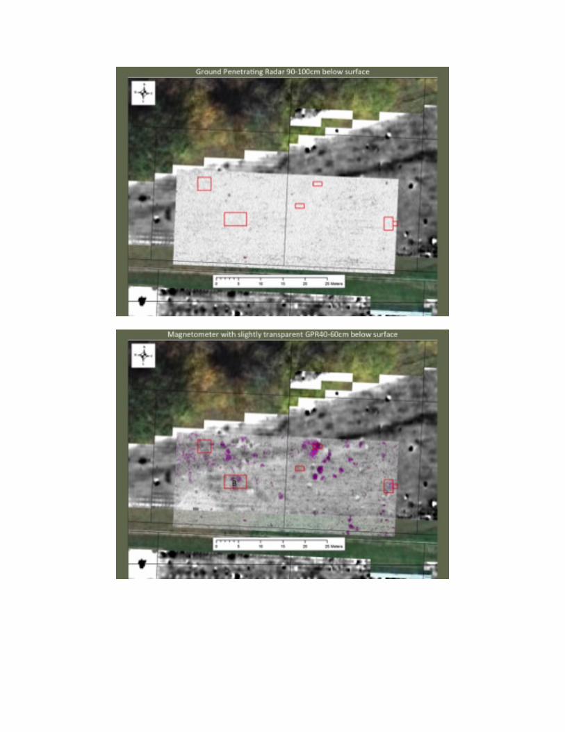
In order to sample a wider range of public and domestic activities at the Cane River site, in June 2013 we conducted magnetometer and ground-‐penetrating radar surveys of the known Cane River village and surrounding areas. [9] Guided by the results of this geophysical survey, four months of subsequent excavations exposed an additional 53 square meters of the site (across 8 different units), targeting several different types of magnetic and radar anomalies. Given the degree of plowing across the site, no intact living surfaces were identified. However, multiple discrete subsurface features and postholes were still intact below the 0.3-‐m modern plough zone. These features included four hearths (two of which were superimposed), one area of sheet midden, and nine borrow or storage pits (several of which were quite deep and stratified). Additionally, my crew and I excavated over a hundred postholes, many of which had clear alignments for structures or palisade walls, along with two pairs of overlapping entrance trenches that were identified from a structure. Overview of the Geophysical Results and Excavations [10] In total, the magnetic gradiometer survey was completed over ~3.5 ha (~33,450 square meters), including portions of the Cane River Middle School’s baseball field, football field and adjoining areas, and on approved portions of the adjoining private property A Bartington Grad601-‐2 dual fluxgate gradiometer was used to collect readings at 0.125m intervals along transverses spaced 0.5m apart. Data processing was undertaken using TerraSurveyor and was limited to: (i) initial clipping of the values to reduce the effect of intense ferrous responses on subsequent processes; (ii) sensor destripe; and interpolation to a resolution of 0.125m x 0.25m in order to smooth the appearance of the data and aid the interpretation of anomalies. The goals of this survey were to determine the extent and preservation of the archaeological site originally identified and partially excavated below the football field in 1989-‐90. Many domestic activities, specifically those involving fire and/or organic material, can locally enhance the magnetic properties of soils (see Aspinall et al. 2008:21–28), resulting in a very clear magnetic contrast of in-‐filled features with the surrounding clay soils, which have a relatively magnetically homogenous background. The size, shape, strength, and form of a magnetic anomaly can be used to make inferences about the feature causing the anomaly. In the magnetometer results presented here, strong, positive magnetic anomalies, (shown in black), are likely caused by features associated with burning (e.g., hearths and pits containing burnt material). Negative magnetic anomalies, (shown in white), are usually less common, indicating areas where the soil is less compact or even absent. In some areas, intense bipolar responses (due to iron metal and therefore suggesting later historic or modern activity) largely obscure the results. Overall, the areas on the recreational playing fields and landscaped areas surrounding them are heavily altered and disturbed by modern debris or plowing. The areas for the fields were likely stripped and leveled off for fill in other areas. The large rectangular area from the 1989-‐90 excavations on the football field is visible in contrast to the lines of the irrigation system put in, (producing the distinct negative linear anomalies). Within the football field, a few areas appear to have large archaeological features still preserved

beneath the irrigation system, however accessing them for excavation or auguring would be difficult given the risk of damaging the irrigation pipes.
However, the field to the north of the football field, currently utilized for pasture, has many potential archaeological signatures. This area of high activity indicates that the majority of the village occupation was to the northeast of the previously identified palisade lines. Focusing in on this triangular field north of the school football field, the dark, positive band running east-‐west is an old road cut and is not of interest to our study The areas with [bipolar signatures are from historic metal – likely pipes sunk into the ground. On the east side (far right of the triangular field), the surrounding magnetic signature of the horse barn largely obscures the magnetic contrast at the edge of the field. Despite this, there were many archaeological features worth exploring. [11] For the GPR survey, a Sensors and Software Noggin and SmartCart system with a 250 MHz antenna was used to survey a total of 60x30m area (1800 square meters). The GPR profiles were closely spaced at 0.25m apart, with individual traces recorded at 0.05m intervals. For the results presented here, data treatment comprised the application of a dewow filter, gain correction, background removal and a bandpass Butterworth filter to limit the frequency response to between 160-‐500 MHz, prior to the production of amplitude time-‐slices. This high resolution GPR survey demonstrates the additional detail and enhanced interpretation that can be made with closely spaced profiles; however, the reduced rate of coverage meant that only five of the eight excavation areas had both magnetometer and GPR data. Those five excavation areas are outlined in this rendering, presented in 10cm depth slices, from surface to 1 m below the ground surface [12-‐22]. This final rendering shows the GPR from 40-‐60cmbs at 50% transparency over the magnetometer data. Comparison between the two data sets shows that some features have been detected with both methods, while others are visible in either only the magnetometer or GPR results. Since these complementary geophysical techniques are measuring different properties, these differences help inform us about the nature of the causative features. Area B [23] Area B is a 5x3m unit placed over several possible circular pit features identified in the magnetometer survey. [24] The magnetic anomalies measure around 1m in diameter and between 10-‐16nT in strength. Excavation revealed 3 circular pit features and one possible burial (left undisturbed) and a line of palisade postholes to the west and a palimpsest of various postholes to the east of the line of pit features. This corresponded closely with the magnetometer data. [25] Oddly enough, these were not detected at the same location by both geophysical methods. The purple color in the GPR data indicates high amplitude reflections; this correlates to a distinct interface between materials, such as a compacted layer or change in soil type. [26] Two of the three strong reflections correlate to boundaries of recognized pit features from the excavation, while one more ambiguous amplitude is off-‐set from the center pit feature. [27-‐28] Thus, the magnetometer seemed to be responding to the more magnetic fill of these larger daub borrow pit features along the palisade line, while the GPR results reflect changes in soil composition within or along the boundaries of these pit features.

Area C [29] Area C is a 3x3m unit also placed over several [30] possible circular pit features identified in the magnetometer survey. These magnetic anomalies again measured around 1m in diameter and between 8-‐17nT. [31] Excavation revealed 3 pit features, two overlapping to the south, and several postholes. [32] At the base of plow zone (20-‐30cmbs in the GPR data), there’s a strong radar reflection in the upper western edge of Feature 5. Again, this is likely due to a change in soil composition, but precisely how it relates to the feature is unclear. The GPR reflection may be caused by a contrast in fill material rather than the base of the pit itself. [33] These larger pits also appear to be within close proximity to a line of palisade postholes and were likely used as daub borrow pits [34] and then in-‐filled with refuse over time Area D [35] Area D is a 1x2m unit placed over a [36] positive magnetometer response that was revealed to be the base of a hearth. [37] While the magnetometer data for this feature was obscured by the linear signature of the road cut and the intense response due to near-‐surface iron metal, [38] the GPR detected a broader area of compaction roughly 4m across, interpreted as the basin of a structure (visible from 30-‐50cmbs). [39] Most of the hearth was destroyed by plowing, but the outline of the feature corresponded well with the outline of the compact soils in the ground penetrating radar survey, and likely indicates the location of a sunken floor surface. Area F [40] Area F is a 7m unit placed over a roughly 2 meter-‐wide, weakly-‐positive magnetic anomaly, around 8nT in strength, [41] on the western half of the unit, as well as a discrete GPR at 30-‐50cmbs at the eastern edge of the unit. Initially this 1x2m unit revealed just postholes but it also caught the edge of an entrance trench. [42] After exposing more surface area under the plow zone, two overlapping pairs of entrance trenches were visible, along with associated postholes. While postholes aren’t usually identifiable with the geophysical methodologies employed here these trenches are likely visible in the magnetometer data because these two sets of entrance trenches were rebuilt in approximately the same place and were in-‐filled with burned material. A similar, weak-‐positive magnetic anomaly is also visible to the west, indicating possible another structure that these entrance trenches are opening up to. [43] This reflection in the GPR data, (of course, on the edge of the survey area!), shows the entrance trenches opening next to into a slightly subterranean structure (less than 3 meters across); this is possibly a compact surface in front of the house where people were walking and there was frequent activity. [44] No floor surface from an associated structure could be established in excavation, but the burnt material in the entrance trenches and some of the deeper postholes likely caused this broader signature in the magnetometer results, [45] while it seems the GPR may have been detecting the compact soils surface of the adjacent house floor. [46] Two areas farther east, outside of the GPR coverage, were also excavated beneath the plow zone to target additional specific magnetic anomalies.

Area E [47] Area E is a 2x2m unit placed over one very large, strong positive anomaly in an area with few other archaeological anomalies. The anomaly measures in excess of 30nT and is roughly circular, around 1.4m in diameter. [48] Excavation revealed a very deep (53cm below the plow zone), steep-‐sided storage pit with a possible burial overlapping the northern edge and a few scattered postholes. [49] The particularly strong positive magnetic response is likely due to the thicker archaeological deposits within this pit, and such anomalies should help us to identify similar features elsewhere in the magnetometer data Area G [50]Area G is 5x2m unit placed over several large, strongly-‐positive anomalies (8-‐24nT in strength) in the magnetometer survey, [51] within a generally very high activity area. [52] Two overlapping hearth features and three overlapping pit features were identified, along with several dozen postholes. The location of these features corresponded very well with the magnetometer responses [53] and the hearth features indicate the location of a house structure that was used long enough to warrant a rebuilt central hearth basin in the approximately same location. [54] Considering the Site Organization
[55] The Pisgah record at Cane River offers a unique opportunity to assess the nature and extent of structural persistence and transformation associated with community layout and organization. The Cane River village appears to extend over approximately 1.5 hectares and have a semi-‐circular layout, similar to the Warren Wilson site and other Mississippian communities. Two sections of palisade lines are identified, possibly indicating one defensive line or perhaps multiple lines – so it is unclear if the site expanded or contracted over time. While one palisade line appears to have been rebuilt or replaced in the same orientation, the distance between the two palisade lines in the southwestern corner of the village are similarly spaced in comparison to the outer double-‐palisade at Warren Wilson. Five buildings identified from posthole patterns and hearth locations (outlined here in blue) surround a central area of the village that is relatively magnetically quiet, indicating a central plaza. The structure located along the western boundary of this plaza, identified by the previously-‐shown entrance trenches, is possibly a public or special use structure, given the lack of an associated hearth or storage pit features or one half of two adjoining houses (perhaps a winter and summer home).
[56] Previous work at the Warren Wilson site has demonstrated that the multiple palisades represent an evolution in site size, either through expansion, contraction, or both (Moore 2002). Yet despite the construction of four or more defensive palisades, the village at Warren Wilson maintained the same basic placement and configuration. Similarly, the Cane River community layout demonstrates elements of a consistent structure. A reconstructed palisade line along the southwestern edge and the rebuilt pair of entrance trenches show architectural continuity and similar placement. Additionally, the overlapping hearth features within the northwestern structure show at least one household was occupied in the same location for an extended period of time and the deep and adjacent overlapping storage pits support this interpretation. [57] This display of a consistent village plan, that includes a central public square ground with surrounding

domestic structures all enclosed within multiple palisade lines, is observed in other South Appalachian Mississippian communities such as the King site in northwestern Georgia and the Town Creek site in central North Carolina (Hally 2008; Boudreaux 2007).
[58] This specific case study illustrates that geophysical surveys and their results are incredibly valuable in providing the location of subsurface features for excavation, as well as answering specific archaeological questions related to site extent and spatial organization. Ground-‐truthing was essential to confirm and support the initial geophysical interpretations, but integrating excavation results with the geophysical survey map is helping us to better identify and interpret other features with similar signatures. This is allowing us to extrapolate site-‐wide patterns of activity and behavior at Cane River and highlights the benefits of doing an initial, extensive geophysical survey. Subsequent research questions and strategies are also informed by this overall site plan. The next phase of research will work to address additional questions such as the growth and development of these Pisgah village settlements and a more detailed understanding of the timing of events at these sites. This data has the potential to make significant inroads in our understanding of the Mississippian historical trajectory in the Appalachian Summit. Although analysis of excavated materials is ongoing, with this accumulated knowledge of site structure, the Cane River archaeological project can contribute to an important discourse regarding regional community organization and variability at the Mississippian frontier.

References Anderson, David G.
1994 The Savannah River Chiefdoms: Political Change in the Late Prehistoric Southeast. University of Alabama Press, Tuscaloosa.
Ashcraft, A. Scott
1996 Pisgah Phase Palisades: Observations on the Spatial Evolution of Village Perimeters. In Upland Archaeology in the East: Symposium Number 6, edited by Eugene B. Barfield and Michael B. Barber, pp. 46–72. United States Department of Agriculture, Forest Service-‐Southern Region, Archaeolgoical Soceity of Virginia Special Publication Number 38 -‐ Part Six, Richmond, Virginia.
Aspinall, Arnold, Chris Gaffney, and Armin Schmidt
2008 Magnetometry for Archaeologists. Altamira Press, Lanham. Beck, Robin A. Jr., Douglas J. Bolender, James A. Brown, and Timothy K. Earle
2007 Eventful Archaeology. Current Anthropology 48(6): 833–860. Beck, Robin A. Jr., and David G. Moore
2002 The Burke Phase: A Mississippian Frontier in North Carolina Foothills. Southeastern Archaeology 21(2): 162–169.
Bigman, Daniel P., Adam King, and Chester P. Walker
2011 Recent Geophysical Investigations and New Interpretations of Etowah’s Palisade. Southeastern Archaeology 30(1): 38.
Boudreaux, Edmond A.
2007 The Archaeology of Town Creek. The University of Alabama Press, Tuscaloosa. Cobb, Charles R.
2015 Mississippian Microhistories and Sub-‐Mound Moments. In The Archaeology of Events: Cultural Change and Continuity in the Pre-‐Columbian Southeast, edited by Zackary I. Gilmore and Jason M. O’Donoughue, pp. 196–219. University of Alabama Press, Tuscaloosa.
Cobb, Charles R., and Adam King
2005 Re-‐Inventing Mississippian Tradition at Etowah, Georgia. Journal of Archaeological Method and Theory 12(3): 167–192.
Connerton, Paul
1998 How Societies Remember. Cambridge University Press, Cambridge. Dickens, Roy S. Jr.
1970 The Pisgah Culture and Its Place in the Prehistory of the Southern Appalachians. University of North Carolina, Chapel Hill.

1976 Cherokee Prehistory: The Pisgah Phase in the Appalachian Summit Region. The University of Tennessee Press, Knoxville.
1978 Mississipian Settlement Patterns in the Appalachian Summit Area: the Pisgah and Qualla Phases. In Mississippian Settlement Patterns, edited by Bruce D. Smith, pp. 115–140. Academic Press, New York.
Eastman, Jane M.
1994a The North Carolina Radiocarbon Date Study (Part 1). Southern Indian Studies 42: 1–63.
1994b The North Carolina Radiocarbon Date Study (Part 2). Southern Indian Studies 43: 1–117.
Ferguson, Leland G.
1974 Prehistoric Mica Mines in the Southern Appalachian. South Carolina Antiquities 6: 1–7.
Griffin, James B.
1943 The Fort Ancient Aspect, Its Cultural and Chronological Position in Mississippi Valley Archaeology. University of Michigan Press, Ann Arbor.
1992 Fort Ancient Has No Class: The Absence of an Elite Group in Mississippian Societies in the Central Ohio Valley. In Lords of the Southeast: Social Inequality and the Native Elites of Southeastern North America, edited by Alex W. Barker and Timothy R. Pauketat, pp. 53–60. Archaeological Papers of the American Anthropological Association Number 3.
Hally, David J.
1994 An Overview of Lamar Culture. In Ocmulgee Archaeology 1936-‐1986, pp. 144–174.
2008 King, the Social Archaeology of a Late Mississippian Town in Northwestern Georgia. The University of Alabama Press, Tuscaloosa.
Hally, David J., and Hypatia Kelly
1998 The Nature of Mississippian Towns in Georgia: the King Site Example. In Mississippian Towns and Sacred Spaces, Searching for an Architectural Grammar, edited by R. Barry Lewis and Charles Stout, pp. 49–63. The University of Alabama Press, Tuscaloosa.
Holmes, William Henry
1903 Aboriginal Pottery of the Eastern United States. Washington, D.C. Horsley, Timothy J., Alice P. Wright, and Casey R. Barrier

2014 Prospecting for New Questions: Integrating Geophysics to Define Anthropological Research Objectives and Inform Excavation Strategies at Monumental Sites. Archaeological Prospection 21: 75–86.
Joyce, Rosemary A., and Julia A. Hendon
2000 Heterarchy, History, and Material Reality: “Communities” in Late Classic Honduras. In The Archaeology of Communities, a New World Perspective, edited by Jason Yaeger and Marcello A. Canuto, pp. 143–160. Routledge, New York.
King, Adam
2003a Over a Century of Explorations at Etowah. Journal of Archaeological Research 11(4): 279–306.
2003b Etowah: The Political History of a Chiefdom Capital. The University of Alabama Press, Tuscaloosa.
Meyers, Maureen S.
2002 The Mississippian Frontier in Southwestern Virginia. Southeastern Archaeology 21(2): 178–191.
2011 Political Economy of Exotic Trade on the Mississippian Frontier: A Case Study of a Fourteenth Century Chiefdom in Southwestern Virginia. University of Kentucky.
Moore, David G.
2002 Pisgah Phase Village Evolution at the Warren Wilson Site. In The Archaeology of Native North Carolina, Papers in Honor of H. Trawick Ward, edited by Jane M. Eastman, Christopher B. Rodning, and EA Boudreaux, Southeaste:pp. 76–83. Southeastern Archaeological Conference Special Publication 7.
Pauketat, Timothy R., and Susan M. Alt
2005 Agency in a Postmold? Physicality and the Archaeology of Culture-‐Making. Journal of Archaeological Method and Theory 12(3): 213–236.
Pluckhahn, Thomas J.
2010 Household Archaeology in the Southeastern United States: History, Trends, and Challenges. Journal of Archaeological Research 18(4): 331–385.
Polhemus, Richard R.
1987 The Toqua Site: A Late Mississippian Phase Town. Purrington, Burton L.
1983 Ancient Mountaineers: An Overview of Prehistoric Archaeology of North Carolina’s Western Mountain Range. In The Prehistory of North Carolina: an archaeological symposium, edited by Mark A. Mathis and Jeffrey J. Crow, pp. 83–194. North Carolina Division of Archives and History, Department of Cultural Resources, Raleigh, NC.

Rodning, Christopher B. 2004 The Cherokee Town at Coweeta Creek. The University of North Carolina at Chapel Hill.
2009 Domestic Houses at Coweeta Creek. Southeastern Archaeology 28(1): 1–26.
Sullivan, Lynne P.
1995 Mississippian Household and Community Organization in Eastern Tennessee. In Mississippian Communities and Households, pp. 99–123. The University of Alabama Press, Tuscaloosa.
Ward, H. Trawick
1965 Correlation of Mississippian Sites and Soil Types. Ed. Stephen Williams. Southeastern Archaeological Conference Bulletin 3: 42–48.
Ward, H. Trawick, and Stephen R. P. Davis
1999 Time Before History: The Archaeology of North Carolina. The University of North Carolina Press, Chapel Hill.
Woodall, J. Ned
1999 Mississippian Expansion on the Eastern Frontier: One Strategy in the North Carolina Piedmont. Archaeology of Eastern North America 27: 55–70.