Geodetic Deformation in the Central-Southern Apennines (Italy) From Repeated GPS Surveys
Upload
independentCategory
view
0download
0
Quaternary Research 75 (2011) 219–230
Contents lists available at ScienceDirect
Quaternary Research
j ourna l homepage: www.e lsev ie r.com/ locate /yqres
Middle and late Pleistocene glaciations in the Campo Felice Basin(central Apennines, Italy)
Carlo Giraudi a,⁎, Giulia Bodrato b, Marianna Ricci Lucchi c, Nicola Cipriani d, Igor M. Villa e,g,Biagio Giaccio f, Giovanni M. Zuppi f
a ENEA, C.R. Casaccia, s.p. Anguillarese, 301, 00123 S. Maria di Galeria, Rome, Italyb Regione Piemonte, Direzione OO.PP.-Difesa del Suolo-Ec.Mont.For., Via Petrarca 44, 10126, Turin, Italyc Department of Earth Sciences, University of Bologna, Piazza di Porta San Donato 1, 40126 Bologna, Italyd Department of Earth Sciences, University of Florence, Via La Pira 4, 50121 Florence, Italye University of Milan “Bicocca”, Piazza della Scienza 4, 20126 Milan, Italyf IGAG-CNR, Via Bolognola 7, 00138 Rome, Italyg Universität Bern, Baltzerstrasse 3, 3012 Bern, Switzerland
⁎ Corresponding author. Fax: +39 0630486678.E-mail address: [email protected] (C. Giraudi).
0033-5894/$ – see front matter © 2010 University of Wdoi:10.1016/j.yqres.2010.06.006
a b s t r a c t
a r t i c l e i n f oArticle history:Received 10 February 2009Available online 19 August 2010
Keywords:Middle and late Pleistocene glaciationsStratigraphyLacustrine sedimentsTephra layers14C and 39Ar–40Ar datingsApennine chainMediterranean basin
The present paper refers to research conducted in the tectonic-karst depression of Campo Felice in the centralApennines (Italy), in which glacial, alluvial and lacustrine sediments have been preserved. Stratigraphicinterpretations of sediments underlying the Campo Felice Plain are based on evidence obtained from ninecontinuous-core boreholes. The boreholes reach a depth of 120 m and provide evidence of five sedimentationcycles separated by erosion surfaces. Each cycle is interpreted as an initial response to a mainly warm stage,characterized by low-energy alluvial and colluvial deposition, pedogenesis, and limited episodes of marshformation. In turn, amainly cold stage follows duringwhich a lake formed, and glaciers developed and expanded,leading to deposition of glacial and fluvioglacial deposits. The chronological framework is established by elevenaccelerator mass spectrometer 14C ages and three 39Ar–40Ar ages on leucites from interbedded tephra layers.These age determinations indicate five glacial advances that respectively occurred duringmarine oxygen isotopestages 2, 3–4, 6, 10 and 14.
ashington. Published by Elsev
© 2010 University of Washington. Published by Elsevier Inc. All rights reserved.
Introduction
The Apennine chain, which forms the backbone of the Italianpeninsula, extends in a NNW–SSE direction between latitudes 44°40′N and 37°57′N and is surrounded on three sides by the MediterraneanSea. The northeast slope of the highest peak (Gran Sasso, 2912 m)supports the Calderone Glacier. This glacier currently is experiencingmajor ablation (Giraudi, 2005).
The mountain chains of the central and western Mediterraneanbasins have been studied relatively little from the viewpoint of glacialtraces prior to the last glacial maximum (LGM). Limited studies reflectin large part that these mountains poorly represent conditionsfavourable for dating glacial features. In Spain, France and Greece,moraines older than LGM have been dated (Fernandez Mosqueraet al., 2000; Calvet, 2004; Woodward et al., 2004; Hughes et al., 2006,2007; Hughes and Woodward, 2008, 2009). Mt. Tymphi in Greece
ier In
(Woodward et al., 2004; Hughes et al., 2007), ca. 600 km southeast ofCampo Felice, is the nearest site with a few available ages.
The highest mountains of the Apennines show traces of threeglaciations (Giraudi, 2004, and references therein), which occurredin the middle and late Pleistocene. Of these, only the most recentglaciation is reasonably well-dated (Giraudi and Frezzotti, 1997).Uranium series dating carried out on calcite crystals includedwithin moraine deposits at Campo Imperatore allowed Kotarbaet al. (2001) to assume that the oldest glaciation occurred duringmarine oxygen isotope stage (MIS) 6.
Study of the glacial evidence (summarized by Giraudi, 2004)indicates that the most extensive glaciers were in the northern andcentral Apennines. The greatest quantity of glacier-related phenom-ena is found in the central Apennines, where the mountains are thehighest. Here, many enclosed tectonic basins are also found withendorheic drainage. This internal drainage favored a slower rate oferosion that enabled glacial deposits older than the LGM to bepreserved.
One of the depressions on the Campo Felice Plain, on the northernedge of the Mt. Velino massif in Abruzzo (42°13′N, 13°25′E), waschosen for the present study (Fig. 1). The plain is well-known in theliterature due to the presence of deposits from at least two glaciations
c. All rights reserved.

Figure 1. Geological map of Campo Felice and its catchment basin (A), and (B) the Roman Comagmatic Province, and Campanian volcanoes.
220 C. Giraudi et al. / Quaternary Research 75 (2011) 219–230
(Cassoli et al., 1986; Jaurand, 1998; Giraudi, 2001, 2004). Thelithological and mineralogical study of the sediments and the datingreported in the present paper provide evidence for a number ofenvironmental variations that occurred over 500 ka involving fivecold periods.
The Campo Felice Plain
The Campo Felice Plain is a small plain located in a closed tectonic-karst basin surrounded by Meso-Cenozoic limestone ridges (Bosi andManfredini, 1967; Accordi et al., 1986). The plain occurs at altitudes

221C. Giraudi et al. / Quaternary Research 75 (2011) 219–230
between about 1520 and 1600 m. Thick lake sediments bordered bydeposits of glacial, fluvioglacial, alluvial, detrital and aeolian originoccur in the lowest portions of Campo Felice. Some small ponors act aswater outflows (Giraudi, 1998, 2001).
The catchment basin (Figs. 1 and 2) extends over large tracts above2000 m and includes peaks above 2200 m. A large portion of themountainous zone and the plain were occupied by glaciers during thePleistocene, and glacio-karstic landforms are present. Moreover, thereare traces of the existence of discontinuous permafrost in the past.Because of its geological and geomorphological features, the CampoFelice Basin shows great potential for the dating of past glacial andperiglacial events.
The origin of the depression of Campo Felice is due to the formationof a half-graben that displaced a limestonemonocline sloping to the NE,and forming the present northern edge of the Plain (Fig. 3). TheForcamiccia pass, located between Mt. Cefalone and Mt. Serralunga(Figs. 1 and 2), is situated at the head of a valley that was truncatedheadwards by the movement of the fault which produced the half-graben. The fault is oriented NW–SE in the eastern portion (the Mt.Cefalone fault) and WNW–ESE in the western portion (the Mt. Orsellofault). The incision of the Forcamiccia valley truncated by the fault took
Figure 2. Geological map of the eastern portion of Campo Felice, location of the boreholes
place before the formation of the half-graben. The stream that producedthe incision probably came from the area of Vena Stellante-Puntadell'Azzocchio and flowed towards the northeast. Part of this valley (onthe downthrown side of the fault) was covered by the sediments ofCampo Felice.
The half-graben structure therefore seems to have been dividedinto two parts by a roughly N–S fault. Some faults were active alsoduring the late Pleistocene and Holocene (Giraudi, 1995; Giaccio et al.,2002).
Field and laboratory methods
The sediments underlying the Campo Felice depression weresampled by means of 9 continuous-core boreholes, the deepest ofwhich reached 120 m below ground level. These borings wereconducted as part of the Special Project “Lacustrine Sedimentation-Palaeoenvironment-Palaeoclimate” of the National Research Council(CNR). Stratigraphy in the upper part of the coreswas correlated againstglacial and lacustrine deposits outcropping at the surface or observed inshallow excavations.
CF1–CF7, 5 and GEO, and geological sections reported in Fig. 7 (A–A′) and 5 (B–B′).
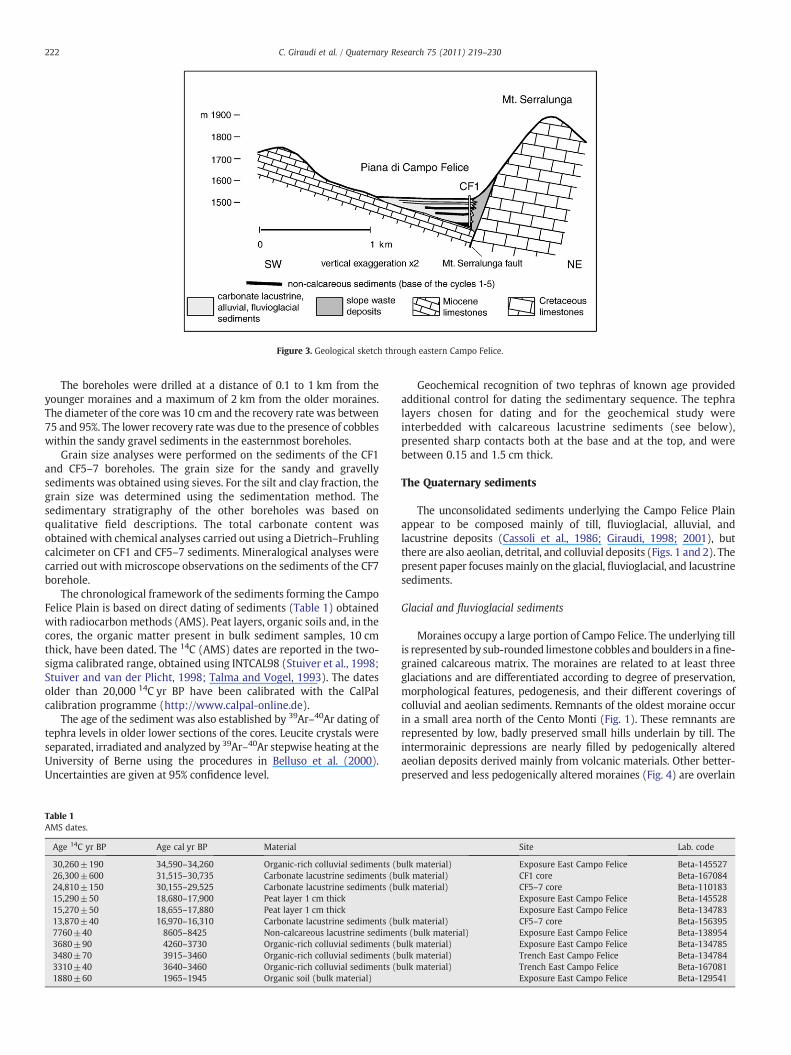
Figure 3. Geological sketch through eastern Campo Felice.
222 C. Giraudi et al. / Quaternary Research 75 (2011) 219–230
The boreholes were drilled at a distance of 0.1 to 1 km from theyounger moraines and a maximum of 2 km from the older moraines.The diameter of the core was 10 cm and the recovery rate was between75 and 95%. The lower recovery rate was due to the presence of cobbleswithin the sandy gravel sediments in the easternmost boreholes.
Grain size analyses were performed on the sediments of the CF1and CF5–7 boreholes. The grain size for the sandy and gravellysediments was obtained using sieves. For the silt and clay fraction, thegrain size was determined using the sedimentation method. Thesedimentary stratigraphy of the other boreholes was based onqualitative field descriptions. The total carbonate content wasobtained with chemical analyses carried out using a Dietrich–Fruhlingcalcimeter on CF1 and CF5–7 sediments. Mineralogical analyses werecarried out with microscope observations on the sediments of the CF7borehole.
The chronological framework of the sediments forming the CampoFelice Plain is based on direct dating of sediments (Table 1) obtainedwith radiocarbonmethods (AMS). Peat layers, organic soils and, in thecores, the organic matter present in bulk sediment samples, 10 cmthick, have been dated. The 14C (AMS) dates are reported in the two-sigma calibrated range, obtained using INTCAL98 (Stuiver et al., 1998;Stuiver and van der Plicht, 1998; Talma and Vogel, 1993). The datesolder than 20,000 14C yr BP have been calibrated with the CalPalcalibration programme (http://www.calpal-online.de).
The age of the sediment was also established by 39Ar–40Ar dating oftephra levels in older lower sections of the cores. Leucite crystals wereseparated, irradiated and analyzed by 39Ar–40Ar stepwise heating at theUniversity of Berne using the procedures in Belluso et al. (2000).Uncertainties are given at 95% confidence level.
Table 1AMS dates.
Age 14C yr BP Age cal yr BP Material
30,260±190 34,590–34,260 Organic-rich colluvial sediments (b26,300±600 31,515–30,735 Carbonate lacustrine sediments (bu24,810±150 30,155–29,525 Carbonate lacustrine sediments (bu15,290±50 18,680–17,900 Peat layer 1 cm thick15,270±50 18,655–17,880 Peat layer 1 cm thick13,870±40 16,970–16,310 Carbonate lacustrine sediments (bu7760±40 8605–8425 Non-calcareous lacustrine sedimen3680±90 4260–3730 Organic-rich colluvial sediments (b3480±70 3915–3460 Organic-rich colluvial sediments (b3310±40 3640–3460 Organic-rich colluvial sediments (b1880±60 1965–1945 Organic soil (bulk material)
Geochemical recognition of two tephras of known age providedadditional control for dating the sedimentary sequence. The tephralayers chosen for dating and for the geochemical study wereinterbedded with calcareous lacustrine sediments (see below),presented sharp contacts both at the base and at the top, and werebetween 0.15 and 1.5 cm thick.
The Quaternary sediments
The unconsolidated sediments underlying the Campo Felice Plainappear to be composed mainly of till, fluvioglacial, alluvial, andlacustrine deposits (Cassoli et al., 1986; Giraudi, 1998; 2001), butthere are also aeolian, detrital, and colluvial deposits (Figs. 1 and 2). Thepresent paper focuses mainly on the glacial, fluvioglacial, and lacustrinesediments.
Glacial and fluvioglacial sediments
Moraines occupy a large portion of Campo Felice. The underlying tillis represented by sub-rounded limestone cobbles andboulders in afine-grained calcareous matrix. The moraines are related to at least threeglaciations and are differentiated according to degree of preservation,morphological features, pedogenesis, and their different coverings ofcolluvial and aeolian sediments. Remnants of the oldest moraine occurin a small area north of the Cento Monti (Fig. 1). These remnants arerepresented by low, badly preserved small hills underlain by till. Theintermorainic depressions are nearly filled by pedogenically alteredaeolian deposits derived mainly from volcanic materials. Other better-preserved and less pedogenically altered moraines (Fig. 4) are overlain
Site Lab. code
ulk material) Exposure East Campo Felice Beta-145527lk material) CF1 core Beta-167084lk material) CF5–7 core Beta-110183
Exposure East Campo Felice Beta-145528Exposure East Campo Felice Beta-134783
lk material) CF5–7 core Beta-156395ts (bulk material) Exposure East Campo Felice Beta-138954ulk material) Exposure East Campo Felice Beta-134785ulk material) Trench East Campo Felice Beta-134784ulk material) Trench East Campo Felice Beta-167081
Exposure East Campo Felice Beta-129541

223C. Giraudi et al. / Quaternary Research 75 (2011) 219–230
by volcanic mineral-rich aeolian deposits with an interbedded paleosol.These deposits have yielded a Mousterian chert artefact. As reported inGiraudi (2001), in Central Italy Mousterian cultural remains occur fromat least MIS 5e and until MIS 3. Since the moraines predate aeoliandeposits, the palaeosol, and the artefacts, it is highly improbable that theice advance occurred duringMIS 4. Thesemoraines, formed by a glacierlarger than the late Pleistocene one, have been dated to the late middlePleistocene (Giraudi, 2004) and correlated to theMIS 6 moraines in theGran Sasso Massif reported by Kotarba et al. (2001).
The local LGMmoraines are the best preserved and cover extensiveareas within Campo Felice at the locality of Cento Monti (Fig. 4), and atthe extreme eastern edge of the Plain. In both localities, the frontalmoraines are characterized by a clear, fairly continuous rampart. Inspite of the absence of direct dating, the freshness of the forms and theslight degree of pedogenesis, support the idea that thesemoraineswereformed during the LGM (Jaurand, 1998; Giraudi, 1998, 2004). Manyridges occur behind the frontal moraines and enclose depressions thatdeveloped during melting of dead ice. In the Cento Monti area (Fig. 1),there are other recessional moraines corresponding to the first re-advance of the glacial front during the general retreat following themaximum expansion (Giraudi, 1998). There are remains of otherrecessional moraines in the intermediary part of Valle Leona (Fig. 1). Amore recent moraine is present on the threshold of the cirque of Fossadel Puzzillo, while the most recent recessional moraine in thecatchment basin of Campo Felice is present at the base of the slope ofVena Stellante. The retreat of the glacial tongue following the local LGMmust have therefore been interrupted by at least four phases of re-advance.
The fluvioglacial sediments, forming aprons around the local LGMfrontal moraines and well-preserved fans, were deposited in twophases. Sediments of the first phase were covered by till during thelocal LGM glacial advance; the sediments of the second phase cross-cutthe LGM moraine, and were formed during the glacial retreat. In theeastern part of Campo Felice, at the contact between the fluvioglacialfan and the lacustrine sediments and at the base of a lacustrine bar,fluvioglacial sediments cover pedogenically altered colluvial deposits,rich in organic matter and dated at approximately 35 cal ka BP(30,260±190 14C yr BP; Giraudi, 2001). The fluvioglacial sedimentsare interbedded with lacustrine sediments (Fig. 5) older than 18.68–17.9 cal ka BP (15,290±50 14C yr BP). The LGM at Campo Felice istherefore bracketed between these ages. This interpretation is consis-tent with findings of Frezzotti and Giraudi (1992), who bracketed LGMfluvioglacial sediments of Valle Majelama on the southern slope of theVelino Massif, between 38 and 34 cal ka BP (30,700±1700 14C yr BP )and ca. 16–17 cal ka BP.
Figure 4. The Cento Monti moraines in the central-western Campo Felice Plain. The younger
Lacustrine sediments
Part of the Campo Felice low-lying areas is underlain by lacustrinesediments, mainly calcareous silt and clay covered by colluvium,mainly formed by volcanic material. The top of the sediments isaltered by pedogenesis. The soil on the calcareous sediments is 15 to20 cm thick and the upper organic horizon is generally 5 to 10 cmthick. In softer non-calcareous sediments the soil reaches a thicknessof about 30–40 cm and appears more organic.
A lacustrine bar is also present in the eastern part of Campo Felice.The bar occurs a few meters higher than the surrounding plain and isformed by decimeter-thick strata, slightly dipping towards the center ofthe plain. The bar consists of clasts that are a few centimeters in size,fairlyflattened, and very little sandymatrix. The bar has been correlatedwith the local LGM, as the sediments forming it cover the fluvioglacialdeposits associated with the last major glacial advance and are cut bythe fluvioglacial sediments associated with glacial retreat.
Outcrops of fine lacustrine sediments have been dated to the finalphases of the late Pleistocene (between 18.68 and 17.9 cal ka BP and8.605 and 8.425 cal ka BP; Table 1) and to theHolocene (Giraudi, 2001).Inparticular, in the course of theHolocene, only brief lacustrineepisodesoccurred, which were interrupted by the sedimentation of colluviumand aeolian sediments, formedmainly of volcanic minerals, and alteredby pedogenesis phases.
The stratigraphy of the Campo Felice sediment cores
In order to obtain the stratigraphic data necessary to understandthe climatic and environmental evolution, seven continuous-coreextractions were made in the eastern portion of Campo Felice (Fig. 2).In addition, the stratigraphy of two sediment cores taken earlier alsowas examined. The maximum depth reached by the boreholes wasabout 120 m. In spite of this, in the zone of maximum thickness of thesediments, the base of the sequence of Quaternary sediments was notreached.
The lacustrine sediments include two types of contributions: onedominated by carbonates and the other with a prevalence of silicates(Fig. 6). The silicate fraction contained abundant hydromorphic femiccrystals mixed with minerals of volcanic origin.
The litho-stratigraphyof the cores provided evidence that sedimentsaccumulated in conjunction with five different cycles. The base of eachsedimentary cycle overlies an erosion surface, or a lacuna, denoted by aclear-cut change in the lithology and facies of the sediments. Also thedifferent thickness of the sediments of the same cycle in different coresseems due mainly to erosion surfaces (Figs. 6 and 7). After the erosion,
moraine formed during the local LGM (MIS 2) while the older one formed during MIS 6.

Figure 5. Stratigraphic section of the eastern boundary of the Campo Felice Plain where calcareous lacustrine sediments are interfingered with fluvioglacial sandy gravel sediments.Ages are reported in cal ka BP. See Fig. 2 for B–B′ transect location.
224 C. Giraudi et al. / Quaternary Research 75 (2011) 219–230
the sedimentation of mainly dark-colored, non-calcareous or weaklycalcareous sediments occurred. A typical stratigraphical sequence ofthese sediments consists of the following: silts and silts with sand, anddecalcified gravel of colluvial origin; reworked volcanic materialconsisting of sand and silt; rare, thin intercalations of gravelly sands ofalluvial origin; rare intercalations of thin, light grey or whitish silts andclayey silts of lacustrine origin (Figs. 6 and 7). Discontinuous, 20 to60 cm thick, yellow–red paleosols developed on silty and sandy gravel,and dark paleosols on thin volcanic material, are preserved. Thin layersof dark silty clay rich sediment in organic matter or peat levels wereinterbedded with the sediments of the 3rd and 1st sedimentary cycles.The thickness of these sedimentary sequences varies greatly, frommorethan 10m to 1.5–2 m. Apart from the thin levels of whitish clayey siltsand the gravelly sands, the other sediments are almost completely non-calcareous and the coarse fraction consists mostly of volcanic minerals.In the CF1 and CF5–7 cores, the base of the 4th cycle is the only oneformed solely by silty gravels of colluvial origin pedogenically altered.
Ingeneral, thenon-calcareousorweakly calcareous sediments foundin the CF1 and CF5–7 cores have a similar grain size. In the CF5–7 cores alarger number of silty gravel and sandy gravel levels occur and the grainsize variations appear more frequent (Fig. 6). The thickness of theprevalently non-calcareous sediments is far less at the base of the 4thand 5th cycles.
Sandy and clayey silts of whitish or light brown color, with a strongcarbonate composition (generally more than 60%, at times more than80%; Fig. 6) overlay the mainly non-calcareous sediments. Thethickness of these sediments varies in some boreholes: the maximumthickness is ca. 30 m in the 1st cycle and theminimum is ca. 4 m in the3rd cycle. The core of the CF1 borehole contains more carbonate thanthe CF5–7 cores.
The calcareous sediments contain a number of tephra layers and,in some parts, appear laminated. The stratigraphy of some trenchescut into surficial sediments (Giraudi, 2001) shows that the calcareouslacustrine sediments of the last cycle are interfingered with sandygravels of a fluvioglacial fan linked with moraines of the local LGM(Fig. 5). Similar stratigraphy is present in the boreholes.
Coarse sandy gravels are interfingered with calcareous silts andclayey silts of lacustrine origin in the top four sedimentary cycles(Figs. 6 and 7). However, in the eastern marginal zone of the CampoFelice Plain, near the lacustrine bar and the moraine front, the non-calcareous sediments and the soils of the last four cycles are overlainby the coarse sandy-gravel sediments interfingered with thecalcareous lacustrine sediments.
The chronological framework for sediments of the cores wasestablished by radiocarbon AMS datings in the upper part of the coresand by 39Ar–40Ar dating of tephra levels in older lower sections of thecores. The tephra layers are coincident, both in age and mineralogicalcomposition, with some ignimbrites from the Alban Hills Volcanic
Complex (AHVC) reported in Villa et al. (1999), Karner et al. (2001)Giordano et al. (2003) and Freda et al. (2006). The tephra levels studiedand dated were selected as they are interfingered with calcareoussediments, have sharp contacts with the underlying and overlyinglacustrine sediments, and do not contain carbonates of lacustrine origin.Moreover, the tephrawere found in the boreholes of the central portionof Campo Felice and not in those at the edges of the plain. It is thereforepossible to exclude that they come from any reworking of the volcanicmaterials already present in the catchment basin. In that case, in fact,levels rich in volcanic materials must have been present, in increasingthicknesses and grain size towards the edge of the plain.
The sediments of the 5th cycle are constrained by several AMS dateson bulk sediment samples (Figs. 6 and 7). The upper part of the 5th cyclecontains a layer dated at 16.3–17.0 cal ka BP, while two samples at thebase of the lacustrine sediments give ages of 30–32 cal ka BP. At the topof the 4th cycle (Fig. 6), a tephra layer contains leucite dated at 41±9 kaby 39Ar–40Ar. This age overlaps that (ca. 36 ka) of the leucite-bearingeruptions of the Albano Maar (also called Albano 7) from the AHVC(Villa et al., 1999; Freda et al., 2006). The chemical composition of thistephra layer (CF3 in Fig. 8; Table 2) shows affinity with the proximalpyroclastic deposits of the eruption. The Albano Maar ignimbrites havebeen found in several zones of the central Apennines (Giaccio et al.,2007, and references therein).
A tephra layer was also found interbedded with the lacustrinesediments of the 3rd cycle (Fig. 6). The chemical composition showsthat the tephra derives from the Vico volcanic eruption (CF4 in Fig. 8;Table 2) known as “Ignimbrite B” dated 157±3 ka by Laurenzi and Villa(1987).
The lacustrine carbonate sediments of the 2nd cycle contain(Fig. 6) a leucite-bearing tephra layer, which we dated at 376±56 kaby 39Ar–40Ar. This age and mineralogical composition are indistin-guishable from that of the leucite-bearing Villa Senni Tuff from theAHVC (dated at 350±2 ka by Karner et al., 2001). The Villa Senni Tufferuption occurred during MIS 10 (Giordano et al., 2003).
We dated a leucite-bearing tephra layer in the lower part of thecarbonate lacustrine sediments of the 1st cycle (Fig. 6) at 504±9 kaby 39Ar–40Ar. Age and mineralogy indicate an attribution to the leucite-bearing Lower Ignimbrite Tuff sequence from the AHVC. The eruptiveinterval of the Lower Tuffswas from514±3 to 561±1 ka (Karner et al.,2001) and corresponds to MIS 14 (Giordano et al., 2003).
Correlation of radiometric ages associated with stratigraphic unitsunderlying the Campo Felice Plain indicates the following possiblelinkages with marine oxygen isotope stages:
– At least part of the lacustrine sedimentation of the 1st cycleoccurred during MIS 14;
– the lacustrine sediments lying near the top of the 2nd cycle weredeposited during MIS 10;

Figure 6. Percentage of carbonate sediments and grain size in the CF1 and CF5–7 cores, and pollen content in the CF7 core. The total carbonate content was obtained with chemicalanalyses carried out using a Dietrich–Fruhling calcimeter. The grain size of the sandy and gravelly sediments was obtained using sieves. The grain size of the silt and clay fraction wasdetermined using the sedimentation method. The pollen data are from Di Rita and Magri (2004).
225C. Giraudi et al. / Quaternary Research 75 (2011) 219–230
– at least the upper part of the lacustrine sediments of the 3rd cycleaccumulated during MIS 6;
– the upper lacustrine sediments of the 4th cycle accumulatedduring MIS 3; and
– the lacustrine sediments of the 5th cycle were deposited duringMIS 2.
Analyses of fossil pollen by others suggest palaeoenvironmentalchanges that are broadly consistent with the results reported herein.Insufficient pollen preservation in the 1st and sedimentary cycles hasprevented reliable interpretations of corresponding vegetation (D.Magri, personal communication, 2007). However, Di Rita and Magri(2004) carried out pollen studies on sediments associated with the

Figure 7. Stratigraphic section through the infill sediment of the Campo Felice Basin. See Fig. 2 for A–A′ transect location.
226 C. Giraudi et al. / Quaternary Research 75 (2011) 219–230
3rd to 5th sedimentary cycles in borehole CF7. Their results show fourdifferent pollen zones within the 3rd depositional cycle (Fig. 6). Thisinclude:
– Zone CF7–1. Wood expansion. Several arboreal taxa are represented:Abies, Alnus, deciduous oaks, Ulmus, Corylus, Fagus, and Picea. Thepollen succession is interpreted as indicating forest dynamics with
Figure 8. Total alkali silica (TAS, Le Bas et al., 1986) diagram of micro-pumices and glass ftephras Campo Felice 3 and 4 (CF3 and CF4) and from the proximal pyroclastic deposits of
elements of mixed oak forest at the beginning, followed by montanetree taxa (beech and fir) and finally by spruce. The authors report thatsimilar dynamics are commonly observed in many European pollenrecords in the course of an interglacial cycle.
– Zone CF7–2. Progressive diffusion of mountain arboreal taxaending with an open vegetation. Pinus is the predominant tree,while Juniperus, Picea, and Ephedra fragilis reach appreciable
ragments (EDS-WDS microprobe analyses; data and their source in Table 2) from theAlbano 7 (Colli Albani Volcanic District) and Vico B (Vico volcano) eruptive units.

Table 2Major-element chemical composition of glass shard from Campo Felice 3 and CampoFelice 4 tephras.
Tephra Campo Felice 3 Albano 7 Campo Felice 4 Vico D
Age (ka) 36 ± 1 157 ± 3
Population a b
Number ofanalyses
19 28 14 2 13
SiO2 44.23 1.81 45.57 1.28 59.51 0.32 54.09 0.04 59.87 0.23TiO2 0.85 0.15 0.85 0.11 0.44 0.03 0.73 0.04 0.46 0.07Al2O3 19.58 1.37 19.15 0.73 20.50 0.14 19.96 0.01 19.66 0.11FeO 7.97 0.96 8.35 0.79 2.81 0.12 5.90 0.04 2.86 0.06MnO 0.30 0.06 0.31 0.06 0.18 0.03 0.19 0.05 0.16 0.04MgO 1.72 0.84 1.31 0.41 0.43 0.03 1.88 0.04 0.42 0.03CaO 11.84 1.88 11.29 1.07 2.34 0.08 5.29 0.19 2.38 0.05Na2O 5.18 1.27 5.53 0.91 5.12 0.18 4.11 0.10 5.39 0.09K2O 6.99 1.52 6.22 1.28 8.50 0.14 7.39 0.14 8.68 0.18P2O5 0.26 0.14 0.04 0.03 0.32 0.09 0.05 0.04F 0.75 0.17 0.51 0.09 0.17 0.16 0.43 0.11Cl 0.23 0.08 0.22 0.02 0.42 0.04 0.22 0.03SO3 1.32 0.94 0.97 0.46 0.11 0.04 0.10 0.06 0.09 0.03Cr2O3 0.01 0.01 0.05 0.21 0.01 0.02 0.03 0.04SrO 0.30 0.15BaO 0.10 0.05Originaltotal
97.38 1.16 96.09 1.22 96.66 0.86 96.65 0.36 94.71 1.34
Average major-element composition (EDS–WDSmicroprobe analyses, wt.% normalizedto 100%; mean value, in bold; standard deviation, in italic) of glass shards from thetephra layers Campo Felice 3 and Campo Felice 4, sampled in CF5 borehole sediments,and from the proximal pyroclastic deposits of Albano 7 (Colli Albani Volcanic District)and Vico B (Vico volcano) eruptive units. A significant chemical affinity between CF3and Albano 7 and between CF4 (population a) and Vico B, respectively, is evident. Datasource: chemical composition of the glasses from Albano 7, Giaccio et al., (2007); 40Ar/39Ar age of Albano 7, Freda et al. (2006); chemical composition of the glasses from VicoB, this study; 40Ar/39Ar age of Vico B, Laurenzi and Villa (1987).
227C. Giraudi et al. / Quaternary Research 75 (2011) 219–230
values. Herbs are very abundant, Artemisia being the mostimportant, followed by Cichorioideae, Gramineae, Asteroideae,Chenopodiaceae, and Thalictrum.
– Zone CF7–3. Moderate wood expansion. Abies is the mostimportant tree taxon, Picea, Fagus, Quercus, and Zelkova are othersignificant tree taxa. Among the herbs, Cichorioideae, Gramineae,and Artemisia are very abundant.
– Zone CF7–4. Open vegetation. Pinus and Juniperus are the onlyarboreal taxa continuously present, but tree pollen do not reach 3%altogether. Artemisia predominates in the lower part, accompaniedby Cichorioideae, while in the upper part an increase of Cichor-ioideae corresponds to a decrease of Artemisia.
The calcareous sediments of the 3rd cycle correspond to theuppermost CF7–3 and to the CF7–4 pollen zones. The tephra of theVico volcano, dated at 157±3 ka ago, indicate that the CF7–4 pollenzone corresponds with MIS 6. Therefore the underlying forest phasepossibly correlates with MIS 7.
There is virtually a total absence of pollen in the calcareous lacustrinesediments of the 4th sedimentary cycle, except next its termination.CF7–4 and CF7–5 pollen zones are dominated by herbaceous taxa,corresponding to cold periods. The CF7–5 pollen zone represents aperiod dominated by herbaceous taxawith a considerable abundance ofArtemisia, Gramineae, and Chenopodiaceae. This association corre-sponds with the LGM (Di Rita and Magri, 2004).
The radiocarbon age of ca. 35 cal ka BP for the non-calcareoussediments at the base of the5th cyclewas determined froma level rich inorganic matter exposed in a trench excavation (Giraudi, 2001). Theorganic horizon was contained within pedogenically weathered collu-vium. Analogous ages have been obtained for soils underlyingfluvioglacial sediments on the southern slope of the Velino Massif(Frezzotti andGiraudi, 1992). Furthermore, palynological studies carriedout on sedimentcores taken froman intermontanebasinon thenorthern
slope of the Velino Massif indicate that around 35 cal ka BP (about30,000 14C yr BP) an arboreal expansion occurred in the area (Chiariniet al., 2007). The non-calcareous sediments at the base of the 5th cycle atCampo Felice thus appear coeval with this arboreal expansion.
Interpretation of the data
The dating of the deposits from which cores have been taken, thecontinuity between the sediments observed as outcrops and those inthe upper part of the cores, and the chronological correlation withmorainic and fluvioglacial deposits, enable the environmentalevolution of Campo Felice to be interpreted.
Among the prevalently calcareous sediments of the last four cycles,gravelly–sandy sediments increase towards the edge of the plain,towards former glacial valleys. The clear interfingering of moraines andfluvioglacial sediments with the deposits of the 5th cycle providesconfirmation that the coarse materials, also in the 2nd, 3rd and 4thcycles, came from past glaciated valleys (Fig. 7). The lacustrinesediments of the 1st cycle, dated at MIS 14, are not interfingered withsediments of fluvioglacial origin. The boreholes that reach the depositsof thebasal cycle are, however, locatedat adistanceof 2 and2.5 kmfromthe oldest moraines, and the absence of coarse deposits in this unit isprobably a consequence of this distal geographic location.
The core sediments of the deepest boreholes (CF1 and CF5–7)show, in general, very similar sedimentary sequences, although indetail some differences can be observed. The non-calcareous orweakly calcareous sediment cores have similar grain size, but in theCF5–7 cores we found more silty–gravel and sandy–gravel layers, andgrain size variations are more frequent (Fig. 6). A difference exists alsofor carbonate sediments. The sediments contain more carbonate inCF1 than in CF5–7. The weak differences between the sediments seemquite normal and due to the location of the boreholes. The CF1borehole lies in the eastern part of the plain not far from the foot of aquite regular slope, about 350 m high. The CF5–7 boreholes lie not farfrom the foot of a slope that is less regular and 200–500 m high, andnear the confluence of the Valle Leona stream (the main tributaryvalley with the highest mountains— Fig. 1) in the Campo Felice Plain.
As observed before, the thickness of the sediments forming a singlecycle can change in different boreholes: the difference is possibly due tothe changing sedimentation rate in various places of the Campo Felicedepression and to later erosions. The thickness of the prevalently non-calcareous sediments at the base of the 4th and 5th cycles is far less thanthat of the non-calcareous sediments at the base of the older cycles. Thedifference could be due to the evolution of the Campo Felice Plain. Thegradual filling-in of the depression (Fig. 3) results in a larger area onwhich the younger sediments are laid down. Therefore, although equalvolumes of materials are deposited, the thickness of the more recentsediments is less because they are distributed over a larger area.
The decrease in the thickness of the non-calcareous sediments of the4th and 5th cycles at Campo Felice may also be due to the smallerquantity of tephra produced by the volcanoes in the nearby RomanComagmatic Province. These volcanoes (Mt. Volsini, Vico, Mt. Sabatini,Alban Hills, Ernici and Roccamonfina), located at a distance of between70and120 km fromCampoFelice (Fig. 1),were very active in the courseof the Middle Pleistocene, but their activity ceased or stronglydiminished in the last 90–100 ka (Marra et al., 2004, and referencestherein). In the last 90 ka only a few secondary volcanic centershave been active in the Sabatini Hills (about 40–50 ka) and in the AlbanHills (about 70 and 25–50 ka). In the central Apennines, in the courseof the Late Pleistocene and the Holocene, some thin tephra levelswere deposited from volcanoes in southern Italy, namely the PhlegreanFields, Vesuvius and Mount Etna (Narcisi, 1993; Frezzotti and Narcisi,1996).
Late Pleistocene and Holocene erosion and sedimentation phasesrecordedonCampoFelice Plain are very similar to those indicatedby thenon-calcareous sediments present at the base of the sedimentary cycles.

228 C. Giraudi et al. / Quaternary Research 75 (2011) 219–230
After the end of the sedimentation of the lacustrine deposits of the 5thcycle (ageb than 16.97–16.31 cal ka BP andN than 8.605–8.425 cal kaBP), various erosion phases developed (Giraudi, 2001). The erosionphases occurred, therefore, near the end of the glacial period and duringthe early Holocene. Macklin et al. (2002) also noted many parts of theMediterranean region indicate evidence of stream incision duringinterglacials period. The Holocene record shows an accumulation ofsediments formed mainly of volcanic materials and reworked by thewind and by colluvial processes including pedogenic weathering.Limited amounts of mainly fine alluvial sediments also were deposited.The oldest preserved Holocene sediments have been dated at about8.605 to 8.425 cal ka BP. Later, brief episodes of sedimentation in small,shallow lacustrine basins took place. Colluvial layers, interbedded withlacustrine sediments have been documented as being deposited about1.965 to 1.945 cal ka BP and 3.64 to 3.46 cal ka BP (Giraudi, 2001).Pedogenic development prevailed throughout the late Holocene.
We therefore interpret the late Pleistocene and early Holoceneerosion as analogues to the erosion phases developed before the startof each sedimentary cycle. The Holocene record of sedimentation andweathering is interpreted as analogous to sedimentation of alluvial,colluvial and marsh deposits and weathering phases developed atCampo Felice at the base of each sedimentary cycle, and characteristicof the interglacial or interstadial periods. This interpretation is inagreement with expansions of woody vegetation indicated by pollenwithin the sediments at the base of the 3rd and 5th cycles.
The sedimentary cycles were completed by sandy gravel depositsthat interfingerwith calcareous lacustrine sediments, containing tephralevels. The calcareous lacustrine sediments of the 5th sedimentary cycleare interfingered with local LGM fluvioglacial sediments (MIS 2) andcontain pollen evidence of steppe vegetation. The calcareous lacustrinesediments of the 3rd sedimentary cycle contain a tephra layer dated atMIS 6 and pollen evidence of steppe vegetation. The moraines of theintermediate glaciationpresent at Campo Felice (dated atMIS 6)maybecorrelated chronologically with the 3rd cycle. Similar sediments fromthe 1st and 2nd cycles contain tephra layers dated atMIS 14 andMIS 10.
The above evidence support our assumption that calcareouslacustrine and sandy gravel sediments were prevalently depositedduring glacial stages. This interpretation agrees with the data relatingto the syn-glacial deposits in theMediterranean area.Woodward et al.(1992) documented an increase of the carbonate percentage inglacier-fed fluvial sediments, derived fromMt. Tymphi, Greece, whereremnants or three glaciations have been found, and a glacio-karstlandscape is present. According to the same authors, Mediterraneanglaciers exerted an important influence on sediment supply related toenhanced flood magnitudes during meltwater events. In the Mt.Tymphi area, the sediment load in the river decreased and erosionoccurred during warmer periods. Elsewhere in other Mediterraneanregions, Macklin et al. (2002) found that a large volume of sedimentsreached the valley floors during cooler climate phases.
The dramatic lithological difference between cold and warmperiod sediments is due to the environmental variations in thecatchment area. We hypothesize that during glacial periods, theglacier meltwater could not penetrate the limestone because the karstfeatures in the bedrock were mainly covered by ice or obstructed byfrozen ground. As a consequence, the water flowed towards theCampo Felice Plain, supplying a large volume of fluvioglacialsediments and till. The debris produced by the glacial action wasformed of sub-rounded limestone cobbles and boulders in a fine-grained calcareous matrix, as shown by the till. Rivers fed bymeltwater and glacial debris deposited sandy gravel in the fluviogla-cial fans, while silt, sandy silt, and clayey silt accumulated in lakes.
During warm climatic phases, limestone outcropping at theglacier-free head of the valleys absorbs water and, at lower elevations,the vegetation producesmorphological stability. As a consequence therunoff is limited. The low stream energy could produce only erosion ofthin, volcanic mineral-rich aeolian, colluvial sediments, and soils.
The erosion surfaces at the top of the lacustrine deposits of the 5thcycle and the small successive erosional episodes were produced byincisions and hillslope degradation in small tributaries that drain to thekarst ponors (Giraudi, 2001). The erosion surfaces between the oldercycles could also have been produced by analogous causes, but atpresent we cannot verify the validity of this hypothesis.
During the cold periods, when the lakes formed, the drainage tothe karst ponors was probably limited. At least during the lastglaciation, mountain permafrost was present in the Campo Felice, andthe frozen ground could have played a role limiting water absorption.
Surface and core data supports the following interpretations. Themoraines of the last two glaciations at Campo Felice, already dated toMIS 2 and 6, formed in the course of the cold periods and are affiliatedwith the calcareousfluvioglacial and lacustrine sedimentation of the 5th(MIS 2) and 3rd (MIS 6) cycles. The oldest moraines of Campo Feliceformed during cold periods corresponding to the calcareous lacustrinesedimentation of the 1st or 2nd cycle (MIS 14 orMIS 10). The calcareouslacustrine sediments of the4th cycle aremore recent thanawarmphasesubsequent to MIS 6 and are dated at the top to MIS 3. These lacustrinesediments have similar lithological characteristics to those of the cyclescontemporaneous with the glacial expansions. Hence, the environmentof Campo Felice and of the surrounding mountains must have beensimilar to that present during the calcareous sedimentation in the othercycles. Therefore, the calcareous sediments of the 4th cycle probablyalso indicate a period of glacial expansion. Chronologically the bottomsediments could correspond toMIS 4,while the top sediments are datedto MIS 3. On the Campo Felice Plain moraines datable at MIS 4 have notbeen recognized, but remains of fluvioglacial fans older than themoraines of MIS 2 and more recent that those of MIS 6 have beenrecognized by Giraudi (1998). Themoraines could have been destroyedby the glacial expansion of MIS 2. Nonetheless, during MIS 3 and 4glaciers should have been present at least at the heads of the valleys. Inthe context of the chronological frame of theAlpine glaciations reportedby Hughes et al. (2006), the Campo Felice sedimentary cycles involve apre-Mindel glacial phase, two Riss glacial phases, and twoWürm glacialphases.
Correlations with the phases of glacial expansion reported in thecentral and western Mediterranean basins
The Apennines, which extend across the centralMediterranean area,appear, together with the Pindus Mountains, to be one of the best areasfor assessing the glaciations in the area of typicalMediterranean climate.Glaciated Mediterranean mountains were evaluated by Hughes et al.(2006, 2007), and by Hughes and Woodword (2008; 2009), whoreported that one of the best age-controlled chronologies for glacialevents in theMediterranean region is associated withMt. Tymphi in thePindus Mountains of Greece where moraines of three differentglaciations are recognized. The first Pindus Mountains glaciation isolder than 350 ka; the second is older than 127 ka; and the thirdcorresponds with MIS 5d-2. Evidence for three different glaciations alsohas been found in the Apennines (Italy), in the Iberian Peninsula (Spain)and in the Pyrenees (Spain–France), (Jaurand, 1998; FernandezMosquera et al., 2000; Calvet, 2004; and Giraudi, 2004). Hughes et al.(2006) hypothesize that the glaciations of the Apennines and of Mt.Tymphiwerepossibly contemporaneous. In the Iberianmountains, threeglaciations are reported and dated using cosmogenic 21Ne (FernandezMosquera et al., 2000). The glaciations have been dated at periods olderthan 15, 130 and 230 ka, and correspond with MIS 2, 6 and 8. In thePyrenees, Calvet (2004) dated the glacial expansions at MIS 2, MIS 3–4,and MIS 6. In the Apennines (Italy), ages for two glaciations have beenreported. The first one is older than 130 ka and corresponds with MIS 6(Kotarba et al., 2001). The secondoneoccurredduringMIS2 andreachedits maximum before 26–28 cal ka BP (Giraudi and Frezzotti, 1997).
We note that the glaciation ages assigned by Fernandez Mosqueraet al. (2000), Kotarba et al. (2001) and Hughes et al. (2006, 2007) are

229C. Giraudi et al. / Quaternary Research 75 (2011) 219–230
only minima. The Campo Felice sediments include glacial phases thatare older than the limits of U–Th datings as illustrated by the 39Ar/40Armethod coupled with the use of tephra.
Radiocarbon dating indicates that the local LGM that occurredbetween 30 and 18 cal ka BP at Campo Felice was apparently morerecent than in Greece, where local LGM is dated between about 30 and25 ka (Hughes and Woodward, 2008). The Campo Felice glacialexpansion dated at MIS 3–4 apparently correlates to the localmaximum extension of the glaciers in the Pyrenees. The Campo Felicemoraines attributed to MIS 6 apparently correlate with the morainesattributed to the intermediate glaciation in Greece and Spain. Theglacial expansion dated at MIS 8 in the Iberian peninsula is notrecorded at Campo Felice due to a general hiatus in sedimentationbetween the 2nd and 3rd cycles.
The oldest glacial phase previously reported for the mountains ofthe Mediterranean basin is older than 350 ka (Woodward et al., 2004;Hughes et al., 2006, 2007). Hughes et al. (2007) correlate it to aprominent cold stage recorded in the Joannina lake sequence inGreece (Tzedakis et al., 2003) assuming that the said glacial phaseoccurred during MIS 12. Although we have directly dated two middlePleistocene glacial phases, at Campo Felice the older correlated withinMIS 14 and the younger within MIS 10, we also note that at CampoFelice there is a sedimentation gap between the 1st and 2nd cyclesand that MIS 12 is apparently not recorded by sediments. Therefore,region-wide correlation of Quaternary glaciations for the mountainsin the Mediterranean basin remains difficult because the glacialremnants are discontinuous and sufficient age control is not available.
Conclusions
The tectonic-karst depression of Campo Felice is surrounded bymountains consisting completely of carbonate rocks. The depressioncontains a sedimentological record of past glaciations which are hardto date bymeans of surficial expressions. Stratigraphic examination ofthe sediments underlying the Campo Felice Plain was undertakenfrom information provided by nine continuous-core boreholes. Theseboreholes contain evidence representing five sedimentation cycles.
Each cycle involves an initial sedimentation of low energy fluvial,colluvial andmarsh deposits, separated bymodest erosion surfaces. Thesediments are pedogenically altered and are sometimes very rich inorganicmatter. The sediments also include reworked volcanicminerals.On the whole, the composition of the sediments is prevalently non-calcareous. The sedimentation of non-calcareous deposits took place inperiods characterized by phases of arboreal expansion. The geomorphicand sedimentation processes that occurred during the Holoceneindicate a similar environmental evolution of this type.
The non-calcareous sediments in each of the cycles are overlain bymainly silty–clayey lacustrine deposits of high carbonate compositionand extremely low organic matter content. In the marginal area of theplain, the lacustrine deposits of the last four cycles are interfingeredwith the sandy gravel sediments. Each cycle has thus been interpretedas the succession of a prevalently warm stage, characterized by theabsence of any widespread lake development although limitedepisodes of small lakes or marsh formation may have occurred. Inturn, a prevalently cold stage followed, during which a lake formed inconjunction with the development and expansion of the glaciers.
The chronological framework of the Campo Felice cycles wasobtainedusing radiocarbonAMSand the 39Ar/40Ar dating. Anoteworthycontribution of this investigation is an improved understanding ofglacial activity older than 300 ka in the Mediterranean region. Thecomposite chronology of the Campo Felice sediments supports therecognition of five glacial advances. The earliest recorded glacialadvance took place, during part of the prevalently cold period recordedby the uppermost sediments of the 1st cycle, dated, at least in part, toMIS 14. In turn a second glacial advance recorded by sediments lying inthemiddle-upperpart of the 2nd cycle, and correspondwithMIS10. The
oldest visible moraine of Campo Felice was deposited either during thisperiod, or during the MIS 14. The glacial period recorded by thesediments near the top of the3rd cycle is dated toMIS6. TheMIS 6 eventalso is recorded by an old, weathered, moraine. Subsequently, anotherglacial advance is recorded by the lacustrine sediments of the 4th cycleduring MIS 3 and probably MIS 4. And finally, the local LGM occurredduring MIS 2. Present results combined with research results of otherselsewhere on other Mediterranean mountain chains, provide evidencefor at least seven glacial expansions during the last 500 ka. Therefore,development of glaciers on the highest mountain peaks in theMediterranean area was neither a rare nor an unusual event.
Acknowledgments
This work has been carried out as part of the CNR's Special Project“Lacustrine Sedimentation-Palaeoenvironment-Palaeoclimate.” Wewish to thank Prof. F. Ricci Lucchi for having participated in finalizingand organising the research and for his assistance in assessing thestratigraphic results. Suggestions from J.C. Woodward, J. Knox and ananonymous referee greatly contributed towards improving themanuscript. The premature loss of our colleague Raffaella Ruffini,who spent her last energies in the analytical work during the initialphase of this investigation, was truly sad for us.
References
Accordi, G., Carbone, F., Civitelli, G., Corda, L., De Rita, D., Esu, D., Funiciello, R., Kotsakis,T., Mariotti, G., Sposato, A., 1986. Lithofacies map of the Latium-Abruzzi andneighbouring areas. C.N.R. Quaderni della Ricerca Scientifica 114 (5) 223 pp.
Belluso, E., Ruffini, R., Schaller, M., Villa, I.M., 2000. Electron-microscope and Ar isotopecharacterization of chemically heterogeneous amphiboles from the Palala shearzone, Limpopo Belt, South Africa. European Journal of Mineralogy 12, 45–62.
Bosi, C., Manfredini, M., 1967. Osservazioni geologiche nella zona di Campofelice(L'Aquila). Memorie Società Geologica Italiana 6, 245–267.
Calvet, M., 2004. The Quaternary glaciations of the Pyrenees. In: Ehlers, J., Gibbard, P.L.(Eds.), Quaternary Glaciations—Extent and Chronology, Part. I: Europe. 119–128.Amsterdam. Elsevier.
Cassoli, A., Corda, L., Lodoli, C.,Malatesta, A.,Molaroni,M.V., Ruggeri, A., 1986. Il glacialismoquaternario del gruppo Velino-Ocre-Sirente. Memorie Società Geologica Italiana 35,855–867.
Chiarini, E., Giardini, M., La Posta, E., Papasodaro, F., Sadori, L., 2007. Sedimentology,palinology and new geochronological constrains on Quaternary deposits of theCorvaro intermontanebasin (central Italy). RevuedeMicropaléontologie 50, 309–314.
Di Rita, F., Magri, D., 2004. Pollen analysis of Upper Pleistocene sediments at CampoFelice, Central Italy. Il Quaternario-Italian Journal of Quaternary Sciences 17 (1),117–127.
Fernandez Mosquera, D., Marti, K., Vidal Romani, J.R., Weigel, A., 2000. Late Pleistocenedeglaciation chronology in the NW of the Iberian Peninsula using cosmic-rayproduced 21Ne in quartz. Nuclear Instruments and Methods in Physics ResearchB172, 832–837.
Freda, C., Gaeta, M., Karner, D.B., Marra, F., Renne, P.R., Taddeucci, J., Scarlato, P.,Christensen, J.N., Dallai, L., 2006. Eruptive history and petrologic evolution of theAlbano multiple maar (Alban Hills, Central Italy). Bulletin of Volcanology 68,567–591.
Frezzotti, M., Giraudi, C., 1992. Evoluzione geologica tardo-pleistocenica ed olocenicadel conoide complesso di Valle Majelama (Massiccio del Velino — Abruzzo).Quaternario 5 (1), 33–50.
Frezzotti, M., Narcisi, B., 1996. Late Quaternary tephra-derived paleosols in CentralItaly's carbonate Apennine range: stratigraphical and paleoclimatological implica-tions. Quaternary International 34–36, 147–153.
Giaccio, B., Galadini, F., Sposato, A., Messina, P., Moro, M., Zreda, M., Cittadini, A., Salvi, S.,Todero, A., 2002. Image processing and roughness analysis of exposed bedrock faultplanes as a tool for paleoseismological analysis: result from the Campo Felice fault(central Apennines, Italy). Geomorphology 49, 281–301.
Giaccio, B., Sposato, A., Gaeta, M., Marra, F., Palladino, D.M., Taddeucci, J., Barbieri, M.,Messina, P., Rolfo, M.F., 2007. Mid-distal occurrences of the AlbanoMaar pyroclasticdeposits and their relevance for reassessing the eruptive scenarios of the mostrecent activity of the Colli Albani Volcanic District, Central Italy. QuaternaryInternational 171–172, 160–168.
Giordano, G., Esposito, A., De Rita, D., Fabbri, M., Mazzini, I., Trigari, A., Rosa, C.,Funiciello, R., 2003. The sedimentation along the Roman coast between Middle andUpper Pleistocene: the interplay of eustatism, tectonics and volcanism. IlQuaternario-Italian Journal of Quaternary Sciences 16 (1bis), 121–129.
Giraudi, C., 1995. Considerations on the significance of some post-glacial fault scarps inthe Abruzzo Apennines (Central Italy). Quaternary International 25, 33–45.
Giraudi, C., 1998. The Late Quaternary geologic evolution of Campo Felice (Abruzzo— CentralItaly). Giornale di Geologia 60, 67–82 sez. 3.

230 C. Giraudi et al. / Quaternary Research 75 (2011) 219–230
Giraudi, C., 2001. Nuovi dati sull'evoluzione tardo-pleistocenica ed olocenica di CampoFelice (L'Aquila, Abruzzo). Quaternario 14 (1), 47–54.
Giraudi, C., 2004. The Apennine glaciations in Italy. In: Ehlers, J., Gibbard, P.L. (Eds.),Quaternary Glaciations—Extent and Chronology, Part. I: Europe. 215–224. Amsterdam.Elsevier.
Giraudi, C., 2005. Middle to Late Holocene glacial variations, periglacial processes andalluvial sedimentation on the higher Apennine massifs (Italy). Quaternary Research64, 176–184.
Giraudi, C., Frezzotti, M., 1997. Late Pleistocene glacial events in the Central Apennine,Italy. Quaternary Research 48 (3), 280–290.
Hughes, P.D., Woodward, J.C., Gibbard, P.L., 2006. Quaternary glacial history of theMediterranean Mountains. Progress in Physical Geography 30 (3), 334–364.
Hughes, P.D., Woodward, J.C., Gibbard, P.L., 2007. Middle Pleistocene cold stage climatein the Mediterranean: new evidence from the glacial record. Earth and PlanetaryScience Letters 253, 50–56.
Hughes, P.D., Woodward, J.C., 2008. Timing of glaciation in the Mediterraneanmountains during the last cold stage. Journal of Quaternary Science 23, 575–588.
Hughes, P.D., Woodward, J.C., 2009. Glacial and periglacial environments. In:Woodward, J.C. (Ed.), The Physical Geography of the Mediterranean. OxfordUniversity Press, Oxford, pp. 353–383.
Jaurand, E., 1998. Glaciers disparù de l'Apennin: géomorphologie et paléoenvironmentsglaciaires de l'Italie peninsulaire. Monographie de l'Universitè de La Sorbonne:Geographie, vol. 10. 382 pp.
Karner, D., Marra, F., Renne, R., 2001. The history of the Monti Sabatini and Alban Hillsvolcanoes: groundwork for assessing volcanic–tectonic hazard for Rome. Journal ofVolcanological and Geothermal Research 107 (1–3), 185–215.
Kotarba, A., Hercman, H., Dramis, F., 2001. On the age of Campo Imperatore glaciations,Gran Sasso Massif, Central Italy. Geografia Fisica e Dinamica Quaternaria 24, 65–69.
Laurenzi, M.A., Villa, I.M., 1987. 40Ar/39Ar chronostratigraphy of Vico ignimbrites.Periodico di Mineralogia 56, 285–293.
Le Bas, M.J., Le Maitre, R.W., Streckeisen, A., Zanettin, B., 1986. A chemical classification ofvolcanic rocks based on the total Alkali–Silica diagram. Journal of Petrology 27, 745–750.
Macklin, M.G., Fuller, I.C., Lewin, J., Maas, G.S., Passmore, D.G., Rose, J., Woodward, J.C.,Black, S., Hamlin, R.H.B., Rowas, J.S., 2002. Correlation of Late and Middle Pleistocenefluvial sequences in the Mediterranean and their relationship to climate change.Quaternary Science Reviews 21, 1633–1644.
Marra, F., Taddeucci, J., Freda, C., Marzocchi, W., Scarlato, P., 2004. Recurrence of volcanicactivity along the Roman Comagmatic Province (Tyrrhenian margin of Italy) and itstectonic significance. Tectonics 23, TC4013 doi:10.1029/2003TC001600.
Narcisi, B., 1993. Segnalazione di un livello piroclastico di provenienza etnea nell'areadel Fucino (Italia Centrale). Quaternario 6 (1), 87–92.
Stuiver, M., van der Plicht, H., 1998. Calibration database editorial comment.Radiocarbon 40 (3), XII–XIII.
Stuiver, M., Reimer, P.J., Bard, E., Beck, W.J., Burr, G.S., Hughen, K.A., Kromer, B.,McCormac, G., van der Plicht, J., Spurk, M., 1998. INTCAL98 radiocarbon agecalibration, 24, 000–0 cal BP. Radiocarbon 40 (3), 1041–1083.
Talma, A.S., Vogel, J.C., 1993. A simplified approach to calibrating C14 dates.Radiocarbon 35 (2), 317–322.
Tzedakis, P.C., McManus, J.F., Hooghiemstra, H., Oppo, D.W., Wijmstra, T.A., 2003.Comparison of changes in vegetation in northeast Greece with records of climatevariability on orbital and suborbital frequencies over the last 450000 years. Earthand Planetary Science Letters 212, 197–212.
Villa, I.M., Calanchi, N., Dinelli, E., Lucchini, F., 1999. Age and evolution of the AlbanoCrater Lake (Roman Volcanic Province). Acta Vulcanologica 11, 305–310.
Woodward, J.C., Lewin, J., Macklin, M.G., 1992. Alluvial sediment sources in glaciatedcatchment: the Voidomatis basin, northwest Greece. Earth Surface Processes andLandforms 16, 205–216.
Woodward, J.C., Macklin, M.G., Smith, G.R., 2004. Pleistocene glaciation in themountains of Greece. In: Ehlers, J., Gibbard, P.L. (Eds.), Quaternary Glaciations—Extent and Chronology, Part. I: Europe. 155–173. Amsterdam. Elsevier.
Copyright © 2022 FDOKUMEN