MD 214, from Md 468 Eastward - Anne Arundel County
14
Page 1 of 14 H539614 – MD 214, from Md 468 Eastward All Public Comments Received Below are all comments received by the County during the public comment process for our Future Conditions evaluation. “Comment Cards” were made available for in-person meeting attendees and were provided to County staff either at the meetings or mailed to the County after those meetings. “Post-It Note” refers to comments left directly on plans and drawings during the in- person meetings. “Emails” refer to comments sent electronically to County staff at any point during the commenting period. Comment # Type Comment description 1 Comment Card As an avid cyclist and runner, I take my life into my own hands down the entire length of 214. Please get a proper shoulder sooner rather than later. Lives have been lost already. 2 Comment Card Improper intersection where the “Lou’s” store is. 3 Comment Card Poor lighting on most of road for walkers and bikers. 4 Comment Card No option solves public safety access. Bury utilities – solves another problem. Center lane – consider reversible. 5 Concept Drawing Turn MD 468 intersection into a half-signal to allow westbound through traffic as free flow. 6 Post-It Note We should try to keep the project as cheap as possible, therefore keeping road layout the same but widening it to 2 lanes each way. Add pedestrian/bicycle facilities, but slow down traffic with police enforcement or cameras; we know policy must change. 7 Post-It Note Yes to a roundabout at Loch Haven. 8 Post-It Note At MD 468, northbound left-turn traffic cuts across eastbound lanes. A left-turn phase is needed for the westbound approach. The northbound stop line is too close to the signal – vehicles on MD 468 almost pull into the MD 214 traveled way. 9 Post-It Note Flooding issues near dead man’s curve. 10 Post-It Note Flooding issues along Ponder Drive south of MD 214; other major pavement quality issues along Ponder. 11 Post-It Note EB traffic stops short approaching Oakford Avenue; manhole on Oakford Avenue sticks out above pavement. 12 Post-It Note Would like new north leg at MD 468 intersection. 13 Post-It Note Need westbound left-turn phase at MD 468. 14 Post-It Note High water issue west of West Shore Drive. 15 Post-It Note Ditches are needed west of West Shore Drive. 16 Post-It Note Stormwater management west of West Shore Dive needs to improve and should be a top priority. 17 Post-It Note 2 lanes should be provided westbound, not eastbound, within the proposed 3-lane section, so community can evacuate during an emergency. 18 Post-It Note Left-turn volumes are low going into Great Heron Drive. Left-turn lane should be provided into Hillside Drive. 19 Post-It Note Roundabout not necessary at Carrs Wharf Rd. / Mayo Ridge Rd. 20 Post-It Note Need more street lights (overhead) along corridor. 21 Post-It Note Roundabout not necessary at Carrs Wharf Rd. / Mayo Ridge Rd. 22 Post-It Note Roundabout not necessary at Carrs Wharf Rd. / Mayo Ridge Rd. – not that much traffic. 23 Post-It Note Roundabout is overkill for Carrs Wharf Rd. / Mayo Ridge Rd. 24 Post-It Note Provide left-turn lanes and smaller shoulders from Winding Rd. /Ponder Dr. to Weirs Rd. 25 Post-It Note Instead of bike lanes, add another lane for motorists. 26 Post-It Note Pedestrian crossings at Selby Blvd. are dangerous. 27 Post-It Note Extend side path down MD 214 east of Shoreham Beach Rd. – walking here is unsafe. 28 Post-It Note Reduce speed limit on Shoreham Beach Rd. to 25 MPH. 29 Post-It Note All the widening is for the parks, not the community. This is not Forest Drive; we do not have any other way off the peninsula. 30 Post-It Note 3-lane section should have 2 lanes westbound, not eastbound. 31 Post-It Note High water after rain east of Summit School driveway.
-
Upload
khangminh22 -
Category
Documents
-
view
0 -
download
0
Transcript of MD 214, from Md 468 Eastward - Anne Arundel County

Page 1 of 14
H539614 – MD 214, from Md 468 Eastward All Public Comments Received Below are all comments received by the County during the public comment process for our Future Conditions evaluation. “Comment Cards” were made available for in-person meeting attendees and were provided to County staff either at the meetings or mailed to the County after those meetings. “Post-It Note” refers to comments left directly on plans and drawings during the in-person meetings. “Emails” refer to comments sent electronically to County staff at any point during the commenting period.
Comment # Type Comment description 1 Comment Card As an avid cyclist and runner, I take my life into my own hands down the entire length
of 214. Please get a proper shoulder sooner rather than later. Lives have been lost already.
2 Comment Card Improper intersection where the “Lou’s” store is. 3 Comment Card Poor lighting on most of road for walkers and bikers. 4 Comment Card No option solves public safety access. Bury utilities – solves another problem. Center
lane – consider reversible. 5 Concept
Drawing Turn MD 468 intersection into a half-signal to allow westbound through traffic as free flow.
6 Post-It Note We should try to keep the project as cheap as possible, therefore keeping road layout the same but widening it to 2 lanes each way. Add pedestrian/bicycle facilities, but slow down traffic with police enforcement or cameras; we know policy must change.
7 Post-It Note Yes to a roundabout at Loch Haven. 8 Post-It Note At MD 468, northbound left-turn traffic cuts across eastbound lanes. A left-turn phase is
needed for the westbound approach. The northbound stop line is too close to the signal – vehicles on MD 468 almost pull into the MD 214 traveled way.
9 Post-It Note Flooding issues near dead man’s curve. 10 Post-It Note Flooding issues along Ponder Drive south of MD 214; other major pavement quality
issues along Ponder. 11 Post-It Note EB traffic stops short approaching Oakford Avenue; manhole on Oakford Avenue sticks
out above pavement. 12 Post-It Note Would like new north leg at MD 468 intersection. 13 Post-It Note Need westbound left-turn phase at MD 468. 14 Post-It Note High water issue west of West Shore Drive. 15 Post-It Note Ditches are needed west of West Shore Drive. 16 Post-It Note Stormwater management west of West Shore Dive needs to improve and should be a
top priority. 17 Post-It Note 2 lanes should be provided westbound, not eastbound, within the proposed 3-lane
section, so community can evacuate during an emergency. 18 Post-It Note Left-turn volumes are low going into Great Heron Drive. Left-turn lane should be
provided into Hillside Drive. 19 Post-It Note Roundabout not necessary at Carrs Wharf Rd. / Mayo Ridge Rd. 20 Post-It Note Need more street lights (overhead) along corridor. 21 Post-It Note Roundabout not necessary at Carrs Wharf Rd. / Mayo Ridge Rd. 22 Post-It Note Roundabout not necessary at Carrs Wharf Rd. / Mayo Ridge Rd. – not that much traffic. 23 Post-It Note Roundabout is overkill for Carrs Wharf Rd. / Mayo Ridge Rd. 24 Post-It Note Provide left-turn lanes and smaller shoulders from Winding Rd. /Ponder Dr. to Weirs Rd. 25 Post-It Note Instead of bike lanes, add another lane for motorists. 26 Post-It Note Pedestrian crossings at Selby Blvd. are dangerous. 27 Post-It Note Extend side path down MD 214 east of Shoreham Beach Rd. – walking here is unsafe. 28 Post-It Note Reduce speed limit on Shoreham Beach Rd. to 25 MPH. 29 Post-It Note All the widening is for the parks, not the community. This is not Forest Drive; we do not
have any other way off the peninsula. 30 Post-It Note 3-lane section should have 2 lanes westbound, not eastbound. 31 Post-It Note High water after rain east of Summit School driveway.

Page 2 of 14
32 Comment Card Drainage concerns are from Camp Letts Rd. Rd. to Selby Heights Dr. 33 Post-It Note Changes to Shoreham Beach Rd. / Triton Beach Rd. intersection don’t seem necessary. 34 Post-It Note Changing the MD 214 / Shoreham Beach Rd. intersection would block full access from
the property on the corner to MD 214. The property would become smaller and would be useless to anyone but the current owner and would hurt future development
35 Post-It Note Roundabout preferred at Loch Haven Rd. 36 Post-It Note Fatal crash west of Loch Haven Rd. 37 Post-It Note 2 recent crashes west of Loch Haven Rd. that shut down peninsula 38 Post-It Note High water area east of Camp Letts Rd. 39 Post-It Note High water area east of Camp Letts Rd. 40 Post-It Note High water area east of Camp Letts Rd. 41 Post-It Note Area near West Shore Dr. is dangerous for bike riders 42 Post-It Note High water area east of Camp Letts Rd.; need “high water” signing until drainage is
improved. 43 Post-It Note Roundabout better option at River Club Dr. / WRF 44 Post-It Note Speed reduction measures needed near American Legion 45 Comment Card Don’t make Edgemont St. a cut-through street to Loch Haven Rd. 46 Email MD 468 – prefer option 2 with two westbound through lanes and a left-turn lane.
Provide westbound left-turn phase plus yellow arrow to indicate that a turn can be made after stopping. There should be two eastbound through lanes and a right-turn lane. Traffic backs up eastbound during the PM rush and on weekend mornings when Mayo and Triton Parks are open. Extend the 2 eastbound lanes as far east as possible so traffic will not back up into the MD 468 intersection when traffic merges into a single lane. Loch Haven Rd. – prefer option 10 with an eastbound left-turn lane. There should be one or two eastbound through lanes with the right-most lane not stopping. There should be two westbound lanes so that there is a dedicated right-turn lane. Provide a signal with left-turn phasing, and design it so left turns can be made after stopping. Do not want a roundabout there – it will slow traffic unnecessarily, and construction will disrupt traffic more than other options. River Club Dr. – prefer option 2 – not enough traffic to justify a circle. Little delay at the intersection now. Left-turn lanes are necessary. River Rd./Selby Blvd. – prefer option 1 – same reasons as at River Club Dr. Carrs Wharf Rd. – prefer circle because of the offset side street approaches. Shoreham Beach Rd. / Triton Beach Rd. – Prefer option 1. Traffic on Triton Beach rd. must already stop, so the other options that require a side street stop does not change much. Circle seems ideal – there is room for one, and everybody benefits.
47 Comment Card No to Edgemont Street extension. 48 Comment Card No to Edgemont Street extension. 49 Comment Card No to Edgemont Street extension. 50 Comment Card No to Edgemont Street extension. 51 Comment Card No to Edgemont Street extension. 52 Comment Card Don’t install any signals nor roundabouts. We prefer “modified T” intersections. Even
at MD 468, it would keep rush hour traffic moving; it would prevent the need for two-lane expansion
53 Comment Card I have 2 young children, soon to be 3. I also have dogs. We walk every day – it is a necessity. I am concerned about the safety of my family, as well as the members of the community walking the road in front of my house. There is no place for pedestrians to get out of the road in some areas, and the problem only seems to be getting worse as the number of distracted drivers increases. I can see the safety of pedestrians

Page 3 of 14
becoming compromised exponentially as the traffic increases due to the park. The area from Mayo Avenue to Mayo Elementary School and to Triton Park needs sidewalks. Pedestrians walking in this area simply are not safe.
54 Phone General support of signals. Concerns over project timeline – I am planning to make landscaping and driveway apron improvements to property, and I am concerned about project coming through and ripping it all out after spending personal funds.
55 Comment Card No to Edgemont Street extension. 56 Comment Card No to Edgemont Street nor any additional through streets in communities. 57 Comment Card Redesign Loch Haven Rd. and River Club Dr. intersections. Make Loch Haven Rd. right-
out only. Roundabout at River Club Dr. would provide access to Loch Haven Rd. from MD 214 and as access to eastbound MD 214. Continue 4-lane section from MD 468 to River Club Dr.
58 Email Westbound traffic is worse than eastbound during peaks - 2 lanes should be provided westbound. Three lanes are only valuable if the middle lane is reversible.
59 Email Make MD 468 intersection a continuous-green-T. 60 Email Do not make any intersection control changes to Loch Haven Rd. intersection. 61 Email Prefer full build-out of proposed improvements:
● Generally against signals and in favor of roundabouts for corridor ● Corridor - 4 lanes from MD 468 to Loch Haven Rd., 2 lanes eastbound and 1 lane
westbound from Loch Haven Rd. to Selby Blvd. ● MD 468 - option 2 ● Loch Haven Rd. - option 9 (one-lane roundabout w/eastbound bypass; secondary -
option 8; against a signal; support option that accommodates trail and bike lanes ● River Club Dr. - prefer roundabout; do not support signal ● Selby Blvd. - prefers roundabout (Loch Haven Rd. is higher priority) ● Carrs Wharf Rd. - support roundabout ● Shoreham Beach Rd. - support the plan, but is lower priority ● Support shared-use path and bike lanes ● Support any of the mentioned emergency access / alternate route options ● Support fixing drainage issues ● Prefer single construction project for all improvements
62 Comment Card No to Edgemont Street extension. 63 Comment Card No to Edgemont Street extension. 64 Comment Card No to Edgemont Street extension. 65 Comment Card No to Edgemont Street extension. 66 Comment Card No to Edgemont Street extension. 67 Comment Card Instead of 2 eastbound lanes east of Loch Haven Rd., provide a center turn lane. This
will help drivers south of MD 214 turn left to go west and still help emergency vehicles. 68 Comment Card Need improvements to 3 or 4 sections of MD 214 that flood regularly. 69 Email Consider as many roundabouts as possible. Improvements should be made regardless
of future development - they will resolve existing operational and safety issues. Maintain 2 eastbound through lanes at MD 468. Although outside scope, consider adding bike/pedestrian facilities westward to MD 2.
70 Email Provide shoulders along eastern portion of corridor where not currently proposed, particularly near Beverly Beach community. Will help with avoiding joggers, dog walkers, and bicyclists. Roll maps do not consider any road widening east of Mayo Avenue. Also need to address drainage issues in this area.
71 Email Definite need for road to be widened and improve access to/from communities. Roundabouts not a good idea under heavy traffic unless the road has 4 lanes. Improvements are necessary if rapid growth that is planned actually occurs.
72 Email Peninsula is already overburdened. All development of new homes should stop. Traffic circles should be installed at intersections, and bike lanes should be added. Since all the new development began, there has been a lot of standing water. If a hurricane comes through, the peninsula will flood.

Page 4 of 14
73 Email What a waste of tax dollars. The study is a best-case planning dream based upon traffic considerations only. The first element that should have been done is the feasibility study of the right-of-way. Once you know what you have access to, then you design your road options. The plan element for the MD 468 intersection will not happen. You already knew 12 years ago that, due to stream and wetland permit issues, you could not widen the roads at that intersection. Why present what you cannot build? Your maps of the area are outdated, and so you show open lots at the Selby Blvd. intersection when houses are currently on the lots. Your roundabout option will not work. At the Mayo Elementary School meeting you stated that you would be changing the two through lanes on MD 214 at MD 468 to one through lane and one right-turn lane. It’s been two months with no action. Since that time, we have had 3 crashes there.
74 Email I’m surprised that the study stopped at Md 468 and didn’t include upgrades to accessing the South River schools. The section of MD 214 between Md 468 and Mayo Rd. is dangerous for pedestrians and bicyclists, especially for school-aged children. Improving pedestrian access to the schools would reduce traffic. It’s short-sighted to not consider that short section of road in this study. The implementation of the MD 214 improvements between Mayo and MD 468 was a disaster, and the road is still poor with large ruts and holes. Lessons learned should be applied, otherwise risking more poor management for implementing more improvements. The diagrams in the study don’t show how access to the businesses near Loch Haven Rd. will be affected. Access to these businesses should be a primary consideration.
75 Email The ditches need to be cleaned east of Oak Lane and near West Shore Drive / River Club Dr. Stormwater constantly floods that area. Turning east from Loch Haven Rd. is a “suicide left". The curves at Shoreham Beach Road and Triton Beach Road -- keep the layout as is, but increase the width of the road and slow traffic. This should be a short-term effort - with added park development traffic, we bring strangers to these curves. I've seen mothers walking their babies in carriages and young teens walk to the corner store. There is no room for pedestrians. Even the locals can't keep down their speed to not cross the yellow line. We want bike lanes – preferably pervious surface -- for as much of MD 214 as possible. Our EMS vehicles need to have better rescue times -- please give us shoulders, even if gravel, so cars can pull off and let EMS pass.
76 Email I do not want a Saturday trip to the grocery store to be canceled because “there’s too much traffic”. Please consider the residents first, on all decisions.
77 Email I live in Selby-on-the-Bay raising my family there for the past 32 years. I have experienced the rapid increase in development on the Mayo Peninsula and resulting increase in traffic congestion. Though the study clearly indicates intense improvements to MD 214 are needed, of which some I agree with, the study also states that any improvements will allow for future increases in development above what is already approved. I have seen this happen after the intersection of MD 468 was widened, which then created another problem with traffic congestion as development continued. I can only expect that this will occur after any/all future improvements to MD 214.

Page 5 of 14
As it seems the County is going ahead with the development and parks, I feel the roundabouts are the best solution to keeping the traffic flowing, in addition to the widening of the road. I feel terrible for those who live along MD 214, as many will lose their homes or have so much of their property confiscated that their homes will go down substantially in value.
78 Email About the traffic options the county has made available to Mayo residents to look over, I think it’s ridiculous to ask for comments. The plans are so confusing and so far in their infancy that there really isn’t a point. I also believe that they are unrealistic whereas these “improvements" will occupy a large amount of space that just isn’t available here on the Peninsula, and they are also aesthetically displeasing. This is a rural country area, and these kinds of traffic plans don’t fit. There are failing intersections on the Peninsula and those intersections will still be failing after the “improvements”. The problem isn’t the roads (although they could use some maintenance), it’s what the County is allowing. The county is allowing too much construction of new homes and park renovations. Mayo simply cannot handle the County’s future for it. No one seems to understand this. Anne Arundel County wants to build another Forest Drive in Mayo because they didn’t learn anything from the first one. The county took 15 years for the roadwork at MD 214 and MD 214 and made it into a road rage paradise after having the road sink twice! It’s all just way too much for a small, swampy Peninsula.
79 Email I have lived on the Mayo peninsula over 35 years. Going to Central Middle and South River High schools. I am writing to you with regards to the growth and development of the Mayo peninsula. I am extremely concerned with the plans for the area. The amount of traffic on our infrastructure has greatly affected my quality of life. Currently it is common for me to wait up to 10 minutes to get out of my own driveway on a weekday morning. (my driveway goes right on to MD 214). I do not leave the house after 10am on a Saturday, as it can take up to 30 minutes just to get to Edgewater. This growth has effects down the line as well, into Edgewater and Davidsonville. I work in Lanham and have seen my drive go from 35 minutes to over an hour each way. The roads and infrastructure do not support the volume. I have had work done on 3 cars due to potholes and poor road surfaces. I have personally witnessed what it takes for emergency vehicles to travel down here. Living where I do, I see every emergency vehicle that comes down here. It is more than one would think. I am sure you know this. With the slight growth of the parks I have noticed an increase of Virginia and DC tags in our area on Saturdays and Sundays. It is noticeable, which contributes to the volume that is already high. I am asking you to please stop or at least slow down this growth. The several intersections you have identified as changes being needed are unnecessary. Some yes, like Loch Haven Rd. and Selby Blvd., but Carrs Wharf Rd. and where Lou’s Stop Shop is are a waste of money. I live in what I thought would be my forever home and honestly now do not like living in my own hometown and have started to think about moving. I don’t want to move, but this is affecting my quality of life.
80 Email My thoughts after living here 20 years: 4 lanes from Loch Haven Rd. to MD 468 are needed. At the intersection, a roundabout would help keep traffic moving but speed down. This would need to be moved on soon, as the land at the intersection is for sale and undeveloped. Put a roundabout at the intersection of MD 214 and Shoreham Beach Rd. With the increase of traffic to the parks, it will keep the traffic moving and help with speed. The

Page 6 of 14
study shows a 90-degree turn onto Shoreham Beach Rd. - with one lane and increased traffic, it would cause backups while traffic is turning left. The roundabout at Shoreham beach would allow movement of traffic going in all directions. These are the two I would work on first. money is limited, and both locations are undeveloped and for sale presently. These are the two most active intersections. Carrs Wharf Rd. was designed for a roundabout but not near the traffic as Shoreham Beach Rd., especially with the new traffic for the newly opened parks. The parks are a positive for the County - keeping the buildup of traffic flowing will keep down complaints and resentment.
81 Email Do not develop the parks down here, thus adding to the traffic problem. However, to solve the existing problems we already have, I offer the following: 1. Make the intersection of Mayo Rd. and MD 2 a right turn on red. 2. Make the intersection of MD 468 and MD 214 a continuous-green-T. 3. Make the intersection at Loch Haven Rd. a continuous-green-T so traffic always flows onto the peninsula, with a blinking red light onto Loch Haven Rd. so traffic west does not need to be stopped unless absolutely necessary. 4, By not developing the parks, no other changes are necessary until you get to Shoreham Beach Rd. A better T-intersection would be safer to avoid the electric pole on the south side of the road for passing vehicles.
82 Email Move telephone poles back as far as possible. Provide some pull-off spaces, and establish shoulders where possible. Provide a continuous westbound lane Md 468 with no light.
83 Email As traffic on our peninsula continues to increase, our access to police, fire, and ambulance services needs to be a top priority, as well as the need to keep everyone moving to and from work. One additional thought on numbers is that we have a large seasonal shift in population, especially on weekends when people come to area marinas for recreation. I support more lanes in both directions to alleviate the backups that occur as you approach MD 468. As I've reviewed the study and listened to your presentations, I would like to express my preferred options. At MD 214 & MD 468 I would prefer to see Option 2. At MD 214 and Loch Haven Rd., option 8 is preferred. 2nd would be Option 1. My concern here is to keep traffic flowing without damaging the small businesses on our peninsula. Creating a situation where access would only be from 1 direction would likely be catastrophic to a small business that relies on morning commuters. At MD 214 & River Club Dr., a roundabout seems the best solution. At MD 214 & Holly Drive, any option that increases safety for those trying to enter/exit will be a vast improvement. Dividers may be difficult with the proximity of homes and poles. At MD 214 & Selby Blvd., option 1 seems the only logical solution. There is now a house on the corner that would likely make a roundabout difficult to create. At MD 214 & Carrs Wharf Rd., I support Option 1. At MD 214 & Shoreham Beach Road, I support creating a standard T to improve the sight line and force people to stop as they turn onto MD 214.

Page 7 of 14
For the intersection of Shoreham Beach Road and Triton Beach Road, option 1 is the one that makes the most sense. I strongly support this as it keeps all traffic moving and does not force a stop on an incline. There are also several areas that flood on a regular basis that need attention. One you had not marked is just east of the American Legion at the bend in the road. I am also interested in any options for relieving congestion at the Summit School.
84 Email Shoreham Beach and Triton Beach Roads: I agree with adding a roundabout. I hope this increases the safety of those going to Saunder's Point and Mayo Beach. Right now, huge vehicles (school buses and commercial trucks) cross over the center line. Either drivers are going too fast to navigate the road, or they just like to drive down the middle of the road. Unfortunately, the road doesn't accommodate the width of many trucks, nor does it provide a shoulder to take evasive action to escape bad drivers. MD 214 at MD 468: I adamantly disagree with 2 eastbound lanes and 1 westbound lane. The issue of concern to me and my family is to safely get off the Mayo Peninsula be it a hurricane, medical needs, getting to and from work, school, and emergencies of all kinds. I know that the water access advocates could care less about my quality of life, as they just want to get to the water for play and leisure activities. Impact of MD 214 development on Beverly Triton Beach Park: Right now, visitors are speeding through the neighborhoods beyond the park entrance. Visitors are parking on narrow streets when Beverly Triton Beach Park is at capacity and the parking is full. Adding a huge parking lot is going to further disrupt the environment by adding more impervious surfaces. Right now, our water has high levels of arsenic, making it undrinkable. Park development advocates want to use Anne Arundel taxes for access to waterways using local taxpayer monies. Once again, judging by the license plates in the park's parking lot, there is out-of-county usage. MD 214 at Loch Haven Rd.: A traffic light may be best. It is important for those exiting Loch Haven Rd. onto MD 214 to be able to safely travel east and west.
85 Email I would like to see an immediate focus on providing shoulders along the full length of MD 214 to improve emergency access and safety for pedestrians and bikers, and I would like to see improvements for stormwater management in the places that most often flood and freeze over. I recognize that congestion and safety issues exist in many places and are predicted to get worse, but we cannot stovepipe decisions about the road from a broader issue of land use and development on the peninsula. We are in serious need of a land use and growth management plan, and I think it is unreasonable to make extremely expensive decisions about road work without them. I am also greatly concerned that the traffic/road situation is projected to get worse even if the full package of recommendations for MD 214 were implemented -- to spend all that money to make it a little less worse, instead of capping the problem. On a peninsula, our options will be limited. We need a land use plan and infrastructure plan that recognizes that. In the meantime, let's work on shoulders and stormwater.
86 Email The MD 214 Corridor Planning Study does not include (nor is it paired with) an analysis of the environmental and development issues inherent in a peninsular land mass. The Mayo peninsula is arguably at a crossroads now that the building moratorium has been lifted (2017), the prospect of more than 600 new housing units is upon us, and public parks are being improved. 600 new units means many additional vehicles and a significant increase in traffic daily.
Importantly, the state and its citizens are under mandate to help restore the Chesapeake Bay and its tributaries. Limiting residential and commercial development, preserving forested lands, and avoiding new impervious surfaces offer the means to
Page 8 of 14
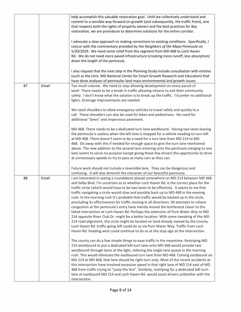
help accomplish this valuable restoration goal. Until we collectively understand and commit to a sensible way forward on growth (and subsequently, the traffic front), one that respects both the rights of property owners and the best practices for Bay restoration, we are premature to determine solutions for the entire corridor.
I advocate a slow approach to making corrections to existing conditions. Specifically, I concur with the commentary provided by the Neighbors of the Mayo Peninsula on 5/30/2019. We need some relief from the segment from MD 468 to Loch Haven Rd. We do not need more paved infrastructure (creating more runoff, less absorption) down the length of the peninsula.
I also request that the next step in the Planning Study include consultation with entities (such as the Univ. MD National Center for Smart Growth Research and Education) that have done analyses of peninsular land mass environmental and growth issues.
87 Email Too much volume. We need to stop allowing development on every parcel of land! There needs to be a break in traffic allowing citizens to exit their community safely. I don’t know what the solution is to break up the traffic. I’d prefer no additional lights. Drainage improvements are needed. We need shoulders to allow emergency vehicles to travel safely and quickly to a call. These shoulders can also be used for bikes and pedestrians. No need for additional “lanes” and impervious pavement. MD 468: There needs to be a dedicated turn lane westbound. Having two lanes leaving the peninsula is useless when the left lane is stopped for a vehicle needing to turn left at MD 468. There doesn’t seem to be a need for a turn lane from MD 214 to MD 468. Do away with this if needed for enough space to give the turn lane mentioned above. The new addition to the second lane entering onto the peninsula merging to one lane seems to serve no purpose except giving those few drivers the opportunity to drive at unnecessary speeds to try to pass as many cars as they can.
Future work should not include a reversible lane. They can be dangerous and confusing. It will also diminish the character of our beautiful peninsula.
88 Email I am interested in seeing a roundabout placed somewhere on MD 214 between MD 468 and Selby Blvd. I’m uncertain as to whether Loch Haven Rd. is the correct place for the traffic circle (which would have to be two lanes to be effective). It seems to me that traffic navigating a circle would slow and possibly back up to MD 468 in the evening rush. In the morning rush it’s probable that traffic would be backed up in the circle, precluding its effectiveness for traffic moving in all directions. All attempts to relieve congestion at the peninsula’s entry have merely moved the bottleneck closer to the failed intersection at Loch Haven Rd. Perhaps the extension of Pure Water Way to MD 214 opposite River Club Dr. might be a better location. With some tweaking of the MD 214 road alignment, the circle might be located on land already owned by the County. Loch Haven Rd. traffic going left could do so via Pure Water Way. Traffic from Loch Haven Rd. heading west could continue to do so at the stop sign at the intersection. The county can do a few simple things to ease traffic in the meantime. Restriping MD 214 westbound to put a dedicated left-turn lane onto MD 468 would provide two westbound through lanes at the light, relieving the single lane queue in the morning rush. This would eliminate the eastbound turn lane from MD 468. Coming eastbound on MD 214 at MD 468, that lane should be right-turn only. Most of the recent accidents at this intersection have involved excessive speed in that right lane of MD 214 east of MD 468 from traffic trying to “jump the line”. Similarly, restriping for a dedicated left-turn lane at eastbound MD 214 and Loch Haven Rd. would assist drivers unfamiliar with the intersection.

Page 9 of 14
There are “paper” roads throughout the peninsula that would have connected neighborhoods. In the absence of connecting roads already platted, there are opportunities to extend roads from one neighborhood to the next. One example is Shady Dr. / Dale St. from Loch Haven Rd. that was to have been connected to Lee St. in Selby. Neighborhood connectivity would allow for safe biking and pedestrian connections, as well as keep some of the local traffic off MD 214. One of the areas of MD 214 well known for flooding appears to be at Bear Neck Creek. These areas prone to flooding in heavy rain events need to be addressed along with all traffic-flow enhancing improvements.
89 Email I have lived in Mayo most of my life, and MD 214 has always been an issue. For many years it seems the thought was ‘it’s only South County’. I have seen traffic increase with the changing of being a summer recreational community to full-time residents. Maintenance and upkeep has always been an issue. No shoulders, flooding, poles too close to the road, and general lack of pavement upkeep. MD 214 has been a failing road for 30+ years. But the building continues, and the traffic gets worse. I remember when Muddy Creek Rd was only a stop sign at MD 214. The light needs to be staggered so a left turn can be made. Loch Haven Rd. has been a nightmare for years. A light wouldn’t help because it would back up. A ‘good’ traffic circle may help. Further down, the Summit School should have upgrades to turn into the school. Parents race to get to the turn and then pull in front of traffic to get across - no shoulder to go around them. Further down by River Club Dr. is a swamp and always has flooded. But nothing has been done - drains haven’t been cleaned out to funnel water off road, and County sewer property has let trees grow up and drainage get worse. By the Legion, I have seen too many accidents and pedestrians struck and killed crossing road with inattentive drivers speeding around the curves. Improvements were made almost 40 yrs. ago to straighten the curve out in Mayo, but nothing since then. The area in front of the school is better since the entrance was moved to side street, but that causes problems at the offset meeting of Mayo Ridge Rd. and Carrs Wharf Rd. I turn off at Lou’s store, and the curve there is blind with the parking lot of water now a storage pond. People fly west bound from Beverly Beach - it’s a crapshoot to make a turn. Shoreham Beach Rd the rest of way is County and has its share of problems. The maintenance is worse than MD 214, and road edges are crumbling and potholes numerous. Sharp turns and no shoulders. Water access - people want more upgrades to parks. It’s not fun to get behind these people navigating on these roads sometimes stopping just to get oriented.
90 Email Improvements should keep safety and first responders action high in consideration. Next should be keeping the expected increase of volume moving. I’m in favor of four lanes between MD 468 and Loch Haven Rd. My personal anecdotal experience tells me the three-lane idea between Loch Haven Rd. and Selby Blvd. with two lanes eastbound is counterintuitive. There seems to be greater problems leaving the peninsula. I favor two west bound lanes. I favor biking lanes as well as side paths. I’m against the emergency routing through the Pure Water way connection. I’m in favor of improving drainage at several spots along MD 214. I’d like to see an uninterrupted westbound lane on MD 214. I favor a roundabout at Loch Haven Rd. I favor east and westbound left-turn lanes at Selby Blvd. I favor a more standard “T” intersection at Shoreham beach Rd. There must also be some improvements regarding entrance/exit from nearby businesses. I favor the “T” intersection with the existing stop for traffic from Triton Beach Rd. onto Shoreham Beach Rd. Today I get a better view of traffic on Shoreham Beach Rd. both ways by stopping and turning from the existing right-hand fork. I believe this is what is shown in the presentation for option three. I favor a roundabout at River Club Drive and WRF park entrance.

Page 10 of 14
91 Email The following modifications would be acceptable based on budget constraints and access working from the intersection of MD 214 / MD 468 to the east end of the peninsula: 1. Intersection at MD 468 (Option 2) - westbound dedicated left-turn lane, one or two lanes westbound with no stop, one or two lanes eastbound onto the Peninsula
2. Road Segment from Mayo Road to Shoreham Beach Rd. - include at least one shoulder and one mixed-use lane as close to MD 214 as possible. Improve line of site as needed. Improve level/grade and stormwater management activities to eliminate flooding. Bury the power lines along sections of road that are rebuilt.
3. Intersection at Loch Haven Road - Option 8 4. Segment from Loch Haven Road to Selby Blvd. – reversible lane
92 Email Peninsulas are fundamentally defined by their topography: nearly surrounded by waterbodies, wrapped by sensitive shorelines, and confined by limited road access to most neighborhoods, parks, and businesses. Our greatest concern is the lack of a vision for how to live sustainably on the County’s peninsulas, backed by proactive land use planning and enforced by meaningful rules, ordinances, and building codes that are vigilantly enforced, to effectively manage the combined impact of commercial and residential development on traffic, essential services, groundwater supplies, and our environment. Citizens are calling on the County to address these concerns. The quality of life of the citizens of the Mayo Peninsula is being negatively impacted due to the poor quality and limited capacity of MD 214 east of MD 468 as has been laid out in the current Small Area Plan, Envision Mayo, as written by the citizens living on the Mayo Peninsula: https://docs.wixstatic.com/ugd/decf28_c260b9a67d8e448c902a333e66807fc5.pdf We ask for the following points to be addressed to deal with the traffic issues: 1. Improve access for fire/EMS/police onto/off the peninsula to improve response
times, as well as physical access created by the current two-lane road with no shoulders.
2. Improve stormwater management to prevent flooding, and limit the addition of any unnecessary impervious surfaces which exacerbates the flooding issue.
3. Add bike, pedestrian, and mixed-use trails that link the Peninsula to the County. 4. Make improvements to MD 214 that are “right-sized” for the kind of environment
the citizens would support. 5. The desire to improve the quality of life of the citizens as opposed to easing
restrictions on Adequate Public Facilities Ordinances. This would necessitate working to limit development on the Peninsula to a controlled pace that is in line with the capacity of the road system and the wishes of the Mayo Communities, as outlined in the Envision Mayo document.
We understand that this is a Concept Study, but as such, the following factors need to be studied prior to the follow-on activities to allow for the Envision Mayo Quality of Life variables to be met: 1. The impact of the proposed designs on deforestation and addition of impervious surfaces along the length of MD 214 - mitigate as much as possible. 2. The impact of the proposed designs on existing and new stormwater management requirements to address substantial expansion of impervious area – provide the type, location and size. Provide area calculations and % increase of impervious surface from existing to propose.

Page 11 of 14
3. Study should prioritize which proposed modifications are most important and thus the individual associated costs – which will assist in decision making and provide cost reduction alternatives, which we all know, will be required at the end of the day. 4. Study should evaluate alternative pervious paving systems for bike and pedestrian paths to reduce Storm Water Management. MD214 Modifications: The following modifications would be acceptable based on budget constraints and access working from the intersection of MD 214 / MD 468 to the east end: 1. Intersection at MD 468 (Option 2) - westbound dedicated left-turn lane, one or two lanes westbound with no stop, one or two lanes eastbound onto the Peninsula
2. Road Segment from Mayo Road to Shoreham Beach Rd. - include at least one shoulder and one mixed-use lane as close to MD 214 as possible. Improve line of site as needed. Improve level/grade and stormwater management activities to eliminate flooding. Bury the power lines along sections of road that are rebuilt.
3. Intersection at Loch Haven Road - Option 8 4. Segment from Loch Haven Road to Selby Blvd. – reversible lane
93 Email I have lived on the peninsula for over 15 years. While traffic getting on and off the peninsula has greatly improved (by adding that second lane each way), I feel that some mistakes were made in the process. One: the extra right lane going towards the peninsula needs to be a right-turn lane towards MD 468. This lane has caused angry and aggressive drivers from last minute merging, caused people not to be able to turn onto MD 468 by being stuck behind them at the light, but the poor people trying to get out of the Kennel, having to cross 3 lanes at rush hour is impossible. Two: The westbound left lane at MD 468 getting off the peninsula needs to have a turn arrow so we can safely turn left onto MD 468.
94 Email I live on the Mayo Peninsula in Loch Haven Beach and contend with the traffic at Loch Haven Rd. every day, and I turn left every morning from MD 214 to MD 468. 1. Do not put a traffic circle at Loch Haven Rd. - this will only cause traffic to back up through the circle and will not allow a good traffic flow, especially for those trying to turn right from Loch Haven Rd. during rush hour. A traffic light is really needed at this intersection to aide with safely turning left (from side street and from main road), breaking up the line of traffic and assisting those turning right out of Loch Haven Rd. to have a reasonable and timely chance to get out. 2. I am glad to see that any option at the MD 214 / MD 468 intersection includes a left-turn lane onto Muddy Creek. When I pull up and wait to turn left at the light, all the cars behind me stay in the right lane, which is not efficient and only causes traffic to back up further onto the peninsula, making the 2nd lane unusable until I am able to turn and free up the lane. This intersection is very tricky and has often had accidents due to traffic volume and the lack of right-of-way for those turning left. I do think having 2 incoming lanes to the peninsula, if they continue past Loch Haven Rd., would alleviate some of the traffic, plus having a dedicated right-turn lane that heads onto MD 468. This may help with traffic backing up further on MD 214 and provide more options for emergency vehicles to maneuver when needed to get down the peninsula quickly. Coming off the peninsula, we need 2 lanes and a separate left-turn lane to help keep things moving. Although bike and walking paths would be ideal in the long run, my priority is making sure that my family and I can safely get to and from our home in our vehicle without the

Page 12 of 14
traffic hazards that we currently encounter daily. At this point, whenever there is an incident or accident on the peninsula, emergency personnel struggle to get through and, with only one lane in and out, often the entire peninsula traffic flow shuts down completely, leaving us stranded and unable to leave or get home.
95 Email First off, I am disappointed with the rate of development of the peninsula. I voted for this administration to slow the development which truly is the cause of the problem. Secondly, I recently experienced the traffic nightmare caused by the culvert repair at MD 468. When traffic was single tracked, the backup and times to get home were completely unreasonable. If I had it my way, I would be in favor of one roundabout at Loch Haven Rd/ and leave the rest alone... and keep the development under control. Since, the development is apparently inevitable, I am for the smallest expansion of the road possible. Do not install any signals. Driving through Edgewater is already awful due to all the lights and sitting at more on the peninsula sounds horrible. If change is needed at an intersection, please put in the roundabout. Lastly, all storm water needs to be address at the highest standard.
96 Email I think putting a traffic light at Loch Haven Rd. would cause problems and would cause eastbound traffic to back up to MD 468 and would impede the flow of traffic. I support the addition of a traffic circle at that intersection. I must turn left in the mornings and must wait 5-10 minutes during rush hour. A traffic circle would allow traffic to continue to flow on MD 214 but would also allow those who need to travel eastbound from Loch Haven Rd. an easier time. I do not support an added lane from MD 468 to Loch Haven Rd.
97 Email 1. The Study is not fully aligned with the critical, priority issues of the Mayo Peninsula Community regarding traffic that need addressing – which have always been communicated as the following: a. Emergency vehicle access throughout the day for timely service b. Relief of the massive morning rush hour backups going west from the end of the peninsula thru MD 468 c. Dedicated, safe pedestrian and bicycle pathways. d. Stormwater Management solutions to the significant and regular flooding e. Improvement of secondary roads access to MD 214 in both directions f. Make improvements to MD 214 that are “right-sized” for the kind of environment the citizens would support and not increase the access and thus pressure on what the Peninsula can reasonably handle. 2. The study advances the predicted traffic problems to a period 20 years from now, based on the worst-case development scenario for maximum new house lots, major parks expansions, and new commercial/retail sites anticipated by the previous developer-driven administration. The Mayo community and the new Pittman Administration plan to work together thru various avenues – including the upcoming GDP Update – to: a. Dramatically scale back the development of the Schuh Administration’s proposed Mayo Parks Master Plan and the associated extensive parking. b. Significantly reduce the future residential and commercial development through more aggressive protection and enforcement of environment laws and regulations to protect critical forest and wetlands that should be preserved and not developed. c. It is hoped that the Mayo Peninsula Community can prepare its own suggested development strategy in the form of a basic zoning overlay to address our unique issues. Within this will be suggested limits on development which will provide new data with which DPW can input into their traffic modelling program that will then presumably identify significantly reduced – but appropriate – traffic solutions. 3. We understand that this is a Concept Study, but as such it must incorporate and evaluate all the major issues and ramifications of its impacts. If these tasks were not included/funded in the original study, then they should be added - or at a minimum on

Page 13 of 14
those that can’t then referenced for later attention. To be considered complete this Study should include the following: a. The impact of the proposed designs on deforestation – already a big issue on the Peninsula - provide the area calculations tied to each option. b. The impact of the proposed designs on existing and new stormwater management requirements to address substantial expansion of impervious area – provide the type, location, and size. Provide area calculations and % increase of impervious surface from existing to proposed. c. Solutions for the significant existing flooding issues d. The impact of the proposed designs on power lines and telecommunications that are right next to the existing roadway and must be relocated along both sides. e. Study should prioritize which proposed modifications are most important and thus the individual associated costs – which will assist in decision making and provide cost reduction alternatives, which we all know will be required at the end of the day. For example, the proposed changes at Shoreham Beach Road and MD 214 relocate the road intersection there (with all the attendant ramifications) for safety reasons. f. The site plan graphics should be improved for greater clarity between the existing satellite photo and the overlay of the proposed to be able to better compare their relationship. g. The site plan graphics should include the state’s R.O.W. property lines along both sides of MD 214 and highlighting where and how much land must be acquired by the state outside of what it now owns. h. The study should evaluate the pro-cons between intersection lights and roundabouts in more detail, e.g. roundabouts require much more land area (and thus land acquisition, cost, SWM, deforestation issues, etc.). i. Justify why a three-lane solution with the middle lane a swing lane between rush hours was not studied as a significant alternative. j. Provide a pro-con spreadsheet to summarize the options to assist in comprehensively evaluating the proposals. k. Study should evaluate alternative pervious paving systems for bike and pedestrian paths to reduce SWM.
98 Email (Neighbors of Mayo Peninsula)
Justification for MD 214 road improvements: Peninsulas are fundamentally defined by their topography: nearly surrounded by waterbodies, wrapped by sensitive shorelines, and confined by limited road access to most neighborhoods, parks, and businesses. Our greatest concern is the lack of a vision for how to live sustainably on the County’s peninsulas, backed by proactive land use planning and enforced by meaningful rules, ordinances, and building codes that are vigilantly enforced, to effectively manage the combined impact of commercial and residential development on traffic, essential services, groundwater supplies, and our environment. Citizens are calling on the county to address these concerns. The quality of life of the citizens of the Mayo Peninsula is being negatively impacted due to the poor quality and limited capacity of MD 214 east of MD 468 as has been laid out in the current Small Area Plan, Envision Mayo, as written by the citizens living on the Mayo Peninsula: https://docs.wixstatic.com/ugd/decf28_c260b9a67d8e448c902a333e66807fc5.pdf We ask for the following points to be addressed to deal with the traffic issues: 1. Improve access for fire/EMS/police onto/off the peninsula to improve response
times, as well as physical access created by the current two-lane road with no shoulders.
2. Improve stormwater management to prevent flooding, and limit the addition of any unnecessary impervious surfaces which exacerbates the flooding issue.
3. Add bike, pedestrian, and mixed-use trails that link the Peninsula to the County.

Page 14 of 14
4. Make improvements to MD 214 that are “right-sized” for the kind of environment the citizens would support.
5. The desire to improve the quality of life of the citizens as opposed to easing restrictions on Adequate Public Facilities Ordinances. This would necessitate working to limit development on the Peninsula to a controlled pace that is in line with the capacity of the road system and the wishes of the Mayo Communities, as outlined in the Envision Mayo document.
We understand that this is a Concept Study, but as such, the following factors need to be studied prior to the follow-on activities to allow for the Envision Mayo Quality of Life variables to be met: 1. The impact of the proposed designs on deforestation and addition of impervious surfaces along the length of MD 214 - mitigate as much as possible. 2. The impact of the proposed designs on existing and new stormwater management requirements to address substantial expansion of impervious area – provide the type, location and size. Provide area calculations and % increase of impervious surface from existing to propose. 3. Study should prioritize which proposed modifications are most important and thus the individual associated costs – which will assist in decision making and provide cost reduction alternatives, which we all know, will be required at the end of the day. 4. Study should evaluate alternative pervious paving systems for bike and pedestrian paths to reduce Storm Water Management.


![Contabilitate manageriala.[conspecte md]](https://static.fdokumen.com/doc/165x107/634610f6df19c083b1085ad3/contabilitate-managerialaconspecte-md.jpg)