Martian atmosphere as observed by VIRTIS-M on Rosetta spacecraft
15
Click Here for Full Article Martian atmosphere as observed by VIRTIS‐M on Rosetta spacecraft A. Coradini, 1 D. Grassi, 1 F. Capaccioni, 2 G. Filacchione, 2 F. Tosi, 1 E. Ammannito, 1 M. C. De Sanctis, 2 V. Formisano, 1 P. Wolkenberg, 1 G. Rinaldi, 1 G. Arnold, 3 M. A. Barucci, 4 G. Bellucci, 1 J. Benkhoff, 5 J. P. Bibring, 6 A. Blanco, 7 D. Bockelee‐Morvan, 4 M. T. Capria, 2 R. Carlson, 8 U. Carsenty, 3 P. Cerroni, 2 L. Colangeli, 9 M. Combes, 4 M. Combi, 10 J. Crovisier, 4 P. Drossart, 4 T. Encrenaz, 4 S. Erard, 4 C. Federico, 11 U. Fink, 12 S. Fonti, 7 W.‐H. Ip, 13 P. G. J. Irwin, 14 R. Jaumann, 3 E. Kuehrt, 3 Y. Langevin, 6 G. Magni, 2 T. McCord, 15 V. Mennella, 9 S. Mottola, 3 G. Neukum, 3 V. Orofino, 7 P. Palumbo, 16 G. Piccioni, 2 H. Rauer, 3 B. Schmitt, 17 D. Tiphene, 4 F. W. Taylor, 14 and G. P. Tozzi 18 Received 26 January 2009; revised 1 September 2009; accepted 5 October 2009; published 2 April 2010. [1] The Rosetta spacecraft accomplished a flyby of Mars on its way to 67P/Churyumov‐ Gerasimenko on 25 February 2007. In this paper we describe the measurements obtained by the M channel of the Visual and Infrared Thermal Imaging Spectrometer (VIRTIS‐M) and the first scientific results derived from their analysis. The broad spectral coverage of the VIRTIS‐M in the IR permitted the study of various phenomena occurring in the Martian atmosphere; observations were further exploited to achieve accurate absolute radiometric calibration. Nighttime data from the VIRTIS‐M constrain the air temperature profile in the lower atmosphere (5–30 km), using variations in CO 2 opacity at 4.3 mm. A comparison of this data with the global circulation model (GCM) by Forget et al. (1999) shows a trend of slightly higher air temperature in the VIRTIS‐M retrievals; this is accompanied by the presence of moderate decreases (∼5 K) in large sections of the equatorial region. This is potentially related to the occurrence of water ice clouds. Daytime data from the VIRTIS‐M reveal CO 2 non–local thermodynamic equilibrium emission in the high atmosphere. A mapping of emission intensity confirms its strict dependence on solar zenith angle. Additionally, devoted limb observations allowed the retrieval of vertical emission intensity profiles, indicating a peak around 105 km in southern tropical regions. Ozone content can be effectively monitored by the emission of O 2 (a 1 D g ) at 1.27 mm. Retrieved emission intensity shows that polar regions are particularly rich in ozone. Aerosol scattering was observed in the 1–2.5 mm region above the night region above the night disk, suggesting the occurrence of very high noctilucent clouds. Citation: Coradini, A., et al. (2010), Martian atmosphere as observed by VIRTIS‐M on Rosetta spacecraft, J. Geophys. Res., 115, E04004, doi:10.1029/2009JE003345. 1. Introduction [2] Flyby observations of targets of opportunity have successfully contributed to the study of many important phenomena in our solar system. Relevant examples include 1 INAF, IFSI, Rome, Italy. 2 INAF, IASF, Rome, Italy. 3 DLR, Berlin, Germany. 4 Observatoire de Paris, Meudon, France. 5 European Space Research and Technology Centre, European Space Agency, Noordwijk, Netherlands. 6 IAS, Centre universitaire d’Orsay, Orsay, France. 7 Dipartimento di Fisica, Università del Salento, Lecce, Italy. 8 Jet Propulsion Laboratory, NASA, Pasadena, California, USA. 9 Osservatorio Astronomico di Capodimonte, INAF, Naples, Italy. 10 Atmospheric, Oceanic, and Space Sciences, University of Michigan, Ann Arbor, Michigan, USA. 11 Dipartimento di Scienze della Terra, Università di Perugia, Perugia, Italy. 12 Department of Planetary Sciences, Lunar and Planetary Laboratory, Tucson, Arizona, USA. 13 Graduate Institute of Astronomy, National Central University, Chung‐Li, Taiwan. 14 Atmospheric, Oceanic and Planetary Physics, University of Oxford, Oxford, UK. 15 Bear Fight Center, Winthrop, Washington, USA. 16 Dipartimento di Scienze Applicate, Università degli Studi di Napoli “Parthenope,” Naples, Italy. 17 OSUG, Université Joseph Fourier, Grenoble, France. 18 Osservatorio Astrofisico di Arcetri, INAF, Firenze, Italy. Copyright 2010 by the American Geophysical Union. 0148‐0227/10/2009JE003345 JOURNAL OF GEOPHYSICAL RESEARCH, VOL. 115, E04004, doi:10.1029/2009JE003345, 2010 E04004 1 of 15
Transcript of Martian atmosphere as observed by VIRTIS-M on Rosetta spacecraft

ClickHere
for
FullArticle
Martian atmosphere as observed by VIRTIS‐Mon Rosetta spacecraft
A. Coradini,1 D. Grassi,1 F. Capaccioni,2 G. Filacchione,2 F. Tosi,1 E. Ammannito,1
M. C. De Sanctis,2 V. Formisano,1 P. Wolkenberg,1 G. Rinaldi,1 G. Arnold,3
M. A. Barucci,4 G. Bellucci,1 J. Benkhoff,5 J. P. Bibring,6 A. Blanco,7
D. Bockelee‐Morvan,4 M. T. Capria,2 R. Carlson,8 U. Carsenty,3 P. Cerroni,2
L. Colangeli,9 M. Combes,4 M. Combi,10 J. Crovisier,4 P. Drossart,4 T. Encrenaz,4
S. Erard,4 C. Federico,11 U. Fink,12 S. Fonti,7 W.‐H. Ip,13 P. G. J. Irwin,14 R. Jaumann,3
E. Kuehrt,3 Y. Langevin,6 G. Magni,2 T. McCord,15 V. Mennella,9 S. Mottola,3
G. Neukum,3 V. Orofino,7 P. Palumbo,16 G. Piccioni,2 H. Rauer,3 B. Schmitt,17
D. Tiphene,4 F. W. Taylor,14 and G. P. Tozzi18
Received 26 January 2009; revised 1 September 2009; accepted 5 October 2009; published 2 April 2010.
[1] The Rosetta spacecraft accomplished a flyby of Mars on its way to 67P/Churyumov‐Gerasimenko on 25 February 2007. In this paper we describe the measurements obtainedby the M channel of the Visual and Infrared Thermal Imaging Spectrometer (VIRTIS‐M)and the first scientific results derived from their analysis. The broad spectral coverage ofthe VIRTIS‐M in the IR permitted the study of various phenomena occurring in theMartian atmosphere; observations were further exploited to achieve accurate absoluteradiometric calibration. Nighttime data from the VIRTIS‐M constrain the air temperatureprofile in the lower atmosphere (5–30 km), using variations in CO2 opacity at 4.3 mm. Acomparison of this data with the global circulation model (GCM) by Forget et al. (1999)shows a trend of slightly higher air temperature in the VIRTIS‐M retrievals; this isaccompanied by the presence of moderate decreases (∼5 K) in large sections of theequatorial region. This is potentially related to the occurrence of water ice clouds. Daytimedata from the VIRTIS‐M reveal CO2 non–local thermodynamic equilibrium emission inthe high atmosphere. A mapping of emission intensity confirms its strict dependenceon solar zenith angle. Additionally, devoted limb observations allowed the retrieval ofvertical emission intensity profiles, indicating a peak around 105 km in southern tropicalregions. Ozone content can be effectively monitored by the emission of O2 (a1Dg) at1.27 mm. Retrieved emission intensity shows that polar regions are particularly rich inozone. Aerosol scattering was observed in the 1–2.5 mm region above the night regionabove the night disk, suggesting the occurrence of very high noctilucent clouds.
Citation: Coradini, A., et al. (2010), Martian atmosphere as observed by VIRTIS‐M on Rosetta spacecraft, J. Geophys. Res.,115, E04004, doi:10.1029/2009JE003345.
1. Introduction
[2] Flyby observations of targets of opportunity havesuccessfully contributed to the study of many importantphenomena in our solar system. Relevant examples include
1INAF, IFSI, Rome, Italy.2INAF, IASF, Rome, Italy.3DLR, Berlin, Germany.4Observatoire de Paris, Meudon, France.5European Space Research and Technology Centre, European Space
Agency, Noordwijk, Netherlands.6IAS, Centre universitaire d’Orsay, Orsay, France.7Dipartimento di Fisica, Università del Salento, Lecce, Italy.8Jet Propulsion Laboratory, NASA, Pasadena, California, USA.9Osservatorio Astronomico di Capodimonte, INAF, Naples, Italy.10Atmospheric, Oceanic, and Space Sciences, University of Michigan,
Ann Arbor, Michigan, USA.11Dipartimento di Scienze della Terra, Università di Perugia, Perugia,
Italy.
12Department of Planetary Sciences, Lunar and Planetary Laboratory,Tucson, Arizona, USA.
13Graduate Institute of Astronomy, National Central University,Chung‐Li, Taiwan.
14Atmospheric, Oceanic and Planetary Physics, University of Oxford,Oxford, UK.
15Bear Fight Center, Winthrop, Washington, USA.16Dipartimento di Scienze Applicate, Università degli Studi di Napoli
“Parthenope,” Naples, Italy.17OSUG, Université Joseph Fourier, Grenoble, France.18Osservatorio Astrofisico di Arcetri, INAF, Firenze, Italy.
Copyright 2010 by the American Geophysical Union.0148‐0227/10/2009JE003345
JOURNAL OF GEOPHYSICAL RESEARCH, VOL. 115, E04004, doi:10.1029/2009JE003345, 2010
E04004 1 of 15

observations of Venus and Jupiter by Galileo and Cassinispacecraft, respectively [e.g., Carlson et al., 1991; Porco etal., 2003]. These events additionally provide an opportunityto check spacecraft and instrument status, validate opera-tional concepts, perform calibrations, and deliver prelimi-nary science return. This last aspect often offers a uniquechance to make observations of the target of opportunity,using instrumentation with better performance character-istics than those of spacecraft dedicated to the target. Inaddition, these flybys may yield unusual and opportunisticobservational geometries.[3] The Rosetta spacecraft of the European Space Agency
performed a flyby of Mars on 25 February 2007. The Ro-setta mission is devoted to the study of a comet and itsenvironment (originally 46P/Wirtanen, now 67P/Churyumov‐Gerasimenko). Even though the payload components weredesigned and highly optimized for that purpose [Schulz etal., 2004], the flexible design of instruments allowed theacquisition of synoptical observations over wide areas of theplanet. Despite the numerous missions dedicated to the studyof the Martian environment, the daily evolution of theatmosphere has not been extensively studied by satellites.All orbiters were actually placed in polar orbits to maximizesurface coverage, resulting either in data sets collected atfixed local time (in the case of Sun synchronous orbits, suchas Mars Global Surveyor) or in strong local time‐latitude‐season correlations (e.g., Mars Express).[4] In this paper we focus our attention on the observa-
tions made using the M channel of the Visual and InfraredThermal Imaging Spectrometer (VIRTIS‐M). In section 2,we provide a description of the instrument and its radio-metric performances. The Mars flyby represented a funda-mental validation test for our calibration pipeline, and themethods are described extensively. In section 3, the MartianVIRTIS‐M data set is discussed, providing the scientificrationale for observations and examples of spectra. Insection 4, we illustrate the main science themes that can beaddressed on the basis of our data. Covered topics includethermal structure of the lower atmosphere, non–local ther-modynamic equilibrium (non‐LTE) emission, aerosol con-tent, and ozone emission. This discussion is not all‐inclusive,and additional studies are proposed in the conclusions.
2. Instrument Description and Performances
[5] The VIRTIS instrument consists of two main channelsthat provide a double capability: (1) high‐spatial‐resolution(up to an instantaneous field of view, or IFOV, of 250 mrad)visible and IR imaging in the 0.25–5.2 mm range at mod-erate spectral resolution (VIRTIS‐M channel) and (2) high
spectral resolution spectroscopy in the 2–5.2 mm range(VIRTIS‐H channel). The two channels observe in tandemthe same areas in combined modes to take full advantage oftheir complementaries.[6] The VIRTIS‐M is characterized by a single optical
head consisting of a Shafer telescope combined with anOffner imaging spectrometer and by two bidimensional focalplane assemblies (FPAs): the visible light spectrometer (VIS)(0.25–1.1 mm) and IR (1–5.2 mm). The VIRTIS‐M is actuallyan imaging spectrometer, able to acquire a stack of mono-chromatic images (“cubes”) that allow the spectrum to bereconstructed for each pixel.[7] The VIRTIS‐M operates simultaneously in the visible
and IR domains, with spectral sampling steps of 1.88 and9.43 nm respectively. The VIRTIS‐M, like most hyper-spectral imagers, is a slit spectrometer: the optical systemperfectly matches a Shafer telescope to an Offner gratingspectrometer to disperse a line image across two bidimen-sional focal planes. A silicon CCD is used to performhyperspectral imaging from 0.25 to 1 mm, while a mercurycadmium telluride (HgCdTe) IR focal plane array takescare of the 1–5.2 mm spectral range. A scan mirror is usedto achieve full imaging capability. Overlapped on the twoVIRTIS‐M detectors are filters needed to remove higherdiffraction orders (order filters). The filters edges fall atfixed positions along the VIRTIS‐M spectra, creating regionswhere calibration is more problematic and that have thereforebeen neglected in the present analysis. Table 1 reports thefilters positions for the VIRTIS‐M.[8] The VIRTIS‐H is a high‐resolution IR cross‐dispersed
spectrometer using a prism and a grating. The 2–5.2 mmspectrum is dispersed in 10 orders on a focal plane detectorarray. The VIRTIS‐M and VIRTIS‐H IFOVs are 0.25 ×0.25 mrad (for an individual pixel) and 1.74 × 0.58 mrad.[9] The hearts of the instrument are the FPAs (Table 2).
The CCD in the VIRTIS‐M is a frame transfer device. TheCCD specifications are listed in Table 2. The baseline forboth the VIRTIS‐M and VIRTIS‐H IRFPAs are HgCdTe onsapphire substrates. To reduce dark current, the VIRTIS‐MIRFPA must be cooled to below 70 K. Passive cooling hasbeen rejected because the low emissive power of passiveradiators and the risk of comet contamination indicate aminimum radiator area larger than 1 m2. Cryocoolers aresuitable for the VIRTIS FPA cooling task.
2.1. Calibration
[10] A detailed description of the instrument and its cali-bration on ground has been given in several papers[Coradini et al., 1999, 2004; Coradini and the VIRTIS team,2007; Ammannito et al., 2006; Filacchione et al., 2006], andhere we report only a very short summary.[11] The performances of the instrument were tested both
in laboratory and in flight. Before the integration of theVIRTIS experiment aboard Rosetta, several tests wereperformed on the VIRTIS‐M and VIRTIS‐H channels tocompletely characterize the instrumental performances.[12] The fundamental calibrations necessary to correctly
retrieve the scientific information from VIRTIS data are asfollows: (1) Geometric calibration is the measurement ofIFOV, FOV, and in‐field distortions. (2) Spectral calibrationis the correlation between the spectral dispersion axis of the
Table 1. Position of the VIRTIS‐M Order Filtersa
Filter Name Affected Region (nm)
VIS: 218 < b < 224 640–651IR 1: 45 < b < 62 1415–1576IR 2: 148 < b < 165 2388–2548IR 3: 284 < b < 294 3671–3765IR 4: 349 < b < 359 4284–4379
aThe band index (i.e., the index of spectrum sampling point), countedfrom the low‐wavelength side, is indicated by b.
CORADINI ET AL.: VIRTIS AT MARS E04004E04004
2 of 15

focal planes and the wavelength. (3) Spatial calibration isthe evaluation of the flat field matrices necessary to uniformthe focal planes responses. (4) Radiometric calibration is thedetermination of the instrument transfer function, whichallows the conversion of digital numbers in physical units ofspectral radiance (W m−2 mm−1 sterad−1). These quantities,continuously checked during the flight at each switch on ofthe experiment, are used in the data pipeline before thescientific analysis.[13] Ammannito et al. [2006] describe the spectral and
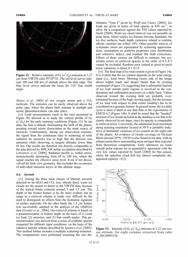
geometric calibrations, while the paper of Filacchione et al.[2006] concerns the measurements of flat fields and radio-metric and internal calibrations. A more detailed analysis ofthe methods used to characterize imaging spectrometers byusing on‐ground and flight data can be found in the work ofFilacchione [2006], where a description of the calibrationpipelines of both the Cassini Visual and Infrared MappingSpectrometer‐V (VIMS‐V) and Rosetta VIRTIS‐M experi-ments is given.
2.2. Radiometric Calibration Refinement
[14] The close encounter with Mars represented animportant opportunity to improve the VIRTIS‐M calibrationdefined in laboratory preflight tests, as reported in the Rosettabook [Coradini et al., 2009].[15] The Martian data set acquired during the flyby is used
to perform a smooth calibration in the visible range by usingthe Hubble Space Telescope (HST) spectra [Noe Dobrea etal., 2003, 2008] in the VIS range and Mars Express–Omegadata in the IR range (ibid).[16] The in‐flight radiometric calibration is computed in
correspondence of a 60 × 60 km plain region near the GusevCrater. We assign to these two raw spectra the correspondingcalibrated reflectance, measured with similar observation andseasonal conditions by the HST/Near Infrared Camera andMulti‐Object Spectrometer in the visible range and by MarsExpress‐Omega in the IR: furthermore, these data are inter-polated at VIRTIS‐M spectral resolutions.[17] In this way, we recalibrate the VIRTIS data in the
spectral range 1.0–2.0 mm. The obtained calibration holdsfor the center of the VIRTIS‐M slit. To extend the calibra-tion to the rest of the slit, we use the flat field of the experi-ment obtained in the laboratory. The flat field data take intoaccount the differences in the response of the VIRTIS indifferent zones of the slit and at different wavelengths. Inthis way, the VIRTIS‐M as a whole could be radiometricallycalibrated. We instead use the results of the ground‐basedcalibration data in the 2.0–5.0 mm range. This “hybridmethod” has been also used to calibrate other imagingspectrometers, such as the VIMS [Brown et al., 2004].
2.3. Geometry Information
[18] The VIRTIS‐M radiometric data are integrated usinggeometric information from the SPICE ancillary data system[Acton, 1996] and the time of acquisition. For each pixelcovering the planet’s disk, the geographic coordinates of thepixel’s centroid as well as the emission, incidence, andphase angles were computed. The minimum altitude of theline of sight above the planet’s areoid was computed forpixels covering the limb. Because of a flight software bug,certain spectral cubes were subject to a loss of the acquisi-tion times for some frame lines. This resulted in missinggeometry information for the respective pixel lines.
3. VIRTIS Martian Data Set
[19] This work considers only data from the VIRTIS‐MIR subsystem, which we will refer to as VIRTIS from hereon. The term “channel” will be used to indicate an indi-vidual spectral sampling point.[20] The VIRTIS observations took place between 24
February 2007 18.14 UTC and 25 February 7.33 UTC. InMartian terminology, these values correspond to Martianyear 28 and solar longitude 189, written as MY28 andLS = 189. The gravity assist geometry and derived thermal,power, and communication conditions strongly constrainedthe observation possibilities during the Mars flyby; forexample, science operations were not allowed during theclosest approach. Throughout the flyby, the subspacecraftpoint remained within [30S, 90E] and [30N, 150E]. Thisconstrained most observation opportunities to the EasternHemisphere of the planet. The observations can be placedinto three categories:[21] 1. Preflyby observations yielded a total of 13 spectral
cubes. The approach geometry enabled hyperspectral imag-ing of the entire visible side of the Martian disk in daytimeconditions. Observation time totaled 4 h at a phase angle of15°, which remained relatively constant. Range from thecenter of the planet to the spacecraft varied from 1.2 × 10⁵ to2.5 × 105 km, correlating to a ground resolution between30 and 60 km.[22] 2. Postflyby observations yielded 2 cubes for 8 limb
scans. These observations focused on atmospheric emissionsat the limb. A maximum vertical resolution of 15 km wasobtained, corresponding to a range of 4 × 10⁴ km at a phaseangle of 155°.[23] 3. Later postflyby observations yielded 4 cubes and
were focused on thermal emissions in the 3–5.2 mm range.Analysis of these data allows monitoring of temperatureconditions in the lower atmosphere. The larger range dis-
Table 2. Characteristics and Performances of the VIRTIS Focal Planes
VIRTIS‐M CCD VIRTIS‐M IRFPA VIRTIS‐H IRFPA
Material Silicon + UV coating HgCdTe on AlO2 or CdZnTe HgCdTe on AlO2 or CdZnTePixel pitch (mm) 38 38 38Format 256 × 432 256 × 432 240 × 640Noise (rms e−) <20 280 280Full well capacity (e−) 106 1.6 × 10⁷ 7 × 10⁶
Temperature (K) 155 75 or 90 70 or 85Dark current (e/s) <1 72,000 18,000
CORADINI ET AL.: VIRTIS AT MARS E04004E04004
3 of 15

tance enabled imaging of the entire disk of the planet, almostcompletely in darkness.[24] Table 3 summarizes the characteristics of different
observations. Typical frames and spectra for the three dif-ferent observational categories are presented in Figures 1–3.Different radiance levels observed by VITRIS during thethree phases previously discussed required the applicationof different exposure times (detailed in the captions ofFigures 1–3).[25] Daytime measurements in the range 1–3.5 mm are
dominated by the surface reflectance of incoming solarradiation (Figure 1a); this reflectance is driven by themineralogy and physical conditions of the soil. In thisspectral range, absorption bands of the main atmospherecomponent CO2 are evident at 2.8, 2, 1.6, and 1.42 mm.The 2.8 mm band is saturated, while the other three bandsshow much weaker intensities and can be used to study thepressure at surface level across the disk by mapping theirdepths [Spiga et al., 2007].[26] Around 3.5 mm, thermal emission of surface and
atmosphere becomes important. The thermal range is char-acterized by a very intense CO2 band at 4.3 mm. In theory,the shape of this band is driven by the air temperature profilein the conditions of LTE. However, the VIRTIS data of thedaytime Martian atmosphere present the strong emissions inthe bottom of the 4.3 mm band expected by Lòpez‐Valverdeet al. [2005] as a result of non‐LTE emissions.[27] Aerosols were also observed by the VIRTIS. Martian
dust is expected to be quite featureless in the spectral range
covered by the VIRTIS [Ockert‐Bell et al., 1997] and istherefore difficult to monitor. However, Martian climatolo-gy recorded by the Thermal Emission Spectrometer (TES)[Smith, 2004] forecasts a low dust content around Ls = 190in absence of great dust storms; fortunately, the excellentvisibility of surface albedo features in the VIRTIS framesexcluded the occurrence of these storms. On the contrary,water ice (including surface frost and suspended clouds) ischaracterized by typical bands at 3 and 1.5 mm; this fact wasused to create a water ice map from the VIRTIS cube.[28] Spectral features of minor gases are also seen in
VIRTIS data. In several spectra, it is possible to detect O2
(a1Dg) emission at 1.27 mm. This species is usually adoptedas a proxy for ozone [Fedorova et al., 2006]. The main COband can be observed between 4.73 and 4.82 mm. A watervapor line is seen at 2.62 mm. Unfortunately, the strongestabsorption features of this band fall within the order filter.[29] In nighttime data, only the thermal component of
the spectrum is observed (Figure 2a). In this case, LTEassumptions are valid. Consequently, the 4.3 mm CO2 bandhas been modeled to compute the thermal profile in the loweratmosphere, adapting the methods presented by Grassi et al.[2008].
Figure 1. (a) Typical VIRTIS Martian daytime spectrum.(b) VIRTIS frame at 2.24 mm, from cube I1_00130962500.Exposure time was 0.2 s. The triangle marks the positionwhere the spectrum of Figure 1a was extracted.
Figure 2. (a) Typical VIRTIS Martian nighttime spectrum.(b) VIRTIS frame at 5.05 mm, from cube I1_00131007789.Exposure time was 1 s. The triangle marks the positionwhere the spectrum of Figure 1a was extracted.
CORADINI ET AL.: VIRTIS AT MARS E04004E04004
4 of 15

[30] Limb measurements from the VIRTIS (Figure 3a) canbe extremely complex to interpret. This is in part due to longoptical paths, which may make indistinguishable the variousdifferent physical conditions along the line of sight. More-over, the absence of radiation from a background surfaceenhances the relative importance of scattering. In our dataset, the tangential points, where most of the atmosphericmass lying along the path is found, are in full sunlight. As aresult, effects from non‐LTE CO2, from ozone emission,and from scattering of sunlight are observed and remainextremely complex to model. In monochromatic images(Figure 3b), the disk appears deformed because of a com-bination of the rapid spacecraft motion during closestapproach and the method for acquiring limb scans, whichconsisted of taking two consecutive scans in oppositedirections covering the same portion of the disk.
[31] The VIRTIS data most closely resemble that ofOMEGA [Bibring, 2007], a spectro‐imager operating onMars Express in the same spectral range. While OMEGAdata are superior in spatial and seasonal coverage and spatialresolution, the VIRTIS provides an ideal complement be-cause of its higher spectral resolution in the mappingchannel, the specific observing conditions during flyby thatallowed synoptic measurements on wide regions of theplanet, and superior performances in the thermal region.
4. Data Analysis
[32] This section describes the current status of scientificanalysis of the VIRTIS observations. Priority was given tostudies that could take advantage of the synoptical nature ofthe data and that could be assessed on a quantitative basisusing software tools currently available to the team.
4.1. Nighttime Air Temperature Maps
[33] The retrieval of air temperature profiles in the lowerMartian atmosphere, on the basis of CO2 opacity in thethermal IR, has been performed on regular basis from thedata of several instruments: IRIS‐Mariner 9 [Conrath,1975], TES‐Mars Global Surveyor [Conrath et al., 2000],and Planetary Fourier Spectrometer (PFS) Mars Express[Grassi et al., 2005]. The algorithms presented in thesepapers rely on variation of CO2 opacity with wavelengthinside the observed bands. If the spectral resolution ofobservation is adequate, different sampling points in thespectrum measure the radiance thermally emitted at differentlevels (namely, where the opacity reaches a value about one),allowing, by inversion, the reconstruction of vertical airtemperature profile.[34] The experiments mentioned above have been operated
in the mid‐IR andmeasure the 15 mmCO2 band, but this bandlies well outside the spectral range covered by our instrument.On the other hand, the 4.3 mm CO2 band has been suc-cessfully adopted in the air temperature retrieval in Venusmesosphere from the VIRTIS–Venus Express data byGrassi et al. [2008]. The code used in this study has beenadapted to Martian conditions and has been applied to theVIRTIS–Rosetta data.[35] Figure 4 shows the shapes of weighting functions for
selected channels. Information content of data is higher forthe indicative levels of 0.2 and 2 mb (around 30 and 10 kmabove the surface), where, on the basis of the Venus Expressnumerical experiments [Grassi et al., 2008], an error lessthan 2 K can be expected. The vertical resolution ofretrieved profile is comparable to weighting functionswidth, i.e., 10 km.[36] The retrieval procedure consisted of two consecutive
steps:[37] 1. In the first step, the code modeled the continuum
outside the band, driven mostly by surface temperatureTsurf and emission "(l). The latter parameter is an un-known function of wavelength and we cannot achieve, instrict terms, a unique solution, since we had as data theradiance measured in N channels and as unknowns the Nvalues of " at the same sampling channels and Tsurf. Wetherefore assumed a constant value of " and computed thebest‐fit values for Tsurf and " by means of a least squaresalgorithm.
Figure 3. (a) VIRTISMartian limb spectrum, acquired abovethe morning terminator. (b) VIRTIS frame at 4.28 mm, fromcube I1_00130995150. Exposure time was 0.7 s. The trian-gle marks the position where the spectrum of Figure 3a wasextracted.
CORADINI ET AL.: VIRTIS AT MARS E04004E04004
5 of 15

[38] 2. Once the level of the continuum was defined, theshape of the CO2 band was modeled varying the temperatureprofile.[39] Following the Venusian case [Grassi et al., 2008], we
adopted for step 2 a nonlinear relaxation algorithm, initial-ized with an isothermal profile. This approach avoided anybias from the a priori profile required by the Bayesian for-malism [Rodgers, 2000], which is more appropriate whendealing with data with higher information content. Surfacepressure was taken from the pres0 subroutine included in theEuropean Martian Climate Database (EMCD) V4.2 (http://www‐mars.lmd.jussieu.fr/ [Lewis et al., 1999]). The itera-tion was stopped by fulfillment of a c2 test on radiance orafter a maximum of six iterations, to avoid the growth ofspurious high‐spatial‐frequency components.
[40] Figure 5 compares, for some typical cases, the radi-ance measured by the VIRTIS and the simulation derivedfrom the retrieval code result. Major misfits are observed inthe range 4.55–4.75 mm, where CO, seen by the VIRTIS butnot modeled by our code, has its fundamental band.[41] Retrievals can be performed, on individual pixel basis,
for nighttime measurements (the non‐LTE emission pre-cludes the method applicability during daytime conditions).In order to increase the S/N and to reduce computationaltimes, the VIRTIS pixels were binned, channel by channel, on2 × 2 widths. Code outputs were filtered to reject cases wherelack of convergence or high emission angle (greater that 60°)was found. Resulting maps for the 2 mb level are presentedin Figure 6. The maps are obtained by using the geometricalinformation associated with the VIRTIS cubes and areshown in cylindrical projection. These data are the firstextensive synoptic map of temperatures of the Martian loweratmosphere recorded so far.
Table 3. Summary of VIRTIS‐M IR Observations at Marsa
Cube Name Frame Size (pixels) Observation Phase Data Type
I1_00130961622 256 × 122 Preflyby Dayside, entire diskI1_00130962500 256 × 148 Preflyby Dayside, entire diskI1_00130963310 256 × 149 Preflyby Dayside, entire diskI1_00130964121 256 × 149 Preflyby Dayside, entire diskI1_00130964930 256 × 148 Preflyby Dayside, entire diskI1_00130965741 256 × 161 Preflyby Dayside, entire diskI1_00130966610 256 × 161 Preflyby Dayside, entire diskI1_00130967541 256 × 185 Preflyby Dayside, entire diskI1_00130972041 256 × 89 Preflyby Dayside, portion of disk for mosaickingI1_00130972701 256 × 88 Preflyby Dayside, portion of disk for mosaickingI1_00130973361 256 × 89 Preflyby Dayside, portion of disk for mosaickingI1_00130974021 256 × 89 Preflyby Dayside, portion of disk for mosaickingI1_00130974741 256 × 246 Preflyby Dayside, entire disk (highest spatial resolution)I1_00130995150 256 × 288 Postflyby Limb above morning terminator (two scans at highest spatial resolution)I1_00130999629 256 × 869 Postflyby Limb above morning terminator (six scans at lower resolution)I1_00131004789 256 × 119 Postflyby Nightside, portion of diskI1_00131006589 256 × 119 Postflyby Nightside, portion of diskI1_00131007789 256 × 221 Postflyby Nightside, entire diskI1_00131009589 256 × 221 Postflyby Nightside, entire disk
aEach pixel in a frame has a corresponding spectrum of 432 sampling points (e.g., I1_00130999629 provides 256 × 869 = 2,22,464 spectra). The cubesare ordered according acquisition time.
Figure 4. Normalized weighting functions for the VIRTISchannels in the region of 4.3 mm CO2 band.
Figure 5. Examples of retrieval code capability to modelthe radiances measured by VIRTIS. Major misfits are ob-served in the range 4.55–4.75 mm, where CO, not modeledby our code, has its fundamental band.
CORADINI ET AL.: VIRTIS AT MARS E04004E04004
6 of 15

Figure
6.(a)Airtemperaturesat
the2mbarlevel,as
retrievedfrom
cube
I1_00131007789.The
blackstripesaredueto
missing
geom
etry
data.Dataareprojectedin
cylin
drical
coordinates.
Amongotherfeatures,wementio
nthefollo
wing:
theextended
minim
umof
temperature
alongtheequator,between100°Eand170°E(m
arkedas
1);thetwolocalmaxim
aat
90°E
and190°E(m
arkedas
2);theextended
cold
air“arch”
that
runs
from
100°E,30°N
to130°E,30°N
,reaching
aminim
umlatitudeof
25°N
at110°E(m
arkedas
3).(b)The
sameforcube
I1_00131009589.The
lower
quality
ofresults
islik
elyto
beascribed
tothelossycompression
algorithm
appliedto
this
cube
priorto
Earth
downlink.
CORADINI ET AL.: VIRTIS AT MARS E04004E04004
7 of 15

[42] Air temperature fields exhibit a detailed structure.The regions at higher latitudes appear colder, as expected. Asmall‐magnitude, but spatially extended, minimum of tem-perature is observed along the equator, between 100°E and170°E. At 0° latitude, temperature has two local maxima at90°E and 190°E. An extended cold air “arch” runs from100°E, 30°N to 130°E, 30°N, reaching a minimum latitudeof 25°N at 110°E. Apparently, this arch is not related to anytopographic feature. Temperature maps from two distinctVIRTIS cubes acquired 30 min apart both present the detailsdescribed above, despite the movement of planet disk withrespect to the instrument focal plane, confirming that theyare genuine features of the Martian atmosphere. Retrievalsfrom cube I1_00131009589 better cover the eastern rims ofHellas, where a local maximum is observed.[43] The maps at the 0.2 mbar level present a much noisier
appearance, since this region is constrained by a muchsmaller number of the VIRTIS sampling channels. Never-theless, we can appreciate in this pressure range a monoto-nous temperature decrease from west (dusk side) toward east(dawn side).[44] Values of air temperature were compared against the
expectations of EMCD 4.2. The latter are derived from theresults of the GCM described by Forget et al. [1999]. Dif-ferential maps (VIRTIS‐EMCD) are given in Figure 7. It isnoteworthy that despite a retrieval approach totally inde-pendent from model expectations, we achieve a very closequantitative correspondence. Differences never exceed 8 Kat the 2mbar level and tend to bemoderately positive between15°N and 45°N and around 30°S. Conversely, the equatorialregion presents usually a temperature deficiency, whichreaches a value of 5 K around 150°E in the data from both theVIRTIS cubes.[45] The VIRTIS observations are performed in a season
usually characterized by a low water ice and dust opacity[Smith, 2004]. However, the TES climatology is derivedmostly from early afternoon observations (14 local time)and cannot account for the likely daily basis variations of theice content [Formisano et al., 2001, Smith et al., 2006]driven by temperature changes. Consequently, the occur-rence of substantial ice load during nighttime cannot beexcluded. The presence of water ice has a twofold effect onour retrievals:[46] 1. Water ice in the atmosphere may represent an
additional source of opacity and may induce a depression ofradiance level. If this opacity is not consistently taken intoaccount during retrieval, resulting temperatures may beunderestimated.[47] 2. Water ice is an effective IR emitter because of its
strong band at 12 mm and its radiative effects, currently notincluded in the EMCD‐parent GCM, may induce cooling inthe order of few kelvins at the pressure levels consideredhere [Wilson et al., 2008].[48] The first effect induces therefore a systematic error in
our retrievals, while the second is a genuine air temperaturevariation. Even if the limited spectral nighttime coverage ofthe VIRTIS data does not allow a self‐consistent simulta-neous retrieval of the water ice content (and therefore thedisentangling between the two effects mentioned above), westill consider water ice as the most likely cause of theobserved temperature deficiency. In particular, the ice con-
tent map discussed in section 4.4 points toward a substantialincrease of ice load during the night as well as to a local iceenhancement at 30°S in the very early morning, both factsbeing consistent with our interpretation of temperature maps(area of temperature deficiency shifts from equator to 30°Sin the eastern part of area observed in Figure 7a). Prelimi-nary analysis of the VIRTIS‐M visible data also suggests theoccurrence of water ice clouds at the morning terminator. Itis noteworthy that these pieces of evidence are derived fromlarge‐scale spatial analysis of ice load and its correlationwith air temperatures is made possible only by the uniquecharacteristics of the VIRTIS Martian data set.
4.2. Non‐LTE Emissions
[49] Non‐LTE emission from the region of 4.3 mm bandwas first reported in the Infrared Space Observatory data byLellouch et al. [2000] and was later described in the PFSdata by Lòpez‐Valverde et al. [2005] and Formisano et al.[2006]. Despite the theoretical capability to provide a nu-merical modeling of this phenomenon, its inclusion in acomplete retrieval scheme has not yet been implemented,making it difficult to distinguish between this fluorescence,the thermal emission of atmosphere in the band wings, andscattering of solar radiation.[50] In this section, we focus our attention on the VIRTIS
channel centered at 4.28 mm. This sampling point lies welloutside the VIRTIS order filter and in a spectral regionwhere CO2 is so intense that, according the numericalmodeling of Lòpez‐Valverde et al. [2005], the signal froman ideal pure LTE atmosphere would basically be zero. Theeffect of dust scattering is also attenuated in a deeply satu-rated spectral region, since most of the dust lies in the loweratmosphere, and solar photons cannot reach these altitudes.The absolute intensity of radiation observed at 4.28 mm istherefore a good proxy for true non‐LTE emission efficiency.[51] Figure 8a shows a map of non‐LTE emission inten-
sity on the Martian daytime hemisphere. A correction wasintroduced on the VIRTIS radiances to account for (1) in-creased emitting optical path (normalization for air mass)and (2) CO2 residual absorption with increasing emissionangle �obs. Pixels with �obs > 70° were neglected, sinceplane‐parallel approximation adopted for evaluation of CO2
residual absorption is not valid for high emission angles. Inagreement with theoretical model expectations, the maphighlights the very strong correlation of non‐LTE emissionwith solar energy input (note that this correlation is alsoevident in not corrected data). Figure 9a provides a scatterplot of the VIRTIS corrected radiances versus the cosine ofSun incidence angle and a comparison against the expecta-tions of Lòpez‐Valverde et al. [2005]. Despite the higherspectral resolution, the latter represent just a lower boundaryfor values measured by the VIRTIS, suggesting either anactual underestimation of the efficiency of level‐populatingmechanisms in theoretical model or an additional contribu-tion to non‐LTE emission in driving the signal at 4.28 mm.[52] Figure 8a furthermore indicates a local time depen-
dence because, for the same values of Sun incidence angle,intensities on the western side (morning) appears system-atically higher than their afternoon counterparts. Figure 9billustrates this trend for two selected latitudes. Namely, ata given latitude, pixels observed during morning showhigher signal than those observed in the afternoon at the
CORADINI ET AL.: VIRTIS AT MARS E04004E04004
8 of 15

Figure
7.(a)DifferencebetweenFigure6a
andtheEMCD
expectations
forairtemperatures,
forthesametim
eand
locatio
n.(b)The
sameas
forFigure6b.
CORADINI ET AL.: VIRTIS AT MARS E04004E04004
9 of 15

same solar zenith angle. A peak efficiency around 11 LT isobserved in both latitude ranges. This trend can be inter-preted as due to an additional contribution to the signalmeasured at 4.28 mm by water ice scattering, since the waterice content tends to diminish when atmospheric temperatureincreases along the day (see section 4.4). Actually, directnumerical experiments demonstrated that signal measured atthe bottom of the band (LTE components only) may increaseby almost two orders of magnitude with respect to clear skycondition if an ice cloud of realistic opacity (0.26 at 3.1 mm) is
placed above the indicative altitude of 40 km. This valuecorresponds roughly to 10% of expected non‐LTE emissionand is quantitatively consistent with the morning/afternoondifferences observed in Figure 9b.[53] The vertical trend of non‐LTE emission is another
topic that could be addressed on the basis of the VIRTISdata, taking into account the postflyby limb observations.The solid curve in Figure 10a shows the intensity measuredat 4.28 mm versus altitude, as derived from the cube inFigure 3b. The curve is an average of the radiances mea-sured between columns 135 and 145, in the upper part offrame (i.e., in the area surrounding the diamond mark inFigure 3b). Scattering of solar radiation by aerosols andthermal emission of the atmosphere (background) accountalmost entirely for the signal measured between 0 and 50 kmaltitude. Actually, similar plots at nearby wavelengths notaffected by CO2 non‐LTE emission show only this mono-tonically decreasing component. Conversely, at 4.28 mm wecan appreciate a second peak, centered around 100 km,because of non‐LTE emission. This result is in fair agree-ment with the trends reported in Figure 20 of the work ofFormisano et al. [2006], once the different spectral andspatial resolutions of the VIRTIS and PFS are kept in mind.The non‐LTE signal was deconvolved to account forspherical geometry view and residual CO2 absorption, toallow separation from background and to retrieve the valueof emission coefficient against altitude. Despite the non-uniqueness of solution for this inverse problem, results canbe considered as robust above 90 km, where the emission iseffectively modeled by a Gaussian function peaked at115 km, with a standard deviation of 20 km and maximumintensity of 8.3 ×·10−10 W/(m2 mm sr)/cm (Figure 10b).
4.3. O2 (a1Dg)
[54] Mapping ofO2 (a1Dg) emission at 1.27 mm (Figure 11a)
was performed according to the retrieval scheme detailed byFedorova et al. [2006] for SPICAV observations. In thisspectral range, VIRTIS has a spectral resolution lower thanthat of SPICAM, providing therefore a limited amount ofsampling points suitable for emission and continuum defi-nition. Eventually, this implied increased systematic errors.Further sources of errors with respect to SPICAV case arerepresented by (1) high Martian signal, which causes phe-nomena of saturation (for the adopted exposure time) in thecentral part of the disk, characterized by low Sun zenithangle and high surface albedo, and (2) residual flat fieldcorrections. Combining these contributions, systematicretrieval errors up to 10 MR cannot be excluded. We decidedtherefore to apply, prior to emission retrieval, a high‐passfilter with a threshold of 0.2 W/(m2 mm sr) for the signal at1.27 mm relative to local continuum in order to limit sys-tematic effects on the final map. On the other hand, randomerrors due to individual pixel noise (more important for thedefinition of relative trends) remain below 5 MR. The finalresult is presented in Figure 11b. The main feature is thesharp emission enhancement above both polar regions,more evident on the Southern Hemisphere. Once the sys-tematic errors are kept in mind, these figures are quanti-tatively consistent with the SPICAM results presented byFedorova et al. [2006] (Figure 11b) and with the antic-orrelation, first reported by Krasnopolsky and Parshev
Figure 8. (a) Intensity of non‐LTE emission at 4.28 mm de-rived from cube I1_00130974741. The level curves indicatethe Sun zenith angle. (b) Broadband albedo of the observedportion of disk, as derived from TES maps [Christensen etal., 2001].
CORADINI ET AL.: VIRTIS AT MARS E04004E04004
10 of 15

[1979], of ozone and water vapor; the latter is expected to behighly depleted above polar caps in this Martian season[Smith, 2004].
[55] The VIRTIS data do not provide any evidence ofemission on the night side of the planet’s disk (Figure 12).This may allow us to pose an upper limit on the efficiency ofO2 (a
1Dg) formation by three‐body recombination [Garcia
Figure 9. (a) Scatter plot of non‐LTE emission intensity versus Sun zenith angle, as derived from thepixels in the 4.28 mm frame of cube I1_00130974741 (black points). the red triangles show the theoreticalexpectations from Lòpez‐Valverde et al. [2005] (note that the estimates are for a higher spectral resolutionand represent therefore an upper limit at VIRTIS resolution). (b) Scatter plot of non‐LTE emission in-tensity versus local time, for two selected latitude bins. The color code of points gives their solar zenithangle. The lower point envelope is for latitude range [35°S, 30°S]; the upper envelope is for the altituderange [30°N, 35°N] and has an offset of 0.02 W/(m2 mm sr).
Figure 10. (a) VIRTIS observations of non‐LTE emissionat limb (4.28 mm). The solid curve denotes the observed ra-diance versus the altitude above the disk. The dashed linedenotes the estimated contribution from aerosol background.The dashed‐dotted line denotes the estimated contributionfrom non‐LTE only. (b) Retrieved non‐LTE emission coef-ficient versus altitude.
Figure 11. (a) Example of O2 (a1Dg) emission at 1.27 mm
as seen in the VIRTIS spectra. (b) Retrieved emission inten-sity of O2 (a
1Dg) at 1.27 mm, as derived from VIRTIS cubeI1_00130962500 (dayside).
CORADINI ET AL.: VIRTIS AT MARS E04004E04004
11 of 15
Munoz et al., 2005] of two oxygen atoms and a CO2
molecule. The emission can be easily observed above thepolar caps, where the planet limb remains in sunlight andozone photodissociation can take place.[56] Limb measurements (such as the ones presented in
Figure 3b) allowed us to study the vertical profile of O2
(a1Dg) for the early morning conditions (Figure 13). In ourdata, the Sun is already illuminating the limb of the planet,pointing toward ozone dissociation as the main source ofemission. Unfortunately, during our observation sessions,the signal from the continuum (due to scattering of solarradiation by aerosols) was so high that the detector wassaturated while observing at tangent altitudes lower than65 km. Our results are therefore not directly comparable tothe data derived by SPICAM stellar occultation described byLebonnois et al. [2006]. Radiance profile is, within errors,monotonically decreasing from 65 to 100 km, where thesignal reaches the effective noise level. Even if not decon-volved for limb view geometry, this excludes the occurrenceof individual emission layers in this altitude range.
4.4. Aerosol
[57] Among the three main classes of Martian aerosolsdetected so far (H2O and CO2 ices, silicate dust), water iceclouds are the easiest to detect in the VIRTIS data, becauseof the typical bands centered around 3 and 1.5 mm. Thedepth of the former feature is by far more evident, but itsusage in a retrieval scheme is made very difficult by theneed to distinguish its effects from the hydration signatureof surface materials. On the other hand, the 1.5 mm featurewas successfully adopted in the analysis of the OMEGAdata [Gondet et al., 2006]. Our retrieval scheme is based ona parameterization of feature depth on the basis of (1) totalice load, (2) emission, and (3) Sun zenith angles. This pa-rameterization was derived from a series of synthetic spectracomputed for different input conditions, on the basis of theradiative transfer scheme described by Ignatiev et al. [2005].This method further includes a multiple scattering treatment.The computations were performed assuming the size dis-
tribution “Type I” given by Wolff and Clancy [2003]. Iceloads are given in terms of total opacity at 830 cm−1, toallow for a comparison against the TES values reported bySmith [2004]. Water ice cloud retrieval was not possible onpolar areas, where surface ice features become dominant. Onice‐free surfaces, band depth variations related to realisticalbedo variation are within 10%. Other possible sources ofsystematic errors are represented by scattering approxima-tions, assumption on particles properties (size distributionand refractive index), and residual flat field corrections.Effects of these sources are difficult to estimate, but sys-tematic errors on retrieved opacity in the order of 0.2–0.3cannot be excluded. Random error related to pixel‐to‐pixelnoise variations is about 0.1–0.15.[58] The final map of ice total content is given in Figure 14a.
It is evident that the ice content depends on the solar energyinput (i.e., local time). Morning (west) side of the imageshows higher loads and deeper bands than its eveningcounterpart (Figure 15), suggesting that a substantial fractionof ice load outside polar regions is involved in the con-densation and sublimation processes on a daily basis. Valuesobserved toward the evening limb are probably over-estimated because of the high viewing angle, but the increaseof ice load with respect to disk center (midday) has to beconsidered as a genuine feature. In general terms, the ice dailycycle is more evident in our data than in the expectations ofEMCD 4.2 (Figure 14b). It shall be noted that the “banded”structure of ice clouds included in the database is too thin to beclearly observed in our maps, since its opacity is comparableto retrieval errors. Conversely, the substantial local maximumalong morning terminator located at 30°S is probably indic-ative of latitudinal variations of ice content on the night sideof the planet. An evidence of clouds coverage on ElysiumMons (around 30°N, 150°E) is also found in our data, with anenhancement above surrounding areas stronger than expectedfrom theoretical computations. Early afternoon ice loadsoutside polar regions are in quantitative agreement with thevery low values reported by Smith [2004] for this season,where the aphelion cloud belt has almost completely dis-appeared (opacity <0.2).
Figure 12. Relative intensity of O2 (a1Dg) emission at 1.27
mm from VIRTIS cube PI72P732. The red level curves indi-cate 100 and 200 km of altitude above the disk edge. Theblue level curves indicate the locus for 110° Sun zenithangle.
Figure 13. Intensity of O2 (a1Dg) emission at 1.27 mm ver-
sus altitude, for eight columns extracted from cubeI1_00130995150.
CORADINI ET AL.: VIRTIS AT MARS E04004E04004
12 of 15

[59] The VIRTIS limb data provide possible evidence ofaerosol occurrence at very high altitudes, by measurementsabove the night limb (Figure 16). In this case, in the latituderange 20°N–40°S, we can appreciate sunlight scattered fromthe opposite side of the planet. Despite the low spatial res-olution of this image, the radial radiance profile does notappear monotonously decreasing with altitude, with thestrongest deviation from monotonicity at 15°S. This fact andthe longitudinal confinement of radiance suggest thataerosols, instead of gases, are the responsible scattering
centers. In this case, a minimum altitude of 100 km forclouds top can be inferred from this image.[60] The occurrence of high clouds on Mars has been
reported for this latitude range by Montmessin et al. [2006],in forms of detached layers. These authors interpreted theSPICAM data as evidence of subtropical CO2 clouds duringthe Martian night. Daytime nadir measurements by OMEGA[Montmessin et al., 2007] further confirmed this interpre-tation. The spectral shape of clouds observed by the VIRTIS(Figure 17) presents no firm evidence of the 4.3 mm peakdiagnostic of CO2 ice according [Montmessin et al., 2007].These authors however considered nadir‐looking measure-ment, and at the current date, we cannot exclude that thisspectral feature may eventually become much fainter in ourlimb measurement.
5. Conclusions
[61] The VIRTIS made a series of successful observationsduring the Martian flyby, providing preliminary validationof the calibration to be used in later phases of the mission.Moreover, it demonstrated the flexibility of the instrumentthat was operated according very complex modes notforeseen in the original design (e.g., the double scan limbobservation of Figure 3b).[62] The VIRTIS observations acquired multispectral
images on large areas of the planet, allowing the gatheringof data simultaneously on a wide range of local times. Thissynoptic nature of data allowed us to achieve the followinggoals: (1) to identify the correlation between air tempera-ture minima and water ice content, (2) to study local timetrends of water ice, (3) to map the daily variations of non‐LTE CO2 emission, and (4) to highlight the occurrence oflatitudinal‐confined high‐altitude clouds. These findingsprovide incentive for planning similar observations usingother spacecrafts.[63] Most of the analysis presented here relied on approx-
imate algorithms, leaving room for substantial future im-provements. In addition, the VIRTIS data will be essential inaddressing several other investigations, mostly by compari-son with the existing simultaneous observations by MarsExpress instruments during Rosetta flyby. Among them, wemention the large‐scale mapping of surface pressure and totalCO content and the study of possible correlations betweenregional air temperature maps and topographic features.
Figure 15. Comparison of two spectra acquired at themorning (lower curve) and evening (upper curve) sides ofMars disk. Note the difference in the depth of 1.5 mm waterice band depth with respect to local continuum (in blue).
Figure 16. The observed radiance around 1.3 mm fromVIRTIS cube I1_00131009589. The external curves indicate100 and 200 km of altitude above the disk edge.
Figure 14. (a) Map of water ice load in the Martian atmo-sphere, as derived from VIRTIS cube I1_00130962500.(b) Water ice load in the Martian atmosphere expected byEMCD 4.2 (for cold atmosphere scenario), at the time andlocation of VIRTIS observation of Figure 14a.
CORADINI ET AL.: VIRTIS AT MARS E04004E04004
13 of 15

[64] Acknowledgments. The VIRTIS‐Rosetta project is funded byItalian Space Agency (ASI). Our colleague L. Brower is acknowledgedfor her support in language and style revision of most parts of the text.We wish to thank the LMD‐AOPP‐IAA teams for their excellent workin developing, testing, distributing, and supporting the usage of the resultsof their GCM, for the benefit of the entire scientific community.
ReferencesActon, C. H. (1996), Ancillary data services of NASA’s navigation and an-cillary information facility, Planet. Space Sci., 44, 65–70, doi:10.1016/0032-0633(95)00107-7.
Ammannito, E., G. Filacchione, A. Coradini, F. Capaccioni, G. Piccioni,M. C. De Sanctis, M. Dami, and A. Barbis (2006), On ground character-ization of Rosetta/VIRTIS‐M. I. Spectral and geometrical calibrations,Rev. Sci. Instrum., 77, 093109, doi:10.1063/1.2349308.
Bibring, J.‐P. (2007), Introduction to special section: OMEGA/Mars ExpressMars surface and atmospheric properties, J. Geophys. Res., 112, E08S01,doi:10.1029/2007JE002935.
Brown, R. H., et al. (2004), The Cassini Visual and Infrared Mapping Spec-trometer (VIMS) investigation, Space Sci. Rev., 115, 111–168,doi:10.1007/s11214-004-1453-x.
Carlson, R. W., K. H. Baines, L. W. Kamp, P. R. Weissman, W. D.Smythe, A. C. Ocampo, T. V. Johnson, D. L. Matson, J. B. Pollack,and D. Grinspoon (1991), Galileo infrared imaging spectroscopymeasurements at Venus, Science, 253, 1541–1548, doi:10.1126/science.253.5027.1541.
Christensen, P. R., et al. (2001), Mars Global Surveyor Thermal EmissionSpectrometer experiment: Investigation description and surface scienceresults, J. Geophys. Res., 106(10), 23,823–23,872, doi:10.1029/2000JE001370.
Conrath, B. J. (1975), Thermal structure of the Martian atmosphere duringthe dissipation of the dust storm of 1971, Icarus, 24, 36–46, doi:10.1016/0019-1035(75)90156-6.
Conrath, B. J., J. C. Pearl, M. D. Smith, W. C. Maguire, P. R. Christensen,S. Dason, and M. S. Kaelberer (2000), Mars Global Surveyor ThermalEmission Spectrometer (TES) observations: Atmospheric temperaturesduring aerobraking and science phasing, J. Geophys. Res., 105(4),9509–9520, doi:10.1029/1999JE001095.
Coradini, A. and VIRTIS team (2007), VIRTIS: An imaging spectrometerfor the Rosetta mission, Space Sci. Rev., 128, 529–559, doi:10.1007/s11214-006-9127-5.
Coradini, A., F. Capaccioni, P. Drossart, A. Semery, G. Arnold, andU. Schade (1999), VIRTIS: The imaging spectrometer of the Rosetta mis-sion, Adv. Space Res., 24, 1105, doi:10.1016/S0273-1177(99)00691-2.
Coradini, A., F. Capaccioni, G. Filacchione, G.Magni, E. Ammannito, M. T.Capria, G. Piccioni, P. Drossart, and G. Arnold (2004), VIRTIS experi-ment at Churyumov‐Gerasimenko comet, new Rosetta target, in TheNewROSETTA Targets, edited by L. Colangeli et al., pp. 223–236, KluwerAcad., Dordrecht, Netherlands.
Coradini, A., et al. (2009), VIRTIS: An imaging spectrometer for the Rosettamission, in Rosetta: ESA’s Mission to the Origin of the Solar System,edited by R. Schulz et al., Springer, New York.
Fedorova, A., O. Korablev, S. Perrier, J.‐L. Bertaux, F. Lefevre, andA. Rodin (2006), Observation of O2 1.27 mm dayglow by SPICAM IR:Seasonal distribution for the first Martian year of Mars Express, J. Geo-phys. Res., 111, E09S07, doi:10.1029/2006JE002694.
Filacchione, G. (2006), Calibrazioni a terra e prestazioni in volo di spettro-metri ad immagine nel visibile e nel vicino infrarosso per l’esplorazioneplanetaria, Ph.D. diss., Univ. degli studi di Napoli Federico II, Naples,(Available at ftp.iasf‐roma.inaf.it/gianrico/phd/Filacchione_PHD_2006.pdf).
Filacchione, G., E. Ammannito, A. Coradini, F. Capaccioni, G. Piccioni,M. C. De Sanctis, M. Dami, and A. Barbis (2006), On ground character-ization of Rosetta/VIRTIS‐M. Part II: Spatial and radiometric calibra-tions, Rev. Sci. Instrum., 77, 103106, doi:10.1063/1.2360786.
Forget, F., F. Hourdin, R. Fournier, C. Hourdin, O. Talagrand, M. Collins,S. R. Lewis, P. L. Read, and J.‐P. Huot (1999), Improved general circu-lation models of the Martian atmosphere from the surface to above 80km, J. Geophys. Res., 104(E10), 24,155–24,176, doi:10.1029/1999JE001025.
Formisano, V., D. Grassi, N. I. Ignatiev, and L. Zasova (2001), IRIS Mariner9 data revisited: Water and dust daily cycles, Planet. Space Sci., 49, 1331–1346, doi:10.1016/S0032-0633(01)00044-7.
Formisano, V., A. Maturilli, M. Giuranna, E. D’Aversa, and M. A. Lopez‐Valverde (2006), Observations of non‐LTE emission at 4,5 microns withthe planetary Fourier spectrometer aboard the Mars Express mission,Icarus, 182, 51–67, doi:10.1016/j.icarus.2005.12.022.
Garcia Munoz, A., J. C. McConnell, I. C. McDane, and S. M. L. Melo(2005), Airglow on Mars: Some model expectations for the OH Meinelbands and the O2 IR atmospheric band, Icarus , 176 , 75–95,doi:10.1016/j.icarus.2005.01.006.
Gondet, B., J.‐P. Bibring, Y. Langevin, F. Poulet, F. Montmessin, andF. Forget (2006), One Martian year observation of H2O ice cloudsby OMEGA/Mars Express, paper presented at the Second Workshopon Mars Atmosphere Modelling and Observations, Cent. Natl. D’EtudesSpatiales, 27 Feb. to 3 Mar., Granada, Spain.
Grassi, D., N. I. Ignatiev, L. V. Zasova, A. Maturilli, V. Formisano, G. A.Bianchini, and M. Giuranna (2005), Methods for the analysis of datafrom the Planetary Fourier Spectrometer on the Mars Express mission,Planet. Space Sci., 53, 1017–1034, doi:10.1016/j.pss.2005.01.006.
Grassi, D., P. Drossart, G. Piccioni, N. I. Ignatiev, L. V. Zasova, A. Adriani,M. L. Moriconi, P. G. J. Irwin, A. Negrão, and A. Migliorini (2008),Retrieval of air temperature profiles in the Venusian mesosphere fromVIRTIS‐M data: Description and validation of algorithms, J. Geophys.Res., 113, E00B09, doi:10.1029/2008JE003075.
Ignatiev, N. I., D. Grassi, and L. V. Zasova (2005), Planetary Fourier spec-trometer data analysis: Fast radiative transfer models, Planet. Space Sci.,53, 1035–1042, doi:10.1016/j.pss.2004.12.009.
Krasnopolsky, V. A., and V. A. Parshev (1979), Ozone and photochemistryof the Martian lower atmosphere, Planet. Space Sci., 27, 113–120,doi:10.1016/0032-0633(79)90040-0.
Lebonnois, S., E. Quèmerais, F. Montmessin, F. Lefèvre, S. Perrier, J.‐L.Bertaux, and F. Forget (2006), Vertical distribution of ozone on Marsas measured by SPICAM/Mars Express using stellar occultations, J. Geo-phys. Res., 111, E09S05, doi:10.1029/2005JE002643.
Lellouch, E., T. Encrenaz, T. de Graauw, S. Erard, P. Morris, J. Crovisier,H. Feuchtgruber, T. Girard, and M. Burgdorf (2000), The 2.4–45 mmspectrum of Mars observed with the infrared space observatory, Planet.Space Sci., 48, 1393–1405, doi:10.1016/S0032-0633(00)00118-5.
Lewis, S. R., M. Collins, P. L. Read, F. Forget, F. Hourdin, R. Fournier,C. Hourdin, O. Talagrand, and J.‐P. Huot (1999), A climate databasefor Mars, J. Geophys. Res., 104(E10), 24,177–24,194, doi:10.1029/1999JE001024.
Lòpez‐Valverde,M.A.,M. Lòpez‐Puertas, J. J. Lòpez‐Moreno,V. Formisano,D. Grassi, A. Maturilli, E. Lellouch, and P. Drossart (2005), Analysis ofCO2 non‐LTE emissions at 4.3 mm in the Martian atmosphere as observedby PFS/Mars Express and SWS/ISO, Planet. Space Sci., 53, 1079–1087,doi:10.1016/j.pss.2005.03.007.
Montmessin, F., et al. (2006), Subvisible CO2 ice clouds detected in the meso-sphere of Mars, Icarus, 183, 403–410, doi:10.1016/j.icarus.2006.03.015.
Montmessin, F., B. Gondet, J.‐P. Bibring, Y. Langevin, P. Drossart, F. For-get, and T. Fouchet (2007), Hyperspectral imaging of convective CO2 iceclouds in the equatorial mesosphere of Mars, J. Geophys. Res., 112,E11S90, doi:10.1029/2007JE002944.
Noe Dobrea, E. Z., J. F. Bell III, M. J. Wolff, and K. D. Gordon (2003),H2O‐ and OH‐bearing minerals in the Martian regolith: Analysis of1997 observat ions f rom HST/NICMOS, Icarus , 166 , 1–20,doi:10.1016/S0019-1035(03)00208-2.
Figure 17. Average spectra from two selected regions ofFigure 16. Both curves refer to the pixel above planetdisk, with the altitude below 200 km. The upper curve is for20°S–10°S; the lower curve is for 50°N–70°N.
CORADINI ET AL.: VIRTIS AT MARS E04004E04004
14 of 15

Noe Dobrea, E. Z., J. F. Bell III, M. J. Wolff, K. Noll, A. Lubenow, andC. C. Million (2008), Global‐scale near infrared variability on Mars:Analysis of 2003 Mars opposition observations from HST/NICMOS,Icarus, 193, 112–124, doi:10.1016/j.icarus.2007.07.026.
Ockert‐Bell, M. E., J. F. Bell, J. B. Pollack, C. P. McKay, and F. Forget(1997), Absorption and scattering properties of the Martian dust in thesolar wavelengths, J. Geophys. Res., 102(E4), 9039–9050, doi:10.1029/96JE03991.
Porco, C. C., et al. (2003), Cassini imaging of Jupiter’s atmosphere, satel-lites, and rings, Science, 299, 1541–1547, doi:10.1126/science.1079462.
Rodgers, C. D. (2000), Inverse Methods for Atmospheric Sounding: Theoryand Practice, World Sci., Singapore.
Schulz, R., J. A. Stuwe, and H. Boehnhardt (2004), Rosetta target comet67P/Churyumov‐Gerasimenko. Postperihelion gas and dust productionrates, Astron. Astrophys., Ser. L, 422, 19–21, doi:10.1051/0004-6361:20040190.
Smith, M. D. (2004), Interannual variability in TES atmospheric observa-tions of Mars during 1999–2003, Icarus, 167, 148–165, doi:10.1016/j.ic-arus.2003.09.010.
Smith, M. D., M. J. Wolff, N. Spanovich, A. Ghosh, D. Banfield, P. R.Christensen, G. A. Landis, and S. W. Squyres (2006), One Martian yearof atmospheric observations using MER Mini‐TES, J. Geophys. Res.,111, E12S13, doi:10.1029/2006JE002770.
Spiga, A., F. Forget, B. Dolla, S. Vinatier, R. Melchiorri, P. Drossart, A.Gendrin, J.‐P. Bibring, Y. Langevin, and B. Gondet (2007), Remotesensing of surface pressure on Mars with the Mars Express/OMEGAspectrometer: 2. Meteorological maps, J. Geophys. Res., 112, E08S16,doi:10.1029/2006JE002870.
Wilson, R. J., S. R. Lewis, L. Montabone, and M. D. Smith (2008), Influ-ence of water ice clouds on Martian tropical atmospheric temperatures,Geophys. Res. Lett., 35, L07202, doi:10.1029/2007GL032405.
Wolff, M. J., and R. T. Clancy (2003), Constraints on the size of Martianaerosols from Thermal Emission Spectrometer observations, J. Geophys.Res., 108(9), 5097, doi:10.1029/2003JE002057.
E. Ammannito, G. Bellucci, A. Coradini, V. Formisano, D. Grassi,G. Rinaldi, F. Tosi, and P. Wolkenberg, INAF, IFSI, Area della Ricerca diRoma 2 Tor Vergata, Via del Fosso del Cavaliere, I‐00133 Rome, Italy.(davide.grassi@ifsi‐roma.inaf.it)
G. Arnold, U. Carsenty, R. Jaumann, E. Kuehrt, S. Mottola, G. Neukum,and H. Rauer, DLR, Rutherfordstraße 2, D‐12489 Berlin, Germany.M. A. Barucci, D. Bockelee‐Morvan, M. Combes, J. Crovisier,
P. Drossart, T. Encrenaz, S. Erard, and D. Tiphene, Observatoire de Paris,Section de Meudon 5, place Jules Janssen, F‐92195 Meudon CEDEX,France.J. Benkhoff, European Space Research and Technology Centre,
European Space Agency, Keplerlaan 1, NL‐2201 AZ Noordwijk,Netherlands.J. P. Bibring and Y. Langevin, IAS, Centre universitaire d’Orsay, Bât
120–121, F‐91405 Orsay CEDEX, France.A. Blanco, S. Fonti, and V. Orofino, Dipartimento di Fisica, Università
del Salento, Via Arnesano, I‐73100 Lecce, Italy.F. Capaccioni, M. T. Capria, P. Cerroni, M. C. De Sanctis, G. Filacchione,
G. Magni, and G. Piccioni, INAF, IASF, Area della Ricerca di Roma 2 TorVergata, Via del Fosso del Cavaliere, I‐00133 Rome, Italy.R. Carlson, Jet Propulsion Laboratory, NASA 4800 Oak Grove Drive,
Pasadena, CA 91109, USA.L. Colangeli and V. Mennella, Oss. Astronomico di Capodimonte, INAF,
Salita Moiariello, 16, I‐80131 Naples, Italy.M. Combi, Atmospheric, Oceanic, and Space Sciences, University of
Michigan, Space Research Building, 2455 Hayward Street, Ann Arbor,MI 48109‐2143, USA.C. Federico, Dipartimento di Scienze della Terra, Università di Perugia,
Piazza Università, I‐06123 Perugia, Italy.U. Fink, Department of Planetary Sciences, Lunar and Planetary
Laboratory, 1629 East University Blvd., Tucson, AZ 85721, USA.W.‐H. Ip, Graduate Institute of Astronomy, National Central University,
300 Chung‐Da Road TW, Chung‐Li 32054, Taiwan.P. G. J. Irwin and F. W. Taylor, Atmospheric, Oceanic and Planetary
Physics, University of Oxford, Clarendon Laboratory Parks Road,Oxford OX1 3PU, UK.T. McCord, Bear Fight Center, PO Box 667, Winthrop, WA 98862, USA.P. Palumbo, Dipartimento di Scienze Applicate–Università degli Studi di
Napoli “Parthenope,” Via De Gasperi 5, I‐80133 Naples, Italy.B. Schmitt, OSUG, Université Joseph Fourier, Bâtiment D de Physique,
122 rue de la Piscine, BP 53, F‐38041 Grenoble CEDEX 9, France.G. P. Tozzi, Oss. Astrofisico di Arcetri, INAF, Largo Enrico Fermi 5,
I‐50125 Firenze, Italy.
CORADINI ET AL.: VIRTIS AT MARS E04004E04004
15 of 15