Marine Spatial Planning Stakeholder Analysis
76
MARINE SPATIAL PLANNING STAKEHOLDER ANALYSIS Conducted for: NOAA COASTAL SERVICES CENTER Charleston, SC (Under NOAA Contract # EAJ33C-09-0034) Conducted by: Eastern Research Group, Inc. (ERG) Lexington, Massachusetts January 22, 2010
-
Upload
independent -
Category
Documents
-
view
2 -
download
0
Transcript of Marine Spatial Planning Stakeholder Analysis
MARINE SPATIAL PLANNING STAKEHOLDER ANALYSIS
Conducted for:
NOAA COASTAL SERVICES CENTER Charleston, SC
(Under NOAA Contract # EAJ33C-09-0034)
Conducted by: Eastern Research Group, Inc. (ERG)
Lexington, Massachusetts
January 22, 2010

1
ACKNOWLEDGMENTS ERG would like to thank and acknowledge the following people who supported and provided information for all aspects of this report. Thanks to NOAA CSC staff: Todd Davison, Christina Hoffman, Betsy Nicholson, Heidi Recksiek, Heather Stirratt, and Bill Thomas. Many thanks to the following formal interviewees and resource experts who enabled a region‐by‐region analysis of MSP stakeholders: Priscilla Brooks (Conservation Law Foundation of New England), Christina Cairns (California Ocean Protection Council), Bruce Carlisle (Massachusetts Office of Coastal Zone Management), Malia Chow, Joe Paulin, Kaylene Keller and Joey Lecky (Hawaiian Islands Humpback Whale National Marine Sanctuary), Mary Conley (The Nature Conservancy), Cathy Cunningham (Michigan Office of Coastal Zone Management), Rick DeVoe (South Carolina Sea Grant Consortium), Kelly Finn (Western Pacific Regional Fishery Management Council), Eddie Fisher (Texas General Lands Office), Glenn Gray (Glenn Gray and Associates), Kevin Hassell (New Jersey Coastal Zone Management), Jennifer Hennessey (Washington State Department of Ecology), Jeff Herter (New York Ocean and Great Lakes Ecosystem Council), Amy Holman (NOAA), Andy Lanier (Oregon Coastal Management Program), Petra MacGowan (Hawaii Division of Aquatic Resources), Jennifer McCann (University of Rhode Island, RI Sea Grant Program), Gil McRae (Florida Fish and Wildlife Conservation Commission), Maureen McCrea and Clarence Pautzke (North Pacific Research Board), Stephanie Moura (Massachusetts Ocean Partnership), John Watkins (Ohio Department of Natural Resources) and John Weber (Massachusetts Office of Coastal Zone Management). For their guidance and feedback throughout development of this report, ERG would also like to thank Chris Ellis and David Stein, NOAA CSC.

2
TABLE OF CONTENTS
1. Executive Summary ....................................................................................................................................... 3
2. Regional Summaries ...................................................................................................................................... 8
2.1. Introduction .......................................................................................................................................................................... 8
2.2. Northeast ............................................................................................................................................................................... 9
2.3. MidAtlantic ....................................................................................................................................................................... 12
2.4. Southeast and Caribbean ............................................................................................................................................ 15
2.5. Great Lakes ........................................................................................................................................................................ 18
2.6. Gulf of Mexico .................................................................................................................................................................... 21
2.7. West Coast .......................................................................................................................................................................... 24
2.8. Hawai‘i and the Insular Pacific ................................................................................................................................. 27
2.9. Alaska ................................................................................................................................................................................... 30
3. Recommendations ....................................................................................................................................... 32
4. References....................................................................................................................................................... 34
5. Appendices ..................................................................................................................................................... 42
APPENDIX A: Interviewees and Resource Experts ................................................................................................... 42
APPENDIX B: Interview Summary Chart ...................................................................................................................... 43
APPENDIX C: Mapping Tools Currently Available/Used, by Region ................................................................ 73
APPENDIX D: see attached

3
Marine Spatial Planning Stakeholder Analysis
1. Executive Summary Marine spatial planning (MSP) is a comprehensive, ecosystem‐based process through which compatible human uses are objectively and transparently allocated, both spatially and temporally, to appropriate ocean areas to sustain critical ecological, economic, and cultural services for future generations. An adaptive process, MSP requires the participation and input of stakeholders throughout a plan’s development, implementation, monitoring, and evaluation. The level of success of a MSP effort will depend largely on the quality of stakeholder engagement. Given the current work of the White House’s Interagency Ocean Policy Task Force, the United States is poised to begin adopting a national MSP framework. Once a framework is in place, successful MSP will require state and federal coordination and meaningful stakeholder involvement. In 2004, the U.S. Commission on Ocean Policy and the Pew Oceans Commission recommended that state and federal government agencies take a fresh look at management of ocean resources. Five years later, President Obama convened the Interagency Ocean Policy Task Force to develop a national ocean policy. This Task Force released an Interim Report on September 10, 2009, that articulated coastal and marine spatial planning as one of nine priority objectives. On December 14, the Task Force released a Framework for Effective Coastal and Marine Spatial Planning. The framework outlines the federal government’s new approach, in collaboration with state, tribal, and local authorities, for managing coastal and marine resources. In the intervening time period between 2004 and 2009, and in some instances for decades prior, several coastal states took the initiative to manage ocean resources on their own. Some state initiatives have become well established, while others are only beginning. These efforts continue to vary greatly in objectives, approaches, and policy structures. States with burgeoning ocean management schemes are looking to more established state programs for lessons learned and best practices, as well as a better understanding of what “marine spatial planning” truly means for the future of ocean planning in their state and region. The purpose of this project was to assist NOAA’s Coastal Services Center (CSC) in gaining a better understanding of current stakeholder use (both key ingredients for success as well as challenges), the level of stakeholder collaboration (on specific MSP projects as well as possible regional applications), and potential future use of MSP tools. The CSC has been working with stakeholders on MSP and providing technical assistance to such efforts for the past 15 years. This project builds on earlier experiences to develop a forward‐looking assessment of what is needed for broader use of MSP. The information in this report has been gleaned from literature reviews, Web searches, and interviews with stakeholders from across the eight designated NOAA coastal regions: Northeast, Mid‐Atlantic, Southeast and Caribbean, Gulf of Mexico, West Coast, Hawai‘i and the Insular Pacific, Alaska, and Great Lakes. ERG conducted Web‐based research on all stakeholder groups involved in MSP, from the most basic, localized, single‐issue planning initiatives to more comprehensive, multi‐use ecosystem‐wide efforts. Each was ranked, on a scale from low to high, in terms of its level of MSP use. From this reconnaissance in each region, ERG identified the most sophisticated MSP applications from which to extract additional information. ERG based its choice of potential interviewees on the resulting
4
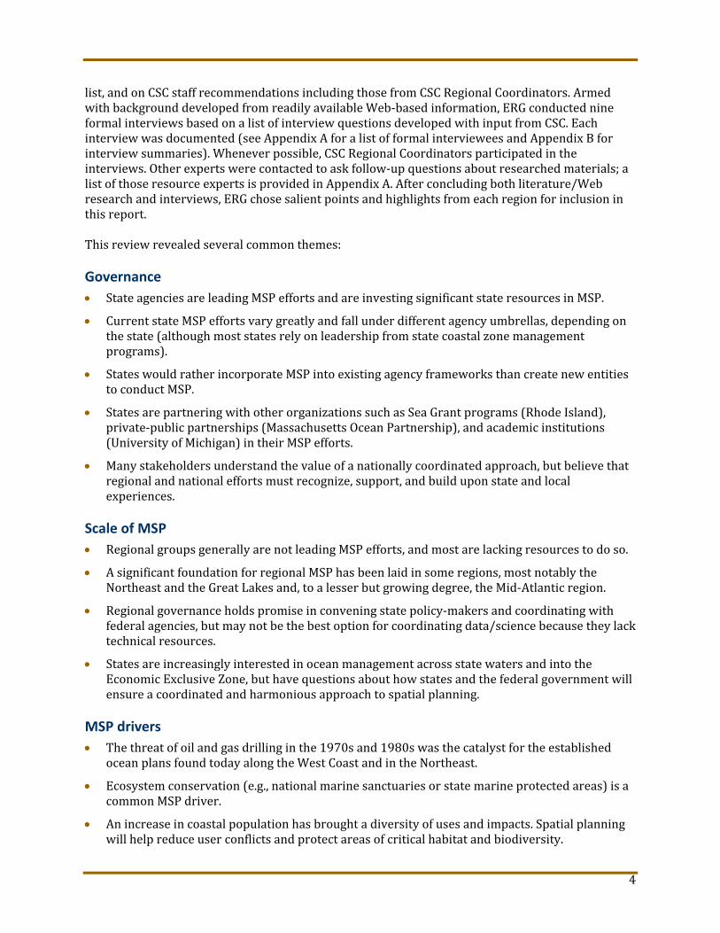
list, and on CSC staff recommendations including those from CSC Regional Coordinators. Armed with background developed from readily available Web‐based information, ERG conducted nine formal interviews based on a list of interview questions developed with input from CSC. Each interview was documented (see Appendix A for a list of formal interviewees and Appendix B for interview summaries). Whenever possible, CSC Regional Coordinators participated in the interviews. Other experts were contacted to ask follow‐up questions about researched materials; a list of those resource experts is provided in Appendix A. After concluding both literature/Web research and interviews, ERG chose salient points and highlights from each region for inclusion in this report. This review revealed several common themes: Governance
State agencies are leading MSP efforts and are investing significant state resources in MSP.
Current state MSP efforts vary greatly and fall under different agency umbrellas, depending on the state (although most states rely on leadership from state coastal zone management programs).
States would rather incorporate MSP into existing agency frameworks than create new entities to conduct MSP.
States are partnering with other organizations such as Sea Grant programs (Rhode Island), private‐public partnerships (Massachusetts Ocean Partnership), and academic institutions (University of Michigan) in their MSP efforts.
Many stakeholders understand the value of a nationally coordinated approach, but believe that regional and national efforts must recognize, support, and build upon state and local experiences.
Scale of MSP
Regional groups generally are not leading MSP efforts, and most are lacking resources to do so.
A significant foundation for regional MSP has been laid in some regions, most notably the Northeast and the Great Lakes and, to a lesser but growing degree, the Mid‐Atlantic region.
Regional governance holds promise in convening state policy‐makers and coordinating with federal agencies, but may not be the best option for coordinating data/science because they lack technical resources.
States are increasingly interested in ocean management across state waters and into the Economic Exclusive Zone, but have questions about how states and the federal government will ensure a coordinated and harmonious approach to spatial planning.
MSP drivers
The threat of oil and gas drilling in the 1970s and 1980s was the catalyst for the established ocean plans found today along the West Coast and in the Northeast.
Ecosystem conservation (e.g., national marine sanctuaries or state marine protected areas) is a common MSP driver.
An increase in coastal population has brought a diversity of uses and impacts. Spatial planning will help reduce user conflicts and protect areas of critical habitat and biodiversity.
5
A direct legislative or gubernatorial mandate is an important driver and would encourage more states to develop marine spatial plans.
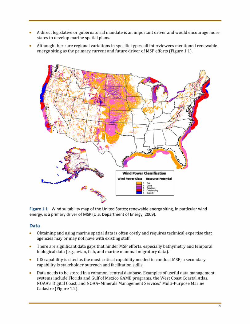
Although there are regional variations in specific types, all interviewees mentioned renewable energy siting as the primary current and future driver of MSP efforts (Figure 1.1).
Figure 1.1 Wind suitability map of the United States; renewable energy siting, in particular wind energy, is a primary driver of MSP (U.S. Department of Energy, 2009). Data
Obtaining and using marine spatial data is often costly and requires technical expertise that agencies may or may not have with existing staff.
There are significant data gaps that hinder MSP efforts, especially bathymetry and temporal biological data (e.g., avian, fish, and marine mammal migratory data).
GIS capability is cited as the most critical capability needed to conduct MSP; a secondary capability is stakeholder outreach and facilitation skills.
Data needs to be stored in a common, central database. Examples of useful data management systems include Florida and Gulf of Mexico GAME programs, the West Coast Coastal Atlas, NOAA’s Digital Coast, and NOAA–Minerals Management Services’ Multi‐Purpose Marine Cadastre (Figure 1.2).

6
Coordination of federal data for MSP is a critical issue for the states. There are data standardization concerns that need to be addressed before centralizing data is even possible.
Figure 1.2 Multipurpose Marine Cadastre – an example of valuable federal data coordination. Stakeholder engagement and support
There are differences among stakeholders regarding the definition of MSP, but nearly uniform agreement that the consistent use of terminology is critical. MSP as a concept needs to be carefully communicated (and clarified in many instances) to allay fears and suspicions, especially among traditional ocean users.
Workshops seem to be the tool of choice for data and information transfer and public education.
In order to ensure public participation and support, MSP must be a bottom‐up process. Future of MSP
MSP should grow from state and regional efforts in order to foster public buy‐in and ownership.
Federal agencies should provide a single point of access to all federal data and facilitate data coordination amongst the states.
Federal agencies should consider incorporating MSP into environmental impact reviews and streamlining federal permit processes for projects that demonstrate consistency with an approved MSP.
Federal agencies (NOAA in particular) should continue to support states and regional organizations by facilitating workshops, organizing meetings, and providing adaptable tools to facilitate information sharing.
Climate change and energy were viewed as future drivers of MSP.
Some interviewees had difficulty predicting potential future MSP use, commenting that the process is iterative and used for adaptive management and therefore will develop organically.

7
It is not possible to rank the importance of the above findings, but a reoccurring theme does emerge: most MSP initiatives are, in fact, triggered by a single sector use. Whether the plan is aimed at ecosystem management for specific marine species of concern or favorability siting for wind energy, all of the interviewees pointed to a single issue around which MSP efforts are galvanized. Far from an academic, value‐neutral exercise, MSP is a practical and scientific response to politically charged ocean management conflicts that require clear communication, robust data sets, and engaged stakeholders.

8
2. Regional Summaries
2.1. Introduction This report is organized by region (Figure 2.1). Each region is characterized by its unique aspects relative to MSP, including historical and future drivers; socio‐economic, political, and cultural distinctions; key stakeholders and partnerships; and common themes from interviews conducted. Case study summaries of notable MSP or MSP‐related initiatives are highlighted in side boxes. Appendices include a list of interviewees and resource experts, interview summaries, a list of the MSP tools used and a stakeholder spreadsheet.
Figure 2.1 NOAA coastal regions (NOAA CSC, 2009).

9
2.2. Northeast The coastal states of the Northeast region (Maine, New Hampshire, Massachusetts, Rhode Island, and Connecticut) share a strong and enduring maritime history. In particular, commercial fishing, shell fishing, and shipping are firmly engrained in the seacoast culture. More recently, LNG terminals, cable crossings, whale watching, marine mammal protection, aquaculture, wastewater discharge outfalls, and recreational uses have exerted their presence on the seascape. Massachusetts and Rhode Island in particular have taken bold steps, with firm legal and technical footing, to emerge as leaders in comprehensive MSP, not only within the Northeast region but within the nation. Regional distinctions of ocean uses
Strong home rule tradition and public rights to coastal areas are pervasive in this region.
The region is small geographically and shares common offshore areas. Cooperation is high among the states, federal agencies, and the eastern Canadian provinces.
Proposals for wind, tidal, and, to a much lesser extent, wave energy have been the major drivers of MSP. Aesthetics are a major source of public concern (e.g., the Cape Wind offshore energy project in Massachusetts).
The Bay of Fundy has the highest tidal range in the world; it fluctuates up to 55 feet during a tidal cycle.
Wind potential for the entire region is considered “outstanding” (Figure 1.1).
This region is home to the Stellwagen Bank National Marine Sanctuary and the endangered humpback and northern right whales. Massachusetts hosts five state‐designated ocean sanctuaries, which include the entire coastline except for the greater Boston Harbor area.
The region contains four national estuarine research reserves, numerous national wildlife refuges, and two seashores designated as national parks.
Fish and shellfish landings for New England states totaled $805.2 million (595.6 million pounds) in 2008. The largest landings were for Atlantic herring (93.7 million pounds), Atlantic mackerel (35.5 million pounds), and sea scallops (27.1 million pounds).
Historical and current MSP drivers
Georges Bank, one of the most productive fisheries in the world, was an early battleground for testing ocean use compatibility when gas and oil drilling was proposed there in the 1970s. This
Highlight Massachusetts Ocean Act In 2008, the Massachusetts Legislature passed the Massachusetts Oceans Act. The Act mandated development of a comprehensive ocean management plan to balance natural resource preservation with traditional and new uses, including renewable energy, for state coastal waters. The final plan, released in January 2010, delineates areas for small‐scale and commercial scale wind projects and imposes more protection for critical resource areas such as fish nurseries, whale feeding areas, and endangered bird nesting sites. Unique aspects of this initiative include the role of the Massachusetts Ocean Partnership, a private‐public partnership that provides resources (e.g., data access, facilitation) and informed input to the state through funding provided by the Betty and Gordon Moore Foundation. Other important features include the Massachusetts Ocean Resources Information System, a Web site for online, shared viewing and public input; a clear legislative mandate with deadlines; pending major offshore wind farm proposals; an aggressive public outreach campaign including numerous public input sessions throughout the state; a structured process with a 17‐member ocean advisory commission; and an ocean science advisory council.

10
protracted and highly publicized litigation sensitized the public to ocean use conflict. Exploratory oil and gas drilling actually occurred on Georges Bank between 1976 and 1982, but was halted in 1983 due to widespread public opposition and litigation. Rhode Island has also addressed ocean uses and claims ownership of the first MSP effort in the United States with its legislatively authorized Special Area Management Plans (SAMPs), beginning in 1983. More recently, energy development (offshore LNG terminals, wind farms, and tidal energy) is driving ocean planning initiatives in the Northeast. In particular, wind energy has been a catalyst in Massachusetts due to a controversial proposed project in Nantucket Sound, and in Rhode Island, where wind turbines are also planned. MSP in the region
There are two mandated MSP efforts in the Northeast (Massachusetts and Rhode Island) as well as other efforts where tools are being applied to assess renewable energy projects. The following represent a range of MSP initiatives, from a single project focus to a much broader focus: Rhode Island SAMPs (Figure 2.2).
The Massachusetts Ocean Management Plan.
A feasibility study of hydrokinetic (tidal) generation in the Little Bay Estuary (New Hampshire).
The Eastern Scotian Shelf Integrated Ocean Management Plan (under Canada’s 1997 Oceans Act).
Maine’s Ocean Energy Task Force and Wind Energy Act.
Major themes from Northeast interviews
Two formal interviews were conducted with coastal and ocean managers in the Northeast region. One interviewee identified MSP as a process, whereas the other identified it as a tool. Interviewees believed that any MSP guidance must be adapted to state‐specific requirements, with emphasis on practicality and flexibility. The management of multiple ocean uses was also mentioned as part of the MSP process. Both interviewees pointed out the large amount of data required for MSP and the associated challenges: accessing federal data, having data available in a form and with common platform/standards so it is usable for MSP, and high transaction costs with federal data access and usability. Gaps in bathymetric data, ecological characterization data, Vessel Monitoring System data, and endangered species data were also identified. The interviewers mentioned obstacles to implementing MSP including insufficient resources, confusing terminology, and a high level of public suspicion. They emphasized the need for effective public outreach and engagement, and underscored the importance of introducing MSP in a practical, understandable way to encourage buy‐in. In discussing future uses of MSP, interviewees discussed MSP as a tool for adaptive management and an iterative process (which makes it hard to predict future applications). Climate change, regional collaborative planning for shared ocean
Figure 2.2 RI SAMP jurisdiction (RI Ocean SAMP,
2009).

11
resources, and streamlined state and federal permitting processes may be future potential uses. The federal government’s role in MSP efforts currently and in the future was identified as coordinating and accessing data, facilitating information exchange (more case studies, “how to” examples), disseminating tools like the Multipurpose Marine Cadastre, and supporting regional staff and regional governance, especially in terms of the two main MSP skill sets: GIS and stakeholder facilitation.
Major stakeholder groups and partnerships: Northeast Regional Ocean Council, The Nature Conservancy, Conservation Law Foundation of New England, Massachusetts Ocean Partnership, State coastal zone management programs, Sea Grant programs, Cooperative Institute for Coastal Energy and Environmental Technology, University of New Hampshire (Center for Coastal and Ocean Mapping/Joint Hydrographic Center), Northeast Regional Association of Coastal Ocean Observing Systems, Regional Association for Research in the Gulf of Maine, Gulf of Maine Council for the Marine Environment, New England Governors and Eastern Canadian Premiers.

12
2.3. Mid‐Atlantic
The Mid‐Atlantic region (New York, New Jersey, Delaware, Maryland, and Virginia) is the historical backbone of U.S. maritime heritage. Integrated coastal management has been recently enhanced in the region by the signing of the Mid‐Atlantic Governors’ Agreement on Ocean Conservation. The agreement created the Mid‐Atlantic Regional Council on the Ocean (MARCO) and has charged the states to collaboratively address priorities for shared action. These priorities include ecosystem resources and services; interdependencies among ecological, economic, social, cultural, political dimensions; the transboundary nature of ocean resources; a unified regional voice; and the development of partnerships. Several Mid‐Atlantic states have begun developing comprehensive plans for offshore areas. One goal of Virginia’s plan is to identify suitable areas for energy facility siting in order to minimize conflicts with other coastal uses, such as ecologically sensitive areas, recreation, and mining. The Maryland Department of Natural Resources is completing detailed spatial assessments of coastal habitats, critical natural resources, and associated human uses. New Jersey and New York lead the region in terms of efforts to comprehensively manage ocean resources. New York has a newly established council to implement ecosystem‐based management strategies, and is the only Mid‐Atlantic state with a marine/riverine renewable energy pilot project underway (tidal turbines in the East River). Regional distinction of ocean uses
The Mid‐Atlantic has diverse marine fisheries owing to productive estuaries (Chesapeake Bay and Delaware Bay) and the continental shelf. Fisheries managed in the region include summer flounder, striped bass, and menhaden.
Many miles of varied coastline adjacent to several major population centers provide opportunities for ocean‐based tourism.
Shipping operations service major centers, such as New York, Philadelphia, and Baltimore. New York is the second largest container port in the United States.
Several large military installations are sited along the mid‐Atlantic coast; naval and air exercises take place from (among others) Joint Base McGuire‐Dix‐Lakehurst (New Jersey), Dover Air Force Base (Delaware), Naval Station Annapolis (Maryland), and Naval Station Norfolk (Virginia).
A relatively shallow offshore area allows for the siting of renewable energy facilities. For example, the Minerals Management Service has initiated a potential lease sale of 2.9 million acres 50 miles offshore from Virginia.
Highlight New York Leadership New York has historically managed ocean and Great Lakes activities on a sector‐by‐sector basis. However, the Legislature created the New York Ocean and Great Lakes Ecosystem Conservation Council to provide greater state agency coordination in the implementation of ecosystem‐based management (EBM). This council has recently initiated a spatial planning effort, whose initial projects will be natural resource and human use maps, human uses impact research, siting criteria, and the identification of areas appropriate to site renewable energy facilities and other infrastructure. The starting point for much of this work will be the area from New York Harbor extending out to the continental shelf, including the Hudson Canyon. In addition to the overarching spatial planning needs associated with EBM, drivers for offshore spatial planning in New York include habitat protection and wind, tidal, and wave energy siting. With respect to energy, the state hopes spatial planning will streamline portions of the placement process. In addition, The Nature Conservancy, in partnership with the NASA Goddard Institute for Space Studies, the Pace Land Use Law Center and NOAA’s Coastal Services Center (among others) is using a multiple‐objective MSP approach in New York as part of its Long Island Coastal Resilience Project. This effort will use geospatial information to support conservation and human needs.

13
As in New England, wind potential for the entire region is considered “outstanding” (Figure 1.1).
Historical and current MSP drivers
Marine zoning has been practiced in a fairly segmented fashion along the Mid‐Atlantic. In large measure, these efforts have been centered on human use conflicts and ecological protection. For example, New Jersey’s first marine conservation zone, the Sedge Islands/Island Beach State Park Marine Conservation Zone, was designed to reduce the impacts of personal watercraft and better manage recreation, impacts to wildlife. Delaware’s ocean management efforts have been greatly influenced by the need to ensure regional coordination; protect and restore coastal ecosystems, waters, and habitats; and address the impacts of climate change. New York has maintained several types of management zones in coastal waters, including shellfish closure zones, Shellfish Spawner Sanctuaries, Significant Coastal Fish and Wildlife Habitats, and the Long Island South Shore Estuary Reserve. Offshore energy development is a major driver of current MSP efforts in the Mid‐Atlantic region. In anticipation of such projects, New Jersey has moved proactively to determine appropriate sites for wind farms by compiling baseline information about marine mammals, avian flyways, endangered species, and fisheries habitat in order to make informed decisions. In Delaware, developers are slated to begin construction in 2012 of 150 offshore wind turbines and an undersea transmission cables. In 2005, in response to the expiration of the moratorium on Outer Continental Shelf exploration, the Virginia legislature required a study of natural gas exploration in coastal areas. This study has called for a broad‐based energy policy, public involvement, risk assessments, environmental and public safety protections, and consistency with Virginia’s Coastal Zone Program (VCMP) requirements. The VCMP has stated that mapping resources, identifying potential use conflicts, and designating preferred corridors for electric transmission and gas pipelines are all important tasks for development of this plan. Maryland has submitted a Request for Information and Interest in Maryland’s offshore wind energy development. Other drivers of spatial planning in the region include sport‐fishing (New Jersey has delineated several offshore sport fishing zones, Figure 2.3) future artificial reef development, ecological restoration, marine managed areas, transportation, and recreation. MSP in the region
Out of the entire Mid‐Atlantic region, only New York has mandated a comprehensive approach to managing ocean and Great Lakes resources through ecosystem‐based management. There are no mandated efforts officially designated as “marine spatial planning” in the Mid‐Atlantic. MSP frameworks in the region vary in their level of maturity. New Jersey, for example, is currently seeking to amend its coastal management rules to identify areas where construction of wind turbines would not be appropriate and has delineated offshore recreational fishing zones (Figure 2.3). The Maryland Department of Natural Resources is working with The Nature Conservancy on marine spatial planning, part of Maryland’s “Blue
Figure 2.3 New Jersey’s offshore sportfishing zones (NJ Coastal Management Program, 2009).

14
Infrastructure,” a “framework to enhance sound coastal and marine resources by completing detailed spatial assessments of coastal habitat, critical resources, and associated human uses.” The following are a few examples of burgeoning MSP efforts, studies, or initiatives that are using or will likely use MSP frameworks: The New Jersey Ocean Resources Management Plan and New Jersey Ocean Atlas.
Delaware Special Area Management Plans.
HD 22 – the Virginia Offshore Natural Gas exploration study.
The East River tidal energy pilot study (New York).
The New York Ocean and Great Lakes Ecosystem Conservation Council.
Maryland’s Blue Infrastructure Initiative and its Coastal Atlas / Maryland Shorelines Online.
The Long Island Coastal Resilience Project. No formal interviews were conducted for the Mid‐Atlantic region. Major stakeholder groups and partnerships: Chesapeake Bay Observing System/ODU, Chesapeake Research Consortium, State coastal zone management and environmental protection programs, Delaware River and Bay Commission, energy developers (e.g., Bluewater Wind, Verdant Power), Mid‐Atlantic Regional Council on the Ocean, New York Ocean and Great Lakes Ecosystem Conservation Council, The Nature Conservancy, Virginia Sea Grant, Virginia Institute of Marine Science, Rutgers Coastal Ocean Observation Lab, Mid‐Atlantic Regional Coastal Ocean Observing System.
15
2.4. Southeast and Caribbean The Southeast and Caribbean region (North Carolina, South Carolina, Georgia, Florida, Puerto Rico, U.S. Virgin Islands) is beginning to consider the possibility of multiple ocean uses of state waters and how to best manage those uses. North Carolina’s Ocean Policy Steering Committee recently published its Final Report, which included recommendations for comprehensive ocean management. South Carolina has established an Ocean Planning Group, currently drafting a report to address ocean resource research and planning in the future. Florida’s extensive aquatic preserve system has given the state a strong understanding of the process of engaging stakeholders in zoning for conservation purposes, and Florida has recently begun to develop an Ocean Management Plan. Georgia has the smallest length of coastline in the Southeast, but is home to the Grey’s Reef Marine Sanctuary, a critical South Atlantic marine protected area (MPA). In the Caribbean, Puerto Rico has developed MSP Draft Guidelines, although their ocean uses are mainly focused on conservation. Overall, MSP is in its infancy in the Southeast and Caribbean region, but is encouraged by the support of the newly formed Governors’ South Atlantic Alliance, which is beginning work on an Action Plan and setting priorities for protecting the value of the region’s ocean resources. Regional distinction of ocean uses
North Carolina and South Florida coasts are particularly vulnerable to sea level rise.
From 1980 to 2003, Florida experienced the highest rate of population increase in the United States; Georgia and South Carolina ranked ninth and tenth, respectively.
The Southeast region has seen a 55 percent increase in anglers from 1997 to 2006. A wide range of fisheries are managed in the area including snapper and grouper, coastal migratory pelagic species, corals, golden crab, shrimp, sargassum, mahi mahi, wahoo, and spiny lobster.
In the Caribbean, commercial and recreational fisheries include spiny lobsters, queen conch and other mollusks, and numerous species of reef fish.
A right whale migration corridor begins in New England and follows the Atlantic coast to calving grounds off the coast of the Georgia/Florida border.
Preliminary federal permits have been granted from the Federal Energy Regulatory Commission to a private company exploring current energy sites of the east coast of Florida.
Offshore wind potential is considered “outstanding” off the coast of the Carolinas (Figure 1.1).
Highlight The Nature Conservancy’s Carolinian Ecoregional Assessment
As in other regions, The Nature Conservancy is an active participant in MSP activities in the Southeast and Caribbean. The Conservancy undertook a science‐based marine ecoregional assessment for the Carolinian region, which includes waters from the estuarine bays seaward to the edge of the outer continental shelf, beginning at Chesapeake Bay and extending south to Cape Canaveral, Florida. The assessment gathered datasets of biological, physical, oceanographic, and human use data drawn from government, academic, and nonprofit sources for 36 shoreline and marine ecosystem targets. Although the assessment focused on prioritizing areas for conservation purposes, information on shipping lanes, coastal populations, dredge disposal, and other human uses were inputted into the analysis. Initial assessment products include a geospatial database of integrated information on marine ecosystems and human uses in the coastal marine areas of the Southwest Atlantic and an online, publicly accessible Web mapping and data download service. This service will help managers meet diverse natural resource management goals; the portfolio of conservation sites provides a representation of critical natural areas (as well as their prioritization) on a regional scale, which would be of great help to a regional MSP effort.

16
There are offshore oil and gas drilling moratoria in Florida and North Carolina. South Carolina is going forward with approving explorations for natural gas 60 miles off the coast.
Puerto Rico controls activities in waters up to 9 nautical miles offshore, whereas the U.S. Virgin Islands and other states in the Southeast control activities 3 miles out.
Historical and current MSP drivers
Coastal development has intensified greatly in the Southeast over the last three decades. To address the growing pressure on ocean uses, North Carolina commenced development of an ocean plan in 1983, but no ocean management‐related state legislation has been passed to date. Florida has preserved aquatic areas for over 30 years, with the passage of the Aquatic Preserves Act in 1975. Efforts at ocean management are less established in South Carolina and Georgia. With the increasing pressures for sand resources and renewable energy siting in the Southeast, states have more actively begun addressing ocean resource issues. Frequent beach nourishment projects in the Carolinas and Florida require enormous amounts of compatible sand, which is not always available in the nearshore environment. In addition to energy and sand availability concerns, climate change is becoming an important driver in the region, where low‐lying coastal areas will be particularly vulnerable to rising sea levels and increasing storm frequency. MSP in the region
There are no mandated efforts officially designated as “marine spatial planning” in the South Atlantic. In the Caribbean, Puerto Rico is developing a rudimentary marine spatial plan. The following are a few examples of burgeoning MSP efforts, studies, or initiatives that are single‐sector‐based but use tools or data layers that could be applied to a more integrated ocean planning approach: The Puerto Rico Draft MSP Guidelines.
St. Croix East End Marine Park (Figure 2.4).
The North Carolina Ocean Policy Steering Committee Final Report, Coastal Habitat Protection Plan, University of North Carolina Wind Study.
Florida Aquatic Preserves and Draft Ocean Management Plan Development Guidelines.
The Nature Conservancy’s Carolinian Ecoregional Assessment.
Highlight East End Marine Park
Located in St. Croix (U.S. Virgin Islands), East End Marine Park was designated a Marine Protected Area in 2003. The same year, the Advisory Committee for the park received the Coastal America Partnership Award “in recognition of the collaborative effort of the territorial government and stakeholders in developing the marine park.” The park includes recreational areas, turtle preserve areas, no take areas, and open areas (see Figure 2.4). The stakeholder engagement required for the successful multi‐use marine zoning that occurred at East End is a crucial component of any MSP effort.
Figure 2.4 St. Croix, East End Marine Park zoning map (U.S.V.I. Dept of Planning & Natural Resources, 2002).
17
Major themes of Southeast Interviews
Two formal interviews were conducted for the Southeast region, one with a national nonprofit and one with a state wildlife management agency. Interviewees defined MSP as a process, a tool for considering several sectors together, and a way to look at the ocean spatially and temporally. Engaging stakeholders was also cited as critical to a comprehensive MSP effort. There are several obstacles to implementing MSP in the region, including lack of bathymetry and biological (temporal) data, lidar data for some states, or a central repository for data. In addition to data barriers, a lack of clear MSP goals and negative public perception (due to public rights in ocean waters) were identified as obstacles to establishing MSP in the region. According to interviewees, current drivers of ocean planning discussions in the region include prioritizing of conservation areas and sediment mining for beach nourishment projects. Interviewees acknowledge energy (both renewable and traditional) and aquaculture as future drivers. They mention the current use of NOAA tools (the Digital Coast) in coastal management, and hope the federal government can provide data at the right scale in the future. Moving forward, interviewees hope the federal government can play a role in authorizing MSP in agency decision‐making and promoting consistency in work with states. Major stakeholder groups and partnerships: Governors’ South Atlantic Alliance, South Atlantic Regional Research Project (Sea Grant), State coastal management and environmental protection programs, Florida Ocean Alliance, The Nature Conservancy, Southern Environmental Law Center.

18
2.5. Great Lakes The Great Lakes are governed by two countries, eight states (New York, Pennsylvania, Ohio, Indiana, Illinois, Michigan, Wisconsin, and Minnesota), and two provinces (Ontario and Quebec), and are the ancestral homeland to 35 tribal nations. Each lake has a Lake‐Wide Management Plan assessing lake health, impairments, emerging issues, and data gaps. Regional cooperation is taking place through the Great Lakes Commission, the Great Lakes Council of Governors, and the Great Lakes Interagency Task Force. In 2004, the Great Lakes Regional Collaboration of National Significance was created to develop a strategic plan with input from state and federal government, tribes, and stakeholders. Wisconsin, Indiana, Illinois, Minnesota, and Pennsylvania have focused most of their lake planning efforts on near shore issues, especially coastal erosion. While these activities have involved aspects of MSP, only recently, when an offshore wind energy project was proposed, has MSP taken shape. Ohio and Michigan are engaged in groundbreaking MSP initiatives. These hold promise for transferability to the Great Lakes region as a whole to help address multiple lake uses including wind energy, commercial shipping, recreational boating, commercial/recreational fishing, water consumption and pollution, mining, wildlife habitat preservation, endangered species, and archeological site protection. Regional distinction of ocean uses
6,000 shipwrecks lie throughout the Great Lakes. Thunder Bay Marine Sanctuary in Lake Huron protects a nationally significant collection of 200 shipwrecks.
There is no federal jurisdiction over submerged lands in the Great Lakes therefore states and tribes control all uses of the waters.
The primary driver for MSP is wind energy development. A major public concern focuses on visual impacts from the shoreline.
Shipping, boating, fishing, and diving are major interests in the Great Lakes. U.S. commercial fishing landings in 2006 for all five lakes totaled $14.5 million.
Salt mining is an important industrial use in Michigan (Detroit Salt Mine) and in Ohio, where salt mines extend three miles under Lake Erie.
Growing international concerns aquaculture projects, consumptive use of water (a bi‐national water diversion compact was recently adopted), and climate change impacts on shipping channel depth.
Highlight Michigan’s Lakebed Alteration Decision Support Tool
The University of Michigan, working with the Michigan Department of Natural Resources and NOAA, developed the Lakebed Alteration Decision Support Tool to “provide a science‐based tool to inform policy‐making and management of Michigan’s coastal resources.” This Web‐based tool allows users to choose criteria for judging the suitability of sites for wind, dredging, and other offshore projects. It accommodates value judgments such as importance of criteria and desired setbacks, and draws upon robust physical, political, and biological data sets. It processes input parameters to create interactive maps displaying areas suitable for the proposed use. The tool allows users to experiment with “what if” scenarios and provides an accessible, user‐friendly visualization tool for immediate feedback. Preliminary results identify exclusion zones and show areas with high, conditional, and low suitability for wind development in Lakes Superior, Michigan, and Huron. The tool is being used by Michigan’s Great Lakes Offshore Wind Council, which is tasked with providing a public forum to identify offshore areas suitable for wind energy development. The Council is continuing its analysis and outreach effort for another year before proposing regulations. Initially developed for internal use, the tool is being adapted for permit applications and will eventually have an interface for public use. State officials recognize that stakeholder engagement is a critical element of this effort.

19
Historical and current MSP drivers
There is a strong history of regional lake management in the Great Lakes region. Water diversions from the Great Lakes for public water supplies, energy projects, shipping, and recreation have occurred for over a century and a half. In response to concerns over larger withdrawal requests in the 1980s, the Great Lakes Charter of 1985 was signed, ensuring regional management of water flows. Regional efforts at protecting the natural resources of the lakes have existed since the establishment of the Great Lakes Commission in 1955. Individual state planning efforts in the past have focused on shipping, mining, shipwrecks, fisheries, and water quality improvements including shoreline erosion control. The primary current driver for MSP in the region is wind energy, and a major public concern focuses on visual impacts from the shoreline.
Highlight Ohio Office of Coastal Management (OCM) Wind turbines were proposed for Lake Erie in the fall of 2008. At first, the proposal outlined a single‐sector project that did not take into account existing uses of the lake. The commonly held view at that time was that the lake was an open expanse of water available for wind energy development. Ohio OCM responded to the wind proposal by delivering spatial information to decision‐makers quickly and clearly, seeking to ensure that the proposal was thoughtfully vetted with the public. OCM aided the public in visualizing lake uses by developing 11 thematic maps and a wind favorability analysis map. The maps examined shipping lanes, bird habitat, fish habitat, commercial fisheries, lakebed substrate, industrial uses, natural heritage observances, distance from shoreline, shipwrecks, sport fishery, and utility infrastructure. A key feature in OCM’s efforts has been the ability to communicate effectively with users and the public via a very simple Web‐based capability. Wind energy regulations, based on the favorability analysis (Figure 2.5), are currently in development. In addition, Ohio OCM recently released the second edition of the Ohio Coastal Atlas, an interactive map viewer tool that combines GIS mapping capabilities with text, graphics, pictures, and contact sources. By capturing interactions between natural resources and human activities, the Atlas enables stakeholders to make improved coastal management decisions.
Figure 2.5 Composite map showing areas in Lake Erie suitable for wind facility siting, ranging from high favorability (dark green) to low favorability (red), based on multiple factors (Ohio DNR, Coastal Management, 2009, www.ohiodnr.com/LakeErie/WindEnergyRules).

20
MSP in the region
There are no mandated efforts officially designated as “marine spatial planning” in the Great Lakes region. The following are a few examples of burgeoning MSP efforts, studies, or initiatives that are single‐sector‐based but use tools or data layers that could be applied to a more integrated ocean planning approach:
New York’s Ocean and Great Lakes Ecosystem Conservation Council Marine Spatial Planning white paper (being drafted).
The New York Power Authority’s request for proposals for a Great Lakes wind farm (Lake Erie and Ontario).
The Great Lakes Wind Council.
The Lake Ontario bathymetric update (a collaboration between NOAA National Geophysical Data Center, the NOAA Great Lakes Environmental Research Laboratory, the Canadian Hydrographic Service, and the University of Colorado).
Major themes from Great Lakes interviews
Two state coastal managers were formally interviewed from the Great Lakes region. They described MSP as analogous to three‐dimensional land‐use planning (not zoning), with a need for clear communications with stakeholders about what MSP is and what it is not. In terms of data, interviewees listed lidar, bathymetry, ice cover, fisheries habitat, and migratory bird data missing or requiring updates. Additional observations related to data being in usable format and the need to better integrate observation system data. In addition to data content, they cited issues over collection, exchange, and storage of data, as well as synchronizing data collection for trends analysis. They also mentioned that the Great Lakes Environmental Research Lab is very helpful to states in accessing data. Interviewees cited several obstacles to full implementation of MSP, such as public suspicion of MSP due to the potential impairment of existing uses/rights and misrepresentation of MSP as a “government‐knows‐best” type of effort. Interviewees acknowledged that MSP will have climate change and regional applications in the future. For future regional applications, the Great Lakes Commission data exchange concept could be merged with NOAA’s Digital Coast through the Great Lakes Environmental Research Lab to provide a regional MSP resource. Additional recommendations include enabling better coordination of federal data to facilitate state use and establishing a science‐based service organization with strong state relationships as a future data host. (Both of these recommendations involve support from the federal government.) As in other regions, interviewees are hoping for additional funding from the federal government and continued support from the NOAA CSC Regional Coordinator, who has been very useful to date. Major stakeholder groups and partnerships: State coastal zone and environmental protection programs, Great Lakes Council of Governors, Great Lakes Regional Collaboration Strategy, Great Lakes Interagency Task Force (federal), Great Lakes Commission, Great Lakes Alliance, Lake Michigan Watershed Ecosystem Partnership, NOAA Great Lakes Environmental Research Lab, Sea Grant Programs and State Universities, Great Lakes Offshore Wind Council, Great Lakes Fishery Commission.

21
2.6. Gulf of Mexico
The Gulf of Mexico region is composed of five states (Alabama, Florida, Louisiana, Mississippi, and Texas) representing a range of approaches to managing ocean resources. Florida’s west coast is considered part of the Gulf of Mexico region and the Florida Keys National Marine Sanctuary is an example of successfully implemented marine zoning. Florida’s ocean resource management is generally focused on conservation, an approach that recognizes the important role the natural environment plays in tourism, a huge component of the state’s economy. Like Florida, Texas works to manage ocean resources for the greatest economic benefit. In Texas’s case, this approach means efficient management of submerged lands for oil and gas leases. Louisiana, Alabama, and Mississippi similarly manage their state waters with focus on oil and gas leases. A recent study by the Gulf States Marine Fisheries Commission on aquaculture siting demonstrates a burgeoning effort to incorporate multiple use data layers in siting decisions – methods that could be used in the future for MSP in the region. Although there are existing regional organizations, such as the Gulf of Mexico Alliance, these groups are generally seen as ancillary to state efforts. Regional distinction of ocean uses
Texas and Florida (west coast) state waters extend 9 nautical miles out into the Gulf compared with the standard 3 nautical miles. Florida does not allow oil and gas drilling in state waters.
The Gulf contains five national estuarine research reserves, the Flower Garden Banks Marine Sanctuary, the Florida Keys National Sanctuary, and numerous national wildlife refuge sites.
The eastern part of the Gulf (under the Gulf of Mexico Security Act) is under an oil/gas leasing moratorium until 2022.
Gulf states, as part of the Gulf of Mexico Security Act, received $2.7 million from the federal government to fund coastal conservation, restoration, and hurricane protection in 2009. In addition, royalties from oil and gas revenues in state waters are often directed toward state preservation funds and public education.
The entire Gulf of Mexico area is susceptible to hurricanes and high‐energy storms.
The Gulf is home to one of the nation’s largest fisheries: the commercial shrimp fishery. The management council for the region has developed a plan to manage burgeoning offshore aquaculture in the region in addition to managing reef fish, coastal pelagic species, spiny lobster, stone crab, corals, red drum, and shrimp.
Florida is the most popular recreational fishing state in the United States. Over 20 percent of Florida and Louisiana residents fish recreationally.
Highlight Texas Coastal Resource Management
Texas state waters extend 10.35 miles (9 nautical miles) out into the Gulf of Mexico, which means the Texas Coastal Management Program is responsible for managing activities beyond the traditional 3‐mile marker. All state‐owned submerged lands are divided into tracts and evaluated for any use restrictions. The mapped tracts are available for viewing on the Texas General Lands Web site. Each map contains the numbered tract and main geographic features. Restrictions on the tract are viewable in a small table below the map (Figure 2.6). Although Texas has admittedly considered natural resources protection as secondary to oil and gas development in the past, concerns over coastal resiliency and ecological health are now being addressed as well, and with the addition of wind energy, the pressure on the resource management system to incorporate these new uses will surely increase.

22
Five offshore wind projects have been awarded leases in Texas. The rest of the Gulf states have limited offshore wind potential, with the majority of states’ wind potential categorized as “fair” (Figure 1.1).
Historical and current MSP drivers
The Gulf of Mexico has over 50 years of experience in managing offshore oil and gas platforms, with the first federal oil exploration lease issued in 1954. Florida is the only state in the Gulf where oil and gas drilling has not been a prevalent use of state waters for decades. Although always prone to intense storms and hurricanes, the Gulf has experienced some particularly intense events in the last decade – eight category three or category four hurricanes, five occurring in 2005 alone. Current state coastal management efforts tend to focus on coastal resilience and hazard mitigation due to the area’s susceptibility to high‐intensity storm events. There is interest in continuing to develop wind energy in Texas, where offshore permits have already been issued for several projects.
Appropriate aquaculture siting is currently being researched by Gulf States Marine Fisheries Commission and could drive MSP going forward. The regional Sea Grant offices are conducting research projects in support of the Gulf of Mexico Alliance (GOMA) Action Plan II priority action steps, which focus on enhancing regional ecosystem health and resilience. As a regional governance structure, GOMA will play an important role in future MSP efforts, and its proposed action steps, such as the “Gulf of Mexico Master Plan,” could be the foundation of a future comprehensive marine spatial plan for the region. MSP in the region
There are no mandated efforts officially designated as “marine spatial planning” in the Gulf of Mexico. The following are efforts that could be considered burgeoning MSP efforts, or initiatives that are single‐sector‐based but use tools that could be applied to a more integrated ocean planning approach:
Florida Keys National Marine Sanctuary.
Resource Management Codes for State‐Owned Submerged Lands in Texas.
Gulf of Mexico Geospatial Assessment of Marine Ecosystems (GAME) and Florida GAME.
The Gulf of Mexico Aquaculture Siting Study.
Highlight Florida Keys National Marine Sanctuary Decades of piecemeal conservation efforts to protect coral reef resources in the Florida Keys had not resulted in any improvements in ecosystem health. By the late 1980s, concerns were amplified as three ships ran aground on the coral reefs in a three‐week period. These explicit user conflicts catalyzed the designation of the Florida Keys National Marine Sanctuary in 1990. While the Sanctuary’s main focus is conservation of marine resources, it has worked to facilitate human uses that are consistent with these goals. The initial management plan was developed using a “top‐down” approach by a representative Sanctuary Advisory Council. The plan faced strong public opposition, which influenced the management plan development process for the Tortugas Ecological Preserve, added to the Sanctuary in 2001. The Tortugas process involved public input from the outset, and stakeholders came together to draft multiple zoning recommendations based on their interests. The successful marine zoning implemented in the Florida Keys National Marine Sanctuary cannot be considered marine spatial planning because it is not a comprehensive plan considering multiple users. However, extensive monitoring, spatial and temporal data gathering, state‐federal agency cooperation, and stakeholder engagement help inform marine zoning decisions. All of these are critical facets of MSP.

23
Major themes from Gulf of Mexico interviews
Two formal interviews were conducted for the Gulf of Mexico region with state wildlife and state coastal program managers. The interviewees defined MSP as a comprehensive management approach with a place‐based perspective. Both discussed the importance of data, but mentioned gaps in biological data, as well as a lack of data integration across groups/states, as issues. There is variation in data across the Gulf states – some states have recent lidar and high‐resolution aerial photography. In addition to data gaps, the interviewees mentioned several other obstacles to MSP implementation, including no official mandate, no regional data sharing, perception of regional groups as ancillary, disconnection between technical side and public participation side of current efforts, lack of public understanding, lack of funding for regional groups, and strong public opposition to any effort that will detract from current energy uses (due to oil and gas revenue sharing). States will have to be more heavily networked with each other in order to consistently address both technical gaps and public biases toward MSP. Interviewees mentioned renewable energy siting, conservation of areas of high resource concentrations, and management of recreational user groups as future drivers of MSP. When discussing the role of the federal government in the future of MSP in the region, they cited the need for a clearer definition of MSP, as well as consolidation of state‐level examples of effective MSP and support to help develop their own states’ MSP framework. The NOAA regional representatives should continue to keep states informed.
Figure 2.6 Example of information provided online for Texas state‐owned submerged lands along entire coast. Resource codes relate to access, dredging and dredged material disposal, miscellaneous, oil and gas development, rights‐of‐way, and time limitations (http://www.glo.state.tx.us/coastal/rmc/#row).
Major stakeholder groups and partnerships: Coastal States Organization, Gulf of Mexico Alliance, Gulf of Mexico Sea Grant Programs, Gulf States Marine Fisheries Commission, Gulf of Mexico States Accord, State General Lands Offices, State coastal management and environmental protection programs.
24
2.7. West Coast
The West Coast region (California, Oregon, and Washington) contains a mix of mandated and informal marine planning initiatives and MSP tools. Oregon has an established, adaptive marine resource management framework in the form of the Territorial Sea Plan (TSP), but the state has not formally expressed uses spatially on planning maps. California has several advanced marine spatial map‐development tools (e.g., MarineMap, Ocean Uses Atlas) without a MSP mandate in place. Washington is being driven toward MSP by wave and tidal energy pilot projects in the Puget Sound and outer coast, but local shoreline master programs do not extend beyond the near shore environment and the state’s Ocean Resources Management Act is broad and underutilized. All West Coast states recognize the importance of public participation, and have designed their MSP and ocean resource management frameworks and tools with the public in mind. Although similar in some ways to MSP, the MPA and reserve designations process has somewhat distorted the public perception of MSP in California and Oregon and may hamper MSP efforts in these states. As in the Great Lakes Region, there are several joint initiatives with Canada. Regional distinction of ocean uses
Native tribes are critical stakeholders in ocean resource discussion, especially in Washington. Washington alone has 20 federally recognized Indian tribes or nations with coastal treaties allowing them hunting and fishing rights.
Five of the 10 top container ports in the country are on the West Coast.
The West Coast contains a rich array of nationally recognized marine resources, including national marine sanctuaries, national wildlife refuges, national parks, national estuarine research reserves, and National Estuary Program sites.
Salmon, groundfish, pelagic species, and highly migratory species (tunas, sharks, and swordfish) are managed by the Pacific Fishery Management Council.
Shellfish aquaculture is one of the oldest industries in Washington, and many tidelands are managed specifically for this use.
Wave and tidal energy pilot projects exist in Oregon and Washington waters.
Deeper waters and less than ideal wind conditions make offshore wind energy a less viable renewable energy source along the West Coast.
There are moratoria on oil and gas leases in all state waters. Historical and current MSP drivers
In Oregon, gas and oil development pressures in the early 1990s led to development of the TSP. Oregon also has experience in bringing stakeholders together for conservation purposes, as it did for its state marine reserve designation process. The state finalized two pilot marine reserves in
Highlight Oregon’s Territorial Sea Plan (TSP)
Established in 1994, Oregon’s TSP is the guiding framework for ocean planning in the state. Fueled by concerns over federal oil and gas drilling, and mineral mining, the plan was established to address activities in state waters extending from mean low tide mark to 3 miles offshore. The TSP is an adaptive management document and therefore can be amended to include unanticipated future ocean uses. Extensive public and government participation helped generate an amendment in 2000 to address new seafloor uses (telecommunications cables, pipelines, utilities) and currently, public hearings are being held to evaluate a new draft amendment addressing renewable energy facility siting. Although critical to ocean use planning, the TSP is only beginning to “draw lines” on maps and explicitly map ocean uses.

25
Highlight MarineMap in California The state of California has no formal MSP initiative, but it does make tools like MarineMap available to the public. MarineMap is a Web‐based tool developed by EcoTrust, The Nature Conservancy, and the University of California–Santa Barbara to support MPA design and development. It gives stakeholders who are involved in designing an MPA access to a variety of geospatial layers and allows them to draw their own prospective MPA boundaries. The system allows sharing of proposed boundaries with other users and provides graphical and statistical evaluations of different MPA configurations. Although the current end‐goal is conservation, the tool’s ability to integrate a variety of oceanographic data layers and stakeholder input could make it a valuable MSP tool in the future.
June 2009 after extensive stakeholder engagement. Around the same time Oregon’s TSP was developed, California enacted a moratorium on new offshore drilling leases in state waters – a ban still in effect today. The Marine Life Protection Act (1999) was the driver behind the development of tools to support spatial planning for MPAs. Like Oregon, Washington developed an Ocean Resources Management Plan in reaction to oil and gas development pressure. But unlike California and Oregon, where MPA and marine reserve designations have served as a starting point for the MSP process, Washington’s experience is based on extensive stakeholder engagement of coastal tribes relating to all coastal and near shore activities. A growing concern for West Coast states is climate change and energy. The emergence of marine renewable energy (wave, tidal, wind, geothermal) is seen as one way to mitigate climate change while meeting energy demands.
MSP in the region
There are no mandated efforts officially designated as “marine spatial planning” along the West Coast. The following could be considered burgeoning MSP efforts, or initiatives that are single‐sector‐based but use tools that could be applied to a more integrated ocean planning approach: The Oregon Territorial Sea Plan.
MPAs in California: Channel Islands, Monterey Bay.
California’s San Pablo Bay Ecosystem‐Based Management Pilot (Figure 2.7).
Wave energy pilot projects in Puget Sound (Washington).
Major themes from West Coast interviews
Two formal interviews were conducted with state coastal managers from the West Coast. The interviewees pointed to the United Nations Educational, Scientific and Cultural Organization (UNESCO) MSP document for guidance on both the process and definition. The importance of data as the foundation for MSP has been acknowledged on the West Coast; in a recent West Coast data workshop (which the interviewees attended), gaps in socio‐economic data, bathymetry, and coastal and near shore habitat data at both the state and regional level were brought to light. Beyond the data content, the interviewees also discussed issues around data standardization and consistent metadata formatting. Other obstacles to MSP include lack of a mandate, misconceptions over what MSP entails, public belief that MSP is the same as the MPA process, public mistrust of the federal government, and lack of funding. Several times, the interviewees mentioned the strong public
Figure 2.7 San Pablo Bay Ecosystem‐Based Management Pilot Project (San Francisco Bay Conservation and Development Commission, 2009).

26
involvement tradition along the West Coast. Looking into the future, the interviewees believed MSP would be used in LNG terminal, desalinization facility, aquaculture, and renewable energy siting. A national MSP framework will be difficult without every state having an MSP program first, as well as a regional data sharing program. This means states will need to be heavily networked. The interviewees saw a critical role for the federal government in coordinating efforts through workshops, meetings, and webinars and acting as a central data repository.
Major stakeholder groups and partnerships: West Coast Governors’ Agreement on Ocean Health, State coastal management programs, State of Washington Puget Sound Partnership, California Ocean Protection Council, The Nature Conservancy, EcoTrust, Center for Ocean Solutions.

27
2.8. Hawai‘i and the Insular Pacific MSP in the U.S. Pacific (Hawai‘i, Guam, American Samoa, Commonwealth of the Northern Mariana Islands) is not currently conducted under comprehensive jurisdictional zoning schemes, nor are there many high‐level actions being undertaken to develop such schemes. Rather, MSP in the region is typified by a case‐by‐case approach to offshore uses (such as renewable energy development) and management of MPAs to alleviate user conflicts. The status of these efforts depends on the level of locally based technical expertise. For this reason, they are more comprehensive in Hawai‘i than in American Samoa, the Commonwealth of the Northern Mariana Islands (CNMI), or Guam. For example, Hawai‘i’s Ocean Resource Management Plan (2006) seeks to integrate the management of coastal and marine areas by connecting land and sea management, preserving ocean heritage, and promoting collaborative governance. It will serve as the framework under which MSP in state waters is conducted. The status of MSP efforts in American Samoa, CNMI, and Guam has been and continues to be largely centered on delineating and supporting the existing networks of MPAs, as well as obtaining basic habitat data with which to understand the ecological characteristics of near shore areas. Unlike the other regions, Hawai‘i and the Insular Pacific have no regional governance structure in place. Regional distinctions of ocean uses
The coral reefs and tropical waters found throughout the U.S. Pacific islands are a major tourism draw.
In the Main Hawaiian Islands, 35 marine managed areas have been established (Figure 2.8). Of these, 11 are Marine Life Conservation Districts designed to conserve and replenish marine life and 20 are Fisheries Management Areas, which seek to resolve conflicts among users, including fishers.
Cultural practices and subsistence uses of native Hawaiians are an important management consideration, and use accommodations are often made on a spatial basis. The ancient Hawaiian practice of “ahupua‘a” (managing the environment from the mountains to the sea) is recognized as an ecosystem‐based approach to management in Hawai‘i.
Both the Hawaiian Islands and Guam have several coastal military installations.
The clear, open, and deep waters that surround most U.S. Pacific island areas are a draw for open‐ocean cage aquaculturists and ocean thermal energy conversion operations.
Offshore renewable energy projects (e.g., the Oahu PowerBuoy wave power generation project).
American Samoa, CNMI, Guam, and Hawai‘i have all undergone, and in some ways continue to undergo, tremendous social change in the past half century. Most notable of these changes is transition from a subsistence way of life to marine‐based industrial and commercial sectors and tourism.
Historical and current MSP drivers
In the Western Pacific, ocean zoning has been historically practiced as a form of customary management. Activities associated with customary management range from limiting fishing
Figure 2.8 Kailua Bay Fisheries Management Area (HI Division of Aquatic Resources, 2009).

28
pressure by banning fishing on certain days or at certain times of year, to allowing fishing in particular places or with particular gear. These measures were instituted to protect the resource so the community could continue to use it in the future. In more recent times, spatial planning has been used on a wider scale to zone areas of the ocean for socio‐economic reasons, to reduce conflicts between user groups, to facilitate public access, to view and enjoy wildlife, to protect cultural areas, and to enhance fishery production. As in Hawai‘i, military activities are an important driver of MSP efforts in the CNMI and Guam: the Department of Defense controls access to a substantial portion of the Guam coast and prohibits access to and activities around some islands in the CNMI. Current drivers of MSP‐related efforts include open ocean aquaculture (e.g., Kona Blue in Hawai‘i), as well as wind and wave energy production, deep‐water‐fed air conditioning, and population growth. Finally, the current ecosystem‐based approach to fisheries management represents an important driver of current and future MSP efforts.
MSP in the region
There are no mandated efforts officially designated as “marine spatial planning” in Hawai‘i and the Pacific islands. The following are efforts that could be considered burgeoning MSP efforts, or initiatives that are single‐sector‐based but use tools that could be applied to a more integrated ocean planning approach: The state of Hawai‘i Ocean Resource
Management Plan.
The Hawai‘i Division of Aquatic Resources’ coral reef management site prioritization.
The Nature Conservancy’s Ecoregional Assessment.
Papahānaumokuākea Marine National Monument (formely the Northwestern Hawaiian Islands Coral Reef Ecosystem Reserve).
Hawaiian Islands Humpback Whale National Marine Sanctuary.
Highlight The Hawaiian Islands Humpback Whale National Marine Sanctuary
As they frame the scope of amending the management plan for the Sanctuary, agencies in Hawaii are already thinking about the potential uses of MSP. In particular, they anticipate being able to determine and spatially manage areas of biological and cultural significance, areas of social importance, and places where these overlap. Managers are also looking at ways in which the management plan should be inclusive of additional species of concern (e.g., the highly endangered Hawaiian monk seal) based on known areas of congregation and foraging as well as essential habitats for various flora and fauna. Finally, Sanctuary managers recognize the importance of coordinating with private industry and state government to ensure that any proposed economic development ventures within the Sanctuary, such as aquaculture and alternative energy projects, are sited and constructed appropriately to minimize impacts to humpback whales and their associated habitats. Sanctuary staff report being pleased with CSC’s Digital Coast and Legislative Atlas products and are hopeful that they can be expanded in a way that explicitly supports MSP efforts.
Highlight The Lana‘i Wind Project
A plan to build 125 turbines spread over 10,000 to 12,000 acres of Lana‘i and then export the power they generate to other islands via undersea cables is currently in development. The University of Hawaii School of Ocean and Earth Science and Technology has conducted a $1.5 million survey of the ocean floor to determine the best routes for the undersea cables, which are expected to pass through the Hawaiian Islands Humpback Whale National Marine Sanctuary.

29
Major stakeholder groups and partnerships: State and territorial coastal management programs, Western Pacific Regional Fisheries Management Council, offshore energy developers, U.S. Department of Defense, Guam Seashore Protection Commission, The National Marine Sanctuary Program, The National Park Service, U.S. Fish and Wildlife Service, The Nature Conservancy.

30
2.9. Alaska With the longest coastline in the United States, highly productive fisheries, continuing aquaculture development, and oil and gas exploration, MSP will undoubtedly be an important initiative in Alaska. MSP in Alaska’s territorial waters is generally supported by state regulation in that “state agencies shall manage coastal land and water uses in such a manner that those uses that are economically or physically dependent on a coastal location are given higher priority when compared to uses that do not economically or physically require a coastal location” (11 AAC 112.200 – DNR, 2006). However, sophisticated applications of MSP have been limited in this region. Governance challenges stemming from natural resource development, climate change, and marine infrastructure are influencing current and future uses of Alaskan coastal and marine waters. Regional distinction of ocean uses
Coastal and marine areas are important energy storehouses with respect to offshore oil and gas. Development of such resources often conflicts with commercial fisheries, as their platforms, surrounding exclusionary zones, and associated cables and anchors effectively prohibit fishing in those areas.
As in other regions (e.g., the Pacific Northwest and the Western Pacific), native Alaskans are important stakeholders in ocean use planning.
With the ice pack retreating, shipping companies are already examining shorter northern shipping routes. Spatial planning of these routes will likely be driven by national sovereignty issues, as well as the need to protect particularly sensitive sea areas and migratory whale populations.
Federal and state waters off Alaska are home to some of the most productive fisheries in the United States, and place‐based ecosystem fishery planning is already well established in the state. Commercial fisheries are the second most important income producer in the state.
State and federal waters off Alaska have some of the United States’ most vital and complex international maritime boundary issues, including territorial claims, fishing rights, and ocean shipping.
Aquaculture is an important state resource.
Much of Alaska’s billion‐dollar tourist economy is centered on the coast and a few major rivers. Historical and current MSP drivers
MPAs, shipping, and oil and gas development compose the bulk of spatial planning activities to date. Witherell and Woodby (2005) identify and describe over 40 existing MPAs in state and federal waters. Fisheries management has been the predominant historical driver of marine planning efforts. Also noteworthy is the ShoreZone mapping system, which was developed in the early 1980s
Highlight Arctic Marine Strategic Plan
Changes in the Arctic environment mandate coordinated management of marine uses, including shipping and associated activities, in the far north. In 2006, the Arctic Council initiated a comprehensive arctic marine shipping assessment. With the support of the Permanent Participants (indigenous organizations) of the Arctic Council, town hall meetings were held in selected Arctic communities in Canada, Iceland, Norway and the United States to listen to issues and concerns – including the human dimension – about future Arctic marine activity. Thirteen major workshops were held from July 2006 through October 2008 on a broad range of relevant topics, including scenarios of future Arctic navigation, indigenous marine use, Arctic marine incidents, environmental impacts, marine infrastructure, Arctic marine technology, and the future of the Northern Sea Route and adjacent seas. A 194‐page report was officially adopted in April 2009.

31
and has been applied to more than 40,000 kilometers of shoreline in Washington and British Columbia. This standardized system consists of a high‐resolution, rich dataset and is a useful tool for creating a variety of habitat models. At present, ecosystem‐based fisheries management planning and conservation interests dominate the MSP landscape in Alaska. In addition to MPAs, the activities associated with natural resource development (e.g., oil and gas leasing, development, production, and exploration – see Figure 2.9), as well as changes in shipping patterns in waters off Alaska, are certain to be drivers of near‐term MSP efforts. Oil and gas activities are currently taking place predominately in the Chukchi Sea, Beaufort Sea, Cook Inlet, Arctic Area, and North Aleutian Basin, and there is great potential for conflict with some of these lease sales. For example, over 40 percent of the U.S. commercial fisheries catch comes from the Bering Sea region and fishing interests are contesting new offshore lease sales and drilling in that area. Experts have also identified the effects of climate change – especially the loss of sea ice (and subsequent changes in shipping routes), northward movement of species, changes in foraging and resting habitats of migratory whale species, and changes in nearshore environments – as important emerging issues in Alaska marine resource management. All of these issues will have spatial management components associated with them, but there is lack of a strategic and coordinated approach to MSP in most regions. In Alaska, there exists an understanding of ocean zoning as associated with the MPA process, but there is less of an understanding of MSP. Looking forward, Alaska will need more substantial direction at the state and federal level on what MSP actually is, how to implement it, and why it is useful. MSP in the region
There are no mandated efforts officially designated as “marine spatial planning” in Alaska. As in other regions, current MSP efforts in waters off Alaska have been practiced in an isolated fashion, in that single‐purpose MPAs have been a prominent spatial planning tool. Although the state has not yet articulated an integrated coastal marine resource management plan, there are several initiatives in the region that do or will rely on MSP: Alaska ShoreZone.
The Arctic Marine Strategic Plan.
Regulation of ocean uses through local planning and zoning authorities (North Slope Borough and Northwest Arctic Borough have zoned marine waters out to the 3‐mile limit of state waters).
Major stakeholder groups and partnerships: Alaska Board of Fisheries, Alaska Coastal Management Program, Alaska Marine Conservation Council, Alaska Sea Life Center, Arctic Council, The Nature Conservancy, North Pacific Fishery Management Council.
Figure 2.9. Minerals Management Service marine planning areas in Alaska (2009).

32
3. Recommendations This report offers the following three recommendations for NOAA CSC as they continue to support MSP efforts in the United States. The Northeast, Great Lakes, and Mid‐Atlantic regions may be good candidates for regional MSP
These three regions have the greatest potential for developing regional MSP plans for several reasons: they are relatively compact geographically and share common marine resources; regional organizations exist to coordinate states; advanced state MSP initiatives exist to serve as models, elements of which can be extracted from to develop regional MSP applications; and CSC Regional Coordinators are located and actively involved in these regions. “Marine spatial planning” needs to be more clearly defined
Marine spatial planning as a concept is difficult to grasp and define. Stakeholders need to be provided with a clear definition of MSP, as well as examples of what it is and what it is not. Without a clear definition, the concept cannot be accurately conveyed to the public, which will seriously hinder positive stakeholder involvement. NOAA’s new Web site on MSP is a huge step in increasing awareness, but even the site acknowledges the multiple definitions of MSP that are in the public lexicon. Particular areas of confusion over MSP: The scale of planning (ecoregions? coastal zone? state and federal waters?).
The iterative nature of the process.
Whether efforts that are looking at multiple uses, but are driven by management of one particular use, can be considered MSP.
MSP needs continued support from the federal government
Newly formed regional organizations tasked with taking a more comprehensive look at ocean resource management are struggling to get on their feet. Most lack funding and are viewed by state managers as ancillary to state efforts. But the regional organizations could become the backbone of regional MSP efforts, providing states with a forum to share and coordinate data, management strategies, and strategies for stakeholder engagement. The supporting role of federal agencies has been and will continue to be critical to state and regional MSP efforts, especially in the areas of data collection, coordination, accessibility and maintenance, facilitating stakeholder engagement, and providing forums in which to share information and lessons learned. More coordination is needed within the federal government (e.g., the Minerals Management Service, the Federal Energy Regulatory Commission, U.S. Environmental Protection Agency, U.S. Fish and Wildlife Service, NOAA). Potential future use of MSP is another area that can benefit from federal leadership. Most stakeholders are focused on shaping current initiatives and are just beginning to think about regional applications and future uses such as climate change. NOAA can begin scenario planning for

33
future MSP uses in the next 20 years to examine future drivers and identify data and collaboration needs to begin addressing them.

34
4. References Northeast
Connecticut DEP and U.S. EPA–Long Island Sound Study. 2007. “Long Island Sound Seafloor Mapping Workshop Proceedings.” University of Connecticut, Storrs, Connecticut. Conservation Law Foundation of New England and World Wildlife Fund–Canada. 2006. “Marine Ecosystem Conservation for New England and Maritime Canada: A Science‐Based Approach to Identifying and Prioritizing Areas for Conservation.” Courtney, F., and Wiggin, J. 2003. “Ocean Zoning for the Gulf of Maine: A Background Paper.” Prepared for the Gulf of Maine Council on the Marine Environment. Boston, Massachusetts. Executive Office of Energy and Environmental Affairs. 2009. “Draft Massachusetts Ocean Management Plan.” Boston, Massachusetts. The 186th General Court of the Commonwealth of Massachusetts. 2008. “An Act Relative to Oceans.” Massachusetts General Laws Ch 114 of the Acts of 2008. Boston, Massachusetts. Governor John E. Baldacci 2008. “An Executive Order Establishing the Maine Ocean Energy Task Force.” Executive Order Signed November 7, 2008. Augusta, Maine. Gulf of Maine Council on the Marine Environment. 2008. “Gulf of Maine Ecosystem‐Based Management Toolkit Survey.” Hart, T., and Grabowski, J. 2009. “Integrating Seafloor Mapping and Benthic Ecology Into Fisheries Management in the Gulf of Maine.” Workshop Proceedings. Gulf of Maine Research Institute. Portland, Maine. McCann, J. Rhode Island Sea Grant Extension Leader for Coastal Programs. Interviewed on November 17, 2009. National Marine Fisheries Service. 2009. “Commercial landings data.” Accessed at http://www.st.nmfs.noaa.gov/st1/commercial/landings/annual_landings.html. Noji, T.T, Snow‐Cotter, S.A., Todd, B.J., Tyrrell, M.C., and Valentine, P.C. 2004. “Gulf of Maine Mapping Initiative: A Framework for Ocean Management.” Gulf of Maine Council on the Marine Environment. Ocean and Habitat Branch. 2007. “Eastern Scotian Shelf Integrated Ocean Management Plan.” Fisheries and Oceans Canada. Dartmouth, Nova Scotia. Pidot, J. 2009. “An Independent Study of Submerged Lands: Leasing and Regulatory Issues Affecting Wind Power Development in Maine’s Coastal Waters.” Maine State Planning Office. Augusta, Maine. Rep. Thomas R. Fargo and Dr. Ken Baldwin. 2008. “Final Report on HB 694, Ch Law 222.1, Laws of 2007.” State of New Hampshire, NH General Court. Concord, New Hampshire. Rhode Island Coastal Resources Management Council. 2009. “Rhode Island Special Area
35
Management Plan – Goals and Principles of the Ocean SAMP.” Accessed at http://seagrant.gso.uri.edu/oceansamp/documents.html. Spaulding, M. 2009. “Rhode Island Renewable Energy Development.” Ocean Engineering University of Rhode Island, Presentation from meeting in IOOS Offshore Wind Energy Management, Rutgers University. New Brunswick, New Jersey. Taylor, P., and Atkinson, J. 2008. “Seascape: Getting to Know the Sea Around Us.” Quebec‐Labrador Foundation, Inc. Ipswich, Massachusetts. Weber, J. Massachusetts Coastal Zone Management Program. Interviewed on November 13, 2009. Mid‐Atlantic
Cheseapeake Bay Program. 2000. “Chesapeake 2000 Agreement.” Accessed at http://dnrweb.dnr.state.md.us/bay/res_protect/c2k/index.asp. Cicin‐Sain, B., Balgos, M.C., Hockenberry, S.M., Wenczel, A.A., and Wowk, K.M. 2006. “Toward a vision for Maryland’s ocean report.” A report to the Coastal Zone Management Division, Maryland Department of Natural Resources. Gerard J. Mangone Center for Marine Policy, University of Delaware. Newark, Delaware. Elefant, E. 2009. “Ocean Renewable Energy Coalition’s Testimony on Coastal and Marine Spatial Planning.” Testimony to the Senate Committee on Commerce, Science, and Transportation: Subcommittee on Oceans, Atmosphere, Fisheries, and Coast Guard. Accessed at http://commerce.senate.gov/public/_files/ElefantTestimony.pdf. Ferdana, Z.A., Agostini, V., Beck, M., and Newkirk, S. 2009. “Coastal Resilience: Using Marine Spatial Planning to Support Decisions That Address Natural and Human Communities.” Paper presented at the annual meeting of the International Marine Conservation Congress, George Madison University. Fairfax, Virginia. Herter, J. 2009. “Spatial Planning for New York Ocean and Great Lakes.” New York Department of State. Albany, New York. Horan, J., and Golden, G. 2009. “Protecting Natural Resources Through Integrated Environmental Review.” A presentation to the Task Force on Fishery Management. Accessed at http://dnr.maryland.gov/fisheries/taskforce/mtgs/071409/IntegratedEnvironmentalReview%5B1%5D.pdf. Maryland Department of Natural Resources. 2009. “Maryland Nominates Historic Potomac River Shipwreck as Marine Protected Area.” Accessed at http://www.dnr.state.md.us/dnrnews/pressrelease2009/042709.html. Markell, J. 2009. “Delaware Is Committed to Offshore Wind.” Accessed at http://governor.delaware.gov/news/2009/12december/20091203offshorewind.shtml.

36
McBride, M., and Houde, E. 2004. “Fisheries Ecosystem Planning for Chesapeake Bay.” Chesapeake Fisheries Ecosystem Plan Technical Advisory Panel. Accessed at http://dnr.maryland.gov/fisheries/taskforce/mtgs/planwkgrp/FEP_DRAFT.pdf. McKay, L. 2009. “Marine Spatial Planning Tools in Virginia.” Accessed at http://www.ceoe.udel.edu/cmp/marof/pdf/LauraMcKay.pdf. Mid‐Atlantic Regional Council on the Ocean [Web site]. Accessed at: http://www.midatlanticocean.org/pressmaterials.htm. National Marine Protected Areas Center. 2009. “Highlighted MMAs: Sedge Islands Marine Conservation Zone.” Accessed at http://mpa.gov/helpful_resources/states/new_jersey.html. New York Ocean and Great Lakes Ecosystem Conservation Council. 2009. “Our Waters, Our Communities, Our Future: Taking Bold Action Now to Achieve Long‐Term Sustainability of New York’s Ocean and Great Lakes.” Presented to Governor David A. Paterson and the New York State Legislature. Albany, New York. Accessed at http://www.nyoglecc.org/media/Final_New_York_Ocean_and_Great_Lakes_Report_April_2009.pdf. Spears, D. 2009. “Virginia’s Experience With Offshore Energy Planning.” A presentation to the North Carolina Legislative Research Commission Advisory Subcommittee on Offshore Energy Exploration. Raleigh, North Carolina. Accessed at http://www.ncleg.net/documentsites/committees/OEESC/10709%20Meeting/Spears%20%20Virginia%20Experience%20with%20Offshore%20Energy%20Planning.pdf. Stafford, G. 2009. “New York’s Offshore Spatial Plan: Managing Competing Uses in a Crowded Offshore Environment.” Accessed at http://www.csc.noaa.gov/cms/fellows/pdfs/2010_NY.pdf. U.S. Army Corps of Engineers. 2007. Navigation Data Center [Web site]. Accessed at http://www.iwr.usace.army.mil/ndc/wcsc/by_porttons07.htm. Great Lakes
Cunningham, C. Director of Michigan Coastal Zone Management. Interviewed on November 23, 2009. Kimura, M.,Geddes, C., Rutherford, E., and Newman, K., 2008. “Development of GIS Based Decision Support Tools for Evaluation of Great Lakes Lake Bed Alterations.” Ann Arbor, MI. Governors of Great Lakes States. 1985. “The Great Lakes Charter.” Accessed at http://www.cglg.org/projects/water/docs/GreatLakesCharter.pdf. Klepinger, M. 2009. “Planning for Offshore Wind Development in Michigan’s Great Lakes, Background Materials.” Prepared for Michigan Economic Development Corporation and Governor Granholm. Michigan Coastal News. 2009. “Michigan Coastal Zone Management.” Lansing, Michigan

37
New York Power Authority (NYPA) Notes. 2009. “LEWISTON: Great Lakes Wind Energy Project Takes Off.” NYPA Notes Update. Accessed at http://www.nypa.gov/press/NYPANotes2009/nn091200.htm. National Marine Fisheries Service. 2009. “Great Lakes Commercial Fishery Landings.” Accessed at http://www.st.nmfs.noaa.gov/st1/commercial/landings/gl_query.html. Watkins, J. 2009. “Developing Wind Energy in Lake Erie.” PowerPoint presentation at CZ 09 conference, July 19–23, Boston, Massachusetts. Watkins, J. Ohio Department of Natural Resources, Chief of Office of Coastal Management. Interviewed on November 25, 2009. University of Wisconsin–Milwaukee and Great Lakes WATER Institute. 2008. “Our Waters: Diversions of Great Lakes Water.” Accessed at http://www.glwi.uwm.edu/ourwaters/documents/DiversionsCWeb.pdf. Southeast
Conley, M. Southeast Marine Conservation Director, The Nature Conservancy. Interviewed on November 20, 2009. Crossett, K., Culliton, T., Wiley, P., and Goodspeed, T. 2004. “Population Trends Along the Coastal United States: 1980–2008.” Accessed at http://oceanservice.noaa.gov/programs/mb/pdfs/coastal_pop_trends_complete.pdf. Florida Ocean Alliance. 2009. “Guidelines for Enhancing Florida’s Ocean Resources: A Process for Developing an Ocean Management Plan for Florida.” Prepared for the Elizabeth Ordway Dunn Foundation. Geselbracht, L., Torres, R., Cumming, G., Dorfman, D., and Beck., M. 2005. “Marine/Estuarine Site Assessment for Florida: A Framework for Site Prioritization.” Final report completed for Florida Fish and Wildlife Conservation Commission. The Nature Conservancy. Ft. Lauderdale, Florida. McRae, G. Director of Florida Fish and Wildlife Conservation Commission, Fish and Wildlife Research Institute. Interviewed on November 19, 2009. North Carolina Ocean Policy Steering Committee. 2009. “Developing a Management Strategy for North Carolina’s Coastal Ocean.” Accessed at http://www.nccoastallaw.org/pubs/opscreport.pdf. North Carolina Division of Coastal Management. 2004. “Coastal Habitat Protection Plan.” Accessed at http://dcm2.enr.state.nc.us/Facts/habitat.htm. Puerto Rico Department of Natural and Environmental Resources, Coastal Zone Division. 2008. “Marine Spatial Planning Guidelines for the Submerged Lands of Puerto Rico (Draft 2008).” Department of Natural and Environmental Resources. San Juan, Puerto Rico. South Carolina Energy Office. 2009. “Committee Recommends Offshore Natural Gas Exploration.” Accessed at http://www.energy.sc.gov/news.aspx?id=154.

38
South Carolina Office of Ocean and Coastal Resource Management (SC OCRM). 2009. “Ocean Planning Work Group.” Accessed at http://www.scdhec.gov/environment/ocrm/science/ocean_plan.htm. SC OCRM. 2006. “State Ocean Management Plans and Policies: Synthesis Report.” Accessed at http://www.scdhec.gov/environment/ocrm/science/docs/Ocean_Mgt_Plans_Policies.pdf. University of North Carolina at Chapel Hill. 2009. “Coastal Wind: Energy for North Carolina’s Future.” Prepared for the North Carolina General Assembly. Accessed at http://www.climate.unc.edu/coastalwind. U.S. Regional Fishery Management Councils. 2009. “U.S. Regional Fishery Management Councils Opportunities and Challenges.” Published in the United States under NOAA Award #NA05NMF4410033. Available at http://alaskafisheries.noaa.gov/npfmc/misc_pub/USRFMCweb.pdf. U.S. Virgin Islands, Department of Planning and Natural Resources. Virgin Islands Marine Protected Area Advisory Committee [online]. Accessed at http://www.stxeastendmarinepark.org/committee.htm. Ward‐Geiger, L.I., Silber, G.K., Baumstark, R.D., and Pulfer, T.L. 2005. “Characterization of Ship Traffic in Right Whale Critical Habitat.” Coastal Management. Volume 33. Pages 263–278. Gulf of Mexico
Fisher, E. Director of Coastal Planning and Policy, Texas General Lands Office. Interviewed on November 20, 2009. Florida Key National Marine Sanctuary. 1999. “Zoning Action Plan.” NOAA. Accessed at http://floridakeys.noaa.gov/regs/zoning.html. Gulf of Mexico Energy Security Act of 2006. 2006. Pub. Law 109‐432. Accessed at http://www.mms.gov/offshore/GOMESA/PDFs/GOMESA.pdf. Gulf of Mexico Alliance. 2009. “Governors’ Action Plan II.” Accessed at http://gulfofmexicoalliance.org/pdfs/ap2_final2.pdf. Gulf States Marine Fisheries Commission. 2009. “Suitable Locations for Aquaculture Facilities in the U.S. Gulf of Mexico.” Made available from author by request. National Marine Fisheries Service. 2007. “Saltwater Fishing Facts and Figures for 2006.” NOAA. Accessed at http://www.nmfs.noaa.gov/sfa/PartnershipsCommunications/recfish/BytheNumbers2006.pdf. NOAA Florida Keys National Marine Sanctuary. 2007. “Florida Keys National Marine Sanctuary Revised Management Plan.” Key West, Florida. NOAA Coastal Services Center. 2008. “Historical Hurricane Tracks Viewer.” Available at http://cscsmapsq.csc.noaa.gov/hurricanes/viewer.html.

39
Keller, B.D. 2009. “The Florida Keys National Marine Sanctuary: Efforts Related to Marine Spatial Planning.” Presentation at The Nature Conservancy’s Southeast Marine Spatial Planning Workshop. Charleston, South Carolina. McRae, G. Director of Florida Fish and Wildlife Conservation Commission, Fish and Wildlife Research Institute. Interviewed on November 19, 2009. Texas General Lands Office (Texas GLO). 2006. “Resource Management Codes – Texas State‐Owned Submerged Lands.” Accessed at http://www.glo.state.tx.us/coastal/rmc/mapsearch.html. Texas GLO. 2008. “Map of Offshore Wind Power Development Lease Areas.” Accessed at http://www.glo.state.tx.us/energy/sustain/pdfs/Active%20Wind%20Leases%20200802.pdf. U.S. Department of Energy. 2009. “U.S. 50‐meter Wind Resources Map.” Accessed at http://www.windpoweringamerica.gov/wind_maps.asp. U.S. Minerals Management Service (MMS). 2009. “MMS Disburses $10.68 Billion in FY 2009.” Accessed at http://www.mrm.mms.gov/Intro/PDFDocs/20091116.pdf. U.S. Regional Fishery Management Councils. 2009. “U.S. Regional Fishery Management Councils Opportunities and Challenges.” Published under NOAA Award #NA05NMF4410033. Available at http://alaskafisheries.noaa.gov/npfmc/misc_pub/USRFMCweb.pdf. West Coast
Cairns, C. Project Manager, California Ocean Protection Council. Interviewed on December 2, 2009. Pacific Fishery Management Council. 2009. “West Coast Hydrokinetic Energy Projects.” Accessed at http://www.pcouncil.org/wave/Hydrokinetics_10_5_09.pdf. Purce, D., Wood, M., Kueck, J., Taylor, K., O’Dea, L., Wright, D. and Haddad, T. 2009. “Proceedings of the West Coast Coastal Atlas Workshop.” Seattle, Washington. Available at http://ican.science.oregonstate.edu/westcoast/. Risien, J., ed. 2009. “West Coast Regional Marine Research and Information Needs.” Oregon Sea Grant. Corvallis, Oregon: ORESU‐Q‐09‐001. Accessed at http://seagrant.oregonstate.edu/sgpubs/onlinepubs/q09001.pdf. Lanier, A. Oregon Coastal Management Program. Interviewed on November 18, 2009. The Nature Conservancy. 2009. “Briefing Paper: Marine Spatial Planning in Oregon.” Prepared for the Forum on Marine Spatial Planning in Oregon, September 10, 2009. U.S. Army Corps of Engineers. 2007. Navigation Data Center [Web site]. Accessed at http://www.iwr.usace.army.mil/ndc/wcsc/by_porttons07.htm. U.S. Navy. 2009. “Navy Puget Sound Hydrokinetic Project.” Accessed at http://www.npskhps.net/.

40
U.S. Regional Fishery Management Councils. 2009. “U.S. Regional Fishery Management Councils Opportunities and Challenges.” Published under NOAA Award #NA05NMF4410033. Accessed at http://alaskafisheries.noaa.gov/npfmc/misc_pub/USRFMCweb.pdf. Hawai‘i and the Insular Pacific
Crowder, L., and Norse, E. 2008. “Essential Ecological Insights for Marine Ecosystem‐Based Management and Marine Spatial Planning.” Marine Policy: The Role of Spatial Planning in Implementing Ecosystembased, Sea Use Management. Volume 32, Number 5. Pages 772 to 778. Fletcher, K.M., and Neyrey, E. 2002. “Marine Aquaculture Zoning: A Sustainable Approach in the Growth of Offshore Aquaculture.” Accessed at www.olemiss.edu/orgs/masglp/zoning.htm. Marine Fish Conservation Network. 2009. “Marine Spatial Planning.” Accessed at http://www.conservefish.org/site/catch012/index.php?option=com_content&task=view&id=388&Itemid=311. National Marine Sanctuary Program. 2007. “Fagatele Bay National Marine Sanctuary Condition Report.” Condition Report. NOAA National Marine Sanctuary Program. Silver Spring, Maryland. Spurgeon, J., Roxburgh, T., O’ Gorman, S., Lindley, R., Ramsey, D., Polunin, N.V.C. 2004. Economic Valuation of Coral Reefs and Adjacent Habitats in American Samoa. Final report to the American Samoa Department of Commerce by Jacobs, Inc. in association with MRAG Americas, National Institution of Water and Atmospheric Research. Alaska
Alaska Sea Grant. 2009. “Marine Recreation and Tourism.” Accessed at http://seagrant.uaf.edu/map/recreation/index.html. Arctic Council. 2009. “Arctic Marine Shipping Assessment 2009 Report.” Accessed at http://arcticcouncil.org/filearchive/amsa2009report.pdf. Arctic Council. 2004. “Arctic Marine Strategic Plan.” Accessed at http://web.arcticportal.org/uploads/vx/IW/vxIWcyCi_7UnSBwZDbPVug/AMSPNov2004.pdf. Pawlowski, R.J., Brooks, P.D., Oswald, J.L. 2002. “Emerging Survey Technologies for Alaska’s Coastal Zone.” In Merrill, K.S., ed. “Proceedings of the 11th International Conference on Cold Regions Engineering: Cold Regions Impacts on Transportation and Infrastructure.” Reston, Virginia. RaLonde, R. 2003. “Aquaculture in Alaska – Management Issues.” A presentation to the Pacific States Marine Fisheries Commission Marine Aquaculture Conference. Accessed at http://www.psmfc.org/ans_presentations/RaLondR.pdf. Department of Natural Resources – State of Alaska. 2006. “Coastal Zone Uses and Activities: Evaluation of the Pebble Exploration Project.” Accessed at http://dnr.alaska.gov/coastal/acmp/Projects/evaluations/mining/SWStandHRExp.pdf.

41
Witherell, D., and Woodby, D. 2005. “Application of Marine Protected Areas for Sustainable Production and Marine Biodiversity Off Alaska." Marine Fisheries Review. Volume 67, Issue 1. Pages 1–27.

42
5. Appendices
APPENDIX A: Interviewees and Resource Experts
Formal Interviewees
1. Kate Killerlain Morrison (Marine Program Director, The Nature Conservancy) a. Alternate: Mary Conley, Southeast Region (Interviewed on 11/20/09)
2. John Weber (Massachusetts Coastal Zone Management Program) (Interviewed on 11/10/09)
3. Grover Fugate (Executive Director, Rhode Island Coastal Resources Management Council) a. Alternate: Jennifer McCann (Rhode Island Sea Grant, URI) (Interviewed on
11/16/09) 4. Jason Breck (University of Michigan)
a. Alternate: Cathy Cunningham (Director of Michigan CZM) (Interviewed on 11/25/09)
5. John Watkins (Chief, Ohio Coastal Management Program) (Interviewed on 11/25/09) 6. Andy Lanier (Oregon Coastal Management Program) (Interviewed on 11/18/09) 7. Christina Cairns (California Ocean Protection Council) (Interviewed on 12/2/09) 8. Eddie Fisher (Texas GLO Coastal Program) (Interviewed 11/20/09) 9. Gil McRae (Director of Florida Fish and Wildlife Conservation Commission) (Interviewed
11/19/09) Resource Experts
Priscilla Brooks (Conservation Law Foundation of New England) Bruce Carlisle (Massachusetts Office of Coastal Zone Management) Malia Chow (Hawaiian Islands Humpback Whale National Marine Sanctuary) Rick DeVoe (South Carolina Sea Grant Consortium) Kelly Finn (Western Pacific Regional Fishery Management Council) Glenn Gray (Glenn Gray and Associates) Kevin Hassell (New Jersey Coastal Zone Management) Jennifer Hennessey (Washington State Department of Ecology) Jeff Herter (New York Ocean and Great Lakes Ecosystem Council) Kaylene Keller (Hawaiian Islands Humpback Whale National Marine Sanctuary) Joey Lecky (Hawaiian Islands Humpback Whale National Marine Sanctuary) Petra MacGowan, (Hawai‘i Division of Aquatic Resources) Maureen McCrea (North Pacific Research Board) Stephanie Moura (Massachusetts Ocean Partnership) Joe Paulin (Hawaiian Islands Humpback Whale National Marine Sanctuary) Clarence Pautzke (North Pacific Research Board)

43
APPENDIX B: Interview Summary Chart
Marine Spatial Planning – Stakeholder Analysis
Interview Summaries
Stakeholder and Region Response
The first category of questions relates to current MSP use and included the following questions (related to defining MSP, MSP Applications, User Requirements, and Qualitative Experience): Defining MSP
1. How would you define MSP?
John Weber, Massachusetts Office of Coastal Zone Management (Northeast Region)
Practical tool to improve management and decision‐making in marine environment. MSP needs to be flexible enough to address regional needs. Because so new, important to have adaptable structure and framework that can work for different implementation mechanisms.
Jennifer McCann, Rhode Island Sea Grant (Northeast Region)
Process for analyzing and allocating ocean space for multiple ocean uses in order to achieve ecological, economic and social objectives.
Andy Lanier, Oregon Coastal Management Program (West Coast Region)
Oregon defers to UNESCO document and supports their definition; importance of public process.
Gil McRae, Florida Fish & Wildlife ConservationCommission, Fish & Wildlife Research Institute (Gulf of Mexico/Southeast & Caribbean Region)
Essentially not taking an issue‐specific approach to management like we traditionally do. We currently are set up to manage components of ecosystem without any regard for space ‐ one size fits all strategy. MSP turns that around and takes the perspective that you start with one area (MPA, shipping corridor, etc), then bring in all user groups and potential conflicts‐ place‐based perspective. Have to dig much deeper into unique nature of resource ‐ include more substantial connection with people living off of resource – need to know who they are. Do it comprehensively, not one‐issue approach.
Cathy Cunningham, Michigan Coastal Management Program (Great Lakes Region)
It is a way to accommodate new uses while still protecting existing uses and services. Also as a way to gauge impacts and provide a new vision for use of the resource. Analogous to three dimensional land use planning.
John Watkins, Ohio Coastal Management Program Need to be clear about the differences between zoning, MSP, and use of data. Practical response to

44
Stakeholder and Region Response
(Great Lakes Region) question: Ohio is using MSP to help users visualize use of the coast and bring information to people to help them understand what the information means in the context of the marine environment. There are specific definitions that people should adhere to. Planning is not management and it’s not zoning. Ought to draw these distinctions because these terms have implications that can cause misunderstanding of the intended purpose and can raise suspicion, undermining the effort.
Eddie Fisher, Texas Coastal Management Program (Gulf of Mexico Region)
There is some confusion with issue because there is so much activity in state waters (state waters in Texas extend 10.32 miles out )– planning has been a process underway by a variety of different agencies for about 50 years; so MSP in TX is going to be a little different, not a blank landscape; has been ongoing. There is a need to pull everything together; no comprehensive inventory of everything – all uses.
Mary Conley, The Nature Conservancy (Southeast Region)
A tool/process that enables multiple ocean management decisions to be considered at the same time by applying spatial data, considering relative costs/benefits/needs, and engaging stakeholders. A way to look at the ocean spatially and temporally using the best available resource and use data to make ocean management decision. Multi‐use or integrated MSP is a mechanism to consider several sectors together rather than managing issue by issue.
Christina Cairns, California Ocean Protection Council (West Coast Region)
UNESCO’s definition:“Marine spatial planning is a public process of analyzing and allocating the spatial and temporal distribution of human activities in marine areas to achieve ecological, economic, and social objectives that usually have been specified through a political process. Characteristics of marine spatial planning include ecosystem‐based, area‐based, integrated, adaptive, strategic and participatory. Marine spatial planning is not an end in itself, but a practical way to create and establish a more rational use of marine space and the interactions between its uses, to balance demands for development with the need to protect the environment, and to achieve social and economic objectives in an open and planned way.”

45
Stakeholder and Region Response
MSP Applications 1. What is your role within your organization? 2. How was your organization introduced to MSP? 3. What has been/will be the practical utility of MSP at your organization?
a. Specific coastal/marine issues addressed b. Management decisions MSP supported c. Specific MSP tools and processes used
4. In thinking about projects for which you applied MSP tools, how adequate were the available data sets needed for those projects? Please describe any key missing or incomplete information/data that would have been useful for your projects’ success.
5. Can you identify the key benefits and any detriments of using MSP for your project?
John Weber, Massachusetts Office of Coastal Zone Management (Northeast Region)
Role: Quarterback day to day development of the Massachusetts Ocean Plan. Intro to MSP: Used (modified) “Bud and Fannie” MSP process to address: protection of special areas; management of human development; pipelines/cables, fisheries (not regulation); shipping/boating, alternative energy (wind) and LNG terminals. Plan must protect areas suitable for energy development. MA focuses on compatibility analysis and level of use (e.g., community scale v commercial scale wind facilities). Data: A lot of data needed‐ plan helped identify and prioritize data needs Key inadequate data: seafloor mapping; coastal marine ecological characterization (CME); endangered species critical habitat. AIS and VMS vessel data critical for spatial patterns of human uses – access problematic. Need above data before can talk about ecosystem‐based management. Federal agencies need to make their data visible and accessible. Possible detriments: Too structured or academic a process can be stifling. Can’t apply technology sophistication beyond capability of users. Ease of implementation is critical. Link level of decisions made and level of data to support them. Can’t get too far out in front of users or science to support decisions. Robust stakeholder process critical especially with stakeholders with long tradition of use and ownership (fishing). Focus public input around key decision points in the process– hold series of meetings at key milestones: data, goals, strategies and policy direction.
Jennifer McCann, Rhode Island Sea Grant (Northeast Region)
Intro to MSP: RI zoned coastal waters using definition above 26 years ago. Six categories of ocean zones. All community master plans must be consistent with this system. CRMC and Sea Grant established the coastal program in RI. Six SAMPs have been adopted in RI and they all take the MSP approach. They are ecosystem based management plans. In the early days, RI was facing potential nuclear power plant, and oil refineries (Tiverton). Those

46
Stakeholder and Region Response
pressures spurred the need to proactive in managing and developing RI’s coast. Ocean SAMP includes federal waters, and is taking ecosystem approach ‐ looks at how alternative energy can fit into other uses, honoring existing active uses. The SAMP is one of the vehicles being used to address climate change. MSP work: MSP allows RI to apply adaptive management approach and be more flexible in making regulatory decisions. The Coastal Resources Management Council (CRMC) amends regulations frequently to ensure management context is updated as new information emerges. The regulations can also be codified in community plans and can be a vehicle to ensure federal agencies support the plan. Once the SAMP is adopted at both the state and federal levels, federally agencies must abide by the document. Basically, the SAMP is hardwired via the CRMC into local and state regulations that govern the uses within the marine and coastal areas. CRMC wants to SAMP (6 of 10‐12 currently completed) all of RI waters to be more location specific. Lots of outreach with SAMP to build support and ownership. Benefits: Expect that the ocean SAMP will be used as the guide for all federal waters decisions (MMS, Army Corps, FERC). Ocean SAMP will have zone map specifying what’s allowed and what’s not allowed using same system as in state waters (uses such as mining, conservation, alternative energy, etc.). Data: GIS for data management, creating technical development index to identify where more information is needed. Ecological services value. Would like to have LiDAR – RI just put in two offshore buoys (many states have them) to understand circulation, waves, acoustics. Have a huge issue getting data on VMS data fisheries observation data from NMFS. URI manages the sightings information for the region.
Andy Lanier, Oregon Coastal Management Program (West Coast Region)
Role & work with MSP: technical support to people involved in planning; GIS, cartographic work. Involved in assessment of mapping projects within the process of marine spatial planning. Worked on marine reserves as introduction to MSP. Intro to MSP: Territorial Sea plan (TSP) is the lens through which we view MSP ‐ guide what we do. Developed in 1994 and wasn’t initially spatial – within general area of ocean – no specific zones were delineated. TSP talks about coordinating public agencies, and then lays out framework for addressing proposals for activities. Plan expects there to be uses we haven’t planned for; an adaptive management process. Citizens and governments involved in process for generating amendment. Benefits: ability to be pro‐active and a chance to determine the most efficient use of space and

47
Stakeholder and Region Response
resources since ocean resources are actually limited. Detriments: hard to get people to the table unless they are at risk of losing something; takes a lot of time and energy to get everyone to the table. Tools: public process ‐ in OR ‐ #1 goal is citizen involvement. OR Coastal Atlas as coordinating mechanism for data; PACOOS. Data gaps: seafloor mapping.
Gil McRae, Florida Fish & Wildlife Conservation Commission, Fish & Wildlife Research Institute (Gulf of Mexico/Southeast & Caribbean Region)
Role & work with MSP: FL State Fish and Game agency – responsibility to fish and wildlife habitats. From MSP perspective – fisheries and habitat management. In FL, management authority is spread out among many agencies – there isn’t one organization that can just “do” MSP, there are dozens of entities that would be involved. The Institute is the research division of the agency and supports management decisions through science; completes assessments of projects to evaluate effectiveness; includes spatial analysis, spatial data management. Intro to MSP: Attention at national level, the president’s executive order. CA and MA are further along in the process. For many years we’ve had MPAs in FL so we’re familiar with this flavor of thinking but the concept of MSP is new as guiding principle. No official state policy or plan, nothing beyond traditional CZM regulations. On federal side – national parks, marine sanctuaries are set up around managing space. Project and data gaps: Traditionally, our role has been as a stakeholder/collaborator in National Marine Sanctuary development (FL Keys) where MSP is farthest along in FL. Role as been to provide science, participate in groups and committees. Biggest foray into MSP – marine sanctuaries; mapping, resource mapping; assisted with human use mapping – boat ramps, location of marinas, etc; helped sanctuary pull together existing data. Helped them build info base; we also provided all fisheries data; had specific research projects on reef fish; coral reef monitoring data. Biological data in particular has gaps – information is never current enough. Sea turtle nesting one year is not same as nest location the next year. Water quality changes seasonally and daily. Always going to have data gaps – have to look more at long term patterns. Mapping data is expensive, requires aerial photography, remote sensing; can’t be done every year because of the cost. First step in MSP is pulling together information. There will always be disparity in temporal sequence. Benefits: Forces management entities to give detailed attention to specific area and issue. Wouldn’t have happened without identifying area. Detailed attention would benefit other areas with similar user concerns and resources. Detriments: Suspicion – government will restrict use, rights, hamper commercial and recreational

48
Stakeholder and Region Response
activity. Most of planning processes are open and transparent, but initially there are fits because of under‐communication. Needs to be more public communication on the front end.
Cathy Cunningham, Michigan Coastal Management Program (Great Lakes Region)
Role & work with MSP: Chief of Coastal management program Michigan (23 years in program). Started MSP about 2 years ago. Intro to MSP: Great Lakes Fisheries Commission hosted workshop to talk about new uses of the lakes and CZM realized they had no way to determine impacts of new uses such as wind, transmission cables, etc. Needed lake bed assessment tool to consider impact of lake bed alterations. Worked with U. of Michigan and DNR through Institute for Fisheries Research. Provided them CZM grant to aggregate data sets on the lake bed and create user friendly interface to allow users to access data and add to the data [Lakebed Alteration Decision Support Tool]. Need ArcGIS to integrate data sets into the tool. Envisioned first application for regulatory (permitting) offices of the state agencies. Commission did a report following the workshop that recommended the MSP effort. MSP work: Protecting fish spawning areas, cultural resources, viewsheds, a marine sanctuary, and 12 areas set aside for underwater preserves/shipwrecks. Other issues‐ shipping routes, recreational boating, and not impairing public trust / rights to the waters. The Michigan Governor, through an executive order, organized an offshore wind council for identifying areas suitable for wind development (under the Department of Labor, Energy and Economic Development). CZM worked with the Mapping Criteria working group of the Council to develop mapping criteria to identify areas suitable, not suitable, and conditionally suitable for development. Categorically excluded fish spawning areas, cultural resources, shipping lanes, 13 miles offshore of national lakeshores to protect viewsheds, and 6 miles offshore everywhere else. Looked at a number of criteria (wind speed, distance from shore) to identifying areas (~20 percent that has suitable depths, of that amount 95% was found to be suitable or conditionally suitable). The suitability determination is not yet embodied in regulation. The Council is extending its effort another year before going to regulation. Stakeholder engagement over next year – holding two half‐day stakeholder workshops to educate users and explore their needs for the tool. The tool was initially designed for in‐house use (regulatory and planning agencies) to develop the prototype, now looking at practical uses of the tool and making the tool accessible via the internet. Tool will be refined to assign weights to input variables based on user values and to produce maps showing gradients of suitability (e.g. low, medium, high) reflecting the variability in inputs, and possible inclusion of data from bordering states. Still collecting data, so continually updating the tool.

49
Stakeholder and Region Response
Project and data gaps: Don’t have LiDAR, up to date bathymetric data (it is very old, and very crude) – this is huge data gap. Fish data, ice cover; adaptation to climate change uses will require much better data sets. Transportation data needs some improvement. Federal data – Great Lakes Environmental Research Lab helped ensure access to data. Researchers at U. of Michigan, and MI Fish & Wildlife helped. Migratory bird data being collected by state at their own cost.
John Watkins, Ohio Coastal Management Program (Great Lakes Region)
Role & work with MSP: Chief, Office of CZM, Ohio DNR Intro to MSP: Ohio CZM has been using MSP for about 7‐8 years, going back to collection of GIS based info and developing an atlas. Ohio CZM has been using spatial analysis to look at relationships between the data layers, laying foundation for using and analyzing data for past 7‐8 yrs. Foundation was transferred into Ohio Coastal Atlas. Visualization and education component was embodied into the atlas, and 2nd edition has been produced. Project: In fall of 2008, wind energy community proposed turbines in the water by fall of 2009. The initiative, at first, did not take into account different users of the lake. The commonly held view of the lake at that time was an open expanse of water available for wind energy development. Ohio CZM needed to get information in front of decision makers quickly, clearly and simply. Ohio DNR supports responsible renewable energy development and wanted to be sure that the wind proponents did get so far out in front that the effort would backfire. CZM pulled together a map showing use and users of the lake and presented the information at a conference that happened to be held at an opportune time. Thematic maps form the composites of the favorability analysis map. On the Web site is the methodology narrative, and the data that went into creating the maps. Stakeholders have not been engaged much to date – still early. Success was attributable to in house cartographers, on staff surveyor, GIS capability contained within the agency. Arc package (kept up to date), spatial analysis tool, upgrades to map making components of arc platform, wall‐size printers, web‐based component But perhaps the most important feature is the ability to get info across in very simple web based capability. Have low resolution pdf format for citizens to be able to download. Atlas has interactive map viewer so people can pull up the information they need. Publicly available info was key component. Currently looking to enhance this site to include public access sites. Data gaps: Data sets were adequate for CZM’s needs. Major Issue: It took an extensive amount of time to pull information from federal agencies. USGS, NOAA, USFWS, ACE (and others) need to coordinate collection of their data (data exchange) for common timeframe and need to go beyond data collection to put it in formats that can be manipulated by users.

50
Stakeholder and Region Response
Benefits: Placing key information into hands of decision makers is a key benefit. [For above mentioned project] provided information to decision‐makers relative to energy deployment and inform all of users of the varied uses of the lake. Detriments: fears can be heightened if data not comprehensive, and if agency is not clear about what MSP is and not ‐ need to engender comfort level with it by defining terminology carefully.
Eddie Fisher, Texas Coastal Management Program (Gulf of Mexico Region)
Role: TX Coastal Resources within General Lands Office: coastal zone management plan, projects to asses and inventory critical natural resources – however, same agency manages 2 larger programs:
- Energy Resources Division – revenues form oil and gas; renewable energy - Professional Service Division – leases submerged lands for piers, channels, marinas, etc.
Revenue from submerged state lands goes to fund public education – primarily because of oil and gas there’s been a lot of permitting; navigation channels are tracked and inventoried. Intro to MSP: In coastal zone planning: several things are going on within coastal areas. In TX, ocean/coastal waters dominated by oil and gas production therefore integrating natural resource protection has been later in process. TX didn’t get CZM plan approved until 1996 – late coming into the game. There is a 40 year history of using ocean for oil/gas. MSP work: In TX, looking at coastal areas. Bill introduced during CZM plan development to map natural resources (coastal resources inventory program). Required several agencies to map and define critical natural resources. Divided coastal area into 5 regions; mapped land use, land cover, parks, natural areas, etc… Ocean planning used more frequently by other divisions ‐ TX Railroad Commission in charge of underwater pipelines. Underwater pipelines, in bay and gulf, are all mapped and permitted. Using new tools – Gulf shoreline – comprehensive baseline data; LiDAR with aerial photographs, no DEM to go along with old aerials – a truer aspect of critical natural resources. Data gaps: baseline info on status of wetlands Benefits: to have a holistic integrated system (CNRAS, pipelines); everything in format that is layered and viewable to get full scope of what is being looked at. Sometimes looking at sand resources in specific area but you end up not being able to use because of other provisions – like a lease for offshore wind in same area. Detriments: a lot work required to do that! Different formats – for own purposes, amount of effort would be huge.

51
Stakeholder and Region Response
Mary Conley, The Nature Conservancy (Southeast Region)
Role: I am the southeast regional marine conservation director. I work with NC, SC, GA and FL on coastal and offshore marine issues. My role has included working with chapters to initiate estuarine conservation activities, building regional partnerships and leading regional strategies (such as MSP). Intro to MSP: evolved from ecoregional assessments. The Nature Conservancy (TNC) has in many ways been doing terrestrial spatial planning for conservation for years. MSP is a mechanism to bring some of that knowledge into the ocean environment. Though the term may be newer, the idea of looking spatially at data and working with multiple sectors has been there in some of our ecosystem‐based management (EBM) work. MSP work: For TNC, I think that a goal is to have conservation as a strategy goal around the MSP table along with other ocean uses. Potential management outcomes could be designation of conservation area. Decisions on use location that minimize the impact on conservation priorities. Consideration of climate change in decisions. Expertise through our ecoregional assessments at managing and analyzing spatial data in a manner to help make conservation decisions, think that this can support MSP efforts. Data gaps: seafloor mapping; biological data –fisheries that move seasonally, marine mammals, migration information, linking species and habitats. LiDAR and nearshore elevation data across the region. Integration ocean observing data such as temperature, chlorophyll with temporal changes. Working in 3‐D. Detriments: timing in decision making due to data limitations, ensuring adaptability, working across authorities.
Christina Cairns, California Ocean Protection Council (West Coast Region)
Role: Project manager: managing collaborative interagency data management project. OPC is supposed to coordinate agencies; not a regulatory agency – looking at things from policy perspective. Intro to MSP: Through our interagency data collection and collaboration project and working with COS (Center for Oceans Solutions). Interviewed various state agencies with coastal and marine jurisdiction to determine geospatial needs and data gaps. Need for agencies to get better data and share data they do have. Originally project was done by COS. MSP work: coastal community is thinking about MSP more because of mandate – authority under CZMA to plan and manage coastal areas. But MSP is not really happening yet in California. Practical utility – not for OPC – but looking at what agencies can do, in terms of MSP; any coastal or marine issue, any activity that’s regulated or affected by state agency effort. CalAtlas is the closest thing we

52
Stakeholder and Region Response
have to a complete geospatial data tool for state agencies. Also look to MarineMap and its potential future use; Multipurpose Marine Cadastre. Internal IMS system has been developed for Coastal Conservancy and Commission staff to use to evaluate project applications. Earlier this year ‐ idea that agencies aren’t sharing geospatial data and if they are, they’re doing it informally. Chance to coordinate data sharing. Sat down with 6 agencies in CA and tried to answer some questions:
What data do you have, what data do you need? Are there tools or something to improve the situation?
Result: joined forces with TNC, COS, NOAA CSC. Hosted workshop – invited managers, NGOs, state agencies, to talk about issues. In the process of producing a report with various recommendations. Now looking at matching state priorities with federal priorities. Starting to look at MSP and potential future next steps. Would like to meet goal of matching federal MSP effort. CA has been talking with MA, other states. Developing key principles and objectives for MSP for the state. This would allow other CA agencies to try and tie MSP into their own mandates. Data gaps: unfortunately, state is in budget crisis and agencies don’t have enough money to perform their current mandates, let alone new MSP goals. Establishing MSP objectives is preliminary step‐ what MSP could accomplish in state waters, what agencies should be doing under guise of more comprehensive plan. How to do this? Through better data management. Helping other agencies to site permits/leases through improved data and access. OPC efforts are not exactly project or data‐specific; however, did assess the data gaps for state agencies and found the following:
1. Primary data needs include: a. Habitat (coastal and submerged habitat) and natural resource data (often use
California Natural Diversity Database (CNDDB) data)‐ DFG is exception, creates habitat and fishery data.
b. Bathymetry‐ Waiting on seafloor mapping and LiDAR results. c. Geopolitical/regulatory boundaries‐ County and parcel data is a common need,
particularly with counties who charge for APN information. Benefits: better statewide planning for existing and future uses. Resolve user conflicts, better siting of permits and leases in appropriate areas. Detriments: fear, may be MLPA‐induced. MPA process is the only EBM effort the state has undertaken; there has been a lot of controversy over it. Fear by certain sectors – major government overhaul – people are afraid they will be displaced, shrink industry’s place in ocean; expand no‐take areas.

53
Stakeholder and Region Response
No single authority to shape MSP in state. Marine resources are under several separate commissions and jurisdictions (e.g. State Lands, Coastal Commission; Fish and Game; Legislature controls some activities). One idea: those who have CZMA authority should do MSP, i.e. CA Coastal Commission. But, barrier is lack of support from Legislature; funding is always under attack; smaller staff than needed to successfully foster MSP.
User Requirements 1. Have you received any training in MSP? If so, could you describe what training you received? 2. Would you say MSP requires special skills /training (if so, describe or provide examples) or is it something that can be selftaught? 3. What training programs do you think would be most useful for organizations interested in undertaking MSP? 4. Does your organization follow a specific protocol, or step by step process when undertaking MSP? If so, please share what process you use. 5. What are some specific resources your organization requires during an MSP process (e.g. software, data source, facilitator)? 6. What types of support can federal agencies provide to assist MSP and what should their role be?
John Weber, Massachusetts Office of Coastal Zone Management (Northeast Region)
Training: Has had no specific training. Can be self taught. Need creativity, and GIS skills, experience with stakeholder involvement. Absolute essentials – GIS and facilitation skills. At beginning of process, MA CZM could have used real‐world examples of MSP to learn from past experience. Now, training more specifically targeted (e.g. Human Use Atlas, CMEC applications). Mass Ocean Partnership was very important to success of project – data resources (not originating data but accessing and digitizing it) and facilitators accessed through MOP. Already had GIS and software. MORIS (Mass Ocean Resources Info System) and public portal made data accessible (provides transparency but not hand on web based interactive tool). Value to connecting to CSC’s MMC in future. Federal support: Provide missing data and make data accessible. Fed agencies should be thinking about how to implement MSP in federal regulatory framework (EPA, ACOE, MMS, FERC). Regulatory program efficiencies could be gained by facilitating permitting decisions for previously determined compatible uses areas. Federal role could also be providing common platform to view MSP data.
Jennifer McCann, Rhode Island Sea Grant (Northeast Region)
Training: Hands on experiences, learning from others. Case studies on what works and what doesn’t. Protocol: RI uses its own process within its own governance structure – methodology is very similar to Bud and Fanny’s. Federal support: More funds especially to make good projects work better, political support
54
Stakeholder and Region Response
especially with other fed agencies (MMS). We are lucky to have great support from federal delegates.
Andy Lanier, Oregon Coastal Management Program (West Coast Region)
Training: Has cartographic and GIS experience – seafloor mapping and habitat classification. OR has brought on people who have science and policy knowledge as well as technical background. People who have never been trained in GIS or cartography don’t have foundation, and can’t pick up where GIS is required. But changing with GoogleEarth – people becoming more accustomed to cartography and mapping platforms. A lot of time was spent educating people in OR during the marine reserves process. Resources for MSP: Potential for OR Coastal Atlas in future of MSP because built in modular fashion; can morph and adapt depending on needs; could be model for other resources. ArcGIS and Adobe creative suite; NOAA’s Multipurpose Marine Cadastre. Need good process management tools and OR has used facilitators in the past for their marine reserve process. Federal support: Some more coordination of federal data available would be useful. Webinars hosted by federal agencies on available resources. Create networking opportunities to learn from other states; provide case studies. Literature review on MSP theory would be useful.
Gil McRae, Florida Fish & Wildlife Conservation Commission, Fish & Wildlife Research Institute (Gulf of Mexico/Southeast & Caribbean Region)
Training: No formal training, has been involved in discussions and groups. Only recently has training has been available in MSP. Taught himself; as scientist and researcher. The planning element of MSP requires different tools; leadership /guidance component; interpersonal skills, knowledge of local issues and relationships, the ability to nurture relationships to achieve collaboration. Unique type of skill set required – technical side and public participation side. Technical skills: GIS, spatial analysis, are required to provide foundational information to MSP process; to allow groups to look at everything in one place. Need almost a review of approaches – what has worked and hasn’t worked. Would help to go through examples, talk about problems – extrapolate from case studies and fit to their particular situation. In order to lead a MSP effort need for training, communicating with stakeholders in the right way so they want to be part of process, feel they’re being heard and understood, aren’t reluctant because don’t believe motives are pure. Technical side: never have enough spatial data analysts, they really are like the checks and balances that prevent data from just being overlaid without knowing where it comes from. Tradition of spatial planning on land (terrestrial analogues) but marine side, authority lies with DEP and many other agencies. DEP doesn’t really do MSP on a wholesale basis either; CAMA. Resources for MSP: technically – GIS technicians and spatial analysts; GIS software; data and

55
Stakeholder and Region Response
information. Data not currently in spatial format will need to be transformed. Good facilitation is important – neutral facilitator. Federal support: FL involved in development of NOAA tools, advocating for more widespread use of Multipurpose Marine Cadastre (MMC). They do use MMC – integrate cadastre into spatial work. Some other tools are too new haven’t gotten off the ground yet.
Cathy Cunningham, Michigan Coastal Management Program (Great Lakes Region)
Training: None Resources for MSP: Although extensive metadata is housed in Lakebed Alteration Decision Support Tool, an explanation of data sets would be useful i.e. where they came from, how they were collected, what the data shows. Training really needs to address local concerns and finding out what public concerns are and addressing them, in addition to understanding data sets. No standard planning process followed. Great need for funding! No resources for this. Using CZM grants to support all of this; have done a lot with only $150K. Federal investments would not need to be that great if used efficiently, i.e. if you have the right combination of skills sets and people to do the work. Federal support: How can we support state efforts but also scale up to regional applications – need to find the right host so data is stored, exchanged, maintained, and made available, with everyone on same platform. Need to put it in a science‐based service organization with strong state relationships. Need better coordination between federal agencies, especially when EIS is required. Have federal agencies better coordinate federal data e.g. ensure data is consistently formatted for state use. MSP must be team effort between state, local, and federal agencies.
John Watkins, Ohio Coastal Management Program (Great Lakes Region)
Training: No, all hands on, on the job training. MSP can be self‐taught but need GIS expertise, at least rudimentary Arc[GIS] skills. Resources for MSP: If NOAA can do what they’re doing with digital coast, then states won’t need as many skills at state level. Digital coast effort is a great example of what should be done on a larger scale. Overview of MSP v. zoning, v. EBM. Interactive training using rudimentary Arc tools. Hands on training using data sets, analyzing data sets and translating this into materials for end users. Ohio CZM documents all assumptions and makes them available on Web site (documentation memo) – important to document assumptions to enable peer review. If you don’t do that, open to negative criticism. Ohio CZM follows federal data standards for producing metadata and information.

56
Stakeholder and Region Response
Software – up to speed on Arc[GIS] products, info technology plan. Data collected from within state, federal sources. Facilitation: haven’t engaged in that yet. There’s an Ohio wind working group and a Council (representing stakeholders appointed by director) that has begun to engage. Federal support: Need to put the information into universal projection (horiz/vertical datum) system so the information is readily available to users. Data collection at different times makes comparative analysis very difficult, so data collection needs to be coordinated temporally to make the data usable. This would help with trends analysis and also help identify future additional data needs. Need to: collect data at same time, re‐project it in usable format, and set up recurring intervals. Efficiency in government is huge opportunity here. Huge savings for science, planning and management communities.
Eddie Fisher, Texas Coastal Management Program (Gulf of Mexico Region)
Training: received through Coastal Resources GIS department, high quality GIS group; very good at using all tools. Hosts “lunch and learn” as a way for agency staff to learn about new tools. Can’t do MSP without knowledge; need significant training. Most people can’t just pick up the technical skills casually. As state agency need to have accuracy and detail to be official, but at same time, need something to get out into public that is more user‐friendly and not as technical. Real challenge: have information that is important to distribute widely but hard to do on Web site alone; expensive to produce. Resources for MSP: ArcGIS, on daily basis; more about people with GIS skills. A lot of tools can be integrated into GoogleEarth which is more user‐friendly and good for the public. Used GoogleEarth after Hurricane Ike – had aerial photos and Google Earth layer surveyed building line; public could zoom in and see their own property. State Coastal Resources GIS group is cutting edge, speakers at national ESRI conference, USACE defers to them. Agency‐wide effort to create a uniform standard of metadata –identified as key. Hired information architect for all contracts. Working groups try and standardize data. Federal support: They use federal tools. Use all NOAA tools. Regional NOAA representatives keep them informed of latest update rounds – work with Gulf groups. In the future: more than dictating standards– dictating particular uses; this is going to be met with resistance, and having guidance on frameworks and access to other states and national data producers will be really helpful.
Mary Conley, The Nature Conservancy (Southeast Region)
Training: no formal training; TNC has been hosting workshops that include general overview of MSP and applications. Two different skill sets: technical (GIS) and public participation side (ability to facilitate, understand stakeholder groups). On the technical side, need to be some training

57
Stakeholder and Region Response
course that allows people to learn about the types of data, types of evaluation and application. There should be an MSP 101 training course that is available to people starting the process. Protocol: Conservation by design program.
- identify what strategies and goals – either at ecoregional or project scale - identify targets - identify common threats and level of threat - determine what is the most high level threat to the most targets
Resources for MSP: Conservation by design is an adaptive management plan and has a lot of applicability for MSP ‐ identifying multiple uses, with conservation as a priority. In Southeast, has been more about estuarine conservation action plans and just starting some of the more detailed offshore evaluation that will be useful in MSP. Need spatial data that is recent enough and of the right scale, and understanding of key species and habitats for conservation purposes. Pull data from all over – federal, regional fisheries management councils, state data sets, some university information. TNC has facilitators in‐house that go through conservation‐based facilitation training. Use of TNC facilitators depends on groups around table – will use facilitators who aren’t local to region. Federal support: help provide data at right scale – doesn’t stop at political boundaries. Help with collection and creation of useable data layers. Play a role in authorizing MSP in decision‐making in agencies they have control over and promoting consistency in work with states. Provide tools to increase understanding and help with training. TNC has helped develop the Multipurpose Marine Cadastre tool in Mid‐Atlantic and along West coast. Have used NOAA digital coast. For ecoregional assessments use a wide variety of data from wide variety of groups.
Christina Cairns, California Ocean Protection Council (West Coast Region)
Training: heard Buddy and Fanny Ehler do information session on MSP and implementation strategy. Reading and self‐education; Stanford workshop on geospatial data and tools, speakers tied in MSP; webinars – EBM Tools Network; workshop in October in Seattle for marine renewable energy. Required training depends on intentions, what you want to do with MSP as concept. Massachusetts story: they worked on their ocean plan mostly on their own without formal training. For CA – so many players that need to be on same page – needs to be standardized training. Need to know how to talk with stakeholders, and possess technical knowledge. Don’t need to learn anew, just applying skills in a new way. As MSP happens in more states, it will be a more common practice and procedure – lessons will be learned by others and then taught so people don’t have to re‐learn in future.

58
Stakeholder and Region Response
Protocol: None yet. Resources for MSP: Funding for above. Federal support: NOAA CSC plays important role: facilitating communication between stakeholders, federal agencies, state, and nonprofits. They’re bringing people to the table, setting up calls – key. CA doesn’t have money or time to go after these leads themselves; having CSC, others set up meetings to talk with other states (MA, for example) has been invaluable. If federal government wants to push MSP in federal waters they will need some facilitation with states. Talking to states individually, melding across 3 mile line (between state‐federal waters). However, states want to remain autonomous. Looking to federal government to provide:
Ideas Funding Tools i.e. Multipurpose Marine Cadastre (look into being used in state waters)
A lot of questions to be answered when looking at federal‐state waters issue: who gets revenue and where to site? For example, oil platform in state waters pumping oil out of federal submerged land. Shipping? Ships crossing EEZ‐state line all the time. Fishing and aquaculture? Resources affected across both zones. Can’t come across as federal government telling us what to do in state waters. MA and RI need to be informing federal government about lessons learned; knowledge sharing amongst states will be important.
Qualitative Experience 1. What have been the shortcomings and challenges of using MSP? 2. What do you view as the priority marine issues for which MSP is particularly useful? 3. Are there any attitudes of biases towards or against MSP that influence its success?
John Weber, Massachusetts Office of Coastal Zone Management (Northeast Region)
Challenges: Need to clearly identify and articulate issue that MSP is trying to address up front and boil down to a very practical list of things that can be done. Focus on how to operationalize the process and delineate boundaries, use iterative process to deal with ancillary issues that could be distracting to near term agenda. Leaders are states, and positioned to be leaders are regional ocean governance organizations. Priority issues: are wind energy on east coast, wave energy on west coast; designation of MPAs/reserves; Other issues: aquaculture, beach renourishment, carbon sequestration. Rate MSP very highly important to CZM’s mission. Biases/attitudes: Traditional users (fisherman, recreational users) often skeptical about why MSP is needed and may feel threatened (e.g. fishermen feel over regulated already and under

59
Stakeholder and Region Response
pressure). Need to appeal to how MSP can help them and their main concerns. (e.g. avoid conflicts with their use of the ocean).
Jennifer McCann, Rhode Island Sea Grant (Northeast Region)
Priority issues: Alternative energy siting You need to work on issues that the stakeholders are passionate about. If not they won’t engage and the plan will not be effective. Biases/attitudes: RI is very familiar with the MSP process so it is ingrained into the RI system
Andy Lanier, Oregon Coastal Management Program (West Coast Region)
Challenges: no data standards; lack of clear documentation in metadata of methods used. Priority issues: Marine conservation and ocean energy are driving issues on West Coast. Ocean energy as a mechanism for reducing impact on global climate change. Biases/Attitudes: towards any government activity i.e. “just another government process…” Lack of understanding of what MSP is supposed to be because right now still driven by single uses. Integrated MSP needs to be promoted – every single use considered.
Gil McRae, Florida Fish & Wildlife Conservation Commission, Fish & Wildlife Research Institute (Gulf of Mexico/Southeast & Caribbean Region)
Challenges: data gaps are always there. Both missing data and data is too disparate in time and space to be useful. Allowing for public input and public involvement to avoid problems is always one of the big challenges; advertising; get people to take their own time to be involved. Creating neutral starting point where people believe in process and believe in project as the most reasonable and best thing for area – baseline. Priority issues: Anywhere where resources concentrate – coral reefs, spawning sites for reef fish; important seasonal congregations e.g. sea turtles nesting sites. Areas where repeatable patterns occur; bottlenecks of abundance are important spatially. Protecting areas of sensitive habitat – seagrasses and coral reefs. Emerging issues: construction of desalinization facilities, oil and gas development, renewable energy installations. Management of recreational user groups; diving, fishing, boating; potential areas to create conflict. Biases/attitudes: fishermen in particular – very weary – MSP as analogue for marine zoning – establish areas where they can’t fish.
Cathy Cunningham, Michigan Coastal Management Program (Great Lakes Region)
Challenges: Having people understand what MSP is before they get invested in fears of what they think it might be (fishermen fear that MSP will stop fishing). People are concerned that their use will be eliminated or impaired. Public engagement will be important. People are very protective of their rights (e.g. divers). Engaging tribes is very important ‐ treaty protecting rights to fish in certain areas.

60
Stakeholder and Region Response
Priority issues: Energy development is driving MSP. Biases/attitudes: Other side is that MSP will save the world and do more than maybe it can actually accomplish. MSP can’t be relied on as the sole answer to all questions. Uses in some regions are going to be more important than others. States need flexibility to identify issues important to their own states. For example, climate adaptation will be very different in the Great Lakes region. Submerged cultural resources very important and for this topic some information is proprietary.
John Watkins, Ohio Coastal Management Program (Great Lakes Region)
Challenges: Challenges have been addressed by CZM’s infrastructure (technical capability). Priority issues: Wind energy, shipping lanes, avian migratory patterns, commercial & recreational fishing, aesthetics, sustainable fisheries, supporting industrial uses (consumptive water, minerals extraction), natural heritage endangered species observances, archeological sites (6000 shipwrecks on great lakes), commercial/recreational navigation, utility infrastructure. Biases/attitudes: Wrong terminology; how it is presented is very important, can’t be communicated in “government knows best” fashion, but needs to be interactive, collaborative to collect information and manage it together using the tool.
Eddie Fisher, Texas Coastal Management Program (Gulf of Mexico Region)
Challenges: especially outside core work group of natural resource agencies, unawareness of products that are out there. Having an inventory of data sources would be useful. Priority issues: coastal hazards. Almost entire state has series of barrier islands subject to sea‐level rise and oil extraction (subsidence). Some islands are developed, some are not; threat to both, need to get a handle on potential hazards – use digital models. There is resistance to whole coastal management program – needs to be spun in a different way, as a tool and process they can use. Both recreational and commercial fishermen use tools the state provides e.g. weather gages, data on well locations, etc., so already kind of involved without realizing it. Biases/attitudes: any mandates regarding percentages of uses (TX is already so far down road with oil and gas, wind) will be met with great resistance because of the existing tie with funding public education. Thousands of acres of wildlife refuges along TX coast (e.g. Padre island – 60 mile stretch – less than 15 % is developable) are already protected and off‐limits.
Mary Conley, The Nature Conservancy (Southeast Region)
Challenges: need to define a purpose; there has been a lot of talk about MSP, but no goal‐setting. States have been saying they need MSP but what will it apply to; need to ask and answer questions. Challenges with data. Should we be collecting more or using best available data? There are a lot of requests for stakeholder engagement across the region and it can be challenging to keep folks

61
Stakeholder and Region Response
engaged since same people get pulled into every effort. Stakeholder meetings need to be made more efficient. Regions are just getting started (especially in Southeast). State – federal issues, e.g. wind energy – siting in federal waters but transmission cables through state waters. Regulatory process brings state and feds together, but authority lies with individual agencies. In Southeast beach nourishment is happening in state waters, but USACE does the permitting for dredging. Need common methods and data standards. Priority issues: big issues in Southeast is energy (conventional and alternative).Can be seen as a starting point; it’s a new use, a new opportunity. Sediment management is also priority. Fisheries are really important – will need to be at the table, but probably not the lead. Identify priority conservation areas – MPAs. Beyond just offshore perspective, MSP can help make decisions on coastal and estuarine uses like port and marina siting, transportation, etc. Biases/attitudes: fishermen (and other stakeholders) aren’t very familiar with term “MSP” and related terminology. Does not have the same bias as associated with MPAs, but is not clear. Concern that it could slow permitting processes for things such as energy siting (especially if data is not readily available). Commercial fishing isn’t as large in Southeast as some other regions. MSP is unknown – no great examples of successes yet.
Christina Cairns, California Ocean Protection Council (West Coast Region)
Challenges: The state isn’t really doing MSP, but I would foresee the challenges as a lack of coherent geospatial data, as well as agency, industry and public doubt in the need for MSP and the fact that in CA there is no singular authority to help promulgate MSP. Priority issue: Now, MPAs. In the future, marine renewable energy development, aquaculture, LNG terminal siting, desalination, climate change, coastal development. Industrial sectors will find themselves more up against regulatory sector. Not piecemeal anymore – agencies will help industry more appropriately site development; it’s a win‐win. Areas where habitat will be protected, industry sited appropriately. MSP will be crucial in knowing what’s going on where. Getting data out there and on map. Decisions currently made piecemeal and independently in CA. Not zoning ocean per se, more like getting an idea of what’s going. Biases/attitudes: majority of public would say MSP is implementing MPAs, but if they don’t know MLPA, don’t have a clue about what MSP is. For now, MSP is just a comprehensive look at activities, then we’ll get to what we can do. Public knowledge of MSP is growing but no action in state, so people are still wondering. Past experience with government planning along coast (i.e. Coastal Act, MLPA) have tainted some attitudes against long‐term comprehensive planning, however others are

62
Stakeholder and Region Response
finding that these have opened their eyes to the need for such planning. Staunch fishing interests in North coast; have to be careful how to approach it; opinions over MLPA process could color any MSP effort. Some people believe the market should just drive where things go. MSP is somewhat political. Not just about zoning, more about assessment and planning.
The second category of questions relates to MSP collaboration and included the following questions: 1. What are some of the major drivers for MSP use in your region? 2. To what degree is regional collaboration taking place and what organizations have you worked with? 3. What is the best way to engage stakeholder groups when sharing information or collaborating with respect to MSP? 4. What are the barriers to data coordination and integration?
John Weber, Massachusetts Office of Coastal Zone Management (Northeast Region)
Drivers: energy, mostly reactive mode Regional collaboration: Regional Collaboration occurring for information sharing, not just data but approaches that work, especially interacting with federal agencies especially those with regulatory role. Northeast Regional Ocean Council is primary regional collaboration mechanism – their role will grow in future. Helps states speak with well informed, unified voice. Works because it is state led. Provides one stop shopping for federal agencies. Also trying to collaborate with scientific researchers; need to tap into that work (using Sea Grant). Collaboration with academic, stakeholder groups on advisory committee including NGOs. Stakeholder engagement: Best way to engage – meet them on their own terms ‐ Don’t underestimate power of stakeholder outreach and going to the audience instead of having the audience come to you. Barriers to data sharing: mainly occurring at federal level with data coordination, integration, sharing.
Jennifer McCann, Rhode Island Sea Grant (Northeast Region)
Drivers: Global climate change, ecosystem‐based management, Energy, Transportation, Economic Development. These issues have not benefited from NROC to date. Another issue is global climate change and SLR – creating standards in building codes for adaptation and hazard mitigation. Other issues: public access and recreation. Water quality is another big issue. Offshore renewable energy is recent main driver. Regional collaboration: Regional sea grant network, NROC has been tangential. For regional collaboration, build on what exists (like sea grant) rather than creating something

63
Stakeholder and Region Response
new.One SAMP has been developed in coordination with Connecticut. We expect at least one maybe two future SAMPs to be done in coordination with Massachusetts. Stakeholder engagement: Trust already there in RI. Base information on science, ensure project is transparent – see Ocean SAMP principles on web site. That gives a summary. Barriers to data sharing: The need for Federal agencies to coordinate and provide information on exactly what they need. This may not be possible due to the new issue we are dealing with and I do believe that Federal agencies are making a great effort to provide the information they know and support.
Andy Lanier, Oregon Coastal Management Program (West Coast Region)
Drivers: Energy and climate are really pushing MSP forward. Marine reserves can be viewed as insurance for climate variability. OR renewable energy portfolio includes wave energy. Regional collaboration: West Coast Governors’ Agreement; Coastal Atlas (ICAN). Stakeholder engagement: Provide data in visual form – help people see collision in space (between multiple ocean user groups). Barriers to data sharing: [from West Coast Atlas Workshop] Long‐term funding, critical gaps in existing data, cross‐browser incompatibility, no good metadata server, etc.
Gil McRae, Florida Fish & Wildlife Conservation Commission, Fish & Wildlife Research Institute (Gulf of Mexico/Southeast & Caribbean Region)
Drivers:most general driver is old way of doing things isn’t working well. As population has grown and conflicts and human impacts increase, issue‐specific management approach has not always ensured our coastal ecosystems are as healthy as they should be. Recognition that we need to modernize our resource management approach and start thinking about particular attributes – both natural and anthropogenic. Other drivers: national attention – attention from ocean governance groups like S. Atlantic Governors Alliance and Gulf Alliance. MSP that has happened has only happened because area has been designated as “special” under certain program – sanctuary or national park. Predefined boundaries inevitably lead to MSP effort. Regional collaboration: Regional groups are getting a little momentum, more on Gulf side – GOMA has been around longer. Most people still consider regional groups ancillary to main mission – they’re not fundamental yet. Serous obstacle is funding, just being able to get people together. Need for objective facilitation. Stakeholder engagement: bring public/stakeholders in as early as possible. Avoid having too many preconceived notions relative to focus area, approaches, or ultimate goals, until you’ve

64
Stakeholder and Region Response
solicited stakeholder feedback in comprehensive way. Barriers to data sharing: Institutional barriers – difficult to find out what groups are doing. May be difficult to get at info – public data is not too hard; data from NGOs is sometimes difficult. Technical side: differences in how data is collected and managed; need to make data compatible. Spatial aggregation and presentation of all available information is a critical first step – understanding what we have to work with, where gaps are.
Cathy Cunningham, Michigan Coastal Management Program (Great Lakes Region)
Drivers: Energy development Regional collaboration: States talking with each other; monthly calls and informal discussions about where to house a regional MSP center. This would be a focal point for MSP. A Great Lakes Wind Collaborative has been developed; they are focused at a slightly higher (regional) level. Regulatory issues aren’t done on regional basis but MSP data, applications, can and should be done regionally. Invasive species lends itself to regional solutions. Some issues lend themselves to regional management, some don’t. Those that do: birds, fisheries, habitat fragmentation, invasive species. Stakeholder engagement: Going to them and getting there early and doing research ahead of time to know what their concerns are. Visualization tools are key to engagement. Hard balance allowing public to have access while tool is in development. Barriers to data sharing: Access to and age of the data. It is important to have data in usable format. Observation systems are collecting data and we need to determine how that can be useful and accessible for integration into the lake bed tool. Funding is big impediment.
John Watkins, Ohio Coastal Management Program (Great Lakes Region)
Drivers: Wind energy primarily. Emphasis on consumptive use of water – recently signed compact (8 states and 2 Canadian provinces) to protect against additional diversions of water from Great Lakes. This will be issue that will require collaboration and needs to be addressed in the near future. Regional Collaboration: Compact above is one example. There are three main regional groups: Great Lakes Regional Collaboration, Great Lakes Commission (DNR heads attend, but Commission is separate body), and Council of Great Lakes Governors. The Commission is the state collaboration mechanism for state environmental agencies. The group that CZM interacts with the most depends on state – CZM Ohio is most connected with Commission. Stakeholder engagement: First of all, need good visual information. Lead with what MSP is and isn’t. Be clear that it is not top‐down but instead a process to assist stakeholders make good

65
Stakeholder and Region Response
decisions. Need that introduction and emphasis or suspicions can derail MSP project.
Eddie Fisher, Texas Coastal Management Program (Gulf of Mexico Region)
Drivers: traditional oil and gas; wind and geothermal are coming on really fast, coming on so fast that it’s hard to asses. Regional collaboration: Gulf of Mexico Governors group, Gulf of Mexico Alliance, Coastal States Organization (CSO). GOM coastal zone managers talk to each other, understand each other. For example, FL and TX actually have same interests i.e. economic, but approaches are different because FL depends on natural resources for tourism revenue and TX depends on natural resources for oil and gas revenue. Good regional collaboration in GOM – GOM Alliance (EPA program, but should be NOAA), tend to come together through CSO. Stakeholder engagement: TX Coastal Division pass 90% of funding off to grants, only use 10% for administrative purposes within division, $2 million a year in grants. Stakeholder needs are addressed through grant awards. Coastal Resources does outreach with stakeholder meetings every year, 5 meetings along coast, develop lists, listen to needs, assign as priority for awarding grants Needs to be follow‐through from NOAA ‐ some type of MSP initiative to bring to stakeholders. Have to be able to explain MSP in 90 seconds i.e. “elevator speech,” There is some frustration with NOAA because they jump onto buzzwords and have little explanation. Bring concepts out of sky and down to earth so people can understand them. Barriers to data sharing: mandate and funding ‐ without national mandate, MSP won’t happen.
Mary Conley, The Nature Conservancy (Southeast Region)
Drivers: North Carolina is probably closest to moving towards MSP. Report came out in the spring (2009) around ocean planning. Potential uses include alternative energy, regional sediment management. Florida is probably next – have a reserve system in place; FL Ocean Alliance (NGO, University, business) released a report recommending that the state do more comprehensive ocean planning. South Carolina: committee is currently looking at ocean mapping (Coastal Zone Management), also committee on alternative energy feasibility where there could be links to MSP. Georgia is furthest behind. Regional collaboration: South Atlantic Alliance is just getting started. Signed by the governors of NC, SC, GA, FL. Still working on Action Plan and establishing priorities. TNC has a role in both the Alliance and in support of MSP discussion (e.g. regional workshop). SECOORA – ocean observation; SE Aquatic Research Plan. Smaller groups of players in Southeast as compared to other regions. Stakeholder engagement: Try and go through groups that are already out there, not just creating new groups. Create better ways to link current groups. It’s always a challenge to communicate with

66
Stakeholder and Region Response
everyone. Initial project is go out to groups and try and understand why they have concerns; there needs to be a certain level of in‐person discussion not just email; whatever keeps people engaged. Barriers to data sharing: Don’t have best handle on what data is out there i.e. what’s actually there, where is it located, how best to share it – hard to get data out quickly without this knowledge. Consistent standards, keeping data up to date, and ensuring there is appropriate metadata. Understanding of who the players are. People have to be willing to share data.
Christina Cairns, California Ocean Protection Council (West Coast Region)
Drivers: MLPA; new interest in siting renewable energy developments, aquaculture farms and LNG facilities along the coast. Regional Collaboration: Under MLPA, collaboration occurring among different regional and statewide stakeholder groups. We have really only worked with DFG and MarineMap staff on MLPA, as well as conducted interviews with 6 state agencies for the OPC interagency data management effort. TNC workshop was great. Three different states on West Coast; OR is farther along for energy; but some of the same issues as in CA. Maybe CA doesn’t have permit applications process, but can still learn from OR and WA. Regional collaboration allows sharing of knowledge and resources. Potential to expand MarineMap to manage other data layers. West Coast Governors Agreement is there, but need to focus more on agencies collaborating across states e.g. focusing on renewable energy sector ‐ drawing together data needed to make development more environmentally friendly. MLPA had significant collaboration that differed by region (within CA). Recreation fishing groups differ by areas. Need to consider scale for regional collaboration – good for long term planning and policy, but actual proposals ‐ local scale really matters. Huge recommendation – need state mandate in CA – at least a geospatial data policy that could also help support future MSP efforts. As stated in UNESCO document ‐ need authority or mandate to make it work. Stakeholder engagement: workshop was a crucial turning point. Before then we had never talked about data sharing and management cohesively in a group. Can have same conversation about MSP to draw out realties of where you are. Interviews with GIS managers about data sharing and needs; starting to talk about MSP. Webinars for getting people informed. Knowledge is there now, probably wasn’t there a year or two ago. The few applications for wave energy permits in CA have been withdrawn because the local community stepped in at the last minute with important information and said “no, not right area for that kind of project.” Want to avoid this in future. Applicants put in millions of dollars, need as

67
Stakeholder and Region Response
much data as possible, and get everyone on board about activity. Awareness will make process more efficient. Barriers to data sharing: Our interviews found:
a. Staff limitations (people, time, resources). b. Confidential data, such as private permit information, and information restricted
by non‐disclosure agreements. c. Data is not readily available; sources are not known or publicized. d. Data is too out‐of‐date to be useful. Quality of data/accuracy uncertain (related to
metadata). e. Limited capacity for geospatial data storage and bandwidth to download external
data files. f. Metadata
i. Often missing from shared datasets, time‐consuming to enter (staff limitations).
ii. Metadata can differ by agency due to multiple authors (each agency fills it in if not available from original source).
iii. Agencies use different metadata standards (FGDC, state standards).
The third category of questions relates to potential future use of MSP and included the following questions: 1. What do you view as future applications of MSP tools:
a. Within your organization? b. In your region? c. In the US?
2. What do you view as the main catalyst for future MSP use? 3. How can information, data, and newly developed tools be more readily transferable?
John Weber, Massachusetts Office of Coastal Zone Management (Northeast Region)
Future applications: Hard to answer because ocean planning it iterative. Window of opportunity now because of high political interest and profile. MSP has practical applications e.g. ensuring better siting and better management of human uses, identification of areas worthy of protection. MSP provides practical way to take advantage of focus on ocean issues and take action to show progress on a discrete set of issues. Future driver: Main catalyst will continue to be energy siting, coupled with growing awareness that oceans are in danger, heightened by climate change. New tools/data transfer: share data, lessons learned. Examples of what is working, successful

68
Stakeholder and Region Response
approaches and how they were accomplished.
Jennifer McCann, Rhode Island Sea Grant (Northeast Region)
Future driver: Funding is main need for realizing potential future use. RI knows how to do MSP, and has worked internationally. CSC and other federal agencies should partner with the experience that is already there and build on it, help develop and share information at regional level so each state isn’t on its own.
Andy Lanier, Oregon Coastal Management Program (West Coast Region)
Future applications:Within OR there will be a natural transition from looking at wave energy to looking at everything (all ocean uses). Regionally: West coast‐wide ocean zoning perspective. But also looking at what will happen at EEZ – will need to go through the same process as 0‐3 miles. EEZ discussion being driven by energy and identifying appropriate uses of OCS. Aquaculture is always banging at door as well. Future driver: In U.S., driver will be/has been climate change. U.S. will need framework for quick decision‐making. Moving forward, findings from each state will be worked into framework for national scale application. Probably a lot of similarity between neighboring states. All states will have to have some sort of MSP before regional, federal framework. Public doesn’t have a good understanding of how much the ocean is in use already. New tools/data transfer: it would be nice if there were resources to take a tool in one state and modify it for next state such as MarineMap. In OR, if we had resources to modify MarineMap we would, but it costs $200k to do that.
Gil McRae, Florida Fish & Wildlife Conservation Commission, Fish & Wildlife Research Institute (Gulf of Mexico/Southeast & Caribbean Region)
Future applications: Future will require stakeholders defining areas of influence as part of process, rather than having it done for them. Drawing lines is not a trivial step. Initially there will be issues just in defining scale for particular need. MSP as comprehensive approach within a given area. National: Danger in carving up nation and drawing lines for MSP. Best course may be to identify areas with particular attributes e.g. high degree of user conflict. Proof of concept areas may be useful. MSP as a movement ‐ premature; not a good understanding what is meant by MSP. On land ‐ no brainer ‐ land is carved up into private property; inherently spatial. But coasts and oceans are different – common property. Public perception (even management perception) isn’t as receptive as on terrestrial side. That need to explain and promote is a really important key step. Regional difference: in FL there is no offshore oil; TX, LA ‐ not an issue. Even at county level there are differences – some coastal counties in FL are highly developed and others are not. New tools/data transfer: On the tool side: needs to be better education and promotion of what’s out there. Standardized protocols for data collection and management would really help.

69
Stakeholder and Region Response
Cathy Cunningham, Michigan Coastal Management Program (Great Lakes Region)
Future applications: Have a road map now, need to do a plan. State has protected areas, but not a plan for the use of the waters. No wind proposals yet, but expect them to come in. Discussions occurring. Need leasing structure (next fall) and permitting regulations/statute including leasing fees after that. Future drivers: Michigan is 4th in the nation for high speed wind. MI is placed well for wind development. Climate change – impacts of lower and higher level waters (stranded infrastructure, ports, shipping channels, contaminated sediments). Coastal wetlands threatened by lower lake levels and interest in removing vegetation to covert them to sandy beaches. Higher incidence of storms. New tools: Environmental protection tool to identify critical areas – resources that go beyond state boundaries like fisheries. MI developing weighting factors to help determine suitability of uses. This could be applied to regional critical areas protection. New tools/data transfer: Identifying where gaps are, who has the data, getting it, making it available. Providing neutral platform to house and work with data and provide visualizations is key.
John Watkins, Ohio Coastal Management Program (Great Lakes Region)
Future applications: Good decision making for all uses seen in thematic maps. Future should include 9 areas of CZM program emphasis. Every one of these themes can benefit from MSP process ‐ each state will have different areas of emphasis. Climate change not listed, but is a future major issue. New tools/data transfer: Scaling up Michigan & Ohio tools: There is a regional data exchange initiative by Great Lakes Commission. Need to take data exchange concept and merge with NOAA’s visual coast concept through NOAA’s Great Lakes Environmental Research Lab in Ann Arbor. The lab is perfectly suited to begin to translate OH and MI tools for broader Great Lakes regional application. The effort should connect Sea Grant program and states, allow states to capitalize on CSC tools, create regional data exchange and apply the tools across the region. Another key element to future success: NOAA’s response by hiring Heather Stirratt and Jennifer Day to help coordinate regional NOAA team in great lakes. Will be an asset to MSP effort – need to utilize that team as an instrumental piece of the regional scale up project.
Eddie Fisher, Texas Coastal Management Program (Gulf of Mexico Region)
Future applications: coastal hazards (coastal planning). One of the biggest challenges is conveying information in a way that’s meaningful and at the same time isn’t fear mongering. Communicating to public exactly what coast line will look like. Regional applications ‐ less important. Having some state that’s already dealt with issue is

70
Stakeholder and Region Response
important, like Oregon and wave energy; Texas can then latch onto what other states have done. Nationally, MSP needs to be built from bottom‐up. States telling federal government what they’ve done rather than other way around. Federal government can set goal, but movement and implementation needs to come from ground‐up. Future drivers: coastal hazards and sea‐level rise, increasing competitive uses because of population density and energy resources. New tools/data transfer: not coming up with something new. A program folded into NOAA definitely; they have the infrastructure to communicate with states.
Mary Conley, The Nature Conservancy (Southeast Region)
Future drivers: energy and beach nourishment are current drivers in Southeast. Don’t know if states in Southeast will have get authorization to complete ocean plans. First step might be on voluntary side. In some places there is the potential to link together planning in EEZ and state waters. The larger the area (like out in the EEZ): a). Less data available than closer to shore and b). fewer uses that occur. How do we do planning as we move away from the coast? e.g. first 30 miles maybe form Memorandum of Understanding (MOU) between state and federal agency to cover area together. Or states moving into federal waters and managing themselves. Are there mechanisms in place for state and federal government working together to cover areas where authority overlaps? There is a level of federal engagement that may be voluntary, but some type of mandate is probably what would get it rolling. In future, new uses; energy, aquaculture. Recognition that resources are being lost because oceans are more cluttered than we thought. Management is all over the place. It’s different when we’ve reached the same point on land ‐ opposite in oceans because oceans are considered public waters – not private property. New tools/data transfer: limit number of Web sites/data portals people need to visit ‐ central starting point v. everyone going to each individual site. Having grouping enables better communication.
Christina Cairns, California Ocean Protection Council (West Coast Region)
Future applications: IMS tool for permit/project evaluation, MarineMap for planning.Multipurpose Marine Cadastre for MPA planning, renewable energy development. New tools/data transfer: data sharing, developing new tools; need to know what agencies need and want ‐‐ then could make MSP a reality. Continuing dialogues are important. Number one issue is funding. A lot of agencies have own tools, but need to be broad and general to be applicable to

71
Stakeholder and Region Response
other agencies. Data is great, but how to cross database and security issues, may need consultants to come from outside. Will be useful to see what other people have done in other states.
Any additional comments.
John Weber, Massachusetts Office of Coastal Zone Management (Northeast Region)
None
Jennifer McCann, Rhode Island Sea Grant (Northeast Region)
None
Andy Lanier, Oregon Coastal Management Program (West Coast Region)
Flexibility and scale of process: people on ground in local community need to feel like they’re involved; likewise state needs to be involved in federal process.
Gil McRae, Florida Fish & Wildlife Conservation Commission, Fish & Wildlife Research Institute (Gulf of Mexico/Southeast & Caribbean Region)
- need for an educational effort on what MSP is and what it’s about:o surveys like this often assume that more has been done than really has
- there are a few areas in country embracing MSP without calling it that - MSP shouldn’t be a brand that’s misunderstood - some people consider it as favorite of environmental groups to restrict fishing - Assumption can’t be that buy in is there – key component is public involvement, so it’s a
naïve assumption that public buy‐in is already there - People just don’t know what it is – there is a tradition to view the coast and oceans as
available to everybody – suspicion and concern over yet another government attempt to control.
Cathy Cunningham, Michigan Coastal Management Program (Great Lakes Region)
Leave it to CSC to do something really good! Love having Heather – regional coordinators are such an asset to the states!
John Watkins, Ohio Coastal Management Program (Great Lakes Region)
Thanks to CSC for its continued effort. Would like to see report as soon as it comes out!
Eddie Fisher, Texas Coastal Management Program (Gulf of Mexico Region)
None
Mary Conley, The Nature Conservancy (Southeast Region)
In Southeast, we’re talking about MSP; introducing the concept and where is it practicable. It’s a process that people seem to like when they hear about it. The big challenge will be implementation of it – create plan that gets applied and see whether it works or not.

72
Stakeholder and Region Response
States get to MSP from different places; state governments are all set up differently, a lot of times have some authority saying “do it.” Individual state coastal programs could be starting point – but how will MSP actually happen ‐ may need authority pushing it forward (question NC is thinking about). States looking at MSP with different goals in mind
Christina Cairns, California Ocean Protection Council (West Coast Region)
Plea for more assistance by NOAA, if they want MSP to happen, need to engage in each coastal state; each state needs to be on equal footing with federal government.
o share tools and resources o help with funding and staff o may have to be instigator – push MSP
CA doesn’t have budget for existing efforts currently; which is tough because a lot is happening at federal level right now.
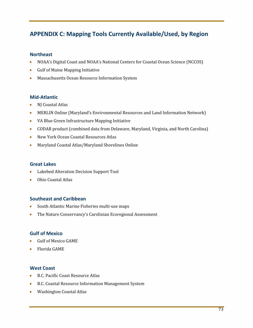
73
APPENDIX C: Mapping Tools Currently Available/Used, by Region
Northeast
NOAA’s Digital Coast and NOAA’s National Centers for Coastal Ocean Science (NCCOS)
Gulf of Maine Mapping Initiative
Massachusetts Ocean Resource Information System
Mid‐Atlantic
NJ Coastal Atlas
MERLIN Online (Maryland’s Environmental Resources and Land Information Network)
VA Blue Green Infrastructure Mapping Initiative
CODAR product (combined data from Delaware, Maryland, Virginia, and North Carolina)
New York Ocean Coastal Resources Atlas
Maryland Coastal Atlas/Maryland Shorelines Online
Great Lakes
Lakebed Alteration Decision Support Tool
Ohio Coastal Atlas
Southeast and Caribbean
South Atlantic Marine Fisheries multi‐use maps
The Nature Conservancy’s Carolinian Ecoregional Assessment
Gulf of Mexico
Gulf of Mexico GAME
Florida GAME
West Coast
B.C. Pacific Coast Resource Atlas
B.C. Coastal Resource Information Management System
Washington Coastal Atlas

74
SalmonScape
Oregon Coastal Atlas
California Ocean Uses Atlas
Southern California MarineMap Tool
International Coastal Atlas Network (ICAN)
Oregon North Coast Explorer
North Coast MIS Interactive Map
California Coastal Atlas
Hawai‘i and Pacific
Hawaii Coastal Atlas
Coral Reef Habitat Assessment for U.S. Marine Protected Areas: American Samoa, CNMI, Guam
Fishing Ecosystem Analysis Tool (FEAT)
Guam Coastal Atlas
Alaska
Alaska ShoreZone
Nearshore Fish Atlas of Alaska

75
APPENDIX D: Stakeholder Spreadsheet See attached.