Waterfront Planning with Fair Share: Improving the East 91st Street Marine Transfer Station
94
Waterfront Planning with Fair Share: Improving the East 91 st Street Marine Transfer Station by Chris Hamby © 2014 Chris Hamby A thesis submitted in partial fulfillment of the requirements for the degree of Master of Science in City and Regional Planning School of Architecture Pratt Institute February 2014
Transcript of Waterfront Planning with Fair Share: Improving the East 91st Street Marine Transfer Station

Waterfront Planning with Fair Share:Improving the East 91st Street Marine Transfer Station
byChris Hamby
© 2014 Chris Hamby
A thesissubmitted in partial fulfillment
of the requirements for the degree of Master of Science in City and Regional Planning
School of ArchitecturePratt Institute
February 2014


Waterfront Planning with Fair Share:Improving the East 91st Street Marine Transfer Station
byChris Hamby
Jonathan Martin, Advisor Date
Jen Becker, Advisor Date
John Shapiro, Chair Date

Hamby - 4
Acknowledgements I am very grateful for the advice and support of my thesis advisors Jonathan Martin and Jen Becker. Jonathan’s enthusiasm for the subject matter became my enthusiasm as well, and his patience with a not-always-on-track thesis student will always be appreciated. As my thesis advisor and professor over many semesters, Jonathan’s work ethic, attention to detail, and high standards continue to inspire. Jen’s careful editing and organization advice helped me to convey my ideas more clearly than I ever could on my own, and her feedback compelled me to complete my work on schedule. Without her diligent help I would still be working on my first chapter.
I would also like to thank Alan Olmsted for making his encyclopedic knowledge of New York City’s waterfront available to me at any time, Brian Pugh for enlightening me on Westchester politics, Chris Huang for giving me an early connection to the environmental justice community, and Lacy Shelby for showing me that exciting things can happen when city agencies work together. I’m also grateful to my friends and family, particularly Jina Porter, Michael Pedron, Natalie Vichnevsky, and Kyle Kozar, who offered me support when I most needed it.
Finally, I’m grateful to Megan, who was with me all along, and most of all to my dad, who more than anyone encouraged me in my work.

Waterfront Planning with Fair Share
Hamby - 5
Table of Contents
Chapter One - Introduction 6
Study Objectives 7
Methodology & Data 8
Literature Review 9
Chapter Two - History and Background 23
Chapter Three - Existing Conditions 35
Demographic Analysis 35
Land Use Analysis 46
Current Facility Design 57
Community Opposition and Litigation 60
Current State of the Project 67
Chapter Four - Proposal Precedents 69
Mitigation through Community Benefits 69
East River Design Precedents 72
Waterfront Design Applications 76
Climate Resilient Design 77
Precedents in New York City 79
Chapter Five - East 91st Street Design Proposal 85
Works Cited 91

Waterfront Planning with Fair Share
Hamby - 6
Chapter One
INTRODUCTION
TO BOOS and shouts from the audience, New York City Council Speaker Christine Quinn addressed residents of Manhattan’s Upper East Side, East Harlem, and Yorkville neighborhoods in February, 2013. “I wish we had a proposal that could make every neighborhood happy, but that is simply not always a possibility.” Quinn, a mayoral candidate campaigning for the 2013 election, spoke loudly over the noise of the unhappy audience. “We’re trying to move towards boroughs taking more responsibility for their own garbage and moving away from the days where all sanitation-related uses only went into lower-income neighborhoods.”1
The animosity at the mayoral forum was in reaction to the marine waste transfer station (MTS) planned for the East River waterfront on East 91st Street. The development of the new station was a key component of the city’s recently-enacted solid waste plan. Its controversial Manhattan location was chosen based on the city government’s “Fair Share” framework, which seeks to distribute waste handling facilities across New York City, avoiding the clustering in neighborhoods with a higher proportion of low-income households and residents of color that had occurred in the city’s past. The plan was strongly shaped by years of campaigning by environmental justice advocates in these burdened neighborhoods for a more equitable distribution of transfer stations in the city.
1 Paybarah, Azi. "Quinn, Alone, Stands Firm on an East Side Waste Station." Capital New York. N.p., 23 Feb. 2013. Web. 20 Mar. 2013.

Waterfront Planning with Fair Share
Hamby - 7
Figure 1 - Christine Quinn speaking to Upper East Siders during her primary election campaign. Some community members allied against the siting decision wore anti-transfer station campaign colors. (photo by Azi Paybarah under Creative Commons license, 2013)
The expansion of New York City’s marine transfer station system, and waterfront-based waste handling in general, comes at a time when waterfront rezonings, cleaner waterbodies, and ever-growing interest in living and playing along the water have caused real estate values along the waterfront to dramatically increase. Partly in response to this demand, and partly to galvanize it, the New York City mayor’s office and the Department of City Planning have released, and recently revised, new waterfront revitalization plans.
How does a LULU like the East 91st Street MTS fit into a rapidly developing waterfront and a citywide desire for increased access to the water?
What tools are at the disposal of planners, activists, designers, and policymakers to mitigate the impacts of waste infrastructure on an increasingly desirable waterfront? When infrastructure funding is scarce and public facilities must perform multiple functions, how can an infrastructure system like New York City’s waste management serve New York City’s garbage needs, while accommodating other community needs like recreation, open space, and community facilities?
Study Objectives

Waterfront Planning with Fair Share
Hamby - 8
In this paper, I aim to address the challenges associated with siting necessary infrastructure or public works, particularly LULUs, in ways that not only mitigate impacts to the local community, but actively improve public space. Solid waste management, particularly related to marine transfer stations and other waterfront uses, presents a typical example of locally unwanted land use. Residents may agree that a city should expand its waste management capabilities in a lower-impact, more equitable manner, but will rarely agree that this infrastructure should be sited in their community.
An opportune moment has arisen in New York City to examine the confluence of a recent, environmental-justice minded, solid waste management plan with a newly revised citywide comprehensive waterfront plan. As the city transitions from truck-based solid waste management to water and rail-based transfer, residents of some neighborhoods previously minimally affected by waste’s infrastructural footprint now find themselves directly impacted by it.
I will explore the background of New York City’s choice of location for the East 91st Street MTS (it is assumed as of the time of this paper’s writing that the city will move forward in constructing and operating the transfer station), and seek to understand and address the concerns of the neighborhood opposition, as well as the unique challenges of siting a difficult land use in an already dense area with a wide range of land uses. The final recommendations will attempt to address some of the challenges particular to the site. As the East 91st Street Marine Transfer Station is just one of several planned new stations across New York City, recommendations that may apply across neighborhoods and boroughs are also included.
Methodology & DataIn order to understand siting practice for LULUs, particularly on the waterfront, in New York City, I undertook a comprehensive look at past siting practices and theory around the county and the world, seeking applicable practices for New York City policymakers and communities. In particular, I examined these issues in the light of a long history of community organizing, environmental justice and racial inequality, solid waste management and the history of land uses along New York City’s waterfront.
These issues are explored through a thorough case study analysis of the development, design, and implementation process behind the East 91st Street Marine Transfer Station. This paper employs a mixed methodology including demographic and land-use analysis, interviews with community members and activists involved with the site, and a close reading of the multiple levels of legislation, jurisdictions, and long-term planning that come into focus at this East River pier. Finally, employing practices from existing literature and other case studies, I explore potential ways forward for the transfer station, both physically and politically, using public space offsets.

Waterfront Planning with Fair Share
Hamby - 9
A demographic and land use analysis defines the site and surrounding area, and is essential in examining the arguments put forward by the community and political stakeholders. This analysis relied on demographic data from the 2010 Census and and 2011 American Community Survey. Land use data was obtained from the New York City Department of City Planning.
A close reading of relevant legislation and city plans are useful to understand the driving forces behind the East 91st Street project. In particular, the city’s 2006 Solid Waste Management Plan (SWMP) and the 1998 Fair Share Criteria guidelines establish a significant piece of the transfer stations’ rationale. The controversy over the East 91st Street Marine Transfer Station is a serious test of the ideas behind both documents and they were read closely. In addition, the 2005 Final Environmental Impact Statement of the SWMP and other documents submitted to the New York State Department of Environmental Conservation were also explored for their impacts on the project, and whether the mitigation for those impacts appear to adhere to the intentions of the environmental review process. Finally, the 1992 and 2002 New York City Waterfront Revitalization plans and their 2012 revisions were examined for their impact on the East River waterfront at this location. Other documents, including community plans, the New York City Economic Development Corporation East River Esplanade plan, and city agency reports, were examined as well.
Interviews were conducted with several activists and campaigners, both in support of and opposed to the facility in order to understand the site’s issues beyond official records and to understand new ways the development may move forward.
In this paper, I address the design and community engagement process behind the East 91st Street Marine Transfer Station. Employing methods explored in the literature review and in other siting scenarios, I recommend conceptual design alternatives and explore, in hindsight, some of the critical community engagement issues behind the transfer station project.
Literature ReviewThe efforts of the environmental justice movement to a great extent define the logic behind the East 91st Street MTS’s siting location, and a paper on this site would be incomplete without addressing the long history of struggle against environmental racism and injustice in New York City. This history is important to the arguments made about the site today.
A great deal of literature exists covering the issues surrounding controversial land uses, ranging from tactics employed by government planners (Aldrich 2005) to the new geographic identities engendered by controversial siting practices (Che 2005). In each case study, siting controversies follow similar patterns of community opposition, negotiation, and the eventual implementation, compromise, or wholesale defeat of the project. As controversial projects may incite passionate responses from neighboring

Waterfront Planning with Fair Share
Hamby - 10
communities, care must be taken when defining terms and language used when referring to land uses like marine transfer stations.
There exists a smaller amount of literature dealing with design strategies and opportunities around difficult infrastructural land uses. The design disciplines have only begun to earnestly embrace urban design and architectural work around infrastructure in recent decades, exemplified by the Landscape Urbanism movement popularized by the Harvard Graduate School of Design.
Finally, waterfront revitalization efforts worldwide during recent decades have produced a significant body of literature on planning issues covering waterfront development and public waterfront access.
Environmental JusticeThe environmental justice movement has a long history in the United States, and its origins are closely intertwined with the rise of industrialization as well as the civil rights struggles of the twentieth century. The broad movements of the 1960s and 70s, including the civil rights, labor, and housing struggles taking place across the country, established many community activists and created an infrastructure of organizing. These groups were often poised to take on environmental justice issues in their communities (Turner & Wu 2002). The environmental justice movement is closely interconnected with the civil rights struggle, as it views land use in the context of a history of discrimination
What is often considered the modern environmental justice movement began in the early 1980’s. Arnold (2007) identifies the 1982 protests against the siting of a hazardous waste landfill in majority African-American Warren County, North Carolina, as the “framing event” that brought together “1) environmental and land use policies and practices; 2) civil rights; and 3) social justice.” In the aftermath of this event, two landmark studies were published, one by the US General Accounting Office, and another by the United Church of Christ’s Commission for Racial Justice, examining the distribution of hazardous waste facilities across the American South and the country, respectively. Both studies found that around the country, the surrounding communities’ racial makeup was the most significant variable in hazardous waste facility siting. These landmark studies were followed by many more, exploring the impacts of unequal distribution of land usage in the United States, which disproportionately affected poor communities and communities of color.
In 1991, the National People of Color Environmental Leadership Summit, held in Washington, D.C., drafted and adopted its landmark Principles of Environmental Justice. These 17 principles are wide-ranging and define the broad scope and mission of the environmental justice movement. Several of the principles relate directly to land-use policies and siting, including demands for the right to participatory decision-making, which may include needs assessment, planning, implementation, enforcement, and evaluation; demands that public policy be based on mutual respect and justice for all

Waterfront Planning with Fair Share
Hamby - 11
peoples; and demands that land use and use of resources be ethical and balanced (Arnold 2007).
Following these events, environmental justice movements grew in number, and built momentum in courtroom victory after courtroom victory. Explored in more detail in Chapter 2, one outcome of the growing number of successful contentions of unjust land use policies was a significant amount of new legislation enshrining (at least partially) the goals of the environmental justice movement into law.
The environmental justice movement has, very intentionally, targeted a broad swathe of civil rights issues as issues of environmental justice. In addition, there are a number of conceptual strategies implemented by environmental justice advocates, including the concept of distributional justice. In a system that is meets the standards of distributional justice, all harms (and benefits) are distributed equally across populations. This approach is at the heart of New York City’s Fair Share framework. Additionally, distributional justice may seek egalitarian outcomes (each community shares the same burdens and benefits) or equity based outcomes. Under equity based outcomes, more vulnerable communities (populations with a higher proportion of children or elderly, or populations of color that may generally be in poorer health) may bear a smaller share of the burdens of environmental harm (Turner and Wu 2002).
In the debate over the East 91st Street Marine Transfer Station, these approaches are not discussed explicitly, but both opponents and supporters of the facility use language of equity- and egalitarian-based distributional justice (see page 38).
LULUsLocally unwanted land uses (usually abbreviated as LULUs) are land uses which are perceived to be necessary and useful on a municipal, regional, or national level, but have negative impacts on a local level. Prisons, coal-fired power plants, landfills, waste treatment plants, and similar facilities are common types of LULUs. LULUs may be privately owned or developed, but are often planned and implemented on a state, local, or federal level. LULU siting often involves multiple governments and agencies, as LULUs typically serve a regional need, and planning requires involvement across jurisdictional boundaries. As an example, infrastructure sited along a body of water may involve state, local, and federal environmental protection agencies, the United States Army Corps of Engineers and Coast Guard simply to manage waterfront siting. The more complex and dangerous a land use may be, - a toxic waste dump, for example - the more (government) stakeholder groups are involved in planning it.
LULUs like waste transfer stations are perceived to have negative consequences for their immediate surroundings, including risks to health and safety, facility mismanagement, falling property values, and an unfair burdening of the neighborhood with waste created in other parts of the city. Residents may also be concerned over the stigma of becoming a “waste repository” (Sellers 1993).

Waterfront Planning with Fair Share
Hamby - 12
By definition, LULUs are considered undesirable by the communities in which the land use project is slated to be sited, and is often publicly opposed. People in opposition to a locally unwanted land use project are often branded as NIMBYs, or “Not in My Backyard.”
NIMBYNIMBY is an acronym often closely associated with LULU. NIMBYs may believe that a particular use is critical or desirable for the region, but believe that it would be unfair, unjust, or simply undesirable sited in their locality (OED 2005). NIMBYs may be local business owners, homeowners, renters or other residents of the neighborhood affected by the proposed land use.
The acronym NIMBY is often used when discussing siting issues in cities, though the definition is somewhat amorphous. The acronym is typically perceived to have a negative connotation. In their work on locating hazardous waste facilities, Groothius and Miller (1994) refer to local opposition as the “NIMBY syndrome,” evoking images of a mania or mental illness. The authors state that during economic analysis of a siting, for economists, rather than investigate causes and determinants for a NIMBY response to unwanted developments, “the construct is often assumed and researchers then examine its stability in the face of moderating variables.” From an economics standpoint, the “NIMBY syndrome” is a reaction to the inefficient allocation of resources: as the global economy (the city, the state, etc.) enjoys the benefits of a facility, while the local economy (the neighborhood, town, community) must bear the negative externalities (pollution, decrease in property values, noise, and so on) of a facility. This balance is the logic behind the compensation model, which quantifies these negative externalities into dollar amounts to be redistributed back into the afflicted economy. As further detailed in the next section, this approach is one of the more straightforward and most common means of addressing LULU siting, though it can be problematic.
Herbert Inhaber (1992), writing from the perspective of a former risk analyst, admits that he often viewed NIMBY reactions as emotional triumph over logic. The risk of new facilities is typically marginal, with carefully considered siting and design decisions calculated for optimal safety and minimal harm. Neighborhood residents, after consideration, should weigh costs and benefits and accept expert reassurance that facility will minimally harm their community. In practice, NIMBYs distrust these reassurances of safety and minimized impacts. Inhaber emphasizes that though the word NIMBY is often used in a derogative manner, it tends to be employed by those fortunate enough to be far away from the facility in question. NIMBYs may be cast as irrational, but their protest often stems from a place of logic. Others, including environmental justice advocates, may use the acronym NIABY, or Not in Anyone’s Backyard, arguing that harmful or risky facilities do not belong near any residential communities (Turner and Wu 2002).

Waterfront Planning with Fair Share
Hamby - 13
Wolsink (2006) argues that the name “NIMBY” is outdated and too weighted with negative connotations to serve any useful purpose in a research context. The NIMBY framework may often be construed as communities organized around pure self-interest, to the detriment of the wider city or region. Wolsink is concerned that by merely using the word NIMBY, a policymaker or researcher is already dismissing what may be legitimate concerns or unaddressed issues in the affected community. Rather than starting from the assumption that a NIMBY response is a problem to overcome, the issue should be seen as a healthy check on ineffective decision making, and addressed on its own terms.
With Wolsink’s argument in mind, I will seek to avoid the term “NIMBY” when referring to local opposition to the East 91st Street Marine Transfer Station. While this term will not be used, local opposition at this site does fit many of the definitions explored above - residents of Yorkville opposed to the facility tend to speak in language indicating their belief that their community will be unfairly burdened to the benefit of New York City as a whole.
LULUs and Siting TheoryThere is a fairly sizable body of work on locally unwanted land uses, largely focused on high-impact uses, often with the potential to pose risk to their surroundings. Daniel Aldrich (2005) surveys some of the siting practices in use by governments around the world. In his cited literature, he covers uses including radioactive waste facilities in New Jersey (Weingart 2001), hazardous waste in Minnesota (McAvoy 1999), and nuclear energy plans in France and Japan (Hect 1998 and Lesbirel 1998). Martin Sellers (1993) uses a planned biomedical waste incinerator in North Carolina as his case study. Compared to the planned marine transfer station at East 91st Street, these uses pose higher risks to quality of life and safety, but the case studies reviewed here are associated with similar opposition from residents, business, and local community groups.
Aldrich makes clear that a proposed LULU project may spur community organizing in ways that are normally difficult - opposition to an unwanted project defines groups of people geographically in ways they may not have considered before. Communities may overcome differences to coalesce in opposition to a locally unwanted land use (Aldrich 2005). Opposition may stem from a variety of factors, depending of course on the type of locally unwanted land use. O’Hare and Sanderson (1993) categorize LULUs, as well as NIMBY opposition to them, into five groups, balanced on the benefits to the wider region versus the costs to the facilities neighbors.

Waterfront Planning with Fair Share
Hamby - 14
Figure 2 - O’Hare and Sanderson’s (1993) categorization of LULU projects
By employing this framework, policy makers may decide just what sort of impact the project in question may have. While a “Free lunch” project is the most desirable (a project that benefits its immediate neighbors as well as the wider region), LULUs will almost never fit this description by definition. O’Hare and Sanderson, in their study of Massachusetts law, argue that the goal of the state’s siting legislation is “getting to free lunch.” The process to reaching this stage, however, may be so time-consuming and confusing that projects are rarely sited. In the authors’ case study of a proposed hazardous waste incinerator in Braintree, residents had stronger political will and more financial incentive than the backers of the project, and most other stakeholders (including politicians) lost interest in the conflict.
Sellers (1993) explores a case study with a similar outcome. Unlike Massachusetts, which had a complex siting process, a more straightforward incinerator project in Dunn, North Carolina, was derailed when local government, assuming a simple approval process, did not anticipate strong business and community opposition. Local government had supported the incinerator project and did not build local support or inform residents in a systematic way. As in Braintree, local politicians wavered in their support in the face of opposition, and the project did not go through. Sellers finds in a post-mortem survey that while strong activism ultimately ended the project’s prospects, most residents were in fact uninformed on the project and did not hold strong opinions. He concludes that the project failed mainly due to a lack of community outreach and participatory process with community groups.
Aldrich (2005) calls this the “persuading” approach in his survey of controversial siting and state policy instruments. He cites case studies related to nuclear power plants in France and Japan, both countries that (until the Fukushima disaster in 2011) enshrined nuclear energy as national goals, as examples of a long-term planning strategy. In both countries, various agencies were created to “sell” power plants to local communities, and mayors and other local politicians were trained in crafting persuasive arguments to help convince skeptical communities of the importance of nuclear power to the nation. In Japan, facing enormous pressure from anti-nuclear activists, the government became more open and provided additional data with the intention of changing minds long-term about nuclear energy to better comport with state policy.

Waterfront Planning with Fair Share
Hamby - 15
Aldrich classifies persuading as the longest-term policy strategy with the lowest immediate effectiveness. The other cited tools include powering, which was employed by industrialized governments more often during the mid-twentieth century. This strategy employs the state’s coercive power, including eminent domain, monopoly over coercive force, and the ability to cut funds and subsidies. Structuring involves state actors controlling the venue and method of debate in order to frustrate any organized opposition. Finally, paying off is considered by Aldrich one of the more common policy tools implemented to address controversial siting.
Figure 3 - Aldrich (2005)’s table of LULU policy tools
Inhaber (1992) begins with the concept that compensation in monetary form is the most open and straightforward method of siting LULU projects. His paper on NIMBYs, LULUs, and NIMTOOs (Not in My Term of Office) references older siting practices like powering, which in the past few decades has become less and less feasible. Inhaber observes that most siting practices (at the time of his paper’s writing) can be described with the acronym DAD - Decide, Announce, and Defend. As an alternative, Inhaber recommends quantifying externalities into direct compensatory payments. His recommended method: a “Dutch style” auction system. In this scenario, the state or business actors that wished to site a controversial land use would auction away a subsidy to offset the cost of the facility. For example, an energy company may be willing to offer a $10 million subsidy to a community where their facility is to be sited. If no community comes forward, the price rises $5 million a month until a bidder is found. In the Dutch auction scenario, the first stakeholder to come forward will “win” the facility and its associated money. The added expense, Inhaber argues, will be ultimately be borne by taxpayers or utility fee payers outside of the community. This is economically just, as the benefits of living further from the facility should be quantified in a similar fashion to the costs of living closer to the facility.

Waterfront Planning with Fair Share
Hamby - 16
Aldrich references John Weingart (2001) to caution that the above analysis may be deceptively simple. While deriving the externality cost imposed on a community may be straightforward to calculate, Weingart’s experiences in New Jersey “reveal the yawning chasm between theory and practice. (P. 111)” New Jersey implemented an innovative nuclear waste facility siting program with generous incentives - $2 million a year for fifty years, plus installation costs, and was marketed heavily. Instead of the state utilizing the “DAD” framework and choosing potential sites, New Jersey’s program was completely voluntary, keeping in the spirit of Inhaber’s example above. Ultimately, however, only twelve municipalities applied to host the facility, and all ended up backing out or being disqualified. Weingart attributes the program’s failure to site a facility to the unexpectedly passionate opposition of local citizens, and an over-estimate of the time that communities were willing to spend considering siting arguments.
In their comprehensive literature review, Lai et al (2007) summarize the evolution of LULU siting as moving from top-down, “DAD”-style frameworks enforced by government power, to a more sophisticated blend of techniques. In particular, NIMBY-type responses are viewed in a more positive light, moving from irrational roadblocks to an important factor in the public decision-making process. A more nuanced view of LULU siting incorporates individual projects unique natures into account, and takes a comprehensive viewpoint towards the communities in which they are sited. This more postmodern approach generally eschews some of the broader theories explored above, but takes applicable pieces into consideration when necessary. In particular, the authors site compensation and mitigation as the two most applicable tools for use in facility siting. Mitigation can take on many forms, including engineered mitigation (physical and design based solutions to alleviate safety, health, and other concerns) and institutional mitigation (which seeks to empower community members during the siting process and in the functional operations of the facility). The most important factors for the authors are the flexibility, openness, and willingness to compromise during the siting process.
Waterfront PlanningThe East 91st Street Marine Transfer Station, as a waste transfer station, is a classic example of a locally unwanted land use. Among the factors that make the project a special case, however, is the transfer station’s location along Manhattan’s East River waterfront. While New York City’s waterfront planning history and modern day waterfront will be explored in more detail on page 31, it is important to understand current issues and best practices along urban waterfronts today.
Until late in the 20th Century, urban waterfronts in the United States were largely used for commercial and industrial businesses. River and oceanfront property was often hardened and bulkheaded, and peppered with docks, piers, warehouses, and other shipping facilities. Until around the turn of the 20th Century, wastewater in New York City ran untreated into the harbor. Waterbodies eventually became so polluted that public bathing had to be prohibited (NYC DEP 2012). Because urban waterways

Waterfront Planning with Fair Share
Hamby - 17
were often heavily trafficked and polluted, they were not usually valued for recreation or residential real estate.
In New York City, the waterfront was indeed more valued for its ability to move cargo and wares in and out of the city during this time. Its deep natural harbor led to the city’s economy relying heavily on shipping and trade from its early years. The city’s famous docks and waterfront culture began to fade following World War II, as containerized cargo and larger ships began to shrink the working waterfronts, and maritime trade moved to New Jersey and other ports along the East Coast better equipped to handle the new standard in shipping. The increase in air travel greatly reduced transatlantic travel by ship, and Manhattan began to see its piers fall into disuse and disrepair. Demobilization after the Second World War, which had boosted the city’s industrial production for the war effort, including shipbuilding at the Brooklyn Navy Yard, was followed by a long decline of manufacturing and industrial business in the city. These uses, as in many industrial cities, were often sited along the waterfront for ease of waste disposal and connections to waterborne commerce. As truck-based shipping and the new predominance of the United States Interstate system decanted manufacturing far outside the city limits, the working waterfront began a long shrinking process.
Figure 4 - Container shipping at Port Elizabeth, New Jersey (photo by Captain Albert E. Theberge, NOAA Corps (ret.) under Creative Commons license, 2004)
Coinciding with the decline in port freight handling in New York City and many other urban waterfronts, new regulations surrounding water quality began to improve the ecology of urban waterways. After public bathing was prohibited in New York City, the city government began exploring ways to improve water quality through treatment. Following the establishment of the link between water quality and

Waterfront Planning with Fair Share
Hamby - 18
wastewater treatment, the city began building wastewater treatment centers, completing 12 wastewater treatment centers by 1968 (NYC DEP 2012).
Waterfronts formerly heavily polluted by industrial runoff and dumping began to improve dramatically following the United States Congress’ passage of the Clean Water Act in 1972. The act, under the jurisdiction of the federal Environmental Protection Agency and state environmental protection agencies (known in New York as the Department of Environmental Conservation), sought to limit runoff into the country’s waterways, enforce new laws preventing water contamination, and hold accountable businesses and local governments responsible for past pollution. The Act also began distributing federal funding to aid communities and local governments in improving their local waterbodies. According to the New York City Department of Environmental Protection, the Clean Water Act is responsible for matching municipal dollars to invest $35 billion into the city’s water quality (NYC DEP 2012). The Act is widely credited for improving water quality dramatically in urban waterways around the county.
This combination of deindustrialization, containerization, and environmentalism reconfigured the way city inhabitants viewed their waterfront. Waterfront land formerly polluted, busy, and of limited access to the public, was now open for redevelopment.
Beginning in the 1970s and 80’s, waterfront residential and commercial development launched in earnest. During a 1966 conference on Manhattan’s waterfront, Borough President Percy Sutton was quoted as saying “[New York City’s shore] has fallen into decay and disuse despite the development of several modern piers. Suffering from years of neglect and divided authority, it has too long been regarded as marginal land, a dumping ground for industries, highways, rotting piers, and raw sewage. The public has been and continues to be denied access to the waterfront.” This change in New York City’s attitude towards the waterfront reflected larger changes going on nationwide, as other American cities with concrete and walled-off waterfronts began to explore bringing waterfront access to their residents. New waterfront zoning and access regulations brought public spaces and promenades along with new development on the Chicago River, San Francisco’s Pier 7, Boston’s harbor, and other ocean and riverfront cities. Formerly industrial waterfronts were rezoned and converted to spaces for living, shopping, and recreation. City governments “increasingly and rightly regarded [waterfronts] as opportunities, rather than as problems” (Hoyle 1995).
As waterfront property began increasing in value (following a trend of rising real estate prices in inner cities around the country) and new parks, residential buildings, and office space broke ground, concerns about lost “working waterfront” grew. Policymakers in waterfront cities found themselves balancing new demand for waterfront real estate with the very real needs of the waterfront’s “legacy” uses: shipping, manufacturing, and infrastructure like water treatment plants, city agency docks, and marine transfer stations. Waterfront planning in recent years has attempted to accommodate the working waterfront.

Waterfront Planning with Fair Share
Hamby - 19
In a large-scale survey of waterfront stakeholders in Canadian waterfront cities, Brian Hoyle (1995) found a diverse set of concerns among public officials, private developers, and “the public” (in this study’s case, residents of waterfront neighborhoods) in responding to a set of propositions on waterfront redevelopment. In general, Hoyle found that interviewees agreed that public access to the waterfront should be a significant goal in waterfront development (though some interviewed considered it more important than others), and were most concerned over “who benefits” from waterfront development. Hoyle concludes the study by asserting that the waterfront may be one of the most contentious sites in the city - so many different stakeholders have different wants and needs from the waterfront that any site planning or redevelopment must be collaborative and participatory in order to succeed.
Infrastructure and DesignPlanning theory has traditionally labeled industrial or infrastructure land use and recreational land use as conflicting with one another — this particular sort of conflict was the origin of “Euclidean zoning.” Opponents of the transfer station often employ the same “pig in the parlor” (a right land use, in the wrong place) language employed by the Supreme Court in the Euclid v. Ambler decision (1926), arguing that uses like marine transfer stations have no place in a largely residential neighborhood (Residents for Sane Trash Solutions 2013).
Over the course of the twentieth century, designers, planners, architects, and engineers have grappled with the challenge of successfully incorporating infrastructure into the complexity of the city, with varying results, often only theoretical in nature. In more recent literature, however, certain writers have emphasized the unique design opportunities characteristic to infrastructure projects.
Ian McHarg’s seminal work Design with Nature (1969) attempts to develop a working theory of city design that incorporates ecological processes and community standards into siting urban areas, rural areas, and the networks that connect them. McHarg took the work of regionalists like Benton MacKaye and expanded the role of systems and processes in the design process. By systematically analyzing the region and the site in terms of what McHarg dubs ‘value systems,’ that is, weighing costs, benefits, and savings in specific categories like ecological, sociological, and moral values.
In the work, McHarg views infrastructure like highways as a case study in the indifference towards nature inherent in design and city growth at the time. “Who are as arrogant, as unmoved by public values and concerns as highway commissioners and engineers?” he writes. Highways, according to McHarg, ravage landscapes, divide communities (especially communities of the poor), and pull in an obscene amount of public funds. But, he argues, that was not always the case, and highways can be designed in such a manner that they actually improve their surroundings while simultaneously achieving the engineering goals of efficient and safe movement of people and goods.

Waterfront Planning with Fair Share
Hamby - 20
McHarg makes the case for use of value overlays, which show the intersections of high-value land (whether high culture, residential use, wetland use, and so on) in order to best site an infrastructural system. In Benton MacKaye’s work, as interpreted by Keller Easterling, infrastructural systems were to be designed at human-scale, at the site, and its effects would be multiplied by the sheer size of the system. McHarg’s work attempts to expand and solidify MacKaye’s “light touch” by developing tools to effectively measure the social and ecological systems immediately affecting, and affected by, new human development.
Like McHarg, Elizabeth Mossop (2006) argues that precedent examples of effective infrastructure design exist in the built environment. While McHarg chooses New Deal era works, Mossop goes further back, before the advent of the RPA and regionalists like Benton MacKaye to the work of Frederick Law Olmstead. Olmstead’s proposals, particularly the Emerald Necklace parkway in Boston, she maintains, “illustrate the intertwining of transport infrastructure, flood and drainage engineering, the creation of scenic landscapes, and urban planning.” This work, first proposed in the 1880’s, enhances or preserves many of McHarg’s values for infrastructure siting and design.
While acknowledging the enormous impact of Design with Nature on planning and architecture, Mossop notes that McHarg’s system of design, for all its sensitivity to the site and regional environmental and cultural assets, is ultimately too rigid and dismissive of the design process to produce the effective built environment he describes. The process of design is exceedingly complex, and Design with Nature fails to acknowledge human actors and interests inherent to planning and design. Infrastructure must respect and abide by the underlying structures of topography and hydrology, and the structuring elements of urban form, but this requires a large number of actors working together, and there are multiple strategies that may prove effective in any design scenario. Design with Nature laments lost natural space and ecological beauty, however, Mossop stresses, in order to re-engage with these “lost” spaces, designers must recognize that all types of space are valuable, not just the “privileged” spaces of traditional parks and natural areas.
As MacKaye, McHarg, and Olmstead, Mossop envisions infrastructure functioning beyond narrowly defined goals of efficiency. Infrastructure can fulfill a diverse range of urban functions, but has become so highly specialized and standardized that it currently only fulfills one function well. Mossop acknowledges that despite works like Design with Nature that inspired a generation of designers, for the most part “a reconciliation between the reality of private transport’s convenience and the idealized places we want to live has yet to be tangibly devised” (p. 173).
Fumihiko Maki, an architect known for his work in urban design, lamented this failure in a 1994 essay on linkage. “Thus we have been notably remiss in our ability to conceive of shapes for paths of high-speed movement through space than with a standard vision of the shape of a space. Each of these things seems to defy relation to a human collective scale – their functional and social aspects seem diametrically opposed” (2008). He believes that design solutions are possible, however. It is the purpose of urban design, he argues, to draw unity from a diversity of viewpoints and

Waterfront Planning with Fair Share
Hamby - 21
situations. At each scale, argues Maki, there is room to admit more than one function or angle of vision.
Following Maki’s line of thought, Alexander D’Hooghe (2010) argues for a deeper aesthetic approach to design of and around infrastructure. Instead of viewing infrastructure as a network or a whole, the system should be broken down into a series of sites, which should be approached in a more traditional architectural manner. D’Hooghe contends that while a variety of architects and designers, particularly in the Mediterranean region, have taken this approach to design, this practice has been largely absent in the United States.
While Maki finds a disconnect between intimate, human level scale and large-scale infrastructural systems, and D’Hooghe seeks to encourage traditional architectural approaches to the infrastructural site, Stan Allen (1999) compels architects, designers, and planners (though largely architects) to develop and appreciate how infrastructure affects development processes in urban areas. In the same vein as McHarg, Allen excoriates architects for largely opting out of infrastructure development over the twentieth century, and calls for a greater role of planning, architecture, and landscape architecture in the design process. To dismiss the design work of engineers would be a mistake, he argues. Allen lists seven “propositions” relating to infrastructure, noting that in sum they describe the complexity and the unforeseeable network effects of infrastructural network development.
Nearly all the other writers mentioned thus far echo Allen’s first point: that infrastructure isn’t built on a site – rather, it is the site. Its scale, services provided, and spaces delineated and bisected, create the conditions for future development. The second and third points reflect on infrastructure as a process rather than a complete plan or development. Infrastructural design operates within a “loose envelope of constraints” and is flexible in its implementation. In contrast to the image of top-down planning and context-less entities in infrastructure development portrayed by other writers, Allen calls infrastructural work “bottom-up” and “participatory,” due to the participation of multiple authors. Its system of fixed points, access, and structure creates a field where designers may participate, within a set of technical limits.
In points four and five, Allen encourages architects to study and understand what he describes as a highly developed set of tools and strategies employed by engineers to adapt infrastructures to local topography and built environments (“doglegs, viaducts, cloverleaves, switchbacks, etc.”). And due to the often tree-like structure of infrastructural networks (trunks scaling down into capillary-like extensions, it is an oversimplification to interpret the network as a strictly linear framework.
Finally, Allen describes infrastructures as best understood through an ecological metaphor (unlike Mossop and McHarg, he refers strictly to the human-constructed environment). By introducing movement of energy and resources to a site, they “direct the density and distribution of habitat.” More simply put, infrastructure has a physical presence in the landscape where architects and designers may engage with it, but its

Waterfront Planning with Fair Share
Hamby - 22
nonphysical aspect, the movement of energy, goods, people, or communication through the site and into the site, fundamentally change its development.

Hamby - 23
Chapter Two
HISTORY AND BACKGROUND
IN 2013, and without the context of history, the intersection of East 91st Street and York Avenue appears to be an unlikely candidate location for a solid waste handling facility. Bordered by playing fields, high rises, and the noises of FDR Drive, this location is densely built up and tightly situated in the urban fabric. The site, however, is the confluence of several driving factors. Above all else, the struggles of the environmental justice movement against environmental racism in solid waste management have steered the development of this facility to its current site in Manhattan, in an effort to prevent further clustering of unwanted facilities in low-income communities and communities of color around the city. Additionally, New York City’s history of solid waste management made the site a sensible and cost-effective option for the city. A transfer station during the years of landfilling within city limits until its closure in the 1990s, the property remains under the jurisdiction of the Department of Sanitation, where a transfer station may be built as of right.
Issues of sanitation and waste have long been contentious in New York City’s history. Only until the post-Civil War era was garbage collected by the city in an organized fashion, and dirty streets posed severe health risks to the growing metropolis (Sze 2007). In the wake of the many city health and sanitation movements of the mid- and late nineteenth century, garbage began to be collected citywide and dumped in various landfill sites around the city. Until later in the 20th Century, dumping was almost entirely conducted within the city limits, ostensibly for the purpose of land reclamation, and was conducted largely by barge. During this period low-lying areas and wetlands were seen as ideal sites for filling and covering for land reclamation. Geographer Daniel Walsh (1991) quotes the New York City Department of Street Cleaning (now the Department of Sanitation) as writing in 1905 that “the [city’s] lowlands… afford an almost unlimited supply of dumping ground… the possibilities of land reclamation are almost boundless.”
By the mid-century, however, dumping sites were beginning to run out for the city’s solid waste. According to Walsh, former dumping grounds in the Bronx and Queens were beginning to fill quickly, and by the 1970s, the city was down to ten landfills. By 1985, the number dropped to two, and by 1991, the number of New York City landfills dropped to one: Fresh Kills in Staten Island.

Waterfront Planning with Fair Share
Hamby - 24
Figure 5 - A simplified timeline of actions taken leading up to the reconstruction of the East 91st Street MTS (timeline by John Casey and Apurva Mehrotra, Baruch University 2011)
Fresh Kills & New York City GarbageFor over 50 years, Fresh Kills landfill in Staten Island was the largest depository for solid waste in New York City. Like other New York City landfills Fresh Kills was sited along former intertidal marshes and wetlands. When first opened in 1947, Fresh Kills was planned under direction of Robert Moses as a temporary landfill, to be open for less than 20 years and only one component in a larger land use plan that included industrial, residential, and recreational use. In practice, the landfill grew to 2,200 acres in size, for a time the largest landfill (and largest man-made structure) in the world. It operated uninterrupted for over 50 years, accepting residential and commercial waste for the entirety of New York City. After 1991, it was the only landfill in New York

Waterfront Planning with Fair Share
Hamby - 25
City, and after 1994, when incinerators stopped operating, it became the only solid waste disposal site in the city (City of New York Independent Budget Office 2001).
Figure 6 - Fresh Kills and surrounding neighborhoods (map by NYC Dept of Sanitation 2001)
For residents of Staten Island and the surrounding communities along the borough’s western shore, the landfill represented the unfair burdening of the entire city’s trash on a single borough. As the city’s other landfills closed and waste was stacked higher at Fresh Kills, pressure from the community and the New York State government advocated closing the landfill as early as 1991, and the last trash barge arrived in 2001. In 1996, Mayor Rudolph Giuliani, whose mayoral campaign depended heavily on Staten Island constituents, and Governor George Pataki announced that the dump was to be closed by the end of 2001, and its garbage phase-out concluded ahead of schedule. Temporarily reopened to accept debris and rubble from the World Trade Center in 2001, Fresh Kills is now closed and capped, and will see new life as a public park in the near future.
During its lifespan, solid waste arrived primarily by barge from the other four boroughs. Waste arrived from 12 city-owned transfer stations and several additional privately owned transfer stations in open barges. While Staten Island community members around Fresh Kills welcomed the closure, all solid waste management planning had previously assumed that the landfill would remain open for several more decades, and a viable alternative plan had not been developed. Only the month before the landfill’s closure announcement, the Giuliani administration had applied to the New York State Department of Environmental Conservation for a twenty year

Waterfront Planning with Fair Share
Hamby - 26
extension on landfilling at Fresh Kills, arguing in the permit’s environmental impact analysis that there were no feasible alternatives (Miller 2000).
Ultimately, the city and state governments decided to let the market handle solid waste and its now-necessary export, in what was termed the “interim plan” for solid waste management (Kearney 2013).
The Growth of Privately-Operated Waste Transfer StationsAs Fresh Kills landfill began to take on less waste, smaller private contractors handled commercial trash more and more frequently, opening up transfer stations throughout New York City. These stations multiplied across the city, and were disproportionately concentrated in the less-wealthy neighborhoods of the outer boroughs, particularly affecting areas of Brooklyn, Queens, and the Bronx (Warren 2000). As the rail- and barge-based transfer stations were mothballed or closed, export of trash began to rely heavily on truck-based transfer. Solid waste shipments to incinerators operating in neighboring New Jersey increased in number. As New York City’s solid waste system evolved, truck traffic increased, and communities already disproportionately burdened by the system reported increased asthma rates and other problems associated the growth in truck traffic.

Waterfront Planning with Fair Share
Hamby - 27
Figure 7 - Privately operated transfer stations currently contracted to handle DSNY residential waste and recycling. Connections are drawn between community boards and their flow of waste (map created using data from New York City Department of Sanitation, 2013)
By 1990, 153 privately-operated transfer stations were in operation across the city. While siting guidelines and regulations were enacted at the city and state level, these rules were often stretched or ignored. Local law 40, which granted jurisdiction over transfer stations to the Department of Sanitation in 1991, failed to incorporate the harmful effects of clustering transfer stations in neighborhoods (Neighbors United Against Garbage v Doherty 1997). Loose interpretation of manufacturing zoning codes allowed transfer stations to be sited near residential areas, and intensive clustering was common. In response to these concerns, (as well as several lawsuits and threats of action by the state Attorney General), the city and state updated siting regulations in 1998 to improve operating standards and improve dispersal of the stations.
By 2004, the number of privately operated transfer stations had declined to 69 in number. Of these, over half (43 stations) were concentrated in five community districts - Bronx Community Districts 1, 2, and 9; Queens Community District 12, and Brooklyn Community District 1. Brooklyn CD 1 alone hosted 20 different privately-operated transfer stations (DSNY). The majority of the city’s privately-operated stations are contracted to handle New York City’s commercial waste. As of 2013, fourteen privately-operated stations are contracted by the Department of Sanitation to handle residential and other solid waste citywide.
Privately-operated, truck-based transfer stations are often little more than a warehouse, and have a reputation for insufficient protections against odors and vermin (ALIGN NY). While Department of Sanitation inspectors inspect the stations weekly, violations for noise, odors, overloaded stations, and other problems are commonly issued (DSNY 2004). As of this paper’s writing an ongoing campaign led by ALIGN NY, an activist and community organizing initiative and its coalition partners is actively seeking to improve labor and operating conditions at these privately-operated transfer stations. In the meantime, however, the South Bronx and North Brooklyn continue to host a heavy concentration of New York City’s waste transfer system facilities.
The Environmental Justice Movement and Marine Transfer StationsBeginning in the 1980’s and 90’s, a growing outcry against unfair waste management siting coalesced into organized environmental justice coalitions (Sze 2007). Organizations like the New York Environmental Justice Alliance, New York Lawyers for the Public Interest, and the Organization of Waterfront Neighborhoods (OWN) began concerted efforts to challenge the way garbage was handled in New York City.

Waterfront Planning with Fair Share
Hamby - 28
Community groups, activists, non-profits, and other stakeholders found common ground across the city to build coalitions and organize around solid waste issues.
Years of campaigning and organizing culminated in the publication of Taking Out the Trash in 2000. The report was the combined efforts of environmental justice groups, activists, and community organizations across the city. Taking Out the Trash excoriated the status quo and made the case that the existing “market-based” solid waste exporting plan systemically burdened poor neighborhoods and neighborhoods of color with unfair densities of truck-based waste transfer stations. While existing waste transfer stations were technically sited in manufacturing and industrial zones, communities of color were living in these areas, a historic legacy of unjust and racially biased land use policies not uncommon to older American cities (Casey and Mehrotra 2011). The proposed city plan would place additional burdens on these communities and was resisted.
Figure 8 - New York City’s existing waste transfer stations, demonstrating concentration in communities of color (map by the New York Times 2013)
Even while environmental justice activists advocated for equal distribution of facilities, plans for new transfer stations in burdened areas continued. In 2000, for example, a court ruling allowed the siting of a new rail-based transfer station in Hunts Point, increasing the amount of garbage from around the city that would enter the South

Waterfront Planning with Fair Share
Hamby - 29
Bronx (Critchell 2000). The facility, which was eventually defeated by a coalition of community groups largely from Hunts Point, would have brought additional trash from outside the Bronx to be handled on the Harlem River waterfront. The site, however, did rely primarily on barge and rail traffic, achieving one of the central goals of environmental justice advocates: to reduce the negative impacts associated with truck traffic in their communities. The back and forth over the facility’s location is cited by Julie Sze (2007) as an example of the uncoordinated siting methodology, driven largely by competing private interests, prior to the revised implementation of the 2006 SWMP.
The Giuliani mayoral administration’s long term plans for solid waste export proposed enshrining truck-based waste transfer, centralizing transfer and containerization operations into a handful of neighborhoods with large manufacturing/industrial zones. Potential neighborhoods included the South Bronx, Williamsburg/Greenpoint and Red Hook in Brooklyn, all areas which already hosted a large number of waste facilities. The new large-scale transfer systems would be constructed by the city but privately owned and operated. The city’s existing marine transfer station facilities would be reopened, but only as a “pass-through” to send trash to larger transfer facilities.
The plan developed by OWN and its coalition partners put forth solid waste proposals that would prevent overburdened neighborhoods in Brooklyn and the Bronx from any new waste management infrastructure siting, and that would rely heavily on retrofitting the city’s existing marine transfer stations for efficient waste handling and containerization. By reopening and retrofitting the marine transfer station system, trucks would be taken off the street, improving air quality and traffic, as containerized waste left the city by barge and rail. The existing waste transfer station sites had the added benefit of geographic distribution - the eight city owned sites were spread across every borough, distributing the burden of waste management facilities across the city. Taking Out the Trash called for expanded recycling and composting to reduce the city’s overall waste export, but acknowledged that export of solid waste will continue to be an essential function of the city’s waste management system.
New York City's Solid Waste Management PlanIn the same year as Taking Out the Trash’s publication, a modification to the 1992 and 1998 Solid Waste Management Plan was passed. The new language added in 2000 sought to make solid waste export more economically sustainable, and began to include language that sought to relieve some of the city’s overburdened neighborhoods. While the plan continued to rely heavily on privately-operated facilities, it now included principles of borough equity and decreased reliance on truck-based transportation. These principles included measures that would be prominent in the 2006 plan, including the reopening of the city’s waste transfer stations, and a focus on shrinking the city’s waste stream through recycling and waste prevention (Casey and Mehrotra 2011).

Waterfront Planning with Fair Share
Hamby - 30
In 2004, the Bloomberg administration submitted a new draft version of the city’s Solid Waste Management Plan to the city council. The new SWMP included a key component of the Organization of Waterfront Neighborhood’s recommendations from Taking Out the Trash: four of the city’s marine transfer stations were to be retrofit containerized waste transfers by barge. In 2005, the Uniform Land Use Review Process (ULURP) was approved by the city council. In 2006, the plan was approved by the city council and the New York State Department of Environmental Conservation, following an environmental impact report.
Figure 9 - Long term export plan, showing DSNY owned and contracted facilities. The Gansevoort and West 59th Street MTS are not displayed because they will handle municipal recycling and commercial waste, respectively (map by New York City Department of Sanitation 2013)
The 2006 plan, developed by a working group of city agencies in collaboration with environmental justice groups like O.W.N., was viewed as a landmark victory following years of campaigning. However, it was not without significant controversy. While the 2006 SWMP was passed by the City Council, it faced a long fight before its eventual passage by the Bloomberg administration.
The controversy revolved around the plan’s selection of waste transfer station sites. Several would be opened on the Manhattan waterfront, including the East 91st Street Station and the Gansevoort Station near the West Village. The pending plan pitted outer-borough council members like Letitia James, who represented the neighborhoods of Fort Greene, Clinton Hill, and Bedford-Stuyvesant in Brooklyn, against Manhattan council members like Speaker Gifford Miller, who represented the Upper East Side district where a new transfer station was slated to be sited (Gotham Gazette 2005). While the council largely agreed with the intent of the new solid waste

Waterfront Planning with Fair Share
Hamby - 31
management plan — that the burdens of waste should be equally shared across boroughs — the council disagreed with the mayor’s choice of locations, as well as contending that the plan did not go far enough in reducing the city’s waste flow.
Many members in the City Council had presented the plan as one driven by the mayor’s office with little input from the council or their constituents. After a vote to override the mayor’s veto on an earlier vote against the SWMP failed to gain a two-thirds majority, Speaker Miller was quoted as saying, “Perhaps we failed in making members understand that this wasn’t a vote on the plan, but on the site selection, which the mayor in essence rammed down the Council’s throat” (Confessore 2005). Without the veto-overriding majority, the plan continued through an environmental impact assessment
Council member Michael McMahon was quoted as saying, “The environmental injustice of the past does not justify environmental revenge today or in the future” (Gotham Gazette 2005) during the legislative fight. This argument would be heard often in the debate over the new marine transfer stations in the years to come.
Comprehensive Waterfront PlanDuring this period, waterfront planning became a major component of New York City planning. Under the Dinkins mayoral administration, a new plan, titled New York City Comprehensive Waterfront Plan: Reclaiming the City’s Edge was released in 1992. The first comprehensive plan for the city’s waterfront, the document built on the past twenty years of waterfront planning. The federal Coastal Zone Management Act, enacted in 1972, led to the city’s Waterfront Revitalization Program (WRP) about a decade later. The new plan sought to refine the WRP by planning for four types of waterfront: the Natural, Public, Working, and Redeveloping waterfronts. The goal of the plan was to protect natural resources, create new connections and access, and preserving and concentrating significant industrial maritime uses. Above all, the plan sought to recharge the waterfront with new development and public access, while improving water quality and redeveloping derelict sites, taking advantage of the large amount of coastline available in New York City. Following the plan’s publication, the city Zoning Code was amended in 1993 to incorporate a new waterfront zoning overlay.
The 1992 plan was ambitious in scope, and made specific recommendations for various “reaches” of the city’s waterfront. Among the recommendations for Manhattan’s East River was a proposal to rezone industrial and manufacturing uses for residential development, encourage development of ferry piers (including a pier at East 90th Street), and complete and improve the East River Esplanade. Among the recommendations for esplanade improvements, the plan called for requests for proposals (RFP’s) on development of city-owned parcels to require an esplanade component, for new or rehabilitated esplanade and access points in conjunction with redevelopment of waterfront municipal facilities, and where possible, to lease city-owned property for water-dependent and water-enhancing uses (City of New York
Waterfront Planning with Fair Share
Hamby - 32
1992). Under the plan, marine transfer stations were classified as water-dependent uses. However, the plan stated that they may not be suitable for public access.
In 2011, a new comprehensive waterfront plan was released by the city. In Vision 2020: New York City Comprehensive Waterfront Plan, the city recommits to unlocking the waterfront for public access and productive uses, improving the estuarine environment, and continue to develop the city’s WRP, which enacts the goals and intent of comprehensive waterfront planning as law. A significant body of work, the plan connects with a number of other citywide planning initiatives, including PlaNYC (the citywide plan published by the mayor’s office in 2007), various waterbody restoration plans, the city’s Green Infrastructure plan, and studies of ferries and industrial maritime uses. While the plan picks up where the 1992 plan ended, noting that a significant number of the previous plan’s goals were met, it expands its scope by examining risks from climate change and rising sea levels, and adding a fifth waterfront category, the “Blue Network” (transportation, recreation, education, and improved water quality in the city’s waterways).
Unlike the 1992 plan, Vision 2020 does not cover marine transfer stations in great detail (at the time of its publication, design and construction was only beginning for the city’s new transfer stations). One of the only mentions of transfer stations occurs in the plan’s Chapter 3, which covers strategies for protections against climate change. In that chapter, marine transfer stations are listed as a crucial water-dependent use that should be protected against rising waters and increased storm surge (more on page 66). While Vision 2020 incorporated a number of other citywide plans, it did not directly incorporate 2006’s solid waste management plan.
In the updated section on the upper East River reach, the plan calls for restoring and expanding the East River Esplanade, bringing the waterfront park into a state of good repair (seawalls and bulkheads along the esplanade and FDR Drive have long been crumbling), and exploration of alternative edge conditions and opportunities for in-water recreation. The plan also calls for a reexamination of the pedestrian crossing to the waterfront at East 96th Street, currently a narrow, unwelcoming and dangerous intersection (referenced in more detail on page 53).
The comprehensive waterfront plan elevates New York City’s waterfront as a significant planning priority for city government and other decision making stakeholders. Under the plan, and the enforcing Waterfront Revitalization Program, developments on the water were to reflect larger city planning priorities.
East 91st Street Site HistoryPrior to its intensive development by Dutch-Anglo colonists, the site that is now home to Asphalt Green and the future East 91st Street Marine Transfer Station was largely tidal wetlands. Just north of the site was the former mouth of Harlem Creek, long covered and diverted through the sewer system. While landfill and bulkheading have largely erased all traces of these former wetlands, much of the area remains only a few

Waterfront Planning with Fair Share
Hamby - 33
feet above sea level, and has a high susceptibility to flooding, as dramatically demonstrated during Superstorm Sandy, when much of the neighborhood and the FDR Drive was inundated (more on page 66)(Ridings and McAuliff 2013).
Figure 10 - Historic tidal lands of New York and New Jersey, with a blowup of what is now Yorkville and the Upper East Side (map by the Regional Plan Association, 2002)
As mentioned earlier, the planned marine transfer station at East 91st Street is a “retrofit” of the existing (but closed) transfer station at this site (the retrofit in reality involves demolition and rebuilding). The original transfer station was constructed in the 1930’s, after New York City was required to end ocean dumping of waste.2 At the time of the station’s construction, the neighborhood still contained significant maritime and inland industry (whose presence attracted a vibrant German immigrant community from the Lower East Side around the turn of the century)3. In addition to
2 Martin, Douglas. "Boroughs Battle Over Trash As Last Landfill Nears Close." New York Times 16 Nov. 1998, NY Region sec.: n. pag. Print.3 Jolowicz, Kathryn A. "The Yorkville/Kleindeutschland Historical Society." Yorkville/Kleindeutschland History. N.p., n.d. Web. 23 Nov. 2013. <http://www.yorkville-

Waterfront Planning with Fair Share
Hamby - 34
gas stations, manufacturing facilities, and auto shops, a large asphalt plant was run by the city for many years on the site of what is now Asphalt Green, a community athletic and recreation space. After the plant, which barged in material dredged from the East River for asphalt manufacturing, was closed in 1968, the land was acquired from the Highway Department by the City Parks Department. Slated for residential development, residential activists successfully stopped the project, two 45-story buildings and a public school, and founded Asphalt Green Incorporated to run an athletic facility and construct new amenities.4
While manufacturing and industrial uses declined and residential density began to increase, the marine waste transfer station continued to operate, until it was closed along with other city owned transfer stations in 1999. While the station was closed for over a decade, the city scrupulously renewed its operation permits for the site, ensuring that it would continue to have the right to operate as a transfer station in the future.
Though the East 91st Street Transfer Station has its own unique siting challenges, the waterfront neighborhood surrounding Asphalt Green has much in common with other waterfront neighborhoods. The transition away from lower-productivity, water-dependent industries has allowed waterfront neighborhoods to grow in real estate value and density. During an issues hearing on the transfer station, Jim Tripp, general counsel for the Environmental Defense Fund, was on the record as saying, “The same sort of development phenomena that has occurred around this facility is occurring in the South Bronx. It’s occurring around 59th Street and in parts of Brooklyn, namely old industrial areas are being rezoned and residential communities are expanding. So if we can’t site this kind of facility in a residential area, what are we going to do?”
When the City and the Department of Sanitation announced the site decision for Manhattan’s new marine transfer station, during the drafting of the new Solid Waste Management Plan, community members and elected officials in Yorkville expressed their dismay. As the city began its outreach process to the future neighbors of the new transfer station, it recorded a long list of concerns and issues, large and small, about perceived risks and damages to the quality of life in the community. These issues are detailed in the following chapter.
kleindeutschlandhistoricalsociety.com/history.html>.4 "Asphalt Green." NYC Parks. New York Dept of Parks and Recreation, n.d. Web. 23 Nov. 2013. <http://www.nycgovparks.org/parks/asphaltgreen/history>.

Hamby - 35
Chapter Three
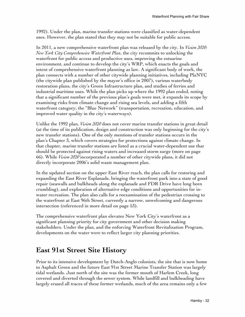
EXISTING CONDITIONS
FIGURE 11 - The existing site, with Asphalt Green and FDR Drive in the center. The existing transfer station, now demolished, sits on the East River to the right (aerial photo from Google Maps 2013)
The following section analyzes ongoing issues with the East 91st Street Marine Transfer Station, and the community that will be affected by the transfer station’s operations. Documents in the public record, both public commenting sessions and legal decisions, as well as an interview with a community opposition member, inform the issues analysis detailed here. To provide background on the site, a demographic and land use analysis was conducted.
Demographic AnalysisFor the purposes of this study, the East 91st Street Marine Transfer Station’s “neighborhood” has been defined as census tracts and tax lots in Manhattan within a 1/2 mile radius of the site. In order to obtain an overview of the neighborhood’s demographic makeup, information was downloaded from the 2010 US Census, 100% data.
Overall, 14 Manhattan census tracts fall within a half mile radius of the transfer station site. As of the 2010 census count, these tracts were home to 108,391 residents. These tracts represent 2,129,935 square meters, or about 0.8 square miles. With an average density of 131,803 people per square mile, it is much denser than the city’s average

Waterfront Planning with Fair Share
Hamby - 36
(about 27,000 people per square mile as of 2012) and denser than Manhattan’s average (about 70,500 people per square mile as of 2012)(nyc.gov).
Figure 12 - Census tracts surrounding the transfer station site (map created using 2010 US Census 100% data)
IncomeMany opponents of the East 91st Street Marine Transfer Station contend that siting a waste transfer facility in Yorkville will not be soaking rich Upper East Siders, but will be affecting middle class families and low-income public housing families. Matthew Chapman, a Yorkville-based community activist, has written several opinion pieces in the Huffington Post during the city’s 2013 primary and general election season outlining arguments against the facility’s siting. He cites the fact that more than 1,532 people living in poverty reside within a quarter mile of the site.5
5 Chapman, Matthew. "Bloomberg's Last Dump: The Great Upper East Side Garbage Swindle." The Huffington Post. TheHuffingtonPost.com, 03 Sept. 2013. Web. 23 Nov. 2013. <http://www.huffingtonpost.com/matthew-chapman/bloombergs-marin-transfer-site_b_3857268.html>.

Waterfront Planning with Fair Share
Hamby - 37
Tract Median Household IncomePercent of Families Below Poverty Line
Census Tract 158.01 $141,857.00 0
Census Tract 144.01 $128,417.00 2.4
Census Tract 148.02 $104,514.00 5.2
Census Tract 146.01 $100,455.00 2.6
Census Tract 136 $98,179.00 1.9
Census Tract 138 $94,622.00 5.6
Census Tract 146.02 $94,366.00 1.5
Census Tract 156.01 $86,759.00 3.5
Census Tract 152 $82,861.00 13.3
Census Tract 144.02 $82,813.00 0
Census Tract 154 $81,053.00 8.5
Census Tract 156.02 $44,896.00 13.3
Census Tract 164 $31,787.00 19.1
Census Tract 162 $29,787.00 27.2
Average $85,883.29 7.44
New York City $51,270.00 19.4
Manhattan $67,204.00 17.6
Figure 13 - Median household income by census tract (data from US Census American Community Survey, 2007-2011)
As of 2011, the average median household income in the study area was over $85,000 a year. This is higher than the median for Manhattan in the same period, which was $67,204 a year according to the US Census Bureau, and higher than the citywide median income of $51,270 a year. Four tracts in the study area have a median income over $100,000 a year.
Three tracts in the study area have a median household income lower than Manhattan and the city as a whole. These tracts, 156.02, 164, and 162, are to the north of the facility site, and as the next section will make clear, are also home to more people of color. Apart from these three tracts, however, the majority of tracts in the neighborhood are well above the city’s median income level.
Most of the tracts have a poverty rate lower than the citywide rate, with a noticeably higher percentage in Tract 152, which is home to two NYCHA housing projects. Tract 164 and 162 have higher poverty rates than Manhattan. These tracts are also home to several NYCHA developments.
Overall, however, it appears that the tracts surrounding the facility site tend to be wealthy, with fairly low poverty rates. From an environmental justice perspective, the

Waterfront Planning with Fair Share
Hamby - 38
data suggests that the people living near the site are not at a higher risk than other populations in the city.
RaceThe “fair share” criteria of the 2006 Solid Waste Management Plan dictates that overburdened communities will not be additionally burdened with new waste management facilities. One of the key premises of the environmental justice movement understands that the historic patterns of land use may be racist in nature, and calls for land use siting decisions which actively work against those patterns. The language of the 2006 SWMP, along with the legal decisions and legislation enacted during the previous two decades makes it clear that any new siting decisions must actively try to prevent replication of historically unjust land use.
Some opponents of the waste transfer station will agree with this framework, but maintain that this particular location does not meet the criteria, as Yorkville and East Harlem are home to a large number of residents of color and many lower-income families. This station may in fact be an environmental justice issue in itself.6 Bertha Lewis, the president and founder of the Black Institute, was quoted at a rally in October 2013 as saying “It really infuriates me that because [the proposed site] is in the east 90s, that now it’s only about white people. This really is a tale of two cities, in our perception alone of what constitutes the Upper East Side. Black and brown kids still use Asphalt Green.”7 According to the 2010 US Census, the tracts surrounding the transfer station are home to a greater proportion of people of color than other Upper East Side tracts to the South, and the half mile radius partially covers some tracts in Spanish Harlem to the north, which are home to a greater proportion of people of color than most of Manhattan.
According to the 2010 Census, a total of 79,658 residents identified as “White Only”, or about 74 percent of the population. Three tracts, on the northern edge of the study area, had less than 50 percent of their population identifying as “White Only.” This proportion is smaller than the city overall, where 44 percent of the population identified as white, and smaller than Manhattan, where 65.2 percent of the population identified as white.
6 BFJ 20137 Karni, Anne. "Prominent Bill De Blasio Supporter Bertha Lewis Joins Protesters Vs. UES Garbage Station." New York Daily News 30 Oct. 2013: n. pag. Print.

Waterfront Planning with Fair Share
Hamby - 39
Figure 14 - Percentage residents of color (the total tract population minus the population identifying as White Alone) in tracts surrounding the East 91st Street MTS (map created using 2010 US Census 100% data)
School Age and Senior CitizensPublic health is frequently cited by community opposition members as the most significant risk posed by the marine transfer station, particularly related to air quality. The high number of children and elderly users of Asphalt Green exercising near the station’s loading ramp is a cause of great concern (see page 61).
Overall, the area surrounding the marine transfer station has a mix of ages comparable to the city as a whole. The average median age in the neighborhood census tracts is 36.7, close to the citywide average median age of 35.5 (US Census 2010).

Waterfront Planning with Fair Share
Hamby - 40
Figure 15 - School age population share by census tract (map created using 2010 US Census 100% data)
About 14.9 percent of the population in the study area’s census tracts are school age (under 18 years of age). This is lower than the city’s average of 21.6 percent, but identical to the borough of Manhattan’s average. Tract 152, which holds the station site itself, and tracts to the north have a notably higher proportion of school-age children than other tracts in the study area. Other tracts in the Upper East Side however, tend to have a higher proportion of school-age children.
13.8 percent of the population in the study area are 65 years of age or over, about the same as Manhattan’s average percentage. The study area has fewer senior citizens as a proportion of the population then other Upper East Side tracts to the south and west of the site, but the percentage is higher than the citywide average of 12.1 percent.
Overall, the proportional population ages in the study area align very closely with borough-wide averages. These broad overviews, however, should not gloss over the fact that due to the high density of the neighborhood, these percentages represent a large number of people. The tracts within a half mile radius of the station are home to about 15,000 senior citizens and over 16,000 school age or younger residents. In addition, there are a number of schools in the area which bring other younger people into the vicinity of the transfer station site. Finally, Asphalt Green, a unique athletic

Waterfront Planning with Fair Share
Hamby - 41
and aquatic facility, draws in a high number of children, senior citizens, and others into the study area from other parts of the city.
Figure 16 - Senior-age (65 years and older) population share by census tract (map created using 2010 US Census 100% data)
Public Housing Residents

Waterfront Planning with Fair Share
Hamby - 42
Figure 17 - Isaacs-Holmes Towers, north of the planned marine transfer station site (photo by the author, 2013)
In close proximity to Asphalt Green and the site proposal, NYCHA (New York City Housing Authority) maintains two housing complexes, Isaacs and Holmes Towers. The residents of Isaacs-Holmes have played a significant role in the ongoing debate over the transfer station, as Bertha Lewis’ earlier quote attests to. Residents of NYCHA public housing tend to be much younger and less wealthy than the city as a whole. Average income for NYCHA public housing residents is about $23,000 yearly, compared to a citywide average income of nearly $57,000 (US Bureau of Labor Statistics 2012) (Unfortunately NYCHA does not provide annual median income, which is often a more nuanced number. The average median income in New York City is about $49,000 per household) (US Census 2011).
While NYCHA’s data is not specific to individual housing projects, it is presumed that the residents of Isaacs-Holmes are significantly less wealthy than their neighbors in Yorkville. The 2010 Census data appears to confirm that residents are more likely to be younger and to be people of color, as Tract 152, which contains the two NYCHA sites, corroborates.
Development Buildings Current Units Total Population
Isaacs 3 635 1,255
Holmes Towers 2 537 933

Waterfront Planning with Fair Share
Hamby - 43
Figure 18 - Numbers of residents in Isaacs and Holmes Towers (2011 NYCHA data)
Overall, 2,188 residents lived in Isaacs and Holmes Towers in 2011. This population makes up about 30 percent of the census tract, and about 2 percent of the census tracts included in the study area. A relatively small number of the population in the study area live in public housing (about 5 percent of the city’s population overall live in public housing, and 7.6 percent of the population live in any NYCHA program housing). However, these housing projects are directly north of the site, and should be given consideration due to their proximity and relatively high proportion of the population immediately adjacent to the marine transfer station.
Environmental Justice AreasAs a result of the long and hard-fought environmental justice campaigns of the past few decades, many environmental justice issues have become set in law. For example, the New York State Department of Environmental Conservation includes a designation of “Environmental Justice Areas” for consideration when making facility siting decisions. Under DEC Environmental Justice Policy CP-29, DEC will include environmental justice considerations when census data meets the following criteria:
• At least 51.1% of the population in an urban area reported themselves to be members of minority groups; or
• At least 33.8% of the population in a rural area reported themselves to be members of minority groups; or
• At least 23.59% of the population in an urban or rural area had household incomes below the federal poverty level.
These environmental justice areas are mapped by DEC, and the selection of the East 91st Street site was partially driven by this criteria.

Waterfront Planning with Fair Share
Hamby - 44
Figure 19 - Potential Environmental Justice Areas with site area circled, New York County (map by New York State Dept of Environmental Conservation 2000)
According to NYDEC’s map, derived from 2000 US Census data, Asphalt Green and the transfer station site do not lay within a potential environmental justice area. North of East 98th Street, however, much of Upper Manhattan is classified as a potential environmental justice area (though the map is not intended to be the final word on this issue - for example, due to quirks of census tract geographies, parkland and uninhabited parts of the city may be designated).
Though environmental justice areas exist north of Yorkville, it is unclear whether these communities will be significantly impacted by the planned facility. According to the prior demographic analysis, several census tracts on the half-mile boundary do meet these criteria. Tracts immediately adjacent to the site, however, do not meet these criteria.
BFJ Planning Report

Waterfront Planning with Fair Share
Hamby - 45
In the Spring of 2013, Pledge 2 Protect, a community group coalition opposed to the siting of the East 91st Street Marine Transfer Station, retained BFJ Planning, an urban planning firm based in New York City, to conduct a demographic analysis of the neighborhood surrounding the proposed site. BFJ, using a 1/4 mile radius, compared the East 91st Street station to six other proposed stations (three solid waste transfer stations, one privately operated rail transfer station, one recycling facility, and one construction waste and commercial waste transfer station).
Figure 20 - Population tables derived from 1/4 mile buffers around planned DSNY and contracted facilities (table by BFJ Planning, 2013)
In its report, BFJ drew the conclusion that a significant number of people, in a overwhelmingly residential neighborhood, would be negatively impacted by a waste transfer station at East 91st Street. The East 91st Street MTS is unique in the sheer density of the neighborhood in which it is to be sited. While this paper analyzed a larger number of census tracts, BFJ’s analysis comes to the same conclusion: that the East 91st Street MTS will not be sited in a majority-minority neighborhood. While the neighborhood is indisputably home to a greater number of people than the other planned sites, making it accurate to report that the station will affect “62% more minority residents compared to the next most populated MTF location”, the neighborhood has the lowest proportion of minority residents after the Gansevoort recycling center in the West Village (BFJ 2013).
Gavin Kearney of New York Lawyers for the Public Interest, a group in support of the transfer station’s construction, points out that while BFJ’s report is factually correct, it contains several omissions. The report does not indicate that the residents near the marine transfer station are overwhelmingly white relative to the city as a whole. The report also does not indicate that West 59th Street, currently underdeveloped, is poised for strong increases in density as development picks up. The quarter mile search area for the other two Manhattan sites omits neighborhoods of significant densities just outside this radius. Both are sited on highly desirable community assets - the public waterfront along the Hudson River. Most tellingly, Kearney asserts, is that the report does not perform the same type of analysis for the

Waterfront Planning with Fair Share
Hamby - 46
large number of contracted waste transfer stations in the city already constructed and running. The cumulative effects of multiple transfer stations on these areas have been well documented. The new facilities in Queens and Brooklyn are sited in locations more distant from built up residential areas by design, which is generally not feasible in Manhattan. The report, while accurate, may still be considered misleading due to the lack of context and background considered so important to the solid waste management plan’s drafting.
Figure 21 - Land use illustration of the East 91st Street Marine Transfer Station (map by BFJ Planning, 2013)
Aside from these omissions, the report makes it very clear that the East 91st Street Station is much denser in nature than the other sites with planned waste infrastructure siting.
Land Use Analysis
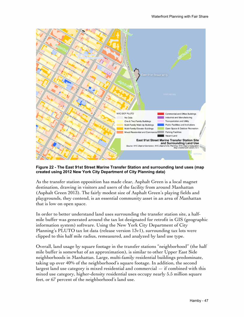
Waterfront Planning with Fair Share
Hamby - 47
Figure 22 - The East 91st Street Marine Transfer Station and surrounding land uses (map created using 2012 New York City Department of City Planning data)
As the transfer station opposition has made clear, Asphalt Green is a local magnet destination, drawing in visitors and users of the facility from around Manhattan (Asphalt Green 2013). The fairly modest size of Asphalt Green’s playing fields and playgrounds, they contend, is an essential community asset in an area of Manhattan that is low on open space.
In order to better understand land uses surrounding the transfer station site, a half-mile buffer was generated around the tax lot designated for retrofit in GIS (geographic information system) software. Using the New York City Department of City Planning’s PLUTO tax lot data (release version 13v1), surrounding tax lots were clipped to this half mile radius, remeasured, and analyzed by land use type.
Overall, land usage by square footage in the transfer stations “neighborhood” (the half mile buffer is somewhat of an approximation), is similar to other Upper East Side neighborhoods in Manhattan. Large, multi-family residential buildings predominate, taking up over 40% of the neighborhood’s square footage. In addition, the second largest land use category is mixed residential and commercial — if combined with this mixed use category, higher-density residential uses occupy nearly 5.5 million square feet, or 67 percent of the neighborhood’s land use.

Waterfront Planning with Fair Share
Hamby - 48
Land Use Category
Land Use by Sq Ft Percentage
Citywide Percentage
Manhattan Percentage
Multi-Family Buildings 3,330,938 40.9% 12.2% 23.3%
Mixed Residential and Commercial 2,127,979 26.1% 3.0% 13.3%
Open Space & Outdoor Recreation 1,020,285 12.5% 27.0% 25.4%
Public Facilities and Institutions 979,090 12.0% 6.9% 11.6%
Parking Facilities 170,030 2.1% 1.3% 1.5%
One & Two Family Buildings 167,167 2.1% 27.3% 1.4%
Commercial and Office Buildings 163,859 2.0% 4.0% 10.5%
Vacant Land 73,395 0.9% 5.8% 2.6%
Industrial and Manufacturing 57,889 0.7% 3.6% 2.0%
Transportation and Utility 38,748 0.5% 7.1% 6.5%
No Data 9,165 0.1% 1.9% 1.8%
Total 8,138,545 100.0% 100.0% 100.0%
Figure 23 - Land uses within a one half-mile radius from the site, compared to percentages citywide (2012 New York City Department of City Planning data)
The neighborhood surrounding the transfer station contains a higher concentration of mixed use and higher-density residential than the city as a whole, and higher even than the average in Manhattan, which is generally denser than the other four boroughs. With this density of residential usage, the square footage of land devoted to open space occupies a lower percentage of the neighborhood than the average for either the city as a whole or for Manhattan.

Waterfront Planning with Fair Share
Hamby - 49
Figure 24 - A dense Yorkville street (photo by the author, 2013)
SchoolsAccording to the New York Department of Education, there are 11 schools located within a half mile of the East 91st Street Marine Transfer Station. These eleven schools have a combined enrollment of about 4,580 students, and cover the full spectrum of ages.
School Type Enrollment
High school 1,740
Secondary School 885
Junior High-Intermediate-Middle 832
Early Childhood 483
Elementary 304
K-8 301
Ungraded 33

Waterfront Planning with Fair Share
Hamby - 50
Total 4,578
Figure 25 - School enrollment by school type (New York City Department of Education 2012)
A significant proportion of enrolled students in the neighborhood’s schools are high schoolers, followed by a large group of students in the middle/secondary/junior high school category.
Figure 26 - Schools near the transfer station site (map created with New York City Department of Education data, 2012)
While no schools are immediately adjacent to the transfer station site and entrance on York Avenue, several schools, including PS 151, PS 051, and the East Side Middle School, are within one or two blocks distance. A larger cluster of schools sits on the north end of the half-mile radius, and includes a special education school and several charter schools. Many local schools in the area make use of Asphalt Green for athletic teams and classes.
Neighborhood Open Space

Waterfront Planning with Fair Share
Hamby - 51
Yorkville is typical of many Upper East Side neighborhoods in its relatively small amount of neighborhood open space. The dense apartment buildings and institutions that characterize the area often do not allow a large amount of park area. While Central Park (840 acres in size) is relatively near (within a half-mile of some of this neighborhood), it is too distant from most of the site to be considered a “neighborhood park” regularly used by members of the community.
Central to the dispute over the transfer station’s siting is the close proximity of three significant parks: Asphalt Green, Carl Schurz Park, and the East River Esplanade/Bobby Wagner Walk. Asphalt Green, which is bisected by the transfer station’s entrance ramp, is in many ways the center of the dispute. In addition, there are several smaller parks and playgrounds nearby, including Ruppert Park, Cherry Tree Park, and Marx Brothers Playground. These smaller parks are mostly playgrounds, and several are located on NYCHA or Department of Education property. Asphalt Green, Carl Schurz Park, and the East River Esplanade draw visitors from other surrounding neighborhoods and from around New York City.
Figure 27 - Parks and open space near the East 91st Street Marine Transfer Station (map created with New York City Department of City Planning data, 2012)
Carl Schurz Park

Waterfront Planning with Fair Share
Hamby - 52
Carl Schurz Park, just south of the East 91st Street Marine Transfer Station, is the largest park in the area at about 15 acres in size. The modern park was completed at the turn of the 20th Century, designed by Calvert Vaux and Samuel Parsons in the pastoral/rustic style seen in parks of that era in New York City. The park includes the former Gracie Estate, and Gracie Manor, home to many New York City mayors beginning from the LaGuardia administration (Carl Schurz Park Conservatory).
Figure 28 - Carl Schurz Park (photo by the author, 2013)
During the late 1930’s and early 1940’s, the construction of FDR Drive (the East River Drive at the time), a separated and elevated highway for most of its length, cut off many Manhattan neighborhoods from the waterfront. At Carl Schurz Park however, the highway switches to a double-decker design, and a cantilevered promenade was added over the highway.
The park runs along the East River from East 90th Street to East 84th Street, from the water’s edge to East End Avenue. At East 90th, the East River Esplanade slopes up to meet the change in grade at the promenade, named Finley’s Walk. The southern end of the promenade ends more abruptly in a steep set of stairs, which go back down to meet FDR Drive at grade. The park is fenced along East End Avenue, with entrances at East 89th, East 88th, East 87th, and East 84th Street.

Waterfront Planning with Fair Share
Hamby - 53
Figure 29 - Map of Carl Schurz Park (map published by the Carl Schurz Park Conservancy, 2013)
Carl Schurz Park is lush with mature trees, shrub and flower plantings, and is largely used for passive recreation On visits to the park, users appeared to be mostly local New Yorkers, with few tourists in site, though the promenade appeared to host a wider variety of users. The Parks Department itself describes the park as “partially hidden” and “one of the city’s best concealed secrets.”8
East River EsplanadeAn esplanade along the river’s edge has been part of FDR Drive from its conception as a new arterial connection in the 1920’s. The segment of the esplanade near the marine waste transfer station, also known as Bobby Wagner Walk, was completed in 1939.9 After Works Progress Administration funding was obtained by the city in the late
8 http://www.nycgovparks.org/parks/carlschurz9 New York City Department of City Planning

Waterfront Planning with Fair Share
Hamby - 54
1930’s, the first section of FDR Drive was completed. The esplanade resulting from this plan largely consists of a narrow strip of paved walkway occupying the spaces between the highway and the East River.
Figure 30 - The East River Esplanade north of the East 91st Street Marine Transfer Station, in process of demolition (photo by the author, 2013)
While the promenade along Carl Schurz Park is fairly wide and leafy, the esplanade north of the park tends to be narrow, at grade with FDR Drive, and in generally poor condition. The seawalls and bulkheads along the walk are crumbling into the East River and missing and cracked pavers are common. The esplanade is well used by cyclists, joggers, walkers, and others. Entrances to the esplanade are very limited, as the six lanes of FDR Drive prevent frequent connections. From Yorkville, the two main entrances to the esplanade and the waterfront are through Carl Schulz Park to the south, between East 90th Street and East 84th Street, or by crossing underneath FDR Drive at East 96th Street, about a half mile’s walk north. Crossing at East 96th Street involves navigation of a fairly confusing tangle of on ramps, off ramps, and service roads, requiring three separate unmarked pedestrian crossings and traffic moving near highway speed.
CIVITAS, a urban design and public space-minded local non-profit, has campaigned to improve this crossing, what it calls “perhaps one of the most dangerous entry points” to the East River Esplanade.10 After a successful letter-writing campaign, the New York City Department of Transportation installed a pedestrian walk signal on one side
10 "East 96th Street Pedestrian Access to the Esplanade." CIVITAS. N.p., n.d. Web. 22 Nov. 2013. <http://civitasnyc.org/live/east-96th-street-pedestrian-access-to-the-esplanade/>.

Waterfront Planning with Fair Share
Hamby - 55
of the intersection. While the crossing has been improved, it remains an undesirable entrance point to the esplanade.
Figure 31 - Crossing below the FDR Drive at East 96th Street (photo by the author, 2013)
Asphalt GreenThis community park is run by a non-profit organization, Asphalt Green Incorporated, which maintains and programs the park on behalf of the City Parks Department. Asphalt Green will be the neighborhood open space most impacted, as the marine transfer station’s entrance ramp at East 91st Street bisects the park directly, and is often the setting for protests and actions against the project.
Asphalt Green occupies about 4.4 acres abutting the FDR Drive. Roughly triangular in shape, it sits between East 92nd and FDR Drive to the north, and East 90th Street to the south. To the northwest of the park stands Issacs and Holmes towers, NYCHA properties. With FDR Drive to one side, the other two sides of the park are bounded by several high density residential buildings to the south, and high density residential with commercial storefronts to the west.

Waterfront Planning with Fair Share
Hamby - 56
Figure 32 - Asphalt Green and surrounding land use (map created with New York City Department of City Planning data, 2012)
Asphalt Green is a multi-use facility, and hosts an olympic-size swimming pool, fitness centers, playing fields, community meeting spaces, playgrounds, and other amenities. It is a popular destination in Yorkville - by Asphalt Green’s estimate, nearly 70,000 people visited Asphalt Green in fiscal year 2013 (July 1 2012-June 30 2013) for a total of over 2.6 million visits.11 The institution serves the community and the wider city, hosting sports teams, gymnastics classes, and swim classes for neighborhood public schools.
While the facility is supported by a variety of paid classes, space rentals, and paid memberships, over half of users of Asphalt Green participated in free activities in fiscal year 2013, a number that the institution seeks to grow. Free swimming programs, a public playground, and scheduled free programs make Asphalt Green an important piece of the public health infrastructure of the neighborhood, especially youth and senior residents.
Operated independently from the city, Asphalt Green has taken a decidedly anti-transfer station position, maintaining that the reopening of the transfer station’s ramp would have a significant, negative impact on the park, changing the park’s character
11 Asphalt Green 2013

Waterfront Planning with Fair Share
Hamby - 57
permanently. The organization belongs to several community coalitions, including Pledge 2 Protect, working to stop the transfer station’s construction and operation.
Figure 33 - Flyers posted protesting against the planned marine waste transfer station at Asphalt Green’s Aqua Center (photo by the author, 2013)
Current Facility DesignIn the image below, the Department of Sanitation has drafted plan schematics of the proposed marine transfer station design. The drawings, created for submission to New York State for permitting approval, show a reconfigured, larger station overlaid on the original site footprint. The facility’s access ramp, which begins at York Avenue between Asphalt Green’s ball field and public playground, extends over the FDR Drive at about 12 feet in height and cantilevers over the East River, leading into the enclosed tipping floor. The ramp, designed to allow off-street queuing for the Department’s trucks, has remained one of the most controversial pieces of the plan.

Waterfront Planning with Fair Share
Hamby - 58
Figure 34 - Overlay of Proposed MTS and Existing Facilities (East 91st Street Converted MTS) (design by the New York City Department of Sanitation 2007)
The existing ramp is enclosed with a chain-link fence, and carries electrical conduits and other connections across the FDR to the site (parkland along this stretch of the East River is not served by the sewer system and other infrastructure)12. Where it bisects Asphalt Green, a short tunnel beneath the elevated segment of the ramp allows a connection between Asphalt Green’s two main buildings.
12 Ridings and McAuliff 2013

Waterfront Planning with Fair Share
Hamby - 59
Figure 35 - Looking east from York Avenue - the existing ramp entrance and barrier walls - to be replaced by new 14 foot high barriers (photo by the author, 2013)
Figure 36 - Looking north from the southeast corner of the park, a rear walkway connecting Asphalt Green’s two main buildings. The FDR Drive is to the right, and a short tunnel leads under the marine transfer station ramp. This connection appears to have low

Waterfront Planning with Fair Share
Hamby - 60
utilization, and the close proximity to the highway creates an unpleasant experience (photo by the author, 2013)
As currently designed, the new facility carefully avoids interference with other city agency jurisdictions. The ramp, while undergoing significant reconfiguration, remains within its designated right of way and does not impede upon the Parks Department’s Asphalt Green property. The ramp’s bridge, before its cantilever out over the East River, passes over land owned by the city and state Departments of Transportation and the Parks Department. The East River Esplanade, owned and maintained by Parks, passes beneath the ramp unimpeded. The facility also accommodates an existing transformer building owned by the power utility Consolidated Edison.
Community Opposition and LitigationConflict over the East 91st Street Marine Transfer Station has been ongoing since prior to the Solid Waste Management Plan’s final approval in 2006. Due to the amount of litigation over the plan and the station, there is a rich record of the Yorkville Community’s perceived threats. A community group, Gracie Point Community Council, has initiated several legal actions against the City of New York. In addition, public commenting sessions and community outreach meetings were well attended by community opposition. In its rejection of one case against the city, the presiding judge agreed with the petitioners that “the [public] comments have been extensive and entirely negative about the project, particularly its location adjacent to a densely populated residential neighborhood.”13
Most significantly, concerns over air quality, public health, noise, and quality of life around Asphalt Green rank high on the list of community threats. Organized opposition to the site has argued multiple times that the city has not adequately accounted for the harmful effects its facility will impose on the surrounding neighborhood. In addition to public records, Sean Wood, a board member of Pledge 2 Protect (one community group in opposition to the facility’s siting) agreed to speak with me about the driving forces behind community opposition.
In the face of these multiple issues, the Department of Sanitation maintained that it had completed its due diligence, and that the majority of community concerns had been addressed during the long and in-depth environmental impact assessment and permitting process. During the project’s long gestation period, the Department largely kept to its original plans, defending its facility design and environmental impact research. In its published responses to concerns from local elected officials and community members, the DSNY largely referred back to its environmental impact statement.14
13 THE ASSOCIATION FOR COMMUNITY REFORM NOW ("ACORN") v. MICHAEL BLOOMBERG. Appellate Division of the Supreme Court of the State of New York, First Department. 26 June 2008. Print.14 New York City Department of Sanitation. East 91st Street Public Participation Report Part 6. <http://www.nyc.gov/html/dsny/downloads/pdf/swmp_implement/mts/part_report/91stPart6.pdf>.

Waterfront Planning with Fair Share
Hamby - 61
Under the city’s Fair Share framework, the city is obliged to take several issues into account when determining a facility’s impact on its surroundings, including its compatibility with existing uses, and the extent which the neighborhood character would be affected by concentration of uses. The framework directs the city to analyze a 400 foot radius from the site to measure a facility’s direct impact. For a sanitation-related site, the city must analyze the surrounding half mile radius. It must also comport with existing plans, and enacted 197-a plans (which include the Waterfront Revitalization Program).
Air QualityAsphalt Green, the locus of community opposition to the waste transfer station, is bordered by two busy roads, York Avenue and the FDR Drive. The highway produces a large volume of particulate matter, and according to a DEP report on air quality in New York City, East Harlem and Upper Manhattan (particularly above East 96th Street) have a particularly high concentration of pollution and poor air quality.
Gracie Point Community Council, a community group representing Yorkville in several lawsuits against the City of New York, has long maintained that trucks queuing on the entrance ramp will emit an unacceptable volume of particulate matter in the immediate vicinity of exercising Asphalt Green users. Because the adjacent area is already burdened with a large volume of emissions from the nearby transportation networks, it is unfair to contribute any additional air pollution.
In addition, Gracie Point and several other petitioners have maintained that the city did not properly account for the facility’s “on-site” impact, by using a daily solid waste volumes of 4,290 tons of trash daily as a worst case scenario, instead of the facility’s maximum designed capacity of 5,280 tons per day. In addition, they argue, the city used an average daily tonnage of 1,872 for its off-site impact analysis, and though this represents about a 25 percent greater volume than the permitted amount, it does not analyze the facilities off-site impacts when operating at full designed capacity.

Waterfront Planning with Fair Share
Hamby - 62
Figure 37 - A bus shelter ad taken out against the East 91st Street MTS by Asphalt Green and other community groups, detailing concerns around truck traffic and diesel emissions (image courtesy of Pledge 2 Protect, 2013)
The community opposition holds air quality as perhaps its greatest concern, due to the facility’s close proximity to dense residential buildings and open space. The facility’s ramp, which bisects Asphalt Green, sits adjacent to several playing fields as well as a public playground. In order to remove truck traffic quickly from York Avenue, trucks will queue on a rebuilt ramp leading up into the facility. While truck drivers will be instructed to avoid idling when possible, the Department of Sanitation concedes that air quality adjacent to the facility will worsen, but not to a dangerous degree.
DSNY ResponseThe city has long maintained, through its permitting and environmental review process, to its defense in the courts, that the marine transfer station will not have a significant impact on air quality. The DSNY’s responses cover the agency’s commitment to using cleaner emission trucks, both through fleet turnover and truck

Waterfront Planning with Fair Share
Hamby - 63
retrofits. These new trucks will run cleaner than the city’s fleet did during the operation of the original transfer station. Drivers will also be instructed to avoid idling while queuing to tip at the station.
DSNY defends its methodologies for air quality, stating that it will be governed by enforceable standards by both DEP and DEC, and emergency capacities are just that, emergencies.
Alternative SitesAccording to many opponents of the marine transfer station, the city failed to adequately account for site alternatives. While the opposition members often state that they agree with the Solid Waste Management Plan’s goal of alleviating the burden on low-income communities and communities of color, multiple community opponents have argued that other Manhattan locations or the “no-build” option have not been seriously considered.
Before the plan’s passage, in 2005, City Council Speaker Gifford Miller proposed an alternative plan that reopened the East 91st Street station, but only for recycled materials. The plan reconfigured several pieces of the waste management plan for Manhattan, but was dismissed by Mayor Bloomberg as unserious.15 Since then, no alternative locations have been proposed.
Sean Wood, a board member of the community group Pledge 2 Protect, told me that his group believed that no transfer station should be sited near any residential neighborhoods in New York City. The solution, he argued, truly lies in significant waste reduction citywide, eliminating the need for additional waste transfer stations. In addition, Manhattan does not burden other boroughs with its residential waste - waste is currently shipped by truck to New Jersey. From this point of view, the “no-build” option is entirely feasible and even desirable.
DSNY ResponseDSNY maintains that it had explored a number of sites along Manhattan’s waterfront in order to meet the goals of the solid waste management plan. In the environmental impact statement, the agency writes that the number of vehicle miles traveled by sanitation trucks would be significantly higher without the reopened transfer stations. In addition, the plan calls for commercial waste transfer development at the 4 MTS sites as well as the West 59th Street MTS, which would reduce the burden of commercial truck traffic on overburdened neighborhoods. This reduction would not occur without the transfer stations’ construction.
15 Confessore, Nick. "Mayor Wins Test of Wills On Trash Plan: Speaker Lacked Votes To Override Veto." New York Times 23 June 2005: B1-B2. Print.

Waterfront Planning with Fair Share
Hamby - 64
Gavin Kearney, of the New York Lawyers for the Public Interest, described the opposition’s stance that more appropriate sites exist in Manhattan as wishful thinking - much of the island’s waterfront has been significantly developed since its industrial and commercial heyday. Any feasible site in Manhattan would run into very similar issues as at Yorkville, and without any well-supported alternative sites, East 91st Street makes economic sense for the city.
Under the city’s fair share criteria, the city may take financial and fiscal suitability into account when making siting decisions. The Fair Share document states: “reasons for limiting the site search to city-owned property might include a determination that acquisition costs would be excessive in terms of project cost, or that need to comply swiftly with legal mandates or imminent threat to public health makes it impractical to acquire private sites by purchase or condemnation.” In its analysis of potential sites, the Department of Sanitation chose only former transfer station sites for this reason. New development in the water is already expensive, and the acquisition of new waterfront property in Manhattan was deemed unrealistic.
Alienation of ParklandOne case against the city, Powell, et al. v. City of New York, et al., (2011) claims that the East 91st Street Marine Transfer Station is effectively removing city parkland, which must be approved by the state and either denied or offset in a nearby part of the city. Under the state’s public trust doctrine, state legislative approval is required before parkland may be alienated for non-park purposes or used for an extended period of time.
The case contended that since the community’s enjoyment of Asphalt Green and Bobby Wagner Walk would be significantly diminished, the city was effectively running afoul of the public trust doctrine.
Additionally, council-member elect Ben Kallos, who campaigned significantly against the MTS during the 2013 elections, has called for the site to be converted to more public space. His campaign recommended a retrofit of the marine transfer station’s entrance ramp and pier infrastructure to grow Asphalt Green, add waterfront space, and create a seamless connection between Yorkville and the East River Esplanade across the FDR.16
DSNY ResponseDSNY maintains, and in the Powell case, the court agrees, that the facility and its ramp are decidedly property of the department, and that no parkland alienation is taking place. The departments lawyers also disputed that Asphalt Green can represent a park
16 "Solutions by Issue: Marine Transfer Station." Kallos for Council, n.d. Web. <https://kallosforcouncil.com/solutions/marine-transfer-station>.

Waterfront Planning with Fair Share
Hamby - 65
as defined in the state constitution, as it is privately managed, includes fee-based membership, and was slowly developed out of formerly industrial land.
Because the transfer station design, while bisecting the park, has a physically small footprint on the Asphalt Green site, the court concluded that Asphalt Green would only be minimally affected both during the site’s construction and its future operations.
Community CharacterThe clearest message sent out by opponents of the transfer station is a simple one: No solid waste facilities belong in residential neighborhoods. Yorkville is very dense, and facilities here impact a very large number of people.17 In the courts, opposition members posed a number of issues, including additional noise from the facility, that would negatively impact the character of the community. Yorkville may once have hosted industrial uses, they contend, but it is now nearly entirely high-density residential and commercial spaces, entirely inappropriate for a site that requires Manufacturing zoning.
The record of concerns also includes the risk to new waterfront development as far away as Brooklyn and Queens from barge pollution and accidents, as well as the eyesore of queuing garbage trucks on local streets.
DSNY ResponseDSNY argues that appropriate measures have been taken to reduce the impacts of odor (an enclosed facility, odor eliminating technology, containerization to prevent odors from entering the community) and the impacts of truck traffic (higher walls screening the facilities entrance ramp, and a design that eliminates trucks idling in the road).
The community character argument is unsound as well, according to the submitted environmental impact statement. Yorkville achieved its current density and wealth while the former station operated. Asphalt Green Park, as well, was developed around the older, arguably dirtier, waste transfer station while it was in operation. DSNY argues that the land use patterns around the facility site are not significantly different than they were in 1998, when the old transfer station closed. Because the facility will be constructed on existing city property, there will be no business or residential displacement. In ACORN v Bloomberg, the courts agreed.
In the final environmental impact statement for the site, the document highlights the beauty of the East River esplanade, and acknowledges that views of the water and
17 THE ASSOCIATION FOR COMMUNITY REFORM NOW ("ACORN") v. MICHAEL BLOOMBERG. Appellate Division of the Supreme Court of the State of New York, First Department. 26 June 2008. Print.

Waterfront Planning with Fair Share
Hamby - 66
other visual impacts must be handled carefully. The design of the station’s ramp and the facility itself, the plan argues, make the facility as discreet as possible. Plantings along the esplanade and ramp will also soften some of the hard edges of the facility.
Flood RiskRevised FEMA maps make clear that waterfront in this area is inappropriate for potentially harmful and noxious land uses. At the end of October, 2012, New York City and the Upper East Side was dramatically impacted by storm surge and flooding caused by Superstorm Sandy’s landfall. Many areas of the Upper East Side, including portions of FDR Drive, were inundated for prolonged periods of time due to their low elevation (see page 32). Asphalt Green was inundated during the storm and suffered flood-related damage, though relatively minor in nature.
According to Jed Garfield, president of the community group Residents for Sane Trash Solutions, the events of Sandy only made it clearer that the Yorkville waterfront continued to be a poor siting decision for a waste transfer station, compromising the city’s resiliency plan for the East River waterfront.18 Significant sections of Yorkville and East Harlem along the East River are susceptible to flood risk, and while the station itself may be protected, opponents of the facility object to the cost of hazard mitigation and claim that any flood risk to the facility is not acceptable in a residential neighborhood.
DSNY ResponseFollowing Sandy, the Department of Sanitation hired Greeley and Hansen, a consulting firm, to undertake a study of the two waterfront marine transfer stations then under construction (the North Shore MTS in Queens, and the Hamilton Avenue MTS in Brooklyn), and the two transfer stations in the planning stages (the Southwest Brooklyn MTS, and East 91st Street). The resulting report compared the city’s current designs with updated FEMA (Federal Emergency Management Agency) advisory base flood elevation levels. The report found that significant sections of the East 91st Street station were at or below the updated design flood elevation, and recommended that steps be taken to seal and flood proof critical functions of the facility. Although the facility was designed with flood protection in mind (garbage unloading, containerizing, and barge loading all take place on separate levels), FEMA’s revisions made clear that some portions of the facility were at risk for damage due to storm surge.
While these changes addressed post-Sandy concerns around climate resiliency and flooding, the site was not changed significantly. In fact, the other hardening option involved changing the site design to raise the facility by about a foot. As this would
18 Beklempis, Victoria. "UES Marine Transfer Station Needs $2.4M in Flood-Proofing." DNAinfo [New York] 13 June 2013: n. pag. Print.

Waterfront Planning with Fair Share
Hamby - 67
have required significant reconfiguration of the pier and the approach ramp, the less-intensive sealing option was chosen.19 From outside the facility, the transfer station would appear the same.
Figure 38 - Revised 2013 FEMA DFIRM (Draft Flood Insurance Rate Map) and area surrounding the East 91st Street Marine Transfer Station. The East River waterfront north of Carl Schurz Park is susceptible to flooding and storm surge (map created with 2013 FEMA data)
Current State of the ProjectAccording to Sean Wood, a board member of Pledge 2 Protect, a community coalition allied against the transfer station, the Department of Sanitation has not responded to a single community concern in its design or planning of the site. At one meeting late in the public comment period, a resident of Yorkville was quoted as telling Harry Szarpanksi of the DSNY “…you said well, we’ve sat at this meeting and we’ve sat at this meeting and we’ve sat at that meeting and we’ve listened to your comments. Sitting there doesn’t mean you’re listening. You have not responded in any meaningful way to the underlying fundamentals of the project. It is disgraceful.20” On the other
19 http://www.nyc.gov/html/dsny/downloads/pdf/swmp/swmp/SWMP%2003DOS004Y-Technical%20Memorandum%205-29-13%20rev%20%2010-23-13.pdf

Waterfront Planning with Fair Share
Hamby - 68
hand, the Department of Sanitation, while largely defending its original design, reports that its outreach on the solid waste management plan “has been one of the most extensive and inclusive efforts in city history.”21
For better or for worse, much of the organized opposition has taken an all-or-nothing approach to the siting issue - the goal of Pledge 2 Protect, Gracie Point Community Council, Asphalt Green, Residents for Sane Trash Solutions, and other organizations is to prevent the facility from being sited. Any other option is considered unacceptable.
While appeals are ongoing as of this paper’s writing, and a new mayoral administration is set to begin in 2014, it does not appear likely that the state permitting and environmental impact processes will be overturned and the station project cancelled. In fact, the winning bidder on the city’s RFP, Skanska USA, has begun construction on the new waste transfer station already. With millions of dollars already invested in generating drawings, obtaining permits, and defending both the Solid Waste Management Plan and the designs for the East 91st Street MTS in courtrooms, it is unlikely that the city would abandon the site for this use.
While construction has begun on the East 91st Street station, the other two planned marine transfer stations in Manhattan, West 59th Street and Gansevoort, remain in limbo. Bill de Blasio, the mayor-elect, voted for the 2006 plan while a city council member, and has voiced some support for the facility and full support of the tenets of the plan. In a May primary debate, he was quoted as saying that while he supported the solid waste management plan, he believed “[…] residents have valid concerns that must be addressed in the implementation process.”22 It remains to be seen how these concerns may be addressed (the new mayor will have a myriad of issues to attend to once in office, and it is unclear how high the solid waste management plan ranks on his agenda). And while construction has begun, it may not be too late for a site design that contributes tangible benefits to the neighborhood, and to Manhattan’s waterfront to help offset its burden.
20 New York City Department of Sanitation. East 91st Street Public Participation Report Part 5. Page 85. <http://www.nyc.gov/html/dsny/downloads/pdf/swmp_implement/mts/part_report/91stPart5.pdf>.21 New York. New York City Department of Sanitation. LEAD AGENCY FINDINGS STATEMENT FOR THE NEW YORK CITY COMPREHENSIVE SOLID WASTE MANAGEMENT PLAN. page 40, 2006. Web. <http://www.nyc.gov/html/dsny/downloads/pdf/swmp/swmp/swmpweb.pdf>.22 Taylor, Kate. "Mayoral Candidates Wrestle Over Waste Removal." New York Times 2 June 2013, NY Metro sec.: n. pag. Print.
Hamby - 69
Chapter Four
PROPOSAL PRECEDENTS
ASSUMING THE city continues to argue that the design of this facility addresses, to a reasonable degree, the concerns about health, safety, and quality of life brought forth during the development process (common “risks” associated with a locally unwanted land use), what other measures, if any, could the city have taken to make the transfer station more acceptable to the community of Yorkville? Could the facility’s design accommodate other community needs?
The East 91st Street MTS has completed its design phase and is in the middle of construction. Therefore, any new changes to the site’s design may need to be undertaken as a retrofit, which would incur significantly greater costs. If the city does decide, in Bill de Blasio’s words, to “address” community concerns in the proposal, there is the chance that construction may halt before it reaches significant milestones, allowing potential design changes under the same construction contract.
This may not be a reasonable assumption - a design change order even at this stage of construction would be highly expensive and therefore unlikely. Even so, envisioning a different transfer station and waterfront may be useful for the future of the site - or for future facility sitings along New York City’s waterfront.
Mitigation through Community BenefitsAs explored in the city’s defense of the East 91st Street MTS (page 60), the Department of Sanitation has never claimed that there would be little to no impact from the facility on the neighborhood, only that the impact would not be so great as to prevent its siting. Rather than attempting to completely mitigate impacts from noise, pollution, or other issues, is it be possible to offset these impacts with benefits of a different kind?
To do so would not be a new mitigation strategy. As detailed in the literature review (page 9), “paying off” is one of the more common and effective methods of successfully siting locally unwanted land uses. Paying off often takes the form of actual cash payments. These may be in the form of literal checks sent out to impacted residents, or in other cases may contribute money to the community in other ways. The Indian Point nuclear power plant in Buchanan, New York, for example, pays for a significant portion of local school budgets and contributes to local non-profits and other institutions in the neighboring Hudson Valley communities that may find themselves at risk from the facility.23
Waterfront Planning with Fair Share
Hamby - 70
In New York City, a complexity of jurisdictions (the site is near the border of multiple community board districts, city council districts, and state legislative districts), density of population, ambiguous neighborhood boundaries (community opponents argued in court, for example, that the East 91st Street MTS would impact redeveloping waterfronts in Brooklyn and Queens) and a precedent likely unwelcome by the city (would the city also begin to reimburse neighbors of existing waste transfer facilities? Would there be backpay?) makes any direct payment option an unlikely solution.
While direct payments may not be feasible, other development projects in New York City have attempted to use community benefits to mitigate perceived harm to the surrounding community.
Open Space OffsetsCommunity benefit agreements (CBAs) are an increasingly common method of facilitating the siting and development of potentially controversial, often large-scale projects. The agreements are typically made between a developer and community groups speaking on behalf of the project neighborhood. In a CBA, community groups promise to support, or at least not actively oppose, a planned project in exchange for benefits like job training, new community facilities, schools, or environmental improvements. While the system is fairly new (the first major CBA was created in Los Angeles during the Staples Center development in 2001), it builds off a long practice of developers seeking understandings with the community in which they wish to develop.
In New York City, community benefits agreements quickly became commonplace. An early example of these types of negotiations took place in the 1990’s during the development of Donald Trump’s Riverside South project, which ended with an agreement that included development of over 20 acres of parkland on Manhattan’s West Side.24 Other large scale projects with community benefit agreements include Yankee Stadium, Shea Stadium/Citifield, Atlantic Yards, and the Gateway Mall. These projects represented private development that often had local and state governmental support, but were largely private agreements negotiated between the developer and “the community” (which is typically a collection of local stakeholders like community groups, community boards, local business, and residential and commercial property owners). While CBAs had been viewed positively by the city government on certain projects, the Bloomberg administration was no longer in support of them by 2006, when the Mets planned to construct a new stadium. “Every development project in this city is not just going to be a horn of plenty for everybody that wants to grab something,” [Mayor Bloomberg] said. New development, he said, should not be a rush to “line up to get some ransom.”25 The New York City Bar
23 "Entergy Nuclear - Indian Point Energy Center Units 2 & 3." Entergy Nuclear. N.p., n.d. Web. 24 Nov. 2013. <http://www.entergy-nuclear.com/plant_information/indian_point.aspx>.24 New York City Department of Parks and Recreation. "PARKS RECLAIMS MANHATTAN WATERFRONT PROPERTY." Daily Plant XVI (11 Apr. 2001): n. pag. Print.25 Association of the Bar of the City of New York. THE ROLE OF COMMUNITY BENEFIT

Waterfront Planning with Fair Share
Hamby - 71
Association, while not in favor of the CBA model, acknowledge that its prevalence signifies a weakness in the current land use approval processes. CBAs may be popular, they reason, because community groups currently do not feel they have a voice in shaping developments.
Community Benefits Agreements have been criticized widely, particularly for their potential for corruption and their limited successes in delivering promised benefits. They are largely focused on private developers, and rarely on local governments. The Atlantic Yards project for example, as of this writing still far from completion, has not delivered significant pieces of its promised benefits. In addition, they are usually associated with projects that require zoning changes in order to proceed.26
Other mechanisms for producing open space or other mitigating offsets are also largely dependent on zoning changes or variances. In Red Hook, Brooklyn, for example, the controversial development of a new IKEA store on former shipyard in the Erie Basin required special planning commission approval, as the site was zoned for heavy manufacturing. In addition to community benefits like local employment requirements and a new job training center, the furniture retailer developed a new, historically sensitive park running for nearly a mile along Erie Basin. The park, 6.3 acres in size, hosts a ferry terminal, amphitheater, seating, and other amenities, all maintained by IKEA.27 The new park also added a crucial link to the Brooklyn Waterfront Greenway, a goal elucidated in the city’s comprehensive waterfront plan.28 Community Board 6 along with Red Hook stakeholders, partnered with local elected officials to ensure successful delivery of IKEA’s promised benefits. Had the retailer been able to build the store as-of-right, however, it doesn’t seem likely that such concessions would have been possible.
In the case of the East 91st Street Marine Transfer Station, the Department of Sanitation may develop the facility “as-of-right”, and while the project was approved through the city’s ULURP, no additional exactions were demanded of the project. In my recommendation, I recognize that there is little official incentive to explore these options. The facility as it is currently designed achieves city policy goals at reasonable cost, with proper precautions to minimize impacts and risk to the surrounding community. As we have seen, however, this has not prevented spirited opposition from forming in Yorkville to agitate against the project.
While the waste transfer station plan was developed in collaboration with environmental justice advocates and other community groups, the Yorkville community appears to have only coalesced in opposition in reaction to the plan’s
AGREEMENTS IN NEW YORK CITY’S LAND USE PROCESS. Issue brief. New York: page 15., 2010. Print.26 Wolf-Powers, Laura. "Community Benefits Agreements and Local Government." Journal of the American Planning Association 76.2 (2010): 141-59. Print.27 "Ikea Development Approved; Sent to Council." Cityland.com. New York Law School, 15 Oct. 2004. Web. 2 Dec. 2013. <http://www.citylandnyc.org/ikea-development-approved-sent-to-council/>.28 Byles, Jeff. "Erie Basin Park." Architect's Newspaper [New York] 3 Sept. 2008, News sec.: n. pag. Print.

Waterfront Planning with Fair Share
Hamby - 72
announcement. So while the city and the Department of Sanitation gave the community many opportunities to comment on the proposal and its design, the city had a decidedly “Decide-Announce-Defend” approach, spending the vast majority of its community outreach time defending its design, its methodology, and its site selection. It appears this approach was chosen because DSNY felt confident that it had every right to site this facility, had done the necessary work to ensure its success and that the facility would operate in a way that truly posed little risk to its surrounding community.
Again, without the hurdles of zoning change approvals, there does not appear to be an alternative forum for a compromise plan. The community benefits model is often viewed as flawed, and other zoning-based mechanisms are not currently in play at this site. While the mechanisms for productive community negotiation may not currently exist for this site, there are potentially other regulations that may still develop a site design that could contain significant community benefits. Building on the waterfront in New York City, whether privately or publicly developed, initiates a number of requirements and planning regulations. The East River in particular has seen an increase in plans and design guidelines in recent years.
East River Design PrecedentsAs Manhattan seeks to complete its waterfront greenway, as the city releases a new comprehensive waterfront plan, and as natural disasters like Superstorm Sandy impact waterfront communities, more and more attention has been focused on the East River waterfront. While the Hudson River length of Manhattan’s greenway runs uninterrupted from Dyckman Street in Inwood to Battery Park and hosts the most well-used bikeway in the United States29, the East River Greenway faces several interruptions and obstacles to completion. Even north of Carl Schurz Park, where the greenway is ostensibly complete, crumbling infrastructure and narrow pathways make for a less inviting riverfront than its counterpart to the West. Several city agencies and community organizations have supported East River Greenway plans, competitions, and studies in recent years.
The city’s Economic Development Corporation (EDC) has been tasked with redeveloping large segments of the East River waterfront, and has released several planning documents for the Lower Manhattan East River waterfront and for the “missing link” of the East River greenway at the United Nations site. The first EDC plan of 2005, published after a collaborative planning process with other city agencies, community boards, and community groups, called for supporting a diverse set of activities on the waterfront, working around and through the boundaries of the FDR Drive, reclaiming underutilized space, and referencing the working waterfront’s past. The plan explores new connections to upland neighborhoods, opportunities for
29 "Statement of Noah Budnick, Deputy Director for Advocacy, Transportation Alternatives to the New York City Hudson River Park | Transportation Alternatives." Transalt.org. Transportation Alternatives, n.d. Web. 24 Nov. 2013. <http://transalt.org/news/testimony/1840>.

Waterfront Planning with Fair Share
Hamby - 73
commerce and development, flexible pavilions and spaces for programming, and ecological restoration.
Figures 39 and 40 - Typical esplanade and pier designs from New York City EDC’s Lower Manhattan East River waterfront plan, showcasing ecological and programmatic intent (images from NYCEDC, 2005)
EDC’s plan came under fire from Lower East Side community groups that contended community outreach had been inadequate. The alternative waterfront plan, titled A People’s Plan for the East River Waterfront, was released by O.U.R. Waterfront Coalition (now the Lower East Side Waterfront Alliance), a coalition of community groups throughout the Lower East Side. The plan contended that EDC’s East River plan focused too heavily on commercial and high-end development, drafting splashy proposals without secure funding in place, and without consulting the waterfront communities that would presumably make use of the redeveloped waterfront. And, due to a lack of funding, many of the proposed waterfront amenities, mostly designed by architecture firm SHoP, have not yet come to fruition. A People’s Plan focused heavily on lower-cost implementation measures requested in community outreach sessions. Above all, A People’s Plan called for a variety of free and low-cost options for recreation, education, and cultural exchange on a welcoming waterfront for all.
Following A People’s Plan, work began on a community vision for one of the key sites along the East River - the abandoned former banana importing pier in the Lower East Side. Pier 42 and Pier 38 had both been slated for community use for many years, but had laid fallow. The pier is currently in the planning stages of a new park designed

Waterfront Planning with Fair Share
Hamby - 74
with community input, adding a significant acreage of park space east of the FDR Drive.
With input from both prior East River waterfront plans, as well as the recently released Vision 2020 comprehensive waterfront plan, the office of the Manhattan Borough President, WXY Architects, and a variety of community stakeholders released a document titled The East River Blueway Plan in 2012. This plan focused more closely on the waterfront between the Brooklyn Bridge and East 38th Street. A “blueway” is a different perspective on waterfront development, looking from the water inwards and making connections on the water. One of the first waterfront development plans released after the revised comprehensive waterfront plan, the Blueway plan seeks to increase access to the water, improve wildlife habitat and establish more natural areas, and create opportunities to interact directly with the water.30
Further north, and involving this paper’s study area, the community group CIVITAS, which promotes urban design in the Upper East Side and East Harlem, recently held a juried competition, entitled Reimagining the Waterfront: Manhattan’s East River Esplanade. The competition, held in 2012, sought new ideas for Manhattan’s East River waterfront from East 60th Street up to East 125th Street. According to CIVITAS, decades of neglect and a lack of cohesive planning along the waterfront here has left the East River Esplanade as a narrow, often awkward stretch of walkway with little water access that contains enormous potential.31
The competition received 90 submissions from a variety of cities and countries. These submissions covered a wide range of recommendations, but nearly all sought to expand pedestrian space, natural areas, and improve access to upland communities.
30 "The East River Blueway Plan." Urban Omnibus. N.p., 30 May 2012. Web. 24 Nov. 2013. <http://urbanomnibus.net/2012/05/the-east-river-blueway-plan/>.31 Reimagining the Waterfront. CIVITAS, n.d. Web. 25 Nov. 2013. <http://reimaginethewaterfront-civitas.com/>.

Waterfront Planning with Fair Share
Hamby - 75
Figure 41 - A competition rendering of new waterfront land, with pedestrian bridges over FDR Drive (rendering by David Elzer for CIVITAS, 2012)
Many of the competition submissions sought to restore some of the East River’s pre-development shoreline of wetlands and littoral zones, incorporating native plantings and deconstructing the crumbling East River Esplanade seawall into a staggered, natural shoreline. Unfortunately, though most submissions covered the East 91st Street pier in their site plans, the competition submissions tended towards wider visions and either reused the MTS pier for other purposes, or left it untouched.
Finally, a graduate planning studio at Hunter College undertook a study of the East Harlem waterfront (just north of the marine transfer station site) in the Spring of 2013 on behalf of TreesNY, a nonprofit advocacy group. The study, titled Greening the Gap: A Green Infrastructure & Waterfront Access Plan for a Healthier East Harlem, sought to improve the neighborhood’s water quality, improve waterfront access, increase stormwater capture, and improve programming along the waterfront. The result of months-long community outreach efforts and local stakeholder engagement, Greening the Gap produced a litany of design, programmatic, and environmental tools for improving the East River Esplanade.
Some of the Greening the Gap’s recommendations included restoration of soft edges along the water (including creation of coves, step setbacks, and riprap installations),

Waterfront Planning with Fair Share
Hamby - 76
mimicking natural shorelines, in order to help mitigate against erosion and tidal surge, aiding in protection of upland areas and reducing future maintenance costs.
Figure 42 - An example of soft edged shorelines, including vegetated areas and riprap stone (image from Greening the Gap photo illustration, 2013)
In addition, the report made recommendations on park lighting, furniture, plantings, and programming, that could create a cost-effective, successful waterfront park. In order to improve access, the report recommends new, welcoming pedestrian bridges, with little to no switchbacks and ADA compliant grades. According to the report, many survey respondents in East Harlem listed new pedestrian bridges as their number one desired access to the waterfront across FDR Drive.
Figure 43 - More welcoming pedestrian bridge safety design (image from Greening the Gap photo illustration, 2013)
Waterfront Design ApplicationsGreening the Gap summarizes a list of recommendations for design along the East River Waterfront. Where possible, the shoreline should replicate natural bends and gradations, in order to create a wave attenuating and erosion controlling environment more welcoming to natural biota. In addition, open space development should be

Waterfront Planning with Fair Share
Hamby - 77
supportive a variety of activities both in and out of the water, including boat launches, areas for fishing, and ample seating. These recommendations for waterfront design echo previous recommendations in other citywide and East River plans, and should all be feasible along the East River.
The Metropolitan Waterfront Alliance, a coalition of waterfront-oriented community groups and activists, has worked for many years to bring smart waterfront design to the forefront of New York City waterfront planning. The MWA, with the city’s Economic Development Corporation, the City Department of Parks and Recreation, the State Department of Environmental Conservation, and local community initiatives, created a series of guidelines on waterfront design, called Design the Edge.32 This set of 10 design principles is used by the MWA are intended to achieve multiple goals: “water recreation, flood storage, access to the water, shoreline habitat and reduced pollution from stormwater.” The MWA, a long supporter of the 2006 Solid Waste Management Plan, believes that accommodations may be made on the working waterfront (which typically includes waste transfer stations) for waterfront access and biological restoration.
The MWA is currently launching a new project specifically targeted towards high level design at difficult or complex sites located along New York City’s waterfront.33 The initiative, as explained by Cortney Worrall, will expand on the group’s Design the Edge, seeking to create a comprehensive design, siting, and permitting framework for all of the city’s waterfront uses. The design group, which includes a wide variety of stakeholders, will seek to aid any entity interested in improving the city’s waterfront. And, she mentioned, this will include waste transfer stations. With a target completion date of September 2014, these guidelines unfortunately come too late for this paper, but the effort underscores the urgency and sheer volume of waterfront work underway in New York City.
Climate Resilient DesignIn addition to complying with waterfront design guidelines, any modifications to the East 91st Street site should seek to conform with the city’s hazard mitigation and climate resiliency plans.
In December of 2012, shortly after Sandy impacted the city, Mayor Bloomberg announced the creation of special task force, named the New York City Special Initiative for Rebuilding and Resiliency (SIRR). The goal was to produce a long-term plan for the city to become more resilient, and to plan for the future impacts of climate change. Over the summer of 2013, the SIRR report was released, with a long set of
32 "Design the Edge Principles." Metropolitan Waterfront Alliance, n.d. Web. 25 Nov. 2013. <http://www.waterfrontalliance.org/projects/designtheedge/criteria>.33 "MWA LAUNCHES KEY PROJECT: Group to Create Comprehensive Waterfront Design Guidelines." Online newsletter. Waterwire. Metropolitan Waterfront Alliance, 21 Oct. 2013. Web. <http://archive.constantcontact.com/fs177/1102224464492/archive/1115202785407.html>.

Waterfront Planning with Fair Share
Hamby - 78
recommendations, goals, and criteria to guide city agencies and planning towards a more resilient city.
Among the host of categories presented with recommendations for climate mitigation, a chapter of the report was dedicated to protecting the New York City coastline against rising sea levels and increased risk of flooding. The SIRR report made coastal protection recommendations for each section of the city’s waterfront. Along the Upper East Side, the report recommends a strategy called integrated flood protection systems.
Figure 44 - A diagrammatic view of an example integrated flood protection system (rendering from the NYC SIRR report, 2013)
This strategy implements a variety of techniques, employing multiple levels of flood protection to strengthen dense residential neighborhoods or critical infrastructure (such as the FDR Drive). This technique allows for any number of mitigation applications: berms, seawalls, bulkheads, flood walls, flood resistant landscaping, temporary flood walls, and other features designed to impede rising tides.
According to the SIRR report’s action plan, an integrated flood protection system is slated for installation along the East River between East 90th Street and East 127th Street. How this system may look, and how it may affect the transfer station site or the East River Esplanade in general remains to be seen. The protection system may be as low-impact as installation of deployable flood walls along the median of the FDR Drive, or changes to the esplanade may occur. However, while mitigation plans are under development, any new open space development at the site should take this ongoing work into account.

Waterfront Planning with Fair Share
Hamby - 79
Precedents in New York CityThe issues at hand in the East 91st Street Marine Transfer Station’s siting are not new to New York City. Below, a sample of other projects in the city illustrates the fact that New York has long been densely populated and densely built up, necessitating creative planning and implementation for controversial facilities and infrastructure.
Riverside Park
Figure 45 - Riverside Park South, the newest addition to one of the city’s oldest waterfront parks (Creative Commons photo by Roger Rowlett, 2006)
Riverside Park is a historic example of waterfront planning with infrastructure. The park started life as a rail line and began construction in 1875, laid out in stages until the early 20th Century. It received two major expansions, one during the Moses years, and another in the late 20th century and early 21st. Partly by early community agitation, and partly by master planning by Robert Moses and other local government stakeholders, the park expanded southward, including the new west side highway. The park covers existing rail lines, and supports an at-grade road.
The park and its subsequent additions are popular locations for both active and passive recreation, and make up a significant stretch of the Manhattan Waterfront Greenway. The parks demonstrate the ability of local community members to achieve new

Waterfront Planning with Fair Share
Hamby - 80
parkland in their neighborhoods, as well as a successful example of infrastructure woven into a park context.
More recently, the completion of Riverside Park South represents a successful outcome of an early version of a community benefit agreement (detailed on page <$p>).
Issues: While the community along the Hudson River at this point is comparable in demographics to Yorkville, this project may be too old and the city’s land use policies too different for relevant lessons for today.34 While a significant amount of parkland was gained in Riverside Park South, the politics of a private development differ significantly from a relatively small public project.
Riverbank State Park
Figure 46 - Riverbank State Park (photo by Dattner Architects)
Riverbank State Park, a riverfront park along the Hudson River at West 135th Street, tops a highly controversial North River wastewater treatment plant. Under legal pressure from the Federal Environmental Protection Agency in the late 1960’s, the city had hurried to construct a wastewater treatment plant to prevent additional pollution
34 Buttenwieser, Ann L. Manhattan Water-bound: Manhattan's Waterfront from the Seventeenth Century to the Present. 2nd ed. Syracuse, NY: Syracuse UP, 1999. Print.

Waterfront Planning with Fair Share
Hamby - 81
in the Hudson. After planning on siting the facility near 57th street, the city found it easier to site the plant in Harlem, which was poorer and home to a majority African-American population.
Recent transparency laws enacted under the Lindsay administration enabled local activists in the West Harlem community to advocate against the siting of this facility in their neighborhood. Mayor Lindsay, arriving into office as planning for the plant had largely been completed, attempted to improve the facility by appointing Philip Johnson, the renowned architect, to develop a creative plan for the top of the plant. Johnson’s plan was poorly accepted by the community, who felt that a well-designed wastewater treatment plant was still a wastewater treatment plant.
The state government offered to build a new park on top of the facility, and the community, left out of the planning process, decided to accept. While West Harlem community groups participated closely in the parks development, it would be several more decades before the parks opening.
While the process of building the new state park was long and politically fraught, Riverbank State Park is now a well-used and loved community park on the Hudson River. In a section of Manhattan that had previously been neglected, the park offers waterfront access, recreation, and ample community facilities. The facility itself successfully helped to keep the Hudson River clean.
Issues: Even after the opening of the new park in the early 1990’s, residents still complained of air pollution and smells emanating from the plant. The city was fined by the EPA for violations at the plant in 1992. And even with a new waterfront park, the facility came at enormous cost and took many decades to complete. And for many in West Harlem, the plant still represents the unjust land use policies of New York City’s recent past.35
Gansevoort Station
35 Miller, Vernice D. "Planning, Power and Politics: A Case Study of the Land Use and Siting History of the North River Water Pollution Control Plant." Fordham Urban Law Journal 21.3 (1993): 707-22. Print.

Waterfront Planning with Fair Share
Hamby - 82
Figure 47 - Competition rendering of Gansevoort Station (image by GRO Architects, 2012)
Another barge-based transfer station developed under the 2006 solid waste management plan, the Gansevoort Recyclables Acceptance Facility is a planned development along the Hudson River in Greenwich Village, Manhattan. Once completed, the station will accept recyclables from Manhattan residents and businesses. Not unlike East 91st Street, however, the station has been snagged in legal battles and delays for several years.
As the BFJ Planning report showed (see page 44), the neighborhood surrounding Gansevoort is similar in demographic makeup to that of Yorkville. However, because the station will alienate parkland (it is sited along the Hudson River Park), a memorandum of understanding will create new park space along with the facility’s development.36 The new facility will feature several new acres of open space as well as public educational facilities.
If completed, the Gansevoort station should prove an illustrative example of public waterfront planning with infrastructure, using the site to fulfill several community needs.
Issues: While the East 91st Street station is beginning construction, the Gansevoort station remains in limbo, and is strongly opposed by the community. While open space is a component of the site plan, it is only due to state constitutional requirements.
36 Vanterpool, Veronica. "Stall Tactics Slow NYC’s Solid Waste Plan." Mobilizing the Region. Tri-State Transportation Campaign, 22 June 2011. Web. <http://blog.tstc.org/2011/06/22/stall-tactics-slow-nycs-solid-waste-plan/>.

Waterfront Planning with Fair Share
Hamby - 83
Unlike solid waste, recycling facilities are often seen as less noxious uses, making proximity less of an issue.
SIMS Municipal Recyling Facility
Figures 48 and 49 - Aerial photo and site plan of the new SIMS recycling center in Brooklyn (photo by the NY Times, 2013)
Perhaps the most applicable open space/infrastructure precedent for the remaining waste transfer stations, the SIMS recycling center in Sunset Park, Brooklyn, represents thoughtful waterfront design for a facility similar to East 91st Street site. The facility, while privately operated, is contracted to handle a large portion of the city’s recycling, most of which will arrive by barge. The site plan includes waterfront access, green infrastructure, open space, and educational programming. While the loading and unloading area is bulkheaded, the rest of the pier features “soft edges” of

Waterfront Planning with Fair Share
Hamby - 84
rip-rap and wetland plantings. The facility itself was designed by a well-respected firm, Selldorf Architects, and has a largely open plan that invites visitors in.37
Issues: Sims is a private contractor and may be less constrained by issues of budget than an entirely city-funded project (though the budget for the project has not been published). In addition, the site’s location at the South Brooklyn Marine Terminal is far less contentious than the Upper East Side, and offers more room for community amenities. Like Gansevoort, the site also benefits from recycling’s perception as a less-noxious use than other solid waste facilities.
37 Kimmelman, Michael. "A Grace Note for a Gritty Business." New York Times 17 Nov. 2013, Art & Design sec.: n. pag. Print

Hamby - 85
Chapter Five
EAST 91ST STREET DESIGN PROPOSAL
THESE PROPOSAL recommendations are based on the community concerns listed in Chapter 3, access issues central to the site, and a recent number of precedents along the East River and on New York City’s waterfront listed in Chapter 4. These precedents showcase the growing interest in recreation and public access to the water, as well as strategies to accommodate open space on challenging sites.
In keeping with larger neighborhood and citywide goals, this proposal recognizes that the Department of Sanitation is the owner of a very desirable piece of property along the East River, in a section of Manhattan with limited access to its waterfront. Because so much of the debate around the transfer station facility revolves around Asphalt Green, issues of community facilities, open space, and programming are crucial. If the community fears that a well-used athletic facility and park will be compromised, improving open space connections, expanding public land, and increasing opportunities for programming on the waterfront could potentially be accommodated by a modified site plan.
While the existing site plan attempts to minimize the facility’s footprint in Yorkville and along the East River waterfront, there are several missed opportunities at this site that could potentially be included in a more accommodating design. The drawing below represents a conceptual sketch of some of the additional possibilities available at this site. The concept goes beyond adding public space and community connections, but attempts to conform to several citywide planning guidelines relevant to this location.

Waterfront Planning with Fair Share
Hamby - 86
Figure 50 - Conceptual sketch of potential site interventions (drawing modification by the author)
The conceptual proposal seeks to achieve several main goals: to create a new connection between upland communities and their waterfront (here, at Asphalt Green); to increase and improve the public waterfront; to increase climate resiliency; and to provide educational opportunities and programming, ultimately diversifying the uses along the East River Esplanade.
On its own, waterfront open space development, particularly creating new piers, bulkheads, and seawalls, is an expensive, complex, and laborious undertaking. Approval for in-water construction often requires permitting from the city under several zoning ordinances, as well as the approval from the state environmental protection agency and the federal Army Corps of Engineers. In order to begin enacting the solid waste management plan, however, the city took these steps and successfully obtained permits for each planned site. East 91st Street has already completed the required steps to gain approval, including all water-based permits.
In theory, an additional amount of square footage of waterfront pier in the immediate vicinity would have also passed the state and federal government’s criteria, with marginal additional cost to the city. All of the proposal’s area falls within DSNY property, and any additional piles or dredging would occur in littoral zones identical to the area already approved for construction. While constructing additional pier space, building new riprap and bulkheads, and driving more piles would increase the cost, it would represent a fraction of the money spent constructing the facility. Inclusion of these elements into a modified capital project would save money over a future retrofit.

Waterfront Planning with Fair Share
Hamby - 87
In the same spirit of making use of funded infrastructure, the plan recommends a new pedestrian walkway crossing the FDR Drive at 91st Street. The walkway could cantilever off of the facility ramp (which will already be bounded by a high wall), connecting to the East River Esplanade (and creating a connection to Carl Schurz Park) south of the transfer station site. The walkway could connect to the Asphalt Green property, utilizing the underused corridor between the ball fields and the FDR Drive. On this side, the walkway’s ramp (at about 12 feet in height, the ramp would stretch out to about 150 feet in length to meet American Disabilities Act regulations) could aid in dampening noise pollution, which is significant, off of the highway.
This walkway could include a stairwell on either side of the FDR Drive for direct access, and could be fitted with emergency egress out onto the facility’s ramp. The concept plan includes a platform for sitting, relaxing, people watching, or observing the river. The walkway, as it connects to Asphalt Green, could be closed at night, and open to the public when Asphalt Green is open. The walkway could provide a new, safe connection directly from Asphalt Green to the waterfront, cutting the crossing distance by a half mile for this area. In addition, it would provide a safer, more pleasant alternative to the current crossing under the FDR at East 96th Street (see page 53).
The new open space produced in this concept would remain under the ownership of the Department of Sanitation, but this area could be maintained by the New York City Parks Department or Asphalt Green, Inc. Asphalt Green had, in the 1980’s, planned to obtain a waterfront facility to train community members in boating and kayaking, but those plans had fallen through38. If maritime traffic permits, Asphalt Green could also manage public boating access at this site, similar to the kayaking programs it is planning to run at other city locations. According the final environmental impact statement, recreational, commercial, and oceangoing vessels could all feasibly operate simultaneously with the prior marine transfer station’s barge traffic, and should be compatible with the new facility as well. By increasing the potential for Asphalt Green’s programming scope, community members will be able to interact more directly with their waterfront, and the organization could gain additional facilities or sites under their jurisdiction, helping to offset the perceived impact of the marine transfer station’s entrance ramp.
Potential IssuesWhile new waterfront open space and waterfront connections developed in collaboration with community stakeholders may be a desirable outcome that could potentially make siting a transfer station easier, there are a large number of potential problems with this approach.
38 "Asphalt Green." NYC Parks. New York Dept of Parks and Recreation, n.d. Web. 23 Nov. 2013. <http://www.nycgovparks.org/parks/asphaltgreen/history>.

Waterfront Planning with Fair Share
Hamby - 88
The open space offset will not be enough. While a large number of concerns were brought up by the community, only a specific few concerns are addressed by this design proposal. New open space will not reduce traffic or prevent additional particulates from entering the air (though added trees and a new barrier from the FDR may help). As opponents in Yorkville did not accept the Department of Sanitation’s assurances that an overhauled and clean-burning truck fleet or a new barrier wall would not be enough to alleviate their public health concerns, it is unlikely that waterfront access, new open space, or new programming would address concerns to a strong enough degree.
Long-term, however, a facility that includes other benefits to the community could help repair the damages caused by the long fight over its siting. As in Riverbank State Park, actions may be taken to address an unpopular site even after construction has finished. And while, initially, community members felt slighted by this approach, the park is a popular community facility today (see page 80).
It is too late for this approach to work. Even a loose adaptation of the community benefits agreement model, the Dutch auction model (page 13), or other “paying off” models generally requires early and frequent consultation with the burdened community. With the Solid Waste Management Plan now over 7 years old, acrimonious conflicts and the hardening of all-or-nothing stances from both the opponents and the supporters of the transfer station, any chance for the sort of negotiation required for a community-approved solution may have passed.
Again, however, from a long term perspective, the inclusion of improved open space and access, well maintained, will continue to benefit the community long after the acrimony has ended.
This approach favors wealthy communities. If solving siting issues along the waterfront involves negotiations with communities, and the stakeholders that claim to represent them, communities already in possession of political and economic power will continue to have a strong advantage over those communities with less power. From this perspective, participatory planning that seeks to “pay off” communities to address concerns only perpetuates unjust and racist patterns of land use.
The imbalance of wealth in New York City’s waterfront communities makes any approach that includes community negotiations dangerous, especially for the Brooklyn and Queens sites that have weaker political power. The city government, in order to provide just outcomes, must be required to do so by regulation.
Adding waterfront design components adds expense. As noted in several precedent projects, good design can be expensive. While the additional cost of open space, green infrastructure, resilient shorelines, new public access points, or other best practices, may be marginal in comparison to the high costs of infrastructure construction in New York City, there is already limited funding for large-scale city projects. Without a conclusive cost-benefit analysis of these additions, they simply appear to be amenities to a project with limited justification.

Waterfront Planning with Fair Share
Hamby - 89
On the other hand, adding these amenities to existing projects is a significantly less expensive proposition than new developments or retrofits. Obtaining permits, bidding contracts, and commissioning designs for city capital projects is often a very expensive and time consuming undertaking, and if a well-designed waterfront is a policy goal of the city, bundling this work into other city excavations or construction could ultimately save money in achieving it.
Any additional planning requirements will slow down or complicate projects. Without clear coordination between the large numbers of jurisdictions present on the city’s waterfronts, any additional planning requirements added to city developments will only complicate an already very complicated process. In addition to extra cost from any extended design and construction timelines, projects may not move forward if additionally burdened by well-intentioned, but complex requirements (as was the case in Massachusetts (page 13)). At their best, design guidelines and regulations simplify, clarify, and make predictable siting, design, and permitting. At their worst, they add the already high number of qualifications, applications, and criteria that must be checked before any work may begin.
One potential response to these critiques may be that developing projects like marine transfer stations with waterfront planning principles in mind is a worthy objective in itself. While facility siting against united community opposition may not be any easier, it is beneficial to the neighborhood, the city, and the waterfront to design, where possible, an ecologically sensitive, accessible, and diverse water’s edge.
ConclusionWhether in the form of design guidelines (as developed by MWA), a public-sector version of community benefits agreement (classic LULU “pay off”), or simply applying preexisting planning recommendations to city-developed parcels on the waterfront, the East 91st Street Marine Transfer Station illustrates the need for a more participatory, collaborative, and imaginative approach to waterfront siting of locally unwanted land uses. Years of struggle by the environmental justice movement and laudable initiatives to reverse decades of burden placed on disadvantaged communities eventually lead to completing new fields on an environmental review form and planning techniques that could be categorized as Decide, Announce, and Defend.
Where waterfront planning regulations did come into force, especially related to open space and waterfront access, the city decided that existing conditions along the water at this site were adequate. The current design seeks only to minimize impacts, not to proactively address some of the goals of the waterfront revitalization program and the comprehensive waterfront plan.
In addition to a lack of true collaboration with the Yorkville community, the Department of Sanitation also failed to coordinate effectively with the other stakeholders in city government. The entirety of the land surrounding the transfer station is owned by either local or state government (City and State Departments of

Waterfront Planning with Fair Share
Hamby - 90
Transportation and the New York City Department of Parks and Recreation) As explored in the design proposal, coordination with these other agencies could still allow for a scope of work that fell outside the direct limits of DSNY property.
It remains unclear what mechanisms could have been employed in the SWMP’s planning stages to produce outcomes more acceptable to Yorkville residents and more successful in achieving the city’s waterfront planning goals. It would be unfair for the city to work with community members for a compromise solution here without similar efforts in Queens, Brooklyn, and Staten Island, and past negotiated projects required zoning changes or other special approvals.
Recommendations for Further StudyDuring this paper, I looked in-depth at just one piece of the city’s larger solid waste management plan: the East 91st Marine Transfer Station. The other solid waste facilities, planned and in operation, deserve further exploration as well. In particular, exploring the potential connections between the other planned stations and their upland communities might produce worthwhile results.
While touched on briefly, the East 91st Street Marine Transfer Station has its own unique siting challenges, but it does represent larger issues of working/industrial waterfront uses? Whether privately or publicly developed, should the city relegate working waterfront uses to clustered zones, avoiding conflicts and strengthening connections between facilities? Or are there enough cases like East 91st Street to justify design guidelines for working waterfront uses in otherwise recreational or commercial areas?
And while this paper found that existing policy at the time of this facility’s development did not foster creative approaches to the waterfront, it remains unclear the sort of mechanism that might encourage it. Whether it is a revision of the land use review process, the waterfront revitalization program or even the state CEQR program, research exploring legislative, regulatory, or other approaches to foster collaboration in waterfront design could help guide New York City’s agencies and local government.

Hamby - 91
Works Cited
Articles & BooksA Regulatory Strategy for Siting and Operating Waste Transfer Stations. Rep. no. EPA 500-
R-00-001. N.p.: US Environmental Protection Agency, 2000. Print.
Aldrich, Daniel P. "Controversial Project Sitings: State Policy Instruments and Flexibility." Comparative Politics 38.1 (2005): 103-23. JSTOR. Web. 27 Mar. 2013.
Allen, Stan. "Infrastructural Urbanism." Points + Lines: Diagrams and Projects for the City. New York: Princeton Architectural, 1999. Print.
Berger, Alan. "Drosscape." The Landscape Urbanism Reader. Ed. Charles Waldheim. New York: Princeton Architectural, 2006. 197-217. Print.
Bertholet, Amelie, Molly Braun, Spencer Edwards, Samuel Frommer, Paul Hesse, Marguerite Koehler, Andrew Martini, Lauren Masseria, Erin McAuliff, Jeff Peel, Jordan Pender, Ryan W. Ridings, and Kelly Usseglio Viretta. Greening the Gap: A Green Infrastructure & Waterfront Access Plan for a Healthier East Harlem. Rep. New York: Hunter College, 2013. Print.
BFJ Planning. Sharing the Garbage Load??: Prepared for the Pledge 2 Protect, Inc. Report. 2013.
Buttenwieser, Ann L. Manhattan Water-bound: Manhattan's Waterfront from the Seventeenth Century to the Present. 2nd ed. Syracuse, NY: Syracuse UP, 1999. Print.
Che, Deborah. "Constructing a Prison in the Forest: Conflicts Over Nature, Paradise, and Identity." Annals of the Association of American Geographers 95.4 (2005): 809-31. Print.
D'Hooghe, Alexander. "The Objectification of Infrastructure." Infrastructure as Architecture: Designing Composite Networks. Ed. Katrina Stoll, Scott Lloyd, and Stan Allen. Berlin: Jovis, 2010. Print.
Easterling, Keller. Organization Space: Landscapes, Highways, and Houses in America. Cambridge, MA: MIT, 1999. Print.
Greenberg, Michael, Karen Lowrie, Joanna Burger, Charles Powers, Michael Gochfeld, and Henry Mayer. "The Ultimate LULU? Public Reaction to New Nuclear Activities at Major Weapons Sites." Journal of the American Planning Association 73.3 (2007): 346-51. Print.
Groothuis, Peter A., and Gail Miller. "Locating Hazardous Waste Facilities: The Influence of NIMBY Beliefs." American Journal of Economics and Sociology 53.3 (1994): 335-46. Print.

Waterfront Planning with Fair Share
Hamby - 92
Hoyle, Brian. "A Shared Space: Contrasted Perspective on Waterfront Redevelopment in Canada." Town Planning Review 66.4 (1995): 345-69. Print.
Inhabler,Herbert "Of NIMBYs, LULUs, andNIMTOOs," The Public Interest, Spring 1992, No. 107, 52-64.
Kunreuther, Howard, Lawrence Susskind, and Thomas D. Aarts. “The Facility Siting Credo: Guidelines for an Effective Facility Siting Process”. Philadelphia: University of Pennsylvania, 1991. Print. Environmental Impact Assessment Review.
Maki, Fumihiko, and Mark Mulligan. Nurturing Dreams: Collected Essays on Architecture and the City. Cambridge, MA: MIT, 2008. Print.
Mossop, Elizabeth. "Landscapes of Infrastructure." The Landscape Urbanism Reader. Ed. Charles Waldheim. New York: Princeton Architectural, 2006. 163-77. Print.
Pong-Wai LAI, Lai-Yan WOO, Kin-Che LAM, Wai-Ying LEE and Tung FUNG. Research Monograph. Siting and Community Response to Locally Unwanted Lan Uses: A Literature Review. Centre for Environmental Policy and Research Management, Department of Geography and Resource Management, The Chinese University of Hong Kong, April 2007
O'Hare, Michael, and Debra Sanderson. "Facility Siting and Compensation: Lessons from the Massachusetts Experience." Journal of Policy Analysis and Management 12.2 (1993): 364. Print.
Rosenberg, Elissa. "Public Works and Public Space: Rethinking the Urban Park." Journal of Architectural Education 50.2 (1996): 89-103. Print.
Sellers, Martin P. "NIMBY: A Case Study in Conflict Politics." Public Administration Quarterly 16.4 (1993): 460-77. Print.
Sze, Julie. Noxious New York: The Racial Politics of Urban Health and Environmental Justice. Cambridge, MA: MIT, 2007. Print.
Walsh, Daniel C. "Reconnaisance Mapping of Landfills in New York City." FOCUS Conference on Eastern Regional Ground Water Issues. Dublin, OH: NGWA, 1991. 388-399.
Warren, Barbara, MS. Taking Out the Trash: A New Direction for New York City's Waste. Rep. New York: Consumer Policy Institute, 2000. Print.
Wolf-Powers, Laura. "Community Benefits Agreements and Local Government." Journal of the American Planning Association 76.2 (2010): 141-59. Print.
Wolsink, Maarten. "Invalid Theory Impedes Our Understanding: A Critique on the Persistence of the Language of NIMBY." Transactions of the Institute of British Geographers 31.1 (2006): 85-91. Print.
Waterfront Planning with Fair Share
Hamby - 93
InterviewsKearney, Gavin (New York Lawyers for the Public Interest). Personal interview. 2
Oct. 2013.
Wood, Sean (Pledge2Protect), Email Interview. 22 November 2013.
Worrall, Cortney (Metropolitan Waterfront Alliance), Phone Interview. 2 Nov 2013.
Periodicals & Web SourcesCentury, Douglas. "Still a Contender on the Waterfront." New York Times 12 Mar.
1999. Print.
Confessore, Nick. "Mayor Wins Test of Wills On Trash Plan: Speaker Lacked Votes To Override Veto." New York Times 23 June 2005: B1-B2. Print.
Critchell, David. "Hunts Point: Residents Seethe As Ruling Allows a Garbage Station." New York Times 6 Feb. 2000: CY11. Print.
Dunlap, David W. "Atop a Harlem Waste Plant, a Park Grows." New York Times, 17 May 1989. Web. 31 Mar. 2013.
Giuliani, Rudolph W., and Joseph B. Rose. "Fair Share Criteria: A Guide for City Agencies." Nyc.gov/html/dcp. New York City Department of City Planning, n.d. Web.
Holloway, Lynette. "28 Acres of Roof and a Place to Play in West Harlem." New York Times 1 Sept. 1992: B1-B2. Print.
Neighbors United Against Garbage v Doherty. New York Supreme Court. 9 Dec. 1997. Leagle. Web. 2 Nov. 2013.
New York City. NYC Dept of Environmental Protection. The State of the Harbor 2012. New York: n.p., 2012. Print.
New York. New York City Department of Sanitation. LEAD AGENCY FINDINGS STATEMENT FOR THE NEW YORK CITY COMPREHENSIVE SOLID WASTE MANAGEMENT PLAN. 2006. Web. <http://www.nyc.gov/html/dsny/downloads/pdf/swmp/swmp/swmpweb.pdf>.
New York. New York City Mayor's Office. PlaNYC: A Greener, Greater New York. By Michael Bloomberg. New York: City of New York, 2007. Print.

Waterfront Planning with Fair Share
Hamby - 94
Pratt Center. "City Charter Revision: Where Land Use Fits In." Prattcenter.net. The Pratt Center for Community Development, 2010. Web.
"Residents for Sane Trash Solutions, Inc. Residents for Sane Trash Solutions Inc. Web. 15 Sept. 2013. <http://sanetrash.org/>.
United States. City of New York. Department of Sanitation. DSNY Annual Report 2001. New York: City of New York, 2001. NYC.gov/. Web. 6 Oct. 2013. <http://www.nyc.gov/html/dsny/downloads/pdf/pubinfo/annual/ar2001.pdf>.
VILLAGE OF EUCLID, OHIO v. AMBLER REALTY CO. US Supreme Court. 22 Nov. 1926. FindLaw. Web. 15 Sept. 2013.
Wall, Patrick. "South Bronx Still Fuming Over City's Garbage Plan." DNAinfo [New York City] 15 June 2012. Print.