MALEY, J. 2000 - Last Glacial Maximum lacustrine and fluviatile Formations in the Tibesti and other...
18
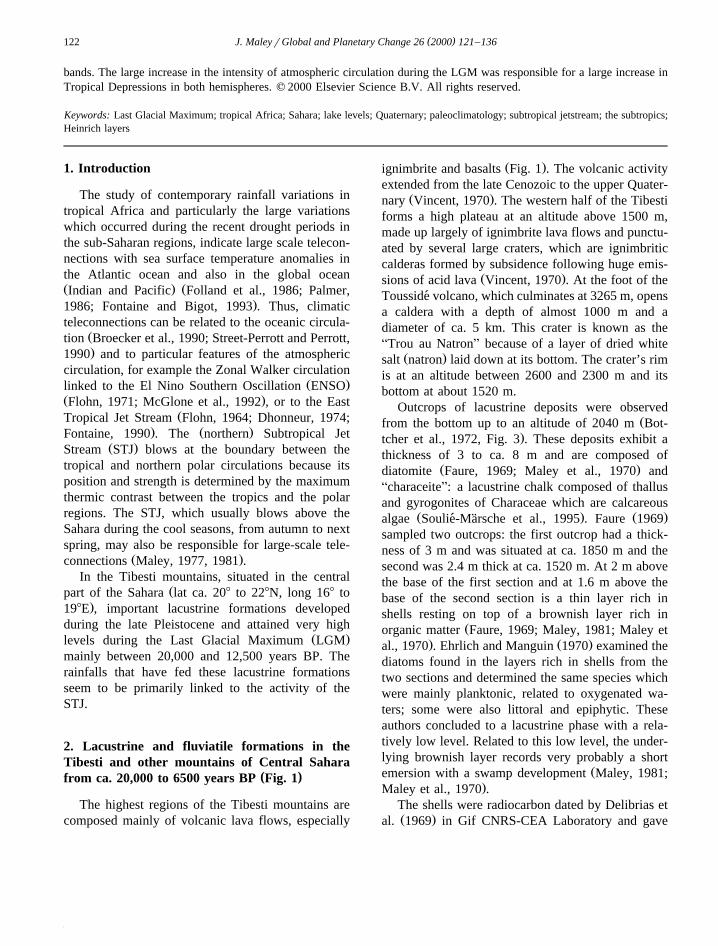
Ž . Global and Planetary Change 26 2000 121–136 www.elsevier.comrlocatergloplacha Last Glacial Maximum lacustrine and fluviatile Formations in the Tibesti and other Saharan mountains, and large-scale climatic teleconnections linked to the activity of the Subtropical Jet Stream Jean Maley ( ) PaleoenÕironnements et Palynologie CNRS r ISEM and IRD r ex ORSTOM, Prog. PVC , UniÕersite de Montpellier-2, ´ ´ Montpellier 34095, France Abstract Ž . In the mountains of the central Sahara lat ca. 208 to 228N, long 168 to 198E and particularly in the Tibesti mountains, Ž . important lacustrine formations developed during the late Pleistocene, primarily during the Last Glacial Maximum LGM . Two main phases, separated by a brief regression, intervened between ca. 20,000 and 15,500 BP, and between 15,000 and 12,500 BP. Pollen analyses were carried out on four samples of this formation. The high lacustrine levels were associated to both important precipitations and a reduced evaporation linked to lower temperatures. Similar lacustrine deposits were found in the Djebel Marra in the south of the Sahara. In the mountains of the central and eastern Sahara, during the same period and until the middle Holocene, the AMiddle TerraceB Formation was deposited in the river valleys of the Tibesti, Hoggar, Air and the Red Sea Hills. Since the southern headwaters of the Nile were dry from ca. 20,000 to 12,500 BP, the fluviatile sediments deposited in the Nile valley in Nubia may have resulted almost entirely from the numerous wadis flowing from the Red Sea Hills. The rainfalls which fed these lacustrine and fluviatile formations were related to the Tropical Depressions which are Ž . formed in the southern part of the westerlies and are linked to the activity of the Subtropical Jet Stream STJ , whose path remained over the central Sahara from 20,000 BP to the early Holocene. In the Rocky Mountains of the western US, the palaeolakes Lahontan and Bonneville were very large during the LGM and the main fluctuations exhibit similar chronology w to that of the Saharan mountains. Broecker Broecker, W.S., 1994. Massive iceberg discharges as triggers for global climate x change. Nature 372, 421-424 estimates that these two large U.S. wet events between ca. 20,000–15,500 BP and ca. 15,000–12,500 BP may have been an indirect result of two large ice surges in the North Atlantic, related to Heinrich layers 1 and 2. We can assume, however, that the similar climatic variation of the Rocky Mountains and the central and eastern Saharan mountains was also a result of the activity of the STJ all along its path, which marks the boundary between the polar and tropical circulations. STJ activity can apparently produce long-distance climatic teleconnections. During the LGM similar teleconnections also existed in the Southern Hemisphere between South Africa and Australia. The Tropical Depressions result from the interaction of polar troughs and the influx of humid equatorial air forming transversal cloud Ž . E-mail address: [email protected] J. Maley . 0921-8181r00r$ - see front matter q 2000 Elsevier Science B.V. All rights reserved. Ž . PII: S0921-8181 00 00039-4
-
Upload
univ-montpellier -
Category
Documents
-
view
3 -
download
0
Transcript of MALEY, J. 2000 - Last Glacial Maximum lacustrine and fluviatile Formations in the Tibesti and other...
Ž .Global and Planetary Change 26 2000 121–136www.elsevier.comrlocatergloplacha
Last Glacial Maximum lacustrine and fluviatile Formationsin the Tibesti and other Saharan mountains,
and large-scale climatic teleconnectionslinked to the activity of the Subtropical Jet Stream
Jean Maley( )PaleoenÕironnements et Palynologie CNRSr ISEM and IRDrex ORSTOM, Prog. PVC , UniÕersite de Montpellier-2,´ ´
Montpellier 34095, France
Abstract
Ž .In the mountains of the central Sahara lat ca. 208 to 228N, long 168 to 198E and particularly in the Tibesti mountains,Ž .important lacustrine formations developed during the late Pleistocene, primarily during the Last Glacial Maximum LGM .
Two main phases, separated by a brief regression, intervened between ca. 20,000 and 15,500 BP, and between 15,000 and12,500 BP. Pollen analyses were carried out on four samples of this formation. The high lacustrine levels were associated toboth important precipitations and a reduced evaporation linked to lower temperatures. Similar lacustrine deposits were foundin the Djebel Marra in the south of the Sahara. In the mountains of the central and eastern Sahara, during the same periodand until the middle Holocene, the AMiddle TerraceB Formation was deposited in the river valleys of the Tibesti, Hoggar,Air and the Red Sea Hills. Since the southern headwaters of the Nile were dry from ca. 20,000 to 12,500 BP, the fluviatilesediments deposited in the Nile valley in Nubia may have resulted almost entirely from the numerous wadis flowing fromthe Red Sea Hills.
The rainfalls which fed these lacustrine and fluviatile formations were related to the Tropical Depressions which areŽ .formed in the southern part of the westerlies and are linked to the activity of the Subtropical Jet Stream STJ , whose path
remained over the central Sahara from 20,000 BP to the early Holocene. In the Rocky Mountains of the western US, thepalaeolakes Lahontan and Bonneville were very large during the LGM and the main fluctuations exhibit similar chronology
wto that of the Saharan mountains. Broecker Broecker, W.S., 1994. Massive iceberg discharges as triggers for global climatexchange. Nature 372, 421-424 estimates that these two large U.S. wet events between ca. 20,000–15,500 BP and ca.
15,000–12,500 BP may have been an indirect result of two large ice surges in the North Atlantic, related to Heinrich layers1 and 2. We can assume, however, that the similar climatic variation of the Rocky Mountains and the central and easternSaharan mountains was also a result of the activity of the STJ all along its path, which marks the boundary between the polarand tropical circulations. STJ activity can apparently produce long-distance climatic teleconnections. During the LGMsimilar teleconnections also existed in the Southern Hemisphere between South Africa and Australia. The TropicalDepressions result from the interaction of polar troughs and the influx of humid equatorial air forming transversal cloud
Ž .E-mail address: [email protected] J. Maley .
0921-8181r00r$ - see front matter q 2000 Elsevier Science B.V. All rights reserved.Ž .PII: S0921-8181 00 00039-4
( )J. MaleyrGlobal and Planetary Change 26 2000 121–136122
bands. The large increase in the intensity of atmospheric circulation during the LGM was responsible for a large increase inTropical Depressions in both hemispheres. q 2000 Elsevier Science B.V. All rights reserved.
Keywords: Last Glacial Maximum; tropical Africa; Sahara; lake levels; Quaternary; paleoclimatology; subtropical jetstream; the subtropics;Heinrich layers
1. Introduction
The study of contemporary rainfall variations intropical Africa and particularly the large variationswhich occurred during the recent drought periods inthe sub-Saharan regions, indicate large scale telecon-nections with sea surface temperature anomalies inthe Atlantic ocean and also in the global oceanŽ . ŽIndian and Pacific Folland et al., 1986; Palmer,
.1986; Fontaine and Bigot, 1993 . Thus, climaticteleconnections can be related to the oceanic circula-
Žtion Broecker et al., 1990; Street-Perrott and Perrott,.1990 and to particular features of the atmospheric
circulation, for example the Zonal Walker circulationŽ .linked to the El Nino Southern Oscillation ENSO
Ž .Flohn, 1971; McGlone et al., 1992 , or to the EastŽTropical Jet Stream Flohn, 1964; Dhonneur, 1974;
. Ž .Fontaine, 1990 . The northern Subtropical JetŽ .Stream STJ blows at the boundary between the
tropical and northern polar circulations because itsposition and strength is determined by the maximumthermic contrast between the tropics and the polarregions. The STJ, which usually blows above theSahara during the cool seasons, from autumn to nextspring, may also be responsible for large-scale tele-
Ž .connections Maley, 1977, 1981 .In the Tibesti mountains, situated in the central
Žpart of the Sahara lat ca. 208 to 228N, long 168 to.198E , important lacustrine formations developed
during the late Pleistocene and attained very highŽ .levels during the Last Glacial Maximum LGM
mainly between 20,000 and 12,500 years BP. Therainfalls that have fed these lacustrine formationsseem to be primarily linked to the activity of theSTJ.
2. Lacustrine and fluviatile formations in theTibesti and other mountains of Central Sahara
( )from ca. 20,000 to 6500 years BP Fig. 1
The highest regions of the Tibesti mountains arecomposed mainly of volcanic lava flows, especially
Ž .ignimbrite and basalts Fig. 1 . The volcanic activityextended from the late Cenozoic to the upper Quater-
Ž .nary Vincent, 1970 . The western half of the Tibestiforms a high plateau at an altitude above 1500 m,made up largely of ignimbrite lava flows and punctu-ated by several large craters, which are ignimbriticcalderas formed by subsidence following huge emis-
Ž .sions of acid lava Vincent, 1970 . At the foot of theTousside volcano, which culminates at 3265 m, opens´a caldera with a depth of almost 1000 m and adiameter of ca. 5 km. This crater is known as theATrou au NatronB because of a layer of dried white
Ž .salt natron laid down at its bottom. The crater’s rimis at an altitude between 2600 and 2300 m and itsbottom at about 1520 m.
Outcrops of lacustrine deposits were observedŽfrom the bottom up to an altitude of 2040 m Bot-
.tcher et al., 1972, Fig. 3 . These deposits exhibit athickness of 3 to ca. 8 m and are composed of
Ž .diatomite Faure, 1969; Maley et al., 1970 andAcharaceiteB: a lacustrine chalk composed of thallusand gyrogonites of Characeae which are calcareous
Ž . Ž .algae Soulie-Marsche et al., 1995 . Faure 1969´ ¨sampled two outcrops: the first outcrop had a thick-ness of 3 m and was situated at ca. 1850 m and thesecond was 2.4 m thick at ca. 1520 m. At 2 m abovethe base of the first section and at 1.6 m above thebase of the second section is a thin layer rich inshells resting on top of a brownish layer rich in
Žorganic matter Faure, 1969; Maley, 1981; Maley et. Ž .al., 1970 . Ehrlich and Manguin 1970 examined the
diatoms found in the layers rich in shells from thetwo sections and determined the same species whichwere mainly planktonic, related to oxygenated wa-ters; some were also littoral and epiphytic. Theseauthors concluded to a lacustrine phase with a rela-tively low level. Related to this low level, the under-lying brownish layer records very probably a short
Žemersion with a swamp development Maley, 1981;.Maley et al., 1970 .
The shells were radiocarbon dated by Delibrias etŽ .al. 1969 in Gif CNRS-CEA Laboratory and gave
( )J. MaleyrGlobal and Planetary Change 26 2000 121–136 123
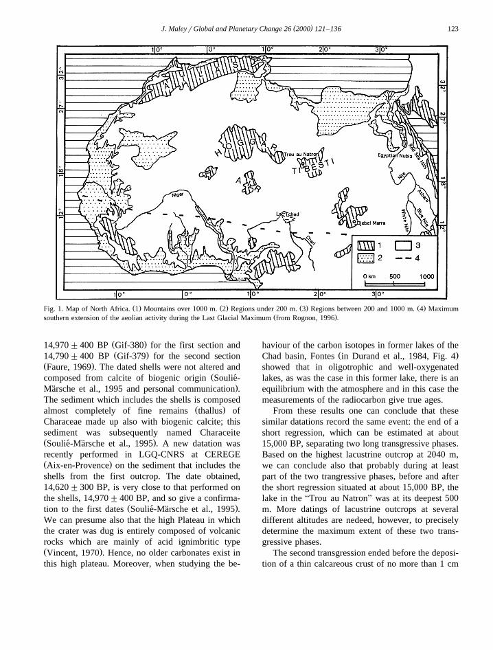
Ž . Ž . Ž . Ž .Fig. 1. Map of North Africa. 1 Mountains over 1000 m. 2 Regions under 200 m. 3 Regions between 200 and 1000 m. 4 MaximumŽ .southern extension of the aeolian activity during the Last Glacial Maximum from Rognon, 1996 .
Ž .14,970"400 BP Gif-380 for the first section andŽ .14,790"400 BP Gif-379 for the second section
Ž .Faure, 1969 . The dated shells were not altered andŽcomposed from calcite of biogenic origin Soulie-´
.Marsche et al., 1995 and personal communication .¨The sediment which includes the shells is composed
Ž .almost completely of fine remains thallus ofCharaceae made up also with biogenic calcite; thissediment was subsequently named CharaceiteŽ .Soulie-Marsche et al., 1995 . A new datation was´ ¨recently performed in LGQ-CNRS at CEREGEŽ .Aix-en-Provence on the sediment that includes theshells from the first outcrop. The date obtained,14,620"300 BP, is very close to that performed onthe shells, 14,970"400 BP, and so give a confirma-
Ž .tion to the first dates Soulie-Marsche et al., 1995 .´ ¨We can presume also that the high Plateau in whichthe crater was dug is entirely composed of volcanicrocks which are mainly of acid ignimbritic typeŽ .Vincent, 1970 . Hence, no older carbonates exist inthis high plateau. Moreover, when studying the be-
haviour of the carbon isotopes in former lakes of theŽ .Chad basin, Fontes in Durand et al., 1984, Fig. 4
showed that in oligotrophic and well-oxygenatedlakes, as was the case in this former lake, there is anequilibrium with the atmosphere and in this case themeasurements of the radiocarbon give true ages.
From these results one can conclude that thesesimilar datations record the same event: the end of ashort regression, which can be estimated at about15,000 BP, separating two long transgressive phases.Based on the highest lacustrine outcrop at 2040 m,we can conclude also that probably during at leastpart of the two trangressive phases, before and afterthe short regression situated at about 15,000 BP, thelake in the ATrou au NatronB was at its deepest 500m. More datings of lacustrine outcrops at severaldifferent altitudes are nedeed, however, to preciselydetermine the maximum extent of these two trans-gressive phases.
The second transgression ended before the deposi-tion of a thin calcareous crust of no more than 1 cm
( )J. MaleyrGlobal and Planetary Change 26 2000 121–136124
thick, which covers almost all of the volcanic rocksoutcropping from the bottom of the crater, but comesto an abrupt end approximately 500 m above the
Ž .bottom Ergenzinger, 1968 . This crust is finely lam-inated with a coralliform stromatolite facies, result-
Žing probably from the activity of algae Faure, 1969;.Maley, 1981 . This crust was deposited either in
open air or under a fine pellicule of seasonallyŽ .dripping water Maley, 1981 . A sample taken from
an altitude of ca. 1750 m was radiocarbon dated atŽ . Ž . Ž12,400 BP Gif-378 by Delibrias et al. 1969 Faure,
.1969 , implying at about this time an importantregression phase, with an almost complete drying ofthe previous lake.
The temporal beginning of the first lacustrineformation is not directly dated. Since the main lacus-
Ž .trine deposits, observed by Faure 1969 , were last
deposited at just prior to ca. 12,400 BP and consider-ing that a layer in the upper third of the two outcrops
Žwas dated at about 15,000 BP i.e. between ca..14,620 and 14,970 BP , we can assume that the
underlying two-thirds of these deposits were formedduring about 5000 years. Therefore, the base of thesedeposits can be roughly estimated at ca. 20,000 BPŽ .estimate updated from that given in Maley, 1981 .
Ž .Ergenzinger 1968 observed in several placesother fine lacustrine deposits lying above the calcare-ous crust. For this reason this third lacustrine forma-tion is post 12,400 BP. The highest observed outcropof this last lacustrine formation is at ca. 370 m abovethe bottom of the crater.
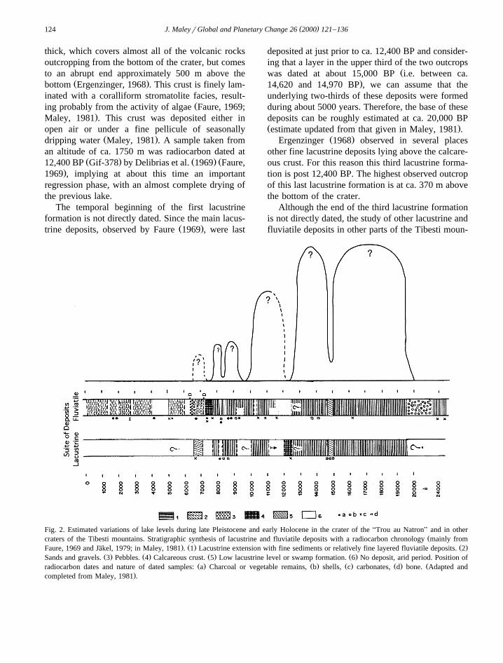
Although the end of the third lacustrine formationis not directly dated, the study of other lacustrine andfluviatile deposits in other parts of the Tibesti moun-
Fig. 2. Estimated variations of lake levels during late Pleistocene and early Holocene in the crater of the ATrou au NatronB and in otherŽcraters of the Tibesti mountains. Stratigraphic synthesis of lacustrine and fluviatile deposits with a radiocarbon chronology mainly from
. Ž . Ž .Faure, 1969 and Jakel, 1979; in Maley, 1981 . 1 Lacustrine extension with fine sediments or relatively fine layered fluviatile deposits. 2¨Ž . Ž . Ž . Ž .Sands and gravels. 3 Pebbles. 4 Calcareous crust. 5 Low lacustrine level or swamp formation. 6 No deposit, arid period. Position of
Ž . Ž . Ž . Ž . Žradiocarbon dates and nature of dated samples: a Charcoal or vegetable remains, b shells, c carbonates, d bone. Adapted and.completed from Maley, 1981 .
( )J. MaleyrGlobal and Planetary Change 26 2000 121–136 125
tains, as in the Zoumri valley at the east of Bardai,indicates that an important erosive discontinuity was
Ždated around 12,500 BP Maley et al., 1970; Jakel,¨.1979; Jakel and Schulz, 1972; Geyh and Jakel, 1974 .¨ ¨
This discontinuity could be linked to the end of thesecond lacustrine phase of the Trou au Natron. An-other phase of fluviatile deposits is bracketed be-
Žtween ca. 11,000 and 10,000 BP Geyh and Jakel,¨. Ž .1974; Jakel, 1979; Maley, 1981 Fig. 2 . Moreover¨
the discontinuity at about 15,000 BP in the lacustrinedeposits of the ATrou au NatronB could be linked toa short swamp phase observed in the Middle Terraceof the Zoumri valley, at the east of Bardai, half ameter below a level dated on shells 14,055"135 BPŽ .Molle, 1971; Jakel, 1979 . In other craters of the¨Tibesti Plateau, lacustrine deposits have been dated
Žfrom the early Holocene up to ca. 6500 BP Geyh.and Jakel, 1974; Jakel, 1979; Maley, 1981 . A¨ ¨
widespread calcareous crust dated at about 7700 to7200 BP indicates a regressive phase that separatedthe two major early Holocene lacustrine formations,one between ca. 9200 and 7800 BP and the other
Žbetween ca. 7100 and 6500 BP Jakel, 1979; Maley,¨.1981 . The lacustrine phase between 9200 and 7800
BP was also interrupted by a short regression aroundŽ .8200 BP Jakel, 1979; Maley, 1981 . The end of the¨
Ž .last lacustrine formation ca. 7100 to 6500 BP canbe linked to a widespread erosive phase frequentlycoupled with the deposit of a thick pebble layerŽ .Messerli, 1972; Geyh and Jakel, 1974; Jakel, 1979 ,¨ ¨which is also an indicator of the end of the AMiddle
Ž .TerraceB Maley, 1977, 1981 .Indeed in the mountains of the central Sahara,
during the entire period of the lacustrine formation inthe ATrou au NatronB described above, fluviatiledeposits were particularly well developed in the river
Ž .valleys of the Tibesti Jakel, 1979; Maley, 1981 , but¨Ž .also in the Hoggar Messerli et al., 1980 and the Air
Ž .mountains Servant, 1973; Morel, 1983 . From ca.20,000 to 6500 BP the AMiddle TerraceB was thetypical fluviatile formation of these regions. More-over older fluviatile deposits were observed also in
Žthese mountains Jakel, 1979; Messerli et al., 1980;¨.Morel, 1983 . A humid phase bracketed between ca.
25,000 and 20,000 BP is frequently reported throughthe lowland and upland regions of central and south-
Žern Sahara Servant, 1973; Maley, 1981; Rognon,. Ž .1996 , and also in Djebel Marra Section 4.1 and
ŽNubia Wendorf and Schild, 1976, 1980; Schild and.Wendorf, 1980; Paulissen and Vermeersch, 1987 .
3. Pollen analyses of the lacustrine formationsfrom the CTrou au NatronD and palaeoenviron-
( )mental interpretations Maley, 1981 .
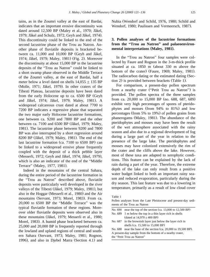
In the ATrou au NatronB four samples were col-lected by Faure and Rognon in the 3-m-thick profile
Žsituated at ca. 1850 m about 330 m above the. Ž .bottom of the crater Faure, 1969; Maley, 1981 .
ŽThe radiocarbon dating or the estimated dating Sec-. Ž .tion 2 is provided between brackets Table 1 .
For comparison, a present-day pollen spectrumŽ .from a nearby crater APetit Trou au NatronB is
provided. The pollen spectra of the three samplesŽ .from ca. 20,000 to 15,000 BP no. 688, 687, 689
exhibit very high percentages of spores of pterido-Ž .phytes and mosses from 94% to 81% and low
Ž .percentages from 5% to 19% of pollen grains fromŽ .phanerogams Maley, 1981 . The abundance of the
pteridophytes and mosses may have been the resultof the wet atmosphere associated with the rainyseason and also due to a regional development of fogduring a large part of the year in relation to thepresence of the large lake. The pteridophytes andmosses may have colonized extensively the rim ofthe crater and the cliffs above the lake. However,most of these taxa are adapted to xerophytic condi-tions. This feature can be explained by the lack ofrain during a part of the year. Therefore, the extremedepth of the lake can only result from a positivewater budget linked to both an important rainy sea-son and reduced evaporation, particularly during thedry season. This last feature was due to a lowering intemperature, primarily as a result of low cloud cover
Table 1Pollen analyses from the Late Pleistocene and present-day sedi-ments of the Trou au Natron
Ž .No. 690 near the top of the section ca. 13,000 to 12,500 BPNo. 689 1 m below the top in a thin layer rich in shells
Ž .dated at 14,970"400 BPNo. 687 in the brownish layer just below the layer rich in
Ž .shells ca. 15,500 to 15,000 BPŽ .No. 688 near the base of the section ca. 20,000 to 19,500 BP .
A present-day sample from the bottom of a nearby crater,the APetit Trou au NatronB
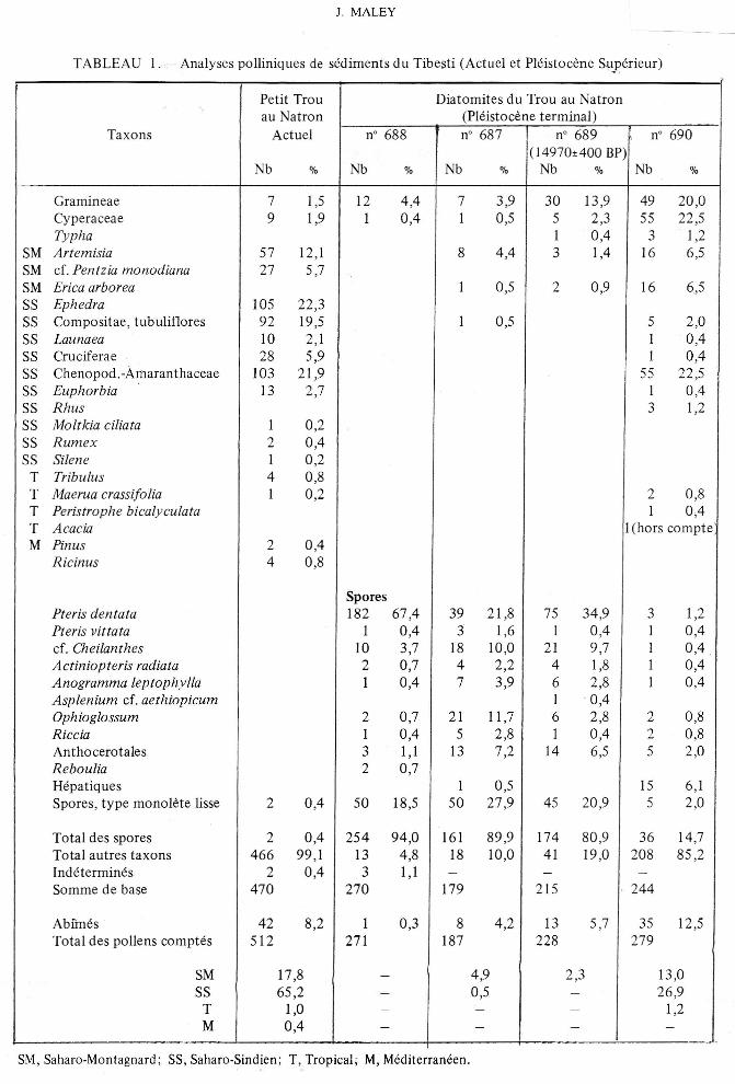
Petit Trou Diatomites du Trou au Natronau Natron (Pleistocene terminal)
Taxons Actuel n° 688 n° 687 n° 689 n° 690(14970±400 BP)
Nb % Nb % Nb % Nb % Nb %
Gramineae 7 1,5 12 4,4 7 3,9 30 13,9 49 20,0Cyperaceae 9 1,9 1 0,4 1 0,5 5 2,3 55 22,5Typha 1 0,4 3 1,2
SM Artemisia 57 12,1 8 4,4 3 1,4 16 6,5SM cf. Pentzia monodiana 27 5,7SM Erica arborea 1 0,5 2 0,9 16 6,5SS Ephedra 105 22,3SS Compositae, tubuliflores 92 19,5 1 0,5 5 2,0SS Launaea 10 2,1 1 0,4SS Cruciferae 28 5,9 1 0,4SS Cheno pod. -Amaran thaceae 103 21,9 55 22,5SS Euphorbia 13 2,7 1 0,4SS Rhus 3 1,2SS Moltkia ciliata 1 0,2SS Rumex 2 0,4SS Silene 1 0,2T Tribulus 4 0,8T Maerua crassifolia 1 0,2 2 0,8T Peristrophe bicalyculata 1 0;4T Acacia 1(hors compteM Pinus 2 0,4
Ricinus 4 0,8
SporesPteris dentata 182 67,4 39 21,8 75 34,9 3 1,2Pteris vittata 1 0,4 5 1,6 1 0,4 1 0,4cf. Cheilanthes 10 3,7 18 10,0 21 9,7 1 0,4Actiniopteris radiata 2 0,7 4 2,2 4 1,8 1 0,4Anogramma leptophylla 1 0,4 7 3,9 6 2,8 1 0,4Asplenium cf. aethiopicum 1 0,4Ophioglossum 2 0,7 21 11,7 6 2,8 2 0,8Riccia 1 0,4 5 2,8 1 0,4 2 0,8An tho cerotales 3 1,1 13 7,2 14 6,5 5 2,0Reboulia 2 0,7Hepatiques 1 0,5 15 6,1Spores, type monolete Iisse 2 0,4 50 18,5 50 27,9 45 20,9 5 2,0
Total des spores 2 0,4 254 94,0 161 89,9 174 80,9 36 14,7Total autres taxons 466 99,1 13 4,8 18 10,0 41 19,0 208 85,2Indetermines 2 0,4 3 1,1 - - -Somme de base 470 270 179 215 244
Abfmes 42 8,2 1 0,3 8 4,2 13 5,7 35 12,5Total des pollens comptes 512 271 187 228 279
SM 17,8 - 4,9 2,3 13,0SS 65,2 - 0,5 - 26,9T 1,0 - - - 1,2M 0,4 - - - -
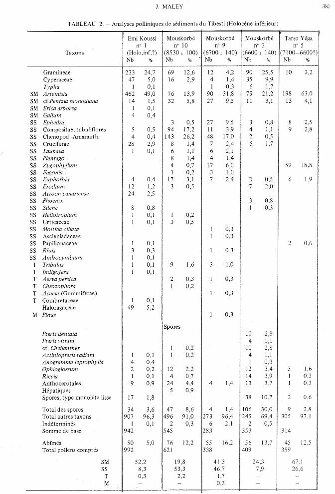
! E . K . Mouskorbe Mouskorbe Mouskorbe ' T"'" Y 'g, 1. m) OUSS)I n° I n° 10 n° 9 n° 3 n° 5Taxons I (Holo.inf.?) (8530 ± 100) (6700 ± 14O) (6600 ± 14O) (7 100-6600?)
. Nb % Nb % ' Nb % Nb % Nb %
Gramineae 233 24,7 69 12,6 12 4,2 90 25,5 10 3,2Cyperaceae 47 5,0 16 2,9 4 1,4 35 9,9Typha I 0,1 I 0,3 6 1,7
SM Artemisia 462 49,0 76 13,9 90 31,8 75 21,2 198 63,0SM cfPentzia monodiana 14 1,5 32 5,8 27 9,5 II 3,1 13 4,1SM Erica arborea I 0,1SM Galium 4 0,4SS Ephedra 3 0,5 27 9,5 3 0,8 8 2,5SS Compositae, tubuliflores 5 0,5 94 17,2 II 3,9 4 1,1 9 2,8SS Chenopod.-Amaranth. 4 0,4 143 26,2 48 17,0 2 0,5SS Cruciferae 28 2,9 8 1,4 7 2,4 6 1,7SS Launaea 1 0,1 6 I, I 6 2,1SS Plantago 8 1,4 4 1,4SS Zygophyllum 4 0,7 17 6,0 59 18,8SS Fagonia. I 0,2 3 1,0SS Euphorbia 4 0,4 17 3,1 7 2,4 2 0,5 6 1,9SS Erodium 12 1,2 3 0,5 7 2,0SS Aizoon canariense 24 2,5SS Phoenix 3 0,8SS Silene 8 0,8 I 0,3SS Heliotropium I 0,1 I 0,2SS Urticaceae I 0,1 3 0,5SS Moltkia ciliata I 0,3SS Asclepiadaceae I 0,3SS Papilionaceae I 0,1 2 0,6SS Rhus 3 0,3 I 0,3SS Androcymbium 1 0,1T Tribulus I 0,1 9 1,6 3 1,0T Indigofera 1 0,1T Aerva persica 2 0,3 I 0,3T Chrozophora 1 0,2T Acacia (Gummiferae) 1 0,3T Combretaceae 1 0,1
Haloragaceae 49 5,2M Pinus 1 0,3
SporesPteris dentata 10 2,8Pteris vittata 4 1,1cf. Cheilanthes 1 0,2 10 2,8Actiniopteris radiata 1 0,1 I 0,2 4 1,1Anogramma leptophylla 4 0,4 I 0,3Ophioglossum 2 0,2 12 2,2 12 3,4 5 1,6Riccia I 0,1 4 0,7 14 3,9 1 0,3Anthocerotales 9 0,9 24 4,4 4 1,4 13 3,7 I 0,3Hepatiques 5 0,9Spores, type monolete lisse 17 1,8 38 10,7 2 0,6
Total des spores 34 3,6 47 8,6 4 1,4 106 30,0 9 2,8Total autres taxons 907 96,3 496 91,0 273 96,4 245 69,4 305 97,1Indetermines I 0,1 2 0,3 6 2,1 2 0,5Somme de base 942 545 283 353 314
Abimes 50 5,0 76 12,2 55 16,2 56 13.7 45 12,5Total pollens comptes 992 621 338 409 359
SM 52,2 19,8 41,3 24,3 67,1SS 8,3 53,3 46,7 7,9 26.6T 0,3 2,2 1,7 - -M - - 0,3 - -
( )J. MaleyrGlobal and Planetary Change 26 2000 121–136126
and fog. Using an energy balance model designed tointerpret the functioning of the former LahontanŽ .Bonneville paleolake in the Rocky MountainsŽ .western USA , which exhibits late Pleistocene fluc-tuations similar to those of the ATrou au NatronBŽ . Ž .Section 5 , Benson 1981 Aconcluded to the funda-mental influence of cloud cover on changes in thehydrologic balance of closed basin systemsB.
Several data exist concerning the lowering oftemperature during this period in the Saharan moun-tains. First the presence of diatoms of the northalpine type in the lacustrine deposits points out to
Žprobably cold waters Faure, 1969; Ehrlich and Man-. Ž .guin, 1970 . Messerli 1972 and Messerli et al.
Ž .1980 also observed sediments and numerous geo-morphological features in the Tibesti mountains thatwere related to the actions of snow and ice; forexample, they described a rock glacier. Using pre-sent-day temperature measurements near the ATrou
Ž .au NatronB and in the Hoggar Assekrem , MesserliŽ . Ž .1972 and Messerli et al. 1980 were able to maketemperature estimates for the mountains in the cen-tral Sahara during the LGM. They concluded a meantemperature lowering of ca. 108C in the winter sea-son and 68 to 88C in July.
Compared to the present-day pollen spectra andalso to the spectra obtained from Holocene sedi-
Ž .ments Maley, 1981 , the low percentages ofphanerogams between ca. 20,000 and 15,000 BPseem to be primarily due to the fact that most of the
Žprecipitation was in the form of snow Messerli,.1972; Messerli et al., 1980 . Snow cover can still
occasionally be observed today on the high plateausŽ .Messerli, 1972 . The reduction of Sahara-mountainvegetation was probably the result of the spreadingof snow and the temperature lowering, which hasforced many taxa to migrate to lower altitudes or toshelter in isolated stations. The current very dryclimate in the lowlands of the northern and southernSahara has also eliminated almost all vegetationŽ .Maley, 1981 .
Following the lacustrine regression around 15,000BP, the phanerogams increase abruptly and dominatewith 85% of the pollen grains belonging to au-
Ž .tochthonous present day taxa Maley, 1981 . Thisphenomenon may be related to an increase in tem-perature. However, the spores remained with fre-quencies of ca. 15%, implying that ferns and Hepat-
ics probably grow once again on the upper rim of thecrater. The temperature increase considerably re-duced the annual snow cover, but it also increasedthe evaporation, which, however, was still lowerthan it is today. The persistent high lacustrine levelsprobably means that the precipitations were rela-tively high until ca. 12,500 BP.
4. Comparison with the lacustrine and fluviatiledeposits of other mountain regions of southernand eastern Sahara
In the mountains of southern and eastern Saharasimilar lacustrine and fluviatile formations have ex-isted during the same period. While these formationsimply important rains in the mountains, however inthe same time the aridity was maximum in thelowlands. This aridity was characterized by the for-mation of large dune fields, which extended alsooutside the present-day northern and southern bound-
Žaries of the Sahara Servant, 1973; Michel, 1977;.Sarnthein, 1978; Rognon, 1996 . In the Chad basin,
for instance, when today the southern boundaryof the active dune fields is situated around the lati-tude of 168N, during the LGM this boundary shifteduntil the latitude of around 108N, i.e. a southern ex-
Žtension of 600 to 700 km Servant, 1973; Maley,.Ž .1981 Fig. 1 .
4.1. The deposits of the Djebel Marra in Sudan
Ž X .The Djebel Marra lat 138N, long 4815 E issituated in Sudan near the present-day southern limitof the Sahara. It is formed by a strato volcano whichculminates at 3042 m and in which are lacustrine
Ždeposits dated from the Late Pleistocene Williams.et al., 1980 . In the Deriba caldera, which has a
diameter of roughly 5 km, is a residual lake at anŽ .elevation of ca. 2000 m. Williams et al. 1980 have
described several outcropping lacustrine deposits withsix radiocarbon datings of calcareous crusts. Theoldest deposits they observed dated at prior to ca.19,000 BP and correspond to the highest shoreline atq25 m above the present lake level. This first andoldest lacustrine phase could correspond to thewidespread ca. 25,000 to 20,000 BP humid phase
Ž .indicated above Section 2 . Following a regression,a second lacustrine formation dated at between ca.19,000 and 16,000 BP with shorelines between q5
( )J. MaleyrGlobal and Planetary Change 26 2000 121–136 127
and q8 m. After yet another regression, a thirdlacustrine formation arose at roughly 14,000 BP withshoreline at q9 m; a subsequent regression inter-
Žvened later, but was not dated Williams et al.,.1980 . Based on these data it appears that the last
two lacustrine formations of the Djebel Marra proba-bly correspond to those of the ATrou au NatronBdated between ca. 20,000 and 12,500 BP.
4.2. The deposits of the Egyptian Nubia
In the Nubian region of the eastern Sahara andparticularly in the Egyptian Nubia, numerous andextensive researches were conducted between thesixties and the eighties on the fluviatile deposits ofthe Nile and of some regional wadis. In this regionthe Nile valley is at an altitude of around 100 m. Wepresent there a short account concerning the periodbetween ca. 20,000 and 10,000 BP based on severalsynthetic publications written by the main authorsŽButzer, 1980; Wendorf et al., 1990; Wendorf andSchild, 1976, 1980; Schild, 1987; Schild and Wen-
.dorf, 1980, 1989; Paulissen and Vermeersch, 1987and also by authors who worked in the upstream
Žregions of the Blue and White Nile Adamson et al.,.1980, 1982 . The present author has had the opportu-
nity to work also in Nubia around the second CataractŽ .of the Nile, in northern Sudan Maley, 1969, 1970 .
The main and outstanding problem concerns thecorrelations during the LGM between the events inthe Blue and White Nile areas and these along thelower main Nile in Nubia and Egypt. Indeed duringthe period from 19–17,000 to 12,500 BP which wasmarkedly more arid than today in the areas around
Žthe headwaters of the Nile Basin Adamson et al.,.1980 , the main Nile in southern Egypt and in Su-
danese Nubia is said to have had a continuousdischarge. All the authors working in Nubia considerthat this discharge can only have come from theheadwaters. However, the two Niles south of Khar-toum were highly seasonal with very low discharges.During the LGM and before ca. 13,000 BP the lake
ŽVictoria dried up quite completely Johnson et al.,.1996 . The extensive sand dunes deposited in the
floor of the White Nile trough south of KhartoumŽ .Adamson et al., 1982 date probably of this periodand imply at least a long seasonal drying of the river.
With a so low seasonal discharge, one can questionif the main Nile north of Khartoum could haveflowed until the Egyptian Nubia? To resolve thisproblem, indeed a part of these different statementsmust be wrong.
Ž .According to Butzer 1980 , the fluviatile sedi-ments deposited along the Nile in Nubia wereAvigorousB and formed braided channels. These bed-load deposits included exotic pebbles which origi-nated from Ethiopia or southern Sudan, apparentlyimplying significant fluvial transport from these re-gions. Wendorf, Schild and other colleaguesŽ .Wendorf and Schild, 1976, 1980 , among their nu-merous researches, have worked in the mouth of thewadi Kubbaniya, a wadi from the western bank ofthe Nile between Aswan and Kom-Ombo. In thisplace between 10 to 20 m of fluviatile sedimentswere deposited between ca. 19,000 and 10,000 BPand the accumulation of these sediments interfin-gered constantly with dune accumulation indicating apronounced local eolian activity. At no point did thewadi contribute any sediment to the sequenceŽ .Wendorf and Schild, 1976, 1980 . Paulissen and
Ž .Vermeersch 1987 showed that between about20,000 and 12,500 BP the slope deposits along theNile in southern Egypt were very coarse, confirmingthe local hyperaridity. However, Butzer was able toshow that in opposition to the wadis of the westernbank, those of the eastern bank of the Nile were veryactive during this period. Butzer described the east-ern wadi deposits near Kom Ombo and named theMalki Member of the Ineiba Formation. The MalkiMember began before 17,500 BP and terminatedaround 13,000 BP, just before the deposits of the
Ž .AWild NileB see below . According to Butzer, theMalki Member at Kom Ombo consists of a lightbrown, laminated clayey silt, with prismatic tenden-cies and frequent slickensides. Local gravels areconfined to lenses near the base. The Malki Memberhad a thickness exceeding 9 m and is now forming aq4 to q6 m wadi terrace. Butzer concluded thatthese deposits represent suspended sediment carriedto the edge of the Nile floodplain by a large water-
Ž .course the wadi al Kharit flowing from the Red SeaHills. The headwater of this wadi culminate at 1975m. From these data, it appears that the Malki Mem-ber can be correlated with the other fluviatile andlacustrine deposits described in this paper from dif-
( )J. MaleyrGlobal and Planetary Change 26 2000 121–136128
ferent mountain regions of the Sahara. The MalkiMember clearly corresponds to the lower part of theAMiddle TerraceB.
To resolve the problem concerning the dry head-waters of the Nile which occurred in the same timeof the fluviatile sediments deposited in the Nilevalley in Nubia, one could assume that these sedi-ments came almost entirely from the numerous wadisflowing from the Red Sea Hills which in Egypt andSudan culminate at altitudes between 1500 and 2200m. Concerning the exotic pebbles included in thesediments deposited in the Nile valley one can esti-mate also that they could have been reworked fromolder true Nile sediments.
The return of the true Nile floods and sedimentscorresponds to the AWild NileB phase described in
ŽNubia Wendorf and Schild, 1976, 1980; Butzer,.1980; Paulissen and Vermeersch, 1987 . This Wild
Nile phase was relatively short; it began between13,000 and 12,500 BP and ended around 12,000 BP;the flood levels were the highest for the late Pleis-tocene and the Holocene, around q30 m above thepresent-day flood plain in Nubia, i.e. 10 to 12 m
Ž .above the highest levels of the Holocene ArkinŽFormation which occurred around 7000 BP Wendorf
and Schild, 1976, 1980; Butzer, 1980; Paulissen and.Vermeersch, 1987 . This Wild Nile phase implies
enormous annual floods and consequently huge mon-soon rains in the headwaters of the Blue Nile andWhite Nile. The return to wetter conditions in these
Žregions occurred indeed around 12,500 BP Adam-.son et al., 1980, 1982 . However, the new filling up
of the lake Victoria that began around 12,400 BPŽ .Johnson et al., 1996 could be the main explanationof the Wild Nile phase because the new overflowingof the lake Victoria led to a brutal re-opening of theupper reach of the White Nile. More to the west in
Ž .the Chad basin Maley, 1981 and in southernŽ .Cameroon Maley and Brenac, 1998 the return to
wetter conditions indeed intervened around 12,500BP.
5. Palaeoclimatic interpretations for the Sahararegions
Ž .Sarnthein et al. 1981 relating to Atlantic marinedata concluded that during both the warm and the
cold climatic stages of the late Quaternary and par-ticularly during the LGM, the circulation of theatmosphere over subtropical North Africa retained abasically stable latitudinal position but was associ-ated with considerable variations in the intensity.Accordingly, the centre of the arid belt would haveremained approximately in the same position, but thebelt would have expanded during the cold periodsand contracted during the warm ones. In a recentstudy from the Canary Islands and the coastal re-gions of Morocco, Rognon and Coude-Gaussen´Ž .1996 showed that during the LGM mobile dunesmoved inland in a west-to-east direction implyingthat the westerly wind was much stronger than today.
ŽRelating to inland Saharan data, Maley 1981, p..542 reached the same conclusions with arguments
based to the geographic extent of the Middle Terracewhich he linked also to the position of the STJ abovethe Sahara.
During the present-day period, the monsoon rainsusually attain the central Sahara only in the summerwhere they produce violent storms. However in thecentral Sahara the largest rains fall primarily duringthe year’s cool seasons — specifically in the spring
Žand autumn, and more rarely in the winter Dubief,.1963; Wilson, 1978 . The rains during these cool
seasons are linked to Tropical Depressions also re-Žferred to as ASaharan DepressionsB Flohn, 1971;
.Maley, 1977, 1981; Flohn and Nicholson, 1980 orŽAHeug rainsB in the western Sahara Dubief, 1963;
.Le Borgne, 1979 , AKhamsin DepressionsB in theŽ .eastern Sahara Tantawy, 1969; Pedgley, 1972 and
ASudano–Saharan DepressionsB in the southern Sa-hara or even rarely in the northern savanna beltŽ .Suchel, 1980 . While monsoon rains are stormy, therains of the Tropical Depressions are usually gentle
Ž .and continuous Delorme, 1963 . Linked to thesegentle and continuous rains, the sediments depositedin the rivers are fine and well stratified, but follow-ing stormy rains, the sediments are sandy and coarser.The size of the raindrops which is different betweenthese two rain types, explain the correlation betweenthe granulometry of the sediments and the rain typesŽ .see Fig. 6 in Maley, 1982 . The importance of dustin the troposhere during the cool seasons also ex-
Žplains the fine character of the sediments Maley,.1981, 1982 . Therefore, when the rains are associ-
ated to Tropical Depressions, the sediments that
( )J. MaleyrGlobal and Planetary Change 26 2000 121–136 129
accumulate in the rivers are predominately fine andwell stratified. When the rains occur in the northernfront of the monsoon, the precipitations are mainlystormy and the sediments deposited are sandy and
Ž .coarse Maley, 1981, 1982 . So, in studying numer-ous profiles, the granulometric character of the fluvi-atile sediments can help the palaeoclimatic interpre-tation.
Since the Saharan lowlands were very dry withlarge extension of eolian activity between ca. 20,000
Žto 12,500 BP Servant, 1973; Maley, 1981; Rognon,. Ž .1996 Section 4 and since the lacustrine and fluvi-
atile formations developed during this period in themountains of the central and southern Sahara weremainly composed of fine and well-stratified deposits,therefore these formations cannot be monsoonal in
Žorigin but only linked to Tropical Depressions Sec-.tions 2–4 . In the lower troposhere, the wind respon-
sible for aeolian activity was very strong and, as aresult, the rains evaporated before they reached thelowlands; therefore, the rains were only effective inthe upland mountainous regions. The fine characterof these deposits were related to the rain types, asexplained above, but mainly also to the large quan-
Žtity of dust which circulated in the troposphere Ma-.ley, 1982 . Several authors pointed out to the loessic
Žcharacter of the sediments for this period Maley,.1981, 1982; Coude-Gaussen, 1987; McTainsh, 1987 .´
Moreover, because the lacustrine deposits formedduring this period in the Djebel Marra were situatedat ca. 138N, one can estimate that during the LGMthe Tropical Depressions reached the present daysouthern boundary of the Sahara. In the easternSahara the more southern of these Tropical Depres-sions could have reached the northern part of theEthiopian Plateau and so could have been responsi-ble for the low discharge of the Blue Nile and othernearby rivers during the LGM.
In the Tibesti the study of the deposits of theupper part of the Middle Terrace which accumulatedduring the early Holocene shows that the sediments
Ž .were fine before ca. 8000 BP Sections 2 and 4 butafter this date and until ca. 7000–6500 BP they wereprogressively enriched with coarse materials, or with
Žalternating fine and coarse layers Maley, 1977,.1981 . Thus, one can deduce a progressive increase
of monsoon rains during the summer, alternatingwith periods exhibiting more precipitations from
Ž .Tropical Depressions Maley, 1977, 1981, 1982 . Inthe Eastern Sahara such rain type alternation was
Ž .also estimated by Kropelin 1993 . The mid-Holo-¨cene erosive phase occurring around 6500–6000 BPwas responsible for the end of the AMiddle TerraceB.This phase was associated with the domination of the
Ž .monsoon rains Maley, 1977, 1981, 1982 . Duringthis period the activity of Tropical Depressions wasprobably much reduced, but it was then renewed inthe late Holocene following a general cooling after
Ž .ca. 4000 BP Maley, 1977, 1981, 1997 .The Tropical Depressions are formed in the south-
ern part of the westerlies; these depressions aretherefore cyclonic and controlled by the activity ofthe STJ, whose path coincides with the limit between
Žpolar and tropical circulations Ramaswamy, 1956;Krishnamurti, 1961; Riehl, 1981; Thepenier and´
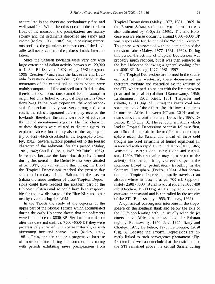
. Ž .Cruette, 1981 Fig. 4 . During the year’s cool sea-sons, the axis of the STJ reaches the lowest latitudes
Ž .in northern Africa between 208 and 308N and re-Žmains above the central Sahara Dettwiller, 1967; De
. Ž .Felice, 1975 Fig. 3 . The synoptic situations whichlead to Tropical Depressions occur as follows: first,an influx of polar air in the middle or upper tropo-sphere reach the Sahara and ahead of these coldtroughs are brief invasions of humid equatorial air
Žassociated with a rapid ITCZ undulation Jalu, 1965;Winstanley, 1970; Flohn, 1971; Flohn and Nichol-
.son, 1980 . This undulation may be a result of theactivity of boreal cold troughs or even surges in themonsoon linked to perturbations travelling in the
Ž .Southern Hemisphere Dorize, 1974 . After forma-tion, the Tropical Depression usually travels at an
Žaltitude where its base is at ca. 700 mb approxi-.mately 2500r3000 m and its top at roughly 300r400
Ž . Ž .mb Drochon, 1971 Fig. 4 . Its trajectory is north-eastward or eastward and is controlled by the activity
Ž .of the STJ Ramaswamy, 1956; Tantawy, 1969 .A dynamical convergence intervene in the tropo-
sphere on the southern flank and below the axis ofthe STJ’s accelerating path, i.e. usually when the jetenters above Africa and blows above the Saharan
Žregions Ramaswamy, 1956; Jalu, 1965; Barry and.Chorley, 1971; De Felice, 1975; Le Borgne, 1979
Ž .Fig. 3 . Because the Tropical Depressions are di-Žrectly linked to such convergence phenomena Fig.
.4 , therefore we can conclude that the main axis ofthe STJ remained above the central Sahara during
()
J.Maleyr
Globaland
Planetary
Change
262000
121–
136130
Ž . Ž .Fig. 3. The STJ: its present-day mean position and speed kmrh in the Northern Hemisphere in January and July. from Namias and Clapp, in Estienne and Godard, 1970 .

( )J. MaleyrGlobal and Planetary Change 26 2000 121–136 131
Fig. 4. Cross section of the STJ during the cool season above theSahara and position of a Tropical Depression. The arrows indicatethe cross circulation to the Jet with development of dynamicalsubsidence or convergence on both sides of the Jet axis. Ac,
ŽAltocumulus adapted from Jalu, 1965 and De Felice, 1975; figure.from Maley, 1981 .
the gradual accumulation of the Middle Terrace andother related lacustrine deposits, i.e. from 20,000 BP
Ž .to the early Holocene Maley, 1981 . Fine fluviatilesediments were deposited also in the northern part of
Ž . ŽIndia ca. 238N during the same period Williams.and Clarke, 1984 , and so these sediments probably
belong to a similar Middle Terrace formation. There-fore, we can estimate that during this period andduring the cool season, the path of the STJ wassituated south of the Himalayas. In the loess depositsof central China, the datations of the two last peaks
Ž .of grain-size maxima Porter and An, 1995 aresynchronous with the two lacustrine and fluviatile
Ž .regressions presented above. Porter and An 1995relate these grain-size maxima to Atlantic Heinrich
Ž .events Section 6 and also to large increases ofwesterly winds, which can be assimilated to the STJactivity.
6. Teleconnections between the mountains of cen-tral and eastern Sahara and the Rocky Mountainsin the western US
The STJ corresponds to the upper troposphericŽbranch of the main Polar Jet Stream Barry and
.Chorley, 1971 . In the Rocky Mountains, a similarŽ .palaeoclimatic role Section 4 has been attributed to
the Polar Jet Stream with regard to lacustrine forma-tions in the large palaeolakes Lahontan and Bon-
Ž . Žneville ca. 408N during the late Pleistocene Be-
.nson and Thompson, 1987; Benson et al., 1995Ž .Figs. 5 and 6 . The most important aspect of thiscomparison is the close temporal similarity for themain fluctuations of the palaeolakes Bonneville inUS and ATrou au NatronB in central Sahara from ca.
Ž20,000 BP until the beginning of the Holocene Figs..2 and 6 . After ca. 10,000 BP the difference in the
variations for these two lakes can probably be relatedto the larger influence of monsoon rains in thecentral Sahara. From the data and interpretationspresented above, we can conclude that during thelate Pleistocene, the teleconnections between theRocky Mountains and the central and eastern Saha-ran mountains probably resulted from the activity ofthe STJ.
Several late Quaternary palaeoenvironmental stud-Ž .ies, i.e. in central Texas Toomey et al., 1993 and
Žsouthern California Enzel et al., 1989; Spaulding,.1991; Sirocko et al., 1999 also concluded that the
STJ played a fundamental palaeoclimatic role. Basedon changing orbital parameters and estimated surface
Žboundary conditions for 18,000 BP in January cold. .season , Kutzbach and Guetter, 1986, fig. 12 and
Ž .COHMAP 1988, figs. 3 and 4 reconstructed theŽformer path of the main westerly Jet Stream prim-
.arily the STJ above North America and Europe,including northern Africa. Their reconstructionshowed that the path of the STJ was situated abovethe Rocky Mountains and, after crossing the At-lantic, above the Mediterranean Sea or southern Eu-rope. This reconstruction is different from thatreached in this study, which shows clearly a path
Ž .above the central Sahara. Bryson 1992, fig. 11 , inusing the AZ-criterionB, which is mainly a functionof vertical and meridional temperature gradientsŽ .Smagorinsky, 1963 , also modeled for the LGM
Žperiod an STJ path above the Sahara i.e. around. Ž26r278N in February at 500 mb . Bryson 1992, Fig.
.12 predicted also a roughly twofold increase ofrainfalls for this period in northern North Africa at318 N. Such increase in rainfall, associated with animportant diminution of the evaporation due to a
Ž .large temperature lowering Section 3 , may alsoexplain the very high lacustrine levels in the Tibestidescribed above.
Based on the long-distance correlations presentedin this paper, the conclusions reached by BroeckerŽ .1994 for the US could be tentatively applied to
( )J. MaleyrGlobal and Planetary Change 26 2000 121–136132
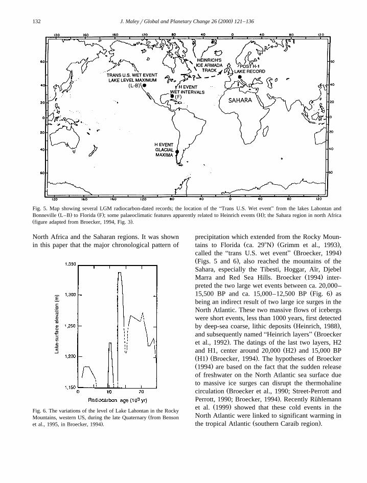
Fig. 5. Map showing several LGM radiocarbon-dated records; the location of the ATrans U.S. Wet eventB from the lakes Lahontan andŽ . Ž . Ž .Bonneville L–B to Florida F ; some palaeoclimatic features apparently related to Heinrich events H ; the Sahara region in north Africa
Ž .figure adapted from Broecker, 1994, Fig. 3 .
North Africa and the Saharan regions. It was shownin this paper that the major chronological pattern of
Fig. 6. The variations of the level of Lake Lahontan in the RockyŽMountains, western US, during the late Quaternary from Benson
.et al., 1995, in Broecker, 1994 .
precipitation which extended from the Rocky Moun-Ž . Ž .tains to Florida ca. 298N Grimm et al., 1993 ,
Ž .called the Atrans U.S. wet eventB Broecker, 1994Ž .Figs. 5 and 6 , also reached the mountains of theSahara, especially the Tibesti, Hoggar, Aır, Djebel¨
Ž .Marra and Red Sea Hills. Broecker 1994 inter-preted the two large wet events between ca. 20,000–
Ž .15,500 BP and ca. 15,000–12,500 BP Fig. 6 asbeing an indirect result of two large ice surges in theNorth Atlantic. These two massive flows of icebergswere short events, less than 1000 years, first detected
Ž .by deep-sea coarse, lithic deposits Heinrich, 1988 ,Žand subsequently named AHeinrich layersB Broecker
.et al., 1992 . The datings of the last two layers, H2Ž .and H1, center around 20,000 H2 and 15,000 BP
Ž . Ž .H1 Broecker, 1994 . The hypotheses of BroeckerŽ .1994 are based on the fact that the sudden releaseof freshwater on the North Atlantic sea surface dueto massive ice surges can disrupt the thermohaline
Žcirculation Broecker et al., 1990; Street-Perrott and.Perrott, 1990; Broecker, 1994 . Recently Ruhlemann¨
Ž .et al. 1999 showed that these cold events in theNorth Atlantic were linked to significant warming in
Ž .the tropical Atlantic southern Caraib region .
( )J. MaleyrGlobal and Planetary Change 26 2000 121–136 133
However the palaeoclimatic correlations duringthe LGM from the Rocky Mountains to the SaharanMountains and until northern India and China canalso be explained by the activity of the STJ all alongits path. The expansion of continental ice sheetsduring this period in northern America and Europehas had a major role in controlling the position andintensity of the STJ. Moreover the lacustrine regres-sions dated at ca. 20,000 and 15,000 BP can belinked to the sudden releases of freshwater and syn-
Ž .chronous tropical warming see above which wereprobably responsible for the shortening of the yearlymaximum activity of the STJ. The same phe-nomenon can also explain the lacustrine regressiondated at ca. 12,500 BP because it intervened at the
Žtime of the first and large monsoon extension Sec-.tion 4.2 , synchronous with a tropical warming phase
Ž .Maley and Brenac, 1998 .When we refer to the present day synoptic situa-
Ž .tions leading to Tropical Depressions Section 5 , weobserve that in the Saharan lowlands the wind in-
Ž .creases at ground level aeolian activity and in theSaharan uplands the importance of rains related toTropical Depressions are both linked to the STJactivity and to the frequency of cold outbreaks inpolar troughs. The origin of the water vapor precipi-tated by the Tropical Depressions can be regional ormore distant. Indeed, on a synoptic scale, ahead ofthe polar troughs were frequently brief surges andinvasions of humid equatorial air, forming transver-
Ž .sal cloud bands Flohn, 1971; Riehl, 1981 . Thesesurges have their parallel in the Southern Hemi-sphere and can be linked also to Tropical Depres-sions associated with the austral STJ and to australpolar troughs which can occur even during the aus-tral summer, owing to a much larger Antarctic icesheet. One can estimate that during the LGM, the
Žgreater intensity of the atmospheric circulation see,for instance, the large increase in the aeolian activity
.and the southern extent of the Sahara, Fig. 5 wasresponsible in both Hemispheres for a large increaseof Tropical Depressions.
Since the climatology of the STJ in the SouthernŽ .Hemisphere Gentili, 1974 is indeed similar to that
of the northern STJ, we can also assume that therewere comparable rain perturbations during the LGM.Evidence exists in South Africa for a widespreadLGM humid period in the Kalahari and Namibia
Ž . Žbetween ca. 188 and 308S Lancaster, 1979; Brook. Žet al., 1990; Heine, 1992 . In Australia New South
. Ž .Wales, ca. 328S Williams et al. 1991 describedŽfluvial, lacustrine with charophyte layers possibly
comparable to the Characeite described in the Trou. Ž .au Natron and aeolian lunettes formations also
dated from the LGM.We can therefore conclude that during the LGM
the high frequencies of boreal and austral TropicalDepressions must have been linked to large increasesof the general circulation, to increased global interac-tions between the polar–zonal circulation in bothhemispheres and to tropical–meridional or Hadleycirculation.
7. Conclusion
From ca. 20,000 BP to the early Holocene, theactivity of the STJ all along its path, which marksthe boundary between the polar and tropical circula-tions, was capable of producing long-distance cli-matic teleconnections, as seen in the Northern Hemi-sphere between the western US and the Sahara aswell as northern India. Similar teleconnections canalso be traced in the Southern Hemisphere betweenSouth Africa and Australia, and perhaps in othercontinental areas as well. During the LGM the pathof the STJ over the Sahara and India was apparentlyrather similar to its present-day path. We can concur
Ž .with Ramaswamy 1956 that Athe Subtropical JetStream plays the very important role of producinglarge-scale convection in the subtropics all over theworld wherever it overruns on its equator-wide side,moist air possessing a high degree of latent instabil-ity.B
Acknowledgements
The author is grateful to Stefan Kropelin for theorganization of a stimulating workshop in Berlin,
Ž .1–2 August 1995 Paleomonsoons Project and alsoto his Secretary, Leigh Love, who greatly improvedthe English of this paper. Special thanks are due toFrank Sirocko and Fred Wendorf for interestingcomments. This is Institut des Sciences de l’Evolu-
( )J. MaleyrGlobal and Planetary Change 26 2000 121–136134
Ž .tion de Montpellier ISEMrCNRS UMR 5554 con-tribution 97-098.
References
Adamson, D.A., Gasse, F., Street, F.A., Williams, M.A., 1980.Late quaternary history of the Nile. Nature 287, 50–55.
Adamson, D.A., Williams, M.A., Gillespie, R., 1982. Palaeogeog-raphy of the Gezira and of the lower Blue and White Nile
Ž .valleys. In: Williams, M.A., Adamson, D.A. Eds. , A Landbetween Two Niles. Quaternary Geology and Biology of theCentral Sudan. A.A. Balkema Publ., Rotterdam, pp. 165–219.
Barry, R.G., Chorley, R.J., 1971. Atmosphere, Weather and Cli-mate. Methuen, London.
Benson, L.V., 1981. Paleoclimatic significance of lake-level fluc-tuations in the Lahontan basin. Quat. Res. 16, 390–403.
Benson, L.V., Thompson, R.S., 1987. Lake-level variation in theLahontan basin for the past 50,000 years. Quat. Res. 28,69–85.
Benson, L.V., Kashgarian, M., Rubin, M., 1995. Carbonate depo-sition, Pyramid Lake subbasin, Nevada: 2. Lake levels andpolar jet stream positions reconstructed from radiocarbon ages
Ž .and elevations of carbonates tufas deposited in the Lahontanbasin. Palaeogeogr., Palaeoclimatol., Palaeoecol. 117, 1–30.
Bottcher, U., Ergenzinger, P.J., Jaeckel, S.H., Kaiser, K., 1972.Quartare seebildungen und ihre mollusken-inhalte im Tibesti-¨Gebirge und seinen rahmen bereichen der zentralen ostsahara.Z. Geomorphol. 16, 182–234.
Broecker, W.S., 1994. Massive iceberg discharges as triggers forglobal climate change. Nature 372, 421–424.
Broecker, W.S., Bond, G., Klas, M., Bonani, G., Wolfi, W., 1990.A salt oscillator in the glacial Atlantic? The concept. Paleoe-ceanography 5, 469–477.
Broecker, W.S., Bond, G., Klas, M., Clark, E., McManus, J.,1992. Origin of the northern Atlantic’s Heinrich events. Clim.Dyn. 6, 265–273.
Brook, G.A., Burney, D.A., Cowart, J.B., 1990. Desert palaeoen-vironmental data from cave speleothems with examples fromthe Chihuahuan, Somali-Chalbi, and Kalahari deserts. Palaeo-geogr., Palaeoclimatol., Palaeoecol. 76, 311–329.
Bryson, R.A., 1992. A macrophysical model of the Holoceneintertropical convergence and Jetstream positions and rainfallfor the Saharan region. Meteorol. Atmos. Phys. 47, 247–258.
Butzer, K.W., 1980. Pleistocene history of the Nile valley inEgypt and Lower Nubia. In: Williams, M.A.J., Faure, H.Ž .Eds. , The Sahara and the Nile. Quaternary Environments andPrehistoric Occupation in Northern Africa. A.A. BalkemaPubl., Rotterdam, pp. 253–280.
COHMAP, 1988. Climatic changes of the last 18,000 years:observations and model simulations. Science 241, 1043–1052.
Coude-Gaussen, G., 1987. The perisaharan loess: sedimentologi-´cal characterization and paleoclimatical significance. GeoJour-nal 15, 177–183.
Dhonneur, G., 1974. Nouvelle approche des realites meteorolo-´ ´ ´ ´
giques de l’Afrique Occidentale et Centrale. These Docteur`Ingenieur, ASECNA, Dakar, 2 t.´
Ž .De Felice, P., 1975. Structure de l’aerojet jet stream subtropical´de l’hemisphere nord sur l’Afrique. C.R. Acad. Sci., Ser. B´ `280, 817–820.
Delibrias, G., Guillier, M.T., Labeyrie, J., 1969. Gif naturalradiocarbon measurements. B, Africa. Radiocarbon 11, 334–335.
Delorme, G.A., 1963. Repartition et duree des precipitations en´ ´ ´Afrique occidentale. Monogr. Meteorol. Nat., Paris 28, 26 pp.
Dettwiller, J., 1967. Caracteristiques du Jet Subtropical sur le´N.W. de l’Afrique. Monogr. Meteorol. Nat., Paris 58, 29 pp.
Dorize, L., 1974. L’oscillation pluviometrique recente sur le bassin´ ´du lac Tchad et la circulation atmospherique generale. Rev.´ ´ ´Geogr. Phys. Geol. Dyn. 18, 217–228.
Drochon, A., 1971. La Saison Seche au Senegal. Publ. ASECNA,` ´ ´Dakar, 43 pp.
Dubief, J., 1963. Le climat du Sahara. L’eau atmospherique au´Sahara. Mem. Hors-Ser. Inst. Rech. Sah. Univ. Alger, 2 tomes,fasc. 1, 275 pp.
Durand, A., Fontes, J.C., Gasse, F., Icole, M., Lang, J., 1984. Lenord-ouest du lac Tchad au Quaternaire: etude de´paleoenvironnements alluviaux, eoliens, palustres et lacustres.´ ´Palaeoecol. Africa 16, 215–243.
Enzel, Y., Cayan, D.R., Anderson, R.Y., Wells, S.G., 1989.Atmospheric circulation during Holocene lake stands in theMojave Desert: evidence of regional climate change. Nature341, 44–47.
Ehrlich, A., Manguin, E., 1970. Examen de quelques diatomitesdu Tibesti et du Bahr el Ghazal. Cah. ORSTOM, Ser. Geol. 2,153–157.
Ergenzinger, P., 1968. Beobachtungen im Gebiet des Trou auNatron, Tibestigebirge. Die Erde 99, 176–183.
Estienne, P., Godard, A., 1970. Climatologie. A. Colin Publ.,Paris, Collection U.
Faure, H., 1969. Lacs quaternaires du Sahara. Mitt. Int. Ver.Limnol. 17, 131–146.
Flohn, H., 1964. Investigations on the Tropical Easterly Jet.Bonner Meteorol. Abh. 4, 83 pp.
Flohn, H., 1971. Tropical circulation pattern. Bonner Meteorol.Abh. 15, 55 pp.
Flohn, H., Nicholson, S., 1980. Climatic fluctuations in the aridbelt of the AOld WorldB since the last glacial maximum;possible causes and future implications. Palaeoecol. Africa 12,3–21.
Folland, C.K., Palmer, T.N., Parker, D.E., 1986. Sahel rainfall andworlwide sea temperatures, 1901–85. Nature 320, 602–607.
Fontaine, B., 1990. Etude comparee des moussons indienne et´ouest africaine: caracteristiques, variabilite et teleconnexions.´ ´ ´ ´Mem. Centre Rech. Climatol., Univ. Bourgogne, Dijon, 2 t.´
Fontaine, B., Bigot, S., 1993. West African rainfall deficits andsea surface temperatures. Int. J. Climatol. 13, 271–285.
Gentili, J., 1974. Epitropical climatology of the subtropical jetŽ .stream in Australia . Bonner Meteorol. Abh. 17, 137–165.
Geyh, M.A., Jakel, D., 1974. Spatpleistozane und holozane Klim-¨ ¨ ¨ ¨ageschichte der Sahara aufgrund zuganglicher 14C-Daten. Z.¨Geomorphol. 18, 82–98.
( )J. MaleyrGlobal and Planetary Change 26 2000 121–136 135
Grimm, E.C., Jacobson, G.L., Watts, W.A., Hansen, B.C., Maasch,K.A., 1993. A 50,000 year record of climate oscillations fromFlorida and its temporal correlation with the Heinrich events.Science 261, 198–200.
Heine, K., 1992. On the ages of humid Late Quaternary phases inŽ .southern African arid areas Namibia, Botswana . Palaeoecol.
Africa 23, 149–164.Heinrich, H., 1988. Origin and consequences of cyclic ice rafting
in the northeast Atlantic Ocean during the past 130,000 years.Quat. Res. 29, 143–152.
Jakel, D., 1979. Run-off and fluvial formation processes in the¨Tibesti mountains as indicators of climatic history in thecentral Sahara during the late Pleistocene and Holocene.Palaeoecol. Africa 11, 13–44.
Jakel, D., Schulz, E., 1972. Spezielle Untersuchungen an der¨Mittelterrasse im Enneri Tabi, Tibesti-Gebirge. Z. Geomor-phol. 15, 129–143.
Jalu, R., 1965. Note sur le declenchement des depressions tropi-´ ´cales sahariennes. La Meteorol. 78, 113–127, Paris.´ ´
Johnson, T.C., Scholz, C.A., Talbot, M.R., Kelts, K., Ricketts,R.D., Ngobi, G., Beuning, K., Ssemmanda, I., McGill, J.W.,1996. Late Pleistocene dessication of Lake Victoria and rapidevolution of Cichlid fishes. Science 273, 1091–1093.
Krishnamurti, T.N., 1961. The Subtropical Jet Stream of winter. J.Meteorol. 18, 172–191.
Kropelin, S., 1993. Geomorphology, landscape evolution and¨Ž .paleoclimates of southwest Egypt. Catena 26, 31–65, suppl. .
Kutzbach, J.E., Guetter, P.J., 1986. The influence of changingorbital parameters and surface boundary conditions on climatesimulations for the past 18,000 years. J. Atmos. Sci. 43,1726–1759.
Lancaster, I.N., 1979. Evidence for a widespread late Pleistocenehumid period in the Kalahari. Nature 279, 145–146.
Le Borgne, A, 1979. Un exemple d’invasion polaire sur la region´mauritano-senegalaise. Ann. Geogr. 489, 521–548.´ ´ ´
McGlone, M.S., Kershaw, A.P., Markgraf, V., 1992. ElNinorSouthern Oscillation climatic variability in Australasianand South American paleoenvironmental records. In: Diaz,
Ž .H.F., Markgraf, V. Eds. , El Nino, Historical and Paleocli-matic Aspects of the Southern Oscillation. Cambridge Univ.Press, pp. 435–462.
McTainsh, G., 1987. Desert loess in northern Nigeria. Z. Geomor-phol. 31, 145–165.
Maley, J., 1969. Le Nil: donnees nouvelles et essai de synthese de´ `son histoire geologique. Bull. Ass. Senegal. Et. Quat. Ouest´ ´ ´Afr., Dakar 21, 40–48.
Maley, J., 1970. Introduction a la geologie des environs de la 2e` ´ `Ž .Cataracte du Nil au Soudan. In: Vercoutter, J. Ed. , Mirgissa
I, Mission Archeologique Francaise au Soudan. P. Geuthner´Publ., Paris, pp. 122–157, 2 cartes geol.´
Maley, J., 1977. Palaeoclimates of Central Sahara during the earlyHolocene. Nature 269, 573–577.
Maley, J., 1981. Etudes palynologiques dans le bassin du Tchad etpaleoclimatologie de l’Afrique nord-tropicale de 30,000 ans a´ `l’epoque actuelle. Trav. Doc. ORSTOM 129, 586 pp.´
Maley, J., 1982. Dust, clouds, rain types and climatic variations intropical North Africa. Quat. Res. 18, 1–16.
Maley, J., 1997. Middle to Late Holocene changes in tropicalAfrica and other continents. Paleomonsoon and sea surfacetemperature variations. In: Dalfes, H.N., Kukla, G., Weiss, H.Ž .Eds. , Third Millenium BC Climate Change and Old WorldCollapse. NATO ASI Series, Global Environmental ChangeSpringer, Berlin, pp. 611–640.
Maley, J., Cohen, J., Faure, H., Rognon, P., Vincent, P.M., 1970.Quelques formations lacustres et fluviatiles associees a differe-´ ` ´
Ž .ntes phases du volcanisme au Tibesti nord du Tchad . Cah.ORSTOM, Ser. Geol. 2, 127–152.
Maley, J., Brenac, P., 1998. Vegetation dynamics, palaeoenviron-ments and climatic changes in the forests of West Cameroonduring the last 28,000 years BP. Rev. Palaeobot. Palynol. 99,157–187.
Messerli, B., 1972. Formen und Formungsprozesse in der Hochge-birgeregion des Tibesti. Hochgebirgsforschung, Innsbruck 2,23–86.
Messerli, B., Winiger, M., Rognon, P., 1980. The Saharan andEast African uplands during the Quaternary. In: Williams,
Ž .M.A.J., Faure, H. Eds. , The Sahara and the Nile. QuaternaryEnvironments and Prehistoric Occupation in Northern Africa.A.A. Balkema Publ., Rotterdam, pp. 87–132.
Michel, P., 1977. Recherches sur le Quaternaire en Afrique occi-dentale. Suppl. Bull. Ass. Fr. Et. Quat. 50, 143–153.
Molle, H.G., 1971. Gliederung und Aufbau fluviatiler Terrassen-Žakkumulationen im Gebiet des Enneri Zoumri Tibesti-
.Gebirge . Berliner Geogr. Abh. 13, 53 pp.Morel, A., 1983. Erosion et sedimentation dans le Massif de l’Aır´ ¨
Ž .Sahara meridional : essai d’interpretation paleoclimatique de´ ´ ´la Moyenne Terrasse. Cah. ORSTOM, Ser. Geol. 13, 111–118.
Palmer, T.N., 1986. Influence of the Atlantic, Pacific and IndianOceans on Sahel rainfall. Nature 322, 251–253.
Paulissen, E., Vermeersch, P.M., 1987. Earth, man and climate inthe Egyptian Nile valley during the Pleistocene. In: Close,
Ž .A.E. Ed. , Prehistory of Arid North Africa. Essays in Honorof Fred Wendorf. South. Meth. Univ. Press, pp. 29–67.
Pedgley, D.E., 1972. Desert depressions over north-east Africa.Meteorol. Mag. 101, 220–244.
Porter, S.C., An, Z., 1995. Correlation between climate events inthe North Atlantic and China during the last glaciation. Nature375, 305–308.
Ramaswamy, C., 1956. On the Sub-tropical Jet Stream and its rolein the development of large scale convection. Tellus 8, 26–60.
Riehl, H., 1981. The limits of the Subtropical Jet Stream. Contrib.Atmos. Phys. 54, 335–351.
Rognon, P., 1996. Climatic change in the African deserts between130,000 and 10,000 yrs BP. C. R. Acad. Sci., Ser. IIa: Sci.Terre Planetes 323, 549–561.
Rognon, P., Coude-Gaussen, G., 1996. Palaeoclimates off North-´Ž .west Africa 288–358N about 18,000 yr B.P. based on conti-
nental eolian deposits. Quat. Res. 46, 118–126.Ruhlemann, C., Mulitza, S., Muller, P.J., Wefer, G., Zahn, R.,¨ ¨
1999. Warming of the tropical Atlantic Ocean and slowdownof thermohaline circulation during the last deglaciation. Nature402, 511–514.
Sarnthein, M., 1978. Sand desert during glacial maximum andclimatic optimum. Nature 272, 43–46.
( )J. MaleyrGlobal and Planetary Change 26 2000 121–136136
Sarnthein, M., Tetzlaff, G., Koopmann, B., Wolter, K., Pflau-mann, U., 1981. Glacial and interglacial wind regimes over theeastern subtropical Atlantic and North-West Africa. Nature293, 193–196.
Schild, R., 1987. Unchanging contrast? The late Pleistocene NileŽ .and Eastern Sahara. In: Close, A.E. Ed. , Prehistory of Arid
North Africa. Essays in Honor of Fred Wendorf. South. Meth.Univ. Press, pp. 13–27.
Schild, R., Wendorf, F., 1980. The late Pleistocene stratigraphyand environment of Wadi Kubbaniya. In: Wendorf, F., Schild,
Ž .R., Close, A.E. Eds. , Loaves and Fishes: The Prehistory ofWadi Kubbaniya. South. Meth. Univ. Press, pp. 11–47.
Schild, R., Wendorf, F., 1989. The Late Pleistocene Nile in WadiŽ .Kubbaniya. In: Wendorf, F., Schild, R., Close, A.E. Eds. ,
The Prehistory of Wadi Kubbaniya 2. South. Meth. Univ.Press, pp. 15–100.
Servant, M., 1973. Sequences continentales et variations clima-´tiques: Evolution du bassin du Tchad au Cenozoıque superieur.´ ¨ ´These Sc. Univ. Paris. Travaux and Documents ORSTOM,`
Ž .159 1983 , 573 pp.Sirocko, F., Leuschner, D., Staubwasser, M., Maley, J., Heusser,
L., 1999. High frequency oscillations of the last 70,000 yearsin the TropicalrSubtropical and Polar climates. In: Clark,
Ž .P.U., Webb, R.S., Keigwin, L.D. Eds. , Mechanisms of GlobalClimate Change at Millenial Time Scales. Geophys. Monogr.112, 113–126.
Smagorinsky, J., 1963. General circulation experiments with theprimitive equations: I. The basic experiment. Mon. WeatherRev. 91, 99–164.
Soulie-Marsche, I., Bieda, S., Faure, H., Lafond, R., Baitoudji,´ ¨M., Vincent, P.M., 1995. Radiocarbon dating of a characeitefrom the crater lake ATrou au NatronB in Tibesti, Chad. TerraNostra, Berlin. 14th Int. Quat. Congress, Abstract. p. 258.
Spaulding, W.G., 1991. Pluvial climatic episodes in North Amer-ica and North Africa: types and correlation with global cli-mate. Palaeogeogr., Palaeoclimatol., Palaeoecol. 84, 217–227.
Street-Perrott, F.A., Perrott, R.A., 1990. Abrupt climate fluctua-tions in the tropics: the influence of Atlantic Ocean circula-tion. Nature 343, 607–612.
Suchel, J.B., 1980. Remarques concernant l’influence des circula-tions meridiennes boreales sur les types de temps de saison´ ´seche au Cameroun. Rech. Geogr., Strasbourg 13r14, 143–` ´150.
Tantawy, A.H., 1969. On the genesis and structure of springdesert depressions in Subtropical Africa. Meteorol. Res. Bull.,Cairo 1, 69–106.
Thepenier, R.M., Cruette, D., 1981. Formation of cloud bands´associated with the American Subtropical Jet Stream and theirinteraction with midlatitude synoptic disturbances reachingEurope. Mon. Weather Rev. 109, 2209–2220.
Toomey, R.S. III, Blum, M.D., Valastro, S.J., 1993. Late Quater-nary climates and environments of the Edwards Plateau, Texas.Global Plan. Change 7, 299–320.
Vincent, P.M., 1970. The evolution of the Tibesti volcanicprovince. Magmatism and Tectonics in Africa. Oliver & Boyd.
Wendorf, F., Schild, R., 1976. The older nilotic deposits. Prehis-tory of the Nile Valley. Academic Press, New York, pp.229–319.
Wendorf, F., Schild, R., 1980. Paleoenvironment of the WesternDesert of Egypt. Prehistory of the Eastern Sahara. AcademicPress, New York, pp. 223–241.
Wendorf, F., Close, A.E., Schild, R., Wieckowska, H., Gautier,A., Hillman, G., Van Neer, W., Madeyska, E., 1990. La bassevallee du Nil entre 21,000 et 17,000 BP. L’Anthropologie 94,´395–434.
Williams, M.A., Adamson, D.A., Williams, F.M., Morton, W.H.,Parry, D.E., 1980. Jebel Marra volcano: a link between theNile valley, the Sahara and central Africa. In: Williams,
Ž .M.A.J., Faure, H. Eds. , The Sahara and the Nile. QuaternaryEnvironments and Prehistoric Occupation in Northern Africa.A.A. Balkema Publ., Rotterdam, pp. 305–337.
Williams, M.A., Clarke, M.F., 1984. Late Quaternary Environ-ments in north-central India. Nature 308, 633–635.
Williams, M.A.J., De Deckker, P., Adamson, D.A., Talbot, M.R.,1991. Episodic fluviatile, lacustrine and aeolian sedimentationin a late Quaternary desert margin system, central westernNew South Wales. In: Williams, M.A.J., De Deckker, P.,
Ž .Kershaw, A.P. Eds. , The Cainozoic in Australia: A Re-ap-praisal of the Evidence. Geol. Soc. Aust., Spec. Publ. 18,258–287.
Wilson, R.T., 1978. The AgizuB: winter grazing in the SouthLibyan desert. J. Arid Environ. 1, 327–344.
Winstanley, D., 1970. The North African flood disaster, Septem-ber 1969. Weather 25, 390–403.