Low long-term erosion rates in high-energy mountain belts: Insights from thermo- and biochronology...
12
This article appeared in a journal published by Elsevier. The attached copy is furnished to the author for internal non-commercial research and education use, including for instruction at the authors institution and sharing with colleagues. Other uses, including reproduction and distribution, or selling or licensing copies, or posting to personal, institutional or third party websites are prohibited. In most cases authors are permitted to post their version of the article (e.g. in Word or Tex form) to their personal website or institutional repository. Authors requiring further information regarding Elsevier’s archiving and manuscript policies are encouraged to visit: http://www.elsevier.com/copyright
-
Upload
independent -
Category
Documents
-
view
0 -
download
0
Transcript of Low long-term erosion rates in high-energy mountain belts: Insights from thermo- and biochronology...

This article appeared in a journal published by Elsevier. The attachedcopy is furnished to the author for internal non-commercial researchand education use, including for instruction at the authors institution
and sharing with colleagues.
Other uses, including reproduction and distribution, or selling orlicensing copies, or posting to personal, institutional or third party
websites are prohibited.
In most cases authors are permitted to post their version of thearticle (e.g. in Word or Tex form) to their personal website orinstitutional repository. Authors requiring further information
regarding Elsevier’s archiving and manuscript policies areencouraged to visit:
http://www.elsevier.com/copyright

Author's personal copy
Low long-term erosion rates in high-energy mountain belts: Insights fromthermo- and biochronology in the Eastern Pyrenees
Y. Gunnell a,⁎, M. Calvet b, S. Brichau c, A. Carter c, J.-P. Aguilar d, H. Zeyen e
a Department of Geography, Université Paris-Diderot, CNRS UMR 8591, 2 Place Jussieu, 75205, Paris cedex 13, Franceb Department of Geography, Médi-Terra, Université de Perpignan, 52 av. F. Albouy, 66860 Perpignan, Francec Research School of Earth Sciences, UCL-Birkbeck College, Gower Street, London WC1E 6B, UKd Institut des Sciences de l'Évolution, CNRS UMR 5554, Université Montpellier 2, Place Eugène Bataillon, Case Courrier 064, 34095 Montpellier cedex 5, Francee Department of Earth Sciences, Université de Paris-Sud, CNRS UMR 8148, Bat. 504, F-91405 Orsay Cedex, France
a b s t r a c ta r t i c l e i n f o
Article history:Received 7 June 2008Received in revised form 29 November 2008Accepted 2 December 2008Available online 12 January 2009
Editor: R.D. van der Hilst
Keywords:apatite fission-trackapatite helium datingbiochronologypeneplaintopographic upliftlithospheric thinningPyrenees
We relate the high elevation of flat topography in the Eastern Pyrenees to the resurrection of a mountain beltwhich prior to ~12 Ma was a low-relief landscape, or peneplain, bevelling eroded stumps of the Pyreneancompressional orogen. New apatite fission-track and (U–Th)/He data together demonstrate the consistentlyyoung age (b30 Ma) of mappable remnants of the peneplain irrespective of their current elevations. Anindependent biochronology of micromammalian assemblages collected from fissures in limestonepavements is also presented and confirms the conclusion that all the relict land surfaces have survived asislands of low erosion in this high-energy mountain environment because of recent and perhaps rapid post-deformation surface uplift. Imaging of lithospheric structure beneath the Pyrenees based on geophysicalmodelling suggests that topography in the Eastern Pyrenees is anomalously elevated for crustal thicknessesof only 25–35 km, and that the elevation is ascribable to thinning by thermal erosion of the subcrustallithosphere. Uplift occurred after 12 Ma as a result of lithospheric thinning, and was accompanied byvolcanism and crustal extension. It outpaced opportunities for denudation to erode the uplifting peneplainentirely, even at its currently observed maximum elevations of 2.4–2.9 km in the crest zone. Overall, thisstudy defines an example of nonequilibrium topography in a region of past plate convergence where post-orogenic uplift has been causing transient landscape response to thermally-driven thinning of thelithosphere. It shows that compression and mountain building do not always occur together: there can becompression without mountain building and mountain building without compression.
© 2008 Elsevier B.V. All rights reserved.
1. Introduction
Nearly one century ago, the geomorphologist WilliamMorris Davis(1911) proposed a two-stage theory of landscape development inmountain belts based on an interpretation of denudation chronologyin the Colorado Front Range: (i) denudation over time bevels orogenicrelief and rock structures to form a peneplain, but (ii) a subsequentphase, during which rapid crustal uplift would exceed denudationrates, resurrects the mountain range. This ‘raised peneplain’ wouldundergo fluvial and/or glacial dissection, but because peneplains werebelieved to form near oceanic base level and were thus implicitsubstitutes for marine sedimentary rocks, their surviving remnantswere used (debatably) as evidence in support of both geologicallyrecent vertical uplift and limited denudation. Although Davis neverproduced the supporting geophysical evidence needed to explain how
or why rapid late-orogenic uplift should occur; and althoughmethodsfor establishing the elevation of land surfaces in the geological paststill remain relatively imprecise (Rowley and Garzione, 2007), theraised peneplain theory has until recently remained the defaulthypothesis for many mountain ranges in a variety of geodynamicsettings (Ollier and Pain, 2000). The Pyrenees have been viewed as acase in point, in which compressional structures were ancient, i.e.older than ~30 Ma, but topography was young due to uplift in laterCenozoic times of a palaeolandscape of low hills forming the erodedstumps of the earlier Cenozoic mountain belt (Birot, 1937; De Sitter,1952).
The raised peneplain theory has generated some debate in this andother orogens around theworld where elevated low-relief topography(LRT) exists (Central Andes, Carpathians, Rhodopes, Hellenides,Laramide Rockies, Sierra Nevada, Moroccan Atlas, Betics, etc.: seeOllier and Pain, 2000 for an overview) because it requires largemagnitudes of vertical uplift occurring over a short time intervalduring the recent geological past—an extreme process that can only beachieved under a restricted range of lithospheric conditions. Further-more, in post-Davisian times the paradigms of continuity and steady
Earth and Planetary Science Letters 278 (2009) 208–218
⁎ Corresponding author.E-mail address: [email protected] (Y. Gunnell).
0012-821X/$ – see front matter © 2008 Elsevier B.V. All rights reserved.doi:10.1016/j.epsl.2008.12.004
Contents lists available at ScienceDirect
Earth and Planetary Science Letters
j ourna l homepage: www.e lsev ie r.com/ locate /eps l
Author's personal copy
state in Earth processes (e.g. Willet and Brandon, 2002) have gainedpreference over the comparative implausibility of transient, andsometimes abrupt, phenomena despite recognition that transienceand nonequilibrium are widespread in Earth surface systems (e.g.Clark et al., 2005).
Among the range of suitable endogenous processes capable ofachieving spectacular results on surface topography, the detachmentof lithospheric slabs in collision zones is increasinglywell documented(Wortel and Spakman, 2000). Sudden breakoff of a slab subductinginto the asthenosphere is a transient event that lasts only a fewmillionyears but has been shown experimentally to cause up to 4 km of rapidvertical uplift along widths of continental crust comparable to thethickness of the plunging lithosphere. Such abrupt lithosphericinstability is typically accompanied by extensional tectonics, whichinterrupt the compressional regime, and by volcanism. Another, per-haps less abrupt mantle-thinning process that causes qualitativelysimilar sequences of surface deformation is the thermal erosion of asubducted slab (Gunnell et al., 2008).
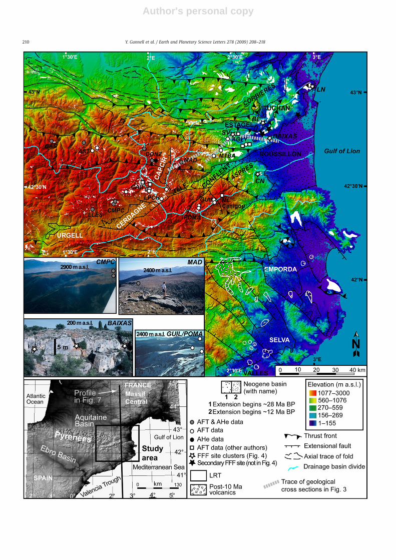
In this paper we query whether any examples of mountain beltscapped by LRT can be linked to such transient processes, and whetherwith hindsight the evidence is likely to support Davis' much debatedtheory in at least some settings. We focus on the Eastern Pyrenees andpresent radiometric constraints on the age of extant LRT occurrences(Fig. 1) in order to establish the age of the well mapped but so farundated planar Pyrenean topography (Birot, 1937; De Sitter, 1952;Calvet, 1996; Calvet and Gunnell, 2008). Depths of erosion wereobtained by thermal modelling of apatite fission track (AFT) data andapatite (U–Th)/He (AHe) ages. In addition to the information providedby low-temperature thermochronolgy, we cross-correlate results withan extensive biochronology of micromammalian assemblages trappedin karstic fissures at a range of sites where LRT bevels folded limestonerocks. The data indicate that all sampled surfaces have sufferedminimal denudation during the last 20–25 m.y., and that relict LRTtracts in the Eastern Pyrenees represent islands of low denudation,whether at elevations b0.4 km in the outer fold belts or at theircurrently observed maximum elevations of 2.4–2.9 km in the crestzone.
2. Study area: brief geology of the Pyrenees
The Pyrenees formed as a result of collision between Europe andthe Iberian microplate during and after late Cretaceous times.Collision-related deformation in the Central Pyrenees ceased ca.25 Mawhen tectonic activity resulting from the convergence betweenAfrica and Europe transferred from the Pyrenees to the Betics (Vergèset al., 2002). However, by 30–28 Ma the Eastern Pyrenees werealready undergoing NW–SE crustal extension, initially related to theopening of theWesternMediterranean back-arc basin due to eastwardrollback of the subducting Tethyan slab currently situated beneathItaly (Durand et al., 1999). Extensional tectonics formed the Roussillon,Conflent and Vallès basins on shore (Fig. 1).
Throughout this region, LRT is post-deformational, i.e. it bevelsrocks of varying mechanical resistance, geological dips as well asmajor syntectonic compressional structures irrespective of lithologicalor tectonic boundaries. It also coincides geographically with thepresence of the extensional basins within the orogenic wedge (Calvetand Gunnell, 2008) (Fig. 1), an issue we return to in Section 5. Bydefinition, low-gradient erosional land surfaces attenuate previouslyexisting relief, implying that elevation differences between formervalley floors and divide summits have been reduced. Any incision ofLRTwill indicate a resumption of unequal erosion between valleys andinterfluves, usually due to intensified forcing mechanisms such as achange in base level or climate. The underlying rationale of this studyis thus that, with suitable constraints, post-deformation erosionsurfaces in mountain belts can be used as geomorphic gauges of theintensity of those forcing mechanisms.
3. Method
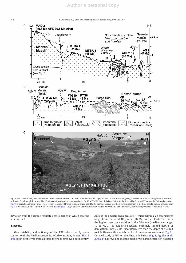
The prime objective was to provide age brackets for a geographi-cally wide-ranging population of LRT tracts in both the Axial Zone (i.e.basement-cored uplifts forming the crest zone) and outer fold belts ofthe Pyrenees, and test whether or not they shared a common past.Accordingly, sampling was restricted to mappable LRT occurrences(see Calvet and Gunnell, 2008), where fossil micromammalianassemblages were collected on limestone in erosionally bevelled foldbelts, and apatite was collected from crystalline outcrops. Samplingtargeted the two extant generations of LRT in themountain belt (Calvetand Gunnell, 2008), namely the peneplain or summit surface (termedS: see examples in Fig. 1), and a population of pediments (P) that havedeveloped at lower elevations relative to S (Fig. 2). Valleys and slopeswere avoided. As such, this studydiffers fromany previous AFTstudy inthe Eastern Pyrenees, where sampling strategies were not guided by ageomorphologically motivated goal (Garwin, 1985; Yelland, 1991;Morris et al., 1998; Maurel et al., 2008). Sample locations andcharacteristics for this study are illustrated in Fig. 1 with supplemen-tary data in SI Table 1. Due to the uneven geographic distribution ofbasement and limestone outcrops, age brackets for S and P in the AxialZone have been derived exclusively from AFT and AHe data, butconstraints in the outer fold belts rely simultaneously on AFT, AHe andFFF analysis (Fig. 3).
3.1. Biochronology of microfossils in surface karst fissure fillings
The number of sites exhibiting fossil-bearing fissure fillings (FFFs)rich in preserved Cenozoic terrestrial microfossils has grown to N100since their initial discovery in the study area (Aguilar et al., 1986). FFFsusually occur on the surface of bevelled Devonian and Mesozoiclimestone outcrops in the Corbières, Agly, and Aspres, i.e. low-elevationplateaus around themarginsof theRoussillonBasin (Figs.1–3).Each filling is made up of the contents of ancient raptor regurgitationpellets that have been transported by rain wash and trapped in thesurface karst. The faunal assemblages extracted from the sedimentthat fills individual FFFs—typically terra rossa forming bone-richbreccia (see Fig. 1)—provide insight into the composition of a widearray of past terrestrial faunas. Collectively, the fissures have yieldedmore than 25,000 teeth. In addition to rodent bone remains, theabundance of unblunted bat's and other insectivore's teeth,which areextremely brittle, supports the hypothesis of limited post-deposi-tional transport. Use of these concentrated occurrences of fossilfaunas as biochronological tools relies on the hypothesis ofchronological homogeneity within the assemblages. Evolutionarylineage theory allows the homogeneity hypothesis to be tested on thebasis of palaeontological criteria, the null hypothesis being that eachsite studied contains a cross section of remains belonging to speciesthat shared the same ecosystem at the time when they were preyedupon and later fossilized. This assumption has been systematicallyconfirmed by the fact that chronologically heterogeneous (i.e. mixedor reworked) assemblages are exceptional and can be easilyrecognized on the basis of evolutionary lineages. Furthermore, veryfew fillings exhibit complex stratigraphies except at one site, Baixas202, which on its own represents ~1% error on the entire regionaldata set. This site has revealed a highly complex microstratigraphyfavouring the alternative hypothesis of a mixed assemblage. How-ever, species inventories indicate that the observed heterogeneity atBaixas 202 essentially implies an increase in age uncertainty to ~0.5m.y.Limited fossil mixing has thus merely affected the accuracy of themethod at this locality (Aguilar and Michaux, 1997).
The recognized evolutionary stages of the rodent lineages presentin the faunas, which are characterized by morphological andbiometric attributes, define the relative chronological succession ofthe faunas. In reference to the MN zonation used for the EuropeanNeogene (de Bruijn et al., 1992), this regional succession of FFF
209Y. Gunnell et al. / Earth and Planetary Science Letters 278 (2009) 208–218
Author's personal copy
210 Y. Gunnell et al. / Earth and Planetary Science Letters 278 (2009) 208–218
Author's personal copy
assemblages was correlated with the succession of continental fau-nas obtained from sedimentary basins (lacustrine, palustrine, or evenbrackish or coastal deposits), and consequently with the marinebiochronological scale (Fig. 4; e.g. Aguilar et al., 1999 and referencestherein; Aguilar et al., 2007a,b). Additional chronological calibrationof faunal sequences based on phyletic lineages has been obtained onthe basis of radiometric ages (40Ar/39Ar: Aguilar et al., 1996, 2003)and palaeomagnetic correlations (Sen, 1997; Dubar et al., 1998;Aguilar et al., 2004) at type sections (Fig. 4).The regional FFF bio-chronology is thus geochronologically calibrated and can be officiallycorrelated with the international stratigraphic scale (Berggren et al.,1995).
3.2. Apatite thermochronology of basement rocks
Apatite fission-track (AFT) and apatite helium (AHe, or (U–Th)/He)age determinations were carried out at the UCL–Birkbeck Thermo-chronometry laboratories, London. Samples were irradiated at thewell-thermalised (Cd ratio for Au N100) Hifar reactor, Lucas Heights,Australia, using the Corning CN5 glass dosimeter. Analyses werecarried out on a Zeiss Axioplan microscope at a magnification of×1250, using a dry (×100) objective. Confined track length measure-ments were made using a drawing tube and digitizing tablet,calibrated against a stage micrometer. Single-grain AFT ages werecalculated using the external detector method and the zeta calibration
approach, as recommended by the I.U.G.S. Subcommission onGeochronology (Hurford, 1990). Track length measurements wererestricted to confined tracks parallel to the c-crystallographic axis.
The AHe thermochronometer (Zeitler et al., 1987) is based on theaccumulation of radiogenic 4He from the decay of 235U-, 238U- and232Th-series nuclides. Laboratory diffusion experiments on a range ofapatites indicate that the helium is partially retained at temperaturesbetween ~80 and 40 °C (Wolf et al., 1998) although over significanttime the influence of accumulated radiation damage can increasepartial retention temperatures (Shuster et al., 2006). The crustal depthrange that corresponds to partial-retention temperatures is termed thepartial retention zone (PRZ). He, U and Th determinations were madeon a single aliquot of two to four apatite grains, typically 100–250 µmlong and 60–150 µm wide. Evolved helium was spiked with 3He, andthe 4He/3He ratio determinedon a quadrupolemass spectrometer afterquantitativeHedegassingof apatite at ~1000 °C for 30min in a furnace.Grains were retrieved from the vacuum system, dissolved in HNO3,spiked with 230Th and 235U, and analysed for U and Th by InductivelyCoupled Plasma Mass Spectrometry. Reported He ages are correctedfor alpha ejection effects based on measured grain dimensions (Farleyet al., 1996) and geometries using the procedure of Gautheron et al.(2006). Each age typically consists of 3 to 5 replicates, the means ofwhich are reported in SI Table 2. The estimated analytical uncertaintyfor AHe ages based on the Durango age standard is 7% (2σ). These arethe default uncertainty values used on a sample unless the standard
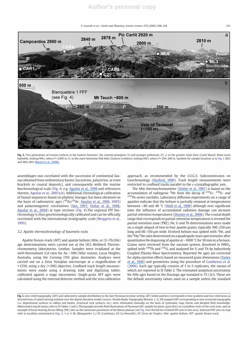
Fig. 2. Two generations of erosion surfaces in the Eastern Pyrenees: the summit peneplain (S) and younger pediments (P). a: in the granitic Axial Zone (Carlit Massif, Mont-Louisbatholith, looking NW), where P≈2200 m; b: in the outer limestone fold belts (Eastern Corbières, looking NW), where P≈350–260 m. Symbols for sample locations as in Fig. 1. ML3and ML6 after Maurel et al. (2008).
Fig.1. Low-relief topography (LRT) and radiometric sample distribution in the East Pyrenean tectonic setting. LRT (white patches) corresponds to low-gradient and low-relief areas asderived from a 9-pixel moving windowover the digital elevation model (source: Shuttle Radar TopographyMission, v. 3). All mapped LRTcorresponding to non-erosional topography(i.e. depositional surfaces in valleys and basins, structural rock surfaces, etc.) were eliminated manually on the basis of systematic map checks and detailed field knowledge.Abbreviated massif names refer to SI Tables 1 and 2. Photographs provide field illustrations of Pyrenean LRT, sample locations (grey dots) on crystalline rocks of the crest zone, and anexample of fossil-bearing fissure filling (FFF) sites on the limestone pavements of the Baixas plateau (see Fig. 4 for the full list of dated FFF sites in this area). Italicized FFF sites onmaprefer to localities mentioned in Figs. 2, 3 or 4: BL (Blanquetère 1), CN (Castelnou), LN (La Nouvelle), SV (Serre de Vergès). AHe: apatite helium. AFT: apatite fission track.
211Y. Gunnell et al. / Earth and Planetary Science Letters 278 (2009) 208–218
Author's personal copy
deviation from the sample replicate ages is higher, in which case thelatter is used.
4. Results
Great stability and antiquity of the LRT where the Pyreneesconnect with the Mediterranean Sea (Corbières, Agly, Aspres: Figs. 1and 3) can be inferred from all three methods employed in this study.
Ages of the phyletic sequences of FFF micromammalian assemblagesrange from the latest Oligocene (26 Ma) to the Pleistocene, withthe highest age concentration in the Miocene (median age range:19–13 Ma). This evidence suggests extremely limited depths ofdenudation since 26 Ma—necessarily less than the depth of fissuredrock (~40 m) within which the fossil remains are contained (Fig. 1).Detailed study of FFFs on the Plateau de Baixas (Fig. 1; Aguilar et al.,2007a,b) has revealed that the intensity of karstic corrosion has been
Fig. 3. Area where AHe, AFT and FFF data sites overlap: erosion surfaces in the Madres and Agly massifs. a and b: scaled geological cross sections showing summit surface S,pediment P, and sample locations. Note (b) is a continuation of (a) (see location in Fig.1). MF, SC, LF: Mas de la Fons, Sainte Catherine and Lo Fournas FFF sites of the Baixas plateau (seeFig. 4). c: partial panoramic view of cross section (a), viewed from a remnant of pediment P. The Serre de Vergès razorback ridge is common to all three panels. Sample symbols as inFig. 1. Note that AG1, FTG8 and FTG10 are from Yelland (1991). Ages indicate that denudation declined between ~52 Ma and 26 Ma, after which pediment P remained stable.
212 Y. Gunnell et al. / Earth and Planetary Science Letters 278 (2009) 208–218

Author's personal copy
limited: limestone pavement surfaces exhibit straight, parallel fissurewalls with limited edge blunting. This suggests rapid opening andfilling of the fissures, particularly those containing Lower andMiddle
Miocene faunas. Both the opening and filling of the fissures arecausally linked to the extensional stress field that affected the EasternPyrenees in Oligocene to Miocene times (Faillat et al., 1990; Aguilar
Fig. 4. Biochronological synthesis of the Eastern Pyrenees and Corbières. Notes: * M1 andM2 are used conventionally by palaeontologists and refer to the first upper and lower molarteeth, respectively, of rodents. ** Age precision on Lower to Middle Miocene, Upper Miocene and Pliocene assemblages is ±0.8, ±0.5 and ±0.25 m.y., respectively, and is a function ofthe quality of the fossil record (number of sites per time interval) and of the reliability of geochronological correlations with reference sites that have been dated using radiometric orpalaeomagnetic methods (noted with black or white dots, see Aguilar and Michaux, 1987). # Sites belonging collectively to the Baixas plateau FFF area, see Fig. 1.
213Y. Gunnell et al. / Earth and Planetary Science Letters 278 (2009) 208–218
Author's personal copy
et al., 2007a) as a result of back-arc extensional tectonics in the Gulf ofLion.
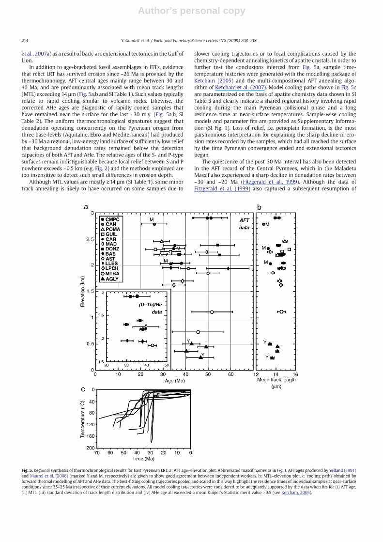
In addition to age-bracketed fossil assemblages in FFFs, evidencethat relict LRT has survived erosion since ~26 Ma is provided by thethermochronology. AFT central ages mainly range between 30 and40 Ma, and are predominantly associated with mean track lengths(MTL) exceeding 14 µm (Fig. 5a,b and SI Table 1). Such values typicallyrelate to rapid cooling similar to volcanic rocks. Likewise, thecorrected AHe ages are diagnostic of rapidly cooled samples thathave remained near the surface for the last ~30 m.y. (Fig. 5a,b, SITable 2). The uniform thermochronological signatures suggest thatdenudation operating concurrently on the Pyrenean orogen fromthree base-levels (Aquitaine, Ebro and Mediterranean) had producedby ~30Ma a regional, low-energy land surface of sufficiently low reliefthat background denudation rates remained below the detectioncapacities of both AFT and AHe. The relative ages of the S- and P-typesurfaces remain indistiguishable because local relief between S and Pnowhere exceeds ~0.5 km (e.g. Fig. 2) and the methods employed aretoo insensitive to detect such small differences in erosion depth.
Although MTL values are mostly ≥14 µm (SI Table 1), some minortrack annealing is likely to have occurred on some samples due to
slower cooling trajectories or to local complications caused by thechemistry-dependent annealing kinetics of apatite crystals. In order tofurther test the conclusions inferred from Fig. 5a, sample time-temperature histories were generated with the modelling package ofKetcham (2005) and the multi-compositional AFT annealing algo-rithm of Ketcham et al. (2007). Model cooling paths shown in Fig. 5care parameterized on the basis of apatite chemistry data shown in SITable 3 and clearly indicate a shared regional history involving rapidcooling during the main Pyrenean collisional phase and a longresidence time at near-surface temperatures. Sample-wise coolingmodels and parameter fits are provided as Supplementary Informa-tion (SI Fig. 1). Loss of relief, i.e. peneplain formation, is the mostparsimonious interpretation for explaining the sharp decline in ero-sion rates recorded by the samples, which had all reached the surfaceby the time Pyrenean convergence ended and extensional tectonicsbegan.
The quiescence of the post-30 Ma interval has also been detectedin the AFT record of the Central Pyrenees, which in the MaladetaMassif also experienced a sharp decline in denudation rates between~30 and ~20 Ma (Fitzgerald et al., 1999). Although the data ofFitzgerald et al. (1999) also captured a subsequent resumption of
Fig. 5. Regional synthesis of thermochronological results for East Pyrenean LRT. a: AFT age–elevation plot. Abbreviated massif names as in Fig. 1. AFT ages produced by Yelland (1991)and Maurel et al. (2008) (marked Y and M, respectively) are given to show good agreement between independent workers. b: MTL–elevation plot. c: cooling paths obtained byforward thermal modelling of AFT and AHe data. The best-fitting cooling trajectories pooled and scaled in this way highlight the residence times of individual samples at near-surfaceconditions since 35–25 Ma irrespective of their current elevations. All model cooling trajectories were considered to be adequately supported by the data when fits for (i) AFT age,(ii) MTL, (iii) standard deviation of track length distribution and (iv) AHe age all exceeded a mean Kuiper's Statistic merit value N0.5 (see Ketcham, 2005).
214 Y. Gunnell et al. / Earth and Planetary Science Letters 278 (2009) 208–218

Author's personal copy
cooling (interpreted as ~1.5–2 km of denudation) during the lateNeogene, the record of that later cooling episode was restricted tosamples situated towards the base of vertical sampling profiles such asMaladeta (Gibson et al., 2007). We interpret this as a signature ofrange-wide late Neogene valley incision in the Pyrenees (Calvet et al.,2008; Gunnell et al., 2008) rather than a peak of denudation endemicto the Central Pyrenees.
Another salient feature in Fig. 5 is that there is no clear pattern ofdecreasing or increasing age relative to transect orientation across orparallel to the Axial Zone, nor any positive correlation between ageand elevation. The occurrence today of islands of low erosion sharingsimilar geochronological signatures irrespective of either topographicelevation or position in the orogenic wedge (Axial Zone, but also outerfold belts: Fig. 1) is a strong indication that these surviving LRT tractsonce formed a single, low-relief land surface—i.e. a peneplain. Such aconclusion is further supported by the upward fining sequence of24–16 Ma clastic sediments in the Aquitaine foreland east of 1°Elongitude, which suggests a change in discharge to sediment supplyratio. Delivery of large masses of fine-grained sediment to a mountainfront could indicate a warm climate becoming wetter, with deepweathering on steep, forested slopes and delivery of fine saprolite to therivers. However, the only clear palaeoclimatic signal between 24Ma and~12Ma in and around thePyrenees indicates instead a clear shift to drierconditions (Calvet, 1996; Aguilar et al., 1999; Böhme et al., 2008; Calvetet al., 2008; see Arenas and Pardo, 1999, for the Ebro Basin). Becauseclimate is an unlikely candidate, we attribute the upward fining trend inforeland sediment sequences to declining relief in the eroding upland.The proportion of large clasts in coeval Miocene piedmont depositsincreases westward (Calvet and Gunnell, 2008), suggesting that theeastern Pyrenees had attained a state of low relief while further westerosion was more active due to a persistence of greater relief (Calvetet al., 2008). This is consistent with conclusions reached by Fitzgeraldet al. (1999) and with knowledge that convergence in the CentralPyrenees lasted until ~25 Ma (Meigs et al., 1996) whereas it had ceasedca. 32 Ma in the Eastern Pyrenees.
5. Discussion
The spatial distribution of LRT tracts with similar AFT and AHesignatures irrespective of elevation suggests that the extensiveNeogene peneplain underwent differential surface uplift at sometime after ~30 Ma. This regrowth of both elevation and relief leavestwo question unanswered: what was the mean palaeoelevation of thepeneplain at its time of formation, and when did the differential upliftoccur?
5.1. Late Cenozoic palaeoelevation of the Pyrenean peneplain
Unlike other orogens such as the Betics, where elevated Neogenemarine strata testify to rapid topographic uplift in recent times (Bragaet al., 2003), the pre-uplift Cenozoic paleoelevation of the Pyreneescan only be constrained by indirect methods. One of these wasaddressed by Gunnell et al. (2008), who conducted a 2- and 3-Dmodelling analysis of gravimetric, geoid, heat flow and topographicdata of NE Iberia and southern France. That study examined why theCentral Pyrenees, where the high topography is supported by crust50–55 km thick, are isostatically overcompensated—i.e. the meanelevation of the range is currently lower than predicted by Airy'smodel; whereas the Eastern Pyrenees are anomalously elevated giventheir crustal thicknesses of just 25–35 km. Gunnell et al. (2008)concluded after others (Zeyen and Fernandez, 1994; Vacher andSouriau, 2001) that a deep structure causing negative buoyancy, suchas a dense root of mantle lithosphere and/or lower crustal eclogite,was present beneath the Central Pyrenees; but they also found thatany such lithospheric slab, which necessarily existed in the past giventhe history of Iberian subduction, had now disappeared from the
Eastern Pyrenees (Fig. 6). They concluded that thermal erosion of thatslab had occurred at some time in the recent geological past and wascurrently operating on the existing slab beneath the Central Pyrenees.By adding beneath the Eastern Pyrenees a subcrustal load equivalentto that still detected beneath the Central Pyrenees, it was found thatthe elevation of the Pyrenean summit peneplain could be lowered to~0.75 km instead of its current 2.4–2.9 km (Fig. 7; Gunnell et al.,2008). In the light of the data presented in this study, we suggest thatthis is a plausible representation of what East Pyrenean palaeotopo-graphy would have looked like prior to uplift of the peneplain (Fig. 7).
This conclusion supports earlier views (Birot, 1937; De Sitter, 1952)according to which the Pyrenean range underwent deep erosionduring the earlier Cenozoic followed by abrupt uplift in Neogenetimes. We therefore suggest that the peneplain in the crest zoneformed at much lower palaeoelevations (0.7–0.8 km) than currentlyobserved, although not close to oceanic base-level as would be
Fig. 6. Depths to the base of the lithosphere in the Eastern Pyrenees. Isopleths wereobtained by a spline-based interpolation of N–S parallel, 100 km-wide swath profilesalong which an inversion of gravity, geoid, topographic and heat flow data haveindicated a steep eastward decline in lithospheric thickness gradient caused by thermalerosion of the subducted leading edge of the Iberian plate (Gunnell et al., 2008). LAB:Lithosphere–Asthenosphere Boundary.
215Y. Gunnell et al. / Earth and Planetary Science Letters 278 (2009) 208–218

Author's personal copy
implied in the perspective promoted by Davis (1911). Nevertheless,the LRT forming the eroded stumps of the Pyrenean range graded toits Aquitaine, Ebro and Mediterranean piedmonts via low-gradientpalaeoslopes compatible with the slopes of megafans documentedworldwide in foreland basins (Calvet and Gunnell, 2008). If thepeneplain had formed at higher palaeoelevations than reconstructedhere, the piedmont palaeoslopes would have exceeded criticaltransport threshold values and become deeply incised by riversinstead of functioning as alluvial fans (Calvet and Gunnell, 2008).
5.2. Timing of differential peneplain uplift
The most widely accepted conditions for rock and/or surface upliftare crustal thickening, and thinning or heating of the lithosphere, e.g.by slab breakoff, mantle delamination or melting. Crustal thickeningin the Eastern Pyrenees was definitively interrupted after ~30 Ma byMediterranean rifting, and is thus not a candidate for explainingpeneplain uplift. Likewise, density-related slab breakoff is unlikely inthis intracontinental orogen where the slab generated by subductionis only ~60 km long. Instead, strong indications of lithosphericthinning by thermal erosion have been detected in the EasternPyrenees (see Gunnell et al., 2008), with current evidence of partialmelting in the Central Pyrenees (Pous et al., 1995). The followingdiscussion is, therefore, examined in the light of thermally-drivenpost-orogenic uplift of the Pyrenean mountain range.
Constraints on the timing of peneplain uplift are provided by theonset of volcanism (Fig. 1) and the age sequencing of extensional basinformation in the Eastern Pyrenees (Saula et al., 1994; Calvet andGunnell, 2008). The first manifestations of volcanism in or close to thePyrenees occurred ca. 10 Ma (Araña et al., 1983). Volcanic activitystarted soon after a new generation of intermontane extensionalbasins began to form. This is known from the palaeontologically datedbasal strata of basin fills in the Empordà, Selva, Cerdagne, Urgell andCapcir clastic basins (Fig. 1), which after ~12 Ma opened and filledwith the products of erosion supplied by the flanking massifs. Thisyounger generation of basins was thus added to the existingpopulation of older (28–18Ma) basins such as the Roussillon, Conflent(on shore) and Gulf of Lion (off shore). Fig. 1 shows the remarkablegeographic concidence between the younger extensional basins andthe Pyrenean orogen. Given that geochemical signatures of thealkaline volcanism indicate partial melting of mantle rocks (Martí
et al., 1992), themagmatic evidence supports the view that thinning ofthe lithospheric mantle occurred after 10–12 Ma. In terms of bothtiming and mechanism, the hypothesis of thermally-driven mantleerosion and corresponding uplift and volcanism is compatible withthermal equilibration of the subducted Iberian slab having beenachieved ~20 m.y. after the cessation of active convergence (Pouset al., 1995). It is also compatible with the presence of heat supplied byasthenospheric flow from the Massif Central mantle plume, whichprogressed southward into the Gulf of Lion between ~17 and 2 Ma(Barruol and Granet, 2002) andwould have impinged on the Pyreneanslab (Gunnell et al., 2008). In summary, we conclude that differentialuplift occurred ca. 10–12 Ma based on the coincidence betweenCatalan volcanism and the opening of the younger intermontanebasins at that time, and based on the intermontane basin stratigraphy,which records steadily coarser clastic input between 12–10 Ma and6–5.5 Ma (Calvet and Gunnell, 2008).
5.3. Causes for the preservation of LRT in the present-day scenery
Assuming from the above that magnitudes of surface uplift of thePyrenean peneplain attained local maxima of ~2 km in the crest zone,i.e. they were uplifted from 0.75 km ca. 12 Ma (Fig. 7) to ~2.5–2.9 kmtoday (Figs. 1 and 7), the preservation to this day of LRT at highelevations requires conditions in which crustal uplift rates have farexceeded denudation rates. This requirement is consistent with theview that uplift occurred recently (i.e. after 12 Ma) and thatdenudation rates have remained low (Fig. 5). Uplift rates and valleyincision were in dynamic equilibrium, such that hillslopes retreatedlaterally while reducing the area but preserving the core zones of theLRT. The promotion of crustal uplift by thermally driven lithosphericthinning has been proposed for a number of other recently upliftedareas of the Iberian peninsula (e.g. Vergès and Fernandez, 2006) and iscurrently the best candidate for explaining both the uplifted peneplainand its partial preservation despite 12m.y. of active valley incision andrange-front denudation in the dynamic environment of the AxialZone.
In summary, erosion of the palaeo-Pyreneanmountain belt, endingin the development of a well preserved peneplain east of ~1°E, waspossible because the orogenic wedge lacked the isostatic buoyancyexpected to be prevalent in a setting of deep syn-orogenic denudation.We attribute this arrested buoyancy to downward pull exerted by thelithospheric root, now removed in the eastern part of the orogen.Some buoyancy was thus restored to the crust when opening of theWestern Mediterranean basin involved crustal but also lithosphericthinning. After Gunnell et al. (2008), we link this first rift-to-drifttectonic event to a base-level change that promoted the developmentof pediments (P) below the summit peneplain (S) (Figs. 2 and 3) andthus began to recreate some relief within the Eastern Pyrenees. Theage-bracketed sediment stratigraphies of intermontane extensionalbasins such as the Conflent, Roussillon and Vallès (Fig. 1) indicate thatthis change affected topography, denudation and the sediment recordafter ~20 Ma (Calvet and Gunnell, 2008). The second tectonic phaseoccurred after ~12 Ma, involving major differential uplift and causingthe current vertical offsets in elevation (Fig. 5) between the previouslyformed doublets of S and P. The late Neogene uplift was caused bythermally driven mantle thinning (Gunnell et al., 2008) and hasaffected the Pyrenean mountain range extensively (Calvet et al., 2008)even though neither crustal extension nor surface expression ofmagmatism have so far impacted areas situated west of Andorra. Thisgradient along the strike of the orogen is interpreted as a delayedmechanical and magmatic response to thermal slab erosion ratherthan as an absence of response (Pous et al., 1995). Gunnell et al. (2008)also argued that the peneplain did not form in the Central Pyreneesbecause crustal convergence lasted longer (until ~25 Ma) andmagnitudes of crustal thickening were greater there. As a result, thecrest zone of the Central Pyrenees has since early Miocene times
Fig. 7. Topographic profiles of the Eastern Pyrenees. Present-day elevation profiles arecomputed from ETOPO2v2 digital data over a 100 km-wide swath symmetricallydistributed on either side of 2.5°E. Maximum elevation highlights the topographicenvelope of the Pyrenean crest zone where age-bracketed LRT occurs (see Fig. 1).Minimum elevation provides a smoothed outline of valley floor elevations. Thetopographic profile (thick dash) is a representation of the peneplain prior to mantlethinning, uplift and valley incision as proposed by Gunnell et al. (2008). Constraints onits elevation of ~0.75 km are restricted to the crest zone. This value was obtained byadding beneath the present-day Eastern Pyrenees a lithospheric load identical to thatstill present beneath the Central Pyrenees. The effect of negative buoyancy is to lowerthe topographic elevation of the summit peneplain, S, by ~2 km. Its low relief andcontinuation beyond the Axial Zone are dictated by the uniform ages of all thepeneplain remnants (Fig. 5), and by the fact that peneplains exhibit low altitudedispersion around the mean. Crustal extension and surface uplift are indicated by thehorizontal and vertical arrows, respectively.
216 Y. Gunnell et al. / Earth and Planetary Science Letters 278 (2009) 208–218

Author's personal copy
constituted a residual topographic core ca. 0.5 km higher and some-what steeper than its surroundings. Finally, post-Tortonian valleyincision and vertical uplift have been recorded along the entire lengthof the orogen and without any systematic or exclusive link with theEbro base level and/or theMessinian salinity crisis (Calvet et al., 2008).This suggests that thermally driven uplift is a unifying cause ofgeologically recent and ongoing topographic growth in the Pyrenees.
5.4. Alternatives to the raised peneplain theory?
While recognizing the existence of LRT in the Pyrenees and othermountain ranges, alternative theories have emphasized climaticforcing instead of tectonic resurrection to explain both LRT formationand its elevated occurrences. For example, the process of altiplanation,i.e. the formation of low-gradient topography at high instead of lowelevations, requires either periglacial processes to smooth ruggedtopography (Small and Anderson, 1998; Anderson, 2002), or the pastexistence of overfilled, internally drained (and thus arid) forelandbasins that help reduce topographic relief by backfilling alluvial debristo the crest zone (Coney et al., 1996). Such altiplanation surfaces areconceived as being either simultaneously or subsequently dissectedand isostatically uplifted as a consequence of fluvial or glacial down-cutting. Incision of the upstanding mountain belt is varyingly ascribedto the promotion of a persistent geomorphic imbalance generated byan increased frequency of climatic changes since the late Neogene(Molnar, 2004); or to a greater availability after 5 Ma of moistureleading suddenly to increased stream and ice power (Cederbom et al.,2004); or to an activation of drainage headwater erosion in the crestzone triggered by a lowering of base levels and a steepening of riverchannels (e.g. the abrupt Mediterranean sea-level fall duringMessinian times, ca. 6 Ma). Despite the plausibility of such theories,evidence that valley incision began earlier than Messinian timessuggests that neither of these climate-driven or eustatic alternativesto lithospheric processes have been dominant. Furthermore, regionalpalaeoclimates underwent only two sharp, short-lived oscillationsbetween drier andmore humid subtropical conditions throughout theNeogene (Calvet, 1996; Böhme et al., 2008), with no lasting break inpatterns ca. 10 Ma (i.e. when intermontane basins first record a sharpand sustained rise in clastic input).
To summarize, unless LRT can be proven to merely represent anexhumed stratigraphic unconformity that mimics the attributes of anelevated peneplain—as is likely to arise during the unroofing of alithologically heterogeneous basement-cored uplift involving sedi-mentary cover rocks and stratigraphic unconformities (Sobel et al.,2006)—we suggest that the widespread presence of elevated LRT inmany mountain-belt settings is the topographic signature of anabnormally shallow lithosphere–asthenosphere boundary, itselfprobably caused by thinning of mantle lithosphere that occurredsufficiently recently for the LRT not to have been entirely erased fromthe scenery by denudation. Mountain belts exhibiting LRT exist onmost continents (Ollier and Pain, 2000), suggesting that the enigma ofmountain belts resurrected by vertical uplift (Davis, 1911) after plateconvergence rates have declined may be a more widespread scenarioof landscape evolution than sometimes believed.
Although it may not explain all cases of elevated LRT, thus leavingroom in other settings for climate-drivenprocesses such as those listedabove, late-orogenic topographic regrowth may occur on differentscales and affect only portions of topographically continuousmountainbelts (Wortel and Spakman, 2000; Clark et al., 2005; this study). Insuch settings, the geomorphic signature of nonequilibrium topogra-phy, namely steep mountains with flat tops, lasts until the flat tops areentirely destroyed by hillslope retreat and the scenery becomes peak-and-valley dominated. This geomorphic pathway of mountain devel-opment differs markedly from cases in which a topographic steadystate has been inferred, implying that while convergence is still activeerosion rates balance uplift rates andmean ormaximum elevation in a
landscape of peaks and valleys remains statistically unchanged forseveral millions of years under constant climatic conditions (e.g.Willett and Brandon, 2002). Thismay have been the case earlier duringPyrenean orogeny, i.e. between ~60 and 30 Ma when activeconvergence caused both crustal thickening and rapid rock cooling(e.g. Fitzgerald et al., 1999) as a consequence of high rates ofdenudation occurring asynchronously in different massifs (Fig. 5c).
6. Conclusion
The interaction between surface processes and tectonics governschanges in Earth's topography. One aim of geomorphology is toestablish whether landforms can be used as proxies for detectingdeeper-seated lithospheric processes. This study has revealed theparadox of low long-term erosion rates occurring in a high-energymountain environment through the use of three independentmethods: AFT, AHe, and biochronology. Results converge on theconclusion that by early Miocene times a peneplain grading to theforeland basins bevelled the eroded stumps of the Eastern Pyreneesand was later uplifted, fragmented by extensional tectonics andsubjected to fluvial and glacial incision. The magnitude of peneplainuplift required the removal of relatively dense mantle lithosphere, aconclusion supported by geophysical data available for the region(Gunnell et al., 2008). Lithospheric thinning occurred in twosuccessive stages, first during late Oligocene to early Miocene timesas a consequence of widespread extensional tectonics in the WesternMediterranean impinging on the Roussillon and adjacent onshoreareas; and subsequently by thermal erosion of the remaining litho-spheric root during late Miocene times when volcanic activity startedand the formation of extensional basins within the mountain beltresumed. All the evidence, from age-bracketed land surfaces and basinstratigraphies to lithospheric signatures and palaeoaltimetry, conspireto define a geomorphic signature of nonequilibrium in the pattern ofEast Pyrenean topographic growth. This pattern shares similaritieswith geological signatures observed in parts of other mountain beltssuch as the southern Sierra Nevada (Clark et al., 2005), the LaramideRockies (McMillan et al., 2006), and much larger and more elevatedplateau regions such as the Altiplano (Kennan et al., 1997).
Acknowledgements
This work benefited from the ‘Reliefs de la Terre’ initiative, aresearch programme funded by the Institut National des Sciences del'Univers, France. Contribution ISE-M-2008-038 (UMR 5554, CNRS).Three anonymous reviewers provided constructive comments.
Appendix A. Supplementary data
Supplementary data associated with this article can be found, inthe online version, at doi:10.1016/j.epsl.2008.12.004.
References
Aguilar, J.-P., Michaux, J., 1987. Essai d'estimation du pouvoir séparateur de la méthodebiostratigraphique des lignées évolutives chez les rongeurs néogènes. Bull. Soc.géol. Fr. 8, 1113–1124.
Aguilar, J.-P., Michaux, J., 1997. Les faunes karstiques néogènes du Sud de la France etla question de leur homogénéité chronologique. In: Aguilar, J.-P., Legendre, S.,Michaux, J. (Eds.), BiochroM'97, Bioch ronologie mammalienne du Cénozoïque enEurope et domaines reliés. Mém. Trav. E.P.H.E., Inst. Montpellier, vol. 21, pp.33–38.
Aguilar, J.-P., Calvet, M., Michaux, J., 1986. Découvertes de faunes de micromammifèresdans les Pyrénées-Orientales (France) de l'Oligocène supérieur au Miocènesupérieur; espèces nouvelles et réflexion sur l'étalonnage des échelles continentaleet marine. C. r. Acad. Sci., Paris, sér. II 303, 755–760.
Aguilar, J.-P., Clauzon, G., Goer de Herve, A., Maluski, H., Michaux, J., Welcomme, J.-L.,1996. TheMN 3 fossil mammal-bearing localty of Beaulieu (France): biochronology,radiometric dating, and lower age limit of the Early Neogene renewal of themammalian fauna in Europe. Newsl. Stratigr. 34, 177–191.
217Y. Gunnell et al. / Earth and Planetary Science Letters 278 (2009) 208–218

Author's personal copy
Aguilar, J.-P., Escarguel, G., Michaux, J., 1999. A succession of Miocene rodentassemblages from fissure fillings in southern France: palaeoenvironmentalinterpretation and comparisonwith Spain. Palaeogeogr. Palaeoclimatol. Palaeoecol.145, 215–230.
Aguilar, J.-P., Antoine, P.-O., Crochet, J.-Y., Lopez Martinez, N., Metais, G., Michaux, J.,Welcomme, J.-L., 2003. Les mammifères du Miocène inférieur de Beaulieu(Bouches-du-Rhône, France), comparaison avec Wintershof-West et le problèmede la limite MN3/MN4. COL-PA 1, 1–24 Volumen Extraordinario.
Aguilar, J.-P., Berggren, W.A., Aubry, M.-P., Kent, D.V., Clauzon, G., Benammi, M.,Michaux, J., 2004. Mid NeogeneMediterraneanMarine-continental correlations: analternative interpretation. Palaeogeogr. Palaeoclimatol. Palaeoecol. 204, 165–186.
Aguilar, J.-P., Lazzari, V., Michaux, J., Sabatier, M., Calvet, M., 2007a. Lo Fournas 16-M(Miocène supérieur) et Lo Fournas 16-P (Miocène moyen), deux nouvelles localitéskarstiques à Baixas, sud de la France. Partie I – Description et implicationsgéodynamiques. Géol. France 1, 55–62.
Aguilar, J.-P., Michaux, J., Lazzari, V., 2007b. Lo Fournas 16-M (Miocène supérieur) et LoFournas 16-P (Miocène moyen), deux nouvelles localités karstiques à Baixas, sud dela France. Partie II – Nouvelles espèces de rongeurs, listes fauniques, et nouvellesremarques sur l'utilisation biochronologique des faunes karstiques. Géol. France 1,63–81.
Anderson, R., 2002. Modelling the tor-dotted crests, bedrock edges, and parabolicprofiles of high alpine surfaces of theWind River Range,Wyoming. Geomorphology46, 35–58.
Araña, V., Aparicio, A., Martin Escorza, C., Garcia Cacho, L., Ortiz, R., Vaquer, R., Barberi, F.,Ferrara, G., Albert, J., Gassiot, X., 1983. El volcanismo neógeno-cuaternario deCatalunya: caracteres estructurales, petrológicos y geodinámicos. Acta Geol. Hisp.18, 1–17.
Arenas, C., Pardo, G., 1999. Latest Oligocene–Late Miocene lacustrine systems of thenorth-central part of the Ebro Basin (Spain): sedimentary facies model andpalaeogeographic synthesis. Palaeogeogr. Palaeoclimatol. Palaeoecol. 151, 127–148.
Barruol, G., Granet, M., 2002. A Tertiary asthenospheric flow beneath the southernMassif Central indicated by upper mantle seismic anisotropy and related to thewest Mediterranean extension. Earth Planet. Sci. Lett. 202, 31–47.
Berggren, W.A., Kent, D.V., Swisher, C.C., Aubry, M.-P., 1995. A revised Cenozoicgeochronology and chronostratigraphy. In: Berggren,W.A., et al. (Ed.), Geochronology,Time Scales and Global Stratigraphic Correlations: A Unified Temporal Framework foran Historical Geology. Soc. Econ. Paleontol. Mineral. SP, vol. 54. 126 pp.
Birot, P., 1937. Recherches sur la morphologie des Pyrénées orientales franco-espagnoles. Baillère Éd., Paris, 318 p.
Böhme, M., Ilg, A., Winklhofer, M., 2008. Late Miocene ‘washhouse’ climate in Europe.Earth Planet. Sci. Lett. 275, 393–401.
Braga, J.C., Martín, J.M., Quesada, C., 2003. Patterns and average rates of late Neogene–Recent uplift of the Betic Cordillera, SE Spain. Geomorphology 50, 3–26.
Calvet, M., 1996. Morphogenèse d'une montagne méditerranéenne, les Pyrénéesorientales. Doc. Bureau des Recherches Géologiques et Minières, Orléans, n° 255.1177 pp.
Calvet, M., Gunnell, Y., 2008. Planar landforms as markers of regional topographicevolution: an inversion of long-term East Pyrenean tectonics based on landscapeand sedimentary basin analysis. In: Gallagher, K., Jones, S.J., Wainwright, J. (Eds.),Landscape Evolution: Denudation, Climate and Tectonics over Different Time andSpatial Scales. Geol. Soc. London Spec. Publ., vol. 296, pp. 147–166.
Calvet, M., Gunnell, Y., Delmas, M., 2008. Géomorphogenèse des Pyrénées. In: Canérot,J., Colin, J.-P., Platel, J.-P., Bilotte, M. (Eds.), Pyrénées d'Hier et d'Aujourd'hui,International Year of Planet Earth. TOTAL, BRGM, AGSO, AIPT, CNRS, ed. Atlantica,Biarritz, pp. 129–143.
Cederbom, C.E., Sinclair, H.D., Schlunegger, F., Rahn, M.K., 2004. Climate-inducedrebound and exhumation of the European Alps. Geology 32, 709–712.
Clark, M.K., Maheo, G., Saleeby, J., Farley, K.A., 2005. The non-equilibrium landscape ofthe southern Sierra Nevada, California. GSA Today 15, 4–10.
Coney, P.J., Muñoz, A.J., McClay, K.R., Evenchik, C.A., 1996. Syntectonic burial and post-tectonic exhumation of the southern Pyrenees foreland fold-thrust belt. J. Geol. Soc.Lond. 153, 9–16.
Davis, W.M., 1911. The Colorado Front Range, a study on physiographic presentation.Ann. Assoc. Am. Geogr. 1, 21–83.
de Bruijn, H., Daams, R., Daxner-Höck, G., Fahlbusch, V., Ginsburg, L., Mein, P., Morales, J.,1992. Report of the RCMNS working group on fossil mammals, Reisensburg 1990.Newsl. Stratigr. 26, 65–118.
De Sitter, L.U., 1952. Pliocene uplift of Tertiary mountain chains. Am. J. Sci. 250, 297–307.Dubar, M., Aguilar, J.-P., Chaline, J., Michaux, J., Sémah, F., 1998. Données chronologiques
(mammifères et magnétostratigraphie) sur les dépôts plio-pléistocènes au toit dubassin de Valensole: implications morphodynamiques. Géol. France 1, 57–68.
Durand, B., Jolivet, L., Horvath, F., Séranne, M. (Eds.), 1999. The Mediterranean Basins:Tertiary Extensionwithin the Alpine Orogen. Geol. Soc. London Spec. Publ., vol. 156.570 pp.
Faillat, J.-P., Aguilar, J.-P., Calvet, M., Michaux, J., 1990. Les fissures à remplissagesfossilifères néogènes du plateau de Baixas (Pyrénées-Orientales, France), témoinsde la distension oligo-miocène. C.r. Acad. Sci., Paris, sér. II 311, 205–212.
Farley, K.A., Wolf, R.A., Silver, L.T., 1996. The effects of long alpha-stopping distances on(U–Th)/He ages. Geochim. Cosmochim. Acta 60, 4223–4229.
Fitzgerald, P.G., Muñoz, J.A., Coney, P.J., Baldwin, S.L., 1999. Asymmetric exhumationacross the Pyrenean orogen: implications for the tectonic evolution of a collisionalorogen. Earth Planet. Sci. Lett. 173, 157–170.
Garwin, L.G., 1985. Fission-track dating and tectonics in the Eastern Pyrenees, PhDthesis (unpubl.), Univ. of Cambridge.
Gautheron, C.E., Tassan-Got, L., Farley, K.A., 2006. (U–Th)/Ne chronometry. Earth Planet.Sci. Lett. 243, 520–535.
Gibson, M., Sinclair, H.D., Lynn, G.J., Stuart, F.M., 2007. Late- to post-orogenicexhumation of the Central Pyrenees revealed through combined thermochrono-logial data and modelling. Basin Res. 19, 323–334.
Gunnell, Y., Zeyen, H., Calvet, M., 2008. Geophysical evidence of amissing lithospheric rootbeneath the Eastern Pyrenees: consequences for post-orogenic uplift and associatedgeomorphic signatures. Earth Planet. Sci. Lett. doi:10.1016/j.epsl.2008.09.031.
Hurford, A.J., 1990. Standardization of Fission track dating calibration: recommendationby the Fission Track Working Group of the I.U.G.S. Subcommission on Geochronol-ogy. Chem. Geol. 80, 171–178.
Kennan, L., Lamb, S.H., Hoke, L., 1997. High-altitude palaeosurfaces in the BolivianAndes: evidence for late Cenozoic uplift. In: Widdowson, M. (Ed.), Paleosurfaces,Recognition, Reconstruction and Palaeoenvironmental Interpretation. Geol. Soc.London Spec. Publ., vol. 120, pp. 307–323.
Ketcham, R.A., 2005. Forward and inverse modeling of low-temperature thermo-chronometry data. Rev. Mineral. Geochem. 58, 275–314.
Ketcham, R.A., Carter, A., Donelick, R.A., Barbarand, J., Hurford, A.J., 2007. Improvedmodeling of fission-track annealing in apatite. Am. Mineral. 92, 799–810.
Martí, J., Mitjavila, J., Roca, E., Aparicio, A., 1992. Cenozoic magmatism of the Valenciatrough (western Mediterranean): relationship between structural evolution andvolcanism. Tectonophysics 203, 145–165.
Maurel, O., Moniè (sic), P., Pik, R., Arnaud, N., Brunel, M., Jolivet, M., 2008. The Meso-Cenozoic thermo-tectonic evolution of the Eastern Pyrenees: an 40Ar/39Ar fissiontrack and (U–Th)/He thermochronological study of the Canigou and Mont-Louismassifs. Int. J. Earth Sci. 97, 565–584.
McMillan, M.E., Heller, P.L., Wing, S.L., 2006. History and causes of post-Laramide reliefin the Rocky Mountain orogenic plateau. Geol. Soc. Amer. Bull. 118, 393–405.
Meigs, A.J., Vergès, J., Burbank, D.W., 1996. Ten-million-year history of a thrust sheet.Geol. Soc. Amer. Bull. 108, 1608–1625.
Molnar, P., 2004. Late Cenozoic increase in accumulation rates of terrestrial sediment:howmight climate change have affected erosion rates? Annu. Rev. Earth Planet. Sci.32, 67–89.
Morris, R.G., Sinclair, H.D., Yelland, A.J., 1998. Exhumation of the Pyrenean orogen:implications for sediment discharge. Basin Res. 10, 69–85.
Ollier, C., Pain, C., 2000. The Origin of Mountains. Routledge, London. 345 pp.Pous, J., Muñoz, J.A., Ledo, J.J., Liesa, M., 1995. Partial melting of subducted continental
lower crust in the Pyrenees. J. Geol. Soc. London 152, 217–220.Rowley, D.R., Garzione, C.N., 2007. Stable isotope-based paleoaltimetry. Annu. Rev. Earth
Planet. Sci. 35, 463–508.Saula, E., Picart, J.,Mató, E., Llenas,M., Losantos,M., Berástegui, X., Agustí, J.,1994. Evolución
geodinámica de la fosa del Empordá y las Sierras Transversales. Acta Geol. Hisp. 29,55–75.
Sen, S., 1997. Magnetostratigraphic calibration of the European Neogene mammalchronology. Palaeogeogr. Palaeoclim. Palaeoecol. 133, 181–204.
Shuster, D.L., Flowers, R.M., Farley, K.A., 2006. The influence of natural radiation damageon helium diffusion kinetics in apatite. Earth Planet. Sci. Lett. 249, 148–161.
Small, E., Anderson, R., 1998. Pleistocene relief production in Laramide mountainranges, western United States. Geology 26, 123–126.
Sobel, E.R., Oskin, M., Burbank, D., Mikolaichuk, A., 2006. Exhumation of basement-cored uplifts: example of the Kyrgyz Range quantified with apatite fission trackthermochronology. Tectonics 25, TC2008. doi:10.1029/2005TC001809.
Vacher, P., Souriau, A., 2001. A three-dimensional model of the Pyrenean deep structurebased on gravity modelling, seismic images and petrological constraints. Geophys.J. Int. 145, 460–470.
Vergès, J., Fernandez, M., 2006. A study relating the topography of the Iberian peninsulawith crustal and lithospheric structure and Alpine tectonics. In: Gee, D.,Stephenson, R. (Eds.), European Lithosphere Dynamics. Geol. Soc. London Memoir,vol. 32, pp. 223–234.
Vergés, J., Fernàndez, M., Martínez, A., 2002. The Pyrenean orogen: pre-, syn-, and post-collisional evolution. J. Virt. Explor. 8, 55–74.
Willet, S.D., Brandon, M.T., 2002. On steady states in mountain belts. Geology 30,175–178.
Wolf, R.A., Farley, K.A., Kass, D.M., 1998. Modelling of the temperature sensitivity of theapatite (U–Th)/He thermochronometer. Chem. Geol. 148, 105–114.
Wortel, M.J.R., Spakman, W., 2000. Subduction and slab detachment in theMediterranean–Carpathian region. Science 290, 1910–1917.
Yelland, A., 1991. Thermo-tectonics of the Pyrenees and Provence from fission-trackstudies, PhD thesis (unpubl.), University of London.
Zeitler, P.K., Herczeg, A.L., McDougall, I., Honda, M., 1987. U–Th–He dating of apatite: apotential thermochronometer. Geochim. Cosmochim. Acta 51, 2865–2868.
Zeyen, H., Fernàndez, M., 1994. Integrated lithospheric modeling combining thermal,gravity and local isostasy analysis: application to the NE Spanish Geotransect.J. Geophys. Res. 99, 18089–18102.
218 Y. Gunnell et al. / Earth and Planetary Science Letters 278 (2009) 208–218