London Borough of Southwark New Southwark Plan
291
London Borough of Southwark New Southwark Plan Site Allocations Methodology Report Update 2021 (April 2021)
-
Upload
khangminh22 -
Category
Documents
-
view
0 -
download
0
Transcript of London Borough of Southwark New Southwark Plan

London Borough of Southwark
New Southwark Plan
Site Allocations Methodology Report Update 2021
(April 2021)
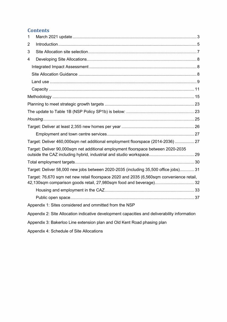
Contents 1 March 2021 update ........................................................................................................ 3
2 Introduction .................................................................................................................... 5
3 Site Allocation site selection ........................................................................................... 7
4 Developing Site Allocations ............................................................................................ 8
Integrated Impact Assessment .......................................................................................... 8
Site Allocation Guidance ................................................................................................... 8
Land use ........................................................................................................................... 9
Capacity .......................................................................................................................... 11
Methodology ....................................................................................................................... 15
Planning to meet strategic growth targets ........................................................................... 23
The update to Table 1B (NSP Policy SP1b) is below: ......................................................... 23
Housing............................................................................................................................... 25
Target: Deliver at least 2,355 new homes per year ............................................................. 26
Employment and town centre services ......................................................................... 27
Target: Deliver 460,000sqm net additional employment floorspace (2014-2036) ................ 27
Target: Deliver 90,000sqm net additional employment floorspace between 2020-2035 outside the CAZ including hybrid, industrial and studio workspace...................................... 29
Total employment targets .................................................................................................... 30
Target: Deliver 58,000 new jobs between 2020-2035 (including 35,500 office jobs) ............ 31
Target: 76,670 sqm net new retail floorspace 2020 and 2035 (6,560sqm convenience retail, 42,130sqm comparison goods retail, 27,980sqm food and beverage) ................................. 32
Housing and employment in the CAZ ........................................................................... 33
Public open space ........................................................................................................ 37
Appendix 1: Sites considered and ommitted from the NSP
Appendix 2: Site Allocation indicative development capacities and deliverability information
Appendix 3: Bakerloo Line extension plan and Old Kent Road phasing plan
Appendix 4: Schedule of Site Allocations

1 March 2021 update
1.1 This Report has been updated to reflect the up to date position of site
allocations in the New Southwark Plan as at March 2021. This also includes
further information as a result of the Examination in Public Hearing Sessions
that took place in February and March 2021. The updates comprise:
• Update to the delivery timeframe to reflect the agreed plan period of 2019-
2036 (Section 2)
• Update to status of applications and capacities in Appendix 2, including Old
Kent Road site allocations as per the Draft Old Kent Road Area Action Plan
(December 2020)
• Inclusion of Aylesbury Action Area Core (NSP01A) as a site allocation in
Appendix 2
• Inclusion of and update to the figures set out in the Strategic Targets
Background Paper to replace the figures set out in EIP161, SP1b
Southwark’s Places including updates to the overall floorspace provision
through site allocations in the Plan (Section 5)
• Update to consideration of Use Classes (Section 4)
• Further explanation on the methodology on determining indicative capacities
(Section 5)
• Update to open space, including justification for the designation and
extension of open spaces as Metropolitan Open Land, Borough Open Land
and Other Open Space (Reference 36 of the Inspector’s request) and S106
Contributions for Open Space (Reference 19 of Inspector’s request) (Section
5)
• Schedule of site allocations has been included as requested by the
Inspectors at Appendix 4.
1.2 This report replaces and updates the New Southwark Plan Site Allocations
Methodology Report July 2020. The New Southwark Plan was submitted to the
Secretary of State in January 2020 and two Inspectors have been appointed to
examine the plan. The Inspectors wrote to the Council in May 2020 to request
further information including the capacity indications and delivery timelines of
the site allocations in the New Southwark Plan, which was updated and

provided as an Examination document in July 2020. This document has been
updated to reflect the latest indications of capacity and delivery timeframes
which has also been set out in the Council’s 5 and 15 year housing land supply
report (April 2021) (EIP198). Updates include capacity reflected in approved
planning applications that fall within site allocation boundaries, inclusion of new
live planning applications. The document also includes the latest indications of
capacity for the Old Kent Road site allocations as reflected in the ongoing
preparation of the Draft Old Kent Road Area Action Plan.
1.3 The Council has completed a review of the indicative site allocation capacities
and included any changes in this update report and any amendments required
to the site allocations within the Council’s Proposed Changes to the Submitted
Plan, August 2020 will be proposed as minor modifications.
1.4 An update has also been completed on the Council’s five and 15 year housing
land supply to take into account the revised timeframe for delivery to reflect the
plan period of 2019-2036, which ensure it aligns with the London Plan plan
period and complies with the NPPF which requires a 15 year plan period on
adoption. Accordingly, housing completion figures are set out within the
housing land supply report for 2019/2020 and pipeline delivery is set out for the
15 years from 2020-2035.
1.5 The Council has identified sufficient capacity for housing land supply for 0-5
years and 6-15 years. The plan period extends to 2036 to ensure a 15 year
period from adoption and there is sufficient capacity to meet the requirement
up to 2036, carrying forward our London Plan housing target to 2036.
1.6 Alongside this document, the Integrated Impact Assessment (IIA) which
accompanies the New Southwark Plan provides information on the Council’s
considerations of reasonable alternatives for planning for growth. As part of this
the IIA includes further information on the options testing for the identification
of sites for growth and the site allocation capacities which informed the final
indicative site capacity assumptions that are provided within this document and
the New Southwark Plan (Southwark Council’s Proposed Changes to the
Submitted Plan, July 2020). The NSP also includes a housing trajectory based
on the 5 and 15 Year Housing Land Supply which will be updated to reflect the
position at March 2021.
1.7 Appendix 3 of this document includes an update to the Old Kent Road phasing
plan, which is referenced in the NSP Old Kent Road Area Vision and includes
an update to the Old Kent Road site allocations to reflect the Draft Old Kent
Area Action Plan (December 2020).
1.8 A schedule of site allocations has been included as requested by the Inspectors
at Appendix 4.
2 Introduction
2.1 This report explains how Site Allocations were prepared for the New Southwark
Plan (NSP). The NSP sets out the Council’s planning and regeneration strategy
for Southwark. The NSP contains Area Vision policies which set out aspirations
for Southwark’s distinct places alongside detailed site-specific development
management policies, known as Site Allocations. Site Allocations contain
specific land use requirements and detailed design and accessibility guidance
where they differ from the borough-wide policies of the NSP.
2.2 To be consistent with the National Planning Policy Framework (NPPF) (Para
17) and the London Plan 2021 (Chapter 1, Good Growth), the NSP must make
land available to house a growing population, encourage economic growth,
enhance Southwark’s town centres and London’s Central Activities Zone (CAZ)
and ensure that adequate infrastructure is provided. The NSP must also ensure
that development is sustainable and makes effective use of previously
developed land.
2.3 This report explains the methodology pertaining to site selection and
development of Site Allocation policies in the New Southwark Plan (Southwark
Council’s Proposed Changes to the Submitted Plan, July 2020) Version of the
NSP, which will subsequently be updated to reflect the current position of the
Site Allocations through minor modifications to the Plan.
2.4 Appendix 1 contains all sites considered in the previous iterations of the Plan
and the reasons for omission from the Plan.
2.5 Appendix 2 sets out the indicative development capacity and deliverability
information showing the expected delivery timeframe for each site allocation as
at March 2021, this includes updates to the status of planning applications,
inclusion of new relevant planning applications and subsequent amendments
to site capacity.
2.6 Appendix 3 contains the Old Kent Road phasing plan.

2.7 Appendix 4 contains the Schedule of Site Allocations for the NSP.

Site Allocation site selection
2.8 Potential Site Allocation sites were drawn from a number of sources:
• London Strategic Housing Land Availability Assessment (SHLAA) 2013.
• Borough planning documents: adopted area action plans (AAP1s),
supplementary planning documents (SPDs) and the Southwark Plan 2007.
• Representations received at previous NSP consultation stages and in
response to the ongoing call for sites.
• Identification by officers in the course of planning and regeneration duties.
2.9 Sites were then examined for their development potential using the following
criteria:
• Size: generally larger than 0.25 ha unless the site presents a particular
opportunity for intensification.
• Context: prevailing urban form and relationship with neighbouring buildings
would not unduly constrain site’s development potential to achieve a
significant uplift in floorspace.
• Prospect of intensification (i.e. the potential to achieve an uplift in
floorspace).
• Opportunity to contribute to area regeneration: where officers agreed they
could achieve positive regeneration outcomes (this criterion was given
greater weight than site size).
2.10 See Appendix 1 for a list of sites which were considered as potential Site
Allocations and omitted following assessment. Planning applications for
proposals relating to these sites would be assessed under other borough-wide
plan policies.
1 Sites proposed in the draft Old Kent Road AAP were not considered as that plan is being progressed separately alongside the NSP

3 Developing Site Allocations
Integrated Impact Assessment 3.1 The Integrated Impact Assessment (IIA) report for the NSP Submission Version
and was updated when the Council’s Proposed Changes to the Submitted New
Southwark Plan was prepared and explains how options for the approach to all
Site Allocations were appraised. The assessment incorporates sustainability
appraisal, strategic environmental assessment, health impact assessment and
equalities impact assessment. The option chosen takes a proactive approach
to place making and place shaping, integrating sites with their context and
steering growth to deliver the regeneration strategy.
Site Allocation Guidance 3.2 Each Site Allocation contains guidance for development proposals within the
site, including ‘site requirements’ and design and accessibility guidance. In
order to produce this guidance the context of each site was investigated in
terms of character, built form, planning designations, non-designated assets of
heritage or other value, planning history and examples of nearby development.
Information was assembled from the NSP evidence base, discussion with
internal stakeholders and wider external input from previous stages of public
consultation.
3.3 As the key opportunities and constraints for each site were clarified, the
potential to contribute towards the delivery of emerging area visions was also
explored. This identified the elements of an area’s character to strengthen cycle
networks and green links to connect to, economic clusters to grow and places
where streets could be enlivened by greater levels of activity.
3.4 The guidance in the Site Allocations draws all of these considerations together,
taking into account the anticipated land uses. The principal opportunities to
improve connectivity or provide active frontages are identified indicatively on
maps to show where they may be successfully implemented. ‘Active frontages’
refers to the design and use of development, principally on the ground floor,
where development should enliven the street. This could involve retail uses but
suitably designed offices or community facilities may also allow activity to spill
out onto the street. Residential uses and servicing does not usually constitute
active frontages.

Land use 3.5 The NSP must accommodate objectively assessed development needs for
Southwark, including the contribution the borough should make to meeting
London-wide needs. In order for Site Allocations to address these needs,
improve service delivery and deliver regeneration, discussions were held with
relevant council services and with NHS Southwark Clinical Commissioning
Group (CCG) to understand what is needed where. The bulk of development
needs are for housing and employment space (including town centre uses) and
the NSP must balance the delivery of both. The Site Allocations designate
required land uses. As detailed further in EIP162 key changes to the Use
Classes Order came into effect from 1 September 2020. The government’s
intention behind these changes is to provide greater flexibility for businesses to
adapt and respond to unexpected economic challenges (e.g. the ongoing
health crisis) through the deregulation of land uses, with particular focus on
town centres and high streets.
3.6 The changes see the introduction of three new use classes: E, F.1 and F.2,
which absorb use classes A, B and D. Sui generis use class has also been
expanded to include some of the aforementioned uses. The land uses set out
within the Site Allocations within the Council’s Proposed Changes to the
Submitted New Southwark Plan reference the previous Use Classes Order –
Use Class A, B and D. Appendix 2 has been updated to set out the expected
land uses to come forward on Site Allocations with reference to the new Use
Classes Order, as set out below. The Site Allocations will be amended through
Minor Modifications to the Plan to include the new Use Classes, as follows:
• Employment Use – E (g) (i), (ii), (iii), B2 and B8
• Retail, community or leisure uses as defined in the glossary of NSP:
E(a) Display or retail sale of goods, other than hot food
E(b) Sale of food and drink for consumption (mostly) on the premises
E(c) Provision of:
E(c)(i) Financial services,
E(c)(ii) Professional services (other than health or medical services), or
E(c)(iii) Other appropriate services in a commercial, business or service
locality
E(d) Indoor sport, recreation or fitness (not involving motorised vehicles or
firearms)
E(e) Provision of medical or health services (except the use of premises
attached to the residence of the consultant or practitioner)
E(f) Creche, day nursery or day centre (not including a residential use)
F1(b) Display of works of art (otherwise than for sale or hire)
F1(c) Museums
F1(d) Public libraries or public reading rooms
F1(e) Public halls or exhibition halls
F1(f) Public worship or religious instruction (or in connection with such use)
F1(g) Law courts
F2(b) Halls or meeting places for the principal use of the local community
F2(c) Areas or places for outdoor sport or recreation (not involving motorised
vehicles or firearms)
F2(d) Indoor or outdoor swimming pools or skating rinks
Appropriate sui generis town centre uses (for example: public house, wine bar
or drinking establishment, a venue for live music performance, a cinema, a
concert hall, a bingo hall, a dance hall)
• Education – F.1 (a)
• Hotel – C1
• Health – sui generis
3.7 Appendix 2 references the previous Use Classes where there is a Planning
Permission that was granted prior to the introduction of the new Use Classes. Changes to the Use Classes Order, Impact on the New Southwark Plan Site
Allocations (EIP162a) has been prepared setting out the minor modifications to
the Site Allocations as a result of the new Use Classes.

Capacity 3.8 The NSP Submission Version did not include indicative development capacities
for each Site Allocation because the purpose of the Site Allocation was not to
provide a detailed design brief for each site. Through the consultation process
on the Preferred Option NSP the Council recognised various stakeholders were
concerned that the inclusion of indicative development capacities in the NSP
would pre-empt the outcome of the detailed development management
process. With the exception of NSP71 (Aylesham Centre and Peckham Bus
Station) the NSP does not provide detailed guidance regarding appropriate
building height, it sets out general areas for tall buildings and Site Allocations
identify possible locations for tall buildings but does not specify heights. This is
because the appropriateness of building heights should be determined through
a detailed assessment of genuine development proposals in relation to their
context.
3.9 The New Southwark Plan (Southwark Council’s Proposed Changes to the
Submitted Plan, July 2020) Version now includes the indicative development
capacities for each site as requested by the Inspectors. The Council has
completed a review of the site capacities to provide any relevant updates, such
as approved planning applications.
3.10 The following table provides aggregated figures for the overall indicative
quantum of development that could be achieved at the borough-scale for
different land uses. Figures are shown in Gross Internal Area (GIA) (except
number of homes where the number of homes was either taken from permitted
schemes or calculated notionally by dividing the assumed residential floorspace
for each site allocation by 73.9sqm (average unit size).
3.11 As significant housing development is planned for within Aylesbury Action Area
Core and will be included within the New Southwark Plan as a Site Allocation
(NSP01A) through a Minor Modification which reflects the requirements within
the Aylesbury Area Action Plan, this has been included within Appendix 2 and
Table 1 and 2 below (further information is set out in the Aylesbury Background
Paper (M2.00b). Given the extent of development coming forward at Elephant
Park (formerly the Heygate), the employment, retail and housing capacity
coming forward is also set out in Table 1 which is within Elephant and Castle
Vision Area.

Table 1 – proposed floorspace provision (gross, sqm) of different land uses
Land use Source Proposed floorspace
GIA (sqm)
Employment
Site allocations (as per the minimum capacity of
the Canada Water masterplan) 880,433
Elephant Park additional offices 60,000
Elephant and Castle Planning Applications 47,792
Potential uplift from employment-led schemes in
the CAZ 66,595
Additional provision based on the maximum
capacity of the Canada Water masterplan 236,048
Intensification of industrial land in South
Bermondsey SPIL (as per maximum capacity of Old
Kent Road masterplan)
86,628
Vacant railway arches brought back into use 17,280
Total 1,396,776
Retail, leisure and
community Uses
(as defined in the
glossary of the
NSP)
Site allocations (as per the minimum capacity of
the Canada Water masterplan) and Elephant Park
retail to be delivered
280,247*
Additional provision based on the maximum
capacity of the Canada Water masterplan 137,348
Total 417,595
Hotel (C1)
Site allocations 67,884
Additional provision from the indicative capacity in
the Canada Water masterplan 7,500**
Total 75,384

Education (F.1
(a)) Site allocations 78,692
Health (sui
generis) Site allocations 18,581
Sui generis Site allocations 25,069

Table 2 – Net floorspace provision (sqm) of different land use
Land use Source Proposed floorspace (sqm GIA)/units
Employment Site allocations (as per the minimum capacity of the
Canada Water masterplan)
288,931
Elephant Park additional offices 60,000
Elephant and Castle Planning Applications 27,542
Potential uplift from employment-led schemes in
the CAZ
66,595
Additional provision based on the maximum capacity of the
Canada Water masterplan
236,048
Intensification of industrial land in South Bermondsey SPIL (as per maximum capacity of Old Kent Road masterplan)
74,567
Vacant railway arches brought back into use 17,280
Total 753,683 Retail, leisure and community uses (as defined in the glossary of the NSP)
Site allocations (as per the minimum capacity of the
Canada Water masterplan) and Elephant Park retail to be
delivered
78,743*
Additional provision based on the maximum capacity of the
Canada Water masterplan
137,348
Total 216,091 Number of homes Site allocations (Based on the
average of residential unit range approved in the Canada
Water masterplan)
37,904***
Elephant Park 629 Open space Site allocations 111,125
New designations 50,425
Extension of existing
designations
49,435
Total 210,985

*The Old Kent Road AAP has been prepared differently from this methodology in that it has categorised education and health uses (18,818 sqm proposed) under general community uses. To be consistent with the Old Kent Road AAP, education and health uses for the Old Kent Road area have been included in the retail, leisure and community uses figures. The Old Kent Road figures have been obtained from the Old Kent Road Existing and Proposed document (EIP148). They are presented as GEA in the Existing and Proposed. In order to be consistent with the figures in this document 5% has been deducted from the GEA in order to calculate GIA.
**The NSP is not actively allocating sites for the development of hotels. This figure has come from sites with existing planning permissions with hotels on the site. In addition to this figure, an additional 7,500 sqm hotel floorspace can potentially come forward as part of Canada Water masterplan.
***This is based on the average of 3,000 residential units as part of the Canada Water masterplan, which is set out in paragraph 4.15. This is based on the delivery of 1371 units on NSP77, if a commercial scheme was to come forward on the remainder of the site, there would be a reduction of 796 units (further details provided at Appendix 2).
3.12 The Council also anticipates a significant number of new homes will be
delivered on ‘windfall’ sites which are outlined in the 5 and 15 Year Land Supply
Report Update (April 2021) (EIP198).
Methodology
Introduction
3.13 The Council has taken a proactive role in identifying and helping to bring
forward land that is suitable for meeting development needs considering the
appropriate uplift for each site within the local context. Each site has an
indicative capacity to set out the quantum of housing development that we
expect to come forward on each site to deliver the optimal development
capacity. This is more certain for the sites where housing is required as a ‘must’,
where housing is a ‘should’ this figure is less certain.
3.14 The key purpose of the indicative development capacities is to inform
Southwark’s strategic growth projections and ensure the Council has a high-
level understanding of the strategic distribution of development expected to
come forward across the borough over the course of the plan period for
housing, employment, retail, leisure and community uses and open space.
3.15 The efficient use of land Policy P17 requires optimisation of the use of land for
all developments in Southwark. The indicative capacities set out the quantum
of development that we consider should deliver the principles of sustainable
development as set out in the NPPF. Where there is an ambition to further

optimise development capacity this may start to put pressure on local character,
and policy constraints may need to be overcome through consideration of the
planning application. This will be particularly in regard to scale, distribution and
type of development which may require collaborative working and consideration
of any adverse or cumulative impacts within the local environment.
3.16 We use ‘indicative’ rather than a ‘minimum’ capacity as there are sites where a
requirement for housing under ‘should’ and in some cases ‘must’ are flexible
on quantums. Therefore a minimum capacity could prioritise housing and
constrain the most effective use of the site which might reduce the opportunity
to optimise the range of town centre, employment and community uses.
3.17 Indicative capacities for each site set out a minimum expected capacity to
optimise the development on the site, this will be determined through detailed
design and may be lower on sites that are ‘should’ for housing.
3.18 Appendix 2 sets out the assumptions that were used to inform these figures.
For sites without proposed residential capacity, the total is shown as 0.
National legislation / guidance
3.19 Section 19(1B) - (1E) of the Planning and Compulsory Purchase Act 2004 sets
out that each local planning authority must identify their strategic priorities and
have policies to address these in their development plan documents (taken as
a whole).
3.20 The National Planning Policy Framework (NPPF) provides the overarching
national planning guidance on Local Plan making and identification of sites for
allocation. Paragraph 17 requires local plans to set out a clear strategy for
allocating sufficient land which is suitable for development in their area,
taking account of the needs of the residential and business
communities. Paragraph 67 states that planning policies should identify a
sufficient supply and mix of sites, taking into account their availability, suitability
and likely economic viability. Appendix 2 of this report provides further
information on the availability and suitability of sites. Viability has been
assessed on a plan-wide basis as set out in the Viability Background Paper
EIP20). Further information of the suitability of the site allocations is provided
in the NSP.

3.21 Paragraph 122 of the Framework states that planning policies and decisions
should support development that makes efficient use of land, taking into
account the following:
a) the identified need for different types of housing and other forms of development
and the availability of land suitable for accommodating it;
c) the availability and capacity of infrastructure and services – both existing and
proposed – as well as their potential for further improvement and the scope to
promote sustainable travel modes that limit future car use;
d) the desirability of maintaining an area’s prevailing character and setting (including
residential gardens), or of promoting regeneration and change; and
e) the importance of securing well-designed, attractive and healthy places.
3.22 The design-led approach taken to calculating indicative development
capacities in the NSP is broadly in line with the considerations listed in
paragraph 122 of the Framework. This approach is presented in greater detail
later in this section.
3.23 Paragraph 123 of the Framework advises that the use of minimum density
standards should be considered to ensure that developments make optimal use
of the potential of each site. This was considered as an alternative option as
explained below.
3.24 The NPPG (Plan-Making) paragraph 002 states that where sites are proposed
for allocation, sufficient detail should be given to provide clarity to developers,
local communities and other interested parties about the nature and scale of
development. The indicative capacities appear alongside site descriptions and
requirements to clearly detail the expected level of development on site.
3.25 The NPPG (Effective use of land) paragraph 004 states that a range of
considerations should be taken into account in establishing appropriate
densities on a site. This can include accessibility measures such as distances
and travel times to key facilities, including public transport stops or hubs;
characterisation studies and design strategies, dealing with issues such as
urban form, historic character, building typologies, prevailing sunlight and
daylight levels, green infrastructure and amenity space; and environmental and
infrastructure assessments. The Council’s use of indicative capacity for
allocated sites is strongly aligned with this guidance and promotes a design-led
approach to site optimisation and development.

Regional Guidance
London Plan 2021
3.26 Policy GG2 Making the best use of land requires that a design–led approach is
applied to determine the optimum development capacity of sites. Policy D1
London’s form, character and capacity for growth Section B advises
that boroughs should plan to meet borough-wide growth requirements,
including their overall housing targets, by following the design-led
approach to establish optimised site capacities for site allocations’. Policy
D3 Optimising site capacity through the design-led approach Section
A states that all development must make the best use of land by following a
design-led approach that optimises the capacity of sites, including site
allocations.
3.27 The London Plan 2021 details that a design-led approach requires
consideration of design options to determine the most appropriate form of
development that responds to a site’s context and capacity for growth, and
existing and planned supporting infrastructure capacity.
3.28 Paragraph 3.3.4 of the London Plan 2021 states that designating appropriate
development capacities through site allocations enables boroughs to
proactively optimise the capacity of strategic sites through a consultative
design-led approach.
Draft Good Quality Homes for All Londoners SPG (October 2020)
3.29 The Mayor’s draft Good Quality Homes for All Londoners SPG was out to
consultation between October 2020 – January 2021. It provides guidance on
assessing the capacity of land and buildings to accommodate housing by
optimising site capacity at all stages of the planning process. Module A –
Optimising Site Capacity: A Design-led Approach sets out a design-led
approach to intensification, using residential types to identify the indicative
capacity of a site or area.
3.30 The Draft SPG provides a detailed methodology for calculating indicative
capacity on an allocated site. The required steps for this calculation are:
1. Locate site movement infrastructure; 2. Locate existing open space and allocate proposed open space; 3. Allocate non-residential uses; 4. Select the residential type(s) based on the site context;
5. Run site through modelling and select the optimal option based on conserve, enhance and transform;
6. Calculate the residential Gross External Area (GEA) m2; 7. Apply the GEAm2 against the appropriate tenure and type mixes to
provide an indicative capacity.
3.31 Section 2 of the draft SPG states that site analysis, including planning history
and surrounding context is the crucial first stage of determining the optimum
site capacity. A list of capacity factors are provided which closely matches the
same factors that were considered during the preparation of the New
Southwark Plan site allocations (as set out at Paragraph 4.33). However the
recommended approach of calculating capacity using the prescribed residential
building types in section 3 is considered to be overly restrictive in the context of
Southwark given the borough’s wide variety of urban forms and character areas
and does not allow for flexibility during the design process.
Southwark's methodology for calculating indicative density
3.32 The indicative capacities presented in the NSP are informed by:
1. Sites that benefit from Planning Permissions that have undergone
detailed design
2. Masterplans that have a high level design (e.g. live planning
applications or Old Kent Road site allocations where masterplanning
has been undertaken)
3. Sites that have not had previous development design work, and this is
where the design-led approach has been applied.
Design-led approach methodology
3.33 Where there are sites that have not come forward at present reasonable
estimates are provided and from which a more detailed design process can be
undertaken. The context of each of these sites was investigated in terms of
character, built form, planning designations, non-designated assets of heritage
or other value, consideration of any relevant characterisation studies, planning
history and examples of nearby development. Information was assembled from
the NSP evidence base, discussion with internal stakeholders and wider
external input from previous stages of public consultation. These are generally
consistent with the considerations set out within national and regional policy.
3.34 During the preparation of the NSP an assessment of individual site capacities
was undertaken to inform the aggregate land-use figures. This involved council
officers assessing potential building footprints on each Site Allocation that
made an efficient use of land and responded to their context. Buildings of merit
were assumed to be retained. The council officers then estimated the notional
massing, i.e. number of storeys, which could be achieved on each building
footprint to generate a total Gross External Area (GEA) for the site.
3.35 The existing and potential or required uses were then considered e.g. what is
required on the site to meet our strategic targets, is the reprovision of
employment or other uses required, is the site suitable for residential, retail,
leisure or community or other uses, is there sufficient space for open space to
be provided.
3.36 This process was iterative, with each site appraised separately by multiple
officers before agreeing the final parameters.
3.37 The final capacity figures are based on mid-points between the assumptions
made in individual officer assessments. The indicative floorspace figures are
presented in GIA. These have been derived by reducing the estimated GEA by
15%. Alongside the indicative floorspace, desk-based estimates were made of
the existing floorspace in different uses on each site except where known by
planning applications. This allowed the potential uplift to be derived.
3.38 The site capacities shown in Appendix 2 are indicative as they have not
undergone further detailed testing. In order to provide flexibility, the site
capacities are also expressed as the measure of floor to area ratio (FAR)
instead of the mid point of building footprint coverage or number of storeys. The
floor area ratio (FAR), also known as the plot ratio, is a measure of the total
permitted floor area of a building, in relation to the total area of the lot (or plot)
on which the building stands:
Gross floor area of all floors of the building / Site area = FAR
3.39 A higher ratio indicates a higher-density environment.
3.40 As the FAR is based on a suitable average for each site they do not preclude
the inclusion of taller or shorter buildings on part of a site. A FAR of 1 can mean
100% of a site developed to 1 storey or 50% of the site developed to two storeys
and so forth. The FAR was calculated following the design-led approach for
each site which informed the GEA. This was then divided by site area and the
FAR was calculated for information.
3.41 The Council considers that the methodology used in the New Southwark Plan
(a design led approach) is consistent with national policy and generally
conforms with the London Plan 2021 and the emerging guidance set out in the
draft Good Quality Homes for All Londoners SPG. The indicative site allocation
capacities deliver the level of certainty required.
Other options considered for calculating site capacity
Density
3.42 Paragraph 123 of the Framework advises that the use of minimum density
standards should be considered to ensure that developments make optimal use
of the potential of each site. The Council has considered the use of minimum
density standards but has concluded that a more flexible approach is
appropriate in ensuring that the optimal potential is achieved on each site. This
is partly because some sites have already undergone masterplanning at the
application stage, and also to take into account the varied urban form and
character of different areas of the borough which requires a tailored approach.
The prescription of a minimum density standard is therefore not the best
approach and may limit the development potential of Southwark sites. The
decision not to use a minimum density standard does not represent
a significant departure from the national guidance, as evidenced by the recent
adoption of the Hackney and Tower Hamlets local plans where minimum
density standards were also not used.
Floor to area ratio
3.43 The sole use of a floor to area ratio (FAR) methodology was not considered to
be appropriate for the purposes of assessing indicative development capacities
for sites. This is because FAR does not allow for site specific circumstances to
be taken into account.
3.44 The Council considers that FAR should only be used as a starting point or
benchmark for delivering minimum amount of housing, and that a design led
optimisation approach offers a less restrictive methodology for assessing
development capacities for sites and achieving optimal land use. The actual
capacity that can be delivered should then be agreed at the planning application

stage following careful consideration of design options and detailed
masterplanning.

Planning to meet strategic growth targets
The update to Table 1B (NSP Policy SP1b) is below:
Site area
Employment floorspace (sqm)
Retail, leisure and community uses
floorspace* (sqm)
Approximate housing capacity
within the borough through site
allocations by area (net, units)
Net open space provision within site allocations
in GIA (sqm) Proposed provision (gross)
Uplift (net) Proposed provision (gross)
Uplift (net)
Aylesbury 900 900 6,765 6,765 1,500 0 Bankside and Borough 165,949 60,813 10,130 9,409 1,022 3,151
Bermondsey 22,073 -10,935 10,280 9,992 2,313 0 Blackfriars Road 195,298 110,018 17,191 15,308 1,439 0
Camberwell 35,850 2,139 14,956 7,674 1,765 0
Crystal Palace and Gipsy Hill 0 0 0 0 103 0
Dulwich 0 0 1,246 187 63 0 East Dulwich 8,867 3,741 13,631 3,947 374 -4,782***
Elephant and Castle Site allocations
27,309 -2,884 30,946 2,261 1,686 1,640
Elephant Park 60,000 60,000 6,014 6,014 629 8,000

Planning applications 47,792 27,542 0 0 0 0
Total 135,101 84,658 36,960 8,275 2,315 9,640
Herne Hill and North Dulwich 2,553 383 2,041 306 45 0
London Bridge 56,574 43,156 2,132 1,526 483 605
Old Kent Road
Site allocations
277,329 46,462
69,784 -1,143 20,800**** 88,815 Industrial intensification in South Bermondsey (SPIL) (Maximum option proposed in Old Kent Road AAP)
86,628 74,567
Total 363,957 121,030 Peckham 19,089 15,378 22,281 4,229 1,370 0
Rotherhithe (minimum figures based on Canada
Water masterplan NSP78)
68,642 22,196 65,467 9,958 4,712** 13,696
Walworth 0 -2,437 7,384 2,310 229 0

Vacant railway arches brought back into use 17,280 17,280
Total (minimum based on Canada Water
Masterplan, NSP78) 1,092,132 468,321 280,247 78,743 38,533 111,125
Further uplift as a result of maximum capacity of
Canada Water Masterplan, NSP78)
236,048 236,048 137,348 137,348
Total (Maximum based on Canada Water Masterplan,
NSP78)
1,328,180 704,369 417,595 216,091
*The figures do not include education and health uses except for Old Kent Road which due to the figures being part of a wider masterplan for the whole area health and education uses are included.
**The capacities planned for Rotherhithe are based on the average of residential unit range set out in the Canada Water masterplan (Site allocation NSP78).
*** The change was due to a redevelopment to provide a new stadium at Dulwich Hamlet Football Club
**** The housing capacity for Old Kent Road is to be phased, including 9,500 homes in Phase 1, with the phasing plan to be determined through the Old Kent Road Area Action Plan

Housing
Target: Deliver at least 2,355 new homes per year
3.45 The 5 and 15 Year Housing Land Supply identifies that the Council will meet
and exceed the London Plan target of 2,355 homes per year. The delivery
information in this report has been updated to reflect the delivery timeline
assumptions set out within the 5 and 15 Housing Land Supply document. The
Council has capacity to deliver 14,765 homes between 2020-2025 (years 0-5)
and has planned to deliver 35,091 homes between 2025 and 2035 (years 6-
15). The 6-15 year land supply is based on the later phasing delivery of some
large scale planning applications with long term delivery timeframes as well as
the capacity planned for in the NSP site allocations as well as some windfall
allowance. The 6-15 year land supply currently identifies that the Council will
exceed our housing target by 11,541 homes. Upon our review of the NSP site
allocation capacities, the amount of homes identified in the NSP site allocations
equates to 38,533 homes. This includes some reductions in capacity on certain
sites upon the Council’s review however some sites have increased in capacity.
This includes information on approved planning applications which reflects the
latest capacity. In the Old Kent Road Opportunity Area, further masterplanning
work and the latest planning application indicative development capacity for the
sites has increased as set out in the Draft Old Kent Road Area Action Plan
(December 2020). This is reflective of the target of 20,000 new homes for this
area.
3.46 As part of the Canada Water masterplan which is relevant to NSP78, a range
of residential provision between 2,000 and 3,995 was approved. For the
purposes of determining the five and 15 years of housing land supply, the
average of 3,000 units was used for the site capacity.
3.47 Aylesbury Action Area Core has been added as a site allocation in the plan
NSP01A which will contribute to a net increase of 1,500 homes in the borough
over the next 15 years.

Employment and town centre services
3.48 As part of the Canada Water Masterplan hybrid/outline application
(18/AP/1604) a mixed use redevelopment was granted planning permission,
where the developer is committed to deliver a minimum of 46,452sqm
employment floorspace and a minimum of 46,452sqm retail and leisure
floorspace, with the potential of delivering up to 282,500sqm of employment,
86,650sqm of retail, 45,650sqm of community facilities and 51,500sqm of
leisure and culture uses as the maximum capacity set out in the parameter plan.
For the purposes of this paper, the minimum capacity figures have mainly been
used for the Canada Water masterplan. The figures where the maximum
scenario is achieved have also been presented.
Target: Deliver 460,000sqm net additional employment floorspace (2014-2036)
3.49 Southwark has a good track record for bringing forward mixed use
redevelopment supported through AAPs and SPDs and this approach is
proposed in the NSP. Many allocation sites also contain existing employment
floorspace. In suitable locations (mainly in the CAZ) site allocations seek the
re-provision of the existing quantum of employment space as a minimum or
50% of the total floorspace, whichever is greater. Within employment uses, site
guidance is used to identify opportunities for town centre uses where they could
improve streets and strengthen centres with active frontages. In some
instances re-provision of specific existing uses is required.
3.50 The Southwark Employment Land Study 2016 indicates that 460,000 sqm of
net additional B1 employment floorspace is needed, principally large office
space in the CAZ as well as a range of business spaces in the CAZ hinterland.
CAZ site allocations
3.51 Offices have been prioritised in the CAZ by requiring the re-provision or
additional provision of the existing employment uses on site allocations. In the
CAZ vision areas of Bankside/Borough, London Bridge, Blackfriars Road and
Elephant and Castle 445,130 sqm (net provision of 211,103 sqm) of office
floorspace is expected to come forward on the site allocations.
CAZ planning applications

3.52 In addition, more offices will be delivered in Elephant and Castle. Lend Lease
propose to submit a planning application for Plot H1 for an office building of
around 60,000sqm. This would be a net increase of offices and it does not
replace any other uses on the overall masterplan. Two planning applications
have also recently been approved in Elephant and Castle which contribute to a
significant uplift in office floorspace of a combined total of 27,542sqm net
increase (Skipton House 18/AP/4194 and 5-9 Rockingham Street 19/AP/0750).
3.53 In addition, a further uplift of employment floorspace will potentially come
forward from commercial only development proposals relevant to the site
allocations within the CAZ, which will create an additional net total of
66,595sqm (115,342sqm) in gross floorspace) if planning permission is granted
for those schemes.
Old Kent Road
3.54 The Old Kent Road Existing and Proposed (EIP149) sets out the total
employment floorspace provision in the Old Kent Road masterplan. This figure
is used to inform the employment target in Table SP1b. In the Existing and
Proposed the figure is presented as GEA but for the purposes of Table SP1b,
the figure has been converted to GIA by deducting five per cent. As a broad
assumption, if 50% of the total floorspace in the site allocations could be offices,
the Old Kent Road masterplan could deliver 23,231sqm of offices (net).
Canada Water
3.55 The Rotherhithe area could deliver a minimum of 22,196sqm net increase in
offices. If the Canada Water masterplan delivered its maximum parameters the
Rotherhithe area could deliver 258,244sqm of offices (so an additional 236,048
sqm to the minimum scenario).
3.56 Office delivery overall would therefore be 388,471sqm net based on the
minimum scenario at Canada Water and 664,519sqm maximum scenario. It is
likely the target would be achieved with significant growth in offices at Canada
Water.
3.57 Other parts of the borough such as town centres will also deliver offices
however some may replace existing employment uses on the site, improving

the overall stock. The council has also approved or received other planning
applications in the CAZ which are increasing the overall office provision.
Target: Deliver 90,000sqm net additional employment floorspace between 2020-2035 outside the CAZ including hybrid, industrial and studio workspace
Old Kent Road 3.58 Assuming 50% of the total floorspace in the site allocations is industrial, hybrid
or studio type workspace, this is 23,231sqm (net). The NSP Industrial
Background Paper demonstrates how we are planning for no net loss of
industrial floorspace capacity across the Old Kent Road Opportunity Area
where the majority of Southwark’s industrial land is located.
South Bermondsey industrial intensification (SPIL)
3.59 Additionally, employment growth is planned for outside of the site allocations.
The latest draft of the Old Kent Road AAP (December 2020) sets out two
options for the industrial intensification of Strategic Protected Industrial Land in
South Bermondsey. This is included in the background evidence EIP149 Old
Kent Road Existing and Proposed (January 2021) and is based upon the
masterplan by Macreanor Lavington South Bermondsey Dive Under
Masterplan (EIP145). If the minimum option for intensification was achieved it
would provide a net of 27,455 sqm in industrial floorspace. If the maximum
option was delivered, 74,567 sqm of industrial floorspace would come forward
(net).
Railway arches
3.60 Further, Policy P33 of the New Southwark Plan (Railway Arches) supports the
development of commercial activities in railway arches. This will particularly
help to bring vacant arches into use, promote active frontages and deliver the
Low Line walking routes outlined within the NSP. There are over 800 railway
arches in Southwark, providing significant opportunity for uplift in the delivery
of different types of workspace, retail and community uses. Some of the railway
arches in Bermondsey remain as Strategic Protected Industrial Land where
industrial uses will be of priority. A Low Line Horizon Study was prepared for
the Borough, Bankside and Bermondsey Area which identified 110,000sqm of
floorspace in 390 arches in the north part of the borough with 70 units vacant
(equating to potential growth in 12,000sqm of space). The study identified the
size of railway arches range from 30sqm to 500sqm with the average size of a

railway arch being around 180sqm. With 800 arches in the borough equating to
around 144,000sqm of floorspace, and a vacancy rate assumed to be the same
as the north of the borough at 12% this could potentially provide an additional
17,280sqm commercial floorspace over the plan period.
Town centres and site allocations
3.61 The other vision areas outside of the main CAZ vision areas, Old Kent Road
Opportunity Area and Rotherhithe would deliver a net increase of employment
of 9,169sqm.
3.62 Industrial floorspace delivered in Old Kent Road, industrial intensification in
South Bermondsey, railway arches and town centre sites would deliver
124,247sqm net of employment floorspace. This would exceed the target for
other types of employment floorspace that was projected to need to increase.
It is possible that some of the railway arches and town centre sites could come
forward as office development which would add on to the overall office target
instead. Policy P29 allows for flexibility so that employment uses are delivered
to meet current market demands. The Old Kent Road AAP sites are guided by
a detailed masterplan with specific employment typologies.
Total employment targets
3.63 As a whole, the site allocations and major planning applications in Elephant and
Castle plan for a net uplift of 376,473sqm employment floorspace. This total
provision is based on the minimum capacities set out in the Canada Water
masterplan.
3.64 In total, the site allocations, together with Elephant and Castle planning
applications, potential uplift from commercial schemes on site allocations within
the CAZ, the intensification of industrial land in South Bermondsey and the use
of vacant railway arches would bring a total of 534,916sqm net uplift of
employment space (as per the minimum amount within the Canada Water
masterplan). With the maximum amount in the Canada Water masterplan this
total would be 770,964sqm net uplift of employment space.
3.65 The total employment target for the borough including office and other types of
workspace is 550,000sqm (460,000sqm offices and 90,000sqm other types of
workspace). If the maximum capacity of Canada Water came forward, the
borough would exceed this target for employment floorspace overall.

Target: Deliver 58,000 new jobs between 2020-2035 (including 35,500 office jobs)
3.66 The policy includes a breakdown of the jobs target for each part of the borough.
Borough, Bankside and London Bridge Opportunity Area 10,000
Elephant and Castle Opportunity Area 10,000 Canada Water Opportunity Area 20,000 Old Kent Road Opportunity Area 10,000 Other town centres 8,000
3.67 These are broadly consistent with the Opportunity Area targets in the London
Plan however we consider that the CAZ and Old Kent Road could deliver in
excess of the jobs distribution reflected in the London Plan, which is reflected
above. The net increase of office floorspace projected for the CAZ vision areas
is 298,645sqm. Using the Employment Densities Guide (2015) average
employment density for offices of 11sqm per employee, this could generate up
to 27,150 office jobs. Additional jobs would come forward in retail, leisure arts
and community sectors.
3.68 In addition, the Elephant Park redevelopment is estimated to generate 5,000
jobs in construction. The council partnered with Lendlease in 2016 to
commission the Southwark Construction Skills Centre at Elephant and Castle,
which supports residents to access pre-employment training, gain employment
and progress in their careers by up-skilling. The centre supports developers to
fulfil their section 106 employment and skills obligations on sites across the
borough, offering a site for engaging local people with the construction industry
and providing residents with the skills they need to enter and progress in the
sector. Since July 2016 over 4,000 Southwark residents have received training
at the centre.
3.69 The Old Kent Road AAP and Existing and Proposed (EIP149) demonstrate how
we will double the number of existing jobs in the opportunity area, achieving a
net uplift in 10,000 jobs.

3.70 The Canada Water Masterplan was estimated to deliver between 12,000 and
30,000 jobs on completion. The 20,000 jobs figure is in the Publication London
Plan.
3.71 Development on other town centre sites such as Peckham and Camberwell as
well as other site allocations and windfall sites would deliver the remainder of
jobs to meet this target.
Target: 76,670 sqm net new retail floorspace 2020 and 2035 (6,560sqm convenience retail, 42,130sqm comparison goods retail, 27,980sqm food and beverage)
3.72 The overall target for retail floorspace provision is 76,670 sqm net. This is
broken down into 6,560 sqm net convenience floorspace, 42,130 sqm net
comparison floorspace and 27,980 sqm net food and beverage floorspace.
Growth of retail will mainly be accommodated in the redevelopment of three
large shopping centres within the major town centres of Elephant and Castle,
Peckham and Canada Water. Old Kent Road will also be transformed from
retail warehouses with large car parks to a Healthy High Street.
3.73 The distribution of retail floorspace is: 10,000 sqm Elephant and Castle Major
Town Centre, 7,000 sqm Peckham Major Town Centre, 40,000 sqm Canada
Water Major Town Centre, the rest of the retail demand (19,670 sqm) would be
met by sites in the CAZ and in the district town centres. Table 1B supporting
Policy SP1b demonstrates how retail, leisure and community floorspace is
expected to change based on site allocation capacity estimates in each Vision
Area. There is no specific target for leisure and community floorspace however
the town centre sites allow for the capacity of retail, leisure, community and
other main town centre uses to increase to support the growth and vitality of
town centres in the borough.
3.74 The retail floorspace in Old Kent Road has reduced to an overall net loss in the
December 2020 masterplan. This is due to the changing format of how retail
space will be delivered in the area. The NSP designates two district town
centres for the Old Kent Road area (north and south). The Publication London
Plan (2020) anticipates that district town centres typically contain 10,000-
50,000sqm retail, leisure and service floorspace. The Old Kent Road
Opportunity Area currently contains 75,000sqm of retail floorspace. The area

will redevelop a significant amount of existing retail space which is currently ‘big
box’ retail sheds and mixed use development will significantly improve the retail
environment by providing a range of shop sizes from supermarkets to high
street shops. The Old Kent Road masterplan also includes provision for health
and education uses. The overall net loss of retail is fairly minimal on a plan-
wide level of 1,143sqm taking into account new retail, community, leisure,
education and health uses that will be provided.
3.75 Table 1B states the expected capacity for retail, leisure and community
floorspace is 78,743sqm (net). This figure uses the minimum expected capacity
in the Canada Water masterplan. There is scope for additional retail, leisure
and community uses in the Canada Water masterplan outline planning
application if a higher range is accommodated between the minimum and
maximum floorspace estimations. If the maximum retail, leisure and community
uses capacity will come forward in the Canada Water masterplan, this will result
in a total net provision of 216,091 sqm. Additional retail, leisure and community
uses may also come forward on smaller scale windfall sites in town centres.
Total targets
3.76 The total employment target for the borough including office and other types of
workspace is 550,000sqm (460,000sqm offices and 90,000sqm other types of
workspace). If the maximum capacity of Canada Water came forward, the
borough would exceed this target for employment floorspace overall.
3.77 Should the maximum amount of employment and retail floorspace come
forward in Canada Water, this would result in a total net uplift of 548,742sqm
employment, not including the potential uplift from commercial schemes in CAZ
or maximum intensification of SPIL in South Bermondsey. With the uplift from
the commercial schemes and the industrial intensification of South
Bermondsey, the net uplift would be 753,683sqm and 216,091sqm retail,
leisure and community uses across all site allocations as set out in Table SP1b.
Housing and employment in the CAZ
3.78 The requirements for other uses in the site allocations are balanced with the
need to provide housing. P29 Office and business redevelopment of the NSP
requires the employment floorspace in the CAZ to be retained or increased.
Additional B Class uses will come forward in areas outside of the CAZ. In the
CAZ, the reprovision or uplift of employment floorspace is a ‘must’ requirement

in the site allocations. Housing is a ‘should’ which encourages mixed use
development where the reprovision or uplift of employment floorspace can be
achieved.
3.79 Housing is a required or encouraged use on most sites. As well as maximising
the provision of new homes, this will help to ensure that all sites have the
potential to generate an increase in land value to incentivise development.
3.80 The level of housing expected from development was estimated from the
capacity remaining after other land use requirements are met. Our housing
requirements are met through site allocations which ‘must’ provide housing,
including sites in the Old Kent Road Opportunity Area. These sites will provide
approximately 33,249 net new homes. These are required to contribute to our
5 year supply of housing land (as set out at Appendix 1 of the 5 and 15 Year
Housing Land Supply Report Update (EIP198). Site allocations which ‘should’
provide housing result in an uplift of approximately 4,193 housing units in the
borough. These are identified within the 5 and 15 Year Housing Land Supply
Report Update (EIP198) for years 6-15, however where there is a planning
approval on the site and in some cases where the site is under construction the
housing is included in the 0-5 year supply. Housing on these sites is strongly
encouraged to maintain a healthy land supply and allow for contingency when
meeting housing targets later in the plan period.
3.81 Some planning applications have been submitted for employment-led schemes
on site allocations and part of sites allocations in the CAZ which would not
provide any housing or would reduce the number of housing coming forward.
These have been specified in Appendix 2 on sites NSP05, NSP17 and NSP51.
As housing continues to be a suitable use for these sites and to allow for
contingency, the ‘should’ requirement for housing has not been changed in the
NSP. If the commercial applications on these sites are approved and delivered,
these applications would provide an indicative capacity of employment
floorspace, totalling 115,342 sqm, which will lead to an increased net
employment growth of 66,595 sqm. As such, the 6-15 year housing land supply
would be reduced by 428 to 3,765 homes in the ‘should’ category. However,
the overall growth in housing within site allocations and the Elephant Park
remains above our strategic target at 38,071 units (this does not include any
schemes where housing has already been completed on the site).

Social infrastructure
Health
3.82 For social infrastructure the need for specific facilities, such as health centres,
was established. NHS Southwark CCG have been working with partners to
project primary and community health service needs and plan to meet them
with new health facilities within:
- NSP34 Guys and St Thomas Trust Rehabilitation Centre, Crystal Palace
in Crystal Palace and Gipsy Hill;
- NSP39 Dulwich Community Hospital, East Dulwich Grove in East
Dulwich;
- NSP65 Sandgate Street and Verney Road in Old Kent Road;
- NSP78 Harmsworth Quays, Surrey Quays Leisure Park, Surrey Quays
Shopping Centre and Robert’s Close in Canada Water
3.83 Our site allocation policies also seek to protect health provision and education
facilities on some sites which are suitable for the continued use for above uses
instead of comprehensive redevelopment, including:
- NSP33 Denmark Hill Campus East in Camberwell , in part of which an in-
patient mental health facility have been proposed and completed
- NSP46 London Southbank University Quarter in Elephant and Castle
- NSP49 London Bridge Health Cluster in London Bridge
Education
3.84 An expansion in school places are planned for across the site allocations in
primary and secondary school provision by The Pupil Place Planning Report
2020. Sites were assessed for their location and capacity to accommodate the
education uses. New school places including primary, secondary education and
sixth form education or general education uses will be delivered or reprovided
in:
- NSP04 London Fire and Emergency Planning Authority in Bankside
and The Borough;
- NSP10 Biscuit Factory and Campus in Bermondsey;
- NSP39 Dulwich Community Hospital, East Dulwich Grove in East
Dulwich;
There may be potential for education facilities in the Old Kent Road Opportunity Area
and further education facilities to be provided in the Old Kent Road and Canada
Water Opportunity Areas.
3.85 Southwark is home to a number of esteemed higher education institutions such
as University of Arts, King’s College and Southbank University. Relevant
policies and further information on this are set out in the Student Housing
background paper.
3.86 The site allocations will support the delivery of gross 78,962 sqm of education
floorspace; 18,581 sqm of health floorspace and other community, leisure and
cultural uses as part of the retail, leisure and community uses identified in the
site allocations.

Public open space 3.87 The Southwark Open Space Strategy 2013 states that the council will seek to
negotiate provision of new public open space on appropriate development
sites. It was considered that sites of sufficient size should accommodate public
open space to serve new users generated by development in areas of
deficiency.
3.88 A total of 103,125 sqm of net open space will be generated from redevelopment
on the 16 site allocations identified in Table 3. They are located in the site areas
of Borough and the Bankside, East Dulwich, Elephant and Castle, London
Bridge, Old Kent Road and Rotherhithe.
3.89 The net loss within site allocation NSP37 in East Dulwich arises from the
redevelopment of Dulwich Hamlet Champion Hill Stadium where the relocation
and expansion of the existing pitch on Other Open Space (OOS) will allow for
residential provision with replacement open space. In response to the net loss
of open space, a shortfall contribution has been agreed to contribute towards
public open space and community amenity space within the vicinity of the site.
Table 3 – Indicative net provision of open space in site allocations
Site area Site allocation number Open space provision (sqm)
Borough and the Bankside
NSP01 1,968 NSP05 1,183
East Dulwich NSP37 -4,782
Elephant and Castle
NSP41 1,640 Elephant Park (part of the
Heygate masterplan – this is not a site allocation)
8,000
London Bridge NSP51 605
Old Kent Road
NSP54 6,720 NSP55 14,530 NSP56 5,105
NSP62 795 NSP63 13,685 NSP64 6,445 NSP65 34,472 NSP66 3,573 NSP67 1,990 NSP68 1,500
Rotherhithe NSP78 13,696 Total 111,125

3.90 Elephant Park is currently partially open and under construction in line with a
major planning application 12/AP/1092 approved in 2013 as part of the Heygate
masterplan. It will be approximately 0.8 hectares in total when completed.
3.91 The Plan will also designate new open spaces, including four Borough Open
Land sites (BOL) covering 28,881 sqm and 18 Other Open Spaces (OOS) with
a total of 20,554 sqm. Together the new designations will create an addition of
49,435 sqm designated open space.
Table 4 – Newly designated open spaces
Name Designation Area (sqm)
Caspian Street Allotments Other Open Space 1,215 Dunstan Road Allotments Other Open Space 909
Aylesbury Road Allotments Other Open Space 972 Fielding Street Allotments Other Open Space 1,559 Alscot Road Allotments Other Open Space 935
Montague Square Other Open Space 1,058 Crossbones Graveyard Other Open Space 796
Diversity Garden Other Open Space 503 Jam Factory Garden Other Open Space 505
Open space on Havil St opposite Orange Tree Court Other Open Space 564
Judith Kerr School Other Open Space 3,246 Reverdy Road Allotment Gardens Other Open Space 888
Deal Porters Square Other Open Space 2,784 Melior Street Community Garden Other Open Space 548
Morecambe Garden Other Open Space 586 Tate Community Garden Other Open Space 484
Northfield House Wildflower Meadow Other Open Space 1,690 Pat Hickson Garden Other Open Space 1,311
Elephant and Castle Peninsula Borough Open Land 4,488 Lorrimore Square Gardens Borough Open Land 1,974
Tate Modern Borough Open Land 10,095 More London Borough Open Land 12,325
Total 49,435
3.92 Moreover, a total of 50,425 sqm of open space will be created through the
extended boundaries for the existing designations. These include eight BOLs,
one OOS and five Metropolitan Open Lands (MOL) in Table 5.

3.93 The site allocations, together with new designations and the increase in areas
to the existing designations, will create a total of 210,985 sqm open space
within the borough.
Table 5 – Increase in areas for existing designations (sqm)
Open space name Designation Increase in area St Francis Park Other Open Space 1,385
Caroline Gardens Borough Open Land 8,030 Camberwell Green Borough Open Land 310
St Mary's Churchyard, Newington Borough Open Land 800 Bermondsey Spa Park Borough Open Land 3,750
Lettsom Gardens Borough Open Land 3,257 St Peter's Churchyard Borough Open Land 2,473
Geraldine Mary Harmsworth Park Metropolitan Open Land 4,075 Sydenham Hill and Dulwich Woods Metropolitan Open Land 18,500
Dulwich Upper Wood Metropolitan Open Land 714 Dog Kennel Hill Metropolitan Open Land 2,344
Potter's Field (aka Tooley Street Park) Metropolitan Open Land 966 Nursery Row Park Borough Open Land 3,001
Salisbury Row Park Borough Open Land 820 Total 50,425
Extensions to open space justification – Reference 36 of the Action List (EIP188)
3.94 Justification is required for the designation of the MOL, BOL and OOS (Reference 36 of the Action List EIP188). This is required by the NPPF at Paragraph 136 which sets out that once established, Green Belt boundaries should only be altered where exceptional circumstances are fully evidenced and justified, through the preparation or updating of plans. In addition, Policy G3 of the London Plan (2021) sets out that: (A) Metropolitan Open Land (MOL) is afforded the same status and level of protection as Green Belt: (B) the extension of MOL designations should be supported where appropriate and sets out a criteria for this. It also sets out that (C) any alterations to the boundary of MOL should be undertaken through the Local Plan process, in consultation with the Mayor and adjoining boroughs. MOL boundaries should only be changed in exceptional circumstances when this is fully evidenced and justified, taking into account the purposes for including land in MOL set out in Part B.
3.95 The new and extended designations of open spaces were included during the initial preferred options stage of the NSP in 2015 and proposed during the submission stage in 2017. They were also included in the NSP policy map schedule for the Proposed Changes to the Submitted NSP 2020 and were subject of public consultation starting October 2015.
3.96 Justification for the designation of new OOS and the extension of the MOL, BOL and OSS is set out below
Metropolitan Open Land (MOL)
3.97 Geraldine Mary Harmsworth Park – The park accommodates the Imperial War Museum. The extension of the southwestern corner of the open space is considered justified as it is clearly a part of the existing green space which is distinguishable from the surrounding residential area (London Plan Policy G3 Part B Section 1) and provides additional access to the adjacent Geraldine Mary Harmsworth Sports Facilities which offer astroturf 5-a-side pitches, tennis courts, and basketball courts (London Plan Policy G3 Part B Section 2 and 4).
3.98 Sydenham Hill and Dulwich Woods - Sydenham Hill and Dulwich Woods form part of the largest remaining tract of the old Great North Wood, a vast area of worked coppices and wooded commons that once stretched from Deptford to Selhurst. The designation is significant for its biodiversity and historic features (London Plan Policy G3 Part B Section 3). The extension to the existing designation is considered to be justified as it provides a link in the network of green infrastructure (London Plan Policy G3 Part B Section 4). It connects the lower part of the existing designation with Section 11 of the Green Chain Walk - Crystal Palace Park to Nunhead Cemetery.

3.99 Dulwich Upper Wood - Dulwich Upper Wood is a local nature reserve and Site
of Borough Importance for Nature Conservation, Grade 1. The extension to the designation is considered necessary as it is part of the existing green space which is distinguishable from the surrounding residential area (London Plan Policy G3 Part B Section 1). It is also considered important for biodiversity as the existing designation is allocated as a local nature reserve (London Plan Policy G3 Part B Section 3).
3.100 Dog Kennel Hill – The site offers a small woodland park with a picnic area. The park forms an oasis for wildlife in a built-up area and the designation also includes the Dog Kennel Hill Adventure Playground which is adjacent to the extension (London Plan Policy G3 Part B Section 2). The extension is considered justified as the Council would like to improve access and biodiversity across the site (London Plan Policy G3 Part B Section 3).
3.101 Potter's Field (aka Tooley Street Park) - The park is a popular visitor destination due to the riverfront location and serves the surrounding business and cultural district. It also has an interesting history has been used as both a burial ground and a site for pottery manufacture. Amendments to the boundary of the designation are considered necessary to include only open space which is clearly distinguishable from the surrounding commercial buildings (London Plan Policy G3 Part B Section 1) and to only include the open-air facilities for leisure and recreation which serve significant parts of central London (London Plan Policy G3 Part B Section 1).

Borough Open Land (BOL)
3.102 Borough Open Land (BOL) is defined in the NSP glossary as designated open space of borough importance. It is normally over 0.25 hectares in size. In order to be designated as BOL it must meet the following criteria:
• An area of borough importance to Southwark
• A clearly distinguishable open space
• Land that contains features or landscapes of historic or recreational value at a borough level
• Open space that is not designated as Metropolitan Open Land
3.103 Table 6 provides more detail surrounding the designation of new BOL. These sites have all been assessed and are considered to play an important contribution to the borough and therefore should be protected. The majority of these spaces were recommended for protection in the Southwark Open Space Strategy (2013).
Table 6 – Justification for designation as Borough Open Land
Borough Open Land name Justification for designation Elephant and Castle
Peninsula Contains the Michael Faraday Memorial to commemorate Michael Faraday who was born in Newingon Butts and made an important contribution to science.

Lorrimore Square Gardens Forms part of the grounds surrounding St Paul’s Church and provides a recreational green space for the surrounding LCC Brandon Estate.
Tate Modern Clear open landscape facing the river used for large-scale events and popular destination for visitors.
More London Important civic space on the south bank of the Thames and provides distinguishable open space from the surrounding commercial buildings. More London frequently hosts outdoor exhibitions and cultural events
Other Open Space (OOS)
3.104 Other Open Space (OOS) is defined in the NSP glossary as an open space designation which is not MOL or BOL but meets one of the following criteria in that it is: an allotment; a public open space such as public parks and gardens; playing fields and sports ground whether publicly or privately owned; a private open space which is of benefit to the local community; open space that has been created and secured through planning obligations; or a site of ecological importance. OOS is usually under 0.25 hectares in size but not always. The Southwark Open Space Strategy Evidence Report (2013) provides further information on the definition of Other open spaces in Table 4.2 (page 46).
3.105 Table 7 shows the open spaces proposed as OOS designation in the NSP and the further detail on the justification behind the designations. The majority of these spaces were recommended for protection in the Southwark Open Space Strategy (2013).
Table 7 – Justification for designation as an Other Open Space
Other Open Space name Justification for designation Caspian Street Allotments Allotments provide a growing space for the community.
Interest in allotments has increased due to public awareness of green issues and concerns over links between food and health. Housing in built up areas such as Southwark often has little or no garden or private outdoor space so allotments provide an important space for physical and social activity. Other benefits include reduction of waste and promotion of recycling green waste, promotion of good mental and physical health, provision of a green lung in urban environments, maintenance of biodiversity, and allotments play an important role in community heritage, values and identity.
Dunstan Road Allotments Aylesbury Road Allotments Fielding Street Allotments Alscot Road Allotments
Reverdy Road Allotment Gardens
Montague Square Provides cultural open-air events such as theatre and music
Crossbones Graveyard
Crossbones is a site of important historical significance as it was once a paupers’ graveyard. It is now a community led project transformed from a derelict industrial site to a garden of remembrance and a sanctuary in the inner city.
Diversity Garden The Diversity Garden replaces a garden which was lost during the redevelopment of the site. It is a community

garden which provides individual plots for residents living in the adjacent housing blocks to grow vegetables
Jam Factory Garden Provides open space and a playground for residents of the Jam Factory development
Open space on Havil St opposite Orange Tree Court
Small site provides green space for the surrounding residential estates
Judith Kerr School The Judith Kerr School playing field is an integral part of the school, used intensively for sports, play, education, and social events
Deal Porters Square An important civic space outside the Canada Water Library which provides seating and an outdoor market
Melior Street Community Garden
Melior Street Community Garden includes a community herb and vegetable garden, a potting shed, reclaimed timber planters and plenty of communal areas to sit and enjoy the green oasis. Produce from the garden is sold to local cafes and restaurants.
Morecambe Garden Small site provides green space for the surrounding residential estates
Tate Community Garden
The Tate Modern wanted to support the creation of a resource for the local community in the form of a garden. It is a participatory art project and provides activities, events and volunteering opportunities which involve the local community.
Northfield House Wildflower Meadow
An important green space for the residents of Northfield house. The intention was to encourage the return of the wildlife that lost their homes when the Surrey Canal (which used to run alongside Northfield House) was filled in and built over.
Pat Hickson Garden
Recently landscaped open space and opened in memory of Pat Hickson MBE, an important member of Southwark’s community, as longstanding chair of the Bonamy and Bramcote Tenants’ Residents’ Association.
S106 Contributions for Open Space - reference 19 of the Action List (EIP188)
3.106 Providing new parks, building new play areas, greening roads planting more trees and improving existing parks are essential to improve the physical, social and mental wellbeing of our residents. Child play space is vital for children’s social development and interaction and to increase their physical activity.
3.107 Old Kent Road is an area of deficiency in public open space. There is currently a shortfall of 1.55ha when considering the population in the Opportunity Area in 2018. The Old Kent Road Opportunity Area has a high deficiency because large areas of extensive commercial activity within the area do not provide parks or open spaces. Further information is set out in the EIP148 – Old Kent Road Open Space Background Paper.
3.108 The Old Kent Road Area Action Plan sets out that the growth in the area over the next 20 years with 20,000 new homes and 10,000 new jobs to be delivered. With the planned development in the area the population could double with an increase of 37,908 people by 2036. This new development coming forward

provides an important opportunity to increase our open space provision in Old Kent Road. Given the deficiency identified and the future development proposed in the Old Kent Road Opportunity Area we are committed to increasing open space provision.
3.109 During preparation of the New Southwark Plan and the Old Kent Road Opportunity Area Framework it was considered that sites of sufficient size should accommodate public open space to serve new users generated by development in areas of deficiency.
3.110 This is considered justified as London Plan Policy G4 Open space requires boroughs as part of the preparation of the Development Plan to undertake a needs assessment of all open space to inform policy.
3.111 The requirement for 5sqm of new public open space per dwelling will help ensure that new open space is provided to help meet the needs of the growing population and provide benefits for existing communities.
3.112 Where the requirement cannot be delivered on site a financial contribution will be sought through s106 agreements. This contribution will go towards creating new open space and/or improving existing public open space or play space provision within the vicinity of the site.
3.113 New developments are also expected to provide play space for children on the site. In exceptional circumstances where this cannot be provided on site, we will seek to secure a section 106 planning obligation to contribute to improving play space elsewhere in the surrounding area of the development site. A minimum of 10sqm of play space per child is required.
3.114 Policy S4 play and informal recreation sets out that boroughs should prepare a Development Plan that is informed by a needs assessment of children and young person’s play and informal recreation facilities. This should include an audit of existing play and informal recreation opportunities and the quantity, quality and accessibility of provision. They should also produce a strategy to address any identified need.
3.115 Table 8 sets out the minimum requirements for private amenity space, communal amenity space and child play space within developments. These requirements are also within adopted the Residential Design Supplementary Planning Document (2011) and the Section 106 Planning Obligations and Community Infrastructure Levy (CIL) SPD (2015).
Table 8 – Minimum requirements for amenity and child’s play space
Housing type Private amenity space (from adopted the Residential Design Standards SPD)
Communal amenity space (from the adopted Residential Design Standards SPD)
Child’s play facilities 10 units + only (from the adopted

Residential Design Standards SPD)
Houses 50sqm
10sqm in length and
should extend
across the width of
the dwelling.
N/A 10sqm per child
Broken down by age:
0-5
5-11
12+
As per the GLA
calculator. Flatted
developments
10sqm minimum for
3 or more bedrooms
10sqm for 2 or less
bedrooms if possible
To count towards
private amenity
space, balconies
must be a minimum
of 3sqm.
50sqm per block
Additional
community amenity
space is required
where minimum
private amenity
space requirements
are not met.
3.116 Any shortfall in the required provision of amenity space, public open space or child play space will be charged at £205 per square metre. £205 per square metre represents an average cost in Southwark for improving open space, taking into account all costs including fees and construction costs as detailed within the S106 and CIL SPD (EIP49).
3.117 Residents have already started to benefit from the improvements to the existing parks including Brimmington Park, Leyton Park and Burgess Park. This includes but not limited to: improvements to play space, sports and recreational facilities, increasing nature areas, and the delivery of a BMX track.
3.118 The policy is required to deliver the Old Kent Road Masterplan and deliver enough open space of the appropriate quality to benefit residents. The policy is already being implemented. Development schemes on Old Kent Road in NSP66, NSP67 and NSP68 which include housing are achieving the policy requirement for the provision of communal amenity space, child play space and public open space.
3.119 In NSP67, 1,002 homes have been approved of the 2,200 capacity of the site allocation. These will deliver 3,016 sqm of Communal Open Space and 1,728 of new public open space. £837,435 has been secured through s106 open space contributions.
3.120 In NSP68, 168 homes have been approved of the 1,000 capacity for the site allocation. £227,015 has been secured through in lieu payments for the shortfall in communal amenity space, child play space, and public open space.
Appendix 1: Sites considered and omitted from the NSP
The following schedule lists the sites considered and omitted from the NSP Proposed
Submission Version (NSP PSV) and NSP Submission Version (NSP SV), excluding those in
adopted AAPs which have not been amended and will remain designated on Southwark’s
policies map:
Site code Site name Reason for omission from NSP PSV / NSP SV
3P (Southwark Plan)
Land adjacent to Cannon Street Railway Bridge
Saved Southwark Plan site: There is no longer an aspiration to open up the un-used railway land for public access and build a foot-bridge on Cannon Street bridge.
4P (Southwark Plan)
London Bridge Site recently redeveloped and unlikely to come forward during the life of the plan.
14P (Southwark Plan)
St James’ School Saved Southwark Plan site: Existing allocation requires that the school be re-provided alongside any residential uplift. This can be achieved under other NSP policies.
15P (Southwark Plan)
Neckinger Estate Saved Southwark Plan site: No comprehensive estate regeneration is currently programmed.
26P (Southwark Plan)
Land between 1 and 45 Alscot Road
Saved Southwark Plan site: Small site where acceptable redevelopment could be achieved under other NSP policies. Existing allocation requires 17-40 new homes.
44P (Southwark Plan)
Land to the south west of Stewart House, bounded by Leroy and Aberdour Street
Saved Southwark Plan site: Small site where acceptable redevelopment could be achieved under other NSP policies. Existing allocation requires 20 new homes.
49P (E&C 35) (Southwark Plan)
Manor Place Depot Site recently redeveloped and unlikely to come forward during the life of the plan.
51P (E&C 31) (Southwark Plan)
Nursery Row car parks at Stead, Wadding and Brandon St
Saved Southwark Plan site: Site has planning permission, is under construction and should be complete by adoption of the NSP.
54P (Southwark Plan)
Welsford St garages/parking area south of Thorburn Sq
Saved Southwark Plan site: Small site where acceptable redevelopment could be achieved under other NSP policies. Existing allocation requires 48 new homes.
56P (Southwark Plan)
Old Kent Road Gas Works site
Saved Southwark Plan site: Site being progressed through the Old Kent Road AAP.
59P (Southwark Plan)
272-304 Camberwell Rd
Saved Southwark Plan site: Site has planning permission, is under construction and should be complete by adoption of the NSP.
61P (Southwark Plan)
Oliver Goldsmith Extension
Saved Southwark Plan site: Small site where acceptable redevelopment could be achieved under other NSP policies.
NSP1 (NSPOV)
River Court and Doggetts Coat and Badge Public House
Small site without the clear opportunity for major intensification where acceptable redevelopment could be achieved under other NSP policies.

Site code Site name Reason for omission from NSP PSV / NSP SV
NSP2 (NSPOV)
South Bank Tower A significant uplift in floorspace is not anticipated due to the existing intensity of development and proximity to the South Bank Tower.
NSP3 (NSPOV)
Rennie Court Site contains a relatively recent residential building unlikely to be redeveloped within the NSP period.
NSP4 (NSPOV)
1 Blackfriars Road, Beethem Tower - Sainsbury's HQ
Site has planning permission, is under construction and should be complete by adoption of the NSP.
NSP8 (NSPOV)
45 Colombo Street Small site without the clear opportunity for major intensification where acceptable redevelopment could be achieved under other NSP policies.
NSP13 (NSPOV)
Site bounded by Bear Lane, Dolben Street, Chancel Street and Treveris Street
Small site without the clear opportunity for major intensification where acceptable redevelopment could be achieved under other NSP policies.
NSP15 (NSPOV)
209-215 Blackfriars Road
Small site without the clear opportunity for major intensification. The site contains buildings of townscape or historic merit at high density and is unlikely to be redeveloped.
NSP16 (NSPOV)
202-208 Blackfriars Road
Small site without the clear opportunity for major intensification where acceptable redevelopment could be achieved under other NSP policies.
NSP17 (NSPOV)
Site bounded by Gambia Street, Dolben Street and Great Suffolk Street
Small site without the clear opportunity for major intensification where acceptable redevelopment could be achieved under other NSP policies.
NSP20 (NSPOV)
200 Union Street Small site without the clear opportunity for major intensification where acceptable redevelopment could be achieved under other NSP policies.
NSP21 (NSPOV)
Southwark College, The Cut
Site has planning permission, is under construction and should be complete by adoption of the NSP.
NSP22 (NSPOV)
235-241 Union Street Small site without the clear opportunity for major intensification where acceptable redevelopment could be achieved under other NSP policies.
NSP23 (NSPOV)
225 Union Street Small site without the clear opportunity for major intensification where acceptable redevelopment could be achieved under other NSP policies.
NSP24 (NSPOV)
90-92 Blackfriars Road Small site without the clear opportunity for major intensification where acceptable redevelopment could be achieved under other NSP policies.
NSP25 (NSPOV)
Friden House, 96-101 Blackfriars Road
Small site without the clear opportunity for major intensification where acceptable redevelopment could be achieved under other NSP policies.
NSP26 (NSPOV)
21-31 Webber Street and 3-7 & 19-21 Valentines Place
Site has planning permission, is under construction and should be complete by adoption of the NSP.
NSP27 (NSPOV)
109-115 Blackfriars Road
Small site without the clear opportunity for major intensification where acceptable redevelopment could be achieved under other NSP policies.
NSP30 (NSPOV)
61 Webber Street Ex-industrial area with buildings of townscape merit with high level of implemented conversions or recent development.
Site code Site name Reason for omission from NSP PSV / NSP SV
NSP31 (NSPOV)
63 Webber Street Small site without the clear opportunity for major intensification where acceptable redevelopment could be achieved under other NSP policies.
NSP33 (NSPOV)
96 Webber Street Small site without the clear opportunity for major intensification where acceptable redevelopment could be achieved under other NSP policies.
NSP34 (NSPOV)
94 Webber Street Small site without the clear opportunity for major intensification where acceptable redevelopment could be achieved under other NSP policies.
NSP36 (NSPOV)
Erlang and Hill House Site has planning permission, is under construction and should be complete by adoption of the NSP.
NSP37 (NSPOV)
Erlang House car park Site has planning permission, is under construction and should be complete by adoption of the NSP.
NSP39 (NSPOV)
Passmore Edwards Library, 112 Borough Road
Small site without the clear opportunity for major intensification. The site contains buildings of townscape or historic merit and is unlikely to accommodate significant redevelopment.
NSP43 (NSPOV)
28-30 Great Suffolk Street
Small site without the clear opportunity for major intensification where acceptable redevelopment could be achieved under other NSP policies.
NSP44 (NSPOV)
44-50 Lancaster Street Small site without the clear opportunity for major intensification where acceptable redevelopment could be achieved under other NSP policies.
NSP45 (NSPOV)
52-56 Lancaster Street Small site with planning permission, likely to be substantially constructed or complete by the start of the NSP period.
NSP46 (NSPOV)
65 Glasshill Street Small site without the clear opportunity for major intensification where acceptable redevelopment could be achieved under other NSP policies.
NSP53 (NSPOV)
Eileen House, Newington Causeway
Site has planning permission, is under construction and should be complete by adoption of the NSP.
NSP54 (NSPOV)
Former London Park Hotel
Site has planning permission, is under construction and should be complete by adoption of the NSP.
NSP56 (NSPOV)
Surdaw House Small site without the clear opportunity for major intensification where acceptable redevelopment could be achieved under other NSP policies.
NSP57 (NSPOV)
Heygate Estate Site is under construction. Although it will be built out during the NSP period a clear masterplan is already in place through the planning permission.
NSP58 (NSPOV)
Castle Day Centre Site has planning permission for redevelopment to provide a church and is likely to be complete or substantially constructed by the start of the NSP period.
NSP59 (NSPOV)
Day Nursery and 20 Steedman Street
Small site without the clear opportunity for major intensification where acceptable redevelopment could be achieved under other NSP policies.
NSP60 (NSPOV)
2-8 Steedman Street Small site without the clear opportunity for major intensification where acceptable redevelopment could be achieved under other NSP policies.
NSP61 (NSPOV)
T. Clarke building (Stanhope House)
Small site without the clear opportunity for major intensification where acceptable redevelopment could be achieved under other NSP policies.

Site code Site name Reason for omission from NSP PSV / NSP SV
NSP62 (NSPOV)
Newington Industrial Estate
Small site without the clear opportunity for major intensification where acceptable redevelopment could be achieved under other NSP policies.
NPS64 (NSPOV)
John Smith House Small site without the clear opportunity for major intensification where acceptable redevelopment could be achieved under other NSP policies.
NSP65 (NSPOV)
Police Forensics Lab and Hotel, Amelia Street
Small site without the clear opportunity for major intensification where acceptable redevelopment could be achieved under other NSP policies.
NSP66 (NSPOV)
Sorting Office and 31 Amelia Street
Small site without the clear opportunity for major intensification where acceptable redevelopment could be achieved under other NSP policies.
NSP68 (NSPOV)
78-82 Brandon Street Small site without the clear opportunity for major intensification where acceptable redevelopment could be achieved under other NSP policies.
NSP69 (NSPOV)
Dante Place The site is occupied by a relatively recent housing development which is unlikely to be redeveloped within the NSP period.
NSP70 (NSPOV)
90-96 Brandon Street Small site without the clear opportunity for major intensification where acceptable redevelopment could be achieved under other NSP policies.
NSP71 (NSPOV)
York House The central part of the site has planning permission for redevelopment and is under construction. The remaining land parcels are fragmented and unlikely to accommodate major intensification.
NSP72 (NSPOV)
237 and rear of 221-223 Walworth Road
Site recently redeveloped and unlikely to come forward during the life of the plan.
NSP73 (NSPOV)
83 New Kent Road Small site without the clear opportunity for major intensification where acceptable redevelopment could be achieved under other NSP policies.
NSP75 (NSPOV)
Caxton House, Borough Road
Small site without the clear opportunity for major intensification where acceptable redevelopment could be achieved under other NSP policies.
NSP76 (NSPOV)
Herne Hill Velodrome Site is designated Metropolitan Open Land and is unlikely to be redeveloped.
NSP77 (NSPOV)
Lordship Lane Police station
Site is under construction and is likely to be complete by the start of the NSP period.
NSP78 (NSPOV)
191-207 Southampton Way
Site recently redeveloped and unlikely to come forward during the life of the plan.
NSP79 (NSPOV)
175-179 Long Lane Site recently redeveloped and unlikely to come forward during the life of the plan.
NSP80 (NSPOV)
Antonine Heights Many of the buildings within the site boundary are relatively recent private housing developments, with the remainder of the site fragmented where acceptable redevelopment could be achieved under other NSP policies.
NSP81 (NSPOV)
Grange Walk Site includes several terraced houses and blocks of flats which are unlikely to be redeveloped. The remainder of the site is fragmented where acceptable redevelopment could be achieved under other NSP policies.
NSP82 (NSPOV)
Land East of Abbotswood Road and Talbot Road East Dulwich London
Site is a heavily vegetated green corridor designated as Borough Open Land and a Site of Importance for Nature Conservation. It is unlikely to be redeveloped.

Site code Site name Reason for omission from NSP PSV / NSP SV
NSP83 (NSPOV)
Stitches Marquee Hire Site is very small with no significant development opportunities.
NSP84 (NSPOV)
St Giles House and Surgery
Small site without the clear opportunity for major intensification where acceptable redevelopment could be achieved under other NSP policies.
NSP85 (NSPOV)
The Old Forge and stables
Site being progressed through the Old Kent Road AAP.
NSP87 (NSPOV)
5 Mandela Way Site being progressed through the Old Kent Road AAP.
NSP88 (NSPOV)
Camberwell College of Arts
Small site without the clear opportunity for major intensification where acceptable redevelopment could be achieved under other NSP policies.
NSP89 (NSPOV)
Vanguard Court, Rear of 36-38
Site consists of a cobbled private road of factory buildings of heritage or townscape merit, already converted for use as artist studios. It is unlikely to be redeveloped.
NSP92 (NSPOV)
Greenhive House Small site without the clear opportunity for major intensification where acceptable redevelopment could be achieved under other NSP policies.
NSP94 (NSPOV)
25 Mandela Way Site being progressed through the Old Kent Road AAP.
NSP95 (NSPOV)
Marshall House and garages
Site being progressed through the Old Kent Road AAP.
NSP96 (NSPOV)
Staples and adjacent buildings, Old Kent Road
Site being progressed through the Old Kent Road AAP.
NSP97 (NSPOV)
Southernwood Retail Park
Site being progressed through the Old Kent Road AAP.
NSP98 (NSPOV)
Depot, 37-39 Peckham road
Site recently redeveloped and unlikely to come forward during the life of the plan.
NSP100 (NSPOV)
Rear of 39-71 Bermondsey Street
The site is a fragmented mixture of small buildings likely to be in multiple ownership and unlikely to come forward as a whole. Redevelopment could be achieved under other NSP policies.
NSP101 (NSPOV)
Winchester Square The site is a fragmented mixture of buildings likely to be in multiple ownership and unlikely to come forward as a whole. Redevelopment could be achieved under other NSP policies.
NSP104 (NSPOV)
127-137 Great Suffolk Street
Intensification of the site is limited by buildings of townscape or heritage merit and recent conversions to business use. Redevelopment could be achieved under other NSP policies.
NSP105 (NSPOV)
Harris & Dixon (Shipbrokers) Ltd
The site is a fragmented mixture of buildings likely to be in multiple ownership and unlikely to come forward as a whole. Redevelopment could be achieved under other NSP policies.
NSP106 (NSPOV)
Hatfields The site is a fragmented mixture of buildings, including relatively recent housing development, likely to be in multiple ownership and unlikely to come forward as a whole. Redevelopment could be achieved under other NSP policies.
NSP111 (NSPOV)
Scovell Road Small site without the clear opportunity for major intensification where acceptable redevelopment could be achieved under other NSP policies.
Site code Site name Reason for omission from NSP PSV / NSP SV
NSP113 (NSPOV)
32-42 Southwark Bridge Road
The site is constrained by the Peabody estate to the rear limiting the potential scale of intensification.
NSP114 (NSPOV)
Great Guildford Business Square
The potential scale of intensification would be limited due to the height and coverage of existing buildings on the site.
NSP115 (NSPOV)
The Jerwood Space Ltd
Site owners have stated they do not wish to redevelop the site.
NSP116 (NSPOV)
Kennington Enterprise Centre
Site is constrained by the adjacent school and residential character of its surroundings. A modest intensification of the site could be dealt with under other NSP policies.
NSP117 (NSPOV)
William Booth Training Centre (Salvation Army)
Site presents little opportunity for intensification at present. Land to the rear of the site could be considered but it is currently in use by William Booth Training Centre with no indication that it would become available.
NSP118 (NSPOV)
Bishops House day nursery
Site contains a building of townscape or heritage merit and is unlikely to provide significant redevelopment opportunities.
NSP120 (NSPOV)
Pearson Close Site contains a relatively recent terrace-style housing development of five to six stories. Further intensification of development is unlikely.
NSP123 (NSPOV)
Gala Clubs Due to the existing building a modest uplift in floor space through intensification could be dealt with through other NSP policies.
NSP124 (NSPOV)
Cottons Centre Site contains a relatively recent commercial development and is unlikely to be redeveloped in the NSP plan period. Any redevelopment would be unlikely to result in significant intensification due to its location on the riverside.
NSP125 (NSPOV)
Camberwell Green Job Centre Site
Site has been recently redeveloped.
NSP129 (NSPOV)
204-260 Walworth Road
Site has limited opportunity for intensification due to the height and coverage of existing buildings.
NSP131 (NSPOV)
277-329 Walworth Road
Small site without the clear opportunity for major intensification where acceptable redevelopment could be achieved under other NSP policies.
NSP134 (NSPOV)
Judith Kerr school 62-68 Half Moon Lane
Site has been proposed as Other Open Space in the NSP with strong public support.
N/A (consultation suggestion)
269-273 Rye Lane and 1a Phillip Walk –
Small site without the clear opportunity for major intensification where acceptable redevelopment could be achieved under other NSP policies.
N/A (consultation suggestion)
Site on corner of O'Meara Street and Southwark Street
Small site without the clear opportunity for major intensification, containing flats which are unlikely to be redeveloped.
N/A (consultation suggestion)
105 Sumner Street Small site without the clear opportunity for major intensification where acceptable redevelopment could be achieved under other NSP policies.
N/A (consultation suggestion)
133 Park Street Small site without the clear opportunity for major intensification where acceptable redevelopment could be achieved under other NSP policies.
N/A (consultation suggestion)
Sites at the southern end of Borough High Street (Adjoining Trinity Square)
The site area identified is a collection of smaller sites in the same land ownership which does not provide the opportunity for comprehensive redevelopment. Acceptable redevelopment could be achieved under other NSP policies.

Site code Site name Reason for omission from NSP PSV / NSP SV
N/A (consultation suggestion)
1-13 Southampton Way
Site is designated Metropolitan Open Land and is unlikely to be redeveloped.
N/A (consultation suggestion)
Surdaw House (136-142 New Kent Road)
Small site without the clear opportunity for major intensification where acceptable redevelopment could be achieved under other NSP policies.
N/A (consultation suggestion)
59-61 Rye Hill Park, Nunhead
Site is designated Metropolitan Open Land and is unlikely to be redeveloped.
N/A (consultation suggestion)
65 Greendale Fields (off Wanley Road), London SE5 8JZ
Site is designated Metropolitan Open Land and is unlikely to be redeveloped.
N/A (consultation suggestion)
SG Smith, Dulwich Village
Small site without the clear opportunity for major intensification where acceptable redevelopment could be achieved under other NSP policies.
N/A (consultation suggestion)
Garages on Dulwich Wood Park
Small site without the clear opportunity for major intensification where acceptable redevelopment could be achieved under other NSP policies.
N/A (consultation suggestion)
Car wash on junction of Herne Hill and Danecroft Road
Small site without the clear opportunity for major intensification where acceptable redevelopment could be achieved under other NSP policies.
N/A (consultation suggestion)
Southwark Crown Court
Site owners indicated there is no prospect of redevelopment within the NSP period.
N/A (consultation suggestion)
The Shell Garage Site, Croxted Road
Small site without the clear opportunity for major intensification where acceptable redevelopment could be achieved under other NSP policies.
NSP14 (NSPPOV)
Telephone Exchange and 50-60 Blackfriars Road
The site owners confirmed there is no prospect of redevelopment within the NSP timeframe as the site houses telecoms equipment that cannot be relocated.
NSP20 (NSPPOV)
St Georges Health Centre and Tadworth House
The site includes a residential element (Tadworth house) and the site’s inclusion caused alarm and distress to residents. There are no plans to redevelop the site so this Site Allocation has been removed.
NSP56 (NSPPOV)
Cinema and multi-storey car park, Moncrief Street
Following the previous consultation and due to the ongoing success of Bold Tendencies, Peckhamplex, and the soon to open Peckham Levels project the council has decided to extend the leases for these users. This Site Allocation has therefore been removed as this site will continue as a hub for employment and cultural uses for at least the duration of the New Southwark Plan.
NSP31 (NSPPOV)
Wesson Mead The site owners, Southwark Council, have no plans to redevelop the site.
NSP69 (NSPPOV)
Dulwich Telephone Exchange, 512 Lordship Lane
The site owners confirmed there is no prospect of redevelopment within the NSP timeframe as the site houses telecoms equipment that cannot be relocated.
NSP13 (NSPPSV)
Old Jamaica Road Industrial Site
Site is now proposed as SPIL.
NSP46 (NSPPSV)
Skipton House, Keyworth Hostel and Perry Library
Delete site allocation. It is unlikely the approved scheme will be delivered and the site is in two separate land ownerships. It is anticipated development will come forward as separate parcels and will be subject to general development management policies.

Site code Site name Reason for omission from NSP PSV / NSP SV
N/A (consultation suggestion)
2 – 8 Half Moon Lane
The site on its own does not offer any clear opportunity for major intensification and so is included within the larger site allocation.
N/A (consultation suggestion)
4 Champion Hill
The site has limited opportunity for intensification due to the coverage of trees that are subject to TPOs.
N/A (consultation suggestion)
Land to the Rear of 52 – 54 Dulwich Village
Small site without the clear opportunity for major intensification where acceptable redevelopment could be achieved under other NSP policies.
N/A (consultation suggestion)
62 – 68 Half Moon Lane
Site has been proposed as Other Open Space in the NSP with strong public support.
N/A (consultation suggestion)
78b Park Hall Road
Small site without the clear opportunity for major intensification where acceptable redevelopment could be achieved under other NSP policies.
N/A (consultation suggestion)
83 – 85 Burbage Road
Small site without the clear opportunity for major intensification where acceptable redevelopment could be achieved under other NSP policies.
N/A (consultation suggestion)
Rear of 85 – 91 Dulwich Village
Small site without the clear opportunity for major intensification where acceptable redevelopment could be achieved under other NSP policies.
N/A (consultation suggestion)
Rear of 97 Dulwich Village
Small site without the clear opportunity for major intensification where acceptable redevelopment could be achieved under other NSP policies.
N/A (consultation suggestion)
140 - 142 Gipsy Hill
Small site without the clear opportunity for major intensification where acceptable redevelopment could be achieved under other NSP policies.
N/A (consultation suggestion)
146 & 146a Thurlow Park Road
Small site without the clear opportunity for major intensification where acceptable redevelopment could be achieved under other NSP policies.
N/A (consultation suggestion)
Rear of 73 Dulwich Village
Small site without the clear opportunity for major intensification where acceptable redevelopment could be achieved under other NSP policies.
N/A (consultation suggestion)
The Old Grammar School Field, Burbage Road
This site is designated MOL with no clear opportunity for major intensification. Any acceptable redevelopment could be dealt with under other NSP policies.
N/A (consultation suggestion)
Rear of 117 & 119 Dulwich Village
Small site without the clear opportunity for major intensification where acceptable redevelopment could be achieved under other NSP policies.
N/A (consultation suggestion)
262 and 262a Walworth Road
Small site without the clear opportunity for major intensification where acceptable redevelopment could be achieved under other NSP policies.
N/A (consultation suggestion)
New City Court, Keats House and 4-8 and 12-16 St Thomas St
The site is a fragmented mixture of buildings likely to be in multiple ownership and unlikely to come forward as a whole. Redevelopment could be achieved under other NSP policies.
N/A (consultation suggestion)
56-61 Rye Hill Park Site is designated Metropolitan Open Land and is unlikely to be redeveloped.
N/A (consultation suggestion)
5-11 Lavington St Site is in different ownerships and is unlikely to come forward as a whole. Redevelopment could be achieved under other NSP policies.
Site code Site name Reason for omission from NSP PSV / NSP SV
N/A (consultation suggestion)
Inner London Crown Court, Newington Causeway
Site contains a Grade II Listed Building and is unlikely to provide significant redevelopment opportunities.
N/A (consultation suggestion)
Workspace Union Street, 164-180 Union Street
Small site without the clear opportunity for major intensification where acceptable redevelopment could be achieved under other NSP policies.
N/A (consultation suggestion)
Riverside House, 2A Southwark Bridge Road
Site contains a relatively recent commercial development and is unlikely to be redeveloped in the NSP plan period. Any redevelopment would be unlikely to result in significant intensification due to its location on the riverside.
N/A (consultation suggestion)
Rose Court, 2 Southwark Bridge Road, SE1 9HS
Planning permission was recently granted on site and so further development on the site is unlikely to come forward.
N/A (consultation suggestion)
Minerva House, 5 Montague Close
Site contains residential units and so is therefore unlikely to come forward for redevelopment.
N/A (consultation suggestion)
24 Southwark Bridge Road,
Small site without the clear opportunity for major intensification where acceptable redevelopment could be achieved under other NSP policies.
N/A (consultation suggestion)
Sungard Building, 38-48 Southwark Bridge Road
The site is constrained by the Peabody estate to the rear limiting the potential scale of intensification.

Appendix 2: Site Allocation indicative development capacities and deliverability information
1. Delivery timeframes and site capacities have been included within this appendix for all sites. Delivery timeframes
2. Within the deliverability table that accompanies each site allocation the delivery timeframe is highlighted showing the expected delivery years for each site allocation. The timeframe is highlighted in green if the site is expected to come forward in years 0-5 (1st April 2020 – 31st March 2025), and in blue if the site is expected to come forward in years 6-15 years (1st April 2025 – 31st March 2035).The information is consistent with the 5 and 15 year housing land supply document March 2021. Some larger allocated sites and sites with planning applications and permissions will be delivered in phases. Where a detailed phasing plan was available in an officer’s report or provided by a developer, these were taken into account in the phasing of the schemes. In the absence of a detailed phasing plan to determine the five and fifteen year supply, discussions were undertaken with the relevant case officers who have been working with the developers and are knowledgeable of the phasing/timeframes of the schemes coming forward.
3. For the Old Kent Road Area Action Plan sites, the delivery detail and assumptions made are set out at pages 123 - 167. For the remainder of the sites, to determine the delivery timeframe for applications we have consulted development management case officers and contacted the applicants and developers where required.
4. Generally, where there is a planning permission on a site allocation and where development has already commenced, it is assumed that this will be delivered within the 0-5 years, with a prudent estimate of the current or future construction progress (i.e. yearly completions) based on desktop research (including google street view) and the LDD completions survey. For larger schemes that are to be delivered in phases, within 0-5 years and 6-15 years, this is indicated in the timeframe. Generally, if there is a live planning application on a site allocation or a site allocation is yet to come forward for redevelopment it is assumed that this will be delivered in the 6-15 years. The plan period will be 2019-2036 to ensure there is a 15 year plan period on adoption consistent with the NPPF and to align with the London Plan plan period. The delivery timeline is set out to 2035, however, as set out in the Housing Land Supply Report, the housing requirement is exceeded by 12,176 homes and the Old Kent Road sites are expected to extend beyond 2035 as the plan period of the Old Kent Road Area Action Plan is for 20 years.
Site capacity
5. Within the capacity table the capacity of a site allocation was determined by using the methodology set out within the Site Allocations Methodology Report or by an approved planning application(s) relevant to the site allocation. Within the deliverability table, if a live application is related to a site the capacity of this is referenced as it is considered that the planning application may come forward.
Aylesbury Action Area Core (NSP01A)
6. Through a minor amendment to the Plan it is proposed to add Aylesbury Action Area Core as a site allocation given the extent of housing to be delivered and the Aylesbury Area Action Plan will be rescinded, therefore the capacity and expected delivery has been added to Appendix 2. The Aylesbury estate regeneration is to be delivered through a partnership with Southwark Council and Notting Hill Genesis and the delivery timeframe is based on the planned phasing of the development.

Aylesbury Site NSP01A Aylesbury Action Area Core

NSP01A Aylesbury Action Area Core
Site Ref. Site Name Site Area m2
Employment GIA m2
Residential Units (net)
Retail GIA m2 Flexible retail or
workspace GIA m2
Non-residential institution/community facilities (GIA)
Open Space m2 (gross)
NSP01A
Aylesbury Estate Action Core – Phase A1, Phase A2,
Phase A3, Phase A4
240,000 600 Up to 1,500 through the
AAP
800 600
Up to 5,665 30,000
*Under 14/AP3844 the minimum figures have been included, the permission includes flexible space for retail and employment.
Delivery of the site Landowner Southwark Council in partnership with Notting Hill Genesis (NHG) Planning application details and known delivery constraints
The Aylesbury Estate is undergoing significant regeneration to provide mixed use development, centred around the reprovision of new homes. This is a partnership between Southwark Council and Notting Hill Genesis. Redevelopment will come forward in four phases as indicated in the site allocation. There will be provision of more than 4,200 new homes built, replacing around 2,700 original homes, with a net increase of 1,500 homes. Delivery so far comprises:
400 new homes have been built and a further 351 homes are now under construction on two sites. A further 352 new council homes will be ready in 2024.
A Southwark Resource Centre and the new Michael Faraday School are complete. A community space, extra care homes and homes for people with learning disabilities, Library, Early Years and Health Centre are under
construction. 14/AP/3843 – planning permission was granted in August 2015 for demolition and redevelopment of a mixed use development to provide 830 residential dwellings, flexible community use, early years facility or gym and open space. This covers AAAP1 within phase 1. 17/AP/3885 - a S73 application was granted in February 2019 to increase this figure by 12 homes from 830 units to 842. This results in 276 net additional homes. The residential units include 50 Extra Care units and seven units specifically designed for adults with learning difficulties. This also

includes community space (263sqm GEA) that may also be used as either an early years facility or gym. 14/AP/3844 - planning permission was granted in outline in August 2015 for up to 2,745 homes (net increase of 665 homes), up to 2,500sqm of employment use, up to 500sqm of retail space, 3,100 to 4,750sqm of community use; medical centre and early years facility, in addition of up to 3,000sqm of flexible floorspace of retail or workspace. 122 homes approved under 16/AP/2800 Reserved Matters need to be excluded which results in a remaining capacity of 2,623 homes. This covers AAAP P2, P3, P4 (Phases 2, 3 and 4). As this permission is in outline, the minimum delivery figures for employment is 600sqm floorspace, retail of 800sqm floorspace and flexible employment/ retail floorspace of 600sqm which set as the capacity. 15/AP/4387 - Planning permission was granted as a Non-Material Amendment to 14/AP/3844 in December 2015 to increase the maximum floorspace for Class D1 Use (Non Residential Institution / Community facilities) from 4750sqm to 6402sqm (GEA) across the outline development; and an increase in the maximum floorspace permitted for Class D1 (Non Residential Institution / Community facilities) on Development Parcel 18 from 4,100sqm to 5752 sqm (GEA). 16/AP/2800 - planning permission was granted for the approval of reserved matters of 14/AP/ 3844 in December 2016 for 122 homes, retail, community facility (library) a health centre and early years facility and public realm in AAAP P2 within Phase 2. This included 5,621sqm GEA of library, play and stay facility, health centre and early years facility, and 225sqm of retail. The delivery of these schemes are expected to come forward in 0-5 years and also 6-15 years, any remaining capacity is expected to come forward in 6-15 years.
Delivery rates
Application number Status No of
homes Delivery timeframe
0-5 years (1st April 2020 – 31st March 2025) 6-15 years (1st April 2025 – 31st March 2035) 2020/2021 2021/2022 2022/2023 2023/2024 2024/2025
Planning application
14/AP/3843 AAAP1 - Phase 1
(first development
site)
Approval of Full/Under
construction 276 (net) 276
14/AP/3844 AAAP P2,
P3, P4 (Phases 2, 3
and 4)
Remaining capacity of
outline approval
543 (net) 543

16/AP/2800 AAAP P1 (Phase 1 -
plot 18)
Approval of Reserved Matters/ Under
construction
122 (net) 122
Remaining capacity as
per the Aylesbury
Area Action Plan net increase
559 (net) 559


Bankside and The Borough Sites NSP01 Site Bordering Great Suffolk Street and Ewer Street NSP02 62-67 Park Street NSP03 185 Park Street NSP04 London Fire and Emergency Planning Authority NSP05 1 Southwark Bridge Road and Red Lion Court NSP06 Landmark Court NSP07 Land between Great Suffolk Street and Glasshill Street NSP08 Swan Street Cluster NSP09 19, 21 and 23 Harper Road, 325 Borough High Street, 1-5 and 7-11 Newington Causeway, SE1
NSP01 Site Bordering Great Suffolk Street and Ewer Street
Site Ref. Site Name Site Area m2
Employment GIA m2
Residential
floorspace GIA
m2
Residential Units
Retail, community and
leisure uses (as defined in
the NSP glossary) GIA
m2
Open Space m2
Assessed development
GEA m2
Assessed development
GIA m2
FAR
NSP01
Site Bordering
Great Suffolk
Street and Ewer Street
6,500 20/AP/1009 50,155 0 0 1,609 1,014 52,778 62,092-
-
6,620 Remaining capacity
11,621 2,956 40 0 954 18,273 15,532
2.8
13,120 Total 61,777 2,956 40 1,609 1,968 71,051 77,624-
-
Delivery of the site NSP01 (Site Bordering Great Suffolk Street and Ewer Street) Landowner Unknown Planning application details and known delivery constraints
Under 16/AP/2668 a scheme was considered for the mixed-use redevelopment of Lavington House, which would have delivered 3 mews houses, 170 residential units and two flexible A1/A3/B1 units at ground/basement level and B1 floorspace. However, this developer has since sold the site and a new application has been received under 20/AP/1009 for a solely commercial development scheme. Planning permission subject to legal agreement (20/AP/1009) has been granted for the erection of two buildings including basement and above ground development of 10 and 15 storeys (in addition to plant) to provide office use, retail use , flexible retail and leisure . This permission relates to the northern part of the site and it includes the existing office building at 25 Lavington Street. The southern half of the site is yet to come forward for redevelopment. It is expected that this site will be redeveloped in years 6-15. The capacity for residential has been reduced to account for the northern part of the site delivering a solely commercial scheme.
Delivery rates
Application number Status
No of home
s Delivery timeframe
0-5 years (1st April 2020 – 31st March 2025) 6-15 years (1st April 2025 – 31st March 2035) 2020/2021 2021/2022 2022/2023 2023/2024 2024/2025
Planning application
20/AP/1009
Approved, subject to S106 0 0

Remaining capacity
40 40

NSP02 62-67 Park Street
Site Ref.
Site Name
Site Area m2
Employment
GIA m2
Residential floorspace –
GIA m2 Residential
Units
Retail, community and leisure
uses (as defined in the NSP
glossary) GIA m2
Assessed development
GEA m2
Assessed development
GIA m2 FAR
NSP02 62-67 Park Street 3,951 16,000 5,882 80 611 26,475 22,504 6.7
Delivery of the site NSP02 (62-67 Park Street) Landowner Unknown Planning application details and known delivery constraints
There is no planning application relevant to this site. As there is currently no planning permission on this site, it is expected that this site will come forward in years 6-15.
Delivery rates
Application number Status No of
homes Delivery timeframe
0-5 years (1st April 2020 – 31st March 2025) 6-15 years (1st April 2025 – 31st March 2035) 2020/2021 2021/2022 2022/2023 2023/2024 2024/2025
N/A N/A 80 80

NSP03 (185 Park Street)
Site Ref. Site Name Site Area
m2 Planning
Permission Employment
GIA m2 Residential
units
Retail, community and leisure uses (as defined in the NSP glossary)
GIA m2
Cultural space GIA m2
NSP03 185 Park Street 4,584 14/AP/3842 8,090 163 777
Retail 1,711
Cultural Space
Delivery of the site NSP03 (185 Park Street) Landowner DV4 Properties Park Street Co Ltd Planning application details and known delivery constraints
Planning permission 14/AP/3842 is relevant to this site and covers the whole site. The development would be formed in three distinct blocks linked below ground by a single two level basement. The site is currently under construction, as such, it is expected that it will come forward in years 0-5. The completion of this application would achieve the capacities set out in the above table.
Delivery rates
Application number Status No of
homes Delivery timeframe
0-5 years (1st April 2020 – 31st March 2025) 6-15 years (1st April 2025 – 31st March 2035) 2020/2021 2021/2022 2022/2023 2023/2024 2024/2025
Planning application 14/AP/3842 Under
construction 163 0 81 82 0 0 0


NSP04 (London Fire and Emergency Planning Authority)
Site Ref. Site Name Site
Area m2 Planning
Permission Residential
units
Retail, community and leisure uses (as defined in the NSP glossary) GIA
m2GIA m2 Education GIA m2
NSP04 London Fire and
Emergency Planning Authority
8,800m2
17/AP/0367 199 373
10,484 Secondary school with sixth form (up to 1,150
pupils)
Delivery of the site NSP04 (London Fire and Emergency Planning Authority) Landowner Hadston Planning application details and known delivery constraints
Application 17/AP/0367 is relevant to this site and has been granted planning permission with legal agreement. The following proposal was granted planning permission: Redevelopment of the site including alterations and extensions to listed buildings for a mixed use scheme to provide a new secondary school with 6th form (up to 1150 pupils), 199 residential units in buildings up the 10 storeys in height, 234 sqm of flexible commercial or community use (Class A1, A3, B1, D1, D2), a 139 sqm Gym, associated landscape and public realm works, cycle parking, disabled parking and servicing access; and the redevelopment of land at Grotto Place for the provision of a new sports hall (1,452sqm) and external multi use games facility and landscaping. This includes a 10,484sqm Secondary school with sixth form (up to 1,150 pupils). The site accommodates Haberdasher Aske's Borough Academy which opened in September 2019. Some additional buildings for the school are still under construction. The main site is the Former Southwark Fire Station which is an irregular shaped plot measuring 0.88 hectares bounded by Copperfield Street to the north, Southwark Bridge Road to the east, and Sawyer Street to the south and west. The site contains two Grade II listed buildings: The former Southwark Fire Station comprising the Engine House, Main and South Blocks and Cottage Blocks, and Winchester House which is arranged in a quadrangle around an internal courtyard. This building is fronted by a large forecourt facing Southwark Bridge Road where there are series of large mature trees and a fire tower. Re-planning of the internal layout revised the number of residential units from 205 to 199. As the site is under construction, it is expected to come forward in years 0-5.
Delivery rates
Application number Status No of
homes Delivery timeframe
0-5 years (1st April 2020 – 31st March 2025) 6-15 years (1st April 2025 – 31st March 2035) 2020/2021 2021/2022 2022/2023 2023/2024 2024/2025

Planning application
17/AP/0367 Under construction 199 132 67 0

NSP05 (1 Southwark Bridge Road and Red Lion Court)
Site Ref. Site Name Site Area m2
Employment GIA m2
Residential floorspace
GIA m2 Residential
Units
Retail, community and leisure
uses (as defined in the NSP
glossary) GIA m2
Open Space
m2
Assessed development
GEA m2
Assessed development
GIA m2 FAR
NSP05 1 Southwark
Bridge Road and Red Lion Court
7,887 32,098 19,295 261 1,010 1,183 61,650 52,403 7.8
Delivery of the site NSP05 (1 Southwark Bridge Road and Red Lion Court) Landowner M&G Investments own 1 SB Road & WPP 2005 Ltd have a long lease.
Red Lion Court is owned by Land Securities Planning application details and known delivery constraints
A planning application has been submitted (21/AP/0599) at 1 Southwark Bridge Road which covers the western part of the site for: ‘Refurbishment and extension of the existing office building to provide office floorspace with first floor retail unit and provision of new publicly accessible routes through the site and hard and soft-landscaped public realm’. This is under consideration. As there is currently no planning permission on this site, the capacity for homes remains and it is expected that this site will come forward in years 6-15. However, should the planning application be approved this would reduce the housing capacity on this site. One of the landowners, Land Securities responded in support of the redevelopment potential of the site NSP Preferred Options Area Visions and Site Allocations Consultation stage (2017).
Delivery rates
Application number Status No of
homes Delivery timeframe
0-5 years (1st April 2020 – 31st March 2025) 6-15 years (1st April 2025 – 31st March 2035) 2020/2021 2021/2022 2022/2023 2023/2024 2024/2025
N/A N/A 261 0 0 0 0 0 261

NSP06 (Landmark Court)
Site Ref Site name Site Area m2
Planning application
Residential units
flexible retail and cultural uses GIA m2
Office floorspace at market rate) GIA m2
office floorspace at affordable rate) GIA
m2
Retail GIA m2
NSP06 Landmark Court 6,223 19/AP/0830 36 1,546 19,524 2,156 102
Delivery of the site NSP06 (Landmark Court) Landowner Transport for London and U+I Planning application details and known delivery constraints
Planning permission19/AP/0830 covers the whole site allocation. The permission is for: Mixed-use development involving the demolition of 25-33 Southwark Street, the restoration of 15 Southwark Street for residential use and the erection of new buildings comprising: a part 6/8/9-storey office building incorporating a single-storey basement, flexible ground floor uses (retail and cultural uses) and workspace units; a 3-storey workshop building; a marketplace with up to 9 permanent stalls (retail); 36 residential units in the refurbished 15 Southwark Street building and a new 8-storey block; associated areas of new public realm; hard and soft landscaping; enhancements to Crossbones Burial Ground; means of access and enclosure, and ancillary plant and equipment. The site is constrained by a railway line to the north west of the site. The majority of the site is within the Borough Conservation Area. It is expected that this site will come forward and the homes completed in 2023/24.
Delivery rates
Application number Status No of
homes Delivery timeframe
0-5 years (1st April 2020 – 31st March 2025) 6-15 years (1st April 2025 – 31st March 2035) 2020/2021 2021/2022 2022/2023 2023/2024 2024/2025
19/AP/0830 Approved with legal agreement
36 0 0 0 36 0 0


NSP07 (Land between Great Suffolk Street and Glasshill Street)
Site Ref. Site Name Site Area m2 Employment GIA m2
Residential floorspace –
GIA m2 Residential
Units
Retail, community and leisure
uses (as defined in the NSP
glossary) GIA m2GIA
m2
Assessed development
GEA m2
Assessed development
GIA m2 FAR
NSP07
Land between Great Suffolk
Street and Glasshill Street
6,004 15,185 9,741 132 466 29,873 25,392 5
Delivery of the site NSP07 (Land between Great Suffolk Street and Glasshill Street) Landowner Unknown Planning application details and known delivery constraints
There is no planning application relevant to this site. As there is currently no planning permission on this site, it is expected that this site will come forward in years 6-15.
Delivery rates
Application number Status No of
homes Delivery timeframe
0-5 years (1st April 2020 – 31st March 2025) 6-15 years (1st April 2025 – 31st March 2035) 2020/2021 2021/2022 2022/2023 2023/2024 2024/2025
N/A N/A 132 0 0 0 0 0 132


NSP08 (Swan Street Cluster)
Site Ref.
Site Name
Site Area m2
Employment GIA m2
Residential floorspace
GIA m2 Residential
Units
Retail, community and leisure
uses (as defined in the NSP
glossary) GIA m2
Education GIA m2
Assessed development
GEA m2
Assessed development
GIA m2 FAR
NSP08 Swan Street Cluster
8,845 9,100 7,237 98 671 6,800 27,668 23,518 3.2
Delivery of the site NSP08 (Swan Street Cluster) Landowner Multiple landownerships Planning application details and known delivery constraints
This site allocation is a cluster of three plots with frontages on to Borough High Street, Great Dover Street and Swan Street. Application 16/AP/2355 is relevant to this site allocation, and it relates to a small plot of land which at present is undeveloped and contains landscaping and tree planting and sits adjacent to the building at 6-12 Tabard Street which at present has a large blank facade facing onto the site. The following scheme was granted planning permission in August, 2016 and has now expired: Erection of a new building on an empty site comprising of 6 storeys above ground with a basement level below comprising commercial B1(a) office use at ground and basement levels and residential on the upper floors (3x2 bedroom flats and a single 1 bedroom mezzanine flat) with associated landscape works. There is no current planning application relevant to this site. As there is currently no planning permission on this site it is expected that this site will come forward in years 6-15. Landowners supported the site allocation in principle at NSP Preferred Options Area Visions and Site Allocations Consultation stage (2017). No representations from landowners were received at NSP Proposed Submission stage.
Delivery rates
Application number Status No of
homes Delivery timeframe
0-5 years (1st April 2020 – 31st March 2025) 6-15 years (1st April 2025 – 31st March 2035) 2020/2021 2021/2022 2022/2023 2023/2024 2024/2025
N/A N/A 98 0 0 0 0 0 98
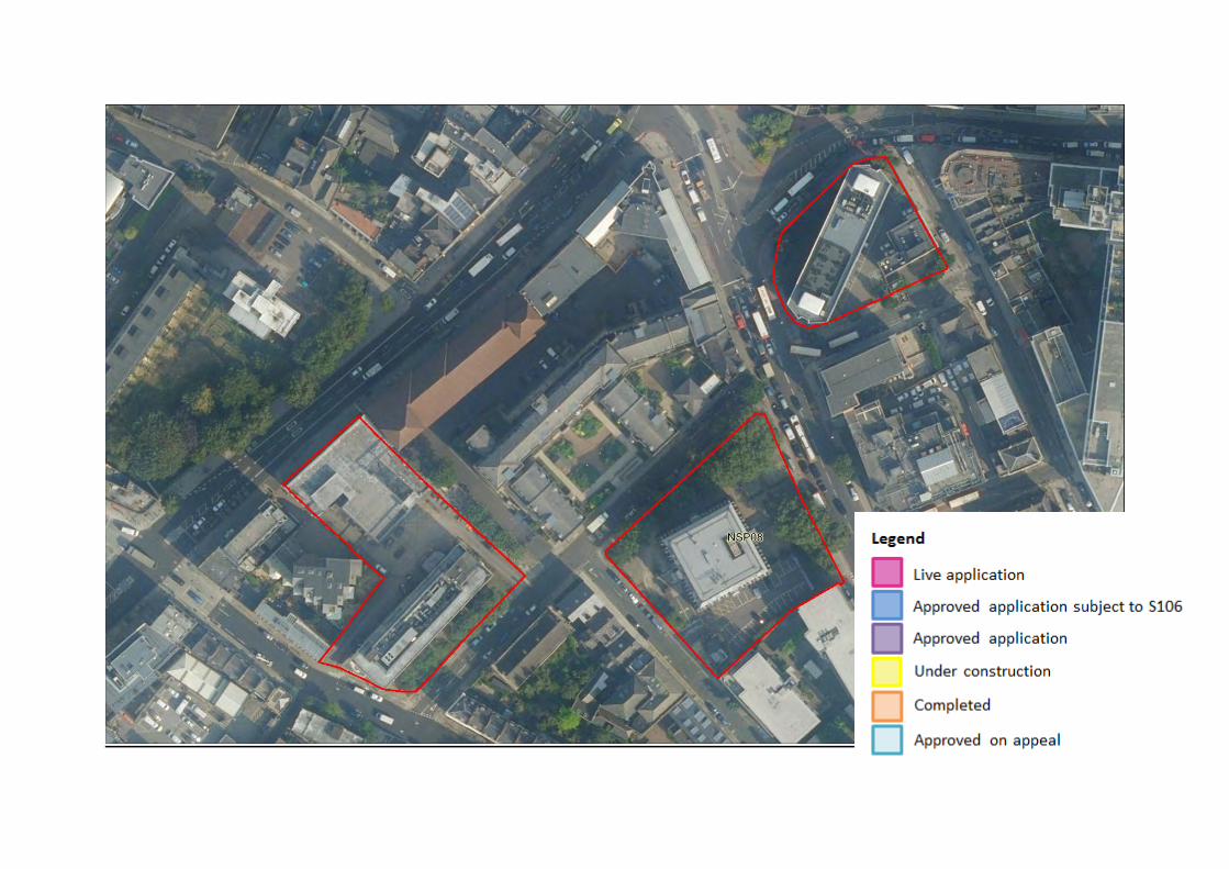

NSP09 (21 and 25-29 Harper Road, 325 Borough High Street, 1-5 and 7-11 Newington Causeway)
Site Ref. Site Name
Site Area m2
Planning Permission
Employment GIA m2
Residential
units
Retail GIA m2
Community space GIA
m2
Hotel
GIA m2
NSP09
21 and 25-29 Harper Road, 325 Borough High Street, 1-5 and 7-11 Newington Causeway
3,048
18/AP/0657
2,019 13 (net) 754 500 11,976
Delivery of the site NSP09 (Land between Great Suffolk Street and Glasshill Street) Landowner Southwark Homes Limited are the developer representing the landowners of the site at 19, 21 and 23 Harper Road, 325 Borough High Street,
1-5 and 7-11 Newington Causeway, SE1. The sites are included within the site allocation. Planning application details and known delivery constraints
Approved application 18/AP/0657 is relevant to this site allocation. Under this site allocation the following proposal has been approved: Demolition of existing buildings and redevelopment to provide construction of a mixed-use development comprising 328 hotel rooms (Class C1), 20 residential dwellings (Class C3), offices, workspace and workshops (Class B1), multifunctional community events space (Class B1/D1), retail use (Class A1/A2/A3). The application fully covers the site. There are 7 existing residential units; as such the net residential uplift would be 13 units. Trinity Church Square Conservation Area is located immediately to the north east of the Site and Liberty of the Mint Conservation Area is located further to the north west of the Site.
Delivery rates
Application number Status No of
homes Delivery timeframe
0-5 years (1st April 2020 – 31st March 2025) 6-15 years (1st April 2025 – 31st March 2035) 2020/2021 2021/2022 2022/2023 2023/2024 2024/2025
Planning application
18/AP/0657 Approved with legal agreement
13 (net) 0 13 0 0 0 0


Bermondsey NSP10 Biscuit Factory and Campus NSP11 Tower Workshops NSP12 Chambers Wharf

NSP 10 (Biscuit Factory)
Site Ref.
Site Name
Planning application
Site Area m2
Employment floorspace
GIA m2
Flexible retail
floorspace GIA m2
Flexible multi-use
floorspace GIA m2
Residential (Class C3) floorspace
GIA m2
Residential units
School GIA m2
Community and
Leisure GIA m2
Flexible retail and multi-use
floorspace GIA m2
NSP10
Biscuit Factory
and Campus
17/AP/4088 78,900 14,666 3,436 3,311 173,279 1,548
600-place secondary
school / 6,973
869 780
Delivery of the site NSP10 (Biscuit Factory) Landowner Grosvenor Britain and Ireland Planning application details and known delivery constraints
Southwark advised the Mayor that it was minded to refuse permission for the redevelopment proposals under planning application 17/AP/4088 and the Mayor having considered a report on the case, notified Southwark that he would act as the local planning authority for the purposes of determining the planning application. Subsequent to the direction that the Mayor will become the local planning authority, the applicant has submitted to the Mayor revisions to the application. The revisions included an increase in the number of residential units from 1,342 to 1,548 (+206). The Mayor has granted planning permission for the application with S106 legal agreement. The landowner engaged in seeking planning permission and therefore committed to the delivery of the site. It is anticipated that the school and 548 homes will come forward for development in years 0-5, and the remaining in years 6-15.
Delivery rates
Application number Status No of
homes Delivery timeframe
0-5 years (1st April 2020 – 31st March 2025) 6-15 years (1st April 2025 – 31st March 2035) 2020/2021 2021/2022 2022/2023 2023/2024 2024/2025
Planning application
17/AP/4088 Approved with S106 1,548 0 0 179 180 189 1,000


NSP11 (Tower Workshops)
Site Ref. Site Name Site Area m2 Employment GIA m2
Residential floorspace –
GIA m2 Residential
units Assessed
development GEA m2
Assessed development GIA
m2 FAR
NSP11 Tower Workshops 7,344 7,407 13,154 178 24,190 20,561 3.3
Delivery of the site NSP11 (Tower Workshops) Landowner Southwark Council
Planning application details and
known delivery
constraints
There is no planning application relevant to this site. It is expected that this site will come forward in years 6-15.
Delivery rates
Application number Status No of
homes Delivery timeframe
0-5 years (1st April 2020 – 31st March 2025) 6-15 years (1st April 2025 – 31st March 2035) 2020/2021 2021/2022 2022/2023 2023/2024 2024/2025
N/A N/A N/A 178 0 0 0 0 0 178


NSP12 (Chambers Wharf)
Site Ref. Site Name
Site Area m2
Planning Permission
Residential units
Retail, community and leisure uses (as defined in the NSP glossary)
GIA m2
Other D Class GIA
m2
NSP12 Chambers Wharf 14,010 07/AP/1262 587 275 200
Delivery of the site NSP12 (Chambers Wharf) Landowner St Martin Property Investments
Planning application details and
known delivery
constraints
This site is a Thames Tideway Tunnel construction site. Under the parent application 07/AP/1262 in total 587 units were granted planning permission, of which 180 units were affordable. The deed of variation application 13/AP/4266 to the existing S106 agreement of planning permission 07/AP/1262 proposed to vary the terms of provision of affordable housing. Two blocks comprised of 180 affordable housing units have already been implemented and the remainder of 407 units will be delivered when the Thames Tideway Tunnel is completed. The remainder of the scheme is likely to be delivered after 2023, in years 6-15.
Delivery rates
Application number Status No of
homes Delivery timeframe
0-5 years (1st April 2020 – 31st March 2025) 6-15 years (1st April 2025 – 31st March 2035) 2020/2021 2021/2022 2022/2023 2023/2024 2024/2025
07/AP/1262 Partially completed 180 180 0 0 0 0 0
07/AP/1262
Approved, remaining capacity
407 0 0 0 0 0 407
Total capacity 587


Blackfriars NSP13 Conoco House, Quadrant House, Edward Edwards House and Suthring House NSP14 Friars House, 157-168 Blackfriars Road NSP15 Land enclosed by Colombo Street, Meymott Street and Blackfriars Road NSP16 Ludgate House and Sampson House, 64 Hopton Street
NSP17 Southwark Station and 1 Joan Street
NSP18 McLaren House, St George’s Circus NSP19 Land between Paris Gardens, Colombo Street, Blackfriars Road and Stamford Street NSP20 1-5 Paris Garden and 16-19 Hatfields

NSP13 (Conoco House, Quadrant House, Edward Edwards House and Suthring House)
Delivery of the site NSP13 (Conoco House, Quadrant House, Edward Edwards House and Suthring House) Landowner Freehold owner Southwark Charities; Conoco House is managed by LaSalle Asset Management
Planning application details and
known delivery
constraints
The site has potential for a comprehensive mixed-use redevelopment which could include taller buildings subject to consideration of the impacts on existing character, heritage and townscape. There are existing residential units currently on site, as follows:
36 units in Quadrant House 6 units in Suthering House 25 almshouses in Edward Edwards’ House owned and managed by Southwark Charities
The residential capacity of this site is 124 (net) units, which is in addition to the existing residential units on site. There is a live application (20/AP/3520) covering half of the site proposing the following: ‘’Redevelopment of the site comprising demolition of the existing buildings and erection of a new part 22/part 15 storey building (with three levels of basement) comprising Office (Class E), Public House (Sui Generis), 66 flats (Class C3) and flexible Office/Community use (Class E/F2) together with public realm improvements and other associated works’’ It is expected that this site will come forward in years 6-15.
Delivery rates
Application number Status No of
homes Delivery timeframe
0-5 years (1st April 2020 – 31st March 2025) 6-15 years (1st April 2025 – 31st
Site Ref. Site Name Site Area m2 Employment (B Class) GIA
m2
Residential floorspace –
GIA m2 Residential
units
Retail, community and leisure (as defined in the NSP Glossary)
GIA m2
Assessed development
GEA m2
Assessed development
GIA m2 FAR
NSP13
Conoco House, Quadrant House, Edward Edwards
House and Suthring House
6,663 12,685 9,185 124 (net) 1,409 33,315 28,318 5

2020/2021 2021/2022 2022/2023 2023/2024 2024//2025 March 2035)
20/AP/3520 Live Application 66 0 0 0 0 0 66 N/A Remaining 58
(net) 0 0 0 0 0 58
N/A Total 124 124

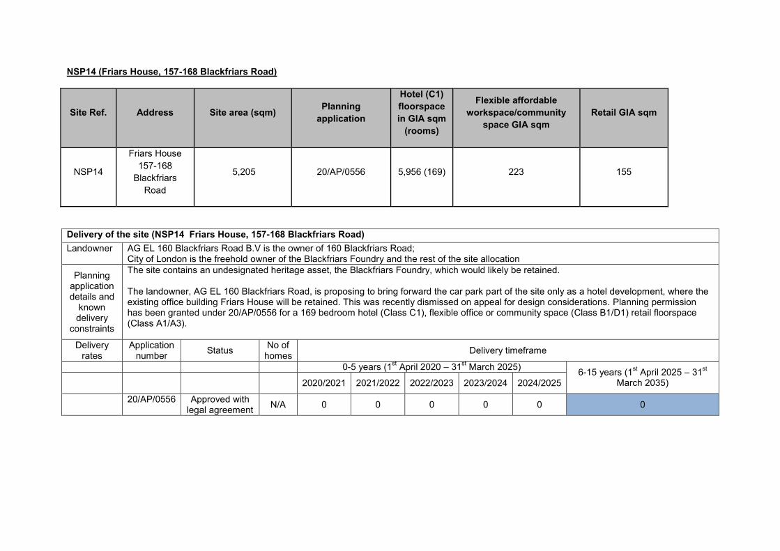
NSP14 (Friars House, 157-168 Blackfriars Road)
Site Ref. Address Site area (sqm) Planning application
Hotel (C1) floorspace in GIA sqm
(rooms)
Flexible affordable workspace/community
space GIA sqm Retail GIA sqm
NSP14
Friars House 157-168
Blackfriars Road
5,205 20/AP/0556 5,956 (169) 223 155
Delivery of the site (NSP14 Friars House, 157-168 Blackfriars Road) Landowner AG EL 160 Blackfriars Road B.V is the owner of 160 Blackfriars Road;
City of London is the freehold owner of the Blackfriars Foundry and the rest of the site allocation
Planning application details and
known delivery
constraints
The site contains an undesignated heritage asset, the Blackfriars Foundry, which would likely be retained. The landowner, AG EL 160 Blackfriars Road, is proposing to bring forward the car park part of the site only as a hotel development, where the existing office building Friars House will be retained. This was recently dismissed on appeal for design considerations. Planning permission has been granted under 20/AP/0556 for a 169 bedroom hotel (Class C1), flexible office or community space (Class B1/D1) retail floorspace (Class A1/A3).
Delivery rates
Application number Status No of
homes Delivery timeframe
0-5 years (1st April 2020 – 31st March 2025) 6-15 years (1st April 2025 – 31st March 2035) 2020/2021 2021/2022 2022/2023 2023/2024 2024/2025
20/AP/0556 Approved with legal agreement N/A 0 0 0 0 0 0


NSP15 Land enclosed by Colombo Street, Meymott Street and Blackfriars Road
Site Ref. Site Name Site Area m2 Planning
Permission Employment
GIA m2 Residential
GIA floorspace
Residential units
Retail, community and leisure (as defined in the NSP Glossary)
GIA m2
Hotel GIA m2
Sui generis GIA m2
Community Use
GIA m2
NSP15
Land enclosed by Colombo
Street, Meymott Street and Blackfriars
Road
3,737 15/AP/0237 5,848 N/A N/A N/A 8,277 36 N/A
Remainder of the site 6,000 4,656 198 625
N/A N/A 375
Delivery of the site (NSP15 Land enclosed by Colombo Street, Meymott Street and Blackfriars Road) Landowner Hoxton (Southwark) Ltd owner of Wedge House, 36 Blackfriars Road;
Jupiter Friars Limited is the freehold owner of Friars Bridge Court at 41-45 Blackfriars Road; Southwark Council is the owner of Colombo Sports Centre
Planning application details and
known delivery
constraints
It is acknowledged that the site allocation relates to a number of different plots that are within a variety of ownerships. Application 15/AP/0237 is relevant to this site allocation and it only covers part of the site. This proposal relates to Wedge House, at 36 Blackfriars Road within the site allocation and the owner is Hoxton (Southwark) Ltd. Under this application the following proposal was granted planning permission: Redevelopment of land and buildings to provide a part 7, part 12, part 14 storey building plus basement, ground and mezzanine levels, comprising office (Class B1) and hotel (Class C1) with ancillary cafe/bar/restaurant and other associated supporting facilities, ancillary plant, servicing, and cycle parking and associated highway and public realm improvements. Under application 16/AP/1253 minor design changes have been approved to application 15/AP/0237. This development is now completed. Application 16/AP/1660 was relevant to Friars Bridge Court at 41-45 Blackfriars Road within the site allocation. The following scheme was granted permission: demolition of existing office building (Class B1a) and redevelopment to provide a part 13, part 22 storey building plus basement comprising offices (Class B1a) with retail (Classes A1/A3 and A4) together with servicing, car parking and landscaping. This application has now expired. Colombo Sport Centre and Friars Bridge Court at 41-45 Blackfriars Road within the site allocation has the potential for a comprehensive mixed use re-development. It is expected that these parts of the site allocation will come forward for development in years 6-15.
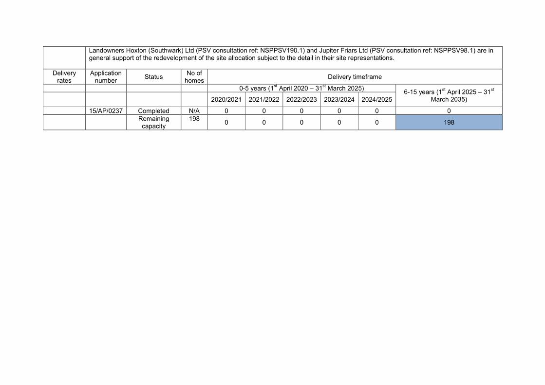
Landowners Hoxton (Southwark) Ltd (PSV consultation ref: NSPPSV190.1) and Jupiter Friars Ltd (PSV consultation ref: NSPPSV98.1) are in general support of the redevelopment of the site allocation subject to the detail in their site representations.
Delivery rates
Application number Status No of
homes Delivery timeframe
0-5 years (1st April 2020 – 31st March 2025) 6-15 years (1st April 2025 – 31st March 2035) 2020/2021 2021/2022 2022/2023 2023/2024 2024/2025
15/AP/0237 Completed N/A 0 0 0 0 0 0 Remaining
capacity 198 0 0 0 0 0 198


NSP16 Ludgate House and Sampson House, 64 Hopton Street
Site Ref. Site Name Site Area m2
Planning Permission
Employment GIA m2
Residential units
Retail Use
GIA m2 Community Use GIA m2
Gym GIA m2
NSP16 Ludgate House 21,000 12/AP/3940 45,378 489 2,627 1,969 1,014
Site Ref. Site Name Site Area m2
Planning Permission
Employment GIA m2
Residential units
Retail floorspace
GIA m2
Cultural floorspace
GIA m2
Hotel floorspace
GIA m2
NSP 16 Sampson House 10,100 18/AP/1603 8,054 109 (net) 1,436 904 16,254
Delivery of the site NSP16 (Ludgate House and Sampson House, 64 Hopton Street) Landowner Native Land
Planning application details and
known delivery
constraints
Applications 12/AP/3940 and 18/AP/1603 are the main applications relevant to this site. Under application 12/AP/3940 (which covered the majority of the site allocation) the following proposal was granted planning permission: Demolition of existing buildings and the construction of a mixed use development totalling 144,622 sq.metres GEA comprising 489 flats (Class C3), 45,378 sqm (including basement) of offices (Class B1), 2,627sqm of retail (Classes A1-A5), 1,969sqm of community uses (Class D1) and 1,014sqm of gym (Class D2). Subsequently, a number of minor material amendments have been approved, one which included a Deed of Variation to the original legal agreement. In 2015 the site was purchased by Native Land who sought an agreement for the development to be treated as two separate phases, each capable of being delivered independently. An application to vary the legal agreement was approved in March 2019 under reference 18/AP/1316. The amendments to the legal agreement separated the Ludgate House and Sampson House obligations. Sampson House has now been demolished while the construction on the Ludgate House site is well under way.

With the ability to deliver the sites independently of one another, the following scheme was approved subject to S106 legal agreement under application 18/AP/1603 on the Sampson House site: Redevelopment to create two levels of basement and the erection of five buildings ranging from seven to 34 storeys plus plant (heights ranging from 28.9m AOD – 123.9m AOD) to provide: 341 dwellings (Class C3); 8,054sqm (GIA) of office space (Class B1); 1,436sqm (GIA) of retail floorspace (Class A1-A4); 904sqm (GIA) of cultural floorspace (Class D1/D2); 16,254sqm (GIA) hotel with up to 126 rooms (Class C1); new open space. The 18/AP/1603 scheme is similar to the 2012 approved development in many respects including the broad location and positioning of buildings and access/egress. The main differences between this scheme and the 2012 permission in relation to Sampson House include the reduction in the number of buildings from six to five by the omission of building SH-E; increasing the height of three of the buildings compared to the approved scheme and decreasing the height of one other; an increased number of homes; the creation of a large cultural venue; and the provision of a large hotel. The proposed 341 dwellings on the Sampson House site, represent an uplift of 109 dwellings in comparison to the scheme on the Ludgate House site which is now providing 257 units. It is expected that the proposal will be delivered in years 0-5.
Delivery rates
Application number Status No of
homes Delivery timeframe
0-5 years (1st April 2020 – 31st March 2025) 6-15 years (1st April 2025 – 31st March 2035) 2020/2021 2021/2022 2022/2023 2023/2024 2024/2025
12/AP/3940 (Ludgate House)
Under construction 257 0 85 85 87 0 0
18/AP/1603 (Sampson
House)
Under construction 341 0 0 170 171 0 0
Total capacity
598 0 85 255 256 0 0


NSP17 (Southwark Station and 1 Joan Street)
Site Ref. Site Name Site Area m2
Planning Application Employment (B
Class) GIA m2
Retail, community and leisure
(as defined in the NSP
Glossary) GIA m2
Residential units
Community uses
GIA m2
NSP17 Southwark
Station and 1 Joan Street
6,466
20/AP/0969 n/a
n/a 25 (16 net) 146
20/AP/1189 26,895
237 n/a n/a
Delivery of the site NSP17 (Southwark Station and 1 Joan Street) Landowner Transport for London; London Borough of Southwark
Planning application details and
known delivery
constraints
The site can accommodate a substantial uplift in new employment space and potentially new homes. Redevelopment will improve the town centre offer at ground floor facing Blackfriars Road and The Cut. Redevelopment should provide access to the Cycle Super Highway and public realm improvements to Joan Street and Isabella Street. Redevelopment of the site must maintain and improve access and egress from Southwark Station and Waterloo East Station. Application 20/AP/1189 has been approved at Planning Committee subject to a legal agreement, and it occupies part of the site allocation. The proposal under this application is for the: Redevelopment of the site including the demolition of Nos. 49-56 Hatfields and No 1 Joan Street to provide an 17 storey (plus plant) building above Southwark Underground Station accommodating Class B1 office space and Class A1/A2/A3/A4/A5 retail space and Class B1/D1 flexible workspace. The development includes associated basement construction, public realm improvements and associated highways works including the closure of Joan Street. The approval of this application has reduced the residential capacity of this site.

Another application has been approved at Planning Committee subject to a legal agreement that is relevant to this site is 20/AP/0969, which is for the redevelopment of Styles House and occupies the remainder of the site. The proposal under this application is for the: Redevelopment of the site to include the demolition of existing buildings (the Platform Southwark building, the existing tenant management organisation hall, nine garages, a sub-station, eight studio apartments, and a storage and boiler room building); the retention and improvement to the existing Styles House building; the erection of 25 new dwellings, a new substation, a new community centre and tenant management organisation facilities; car and cycle parking; a new boiler house; landscaping; access and associated works.
Delivery rates
Application number Status No of
homes Delivery timeframe
0-5 years (1st April 2020 – 31st March 2025) 6-15 years (1st April 2025 – 31st March 2035) 2020/2021 2021/2022 2022/2023 2023/2024 2024/2025
20/AP/1189 Approved subject to legal
agreement
N/A 0 0 0 0 0 0
20/AP/0969 Approved subject to legal
agreement
25 (16 net
uplift) 0 0 0 16 0 16

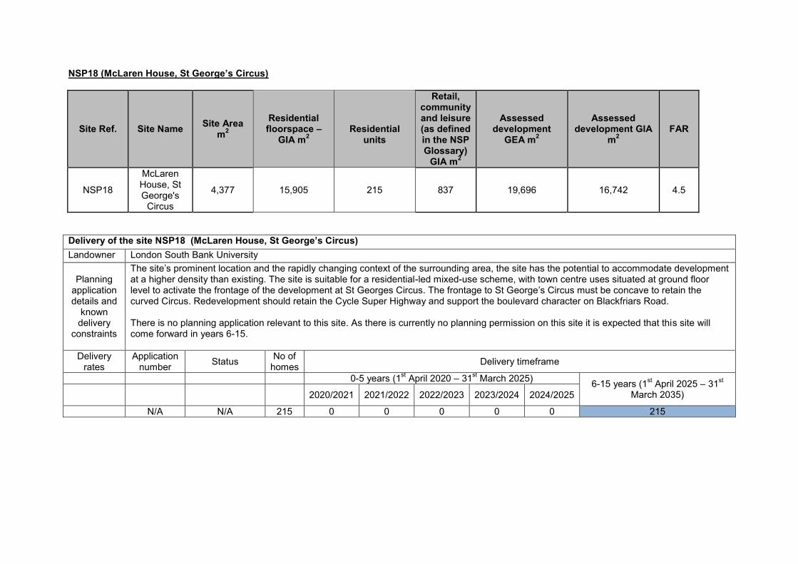
NSP18 (McLaren House, St George’s Circus)
Site Ref. Site Name Site Area m2
Residential floorspace –
GIA m2
Residential
units
Retail, community and leisure (as defined in the NSP Glossary)
GIA m2
Assessed development
GEA m2
Assessed development GIA
m2 FAR
NSP18
McLaren House, St George's
Circus
4,377 15,905 215 837 19,696 16,742 4.5
Delivery of the site NSP18 (McLaren House, St George’s Circus) Landowner London South Bank University
Planning application details and
known delivery
constraints
The site’s prominent location and the rapidly changing context of the surrounding area, the site has the potential to accommodate development at a higher density than existing. The site is suitable for a residential-led mixed-use scheme, with town centre uses situated at ground floor level to activate the frontage of the development at St Georges Circus. The frontage to St George’s Circus must be concave to retain the curved Circus. Redevelopment should retain the Cycle Super Highway and support the boulevard character on Blackfriars Road. There is no planning application relevant to this site. As there is currently no planning permission on this site it is expected that this site will come forward in years 6-15.
Delivery rates
Application number Status No of
homes Delivery timeframe
0-5 years (1st April 2020 – 31st March 2025) 6-15 years (1st April 2025 – 31st March 2035) 2020/2021 2021/2022 2022/2023 2023/2024 2024/2025
N/A N/A 215 0 0 0 0 0 215


NSP19 Land between Paris Gardens, Colombo Street, Blackfriars Road and Stamford Street
Site Ref. Site Name
Site Area m2
Planning Permission Employment GIA m2
Residential units
Retail, community and
leisure (as defined in the NSP Glossary)
GIA m2
Other community uses GIA
m2
Hotel GIA
m2
NSP19
Land between Paris Gardens, Colombo Street, Blackfriars
Road and Stamford Street
7,218 16/AP/5239 33,755 288 3,212 783
25,009
Delivery of the site NSP19 ( Land between Paris Gardens, Colombo Street, Blackfriars Road and Stamford Street) Landowner Black Pearl Ltd.
Planning application details and
known delivery
constraints
Application 16/AP/5239 is relevant to this site, which has been approved with legal agreement. The application covers the whole area of the site allocation. The proposal is currently under construction and is expected that this scheme will be delivered in years 0-5.
Delivery rates
Application number Status No of
homes Delivery timeframe
0-5 years (1st April 2018 – 31st March 2023) 6-15 years (1st April 2023 – 31st March 2033) 2020/2021 2021/2022 2022/2023 2023/2024 2024/2025
16/AP/5239 Under construction 288 0 96 96 96 0 0


NSP20 (1-5 Paris Garden and 16-19 Hatfields)
Site Ref. Site Name
Site Area m2
Planning Permission Employment
GIA m2
Retail, community and
leisure (as defined in the NSP Glossary)
GIA m2
NSP20 1-5 Paris Garden
and 16-19 Hatfields
5,550
17/AP/4230 56,571 1,651
Delivery of the site NSP20 (1-5 Paris Garden and 16-19 Hatfields) Landowner Overcourt Ltd.
Planning application details and
known delivery
constraints
The application relevant to this site is 17/AP/4230. The proposal is for the: Phased redevelopment comprising: Phase 1: Demolition of 4-5 Paris Garden and 18-19 Hatfields to create a part 23 and part 26 storey tower building (+ double basement)(up to 115.75m AOD) to be used for offices (Class B1), above a new public space with flexible retail/professional services/restaurant uses (Classes A1/A2/A3) at ground floor level and restaurant/bar uses (Classes A3/A4) at third floor level; Phase 2: Partial demolition, refurbishment and extensions to 16-17 Hatfields and 1-3 Paris Garden for continued use as offices (Class B1) with flexible use of the ground floor level (Classes A1/A2/A3/A4/B1) and restaurant/bar uses (Classes A3/A4) at part fifth floor level; creation of a new public, landscaped roof terrace at part fifth floor level and green roof at sixth floor level; lowering of existing basement slab; new landscaping and public realm; reconfigured vehicular and pedestrian access; associated works to public highway; cycle parking; ancillary servicing and plant and other associated works. The application covers the whole area of the site allocation. It is expected that this scheme will be delivered in years 0-5. No residential will come forward on this site.
Delivery rates
Application number Status No of
homes Delivery timeframe
0-5 years (1st April 2020 – 31st March 2025) 6-15 years (1st April 2025 – 31st March 2035) 2020/2021 2021/2022 2022/2023 2023/2024 2024/2025
17/AP/4230 Approved with legal agreement N/A 0 0 0 0 0 0


Camberwell Sites NSP21 Camberwell Station NSP22 Burgess Business Park NSP23 Butterfly Walk and Morrisons Car Park and police station NSP24 Valmar Trading Estate NSP25 Camberwell Bus Garage NSP26 Abellio Walworth Depot NSP27 Land Between Camberwell Station Road and Warner Road NSP28 Iceland, 120-132 Camberwell Road NSP29 49 Lomond Grove NSP30 83 Lomond Grove NSP31 123 Grove Park NSP32 Camberwell Green Magistrates Court NSP33 Denmark Hill Campus East

NSP21 Camberwell Station
Site Ref. Site Name Site Area m2 Light Industry / Small Business GIA m2
Sui Generis GIA m2
NSP21 Camberwell Station 16,400
Small business space within railway arches (replacement)
New station at Camberwell with an exit to the east and west of the railway viaduct.
Delivery of the site NSP21 (Camberwell Station) Landowner Network Rail
Planning application details and
known delivery
constraints
The site must provide employment uses but is also capable of providing some supporting town centre uses and sui generis uses. Development proposals must recognise the site’s close proximity to the borough boundary and must consider the function of Camberwell Trading Estate, in addition to any cross-boundary issues and the provisions of policies and site allocations within reasonable proximity of the site as set out in the Lambeth Local Plan. There is no planning application relevant to this site. The Council has been actively promoting the reopening of Camberwell Station working with TfL and Network Rail (PSV consultation ref: NSPPSV181.16). The Council recently submitted a Restoring Your Railway Fund bid with SE5 Forum and local MPs.
Delivery rates
Application number Status No of
homes Delivery timeframe
0-5 years (1st April 2020 – 31st March 2025) 6-15 years (1st April 2025 – 31st March 2035) 2020/2021 2021/2022 2022/2023 2023/2024 2024/2025
N/A N/A N/A 0 0 0 0 0 0


NSP22 Burgess Business Park
Site Ref. Site Name
Site Area m2
Planning permission
Employment GIA m2
Residential floorspace – GIA m2
Residential units
Assessed development
GEA m2
Assessed development
GIA m2
Others (Mezzanine
Storage) GIA m2
FAR
NSP22 Burgess Business
Park 38,010
17/AP/4381 798 (B1, B2 B8) N/A N/A 939 798 N/A N/A
17/AP/4778 6438 (B1a, B8) N/A N/A 9,999 8,499 2,061 N/A
Remainder of the site 25,073 50,326 681 97,218 82,635 N/A 3.1
Delivery of the site NSP22 (Burgess Business Park) Landowner Pelican Resource Limited - 17/AP/4381
Big Yellow Self storage company - 17/AP/4778 Peach Tree Services Limited Units 1-9 of the Burgess Business Park, nos. 2, 10-12 and 15-19 Parkhouse Street and 45 Southampton Way Dolphin Square Charitable Trustee – 19/AP/2011 JH Parkhouse Ltd - 20/AP/0858 Southwark Council - 19/AP/0469
Planning application details and
known delivery
constraints
There are two approved applications that are relevant to this site. The development approved under 17/AP/4381 (PHS Waste Transfer site) includes the demolition of the existing building located at 41-43 Parkhouse Street, and the construction of an extension to the existing building located at 66 Wells Way to be used for B2/B8 and Sui Generis (Waste Transfer) uses in connection with the existing use of the retained building. The new extension would provide 798sqm of floorspace (net increase of 287sqm) and would be attached to the southern elevation of the existing building to be retained. The development approved under 17/AP/4778 (Big Yellow Storage site) includes the demolition of existing warehouse (Use Class B8) and office buildings (Use Class B1A) and the erection of a part 2, part 4-storey building plus basement comprising self storage facility (Use Class B8) and flexible office space (Use Class B1A) together with vehicular and pedestrian accesses, parking, associated works and landscaping. The building would provide a 4,444sqm (GIA) self-storage facility (use Class B8) and 1,994sqm (GIA) of flexible office space (use Class B1a). For the storage facility, permanent floors would be provided at basement, ground and second floor levels. Notional mezzanines shown on the other floors would increase the storage floorspace to 8,499sqm (GIA), and supporting transport information submitted with the application has

been calculated on this basis. The following 3 live applications are relevant to this site allocation and they are still under consideration: The development under 19/AP/2011 (Dolphin Square Charitable Trustee landowner is relevant to this site) includes the demolition of existing buildings and construction of a mixed use building ranging from six to 10 storeys in height (35.15m AOD) comprising 100 residential units (Use Class C3) and 1,323 sqm (GIA) of Class B1/B2/B8 floorspace) with associated car parking, landscaping and other associated works. The development under 19/AP/0469 (Southwark Council landowner is relevant to this site) includes the demolition of existing building and erection of two blocks (Block A and Block B) of 5 storeys and part-7/part-10 storeys (total AOD 35.86m). Block A would comprise of a 5-storey block for commercial/employment use (962 sqm) and Block B would comprise of a ground floor commercial/employment use (129sqm), 33 residential dwellings (3 x studios; 6 x 1b flats, 18 x 2b flats, 6 x 3b flats), 1 accessible car parking space with associated landscaping, cycle parking and refuse store. The development under 20/AP/0858 (JH Parkhouse is relevant to this site) will redevelop the site to provide a mixed-use development comprising buildings up to 11 storeys in height and accommodating new homes (Use Class C3) and commercial floorspace (Use Class B1c), car parking, cycle parking and associated landscaping. The site will deliver 109 dwellings and 1,351sqm(GIA) of commercial floorspace. The proposal would be within the setting of the Addington Park Conservation Area and grade II listed buildings the Lime Kiln in Burgess Park and the former St Georges Church and Groundwork Trust Offices on Wells Way. An appeal submitted by Peachtree Services Ltd was dismissed for the largest site within the site allocation, land at Burgess Business Park, Parkhouse Street, London SE5 7TJ (17/AP/4797, APP/A5840/W/19/3225548) for 499 residential units, up to 3,725m2 (GIA) of Class B1 commercial floorspace, up to 128m2 (GIA) of Class D2 leisure floorspace and up to 551m2 of Class A1-A3 floorspace within 13 blocks of between 2-12 storeys (max AOD height 41.95m), with car and cycle parking and associated hard and soft landscaping. The appeal was dismissed relating to reasons of density, standard of accommodation and design quality. All proposals which have not currently been granted planning permission are expected to come forward in year 6-15. The site remains partially occupied.
Delivery rates
Application number Status No of
homes Delivery timeframe
0-5 years (1st April 2020 – 31st March 2025) 6-15 years (1st April 2025 – 31st March 2035) 2020/2021 2021/2022 2022/2023 2023/2024 2024/2025
17/AP/4381 PHS Waste Transfer
Built N/A

17/AP/4778 Big Yellow Storage
Built N/A
19/AP/2011
Live application 100
100
19/AP/0469 Live application 33 33 20/AP/0858 Live application 109 109 N/A
Remaining capacity
439 439
Total 681 681


NSP23 Butterfly Walk and Morrisons Car Park and Police Station
Site Ref. Site Name Site Area m2
Retail, community and leisure (as defined in the NSP Glossary)
GIA m2
Residential floorspace – GIA m2
Residential units
Sui Generis GIA m2
Assessed development
GEA m2
Assessed development
GIA m2 FAR
NSP23
Butterfly Walk and Morrisons Car Park and police station
13,840 6,705 16,997 230 384 28,336 24,086 2.0
Delivery of the site NSP23 (Butterfly Walk and Morrisons Car Park) Landowner Mumbo Jumbo World (MJW)
Metropolitan Police
Planning application details and
known delivery
constraints
The site is capable of delivering a comprehensive mixed-use development of at least the amount of town centres uses currently on site alongside new residential units. The site may also provide employment and cultural. The site currently has a live planning application pending consideration which covers the whole site allocation. The development under live application 19/AP/7057 includes a part redevelopment, part refurbishment of the Butterfly Walk Shopping Centre including the addition of a part 3, part 5 and part 6 storey building fronting Denmark Hill, and the erection of a new part 2, part 3, part 4 and part 8 storey building fronting Daneville Road. The development also includes the erection of a new 6 storey building on the corner of Orpheus Street and Daneville Road, to accommodate a mix of new retail (classes A1 to A3), 146 residential dwellings (Class C3) within three buildings; erection of a new 101-bed hotel, new two screen cinema, the creation of a central landscaped shopping area to the rear of the Shopping Centre. If approved, it is expected to come forward in years 6 – 15.
Delivery rates
Application number Status No of
homes Delivery timeframe
0-5 years (1st April 2020 – 31st March 2025) 6-15 years (1st April 2025 – 31st March 2035) 2020/2021 2021/2022 2022/2023 2023/2024 2024/2025
19/AP/7057 Live application 146 146
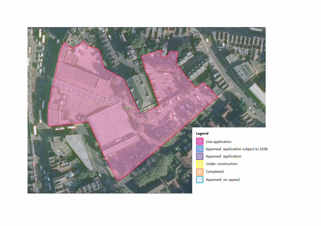

NSP24 Valmar Trading Estate
Site Ref. Site Name
Planning
Permission
Site Area m2
Employment GIA m2
Residential floorspace –
GIA m2 Residential
units
Hotel GIA m2
Retail
GIA m2
NSP24 Valmar Trading Estate
19/AP/0864 6,021 3,447 4,302 43
3,717 (127
rooms)
55
Delivery of the site NSP24 (Valmar Trading Estate) Landowner Fodbury Properties limited
Coldspace Limited
Planning application details and
known delivery
constraints
The site currently has planning permission covering the majority of the site (19/AP/0864) for: ‘Redevelopment of the site to include the demolition of the existing buildings and construction of three buildings of: 7 storeys (plus single storey basement), 6 storeys and 4 storeys across the site providing employment space with ancillary screening room and gallery space (Use Class B1), 127 hotel rooms (Use Class C1), 43 residential units (Use Class C3) and a café (Class A3); together with associated landscaping works and provision of refuse storage, cycle parking, disabled car parking and amenity space.’
Delivery rates
Application number Status No of
homes Delivery timeframe
0-5 years (1st April 2020 – 31st March 2025) 6-15 years (1st April 2025 – 31st March 2035) 2020/2021 2021/2022 2022/2023 2023/2024 2024/2025
19/AP/0864 Approved with legal agreement
43 0 0 21 22 0 0


NSP25 Camberwell Bus Garage
Site Ref.
Site Name Site Area m2
Residential floorspace –
GIA m2
Residential units
Retail, community and leisure (as defined in
the NSP Glossary) GIA m2
Sui Generis GIA m2
Assessed development
GEA m2
Assessed development
GIA m2
FAR
NSP25 Camberwell Bus Garage
17,090
19,502
264 1,525
9,478
35,889
30,505
2.1
Delivery of the site NSP25 (Camberwell Bus Garage) Landowner Fodbury Properties limited
Coldspace Limited Planning
application details and
known delivery
constraints
There is no planning application relevant to this site. As there is currently no planning permission, it is expected that this site will come forward in years 6-15.
Delivery rates
Application number Status No of
homes Delivery timeframe
0-5 years (1st April 2020 – 31st March 2025) 6-15 years (1st April 2025 – 31st March 2035) 2020/2021 2021/2022 2022/2023 2023/2024 2024/2025
N/A N/A 264 264


NSP26 Abellio Walworth Depot
Site Ref.
Site Name Site Area m2
Residential floorspace –
GIA m2
Residential units
Retail, community and leisure (as defined in the
NSP Glossary) GIA m2
Sui Generis GIA m2
Assessed development
GEA m2
Assessed development GIA
m2
FAR
NSP26 Abellio Walworth
Depot
11,330
14,451
196 1,156
7,507
27,192
23,113
2.4
Delivery of the site NSP26 (Abellio Walworth Depot) Landowner Transport For London (TFL)
Planning application details and
known delivery
constraints
There is no planning application relevant to this site. As there is currently no planning permission, it is expected that this site will come forward in years 6-15. Landowner TFL (PSV consultation ref: NSPPSV181.18) have expressed support to the delivery of residential uses on this site allocation. The Commercial Development department (PSV consultation ref: NSPPVS182.5) have expressed support for the bus garage function to remain and that this be combined with a residential-led development. They also support that if the bus garage is surplus to requirement that the delivery of new homes, business space (B1) and town centre uses would be appropriate. In the 2020 consultation TFL (NSPPSV181) and TLF Commercial Development (NSPPSV182) reiterated that the bus garage capacity must be retained to maintain the local bus network. TfL Commerical has stated that the site is deliverable within the plan period.
Delivery rates
Application number Status No of
homes Delivery timeframe
0-5 years (1st April 2020 – 31st March 2025) 6-15 years (1st April 2025 – 31st March 2035) 2020/2021 2021/2022 2022/2023 2023/2024 2024/2025
N/A N/A 196 196


NSP27 Land Between Camberwell Station Road and Warner Road
Site Ref. Site Name Site Area m2
Employment GIA m2
Residential floorspace –
GIA m2 Residential
units
Community uses
GIA m2
Assessed development
GEA m2
Assessed development
GIA m2 FAR
NSP27
Land Between Camberwell Station Road and Warner
Road
4,135 3,211 4,730 64 476 9,902 8,417 2.4
Delivery of the site NSP27 (Land Between Camberwell Station Road and Warner Road) Landowner Unknown
Planning application details and
known delivery
constraints
There is no planning application relevant to this site. As there is currently no planning permission on this site, it is expected that this site will come forward in years 6-15.
Delivery rates
Application number Status No of
homes Delivery timeframe
0-5 years (1st April 2020 – 31st March 2025) 6-15 years (1st April 2025 – 31st March 2035) 2020/2021 2021/2022 2022/2023 2023/2024 2024/2025
N/A N/A 64 64


NSP28 Iceland, 120-132 Camberwell Road
Site Ref. Site Name Site Area m2
Residential floorspace – GIA m2
Retail, community and leisure (as
defined in the NSP Glossary) GIA m2
Residential units
Assessed development
GEA m2
Assessed development
GIA m2 FAR
NSP28
Iceland, 120-132
Camberwell Road
2,930 2,872 2,390 39 (net) 6,592 5,603 2.3
Delivery of the site NSP28 (Iceland, 120-132 Camberwell Road) Landowner Crown Properties
Planning application details and
known delivery
constraints
The site is capable of providing comprehensive mixed use development with the inclusion of residential units for new homes. There are 6 existing units on site. As such, the net residential capacity is 39 units in addition to the existing units on site. There are no pending or decided planning applications on this site. It is expected that any forthcoming schemes on this site will come forward in years 6-15. The landowner, Crown Properties (PSV ref: NSPPSV41.1) have expressed support at the inclusion of the site as an allocation to come forward for mixed-use residential development.
Delivery rates
Application number Status No of
homes Delivery timeframe
0-5 years (1st April 2020 – 31st March 2025) 6-15 years (1st April 2025 – 31st March 2035) 2020/2021 2021/2022 2022/2023 2023/2024 2024/2025
N/A N/A 39 (net) 39


NSP29 49 Lomond Grove
Site Ref.
Site Name Site Area m2
Employment GIA m2
Residential floorspace – GIA m2
Residential units
Assessed development GEA m2
Assessed development GIA m2
FAR
NSP29 49 Lomond Grove
3,162
1,940
2,898
39 5,691
4,837
1.8
Delivery of the site NSP29 (49 Lomond Grove) Landowner Unknown
Planning application details and
known delivery
constraints
The site is capable of providing comprehensive mixed use development with the inclusion of residential units for new homes. There is no planning application relevant to this site. As there is currently no planning permission on this site, it is expected that this site will come forward in years 6-15.
Delivery rates
Application number Status No of
homes Delivery timeframe
0-5 years (1st April 2020 – 31st March 2025) 6-15 years (1st April 2025 – 31st March 2035) 2020/2021 2021/2022 2022/2023 2023/2024 2024/2025
N/A N/A 39 39


NSP30 83 Lomond Grove
Site Ref.
Site Name Site Area m2
Employment GIA m2
Residential floorspace – GIA m2
Residential units
Assessed development GEA m2
Assessed development GIA m2
FAR
NSP30 83 Lomond Grove
2,104
695
3,716
50 5,190
4,411
4
Delivery of the site NSP30 (83 Lomond Grove) Landowner Unknown
Planning application details and
known delivery
constraints
The site has the potential to deliver a residential-led mixed-use development. There is no planning application relevant to this site. As there is currently no planning permission on this site, it is expected that this site will come forward in years 6-15.
Delivery rates
Application number Status No of
homes Delivery timeframe
0-5 years (1st April 2020 – 31st March 2025) 6-15 years (1st April 2025 – 31st March 2035) 2020/2021 2021/2022 2022/2023 2023/2024 2024/2025
N/A N/A 50 50


NSP31 123 Grove Park
Site Ref.
Site Name Site Area m2 Planning permission
Residential units
NSP31 123 Grove Park 5,798
17/AP/4124 9
Delivery of the site NSP31 (123 Grove Park) Landowner 123 Grove Park Ltd
Planning application details and
known delivery
constraints
Application 17/AP/4124 is relevant to this site allocation. Under this application the following scheme was granted planning permission, which is now under construction: The development includes a change of use from Class D1 with an ancillary Class B1 office function to Class C3 for residential use. The development also includes the conversion and part demolition of the existing main house to enable the creation of x5 new residential units and the construction of x4 new residential units in the rear garden with x9 off street parking spaces, associated communal and private landscaped areas. There are several sensitive trees and groups of trees on site which must be managed. The proposal accords with the site allocation in providing new residential units. The granted permission will fully occupy the site allocation.
Delivery rates
Application number Status No of
homes Delivery timeframe
0-5 years (1st April 2020 – 31st March 2025) 6-15 years (1st April 2025 – 31st March 2035) 2020/2021 2021/2022 2022/2023 2023/2024 2024/2025
17/AP/4124 Under construction 9 0 9 0 0 0 0


NSP32 Camberwell Green Magistrates Court
Site Ref. Site Name Site Area m2
Employment; Retail,
community and leisure (as
defined in the NSP Glossary)
GIA m2
Residential floorspace –
GIA m2 Residential
units Assessed
development GEA m2
Assessed development
GIA m2 FAR
NSP32 Camberwell Green Magistrates Court 4,814 5,298 11,085 150 19,274 16,383 4
Delivery of the site NSP32 (Camberwell Green Magistrates Court) Landowner Criterion Capital
Planning application details and
known delivery
constraints
The site is required to provide employment, town centre and community uses of at least the amount of employment generating floorspace currently on site. Also, there is capacity to provide residential units. There is no planning application relevant to this site. As there is currently no planning permission on this site it is expected that this site will come forward in years 6-15. The previous occupier of the site, Her Majesty’s Courts and Tribunals Service (PSV consultation ref: NSPPSV81.3) responded in support of the redevelopment potential of the site subject to the detail of their representation.
Delivery rates
Application number Status No of
homes Delivery timeframe
0-5 years (1st April 2020 – 31st March 2025) 6-15 years (1st April 2025 – 31st March 2035) 2020/2021 2021/2022 2022/2023 2023/2024 2024/2025
N/A N/A 150 0 0 0 0 0 150


NSP33 Denmark Hill Campus East
Site Ref. Site Name Site Area m2 Health (D1) GIA m2 Capacity note
NSP33 Denmark Hill Campus East
62,660
9,995 (gross)
Land use policy - not an opportunity for comprehensive redevelopment
Delivery of the site NSP33 (Denmark Hill Campus East) Landowner Unknown
Planning application details and
known delivery
constraints
Redevelopment of the site must: Provide health, research and education facilities or otherwise support the functioning of the Denmark Hill health cluster. Parts of the site may be redeveloped and intensified to support the functioning of the two hospitals to enhance their services. The potential to provide new public routes to improve access to Denmark Hill station and Grove Lane should be explored. Application 19/AP/1150 is relevant to this site, and it only covers part of the site allocation. This application relates to Douglas Bennett House, Maudsley Hospital, Windsor Walk. The following proposal was granted planning permission: Demolition of the existing building and erection of a new five storey building to accommodate a new in-patient mental health facility comprising 8 wards together with associated landscape works. Under this application 9,995 sqm of (gross) health (D1) floorspace was approved, with a net uplift of 4,238 sqm. Application 20/AP/1302 is relevant to the site, and it only covers part of the site allocation. The application was approved at Planning Committee on November 3 2020 for the demolition of existing buildings and construction of new centre for Children and Young People to include outpatients, inpatients, school, research and clinical floorspace, associated roof terraces, cycle parking, services compound and landscaping Live application 20/AP/2768 is also relevant to part of the site. If approved the application would provide 187 residential units, a nursery facility and play space. The residential proposal has come about as there are a number of old redundant buildings on site as a result of consolidating and enhancing medical facilities elsewhere on the hospital campus. Provision of residential units has come forward on the basis that there would be no reduction in the amount of medical floorspace or range of services. The residential units would generate funds for future improvements and expansion of medical uses on the other parts of the campus. If the application is approved it is expected to come forward 6-15 years. The site remains partially occupied.
Delivery Application Status No of Delivery timeframe

rates number homes 0-5 years (1st April 2020 – 31st March 2025) 6-15 years (1st April 2025 – 31st
March 2035) 2020/2021 2021/2022 2022/2023 2023/2024 2024/2025
19/AP/1150 Approved N/A 0 20/AP/1302 Approved N/A 0 20/AP/2768 Live Application 187 187


Crystal Palace and Gipsy Hill Sites NSP34 Guys and St Thomas Trust Rehabilitation Centre, Crystal Palace
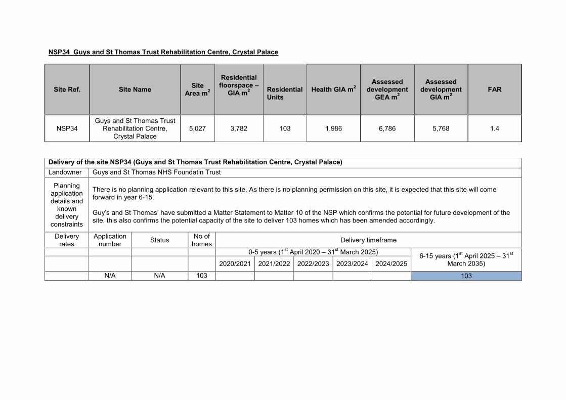
NSP34 Guys and St Thomas Trust Rehabilitation Centre, Crystal Palace
Site Ref. Site Name Site Area m2
Residential floorspace –
GIA m2
Residential Units
Health GIA m2 Assessed
development GEA m2
Assessed development
GIA m2 FAR
NSP34 Guys and St Thomas Trust
Rehabilitation Centre, Crystal Palace
5,027 3,782 103 1,986 6,786 5,768 1.4
Delivery of the site NSP34 (Guys and St Thomas Trust Rehabilitation Centre, Crystal Palace) Landowner Guys and St Thomas NHS Foundatin Trust
Planning application details and
known delivery
constraints
There is no planning application relevant to this site. As there is no planning permission on this site, it is expected that this site will come forward in year 6-15. Guy’s and St Thomas’ have submitted a Matter Statement to Matter 10 of the NSP which confirms the potential for future development of the site, this also confirms the potential capacity of the site to deliver 103 homes which has been amended accordingly.
Delivery rates
Application number Status No of
homes Delivery timeframe
0-5 years (1st April 2020 – 31st March 2025) 6-15 years (1st April 2025 – 31st March 2035) 2020/2021 2021/2022 2022/2023 2023/2024 2024/2025
N/A N/A 103 103


Dulwich Sites NSP35 The Grove Tavern, 520 Lordship Lane
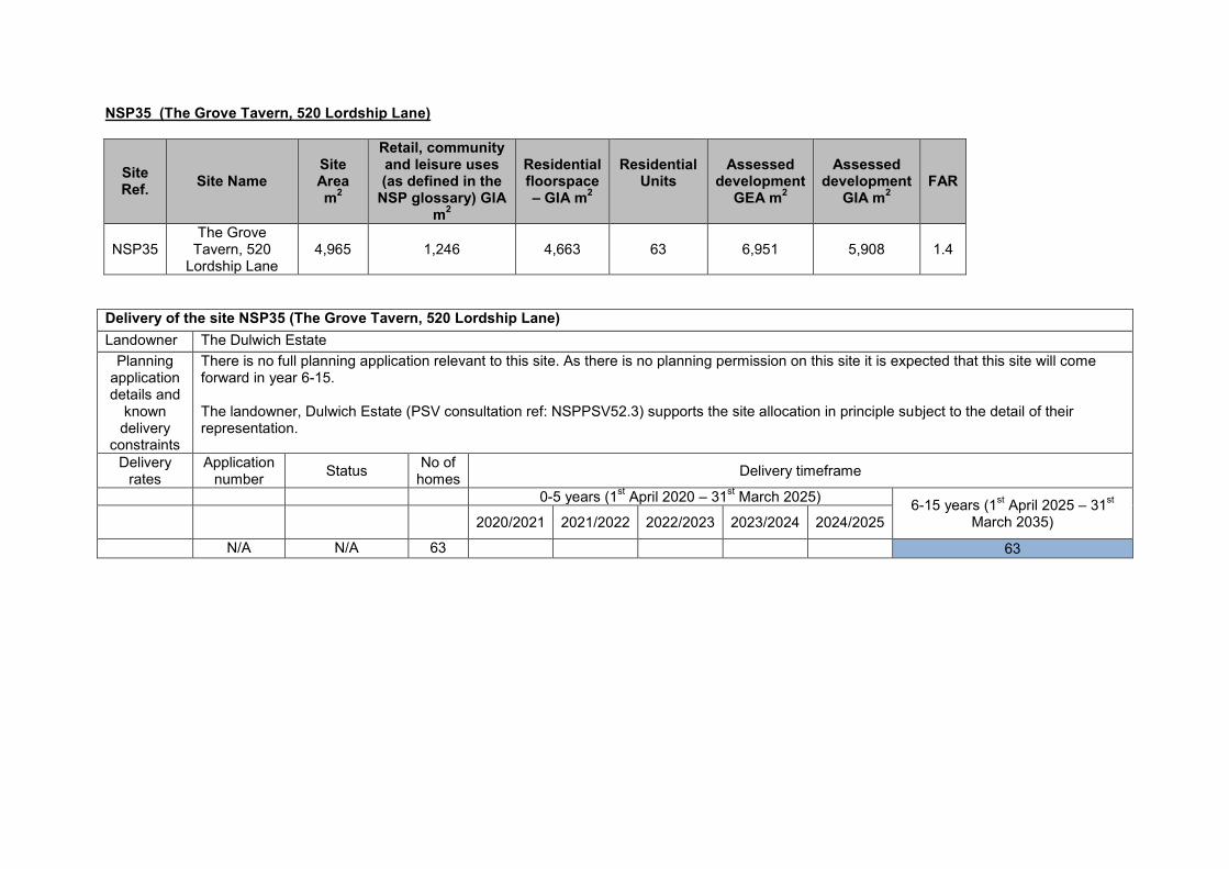
NSP35 (The Grove Tavern, 520 Lordship Lane)
Site Ref. Site Name
Site Area m2
Retail, community and leisure uses (as defined in the
NSP glossary) GIA m2
Residential floorspace – GIA m2
Residential
Units Assessed
development GEA m2
Assessed development
GIA m2 FAR
NSP35 The Grove
Tavern, 520 Lordship Lane
4,965 1,246 4,663
63 6,951 5,908 1.4
Delivery of the site NSP35 (The Grove Tavern, 520 Lordship Lane) Landowner The Dulwich Estate
Planning application details and
known delivery
constraints
There is no full planning application relevant to this site. As there is no planning permission on this site it is expected that this site will come forward in year 6-15. The landowner, Dulwich Estate (PSV consultation ref: NSPPSV52.3) supports the site allocation in principle subject to the detail of their representation.
Delivery rates
Application number Status No of
homes Delivery timeframe
0-5 years (1st April 2020 – 31st March 2025) 6-15 years (1st April 2025 – 31st March 2035) 2020/2021 2021/2022 2022/2023 2023/2024 2024/2025
N/A N/A 63 63


East Dulwich Sites NSP36 Kwik Fit and Gibbs and Dandy, Grove Vale NSP37 Dulwich Hamlet Champion Hill Stadium, Dog Kennel Hill NSP38 Railway Rise, East Dulwich NSP39 Dulwich Community Hospital, East Dulwich Grove NSP40 Goose Green Trading Estate
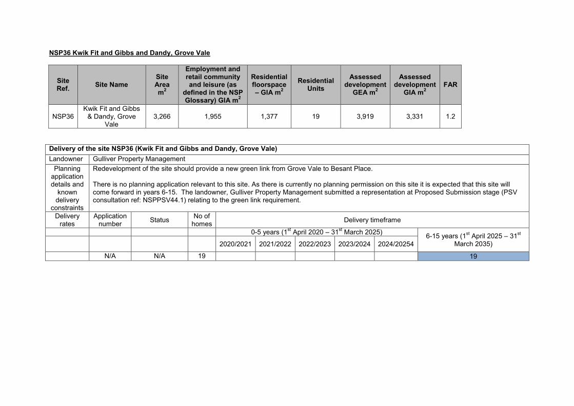
NSP36 Kwik Fit and Gibbs and Dandy, Grove Vale
Site Ref. Site Name
Site Area m2
Employment and retail community and leisure (as
defined in the NSP Glossary) GIA m2
Residential floorspace – GIA m2
Residential Units
Assessed development
GEA m2
Assessed development
GIA m2 FAR
NSP36 Kwik Fit and Gibbs
& Dandy, Grove Vale
3,266 1,955 1,377 19 3,919 3,331 1.2
Delivery of the site NSP36 (Kwik Fit and Gibbs and Dandy, Grove Vale) Landowner Gulliver Property Management
Planning application details and
known delivery
constraints
Redevelopment of the site should provide a new green link from Grove Vale to Besant Place. There is no planning application relevant to this site. As there is currently no planning permission on this site it is expected that this site will come forward in years 6-15. The landowner, Gulliver Property Management submitted a representation at Proposed Submission stage (PSV consultation ref: NSPPSV44.1) relating to the green link requirement.
Delivery rates
Application number Status No of
homes Delivery timeframe
0-5 years (1st April 2020 – 31st March 2025) 6-15 years (1st April 2025 – 31st March 2035) 2020/2021 2021/2022 2022/2023 2023/2024 2024/20254
N/A N/A 19 19
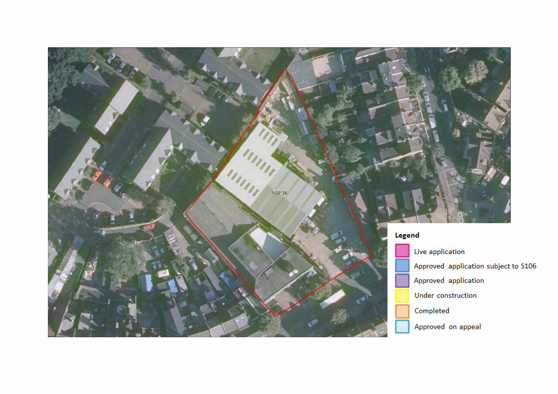

NSP37 Dulwich Hamlet Champion Hill Stadium, Dog Kennel Hill
Site Ref. Site Name
Site Area m2
Planning Permission Residential units
Retail community and
leisure (as defined in the NSP Glossary)
GIA m2
NSP37
Dulwich Hamlet Champion Hill
Stadium, Dog Kennel Hill
14,640 19/AP/1867 219 12,693
Delivery of the site NSP37 (Dulwich Hamlet Champion Hill Stadium, Dog Kennel Hill) Landowner Greendale Property Company Limited
Planning application details and
known delivery
constraints
Application 19/AP/1867 is relevant for this site. Southwark’s Planning Committee resolved to grant permission in July 2020 for a new stadium with relocated playing pitch, and part two-part three storey clubhouse building with sports and leisure facilities, with capacity for 4,000 spectators (Use Class D2); -the construction of a multi-use games area (MUGA), and the erection of a series of buildings between four and six storeys in height to provide 219 residential dwellings. The S106 agreement is being finalised. The current stadium is located to the rear of St. Francis Park and to the south of Sainsbury’s supermarket, with Dog Kennel Hill to the east. The stadium consists of a grassed pitch, main stand (the Tommy Jover stand) and club house, with a 3,000 seat capacity, and a smaller covered stand to the south. The artificial pitch is in the council’s ownership and remains as MOL given the importance of the provision of open space in the borough.
Delivery rates
Application number Status No of
homes Delivery timeframe
0-5 years (1st April 2020 – 31st March 2025) 6-15 years (1st April 2025 – 31st March 2035) 2020/2021 2021/2022 2022|/2023 2023/2024 2024/2025
Planning application 19/AP/1867
Approved subject to S106
agreement 219 0 0 0 0 0 219


NSP38 (Railway Rise, East Dulwich)
Site Ref. Site Name
Site Area m2
Employment GIA m2
Residential floorspace – GIA m2
Residential Units
Assessed development
GEA m2
Assessed development
GIA m2 FAR
NSP38 Railway
Rise, East Dulwich
7,849 4,056 3,950 53 9,419 8,006 1.2
Delivery of the site NSP38 (Railway Rise, East Dulwich) Landowner Unknown
Planning application details and
known delivery
constraints
The site is bounded by Grove Vale to the north, Railway Rise to the east and an existing builder’s yard to the south. The west of the site is bounded by the railway viaduct, the station building and pedestrian footway up to the station platforms. Adjoining the site is the single storey train station building for East Dulwich national rail services. The railway line runs southwest – northeast almost parallel with the application site. However, the railway line and platform does not directly adjoin the site. It is separated from the platform by a footpath access to the southbound platform, and a railway embankment which is designated in the New Southwark Plan as Borough Open Land and Site of Importance of Nature Conservation. There is no planning application relevant to this site. As there is currently no planning perm19ission, it is expected that this site will come forward in years 6-15.
Delivery rates
Application number Status No of
homes Delivery timeframe
0-5 years (1st April 2020 – 31st March 2025) 6-15 years (1st April 2025 – 31st March 2035) 2020/2021 2021/2022 2022/2023 2023/2024 2024/2025
N/A N/A 53 0 0 0 0 0 53


NSP39 (Dulwich Community Hospital, East Dulwich Grove)
Site Ref. Site Name Site Area
m2 Planning
Permission Education
GIA m2 Health GIA m2
NSP39
Dulwich Community
Hospital, East Dulwich Grove
27,820 16/AP/2740 13,300 4,600
Delivery of the site NSP39 (Dulwich Community Hospital, East Dulwich Grove) Landowner Education Funding Agency. The application has been made by Southwark Council
Planning application details and
known delivery
constraints
16/AP/2740 - This application has been granted with ‘Grampian’ agreement. The site is currently under construction, the officer’s report indicates both phases of construction should be completed by 2022. The application proposes the demolition of existing ward buildings and nurses accommodation and development of site to provide a new secondary school within the retained and refurbished 'Chateau' building fronting East Dulwich Grove and in a series of new buildings and extensions up to 5 storeys high, comprising teaching and administration spaces, dining and indoor sports hall, multi-use games area, accesses, car parking and servicing areas and landscaping. The school is under construction and some of the buildings are already complete which accommodates the Charter School East Dulwich. 16/AP/2747 – This application has been granted with legal agreement. The site is currently under construction. The application proposes the erection of a health centre.
Delivery rates
Application number Status No of
homes Delivery timeframe
0-5 years (1st April 2020 – 31st March 2025) 6-15 years (1st April 2025 – 31st March 2035) 2020/2021 2021/2022 2022/2023 2023/2024 2024/2025
16/AP/2740 Under construction
N/A 0 0 0 0 0 0
16/AP/2747 Under construction N/A 0 0 0 0 0 0


NSP40 (Goose Green Trading Estate)
Site Ref. Site Name Site Area m2
Capacity note Employment GIA m2
Residential floorspace
Residential units
Assessed development
GEA m2
Assessed development
GIA m2 FAR
NSP40 Goose Green Trading Estate 4,976
The indicative site capacity
reflects the re-provision of
existing uses
3,794 6,134 83 11,680 9,928 2.3
Delivery of the site NSP40 (Goose Green Trading Estate) Landowner Unknown
Planning application details and
known delivery
constraints
There is no planning application relevant to this site. As there is currently no planning permission on this site, it is expected that this site will come forward in years 6-15.
Delivery rates
Application number Status No of
homes Delivery timeframe
0-5 years (1st April 2020 – 31st March 2025) 6-15 years (1st April 2025 – 31st March 2035) 2020/2021 2021/2022 2022/2023 2023/2024 2024/2025
N/A N/A N/A 83


Elephant and Castle sites NSP41 Newington Triangle NSP42 Bakerloo Line Sidings and 7 St George’s Circus NSP43 63-85 Newington Causeway NSP44 Salvation Army Headquarters, Newington Causeway NSP45 Elephant and Castle Shopping Centre and London College of Communication NSP46 London Southbank University Quarter NSP47 1-5 Westminster Bridge Road
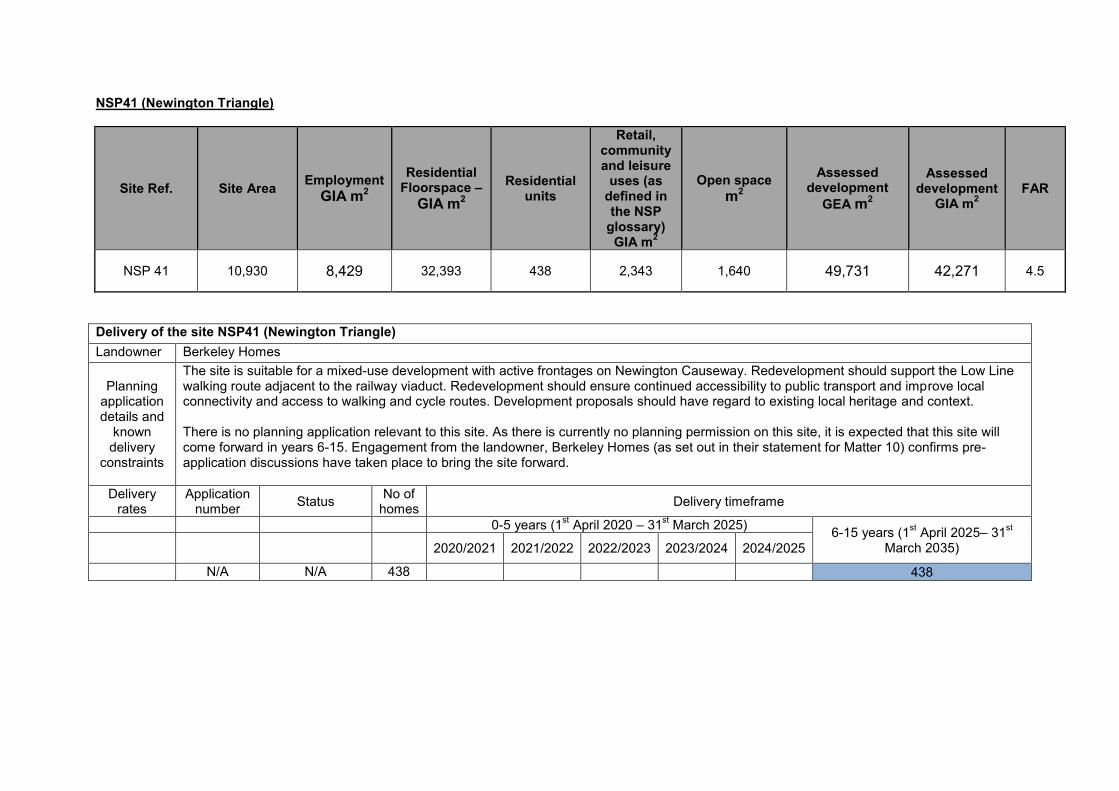
NSP41 (Newington Triangle)
Site Ref. Site Area Employment GIA m2
Residential Floorspace –
GIA m2
Residential units
Retail, community and leisure
uses (as defined in the NSP
glossary) GIA m2
Open space m2
Assessed development
GEA m2
Assessed development
GIA m2 FAR
NSP 41 10,930 8,429 32,393 438 2,343 1,640 49,731 42,271 4.5
Delivery of the site NSP41 (Newington Triangle) Landowner Berkeley Homes
Planning application details and
known delivery
constraints
The site is suitable for a mixed-use development with active frontages on Newington Causeway. Redevelopment should support the Low Line walking route adjacent to the railway viaduct. Redevelopment should ensure continued accessibility to public transport and improve local connectivity and access to walking and cycle routes. Development proposals should have regard to existing local heritage and context. There is no planning application relevant to this site. As there is currently no planning permission on this site, it is expected that this site will come forward in years 6-15. Engagement from the landowner, Berkeley Homes (as set out in their statement for Matter 10) confirms pre-application discussions have taken place to bring the site forward.
Delivery rates
Application number Status No of
homes Delivery timeframe
0-5 years (1st April 2020 – 31st March 2025) 6-15 years (1st April 2025– 31st March 2035) 2020/2021 2021/2022 2022/2023 2023/2024 2024/2025
N/A N/A 438 438


NSP 42 (Bakerloo Line Sidings and 7 St George’s Circus)
Site Ref. Site Name Site Area
m2 Employment
GIA m2
Residential floorspace –
GIA m2 Residential
units
Retail, community and leisure
uses (as defined in the NSP
glossary) GIA m2
Assessed development
GEA m2
Assessed development
GIA m2 FAR
NSP42
Bakerloo Line
Sidings and 7 St George's
Circus
11,670 363 7,390 100 1,786 11,222 9,539 1
Delivery of the site NSP 42 (Bakerloo Line Sidings and 7 St George’s Circus) Landowner Transport for London
Planning application details and
known delivery
constraints
The site is suitable to provide new residential led development with retail, community and leisure uses. There is no planning application relevant to this site. As there is currently no planning permission on this site, it is expected that this site will come forward in years 6-15. The landowner, TFL (PSV consultation ref: NSPPSV182.3) indicates that redevelopment of the site could be possible in years 6-15 as the site may be required for the extension of the Bakerloo Line.
Delivery rates
Application number Status No of
homes Delivery timeframe
0-5 years (1st April 2020 – 31st March 2025) 6-15 years (1st April 2025 – 31st March 2035) 2020/2021 2021/2022 2022/2023 2023/2024 2024/2025
N/A N/A 100 100


NSP43 (63-85 Newington Causeway)
Site Ref. Site Name Site Area
m2 Employment
GIA m2
Residential floorspace –
GIA m2 Residential
units
Retail, community and leisure
uses (as defined in the NSP
glossary) GIA m2
Other D Class
GIA m2
Assessed development
GEA m2
Assessed development
GIA m2 FAR
NSP43 63-85
Newington Causeway
3,784 6,947 6,904 93 772 816 18,163 15,438 4.8
Delivery of the site NSP43 (63-85 Newington Causeway) Landowner RDI REIT is the owner of 63-67 Newington Causeway;
Blyford Investment Co is the owner of 73-85 Newington Causeway
Planning application details and
known delivery
constraints
Planning application 12/AP/2694 is a personal planning permission to Southwark Playhouse, establishing the D use class currently on site. It is important to note that condition 2 of planning application 12/AP/2694 states that upon vacation of Southwark Playhouse from the building, the use shall be discontinued and the property will revert back to employment use. It is acknowledged that the site allocation relates to a number of different plots that are within a variety of ownerships. As such the redevelopment of the site allocation could come forward in a number of different phases and at various times. As there is currently no planning permission on this site, for a comprehensive redevelopment of the site, it is expected that this site will come forward in years 6-15. The landowner, Blyford Investment Co (PSV consultation ref: NSPPSV25.1) is in general support of the redevelopment potential of the site subject to the detail of their representation. RDI REIT (PSV consultation ref: NSPPSV144.1) is in general support of the redevelopment potential of the site subject to the detail of their representation.
Delivery rates
Application number Status No of
homes Delivery timeframe
0-5 years (1st April 2020 – 31st March 2025) 6-15 years (1st April 2025 – 31st March 2035) 2020/2021 2021/2022 2022/2023 2023/2024 2024/2025
N/A N/A 93 93


NSP44 (Salvation Army Headquarters, Newington Causeway)
Site Ref. Site Name Site Area m2
Employment GIA m2
Residential floorspace –
GIA m2 Residential
units
Retail, community and leisure
uses (as defined in the NSP
glossary) GIA m2
Assessed development
GEA m2
Assessed development
GIA m2 FAR
NSP44
Salvation Army Headquarters,
Newington Causeway
2,607 7,346 4,214 57 554 14,227 12,114 5.4
Delivery of the site NSP44 (Salvation Army Headquarters, Newington Causeway) Landowner The Salvation Army Trustee Company
Planning application details and
known delivery
constraints
The site is in the central area of Elephant and Castle and redevelopment should contribute towards realising the vision. Redevelopment must provide at least the existing level of employment floorspace. Redevelopment should enhance local accessibility to bus stops, tube and rail stations and contribute towards improving the connectivity, walking and cycle routes, specifically taking into consideration the Newington Causeway project (TfL and Southwark). There is no planning application relevant to this site. As there is currently no planning permission on this site, it is expected that this site will come forward in years 6-15. The landowner, The Salvation Army Trustee Company (PSV consultation ref: NSPPSV188.1) is in general support of the redevelopment potential of the site subject to the detail of their representation.
Delivery rates
Application number Status No of
homes Delivery timeframe
0-5 years (1st April 2020 – 31st March 2025) 6-15 years (1st April 2025 – 31st March 2035) 2020/2021 2021/2022 2022/2023 2023/2024 2024/2025
N/A N/A 57 57


NSP45 (Elephant and Castle Shopping Centre and London College of Communication)
Site Ref.
Site Name
Site Area m2
Planning
Permission
Employment GIA
m2
Retail, community and leisure uses (as defined in the
NSP glossary) GIA m2
Residential
units
Other D Use
Class GIA m2
Education
Use (D Class) GIA
m2
NSP45
Elephant & Castle Shopping Centre
and London College of
Communication
36,010
16/AP/4458
2,806
21,040
977 (net)
5,743
41,405
Delivery of the site NSP45 (Elephant and Castle Shopping Centre and London College of Communication) Landowner Elephant and Castle Properties Co. Ltd
Planning application details and
known delivery
constraints
Planning permission 16/AP/4458 is relevant to this site and it covers the whole site allocation. Under this permission the following proposal was approved: Phased, mixed-use redevelopment of the existing Elephant and Castle shopping centre and London College of Communication sites comprising the demolition of all existing buildings and structures and redevelopment to comprise buildings ranging in height from single storey to 35 storeys (with a maximum building height of 124.5m AOD) above multi-level and single basements, to provide a range of uses including 979 residential units (use class C3), retail office, Education, assembly and leisure and a new station entrance and station box for use as a London underground operational railway station. The planning permission is subject to legal agreement and the shopping centre closed on 24th September 2020. In 2019 a judicial review challenge against Southwark Council's decision to grant planning permission for the redevelopment of Elephant and Castle Shopping Centre was turned down by the courts. The case was subsequently heard by the Court of Appeal on 16th and 17th March 2021 and a judgement is awaited. There are two existing residential units on site; as such the net residential provision would be 977 units. Given the size and complexity of the proposed development and that significant demolition works are required, it is expected that the development will be delivered in phases, with 481 homes delivered in years 0-5 and the remaining 496 homes delivered in years 6-15.
Delivery rates
Application number Status No of
homes Delivery timeframe
0-5 years (1st April 2020 – 31st March 2025) 6-15 years (1st April 2025 – 31st

2020/2021 2021/2022 2022/2023 2023/2024 2024/2025 March 2035)
16/AP/4458 Approved, with legal agreement 977 0 0 0 0 481 496


NSP46 (London Southbank University Quarter)
Site Ref. Site Name Site Area m2 Capacity note
NSP46 London Southbank University Quarter 51,660 Land use policy - not an opportunity for comprehensive redevelopment
Delivery of the site NSP46 (London Southbank University Quarter) Landowner London South Bank University
Planning application details and
known delivery
constraints
This is a land use policy only, it is not suitable for housing and therefore it does not represent an opportunity for comprehensive redevelopment. There is no development capacity allocated to this site as the purpose is not to provide a detailed design brief for this site. In this case the site is suitable for continued use for research and education facilities. The uses set out in the NSP will continue to be implemented. Planning permission (17/AP/4233) was granted on part of the site (part of the site along the western edge) for redevelopment of the site to provide a part 7/part 4 storey building, a 5 storey building to provide a academic teaching, library, student support and performance facilities and partial demolition and extension to the listed building. It is not likely an application will come forward on this site, except for research and education facilities, walking routes and the provision of ancillary uses, including Retail, community and leisure uses (as defined in the NSP glossary) for the needs of visitors, pedestrians, the surrounding workforce and University. London Southbank University have previously expressed support for the allocation at Preferred Options Area Visions and Site Allocations (2017) consultation stage.
Delivery rates
Application number Status No of
homes Delivery timeframe
0-5 years (1st April 2020 – 31st March 2025) 6-15 years (1st April 2025 – 31st March 2035) 2020/2021 2021/2022 2022/2023 2023/2024 2024/2025
N/A N/A N/A 0 0 0 0 0 0


NSP47 (1-5 Westminster Bridge Road)
Site Ref. Site Name Site Area m2
Employment GIA m2
Residential floorspace –
GIA m2 Residential
units
Retail, community and leisure
uses (as defined in the NSP
glossary) GIA m2
Assessed development
GEA m2
Assessed development
GIA m2 FAR
NSP47 1-5
Westminster Bridge Road
773 1,418 1,576 21 158 3,708 3,152 4.8
Delivery of the site NSP47 (1-5 Westminster Bridge Road) Landowner Southwark Council, City of London Corporation
Planning application details and
known delivery
constraints
This site allocation has the potential for a comprehensive mixed-use development that is required to provide an uplift in office floorspace, enabling continued provision of office space, alongside new residential units. Redevelopment must successfully relate to the St George’s Circus building line. There is no planning application relevant to this site. As there is currently no planning permission on this site, it is expected that this site will come forward in years 6-15.
Delivery rates
Application number Status No of
homes Delivery timeframe
0-5 years (1st April 2020 – 31st March 2025) 6-15 years (1st April 2025 – 31st March 2035) 2020/2021 2021/2022 2022/2023 2023/2024 2024/2025
N/A N/A 21 21


Herne Hill and North Dulwich Sites NSP48 Bath Trading Estate

NSP48 Bath Trading Estate
Site Ref. Site Name Site Area m2
Employment (B Class)
floorspace GIA m2
Town centre uses (A1, A2, A3, A4, D1, D2) floorspace GIA
m2
Residential floorspace GIA
m2
Residential units
Assessed development
GEA m2
Assessed development
GIA m2 FAR
June 2020 Bath Trading Estate 15,390 2,553 2,041 3,255 45 9,234 7,849 0.6
Delivery of the site NSP48 (Bath Trading Estate) Landowner Network Rail
Planning application details and
known delivery
constraints
The site allocation is suitable for continued use for employment and town centre uses, with residential units on upper storeys facing Brockwell Park. Any redevelopment of the site would remain of a similar density and massing and contribute towards a small business cluster including creative and cultural industries, providing at least the amount of employment floorspace (B use class) currently onsite. Redevelopment must provide high quality active frontages and space for small businesses in the railway arches viaducts. There may be an opportunity for residential development but any uplift in floorspace must be sensitive to the setting of Brockwell Park and reflect existing building heights. The site is in close proximity to the boundary with Lambeth, and of Brockwell Park and any development should consider the setting of Brockwell Park and its conservation area. The area is characterised by being very low density and height. There is no planning application relevant to this site. As there is no planning permission on this site, it is expected that this site will come forward in year 6-15.
Delivery rates
Application number Status No of
homes Delivery timeframe
0-5 years (1st April 2020 – 31st March 2025) 6-15 years (1st April 2025 – 31st March 2035) 2020/2021 2021/2022 2022/2023 2023/2024 2024/2025
N/A N/A 45 45


London Bridge Sites NSP49 London Bridge Health Cluster NSP50 Land between Melior Street, St Thomas Street, Weston Street and Fenning Street NSP51 Land between St Thomas Street, Fenning Street, Melior Place and Snowsfields NSP52 Colechurch House, London Bridge Walk

NSP49 (London Bridge Health Cluster)
Site Ref. Site Name
Site Area m2
Capacity note
NSP49 London Bridge Health Cluster 80,030
Land use policy - not an opportunity for comprehensive redevelopment
Delivery of the site NSP49 (London Bridge Health Cluster) Landowner Guy’s and St Thomas’s Charity
Planning application details and
known delivery
constraints
This is a land use policy only, it is not suitable for standalone residential use and it therefore not an opportunity for comprehensive redevelopment. There is no development capacity allocated to this site as the purpose is not to provide a detailed design brief for the site. In this case, the site is suitable for continued use for health provision, employment and education floorspace. The site allocation is in the Central Activities Zone (CAZ). The uses set out in the NSP will continue to be implemented. There are no relevant planning applications. Applications likely to come forward on this site may propose ancillary residential accommodation, town centre uses, office floorspace or student accommodation associated to the hospital campus. Applications are likely to come forward altogether as there is only one landowner in years 6-15. The landowner, Guy’s and St Thomas’s Charity (PSV consultation ref: NSPPSV76.1) are in general support of the principles behind this site allocation subject to the further detail in their representation.
Delivery rates
Application number Status No of
homes Delivery timeframe
0-5 years (1st April 2020 – 31st March 2025) 6-15 years (1st April 2025 – 31st March 2035) 2020/2021 2021/2022 2022/2023 2023/2024 2024/2025
N/A N/A N/A 0


NSP50 (Land between Melior Street, St Thomas Street, Weston Street and Fenning Street)
Site Ref. Site Name Site Area m2
Planning Permission Employment GIA m2
Residential floorspace –
GIA m2
Residential units
Retail, community and leisure (as defined in the NSP)
GIA m2
NSP50
Land between Melior Street, St Thomas Street,
Weston Street and Fenning Street
3,814 18/AP/0900 N/A 14,266 362 528
Remainder of the site 35,000 N/A N/A N/A
Delivery of the site NSP50 Land between Melior Street, St Thomas Street, Weston Street and Fenning Street Landowner Greystar Europe Holdings, CIT and Simtem
Planning application details and
known delivery
constraints
The site is suitable for employment floorspace as the site allocation is in the Central Activities Zone (CAZ) and mixed-use development including retail, community and leisure uses as defined in the NSP with active frontages on St Thomas Street. Redevelopment of the site should provide homes. Redevelopment must enhance St Thomas Street by providing high quality public realm. Development proposals should have regard to existing local heritage and context, namely Bermondsey Street Conservation Area and Grade II listed London Bridge Station and Railway Arches. There are two applications relevant to this site. Developments on this site allocation may come forward at different times. Planning application 18/AP/0900 proposes the demolition of Capital House, and the site area covers approximately a third of the site allocation. It proposes a 39 storey building to accommodate 905 student rooms, with flexible retail/café/office floorspace and associated access and public realm works. This went to Planning Committee on 14th May 2019, the Planning Committee granted planning permission subject to conditions, the applicant entering into an appropriate legal agreement and referral to the Mayor of London. The landowner engaged in seeking planning permission and therefore committed to delivery of the site. It is expected that the scheme will be delivered in years 6-15. The officer report set

out that the development would be delivered in a single phase. The proposed development would provide 35% affordable housing by way of an in lieu payment. This application covers a third of the site. Planning application 20/AP/0944 (Becket House at 60-68 St Thomas Street) is currently under consideration. The proposal is for a 27 storey building to provide office use (Class B1), retail (flexible Class A1/A3). The Planning Statement outlines the mix at ground floor as retail and office floorspace, with office floorspace occupying from the first floor solely. The application proposes 37,494sqm of B1 use class and 36 sqm of A1 retail use class. The site area covers the remaining site allocation area minus Capital House and its access. The application is still under consideration and therefore the site allocation capacity figure is included in the 6-15 year supply. Planning permission has been sought for this application indicating the intent to implement this application. The St Thomas Street Social Regeneration Charter is relevant to this site allocation.
Delivery rates
Application number Status No of
homes Delivery timeframe
0-5 years (1st April 2020 – 31st March 2025) 6-15 years (1st April 2025 – 31st March 2035) 2020/2021 2021/2022 2022/2023 2023/2024 2024/2025
Planning Application
18/AP/0900 (Capital House)
Approved with legal agreement
905 student bedrooms (362 units)
181
181
Planning Application
20/AP/0944 (Becket House at 60-68 St Thomas Street)
Live application
0
0


NSP51 (Land between St Thomas Street, Fenning Street, Melior Place and Snowsfields)
Site Ref. Site Name
Site Area m2
Employment GIA m2
Residential floorspace
GIA m2
Residential
units
Retail, community and leisure (as defined in the NSP) GIA m2
Open Space m2
Assessed development
GEA m2
Assessed development
GIA m2 FAR
NSP51
Land between St
Thomas Street,
Fenning Street,
Melior Place and
Snowsfields
4,033 8,022 8,913
121 891 605 20,971 17,825 5.2
Delivery of the site NSP51 (Land between St Thomas Street, Fenning Street, Melior Street and Snowsfields) Landowner Sellar; CIT
Planning application details and
known delivery
constraints
The site is suitable for employment floorspace as the site allocation is in the Central Activities Zone (CAZ) and mixed-use development including retail, community and leisure uses as defined in the NSP with active frontages on St Thomas Street. Redevelopment of the site should provide homes. Redevelopment must enhance St Thomas Street by providing high quality public realm. Redevelopment of the site must provide a new north-south green link from Melior Place to St Thomas Street. Development proposals should have regard to existing local heritage and context, namely Bermondsey Street Conservation Area and Grade II listed London Bridge Station and Railway Arches. The buildings have been recently demolished and temporary uses are on site. The temporary uses were approved under application 19/AP/1185 for the continued of the use of the site for food and drink stalls, retail units, a bar and events space along with art installations, artist studios (Use Class Sui Generis); the retention of hoarding and associated alterations. This permission expires on 25/09/2022. There are two full applications relevant to this site. Planning application 18/AP/4171 (at Land Bounded By St Thomas Street, Fenning Street, Vinegar Yard And Snowfields Including Nos. 1-7) was for the following proposal: Redevelopment of the site to include the demolition of the existing buildings and the erection of a building up to 20 storeys in height (maximum height of 86.675m AOD) and a 3 storey pavilion building (maximum height of 16.680m AOD) with 3 basement levels across the site providing .a total of 30,292 sqm (GIA) of commercial floorspace comprising of use classes A1/A2/A3/A4/B1/D2 and sui generis (performance venue). This application site area covers three quarters of the site allocation, and it was refused at the planning committee on the 29th June 2020 due to impacts on design impacts on heritage assets and conservation area. This application did not propose residential uses (C3). This application has since been called in by the Mayor. The application has been amended as follows: Redevelopment of the site to include the demolition of existing buildings, retention and refurbishment of the warehouse and the erection of a

ground, mezzanine and 18 storey building (with plant at roof level and 3 basement levels) comprising of café and community space within the warehouse and flexible retail, affordable workspace and flexible office and medical floorspace within the new building, cycle and disabled car parking, servicing, refuse and plant areas, public garden (including soft and hard landscaping), highway improvements and all other associated works. The Mayor has accepted the amendments and will determine the application on the amended basis. The other relevant application is 19/AP/0404 at 40-44 Bermondsey Street, Vinegar Yard Warehouse 9-17 Vinegar Yard And Land Adjacent To 1-7 Snowsfields SE1. This application is still under consideration and it proposes the demolition of 40-44 Bermondsey Street including partial demolition and redevelopment of existing Vinegar Yard Warehouse, to provide office floorspace (B1), flexible retail space (A1, A2, A3, A4, A5). The application covers a third of the site allocation and continues across the road. There are no approved planning applications relevant to this site, so it is expected that this site will be re developed in years 6-15. If the planning applications are approved and delivered there may be no housing delivered on the site. The St Thomas Street Social Regeneration Charter is relevant to this site allocation.
Delivery rates
Application number Status No of
homes Delivery timeframe
0-5 years (1st April 2020 – 31st March 2025) 6-15 years (1st April 2025 – 31st March 2035) 2020/2021 2021/2022 2022/2023 2023/2024 2024/2025
Planning Application
19/AP/0404 Live application
N/A 0
Planning Application
18/AP/4171 Live application
N/A 0
Capacity N/A N/A 121 121


NSP52 (Colechurch House, London Bridge Walk)
Site Ref. Site Name
Site Area m2
Employment GIA m2
Retail, community and leisure (as defined in the NSP) GIA m2
Assessed development
GEA m2
Assessed development
GIA m2 FAR
NSP52 Colechurch House,
London Bridge Walk
2,582 13,552 713 16,782 14,265 6.5
Delivery of the site NSP52 (Colechurch House, London Bridge Walk) Landowner CIT
Planning application details and
known delivery
constraints
Live application 20/AP/3013 is relevant to the site and covers the full site. The development proposes the redevelopment of the site to include demolition of Colechurch House, pedestrian footbridge and walkway and erection of an elevated 22-storey building (+ 4-storey basement) above a public park and providing office floorspace, retail floorspace, restaurant/café floorspace, leisure floorspace (all Use Class E), theatre and a bar (Sui Generis), delivered alongside public realm improvements, roof gardens, cycle parking, servicing, refuse, plant areas and other associated works incidental to the development. The St Thomas Street Social Regeneration Charter is relevant to this site allocation.
Delivery rates
Application number Status No of
homes Delivery timeframe
0-5 years (1st April 2020 – 31st March 2025) 6-15 years (1st April 2025 – 31st March 2035) 2020/2021 2021/2022 2022/2023 2023/2024 2024/2025
20/AP/3013 Live Application
0 0


Old Kent Road sites NSP53 Bricklayers Arms NSP54 Crimscott Street and Pages Walk NSP55 Mandela Way NSP56 107 Dunton Road (Tesco store and car park) and Southernwood Retail Park NSP57 Salisbury estate car park NSP58 96-120 Old Kent Road (Lidl store) NSP59 Former petrol filling station, 233-247 Old Kent Road NSP60 Kinglake Street Garages NSP61 4/12 Albany Road NSP62 Former Southern Railway Stables
NSP63 Land bounded by Glengall Road, Latona Road and Old Kent Road
NSP64 Marlborough Grove and St James’s Road
NSP65 Sandgate Street and Verney Road
NSP66 Devon Street and Sylvan Grove
NSP67 Hatcham Road and Penarth Street and Ilderton Road
NSP68 760 and 812 Old Kent Road (Toyrus store) and 840 Old Kent Road (Aldi store) NSP69 684-698 Old Kent Road (Kwikfit garage) NSP70 636 Old Kent Road

1. The following 18 sites (NSP53 – 70) are within the Old Kent Road Opportunity Area. The draft Area Action Plan provides masterplans for the majority of
the site allocations in the Old Kent Road and local development studies have been prepared as evidence base which provide detail on how the ambitions
in the AAP will be realised across sites in multiple land ownerships. 9 sites are currently under construction, with an additional 2 sites being cleared, and
24 major sites are approved or approved subject to S106 in the Old Kent Road and a further 4 applications have been submitted but not yet determined
(information correct at March 2021). Development will be phased based on the commitment and delivery of the Bakerloo Line extension. It is anticipated
around 9,500 homes will be committed in Phase 1 (2018- 2026) alongside enhancements to the existing public transport network prior to the letting of the
construction contract for the Bakerloo Line extension. The remaining 10,500 will be committed for Phase 2 (2026-2031) and will be subject to agreement
between Southwark Council, the Greater London Authority and Transport for London relating to the status of transport improvements. A detailed phasing
plan is included at Appendix 3. This will be kept under review as the Area Action Plan develops. Some sites have been excluded from the BLE phasing
plan which were approved, built or under construction prior to 2018, sites 9 units or fewer and sites located nearer to other key transport corridors which
would not rely on the A2 (Old Kent Road) bus routes.
2. The following information is based on the current draft of the Old Kent Road AAP (December 2020) which has been prepared using urban design studies
and local development studies which look at the capacity and masterplans for each sub-area of the Old Kent Road. These have been provided for the
examination evidence base. Many detailed planning applications have now come forward and masterplans have been revised based on extensive public
consultation on the document. The following development capacity figures are based on the current draft of the AAP and the non-residential floorspace
figures quoted in the Old Kent Road Accommodation Schedule (based on the masterplan studies). The non-residential figures have mostly stayed the
same or increased from the previous masterplanning work proposed in Appendix 1 of the Industrial Background Paper (2019). Where there is a
decrease, this is usually explained by an increase in residential capacities proposed in the draft Old Kent Road Area Action Plan 2017. In the Site
Allocation Methodology Report published in July 2020 a range was provided for the residential capacities on the Old Kent Road sites. With the publishing
of the draft Old Kent Road Area Action Plan (December 2020), most of these sites have taken on the upper capacity of the range. The exception being
NSP55 Mandela Way, which took the lower end of the range as the industrial floorspace was increased leading to a reduction in residential units.
3. The council has approved 8,072 homes in Phase 1 (as of March 2021). The phasing timeframe given by developers for larger schemes has been taken
into account in the development delivery timeline and five year supply.
4. As the Old Kent Road Opportunity Area has the potential to deliver 20,000 homes over the next 15-20 years, the evidence base supporting the AAP
includes a number of delivery strategies to ensure adequate infrastructure can be provided. These include information on population growth and health
care and school places, a decentralised energy strategy, an integrated water management strategy and a power and utilities strategy. These measures
are incorporated into planning policy and masterplanning in the Old Kent Road AAP.

NSP53 Bricklayers Arms Roundabout
Site Ref. Site Name Site Area m2
Employment GIA m2
Residential units
Retail GIA m2
Community GIA m2
Open space m2
NSP53 (OKR1)
Bricklayers Arms
Roundabout 4,011 Unknown Unknown Unknown Unknown
Unknown
Delivery of the site NSP53 (OKR1) Bricklayers Arms Roundabout Landowner Phase 2: TFL Planning application details and known delivery constraints
The Bricklayers Arms site is part of the draft Old Kent Road AAP in terms of envisaging significant change to the Opportunity Area over the next 20 years. The flyover is part of the TFL strategic road network and at the moment funding for the project has yet to be identified. The capacity of the site is therefore more uncertain and it has not been included in the calculations for growth in either the NSP or OKR AAP site allocations capacity figures. It is not relied upon in either our 5 or 15 year supply calculations. Nevertheless we consider its inclusion as a site allocation necessary to achieve place-making objections of the Old Kent Road and its role as a Healthy Street. The inclusion of the allocation stresses the importance of securing funding for the project in future and also is transparent about the potential future plans for the site. It may come forward in Phase 2 of the Old Kent Road AAP delivery. The allocation is supported by TfL (PSV consultation ref: NSPPSV181.24) and TfL are currently reviewing development options supported by a recently awarded central government grant. The Old Kent Road AAP (December 2020) outlines two options for the future of the site (EIP128, OKR1, page 103). Option 1 is to remove the flyover and reconfigure the junction and road layout. Option 2 is to reconfigure the roads and convert the flyover to a “Flyover Park”. The introduction of new street frontages would improve permeability for people walking and cycling and reduce severance created by the existing junction layout and the flyover. Landscaping would be improved with the retention of good quality trees.

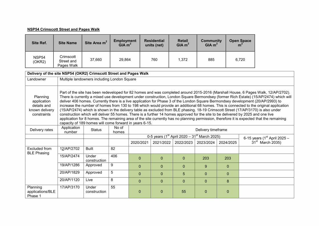
NSP54 Crimscott Street and Pages Walk Site Ref. Site Name Site Area m2 Employment
GIA m2 Residential units (net)
Retail GIA m2
Community GIA m2
Open Space m2
NSP54 (OKR2)
Crimscott Street and
Pages Walk 37,660 29,864 760 1,372 885 6,720
Delivery of the site NSP54 (OKR2) Crimscott Street and Pages Walk Landowner Multiple landowners including London Square
Planning application details and
known delivery constraints
Part of the site has been redeveloped for 82 homes and was completed around 2015-2016 (Marshall House, 6 Pages Walk, 12/AP/2702). There is currently a mixed use development under construction, London Square Bermondsey (former Rich Estate) (15/AP/2474) which will deliver 406 homes. Currently there is a live application for Phase 3 of the London Square Bermondsey development (20/AP/2993) to increase the number of homes from 130 to 198 which would provide an additional 68 homes. This is connected to the original application (15/AP/2474) which is shown in the delivery table as excluded from BLE phasing. 18-19 Crimscott Street (17/AP/3170) is also under construction which will deliver 55 homes. There is a further 14 homes approved for the site to be delivered by 2025 and one live application for 8 homes. The remaining area of the site currently has no planning permission, therefore it is expected that the remaining capacity of 189 homes will come forward in years 6-15.
Delivery rates Application number Status No of
homes Delivery timeframe
0-5 years (1st April 2020 – 31st March 2025) 6-15 years (1st April 2025 – 31st March 2035) 2020/2021 2021/2022 2022/2023 2023/2024 2024/2025
Excluded from BLE Phasing
12/AP/2702 Built 82 15/AP/2474 Under
construction 406 0 0 0 203 203
19/AP/1286 Approved 9 0 0 0 9 0 20/AP/1829 Approved 5 0 0 5 0 0
20/AP/1120 Live 8 0 0 0 0 8 Planning applications/BLE Phase 1
17/AP/3170 Under construction
55 0 0 55 0 0

Remaining capacity excluded from BLE Phasing
6
6
Remaining capacity
189 189
Total 760 0 0 60 212 217 189


NSP55 Mandela Way
Site Ref. Site Name Site Area m2
Employment GIA m2
Residential units
Retail GIA m2
Education (F.1 (a) Class)
GIA m2
Open space m2
NSP55 (OKR3)
Mandela Way 120,400 94,901 1,955 0 2,990 14,530
Delivery of the site NSP55 (OKR3) Mandela Way Landowner Phase 2: Duchy of Lancaster, City of Westminster, Tate, Royal Mail Pension Fund, John Lyon’s Charity, Conway, Southwark Council, Firmdale
Planning application details and
known delivery
constraints
There are no comprehensive planning applications relevant to this site. The site has been masterplanned to indicate the potential capacities shown and engagement with the numerous landowners has yielded positive feedback for the future development of the site. The Duchy of Lancaster is the freehold owner of 3 ha of the site and approximately 14,900 sqm of floorspace (GIA), leased to various businesses expiring between 2023-2029. All the leased units have the right to renewal unless a “bona fide” redevelopment scheme comes forward. Employment floorspace has been increased as proposals for the Tate storage facility have expanded, which has resulted in a slight reduction in housing units (previous estimate was 2,200 units, current estimate is 1,955 units). The site has the potential to deliver new education uses and a strategic park. As there are currently no major planning permissions on this site, and it is a BLE Phase 2 site, it is expected that this site will come forward in years 6-15.
Delivery rates
Application number Status No of
homes Delivery timeframe
0-5 years (1st April 2020 – 31st March 2025) 6-15 years (1st April 2025 – 31st March 2035) 2020/2021 2021/2022 2022/2023 2023/2024 2024/2025
BLE Phase 2
N/A N/A 1955 1,955


NSP56 107 Dunton Road (Tesco and Car Park) and Southernwood Retail Park
Site Ref. Site Name
Site Area m2
Employment GIA m2
Residential units
Retail GIA m2
Community GIA m2
Open space
m2
Hotel (C1)
GIA m2
NSP56 (OKR4)
107 Dunton Road (Tesco and Car Park)
and Southernwood Retail Park
40,590 6,300 1,600 9,115 507
4,035
8,671
Delivery of the site NSP56 (OKR4) 107 Dunton Road (Tesco and Car Park) and Southernwood Retail Park Landowner Phase 1: Southernwood Retail Park planning application approved - Strathclyde Pension Fund, Quadron Investments Ltd
Phase 2: Tesco site in single land ownership - Invesco
Planning application details and
known delivery constraints
Planning application 18/AP/3551, which relates to Southernwood Retail Park, has been approved subject to s106 agreement indicating a delivery of 541 homes within 0-5 years and a further 183 homes to be delivered in years 6-15. The site has been masterplanned to include ongoing discussions with the developer for the Tesco site which indicates a remaining capacity of 876 homes. The site may be required for the construction of the Bakerloo Line Extension so will not be available until the late 2020s.
Delivery rates Application number Status No of
homes Delivery timeframe
0-5 years (1st April 2020 – 31st March 2025) 6-15 years (1st April 2025 – 31st March 2035) 2020/2021 2021/2022 2022/2023 2023/2024 2024/2025
Planning applications/BLE Phase 1
18/AP/3551 Granted subject to s106
541 0 0 0 270 271
BLE Phase 2 183 183 Remaining capacity BLE Phase 2
876 876
Total 1600 0 0 0 270 271 1059


NSP57 Salisbury Estate Car Park
Site Ref. Site Name Site Area m2
Employment GIA m2
Residential units
Retail GIA m2
Community GIA m2
NSP57 (OKR5)
Salisbury Estate Car
Park 1,037 0 26 0 0
Delivery of the site NSP57 (OKR5) Salisbury Estate Car Park Landowner Southwark Council
Planning application details and
known delivery
constraints
Planning application 19/AP/1506, a residential development, has been approved and due to start construction, so will deliver 26 homes by 2023.
Delivery rates
Application number Status No of
homes Delivery timeframe
0-5 years (1st April 2020 – 31st March 2025) 6-15 years (1st April 2025 – 31st March 2035) 2020/2021 2021/2022 2022/2023 2023/2024 2024/2025
Excluded from BLE Phasing
19/AP/1506 Approved 26 0 0 0 26 0


NSP58 96-120 Old Kent Road (Lidl store)
Site Ref. Site Name Site Area m2
Employment GIA m2
Residential units
Retail GIA m2
Community GIA m2
NSP58 (OKR6)
96-120 Old Kent Road (Lidl store)
5,374 0 180 1,345 2,309
Delivery of the site NSP58 (OKR6) 96-120 Old Kent Road (Lidl store) Landowner Phase 1: Lidl
Planning application details and
known delivery constraints
The site currently has no planning permission or pending applications but discussions with developers indicate the site is likely to be developed 2023-2024. The re-provision of retail space is required for any proposals which come forward.
Delivery rates Application number Status No of
homes Delivery timeframe
0-5 years (1st April 2020 – 31st March 2025) 6-15 years (1st April 2025 – 31st March 2035) 2020/2021 2021/2022 2022/2023 2023/2024 2024/2025
Planning applications/BLE Phase 1
N/A N/A 180 180
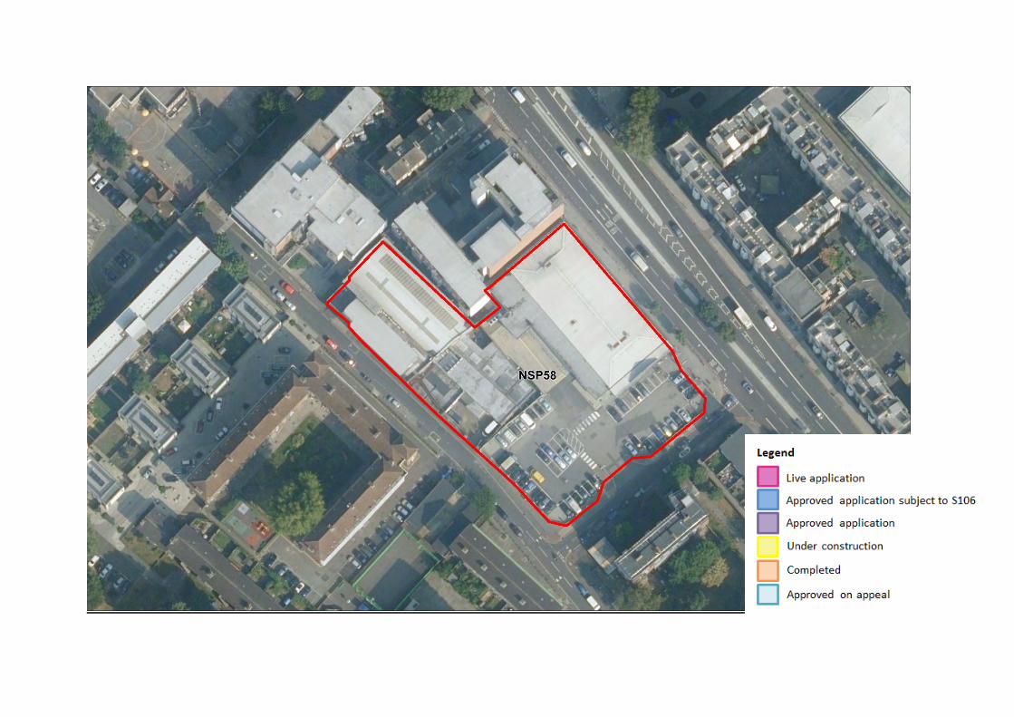

NSP59 Former petrol filling station, 233-247 Old Kent Road
Delivery of the site NSP59 (OKR7) Former petrol filling station, 233-247 Old Kent Road Landowner Phase 1: Southwark Council
Planning application details and
known delivery constraints
A mixed use development is currently under construction for this site and is expected to deliver 24 homes by 2022 and 190m2 GIA of retail space
Delivery rates Application number Status No of
homes Delivery timeframe
0-5 years (1st April 2020 – 31st March 2025) 6-15 years (1st April 2025 – 31st March 2035) 2020/2021 2021/2022 2022/2023 2023/2024 2024/2025
Planning applications/BLE Phase 1
18/AP/0928 Under construction
24 0 0 24 0 0 0
Site Ref. Site Name Site Area m2
Employment GIA m2
Residential units
Retail GIA m2
Community GIA m2
NSP59 (OKR7)
Former petrol filling station, 233-247 Old Kent Road
870 0 24 190 0


NSP60 Kinglake Street Garages
Site Ref. Site Name Site Area m2
Employment GIA m2 Residential units Retail
GIA m2 Community GIA
m2
NSP60 (OKR8)
Kinglake Street
Garages 750 0 21 105 68
Delivery of the site NSP60 (OKR8) Kinglake Street Garages Landowner Southwark Council (site under construction)
Planning application details and
known delivery
constraints
A residential development is currently under construction for this site and is expected to deliver 21 homes by 2023.
Delivery rates
Application number Status No of
homes Delivery timeframe
0-5 years (1st April 2020 – 31st March 2025) 6-15 years (1st April 2025 – 31st March 2035) 2020/2021 2021/2022 2022/2023 2023/2024 2024/2025
Excluded from BLE phasing
16/AP/4589 Under construction 21 0 0 0 21 0 0
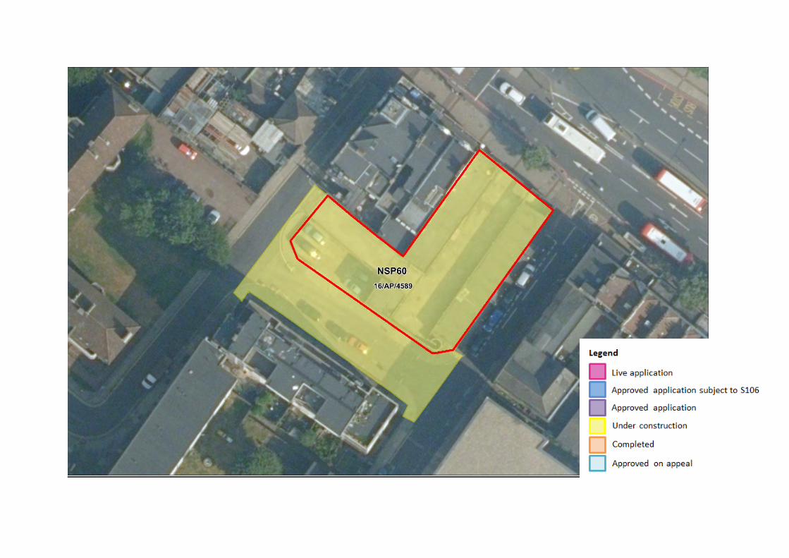
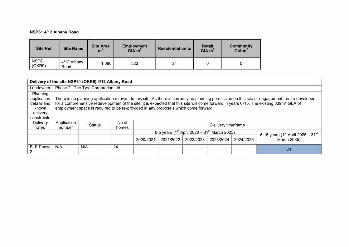
NSP61 4/12 Albany Road
Site Ref. Site Name Site Area m2
Employment GIA m2 Residential units Retail
GIA m2 Community
GIA m2
NSP61 (OKR9)
4/12 Albany Road
1,080 323 24 0 0
Delivery of the site NSP61 (OKR9) 4/12 Albany Road Landowner Phase 2: The Tyre Corporation Ltd
Planning application details and
known delivery
constraints
There is no planning application relevant to this site. As there is currently no planning permission on this site or engagement from a developer for a comprehensive redevelopment of the site, it is expected that this site will come forward in years 6-15. The existing 339m2 GEA of employment space is required to be re-provided in any proposals which come forward.
Delivery rates
Application number Status No of
homes Delivery timeframe
0-5 years (1st April 2020 – 31st March 2025) 6-15 years (1st April 2025 – 31st March 2035) 2020/2021 2021/2022 2022/2023 2023/2024 2024/2025
BLE Phase 2
N/A N/A 24 24


NSP62 Former Southern Railway Stables
Site Ref. Site Name Site Area m2
Employment GIA m2
Residential units
Retail GIA m2
Community GIA m2
Open space m2
NSP62 (OKR12)
Former Southern Railway Stables
6,248 765 103 0 0 795
Delivery of the site NSP62 (OKR12) Former Southern Railway Stables Landowner Phase 1: Multiple
Planning
application details and
known delivery constraints
This site is split between three land owners but is to come forward as one holding for comprehensive redevelopment. There is currently no planning application relevant to this site but discussions have been underway with developers. Masterplanning work indicates the site is suitable for a mixed use scheme which would deliver 103 homes in years 6-15.
Delivery rates Application number Status No of
homes Delivery timeframe
0-5 years (1st April 2020 – 31st March 2025) 6-15 years (1st April 2025 – 31st March 2035) 2020/2021 2021/2022 2022/2023 2023/2024 2024/2025
Planning applications/BLE Phase 1
N/A N/A 103 103
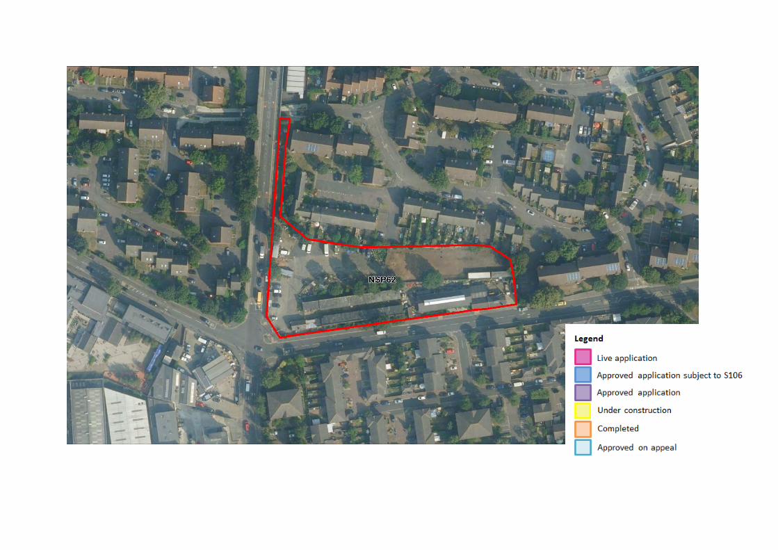

NSP63 Land bounded by Glengall Road, Latona Road and Cantium Retail Park
Site Ref. Site Name Site Area m2
Employment GIA m2
Residential units
Retail GIA m2
Community and leisure
GIA m2
Open space
m2
NSP63 (OKR10)
Land bounded by Glengall Road, Latona Road and Cantium Retail
Park 111,250 33,489 4,800 12,412 3,518 13,685
Delivery of the site NSP63 (OKR10) Land bounded by Glengall Road, Latona Road and Cantium Retail Park Landowner Phase 1: ABC Selfstore, Aviva, Civic Centre Ltd, Shaviram Developments Ltd, Berkeley Homes, Southern Housing, Pocket Homes,
Kaymet London Ltd, Southwark Council Phase 2: Asda (freeholders), McDonalds sites (freeholders)
Planning application details and
known delivery constraints
Several applications for mixed use schemes have come forward and been approved for the site. There are currently 2 applications under consideration for the site which, if approved, would deliver 40 homes. The site has fragmented land ownership; however land owners have shown general support for the mixed use development of the site allocation. There are ongoing discussions between the Council and developers to bring forward further developments for the remainder of the site, which can be expected to be delivered in years 6-15. Masterplanning work has been undertaken for the site to inform the latest draft of the Old Kent Road Area Action Plan (December 2020), which has increased the capacity of the site to 4,800 homes. This capacity has taken into account current approvals on the site. The site will deliver part of the Surrey Canal Linear Park. Pocket Homes scheme at 8-10 Ossory Road for 105 units (20/AP/0009) went to committee in October 2020 and was refused on the basis that there was no proposed social rented housing included in the proposal, there would be a lack of private amenity space for each resident and that the high density in terms of habitable rooms per hectare would not be mitigated as the proposal lacked exemplary design. An application 20/AP/0504 for an extension of the existing self-storage facility to provide additional Use Class B8 (storage and distribution) floorspace was refused as the proposal failed to provide an adequate fire strategy and did not meet the fire safety standards required by the London Plan. The proposal included no residential units so does not affect the residential capacity of the site.
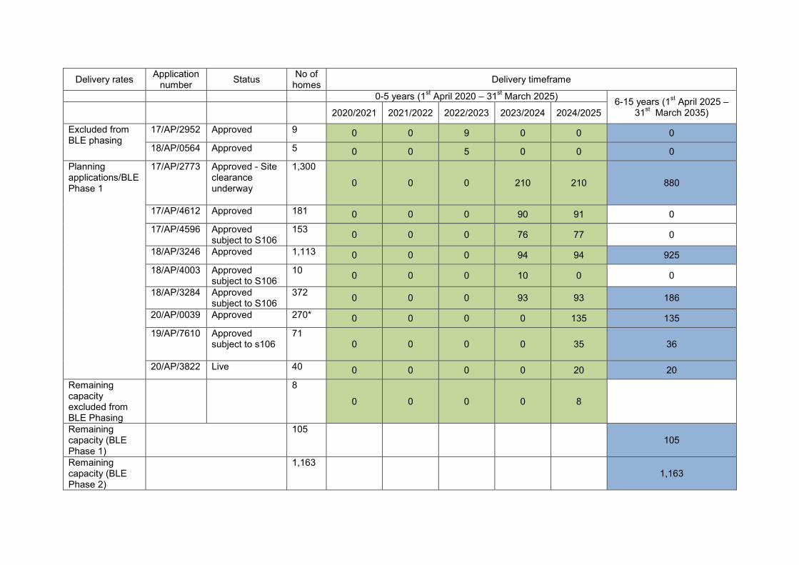
Delivery rates Application number Status No of
homes Delivery timeframe
0-5 years (1st April 2020 – 31st March 2025) 6-15 years (1st April 2025 – 31st March 2035) 2020/2021 2021/2022 2022/2023 2023/2024 2024/2025
Excluded from BLE phasing
17/AP/2952 Approved 9 0 0 9 0 0 0
18/AP/0564 Approved 5 0 0 5 0 0 0
Planning applications/BLE Phase 1
17/AP/2773 Approved - Site clearance underway
1,300
0 0 0 210 210 880
17/AP/4612 Approved 181 0 0 0 90 91 0 17/AP/4596 Approved
subject to S106 153 0 0 0 76 77 0
18/AP/3246 Approved 1,113 0 0 0 94 94 925 18/AP/4003 Approved
subject to S106 10 0 0 0 10 0 0
18/AP/3284 Approved subject to S106
372 0 0 0 93 93 186
20/AP/0039 Approved 270* 0 0 0 0 135 135 19/AP/7610 Approved
subject to s106
71 0 0 0 0 35 36
20/AP/3822 Live 40 0 0 0 0 20 20 Remaining capacity excluded from BLE Phasing
8
0 0 0 0 8
Remaining capacity (BLE Phase 1)
105 105
Remaining capacity (BLE Phase 2)
1,163 1,163

Total 4,800 0 0 14 573 763 3,450
*To report on non conventional residential schemes the figures presented includes a conversion the calculation of which is based on Policy H1 of the London Plan. The policy states that non self contained housing for students and shared living schemes should count towards meeting housing targets on a 2.5:1 ratio. Where schemes are non conventional housing schemes an asterisk has been used to show a conversion has been made.


NSP64 Marlborough Grove and St James’s Road
Site Ref. Site Name Site Area m2
Employment GIA m2
Residential units
Retail GIA m2
Community GIA m2
Open space m2
NSP64 (OKR11)
Marlborough Grove and St James’s Road
39,600 13,813 1,200 2,689 0
6,445
Delivery of the site NSP64 (OKR11) Marlborough Grove and St James’s Road Landowner Phase 1: Helix International Group (328 St James’s Road), Jon Watson Miller, Southwark Council, Bermond Developments Ltd
Phase 2: Royal London
Planning application details
and known delivery
constraints
Planning application 18/AP/0156, a student housing scheme, has been approved under appeal and is now under construction, which will contribute to the equivalent of 100* homes by 2025. There is currently one application 19/AP/6395 which has been approved subject to s106 agreement for a residential development to deliver 15 homes. Other landowners on the site are positive in bringing forward comprehensive development schemes and have expressed positivity to work with the Council to deliver future development on this site. Royal London (PSV consultation ref: NSPPSV163.1) are the freehold owners of part of the site with leases expiring around 2025 so it is expected that these sites will come forward in years 6-15.
Delivery rates Application number Status No of
homes Delivery timeframe
0-5 years (1st April 2020 – 31st March 2025) 6-15 years (1st April 2025 – 31st March 2035) 2020/2021 2021/2022 2022/2023 2023/2024 2024/2025
Planning applications/BLE Phase 1
19/AP/6395 Approved subject to s106
15 0 0 0 0 15 0
18/AP/0156 Under construction
100* 0 0 0 50 50 0
Remaining capacity (BLE Phase 1)
155 155 Remaining capacity (BLE Phase 2)
930 930 Total 1,200 0 0 0 50 65 1,085

*To report on non conventional residential schemes the figures presented includes a conversion the calculation of which is based on Policy H1 of the London Plan. The policy states that non self contained housing for students and shared living schemes should count towards meeting housing targets on a 2.5:1 ratio. Where schemes are non conventional housing schemes an asterisk has been used to show a conversion has been made.


NSP65 Sandgate Street and Verney Road
Site Ref. Site Name Site Area m2
Employment GIA m2
Residential units
Retail GIA m2
Community, leisure GIA m2
Education (F.1 (a)
Class) GIA m2
Health (Sui generis) GIA m2
Open space
m2
NSP65 (OKR13)
Sandgate Street and
Verney Road
127,600 47,969 5,300 5,949 2,198
10,411
2,000 34,472
Delivery of the site NSP65 (OKR13) Sandgate Street and Verney Road Landowner Royal Ordnance (Crown Service) Pension Scheme Trustees, Bishopsgate Property Fund Unit, Capital Industrial Holdings, Charities
Property Fund, Constantine Ltd (leasehold owner of 3 properties with lease until 2027 and 2028), Clough Winter, Hoxton Investments (38-40 Verney Road, Constantine Land Ltd (freehold owner of 4 Verney Road), Scotia Gas Network, Southwark Council
Planning application details and
known delivery constraints
There is currently one application under construction at 2 Varcoe Road (18/AP/2895) for 74 homes which will be completed by 2025. Several applications for mixed use schemes have been approved for the site, delivering at least 947 homes by 2025 and potentially up to 1,710 homes by 2035. There is currently two applications under consideration for the site which, if approved, would deliver a further 146 homes. The site has fragmented land ownership; however land owners have shown general support for the mixed use development of the site allocation. The development of this site will occur incrementally depending on when individual land owners bring forward proposals. There are ongoing discussions between the Council and developers to bring forward further developments which can be expected to deliver in years 6-15. Masterplanning has been undertaken to show indicative capacities for the site. The site will deliver new education uses, a health centre and part of the Surrey Canal Linear Park.
Delivery rates Application number Status No of
homes Delivery timeframe
0-5 years (1st April 2020 – 31st March 2025) 6-15 years (1st April 2025 – 31st March 2035) 2020/2021 2021/2022 2022/2023 2023/2024 2024/2025
Excluded from BLE Phasing
16/AP/5235 Built 57
Planning applications/BLE Phase 1
18/AP/0897 Approved 1,152 0 0 0 288 288 576 18/AP/2895 Under
construction 74 0 0 0 37 37 0

17/AP/4508 Approved subject to s106
338 0 0 0 169 169 0
18/AP/0196 Approved 111 0 0 0 0 55 56 19/AP/1710 Approved
subject to s106
262 0 0 0 65 66 131
19/AP/7550 Live 57 0 0 0 0 28 29 20/AP/2701 Live 107* 0 0 0 0 53 54
Remaining capacity BLE Phase 1
30 0 0 0 0 0 30
Remaining capacity (BLE Phase 2)
3,112 3,112
Total 5,300 0 0 0 559 696 3,988
*To report on non conventional residential schemes the figures presented includes a conversion the calculation of which is based on Policy H1 of the London Plan. The policy states that non self contained housing for students and shared living schemes should count towards meeting housing targets on a 2.5:1 ratio. Where schemes are non conventional housing schemes an asterisk has been used to show a conversion has been made.


NSP66 Devon Street and Sylvan Grove
Site Ref. Site Name Site Area m2
Employment GIA m2
Residential units
Retail GIA m2
Community GIA m2
Open space
m2
NSP66 (OKR18)
Devon Street and Sylvan Grove 44,170 17,046 1,500 4,822 931 3,573
Delivery of the site NSP66 (OKR18) Devon Street and Sylvan Grove Landowner Barkwest, Folgate Estates (Freehold owners), PGIM Real Estate, Safestore
Planning application details and
known delivery constraints
Part of the site is completed as affordable housing (8-24 Sylvan Grove, 80 units). There are currently two applications which are both approved subject to s106 agreement, 19/AP/2307 and 19/AP/1239. Together these proposals will deliver 565 homes. Masterplanning work has been undertaken for the remainder of the site to inform the latest draft of the Old Kent Road Area Action Plan (December 2020), which has increased the capacity of the site to 1,500 homes. The landowners Barkwest have expressed support in relation to increasing the site capacity. Other landowners, Safestore (PSV consultation ref: NSPPSV157.1) would like to retain their premises on this site allocation but are not opposed to the possibility of mixed use development subject to their existing use being retained or re-provided.
Delivery rates Application number Status No of
homes Delivery timeframe
0-5 years (1st April 2020 – 31st March 2025) 6-15 years (1st April 2025 – 31st March 2035) 2020/2021 2021/2022 2022/2023 2023/2024 2024/2025
Excluded from BLE phasing
15/AP/1330 Built 80
Planning applications/BLE Phase 1
19/AP/2307 Approved subject to s106
219 0 0 0 0 109 110
Planning applications/BLE Phase 1
19/AP/1239 Approved subject to s106
565 0 0 0 141 141 283
Remaining capacity (BLE
636 636

Phase 2)
Total 1,500 0 0 0 141 250 1,029


NSP67 Hatcham Road, Penarth Street and Ilderton Road
Site Ref. Site Name
Site Area m2
Employment GIA m2
Residential units
Retail GIA m2
Community GIA m2
Open space
m2
NSP67 (OKR16)
Hatcham Road, Penarth Street and Ilderton Road 66,840 45,114 2,200 449 0 1,990
Delivery of the site NSP67 (OKR16) Hatcham Road, Penarth Street and Ilderton Road Landowner Capital Industrial Holdings BV, Glancy Design, Purpose Powder Coatings and the CCC New Jerusalem, Danecroft Land Ltd, Leathams
Larder Parish Church (the Consortium), Aitch Group, Optivo Housing Association
Planning application details and
known delivery constraints
Several applications for mixed use schemes have come forward and been approved for the site, with a total deliverability of at least 654 homes by 2025.17/AP/4819 for 313-349 Ilderton Road has been superseded by a new proposal (20/AP/1329) which proposes a mixed use student accommodation and residential scheme and sees an increase from 130 homes to 158* homes. The site has fragmented land ownership; however land owners have shown general support for the mixed use development of the site allocation. The development of this site will occur incrementally depending on when individual land owners bring forward proposals. There are ongoing discussions between the Council and developers to bring forward further developments which can be expected to deliver in years 6-15.
Delivery rates Application number Status No of
homes Delivery timeframe
0-5 years (1st April 2020 – 31st March 2025) 6-15 years (1st April 2025 – 31st March 2035) 2020/2021 2021/2022 2022/2023 2023/2024 2024/2025
Excluded from BLE phasing
16/AP2436 Built 9 16/AP/1092 Under
construction 8 0 0 8 0 0
Planning applications/BLE Phase 1
17/AP/3757 Under construction
86 0 0 0 50 36
17/AP/4546 Under construction
84 0 42 42 0 0
18/AP/1049 Approved 56 0 0 0 56 0 17/AP/4649 Approved 33 0 0 0 33 0

18/AP/2761 Approved 46 0 0 0 0 23 23 18/AP/2497 Approved
subject to s106
312 0 0 0 78 79 155
19/AP/1773 Approved 254 0 0 0 63 64 127 20/AP/1329 Approved
subject to s106
158* 0 0 0 39 40 79
Remaining capacity (BLE Phase 1)
549 549
Remaining capacity (BLE Phase 2)
605 605
Total 2,200 0 42 50 319 242 1,538 *To report on non conventional residential schemes the figures presented includes a conversion the calculation of which is based on Policy H1 of the London Plan. The policy states that non self contained housing for students and shared living schemes should count towards meeting housing targets on a 2.5:1 ratio. Where schemes are non conventional housing schemes an asterisk has been used to show a conversion has been made.


NSP68 - 760 and 812 Old Kent Road (ToysRUs) and 840 Old Kent Road (Aldi)
Delivery of the site NSP68 (OKR17) 760 and 812 Old Kent Road (ToysRUs) and 840 Old Kent Road (Aldi) Landowner Phase 1: Aldi
Phase 2: Firem Ltd Planning
application details and
known delivery
constraints
There is currently one application approved for this site which will deliver 168 homes. Live application 19/AP/0994 would deliver a further 138 homes in years 6-15. Part of the site will be required to deliver the Bakerloo Line extension station. Application 19/AP/1766 is for the erection of temporary ALDI foodstore on the existing car park while the wider site undergoes redevelopment.
Delivery rates
Application number Status No of
homes Delivery timeframe
0-5 years (1st April 2020 – 31st March 2025) 6-15 years (1st April 2025 – 31st March 2035) 2020/2021 2021/2022 2022/2023 2023/2024 2024/2025
Planning applications/ BLE Phase 1
19/AP/1322 Approved 168
0 0 0 42 42 84
BLE Phase 2
19/AP/0994 Live 138 138
Remaining capacity (BLE Phase 2)
694
694
Total 1,000 0 0 0 42 42 916
Site Ref. Site Name Site Area m2
Employment GIA m2
Residential units
Retail GIA m2
Community (D Class) GIA m2
Open space m2
NSP68 (OKR17)
760 and 812 Old Kent Road (ToysRUs) and 840 Old Kent Road
(Aldi) 14,500 1,903 1,000 4,196 0 1,500


NSP69 - 684-698 OId Kent Road (Kwikfit Garage)
Site Ref. Site Name Site Area m2
Employment GIA m2
Residential units
Retail GIA m2
Community GIA m2
NSP69 (OKR15)
684-698 OId Kent
Road (Kwikfit Garage)
1,500 295 65 295 0
Delivery of the site NSP69 (OKR15) 684-698 OId Kent Road (Kwikfit Garage) Landowner Phase 2: Lencrown Investments Ltd (freeholders)
Planning application details and
known delivery
constraints
There is no planning application relevant to this site. As there is currently no planning permission on this site or engagement from a developer for a comprehensive redevelopment of the site, it is expected that this site will come forward in years 6-15. The reprovision of existing floorspace, 590m2 GIA, is required as a minimum for any schemes which come forward.
Delivery rates
Application number Status No of
homes Delivery timeframe
0-5 years (1st April 2020 – 31st March 2025) 6-15 years (1st April 2025 – 31st March 2035) 2020/2021 2021/2022 2022/2023 2023/2024 2024/2025
BLE Phase 2
N/A N/A 65 65


NSP70 - 636 OId Kent Road
Site Ref. Site Name
Site Area m2
Employment (B Class) GIA
m2 Residential
units Retail
(A Class) m2
Community (D Class) m2
NSP70 (OKR14)
636 Old Kent Road
900 272 42 0 0
Delivery of the site NSP70 (OKR14) 636 OId Kent Road Landowner Hexagon Housing
Planning application details and
known delivery constraints
There is a mixed use scheme currently under construction on the site, 17/AP/1646, which will deliver 42 homes by 2023 and 272 m2 of flexible commercial floorspace.
Delivery rates Application number Status No of
homes Delivery timeframe
0-5 years (1st April 2020 – 31st March 2025) 6-15 years (1st April 2025 – 31st March 2035) 2020/2021 2021/2022 2022/2023 2023/2024 2024/2025
Planning applications/BLE Phase 1
17/AP/1646 Under construction
42 0 42 0 0 0


Peckham Sites NSP71 Aylesham Centre and Peckham Bus Station NSP72 Blackpool Road Business Park NSP73 Land between the railway arches (East of Rye Lane including railway arches) NSP74 Copeland Industrial Park and 1-27 Bournemouth Road
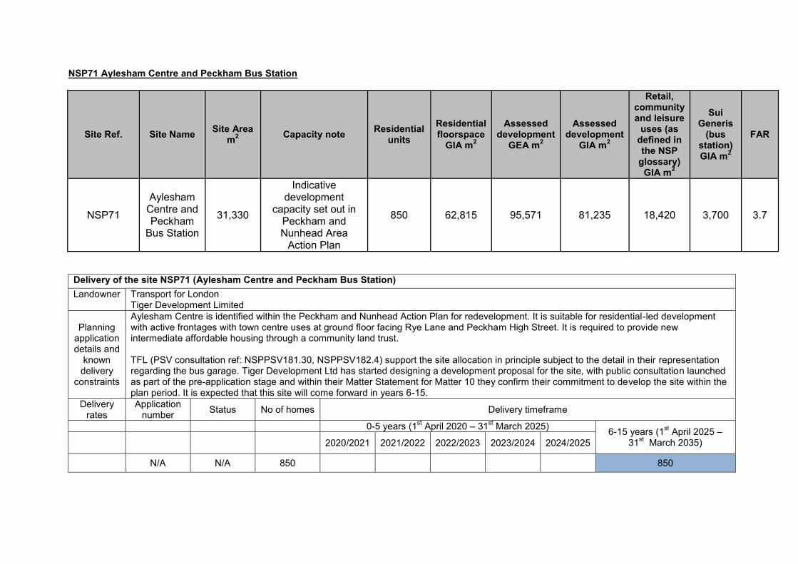
NSP71 Aylesham Centre and Peckham Bus Station
Site Ref. Site Name Site Area m2 Capacity note Residential
units Residential floorspace
GIA m2
Assessed development
GEA m2
Assessed development
GIA m2
Retail, community and leisure
uses (as defined in the NSP
glossary) GIA m2
Sui Generis
(bus station) GIA m2
FAR
NSP71
Aylesham Centre and Peckham
Bus Station
31,330
Indicative development
capacity set out in Peckham and Nunhead Area
Action Plan
850 62,815 95,571 81,235 18,420 3,700 3.7
Delivery of the site NSP71 (Aylesham Centre and Peckham Bus Station) Landowner Transport for London
Tiger Development Limited
Planning application details and
known delivery
constraints
Aylesham Centre is identified within the Peckham and Nunhead Action Plan for redevelopment. It is suitable for residential-led development with active frontages with town centre uses at ground floor facing Rye Lane and Peckham High Street. It is required to provide new intermediate affordable housing through a community land trust. TFL (PSV consultation ref: NSPPSV181.30, NSPPSV182.4) support the site allocation in principle subject to the detail in their representation regarding the bus garage. Tiger Development Ltd has started designing a development proposal for the site, with public consultation launched as part of the pre-application stage and within their Matter Statement for Matter 10 they confirm their commitment to develop the site within the plan period. It is expected that this site will come forward in years 6-15.
Delivery rates
Application number Status No of homes Delivery timeframe
0-5 years (1st April 2020 – 31st March 2025) 6-15 years (1st April 2025 – 31st March 2035) 2020/2021 2021/2022 2022/2023 2023/2024 2024/2025
N/A N/A 850 850
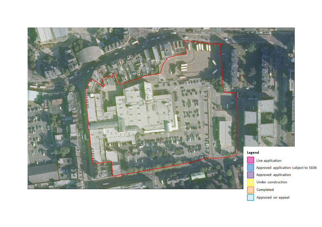

NSP72 Blackpool Road Business Park
Site Ref.
Site Name
Site Area m2
Employment GIA m2
Residential floorspace – GIA m2
Residential
units
Community floorspace
GIA m2
Sui Generis
(bus garage) GIA m2
Assessed development
GEA m2
Assessed development
GIA m2 FAR
NSP72
Blackpool Road
Business Park
17,580 11,851 18,485 250
361 4,000 40,434 34,369 4
Delivery of the site NSP72 (Blackpool Road Business Park) Landowner Grafton Group, Southwark Council
Planning application details and
known delivery
constraints
Any redevelopment proposal on site must provide the amount of employment floorspace currently on the site and re-provide bus garage subject to need. It is suitable for residential development. Development should provide new amenity space and enhance permeability of the site. There is no planning application relevant to this site. As there is no planning permission on this site, it is expected that this site will come forward in years 6-15. The landowner, Grafton Group (PSV consultation ref: NSPPSV69.1) responded in support of the redevelopment potential of the site in principle subject to the detail of their representation.
Delivery rates
Application number Status No of homes Delivery timeframe
0-5 years (1st April 2020 – 31st March 2025) 6-15 years (1st April 2025 – 31st March 2035) 2020/2021 2021/2022 2022/2023 2023/2024 2024/2025
N/A N/A 250 250


NSP73 Land between the railway arches (East of Rye Lane including railway arches)
Site Ref. Site Name Site Area m2 Capacity note Employment GIA m2
Retail uses (GIA m2
NSP73 Land between the railway arches (East of Rye Lane including railway arches)
20,460 Indicative development capacity set out in Peckham and Nunhead Area Action Plan
500
Delivery of the site NSP73 ( Land between the railway arches (East of Rye Lane including railway arches)) Landowner Majority owned by The Arch Company, part owned by Network Rail
Planning application details and
known delivery
constraints
This site allocation is set out in the adopted Peckham and Nunhead Area Action Plan (2004) as ‘PNAAP 3: Land between the railway arches (East of Rye Lane including railway arches)’. It is suitable for mixed use development with small scale businesses, cultural, leisure and retail elements. There is the opportunity to create a market within the site, which would help promote the local economy. The site provides great opportunities to increase the linkages both to the north and east to west. There is scope to open up some of the railways arches to create alternative links.
There is no planning application relevant to this site. As there is no planning permission on this site, it is expected that this site will come forward in year 6-15.
Delivery rates
Application number Status No of homes Delivery timeframe
0-5 years (1st April 2020 – 31st March 2025) 6-15 years (1st April 2025 –31st March 2035)2020/2021 2021/2022 2022/2023 2023/2024 2024/2025
N/A N/A 0 0 0 0 0 0 0
4,238


NSP74 Copeland Industrial Park and 1-27 Bournemouth Road
Site Ref. Site Name Site Area m2 Capacity note Employment GIA m2
Residential units Retail, community and leisure uses (as defined in the NSP glossary) GIA m2
NSP74 Copeland Industrial Park
and 1-27 Bournemouth
Road
11,630 Indicative development
capacity set out in Peckham and Nunhead Area
Action Plan
3,000 270 3,000
Delivery of the site NSP74 (Copeland Industrial Park and 1-27 Bournemouth Road) Landowner The majority of the site is owned by CIP Limited, with a small part of the site (the offices on Bournemouth Road) owned by Southwark Council
Planning application details and
known delivery
constraints
This site allocation is set out in the adopted Peckham and Nunhead Area Action Plan (2004) as ‘PNAAP 4: Copeland Industrial Park and 1-27 Bournemouth Road’. The site’s close proximity to Peckham Rye Station and its large size provide a variety of options to develop this site. Mixed-use development should be centred around the retention of the historic Bussey building and should include new public realm improvements to provide space for new residents, workers and visitors. No residential uses should be located on Bournemouth Road. The size of the site provides the opportunity for a variety of larger floorplate retail units which are lacking in the town centre. There is no planning application relevant to this site. As there is no planning permission on this site, it is expected that this site will come forward in years 6-15. The freehold landowners of the Copeland Park (PSV consultation ref: NSPPSV38.1) submitted a representation at Proposed Submission stage and consider the site allocation is a duplicate of PNAAP4. No comments were made specifically on delivery.
Delivery rates
Application number Status No of homes Delivery timeframe
0-5 years (1st April 2020 – 31st March 2025) 6-15 years (1st April 2025 – 31st March 2035) 2020/2021 2021/2022 2022/2023 2023/2024 2024/2025
N/A N/A 270 270


Rotherhithe Sites NSP75 Rotherhithe Gasometer NSP76 St Olav’s Business Park, Lower Road NSP77 Decathlon Site and Mulberry Business Park NSP78 Harmsworth Quays, Surrey Quays Leisure Park, Surrey Quays Shopping Centre and Robert’s Close NSP79 Croft Street Depot

NSP75 Rotherhithe Gasometer
Site Ref. Site Name Site Area m2
Residential floorspace –
GIA m2 Residential
units Assessed
development GEA m2
Assessed development
GIA m2 FAR
NSP75 Rotherhithe Gasometer 9,597 11,824 160 13,911 11,824 1.4
Delivery of the site NSP75 (Rotherhithe Gasometer) Landowner Scotia Gas Network
Planning application details and
known delivery
constraints
The land is suitable for residential-led redevelopment. It should provide a new green link between Salter Road and Windrose Close, providing access to Canada Water town centre and the woodland to the south of the development site. The development should respond to the local heritage and the surrounding context in terms of scale and height, also being set back from the mature trees on Brunel Road. The landowner, Scotia Gas Network (PSV consultation ref: NSPPSV160.1) is undergoing a strategic review of its portfolio owing to OFGEM (Office of Gas and Electricity Markets) requirements to decommission obsolete terranean gas storage facilities in favour of a subterranean pipe network. With gas holders in other boroughs including Lambeth, Sutton and Kingston already subject to active planning permission for mixed use development, the landowner is positive that the site will be made available for redevelopment within the plan period, as part of the decommissioning process and are in support of residential land uses. There is no planning application relevant to this site. As there is no planning permission on this site, it is expected that this site will come forward in years 6-15.
Delivery rates
Application number Status No of homes Delivery timeframe
0-5 years (1st April 2020 – 31st March 2025) 6-15 years (1st April 2025 – 31st March 2035) 2020/2021 2021/2022 2022/2023 2023/2024 2024/2025
N/A N/A 160 160

NSP76 St Olav’s Business Park, Lower Road
Site Ref. Site Name Site Area m2
Employment GIA m2
Residential floorspace –
GIA m2 Residential units
Assessed development
GEA m2
Assessed development GIA
m2
NSP76 St Olav's Business Park, Lower Road 5,384 4,550 9,238 125 16,221 13,788
Delivery of the site NSP76 (St Olav’s Business Park, Lower Road) Landowner St Olav Court Limited/Southern Grove Real Estate
Planning application details and
known delivery
constraints
The land is suitable for mixed use development with new homes and replacement employment floorspace providing active frontages at ground floor level. It should provide increased permeability across the site and high quality public realm at the centre and at the confluence of three routes towards Christopher Jones Square open space, Southwark Park and the retail frontage on Albion Street. The site allocation relates to a number of plots within a variety of landownerships. Prospective landowner Southern Grove Real Estate Ltd (PSV ref NSPPSV372) has responded in support of the redevelopment potential of the site subject to the detail in their representation. There is no planning application relevant to this site. As there is no planning permission on this site, it is expected that this site will come forward in year 6-15.
Delivery rates
Application number Status No of homes Delivery timeframe
0-5 years (1st April 2020 – 31st March 2025) 6-15 years (1st April 2025 – 31st March 2035) 2018/2019 2019/2020 2020/2021 2021/2022 2022/2023
N/A N/A 125 125


NSP77 Decathlon Site and Mulberry Business Park
Delivery of the site NSP77 (Decathlon Site and Mulberry Business Park) Landowner Decathlon site, i.e. Canada Water Site C & E: Notting Hill Genesis, Art Invest Real Estate (AIRE), The Mayor and Burgesses of the London
Borough of Southwark, London Underground Limited, London Power Networks plc and Decathlon UK Limited; Mulberry Business Park: Scape
Planning application details and
known delivery
constraints
The Decathlon site, previously known as Site C and E along Surrey Quays Road, forms the southern part of the site allocation. An outline application for a comprehensive redevelopment on the plot (Ref: 12/AP/4126) was approved with legal agreement in 2013. As set out in the officer report, the mixed use redevelopment will be delivered in four phases over approximately eight years. Phase 1 has been completed, delivering 234 residential units and town centre uses in 2019. The site for Phase 2, 3 and 4 has been sold and the new owners have been in discussion with the council through a Statement of Common Ground about the future use and development of the site which could result in the reduction of 796 units coming forward on the site and increasing the employment provision. Therefore the remaining delivery has been included in 6-15 years. The Mulberry Business Park forms the northern part of the site allocation. The full application (Ref: 13/AP/1429) was approved with legal agreement in 2013 for student housing-led mixed use development, including 33 affordable residential units. With London Plan setting out non-conventional housing as part of housing supply, the 770 student rooms will provide an equivalent of 308 residential units on the 2.5:1 ratio. The scheme in total provides 341 residential units. The redevelopment of four building blocks is already under construction. Therefore it is expected to be delivered in the first five years.
Delivery rates
Application number Status No of
homes Delivery timeframe
0-5 years (1st April 2020 – 31st March 2025) 6-15 years (1st April 2025 –
Site Ref. Site Name Site Area m2 Planning Permission
Employment GIA m2 Retail, community and leisure uses (as defined in the NSP glossary) GIA m2
Residential Units
NSP77 Decathlon Site and Mulberry Business
Park
48,520 12/AP/4126 and
13/AP/1429
7,290
19,015 1,371 (1,063 + 770 student
homes)

2020/2021 2021/2022 2022/2023 2023/2024 2024/2025 31st March 2035)
12/AP/4126 Partially
completed/Under construction
1031 (234 completed
in 2019/2020)
796
13/AP/1429 Under construction 341 170 171 0 0 0


NSP78 Harmsworth Quays, Surrey Quays Leisure Park, Surrey Quays Shopping Centre and Robert’s Close
Site Ref. Site Name Site Area m2 Planning Permission
Minimum employment GIA m2
Minimum retail and leisure GIA
m2 Residential
units Open space
m2
NSP78 Harmsworth Quays, Surrey Quays
Leisure Park, Surrey Quays Shopping Centre and Robert's Close
212,700m2 *18/AP/1604 46,452 46,452 2,000 –
3,995 13,696
*18/AP/1604 sets out a masterplan for Canada Water. The above values show the minimum floorspace and residential units that are committed to come forward on this site allocation. Depending on market trends and need for different uses on these sites these figures could increase.
Delivery of the site NSP78 (Harmsworth Quays, Surrey Quays Leisure Park, Surrey Quays Shopping Centre and Robert’s Close) Landowner London Underground Limited, British Land Canada Water Limited
Planning application details and
known delivery constraints
This site allocation is adjacent to NSP77. A hybrid application (18/AP/1604) was approved subject to Section 106 agreement in 2019. The mixed use redevelopment will deliver residential units between a range of 2,000-3,995 and at least 92,904 sqm employment, retail and leisure floorspace combined; and 13,696 sqm of open space. For the purpose of the 5+15 year land supply it was assumed that site has a potential to deliver an average of 3,000 units. As part of the outline element of the permission the following uses and maximum capacities by use have been granted planning permission and could potentially come forward: retail (A1-A5) - 86,650 sqm; workspace (B1) – 282,500sqm; hotel (C1) – 7,500 sqm; assisted living (C2) – 35,700 sqm; residential (C3) – 331,500 sqm; community facilities (D1) – 45,650 sqm; leisure/cultural (D2) – 51,500 sqm; night club (Sui Generis) – 1,500 sqm; student accommodation (Sui Generis) – 50,300 sqm; energy centre (Sui Generis) – 2,000 sqm; primary substation (Sui Generis) – 3,000 sqm; multi-storey car park (Sui Generis) – 17,200 sqm; petrol filling station (Sui Generis) – 3,000 sqm; transport infrastructure (potential second entrance to SQ station) (Sui Generis) – 500 sqm; flexible events space (Sui Generis) – 5,000 sqm; parking and plant – 133,750 sqm; and public toilets (Sui Generis) – 500 sqm. A full and detailed application for Phase 1 was approved, bringing 265 new homes and 45,985 sqm non-residential floorspace at the western edge and the north east of the site. It is expected to come forward in the first five years, with the remainder being delivered in reserved matters applications between the years 6-15.
Delivery rates Application number Status No of
homes Delivery timeframe
0-5 years (1st April 2020 – 31st March 2025) 6-15 years (1st April 2025 – 31st March
2035)
2020/2021 2021/2022 2022/2023 2023/2024 2024/2025
18/AP/1604 Approved with S106 265 0 0 265 100 100
Remaining capacity 2,735 2,535

(reserved matters for 18/AP/1604)
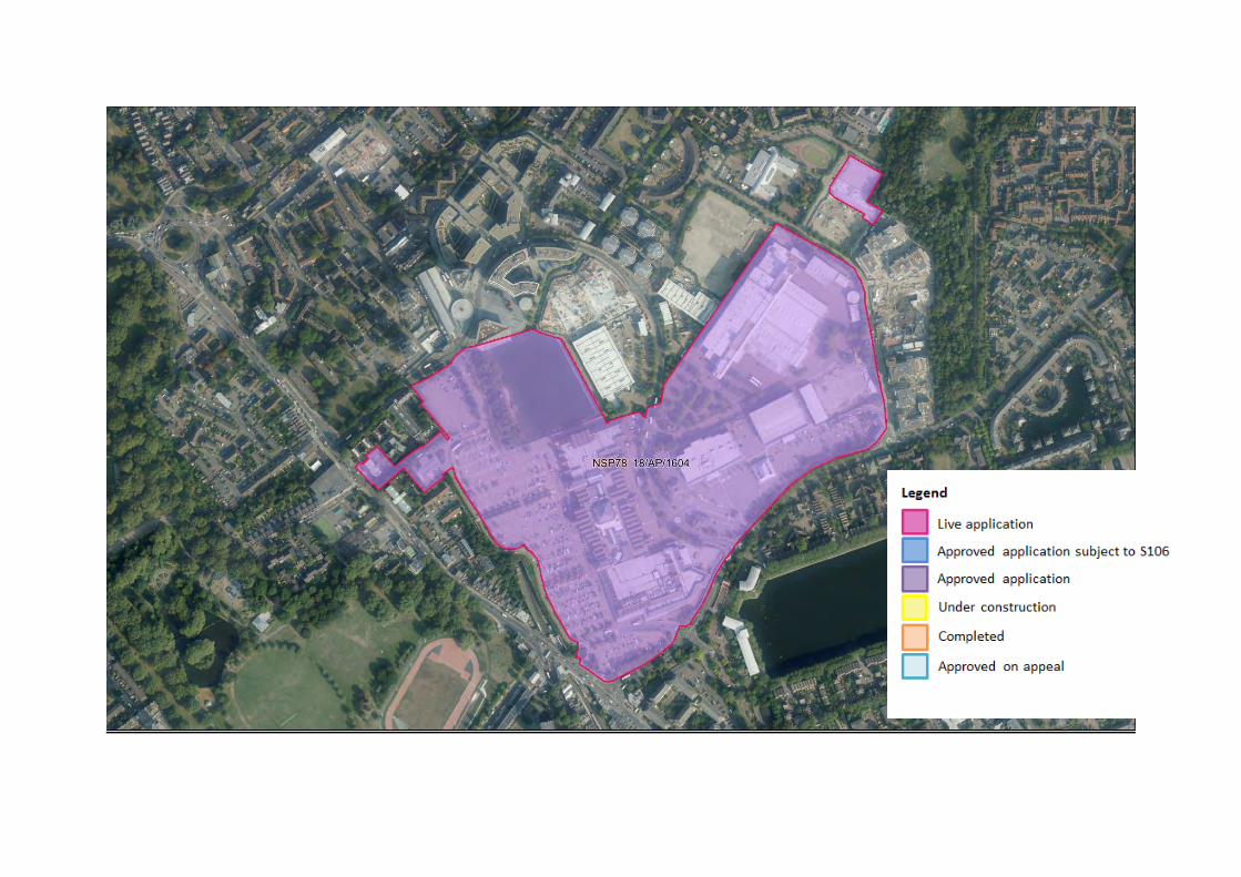

NSP79 Croft Street Depot
Site Ref. Site Name
Site Area m2
Storage and distribution GIA
m2
Residential units
proposed
Residential floorspace
GIA m2
Small business
space proposed GIA
m2
Assessed development
GEA m2
Assessed development
GIA m2 FAR
NSP79 Croft Street Depot
4,711 5,175 56 4,138 5,175 10,222 8,688 3.6
Delivery of the site NSP79 (Croft Street Depot) Landowner British Land Fixed Uplift Fund Limited Partnership (subsidiary of The British Land Company Plc )
Planning application details and
known delivery constraints
The site allocation consists of a depot building and yard on Croft Street. Any redevelopment proposal must provide at least the amount of employment floorspace currently on the site as small business workspace or a storage depot, with potential provision of new homes. It should provide active edges onto Croft Street whilst retaining and protecting the street trees on Croft Street, and also consider potential road alterations on Lower Road that may narrow the Croft Street junction and introduce a two-way segregated cycle track across the mouth of Croft Street. There is no planning application relevant to this site. As there is no planning permission on this site, it is expected that this site will come forward in years 6-15. The landowner, British Land supported the allocation of this site therefore it was reintroduced in the Amended Policies 2019 version of the NSP as the landowner confirmed this site is not used for telecommunications.
Delivery rates Application number Status No of
homes Delivery timeframe
0-5 years (1st April 2020 – 31st March 2025) 6-15 years (1st April 2025 – 31st March
2035)
2020/2021 2021/2022 2022/2023 2023/2024 2024/2025
N/A N/A 56 56
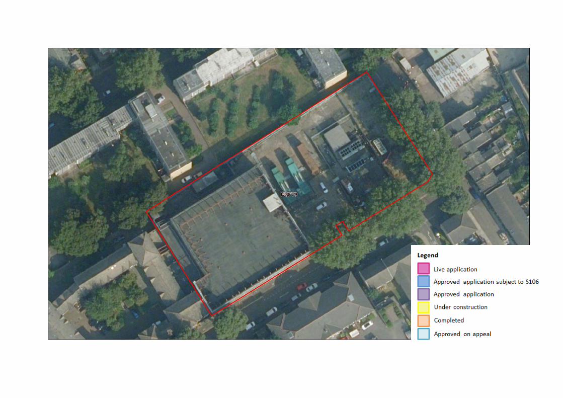

Walworth Sites NSP80 Morrison’s, Walworth Road NSP81 330-344 Walworth Road NSP82 Chatelaine House, Walworth Road

NSP80 Morrison’s, Walworth Road
Site Ref. Site Name
Site Area m2
Residential floorspace
GIA m2
Residential
units
Retail, community and leisure uses (as defined in the
NSP glossary) GIA m2
Assessed development
GEA m2
Assessed development
GIA m2 FAR
NSP80 Morrisons, Walworth Road 5,114 9,551
129 2,403 14,063 11,954 2.8
Delivery of site NSP80 (Morrison’s, Walworth Road) Landowner Southwark Pension Fund
Planning application details and
known delivery constraints
There is no planning application relevant to this site. As there is no planning permission on this site, it is expected that this site will come forward in years 6-15.
Delivery rates Application number Status No of
homes Delivery timeframe
0-5 years (1st April 2020 – 31st March 2025) 6-15 years (1st April 2025 – 31st March 2035) 2020/2021 2021/2022 2022/2023 2023/2024 2024/2025
N/A N/A 129 129
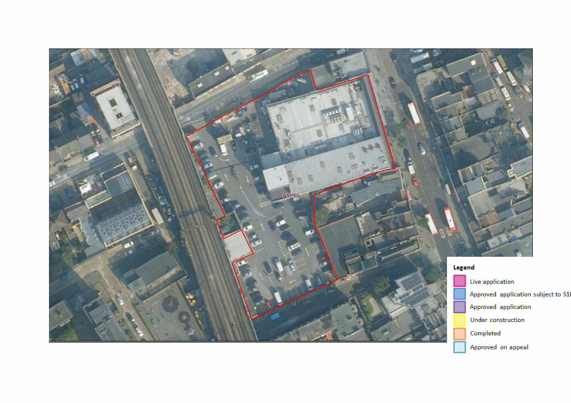

NSP81 330-344 Walworth Road
Delivery of site NSP81 (330-344 Walworth Road) Landowner Altum Capital
Planning application details and
known delivery constraints
There is no planning application relevant to this site. As there is no planning permission on this, it is expected that this site will come forward in years 6-15. The previous landowner Tadum Properties expressed support in relation to the inclusion of this site as an allocation in previous consultations. It is understood that no consultation response has been received from the current landowner, Altum Capital.
Delivery rates Application number Status No of
homes Delivery timeframe
0-5 years (1st April 2020 – 31st March 2025) 6-15 years (1st April 2025 – 31st March 2035) 2020/2021 2021/2022 2022/2023 2023/2024 2024/2025
N/A N/A 46 46
Site Ref. Site Name Site Area m2
Residential floorspace – GIA m2
Residential units
Retail, community and leisure
uses (as defined in the NSP
glossary) GIA m2
Assessed development
GEA m2
Assessed development
GIA m2 FAR
NSP81 330-344 Walworth Road 2,961 3,416 46 4,414 9,212 7,830 2.4


NSP82 Chatelaine House, Walworth Road
Site Ref. Site Name
Site Area m2
Planning Permission
Residential units
Retail, community and leisure uses (as defined in the
NSP glossary) GIA m2
NSP82 Chatelaine House, Walworth Road 3,163 13/AP/1122 54 567
Delivery of site NSP82 (Chatelaine House, Walworth Road) Landowner Durkan Estates Limited
Planning application details and
known delivery constraints
Planning application 13/AP/1122 is relevant to this site. This proposes a mix of retail, leisure and business floorspace alongside residential uses. It also includes the provision of 6 accessible car parking spaces. Construction has started on this site, so it is expected to come forward in the first five years.
Delivery rates Application number Status No of
homes Delivery timeframe
0-5 years (1st April 2020 – 31st March 2025) 6-15 years (1st April 2025 – 31st March 2035) 2020/2021 2021/2022 2022/2023 2023/2024 2024/2025
13/AP/1122 Under construction 54 0 0 54 0 0


Appendix 3 Old Kent Road Phasing
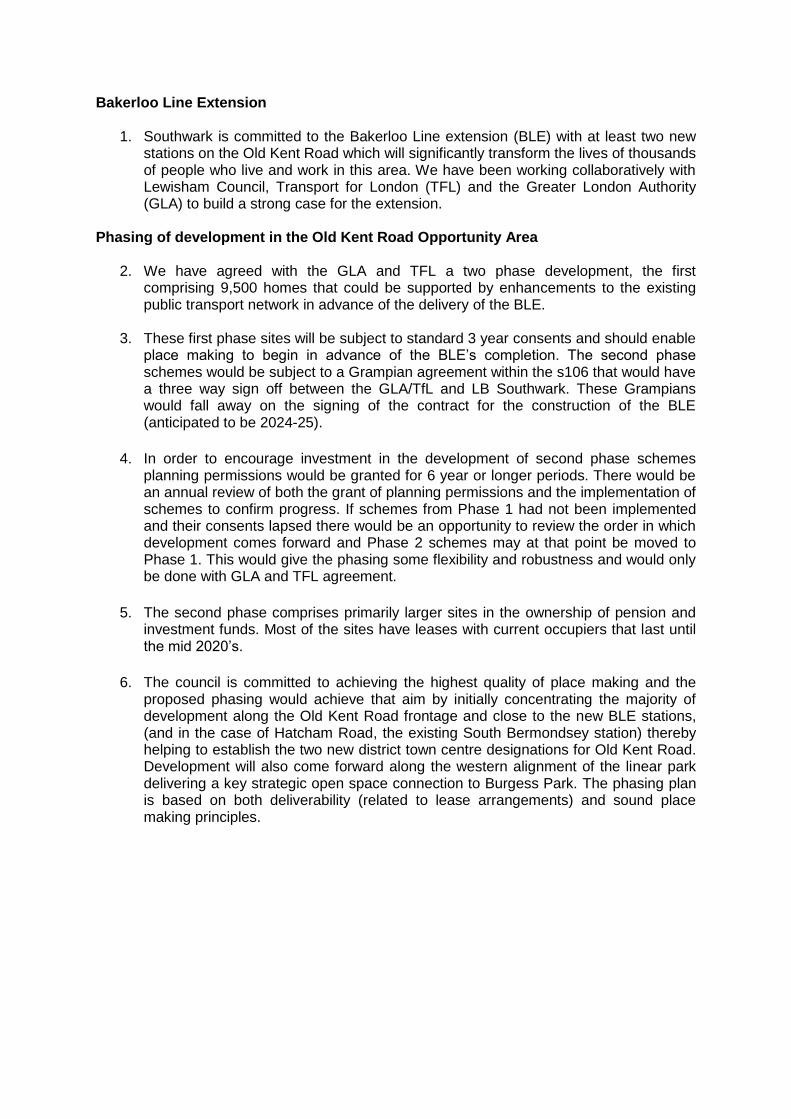
Bakerloo Line Extension
1. Southwark is committed to the Bakerloo Line extension (BLE) with at least two new stations on the Old Kent Road which will significantly transform the lives of thousands of people who live and work in this area. We have been working collaboratively with Lewisham Council, Transport for London (TFL) and the Greater London Authority (GLA) to build a strong case for the extension.
Phasing of development in the Old Kent Road Opportunity Area
2. We have agreed with the GLA and TFL a two phase development, the first comprising 9,500 homes that could be supported by enhancements to the existing public transport network in advance of the delivery of the BLE.
3. These first phase sites will be subject to standard 3 year consents and should enable place making to begin in advance of the BLE’s completion. The second phase schemes would be subject to a Grampian agreement within the s106 that would have a three way sign off between the GLA/TfL and LB Southwark. These Grampians would fall away on the signing of the contract for the construction of the BLE (anticipated to be 2024-25).
4. In order to encourage investment in the development of second phase schemes planning permissions would be granted for 6 year or longer periods. There would be an annual review of both the grant of planning permissions and the implementation of schemes to confirm progress. If schemes from Phase 1 had not been implemented and their consents lapsed there would be an opportunity to review the order in which development comes forward and Phase 2 schemes may at that point be moved to Phase 1. This would give the phasing some flexibility and robustness and would only be done with GLA and TFL agreement.
5. The second phase comprises primarily larger sites in the ownership of pension and investment funds. Most of the sites have leases with current occupiers that last until the mid 2020’s.
6. The council is committed to achieving the highest quality of place making and the proposed phasing would achieve that aim by initially concentrating the majority of development along the Old Kent Road frontage and close to the new BLE stations, (and in the case of Hatcham Road, the existing South Bermondsey station) thereby helping to establish the two new district town centre designations for Old Kent Road. Development will also come forward along the western alignment of the linear park delivering a key strategic open space connection to Burgess Park. The phasing plan is based on both deliverability (related to lease arrangements) and sound place making principles.

Phase Description Planning consent given
Build out Units
1 Pre Construction Contract Approval 3 year consents
2018-2026 2019-2027 9,500
2 Post Construction Contract Approval 6 year (or more) consents with Grampian conditions
2026-2031 2027-2038 10,500
Total 20,000
7. The NSP has been updated to include the following wording in the Old Kent Road
area vision:
Development will be phased based on the commitment and delivery of the Bakerloo Line extension. It is anticipated around 9,500 homes will be committed in Phase 1 (2018-2023) alongside enhancements to the existing public transport network prior to the letting of the construction contract for the Transport and Works Act Order for Bakerloo Line extension. The remaining 10,500 will be committed for Phase 2 (2023-2027) and will be subject to agreement between Southwark Council, the Greater London Authority and Transport for London relating to the status of transport improvements. A detailed phasing plan is included in the New Southwark Plan Infrastructure Plan and in the Old Kent Road Area Action Plan.
8. As of March 2021 the council had granted 8,072 homes in Phase 1. The phasing
plan has been updated as below, in agreement with TFL and the GLA to remove all schemes granted consent prior to 2018, sites which rely on other transport nodes than the A2 bus corridor and sites of 9 homes or under. The remaining Phase 1 dwellings will be accommodated in the Phase 1 sites shown in the phasing plan. This will be continually updated as planning applications are reviewed.
9. The following maps and charts show the updated phasing plan for Old Kent Road, the current status of applications in Old Kent Road (as of March 2021) and delivery timeline.
OKR Phasing Map
OKR Phasing Map with applications
OKR GANTT chart phasing
OKR Phasing summary

OLD KENT ROAD PHASING PLAN

OLD KENT ROAD APPLICATIONS AND PHASING – MARCH 2021

Application AddressNumber of
homes
Non-residential
floorspace
Construction
PhaseSite Allocation
OKR
PhaseQ1 Q2 Q3 Q4 Q1 Q2 Q3 Q4 Q1 Q2 Q3 Q4 Q1 Q2 Q3 Q4 Q1 Q2 Q3 Q4 Q1 Q2 Q3 Q4 Q1 Q2 Q3 Q4 Q1 Q2 Q3 Q4 Q1 Q2 Q3 Q4 Q1 Q2 Q3 Q4 Q1 Q2 Q3 Q4 Q1 Q2 Q3 Q4
15/AP/1330 8-24 Sylvan Grove 80 0 Built OKR18 E Pre-application advice
276 19,468 Under
ConstructionE
130 Approved E
16/AP/1092 171-177 Ilderton Road 8 338 Under
ConstructionOKR16 E
16/AP/2436
Atar House 179 Ilderton Road 9 166 Built OKR16 E
16/AP/4589
Ivy Church Lane Garages 282-286 Old Kent Road 21 173 Under
ConstructionOKR8 E
16/AP/5235
Varcoe Service Station1 Varcoe Road 57 228 Built OKR13 E
17/AP/1646 634-636 Old Kent Road 42 272 Site cleared OKR14 E
17/AP/3170 18-19 Crimscott Street 55 1835 Under
ConstructionOKR2 1
17/AP/2773
Malt Street
Malt Street regeneration site, land bounded by Bianca Road, Latona
Road, Haymerle Road, Frensham Street and Malt Street 1300 7000
Site clearance
underwayOKR10 1 First 210
homes
Second
210
homes
Third 880
homes
17/AP/2952 57 Glengall Road 9 750 Approved OKR10 E
17/AP/3757 62 Hatcham Road 86 1185 Under
ConstructionOKR16 1 First 50
homes
Second 36
homes
17/AP/4508 6-12 Verney Road 338 5234Approved subject
to 106OKR13 1 First 169
homes
Second
169
homes
17/AP/4649
Iberia House 2 Hatcham Road 33 1302 Approved OKR16 1
17/AP/4546 180 Ilderton Road 84 2351 Under
ConstructionOKR16 1
17/AP/4612 49-53 Glengall Road 181 3716 Approved OKR10 1 Phase 1
17/AP/4596
Nye's WharfNye's Wharf, Frensham Street 153 1193 Approved OKR10 1 Phase 2
20/AP/1329 313-349 Ilderton Road* 141 1526 Approved subject
to s106OKR16 1
First 76
homes
Second 77
homes Discounted from phasing
18/AP/0897
Ruby Triangle
Ruby Triangle Site, Land bounded by Old Kent Road, Ruby Street and
Sandgate Street 1152 9896 Approved OKR13 1
first 288
homes
second
288
homes
third 576
homes
18/AP/0196
Ruby/Murdoch Scheme685-695 Old Kent Road 111 3411 Approved OKR13 1
First 55
homes
second 56
homes
18/AP/0564 16 Peckham Park Road 5 113 Approved OKR10 E Q1 January - March
18/AP/0156
Student Housing scheme262 - 272 St James's Road* 49 95
Under
ConstructionOKR11 1 Q2 April - June
18/AP/1431
Muslim Association of Nigeria 365 Old Kent Road 0 1512 Approved None E Q3 July - September
18/AP/1049 78-94 Ormside Street 56 2058 Approved OKR16 1 Q4 October - December
18/AP/0928
Former Petrol Station233-247 Old Kent Road 24 190 Under
ConstructionOKR7 1
18/AP/0987 176-178 Old Kent Road 6 0 Approved None E
18/AP/2497 79-161 Ilderton Road 312 2267 Approved subject
to s106OKR16 1
First 157 homes Second 155 homes
18/AP/2761 301-303 Ilderton Road 46 449 Approved OKR16 1
18/AP/3246
Cantium Retail ParkLand at Cantium Retail park, 520 Old Kent Road 1113 10819 Approved OKR10 1
first 188
homes
second
925
homes
541 1first 541
homes
183 2second
183
homes
65 2
18/AP/4003 3-5 Latona Road 10 0Approved subject
to 106OKR10 1
18/AP/2895 2 Varcoe Road 74 288Under
ConstructionOKR13 1
18/AP/3284
Civic and Livesey 596-608 Old Kent Road 372 4322
Approved subject
to 106OKR10 1
19/AP/1286 20 Crimscott Street 9 0 Approved OKR2 E
19/AP/5389
*Mixed-use hotel 221 New Kent Road* 67 1,354
Approved subject
to 106None E
19/AP/0994
VW site812 Old Kent Road 154 1950 Live Application OKR17 2
19/AP/1322
Aldi840 Old Kent Road 168 1830 Approved OKR17 1
19/AP/1239
Devonshire Square 747-759 Old Kent Road 565 4771 Approved subject
to S106OKR18 1
19/AP/1710
Carpetright651-657 Old Kent Road 262 2096 Approved subject
to 106OKR13 1
19/AP/1773
Leathams227-255 Ilderton Road 254 2538 Approved OKR16 1
19/AP/1506
Salisbury Estate Car ParkBalfour Road 26 0 Approved OKR5 E
19/AP/2307
Daisy Business Park 19-35 Sylvan Grove 219 3088 Approved subject
to S106 OKR18 1
19/AP/6395
Chevron Apartments294 St James's Road 15 0 Approved subject
to s106OKR11 1
20/AP/0009
Pocket Homes 8-10 Ossory Road 105 1447 Refused (currently
stil l counted) OKR10 1
20/AP/0039
LSE student scheme 43-47 Glengall Road* 225 2375 Approved OKR10 1
19/AP/7550
Pocket HomesCredon House, Verney Road 57 123 Live Application OKR13 1
20/AP/0504
Shurgard54-80 Ossory Road 0 3500 Refused (currently
stil l counted) OKR10 1
Refused -
decis ion
i ssued
19/AP/7610
Hireman 14-22 Ossory Rd 71 1040 Approved subject
to s106OKR10 1
19/AP/5141 63-65 Old Kent Road 9 276 Live Application None E
Tustin Estate Hidden Homes 62 Old Kent Road 13 0 Approved None 1
20/AP/0269 Garages adjacent to Trevithick House, Rennie Estate 49 0 Approved subject
to s106None 1
20/AP/1120 29-31 Pages Walk 8 0 Live Application OKR2 E
20/AP/2913 143 Ormside Street 0 409 Live Application None 1
20/AP/2701
KFC671-679 Old Kent Road* 89 257 Live Application OKR13 1
20/AP/1997 Charlotte Court, 68B Old Kent Road 9 0 Live Application None E
20/AP/2367 304-314 Lynton Road 19 0 Live Application None 1
20/AP/1829 2 Crimscott Street 5 151 Approved OKR2 E
20/AP/1919 240 Old Kent road 3 0 Live Application None E
20/AP/3096 258 Old Kent Road 9 0 Live Application None E
20/AP/3822 95 Haymerle Road 40 623 Live Application OKR10 1
8382 95,572
402 1,950
788 24,801
9572 122,323Total
Total Phase 1
Total Phase 2
Total Excluded
Note on figures: Housing figures are reported in net and commercial figures
are reported on in gross.
9,508 Total homes within Phase 1
Approved subject
to 106OKR4
711 New Homes Under Construction
1,126 Additional Phase 1 homes to come forward
Expected Completion
HEADLINE FIGURES
95,572sqm of commercial floorspace approved,
built, under construction or live
applications
(number)*
*To report on non conventional residential
schemes (student schemes and hotels) the
figures presented includes a conversion to
residential on a 3:1 ratio. Where schemes are
non conventional housing schemes an asterisk
has been used to show a conversion has been
made. The scheme at 262 St James' Road
(18/AP/0156) takes into account permission
granted prior to 2018 for 34 units hence it has
been reduced for the purposes of phasing.
146 New Homes Built
8,382Phase 1 New homes approved, under
construction or live applications
Full application received/
validated/statutory consultation/ any
reconsultation
Planning committee
The remaining 10,500 will be committed for Phase 2 (2023-2027)
and will be subject to agreement between Southwark Council, the
Greater London Authority and Transport for London relating to the
status of transport improvements. A detailed phasing plan is
included in the New Southwark Plan Infrastructure Plan and in the
Old Kent Road Area Action Plan. Sites excluded are those which
are 9 units or fewer, approved, built or under construction prior to
2018 and sites located nearer to other key transport corridors
which would not rely on the A2.
S106 discussions ongoing
Planning permission issued
Site demolition / clearance * Some demolition occurs before planning permission is
granted if PD
Development will be phased based on the commitment and
delivery of the Bakerloo Line extension. It is anticipated around
9,500 homes will be committed in Phase 1 (2018-2023) alongside
enhancements to the existing public transport network prior to
the letting of the construction contract for the Bakerloo Line
extension.
Indicative construction period *excludes demolition
PLA
NN
ING
AP
PLI
CA
TIO
NS
18/AP/3551
Southernwood Retail Park Southernwood Retail Park, 2 Humphrey Street* 12338
15/AP/2474
Rich Industrial Estate Crimscott Street, Willow Wak OKR2
Year
DEVELOPMENT PHASINGKEY
2015 2016 2017 2018 2019 2020 2021 2022 2023 2024 2025 2026

AAP Site Allocation AAP Site Allocation capacityApplications excluded
from phasing Phase 1 total units Phase 2 total units
OKR1 tbc tbcOKR2 760 516 55 189OKR3 1955 0 0 1955OKR4 1600 0 541 1059OKR5 26 26 0 0OKR6 180 0 180 0OKR7 24 0 24 0OKR8 21 21 0 0OKR9 24 0 0 24
OKR10 4800 22 3650 1128OKR11 1200 0 219 981OKR12 103 0 103 0OKR13 5300 57 2113 3130OKR14 42 42 0 0OKR15 65 0 0 65OKR16 2200 17 1561 622OKR17 1000 0 168 832OKR18 1500 88 784 628
Not in an allocation 213 103 110 021013 892 9508 10613

Appendix 4: Schedule of Site Allocations
The table below sets out the approved planning applications on Site Allocations in the New
Southwark Plan. The table includes information on the development description and status
of the sites as at April 2021 where there is an approval(s) on the site. This table has been
prepared in response to the Inspector’s request for information on the sites where planning
permission has been granted.
The updated Site Allocations Methodology Paper (March 2021) EIP82a Appendix 2 provides
further detail on the status of the proposed site allocations.

Site Allocation Reference
Planning Application Reference
Site address Development Description Date
Approved Status Comments
Bankside and The Borough
NSP01 20/AP/1008
25 Lavington Street London Southwark SE1 0NA
Redevelopment of the site including partial demolition of existing buildings and erection of two buildings including basement and above ground development of 10 and 15 storeys (in addition to plant) to provide office use (Class B1), retail use (Class A1),
flexible retail and leisure (A1/A3, A3/A4, D2/A3/A4), landscaping, public realm, highway works, disabled car parking, cycle parking, plant and associated works
Approved subject to S106
Approved at Planning Committee 1/12/2020 Partially covers site area
NSP02 N/A 62-67 Park Street N/A N/A No relevant application No relevant applications
NSP03 14/AP/3842 185 Park Street
Demolition of existing buildings and redevelopment to provide a mixed use
development providing three new buildings comprising basement, lower ground and ground floor plus part 9, 14 and 18 storeys (maximum height 19 storeys) containing 163
residential units (Class C3), Office (Class B1), Retail (Class A1/A3/A4), Cultural facility (Class D1/A1/A3/A4); provision of hard and soft landscaping and the provision of
parking, servicing and plant areas.
2/12/2016 Under construction Covers full area of site
NSP04 17/AP/0367 London Fire and Emergency Planning
Authority
Redevelopment of the site including alterations and extensions to listed buildings for a
mixed use scheme to provide a new secondary school with 6th form (up to 1150 pupils), 199 residential units in buildings up the 10 storeys in height, 234 sqm of flexible
commercial or community use (Class A1, A3, B1, D1, D2), a 139 sqm Gym, associated landscape and public realm works, cycle parking, disabled parking and servicing access;
and the redevelopment of land at Grotto Place for the provision of a new sports hall (1,452sqm) and external multi use games facility and landscaping.
11/2/2018 Under construction Covers full area of site
NSP05 N/A 1 Southwark Bridge and Red Lion
Court N/A N/A No relevant application No relevant applications
NSP06 19/AP/0830 Landmark Court
Mixed-use development involving the demolition of 25-33 Southwark Street, the
restoration of 15 Southwark Street for residential use and the erection of new buildings comprising: a part 6/8/9-storey office (Class B1) building incorporating a single-storey
basement, flexible ground floor uses (Classes A1/A2/A3/A4 and D2) and workspace units (Class B1); a 3-storey workshop building (Class B1); a marketplace with up to 9
permanent stalls (Class A1); 36 residential units in the refurbished 15 Southwark Street building and a new 8-storey block; associated areas of new public realm; hard and soft
landscaping; enhancements to Crossbones Burial Ground; means of access and enclosure, and; ancillary plant and equipment.
5/1/2021 Full Planning Permission Approved. Partially covers site area

Site Allocation Reference
Planning Application Reference
Site address Development Description Date
Approved Status Comments
NSP07 N/A Land between Great Suffolk Street
and Glasshill Street N/A N/A No relevant application No relevant applications
NSP08 N/A Swan Street Cluster N/A N/A No relevant application No relevant applications
NSP09 18/AP/0657 19, 21 and 23 Harper Road, 325
Borough High Street, 1-5 and 7-11 Newington Causeway
Demolition of existing buildings and redevelopment to provide construction of a part 5,
part 7, part 8 and part 13 building a mixed-use development comprising 328 hotel rooms (Class C1) 20 no. residential dwellings (Class C3), offices, workspace and
workshops (Class B1), multifunctional community events space (Class B1/D1), retail use (Class A1/A2/A3), 4 no. car parking spaces together with access, cycle parking, hard and
soft landscaping and other associated works incidental to the development
11/5/2020 Full planning permission approved. Covers full area of site
Bermondsey
NSP10 17/AP/4088 Biscuit Factory and Campus
Full planning permission for demolition, alterations and extension of existing buildings and erection of new buildings comprising a mixed use scheme providing up to 1,418 residential units, up to 3,436 sqm GEA of flexible Class A1/A3/A4 floorspace, up to 14,666 sqm GEA of flexible Class B1 floorspace, up to 869 sqm GEA of flexible Class
D1/D2 and up to 3,311 sqm GEA of multi-use floorspace (A1/A3/A4/D1) within Building BF-F, a new secondary school, in buildings ranging from 6 to 36 storeys in height as well as the creation of a single storey basement. The development also includes communal amenity space, landscaping, children's play space, car and cycle parking, installation of
plant, new pedestrian, vehicular and servicing routes, the creation of two new pedestrian routes through the Railway Arches and other associated works; and
Outline planning permission (with all matters reserved) for the part demolition and part retention of existing buildings and erection of two new buildings comprising a mixed use
scheme providing up to 130 residential units and up to 780 sqm GEA of flexible A1/A3/A4/D1/Sui Generis Uses and other associated works
4/6/2020 Full planning permission approved. Partially covers site area
NSP11 N/A Tower Workshops N/A N/A No relevant application No relevant application
NSP12 07/AP/1262 Chambers Wharf Chambers Street London SE16 4XQ
The erection of six residential buildings providing 587 residential units and 275m² of flexible Class A/B1 floorspace at ground floor level along Chambers Street; 203m² of
Class D1 floorspace along Llewellyn Street; basement parking; service and access roads, works of hard and soft landscaping together with other works incidental to the
application.
10/8/2010 Will be delivered after 2023 once the Thames Gateway works are completed. 180 units have
been completed in 2020/21 Covers full area of site
Blackfriars Road
NSP13 N/A Conoco House, Quadrant House,
Edward Edwards House and Suthring House
N/A N/A No relevant application No relevant application

Site Allocation Reference
Planning Application Reference
Site address Development Description Date
Approved Status Comments
NSP14 20/AP/0556 Friars House, 157-168 Blackfriars
Road
Erection of an eight storey building with basement, comprising a hotel (Class C1),
flexible commercial or community unit (Class B1/D1), retail floorspace (Class A1/A3), creation of public space, landscaping and associated works. Works to the existing office building at ground and roof levels (including a new rooftop terrace, balustrades and PV panels); elevational alterations; and alterations associated with the creation of a new
entrance on the Blackfriars Road elevation.
27/08/2020 Full planning permission approved. Partially covers site area
NSP15 15/AP/0237
Wedge House 32-40 Blackfriars Road London SE1 8PB
Redevelopment of land and buildings to provide a part 7, part 12, part 14 storey building
plus basement, ground and mezzanine levels, comprising office (Class B1) and hotel (Class C1) with ancillary cafe/bar/restaurant and other associated supporting facilities, ancillary plant, servicing, and cycle parking and associated highway and public realm
improvements.
26/08/2015 Completed Partially covers site area
NSP 16
18/AP/1603 Sampson House, 64 Hopton Street,
London, SE1 9JH
Redevelopment to create two levels of basement and the erection of five buildings
ranging from seven to 34 storeys plus plant (heights ranging from 28.9m AOD 123.9m AOD) to provide: 341 dwellings (Class C3); 8,054sqm (GIA) of office space (Class B1);
1,436sqm (GIA) of retail floorspace (Class A1-A4); 904sqm (GIA) of cultural floorspace (Class D1/D2); 16,254sqm (GIA) hotel with up to 126 rooms (Class C1); new open space; reconfigured vehicular and pedestrian access; highway works; landscaping; basement
car park for 107 cars (including 29 disabled car parking spaces), plus servicing and plant areas; and works associated and ancillary to the proposed development.
22/12/2020 Application approved and under construction Partially covers site area
12/AP/3940 Sampson House, 64 Hopton Street,
SE1 9JH & Ludgate House 245 Blackfriars Road SE1 & Railway Arches
Demolition of existing buildings and the construction of a mixed use development
totaling 144,622 sq.metres GEA comprising 489 flats (Class C3), 45,378 sqm (including basement) of offices (Class B1), 2,627sqm of retail (Classes A1-A5), 1,969sqm of
community uses (Class D1) and 1,014sqm of gym (Class D2). New open space including formation of two new east-west routes, new public square, reconfigured vehicular and
pedestrian access and works to the public highway with associated works including landscaping and basement car park for 200 cars (including 54 disabled car parking spaces) plus servicing and plant areas. Change of use of the railway arches from a
nightclub to retail, gym and community uses. Configuration of the toilet block for retail uses and toilets.
3/28/2014
Under construction. Above application includes half of the site.
Partially covers site area
NSP17 20/AP/1189 Southwark Underground Station The Cut, 68-70 Blackfriars Road London
Southwark
Redevelopment of the site including the demolition of Nos. 49-56 Hatfields and No 1
Joan Street to provide an 17 storey (plus plant) building above Southwark Underground Station accommodating Class B1 office space and Class A1/A2/A3/A4 retail space. The development includes associated basement construction, public realm improvements
and associated highways works including the closure of Joan Street.
Awaiting determination
Approved at Planning Commitee 17/03/2021. Covers half the site
Partially covers site area

Site Allocation Reference
Planning Application Reference
Site address Development Description Date
Approved Status Comments
NSP17 20/AP/0969 Styles House Hatfields London
Southwark
Redevelopment of the site to include the demolition of existing buildings (the Platform Southwark building, the existing tenant management organisation hall, nine garages, a
sub-station, eight studio apartments, and a storage and boiler room building); the retention and improvement to the existing Styles House building; the erection of 25 new
dwellings, a new substation, a new community centre and tenant management organisation facilities; car and cycle parking; a new boiler house; landscaping; access
and associated works.
Awaiting determination
Approved at Planning Commitee 22/02/2021. Covers half the site
Partially covers site area
NSP18 N/A McLaren House, St George’s Circus N/A N/A No relevant application No relevant application
NSP19 16/AP/5239 Land at 18 Blackfriars Road bounded
by Stamford Street, Paris Gardens and Church Gardens, London, SE1 8NY
Redevelopment of site to create four levels of basement and the erection of six
buildings ranging from five to 53 storeys plus plant (heights ranging from 23.1m AOD - 183.5m AOD) to provide; office space (Class B1); 548 room hotel (Class C1); 288
residential units (Class C3); flexible retail uses (Classes A1/A2/A3/A4); restaurant (Class A3); music venue (Class D2); storage (Class B8); new landscaping and public realm; reconfigured vehicular and pedestrian access; associated works to public highway;
ancillary servicing and plant; car parking and associated works.
6/21/2018 Under construction. Covers full area of site
Camberwell
NSP 20 17/AP/4230
1-5 Paris Garden And 16-19 Hatfields London SE1 8ND
Phased redevelopment comprising: Phase 1: Demolition of 4-5 Paris Garden and 18-19 Hatfields to create a part 23 and part 26 storey tower building (+ double basement)(up
to 115.75m AOD) to be used for offices (Class B1), above a new public space with flexible retail/professional services/restaurant uses (Classes A1/A2/A3) at ground floor
level and restaurant/bar uses (Classes A3/A4) at third floor level; Phase 2: Partial demolition, refurbishment and extensions to 16-17 Hatfields and 1-3 Paris Garden for continued use as offices (Class B1) with flexible use of the ground floor level (Classes
A1/A2/A3/A4/B1) and restaurant/bar uses (Classes A3/A4) at part fifth floor level; creation of a new public, landscaped roof terrace at part fifth floor level and green roof
at sixth floor level; lowering of existing basement slab; new landscaping and public realm; reconfigured vehicular and pedestrian access; associated works to public highway; cycle parking; ancillary servicing and plant and other associated works.
28/01/2021 Full Planning Permission Approved. Covers full area of site
NSP 21 N/A Camberwell Station N/A N/A No relevant application No relevant applications
NSP 22 17/AP/4381 66 Wells Way & 41 & 43 Parkhouse
Street, London SE5 7TQ
Demolition of existing building located at 41-43 Parkhouse Street, and the construction of an extension to the existing building located at 66 Wells Way to be used for B2/B8
and Sui Generis (Waste Transfer) Uses in connection with the existing use of the retained building. Together with alterations to the existing vehicular access on
Parkhouse Street, and the provision of associated car and cycle parking facilities.
9/2/2018 Completed Partially covers site area

Site Allocation Reference
Planning Application Reference
Site address Development Description Date
Approved Status Comments
17/AP/4778 49-65 Southampton Way, London,
SE5 7SW
Demolition of existing warehouse (Use Class B8) and office buildings (Use Class B1A) and the erection of a part 2, part 4-storey building plus basement comprising self storage facility (Use Class B8) and flexible office space (Use Class B1A) together with vehicular
and pedestrian accesses, parking, associated works and landscaping.
4/4/2018 Completed Partially covers site area
NSP 23 N/A Butterfly Walk, Morrisons Car Park
and Police Station N/A N/A No relevant application No relevant applications
NSP 24 19/AP/0864 Valmar Trading Estate, Valmar Road
London SE5 9NW
Redevelopment of the site to include the demolition of the existing buildings and construction of three buildings of: 7 storeys (plus single storey basement), 6 storeys and 4 storeys across the site providing employment space with ancillary screening room and
gallery space (Use Class B1), 127 hotel rooms (Use Class C1), 43 residential units (Use Class C3) and a cafe (Class A3); together with associated landscaping works and
provision of refuse storage, cycle parking, disabled car parking and amenity space
12/2/2021 Full planning permission approved. Covers majority of the site area
NSP 25 N/A Camberwell Bus Garage N/A N/A No relevant application No relevant applications
NSP 26 N/A Abellio Bus Garage N/A N/A No relevant application No relevant applications
NSP 27 N/A Land between Camberwell Station
Road and Warner Road N/A N/A No relevant application No relevant applications
NSP 28 N/A Iceland, 120-132 Camberwell Road N/A N/A No relevant application No relevant applications
NSP 29 N/A 49 Lomond Grove N/A N/A No relevant application No relevant applications
NSP30 N/A 83 Lomond Grove N/A N/A No relevant application No relevant applications
NSP 31 17/AP/4124 123 Grove Park, London SE5 8LD
Change of use from Class D1 with an ancillary Class B1 office function to Class C3 for residential use, including conversion and part demolition of existing main house to
enable the creation of x5 new residential units and the construction of x4 new residential units in the rear garden with x9 off street parking spaces, associated
communal and private landscaped areas. |
7/30/2018 Full planning permission approved. Under
construction. Covers full area of site
NSP 32 N/A Camberwell Green Magistrate's Court N/A N/A No relevant application No relevant applications
NSP 33
19/AP/1150 Douglas Bennett House Maudsley
Hospital Windsor Walk London SE5 8AZ
Demolition of the existing building and erection of a new five storey building to accommodate a new in-patient mental health facility comprising 8 wards together with
associated landscape works. 29/01/2020 Approved Partially covers site area
20/AP/1302 Felix Post Unit And Old Age Psychiatry Building Maudsley Hospital Denmark
Hill London Southwark SE5 8AZ
Demolition of existing buildings and construction of new centre for Children and Young People to include outpatients, inpatients, school, research and clinical floorspace,
associated roof terraces, cycle parking, services compound and landscaping 03/02/2021 Approved Partially covers site area

Site Allocation Reference
Planning Application Reference
Site address Development Description Date
Approved Status Comments
Crystal Palace and Gipsy Hill
NSP34 N/A Guys and St Thomas Trust
Rehabilitation Centre, Crystal Palace N/A N/A No relevant application No relevant applications
Dulwich
NSP35 N/A The Grove Tavern, 520 Lordship Lane N/A N/A No relevant application No relevant applications
East Dulwich
NSP36 N/A Kwik Fit and Gibbs & Dandy, Grove
Vale N/A N/A No relevant application No relevant applications
NSP37 19/AP/1867 Dulwich Hamlet Champion Hill
Stadium, Dog Kennel Hill
Redevelopment of the Dulwich Hamlet Football (Champion Hill) Stadium, including the demolition of existing buildings, and use of land at Greendale, to provide: - the erection
of a new stadium with relocated playing pitch with associated floodlighting and boundary treatment, and part two-part three storey clubhouse building with sports and leisure facilities, with capacity for 4,000 spectators (Use Class D2); - the construction of a multi-functional kickabout space and associated boundary treatment; - the erection of a
series of buildings between four and six storeys in height to provide 219 residential dwellings, (Use Class C3); - associated car parking, cycle parking, refuse storage and
access road; - the widening and greening of a public route with associated hard and soft landscaping; - the relocation of telecommunications equipment and re-provision of the
substation together with plant and equipment
Awaiting S106 Approved at Planning Committee 27/07/2020,
awaiting s106 sign off Covers full area of site
NSP38 N/A Railway Rise, East Dulwich N/A N/A No relevant application No relevant applications
NSP39 16/AP/2740 Dulwich Community Hospital, East
Dulwich Grove SE22 8PT
Demolition of existing ward buildings and nurses accommodation and development of site to provide a new secondary school within the retained and refurbished 'Chateau'
building fronting East Dulwich Grove and in a series of new buildings and extensions up to 5 storeys high, comprising teaching and administration spaces, dining and indoor
sports hall, multi-use games area, accesses, car parking and servicing areas and landscaping (Use Class D1).
2/11/2016 Under construction Partially covers site area

Site Allocation Reference
Planning Application Reference
Site address Development Description Date
Approved Status Comments
16/AP/2747 Dulwich Community Hospital, East
Dulwich Grove SE22 8PT
Erection of a health centre within a part 2, part 3-storey building to accommodate medical services and related uses (Use Class D1), access, parking and servicing areas,
hard and soft landscaping and associated groundworks. 2/2/2017 Under construction Partially covers site area
NSP40 N/A Goose Green Trading Estate N/A N/A No relevant application No relevant applications
Elephant and Castle
NSP41 N/A Newington Triangle N/A N/A No relevant application No relevant applications
NSP42 N/A Bakerloo Line Sidings and 7 St
George's Circus N/A N/A No relevant application No relevant applications
NSP43 N/A 63-85 Newington Causeway N/A N/A No relevant application
No relevant applications.
Previous application - to establish D use class. Condition 2 of the permission states
that upon vacation of Southwark Playhouse the property will revert back to employment
use.
NSP44 N/A Salvation Army Headquarters,
Newington Causeway N/A N/A No relevant application No relevant applications.

Site Allocation Reference
Planning Application Reference
Site address Development Description Date
Approved Status Comments
NSP45 16/AP/4458 Elephant & Castle Shopping Centre
and London College of Communication
Phased, mixed-use redevelopment of the existing Elephant and Castle shopping centre and London College of Communication sites comprising the demolition of all existing buildings and structures and redevelopment to comprise buildings ranging in height
from single storey to 35 storeys (with a maximum building height of 124.5m AOD) above multi-level and single basements, to provide a range of uses including 979 residential units (use class C3), retail (use Class A1-A4), office (Use Class B1), Education (use class
D1), assembly and leisure (use class D2) and a new station entrance and station box for use as a London underground operational railway station; means of access, public realm
and landscaping works, parking and cycle storage provision, plant and servicing areas, and a range of other associated and ancillary works and structures. In the Council's
opinion the proposal may affect the setting of the following listed buildings and conservation areas: Metro Central Heights, Newington Causeway; Metropolitan
Tabernacle, Newington Butts; Michael Faraday Memorial, Elephant and Castle; the Imperial War Museum, St George's Road; and the Obelisk at St George's Circus. Elliot's Row; St George's Circus and West Square Conservation Areas and the listed buildings
therein, and the Walcot Square Conservation Area in Lambeth The application is accompanied by an Environmental Statement (ES) submitted pursuant to the Town and Country Planning (Environmental Impact Assessment) 2011 (as amended). Copies of the
ES may be obtained from Waterman Infrastructure & Environment Ltd, Pickford's Wharf, Clink Street, London SE1 9DG at a charge of £950 (printed) or £25 (CD). HARD COPIES OF THE APPLICATION DOCUMENTS ARE AVAILABLE FOR INSPECTION AT 160
TOOLEY STREET, LONDON SE1 3QH AND ON THE COUNCIL'S WEBSITE (www.southwark.gov.uk/planning) |
10/1/2019 Approved with legal agreement. Covers full area of site.
Awaiting judgment on a judicial review.
NSP46 17/AP/4233 London Southbank University
Redevelopment of the site by the erection of a part 7 storey/ part 4 storey building with basement and roof plant fronting onto Keyworth Street and Borough Road, a 5 storey
building with roof plant fronting onto London Road linked by a central covered concourse; Part demolition with alterations and extensions to the grade II listed former Presbyterian Chapel; All to provide new academic teaching, library, student support and performance facilities (Use Class D1) and ancillary cafe/retail space. The creation of new
public realm, hard and soft landscaping improvements within and around the site, streetscape improvements on Keyworth Street, the stopping-up of Rotary Street and
Thomas Doyle Street, and other associated works.
26/10/19 Approved Partially covers site area
NSP47 N/A 1-5 Westminster Bridge Road N/A N/A No relevant application No relevant application
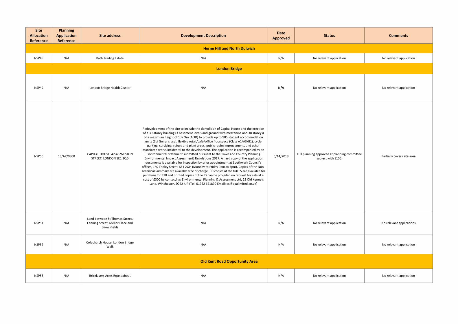
Site Allocation Reference
Planning Application Reference
Site address Development Description Date
Approved Status Comments
Herne Hill and North Dulwich
NSP48 N/A Bath Trading Estate N/A N/A No relevant application No relevant application
London Bridge
NSP49 N/A London Bridge Health Cluster N/A N/A No relevant application No relevant application
NSP50 18/AP/0900 CAPITAL HOUSE, 42-46 WESTON
STREET, LONDON SE1 3QD
Redevelopment of the site to include the demolition of Capital House and the erection of a 39-storey building (3 basement levels and ground with mezzanine and 38 storeys) of a maximum height of 137.9m (AOD) to provide up to 905 student accommodation units (Sui Generis use), flexible retail/café/office floorspace (Class A1/A3/B1), cycle
parking, servicing, refuse and plant areas, public realm improvements and other associated works incidental to the development. The application is accompanied by an
Environmental Statement submitted pursuant to the Town and Country Planning (Environmental Impact Assessment) Regulations 2017. A hard copy of the application
documents is available for inspection by prior appointment at Southwark Council's offices, 160 Tooley Street, SE1 2QH (Monday to Friday 9am to 5pm). Copies of the Non-Technical Summary are available free of charge, CD copies of the full ES are available for
purchase for £10 and printed copies of the ES can be provided on request for sale at a cost of £300 by contacting: Environmental Planning & Assessment Ltd, 22 Old Kennels
Lane, Winchester, SO22 4JP (Tel: 01962 621890 Email: [email protected])
5/14/2019 Full planning approved at planning committee
subject with S106. Partially covers site area
NSP51 N/A Land between St Thomas Street, Fenning Street, Melior Place and
Snowsfields N/A N/A No relevant application No relevant applications
NSP52 N/A Colechurch House, London Bridge
Walk N/A N/A No relevant application No relevant application
Old Kent Road Opportunity Area
NSP53 N/A Bricklayers Arms Roundabout N/A N/A No relevant application No relevant application
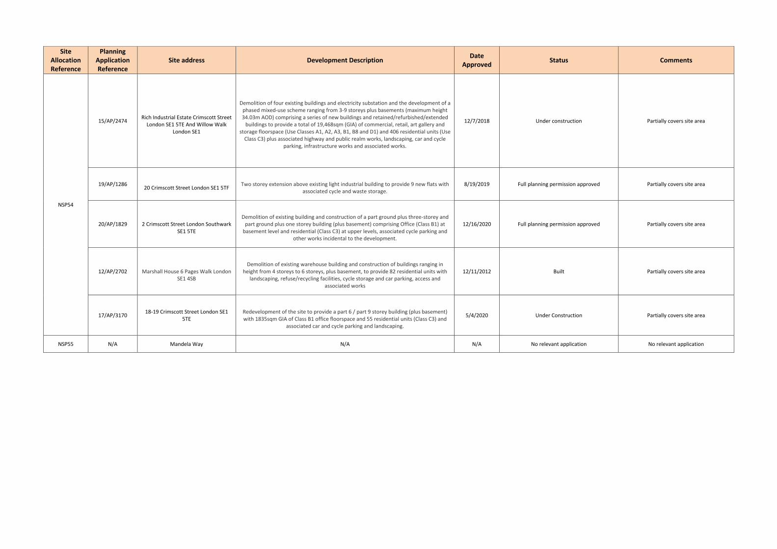
Site Allocation Reference
Planning Application Reference
Site address Development Description Date
Approved Status Comments
NSP54
15/AP/2474
Rich Industrial Estate Crimscott Street
London SE1 5TE And Willow Walk London SE1
Demolition of four existing buildings and electricity substation and the development of a
phased mixed-use scheme ranging from 3-9 storeys plus basements (maximum height 34.03m AOD) comprising a series of new buildings and retained/refurbished/extended
buildings to provide a total of 19,468sqm (GIA) of commercial, retail, art gallery and storage floorspace (Use Classes A1, A2, A3, B1, B8 and D1) and 406 residential units (Use
Class C3) plus associated highway and public realm works, landscaping, car and cycle parking, infrastructure works and associated works.
12/7/2018 Under construction Partially covers site area
19/AP/1286
20 Crimscott Street London SE1 5TF
Two storey extension above existing light industrial building to provide 9 new flats with
associated cycle and waste storage. 8/19/2019 Full planning permission approved Partially covers site area
20/AP/1829
2 Crimscott Street London Southwark SE1 5TE
Demolition of existing building and construction of a part ground plus three-storey and
part ground plus one storey building (plus basement) comprising Office (Class B1) at basement level and residential (Class C3) at upper levels, associated cycle parking and
other works incidental to the development.
12/16/2020 Full planning permission approved Partially covers site area
12/AP/2702
Marshall House 6 Pages Walk London SE1 4SB
Demolition of existing warehouse building and construction of buildings ranging in
height from 4 storeys to 6 storeys, plus basement, to provide 82 residential units with landscaping, refuse/recycling facilities, cycle storage and car parking, access and
associated works
12/11/2012 Built Partially covers site area
17/AP/3170 18-19 Crimscott Street London SE1
5TE
Redevelopment of the site to provide a part 6 / part 9 storey building (plus basement) with 1835sqm GIA of Class B1 office floorspace and 55 residential units (Class C3) and
associated car and cycle parking and landscaping.
5/4/2020 Under Construction Partially covers site area
NSP55 N/A Mandela Way N/A N/A No relevant application No relevant application

Site Allocation Reference
Planning Application Reference
Site address Development Description Date
Approved Status Comments
NSP56 18/AP/3551 Southernwood Retail Park 2
Humphrey Street London SE1 5JJ
Hybrid planning application for detailed permission for Phase 1 and outline planning
permission for Phase 2 comprising: Application for full planning permission for 'Phase 1' comprising demolition of existing
buildings and the erection of a part 9, part 14, part 15, part 48 storey development (plus basement) up to 161.25m AOD, with 940 sqm GIA of (Class A1) retail use, 541 sqm GIA
of flexible (Class A1/A2/A3) retail/financial and professional services/restaurant and café use, 8671 sqm GIA (Class C1) hotel; 541 (class C3) residential units (51,757 sqm
GIA); landscaping, public realm and highway works, car and cycle parking and servicing area, plant and associated works.
Application for outline planning permission (with details of internal layouts and external appearance reserved) for 'Phase 2' comprising demolition of existing buildings and the erection of a part 9, part 12, storey development (plus basement) up to 42.80m AOD,
with 1049 sqm GIA of flexible (Class A1/A2/A3) retail/financial and professional services/restaurant and café use; 183 (Class C3) residential units (17,847sqm GIA), 1141
sqm GIA (Class D2) cinema and the creation of a 475 sqm GIA (Class C1) hotel service area at basement level; landscaping, public realm and highway works, car and cycle
parking and servicing area, plant and associated works.
Awaiting determination
Permission approved subject to s106 Partially cover site area
NSP57 19/AP/1506 Salisbury estate car park
Redevelopment of the existing car park to provide 26 residential units in a 5 storey block with maximum height of 21.8m AOD (5 x 3 bed 5 person flats, 9 x 2 bed four person flats
& 9 x 1 bed 2 person flats, 2 x 2 bed wheelchair units and 1 x 1 bedroom wheelchair unit) together with new private amenity space located within a rear courtyard as well as improving the landscaping of the existing pedestrian link between Chatham Street and
the open green space to the south of the site for public use. Two disabled parking spaces to be provided to the north of the site accessed off Chatham Street
11/12/2019 Full planning permission approved Covers full area of site
NSP58 N/A 96-120 Old Kent Road (Lidl store) N/A N/A No relevant allocation No relevant applications
NSP59 18/AP/0928 Former petrol filling station, 233-247
Old Kent Road
Demolition of existing buildings and structures and erection of a new part 3, 4 and 5 storey building to provide three retail units (flexible A1/A2 use) at part ground floor and 24 residential units (C3 use) at part ground floor and on the upper floors, including the
provision of secure cycle parking facilities, bin stores and communal amenity space (revised application). (11 x 2 bed private units & 6 x 1 bed, 2 x 7 bed affordable units)
04/02/2019 Under construction Covers full area of site
NSP60 16/AP/4589 Kinglake Street Garages
Construction of a part 4, 6 and 7 storey mixed use development providing 105sqm commercial use (Class A1 and A2 Use), 68sqm community use (Class D Use) and 6 x 1
bed flats (including one wheelchair accessible flat), 9 x 2 bed flats (including one wheelchair accessible flat), 2 x 3 bed flats and 4 x part 2 / part 3 storey 3 bed mews houses together with associated landscaping works to Ivy Church Lane including the
provision of two dedicated wheelchair accessible parking bays
19/7/2019 Under construction Covers full area of site

Site Allocation Reference
Planning Application Reference
Site address Development Description Date
Approved Status Comments
NSP61 N/A 4/12 Albany Road N/A N/A No relevant application No Relevant application
NSP62 N/A Former Southern Railway Stables N/A N/A No relevant application No Relevant application
NSP63
17/AP/2952 57 Glengall Road London SE15 6NF
Refurbishment of existing building, redevelopment of outbuildings and addition of two storeys to provide 5 no. B1 commercial units and 9 no. residential flats
21/10/2019 Full Planning Permission approved. Partially cover site area
18/AP/0564 16 Peckham Park Road And 1 Livesey
Place London SE15 6TW
Demolition of existing buildings and construction of a part three, part four storey
building with retail and warehouse (A1) use on the ground floor and 5 residential units (3 x 2-bedroom and 2 studio flats) on upper floors.
3/8/2018 Full Planning Permission approved. Partially cover site area
17/AP/2773
Malt Street Regeneration Site Land Bounded By Bianca Road Latona Road Haymerle Road Frensham Street And
Malt Street London SE1
Hybrid application comprising a full planning application for Phase 1 (the 'Detailed Component') and outline planning permission (the 'Outline Component') for Phases 2 & 3: Detailed Component (Phase 1): Full planning permission for the demolition of existing
buildings and structures and redevelopment of the central area for the erection of a total of 4 buildings, two at 7 storeys (Buildings B9& part B12), one at 15 storeys
(Building B10), and one at 44 storeys (Building B4) (max height 147.12m AOD) to provide 420 homes, 1,197 sqm GEA of Class B1(c) floorspace and 785 sqm GEA of non-
residential floor space within classes A1-A4 (retail), Class B1 (business) and Class D1 (public services) and D2 (entertainment and leisure) use, an energy centre (750 sqm) and new public open space and public realm with on street and basement car parking
spaces and cycle spaces. Outline Component (Phase 2 & 3): Outline planning permission (scale, layout, landscaping, access and appearance reserved) for the demolition of
existing buildings and structures and the erection of eight buildings (B1, B2, B3, B5, B6, B7, B11 and part B12) ranging in height from 5 to 35 storeys (max height 132.9m AOD) to provide up to 88,052sqm floorspace GEA, comprising up to 880 residential units, up to 3,316 sqm GEA of Class B1(c) floorspace and up to 1,702sqm GEA of non-residential floor space within Classes A1-A4 (retail), Class B1 (business), Class D1 (public services)
and D2 (entertainment and leisure) use and car parking spaces at ground level and cycle spaces, with associated new open space, public realm, car parking and associated works.
Totals: Up to 1,300 homes and up to 7,000sqm commercial floorspace
30/10/2020 Approved- Clearance Underway Partially cover site area
17/AP/4612 49-53 Glengall Road London SE15 6NF
Demolition of all existing buildings and structures (excluding some of the facades along Glengall Road and Bianca Road and the industrial chimney) and erection of a part 6, 8
and 15 storey mixed-use development comprising 3,716 sqm (GIA) of flexible workspace (Use Class B1(c) and B2/B8) and 181 residential units (Use Class C3) with amenity spaces
and associated infrastructure.
21/07/2020 Full Planning Permission approved. Partially cover site area
17/AP/4596 Nyes Wharf Frensham Street London
SE15 6TH
Demolition of existing buildings and erection of mixed-use scheme comprising 1,193sqm Class B1 floorspace at ground and mezzanine levels; with 153 Residential units (Class C3)
above in a building ranging from 9 to 18 storeys (max height 56.202m) with hard and soft landscaping including a new park and associated infrastructure works, including
three disabled spaces and cycle parking.
30/10/2020 Approved subject to S106 Partially cover site area

Site Allocation Reference
Planning Application Reference
Site address Development Description Date
Approved Status Comments
18/AP/4003
3-5 Latona Road London SE15 6RX
Proposed development to add three new storeys of residential accommodation to the existing building at 3-5 Latona Road. The existing Ground, First and Second floor will
retain its commercial use. The proposed residential accommodation comprises ten flats in total; 2x1-Beds, 6x2-Beds and 2x3-Beds.
15/12/2020 Approved subject to S106 Partially cover site area
18/AP/3284 596-608 Old Kent Road And Land At
Livesey Place London SE15 1JB
Mixed-use redevelopment comprising the demolition of all existing buildings and structures (listed mural to be removed and stored prior to demolition, and incorporated into proposed development); construction of three buildings arranged around a central plinth ranging in height from 10 to 38 storeys (maximum height +144.2m AOD) above
single basement, ground and mezzanines floors, to provide a range of uses including 372 residential units (Use Class C3), place of worship (Use Class D1), retail (Use Classes A1-
A4), and office / light industrial (Use Classes B1(a)/B1(c)); means of access, public realm and landscaping works, parking and cycle storage provision, energy centre / plant and servicing areas, and associated ancillary works. This application represents a departure
from strategic policy 10 'Jobs and Businesses' of the Core Strategy (2011) and Saved Policy 1.2 'Strategic and Local Preferred Industrial Locations' of the Southwark Plan
(2007) by virtue of proposing to introduce residential accommodation in a preferred industrial location. An associated Listed Building Consent Application has been
submitted under reference 18/AP/3285 THE APPLICATION IS ACCOMPANIED BY AN ENVIRONMENTAL STATEMENT (ES) submitted pursuant to the Town and Country
Planning (Environmental Impact Assessment) regulations 2017. The ES can be viewed on the Council's website. A paper copy of the ES may be obtained for a charge of £500.00 from: CBRE Ltd. Environmental Planning & Assessment St Martins Court 10 Paternoster Row London EC4M 7HP Alternatively, an electronic copy can be obtained for £10.00 by
contacting CBRE at the above address. Charges for paper and electronic copies of the ES are made in accordance with Regulation 24 of the EIA Regulations 2017.
5/11/2019 Approved subject to S108 Partially cover site area
18/AP/3246 Land At Cantium Retail Park 520 Old
Kent Road London SE1 5BA
Demolition of existing buildings and redevelopment of the site to provide a new basement level and buildings ranging from 3 to 48 storeys in height (max height
159.05m above ground level) comprising up to 1,113 residential units (Class C3), up to 5,659 sq. m of office floorspace (Class B1(a)), up to 2,228 sq. m of retail floorspace (Class A1), up to 2,336 sq. m of flexible space including use within Classes A1, A3, D1, D2 and /
or Sui Generis (Theatre) within Block B and up to 596 sq. m of flexible space within Classes A1, A2 and / or A3 within Block C together with associated access, car parking,
landscaping and infrastructure works.
12/2/2021 Full Planning Permission approved Partially cover site area

Site Allocation Reference
Planning Application Reference
Site address Development Description Date
Approved Status Comments
20/AP/0039 Bianca Warehouse 43 Glengall Road
London Southwark
Demolition of the existing building (43 Glengall Road) and erection of a single
replacement building of up to 15 storeys (plus lower ground) together with new areas of public realm, replacement of commercial floorspace in the form of a Creative
Commercial Centre including University related uses (comprised of light industrial Use Class E and part flexible Use Class E/F1) and ancillary café (Use Class E) on the lower and upper ground floors and Halls of Residence consisting of 676 student rooms (sui generis
Use Class).
22/12/2020 Full Planning Permission approved. Partially cover site area
19/AP/7610 14-22 Ossory Road London Southwark
SE1 5AN
Demolition of the existing building and redevelopment of the site to deliver a building of part 10 part 11 storeys (43.2m AOD) comprising 1,438 sqm of light industrial floorspace across the basement, ground, and first floors; 71 residential units (35.38% by habitable
rooms) across the upper floors; and associated outdoor communal amenity space, disabled car parking, cycle storage, refuse storage, and landscaping. This application
represents a departure from strategic policy 10 'Jobs and Businesses' of the Core Strategy (2011) and Saved Policy 1.2 'Strategic and Local Preferred Industrial Locations'
of the Southwark Plan (2007) by virtue of proposing to introduce residential accommodation in a preferred industrial location.
1/12/2020 Approved subject to s106 Partially cover site area
NSP64
19/AP/6395
Chevron Apartments 294-304 St
James's Road London SE1 5JX Southwark
Extension of the existing building to provide 15no. new residential (C3) apartments
together with other associated and enabling works 17/11/2020 Full Planning Permission approved. Partially cover site area
18/AP/0156
272 St Jamess Road London Southwark
Demolition of existing building and erection of a student accommodation building of up
to nine storeys (maximum height 30.815m AOD, 29.525m from ground), to comprise 250 student rooms and associated communal facilities, 73 sqm cafe/retail space (A1/A3
use class), hard and soft landscaping, 2 disabled parking spaces and cycle parking.
20/09/2019 Under construction Partially cover site area
NSP65 18/AP/0897 Ruby Triangle Site Land Bounded By
Old Kent Road Ruby Street And Sandgate Street London SE15 1LG
Full planning permission is sought for demolition of existing buildings and structures on the site, and redevelopment consisting of three buildings at maximum heights of 17 storeys (including mezzanine) (+64.735m AOD), 48 Storeys (+170.830m AOD) and 40
storeys (including mezzanine) (+144.750m AOD), plus single storey basement under part of the site. Development would provide 1,152 residential dwellings (Class C3), retail, business and community spaces (Classes A1, A2, A3, A4, B1(a),(b),(c) and D1), public
sports hall and gym (Class D2), public and private open space, formation of new accesses and alterations to existing accesses, energy centre, associated car and cycle
parking and other associated works.
6/6/2019 Full Planning Permission approved. Partially cover site area
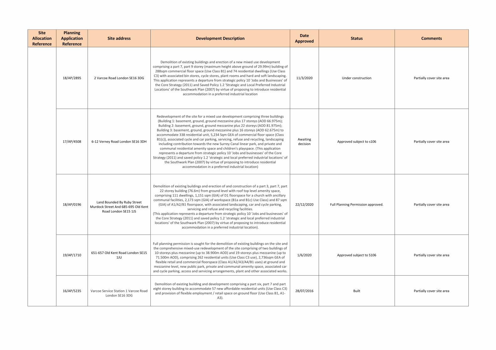
Site Allocation Reference
Planning Application Reference
Site address Development Description Date
Approved Status Comments
18/AP/2895 2 Varcoe Road London SE16 3DG
Demolition of existing buildings and erection of a new mixed use development comprising a part 7, part 9 storey (maximum height above ground of 29.99m) building of
288sqm commercial floor space (Use Class B1) and 74 residential dwellings (Use Class C3) with associated bin stores, cycle stores, plant rooms and hard and soft landscaping. This application represents a departure from strategic policy 10 'Jobs and Businesses' of
the Core Strategy (2011) and Saved Policy 1.2 'Strategic and Local Preferred Industrial Locations' of the Southwark Plan (2007) by virtue of proposing to introduce residential
accommodation in a preferred industrial location
11/3/2020 Under construction Partially cover site area
17/AP/4508 6-12 Verney Road London SE16 3DH
Redevelopment of the site for a mixed use development comprising three buildings (Building 1: basement, ground, ground mezzanine plus 17 storeys (AOD 66.975m); Building 2: basement, ground, ground mezzanine plus 22 storeys (AOD 81.975m);
Building 3: basement, ground, ground mezzanine plus 16 storeys (AOD 62.675m) to accommodate 338 residential unit, 5,234 Sqm GEA of commercial floor space (Class B1(c)), associated cycle and car parking, servicing, refuse and recycling, landscaping
including contribution towards the new Surrey Canal linear park, and private and communal residential amenity space and children's playspace. (This application
represents a departure from strategic policy 10 'Jobs and businesses' of the Core Strategy (2011) and saved policy 1.2 'strategic and local preferred industrial locations' of
the Southwark Plan (2007) by virtue of proposing to introduce residential accommodation in a preferred industrial location)
Awaiting decision
Approved subject to s106 Partially cover site area
18/AP/0196
Land Bounded By Ruby Street
Murdock Street And 685-695 Old Kent Road London SE15 1JS
Demolition of existing buildings and erection of and construction of a part 3, part 7, part
22 storey building (76.6m) from ground level with roof top level amenity space, comprising 111 dwellings, 1,151 sqm (GIA) of D1 floorspace for a church with ancillary
communal facilities, 2,173 sqm (GIA) of workspace (B1a and B1c) Use Class) and 87 sqm (GIA) of A1/A2/B1 floorspace, with associated landscaping, car and cycle parking,
servicing and refuse and recycling facilities. (This application represents a departure from strategic policy 10 'Jobs and businesses' of
the Core Strategy (2011) and saved policy 1.2 'strategic and local preferred industrial locations' of the Southwark Plan (2007) by virtue of proposing to introduce residential
accommodation in a preferred industrial location).
22/12/2020 Full Planning Permission approved. Partially cover site area
19/AP/1710 651-657 Old Kent Road London SE15
1JU
Full planning permission is sought for the demolition of existing buildings on the site and the comprehensive mixed-use redevelopment of the site comprising of two buildings of 10-storeys plus mezzanine (up to 38.900m AOD) and 19-storeys plus mezzanine (up to 71.500m AOD), comprising 262 residential units (Use Class C3 use), 2,736sqm GEA of flexible retail and commercial floorspace (Class A1/A2/A3/A4/B1 uses) at ground and
mezzanine level, new public park, private and communal amenity space, associated car and cycle parking, access and servicing arrangements, plant and other associated works.
1/6/2020 Approved subject to S106 Partially cover site area
16/AP/5235
Varcoe Service Station 1 Varcoe Road London SE16 3DG
Demolition of existing building and development comprising a part six, part 7 and part eight storey building to accommodate 57 new affordable residential units (Use Class C3)
and provision of flexible employment / retail space on ground floor (Use Class B1, A1-A3).
28/07/2016 Built Partially cover site area

Site Allocation Reference
Planning Application Reference
Site address Development Description Date
Approved Status Comments
NSP66
19/AP/2307 Daisy Business Park 19-35 Sylvan
Grove London SE15 1PD
Demolition of existing buildings and redevelopment of the site to provide a mixed use development comprising of 219 residential dwellings ( Use Class C3) and 3,088 sqm
(GIA); commercial workspace (Use Class B1) within two buildings of 5 storeys (24.55m AOD) and 32 storeys (106.43m AOD); and associated car and cycle parking, landscaping,
and public realm and highways improvements.
Awaiting decision
Approved subject to s106 Partially cover site area
19/AP/1239 747-759 & 765-775 Old Kent Road
London SE15 1NZ & Land At Devonshire Grove SE15
Hybrid application consisting of:
Full planning permission for the demolition of all existing structures on site, the stopping up of the existing Devonshire Grove major arm (IWMF egress road) and redevelopment to include formation of a new road reconfiguration and widening of Devonshire Grove, widening of the foot ways on Sylvan Grove and Old Kent Road, construction of Building A at ground plus 38 storeys (137.26m AOD) to provide 264 residential units (Class C3), flexible retail/employment floorspace (Class A1/A2/A3/A4/B1a-c), creation of a new
public realm including new public squares and spaces ,associated landscaping and highways works and a new substation and all associated works.
Awaiting Decision
Approved subject to s106 Partially cover site area
15/AP/1330
8-24 Sylvan Grove London SE15 1PE
Redevelopment of the site to construct a part two, part five, part six and part eight storey building comprising 80 residential units ( 23 x one bed, 41 x two bed and 16 x three bed) for both private and affordable tenures with associated car parking and
landscaping
21/10/2015 Built Partially cover site area
NSP67
16/AP/1092 171-177 Ilderton Road London SE16
3LA
Erection of a new four storey building plus basement to provide 9 new residential homes (Use Class C3 - 2 x 1 bed, 4 x 2-bed, 3 x 3 bed) and two new ground floor
commercial units providing a total of 338sqm commercial (B1) floor space, together with associated landscaping, amenity and playspace, car and cycle parking and plant
space.
8/18/2016 Under construction Partially cover site area
17/AP/3757 60A And 62 Hatcham Road And 134-140 Ilderton Road London SE15 1TW
Demolition of existing buildings and construction of a building ranging in height from four to nine storeys to provide 1,185sqm (GIA) of commercial space (Use Class B1) at
ground floor, 86 residential dwellings (30 x 1 bed, 39 x 2 bed and 17 x 3 bed) above with associated amenity areas, cycle and disabled car parking and refuse/recycling stores.
3/18/2019 Under construction Partially cover site area
17/AP/4546 180 Ilderton Road London SE15 1NT
Demolition of existing building and erection of a part 5, 8 and 9 storey plus basement mixed-use development (max height 29.98m) comprising 2,351 sqm (gia) of flexible
workspace (Use Class B1) and 84 residential apartments (Use Class C3) with associated amenity space and ancillary infrastructure
9/13/2018 Under construction Partially cover site area
18/AP/1049 78-94 Ormside Street London SE15
1TF
Redevelopment of the site, involving the demolition of existing buildings and structures,
to deliver a mixed use building of up to nine storeys (ten storeys including the mezzanine at entrance level) plus rooftop plant. The building will comprise 2058 square
metres of new and replacement commercial floor space (Class B1) together with 56 residential units (Class C3) and will include the creation of a new basement, hard and soft landscaping, reconfigured servicing arrangements and other associated works.
3/29/2019 Full planning permission approved Partially cover site area
17/AP/4649
Iberia House 2 Hatcham Road London SE15 1TW
Demolition of existing light industrial building and construction of a building ranging in
height from 2 to 9 storeys comprising 915.5sqm of B1 commercial and employment space at ground and first floor levels and 33 residential flats over the second to eight
floor levels, with 3 residential parking spaces accessed from Hatcham Road.
5/29/2020 Full planning permission approved Partially cover site area

Site Allocation Reference
Planning Application Reference
Site address Development Description Date
Approved Status Comments
16/AP/2346
26 Aberdour Street London SE1 4SG
Details of condition 9 'implementation of a programme of archaeological evaluation works' pursuant to planning permission 14AP2694 for 'The demolition of the existing
two storey building and the erection of a three storey building comprising 6 two bedroom dwellings with terraces onto Tower Walk, with ancillary cycle storage and
landscaping.'
19/09/2016 Built Partially cover site area
18/AP/2761
301-303 Ilderton Road London SE15 1NW
Demolition of existing buildings and construction of a 12 storey building (plus basement) comprising 46 residential dwellings (Class C3) and commercial floorspace (Class B1(c)), creation of a new vehicular access from Hornshay Street with landscaping (including a
communal roof garden), cycle parking and associated ancillary development.
5/29/2020 Full planning permission approved Partially cover site area
18/AP/2497 79-161 Ilderton Road London SE16
3JZ Redevelopment of 79 - 161 Ilderton Road to provide two separate buildings, a north building and a south building separated by a publicly accessible childrens playspace.
Awaiting S106 Approved subject to s106 Partially cover site area
19/AP/1773 227-255 Ilderton Road London SE15
1NS
Demolition of existing buildings and the erection of a part 2/3, 9 and 28 storey (up to 94.65m AOD) mixed-use development comprising of 3,581 sqm including 2,538 sqm of
industrial floorspace (Use Classes B1c/B8) at ground and intermediate levels, 598 sqm of internal loading yard, 445 sqm ancillary plant and equipment; and 253 residential
apartments (C3), 35.75% affordable by habitable room, and other associated infrastructure. This application represents a departure from strategic policy 10 'Jobs and
Businesses' of the Core Strategy (2011) and Saved Policy 1.2 'Strategic and Local Preferred Industrial Locations' of the Southwark Plan (2007) by virtue of proposing to
introduce residential accommodation in a preferred industrial location. |
1/29/2021 Full planning permission approved Partially cover site area
20/AP/1329
313-349 Ilderton Road London Southwark
Demolition of existing buildings and construction of two buildings, one of part 11 and 13 storeys and one of part 13 and 15 storeys, to provide 1,739sq.m (GIA) of commercial floorspace, 250 student accommodation bed spaces (Sui Generis) and 58 residential
units, with associated access and highway works, amenity space, cycle parking spaces, disabled car parking spaces and refuse/ recycling stores.
Awaiting decision
Approved subject to s106 Partially cover site area
NSP68 19/AP/1322 840 Old Kent Road London SE15 1NQ
Demolition of existing building and redevelopment of the site to provide a new building of up to 13 and 21 storeys in height (maximum height 73.60m above ground level).
Redevelopment to comprise 170 residential units (Class C3), a 1,778 sqm (GIA) retail unit (Class A1) and a 52 sqm (GIA) flexible retail unit (Class A1/A3), with associated
landscaping, car parking, servicing, refuse and plant areas, and all ancillary or associated works.
21/11/2020 Full planning permission approved Partially covers site area
NSP69 N/A 684-698 Old Kent Road (Kwikfit
garage) N/A N/A N/A No relevant applications

Site Allocation Reference
Planning Application Reference
Site address Development Description Date
Approved Status Comments
NSP70 17/AP/1646 636 Old Kent Road
Demolition of the existing buildings to facilitate the redevelopment of the site to create 42x residential units and 272 sq m (GIA) of flexible commercial floorspace (Class
A1/A2/A3/B1) in a new building of between three and six storeys in height, together with disabled car parking, cycle parking, landscaping, plant, and associated works.
30/11/2017 Under construction Covers full area of site
Peckham and Nunhead Action Area (NSP site allocation and Peckham and Nunhead AAP sites)
NSP 71 N/A Aylesham Centre and Peckham Bus
Station N/A N/A No relevant applications No relevant applications
NSP 72 N/A Blackpool Road Business Park N/A N/A No relevant applications No relevant applications
NSP73 N/A
Land between the railway arches (East of Rye Lane including railway
arches))
N/A N/A No relevant applications No relevant applications
NSP 74 N/A Copeland Industrial Park and 1-27
Bournemouth Road N/A N/A No relevant applications No relevant applications
Rotherhithe Canada Water Opportunity Area (Includes NSP site allocations and Canada Water AAP site allocations)
NSP75 N/A Rotherhithe Gasometer N/A N/A No relevant applications No relevant applications
NSP76 N/A St Olav’s Business Park, Lower Road N/A N/A No relevant applications No relevant applications

Site Allocation Reference
Planning Application Reference
Site address Development Description Date
Approved Status Comments
NSP77
12/AP/4126 Decathlon Site
Outline planning permission for the demolition of existing buildings on the site (the 'Decathlon' and 'What' Retail Stores) and the erection of 5 buildings (C1-C4 and E1)
ranging from 5 to 40 storeys (150.86m AOD) comprising a maximum overall floorspace of up to 138,146.8sq.m GEA. New buildings to comprise: up to 97,851sq.m of residential
accommodation (Class C3) (equating to a maximum of 1,030 residential units), up to 12,300.9sq.m Class A1 retail store (including 10,178sq.m (net) sales area, 745sq.m
ancillary office accommodation and 308sq.m ancillary cafe); up to 4,352.3sq.m of other retail (Class A1/A2/A3/A4 floorspace); up to 2,800sq.m of office space floorspace (Class
B1), up to 658sq.m of health centre floorspace (Class D1) and up to 698.2sq.m of cinema floorspace (Class D2); 19,486.5sq.m ancillary parking (equating to up to a maximum of
466 parking spaces), plant and storage accommodation, including the provision of basements to provide vehicle and cycle parking, circulation, servicing and plant areas; new vehicle and pedestrian accesses and new public amenity space and landscaping
including new public square. Within the outline described above: Full details are submitted for the access, appearance, landscaping, layout and scale of Building C1 and
associated works; Full details are submitted for the layout, appearance and scale of Buildings C2, C3 and C4 and means of vehicular access, with layout of the linked
basement, internal layouts of the individual buildings and landscaping reserved; All matters are reserved in respect of Building E1 (min 17.8m height, max 37.8m height,
comprising up to 29,907.9sqm floorspace).
12/20/2013 Under Construction Partially covers site area
13/AP/1429 Mulberry Business Park
Redevelopment of the former Mulberry Business park to provide buildings of between 4 and 9 storeys (maximum height 42.85m AOD), comprising 770 student bedrooms with
related living/kitchen and communal spaces (sui generis); 33 affordable residential units (Class C3); 610sqm retail uses (Classes A1, A2,A3); 322sqm health centre (Class D1);
75sqm area of retail (Classes A1, A2, A3) or alternate non-residential institutional use (Class D1); 4,490sqm offices (Class B1); associated car parking, cycle parking and
landscaped public realm; new vehicular and pedestrian access/egress and associated works
10/22/2013 Under construction Partially covers site area

Site Allocation Reference
Planning Application Reference
Site address Development Description Date
Approved Status Comments
NSP78 18/AP/1604
Canada Water Masterplan: Harmsworth Quays, Surrey Quays
Leisure Park, Surrey Quays Shopping Centre and Robert’s Close
Hybrid application seeking detailed planning permission for Phase 1 and outline planning permission for future phases, comprising: Outline planning permission (all
matters reserved) for demolition of all existing structures and redevelopment to include a number of tall buildings comprising the following mix of uses: retail (Use Classes A1-
A5), workspace (B1), hotel (C1), residential (C3), assisted living (C2), student accommodation, leisure (including a cinema)(D2), community facilities (including health
and education uses)(D1), public toilets, nightclub, flexible events space, an energy centre, an interim and permanent petrol filling station, a primary electricity substation,
a secondary entrance for Surrey Quays Rail Station, a Park Pavilion, landscaping including open spaces and public realm, works to Canada Water Dock, car parking,
means of access, associated infrastructure and highways works, demolition or retention with alterations to the Press Hall and/or Spine Building of the Printworks; and Detailed planning permission for the following Development Plots in Phase 1: Plot A1 (south of
Surrey Quays Road and west of Deal Porters Way) to provide uses comprising retail (A1-A5), workspace (B1) and 186 residential units (C3) in a 6 and 34 storey building, plus basement; Plot A2 (east of Lower Road and west of Canada Water Dock) to provide a leisure centre (D2), retail (A1-A5), and workspace (B1) in a 4, 5 and 6 storey building,
plus basement; Plot K1 (east of Roberts Close) to provide 79 residential units (C3) in a 5 and 6 storey building; Interim Petrol Filling Station (north of Redriff Road and east of Lower Road) to provide a petrol filling station with kiosk, canopy and forecourt area.
Each Development Plot with associated car parking, cycle parking, landscaping, public realm, plant and other relevant works. The application is accompanied by an
Environmental Statement pursuant to the Town and Country Planning (EIA) Regulations 2011 (amended)
29/05/2020 Approved subject to S106 Covers full area of site
NSP 79 N/A Croft Street Depot N/A N/A No relevant applications No relevant applications
Walworth
NSP80 N/A Morrisons, Walworth Road N/A N/A No relevant applications No relevant applications
NSP81 N/A 330-344 Walworth Road N/A N/A No relevant applications No relevant applications

Site Allocation Reference
Planning Application Reference
Site address Development Description Date
Approved Status Comments
NSP82 13/AP/1122 Chatelain House, 182-202 Walworth
Road, London, SE17 1JJ
Demolition of the existing building and erection of a building ranging in height from 4 storeys to 6 storeys (plus basement) comprising 4,945 sqm (GEA) of use Class A1 (shops), A3 (restaurants and cafes), D2 (Assembly and Leisure) and B1 (Business) floorspace and 54 residential units with associated landscaping, play space, cycle
parking and 6 accessible car parking spaces
12/23/2015 Under construction. Covers full area of site
Aylesbury Area Action Plan Area
AAAP P1 (Phase 1)
14/AP/3843
Aylesbury Estate, Land bounded by Albany Road, Portland Street,
Westmoreland Road and Bradenham Close, London SE17
Demolition of existing buildings and redevelopment to provide a mixed use development comprising a number of buildings ranging between 2 to 20 storeys in height (9.45m - 72.2m AOD), providing 830 residential dwellings (Class C3); flexible
community use, early years facility (Class D1) or gym (Class D2); public and private open space; formation of new accesses and alterations to existing accesses; energy centre;
gas pressure reduction station; associated car and cycle parking and associated works.
4/23/2015 Under construction Partially covers site area
AAAP P2, P3, P4 (Phases 2, 3
and 4) 14/AP/3844
Aylesbury Estate, Land bounded by Albany Road, Portland Street, Bagshot
Street, Alvey Street, East Street and Dawes Street, London SE17
Outline application for: demolition of existing buildings and phased redevelopment to
provide a mixed use development comprising a number of buildings ranging between 2 to 20 storeys in height (12.45m - 68.85m AOD) with capacity for up to 2,745 residential units (Class C3),up to 2,500sqm of employment use (Class B1); up to 500sqm of retail
space (Class A1); 3,100 to 4,750sqm of community use; medical centre and early years facility (Class D1); in addition to up to 3,000sqm flexible retail use (Class A1/A3/A4) or
workspace use (Class B1); new landscaping; parks, public realm; energy centre; gas pressure reduction station; up to 1,098 car parking spaces; cycle parking; landscaping
and associated works.
4/23/2015 Approved Partially covers site area
AAAP P2 (Phase 2)
16/AP/2800
Plot 18 (Phase 2a in original application) – Ayelsbury Estate, Land bounded by Albany Road, Portland Street, Bagshot Street, Alvey Street,
East Street and Dawes Street, London SE17
Approval of Reserved Matters pursuant to Condition 1 (access; layout; scale; appearance; and landscaping) to provide a mixed-use development at 'Plot 18' (Phase 2A) comprising 122 residential units (C3), retail (A1/A3/A4) and a community facility
(library D1) in a part 15, part 7 and part4/6 storey building (known as the North Block); a health centre (D1) and early years facility (D1) in a 4 storey (plus basement) building (known as the South Block); public realm; landscaping; cycle parking and car parking.
12/6/2016 Under Construction Partially covers site area