Sandwell Metropolitan Borough Council
242
[IL0: UNCLASSIFIED] Sandwell Metropolitan Borough Council Highway Asset Management Plan 2014 - 2015 (Approved 12 November 2014)
-
Upload
khangminh22 -
Category
Documents
-
view
2 -
download
0
Transcript of Sandwell Metropolitan Borough Council

[IL0: UNCLASSIFIED]
Sandwell Metropolitan Borough Council
Highway Asset Management Plan 2014 - 2015 (Approved 12 November 2014)

[IL0: UNCLASSIFIED] 1
Cont en ts Chapter No. Page Number
Forward 2
Executive Summary 3
Glossary of Terms 5
Abbreviations 6
1. Introduction 8
2. Framework 10
3. Inventory and Condition Information 12
4. Goals, Objectives and Policies 14
5. Levels of Service 19
6. Asset Groups - Levels of Service 22
Highway Safety Inspections 22 Street Lighting 28 Traffic Signals, Controlled Crossings & UTC 38 Winter Service 41 Bridges and Other Highway Structures 42 Highway Trees 57 Highway Drainage 59
7. Service Options 61
8. Lifecycle Planning 64
9. Financial 68
10. Asset Valuation 71
11. Risk Management 73
12. Forward Works Programme 75
13. Performance Monitoring 82
14. Next Steps 88
Appendices 90

[IL0: UNCLASSIFIED] 2
F O R W A R D If you live, work or pass through Sandwell whether on foot, cycling, using public or personal transport you will use the largest and most visible asset Sandwell Council is responsible for – the highway network. A well maintained and managed network that is safe, serviceable and sustainable is one of the best ways to foster job creation, encourage economic growth and support local communities. It makes an important contribution to social inclusion, community safety, and education and health. The appearance of our streets helps to shape the character and quality of the local environment in which people live. Asset management brings a strategic approach to the management of the highway network to help meet the needs of current and future customer demands. We believe it can bring about significant value for money savings and service benefits to our highway users whether they are residents, businesses or visitors. Asset management is a process of continual development, refinement and improvement and this plan, originally developed around a common framework agreed with other West Midlands councils, aims to ensure Sandwell’s highway infrastructure is well maintained and managed in an efficient, affordable and customer focused way. With a focus on doing more with scarce resources, the Department for Transport has sponsored the Highways Maintenance Efficiency Programme (HMEP), a sector led transformation initiative, which is driving the introduction of business like asset management thinking into highway maintenance. To help authorities HMEP has published new asset management guidance (May 2013). This asset management framework will be further developed building on our current work using the HMEP guidance and recommendations in the coming years.

[IL0: UNCLASSIFIED] 3
E X E C U T I V E S U M M A R Y The highway infrastructure is probably the most visible and valuable asset for which Sandwell Council is responsible. It is used on a daily basis by residents, businesses and visitors alike making important contributions to economic growth, social inclusion, community safety, and education and health. The purpose of modern asset management is to make how we manage the highway infrastructure more evidence led to support better decision making and to deliver customer focused highway services in a way that provides improved value for money. The principles of asset management are based around reliable knowledge of the asset base, it involves having a comprehensive asset inventory, knowing the condition of the asset, knowing how best to manage and maintain it and how long it will last. This Highway Asset Management Plan (HAMP) is the developing framework that sets out how we invest in, manage and operate the highway infrastructure to meet legal obligations, high public expectations for safe, reliable and convenient travel and the wider objectives of transport strategy set out in the West Midlands Local Transport Plan 3 with links to the Sandwell council’s vision as a great place with great people and great prospects for the future. This 2014 - 2015 HAMP is a minor revision of its predecessor to include updated asset valuation, forward works programmes, and minor revisions following service reviews together with on-going work to develop the strategic planning approach in line with the HMEP Highway Infrastructure Asset Management Guidance published in May 2013. As part of the strategic planning approach this HAMP includes, for the first time, a ‘Status & Options Report for Carriageways’. The purpose of the report is to inform decision makers about the asset owned, its current condition and to provide a basis for making strategic planning decisions at a borough wide network level about future investment in, and performance of, the carriageway asset. Since 2010 the council is required by HM Treasury to report highway asset valuation based on a set of financial management information that is consistent between authorities and can be used for asset management, financial management and financial reporting. With effect from 2016/17 transport asset valuation and depreciation information in accordance with Highways Asset Management Plans and CIPFA's requirements will be included in the authority’s accounts. Asset valuation seeks to identify the total cost of ownership and is driving a move away from highway maintenance investment based upon short-term criterion (historic spending approach) to one that identifies the most economically advantageous maintenance intervention over the whole asset lifecycle (whole life costing approach). Ultimately, through a greater understanding of the asset base and its value stakeholders, elected members and officers will be better informed to make long term strategic investment decisions to manage risk and meet desired performance requirements in the most efficient, affordable and sustainable manner taking in to account the optimal allocation of resources, the council’s wider strategic goals and statutory obligations as highway authority.
[IL0: UNCLASSIFIED] 4
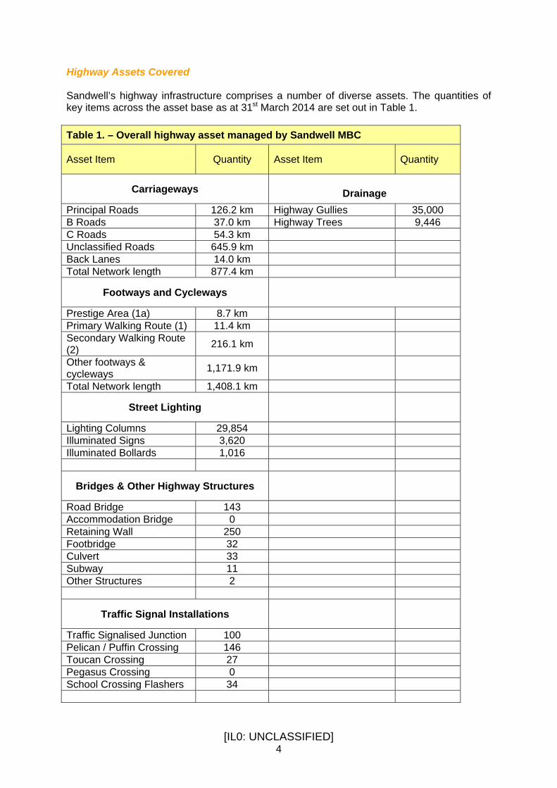
Highway Assets Covered Sandwell’s highway infrastructure comprises a number of diverse assets. The quantities of key items across the asset base as at 31st March 2014 are set out in Table 1. Table 1. – Overall highway asset managed by Sandwell MBC
Asset Item Quantity Asset Item Quantity
Carriageways
Drainage
Principal Roads 126.2 km Highway Gullies 35,000 B Roads 37.0 km Highway Trees 9,446 C Roads 54.3 km Unclassified Roads 645.9 km Back Lanes 14.0 km Total Network length 877.4 km
Footways and Cycleways
Prestige Area (1a) 8.7 km Primary Walking Route (1) 11.4 km Secondary Walking Route (2) 216.1 km
Other footways & cycleways 1,171.9 km
Total Network length 1,408.1 km
Street Lighting
Lighting Columns 29,854 Illuminated Signs 3,620 Illuminated Bollards 1,016
Bridges & Other Highway Structures
Road Bridge 143 Accommodation Bridge 0 Retaining Wall 250 Footbridge 32 Culvert 33 Subway 11 Other Structures 2
Traffic Signal Installations
Traffic Signalised Junction 100 Pelican / Puffin Crossing 146 Toucan Crossing 27 Pegasus Crossing 0 School Crossing Flashers 34

[IL0: UNCLASSIFIED] 5
Glossa ry o f Te rms The following terms are used in this plan:
Asset Management A strategic approach that identified the optimal allocation of resources for the management, operation, preservation and enhancement of the highway infrastructure to meet the needs of current and future customers.
Asset Valuation The calculation of the current monetary value of an Authority’s assets. It excludes therefore any consideration of the value to the community in terms of economic and social benefits of providing a means for people to travel in order to work, socialise and live.
Levels of Service A statement of the performance of the asset in terms that the customer can understand. Levels of service typically cover condition, availability, capacity, amenity, safety, environmental impact and social equity. They cover the condition of the asset and non-condition related demand aspirations ie. a representation of how the asset is performing in terms of both delivering a service to customers and maintaining its physical integrity at an appropriate level.
Risk Management The formal assessment of risks with the potential to affect delivery of the service via a process of identification, assessment, ranking, and control planning.
Gross Replacement Cost
A strategic approach that identifies the optimal allocation of resources for the management, operation, preservation and enhancement of the highway infrastructure to meet the needs of the current and future customer.
Deterioration The change in physical condition of an asset resulting from use or ageing.
Depreciation The consumption of economic benefits embodied in an asset over its service life arising from use, ageing, deterioration, damage and obsolescence.
Depreciated Replacement Cost
The current value of the asset, normally calculated as the Gross Replacement Cost minus accumulated depreciation and impairment.
Service Options Options available for an asset or groups of asset in terms of alternative levels of service.
[IL0: UNCLASSIFIED] 6
Abbr ev ia t i ons The following abbreviations are used in this plan:
AIS Asset Information Strategy
AMP Asset Management Plan
AM Asset Management
AV Asset Valuation
BPM Business Process Maps
BVPI Best Value Performance Indicator
CAMP Corporate Asset Management Plan
CIPFA Chartered Institute of Public Finance & Accountancy
CSS County Surveyors Society
CVI Course Visual Inspection
DCLG Department of Communities and Local Government
DfT Department for Transport
DMEG District Maintenance Engineers Group
DNO District Network Operator
DRC Depreciated Replacement Cost
DVI Detailed Visual Inspection
FMfSW Flood Maps for Surface Water
GAAP Generally Accepted Accounting Principles
GIS Geographical Information Systems
GRC Gross Replacement Cost
HAMFIG Highway Asset Management Financial Information Group
HAMP Highway Asset Management Plan
HIMG Highway Infrastructure Managers Group
HMEP Highways Maintenance Efficiency Programme
IEWM Improvement and Efficiency West Midlands

[IL0: UNCLASSIFIED] 7
IFRS International Financial Reporting System
ITA Integrated Transport Authority
ITS Intelligent Transport Systems
KPI Key Performance Indicators
KPO Key Priority Outcomes
KSI Killed and Seriously Injured
LCP Life Cycle Plan
LGIH Local Government information House
LoS Levels of Service
LLFA Lead Local Flood Authority
LTP3 West Midlands Area Local Transport Plan 3
NI National Indicator
PSMA Public Sector Mapping Agreement
RAB Resource Accounting and Budgeting
TAG Local Authority Technical Advisors Group
TAMP Transport Asset Management Plan
SCANNER Surface Condition Assessment of the National Network of Roads
SDL Single Data List
SMART Specific, Measurable, Achievable, Realistic and Time-Bound
SPA Shared Priority Outcome
SSP Safer Sandwell Partnership
UKPMS United Kingdom Pavement Management System
WGA Whole Government Accounts

[IL0: UNCLASSIFIED] 8
1 . I N T R O D U C T I O N Definition Sandwell has adopted the definition of asset management that is contained in the new Guidance Document entitled Highway Infrastructure Asset Management published by HMEP/UK Roads Liaison Group in May 2013
“Asset Management is a systematic approach to meeting the strategic need for the management and maintenance of highway infrastructure through long term planning and optimal allocation of resources in order to manage risk and meet the performance requirements of the authority in the most efficient and sustainable manner”
Purpose This document is the Highways Asset Management Plan (HAMP) for Sandwell’s Highway network. It is intended to provide a framework for continuous improvement not only to ensure the highway network is well managed and maintained, is safe, serviceable and sustainable but also in a cost effective and customer focused way. The Highways Asset Management Plan provides strategic tools to facilitate and underpin continuous improvement to bring about significant value for money savings and service benefits to our highway users whether they be residents, businesses or visitors. It will allow the council to meet the needs of current and future customer demands and ensure Sandwell’s highway infrastructure is well maintained and managed within the constraints of statutory obligations, customer expectations and funding limitations. HM Treasury now require the council to produce and report Transport Asset financial information that is compliant with International Financial reporting Standards (IFRS) that meets the needs of Whole of Government Accounts (WGA) and National Accounts hence many of our key assets have to be now valued in terms of Gross Replacement Cost (GRC) and Depreciated Replacements Cost (DRC) on a year by year basis. As far as the maintenance and management of our highway network is concerned, the two main reasons for asset valuation are to place a monetary value against the asset, thereby raising awareness of the need to adequately fund the preservation of that asset and to demonstrate effective management by monitoring asset value over time. This is driving a move away from highway maintenance investment based upon short-term criterion (historic spending approach) to one that identifies the most economically advantageous maintenance intervention over the whole asset lifecycle (whole life costing approach).

[IL0: UNCLASSIFIED] 9
Assets Covered The Highway network comprises of a number of diverse assets and the principles of asset management are to be applied to all of these components within the groupings set out below in Table 2. Table 2. – Sandwell Metropolitan Borough Council Highway Asset Groupings
Asset Group Asset Elements
Carriageways Carriageways and Bus Lanes
Footways and Footpaths Footways, footpaths and hard paved verges
Street Lighting Lighting columns, lanterns, feeder pillars and cabling
Illuminated Signs and Bollards Advanced direction signs, direction signs, warning signs, illuminated bollards and zebra crossings
Traffic Signals, Controlled Crossings & UTC Signalised junctions, puffin, toucan and pelican crossings, SCOOT and UTC systems
Winter Service Salt, plant and salt bins
Highway Structures Bridges, subways, culverts, retaining walls, tunnels, steps, river walls & revetments
Drainage Carriageway and footway gullies and pipes systems

[IL0: UNCLASSIFIED] 10
2 . FRA MEWOR K Introduction Sandwell’s HAMP is currently based upon the CSS Generic Framework for Highways Asset Management. The key elements of this framework are shown diagrammatically in Figure 1 and illustrate the basic relationship between each element. It is the linking of these activities into an overall management framework that is the principal difference between asset management and current practice. The application of this framework asks a series of questions about our current management practices. The questions are:
• What do we want to achieve? • What do we own? • What is the condition of the asset? • What do we want the asset to do? • How does the current performance compare with desired? • What options are available for closing these gaps? • How do the costs of options compare with available funding? • What risks are associated with each option? • When are the service options to be implemented? • How will the required works be delivered? • How will the improvement actions be identified? • How will progress be reported and monitored?
With a focus on doing more with scarce resources, the Department for Transport has sponsored the Highways Maintenance Efficiency Programme (HMEP), a sector led transformation initiative, which is driving the introduction of business like asset management thinking into highway maintenance. At its core is lifecycle planning to help authorities maximise returns in investment to deliver efficiencies in the longer term. To help authorities HMEP has published new asset management guidance (May 2013). This asset management framework will be further developed building on our current work using the HMEP guidance and recommendations in the coming years.

[IL0: UNCLASSIFIED] 11
Figure 1 CSS Generic Highway Asset Management Framework

[IL0: UNCLASSIFIED] 12
3 . I N V E N T O R Y A N D C O N D I T I O N I N F O R M A T I O N The importance of asset information is made clear in the CSS Highway Asset Management framework document. It states: “It is only when appropriate inventory and condition data are available to all staff involved in the process that an overall view and consistent management approach can be achieved.”
The code of practice for highway maintenance management “Well Maintained Highways” recommends that highway authorities should produce an inventory of all roads, footways and verges forming part of the publicly maintained highway. Asset information is collected and maintained to enable the Council to: -
• monitor and report on the condition of our highway infrastructure assets
• develop Levels of Service, associated performance indicators and targets
• model and understand the cost consequences of different maintenance strategies
• conduct valuation assessments for our highway infrastructure assets
• make well informed, cost effective asset management decisions
• reduce unplanned, reactive maintenance As part of getting started on implementing asset management planning the West Midlands Highways Infrastructure Managers Group (HIMG) developed a staged approach and framework to producing regional HAMPs. HIMG commissioned a series of workshops with a specialist asset management consultancy, Opus International (UK Ltd) and through these the Council undertook an exercise to establish the extent and reliability of its existing asset information in terms of coverage, confidence, requirements and criticality for each of the following key asset groups:
• Carriageways

[IL0: UNCLASSIFIED] 13
• Footways and Footpaths • Street Lighting • Illuminated Signs and Bollards • Traffic Signals, controlled Crossings & UTC • Winter Service • Highway Structures • Drainage
To determine the priority for improvements analysis was undertaken to establish the gap between information currently held and that desired for asset management purposes.
Having identified the critical data priorities these were translated into tangible and resourced actions for improvement through the subsequent production of an asset information strategy set out in Appendix A.
In terms of data management practices it was found that, at that time, information for many assets was held in paper based systems or rudimentary databases rather than ICT systems. To overcome this and to ensure all asset information, whether it be inventory or condition based, can be well managed and shared in an accessible way a comprehensive and fully integrated highway asset management and cyclic works software solution was implemented, through a partnership arrangement with a leading provider of asset management systems - Symology Ltd. Development of this integrated asset management solution continues.

[IL0: UNCLASSIFIED] 14
4 . GOA LS , OB JEC TIV ES & POL IC IES Introduction The Highway Asset Management Plan (HAMP) will provide the council with the basis for effective management of Sandwell’s highway infrastructure. It sets out the framework for how we invest in, manage and operate the highway infrastructure to meet legal obligations, high public expectations for safe, reliable and convenient travel and corporate, regional and national transport objectives National Context The coalition Government is committed to a shift of power away from Westminster to local authorities, communities and individuals. They believe the transference of power and influence will help people take control and get things done for their local community. This challenging vision known as Localism is now being brought about through the following changes and aspirations. Decentralisation and localism are at the heart of the Government’s priorities and through it believes power can be given at the lowest level to individuals, neighbourhoods, professionals, communities and other local institutions as well as local councils. Ultimately localised decision-making will give people more say, choice and ownership of their local facilities and services. A statute of law now exists, The Localism Act 2011, and through it power will be shifted from central government back into the hands of individuals, communities and councils. The Government considers devolved Community Budgets will give the council and its partners the freedom to work together to redesign services around the needs of people so improving outcomes, reducing duplication and waste to deliver excellent, joined up, services. The Government also believes transparency is the foundation of accountability. Through increased transparency, people will know what's going on, who's spending their money and on what. Local people will be able to hold politicians and the council to account over how their council tax is being spent, and decisions made on their behalf. Five key measures underpin the Government's approach to decentralisation. Three of which must now be importantly considered in the delivery of our services. In greater detail these are: 1. Neighbourhood planning New rights will allow local communities to shape new development by coming together to prepare neighbourhood plans. Neighbourhood forums will lead the creation of neighbourhood plans This will mean local people can not only decide where new homes and businesses should go and what they should look like but have genuine opportunities to influence the future of where they live through revitalisation of town centres, protection of green spaces, and regeneration.

[IL0: UNCLASSIFIED] 15
2. Empowering cities and other local areas The Localism Act 2011 enables Ministers to transfer public functions to local authorities in order to improve local accountability or promote economic growth. Our major cities need new powers to thrive. The Localism Act empowers major cities and other local authorities to:
• develop their areas • improve local services • increase their competitiveness
3. General power of Competence The general power of competence will allow councils to work in innovative ways. Sometimes councils are wary of doing something new because they're not sure the law allows them to even if they think it might be a good idea. The Localism Act 2011 includes a 'general power of competence'. This gives local authorities the freedom and ability to work creatively to meet local needs to:
• work together to improve services • drive down costs • enhance their local area
Regional Context Regional transportation policy is set out in West Midlands Area Local Transport Plan (LTP3). The West Midlands Integrated Transport Authority (ITA) has produce LTP3 in partnership with Sandwell and its neighbouring metropolitan district councils, in consultation with partners, stakeholders and the public. It exists to set out policies, strategies, objectives and targets for improving regional transport, taking a broader view of how transport measures can help achieve wider and longer-term objectives. It builds upon, and links with, other local and regional initiatives. By addressing transport problems it aims to improve throughout the region access to jobs and skills, enhance competiveness, and improve social inclusion and health. Provide access to homes and regeneration, and positively contribute to the carbon reduction agenda. The vision of LTP3 is to: -
• support economic growth, reflecting the Area’s major contribution to the regional and national economies
• tackle climate change • improve safety, security and health • provide equality of opportunity to all, in an area of wide cultural and ethnic diversity • enhance quality of life and the built environment
From the council’s perspective the LTP can be seen as a vehicle for securing capital funding and investment performance in transport settlements.

[IL0: UNCLASSIFIED] 16
LTP3’s overarching aim is… “to make the West Midlands Metropolitan Area more prosperous, healthier and safer, offering a high quality and attractive environment where people will choose to live, work and visit, and where businesses thrive and attract inward investment” Corporate Context The council believe the people of Sandwell have a right to know what we are doing, why we are doing it – and the progress we make on what we say we will do. It has developed a Scorecard, which aims to let people know just that. The Scorecard presents a rounded definition of excellence for the council as a whole and is written around ‘outcomes’ that have a real meaning for people and through it they are able to make their own judgement about the council’s performance in an informed way. To ultimately achieve this the council see “Sandwell as a great place with great people and great prospects for the future”. It also wants the council’s performance to be great so that it can help turn the Government’s decentralisation and localism priorities future into reality. The key elements of the Scorecard are: Great people – Our children: Sandwell’s future; Healthy lifestyles, In your neighbourhood Great Place – Regeneration (the pace steps up); Homes that meet people’s current and future needs); Cleaner streets and more recycling Great Prospects – Investing in businesses, people & jobs; something for everyone Great Performance – The customer is always right; Getting the resources right Further details and the full Sandwell Scorecard can be seen at: http://www.sandwell.gov.uk/scorecard Highway Services Vision Sandwell’s highway infrastructure is managed by Highways Services, a division within the Streetscene directorate. The Streetscene Annual Business Plan 2014-17 sets out the directorate’s vision as: “Drawing on our knowledge, skills and expertise, we will make the best use of the resources we do have in protecting and enhancing the natural and built environment”. The aim for Highways Services, as set out in the Streetscene Annual Business Plan 2014-17, is…“to provide an excellent, well maintained, integrated and improving highways infrastructure across the borough. Our core objective is to deliver a safe, serviceable and sustainable road network.” The Streetscene Annual Business Plan 2014-17 sets out how our resources are aligned to support delivery of the Sandwell Scorecard within the context of severe budget cuts and the localism agenda.

[IL0: UNCLASSIFIED] 17
Highway Services has placed an emphasis on highway asset management in helping to deliver its corporate objectives which will underpin achievement of the council’s overarching vision. Highway Services indirectly supports many environmental and regeneration outcomes in the Sandwell Scorecard with direct responsibility for the following outcome in the Scorecard, under Sandwell’s Children our Future: “We are constantly looking at ways of reducing the number of children killed or seriously hurt on our roads”. The adoption of modern highway asset management processes will not only ensure Sandwell’s highway infrastructure is well maintained and managed in the most cost effective way but will also provide a mechanism to ensure we are best placed to maximise income, justify and secure funding or for that matter retain existing funding levels. Other Documents Setting Goals and Objectives The legislation that governs the statutory functions, duties and discretionary powers for delivery of the highways service, are contained variously in: • The Highways Act 1980
• Traffic Management Act, 2004
• Railways and Transport Safety Act, 2003
• New Roads and Street works Act, 1991
• The Local Government Act 2003
• Local Authorities (Transport Charges) Regulations 1998
• Road Traffic Regulation Act 1984
• Traffic Signs and General Directions 1994
• Road Traffic Act 1988
• Road Traffic Reduction Act 1997
• Transport Act 2000
• Wildlife and Countryside Act 1981
• Environmental Protection Act 1990
• Noxious Weeds Act 1959
• Rights of Way Act 1990
• Countryside and Rights of Way Act 2000
• Health and Safety at Work Act 1974
• Management of Health and Safety at Work Regulations 1992
• Construction (Design & Management) Regulations 1994
• Disability Discrimination Act 1995
• Criminal Justice and Public Order Act 1994
• Human Rights Act 1998
• Freedom of Information Act 2000

[IL0: UNCLASSIFIED] 18
• Local Government Act 2000
• The Local Transport Act 2008
• Flood Regulations 2009
• The Floods and Water Management Act 2010
Various codes of practice inform best practice for highway authorities in the delivery of their statutory functions, duties and powers. Key guidance is contained in: “Well-maintained Highways: A Code of Practice for Highway Maintenance Management” - national guidelines for highway maintenance standards “Management of Highway Structures: A Code of Practice”- national guidelines for bridges and other highway structures maintenance standards “Well-lit Highways: A Code of Practice for Highway Lighting Management”- national guidelines for highway maintenance standards Other corporate objectives inform aspects of asset management process including: Sandwell MBC Street Scene Annual Business Plan 2014-17 Corporate Risk Management Strategy Sandwell MBC Network Management Plan Sandwell Road Safety Plan

[IL0: UNCLASSIFIED] 19
5 . L EV E L S O F S E R V I C E Introduction This section describes what levels of service are and why they are central to an asset management approach. It highlights the issues to be taken into account when developing levels of service and outlines the steps ahead. Levels of Service In highway asset management terms levels of service (LOS) are the means by which the council as a highway authority attempts to meet customer expectations, statutory obligations and corporate aims in delivering highway services. Levels of service describe the quality of the service provided by the asset for the benefit of the customer. They are about reflecting the customers’ interests in terms that can be measured and evaluated. In defining levels of service it is not only important to consider the safety, serviceability and sustainability of the asset but other key factors; including: • statutory and legal duties; • national, regional and local policy and objectives; • customer & stakeholder expectations; • best practice guidelines; • affordability; and • availability of resources Historically the approach has been to measure condition to see what effect maintenance investment has had on service condition. Service delivery is based upon predicated budgets on an asset by asset approach, aiming to achieve best value with available funding. To inform decision makers and provide a basis for making strategic planning decisions about future investment in, and performance of, asset groups predictive analysis tools are becoming available to highway asset managers to determine the investment required to maintain assets at a given target level of service. It is not now sufficient to say we do not have enough money. We must say not enough money for what target service condition. As part of the developing strategic planning approach this HAMP includes, for the first time, a ‘Status & Options Report for Carriageways April 2014’ (Appendix E). The purpose of the report is to inform decision makers about the carriageway asset owned, its current condition and to provide a basis for making strategic planning decisions at a network level about future investment in, and performance of, the carriageway asset. In particular it sets out long term predictions of the service condition that the carriageway and a range of budgets are able to provide. A target service condition must now be agreed and appropriately financed by decision makers. Some choices are set out in the options section of the ‘Status & Options Report for Carriageways April 2014’ (Appendix E). We aim to extend this approach across other asset groups as predictive analysis tools become available to support decision making. For further details of this approach see Chapter 8 Life Cycle Planning. Performance measures are used to monitor whether authorities are meeting defined levels of service and to report actual performance as shown in Figure 2.

[IL0: UNCLASSIFIED] 20
Figure 2 CSS Model for developing Levels of Service
We aim to build on the performance measures detailed in Section 6 to create a performance management framework that is clear and accessible to stakeholders and supports the asset management strategy to show that agreed levels of service are being achieved. LEAN Project In developing or redefining appropriate levels of service we must ensure we obtain the greatest value from our asset base but also ensuring our customer’s expectations are met. Services must not only be efficient, streamlined and of high quality but be customer focused. To this end Highway Services has worked closely with Improvement and Efficiency West Midlands (IEWM) who support local authorities and their partners in the pursuance of increased efficiency and improved services. Through their involvement and funding, Habanero Business Consulting has reviewed a number of operations in the Asset Management / Street Works Team using LEAN systems thinking which applies the following principles:
• Specify the value desired by the customer
• Identify the value stream for each product providing that value and challenge all the wasted steps currently necessary to provide it
• Make the product flow continuously through the remaining value-added steps
• Introduce pull between all steps where continuous flow is possible
Customer
Requirements Levels of Service Performance Measures
Legal Requirements
Customer / Stakeholder Expectations
Council Objectives
Best Practice Guidelines
Safety
Serviceability
Sustainability
Contract Perfomance Indicators
Customer Satisfaction
Surveys
Local Performance Indicators
NIs

[IL0: UNCLASSIFIED] 21
• Manage towards perfection so that the number of steps and the amount of information needed to serve the customer continually falls
The LEAN project took nine months from February to September 2011. Working in partnership with IEWM and WMHA has ensured a successful outcome of the project. The project focused on Highway Maintenance, Street Works, and Traffic Management & Enforcement. The outcome of this efficiency project is significant service improvements and £0.5 million per annum cashable efficiency savings. The success of the pilot project has built up confidence in the process and has been a catalyst for a Council wide LEAN transformation programme that will ultimately lead to savings running into millions of pounds. As part of the project our Street Scene Inspectors created a design that enabled them to work closely with highways gangs to ensure potholes and other problems in the road were fixed once, permanently. Full details of the project are reported in a case study published on the IEWM web site at: http://www.westmidlandsiep.gov.uk/index.php?page=819 The LEAN project has not only resulted in improved service delivery but influenced the review of service levels.

[IL0: UNCLASSIFIED] 22
6 . A s s e t G r o u p s - L ev e l s o f S e r v i c e Carriageways and Footways Street Scene Inspectors Our Street Scene Inspectors carry out planned highway safety inspections and respond to problems that impact network safety, serviceability or availability.
The Street Scene Inspectors are visible in their work in specially marked vans containing equipment essential to provide that rapid response. Highway Safety Inspections Background The council and for that matter other local authorities are not statutorily obliged to undertake highway safety inspections. However, best practice recommendations contained within the Code of Practice for Highway Maintenance Management – “Well-maintained Highways” published by the Roads Liaison Group in July 2005 recommends that local authorities should undertake regular safety inspections in accordance with the principles of this code to identify all defects likely to create danger or serious inconvenience to users of the network or the wider community. We therefore, have chosen to undertake safety inspections and they form a key aspect of our strategy for managing liabilities and risks. Through them we are not only able to ensure the safety of Sandwell’s highway network but to support a defence to repudiate third party highway liability claims under Section 58 of the Highways Act 1980. This requires that a court shall have regard to ‘whether the highway authority knew or could reasonably be expected to know, that the condition of the part of the highway to which the action relates was likely to cause danger to users of the highway’. In accordance with the Code of Practice our safety inspections regime is based on an assessment of risk that provides for a practicable, reasonable and affordable approach to the risks and potential consequences of the defects identified. The inspections take account of potential risks to all road users and in particular those most vulnerable.

[IL0: UNCLASSIFIED] 23
The Code specifies four parameters needed for an appropriate and effective response to highway deficiencies. They are: • Frequency of inspection
• Items for inspection
• Degree of deficiency
• Nature of response Frequency of inspection We base frequencies for undertaking safety inspections upon road hierarchy categories as recommended in the Code of Practice “Well-maintained Highways”. Whist typical inspection frequencies are recommended within the Code these are only intended to be a starting point as it advocates local authorities should, when establishing frequencies, also take wider consideration of: • Category within the network hierarchy • traffic use, characteristics and trends • incident and inspection history • characteristics of adjoining network elements • wider policy or operational considerations (e.g. affordability) Table 3 overleaf shows details of our current and past safety inspection frequencies. For the period covered by this HAMP the planned highway safety inspection frequencies are those approved on 13 April 2012. Planned safety inspections will be carried out at the frequencies stated in Table 3 within the following tolerances: Frequency of Inspection 1 Month 6 month 1 year
Tolerance ± 1 week ± 1 week ±1 week
Exceptionally it may not be practicable to carry out inspections within these tolerances such as prolonged severe weather, staff absence due to pandemics or the like.
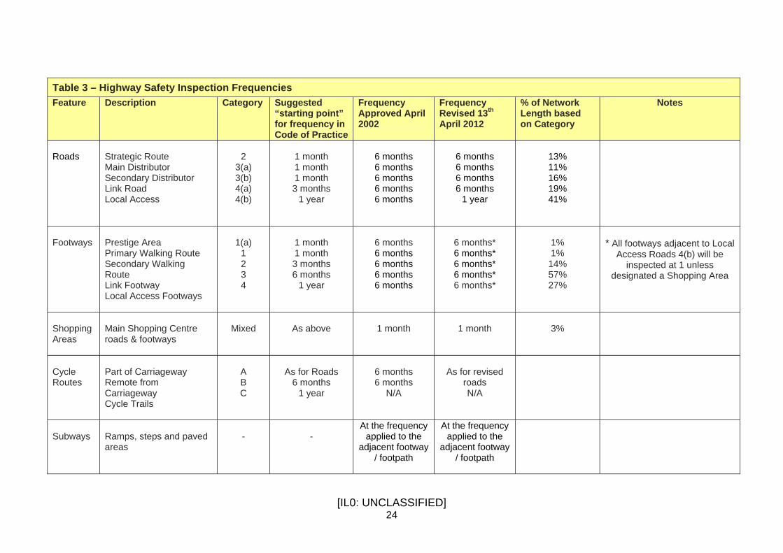
[IL0: UNCLASSIFIED] 24
Table 3 – Highway Safety Inspection Frequencies Feature Description Category Suggested
“starting point” for frequency in Code of Practice
Frequency Approved April 2002
Frequency Revised 13th April 2012
% of Network Length based on Category
Notes
Roads
Strategic Route Main Distributor Secondary Distributor Link Road Local Access
2
3(a) 3(b) 4(a) 4(b)
1 month 1 month 1 month 3 months
1 year
6 months 6 months 6 months 6 months 6 months
6 months 6 months 6 months 6 months
1 year
13% 11% 16% 19% 41%
Footways
Prestige Area Primary Walking Route Secondary Walking Route Link Footway Local Access Footways
1(a)
1 2 3 4
1 month 1 month 3 months 6 months
1 year
6 months 6 months 6 months 6 months 6 months
6 months* 6 months* 6 months* 6 months* 6 months*
1% 1% 14% 57% 27%
* All footways adjacent to Local
Access Roads 4(b) will be inspected at 1 unless
designated a Shopping Area
Shopping Areas
Main Shopping Centre roads & footways
Mixed
As above
1 month
1 month
3%
Cycle Routes
Part of Carriageway Remote from Carriageway Cycle Trails
A B C
As for Roads
6 months 1 year
6 months 6 months
N/A
As for revised
roads N/A
Subways
Ramps, steps and paved areas
-
-
At the frequency applied to the
adjacent footway / footpath
At the frequency applied to the
adjacent footway / footpath

[IL0: UNCLASSIFIED] 25
Items for Inspection In an urban environment such as Sandwell it is difficult to obtain the necessary level of accuracy from inspections when carried out in a moving vehicle. Consequently, normally our safety inspections are walked. Sandwell’s inspections cover the entire street scene and therefore will not only identify defects on the surfaces of carriageways, footways, footpaths, subways and hard/soft verges but also include other items such as street lighting, signage, drainage, ironwork, trees and street furniture. Degree of Deficiency During safety inspections, observed defects that provide a risk to users are risk assessed to determine the level of response. The degree of risk is a crucial contributory factor in determining the nature and speed of response. For example the degree of risk from a pothole depends not merely on its depth but also on its size and location. On site judgement will always need to take into account the particular circumstances of individual defects. For inspection purposes our currently approved investigatory threshold for footway or carriageway surface safety defects that require prompt attention, such as a pothole or raised paving flag, is defined as a sharp edged vertical trip in excess of 40mm in the carriageway and 20mm in the footway. For other items where no investigatory threshold is stated an on-site risk assessment is carried out to determine the degree of risk. Nature of Response The Code of Practice defines safety defects in two categories: Category 1 - those that require prompt attention because they represent an immediate or imminent hazard or because there is a risk of short-term structural deterioration. Category 2 - all other defects. Only Category 1 defects are recorded by our safety inspections. Other Category 2 non-hazardous serviceability defects are not recorded during planned safety inspections as current budgets are not sufficient to repair non-dangerous defects. Condition surveys look at deficiencies in the fabric of the highway and impacts on performance and serviceability over the longer term to inform planned renewal. Repairs to serviceability defects and customer reported defects that do not represent an immediate or imminent hazard or a risk of short-term structural deterioration are carried out as part of planned asset renewal (e.g. reconstruction, resurfacing or treatment).

[IL0: UNCLASSIFIED] 26
Defect Risk Assessment As our safety inspections solely consider Category 1 defects there is only a need to determine through risk assessment the appropriate level of response in relation to them presenting either an imminent or immediate hazard. To do so the Code of Practice recommends the methodology summarised as follows: Risk Identification - any highway item which is defective to or is in excess of the stated investigatory threshold is to be identified as a risk. All risks identified through this process are evaluated in terms of their significance, which means assessing the likely impact should the risk occur and the probability of it actually happening. Risk impact - the impact of a risk occurring should be assessed as follows: Little or negligible impact Minor or low impact Noticeable impact Major, high or serious impact The impact is quantified by assessing the extent of damage likely to be caused should the risk become an incident. As the impact is likely to increase with increasing speed, the amount of vehicular traffic and type of road are clearly important considerations in the assessment. Risk probability - the probability of a risk occurring should also be quantified and assessed as follows: Very low probability Low probability Medium probability High probability The probability is quantified by assessing the likelihood of users, passing by or over the defect, encountering the risk. As the probability is likely to increase with increasing vehicular or pedestrian flow, the network hierarchy and defect size and location are, consequently important considerations in the assessment. The assessment of risk impact and probability are used by inspectors to identify the overall seriousness of the risk and consequently assign an appropriate target of response. Targets for Response The targets for responding to highway defects representing an: • immediate hazard is to temporarily or permanently repair within 2 hours; • imminent hazard is to temporarily or permanently repair within 5 working days.
When a defect is temporarily repaired then complete permanent repair within 6 months.

[IL0: UNCLASSIFIED] 27
Defects risk assessed as an immediate (critical) hazard can typically be termed ‘life & limb’ and examples could include missing gully gratings, manhole covers and extreme carriageway failure. The target for responding to highway defects representing an imminent hazard was changed on 6 March 2013 (approved under an Action on Matter of Urgency) following service review. It was found that the previous target of ‘to respond by the end of the next working day to carry out a temporary or permanent repair…’ is inflexible, inefficient and driving poor quality temporary repairs resulting in earlier failure and repeat visits. The 5 working day response time allows work to be planned more effectively and efficiently releasing operational capacity to do more repairs right first time with the same resource.

[IL0: UNCLASSIFIED] 28
St r e e t L i gh t i ng Introduction Street lighting is an intrinsic part of our everyday lives. As a service it can go unnoticed, and yet if we were to remove the illumination of our 29,854 street and community lights across the Borough, the effects on our real and perceived safety would be far reaching. Traditionally, the primary function of public lighting has been its contribution to the creation of a safe Borough in which people feel confident to travel around, especially during the hours of darkness. However, its perceived role has now grown such that lighting is also expected to contribute to reductions in crime, and fear of crime, and to contribute to improvements in the urban environment. The provision of good street lighting can therefore be directly linked to reducing crime and disorder, reducing fear for personal safety, reducing road traffic accidents and contributing to a safe, high quality living environment. In contrast to this, the lack of funding invested into the service over many years now means that much work needs to be done in order for the Councils aspirations to be realised. In reality a significant proportion of lighting supports now exceed the age at which action should be considered with the condition of some street lighting now giving cause for concern. In addition ever rising electrical energy costs at a time when revenue budgets are reducing is a significant budget pressure driving the need for energy efficiency as well as management of public expectations about the availability and level of public lighting (e.g. trimming, dimming and part night operation).

[IL0: UNCLASSIFIED] 29
Service Aims and Priorities Primary Aims To contribute to a safe road network for all road users through the provision of high quality street lighting. To supplement the night time environment, and to contribute to the reduction of road traffic accidents. To provide high quality lighting that will help reduce crime, disorder and anti-social behaviour and contribute towards the perception of a safe and secure environment. To maximise energy efficiency and sustainability. To achieve high standards of performance, efficiency and customer care in service delivery. Secondary Aims To make constructive contributions to the night-time environment to stimulate usage. To maximise the usage of facilities to increase income to the Council. To aesthetically enhance the environment. To develop the Social Inclusion of the general public during a variety of religious festivals. To maximise the contribution of street lighting services towards improving the local economy. To protect the environment by ensuring that the public lighting is in keeping with and properly integrated into sensitive locations. To improve the integration, accessibility and use of the public transport system. Inventory Data Information on the inventory of illuminated equipment is currently held on a specialised electronic asset management system (Mayrise). Attributes held include: Column number Electricity Supplier Local Authority Road Reference Location Description Street Name Area Name Ordnance Survey Grid Reference 24 Hour Burn (y/ n) Cen Value Column Height Column Type Lamp Type Lamp Quantity

[IL0: UNCLASSIFIED] 30
Average Watts Date erected Ownership Road Classification Lantern Type Bracket type Bracket Outreach Bracket Number The council is currently responsible for: Streetlights Lit bridges Lit Subways Other illuminated highway infrastructure (e.g. traffic signs, VMS etc) Effective management of the asset relies on accurate inventory data. Validation of illuminated highway infrastructure inventory was carried out in 2013/14 and further inventory collection of known omissions in 2014/15. Condition Information The following inspection regime applies: At each maintenance or repair visit a visual inspection of the following components is undertaken;
• Electrical equipment and wiring • Visual condition survey • The condition of lighting columns protective systems • The visual structural condition of each lighting column
A defect sheet is produced only where a defect is identified. It is a requirement that electrical inspection and testing to BS 7671 is carried out on a cyclic basis with every installation being visited at least once every six years and an inspection certificate produced. A pilot electrical inspection of around 500 street lighting columns was carried out by a service provider in 2013/14. Based on this 5,000 street lighting columns and powered installations will be inspected in 2014/15 and each year thereafter providing for a 6 year cyclic programme. The Institution of Lighting Engineers Technical Report No 22 – Planned Inspection Regime recommends that a structural visual condition survey is undertaken on a cyclic basis of all illuminated items of street furniture. During the inventory data collection refresh in 2013/14 every item of recorded illuminated highway infrastructure was visited. Based on visual inspection identified structural defects requiring prompt attention were recorded and prioritised for repair in 2014/15. The planned electrical safety inspection regime includes the assessment and recording of a structural visual condition of each unit. The electrical and structural condition cyclical inspection regimes are aligned so that they can be delivered efficiently at an affordable cost. A pilot structural visual inspection of around 500 street lighting columns was carried out by a service provider in 2013/14. Based on this 5,000 street lighting columns and powered

[IL0: UNCLASSIFIED] 31
installations will be inspected in 2014/15 and each year thereafter providing a 6 year cyclic programme. Based on the visual inspection identified defects requiring prompt attention will be recorded and prioritised for repair within budget constraints. Structural testing using ultrasonic or strength tests is only undertaken when the authority has a specific reason to believe that the structural integrity of a particular column or group of columns has been impaired. Lighting Maintenance To maintain the service to the public there is a need to identify lighting units and illuminated traffic signs which have failed or have mechanical defects, and then to repair them within predetermined timescales. In response to budget cuts planned pro-active night time scouting patrols to identify illumination faults for repair are not now routinely carried out. Identification of illumination, serviceability or visible safety faults (e.g. missing doors) is recorded during planned highway safety inspections (see above) or by public reporting through the council’s improved public communication channels such as the Contact Centre or local Neighbourhood Forums. Ad-hoc illumination scouting patrols may be carried out and recorded from time to time where area wide concerns are reported. Routine faults are entered on to the Mayrise system on the day following report for repair programming. Emergency faults are reported to the Highways Operations service for immediate repair. Once reported, the target response times are shown below in Table 4. Table 4 Target response times
Nature of fault Response time
Non-emergency faults involving the replacement of components 5 working days
Non-emergency faults involving the replacement of a complete unit of apparatus, including those made safe as emergency faults 15 working days
Non-emergency faults involving the replacement of mandatory traffic signs and illuminated traffic bollards, including those made safe as emergency faults.
5 working days
Non-emergency faults involving works by the DNO 25 working days
Non-emergency faults involving the rectification of non-operating Belisha beacons and flashing school warning signs 5 working days
Emergency faults 2 hours

[IL0: UNCLASSIFIED] 32
Emergency Service Parts of an electrical installation may become a danger to the public as a result of incidents such as vehicle impact, cable damage, vandalism, storm damage and deterioration of components. Such incidents can result in potential danger and require emergency response. An emergency response service therefore operates 24 hours per day, 365 days of the year.

[IL0: UNCLASSIFIED] 33
Lighting Improvements There is virtual certainty that energy costs will rise steeply in the coming years. Additionally on 1 April 2014 carbon tax became payable on unmetered energy tariffs. To improve the energy efficiency and condition of Sandwell’s street lighting stock a street lighting reinvestment programme was developed in 2010 through the establishment of a Street Lighting Project Board. The programme proposed a phased approach to initially retro-fit LED luminaires onto existing aluminium columns. This will give maximum benefits in reduced energy costs and CO2 emissions for a minimum investment. In 2011 the council started implementation of a street lighting energy efficiency programme to:
• Achieve an immediate reduction in electrical energy costs; • Contribute to revenue budget reduction targets; • Reduce exposure to future energy price inflation; and • Reduce exposure to carbon reduction commitment charges (CRC).
To date 3,437 energy efficient LED lanterns have been retro-fitted to existing street lighting columns largely in residential streets. The total annual energy saving in a full year is £108k. Recent implementation of trimming (£11k) and dimming (£18k) regimes will add a further £29k annual energy saving. Over a 25 year period at current energy prices a saving of £2.7 m would be achieved. With year on year energy price inflation of 7.5% savings over a 25 year period increase to £7.0 million. Advances in technology now mean that LED lanterns are available that can be used on traffic routes. These roads currently use lamps with the highest consumption wattages and therefore offer the greatest energy savings (typically 60%). So, therefore, in order to maximise savings there is a shift in the focus of the programme from residential streets to traffic routes. A further phase of the programme is proposed in 2014/15 and 2015/16 to retro-fit 1,120 lanterns to existing street lighting columns on traffic routes. The first year annual energy saving achievable is £88k. Over a 25 year period at current energy prices a saving of £2.2 m would be achieved. With year on year energy price inflation of 7.5% savings over a 25 year period increase to £5.7 million. Replacement of 1,120 existing lamps with LED lanterns will reduce the council’s carbon emissions (CO2) by 452 tonnes per year. Implementation of trimming (£5k) and dimming the lanterns by 60% between midnight and 5 am (£14k) can add a further £19k first year annual energy savings.

[IL0: UNCLASSIFIED] 34
Project Considerations In order for the Street Lighting Project Board to establish the most appropriate solution to successfully mitigate the rising costs of energy, carbon taxation and to reduce CO2 emissions important consideration was given to the following in the first phase of the improvements: - Replacement of Faulty and Dangerous Equipment. For phase one of the street lighting project plan Sandwell Council commissioned a specialist street lighting consultant to conduct a structural survey of over 3,000 concrete columns that were between 30 – 40 years old. These lighting columns were identified most at risk of structural failure through the data collated using the age profile and type of material that is held within the street lighting asset inventory called Mayrise. The survey identified around 630 dangerous columns that were in need of immediate attention. This risk has been addressed through phase one of the improvement plan. This work is completed. Following the initial survey conducted by the street lighting consultant the affordability of implementing a cyclic condition inspection survey was investigated in line with recommendations illustrated in Technical Report produced from the Institute of Lighting engineers giving all authorities guidance on a planned inspection regime. The recordings from these inspections would be reviewed and assessed for the need of future replacements, painting or as deemed necessary a more in depth investigation of severe corrosion, cracking or apparent structural failure. Community Safety The introduction of white light sources produces a higher quality of illumination and better colour rendering attributes than the standard yellow / orange type streetlights so the eye is able to see objects more easily. Research carried out during the 1990s showed that criminals do take into account of potential levels of security and location features, including escape routes and visibility to witnesses when assessing the risk of being caught. It is generally accepted, therefore, that good lighting does have a positive impact on the crime rate and this is enhanced by the use of white light sources. By providing good colour rendering and enhanced uniformity, white light has a significant role to play, particularly when introduced into residential areas. Carbon Footprint Reduction The council has made a firm commitment to reduce its fuel costs and carbon footprint. Through a strategic Climate Change Action Plan it aims to deliver at least 6,000 tonnes carbon dioxide (CO2) savings in its in-house carbon emissions each year up to 2012. As street lighting is responsible for emitting around 8,000 tonnes of CO2 each year we believe reductions made through the street lighting reinvestment programme can save 170 tonnes of CO2 over a three year period. This objective is included in the council’s Scorecard and accordingly, a system has been set up to monitor and report the progress being made through the programme towards this target and that of restraining growth in electricity costs. This involved undertaking the following actions:

[IL0: UNCLASSIFIED] 35
• Monitor progress on the street lighting reinvestment programme on a half yearly basis
• Establish the 2010/11 baseline electricity use, fuel costs and carbon footprint for
street lighting • Report estimated electricity use and costs on a quarterly basis
Using the above the following 2010/11 baseline has been established:
• Energy consumption was 15,366,336 kWh • Energy cost was £1,464,411 • Carbon emissions were 8,020 tonnes of CO2
Total target savings over two years has now been set at:
• Energy consumption reduced by 440,165 kWhs • Energy cost reduced by £41,947 (Using 2010/11 tariff) • Carbon emission reduced by 172 tonnes CO2
For 2011/12 Target Savings have been set at:
• Energy consumption reduced by 110,041 kWhs • Energy cost reduced by £10,486 (Using 2010/11 tariff) • Carbon emission reduced by 57 tonnes CO2
For 2012/13 Target Savings have been set at:
• Energy consumption reduced by 330,124 kWhs • Energy cost reduced by £31,460 (Using 2010/11 tariff) • Carbon emission reduced by 115 tonnes CO2
Service Objectives / Thematic Priorities: Improving Road Safety Reducing Crime and the fear of Crime Energy Reduction and CO2 emissions Stock deterioration Improve the quality of lighting Reduce light pollution Performance Targets Whilst the Secretary of State for the Department of Communities and Local Government (DCLG) has informed Local Authorities that the National Indicator Set has ceased to be a mandatory requirement for councils. However, many local authorities including Sandwell have retained key national indicators as their value in determining performance against services that matter to local residents is vital. Central Government still wants reports on NI 185, the council's in-house carbon emissions. Generally speaking we should be averaging 3% cuts every year in our footprint. That is the

[IL0: UNCLASSIFIED] 36
strike rate that CRC trading seems to be based on, so at 3% rate an average of around 200 tonnes of CO2 should be saved each year with the revamp of street lighting. In respect of this project, and the desired outcomes, it is vital that we measure success against recognised performance measures. E.g. Accident reduction targets (killed and seriously injured) will still be measured and used to improve services with a key aim of saving lives including those of young children. Former targets for reducing anti-social behaviour, crime reduction and the fear of crime will also be informally retained as these are a key measure of progress in dealing with things that matter greatly to people. On top of the general efficiencies that are at the forefront of local authority service transformation at this current time, there is also an imperative to reduce the levels of carbon emissions across the whole of the public sector. Again, these former targets will be retained by local authorities including Sandwell to directly measure carbon reduction across all council services. All of the above performance measures will be significantly improved through the outputs/outcomes cited within this project. Modern, efficient street lighting has a wider positive impact on communities and neighbourhoods and a direct impact on their quality of life, their perceptions of the council generally. Risk Management Risk can be defined as ‘the threat that an event or action can adversely affect an organisation’s ability to achieve its objectives and to successfully exercise its strategies’ All local authority services are delivered for a purpose and any disruption will cause problems somewhere. The extent and severity of the problems created will however vary from service to service. A risk management audit has concluded only the Emergency Response Service is considered to be ‘critical’, on the ground that exposed live connections resulting from vehicle damage or vandalism could result in personal injury or loss of life. Short-term disruption to all other aspects of the service is only likely to result in economic loss or loss of amenity. Contingency plans are in place to deal with ‘critical services’ considering disruption arising from the loss of assets such as: labour, plant, materials, premises, communications and information systems. In the case of street lighting, the main measure of mitigation is the fact that the service is delivered using both in-house and external resources working together on a partnership basis. This offers alternative ways of delivering all aspects of the service should the need arise. In addition, close working arrangements with neighbouring local authorities provides further support in some areas of service delivery. Performance Management To ensure that the current maintenance programme is delivering an efficient and effective service the following management performance indicators are measured:- Average time to repair lamps (Local authority works) Average time to repair lamps (District network operator works)

[IL0: UNCLASSIFIED] 37
Percentage of street lamps not working as planned Percentage of street lamps restored to working condition within 5 calendar days Percentage of staff absence - frontline employees Percentage of staff absence - all employees Adequacy of current service standards, which are to: a) Repair faulty streetlights within five calendar days, unless the fault is found to be with the electricity supply. b) Repair dangerous defects within two hours (missing doors, exposed electrics etc). Service Provision Sandwell delivers its street lighting service using both in-house and external resources. Broadly speaking: Reactive maintenance and the emergency response service are delivered by our in-house team of qualified electricians and lighting attendants. Lighting improvement schemes are commissioned from external service providers. PLANNED RENEWAL OF INFRASTRUCTURE The under-investment over many years and resulting increasing age of the street lighting stock means that a significant proportion of lighting supports now exceed the age at which action should be considered. There is a need now to develop a strategic approach at a borough wide level about future investment in, and performance of, the street lighting asset to manage this increasing risk. An investment options proposal is to be prepared in 2014/15 to inform decision making.

[IL0: UNCLASSIFIED] 38
Tr a f f i c S i g n a l s , C o n t r o l l e d C r o s s i n g s & U TC There are approximately 307 traffic and crossing signal installations throughout the borough. To reduce maintenance, energy costs and carbon emissions it is now the Council’s policy to use LED lamps in all new and refurbished installations. Currently, approximately 40% of all installations have been converted. New signal controlled crossings have to date been designed in-house or by consultants in accordance with the Design Manual for Roads and Bridges. All are subject to Safety Audit procedure. Commissioning of the traffic signal equipment takes place in the presence of the Assistant Engineer (Traffic Signals). Signal controlled crossings are not made available for use without satisfactory completion of the Stage 3 Safety Audit and testing in the presence of the Assistant Engineer (Traffic Signals). Immediately on being made available for use, details of the signal controlled crossing are recorded in the Traffic Signals Inventory. Works to be carried out on the highway are logged and monitored by Highway Services. If the works are to be carried out on or near signal control crossings, the Assistant Engineer (Traffic Signals) is notified for approval with the traffic management team. Where two carriageways are crossed, the crossing is recorded in the Traffic Signals Inventory as two crossings and a signal controlled crossroads is recorded in the Traffic Signals Inventory as a junction. This method of recording location and other details of the crossing reflect the fact that the facilities operate independently and aids fault reporting and maintenance. Signalised crossings are numbered individually for inventory purposes. Inventory information is transferred to the Performance Review Manager who undertakes to audit all sites annually to assist the process in compliance with the Government’s former BVPI 165 Pedestrian crossings with facilities for disabled. This is defined as: The percentage of pedestrian crossings with facilities for disabled people as a proportion of all crossings in the local authority area. Pedestrian crossings with islands or refuges are classified as single crossings for this purpose. Defects identified during the audit process are reported immediately to the appropriate section for rectification. The following definitions apply to signal controlled crossings: Audible Signal An audible signal bleeper is a sound emitted at a crossing when it is safe to cross, provided for the benefit of visually impaired people so that they may cross safely.

[IL0: UNCLASSIFIED] 39
Tactile Signal Facility A tactile signal facility is a cone underneath the push button controls which rotates when it is safe to cross, provided for the benefits of people with visual and hearing difficulties so that they may cross safely. Tactile Surface A tactile surface is a blistered paving surface which can be detected by a visually impaired person. It is ‘L’ shaped to lead the person from the back of the footway to the push button control and the dropped kerb. In a central refuge however this will not be ‘L’ shaped. Dropped Kerb A dropped kerb is a kerb of lower upstand than normal kerbs. Reactive maintenance of the traffic signal equipment is carried out under a collaborative contract with Black Country and Telford & Wrekin local authorities by Telent technology. The contract contains service response targets. Maintenance of the paved surfaces of signal controlled crossings is carried out by Highway Services. Prior to 2007 annual cleaning of the dropped kerbs has been carried out to maintain their white appearance and thereby provide a contrast for visually impaired people. From 2007 biennial painting of dropped kerbs (white chlorinated rubber), subway and footbridge steps take place during the school summer holidays when usage is at a minimum. It is the Council’s policy to construct and maintain signal controlled crossings in accordance with the guidelines as referred to in the Government’s former BVPI 165 definition with the following exceptions: Audible signals are not provided where it would be possible to hear the audible signal from any other signal controlled crossings. This is most evident at signal controlled crossroads but also occurs in High Streets where signal controlled crossings are close together. Dropped kerbs are not generally provided flush with the carriageway but are specified at 20mm or less. It is appreciated that wheelchair users prefer flush crossings but our local policy reflects other Health and Safety and Risk Management implications for the following reasons: • the occurrence of ponding between channel and tactile surface, where in the winter
months ice forms and presents a dangerous surface to all users. • the spread of dirt and other debris during road sweeping operations. • damage caused to kerbs during rolling. • preference of blind people for upstand which allows ‘tapping’ of the kerb. This policy forms part of a long standing agreement between the Council and representations of people with disabilities through the Council’s Access group. Whenever a change occurs, work is programmed based on a balance of cost, risk and knowledge of future works to be carried out at or near the signal controlled crossing.

[IL0: UNCLASSIFIED] 40
The inspection process has highlighted kerbs which exceed the local policy of a 20mm upstand. Retrofitting of these crossings to correct the upstand is carried out within the constraints of available funding.

[IL0: UNCLASSIFIED] 41
Wint e r Se rv i c e A winter maintenance service is to be provided in accordance with the Winter Maintenance Service Operational Plan 2014-15 and is included in Appendix B.

[IL0: UNCLASSIFIED] 42
B r i d g e s a n d O t h e r H i g h w a y S t r u c t u r e s Goals and Objectives The Highways Act 1980 requires that roads are maintained to allow the passage of all Construction and Use vehicles i.e. those up to 40/44 tonnes. Therefore, the primary service standard is to maintain bridges to allow the passage of such vehicles, including smaller vehicles with 11.5 tonnes axles, unless a permanent weight restriction has been imposed at a particular bridge. In particular, Section 41 (1) of the Highways Act states: The Authority who are for the time being the highway authority for a highway maintainable at the public expense are under a duty, ……….., to maintain the highway. The Act includes provisions for enforcing liability for maintenance (Section 56) that can be determined by a magistrate’s court. The Act provides a general power to improve highways (Section 62) including the provision of subways (Section 69), footbridges (Section 70) and the construction and reconstruction of bridges (Sections 91 and 92). More detailed sections of the Act grant the power to construct bridges over navigable water courses (Section 106). The Act grants the power to remove unauthorised structures (Section 143), to licence the construction of a bridge over the highway (Section 176) and to control the construction of scaffolding (Section 169) and cellars (Section 179). The Act also grants powers to control the construction of retaining walls near streets (Section 167). Bridgeworks shall not be carried out unless approved by the council (Section 195), a duty delegated to the Technical Approval Authority. Highway Services is accountable for delivering these objectives on those structures within its stewardship by: - Inspecting every structure on a pre-determined cycle to report its condition and determine the extent of remedial work required. Repairing hazardous defects quickly Carrying out special investigations and structural assessments where identified to complement routine inspections Prioritising remedial works by taking into account the nature and extent of the defect and the importance of the bridge and route it carries Upgrading structures where appropriate to meet changing demands and/or standards Procuring and managing engineering consultants and contractors to prepare and carry out the works Implementing programmes of work and managing related budgets Setting and monitoring standards for design and construction of both new structures and maintenance works

[IL0: UNCLASSIFIED] 43
Recording the design, construction, inspection and maintenance of all highway structures and maintaining the related Bridge Management System (BMS) Assessing, through technical approval the acceptability of any proposed works by any party on existing or new structures, above, below or abutting the highway Seeking to ensure that other bridge owners meet their obligations to the travelling public Reviewing achievements against aims and comparing with other authorities to assess performance and invoke change where necessary In carrying out these activities the aim is always to seek to minimise disruption to the travelling public and to achieve the council’s priorities, strategies and key areas for improvement. To this end the council see “Sandwell as a great place with great people and great prospects for the future” Inventory Information on the inventory of highways structures are held in the computerised Bridge Management System (BMS) supplied by Symology Ltd. Information held includes: - Structure Name Structure Number Structure Type Structure Owner Structure Location Maintenance responsibility Construction details Inspection details There is a high level of confidence in the records held although gaps are known to exist for retaining walls, where ownership is often unclear. Whenever ownership of a retaining wall is queried or inspections or ad hoc reports suggest maintenance is required, ownership of the wall is investigated and details added to the BMS. An exercise to identify locations where retaining walls exist has been completed and the long process of establishing ownership is underway. The Council owns 471 bridges and other highway structures highway bridges, culverts and subways and an additional 65 highway bridges are owned by Statutory Transport Undertakers such as Network Rail, British Rail Property Board and British Waterways.

[IL0: UNCLASSIFIED] 44
Condition Purpose The overall purpose of inspections, assessment, testing and monitoring of the highways structures stock is to ensure that they are safe for use and fit for purpose. Types of Bridge Inspections Routine Surveillance comprises notification of obvious defects observed during the routine safety inspections of the highways – In addition all highways staff are encouraged to be vigilant in travelling around the borough and to report any defects observed. General Inspections comprise a visual inspection of all parts of the structure and adjacent elements e.g. earthworks without the need for special access or traffic management arrangements. Principal Inspections comprise of a close examination, within touching distance, of all accessible parts of a structure and adjacent elements utilising special access, traffic management and CCTV where necessary. Special Inspections concentrate on a particular part of a structure in specific circumstances or following certain events:- When a particular problem is detected during an earlier inspection of the structure or of similar structures. On particular structural forms or types e.g. cast iron structures, post tensioned structures, structures strengthened with bonded plates. On structures that have loading or other forms of restrictions on use, e.g., restriction of traffic on bridges. When the necessary frequency or access arrangements for a particular part of the structure are beyond those available for General or Principal Inspections. On bridges that have to carry an abnormally heavy load – inspections may be done before, during and after the passage of the load. Following a bridge strike. Following a flood or high river flow to check for scour or other damage. To check specific concerns, possibly based on new information, e.g. concerns over the quality of previously used batches of rebar or concrete. Acceptance Inspections enable the Council, in taking over responsibility for a structure from another organization e.g. private developers, to determine the condition of the structure and any outstanding work to be carried out. Acceptance inspections closely follow the requirements of principal inspections. Underwater Inspections comprise inspections carried out by divers of underwater elements of structures susceptible to scour in conjunction with principal inspections.

[IL0: UNCLASSIFIED] 45
Frequency of Inspections Inspections are carried out at frequencies shown in Table 5 below.
Table 5 - Frequency of Inspections of Structures
Inspection Type
Frequency
Routine Surveillance Every 1 month in shopping centres Every 6 months elsewhere
General Inspections Every 2 years except where Principal Inspection is to be carried out.
Principal Inspections Every 6 years as a norm although this is extended up to 12 years where risk is reduced
Underwater Inspections Every 6 years (special inspections are carried out following floods)
Acceptance Inspections As and when necessary
Special Inspections 1, 3, 6 and 12 monthly or as requested.
The condition of a bridge is rated using the CSS Bridge Condition Index. The condition indicators for an individual bridge (BCI) or a stock of bridges (BSCI) are evaluated using the data collected during the bridge inspections according to a predefined scale set out in the CSS requirements. The BCI values can be interpreted broadly as the “percentage service potential” of a bridge. Thus a BCI value of 100 implies that the bridge has retained 100% of its service potential; a value of 60 implies that the bridge has lost 40% of its service potential and a value of 0 implies that the bridge is no longer serviceable. The BCI(av) is the average BCI for a bridge evaluated taking into account the condition of all structural elements in a bridge. The BCI(crit) is the critical BCI for a bridge evaluated taking into account the condition of those elements deemed to be of a very high importance to the bridge. The BSCI(av) and BSCI(crit) is a measure of the above condition index values for all bridges in the stock. Table 6 gives an interpretation of the BSCI(av) and BSCI(crit) values in terms of the general condition of the bridge stock. In deciding on the level of funding to be allocated to different bridge stocks, it should be recognised that the funding required for a stock, which is in poor condition, e.g. BSCI 50, can be very high compared to another stock which is in a fair condition with a BSCI 75, to obtain the same increase in BSCI value.

[IL0: UNCLASSIFIED] 46
Table 6. General Condition of Bridge Stock
BSCI Range
Average Stock Condition based on BSCI(av)
Critical Stock Condition based on BSCI(crit)
Additional Comments
100 to 95 Very Good
The structure stock is in a very good condition. Very few bridges may be in a moderate to severe condition
Very few critical load-bearing elements may be in a moderate to severe condition. Represents very low risk to public safety.
It is a relatively new stock of structures than an appropriate maintenance funding level needs to be identified through the Asset management Plan and Best Value. If it is a mature stock then continuing with the same level of funding is likely to sustain a high condition score and an effective preventative maintenance regime.
94 to 90 Good
Structure stock is in a good condition. A few bridges may be in a severe condition.
A few critical load-bearing elements may be in a severe condition. Represents a low risk to public safety.
Historical maintenance funding levels have been at an appropriate level to maintain a good stock condition. These levels of funding should be continued to ensure condition is maintained and resources are concentrated on preventative maintenance activities
89 to 80 Fair
Structure stock is in a fair condition. Some structures may be in a severe condition.
Wide variability of conditions for critical load bearing elements, some may be in a severe condition. Some bridges may represent a moderate risk to public safety unless mitigation measures are in place.
Historical maintenance work may be underfunded and structures may not be managed in accordance with Best Value principles – implementation of an Asset Management Plan is essential. Potential for rapid decrease in condition if sufficient maintenance funding is not provided. Moderate to significant backlog of maintenance work.
79 to 65 Poor
Structure stock is in a poor condition. A significant number of structures may be in a severe condition.
A significant number of critical load bearing elements may be in a severe condition. Some structures may represent a significant risk to public safety unless mitigation measures are in place.
Historical maintenance work under-funded and structures not managed in accordance with Best Value principles and sound asset management. It is essential to implement an Asset Management Plan to ensure work is adequately funded and prioritised and risks assessed and managed. Significant to large backlog of maintenance work, essential work dominates spending.

[IL0: UNCLASSIFIED] 47
Table 6. General Condition of Bridge Stock
BSCI Range
Average Stock Condition based on BSCI(av)
Critical Stock Condition based on BSCI(crit)
Additional Comments
64 to 40 Very Poor
Structure stock is in a very poor condition. Many structures may be in a severe condition.
Many critical load-bearing elements may be unserviceable or close to it and are in a dangerous condition. Some structures may represent a high risk to public safety unless mitigation measures are in place.
Historical maintenance work significantly under funded and a large to very large maintenance backlog. An Asset Management regime is essential. Re-active approach to maintenance that has been unable to contain deterioration. A significant number of structures likely to be closed have temporary measures in place or other risk mitigation measures. Essential work dominates spending.
39 to 0 Severe
Structure stock is in a severe condition. Many structures may be unserviceable or close to it.
Majority of critical load bearing elements unserviceable or close to it and are in a dangerous condition. Some structures may represent a very high risk to public safety unless mitigation measures are in place.
Historical maintenance work grossly under funded and a very large maintenance backlog. Re-active approach to maintenance that has been unable to prevent deterioration, only essential maintenance work performed, Asset management is essential. Many structures likely to be closed have temporary measures in place or other risk mitigation measures. All spend likely to be on essential maintenance.
Bridge Assessment A nationally funded bridge assessment programme was introduced to check the capability of existing bridges to meet the higher 11.5t axle load and 40/44t gross vehicle weights permitted on UK roads from 1 January 1999. The results of the assessment programme are recorded in the BMS. The assessment reports comprise inspections specifically for assessments, material testing results where appropriate and a mathematical evaluation of the way that a bridge is assumed to carry traffic loads. The calculation process starts with a comparatively simplistic approach and continues, where justified, by using more sophisticated analytic techniques. All Council owned bridges and the vast majority of privately owned bridges in Sandwell have now been assessed. The future management of highway structures will include regime of ongoing structural reviews to ascertain their adequacy to support imposed loads. Such reviews will be undertaken when significant events occur that could increase the imposed loads above those

[IL0: UNCLASSIFIED] 48
previously assessed and/or reduce the load bearing capacity of structures. A structural review will be undertaken, for example, when one or more of the following conditions or events occur: The structures are known or suspected to have load-bearing capacities below those deemed to be appropriate for the class of highway supported. There is a significant change in the regulations governing the configurations and weight limits of vehicles that may use the relevant highway. The impact of such changes would generally have been assessed by the Department for Transport or the Highways Agency and guidelines issued to authorities on the actions to be taken. The hierarchy of the road carried by the structure has changed or is proposed to be changed. The change may modify the density and type of traffic carried resulting in a change to the ‘loading class’ defined in BD21 The Assessment of Highway Bridges and Structures. Records of the original design or subsequent assessment do not exist or have become discredited. The structure has been modified or is proposed to be modified. The structure is on a route proposed for an abnormal load movement, either a Special Order vehicle or an un-common STGO vehicle, for which the structure has not been previously assessed. Significant deterioration or damage has been identified by an inspection. Conditions considered would include those found in structures such as arches that may be susceptible to changing condition factors. At least every 12 years, in conjunction with a Principal inspection.

[IL0: UNCLASSIFIED] 49
The assessment process is outlined in the following flow chart:-
Establish need
Appoint assessor
Gather information
Initial appraisal
Establish condition through Inspection
for Assessment with testing if required
Further appraisal
Additional information on
condition required? YES
Is refined analysis
required?
Technical Approval
Appoint checker
Formal assessment analysis and check
Determine any remedial actions
Draft report
Final report and certification
(If not already appointed)
NO
Input to maintenance management and BMS
YES

[IL0: UNCLASSIFIED] 50
Code of Practice for the Management of Highway Structures The Stationery Office published the Code of Practice for the Management of Highway Structures in September 2005 and three milestones for implementation of each of the sections were proposed. The dates suggested for implementation of the milestones were as follows:- Level One March 2006 Level Two March 2007 Level Three March 2008 A gap analysis was carried out in December 2005 to establish a ‘where are we now’ and ‘what do we need to do’ to implement the Code of Practice by the required timescale. The result of the gap analysis is shown in Appendix C. Risk Management Risk Management is an embedded part of the Council’s business planning process. Risk management details for highway structures are shown in Table 7.

[IL0: UNCLASSIFIED] 51
Table 7 Risk Management Details for Highway Structures
Risk Scores
Risk Effect on Service
Delivery/ Consequences
Impact Likelihood Combined scores
impact x Likelihood
Existing Control Measures in Places
Action to be taken to address deficiencies, c/fwd to the BP action plan/cross ref to the BP action plans
Road vehicle incursion onto railway
Reduce operational performance dealing with litigation
4 2 8 Comparative risk assessment by all sites completed
Implementation of recommendations of Traffic Advisory Leaflet 6/03
Injury to highway users through use of subways
Minor operational performance dealing with claims
2 4 8 Principal inspection every 6 yrs, general inspection every 2 yrs
Safety inspections every 6 months, remedial action taken as necessary
Injury to highway users through use of bridges
Reduced operational performance dealing with litigation
4 5 20 Principal inspection every 6 yrs, general inspection every 2 yrs
Employees to maintain professional capability through continued professional development
Injury to construction operatives, supervising staff and public during construction work
Possible failure to comply with statutory duties, claims, litigation, improvement notices etc
3 5 15 Implementation of CDM regulations, risk assessments, H & S plans, employees trained in planning supervision
Regularly update training of employees in role as planning supervisor and other safety supervision
Employee Health and Safety injuries
Reduction in service through staff absence
3 2 6 Training in IOSHH managing safety. Training of relevant employees in CDM, appropriate H & S training for all employees eg: fire safety
Risk assessments to be prepared for work of all employees and safe methods of working developed
Professional indemnity risks
Serious financial loss
4 3 12 Investigate obtaining personal injury insurance

[IL0: UNCLASSIFIED] 52
Table 7 Risk Management Details for Highway Structures
Risk Scores
Risk Effect on Service
Delivery/ Consequences
Impact Likelihood Combined scores
impact x Likelihood
Existing Control Measures in Places
Action to be taken to address deficiencies, c/fwd to the BP action plan/cross ref to the BP action plans
Loss of electronic information
Reduced operational performance
3 4 12 Regular back up of information Regular reminders of need to back up information to be issued
Loss of key staff Significantly reduced operational performance
3 3 9 Succession planning as detailed in Learning and Development Plan. Professional Services Framework (PSF) used to provide external support
Collaborate in the West Midlands Professional Services Framework contract prior to expiry of current HCA framework to ensure continuity of operation from January 2015.
Release of sensitive information through FOI Act
Reduced operational performance dealing with litigation
2 3 6 Logging and monitoring of FOI requests
Discussion item for Team Briefings and regularly update training of employees in Data Protection Act

[IL0: UNCLASSIFIED] 53
Lifecycle Plans A lifecycle plan describes the long-term strategy for managing a group of similar structures with a view to minimizing whole life costs while providing the required levels of performance. They are used to identify maintenance cycles and intervention thresholds. It is proposed that Lifecycle plans will be established for each structure and to support their production a Structures Asset Management Planning Toolkit is currently being developed by the Department for Transport (DfT). The Toolkit primarily focuses on long-term asset management and financial planning and asset valuation/depreciation for highway structures and comprises: Part A: Methodology – describes in detail the method developed for highway structures to meet specific asset management (and financial reporting) requirements. The document sets out the assumptions, rationale, algorithms, the minimum data requirements and how the methodology can, where appropriate, be further refined. Part B: Functional Specification – provides a detailed description of the required functionality of any software developed to support the methodology. This would enable commercial software providers to code the methodology into their systems in accordance with the requirements of structures managers/engineers. Part C: Supporting Information – provides default lifecycle planning and financial reporting data, i.e. deterioration rates, intervention triggers and effects, work unit rates, etc. The draft Toolkit was released in May 2012 with limited functionality to provide DfT asset valuation information. Once the final Toolkit is released, not only will it be used for the DfT asset valuation information, but also to provide a Life Cycle Planning function.

[IL0: UNCLASSIFIED] 54
PROCESS MAP: Bridge Inspections following fire damage/bridge strike/flash floods
End to End Service INCIDENT
OCCURRING OUTSIDE OF
OFFICE HOURS Reporting incident
Call received / details obtained
Report incident
Initial site inspection /
damage assessment
Further action
eg road closure
Public / Police
Standby Officer Assets Group Manager
Contractor Safety Works
Depot Supervisor Road
Closure
Depot Gang Road Closure
Resource list for above: Staff Standby Officer
Assets Group Manager Depot Supervisor Gang for Road Closures
Accommodation Taylor’s Lane Depot (if closure required)
Systems
Communications Mobile phones
Plant/Equipment Pen and paper Barriers, sign, van/lorry for road closures Contractor’s Plant/Equipment should a make safe repair be required Camera
Other Outside Agencies Support if required eg British Waterways, Network Rail, Environment Agency, Highways Agency
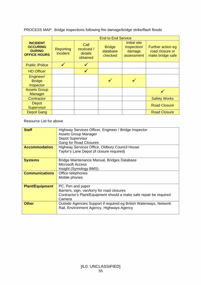
[IL0: UNCLASSIFIED] 55
PROCESS MAP: Bridge inspections following fire damage/bridge strike/flash floods
End to End Service INCIDENT
OCCURING DURING
OFFICE HOURS Reporting incident
Call received /
details obtained
Bridge database checked
Initial site inspection/
damage assessment
Further action eg road closure or
make bridge safe
Public /Police HD Officer Engineer/
Bridge Inspector
Assets Group Manager
Contractor Safety Works Depot
Supervisor Road Closure
Depot Gang Road Closure Resource List for above Staff Highway Services Officer, Engineer / Bridge Inspector
Assets Group Manager Depot Supervisor Gang for Road Closures
Accommodation Highway Services Office, Oldbury Council House Taylor’s Lane Depot (if closure required)
Systems Bridge Maintenance Manual, Bridges Database Microsoft Access Insight (Symology BMS)
Communications Office telephones Mobile phones
Plant/Equipment PC, Pen and paper Barriers, sign, van/lorry for road closures Contractor’s Plant/Equipment should a make safe repair be required Camera
Other Outside Agencies Support if required eg British Waterways, Network Rail, Environment Agency, Highways Agency

[IL0: UNCLASSIFIED] 56
Performance Monitoring The CSS Bridge Stock Condition Index described in Section 1.4 is used to produce the average and critical conditions of Sandwell’s bridge stock on an annual basis. These results have been summarised below: Bridge Stock Condition Indicator (BSCI) Weighted by Deck Area 2008/2009 BSCI (av) = 85 BSCI (crit) = 73 2009/2010 BSCI (av) = 89 BSCI (crit) = 83 2010/2011 BSCI (av) = 81 BSCI (crit) = 75 2011/2012 BSCI (av) = 81 BSCI (crit) = 75 2012/2013 BSCI (av) = 85 BSCI (crit) = 81 2013/2014 BSCI (av) = 85 BSCI (crit) = 80 See Table 6 for details of General Condition of Stock indicators BSCI (av) = conditions of all elements of a structure BSCI (crit) = condition of critical elements of a structure BSCI > 90 and < = 100 Bridge Stock Condition is very good BSCI > 80 and < = 90 Bridge Stock Condition is good BSCI > 65 and < = 80 Bridge Stock Condition is fair BSCI > 40 and < = 65 Bridge Stock Condition is poor BSCI < 40 Bridge Stock Condition is very poor

[IL0: UNCLASSIFIED] 57
H I G H W A Y T R E E S Introduction Locally, in towns mature trees act as air filters, each tree able to remove 10kg of dust from the air each day. Therefore, trees are very desirable along roads, busy streets and shopping areas. Trees also help to keep the air fresher and cooler in towns during hot weather. Open space containing trees provide shade and recreation. Trees provide seasonal variations of flower, leaf, fruit, autumn colour and winter silhouette, which for those of us in towns may be one of the main seasonal changes still left to link us to the countryside. However, poorly maintained trees have the potential to degrade the environment and harm people and property. Therefore, the safe and appropriate management of trees and woodlands is of concern to the Council and all in the community. The Importance of Trees Trees are essential to life and their value cannot be overstated. As they grow they:- Contribute immeasurable as part of the landscape or particularly in their own right in an urban setting in contributing to peoples quality of life and sense of well-being. Provide Carbon Dioxide absorption and oxygen production. Filter air and absorb other pollutants such as ozone, nitrogen oxides, sulphur dioxides, carbon monoxide, smoke, dust, ash and noise. Provide varied habitats for wildlife. Create aesthetic value improving the appearance of our environment, giving variety of scale, form, colour and shape. Provide summer shade and winter shelter enabling the saving of energy. Reduce noise levels. Reduce everyday stress, particularly important in today’s environment. Enable greener towns which are more attractive to new business and make Sandwell a pleasanter place to live and work. Fortunately, there is an increasing public awareness of these benefits and therefore the need for trees in urban areas. People are beginning to place a higher priority on the environment in which they live. In urban areas this means that there should be accessible recreation open space containing trees and pleasant, tree-lined streets and squares. Tree Problems People often live in close proximity to trees, and we are fortunate to have large numbers of mature trees across the Borough. These trees are either their own, their neighbours, or quite commonly belong to the Council. Trees can however cause inconvenience to residents when they grow near dwellings. A dilemma often occurs when the tree makes an important contribution to the local environment but also causes inconvenience to those living nearby. With any population of trees there are a number of common sources of complaint including overhanging branches, shade, leaf/fruit fall, obstruction and physical damage etc. Many of these problems can be dealt with by careful pruning once the tree is established. However, sometimes the problem is a result of inappropriate species selection in the past and may be difficult or impossible to resolve in all parties favour.

[IL0: UNCLASSIFIED] 58
Tree roots may damage a structure by direct or indirect action. Direct action involves a root growing against or under a structure and as it increases in diameter with each year’s growth, pushing the structure and moving it. Naturally only shallow founded, light structures can be moved in this way, such as paving and tarmac or perhaps a boundary wall. When roots meet a heavy or well-founded structure, like a house, they tend to distort or divert around the obstruction, rather than move the object. The numbers of tree root claims are increasing as the applications by potential home owners/mortgage companies requesting works to trees outside properties, to prevent/cure subsidence. In reality the vast majority of trees near buildings cause no structural damage at all. Certain soil types have to be present for tree roots to be implicated in subsidence claims. Also, trees may become dangerous due to a single event such as a storm, flood or vehicular damage in an accident, resulting in part, or all, of the tree presenting a danger to the public. Alternatively, a tree may reach a dangerous stage by ongoing decay or disease, or may have grown in such a way as to be structurally unsound. It must be stressed that, except in the most obvious cases, such as a broken branch over a road, that only a qualified arboriculturist should be consulted to determine whether a tree is dangerous. Highway Trees These are the trees planted in pavements or road verges along the Borough’s streets. They help to filter traffic pollution, provide shade for car parking and improve the overall appearance of the street scene. All highway trees are the responsibility of council and deserve special attention, as they are one of the most prominent of elements of the street scene. There are approximately 9,446 highway trees in the borough and to establish their location, size and species and to assess their basic condition an in-field study has been undertaken. As part of this exercise trees have also been tagged to aid their identification and future management. A number of our tree-lined streets have trees which are either nearing maturity or have outgrown their location and as such there is a requirement to plan ahead for their eventual removal and replacement with more suitable trees that have now become widely available. These plans need to be based on a full conditional tree health and risk assessment of which the assessment of basic condition forms the foundation of. Tree Root Damage Tree root damage can uplift footways and in some cases cause trips. In other cases the footway surface can be raised over such a large area that no trip hazard will exist. All root damage is assessed and prioritised for repair using the same criteria applied when inspecting the highway for safety defects. Examples of defects considered include tree roots raising individual paving flags or where tree root damage has caused extreme bulging of a bituminous footway.

[IL0: UNCLASSIFIED] 59
H i g h w a y D r a i n a g e Introduction Sandwell’s Highway Authority has responsibility for over 35,000 road gullies together with associated highway drains. In addition the roles of Land Drainage Authority and Lead Local Flood Authority also fall within the remit of the Highway Services. Drainage Maintenance Cleansing of the highway gullies is carried out by the council’s waste partner, SERCO. All road gullies are cleansed once per year, except areas where properties have been identified as being at risk of flooding from the highway, or the highway is at high risk of being flooded, in these areas the road gullies are cleansed four times per year. The majority of the 35,000 road gullies discharge to Public Sewers, maintainable by Severn Trent Water. A minority of road gullies discharged to Highway Drains that are maintainable by the Highway Authority. The cleansing partner SERCO reports problems with the receiving piped system for action by Severn Trent or Highways Maintenance. In addition to the cyclic maintenance of the road gullies the authority also carries out reactive maintenance to problems reported. The authority aims to attend any reported blocked gully the next working day, and to attend flooded highway within 4 hours. Risk Management Missing or damaged ironwork is recorded through the council’s customer relations management system – Siebel. The authority aims to make safe the defect within 2 hours, with the permanent repair following. Theft of metal gullies and manhole covers has led to significant danger to road users. The authority has worked with the police to significantly reduce the incidents of theft. Land Drainage Authority Many highway drains discharge directly to watercourses, and in Sandwell many of those watercourses are culverted. Culverted watercourses are easier to block than an open watercourse causing flooding to both highway and property. To prevent debris entering culverted watercourses trash screens are placed across the inlet. These trash screens are inspected and cleansed on either a weekly or monthly basis, dependant on risk. As a requirement of the Floods and Water Management Act 2010, all flood risk assets must be recorded on an asset register. All trash screens will be recorded on the asset register. Lead Local Flood Authority (LLFA) In December 2011, in accordance with the Flood Regulations 2009, Sandwell produced its Preliminary Flood Risk Assessment. Included in this document were Flood Maps for Surface Water (FMfSW). These Identify areas which in the event of rainfall exceeding the capacity of

[IL0: UNCLASSIFIED] 60
the drainage system would be at risk of future flooding. These maps will be used by emergency planners to identify safe highway routes in such flooding events The council is currently preparing a Local Strategy for Flood Risk Management and Surface Water Management Plan, which will further refine the FMfSW and identify flooding hotspots. This will result in an action plan of mitigation measures, which will result in reducing flood risk to highways across the borough. Flooding associated with the Thimblemill Brook has been identified as a priority and 100% funding secured from the Environment Agency for a flood alleviation scheme due to commence in 2016/17.

[IL0: UNCLASSIFIED] 61
7 . Se rv ice O pt i ons The delivery of our highway services are influenced by a number of demands. These come mainly from legislation, best practice guidelines, health and safety requirements, corporate goals, political influences, customer expectations and not least financial constraints, which during this unprecedented period of economic downturn has become far more relevant than ever before. Our existing levels of service (LoS) have resulted from a combination of cost, benefit and risk and whilst these factors are of critical importance it is recognised that a developed asset management approach will facilitate better decision making by providing enhanced information. In practical terms this means the identification and assessment of service options which can be used to vary levels of service across asset groups to best allocate available funding to the areas of greatest need. To ensure service options are described in a consistent way throughout the region we have worked collaboratively with the West Midlands Highway Infrastructure Managers’ Group to establish a set of generic service option definitions which we have chosen to adopt. These are shown below: Statutory Minimum Meeting statutory or legislative requirements and notes
for guidance only.
Existing The impact on the asset if current funding levels are maintained.
Steady State To arrest deterioration of the asset and maintain current condition, performance and value.
Requested Service Based on customer expectations and/or political aspirations.
Optimum Service An optimum level of service based on an economic lifecycle planning process.
Attainable Service Re-interprets the Optimum Service option in light of available recourses and represents the best return for available funding.
Once service options have been developed it will be necessary to evaluate them not only against cost, benefit and risk but because of competing demands and the importance of each group of assets it is necessary to evaluate them against wider and more holistic asset management criteria. Again, in a similar manner to generic service options we have chosen to adopt regionally established criteria. These are shown below:
• Asset grouping • Safety of the asset • Availability • Accessibility • Condition of the asset • Environmental impact of the Asset • Customer service • Financial performance & valuation

[IL0: UNCLASSIFIED] 62
Following evaluation of the selected service option a ‘Final’ or attainable service option will need to be determined for each asset group. This could be a mix of options that makes the most efficient use of current funding and resources but provides the best long term solution for management of the asset. To do so requires taking into account long term costs which are established from the asset’s life cycle plan (LCP) and therefore these are not only a fundamental requirement in establishing a ‘Final’ service option but also to develop forward works programmes for its delivery. Once the ‘Final’ service option has been formally approved and becomes operational the asset management process will monitor, review and report on progress and performance using appropriate indicators which include:
• Single Data List Returns • Shared Priority Outcomes (SPA’s) • Recording of Response Times • Customer Complaints Monitoring Procedures • Condition Surveys
The flow chart shown in Figure 3 illustrates the processes to establish a ‘Final’ service level. The HMEP Guidance on Highway Infrastructure Asset Management published May 2013 recommends that “A performance management framework should be developed that is clear and accessible to stakeholders as appropriate and supports the asset management strategy’. Establishing levels of service and setting performance measures and targets is a key action in developing our asset management strategy.

[IL0: UNCLASSIFIED] 63
Figure 3 – Final Service Level Flowchart

[IL0: UNCLASSIFIED] 64
8 . L i f e Cyc l e P l ann i ng Introduction Lifecycle planning comprises the approach to the maintenance of an asset from construction to disposal. It is the prediction of future performance of an asset, or a group of assets, based on investment scenarios and maintenance strategies. With a focus on doing more with scarce resources, the Department for Transport sponsored the Highways Maintenance Efficiency Programme (HMEP), a sector led transformation initiative aiming to maximise returns from investment and deliver efficiencies in highway maintenance services. HMEP commissioned the development of a lifecycle planning toolkits to assist Authorities in achieving the objectives of Lifecycle planning outlined in the Highway Infrastructure Asset Management Guidance Document. The Objectives of Life Cycle Planning The following key areas are considered and examined during the life cycle planning process. • Identify long term investment for highway infrastructure assets and develop an
appropriate maintenance strategy;
• Predict future performance of highway infrastructure assets for different levels of investment and different maintenance strategies;
• Determine the level of investment required to achieve the required performance;
• Determine the performance that will be achieved for available funding and/or future investment;
• Support decision making, the case for investing in maintenance activities and demonstrate the impact of different funding scenarios; and
• Minimising costs over the lifecycle while maintaining the required performance. The life cycle process is diagrammatically represented by the flowchart shown in Figure 4.

[IL0: UNCLASSIFIED] 65
Figure 4 The life cycle planning process flow chart:
Carriageway life cycle plan As part of the developing strategic planning approach this HAMP includes, for the first time, a ‘Status & Options Report for Carriageways April 2014’ (Appendix E). The purpose of the report is to inform decision makers about the carriageway asset owned, its current condition and to provide a basis for making strategic planning decisions at a network level about future investment in, and performance of, the carriageway asset. In particular it sets out long term predictions of the service condition that the carriageway and a range of budgets are able to provide. A target service condition is to be considered, agreed and appropriately financed by decision makers as part of the approval of this HAMP 2014/15. Some choices are set out in the options section of the ‘Status & Options Report for Carriageways April 2014’ (Appendix E). This work is driving a change in maintenance strategy from “worst first” to a more preventative approach that seeks to prolong the life of the asset. We aim to extend this approach across other asset groups as predictive analysis tools become available to support decision making.

[IL0: UNCLASSIFIED] 66
Scheme Identification and Prioritisation - Carriageways Planned carriageway renewal (reconstruction, resurfacing or surface treatment) schemes are identified in a number of ways and originate from a number of sources. Once a scheme has been identified as having a possible maintenance need, it is then analysed along with all other schemes to establish a priority listing. The scheme identification and prioritisation process is diagrammatically represented by the flowchart shown in Figure 5. Figure 5 Scheme identification and prioritisation process:
The planned carriageway maintenance forward programme is produced by means of a ranking system based on the following criteria: Condition – Condition threshold values represent the condition which the road would be classified by as in need of investigation and possible treatment. Threshold levels are defined in terms of Road Condition Indicator (RCI), which combines defects together into a composite measure for every 10 metre subsection of road. Road Condition Indicators are banded and assigned a “condition” colour based on the RCI value. The nationally recognised definitions for the colour groupings are as follows: Green Lengths where the carriageway is generally in a good state of repair Amber Lengths where some deterioration is apparent which should be investigated
to determine the optimum time for planned maintenance treatment High Amber A locally created range of lengths where the carriageway is in need of
planned maintenance as soon as possible to justify carrying out a lesser maintenance treatment rather than a more expensive treatment later
Red Lengths in poor overall condition which are likely to require planned
maintenance soon on a “worst first” basis
Number of Claims
Deterioration Trend
Road Classification
Condition
Treatment Efficiency
Priority scheme list
Maintenance Strategy

[IL0: UNCLASSIFIED] 67
Road Classification – Gives greater priority to higher classification roads which are by definition going to have higher traffic volumes and be of greater economic importance. Deterioration Trend - Trending analysis is carried out to establish how the road pavement within an identified scheme has performed over a period of time. Deterioration modelling can be unpredictable due to the high number of variables that have an effect on a road pavements residual life, for example, extreme weather, traffic flows, drainage, location etc. However, analysis of past road condition indicator values and the changes that may have occurred over time, can give a good indication of the rapid onset of failure. Treatment Efficiency – By the very nature of the work, maintenance schemes will contain ‘non-defective’ sections and therefore treatments will be applied where they do not produce the full benefit of the treatment. The amount of non-effective maintenance is defined as the effectiveness factor for the treatment and is a variable within the model. Number of Claims – The number of highways liability claims received by the Authority on any given section of the network. Weightings are applied to each of the scoring criteria above to determine the overall score for the scheme. With this overall score, it is possible to compare schemes and set priorities in an objective manner.

[IL0: UNCLASSIFIED] 68
9 . F i nanc ia l Introduction A number of financial processes, procedures and techniques can be employed in highway asset management to help ensure funding is based on need rather than through historical allocation. Several approaches may be adopted for determining that need, which includes asset valuation, risk management, whole life costing and the forward works programme. Because of the current unprecedented period of economic downturn a major challenge exists for Highway Services to make efficiency improvements in revenue budgets of 5% in 2013/14, 9% in 2014/15 and 10% in 2015/16. The Streetscene Directorate, of which Highway Services is part, see the application of sound asset management principles as one of the most appropriate ways to deliver these efficiencies and accordingly the implementation of our HAMP has been identified in the Streetscene Annual Business Plan 2014-17 as a key objective. Funding All West Midlands local authorities have jointly set out their transport strategy and policies in a statutory document, known as the Local Transport Plan 3 for the period 2011 - 2026. Through submission of detailed delivery programmes a joint bid for resources to Government has been made for the first three years. The West Midlands LTP3 document described the results of consultation with the public and stakeholders highlighting highway maintenance a high priority for expenditure. Sandwell’s highway maintenance and bridge maintenance bids were included in LTP3 appendices. Consequently, the DfT through the government’s Local Transport Capital Settlement 2011/12 to 2014/15 have now allocated The West Midlands’ Integrated Transport Authority the following capital grants for 2014-15 Integrated Transport Block £37,395,000 Highway Maintenance Block £14,251,000 Centro manage and distribute ITA block allocations to the West Midlands metropolitan local authorities and for 2014/15 Sandwell is to receive a total allocation of £3,096,000 from the Highway Maintenance Block. In its autumn statement 2012, the Government announced a one off additional capital funding sum for essential maintenance to repair, renew and extend the life of roads, recognising that well maintained roads are one of the best ways to foster job creation, encourage economic growth and support local communities. The additional funding of £941,000 is split over two years as follows: 2013/14 £620,000 and 2014/15 £321,000. On 9 March 2014 the Secretary of State for Transport announced additional funding to help local authorities repair general deterioration to the local road network caused by the wettest winter on record. Sandwell Council's allocation is £302,501 and is to be spent by 31 March 2015.

[IL0: UNCLASSIFIED] 69
On 18 July 2014 the Department for Transport confirmed a capital funding allocation of £537,587 in response to a bid submitted to the Pot Hole Challenge Fund to help council’s repair damage to their local roads. The allocation is to be spent by 31 March 2015. Revenue allocations for highway maintenance are funded from a combination of council tax, business rates, revenue support and other grants. Allocation of Funding Table 10 shows the funding allocation available to support highway infrastructure management in 2014/15: Table 10
Activity Type Funding £000’s Highways Maintenance
Block Fund Capital 1,950
Autumn Statement 2012 Capital 321
Pot Hole Challenge Fund Capital 538
Highways Maintenance Target Revenue 4,177
Severe Winter Weather Payment Revenue
302
General Highway Maintenance
Carriageways
Traffic Signals & UTC Footways
Winter Service Street Furniture
Highways Drainage
Total 7,288 Highways Maintenance
Block Fund Capital 230
Highways Maintenance Target Revenue 47 Structures Maintenance
Total 277 Highways Maintenance
Block Fund Capital 1,050
Energy Reduction programme Sandwell
Capital 521
Highways Maintenance Target Revenue 1,001
Highways Maintenance Target Revenue Energy 1,840
Street Lighting
Total 4,412
TOTAL 11,977

[IL0: UNCLASSIFIED] 70
Prediction of Funding Needs The move to Whole Government Accounts means that local authorities must generate in-depth information on the condition and rate of deterioration of their highway assets. From this data, current and future valuations can be estimated. Previously, it was sufficient to estimate the projected maintenance expenditure needed to keep the highway asset operational. However the flaw to this approach is its vulnerability to budget cuts and under investment, leading to what is nationally recognised as being ‘the highway maintenance backlog’. Levels of service and service options will set out and identify the most economic and efficient way of delivering an acceptable level of service over the long term. Pressures on council funding and increasing demands on the highway network may mean it is not always possible to secure the required funding to deliver the optimum solution. However, the HAMP will provide mechanisms through which the impact of funding variations can be demonstrated to decision makers. There is a clear correlation between the degree to which highway assets deteriorate and the level of maintenance, or level of investment they receive. Lifecycle plans are one of the key mechanisms used in establishing funding needs. Lifecycle planning appraises various maintenance regimes that can be applied to each specific asset group, they identify cost effectiveness and review the merits of alternative maintenance treatments, including cyclic, reactive, routine and programmed options in relation to varying levels of service. See Chapter 8 for further details. Future Budget Allocation Annual calculation of the depreciated value of all highway assets will enable year on year comparison to take place, which in turn will enable determination of whether the level of investment is sufficient to maintain the asset at its current state to be made. Depreciated values of individual assets can be drilled down so that similar conclusions can be drawn and when used with lifecycle plans, whole life costing and risk management, accurate investment needs can be identified enabling a move from funding allocation based on previous years figures.

[IL0: UNCLASSIFIED] 71
1 0 . A s s e t V a l u a t i o n Background In 2006 HM Treasury and DfT commissioned CIPFA to carry out a review of accounting management and finance mechanisms for local authority transport infrastructure assets. A final report was published in 2009 and it made recommendations to improve the way local authorities account for highway maintenance. To support implementation CIPFA were asked to produce guidance on the development and use of financial information to support asset management, financial management and reporting. The guidance, published in March 2010, takes the form of a new Transport Infrastructure Assets Code of Practice and was developed in collaboration with the Highways Asset Management Financial Information Group (HAMFIG). Local authority accounting is now compliant with International Financial Reporting Standards (IFRS) and meets the needs of Whole of Government Accounts (WGA) and National Accounts. However, highway assets are currently reported within their accounts on a historical basis i.e. what has been spent. HM Treasury have set a timetable for a gradual transition to depreciated replacement cost basis and have confirmed that, with effect 2016/17, transport asset valuation information will be included into the Whole of Government Accounts. Whilst this will enable local authorities to produce financial data in a form compliant with the Governments requirement for reporting the current value of highway assets it will also allow the development of robust and consistent information to support effective management of these assets, which through a better understanding of the true costs of holding and maintaining them should help identify where value for money and service improvements can be made. In concise terms asset valuation is the calculation of the current monetary value of an authority’s asset. The current monetary value is defined as the depreciated replacement cost (DRC), which is the gross replacement cost (GRC), less the accumulated consumption. The GRC is the cost of replacing the asset with a Modern Equivalent Asset. Accumulated consumption is the depreciation in value due to ageing, usage, deterioration, damage, reduced service levels and obsolescence. From a highway asset management perspective valuation can potentially be used to help:
• time maintenance and replacement programmes;
• minimise costs and to maximising value over the long term;
• maximise the return on a given level of investment;
• reduce unplanned, reactive maintenance;
• reduce the number & value of successful third-party claims;
• inform better procurement; and
• monitor performance & trends.
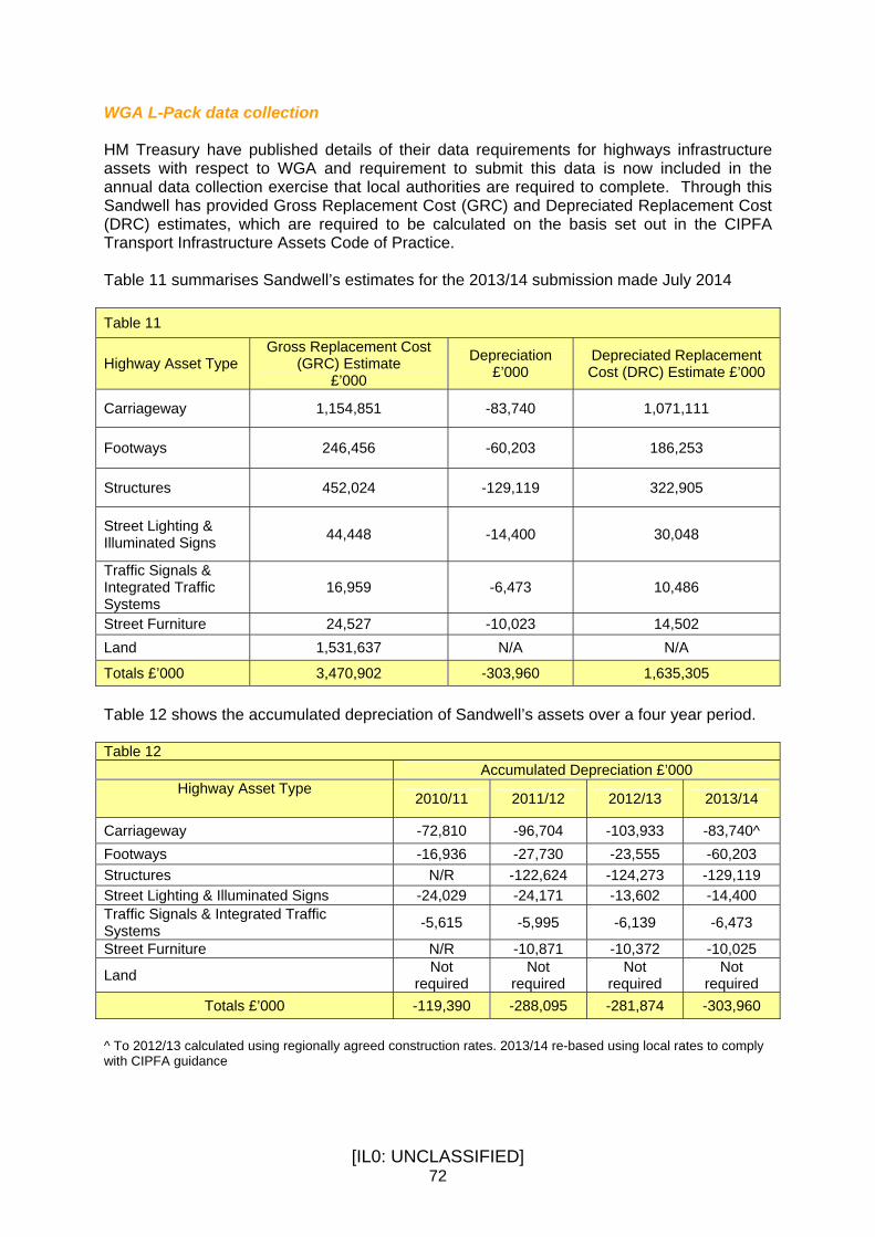
[IL0: UNCLASSIFIED] 72
WGA L-Pack data collection HM Treasury have published details of their data requirements for highways infrastructure assets with respect to WGA and requirement to submit this data is now included in the annual data collection exercise that local authorities are required to complete. Through this Sandwell has provided Gross Replacement Cost (GRC) and Depreciated Replacement Cost (DRC) estimates, which are required to be calculated on the basis set out in the CIPFA Transport Infrastructure Assets Code of Practice. Table 11 summarises Sandwell’s estimates for the 2013/14 submission made July 2014 Table 11
Highway Asset Type Gross Replacement Cost
(GRC) Estimate £’000
Depreciation £’000
Depreciated Replacement Cost (DRC) Estimate £’000
Carriageway 1,154,851 -83,740 1,071,111
Footways 246,456 -60,203 186,253
Structures 452,024 -129,119 322,905
Street Lighting & Illuminated Signs 44,448 -14,400 30,048
Traffic Signals & Integrated Traffic Systems
16,959 -6,473 10,486
Street Furniture 24,527 -10,023 14,502 Land 1,531,637 N/A N/A
Totals £’000 3,470,902 -303,960 1,635,305 Table 12 shows the accumulated depreciation of Sandwell’s assets over a four year period. Table 12
Accumulated Depreciation £’000 Highway Asset Type
2010/11 2011/12 2012/13 2013/14
Carriageway -72,810 -96,704 -103,933 -83,740^ Footways -16,936 -27,730 -23,555 -60,203 Structures N/R -122,624 -124,273 -129,119 Street Lighting & Illuminated Signs -24,029 -24,171 -13,602 -14,400 Traffic Signals & Integrated Traffic Systems -5,615 -5,995 -6,139 -6,473
Street Furniture N/R -10,871 -10,372 -10,025
Land Not required
Not required
Not required
Not required
Totals £’000 -119,390 -288,095 -281,874 -303,960 ^ To 2012/13 calculated using regionally agreed construction rates. 2013/14 re-based using local rates to comply with CIPFA guidance

[IL0: UNCLASSIFIED] 73
1 1 . R I S K M A N A G E M E N T Introduction The council has a well-established risk management process that overarches all service areas. The Street Scene Directorate, of which Highway Services is part, has accordingly identified and prioritised its high level risks and through appropriate mitigation and other controls measures aims to reduce assessed risk factors to an acceptable level. Context within Asset Management Within the context of highway asset management risk is one of the key drivers for the decision making process involved in establishing service options. It is therefore important that the adoption of specific levels of service or service options is done in the full knowledge of their inherent risks. The most commonly understood risks affecting the highway relate to safety. But other risks are a crucial part of the asset management process and may include: • Safety; • Reputation; • asset loss or damage; • service reduction or failure; • operational; • environmental; • financial and; • contractual. Risk management assists option selection and appraisal by assisting with the assessment of the comparative risks of: • providing differing levels of service • varying funding levels between asset groups • funding improvements as opposed to maintenance works The risk management process concentrates on four main issues: • Risk identification • Risk Analysis • Managing and controlling risks • Monitoring, reviewing & reporting risk Figure 5 shown overleaf illustrates the Risk Management Cycle. Succinctly, by applying these risk management principles we will be able to more appropriately target resources and to deliver services and projects in a way that ensures the council’s overall exposure to risk is minimised. The HMEP Guidance on Highway Infrastructure Asset Management published May 2013 recommends that ‘The management of current and future risks associated with assets should

[IL0: UNCLASSIFIED] 74
be embedded within the approach to asset management. Strategic, tactical and operational risks should be included, as should appropriate mitigation measures’. Prepared in accordance with the corporate risk management strategy the Street Scene Directorate’s current risk management action plan can be found in the Street Scene Annual Business Plan 2014-2017. A key service risk relates to safety and the liability claims arising from accident and injury due to the condition of the highway infrastructure. A statutory defence exists if an authority can prove it has in place adequate policies and procedures to maintain the highway, they are performed and there was no prior knowledge of the defect. The HAMP sets out the council’s planned safety inspection regimes for mitigating this risk. This provides for a practicable and reasonably deliverable response given resources available. Figure 5 – The Risk Management Cycle
Risk Identification
Risk Monitoring
Risk Assessment
Risk Management
The Risk Management Cycle

[IL0: UNCLASSIFIED] 75
12 . FORWARD WORKS PROGRAMME Introduction A fully integrated forward work programme is a frequently used method of demonstrating that the long term needs of the asset have been considered and evaluated. The process itself of preparing a forward work programme is most important because it drives consideration of the evaluation and ranking of alternative improvement projects and maintenance treatments. Such a forward work programme may typically cover a period of 10 years. At present Sandwell does not have a fully integrated or long-term forward work programme for all of the asset groupings, which make up the highways infrastructure. Historically managers of key asset groups develop local programmes predominately based on addressing worst condition first. The derivation of worst condition is however based on many sources of information that include safety inspections, condition surveys, complaints, service requests and insurance claims data. Whilst the construction of longer term forward works programmes will ensure that all work is carried out in accordance with whole life costing principles and develop co-operation between different work streams they may however, be less reliable in terms of the exact location and type of project to be carried out because the programme is constructed from projections using available data and knowledge. On the other hand aggregating all anticipated need is a valid method of long term funding prediction. Relationship with Co-ordination of Street Works The council has to ensure as far as is reasonably practicable, the expeditious movement of traffic on Sandwell’s highway network through duties placed upon it by the Traffic Management Act 2004. This involves co-ordinating works that take place on the network whether they are carried out by the council independent promoters such as public utilities. Presently, work programmes considered are quite short term. Co-ordination is a key element to the development of works programmes moreover if a long-term view is to be taken in their establishment. This will not only maximise benefits in terms of road space and traffic management issues but avoid instances of ill-timed works where for example maintenance schemes may be compromised by subsequent public utility refurbishment works. Forward Work Programmes Sandwell’s capital funded forward works programme for carriageway renewals, highway structures and street lighting can be found in Appendix D Carriegeways The Government’s commitment of £5.8 billion over the six years 2015 – 21 via the Local Transport Capital Grant to local highway authorities for carriageway maintenance is a welcome driver for longer term planning. Sandwell MBC is adopting the principles of modern asset management to establish long term predictions of the levels of service that the carriageway and a range of budgets are able to provide at a network level. Lifecycle planning is used to predict service standards against

[IL0: UNCLASSIFIED] 76
different budget allocations for planned maintenance (reconstruction, resurfacing and protective treatment) over a 20 year period embracing the ‘prevention is better than cure’ approach. This lifecycle planning work (see Chapter 8) is reported to the council’s executive decision makers to provide a basis for making strategic financial planning decisions at a borough wide level about future investment in, and performance of, the carriageway asset during the period 2015-21 but also in the longer term. The certainty of capital funding for the six year period 2015 – 21 together with the network level analysis will enable the development of a forward programme of planned maintenance interventions by means of a scheme selection and prioritisation process taking into account treatment intervals across the full 20 year life cycle period. This is work in progress. In the meantime we operate a rolling 2 year forward programme of planned maintenance works. The carriageway forward work programme for 2014/15 is at Appendix D. The council’s own revenue expenditure on highway maintenance is based on annual budgets and supports routine activities. All councils are facing extraordinary financial pressures as part of austerity measures. There is a need to align the council’s revenue budgets to the period 2015 – 21 to support a longer term affordable, efficient and effective highway maintenance management approach. The lifecycle planning work qualitatively estimates the impact on the demand for, and cost of, expensive and inefficient revenue funded routine maintenance such as small scale patching and pothole repair work for each option. Impacts on revenue expenditure can therefore be considered and aligned to the preferred maintenance strategy set within the council’s wider priorities. Highway Structures The forward programme and financial summary of capital funded improvements to highway structures is at Appendix D. A 20 year forward works programme has been derived for all routine and renewal maintenance operations for highway structures. These routine and renewal maintenance operations are shown in Tables 13, 14 and 15:

[IL0: UNCLASSIFIED] 77
Table 13 - Routine Maintenance Activities
Structure / Substructure Component Type
Maintenance Activity Maintenance Interval
Subways Remove graffiti* 12 Months Clear drainage channels Clean drainage outlets, rodding where required Check seating of drainage gratings and covers, replace any missing or defective items Repair gap sealant to movement joints Check and clean security mirrors
Culverts Remove any vegetation and debris 6 Months from within the structure Remove any silt build-up which is restricting flow through the culvert Repair gap sealant to movement joints
Sign gantries and high Tighten holding down bolts where 12 Months masts necessary

[IL0: UNCLASSIFIED] 78
Table 14 Routine Maintenance Activities
Structure / Substructure Component Type
Maintenance Activity Maintenance Interval
Piers, abutments, wing Remove graffiti* 12 Months walls, retaining walls, Remove vegetation from structure reinforced earth walls Clear debris from bearing shelves and crib walls Clean drainage channels
Rod outlet pipes Clear drainage outlet manhole chambers Rod weep pipes and remove silt & debris Check operation of flap valves and grease where required Repair gap sealant to movement joints Check pedestrian protection measures
Columns Remove graffiti* 12 Months Remove debris and bird droppings
Steel beams, girders, Remove graffiti* 12 Months trusses, concrete beams Remove debris and bird droppings and fascias from flanges
Clear drainage holes for box sections
Deck carriageway, Remove grass and weeds from 12 Months verge and parapet verges and channels cantilever Repair gap sealant to movement
joints Expansion joints Clean out debris and vegetation 12 Months
(water jetting where appropriate) Clear drainage systems Check and tighten where necessary any loose nuts and bolts. Replace where necessary Replace gaskets where there is a specific requirement in the structure maintenance manual
Metal parapets Check and tighten where 12 Months necessary any loose nuts and bolts. Replace where necessary. Clear hollow section drain holes
Masonry and concrete Remove graffiti* 12 Months parapets Remove any vegetation Bearings (elastomeric, Remove general dirt & debris 12 Months sliding & roller) Where appropriate, clean sliding 10 years
and roller surfaces if accessible and regrease
The Council has undertaken to remove any graffiti that is of an offensive or racist nature within 24 hours of it being reported.

[IL0: UNCLASSIFIED] 79
Table 15 Renewal Maintenance Activities
Treatment Type Comments Anticipated Frequency
Repainting Repainting steelwork to prevent 10 - 15 years corrosion
Waterproofing Repair or replacement of 5 - 12 years waterproofing to bridge decks. Work required to keep out water and chloride, which can cause corrosion of reinforcement.
Expansion joints Repair or replacement of 6 - 8 years expansion joints in bridge decks. Work required to prevent damage to road surfacing. Sealing joints required to keep out water and chloride, which can cause corrosion of reinforcement.
Resurfacing Repair or replacement of 5 - 12 years surfacing material to protect the integrity of the waterproofing membrane and to ensure a safe and comfortable surface for vehicles or pedestrians
Non-slip surfacing Repair or replacement of 3 - 5 years non-slip surfacing to ensure a safe surface for vehicles or pedestrians
Other work Other maintenance not shown 10 - 15 years above e.g. repair or replacement of brickwork, steelwork or bearings
There is a high level of confidence in this programme although the costs associated can only be the best available estimated at the time and may vary over the 20 years period.

[IL0: UNCLASSIFIED] 80
Other work to be carried out to the bridge stock originates from either the regular bridge inspections programme or through the upgrading / strengthening / replacement programme is show in Table 16 below: Table 16
Activity Explanation
Construction Although it is very unusual to have a new structural asset created, it does occur where a new route is required or where an existing substandard structure needs replacing.
Acquisition Acquisition of structures is normally associated with the taking up of maintenance responsibilities following new developments.
Upgrading A number of upgrading activities, which may take place to improve the existing stock condition, are detailed below.
Waterproofing Waterproofing of unprotected decks. Structures built prior to the introduction of the present standards may need the addition of waterproofing to protect against corrosion.
Parapet replacement Replacement of substandard parapets installed before the introduction of the present standards or at sites where the risk rating calls for a higher standard of parapet.
Strengthening of columns Possible collision may require strengthening of piers and columns to resist higher impact forces, due to the increase in numbers and weights of HGVs.
The frequency of bridge inspections is described in Chapter 8 and work is programmed over the years using a combination of engineering judgement, funding availability and adjustment to avoid work being replaced by subsequent work before life expired. The forward works programme for highway structures is therefore a combination of routine and maintenance and renewal maintenance operations, works arising from the bridge inspections and those major works of upgrading, strengthening or replacement. There are other works, following accidents or incidents such as bridge strikes, required on a more immediate basis which cannot be incorporated in a forward works programme but it is nonetheless, necessary to make budgetary provision for those events.

[IL0: UNCLASSIFIED] 81
Street Lighting Details of the forward programme of investment in street lighting are set out in Section 6 and in summary in Appendix D.

[IL0: UNCLASSIFIED] 82
1 3 . P E R F O R M A N C E M O N I T O R I N G Introduction Sandwell Metropolitan Borough Council has developed a performance culture through: Strong Leadership Accountability & Challenge This has been achieved through a close and active working relationship between lead members and council officers. Through this visible commitment to drive performance from the highest level has emerged a clear and strong message throughout the organisation that performance management is important. A Wider Perspective The council has an established planning cycle for programming spends that takes into account policy development, budget setting and performance management. In so doing resources are allocated to individual services to ensure policy is put into practice using a priority led allocation of resources. The council has established Shared Priority Outcomes (SPA’s), which are the most important planned achievements over a three-year cycle. They identify: - Actions required to deliver outcomes Links to corporate, thematic and directorate priorities, service inspections, or statutory requirements Impact of their delivery on the public, council and theme Resources required How outcomes are to be measured and the target or level of performance expected Reporting arrangements for tracking and assessing actual achievement Risk assessment and other implications of undertaking or not undertaking actions The council believe the people of Sandwell have a right to know what we are doing, why we are doing it – and the progress we make on what we say we will do. It has developed a Scorecard, which aims to let people know just that. The Scorecard presents a rounded definition of excellence for the council as a whole and is written around ‘outcomes’ that have a real meaning for people and through it they are able to make their own judgement about the council’s performance in an informed way. Highway Services indirectly supports many environmental and regeneration outcomes in the Scorecard and also does have direct responsibility for the following outcome in the Scorecard, under Sandwell’s Children our Future: “We are constantly looking at ways of reducing the number of children killed or seriously hurt on our roads” Performance Management The council has developed a strong performance management framework to support continuous improvement in services. A deputy leader has been allocated a portfolio

[IL0: UNCLASSIFIED] 83
addressing improvement and efficiency and is charged with driving performance improvements in relation to delivery our corporate priorities. Through this, other lead members and officers can be challenged on issues relating to performance. To augment this, the chief executive works closely with executive directors to focus on key issues affecting the services within a theme, reviewing key planning milestones, reviewing performance and overall risk. In addition, the council has adopted an appraisal process where all levels of employees, managers and cabinet members are focused, through meetings held on an individual basis, on the achievement of these stated outcomes through personal performance and development. A Local Perspective The Streetscene Annual Business Plan 2014-17 sets out how the delivery of highway services can contribute towards the council’s objectives and vision whether these have been established corporately, through partnerships or agreement with central government. To underpin the council’s performance framework Activity Based Costing (ABC) budgets is used to align resources to specific agreed activity outcomes. ABC will identify the true cost of each activity. The Street Scene directorate, of which Highway Services is part, has developed a high level business plan for 2014-17 to align its resources to Sandwell’s Scorecard priorities. Contained within it is a delivery action plan to identify key high level outputs that are to be pursued in relation to Scorecard shared priorities, other key directorate aspirations and corporate objectives (outcomes). The actions have been deliberately kept brief and focus upon measuring what matters. The progress towards achievement is monitored and reviewed quarterly by the senior management team. Highway Services delivery actions are to: • Implement actions identified in the Road Safety Plan 2013-15
• Revise the Asset Management Plan by July 2014 and implement actions in service
delivery
• Deliver the Local Transport Plan’s Safer Routes to School, Local Area Safety, Local Safety and Traffic Calming Schemes.
• Monitor progress in relation to income and expenditure for borough wide paid for
parking
• Implement actions arising from the review of the Highways Service against defined criteria for “A World Class Highways Service”
Single Data List On 13th October 2010 the Secretary of State for the Department of Communities and Local Government (DCLG) announced proposals to reduce burdens on local government by

[IL0: UNCLASSIFIED] 84
replacement of the National Indicator Set (NIS) with the Single Data List. From April 2011 the (NIS) has effectively ceased to exist. The NIS was set up to aid the performance management of local authorities by central government and consisted of processed indicators rather than pure data. The Single Data List is simply a catalogue of all the central government's data requirements from local government. It has been assembled to aid transparency rather than to manage performance of local councils and facilitates the control of the volume of data central government asks of local government. The DfT have been appointed by central government as the department responsible for data collection in relation to the condition of local authority managed roads and maintenance activity. They require submission of information relating to the following data topics: 130-01 Principal roads where maintenance should be considered* 130-02 Non-principal classified roads where maintenance should be considered* 130-03 Skidding resistance surveys 130-04 Carriageway work done survey 132-01 Estimate of road lengths 251-01 Winter service salt stock holdings *Data topics 130-01 and 130-02 were formerly NIs 168 and 169

[IL0: UNCLASSIFIED] 85
Performance & Data Measures Table 17 shown below details the highway maintenance related performance and data measures that we currently produce. Table 17 Highway Maintenance Performance / Data Measures
Measure Description Purpose
Single Data Set Ref 130-01 (Formerly NI 168)
Percentage of principal roads where maintenance should be considered
Dft Single Data List requirement, LTP 3 & corporate Value for Money monitoring
Single Data Set Ref 130-02 (Formerly NI 169)
Percentage of non-principal classified roads where maintenance should be considered
Dft Single Data List requirement, LTP 3 & corporate Value for Money monitoring
Former BVPI 224b Percentage of unclassified roads where maintenance should be considered
Regional, local & corporate Value for Money monitoring
Former BVPI 187 Percentage of footway hierarchy categories 1, 1a and 2 where maintenance should be considered
Regional, local & corporate Value for Money monitoring
Former NI 48 Children killed or seriously injured in road traffic accidents
Corporate Scorecard key outcome monitor
Single Data Set Ref 130-03
Skidding resistance surveys undertaken
Dft Single Data List requirement
Single Data Set Ref 130-04
Carriageway work done survey Dft Single Data List requirement
Single Data Set Ref 132-01
Estimate of road lengths Dft Single Data List requirement
Single Data Set Ref 251-01
Winter service salt stock holdings Dft Single Data List requirement

[IL0: UNCLASSIFIED] 86
Performance Outcomes Table 18 below lists our historical results for key highway maintenance performance measures in relation to other West Midlands Authorities. The percentages represent the length of network that is in a poor overall condition and is likely to require planned maintenance soon (Red - Road Condition Indicator) Table 18a Condition of Principal Roads
Table 18b Condition of Non Principal Classified Roads
Table 18c Condition of Footway Hierarchy Categories 1, 1a & 2
Authority BVPI 223 NI 168 RCI 130-01
Financial Year 2007/8 2008/9 2009/10 2010/11 2011/12 2012/13 2013/14 Birmingham 5% 6% 7% 11% 10% 7% 7% Coventry 2% 4% 3% 3% 4% 3% n/a Dudley 8% 8% 8% 8% 8% 7% 7% Sandwell 5% 5% 4% 5% 6% 7% 6% Solihull 2% 5% 3% 4% 5% 5% n/a Walsall 4% 6% 6% 7% 8% 7% n/a Wolverhampton 2% 3% 4% 5% 5% 4% n/a
Authority BVPI 224a NI 169 RCI 130-02
Financial Year 2007/8 2008/9 2009/10 2010/11 2011/12 2012/13 2013/14 Birmingham 5% 6% 6% 6% 6% 4% 3% Coventry 7% 6% 6% 8% 10% 8% n/a Dudley 5% 7% 7% 8% 7% 6% 5% Sandwell 4% 5% 5% 6% 7% 10% 8% Solihull 3% 6% 6% 5% 13% 5% n/a Walsall 5% 5% 5% 5% 5% 5% n/a Wolverhampton 2% 5% 5% 8% 5% 6% n/a
Authority BVPI187
Financial Year 2007/8 2008/9 2009/10 2010/11 2011/12 2012/13 2013/14 Birmingham 39% 21% 32% 48% n/a n/a n/a Coventry 40% 53% 40% 43% 41% 51% n/a Dudley 14% 4% 11% 24% 53% n/a n/a Sandwell 11% 9% 13% 5% 16% 4% 17% Solihull 23% 10% 14% 16% 12% 26% n/a Walsall 33% 21% 25% 28% 50% 64% n/a Wolverhampton 18% 14% 19% 26% n/a n/a n/a

[IL0: UNCLASSIFIED] 87
Table 18d Condition of Unclassified Roads
Public Perception Sandwell MBC took part in the National Highways and Transport Public Satisfaction Survey in 2009 and 2010. Following review of our developing asset management framework in line with the recommendations in the HMEP Highway Asset Management Guidance Document (May 2013) understanding stakeholders’ expectations is seen as a key part of setting service levels, making decisions and reporting performance (Recommendation 2). Therefore Sandwell MBC has registered to take part in the National Highways and Transport Public Satisfaction Survey to be carried out in June 2014.
Authority BVPI 224b Condition of Unclassified Roads
Financial Year 2007/8 2008/9 2009/10 2010/11 2011/12 2012/13 2013/14 Birmingham 11% 17% 21% 18% n/a n/a n/a Coventry 25% 21% 22% 24% 20% 21% n/a Dudley 11% 14% 13% 16% 14% 16% n/a Sandwell 11% 8% 7% 9% 15% 14% 17% Solihull 12% 16% 12% 10% 9% 9% n/a Walsall 17% 15% 15% 15% 24% 20% n/a Wolverhampton 10% 8% 11% 13% n/a n/a n/a

[IL0: UNCLASSIFIED] 88
1 4 . N E X T S T E P S With a focus on doing more with scarce resources, the Department for Transport has sponsored the Highways Maintenance Efficiency Programme (HMEP), a sector led transformation initiative, which is driving the introduction of business like asset management thinking into highway maintenance. To help authorities HMEP published new asset management guidance (May 2013). The guidance is intended to provide highway authorities with minimum requirements to achieve a reasonable level of benefit from asset management. The guidance contains 14 recommendations. Over the coming years we will review our current asset management framework and practices against each of the recommendations to further develop and embed our asset management planning making it an essential and valuable tool to ensure the stewardship of Sandwell’s highway infrastructure is undertaken in the best and most efficient way. In summary the 14 recommendations are: RECOMMENDATION 1 ASSET MANAGEMENT FRAMEWORK An Asset Management Framework should be developed and endorsed by senior decision makers. All activities outlined in the Framework should be documented.
RECOMMENDATION 2 COMMUNICATIONS Relevant information associated with asset management should be actively communicated through engagement with relevant stakeholders in setting requirements, making decisions and reporting performance.
RECOMMENDATION 3 ASSET MANAGEMENT POLICY AND STRATEGY An asset management policy and a strategy should be developed and published. These should align with the corporate vision and demonstrate the contribution asset management makes towards achieving this vision.
RECOMMENDATION 4 PERFORMANCE MANAGEMENT FRAMEWORK A performance management framework should be developed that is clear and accessible to stakeholders as appropriate and supports the asset management strategy.
RECOMMENDATION 5 ASSET DATA MANAGEMENT The quality, currency, appropriateness and completeness of all data supporting asset management should be regularly reviewed. An asset register should be maintained that stores, manages and reports all relevant asset data.
RECOMMENDATION 6 LIFECYCLE PLANS Lifecycle planning principles should be used to review the level of funding, support investment decisions and substantiate the need for appropriate and sustainable long term investment.

[IL0: UNCLASSIFIED] 89
RECOMMENDATION 7 WORKS PROGRAMMING A prioritised forward works programme for a rolling period of three to five years should be developed and updated regularly.
RECOMMENDATION 8 LEADERSHIP AND COMMITMENT Senior decision makers should demonstrate leadership and commitment to enable the implementation of asset management.
RECOMMENDATION 9 MAKING THE CASE FOR ASSET MANAGEMENT The case for implementing the Asset Management Framework should be made by clearly explaining the funding required and the wider benefits to be achieved.
RECOMMENDATION 10 COMPETENCIES AND TRAINING The appropriate competency required for asset management should be identified, and training should be provided where necessary.
RECOMMENDATION 11 RISK MANAGEMENT The management of current and future risks associated with assets should be embedded within the approach to asset management. Strategic, tactical and operational risks should be included as should appropriate mitigation measures.
RECOMMENDATION 12 ASSET MANAGEMENT SYSTEMS Asset management systems should be sustainable and able to support the information required to enable asset management. Systems should be accessible to relevant staff and, where appropriate, support the provision of information for stakeholders.
RECOMMENDATION 13 PERFORMANCE MONITORING The performance of the Asset Management Framework should be monitored and reported. It should be reviewed regularly by senior decision makers and when appropriate, improvement actions should be taken.
RECOMMENDATION 14 BENCHMARKING Local and national benchmarking should be used to compare performance of the Asset Management Framework and to share information that supports continuous improvement.

[IL0: UNCLASSIFIED] 90
Append ices
A. Asset Information Strategy B. Winter Maintenance Service Operational Plan C. Code of Practice for Highway Structures Implementation Action Plan
D. Forward Works Programmes
E. Status and Options Report for Carriageways April 2014

[IL0: UNCLASSIFIED]
A P P EN D IX A - Asset In format ion Strategy The County Surveyors’ Society’s (CSS) Highway Asset Management framework document makes clear the importance of asset information. This states: - “It is only when appropriate inventory and condition data are available to all staff involved in the process that an overall view and consistent management approach can be achieved.” It is also good practice for highway authorities to produce an inventory of all roads, footways and verges forming part of the publicly maintained highway. Asset information is required to enable the council to: -
• monitor and report on the condition of our highway infrastructure assets
• develop levels of service, associated performance indicators and targets
• identify future investment strategies – modelling future maintenance options and developing longer term programmes and associated budgets needs
• conduct valuation assessments for our highway infrastructure assets
• make well informed, cost effective asset management decisions

[IL0: UNCLASSIFIED]
Asset Groupings For the purposes of this plan the council’s highway assets have been broken down into seven main groupings. Accordingly, this Information Strategy has been focused around these. They are set out below in Table A.1: -
Table A.1 – Highway Asset Groupings Asset Group Asset Element
Carriageways Carriageways and Bus Lanes
Footways and Footpaths Footways, footpaths and hard paved verges
Street Lighting Lighting columns, lanterns, feeder pillars and cabling
Illuminated Signs and Bollards Advanced direction signs, direction signs, warning signs, illuminated bollards and zebra crossings
Traffic Signals, Controlled Crossings & UTC Signalised junctions, puffin, toucan and pelican crossings, SCOOT and UTC systems
Winter Service Gritters, plant and salt bins
Highway Structures Bridges, subways, culverts, retaining walls, tunnels, steps, river walls & revetments
Drainage Carriageway and footway gullies and piped systems
Benchmar k i ng R ev i ew Before embarking on the adoption of an asset management we considered it important to establish areas of strength and weakness in current data and practice for key highway asset management activities. Through involvement with the Highway Infrastructure Managers’ Group (HIMG) - West Midlands an exercise to do so has been undertaken. Opus International Consultants (UK Ltd) were commissioned to facilitate it. They also carried out a benchmarking review to quickly gauge and compare our current state with other local authorities across the region. Asset Data Review Sandwell like all Highway Authorities holds asset data. It is typical for elements of this data to be of unknown quality, not necessarily complete or up to date or for that matter to exist at all. It was therefore an essential prerequisite of our first HAMP prepared in 2010 that quality and completeness of existing asset data be established. In relationship to Sandwell’s asset groupings we carried out a review exercise to establish data availability, appropriateness, reliability and accuracy. This was undertaken through involvement with HIMG and was again facilitated by Opus International Consultants (UK Ltd). The level of confidence in our data was established by assessing the extent and reliability of our data and storage arrangements together with assessment of data criticality to service delivery and asset management planning.

[IL0: UNCLASSIFIED]
By combining criticality and confidence priorities were established to inform data improvement work programmes. Much data is now improved although there remain some areas where confidence levels are low. Work to review and update data quality, currency, appropriateness and completeness to support asset management is continuous. Relationship with Proposed Levels of Service Levels of service describe the quality of services provided by the asset for the benefit of the customers and whilst they do relate to demand aspirations such as safety, availability, accessibility etc. they do also need to relate to the physical condition of the asset. The physical condition of the asset can be considered in the following two ways: - 1. The perceived condition of the asset as “measured” by public and road user
perception; and
2. The condition of the asset as determined by measurement and analysis of condition data
To enable the latter to be achieved importantly in those instances when customers will not be in a position to hold an informed opinion, particularly in relation to the structural condition of the asset, it is essential that inventory and condition data exists to support the establishment and development of levels of service, and subsequent objective assessment of performance. It is imperative that this is considered when establishing the type and extent of, and priority for collecting new or supplementary data D a t a M a n a g e m e n t Data is one of the most important assets this council holds and good management information is based on good data. If we are to turn our data streams into useful information that can be used within the asset management process then we need to ensure we are managing our data effectively. Data management is the set of procedures and processes that we have in place to ensure that it is positively contributing to our aims an objectives. The Western European Road Directors (WERD) have published a guidance document entitled ‘Data Management for Road Administrations’ It contains a heath check questionnaire to help organisations establish whether or not their highways related data is successfully managed. The questionnaire has been used to undertake an independent data management audit for the West Midlands District Authorities. Opus International Consultants (UK Ltd) facilitated this and from it we have not only identified areas of strength but also areas of weakness where further investigation is required. The guidance document also contains a framework to help organisations achieve good data management. We have now begun to adopt a seven-step approach advocated within the framework and is show below.
[IL0: UNCLASSIFIED]
Step 1 Determine business information needs Step 2 Review current situation Step 3 Data analysis Step 4 Design a data management regime Step 5 Develop an implementation plan Step 6 Establish a data management regime Step 7 Monitor, review and improvement
D a t a M a n a g e me n t S y s t e m s In the past we believed that our asset data could be satisfactorily managed through the use of many disparate paper, plan and electronic systems. Whist this may have been the case, asset management has now brought about an essential need to have an ability to efficiently combine, view and interrogate, large and varied, and at times complex, amounts of data. In order to do so and to improve the management of these assets and fully integrate information in line with the minimum standard for Highways e-Service Delivery Standards (NeSDS), we decided to explore the expansion of our existing street works register and notice management system that had been originally provided to us by Symology Limited in 1993. Due to the flexible and comprehensive facilities made available by this product and our excellent relationship with the company we entered into a Partnership that provided us with a competitively priced integrated highway management solution, Insight Enterprise. The Insight Enterprise solution comprises of a universal set of fully integrated core modules that offers: - National Street & Property Gazetteer linked multiple network location referencing Flexible asset register with comprehensive data warehousing and reporting Graphical and GIS capabilities Asset condition evaluation and valuation Treatment selection and definition of works programmes, and schemes Contract and work management, and monitoring. The following describes in more detail how the system is currently deployed to help support service delivery. H i g h w a y S a f e t y I n s p e c t i o n s Routine highway safety inspections began in January 1998 primarily to help ensure that the Council were able to robustly investigate and where appropriate, repudiate highway related claims. At that time a first generation electronic safety inspection system called Roadster was used to support this aim. In November 2005 our obsolete and by then, unsupported Roadster system was replaced by Insight Enterprise. Besides offering improved functionality and integration with other work areas supported through Insight, it allowed infield data collection to be carried out using modern hand held data capture devices, resulting in cashable efficiency gains being achieved through more cost effective inspections.

[IL0: UNCLASSIFIED]
Ad-hoc reactive safety defect and non-safety related defect reports are also recorded in Insight. In relation to these and routine safety inspections prioritised work instructions are produced from the system for remedial repairs. For defects considered being the responsibility of external organisation or other council service areas repair requests are forwarded using notifications raised and issued through Insight. Repair response times are recorded in and subsequently monitored for performance against target using Insight. Insurance reports are produced from Insight at the request of the council’s Risk Management Unit and are used by them to assist in dealing with highway related third party claims. L o c a l S t r e e t G a z e t t e e r The Improvement and Development Agency (IdeA) through the its former subsidiary Local Government Information House (LGIH), developed and implemented several national infrastructure projects to assist Councils with delivering better local services. One of these has been concerned with the production of a National Street Gazetteer (NSG) The NSG is designed to be an unambiguous referencing system that will identify any length of a street in the UK. It conforms to British Standard, BS 7666 part 1 and provides a complete list of streets with their names and other useful information. The council through a Public Sector Mapping Agreement with the Department for Communities and Local government has a commitment to submit on a regular basis a current and valid Local Street Gazetteer (LSG) to GeoPlace, the present NSG concessionaire, who took over custodianship from LGIH as part of a joint venture between Local Government and Ordnance Survey. Local councils and other interested parties such as Public Utility companies incorporate the NSG fully or partially within their systems to form a central locational index to street and property related data. Our Insight system is no different in that it references asset and other system features such as condition surveys and inspections to Sandwell’s Local Street Gazetteer (LSG). Insight’s UK Street Gazetteer module is used to ensure our LSG is well managed and maintained and made available for submission to the concessionaire’s national hub for inclusion into the NSG and for that matter, other systems used by Highway Services and the wider council. U n i t e d K i n g d o m P a v e m en t M a n a g e m e n t S y s t e m (UKPMS) UKPMS is a national standard for the management and assessment of the local road network within the UK. It is endorsed and promoted by the UK Roads Board. Our UKPMS is an integral part of Insight Enterprise. It holds and is able to process road network information and condition data collected using both visual and machine based

[IL0: UNCLASSIFIED]
surveys. Information derived from processed data is used to assist with the planning of investment and programming of maintenance activities. Insight is also used to graphically display condition data in strip line form or superimposed on a route-map to aid visual understanding and decision-making. There is a Department for Transport requirement for key aspects of UKPMS to be nationally consistent and comparable. For this reason, systems are subject to compliance testing and accreditation. The Government requires for its Single Data Set (SDS) two key condition based performance indicators to be produced using a UKPMS. These are as follows: - SDS ref 130-01 (Former NI 168) Condition of Principal Roads SDS ref 130-02 (Former NI 169) Condition of Non-Principal Classified Roads Besides these the following indicators are used and produce from our UKPMS for monitoring and measuring performance at regional and local levels: - Former BV 224b Condition of unclassified roads Former BV 187 Condition of high category footways HM treasury’s requirement for local authorities to now produce and report GRC & DRC estimates through the adoption of CIFA’s Transport Infrastructure Assets Code of Practice. To do so necessitates the use of a UKPMS to process and produce information for the establishment of carriageway and footway accumulated depreciation.
B r i d g e s a n d O t h e r H i g h w a y S t r u c t u r e s It has been recognised that the acquisition and implementation of a Bridge Management System (BMS) is an essential requirement for underpinning the good management of highway structures and asset management planning. To maximise the benefits from a BMS we believed that where possible it should be part of, or align with, a wider highway asset management system. For this reason it was decided that our BMS should be an integral part of the Insight Enterprise solution.

[IL0: UNCLASSIFIED]
Functional system requirements have been specified and are detailed within the Framework for a Bridge Management System contained within the life cycle plan. The framework calls for functionality to be developed to meet three implementation milestones. To date Milestone 1 has been met with basic inventory details and inspection information now being held within the Insight BMS. The functional requirements to reach Milestone 2 have been defined as follows: - User interface Report generator Asset database Works management Abnormal load management Performance measures Decision support for short term planning & basic AM planning In order to reach Milestone 3 the BMS in addition to the above should be able to undertake the following: - Prediction modelling Whole life costing Asset valuation Many of the objectives identified to achieve Milestones 2 & 3 require further development to Insight’s BMS but indeed also to systems provided by other suppliers. Co - o r d i n a t i o n o f S t r e e t Wor ks The Council, as a Highway Authority, has a statutory duty under the New Roads and Street Works Act 1991 to keep a Street Works Register to co-ordinate street works, works for road purposes and other related matters. To enable Utilities and promoters of works to transmit information for inclusion in this register an Internet based national electronic system for transfer of notifications (ETON) is used. To meet these demands and to embrace new technological developments an electronic street works register and notice management system, Highway One, was procured from Symology Ltd and implemented in 1993. It was very much the precursor to their Insight Enterprise solution and much of its functionality still forms the cornerstone of our current system. In 2005 the Traffic Management Act 2004 took effect placing a ‘network management duty’ on Local Traffic Authorities (LTAs) requiring them ‘secure the expeditious movement of traffic on the Authority’s road network’. As a consequence we upgraded the Insight system to strengthen our ability to meet this duty. A revised Code of Practice for Noticing was issued in July 2007. It took effect from April 2008 and places additional statutory requirements on LTAs. Included is one for best use of technology to secure road network performance improvements.

[IL0: UNCLASSIFIED]
The use of GIS and spatial referencing has been specified within the code as a primary enabler for improving the co-ordination of road works and street works register management. Accordingly, we now propose to implement Symology’s enhanced multi-user, spatially enabled Insight software to ensure we can do so. St r e e t L i gh t i ng The Division is responsible for the management and maintenance of street lighting and illuminated signs and bollards. An electronic management system supplied by Mayrise is used to help deliver this service. Data held within and processed by the system provides information to support both management decisions and operational functions. In addition, it is importantly used to produce the following key service performance indicator: - Average time to repair lamps (Local authority works) Average time to repair lamps (District network operator) Percentage of street lamps not working as planned Percentage of street lamps restored to working condition within 5 calendar days The system helps to underpin the following activities: - Inventory management Fault recording & works ordering Cyclic maintenance Financial management Performance monitoring Mayrise also incorporates an integrated mapping functionality to provide the ability to plot and view inventory and fault locations.

[IL0: UNCLASSIFIED]
Wint e r Se rv i c e To ensure that Winter Maintenance resources are used in the right way, in the right place, at the right time, good local weather forecasting and an awareness of the current road condition is essential. In the defined Winter Maintenance period, we use advanced weather forecasting information, provided by MeteoGroup UK Ltd, via a web-based system known as RoadCast. The RoadCast service provides users with both 24 hour and 5 day weather forecasts, ice prediction, together with weather maps / radar images. Outside the normal weather forecasting window, when conditions dictate, MeteoGroup UK Ltd. issue simple coded messages providing Road Danger Warnings. In addition to RoadCast, Sandwell as one of the West Midland District Councils jointly funds and utilises a common ice prediction system known as Icelert. This is also a web-based system involving the use of microcomputers, carriageway and atmospheric sensors at out-stations, together with office in-stations and portable computers. The Icelert system provides information for an Ice-Prediction service based on 8 sites situated across the West Midlands chosen for their particular geographic location, whilst current and historical values for both air and road temperatures, along with salt strengths are available for 27 other sensor sites. Once salting vehicles have been deployed, we use a web-enabled system called EXACTRAK to monitor their position and route. Tr a f f i c S i g n a l s & C o n t r o l l e d C r o s s i n g s D a t a b a s e Inventory and related attribute data for traffic signals and controlled crossings equipment is currently held in several disparate paper and electronic based systems. Until recently, these data sets had incomplete coverage and were not current because of a lack of resources to maintain them. As a consequence an objective to improve their currency and coverage was deemed necessary. This has now been achieved and as a consequence we have also been able to produce an unmetered supplies inventory that is compliant with the requirements of our energy provider. To facilitate improved and easier maintenance of data, to address our future business needs and the requirements of HAMP, we propose to fully transfer the inventory into Insight’s asset register. This involves further data cleansing, updating and validation which is now being undertaken. As part of this work, paper based and electronic data has been amalgamated into a single electronic data set in preparation for transference into Insight Enterprise’s Asset register. In so far as mapping is concerned, spatial attributes do exist within inventory data to allow binding with a GIS. Presently, “real time” map integration does not exist and this is therefore seen as a shortcoming and hence is another reason for the transference of data into Insight.

[IL0: UNCLASSIFIED]
Sk i dd i ng P r i o r i t i sa t i on Sys tem The level of skidding resistance required will vary across the road network, depending on road geometry and other characteristics. Typically, a higher skidding resistance is required at difficult sites (for example bends, approaches to junctions and steep gradients) than required at ‘non-event’ sites (for example a straight road without junctions) We have therefore adopted an approach based on ‘Investigatory Level.’ This is a recognised national method by which appropriate skid resistance values (Investigatory Levels) are assigned to sections of road, which are then surveyed by purpose built survey apparatus to compare the actual road skidding resistance level against its assigned Investigatory Level. Sites with skidding resistance below Investigatory Levels are subject to an investigation to establish whether or not remedial measures need to be carried out. This involves reviewing accident records and skidding survey results. Where accidents have occurred sites are prioritised for remedial measures with regard to survey results and the nature / number of accidents. Historically, this was carried out in a subjective way using information extracted from disparate systems. Through a consortium with other West Midlands District Councils, Paul Marsh and Associates consultancy to develop a software solution to provide an objective means of identifying and prioritising sites requiring remedial measures. This solution combines statistical accident data with skidding survey results and through analysis using algorithms and applied weighting factors. It is able to produce a listing of sites / schemes for remedial measures ranked logically, on a worst first basis in an efficient, automated and transparent way. A GIS interface is to be provided, which will aid visual understanding of output and decision-making. F ut u r e S t r a t e gy / R e q u i r em e nt s There exists an overarching objective to make Insight the division’s integrated asset management system to do so has involved an ICT improvement project. Work continues to develop and integrate our asset management system capability. Not only will this improve the management of data held that is needed for asset management planning but also will provide opportunities to gain benefits through technology to further assist the efficient delivery of improved and locally focused services at a time when resources are limited. These use new technologies will also improve resilience whilst giving superior data integrity and interoperability with other systems. In terms of asset information held the asset data review exercise has highlighted the need to have a long-term objective to establish new asset data sets and/or collect supplementary information in relation to existing ones. A programme of data collection has been created against a backdrop of the assessment of the cost of collecting and maintaining required data against practical and financial benefits. Examples of where we have improved data held have been in the establishment of a highway retaining wall inventory, highway tree condition / attribute inventory and improved coverage in the condition and inventory information held for carriageways and footways.

[IL0: UNCLASSIFIED]
In 2013 we are currently improving the confidence and completeness of information for street lights and illuminated signs by refreshing inventory data held in Mayrise.

[IL0: UNCLASSIFIED]
A P P EN D I X B - W i n t e r M a i n t e n a n c e S e r v i c e O p e r a t i o n a l P l a n
[IL0: UNCLASSIFIED]
Street Scene Highways Services
WINTER MAINTENANCE SERVICE
OPERATIONAL PLAN – 2014/2015
[IL0: UNCLASSIFIED] 1
I N D E X Page No. 2. Introduction. 3. Policies and Responsibilities
6 Quality Plan 8 Route Planning 10 Weather Prediction and Information 14 Organisational Arrangements and Personnel 17 Plant Vehicles and Equipment 18 Salt and Other De-Icing Materials 22 Salt bins 24 Operational Communications
25 Information and Publicity
26 Model Report Sheets
28 Carriageway Salting Routes 63 Footway Salting Routes
65 Salt Bin Locations

[IL0: UNCLASSIFIED] 2
INTRODUCTION In England, weather is unpredictable and the occurrence of wintry conditions varies considerably through the season and from year to year. Generally severe conditions might reasonably be expected in December, January and February; are less likely in November and March and are possible but unlikely in October and April. Operational winter maintenance periods need to be defined, to strike a balance between economy and an effective service. To plan resources regularly on the assumption of a long hard winter would be wasteful, but to do so on the assumption of a short, mild winter could lead to a deficient service at times. Planning should be undertaken between these extremes, but with enough back-up at reasonable notice to react to unforeseen circumstances. Put simply, resources should be directed:
• in the right way • in the right place • at the right time • be affordable
Winter Maintenance comprises the treatment of the highway to: i) Prevent ice from forming (Precautionary salting) ii) Melt ice that has already formed (Post salting) iii) Remove Snow Winter Maintenance forms an integral part of the highway maintenance function and highway authorities spend over £100 million per year on salting and snow clearing operations. Most of this money is spent on salting, either pre-salting to prevent the build-up of ice, or post salting to disperse ice that has already formed. Although there are times during a winter when a true emergency exists, occasioned by heavy or drifting snow, most winter maintenance operations can be planned in a systematic manner. The extent of this planning will be dependent upon the nature of each authority and the severity of an average winter. This Plan sets out standards for the treatment of Sandwell MBC’s highway network under the varying conditions of ice and snow, and sets out a framework of good practice within which the winter maintenance operation is managed. The standards set out in this Plan for snow and ice clearance reflect the recommendations contained in the Code of Practice for Highway Maintenance – “Well-maintained Highways” published in July 2005.
[IL0: UNCLASSIFIED] 3
POLICIES AND RESPONSIBILITIES The objective is to provide a winter maintenance service which, as far as is reasonably practicable, will permit the safe movement of traffic along the priority network, whilst minimising delays and accidents attributable to the adverse weather conditions. Good practice is also important to minimise both the environmental impact of salt and affordability implications. Highway authorities are under a statutory duty - by virtue of the Highways Act 1980, to maintain the highways. Section 41: "The authority who are for the time being the highway authority for a highway
maintained at the public expense are under a duty, ........ to maintain the highway."
Section 41 (1A) “In particular, a highway authority are under a duty to ensure, so far as is
reasonably practicable, that safe passage along a highway is not endangered by snow or ice.”
Section 130: "It is the duty of the highway authority to assert and protect the rights of the
public to the use and enjoyment of any highway for which they are the highway authority......"
Section 150: "If an obstruction arises in a highway from accumulations of snow ....... the
highway authority shall remove the obstruction......" Recent legal judgement has concluded that there is no duty upon authorities to remove ice from highways under the general responsibility to “maintain the highway” in Section 41. It is important to note that this judgement does not remove liability in all circumstances. However, it is important to recognise that in the context of a highway authority's statutory maintenance duty that:- i) The highway authority is not obliged to take preventative measures in
anticipation of snow and ice. ii) The duty to clear ice and snow from maintainable highways is not absolute
and the authority will be under no liability unless the breach of duty to maintain is blameworthy. In other words so long as the decision as to whether or not to act has been taken on reasonable grounds, with due care and with regard to relevant considerations, the authority will not be liable.
iii) It has been said judicially that when there is a transient danger due to the
elements, be it snow or ice or heavy rain, the existence of danger for a short time is no evidence of a failure to maintain the highway.
The statutory duties outlined above are delegated to the Area Director of Streetscene. Overall coordination and control required by this Winter Service Operational Plan is carried out by a group of Street Scene officers from Highways Services based at Oldbury Council

[IL0: UNCLASSIFIED] 4
House, Oldbury. Operational delivery of the service is undertaken from the Highways Depot at Taylors Lane, Oldbury and Waste Improvement Partner facility at Shidas Lane, Oldbury. The Winter Maintenance Service is funded from the Street Scene Highways Maintenance target revenue budget. This account is cash limited and any under/over spends are required to be contained within this budget. Whilst every attempt should be made to do so, inevitably with the worst and most unpredictable part of the winter falling at the end of the financial year, some difficulties may be experienced. The budget is set based on a notional average winter with 55 precautionary treatments as follows:-
2014/2015 Committed costs (These costs are incurred irrespective of the severity of the winter and include) Plant 205,426 Salt bins 15,000 Labour standby (18 weeks) 45,360 Professional staff & Duty Officer 24,000 Road Weather Forecasting (West Midlands Consortium) 11,000 Road Weather Information Service - Icelert 7,169 Communications, GPRS, Energy Charges 7,300 Total of Committed Costs (£) £315,255 Variable Costs (These costs vary with the severity of the winter and include) Labour for operational ‘turn outs’ 70,000 Salt 170,750 Refilling salt bins 30,000 Fuel 15,400 Vehicle repairs 6,200 Total of Variable Costs (£) 292,350 Total Budget Provision (£) 607,605

[IL0: UNCLASSIFIED] 5
Off Highway Operations This plan sets out the operational detail in fulfilling the Council’s obligations as Highway Authority. However as a Local Authority with wider responsibilities and functions, dealing with the problems associated with winter weather necessarily involves other functional areas within the Council. Street Scene Ground Care operatives provide support across other areas of the Council in assisting with snow clearing and gritting operations. The deployment of resources from Ground Care depends largely on the scale and period of inclement weather. Resources available include 2 and 4 wheel drive tractors with front buckets, gritting facilities, lorries and pick up trucks. Prior arrangements are made for small supplies of rock salt to be available for salting purposes at each of the following depots Walsall Road, West Bromwich; Jubilee Park, Tipton and Dartmouth Park, West Bromwich. Salt is also available from the Highways Depot at Taylors Lane Oldbury.

[IL0: UNCLASSIFIED] 6
QUALITY PLAN
Forecast Data General Arrangements The information used in decision making will in most cases be a combination of a road weather forecast and Road Weather Information System (Icelert) sensor data. The main weather prediction service used by Sandwell MBC is the ‘RoadCast’ forecasting package provided by MeteoGroup Ltd. This service is designed specifically for Highway Authorities and their agents to give road condition specific weather forecasts and a 24-hour Consultancy contact. The Road Weather Information System in use by Sandwell MBC is Findlay Irvine’s ‘Icelert’ system. This system involves 2 remote weather stations within Sandwell with access to the data from these sites and those of neighbouring authorities via a password protected website. Data from these sites is collected and archived daily and may be referred to at a later date. This is particularly useful when forward planning and for dealing with insurance claims.
Report Sheets Every morning during the winter maintenance season, operational staff at Taylors Lane Depot complete a report on operational matters. This report notes what action was undertaken, the time each vehicle left the depot and the time each vehicle returned. Also noted are any problems, which were encountered, be they vehicular (i.e. breakdown or accident) or operational (i.e. access problems due to parked cars).
Summary Action Sheets and Monitoring Daily during the winter maintenance season the Duty Officer will complete a report sheet detailing that night’s activities. This notes the time and content of any telephone conversations with either the duty weather forecaster at MeteoGroup UK Ltd. or Operational staff, along with the time of any decision made regarding the night’s winter maintenance actions. All Sandwell MBC gritting vehicles are fitted with the Exactrak System (GPRS) to enable tracking of vehicles and logging of the actions performed. Information gathered provides a regular snapshot of the vehicle’s position, speed and direction of travel as well as its operational/activity status. This information is collected and presented on a specialist password protected website and enables routes to be fully audited from a remote position whilst also providing accurate and comprehensive treatment records.
Performance Monitoring At the end of each month MeteoGroup UK Ltd. provides each customer with performance statistics for the accuracy of their forecasts. At the end of the Winter Season, a meeting is

[IL0: UNCLASSIFIED] 7
convened between MeteoGroup UK Ltd. and the West Midlands Authorities to discuss their performance and also to identify where any improvements can be made.

[IL0: UNCLASSIFIED] 8
ROUTE PLANNING Sandwell Council is the Highway Authority for all roads within the Borough boundary other than the Midlands Links Motorways, which are maintained by Agents for the Highways Agency. Carriageway The classifications and lengths of public highway are as follows:- Road Classification Lane Length Principal Roads 126.2 km B Roads 37.0 km C Roads 54.3 km Unclassified Roads 645.9 km Back Lanes 14.0 km Total Network length 877.4 km
Resources do not permit all roads to be treated and hence a priority network has been established which covers approximately 410.1 km of lane length being 47.5% of the total network lane length (excluding Back Lanes). The carriageways on the priority network are divided into two categories:- Priority 1 – treated length of 126.3 km These are the Borough's Principal Roads (Class A). The Principal Roads form the
backbone of the road network within the Borough. Priority 2 – treated length of 283.8 km All Non Principal Roads (Class B & Class C) and other roads, though less important
comprising of other heavily trafficked routes, all bus routes and roads serving other key locations and important buildings e.g. hospitals, commercial centres etc.
Other roads within the Borough are not treated other than in exceptional circumstances when severe weather conditions occur and then only when all priority routes have been cleared. Priority Route Descriptions Priority 1 roads are divided into five separate routes (P1 to P5). These are utilised as a first preference for snow clearing. 8 routes (R1 to R8) cover the whole priority network (Priority 1 and 2 roads together). Routes have been drawn up in consultation with adjacent Boroughs and Motorway maintenance Agents for the Highways Agency to achieve consistency of treatment.

[IL0: UNCLASSIFIED] 9
It is inevitable that minor alterations to the network will be required from time to time throughout the winter season as traffic patterns are altered by reason of diversions or road closures. Call out criteria Priority 1 routes are only treated, when heavy snow conditions exist necessitating snow ploughing. Priority 1 and 2 routes are to be treated, when forecasts indicate that formation of ice or snow is likely. Response and treatment times i) Priority 1 routes, rate of spread 20-40 gm/sq.m. Response time - 1 hour, treatment time - 1½ hours, total - 2½ hours. ii) Priority 1 and 2 routes, rate of spread 10-20 gm/sq.m. Response time - 1 hour, treatment time - 2½ hours, total - 3 ½hours. iii) Priority 1 and 2 routes, rate of spread 30-40 gm/sq.m. Response time - 1 hour, treatment time - 5 hours, total - 6 hours. Footway Resources do not permit all footways to be treated. A priority network has been established based upon the footway hierarchy recommended in the Code of Practice Well Maintained Highways. Category 1(a) Prestige Area footways are major shopping streets in town centre and district centres. Category 1(a) Prestige Area footways are the priority. Prioritised footways may receive precautionary treatment when the forecast indicates that hoarfrost or snow is likely. Precautionary treatment of footways will be undertaken by operational staff from Sandwell MBC’s Waste Improvement Partner (WIP) based at Shidas lane Depot, Oldbury. When Duty Officer instructs WIP Supervisor that treatment is necessary, operatives will commence salting activities from 0630 with completion within 2.5 hours.

[IL0: UNCLASSIFIED] 10
WEATHER PREDICTION AND INFORMATION To be most effective, salt should be spread before either ice or snow settles on the carriageway. Anticipating these conditions and reacting appropriately, depends upon a mixture of local knowledge and experience, along with good local weather forecasting and an awareness of the current condition of the road. Weather Forecasting Service The ‘RoadCast’ weather forecasting service is received under contract through Dudley Metropolitan Borough Council from MeteoGroup Ltd. In accordance with common practice and the requirements the seven West Midlands Authorities, MeteoGroup will provide the following forecasts and summaries by the times stated:
• 24 hour text forecast issued by 12:30 hours detailing the expected conditions for the following 24 hours including:
o Min air and Road Surface Temperatures with time crossing zero o Relative humidity and dew point o Likelihood and timing of precipitation o For a forecast of snow, its timing, amount, type, direction, whether drifting is
likely to occur and the height above sea level at which accumulation is likely o Wind speed and direction o Confidence levels in the forecast
• 2-5 day text outlook issued with the 24 hour forecast that including: o A general synopsis and anticipated trends o Specific condition reports o Confidence levels in the forecasts (Low, Medium or High)
• Site Specific Forecasts issued by 14:00 hours that include: o Graphical representation, against time, of predicated road surface
temperatures, air temperatures and surface conditions. o Textual site specific forecasts.
• Evening updated forecasts 24 hour text and site specific graphs between 16:00 and 22:00 hours.
• 24 hour Telephone Consultancy Service o MeteoGroup provide a 24/7 telephone consultancy service throughout the
Winter Service season, to give advice on weather conditions and to discuss issued forecasts.
• Proactive Communication Regime o Pager based contact system for severe weather and significant change in
forecasts. o Sensor monitoring service.
• Dedicated Website access through www.roadcast.co.uk. • Monthly and End of Season Analysis of forecasts including:
o Synopsis of weather conditions during the period o Forecast site accuracy analysis o Pie charts detailing the frost prediction accuracy o The bias and root mean square error in the forecast of minimum RST

[IL0: UNCLASSIFIED] 11
This full service operates from 1st November through to 30th April. During October and May a reduced service is available whereby Road Weather Warnings are only issued as necessary. The telephone Consultancy Service remains available at all times. Forecast information is received by email direct to relevant staff and through both www.roadcast.co.uk and www.icelert.net. Upon receipt of the forecasts printed copies will be posted on notice boards at both operational depots for information to operatives on duty. Should the forecast change significantly, MeteoGroup will contact the Duty Officer with a revised forecast using a pager system. Messages will give a brief description and direct staff toward further information. A further aid to decision-making is provided by the weather forecasting service access to the roadcast.co.uk website. This site provides access to all of the aforementioned data plus a host of current radar images including precipitation intensity and type. This gives a visual indication of the progress of precipitation in various forms as it moves across the region and is of particular interest when snowfall is forecast. Road Weather Information System (RWIS) Sandwell MBC operates a Road Weather Information System manufactured by Findlay Irvine Limited, Edinburgh. This system, known as ‘Icelert’ allows for remote and instant access to outstations indicating current road surface and atmospheric conditions. A bureau system based at Findlay Irvine’s headquarters allows access to the information via a secure, password protected website at www.icelert.net . The bureau also archives all data for future use as required. The data available from the Icelert outstations is presented in both graphic and tabular format and includes:
• Road surface temperature • Road surface condition (salt levels and presence of precipitation) • Deep road temperature • Air temperature • Relative humidity • Wind speed and direction
There are 2 Icelert outstations within Sandwell. The outstations within Sandwell are located as follows:
• ROWLEY HILLS: Oakham Road, Tividale near Darbys Hill Road junction • WEDNESBURY OAK ROAD: Wednesbury Oak Road, Tipton approximately
opposite ASDA store Throughout the West Midlands Metropolitan Authorities area there are 29 Icelert sites and access to these sites is shared between the seven Local Authorities and agents within this area.

[IL0: UNCLASSIFIED] 12
Calibration of the Icelert outstations is carried out by the equipment manufacturer, Findlay Irvine Limited during September or October and January every year to ensure accuracy is maintained. Any faults with the Icelert.net bureau service should be reported to Findlay Irvine as soon as possible. The appropriate 24 hour emergency contact details are detailed on their website. Faults with the outstations within Sandwell should be reported to Highways Services who will arrange for the necessary repairs or maintenance to be carried out. Whilst good local weather forecasts are essential, due to the varied local conditions and topography of the Borough, other factors may have to be considered in reaching a decision e.g. recent pre-salting practice and therefore no specific action can be determined for a particular forecast. The onus of decision is left with the duty officer. Forecast sites: Birmingham YARWOOD Yardley Wood Road (New) Coventry COVRR Coventry Ring Road / London Road Dudley AUDNAM Camp Hill Audnam SEDGELEY A463 Gospel End Road /
Cotwall End Road Solihull SOLGA A4177 Kenilworth Road at
Gambles Garage CRANMORE Cranmore Boulevard Walsall BARR BEACON A5 / A452 at the Rising Sun PH Wolverhampton WOLRRBR Wolverhampton Ring Road /
Bilston Road Other Sensor Sites: Birmingham BHAM CITY Paradise Circus Queensway BISHWAY A5127 Lichfield Road, Sutton COVFORRD A45 Coventry Road, Yardley COVRD A45 Coventry Road, Yardley
HAGRD A456 Hagley Road / Quinton Expressway HAGWOL A456 Hagley Road /
A4123 Wolverhampton Road KINGRD A38 Kingsbury Road / Tyburn Road MERGN A5127 Lichfield Road, Sutton REDRD A441 Redditch Road, West Heath WALSRD A34 Walsall Road, Perry Barr (Vaisala site)
Coventry CORLEY Tamworth Road at the City boundary
COV01A45 A45 opposite the Windmill Hotel and Golf Course

[IL0: UNCLASSIFIED] 13
Dudley DUDHG A456 Hayley Green Island Sandwell ROWLEY Oakham Road / Darby’s Hill Road WEDOAK Wednesbury Oak Road, Tipton Solihull SOLCRAN A3400 Stratford Road /
Cranmore Boulevard Walsall KEYWAY A454 Keyway, Willenhall BROWNHILLS A5/A452 at the Rising Sun PH Wolverhampton WOLRR Wolverhampton Ring Road / Chapel Ash WOLSTFRD Stafford Road / Greenfield Lane WOLWOODX Dovedale Road, Woodcross Calibration of the Icelert outstations is carried out by the equipment manufacturer, Findlay Irvine Limited during September or October and January every year to ensure accuracy is maintained

[IL0: UNCLASSIFIED] 14
ORGANISATIONAL ARRANGEMENTS AND PERSONNEL Duty Officer During normal office hours, management of the winter maintenance service is undertaken by officers based at Oldbury Council House, Oldbury. Outside normal office hours a Duty Officer will operate from home, having remote access to MeteoGroup UK Ltd. forecasting information via the internet and telephone. The Duty Officer shall monitor weather forecasts and Road Weather Information Systems and make the appropriate decision for required treatments. They are also responsible for the overall co-ordination and management of operations. Duty Officers will operate on a rota basis and will be contactable by telephone at all times during their period of duty using their office number, a mobile phone, their home number and other numbers as necessary. At the end of duty period the Duty Officer will ensure on hand over that all relevant information is communicated to the new Duty Officer including if necessary a copy of the Duty Log. The Duty Officer will maintain a Duty Log in which records of all decisions made and actions taken will be recorded. This log is of particular importance during marginal or adverse weather conditions, where particular note will be taken of any contact with MeteoGroup (who/when/advice given), reports of problems on the network, changes in forecast affecting decision and all other such relevant detail. In addition the Duty Officer will post a notification message onto the Message Centre of Icelert.net. This webpage is accessible to all West Midlands Authorities. The Icelert.net Message Centre will also accept information and action taken from neighbouring authorities in the form of an email and display this within the message board. Finally, the Message Centre will also automatically send text messages to key personnel within Sandwell MBC (all Duty Officers, all Operational Supervisors and Communications Office staff). Operational For our Operational Division, operatives out of hours standby operates from home through the main parts of the winter for a normal period of 18 weeks, with a start in mid-November, although where the long range weather forecast indicates or the prevailing conditions dictate, this period may be extended by at either end of this period as necessary. Out of Hours Standby is from home, operatives being contacted by telephone and/or bleeper. Operational Supervisors will be experienced and trained personnel with responsibility for operational control at Taylors Lane Depot. All Operational Supervisors must hold a Heavy Goods Vehicle licence, attain the City and Guilds Institute Scheme 6159 Winter Maintenance Operators Qualification and the City and Guilds Institute Scheme 6159 Winter Maintenance Manager/Supervisor Qualification. They will co-ordinate all Winter Service operations from the depot and ensure they are undertaken in a safe manner. They will also relay observed local weather, carriageway and footway conditions to the Duty Officer. The Duty Operational Supervisor will also ensure the accurate recording and reporting of all relevant Winter Service information.

[IL0: UNCLASSIFIED] 15
During a normal gritting operation, once a decision is made by the Duty Officer, this is communicated to the Duty Operational Supervisor detailing exact requirements. The Operational Supervisor will then initiate the call-out of all personnel required to perform the tasks instructed. They will then proceed to Taylors Lane Depot to organise and co-ordinate operations. The Operational Supervisor will maintain a log which will contain details of instructions received, route exceptions, Duty Officer requests for assistance and any other operational issue deemed relevant. Once the gritting operation is underway, the Operational Supervisor will monitor the operation and deal with any issues that may arise such as vehicle breakdowns or network incidents. They will be the point of contact for the Duty Officer on the network for incident management. This would include arranging the treatment of any areas not covered within the Priority Treated Network as may be requested by the Emergency Services or other stakeholders and approved by the Duty Officer. Upon completion of the operation, the Operational Supervisor is responsible for ensuring that vehicles are accurately weighed back into the depot, offloaded of any excess material and that the Salt storage area is left in a tidy and safe condition. They must also ensure the quality of vehicle wash downs in accordance with operational procedures, that the gritting vehicles are returned to the storage area correctly and that any mechanical failures are made aware to vehicle maintenance staff. Any issues with regard to route coverage or treatment exceptions should be recorded in the Daily Log or Record of Salting Operation and all records completed accurately. Operational staff shall be drawn from staff within Sandwell MBC. These operatives will be trained to a high standard and capable of operating vehicles, plant and equipment to required standards and in accordance with instructions. Operational staff will be available on a weekly rota “home standby” basis to be contacted by telephone. All gritting vehicle drivers must hold a Heavy Goods Vehicle licence and attain the City and Guilds Institute Scheme 6159 Winter Maintenance Operators Qualification. Once a call-out is ordered gritting vehicle drivers will report to Taylors Lane Depot to collect a gritting vehicle and be assigned a route. Generally operatives are designated specific routes to promote route ownership and knowledge but will have a working knowledge of other routes should this be necessary. The operative will drive the route as required and on return to the depot discharge any excess salt and wash the vehicle down. During the operations, should the operative encounter any route exceptions such as road closures, illegal manoeuvres or extreme conditions on a certain section of network, these should be reported to the Duty Operational Supervisor for a record to be made and/or alternative instructions to be given. Loading shovel operatives will also report to the depot and undertake the loading of the gritting vehicles as instructed by the Duty Operational Supervisor. At the end of the operation they will also ensure salt stocks are maintained and left in a tidy condition.

[IL0: UNCLASSIFIED] 16
In normal circumstances operational resources comprise one operative per gritting vehicle together with one loading shovel operative. However, where deemed necessary by the Duty Officer and Duty Operational Supervisor, such as in heavy snow, freezing or dense fog with restricted visibility or during significant snowfalls when snow ploughs are in use or extreme conditions, gritting vehicles will be operated by two personnel, one driver and a mate/observer. Operational Division’s labour resources are:-
Operations Team Leader
Duty Operational Supervisors
Drivers Loading Shovel Operatives Mate/Observer
1 2 28 3 volunteers The above resources both in vehicles, labour and plant are sufficient to deal with the situation presented by an average winter i.e. routine pre-salting and average snowfalls. However, if winter conditions become so severe then further resources in labour and plant may be utilised from Contractors undertaking other routine highway maintenance operations. Communications are maintained by a combination of bleepers, land and mobile telephones. Day time numbers MeteoGroup UK Ltd. contact number is – 0845 6030563 A dedicated mobile number for the Duty Officer is 07710 310952 Out of hours numbers: At the commencement of the winter season a rota of duty officers and operational staff and operatives is prepared and issued to all interested parties. Home numbers are published but should only be used as a last resort.

[IL0: UNCLASSIFIED] 17
PLANT VEHICLES AND EQUIPMENT Custom Built Salting Vehicles 9 No Snowploughs 9 No Towable spreaders 2 No Loading shovel 1 No Other Plant Hired as required. Regular calibration testing of the spreaders is undertaken each year, remote controls are available to control spread width and rate of spread. All spreaders conform to BS1622:1989 and are speed-related. All vehicles and plant used during the routine operations are hired by our in-house Fleet Services based at Waterfall Lane Depot, who provide a 24-hour response for emergency repairs. All Sandwell MBC gritting vehicles are fitted with the Exactrak System (GPRS) to enable tracking of vehicles and logging of the actions performed. Information gathered provides a regular snapshot of the vehicle’s position, speed and direction of travel as well as its operational/activity status. This information is collected and presented on a specialist password protected website and enables routes to be fully audited from a remote position whilst also providing accurate and comprehensive treatment records.

[IL0: UNCLASSIFIED] 18
SALT AND OTHER DE-ICING MATERIALS Rock Salt is the prime material for combating snow and the formation of ice on the highway, but it has environmental consequences, in that it can kill vegetation and pollute watercourses, also causing damage to the road structure, bridges, utility apparatus and vehicles. Crushed rock salt treated with an agricultural by product (Molasses) to enhance its adherence to the road surface has been introduced in recent years. Successfully trialled by Sandwell MBC., it has allowed a reduced spread rate and therefore a reduced salt usage with less environmental impact. Therefore in the interest of both economy and environmental protection, only the minimum amount of salt should be used for the prevailing conditions. Realistically there is only one supply of rock salt from Winsford in Cheshire although trials have taken place with imported salt, the price of which is susceptible to currency fluctuations. In order to maintain adequate supply in Taylors Lane Depot, Streetscene staff at Oldbury Council House will maintain a detailed stock management system. Using this system, information on salt usage is inputted after every operation or incident of salt usage. This ensures that Streetscene are aware of the exact stocks available at any one time and restocking will then be triggered based on pre-determined minimum stock levels Specification: All coarse grade rock salt used on the highway by the Council for Winter Maintenance purposes is supplied to comply with B.S 3247 Part 1 (Salt for spreading on highways for Winter Maintenance). English mineral rock salt, complying with the current BS3247, is treated with Sodium Ferrocyanide as an anti-caking agent. Other rock salt may not be treated and may solidify, leading to storage, loading and spreading difficulties. Non BS3247 Rock Salt may also have inferior melting properties, which might lead to choking of the spreading equipment and to slippery deposits on the carriageway. In recent years there has been a tendency to use the finer grading of rock salt for precautionary salting, resulting in reduced potential for vehicle damage and a more uniform spread on the carriageway together with minimizing overspread and contamination of adjacent vegetation. Storage: The untreated salt held in readiness for use is stored, uncovered, in a purpose built salt store at Taylors Lane Depot. A thin polypropylene sheet, to maintain the benefits of the additive and reduce environmental impact due to run-off during inclement weather, protects salt treated with an agricultural by product. In general at the start of each winter, 7,000 tonnes of salt are stored and replenished as necessary through the winter period. Layout of the salt store ensures adequate rotational use of the salt on a year by year basis.

[IL0: UNCLASSIFIED] 19
Care should be taken that no valleys are formed on the top surface of the pile, there should be a continuous slope from the highest point of the pile to ground level with no steep faces liable to sudden collapse. Run-off from the stockpile is contained in catch pits to reduce salt contamination and a loss of salt from leaching. On the outer surface of the pile a crust forms of a slightly different colour which cuts down losses. It should be removed or broken up before the salt is loaded so as not to block the mechanism of the spreading vehicle. The corrosive nature of the salt makes careful cleaning and maintenance of the vehicles and plant used essential. Resilience The winters of 2009 and 2010 respectively exposed the fragility of Local Authorities salt stock resilience and the dependence upon salt stock replenishment during a winter season. The Code of Practice Well Maintained Highways has introduced a recommendation for minimum resilience of continuous treatment capability of 12 days with 4 treatments each day at a spread rate 20 grammes per square metre of dry salt (therefore, a minimum resilience of 48 actions). Each 20 grammes per square metre treatment of Priority 1 & 2 carriageway routes within Sandwell requires approximately 75 tonnes of dry salt and therefore the minimum desirable stockholding of salt at the start of the winter season is 3,600 tonnes. Should low levels of National Salt Resilience require the instigation of the Department for Transport’s ‘Salt Cell’ then the Authority will fulfil and comply with the requirements of the system. Salting Practice To be most effective, the treatment should be applied before either ice forms or snow settles. The success or otherwise of the operation depends greatly on the good judgement of those who decide whether or not to treat. It is recommended that the following rates of spread be used when treating carriageways: PRECAUTIONARY SALTING 10-20 gm/sq.m TREATMENT OF ICE (Dependent on the amount of ice to be removed and the temperature) 20-40 gm/sq.m TREATMENT OF SNOW (i) (Light) 20-40 gm/sq.m (ii) (Snow exceeding 30-40mm in depth) Plough where applicable and then salt. 20 gm/sq.m

[IL0: UNCLASSIFIED] 20
(iii) (Snow exceeding 30/40mm in depth with freezing temperatures) Plough where applicable then salt. 20-40 gm/sq.m N.B It is never recommended that salt be spread at a rate greater than 40 gm/sq m. It
should be recognised that salt alone will not melt snow, vehicle movements are essential to assist dispersal.
NOTE. Sustained low temperatures are rare in England. For each degree drop below - 5° C, the amount of salt needed to maintain the equivalent melting effect increases by about 14 g/m². Salt will melt ice and snow at temperatures as low as - 21° C, but below - 10° C the amount needed increases to become environmentally and economically undesirable. Melt water from thawing accumulations of snow on central reservations or verges, can spread over the carriageway and re-freeze, particularly at night. Extra treatment may be needed and potential hazards such as these should be closely monitored.
Snow Clearance and Severe Conditions It is difficult to lay down hard and fast rules for the clearance of falling or fallen snow. Conditions can vary considerably on a day to day basis. Response will inevitably depend on the severity of the conditions and the resources available at the time. However, the following notes are given as guidance. SEVERE CONDITION 1 If a snowfall of at least 75mm (3") occurs and the weather forecast is for freezing conditions to continue then the following course of action is to be taken:- Stage 1 Operational resources (including any specialised hired plant) will be concentrated on
clearing Priority 1 roads initially and then Priority 2 roads. Stage 2 Client officers will determine at what stage approval is given to treat "other" roads
outside the approved priority network. Such approval will only be given providing that priority 1 roads have been treated and/or are completely open to traffic and priority 2 roads are substantially so.
At this stage the following resources may be utilised and funded from the winter
maintenance account:- (a) Normal winter maintenance crews.

[IL0: UNCLASSIFIED] 21
(b) Redeployment of other operatives normally engaged on highway maintenance operations.
(excludes other operatives carrying out Ground Maintenance or Street Cleansing operations).
(c) Hired plant/equipment as necessary. Stage 3 If the weather conditions under Stages 1 and 2 continue to deteriorate then the Area
Director of Streetscene in consultation with the Cabinet Member for Highways & Environment may give authority to employ other operatives and contractors on winter maintenance operations.
The resources which may be used at this stage are:- (a) Normal winter maintenance crews. (b) Highways maintenance operatives. (c) Other Sandwell operatives in the Street Scene Directorate. (d) Contractors. (e) Hired plant as necessary. SEVERE CONDITION 2. The other condition which can be classified as severe and where treatment to "other" roads - outside the approved network - will be carried out is where severe frosts, ice or light snow (less than 75mm deep) occur for long periods of time. The decision to treat "other" roads in this condition is to be made by the Area Director of Streetscene in consultation with the Cabinet Member for Highways & Environment, who will also decide what level of resources are to be used in this situation. FOOTWAYS.
Conditions under which additional footways may be treated. (i) Up to 75mm deep snow. Redeploy highways cleansing operatives - but not to be charged to winter
maintenance. This will require the approval of Area Director of Streetscene.
(ii) Severe Condition 1 (stage 2) or Severe condition 2 (as defined earlier for carriageways)
Under either of these conditions the footways identified above may be treated /
cleared and the same arrangements, regarding resources and decisions, will apply as for carriageways.

[IL0: UNCLASSIFIED] 22
Salt Bin Policy Salt bins are provided to assist safe passage of vehicles along the carriageway. The placement policy considers the characteristics of a road together with influencing factors and apportions a score against each. If the criteria assessment total score exceeds 100 then a grit bin qualifies for placement and is maintained at this site subject to suitable resources. Grit Bin Placement Policy Criteria .
Road Characteristic Criteria Score
> 1 in 15 75
1 in 15 to 1 in 29 40 1 Gradient of Road
< 1 in 30 0
Bend < 100 m Radius 60
Bend < 250 m Radius 20 2 Carriageway Horizontal Alignment
Bend > 250 m Radius 0
NRSWA Type 1 90
NRSWA Type 2 75
NRSWA Type 3 50 3 Close Proximity (25m) and Falling
Towards
NRSWA Type 4 30
NRSWA Type 1 60
NRSWA Type 2 45
NRSWA Type 3 20 4 Road Category
NRSWA Type 4 0
Over 50 30
20 to 50 20 5 Number of Premises for Which Only Access (cul-de-sac)*
0 to 20 0
Yes 20 6
Critical community facility access required for large numbers of
people e.g. day care centre, health centre or similar? No 0
Road Categories are taken from the NRSWA specification. Each officer has access to a listing of all roads within Sandwell and their corresponding
NRSWA category.

[IL0: UNCLASSIFIED] 23
*N.B Any industrial premises for which this is the only access are to be automatically promoted to the higher category. Note: Evaluation on the above basis should ensure that salt bins are installed only at identified locations where there are any combinations of significant factors. Salt bins shall not be sited on the priority salting network. Care should be taken to avoid locating salt bins in areas where they may be used for the disposal of litter (ie near bus stops) or act as litter traps.

[IL0: UNCLASSIFIED] 24
OPERATIONAL COMMUNICATIONS D a i l y F o r e c a s t s 1st October – 30th October & 16th April – 15th May By 1100 24 hour & 2-5 day text forecasts 1st November – 15th April By 1300 24 hour, 2-5 day text forecasts & Site specific forecast graphs By 1630 Routine afternoon update to 24 hour forecasts 2100 Routine update to site specific forecast graphs By 0730 Morning summary, summarizing the actual weather conditions for the
previous night. Action plan By 1330 Duty Officer consult the 24 hour, 2-5 day text forecasts & the site specific
forecast graphs, which apply to the Sandwell area and consider possibilities. Inform the Duty Operational Supervisor as to possible plans (eg action / no action, early turn-out / late turn-out.
By 1700 Duty Officer review the situation following the routine afternoon update to 24
hour forecasts. 1800 Inform Duty Operational Supervisor if an early turn-out is required.
If no early action is required the situation will be monitored throughout the evening.
2101 Check the routine update to site specific forecast graphs
If no early action is required the situation will be monitored throughout the evening.
Note: At all times a MeteoGroup UK Ltd. ‘RoadCast’ forecaster is available by
telephone for further consultation as to the weather conditions.

[IL0: UNCLASSIFIED] 25
INFORMATION AND PUBLICITY Contact through the media is increasingly important as a means of keeping the road user informed of adverse conditions and promoting safety on the highway. Media coverage of winter maintenance and emergency operations plays a very important part in making the public aware of the service provided and how essential the service is to the community. Throughout the winter period dialogue with the media is maintained through the Council’s Press Office. Officers are proactive in providing up to date information on a daily basis in the form of a text message sent to the Press Office when an action is planned, in order that meaningful responses can be made to enquiries from the media. Appropriate officers are also available to appear on local radio stations as and when the needs arise. When periods of extreme weather conditions, ie heavy snow, have been forecast, the Press Office is notified of the Council’s winter service plans so that they can inform the media accordingly. It is of great importance that situation updates are received by the Press Office, therefore enabling them to present credible press releases and interviews to the media. Information is published on the council’s website at: http://www.sandwell.gov.uk/info/200284/roads_travel_and_parking/2139/gritting Increasing use of social media is made to keep our community informed about our winter service policy, operational activity and to manage expectations regarding the winter service. Driver Information Leaflets and information on Service Standards are published from time to time.

[IL0: UNCLASSIFIED] 26
MODEL REPORT SHEETS

[IL0: UNCLASSIFIED] 27
Sandwell Metropolitan Borough Council – Winter Service
Duty Officer Log Sheet
Reporting Period 12 noon / / 2012 to / / 2012
Forecasts (24 hour clock)
Updates
Text Forecast Received:
Graphs Received:
Afternoon Text Update Received:
Evening Graph Update Received:
Morning Summary Received:
I n s t r u c t i o n s t o T a y l o r s L a n e D e p o t Time: To:
Log of Principal Events:
Time: Action:
Duty Officer: Signed:

[IL0: UNCLASSIFIED] 28
CARRIAGEWAY SALTING ROUTES

[IL0: UNCLASSIFIED] 29
SALTING - PRINCIPAL ROADS ONLY - ROUTE P1 For use as pre-salting route OR heavy dose route in snow situations. Travel to Birchley island. Start salting into Birchfield Lane and continue into Oldbury Rd. At Kwik Save bear left to the island and left into Long Lane. Proceed past Borough boundary and turn around at roundabout and return along Long Lane. Turn left into Halesowen St and right into Bassano Rd. At the end turn left into High St and at the give way turn right into Henderson Way. Turn first right into Beet St and at the end turn left into High St. At the island turn right into Halesowen St and at the second island turn left into Horner Way. Cross over the traffic lights into Archer Way and at the end turn right along Oldbury Road, at lights turn right into Station Rd. Continue to roundabout and make u-turn back along Station Road. At the end turn left into Oldbury Rd and bear right into Henderson Way. Cross the island into Henderson Way and continue to the traffic lights. Carry on into Powke Lane and circle the island before turning into Garratts Lane. At the next island turn left into Heathfield Way (Old Hill by-pass). At the island u-turn and return along Heathfield Way and at the island turn second left into Highgate St. At the next island turn right into Halesowen Rd, go to the Borough boundary and turn around back along Halesowen Rd, to the island. Turn right into Reddal Hill Rd and on into Upper High St, into Foxoak Street and continue into Lower High St. Carry on into Forge Lane and at the Borough boundary turn around and return. At the island at Halesowen Rd turn right, proceed along Halesowen Rd. Carry on and at the Borough boundary turn around and return along Halesowen Rd. At the traffic lights turn right into Beauty Bank and turn first right into Station Rd. At the end turn left into Gorsty Hill, on into Halesowen St and left into Bassano Rd. Bear right into High St and at roundabout turn left into Birmingham Rd. At the island turn right into Henderson Way and on into Oldbury Rd.

[IL0: UNCLASSIFIED] 30
Continue on into Birchfield Lane and at Birchley island STOP SALTING and return to Taylors Lane. RouteP1 Last Reviewed October 2014 Last Revised October 2014

[IL0: UNCLASSIFIED] 31
SALTING - PRINCIPAL ROADS ONLY - ROUTE P2 For use as pre-salting route OR heavy dose route in snow situations. Start salting at the Depot. Turn right into Taylors Lane and at the island turn right into Shidas Lane. At the island turn left into Portway Rd and at the end turn left into Churchbridge. Turn around at McDonald's island and return along Churchbridge. At the Birchley island keep to left lane around the island and return along Churchbridge. At McDonald's island turn right into Oldbury Ringway towards Smethwick. Go on into Birmingham Rd and then on into Oldbury Rd. Continue into Toll House Way and on into Soho Way. At Windmill Lane circle the island once then exit into Grove Lane. At roundabout turn left into Dudley Rd and at the Borough boundary turn at Dugdale St and return along Dudley Rd into Cape Hill. Continue into High St, bear left at Newlands Green and left again into Bearwood Rd. Go along Bearwood Rd to the traffic lights at Hagley Rd West and turn right into Hagley Rd West. Go on to the island at Quinton Lane by Jefferson’s P.H. turn around and return along Hagley Rd West. Turn left into Bearwood Rd and at the traffic lights by Hadley Stadium bear right into Waterloo Rd. At the next traffic lights turn right and go down Cape Hill. At the roundabout turn left into Grove Lane and on into Soho Way. Cross the traffic lights at Crockett's Lane and take first left into High St. At Newlands Green bear right then right again and back along High St. Turn left into Toll House Way and continue along Oldbury Rd to the roundabout. Turn right into Spon Lane South and at the next island turn left into Kelvin Way. At Bromford Lane traffic island u-turn and return along Kelvin Way. At the next island turn left into Trinity Way and go across the next traffic lights. Go onto the Expressway, continue under the underpass to Albion roundabout, u-turn and return back along Expressway to motorway island. U-turn at Motorway island and return back along

[IL0: UNCLASSIFIED] 32
Expressway. Take left hand slip on to fire station island, make u-turn and take slip road back on to Expressway, (towards motorway island),. Turn left off Expressway into Trinity Way and cross the traffic lights. At the island turn left into Kenrick Way and turn left at the next island into Kenrick Way. Go around the M5 island; keep to the right to pass through the special holding section. Return down Kenrick Way, over the island into Telford Way and at the Oldbury Rd island turn around and return along Telford Way. At the island turn left into Kenrick Way and at the next island turn left into Spon Lane South. At the roundabout island turn right into Oldbury Rd and go on into Oldbury Ringway. At McDonald's island stop salting and return to Taylors Lane. RouteP2 Last Reviewed October 2014 Last Revised October 2014

[IL0: UNCLASSIFIED] 33
SALTING - PRINCIPAL ROADS ONLY - ROUTE P3 For use as pre-salting route OR heavy dose route in snow situations. Travel to Albion island (Carters Green) and start salting the Black Country New Rd. Go on along Black Country New Rd and cross Swan, Navigation, Parkway and Steel islands. At Patent Shaft island turn around and return along Black Country New Rd Go along Black Country New Rd and cross Steel, Parkway, Navigation, Swan and Albion islands into the Expressway (New Rd). Take left hand slip on to Fire station island then turn left into All Saints Way. At the traffic lights at the end of All Saints Way turn left into Heath Lane then immediately right into Walsall Rd. Turn right again into Lyndhurst Rd and at end right into Hollyhedge Rd. Move over to the left hand lane. At the traffic lights turn left into Newton Rd and at the Scott Arms traffic lights turn left into Birmingham Rd. Follow Birmingham Rd over the Motorway flyover to the Borough boundary just past Merrions Close. Turn through central reserve and return along Birmingham Rd over the flyover, but before the traffic lights at Scott Arms, turn through central reserve at Sundial Lane. Return along Birmingham Rd and turn off down the slip road to the Motorway island. Take the first slip road off towards Walsall back onto Birmingham Rd. U-turn at central reservation by Chapel Lane, back along Birmingham Rd and turn off down the slip road to the Motorway island. Circle island and take slip road back towards Walsall, join Birmingham Road and continue to borough boundary and make u-turn back along Birmingham Road towards Birmingham. Take left hand slip to motorway island, Circle the Motorway island once and turn off up the slip road signed to Birmingham back onto Birmingham Rd. At the traffic lights at Scott Arms turn left into Queslett Rd, continue to Asda island and make u-turn back along Queslett Road. At the Scott Arms cross into Newton Rd and at the traffic lights by All Saints Church take the right hand lane and follow the A4031 sign for Walsall onto Walsall Rd. At Stone Cross circle the island once and carry on down Walsall Rd to pass under the motorway and turn right into Greenside Way. Continue on into Thorncroft Way and Birchfield Way and at the island cross into Cherry Tree Avenue.

[IL0: UNCLASSIFIED] 34
At the end turn left into Greenside Way and second right into Orchard Rd. Continue on into Woodruff Way and at the end turn left into Greenside Way. At the end turn left into Walsall Rd. Proceed to the one way system at Lyndhurst Rd and at the end turn right into Hollyhedge Rd. Cross the traffic lights in the middle lane into All Saints Way. At the island at the Expressway (New Rd) stop salting and return to Taylors Lane depot. RouteP3 Last Reviewed October 2014 Last Revised October 2014

[IL0: UNCLASSIFIED] 35
SALTING - PRINCIPAL ROADS ONLY - ROUTE P4 For use as pre-salting route OR heavy dose route in snow situations. Start at Bromford Rd island (junc. Ringway and Church St.) Start salting Oldbury Ringway to McDonald's island and turn around. Return along Oldbury Ringway and continue along Bromford Rd, Bromford Lane, Moor St and Price Street. At the traffic lights turn left into St Michael's St and at the traffic lights turn left into High St and go on into Carters Green. At the island (Albion) turn right into the Expressway (New Rd) and cross the next island (All Saints). At the M5 island keep to the left hand lane over the motorway, go along Birmingham Rd to Park Lane and turn around. Return along Birmingham Rd to M5 island and keep to the left hand lane over the motorway. Return along the Expressway (New Rd), take left hand slip on to Fire Station island, circle island and take the slip road back on to The Expressway travelling towards Wednesbury. At the next island (Albion) turn right into Old Meeting St. Carry on along Old Meeting St, Black Lake, Hill Top, Holloway Bank, Bridge St, and Holyhead Rd. At the island turn left into Dudley St and at the next island turn left onto Black Country New Rd. At the island turn right into Leabrook Rd and after going over the canal bridge make sure you are positioned to spread salt to the full road width. At Ocker Hill island turn right and go along Gospel Oak Rd. At the traffic lights turn right into Farmer Way and at the end turn right into Charlotte Rd. At the end turn left into Willingsworth Rd and at the end turn left into Leabrook Rd Return along Leabrook Rd and at the island turn left into Black Country New Rd. At the island turn right into Dudley St and at the next island turn left into Holyhead Rd. At the island (Patent Shaft) turn around and return along Holyhead Rd. At the island turn left into High Bullen and at the next island turn left into Trouse Lane. Go on into Darlaston Rd to the Borough boundary at Woden Rd West. Turn around and return along Darlaston Rd into Trouse Lane to High Bullen island. Turn left into High Bullen, Walsall St and on into Wood Green Rd.

[IL0: UNCLASSIFIED] 36
Cross the traffic lights, continue along Wood Green Rd and u-turn at the Motorway island. Return along Wood Green Rd and Walsall St to High Bullen island and turn first left into High Bullen. At the next roundabout u-turn back along High Bullen to island, u-turn back along High Bullen at the island turn left into Holyhead Rd. Go along Holyhead Rd, Bridge St, Holloway Bank, Hill Top, Black Lake and Old Meeting St. At the island (Albion) cross into Carters Green and on into High St. At the end turn left into New Street, continue into Cronehills Linkway. Circle roundabout continue on to Cronehills Linkway, at Tesco roundabout circle island then turn left on to Cronehills Linkway to Fire station island. U-turn and return along Cronehills Linkway and take 1st exit at roundabout on to Congregation Way. At next roundabout make u-turn back along Congregation Way to Tesco island. Make u-turn and go back along Congregation Way to roundabout, circle roundabout and proceed along Congregation Way to Reform Street. At reform Street roundabout take 2nd exit into Reform Street, go straight over lights in to Bull Street. Straight over the lights onto West Bromwich Ringway. Take next left on to Spon Lane and turn left at end into Kelvin Way. Turn around at the island and take first right back into Spon Lane. At the traffic lights turn left into West Bromwich Ringway. At the traffic lights turn left into Moor St, go around Price Street gyratory to lights. Turn right into Moor Street then turn left into Moor Street and continue in to Bromford Lane. At the island cross into Bromford Rd and at the island at the Church St / Ringway junction STOP SALTING and return to Taylors Lane. RouteP4 Last Reviewed October 2014 Last Revised October 2014

[IL0: UNCLASSIFIED] 37
SALTING - PRINCIPAL ROADS ONLY - ROUTE P5 For use as pre-salting route OR heavy dose route in snow situations. Travel to Freeth St island on Oldbury Ringway and start salting. Turn left into Dudley Rd, and go on into Dudley Rd East. Go on into Dudley Rd West and bear left on Tividale Rd, turn right onto New Birmingham Road to Burnt Tree traffic signals. Turn right into Burnt Tree and at the traffic lights turn left into Sedgley Rd East. Continue on into Park Lane West and cross the island into Sedgley Rd West. At the traffic lights turn left into Dudley Rd and at the junction with New Birmingham Rd go across the traffic lights into Tipton Rd and turn around through the central reservation. Return along Dudley Rd to the traffic lights and cross into Hurst Lane, Bloomfield Rd, High St, and Wednesbury Oak Rd. At the Gospel Oak traffic lights turn left into Bilston Rd. Continue into Great Bridge Rd and pass under railway bridge then turn around and return along Great Bridge Rd and Bilston Rd. At the Gospel Oak traffic lights cross into Gospel Oak Rd to Ocker Hill island. Go around the island, return along Gospel Oak Rd to the Gospel Oak traffic lights and turn left into Wednesbury Oak Rd. Continue along Wednesbury Oak Rd, High St, Bloomfield Rd and Hurst Lane to the traffic lights. Turn left into Sedgley Rd West, cross the island into Park Lane West and on into Sedgley Rd East. At the traffic lights at Dudley Port turn left, continue on into Horseley Heath and at the Great Bridge island turn left into New Rd. Continue on into Toll End Rd and at the Ocker Hill island turn around and return along Toll End Rd and New Rd. At the island turn left into Great Western Way and at Navigation island turn left into the Black Country New Rd. At Parkway island turn around and return along the Black Country New Rd and at Navigation island turn right into Great Western Way. At the island turn left into Market Place and go on into Great Bridge. Go on into Great Bridge St and at the end turn left to Swan island. Go around Swan island and go into Dudley St.

[IL0: UNCLASSIFIED] 38
At the end turn left into Carters Green and at Albion island turn around and return into Carters Green. Immediately turn right back into Dudley St and just before Swan island turn left into Great Bridge St. Go on into Great Bridge and Market Place and at the island turn left into Horseley Heath. Go on into Dudley Port and cross the traffic lights to continue along Dudley Port to Burnt Tree traffic signals. Turn left into New Birmingham Road then at next lights turn left in to Tividale Rd; continue on into Dudley Rd West at lights at end turn left into Tipton Rd. Go across the Dudley Port traffic lights, turn around and return along Sedgley Rd East, Tipton Rd, Dudley Rd East and Dudley Rd. At Oldbury Ringway stop salting and return to Taylors Lane depot. RouteP5 Last Reviewed October 2014 Last Revised October 2014

[IL0: UNCLASSIFIED] 39
ROUTINE PRESALTING - WHOLE NETWORK - ROUTE R1
Travel to island at Oldbury Rd / Spon Lane South. START GRITTING on approach to island and turn left into Spon Lane South, at island turn right into Kenrick Way and at next island turn left into Kenrick Way. At M5 J1, follow inner lane of island and return back along Kenrick Way. At island continue into Telford Way and at next island circle roundabout and return along Telford Way. At island turn left into Kenrick Way and at next island turn right into Trinity Way. At the traffic lights turn right into High St continuing on into Birmingham Rd. At M5 J1, take third exit onto Kenrick Way then at roundabout turn right onto Kenrick Way. At roundabout undertake a U-turn back onto Kenrick Way, take 2nd left into Green Street, continue into Glover Street to Trinity Way, Turn left on to Trinity Way to roundabout. U-turn back on to Trinity Way continue lights at High Street. Proceed Straight over lights onto Trinity Way to Expressway, join dual carriageway. Leave Expressway at slip road onto fire station island, at island turn right into All Saints Way, continue into Newton Rd. Turn left on to Pear Tree Drive, turn left on to Pear Tree Rd to Pear Tree Drive, Turn Right on Pear Tree Drive to Newton Road. Turn left on to Newton Road. At Scott Arms continue into Queslett Rd, turn left on to Whitecrest, turn right on to Peveril Way, turn right on to Abbotsford Avenue proceed to Whitecrest. Turn left on to Whitecrest, travel along Whitecrest to Scott Road, turn right. Turn 5th left off Scott Road on to Carter Road, turn left in to Sundial Lane and continue to Queslett Rd and turn left. After passing under the M6 motorway bridge continue to roundabout at Asda and u-turn to return along Queslett Road to Scott Arms jct. At Scott Arms, turn right into Birmingham Rd; follow Birmingham Rd over the Motorway flyover to the Borough boundary just past Merrions Close. Turn through central reserve and return along Birmingham Rd over the flyover to Scott Arms. At Scott Arms turn right into Newton Rd and turn left into Hamstead Rd. Turn 1st right on to Hembs Crescent, turn right on to Tanhouse Ave, turn right on to Howard Road to Hembs Crescent, Turn right. Hembs Crescent to Tanhouse Ave, and turn left along Tanhouse Ave. Turn left on to Valley Road. Turn right on to Hamstead Road. Turn left in to Stanton Road, Turn left in to Green Lane; turn left in to Hamstead Road. Turn left on to Spouthouse Lane. Turn left in to Appleton Avenue, Turn right in to Gorse Farm Rd to roundabout, u-turn back along Gorse farm Road to

[IL0: UNCLASSIFIED] 40
Appleton Avenue, turn left on Appleton Avenue to Spouthouse Lane. Turn left in to Spouthouse Lane to Old Walsall Road, turn left and continue to jct with Walsall Road. Turn left to Scott Arms. At Scott Arms continue on into Birmingham Rd and turn left into slip Rd for Motorway Island, circle roundabout and take slip Rd back onto Birmingham Rd towards Walsall. Take right turn into chapel Lane, turn left into Coronation Road, continue into Merrions Close up to Birmingham Road Birmingham Road then Turn left in to slip road for Motorway Island, circle roundabout and exit slip road onto Birmingham Rd towards Walsall. Continue along Birmingham Road and turn right in to Merrions Close, continue in to Coronation Rd to Chapel Lane. Turn left in Chapel Lane to church and make u-turn. Proceed down Chapel Lane to Birmingham Rd and turn left. Take slip road on to Motorway Island and take exit slip road on to Birmingham Road heading towards Birmingham. At Scott Arms, turn right on to Newton Road, turn left into Jayshaw Avenue, turn left into Waddington Avenue to turn left on to Newton Road. Turn left in to Jayshaw Avenue, turn right in to Gorse Farm Rd, turn left at roundabout in to Eastwood Road then turn left at end in to Jayshaw Avenue. Turn 1st left in to Shenstone Road, turn left in to Gorse Farm Rd. At roundabout turn left in to Eastwood Road, turn right in to Jayshaw Avenue, continue to Walsall Road and turn left. Make u-turn through centre reserve and turn right at light in to Old Walsall Road. Turn right on to Hamstead Road then turn right in to Spouthouse Lane. Turn left into West Road, continue in to Templemore Drive, turn left in to Stanton Road to Hamstead Road, continue straight over roundabout in to Tanhouse Avenue. Turn right in to Valley Road, turn left on to Hamstead Road then turn right at the lights on to Newton Road. Turn left in to Pages Lane then left on to Birmingham Road, take left hand slip lane to jct 7 roundabout, take left slip on to Birmingham Road and keep in left slip road and turn left in to Wilderness Lane. Continue in to Longleat to the bottom then turn right in to Monksfield Ave. Turn right on to Newton Road and continue to All Saints Way. At traffic lights keep left into All Saints Way and turn left into Parsonage Street .Continue into Hallam St, Seagar St and Reform St to island. At the island take 3rd exit on to Congregation Way, at the next roundabout take the 1st exit and continue along Congregation Way to next roundabout. Take the 3rd exit on to Cronehills Linkway up to the fire station island. Circle roundabout and return back along Cronehills Linkway to the roundabout then take 1st exit on to Congregation Way. At the next roundabout take 2nd exit along Congregation Way.

[IL0: UNCLASSIFIED] 41
Turn left into Reform St, turn right into Lloyd St and continue along Dagger Lane. At end turn right onto Church Vale and bear left into Parsonage St. At traffic signals, turn left into All Saints Way and turn first right into Wilford Rd. At end of Wilford Road, turn right into Vicarage Rd to traffic signals turn right into Heath lane. Bear left into Walsall Rd then bear right into Lyndhurst Rd, and then keep right into Hollyhedge Rd. At traffic signals, continue into All Saints Way. At the fire station island turn left onto slip road on to The Expressway, turn left onto Trinity Way. Go straight over the lights at junction with High Street then at roundabout take second exit onto Spon Lane South. At roundabout make u-turn back on to Spon Lane South to Kevin Way roundabout. STOP SALTING AND RETURN TO TAYLORS LANE Route R1 Last Reviewed October 2014 Last Revised October 2014
[IL0: UNCLASSIFIED] 42
ROUTINE PRESALTING - WHOLE NETWORK - ROUTE R2 Travel from depot to island at M5 J1. START GRITTING. Turn onto The Expressway continue under the underpass to Albion roundabout, u-turn and return back along the Expressway under the underpass to M5 J1. U-turn at motorway island return back along Expressway, go up slip road to fire station island and then down slip road back on to Expressway continuing to Albion island. U-turn back along The Expressway go up slip road to fire station island and then continue down slip road on to The Expressway towards motorway island. At motorway island make u-turn back on to Expressway and continue along Black Country New Road to Leabrook Road roundabout, circulate roundabout and return along Black Country New Road to Albion Roundabout and then turn left into Old Meeting Street continuing over the traffic signals into Black Lake. At the traffic signals at Hill Top, turn left into New Street, continuing along Harvills Hawthorn, Bagnall Street and George Henry Road. At the island turn left onto Black Country New Road and turn second left into Richmond Street continuing into Dial Lane. At the end turn left in to Harvills Hawthorn and the left into Wedgwood Avenue. Turn right into Anson Road, left into Wolseley Road then right in to St Vincents Crescent, turn right into Marmion Way then left on to Dial Lane. Turn 1st right in to Ebenezer St continue in to Heronville Road, turn right on to Norbury Road and continue to New Street. Turn right in to New Street and at the traffic signals turn left into Hill Top. At the traffic signals turn right into Witton Lane, continue in to Jowetts Lane, turn left on to Allerton Lane then left on to Wyntor Lane up to Witton Lane then right and immediate left in to Coles Lane. Turn left in to Bedford Road, turn right in to Huntingdon Road, left in to Denbigh Drive to end then turn right in to Wiltshire Way. Continue in to Bank Street then turn left onto Vicarage Road. At the end turn right onto Heath Lane and follow the road to the left into Walsall Road and turn fifth right into Charlemont Road. Cross over Hollyhedge Road into Charlemont Road and turn first left into Beacon View Road. Turn fourth right into Smithmoor Crescent and second left into Meadow Avenue. At the end turn right into Charlemont Road and at the end turn right onto Hollyhedge Road continuing on into Jervoise lane. At the end turn right onto Walsall Road continuing through the gyratory system along Walsall Road and take fourth left into Sandy Lane. Turn first left into Friar Park Road, turn third left in to School Road, turn right on to Carrington Road, then left along Manor Road turn left into Carisbrooke Road

[IL0: UNCLASSIFIED] 43
then left in to Friar Park Road turn left into Freeman Road and continue into Carrington Road. Continue over Carisbrooke Road into Astbury Road then turn left in to Roberts Road and then right on to Friar Park Road.at the end turn right into Sandy Lane and turn left onto Walsall Road. Turn right into Greenside Way, left in to Redwood Road then right on to Birchfield Way then continue in to Thorncroft Way, then right back in to Redwood Road, turn left in to Cherry Tree Avenue follow to end then left in to Greenside Way. Turn right in to Orchard Road, continue round in to Ladbury Road to Greenside Way and turn left. Turn left onto Walsall Road. At Stone Cross, go around gyratory and return back along Walsall Road, turning right into Beacon view Road. Turn left on to Bustleholme Lane, circulate Andrew Road and Rayford Drive and return to Bustleholme Lane. Turn left on to Beaconview Road and turn second right into Wyndmill Crescent and follow round. At the end turn right onto Beacon View Road. Turn second left into Smithmoor Crescent and second left into Meadow Avenue. At the end turn left onto Charlemont Road into Wigmore Lane and turn right into Water Lane continuing on into Pennyhill Lane. At the end turn left into Hollyhedge Road, keep to right hand lane. At the traffic signals continue into All Saints Way turning right into Heath Lane turning right into Walsall Road, turn right into Lyndhurst Road and turn left onto Hollyhedge Road. Turn fifth left into Charlemont Road and at the end turn right onto Walsall Road. Continue along Walsall Road and circle Stone Cross gyratory, returning along Walsall Road (towards West Brom). Turn first right into Beverley Road and turn fifth left into Westminster Road. Cross over Marsh Lane into Jubilee Street and at the end turn right into Heath Lane. Turn right into Marsh lane and at the end, turn left into Walsall Road and at Stone Cross gyratory turn left into Hall Green Road and at island continue into Hydes Road. At island turn left into Rydding lane and continue into Allerton Lane. Turn Left in to Clarks Lane and then right in to Kesteven Road and then left in to Wiltshire Way. Turn left in to Westmorland Road, right in to Somerset Road and then right on to Essex Avenue. Turn right back on to Kesteven Road and the at the end turn right on to Clarks Lane then right at the signals into Vicarage Road and continue along Church Lane. At traffic signals continue into New Swan lane and at Swan roundabout, take second exit into Dudley Street. At the end turn left into Carters Green and at Albion roundabout, take third exit onto The Expressway and continue to J1 M5. STOP GRITTING and return to depot. RouteR2 Last Reviewed October 2014

[IL0: UNCLASSIFIED] 44
Last Revised October 2014

[IL0: UNCLASSIFIED] 45
ROUTINE PRESALTING - WHOLE NETWORK - ROUTE R3
Travel to Oldbury Ringway/West Bromwich Street. START GRITTING. Turn left into West Bromwich Street and continue into Oldbury Road. At canal bridge, turn right into Albion Road and at the end turn left onto Brandon Way. At the end turn left onto Greets Green Road and continue into Whitehall Road, turn left on to Dunkirk Avenue then continue in to Elizabeth Road. Turn left on to Phillip Road and left on to Cophall Street and right on to Sheepwash Lane, then turn left on to Whitehall Road. At the end turn right onto Great Bridge Street, and at the end turn left into Dudley Street. At Swan Island, circle the island and return along Dudley Street and turn right into Great Bridge Street, continue into Great Bridge and Market Place. At roundabout, turn right onto Great Western Way. At Navigation roundabout, circle roundabout and return along Great Western Way. At roundabout, return along Great Western way and at Navigation roundabout turn left into dedicated left filter lane onto Black Country New Road. Continue along Black Country New Road, cross Parkway and Steel roundabouts and at Patent Shaft roundabout, turn left into Patent Drive. At next island turn left into Hallens Drive and turn right into Moorcroft Drive. Turn right into Patent Drive and at the roundabout turn right into Hallens Drive and continue to island. At Steel island turn left into Black Country New road and at Patent Shaft roundabout, circle roundabout and return along Black Country New Road. At Steel Island turn left into Dudley Street, continue over roundabout into High Bullen and at next roundabout turn left into Trouse Lane and turn left into Bilston Road. At Patent Shaft roundabout turn left onto Holyhead Road. At roundabout continue straight over in to into Holyhead Road continuing into Bridge Street, into Holloway Bank. At the traffic signals turn left into Witton Lane and at the mini-roundabout turn right into Coles lane. At the traffic signals turn right into Hill Top. At the traffic signals turn right into Witton Lane and turn second left into Crookhay Lane. Turn second right into Winchester Road and at the end turn right onto Windsor Road. At the end turn right onto Millfields Road and at roundabout, take second exit onto Hydes Road into Hall Green Road. At roundabout turn left into Crankhall Lane the left in to Oldbury Street. Turn left on to Elwell Street then take a left to return back on to Crankhall Lane at the end of the road turn left onto Brunswick Park Road. At the end turn left onto Hydes Road. At second mini-roundabout, turn left into Paul Street then turn right in to Moor Street, turn right on to Richard Williams Road, take a right on to Hydes Road, then turn right back on to Paul Street, continuing into Oxford street, Alma Street. Turn left on to St Lukes

[IL0: UNCLASSIFIED] 46
Road then left on to Oxford Street and follow to end at Crankhall Lane, turn right on to Crankhall Lane. First left into Woden Road East. Follow to end then turn left in to Wood Green Road. Turn left in to Brunswick Park Road and then left in to Crankhall Lane then take first left back in to Woden Road East. Turn second right into Park Hill then left on to Coronation Road and right in to Rutland Road. Turn left in to Kent Road to Suffolk Road crossroads then turn right in to Kent Road. Turn left on to Rutland Road then left on to Coronation Road and then turn right on to Crankhall Lane. Turn left into William Green Road and continue along Price Road and then turn right in to Walton Road, take a right on to Warner Road, carry over Johnson Road into Bishop Road and turn left into Booth Road. Turn right on to Johnson Road and turn left in to Crankhall Lane. Turn right in to Friar Park Road, circulate the green and take the exit in to Freeman Road turn right into Manor Road. At the end turn left into Crankhall Lane and at the roundabout, turn right into Hall Green Road continuing into Hydes Road. At the roundabout turn right into Hydes Road and continue over roundabouts into Hydes Road, take next left into Chestnut Road and second right into Cedar road. At the end turn right onto Holden Road and at the roundabout, turn left onto Hydes Road. At the end turn left onto Walsall Street and into High Bullen. At the roundabout, circle the roundabout and return along High Bullen. Turn left in to Church Hill, continue down Vicarage Road and turn left at the end in to Wood Green Road. Turn left on to Hobs Road, turn left in to Churchfields Road then take a right on to Church Hill and turn left in to High Bullen Turn right into Walsall Street, turn left into Market Place continuing into Lower High Street and at the roundabout, turn right into Holyhead Road and turn right in to Russell Street, bear right on Russell Street, turn left on to Lower High Street and continue to Market Place. Turn left into The Shambles turn left back on to Russell Street, left on to Lower High Street. Turn right on to Rydding Lane and left in to Holden Road. Turn right in to Cedar Road, take a right in to Chestnut Road. At the end turn left onto Woden Road South and at the roundabout turn left onto Hydes road. At the end turn right onto Wood Green Road continuing to M6 J9, circulate and return onto wood Green Road. Turn left into Axletree Way, turn left to follow Axletree Way under bridge to roundabout, circle the roundabout and return along Axletree Way onto Wood Green Road. At traffic signals turn right into Myvod Road continuing into Woden Road North. At the end turn left into Old Park Road then left on to Hawthorn Road, left in to Ash Road then left on to Woden Road North, turn left back on to Old Park Road and at the end turn left into Manor House Road. Take fifth right into Hobs Road and first left into Crew Road. At the end turn right into Myvod Road. At the traffic signals turn left into Wood Green Road and turn left into Axletree Way. At roundabout, circle and return along Axletree Way. Turn left onto Wood Green Road to M6 J9, circle roundabout and return along Wood Green Road. Continue over traffic signals and turn

[IL0: UNCLASSIFIED] 47
fourth right into Hobs Road. At the end turn right into Park Lane, continue over roundabout and at next roundabout, turn right into Axletree Way. At the next roundabout, circle the roundabout and return along Axletree Way. At roundabout, turn left into Park Lane then left in to Dingley Road, right on to Prince George Road then right in to Myvod Road. Take a right in to Simcox Road, right onto Allen Road then right on to Park Lane, continue along Manor House Road into whitley Street. At the end, turn right onto Darlaston Road and turn third left into Woden Road West. At the end turn left onto Black Country New Road and at Patent Shaft roundabout, circle the roundabout and return back on to The Black Country New Road (towards Moxley), turn left on to Bull Lane, turn left on to Western Way then left at the roundabout on to Patent Drive to Black Country New Road. Go straight over the roundabout on to Bilston Road. At the end, turn right into Trouse Lane and at the roundabout, turn right into High Bullen. Continue over next roundabout into Dudley Street. At Steel Island, turn left onto Black Country New Road and at Parkway Roundabout, turn right into Leabrook Road continuing over the roundabout into Toll End Road and turn eighth right into Horseley Road into Alexandra Road. At roundabout, turn left into Lower Church Lane and at end turn left onto Horsley Heath. Turn third left into Horseley Road and at the end turn right into Horseley Road. Turn left into Bridge Road and at end turn right into Toll End Road continuing into New Road. At roundabout, turn right onto Horseley Heath and turn fifth left into Tame Road continuing into Sheepwash Lane. At the end turn right into Whitehall Road, turn right in to Whitgreave Street and in to Vernon Street. Take a right on to Oldbury Road then right in to Albion Road, go over the canal bridge in to West Bromwich Street, bear left in to Fountain Lane to Bromford Road lights. Go straight over in to Broadwell Road. Follow to the end then turn right on to Oldbury Road. STOP GRITTING and return to depot. RouteR3 Last Reviewed October 2014 Last Revised October 2014

[IL0: UNCLASSIFIED] 48
ROUTINE PRESALTING - WHOLE NETWORK - ROUTE R4 Travel to Oldbury Ringway roundabout Dudley Rd. START GRITTING. Turn left at roundabout onto Dudley Rd, continue along Dudley Rd East and at the traffic signals, bear left on to Dudley Rd West, continue in to Tividale Road then turn left to continue on Tividale Road towards the New Birmingham Road. Turn left on to New Birmingham Road then turn right at signals on to Regent Road, follow to end then turn left on to Oakham Road then first left on to Darbys Hill Road. Turn left on to Wheatsheaf Road then take a right on to Regent Road. Turn left in to Red Lion Close and follow to end. Go straight over Regent Road in to Elm Terrace then take 1st right in to Pine Road then left in to California Road. Turn left in to Mallen Drive, left in to Taylor Way, right on to Hodges Drive then left on to Wakeman Drive, turn left in to Trafalgar Road, take the right on to Poplar Avenue then the right on to Poplar Rise. Turn left on to Mary Road and left back on to Poplar Avenue to Trafalgar Road and turn right. Continue down Trafalgar road to New Birmingham Road and turn right. Turn right in to City Road, turn 2nd right in to Poplar Rise and take the right in to Mary Road, turn right on to Poplar Avenue then left back on to City Road. Turn right on to the New Birmingham Road. Turn 1st right on to Hilton Road. Turn right at end of Hilton Road on to Ashleigh Road then left in to Grace Road and left on to City Road. Turn left off in to Hawfield Road, turn right on to Tower Road then turn left back on to City Road. Take a right on to Darbys Hill Road then at end turn left on to Oakham Road then left in to City Road. Turn left in to Poplar Rise then left in to Wakeman Drive then right in to Trafalgar Road. Turn 1st left in to Elm Terrace. Turn left in to Pine Road, left again in to California Road then 1st right in to Fairway Avenue. Turn left in to Wheatsheaf Road then 1st left in to Hollies Road then right in to Fairway Avenue, then take a right in to California Road. Turn left at end in to Wheatsheaf Road then left in to Darbys Hill Road then left in to City Road. Turn right in to Tower Road then at the bottom turn left on to New Birmingham Road. Turn right in to Lower City Road then left at end on to Dudley Road East. Bear right at the lights in to Tipton Road then turn right in to Johns Lane, and right in to Temple Way. At the end of Temple Way turn right back on to Dudley Road East. Bear right again in to Tipton Road into Sedgley Rd East and at the traffic signals turn left into Dudley Port into Burnt Tree and at Burnt Tree traffic signals turn left, turn left in to Tividale Road and continue on Tividale Road, turn left in to Bradley Street. Turn right on to Burnt continue along Burnt Tree, Dudley Port, Horseley Heath and at roundabout at

[IL0: UNCLASSIFIED] 49
Great Bridge, circle the roundabout and return along Horseley Heath, Dudley Port through signals and left in to Groveland Road . Turn right on to Dudley Road West continue on to Tividale Road then turn right in to Bradley Street. Turn right at end on to Burnt Tree. Turn left in to Coneygre Road then left on Coneygre Road to New Birmingham Road. Turn left on to New Birmingham Road to Burnt Tree signals and continue straight over. Turn left on to Tividale Road. Turn left back in to Bradley Street, then left on to Burnt Tree to signals then turn right on to New Birmingham Road. Turn right at signals on to Dudley Road. Turn left onto Sedgley Road West to borough boundary and u-turn in Oxford Way. Go back to Pie Factory lights and turn left in to Hurst Lane. Continue up Hurst Lane/Bloomfield Road through lights then turn right on to Upper Church Lane. Turn right at signals on to Locarno Road then turn 1st right on to Central Avenue. Turn right on to Salter Road then right back on to Upper Church Lane to roundabout, turn right on to Alexandra Road. Turn left on to Kirkham Way follow in to Standbridge Way, Puppy Green until turning right on to Station Street, turn left on to Park Lane East. Proceed straight over Lower Church Lane past shops then turn right on to Horseley Heath. Turn right on to Lower Church Lane and left in to Park Lane East then right in to Station Street, turn left in to Puppy Green then continue along Standbridge Way and Kirkham Way to end then turn left on to Alexandra Road. Follow Alexandra Road, into Owen Street up to roundabout, go straight over roundabout in to High Street then turn 1st left on to Castle Street. Turn right on to Park Lane West then left at lights on to Coneygre Road, continue over roundabout onto Victoria Road, in to Queens Road and continue into Silvertree Road to end. Turn left on to Park Lane West and then left in to Manor Road then left in to Queens Road. Turn right in to Birch Street then left in to Waterloo Street to Lime Close roundabout and u-turn. Travel back along Waterloo Street then turn left into Union Street then right in to Albion Street. Turn right on to Owen Street under the underpass then first left into Alexandra Road to Robert Road and make u-turn. Turn left in to Locarno Road then cross signals at Upper Church Lane in to Powis Avenue, at end of Powis Avenue turn left on to Toll End Road. Turn 1st left at roundabout on to Ocker Hill Road and turn left in to Spring Street to Toll End Road and turn left again. Turn right at roundabout on to Blakeley Wood Road to end and make u-turn. Return to Toll End roundabout continue straight over on to Ocker Hill Road and continue into St Marks Rd. Turn left on to Watt Road then left on to Highfield Road. Turn right on to Cupfields Avenue then continue over Powis Avenue to turn right on to Toll End Road. Turn right in to Bridge Road then right into Bourne Avenue. Turn right into Powis Avenue then go over

[IL0: UNCLASSIFIED] 50
roundabout and turn left in to Highfield Road. Turn right on to Watt Road and left on to St Marks Road, left on to Glebefields Road, at Powis Avenue u-turn around triangle. Continue back along Glebefields Road and turn left in to St Marks Road. Turn right at the end in to Upper Church Lane. At lights turn right on to High St then 1st left on to Union St then right on to Richards Road. Turn left on to Wednesbury Oak Road. Continue over signals on to Farmer Way, at end of Farmer Way turn right on to Charlotte Road, turn left onto Willingsworth Road to Leabrook Road and turn right. Continue to Toll End roundabout and turn right along Gospel Oak Road, continue over lights in to Bilston Road and proceed along Great Bridge Road to boundary at railway bridge and make u-turn. Travel back along Great Bridge Road/Bilston Road and turn right at lights in to Wednesbury Oak Road. Turn right in to Union Street then continue in to Richards Road and turn right at end on to Batmans Hill Road, proceed to end at junction with Brierley Lane and carry out a u-turn. Continue back along Batmans Hill Road into Parkes Lane then turn right on to High Street. Continue through lights into Bloomfield Road to pie factory lights, turn left on to Sedgley Road West, Continue over roundabout into Park Lane West. Turn left in to Silvertrees Road and continue on to Queens Road and in to Victoria Road, across roundabout to Sedgley Road East lights, turn left. At signals turn right on to Dudley Port then turn left in to Tividale Street then left in to Dudley Road West, turn right in to Hill Road. At end turn left on to New Birmingham Road then left in to Lower City Road, turn 1st right in to Ashtree Road, left on to St James Road then left on to Brades Road, left in to Brades Rise, left again in to Ashtree Road and proceed into Bury Hill Road up to lights. Turn left onto Wolverhampton Road then left in to Florence Road, turn right at the end in to Brades Road and return to depot. RouteR4 Last Reviewed October 2014 Last Revised October 2014

[IL0: UNCLASSIFIED] 51
ROUTINE PRESALTING - WHOLE NETWORK - ROUTE R5 Leave depot and START GRITTING. At roundabout turn left into Brades Rd and continue to roundabout. At roundabout crossover into Roway Lane and at the end turn right into West Bromwich St, continuing into Fountain Lane. At the traffic signals turn left into Bromford Rd, circulate around roundabout then continue into Bromford Lane and Moor St. At Price St gyratory continue into West Bromwich Ringway and at the traffic signals turn right into Spon Lane. Turn fifth right into Bache St, turn left into Johnston St, turn right into Dawes Avenue, turn right into Gill St and left into Farm St. At the end turn right onto Sams Lane and at the end turn right into Spon Lane. At the end turn left onto Kelvin Way and at the roundabout, circle the roundabout and return along Kelvin Way continuing over roundabout into Brandon Way. Turn third right into Albion Rd and turn right into Clifford Rd. Turn left into Westbourne Rd and right into Caroline St. Turn left into Bromford lane and turn second right into Lyttleton St. At the end turn left into Spon Lane and at the traffic lights, turn left into West Bromwich Ringway, turn right in to St Michael St and continue in to New Street, continuing on to Cronehills Linkway, at the 2nd roundabout circle and return back along Cronehills Linkway and continue back on to New Street. Turn right at lights on to High Street, turn 1st left in to Victoria Street and then left in to Price Street. Carry straight over the lights on to West Bromwich Ringway, continue round in to Bull Street and to up to Reform St roundabout, circle the roundabout and return back along Bull Street and turn left on to High Street at signals. Continue over lights into Birmingham Rd. At J1 M5 continue over roundabout using outer lane onto Birmingham Rd (towards West Brom stadium) and at traffic signals turn right into Halfords Lane. At traffic signals turn left into Lewisham Rd, at lights bear right into Lewisham Rd bear left into Downing St and turn right into Cornwall Rd. At lights turn left in to Rabone Lane, then turn right in to Anne Road, then right in to Woodburn Road, turn left into Foundry Lane. Continue into Wellington Street then turn right in to Winson Green Road, turn right in to Heath Street, into Cranford Street to roundabout, make u-turn and return back along Cranford Street into Heath Street. Turn right in to Winson Green Road turn right on to Dudley Road. At roundabout turn right in to Grove Lane and continue to roundabout with Windmill Lane, make u-turn. Return back along dual carriageway and at roundabout turn right on to Cape Hill. Turn right at lights in to Windmill Lane and follow to end. At roundabout turn left on to Soho Way and continue in to Tollhouse Way and turn right on to Rolfe Street.

[IL0: UNCLASSIFIED] 52
Continue along Rolfe Street in to Rabone Lane then at lights turn right in to Foundry Lane then onto Wellington St. Turn left off Wellington Street into Franklin Street, then take a left in to Foundry Road, turn right on to Perrott Street, then left in to Woodburn Road. Take first right in to Anne Road then turn right in to Rabone Lane. Turn left in to Downing Street. At junction turn left in to Downing Street then left in to Bridge Street North. Turn right in to Rolfe Street and left in to New Street. Travel over Tollhouse Way in to Crocketts Lane and turn 1st left in to Brook Street. Continue along Brook Street in to Price Street and then turn left at end in to Thomas Street. Turn right into Messenger Road then left on to Windmill Lane then at roundabout make u-turn and return along Windmill Lane. Turn first right in to Messenger Road, turn left into Thomas Street, right into Tiverton Road, right into Victoria Park Road then left into Brook Street. Turn left in to Crocketts Lane then right at signals on to High Street then take a left on to Tollhouse Way. Turn right on to Rolfe Street then left in to North Western Road continuing into Brasshouse Lane and into Halfords Lane. At the traffic signals turn right onto Birmingham Rd and turn left into Park Lane continuing into Forge Lane. At the end turn left onto Newton Rd and at the traffic signals turn right into Heath lane, keep right into Walsall Rd and turn right into Lyndhurst Rd. Turn left onto Hollyhedge Rd and turn right into Pennyhill Lane, continuing into Water lane then turn left on to Tompstone Road, circulate and return to Water Lane, turn left on to Wigmore Lane. At the end, turn right onto Newton Rd and turn left into Forge Lane continuing into Park Lane. At the end turn left onto Birmingham Rd and turn right into Middlemore Rd. At lights turn right into Lewisham Rd and at the traffic signals continue over into Dartmouth Rd. At roundabout turn right into Kenrick Way. At M5 J1 turn second left into Birmingham Rd and turn right into Beeches Rd. Turn right into Europa Avenue and circle Europe Avenue returning to junction with Beeches Rd. Turn right onto Beeches Rd and third left into Jesson St. At the end turn right onto High St and continue to the traffic signals at West Bromwich Ringway, turn left onto West Bromwich Ringway. Continue around West Bromwich Ringway, then turn left in to Moor Street, circulate Price St gyratory to lights, and turn left on to St Michaels Street. At the traffic signals turn left into High St and turn fourth left into Dartmouth St. At the end turn left into Oak Lane continuing into Oxford Rd and Izons Rd turning right onto Oak Rd. Turn second right into Oak Lane and at the end turn left into Oak Lane. Turn left into Gadds Lane. At the end turn right into Albion Rd and right onto Brandon Way. At the end turn right onto Woods Lane and turn fifth right into Gadds Lane. At the bottom turn left into Oak Rd. At Price St gyratory, turn left into Victoria St and left into Edward St. At the end turn right into Dartmouth St and at the traffic signals turn left onto High St. At Albion roundabout turn left onto Black Country New Rd and at Swan roundabout, turn left into Dudley St

[IL0: UNCLASSIFIED] 53
and turn second right into Phoenix St continuing along Ryders Green Rd, Oldbury Rd and Albion Rd turning left onto Brandon Way. At the end turn right into Woods lane and left into Claypit Lane. At the end turn right into Dudley St and at the end turn left into Carters Green. At Albion roundabout, circle the roundabout and return along Carters Green and at the traffic signals turn left into Sandwell Rd, at Bratt Street turn around and return to traffic signals at junction with High St. Turn left onto High St and turn next left into Lombard St. At the end turn right into Bratt St and turn left onto Cronehills Linkway and left at roundabout onto Cronehills Linkway. At The Expressway roundabout, circle the roundabout and return along Cronehills Linkway turning left on to Congregation Way, turn right at next roundabout to continue along Congregation Way. At next roundabout turn left on to Reform Street, continue in to Seagar Street then turn left in to St. Clements Lane, continue in to Lyndon then at end turn right on to All Saints Way. At lights turn left in to Wilford Road then left in to Lily Street. Continue in to Peel Street then Ruskin Street, then Shaftesbury Street. Turn left on to High Street. Go through signals and turn right into Lodge Rd. At the end turn right into Oak Rd and turn left into Cambridge St and at the end turn right onto Bromford Lane. Continue over the roundabout into Bromford Rd and at the roundabout take 2nd exit onto Oldbury Ringway and return to depot. STOP GRITTING. RouteR5 Last Reviewed October 2014 Last Revised October 2014

[IL0: UNCLASSIFIED] 54
ROUTINE PRESALTING - WHOLE NETWORK - ROUTE R6 Leave depot, turn left at roundabout onto Brades Rd and turn second left into St James Rd and at the end turn left into Bury Hill Rd. At the traffic signals turn left onto Wolverhampton Rd. START GRITTING. Turn right into Newbury Lane and turn third left into Martley Rd into Hartlebury Rd and turn left into Shelsley Avenue. At the end turn right onto Throne Rd and at the traffic signals turn left onto Portway Rd. Turn next left into Hanover Rd and at the end turn left into Rowley Village. At the roundabout, turn right into Siviters Lane into Ross, cross over traffic signals into Holly Rd and Highfield Rd. Turn right into Perry Park Rd into Waterfall Lane and turn right into Station Rd. At roundabout, turn right onto Heathfield Way and at next roundabout, turn left onto Highgate St. At next roundabout turn right into Halesowen Rd to borough boundary, continue on and turn right into Cole St. Turn third right into Oak St and right onto Withymoor Rd continuing into Gawne lane, Powke Lane, continuing over roundabout into Powke Lane and over traffic signals into High St. Continue into Henderson Way and turn right into Beet St. Turn right onto High St and at the end turn right onto Henderson Way. At the roundabout, turn right into Birmingham Rd and at the next roundabout continue into Long Lane, cross boundary and at roundabout u-turn around returning along Long Lane. At the traffic signals turn right into Archer way, at the traffic signals turn left into Oldbury Rd continue to roundabout and take 2nd exit into Halesowen Street. Continue to roundabout and make u-turn on to Bassano Road, and turn right on to High Street. Turn left on to Short Street then turn left at car park, take a left on to Beet Street then left on to High Street. At roundabout turn left in to Birmingham Road then at roundabout continue over in to Birmingham Road into Rowley Village, Hawes Lane and Dudley Road Turn third left into Doulton Rd and at the bottom turn left into Powke Lane. Turn right into Coxs Lane and at the bottom turn left onto Halesowen Rd. At roundabout turn left into Highgate St, continue over next roundabout into Highgate St and turn right into Wrights Lane. At the end turn left onto Station Rd and turn right into Beauty Bank , turn right in to Halesowen Road, left in to Harcourt Road, left on to Trejon Road, right on to Barrs Road turn left on to Corngreaves Road and into Overend Rd. Turn around after boundary and return along Overend Rd. Turn right into Corngreaves Rd and turn around after boundary returning along Corngreaves Rd. Turn right into Timbertree Crescent and turn left into Valley Rd. At the end turn left onto Barrs Rd and at the roundabout turn right into Corngreaves Rd and into Graingers lane. At the end turn left into Cradley Rd and continue over boundary turning right into Lyde Green Rd into Maypole Hill into Cradley Forge. Turn right into Forge
[IL0: UNCLASSIFIED] 55
Lane. Continue into Lower High St into Foxoak St, through lights, turn right into upper High St, turn right in to Newtown Lane then at traffic lights turn right on to Upper High Street, continue into Reddal Hill Rd. At roundabout turn right in to Halesowen Road, take 2nd exit at roundabout in to Station Road, turn right in to Beauty Bank, at lights turn right on to Halesowen Road, turn left in to Beechcroft Road, continue in to Lawrence Lane, then turn right on to Reddal Hill Road. Continue to roundabout and turn left on to Halesowen Road, continue past borough boundary and turn left in to Saltwells Road. At junction turn left in to Cradley Road, continue in to Newtown Lane, across lights then turn right in to High Street. Turn right off High Street in to St Annes Road to borough boundary, u-turn. Continue back along St Annes Road, through lights and turn right in to High Street. Turn left in to Lower High Street, turn left in to Chester Road continue over into Station St. At the end turn left into Graingers Lane. Turn right into High St and at the end turn right into Corngreaves Rd. Turn left into Corngreaves Rd and turn left into Surfeit Hill into Codsall Rd, turn right in to Trejon Road, left into Barrs Road, at lights turn left in to Halesowen Road. At the roundabout, turn right into Station Rd. Turn second left into Wrights Lane and at the end turn right into Garratts Lane and at the roundabout take 2nd exit into Harvest Rd. At the end turn right into Knowle Rd and turn left into Doulton Rd. Turn third left into Cornfield Rd and turn left into Knowle Rd. Turn right into Harvest Rd and at the roundabout turn left into Moor lane continuing left into Siviters Lane. At the roundabout turn right into Rowley Village and turn left into Bell End and turn right into Britannia Rd. At the traffic signals turn left onto Oldbury Rd and at the next traffic signals turn right into Penncricket Lane. At the end turn right onto Cakemore Rd and at the roundabout turn right into Station Rd. At the traffic signals turn left onto Oldbury Rd, turn left into archer way into Horner Way and at roundabout, make u-turn and return along Horner Way and Archer Way. At over traffic signals turn left into Oldbury Rd and at the roundabout continue into Halesowen St. Continue over traffic signals into Gorsty Hill and turn second right into Station Rd. Turn left into High Haden Rd bear right into High Haden Crescent and turn right into High Haden Rd. At the bottom turn right onto Halesowen Rd, continue over traffic signals and at roundabout, circle roundabout and return along Halesowen Rd continuing on to Haden Hill Road. At traffic signals turn left into Coombs Rd, left on to Station Road, right on to Waterfall Lane, bear left into Waterfall Lane. At the end cross over Highfield Rd into Beeches Rd and turn right into Marlowe St and turn right into Highfield Rd continuing into Holly Rd. At traffic signals turn right onto High St into Henderson way and over roundabout into Henderson Way. At traffic signals turn left into Oldbury Rd. At traffic signals turn left into Britannia Rd and at the end turn right into Bell End into Mincing Lane. At traffic signals continue into Penncricket Lane, bear left in to Penncricket Lane and at the end turn left into Causeway Green Rd. Turn

[IL0: UNCLASSIFIED] 56
left into Ashes Rd into Titford Lane and cross over traffic signals into Throne Rd. Turn fifth left into Throne Crescent into Stuart Rd and at the end turn left onto Hanover Rd. At the end turn right onto Hawes Lane and turn second right into Tippity Green into Portway Rd and at the traffic signals turn left into Portway Hill. Turn second right into Midhill Drive, follow round and at the end turn right onto Portway Hill and continue into Oakham Rd. At the end turn left into Buffery Rd and turn left into New Rowley Rd into Dudley Rd and turn second right into Springfield lane. At the bottom turn right into Blackberry Lane and at the top turn right onto Dudley Rd. Turn fourth left into Tippity Green into Portway Rd into Newbury Lane and continue to depot. STOP GRITTING. RouteR6 Last Reviewed October 2014 Last Revised October 2014

[IL0: UNCLASSIFIED] 57
ROUTINE PRESALTING - WHOLE NETWORK - ROUTE R7 Leave depot. START GRITTING. Continue over roundabout into Rounds Green Road and at Oldbury Ringway turn left. At next roundabout, circle the roundabout and return along Oldbury Ringway, continue over next roundabout and at the next roundabout turn right into Churchbridge. Continue to Birchley roundabout and turn second left onto Wolverhampton Road (towards Birmingham). Continue to Hagley Road West traffic signals, continue over and turn right through central reserve and return along Wolverhampton Road. Continue onto Birchley roundabout and turn right into Churchbridge. At roundabout turn left onto Oldbury Ringway and the next roundabout, circle the roundabout and return along Oldbury Ringway. Continue over the next roundabout and turn first right into Seven Stars Road, continue along park Lane. Turn left onto Park Lane and continue into Station Road. After the level crossing, turn right into Thompson Road and at the end turn right into New Henry Street. Turn next right into Langley Green Road continuing into Langley High Street, Broad Street and Old Park Lane. At the end turn right into Station Road, bear right on the gyratory and turn left into Titford Road. Continue over Wolverhampton Road into Titford Road and at the end turn right into Ashes Road. Turn next left into York Road and at the end turn right into Penncricket Lane. At the traffic signals turn right into Oldbury Road and continue to Birchley roundabout. Circle the roundabout and return along Oldbury Road, continue over traffic signals and at next traffic signals turn left into Penncricket Lane. At the end turn left into Cakemore Road and turn right into Pound Road. Continue over Wolverhampton Road and at the roundabout, take second exit onto Bristnall hall Road and turn second left into Brookfields Road. At the end turn left into Vicarage Road and turn left into Moat Road. At the roundabout, take third exit into Brandhall Road and at the end turn left onto Wolverhampton Road. Turn second left into Broadway and at the roundabout turn left onto Pottery Road. At the roundabout take second exit onto George Road and at the roundabout turn left into Brandhall Road and turn left onto Wolverhampton Road. Turn right into Queensway and turn second right into Malvern Road. At the end turn left onto Tame Road and at the traffic signals turn right into Kingsway and turn fourth right into Apsley Road. At the end turn right into Kingsway. At the end turn left onto Hagley Road West, continue left at roundabout and take second left into Perryhill Road. Turn third left into Brennand Road and at the end turn left onto Queensway. At the traffic signals turn right into Tame Road and turn fourth left into Oldacre Road. At the end turn right onto Kingsway and turn second left into Lewis Road. At the end turn right into Perry Hill Lane and turn left onto Hagley Road West. Turn third left into Stanley Road and at end turn left into Castle Road West and turn next right into Bleakhouse Road. At traffic

[IL0: UNCLASSIFIED] 58
signals, crossover Wolverhampton Road and turn second right into Broadway. At roundabout turn right into Pottery Road and turn left into Harborne Road. Turn right into Abbey Road. Turn fourth right into Wigorn Road and turn third left into St Marys Road. At the end turn right onto Bearwood Road. At the traffic signals turn right onto Hagley Road West and continue through the traffic signals until the roundabout at Quinton Lane (Jefferson’s), turn around and return along Hagley Road West. Continue over traffic signals and at next traffic signals turn left into Bearwood Road. At traffic signals turn left into Three Shires Oak Road, turn right on to Thimblemill Road, left on to Norman Road then turn left on to Alexander Road. Turn left on to Abbey Road, turn right on to Barclay Road. Turn left on to Upper St. Marys Road, then right on to Wigorn Road. Go straight over the roundabout at Lightwoods Hill and turn left into Harborne Road and second left into Devon Road. At the end turn right into Beechwood Road and turn left onto Hagley Road West. Turn next left into Galton Road and turn right into Lightwoods Hill and continue over roundabout into Adkins Lane. At end turn left onto Bearwood Road and turn left in to Anderson Road. Turn left in to Herbert Road to Adkins Lane. Turn left on to Bearwood Road, third left into St Marys Road. Turn left into Lightwoods Road, turn right in to Adkins Lane, right in to Milcote Road then right in to St Mary’s Road. Turn right in to Lightwoods Road, turn right on to Adkins Lane, continue in to Lightwoods Hill and Harborne Road and turn fourth left into Pottery Road. Turn right into Abbey Road and next right into Harborne Road. Turn fourth right into Castle Road East and at the end turn left on to Wolverhampton Road. Turn right in to Castle Road West, turn right on to Albert Road. Turn left on to Wolverhampton Road then right at lights into Bleakhouse Road. Continue to roundabout and turn right in to Pottery Road. Turn right at roundabout onto Broadway then 1st left in to Clent Road. Continue over Wolverhampton Road in to Albert Road then turn 1st right in to Castle Road West. Turn left in to Perry Hill Road then turn right in to Tame Road. Continue along Tame Road under the bridge and turn right into Lansdowne Road into Grafton Road. At the end turn right into Causeway Green Road continuing over Wolverhampton Road into Causeway Green Road into New Henry St, turn right on to Langley Road into Farm Road to end then turn right on to Pound Road. Continue over Wolverhampton Road in to Pound Road and turn left on to Brook Road. Turn right in to Heron Road, left on to Ferndale Road, right on to Grafton Road. At end turn right on to Causeway Green Road, continue over Wolverhampton Road into Causeway Green Road, in to New Henry Street, Joinings Bank and Vicarage Road. At the roundabout, turn left into Crosswells Road and continue into Station Road. After level crossing, turn right into Western Road and at the end turn right into Tat Bank Road. At traffic signals turn right into Vicarage Road and at roundabout, turn right into Crosswells Road continuing into Station Road

[IL0: UNCLASSIFIED] 59
and into Park Lane at gyratory. Continue into Park Street and at the traffic signals turn left onto Churchbridge. At Birchley roundabout turn right onto Wolverhampton Road. At traffic signals turn right into Portway Road and return to Depot. STOP GRITTING. RouteR7 Last Reviewed October 2014 Last Revised October 2014

[IL0: UNCLASSIFIED] 60
ROUTINE PRESALTING - WHOLE NETWORK - ROUTE R8 Leave depot. START GRITTING. Turn right into Taylors Lane. At roundabout turn right into Shidas Lane and at roundabout turn right into Portway Road. At the traffic signals turn left onto Wolverhampton Road and at Birchley roundabout, circle the roundabout and return along Wolverhampton Road to Burnt Tree signals, take left hand filter lane towards Dudley, At castle gate island circulate and return back to Burnt Tree signals. Turn right at Burnt Tree signals. Turn left on to Tividale Road then right in to Hill Road. At end of Hill Road turn right onto New Birmingham Road. At Burnt Tree signals go straight over, turn right into Coneygre Road and u-turn to turn left back on to New Birmingham Road back to Burnt Tree signals. Turn left into Portway Road and continue over roundabout into Portway Road. At the end turn left onto Churchbridge and at the roundabout turn right onto Oldbury Ringway, Birmingham Road, Oldbury Road, Tollhouse Way and Soho Way, circulate roundabout at Windmill Lane and return along Soho way, Tollhouse Way, Oldbury Road and Oldbury Ringway. At roundabout turn right into Halesowen Street, continue over roundabout into Church Street and at the next roundabout, circle the roundabout and return along Church Street. At the next roundabout, turn left into Birmingham Street and at the end turn right onto Oldbury Ringway. Turn left into Stone Street, continue into Tat Bank Road and cross the traffic signals into Warley Road. Turn left on to St Johns Road, turn right into Victoria Road, turn left in to Holly Lane, turn left onto West Park Road, continue on to Mallin Street to Oldbury Road. At roundabout u-turn back in to Mallin Street and continue over signals into West Park Road. At the end turn left into Holly Lane and at the end turn right into St Pauls Road continuing into High Street. Turn fifth right into Stony Lane and left onto Church Hill Street, at end turn around and return along Church Hill Street. Turn left onto Stony Lane continuing into Londonderry Lane and at roundabout turn left into Queens Road and immediate left turn into Thimblemill Road. Turn second left into Hales Lane, continue over roundabout and turn right into The Uplands. At the end turn right into Church Road into Manor Road and at the roundabout turn right into Hales Lane. Turn left into The Uplands and second left into Londonderry Lane (short section to Stony Lane). At the end turn left into Stony Lane and turn left into Londonderry Lane. Turn right into Taylors Lane and at the end turn left into The Uplands. Turn right into Londonerry Lane and continue on to Coopers Lane. Turn left at the traffic signals into High Street and left onto Tollhouse Way. At traffic signals turn right in to Rolfe Street, turn right in to Hill Street (one way section) take 1st right on to one way section back on to Rolfe Street. Turn

[IL0: UNCLASSIFIED] 61
left back on to Rolfe Street. At end turn left and return along Tollhouse Way turning right into High Street. Turn right into High Street then left in to Stoney Lane. Turn right in to Devonshire Road, turn left into Holly Lane. Continue over roundabout into Basons Lane and turn left onto Dogkennel Lane. Turn left on to Londonderry Road, turn right on to Queens Road, turn left onto Thimblemill Road, turn right onto William Road, turn left onto Harold Road, turn left on to The Oval, turn left onto Goodyear Road, turn right onto Broadmoor Avenue. Continue straight over Hurst Road into Salop Road, go straight over mini roundabout onto Bristnall Hall Road then turn right at roundabout onto Londonderry Road. Turn right onto Queens Road, continue in to Hurst Road then turn right into Eva Road, continue over Salop Road into Hill Top Road, continue left at mini-roundabout into Hill Top Road. At end turn left into George Road and continue over roundabout into Pottery Road. Turn left into Edmonds Road and at end turn left into Salop Road. At roundabout turn right into Bristnall hall Lane and at roundabout, turn right into Hurst Road. Circulate Salop Road triangle back onto Hurst Road, continue over roundabout then turn right onto Abbey Road. Bear right in to Pottery Road then at roundabout turn right into Norman Road and continue over roundabout into Stanhope Road, turning first right into Beakes Road. Turn left into Bearwood Road and at traffic signals continue into Bearwood Road, turn third right into Grange Road and at the roundabout turn left onto Waterloo Road. Turn third right into Shireland Road, turn left onto Montague Road then turn left onto Cape Hill. Continue over lights on to Cape Hill and turn right on to Corbett Street. Turn right on to Suffrage Street to Windmill Lane and turn right. Turn right at Signals along High Street, bear left on to Newlands Green, bear left on to Bearwood Road, turn left on to Grange Road. At roundabout go straight over then turn right into Sycamore Road, perform u-turn at junction with Poplar Avenue and return down Sycamore Road. Turn left in to Grange Road then at roundabout turn left on to Waterloo Road. Continue over signals in to Bearwood Road. Turn right in to Three Shires Oak Road, turn right on to Thimblemill Road, At the roundabout turn right into Stanhope Road continuing over roundabout into Cheshire Road and at the end turn right into High Street bear right into Newlands Green and bear right back towards High Street. At traffic signals continue into High Street and turn left into High Street. Turn right in to Fenton Street, turn left at roundabout in to Oldbury Road. Turn left in to Holly Lane. Turn right on to St. Pauls Road into Cemetery Road into Rood End Road and into Vicarage Road. At the roundabout, turn left into Dogkennel Lane and take second left into Basons Lane and turn right into Warley Road and at the roundabout continue into Thimblemill Road. At roundabout turn left into Stanhope Road, then first right

[IL0: UNCLASSIFIED] 62
into Beakes Road. At the end turn left onto Bearwood Road and turn fourth left into Church Road. Continue over the roundabout into Church Road into Manor Road. Turn left at roundabout in to Basons Lane, turn left in to Queens Road, turn right on to Warley Road. Turn right into St. Johns Road, turn left into Victoria Road. At the end turn left into Cemetery Road and turn right into Rood End Road. Turn left onto Birmingham Road. STOP GRITTING. Return to depot. RouteR8 Last Reviewed October 2014 Last Revised October 2014

[IL0: UNCLASSIFIED] 63
FOOTWAYS
Hierarchy Category 1(a) Prestige Areas

[IL0: UNCLASSIFIED] 64
Footways - Hierarchy Category 1(a) Prestige Areas
Description Town
BIRMINGHAM ST FM RBT HALESOWEN ST TO OLDBURY R/WAY Oldbury HALESOWEN ST FM RINGWAY RBT TO RBT AT BIRMINGHAM ST Oldbury BIRMINGHAM RD FM RBT LONG LANE TO RBT HENDERSON WAY Rowley Regis HALESOWEN ST FM RBT OLDBURY RD TO BASSANO RD Rowley Regis HALESOWEN ST FM BASSANO RD TO RBT CAR PARK ENT Rowley Regis HIGH ST FM CORNGREAVES RD TO CRADLEY RD Rowley Regis HIGH ST FM C/L BASSANO RD TO HENDERSON WAY Rowley Regis HIGH ST FM BASSANO RD TO RBT OLDBURY RD Rowley Regis LONG LN FM RBT MARKET PLACE TO ARCHER WAY Rowley Regis OLDBURY ROAD FM HENDERSON WAY TO BIRMINGHAM ROAD Rowley Regis BEARWOOD RD FM THREE SHIRES OAK RD TO HAGLEY RD Smethwick CAPE HILL FM MONTAGUE RD TO SHIRELAND RD Smethwick HIGH ST FM END DCW A4030 TO WHITE RD Smethwick ST PAULS RD FM WHITE RD TO FENTON ST Smethwick BREWERY ST CDS FM HIGH ST TO END Smethwick BREWERY ST CDS FM CHURCH HILL ST TO END Smethwick GREAT BRIDGE FM C/L CANAL BGE TO C/L RIVER BGE Tipton MARKET PLACE GT BGE FM C/L RIVER TAME BGE TO RBT NEW RD Tipton MARKET PLACE GT BGE FM MARKET PLACE NR PH TO DCW Tipton MARKET PLACE BUS STATION LN 1 HORSELEY HEATH TO MKT PL Tipton UNION ST FM CAMPHILL LN TO MARKET PL Wednesbury MARKET PL FM WALSALL ST TO LOWER HIGH ST Wednesbury MARKET PL FM O/S 21 TO RIDDING LN 1W Wednesbury UPPER HIGH ST FM WALSALL ST TO HIGH BULLEN Wednesbury HIGH ST DUCHESS PARADE FM R/WAY TO C/L COVERED WAY West Bromwich HIGH ST PRINCESS PARADE FM C/L COVERED WAY TO R/WAY West Bromwich

[IL0: UNCLASSIFIED] 65
SALT BIN LOCATIONS

[IL0: UNCLASSIFIED] 66
Road Location Abbey Crescent Opposite No 53 Abbotsford Avenue Outside No 2 (near Whitecrest) Addison Terrace, Wednesbury Addenbrooke Road, Smethwick On the bend outside house numbers 11/13 Addenbrooke Way, Tipton On the inside of the bend outside number 39 Addenbrooke Way, Tipton On the outside of the bend opposite number 26 Addenbrooke Way, Tipton Outside house number 3 Aldridge Road, Oldbury At the junction with Queensway Aldridge Road Junction Bodenham Road by wall in Bodenham Road Allendale Grove On verge by lamppost above No 2 Anderson Crescent, Great Barr The inside of the bend between numbers 32/34 Anderson Crescent, Great Barr At the junction with Greenhill Gardens Appleton Avenue In service road outside Numbers 55 and 99 Appleton Avenue By fence above No 2 Ardav Road By grass bank opposite No 20 Arthur Harris Close, Smethwick junction Montague Road Arthur Harris Close, Smethwick junction Arthur Harris Close Arundel Drive, Tividale Opposite house No 27 Ascot Close, Oldbury At the junction with Newbury Lane Ashleigh Road Outside 32/34 Aston Road Junction Pine Road Baker Street By wall above No 20 Barncroft Road, Tividale At junction with Regent Road outside school Barncroft Road, Tividale On bend opposite Barncroft Road cul de sac
Barncroft Road, Tividale At junction with Regent Road outside house number 50.
Barncroft Road Opposite house No 69 Barncroft Street By alleyway opposite 59/61 Barnford Crescent, Oldbury on bend near 58 Barnford Hill Close On path side of No 56 Barnford Hill Close Junction Moat Road (Opposite No 30 Moat Road) Barrs Crescent Halfway uphill by telegraph pole Barrs Road Junction Lee Road (by "No Through Road" sign) Barrs Road Outside Municipal Buildings Barston Road Outside No 63 (by telegraph pole) Bartleet Road, Smethwick At the junction with Manor Road Bartleet Road, Smethwick On the bend outside house number 19 Beaconview Road Near lamppost No 1 (near Walsall Road) Beaconview Road Corner Smithmoor Crescent Outside "The Spinney" Bearwood Road Junction Church Road near path to flats Beaumont Road, Wednesbury Junction Manor House Road Beeches Road By Trinity Way footbridge ramp Outside No 120 Beeches Road By Expressway footbridge opposite Herbert St Bertram Road Outside No 63

[IL0: UNCLASSIFIED] 67
Road Location Bilhay Lane, West Bromwich Outside house numbers 71/73 Birch Crescent, Tividale near Elm Terrace Birch Crescent, Tividale near Packwood Road Birch Lane, Oldbury junction Hagley Road west Birch Road, Oldbury junction Hagley Road West Birch Road, Oldbury junction Birch Lane Birchley Park Avenue, Oldbury junction Wolverhampton Road Birkdale Drive Lamppost No 2 Birmingham Road Near footbridge steps on either side of A41 Blue Bell Road By fence opposite No 26 Bluestone Walk On footway Outside No 19 Bluestone Walk By lamppost No. 6 at rear of No's 35/37 Portway Hill Blythfield Avenue, Great Barr At the junction with Longleat Bodenham Road Junction Mavis Gardens on corner Outside No 18 Bodenham Road, Oldbury on bend Bond Street By telegraph pole Outside House No 17 Boscobel Road, Great Barr At junction with Packwood Drive Bowden Road Outside Numbers 97/99 Bramah Way, Tipton At the junction with New Road Brandhall Road Junction George Road by fence adjacent No 25 Brasshouse Lane On bend near steps to footbridge Brecknock Road On verge outside MEB sub station Bridle Grove, West Bromwich At end of cul de sac Bristnall Hall Crescent On grassed area opposite No 28 Bristnall Hall Lane Near school entrance Opposite No 34 Britannia Street Opposite "Barnshaws" near canal bridge Brookes Close, Oldbury In turning area to the right of house number 4 Brookes Meadow, Tipton At junction with Lower Comball Broadmoor Avenue By lamppost opposite cul-de-sac entrance The Broadway Opposite no. 26 at junction with Mostyn Crescent Broadway Croft End of service road Broomhill Lane Junction Heather Road (Opposite No 7 Broomhill) Buckingham Road Next to MEB sub-station Bullfields Close Junction Hyatts Walk (under lamppost) Burmese Way By lamppost on left hand side near to Junction with Dudley Road Burns Close, Smethwick on bend Bury Hill Road Opposite St. James Road (by concrete wall) Caddick Crescent, West Bromwich On bend opposite house numbers 1/2 Caddick Crescent, West Bromwich On bend opposite house numbers 27/28 Caldwell Street 10 metres down from No 71 California Road Junction Fairway Avenue (by wall Outside No 14) Calverton Grove On verge outside Numbers 23/25 Capener Road, Great Barr junction with Willow Road Castle Road West Outside MEB sub-station, Opposite House No 204 Charlemont Avenue On bend outside No 30

[IL0: UNCLASSIFIED] 68
Road Location Charlemont Avenue Outside Numbers 9/11 Chatsworth Avenue By lamppost between Numbers 27 and 29 Cherry Orchard, Cradley Heath by lamppost 5 Chestnut Road, Oldbury Outside No 64 Church Hill opposite No 36 near top of steps Church Hill Street By wall Opposite Lowry Close Church Road Junction Church Gardens Flats Churchfields Road Junction Churchfields Road/Vicarage Road on corner Clent Hill Drive, Rowley near lamppost 6 Clifford Road Outside No 73/75 Coneygree Industrial Estate, Tipton Opposite unit number 37 Coneygree Industrial Estate, Tipton Outside unit number 40 Coneygree Industrial Estate, Tipton On inside of the bend outside unit number 3 Coneygree Industrial Estate, Tipton On the outside of the bend outside unit number 29 Coombe Hill On footway by Lansbury Green Coombe Hill On rough ground Opposite No 12 (bottom of steps) Coppice Road Junction Spring Crescent (by wall outside 12) Corngreaves Walk On grass verge Opposite No 1 Cricketers Meadow By lamppost Near Haden Park Road Cumberland Road Near turning head outside No 36 Cumberland Road On grass verge Opposite No 10 Cygnet Road By "alleyway" opposite No 11 Dane Terrace, Rowley On the bend outside house number 26 Danford Way Opposite No 16 Danford Way, Great Barr opposite 28 Dawson Street, Smethwick junction Dale Street Delville Road, Wednesbury At the side of number 5 Delville Terrace Denbigh Drive On verge outside No 71 Denbigh Road By lamppost no 2
Devon Crescent, West Bromwich At junction with Sussex Avenue at side of 33 Sussex Avenue
Devon Crescent, West Bromwich At junction with Sussex Avenue at side of 51 Sussex Avenue
Devonshire Drive, West Bromwich At junction with Reform Street Devonshire Road Near sub-station by side of No 126 Dibble Road Side of No 162 Dingle Avenue Outside house No 1 Doulton Drive, Smethwick On the inside of the bend opposite house numbers 47/49. Doulton Road On hardstanding by side of crossing point Druids Avenue Bin in edge of shrubs Outside No 45 Dudhill Road, Rowley Regis opposite 62/64 Dudley Close, Rowley Regis Junction Dudley Road Duke Street, Rowley Regis Junction Powke Lane Eastwood Road On slab platform on verge near No 63 Eastwood Road On verge opposite No 103

[IL0: UNCLASSIFIED] 69
Road Location Eden Grove, West Bromwich by parking bays on bend Edgbaston Road, Smethwick At the junction with High Street. Edinburgh Road On corner opposite No 73 Elm Croft Junction Oak Road, side of No 37 Oak Road Embassy Drive, Oldbury on bend Enfield Road, Rowley Regis on bend near junction with Bell End Ennerdale Road On "triangle" Junction Kirkstone Crescent Ethel Street, Bearwood junction Thimblemill Road Falcon Place, Oldbury At the junction with Tower Road Farm Road, Rowley At the junction with Fallowfield Road Farm Road, Langley At the junction with Langley Green Road Foxes Ridge Rear/Opposite No 3 Foxes Ridge Freda Rise At Hilton Road Junction by side of 66 Hilton Rd Gadds Drive Junction Throne Crescent (Outside No 84) Gale Walk, Rowley Junction Springfield Lane Garratts Lane By bridge (by C.M.T. Ltd) Garrett Street Near top on left hand side George Road Junction Colman Crescent by wall Gladys Road, Bearwood junction Thimblemill Road Gleneagles Drive Top of cul-de-sac (by path Near 18 & 21) Goldby Drive, Wednesbury At junction with Old Park Road Goodwyn Avenue, Oldbury by lamppost1 Goodyear Road Junction with the Oval, Opposite No 14 Gorse Farm Road Between No 54 and Red Admiral public house Granville Road Bottom of Granville Road by garages Green Lane Junction Linden Avenue by Canal Bridge Greswold Street, West Brom on bend near Milton Street Grove Vale Avenue Junction Newton Road (inside Avenue on verge) Haden Park Road Junction Barrs road (not on grass) Haden Park Road On corner by No 35 Hailstone Close Junction Wendover Road Hailstone Close Corner Springvale Road (by No 1) Hales Crescent, Oldbury outside 91/93 Hales Crescent, Oldbury on grassed area Hamilton Street, Oldbury Located on the bend Hamilton Road, Smethwick junction Alexander Road Hampshire Road Junction Surrey Crescent (Opposite No 111) Hamstead Road, Great Barr Junction service road off Tanhouse Avenue Hanover Road Outside No 124 Hardwick Drive, Rowley Regis outside 27 Hardy Road Junction Vicar Street by street sign outside Church Hardy Road On bend by wall Outside Numbers 1/3 Harewood Avenue, Great Barr on bend Harrington Croft, West Bromwich On inside of the bend outside number 10 Harvest Road, Oldbury on bend

[IL0: UNCLASSIFIED] 70
Road Location Harwood Street, West Bromwich Next to pathway side of house number 5 Hawfield Road Junction School Close (on corner Opposite school) Hawthorn Croft, Oldbury junction Hagley Road west Haypits Close On footway at end of sul-de-sac Hayseech Junction Haden Close (By No 48) Hembs Crescent At the junction with Bowstoke Road Hembs Crescent At the junction with Valerie Grove Higgs Field Crescent, Cradley At the junction with Waterfall Lane Higgsfield Crescent Outside No 19 (Use wide based bin) High Avenue By grass area on hill High Croft Outside No 6 on narrow path in corner by walls Highbury Avenue, Rowley on bend near cabinet, side of 22
Highfield Road, Smethwick On the outside of the bend at the junction with Westfield Road.
Highfield Crescent, Cradley Opposite 1 Walton Close Hill Bank Junction Ash Tree Road (Outside No 2 Hill Bank) Hill Lane, Great Barr opposite Red House Park Road Hill Top Road Side of lamppost, Outside No 43 Hillcrest Road, Great Barr vicinity of 94/96 Hillfields, Smethwick At the junction with Thimblemill Road outside house number 2. Hillside Avenue By lamppost outside No 16 Hillside Road opposite No 4 Hobhouse Close, Great Barr Outside numbers 23/24 Hodges Drive, Tividale At the junction with Wakeman Drive Hodges Drive, Tividale Next to turning head outside house number 15/17 Hollies Drive By lamppost outside No 5a Hollywood Junction Whitecrest (No 52) Hopkins Drive Adjacent to wall Outside No 35 Hopkins Drive Outside No 59 Howard Street, West Bromwich Half way down street Hoylake Drive Junction Sunningdale Drive (by street sign Opposite No 2) Hugh Road Junction Auckland Road on steep hill (Outside No 114) Ingestre Drive, Great Barr At the junction with Chatsworth Avenue Ingestre Drive, Great Barr In the cul de sac Ivy House Road, Oldbury On bend outside house number 44 James Watt Street On bend outside house number 48 Jayne Close At junction of Walsall road Jill Avenue, Great Barr outside 13 Katherine Road, Smethwick On bend outside No 118 Keir Road, Wednesbury At the side of number 171 Crankhall Lane Kendal Rise On verge on right hand side near Junction with Moat Road Kiniths Crescent, West Bromwich Kirkham Way By lamppost on left hand side, 40m from Alexandra Road Knotsall Lane, Oldbury On flags side of lamppost No 330A Knotsall Lane, Oldbury junction Bristnallhall Road

[IL0: UNCLASSIFIED] 71
Road Location Labury Grove, Yew Tree Estate vicinity of 18 Lakeside Road By fence on bend below No 82 Lammermoor Avenue, Gt Barr junction Whitecrest Langford Avenue Outside Numbers 45/47 Langley High Street Wide section of footway Larchwood Green, Yew Tree Estate On the bend outside house number 15 Law Close, Tipton junction temple Way Lawton Close, Oldbury on bend Lechlade Road By telegraph pole Outside No 2 Lechlade Road By telegraph pole opposite No 68 Lee Street Junction Barrack Street (on bend Outside No 28) Leicester Close, Smethwick To the right side of the entrance to garage area Leslie Rise, Tividale outside 13/15 Leveson Drive, Tipton junction Factory Road Linden Avenue Opposite No 51 on waste land by fence Linden Avenue Junction Danford Way (side of No 2 Garston) Linden Avenue, Great Barr junction Danford Way Linden Road Junction Merrivale Road (outside shop) Little Hill Junction Church Hill by street sign (s/o 14 Church Hill) Little Lane Opposite No 10 by Hospital emergency access Lochranza Croft Outside No 6 Long Meadow, Rowley At rear of number 34 Longbank Road Outside No 32 (Junction Ashleigh Road) Lotus Drive, Cradley Heath junction Best Street Lye Cross Road, Tividale Opposite house number 52 Macdonald Close, Tividale junction Temple Way Mace Street, Rowley Regis on bend Magnolis Drive, Yte Junction Bellflower Drive Majestic Way Opposite Sandringham Drive Majestic Way On grass verge below no. 2 Mansion Crescent, Smethwick Marlborough Road Outside No 80 Marquis Drive, Rowley Regis opposite 25 Maurice Road Junction Abbey Road (School side) Marshall Road, Oldbury Opposite house number 18 Meadowside Close,Great Barr On splitter island at the entrance to the road Meadow Road, Oldbury Junction Kenelm Road by wall Outside 13 Meadow Road Meadow Road, Smethwick By church wall near Junction with Rosefield Road Meadow Walk, Cradley Outside house numbers 2/3 Melbourne Close Junction Castle Street on corner Outside No 16 Meredith Street Rear of 31/32 on slabbed area away from fence Mill Hill By lamppost Opposite No 2 Millpool Way, Smethwick junction Bearwood Road Millpool Way, Smethwick on bend Milton Road, Smethwick At junction outside house numbers 9/11

[IL0: UNCLASSIFIED] 72
Road Location Moatfield Terrace Outside No 2 (Opposite Kendrick Street) Monksfield Avenue Outside School opposite Dale close Monmouth Drive Side of lamppost opposite centre line John Bosco Close Moor Lane Junction Highams Close Morgan Close, Oldbury by lamppost 3 Mount Road Junction Park Road (Outside No 29 Park Road) Mountford Close By allotment fence Muirfield Crescent Outside No 56 (in turning head) Napier Drive, Tipton. At the junction with Horseley Road Narel Sharpe Close, Smethwick At the junction with Grenville Drive Nelson Street, West Brom junction James Eaton Close Newhall Road On slabs (Opposite cable cabinet.) by street sign Nicholls Street By Trinity Way Footbridge steps Opposite No 54a North Road, Tipton Norfolk Road Opposite flats halfway along on left Oak Crescent, Tividale on bend Oakdale Road, Oldbury On the bend outside house number 11 Oakeswell Street, Wednesbury Between house numbers 30/32 Old Acre Road On bend near No 104 Old Acre Road Outside school on corner Opposite No 73 Old Park Road Outside Fire Station entrance (Opposite No 41) Old School Drive Outside 24/26 Orchard Close In small cul-de-sac side of No 12 Owen Street On footway by Fountain Inn public house Owen Street Outside No 11 Stockdale Parade Owens Way On footway Opposite No 21 Oxford Way, Tipton junction Sedgley Road East Packwood Drive Junction Wrottesley Road by street sign outside o 2 Packwood Road, Tividale opposite 97 Pargeter Road Alongside wooden pub fence Near No 114 Park Avenue, Rowley Between lampposts 013/014 (Near Bell End) Park Avenue, Rowley junction Bell End Park Street, Cradley By fence Opposite Oak Street Pavilion Avenue On footway in front of No 27 Payton Close, Oldbury junction Brades Road Pembroke Road Junction Winchester Road opposite post box by Club Penncricket Lane Junction Oldbury Road Perryhill Lane Junction Hagley Road West (Opposite No 13) Pine Avenue, Wednesbury Next to footway serving numbers 43/44. Pitcairn Road, Smethwick junction Norman Road Pleasant Street Junction Lee Street (top of hill opposite No 60) Pleasant Street On footway opposite Gate to No 2 "Hillcrest" Pool Road, Smethwick Junction Brook Street Pool Road, Smethwick near lamppost 7 Poplar Avenue Junction Poplar Rise on slabs in verge s/o 18

[IL0: UNCLASSIFIED] 73
Road Location Poplar Avenue By wall ouside No 1 Poppy Drive, Yew Tree Estate Junction Woodruff Way Portersfield Road Junction Cradley Road Outside Alloy Wire Portobello Road By wall outside No 10 Pottery Road By street sign on corner Outside No 168 Pottery Road Pound Road, Wednesbury At junction with Brunswick Park Road Princes Road, Tividale on bend Princess Grove End of cul-de-sac by fence at side of No 9 Princess Grove Outside No 35 by telegraph pole Pritchard Street Next to LamppostNo 4 Pritchard Street Pryor Road, Oldbury At the junction with Brookfields Road Quarry Rise, Tividale On footway near Spring at end Queen Street Near "The Flask" by top of steps Queen'S Drive Opposite No 94 (NOT on grass) Radnor Road - Cul-De-Sac Side of garages at rear of 'Avery Court' flats Ragley Drive, Great Barr Raleigh Croft, Great Barr On build out opposite junction with Poolhouse Road Raleigh Street, West Brom on bend with Cromwell Street Rathbone Road Outside No 111 (by telegraph pole) Rawlings Road, Smethwick At the junction with Bearwood Road Readers Walk, Great Barr by garages Red Lion Close Junction Harlech Close (side of No 1) Regan Drive, Oldbury by lamppost 3 Regent Avenue Outside No 8 Regent Drive By lamppostNo 003 Regent Road Junction Beech Road (on verge) Regent Road Junction Barncroft Road Regent Street, Smethwick junction High Street Regent Street, Smethwick junction Piddock Road
Regis Heath Road, Rowley On the outside of the bend opposite house number 103A.
Reservoir Road, Rowley Next to rear access road at the side of house number 45.
Richmond Road Junction Merrivale Road by lamppost No 006 Ridding Square, West Brom On the outside of the bend opposite house number 103A Roman Way Opposite No 22 Roman Way By Path side of No 40 Ross Heights By gulley Outside No 31 Rough Hill Drive On footway between Dudley Road & No 10 Rowley Hall Avenue Opposite No 24 Rowley Hill View Junction Barrs Road Royal Oak Road, Rowley Regis Junction Blackberry Lane Sabell Road Outside No 19
Salop Drive, Oldbury At side of entrance to Beechcroft elderly persons home.
Salop Road Junction Eva Road by hedge below No 10

[IL0: UNCLASSIFIED] 74
Road Location Sandfields Road By fence Opposite Cornway Avenue Sandfields Road By street sign opposite Shop near George Road Sandringham Drive, Rowley near lamppost 5 Sandwell Grove, Cradley Outside house number 32 Saxon Drive In turning head, by lamppost No 6 School Street, Cradley Heath on bend Scott Road Next to "No Entry" sign Junction Birmingham Road Scotwell Close Junction Pennant Road Shaftesbury Square Grass area Opposite No 1 Shaldon Walk, Smethwick by lamppost 2 Sheldon Avenue, Wednesbury Next to driveway to numbers 1 to 11 Shenstone Road On verge outside No 40 Sherbourne Road On footway Outside MEB sub-station Shire Close On verge between lamppostNo 2 / House No 10 Short Road Junction Harvest road by hedge Outside No 1 Shrubbery Avenue At Junction with Menin Road Sidaway Close, Oldbury on bend Silverlands Road, Oldbury At the junction with Moat Road Smethwick High Street Footbridge - near to steps Smith Close, Smethwick On the bend opposite house number 4 Soho Way Footbridge - near to steps Solari Close, Tipton At side of house number 1 South Road Opposite DHSS by Church wall Speakers Close, Tividale junction Viewpoint Springfield Close Junction Dudley Road Springfield Lane By Canal Bridge Squirrels Hollow, Oldbury end of footway, side of 2 Stella Grove, Great Barr To the right hand side of house number 26 St Albans Road lamppost No 1 Near Junction Street Pauls St Albans Road Outside Numbers 47/49 St Brades Close On footway Opposite house no 3 St Brades Close On footway Opposite House No 55/57 St Christopher Close On grass in corner by fence opposite No 66 St Giles Avenue Junction St. Johns Avenue (Outside 11/13) St Katherine's Road Junction Bristnall Hall Rd, by T/Pole Opposite No 1 St Lukes Close, Rowley On bend near lamp column St Marks Road, Smethwick At junction with Thimblemill Road St Marys Road Junction Elthelfred Terrace by street sign (Church side) St Johns Avenue On footway Outside No 28 Stanford Drive By lamppostnear house No 1 Stanhope Road On tarmac verge, entrance to cul-de-sac Stanhope Road At the junction with Astbury Avenue Stanton Road On bend Outside Numbers 164/166 Stokesay Close End of footpath (side of No 25) Strawberry Close, Tividale junction Tower Road

[IL0: UNCLASSIFIED] 75
Road Location Strawberry Close, Tividale opposite cul-de-sac Sutherland Road, Cradley Opposite house number 66 Talbot Road At the junction with Merrivale Road Tame Rise Junction Tame Road (Opposite No 200) Tame Road On footway Outside Library Tame Road At the junction with Perry Hill Road Templemore Drive On footway opposite lamp post No 4 by garages entrances Terrace Street By wall opposite No 24 Terrace Street, Wednesbury Junction Arundel Avenue The Grove, Great Barr At the end of the cul de sac The Grove, Great Barr Located at the brow of the hill The Horseshoe, Oldbury at both junctions The Oval Corner Harold Road by No 40 The Retreat Shrubbed area, Opposite No 8 Thompson Road, Smethwick Opposite house number 31 Thuree Road Junction Woodbourne Road (Outside No 35) Throne Close, Rowley At junction with Throne Road Timbertree Crescent Junction Timbertree Road (on bend Outside No 60) Timbertree Crescent Junction Briery Close (side of No 25) Timbertree Crescent Verge in front of hydrant at side of No 88 Timothy Road Off Tower road (Outside No 7/9 by telephone pole Tiverton Drive, West Brom Topsham Road Outside Numbers 67/69 Trafalgar Court On hill at A4123 junction Trejon Road Opposite No 40b Trejon Road Opposite No 85 Tunnel Road Junction Castle Street on corner Outside No 47 Union Street Junction Union Street/Kendrick Way Union Street In pedestrian area Union Street 1. Raised area by T/Box near Junction Market Place Union Street 2. On fence line at camp Street Car Park Unketts Road On kerb line Opposite No 22 (NOT by hedge) Uplands Avenue On bend (outside No 120) Uplands Avenue By wall Outside No 24 Valley Road On corner of Mill Road (Opposite 11 valley Road) Valley Road On verge at bottom of hill near No 153 Vestry Close, Old Hill on bend Victoria Road, Cradley On the bend opposite house numbers 21/22 Victoria Road, Cradley n the bend opposite house number 35 Vicarage Street, Oldbury On the bend opposite house number 63. Vicarage Street, Oldbury At the junction with Vicarage Road View Point, Tividale junction Darbys Hill Road View Point, Tividale outside 33, end of footway Vince Street, Smethwick junction Dale Street Wallace Road Opposite No 63 on flat areas of grass, by spring

[IL0: UNCLASSIFIED] 76
Road Location Walton Close, Rowley Outside house numbers 25/26. Walsall Road Near subway ramp in lay-by Outside "Navigation" Walsall Street Cul-De-Sac Near ramps at either side of footbridge Warley Hall Road Next to telephone box - Junction Wilson Road Wall Close, Smethwick Located on bend opposite parking bays Warstone Drive Near Old People's Home on corner Warwick Close Lower end of parking area in Warwick Close Waterways Drive, Oldbury on bend near lamp column Watery Lane, Tipton Junction Queens Road Watery Lane, Tipton On over-bridge Wellcroft Street, Wednesbury At the junction with Trouse Lane Wellington Street, Smethwick on bend Wendover Road Junction Crendon Road (Opposite Shops) West Avenue, Tividale Outside house numbers 30/32 Westmead Drive By bollards Outside sub-station near no 21 Wheatley Close, Oldbury near house number 1 Wheatley Road On bend Opposite No 53 White Road Outside No 9 Whitworth Drive On footway Opposite No 4 Wickham Square Bin on island in middle of parking area Willow Drive, Tividale At the junction with Hawfield Road Windsor Road, Rowley On the bend at the side of house number 33 Windsor Road, Rowley On the bend at the outside house number 35 Woburn Drive, Cradley Heath outside 38 Woburn Drive, Cradley Heath grassed area near 79 Woodfort Road by lamppost No 6 Woodgreen Road Side of Kentucky Fried Chicken Shop Woodgreen Road Side of Morrisons Superstore Woodhouse Way, Cradley junction with Annes Road Woolpack Close By lamppost outside 23 Worcester Road Junction Queensway by wall Outside No 1 Worcester Road, Oldbury outside 29 on bend Wylde Crescent Opposite No 63 Stuart Road Yardley Close On footway by entrance to 'car park' Yew Tree Lane Junction Moor Lane by MEB sub-station Yew Tree Lane, Rowley Regis Junction Powke Lane

[IL0: UNCLASSIFIED]
A P P E N D I X C - A C o d e o f P r ac t i ce f o r H i ghway S t ruc tu r e s I m p l e m e n t a t i o n A c t i o n P l a n 2 - Management Context Section / Milestones [ONE,TWO, THREE]
Recommendations (e.g.1) / Actions (bullet points) Where are we? What we need to do?
Timescale and Monitoring
2.14.1 It is recommended that: -
1. Suitably qualified and experienced personnel, including contracted staff, should be used to implement the Good Management Practice embodied in this Code. There should be a programme of training and Continuing Professional Development (CPD).
2. Up-to-date background information should be
maintained on the overall management context to provide an appropriate basis for meeting the requirements and regulations for the management of highway structures. This should include Government transport policy, authority’s transport policy, legal, Health and Safety, environmental, and sustainability requirements.
2.14.2 Specific actions to be taken by authorities in meeting the above recommendations are listed in the table below, separated into the three implementation milestones described in Sections 1 and 11
ONE Employ suitably qualified, experienced and trained personnel (Section 2.2).
Achieved 6 monthly

[IL0: UNCLASSIFIED]
2 - Management Context Section / Milestones [ONE,TWO, THREE]
Recommendations (e.g.1) / Actions (bullet points) Where are we? What we need to do?
Timescale and Monitoring
Provide a programme of CPD and training for bridge managers, engineers and other staff to enable them to understand and implement the processes necessary to provide highway structures that are safe to use, inspect and maintain (Section 2.2).
Achieved 6 monthly
Require agents and contractors to demonstrate their personnel are adequately qualified and experienced and are provided with appropriate CPD and training (Section 2.2).
Achieved Required for each commission
Maintain up-to-date documents on Government Transport Policy and Plans (Section 2.3) and Best Value, or equivalent, legislation (Section 2.4).
Individual policy documents are maintained within the office
1. Overarching document to be produced
Achieved
Maintain information on legal and procedural requirements (Section 2.6).
Individual policy documents are maintained within the office.
2. Prepare briefing note for bridges group staff on legal and procedural issues.
Achieved
Maintain a Health & Safety policy and associated guidance notes tailored for the specific operations involved in the management of highway structures (Section 2.7).
Generally in place. Risk Assessments for staff and public are carried out for inspection and bridge construction works.
3. Review existing Health & Safety system. 4. Appoint dedicated Health & Safety Officer
Achieved
Maintain appropriate standards for maintenance (Section 2.8).
Achieved 3 monthly

[IL0: UNCLASSIFIED]
2 - Management Context Section / Milestones [ONE,TWO, THREE]
Recommendations (e.g.1) / Actions (bullet points) Where are we? What we need to do?
Timescale and Monitoring
Maintain a Technical Approval Procedure with an organisation or individual formally appointed as TAA (Section 2.8).
Achieved
TWO Establish a process for compiling, storing and maintaining information on the management context of highway structures. Ensure the information is readily accessible and the process has a mechanism for keeping relevant staff informed of changes, amendments, updates, etc. (Section 2.1).
See 2.14.1.1.2 Produce fully documented procedure
Achieved Annually
Provide a programme of CPD and training for bridge managers, engineers and other staff to enable them to understand and implement the processes of Good Management Practice described in this Code (Section 2.2).
Achieved - 6 monthly
Maintain up-to-date documents on Resource Accounting and Budgeting requirements (Section 2.5).
Council wide issue. Some training provided
Achieved
Maintain guidance notes on the environmental (Section 2.9) and conservation (Section 2.11) requirements for management of highway structures.
Currently in place for major schemes – unlikely to apply to bridge schemes
Establish awareness through team briefing
Achieved
Maintain procedures for stakeholder consultation and involvement (Section 2.12)
Achieved - Every scheme
Produce and maintain guidance notes, as appropriate, for dealing with other owners and third parties, e.g. developer promoted structures and structures over/adjacent to railways or canals (Section 2.13).
Generally, information held but not easily located.
Work required to fully document location of information
September 2015

[IL0: UNCLASSIFIED]
2 - Management Context Section / Milestones [ONE,TWO, THREE]
Recommendations (e.g.1) / Actions (bullet points) Where are we? What we need to do?
Timescale and Monitoring
THREE Continue to provide an on-going programme of CPD (Section 2.2)
Achieved - 6 monthly
Produce and maintain a guidance note on the ownership and maintenance of retaining walls and, as appropriate, a protocol for dealing with cellars and vaults and flooding at culverts (Section 2.6).
Very little information held
Acquisition of information has commenced as part of the Asset Management Plan
To be included in plan in March 2016. Implemented over course of plan.
Produce and maintain a guidance note on the sustainability requirements for the management of highway structures (Section 2.10).
Nothing in place Guidance note to be prepared adopting these requirements into our business
March 2015

[IL0: UNCLASSIFIED]
3 - Asset Management Planning Section / Milestones [ONE,TWO, THREE]
Recommendations (e.g.1) / Actions (bullet points) Where are we? What we need to do?
Timescale and Monitoring
3.9.1 The recommendations for structures asset management planning are:
1. An Asset Management Regime should be developed for highway structures that are appropriate to the size and character of the stock. The regime should seek to be consistent with those for other transport assets.
2. A highway structures representative should be appointed to the authority’s asset management team.
3. A robust long term asset management planning process should be developed and implemented for highway structures.
4. Performance measures and targets should be established for highway structures that align with and support the strategic goals and objectives and Levels of Service.
1. Achieved
2. Achieved
3. Achieved
3. Whole Life costing Plans for Structures to be developed in accordance with CIPFA guidance
March 2016 Annually
3.9.2 A Bridge Management System (BMS) should be implemented that supports AM planning, and where possible the BMS should be part of, or align with, the wider Transport Asset Management System. Refer to Section 10 (Framework for a BMS) for recommendations and actions associated with the development and implementation of a BMS that supports the management of highway structures, including AM planning.
Achieved in part Further work required in long term asset plans for highway structures based on stated maintenance interventions
3.9.3 Specific actions to be taken by authorities in meeting the above recommendations are listed in the table below, separated into the three implementation milestones described in Sections 1 and 11.
ONE Nominate a highway structures representative to the asset management team (Section 3.3).
Achieved - -

[IL0: UNCLASSIFIED]
3 - Asset Management Planning Section / Milestones [ONE,TWO, THREE]
Recommendations (e.g.1) / Actions (bullet points) Where are we? What we need to do?
Timescale and Monitoring
TWO Determine the content and scope of the Asset Management Regime that is appropriate for the authority’s highway structures stock and align the Regime with the regimes for other transport assets (Section 3.5)
Achieved Achieved Achieved Annually
Translate strategic goals and objectives and Levels of Service into performance targets for highway structures (Section 3.7).
Identify the components of the Asset Management Regime that need to be developed for Basic and Advanced AM Planning (Section 3.7).
Develop and implement components of the AM Regime needed to deliver the Advanced AM Planning process for highway structures (Section 3.7).
THREE Develop and implement components of the AM Regime needed to deliver the Advanced AM Planning process for highway structures (Section 3.7).
Final draft

[IL0: UNCLASSIFIED]
4 - Financial Planning and Resource Accounting Section / Milestones [ONE,TWO, THREE]
Recommendations (e.g.1) / Actions (bullet points) Where are we? What we need to do?
Timescale and Monitoring
4.9.1 The recommendations for financial planning and resource accounting of highway structures are:
1. Financial plans should be prepared covering short, medium and longer term time horizons for the maintenance of highway structures. The plans should provide the basis for targeting investment in achieving the authority’s Strategic Transport Plan, e.g. LTP or LIP.
2. Appropriate policies and procedures should be implemented for the accounting of expenditure on structures in accordance with financial reporting standards, established accounting practices and guidance.
3. Appropriate policies and procedures should be implemented for the asset valuation of highway structures for inclusion in the authority’s Balance Sheet. The valuation should follow financial reporting requirements and guidance provided in CSS Guidance Document for Highway Infrastructure Asset Valuation [2].
4.9.2 Specific actions to be taken by authorities in meeting the above recommendations are listed in the table below, separated into the three implementation milestones described in Sections 1 and 11.
ONE Establish proper policies and procedures for the capitalisation of expenditure on structures maintenance, renewal and enhancement (Section 4.6).
Achieved - -

[IL0: UNCLASSIFIED]
4 - Financial Planning and Resource Accounting Section / Milestones [ONE,TWO, THREE]
Recommendations (e.g.1) / Actions (bullet points) Where are we? What we need to do?
Timescale and Monitoring
TWO Prepare a Medium Term Financial Plan to support funding processes such as LTP, Spending Reviews, etc (Section 4.5).
Not in place Develop Medium Term Financial Plan
Achieved
Prepare Annual Financial Plan to provide a basis for setting the Annual Budget (Section 4.5).
Brief Financial Plan is prepared to set budget
Subsequent AFPs to be developed from AWPs
Achieved
Adopt the recommended procedures for determining commuted sums (Section 4.8).
Commuted sums are applied when adopting structures
- -
THREE Prepare an integrated long term Transport Asset Management Plan, Medium Term Financial Plan and Annual Financial Plan as recommended. The plans should represent consequences of under-funding, by say 10%, 20% and 30% (Section 4.5).
Not in place Develop TAMP
Establish a regime for the asset valuation of highway structures in accordance with the CSS Guidance Document (Section 4.7).
First produced 2012 Achieved

[IL0: UNCLASSIFIED]
5 - Maintenance Planning and Management Section / Milestones [ONE,TWO, THREE]
Recommendations (e.g.1) / Actions (bullet points) Where are we? What we need to do?
Timescale and Monitoring
5.18.1 It is recommended that a formalised maintenance planning and management process should be implemented that identifies needs, prioritises maintenance and produces cost effective and sustainable short to medium term work plans that are consistent with the long term Transport Asset Management Plan. The processes should cover the complete maintenance planning and management cycle.
5.18.2 Specific actions to be taken by authorities in meeting the above recommendations are listed in the table below, separated into the three implementation milestones described in Sections 1 and 11.
ONE Check that the inputs to the maintenance planning and management process are in place (Section 5.6).
Fully documented inspections supplemented by monitoring and assessment of structures
- Annual Programme
Implement a formal emergency response process (Section 5.7).
No Bridges Group Formal Plan
Develop draft emergency plan.
Achieved
Implement a formal process for identification of needs (Section 5.10).
Condition and performance data is currently held. Maintenance manuals available for all structures built in the last 10 years
Lifecycle Plans and Transport Asset Management Plans in development
March 2016

[IL0: UNCLASSIFIED]
5 - Maintenance Planning and Management Section / Milestones [ONE,TWO, THREE]
Recommendations (e.g.1) / Actions (bullet points) Where are we? What we need to do?
Timescale and Monitoring
Develop and implement an annual work plan that covers re-active maintenance (Section 5.14).
Annual works plan prepared.
- Annually
Identify how maintenance work should be classified (Section 5.5)
Information held but not readily available in proposed format.
Configure GM module in Symology to record information in required format.
March 2006
TWO Store the data required for maintenance planning and management in a suitable format (Section 5.8) and determine current performance (Section 5.9).
Not in place Establish groupings in Bridge Management System to determine performance.
March 2014
Develop and implement a regular maintenance regime (Section 5.10).
⎞ No regular formal
Lifecycle plans to
⎞ be developed Develop and implement lifecycle plans for common
forms of bridge construction (Section 5.10).
⎠ maintenance regime
⎠ and implemented.
March 2013
Develop and implement Value Management (Section 5.11).
Value management takes place after inspection of bridge
Develop more detailed costed process.
Achieved
Develop and implement an Annual Work Plan that covers regular, programmed and re-active maintenance (Section 5.14).
Work plan is produced
Condoned work plan required.
March 2007
Implement a feedback loop to monitor and review delivery of the Annual Work Plan (Section 5.16).
Planned .v. actual delivery and costs reviewed at SLUG meetings and adjustments made as necessary.
- Monthly monitoring

[IL0: UNCLASSIFIED]
5 - Maintenance Planning and Management Section / Milestones [ONE,TWO, THREE]
Recommendations (e.g.1) / Actions (bullet points) Where are we? What we need to do?
Timescale and Monitoring
Identify and implement improvements to the maintenance planning and management process (Section 5.17).
Improvements to system required.
Implement processes identified in Asset Management Plan
March 2013
THREE Develop and implement lifecycle plans for all groups and sub-groups of highway structures (Section 5.10).
⎞ As in one and
Regular review
Bi annually
Develop and implement Value Engineering (Section 5.12).
⎠ two above
Develop and implement a Forward Work Plan for the next 1 to 3 years (Section 5.13) and monitor delivery (Section 5.16).
No 3 year plan at present
Asset Management Plan will output longer term programmes
March 2015
Organise the different components of the maintenance planning and management process into a complete and integrated process (Section 5.4) and align with the long term asset management planning process (Section 3.7).
Strategy developed All of the actions identified above
March 2015

[IL0: UNCLASSIFIED]
6 - Inspection Testing and Monitoring Section / Milestones [ONE,TWO, THREE]
Recommendations (e.g.1) / Actions (bullet points) Where are we? What we need to do?
Timescale and Monitoring
6.8.1 It is recommended that an inspection regime should be implemented for all highway structures, supplemented by testing and monitoring where appropriate. The inspection regime should include Acceptance, Routine Surveillance, General, Principal, Special and Safety Inspections as necessary.
6.8.2 Specific actions to be taken by authorities in meeting the above recommendations are listed in the table below, separated into the three implementation milestones described in Sections 1 and 11.
ONE Implement a regime of Routine, Safety, Special and Acceptance Inspections covering all highway structures and any necessary testing and monitoring (Section 6.4).
In place - GI’s 2 years, PI 6 years (risk based) Special and Acceptance as required, Safety 6 months
Implement a regime of General Inspections at an interval of not more than two years covering all highway structures (Section 6.4)
Implemented - 2 Years
Implement a process whereby the inspector has a clearly defined duty to inform the bridge manager, at the earliest possible opportunity, of any defects that may represent an immediate risk to public safety (Section 6.5).
Implemented - -
Implement a monitoring regime for all sub-standard structures (Section 6.7).
Implemented - -

[IL0: UNCLASSIFIED]
6 - Inspection Testing and Monitoring Section / Milestones [ONE,TWO, THREE]
Recommendations (e.g.1) / Actions (bullet points) Where are we? What we need to do?
Timescale and Monitoring
TWO Implement a regime of Principal Inspections at an interval of not more than six years covering all highway structures except those where a Principal Inspection would not add significantly to the defects picked up by a General Inspection (Section 6.4).
Record the severity and extent of defects during General and Principal Inspections. It is recommended that the CSS Inspection Guidance, or a similar approach, is used (Section 6.5).
Produce a full report for each Principal Inspection (Section 6.5).
Carry out regular in-house inspection meetings to
assess the consistency and competence of inspectors OR check that external contractors have suitably qualified/experienced inspectors who are also reviewed on a regular basis (Section 6.5).
Implemented Implemented Implemented Done
- - - -
6 years - - -
THREE Implement a regime of Principal Inspections covering all highway structures. Where appropriate, use risk assessment to determine the inspection interval (Section 6.4)
PI’s carried out Implement new code when published
Produce an inspection, testing and monitoring manual that clearly defines the inspection requirements for the authority with H&S, Environmental and Conservation information recorded for each structure (Sections 2 and 6).
H & S Risk Assessment in place for bridge inspections for each structure.
Produce manual Achieved

[IL0: UNCLASSIFIED]
7 - Assessment of Structures Section / Milestones [ONE,TWO, THREE]
Recommendations (e.g.1) / Actions (bullet points) Where are we? What we need to do?
Timescale and Monitoring
7.9.1 The recommendations for assessment of highway structures are:
1. A regime of structural reviews should be implemented whereby the adequacy of structures to carry the specified loads is ascertained when there are significant changes to usage, loading, condition or the assessment standards. A structural review should identify structures that need a full assessment.
A prioritised programme of structural review should be put in place to establish the need to assess, or update the assessment of, all structures which have not been designed or previously assessed to current standards. Where a requirement for assessment is identified, such assessments should be carried out in accordance with national standards that are current at the time
7.9.2 Specific actions to be taken by authorities in meeting the above recommendations are listed in the table below, separated into the three implementation milestones described in Sections 1 and 11
ONE Complete the already defined national programme for 40 tonne assessment loading and take appropriate actions arising from the assessments including any interim measures.
All Sandwell, and majority of other, bridges assessed and where required interim measures put in place
One Network Rail bridge assessment to be completed.
Achieved

[IL0: UNCLASSIFIED]
7 - Assessment of Structures Section / Milestones [ONE,TWO, THREE]
Recommendations (e.g.1) / Actions (bullet points) Where are we? What we need to do?
Timescale and Monitoring
Check that assessments results are properly recorded and kept up-to-date (Section 7.6).
Achieved – Recorded on database and reports available as hard copies
- -
TWO Implement a regime of structural reviews and reassessments as defined in the Code (Section 7.4).
Carry out review for all structures and then follow flow chart for future reviews.
March 2016
Put in place a prioritised programme of structural reviews to establish the need to assess, or update the assessment of, all structures which have not been designed or previously assessed to current standards (Section 7.4).
Not in place Produce programme March 2016
Store the assessment results in a Bridge Management System (Section 7.6)
Achieved - -
Three Utilise assessment results in the planning and management of future maintenance programmes.
Not yet achieved Complete reviews March 2017

[IL0: UNCLASSIFIED]
8 - Management of Abnormal Loads Section / Milestones [ONE,TWO, THREE]
Recommendations (e.g.1) / Actions (bullet points) Where are we? What we need to do?
Timescale and Monitoring
8.7.1 It is recommended that all owners or managers of highway structures should: - Establish and maintain a system to receive notifications from hauliers in respect of General Order abnormal load movements. The system should enable hauliers to be advised within the statutory time limits if there is any reason why the movement should not proceed. The system should also be able to manage the movement of Special Order vehicles in accordance with national standards and regulations.
8.7.2 Specific actions to be taken by authorities in meeting the above recommendation are listed in the table below, separated into the three implementation milestones described in Sections 1 and 11.
ONE Establish the roles of Abnormal Loads Officer, Structures Adviser, and Road Space Co-ordinator as specified in the Code (Section 8.2).
Established – ALO & SA is I Choudry, RSC is Nigel Wilkins
- -
Establish procedures to check the suitability of a specific abnormal load to cross a particular structure broadly in accordance with the procedures given in Annex D of BD86 (Sections 8.5 and 8.6).
Achieved - -
Establish an Elementary System for the management of abnormal loads (Section 8.6).
Achieved - -

[IL0: UNCLASSIFIED]
8 - Management of Abnormal Loads Section / Milestones [ONE,TWO, THREE]
Recommendations (e.g.1) / Actions (bullet points) Where are we? What we need to do?
Timescale and Monitoring
TWO Establish how and to what extent the Authority will use the ESDAL system, when available, in particular the facility for Indicative Capacity Appraisals. Accordingly make the necessary data available to the ESDAL System (Section 8.6).
All known data supplied and queries responded to. System will be used when live.
- -
THREE Establish an Advanced System for the management of abnormal loads as appropriate to work alongside the ESDAL System (Section 8.6)
Not in place. Identify suitable system.
March 2016
Ensure that the necessary data, including assessment results, are implemented and kept up-to-date within a Bridge Management System and used in the management of abnormal load movements (Section 8.5).
BMS Updated Links of BMS to ESDAL to be
Dependant on ESDAL
Establish and monitor communication links between the Bridge Management System and the ESDAL System as necessary (Section 8.6).
Not in place
Established Implementation.

[IL0: UNCLASSIFIED]
9 - Asset Information Management Section / Milestones [ONE,TWO, THREE]
Recommendations (e.g.1) / Actions (bullet points) Where are we? What we need to do?
Timescale and Monitoring
9.8.1 The recommendations for asset information management are:
1. Information requirements for implementing Good Management Practice should be established and gaps in current information identified. A prioritized programme should be put in place to capture missing information.
2. Data and information capture, verification, transfer and storage processes and practices should be established and continually reviewed.
3. Data and information capture, verification & reviewed.
9.8.2 1. Specific actions to be taken by authorities in meeting the above recommendations are listed in the table below, separated into the three implementation milestones described in Sections 1 and 11.
ONE Identify data and information needs (Sections 9.5 and 9.6).
Achieved - -
Review current data and information (Section 9.5).
Achieved - -
Undertake a gap analysis and schedule data capture (Section 9.5)
Gap analysis undertaken
Opus to output priorities
Achieved
Establish data capture, verification, transfer and storage processes and practices (Section 9.5).
All data on BMS Re-check validity Achieved
TWO Capture essential data (Section 9.6).
Achieved - -
Establish Structure Files (Section 9.7).
Achieved - -

[IL0: UNCLASSIFIED]
9 - Asset Information Management Section / Milestones [ONE,TWO, THREE]
Recommendations (e.g.1) / Actions (bullet points) Where are we? What we need to do?
Timescale and Monitoring
Capture remaining data and information (Sections 9.5 and 9.6).
Awaiting prioritisation Capture data in priority order
March 2015
Programme cyclic data and information needs (Section 9.5).
Achieved - As necessary e.g. inspections
THREE Implement an on-going data and information review process (Section 9.5).
In place - Annually

[IL0: UNCLASSIFIED]
10 - Framework for Bridge Management System Section / Milestones [ONE,TWO, THREE]
Recommendations (e.g.1) / Actions (bullet points) Where are we? What we need to do?
Timescale and Monitoring
10.18.1 It is recommended that a Bridge Management System appropriate to the size and characteristics of the highway structures stock and needs of the authority should be implemented to support the Good Management Practice set out in this Code.
10.18.2 The functional requirements for the BMS specified in this section can be developed in a phased manner consistent with the authority’s progress towards the Good Management Practice.
10.18.3 Specific BMS functionality to be developed in the three implementation milestones described in Sections 1 and 11 are listed in the table below.
ONE The BMS should have a database with a listing of all highway structures with basic inventory details recorded for each asset. It would be preferable to store inspection results on the BMS (Section 10.8).
Achieved - -
TWO The BMS should incorporate the following functional modules: • User Interface (Section 10.5). • Report Generator (Section 10.7). • Asset Database (Section 10.8). • Works Management (Section 10.9). • Abnormal Load Management (Section 10.10). • Performance Measures (Section 10.13). • Decision Support for short term planning and Basic AM
planning (Section 10.6).
In development with Partners Symology Ltd
Continue development March 2016

[IL0: UNCLASSIFIED]
10 - Framework for Bridge Management System Section / Milestones [ONE,TWO, THREE]
Recommendations (e.g.1) / Actions (bullet points) Where are we? What we need to do?
Timescale and Monitoring
THREE In addition to the above, the BMS should incorporate the following functional modules:
• Prediction Models (Section 10.11). • Whole Life Costing (Section 10.12). • Asset Valuation (Section 10.14). • Decision Support for Advanced AM planning (Section
10.6)
In development with Partners Symology Ltd
Continue development March 2016
10.18.4 It is not necessary that the same BMS is developed gradually over the three milestones. The existing in-house system in an authority may be adequate to meet the requirements in Milestone 1; however, this system may not be suitable for further development to incorporate the requirements for Milestone 2. Many of the widely used commercial BMSs in the UK at present should be able to meet the majority of the requirements for Milestone 2; and these systems may be enhanced further to meet the requirements of Milestone 3.

[IL0: UNCLASSIFIED]
A P P EN D I X D – F o r w a r d Wo r ks P r o g r am m es Carriageway renewals (reconstruction & resurfacing) forward works programme for 2014/2015 Trejon Road Cradley Station Road Cradley Portersfield Road Cradley Corngreaves Road Cradley Doulton Road Cradley Hagley Road West - Phase 1 Oldbury Jarvis Crescent Oldbury Moat Road Oldbury Causeway Green Road Oldbury Wolverhampton Road Oldbury Vicarage Road Oldbury Dog Kennel Lane Oldbury Hagley Road West - Phase 2 Oldbury Barker Street Oldbury Hales Lane Smethwick Mornington Road Smethwick Foundry Lane Smethwick Woodburn Road Smethwick Firs Lane Smethwick Lewisham Road Smethwick Galton Road, Smethwick Gospel Oak Road Tipton Holland Street Tipton Park Lane East Tipton Park Lane West Tipton Crankhall Lane Wednesbury Myvod Road Wednesbury Wood Green Road Wednesbury All Saints Way West Bromwich Hollyhedge Road West Bromwich Oxford Road West Bromwich Oak Lane West Bromwich Beaconview Road West Bromwich Glover Street West Bromwich Overend Street West Bromwich Carriageway renewals (surface treatments) forward programme 2014/2015 Surface Dressing Abbey Crescent Oldbury Addison Close Wednesbury Addison Road Wednesbury

[IL0: UNCLASSIFIED]
Alma St Wednesbury Apsley Close Oldbury Apsley Road Oldbury Arlington Road West Bromwich Asbury Road Wednesbury Aston Street Tipton/Tividale Awefields Crescent Smethwick Barston Road Oldbury Beaconsfield St West Bromwich Beechcroft Road Cradley Heath Bird End West Bromwich Blackthorne Road Smethwick Bleakhouse Road (from 38 - 97) Oldbury Bloomfield Terrace Tipton/Tividale Brasshouse Lane Smethwick Bratt Street West Bromwich Campville Cres West Bromwich Causeway Green Road West Bromwich Cedar Road Wednesbury Charlemont Cres West Bromwich Charlemont Rd West Bromwich Chestnut Road Oldbury Chestnut Road Wednesbury Church Hill Wednesbury Clifton Street Cradley Heath Cobham Road Wednesbury Cokeland Place Cradley Heath Connaught Ave Wednesbury Coronation Road Wednesbury Cupfields Avenue Tipton/Tividale Dagger Lane West Bromwich Dartmouth Road (from Gaitskill Way to Brasshouse Lane) Smethwick
Dudley Road (from Dudley boundary to Blackberry Lane) Rowley Regis
Ebrington Road West Bromwich Edmonds Road Oldbury Elford Road West Bromwich Elizabeth Ave Wednesbury Elliotts Rd Tipton Elm Croft Oldbury Farm Road Oldbury Gillingham Close Wednesbury Groveland Road Tipton/Tividale

[IL0: UNCLASSIFIED]
Hackwood Rd Wednesbury Hadley Street Oldbury Haig St West Bromwich Hales Crescent Smethwick Hales Lane Smethwick Hall Street Tipton Harborne Road/Lightwoods Hill Oldbury Harcourt Road Cradley Heath Harvington Road Oldbury Highmoor Road Rowley Regis Hill Street Tipton/Tividale Hill Top Road (main road) Oldbury Jays Avenue Tipton/Tividale Jeffrey Road Rowley Regis Jervoise Ln West Bromwich Johnson Road Wednesbury Keir Road Wednesbury Kingsway (from approx 30 - 92) Oldbury Langley Road (including both sides) Oldbury Lilac Grove Wednesbury Lily Street (from Wilford Rd to Gladstone St) West Bromwich Lloyd St West Bromwich Mallard Drive Oldbury Malvern Road Oldbury Marsh Lane West Bromwich Needwood Gr West Bromwich Neptune St Tipton New Cross St Tipton Newtown Street Cradley Heath Norfolk Road Oldbury Old Park Road Wednesbury Oldbury St James Road Oldbury Brook Road Oldbury Street Wednesbury Oldcare Road Oldbury Park Lane Wednesbury Parkside Close Wednesbury Parsons Hill Oldbury Peartree Road Smethwick Pennant Road Rowley Regis Price Road Wednesbury Prince Street Cradley Heath Queens Road Tipton/Tividale
[IL0: UNCLASSIFIED]
Queensway Oldbury Redhouse Ave Wednesbury Remembrance Rd Wednesbury Richard William Rd Wednesbury Roberts Road Wednesbury Romsley Road Oldbury Sandfield Rd West Bromwich Scott Road Great Barr Sheepwash Lane Tipton/Tividale St Lukes Rd Wednesbury St Pauls Road (part from Cemetery Road to traffic lights) Smethwick
Stanley Road West Bromwich Suffolk Close West Bromwich Sycamore Rd Wednesbury The Oval Wednesbury Thimblemill Road Smethwick Thursfield Rd West Bromwich Trejon Road (middle section only) Cradley Heath Trotters Lane West Bromwich Unketts Road Smethwick Warley Hall Road Oldbury Warley Road Oldbury Waterloo St East Tipton Waterloo Street Tipton/Tividale Wheatley Road Oldbury Whitley Street Wednesbury William Green Road Wednesbury Willow Drive Oldbury Wilson Road Oldbury Woden Rd North Wednesbury Wrights Lane Cradley Heath Yardley Close Oldbury Young Street West Bromwich Carriageway renewals (surface treatments) forward programme 2014/2015 Thin surfacing – micro asphalt Albion Street Tipton Barclay Road (side of houses only) Smethwick Barnfordhill Close Oldbury Basons Lane Oldbury

[IL0: UNCLASSIFIED]
Beeches Road (top end by School) West Bromwich Bilhay Lane West Bromwich Brook Street West Bromwich Bustleholme Avenue West Bromwich Byron Street West Bromwich Canalside Close Wednesbury Church Street West Bromwich Clarkson Road Wednesbury College Close Wednesbury Connor Road West Bromwich Cordley Street West Bromwich Crabtree Close West Bromwich Dale Street Smethwick Dawson Street Smethwick Demuth Way Oldbury Firs Lane/Arden Road Smethwick Gladys Road Smethwick Gorsty Close West Bromwich Graham Road West Bromwich Hales Way, Oldbury Oldbury Hardy Road Wednesbury Hawthorn Croft Oldbury Haypits Close West Bromwich Hereford Place West Bromwich Highbury Road/Jackson Street Oldbury Holly Lane Smethwick Hopkins Drive West Bromwich James Watt Street West Bromwich Jockey Lane Wednesbury Kelia Drive Smethwick Kilvert Road Wednesbury Knotsall Lane Oldbury Ladbury Road Walsall Langley Crescent Oldbury Longcroft Avenue Wednesbury Lower Church Lane (part only) Tipton Lyndon West Bromwich Malvern Close West Bromwich Manison Crescent Smethwick Mayfair Gardens Tipton Meadow Avenue West Bromwich
Moatfield Terrace Wednesbury

[IL0: UNCLASSIFIED]
Moor Street Wednesbury
Mount Pleasant Street West Bromwich
Orchard Road Walsall
Oxford Street Wednesbury
Park Lane East (part only) Tipton
Pedmore Walk Oldbury
Pembroke Way West Bromwich
Poplar Road Wednesbury
Regis Heath Road Rowley Regis
Reservoir Passage Wednesbury
Ridgacre ind. Estate West Bromwich
Salisbury Road West Bromwich
Salters Lane, West Bromwich West Bromwich
Sampson Close Oldbury
Sandpit Close Wednesbury
Schofield Avenue West Bromwich
Seedhouse Court Cradley Heath
Shaw Street West Bromwich
Sheridan Street West Bromwich
Sherwood Road Smethwick
Slaithwaite Road West Bromwich
Stony Lane West Bromwich
Stourdale Road Cradley Heath
Sycamore Road Smethwick
Terrace Street Wednesbury
The Beeches West Bromwich
Union Street Tipton
Vicar Street Wednesbury
Vicarage Close Tipton
Vince Street Smethwick
Westmead Drive Oldbury
Whitehouse Avenue Wednesbury
Whittington Close West Bromwich
Willett Road West Bromwich
Wilson Road Smethwick
Windmill Street Wednesbury

[IL0: UNCLASSIFIED]
Woodgreen Croft (cul-de-sac area at top of road) Oldbury
Worleys Wharf Wednesbury
Footway renewals (reconstruction & resurfacing) forward works programme for 2014/2015 Lodge Road Smethwick Galton Road Smethwick Bernard Road Oldbury Valentine Road Oldbury Princess Road Oldbury Woodbourne Road Oldbury Footway renewals (surface treatments) forward programme 2014/2015 Road Town Abbotsford Avenue Great Barr Allbut Street Cradley Heath Alwin Road Rowley Regis Bannister Street Cradley Heath Barncroft Tividale Bassano Road Rowley Regis Beech Road Tividale Birch Crescent Tividale Bluestone Walk Rowley Regis Bridge Street Oldbury Britannia Road Rowley Regis Buckingham Road Rowley Regis California Road Tividale Castle Croft Oldbury Coxs Lane Cradley Heath Crawford Avenue Smethwick Darbys Hill Road Tividale Drake Street West Bromwich Dugdale Street Smethwick Elm Terrace Tividale Fairway Avenue Tividale Garratt Close Oldbury George Avenue Rowley Regis Haden Close Cradley Heath Hadendale Cradley Heath Hancox Street Oldbury Hayseech Cradley Heath

[IL0: UNCLASSIFIED]
Highmoor Road Rowley Regis Hollies Road Tividale Hollyoake Close Oldbury Lamermoor Avenue Great Barr Landswood Road Oldbury Mallard Drive Oldbury Maple Leaf Road Wednesbury Maple Rise Oldbury Meredith Street Cradley Heath Montague Road Smethwick Mushroom Hall Road Oldbury New Pool Road Cradley Heath Newtown Street Cradley Heath North Western Road Smethwick Packwood Road Tividale Payne Street Rowley Regis Peel Street Tipton Perry Street Oldbury Pine Road Tividale Portersfield Road Cradley Heath Portway Road Oldbury Powke Lane Rowley Regis Raby Close Tividale Ross Rowley Regis Ross Heights Rowley Regis Rowley Regis Village Rowley Regis School Street Cradley Heath Sherbourne Road Cradley Heath Siviters Lane Rowley Regis St Lukes Road Cradley Heath Starkie Drive Oldbury The Crescent Cradley Heath The Green Oldbury Unketts Road Smethwick Warwick Close Oldbury Woodnorton Road Oldbury Summary of capital funded street lighting investment works: Energy Reduction Programme Phase 1/2 - 2012/13/14

[IL0: UNCLASSIFIED]
To date 3,437 energy efficient LED lanterns have been retro-fitted to existing street lighting columns. Energy Reduction Programme Phase 3 - 2014/15 & 15/16 A further phase of the programme is proposed to retro-fit 1,120 lanterns to existing street lighting columns on traffic routes. Electrical & Structural Inspections Inspection of 5,000 street lighting units together with defect correction or replacement as required. Highway structures forward works programme for 2014/2015. Highway Structure Improvements: Eagle Lane Viaduct joint replacement and protective measures Complete Significant works to address degradation of structural elements and On-going water seepage to several highway structures. Anchor Bridge Joint Replacement Planned General Structures Maintenance: Works to address general degradation to highway structures. On-going River Culvert - Scour Protection Overend Road Culvert On-going Footbridges Birmingham Road Footbridge Deck Replacement - Design Planned Financial summary of proposed works to highway structures for 2014/15:
Bridge Maintenance Programme Funds 2014/15 £’000s
Principal Inspections and Assessments 50 Bridge Scour Inspections/Assessments 20 Bridge General Inspections 25 Birmingham Road Footbridge Deck Design 17 Highway Structure Improvements and Joint Replacement 85 General Structures Maintenance 80 Total 277

[IL0: UNCLASSIFIED]
A P P EN D I X E – S t a t u s a n d O pt i o n s R e p o r t f o r Ca r r i ageways A pr i l 2014

[IL0: UNCLASSIFIED] Page 1
Sandwell Metropolitan Borough Council Street Scene Highways Services Status and Options Report for Carriageways April 2014

[IL0: UNCLASSIFIED] Page 2
INTRODUCTION
Purpose
This report presents a summary of the council’s highway carriageway asset maintainable at the public expense (adopted) at March 2014. It:
• Details the asset owned;
• Details current condition and existing levels of service;
• Sets out long term predictions of the service that the carriageway and a range of budgets are able to provide;
The purpose of the report is to inform decision makers and to provide a basis for making strategic planning decisions at a borough wide level about future investment in, and performance of, the carriageway asset.
The report complements the Highway Asset Management Plan (HAMP) 2014‐15.
This report does not consider roads owned, managed and maintained by the council housing services.
Status
The status of the carriageway asset is defined by its current condition compared to previous years’ condition and the levels of service being provided.
Options
The report presents the following four options:
1. Do minimum: impact on condition of not carrying out any planned maintenance; 2. Current budget constraint: impact of continuing to invest at current funding levels; 3. Maintain existing condition: determine funding required to maintain the current condition; 4. Performance Target: determine funding required to restore and maintain roads to 2009/10
condition.
Long Term Forecasts
Generally the condition of carriageways deteriorates slowly. It is not possible to model the impact of a level of investment and different maintenance strategies in the short term. Predictions are therefore made over a 20 year life cycle planning period to ensure decisions are made with an understanding of their long term consequences. Savings can be made with a long term approach as the right balance can be struck in the mix and timing of preventative maintenance to prolong carriageway life and more expensive reconstruction or renewal work.
Risk Impacts
The report considers the predicted effect on risk exposure for the different maintenance investment options.
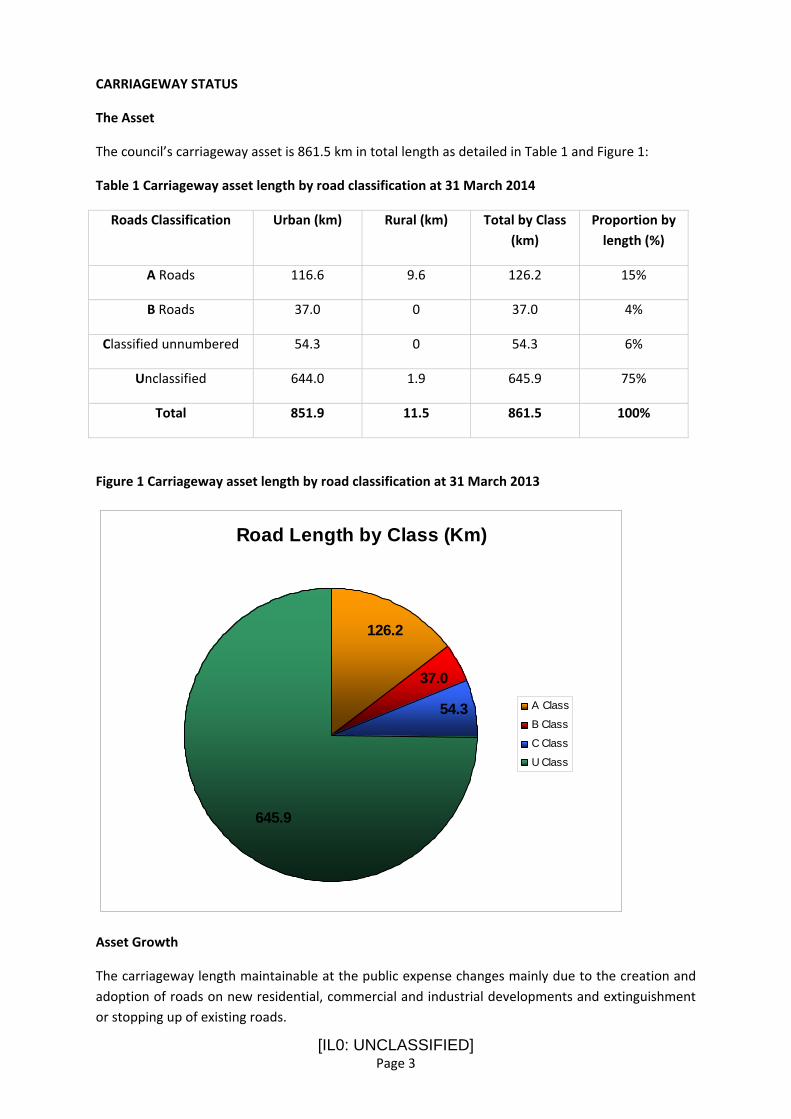
[IL0: UNCLASSIFIED] Page 3
CARRIAGEWAY STATUS
The Asset
The council’s carriageway asset is 861.5 km in total length as detailed in Table 1 and Figure 1:
Table 1 Carriageway asset length by road classification at 31 March 2014
Roads Classification Urban (km) Rural (km) Total by Class (km)
Proportion by length (%)
A Roads 116.6 9.6 126.2 15%
B Roads 37.0 0 37.0 4%
Classified unnumbered 54.3 0 54.3 6%
Unclassified 644.0 1.9 645.9 75%
Total 851.9 11.5 861.5 100%
Figure 1 Carriageway asset length by road classification at 31 March 2013
Road Length by Class (Km)
37.0
54.3
126.2
645.9
A Class
B Class
C Class
U Class
Asset Growth
The carriageway length maintainable at the public expense changes mainly due to the creation and adoption of roads on new residential, commercial and industrial developments and extinguishment or stopping up of existing roads.

[IL0: UNCLASSIFIED] Page 4
The length of carriageway maintained by the council increased by 14.8 km or 1.7% in the 5 year period 2009 to 2014.
Continued growth places increased demand on investment in maintenance.
Asset Value
HM Treasury now requires the council to produce and report the value of their road assets. With effect 2016/17 transport asset valuation and depreciation will be reported in the authority’s annual accounts.
Asset valuation seeks to identify in an open and transparent way:
• The true cost of holding and maintaining the road network;
• The effect expenditure has on the asset condition; and
• How far spending levels match need.
The council’s carriageway asset value at 1 July 2014 calculated in accordance with the CIPFA Transport Asset Code for Whole of Government Accounts is detailed in Table 2.
Table 2 Carriageway Asset Valuation at 1 July 2014
Highway Asset Type
Gross Replacement Cost (GRC) Estimate
£’000
Depreciation
£’000
Depreciated Replacement Cost (DRC) Estimate
£’000
Carriageway 1,154,851 ‐83,740 1,071,111
In the four year period 2010/11 to 2013/14 the accumulated depreciation has increased as detailed in Table 3:
Table 3 Accumulated depreciation of carriageway asset 2010/11 to 2013/14
Accumulated Depreciation £’000
Highway Asset Type
2010/11 2011/12 2012/13 2013/14
Carriageway ‐72,810 ‐96,704 ‐103,933
‐83,740 ^
‐97,514*
* To 2012/13 calculated using regional rates agreed by all the West Midlands Authorities.
^ From 2013/14 calculation rebased using local rates to comply with CIPFA guidance.

[IL0: UNCLASSIFIED] Page 5
Over the 4 year period the trends shows accumulated depreciation increasing. This means that, at the current level of investment, the value in the carriageway asset is being consumed faster than it is being restored or, put another way, the backlog of deferred maintenance is increasing.
The report entitled Managing a valuable asset: improving road condition published on 14 October 2013 by the All Party Parliamentary Group on Highway Maintenance states that “deferring maintenance can be seen as a form of borrowing (from the asset value). Funds are saved in the short term at the expense of higher outlays in the future.” And simplifies this saying “underfunding roads now is effectively borrowing on the future with a very high interest rate.” So the message is pay now or a lot more later.
Annualised Depreciation
Annualised Depreciation (AD) is the average amount by which the asset value is considered to depreciate in one year if there no investment in renewal.
AD is calculated in accordance with the CIPFA Code of Practice on Transport Asset Infrastructure assuming that the top 100mm of carriageway pavement will be replaced (reconstructed) on average every 21 years for the Classified network and 25years for the Unclassified network.
Theoretically if annual renewal investment in the asset is less than the AD then the overall asset value will depreciate over time.
The AD is calculated in the amount £5.9 million.
In practice a long‐term preventative treatment approach aimed at maintaining road condition at a given service level provides a reduced annual investment requirement.
Maintenance Backlog
The carriageway maintenance backlog is the one year cost of work to improve all roads to a good level of condition.
Maintenance back log is calculated in accordance with methodology approved by the Highway Asset Management Finance Information Group (HAMFIG).
The carriageway maintenance backlog at 2014/15 is estimated to be £69.4 m.
It is not practicable to treat all roads needing maintenance now or soon in one year. Nevertheless the maintenance backlog is indicative of the scale of investment needed to return the carriageway to a good condition.
Condition
The UK Pavement Management System (UKPMS) is the national standard for assessing local road network condition and for the planning of investment and maintenance.
Condition of carriageways is measured by a programme of visual and machine surveys. Annually 50% of the classified and 25% of the unclassified network is surveyed. Results are reported annually as a rolling 2 and 4 year average respectively indicating condition and how it is changing over time.
The annual contract cost of carrying out carriageway condition surveys is £10,400.

[IL0: UNCLASSIFIED] Page 6
A Road Condition Indicator (RCI) is calculated from survey data. Three RCI based condition bands define lengths of road as:
Red – poor condition in need of maintenance within next year or so
Amber – some deterioration apparent which should be investigated to determine the optimum time for planned maintenance
Green – generally in a good state of repair
A visual indication of each condition band is shown in photographs 1 to 3:

[IL0: UNCLASSIFIED] Page 7
Photograph 1 – Condition Band Green: carriageway generally in good state of repair

[IL0: UNCLASSIFIED] Page 8
Photograph 2 – Condition Band Amber: some deterioration apparent which should be investigated to determine the optimum time for planned maintenance

[IL0: UNCLASSIFIED] Page 9
Photograph 3 – Condition Band Red: poor condition in need of maintenance within next year or so

[IL0: UNCLASSIFIED] Page 10
The lengths of road and the percentage in each condition band for classified roads are shown in Table 4.
Table 4 Classified Road Condition Band (RCI) 2010/11 – 2013/14 by Roads Class
2010‐2011 2011‐2012 2012‐2013 2013‐2014
Class RCI Km % Km % Km % Km %
>=100 8 5.1 8 6.0 10 6.7 8 5.7
>=40 38 24.8 35 25.3 47 32.4 46 32.4 A
<40 108 70.1 95 68.6 88 60.9 88 61.9
>=100 5 7.1 5 8.2 8 12.2 7 10.4
>=40 22 31.9 21 32.6 26 40.4 25 38.2 B
<40 42 61.0 38 59.2 31 47.4 33 51.4
>=100 5 5.0 5 6.0 7 7.8 6 6.9
>=40 25 26.6 21 26.9 38 40.8 32 35.4 C
<40 63 68.4 52 67.1 48 51.4 52 57.7
The lengths of road and the percentage in each condition band for unclassified roads are shown in Table 5:
Table 5 Unclassified Roads by Condition Band (RCI) 2010/11 – 2013/14
2010‐2011 2011‐2012 2012‐2013 2013‐2014
Class RCI Km % Km % Km % Km %
>=100 56.4 9 91.2 15 89.8 14 108.6 17
>=40 ‐ ‐ ‐ ‐ ‐ ‐ 217.3 34 U
<40 ‐ ‐ ‐ ‐ ‐ ‐ 306.7 49
Comparison with other West Midlands Metropolitan Authorities
For the purposes of comparing performance the seven West Midlands metropolitan authorities share Road Condition Indicator Data.
For the 7 year period 2007/08 to 2013/14 the performance of the Red Road Condition Indicator for Sandwell MBC is compared to the West Midlands average for each road classification as shown in Figures 2 to 4
The percentages represent the length of network that is in a poor condition in need of maintenance within next year or so (Red ‐ Road Condition Indicator)

[IL0: UNCLASSIFIED] Page 11
Figure 2 Classified A road Red RCI comparison to West Midlands average
The current trend shows a decline in the overall condition of the classified A roads in the West Midlands. This general deterioration trend is mirrored on A roads in Sandwell.
Figure 3 Classified B & C road Red RCI comparison to West Midlands average
The current trend shows a decline in the condition of classified B and C roads in the West Midlands. This general deterioration trend is mirrored on B and C roads in Sandwell although a marked deterioration from the West Midlands average in 2012/13 is noted.

[IL0: UNCLASSIFIED] Page 12
Figure 4 Unclassified road Red RCI comparison to West Midlands average
The current trend shows a decline in the condition of unclassified roads in the West Midlands. Over the 8 year period the overall condition of unclassified roads in Sandwell is consistently better than the average. However, the current trend shows that they are deteriorating at a rate faster than the West Midlands average and are now near the average condition.
Current Targets
No target level of service for carriageway condition is defined in the HAMP 2013‐14.
At a regional level the West Midlands Integrated Transport Authority (ITA) through its Local Transport Plan (LTP3) 2011‐2016 has a target of maintaining the 2009 condition of local Principal Roads until 2015.
Historically the approach has been to measure condition to see what effect maintenance investment has had on condition.
Operationally the working target level of service is to arrest the current rate of deterioration by optimising treatment application.
Predictive analysis tools are recently available to highway asset managers to determine the investment required to maintain roads at a given target level of service. It is not now sufficient to say we do not have enough money. We must say not enough money for what target service condition.
A target service condition must now be agreed and appropriately financed by decision makers. Some choices are set out in the options section of this report.
Public satisfaction

[IL0: UNCLASSIFIED] Page 13
Sandwell MBC registered to take part in the National Highways and Transport Public Satisfaction Survey carried out in June 2014. This will provide public opinion on the condition of our roads as well as comparative data on how we are doing compared to other participating authorities. This will help in setting priorities, making decisions and reporting performance.
Investment in Planned Maintenance of Carriageways
In 2013/14 £2,227,000 was invested in carriageway renewals (reconstruction, resurfacing and surface treatments).
In 2014/15 proposed investment in carriageway renewals is £2,400,000.
In the period 2013/14 and 2014/15 baseline Highways Maintenance Block Funding was enhanced by one off additional capital and revenue payments.
Change to Highway Maintenance Block Funding in the next 6 year spending review period is likely. For the purposes of forward predictions it is assumed that a net sum of £1.8m will be available from Highway Maintenance Block Funding for carrying out carriageway protection, resurfacing or reconstruction works.
There is no highways maintenance target budget revenue money invested in planned carriageway renewal. Revenue funding is in the main used for small scale patching, repair and safety works. This allocation is likely to be reduced in future years in response to austerity cuts and demands in other asset classes. Therefore revenue funding is not considered further in future years for planned renewal.
A £1.8m annual investment in planned renewal of the carriageway asset (reconstruction, resurfacing and surface treatments) equates to only 31% of the estimated annualised depreciation (AD) of £5.9m.
Treatment Options
Road surfaces can be reconstructed, resurfaced or protected.
Reconstruction involves removing and replacing the top two bound layers typically 100mm in depth.
Resurfacing typically removes and replaces the top 40 mm surface layer (inlay) and will normally require patching of the underlying layer. Sometimes it is possible and more economical to lay the new surface on top of the old surface (overlay) although generally this can only be done once.
Protective treatments include surface dressing and thin surfacing e.g. micro asphalt. The former involves spraying a bituminous binder onto the existing road surface followed by application of aggregate chippings to dress the binder. The latter is a bitumen and graded aggregate mixture laid in one or two layers to a depth of about 15mm.
Selecting the right treatment depends on a number of factors including the condition and construction of the road and type and amount of traffic. The merit of each treatment type is summarised in Table 7:

[IL0: UNCLASSIFIED] Page 14
Table 7 Merit of carriageway treatment approaches
Treatment Type Protection Resurfacing Reconstruction
Seals the surface from water ingress Yes Yes Yes
Restores grip Yes Yes Yes
Expected service life 8 years 14 years 19 years
Repairs surface defects Yes Yes Yes
Removes minor unevenness Sometimes Yes Yes
Removes major unevenness No Sometimes Yes
Adds structural strength No Sometimes Yes
Typical Cost per square metre £4.50 £17 £26
Repairs foundation problems No No No
Environmental Impact (carbon footprint) Low Medium Medium/High
Disruption to road users during construction
Low Medium `High
Outputs in 2013/14
In 2013/14 spend invested in planned carriageway renewals across the network is shown in Table 8:
Table 8 2013/14 spend on planned maintenance renewals by road classification
Road classification A B C U Total
Reconstruction £000’s £407k £242k £37k £274k £960k
Resurfacing £000’s £386k £34k £12k £190k £622k
Surface Treatment £000’s £0 £31k £102k £512k £645k
Total Spend £000’s £793k £307k £151k £976k £2,227k
The output in terms of length of carriageway receiving planned maintenance from investing £2,227,000 during 2013/14 is shown in Table 9:

[IL0: UNCLASSIFIED] Page 15
Table 9 2013/14 Length of carriageway treated by type and road classification
Road classification A B C U Total
Reconstruction Km 1.98 Km 1.05 Km 0.38 Km 1.78 Km 5.19 Km
Resurfacing Km 2.04 Km 0.28 Km 0.16 Km 2.14 Km 4.62 Km
Surface Treatment Km 0km 1.22km 3.76km 16.84 Km 21.82Km
Total Length Km 4.02 Km 2.55 Km 4.30 Km 20.76 Km 31.63 Km
The length of carriageway treated per year as a proportion of overall network length provides an indication of the interval between treatments at current budget levels. This interval can then be compared to the expected service life of the treatment.
Table 10 Interval between treatments at 2013/14 investment level
Road classification A B C U Total
Length treated Km 4.02 Km 2.55 Km 4.30 Km 20.76 Km 31.63 Km
Asset length Km 126.2 37.0 54.3 645.9 861.5
Proportion treated % 3.2% 6.9% 7.9% 3.2% 3.7%
Treatment Interval Years 31 yrs 15 yrs 13 yrs 31 yrs 27 yrs
In 2013/14 a substantial programme of protective treatments was undertaken across Sandwell producing the treatment intervals outlined in Table 10 above. This change in strategy produced a reduction in the total overall treatment interval period from 44 years in 2012/13 when no surface treatment programme was in place to 27 years in 2013/14.
At the current budget the average interval between treatments far exceeds expected service life presenting demand for short‐term inefficient and expensive reactive maintenance such as small scale patching and pot holes repairs.
Highway safety and reactive repairs
Condition surveys look at deficiencies in the fabric of the highway and impacts on performance and serviceability over the longer term to inform planned renewal.
In the shorter term highway safety is maintained by a separate risk management regime incorporating the inspection, identification, categorisation and repair of carriageway defects likely to create danger or serious inconvenience.
Category 1 defects represent a hazard to road users and are categorised as either an immediate (emergency) or imminent (urgent) risk. The target response times are to make safe or repair in 2 hours and 5 working days respectively.

[IL0: UNCLASSIFIED] Page 16
Other Category 2 non‐hazardous serviceability defects are not recorded as current budgets are not sufficient to repair non‐dangerous defects. These are repaired only during planned maintenance.
Customer reported carriageway defects (e.g. pot holes) are managed in the same way.
The total number of Category 1 carriageway defects recorded in 2013/14 together with the performance in addressing them is shown in Table 11:
Table 11 Category 1 carriageway safety defects and repair performance 2012/13 & 2013/14
Indicator 2012/13 2013/14
Total number of Category 1 safety defects identified 3,714 3,540
Number of safety defects on each road by classification
A road ‐ 436
B road ‐ 205
C road ‐ 189
U road ‐ 2884
A road ‐ 413
B road ‐ 179
C road ‐ 265
U road ‐ 2683
Number of safety defects per kilometre
A road ‐ 3.45
B road ‐ 5.37
C road ‐ 3.41
U road ‐ 4.56
A road ‐ 3.27
B road – 4.84
C road – 4.88
U road – 4.15
Road Condition Value Red
A road ‐ 6.7%
B road ‐ 12.2%
C road ‐ 7.8%
U road ‐ 14%
A road ‐ 5.7%
B road ‐ 10.4%
C road ‐ 6.9%
U road ‐ 17%
Number of Category 1 Emergency safety defects reported
23 14
Percentage of Category 1 Emergency safety defects made safe / repaired within 2 hours
91%/17%* 100%/36%*
Number of Category 1 Urgent safety defects reported 3691 3526
Percentage of Category 1 Urgent safety defects made safe / repaired within 5 working days
88%/61%* 93%/91%
* investigate possible recording problem
Correlation is noted between number of defects, defects per kilometre and road condition. Not surprisingly the incidence of safety defects is more prevalent on roads in worst condition. The number of safety defects per kilometre can be expected to increase as condition worsens. This in

[IL0: UNCLASSIFIED] Page 17
turn increases road user exposure to safety defects increasing the likelihood of third party liability claims.
Third party liability claims
Defects can give rise to claims against the authority for failure in its statutory duty to maintain the highway.
Claims can be repudiated if adequate safety inspection and repair policies and procedures are in place, they are performed and there was no prior knowledge of the defect prior to the incident.
Table 12 shows the third party highways liability claims performance over the period 2009‐2014.
Table 12 Highways liability claims performance
Financial Year 2009/10 2010/11 2011/12 2012/13 2013/14
Total Number of claims all highway asset categories
424 326 325 260 265
Total Number of claims relating to carriageway defects
n/a n/a n/a 135 107
Claims repudiated as % of claims 74%
(315)
62%
(203)
52%
(168)
50%
(131)
53%
(141)
Claims still current 15 34 80 127 151
Corporate insurance recharge to Highways Maintenance Target Revenue Budget
£202k £362k £450k £824k £766k
Highways claims total costs (this is the aggregate of claims payments, legal costs and outstanding ‘reserves’ against current claims.
£693k £945k £1,126k £1,122k £646k
(to date)
Over the period trends show the number of claims is falling, repudiation rates falling, pay‐out costs doubling and the centrally imposed insurance recharge quadrupling.
The £564k increase in the corporate insurance recharge over the period is a significant additional impact on the highway maintenance revenue budget at a time of cuts.
Increasing the current repudiation rate to the national average reported by CIPFA at 79% is an area for improvement although it is to be noted that in the year prior to 1 April 2012 safety inspection performance is poor due to service transformation interruptions.

[IL0: UNCLASSIFIED] Page 18
INVESTMENT OPTIONS
Investment options focus on planned renewal (protection, resurfacing or reconstruction) of the carriageway asset.
Options analysis predicts the future service condition of the carriageway for different budgets levels so that decision makers can make informed choices. Analysis is carried out using the lifecycle planning analysis tool developed by the government sponsored Highways Maintenance Efficiency Programme.
It is important that realistic options are considered to reflect the current context of public sector budget cuts. The options considered and their impacts over a 20 year life cycle period are:
Option Description
1. Do Minimum
Identify impacts of not carrying out any planned maintenance. Only do reactive repairs to keep carriageways safe to meet minimum statutory requirements
2. Current Budget Constraint Investigate impact of investing current capital budget with optimised treatment mix to prolong carriageway life
3. Maintain Current Condition Determine funding level required to arrest deterioration to keep roads at about current condition
4. Return condition to 2010/11 levels Determine investment required to restore and maintain roads to 2009/10 condition.
The graphs are interpreted as follows:‐
Dark Green – Lengths where the carriageway is generally in a good state of repair.
Light Green – Lengths where some deterioration is apparent which should be investigated to determine the optimum time for planned maintenance treatment.
Yellow (locally created) – Lengths where the carriageway is in need of planned maintenance as soon as possible to justify carrying out a lesser treatment rather than a more expensive treatment later, in order to minimise whole life costs.
Red – Lengths in poor overall condition which are likely to require maintenance soon (i.e. within the year).
Reactive maintenance
The impact of changes in carriageway condition resulting from different investment budgets should be reflected in the demand for, and cost of, reactive maintenance. No robust data is available to inform this relationship quantitatively at present. However, it is reasonable to assume that as condition worsens demand for expensive and inefficient small scale patching, repair and safety defect work will increase. This risk is expressed qualitatively in this report.

[IL0: UNCLASSIFIED] Page 19
Investment Option 1 Do Minimum
This option is included for illustrative purposes only to show the impacts of not carrying out any planned maintenance at all. The only maintenance activity is localised reactive repairs (patching and pot holes) to keep carriageways safe to meet minimum statutory requirements.
The predicted deterioration in road condition over time for each road class is shown in Figures 13 to 16:
Figure 13 Do minimum predicted condition A roads
Figure 14 Do minimum predicted condition B roads

[IL0: UNCLASSIFIED] Page 20
Figure 15 Do minimum predicted condition C roads
Figure 16 Do minimum predicted condition Unclassified roads
The outcomes of the do minimum option are predicted to result in:
the proportion of roads requiring maintenance soon (Red RCI) increasing rapidly over the 20 year lifecycle as follows:
Classification 2013
(current)
2018
(5 years)
2033
(20 years)
A 6% 17% 66%
B 10% 25% 72%
C 7% 21% 69%
U 17% 27% 69%

[IL0: UNCLASSIFIED] Page 21
Increasing incidence of defects such as pot holes as road condition deteriorates; Increasing demand for reactive maintenance to meet minimum statutory requirement to keep
roads safe; Increasing customer dissatisfaction; Withdrawal of highway liability claims insurance cover exposing council to increasing self‐
funded risk; Wider negative impacts on local economy, jobs and growth

[IL0: UNCLASSIFIED] Page 22
Option 2 Current Budget Constraint
This option identifies the impacts of investing the assumed forward forecast capital budget works value of £1,800,000 each year for the 20 year lifecycle.
The mix and timing of treatments is tested to optimise service level condition over the lifecycle maximising the benefits of the ‘prevention is better than cure’ approach.
The estimated average annual expenditure by treatment type is shown in Table 17:
Table 17 Option 2 Investment Allocation
Year 1 to 20 Budget £1,800,000 (works cost)* p.a.
Category Strengthening Treatment
Resurfacing
Treatment Surface Treatment
Principal A Roads £280,000 £330,000 £70,000
Classified B Roads £80,000 £60,000 £90,000
Classified C Roads £90,000 £50,000 £140,000
Unclassified Roads £120,000 £100,000 £390,000
Treatment Totals £570,000 £540,000 £690,000
The predicted road condition over time for each road class is shown in Figures 18 to 21:

[IL0: UNCLASSIFIED] Page 23
Figure 18 Current Budget Constraint predicted condition A roads
Figure 19 Current Budget Constraint predicted condition B roads
Figure 20 Current Budget Constraint predicted condition C roads

[IL0: UNCLASSIFIED] Page 24
Figure 21 Current Budget Constraint predicted condition Unclassified roads
Continuing to invest at the current budget level is predicted to result in:
Continuing deterioration with the proportion of roads requiring maintenance soon increasing over the 20 year lifecycle. For comparison purposes the impacts of adopting a ‘worst first’ approach are reported for comparison alongside the recommended ‘preventative approach’:
Classification 2013
(current)
2018
(5 years)
2018
Worst first
2033
(20 years)
2033
Worst first
A 6% 12% 14% 28% 40%
B 10% 17% 19% 27% 32%
C 7% 14% 16% 28% 34%
U 17% 24% 27% 54% 63%
increasing incidence of serviceability and safety defects such as pot holes; increasing demand and cost for reactive repairs to meet minimum statutory requirement to
keep roads safe; increasing customer dissatisfaction particularly as unclassified residential streets show a big
drop in condition affecting look and feel of street scene; likelihood of increasing highway liability claims due to increased exposure to carriageway
defects; negative impact of poor road condition on local economy and disincentive to growth

[IL0: UNCLASSIFIED] Page 25
Option 3 Maintain Current Condition
This option determines the funding level required to arrest deterioration to keep roads at about the current condition for the 20 year lifecycle.
The estimated average annual works expenditure on planned maintenance is £4,924,000 to maintain current road condition which is £3,124,000 more than the assumed forward forecast capital works budget.
The estimated average annual expenditure by treatment type is shown in Table 22:
Table 22 Option 3 Investment Allocation
Year 1 to 20 Budget £4,924,000 (works cost) p.a.
Category Strengthening Treatment
Resurfacing
Treatment Surface Treatment
Principal A Roads £751,000 £1,021,000 £50,000
Classified B Roads £175,000 £147,000 £110,000
Classified C Roads £221,000 £155,000 £260,000
Unclassified Roads £654,000 £691,000 £689,000
Treatment Totals £1,801,000 £2,014,000 £1,109,000
As expected the predicted road network condition remains approximately the same over the 20 year lifecycle as shown in Figures 23 to 26:

[IL0: UNCLASSIFIED] Page 26
Figure 23 Maintain current condition A roads
Figure 24 Maintain current condition B roads
Figure 25 Maintain current condition C roads

[IL0: UNCLASSIFIED] Page 27
Figure 26 Maintain current condition U roads
Increasing investment to maintain roads at about the current condition is predicted to result in:
The proportion of roads in need of maintenance soon (Red RCI) would be expected to remain at 2013 levels (A – 6%; B – 10%; C – 7%; U – 17%)
Demand for reactive safety repairs is likely to remain largely constant although based on experience significant spikes are to be expected after periods of prolonged adverse or winter weather;
Customer satisfaction levels expected to remain at about current levels; Incidence of highway liability claims to remain at about current levels;

[IL0: UNCLASSIFIED] Page 28
Option 4 Return condition to 2009/10 levels
This option determines the investment level required to restore and maintain roads to 2009/10 condition levels for the 20 year life cycle.
The estimated average annual expenditure on planned maintenance is £8,252,000 which is £6,452,000 more than the assumed forward forecast capital works budget.
The estimated average annual expenditure by treatment type is shown in Table 27:
Table 27 Option 3 Investment Allocation
Year 1 to 20 Budget £8,252,000 (works cost) p.a.
Category Strengthening Treatment
Resurfacing
Treatment Surface Treatment
Principal A Roads £730,000 £994,000 £217,000
Classified B Roads £197,000 £166,000 £213,000
Classified C Roads £251,000 £176,000 £416,000
Unclassified Roads £1,491,000 £1,290,000 £2,111,000
Treatment Totals £2,669,000 £2,626,000 £2,957,000
The predicted road condition over time for each road class is shown in Figures 28 to 31:
Figure 28 Return to 2009/10 condition A roads

[IL0: UNCLASSIFIED] Page 29
Figure 29 Return to 2009/10 condition B roads
Figure 30 Return to 2009/10 condition C roads
Figure 31 Return to 2009/10 condition U roads

[IL0: UNCLASSIFIED] Page 30
Increasing investment to return and maintain road condition to 2009/10 levels is predicted to result in:
Improving overall network condition; the proportion of roads requiring maintenance soon (Red RCI) decreasing over the 20 year
lifecycle as follows:
Classification 2013
(current)
2018
(5 years)
2032
(20 years)
A 6% 5% 4%
B 10% 7% 6%
C 7% 5% 4%
U 14% 9% 7%
The proportion of roads in a good state of repair (Green RCI) increasing over the 20 year lifecycle as follows:
Classification 2013
(current)
2018
(5 years)
2032
(20 years)
A 62% 67% 69%
B 51% 68% 68%
C 58% 70% 71%
U 48% 62% 63%
Decreasing incidence of serviceability and safety defects such as pot holes; Decreasing demand and cost for reactive repairs to meet minimum statutory requirement to
keep roads safe; customer satisfaction expected to improve in line with better maintained roads particularly on
unclassified residential streets as the look and feel of the street scene improves; positive impacts of improving road condition on local economy and growth prospects

[IL0: UNCLASSIFIED] Page 31
Conclusion
Analysis carried out using the lifecycle planning tool to support strategic level decision making shows that the existing budget is insufficient to maintain current road condition and, unless increased, will result in continuing deterioration over the 20 year lifecycle.
To arrest continued deterioration and maintain condition at current levels for the 20 year lifecycle an increase in the budget for planned maintenance by £3.1m per year is required.
To return and maintain road condition to 2009/10 levels for the 20 year lifecycle will need an increase in the budget for planned maintenance by £6.5m per year.
Any additional funding will have to be from the council’s own resources.