Jason Hipkiss - Barrow Borough Council
110
DEVELOPMENT SERVICES PLANNING COMMITTEE FOR DECISION 10 th July 2018 Ladies and Gentlemen, The applications within this report have been submitted for determination under the Town and Country Planning Acts and associated legislation. All applications within this report are “Delegated” to this Committee but can be moved “Non-Delegated” by a Member of the Committee under the terms adopted for the Scheme of Delegation approved by Council, 16 th May, 1994. Any such motion needs to be accepted by a majority of Members of the Committee present (Council, 8 th August, 1995). All applications left as Delegated will be decided by the Committee and will not be subject to confirmation by Council. The application plan numbers also refer to files for the purposes of background papers. Jason Hipkiss Planning Manager Page 1 of 91
-
Upload
khangminh22 -
Category
Documents
-
view
2 -
download
0
Transcript of Jason Hipkiss - Barrow Borough Council

DEVELOPMENT SERVICES
PLANNING COMMITTEE
FOR DECISION
10th July 2018
Ladies and Gentlemen, The applications within this report have been submitted for determination under the Town and Country Planning Acts and associated legislation. All applications within this report are “Delegated” to this Committee but can be moved “Non-Delegated” by a Member of the Committee under the terms adopted for the Scheme of Delegation approved by Council, 16th May, 1994. Any such motion needs to be accepted by a majority of Members of the Committee present (Council, 8th August, 1995). All applications left as Delegated will be decided by the Committee and will not be subject to confirmation by Council. The application plan numbers also refer to files for the purposes of background papers.
Jason Hipkiss
Planning Manager
Page 1 of 91

B28/2018/0313 Planning Committee
10th July 2018
Application Number : B28/2018/0313 Date Valid :02/05/2018
Address : Abbotsmead School (site of), Friars Lane, Barrow-in-Furness
Case Officer : Charles Wilton
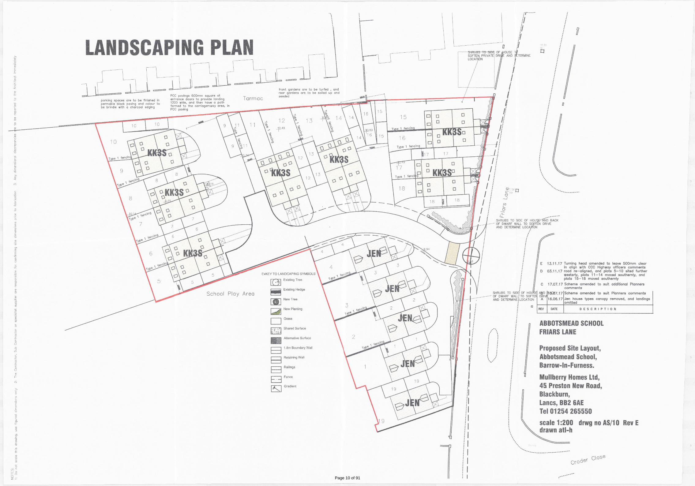
Proposal : Application for approval of details reserved by condition no. 6 (Proposed boundary treatments), No. 7 (landscaping scheme) and No. 18 (landscape phasing) for planning permission 2017/0470 (Erection of 18 houses in a mixture of detached and semi detached houses and associated site works)
Ward : Risedale Ward Parish : N/A
Applicant : Mr A Wilcock Mulberry Homes Ltd 45 Preston New Road Blackburn
Agent :
Statutory Date : 27/06/2018 Recommendation : That a split decision be issued
National Guidance
Add national guidance here
Local Plan Policies
Full details of the policies listed below are included in the appendix
Saved Local Plan Policies
1. Saved Local Plan 2001 - Policy D21 2. Saved Local Plan 2001 - Policy D29
Emerging Draft Local Plan Policies
1. Submission Draft Local Plan – December 2017 - Policy Emerging Policy DS1 - Council’s commitment to sustainable development
2. Submission Draft Local Plan – December 2017 - Policy Emerging Policy DS2 - Sustainable Development Criteria
3. Submission Draft Local Plan – December 2017 - Policy Emerging Policy DS5 - Design
Page 2 of 91

Summary of Main Issues
Applications for the discharge of conditions are usually dealt with by the Planning Manager under delegated powers as they normally raise no issues. However in this case the matter is reported to Committee due to an objection. The objection raises concerns relating to the standard of the submitted scheme, but also issues pertaining to the applicants other schemes currently underway.
Non Material Considerations
Whether or not the applicant has followed approved landscaping schemes elsewhere
Response to Publicity and Consultations
No neighbours listed as consulted
Responses Support Object Neutral
1 0 1 0
Summary of objection:
Objects to the initial scheme for Abbotsmead but does not specifically elaborate why.
Expresses the view that approved landscaping schemes are not followed with reference to other sites being built out by the same developer
That factually incorrect information was submitted with a proposed demolition at a different site and that damage occurred to trees located on adjacent land.
Organisations Consulted
Consultee Barrow Borough Council (Building Control)
List of Organisation Responses
No organisation responses recorded
Page 3 of 91

Officers Report
1. Site and Locality
1.1 The application relates to a vacant brownfield site - originally Abbotsmead school, now demolished, which is located within a predominantly residential area. The main frontage and sole site access is from Friars Lane, a local distributor road. Boundaries are shared with other houses to the north and Cambridge Street school to the west and south.
2. Proposal Details
2.1 Application for approval of details reserved by condition no. 6 (Proposed boundary treatments), No. 7 (landscaping scheme) and No. 18 (Planting, seeding Turfing details) for planning permission 2017/0470 (Erection of 18 houses in a mixture of detached and semi detached houses and associated site works)
3. Relevant History 3.1 94/2004/9026 Priory Grove Junior School Friars Lane Barrow-in-Furness Cumbria LA13 9NP Change of use from education building to social services accommodation County Matter 24/01/2005 3.2 B07/2015/0600 Abbotsmead Primary School (Site of) Friars Lane Barrow-in-Furness Cumbria Erection of 18 houses in a mixture of detached, semi detached and terraced form with new access onto Friars Lane. APPCOND 11/07/2017 3.3 B07/2017/0470 Former Abbotsmead School Friars Lane Barrow-in-Furness Cumbria Erection of 18 houses in a mixture of detached and semi detached houses and associated site works. APPCOND 14/11/2017 3.4 B27/2014/0422 Abbotsmead Infant School Friars Lane Barrow-in-Furness Cumbria LA13 9NP Application for prior notification of proposed demolition of former infant school. APPLETT 17/07/2014 3.5 B28/2013/9012 Priory Grove Friars Lane Barrow-in-Furness Cumbria LA13 9NP Prior Notification of Demolition of Social and Education Offices. (County Matter) Withdrawn 16-DEC-2013 3.6 B28/2017/0461 Former Abbotsmead School Friars Lane Barrow-in-Furness Cumbria Application for approval of details reserved by Condition No. 4 (Construction Method Statement) of planning permission 2015/0600 (Application Erection of 18 houses in a mixture of detached, semi detached and terraced form with new access onto Friars Lane) APPCOND 13/09/2017 3.7 B28/2017/0779 Former Abbotsmead School Friars Lane Barrow-in-Furness Cumbria Application for approval of details reserved by condition no. 3 (Construction Method Statement) of planning permission 2017/0470 (Erection of 18 houses in a mixture of detached and semi detached houses and associated site works) APPROVED 15/12/2017
Page 4 of 91

3.8 B28/2017/0822 Former Abbotsmead School Friars Lane Barrow-in-Furness Cumbria Application for approval of details reserved by condition no. 9 (remediation statement) of planning permission 2017/0470 (Erection of 18 houses in a mixture of detached and semi detached houses and associated site works) APPROVED 05/01/2018
4. Officer Assessment
4.1 The application seeks agreement of details reserved for subsequent approval by conditions attached to planning permission 2017/0470 which permitted the erection of 18 dwellings.
4.2 Condition 7 - Landscape scheme
The landscaping scheme, which the developer had produced "in house", as submitted was not considered adequate, lacking a suitable planting schedule to show species and numbers. The number of planting areas was also too few. However, following negotiations, the matter was transferred to a landscape architect who has prepared a scheme of a professional standard with significant amounts of tree and shrub planting. Importantly these are also appropriate species for the size of the spaces available. I now consider approval would accord with saved policy D29. The revised scheme will add quality and amenity value to the overall development which are matters recognised in both the NPPF and in local policies.
4.3 Condition 18 - Implementation of landscaping scheme
Condition 18 requires the whole scheme to be implemented prior to the occupation of the development or in accordance with a phasing scheme if agreed in writing with the Planning Authority. To date the applicant is only committing to carry out the landscaping at some point during the development as a single phase. This is too open ended and would result potentially in some houses being occupied for quite some time before they are landscaped. In this regard I consider that the proposed phasing should be refused.
4.4 Condition 6 Boundary treatments
This condition required details of proposed boundary treatments to be agreed including materials and a schedule of implementation. A reasonable level of information has been provided for the rear garden boundaries which are shown as vertically boarded fences. However there is a lack of information on the front boundary along Friars Lane. It is unclear whether the existing metal railings are to be retained (but with alterations for accesses as required) or whether an entirely new boundary treatment is proposed. The level of information is inadequate to assess what is proposed or its suitability given its prominent location. Further information is awaited but at the time of preparing this report the information is not adequate to approve.
Page 5 of 91

5. Conclusions
5.1 The revised landscaping scheme is to a high standard and should be approved. However the scheme of phasing and details of the front boundary treatment are, at the time of writing, inadequate and are recommended to be refused.
6. Recommendation I recommend that :-
1. With regard to Condition 7 that the landscaping scheme ref MHA-WW-01 be approved
2. With regard to condition 18, that the landscaping phasing as detailed in email dated 19/06/2018 (sent at 15.46) is refused as the timescale lacks clarity, being too open ended, and would be potentially detrimental to the amenities of occupiers of the new dwellings.
3. With regard to Condition 6, that the street scene drawing ref AS/20 rev A and layout plan ref AS/10 Rev E are refused in relation to boundary treatment as the submitted information does not provide sufficient information to assess the design, materials or location of the boundary to Friars Lane and as a result approval could result in feature in appropriate to the location contrary to saved policy D21.
Page 6 of 91

ABBOTSMEAD SCHOOLFRIARS LANE
Mullberry Homes Ltd,45 Preston New Road,Blackburn,Lancs, BB2 6AETel 01254 265550
drawn atl-hscale 1:125 drwg no AS/20
Proposed Site Layout,Abbotsmead School,Barrow-In-Furness.
STREETSCENE
Rev A
2018/0313
Page 7 of 91

1
Hi Charles, I have spoken to Mr Barnes about this and he has confirmed that the landscaping will be carried out in 1 Phase. Regards the wall at the front of the plots 1A‐4, and 15‐18, they will be done as per that previously approved on M & P Gadsden's scheme which is what we have showed on this. I will however forward a larger scale plan
2018/0313
Page 8 of 91

Grass
School Play Area
F
ria
rs
L
a
n
e
10.81MH
9.98MH
9.66
9.94
10.49
10.80
10.66
10.49
10.34
10.16
9.99
10.14
KK3S
KK3S
KK3S
KK3SKK3S
KK3S
KK3S
JEN
JEN
JEN
JEN
HAS
8
3
2
5
TOPSOIL CULTIVATION In accordance with BS 3882. Apply glyphosate herbicide prior cultivation and allow the recommended
period before further action. Ensure ground is free draining by breaking up subsoil and installation of land drainage as required. Do
not work the soil in frozen or waterlogged condition. Remove any debris and stones greater than 50mm from surface and cultivate
to suitable tilth for planting. Rake surface to achieve required level flush with adjacent paving for turf and 50mm below for planting
to allow for mulch layer and smooth flowing contours for open space areas without hollows or soft areas. Topsoil depths to be
minimum 150mm for grass and 450mm for planting and at least 300mm of suitable subsoil beneath the topsoil layer. Site topsoil to
be supplemented with imported topsoil in accordance with BS 3882. Shrub beds in grass areas to be neatly cut to layout shown.
PLANTING Plant material shall conform to the National Plant Specification and be healthy, vigorous specimens, well rooted but not
pot bound, free from pests and disease, hardy and undamaged by transport operations in accordance with HTA 'handling and
establishing landscape plants'. Planting and turfing to be in accordance with BS 3936 and 4428. Plant species substitutes will be
permitted to accommodate availability and to include stock of particular good quality in nursery provided these are of a similar
habit, size, colour, value etc and that they are approved in advance by the Landscape Architect. Native species to be local
provenance. Bare root and rootballed plants to be planted between November and March. Backfill of planting holes and tree pits to
be excavated topsoil with 25% by volume tree and shrub planting compost. Shrub pits to be generally 300 x 300 x 300mm or
75mm wider and deeper than the root spread. Tree pits to be 900 x 900 x 600mm or 150mm wider than the root spread. Stakes to
be two 75mm diameter pointed stakes driven until firm and trimmed to 900mm above G.L. with 50 x 100mm crossbar screwed to
stakes. Rubber tree cushion nailed to crossbar and rubber tree belting nailed to secure tree. Single 75mm diameter stake for
bare-rooted trees with rubber tree belting with spacer. Apply slow release fertiliser (16:10:10) at rate of 100g/ sq.m. to planting
areas and 250g per tree. Thoroughly water planting.
PLANTING DENSITIES/ SETTING OUT Refer to the Planting Schedule for densities. Where a bed is indicated as mixed species
on the plan, the area should be divided equally between the species shown and the relevant density for that species applied to that
proportion of the bed. Taller species to the rear of the bed and smaller species to the front planted in bold groups of single species
and not mixtures unless clearly requested on the plan annotations.
TREE RABBIT GUARDS If rabbit activity is noted in the area and guarding is authorised each bare-rooted native plant hedge plant
to receive a 12/14 weight 900mm cane and 60cm clear spiral guard. Trees to receive 90cm spiral guard. If extensive rabbit activity
is observed rabbit fencing to ornamental areas will be required as directed by the Landscape Architect.
MULCH Spread 50mm layer of general purpose bark mulch, free from large sticks, and debris over all shrub areas, 800mm wide
strips for hedging and 800mm diameter circles for tree pits in grass with neatly trimmed edge.
TURFING Following cultivation preparation specified above supply and lay Rolawn Medallion turf or similar approved with
staggered joints close butted to uniform levels to finish 25mm above adjacent paving levels once well tamped down. Use sharp
sand spread on surface to achieve fine tuning of levels. Thoroughly soak turf on completion and ensure regular watering is
arranged until the turf has rooted. Do not turf in waterlogged or frozen conditions.
SEEDING AMENITY GRASS. Following cultivation preparation specified above apply Cropwise low maintenance amenity mix or
similar approved at a rate of 35gms/ sq.m. and roll with quad or hand drawn ballast grass roller. Apply water with sprinkler hose in
dry conditions to ensure germination. Levels to be flush with adjacent paving following firming and settlement of topsoil. Further
stone-picking, top-dressing and re-seeding of bare patches to ensure uniform, level grass is established. Re-roll as required at first
cut stage.
LANDSCAPE MAINTENANCE. Any plants which fail within 5 years to be replaced in the season following failure to the original
specification. Check and adjust stakes and ties every month, and remove stakes in year 5 when trees are suitably stable. Prune
trees and shrubs once each year - formative prune to encourage good habit. Apply fertiliser once in Spring each year to grass
40gms/ sq.m. Apply fertiliser once in Spring each year to shrubs 20gms/ sq.m - Osmocote slow release. Top up bark mulch to
50mm depth annually. Check for pests and diseases - treat as required. Water as required all landscape areas. Mow grass 18
times annually and remove arisings, trim edges. Apply selective herbicide and moss killer to grass as required. Re-seed, top dress
and aerate lawns as required to maintain grass in good condition. Cut and rake off wildflower grass twice annually. Collect litter
from all landscape areas monthly. Apply Glyphosate herbicide to hard paved areas as required.
PLANTING SCHEDULE
Type Key SpecificationNo/SQ.M.
TREES
Crataegus persimilis PrunifoliaCP
RB, 14-16cm, 3.4-4mN/A
Carpinus betulus FastigiataCF
RB, 14-16cm, 3.5-4mN/A
Prunus Amanogawa
PARB, 12-14cm, 3-3.5m
N/A
Sorbus aucuparia Sheerwater Seedling
SARB, 14-16cm, 3.5-4m
N/A
Sorbus aria Majestica
SMRB, 14-16cm, 3.5-4m
N/A
Sorbus aria Lutescens SLRB, 14-16cm, 3.5-4m
N/A
SPECIMENS
Amelanchier lamarckii AME C25 N/A
Aucuba japonica CrotonifoliaAUC C25 N/A
Phormium tenax Variegatum
PTV C25 N/A
Photinia Red Robin PRR C25 N/A
SHRUBS & HERBACEOUS
Euonymus fortunei 'Emerald n Gold' EgoC2, 20-30cm
5
Euonymus fortunei 'Emerald Gaiety' EegC2, 20-30cm
5
Hebe Sutherlandii Hsu C5 4
Hebe Midsummer Beauty
Hmb C5 4
Hypericum Hidcote
Hhi C3 3
Lonicera henryi
LheC2, 60-80cm
3/m
Pyracantha Red Collumn
Prc C3 4
Senecio sunshine Sen C3 4
Spiraea japonica Goldmound Sgo
C3 3
Spiraea Little Princess SlpC3 4
Vinca minor AtropurpureaVmi C3 4
PERENNIALS
Bergenia cordifolia
BcoC2, 20-30cm
6
Pachysandra terminalis Green Carpet
PatC2, 20-30cm
5
HEDGES No/Linear m.
Elaeagnus ebbingei
ELEc3, 45-60cm
4
PROPOSED TURF
PROPOSED SHRUBS
PROPOSED TREES
PROPOSED SPECIMEN SHRUB
PROPOSED HEDGE
PROPOSED GRASS SEEDING
CR
F
R
IA
R
S
L
A
N
E
10.1m
1c
7.9m
SL
SL
SA
SA
SA
SM
CF
CP
CF
ELE
ELE
ELE
ELE
ELE
ELE
PA
PA
PTV
PRR
PTV
PRR
PTV
PTV
PTV
3 AUC
PTV
PTV
PTV
PTV
PTV
PTV
PTV
AME
AME
AME
Hsu
Hsu
Sen
Hsu
Sen
Vmi
Sgo
Vmi
Sgo
Hsu
Sen
Hsu
Hmb
Bco
Hmb
Bco
Prc
Hhi
Slp
Hsu
Ego
Hmb
Vmi
Hmb
Slp
Eeg
Eeg
Hmb
Slp
Sen
Hsu
Hsu
Hsu
Ego
Hmb
Hmb
Eeg
Lhe
Lhe
Lhe
Lhe
Trees either side of the entrance create a focal
point and soften the front of the development.
Elaeagnus hedge grown behind the low wall to
create a clear boundary to the properties and
soften the front elevation of the development.
Open lawn adjacent to the hedge maintains an
open feel for the properties opposite.
Shrub beds to the front of each property with a key
specimen shrub adds colour and interest to the
development whilst softening the front elevation of
the property.
Paths added to allow access to the front of plots
17 and 18 from their driveways.
Elaeagnus hedge grown behind the low wall to
create a clear boundary to the properties and
soften the front elevation of the development.
Planting to the boundary fence of the front garden
adds height and interest to the scheme with 3
specimen Aucuba japonica Crotonifolia.
Flowering cherry tree at a key focal point
at the end of the entrance road.
Key specimen shrubs in planted beds
at the front of each property to add
colour and interest.
Rear garden trees help to control the
intervisibility between the new properties
and the existing buildings beyond.
Rear garden trees help to control the intervisibility
between the new properties and the existing
buildings beyond.
Honeysuckle planted to climb the fence with
appropriate supports added to the fence. This will
help to soften the boundary for the existing
properties.
MULBERRY HOMES, ABBOTSMEAD
DRAWING NO: MHA-WW-01
DATE: 18 June 18
SCALE: 1:200 @ A1
landscape
CHARTERED LANDSCAPE ARCHITECTS
www.westwoodlandscape.co.uk
Landscape Plan
2018/0313
Page 9 of 91
Page 10 of 91

B20/2018/0350 Planning Committee
20th July 2018
Application Number : B20/2018/0350 Date Valid :09/05/2018
Address : 286 Abbey Road, Barrow-in-Furness
Case Officer : Charles Wilton
Proposal : Change of use from a 7 bedroom semi detached residential dwelling to provide 9 units with shared kitchen and living facilities for independent adults requiring minimal level of 24hr care provided by Northern Healthcare
Ward : Newbarns Ward Parish : N/A
Applicant : Aspall Investments Ltd Agent :
Statutory Date : 04/07/2018 Recommendation : Approval
National Guidance
No specific policies
Local Plan Policies
Full details of the policies listed below are included in the appendix
Emerging Draft Local Plan Policies
1. Submission Draft Local Plan – December 2017 - Policy Emerging Policy DS1 - Council’s commitment to sustainable development
2. Submission Draft Local Plan – December 2017 - Policy Emerging Policy DS2 - Sustainable Development Criteria
3. Submission Draft Local Plan – December 2017 - Policy Emerging Policy DS5 - Design
Summary of Main Issues
The proposed care home raises various issues relating to such matters as residential amenity and parking
Non Material Considerations
None
Page 11 of 91

Response to Publicity and Consultations
Application advertised on site
Neighbours Consulted
Street Name Properties Abbey Road 286A, 288, 290, Infield Gardens 1, 3, 5, Infield Park Infield Park Cottage,
Responses Support Object Neutral
3 0 3 0
Summary of objections
Business use inappropriate in a residential area.
Noise from staff change over.
Noise from large number of residents.
Insufficient parking.
Lights tend to be left on at Glen Garth House which would be more intrusive at the proposed site.
Queries about the requirements of the residents to be accommodated.
Impact of any smoking area.
Intrusive CCTV.
Organisations Consulted
Consultee Barrow Borough Council (Building Control) Barrow Borough Council (Planning Policy) Barrow Borough Council (Public Protection Services) Cumbria County Council (Highways) Cumbria County Council (Transport & Spatial Planning) United Utilities (Asset Protection)
Page 12 of 91

List of Organisation Responses
29/05/2018 Barrow Borough Council (Building Control)
“Building regulation approval required for the proposals”
06/06/2018 Cumbria County Council (Highways & LLFA)
"Thank you for the consultation on the above application for the Change of use from a 7 bedroom semi-detached residential dwelling to provide 9 units with shared kitchen and living facilities for independent adults requiring minimal level of 24hr care.
The layout details shown on the submitted plan are considered satisfactory from a highway perspective. I can therefore confirm that the Highway Authority and Lead Local Flood Authority have no objection to the proposed development."
Officers Report
1.Site and Locality
1.1 The application site consists of a 3 storey, semi detached Victorian Villa, previously in use as a family home though it was once a hotel. It is located on Abbey Road, a main thoroughfare into the town, which between Abbey House Hotel and the Strawberry traffic lights, is characterised by being flanked by large dwellings and hotels many which were previously private residences. With a mature hedge forming the front boundary, it is set back from the road with parking space to the front and to the side with a double detached garage at the rear.
2. Proposal Details
2.1 Change of use from a 7 bedroom semi detached residential dwelling to provide 9 units with shared kitchen and living facilities for independent adults requiring minimal level of 24hr care.
2.2 The ground floor would provide shared facilities, an office and also one bedroom. The other 8 bedrooms would be split over the upper two floors.
3. Relevant History
3.1 1984/0110 Hotel Trafalgar, 286 Abbey Road, Barrow-in-Furness Consent to display advertisements - Display sign and fascia sign Appcond 28/02/1984 3.2 1984/0411 Trafalgar Hotel, Abbey Road, Barrow-in-Furness Consent to display advertisements - Floodlit fascia and display sign Appcond 08/06/1984 3.3 1986/0191 Trafalgar Hotel, Abbey Road, Barrow-in-Furness Ground floor extension to provide toilets Approved 19/06/1986
Page 13 of 91

3.4 1986/0833 Hotel Trafalgar, Abbey Road, Barrow-in-Furness Erection of a detached double garage Appcond 27/11/1986 3.5 1988/0585 Hotel Trafalgar, Abbey Road, Barrow-in-Furness Ground floor lounge extension to rear elevation and porch extension to side elevation Appcond 02/09/1988 3.6 1990/0417 288 Abbey Road, Barrow-in-Furness Outline Planning Permission for conversion from single dwelling to three self contained flats Appcond 17/05/1990
3.7 83/1991/0671 286 Abbey Road, Barrow-in-Furness Consent to display advertisements - Free standing illuminated post sign (Hotel Trafalgar) Appcond 07/11/1991 3.8 75/1999/0419 286 Abbey Road Barrow-in-Furness Cumbria LA13 9JN Change of use of hotel (C1) to a single dwelling house (C3) Approved 06/08/1999 3.9 B21/2011/0094 286 Abbey Road Barrow-in-Furness Cumbria LA13 9JN Rear kitchen extension. Appcond 18-MAR-2011
4. Officer Assessment
4.1 The proposal involves the change of use of this semi detached house into a care home providing facilities for up to 9 residents. The applicant has explained that it is to be run along similar lines to the applicant's existing care home which operates from 359 Abbey Rd (Glen Garth House) and has commented as follows:
The accommodation is to provide residential care spaces, as a step down for people to make the transition from institutional care to living a more independent lifestyle within their local community.[supplementary Information Statement, June 2018'
4.2 In terms of staffing the applicant has confirmed that there would be 3 care workers and 1 admin worker during the day and 2 members of staff over night.
4.3 In terms of issues raised:
4.4 Principle of use. The applicant's existing facility was granted planning permission in August 2013 under ref 2013/0349. This was for a larger facility accommodating up to 15 residents. The committee report for that application stated as follows:
4.5 The proposal involves a change of use from its current hotel use which falls within Class C1 of the Use Classes Order to a residential institution which provides supported living accommodation for people with long term mental health needs. This places the use into Class C2 which is defined as follows:
4.6 ‘C2 Residential institutions & residential care homes, hospitals, nursing homes, boarding schools, residential colleges & training centres’.
Page 14 of 91

4.7 The proposed use would provide 15 en suite bedrooms mainly on the upper floors, with the ground floor given mainly over to communal areas including lounge, games room and multi faith room. 4.8 Policy Control practice in this type of proposal is essentially a matter of determining each case on its merit. Circular 11/95 has a note of general relevance to the subject stating that planning controls are concerned with the use of land rather than with the identity of the user, and therefore the question of who is to occupy the premises will normally be irrelevant. 4.9 The development plan remains the starting point for the determination of planning applications. This comprises the saved policies of the Local Plan Review. However this contains no policies with respect to care homes. The National Planning Policy Framework states as follows: “Where the development plan is absent, silent, or relevant policies are out of date, granting permission unless any adverse impacts of doing so would significantly & demonstrably outweigh the benefits, when assessed against the policies in this Framework as a whole.”
4.10 A large number of representations have been received [34]. These raise various points which can be summarised as follows:- The appropriateness of the proposed use in this location; Parking / access issues; Disturbance to neighbours; Location of the proposed use.
4.11 National policy seeks to provide care within the community rather than relying on larger, more isolated institutions. In light of this the Use Class Order was changed to allow small care homes to operate without the need for planning permission [up to 6 persons]. Whilst the proposed use is larger than allowed under the planning exemption it illustrates the appropriateness of the proposed use within the community. Furthermore, the Use Classes Order does not distinguish between care homes which cater for differing needs. Indeed there are other C2 uses in the vicinity of the application site.
4.12 The development of care homes for the treatment of mental disorders often raises concerns by local residents as to the potential for it to undermine public safety in the immediate area. This has been considered at several appeals nationally and common threads appear throughout. Inspectors note that such homes have to operate under several layers of legislation and that it is not the function of the Planning system to pass judgement either on the nature of the patients or the suitability of the operator to run such an establishment. Any fear of increased crime or anti-social behaviour needs to have a firm evidence base of previous occurrences or existing characteristics for it to be considered as “Material”, i.e. the link between the expressed fear and the proposed facility needs to be demonstrated.
Page 15 of 91

4.13 The proposed use can be considered to be a sustainable form of development in an appropriate location close to bus routes and other services, thus allowing staff and visitors a choice of transport mode [Report to Planning Committee 6/08/2013]
4.14 As the applicant has operated a similar facility in the locality the Council's Public Protection Officer has been consulted in terms of assessing any evidence. They have advised as follows:
4.15 "We had one complaint in 2016. The case was never progressed and no further complainants were received. However, the content included:
Glen Garth- Problem Details: Monday 13/6/16 and Friday 17/6/16 Between the hours of 23.00 and 04.00. Shouting Abusive language. Banging. I contacted the property on Tuesday to complain about the problem and was assured that it was being dealt with however the problem was repeated last night (Friday). Constant swearing and shouting"
4.16 The Public Protection Officer has confirmed that the case was never progressed and that no further complaints were received.
4.17 Parking. The front garden area is already partly hard surfaced and provides 4 parking spaces. There are a further two spaces down the side of the drive. The County Council have confirmed that the access and parking details are acceptable. The applicant has also provided the following information:
"Tenby House is accessed via a private driveway off Abbey Road and is to provide 8 No. parking spaces in total. The amount of parking spaces supplied is based on the usage of those supplied at Glengarth House, which already operates as a care facility along the same lines as the proposed scheme. Based on the demand for parking at Glengarth House we have provided 4 parking spaces for staff located behind the gate to the side of Tenby House. Due to 12 hourly staff rotation the need to move cars in and out of the parking spaces is much reduced, as such 2 of these parking spaces are within the detached double garage, with 2 additional external spaces in front of each of the 2 garage doors. As detailed later in this statement there will be 4 members of staff at Tenby House in the daytime; 3 care workers and 1 admin worker, and 2 members of staff at night. The provision of 4 staff parking spaces for each member of staff in the day time works on a ‘worst case’ scenario as the staff employed will be from the local area, and as we have found in Glengarth House, 1 of every 2 staff travel to work via public transport. 4 No. visitor spaces have been provided including 1 disabled space to the front driveway of the property. Using Glengarth House as a precedent, each resident here receives on average 2 no. visitors in a 7 day period from family and friends. On average at least 1 of the 2 visits is by car, the other by public transport. Therefore, during a 7 day period it can be estimated that there will be an average of 9 visits requiring a parking space. As such the provision of 4 car parking spaces including a disabled space for visitor use each day was deemed more than acceptable, as the likelihood of all 9 visits occurring on the same morning is extremely small. It should be noted that the residents for whom care will be provided will not have use of a car. Resident and staff cycle storage have been provided on the driveway immediately to the front of Tenby House"[supplementary Information Statement, June 2018]
Page 16 of 91

14.18 Noise from staff change over. The Design and Access Statement which accompanies the application states that full time staffing will be provided over 12 hour shifts. Information on the time of the change overs is provided as follows: 'changeover times to take place no earlier that 8am and no later than 10pm. The staff will comprise a mixture of qualified nurses and administration staff. Support workers such as cleaners etc will periodically visit Tenby House for a morning or an afternoon if required. It is envisaged that the equivalent of 7 full time jobs will be created overall'.
14.19 The change over times do not appear to be at unduly sociable times and staff numbers are low.
14.20 Impact of smoking area. An external smoking area is provided at Glen Garth House and concern is expressed that this could lead to noise at unsociable times close to neighbours. Further information has been sought from the applicant in this regard who has confirmed as follows:
14.21 A smoking shelter will be positioned to the rear garden of Tenby House. Although we are unable to restrict the times of usage of the smoking shelter, we can restrict the number of users to 2 people at any one time between the hours of 11pm and 6am to reduce noise accumulation. Tenby House is managed 24 hours a day and as such a member of staff will be able to control its usage and monitor the amount of noise, if any, created by residents at night. We are happy for the size and exact location of the smoking shelter to be agreed with the local planning authority prior to the occupation of the building to help ease residents’ concerns [supplementary Information Statement, June 2018]
14.22 Impact of CCTV. Concern is expressed that the type of CCTV installed at Glen Garth House could intrude on the privacy of neighbours. However a condition could be imposed on any permission requiring details of the location and angling to be agreed.
14.23 Impact of night time lighting. Concern has been expressed at the potential for excessive light spillage based upon the level of internal lighting at Glen Garth House. The applicant has advised as follows:
Further to a response received by the local planning authority with respect to the internal illumination of the lounge and the kitchen area at night time at Glengarth House, we have alerted our Glengarth staff to this issue and both Glengarth and Tenby House are to ensure that all lights to these areas are to be switched off when not in use between the hours of 11pm and 6am. This is to be written into the managers manual. Unfortunately we cannot restrict residents use of these areas and other communal spaces at night as this is their home. The room with a large bay window to the side elevation of Tenby House is to become a staff office (please see relevant floor plans submitted with the application for further details) as such we can request that staff close the blinds at night to this room to reduce the amount of light emitted and seen by their next-door neighbour No.286a.[supplementary Information Statement, June 2018]
Page 17 of 91

5. Conclusions
5.1 As the Development Plan is silent on this matter the application should be assessed based on the tilted balance as expressed in paragraph 14 of the Framework. This requires that planning permission should be granted unless the harm would significantly and demonstrably out weigh the benefits. In this case the proposal would provide benefits of providing a care facility in a sustainable location which accords with the thrust of policy to locate such facilities within the community. Evidence in the form of how the applicant's current facility is operated includes a recorded incident. However this would appear to be an isolated event given the time that the facility has been in use and falls short of the "significantly and demonstrably" test of the Framework.
6. Recommendation I recommend that Planning Permission be GRANTED subject to the Standard Duration Limit and the following conditions : -
2. The development shall be carried out in accordance with the application dated 8/05/2018 and the accompanying plans reference P3414-105, 106, 107, 201, 202, 203, and 204.
Reason
To ensure that the development is only carried out as approved
3. Prior to the commencement of the approved use details of the location, design and materials of the proposed smoking shelter shall have been submitted to and approved in writing by the Planning Authority. No smoking shelter shall be built except in accordance with the approved details.
Reason
To minimise any impact on adjacent residents from the use of the smoking shelter
3. Prior to the commencement of the approved use the parking areas shown on drawing P3414-201 shall have been provided and shall thereafter be retained for the life of the development.
Reason
To ensure that adequate parking is provided and retained.
4. Not withstanding the provisions of the Town and Country Planning (General Permitted Development) Order 2015 (as amended) (or any Order revoking and re enacting that Order with or without amendment) no CCTV cameras shall be installed externally on the premises unless in accordance with a scheme which must have first been submitted and approved in writing by the Planning Authority.
Page 18 of 91

Reason
To address any privacy issues that may arise affecting adjacent neighbouring properties.
Informatives
Please note that any additional external alterations required under the Building Regulations may also require prior planning consent. Please speak to the Planning Officer before any such works are carried out
This development may require approval under the Building Regulations. Please contact your Building Control department on 01229 876356 for further advice as to how to proceed.
Page 19 of 91

SITE
Abb
ey R
oad
Can
o py
Drainag
e Cha
nnel
Drainag
e Cha
nnel
Stone
42.05FIR
FIR
FPP
FPP
FPP
42.06
Out Building
No. 286
Abbey R
oad
Semi - Detached
Stones
Hedge/ FoliageTree
Flower Bed
Pavem
ent
Patio Decking
Reta
inin
g W
all
Grass/ Lawn
Flower Bed/ Bushes
Wall
Wall
Wall
Gate
Hedge/ F
olia
ge
Hedge/ FoliageHedge/ Foliage
Hedge/ Foliage
Pavement
Tree
Tree
Stones
Hedge/ FoliageOutBuilding
Pavement
Flower Bed/ Bushes
Gate
Gate
Grass/ Lawn
1:1250
1:100
1:200
1000 3000 5000
1:500 5 15 25
10 30 50 70
M
mm
mm
M
5000 8000
The Contractor is to check all dimensions and conditions onsite before commencing. Do not scale from this drawing.This drawing remains the copyright of Aspall Investments Ltd.
Scale Bars TO BE USED ONLY AS GUIDANCE
Notes
+44 161 974 7210
Barton Hall Business ParkHardy Street
EcclesManchester
M30 7NB
Contract As Built
Feasibility
Design
Tender Construction
Clie
nt
Job
Dra
win
gD
rg. N
o.
Rev
Scale
3D
CoO
rd
Appro
ved
Date
Drawings andmodels powered by
Aspall Investments Ltd BIM Contact usfor detailsusing AutoDesk Revit ®
Pro
ject
Sta
tus
www.northernhealthcare.org.uk
2D
CoO
rd
@ A3
AspallInvestments Ltd
Asindicated
Site Location Plan andExisting Site Plan
02/05/18
Aspall Investments Ltd
286 Abbey Road, Barrow-in-FurnessLA13 9JN
P3414 - 101
FORPLANNING
1 : 1000
Site Loaction Plan1
North
Application Boundary
1 : 100
Site Plan - Existing3 Rev Description By Date
North
NOTES:
THIS DRAWING HAS BEEN PREPARED FROM SURVEY INFORMATION SUPPLIED BY OTHERS AND IS FOR INFORMATION PURPOSES ONLY. DO NOT SCALE FROM DRAWING, USE FIGURED DIMENSIONSONLY. ALL DIMENSIONS MUST BE CHECKED AND VERIFIED ON SITE PRIOR TO COMMENCEMENT OF WORK AND ARCHITECT TO BE NOTIFIED OF ANY DISCPREPANCIES. THE PARTY WALL ETC ACT 1996CAME INTO FORCE ON 1ST JULY 1997 THROUGHOUT ENGLAND AND WALES. IF YOU INTEND TO CARRY OUT BUILDING WORK WHICH INVOLVES ONE OF THE FOLLOWING CATAGORIES:1) WORK ON ANEXISTING WALL OR STRUCTURE SHARED WITH ANOTHER PROPERTY (SECTION 2 OF THE ACT) 2) BUILDING FREE STANDING WALL OR WALLS OF A BUILDING UP TO OR ASTRIDE THE BOUNDARY WITHA NEIGHBOURING PROPERTY (SECTION 1 OF THE ACT) 3) EXCAVATING NEAR A NEIGHBOURING BUILDING (SECTION 6 OF THE ACT)
YOU MUST FIND OUT WHETHER THAT WORK FALLS WITHIN THE ACT (YOUR PROJECT MANAGER WILL BE ABLE TO ADVISE YOU ON THIS). IF IT DOES, YOU MUST NOTIFY ALL AFFECTED NEIGHBOURS, ANOTICE MUST BE GIVEN EVEN WHERE THAT WORK WILL NOT EXTEND BEYOND THE CENTRELINE OF A PARTY WALL.
ALL CONSTRUCTION PROJECTS LARGE AND SMALL ARE SUBJECT TO CDM REGULATIONS(2015). IF THE DEVELOPMENT WILL BE FOR A DOMESTIC CLIENT OR LESS THAN 30 DAYS IN DURATION THERESPONSIBILITY FOR HEALTH & SAFETY IS THEN PASSED ON TO THE PRINCIPLE CONTRACTOR. IN ALL CASES THE CLIENT MAY DEVLOVE THE RESPONSIBILITY TO A CDM ADVISOR WHO WILL ACT ONTHE CLIENTS BEHALF. PLEASE REFER TO CDM ADVISER/CO-ORDINATOR FOR ADVICE.
BEFORE STARTING WORK YOU NEED TO CHECK IF ANY ASBESTOS IS PRESENT, IN COMMERCIAL PROPERTIES THERE SHOULD BE A PLAN/REGISTER - ASK TO SEE IT. YOU NEED TO CHECK THAT THEPLAN COVERS THE AREA OF THE BUILDING THAT YOU WILL BE WORKING INAND IF YOU ARE DOINF REFURBISHMENT WORK THAT IT INCLUDES A SURVEY THAT TELLS YOU WHAT TYPES OF ASBESTOSIS PRESENT AND ITS CONDITION. IF THERE IS NO REGISTER OR SURVEY OR THE REPORT IS NOT CLEAR - DO NOT START WORK. NO WORKS ARE TO START ON SITE PRIOR TO DISCHRGE OF ANY/ ALLPRE-START PLANNING CONDITIONS. THE CLIENT IS AT RISK IF ANY WORKS ARE STARTED PRIOR TO APPROVAL BY APPOINTED BUILDING CONTROL BODY.
2018/0350
Page 20 of 91

Can
o py
Drainag
e Cha
nnel
Drainag
e Cha
nnel
Stone
42.05FIR
FIR
FPP
FPP
FPP
42.06
Out Building
No. 286
Abbey R
oad
Semi - Detached
Stones
Hedge/ FoliageTree
Flower Bed
Pavem
ent
Patio Decking
Reta
inin
g W
all
Grass/ Lawn
Flower Bed/ Bushes
Wall
Wall
Wall
Gate
Hedge/ F
olia
ge
Hedge/ FoliageHedge/ Foliage
Hedge/ Foliage
Pavement
Tree
Tree
Stones
Hedge/ FoliageOutBuilding
Pavement
Flower Bed/ Bushes
Gate
Gate
Bin Storage Area
2 Parking Spaces
4 No. Parking Spaces including 1 No. disabled
Eurobin Eurobin
Bike Rack - 4 Cycles
Grass/ Lawn
1:1250
1:100
1:200
1000 3000 5000
1:500 5 15 25
10 30 50 70
M
mm
mm
M
5000 8000
The Contractor is to check all dimensions and conditions onsite before commencing. Do not scale from this drawing.This drawing remains the copyright of Aspall Investments Ltd.
Scale Bars TO BE USED ONLY AS GUIDANCE
Notes
+44 161 974 7210
Barton Hall Business ParkHardy Street
EcclesManchester
M30 7NB
Contract As Built
Feasibility
Design
Tender Construction
Clie
nt
Job
Dra
win
gD
rg. N
o.
Rev
Scale
3D
CoO
rd
Appro
ved
Date
Drawings andmodels powered by
Aspall Investments Ltd BIM Contact usfor detailsusing AutoDesk Revit ®
Pro
ject
Sta
tus
www.northernhealthcare.org.uk
2D
CoO
rd
@ A2
AspallInvestments Ltd
1 : 100
Site Plan - Proposed
025/05/18
Aspall Investments Ltd
286 Abbey Road, Barrow-in-FurnessLA13 9JN
P3414 - 201
FORPLANNING
1 : 100
Site Plan - Proposed1
Rev Description By Date
North
NOTES:
THIS DRAWING HAS BEEN PREPARED FROM SURVEY INFORMATION SUPPLIED BY OTHERS AND IS FOR INFORMATION PURPOSES ONLY. DO NOT SCALE FROM DRAWING, USE FIGUREDDIMENSIONS ONLY. ALL DIMENSIONS MUST BE CHECKED AND VERIFIED ON SITE PRIOR TO COMMENCEMENT OF WORK AND ARCHITECT TO BE NOTIFIED OF ANY DISCPREPANCIES.THE PARTY WALL ETC ACT 1996 CAME INTO FORCE ON 1ST JULY 1997 THROUGHOUT ENGLAND AND WALES. IF YOU INTEND TO CARRY OUT BUILDING WORK WHICH INVOLVES ONEOF THE FOLLOWING CATAGORIES:1) WORK ON AN EXISTING WALL OR STRUCTURE SHARED WITH ANOTHER PROPERTY (SECTION 2 OF THE ACT) 2) BUILDING FREE STANDING WALLOR WALLS OF A BUILDING UP TO OR ASTRIDE THE BOUNDARY WITH A NEIGHBOURING PROPERTY (SECTION 1 OF THE ACT) 3) EXCAVATING NEAR A NEIGHBOURING BUILDING(SECTION 6 OF THE ACT)
YOU MUST FIND OUT WHETHER THAT WORK FALLS WITHIN THE ACT (YOUR PROJECT MANAGER WILL BE ABLE TO ADVISE YOU ON THIS). IF IT DOES, YOU MUST NOTIFY ALLAFFECTED NEIGHBOURS, A NOTICE MUST BE GIVEN EVEN WHERE THAT WORK WILL NOT EXTEND BEYOND THE CENTRELINE OF A PARTY WALL.
ALL CONSTRUCTION PROJECTS LARGE AND SMALL ARE SUBJECT TO CDM REGULATIONS(2015). IF THE DEVELOPMENT WILL BE FOR A DOMESTIC CLIENT OR LESS THAN 30 DAYS INDURATION THE RESPONSIBILITY FOR HEALTH & SAFETY IS THEN PASSED ON TO THE PRINCIPLE CONTRACTOR. IN ALL CASES THE CLIENT MAY DEVLOVE THE RESPONSIBILITY TO ACDM ADVISOR WHO WILL ACT ON THE CLIENTS BEHALF. PLEASE REFER TO CDM ADVISER/CO-ORDINATOR FOR ADVICE.
BEFORE STARTING WORK YOU NEED TO CHECK IF ANY ASBESTOS IS PRESENT, IN COMMERCIAL PROPERTIES THERE SHOULD BE A PLAN/REGISTER - ASK TO SEE IT. YOU NEED TOCHECK THAT THE PLAN COVERS THE AREA OF THE BUILDING THAT YOU WILL BE WORKING INAND IF YOU ARE DOINF REFURBISHMENT WORK THAT IT INCLUDES A SURVEY THATTELLS YOU WHAT TYPES OF ASBESTOS IS PRESENT AND ITS CONDITION. IF THERE IS NO REGISTER OR SURVEY OR THE REPORT IS NOT CLEAR - DO NOT START WORK. NO WORKSARE TO START ON SITE PRIOR TO DISCHRGE OF ANY/ ALL PRE-START PLANNING CONDITIONS. THE CLIENT IS AT RISK IF ANY WORKS ARE STARTED PRIOR TO APPROVAL BYAPPOINTED BUILDING CONTROL BODY.
2018/0350
Page 21 of 91

1 : 50
Ground Floor - Existing1
1:5
1:10
1:20
1:50
100 300 500
mm
mm
mm
50 150 250
2500500 1500mm
500 800
The Contractor is to check all dimensions and conditions onsite before commencing. Do not scale from this drawing.This drawing remains the copyright of Aspall Investments Ltd.
Scale Bars TO BE USED ONLY AS GUIDANCE
Notes
+44 161 974 7210
Barton Hall Business ParkHardy Street
EcclesManchester
M30 7NB
Contract As Built
Feasibility
Design
Tender Construction
Clie
nt
Job
Dra
win
gD
rg. N
o.
Rev
Scale
3D
CoO
rd
Appro
ved
Date
Drawings andmodels powered by
Aspall Investments Ltd BIM Contact usfor detailsusing AutoDesk Revit ®
Pro
ject
Sta
tus
www.northernhealthcare.org.uk
2D
CoO
rd
@ A2
AspallInvestments Ltd
1 : 50
Ground Floor Plan -Existing
02/05/18
Aspall Investments Ltd
286 Abbey Road, Barrow-in-FurnessLA13 9JN
P3414 - 102
FORPLANNING
Rev Description By Date
NorthNOTES:
THIS DRAWING HAS BEEN PREPARED FROM SURVEY INFORMATION SUPPLIED BY OTHERSAND IS FOR INFORMATION PURPOSES ONLY. DO NOT SCALE FROM DRAWING, USE FIGUREDDIMENSIONS ONLY. ALL DIMENSIONS MUST BE CHECKED AND VERIFIED ON SITE PRIOR TOCOMMENCEMENT OF WORK AND ARCHITECT TO BE NOTIFIED OF ANY DISCPREPANCIES.THE PARTY WALL ETC ACT 1996 CAME INTO FORCE ON 1ST JULY 1997 THROUGHOUTENGLAND AND WALES. IF YOU INTEND TO CARRY OUT BUILDING WORK WHICH INVOLVESONE OF THE FOLLOWING CATAGORIES:1) WORK ON AN EXISTING WALL OR STRUCTURESHARED WITH ANOTHER PROPERTY (SECTION 2 OF THE ACT) 2) BUILDING FREE STANDINGWALL OR WALLS OF A BUILDING UP TO OR ASTRIDE THE BOUNDARY WITH A NEIGHBOURINGPROPERTY (SECTION 1 OF THE ACT) 3) EXCAVATING NEAR A NEIGHBOURING BUILDING(SECTION 6 OF THE ACT)
YOU MUST FIND OUT WHETHER THAT WORK FALLS WITHIN THE ACT (YOUR PROJECTMANAGER WILL BE ABLE TO ADVISE YOU ON THIS). IF IT DOES, YOU MUST NOTIFY ALLAFFECTED NEIGHBOURS, A NOTICE MUST BE GIVEN EVEN WHERE THAT WORK WILL NOTEXTEND BEYOND THE CENTRELINE OF A PARTY WALL.
ALL CONSTRUCTION PROJECTS LARGE AND SMALL ARE SUBJECT TO CDMREGULATIONS(2015). IF THE DEVELOPMENT WILL BE FOR A DOMESTIC CLIENT OR LESSTHAN 30 DAYS IN DURATION THE RESPONSIBILITY FOR HEALTH & SAFETY IS THEN PASSEDON TO THE PRINCIPLE CONTRACTOR. IN ALL CASES THE CLIENT MAY DEVLOVE THERESPONSIBILITY TO A CDM ADVISOR WHO WILL ACT ON THE CLIENTS BEHALF. PLEASEREFER TO CDM ADVISER/CO-ORDINATOR FOR ADVICE.
BEFORE STARTING WORK YOU NEED TO CHECK IF ANY ASBESTOS IS PRESENT, INCOMMERCIAL PROPERTIES THERE SHOULD BE A PLAN/REGISTER - ASK TO SEE IT. YOUNEED TO CHECK THAT THE PLAN COVERS THE AREA OF THE BUILDING THAT YOU WILL BEWORKING INAND IF YOU ARE DOINF REFURBISHMENT WORK THAT IT INCLUDES A SURVEYTHAT TELLS YOU WHAT TYPES OF ASBESTOS IS PRESENT AND ITS CONDITION. IF THERE ISNO REGISTER OR SURVEY OR THE REPORT IS NOT CLEAR - DO NOT START WORK. NOWORKS ARE TO START ON SITE PRIOR TO DISCHRGE OF ANY/ ALL PRE-START PLANNINGCONDITIONS. THE CLIENT IS AT RISK IF ANY WORKS ARE STARTED PRIOR TO APPROVAL BYAPPOINTED BUILDING CONTROL BODY.
2018/0350
Page 22 of 91

1:5
1:10
1:20
1:50
100 300 500
mm
mm
mm
50 150 250
2500500 1500mm
500 800
The Contractor is to check all dimensions and conditions onsite before commencing. Do not scale from this drawing.This drawing remains the copyright of Aspall Investments Ltd.
Scale Bars TO BE USED ONLY AS GUIDANCE
Notes
+44 161 974 7210
Barton Hall Business ParkHardy Street
EcclesManchester
M30 7NB
Contract As Built
Feasibility
Design
Tender Construction
Clie
nt
Job
Dra
win
gD
rg. N
o.
Rev
Scale
3D
CoO
rd
Appro
ved
Date
Drawings andmodels powered by
Aspall Investments Ltd BIM Contact usfor detailsusing AutoDesk Revit ®
Pro
ject
Sta
tus
www.northernhealthcare.org.uk
2D
CoO
rd
@ A2
AspallInvestments Ltd
1 : 50
First Floor Plan _ Existing
02/05/18
Aspall Investments Ltd
286 Abbey Road, Barrow-in-FurnessLA13 9JN
P3414 - 103
FORPLANNING
1 : 50
First Floor - Existing1
Rev Description By Date
NorthNOTES:
THIS DRAWING HAS BEEN PREPARED FROM SURVEY INFORMATION SUPPLIED BY OTHERSAND IS FOR INFORMATION PURPOSES ONLY. DO NOT SCALE FROM DRAWING, USE FIGUREDDIMENSIONS ONLY. ALL DIMENSIONS MUST BE CHECKED AND VERIFIED ON SITE PRIOR TOCOMMENCEMENT OF WORK AND ARCHITECT TO BE NOTIFIED OF ANY DISCPREPANCIES.THE PARTY WALL ETC ACT 1996 CAME INTO FORCE ON 1ST JULY 1997 THROUGHOUTENGLAND AND WALES. IF YOU INTEND TO CARRY OUT BUILDING WORK WHICH INVOLVESONE OF THE FOLLOWING CATAGORIES:1) WORK ON AN EXISTING WALL OR STRUCTURESHARED WITH ANOTHER PROPERTY (SECTION 2 OF THE ACT) 2) BUILDING FREE STANDINGWALL OR WALLS OF A BUILDING UP TO OR ASTRIDE THE BOUNDARY WITH A NEIGHBOURINGPROPERTY (SECTION 1 OF THE ACT) 3) EXCAVATING NEAR A NEIGHBOURING BUILDING(SECTION 6 OF THE ACT)
YOU MUST FIND OUT WHETHER THAT WORK FALLS WITHIN THE ACT (YOUR PROJECTMANAGER WILL BE ABLE TO ADVISE YOU ON THIS). IF IT DOES, YOU MUST NOTIFY ALLAFFECTED NEIGHBOURS, A NOTICE MUST BE GIVEN EVEN WHERE THAT WORK WILL NOTEXTEND BEYOND THE CENTRELINE OF A PARTY WALL.
ALL CONSTRUCTION PROJECTS LARGE AND SMALL ARE SUBJECT TO CDMREGULATIONS(2015). IF THE DEVELOPMENT WILL BE FOR A DOMESTIC CLIENT OR LESSTHAN 30 DAYS IN DURATION THE RESPONSIBILITY FOR HEALTH & SAFETY IS THEN PASSEDON TO THE PRINCIPLE CONTRACTOR. IN ALL CASES THE CLIENT MAY DEVLOVE THERESPONSIBILITY TO A CDM ADVISOR WHO WILL ACT ON THE CLIENTS BEHALF. PLEASEREFER TO CDM ADVISER/CO-ORDINATOR FOR ADVICE.
BEFORE STARTING WORK YOU NEED TO CHECK IF ANY ASBESTOS IS PRESENT, INCOMMERCIAL PROPERTIES THERE SHOULD BE A PLAN/REGISTER - ASK TO SEE IT. YOUNEED TO CHECK THAT THE PLAN COVERS THE AREA OF THE BUILDING THAT YOU WILL BEWORKING INAND IF YOU ARE DOINF REFURBISHMENT WORK THAT IT INCLUDES A SURVEYTHAT TELLS YOU WHAT TYPES OF ASBESTOS IS PRESENT AND ITS CONDITION. IF THERE ISNO REGISTER OR SURVEY OR THE REPORT IS NOT CLEAR - DO NOT START WORK. NOWORKS ARE TO START ON SITE PRIOR TO DISCHRGE OF ANY/ ALL PRE-START PLANNINGCONDITIONS. THE CLIENT IS AT RISK IF ANY WORKS ARE STARTED PRIOR TO APPROVAL BYAPPOINTED BUILDING CONTROL BODY.
2018/0350
Page 23 of 91

1:5
1:10
1:20
1:50
100 300 500
mm
mm
mm
50 150 250
2500500 1500mm
500 800
The Contractor is to check all dimensions and conditions onsite before commencing. Do not scale from this drawing.This drawing remains the copyright of Aspall Investments Ltd.
Scale Bars TO BE USED ONLY AS GUIDANCE
Notes
+44 161 974 7210
Barton Hall Business ParkHardy Street
EcclesManchester
M30 7NB
Contract As Built
Feasibility
Design
Tender Construction
Clie
nt
Job
Dra
win
gD
rg. N
o.
Rev
Scale
3D
CoO
rd
Appro
ved
Date
Drawings andmodels powered by
Aspall Investments Ltd BIM Contact usfor detailsusing AutoDesk Revit ®
Pro
ject
Sta
tus
www.northernhealthcare.org.uk
2D
CoO
rd
@ A2
AspallInvestments Ltd
1 : 50
Second Floor Plan -Existing
02/05/18
Aspall Investments Ltd
286 Abbey Road, Barrow-in-FurnessLA13 9JN
P3414 - 104
FORPLANNING
1 : 50
Second Foor - Existing1
Rev Description By Date
NorthNOTES:
THIS DRAWING HAS BEEN PREPARED FROM SURVEY INFORMATION SUPPLIED BY OTHERSAND IS FOR INFORMATION PURPOSES ONLY. DO NOT SCALE FROM DRAWING, USE FIGUREDDIMENSIONS ONLY. ALL DIMENSIONS MUST BE CHECKED AND VERIFIED ON SITE PRIOR TOCOMMENCEMENT OF WORK AND ARCHITECT TO BE NOTIFIED OF ANY DISCPREPANCIES.THE PARTY WALL ETC ACT 1996 CAME INTO FORCE ON 1ST JULY 1997 THROUGHOUTENGLAND AND WALES. IF YOU INTEND TO CARRY OUT BUILDING WORK WHICH INVOLVESONE OF THE FOLLOWING CATAGORIES:1) WORK ON AN EXISTING WALL OR STRUCTURESHARED WITH ANOTHER PROPERTY (SECTION 2 OF THE ACT) 2) BUILDING FREE STANDINGWALL OR WALLS OF A BUILDING UP TO OR ASTRIDE THE BOUNDARY WITH A NEIGHBOURINGPROPERTY (SECTION 1 OF THE ACT) 3) EXCAVATING NEAR A NEIGHBOURING BUILDING(SECTION 6 OF THE ACT)
YOU MUST FIND OUT WHETHER THAT WORK FALLS WITHIN THE ACT (YOUR PROJECTMANAGER WILL BE ABLE TO ADVISE YOU ON THIS). IF IT DOES, YOU MUST NOTIFY ALLAFFECTED NEIGHBOURS, A NOTICE MUST BE GIVEN EVEN WHERE THAT WORK WILL NOTEXTEND BEYOND THE CENTRELINE OF A PARTY WALL.
ALL CONSTRUCTION PROJECTS LARGE AND SMALL ARE SUBJECT TO CDMREGULATIONS(2015). IF THE DEVELOPMENT WILL BE FOR A DOMESTIC CLIENT OR LESSTHAN 30 DAYS IN DURATION THE RESPONSIBILITY FOR HEALTH & SAFETY IS THEN PASSEDON TO THE PRINCIPLE CONTRACTOR. IN ALL CASES THE CLIENT MAY DEVLOVE THERESPONSIBILITY TO A CDM ADVISOR WHO WILL ACT ON THE CLIENTS BEHALF. PLEASEREFER TO CDM ADVISER/CO-ORDINATOR FOR ADVICE.
BEFORE STARTING WORK YOU NEED TO CHECK IF ANY ASBESTOS IS PRESENT, INCOMMERCIAL PROPERTIES THERE SHOULD BE A PLAN/REGISTER - ASK TO SEE IT. YOUNEED TO CHECK THAT THE PLAN COVERS THE AREA OF THE BUILDING THAT YOU WILL BEWORKING INAND IF YOU ARE DOINF REFURBISHMENT WORK THAT IT INCLUDES A SURVEYTHAT TELLS YOU WHAT TYPES OF ASBESTOS IS PRESENT AND ITS CONDITION. IF THERE ISNO REGISTER OR SURVEY OR THE REPORT IS NOT CLEAR - DO NOT START WORK. NOWORKS ARE TO START ON SITE PRIOR TO DISCHRGE OF ANY/ ALL PRE-START PLANNINGCONDITIONS. THE CLIENT IS AT RISK IF ANY WORKS ARE STARTED PRIOR TO APPROVAL BYAPPOINTED BUILDING CONTROL BODY.
2018/0350
Page 24 of 91

1:5
1:10
1:20
1:50
100 300 500
mm
mm
mm
50 150 250
2500500 1500mm
500 800
The Contractor is to check all dimensions and conditions onsite before commencing. Do not scale from this drawing.This drawing remains the copyright of Aspall Investments Ltd.
Scale Bars TO BE USED ONLY AS GUIDANCE
Notes
+44 161 974 7210
Barton Hall Business ParkHardy Street
EcclesManchester
M30 7NB
Contract As Built
Feasibility
Design
Tender Construction
Clie
nt
Job
Dra
win
gD
rg. N
o.
Rev
Scale
3D
CoO
rd
Appro
ved
Date
Drawings andmodels powered by
Aspall Investments Ltd BIM Contact usfor detailsusing AutoDesk Revit ®
Pro
ject
Sta
tus
www.northernhealthcare.org.uk
2D
CoO
rd
@ A2
AspallInvestments Ltd
1 : 50
Basement Floor Plan -Existing and Proposed
02/05/18
Aspall Investments Ltd
286 Abbey Road, Barrow-in-FurnessLA13 9JN
P3414 - 105
FORPLANNING
1 : 50
Basement1
Rev Description By Date
NorthNOTES:
THIS DRAWING HAS BEEN PREPARED FROM SURVEY INFORMATION SUPPLIED BY OTHERSAND IS FOR INFORMATION PURPOSES ONLY. DO NOT SCALE FROM DRAWING, USE FIGUREDDIMENSIONS ONLY. ALL DIMENSIONS MUST BE CHECKED AND VERIFIED ON SITE PRIOR TOCOMMENCEMENT OF WORK AND ARCHITECT TO BE NOTIFIED OF ANY DISCPREPANCIES.THE PARTY WALL ETC ACT 1996 CAME INTO FORCE ON 1ST JULY 1997 THROUGHOUTENGLAND AND WALES. IF YOU INTEND TO CARRY OUT BUILDING WORK WHICH INVOLVESONE OF THE FOLLOWING CATAGORIES:1) WORK ON AN EXISTING WALL OR STRUCTURESHARED WITH ANOTHER PROPERTY (SECTION 2 OF THE ACT) 2) BUILDING FREE STANDINGWALL OR WALLS OF A BUILDING UP TO OR ASTRIDE THE BOUNDARY WITH A NEIGHBOURINGPROPERTY (SECTION 1 OF THE ACT) 3) EXCAVATING NEAR A NEIGHBOURING BUILDING(SECTION 6 OF THE ACT)
YOU MUST FIND OUT WHETHER THAT WORK FALLS WITHIN THE ACT (YOUR PROJECTMANAGER WILL BE ABLE TO ADVISE YOU ON THIS). IF IT DOES, YOU MUST NOTIFY ALLAFFECTED NEIGHBOURS, A NOTICE MUST BE GIVEN EVEN WHERE THAT WORK WILL NOTEXTEND BEYOND THE CENTRELINE OF A PARTY WALL.
ALL CONSTRUCTION PROJECTS LARGE AND SMALL ARE SUBJECT TO CDMREGULATIONS(2015). IF THE DEVELOPMENT WILL BE FOR A DOMESTIC CLIENT OR LESSTHAN 30 DAYS IN DURATION THE RESPONSIBILITY FOR HEALTH & SAFETY IS THEN PASSEDON TO THE PRINCIPLE CONTRACTOR. IN ALL CASES THE CLIENT MAY DEVLOVE THERESPONSIBILITY TO A CDM ADVISOR WHO WILL ACT ON THE CLIENTS BEHALF. PLEASEREFER TO CDM ADVISER/CO-ORDINATOR FOR ADVICE.
BEFORE STARTING WORK YOU NEED TO CHECK IF ANY ASBESTOS IS PRESENT, INCOMMERCIAL PROPERTIES THERE SHOULD BE A PLAN/REGISTER - ASK TO SEE IT. YOUNEED TO CHECK THAT THE PLAN COVERS THE AREA OF THE BUILDING THAT YOU WILL BEWORKING INAND IF YOU ARE DOINF REFURBISHMENT WORK THAT IT INCLUDES A SURVEYTHAT TELLS YOU WHAT TYPES OF ASBESTOS IS PRESENT AND ITS CONDITION. IF THERE ISNO REGISTER OR SURVEY OR THE REPORT IS NOT CLEAR - DO NOT START WORK. NOWORKS ARE TO START ON SITE PRIOR TO DISCHRGE OF ANY/ ALL PRE-START PLANNINGCONDITIONS. THE CLIENT IS AT RISK IF ANY WORKS ARE STARTED PRIOR TO APPROVAL BYAPPOINTED BUILDING CONTROL BODY.
2018/0350
Page 25 of 91

AA
B BChimney
Reception / Office12.5 sqm
Reception H
atc
hMeeting Room
5.3 sqm
Glazed Screen
Store2.1 sqm
Glazed Door
Hallway19.3 sqm
Main Entrance
Lounge24.5 sqm
Bedroom 114.8 sqm
Double
Ward
robe
Dra
wers
Single Bed
Desk
Comfy Chair To share First FloorBathroom with Bedroom 2
TV
Cabinet
Fire Place
CoffeeTable
MainEntrance
Skylightabove
Skylightabove
Skylightabove
Kitchen / Dining37.0 sqm
WC1.1 sqm
Laundry5.6 sqm
Porch10.5 sqm
New DryingMachines
NewWashingMachines
Cleaners storeunder sink
Existingoven andmicrowave
Existingoven andmicrowave
Existing cups/cuttlery
cupboard
New 1 persondouble cupboard
New Plate rack/ storagecupboards above if necessary
Existing plate rack above
Existing 1personcupboard
Existing 1 persondouble high cupboard
Existing 1 persondouble high cupboard
Existing cups/cuttlery
cupboard
Existing 1personcupboard
Existing lockablecleaners doublecupboard
Existing 1personcupboard Existing pots and pans cupboard
below and storage above
New worktop
Existing DoubleFridge/ FreezerFull Height
New DoubleFridge/ FreezerFull Height
New 1 personcupboard
New 1 personcupboard
New 1personcupboard
Existing potsand pansstoragebelow Existing hob and hot plate
Existing crockerydouble cupboard
Existingcrockerydouble
cupboard
UP
DOWN
PartDemolitionof Wall
Ste
ps
NewPartitionWalls
New Drainage
Existing Sink
Existing Sink
ExistingSink
NewWork Top
Exiting Bi-fodling Doors
External Terrace
1700.0 105.0 2500.0
2400.0
1300.0 Key
New Build/ Infil
Demolition
1:5
1:10
1:20
1:50
100 300 500
mm
mm
mm
50 150 250
2500500 1500mm
500 800
The Contractor is to check all dimensions and conditions onsite before commencing. Do not scale from this drawing.This drawing remains the copyright of Aspall Investments Ltd.
Scale Bars TO BE USED ONLY AS GUIDANCE
Notes
+44 161 974 7210
Barton Hall Business ParkHardy Street
EcclesManchester
M30 7NB
Contract As Built
Feasibility
Design
Tender Construction
PREL
IMIN
ARY
Clie
nt
Job
Dra
win
gD
rg. N
o.
Rev
Scale
3D
CoO
rd
Appro
ved
Date
Drawings andmodels powered by
Aspall Investments Ltd BIM Contact usfor detailsusing AutoDesk Revit ®
Pro
ject
Sta
tus
www.northernhealthcare.org.uk
2D
CoO
rd
@ A2
AspallInvestments Ltd
1 : 50
Ground Floor Plan -Proposed
02/05/18
Aspall Investments Ltd
286 Abbey Road, Barrow-in-FurnessLA13 9JN
P3414 - 202
FORPLANNING
1 : 50
Ground Floor - Proposed1
North
Ground Floor GIFA:
Approx 144.5 sqm total
NOTES:
THIS DRAWING HAS BEEN PREPARED FROM SURVEY INFORMATION SUPPLIED BY OTHERSAND IS FOR INFORMATION PURPOSES ONLY. DO NOT SCALE FROM DRAWING, USE FIGUREDDIMENSIONS ONLY. ALL DIMENSIONS MUST BE CHECKED AND VERIFIED ON SITE PRIOR TOCOMMENCEMENT OF WORK AND ARCHITECT TO BE NOTIFIED OF ANY DISCPREPANCIES.THE PARTY WALL ETC ACT 1996 CAME INTO FORCE ON 1ST JULY 1997 THROUGHOUTENGLAND AND WALES. IF YOU INTEND TO CARRY OUT BUILDING WORK WHICH INVOLVESONE OF THE FOLLOWING CATAGORIES:1) WORK ON AN EXISTING WALL OR STRUCTURESHARED WITH ANOTHER PROPERTY (SECTION 2 OF THE ACT) 2) BUILDING FREE STANDINGWALL OR WALLS OF A BUILDING UP TO OR ASTRIDE THE BOUNDARY WITH A NEIGHBOURINGPROPERTY (SECTION 1 OF THE ACT) 3) EXCAVATING NEAR A NEIGHBOURING BUILDING(SECTION 6 OF THE ACT)
YOU MUST FIND OUT WHETHER THAT WORK FALLS WITHIN THE ACT (YOUR PROJECTMANAGER WILL BE ABLE TO ADVISE YOU ON THIS). IF IT DOES, YOU MUST NOTIFY ALLAFFECTED NEIGHBOURS, A NOTICE MUST BE GIVEN EVEN WHERE THAT WORK WILL NOTEXTEND BEYOND THE CENTRELINE OF A PARTY WALL.
ALL CONSTRUCTION PROJECTS LARGE AND SMALL ARE SUBJECT TO CDMREGULATIONS(2015). IF THE DEVELOPMENT WILL BE FOR A DOMESTIC CLIENT OR LESSTHAN 30 DAYS IN DURATION THE RESPONSIBILITY FOR HEALTH & SAFETY IS THEN PASSEDON TO THE PRINCIPLE CONTRACTOR. IN ALL CASES THE CLIENT MAY DEVLOVE THERESPONSIBILITY TO A CDM ADVISOR WHO WILL ACT ON THE CLIENTS BEHALF. PLEASEREFER TO CDM ADVISER/CO-ORDINATOR FOR ADVICE.
BEFORE STARTING WORK YOU NEED TO CHECK IF ANY ASBESTOS IS PRESENT, INCOMMERCIAL PROPERTIES THERE SHOULD BE A PLAN/REGISTER - ASK TO SEE IT. YOUNEED TO CHECK THAT THE PLAN COVERS THE AREA OF THE BUILDING THAT YOU WILL BEWORKING INAND IF YOU ARE DOINF REFURBISHMENT WORK THAT IT INCLUDES A SURVEYTHAT TELLS YOU WHAT TYPES OF ASBESTOS IS PRESENT AND ITS CONDITION. IF THERE ISNO REGISTER OR SURVEY OR THE REPORT IS NOT CLEAR - DO NOT START WORK. NOWORKS ARE TO START ON SITE PRIOR TO DISCHRGE OF ANY/ ALL PRE-START PLANNINGCONDITIONS. THE CLIENT IS AT RISK IF ANY WORKS ARE STARTED PRIOR TO APPROVAL BYAPPOINTED BUILDING CONTROL BODY.
Rev Description By Date
2018/0350
Page 26 of 91

AA
B BChimney Assumed
Chimney Assumed
Bedroom 214.8 sqm
Double
Ward
robe
Dra
wers
Single Bed
Desk
Comfy Chair To share First FloorBathroom with Bedroom 1
Bedroom 319.7 sqm
Double
Ward
robe
Drawers
Desk
Comfy Chair
Demolitionof walls
Bedroom 416.0 sqm
Double
Ward
robe
Drawers
Desk
ComfyChair
Bedroom 511.4 sqm
Bathroom7.2 sqm
To share betweenBedroom 1 and 2
Single Bed
Ensuite4.1 sqm
New PartitionWalls
New Drainage
Infill wall
Single Bed
New PartitionWalls
Ensuite4.1 sqm
New door
Newdoor
UP
DOWN
Ensuite4.6 sqm
DeskDrawers
105.0
2300.0
105.0
105.0
105.0 2300.0
105.0
Single Bed
Singlewardrobe
Singlewardrobe
Landing12.9 sqm
Newdoor
Infill wall
New Partition Walls
Demolition ofpart of wall
New
New
New
New
New
New
New
New
New
New
New
New
Key
New Build/ Infil
Demolition
1:5
1:10
1:20
1:50
100 300 500
mm
mm
mm
50 150 250
2500500 1500mm
500 800
The Contractor is to check all dimensions and conditions onsite before commencing. Do not scale from this drawing.This drawing remains the copyright of Aspall Investments Ltd.
Scale Bars TO BE USED ONLY AS GUIDANCE
Notes
+44 161 974 7210
Barton Hall Business ParkHardy Street
EcclesManchester
M30 7NB
Contract As Built
Feasibility
Design
Tender Construction
PREL
IMIN
ARY
Clie
nt
Job
Dra
win
gD
rg. N
o.
Rev
Scale
3D
CoO
rd
Appro
ved
Date
Drawings andmodels powered by
Aspall Investments Ltd BIM Contact usfor detailsusing AutoDesk Revit ®
Pro
ject
Sta
tus
www.northernhealthcare.org.uk
2D
CoO
rd
@ A2
AspallInvestments Ltd
1 : 50
First Floor Plan -Proposed
02/05/18
Aspall Investments Ltd
286 Abbey Road, Barrow-in-FurnessLA13 9JN
P3414 - 203
FORPLANNING
First Floor GIFA:
Approx 104.2 sqm total
1 : 50
First Floor - Proposed1
North
NOTES:
THIS DRAWING HAS BEEN PREPARED FROM SURVEY INFORMATION SUPPLIED BY OTHERSAND IS FOR INFORMATION PURPOSES ONLY. DO NOT SCALE FROM DRAWING, USE FIGUREDDIMENSIONS ONLY. ALL DIMENSIONS MUST BE CHECKED AND VERIFIED ON SITE PRIOR TOCOMMENCEMENT OF WORK AND ARCHITECT TO BE NOTIFIED OF ANY DISCPREPANCIES.THE PARTY WALL ETC ACT 1996 CAME INTO FORCE ON 1ST JULY 1997 THROUGHOUTENGLAND AND WALES. IF YOU INTEND TO CARRY OUT BUILDING WORK WHICH INVOLVESONE OF THE FOLLOWING CATAGORIES:1) WORK ON AN EXISTING WALL OR STRUCTURESHARED WITH ANOTHER PROPERTY (SECTION 2 OF THE ACT) 2) BUILDING FREE STANDINGWALL OR WALLS OF A BUILDING UP TO OR ASTRIDE THE BOUNDARY WITH A NEIGHBOURINGPROPERTY (SECTION 1 OF THE ACT) 3) EXCAVATING NEAR A NEIGHBOURING BUILDING(SECTION 6 OF THE ACT)
YOU MUST FIND OUT WHETHER THAT WORK FALLS WITHIN THE ACT (YOUR PROJECTMANAGER WILL BE ABLE TO ADVISE YOU ON THIS). IF IT DOES, YOU MUST NOTIFY ALLAFFECTED NEIGHBOURS, A NOTICE MUST BE GIVEN EVEN WHERE THAT WORK WILL NOTEXTEND BEYOND THE CENTRELINE OF A PARTY WALL.
ALL CONSTRUCTION PROJECTS LARGE AND SMALL ARE SUBJECT TO CDMREGULATIONS(2015). IF THE DEVELOPMENT WILL BE FOR A DOMESTIC CLIENT OR LESSTHAN 30 DAYS IN DURATION THE RESPONSIBILITY FOR HEALTH & SAFETY IS THEN PASSEDON TO THE PRINCIPLE CONTRACTOR. IN ALL CASES THE CLIENT MAY DEVLOVE THERESPONSIBILITY TO A CDM ADVISOR WHO WILL ACT ON THE CLIENTS BEHALF. PLEASEREFER TO CDM ADVISER/CO-ORDINATOR FOR ADVICE.
BEFORE STARTING WORK YOU NEED TO CHECK IF ANY ASBESTOS IS PRESENT, INCOMMERCIAL PROPERTIES THERE SHOULD BE A PLAN/REGISTER - ASK TO SEE IT. YOUNEED TO CHECK THAT THE PLAN COVERS THE AREA OF THE BUILDING THAT YOU WILL BEWORKING INAND IF YOU ARE DOINF REFURBISHMENT WORK THAT IT INCLUDES A SURVEYTHAT TELLS YOU WHAT TYPES OF ASBESTOS IS PRESENT AND ITS CONDITION. IF THERE ISNO REGISTER OR SURVEY OR THE REPORT IS NOT CLEAR - DO NOT START WORK. NOWORKS ARE TO START ON SITE PRIOR TO DISCHRGE OF ANY/ ALL PRE-START PLANNINGCONDITIONS. THE CLIENT IS AT RISK IF ANY WORKS ARE STARTED PRIOR TO APPROVAL BYAPPOINTED BUILDING CONTROL BODY.
Rev Description By Date
2018/0350
Page 27 of 91

AA
B BChimney Assumed
Chimney Assumed
Bedroom 615.5 sqm
Single Bed
Desk
Comfy ChairTo share Second Floor
Bathroom with Bedroom 7
Bedroom 722.9 sqm
Double WardrobeDrawers
Desk
Comfy Chair
Double Bed
New Drainage
DOWN
Landing15.8 sqm
To share Second FloorBathroom with Bedroom 6
Bathroom6.8 sqm
To share betweenBedroom 6 and 7
Bedroom 811.9 sqm
Double
Ward
robe
DrawersDesk
Bedroom 913.6 sqm
Single Bed
NewPartition
Wall
Ensuite5.1 sqm
Ensuite2.57 sqm
DeskDrawers
Single Bed
Singlewardrobe
Singlewardrobe
Demolitionof walls
Existing
Existing
Existing
Existing
Existing
Existing
Double
Ward
robe
Drawers
2300.0
1986.0
Skylight above
New
New
New
Key
New Build/ Infil
Demolition
1:5
1:10
1:20
1:50
100 300 500
mm
mm
mm
50 150 250
2500500 1500mm
500 800
The Contractor is to check all dimensions and conditions onsite before commencing. Do not scale from this drawing.This drawing remains the copyright of Aspall Investments Ltd.
Scale Bars TO BE USED ONLY AS GUIDANCE
Notes
+44 161 974 7210
Barton Hall Business ParkHardy Street
EcclesManchester
M30 7NB
Contract As Built
Feasibility
Design
Tender Construction
PREL
IMIN
ARY
Clie
nt
Job
Dra
win
gD
rg. N
o.
Rev
Scale
3D
CoO
rd
Appro
ved
Date
Drawings andmodels powered by
Aspall Investments Ltd BIM Contact usfor detailsusing AutoDesk Revit ®
Pro
ject
Sta
tus
www.northernhealthcare.org.uk
2D
CoO
rd
@ A2
AspallInvestments Ltd
1 : 50
Second Floor Plan -Proposed
02/05/18
Aspall Investments Ltd
286 Abbey Road, Barrow-in-FurnessLA13 9JN
P3414 - 204
FORPLANNING
1 : 50
Second Foor - Proposed1
North
NOTES:
THIS DRAWING HAS BEEN PREPARED FROM SURVEY INFORMATION SUPPLIED BY OTHERSAND IS FOR INFORMATION PURPOSES ONLY. DO NOT SCALE FROM DRAWING, USE FIGUREDDIMENSIONS ONLY. ALL DIMENSIONS MUST BE CHECKED AND VERIFIED ON SITE PRIOR TOCOMMENCEMENT OF WORK AND ARCHITECT TO BE NOTIFIED OF ANY DISCPREPANCIES.THE PARTY WALL ETC ACT 1996 CAME INTO FORCE ON 1ST JULY 1997 THROUGHOUTENGLAND AND WALES. IF YOU INTEND TO CARRY OUT BUILDING WORK WHICH INVOLVESONE OF THE FOLLOWING CATAGORIES:1) WORK ON AN EXISTING WALL OR STRUCTURESHARED WITH ANOTHER PROPERTY (SECTION 2 OF THE ACT) 2) BUILDING FREE STANDINGWALL OR WALLS OF A BUILDING UP TO OR ASTRIDE THE BOUNDARY WITH A NEIGHBOURINGPROPERTY (SECTION 1 OF THE ACT) 3) EXCAVATING NEAR A NEIGHBOURING BUILDING(SECTION 6 OF THE ACT)
YOU MUST FIND OUT WHETHER THAT WORK FALLS WITHIN THE ACT (YOUR PROJECTMANAGER WILL BE ABLE TO ADVISE YOU ON THIS). IF IT DOES, YOU MUST NOTIFY ALLAFFECTED NEIGHBOURS, A NOTICE MUST BE GIVEN EVEN WHERE THAT WORK WILL NOTEXTEND BEYOND THE CENTRELINE OF A PARTY WALL.
ALL CONSTRUCTION PROJECTS LARGE AND SMALL ARE SUBJECT TO CDMREGULATIONS(2015). IF THE DEVELOPMENT WILL BE FOR A DOMESTIC CLIENT OR LESSTHAN 30 DAYS IN DURATION THE RESPONSIBILITY FOR HEALTH & SAFETY IS THEN PASSEDON TO THE PRINCIPLE CONTRACTOR. IN ALL CASES THE CLIENT MAY DEVLOVE THERESPONSIBILITY TO A CDM ADVISOR WHO WILL ACT ON THE CLIENTS BEHALF. PLEASEREFER TO CDM ADVISER/CO-ORDINATOR FOR ADVICE.
BEFORE STARTING WORK YOU NEED TO CHECK IF ANY ASBESTOS IS PRESENT, INCOMMERCIAL PROPERTIES THERE SHOULD BE A PLAN/REGISTER - ASK TO SEE IT. YOUNEED TO CHECK THAT THE PLAN COVERS THE AREA OF THE BUILDING THAT YOU WILL BEWORKING INAND IF YOU ARE DOINF REFURBISHMENT WORK THAT IT INCLUDES A SURVEYTHAT TELLS YOU WHAT TYPES OF ASBESTOS IS PRESENT AND ITS CONDITION. IF THERE ISNO REGISTER OR SURVEY OR THE REPORT IS NOT CLEAR - DO NOT START WORK. NOWORKS ARE TO START ON SITE PRIOR TO DISCHRGE OF ANY/ ALL PRE-START PLANNINGCONDITIONS. THE CLIENT IS AT RISK IF ANY WORKS ARE STARTED PRIOR TO APPROVAL BYAPPOINTED BUILDING CONTROL BODY.
Rev Description By Date
Second Floor GIFA:
Approx 102.5 sqm total
2018/0350
Page 28 of 91

2018/0350
Page 29 of 91

1:1250
1:100
1:200
1000 3000 5000
1:500 5 15 25
10 30 50 70
M
mm
mm
M
5000 8000
The Contractor is to check all dimensions and conditions onsite before commencing. Do not scale from this drawing.This drawing remains the copyright of Aspall Investments Ltd.
Scale Bars TO BE USED ONLY AS GUIDANCE
Notes
+44 161 974 7210
Barton Hall Business ParkHardy Street
EcclesManchester
M30 7NB
Contract As Built
Feasibility
Design
Tender Construction
Clie
nt
Job
Dra
win
gD
rg. N
o.
Rev
Scale
3D
CoO
rd
Appro
ved
Date
Drawings andmodels powered by
Aspall Investments Ltd BIM Contact usfor detailsusing AutoDesk Revit ®
Pro
ject
Sta
tus
www.northernhealthcare.org.uk
2D
CoO
rd
@ A2
AspallInvestments Ltd
1 : 100
Elevations Existing andProposed
02/05/18
Aspall Investments Ltd
286 Abbey Road, Barrow-in-FurnessLA13 9JN
P3414 - 106
FORPLANNING
1 : 100
Side Elevation - Existing and Proposed2
1 : 100
Rear Elevation - Existing and Proposed3 1 : 100
Front Elevation - Existing and Proposed4
Rev Description By Date
NOTES:
THIS DRAWING HAS BEEN PREPARED FROM SURVEY INFORMATION SUPPLIED BY OTHERSAND IS FOR INFORMATION PURPOSES ONLY. DO NOT SCALE FROM DRAWING, USE FIGUREDDIMENSIONS ONLY. ALL DIMENSIONS MUST BE CHECKED AND VERIFIED ON SITE PRIOR TOCOMMENCEMENT OF WORK AND ARCHITECT TO BE NOTIFIED OF ANY DISCPREPANCIES.THE PARTY WALL ETC ACT 1996 CAME INTO FORCE ON 1ST JULY 1997 THROUGHOUTENGLAND AND WALES. IF YOU INTEND TO CARRY OUT BUILDING WORK WHICH INVOLVESONE OF THE FOLLOWING CATAGORIES:1) WORK ON AN EXISTING WALL OR STRUCTURESHARED WITH ANOTHER PROPERTY (SECTION 2 OF THE ACT) 2) BUILDING FREE STANDINGWALL OR WALLS OF A BUILDING UP TO OR ASTRIDE THE BOUNDARY WITH A NEIGHBOURINGPROPERTY (SECTION 1 OF THE ACT) 3) EXCAVATING NEAR A NEIGHBOURING BUILDING(SECTION 6 OF THE ACT)
YOU MUST FIND OUT WHETHER THAT WORK FALLS WITHIN THE ACT (YOUR PROJECTMANAGER WILL BE ABLE TO ADVISE YOU ON THIS). IF IT DOES, YOU MUST NOTIFY ALLAFFECTED NEIGHBOURS, A NOTICE MUST BE GIVEN EVEN WHERE THAT WORK WILL NOTEXTEND BEYOND THE CENTRELINE OF A PARTY WALL.
ALL CONSTRUCTION PROJECTS LARGE AND SMALL ARE SUBJECT TO CDMREGULATIONS(2015). IF THE DEVELOPMENT WILL BE FOR A DOMESTIC CLIENT OR LESSTHAN 30 DAYS IN DURATION THE RESPONSIBILITY FOR HEALTH & SAFETY IS THEN PASSEDON TO THE PRINCIPLE CONTRACTOR. IN ALL CASES THE CLIENT MAY DEVLOVE THERESPONSIBILITY TO A CDM ADVISOR WHO WILL ACT ON THE CLIENTS BEHALF. PLEASEREFER TO CDM ADVISER/CO-ORDINATOR FOR ADVICE.
BEFORE STARTING WORK YOU NEED TO CHECK IF ANY ASBESTOS IS PRESENT, INCOMMERCIAL PROPERTIES THERE SHOULD BE A PLAN/REGISTER - ASK TO SEE IT. YOUNEED TO CHECK THAT THE PLAN COVERS THE AREA OF THE BUILDING THAT YOU WILL BEWORKING INAND IF YOU ARE DOINF REFURBISHMENT WORK THAT IT INCLUDES A SURVEYTHAT TELLS YOU WHAT TYPES OF ASBESTOS IS PRESENT AND ITS CONDITION. IF THERE ISNO REGISTER OR SURVEY OR THE REPORT IS NOT CLEAR - DO NOT START WORK. NOWORKS ARE TO START ON SITE PRIOR TO DISCHRGE OF ANY/ ALL PRE-START PLANNINGCONDITIONS. THE CLIENT IS AT RISK IF ANY WORKS ARE STARTED PRIOR TO APPROVAL BYAPPOINTED BUILDING CONTROL BODY.
2018/0350
Page 30 of 91
B18/2018/0380 Planning Committee
10th July 2018
Application Number : B18/2018/0380 Date Valid :17/05/2018
Address : 108 112 Lesh Lane Barrow-in-Furness Cumbria LA13 9EQ
Case Officer : Barry Jesson
Proposal : Installation of an ATM
Ward : Newbarns Ward Parish : N/A
Applicant : Ms Jan Clark Notemachine Uk Ltd
Agent :
Statutory Date : 12/07/2018 Recommendation : Granted with conditions
National Guidance
NPPF core planning principles seek to ensure good design and standards of amenity for all existing and future occupants of land and buildings.
Local Plan Policies
Full details of the policies listed below are included in the appendix
Saved Local Plan Policies
1. Saved Local Plan 2001 - Policy D21 2. Saved Local Plan 2001 - Policy D58
Emerging Draft Local Plan Policies
1. Submission Draft Local Plan – December 2017 - Policy Emerging Policy DS1 - Council’s commitment to sustainable development
2. Submission Draft Local Plan – December 2017 - Policy Emerging Policy DS2 - Sustainable Development Criteria
3. Submission Draft Local Plan – December 2017 - Policy Emerging Policy DS5 - Design
Summary of Main Issues
The provision of the ATM raises no visual issue, whilst the concern over resulting noise cannot be substantiated.
Page 31 of 91

Non Material Considerations
None
Response to Publicity and Consultations
The development was advertised on site.
Neighbours Consulted
Street Name Properties Lesh Lane 106, 114,
Responses Support Object Neutral
2 0 1 0
Organisations Consulted
Consultee Barrow Borough Council (Building Control) Barrow Borough Council (Estates) Barrow Borough Council (Housing)
List of Organisation Responses
Barrow Borough Council (Estates) 04/06/2018
“no comment”
Janice Sharp Barrow Borough Council (Housing) 05/06/2018
"Consent is given by BBC Housing Dept."
Page 32 of 91

Officers Report
1. Site and Locality
1.1 This application is being reported to Members as it is owned by the Borough Council. The site is a general convenience/off license located in a row of other local services on a busy through route served by public transport. Interspersed with the shops are ground floor accesses for the flats which occupy the first floor of the block. The row overlooks an area of open space to the east.
2. Proposal Details
2.1 Installation of an ATM
3. Relevant History 3.1 1988/0438 110 Lesh Lane, Barrow-in-Furness Consent to display advertisements - Installation of internally illuminated advertisement Appcond 30/06/1988 3.2 46/1996/0174 108-110 Lesh Lane Barrow-In-Furness Appcond 22/05/1996 3.3 75/1993/0477 108 Lesh Lane, Barrow-in-Furness Change of use from butchers shop to fish and chip shop Appcond 17/08/1993 3.4 83/1996/0241 108 - 110 Lesh Lane Barrow-in-Furness Display of illuminated fascia and projecting signage on the front elevation Appcond 18/06/1996
4. Officer Assessment
4.1 The installation results in a small loss of glazed shopfront, though this amounts to approx 1/6th of the store. The loss is not detrimental to the appearance of the store as much of the glazing is already obscured by stickers/posters on the inside to allow for displays and promotions. The associated signage and illumination forms a separate advertisement consent application, though are within typical levels.
4.2 The ATM has external access to allow for use outside of the store hours, which, whilst not listed on the application form, is stated as being until midnight in the letter of objection received. The objection relates to the noise potential from the ATM. Whilst it will be available for use beyond the shops opening times, it cannot be anticipated that its use at these times will be significant (given the shops are closed) or that any noise will exceed that already typical in the area. Indeed it cannot be assumed that people will make specific trips outside of store hours to use the cash machine; it is more likely that people already passing by at night following closure will use the facility. This should not result in excessive use, or in turn noise. Many ATM's are located in residential areas and are available for use beyond the store opening hours; I am not aware of complaints relating to their use.
Page 33 of 91

5. Conclusions
5.1 The proposed ATM will be of benefit to shop customers and passers by, though is not anticipated to result in excessive use, with limited potential for noise disturbance outside of the store opening hours.
6. Recommendation I recommend that Planning Permission be GRANTED subject to the Standard Duration Limit and the following conditions : - 1. The development must be begun not later than the expiration of three years beginning with the date of this permission. Reason Required to be imposed pursuant to Section 91 of the Town and Country Planning Act 1990, as amended by Section 51 of the Planning & Compulsory Purchase Act 2004. Compliance with Approved Plans 2. The development shall be carried out and completed in all respects in accordance with the application dated 14/05/18 and the hereby approved documents defined by this permission as listed below, except where varied by conditions attached to this consent. 'Proposed Plan and Elevation' dated 15/05/2018 Reason To ensure that the development is carried out only as indicated on the drawings approved by the Planning Authority. Informative
Please note that any additional external alterations required under the Building Regulations may also require prior planning consent. Please speak to the Planning Officer before any such works are carried out
This development may require approval under the Building Regulations. Please contact your Building Control department on 01229 876356 for further advice as to how to proceed.
Page 34 of 91

Page 35 of 91

Page 36 of 91

Page 37 of 91

B09/2016/0666 Planning Committee
10th July 2018
Application Number : B09/2016/0666 Date Valid :21/09/2016
Address : Devonshire Dock Quay (DDQ/NBS) Michaelson Road Barrow-in-Furness Cumbria
Case Officer : Jason Hipkiss
Proposal : Erection of an extension to Devonshire Dock Quay, Nuclear Berthing Support facility, Control of Works office, Electrical Substation, fencing, hard landscaping and associated site infrastructure and related works.
Ward : Barrow Island Ward Parish : N/A
Applicant : BAE Systems Marine Ltd Agent : Porta Planning LLP
Statutory Date : 21/12/2016 Recommendation : Granted with conditions
National Guidance
The NPPF states the need to ensure that development is sustainable and that the planning system should be proactive in identifying business needs, delivering sustainable economic development to create jobs and infrastructure
Local Plan Policies
Full details of the policies listed below are included in the appendix
Saved Local Plan Policies
1. Saved Local Plan 2001 - Policy A4 2. Saved Local Plan 2001 - Policy A5 3. Saved Local Plan 2001 - Policy C1 4. Saved Local Plan 2001 - Policy C7 5. Saved Local Plan 2001 - Policy D10 6. Saved Local Plan 2001 - Policy D11 7. Saved Local Plan 2001 - Policy D12 8. Saved Local Plan 2001 - Policy D13 9. Saved Local Plan 2001 - Policy D15 10. Saved Local Plan 2001 - Policy D21 11. Saved Local Plan 2001 - Policy D56 12. Saved Local Plan 2001 - Policy D57 13. Saved Local Plan 2001 - Policy D58 14. Saved Local Plan 2001 - Policy D59 15. Saved Local Plan 2001 - Policy D60
Page 38 of 91

16. Saved Local Plan 2001 - Policy D63 17. Saved Local Plan 2001 - Policy D9 18. Saved Local Plan 2001 - Policy F6 19. Saved Local Plan 2001 - Policy F9
Emerging Draft Local Plan Policies
1. Submission Draft Local Plan – December 2017 - Policy Emerging Policy DS1 - Council’s commitment to sustainable development
2. Submission Draft Local Plan – December 2017 - Policy Emerging Policy DS3 - Development Strategy
3. Submission Draft Local Plan – December 2017 - Policy Emerging Policy DS5 - Design
4. Submission Draft Local Plan – December 2017 - Policy Emerging Policy HE1 - Heritage Assets and their setting
Summary of Main Issues
The Successor Programme is the largest investment in the shipyard estate since DDH was built and its importance in terms of the yards future should not be underestimated. It will enable construction of the Dreadnought Class boats in tandem with the confirmed Astute order and secure many years of work for the company, as well as a significant local network of supporting companies and ancillary employment. As with the other major elements of the Programme there are impacts upon the environment that will need to be assessed and mitigated where appropriate.
Response to Publicity and Consultations
No neighbours listed as consulted
Responses Support Object Neutral
1 0 0 0
Page 39 of 91

Organisations Consulted
Cumbria County Council ( Archaeology) Cumbria County Council ( Highways) Cumbria County Council (LLFA) Natural England
Cumbria County Council Emergency Planning 22/09/2016
“This part of the BAE site is covered by the provision of the Radiation (Emergency Preparedness and Public Information) 2001 Regulations. There are no objections to the proposed development based on the information provided but it should be noted that the proposed development is situated within the Detailed Emergency Planning Area of the site. Cumbria County Council, in liaison with the site operator and the Office for Nuclear Regulation, have certain special arrangements are made for residents/business premises in this area and particular attention is paid to ensuring that people are aware of the appropriate action to take in the event of an incident at the site. Accordingly I would be grateful if you could, in the event of the application being approved, advise the applicant to liaise with this office to allow for further discussion.” Office Nuclear Regulation 29/09/2016
“I have consulted with the emergency planners within Cumbria County Council, which is responsible for the preparation of the Barrow off-site emergency plan required by the Radiation Emergency Preparedness and Public Information Regulations (REPPIR) 2001. They have provided adequate assurance that the proposed development can be accommodated within their off-site emergency planning arrangements.
The proposed development does not present a significant external hazard to the safety of the nuclear site. Therefore, ONR does not advise against this development.”
Mr Jeremy Parsons Cumbria County Council (Archaeology) 04/10/2016
The archaeological desk-based assessment submitted with the application indicates that the BAES buildings C04, 05 and 06, which are proposed for demolition, may be of some historic interest. It highlights historic map evidence showing elements of the buildings may date to the late 19th and early 20th centuries and formed part of the shipyard.
Although the desk-based assessment suggests the buildings may be of potential historic interest, no information has been provided to support or disprove this. Contrary to what paragraph 6.3 of the Planning Statement claims, the archaeological desk-based assessment does not recommend an archaeological watching brief but does recommend that BAES buildings C04, 05 and 06 should be appraised to determine the survival of historic fabric and significance so that, in the event planning consent is granted, an appropriate level of mitigation recording is implemented prior to demolition.
Page 40 of 91

I agree with this recommendation because at present, there is insufficient information within the application to determine whether the buildings are of historic interest. I therefore advise that the historic interest of BAES buildings C04, 05 and 06 is provided prior to the determination of the application. An informed judgement can then be made as to whether any forthcoming planning consent that may be granted should include provisions for the recording of un-designated heritage assets harmed by the proposed development. Please do not hesitate to contact me if you have any queries regarding the above.”
Update 10/11/2017
“Further to my letter to you dated 03 February 2017, the applicant has helpfully commissioned a building recording survey of the structures proposed for demolition. I confirm that I consider the submitted survey report is acceptable and that it fulfils the requirements of a Level 2 Survey. I therefore wish to alter my initial advice as I no longer consider that a condition is required to secure the Level 2 Survey in any forthcoming planning consent”.
Cumbria County Council (Highways) 18/07/2017
"We are unable to give a positive recommendation at this time pending further information relating to impacts on the local highway network. We advise that an updated Car Parking Strategy is due to be unveiled next week and we expect the impact to be understood following that.
This application was submitted without a Transport Assessment (TA).
The applicant has made the case that an individual TA is not necessary because it is covered by the overall TA for the entire BAE programme. This argument is reasonable except the overall TA was done in mid 2015 so we queried whether the assumptions from mid 2015 are still valid or whether a rerun of the 2015 assessment is needed.
The applicant has provided an unevidenced assertion that the assumptions are still valid which we can’t accept at face value so we recommend refusal until reasoning is provided. Assumptions that go into a TA include traffic movements and distribution based on quantity, origins, and destinations. A particular concern is that the Car Park Strategy (CPS) from 2015 has not been delivered meaning that there is fundamental uncertainty about destinations. An updated CPS is due to be presented next week and we suggest that the decision could be deferred until to outcome of this is understood.
At the time that this application is ready to be approved (assuming operational impacts have been assessed and mitigated) there will need to be conditions relating to management of Construction impacts as in previous SRP projects.
Page 41 of 91

To sum up, our overall recommendation is that,
Inadequate information has been submitted to satisfy the Local Planning Authority that the proposal is acceptable in terms of its effect on local traffic conditions and public safety to support Local Transport Plan Policy: LD7, LD8
LLFA
A Sustainable Urban Drainage Systems (SuDS) Statement has now been provided. Seven existing outfalls are to be rerouted around the quay extension and discharged in two proposed outfalls. The SuDS Statement says that it is currently 100% impermeable with no treatment and will remain 100% impermeable but with an oil and grit separator for some form of treatment. This is not SuDS although it is acknowledged that no attenuation is required into the dock.
In a recent related application (2016/0436) we explained that the planning system requires that major development gives priority to SuDS and that SuDS are expected to deliver a wide range of benefits including improvements to water quality. In that application the developer looked at this issue and revised the scheme to include hydrodynamic vortex separators that remove contaminants from water, delivering high levels of treatment over a wide range of flow rates. This is not a system that mimics natural drainage as recommended by Planning Practice Guidance but, given the site constraints, delivering these benefits probably comes as close as is possible and we removed this part of our objection. This application (16/0666) has similar site constraints and is providing a separator for water quality so it is also appropriate to remove our objection here.
Comments from Cumbria County Council Highways 30/01/2017
“A letter dated 20th December 2016 was submitted in response to our comments. The letter was in four parts which have been labelled A-D in our comments below.
A. Highways. Can a statement be submitted to show that the assumptions that the 2015 overall SRP TA are still valid. Any application that relies on the 2015 TA should provide such a statement as the project goes on and it becomes possible to understand whether the assumptions were accurate.
In mid 2015 we agreed an overall TA for the whole of the 32 projects of SRP which include this one (DDQ) even though we were considering a different application (CYC and DDH). For those projects in 2015 we didn’t ask for a updated TA for the operational impacts, just the construction impacts which was secured by condition. If the assumptions that the 2015 TA was agreed on are still valid then yes, it would be reasonable not to update the TA but to require conditions as in previous SRP projects relating to construction impacts.
B. Drainage. According to the NPPF and guidance, new development should give priority to the use of sustainable drainage systems. This requires that drainage is considered as an integral part of the design of the project from the very earliest stage. We do not agree with the approach that the applicant suggests whereby the project is designed entirely around other concerns then drainage is later bolted on when discharging a condition at a later date.
Page 42 of 91

Our recommendation regarding drainage remains as in our previous comments. I would draw your attention to the table at 2.14 of the linked document for a description of what detail regarding drainage should be expected from an applicant at each stage of a planning application in order to secure the requirements of the NPPF and Planning Practice Guidance.
C. Historic. The applicant agrees the need to provide the Heritage Statement but they have not done so, so there is no reason for us to change our recommendation that that the historic interest of BAES buildings C04, 05 and 06 is provided prior to the determination of the application. An informed judgement can then be made as to whether any forthcoming planning consent that may be granted should include provisions for the recording of undesignated heritage assets harmed by the proposed development.
D. The applicant wishes to exclude some works from being described as development so they can make a start. From a highways point of view it depends how much traffic the excluded items would be likely to generate. The answer to this may partly rely on the answer to A.”
Environment Agency 12/10/2016
“We have reviewed the flood risk assessment (FRA) submitted with this application ‘Site Redevelopment Programme Flood Risk Assessment November 2014’ (Royal Haskoning DHV). This uses the Climate Change Allowances based on PPS25 (DCLG, 2010) rather than the updated climate change allowances that were issued in February 2016.
Environment Agency position In the absence of an updated FRA, we object to the grant of planning permission and recommend refusal on this basis for the following reasons:
Reasons Part of the application site lies within Flood Zone 3 defined by the Environment Agency Flood Map as having a High probability of flooding.
The FRA submitted with this application does not comply with the requirements set out in paragraph 102 of the National Planning Policy Framework which states that for areas at risk of flooding a site-specific flood risk assessment must be undertaken which demonstrates that the development will be safe for its lifetime. The submitted FRA does not therefore, provide a suitable basis for assessment to be made of the flood risks arising from the proposed development. In particular, the submitted FRA fails to make an assessment of the impact of climate change using appropriate updated climate change allowances
Overcoming our objection
You can overcome our objection by undertaking an FRA that demonstrates that it has taken into account that the development is safe without increasing risk elsewhere and where possible reduces flood risk overall. If this cannot be achieved we are likely to maintain our objection to the application. Production of an FRA will not in itself result in the removal of an objection.
Page 43 of 91

We ask to be re-consulted with the results of the FRA. We will provide you with bespoke comments within 21 days of receiving formal consultation. Our objection will be maintained until an adequate FRA has been submitted.
Informative
The updated climate change allowances, issued in February 2016, are available at: https://www.gov.uk/guidance/flood-risk-assessments-climate-change-allowances Appendix A of the submitted FRA shows the Environment Agency ‘Revised Flood Map - Due for external publication late 2014’. This has now has now been published. We would suggest that the developer or their consultants check that the information used to produce this FRA is up to date and that the latest information is included. This can be done by emailing [email protected]
Recommendation The Environment Agency Flood Map system is indicative and not intended for site specific use it. For site specific information the site's developers or their consultants should request a Detailed Flood Risk Assessment Map: Product 4 from the Environment Agency to clarify the site specific flood risks across the site.
Groundwater
If you consider that there are other material considerations that outweigh our objection to this development we kindly request that you re-consult us prior to the determination of this application to allow us to make further representations regarding groundwater protection.”
Environment Agency 15/11/2016
“Thank you for providing us with further information on the above application. We have the following comments to make:
We have reviewed this information and can withdraw our previous objection on flood risk grounds. We have no objection to grant of planning permission subject to the following conditions being included:
Land Quality
Without a site investigation report and risk assessment, as submitted with the other parts of the scheme, we request the following conditions:
Condition
No development approved by this planning permission (or such other date or stage in development as may be agreed in writing with the Local Planning Authority), shall take place until a scheme that includes the following components to deal with the risks associated with contamination of the site shall each be submitted to and approved, in writing, by the local planning authority:
Page 44 of 91

1) A site investigation scheme, based on the desk study to provide information for a detailed assessment of the risk to all receptors that may be affected, including those off site.
2) The results of the site investigation and detailed risk assessment referred to in (1) and, based on these, an options appraisal and remediation strategy giving full details of the remediation measures required and how they are to be undertaken.
3) A verification plan providing details of the data that will be collected in order to demonstrate that the works set out in the remediation strategy in (2) are complete and identifying any requirements for longer-term monitoring of pollutant linkages, maintenance and arrangements for contingency action.
Any changes to these components require the express written consent of the local planning authority. The scheme shall be implemented as approved.
Reason
National Planning Policy Framework (NPPF) paragraph 109 states that the planning system should contribute to and enhance the natural and local environment by preventing both new and existing development from contributing to or being put at unacceptable risk from, or being adversely affected by unacceptable levels of water pollution. Government policy also states that planning policies and decisions should also ensure that adequate site investigation information, prepared by a competent person, is presented (NPPF, paragraph 121).
Flood Risk
With reference to the latest version of flood map, the majority of the proposed development is in Flood Zone 1. Some edges of the proposed development site lie within Flood Zones 3 and 2. Flood Zone 3 is defined as compromising of land as having a 1 in 200 or greater annual probability of flooding from the sea (>0.5%) in any year. Flood Zone 2 is defined as compromising of land as having between a 1 in 200 and 1 in 1,000 annual probability of sea flooding (0.5% – 0.1%) in any year. The proposed development is classed as a water compatible development in Flood Zones 3 and 2.
Advice to applicant
The applicant as owners of the existing development site will be aware of the potential flood risk and frequency. The applicant should be satisfied that the impact of any flooding will not adversely affect their proposals. The applicant should be aware that a managed adaptive approach may be required in order to mitigate any future increase sea level rise due to climate change.
Page 45 of 91

For any proposed buildings that lie within Flood Zones 3 and 2, we recommend that consideration be given to use of flood proofing measures to reduce the impact of flooding when it occurs. Flood proofing measures include barriers on ground floor doors, windows and access points and bringing in electrical services into the building at a high level so that plugs are located above possible flood levels.
Consultation with your building control department is recommended when determining if flood proofing measures are effective.
Advice to LPA
The Environment Agency does not normally comment on or approve the adequacy of flood emergency response procedures accompanying development proposals, as we do not carry out these roles during a flood. Our involvement with this development during an emergency will be limited to delivering flood warnings to users covered by our flood warning network.
Planning Practice Guidance states that those proposing developments should take advice from the emergency services when producing an evacuation plan for the development as part of the flood risk assessment.
In all circumstances where warning and emergency response is fundamental to managing flood risk, we advise local planning authorities to formally consider the emergency planning and rescue implications of new development in making their decisions.”
Natural England 20/03/2017
"Thank you for your consultation on the above dated 27 February 2017 which was received by Natural England on 27 February 2017.
We previously provided advice on the Habitats Regulations Assessment (on 31st July 2014; our ref: DAS/8126/122730, your ref: BAE Barrow Redevelopment) for the Barrow Redevelopment Programme proposals, under our Discretionary Advice Service. Natural England provided advice on biological surveys and potential impacts, and protected species advice. The Natural England Advice outlined several initial concerns which were subsequently addressed by the applicant, and Natural England later responded that all initial concerns had satisfactorily been addressed.
NO OBJECTION
Based on the plans submitted, Natural England considers that the proposed development will not have significant adverse impacts on designated sites and has no objection.
Page 46 of 91

Internationally Designated Sites
The application site is in close proximity to European designated sites (also commonly referred to as Natura 2000 sites), and therefore has the potential to affect their interest features. European sites are afforded protection under the Conservation of Habitats and Species Regulations 2010, as amended (the ‘Habitats Regulations’). The application site is in close proximity to the following European sites: Morecambe Bay Special Area of Conservation (SAC), Duddon Estuary Special Protection Area (SPA), Morecambe Bay SPA, Duddon Estuary Ramsar and Morecambe Bay Ramsar. We are therefore confident that the works will not hinder the conservation objectives of the sites. The proposed development is also adjacent to Morecambe Bay and Duddon Estuary potential SPA (pSPA). Morecambe Bay and Duddon Estuary pSPA amalgamates and extends the existing SPA’s of Morecambe Bay and Duddon Estuary. Consideration for all features of the pSPA should be given material consideration in any Habitats Regulations Assessment: further information regarding the proposed site can be found here. Several bird species have been added to the proposed pSPA: black-tailed godwit, whooper swan, little egret, Mediterranean gull, lesser black backed gull and ruff. The addition of these new bird species will not change the conclusions or results of the assessment as the applicant’s assessment has considered birds which have similar functional requirements. However the HRA should be revised to include the additional species of Morecambe Bay and Duddon Estuary pSPA. Duddon Estuary Site of Special Scientific Interest (SSSI) and South Walney and Piel Channel Flats SSSI Based on the plans submitted, Natural England considers that the proposed development will not damage or destroy the interest features for which the sites have been notified and has no objection.
Other advice
Natural England notes that a separate marine license consent will be submitted to the Marine Management Organisation at a later date. Please note that the proposed dredging activities, including disposal and mitigation measures, have not been considered by Natural England in this advice letter, and we will wait for the MMO license application to provide any relevant comments. Best practice biosecurity measures should be followed to reduce the risk of spreading invasive non-native species to Devonshire Dock and to its adjacent designated sites. The principles of ‘check, clean, dry’ should be applied when working in terrestrial, marine and coastal environments. Additionally, any sightings of marine invasive non-native species (if known) should be reported to the Marine Biological Association http://www.mba.ac.uk/recording.
Page 47 of 91

Cumbria County Council Development Management 13/10/2016
“In support of this application the developer has submitted the overarching Transport Assessment and Addendums for the overall BAE SRP development which includes 32 related projects connected to SRP. As it gets to the time that each of the 32 projects is put forward for planning and more reliable transport information is known, the agreed strategy was that a TA update would be submitted. This would describe the impact of the project and how this relates to the cumulative impact of the entire SRP, either confirming that the impact was within the bounds of the overarching TA or, if it was found that the impacts would be more severe than expected, describing the necessary mitigation that would needed. In particular the impacts of construction traffic, including construction operatives were to be supplied.
It is also a problem that a drainage design has not been supplied. There is an existing drainage system which needs to be extended to drain the new quayside. I would draw your attention to the table at 2.14 of the linked document for a description of what detail regarding drainage should be expected from an applicant at each stage of a planning application in order to secure the requirements of the NPPF and Planning Practice Guidance. We cannot tell whether there is any increase in impermeable area for which attenuation may be needed. To this end an impermeable areas plan as existing and as proposed should be supplied. All major development should provide SuDS elements. No maintenance details have been provided.
We also advise that that the historic interest of BAES buildings C04, 05 and 06 is provided prior to the determination of the application. An informed judgement can then be made as to whether any forthcoming planning consent that may be granted should include provisions for the recording of undesignated heritage assets harmed by the proposed development.
As none of this information specific to this project has been submitted we request that it is supplied as soon as possible. We will not be in a position where we can give a positive response until we have been able to review it.”
Officers Report
1.Site and Locality
1.1 The site is located within the BAe estate, on the SW side of Devonshire Dock Quay (DDQ), itself to the front of DDH, east of the existing Wet Dock Quay (WDQ). It sits between the waterfront and the Central Yard area and faces onto Cornmill Crossing, now utilised for BAe employee parking, whilst on the opposite side of the quay is the crew accommodation, shortly to be relocated. To the east is the dock network leading to Walney Channel and in close proximity, Michaelson Road bridge. Holland House which is listed grade II occupies the SE corner. The site currently houses a series of more recent industrial buildings and various open storage and work areas associated with the continued work on the boats once they have left DDH.
Page 48 of 91

1.2 Attached to the dockside is the steam barge which provides external power to the boat whilst moored there. In the Dock itself is a "dive hole" a dredged section which allows the boats to be submerged as part of the overall testing programme.
2.Proposal Details
2.1 Erection of an extension to Devonshire Dock Quay, Nuclear Berthing Support facility, Control of Works office, Electrical Substation, fencing, hard landscaping and associated site infrastructure and related works.
3.Relevant History
3.1 B23/2016/0119 Building C3 Holland House BAE Systems Bridge Road Barrow-in-Furness Cumbria LA14 1AF Listed Building consent for recovering of east elevation roof slope facing Michaelson Road, including new lead gutter to base of roof. Repairs to stone walling including lead weathering to expose copings and features. Re-pointing to selected elevation Appcond 06/04/2016 3.2 B23/2017/0169 BAE Systems, Holland House Bridge Road Barrow-in-Furness Cumbria LA14 1AF Listed Building Consent for Internal refurbishment and renovation works, application of security film to windows, repair/replacement of external doors, windows and roofing,installation of turnstiles, gates and secure fence and related works. APPCOND 03/07/2017 3.3 BPA4/2017/0681 BAE Systems Buildings C04, C05 and C06 Michaelson Road, Barrow-in-Furness Cumbria LA14 2RJ Application for prior notification of proposed demolition. Town and Country Planning (General Permitted Development) Order 2015 Schedule 2, Part 11 PRIOR APPROVAL NOT REQUIRED 14/11/2017 3.4 BSS/2014/0523 BAE Systems Bridge Road Barrow-in-Furness Cumbria LA14 1AF Town & Country Planning under regulation 5 (Environmental Impact Assessment) Regulations 2011- Screening opinion for the Barrow Site Redevelopment Programme (BSRP) BSSNEA 17/11/2014
4.Officer Assessment
4.1 The works are, collectively, to modernise and extend the quayside facilities to enable fit-out of the boats once they have completed the construction phase in DDH. In summary the development consists of three new buildings of varying size arranged around an open working platform and berth. Some 400 people will be employed here although how many are new posts has not been submitted.
4.2 The new quay would be located east of the existing WDQ consisting of a piled structure extending 20m out into the Dock and 110m long with a 10m offset. The total length is shown as 190m. Construction is of sheet concrete reinforced with steel piles.
4.3 A series of existing quayside buildings (CO4, CO5, & CO6) which are beyond their operational life will be demolished and replaced by the Nuclear Berth Support (NBS). This is a 5 storey building, shown as 18m wide, 82m long and 25m high. It is positioned at the rear of the quay alongside Holland House, and slightly higher. Internally it provides workshops and laboratories on the lower floors with offices above and rooftop plant.
Page 49 of 91

4.4 In addition to this there will be 2 support buildings.To the front of the NBS, running in parallel with the waterside and positioned at the back of the new quay extension is the Control of Works (CoW) building, a 2 storey structure providing offices and storage. To the west is the Electrical Substation (ESS) & store.
4.5 The external appearance of the new buildings will be a mix of masonry and modern metal cladding systems, sporting the new corporate design colours found elsewhere in the SBS buildings. The design is stated to provide simple clean lines that reduce maintenance within what is recognised as an aggressive marine environment.
Policy
4.6 National guidance in the form of the NPPF states the need to ensure that development is sustainable and that the planning system should be proactive in identifying business needs, and thus delivering sustainable economic development to deliver jobs and infrastructure. The Framework confirms that where development is judged to be suitable for the proposed location it should not be at the expense of environmental values. The need for the avoidance of, or suitable mitigation for, ecological matters and issues such as noise, air & water pollution is also stated. Where appropriate sustainable drainage should be employed to minimise reliance on piped systems for surface water with the use of surface features providing opportunity for additional biodiversity.
4.7 The Authority is currently in transition between its Saved Plan and the new Plan which has recently been through public examination. Saved policies A4 and A5 collectively define the policy context for industrial development on un-allocated sites such as this; A4 providing criteria for layout, access, content and operation, whilst A5 confirms the preference for urban brownfield sites. The proposal within the existing Yard with its attendant proximity to public transport meets both policies.
4.8 Saved policy D21 confirms the need for high quality design often an issue for industrial buildings but in this case the new corporate palette raises no issues. Careful consideration is however needed due to the proximity to the Barrow Island Conservation Area and Holland House in the context of D15. As the site is enclosed by other buildings any impact upon the conservation area is minimal. The uncluttered design and massing of the NBS does not adversely impact upon Holland House, instead enclosing the area next to it providing a contrast of traditional and modern industrial buildings.
4.9 Devonshire Dock is the uppermost part of the docks complex that then links into Walney Channel and ultimately Morecambe Bay and the Duddon Estuary, both areas with multiple levels of ecological protection. Saved policies D9 to D13 refer to projects that may indirectly impact upon Designated areas and the need to ensure suitable mitigation. Policies D56-D60 and D63 establish the need for environmental controls over matters such as air and water quality and light pollution without which developments will be refused. The demolition and construction phases will employ suitable mitigation measures to prevent material entering the dock waters such as debris or fuels/chemicals. External lights will be directed into the site to minimise spread beyond the site perimeter although the proximity to the town centre means background levels are already significant.
Page 50 of 91

4.10 Policies F6 and F9 relate to flooding. The application site, being a nuclear licensed site, and by virtue of its industrial use is almost entirely hard surfaced, is dependent upon piped surface water with no open features. Currently there are several licenses for consent to drain into the docks complex and this will remain so for the proposed scheme. Drainage to open water is considered second to ground infiltration in the hierarchy for surface water management.
4.11 The Emerging Plan aligns with the NPPF in that it promotes sustainable development in appropriate locations to create economic growth to bring prosperity to the area. Environmental aspects of developments should be addressed through suitable mitigation, with assessments and supporting studies as appropriate. The application has been accompanied by several extensive documents which highlight potential issues and how they will be addressed. High quality design is expected whilst heritage assets and their settings will be protected from harm. In this case the NBS replaces a shabby looking metal clad workshop with a neater and crisp design which provides a building of similar massing and external proportions.
5.Conclusions
5.1 The application is important as it provides new facilities for the final yard fit-out of the boats prior to releasing them to the Navy for sea trials. It involves a large engineering operation of demolition and civil construction for which a construction management plan has been submitted.
5.2 The works, whilst comprehensive, are within the bounds of the BAe Yard. That said it is an area which is is open to public view but I am satisfied that the corporate design of the buildings, using the new palette of greys and black, will not adversely impact upon either the public views or the setting of Holland House. More significant buildings in full view such as the CYC have already been granted.
5.3 No employee parking provision is displaced and the agreement of measures to control construction traffic coupled with the continuing assessment of the car parking strategy (CPS) across the Successor Programme will monitor the impact on the highway network. The mitigation of environmental impacts can also be subject to conditions.
6.Recommendation I recommend that Planning Permission be GRANTED subject to the Standard Duration Limit and the following conditions : - 1. The development must be begun not later than the expiration of three years beginning with the date of this permission. Reason Required to be imposed pursuant to Section 91 of the Town and Country Planning Act 1990, as amended by Section 51 of the Planning & Compulsory Purchase Act 2004.
Page 51 of 91

Compliance with Approved Plans 2. The development shall be carried out and completed in all respects in accordance with the application dated 6th September 2016 and the hereby approved documents defined by this permission as listed below, except where varied by conditions attached to this consent. B0089306/A/NBS/L01/1900 Rev A NBS OS Site Location Plan B0089306/A/NBS/L01/1901 Rev A NBS Planning/MMO Relationship Plan B0089306/A/NBS/L01/1902 Rev A NBS Site Plan as Existing B0089306/A/NBS/L01/1910 Rev A NBS Proposed Site Layout B0089306/C/DDQ/L01/0005 Rev A DDQ Elevations on Quay Wall B0089306/C/DDQ/L01/0006 Rev A DDQ Typical Sections Berthing Structure B0089306/A/NBS/L01/1904 Rev A NBS Existing Elevations Sheet 1 B0089306/A/NBS/L01/1905 Rev A NBS Existing Elevations Sheet 2 B0089306/A/NBS/L01/1911 Rev A NBS North & South Site Elevations B0089306/A/NBS/L01/1912 Rev A NBS East and West Site Elevations B0089306/A/NBS/L01/1920 Rev A NBS Ground and First Floor Layouts B0089306/A/NBS/L01/1921 Rev A NBS Second & Third Floor Layouts B0089306/A/NBS/L01/1922 Rev A NBS Fourth Floor and Roof Plans B0089306/A/NBS/L01/1923 Rev A NBS Elevations North & South B0089306/A/NBS/L01/1924 Rev A NBS Elevations East & West B0089306/A/NBS/L01/1925 Rev A NBS Cross Sections Sheet 1 B0089306/A/NBS/L01/1926 Rev A NBS Cross Sections Sheet 2 B0089306/A/COW/L01/1933 Rev A COW Elevations B0089306/A/COW/L01/1930 Rev A COW Ground & First Floor Plan B0089306/A/COW/L01/1931 Rev A COW Building Roof Plan B0089306/A/COW/L01/1932 Rev A COW Cross & Longitudinal Section B0089306/ESS/A/L01/1943 Rev A ESS Elevations B0089306/ESS/A/L01/1940 Rev A ESS Ground & First Floor Plan B0089306/ESS/A/L01/1941 Rev A ESS Roof Plan GA B0089306/ESS/A/L01/1942 Rev A ESS Cross Section B0089306/A/NBS/L01/1915 Rev A NBS Site Proposed Cross Sections through NBS, COW & Quay B0089306/A/NBS/L01/1913 Rev A NBS Photomontage Views Planning Statement; (August 2016) Design and Access Statement; B0089306/B.06f/000009 0 (August 2016) SRP Car Park Management Plan; T&PPB1700R031F0.1 (July 2017) SRP Car Parking Strategy Rev. H; T&PPB1700R001F0.1 (May 2018) Devonshire Dock Quay Project: Environmental Report; PB1700-R15-303543 (September 2016) Historic Buildings Appraisal Buildings C04, 05 and 06; I&BPB1700-102-123R001F0.1 (December 2016) Historic Building Survey Report 2017/18-1865 (October 2017) SRP Air Quality Assessment; PB1700/R12/304403/Manc (February 2016) Archaeological Desk Based Assessment; 104710.01 v2 (June 2014) Baseline Noise Survey V2 (June 2014) SRP Construction Environmental Management Plan PB1700-R17-303543 (June 2015) Technical Note: Updated Climate Change Allowances for SRP Flood Risk Assessment; WATPB1700TN25D0.1 (October 2016) SRP Flood Risk Assessment PB1700-R05-304366 (November 2014)
Page 52 of 91

SRP Habitats Regulations Assessment PB1700-R03-304258 (November 2014) SRP Noise Assessment PB1700/R10/304368/Newc (February 2016) SRP Transport Assessment; PB1700/R06B33/304032/Birm (January 2015) SRP Transport Assessment Addendum; PB1700/R06-1/304032/Birm (May 2015) SRP Second Transport Assessment Addendum; PB1700/R06-2/304032/Birm (July 2015) SRP Third Transport Assessment Addendum; PB1700/R06-3/304032/Birm (July 2015) SRP Fourth Transport Assessment Addendum: Car Parking Strategy Options 03/Final; INFRAPB1700R065F03 (December 2015) SRP Fifth Transport Assessment Addendum: Car Parking Strategy Update 03/Final T&PPB1700R0610F0.3 (May 2018) SRP Travel Plan; PB1700/R07A/310043 (February 2015) Site Redevelopment Programme Travel Plan; PB1700/R07A/310043 (February 2015) SRP Water Framework Directive Compliance Assessment; PB1700/R12/303659/Newc (February 2015) Ecological Appraisal; BOW17/527 V3 (July 2014) Land Quality Preliminary Risk Assessment; PB1700_R02_303708/LPool (September 2014) Sustainable Urban Drainage Systems Statement Rev 1; B0089306/H.06F/000004 (June 2017) Reason To ensure that the development is carried out only as indicated on the drawings approved by the Planning Authority. Pre-commencement Conditions 3. No development shall commence until a Construction Traffic Management Plan (CTMP) has been submitted to, and approved in writing by, the Planning Authority. The Plan shall take into account not only the impacts from the hereby approved scheme but also the cumulative impacts arising for all subsequently consented elements of the Successor Programme as each project commences. The CTMP must provide details of: a) The proposed vehicle routing plans b) The proposed scheduling and timing of vehicle movements c) The details of handling facilities for deliveries, including a parking management plan for heavy goods vehicles and construction workers’ vehicles d) The swept path analysis of the proposed vehicle routes e) The scope of survey to be carried out to record the condition of the public highway, including proposed highway inspection regimes, and the proposed highway maintenance scheme to remediate damage to the highway (if any) that may be caused by construction vehicles f) The details of any highway works proposed beyond those included to satisfy condition 4 attached to this consent g) The details of any construction management that is proposed h) The details of the hours of working / deliveries
Page 53 of 91

Reason In the interests of ensuring highway safety and efficiency, in order to ensure adequate off street parking for contractors vehicles and in order to ensure that the highway network has sufficient capacity to safely accommodate the increased levels of construction traffic associated with the Successor Programme development. 4. A Field Investigation and Updated Risk Assessment (Including Ground Gas Monitoring), conducted in accordance with established procedures (BS10175 (2011) Code of Practice for the Investigation of Potentially Contaminated Sites and Model Procedures for the Management of Land Contamination (CLR11)), shall be undertaken to determine the presence and degree of contamination and must be undertaken by a suitably qualified contaminated land practitioner. The Assessment shall be carried out, and the results of the Field Investigation and Updated Risk Assessment submitted to and approved by the Planning Authority prior to development. Where contamination is found which poses unacceptable risks, no development shall take place until a detailed Remediation Scheme has been submitted to and approved in writing by the Planning Authority. The scheme must include an appraisal of remedial options and proposal of the preferred option(s), all works to be undertaken, proposed remediation objectives, remediation criteria and a verification plan. The scheme must ensure that the site will not qualify as contaminated land under Part 2A of the Environmental Protection Act 1990 in relation to the intended use. The approved Remediation Scheme shall be implemented and a Verification Report submitted to and approved in writing by the Planning Authority, prior to occupation of the development. Reason To ensure that risks from land contamination to the future users of the land and neighbouring land are minimised, together with those to controlled waters, property and ecological systems, and to ensure that the development can be carried out safely without unacceptable risks to workers, neighbours and other offsite receptors. 5. Unless the Planning Authority gives prior written agreement that it is impractical to do so, all drainage must be on a separate system with all foul drainage connected to the foul sewers and only uncontaminated surface water connected to the surface water system. A finalised Surface Water Drainage Strategy should be submitted to and agreed in writing by the Planning Authority prior to the commencement of any drainage works on site Reason In order to ensure the site is adequately drained, in order to control the potential for pollution of the water environment, and to prevent flooding by ensuring satisfactory storage / disposal of surface water from the site
Page 54 of 91

During Building Works 6. For the purposes of this consent, the term “development” shall exclude the following works: excavation and site remediation works to provide a piling mat, works for demolition, works associated with the clearance of vegetation, works required for ground investigation purposes, works to enable services and utilities infrastructure diversions, and works necessary for the provision of temporary construction facilities. Reason For the avoidance of doubt and in order to offer flexibility to the timescales associated with this significant development which is considered to be of national importance. 7. In the event that contamination is found at any time when carrying out the approved development, that was not previously identified, it must be reported immediately to the Planning Authority. Development on the part of the site affected must be halted and Field Investigations shall be carried out. Where required by the Planning Authority, remediation and verification schemes shall be submitted to and approved in writing by the Planning Authority. These shall be implemented prior to occupation of the development. Reason To ensure that risks from land contamination to the future users of the land and neighbouring land are minimised, together with those to controlled waters, property and ecological systems, and to ensure that the development can be carried out safely without unacceptable risks to workers, neighbours and other offsite receptors. 8. No soil material is to be imported to the site until it has been tested for contamination and assessed for its suitability for the proposed development. A suitable methodology for testing this material should be submitted to and approved by the Planning Authority prior to the soils being imported onto site. The methodology should include the sampling frequency, testing schedules, criteria against which the analytical results will be assessed (as determined by the risk assessment) and source material information. The analysis shall then be carried out as per the agreed methodology with verification of its completion submitted to and approved in writing by the Planning Authority. Reason To ensure that risks from land contamination to the future users of the land and neighbouring land are minimised, together with those to controlled waters, property and ecological systems, and to ensure that the development can be carried out safely without unacceptable risks to workers, neighbours and other offsite receptors. 9. During the construction phase the following restrictions shall apply; Piling operations shall only take place between 8:00am - 6:00pm Monday to Friday and on Saturday 8:00am- 4:00pm, and not at all on Sunday, or Bank Holidays, and any other noisy construction works shall only take place during the hours of 7:00am - 6:00pm Monday to Friday, and 7:00am - 4:00pm on Saturday. There shall be no noisy activities on Sunday or Bank Holidays. 'Noisy Construction' is defined as audible or perceived at any noise sensitive dwelling
Page 55 of 91

Reason 10. Piling or any other foundation designs using penetrative methods shall only be permitted for those parts of the site where, it has been demonstrated to the satisfaction of the Planning Authority, that there is no resultant unacceptable risk to groundwater and mitigation measures to prevent contaminant migration & pollution of groundwater are acceptable. Reason In order to protect controlled waters and in order to comply with the NPPF. 11. Piling or any other foundation designs using penetrative methods shall only be permitted for those parts of the site where, it has been demonstrated to the satisfaction of the Planning Authority, that there is no resultant unacceptable risk to groundwater and mitigation measures to prevent contaminant migration & pollution of groundwater are acceptable. Reason In order to protect controlled waters and in order to comply with the NPPF. Operational Conditions 12. Any external lighting (temporary and permanent) shall at all times be directed and shielded so as to minimise light spillage outside of the application site, and shall not shine directly onto adjacent highways nor into habitable room windows of any adjacent dwellings. Reason In order to minimise light pollution and in the interests of highway safety and residential amenities. Informative
This development may require approval under the Building Regulations. Please contact our Building Control department on 01229 876356 for further advice as to how to proceed.
Condition 3 does not preclude the need for the prior obtaining of any permits, licenses or permissions required by other legislation
Page 56 of 91

319900319300
468500
319900319300
468500
469000
469000
© Local Government Information House Limited copyright and database rights 2016 0100031673
© Crown copyright and database 2016 Ordance Survey Licence number 0100031673
LEGEND:
SITE BOUNDARY
SITE OWNERSHIP BOUNDARY LINE
R
1180 Eskdale Road, Winnersh, Wokingham RG41 5TUTel: +44 (0) 118 946 7000 Fax:+44(0)118 946 7001
This drawing is not to be used in whole or part other than for the intendedpurpose and project as defined on this drawing. Refer to the contract for fullterms and conditions.
Drawing title
Drawing Status
Scale
Jacobs No.
JPI No.
Drawing Number Revision
DO NOT SCALE
Project
www.jacobs.com
Rev Rev Date Purpose of revision Drawn Check'd Apprv'd
Client
Review
NOTES:
Protective Marking
OFFICIAL
Protective Marking
OFFICIAL
Status Code
As indicated@A1
22/08/2016 10:41:24
OS SITE LOCATION PLAN
A
ISSUED FOR INFORMATION
B0089306/A/NBS/L01/1900
B0089306
B0089306/A/01a/001900
A 01.07.2016 PLANNING ISSUE JT JS PH
DEVONSHIRE DOCK QUAYAND
NUCLEAR BERTH SUPPORT
BAE Systems
JA
S2
NBS
SCALE 1 : 1250
OS SITE LOCATION PLAN 1250
100500
SCALE 1 : 1250
150 m
N
Page 57 of 91

R
1180 Eskdale Road, Winnersh, Wokingham RG41 5TUTel: +44 (0) 118 946 7000 Fax:+44(0)118 946 7001
This drawing is not to be used in whole or part other than for the intendedpurpose and project as defined on this drawing. Refer to the contract for fullterms and conditions.
Drawing title
Drawing Status
Scale
Jacobs No.
JPI No.
Drawing Number Revision
DO NOT SCALE
Project
www.jacobs.com
Rev Rev Date Purpose of revision Drawn Check'd Apprv'd
Client
Review
NOTES:
Protective Marking
OFFICIAL
Protective Marking
OFFICIAL
Status Code
@A1
15/07/2016 11:51:22
PHOTOMONTAGE VIEWS
A
ISSUED FOR INFORMATION
B0089306/A/NBS/L01/1913
B0089306
B0089306/A/01a/001913
A 01.07.2016 PLANNING ISSUE JT JS PH
DEVONSHIRE DOCK QUAYAND
NUCLEAR BERTH SUPPORT
BAE Systems
JA
S2
NBS
VIEW FROM MICHAELSON ROAD BRIDGE
VIEW FROM MICHAELSON ROAD
VIEW ACROSS DEVONSHIRE DOCK
VIEW FROM CORNWALLIS STREET AND HINDPOOL ROAD
21
43
Page 58 of 91

B20/2018/0307 Planning Committee
10th July 2018
Application Number : B20/2018/0307 Date Valid :14/06/2018
Address : 85 Abbey Road Barrow-in-Furness Cumbria LA14 5ES
Case Officer : Barry Jesson
Proposal : Change of use from seven bedroom guest house (Use class C1) to a nine bedroom House of Multiple Occupation (Use class Sui Generis)
Ward : Parkside Ward Parish : N/A
Applicant : Mr Miles Bulloch, Global Propertunities
Agent : Winstanley Consulting
Statutory Date : 09/08/2018 Recommendation : Refused for reasons stated
National Guidance
NPPF 14, "At the heart of the National Planning Policy Framework is a presumption in favour of sustainable development, which should be seen as a golden thread running through both plan-making and decision-taking.
For decision-taking this means
approving development proposals that accord with the development plan without delay; and where the development plan is absent, silent or relevant policies are out-of-date, granting permission unless: – any adverse impacts of doing so would significantly and demonstrably outweigh the benefits, when assessed against the policies in this Framework taken as a whole; or – specific policies in this Framework indicate development should be restricted."
NPPF 50 states “to deliver a wide choice of high quality homes, widen opportunities for home ownership and create sustainable, inclusive and mixed communities, local planning authorities should:
plan for a mix of housing based on current and future demographic trends, market trends and the needs of different groups in the community (…)”
Page 59 of 91

Local Plan Policies
Full details of the policies listed below are included in the appendix
Saved Local Plan Policies
1. Saved Local Plan 2001 - Policy E9 2. Housing Chapter Alteration 2006 - Policy B12 3. Housing Chapter Alteration 2006 - Policy B6
Emerging Draft Local Plan Policies
1. Submission Draft Local Plan – December 2017 - Policy Emerging Policy DS1 - Council’s commitment to sustainable development
2. Submission Draft Local Plan – December 2017 - Policy Emerging Policy DS2 - Sustainable Development Criteria
3. Submission Draft Local Plan – December 2017 - Policy Emerging Policy DS5 - Design
4. Submission Draft Local Plan – December 2017 - Policy Emerging Policy H26 - Large Houses in Multiple Occupation (HMOs) and the Subdivision of Dwellings
5. Submission Draft Local Plan – December 2017 - Policy Emerging Policy I6 - Parking
Summary of Main Issues
The proposal forms an intensification when compared to the existing use in terms of character, but not for parking demand. Whilst internal room sizes are considered adequate, the provision of communal space is lacking. A property of this size with this number of individual persons is considered to result in an unacceptable lowering of amenity standards for neighbouring properties.
Non Material Considerations
None
Response to Publicity and Consultations
Development advertised on site
Neighbours Consulted
Street Name Properties Abbey Road 83, 85, 87, Warwick Street 10, 12, 14, 16,
Responses Support Object Neutral
1 0 1 0
Page 60 of 91

Organisations Consulted
Consultee Barrow Borough Council (Building Control) Barrow Borough Council (HMO) Jayne Parrington Barrow Borough Council (Planning Policy) Barrow Borough Council (Public Protection Services) Cumbria County Council (Highways) Office for Nuclear Regulation (Nuclear) United Utilities (Asset Protection)
List of Organisation Responses
Barrow Borough Council (Building Control) 02/05/2018
“Building regulation approval required for the proposals”.
Cumbria County Council (LLFA) 23/05/2018
"Considering the previous use ( B&B / Boarding house ) it is considered that the HMO will not increase the parking demand in the wider area. We can therefore confirm that the Local Highway Authority and the Lead Local Flood Authority has no objections to this application".
Office for Nuclear Regulation (Nuclear) 03/05/2018
"With regard to planning application B20/2018/0307, ONR makes no comment on this proposed development as it does not lie within a consultation zone around a GB nuclear site."
1.Officers Report
Site and Locality
1.1 The property is a large 3 storey mid terrace which was previously used as a 7 bedroom Guesthouse (C1) though is now vacant. The neighbouring properties and the majority of the block appear to be in residential use, though the northeast end of the terrace is a medical centre. This forecourted property overlooks Barrow Park, fronting Abbey Road. On-street parking is only available to the rear backstreet and surrounding side streets due to the parking restrictions along Abbey Road. A bus stop is immediately adjacent to the front entrance, with the railway station also in close proximity.
2.Proposal Details
2.1 Change of use from seven bedroom guest house (Use class C1) to a nine bedroom House of Multiple Occupation (Use class Sui Generis)
Page 61 of 91

3.Relevant History 3.1 1987/0064 83 Abbey Road Barrow-in-Furness Change of use from dwelling to offices with living accomodation Appcond 02/07/1987 3.2 75/1999/0265 83 Abbey Road Barrow-in-Furness Cumbria LA14 5ES Change of use from office (A2) to residential (C3) Approved 21/05/1999 3.3 75/2005/1171 87 Abbey Road Barrow-in-Furness Cumbria LA14 5ES Change of use from a dwelling to a mixed use of childcare and residential use (retrospective) Refused 20/09/2005 3.4 84/2005/1172 87 Abbey Road Barrow-in-Furness Cumbria LA14 5ES Advertisement consent to display a non-illuminated fascia sign on the rear elevation (retrospective) Approved 13/09/2005
4. Officer Assessment
4.1 As no extensions or significant external changes are proposed, the key issue is whether there is a material difference between the current Guesthouse use and the proposed 9 bed House in Multiple Occupation (HMO). The common concerns often raised with larger HMOs relate to parking provision and the potential for impact on existing residential amenity when located in residential areas. The one objection received relates solely to parking, though is slightly confusing as it questions where B&B customers will park (rather than the occupants of the proposed HMO). The inference is clear however that concern exists over the availability of parking to serve the premises. Cumbria County Council (Highways) has responded stating that it is not considered there will be a material increase in demand between the two uses and offer no objection. The well connected central location and the availability of public transport further mitigates concern, thus from a parking perspective the use is considered to accord with Saved Policy E9 and emerging Policy I6 and will have a broadly neutral impact when considered against the existing use.
4.2 Saved Policy B12 relates to the conversion of buildings to residential uses within urban areas, and whilst Saved Policy B6 only refers to the subdivision to flats within its wording, the criteria therein are equally applicable as material considerations. Furthermore, emerging Policy H26 specifically relates to HMO's; as there are no outstanding objections to the policy, the plan is at a more advanced stage of preparation and it is considered compliant with the NPPF by the Council's Policy team, the policy does carry some weight and also forms a material consideration. Both B6 and H26 aim to ensure a good standard of amenity for all existing and future occupants of land and buildings, in line with the NPPF's core planning principle.
Page 62 of 91

4.3 In terms of those living within the proposed HMO, the rooms sizes provided seem adequate; whilst some bedrooms are perhaps on the small side, no space standard exist within the policies. Kitchens are provided on the ground and 1st floor, which normally satisfies licensing requirements by preventing those on the third floor having to go down two flights of stairs. However, for a property of this size and bedrooms, the communal space is quite limited. The ground floor kitchen diner is the larger of the two, but is only 20m². A good proportion would have to be given to dining facilities which would make the kitchen area quite compact. No additional space is provided such as a communal lounge, effectively confining occupants to their rooms outside of meal times.
4.4 In considering whether the proposal achieves an acceptable standard of amenity for neighbouring residents, the increase in potential occupants has to be taken into account as the Guesthouse had capacity for seven guests (an extra eighth bedroom served the landlady/landlord) whilst the HMO proposes nine rooms. A recent nearby appeal decision (APP/W0910/W/17/3179882) less than 200m away in Park Avenue, an area of similar character, concluded that an additional two rooms (eight increased from six) was a material and significant increase when considering a C3 dwelling to a larger HMO (in that case also with a self contained flat). Whilst the proportionate increase in the case at hand is less, it does still result in a HMO with nine occupants; a high number for a residential area. The Inspector stated, "Even considerate occupiers would generate a degree of noise and disturbance through every day comings and goings. Having regard to the size, situation and configuration of the appeal property, the cumulative effects of those associated with occupiers of eight separate rooms would be clearly perceptible, and obviously and evidently greater than those compared to the occupation of the dwelling as a six person HMO or indeed as a large family home."
4.5 That case was different in that the starting point was from a C3 dwelling, whereas this is a Guesthouse. Does a Guesthouse already provide a similar standard of amenity for neighbours as a dwelling, or could it be greater or indeed lesser? Members may recall a recent application in Manchester Street (27th March meeting) where it was argued the existing office/commercial use provided potential for an equal or greater disturbance than the proposed 8 bed HMO. The starting point is therefore essential in assessing whether the proposed change will be material. On this theme, a previous appeal decision outside the Borough in 2015, concerned a change of use of a Guesthouse to a 9 bed HMO (APP/U2615/W/15/3011913). The main difference is that the property was located in a small cluster of Guesthouses, and not in an area of single family dwellings as is the case in this application. When considering the difference in character between the former Guesthouse and the HMO, the Inspector stated at para 9,
"Nonetheless, in comparison to a holiday use, I consider that it is much more likely that the building would be occupied on a year-round basis and for a greater proportion of the day, as well as potentially at different times of the day, when its occupants are not at work. In addition, the extent and type of comings and goings from the property, including visitors and deliveries, are very likely to be materially different. For these reasons, I consider that its use as an HMO would be materially more intensive and markedly different in character to that which would occur from its use as a guesthouse."
Page 63 of 91

4.6 Unlike in the Manchester Street example, the appeal case concluded that the proposed HMO would be materially more intensive than the existing Guesthouse use. Nothing submitted suggests this should be considered differently. Indeed, this application site is located within a row appearing to comprise predominantly single family dwellings. Turning back to the recent local appeal decision at Park Avenue, the Inspector stated,
"Taking account of the size of the appeal property, the activity generated by eight persons living independent lives, along with their visitors, and their coming and goings would lead to an level of activity that would be more marked and intensive than that which could reasonably be expected to be associated with a single house, even one occupied by a large family. This would give rise to a level of general noise and disturbance at an intensity that would be disruptive, particularly to the occupiers of Nos 2 and 6. The overall effect would be one which would lead to material harm to the living conditions of those neighbours, a consideration which carries considerable weight against the proposal."
5.Conclusions
5.1 Parking demand is not likely to alter between the two uses, perhaps only seasonally if so, with no objection from Cumbria Highways. Internal room sizes are considered adequate, with internal en-suites provided, though there is a distinct lack of internal communal space which will affect the quality of accommodation and internal amenity for occupants. Whilst this could likely be addressed by a reconfiguration, this has not been requested due to more fundamental concerns.
5.2 An HMO of this size, in this location, has been shown to result in an intensification of use when compared to the existing Guesthouse. In addition, the level of activity from nine independent people (even eight if reduced to increase communal areas) is, and has previously been, considered to result in material harm to the neighbouring properties living conditions. The development would therefore not accord with the requirement in Emerging Policy H26 that there should be no unacceptable impact on the residential amenity of neighbouring properties, especially with respect to noise and other disturbance. Whilst this policy may not currently carry full weight, the development would not accord with the National Planning Policy Framework’s core planning principle of always seeking a good standard of amenity for all existing and future occupants of land and buildings.
Page 64 of 91

6.Recommendation I recommend that Planning Permission be REFUSED for the following reasons : - 1. The proposal would be likely to result in significant adverse impact on the living conditions of neighbours due to the large number of occupants involved. This can reasonably be considered to exceed that arising from the neighbouring single family dwellings given the more transient nature of the occupants, leading separate lives, and making it much more likely that such levels of activity would give rise to disturbance. It is considered that such occupation is materially different to the character and intensity of that resulting from the existing use as a Guesthouse, due to the likely differing times and proportion of occupation. Approval of the proposal would thereby conflict with saved policy B12 of the Local Plan Review (1996-2006) Housing Chapter Alteration 2006 due to the excessive scale of conversion, and Policy H26 of the Local Plan (Submission Draft December 2017) which seeks to ensure no unacceptable impact on the residential amenity of neighbouring properties results. It is also contrary to the NPPF core planning principle of always seeking a good standard of amenity for all existing and future occupants of land and buildings. 2. The provision of internal communal amenity space is considered to be insufficient for the scale of conversion and number of bedrooms proposed. This would likely result in undue reliance for habitation primarily within the individual bedrooms, providing a reduced standard of living for occupants in their main residence. This is contrary to the aims of the NPPF core planning principles and Policy H26 of the Local Plan (Submission Draft December 2017) which aims to provide an acceptable standard of amenity for occupants. 3. This development may require approval under the Building Regulations. Please contact your Building Control department on 01229 876356 for further advice as to how to proceed. 4. Please note that any additional external alterations required under the Building Regulations may also require prior planning consent. Please speak to the Planning Officer before any such works are carried out.
Page 65 of 91

Apr 2018 RE1:50
Existing Plans
Drawing No: P01 Revision A
PLANNING
85 Abbey Road
Barrow-in-Furness, LA14 5ES
GLOBAL PROPERTUNITIES LTD
NOTES
Do not scale from this drawing. Only figured
dimensions are to be taken from this drawing.
Contractor must verify all dimensions on site before
commencing any work or shop drawings.
Report any discrepancies before commencing work
to Winstanley Consulting Ltd. If this drawing
exceeds the quantities taken in any way the
designers are to be informed before the work is
initiated.
This drawing is Copyright and must not be
reproduced without consent of Winstanley
Consulting Ltd.
JW
2018/0307
Page 66 of 91

E
D
B
d
y
5
5
2
7
5
9
9
2
3
2
9
7
1
1
2
4
C
R
A
G
G
S
T
R
E
E
T
A
B
B
E
Y
R
O
A
D
17.0m
1
1
4
2
3
49
W
E
S
T
V
I
E
W
R
O
A
D
18.9m
7
7
4
1
2
17.7m
Shelter
9
1
E
D
B
d
y
2
6
1
1
2
Shelter
L
O
N
G
R
E
I
N
S
R
O
A
D
6
5
7
5
2
6
1
4
E
D
B
d
y
Court
Emmanuel
1
4
1 to 32
2
6
1
3
1
1
3
3
6
1
0
5
1
S
u
r
g
e
r
y
2
0
2
3
1
0
3
E
D
B
d
y
5
5
2
7
9
9
2
3
2
9
7
1
1
2
4
C
R
A
G
G
S
T
R
E
E
T
A
B
B
E
Y
R
O
A
D
17.0m
1
1
4
3
49
W
E
S
T
V
I
E
W
R
O
A
D
18.9m
7
7
4
1
2
17.7m
Shelter
9
1
2
6
Shelter
6
5
7
5
1
4
E
D
B
d
y
Court
Emmanuel
1
4
1 to 32
2
6
1
3
1
3
1
0
5
1
S
u
r
g
e
r
y
2
0
2
3
1
0
3
JW
Location and Site Plans
Apr 20181:1250 and 1:500
Location Plan - 1:1250
Site Plan - 1:500
85 Abbey Road
Barrow-in-Furness, LA14 5ES
GLOBAL PROPERTUNITIES LTD
Drawing No: P03 Revision A
© Crown Copyright and database rights 2018. OS 100031961
2018/0307
Page 67 of 91

PLANNING
Apr 2018 1:50
Proposed Plans
GLOBAL PROPERTUNITIES LTD
85 Abbey Road
Barrow-in-Furness, LA14 5ES
NOTES
Do not scale from this drawing. Only figured
dimensions are to be taken from this drawing.
Contractor must verify all dimensions on site before
commencing any work or shop drawings.
Report any discrepancies before commencing work
to Winstanley Consulting Ltd. If this drawing
exceeds the quantities taken in any way the
designers are to be informed before the work is
initiated.
This drawing is Copyright and must not be
reproduced without consent of Winstanley
Consulting Ltd.
JWRE
Drawing No: P02 Revision A
2018/0307
Page 68 of 91

B07/2018/0039 Planning Committee
10th July 2018
Application Number : B07/2018/0039 Date Valid :09/02/2018
Address : Long Lane/Newton Road Dalton-in-Furness
Case Officer : Charles Wilton
Proposal : Erection of 34 detached dwellings of a mix of single storey, two storey and two and a half storey including new site entrance and associated site works
Ward : Dalton South Ward Parish : Dalton Town with Newton Parish Council
Applicant : Mulberry Homes Ltd, 45 Preston New Road, Blackburn
Agent :
Statutory Date : 11/05/2018 Recommendation : Refusal
National Guidance
National Planning Policy Guidance
Local Plan Policies
Full details of the policies listed below are included in the appendix
Saved Local Plan Policies
1. Saved Local Plan 2001 - Policy D1 2. Saved Local Plan 2001 - Policy D13 3. Saved Local Plan 2001 - Policy D15 4. Saved Local Plan 2001- Policy D21 5. Saved Local Plan 2001 - Policy D4 6. Saved Local Plan 2001 - Policy D5 7. Saved Local Plan 2001 - Policy E2 8. Saved Local Plan 2001 - Policy G9 9. Housing Chapter Alteration 2006 - Policy B3
Emerging Draft Local Plan Policies
1. Submission Draft Local Plan – December 2017 - Policy Emerging Policy DS1 - Council’s commitment to sustainable development
2. Submission Draft Local Plan – December 2017 - Policy Emerging Policy DS2 - Sustainable Development Criteria
3. Submission Draft Local Plan – December 2017 - Policy Emerging Policy DS5 - Design
Page 69 of 91

Summary of Main Issues
The proposed development has generated a substantial number of objections who raise various matters including the site's attractive appearance and openness.
Historically the Council has sought to protect the site's open character with its designation as a Green Wedge. Through the draft Local Plan however, in order to provide additional housing in Dalton, the Council's position has changed with the residential allocation of much of the application site.
The proposed development, whilst a substantial reduction of units from a scheme recently dismissed on appeal, would still have far more harmful impact on the character of the area than necessary. This is largely the result of a failure to the site's context and green infra structure requirements
Response to Publicity and Consultations
Development advertised on site and in the local press
Neighbours Consulted
Street Name Properties Abbey Road Schoolwaters House, The Willows, Adgarley Way 10, 3, 4, 9, Bardsea Close 7, Barnes Avenue 16, 20, 21, 22, 23, 25, 27, 29, 31, 33, 35, 37, 39, 41, 43, 45, 5, 7, Baycliffe Drive 12, 13, 18, 22, 24, 26, 3, 4, 8,
Billings Road Unit 1 Standsure House, Unit 5 Standsure House, Standsure House, Q C L Development Standsure House, Unit 2 and 3 Standsure House,
Bowness Road 13, 15, 2, 21, 23, 6, 8, Buttermere Drive 11, 17, 42, Calder Drive 15, 5, 9, Cavendish Street 1, Coniston Avenue 2, Coronation Drive 8, Dendron Close 11, 3, 6, Green Lane 11, 21, 25, 29, 5, Stone Lea, Kings Drive 7, Langdale Crescent 17, 36, 43, 45, 48, 7, 9, Lindal Close 21,
Long Lane Brigantine, Greenacres, Long Lane House, The Bungalow, The Grange, The Larches,
Newton Cross Road 32,
Newton Road
10, 14, 24, 26, 30, 34, 40, 51, 52, 53, 54, 55, 56, 57, 61, 63, 65, 67, 8, Avondale, Gillycombe, High Bank, High Banks Chalet, 1 Schoolwaters, 3 Schoolwaters, 9 Schoolwaters, 11 Schoolwaters, 5 Schoolwaters, 7 Schoolwaters,
Pennington Close 11, 3, 4, 5,
Page 70 of 91

Romney Road 7, Scales Close 13,
Stainton Drive 1, 10, 12, 2, 24, 25, 26, 3, 34, 36, 38, 4, 45, 46, 5, 52, 53, 55, 57, 58, 6, 60, 61, 65, 7, 72, 80, 82, 86, 9, 90, 91, 93, 94, 96,
Responses Support Object Neutral
139 0 136 3
Summary of objections
Considerable number of objections received including a petition against carrying 100+ signatures. Issues raised are prematurity as only a draft allocation, harm to green wedge, loss of separation between Barrow and Dalton, loss of wildlife corridors, complete infill of Long lane elevation, creation of a hard edge to Dalton, more houses than indicated in the emerging plan, flood risk and drainage concerns, impact on bus stops, traffic congestion/safety issues, capacity of local schools to take more children
Organisations Consulted
Consultee Barrow Borough Council (Building Control) Barrow Borough Council (Environmental Health Contamination) Barrow Borough Council (Environmental Health) Cumbria County Council (Archaeology) Cumbria County Council (Highways) Cumbria County Council (LLFA) Cumbria County Council (Transport & Spatial Planning) Cumbria County Council (Travel Plan) Dalton With Newton Town Council United Utilities (Asset Protection)
List of Organisation Responses
15/02/2018 Barrow Borough Council (Building Control)
“Building regulation approval required for the proposals”.
15/02/2018 Cumbria County Council (Archaeology)
"I am writing to thank you for consulting me on the above application and to confirm that I have no objections and do not wish to make any comments or recommendations”.
15/03/2018 Cumbria County Council
“Cumbria County Council as the Highway Authority and Lead Local Flood Authority (LLFA) has reviewed the submitted material and has the following comments and recommendations:
Page 71 of 91

1. Highways
The access road width and footway provision are in accordance with the design guide.
However, the alignment of the main access road looks like it has poor horizontal alignment with kinks instead of curves. The approval of the highway layout can be conditioned however
Visibility splays of over 100m are achievable at the main junction of Newton Road and Long Lane and are satisfactory for the speed limit of 30mph. Please note however the future plans to upgrade this junction to a roundabout in the future (see comments below);
Appropriate visibility splays of 2.4m x 43m for a 30mph limit have been designed into the access onto Newton Road;
The impact of the development traffic at around 5% is not considered to have a material impact on this junction or the wider network in isolation but combined with the other eight planned development sites in the town, the cumulative effect is significant. Modelling in the design year of 2031 with all committed development shows that the Newton Road / Long Lane junction will operate over capacity.
This junction will need upgrading in the near future to better cope with the demand on the side roads and reduce overall delay. A roundabout has been identified as the most suitable option.
The developer is required to make a financial contribution for the junction improvement by way of a S.106 agreement. The contribution is based on the number of dwellings per application site on a pro-rata basis at £3,189 per dwelling. For this site of 34 units the contribution will be £108,460.
More information and/or clarification is required on the following points:
The layout would benefit from a pedestrian link to Long Lane to increase permeability of the site and make walking and cycling journeys more attractive
The bus stop on Newton Road adjacent to the access has been relocated to the north of the access. It is considered that the location shown is too close to the access. Waiting buses will force the driver onto the other side of the road with very restricted visibility.
Car parking provision seems adequate in driveways with additional or visitor spaces possible on the access roads and the statement refers to 2 or 3 spaces per property. The total number should be in accordance with the Cumbria Development Design Guide.
Please provide a more detailed plan showing the driveways for all properties. For example
Plots 22, 29 do not seem to have any on-site parking shown.
The cul-de sacs with turning heads do not extend far enough and the private shared driveways are too long for refuse vehicles meaning that householder s would have to move their bins well in excess of the 30m guidance figure in the design guide.
Page 72 of 91

2. Surface Water Drainage and Flood Risk
The site is considered low risk in many respects: The site is not in a SPZ but within 500m of a SPZ; No abstraction within 2km of the site; In Flood Zone 1 – very low risk of fluvial flooding ad no FRA is required;
A small area against southern boundary is low-lying and is shown at risk of surface water flooding. This appears to be in a local valley and the destination is the ‘pond’ area in the field to the south of Long Lane.
However, more information and/or clarification is required on the following points: The easement / legal agreement provided seems to be related to a different site and it is not clear what the ‘Property’ and ‘adjacent land’ is, and it also shows the approximate position of a drain on a differing alignment to tie into the proposed site. A clearer plan and agreement to demonstrate that the applicant has permission to discharge to this watercourse should be provided.
NPPG guidance on Flood Risk should be followed and the possibility of discharging the surface water into the ground through infiltration should be explored in more detail. It is important at this stage to establish the principle of surface water discharge destinations. Therefore please provide infiltration test results and details of drainage measures to exploit the infiltration potential if proved suitable.
Please provide further information as specified in the Cumbria Development Design Guide Appendix 7 – Drainage Checklist: http://www.cumbria.gov.uk/eLibrary/Content/Internet/544/3887/43115151819.pdf
This should include at the very least (in addition to the other points raised):
Surface Water Drainage proposals Assessment of suitability for infiltration methods of surface water disposal General Drainage Layout Drawings Surface water drainage proposals Assessment of suitability for infiltration methods of surface water disposal General Drainage Layout Drawings Preliminary "Outline" hydraulic calculations Full Structural and hydraulic calculations for the proposed drainage design
A number of SUDS measures have been suggested in the FRA as possible for inclusion and it will be important to include as many of these as possible in the strategy to provide treatment, storage and attenuation. Surface water drainage should as far as practicable replicate the natural contours and flow paths of the site. It is noted that there is a slight depression running from north to south across the site which might lend itself to a linear SUDS feature providing storage and attenuation (e.g. a conveyance/attenuation swale) before the outflow is piped under the road. This kind of feature would also provide effective treatment and prevent any outflow pipe from becoming blocked.
Page 73 of 91

Other CCC Areas of Interest
3. Public Rights of Way
No recorded public rights of way would be affected by the proposed development.
4. Archaeology
This application does not raise any archaeological issues
5. Road Lighting
No comments
6. Education
Using a dwelling led model as outlined in the County Council’s Planning Obligation Policy for the proposed 34 x 4+ bedroomed dwellings, which estimates a yield of 17 children (4 infant, 6
Junior and 7 secondary). The development is in the catchment of Dalton, St Mary’s Primary
School (0.5 miles) and Dowdales Secondary School (0.9 miles).
Primary There are sufficient places available in the catchment primary school of St. Mary's CE Primary to accommodate the 4 infant and 6 junior pupil yield from this development. A contribution will not be sought for primary education.
Secondary There are sufficient places available in Dowdales which is the catchment school to accommodate the secondary pupil yield of 7 pupils from this development. The next nearest school with places is Chetwynde which is a free school and St Bernards Catholic, both of which have no specified catchment area. A secondary education contribution would not be required
School Transport
As there are schools for primary and secondary provision with capacity with safe walking routes within the statutory distance no contribution will be sought.
NOTE This is a snapshot in time and there is a possibility that these numbers will change between now and the point at which a planning application may be approved. The numbers may be affected by subsequent planning applications received between now and the approval of the application for this site.
We therefore have no option but to recommend refusal at present pending further clarifications and submission of additional information as listed above."
Page 74 of 91

05/06/2018 Cumbria County Council (Highways - updated comments on revised layout)
"Cumbria County Council as the Highway Authority has reviewed the submitted revised and/or additional material :
Dwg No. DL/10 Rev C (12.4.18) – Proposed Site Layout
and has the following comments but please see the notes drawn onto a PDF copy of the plan as well (Ref. B07/2018/0039/SG/001)
1. Highways
The various access roads width and footway provision are inconsistent in their width and footway provision. It is not clear on their design standard / category (see Appendix 4 in the CDDG);
The main spine access road does not have speed controlling features at the necessary intervals and the radius is too shallow to have any effect.
The distances of some of the houses at the end of cul-de-sacs are too far for moving bins;
To encourage walking and cycling trips a secondary access (pedestrian and cycle only) should be provided onto Newton Road;
The visibility splays onto Long Lane in the absence of a speed survey should be 60m;
Please indicate the proposal to relocate the bus stop on Newton Road;
Please submit an updated D&A statement;
Existing features such as footways should be shown on the plan to help demonstrate connectivity to existing facilities;
The impact of the development traffic at around 5% is not considered to have a material impact on this junction or the wider network in isolation but combined with the other eight planned development sites in the town, the cumulative effect is significant. Modelling in the design year of 2031 with all committed development shows that the Newton Road / Long Lane junction will operate over capacity.
This junction will need upgrading in the near future to better cope with the demand on the side roads and reduce overall delay. The developer is required to make a financial contribution for the junction improvement by way of a S.106 agreement. The contribution amount is to be confirmed.
We therefore have no option but to recommend refusal at present pending further clarifications and submission of additional information as listed above."
Page 75 of 91

6/04/2018 Cumbria County Council (LLFA)
Drainage and Flood Risk:
1. I agree with the infiltration results – the ground has good potential and should be utilised wherever possible to reduce the run-off. I note that individual soakaways are planned for each garden but is permeable driveways planned as well? 2. What is the strategy for draining the roads & footways? Will it be a standard kerbed road with gullies or something more SuDS orientated? 3. Please show the exceedance route for overland flows (are these just from the flow control chamber?) 4. I note that the storage pond and flow control is located out with the site (and I assume the red-line boundary) this is not an issue as long as the run-off is properly attenuated to green-field equivalent and receives the proper treatment and I believe the outline proposals can provide this (to be demonstrated in the detailed design which will can be addressed by conditioning). However, I am trying to interpret the legal agreement attached to see if it gives us the necessary reassurance that you have the legal right to use the land, access it and discharge into the pond etc. The agreement seems to refer to a different proposal? 5. See sketch below where I have superimposed the EA surface water flood map onto the proposed site. This shows that Plot 5 is at Low Risk of SW flooding. What is the proposal for this area?
21/02/2018 Dalton With Newton Town Council
"The Town Council object to this application for a proposed Housing Development at Long Lane. This site has been identified in the Barrow Borough local plan as a proposed location for housing, however the local plan is still in the draft stage and our understanding is that the formal approval of the plan will not take place until next year. The application is therefore pre-empting approval and until the local plan is finalised and approved this location could, theoretically be rejected and removed. The Town Council consider approving permission at this stage would be premature and would ask that the applicant be requested to resubmit an application once the Local Plan is finalised and adopted as a public document."
06/03/2018 Barrow Borough Council (Public Protection)
Thank you for consulting me on the above application. I can confirm that I have read the bEk Enviro Preliminary Risk Assessment which was also submitted previously under application B07/2015/0516. I would therefore seek to reiterate my original comments on this application:
"I can confirm receipt of the Preliminary Risk Assessment prepared by bEK Enviro (Report No. BEK/14051/1, Dated Nov 2014) and I can now comment further on the application".
Page 76 of 91

In summary this area has little or no historic use other than agricultural for livestock and crops. Growing these crops on a yearly basis is evidence that little or no contamination exists on this plot. The above report confirms this and therefore I agree with the conclusions drawn that there is no significant pollution contamination sources on this site and therefore the risk to any end user is associated as being low risk.
The report does identify the area has having a potential risk of radon and recommends suitable protection measures incorporated into the build.
Finally, the report recommends an intrusive investigation, mainly to assess ground conditions and composition, but I am satisfied that the plot is suitable for its intended use unless proven otherwise.
I would recommend that conditions are imposed on any Planning Consent granted, based on the following:
In the event that contamination is found at any time when carrying out the approved development, that was not previously identified, it must be reported immediately to the Local Planning Authority. Development on the part of the site affected must be halted and Field Investigations shall be carried out. Where required by the Local Planning Authority, remediation and verification schemes shall be submitted to and approved in writing by the Local Planning Authority. These shall be implemented prior to occupation of the development.
No soil material is to be imported to the site until it has been tested for contamination and assessed for its suitability for the proposed development. A suitable methodology for testing this material should be submitted to and approved by the Local Planning Authority prior to the soils being imported onto site. The methodology should include the sampling frequency, testing schedules, criteria against which the analytical results will be assessed (as determined by the risk assessment) and source material information. The analysis shall then be carried out as per the agreed methodology with verification of its completion submitted to and approved in writing by the Local Planning Authority.
Furthermore, I would request that a construction management plan is submitted to the planning authority prior to development commencement. This should ideally include:
Construction and Demolition Sites – Noise, Dust and Light Management. It is essential to have effective noise and dust emission control measures in place for every activity carried out on site, not only to protect the health and safety of the on-site workforce, but also local residents and members of the public in the locality. In order to successfully control demolition and construction activities, it is important to evaluate the risk from pollutants emitted from site. It is envisaged that this approach will bring additional benefits, such as a reduction in the number of nuisance complaints; the majority of which relate to dust and noise emitted from construction activities. Applications for development proposals which, by virtue of the nature and/or scale are considered by the Council to be likely to give rise to an adverse impact during construction, demolition and/or generate construction waste, will be expected to be accompanied by a Construction Management Method Statement. The method statement should cover all phases of the development and take account of all contractors or sub-contractors and must be submitted for approval by the Local Planning
Page 77 of 91

Authority, prior to the commencement of the development. Construction management method statements will be expected to include the following: Details of phasing of the construction work including a programme of work for the demolition and construction phase;
A Traffic Management Plan to include all traffic associated with the development, including site and staff traffic; Procedures to monitor and mitigate noise and vibration from the construction and demolition and to monitor any properties at risk of damage from vibration, as well as taking into account noise from plant, machinery, vehicles and deliveries, with reference to BS 5228 - Code of practice for noise and vibration control on construction and open sites. All measurements should make reference to BS 7445 - Description and measurement of environmental noise; Hours of working and deliveries; Mitigation measures to reduce adverse impacts on residential properties from construction compounds including visual impact, noise, dust and light pollution; Mitigation measures to control the emissions of dust and dirt during construction and demolition; A written procedure for dealing with complaints regarding the construction or demolition; A site log book to record details and action taken in response to exceptional noisy incidents or dust-causing episodes. It should also be used to record the results of routine site inspections; Details of lighting to be used on site; Mitigation measures to ensure that no harm is caused to protected species during construction; The provision of facilities for the cleaning of vehicle tyres where haul routes meet the public highway to avoid deposition of mud/debris on the public highway and the generation of dust.
United Utilities (Asset Protection)
“With regard to the above development proposal, United Utilities Water Limited (‘United Utilities’) wishes to provide the following comments.
Drainage Conditions
In accordance with the National Planning Policy Framework (NPPF) and the National Planning Practice Guidance (NPPG), the site should be drained on a separate system with foul water draining to the public sewer and surface water draining in the most sustainable way. We request the following drainage conditions are attached to any subsequent approval to reflect this approach:
Foul Water Condition 1
Foul and surface water shall be drained on separate systems.
Reason: To secure proper drainage and to manage the risk of flooding and pollution.
Surface Water
Following our review of Flood Risk Assessment dated 26/10/2017 Version 03 proposing surface water discharging into existing pond via existing private surface water system, we can confirm the proposals are acceptable in principle to United Utilities.
Page 78 of 91

Condition 2
The drainage for the development hereby approved, shall be carried out in accordance with principles set out in the submitted Flood Risk Assessment dated 26/10/2017 Version 03 proposing surface water discharging into existing pond via existing private surface water system. Foul water should be discharged into the 150mm diameter combined sewer at Long Lane by gravity. No surface water will be permitted to drain directly or indirectly into the public sewer. Any variation to the discharge of foul shall be agreed in writing by the Local Planning Authority prior to the commencement of the development. The development shall be completed in accordance with the approved details.
Reason: To ensure a satisfactory form of development and to prevent an undue increase in surface water run-off and to reduce the risk of flooding.
Please note, United Utilities are not responsible for advising on rates of discharge to the local watercourse system. This is a matter for discussion with the Lead Local Flood Authority and / or the Environment Agency (if the watercourse is classified as main river).
Management and Maintenance of Sustainable Drainage Systems
Without effective management and maintenance, sustainable drainage systems can fail or become ineffective. As a provider of wastewater services, we believe we have a duty to advise the Local Planning Authority of this potential risk to ensure the longevity of the surface water drainage system and the service it provides to people. We also wish to minimise the risk of a sustainable drainage system having a detrimental impact on the public sewer network should the two systems interact. We therefore recommend the Local Planning Authority include a condition in their Decision Notice regarding a management and maintenance regime for any sustainable drainage system that is included as part of the proposed development. For schemes of 10 or more units and other major development, we recommend the Local Planning Authority consults with the Lead Local Flood Authority regarding the exact wording of any condition. You may find the below a useful example.
Example condition
Prior to occupation of the development a sustainable drainage management and maintenance plan for the lifetime of the development shall be submitted to the local planning authority and agreed in writing. The sustainable drainage management and maintenance plan shall include as a minimum:
a. Arrangements for adoption by an appropriate public body or statutory undertaker, or, management and maintenance by a resident’s management company; and
b. Arrangements for inspection and ongoing maintenance of all elements of the sustainable drainage system to secure the operation of the surface water drainage scheme throughout its lifetime.
The development shall subsequently be completed, maintained and managed in accordance with the approved plan.
Page 79 of 91

Reason: To ensure that management arrangements are in place for the sustainable drainage system in order to manage the risk of flooding and pollution during the lifetime of the development.
Please note, United Utilities cannot provide comment on the design, management and maintenance of an asset that is not in our ownership and therefore should the suggested condition be included in the Decision Notice, we will not be involved in discharging this condition.
Water Comments
If the applicant intends to obtain a water supply from United Utilities for the proposed development, we strongly recommend they engage with us at the earliest opportunity. If reinforcement of the water network is required to meet the demand, this could be a significant project and the design and construction period should be accounted for”.
Officers Report
1. Site and Locality
1.1 The application site comprises undulating land on the southern fringe of the settlement of Dalton and comprises approximately 2.08ha of open fields with contiguous boundaries to Newton Rd and Long Lane. To the north of the appeal site is a mix of open and garden land associated with individual residential properties, with the denser residential development on Barnes Ave beyond, whilst to the east on the opposite side of Newton Road, is a large established area of residential development. The land immediately to the south of Long Lane is predominantly open fields with scattered properties beyond, whilst there is a small cluster of residential properties on the northern side of Long Lane adjacent to the south west corner of the application site.
2. Proposal Details
2.1 Erection of 34 detached dwellings of a mix of single storey, two storey and two and a half storey, including new site entrance and associated site works.
3. Relevant History 3.1 1985/0907 Land adjacent to Schoolwaters Bungalow, Newton Road, Dalton-in-Furness Erection of one detached house and garage (Outline) Refused 05/02/1986 3.2 1986/0439 Land adjacent to Schoolwaters Bungalow, Newton Road, Dalton-in-Furness Erection of a detached bungalow (outline) Refused 22/07/1986 3.3 1987/0865 Land west of Newton Road and north of Long Lane, Dalton-in-Furness Residential development (Outline) Refused 26/11/1987
Page 80 of 91

3.4 1989/0149 Land at the corner of Long Lane and Newton Road, Dalton-in-Furness Outline application for residential development Refused 27/04/1989 Appeal dismissed Sept 1989 3.5 B07/2015/0516 Proposed Housing Development Newton Road Dalton-in-Furness Cumbria Residential development for approximately 79 units - Outline (all matters reserved) Refused 04-NOV-2015 Appeal dismissed Feb 2016 3.6 B13/2015/0569 Gillycombe Newton Road Dalton-in-Furness Cumbria LA15 8LW Outline planning permission for a pair of two bedroom bungalows with rear access to the application site (all matters reserved) Withdrawn 23-NOV-2015
4. Officer Assessment
4.1 The application site is allocated as a "Green Wedge" in the Development Plan and as a consequence Saved policy D4 applies. This policy seeks to protect green wedges from development which would detract from their value as a setting for recreation, providing important urban space and visual relief and contrast between residential areas. There is however a significant amendment proposed to the Green Wedge in the emerging Development Plan to facilitate a residential allocation. The application site (2.08ha) whilst based on the proposed residential allocation, is larger (allocation is 1.68ha) and also extends west into an area proposed to be retained as a Green Wedge. The allocation has an indicative yield 24 dwellings [Site REC34, Table 7 'Proposed housing allocations, Barrow Borough Local Plan Submission Draft Dec 2017]. Supporting information in the Plan suggests that the layout should include green space along the boundaries, and the retention of the existing hedgerow as a green link through the site.
4.2 The starting point for the determination of a planning application remains the Development Plan and the National Planning Policy Framework (NPPF) does not change this. However the statutory presumption in favour of the Development Plan can be lost in one of two circumstances. One, where a Council is unable to demonstrate a 5 year supply of housing land, the other where relevant policies are out of date. If either of these cases apply then the tilted balance is engaged which states:
'any adverse impacts of doing so would significantly and demonstrably outweigh the benefits, when assessed against the policies in this Framework taken as a whole' [para 14 NPPF]
4.3 Members will recall that the issue of the tilted balance was first applied at the Dalton Lane Inquiry. It occurred as a result of problems with the housing requirement which prevented the Council being able to demonstrate a supply. Since then the Council has re-calculated the requirement and used this for the Local Plan which is now at examination. This reason for triggering the tilted balance has therefore been addressed. However some relevant policies were also found to have been out of date, so the tilted balance remains engaged under Paragraph 14 of the NPPF.
4.4 The Courts have held that when applying the tilted balance, weight should also be given to relevant development plan policies in addition to policies in the Framework. In addition to these policy considerations the recent appeal decision concerning this site and involving the same developer is an additional material consideration.
Page 81 of 91

Visual amenity
4.5 The Framework has a core principle that the different roles and character of different areas should be taken into account, and to recognise the intrinsic character and beauty of the countryside.
4.6 The site figures prominently in terms of visual amenity creating a pleasant approach to the southern boundary of Dalton and which has changed little in recent years. This is recognised by the long standing designation of the application site as part of a Green Wedge (saved policy D4). In an earlier appeal the area was also described as having a 'relatively open character' and as 'countryside' [LPA ref 1989/0149 Sept 1989].
4.7 More recently its development has been recognised as having a clear adverse impact on its current designation as a 'Green Wedge'. An Appeal on the same site was dismissed in Oct 2016 in relation to a proposal of 79 dwellings by the current applicant. The appeal inspector agreed that approval would conflict with both saved policies D4 (Green Wedge) and D5 (visual separation between Barrow & Dalton) [appeal ref APP/W0910/W/15/3139345].
4.8 While the number of dwellings (34) in the current application is significantly less than the appeal proposal they are much larger properties and are shown to be sited close together around the perimeter with a few exceptions. As a result there will be a similar loss of openness to that refused previously. Approval would continue to conflict with saved policies D4 & D5.
4.9 It would also conflict with emerging policy even though much of the site is shown to be allocated for housing. This conflict would occur for two reasons. One that part of the application site continues to be allocated as a green wedge, and two, that the part of the site shown to be allocated contains the caveat that it is developed in such a way which retains some of its openness. This objective is expressed via emerging policy Gl1 which sets out the Council's approach to green infra structure, and in some more detail by the 'Barrow Borough Green Infra Structure - Draft July 2016. This latter document also explains the rationale behind the allocation as follows:
'An area of the Green Wedge west of Newton Road has been identified as having potential to form a small clustered development set within an agricultural setting and has therefore been removed from the Green Wedge classification'.
4.10 The low number of dwellings attributed to this site reflects this limitation - 24. The emerging plan is now at examination stage with the public sessions to be completed by the end of June and prior to your meeting. However there are objections to the allocation and there is the potential for the emerging policy to change. In the October 2016 appeal the inspector considered that, at that time, the emerging plan carried 'very limited weight' [para 6 ].
4.11 I consider that approval of the current application, in the presented format of large dwellings laid out in a suburban manner, with little account taken of landscaping or green infra structure, would conflict with the Framework in that it does not take account of the different roles and character of different areas or recognise the intrinsic character and beauty of the countryside.
Page 82 of 91

Highway matters
4.12 The internal road design has changed significantly since the application was received. The original layout involved access from Newton Road but was changed to Long Lane. The County were re consulted and have updated their comments to take account of the revised scheme. They have identified several areas still requiring further attention:
The various access roads width and foot-way provision are inconsistent in their width and footway provision. It is not clear on their design standard / category (see Appendix 4 in the CDDG);
The main spine access road does not have speed controlling features at the necessary intervals and the radius is too shallow to have any effect.
The distances of some of the houses at the end of cul-de-sacs are too far for moving bins;
To encourage walking and cycling trips a secondary access (pedestrian and cycle only) should be provided onto Newton Road;
The visibility splays onto Long Lane in the absence of a speed survey should be 60m;
Please indicate the proposal to relocate the bus stop on Newton Road;
Existing features such as foot-ways should be shown on the plan to help demonstrate connectivity to existing facilities [County Council 5/06/18]
4.13 As a result of these issues the County recommend refusal pending further clarifications / submission of additional information. Also that in the near future the junction of Newton Rd/Long Lane will be operating over capacity and that the developer will be required to contribute to the cost of this junction improvement. This can be secured by means of a section 106 Obligation but the actual amount is to be confirmed by the County.
4.14 The County updated their comments on the 20/06/2018 as follows:
Objection points (to Long Lane access iteration) include:
The various access roads width and footway provision are inconsistent in their width and footway provision. It is not clear on their design standard / category (see Appendix 4 in the CDDG);
The main spine access road does not have speed controlling features at the necessary intervals and the radius is too shallow to have any effect;
The distances of some of the houses at the end of cul-de-sacs are too far for moving bins (refer to standards in the CDDG);
Page 83 of 91

The turning head provision seems to be inconsistent – need to demonstrate that the layout shown can accommodate turning refuse vehicles using swept paths;
To encourage walking and cycling trips a secondary access (pedestrian and cycle only) should be provided onto Newton Road;
The visibility splays onto Long Lane in the absence of a speed survey should be 60m;
Please indicate the proposal to relocate the bus stop on Newton Road;
The D&A statement has not been updated;
What are the surfacing materials – permeable surfaces?
What are the lighting proposals?
Existing features such as footways should be shown on the plan to help demonstrate connectivity to existing facilities;
Modelling in the design year of 2031 with all committed development shows that the Newton Road / Long Lane junction will operate over capacity. Evidence is required to show that the identified roundabout design can be accommodated in the site layout.
The layout of the roads or green space design does is not sympathetic to the natural topography of the site and the possible surface water exceedance routes that are likely to mimic existing low lying areas at risk from surface water flooding (this is a layout matter that impacts on drainage). See the EA flood maps. [Email dated 21/06/2018]
4.15 Some of these matters are capable of being addressed by condition whereas others are more fundamental. In particular those issues of whether the road would meet adoptable standards, as required by the Development Plan to ensure the safety of pedestrians and road users.
Drainage
4.16 The NPPF, at Section 10 'Meeting the Challenge of Climate Change, Flooding and Coastal Change' states that planning authorities should ensure that flood risk is not increased elsewhere (para 103) Many of the public representations raise flood risk as a concern, this aspect was also an issue for the Inspector in the previous appeal.
4.17 The County as Lead Local Flood Authority (LLFA) have provided a number of responses as further information has been provided. It is clear that further technical detail is still required, however the issue is whether sufficient base information has been provided such that the outstanding matters can be dealt with by a planning condition. This is a matter which I have sought to clarify with the LLFA. Essentially to grant planning permission there must be confidence that there is a workable scheme. The LLFA take the following view;
Page 84 of 91

4.18 The applicant has not demonstrated satisfactorily that the drainage solution will work at this stage to us. Although in theory I think it should be possible, we cannot be 100% certain about these things. It is necessary for a development of this scale to provide the evidence to demonstrate the SW drainage strategy will work in controlling the run-off volume, rate and provide treatment whilst not increasing flood risk elsewhere. The applicant has not done this.
4.19 Also, with the layout, again, whilst an acceptable solution should be possible on the site, taking into account the fact that it is full planning application we want to see updated ‘final’ plans rather than condition it. The issue with conditioning layout is that when it changes can have fundamental impacts such as the number and types of dwellings, layout of the drainage infrastructure, landscaping and additional unforeseen issues with highways. This site carries too much risk to accept in principle.
4.20 Therefore on the grounds of lack of information and evidence, non-compliant layouts and overall non-cohesive or comprehensive submission we wish to maintain our recommendation of refusal at this stage. Establishing details through conditioning can work with very small sites or sites where 95% of the detail has been established but this is far from that. [Email dated 22/06/2018]
Design
4.21 The NPPF, at Section 7 'Requiring Good Design' requires that all development responds to local character and history, and reflects the local identity of local surroundings and materials [para 58]. In the core principles the Framework requires that planning takes account of the different roles and characters of different areas. At a local level, the General Design Code (saved policy D21) requires developments to respect the character and distinctiveness of their context.
4.22 Dalton is a distinct settlement from Barrow, being the ancient capital of Furness. It retains a medieval core with many listed buildings in its conservation area. Barrow conversely grew rapidly in the 19th century from rural village to an industrial town. While the latter 20th century development in the vicinity of the application site shows little appreciation for this distinction, this was built prior to the introduction of these policies. There is little to suggest, either by design of the layout or the suggested materials in the current application, that local distinctiveness or the urban fringe character has been considered as part of this project.
4.23 Issues re highway design have also been raised by the County Council as Highway Authority.
Connectivity
4.24 The Framework seeks to promote sustainable development which includes making the fullest use of walking and cycling and achieving good standards of amenity (para 17- core principles.) These objectives can also be found at Section 4, 'Promoting Sustainable Transport' and section 8, 'Promoting Healthy Communities'.
Page 85 of 91

4.25 Saved policy E17 requires that where feasible new development schemes will be required to contribute to an improvement in conditions for pedestrians with the objective of increasing journeys on foot, reducing car dependence and improving the environment. These objectives are carried through into the emerging plan and accords with the emphasis on sustainable development which is the overarching objective of the NPPF. Saved policy G9 sets out open/play space provisions.
4.26 Emerging policy provides greater detail of these objectives identifying a green hierarchy of wedges, corridors, spaces, routes and links. The objective behind this approach is defined as 'High quality open spaces will be protected and access to them improved, benefiting health and well being and providing important space for nature. Green infra structure will be viewed as an integral part of new development which is considered at the very start of the design process'. [Opening commentary, page 240 Submission Draft of LP].
4.27 The proposed development demonstrates very little connectivity. It relies on a single access point for both pedestrians and vehicles. It fails to incorporate measures to improve conditions for pedestrians. There are no footpath links, open spaces, and no attempt to make use of open land previously proposed to be developed in the previously refused scheme. This would permit links through onto Abbey Road.
Bio diversity
4.28 The Framework, section 11 Conserving and Enhancing the Natural Environment requires that the planning system should contribute and enhance the natural and local environment. This includes providing net gains in bio diversity where possible.
4.29 Saved policy D13 states that proposals which adversely affect wildlife features such as hedgerows will not be approved unless the benefits of the proposal outweigh the harm and then mitigation shall be sought. In terms of emerging policy green infrastructure policies seek to deliver improvements in bio diversity; an objective of the NPPF (para 109). Policy Gl6 for example seeks to provide green links adjacent to existing hedgerows which as well as delivering required improvements for pedestrians should deliver enhanced bio diversity. Policy N3 requires that new developments should protect, maintain and enhance the quality of bio diversity habitat.
Benefits of the development
4.30 The Framework, Section 6, 'Delivering a Wide Choice of High Quality Homes' emphases the importance of meeting the identified housing needs
4.31 The development will deliver 34 market houses which will contribute to the range of houses available in the Borough. While no affordable housing is included this still carries significant weight particularly as the annual housing requirement for the Borough has not been met since 2003.
4.32 The provision of new housing will also support the anticipated economic growth from further investment in BAE systems and other companies within the Borough.
Page 86 of 91

4.33 It will also provide economic benefits during the construction phase with the creation of jobs and demand for building supplies in the local area. Future occupiers would spend in the local area and support local services and facilities including schools; the County Council also note that there are surplus school places.
4.34 The Newton Road/Long Lane junction has been found to be approaching capacity and the County Council has advised that any permission should contribute to an upgrade of the junction. A junction improvement in the form of a traffic island has been designed by the County Council. The contribution can be secured by a 106 obligation and can be seen as a benefit to the wider infrastructure of the area.
4.35 The completion of houses could potentially contribute to the funding that the Council receives through the New Homes Bonus. The amount that the Council has previously received is very small (£540 in the year Oct 15 to Oct 16).
Housing context
4.36 Councils are required to provide a 5 year supply of housing land. The latest position (as of 31/03/2018) is shown in the Council Housing land Statement 2018 (HLS 2018). This determines that a supply of 7.4 years exists within the Borough totalling sufficient land to build 1183 dwellings (para 7.6 HLS 2018).
4.37 The figure is based upon an annual requirement of 160 which is made up of a requirement of 119 to which is added an allowance for historic shortfalls and a 20% buffer (applies to Councils where there has been a 'record of persistent under delivery' [refer para 6.7 to 6.9 of HLS 2018].
4.38 While a strong position exists within the Borough in terms of the amount of land available to develop the actual delivery of houses remains disappointingly low. This is despite planning permission being granted for high numbers of houses. This is illustrated from the following extract
Year No. of houses grant permission No. of houses completed
2015/16 353 91
2016/17 72 68
2017/18 422 98 [table 1 HLS 2018]
4.39 In addition there is much greater emphasis on delivery. This is reflected by the emerging local plan with policy:
4.40 Housing delivery will be monitored and if the number of houses built is not meeting the targets set, interventions will be sought including bringing forward additional allocations (Policy H10)
4.41 The supplementary text also refers to working with stakeholders to identify any barriers to development.
4.42 Problems with delivery are shown relative to other development sites under this applicants control as follows:
Page 87 of 91

Site date approved no. of units built no. of units outstanding
Roose Garden Ctr 2003 to 2017 10 15
Thorncliffe North 2014 10 1
Thorncliffe South 2015 4 25
Abbotsmead 2017 0 19
Rock Lea 2017 0 10
Table 1 HLS 2018
4.43 The applicant's largest development is around Sherborne Avenue with planning permission granted in 2003 for 150 dwellings though this has been increased to approx 260 with various subsequent permissions. The site achieved no completions in the 12 months to March 2018 however it delivered an average completion rate of 13 dwellings per annum over the period 2005/06 to 2013 [Table 2, HLS 2017].
4.44 The above shows that there is a significant supply of housing land including an exceptionally high number of units granted planning permission. However delivery remains below target which is illustrated by the number of completions on the applicant's other sites.
5. Conclusions
Planning Balance
5.1 The Council is able to demonstrate in excess of a 5 year supply of housing (7.2 years) however saved policy B3 and D1 are out of date and inconsistent with the Framework. As a consequence of the latter paragraph 14 (the Tilted Balance) of the Framework is engaged. It is therefore necessary to consider whether the adverse impacts of granting planning permission would significantly and demonstrably outweigh the benefits when assessed against the policies of the Framework taken as a whole.
5.2 Turning to the economic benefits of the scheme, it would support the anticipated economic growth arising from the current investment in BAE Systems and in other major projects in the area. This would occur by providing greater consumer choice in the form of detached family housing at a time of expected major investment and employment growth. However as there continues to be some degree of uncertainty with these future investments and employment, it would be appropriate to attach moderate weight to these benefits.
5.3 The scheme would provide economic benefits during the construction phase with the demand for jobs and demand for building supplies in the local area. Future occupiers would spend money in the local economy and support local services and facilities including schools. Benefits during the construction phase are short term in nature and are afforded limited weight. The contribution to facilities is helpful but small and has moderate weight.
5.4 However the annual housing requirement for the Borough has not been met by developers since 2003. In this context significant weight should be given to the contribution which the proposed development would make, especially in contributing to the offer in Dalton.
Page 88 of 91

5.5 Turning to environmental matters, the scheme would not harm the landscape character of the wider area with the site being relatively self contained. However, as designed, it would result in significant harm to the immediate visual amenity and sense of openness of this particular area. It is clear that these features are valued by the local community from the scale of local opposition. This no doubt reflects the prominence of the area and the way it enhances the setting and approach to this part of Dalton; matters acknowledged by its long standing allocation as a 'Green Wedge'.
5.6 The environmental harm identified above is increased due to aspects of the design. While the number of units has been greatly reduced (from 78 to 34) the opportunities of retaining a sense of openness as part of development (as envisaged in emerging policy) has not been taken. Importantly the development does not respond to local character, and does not deliver public space and connectivity. Nor does it provide for improvements in bio diversity as required by the Framework, the Development Plan and by emerging policy. These factors should be given substantial weight particularly as such features can be delivered through a revised scheme.
5.7 Neither does the development fully resolve surface water drainage issues such that approval could potentially increase flood risk hence the continued objection of the LLFA. Approval would therefore conflict with the Framework in this regard. Significant weight should be attached to this matter. There are also outstanding issues re highway design as advised by the County Council which again due to issues around adoption and safety significant weight should be attached.
5.8 Assessing the development against the policies of the Framework taken as a whole I consider that the proposal does not amount to sustainable development. Harm to the environmental dimension arises through the loss of openness, various issues of poor design, and failure to deliver connectivity and bio diversity. There is some conflict with the social dimension by failing to create a high quality built development which supports social and cultural well being, and some conflict with the economic role (and social) in terms of the unresolved issues around infrastructure (surface water drainage). Cumulatively, these significantly and demonstrably outweigh the benefits which comprise the delivery of 34 market houses within the context of consistent under delivery, but where an otherwise adequate supply of housing land exists (benefits re the economic and social dimensions).
6. Recommendation
I recommend that Planning Permission be REFUSED for the following reasons;
1. The harm arising from the development would significantly, and demonstrably, outweigh the benefits, due to the loss of openness, harm to visual amenity and unresolved issues re highway design and surface water drainage. Approval would conflict with the Framework and saved policies D4, D5 and E2.
Page 89 of 91

2. The environmental harm identified above is increased due to various aspects of the design. Despite the reduction in the number of houses (from 78 to 34) the opportunities for retaining a sense of openness as part of the development (as envisaged in emerging policy) has not been taken. Importantly the development does not respond to local character, deliver public space and connectivity, or provide for improvements in bio diversity as required by the Framework and saved policy D13, the Development Plan (saved policies D21 & G9) and emerging policy (DS1, DS5, GI1, GI4, GI5, GI6, HC10).
4. On the advice of Cumbria CC as Highway Authority, there are unresolved issues regarding the highway design, and as LLFA there are unresolved issues relating to surface water drainage (and resulting conflict with the Framework due to risk of flood). Approval would conflict with saved policy E2 with respect to highways. Specific issues identified by the Highway Authority are:
The various access roads width and footway provision are inconsistent in their width and footway provision. It is not clear on their design standard / category (see Appendix 4 in the CDDG);
The main spine access road does not have speed controlling features at the necessary intervals and the radius is too shallow to have any effect;
The distances of some of the houses at the end of cul-de-sacs are too far for an effective refuse bin collection (refer to standards in the CDDG);
The turning head provision seems to be inconsistent – there is a need to demonstrate that the layout shown can accommodate turning refuse vehicles using swept paths;
The visibility splays onto Long Lane in the absence of a speed survey should be 60m The layout of the roads and green space design is not sympathetic to the natural
topography of the site and the possible surface water exceedance routes that are likely to mimic existing low lying areas at risk from surface water flooding (this is a layout matter that impacts on drainage).
Page 90 of 91

Page 91 of 91

PLANNING COMMITTEE
10th July 2018
INDEX
Page Reference Address Proposal
2
2018/0313
Abbotsmead School (Site off) Friars Lane,. Barrow.
Application for approval of details reserved by condition no. 6 (Proposed boundary treatments), No. 7 (landscaping scheme) and No. 18 (landscape phasing) for planning permission 2017/0470 (Erection of 18 houses in a mixture of detached and semi detached houses and associated site works)
11 2018/0350 286 Abbey Road, Barrow
Change of use from a 7 bedroom semi detached residential dwelling to provide 9 units with shared kitchen and living facilities for independent adults requiring minimal level of 24hr care provided by Northern Healthcare
31 2018/0380 108-112 Lesh Lane, Barrow.
Installation of an ATM
38 2018/0666 Devonshire Dock Quay (DDQ/NBS) Michaelson Road Barrow-in-Furness Cumbria Case Officer : Jason Hipkiss
Proposal : Erection of an extension to D
Erection of an extension to Devonshire Dock Quay, Nuclear Berthing Support facility, Control of Works office, Electrical Substation, fencing, hard landscaping and associated site infrastructure and related works.
59 2018/0307 85 Abbey Road, Barrow.
Change of use from seven bedroom guest house (Use class C1) to a nine bedroom House of Multiple Occupation (Use class Sui Generis)
69 2018/0039 Long Lane/Newton Road Dalton.
Erection of 34 detached dwellings of a mix of single storey, two storey and two and a half storey including new site entrance and associated site works
Appendices of Saved and Emerging Policies Note to Members Below are the full wordings of the policies relevant to the applications found on theagenda today. Saved Policies The starting point when determining applications remains the Development Plan.Applications must be determined in accordance with the Development Plan unlessmaterial considerations, including the NPPF, indicate otherwise. The tilted balance under paragraph 14 of the NPPF is engaged where any of the policiesrelevant to the application are out of date or where there is no 5 year housing landsupply. At present the Council can demonstrate a supply in excess of 5 years. Theofficers report will indicate if any policies are out of date and how much weight they canbe given. Under the tilted balance applications should be approved unless "any adverse impacts of doing so would significantly and demonstrably outweigh thebenefits, when assessed against the policies as a whole, or specific policies in theFramework indicate development should be restricted." The tilted balance is not engaged where all relevant policies are in date and there is asufficient supply of housing land. Emerging Policies As the emerging Local Plan is now under examination, the policies within it can be givenweight. The amount of weight each policy has is dependent upon the significance ofunresolved objections to the policy and how consistent it is with the NPPF. Saved Local Plan 2001 A4Proposals for the development of sites allocated under policies A1 and A2 will berequired to meet the following criteria: a) Site planning and layout should be carried out on a comprehensive basisdemonstrating how the whole site will be developed (other than for Site E6);and

b) The road layout should provide a safe and attractive means of accessing the site fromthe nearest main road - for both vehicles and pedestrians and should be constructed tothe standards required for adoption by the Highway Authority; and c) There is adequate space for parking, loading and unloading in accordance with theplanning authority's adopted guidelines; and d) The buildings are well designed in terms of siting, scale, orientation, detailing andexternal finishes and take into account the characteristics of adjoining land uses andlandscape; and e) There is sufficient space to accommodate likely needs for outside storage; and f) The development is sustainable in its energy usage, environmental impact, waste andtransport implications. A5In the urban areas of Barrow and Dalton, outside the locations listed in Policies A1 andA2, industrial, storage and similar development (B1, B2 and B8 uses) will be allowedwhere proposals, in addition to criteria a) - f) inclusive, of Policy A4 do not conflict withother Local Plan policies and are conveniently accessible by public transport servicesand cycle routes. Where this involves conversions within town centres and conservationareas the Council will expect any conversion to respect the character of the building,particularly with respect to the treatment of doors and windows. C1All new and redeveloped retail facilities will be expected to: .; achieve high design standards, taking into account the character of the surroundingarea and the requirement to maintain or enhance Conservation Areas and their settings; .; where practicable, provide adequate access for people whose mobility is impaired; .; result in no loss of or detriment to: important areas of amenity open space; interestsof wildlife, landscape or nature conservation importance; or trees or landmarks ofimportance to local character; and .; provide an acceptable level of car parking in accordance with the Cumbria ParkingGuidelines, except in cases of redevelopment where present levels must at least be

maintained. C7Within the Mixed Areas around Barrow Town Centre the Authority will allow shopping orcommercial uses where this does not adversely affect immediate residential neighboursand meets normal planning standards. The Authority will also allow conversions toresidential schemes, particularly on upper floors, where this will assist the regenerationof the area and will bring back into use a vacant property, subject to the application ofthe criteria contained in Policy B6 and the site being capable of providing an acceptableresidential environment for future occupiers. D1The Borough's countryside will be safeguarded for its own sake and non-renewable andnatural resources afforded protection. Development will be permitted in the countrysideonly where there is a demonstrable need that cannot be met elsewhere. Wherenecessary development is permitted any adverse effect on the rural character of thesurroundings should be minimised subject to the development's operationalrequirements. D10Proposals for development or land use changes affecting nationally important natureconservation interests will be subject to special scrutiny. Where development may havea significant adverse effect on the nature conservation interest or integrity of an SSSI itwill not be permitted unless the need for development outweighs both the value of thesite itself and considerations of the national policy to safeguard the intrinsic natureconservation value of the national network of such sites. In the National Nature Reserveand Foulney Island Bird Sanctuary particular regard will be paid to the individual site'simportance. In exceptional circumstances where development is permitted the council will useplanning conditions and obligations to ensure the protection and enhancement of thesite's nature conservation interest. D11Development and land use changes which may have a significant adverse effect on aninterest of local importance (i.e. Proposed and Statutory Local Nature Reserves andRegionally Important Geological/Geomorphological Sites and the Wildlife Sites set out inPara. 5.3.16) will not be approved unless the need for the development clearly

outweighs the nature conservation value of the site. D12Development or demolition that would significantly adversely affect animal or plantspecies protected by Schedules 1, 5 & 8 of the Wildlife & Countryside Act 1981 (asamended) will not be permitted. If planning permission is granted which may have anadverse effect on protected species the local planning authority will, where appropriate,impose conditions and/or will use its powers to enter into Section 106 Obligations to; i) Safeguard the survival of individual members of the species; ii) Reduce habitat disturbance to a minimum; and/or iii) Provide suitable alternative habitats. D13Proposals for developments or land use changes which adversely affect, direct orindirectly, the integrity of wildlife and landscape features such as hedgerows, ponds,woodland or continuity of the Wildlife Corridors will only be approved if the developmentcannot be accommodated elsewhere and the need for the development clearlyoutweighs the need to retain that particular section of the wildlife network. Where thedevelopment will result in the loss of trees or woodland or other wildlife features, theAuthority will require the developer to submit a detailed landscaping scheme with theplanning application, which must be completed as part of the development, and whichmust provide for the replacement of trees or other wildlife features lost as a result of thedevelopment. D15Development within or affecting the setting of Conservation Areas will only be permittedwhere it preserves or enhances the character or appearance of the Area. In particular itshould: 1. Respect the character of existing architecture and any historical associations byhaving due regard to positioning and grouping of buildings, form, scale, enclosure,detailing and use of traditional materials; 2. Respect existing hard and soft landscape features including open space, trees,walls and surfacing;

3. Respect traditional plot boundaries and frontage widths; and 4. Respect significant views into or out of the Areas. Applications for: a) Listed Building Consent; or b) Planning consent for alterations to un-listed buildings within Conservation Areas ornew buildings affecting the setting of a Listed Building must show full details unless otherwise agreed with the Planning Authority. D21In determining all applications submitted to it the local planning authority will have regardto the General Design Code set out in paragraph 5.4.27 of this plan. In towns and villages, proposals shall relate to the context provided by buildings, streetand plot patterns, building frontages, topography, established public views, landmarkbuildings and other townscape elements. Proposals that do not respect the localcontext and street pattern or the scale, height, proportions and materials of surroundingbuildings and development which constitutes over development of the site by virtue ofscale, height or bulk will not be permitted, unless there is specific justification, such asinterests of sustainability, energy efficiency or crime prevention. Development proposals in the countryside shall respect the diversity and distinctivenessof local landscape character. New farm buildings will, in general, be required to be sitedwithin or adjacent to an existing farm building complex or in other well screenedlocations and to be subject to a complementary design and use of materials, with, wherenecessary, a 'planting' scheme. D29A high standard of landscaping will be required of appropriate new development, bothfor the initial scheme and its long-term maintenance. Where possible, existinglandscape features shall be integrated into landscape schemes. Where the DistrictCouncil intends to adopt an area of landscaping, a commuted payment will be requiredto meet the cost of 10 years maintenance. The requirements of this policy will beimplemented as a condition of planning consent, or by planning obligation as

appropriate. D4The following areas have been designated as Green Wedges: a) Mill Beck Valleyb) Roosegatec) Land separating Ormsgill and Hawcoatd) Land north of Daltone) Land between North Walney Estate and North Vickerstownf) Land at Anticrossg) Land north of Flass Laneh) Land at Clovelly Terrace Development within Green Wedges that would detract from their value as a setting forrecreation, providing important urban space and visual relief and contrast betweenresidential areas would not be permitted. D5Land will not be released for development where this would result in a reduction in theclear separation of the settlements of Barrow and Dalton, unless: a) It is essential for the needs of agriculture, forestry, local infrastructure or appropriateopen air recreation and cannot be located elsewhere; and b) It does not significantly harm the rural character of the landscape. D56The Council will refuse permission for development that in its opinion is likely toadversely affect the quality of surface, underground or coastal water as a result of thenature of the surface or waste water discharge, or give rise to pollution problemsresulting from the disturbance of contaminated land. The Authority will supportinitiatives that lead to improvement in surface water quality. D57Developments will not be permitted which in the opinion of the Council pose anunacceptable risk to the quality of groundwater. Areas subject to different levels of riskand protection are shown on the Proposals Map.

D58New development within the vicinity of residential areas, schools, hospitals and officesmust not generate noise above the existing background levels, as measured inaccordance with the positions, times and methods agreed beforehand with the Authority. D59Noise sensitive development such as housing, schools and care homes will not bepermitted in locations where it is likely that exposure to high noise levels would occur,both at present and in the future. D60Developments giving rise to occasional noise levels above background, which arepermissible under the other policy criteria of this Plan, will be required to show to theplanning authority's satisfaction that adequate measures have been taken to providereasonable noise attenuation by design and/or screening and that adequate publicity isgiven beforehand of when noisy activities may occur. D63The Council will seek to minimise light pollution. Details of any external lighting schemerequired as part of any new development should be submitted as part of the planningapplication. Applicants will be expected to demonstrate to the Authority that the schemeproposed is the minimum needed for security and working purposes and that itminimises the potential pollution from glare and light spillage, particularly to residentialand commercial areas, areas of nature conservation importance and areas whose openand remote landscape qualities would be affected. Lighting will be required to bedirected to the part of the site where it is needed and the Authority will require measuresto be taken to seek to ensure that it does not spread beyond the site boundaries orupwards into the sky. Any approved scheme, once installed, will have to meet theparameters agreed in the submitted details. D9Proposals for development or land use which may affect a European site, a proposedsite or a Ramsar site will be subject to the most rigorous examination. Development orland use change not directly connected with or necessary to the management of thesite, that is likely to have significant adverse effects on the site (either individually or incombination with other plans or projects), and which would affect the integrity of the sitewill not be permitted unless the authority is satisfied that:

.; There is no alternative solution; and .; There are imperative reasons of overriding public interest for the development orland use change. E2Highways proposed in housing developments must be designed and constructed toadoptable standards. E9All development should provide for its car parking requirements. However, within theBarrow town centre block (indicated in Proposals map 4 and where A13, B7, C5, C6 &C7 apply) private parking provision will not be required on-site for residential orcommercial development. Parking within that area will only be available on-street orwithin publicly provided off-street areas. This may require the payment of commutedsums towards the cost of publicly provided parking in lieu of on-site parking provision.Development proposals in the Barrow town centre block will further be consideredhaving regard to the level of public transport provision in the area and any improvementsto that provision proposed by developers. F6Proposals for new development involving sites in excess of 0.4 ha must beaccompanied by details of all land drainage arrangements. These must be designed soas to ensure that there is no deleterious effect on adjoining occupiers of land, importantwildlife habitats or watercourses in the vicinity. F9The Authority will refuse development that would result in adverse impact on the waterenvironment due to additional surface water run-off, unless appropriate alleviation ormitigation measures, as agreed with the Authority in consultation with the EnvironmentAgency, are provided. Developers will be expected to cover the costs of assessingsurface water drainage impacts and of any appropriate mitigation works. G9New housing development will be required to include, as a minimum, childrens' playspace in accordance with the standards set out below, which are hereby adopted by theAuthority and based on the recommendations of the National Playing Field Association: .; Development sites over 15 units or 0.4 hectares in size should provide a play area ofno less than 100 metres2, within 100 metres or 1 minutes safe walking distance of the

new dwellings. .; Development sites over 50 units or 0.8 hectares in size should provide a play area ofno less than 400 metres2, with at least five types of play equipment within 500 metres or5 minutes safe walking distance of the new dwellings. .; Development sites over 100 units should also provide a kick-about space for olderchildren of no less than 400 metres2. Housing Chapter Alteration 2006 B12Within the existing settlements of Barrow and Dalton and the residential cordonsoutlined in Policy B13 below, the conversion of buildings to residential accommodationwill be permitted where the following criteria can be met: a) The building is structurally sound and capable of conversion without majorrebuilding, extensions or modifications to the existing structure, as demonstrated by thesubmission of a satisfactory structural survey; b) The building is served by a satisfactory access; c) Water supply, foul and surface water drainage and sewage treatment facilities arereadily available on site or can be provided; and d) The scale of the conversion, both in terms of the number of units and their size andin terms of architectural detailing is appropriate to the buildings, their character and theirlocation. B3Applications for residential development on unallocated sites will be permitted wherethey accord with the sequential approach of the Structure Plan and also satisfy thefollowing criteria: i) The site is located within the built up area of existing settlements or the developmentcordons identified in Policy B13; and ii) The siting, scale, layout and design (in the materials and form of the buildings) of

the development is sensitive to the local environment, it promotes the principles of'Secure by Design' and adequate parking provision is made; and iii) Adequate access arrangements can be provided, including servicing the site by thepublic transport and by cycle routes; and iv) The development is laid out in a way that maximises energy efficiency; and v) The development will not result in the loss of land which has a recognised orestablished nature conservation interest; and vi) The development must not cause an undue increase in traffic passing throughexisting residential areas such as to be detrimental to residential amenity or highwaysafety; and vii) Adequate water supplies, foul and surface water sewers and sewerage treatmentfacilities exist or can be provided; and viii) 'A risk-based approach will be adopted for development in or affecting flood riskareas to minimise the risk of flooding associated with the site and the potential effectdevelopment of the site might have elsewhere through increased run off or a reductionin the capacity of flood plains. This shall be in accordance with the sequentialcharacterisation of flood risk set out in Table 1 of Planning Policy Guidance Note 25'Development and Flood Risk; and ix) Where contamination is suspected, a desk study is undertaken and if necessary asite investigation is undertaken and remediation strategy submitted. B6Subdivision of existing properties in residential areas to flats will be permitted providedthe following can be met: i) There is no detriment to the residential amenity of neighbouring properties,especially with respect to the loss of privacy; ii) Adequate car parking facilities can be produced without placing an unacceptablestrain on the on-street parking facilities; iii) The subdivision will not detract from the character of that area;

iv) Adequate external and internal amenity space is provided; v) The conversion works retain the character of the building; vi) There is adequate access from the residential units to both the front and rear of thebuilding; and vii) Adequate capacity either exists or can be provided in relation to water supply, fouland surface water sewerage and sewerage treatment. Local Plan 2017 Emerging Policy DS1 - Council’s commitment to sustainable developmentWhen determining planning applications the Council will take a positive approach toensure development is sustainable. The Council will work pro-actively with applicants tofind positive solutions that allow suitable proposals for sustainable developments to beapproved wherever possible. The Council is committed to seeking to enhance the quality of life for residents by takingan integrated approach to protect, conserve and enhance the built, natural and historicenvironment whilst ensuring access to essential services and facilities and a widerchoice of housing. This will enable the Local Plan's Vision and Objectives to be met andto secure development that simultaneously achieves economic, social andenvironmental gains for the Borough. Planning applications that accord with the Development Plan will be approved withoutdelay, unless material considerations indicate otherwise. Where there are no policies relevant to the application or relevant policies are out ofdate at the time of making the decision then the Council will grant permission unlessmaterial considerations indicate otherwise, taking into account whether: a) Any adverse impacts of granting permission would significantly and demonstrablyoutweigh the benefits when assessed against the policies in the National PlanningPolicy Framework (or any document which replaces it) taken as a whole; or b) Specific policies in the Framework (or any document which replaces it) indicate thatdevelopment should be restricted.

Emerging Policy DS2 - Sustainable Development CriteriaIn order to meet the objectives outlined in Policy DS1, subject to other DevelopmentPlan policies which may determine the suitability of particular sites, all proposals shouldmeet all of the following criteria, where possible, taking into account the scale ofdevelopment and magnitude of impact and any associated mitigation by: a) Ensuring that proposed development incorporates green infrastructure designed andintegrated to enable accessibility by walking, cycling and public transport for main travelpurposes, particularly from areas of employment and retail, leisure and educationfacilities; b) Ensuring development does not prejudice road safety or increase congestion atjunctions that are identified by the Local Highway Authority as being over-capacity; c) Ensuring access to necessary services, facilities and infrastructure and ensuring thatproposed development takes into account the capacity of existing or planned utilitiesinfrastructure; d) Ensuring that the health, safety and environmental effects of noise, smell, dust, light,vibration, fumes or other forms of pollution or nuisance arising from the proposeddevelopment including from associated traffic are within acceptable levels; e) Respecting the residential amenity of existing and committed dwellings, particularlyprivacy, security and natural light; f) Protecting the health, safety or amenity of occupants or users of the proposeddevelopment; g) Contributing to the enhancement of the character, appearance and historic interest ofrelated landscapes, settlements, street scenes, buildings, open spaces, trees and otherenvironmental assets; h) Contributing to the enhancement of biodiversity and geodiversity; i) Ensuring that construction and demolition materials are re-used on the site if possible; j) Avoiding adverse impact on mineral extraction and agricultural production; k) Ensuring that proposals incorporate energy and water efficiency measures (inaccordance with the relevant Building Regulations), the use of sustainable drainage

systems where appropriate and steers development away from areas of flood risk; l) Ensuring that any proposed development conserves and enhances the historicenvironment including heritage assets and their settings; and m) Development must comply with Policy DS3. Where the applicant demonstrates that one or more of the criteria cannot be met, theymust highlight how the development will contribute towards the achievement of the LocalPlan objectives by alternative means. Emerging Policy DS3 - Development StrategyThe Council will pursue an overarching strategy of sustainable balanced growth,redistributing development across the Borough, to improve the residential environmentof the central Barrow area and whilst also allowing some development adjoining Barrowand Dalton and within the cordon villages. Other development will be supported where itcomplies with local and national planning policy. The distribution of housing development is outlined in Policy H2, and Policy H3 containsa balanced portfolio of sites, in a range of locations throughout the Borough, bothbrownfield and greenfield in order to support the achievement of this Strategy, otherwindfall developments will be supported where the proposal accords with national andlocal policy. This Strategy seeks to promote the opportunities and strengths enjoyed by the Boroughand achieve sustainable development that enhances its offer in terms of housing,employment, leisure and culture, and encourages inward investment. Emerging Policy DS5 - DesignNew development must be of a high quality design, which will support the creation ofattractive, vibrant places. Designs will be specific to the site and planning applicationsmust demonstrate a clear process that analyses and responds to the characteristics ofthe site and its context, including surrounding uses, taking into account the Council'sGreen Infrastructure Strategy. Proposals must demonstrate clearly how they: a) Integrate with and where possible conserve and enhance the character of theadjoining natural environment, taking into account relevant Supplementary PlanningDocuments;

b) Conserve and enhance the historic environment, including heritage assets and theirsetting; c) Make the most effective and efficient use of the site and any existing buildings upon it; d) Create clearly distinguishable, well defined and designed public and private spacesthat are attractive, accessible, coherent and safe and provide a stimulating environment; e) Allow permeability and ease of movement within the site and with surrounding areas,placing the needs of pedestrians, cyclists and public transport above those of themotorist, depending on the nature and function of the uses proposed; f) Create a place that is easy to find your way around with routes defined by a well-structured building layout; g) Prioritise building and landscape form over parking and roads, so that vehicularrequirements do not dominate the sites appearance and character; h) Exhibit design quality using design cues and materials appropriate to the area, locallysourced wherever possible; i) Respect the distinctive character of the local landscape, protecting and incorporatingkey environmental assets of the area, including topography, landmarks, views, trees,hedgerows, habitats and skylines. Where no discernible or positive character exists,creating a meaningful hierarchy of space that combines to create a sense of place; j) Create layouts that are inclusive and promote health, well-being, community cohesionand public safety; k) Incorporate public art where this is appropriate to the project and where it cancontribute to design objectives; l) Ensure that development is both accessible and usable by different age groups andpeople with disabilities; m) Integrate Sustainable Drainage Systems of an appropriate form and scale; n) Mitigate against the impacts of climate change by the incorporation of energy andwater efficiency measures (in accordance with the Building Regulations), the orientationof new buildings, and use of recyclable materials in construction; and

o) Ensuring that new development avoids creating nesting sites for gulls e.g. through theprovision of appropriate roof pitches. Emerging Policy H26 - Large Houses in Multiple Occupation (HMOs) and theSubdivision of DwellingsProposals for the subdivision of dwellings and those which involve the creation of largehouses in multiple occupation (over 6 occupiers) will be acceptable providing that: a) Such proposals do not lead to the unacceptable loss of good quality family housing,taking into account housing needs identified in the current Strategic Housing MarketAssessment; b) There will be no unacceptable impact on the residential amenity of neighbouringproperties, especially with respect to privacy, noise and other disturbance; c) The proposal would not adversely affect the character of the building or thesurrounding area, for example through an unacceptable increase in on-street parking; d) The proposed internal design ensures that units will have access to sufficient naturallight, ventilation, privacy, outlook and indoor amenity space; e) The proposal does not lead to inappropriate stacking of rooms; f) Adequate suitably screened space is provided for the storage of refuse, recycling binsand cycles; g) Outdoor amenity space is provided where possible; h) There is adequate access from the residential unit to both the front and rear of thebuilding; i) The proposal would not lead to an over-concentration of similar uses resulting in theloss of social and community cohesion; and j) The site is within easy reach of public transport and community facilities. The design principles set out in the Development Strategy chapter should be followed

where appropriate. Emerging Policy HE1 - Heritage Assets and their settingThe Council will, through planning decisions and in fulfilling its wider functions,proactively manage and work with partners to protect and enhance the character,appearance, archaeological and historic value and significance of the Borough'sdesignated and undesignated heritage assets and their setting. Opportunities will also be pursued, to aid the promotion, understanding andinterpretation of both heritage and cultural assets, as a means of maximising widerpublic benefits and in reinforcing Barrow's distinct identity. Key elements which contribute to the Borough's identity, and which will therefore be apriority for safeguarding and enhancing into the future, include: 1. The Furness Abbey Scheduled Ancient Monument and its setting; 2. 14th Century castles such Piel Castle and Dalton Castle and key religious sites andtheir setting; 3. Barrow Town Hall, Ramsden Square and Schneider Square and associated statuesas well as the streets and spaces which interconnect and provide setting for theseassets; 4. Wide, Victorian, tree-lined routes into and around Barrow such as Abbey Road andHartington Street and the grid-iron pattern of areas of terraced housing in and aroundBarrow town centre; 5. Remnants of the Borough's industrial heritage including sandstone workshopbuildings, the imposing former worker's tenement blocks on Barrow Island, the slagbank, former iron workings and neighbourhoods of older traditional housing. 6. Coastal features including Jubilee Bridge, Roa Island jetty, pill boxes, Walney andRampside lighthouses and Cavendish Dock; 7. Barrow Park, including the cenotaph and bandstand; 8. Conservation areas and Listed Buildings across the Borough;

9. Key cultural assets encompassing parklands, woodland, landscapes, coastlines,museums, libraries, art galleries, public art, local food and drink and local customs andtraditions. As well as fulfilling its statutory obligations, the Council will: a) Seek to identify, protect and enhance local heritage assets; b) Promote heritage-led regeneration including in relation to development opportunities; c) Produce conservation area appraisals and management plans; d) Develop a positive strategy to safeguard the future of any heritage assets that areconsidered to be "at risk"; e) Adopt a proactive approach to utilising development opportunities to increase thepromotion and interpretation of the Borough's rich archaeological wealth; and f) Develop a positive heritage strategy across the Borough. Emerging Policy I6 - ParkingProposals for new developments will be required to provide evidence to demonstratethat adequate parking provision has been provided in consultation with the LocalHighways Authority and in accordance with the parking standards in the "ParkingGuidelines in Cumbria" SPG or any update to it. In areas suffering from significant on-street parking problems, greater provision will besought where possible, or alternative arrangements will be required. When applyingparking standards each site should be assessed on its own merits and, if a developercan demonstrate to the satisfaction of the authority that their proposed parking provisionis sufficient, the 'Parking Guidelines in Cumbria' can be relaxed in favour of thedemonstrated proposal. The design of on and off site parking provision will be safely accessible and appropriateto the streetscene and character of the local area. Consideration should be given toPolicy C3 (water management) and Policy DS6 (landscaping).