
LOCAL GOVERNMENT MEETING AGENDA
384
Thursday, 21 January 2021 9:00 AM Innisfail Shire Hall Council Chambers Level 2 70 Rankin Street Innisfail Q 4860 Tully Civic Centre Council Chambers Level 2 3840 Bryant Street Tully Q 4854 Cr Mark Nolan Mayor Cr Barry Barnes Division 1 Cr Teresa Millwood Division 2 Cr Trudy Tschui Division 3 Cr Nicholas Pervan Division 4 Cr Jeff Baines Division 5 Cr Kylie Farinelli Division 6 LOCAL GOVERNMENT MEETING AGENDA Welcome Present Acknowledgement of Country Opening Prayer Apologies Declaration of Prescribed Conflicts of Interest or Declarable Conflicts of Interest 1. CONFIRMATION OF MINUTES 1.1. Minutes of the Local Government Meeting dated 10 December 2020 2. BUSINESS ARISING FROM PREVIOUS MINUTES 3. ECONOMIC ACTIVATION & TOURISM 3.1. Performance Car Festival 4. GOVERNANCE, ENVIRONMENT & FINANCE 4.1. Audit Committee Report 4.2. Finance Report December 2020 4.3. Policy Review Various Council Policies 4.4. Councillor Remuneration for 2021/22 5. ASSET SUSTAINABILITY 5.1. CCRC Capital Report December 2020 5.2. Asset Rationalisation Process Initial Rationalisation Recommendation 6. MAJOR PROJECTS 6.1. Port Hinchinbrook Sewerage Proposal 7. PLANNING & REGIONAL DEVELOPMENT 7.1. Delegations Report and Current Applications 7.2. MCU19/0043 Development Permit for a Material Change of Use for an Educational Establishment (Intensification of an Existing Use 25 Students) on land described as Lot 2 on RP709042, situated at 89 Mourilyan Road, East Innisfail, Q 4860 Page 1 of 384
-
Upload
khangminh22 -
Category
Documents
-
view
3 -
download
0
Transcript of LOCAL GOVERNMENT MEETING AGENDA

Thursday, 21 January 20219:00 AM
Innisfail Shire HallCouncil Chambers Level 2
70 Rankin StreetInnisfail Q 4860
Tully Civic CentreCouncil Chambers Level 2
3840 Bryant StreetTully Q 4854
Cr Mark Nolan MayorCr Barry Barnes Division 1
Cr Teresa Millwood Division 2Cr Trudy Tschui Division 3
Cr Nicholas Pervan Division 4Cr Jeff Baines Division 5Cr Kylie Farinelli Division 6
LOCAL GOVERNMENT MEETING
AGENDA Welcome Present Acknowledgement of Country Opening Prayer Apologies Declaration of Prescribed Conflicts of Interest or Declarable Conflicts of Interest1. CONFIRMATION OF MINUTES 1.1. Minutes of the Local Government Meeting dated 10 December 2020
2. BUSINESS ARISING FROM PREVIOUS MINUTES3. ECONOMIC ACTIVATION & TOURISM 3.1. Performance Car Festival
4. GOVERNANCE, ENVIRONMENT & FINANCE 4.1. Audit Committee Report
4.2. Finance Report December 2020
4.3. Policy Review Various Council Policies
4.4. Councillor Remuneration for 2021/22
5. ASSET SUSTAINABILITY 5.1. CCRC Capital Report December 2020
5.2. Asset Rationalisation Process Initial Rationalisation Recommendation
6. MAJOR PROJECTS 6.1. Port Hinchinbrook Sewerage Proposal
7. PLANNING & REGIONAL DEVELOPMENT 7.1. Delegations Report and Current Applications
7.2. MCU19/0043 Development Permit for a Material Change of Use for an Educational Establishment (Intensification of an Existing Use 25 Students) on land described as Lot 2 on RP709042, situated at 89 Mourilyan Road, East Innisfail, Q 4860
Page 1 of 384

Agenda – LOCAL GOVERNMENT MEETING21/01/2021
7.3. MCU20/0006 Development Application for a Material Change of Use for Air Services (Aviation Facility) on land described as Lot 3 on RP732964, situated at 2224 Tully/Mission Beach Road, Mission Beach Q 4852
8. GENERAL BUSINESS9. CONFIDENTIAL REPORTS 9.1. Quarterly Outstanding Sundry Debtors Report
9.2. Quarterly Outstanding Rates and Charges Report
10. MEETING CLOSURE
Page 2 of 384

1 CONFIRMATION OF MINUTES1.1. Minutes of the Local Government Meeting dated 10 December 2020
Prepared by: Joanne Sands, Executive Secretary to the CEO Meeting Date: Thursday, January 21, 2021
Recommendation:"That the Minutes of the Local Government Meeting held on 10 December 2020 be confirmed as a true and correct record."
Page 3 of 384

Thursday, 10 December 2020
9:00 AM
Tully Civic Centre
Council Chambers Level 2
38-40 Bryant Street
Tully Q 4854
Cr Mark Nolan - Mayor Cr Barry Barnes - Division 1
Cr Teresa Millwood - Division 2 Cr Trudy Tschui - Division 3
Cr Nicholas Pervan - Division 4 Cr Jeff Baines - Division 5
Cr Kylie Farinelli - Division 6
LOCAL GOVERNMENT MEETING
MINUTES
Welcome
Cr M Nolan (Chairman) welcomed everyone and opened the Local Government Meeting at
9:00am.
Present
Crs M Nolan (Mayor), B Barnes (Deputy Mayor), T Millwood, T Tschui, N Pervan, J Baines and K
Farinelli, Mr J Gott (Chief Executive Officer), Mr D Goodman (Director Infrastructure Services), Mr
A Sadler (Director Delivery Services), Mr G Singh (Chief Financial Officer), Ms L Bradley (Manager
Finance), Mr B Vick (Coordinator Procurement), Ms J Szafran (Manager Community Relations &
Services), Ms K Hadley (Team Leader Communications), Ms K Vick (Coordinator Rates), Ms M
Clubb (Executive PA), (Mr D Walker (ICT Customer Support Officer) and Mrs J Sands (Minutes
Clerk)
Acknowledgement of Country
The Mayor acknowledged the traditional owners and caretakers of the land on which the meeting
is being held and paid his respects to the elders, past, present and emerging.
Opening Prayer
The Mayor welcomed Pastor Rob Magarey of the Tully Family Church to the meeting and invited Pastor
Magarey to open the meeting prayer.
On completion of the blessing Pastor Magarey left the meeting.
9:03am Cr J Gott requested that Standing Orders be suspended.
9:06am The Honourable Curtis Pitt MP entered the meeting.
Presentation to Cr Mark Nolan (Mayor) for 15 Years of Long Service in Local Government
The Honourable Curtis Pitt on behalf of the LGAQ offered his congratulations and acknowledged the
Mayor's 15 years in Local Government as well as the community work that he was involved in prior to
becoming an elected member and his long involvement with advocating for workers and working with
local sporting and community organisations. Mr Pitt also acknowledged Mrs Marsha Nolan for her
involvement with local service clubs over the years particularly the Innisfail Lioness Club and he further
added that no person in a leadership role or elected role can do their job without the support of their
family. Mr Pitt said that this is also a tribute to Mrs Nolan as well as the Mayor and on a personal note he
is very pleased that Cr Nolan is the Mayor and the leadership role that the Mayor now has; it has been a
long time coming and that he has now achieved that and that the people of the Cassowary Coast will the
Page 4 of 384

MINUTES - LOCAL GOVERNMENT MEETING 10/12/2020
better for it. Mr Pitt considers the Mayor a friend and who has worked with him in his capacity as a local
member and in former cabinet positions as well. Mr Pitt acknowledged the family friendship and Mr
Warren Pitt who has a long history also of working with the Mayor in his various roles. Congratulations.
Cr M Nolan (Mayor) replied:
“Thank you ALL for this special acknowledgement. There is no greater Honour OR Privilege than
serving in public office. “Special Thanks” to my good mate Curtis for being present to officiate – greatly
appreciated comrade. “Extra Special Thanks” to my wife Marsha and family (4 generations present today)
for your unwavering support on this 15 year journey in Local Government. I’d also like to make a special
mention and acknowledge my campaign advisor over the last four (4) successful campaigns, Peter
Roberts (the CEO at Warrina Home). Four (4) political mentors – people who instilled politics into my
DNA, former Minister Bill Eaton, former Shire Chairman Ross Overton – both of who have sadly passed.
The Pitt dynasty, former Minister Warren Pitt and current Speaker of the Queensland parliament and
former Treasurer Curtis Pitt – friends for life, thank you for being here.
In conclusion, I have enjoyed the journey thus far despite the inevitable highs and lows of politics. Like
an airline pilot there have been periods of turbulence! Importantly, Local Government is the closes to the
people of all three (3) levels of government and I am passionate about my role in delivering the best
possible outcomes for our stakeholders, the residents of Cassowary Coast. Thank you.”
9:25am The meeting adjourned for morning tea. It was noted when the meeting reconvened that
the following were present:
Crs M Nolan (Mayor), B Barnes (Deputy Mayor), T Millwood, T Tschui, N Pervan, J Baines and K
Farinelli, Mr J Gott (Chief Executive Officer), Mr D Goodman (Director Infrastructure Services), Mr A
Sadler (Director Delivery Services), Mr G Singh (Chief Financial Officer), Ms L Bradley (Manager
Finance), , Mr J Fischer (Manager Asset Engineering), Mr G Smart (Manager Water), Ms J Szafran
(Manager Community Relations & Services), Mr B Vick (Coordinator Procurement), Mr R Blanchette
(Tourism Coordinator), Ms K Vick (Coordinator Rates), (Mr D Walker (ICT Customer Support Officer) and
Mrs J Sands (Minutes Clerk)
Apologies
Nil
Declaration of Prescribed Conflicts of Interest and Declarable Conflicts of
Interest
COUNCILLORS & STAFF Prescribed Conflicts of Interest or Declarable Conflicts of Interest Cr M Nolan (Chairman) invited those present to use this opportunity to make public any Prescribed Conflicts of Interest or Declarable Conflicts of Interest in respect of the Items in the Agenda. Councillors should use this opportunity to disclose and/or comment on other Councillors and/or Staff interests in accordance with the Act and Regulations. DECLARATION No Prescribed Conflicts of Interest or Declarable Conflicts of Interest were declared.
Page 5 of 384

MINUTES - LOCAL GOVERNMENT MEETING 10/12/2020
1. CONFIRMATION OF MINUTES
1.1 Minutes of the Local Government Meeting dated 26 November 2020
Recommendation
"That the Minutes of the Local Government Meeting held on 26 November 2020
be confirmed as a true and correct record."
Moved Cr B Barnes Seconded Cr N Pervan
Resolution Number LGO878
"That the Recommendation be adopted."
FOR: Unanimous CARRIED
2. BUSINESS ARISING FROM PREVIOUS MINUTES
Cr T Tschui offered her apologies to the organisers of the Paradise Run for any confusion with the
address being the lifesavers hut and not the lifesavers club. It was a great event and she hoped to
see them all again.
3. COMMUNITY & CULTURE
3.1 Tully Support Youth Centre
Executive Summary
Cassowary Coast Regional Council has historically supported the Tully Support Youth Centre as a
legacy from Cardwell Shire Council. Council funds the service to value of $63,000 per annum.
These costs overs the cost of a part time coordinator for the service $32,500 and $30,500 for the
use of the Mullins Building at the Tully Showgrounds. The role of the Tully Youth Centre
opportunity for youth to access services and interact in a safe environment.
The Tully Support Youth Centre promotes a sense of ownership and freedom of expression for
various social activities life skills, recreation and social interaction. The youth centre is an
invaluable resource that facilitates long-term benefit to the Tully youth.
Recommendation
“That Council continues to support Tully Support Youth Centre endorsing:
1. Financial assistance to the value of $32,500 exclusive; and
2. Provide access to the Mullins Building whilst entering into conversations relating to
asset rationalisation.”
Moved Cr T Millwood Seconded Cr K Farinelli
Resolution Number LG0879
"That the Recommendation be adopted."
FOR: Unanimous CARRIED
Page 6 of 384

MINUTES - LOCAL GOVERNMENT MEETING 10/12/2020
4. ECONOMIC ACTIVATION & TOURISM
4.1 CCRC Tourism Monthly Report
Executive Summary
This report represents Council involvement or interest in tourism initiatives of note within or
affecting the Cassowary Coast Region. The report is a summary of key events, matters of interest
and Council’s interaction with the region’s peak Local Tourist Organisation – Tropical Coast
Tourism (TCT).
The items referred to in the report may serve as a catalyst for Councilor’s to raise tourism related
matters through the Meeting for further formal consideration and resolution or for operational
attention by staff.
Where practicable, the report will be presented to the Council and will cover the significant events
during the preceding month.
Recommendation
"That the Report be received and noted."
Moved Cr J Baines Seconded Cr Farinelli
Resolution Number LG0880
"That the Recommendation be adopted."
FOR: Unanimous CARRIED
5. GOVERNANCE, ENVIRONMENT & FINANCE
5.1 Addition to the Register of Prequalified Suppliers for Trade and Technical Services -
COW000013
Executive Summary
A tender was advertised in October 2018 to invite new suppliers to be considered for the Register of
Prequalified Suppliers (RPS) for Advertising and Media Services within the Cassowary Coast Local
Government Area. Council staff involved with the finalisation of the panel were not able to finalise the
RPS due to the restructure and staff turnover. Council has now limited appetite to set up a separate
RPS for Advertising and Media Services.
HDeVolution was one of the prospective local suppliers who submitted to be on this panel and have
been impacted by this decision. They have since requested that they be considered for inclusion to the
Register of Prequalified Suppliers for Trade and Technical Services as they were of the belief that they
were already included on the RPS for Advertising and Media Services. The relevant paperwork has
been submitted for consideration and has been assessed by Council staff.
Recommendation
“That Council accept HDeVolution for inclusion in the existing Register of Prequalified
Suppliers for the engagement of Trade and Technical Services as required, within the
Cassowary Coast Local Government Area; and for the period of the Register of Prequalified
Supplier contractual arrangement.”
Moved Cr K Farinelli Seconded Cr T Millwood
Page 7 of 384

MINUTES - LOCAL GOVERNMENT MEETING 10/12/2020
Resolution Number LG0881
"That the Recommendation be adopted."
FOR: Unanimous CARRIED
9:57am Ms L Bradley left the meeting
5.2 Finance Report - November 2020
Executive Summary
The purpose of this report is to promote sound financial management and accountability by presenting
the Finance Report and Monthly Council Reporting Package as at 27 November 2020 to Council.
The Chief Financial Officer will be available at the Council meeting to answer any questions Councillors
may have.
Recommendation
"That the report be received and noted."
Moved Cr K Farinelli Seconded Cr N Pervan
Resolution Number LG0882
"That the Recommendation be adopted."
FOR: Unanimous CARRIED
9:58am Mr B Vick left the meeting
6. ASSET SUSTAINABILITY
6.1 Water Section - Performance Report 2019-2020
Executive Summary
Council is a registered Water Service Provider (WSP) under the Water Supply (Safety and
Reliability) Act 2008 (the Act) and one of its legislative obligations is to provide an annual
performance report on prescribed indicators nominated by the Department of Natural Resources
Mines and Energy (DNRME) as the Queensland Water Supply Regulator (the Regulator). The
data required by the Regulator covers details such as connected populations, asset information,
water treatment and sewerage treatment volumes, staff information, system performance,
customer service and financials. The water and sewerage data required by the Regulator was
loaded into the Statewide Water Information Management (SWIM) portal to meet the 2 October
2020, lodgement date.
In addition to the lodgement of data into the SWIM system, Council must also publically publish its
performance with commentary on key indicators.
The Cassowary Coast Regional Council Water and Sewerage Services Performance Report for
2019-20 satisfies Council's requirements under Section 142A of the Water Supply (Safety and
Page 8 of 384

MINUTES - LOCAL GOVERNMENT MEETING 10/12/2020
Reliability) Act 2008 ("the act"), to prepare a performance report on water and sewerage services
for the 2019-2020 financial year.
The report is structured to give an overview of the extent of Council's water and sewerage
schemes followed by discussion on results of some of the key performance indicators (KPI's) for
water services and sewerage services lodged in the SWIM system. The data lodged in the SWIM
system is included in the report.
In addition to reporting against SWIM data, the Performance Report also includes an overview of
Council's adopted Customer Service Standards and our performance against these standards as
well an overview on Council's drinking water services measured against the requirements of its
approved drinking water quality management plan (DWQMP).
The Performance Report assists the Regulator to determine whether the approved DWQMP and
any approval conditions have been complied with and provides a mechanism for providers to
report publicly on their performance in managing drinking water quality.
This report seeks Council endorsement of the Water Section Performance Report 2019-2020 prior
to forwarding to the Regulator and publishing on Councils internet site.
Recommendation
"That Council:
1. approve the Cassowary Coast Regional Council Water and Sewerage Services
Performance Report for 2019-20 for forwarding to the Regulator and for publishing on
Council's website; and
2. note the performance against Council's Customer Service Standards."
Moved Cr J Baines Seconded Cr T Millwood
Resolution Number LG0883
"That the Recommendation be adopted."
FOR: Unanimous CARRIED
10:04am Mr B Jones (Senior Planner/Strategic Planner) entered the meeting
10:04am Mr D Thomas (Planning Officer) entered the meeting
10:13am Mr B Jones left the meeting
10:15am Ms J Szafran left the meeting
10:17am Mr B Jones re-entered the meeting
6.2 Backflow Prevention Policy
Executive Summary
This report seeks endorsement of a recommendation to implement a policy for backflow prevention
to establish a process for the registration, monitoring and testing of backflow prevention devices on
private water plumbing that is connected to Council’s reticulated potable water supply.
Page 9 of 384

MINUTES - LOCAL GOVERNMENT MEETING 10/12/2020
Recommendation
"That:
1. Council approve the Backflow Prevention Policy and the associated Backflow Prevention
Management Plan;
2. Council undertake a program of public information and awareness to assist with the
implementation of the Policy;
3. It be noted that correspondence will be issued to property owners in early 2021 advising
of the requirements of the Policy;
4. An amnesty period of two years be applied from the date of the above correspondence
for owners to register their testable backflow devices;
5. No fees be applied for the initial implementation of the register but that fees be developed
for management of the register in the year 22/23 and be applied after the two year amnesty
period has expired; and
6. It be noted that briefing sessions will be held with regional plumbers prior to issuing any
correspondence to owners advising them of the details of the Policy."
Moved Cr B Barnes Seconded Cr TMillwood
Resolution Number LG0884
"That the Recommendation be adopted."
FOR: Unanimous CARRIED
10:18am Mr A Sadler and Mr R Blanchette left the meeting
10:18am Cr J Baines left the meeting
10:21am Cr J Baines re-entered the meeting
10:25am Mr A Sadler re-entered the meeting
10:30am Cr T Tschui left the meeting
10:31am Cr T Tschui re-entered the meeting
6.3 Principles for Community Use of Assets - Development of Policy & Framework
Executive Summary
Council has a large number of assets used by a variety of user groups, clubs and associations.
The way in which use has been permitted or tolerated has varied over time with no consistent
approach defined since the formation of the Cassowary Coast Regional Council.
To enable improved governance and financial sustainability it is proposed that a policy and
framework be developed for use going forward. This report discusses the principles which are
intended to be incorporated into a policy and framework.
Page 10 of 384

MINUTES - LOCAL GOVERNMENT MEETING 10/12/2020
Recommendation
“That Council:
1. Adopt the following principles as outlined in the report:
Asset utilisation – Council manages fewer assets that are of a higher standard and
are provided for shared use, providing greater benefit;
We will support groups that support themselves;
Ratepayers will support groups who can demonstrate community benefit and are
sustainable;
Council has a low risk appetite for non-compliance with legislation, regulation and
policy. We want to partner with groups that comply;
Groups who receive benefit from Council can demonstrate proper governance and
financial management;
We seek to support clubs appropriately and enable new groups to start while limiting
the financial risk to ratepayers;
If clubs reduce in size we will support them to move to more sustainable
arrangements;
Demonstration of track record, capacity and strategy is required to access greater
support from ratepayers;
We require accountability for agreements and deliverables;
Clubs with greater access to finance through income generating activities made
possible by ratepayer-owned assets should contribute more;
We will support and incentivise groups to provide assets and services which are not
on Council land;
We expect groups to firstly look to fund ongoing costs through external (grant)
funding to reduce costs to ratepayers;
New or upgraded assets will only be supported where a sustainable business case
demonstrates value, benefit and sustainability;
We expect support and respect from those we support;
For Profit and State and Federal entities will not be provided with ratepayer direct or
in-kind support without a Council resolution; and
2. Develop a policy and framework for the strategic and consistent management of
community use of Council assets based on these principles.”
Moved Cr K Farinelli Seconded Cr T Millwood
Resolution Number LG0885
"That the Recommendation be adopted."
FOR: Unanimous CARRIED
10:32am Mr G Smart left the meeting
Page 11 of 384

MINUTES - LOCAL GOVERNMENT MEETING 10/12/2020
6.4 Capital Report - November 2020
Executive Summary
Council has adopted its Capital Works Program for the 2020-21 financial year. The status of
individual projects is reported monthly.
Recommendation
"That Council receive the report and note the status of Capital Works projects managed by
it."
Moved Cr J Baines Seconded Cr T Tschui
Resolution Number LG0886
"That the Recommendation be adopted."
FOR: Unanimous CARRIED
7. PLANNING & REGIONAL DEVELOPMENT
7.1 Application for Reduction in Infrastructure Charges relating to RAL20/0002 -
Development Application for a Reconfiguring of a Lot (One (1) Lot into Two (2) Lots)
on land described as Lot 13 on SP11407 situated at 27 Giufre Crescent, Wongaling
Beach
Executive Summary
Council is in receipt of a request from Vaanda Beatrice Jones c/- Grahame Anderson for a 100%
reduction in the infrastructure charges relating to RAL20/0002. The charges relate to a
Reconfiguring of a Lot (One (1) Lot into Two (2) Lots) on land described as Lot 13 on SP114071
situated at 27 Giufre Crescent, Wongaling Beach. The application was approved by Council
resolution, subject to conditions on 26 March 2020, with the Decision Notice Approval being issued
on 30 March 2020. An Infrastructure charges notice was also issued on 30 March 2020 for the
amount of $29,339.55.
Council’s Activate Cassowary Coast Development Incentive – Reduction in Infrastructure Charges
Scheme Policy (Policy Number PRD005) was adopted by Council resolution on 12 December 2019
and came into effect on and from 16 December 2019. In order to be eligible for the reduction in
infrastructure charges, the development must be approved and the development permit issued by
Council on or after the date of the adoption of this policy (16 December 2019), where the
development which is the subject of the permit will be completed within three (3) years of the date
of the approval taking effect (30 March 2020), and meet the eligibility criteria and provide sufficient
justification against the criteria. However Council may use its discretion to grant a reduction in
infrastructure charges where the development does not meet the eligibility criteria if the
development can demonstrate it will provide significant economic benefits to the Cassowary Coast
Region and its residents.
In this case, the proposed development was approved by Council resolution, subject to conditions
on 26 March 2020. The proposed development is for a Reconfiguring of a Lot (One (1) Lot into
Page 12 of 384

MINUTES - LOCAL GOVERNMENT MEETING 10/12/2020
Two (2) Lots on land within the Residential Choice Precinct of the Greater Mission Beach Local
Plan in the Township Zone.
The proposed reconfiguring of a lot meets the criteria for eligible development outlined within the
policy. The proposed development will be complementary and contribute positively to the Greater
Mission Beach Local Plan area.
In addition to this, to be eligible for the incentives contained within the policy, the applicant must
demonstrate that the development complies with the criteria listed in the policy (where applicable).
The development has demonstrated that it will provide economic benefits to the Cassowary Coast
Region and its residents through employment of local residents and by establishing additional
commercial development that contributes to the diversification of the local economy. It is
recommended that Council grant a 100% reduction in infrastructure charges given that the
development has demonstrated it will provide significant economic benefits to the Cassowary
Coast Region and its residents.
A 100% reduction in the infrastructure charges for the development would result in a $29,339.55
discount, with the revised infrastructure charge amount being $0.00, if the development is
completed within the timeframe required in the agreement.
It is recommended that the request for a 100% reduction in infrastructure charges be approved by
Council, provided the development is completed prior to 30 March 2023.
Recommendation
“That, as the request to reduce Infrastructure Charges complies with the criteria of
Council's Activate Cassowary Coast Development Incentive - Reduction in Infrastructure
Charges Scheme (Policy Number PRD005) in that it seeks to encourage development which
provides significant economic benefits to the Cassowary Coast Region, Council agree to a
100% reduction in Infrastructure Charges subject to the development and all works as
required to comply with the Reconfiguring of a Lot Approval (RAL20/0002) and other
Statutory requirements are completed prior to 30 March 2023.”
Moved Cr T Tschui Seconded Cr K Farinelli
Resolution Number LG0887
"That the Recommendation be adopted."
FOR: Unanimous CARRIED
Page 13 of 384

MINUTES - LOCAL GOVERNMENT MEETING 10/12/2020
7.2 MCU20/0006 - Development application for a Material Change of Use for Air Services
(Aviation Facility) on land described as Lot 3 on RP732964, situated at 2224 Tully-
Mission Beach Road, Mission Beach QLD 4852
Executive Summary
Applicant: Mission Helicopters Pty Ltd Consultant: Gilvear Planning Pty Ltd Landowner: Crofam Pty Ltd ATF Cronin Family Super Fund Application Date: 21 February 2020 Proposal: Material Change of Use for Air Services (Aviation Facility) Real Property Description: Lot 3 on RP732964 Property Address: 2224 Tully-Mission Beach Road, Mission Beach QLD 4852 Land Area: 11.16ha FNQRP Zone: Regional Landscape and Rural Production Area Planning Instrument: Cassowary Coast Regional Council Planning Scheme 2015
Zone Rural Zone Local Plan N/A Precinct N/A Overlays Agricultural Land
Coastal Protection
Environmental Significance
Flood Hazard
Scenic Amenity
Transport Noise Corridor
Waterway Corridors and Wetlands Referral Agencies: Queensland Treasury – State Assessment Referral Agency Level of Assessment: Impact Land Use Codes: N/A Existing Use of Land: Nurseries/Plants (Garden Centre) Existing Approvals: Nil No. of Submissions: A total of sixty two (62) submissions were received by Council during
the notification period. The submissions are categorised as follows:
1. Fifty Five (55) submissions raised objections to the proposed
development; and
2. Seven (7) submissions supported the proposed development
In addition to this, Council also received an online petition raising
objections to the proposed development with Three Hundred and
Seventy Two (372) signatures at the time of submissions closing,
however this petition was not considered to be a properly made
submission due to the fact that it did not state the residential address
of all submission makers and the contents of the submission attached
to the petition was not signed by all submission makers.
Council is in receipt of an application proposes to establish Air Services (Aviation Facility) on land
described as Lot 3 on RP732964, situated at 2224 Tully-Mission Beach Road, Mission Beach. The
proposed development will comprise a single-story building, parking spaces, an external helicopter
landing pad and a fuel storage area. The proposed development will be located on a portion of the
Page 14 of 384

MINUTES - LOCAL GOVERNMENT MEETING 10/12/2020
subject site which has been cleared of vegetation as a result of previous agricultural activities. The
front of the building and parking areas will be landscaped with the balance of the subject site being
grass.
The development proposes to connect to Councils water infrastructure on the Tully-Mission Beach
Road and also proposes install a conventional septic system with soakage trench. The
development proposes to connect to mains electricity and telecommunications via existing
infrastructure from the Tully-Mission Beach Road. The existing vehicle access point from the Tully-
Mission Beach Road is proposed to be upgraded to service the development.
The proposed Aviation Facility will provide a base for helicopter passenger transport operations
inclusive of island connections from the region’s major airports (Cairns and Townsville). Associated
uses including medical transfers, aerial firefighting and search and rescue operations and other
emergency activities will also be undertaken from the site on an as needs and emergency situation
basis.
The subject site has an area of 11.16 hectares with a frontage of approximately 870 metres to
Tully-Mission Beach Road. The site is located within the Rural Zone and has an existing bulk
landscape supplies business which has been operating from the site for many years and is
proposed to continue to operate. To the north, the site adjoins land located within the Township
Zone, Greater Great Mission Beach Business Precinct and is vegetated and vacant. To the east,
the site adjoins land located within the Environmental Management and Conservation Zone and is
vegetated and vacant. To the south, the site adjoins land located within the Environmental
Management and Conservation Zone and has an established large home site dwelling. To the
west, the site adjoins Tully-Mission Beach Road, being a state controlled road.
The subject site has been extensively cleared due to previous agricultural activities with a small
area of remnant riparian vegetation located adjacent to a waterway which traverses east-west
through the site. The site was previously used for cattle raising, however it has not been used for
agricultural purposes for a number of years. The closest sensitive receptor is a residential dwelling
which is located approximately 360 metres from the proposed aviation facility.
The development application was impact assessable and therefore required public notification. The
applicant advised that public notification requirements were carried out in accordance with the
Planning Act 2016. A total of sixty two (62) properly made submissions were received by Council
during the notification period. The submissions are categorised as follows:
1. Fifty Five (55) submissions raised objections to the proposed development; and
2. Seven (7) submissions supported the proposed development.
In addition to this, Council also received an online petition raising objections to the proposed
development with Three Hundred and Seventy Two (372) signatures at the time of submissions
closing. However this petition was not considered to be a properly made submission as it did not
state the residential address of all submission makers and the contents of the submission attached
to the petition had not been signed by all submission makers.
Key concerns raised within the Fifty Five (55) submissions objecting to the proposed development
have been categorised into Three (3) broad categories, being:
The potential impacts of noise originating from the flight of helicopters to and from and the
operation of the facility;
The potential impacts of the facility on the local community and local environment
particularly Cassowaries; and
Page 15 of 384

MINUTES - LOCAL GOVERNMENT MEETING 10/12/2020
The potential impacts of a commercial helicopter operation being established in the Mission
Beach area.
Key points raised within the Seven (7) submissions supporting the proposed development have
been categorised into Four (4) broad categories, being:
The benefit of the proposed development to the Mission Beach area;
The benefit to the local economy through the creation of jobs during the construction and
operational stages;
The small scale of the development and minimal environmental impact; and
The benefit of having a dedicated air service for emergencies in Mission Beach.
The proposed development triggered referral to Queensland Treasury as a Concurrence agency.
Queensland Treasury – State Assessment Referral Agency Response (2003-15835 SRA) dated 9
April 2020 is shown as Attachment Five.
The subject site is located within the Regional Landscape and Rural Production (RLRPA) area as
indicated in the Far North Queensland Regional Plan (FNQRP) 2009-2031 and it is considered that
the application is consistent with the intent of the Far North Queensland Regional Plan 2009-2031
as the impact on land for rural production is relatively minor.
The proposed development will be located on a portion of the subject site which has been cleared
of vegetation as a result of previous agricultural activities. As no clearing of vegetation is proposed
and traffic generation along Tully-Mission Beach Road will be limited when compared to the
existing traffic, this will minimise the impact on the surrounding environment, habitat and
cassowaries. Therefore the proposed development does not result in the loss of habitat or the
clearing of an environmentally significant area or significantly increase traffic movements within the
Mission Beach area.
The helicopter operations will use a direct eastern flight path from the proposed development to
minimise disturbance of fauna species. Once airborne, helicopters will head east over the Coral
Sea prior to heading towards intended destinations. Flights over the Djiru, Maria Creek and Japoon
National Parks will not occur as a result of activities associated with the proposed development.
This will minimise the impact of the development on the surrounding environment, residences and
cassowaries.
Furthermore, the applicant has confirmed that the majority of the helicopters proposed to be
stationed at this aviation facility are not proposed to be used for “joy flights”. The type of helicopters
proposed are highly specialised multi-role helicopters and provide a range of services including
aerial firefighting, heavy-lift and aerial crane, and reconnaissance missions. There is a direct
linkage between the specialist nature of these helicopters, and the high cost of operation, the
number of movements will generally be lower than what would be expected from a tourism
operation. The closest sensitive receptor is a residential dwelling which is located approximately
360 metres from the proposed aviation facility. This will minimise the impact of the development on
the surrounding environment, residences and cassowaries.
There is currently no formal approved helicopter take-off and landing facilities in the Mission Beach
area, with the closest aviation facilities being at Tully Airport being 20 kilometres away and a 20
minute drive. Frequently, helicopters have been required to land, without formal approvals in place,
at the vacant lot on the corner of Seaview Street and Pacific Parade, located in the populated
centre and urban areas of Mission Beach. Council officers have received many complaints from
the residents of Mission Beach regarding the use of Seaview Street and Pacific Parade site over
Page 16 of 384

MINUTES - LOCAL GOVERNMENT MEETING 10/12/2020
the years.
The proposed development will assist in addressing this ongoing issue by providing a fully
compliant civil aviation safety authority (CASA) aviation facility which does not have a flight path
over urban areas, does not expose the community to excessive noise and dust nuisance related to
landing and taking-off and reduces the risk to the community as it is not located in a highly
populated area.
The site is heavily vegetated with mature remnant vegetation on three of the property boundaries
(north, east, south) with the other boundary (west) being located adjacent to Tully-Mission Beach
Road. The vegetation and road will minimise the impact on the surrounding local community,
environment and fauna, in particular the cassowary. In addition, the proposed helicopter landing
pad will be grass and will assist in reducing dust nuisance. The refuelling operations will be
undertaken within hangar and within an approved self-bunded container with maximum fuel
quantities of 4,000 litres maintained, limiting the risk of fuel leakage and fire.
The applicant has proposed integrate measures into its daily operations to manage direct impact
noise on the local community, local environment and fauna (including the cassowary corridor that
has been established to the south of the facility). These measures include:
The use of a suitable flight plan and approach path which complies with the guidelines in
the Helicopter Association International (HAI) Fly Neighbouring Guidelines which is the
internationally accepted best practice framework to limit noise nuisance through the use of
lateral and vertical sense and has been developed for use in densely populated areas. The
proposed flight path will make use of the park reserve located to the East of the site, over
which it would be an anticipated 20-30 second flight time between the pad, once airborne,
and the coast. This path maximises the distance between the closest structures and the
flight path to a minimum of ~540 ground-distance metres (or hypotenuse-distance of ~670
metres using a minimum approach/departure altitude of 400 metres above-sea-level);
The formal training of personnel in the approved approach and departure pattern
requirement to meet the Helicopter Association International (HAI) Fly Neighbouring
Guidelines; and
Community awareness/education programs that will assist with education on helicopter
activities and their benefit to the local area and community as part of perception
management with the Australian Civil Aviation Safety Authority (CASA) approved
management system.
The site was previously used for agricultural purposes, primarily cattle raising, however it has not
been used for agricultural purposes for a number of years. The proposed development can be
accommodated on the site and will not have a detrimental impact on the locality given proposed
aviation facility comprises approximately 1.27% of the overall site cover, therefore there is
sufficient room to continue the agricultural production of the land in the future.
As the site is included in the Rural Zone of the Planning Scheme and has historically been used for
agricultural purposes, sugar cane or bananas or any other agricultural use could be established on
the site without planning approval. The operations of these farms could include aerial spraying on
an as needs basis. In addition to this, there are a number of farms within the Mission Beach and
wider Cassowary Coast area which use aerial spraying on sugar cane and bananas.
Page 17 of 384

MINUTES - LOCAL GOVERNMENT MEETING 10/12/2020
The proposed development provides flow on effects for the community and local economy through
the operational (labour, goods and services) phases. The proposed development will have a
positive impact on the tourism industry. The proposed development provides employment to local
residents and supports the Cassowary Coast economy.
The proposed development can be accommodated on the site and will not have a detrimental
impact on the locality. The proposed development is setback from neighbouring residential
properties by approximately 360 metres. To ensure that the impact of the proposed development
on the surrounding locality is minimised, the development has been conditioned, to provide for the
following:
Limiting the hours of operation (including the take-off, flight and landing of helicopters) to
6:00am – 6:00pm seven days a week. No take-off, flight and landing of helicopters or
audible noise from the facility is permitted outside these hours (with the exception of
emergency situations);
Ensuring the helipad meets the Standards and Recommendations for heliports as set out in
CAAP92.2;
Ensuring that once airborne, helicopters will head directly east over the Coral Sea prior to
heading towards intended destinations;
Ensuring that the operations of the facility are limited to helicopters operated exclusively by
Mission Beach Helicopters or another related entity operated by the Directors /
Shareholders of the applicant / owner;
The provision of adequate on-site car parking spaces to contain the operations of the
development within the site;
The requirement for adequate fuel storage and bunding; and
The requirement that noise from the site must not emanate from the subject land to a
degree that would create an environmental nuisance having regard to the provisions of the
Environmental Protection Act 1994 and Environmental Protection Regulation 2019.
The proposed development has been conditioned to allow for the temporary relaxation of some of
these conditions in the event that Helicopter Flights/Operations are required in response to an
emergency situation.
The proposed development is considered to represent an appropriate use of the land given the
rural nature of the area and separation from other residences. The proposed development does
not compromise the intent of the Rural Zone in this particular location as the impact on land for
rural production, surrounding residences and environment is relatively minor. Therefore, the
application is generally consistent with the provisions of the Cassowary Coast Regional Council
Planning Scheme 2015 and the Far North Queensland Regional Plan 2009-2031. The proposed
development for a Material Change of Use for Air Services (Aviation Facility) on land described as
Lot 3 on RP732964, situated at 2224 Tully-Mission Beach Road, Mission Beach is recommended
for approval, subject to reasonable and relevant conditions.
Recommendation
“That a Development Permit be issued for a Material Change of Use for Air Services
(Aviation Facility) on land described as Lot 3 on RP732964, situated at 2224 Tully-Mission
Beach Road, Mission Beach QLD 4852”, subject to the conditions contained in Annexure 1."
Moved Cr T Tschui Seconded Cr B Barnes
Resolution Number LG0888
Page 18 of 384

MINUTES - LOCAL GOVERNMENT MEETING 10/12/2020
"That consideration of the Material Change of Use Application before Council be deferred
until the Local Government Meeting to be held on 21 January 2021 as this will give
Councillors further opportunity for discussions about the proposal."
FOR: Crs M Nolan, B Barnes, T Tschui and J Baines
AGAINST: Crs T Millwood, N Pervan and K Farinelli
CARRIED
7.3 Delegations Report and Current Applications
Executive Summary
The Planning Services Delegations report detailing approvals issued under Delegated Authority
during the month of November 2020 is presented for Councillors Information.
Additionally I wish to outline that you can view documents related to any proposed development
and make a submission using Council’s MyCouncil Platform via Councils website.
MyCouncil features are as follows:
Provides self-service options for the community 24/7 ie:
Lodge a CR (Customer Request)
Lodge a development Application (planning, building or plumbing & drainage)
Submit a planning & development or building records search request
Track a CR or development application
Make a submission on a development application on public notification
Conduct a land parcel search
View copies of Decision notices for development applications
Recommendation
"That the Delegations report listing statistics and approvals issued by Planning Services
from November 2020 be noted and received."
Moved Cr T Tschui Seconded Cr K Farinelli
Resolution Number LG0889
"That the Recommendation be adopted."
FOR: Unanimous CARRIED
11:12am Mr J Fischer left the meeting
11:15am Mr J Fischer re-entered the meeting
Page 19 of 384

MINUTES - LOCAL GOVERNMENT MEETING 10/12/2020
8. GENERAL BUSINESS
8.1 Village Green Christmas Party
Cr T Tschui mentioned that the Village Green Christmas Party is on at Mission Beach tonight
(Thursday 10 December 2020) and everyone is invited to attend.
8.2 Domestic and Family Violence Prevention Council
Cr T Tschui advised that she had recently become Cassowary Coast Regional Council's
representative on the Domestic and Family Violence Prevention Council and wanted to take this
opportunity to talk about 'The Handbag Project', which supports victims of Domestic Violence. As
some people may know, Cr Tschui has invited the community to become involved in this over
several years, and she is happy to say that it will be continuing into 2021. Whilst this is not the
official launch of the Project, Cr Tschui thought that this would be a good time to think about putting
items aside, or re-gifting things that could be used to fill our handbags for next year Together we
have filled over 500 handbags and look forward to filling more next year.
8.3 Thanks and Merry Xmas to Cassowary Coast Regional Council (CCRC) Staff
Cr T Millwood extended her thanks to all Cassowary Coast Regional Council Staff wherever they
work - inside or outside - thank you for the hard work and support given to Cr Millwood throughout
her first term in Council. A safe and Merry Christmas to all staff and their families.
8.4 Cyclone Season Clean Up
Cr B Barnes highlighted that the Cyclone Season is approaching and we should be encouraging
our neighbours and local constituents to be mindful and aware of bundles of iron and/or potential
missiles and encourage a clean-up. Cr Barnes also suggested a proposal to Council to look at the
shipping containers that have been in yards since Cyclone Yasi and encourage residents under
the Building Act to submit a building application to concrete these containers in if residents intend
to keep them in their yards. This would be a matter for Council engineers to address.
8.5 Mission Beach Fishing Competition
Cr N Pervan advised that the Mission Beach Fishing competition would be held on Saturday 12
December and Sunday 13 December 2020. For further information contact the Mission Beach
Game Fishing club. It should be a good competition with the current weather and it would be great
to see families becoming involved.
Cr Pervan also wished all Council staff, their families and also the residents of the Cassowary
Coast a Merry Christmas and a Happy New Year.
8.6 A Very Very Cassowary Christmas
Cr J Baines agreed with all the sentiments around the table. It has been a somewhat difficult year
with the unexpected pandemic at the start of everyone’s election campaign. This Council is
working together very well. Cassowary Coast - the heart of the wet tropics – the birthplace of the
Great Barrier Reef – 2021 is going to be a great year and I wish everyone a very very Cassowary
Christmas.
8.7 Thank you from Innisfail Senior Citizens Club
Cr M Nolan advised that he and Mrs Nolan attended the Innisfail Senior Citizens Christmas break
up. Mr Norm Millard, President expressed great praise for the work of Council staff with the
Budget. They were the beneficiaries of relief in financial terms with the funds put aside for COVID-
19 relief. The Innisfail Senior Citizens fraternity would like to extend their gratitude to Mr Gurbindar
Singh and his finance team for the support they received when they made their application.
The Mayor also extended best wishes for Christmas and the New Year to Council staff and fellow
Page 20 of 384

MINUTES - LOCAL GOVERNMENT MEETING 10/12/2020
Councillors. Cr Nolan said that it has been an interesting year and he would like to publicly
acknowledge the great work of staff in preparing the budget. Whilst there is praise about the lowest
rate increase in 12 years and good policy with the COVID-19 financial relief, the hard work has
been completed by Council staff and then adopted by Council and he offered his sincere thanks.
8.8 Christmas in July
Mr J Gott mentioned that whilst Council staff would not be partaking in the Staff Christmas break
up party this year there will be a ‘Christmas in July 2021’ where staff can reflect on and celebrate
18 months of work instead of 12 months. The CEO also wished everyone a ‘Happy Hanukkah’
which commences on 10 December through until 18 December 2020.
MOVE INTO COMMITTEE -11:30am
Moved Cr T Tschui Seconded Cr B Barnes
Resolution Number LG0890
"That in relation to Agenda Items 9.1, 9.2 and 9.3, I move, pursuant to Section 254J (1) (e),
(g) and (g) of the Local Government Regulation 2012, that the meeting be closed to the
public so that Council can discuss (e) legal advice obtained by the local government or
legal proceedings involving the local government including, for example, legal
proceedings that may be taken by or against the local government, (g) negotiations
relating to a commercial matter involving the local government for which a public
discussion would be likely to prejudice the interests of the local government and (g)
negotiations relating to a commercial matter involving the local government for which a
public discussion would be likely to prejudice the interests of the local government.”
FOR - Unanimous CARRIED
MOVE OUT OF COMMITTEE – 12:30pm
Moved Cr N Pervan Seconded Cr T Millwood
Resolution Number LG0891
"That the meeting be re-opened to the public."
FOR: Unanimous
CARRIED
Page 21 of 384

MINUTES - LOCAL GOVERNMENT MEETING 10/12/2020
9. CONFIDENTIAL REPORTS
9.1 Outstanding Rates and Charges - Legal Action
Executive Summary
The Council has been undertaking recovery action on a number of properties to recover the outstanding
rates. It is proposed to commence sale of land proceedings and debt recovery action on forty-four (44)
properties as per Schedule 1, in accordance with the provisions of the Local Government Regulation
2012.
Recommendation
"That Council proceed to commence the sale of land for the properties detailed in Schedule 1 of
this report for overdue rates and charges in accordance with section 140 of the Local
Government Regulation 2012".
Moved Cr J Baines Seconded Cr N Pervan
Resolution Number LG0892
"That the Recommendation be adopted."
FOR: Unanimous CARRIED
9.2 Contract No. CCW000125 Rankin Street Footpath Upgrade
Executive Summary
The purpose of this report is for Council to consider awarding Contract No. CCW000125 Rankin
Street Footpath Upgrade. The Council continuously renews and upgrades the pathway
infrastructure throughout the region. This section of footpath has been programmed for renewal in
the 2020/2021 Capital Works Program budget and is partially funded by the Queensland
Government’s Work for Queensland Program.
A public tender process was completed through LG Tender Box in accordance with Council
policies. The shared funding arrangements are within the financial budgets for 2020/21.
Recommendation
"That Council award Contract No. CCW000125 Rankin Street Footpath Upgrade to Allan
Sultana Constructions Pty Ltd for a lump sum of $595,767.61 (excluding GST)."
Moved Cr K Farinelli Seconded Cr T Millwood
Resolution Number LG0893
"That the Recommendation be adopted."
FOR: Unanimous CARRIED
12:32pm Ms K Vick left the meeting
Page 22 of 384

MINUTES - LOCAL GOVERNMENT MEETING 10/12/2020
9.3 Early Tender Involvement (ETI) Stage of the One Mile Creek & Port Hinchinbrook
Rehabilitation of All Tides Access
Executive Summary
The purpose of this report is for Council to consider progressing the dredging works of One Mile
Creek & Port Hinchinbrook Rehabilitation of All Tides Access.
Recommendation
"That Council:
1. Note that the Early Tender Involvement process for the dredging of One Mile Creek - Port
Hinchinbrook has developed formal proposals that can reasonably be expected to deliver a
material benefit with an expenditure of $1.5 million;
2. Make a formal submission to the Federal Government for $1.5 million consistent with the
requirements of the invitation of the Deputy Prime Minister and seek to enter into a Deed of
Agreement with the Department of Infrastructure, Regional Development and Cities through
the Community Development Grants Program; and
3. Note that the Early Tender Involvement process has developed detailed cost estimates
for the removal of sediment from One Mile Creek, the Marina and Boat Maintenance Basin.
These estimates indicate that funding in the order of $7.5 million would be required to
complete these works."
Moved Cr B Barnes Seconded Cr K Farinelli
Resolution Number LG0894
"That the Recommendation be adopted."
FOR: Unanimous CARRIED
Moved Cr M Nolan Seconded Cr T Millwood
Resolution Number LG0895
"That Council now seek further negotiations with the State and Federal Governments to
seek funding for the ongoing maintenance of One Mile Creek."
FOR: Unanimous CARRIED
Page 23 of 384

MINUTES - LOCAL GOVERNMENT MEETING 10/12/2020
ADDITIONAL GENERAL BUSINESS
Item 8.9 Appointment of Acting Chief Executive Officer
Executive Summary
The Chief Executive Officer (CEO) will be taking annual leave from the 14 December 2020 until 10
January 2021, returning to work on Monday 11 January 2021. The Council needs to take action to
appoint an Acting CEO during the period of absence of the CEO on leave.
Recommendation
"That under Section 195 of the Local Government Act, the Chief Financial Officer, Mr
Gurbindar Singh, be appointed Acting Chief Executive Officer from 14 December 2020 to 10
January 2021 during the absence of the CEO on annual leave."
Moved Cr K Farinelli Seconded Cr T Tschui
Resolution Number LG0896
"That the Recommendation be adopted."
FOR: Unanimous CARRIED
10. MEETING CLOSURE
12:36pm There being no further business, the Mayor declared the meeting closed.
CONFIRMED AS A TRUE AND CORRECT RECORD THIS 21ST DAY OF JANUARY 2021
________________________________
Cr M Nolan, Mayor
Page 24 of 384

MINUTES - LOCAL GOVERNMENT MEETING 10/12/2020
Page 25 of 384

MINUTES - LOCAL GOVERNMENT MEETING 10/12/2020
Page 26 of 384

MINUTES - LOCAL GOVERNMENT MEETING 10/12/2020
Page 27 of 384

MINUTES - LOCAL GOVERNMENT MEETING 10/12/2020
Page 28 of 384

MINUTES - LOCAL GOVERNMENT MEETING 10/12/2020
Page 29 of 384

MINUTES - LOCAL GOVERNMENT MEETING 10/12/2020
Page 30 of 384

MINUTES - LOCAL GOVERNMENT MEETING 10/12/2020
Page 31 of 384

ECONOMIC ACTIVATION & TOURISM
3.1. Performance Car Festival
Prepared by: Jacqui SzafranManager Community Relations and Services
Meeting Date: Thursday, January 21, 2021
Executive Summary:Cassowary Coast Regional Council was approached in 2020 by Spring Car Nationals P/L to identify a location within the region that the organisation can hold a Performance Car Festival. Council was also asked to consider sponsoring the event. After much conversation and comparison of venue capacity it was decided the best venue to undertake an event would be the Mundoo Airport.
Use of these facilities would require Spring Car Nationals P/L to ensure:
• Facility users are engaged • Facility users communications plan developed and implemented • All Council permits to be submitted and approved • Traffic management plans submitted and approved• Covid-19 Event plans submitted and approved • The event must be held either 7th August or 14th August 2021 to compliment Targa and Red Bull Defiance events
As a major sponsor of the event Cassowary Coast Regional Council would be required to:
• Offer free venue hire to any Council owned venues required to host the various event components• Assist with planning and implementation of a traffic management plan for the street parade element of the event (should Council wish a Street Parade be incorporated as part of the event)• Provision of appropriate amenities and facilities for the event attendees • Provision of waste management services • $10,000 sponsorship + GST
Recommendation:"That:
1. Council supports the use of the Mundoo Airport as a location to undertake Cassowary Coast AutoFest Performance Car Festival if held on either 7th August or 14th August 2021 and all conditions met as stated in report
2. Council sponsor the event to the value of $10,000 exclusive plus in kind support as indicated."
Background:Cassowary Coast Regional Council has been approached by Autofest Performance Car Festivals to hold an event in 2021.
The event highlights Australia’s Performance Car scene with Autofest Performance Car Festivals being one of the largest festivals of its type in the country and one of the few remaining street performance car festivals that involve the local community groups at each location. The Festival attracts a diverse visitation ranging from young families, those just coming for a look and hard core enthusiasts. It is anticipated that many local businesses, sporting clubs, community organisations and the community as a whole will receive a direct monetary benefit from participating in the Autofest Performance Car Festival. The Event endeavours to utilise local organisations and business to assist in providing crucial infrastructure for the smooth operation of the event over the weekend this would include
Page 32 of 384

but is not limited to fire rescue, first aid, catering staff, catering supplies, ticketing, waste management and spectator control. Chamber of Commerce participation in the event is also encouraged to promote Regional business.
The event has the potential to bring 1000’s of motor vehicle enthusiasts to the region and is an opportunity to showcase the Cassowary Coast Region. Promotion of Autofest pre and post event places the Region in the spotlight and many who attend these events return for the purpose of holidaying.
An experienced team of motor enthusiasts manage the event with varied backgrounds and expertise, Autofest has approximately 140 staff sourced from members from each location visited.
Proposed Dates and Duration: The proposed dates are August 7th or 14th 2021 with the event being undertaken over Friday night, Saturday, Saturday night and Sunday.
Location:After much toing and froing from Council staff Mundoo Airport was considered the most appropriate location. However Edith Street could host a Street Parade should this be considered by Council and either Fitzgerald Esplanade or Anzac Park could be considered for a Show ‘n’ Shine event if this considered reasonable by the organisers. Participation Numbers: It is estimated that 400-430 event participants featuring entrants, staff and volunteers will attend the event. On average each participant would bring at least 1 accompanying guest and 70% of the participants would be from outside the region.
Spectator Numbers: It is estimated that around 8,000 spectators will attend the event and that 40% of these spectators will travel from outside the region. Economic Benefit
Table 1
Based on 280 participants from outside of the region plus an accompanying guest, staying 2 nights with an average spend of $269.00 (Current Tourism Research Australia statistics for a sports tourist).
Page 33 of 384

Table 2
Based on 40% of event spectators coming from outside of the region with an expected overnight stay of 1 night with a daily spend of $269.00 (Current Tourism Research Australia statistics for a sports tourist)A combined total event spend within the region of $1,162,080
Community Benefits:The event will effectively engage the local community, encouraging local participation, employing local people to assist with event operations in a variety of roles, and upskilling volunteers in event management roles.
A range of local community organisations will be directly engaged, promoted and provided with opportunities to fundraise at the event.
Autofest will undertake thorough surveys of the community and local residents to obtain their overall perception of the customer experience from the event. The results and general feedback will be summarised into a report for Council.
Marketing and Media The Cassowary Coast Autofest Performance Car Festival will be marketed thoroughly to car enthusiasts and classic car groups across Australia through a variety of associations, networks and databases seeking entrants and their vehicles. The event will be promoted to spectators through a variety of mediums including print, radio and TV as well as targeted social media promotional campaigns.
The event will attract significant local, regional and state media attention and media agencies will be invited to report from the event. The events generally attract industry media with feature articles produced in industry magazines. Professional photography and videography of the event will be undertaken with Council provided with select images following the event and thereby allowing effective promotion of Councils sponsorship for the event into future years. A Mayor Welcome and Council sponsorship recognition will be given prominence in the event program.
Opportunities for destination marketing by Council and or the Tropical Coast Tourism (local tourism organisation) across all promotional channels and linking with two other major events occurring in the same month within the region, Red Bull Defiance and Targa GBR.
Page 34 of 384

Partnership BenefitsPartnership benefits include:
• Naming Rights Partnership Agreement, with the event known as Cassowary Coast Autofest • Logo recognition on all marketing collateral, communications, website, social media etc• Prominent signage positioning at the event • Joint media releases produced in conjunction with Council • Invitation to dignitaries to provide welcome speech and make presentations• Promoting accommodation through the Visitor Information Centres and LTO sites • Promotion of any tourism information • Dissemination of any general information to participants• Post-event report provided outlining details of the event and attendance figures • Any other reasonable requests will be considered
Council Sponsorship Council sponsorship would include:• $10,000 plus GST • Free venue hire of the various Council owned venues required to host the various event components• Assistance with planning and implementation of a traffic management plan if a street parade is to be incorporate the as part of the event • Provision of appropriate amenities and facilities for event attendees (camping option to cover overflow from local van parks, seating if available for around the site)
Link to Corporate Plan:Goal 1 - Growth and Economic Sustainability
Objective: To build a strong diverse economy which provides opportunities for business and investment with an integrated approach to long-term planning where the region's assets meet community needs.
1.2.Further develop tourism industry, destination and events.
Goal 2 - Community First
Objective: To work in partnership with the community to ensure that facilities and amenities meet the needs of local people and that Council delivers a consistent and high level of service. We will measure ourselves to ensure our performance keeps pace with evolving community expectations.
2.6.Arranged activities and events ensuring increased utilisation of open spaces, reserves and sporting facilities to help people remain active and healthy.
2.7.Council's services, amenities, partnerships and programs help communities connect to build a strong sense of place and cultural diversity now and in conjunction with planning for the future.
Goal 3 - Sustainable Infrastructure
Objective: Regional infrastructure that delivers levels of service supported by the community and is financially sustainable.
3.5.Develop and effectively manage open space to ensure maximum community benefit at an affordable price for residents.
Consultation:EMT & Councillors
Legal Implications (Statutory basis, legal risks):Council has given due consideration to the Human Rights 2019 (Qld) in passing any resolution emanating from the recommendations in this paper or otherwise.
Page 35 of 384

Policy Implications:Financial Assistance
Risk Implications (Corporate, Operational, Project risks):Nil
Financial & Resource Implications:• $10,000.00 sponsorship in 2021/22 financial year • Free venue hire of the various Council owned venues required to host the various event components• Assistance with planning and implementation of a traffic management plan if a street parade is to be incorporated the as part of the event • Provision of appropriate amenities and facilities for event attendees (camping option to cover overflow from local van parks, seating if available for around the site)
Report authorised by:Adam Sadler, Director Delivery Services
Supporting Documents:None
Page 36 of 384

GOVERNANCE, ENVIRONMENT & FINANCE
4.1. Audit Committee Report
Prepared by: Marcia Sanderson, Executive PA to the CFOMeeting Date: Thursday, January 21, 2021
Executive Summary:The Cassowary Coast Regional Council Audit Committee meets quarterly each financial year to review matters relating to the operational risks and control measures detailed in its internal audit plan, as required by the Local Government Regulation 2012.
The meeting minutes contain a summary of matters which were discussed and are provided for Council’s information.
Recommendation:"That the minutes which include relevant matters discussed at the Cassowary Coast Regional Council Audit Committee Special Meeting held on Friday 16 October 2020, and the unconfirmed minutes of the Ordinary Meeting held on Thursday 3 December 2020, be noted."
Background:Council's Audit Committee is comprised of two independent members and two councillors, which includes the Mayor. The role of the Committee is to provide independent assurance and assistance to the Chief Executive Officer and Council on:
the risk, control and compliance frameworks; Council’s external accountability responsibilities as prescribed in the Local Government Act 2009 and
any regulations or standards made thereunder.
The Committee is directly responsible and accountable to Council for the exercise of its duties and responsibilities and this includes:
Performance Management; Internal Audit; External Audit; Compliance; Reporting.
As required by the Local Government Regulation, the minutes of the Audit Committee provide Council with information on relevant matters which have been reviewed and discussed by the Audit Committee.
Link to Corporate Plan:Goal 4 - Responsible Governance
Objective:
Ensure good governance is achieved by having efficient and effective decision-making processes and systems.
Maintain a well-managed, transparent and effective organisation that gives the community confidence, demonstrates financial sustainability and ensures our customers are satisfied with our services and our employees are proud to work here.
4.1.Build an "organisational culture" that values risk management, facilitates the development of risk mitigation measures that are proportionate to the issues at hand, and capitalises on opportunities.
4.2.Undertake robust and accountable financial, resource and infrastructure planning and management
Page 37 of 384

to ensure affordable and sustainable outcomes for our community.
Consultation:Chairperson and Members of the CCRC Audit Committee.
Legal Implications (Statutory basis, legal risks):Section 211 of the Local Government Regulation 2012 requires that the audit committee of a local government must, as soon as practicable after a meeting of the committee, give the local government a written report about the matters reviewed at the meeting and the committee’s recommendations about the matters, and that the chief executive officer must present the report at the next meeting of the local government.
Policy Implications:Nil
Risk Implications (Corporate, Operational, Project risks):CCR0000901 – Lack of resourcesCCR0002096 – Ineffective financial management
Financial & Resource Implications:Administering and addressing issues raised at the Audit Committee on occasion requires additional resources.
Report authorised by:Gurbindar Singh, Chief Financial Officer
Supporting Documents:1. 1 Audit Committee Special MINUTES 2020 10 162. 2 Audit Committee MINUTES 2020 12 03 - unconfirmed
Page 38 of 384

Cassowary Coast Regional Council
Audit Committee (Special Meeting)
MINUTES >>
DATE >> Friday 16 October 2020
TIME >> 10.00 am
VENUE >> Council Chamber, Shire Hall, Innisfail
ATTENDEES >> Independent Members Mark Andrejic, Chairperson (via Zoom)
Council Members Cr Mark Nolan, Mayor
Cr Kylie Farinelli, Councillor Division 6
Councillor Observer Cr Barry Barnes, Councillor Division 1
Council Officers James Gott, Chief Executive Officer
Gurbindar Singh, Chief Financial Officer
Leah Bradley, Manager Finance
Kerry Osmond, Financial Services Accountant
Kelly Slattery, Governance Lead
Vanessa Kerr, Governance Officer
External Auditor Graham Coonan, Grant Thornton
Queensland Audit Office Lisa Fraser (via Zoom)
APOLOGIES >> Queensland Audit Office Greg Archer
Opening of Meeting >>
Mark Andrejic opened the meeting at 10.03 am.
1. QAO Closing Report >>
Mark Andrejic invited Graham Coonan to present the 2020 QAO Closing Report.
Graham proceeded to provide a summary of the 2020 QAO Closing Report firstly
advising that the recommendation to the Auditor-General is for an unmodified
audit. The following points were discussed:
Summary and outstanding audit matters
Key insights
Financial sustainability assessment – rated as moderate risk overall
Update on emerging risks
Audit conclusions
Audit issues and assessments
Other required information including internal controls, financial reporting
issues, matters previously reported and misstatements
Page 39 of 384

Cassowary Coast Regional Council
Audit Committee (Special Meeting)
Lisa Fraser highlighted that six reports to Parliament have recently been tabled by
the QAO. The key report relates to the effectiveness of Audit Committees are they
relate to State Government which will have recommendations that will filter down to
the local government report scheduled over the next 2-3 years. Lisa also mentioned
that the Audit Committee Chair briefing invitations will be distributed shortly for
December 2020. The QAO briefing note referring to these matters will be distributed
to the Audit Committee members at the conclusion of the meeting.
Mark Andrejic thanked Graham and his team for their support in achieving
endorsement of the documents, particularly in relation to the new standards
implemented this year.
2 2019/20 Financial Statements >>
Gurbindar Singh provided an overview of the 2019-20 Financial Statements
including the following matters:
Service Catalogue is being prepared by Council for future reference and
budgeting;
Council’s Waste Transfer Stations will be managed by Council from 2021;
Council is reviewing its ten year capital plan which will affect the long term
financial plan and the financial action plan; and
Council submitted a position paper to the QAO regarding KMP disclosures
in the statements.
Lisa Fraser advised that she had reviewed the position paper on KMP disclosures
and agreed with the recommendation and the information contained within the
financial statements to 30 June 2020.
Mark Andrejic also confirmed approval of the position taken in relation to the
disclosures contained within the statements.
Gurbindar mentioned a slight adjustment to the number of employees reported in
note 33, will be amended to read 317 as the figure in the statements included the
seven Councillors.
Mark recommended the Financial Statements, including the Current and Long-Term
Financial Sustainability Statements, be certified by Council.
MOTION: “That the Cassowary Coast Regional Council Financial Statements
for the year ended 30 June 2020 be recommended for signing by the Mayor
and Chief Executive Officer, and for subsequent endorsement by Council.”
Moved: Kylie Farinelli Seconded: Mark Andrejic CARRIED
Mark Andrejic thanked Council management and the Grant Thornton team for their
efforts in achieving an unqualified opinion, particular as it has been a difficult year
due to COVID-19 and the new accounting standards.
Page 40 of 384

Cassowary Coast Regional Council
Audit Committee (Special Meeting)
Gurbindar Singh also thanked the QAO and Graham and his team for their
assistance and thanked Council staff for their efforts.
James Gott and Cr Mark Nolan expressed their gratitude for the excellent result as
the first team of the new Council and Cr Kylie Farinelli congratulated staff on the
positive feedback received from the Auditors.
>> The Chairperson declared the meeting closed at 11.20 am.
>> The next meeting of the CCRC Audit Committee will be held on Thursday 3
December 2020 at 1.00 pm in the Council Chamber at the Shire Hall in
Innisfail.
Page 41 of 384

Cassowary Coast Regional Council
Audit Committee
Page | 1
MINUTES >>
DATE >> Thursday 3 December 2020
TIME >> 1.00 pm
VENUE >> Council Chamber, 70 Rankin Street, Innisfail
ATTENDEES >> Independent Members Mark Andrejic, Chairperson (via Zoom)
Greg Archer
Council Members Cr Mark Nolan, Mayor
Cr Kylie Farinelli, Councillor Division 6
Council Officers Gurbindar Singh, Chief Financial Officer
Adam Sadler, Director Delivery Services
David Goodman, Director Infrastructure Services
Leah Bradley, Manager Finance
Kerry Osmond, Financial Services Accountant
Anthony Wilson, Manager Information Services
Chris Accatino, Assets Engineer
Kelly Slattery, Governance Lead
Vanessa Kerr, Governance Officer
Michael Fitzgerald, ICT Customer Support Officer
Marcia Sanderson, Executive Assistant
Internal Auditor Tracy Townsend, Pacifica (via Zoom)
External Auditor Graham Coonan, Grant Thornton
Andrew Cornes, Grant Thornton
Lisa Fraser, Queensland Audit Office (via Zoom)
APOLOGIES >> Council Observer Cr Jeffrey Baines, Councillor Division 5
Council Officers James Gott, Chief Executive Officer
Justin Fischer, Manager Asset Engineering
Michael McDermott, Coordinator WHS
Internal Auditor Carolyn Eagle, Pacifica
External Auditor Sri Narasimhan, Queensland Audit Office
>> Lisa Fraser and Tracy Townsend were present via Zoom at the commencement of the
meeting.
1. Opening of Meeting
Chair, Mark Andrejic opened the meeting at 1.00 pm.
2. Approval of Part B Items
Mark Andrejic invited members to indicate any items in Agenda Part B they wished to be moved to
Part A. Mark suggested that Agenda Item 13. Legal and Legislative Matters be brought forward to
Agenda Part A for discussion as part of Agenda Item 9. Enterprise Risk Management. Committee
Members were in agreement. Mark advised that the remainder of Agenda Part B would be taken
as read.
3. Confirmation of Minutes of Previous Meetings
MOTION: “That the Minutes of the Audit Committee Meeting held on Friday 4 September 2020,
and the Special Audit Committee Meeting held on Friday 16 October 2020, be accepted”.
Moved: Cr Kylie Farinelli Seconded: Mark Andrejic CARRIED
Page 42 of 384

Cassowary Coast Regional Council
Audit Committee
Page | 2
4. Declaration of Conflicts of Interest
No conflicts of interest were declared.
5. Business Arising from Minutes
5.1 That Gurbindar Singh arrange to circulate a flying minute to Audit Committee members
regarding legal expenses and related parties prior to the October Audit Committee Meeting
(from Minutes Item 11.2).
The Chair advised that this item has been completed.
5.2 a. That Pacifica arrange to make the suggested changes to the “Three-Year Strategic
Internal Audit Plan FY 2022-2024”.
b. That project updates regarding vulnerability assessment and penetration testing be
included in the ICT Security Vulnerability Assessment – Quarterly Report.
(from Minutes Item 7.1).
The Chair advised that these items will be discussed at Agenda Items 7.1 and 9.2
respectively.
5.3 That the Asset Management Working Group provide a quarterly report to the Audit
Committee regarding progress and outcomes in relation to the recommendations of the
Internal Audit Report “Asset Management – Maintenance Programming Review” (from
Minutes Item 7.3).
The Chair advised that this item will be discussed at Agenda Item 8.1.
5.4 That Vanessa Kerr provide the LGM Liability Risk Self-Assessment Result for CCRC for
2020 to the next meeting of the Audit Committee (from Minutes Item 9.2).
The Chair advised that this item will be discussed at Agenda Item 9.1.
5.5 That Marcia Sanderson email the Fraud Control Plan Checklist to Mark Andrejic for signing
and return (from Minutes Item 9.4).
The Chair advised that this document will be signed today.
5.6 That Leah Bradley provide a report to the Audit Committee confirming that the 34 employees
noted in the findings of the Fraud Control Plan Data Mining Annual Report’s Item 3: Payroll
HR Reconciliation had appropriate approval processes in place, and that any instances
outside of two weeks of higher duties be identified to determine extent (from Minutes Item
9.5).
The Chair advised that this item will be discussed at Agenda Item 9.4.
5.7 That Gurbindar Singh work with the Audit Committee Members to develop a skills matrix to
assist with recruiting qualified Audit Committee Members (from Minutes Item 9.10).
The Chair advised that a skills matrix is being developed to ensure Audit Committee
members possess appropriate skills and qualifications and to assist with recruitment of new
members. It was noted that Greg Archer is in his final year as a member of the CCRC Audit
Committee. The Chair said this would be discussed at the next Audit Committee Meeting or
by flying minute if required.
Page 43 of 384

Cassowary Coast Regional Council
Audit Committee
Page | 3
5.8 That Gurbindar Singh discuss the justification of the DELTA application as an intangible
asset with Sasha Dunbar during the current external audit visit (from Minutes Item 9.11).
The Chair advised that this item is complete and has been dealt with as part of the external
audit.
5.9 That Anthony Wilson provide a live demonstration at the next Audit Committee Meeting, as
part of his quarterly report regarding the implementation of systems to ensure upgraded
security measures (from Minutes Item 9.13).
The Chair advised that that this presentation will be delivered by Michael Fitzgerald later in
today’s meeting.
6. External Audit
Mark Andrejic advised that today’s meeting would be Graham Coonan’s last meeting with
the CCRC Audit Committee. On behalf of the Audit Committee, Mark noted appreciation of
Graham’s input and valuable contribution over the last five years. Mark welcomed Andrew
Cornes to the Committee.
Graham thanked the Committee and said that it has been a pleasure to be a part of this
organisation albeit in an independent external audit role.
6.1 Final Management Letter; and
6.2 QAO Briefing Paper
Graham Coonan took the Final Management Letter as read and provided an overview of the
report. He said there were no issues to report since the presentation of the closing report.
There will be no change to the estimated audit fee.
Graham invited Lisa Fraser to provide an update regarding the Financial Reporting Maturity
Model. Lisa explained that the Financial Statements Maturity Model self-assessment tool
was implemented last year for state government entities. This year the model will also be
implemented across local government entities. The tool will assist in mapping progress in
the financial statement preparation process.
Gurbindar Singh confirmed that Council has been provided with the tool. He said that Leah
Bradley and Kerry Osmond are reviewing the tool and will seek advice as required.
Gurbindar also confirmed that the 2020 QAO Closing Report was presented to Council on 12
November 2020.
Andrew Cornes provided an overview of the Audit Committee Briefing Paper. Andrew
advised that Sasha Dunbar and Melissa McDonald would visit Council on 8 December 2020
to commence the audit planning process. The draft plan will be forwarded to Gurbindar prior
to Christmas and the final plan will be presented to the first Audit Committee Meeting in
2021.
There is one new Accounting Standard which is being assessed for any impact on Council.
Andrew said that the challenge this year will be to reinforce the Accounting Standards
introduced last year, particularly Revenue Recognition. There will still be an expectation to
adhere to the agreed timetables and milestone dates.
Lisa Fraser confirmed that Andrew Cornes has joined their team as Engagement Partner.
Lisa also advised that Sri Narasimhan has previously signed Council’s financial statements
however from this year Lisa will be the signing officer for Council. QAO team
Page 44 of 384

Cassowary Coast Regional Council
Audit Committee
Page | 4
member Nicole Short will be joining the CCRC audit and is likely to be QAO’s representative
attending CCRC Audit Committee Meetings. Other matters Lisa mentioned were that the
Audit Program has been updated due to COVID-19, and the papers from the Audit
Committee Chairs Briefing were available on the web.
Andrew Cornes confirmed that Grant Thornton have been offered a two year extension to
their appointment. During this period Sasha Dunbar will be on leave with Kelly Graham
returning to join Melissa McDonald for the CCRC external audit.
6.3 External Audit Issues Register
Mark Andrejic said he is happy with the current status of the Register. Gurbindar Singh
mentioned that the business process reengineering project had commenced and the initial
draft will be presented to the Asset Management Working Group Meeting in December.
6.4 Any other External Audit Issues
On behalf of Council, Gurbindar Singh thanked Graham Coonan for his contribution to
Council and the Audit Committee.
7. Internal Audit
7.1 2022-2024 Three-Year Strategic Internal Audit Plan and Annual Internal Audit Plan
Tracy Townsend advised that the Plan was discussed at the last Audit Committee Meeting
and the requested changes have been made to the document i.e. removal of the cyber-
security project.
MOTION: “That the amended 2022-2024 Three-Year Strategic Internal Audit Plan be accepted”.
Moved: Greg Archer Seconded: Mark Andrejic CARRIED
7.2 Internal Audit Progress Report
Tracy Townsend advised that two projects will be undertaken this year i.e. Revenue
Assurance – Water Focus, and Records and Information Management Review. Scoping and
scheduling of these projects will be discussed with Gurbindar Singh in the New Year.
7.3 Internal Audit Report – Councillor Use of Social Media
Tracy Townsend took the report as read and provided an overview.
>> Cr Mark Nolan entered the meeting at 1.30 pm
Mark Andrejic invited Kelly Slattery to provide an update regarding the progress in
implementing the report recommendations. Kelly advised that most of the recommendations
were practical and were known to Council so additional training for Councillors wasn’t
required. Councillors have been provided with refresher training regarding Code of Conduct
requirements, and Media and Communications training which included social media.
Cr Kylie Farinelli said that the media training was extremely valuable and enlightening.
Cr Mark Nolan endorsed Kelly’s suggestion that quarterly follow-up reports be presented to
the Audit Committee.
Page 45 of 384

Cassowary Coast Regional Council
Audit Committee
Page | 5
Action Item 1 >> That Kelly Slattery provide a quarterly report to the Audit Committee regarding Councillor Use of Social Media.
7.4 Internal Audit Issues Dashboard
7.5 Internal Audit Report Update and Summary
Mark Andrejic advised that good progress has been made regarding the outstanding issues
in recent months.
Gurbindar Singh provided an update regarding outstanding issues. With regard to the End
to End Payroll Process Review, Gurbindar suggested closing this issue with the permission
of the Audit Committee. Due to the implementation of Ci HR and Payroll, the project has
been deferred however what could be done at this point in time has been completed. The
Chair and Audit Committee Members agreed to close this item.
Gurbindar provided an update regarding the Review of Water Management Practices.
Council has water loss management strategies in place and expects to see water loss
figures starting to reduce. David Goodman confirmed that significant progress has been
made in identifying system losses, assisted by the setup of comprehensive overall
monitoring.
Gurbindar said that in addition, water billing is being reviewed and will include data mining to
investigate revenue numbers. This will align with Pacifica’s Revenue Assurance – Water
Focus project.
Action Item 2 >> That Internal Audit Issue No. 14 End to End Payroll Process Review be noted as complete.
7.6 High Level Review of Procurement and Plant & Truck Hire - Report
Gurbindar Singh provided the Audit Committee and the Auditors with a high level overview of
the reports from the Procurement Review (Mead Perry) and the Plant and Truck Hire Review
(Altius Advisors).
Gurbindar advised that a quarterly report would be provided to the Audit Committee
regarding progress in this area.
7.7 Any other Internal Audit business
There was no other Internal Audit business.
>> Tracy Townsend left the meeting at 2.03 pm.
8. Asset Management
8.1 Asset Management Report (including Minutes of Asset Management Working Group)
Chris Accatino provided an overview of the Asset Management Report. Chris advised that
the Asset Rationalisation project is currently an area of significant attention for the Asset
Management team. He said that the community consultation process has now been
completed and the information gathered will now be collated and assessed.
Cr Kylie Farinelli, Council’s representative on the community consultative group, advised that
the response from the group has been very positive. Cr Farinelli complemented Council
staff and the consultative group facilitator on the great work they have done.
Page 46 of 384

Cassowary Coast Regional Council
Audit Committee
Page | 6
8.2 Any other Asset Management business
There was no other Asset Management business.
9. Enterprise Risk Management
9.5 Item Brought Forward
Correspondence received from Mr Paul and Mrs Julianne Toogood, and Mr Frederick James
The Audit Committee resolved to seek legal advice before returning the complaint to the
Council’s Complaints Management Process.
13.1 Item Brought Forward
Register of Legal Matters
Gurbindar Singh provided an updated regarding legal matters.
9.1 Enterprise Risk Management Update Report (including Minutes of Enterprise Risk
Management Committee Meeting)
Vanessa Kerr provided an overview of the Enterprise Risk Management Update Report.
Vanessa advised that the Enterprise Risk Management Committee met on 10 November
2020 and the minutes are provided for the Audit Committee’s information. It is hoped to
have the entire Risk Register reviewed by June 2021.
>> Lisa Fraser, Graham Coonan and Andrew Cornes left the meeting at 2.40 pm.
9.2 ICT Asset Management Plan – Quarterly Report, including ICT Security Vulnerability
Assessment – Quarterly Report with live demonstration; and
9.3 TechnologyOne Migration to SaaS – Status Report
Anthony Wilson provided an overview of the ICT Asset Management Plan Quarterly Report,
which includes the ICT Security Vulnerability Assessment Report.
Anthony advised that the greatest change since the last Audit Committee Meeting has been
the successful migration from TechnologyOne to the Cloud. 160 people were involved in the
project which was essentially four projects in one i.e. restructure of databases, replacement
and restructure of application layers, complete replacement of the deployment mechanism,
and upgrade of all applications to the latest version of SaaS. Overall the project has been a
great success with very little impact to end users. Management support in providing
resources significantly contributed to the project’s success.
Anthony said Council has done well considering progress made in the last two years and he
is confident that Council now has effective security. TechnologyOne is a crowning
achievement which has achieved Best Practice for this organisation.
Anthony provided an overview of tools being used in the area of ICT security vulnerability
and introduced Michael Fitzgerald, ICT Customer Support Officer, to provide the Audit
Committee with a live demonstration of the monitoring tools.
9.4 Supplementary Report - Data Mining 2019-20
Leah Bradley provided an overview of the report and the further investigations which were
carried out as requested at the Audit Committee Meeting of 4 September 2020. The
Committee noted the further advice provided with no further action required.
Page 47 of 384

Cassowary Coast Regional Council
Audit Committee
Page | 7
9.6 Workplace Health and Safety Quarterly Report
Gurbindar Singh provided an overview of the Workplace Health and Safety report which
included outcomes of the WHS Internal Audit.
9.7 Any other Enterprise Risk Management business
There was no other Enterprise Risk Management business.
10. General Business
There was no General Business.
NEXT MEETING >>
The next meeting will of the Audit Committee is scheduled for Thursday 4 March 2021.
MEETING CLOSE >>
The Chairperson declared the meeting closed at 3.35 pm
Page 48 of 384

GOVERNANCE, ENVIRONMENT & FINANCE
4.2. Finance Report - December 2020
Prepared by: Leah Bradley, Manager FinanceMeeting Date: Thursday, January 21, 2021
Executive Summary:The purpose of this report is to promote sound financial management and accountability by presenting the Finance Report and Monthly Council Reporting Package as at 31 December 2020 to Council.
The Chief Financial Officer will be available at the Council meeting to answer any questions Councillors may have.
Recommendation:"That the report be received and noted."
Background:The Chief Executive Officer is required by Section 204(2) of the Local Government Regulation 2012 to present the financial report at a meeting of the Local Government once each month. The financial report must state the progress that has been made in relation to the Local Government’s budget for the period of the financial year up to a day as near as practicable to the end of the month before the meeting is held.
Council adopted the 2020-2021 budget on 7 July 2020 and approved the first quarter budget review on 12 November 2020 which is reflected in the attached Monthly Council Reporting Package. The report provides information and tracks Council’s year-to-date revenue and expenditure across all Departments, Programs and by Services. It also includes crucial financial statistical data which highlights Council’s operations.
Summary Information:The following highlights some of the key figures:
Operational revenue is at $47.9M which is $533K over budget in comparison to the budget of $47.4M Operational expenditure is at $47.1M which is $1.9M under budget in comparison to the budget of
$48.9M The end of month cash balance is $32.2M Capital expenditure for the month was $4.7M and YTD capital expenditure including commitments totals
$31.8M (36% in comparison to the full year budget excluding commitments, 47% including commitments)
Page 49 of 384

Page 50 of 384

With reference to the above table notes, some of the key variance observations are as follows:
1. Fees and Charges over budget due to increased rates searches, increased building inspections and increased animal registration.
2. Interest under budget due to lower than anticipated interest rates. Council will continue to monitor this budget risk closely and maximise investments where possible.
3. Operating Grants over budget due to W4Q funding received in relation to projects completed in prior financial year and receipt of second payment of Coastal Adaption Strategic Plan.
4. Sales and Recoverable over budget due to receipt of Main Roads Contract Works. Budget to be rephased.
5. Employee Expenses under budget due to vacant positions.6. Materials and Services under budget relates to timing of invoices for transfer stations, electricity and
telecommunications and reduced fuel costs.7. Capital Grants over budget due to NDRRA funding received for prior year works and receipt of LCRI
funding.8. Capital Contributions over budget due to increased Developer Contributions.9. Gain on Asset Disposal relates to proceeds of sale from Fleet items, offset by loss on disposal.10. Loss on Asset Disposal under budget due to timing of completion of capital projects and capitalisation
process.
Page 51 of 384

Budget Risks:Throughout the year, Management identify and monitor budget risks that have the potential to impact Council’s current and future budget performance. Below are areas of budget risk to be reviewed in more detail and addressed as part of the December Budget Review.
Asset Rationalisation – $400K Interest on Investments – $330K – partially offset by interest on outstanding rates WorkCover Insurance – $60K – the premium for 2020-2021 increased due to additional claims made
during 2019-2020
Page 52 of 384

Port Hinchinbrook Dredging Study – $50K Waste Transfer Station Project
Link to Corporate Plan:Goal 2: Community FirstObjective: To work in partnership with the community to ensure that facilities and amenities meet the needs of local people and that Council delivers a consistent and high level of service. We will measure ourselves to ensure our performance keeps pace with evolving community expectations.
2.1. Increase community engagement, consultation, transparency in decision making and ease of access to information.
Goal 4 - Responsible GovernanceObjective:Ensure good governance is achieved by having efficient and effective decision-making processes and systems. Maintain a well-managed, transparent and effective organisation that gives the community confidence, demonstrates financial sustainability and ensures our customers are satisfied with our services and our employees are proud to work here.
4.2.Undertake robust and accountable financial, resource and infrastructure planning and management to ensure affordable and sustainable outcomes for our community.
Consultation:Directors and ManagersManagement Accountants and Finance Officers
Legal Implications (Statutory basis, legal risks):Compliance with financial management policies and principles as set down in the Local Government Finance Standards and requirements of the Local Government Act.
Policy Implications:Nil
Risk Implications (Corporate, Operational, Project risks):CCR0000902 – Ineffective Financial ManagementCCR0000901 – Lack of Resources
Financial & Resource Implications:Maintaining a balanced budget throughout the financial year and remaining sustainable. Budget risks identified throughout the year are to be mitigated as part of Council’s quarterly budget reviews.
Report authorised by:Gurbindar Singh, Chief Financial Officer
Supporting Documents:1. MCRP December 2020 FINAL
Page 53 of 384

PACKAGE
CASSOWARY COAST REGIONAL COUNCILMONTHLY COUNCIL REPORTING
2020/21
DECEMBER 2020
Page 54 of 384

NET RESULT $ YTD ACT $ YTD BUD $ YTD VAR $ FY BUD % Achieved $ FY ForecastOperating Revenue 47,942,046 47,408,237 533,808 96,592,686 49.63% 96,592,686Operating Expense 47,060,019 48,919,937 1,859,919 96,584,061 48.72% 96,584,061Operating Result 882,027 (1,511,700) 2,393,727 8,626 8,626Capital Revenue 10,132,516 5,527,544 4,604,971 22,751,710 44.54% 23,128,023Capital Expense 1,686,227 3,397,500 1,711,273 6,795,000 24.82% 6,795,000Net Result 9,328,316 618,344 8,709,971 15,965,336 16,341,648
Actual
Operating Surplus Ratio 1.84%
Asset Sustainability Ratio 117.00%
Net Financial Liabilities Ratio (49.57%)Total liabilities less current assets divided
by total operating revenue (excluding capital items)
Between 0% and 10%
Greater than 90%
Not greater than 60%
Measures of Financial SustainabilityAs at 31 December 2020
CCRC Summary Financial ResultAs at 31 December 2020
TargetHow the measure is calculated
Net Result (excluding capital items) divided by total operating revenue (excluding
capital items)
Capital expenditure on the replacement of assets (renewals) divided by depreciation
expense
$M
$20M
$40M
$60M
$80M
$100M
$120M
Jul-20 Aug-20 Sep-20 Oct-20 Nov-20 Dec-20 Jan-21 Feb-21 Mar-21 Apr-21 May-21 Jun-21
CCRC Operating Result
Revenue ACT Revenue BUD Expense ACT Expense BUD
Page 2 of 10
Page 55 of 384

REVENUE $ YTD ACT $ YTD BUD $ YTD VAR $ FY BUD %Achieved $ FY ForecastOperating Revenue Net Rates and Utilities 33,916,275 33,966,479 (50,204) 66,962,956 50.65% 66,962,956 Fees and Charges 1,545,466 1,381,702 163,764 2,563,102 60.30% 2,563,102 Interest 490,431 729,371 (238,940) 1,458,742 33.62% 1,458,742 Operating Grants 3,905,118 3,589,778 315,341 9,552,405 40.88% 9,552,405 Operating Contributions 524,271 616,166 (91,895) 1,232,331 42.54% 1,232,331 Other Revenue Sources 948,599 891,310 57,289 1,761,072 53.86% 1,761,072 Sales & Recoverable Works 860,203 446,125 414,078 1,494,225 57.57% 1,494,225 Internal Revenue 5,751,683 5,787,307 (35,624) 11,567,854 49.72% 11,567,854Total Operating Revenue 47,942,046 47,408,237 533,808 96,592,686 49.63% 96,592,686
Capital Revenue
Capital Grants 9,700,646 5,471,987 4,228,659 22,696,153 42.74% 22,696,153
Capital Contributions 83,477 55,557 27,920 55,557 150.25% 83,477
Gain on Asset Disposal 348,392 0 348,392 0 348,392Total Capital Revenue 10,132,516 5,527,544 4,604,971 22,751,710 44.54% 23,128,023Total Revenue 58,074,561 52,935,782 5,138,780 119,344,397 48.66% 119,720,709
CCRC Operating RevenueAs at 31 December 2020
$M $5M $10M $15M $20M $25M $30M $35M $40M
Net Rates and Utilities
Fees and Charges
Interest
Operating Grants
Operating Contributions
Other Revenue Sources
Sales & Recoverable Works
Internal Revenue
CCRC Operating Revenue
YTD ACT
YTD BUD
0
2
4
6
8
10
12
14
16
0
2
4
6
8
10
12
14
Sep-18 Dec-18 Mar-19 Jun-19 Sep-19 Dec-19 Mar-20 Jun-20 Sep-20 Dec-20
%$M
CCRC Quarterly Rate Arrears % and Value
$'000 Arrears % Target %
Page 3 of 10
Page 56 of 384

EXPENSE $ YTD ACT $ YTD BUD $ YTD VAR $ FY BUD %Achieved $ FY ForecastOperating Expense Employees Expenses 11,919,684 12,964,652 1,044,967 25,718,368 46.35% 25,718,368 Contract Labour 472,681 470,748 (1,933) 951,178 49.69% 951,178 Materials and Services 15,264,973 16,020,512 755,539 31,899,396 47.85% 31,899,396 Finance Costs 37,150 70,100 32,950 155,200 23.94% 155,200 Depreciation 13,633,403 13,636,659 3,255 26,372,673 51.70% 26,372,673 Internal Expenses 5,732,128 5,757,267 25,139 11,487,246 49.90% 11,487,246
Total Operating Expense 47,060,019 48,919,937 1,859,919 96,584,061 48.72% 96,584,061
Capital Expense
Loss on Asset Disposal 1,686,227 3,397,500 1,711,273 6,795,000 24.82% 6,795,000
Total Capital Expense 1,686,227 3,397,500 1,711,273 6,795,000 24.82% 6,795,000
Total Expense 48,746,245 52,317,437 3,571,192 103,379,061 47.15% 103,379,061
CCRC Operating ExpenseAs at 31 December 2020
$M $2M $4M $6M $8M $10M $12M $14M $16M $18M
Employees Expenses
Contract Labour
Materials and Services
Finance Costs
Depreciation
Internal Expenses
CCRC Operating Expense
YTD ACT
YTD BUD
Page 4 of 10
Page 57 of 384

Op Bal as at Closing Bal as at Movement
1 July 2020 31 December 2020To 31 December
2020Assets 1,250,350,577 1,247,674,248 (2,676,329) Current Assets 52,799,435 44,422,370 (8,377,065) Cash Assets 37,350,495 32,202,318 (5,148,176) Trade & Other Receivables 13,955,486 10,450,229 (3,505,258) Inventories Current 1,493,454 1,769,822 276,369 Non-Current Assets 1,197,551,142 1,203,251,878 5,700,736 Capital Works in Progress 22,059,680 42,260,000 20,200,320 Intangible Assets 2,319,677 2,204,504 (115,173) Property, Plant and Equipment 1,173,022,881 1,158,638,470 (14,384,411) Right of Use Asset 148,905 148,905 0Liabilities 31,765,786 20,657,754 (11,108,032) Current Liabilities 21,077,741 9,982,076 (11,095,665) Payables Current 10,343,711 589,972 (9,753,739) Payroll Clearing 175,232 14,092 (161,140) Property Liabilities 7,294,188 6,064,133 (1,230,056) Provisions Current 3,260,991 3,291,155 30,164 Lease Liability Right of Use Asset 3,619 22,725 19,107 Non-Current Liabilities 10,688,045 10,675,678 (12,367) Non-Current Provisions 10,584,124 10,606,559 22,435 Lease Liability Right of Use Asset 103,921 69,118 (34,802)Equity 1,218,584,791 1,227,016,494 8,431,703 Community Equity 1,218,584,791 1,227,016,494 8,431,703 Asset Revaluation Reserve 554,691,326 554,691,326 0 Shire Capital 663,893,465 672,325,168 8,431,703
CCRC Balance SheetAs at 31 December 2020
0
500
1000
1500
2000
2500
Dec-19 Jan-20 Feb-20 Mar-20 Apr-20 May-20 Jun-20 Jul-20 Aug-20 Sep-20 Oct-20 Nov-20 Dec-20
$'00
0
CCRC Aged Debtors
0-30 days 31-60 days 61-90 days 90 + days
Page 5 of 10
Page 58 of 384

CASH FLOW COMPARISON $ YTD ACT $ YTD BUD $ FY BUD
To 31 December 2020
To 31 December 2020
Jun-21
From Operating Activities $'000 $'000 $'000 Receipts from Customers 33,242 36,096 70,650 Payments to Suppliers (32,794) (29,306) (65,621) Interest Received 490 729 1,459 Operating Grants 4,429 4,205 10,632 Rental Income 386 409 932 Borrowing Costs (0) (9) 0 Clearing Accounts 1 0 18,052Total Operating Activities 5,755 12,124 36,103From Investing Activities Payment for PPE (21,020) (25,539) 950 Proceeds from Sale of PPE 348 3,397 22,752 Capital Grants & Contributions 9,784 5,527 (15,897)Total Investing Activities (10,888) (16,614) 7,805From Financing Activities Repayments Made on Leases (15) 0 0Total Financing Activities (15) 0 0
Cash/Cash Equivalents - Beginning of the Period 37,350 37,350 37,350Net Cash Flow in Cash/Cash Equivalents Held (5,148) (4,489) 5,155Cash/Cash Equivalents - End of the Period 32,202 32,860 42,505
* Opening Cash Balance at 1 July 2020 includes $24M cash investments
CCRC Statement of Cash FlowsAs at 31 December 2020
0.00%
0.20%
0.40%
0.60%
0.80%
1.00%
1.20%
Jul-20 Aug-20 Sep-20 Oct-20 Nov-20 Dec-20 Jan-21 Feb-21 Mar-21 Apr-21 May-21 Jun-21 Jul-21
CCRC Investment Performance
RBA Cash Rate QTC Cash Rate Weighted Average Interest Rate
Page 6 of 10
Page 59 of 384

$ YTD ACT $ YTD Bud $ FY BUD
Works for Queensland 2,264,383 2,265,017 3,090,911Roads to Recovery 0 0 739,286DRFA & Other Capital Grants 7,436,263 3,206,970 18,865,956Total Capital Grant Revenue 9,700,646 5,471,987 22,696,153
CCRC Capital Grant RevenueAs at 31 December 2020
Capital Works Program Summary
Capital Budget
2020-2021
Capital Works from 2019-2020 to
be completed in
2020-2021
Total Capital Budget
including carryovers
YTD Capital Expenditure
YTD Commitments
Capital Actual YTD including commitments
% of Budget Spent
excluding commitments
$ $ $ $ $ $ $
Chief Executive OfficeOffice Chief Financial Officer 1,385,000 569,510 1,954,510 479,782 171,491 651,274 24.55%
1,385,000 569,510 1,954,510 479,782 171,491 651,274 24.55%
Infrastructure ServicesFacilities 1,073,000 4,831,226 5,904,226 3,028,619 2,531,398 5,560,016 51.30%Infrastructure Services Program Support4,941,075 7,530,143 12,471,218 5,259,429 2,846,995 8,106,424 42.17%Workshop & Fleet Services 2,912,000 3,566,867 6,478,867 576,870 559,246 1,136,116 8.90%
8,926,075 15,928,236 24,854,311 8,864,917 5,937,639 14,802,556 35.67%
Water 5,163,000 2,700,561 7,863,561 2,202,028 927,429 3,129,457 28.00%
Sewerage 2,025,000 3,014,480 5,039,480 1,179,551 1,274,090 2,453,641 23.41%
Delivery ServicesCustomer Service & Libraries 0 80,400 80,400 8,314 7,663 15,977 10.34%Maintenance Delivery Services 18,650,475 1,677,152 16,973,323 7,289,093 1,078,785 8,367,878 42.94%Community Relations & Services 144,000 460,946 604,946 8,190 366,976 375,166 1.35%Regulatory Services 25,000 0 25,000 0 0 0 0.00%
18,819,475 1,135,806 17,683,669 7,305,597 1,453,423 8,759,020 41.31%
Waste 280,000 1,284,253 1,564,253 986,859 977,682 1,964,541 63.09%
Cassowary Coast Regional Council 36,598,550 22,361,234 58,959,784 21,018,734 10,741,755 31,760,489 35.65%
Cassowary Coast Regional CouncilCapital Projects as at 31 December 2020
Page 7 of 10
Page 60 of 384

As at 31 December 2020CCRC Capital Works in Progress
-
10,000
20,000
30,000
40,000
50,000
60,000
Jan-20 Feb-20 Mar-20 Apr-20 May-20 Jun-20 Jul-20 Aug-20 Sep-20 Oct-20 Nov-20 Dec-20
$'00
0
CCRC Capital Work in Progress
Chief Executive Infrastructure Services Sewerage Water Delivery Services Waste
0%10%20%30%40%50%60%70%80%90%
100%
Jan-20 Feb-20 Mar-20 Apr-20 May-20 Jun-20 Jul-20 Aug-20 Sep-20 Oct-20 Nov-20 Dec-20
CWIP Balance by Project Status (as % of total)
Pre-Construction Construction Physically Complete Capitalisation Ready
CWIP Current Balance ($'000):
Jan-20 Feb-20 Mar-20 Apr-20 May-20 Jun-20 Jul-20 Aug-20 Sep-20 Oct-20 Nov-20 Dec-20
Chief Executive 788 827 928 1,052 1,112 830 214 260 308 411 589 671
Infrastructure Services 16,071 17,693 20,781 19,300 21,287 16,716 12,498 13,954 15,458 16,815 18,048 20,236
Sewerage 3,234 4,142 4,750 5,001 5,307 2,419 831 1,056 1,220 1,400 1,598 2,002
Water 10,360 10,027 11,122 11,366 11,996 5,001 5,201 5,660 5,988 6,593 6,819 7,175
Delivery Services 10,579 10,830 9,891 5,362 5,802 4,406 4,455 5,173 6,399 7,627 8,439 10,953
Waste 525 539 476 486 557 534 434 590 671 847 1,250 1,223
41,557 44,058 47,949 42,566 46,061 29,906 23,634 26,693 30,045 33,694 36,742 42,260
CWIP Balance by Project Status (as % of total):
Jan-20 Feb-20 Mar-20 Apr-20 May-20 Jun-20 Jul-20 Aug-20 Sep-20 Oct-20 Nov-20 Dec-20
Pre-Construction 9% 7% 7% 8% 7% 10% 14% 12% 13% 7% 7% 6%
Construction 26% 27% 27% 33% 30% 56% 75% 46% 48% 48% 41% 16%
Physically Complete 48% 44% 43% 49% 39% 8% 10% 39% 36% 37% 45% 70%
Capitalisation Ready 17% 21% 23% 10% 23% 25% 1% 3% 3% 7% 7% 8%
100% 100% 100% 100% 100% 100% 100% 100% 100% 100% 100% 100%
Page 8 of 10
Page 61 of 384

Net Rates & Utilities,
Grants, Subs & Contrib
Fees & Charges
Other Revenue YTD Actual
YTD Budget FY Budget
% Achieved
(FY)Employee
CostsMaterials &
ServicesDepreciati
on YTD ActualYTD
Budget FY Budget
% Achieved
(FY)
Chief Executive Office
Chief Executive Office 0 0 76,433 76,433 76,187 112,373 68.02% 348,261 554,519 0 902,779 924,380 1,684,134 53.60%
Corporate Governance 0 874 31,139 32,012 31,638 63,277 50.59% 263,546 418,463 0 682,009 729,173 1,129,719 60.37%
Office Chief Financial Officer 20,336,889 85,773 1,901,484 22,324,146 22,683,904 45,683,349 48.87% 1,985,109 3,094,789 367,547 5,447,445 5,610,554 10,871,606 50.11%
People & Culture 0 0 75,276 75,276 75,049 150,098 50.15% 410,511 45,341 0 455,853 587,828 1,166,942 39.06%
20,336,889 86,646 2,084,331 22,507,866 22,866,778 46,009,097 48.92% 3,007,427 4,113,113 367,547 7,488,087 7,851,935 14,852,402 50.42%
Infrastructure Services
Asset & Engineering 0 0 0 0 0 0 0.00% 214,076 47,227 0 261,304 338,070 695,674 37.56%
Facilities 105,000 218,687 112,324 436,011 408,130 780,772 55.84% 581,845 2,418,518 1,654,593 4,654,956 4,839,008 9,181,117 50.70%
Infrastructure Services Program Support 0 0 0 0 0 0 0.00% 158,443 13,771 0 172,214 133,892 265,221 64.93%
Planning Services 106,106 401,234 246,644 753,985 587,144 1,239,288 60.84% 559,851 104,640 0 664,491 780,075 1,482,291 44.83%
Workshop & Fleet Services 68,293 0 2,544,484 2,612,777 2,689,788 5,379,575 48.57% 319,606 938,371 621,877 1,879,854 1,994,092 3,702,229 50.78%
279,399 619,921 2,903,452 3,802,772 3,685,062 7,399,635 51.39% 1,833,821 3,522,528 2,276,470 7,632,819 8,085,137 15,326,533 49.80%
Water 5,815,150 37,471 65,363 5,917,983 5,871,755 11,743,509 50.39% 925,441 1,421,877 2,805,082 5,152,400 5,287,135 10,596,245 48.62%
Sewerage 4,717,003 128,481 6,968 4,852,452 4,796,238 9,814,821 49.44% 721,050 1,742,878 1,652,812 4,116,739 4,699,118 8,448,285 48.73%
Delivery Services
Customer Service & Libraries 131,920 42,569 131,703 306,192 287,478 515,005 59.45% 836,966 369,911 130,608 1,337,485 1,369,109 2,621,111 51.03%
Delivery Services Program Support 0 0 0 0 0 0 0.00% 156,981 12,086 0 169,067 142,898 282,653 59.81%
Disaster 36,922 2,303 0 39,225 39,950 63,700 61.58% 67,141 99,712 13,112 179,964 216,471 393,141 45.78%
Maintenance Delivery Services 3,019,912 79,401 1,188,867 4,288,180 3,692,758 9,100,200 47.12% 2,981,963 5,408,759 6,121,828 14,512,550 14,337,649 30,361,859 47.80%
Community Relations & Services 606,408 3,948 439,939 1,050,294 1,034,043 1,853,531 56.66% 568,264 807,169 134,525 1,509,958 1,762,888 3,437,510 43.93%
Regulatory Services 0 192,221 168,877 361,098 331,246 534,261 67.59% 546,204 178,441 14,073 738,718 723,494 1,425,615 51.82%
3,795,162 320,442 1,929,386 6,044,990 5,385,475 12,066,697 50.10% 5,157,519 6,876,077 6,414,145 18,447,742 18,552,509 38,521,890 47.89%
Waste 3,402,061 352,505 1,061,416 4,815,982 4,802,930 9,558,928 50.38% 274,427 3,830,459 117,347 4,222,233 4,444,104 8,838,706 47.77%
Cassowary Coast Regional Council 38,345,664 1,545,466 8,050,915 47,942,046 47,408,237 96,592,686 49.63% 11,919,685 21,506,931 13,633,403 47,060,019 48,919,937 96,584,061 48.72%
CASSOWARY COAST REGIONAL COUNCILProgram Summary as at 31 December 2020
REVENUE EXPENSES
Page 9 of 10
Page 62 of 384

Net Rates, Utilities &
Grants
Fees & Charges
Other Revenue
YTD Actual
YTD Budget FY Budget
% Achieved
(FY)Employee
CostsMaterials
& Services DeprnYTD
ActualYTD
Budget FY Budget
% Achieved
(FY)
Administration 0 0 76,433 76,433 76,187 112,373 68.02% 580,102 279,702 0 859,805 798,286 1,427,264 60.24%
Airports 0 20,357 19,096 39,453 35,250 137,500 28.69% 25,397 70,459 79,926 175,782 146,670 283,815 61.94%
Aquatic Facilities 20,000 0 12,096 32,096 15,150 18,800 170.72% 40,302 673,137 225,610 939,049 960,581 2,001,243 46.92%
Asset Management 0 0 430 430 0 0 0.00% 316,940 117,337 0 434,277 495,402 989,073 43.91%
Bridges 0 0 0 0 0 0 0.00% 33,442 55,520 690,522 779,484 913,551 1,790,662 43.53%
Caravan & Holiday Parks 45,000 188,954 19,402 253,356 235,350 375,117 67.54% 17,826 243,971 80,855 342,652 339,262 632,542 54.17%
Cemeteries 0 78,178 1,904 80,083 93,250 186,500 42.94% 127,901 78,398 9,383 215,681 227,766 448,985 48.04%
Councillor Services 0 0 0 0 0 0 0.00% 83,582 300,674 0 384,256 402,883 804,744 47.75%
Community Care & Support 276,937 0 910 277,847 276,937 301,937 92.02% 262,525 55,683 0 318,208 443,566 894,366 35.58%
Communications 0 0 22,029 22,029 22,029 44,058 50.00% 124,800 60,181 0 184,981 235,051 467,838 39.54%
Corporate Buildings 0 0 34,246 34,246 41,615 83,230 41.15% 91,476 585,865 527,449 1,204,790 1,281,054 2,313,197 52.08%
Customer Service 15,000 74 106,377 121,452 131,127 237,505 51.14% 281,325 13,425 0 294,751 324,347 625,065 47.16%
Disaster Managment 36,922 2,303 0 39,225 39,950 63,700 61.58% 67,141 99,712 13,112 179,964 216,471 393,141 45.78%
Drainage 281,000 0 0 281,000 281,000 530,000 53.02% 97,037 91,938 470,473 659,448 981,323 2,034,569 32.41%
Economic Development & Tourism 0 300 12,496 12,796 12,096 28,893 44.29% 171,950 158,005 1,728 331,683 381,236 726,058 45.68%
Events 21,650 0 8,254 29,904 3,000 5,000 598.07% 15,453 21,118 0 36,571 55,836 121,060 30.21%
External Works 659,284 0 862,451 1,521,735 1,112,375 2,728,210 55.78% 152,306 1,349,131 0 1,501,437 825,609 2,605,705 57.62%
Family Day Care 308,470 0 112,817 421,287 396,209 824,836 51.08% 59,196 364,247 0 423,443 431,523 858,471 49.33%
Finance & Revenue Services 20,336,889 85,773 1,500,169 21,922,831 22,272,104 44,879,249 48.85% 1,002,811 1,951,157 0 2,953,968 3,122,465 6,371,919 46.36%
Fleet 68,293 0 2,544,484 2,612,777 2,689,788 5,379,575 48.57% 319,606 938,371 621,877 1,879,854 1,994,092 3,702,229 50.78%
Governance 0 874 9,110 9,983 9,609 19,219 51.94% 138,747 358,282 0 497,028 494,122 661,882 75.09%
Halls and Facilities 40,000 12,517 28,244 80,761 76,025 148,925 54.23% 261,793 283,734 193,751 739,278 743,220 1,466,064 50.43%
Community Housing 0 0 231,786 231,786 251,480 502,960 46.08% 54,212 160,507 95,961 310,680 357,344 656,850 47.30%
Housing Services 0 0 75,849 75,849 79,447 156,780 48.38% 17,371 40,810 36,836 95,017 97,993 184,158 51.60%
IT Management 0 0 303,692 303,692 307,714 605,678 50.14% 698,972 1,062,056 367,547 2,128,574 2,123,417 3,777,035 56.36%
Library 116,920 42,495 25,326 184,740 156,350 277,500 66.57% 522,112 343,148 128,956 994,215 987,996 1,892,700 52.53%
Marine and Boating Facilities 0 0 22,774 22,774 18,750 37,500 60.73% 22,608 87,590 386,796 496,995 587,047 1,126,164 44.13%
Openspace 283,586 0 272,287 555,873 526,496 865,360 64.24% 459,292 445,413 82,689 987,395 1,043,580 1,984,482 49.76%
Parks and Sportsfields 175,000 1,223 4,011 180,234 181,600 363,200 49.62% 373,433 997,354 560,323 1,931,110 1,917,418 3,758,805 51.38%
Pathways 0 0 0 0 0 0 0.00% 22,645 11,684 213,807 248,136 258,016 511,968 48.47%
People and Culture 0 0 75,276 75,276 75,049 150,098 50.15% 410,511 45,341 0 455,853 587,828 1,166,942 39.06%
Planning Services 106,106 401,234 246,644 753,985 587,144 1,239,288 60.84% 559,851 104,640 0 664,491 780,075 1,482,291 44.83%
Public Amenities 0 0 0 0 0 0 0.00% 145,558 346,599 309,616 801,773 791,548 1,446,457 55.43%
Regulatory Service 0 192,221 168,877 361,098 331,246 534,261 67.59% 546,204 178,441 14,073 738,718 723,494 1,425,615 51.82%
Roads 1,620,393 0 16,755 1,637,148 1,477,287 4,385,430 37.33% 1,434,835 2,138,661 3,694,522 7,268,019 7,152,754 15,264,233 47.61%
Sewerage 4,717,003 128,481 6,968 4,852,452 4,796,238 9,814,821 49.44% 721,050 1,742,878 1,652,812 4,116,739 4,699,118 8,448,285 48.73%
Showgrounds 0 507 5,322 5,830 21,615 54,325 10.73% 33,806 249,569 226,031 509,407 646,316 1,171,906 43.47%
Procurement and Stores 0 0 97,622 97,622 104,086 198,422 49.20% 283,326 81,576 0 364,902 364,671 722,653 50.49%
Town Centres 0 0 0 0 0 0 0.00% 142,373 68,280 26,320 236,973 255,765 508,674 46.59%
Waste and Resource Management 3,402,061 352,505 1,061,416 4,815,982 4,802,930 9,558,928 50.38% 274,427 3,830,459 117,347 4,222,233 4,444,104 8,838,706 47.77%
Water 5,815,150 37,471 65,363 5,917,983 5,871,755 11,743,509 50.39% 925,441 1,421,877 2,805,082 5,152,400 5,287,135 10,596,245 48.62%
Total 38,345,664 1,545,466 8,050,915 47,942,046 47,408,237 96,592,686 49.63% 11,919,685 21,506,931 13,633,403 47,060,019 48,919,937 96,584,061 48.72%
CASSOWARY COAST REGIONAL COUNCILService Level Summary as at 31 December 2020
REVENUE EXPENSES
Page 10 of 10
Page 63 of 384

GOVERNANCE, ENVIRONMENT & FINANCE
4.3. Policy Review - Various Council Policies
Prepared by: Kelly Slattery, Governance LeadMeeting Date: Thursday, January 21, 2021
Executive Summary:Regularly reviewing policies and procedures keeps Councillors, Council staff and other stakeholders up to date with regulations, technology, and industry best practices.
Policy review ensures that policies remain consistent, current, relevant and effective, while also providing clarity to the reader when dealing with accountability issues or activities that are of critical importance to Council such as, health and safety, legal liability, regulatory requirements or issues that have serious consequences.
This report provides the following documents for Council consideration —• Guideline for the Provision of Councillor Administration Support Staff MDG-011• Provision of Legal Assistance for Employees and Councillors CCRC003
Recommendation:“That Council adopt—• Guideline for the Provision of Councillor Administration Support Staff MDG-011; and• Provision of Legal Assistance for Employees and Councillors CCRC003.”
Background:The following table provides an overview of the status and content of the policies subject of this report—
Name Status Overview
Guideline for the Provision of Councillor Administration Support Staff
New
This new guideline clarifies when and how Councillors can direct Councillor Administrative Support Staff and is a requirement as part of the new Local Government Act legislation update as at 12 October 2020.
Provision of Legal Assistance for Employees and Councillors
Revised and updated
This policy has been updated to reflect insurance policy amendments in relation to repayment of claims in certain circumstances.
Link to Corporate Plan:Goal 4 - Responsible Governance
Objective:
Ensure good governance is achieved by having efficient and effective decision-making processes and systems.
Maintain a well-managed, transparent and effective organisation that gives the community confidence, demonstrates financial sustainability and ensures our customers are satisfied with our services and our
Page 64 of 384

employees are proud to work here.
4.8.Commit to open, transparent and accountable governance to ensure community confidence and trust in Council.
Consultation:Department of Local Government and Council's insurers.
Legal Implications (Statutory basis, legal risks):As stated in policy.
Policy Implications:Nil
Risk Implications (Corporate, Operational, Project risks):Nil
Financial & Resource Implications:Nil
Report authorised by:James Gott, CEO
Supporting Documents:1. Guidelines for the Provision of Councillor Administration Support Staff2. Provision of Legal Assistance for Employees and Councillors CCRC003
Page 65 of 384

Guideline for the Provision of Councillor Administration Support Staff Page 1 of 5
Guideline for the Provision of Councillor Administration Support Staff
This Guidelines clarifies when and how Councillors can direct Councillor Administrative
Support Staff
Category Councillors Policy number: MDG-011
Related forms,
policies and
procedures
Councillor Code of Conduct
Councillor Interaction with Staff Policy
Code of Conduct for Council Employees
Key words Support staff; Councillors; Mayor;
Relevant
legislation
Local Government Act 2009
References
and resources
Department of State Development, Infrastructure, Local Government and Planning
Review due by Governance Date: January 2023
Approved by Council Resolution Date: 21 January 2021
Page 66 of 384

Guideline for the Provision of Councillor Administration Support Staff Page 2 of 5
GUIDELINE FOR THE PROVISION OF COUNCILLOR ADMINISTRATION SUPPORT STAFF
1. Purpose
To promote accountability and integrity and to meet the community’s expectations about the use of
administrative support staff, and appropriate standards for interactions between Councillors and local
government employees.
Changes to the Local Government Act 2009 in effect from 12 October 2020 provide that a Councillor may
give a direction to a local government employee who provides administrative support to the Councillor in
accordance with guidelines made by the Chief Executive Officer.
The Guidelines must include –
(a) when a Councillor may be provided with administrative support by a Council employee; and
(b) how and when a Councillor may give a direction to a Council employee in relation to the provision
of administrative support; and
(c) a requirement that a Councillor may give a direction only if the direction relates directly to
administrative support to be provided by the Council employee under the guidelines.
2. Scope
This Guidelines applies to Mayor and Councillors and administrative support staff of Council.
3. Principles
To ensure the system of local government in Queensland is accountable, effective, efficient and
sustainable, all Mayors, Councillors and Council employees are required to carry out their responsibilities
in accordance with the local government principles:-
Transparent and effective process, and decision-making in the public interest;
Sustainable development and management of assets and infrastructure, and delivery of effective
services;
Democratic representation, social inclusion and meaningful community engagement;
Good governance of, and by, local government; and
Ethical and legal behaviour of Councillors and local government employees.
Page 67 of 384

Guideline for the Provision of Councillor Administration Support Staff Page 3 of 5
4. Background
Changes to the Local Government Act 2009 in effect from 12 October 2020 provide that a Councillor may
give a direction to a local government employee who provides administrative support to the Councillor in
accordance with guidelines made by the Chief Executive Officer.
The Guidelines must include –
(a) when a Councillor may be provided with administrative support by a Council employee; and
(b) how and when a Councillor may give a direction to a Council employee in relation to the provision
of administrative support; and
(c) a requirement that a Councillor may give a direction only if the direction relates directly to
administrative support to be provided by the Council employee under the guidelines.
5. Role of administrative support staff
Administrative support staff are local government employees funded by Councils to assist Mayors and
Councillors to meet the responsibilities of their roles and deliver important services and infrastructure for
local communities.
Administrative support staff may be involved in a range of activities including other responsibilities besides
supporting a Councillor or Councillors.
These guidelines clarify the specific types of tasks regarded as administrative that Councillors can direct
support staff to complete. Tasks may include the following:-
answering telephone calls
managing email inbox and appointments calendar
managing correspondence flows and drafting or typing replies to simple correspondence
filing
photocopying, printing and ordering stationery
liaising with Council about office maintenance or health and safety issues on behalf of the
Councillor
room or travel bookings, for example booking Council vehicles or meeting rooms
logging requests for service jobs from the community, for example requests for street or park
maintenance
locating information for Councillors such as legislation, or information from Council’s website or
other sources
Page 68 of 384

Guideline for the Provision of Councillor Administration Support Staff Page 4 of 5
6. Support provisions
The following provisions are documented to assist Councillors and support staff:-
(a) Councillors should only expect support during normal business hours of Council;
(b) One full time employee is assigned by Cassowary Coast Regional Council as administrative
support staff to the Mayor and Councillors as per the adopted Organisational Structure;
(c) Council will provide an appropriately qualified employee in the role of administrative support to
Councillors;
(d) In the instance whereby the assigned employee is on leave another suitably qualified employee
will be seconded to the role to relieve the permanent employee whilst on leave;
(e) If there is a period of particularly high volume workload, administrative support staff may request
additional assistance from within Council via a request to the Chief Executive Officer or other
delegate;
(f) Administrative support staff can be requested to work out of different Council offices from time to
time at the request of the Mayor to assist at a particular location if an event or work commitments
require the Mayor to be based at an alternative site from time to time;
(g) Councillors can only contact administrative support staff outside of normal business hours if the
matter is deemed urgent or the circumstances warrant immediate contact (ie natural weather
events, disaster management);
(h) Councillors may contact other Senior Executive Management outside of normal business hours to
request “urgent” information or the circumstances warrant immediate contact (ie natural weather
events, disaster management);
(i) Administrative support staff will not provide assistance with political or campaigning tasks or to
provide advice in relation to policy or complex matters as per the Councillors Interaction with Staff
Policy; and
(j) Training requirements of administrative support staff shall be reviewed on an annual basis to
ensure skills and legislative requirements are being met.
Page 69 of 384

Guideline for the Provision of Councillor Administration Support Staff Page 5 of 5
7. Escalation processes
7.1 Councillors
Councillors are required to comply with the Code of Conduct for Councillors and treat administrative
support staff with courtesy, honesty and fairness. If Councillors have any concerns about the performance
of support staff they should direct these concerns to the Chief Executive Officer or other delegate and not
direct criticism to the employee themselves. It is not the role of the Councillor to manage the performance
of administrative support staff.
7.2 Employees
Administrative support staff who have concerns with any request or direction from a Councillor that is not
in accordance with this guideline, should raise concerns directly with the Chief Executive Officer or other
Delegate.
8. Compliance
This guideline shall be reviewed at least bi-annually or as required by the Chief Executive Officer.
Complaints regarding suspected inappropriate conduct in relation to this guideline may be lodged with the
Office of the Independent Assessor.
Page 70 of 384

Page 1 of 7
Provision of Legal Assistance for Employees and Councillors
This policy provides criteria and circumstances for assessing the appropriateness of
expending Council funds on the legal representation of Council members and employees.
Category Office of CEO Policy number: CCRC003
Related forms,
policies and
procedures
Code of Council for Employees
Councillor Code of Conduct
Key words Legal costs, litigation, civil, criminal
Relevant
legislation Local Government Act 2009 (QLD)
Local Government regulation 2012 (QLD)
References
and resources
LGAQ
King & Co
Review due by Governance 27 February 2023
Approved by Council Resolution 21 January 2021
Approved by Council Resolution LG0472 28 February 2019
Page 71 of 384

PROVISION OF LEGAL ASSISTANCE FOR EMPLOYEES AND COUNCILLORS
1. Purpose
This policy is designed to protect the interests of individual Council members and employees (including past
members and former employees) where they become involved in legal proceedings because of their official
functions.
In each case it will be necessary to determine whether assistance with legal costs is justified for the good
government of the Cassowary Coast Regional Council.
This policy provides criteria and circumstances for assessing the appropriateness of expending Council funds
on the legal representation of Council members and employees.
2. Scope
This policy applies to all current and past councillors and employees of Council.
2.1 Responsibility
The Cassowary Coast Regional Council and the Chief Executive Officer are responsible for administering
this policy.
3. Definitions and principles
Council – means Cassowary Coast Regional Council
Employee or councillor – means an employee of the Council or a current or former councillor or non-
elected member of a council committee.
Legal Proceedings – may be civil, criminal or investigative being an inquiry or statutory, administrative or
regulatory investigation.
Legal representation – is the provision of legal services, to an employee or councillor, by an approved
lawyer that acts in respect of—
a) A matter or matters arising from the performance by a/an employee or councillor of their
Council functions and duties; and
b) Legal proceedings involving an employee or councillor that have been, or may be,
commenced.
Legal representation costs - are the costs, including reasonable professional fees and disbursements
that are properly incurred in providing the approved legal representation and the associated legal costs
arising therefrom.
Page 72 of 384

4. Policy Guidelines
4.1 Legal Representation Costs that may be Approved
Council recognised that employees and councillors, as a result of their Council roles, functions and
duties may at times require legal representation. In some circumstances, it may be appropriate for
Council to provide financial assistance to meet the cost of obtaining the legal representation. For
Example—
i. an employee or councillor may personally be threatened with legal action if an aggrieved
party believes that they will not, or have not, carried out their legislative or administrative,
functions or responsibilities in a correct and appropriate manner; or
ii. to enable proceedings to be commenced and/or maintained by a council member or
employee to permit him or her to carry out his or her functions – for example, where a
council member or employee seeks to take action to obtain a restraining order against a
person using threatening behaviour to the council member or employee; or
iii. where exceptional circumstances are involved – for example, where a person or
organisation is lessening the confidence of the employee, councillor, or the community in
the local government area by publicly making adverse personal comments about council
member/s or employees.
54.2 Roles and Responsibilities
a) The Chief Executive Officer (CEO) is to normally receive, assess and make a
recommendation to Council for any requests for legal assistance from an employee or
councillor. The CEO is then to make any other related decisions on behalf of the Council
under this policy.
b) If the applicant under this policy is the CEO, the Mayor is to receive the request, assess
and make recommendation to Council to decide the request for legal assistance from the
CEO. The Mayor is then to make any other related decisions on behalf of the Council under
this policy.
c) Any application made under this policy may be assessed in the first instance by an
appropriate employee so nominated by either the CEO or the Mayor in their respective
roles.
d) The Mayor and Council are delegated to make the relevant decisions provided for under
this policy and to incur the relevant liabilities and to approve the associated expenditure on
behalf of the Council in accordance with this policy.
Page 73 of 384

64.3 Assessment Criteriaa
a) There are four major criteria that will be considered when a decision is to be made under this policy.
b) These criteria are—
i. a) tThe legal representation costs must relate to a matter that arises from the performance, by
the employee or councillor, of his or her Council role, functions and duties;
b) tThe relevant actions of the employee or councillors must have been made in good faith;
c) the legal representation costs must be in respect of legal proceedings that have been
threatened or commenced against an employee or councillor in their personal capacity, or
which, in exceptional circumstances, may need to be commenced to properly protect the
interests of a councillor, employee or the reputation of the Council. Set out below in clause
6 of this policy are examples which provide further guidance in this regard; and
d) the legal representation costs must not relate to a matter that is purely of an individual or
private nature in the sense that it must arise from the performance by the employee or
councillor of their Council functions or duties.
ii.
iii.c) Council will only approve, where there exists exceptional circumstances, the payment of legal
representation costs for an employee or councillor to institute or consider the institution of defamation or
other personal proceedings against a third party to seek damages and/or compensation;
iv.The legal representation costs must relate to a matter that has arisen from the performance by the
employee or councillor of their Council functions or duties.
c) Under this policy, Council will not approve the payment of legal representation costs for an
employee or Councillor to institute or consider the institution of proceedings against another employee or
Councillor.
74.4 Application for Payment
a) An employee or councillor who seeks assistance for the payment of legal representation costs
under this policy is to make an application/s in writing to the CEO. If the applicant under this policy is the
CEO the application is to be made to the Mayor.
b) A written application under this policy for the payment of legal representation costs is to provide
the required details which may include—
i. The details of the matter for which legal representation is sought;
ii. How the matter relates to the Council role,, functions and duties of the employee or
councillor making the application;
iii. The lawyer (or law firm) who is to be asked to provide the legal representation;
iv. The nature of legal representation to be sought (such as legal advice, representation
in court, preparation of legal proceedings or lodgement of a defence);
v. An estimate of the cost of the relevant legal representation where possible; and
vi. Why the Council should provide the relevant support and assistance.
Page 74 of 384

c) The application is to also include a declaration by the applicant that they have acted in good faith.
d) Any application should normally be made before the incurring of any legal costs to which the
application relates.
Any application should normally be made before the incurring of any legal costs to which the application
relates. Unless exceptional circumstances exist, a failure to make an application before incurring legal
costs, particularly where the employee or Councillor have engaged legal representation that is not a panel
representative of Local Government Mutual may be a ground for refusing the application.
The application is to be accompanied by a signed written statement by the applicant that he or she:
a) has read and understands the terms of this policy;
b) acknowledges that any approval of legal representation costs is conditional on the repayment
provisions set out in clause 10 and any other conditions which are provided for in any approval
given under this policy; and
c) the applicant undertakes to repay to the Council any legal representation costs in accordance with
the provisions of clauses 10.
So far as possible under the LGA and LGR any application under clause 7, written statement or formal
documentation relating to the same will be kept confidential owing to the potential sensitive nature of the
content.
84.5 Possible Decisions
The CEO or Mayor may—
a) Refuse;
b) Grant; or
c) Grant subject to conditions,
Aan application for the payment of legal representation costs under this policy.
The CEO or the Mayor in their respective roles may, in appropriate circumstances decide to approve the
provision of legal representation to an employee or councillors but may require that the Council's legal
team or other Council employees provide the relevant assistance, advice or representation using internal
or external resources.
The conditions that may be imposed may include, but are not restricted to, setting a financial limit and/or
a requirement to enter into a formal agreement, including a security agreement, relating to the payment,
and repayment of the legal representation costs paid for by the Council under this policy.
Page 75 of 384

Where an application is made and the CEO or Mayor are inclined to grant the application, the relevant
Governance officer shall notify Council’s insurers of a possible action that may be supported by Council
and confirm the insurers support or otherwise for such a decision. Despite the content of this policy, where
a claim for cover is approved under any or several policies held by Council, the approval of the application
will be subject to any terms and conditions required by the insurance policy. This may include only utilising
the insurers panel representatives or those representatives approved by the insurer.
The CEO or the Mayor or Council, in their respective roles, may determine that an employee or Councillor
whose application for legal representation costs has been approved:
a) did not act in good faith; or
b) provided false or misleading information in respect of their application for assistance under this
policy.
The findings of a Court, tribunal inquiry, regulatory investigation or other similar independent body may
form the basis of a determination of a finding that an employee or Councillor did not act in good faith. Such
a determination may be made but only on the basis of, and consistently with, the findings of a court, tribunal
inquiry, regulatory investigation or other similar independent body.
Where a determination is made that an employee or Councillor did not act in good faith, the legal
representation costs paid by the Council are to be repaid by the employee or councillor in accordance with
clause 10.
94.6 Conditions which may be imposed
a) The application is to be accompanied by a signed written statement by the applicant that he
or she—
i. Has read and understands the terms of this policy;
ii. Acknowledges that any approval of legal representation costs is conditional on any
other conditions which are provided for in any approval given under this policy; and
iii. The applicant undertakes to repay to the Council any legal representation costs, if the
CEO or Mayor in their respective roles determine that an employee or councillor
whose application for legal representation costs has been approved—
a. Did not act in good faith; or
b. Provided false or misleading information in respect of their application for
assistance under this policy.
b) A determination under clause 7.6 a) iii, may be made but only on the basis of, and
consistently with, the findings of a court, tribunal inquiry, regulatory investigation or other
similar independent body.
Page 76 of 384

c) Where a determination is made under clause 7.6 a)iii, the legal representation costs paid
by the Council are to be repaid by the employee or councillor to the Council—
i. All or part of those legal costs – in accordance with a determination made under
clause 7.6 b), and
ii. If the employee or councillor receives monies from costs orders, damages, or any
settlement, in respect of the matter for which the Council has paid legal representation
costs then the employee or councillor is to repay to the extent of those monies
received such sum to the Council to the amount of legal representation costs that
have been paid by the Council under this policy.
10. Repayment of Legal Representation Costs
An employee or Councillor whose legal representation costs have been paid by the Council must repay all
of those legal representation costs to the Council, under the following circumstances:
a) all where all or part of those legal representation costs - were subject to a determination made
under clause 9; or
b) where an employee or councillor is convicted by any Australian Court or Tribunal, of any criminal
offence against any State or Commonwealth Law; or
c) where a Councillor is subject to any finding of misconduct or inappropriate conduct, against the
Councillor by the Councillor Conduct Tribunal (as defined in the Local Government Act 2009
(“Qld”); or
d) where the recovery of the legal costs is in accordance with the terms of any agreement (if any)
between Council.
ii.
Page 77 of 384

GOVERNANCE, ENVIRONMENT & FINANCE
4.4. Councillor Remuneration for 2021/22
Prepared by: Kelly Slattery, Governance LeadMeeting Date: Thursday, January 21, 2021
Executive Summary:On 30 November 2020, the Local Government Remuneration Commission concluded its determination of the levels of remuneration for Mayors, Deputy Mayors and Councillors of Local Governments as required by section 177(c) of the Local Government Act 2009 and chapter 8, division 1 of the Local Government Regulation 2012.
Recommendation:“That Council resolves to adopt the recommendation of the Local Government Remuneration Commission to NOT increase the maximum remuneration levels for mayors, deputy mayors and councillors from 1 July 2021 with the levels to remain the same as 2020/21 for Cassowary Coast Regional Council."
Background:The Commission has decided not to increase the maximum remuneration levels for mayors, deputy mayors and councillors from 1 July 2021. The levels will remain as set at the amounts fixed for 1 July 2020.
In making its determination, the Commission considered the following:
Decrease in the Consumer Price Index (CPI) for the financial year ended 30 June 2020 (percentage change from previous financial year)
Increases in the Wage Price Index (WPI) for the financial year ended 30 June 2020 Queensland Weekly Payroll Jobs and Wages The application of principles of consistency and austerity, and general consideration of recent
conservative wage review practices in both the public and private sectors. The Commission’s inability to project the short and long-term impacts of COVID-19 with certainty.
The Commission also had regard to anecdotal reports and submissions received about:
The impact of economic hardship experienced by local communities during and following the COVID-19 pandemic and natural disasters of 2019-2020.
The potential disproportional impact of COVID-19 pandemic restrictions on rural and remote communities.
The economic cost to communities of interruption to businesses. The significant economic volatility and contraction during 2020. The need to ensure sustainability for local governments and their communities. Local governments role in Queensland’s post COVID-19 economic recovery and development
Link to Corporate Plan:Goal 4: Responsible Governance
4.8 Commit to open, transparent and accountable governance to ensure community confidence and trust in Council.
Consultation:Local Government Remuneration Commission
Legal Implications (Statutory basis, legal risks):
Page 78 of 384

Council has given due consideration to the Human Rights 2019 (Qld) in passing any resolution emanating from the recommendations in this paper or otherwise.
Policy Implications:Nil
Risk Implications (Corporate, Operational, Project risks):Nil
Financial & Resource Implications:2021-22 Budget
Report authorised by:James Gott, CEO
Supporting Documents:None
Page 79 of 384

ASSET SUSTAINABILITY
5.1. CCRC Capital Report - December 2020
Prepared by: Justin Fischer, Manager Asset EngineeringMeeting Date: Thursday, January 21, 2021
Executive Summary:Council has adopted its Capital Works Program for the 2020-21 financial year. The status of individual projects is reported monthly.
Recommendation:"That Council receive the report and note the status of Capital Works projects managed by it."
Background:Council is advancing the delivery of Capital Works projects commenced in prior years, as well as the delivery of new projects in 2020-21.
Council's Capital Works Program for 2020-21 contains 308 projects with a total budget of $59.0 million.
As of 31 December 2020, the Council has expended $29.9 million (including commitments) of the programmed Capital Works budget, which equates to approximately 51% of the deliverable program:
Page 80 of 384

The attachment to this report contain the status updates for individual projects. Commencement and completion dates have been included; however, forecasted dates are subject to change dependent on factors such as weather conditions, supply availability and other unforeseen circumstances. A status summary is set out below:
Projects completed during December 2020 include:
INN Depot - Reg Service Roof Tully Depot Carpenters Workshop INN Cultural Centre Fibreglass Sheeting Tully Tennis Club Power Pole
Page 81 of 384

DRFA CCRC.0005.1819E.REC Submission 5 DRFA CCRC.0005.1819E.REC Submission 9 Dallachy Road Sealed Road Renewal Guardrail - Big Maria Creek, El Arish Guardrail - McQuillan Street, Tully Lacaze Rd culvert - Ch1.0 Meuanbah Road North Resheeting Ch0-0.75 Meuanbah Road South Resheeting Ch.94-1.6 R2R Jacobs Road Renewal Rockingham Road Sealed Road Renewal Syndicate Road Sealed Road Renewal Bluff Road Culvert Renewal Pipe No 1 B luff Road Culvert Renewal Pipe No 4 Mena Creek Road Culvert Renewal Ch4.546 Mena Creek Road Culvert Renewal Ch5.696 Mena Creek Road Culvert Renewal Pipe 10 Footpath Renewal - Bryant St, Tully W4QC-Johnstone River Viewing Platform INN WTP - Inlet Works Pump Overhaul INN-Fitzgerald Esp (Edith-Grace) WM Renewal INN-Rankin St (Alice to Grace) WM Renewal NYL-DMA Flow Meter No4 Branch
Link to Corporate Plan:Goal 3 - Sustainable Infrastructure
Objective: Regional infrastructure that delivers levels of service supported by the community and is financially sustainable.
3.1.A safe, reliable and financially sustainable transport network throughout the Cassowary Coast to facilitate getting people and goods around our community.
3.2.Provide and manage appropriate marine facilities to meet the boating needs of the region. 3.3.Provide and manage cost effective and efficient water supply and sewerage infrastructure,
which provides for growth while being environmentally sustainable. 3.4.Effectively deliver and manage infrastructure assets in order to maximise community service
levels in a financially sustainable manner.
Consultation:Managers and Coordinators
Legal Implications (Statutory basis, legal risks):Council has given due consideration to the Human Rights 2019 (Qld) in passing any resolution emanating from the recommendations in this paper or otherwise.
Policy Implications:Nil
Risk Implications (Corporate, Operational, Project risks):CCR0000814 - Inadequate financial management;CCR0000819 - Failure of critical infrastructure
Financial & Resource Implications:2020-2021 Budget Tracking
Externally funded projects will need to be completed and acquitted by the funding agreement completion date. Table below shows the major funding sources yet to be claimed and the funding deadline.
Funding Source Amount $ Completion Date
Page 82 of 384

DRFA 2018 & 2019 $17,306,278 June 2021Local Community & Roads Infrastructure $739,286 June 2021Roads to Recovery $739,286 June 2021Works for Queensland Round 3 $1,991,911 June 2021Works for Queensland COVID $1,099,000 June 2021TIDS – Cowley Creek Bridge $219,732 July 2020Double Barrell Creek Bridge $182,921 June 2021Balliol St Cardwell $145,000 June 2022Ann Rd/Dallachy Rd Intersection $399,042 June 2021South Mission Beach Path $386,855 June 2021Bulgun Reservoir $662,049 June 2021Tully Showgrounds Grandstand $2,250,000 June 2021
It should be noted that there are a significant number of funded projects that need to be completed by 30 June 2021. Priority will need to be given to delivering these projects so that external funding is maximised and Council is not required to fund the works.
Report authorised by:David Goodman, Director Infrastructure Services
Supporting Documents:1. Capital Status Report to Council - 2020 11 December
Page 83 of 384

CASSOWARY COAST REGIONAL COUNCIL CAPITAL REPORT Construction
Project Description Status Start Finish
Status
Alert
Program : Customer Service & Libraries Library Services
Wongaling Beach Library RefurbishmentUpdating furniture and shelving, increasing the collection and floor
footprint of the library
Procurement
PhaseFeb-21 Mar-21
Program : Facilities Works Depots
Cardwell Depot Entrance to Toilets Cardwell Depot Replace access to toilets - safety issueProject
CompletedSep-20 Dec-20
INN Depot - Reg Service Roof INN Depot - Reg Services RoofProject
CompletedNov-20 Dec-20
TUL Depot Fire Fighting Upgrade
Upgrade fire fighting system at Tully depot. This addresses ongoing main
breaks and compliance with fire code. Works include
resealing/concreting carpark following upgrade.
>90% complete Oct-20 Feb-21
Tully Depot Carpenters Workshop Tully Depot Carpenters WorkshopProject
CompletedSep-20 Dec-20
Public amenities
Fitzgerald Esplanade Toilet Handrails Fitzgerald Esplanade Toilet - non compliant handrailsProcurement
PhaseJan-21 Feb-21
MARCS Park Amenities Renewal MARCS Park Amenities Renewal. Renew interior of amenities.Project
CompletedAug-20 Nov-20
MB Stinger Net Toilet - Drainage Mission Beach Stinger Net Toilet - Improved Drainage Planning Phase TBA TBATully Transit Centre Amenities Renewal Tully Transit Centre Amenities Renewal Planning Phase Mar-21 Apr-21
Showgrounds
Pease Park Grandstand Truss Renewal Renewal of heavily corroded steel truss in grandstandProject
CompletedJul-20 Oct-20
TUL Showground Youth Shelter Awning Renewal of awning on Youth shelter at Tully ShowgroundsProject
CompletedJul-20 Jul-20
Tully Showgrounds Grandstand Construct Construction phase of Tully Showgrounds Grandstand replacementProject
CompletedSep-19 Sep-20
Carvan Parks & Camping Grounds
Bingil Bay Caravan Park Amenities Renew
Bingil Bay Caravan Park Amenities Renewal. Roof, surround slab to
improve accessibility, retile cubical floors to meet skid resistance
rquirements, tile main amenities area, painting and hot water system
<50% complete Nov-20 Feb-21
Haddrell Park RV Camping - Access WorksConstruction of turning lane and driveway access for RV camping at
Haddrell Park, InnisfailPlanning Phase Feb-21 Mar-21
W4QC - Greenway Caravan Park UpgradeUpgrade to Greenway Caravan park funded by COVID Works for
Queensland
Procurement
PhaseJan-21 Mar-21
W4QC - River Drive Caravan Park Upgrade Upgrade to River Drive Caravan park funded by COVID Works for <75% complete Aug-20 Mar-21
W4QC - RV Dump Point CardwellInstallation of RV dump point in Cardwell funded by COVID Works for
Queensland
Design Phase -
90%TBA TBA
Aerodromes
Mundoo Aerodrome Asphalt Hard Stand Works to asphalt hard stand at Mundoo Aerodrome Planning Phase Feb-21 Mar-21
Mundoo Aerodrome Lighting Renewal Mundoo Aerodrome Lighting RenewalContract
AwardedMar-21 Apr-21
Mundoo Aerodrome New Approach
Commission
Expenditure related to commissioning of the upgrade NDB at Mundoo
Aerodrome.
Project
CompletedAug-20 Sep-20
Community Halls and Buildings
Cardwell Comm Centre Air Con ModificatioAir conditioner modifications at Cardwell Community Centre to lower
noise levels>90% complete Sep-20 Jan-21
East Palmerston Hall Grease Trap East Palmerston Hall Grease TrapProject
CompletedSep-20 Sep-20
Gutter Guard Program 2019/20 Installation of gutter guarding to various buildings across the regionProject
CompletedMay-20 Aug-20
INN Cultural Centre Fibreglass Sheeting INN Cultural Centre Fibreglass Sheeting RenewalProject
CompletedSep-20 Dec-20
INN Library Air Con Renewal Innisfail Library Air conditioner renewal Commenced Dec-20 Jan-21
INN Shire Hall Gutter GuardINN Shire Hall Gutter Guard. To stop nesting birds causing water damage
to Shire Hall.Planning Phase Feb-21 Mar-21
INN Shire Hall Prioritised RenewalsINN Shire Hall Prioritised Renewal following detailed investigations into
Shire Hall.Planning Phase Jul-21 Oct-21
MARCS Park Drainage MARCS Park DrainageDesign Phase -
75%Feb-21 Mar-21
Shire Hall Water Damage Repairs Shire Hall Water Damage - Insurance Claim for damage on 20.10.20 <25% complete Oct-20 Feb-21
The Conservatorium Male ToiletThe Conservatorium male toilet - replace leaking toilet with stainless steel
urinal
Project
CompletedSep-20 Oct-20
Tully Depot Air Con RenewalTully Depot Air conditioner renewal - Foremans office and Safety Officers
office
Project
CompletedDec-20 Dec-20
On Track On Watch Warning
Page 84 of 384

CASSOWARY COAST REGIONAL COUNCIL CAPITAL REPORT Construction
Project Description Status Start Finish
Status
AlertOn Track On Watch Warning
Tully Tennis Club Power Pole Replacement of faulty/dangerous power pole at Tully Tennis Club facilityProject
CompletedDec-20 Dec-20
W4Q3- Energy Eff Up SMB Sewerage Pump StW4Q3-Energy efficiency upgrades - South Mission Beach Sewerage Pump
Station
Project
CompletedSep-20 Oct-20
W4Q3-Energy Eff Upg Cardwell Library W4Q3-Energy efficiency upgrade to Cardwell LibraryProject
CompletedApr-20 May-20
W4Q3-Energy Eff Upg Cardwell Pool W4Q3-Energy efficiency upgrade to Cardwell PoolProject
CompletedMay-20 May-20
W4Q3-Energy Eff Upg El Arish Depot W4Q3-Energy efficiency upgrade to El Arish DepotProject
CompletedNov-20 Nov-20
W4Q3-Energy Eff Upg Innisfail Depot W4Q3-Energy efficiency upgrades - Innisfail DepotProject
CompletedJul-20 Dec-20
W4Q3-Energy Eff Upg Innisfail Library W4Q3-Energy efficiency upgrade to Innisfail LibraryProject
CompletedJun-20 Jul-20
W4Q3-Energy Eff Upg Innisfail SewerageTP W4Q3-Energy efficiency upgrade to Innisfail Sewerage Treatment PlantProject
CompletedAug-20 Sep-20
W4Q3-Energy Eff Upg Innisfail Shire Hall W4Q3-Energy efficiency upgrade to Innisfail Shire Hall <50% complete Aug-20 Mar-21
W4Q3-Energy Eff Upg Innisfail Water TP W4Q3-Energy efficiency upgrade to Innisfail Water Treatment PlantProject
CompletedMay-20 Sep-20
W4Q3-Energy Eff Upg Mission Bch Library W4Q3-Energy efficiency upgrade to Mission Beachl LibraryProject
CompletedAug-20 Aug-20
W4Q3-Energy Eff Upg Mission Beach Pool W4Q3-Energy efficiency upgrade to Mission Beach PoolProject
CompletedNov-20 Nov-20
W4Q3-Energy Eff Upg Tully Civic Centre W4Q3-Energy efficiency upgrade to Tully Civic Centre Planning Phase Feb-21 Mar-21W4Q3-Energy Eff Upg Tully Depot W4Q3-Energy efficiency upgrade to Tully Depot Planning Phase Feb-21 Mar-21
W4Q3-Energy Eff Upg Tully Library W4Q3-Energy efficiency upgrade to Tully LibraryProject
CompletedApr-20 Jul-20
W4Q3-Energy Eff Upg Tully Pool W4Q3-Energy efficiency upgrade to Tully PoolProject
CompletedApr-20 Apr-20
W4QC- Energy Eff Up Cardwell Comm Hall W4QC-Energy efficiency upgrades - Cardwell Community HallProject
CompletedNov-20 Nov-20
W4QC- Energy Eff Up Stoters Hill WTSW4QC-Energy efficiency upgrades - INN Stoters Hill Waste Transfer
Station
Project
CompletedNov-20 Nov-20
Swimming Pools
Cardwell Pool Fence Renewal of Cardwell Pool fence.Project
CompletedAug-20 Aug-20
Tully Pool - Change Rooms Floor Tiles Tully Pool replace floor tiles change rooms Planning Phase May-21 Jun-21
Tully Pool Balance Tank Tully Pool Balance TankDesign Phase -
25%Jun-21 Jul-21
W4Q3 - Filtration Renew/Upgrade 2 INN W4Q3 - Filtration renewal/upgrades 2 of 50m pool at InnisfailProject
CompletedOct-20 Nov-20
W4QC - Mission Beach Pool Shade Mission Beach Pool Shade - funded by COVID Works for QueenslandDesign
CompleteFeb-21 Mar-21
Security Cameras
W4QC - Innisfail CCTV Software renewal
Including replacement of links and panels to provide a more secure
network and reduce frequency of internet interruptions. Potential scope
to replace older cameras but no new cameras will be added
Contract
AwardedJan-21 Mar-21
W4QC - Tully CCTV Software renewal
Including replacement of 1 x NVR which is at its end of life. Will also allow
room for future expansion and act as a contingency for the secondary
system.
>90% complete Aug-20 Jan-21
Program : Infrastructure Services Program Support IS Stormwater Drainage
Callendar Park-Fitzgerald Esp DrainDesign, commence procurement of renewal of concrete underground
drainage culvert including floodgate based on age and condition
Design Phase -
90%N/A N/A
IS Boating Facilities
Clump Point Boat Ramp CarparkCarpark upgrade as Council contribution towards the Mission Beach Safer
Boating Project.
Project
CompletedSep-20 Nov-20
IS Coastal Protection
Seawall Renew-FFP Stg3 Road RestorationRoad restoration following renewal of Flying Fish Point seawall - Stage 3 -
George St to Ruby StProgrammed Feb-21 Mar-21
IS Roads
DRFA CCRC.0001.1819E.REC Submission 1 DRFA FNQ Monsoon 25 Jan - 14 Feb 2019 - Roads Package Submisson 1Project
CompletedFeb-20 Jul-20
DRFA CCRC.0002.1819E.REC Submission 2 DRFA FNQ Monsoon 25 Jan - 14 Feb 2019 - Roads Package Submisson 2 <75% complete Feb-20 Jan-21
DRFA CCRC.0003.1819E.REC Submission 4 DRFA FNQ Monsoon 25 Jan - 14 Feb 2019 - Roads Package Submisson 4Project
CompletedJan-20 Jul-20
DRFA CCRC.0004.1819E.REC Submission 3 DRFA FNQ Monsoon 25 Jan - 14 Feb 2019 - Roads Package Submisson 3Project
CompletedFeb-20 Sep-20
Page 85 of 384

CASSOWARY COAST REGIONAL COUNCIL CAPITAL REPORT Construction
Project Description Status Start Finish
Status
AlertOn Track On Watch Warning
DRFA CCRC.0005.1819E.REC Submission 5 DRFA FNQ Monsoon 25 Jan - 14 Feb 2019 - Roads Package Submisson 5Project
CompletedFeb-20 Dec-20
DRFA CCRC.0011.1819E.REC Stephenson RdDRFA FNQ Monsoon 25 Jan - 14 Feb 2019 - Roads Package Betterment
Stephenson Road
Procurement
PhaseMar-21 Jun-21
DRFA CCRC.0017.1819E.REC Schumann RoadDRFA FNQ Monsoon 25 Jan - 14 Feb 2019 - Roads Package Betterment
Schumann RoadPlanning Phase Feb-21 May-21
DRFA CCRC.0018.1819E.REC Hamilton RoadDRFA FNQ Monsoon 25 Jan - 14 Feb 2019 - Roads Package Betterment
Hamilton Road<25% complete Dec-20 Jun-21
DRFA CCRC.0019.1819E.REC Submission 6 DRFA FNQ Monsoon 25 Jan - 14 Feb 2019 - Roads Package Submisson 6Project
CompletedSep-20 Nov-20
DRFA CCRC.0020.1819E.REC Submission 9 DRFA FNQ Monsoon 25 Jan - 14 Feb 2019 - Roads Package Submisson 9Project
CompletedNov-20 Dec-20
DRFA CCRC.0021.1819E.REC Submission 7 DRFA FNQ Monsoon 25 Jan - 14 Feb 2019 - Roads Package Submisson 7Project
CompletedNov-20 Nov-20
DRFA CCRC.0022.1819E.REC Submission 8 DRFA FNQ Monsoon 25 Jan - 14 Feb 2019 - Roads Package Submisson 8 <25% complete Sep-20 Apr-21
DRFA CCRC.0024.1819E.REC Submission 10 DRFA FNQ Monsoon 25 Jan - 14 Feb 2019 - Roads Package Submisson 10Contract
AwardedJan-21 Apr-21
DRFA CCRC.0025.1819E.REC Blackman RoadDRFA FNQ Monsoon 25 Jan - 14 Feb 2019 - Roads Package Betterment
Blackman Road
Contract
AwardedMar-21 Jun-21
DRFA CCRC.0026.1819E.FWI Flood Warning DRFA FNQ Monsoon 25 Jan - 14 Feb 2019 - Flood Warning Infrastructure Planning Phase TBA TBADRFA CCRC.0028.1819E.FWI Flood Warning DRFA FNQ Monsoon 25 Jan - 14 Feb 2019 - Flood Warning Infrastructure Planning Phase TBA TBA
IS Bridges
Banyan Creek Bridge Banyan Creek Bridge >90% complete Jan-20 Feb-21
Bobs Crossing Bobs CrossingProcurement
PhaseApr-21 Apr-21
BRP Double Barrell Creek Bridge Double Barrell Creek BridgeProject
CompletedAug-20 Nov-20
Buckleys Bridge Buckleys BridgeDesign Phase -
25%Mar-21 Mar-21
Geraldton Bridge Geraldton BridgeProject
DeferredTBA TBA
Silky Oak Creek Bridge Silky Oak Creek BridgeProject
CompletedAug-20 Sep-20
IS Path & Cycleways
Innisfail CBD Masterplan Streetscape Innisfail CBD masterplan streetscapeDesign Phase -
25%TBA TBA
Program : Maintenance Delivery Services Roads
5 Ways Roundabout Hort Street Renewal 5 Ways Roundabout Hort Street RenewalProject
CompletedSep-20 Nov-20
Dallachy Road Sealed Road Renewal Dallachy Road Sealed Road RenewalProject
CompletedOct-20 Dec-20
Dargin Road Resheeting Ch0-2.12 20/21 Resheeting Program - Dargin Road Resheeting Ch0-2.12Project
CompletedAug-20 Sep-20
Downing St, InnisfailSealing Of Unsealed Roads in urban/township areas - Downing Street,
Innisfail
Project
CompletedJun-20 Jul-20
DRFA Upper Daradgee Road RealignmentRealignment of Upper Daradgee Road (adjacent to Pernase Rd
intersection) due to erosion of river bankPlanning Phase Jan-21 Jun-21
Ernest St (Hway to Grace St) Renewal Ernest St (Hway to Grace St) Renewal - entire pavement and kerb & Planning Phase Apr-21 May-21
Guardrail - Big Maria Creek, El Arish Renewal of guardrail on Big Maria Creek, El ArishProject
CompletedAug-20 Dec-20
Guardrail - Cowley Creek Bridge Renewal of guardrail Cowley Creek Bridge. Steel Splic End Plates + bolts to >90% complete Dec-20 Jan-21
Guardrail - McQuilan Street, Tully Renewal of guardrail McQuillan Street, TullyProject
CompletedDec-20 Dec-20
HVSPP Ann Rd/Dallachy Rd IntersectionChange priority of Ann Rd/Dallachy Rd intersection to allow for 26m B-
double and 30m A-double access to industrial estate.
Project
CompletedSep-19 Nov-20
Janke Road Resheeting Ch0-1.24 20/21 Resheeting Program - Janke Road Resheeting Ch0-1.24Project
CompletedOct-20 Nov-20
Kalbo Road Resheeting Ch0-1.42 20/21 Resheeting Program - Kalbo Road Resheeting Ch0-1.42Project
CompletedOct-20 Oct-20
Kate Boylan Road Resheeting Ch0.89-3.31 20/21 Resheeting Program -Kate Boylan Road Resheeting Ch0.89-3.31Project
CompletedNov-20 Nov-20
Lacaze Rd culvert - Ch1.0 Install a new 375 RCP culvert on Lacaze Road - Chainage 1Project
CompletedDec-20 Dec-20
McQuillan Road Floodway McQuillan Road FloodwayDesign Phase -
75%Jun-21 Jun-21
Meuanbah Road North Resheeting Ch0-0.75 20/21 Resheeting Program - Meuanbah Road North Resheeting Ch0-0.75Project
CompletedDec-20 Dec-20
Meuanbah Road South Resheeting Ch.94-1.6 20/21 Resheeting Program - Meuanbah Road South Resheeting Ch.94-1.6Project
CompletedDec-20 Dec-20
No 5 Branch Road Resheeting Ch0-2.26 20/21 Resheeting Program - No 5 Branch Road Resheeting Ch0-2.26Project
CompletedOct-20 Nov-20
Page 86 of 384

CASSOWARY COAST REGIONAL COUNCIL CAPITAL REPORT Construction
Project Description Status Start Finish
Status
AlertOn Track On Watch Warning
R2R Jacobs Road Renewal Road widening of Jacobs Road, between Hawthorne Drive and Riser StreetProject
CompletedNov-20 Dec-20
Regional Reseal 20/21Reseal Program - includes resealing and asphalt resurfacing of sealed
roads throughout the region
Project
CompletedSep-20 Nov-20
Reid Road Sealed Road Renewal Reid Road Sealed Road Renewal Planning Phase Jun-21 Jun-21
Rockingham Road Sealed Road Renewal Rockingham Road Sealed Road RenewalProject
CompletedNov-20 Dec-20
Spanos Road East Resheeting Ch0-1.29 20/21 Resheeting Program - Spanos Road East Resheeting Ch0-1.29Project
CompletedAug-20 Sep-20
Spanos Road East Resheeting Ch1.37-2.13 20/21 Resheeting Program - Spanos Road East Resheeting Ch1.37-2.13Project
CompletedAug-20 Sep-20
Stocton Road Resheeting Ch0.42-1.27 20/21 Resheeting Program - Stocton Road Resheeting Ch0.42-1.27Project
CompletedSep-20 Oct-20
Syndicate Road Sealed Road Renewal Syndicate Road Sealed Road RenewalProject
CompletedNov-20 Dec-20
TIDS Clifford Road - Goondi Upgrade Clifford Road - Goondi UpgradeProject
CompletedOct-19 Nov-20
TIDS Goondi Mill Road - Goondi Upgrade Goondi Mill Road - Goondi UpgradeProject
CompletedOct-19 Nov-20
TMR Tourism Balliol Street, Cardwell Balliol Street, Cardwell - Stage 1Design Phase -
90%Apr-21 May-21
Tully High School Turnaround Tully High School TurnaroundProject
CompletedMay-19 Nov-20
W4Q3-Cardwell Transit CentreThis project will provide safer facilities for community and transport
companies.
Design Phase -
90%Apr-21 May-21
Warrami/Outstation Road Road widening and seal.Design
CompleteJun-21 Jun-21
Wongaling Beach Road Sealed Road Renewal Wongaling Beach Road Sealed Road Renewal Planning Phase Jun-21 Jun-21
Bridges
Bingil Bay Road Culvert Renewal Pipe 39 Bingil Bay Road Culvert Renewal Pipe 39 Planning Phase Apr-21 May-21
Bluff Road Culvert Renewal Pipe No 1 Bluff Road Culvert Renewal Pipe No 1Project
CompletedNov-20 Dec-20
Bluff Road Culvert Renewal Pipe No 4 Bluff Road Culvert Renewal Pipe No 4Project
CompletedOct-20 Dec-20
East Feluga Rd Culvert Renewal Pipe No 4 East Feluga Rd Culvert Renewal Pipe No 4 Planning Phase Apr-21 Apr-21East Feluga Road Culvert Renewal Pipe 30 East Feluga Road Culvert Renewal Pipe 30 Planning Phase Apr-21 Apr-21Eden Road Culvert Renewal Pipe 2 Eden Road Culvert Renewal Pipe 2 Planning Phase May-21 Jun-21Flying Fish Pt Rd Culvert Renewal Pipe10 Flying Fish Pt Rd Culvert Renewal Pipe10 Planning Phase Jun-21 Jun-21
Mena Creek Road Culvert Renewal Ch4.546 Mena Creek Road Culvert Renewal Ch4.546Project
CompletedSep-20 Dec-20
Mena Creek Road Culvert Renewal Ch5.696 Mena Creek Road Culvert Renewal Ch5.696Project
CompletedJul-20 Dec-20
Mena Creek Road Culvert Renewal Pipe 10 Mena Creek Road Culvert Renewal Pipe 10Project
CompletedAug-20 Dec-20
Pernase Road Culvert Renewal Pipe No 4 Pernase Road Culvert Renewal Pipe No 4 Planning Phase Apr-21 Apr-21Spanos Rd Culvert Renewal Pipe No 5 Spanos Rd Culvert Renewal Pipe No 5 Planning Phase May-21 May-21Spanos Rd Culvert Renewal Pipe No 7 Spanos Rd Culvert Renewal Pipe No 7 Planning Phase May-21 Jun-21
Tully Gorge Rd Culvert Renewal Pipe 238 Tully Gorge Rd Culvert Renewal Pipe 238Contract
AwardedJan-21 Jan-21
Warrakin Road Culvert Renewal Pipe 16 Warrakin Road Culvert Renewal Pipe 16Project
DeferredJul-21 Jul-21
Warrakin Road Culvert Renewal Pipe No 22 Warrakin Road Culvert Renewal Pipe No 22Project
DeferredJul-21 Jul-21
Wells Road Culvert Renewal Pipe 1 Wells Road Culvert Renewal Pipe 1 Planning Phase May-21 May-21
Path & Cycleways
Footpath Renewal - Bryant St, Tully Footpath Renewal - Bryant St, Tully - Watkins St to Black StProject
CompletedOct-20 Dec-20
Footpath Renewal - McGowan Drive Footpath Renewal - McGowan DriveDesign Phase -
75%Mar-21 Apr-21
LRCI Path Renewal - Mars/Bryant-Campbell Footpath Renewal - corner Mars & Bryant St to Campbell St, TullyDesign
CompleteApr-21 Apr-21
LRCI Path Renewal-Fitzgerald Esp (Alice)Footpath Renewal - Fitzgerald Esplanade - from Hospital entrance across
Alice St intersection
Design Phase -
25%Feb-21 Feb-21
LRCI Path Renew-Bryant (Mars to Civic) Footpath Renewal - Bryant St from Mars St to Civic CentreDesign
CompleteApr-21 Apr-21
LRCI Path Renew-Fitzgerald(Edith-Coffee) Footpath Renewal - Fitzgerald Esplanade - from Edith St to Coffee shopDesign
CompleteMar-21 Mar-21
PCNP South Mission Beach Shared PathConstruction of 500m of 3m wide shared pathway at South Mission Beach
connecting two existing shared paths.
Design Phase -
50%Mar-21 Jun-21
W4Q3 - Path Renewal - Goondi Sports W4Q3 - Path Renewal - Goondi Sports Planning Phase Feb-21 Jun-21
W4Q3 - Path Renewal - Grace Street W4Q3 - Path Renewal - Grace Street - Rankin St to Fitzgerald ExpProject
CompletedJul-20 Sep-20
W4Q3 - Path Renewal - Silkwood W4Q3 - Path Renewal - Silkwood Planning Phase Feb-21 Jun-21
Page 87 of 384

CASSOWARY COAST REGIONAL COUNCIL CAPITAL REPORT Construction
Project Description Status Start Finish
Status
AlertOn Track On Watch Warning
W4Q3-Cardwell Disability Access ImproveThe project will improve disability access through Cardwell's CBD,
providing safer access to facilities and business fronts.
Design
CompleteApr-21 May-21
W4Q3-Rankin St Footpath Improvements
Improve a section of footpath on the western side of Rankin Street. New
path will be in line with Innisfail's main theme of Art Deco to complement
surrounding buildings. Works to K&C will also be involved to improve
disability access to the Shire Hall.
Contract
AwardedFeb-21 Jun-21
W4QC - Pathway - Wheatley RdWheatley Road pathway - missing link - funded by COVID Works for
QueenslandPlanning Phase Jan-21 Apr-21
Public Transport Infrastructure
W4Q3 - Bus Shelter - Hull Heads Rd W4Q3 - Bus Shelter - Hull Heads Rd Planning Phase Apr-21 Apr-21W4Q3 - Bus Shelter - King George Park W4Q3 - Bus Shelter - King George Park Innisfail Planning Phase Apr-21 Apr-21W4Q3 - Bus Shelter - Oakley Rd W4Q3 - Bus Shelter - Oakley Rd Planning Phase Apr-21 Apr-21W4Q3 - Bus Shelter - Old Cardwell Rd W4Q3 - Bus Shelter - Old Cardwell Rd Planning Phase Apr-21 Apr-21
Town Centres
W4Q3-Street Furniture Upgrades W4Q3-Street Furniture Upgrades focussed in the CBD areas <50% complete Oct-20 Mar-21
Stormwater Drainage
5 Ways Roundabout Hort St 375 No1, Tully 5 Ways Roundabout Hort St 375 No1, TullyProject
CompletedMar-20 Aug-20
5 Ways Roundabout Hort St 375 No2, Tully 5 Ways Roundabout Hort St 375 No2, TullyProject
CompletedMar-20 Aug-20
5 Ways Roundabout Hort Street 750, Tully 5 Ways Roundabout Hort Street 750x10.27MProject
CompletedMar-20 Aug-20
Donkin Lane Drainage Renewal Donkin lane Drainage RenewalContract
AwardedFeb-21 Feb-21
East Innisfail Drainage Renewal Ch0.100 East Innisfail Drainage Renewal Ch0.100 Planning Phase Mar-21 Mar-21
Floodgate Renewal - Jacobs Road Floodgate Renewal - Jacobs RoadProject
CompletedJul-20 Jul-20
Floodgate Renewal-Carellos No13a Floodgate Renewal - Carellos No13a Planning Phase May-21 Jun-21Floodgate Renewal-Carellos No13f Floodgate Renewal - Carellos No13f Planning Phase May-21 Jun-21Floodgate Renewal-Cowley BeachRd40 Floodgate Renewal - Cowley Beach Road No 40 Planning Phase May-21 Jun-21
Floodgate Renewal-Mt Coomb Road Floodgate Renewal - Mt Coomb RoadProject
DeferredJul-21 Jul-21
Kennedy Esplanade Drainage Renewal Kennedy Esplanade Drainage Renewal <90% complete Dec-20 Jan-21R2R Bryant Street Drainage Renewal Bryant Street Drainage Renewal <25% complete Dec-20 Jan-21Tully Gorge Road Drainage Renewal Pipe 5 Tully Gorge Road Drainage Renewal Pipe 5 Planning Phase Apr-21 Apr-21
Boating Facilities
Flying Fish Point Seawall 2 Flying Fish Point Seawall 2Project
CompletedSep-20 Oct-20
Hull Heads Boat Ramp Carpark Hull Heads Boat Ramp Carpark Planning Phase May-21 May-21Hull Heads Boat Ramp Lighting Hull Heads Boat Ramp Lighting Planning Phase May-21 May-21Hull Heads Pontoon Hull Heads Pontoon Planning Phase Feb-21 Feb-21Jackey Jackey St Boat Ramp Road Widening Jackey Jackey St Boat Ramp Road Widening Planning Phase May-21 May-21Jackey Jackey Street Boat Ramp Renewal of boat ramp at Jackey Jackey Street >90% complete Oct-20 Jan-21Perry Harvey Jetty Shelter Perry Harvey Jetty Shelter Planning Phase May-21 May-21
Park Assets
Butterfly Park, SMB Picnic Table/Slab Renew aluminium picnic set and shelter Planning Phase Apr-21 Jun-21Chappa Chappa Park Playground Renew playground equipment Planning Phase Feb-21 Feb-21Clump Point Lookout Park Bench/Slab Renew park bench and slab Planning Phase Apr-21 Jun-21Coral Sea Park, CAR Picnic Table/Slab Renew picnic setting and shelter Planning Phase Apr-21 Jun-21Coronation Drive, Innisfail Park Benches Renew 3 x aluminium park benches Planning Phase Apr-21 Jun-21Diggers Creek, El Arish Picnic Tables Renew 2 x aluminium picnic sets Planning Phase Apr-21 Jun-21
Fitzgerald Esplanade PowerInnisfail CBD masterplan streetscape - installtion of electrical power
outlets on Fitzgerald EsplanadePlanning Phase May-21 Jun-21
Fossey Park Renew playground equipmentProject
CompletedJun-20 Jun-20
Fossey Park, Innisfail Park Benches Renew 2 x aluminium park benches Planning Phase Apr-21 Jun-21Innisfail CBD Masterplan - Furniture Innisfail CBD masterplan streetscape - renewal of street furniture Planning Phase Jan-21 Mar-21Liverpool Creek Picnic Tables Renew 2 x aluminium park picnic sets Planning Phase Apr-21 Jun-21
Matt Cockbain Park Playground, Coconuts Renew playground equipmentProject
CompletedAug-20 Aug-20
Porters Promenade Picnic Table Renew 1 x aluminium picnic set Planning Phase Apr-21 Jun-21Sign Replacement Renew signage in various parks Planning Phase Feb-21 Feb-21Silkwood Gardens Playground Renew Renew playground equipment Planning Phase Feb-21 Feb-21Street Sign Name Blades Replace CBD street name signage with Art Deco styled signage Planning Phase Mar-21 May-21Taifolas Park, Kurrimine Shelter Renew aluminium shelter Planning Phase Apr-21 Jun-21Tully Lions Park Shelter Renew aluminium shelter Planning Phase Apr-21 Jun-21Tully Skate Park Shelters Renew 2 x aluminium shelters Planning Phase Apr-21 Jun-21
W4Q3-Bouldering & Slackline
Provide youth of Innisfail an alternative activity that is fun and healthy.
This project will involve the installation of equipment related to
bouldering and slacklining, in a location that attracts the youth already
<50% complete Sep-20 Mar-21
Page 88 of 384

CASSOWARY COAST REGIONAL COUNCIL CAPITAL REPORT Construction
Project Description Status Start Finish
Status
AlertOn Track On Watch Warning
Cemeteries
Innisfail Cemetery Concrete Beams Innisfail Cemetery Concrete Beams Planning Phase Feb-21 Mar-21Tully Cemetery Concrete Beams Tully Cemetery Concrete Beams Planning Phase Feb-21 Mar-21
Tully Cemetery Stone Pitched Beams Tully Cemetery Stone Pitched BeamsProject
CompletedJun-20 Jun-20
Natural Environment
Cutten Walking Track Replace Decking on Cutten Walking TrackProcurement
PhaseFeb-21 Feb-21
Mena Creek Walking Track Mena Creek Walking Track ImprovementsProject
CompletedNov-20 Nov-20
W4QC-Johnstone River Viewing Platform Johnstone River Viewing PlatformProject
CompletedNov-20 Dec-20
Program : Office Chief Financial Officer IS Management
Audio/Visual systems Renewal 20/21 Audio/Visual systems Renewal 20/21 <50% complete Jul-20 Jun-21Client PC/Laptop Renewal 20-21 Client PC/Laptop Renewal 20-21 <25% complete Oct-20 Mar-21Client Table Renewal - 20/21 Client Table Renewal - 20/21 <25% complete Jul-20 Jun-21Corporate/Enterprise Software 20-21 Corporate/Enterprise Software 20-21 <25% complete Jul-20 Jun-21Data Server Hosts renewal 20-21 Data Server Hosts renewal 20-21 <25% complete Jul-20 Jun-21Datacenter Storage Renewal 20-21 Datacenter Storage Renewal 20-21 <50% complete Jul-20 Jun-21
HR & Payroll (HRIS)Implementation/Upgrade of Technology One (T1) and HR and Payroll
systems to CI Anywhere
Project
DeferredMay-21 Dec-22
Mobile Phones Renewal 20-21 Mobile Phones Renewal 20-21 <25% complete Aug-20 Feb-21Multifunction Device - 20/21 Multifunction Device -20/21 <25% complete Jul-20 Jun-21Switches Renew 20-21 Switches Renew 20-21 Planning Phase Jul-20 Jun-21Uninterrupted Power Supply 20/21 Uninterrupted Power Supply 20/21 <25% complete Jul-20 Jun-21Wireless Access Incpoint2point - 20-21 Wireless Access Incpoint2point - 20-21 Planning Phase Jul-20 Jun-21
Program : Community Relations & Services Pensioner Housing
Martin St Pens Housing Garden Shed Martin Street Pensioner Housing replace Garden Shed x 3 and landscape Planning Phase Feb-21 May-21
Community Housing
Calledar Drive Comm Housing Int.Refit Callendar Drive Community Housing Refit Planning Phase Feb-21 May-21
Scullen Ave Commun Housing Renewal 2021Scullen Avenue Community Housing Internal Fitout - Building Renewals
20/21. Units 3A, 3B, 4A, 4B 12 Scullen Avenue
Contract
AwardedJan-21 May-21
Council Housing
TUL Pound House Shed Cncl Hous Renewal Tully Pound House Shed - Council Housing Renewal 2020/2021Contract
AwardedNov-20 Jan-21
Community Development Projects
BAGU Entrance Statement BAGU Entrance Statement - RADF Initiative Project 2019-2020 <50% complete Oct-19 Apr-21
Economic Development
Wayfinding StrategyInstallation of signage at entrance to region, major towns, attractions and
places of interest.
Design
CompleteMar-21 Mar-21
Program : Regulatory Services Waste Transfer Stations
Goondi Closed Landfill Boundary Adjust
Realignment of boundaries of the old Goondi landfill including possible
land exchange, rezoning, surveying and legal expenditure to address an
historic boundary dispute regarding this site.
Planning Phase TBA TBA
SH - (C) Leachate Management Systems UpgStoters Hill Landfill Leachate Management Systems Upgrade - Electrical
works, , leachate management.<75% complete Mar-18 Jan-21
TL - (C) - Landfill Leachate ControlsTully Landfill Leachate controls - Electrical works, scada, leachate
management.<75% complete May-18 Jan-21
Tully Landfill Monitoring Bore Upgrade
Undertake the installation of additional monitoring bores to the Tully
landfill to ensure CCRC EA compliance. A consultancy investigation is
currently in progress which will detail works to be undertaken.
Design Phase -
50%TBA TBA
WTS - Bells Creek Bank Stabilisation WTS - Bells Creek Bank Stabilisation Planning Phase TBA TBA
WTS - Stoters Hill Sidewall Construction Construction of sidewall at Stoters Hill Waste Transfer StationProject
CompletedMay-20 Nov-20
WTS-Cardwell - Awning WTS-WTS-Cardwell - AwningProject
CompletedOct-20 Oct-20
WTS-Mission Beach Transfer Station Upgr Redevelopment and upgrade of the Mission Beach Transfer StationDesign Phase -
50%Mar-21 Sep-21
WTS-SH Sidewall Design Cell 2 Stage 2Design expenditure for stage 2 of sidewall extension for Landfill Cell2 at
Stoters HillPlanning Phase N/A N/A
Page 89 of 384

CASSOWARY COAST REGIONAL COUNCIL CAPITAL REPORT Construction
Project Description Status Start Finish
Status
AlertOn Track On Watch Warning
Waste Disposal
Stoters Hill Landfill Drainage Works Drainage works around working areas leading to sedimentation pondsProject
CompletedSep-20 Oct-20
Program : Water Water Planning & Performance
MiWater Meter Data Management SoftwareMeter Data Management Software (MiWater) - software solution to
manage and analyse water supply and consumption<50% complete Nov-19 Aug-21
Innisfail Water Treatment
INN WTP - Air Conditioner MCC RoomSupply and install Panasonic Inverter 12.5kw air conditioner to
switchboard room
Project
CompletedSep-20 Dec-20
INN WTP - Backwash No2 Drive Replacement Innisfail Water Treatment PlantBackwash No2 replacementContract
AwardedFeb-21 Feb-21
INN WTP - Chlorine Analyser renewal Renewal of Chlorine Anaylser at Innisfail WTPProject
CompletedAug-20 Nov-20
INN WTP - Flow Meter Replacements Innisfail Water Treatment Plant - flow meter replacements <25% complete Nov-20 May-21
INN WTP - Inlet Works Pump Overhaul Innisfail Water Treatment Plant - inlet works pump overhaulProject
CompletedDec-20 Dec-20
INN-New Jonston screen on No2 Intake New Johnston screen on No2 IntakeProject
CompletedJul-20 Aug-20
Innisfail Water Reticulation
INN-Annie St (Corso to Benwell) WM Renew Water main renewal Annie St Innisfail (from The Corso to Benwell St).Design Phase -
75%Jan-21 Mar-21
INN-Bruce Hwy (Boogan Rd) WM RenewalWater main renewal Bruce Highway intersection with Boogan Road
(approx 150m north to 60m south of the intersection)
Design
CompleteJan-21 Jun-21
INN-Charles/Grace/Emily St WM Renewal Water main renewals for Charles, Grace and Emily St, Innisfail.Project
CompletedJan-20 Aug-20
INN-DMA Flow Meter Mundoo Water Pump Sta
Innisfail Water Scheme - Installation of water meters in reticulation
network to allow improved monitoring of water consumption and losses
in the network - DMA flow meter - Mundoo Water Pump Station
Project
CompletedAug-20 Nov-20
INN-Fitzgerald Esp (Edith-Grace) WM ReneWater main renewals for Fitzgerald Esplanade between Edith and Grace
Street, Innisfail.
Project
CompletedOct-20 Dec-20
INN-Grace St (Charles to Hway) WM Renew Water main renewal Grace St Innisfail (from Charles St to Highway)Project
CompletedAug-20 Nov-20
INN-Palmerston Hwy(Pingin Hill) WM RenewWater main renewal Palmerston Highway Crossing Pingin Hill (near
Spannagle Rd)
Contract
AwardedJan-21 Feb-21
INN-Pressure Control Valves-Pingin HillInnisfail Water Scheme - Installation of pressure control valves for water
loss management - Pingin Hill PRV
Project
CompletedOct-20 Nov-20
INN-Rankin St (Alice to Grace) WM Renew Water main renewal Rankin St Innisfail (from Alice St to Grace St).Project
CompletedOct-20 Dec-20
INN-Rankin St (Grace to Edith) WM Renew Water main renewal Rankin St Innisfail (from Grace St to Edith St)Design
CompleteJan-21 Apr-21
INN-The Corso (Annie to Ryan) WM Renew Water main renewal The Corso Innisfail (from Annie St to Ryan St). <25% complete Nov-20 Feb-21INN-Water Service & Meter Renewals 20/21 INN Water Service & Meter Renewals Program 20/21 <50% complete Jul-20 Jun-21
Nyleta Water Reticulation
NYL-Clump Mountain Booster PumpsNyleta Water Scheme - Clump mountain booster pumps for Fenby's Gap
reservoir<90% complete Nov-20 Mar-21
NYL-DMA Flow Meter Kurrimine BayHill ResNyleta Water Scheme - Installation of DMA (District Metered Area) Flow
Meter - Kurrimine Bay Hill ReservoirPlanning Phase Jan-21 Jun-21
NYL-DMA Flow Meter No4 BranchNyleta Water Scheme - Installation of DMA (District Metered Area) Flow
Meter - No 4 Branch
Project
CompletedJul-20 Dec-20
NYL-Intake main scour facility Installation of main scour facility at NYL intake Planning Phase Apr-21 May-21NYL-Maria Ck Bridge, Old Tully Rd WM Ren Replacement of damaged water main on Maria Ck Bridge, Old Tully Road Planning Phase Jan-21 Feb-21NYL-Royston St El Arish WM renewal Renewal of water main - Royston St El Arish - 100mm Planning Phase May-21 Jul-21
NYL-Silkwood Japoon (Edward-Albert) WMRenewal of water main - Silkwood Japoon Rd (between Edward and Albert
St) - 150mm
Design Phase -
25%May-21 Jul-21
NYL-Silkwood-John St under bore WM RenewRenewal of water main - Silkwood - John St underbore to Silkwwod-
Japoon Rd - 180mm poly
Design Phase -
25%May-21 Aug-21
NYL-Victoria St Silkwood WM RenewalRenewal of water main - Victoria St Silkwood (John St to new underbore) -
150mm
Design Phase -
25%May-21 Aug-21
NYL-Water Service & Meter Renewals 20/21 NYL Water Service & Meter Renewals Program 20/21 <50% complete Jul-20 Jun-21
Tully Water Reticulation
TUL - Bulgun Rd Madden Ck Bridge WM Rene TUL - Bulgun Rd Madden Ck Bridge Water Main RenewalDesign Phase -
50%Feb-21 Oct-21
TUL - SMART Meter PROGRAM - Phase 2TUL - SMART Meter Program Phase 2 - Replace existing meters with smart
meters<75% complete Aug-18 Sep-21
TUL-Blackman St(Curtis-Cook) WM RenewalRenewal of water main Blackman Street between Curtis & Cook Street,
Tully.
Project
CompletedJun-20 Sep-20
TUL-Boulder Chlorinator AutoscourInstallation of autoscour at the Boulder chlorinator. Works necessary for
the automation of the Bulgun Intake Reservoir.
Project
CompletedOct-19 Nov-20
Page 90 of 384

CASSOWARY COAST REGIONAL COUNCIL CAPITAL REPORT Construction
Project Description Status Start Finish
Status
AlertOn Track On Watch Warning
TUL-Bryant St (Mars-Ross) WM Renewal Water main renewal - Bryant St, Tully (Mars St to Ross Lane)Design
CompleteMar-21 Apr-21
TUL-Bulgun Chlor Pipe Rationalisation Pipe rationalisation at the Bulgun Creek chlorinatorProject
CompletedJul-20 Sep-20
TUL-Bulgun Creek Intake Reservoir (5ML)Design & Construction of new 5-megalitre water supply reservoir at
Bulgun Creek - Intake Road, Walter Hill.
Project
CompletedOct-19 Nov-20
TUL-Bulgun Intake Road renewal Renewal of access road to Bulgun Intake reservoir Planning Phase Feb-21 Apr-21
TUL-Cook St (Hospital leg) WM Renewal Water main renewal - Cook St (Hospital leg) - 150mmDesign Phase -
25%Feb-21 Apr-21
TUL-Cook St (Murray-Bryant) WM RenewalRenewal of water main Cook Street between Murray & Bryant Street,
Tully
Project
CompletedJun-20 Sep-20
TUL-DMA Flow Meter - Tully Gorge Road Tully Water Scheme - Installation of DMA flow meter - Tully Gorge RoadProject
CompletedMay-20 Sep-20
TUL-Henry St (Curtis-Bryant) WM Renewal Renewal of water main Henry Street between Curtis & Bryant Street, TullyProject
CompletedMay-20 Sep-20
TUL-Kelly Road, Lower Tully WM Renewal Renewal of section of water main at Kelly Road, Lower TullyProject
CompletedAug-19 Jul-20
TUL-Mars St(Bryant-McQuillen) WM Renewal Water main renewal - Mars St, Tully (Bryant St to McQuillen St)Design
CompleteJan-21 Feb-21
TUL-Murray St (Cook-Bineham) WM Renewal Water main renewal - Murray St Tully (Cook to Bineham St) - 150mm Planning Phase Mar-21 Jul-21
TUL-Murray St(Blackman-Thurles) WM RenewRenewal of water main Murray Street between Blackman & Thurles
Street, Tully
Project
CompletedMay-20 Sep-20
TUL-Supply main for Hyatt St Res Phase 1 Construction of 300dia supply main for Hyatt St reservoir - phase 1 Planning Phase May-21 Feb-22
TUL-Tul-MBeach WM - Merryburn Scour Tully Mission Beach WM - Merryburn Scour Commenced Oct-20 Jun-21
TUL-Water Service & Meter Renewals 20/21 TUL Water Service & Meter Renewals Program 20/21 <50% complete Jul-20 Jun-21
TUL-Webb St WM Renewal Water main renewal - Webb St Tully - 150mmDesign Phase -
25%Apr-21 Jun-21
Cardwell Water Reticulation
CAR-Bowen Street WM RenewalCardwell Water Scheme: AC mains replacement Bowen St (balance of
works between Clitheroe and Liverpool St)Commenced Nov-20 Feb-21
CAR-Clitheroe St (Bowen-Hwy) WM renewalCardwell Water Scheme: AC mains replacement Clitheroe St (between
Bowen St and Highway)
Design
CompleteFeb-21 Mar-21
CAR-Liverpool St (Bowen-Hwy) WM renewalCardwell Water Scheme: AC mains replacement Liverpool St (between
Bowen St and Highway)
Design
CompleteMar-21 Apr-21
CAR-Water Service & Meter Renewals 20/21 CAR Water Service & Meter Renewals Program 20/21 <25% complete Jul-20 Jun-21
Innisfail Sewage Treatment
INN-STP Access Road Bank StabilisationStabilisation of the bank on the access road to the Innisfail Sewage
Treatment plantCommenced Oct-20 Jun-21
INN-STP Effluent Flow Meter replacementReplacement of effluent flow meter at the Innisfail Sewerage Treatment
Plant.
Project
CompletedApr-20 Oct-20
INN-STP Re-Use Tank Pipework Replacement Innisfail WWTP Re-use tank pipe work replacementProject
CompletedNov-20 Nov-20
INN-STP Screw Press Auger replacementReplacement of failed screw press auger at the Innisfail Sewerage
Treatment Plant.
Project
CompletedJun-20 Aug-20
INN-STP Ultra Violet Transmissivity(UVT) Innisfail STP Replacement of Ultra Violet Transmissivity (UVT) meter Commenced Dec-20 Feb-21
INN-STP UV Control System Upgrade Upgrade to UV channels at Innisfail Sewerage Treatment Plant.Project
CompletedAug-20 Nov-20
Tully Sewage Treatment
TUL STP-Motor Control Centre (MCC) RoomTUL - Sewage Treatment Plant Upgrade - Motor Control Centre (MCC)
Room
Design
CompleteFeb-21 Sep-21
TUL STP-Nicotra Refurbish #7 Sludge Bed Tully Sewage Treatment Plant - Nicotra Refurbish #7 Sludge Bed Planning Phase Feb-21 Jun-21
Innisfail Sewerage Reticulation
INN Dosing Equipment fo H2S ControlSupply and installation of chemical dosing equipment at key pump
stations in the Innisfail sewerage system to control release of H2S.Planning Phase Apr-21 Jun-21
INN SEW SCADA SPS13 2021Innisfail Sewerage Scheme: Sewer Pump Station SPS13 Capital Work
associated with SCADA, Telemetry, Radio, Communications, <25% complete Jun-19 Apr-21
INN SEW SCADA SPS14 2021Innisfail Sewerage Scheme: Sewer Pump Station SPS14 Capital Work
associated with SCADA, Telemetry, Radio, Communications, <25% complete Jun-19 Jun-21
INN Sewer Rehabilitation 19/20Innisfail Sewerage Scheme: Capital work associated with sewer
rehabilitation. Relining contract & associated work.>90% complete Apr-20 Jan-21
INN Sewer Rehabilitation 20/21Innisfail Sewerage Scheme: Capital work associated with sewer
rehabilitation. Relining contract & associated work.<25% complete Aug-20 Jun-21
INN SPS02 Flow Meter Replacement 2021 INN SPS02 Flow Meter Replacement <25% complete Jun-20 Apr-21
INN SPS03 Pump Overhaul Pump overhaul for SPS03.Project
CompletedJun-20 Oct-20
INN SPS05 Flow Meter Replacement 2021 INN SPS05 Flow Meter Replacement <25% complete Jun-20 Apr-21
INN SPS14 Refurbishment 2021Renewal/refurbishment of Innisfail Sewer Pump Station SPS14 Incl
Replacement of pumps, pipes, hatches, switchboard, and well coating
Contract
AwardedJan-21 Jun-21
INN SPS24 Flow Meter Replacement 2021 INN SPS24 Flow Meter Replacement <25% complete Jun-20 Apr-21
Page 91 of 384

CASSOWARY COAST REGIONAL COUNCIL CAPITAL REPORT Construction
Project Description Status Start Finish
Status
AlertOn Track On Watch Warning
INN SPS27 Flow Meter Replacement 2021 INN SPS27 Flow Meter Replacement <25% complete Jun-20 Apr-21
INN SPS3 Valve Pit INN SPS3 Valve Pit (safety improvement)Project
CompletedFeb-20 Nov-20
INN-SPS09 Flow Meter Pit INN-SPS09 Flow Meter PitDesign Phase -
25%Feb-21 Jun-21
Tully Sewerage Reticulation
TUL-Connect King & Andersen to Showgroun
Tully sewer Reticulation - connect King St and Andersen St pump stations
to Showgrounds pump station to improve pumping performance and
balances flow into STP
Planning Phase Apr-21 Dec-21
TUL-Sewer Rehabilitation 19/20Tully Sewerage Scheme: Capital work associated with sewer
rehabilitation. Relining contract & associated work.>90% complete Apr-20 Jan-21
TUL-Sewer Rehabilitation 20/21Tully Sewerage Scheme: Capital work associated with sewer
rehabilitation. Relining contract & associated work.<25% complete Aug-20 Jun-21
Mission Beach Sewerage Reticulation
MBS-Directionally Drilled RM Banyan CkMSB - Main Transfer Rising Main Renewal. Directionally drilled Rising
Main under Banyan Ck, Tully (replaces section on bridge over creek).
Design
CompleteMar-21 Jun-21
MSB-Main Transfer Station Flow Meter PitConstruction of a flow meter pit at the Mission Beach Main Transfer
sewage pump station to measure flows to the Tully Sewage Treatment
Project
DeferredTBA TBA
MSB-NMB1 Flow Meter Pit
Construction of a flow meter pit at North Mission Beach 1 sewage pump
station to measure flows to the Mission Beach Main Transfer sewage
pump station.
Project
CompletedJun-20 Oct-20
MSB-WB3 Flow Meter PitConstruction of a flow meter pit at Wongaling Beach 3 sewage pump
station to measure flows to the Mission Beach Main Transfer sewage
Project
CompletedJun-20 Oct-20
Program : Workshop & Fleet Services Fleet & Plant
Fire Risk Reduction Preparedness Equip Fire Risk Reduction Preparedness EquipProcurement
PhaseJan-21 Jan-21
Fleet & Plant CapitalFleet & Plant capital sales & purchases relating to Miscellaneous Plant,
Light Fleet, Heavy Fleet & Workshop purchases<25% complete Jul-20 Jun-21
Fleet Digital Radio & GPS Project Radio & GPS Network projectProject
CompletedNov-19 Oct-20
Page 92 of 384

ASSET SUSTAINABILITY
5.2. Asset Rationalisation Process - Initial Rationalisation Recommendation
Prepared by: Christopher Accatino, Asset EngineerMeeting Date: Thursday, January 21, 2021
Executive Summary:Cassowary Coast Regional Council’s vision is to work collaboratively with community to ensure “We Love the Place We Live”. One of Council’s key initiatives to put downward pressure on rates and improve the financial sustainability of the region is the asset rationalisation project. This project comes in response to a 2015 Queensland Treasury Corporation Report that identified Council’s growing asset base had placed a significant financial burden on the regional community and recommended the rationalisation or disposal of assets that had been earmarked as surplus to requirements.
The work undertaken by the Cassowary Coast Community Consultative Group has enabled broader community feedback on the rationalisation project to be gathered. This information along with information from user group meetings and surveys, and officer’s knowledge has been collated and Council is now in a position to consider a number of assets for rationalisation.
Recommendation:"That Council:
1. Support the rationalisation of the following assets:
Demountable building Warrina Lakes;Change all 'F' Class gravel roads to tracks;Innisfail Racing Infrastructure;Innisfail Fishing Club;Daradgee Wharf; Tully Gem Club;Transfer ownership of Caravan Park building assets to lessees;King Ranch Cultural Theatre;Innisfail Men's Shed + BMX Track;Covered car parking - Cnr Grace and Owen Streets, Innisfail;Innisfail Cultural Complex;Dalrymple Esplanade path;Lihs Road Tennis Court;Mullins Hall;Old Tully VIC (CRACA);Silkwood Tennis Courts and Buildings;Employee Housing;Enforce lease conditions;Stoters Quarry
2. Adopt the Recommended Rationalisation Approach for each asset as outlined in Attachment 1 to this report."
Background:In 2015 the Queensland Treasury Corporation (QTC) identified that Council’s growing asset base had placed a significant financial burden on the regional community. QTC recommended that Council identify options to rationalise or dispose of assets that had been earmarked as surplus to requirements.
In comparison to neighbouring local government areas, Cassowary Coast Regional Council’s asset to population ratio is high and contributes to higher rates for the community. The value of Cassowary Coast’s asset base per rateable property in 2018/19 was $73,230 compared to $42,601 for the Tablelands and
Page 93 of 384

$46,865 for the Hinchinbrook Shire. Without change this will continue into the future with the potential to worsen as Council seeks to provide new and upgraded assets to meet changes in regulation, standards and community need.
As part of the 20/21 budget process Council identified the significant cost to ratepayers that comes with owning $1.8bn of infrastructure. High level analysis suggested that there are a number of assets within Council’s portfolio that may not be providing value to the community as they once did. While it is acknowledged that most assets still have some form of usage the costs to the ratepayer should be understood and informed, to enable sustainable and financially responsible decisions to be made.
Council acknowledges that this process of change may prove unpopular with individuals, groups and small sections of the community, however it sees this process as an opportunity to redirect funds from low use assets to higher value assets and services.
In determining assets for rationalisation the following criteria have been used:
• Have limited use or sole use;
• Have limited community value (asset serves a very small number of the community, or are under-utilised);
• An alternative similar asset/facility or other means of providing the service is available;
• Are not fit-for-purpose. eg.. A building that was once regularly used by a large number of the community is now infrequently used by a small group. A smaller shared facility may be better fit-for-purpose;
• May not need to be replaced as the service they provide can be delivered through new or other assets;
• The value provided by the asset benefits an individual/business – commercial use;
• Assets that provide an inconsistent level or excessively high level of service when compared to other assets within Council’s asset networks;
• Assets that compete with other council assets, private assets or businesses by oversupplying the community and impacting on the sustainability of other businesses and private groups.
Throughout the Asset rationalisation process Council has committed to:
Focusing on decisions that bring benefits to whole community; Reducing depreciation, insurance premiums and other operational costs to improve Council’s
financial sustainability; Encourage assets to be shared amongst multiple users/groups to increase utilisation rates; Work collaboratively with user groups throughout the project; Support affected user groups during and after implementation of Council’s decisions; Acknowledge that different scenarios will require different responses and options; Ensure that there is a single point of contact for the project; Engage affected user groups in a timely and inclusive way.
This project is one of many projects Council is working on to deliver sustainable services to the community.
Asset Rationalisation DefinitionAsset rationalisation is the action of making an organisation or process more efficient, through the better
Page 94 of 384

use of its assets. Rationalisation may refer to a number of options, such as:
Transfer ownership; Sell building; Set lease agreements with clauses that require users and not ratepayers to renew assets; Change end of life renewal treatments, e.g. concrete to deco; Remove asset; Replace with fit for purpose asset; Increase usage through shared arrangements.
Asset Rationalisation ProcessTo ensure that Council is successful in achieving its commitment to the ratepayer to generate savings, a process to support decision-making has been adopted. Council has engaged with the community in a range of different ways to seek feedback and consider input to the asset rationalisation proposals. There are two main approaches to the engagement process:
1. The Cassowary Coast Community Consultative Group has provided input into Council's asset rationalisation process; and
2. Direct engagement with users, clubs and groups that use some of the assets under consideration.
Furthermore a survey of all known user groups that utilise council assets has been undertaken as well as input from council operations staff on their knowledge of use and asset condition and history.
While the Cassowary Coast Community Consultative Group has provided input into the process their assessment is only one of the inputs for Council to consider in making its decision. Council is solely responsible for making decisions regarding the rationalisation of assets.
This report collates the information from the Community Consultative Group, community group discussions/surveys and officers knowledge and makes recommendations on rationalisation opportunities and approaches.
Cassowary Coast Community Consultative GroupThree deliberative workshop sessions were planned with the Community Consultative Group (CCG) spread over a two-week period. The group members worked with the project team to understand the context and rationale for the project, considering the information that was available for each asset before then applying the assessment criteria to each of the assets.
The CCG is currently made up of 26 people from across the region who have diverse backgrounds and interests. Of the larger group, 14 group members were able to participate in the project and 11 group members contributed to all three sessions.
There were two approaches to the assessment of each of the assets. The first was a multi-criteria assessment, replicating what the project team had used in short-listing possible assets for rationalisation. The second was an overall consideration of each asset that followed the multi-criteria scoring using a ‘three flag’ rating system.
The three-flag approach provided the group with the following options:
Green flag – full support for the asset to be considered for rationalisation; Amber flag – support that the asset should be considered for rationalisation but had some
questions or reservations; and Red flag – do not support the asset being considered for rationalisation with reasons to be
provided.
Page 95 of 384

Both the multi-criteria assessment and overall consideration data from the CCG’s assessment is provided in Appendix 1 for each asset under consideration.
The group were also asked to provide comments related to the asset or their assessment. Where members raised concerns or made comments related to an ‘Amber’ or ‘Red’ assessment their comments where summarised in the appendix and an officer’s response provided.
CCG Constraints
There was some concern from the CCG about their specific role. They considered that they may be made out to be the decision makers and perceived a risk of retribution by community groups. CCG sought assurances that Council would be the ultimate decision-making body and that the CCG would not be made a scapegoat if there was push back from the public;
The amount and type of information that was available for CCG members was challenging at times. A parallel engagement process where all user groups were surveyed about their group and use of different facilities in the Cassowary Coast region was occurring in the early stages of the CCG deliberations. As new and more detailed information came to light this was passed onto CCG members at their sessions;
Where the CCG members had familiarity with the asset under discussion there was less of concern. In all instances, the CCG held strong expectations that impacted user groups and the wider public were engaged as part of this project. In order to provide some assurances to the CCG members, information was provided about all of the user groups that have been surveyed and an update on which of the impacted user groups had had face to face meetings with the project team was reported on in the third session with the CCG members; and
The CCG also had difficulty initially in understanding what ‘rationalisation’ meant in relation to the assets and fell into a trap of assuming that this automatically meant removal of the asset. At the second session with the CCG a number of examples of rationalisation with differing outcomes was presented to the group. This initiative as well as an opportunity to clarify possible implementation processes helped the group to understand what rationalisation options were under consideration and to give a more comprehensive assessment of each of the assets. The initial misunderstanding led to some of the assets that were being assessed at the start of the project as having generally less support than those assessed towards the end of the project.
Implementation PhaseOnce Council resolves to dispose of assets the project will enter the implementation phase. The Implementation phase of the process is where the finer details will be worked though for individual assets that will be rationalised. The following principles will be used to guide the implementation phase:
Council will remain focused on delivering outcomes that benefits the whole community. Council is committed to reducing depreciation, Insurance premiums and other operational costs. Council encourages assets to be shared amongst multiple users/groups to increase utilisation
rates. Council is committed to work with users to minimise the impacts where possible albeit the way they
use Council infrastructure may change. Follow up on affected users after implantation is completed to maintain Council’s support.
The implementation phase will initially focus on rationalisation options that allow for the savings to the budget to be achieved quickly. Some options will take longer to progress and in some instances the method of disposal may change due to final advice from Council’s auditors. In a scenario where the rationalisation approach materially changes a further report will be bought to Council to advise of the
Page 96 of 384

change and recommend a new rationalisation approach.
Future Rationalisation OpportunitiesWhile a number of assets in Council’s asset portfolio meet the rationalisation criteria the initial round of assets is provided for Council’s consideration as its considered sufficient information is available to inform a decision.
There are further assets that meet the rationalisation criteria and have been considered by the CCG which will be bought to Council in future. Staff are currently gathering additional data and undertaking more consultation to inform an appropriate rationalisation approach. A future report is planned for February.
Reviewing and updating its asset base should be an ongoing process to ensure the assets Council own and operate and maintain are appropriate for its ratepayers both in terms of provision but also in terms of affordability. It is expected that further rationalisation opportunities will be identified in future.
Round 1 – Recommended for Disposal
1. Demountable Building Warrina Lakes;2. Change all F Class gravel roads to tracks;3. Racing Infrastructure, Innisfail;4. Innisfail Fishing Club;5. Daradgee Wharf;6. Tully Gem Club;7. Transfer ownership of Caravan Park Building Assets to lessee;8. King Ranch Cultural Centre;9. Innisfail Mens Shed + BMX track;10. Covered car parking corner of Grace and Owen;11. Innisfail Cultural Complex;12. Dalrymple Esplanade Path - Concrete to Deco;13. Tennis Court, Lihs Rd;14. Mullins Hall, Tully;15. Old Tully VIC CRACA;16. Silkwood Tennis;17. Employee Housing;18. Enforce lease conditions;19. Stoters Quarry
Link to Corporate Plan:Goal 2 - Community First
Objective: To work in partnership with the community to ensure that facilities and amenities meet the needs of local people and that Council delivers a consistent and high level of service. We will measure ourselves to ensure our performance keeps pace with evolving community expectations.
2.7.Council's services, amenities, partnerships and programs help communities connect to build a strong sense of place and cultural diversity now and in conjunction with planning for the future.
Goal 4 - Responsible Governance
Objective:
Ensure good governance is achieved by having efficient and effective decision-making processes and systems.
Maintain a well-managed, transparent and effective organisation that gives the community
Page 97 of 384

confidence, demonstrates financial sustainability and ensures our customers are satisfied with our services and our employees are proud to work here.
4.2.Undertake robust and accountable financial, resource and infrastructure planning and management to ensure affordable and sustainable outcomes for our community.4.6.Engage with the community to inform council decision making processes.
4.7.Provide inspirational leadership and contemporary management systems that drive a coordinated, motivated, highly effective and efficient organisation.
4.8.Commit to open, transparent and accountable governance to ensure community confidence and trust in Council.
Consultation:Management team and Councillors;Community Engagement Consultant;Cassowary Coast Community Consultation Group; andUser Groups
The following groups were invited to complete a survey that sought to gather information about the group and their use of Council facilities. Council staff have followed up with all clubs and relevant information has been included for each asset under consideration. At the time of preparing the report 42 out of 76 of groups had responded to the survey. Staff are attempting to follow up with all groups to ensure a response is provided. It is possible that some groups are no longer active which may present further rationalisation opportunities.
Page 98 of 384

The following groups have attended the community group briefing sessions and/or had one- on-one conversations with Council Staff.
Page 99 of 384

Legal Implications (Statutory basis, legal risks):Changes to lease agreements will need to be undertaken in accordance with the Land Act and Regulations.
As the owner or trustee of community land Council is obliged to ensure that any use of the land is conducted safely and in accordance with federal, state and local laws.
Council has given due consideration to the Human Rights 2019 (Qld) in passing any resolution emanating from the recommendations in this paper or otherwise.
Policy Implications:
Page 100 of 384

Compliance with financial management policies and principles as set down in the Local Government Finance Standards and requirements of the Local Government Act and Regulation.
At its December Meeting in 2020 Council resolved:
1. Adopt the following principles as outlined in the report:
Asset utilisation – Council manages fewer assets that are of a higher standard and are provided for shared use, providing greater benefit;
We will support groups that support themselves; Ratepayers will support groups who can demonstrate community benefit and are sustainable; Council has a low risk appetite for non-compliance with legislation, regulation and policy. We want
to partner with groups that comply; Groups who receive benefit from Council can demonstrate proper governance and financial
management; We seek to support clubs appropriately and enable new groups to start while limiting the financial
risk to ratepayers; If clubs reduce in size we will support them to move to more sustainable arrangements; Demonstration of track record, capacity and strategy is required to access greater support from
ratepayers; We require accountability for agreements and deliverables; Clubs with greater access to finance through income generating activities made possible by
ratepayer-owned assets should contribute more; We will support and incentivise groups to provide assets and services which are not on Council
land; We expect groups to firstly look to fund ongoing costs through external (grant) funding to reduce
costs to ratepayers; New or upgraded assets will only be supported where a sustainable business case demonstrates
value, benefit and sustainability; We expect support and respect from those we support; For Profit and State and Federal entities will not be provided with ratepayer direct or in-kind support
without a Council resolution; and
2. Develop a policy and framework for the strategic and consistent management of community use of Council assets based on these principles.”
It is envisaged that the development of such a policy and framework will enable further conversations regarding rationalisation to be more easily facilitated especially where groups have sole use of an asset. Such a policy should also enable Council to more effectively manage its asset base into the future. These adopted principles will be applied in the implementation phase of the Asset Rationalisation Project.
Risk Implications (Corporate, Operational, Project risks):Failure to achieve the forecast savings will result in the budget surplus not being realised. It will be important that performance against the target be monitored and reviewed through quarterly budget reviews.
There is some lack of clarity on what level of action will be required to support Council achieving the targeted savings. Council’s Finance team are currently collating financial data and will be working with Council’s Auditors to determine ways in which Council’s accounting methodology can be used to facilitate responsible and sustainable decisions regarding future asset provision to be made.
There may be some negative feedback from individuals, groups or small sections of the community as Council undertakes this process. Through the CCG Council has validated that community are willing to consider a rationalised asset base, sharing of assets and the resultant impact on services as a means of producing downward pressure on rates.
Page 101 of 384

Financial & Resource Implications:Commitment from Whole-of-Council is required and community consultation will form a crucial part of this process. While there is significant opportunity to make savings, some difficult decisions will need to be made to realise this. It will take a substantial commitment through the implementation phase from Council and staff to progress this process.
Council has a responsibility to ensure long term financial sustainability is provided to the community. It must continuously plan, review and make decisions about the provision of assets and ensure that assets are well utilised and represent value to the community. By making changes that improve sustainability Council will be able to invest in new infrastructure and improve services that will facilitate growth and improved outcomes for more of the community.
Individual savings estimates are provided for each asset in Appendix 1. Should Council decide to rationalise all of the assets in round 1 and the depreciation savings are as expected, annual savings of $392,000 could be achieved.
Council’s annual insurance premium is usually calculated in May and paid in July. Savings in insurance will be realised in the 21/22 financial year.
Report authorised by:David Goodman, Director Infrastructure Services
Supporting Documents:1. Attachment 1 - Recommended Rationalisation Approach
Page 102 of 384

Demountable Building – Warrina Lakes, Innisfail. Initial Criteria Assessment
Criteria Number Criteria Relevant
1 Have limited use or sole use
2 Have limited community value (asset serves a very small number of the community, or are underutilised)
3 An alternative similar asset/facility or other means of providing the service is available
4 Are not fit for purpose. E.g. A building which was once regularly used by a large number of the community is now infrequently used by a small group. A smaller shared facility may be better fit for purpose.
5 May not need to be replaced as the service they provide can be delivered through new or other assets.
6 The value provided by the asset benefits an individual/business – commercial use
7 Assets which provide an inconsistent level or excessively high level of service when compared to other assets within Council’s asset networks.
8 Assets which compete with other council assets, private assets or businesses by oversupplying the community and impacting on the sustainability of other businesses and private groups.
Financial Details Annual Depreciation $6,294
O&M $500 estimated
Insurance $1,500 – estimated split from full council insurance policy
Action required to gain financial savings Sell/remove building
Current use Unused – Building is in very poor condition and requires significant work to make useable.
History Demountable building was donated to council after Cyclone Larry, circa 2007. It was originally used as the insurance assessors site office and moved to Warrina Lakes for the parks and gardens office. When parks and gardens moved to the works depot it was used by the FM community radio club. The club never got to the point of broadcasting from the site and the building has been left unused for a number of years.
Page 103 of 384

Strategy for existing use Nil – group has never been in a position to broadcast.
Consultation Survey Information Session One on One
NA club no longer operational
NA club no longer operational
NA club no longer operational
Internal only
Community Consultative Group Assessment (N=11)
Criteria Number Criteria CCG Assessment
1 Have limited use or sole use 5
2 Have limited community value (asset serves a very small number of the community, or are underutilised)
5
3 An alternative similar asset/facility or other means of providing the service is available
4
4 Are not fit for purpose. E.g. A building which was once regularly used by a large number of the community is now infrequently used by a small group. A smaller shared facility may be better fit for purpose.
4
5 May not need to be replaced as the service they provide can be delivered through new or other assets.
5
6 The value provided by the asset benefits an individual/business – commercial use
3
7 Assets which provide an inconsistent level or excessively high level of service when compared to other assets within Council’s asset networks.
4
8 Assets which compete with other council assets, private assets or businesses by oversupplying the community and impacting on the sustainability of other businesses and private groups.
3
Criteria – 1 = Do Not Agree, 2= Somewhat Disagree, 3= Neither Agree or Disagree, 4 = Somewhat agree, 5 = Strongly Agree.
Page 104 of 384

Recommended Rationalisation Approach Remove from Insurance Register. Dispose by public auction, clean up site. Remove from asset
register.
Page 105 of 384

Change all F Class gravel roads to tracks
Initial Criteria Assessment Criteria Number Criteria Relevant
1 Have limited use or sole use
2 Have limited community value (asset serves a very small number of the community, or are underutilised)
3 An alternative similar asset/facility or other means of providing the service is available
4 Are not fit for purpose. E.g. A building which was once regularly used by a large number of the community is now infrequently used by a small group. A smaller shared facility may be better fit for purpose.
5 May not need to be replaced as the service they provide can be delivered through new or other assets.
6 The value provided by the asset benefits an individual/business – commercial use
7 Assets which provide an inconsistent level or excessively high level of service when compared to other assets within Council’s asset networks.
8 Assets which compete with other council assets, private assets or businesses by oversupplying the community and impacting on the sustainability of other businesses and private groups.
Financial Details Annual Depreciation $45,000
O&M
Insurance nil
Action required to gain financial savings Review revaluation methodology and Asset Management Plan. Remove pavement asset from asset register.
Current use F class unsealed roads are very low use roads. Due to this they rarely receive any gravel and minimal maintenance as council seeks to direct its resources to more highly trafficked roads.
Page 106 of 384

History Council manages it unsealed road network through a hierarchy based approach. Roads with less than 8 vehicles per day, no house access, used for infrequent recreation, ie access to paddocks, rivers or 4WD tracks.
Strategy for existing use Maintenance only, no capital resheeting or regular maintenance grading. It is anticipated that this change will initially see very little physical change and will likely go unnoticed by the small number of road users who use F Class roads.
Consultation Survey Information Session One on One
NA NA NA
Internal only
Page 107 of 384

Community Consultative Group Assessment (N=11)
Criteria Number Criteria CCG Assessment
1 Have limited use or sole use 5
2 Have limited community value (asset serves a very small number of the community, or are underutilised)
5
3 An alternative similar asset/facility or other means of providing the service is available
3
4 Are not fit for purpose. E.g. A building which was once regularly used by a large number of the community is now infrequently used by a small group. A smaller shared facility may be better fit for purpose.
3
5 May not need to be replaced as the service they provide can be delivered through new or other assets.
3
6 The value provided by the asset benefits an individual/business – commercial use
4
7 Assets which provide an inconsistent level or excessively high level of service when compared to other assets within Council’s asset networks.
3
8 Assets which compete with other council assets, private assets or businesses by oversupplying the community and impacting on the sustainability of other businesses and private groups.
2
Criteria – 1 = Do Not Agree, 2= Somewhat Disagree, 3= Neither Agree or Disagree, 4 = Somewhat agree, 5 = Strongly Agree.
CCG Comments CCG Comment Officer Comment
As long as no houses are affected Under Council’s maintenance hierarchy F class roads to not provide access to residents. Should Council support rationalisation this will be reviewed as part of the implementation phase.
Page 108 of 384

Recommended Rationalisation Approach Review the asset revaluation methodology and Asset Management Plan. Provide future report to
Council for adoption and also report to Audit Committee.
List of F Class Roads
Road Name Section No Map Object
Count
Region Chainage
Start
Chainage
Finish
Start Location Finish Location Length (km)
Adams Rd South 2 1 Davidson 0.00 1.00 Davidson Rd End 1.00
Alderman Rd 2 1 Davidson 0.80 1.51 Driveway on the
right
End 0.71
Andy Sorbello Rd 1 1 Lower Tully 0.00 0.67 Jack Evans Drive End 0.67
Blackman Rd 8 1 Murray Upper 9.12 10.10 Intersection Private Rd on the
left
0.98
Blackman Rd 9 1 Murray Upper 10.10 10.95 Private Rd on the left Private Rd on the
left
0.85
Blackman Rd 10 1 Murray Upper 10.95 12.13 Private Rd on the left End 1.18
Blackman Rd side road 11 1 Murray Upper 0.00 2.24 Blackman Rd (down
side road)
End 2.24
Bob Rodgers Ln 1 1 Tully 0.30 0.90 Start of Gravel End 0.60
Brett St 1 1 Innisfail 0.00 0.06 Innisfail Japoon Rd Callow St 0.06
Carron Esp 1 1 Lower Tully 0.04 0.95 Start of Gravel Bitumen 0.91
Coquette Point Rd 1 1 Innisfail 3.90 4.00 Start of Gravel End 0.10
Creek St 1 1 Bingil Bay 0.00 0.04 Porter Promenade End 0.04
Dallachy Aerodrome Road 1 1 Kennedy 0.00 1.02 Bruce Highway Aerodrome 1.02
Eden Rd 2 1 Cowley 1.54 2.71 Last house on the
left
End 1.17
Gauci Rd 1 1 Silkwood 0.00 1.07 Silkwood Japoon Rd Black Wattle Rd 1.07
Gauci Rd 2 1 Silkwood 1.07 2.37 Black Wattle Rd Bitumen 1.30
Hamilton Rd 1 1 Kennedy 2.90 3.71 Start of Gravel End of Cane, both
sides
0.81
Hamilton Rd 2 1 Kennedy 3.71 4.56 End of Cane, both
sides
Meacham Rd 0.85
Illich St 1 1 Kurrimine 0.82 1.13 Start of Gravel Bitumen 0.31
Jenkins Rd 1 1 Davidson 0.00 0.48 Davidson Rd End 0.48
Jim Henry Road 1 1 Rockingham 0.00 0.75 Rockingham Rd End 0.75
Kavanagh Rd 1 1 Innisfail 0.00 0.66 Goondi Mill Rd Bitumen 0.66
Lawson Drive 1 1 Cardwell 0.25 0.74 Start of Gravel End 0.49
Leichardt Rd Davidson 1 1 Davidson 0.00 0.39 Davidson Rd Road closure 0.39
Marine Pde 1 1 Bingil Bay 0.00 0.41 Central Ave End 0.41
Mena Ck Rd 4 1 Mena Creek 9.72 10.54 Driveway on the left End 0.82
Muff Creek Road 1 1 Bingil Bay 0.00 0.15 Bingil Bay Road End 0.15
Mullins Rd 4 1 Jarra 6.14 7.05 Culvert/bridge Scougall Rd 0.91
Nth Davidson Rd 6 1 Davidson 16.65 17.45 Grid/gate Grid/gate 0.80
Nth Davidson Rd 7 1 Davidson 17.45 18.78 Grid/gate Grid/gate 1.33
Nth Davidson Rd 8 1 Davidson 18.78 19.80 Grid/gate Culvert/bridge 1.02
Nth Davidson Rd 9 1 Davidson 19.80 21.26 Culvert/bridge Grid/gate 1.46
Nth Davidson Rd 10 1 Davidson 21.26 22.57 Grid/gate Culvert/bridge 1.31
Nth Davidson Rd 11 1 Davidson 22.57 24.03 Culvert/bridge Culvert/bridge 1.46
Nth Davidson Rd 12 1 Davidson 24.03 25.03 Culvert/bridge Tully Gorge Rd 1.00
Old Cardwell Rd 2 1 Bilyana 1.16 2.60 Start of Cane on the
left
End of Forest 1.44
Old Telegraph Rd 1 1 Feluga 0.00 0.34 East Feluga Rd Private Rd on the
left
0.34
Old Telegraph Rd 2 1 Feluga 0.34 1.76 Private Rd on the left End 1.42
Sandy Creek Rd 2 1 Jarra 1.50 2.40 End of straight Causeway 0.90
Sandy Creek Rd 3 1 Jarra 2.40 3.50 Causeway End 1.10
Silky Oak Ck Rd 2 1 Lower Tully 3.56 5.16 Culvert/bridge End 1.60
Stamp Rd 1 2 1 Rockingham 4.09 5.40 Stamp Rd 2 Private Rds left and
right
1.31
Stamp Rd 1 3 1 Rockingham 5.40 6.53 Private Rds left and
right
End 1.13
Stamp Rd 2 4 1 Rockingham 3.22 4.69 Driveway on the
right
Culvert/bridge 1.47
Stamp Rd 2 5 1 Rockingham 4.69 5.61 Culvert/bridge End 0.92
Stamp Rd 3 1 1 Rockingham 0.00 0.74 Stamp Rd 1 End 0.74
Tully St 1 1 Cardwell 0.00 0.23 Brasenose St St Albans St 0.23
Wilkinson Rd 2 1 Davidson 0.60 1.89 Culvert/bridge End 1.29
Zonta Rd 1 1 Bilyana 0.00 0.36 Bluff Rd End 0.36
Zonta Subdivision Rd 1 1 Rockingham 0.00 1.41 Rockingham Rd End 1.41
44.96
Page 109 of 384

Racing Infrastructure, Pease Park, Innisfail Initial Criteria Assessment
Criteria Number
Criteria Relevant
1 Have limited use or sole use
2 Have limited community value (asset serves a very small number of the community, or are underutilised)
3 An alternative similar asset/facility or other means of providing the service is available
4 Are not fit for purpose. E.g. A building which was once regularly used by a large number of the community is now infrequently used by a small group. A smaller shared facility may be better fit for purpose.
5 May not need to be replaced as the service they provide can be delivered through new or other assets.
6 The value provided by the asset benefits an individual/business – commercial use
7 Assets which provide an inconsistent level or excessively high level of service when compared to other assets within Council’s asset networks.
8 Assets which compete with other council assets, private assets or
businesses by oversupplying the community and impacting on
the sustainability of other businesses and private groups.
Financial Details Annual Depreciation $45,400
O&M $10,000 Estimated savings in mowing and staff costs
Insurance $13,700 - estimated split from full council insurance policy
Action required to gain financial savings Remove assets specifically related to horse racing and covered within the Innisfail Turf Club Lease
from asset and insurance registers. Apply lease conditions which state ownership and
maintenance are responsibility of the Innisfail Turf Club. Remove assets from insurance register.
Current use Turf club hold the lease but overtime have not been fulfilling obligations under lease.
Page 110 of 384

History These assets are for the sole use of the lease holder and not used for any other purpose than horse racing. The assets have been built by the Innisfail Turf Club and would not be replaced in the scenario the Turf Club was to cease operation.
Strategy for existing use Continue to operate under lease agreement.
Consultation Survey Information Session One on One
Completed Attended Attended
Approximately 70 members. Largest impact will be in regards to mowing of track. ITC are happy to
work with CCRC to improve and make this a better facility. The current upgrade of the race track
(under Racing Queensland grant) will provide an opportunity for the club to receive TAB meetings
(telecast to the Nation) which will showcase Innisfail. ITC are also continually applying for grants
to try and help improve the facility.
Community Consultative Group Assessment (N=11)
Criteria
Number
Criteria CCG Assessment
1 Have limited use or sole use 5
2 Have limited community value (asset serves a very small number of
the community, or are underutilised)
4
10
Racing Infrastructure
Green – fully support
Amber - support but have questions or reservations
Red - Do not support - provide explanation using criteria
Page 111 of 384

3 An alternative similar asset/facility or other means of providing the
service is available
2
4 Are not fit for purpose. E.g. A building which was once regularly used
by a large number of the community is now infrequently used by a
small group. A smaller shared facility may be better fit for purpose.
3
5 May not need to be replaced as the service they provide can be
delivered through new or other assets.
3
6 The value provided by the asset benefits an individual/business –
commercial use
5
7 Assets which provide an inconsistent level or excessively high level of
service when compared to other assets within Council’s asset
networks.
4
8 Assets which compete with other council assets, private assets or
businesses by oversupplying the community and impacting on the
sustainability of other businesses and private groups.
3
Criteria – 1 = Do Not Agree, 2= Somewhat Disagree, 3= Neither Agree or Disagree, 4 = Somewhat agree, 5 = Strongly Agree.
Recommended Rationalisation Approach Remove assets from the insurance register. Seek amendment to current lease that assets shall be
removed at the end of the lease period, remove assets from asset register. Give written notice to the
Innisfail Turf Club that all lease conditions will be applicable.
Page 112 of 384

Innisfail Fishing Club, Innisfail Initial Criteria Assessment
Criteria Number Criteria Relevant
1 Have limited use or sole use
2 Have limited community value (asset serves a very small number of the community, or are underutilised)
3 An alternative similar asset/facility or other means of providing the service is available
4 Are not fit for purpose. E.g. A building which was once regularly used by a large number of the community is now infrequently used by a small group. A smaller shared facility may be better fit for purpose.
5 May not need to be replaced as the service they provide can be delivered through new or other assets.
6 The value provided by the asset benefits an individual/business – commercial use
7 Assets which provide an inconsistent level or excessively high level of service when compared to other assets within Council’s asset networks.
8 Assets which compete with other council assets, private assets or businesses by oversupplying the community and impacting on the sustainability of other businesses and private groups.
Financial Details Annual Depreciation $11,800
O&M $500 estimated
Insurance $2,900 – estimated split from full Council Insurance Policy
Action required to gain financial savings Set lease agreement to transfer ownership or Remove/sell building.
Current use Only used for storage by the Feast of the Senses. The building is in very poor condition and is located in a High Hazard flood zone.
History Building commissioned 1972. Lease recently handed back. Lessee did not meet the maintenance requirements, and as a result the building is in very poor structural condition. Was used by a Dance Club who did some minor maintenance regularly but no structural/major maintenance. No other lease details Building sits on land that is leased to the Innisfail Rowing Club by Cassowary Coast Regional Council.
Page 113 of 384

More recently, discussions were held with Innisfail Creatives to use this space as an Arts Centre, however negotiations stalled when Council advised it wasn’t prepared to make significant repairs to the building and install air conditioners.
Strategy for existing use Groups to utilise other shared facilities in Innisfail.
Consultation Survey Information Session One on One
Completed by one user
Attended Phone conversations
Feast of The Senses use the space for storage. Innisfail Creatives currently have no members as the club is currently in the phase of rejuvenation.
Community Consultative Group Assessment (N=11)
Criteria Number Criteria CCG Assessment
1 Have limited use or sole use 4
2 Have limited community value (asset serves a very small number of the community, or are underutilised)
4
3 An alternative similar asset/facility or other means of providing the service is available
4
4 Are not fit for purpose. E.g. A building which was once regularly used by a large number of the community is now infrequently used by a small group. A smaller shared facility may be better fit for purpose.
4
5 May not need to be replaced as the service they provide can be delivered through new or other assets.
4
6 The value provided by the asset benefits an individual/business – commercial use
2
Page 114 of 384

7 Assets which provide an inconsistent level or excessively high level of service when compared to other assets within Council’s asset networks.
4
8 Assets which compete with other council assets, private assets or businesses by oversupplying the community and impacting on the sustainability of other businesses and private groups.
3
Criteria – 1 = Do Not Agree, 2= Somewhat Disagree, 3= Neither Agree or Disagree, 4 = Somewhat agree, 5 = Strongly Agree.
Recommended Rationalisation Approach Dispose of building by public auction. Restore site as open space. Sell any items of value/use/salvage
via public auction.
Page 115 of 384

Daradgee Wharf, Daradgee Initial Criteria Assessment
Criteria Number Criteria Relevant
1 Have limited use or sole use
2 Have limited community value (asset serves a very small number of the community, or are underutilised)
3 An alternative similar asset/facility or other means of providing the service is available
4 Are not fit for purpose. E.g. A building which was once regularly used by a large number of the community is now infrequently used by a small group. A smaller shared facility may be better fit for purpose.
5 May not need to be replaced as the service they provide can be delivered through new or other assets.
6 The value provided by the asset benefits an individual/business – commercial use
7 Assets which provide an inconsistent level or excessively high level of service when compared to other assets within Council’s asset networks.
8 Assets which compete with other council assets, private assets or businesses by oversupplying the community and impacting on the sustainability of other businesses and private groups.
Financial Details Annual Depreciation $8,800
O&M $3,000. Estimate based on annual inspection and some minor
repairs. Note significant costs can result if asset requires repairs
after flooding.
Insurance Asset not Insured
Action required to gain financial savings
Transfer ownership to school and Remove asset from register.
Current use Used by Education Queensland (State Government) by Daradgee Environmental Education Centre
(DEEC) residential camps and day visit excursions catering for Prep to Year 12.
Page 116 of 384

History The wharf was built in 2000 and co-funded by the Department of Education and Council under a
joint-use agreement. DEEC have priority use over the wharf, however it is a fully accessible public
asset but due to its location has limited community use. The Daradgee Environmental Education
Centre’s boat, the Daraji Sunbird is frequently moored at the wharf and used to give students of
all year levels the opportunity to explore the Johnstone River.
Strategy for existing use Transfer ownership to Education Queensland (EQ) and allow EQ to decide whether the ongoing
costs of ownership adds sufficient value to their business.
Consultation Initial discussions with the school. School would clearly like the ongoing costs of ownership to
remain with the ratepayer rather than shifted to State Government.
Community Consultative Group Assessment (N=11)
Criteria
Number
Criteria CCG
Assessment
1 Have limited use or sole use 4
2 Have limited community value (asset serves a very small
number of the community, or are underutilised)
4
3 An alternative similar asset/facility or other means of
providing the service is available
3
4 Are not fit for purpose. E.g. A building which was once
regularly used by a large number of the community is now
infrequently used by a small group. A smaller shared facility
may be better fit for purpose.
3
9
2
Daradgee Warf
Green – fully support
Amber - support but have questions or reservations
Red - Do not support - provide explanation using criteria
Page 117 of 384

5 May not need to be replaced as the service they provide can
be delivered through new or other assets.
2
6 The value provided by the asset benefits an
individual/business – commercial use
4
7 Assets which provide an inconsistent level or excessively high
level of service when compared to other assets within
Council’s asset networks.
3
8 Assets which compete with other council assets, private
assets or businesses by oversupplying the community and
impacting on the sustainability of other businesses and
private groups.
2
Criteria – 1 = Do Not Agree, 2= Somewhat Disagree, 3= Neither Agree or Disagree, 4 = Somewhat agree, 5 = Strongly Agree.
CCG Comments
CCG Comment Officer Comment
Would the facility still be available for public
use?
Many facilities owned by Education Queensland
are available for public use outside of school
hours. While ongoing access would be a matter
for Education Queensland to decide the
amount of public use is considered low when
compared to the costs of asset provision.
Recommended Rationalisation Approach Transfer ownership to Education Queensland. If Education Queensland considers that the asset does
not add sufficient value to their programs to warrant owning it adopt an alternative approach. This
may include restricting access to the structure and demolishing when condition reaches a point
where environment/safety become high risk.
Page 118 of 384

Gem Club, Tully Initial Criteria Assessment
Criteria Number Criteria Relevant
1 Have limited use or sole use
2 Have limited community value (asset serves a very small number of the community, or are underutilised)
3 An alternative similar asset/facility or other means of providing the service is available
4 Are not fit for purpose. E.g. A building which was once regularly used by a large number of the community is now infrequently used by a small group. A smaller shared facility may be better fit for purpose.
5 May not need to be replaced as the service they provide can be delivered through new or other assets.
6 The value provided by the asset benefits an individual/business – commercial use
7 Assets which provide an inconsistent level or excessively high level of service when compared to other assets within Council’s asset networks.
8 Assets which compete with other council assets, private assets or businesses by oversupplying the community and impacting on the sustainability of other businesses and private groups.
Financial Details Annual Depreciation $4,000
O&M $1,500 – estimated
Insurance $1,000 – estimated split from full council insurance policy
Action required to gain financial savings Remove building
Current use Facility is currently used by the Gem Club. Lease details – old/expired CSC Hire Agreement - no current CCRC agreement in place Part of the building is used as a gym by Tully Rugby Leauge.
History The Gem Club is locked when not in use. Tully Gem Club Building Commissioned 1974. The Gem Club used to be in the old Scout Hut, relocated to its present site years ago. The building itself is in very poor condition because of its age and the fact it’s a demountable (short life) building however the Gem Club generally take good care of it.
Strategy for existing use Look to encourage a shared arrangement with the Men’s Shed. Both groups have a similar function and would benefit from a shared facility.
Page 119 of 384

Consultation Survey Information Session One on One
Not Completed Did not attend Attended
Group understands that the facility is at end of life and is interested in finding an alternative facility from which to operate.
Community Consultative Group Assessment (N=11)
Criteria Number Criteria CCG Assessment
1 Have limited use or sole use 4
2 Have limited community value (asset serves a very small number of the community, or are underutilised)
4
3 An alternative similar asset/facility or other means of providing the service is available
4
4 Are not fit for purpose. E.g. A building which was once regularly used by a large number of the community is now infrequently used by a small group. A smaller shared facility may be better fit for purpose.
4
5 May not need to be replaced as the service they provide can be delivered through new or other assets.
4
6 The value provided by the asset benefits an individual/business – commercial use
2
7 Assets which provide an inconsistent level or excessively high level of service when compared to other assets within Council’s asset networks.
3
8 Assets which compete with other council assets, private assets or businesses by oversupplying the community and impacting on the sustainability of other businesses and private groups.
2
Page 120 of 384

Criteria – 1 = Do Not Agree, 2= Somewhat Disagree, 3= Neither Agree or Disagree, 4 = Somewhat agree, 5 = Strongly Agree.
CCG Comments CCG Comment Officer Comment
NA
Recommended Rationalisation Approach Remove from insurance register. Relocate Gem Club to an alternative facility, potentially the old
Scout Building and have the club share this facility with the Men’s Shed. Gym equipment to be
relocated into other facility at Showgrounds and appropriate agreement with Tully Rugby League
formalised (to include all use of the showgrounds inc Grandstand, Field, Lighting etc). Dispose of the
building by public tender or demolish if not sold. Remove from asset register.
Page 121 of 384

Transfer ownership of Caravan Park
Building Assets to lessee
Initial Criteria Assessment Criteria Number Criteria Relevant
1 Have limited use or sole use
2 Have limited community value (asset serves a very small number of the community, or are underutilised)
3 An alternative similar asset/facility or other means of providing the service is available
4 Are not fit for purpose. E.g. A building which was once regularly used by a large number of the community is now infrequently used by a small group. A smaller shared facility may be better fit for purpose.
5 May not need to be replaced as the service they provide can be delivered through new or other assets.
6 The value provided by the asset benefits an individual/business – commercial use
7 Assets which provide an inconsistent level or excessively high level of service when compared to other assets within Council’s asset networks.
8 Assets which compete with other council assets, private assets or businesses by oversupplying the community and impacting on the sustainability of other businesses and private groups.
Financial Details Annual Depreciation $32,000
O&M $500 - estimated
Insurance $14,000 - estimated split from full Council insurance policy.
Action required to gain financial savings Ensure lease agreements stipulate that the assets are owned by the Lessee and then remove assets from our asset and insurance registers
Current use Paid Caravan park sites with leases – Flying Fish point, Etty Bay and Mission Beach.
History The Lessee build assets for the sole purpose of operating the caravan park, these assets are not for community use and should not be renewed with rate payer dollars.
Strategy for existing use Continue as per lease agreement.
Page 122 of 384

Consultation Survey Information Session One on One
NA – Lessees NA – Lessees NA – Lessees
Community Consultative Group Assessment (N=11)
Criteria Number Criteria CCG Assessment
1 Have limited use or sole use 3
2 Have limited community value (asset serves a very small number of the community, or are underutilised)
3
3 An alternative similar asset/facility or other means of providing the service is available
3
4 Are not fit for purpose. E.g. A building which was once regularly used by a large number of the community is now infrequently used by a small group. A smaller shared facility may be better fit for purpose.
2
5 May not need to be replaced as the service they provide can be delivered through new or other assets.
3
6 The value provided by the asset benefits an individual/business – commercial use
4
7 Assets which provide an inconsistent level or excessively high level of service when compared to other assets within Council’s asset networks.
3
8 Assets which compete with other council assets, private assets or businesses by oversupplying the community and impacting on the sustainability of other businesses and private groups.
3
Criteria – 1 = Do Not Agree, 2= Somewhat Disagree, 3= Neither Agree or Disagree, 4 = Somewhat agree, 5 = Strongly Agree.
Preliminary discussions with leases
Page 123 of 384

CCG Comments CCG Comment Officer Comment
Cannot negatively impact community as has happened in the past
Council will use the previous undertakings as learning, ensuring that the lease conditions set up can be better managed, and provide better outcomes for all involved.
Standards at all 3 assets are poorly maintained in lease
Recommended Rationalisation Approach Remove from insurance register. Seek deed of amendment to lease conditions. Remove assets from
asset register.
Page 124 of 384

King Ranch Cultural Centre, Munro Plains Initial Criteria Assessment
Criteria Number Criteria Relevant
1 Have limited use or sole use
2 Have limited community value (asset serves a very small number of the community, or are underutilised)
3 An alternative similar asset/facility or other means of providing the service is available
4 Are not fit for purpose. E.g. A building which was once regularly used by a large number of the community is now infrequently used by a small group. A smaller shared facility may be better fit for purpose.
5 May not need to be replaced as the service they provide can be delivered through new or other assets.
6 The value provided by the asset benefits an individual/business – commercial use
7 Assets which provide an inconsistent level or excessively high level of service when compared to other assets within Council’s asset networks.
8 Assets which compete with other council assets, private assets or businesses by oversupplying the community and impacting on the sustainability of other businesses and private groups.
Financial Details Annual Depreciation $8,400
O&M
Insurance $2,000 – estimated split from full Council Insurance Policy
Action required to gain financial savings Sell building and land or remove building.
Current use Used by school groups on an ad hoc basis for camping excursions etc. Facility functions as an ancillary building to Echo Creek Adventure Centre.
Page 125 of 384

History Land commissioned in 1942, building commissioned in 1999 No current lease. Last lease was from 2007 to 2012. The theatre no longer serves the purpose for which it was built and there are now several more centrally-located venues within the Tully region that are well equipped to accommodate indigenous and non-indigenous art and cultural events. The King Ranch Cultural Theatre project was funded under the QHTN, a joint initiative of the Commonwealth and State governments and was officially opened on 23/02/2003. The project was originally proposed as an initiative of the traditional owners, the Girribal People with the support of El Ranch Del Ray (King Ranch) and the former CSC. The aim of the project was to add additional tourism value to the King Ranch area by providing a “Traditional Cultural Experience” to visitors to the area.
Strategy for existing use Centrally-located venues within the Tully region are well equipped to accommodate indigenous and non-indigenous art and cultural events.
Consultation Director Infrastructure Services has had a number of conversations with Traditional Owner representatives and adjoining property owners.
Community Consultative Group Assessment (N=11)
Criteria Number Criteria CCG Assessment
1 Have limited use or sole use 4
Page 126 of 384

2 Have limited community value (asset serves a very small number of the community, or are underutilised)
4
3 An alternative similar asset/facility or other means of providing the service is available
3
4 Are not fit for purpose. E.g. A building which was once regularly used by a large number of the community is now infrequently used by a small group. A smaller shared facility may be better fit for purpose.
4
5 May not need to be replaced as the service they provide can be delivered through new or other assets.
4
6 The value provided by the asset benefits an individual/business – commercial use
2
7 Assets which provide an inconsistent level or excessively high level of service when compared to other assets within Council’s asset networks.
3
8 Assets which compete with other council assets, private assets or businesses by oversupplying the community and impacting on the sustainability of other businesses and private groups.
3
Criteria – 1 = Do Not Agree, 2= Somewhat Disagree, 3= Neither Agree or Disagree, 4 = Somewhat agree, 5 = Strongly Agree.
CCG Comments CCG Comment Officer Comment
NA
Recommended Rationalisation Approach Remove from insurance register. Investigate options to dispose of building and land or demolish
building and dispose of land. Undertake minimal and safety related maintenance only until asset is
disposed. Remove from asset register.
Page 127 of 384

Men’s Shed + BMX track, Innisfail
Initial Criteria Assessment Criteria Number Criteria Relevant
1 Have limited use or sole use
2 Have limited community value (asset serves a very small
number of the community, or are underutilised)
3 An alternative similar asset/facility or other means of
providing the service is available
4 Are not fit for purpose. E.g. A building which was once
regularly used by a large number of the community is now
infrequently used by a small group. A smaller shared facility
may be better fit for purpose.
5 May not need to be replaced as the service they provide
can be delivered through new or other assets.
6 The value provided by the asset benefits an
individual/business – commercial use
7 Assets which provide an inconsistent level or excessively
high level of service when compared to other assets within
Council’s asset networks.
8 Assets which compete with other council assets, private
assets or businesses by oversupplying the community and
impacting on the sustainability of other businesses and
private groups.
Financial Details Annual Depreciation $9,600
O&M $1,500 estimated
Insurance $1,600- estimated split from full Council Insurance Policy
Action required to gain financial savings Set lease agreement to transfer ownership.
Page 128 of 384

Current use Men’s Shed have sole use and have a current management agreement with council. BMX
component is not used and is not fit for purpose. Facility sits within high/extreme flood risk area.
History Originally the building was used by BMX enthusiasts. The Men’s Shed have used the building for at
least 5 years. The Men’s Shed generally keep the facility in very good condition and undertake all
maintenance and ground maintenance. Very active group that seem to be expanding in size.
Strategy for existing use Change from management to lease with appropriate conditions to ensure assets are removed at
end of use.
Consultation Survey Information Session One on One
Completed Attended Attended
The basic premise of the shed is to provide an informal location where men can engage in crafts
and social activities and help combat depression. Approximately 45 members. Club reports to
have sufficient resources to support themselves.
Community Consultative Group Assessment (N=11)
Criteria Number Criteria CCG Assessment
Page 129 of 384

1 Have limited use or sole use 4
2 Have limited community value (asset serves a
very small number of the community, or are
underutilised)
3
3 An alternative similar asset/facility or other
means of providing the service is available
2
4 Are not fit for purpose. E.g. A building which was
once regularly used by a large number of the
community is now infrequently used by a small
group. A smaller shared facility may be better fit
for purpose.
2
5 May not need to be replaced as the service they
provide can be delivered through new or other
assets.
3
6 The value provided by the asset benefits an
individual/business – commercial use
2
7 Assets which provide an inconsistent level or
excessively high level of service when compared
to other assets within Council’s asset networks.
3
8 Assets which compete with other council assets,
private assets or businesses by oversupplying the
community and impacting on the sustainability of
other businesses and private groups.
1
Criteria – 1 = Do Not Agree, 2= Somewhat Disagree, 3= Neither Agree or Disagree, 4 = Somewhat agree, 5 = Strongly Agree.
CCG Comments
CCG Comment Officer Comment
Ensure adjoining land remains available for park
/ recreation.
Lease would cover the area of the shed and old
BMX track leaving the remainder of Wrights
park available for recreation.
Remove the BMX track Removal of the track is supported but by
allowing the Shed to do this work in the future
through grants or volunteer effort there will be
no cost to the ratepayer.
Recommended Rationalisation Approach Remove from insurance register. Negotiate new lease with appropriate conditions. Remove from
asset register.
Page 130 of 384

Covered Car parking corner of Grace and Owen, Innisfail Initial Criteria Assessment
Criteria Number Criteria Relevant
1 Have limited use or sole use
2 Have limited community value (asset serves a very small number of the community, or are underutilised)
3 An alternative similar asset/facility or other means of providing the service is available
4 Are not fit for purpose. E.g. A building which was once regularly used by a large number of the community is now infrequently used by a small group. A smaller shared facility may be better fit for purpose.
5 May not need to be replaced as the service they provide can be delivered through new or other assets.
6 The value provided by the asset benefits an individual/business – commercial use
7 Assets which provide an inconsistent level or excessively high level of service when compared to other assets within Council’s asset networks.
8 Assets which compete with other council assets, private assets or businesses by oversupplying the community and impacting on the sustainability of other businesses and private groups.
Financial Details Annual Depreciation $2,200
O&M $500 – estimated
Insurance $900 – estimated split from full council insurance policy
Action required to gain financial savings No longer provide covered parking and sell or remove shelters.
Current use The covered carparks are being managed by the Lionesses and Lions group in which they are renting the spaces to Good Counsel Collage staff. Council pays for any maintenance required.
History These shelters are in poor condition and require capital expenditure to replace
Strategy for existing use No longer provide covered parking for paid private use unless funds cover all required expenditure.
Page 131 of 384

Consultation Survey Information Session One on One
Not completed for this asset
Attended To be scheduled
Community Consultative Group Assessment (N=9)
Criteria Number Criteria CCG Assessment
1 Have limited use or sole use 4
2 Have limited community value (asset serves a very small number of the community, or are underutilised)
3
3 An alternative similar asset/facility or other means of providing the service is available
3
4 Are not fit for purpose. E.g. A building which was once regularly used by a large number of the community is now infrequently used by a small group. A smaller shared facility may be better fit for purpose.
3
5 May not need to be replaced as the service they provide can be delivered through new or other assets.
3
6 The value provided by the asset benefits an individual/business – commercial use
4
7 Assets which provide an inconsistent level or excessively high level of service when compared to other assets within Council’s asset networks.
3
8 Assets which compete with other council assets, private assets or businesses by oversupplying the
3
Page 132 of 384

community and impacting on the sustainability of other businesses and private groups.
Criteria – 1 = Do Not Agree, 2= Somewhat Disagree, 3= Neither Agree or Disagree, 4 = Somewhat agree, 5 = Strongly Agree.
CCG Comments CCG Comment Officer Comment
Talk to good council (Good Counsel) if they want it let them upgrade and maintain it
Discussions will be had with all interested parties to determine the future use. As they are in poor condition, they need to be scheduled for replacement or removal.
Either develop a proper car park or lease commercially, get a return for asset
Must keep car parks and negotiate with lionesses to come up with solution
Sell off area of land The Land is Freehold with an access easement down the middle for the adjoining businesses, therefore the use of this land would not suit any other use other than car parking.
Recommended Rationalisation Approach Remove from insurance register. Enter discussions with interested parties on entering into a lease
agreement that includes ownership or remove structures and maintain as uncovered parking.
Page 133 of 384

Innisfail Cultural Complex, Innisfail
Initial Criteria Assessment Criteria Number Criteria Relevant
1 Have limited use or sole use
2 Have limited community value (asset serves a very small
number of the community, or are underutilised)
3 An alternative similar asset/facility or other means of
providing the service is available
4 Are not fit for purpose. E.g. A building which was once
regularly used by a large number of the community is now
infrequently used by a small group. A smaller shared facility
may be better fit for purpose.
5 May not need to be replaced as the service they provide
can be delivered through new or other assets.
6 The value provided by the asset benefits an
individual/business – commercial use
7 Assets which provide an inconsistent level or excessively
high level of service when compared to other assets within
Council’s asset networks.
8 Assets which compete with other council assets, private
assets or businesses by oversupplying the community and
impacting on the sustainability of other businesses and
private groups.
Financial Details Annual Depreciation $17,000
O&M $2,000
Insurance $4,000 - estimated split from full Council Insurance Policy
Action required to gain financial savings Remove/sell assets
Page 134 of 384

Current use Used by several smaller groups.
History The building was originally used by the Innisfail Choral Society and the Innisfail Theatre Group
which are still in existence but not active. Both groups have a long history with the Con, with
many performances taking place since the doors first opened. In recent times the Innisfail Gem
Club has been using the facility as well as the Innisfail Lionesses.
Strategy for existing use Promote the use of other shared spaces in Innisfail such as the con
Consultation Survey Information Session One on One
Completed by one
user
Attended Attended
The complex used to be run as a registered association. This has now been terminated, as there
are only two users + some third party bookings for the meeting room.
Gem Club (35 Members) and Lionesses
Community Consultative Group Assessment (N=11)
Page 135 of 384

Criteria Number Criteria CCG Assessment
1 Have limited use or sole use 4
2 Have limited community value (asset serves a
very small number of the community, or are
underutilised)
4
3 An alternative similar asset/facility or other
means of providing the service is available
4
4 Are not fit for purpose. E.g. A building which was
once regularly used by a large number of the
community is now infrequently used by a small
group. A smaller shared facility may be better fit
for purpose.
4
5 May not need to be replaced as the service they
provide can be delivered through new or other
assets.
4
6 The value provided by the asset benefits an
individual/business – commercial use
4
7 Assets which provide an inconsistent level or
excessively high level of service when compared
to other assets within Council’s asset networks.
3
8 Assets which compete with other council assets,
private assets or businesses by oversupplying the
community and impacting on the sustainability of
other businesses and private groups.
2
Criteria – 1 = Do Not Agree, 2= Somewhat Disagree, 3= Neither Agree or Disagree, 4 = Somewhat agree, 5 = Strongly Agree.
CCG Comments
CCG Comment Officer Comment
NA
Recommended Rationalisation Approach Remove from insurance register. Allow existing clubs to remain, enter into new user agreements and
progressively relocate groups. Manage building by doing minimal maintenance to mitigate safety risk
until high risk. Do not replace asset at end of life. Sell any items of value/use/salvage via public
auction.
Page 136 of 384

Dalrymple Esplanade pathway, Innisfail Estate Initial Criteria Assessment
Criteria Number Criteria Relevant
1 Have limited use or sole use
2 Have limited community value (asset serves a very small number of the community, or are underutilised)
3 An alternative similar asset/facility or other means of providing the service is available
4 Are not fit for purpose. E.g. A building which was once regularly used by a large number of the community is now infrequently used by a small group. A smaller shared facility may be better fit for purpose.
5 May not need to be replaced as the service they provide can be delivered through new or other assets.
6 The value provided by the asset benefits an individual/business – commercial use
7 Assets which provide an inconsistent level or excessively high level of service when compared to other assets within Council’s asset networks.
8 Assets which compete with other council assets, private assets or businesses by oversupplying the community and impacting on the sustainability of other businesses and private groups.
Financial Details Annual Depreciation $4,700
O&M Costs not captured down at this level.
Insurance Nil
Action required to gain financial savings Change accounting methodology, at end of life remove concrete pathway and replace with Deco
Current use Geraldton Bridge to Reynolds road (1310m) Recreational pathway. Well used due to scenic nature of path and close proximity to residential area.
History Condition of the pathway is poor and for the most part adjoins the back of residential properties. Complaints have been received about its proximity to properties which increase the potential for break-ins.
Strategy for existing use Replace concrete pathway with fit for purpose deco path closer to the river within parkland.
Page 137 of 384

Consultation Survey Information Session One on One
NA NA NA
Council has received a petition regarding the existing pathway. The petition requests that council relocate the pathway away from the rear of properties as there is a perception that this will reduce the likelihood of crime.
Community Consultative Group Assessment (N=11)
Criteria Number Criteria CCG Assessment
1 Have limited use or sole use 2
2 Have limited community value (asset serves a very small number of the community, or are underutilised)
2
3 An alternative similar asset/facility or other means of providing the service is available
1
4 Are not fit for purpose. E.g. A building which was once regularly used by a large number of the community is now infrequently used by a small group. A smaller shared facility may be better fit for purpose.
2
5 May not need to be replaced as the service they provide can be delivered through new or other assets.
2
6 The value provided by the asset benefits an individual/business – commercial use
2
7 Assets which provide an inconsistent level or excessively high level of service when compared to other assets within Council’s asset networks.
3
8 Assets which compete with other council assets, private assets or businesses by oversupplying the community and impacting on the sustainability of other businesses and private groups.
2
Page 138 of 384

Criteria – 1 = Do Not Agree, 2= Somewhat Disagree, 3= Neither Agree or Disagree, 4 = Somewhat agree, 5 = Strongly Agree.
CCG Comments CCG Comment Officer Comment
Need to ensure disabled/aged access Deco does not provide the same level of all weather access when compared to concrete to use. Council can work with local disability groups to determine pathways that are likely be high use by those in wheel chairs and consider this in network approach.
Must be more expensive to maintain deco in Wet Tropics, keep concrete
Focus to date has been on depreciation expense. While Deco paths have been used extensively in the Mission Beach area their use outside this area is limited (within CCRC region). As maintenance costs are not captured at a pathway level more investigation is required to satisfy this comment.
Recommended Rationalisation Approach Investigate options further to ensure savings will be realised and develop strategy for pathway
material preferences. A network approach would produce criteria and service standard so that any
changes in approach could be applied at a network level resulting in potentially greater savings.
Page 139 of 384

Lihs Rd Tennis Court, Euramo
Initial Criteria Assessment Criteria Number Criteria Relevant
1 Have limited use or sole use
2 Have limited community value (asset serves a very small number
of the community, or are underutilised)
3 An alternative similar asset/facility or other means of providing the
service is available
4 Are not fit for purpose. E.g. A building which was once regularly
used by a large number of the community is now infrequently used
by a small group. A smaller shared facility may be better fit for
purpose.
5 May not need to be replaced as the service they provide can be
delivered through new or other assets.
6 The value provided by the asset benefits an individual/business –
commercial use
7 Assets which provide an inconsistent level or excessively high level
of service when compared to other assets within Council’s asset
networks.
8 Assets which compete with other council assets, private assets or
businesses by oversupplying the community and impacting on the
sustainability of other businesses and private groups.
Financial Details Annual Depreciation $3,000
O&M Costs not captured down at this level.
Insurance $900 – estimated split based on asset value
Action required to gain financial savings Remove facility
Current use No active club, minimal/no residents using. Report that some youth use to skate. Tully Sugar Loco Drivers use toilets during cane season.
History Very old facility, includes locked amenities building. No club for 10+ years possible more. Courts in very poor condition and are not suitable for tennis due to condition.
Page 140 of 384

Strategy for existing use Encourage residents to utilise tennis courts in Tully or other facilities within the region. Council does not provide toilets for mill loco operators at other locations throughout the region. Tully Sugar can provide appropriate facilities for their staff on their land at their cost.
Consultation Survey Information Session One on One
NA NA NA
Internal only
Community Consultative Group Assessment (N=14)
Criteria Number Criteria CCG Assessment
1 Have limited use or sole use 4
2 Have limited community value (asset serves a very small number of the community, or are underutilised)
5
3 An alternative similar asset/facility or other means of providing the service is available
4
4 Are not fit for purpose. E.g. A building which was once regularly used by a large number of the community is now infrequently used by a small group. A smaller shared facility may be better fit for purpose.
4
5 May not need to be replaced as the service they provide can be delivered through new or other assets.
4
6 The value provided by the asset benefits an individual/business – commercial use
2
7 Assets which provide an inconsistent level or excessively high level of service when compared to other assets within Council’s asset networks.
3
Page 141 of 384

8 Assets which compete with other council assets, private assets or businesses by oversupplying the community and impacting on the sustainability of other businesses and private groups.
2
Criteria – 1 = Do Not Agree, 2= Somewhat Disagree, 3= Neither Agree or Disagree, 4 = Somewhat agree, 5 = Strongly Agree.
Recommended Rationalisation Approach Lock facilities and demolish when considered high risk. Remove assets from insurance register. Sell
any items of value/use/salvage via public auction.
Page 142 of 384
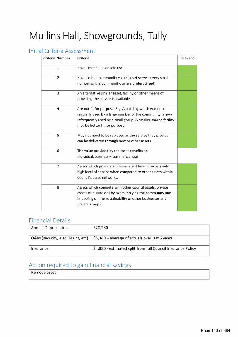
Mullins Hall, Showgrounds, Tully Initial Criteria Assessment
Criteria Number Criteria Relevant
1 Have limited use or sole use
2 Have limited community value (asset serves a very small
number of the community, or are underutilised)
3 An alternative similar asset/facility or other means of
providing the service is available
4 Are not fit for purpose. E.g. A building which was once
regularly used by a large number of the community is now
infrequently used by a small group. A smaller shared facility
may be better fit for purpose.
5 May not need to be replaced as the service they provide
can be delivered through new or other assets.
6 The value provided by the asset benefits an
individual/business – commercial use
7 Assets which provide an inconsistent level or excessively
high level of service when compared to other assets within
Council’s asset networks.
8 Assets which compete with other council assets, private
assets or businesses by oversupplying the community and
impacting on the sustainability of other businesses and
private groups.
Financial Details Annual Depreciation $20,280
O&M (security, elec, maint, etc) $5,340 – average of actuals over last 6 years
Insurance $4,880 - estimated split from full Council Insurance Policy
Action required to gain financial savings Remove asset
Page 143 of 384

Current use The building is occasionally used by the Tully Support Centre for community care/youth activities
and is in very poor condition.
History Build 45 years ago in conjunction between Tully Rugby League and CSC and used for cabarets,
sports presentation dinners etc. Last 10 years this has been only utilised occasionally the Tully
Support Centre for community care/youth activities.
Strategy for existing use Utilise other shared locations within Tully.
Consultation Survey Information Session One on One
Completed Attended Attended
Youth centre is operated by the Tully Support Centre and has approximately 2500 youth visit
during the year providing free food and support to young people from the Tully Community. The
youth centre is largely funded by Council. The Tully Support Centre has provided a large amount
of information supporting the need for an ongoing service to be provided.
Community Consultative Group Assessment (N=11)
Criteria Number Criteria CCG Assessment
Page 144 of 384

1 Have limited use or sole use 3
2 Have limited community value (asset serves a
very small number of the community, or are
underutilised)
2
3 An alternative similar asset/facility or other
means of providing the service is available
4
4 Are not fit for purpose. E.g. A building which was
once regularly used by a large number of the
community is now infrequently used by a small
group. A smaller shared facility may be better fit
for purpose.
4
5 May not need to be replaced as the service they
provide can be delivered through new or other
assets.
4
6 The value provided by the asset benefits an
individual/business – commercial use
1
7 Assets which provide an inconsistent level or
excessively high level of service when compared
to other assets within Council’s asset networks.
3
8 Assets which compete with other council assets,
private assets or businesses by oversupplying the
community and impacting on the sustainability of
other businesses and private groups.
2
Criteria – 1 = Do Not Agree, 2= Somewhat Disagree, 3= Neither Agree or Disagree, 4 = Somewhat agree, 5 = Strongly Agree.
CCG Comments
CCG Comment Officer Comment
Need to find alternative for Youth Centre Council can work with the youth centre to find
an alterative location where services can be
provided.
Recommended Rationalisation Approach Remove from insurance register. Relocate Tully Youth Centre to an alternative facility. Demolish
facility when high risk. Sell any items of value/use/salvage via public auction.
Page 145 of 384

Old Tully Visitor Information Centre/Cassowary Region Arts Council Association (CRACA) Initial Criteria Assessment
Criteria Number Criteria Relevant
1 Have limited use or sole use
2 Have limited community value (asset serves a very small number of the community, or are underutilised)
3 An alternative similar asset/facility or other means of providing the service is available
4 Are not fit for purpose. E.g. A building which was once regularly used by a large number of the community is now infrequently used by a small group. A smaller shared facility may be better fit for purpose.
5 May not need to be replaced as the service they provide can be delivered through new or other assets.
6 The value provided by the asset benefits an individual/business – commercial use
7 Assets which provide an inconsistent level or excessively high level of service when compared to other assets within Council’s asset networks.
8 Assets which compete with other council assets, private assets or businesses by oversupplying the community and impacting on the sustainability of other businesses and private groups.
Financial Details Annual Depreciation $2,900
O&M $1,500
Insurance $700 - estimated split from full Council Insurance Policy
Action required to gain financial savings Remove asset
Page 146 of 384

Current use Facility has been vacated by the Tully Arts and is currently unused. A number of groups have
expressed interest in the facility however groups could be accommodated at alternative facilities.
Given its location on the entrance to Tully an adjacent to the VIC a high quality, financially strong
and low impact user would be required.
Asset requires significant maintenance.
History Council assumed ownership of the building from the Development Bureau of Hinchinbrook &
Cardwell Shires Inc. in December 2004. CRACA originally operated out of a space in the Post Office
Meeting Rooms in Bryant Street, however when the space was required for other purposes,
CRACA lobbied the CSC for use of the building on the Bruce Highway, next to the new Tully VIC for
the purposes of facilitating cultural development, gallery exhibitions, arts workshops, etc. The
building was converted from an undercover shelter into a building.
Strategy for existing use Look to accommodate any emerging groups in shared facilities.
Consultation Survey Information Session One on One
NA -No User NA -No User NA -No User
Internal Only.
Page 147 of 384

Community Consultative Group Assessment (N=11)
Criteria Number Criteria CCG Assessment
1 Have limited use or sole use 3
2 Have limited community value (asset serves a
very small number of the community, or are
underutilised)
3
3 An alternative similar asset/facility or other
means of providing the service is available
3
4 Are not fit for purpose. E.g. A building which was
once regularly used by a large number of the
community is now infrequently used by a small
group. A smaller shared facility may be better fit
for purpose.
3
5 May not need to be replaced as the service they
provide can be delivered through new or other
assets.
3
6 The value provided by the asset benefits an
individual/business – commercial use
2
7 Assets which provide an inconsistent level or
excessively high level of service when compared
to other assets within Council’s asset networks.
3
8 Assets which compete with other council assets,
private assets or businesses by oversupplying the
community and impacting on the sustainability of
other businesses and private groups.
2
Page 148 of 384

Criteria – 1 = Do Not Agree, 2= Somewhat Disagree, 3= Neither Agree or Disagree, 4 = Somewhat agree, 5 = Strongly Agree.
CCG Comments
CCG Comment Officer Comment
Commercial Opportunity for Café Currently there are a number of café’s within Tully. There is
also been a long-term desire to get people to turn into Tully
form the highway. Locating a café out on the highway
contradicts this idea. A recent attempt to operate a café
from the old railway station was unsuccessful.
Provide to alternative group This would not allow rationalisation to result in savings.
There is limited parking available which competes with the
VIC. Other groups can be located in other shared facilities
elsewhere in Tully leaving this site for the VIC.
Recommended Rationalisation Approach Remove from insurance register. Dispose via public auction any items of value/use. Demolish facility
when high risk.
Page 149 of 384

Tennis Facility, Silkwood Initial Criteria Assessment
Criteria Number Criteria Relevant
1 Have limited use or sole use
2 Have limited community value (asset serves a very small number
of the community, or are underutilised)
3 An alternative similar asset/facility or other means of providing the
service is available
4 Are not fit for purpose. E.g. A building which was once regularly
used by a large number of the community is now infrequently used
by a small group. A smaller shared facility may be better fit for
purpose.
5 May not need to be replaced as the service they provide can be
delivered through new or other assets.
6 The value provided by the asset benefits an individual/business –
commercial use
7 Assets which provide an inconsistent level or excessively high level
of service when compared to other assets within Council’s asset
networks.
8 Assets which compete with other council assets, private assets or
businesses by oversupplying the community and impacting on the
sustainability of other businesses and private groups.
Financial Details Annual Depreciation $9,000
O&M $500
Insurance $2,000 – estimated split from full Council insurance policy.
Action required to gain financial savings Remove assets
Page 150 of 384

Current use The asset is not being utilised – no active Club. The courts are in poor condition. Due to the flood
prone nature of the site removal of the assets is recommended to avoid placing assets and other
groups in area that is prone to inundation.
History The tennis courts were built in the early 1920’s by Arthur Heaton, one of the first settlers in
Silkwood and one of the first cane farmers to supply the South Johnstone Mill in 1916. Since the
establishment of the courts they have been relocated three times. In its day it was a very
active/well used space.
Strategy for existing use There is no active club. There are a number of other Tennis facilities within the region that tennis
players can use within a 30 minute drive of this location.
Consultation
Survey Information Session One on One
No users NA No users NA No users NA
Internal Only.
Community Consultative Group Assessment (N=13)
Criteria Number Criteria CCG Assessment
2
10
1
Silkwood Tennis Court
Green – fully supportAmber - support but have questions or reservationsRed - Do not support - provide explanation using criteria
Page 151 of 384

1 Have limited use or sole use 4
2 Have limited community value (asset serves a
very small number of the community, or are
underutilised)
4
3 An alternative similar asset/facility or other
means of providing the service is available
3
4 Are not fit for purpose. E.g. A building which was
once regularly used by a large number of the
community is now infrequently used by a small
group. A smaller shared facility may be better fit
for purpose.
4
5 May not need to be replaced as the service they
provide can be delivered through new or other
assets.
3
6 The value provided by the asset benefits an
individual/business – commercial use
2
7 Assets which provide an inconsistent level or
excessively high level of service when compared
to other assets within Council’s asset networks.
3
8 Assets which compete with other council assets,
private assets or businesses by oversupplying the
community and impacting on the sustainability of
other businesses and private groups.
3
Criteria – 1 = Do Not Agree, 2= Somewhat Disagree, 3= Neither Agree or Disagree, 4 = Somewhat agree, 5 = Strongly Agree.
CCG Comments
CCG Comment Officer Comment
More community consultation is required There is no active club for many years. Council
has undertaken consultation consistent with its
adopted consultation approach .
Try to find alternative user Finding another user would reduce the ability
for council to achieve the savings available by
rationalising the asset. Its also likely that any
new group could use a shared facility
somewhere else in the region.
Page 152 of 384

Recommended Rationalisation Approach Remove from insurance register. Dispose by public auction of storage shed and other saleable items.
Remove courts and fencing. Provide minimal maintenance to mitigate safety risk. Demolish buildings
when considered high risk due to asset condition.
Page 153 of 384

Council Employee Housing (Pease Park, Warrina Lakes, Tully Showgrounds, Stoters Hill) Initial Criteria Assessment
Criteria Number Criteria Relevant
1 Have limited use or sole use
2 Have limited community value (asset serves a very small number of the community, or are underutilised)
3 An alternative similar asset/facility or other means of providing the service is available
4 Are not fit for purpose. E.g. A building which was once regularly used by a large number of the community is now infrequently used by a small group. A smaller shared facility may be better fit for purpose.
5 May not need to be replaced as the service they provide can be delivered through new or other assets.
6 The value provided by the asset benefits an individual/business – commercial use
7 Assets which provide an inconsistent level or excessively high level of service when compared to other assets within Council’s asset networks.
8 Assets which compete with other council assets, private assets or businesses by oversupplying the community and impacting on the sustainability of other businesses and private groups.
Financial Details Annual Depreciation $26,771
O&M $23,184 – average annual expenditure over the past 4 years
Insurance $6,700 – estimated split from full council insurance policy
Action required to gain financial savings Where houses are located on larger reserve and is able to be moved sell houses (Tully Showgrounds, Pease Park, Warrina Lakes). Where house is located on freehold land sell house and land.
Current use These residences are rented to Council employees not related to the operation of any facility. 2 are currently vacant.
Page 154 of 384

History Stoters Hill Residence - Johnstone Shire Council acquired the residence (1 RP730859) and adjoining parcel of land at 15 Quarry Road Stoter's Hill (1 RP734667) in January 2001. In the time since the purchase the premises has accommodated a number of senior staff members and has had regular maintenance and capital work undertaken to ensure its condition has been kept in a reasonable state. Caretaker Residence Warrina Lakes - The house was originally used as a caretaker residence/garages attached to the Clare Street Council Depot. It was relocated to Warrina Lakes in the late 1980’s from its original site where Kmart is today. No formal caretaker duties now exist. Tully Showgrounds – Caretaker’s Residence was built pre 1950 when the showgrounds was used as cattle yards and the Council kept pound horses there. No formal caretaker duties now exist. Pease Park Caretakers Residence - Building commissioned in 1969 and was tenanted up until January 2020 to staff in conjunction with the maintenance of Pease Park. Leases are in place that see this no longer a requirement of council.
Strategy for existing use Honour current tenancy agreements. Advise tenants at the end of their current rental term they will need to find alternative accommodation.
Consultation Survey Information Session One on One
NA NA Attended
Community Consultative Group Assessment (N=11)
Criteria Number Criteria CCG Assessment
1 Have limited use or sole use 5
Current tenants notified that Council might be looking to dispose of assets in future. Existing tenancy agreements will be honoured.
Page 155 of 384

2 Have limited community value (asset serves a very small number of the community, or are underutilised)
5
3 An alternative similar asset/facility or other means of providing the service is available
4
4 Are not fit for purpose. E.g. A building which was once regularly used by a large number of the community is now infrequently used by a small group. A smaller shared facility may be better fit for purpose.
3
5 May not need to be replaced as the service they provide can be delivered through new or other assets.
4
6 The value provided by the asset benefits an individual/business – commercial use
4
7 Assets which provide an inconsistent level or excessively high level of service when compared to other assets within Council’s asset networks.
4
8 Assets which compete with other council assets, private assets or businesses by oversupplying the community and impacting on the sustainability of other businesses and private groups.
3
Criteria – 1 = Do Not Agree, 2= Somewhat Disagree, 3= Neither Agree or Disagree, 4 = Somewhat agree, 5 = Strongly Agree.
CCG Comments CCG Comment Officer Comment
NA
Recommended Rationalisation Approach Remove from insurance register. Once houses are vacant dispose by public auction the Pease Park
caretaker house, Warrina Lakes caretaker Residence and Tully Showgrounds Caretaker Residence
buildings only. Sell the land and house at Stoters Hill. Remove from asset register.
Page 156 of 384

Enforce lease conditions
Initial Criteria Assessment Criteria Number Criteria Relevant
1 Have limited use or sole use
2 Have limited community value (asset serves a very small number
of the community, or are underutilised)
3 An alternative similar asset/facility or other means of providing the
service is available
4 Are not fit for purpose. E.g. A building which was once regularly
used by a large number of the community is now infrequently used
by a small group. A smaller shared facility may be better fit for
purpose.
5 May not need to be replaced as the service they provide can be
delivered through new or other assets.
6 The value provided by the asset benefits an individual/business –
commercial use
7 Assets which provide an inconsistent level or excessively high level
of service when compared to other assets within Council’s asset
networks.
8 Assets which compete with other council assets, private assets or
businesses by oversupplying the community and impacting on the
sustainability of other businesses and private groups.
Financial Details Annual Depreciation
O&M $25,000
Insurance
Action required to gain financial savings Enforce lease conditions onto the lessee. This will result in savings for mowing, cleaning and
maintenance costs.
Page 157 of 384

Current use Various leases across the region
History
Council has many historical leases that have. In most cases this sees the lessee obtaining extra benefits at the ratepayers expense.
Strategy for existing use Continue use with lease conditions enforced.
Consultation
Discussion regarding Principles for Community Use of Assets at CCG.
Resolution Number LG0885
“We require accountability for agreements and deliverables”
Community Consultative Group Assessment (N=11)
Criteria Number Criteria CCG Assessment
1 Have limited use or sole use 3
2 Have limited community value (asset serves a
very small number of the community, or are
underutilised)
2
3 An alternative similar asset/facility or other
means of providing the service is available
2
10
Enforce Lease Conditions
Green – fully support
Amber - support but have questions or reservations
Red - Do not support - provide explanation using criteria
Page 158 of 384

4 Are not fit for purpose. E.g. A building which was
once regularly used by a large number of the
community is now infrequently used by a small
group. A smaller shared facility may be better fit
for purpose.
2
5 May not need to be replaced as the service they
provide can be delivered through new or other
assets.
2
6 The value provided by the asset benefits an
individual/business – commercial use
3
7 Assets which provide an inconsistent level or
excessively high level of service when compared
to other assets within Council’s asset networks.
4
8 Assets which compete with other council assets,
private assets or businesses by oversupplying the
community and impacting on the sustainability of
other businesses and private groups.
3
Criteria – 1 = Do Not Agree, 2= Somewhat Disagree, 3= Neither Agree or Disagree, 4 = Somewhat agree, 5 = Strongly Agree.
CCG Comments
CCG Comment Officer Comment
Recommended Rationalisation Approach Audit all current leases/agreements to identify where Council is incurring costs that should be borne
by the lessee/group (eg Insurance, Electricity, Rates, Depreciation, Maintenance, Mowing and
Cleaning). Write to the lessee/group and request compliance with lease/agreement conditions,
timeframes for compliance of 21 days to 90 days are anticipated for most cases. Should
lessees/groups fail to comply, follow the process in the lease/agreement terms that the
lessee/group agreed to for default/termination.
Page 159 of 384

Stoters Quarry – Buildings and Equipment, Stoters Hill Initial Criteria Assessment
Criteria Number Criteria Relevant
1 Have limited use or sole use
2 Have limited community value (asset serves a very small number of the community, or are underutilised)
3 An alternative similar asset/facility or other means of providing the service is available
4 Are not fit for purpose. E.g. A building which was once regularly used by a large number of the community is now infrequently used by a small group. A smaller shared facility may be better fit for purpose.
5 May not need to be replaced as the service they provide can be delivered through new or other assets.
6 The value provided by the asset benefits an individual/business – commercial use
7 Assets which provide an inconsistent level or excessively high level of service when compared to other assets within Council’s asset networks.
8 Assets which compete with other council assets, private assets or businesses by oversupplying the community and impacting on the sustainability of other businesses and private groups.
Financial Details Annual Depreciation $19,394
O&M Limited savings as site and assets have not been maintained.
Insurance $4,350 – estimated split from full council insurance policy
Action required to gain financial savings Dispose of assets off site / make safe.
Current use Unused
History The Stoters Hill Quarry site was previously leased to Hasting NQ Pty Limited as an operating Quarry. The lease expired in February 2015 and the quarry is no longer in operation. There are no current plans to put the quarry back in operation in its current state. The assets on site are aged and deteriorated due to lack of maintenance. Significant investment would be required to bring the equipment up to a safe standard which complies with current requirements.
Page 160 of 384

Strategy for existing use Nil. There are currently a number of private quarries operating within the Cassowary Coast Region which are keeping up with demand for gravel. The site represents challenges to operate largely dewatering and any future operation would need to consider the use of mobile (rather than fixed) plant to enable dry season production with equipment to be utilised elsewhere during the wet season. Such an operation would not require fixed assets.
Consultation Internal only
Criteria Number Criteria CCG Assessment
1 Have limited use or sole use 5
2 Have limited community value (asset serves a very small number of the community, or are underutilised)
5
3 An alternative similar asset/facility or other means of providing the service is available
4
4 Are not fit for purpose. E.g. A building which was once regularly used by a large number of the community is now infrequently used by a small group. A smaller shared facility may be better fit for purpose.
4
5 May not need to be replaced as the service they provide can be delivered through new or other assets.
5
6 The value provided by the asset benefits an individual/business – commercial use
3
7 Assets which provide an inconsistent level or excessively high level of service when compared to other assets within Council’s asset networks.
4
8 Assets which compete with other council assets, private assets or businesses by oversupplying the community and impacting on the sustainability of other businesses and private groups.
3
Page 161 of 384

Criteria – 1 = Do Not Agree, 2= Somewhat Disagree, 3= Neither Agree or Disagree, 4 = Somewhat agree, 5 = Strongly Agree.
CCG Comments CCG Comment Officer Comment
Offer quarry for tender/privatisation The assets on site are aged and deteriorated due to lack of maintenance. Significant investment would be required to bring the equipment up to a safe standard which complies with current requirements. Its likely that the assets would actually be a detractor due to the investment required to bring them up to a reasonable standard. There are currently a number of private quarries operating within the Cassowary Coast Region which are keeping up with demand for gravel. Any future privatisation should be timed to align with a period of high demand to ensure that the ratepayer receives maximum benefit from the resource.
Recommended Rationalisation Approach Dispose of assets by public auction or demolish.
Page 162 of 384

MAJOR PROJECTS
6.1. Port Hinchinbrook Sewerage Proposal
Prepared by: Daniel Bradford, Business Opportunities & Improvement Lead Meeting Date: Thursday, January 21, 2021
Executive Summary:Cassowary Coast Regional Council, under an agreement with the Department of State Development, Tourism and Innovation (DSDTI) and consent from the liquidator for The Passage Holdings, has been maintaining and operating the Sewerage Treatment Plant for the Port Hinchinbrook Estate just south of Cardwell since August 2018. Options for a long-term solution for the sewerage treatment plant at Port Hinchinbrook have been prepared with the final design now complete.
Council is in receipt of a funding proposal from DSDTI for $4.3million to go towards the construction of a new sewerage treatment plant and acquisition of the road lots within the Port Hinchinbrook Estate.
In addition to this, Council has recently conducted some community consultation in relation to the sewerage situation at Port Hinchinbrook. This feedback has been summarised in the report and should be taken into consideration when making a resolution.
Recommendation:“That Council:1. Acknowledge the feedback from property owners and concerned members of the community from the recently completed community engagement survey;
2. Consider the proposal from the Department of State Development, Tourism and Innovation for acquisition as described in Schedule 1 being land used for sewage treatment, and road purposes within the Port Hinchinbrook private estate, and the construction of a replacement sewage treatment plant for Port Hinchinbrook. "
Background:Following the resolution from Council on 13 August 2020 in relation to the Ganden Report, Council officers have been working proactively with the Department of State Development, Tourism and Innovation to facilitate a long-term solution for Port Hinchinbrook. The company in control of the estate, The Passage Holdings Limited, is in liquidation and currently in the hands of liquidators. There are a number of infrastructure issues within the Port Hinchinbrook private development with varying levels of impact for local residents, property owners, the wider Cassowary Coast community and potentially, the greater natural environment, such as the Great Barrier Reef.
Council officers have been working with various stakeholders in an effort to progress towards long term solutions to a number of issues within the Port Hinchinbrook development. This report will focus particularly on the sewerage and the roads infrastructure within the Port Hinchinbrook private estate. Council has, since 2018, been operating and maintaining the current sewerage treatment plant (STP) at Port Hinchinbrook under an interim funding agreement with DSDTI. In September 2020 Council received a funding proposal from the DSDTI for a long term solution for sewerage at Port Hinchinbrook which would see the Council own and operate the facility. The proposal is as follows:
• DSDTI will provide $4.3M towards a new STP;• The Council will provide approximately $2M towards the new STP;• The detailed design and specifications for the STP will form the basis of the project;• The Council will deliver the project;• The Council will acquire the STP land and existing STP assets;• The Council will acquire the Road Land and proceed to request dedication of the land as road reserves under the Land Act 1994(Qld); and
Page 163 of 384

• The Council’s acquisition will be subject to its satisfaction that the terms of acquisition are acceptable.
The proposal from the Department is very generous and Council officers thank DSDTI for its hard work. The construction of a Council owned replacement sewage treatment facility would see Council take ownership and full control of sewerage within the Port Hinchinbrook private estate. In addition to this Council would be acquiring the "road" land from the Company, The Passage Holdings. This would see Council take control and responsibility for the "roads" within the estate.
Detailed Design of Sewage Treatment PlantThe detailed design is for the construction of a new 500 equivalent persons (EP) sewage treatment plant which would cater for the current 200EP demand from the Port Hinchinbrook community. Officers are comfortable that the STP is sized appropriately to meet the current and short to medium term future demands from Port Hinchinbrook.
If Port Hinchinbrook were to expand to somewhere near its population capacity (1500) in the next five to ten years, significant capital outlay would be required to upgrade treatment facilities. Solutions to this issue could be addressed through some further modifications to design now, which may add a small amount to the project cost, but save significantly on an expansion in the future.
It should be noted that Council will need to have the relevant environmental authority (EA) for the operation of the sewerage treatment plant, transferred into its name as the operator (which carries with it liabilities, given that the current STP is not compliant with the EA). Alternatively, Council could apply for a new environmental authority for the new plant (with potentially new and unpredictable conditions) and source additional land for the irrigation component of discharge of the treated sewage to satisfy the proposed plant capacity of 500EP. Under the proposal from DSDTI, Council would be acquiring sufficient land to be able to meet the current demand to satisfy the conditions under the environmental authority for the disposal through irrigation. However, increases in demand would require additional land to be sourced. As mentioned in a previous report, this could include utilising alternative methods of disposal such as third party consumers.
As the current environmental authority nominates parcels of land for irrigation purposes that are now no longer available, some clauses of the authority would need to be renegotiated and there is a real risk that Department of Environment and Science could introduce changes to conditions with some significant financial ramifications.
"Roads" and Associated InfrastructureWithin the Estate there is around 6km of sealed "roads". Under the proposal from DSDTI this would see Council acquire this land (and associated infrastructure, e.g. water and sewerage reticulation and stormwater assets) and then dedicate it as a road/s for public use. Council officers have identified some capital works that would need to be undertaken in the short term. These works include small sections of road rehabilitation and also culvert and bridge works. From an ongoing operational perspective, there would be a small amount of additional maintenance required, with minimal impact upon current operating budgets.
Water ReticulationThe acquisition of the land for roads and associated infrastructure and the dedication of the land as road/s for public use would also trigger the transfer of responsibility for all water reticulation assets (located in the road reserves) to Council. There has been no condition assessment of existing water infrastructure within the estate. There is a possibility that some other services have been bundled in the same trench with the internal water mains which will add complexity and cost to any future maintenance of the water assets. No accumulated depreciation funds are available to replace the water assets once they reach the end of their useful lives. An accelerated depreciation expense should be applied to Port Hinchinbrook water assets which will have some impact to water operational budgets.
Under the Water Supply (Safety and Reliability) Act 2008 (WSSRA), once Council owns those assets, it may be registered as a service provider for the assets.
Page 164 of 384

Port Hinchinbrook’s Current STPCouncil, funded by DSDTI, for over two years, has been operating the current STP at Port Hinchinbrook. The current facilities are in very poor condition with minor works needed to keep the current plant operational. While some minor works may be able to delay the immediate need for a new treatment plant, it is the view of officers and the State, that a new treatment plant is required. There is a real risk of major plant failure, even with works being undertaken to parts of the current facility. Additionally, it should be noted that the current STP is at severe risk of not meeting environmental compliance requirements as set out in the environmental authority.
Sewerage Reticulation NetworkAs mentioned, the project scope set out in the funding proposal is limited to the construction of a new sewage treatment plant and acquisition of the roads land. Council officers are of the view that there are additional renewal works needed to be undertaken to provide a suitable level of reliability and efficiency for the management of sewerage across the network into the future. Officers have identified:
• Replacement of pump station 4• New pumps, guiderails and chains for 10 pump stations• New switchboards with SCADA for 10 pump stations• New floats and sensors for 10 pump stations• New risers, and valve pit pipework for 6 pump stations
It is estimated that these works along with other minor repairs to the network will see an additional $2.3M needed to achieve a suitable level of operation.
Some condition assessment has been undertaken on a sample of the gravity sewerage network and the pipes and manholes were found to be in fair condition for their age. No condition assessment has been undertaken on any of the pressure mains. The pressure mains are understood to be polyethylene pipes of a lower class than normally accepted by Council.
Much of the existing gravity sewer network is not in the road reserve but passes through the individual lots within the estate. Easements for sewerage purposes could be required from owners to ensure access to all sewerage assets not in the road reserve.
Under the WSSRA, once Council owns these assets, it may be registered as a service provider for the assets.
Community Survey FeedbackAs a part of this process, it was important to understand the community’s position in relation to Port Hinchinbrook and the consideration of the long term future for sewerage within the estate. The community consultation was as much about Council clearly outlining the facts and the options for property owners, as it was about hearing from the community. The survey was aimed at hearing from the property owners as they will ultimately be benefiting and paying for a sewerage service. However, there was opportunity for local residents, facility users, and concerned citizens to have their say.
Council received eighty-five completed surveys during the period and around a dozen letters directly to Councillors and council staff. Forty-seven of the survey respondents and the majority of the letters indicated they were property owners. Just focusing on the property owner responses, half were clear, indicating they see Council to be in the best position to take on sewage treatment for Port Hinchinbrook. However most felt the indicative utility rate and special charge were too high or should be on par with other sewerage schemes. There was support for Council to source further government funding for the capital component to reduce the rates burden on those within the benefited area. There were four responses that while not indicating support for the estimated price did seek Council to push forward and fix the issues.
There were just 3/47 respondents suggesting the body corporate should remain in control of the sewage treatment plant. There were some that went further and indicated Council should take over the entire
Page 165 of 384

estate, while others suggested connecting sewage to Cardwell to make the scheme more affordable and offering potential economic opportunities, particularly in preparation for such prospects as the Mountain Bike Strategy.
From some property owner comments it was clear they were quite desperate for a solution, but were not sure how they could afford it. Many indicated they are looking to sell out but cannot find buyers in the current market. This would only become more difficult if property owners of vacant land then had a significant increase in rates to contribute to the sewerage service. Others indicated that they pay enough rates already and that Government has abandoned Port Hinchinbrook.
Property owners’ views must be balanced against the wider community’s views. The thirty-eight non-Port Hinchinbrook property owners who responded did provide quite mixed opinions on who should be operating the STP. However, there was significant clarity in a self-funded model and not burdening the general ratepayer, many suggesting that property owners should be responsible for what they have bought into.
In addition to the sewerage, the survey asked about the general situation at Port Hinchinbrook. Many respondents indicated disappointment at the current state of the development and demonstrated a recognition that Port Hinchinbrook is, or has the potential to be, a critical regional asset for the Cassowary Coast. Property owners and some non-property owners indicated that roads should be managed by Council.
Ratepayer ImpactIn the community consultation Council indicated that the expected sewerage utility charge could be upwards of $3,000 per year. The reason for this is due to the small number of users within the scheme. In addition to this utility charge, Council estimates $1500 per year would need to be charged as a special charge for ten years to cover the cost of the initial capital outlay from Council. One option, as some respondents suggested, is to source funding for the additional capital needed to complete STP and reticulation network projects. Any additional sourced funding would directly reduce the $1500 defined benefited area contribution.
A sewerage service provided by Council is a utility charge as defined in the Local Government Act 2009. This represents the costs of operating and maintaining the STP and associated sewerage reticulation network. As a result, sewerage costs are not levied as part of the general rates. Council currently operates two sewerage schemes that both operate on an individual utility charge based on the costs associated within each scheme. Innisfail’s sewerage utility charge is currently $999, which is one of the dearest in the State. The proposed charge for Port Hinchinbrook could be three times this amount and should raise concerns about capacity to pay for property owners.
The Option of not proceeding with DSDTI’s ProposalAs a part of any consideration for a project, Council must consider the option of not proceeding. There are some substantial risks for Council in proceeding with the DSDTI’s proposal and any benefits from the proposal are primarily benefits for the owners at Port Hinchinbrook.
Council is under no obligation to take on the sewerage treatment at Port Hinchinbrook. The development is a private estate and governed by the Port Hinchinbrook Conformed Deed (being an infrastructure agreement that binds successors in title). The deed assigns responsibility for the sewage treatment to the Company (being a successor in title to Williams Corporation Pty Ltd (in liquidation)). This by definition is currently The Passage Holdings Pty Ltd (in liquidation). Council is currently operating the STP with funding from DSDTI following advice from the liquidator. This is not a sustainable solution due to the risk of imminent failure of the current STP.
In its current form, Port Hinchinbrook is not offering a huge amount for the region from an economic perspective. While the sewerage and other matters remain outstanding within the estate, the outlook is likely to continue. Long term security of sewerage treatment on its own is not going to see a shift in opportunity immediately, but it will resolve a major road block that may be slowing some major investors. A
Page 166 of 384

vibrant Port Hinchinbrook would certainly add value to the Cassowary Coast Region.
Link to Corporate Plan:Goal 1 - Growth and Economic Sustainability
Objective: To build a strong diverse economy which provides opportunities for business and investment with an integrated approach to long-term planning where the region's assets meet community needs.
1.7.Ensure the Cassowary Coast Region is seen as an economically vibrant area to do business.
Goal 2 - Community First
Objective: To work in partnership with the community to ensure that facilities and amenities meet the needs of local people and that Council delivers a consistent and high level of service. We will measure ourselves to ensure our performance keeps pace with evolving community expectations.
2.10. Council initiatives balance impact on the environment against benefit for different community interest groups.
Goal 3 - Sustainable Infrastructure
Objective: Regional infrastructure that delivers levels of service supported by the community and is financially sustainable.
3.3.Provide and manage cost effective and efficient water supply and sewerage infrastructure, which provides for growth while being environmentally sustainable.
3.4.Effectively deliver and manage infrastructure assets in order to maximise community service levels in a financially sustainable manner.
Goal 4 - Responsible Governance
Objective: Ensure good governance is achieved by having efficient and effective decision-making processes and systems.
Maintain a well-managed, transparent and effective organisation that gives the community confidence, demonstrates financial sustainability and ensures our customers are satisfied with our services and our employees are proud to work here.
4.2.Undertake robust and accountable financial, resource and infrastructure planning and management to ensure affordable and sustainable outcomes for our community.
Consultation:Local Community through Community consultation surveyDepartment of Development, Tourism and Innovation
Legal Implications (Statutory basis, legal risks):Council is a party to the Port Hinchinbrook Conformed Deed. This does set out obligations for all parties. There are no legal requirements for Council to take on the sewerage service for Port Hinchinbrook, and it is quite clear in the Deed that this is the responsibility of the Company. If Council was to take on sewerage for the estate, it will inherit some compliance issues that would need to be addressed. Other risks include:
• Protection under the Conformed deed may be lost, at least in respect of sewerage;• Further potentially onerous approvals may be required, on the basis that the proposal falls outside the terms of the Conformed deed and given the proximity of the proposed development to the Great Barrier Reef. This will lead to delay, uncertainty and additional costs;
Page 167 of 384

• If the basis for commercial operation of the resort is removed, then pressure will be applied to Council to maintain the canal and Harbour.
Policy Implications:If Council is to take on the sewerage treatment for Port Hinchinbrook there will be various policies and asset plans that would need to be updated to reflect the needs and impacts from taking on an increase to our asset base.
Risk Implications (Corporate, Operational, Project risks):There are a number of risks for this project which need to be managed. There are significant risks to Council and the local community if Council proceeds with the DSDTI proposal. These risks need to be managed and the impact reduced or removed depending on the approach taken by Council. If Council is to proceed with taking on the sewerage scheme the following matters need to be addressed further:
• The potential lack of capacity for property owners to pay the additional rates and charges for constructing, operating and maintaining the sewerage treatment plant;• Environmental compliance issues with operating the current sewerage treatment plant which would need to be addressed when taking on the ownership of the STP.• Protection under the Conformed deed may be lost, at least in respect of sewerage.• Further onerous approvals may be required.• If the basis for commercial operation of the resort is removed then pressure will be applied to Council to maintain the canal and Harbour.• Council is unable to source appropriate land in the local vicinity of the STP for the disposal of treated effluent in accordance with the environmental authority. • The risk of substantial additional capital outlay required to support an expansion to the STP from a major increase to population within the sewerage scheme.• The risk of additional operational or capital outlays to repair or upgrade components of the sewerage network because of lack of detail on their capacity and condition.• Sewerage assets not in road reserve will require easements from property owners. There is some cost associated with the settling of these easements and there is some risk of opposition to the granting of such easements.• Council’s acquisition costs.• The risk of additional operational or capital outlays to repair or renew components of the water reticulation network because of a lack of detail on the condition of water assets. (It should also be noted that accumulated depreciation funds are not available for Port Hinchinbrook water assets.)
On the flip side there are also risks if Council resolves to not proceed with taking on the sewerage scheme unless Council adopts a suitable alternative option. The risks included:
• Lack of ongoing appropriate management of sewerage treatment for the estate and its residents. • Risks to the wider environment such as the Great Barrier Reef.• Continued political risk around the inaction of a failed private estate on the doorstep of the Cassowary Coast.
It should be noted that the management of many of the risks associated with not proceeding would not be the direct responsibility of Council. However, any failure to manage these risks will severely affect some members of the Cassowary Coast community.
Financial & Resource Implications:Included in the funding proposal is a $4.3M contribution to the construction of the $6.3M new STP. This would see Council funding the remaining $2M. In addition to this project from the funding agreement, Council has identified an additional $2.3M of capital works needing to be undertaken to the sewerage reticulation network. To support the sewerage service into the future, Council will need to levy a sewerage utility charge to the properties within the development. In addition to this Council need to consider sourcing funds for the $4.3M. If a special charge from property owners were to be used as the source of funding this would see a charge of $1500 per year for ten years for property owners.
Page 168 of 384

The ongoing management of the sewerage treatment plant and associated reticulation network is expected to cost $737,000 per year. This includes depreciation of the new STP and other assets within the network. By making an allowance for depreciation as part of our normal operational costs, Council is able to fund the ongoing renewal of the treatment plant into the future. This would see a utility charge of around $3,000 per year for rate payers. While this would see the operations of the treatment plant funded, this utility would be three times the price of the Innisfail sewerage utility rate, a rate which is already rated as one the most expensive in the state.
Some elements of the existing gravity sewerage network infrastructure and pressure mains are in an unknown condition. Water main assets are in an unknown condition and no depreciation funding has been accumulated for their eventual replacement.
There are works that need to be undertaken in the roads and stormwater space. It is understood that those works should fit in with current capital works programs. With regard to the amount of ongoing operational maintenance required for the roads and stormwater networks, it is anticipated that costs could be absorbed into current budgets.
Total additional depreciation for Roads, Stormwater, Kerb and Channel, Major Drainage Structure and Water Reticulation are expected to be in the order of $125K annually. Some increase to operations and maintenance expenditure for these assets is also anticipated. These increases would likely be funded by General rates. An indicative increase required in the general rate to fund Depreciation, Operations and Maintenance would be in the order of 0.5%.
Report authorised by:James Gott, CEO
Supporting Documents:1. Schedule 1
Page 169 of 384

Schedule 1
Land subject to acquisition as a part of the funding proposal from the Department of State Development, Tourism and Innovation.
Lot on Plan Use
Lot 60 on SP116825 Road
Lot 65 on SP135869 Road
Lot 62 on SP125903 Road
Lot 59 on SP135869 Road
Lot 65 on SP155035 Road
Lot 64 on SP132625 Road
Lot 64 on SP174367 Road
Lot 66 on SP135869 Road
Lot 197 on SP202762 Road
Lot 81 on SP202762 Road
Lot 3 on C1043 STP
Lot 2 on CWL1212 STP
Lot 1 on C1043 STP
Lot 3 on RP733367 STP
Page 170 of 384

PLANNING & REGIONAL DEVELOPMENT
7.1. Delegations Report and Current Applications
Prepared by: Daniel Horton, Manager Planning ServicesMeeting Date: Thursday, January 21, 2021
Executive Summary:The Planning Services Delegations report detailing approvals issued under Delegated Authority during the month of December 2020 is presented for Councillors Information.
Additionally I wish to outline that you can view documents related to any proposed development and make a submission using Council’s MyCouncil Platform via Councils website.
MyCouncil features are as follows:
Provides self-service options for the community 24/7 ie:
Lodge a CR (Customer Request) Lodge a development Application (planning, building or plumbing & drainage) Submit a planning & development or building records search request Track a CR or development application Make a submission on a development application on public notification Conduct a land parcel search View copies of Decision notices for development applications
Recommendation:"that the Delegations report listing statistics and approvals issued by Planning Services from December 2020 be received and noted."
Background:The monthly operations report for the Planning Services Section for applications approved under Delegated Authority for Councils information. The report contains information relating to the approvals issued during December 2020.
Details are listed in the Attachments 1 and 2.
Link to Corporate Plan:Goal 4 - Responsible Governance
Objective:
Ensure good governance is achieved by having efficient and effective decision-making processes and systems.
Maintain a well-managed, transparent and effective organisation that gives the community confidence, demonstrates financial sustainability and ensures our customers are satisfied with our services and our employees are proud to work here.
4.8.Commit to open, transparent and accountable governance to ensure community confidence and trust in Council.
Consultation:Planning Services staff.
Legal Implications (Statutory basis, legal risks):
Page 171 of 384

Council has given due consideration to the Human Rights 2019 (Qld) in passing any resolution emanating from the recommendations in this paper or otherwise.
Policy Implications:Nil
Risk Implications (Corporate, Operational, Project risks):Nil
Financial & Resource Implications:Nil
Report authorised by:David Goodman, Director Infrastructure Services
Supporting Documents:1. Delegation Report - January 2021 - Attachments 1 and 2
Page 172 of 384

Attachment 1: Planning
Page 173 of 384

Page 174 of 384

Page 175 of 384

Attachment 2: Building
CCRC Building Statistics for December 2020
Page 176 of 384

Page 177 of 384

Page 178 of 384

Page 179 of 384

Page 180 of 384

Page 181 of 384

Page 182 of 384

Page 183 of 384

Page 184 of 384

Page 185 of 384

Page 186 of 384

Page 187 of 384

Page 188 of 384

Page 189 of 384

Page 190 of 384

Page 191 of 384

Page 192 of 384

Page 193 of 384

Page 194 of 384

Page 195 of 384

Page 196 of 384

Page 197 of 384

Page 198 of 384

PLANNING & REGIONAL DEVELOPMENT
7.2. MCU19/0043 - Development Permit for a Material Change of Use for an Educational Establishment (Intensification of an Existing Use - 25 Students) on land described as Lot 2 on RP709042, situated at 89 Mourilyan Road, East Innisfail, Q 4860
Prepared by: Byron Jones, Senior Planner/Strategic PlannerMeeting Date: Thursday, January 21, 2021
Executive Summary:Applicant: Darlingia Ltd Consultant: N/ALandowner: Dianne Jennifer Dray and William Mervyn Dray Application Date: 26 October 2020Proposal: Material Change of Use for an Educational Establishment (Intensification of an
Existing Use – 25 Students)Real Property Description: Lot 2 on RP709042Property Address: 89 Mourilyan Road, East Innisfail QLD 4860Land Area: 1,183m²FNQRP Zone: Urban FootprintPlanning Instrument: Cassowary Coast Regional Council Planning Scheme 2015
Zone Township ZoneLocal Plan Innisfail Local PlanPrecinct Residential PrecinctOverlays Flood hazard
Landslide hazard
Scenic amenity Building Class: Class 9bReferral Agencies: NilLevel of Assessment: Impact assessableLand Use Codes: Community activities codeExisting Use of Land: Educational/Religious EstablishmentExisting Approvals: T.2/3(121/3) Educational Establishment (Tutoring – 8 Students)No. of Submissions: 0 (Zero)
Council is in receipt of an application for a Material Change of Use for an Educational Establishment (Intensification of an Existing Use – 25 Students). The application was prepared by Darlingia Ltd on land described as Lot 2 on RP709042, situated at 89 Mourilyan Road, East Innisfail QLD.
The proposed development facilitates the intensification of the existing educational establishment, being the Darlingia Forest School, for the future growth of the school beyond 2021. The expansion will allow the school to increase the number of students on the site allowed under the current approval from 8 to 25 students. The proposed development will utilise the existing building, access points and parking on the site.
The development application was impact assessable and therefore required public notification. The applicant advised that public notification requirements were carried out in accordance with the Planning Act 2016. Zero (0) properly made submissions were received by Council during the notification period.
At the commencement of the public notification period, the applicant provided the notice of compliance with public notification requirements form instead of the notice of commencement of public notification form in accordance with section 18 of the Development Assessment Rules, however all the required relevant information was provided, this would not have disadvantaged any person/s from making a properly made submission regarding the proposed development. The public notification sign was placed on the fence of the building not on the front boundary, however the public notification sign was still visible from Mourilyan Harbour Road and would not have disadvantaged any person/s from making a properly made submission regarding the proposed development. Given these indiscretions are relatively minor in nature, Council
Page 199 of 384

officers have determined that no person/s would have been disadvantaged from making a properly made submission regarding the development and that public notification had been carried out for the proposed development.
The application did not trigger referral to Queensland Treasury as a Concurrence agency.
The subject site is located within the Urban Footprint as indicated in the Far North Queensland Regional Plan (FNQRP) 2009-2031. The proposal is for an urban purpose, and is considered to be consistent with the FNQ Regional Plan.
The application is generally consistent with the provisions of the Cassowary Coast Regional Council Planning Scheme 2015 and therefore the application for MCU19/0043 - Development Permit for a Material Change of Use for an Educational Establishment (Intensification of an Existing Use - 25 Students) on land described as Lot 2 on RP709042, situated at 89 Mourilyan Road, East Innisfail is recommended for approval subject to reasonable and relevant conditions.
Recommendation:“That a Development Permit be issued for a Material Change of Use for an Educational Establishment (Intensification of an Existing Use - 25 Students) on land described as Lot 2 on RP709042, situated at 89 Mourilyan Road, East Innisfail QLD 4860”, subject to the following conditions:
Background:See Attachments 1, 2, 3 and 4 for more information.
Link to Corporate Plan:Goal 1 - Growth and Economic Sustainability
Objective: To build a strong diverse economy which provides opportunities for business and investment with an integrated approach to long-term planning where the region's assets meet community needs.
1.1.Encourage and facilitate investment in the region that will support both traditional and emerging industries and act as a catalyst for further employment an population growth.
1.2.Further develop tourism industry, destination and events. 1.3.Promote arts and culture as a key feature of the region's lifestyle, liveability, vitality and
character.
Consultation:Regulatory Services
Legal Implications (Statutory basis, legal risks):Possible appeal in the Planning and Environment Court.
Council has given due consideration to the Human Rights 2019 (Qld) in passing any resolution emanating from the recommendations in this paper or otherwise.
Policy Implications:Nil
Risk Implications (Corporate, Operational, Project risks):Nil
Financial & Resource Implications:Possible appeal costs in the Planning and Environment Court.
Report authorised by:David Goodman, Director Infrastructure Services
Supporting Documents:
Page 200 of 384

1. MCU19-0043 - Attachment 1 - Assessment Managers Conditions2. MCU19-0043 - Attachment 2 - Planning Assessment Report3. MCU19-0043 - Attachment 3 - Locality Plan and Aerial Image4. MCU19-0043 - Attachment 4 - Approved Plans
Page 201 of 384

ATTACHMENT 1 – ASSESSMENT MANAGER’S CONDITIONS
Assessment Manager's Conditions
1. Approved Plans and Supporting Documentation
Condition Timing
The development must be undertaken generally in accordance with the application, documentation received by Council on 26 October 2020 and plans in the table below, which forms part of this approval, except where varied by the following conditions.
At all times
Plan/Drawing Number Plan Name Date
Plan No. Nil
Site Plan
Dated: No Date
Received by Council:
26 October 2020
Plan No. Nil Floor Plan
Dated: No Date
Received by Council:
26 October 2020
2. Hours of Operation
Condition Timing
The hours of operation of the site is limited to 7:00am – 6:00pm Monday to Friday (the site may be used out of these hours for events such as information nights and parent interviews) to the satisfaction of the Manager Planning Services.
At all times
3. Car Parking
Condition Timing
The applicant/owner is to ensure that the development provides a minimum of 5 carparks on the subject site. All car parking facilities must comply with the following requirements, to the satisfaction of the Manager Planning Services:
All car parking facilities are designed and constructed in
accordance with Australian Standard AS1428 Design for
Access and Mobility and Australian Standard AS2890.1
Parking Facilities – Off Street Car Parking; and
All car parking facilities excluding the disable carpark are
to be to an all sealed surface, drained and maintained.
Prior to the commencement of the use
Page 202 of 384

4. Scale or Intensity of the Use
Condition Timing
The subject approval is limited to an enrolment number of one twenty five (25) students. Enrolments exceeding this number will necessitate a further Material Change of Use application for the intensification of the use
To be maintained at all times
5. Erosion and Sediment Controls
Condition Timing
Effective erosion and sediment controls must be maintained during and after the construction, installation and maintenance of the site until there is adequate vegetation cover, paved or other controls to prevent any silt run-off from the site.
At all times
6. Stormwater Discharge
Condition Timing
The applicant/owner must ensure that the flow of all external stormwater from the property is directed to a lawful point of discharge, such that stormwater does not adversely affect surrounding properties, to the satisfaction of the Manager Planning Services.
At all times
7. Public Infrastructure/Utilities
Condition Timing
Any relocation or alteration to any public utilities (including stormwater infrastructure) in association with building work must be undertaken as required by the relevant service provider and at no cost to Council.
At all times
8. Waste Bins and Storage Area
Condition Timing
The waste bin and storage areas must be screened from view of adjoining properties and road frontages, to the satisfaction of the Manager Planning Services.
At all times
Page 203 of 384

9. Landscaping
Condition Timing
The applicant/owner is to ensure that all landscaping works are carried out in accordance with 9.4.5 Landscaping Code of the Cassowary Coast Regional Council Planning Scheme 2015.
Prior to the commencement of use and maintained at all times
10. Noise
Condition Timing
The applicant/owner is to ensure that noise from the site must not emanate from the subject land to a degree that would, in the opinion of the Manager Regulatory Services, create an environmental nuisance having regard to the provisions of the Environmental Protection Act 1994, Environmental Protection (Noise) Policy 2019 and Environmental Protection Regulation 2019.
At all times
11. Advertising Devices
Condition Timing
The applicant/owner is to ensure that all advertising devices erected on site are in accordance with 9.4.1 Advertising Devices Code of the Cassowary Coast Regional Council Planning Scheme 2015.
At all times
12. Street Numbering/Public Safety
Condition Timing
The applicant/owner is to ensure that the street numbers are clearly identifiable from Mourilyan Road. Warning or information signs are to be erected at the site where necessary to do so to ensure public safety.
At all times
13. Night Lighting
Condition Timing
The applicant/owner is to ensure that all night lighting is designed and constructed to the satisfaction of the Manager Regulatory Services so as to ensure that light emitted from the subject site does not create environmental nuisance in accordance with the provisions of the Environmental Protection Act 1994 and Environmental Protection Regulation 2008 (Part 2A – Environmental Nuisance.
At all times
Page 204 of 384

14. Excavating and Filling
Condition Timing
The applicant/owner is to ensure that all excavating and filling works are carried out in compliance with 9.4.3 Excavating and Filling Code of the Cassowary Coast Regional Council Planning Scheme 2015, to the satisfaction of the Manager Planning Services.
At all times
Assessment Manager’s Advice:
1. Currency Period
The currency period for the development approval (Material Change of Use) shall be six (6) years starting the day the approval is granted or takes effect. In accordance with section 85 of the Planning Act 2016 (PA), the development approval for Material Change of Use lapses if the building work under the approval is not complete within the abovementioned currency period.
An applicant may request Council extend the currency period provided that such request is made in accordance with section 86 of PA and before the development approval lapses under section 85 of PA.
2. Further Approvals Required
An application for a Development Permit for Building Work (internal fit out) and Plumbing/Drainage Work may be required for the proposed development. This application/s are required to be approved prior to any works commencing on site.
3. Cultural Heritage
The applicant/owner is to ensure compliance with the requirements of the Aboriginal Cultural Heritage Act 2003 and in particular ‘the duty of care’ that imposes landowners, developers and the like.
4. Engineering Works
The applicant/owner is to ensure that the engineering works involved in the proposed development are designed and constructed in accordance with the FNQROC Development Manual.
5. Compliance with Laws
The approval does not negate the requirement for compliance with all other relevant local Laws and other statutory legislation.
Page 205 of 384

6. Environmental Nuisance
The Environmental Protection Act 1994 states a person must not carry out any activity that causes, or is likely to cause, environmental harm unless the person takes all reasonable and practicable measures to prevent or minimise the harm. Environmental harm includes environmental nuisance. In this regard persons and entities, involved in the civil, earthworks and construction phases of this development, are to adhere to their “general environmental duty” to minimise the risk of causing environmental harm.
Environmental harm is defined by the Act as any adverse effect, or potential adverse effect whether temporary or permanent and of whatever magnitude, duration or frequency on an environmental value and includes environmental nuisance. Therefore, no person should cause any interference with the environment or amenity of the area by reason of the emission of noise, vibration, smell, fumes, smoke, vapour, steam, soot, ash, dust, waste water, waste products, grit, sediment, oil or otherwise, or cause hazards likely in the opinion of the Council to cause undue disturbance or annoyance to persons or affect property not connected with the use.
7. Adopted Infrastructure Charges
The applicant/owner must contribute in accordance with Council’s Infrastructure Charges Resolution (No.1) 2019, made under the Planning Act 2016. The adopted infrastructure charge is payable prior to the commencement of the use. Payment is to be made to Council in accordance with the Adopted Infrastructure Charges Notice attached to the decision notice.
Page 206 of 384

ATTACHMENT 2 – PLANNING ASSESSMENT REPORT
Proposal:
The proposed development facilitates the intensification of the existing educational establishment, being the Darlingia Forest School, for the future growth of the school beyond 2021. Darlingia Ltd proposes to establish a one-teacher non-state school, providing families in Innisfail an alternative to mainstream schooling for their children. Given the size of the site, the development application is to increase that number to maximum 25 students and 4 staff: teacher, teacher aid, admin officer, and student wellbeing worker.
Operating hours will generally reflect with other schools being 9:00am to 3:00pm, Monday to Friday, however Darlingia will operate with soft/flexible starting and finishing times of 8:30am-9:30am and 2:30pm-3:30pm. Staff preparation and pack away at the start and end of the day is expected that a member of staff will be on site from 8:00am to 4:00pm. The school may also provide Out of School Hours Care after school until 6:00pm, in which case the site will be operational from 8:00am to 6:00pm, Monday to Friday. Occasionally (on average once per month) there will be times when the site will be used out of these hours for events like information nights and parent interviews. The proposed development involves improving the current disabled access, converting the staff toilet to a unisex accessible toilet, and install a third toilet for students. The proposed development will utilise the existing building, access points and parking on the site.
Figure 1: Proposal Plan
The following table describes the key development parameters for the proposal:
Material Change of Use Development Parameters
Gross Floor Area 176m2
Building Height/ Storeys Single storey
Setbacks 9.0 metres to northern property boundary
6.0 metres to western property boundary
2.0 metres to eastern property boundary
16.0 metres to southern property boundary
Page 207 of 384

Parking 5 car parks
Site and Locality:
Real Property Description: Lot 2 on RP709042
Property Address: 89 Mourilyan Road, East Innisfail QLD 4860
Land Area: 1,183m²
Access: Via Mourilyan Road
Road Frontage: 25 metres to Mourilyan Road
Topography: Flat
Surrounding Land Uses: Dwelling houses and Church
Council Services: Reticulated water & sewerage
Vegetation: Nil
Wetland/ Watercourse: Nil
Planning Scheme Overlays: Flood hazard
Landslide hazard
Scenic amenity
ASSESSMENT:
Framework for Assessment
Categorising Instruments for Statutory Assessment
For the Planning Act 2016, the following Categorising Instruments may contain Assessment Benchmarks applicable to development applications:
the Planning Regulation 2017
the Planning Scheme for the local government area
any Temporary Local Planning Instrument
any Variation Approval
Of these, the planning instruments relevant to this application are discussed in this report.
Assessment Benchmarks
The following Assessment Benchmarks from the Planning Regulation 2017 are applicable to this application:
Assessment Benchmarks: State Planning Policy
FNQ Regional Plan 2009-2031
Cassowary Coast Regional Council Planning Scheme 2015
Township Zone Code
Innisfail Local Plan Code
Community Activities Code
Flood Hazard Code
Landslide Hazard Code
Scenic Amenity Code
All Other Development Codes
State Planning Policy
Page 208 of 384

The proposal is for the expansion of an existing Educational Establishment. It is considered to be consistent with the intent of the State Planning Policy.
Far North Queensland Regional Plan
The subject site is located within the Urban Footprint and it is considered that the application is consistent with the intent of the Far North Queensland Regional Plan 2031.
Assessment Benchmarks Pertaining to the Planning Scheme
The applicable planning scheme for the application is the Cassowary Coast Regional Council Planning Scheme 2015. The following sections relate to the provisions of the Planning Scheme.
Planning Scheme: Cassowary Coast Regional Council Planning Scheme 2015
Zone: Township Zone
Local Plan Area: Innisfail Local Plan
Precinct: Community Purpose Precinct
Residential Precinct
Assessment Benchmarks: Township Zone Code
Innisfail Local Plan Code
Community Activities Code
Bushfire Hazard Code
Environmental Significance Code
Flood Hazard Code
Waterway Corridors and Wetlands Code
All Other Development Codes
Strategic Framework
The Strategic Framework considers the following matters:
Settlement pattern
Natural environment
Community identity and diversity
Natural resources and landscape
Access and mobility
Infrastructure and services
Economic development
Water management
Natural hazards
The application has been assessed against each of the matters above. The pertinent issues arising out of assessment against the Strategic Framework are discussed below.
Strategic Framework
The strategic intent (s3.2) of the Planning Scheme is as follows:
CREATING OUR FUTURE: OUR VISION
Through working together we will be a vibrant, inclusive community based on a strong regional economy that will protect our exceptional natural environment and retain our unique tropical lifestyle.
Page 209 of 384

In 2031, the Cassowary Coast Region will be known for its remarkable biodiversity within its rainforests, waterways, beaches and islands. Our water and air will be clean and healthy populations of the iconic species, the southern cassowary and the mahogany glider, will be thriving within our habitat networks which includes protected areas and habitat and corridors located on privately owned land.
Our commitment to good environmental management allows us to adopt a more sustainable approach to the use and management of natural resources, energy and waste. We will continue to develop new and exciting local industries based on nature-based tourism, value-added agriculture and technological innovation.
We want a resilient and diversified regional economy linked to markets near and far, and to support existing and new industries. We will use modern communication platforms, strategic partnering and distinctive local branding to support this outcome. Our thriving economy will benefit from an invigorated workforce empowered through training and creative learning.
We are an astute Region that has learnt there are benefits to being located in a fast developing part of our nation and we will take advantage of this by ensuring that our infrastructure management and development decisions are sound. We will ensure an effort alignment of service delivery by all levels of government, private sector and community organisations and benefit from a range of housing, health care and lifestyle support services.
We will value our unique heritage and cultural diversity and proudly celebrate these through our lifestyles, architecture, arts, festivals and events. We will be resilient in nature, quick to adapt to change and able to call upon our own resources in times of need.
Officer’s comment:
It is considered that the proposed development is in accordance with the applicable strategies of the Strategic Framework.
Strategic Outcomes
The following Strategic Outcomes are relevant to the proposed development:
3.3 Settlement pattern
3.3.1 Strategic outcomes
(1) In 2031, the towns and villages of the Cassowary Coast Region are vibrant and sustainable. These towns and villages are interconnected, however residential accommodation, employment, transport and other services are available to the residents of each community within the town or village where they reside.
(2) The Region is comprised of a network of centres, with the township of Innisfail containing the major regional activity centre, the township of Tully containing a district regional activity centre and the villages of Mission Beach, Wongaling Beach and Cardwell containing village activity centres. The villages of Mourilyan, South Johnstone and Wangan contain local activity centres supporting regionally significant local industries (Port of Mourilyan, South Johnstone Sugar Mill and Wangan foundry). This network of centres is shown on strategic framework map SFM-01.
(4) The Region's towns and villages are designed so that services are easy to locate and are designed to promote social interaction.
(5) Development in Innisfail ensures that it retains its regional country town character strongly linked to its location in the tropics and its surrounding agricultural economic base.
(11) Future urban growth and development in the Cassowary Coast Region is accommodated within its existing towns and villages and within the designated urban footprint of these towns and villages. The majority of this growth will occur in Innisfail and Tully, with development in the remainder of the Region's villages largely occurring by way of infill and consolidation.
(12) As new urban development occurs, it will be sequenced to minimise the burden on Council's infrastructure networks (for example, transport, water, sewerage). Infill
Page 210 of 384

development and urban consolidation is the preferred form of development to maximise efficiencies in the delivery of infrastructure and other services.
(13) It is acknowledged that the extent of certain natural hazards and the historic pattern of development in the Region may make it impractical to avoid locating urban development in areas of natural hazards, especially where the development takes the form of infill development. Therefore, development should be designed and located to ensure maximum resilience to natural hazard events. An example of a design solution for residential activities located in areas subject to flooding would be to locate habitable floor levels above the 1% annual exceedance probability level, leaving a ground floor level for car parking. However, land subject to extreme hazard flooding is not considered suitable for urban development and high coastal hazard areas are not considered suitable for any intensification of development.
(15) New development incorporates tropical design principles where practicable, taking into account siting, orientation and passive climate control that benefits from the Region's tropical climate. Urban development provides for public open space that encourages social interaction and takes advantage of the Region's natural features and assets.
(16) Development is designed to take into account the potential impacts of climate change.
(18) Conflict between inconsistent land uses or zones/precincts is managed to protect human health and amenity from air, noise and odour emissions. Sensitive land uses do not encroach upon high impact activities, in particular airports, aerodromes, industrial activities, extractive industries and intensive animal industries.
3.3.2 Element—Network of centres:
The Region is comprised of a network of discrete but interconnected towns and villages
3.3.2.1 Specific outcomes:
(1) Innisfail contains the major activity centre for the Region and is the regional hub for higher order retail, business, government and community activities servicing the Cassowary Coast Region as well as rural and urban communities outside the Region. Activity centre functions are located within the Innisfail central business, business fringe, industry and community purpose precincts.
(9) Development which may impact on or detract from the vibrancy and viability of the Region's centres is not supported.
(10) Centre activities will not occur outside an activity centre unless:
(a) the activity is required to support the residential population and/or local industries in the immediate locality; or
(b) there is sound economic justification for locating the activity outside an activity centre; or
(c) there are no alternative sites in an activity centre.
(11) Where a centre activity is proposed outside an activity centre, it must not cause an adverse impact on the functionality of surrounding activity centres, infrastructure delivery, traffic congestion and amenity of any adjoining residential precinct. In addition, the proposed site of the centre activity must be adequately serviced by a range of adequate and suitable transport infrastructure and services.
3.3.2 Element—Infill development and compact urban form:
Infill development and consolidation of urban areas will be pursued while maintaining the unique character and "look and feel" of the Region's towns and villages
3.3.2.1 Specific outcomes:
Page 211 of 384

(12) To the maximum extent practicable, new urban development should be located within or adjacent to existing urban development. In particular, new residential subdivisions are located within or adjacent to existing urban areas. New commercial and residential subdivisions on greenfield sites are located adjacent to existing urban development.
(13) Infill development and consolidation is the preferred form of development in Innisfail and should be pursued in preference to the development of greenfield areas.
(15) The areas considered suitable for infill development in Cardwell, Innisfail, Tully and Greater Mission Beach are shown on strategic framework maps SFM-04 to SFM-07. While these areas have been identified as generally suitable for infill development, certain land within these areas may not be suitable for all types of development due to constraints that apply to that land.
(16) Development in the remainder of the Region's villages occurs within the villages local plan area and is limited to 2 storeys in height to maintain the village character of these areas.
3.3.2 Element—Future urban areas:
The future urban areas in Innisfail and Tully have been provided to accommodate the future growth of the Region
3.3.2.1 Specific outcomes:
(17) There is sufficient land within the Innisfail and Tully local plan areas to accommodate the growth of these towns over the next 10 years. While development in the Innisfail local plan area will predominately take the form of infill development, there are some small greenfield areas which may be developed. However, infill development is still the preferred form of development in Innisfail.
(18) The future urban areas on strategic framework maps SFM-04 and SFM-05 shows the preferred future urban growth corridors of Innisfail and Tully. It is unlikely that this land will be required within the next 10 years and development in the Innisfail and Tully local plan areas should be developed first.
Officer’s comment:
The proposal facilitates the expansion of an existing educational establishment of the site, which is within the urban footprint. As such, it is considered that the development is consistent with the Settlement pattern of the strategic framework.
3.4 Natural environment
3.4.1 Strategic outcomes
(1) The Cassowary Coast Region is rich in terrestrial and aquatic natural assets that are pristine and of the highest integrity.
(2) The Region is home to national parks and the Wet Tropics and Great Barrier Reef World Heritage Areas. Given the extent of these areas within the Cassowary Coast Region, they are important to the identity of the Region. The Region's national parks and World Heritage Areas are rich in natural habitat and serve important ecological functions. Both residents and visitors frequent these areas to enjoy their natural ambience and natural attractions and the associated recreational opportunities.
(3) Development allows for the Region's natural assets to be resilient to the impacts of climate change.
(4) The ecological values of the Region are protected from the potential adverse impacts of urban development and urban development will only occur within the township zone, unless the locational requirements of the development necessitate its location outside the urban footprint.
Page 212 of 384

(5) Maintaining connectivity of the Region's important regional scale habitat links is essential. Broadly, these habitat links run east-west across the Region, and north-south along the western part of the Region and along the Region's coastline (see strategic framework map SFM-02). There is also connectivity between the mainland coast and the Region's islands, and through the Region’s waterways and wetlands. Degraded or missing links within this habitat network will be restored. A minimum width of 200 metres is optimum for local scale habitat links.
(6) The cassowary is recognised as an iconic symbol of the Region. Ensuring that conditions exist for its survival, for example through the preservation of cassowary habitat and habitat corridors and reducing/minimising conflicts with urban development and associated impacts such as traffic, is extremely important.
(7) Development is carried out in a way that is sensitive to and protective of the Region's endangered and threatened species, including the cassowary and the mahogany glider. This means that urban impacts, such as fencing, traffic and the introduction of pest plants and animals do not impact on the future viability of these species.
(8) The Region's coast, including its beaches, native plants and animals, littoral rainforest, coastal wetlands, coastal woodlands and the Great Barrier Reef is an important part of the Region's identity, the lifestyle of its residents and the economic viability of its tourism industry. Development in the Region will ensure the protection of the biodiversity values of coastal ecosystems. The coastal zone should be conserved in its natural or non-urban state outside of existing urban areas.
(11) Given the predominance of flood plains and coastal low lands throughout the Cassowary Coast Region, there is a high probability that acid sulfate soils will be present in many locations. Therefore, it is accepted that avoidance of acid sulfate soils may not be practicable. Instead, development will need to avoid and/or effectively manage the potential adverse effects of acid sulfate soils on the natural environment, built structures, infrastructure and human health.
(12) Pest plants and animals pose a significant threat to the Region’s biodiversity. The failure to control pest plants and animals also has economic and social impacts across the Region. Development will assist in achieving positive pest management outcomes for the Region by removing pest plants and animals from the development site and preventing the spread of weed seed from the site.
3.4.2 Element—Natural environment:
The Region's natural environment is protected and enhanced through the design and siting of development and infrastructure
3.4.2.1 Specific outcomes:
(1) Development is designed to take into account the Region's biodiversity and environmental values, and seeks to protect the Region's biodiversity and environmental values.
(2) Urban development is located within the township zone, except where this is not feasible due to the size and specific locational requirements of the development. However, development must avoid environmentally significant areas. Nature-based tourism may be located in environmentally significant areas, provided the activity:
(a) is low key and low impact;
(b) is reliant upon, consistent with and does not degrade the ecological values of the area;
(c) maintains ecological connectivity or habitat extent.
(3) Development within a SRA results in improved ecological connectivity or habitat extent. Revegetation within a SRA results in the establishment of an appropriate mix of locally endemic native species that enhances the area's ecological values.
Page 213 of 384

(4) Development results in the removal of pest plants and animals from the development site and is undertaken in a way that prevents the spread of weed seed from the site.
Officer’s comment:
The proposal does not involve the clearing of any native vegetation. It is not considered that the proposed expansion will result in detrimental impacts to any nearby wetlands or waterways.
3.5 Community identity and diversity
3.5.1 Strategic outcomes
(1) The Cassowary Coast Region is comprised of a number of diverse rural and urban communities. The Region accommodates persons from a range of cultural backgrounds, including its traditional owners who identify as the Mamu, Jirrbal, Djiru, Gulnay, Girramay and Bandjin peoples. Over the next 25 years, it is anticipated that the average age of the Region's population will increase, while the average size of households will decrease. Development in the Region is sensitive to these factors and able to adapt to the changing needs of residents.
(2) The Region's towns and villages are safe and healthy places for residents and visitors to the Region. Development in the Region's towns and villages creates, maintains and enhances a sense of community and local identity. The sense of community and local identity in rural and rural residential communities is also important.
(3) The strength and viability of the Region's communities is improved through the establishment of adequate and accessible community services and facilities.
(4) The layout of urban development ensures equitable access to services and avoids creating areas of disadvantage. It promotes neighbourhood cohesion while minimising social conflict and disharmony.
(9) Development is carried out in a way that is sensitive to and cognisant of local Aboriginal communities, their values and beliefs, traditions and cultural heritage. Planning in the Region provides opportunities and encourages a sense of belonging for all cultural groups.
(10) Cultural development and the arts are supported through the development of cultural infrastructure, including theatres, improved library facilities and cultural spaces incorporating public artwork.
3.5.2 Element—Social infrastructure:
Adequate and appropriate social infrastructure is provided to service the Region's towns and villages
3.5.2.1 Specific outcomes:
(4) Vocational education and training is provided in Innisfail and Tully. The establishment of secondary schools in Greater Mission Beach and Cardwell is supported.
(5) Opportunities are required for residents, and in particular the Region's young people, to meet, socialise and recreate in safe and appropriate locations.
(7) Existing recreation and open space is maintained, with its use rationalised to enhance opportunities for different types of recreational activities.
(8) New social infrastructure is designed to:
(a) adapt to the changing needs of the community over time, and in particular the needs of an ageing population;
(b) be accessible by all members of the community, including those with disabilities, parents with prams and the aged.
Page 214 of 384

(9) Community facilities and services are co-located to increase accessibility and meet a broader range of needs.
3.5.2 Element—Safe and strong communities:
Development ensures that the Region's towns and villages remain safe and viable
3.5.2.1 Specific outcomes:
(11) Development provides for:
(a) safe access to the surrounding road network;
(b) for development involving the reconfiguration of a lot, multiple points of access to the external road network;
(c) access to public transport (where applicable);
(d) access to useable open space and natural areas;
(e) integrated or linked pedestrian and bikeways;
(f) appropriate lighting;
(g) sight lines and passive surveillance of public areas;
(h) the incorporation of Crime Prevention through Environmental Design Principles;
(i) subdivision and building layout that minimises opportunities for criminal activity and situations causing social conflict between residents.
(12) Urban development is designed to take into account the possible health impacts of biting insects and incorporates measures to prevent associated health impacts.
(13) Development near estuaries, waterways and drains is designed and located to minimise the risk of residents interacting with hazardous wildlife, such as crocodiles.
3.5.2 Element—Community identity:
Development protects and enhances the character of the Region's towns and villages and places of cultural heritage significance
3.5.2.1 Specific outcomes:
(14) Development in the Region's towns and villages is consistent with and complements the character of the town/village in which it is located.
3.5 Community identity and diversity - Officer’s comment:
The proposed expansion of the school to allow the attendance of additional students will provide an essential community service to the surrounding area.
3.6 Natural resources and landscape
3.6.1 Strategic outcomes
(1) The Region's landscape predominately consists of shades of green, comprising open space, vegetated areas, waterways, cropping land and improved pastures, framed by mountain ranges. The scenic values of the Region's landscape is maintained, protected and enhanced. The features that comprise this landscape are protected from incompatible development so they remain the dominant visual elements of the Region.
(2) The importance of the natural environment in contributing to tourism, scenic amenity and recreational activities is recognised in the design of development. Maintenance of the scenic values of the coastline is particularly important.
(8) The focus of development involving the exploitation of the Region's natural resources is on increasing productivity, maximising efficiency and reducing waste. Doing this will
Page 215 of 384

maximise yield and economic viability of these industries, while minimising off-site, environmental and social impacts.
Officer’s comment:
The proposal does not involve the clearing of any native vegetation. It is not considered that the proposed expansion will result in detrimental impacts to any nearby wetlands or waterways.
3.9 Economic development
3.9.1 Strategic outcomes
(1) Development in the Cassowary Coast Region seeks to create and maintain a sustainable and diversified economy. In 2014, the Region's economy is largely reliant on cane farming, banana farming and tourism. The goal for planning and development is to assist in diversifying this economic base to provide greater economic resilience and employment opportunities.
(2) The Region's existing industries, commercial activities and employment generators must be protected from incompatible development and provided the opportunity to expand.
(5) Self containment within the Region's villages is promoted. However, the role of Innisfail as the major regional activity centre and Tully as the district regional activity centre is maintained.
Officer’s comment:
The proposed development supports the role of Innisfail as the major regional centre and will also increase employment opportunities in the region. The proposed expansion of the school to allow the attendance of additional students will provide an essential community service to the surrounding area.
3.11 Natural hazards
3.11.1 Strategic outcomes
(1) The Cassowary Coast Region is subject to a range of natural hazards, notably flooding and cyclones. Development in the Region must be able to either withstand the impacts of these natural hazards or recover quickly when affected. The highest priority in the design of a development is that people are kept safe from natural hazards. The protection of property is also important, although a secondary concern to ensuring people are safe.
(2) The first option is always to locate development away from natural hazards and outside areas subject to natural hazards. However, this may not always be practical given the extent of certain natural hazards in the Region, such as flooding, and the pattern of historical development making infill development likely. Therefore, the focus is on designing and locating development to ensure maximum resilience to natural hazard events. However, land subject to extreme hazard flooding is not considered suitable for urban development and high coastal hazard areas are not considered suitable for any intensification of development.
(3) Where practicable, development for essential community infrastructure and services is designed to be able to operate and function during and immediately following a hazard event. Other development is designed to allow for maximum resilience and the ability to absorb the impact of natural hazards, allowing for a return to "business as usual" as quickly as possible following an event. These principles apply equally to residential activities, with residents able to return to their homes and daily activities as quickly as possible.
Page 216 of 384

(4) Climate change, and in particular the likelihood of more intense and frequent events, is taken into account when incorporating disaster and natural hazard mitigation features into a development.
(6) Large parts of the Region are subject to flooding. The Region's residents accept this aspect of living in the Wet Tropics, and are resilient to this aspect of living "up north". However, new development must be designed to provide maximum protection to people and property during flood events. Subdivision design provides for an evacuation route for persons wanting to leave a potentially affected property for the duration of a flood event.
(7) Infill development in areas at risk of natural hazards, in particular, flooding and storm tide inundation, is designed and located to avoid, or if this is not feasible, minimise the damage caused by a natural hazard event. The development will also be designed to ensure no worsening of the impact of the natural hazard on the subject property and surrounding properties.
(8) Transport infrastructure is designed and located to minimise the impact of natural hazard events and maximise usability during and immediately after an event.
3.11.2 Element—Safety and resilience:
Development ensures the safety of persons from natural hazards and community resilience from such events
3.11.2.1 Specific outcomes:
(1) Development provides for the safe evacuation of persons by road.
(2) Access from a development site to an adjacent road is constructed at or above the level of the adjacent road.
(3) New residential and commercial subdivisions allow persons to be evacuated by road out of the development site.
(4) If part of a development is below the 1% annual exceedance probability flood event level, the development site or building contains an area above the 1% annual exceedance probability flood event level for persons within the development site to evacuate to during a flood.
Note— this is not intended to result in a subdivision where only the building footprints are above the 1% annual exceedance probability flood event level. Subdivision design that addresses flooding by constructing only the building footprints above the 1% annual exceedance probability flood event level does not represent a sound planning outcome.
(5) Development allows for easy access by emergency services.
(6) Evacuation facilities are located in each of the Region's towns and villages outside of coastal hazard areas and at or above the 0.5% annual exceedance probability level for flooding.
Officer’s comment:
The school is not used as an evacuation centre during natural disasters, and there are existing evacuation centres in the Innisfail area that address this need. The proposed development is considered appropriate as the existing building is located outside the flood zone.
It is considered that the proposed development is in accordance with the Strategic outcomes.
Assessment Benchmarks – Planning Scheme Codes
Page 217 of 384

The application has been assessed against each of the applicable codes and found to be compliant with, or can be conditioned to comply with, each. The pertinent issues arising out of assessment against the codes are discussed below:
CCRC Planning scheme 2015 - Zones
The subject site is located within the Township Zone. Development within this area is assessed against the Township Zone Code.
The purpose of the Township Zone Code is to:
6.2.7 Township zone code
6.2.7.2 Purpose
(1) The purpose of the township zone code is to:
provide for the consolidation of urban land uses in the township zone.
define the urban extent of the Region's towns and villages and allow for the future expansion of these towns and villages for at least the next 10 years;
provide for a mix of uses including residential, retail, business, education, industrial, community purpose, recreation and open space that support the needs of the local community.
The township zone is split into a number of precincts within local plan areas that further regulate development within each of the Region's towns and villages.
(2) The purpose of the code will be achieved through the following overall outcomes:
(a) ensuring that urban development is consolidated in the township zone;
(b) promoting safe and liveable communities and maximising the efficient use of existing infrastructure by limiting the urban extent to the township zone;
(c) maintaining the character, amenity and scale of the region’s towns, particularly the main street character of the region’s historic towns;
(d) development occurs consistent with the precinct in which it is located, maintaining the intended pattern of development for towns, and the amenity of residential areas;
(e) development maintains the scenic amenity and ecological values and features of the town;
(f) ensuring development complies with the purpose and overall outcomes for the local plan area and precinct within which the development is located.
Officer’s comment:
The proposed development is considered to be consistent with the purpose statement of the Code.
The Township Zone Code contains provisions by which it seeks to achieve its outcomes. The proposed development is assessed against the applicable provisions of the code below.
6.2.7 Township zone code
6.2.7.3 Identified requirements and assessment benchmarks
Part A—Identified requirements and assessment benchmarks
Table 6.2.7.3—Accepted development subject to requirements and assessable development
Page 218 of 384

Performance outcomes Acceptable outcomes Compliance
Consolidation of urban development
PO1
Urban development consolidated within the township zone.
No acceptable outcome prescribed.
Complies with PO1
The proposal is for urban development within the township zone.
Amenity
PO2
The height of all buildings and structures is in keeping with the existing character of the area and must not adversely affect the amenity of the area or other uses, particularly adjacent residential activities located in a residential or residential choice precinct.
AO2.1▼
Buildings and other structures do not exceed:
(a) a maximum height of 9.5 metres;
(b) a maximum of 2 storeys.
Note—The applicable local plan code may contain alternative provisions in relation to height and number of storeys. The provisions of the applicable local plan prevail to the extent of any inconsistency.
Complies with AO2.1
The proposed buildings do not exceed a max height of 9.5 metres or 2 storeys.
PO3
Buildings, other structures and car parks are set back to ensure that they are compatible with the character of the area and do not adversely affect the amenity of the area or other uses, particularly adjacent residential activities located in a residential or residential choice precinct.
AO3.1▼
Buildings, other structures and car parking areas are set back:
(a) where a use code applies to the development, in accordance with any setbacks specified in the applicable use code; or
(b) where a use code does not apply to the development or the applicable use code does not contain setbacks for the development, at least:
(i) 6 metres from the primary street frontage;
(ii)4 metres from any secondary street frontage;
(iii)3 metres from the side and rear boundaries
Complies with AO3.1
The building meets the setback requirements.
Page 219 of 384

Performance outcomes Acceptable outcomes Compliance
where the land is in a recreation precinct;
(iv)1.5 metres from the side and rear boundaries in all other precincts.
Note—The applicable local plan code may contain alternative provisions in relation to setbacks. The provisions of the applicable local plan prevail to the extent of any inconsistency.
PO4
The construction and use of out-buildings and sheds must not adversely affect the amenity of the surrounding area.
AO4.1▼
Class 10a buildings:
(a) cannot have a gross floor area greater than 100m2;
(b) must be erected at the same time or subsequent to the construction of a Class 1-9 Building on the lot.
Complies with AO4.1
The proposal does not include the construction of Class 10a buildings.
PO5
Development for residential activities and uses that involve permanent residential accommodation contribute to a cohesive townscape character which incorporates innovative and contemporary characteristics which evoke but do not necessarily imitate the Queensland vernacular building style.
AO5.1▼
Residential activities and uses that involve permanent residential accommodation are designed to incorporate architectural/design elements detailed in Planning Scheme Policy SC6.2 Building design.
Not Applicable
The proposal does not include residential activities.
PO6
Buildings and other structures feature a high standard of design and finish.
No acceptable outcome prescribed.
Complies with PO6
It is considered that the buildings feature a high standard of design.
Sensitive land uses
PO8
Sensitive land uses are appropriately separated from industrial activities to prevent exposure to
AO8.1▼
A site used for a sensitive land use is not located within 250 metres of a site used for medium impact
Complies with AO8.1
The site is not in proximity to any industry uses.
Page 220 of 384

Performance outcomes Acceptable outcomes Compliance
industrial air, noise and odour emissions that impact on human health, wellbeing or amenity.
industry.
AO8.2▼
A site used for a sensitive land use is not located within 500 metres of a site used for high impact industry.
AO8.3
A site used for a sensitive land use is not located within 1.5 kilometres of a site used for special industry.
Complies with AO8.2
The site is not in proximity to any industry uses.
Complies with AO8.3
The site is not in proximity to any industry uses.
PO9
Development is not exposed to potential impacts from special industry that will affect human health, wellbeing, human safety or amenity.
No acceptable outcome prescribed.
Complies with PO9
The site is not in proximity to any industry uses.
PO10
Development must not result in a sensitive land use being exposed to industrial air, noise and odour emissions that impact on human health, wellbeing and amenity.
AO10.1
The use is designed to ensure that:
(a) the indoor noise objectives set out in the Environmental Protection (Noise) Policy 2008 are met;
(b) the air quality objectives in the Environmental Protection (Air) Policy 2008 are met.
AO10.2
Noxious and offensive odours are not experienced at the location of sensitive land uses.
Complies with AO10.1
The development will be conditioned to comply with the Environmental Protection (Noise) Policy. It is not considered that it will result in detrimental impacts on air quality.
Complies with AO10.2
The use will not generate or experience noxious and offensive odours.
PO11
Sensitive land uses are sufficiently separated from major electricity infrastructure or substations to minimise the likelihood of nuisance or complaint.
AO11.1▼
Sensitive land uses maintain the following separation distances from a substation or easement for major electricity infrastructure:
(a) 20 metres for transmission lines up to 132 kilovolts;
Complies with AO11.1
The site is not located adjacent to major electivity infrastructure.
Page 221 of 384

Performance outcomes Acceptable outcomes Compliance
(b) 30 metres for transmission lines between 133 kilovolts and 275 kilovolts;
(c) 40 metres for transmission lines exceeding 275 kilovolts.
Traffic and access
PO12
Vehicular traffic generated by the development will not conflict with local or through traffic and will not have a detrimental impact on the safety and amenity of the locality.
No acceptable outcome prescribed.
Complies with PO12
It is considered that the vehicular traffic generated by the development will not have detrimental impact on the safety and amenity of the area. There are two access points to Mourilyan Road which enable vehicles to enter and exit the site in a forward gear. Given the limited number of students and extended drop-off and pick-up times of 8:30am-9:30am and 2:30pm-3:30pm will minimise impacts.
PO13
Development incorporates any necessary road and access upgrades to facilitate the development without impacting on the operation and standard of the road network for other users.
No acceptable outcome prescribed.
Complies with PO13
It is considered that the increase in vehicular traffic can be accommodated by the existing road network.
PO14
Development does not compromise the State controlled road network.
No acceptable outcome prescribed.
Complies with PO14
The development is located a significant distance from the State controlled road network.
PO15
Development mitigates the impact of rail and road traffic noise to provide for an acceptable level of amenity.
No acceptable outcome prescribed.
Complies with PO15
The development will experience an acceptable level of traffic noise.
Pest management
PO16
The development site must be kept free of pest plants
AO16.1▼
The development site does
Complies with AO16.1
This site currently does not
Page 222 of 384

Performance outcomes Acceptable outcomes Compliance
and animals. not contain:
(a) class 1 or 2 pests identified in the Land Protection (Pest and Stock Route Management) Act 2002;
(b) local pests identified in Planning Scheme Policy SC6.3 Landscaping.
contain any pests.
Additional requirements for development in a residential precinct
Amenity
PO29
The site coverage of buildings and other structures does not have a detrimental impact on the residential amenity of the precinct.
AO29.1▼
Buildings and other structures do not exceed:
(a) where a use code applies to the development, a maximum site cover that complies with any site cover requirements specified in the applicable use code; or
(b) where a use code does not apply to the development or the applicable use code does not contain site cover requirements for the development, a maximum site cover of 50%.
Complies with AO29.1
The buildings do not exceed 50% site cover.
PO30
Development other than for a dwelling house incorporates appropriate screen fencing and landscaping to maintain the amenity of the area.
AO30.1▼
Landscaping strips a minimum of 2 metres in width are provided on the site adjacent to all street frontages and for the full width of the frontages (excepting driveway or pedestrian access points).
AO30.2▼
Landscaping strips a minimum of 1 metre in width are provided adjacent to side boundaries from the street frontage to the line of the building alignment.
Complies with AO30.1
Landscaping strips are in place for the frontage of the site and are sufficient
Complies with AO30.2 Landscaping strips are in place for the frontage of the site and are sufficient.
Page 223 of 384

Performance outcomes Acceptable outcomes Compliance
AO30.3▼
Development incorporates landscaping buffers a minimum of 1 metre in width and screen fences a minimum of 1.8 metres in height (but tapering to a minimum of 1 metre in height from the front building alignment to the front boundary) along any common boundary with an adjoining residential activity.
AO30.4▼
Any areas used for the storage of materials, equipment and rubbish are visually screened from the open view of any public road through landscaping buffers or screen fencing.
Development other than for a dwelling house
PO31
Development involving uses other than a dwelling house, dual occupancy, multiple dwelling or home based business are only located where they:
(a) are required to support the residential population of the immediate locality; or
(b) cannot be located elsewhere; or
(c) provide accommodation for persons with particular needs; or
(d) are a community activity located contiguous with an existing like use.
Note—persons with particular needs include older persons and persons with a disability.
No acceptable outcome prescribed.
Complies with PO31
The development is for the expansion of an existing educational establishment on the site.
PO32
Development must be
No acceptable outcome prescribed.
Complies with PO32
The development facilitates
Page 224 of 384

Performance outcomes Acceptable outcomes Compliance
compatible with existing residential densities and activities.
the expansion of the existing educational establishment on the site and the scale is considered to be consistent with the surrounding area.
Environmental features
PO34
Environmental features are protected for their habitat, amenity and scenic values.
No acceptable outcome prescribed.
Complies with PO34
No significant vegetation exists on the site.
PO35
Any existing vegetation and/or creeks are protected through the siting and design of development.
No acceptable outcome prescribed.
Complies with PO35
No significant vegetation exists on the site.
CCRC Planning scheme 2015 - Local Plans
The subject site is within the Innisfail Local Plan, Residential Precinct. Development within this area is assessed against the Innisfail Local Plan Code.
The purpose of the Innisfail Local Plan Code is to:
7.2.3 Innisfail local plan code
7.2.3.2 Purpose
(1) The purpose of the Innisfail local plan code is to ensure that Innisfail continues to develop as the major regional activity centre for the Cassowary Coast Region, consolidating higher order retail, business, government and community activities servicing the Cassowary Coast and Far North Region within the township.
The township's existing open space network will be enhanced and expanded to ensure the prominence of attractive green space. Pedestrian and bikeway facilities will be expanded to provide increased opportunities for active transport and recreation while infrastructure supporting the public transport system is implemented.
New residential development will provide for a range of housing options for all residents and comprise infill development or be contiguous with existing residential areas.
Development will focus and capitalise on the township's outstanding natural attributes, including the North and South Johnstone Rivers and historic art deco townscape character.
Innisfail residential precinct
(12) The purpose of the Innisfail residential precinct is to accommodate the future growth of Innisfail proximate to existing developed areas. Residential development occurs in a way that maximises the efficiency and cost effective delivery of infrastructure and services. Infill development is the preferred form of development in this precinct.
(13) The purpose of the Innisfail local plan code will be achieved for the Innisfail residential precinct through the following overall outcomes:
Page 225 of 384

(a) a high level of residential amenity is achieved by ensuring that the predominant form of development in the residential precinct is dwelling houses and some dual occupancies;
(b) any non-residential development is of a nature and scale that is compatible with a residential environment, for example home based business developments and shops established primarily to provide general convenience items for residents in the immediate locality;
(c) the amenity of the residential precinct is protected from incompatible and/or non-residential uses;
(d) the amenity of residential activities on lots adjoining the railway line and the Innisfail future bypass corridor is protected;
(e) community activities and accommodation for persons with particular needs are appropriately located;
(f) the visual presentation of the Bruce Highway, the Palmerston Highway and River Avenue is maintained at a high standard;
(g) a movement network that establishes good internal and external access for residents, maximises safety and minimises the impact of through traffic is achieved;
(h) the road network and rail facilities are protected from development that may restrict its operation and maintenance;
(i) environmental features of residential areas are conserved so as to ensure that significant vegetation and topographical features contribute to the streetscape in addition to providing habitat for wildlife within the urban footprint;
(j) development enhances the architectural and townscape character of its locality.
Officer’s comment:
The proposed development is considered to be consistent with the purpose statement of the code.
The Innisfail Local Plan Code contains provisions by which it seeks to achieve its outcomes. The proposed development is assessed against the applicable provisions of the code below.
7.2.3 Innisfail local plan code
7.2.3.3 Identified requirements and assessment benchmarks
Part A— Identified requirements and assessment benchmarks
Table 7.2.3.3—Accepted development subject to requirements and assessable development
Performance outcomes Acceptable outcomes Compliance
Innisfail residential precinct
Amenity
PO15
Buildings and other structures do not have a detrimental impact on the residential amenity of the precinct.
AO15.1▼
Development complies with the height, storey, setback and site cover requirements specified in AO2.1, AO3.1 and AO28.1 of the township zone code.
Complies with AO15.1
The proposed setbacks comply with requirements.
Page 226 of 384

Performance outcomes Acceptable outcomes Compliance
Development other than for a dwelling house
PO18
Development for a use that is not a dwelling house, multiple dwelling, dual occupancy or home based business must be designed to maintain the amenity of the area.
AO18.1▼
Development for a shop must not operate outside the hours of 7am to 7pm.
AO18.2▼
Illuminated signage and external lighting is such that vertical illumination at a distance of 1.5 metres outside the boundary of the site does not exceed 8 lux measured at any level upwards from ground level.
Not Applicable
The proposal does not involve a shop.
Complies with AO18.2
It is not proposed to have vertical illumination 1.5 metres outside the boundary of the site.
PO19
Development on a lot adjoining a dwelling house is designed to minimise any detrimental affect on the amenity of the adjoining dwelling house.
No acceptable outcome prescribed.
Complies with PO19
The proposed development involves the use of an existing building which is set back a significant distance from all boundaries.
CCRC Planning scheme 2015 - Development codes
The proposed development is assessed against the Community Activities Code, as below:
9.3.8 Community activities code
9.3.8.2 Purpose
(1) The purpose of the community activities code is to ensure that community activities are established for the benefit of the community whilst mitigating potential adverse impacts.
(2) The purpose of the code will be achieved through the following overall outcomes:
(a) community activities are appropriately located to minimise conflict with adjoining land uses;
(b) community activities are integrated and co-located in areas convenient to the community the activity services;
(c) community activities are compatible with the amenity and character of the area within which they are located.
Officer’s comment:
The proposed development is considered to be consistent with the purpose statement of the code.
The Community activities code contains provisions by which it seeks to achieve its outcomes. The proposed development is assessed against the applicable provisions of the code below
9.3.8.3 Identified requirements and assessment benchmarks
Page 227 of 384

Part A—Identified requirements and assessment benchmarks
Table 9.3.8.3—Accepted development subject to requirements and assessable development
Performance outcomes Acceptable outcomes Compliance
Amenity
PO1
The community activity does not impose unreasonable adverse impacts on any surrounding residential area, including by way of noise, light and odour nuisance.
No acceptable outcome prescribed.
Complies with PO1
It is not considered that the expansion of the school will result in unreasonable adverse impacts on the surrounding area. The proposed development involves the use of an existing building which is set back a significant distance from all boundaries.
PO2
The scale, height and bulk of any buildings or structures involved in a community activity are no greater than those of surrounding buildings.
No acceptable outcome prescribed.
Complies with PO2
The buildings will be single storey only.
PO3
Development adjoining or opposite a residential activity is designed to minimise any detrimental affect on the amenity of that residential activity.
AO3.1▼
Buildings and noise or light producing outdoor activities on the site are orientated away from adjoining residential activities.
Complies with AO3.1
The play area is situated away from adjoining residential activities.
PO4
Waste storage areas are enclosed and screened from the street frontage.
No acceptable outcome prescribed.
Complies with PO4
It will be conditioned that waste storage areas are screened from the street frontage and adjoining properties.
PO5
Development on a lot adjoining a residential activity is designed to minimise any detrimental affect on the amenity of the area.
AO5.1▼
Development incorporates landscaping buffers a minimum of 1 metre in width and screen fences a minimum of 1.8 metres in height (but tapering to a minimum of 1 metre in height from the front building alignment to the front boundary) along any common boundary with an
Complies with AO5.1
The proposed development involves the use of an existing building which is set back a significant distance from all boundaries.
Page 228 of 384

Performance outcomes Acceptable outcomes Compliance
adjoining residential activity.
Location and site requirements
PO6
The community activity is conveniently located to the community that it is intended to serve.
AO6.1
The community activity is located within a community purpose precinct.
AO6.2
Development for health care services is located within a community purpose precinct or a business precinct.
Complies with AO6.1
Not Applicable
PO7
The layout and design of the community activity provides a safe and secure environment for users.
No acceptable outcome prescribed.
Complies with PO7
It is considered that the proposed layout and design provides a safe and secure environment.
PO8
Community activities are appropriately set back and buffered from activities that:
(a) generate excessive heat, noise or environmental pollution; or
(b) are likely to expose patrons to spray or other drift from aerial spraying, crop dusting or fertilising; or
(c) are used for the manufacture or storage of flammable or combustible materials or dangerous chemicals.
No acceptable outcome prescribed.
Not Applicable
The area does not contain any uses that generate heat, noise, environmental pollution, spray drift, or store dangerous chemicals.
Car parking and other facilities
PO9
All the operations of the development are contained within the site.
No acceptable outcome prescribed.
Complies with PO9
All activities will be contained within the site.
PO10
Adequate car parking and any other ancillary facilities provided as part of the
No acceptable outcome prescribed.
Complies with PO10
The existing car park on the site will used to cater for a total of 5 car parks. It is
Page 229 of 384

Performance outcomes Acceptable outcomes Compliance
development are sited to be proximate to the use and located on the same site.
considered to be situated in an appropriate location.
PO11
Waste disposal facilities are located in convenient and unobtrusive positions and are capable of being serviced by Council's cleansing contractor.
No acceptable outcome prescribed.
Complies with PO11
Waste areas are conditioned to be screened from view and can continue to be serviced by Council’s cleansing contractor.
Landscaping
PO12
Landscaping contributes to the amenity of the site and the character of the locality and provides buffering between adjoining land uses.
No acceptable outcome prescribed.
Complies with PO12
Appropriate landscaping exists.
Other Developments Codes
9.4.1 Advertising devices code
Purpose
(1) The purpose of the advertising devices code is to regulate the location, siting and design of advertising devices to avoid impacts on public safety and visual amenity.
(2) The purpose of the code will be achieved through the following overall outcomes:
(a) advertising devices adequately cater for the needs of businesses, allowing for the clear identification of goods and/or services offered to the public;
(b) an advertising device complements and integrates with the design of the building on which it is located and is consistent with the character of development in the vicinity;
(c) advertising devices do not detract from the visual amenity of the natural and built environment;
(d) advertising devices to not deleteriously impact on the character of scenic routes or the character and amenity of rural and rural residential areas;
(e) advertising devices complement the local streetscape and present to public areas a visually attractive appearance;
(f) advertising devices do not unreasonably impact on the ability of adjoining premises to access views, sunlight or breezes;
(g) advertising devices do not create a nuisance as a result of noisy, flashing or illuminated devices;
(h) advertising devices do not endanger public safety or pose a physical hazard to motorists, pedestrians, cyclists and adjoining residents.
Officer’s comment:
The proposed development is considered to be consistent with the purpose statement of the code.
Page 230 of 384

It will be conditioned with the development approval that all future advertising devices comply with the requirements of 9.4.1 Advertising Devices Code of the Cassowary Coast Regional Council Planning Scheme 2015. As such, the proposal complies with code.
9.4.2 Design for safety code
Purpose
(1) The purpose of the design for safety code is to ensure development incorporates design features that reduce opportunities for crime to be committed within a site, on neighbouring sites and in public areas, and enhance perceived safety for site users.
(2) The purpose of the code will be achieved through the following overall outcomes:
(a) development is user friendly;
(b) development is designed to reduce the vulnerability of people and property to crime;
(c) development increases people's awareness of their environment;
(d) development mitigates the health impacts of biting insects.
Officer’s comment:
The proposed development is considered to be consistent with the purpose statement of the code.
The site is fenced from adjoining residential properties. With frontages to Mourilyan Road, casual surveillance from the general public can occur. Car parking onsite is accessed and visible from the Mourilyan Road frontage
9.4.3 Excavating and filling code
Purpose
(1) The purpose of the excavating and filling code is to ensure that excavating and filling does not adversely affect other properties, the general amenity of the locality or environmental values.
(2) The purpose of the code will be achieved through the following overall outcomes:
(a) excavating and filling does not cause:
(i) land instability;
(ii) flooding or drainage problems;
(iii) adverse impacts on environmental values, including water quality, water flows and native vegetation;
(iv) the contamination of land;
(v) adverse impacts on visual and scenic amenity;
(vi) damage to infrastructure;
(vii) adverse traffic impacts;
(viii) unreasonable air or noise emissions.
Officer’s comment:
The proposed development is considered to be consistent with the purpose statement of the code.
The development will be conditioned to be undertaken in accordance with the 9.4.3 Excavating and Filling Code of the Cassowary Coast Regional Council Planning Scheme 2015.
Page 231 of 384

9.4.4 Infrastructure works code
Purpose
(1) The purpose of the infrastructure works code is to ensure that development includes the provision of infrastructure which is of an appropriate standard and meets the needs of users, maintains high environmental standards and is safe and efficient.
(2) The purpose of the code will be achieved through the following overall outcomes:
(a) the standards of water supply, waste water treatment and disposal, stormwater drainage, electricity and telecommunications supply and road construction meets the needs of the development and is safe and efficient;
(b) infrastructure services and utilities are designed and constructed to provide a level of service consistent with the nature of the development and the area within which it is located;
(c) to the extent practicable, infrastructure is able to function effectively during and following a natural disaster;
(d) infrastructure is designed, constructed and operated to maintain high environmental standards;
(e) pedestrian and bikeway facilities are provided to an appropriate standard and contribute to a pedestrian oriented environment.
Officer's Comment:
The proposed development is considered to be consistent with the purpose statement of the code.
The Infrastructure works code contains provisions by which it seeks to achieve its outcomes. The proposed development is assessed against the applicable provisions of the code below.
9.4.4.3 Criteria for assessment
Part A—Criteria for assessable development
Table 9.4.4.3—Self-assessable and assessable development
Performance outcomes Acceptable outcomes Compliance
General
PO1
Operational works is carried out with minimal disturbance to soils and with careful management of any run off or dust to prevent off-site impacts during and after construction.
AO1.1▼
Development is designed and constructed in accordance with Planning Scheme Policy SC6.3 FNQROC Development Manual.
Complies with AO1.1
The development will be conditioned to be undertaken in accordance with FNQROC Standards.
PO2
Operational works must not affect the efficient functioning of any public infrastructure.
AO2.1▼
Public infrastructure is altered or repaired to ensure its continued efficient functioning in accordance with Planning Scheme Policy SC6.3 FNQROC
Complies with AO2.1
The development will be conditioned to be undertaken in accordance with FNQROC Standards.
Page 232 of 384

Performance outcomes Acceptable outcomes Compliance
Development Manual.
PO3
To the extent practicable, infrastructure is designed and constructed:
(a) to withstand natural disasters;
(b) remain operational during and after natural disasters.
No acceptable outcome prescribed.
Complies with PO3
The development will be conditioned to be undertaken in accordance with FNQROC Standards.
Road design and construction
PO4
Any road frontages adjacent to the site must be constructed to provide for the safe and efficient movement of:
(a) vehicles on the road adjacent to the site;
(b) vehicles to and from the site;
(c) pedestrians and cyclists adjacent to the site;
(d) pedestrians and cyclists to and from the site.
AO4.1▼
There is existing kerb and channel for the full road frontage of the site or kerb and channel is designed and constructed in accordance with Planning Scheme Policy SC6.3 FNQROC Development Manual.
AO4.2▼
There is an existing vehicular crossover/s to provide access to the site or a vehicular crossover is designed and constructed in accordance with Planning Scheme Policy SC6.3 FNQROC Development Manual.
Complies with AO4.1
The development will be conditioned to be undertaken in accordance with FNQROC Standards.
Complies with AO4.2
The development will be conditioned to be undertaken in accordance with FNQROC Standards.
Water supply
PO7
In areas serviced by a reticulated water supply, development must connect to that supply system.
AO7.1▼
The site is connected to Council’s reticulated water supply system in accordance with Planning Scheme Policy SC6.3 FNQROC Development Manual.
AO7.2▼
The extension and/or connection to the water supply system is designed and constructed in accordance with Planning Scheme Policy SC6.3
Complies with AO7.1
The site is connected to Council’s reticulated water supply system.
Complies with AO7.2
The site is connected to Council’s reticulated water supply system.
Page 233 of 384

Performance outcomes Acceptable outcomes Compliance
FNQROC Development Manual.
PO9
Water supply infrastructure is designed and constructed to an appropriate standard.
AO9.1▼
Water supply infrastructure is designed and constructed in accordance with Planning Scheme Policy SC6.3 FNQROC Development Manual.
Complies with AO9.1
It will be conditioned with the development approval that the site is connected to Council's reticulated water supply in accordance with FNQROC standards.
Waste water treatment and disposal
PO10
In areas serviced by a reticulated sewerage system, development must connect to that system.
AO10.1▼
The site is connected to Council’s reticulated sewerage system.
AO10.2▼
The extension and/or connection to the sewerage system is designed and constructed in accordance with Planning Scheme Policy SC6.3 FNQROC Development Manual.
Complies with AO10.1
The site is connected to Council’s reticulated sewerage system
Complies with AO10.2
The site is connected to Council’s reticulated sewerage system.
Stormwater management
PO14
Development includes sufficient stormwater management infrastructure that suitably manages stormwater runoff in terms of:
(a) maintaining natural drainage systems;
(b) protecting water quality;
(c) avoiding off-site impacts;
(d) minimising erosion potential;
(e) avoiding the risk of landslip and subsidence.
AO14.1▼
Stormwater management infrastructure is designed and constructed in accordance with Planning Scheme Policy SC6.3 FNQROC Development Manual.
Complies with AO14.1
Stormwater management infrastructure will be conditioned to comply with FNQROC standards.
PO15
Development is designed to optimise the interception, retention and removal of
No acceptable outcome prescribed.
Complies with PO15
Stormwater management infrastructure will be conditioned to comply with
Page 234 of 384

Performance outcomes Acceptable outcomes Compliance
waterborne pollutants, prior to the discharge to receiving waters.
FNQROC standards.
PO16
The stormwater drainage system connects to a lawful point of discharge.
No acceptable outcome prescribed.
Complies with PO16
Stormwater management infrastructure will be conditioned to comply with FNQROC standards.
PO17
Development does not obstruct the free passage of stormwater through a property.
No acceptable outcome prescribed.
Complies with PO17
Stormwater management infrastructure will be conditioned to comply with FNQROC standards.
PO18
The pre-existing water regime in any natural waterway or wetland system within, adjacent, upstream or downstream of a development site is maintained and protected.
No acceptable outcome prescribed.
Complies with PO18
The proposed development will not impact on the pre-existing water regime of the surrounding area.
PO19
Storage areas for stormwater detention and retention:
(a) protect or enhance the environmental values of receiving waters;
(b) achieve specified water quality objectives;
(c) where practicable, provide for recreational use.
Note—Storage areas for stormwater detention and retention which provide a dual recreational use cannot be used to meet the requirements of PO22 of the reconfiguring a lot code, unless Council, taking into account the nature of the area and its potential range of uses, agrees that it is suitable for this purpose.
No acceptable outcome prescribed.
Not applicable
Storage areas for stormwater detention and retention are not proposed.
Electricity and telecommunication services
Page 235 of 384

Performance outcomes Acceptable outcomes Compliance
PO20
Development is provided with electricity supply and telecommunication services.
AO20.1▼
The site is connected to the transmission grid.
AO20.2▼
Electricity supply and telecommunication services are provided in accordance with Planning Scheme Policy SC6.3 FNQROC Development Manual.
Complies with AO20.1
The site will be connected to the transmission grid.
Complies with AO20.2
It will be conditioned that electricity supply and telecommunication services are provided in accordance with FNQROC standard.
Erosion and sediment control
PO24
Construction works include appropriate erosion and sediment control devices to ensure that erosion and sedimentation does not have an adverse impact on the environment.
AO24.1
Erosion and sediment control devices are implemented in accordance with Planning Scheme Policy SC6.3 FNQROC Development Manual.
Complies with AO24.1
It will be conditioned that Erosion and sediment control devices are implemented in accordance with FNQROC standards.
Concrete works
PO25
Concrete is supplied, placed, compacted and finished to an appropriate standard to ensure its durability.
AO25.1
Concreting works are carried out in accordance with Planning Scheme Policy SC6.3 FNQROC Development Manual.
Complies with AO25.1
It will be conditioned that all works are carried out in accordance with FNQROC standards.
Streetscape
PO26
Development contributes towards an attractive streetscape by incorporating the requirements of any relevant streetscape or townscape master plan.
No acceptable outcome prescribed.
Not applicable
No relevant streetscape or townscape masterplans existing for the area.
9.4.5 Landscaping code
Purpose
(1) The purpose of the landscaping code is that development incorporates appropriate landscaping that predominantly consists of native species.
(2) The purpose of the code will be achieved through the following overall outcomes:
(a) landscaping enhances the appearance of development and public spaces;
(b) landscaping contributes to an attractive streetscape;
(c) landscaping buffers provide effective screening;
Page 236 of 384

(d) landscaping provides shade where required;
(e) landscaping accommodates the retention of existing significant or valued on site vegetation
(f) landscaping utilises native species and does not incorporate declared or potential pest species.
Officer’s Comment:
The proposed development is considered to be consistent with the purpose statement of the code.
The proposed development is considered to be consistent with the purpose statement of the code. It will be conditioned that landscaping works are to be undertaken in accordance with the 9.4.5 Landscaping Code of the Cassowary Coast Regional Council Planning Scheme 2015.
9.4.6 Parking and access code
Purpose
(1) The purpose of the parking and access code is to ensure development provides a sufficient number of on-site parking spaces to meet the likely parking demand and to ensure that parking and access to the site is appropriately designed and constructed.
(2) The purpose of the code will be achieved through the following overall outcomes:
(a) uses have sufficient on site parking spaces designated in a manner to meet the requirements of the intended user;
(b) the number of parking spaces provided does not impact on the functioning of the surrounding road network;
(c) vehicles can access and move within the site in a safe and efficient manner.
(d) adequate provision for service vehicles is provided to meet the reasonable requirements of the development;
(e) the amenity of nearby land uses and the surrounding area is protected and maintained.
Officer’s comment:
The proposed development is considered to be consistent with the purpose statement of the code.
The Parking and Access Code requires that the development provide 1 space per employee, 1 space per 20 students and 1 bus and car set down area. As of 2021 the school is expected to create to following demand for parking:
4 staff = 4 spaces
25 secondary students = 1 spaces with sufficient informal parking spaces available.
Sufficient area exists for a bus and car set down area.
It is also noted that the proposed car parking and manoeuvring areas have been design and will be constructed in accordance with the relevant Australian Standards.
CCRC Planning scheme 2015 - Overlays
The following overlays apply to this development application:
Flood hazard
Page 237 of 384

Landslide hazard
Scenic amenity
8.2.7 Flood hazard code
8.2.7.2 Purpose
(1) The purpose of the flood hazard overlay code is to manage development so that risk to life, property, community and the environment during future flood events is minimised, and to ensure that development does not increase the potential for flood damage on site or to other property.
(2) The purpose of the code will be achieved through the following overall outcomes:
(a) development maintains the safety of people from flood events;
(b) development minimises the potential damage to property from flooding;
(c) development does not result in adverse impacts on the environment or the amenity of a location;
(d) development provides an evacuation path to enable the safe evacuation of people during a flood event or a place to provide the safe refuge of people during a flood event;
(e) development does not have an adverse impact on flood conveyance capacity, flood levels and velocities, floodplain storage capacity and drainage characteristics, taking into account the additional impacts of flood from cumulative impacts of development.
Officer’s comments:
The proposed development is considered to be consistent with the purpose statement of the code. The proposed development will not expose additional people to hazards. The school is not used as an evacuation centre during natural disasters, and there are existing evacuation centres in the Innisfail area that address this need. The portion of the site which is subject to the proposed development is not effected by flood impacts.
8.2.9 Landslide hazard code
8.2.9.2 Purpose
(1) The purpose of the landslide hazard code is to maintain the safety of people and property from landslides.
(2) The purpose of the code will be achieved through the following overall outcomes:
(a) development avoids areas at risk of landslide;
(b) development does not impact on the long term stability of land.
(3) To comply with the purpose and overall outcomes of this code, development must comply with the applicable performance and/or acceptable outcomes as specified by the relevant table/s of assessment.
Officer’s comments:
The proposed development is considered to be consistent with the purpose statement of the code.
The portion of the site which is subject to the proposed development is not effected by landslide hazard.
Page 238 of 384

8.2.10 Scenic amenity code
Purpose
(1) The purpose of the scenic amenity code is to ensure the Region's scenic hill slopes, foreshores and esplanades, visually significant areas, tourist routes, rural landscape and landscape generally are protected and enhanced.
(2) The purpose of the code will be achieved through the following overall outcomes:
(a) within the urban footprint, development avoids hill slopes and headlands with a gradient greater than 1:4;
(b) outside the urban footprint, development avoids hill slopes and headlands with a gradient greater than 1:6;
(c) the scenic values of the Region's hill slopes are protected from development that may impact on those values;
(d) the scenic values of visually significant areas are maintained or enhanced;
(e) views from tourist routes, the State and major road network, scenic esplanades/foreshores, beaches and offshore are maintained or enhanced;
(f) the scenic values of the rural landscape and the landscape generally are protected.
(3) To comply with the purpose and overall outcomes of this code, development must comply with the applicable performance and/or acceptable outcomes as specified by the relevant table/s of assessment.
Officer’s Comments:
The proposed development is considered to be consistent with the purpose statement of the code.
The proposed development will comprise an existing single-story building and parking spaces with no change to the scenic amenity of the site
It is considered that the proposed development is generally in accordance with the applicable provisions of the above codes and where reasonable and relevant, has been conditioned upon approval of this development application.
Planning Scheme Policies
The following Planning scheme policies are applicable to this development and have been considered in the planning assessment and conditions of approval:
Planning scheme policy SC6.2 - Building design
Planning scheme policy SC6.3 - FNQROC Development Manual
Planning scheme policy SC6.4 - Landscaping
Page 239 of 384

Public Notification/Submissions:
The development application was impact assessable and therefore required public notification. The applicant advised that public notification requirements were carried out in accordance with the Planning Act 2016. Zero (0) properly made submissions were received by Council during the notification period.
Infrastructure Charges Notice:
As the site has an existing approval for an educational establishment and the use is contained within the existing building no infrastructure charges are applicable to the development.
Referrals:
The application did not trigger referral to Queensland Treasury as a Concurrence agency.
Reason for the decision:
The proposal facilitates the expansion of the school to cater for up to 25 students, which provides an essential service to the community and benefits the surrounding area. The proposal involves the use of an existing building on the site does not result in any detrimental impacts to environmental values or detrimental amenity impacts on surrounding areas.
Non-compliance with benchmarks:
Nil.
Relevant matters for impact assessable development
Nil.
Conclusion:
The proposal facilitates the expansion of the school to cater for up to 25 students, which provides an essential service to the community and benefits the surrounding area. The proposal involves the use of an existing building on the site does not result in any detrimental impacts to environmental values or detrimental amenity impacts on surrounding areas. The application is generally consistent with the requirements of the Cassowary Coast Regional Council Planning Scheme 2015 and does not raise any significant issues that cannot be addressed by reasonable and relevant conditions. Therefore, the proposed application for a MCU19/0043 - Development Permit for a Material Change of Use for an Educational Establishment (Intensification of an Existing Use - 25 Students) on land described as Lot 2 on RP709042, situated at 89 Mourilyan Road, East Innisfail QLD 4860 is recommended for approval subject to reasonable and relevant conditions.
Page 240 of 384

ATTACHMENT 3: LOCALITY PLAN AND AERIAL IMAGE
Page 241 of 384

Page 242 of 384

ATTACHMENT 4: APPROVED PLANS
Page 243 of 384

Page 244 of 384

PLANNING & REGIONAL DEVELOPMENT
7.3. MCU20/0006 - Development Application for a Material Change of Use for Air Services (Aviation Facility) on land described as Lot 3 on RP732964, situated at 2224 Tully/Mission Beach Road, Mission Beach Q 4852
Prepared by: Byron Jones, Senior Planner/Strategic PlannerMeeting Date: Thursday, January 21, 2021
Executive Summary:Applicant: Mission Helicopters Pty LtdConsultant: Gilvear Planning Pty LtdLandowner: Crofam Pty Ltd ATF Cronin Family Super Fund Application Date: 21 February 2020Proposal: Material Change of Use for Air Services (Aviation Facility)Real Property Description: Lot 3 on RP732964Property Address: 2224 Tully-Mission Beach Road, Mission Beach QLD 4852 Land Area: 11.16haFNQRP Zone: Regional Landscape and Rural Production AreaPlanning Instrument: Cassowary Coast Regional Council Planning Scheme 2015
Zone Rural ZoneLocal Plan N/APrecinct N/AOverlays Agricultural Land
Coastal Protection
Environmental Significance
Flood Hazard
Scenic Amenity
Transport Noise Corridor
Waterway Corridors and Wetlands Referral Agencies: Queensland Treasury – State Assessment Referral Agency Level of Assessment: ImpactLand Use Codes: N/A Existing Use of Land: Nurseries/Plants (Garden Centre) Existing Approvals: NilNo. of Submissions: A total of sixty two (62) submissions were received by Council during the
notification period. The submissions are categorised as follows:
1. Fifty Five (55) submissions raised objections to the proposed development; and
2. Seven (7) submissions supported the proposed development
In addition to this, Council also received an online petition raising objections to the proposed development with Three Hundred and Seventy Two (372) signatures at the time of submissions closing, however this petition was not considered to be a properly made submission due to the fact that it did not state the residential address of all submission makers and the contents of the submission attached to the petition was not signed by all submission makers.
Council is in receipt of an application proposes to establish Air Services (Aviation Facility) on land described as Lot 3 on RP732964, situated at 2224 Tully-Mission Beach Road, Mission Beach. The proposed development will comprise a single-story building, parking spaces, an external helicopter landing pad and a fuel storage area. The proposed development will be located on a portion of the subject site which has been cleared of vegetation as a result of previous agricultural activities. The front of the building and parking areas will be landscaped with the balance of the subject site being
Page 245 of 384

grass.
Figure 1: Aerial Map
The development proposes to connect to Councils water infrastructure on the Tully-Mission Beach Road and also proposes install an appropriate waste water treatment facility. The development proposes to connect to mains electricity and telecommunications via existing infrastructure from the Tully-Mission Beach Road. The existing vehicle access point from the Tully-Mission Beach Road is proposed to be upgraded to service the development.
The proposed Aviation Facility will provide a base for helicopter passenger transport operations inclusive of island connections from the region’s major airports (Cairns and Townsville). Associated uses including medical transfers, aerial firefighting and search and rescue operations and other emergency activities will also be undertaken from the site on an as needs and emergency situation basis.
The applicant has confirmed the following:
“Kestrel Aviation, Mission Helicopter’s parent company and holder of the Australian Civil Aviation Safety Authority (CASA) issued Air Operator’s Certificate (AOC, no. CASA.TAAOC.0321) already holds approval to operate aircraft, which includes operating from the proposed site on Tully Mission Beach Road. This is the same arrangement that is in place for other civilian commercial operators and the Australian Defence Force (ADF) aircraft which use the surrounds of the region. The proposed development is for a permanent structure to provide a formalised helicopter landing site with associated support equipment. Therefore, the operation of helicopters into or from this site, or other regional sites currently being used by other operators, does not form part of this current application process, as it is already in place through CASA as the federal agency responsible for aircraft operations.”
The applicant has confirmed that the majority of the helicopters proposed to be stationed at this aviation facility are not proposed to be used for “joy flights”. The type of helicopters proposed are highly specialised multi-role helicopters and provide a range of services including aerial firefighting, heavy-lift and aerial crane, and reconnaissance missions. There is a direct linkage between the specialist nature of these helicopters, and the high cost of operation, the number of movements will generally be lower than what would be expected from a tourism joy flight operation. The primary operations of the site is proposed to conduct passenger transport operations from Cairns and Townsville to support high-end tourism activities
Page 246 of 384

in the area. The applicant noted that helicopter island transfers are currently conducted to Bedarra and Dunk Island which are limited in capacity, and it is intended to offer to support those activities and other tourist opportunities to the islands and the Great Barrier Reef.
The applicant has noted that its parent company, Kestrel Aviation operate the Erickson Air Crane and Sikorsky Blackhawk helicopters as part of its aerial firefighting fleet in conjunction with US based partners. However it is not intended to have these stationed at Mission Beach as part of the Mission Beach Helicopter operations. These helicopters when not engaged under specific firefighting contracts, are generally stationed overseas to participate in northern hemisphere fire seasons. The type of helicopter proposed to be stationed at Mission Beach will be the Bell 206L3 LongRanger and Sikorsky S-76 units (pictured below):
Figure 2: Type of helicopters proposed to be stationed at the facility.
During natural disasters, the applicant has confirmed that they may utilise helicopters from its Bell Medium fleet (Bell 212 or 412), both of which are in the same category as the Sikorsky S-76 to assist.
The subject site has an area of 11.16 hectares with a frontage of approximately 870 metres to Tully-Mission Beach Road. The site is located within the Rural Zone and has an existing bulk landscape supplies business which has been operating from the site for many years and is proposed to continue to operate. To the north, the site adjoins land located within the Township Zone, Greater Mission Beach Business Precinct and is vegetated and vacant. To the east, the site adjoins land located within the Environmental Management and Conservation Zone and is vegetated and vacant. To the south, the site adjoins land located within the Environmental Management and Conservation Zone and has an established large homesite dwelling. To the west, the site adjoins Tully-Mission Beach Road, being a state controlled road.
Page 247 of 384

Figure 3 - Proposed Development Facility Plan
Figure 4: Proposed Development Site Plan
The development application was impact assessable and therefore required public notification. The applicant advised that public notification requirements were carried out in accordance with the Planning Act 2016. A total of sixty two (62) properly made submissions were received by Council during the notification period. The submissions are categorised as follows:
1. Fifty Five (55) submissions raised objections to the proposed development; and2. Seven (7) submissions supported the proposed development.
In addition to this, Council also received an online petition raising objections to the proposed development with Three Hundred and Seventy Two (372) signatures at the time of submissions closing, however this petition was not considered to be a properly made submission due to the fact that it did not state the residential address of all submission makers and the contents of the submission attached to the petition
Page 248 of 384

was not been signed by all submission makers.
Key concerns raised within the Fifty Five (55) submissions objecting to the proposed development have been categorised into Three (3) broad categories, being:
The potential impact of the proposed development on the Good Quality Agricultural Land (GQAL) values of the site:
The potential impacts of the proposed development on environment, fauna (specifically the Southern Cassowary) and cultural heritage/native title values of adjoining sites; and
The potential impact of the proposed development on residences and the amenity of the greater Mission Beach area.
Key points raised within the Seven (7) submissions supporting the proposed development have been categorised into Four (4) broad categories, being:
The benefit of the proposed development to the Mission Beach area; The benefit to the local economy through the creation of jobs during the construction and
operational stages; The small scale of the development and minimal environmental impact; and The benefit of having a dedicated air service for emergencies in Mission Beach.
The proposed development triggered referral to Queensland Treasury (State Government) as a Concurrence agency. Queensland Treasury – State Assessment Referral Agency Response (2003-15835 SRA) dated 9 April 2020 is shown as Attachment Five. It is noted that the proposed development was triggered for referral due to the sites proximity to a state controlled road (Tully-Mission Beach Road), there was no environmental issues which triggered referral of the application under the requirements of the Planning Regulation 2017. It is noted that Council has no jurisdiction over the triggers associated with the referral of the development application under the requirements of the Planning Regulation 2017.
The issues which were raised during the assessment of the proposed development and relevant discussion is as follows:
The potential impact of the proposed development on the Good Quality Agricultural Land (GQAL) values of the site:
The subject site is located within the Regional Landscape and Rural Production (RLRPA) area as indicated in the Far North Queensland Regional Plan (FNQRP) 2009-2031 and the Rural Zone and Agricultural Land (Agricultural Land Classification A & B) Overlay of the Cassowary Coast Planning Scheme 2015.
However, the site is located adjacent to land in the Greater Mission Beach Business Precinct and within the Urban Footprint as indicated in the Far North Queensland Regional Plan (FNQRP) 2009-2031 to the
Page 249 of 384

north.
Figure 5: Cassowary Coast Planning Scheme 2015 Zoning Map
Figure 6: Cassowary Coast Planning Scheme 2015 Agricultural land Overlay Map
The site has been extensively cleared due to previous agricultural activities with a small area of remnant riparian vegetation located adjacent to a waterway which traverses east-west through the site.
The site was previously used for agricultural purposes, primarily cattle raising, however it has not been used for agricultural purposes for a number of years. The proposed development can be accommodated on the site and will not have a detrimental impact on the locality given proposed aviation facility comprises a small portion of the overall site cover, therefore there is sufficient room to continue using the land (if desired) in the future for agricultural production. As the site is included in the Rural Zone of the Planning Scheme and has historically been used for agricultural purposes, sugar cane or bananas or any other agricultural use could be established on the site without a development permit. The proposed building which houses the office and hangar could be converted to dwelling or farm shed in the future, if the proposed aviation facility use ceased on the site.
Page 250 of 384

In addition to this, planning approval is not required to use the site for a helicopter landing site that is used by a helicopter engaged in agricultural activity in conjunction with the use of any land for agriculture. This can include flights for purposes such as spraying, dusting and fertilising operations and herding cattle. In addition to this, there are a number of farms within the Mission Beach and wider Cassowary Coast area which use aerial spraying on sugar cane and bananas.
The potential impacts of the proposed development on environment, fauna (specifically the Southern Cassowary) and cultural heritage/native title values of adjoining sites
The site is designated as a Cassowary habitat corridor and contains an area of environmental significance. The proposed development is to be setback 20 metres to the riparian vegetation which traverse the site is an east-west direction and contains the mapped Cassowary habitat
corridor.
Figure 7: Cassowary Coast Planning Scheme 2015 Environmental Significance Overlay Map
The proposed development does not propose the clearing of any remnant vegetation, in addition to this the remnant vegetation on the site, which includes the Cassowary habitat corridor (as shown on the Environmental Significance Overlay Map within the Cassowary Coast Regional Council Planning Scheme is protected from clearing under the Vegetation Management Act 1999.
The proposed development has been designed to take into account the Cassowary habitat corridor and environmental values, and seeks to protect the Cassowary habitat corridor and environmental values through the following mechanisms:
The retention of all existing protected vegetation on the site; The entirety of the proposed development footprint has been located on land which is already
cleared to avoid the remnant vegetation and the identified Cassowary habitat corridor; and The proposed development does not involve the clearing vegetation or interfere with the
watercourse on the site.
To ensure that the development protects Cassowary habitat corridor and environmental values, the development has been conditioned as follows:
Remnant vegetation, including vegetation mapped as Cassowary habitat within the Cassowary Coast Regional Council Planning Scheme (including the Cassowary habitat corridor as identified on
Page 251 of 384

the Environmental Significance Overlay Map) must not be cleared unless that clearing is for a lawful purpose under the provision of the Vegetation Management Act 1999.
The proposed development comprises a small portion of the overall site cover, although the area surrounding the aviation facility is proposed to be fenced, there is sufficient room to the north and the south to allow the unimpeded movement of Cassowaries and other fauna through the site. In addition to this, a development permit is not required to fence the entire site with a 1.8 metre high which would completely impeded Cassowary movements through the site.
The applicant has confirmed that the helicopters proposed to utilise the facility have a start cycle of two (2) minutes from the commencement of engine start to lift off plus a twenty (20) second transit time between the facility and the coast (and vice-versa on landing), resulting in a total time of less than three (3) minutes of impact on each helicopter movement. The helicopter operations will use a direct eastern flight path from the proposed development to minimise disturbance of fauna species. Once airborne, helicopters will head east over the Coral Sea prior to heading towards intended destinations. Flights over the Djiru, Maria Creek and Japoon National Parks will not occur as a result of activities associated with the proposed development.
Figure 8: Mission Beach Helicopters Proposed Flight Path
Furthermore, the applicant has confirmed that the majority of the helicopters proposed to be stationed at this aviation facility are not proposed to be used for “joy flights”. The type of helicopters proposed are highly specialised multi-role helicopters and provide a range of services including aerial firefighting, heavy-lift and aerial crane, and reconnaissance missions. There is a direct linkage between the specialist nature of these helicopters, and the high cost of operation, the number of movements will generally be lower than what would be expected from a tourism joy flight operation.
Council undertook a significant amount of time and resources searching for scientific studies and evidence on the interaction between Cassowaries and helicopters during the assessment of the application and to the best of Councils knowledge there have been no formal studies undertaken into this issue. In the absence of a formal studies on the interaction between Cassowaries and helicopters, Council officers considered the outcomes of the National recovery plan for the southern cassowary Casuarius casuarius johnsonii. Report to the Department of the Environment, Water, Heritage and the Arts, Canberra which was prepared in 2007.
The report concluded that:The southern cassowary is listed as ‘Endangered’ under the Commonwealth Environment Protection and Biodiversity Conservation Act 1999. Under the Queensland Nature Conservation Act 1992, the Wet Tropics population is listed as ‘Endangered’ . The Wet Tropics cassowary population (which the Mission
Page 252 of 384

Beach population falls within) is impacted upon by eight main threats.
1. Habitat loss from clearing: more than 80 per cent of coastal lowland habitat has gone.2. Habitat fragmentation: much of remaining habitat is fragmented, isolating groups and disrupting movement.3. Habitat degradation: through invasion of weeds such as pond apple, and changed fire regimes.4. Roads and traffic: cassowaries are killed by vehicles on roads.5. Dog attacks: urban development brings more domestic dogs.6. Hand feeding: brings cassowaries closer to vehicle traffic and dogs.7. Diseases: aspergillosis, avian tuberculosis and parasites.8. Natural catastrophic events: cyclones.
Source: Latch, P. 2007. National recovery plan for the southern cassowary Casuarius casuarius johnsonii . Report to Department of the Environment, Water, Heritage and the Arts, Canberra. Environmental Protection Agency. The Queensland State Government – Department of Environment and Science provides the following information specific to Cassowaries in the Mission Beach area on their website Source (https://environment.des.qld.gov.au/wildlife/threatened-species/featured-threatened-species-projects/cassowary#conservation_status).
A number of factors affect southern cassowary survival. The major threats include the loss, fragmentation and modification of habitat, vehicle strikes, dog attacks, human interactions, pigs, disease and natural catastrophic events.
Southern cassowary habitat, particularly on the coastal lowlands, has been seriously reduced by land clearing for farming, urban settlement and other development. Urban development continues to threaten the populations that occur outside protected areas.
In the Mission Beach area, road accidents are the greatest single cause of southern cassowary death. Roads cut through southern cassowary territories, making it necessary for the birds to travel across them when looking for food. Birds can also be attracted to roads by people feeding them or throwing litter from vehicles.
Unrestrained and wild dogs are another major cause of southern cassowary mortalitu, particularly in areas near residential development. Chicks and sub-adults are small enough to be killed by dogs and packs of dogs also kill adult birds, pursuing them until they are exhausted, then attacking them. Dogs also indirectly affect cassowaries through their very presence, influencing the feeding, movements and general behaviour of the birds. Domestic dogs can also attack and kill cassowaries when they wander into suburban areas seeking food or water.
Pigs cause disturbance to the rainforest and compete with cassowaries for fallen fruit. They may also eat southern cassowary eggs and destroy nests. Pig control activities may also be hazardous to cassowaries, particularly when dogs are let loose to hunt pigs, and end up finding and attacking cassowaries instead.
Hand-feeding of cassowaries is a risk to both birds and people. Wild cassowaries conditioned to human food sources can be aggressive when protecting themselves or their chicks, or seeking other human food. As birds become less wary of humans, they may become more vulnerable to dog attack and road mortality as they search for food.
In recent years, cyclones have damaged large areas of southern cassowary habitat, causing temporary food shortages. This may place further stress on local populations already under threat from habitat fragmentation, dogs and vehicle strikes.
The assessment of these impacts is as follows, it is noted that:
The proposed development will not result in clearing or habitat loss; The site is identified as a mapped Cassowary habitat corridor within the environmental significance
overlay of the planning scheme, the proposed development has a relatively small footprint and the majority of the site will be left unobstructed which will allow for the free movement of Cassowaries;
The proposed development will assist in removing weeds on the site; The vehicle traffic generated by the development is relatively minor, the high value low volume
tourism operation and the helicopter transfers will ensure that the vehicle traffic generation is minimal;
The proposed development is not for residential purposes and will not increase the amount of dogs in the Mission Beach area;
Page 253 of 384

The proposed development will not increase the hand feeding or domestication of Cassowaries; The proposed development will not spread diseases to the Cassowaries; The proposed development will assist in natural disaster recovery and the helicopters may be used
to drop food supplies to Cassowaries, just as they were after Cyclone Yasi in 2011 (Source https://cassowaryrecoveryteam.org/category/cyclones/page/2/) .
Given the height which the helicopters will reach after take-off, the speed of the ascent and descent as well as warm up and warm down, the existing mature vegetation with significant canopy cover in the reserve to the east, and the conditioned flight path will minimise any impact on Cassowaries.
There are a number of farms throughout the Cassowary Coast which use aerial spraying from helicopters, some of these are located in areas which have significant populations of Cassowaries and residences under the flight paths. There is also a number of helicopters which use defence training bases throughout the region, some of these are located in areas which have a significant populations of Cassowaries under the flight paths. MARCS Park is the current designated helicopter landing and take-off area for the Mission Beach. In addition to this, the flight path to MARCS Park is located over a number of areas which have a significant populations of Cassowaries under the flight paths.
Queensland Government Air is the aviation division within the Public Safety Business Agency of the Queensland Government. Queensland Government Air has a fleet of three AW139 and two Bell 412EP helicopters from its bases in Brisbane, Townsville and Cairns. Within the Cassowary Coast region, both Innisfail and Tully hospitals have helipads, Queensland Government Air undertakes a number of retrievals from these hospitals throughout the year, some of these are located in areas which have a significant populations of Cassowaries and residences under the flight paths, given the emergency operations of these helicopters they travelling all hours of night and days of the week on an as needs basis.
Therefore interaction between helicopters and Cassowaries already occurs on a daily basis within the region, an additional 3 helicopters flying within the Cassowary Coast Region is unlikely to make any significant residual difference to current interaction levels.
The site does not include any places of cultural heritage significance. The site is freehold and native title has been extinguished over the land. It is noted that the reserve adjacent to the east of the subject site (Lot 109 on SP247307 (NNTT Number: QCD2011/005 dated 01/09/2011)) and another reserve approximately 600 metres to the east (634 SP247307) (NNTT Number: QCD2011/006 dated 01/09/2011)) both have determinations for the Djiru people through the Djiru Warrangburra Aboriginal Corporation RNTBC. Council officers have researched both native title determinations and to the best of our knowledge and there are no requirements as to how air space above these native title determined areas are to be managed.
Page 254 of 384

Figure 9: Native Title Determination Map
The potential impact of the proposed development on residences and the amenity of the greater Mission Beach area.
The subject site has been extensively cleared due to previous agricultural activities with a small area of remnant riparian vegetation located adjacent to a waterway which traverses east-west through the site. The site was previously used for agricultural purposes, primarily cattle raising, however it has not been used for agricultural purposes for a number of years. The closest sensitive receptor is a residential dwelling which is located approximately 360 metres from the proposed aviation facility.
Furthermore, the applicant has confirmed that the majority of the helicopters proposed to be stationed at this aviation facility are not proposed to be used for “joy flights”. The type of helicopters proposed are highly specialised multi-role helicopters and provide a range of services including aerial firefighting, heavy-lift and aerial crane, and reconnaissance missions. There is a direct linkage between the specialist nature of these helicopters, and the high cost of operation, the number of movements will generally be lower than what would be expected from a mass tourism operation. The proposed development will offer a new service which supports a low number high value tourism based economy.
The applicant has confirmed that the helicopters proposed to utilise the facility have a start cycle of two (2) minutes from the commencement of engine start to lift off plus a twenty (20) second transit time between the facility and the coast (and vice-versa on landing), resulting in a total time of less than three (3) minutes of impact on each helicopter movement. The helicopter operations will use a direct eastern flight path from the proposed development to minimise disturbance of fauna species. Once airborne, helicopters will head east over the Coral Sea prior to heading towards intended destinations. Flights over the Djiru, Maria Creek and Japoon National Parks will not occur as a result of activities associated with the proposed development.
It is noted that in terms of planning considerations and possible impacts, whilst the helicopters are on the ground, regulation is via Council and the State Government however, as soon as the helicopters leaves the ground, the Civil Aviation Safety Authority is the regulatory authority in accordance with Civil Aviation Regulations 1988. The Civil Aviation Safety Authority has its own set of guidelines/standards and permits which the helicopter operations will be required to meet. During the assessment process the applicant has developed a fly neighbourly advice, including a flight path to minimise impacts of the local community, this
Page 255 of 384

advice has been conditioned to limit the operations to that flight path to ensure compliance.
The applicant has proposed integrate measures into its daily operations to manage direct impact noise on the local community. These measures include:
The use of a suitable flight plan and approach path which complies with the guidelines in the Helicopter Association International (HAI) Fly Neighbouring Guidelines which is the internationally accepted best practice framework to limit noise nuisance through the use of lateral and vertical sense and has been developed for use in densely populated areas. The proposed flight path will make use of the park reserve located to the East of the site, over which it would be an anticipated 20-30 second flight time between the pad, once airborne, and the coast. This path maximises the distance between the closest structures and the flight path to a minimum of ~540 ground-distance metres (or hypotenuse-distance of ~670 metres using a minimum approach/departure altitude of 400 metres above-sea-level);
The formal training of personnel in the approved approach and departure pattern requirement to meet the Helicopter Association International (HAI) Fly Neighbouring Guidelines; and
Community awareness/education programs that will assist with education on helicopter activities and their benefit to the local area and community as part of perception management with the Australian Civil Aviation Safety Authority (CASA) approved management system.
The site is heavily vegetated with mature remnant vegetation on three of the property boundaries (north, east, south) with the other boundary (west) being located adjacent to Tully-Mission Beach Road. The vegetation and road will minimise the impact on the surrounding local community from the take-off and landing noise. In addition, the proposed helicopter landing pad will be grass and will assist in reducing dust nuisance. The refuelling operations will be undertaken within hangar and within an approved self-bunded container with maximum fuel quantities of 4,000 litres maintained, limiting the risk of fuel leakage and fire.
The proposed development consist of 2 helicopters to be stored in the hanger and 1 on the helipad, so at any one time there may be up to 3 helicopters on the site, this is during normal operations. Therefore, 3 helicopters will be in operation at any one time will limit any movements to and from the site. This will minimise the impact of the development on the local community.
Page 256 of 384

Figure 10: Proposed development in relation to surrounding residences - minimum distance 360 metres
There is currently no formal approved helicopter take-off and landing facilities in the Mission Beach area, with the closest aviation facilities being at Tully Airport being 20 kilometres away and a 20 minute drive. Additionally Cairns airport is located 2 hours and 150 kilometres away by car and Townsville airport is located 2 hours and 45 minutes and 230 kilometres away by car. Frequently, helicopters have been required to land, without formal approvals in place, at the vacant lot on the corner of Seaview Street and Pacific Parade, located in the populated centre and urban areas of Mission Beach. Council officers have received many complaints from the residents of Mission Beach regarding the use of Seaview Street and Pacific Parade site over the years.
MARCS Park is the current designated helicopter land off and take off area for the Mission Beach during emergency situations and natural disaster responses. The closest sensitive receptor is a residential dwelling which is located approximately 100 metres from the MARCS Park site. In addition to this, the flight path to MARCS Park is located over a number of residences and National Parks.
The proposed development will assist in addressing this ongoing issue by providing a fully compliant civil aviation safety authority (CASA) aviation facility which does not have a flight path over urban areas, does not expose the community to excessive noise and dust nuisance related to landing and taking-off and reduces the risk to the community as it is not located in a highly populated area.
In support of the proposed development it is noted that at the current time, residents rely on Queensland Government Air for all
Page 257 of 384

medical retrieval and search and rescue services, however as there are only 5 helicopters between Brisbane and Cairns, there is significant competition for resources which may lead to a delay in responses in critical situations. The proposed facility provides an additional benefit where the helicopters based in the Cassowary Coast region can assist in medical retrieval and search and rescue situations throughout the Cassowary Coast region by responding to these time critical situations. In addition to this, the proposal also includes refuelling capability, meaning that more time can be spent on responding to the emergency situation rather than having to travel to refuel.
It is also noted that the proposed development provides direct flow on effects for the community and local economy through the operational (labour, goods and services) phases. The proposed development will have a positive impact on the tourism industry through offering a new service which supports a low number high value tourism based economy. The proposed development provides direct employment to local residents through both the construction and operational phases of the development (i.e. operations, maintenance and administration) and supports the Cassowary Coast economy.
The proposed development will be located on a portion of the subject site which has been cleared of vegetation as a result of previous agricultural activities. As no clearing of vegetation is proposed and traffic generation along Tully-Mission Beach Road will be limited when compared to the existing traffic, this will minimise the impact on the surrounding environment, habitat and cassowaries. Therefore the proposed development does not result in the loss of habitat or the clearing of an environmentally significant area or significantly increase traffic movements within the Mission Beach area.
To ensure that the impact of the proposed development on the surrounding locality is minimised, the development has been conditioned, to provide for the following:
Limiting the hours of operation (including the take-off, flight and landing of helicopters) to 7:00am – 6:00pm Monday to Friday and 08:00am – 06:00pm Saturday to Sunday. No take-off, flight and landing of helicopters or audible noise from the facility is permitted outside these hours (with the exception of emergency situations);
Ensuring that remnant vegetation, including vegetation mapped as Cassowary habitat within the Cassowary Coast Regional Council Planning Scheme (including the Cassowary habitat corridor as identified on the Environmental Significance Overlay Map) must not be cleared unless that clearing is for a lawful purpose under the provision of the Vegetation Management Act 1999;
Ensuring the helipad meets the Standards and Recommendations for heliports as set out in CAAP92.2; Ensuring that once airborne, helicopters will head directly east over the Coral Sea prior to heading towards intended
destinations; Ensuring that the operations of the facility are limited to helicopters operated exclusively by Mission Beach Helicopters or
another related entity operated by the Directors / Shareholders of the applicant / owner; Ensuring that all helicopters taking off and landing at the site have a maximum weight limit of 5,700 kilograms maximum
take-off weight (MTOW) to limit the type of helicopters operating from the site to smaller sized helicopters; The provision of adequate on-site car parking spaces to contain the operations of the development within the site; The requirement for adequate fuel storage and bunding; and The requirement that noise from the site must not emanate from the subject land to a degree that would create an
environmental nuisance having regard to the provisions of the Environmental Protection Act 1994 and Environmental Protection Regulation 2019.
The proposed development has been conditioned to allow for the temporary relaxation of some of these conditions in the event that Helicopter flight/operations are required in response to an emergency situation.
It is noted that the granting of a development permit on the site for the proposed development does not mean that the zoning of the land changes from rural to industrial. The proposed development facilitates a change of land use from just Nurseries/Plants (Garden Centre) and adds Air Services (Aviation Facility) in accordance with the intensity outlined in the approved plans and supporting documentation only (3 helicopters to be stored on the site at any one time).
The proposed development is considered to represent an appropriate use of the land given the rural nature of the area and separation from residences. The proposed development does not compromise the intent of the Rural Zone in this particular location as the impact on land for rural production, surrounding residences and environment is relatively minor. Therefore, the application is generally consistent with the provisions of the Cassowary Coast Regional Council Planning Scheme 2015 and the Far North Queensland Regional Plan 2009-2031. The proposed development for a Material Change of Use for Air Services (Aviation Facility) on land described as Lot 3 on RP732964, situated at 2224 Tully-Mission Beach Road, Mission Beach is recommended for approval, subject to reasonable and relevant conditions.
Recommendation:“That a Development Permit be issued for a Material Change of Use for Air Services (Aviation Facility) on land described as Lot 3 on RP732964, situated at 2224 Tully-Mission Beach Road, Mission Beach QLD 4852”, subject to the following conditions:
Refer Attachment 1 - Assessment Manager's Conditions
Page 258 of 384

Background:Refer Attachments 2 - 7
Link to Corporate Plan:Goal 1 - Growth and Economic Sustainability
Objective: To build a strong diverse economy which provides opportunities for business and investment with an integrated approach to long-term planning where the region's assets meet community needs.
1.1.Encourage and facilitate investment in the region that will support both traditional and emerging industries and act as a catalyst for further employment an population growth.
1.2.Further develop tourism industry, destination and events. 1.3.Promote arts and culture as a key feature of the region's lifestyle, liveability, vitality and
character.
Consultation:Regulatory Services
Legal Implications (Statutory basis, legal risks):Council has given due consideration to the Human Rights 2019 (Qld) in passing any resolution emanating from the recommendations in this paper or otherwise.
Possible Appeal costs in the Planning and Environment Court.
Policy Implications:Nil
Risk Implications (Corporate, Operational, Project risks):Nil
Financial & Resource Implications:Possible Appeal costs in the Planning and Environment Court.
Report authorised by:David Goodman, Director Infrastructure Services
Supporting Documents:1. Amended MCU20-0006 - Attachment 1 - Assessment Managers Conditions2. Amended MCU20-0006 - Attachment 2 - Planning Assessment Report3. Amended MCU20-0006 - Attachment 3 - Aerial Image and Locality Plan4. Amended MCU20-0006 - Attachment 4 - Approved Plans5. Amended MCU20-0006 - Attachment 5 - Guidelines for establishment of Helicopter sites6. Amended MCU20-0006 - Attachment 6 - Site Photos7. Amended MCU20-0006 - Attachment 7 - Draft Infrastructure Charges and Notice
Page 259 of 384

ATTACHMENT 1 – ASSESSMENT MANAGER’S CONDITIONS Assessment Manager's Conditions
1. Approved Plans and Supporting Documentation
Condition Timing
The development must be undertaken generally in accordance with the application, documentation received by Council on 21 February 2020, 30 March 2020 and 14 October 2020 and 23 November 2020 and plans in the table below, which forms part of this approval, except where varied by the following conditions.
At all times
Plan/Drawing Number Plan Name Date
Plan No. 1190725 Sheet No. 003 Rev D
Facilities Plan Dated: 15 March 2020 Received by Council: 30 March 2020
Plan No. 1190725 Sheet No. 001 Rev D
Site Plan Dated: 15 March 2020 Received by Council: 30 March 2020
Plan No. 1190725 Sheet No. 001 Rev D
Elevations Plan Dated: 15 March 2020 Received by Council: 30 March 2020
No Plan No. Mission Beach Helicopters Approach/Departure Waypoint Flight Plan
Dated: No Date Received by Council: 14 October 2020
CAAP 92-2(2)
Guidelines for the establishment and operation of onshore Helicopter Landing Sites
Dated: No Date Received by Council: 23 November 2020
2. Hours of Operation
Condition Timing
The hours of operation (including the take-off, flight and landing of helicopters) is limited to 7:00am – 6:00pm Monday to Friday and 08:00am – 06:00pm Saturday to Sunday. No take-off, flight and landing of helicopters or audible noise from the facility is permitted outside these hours (with the exception of emergency situations) to the satisfaction of the Manager Planning Services.
At all times
3. Water Connection
Condition Timing
The applicant/owner must ensure the development is connected to the existing reticulated water system prior to commencement of the use in accordance with the FNQROC Development Manual. The applicant/owner is to apply to Council’s Water Section of the Infrastructure Services Department to install a water service fitted with an appropriate sized water meter at no cost to Council. The fee/charge for the water service connection and any associated upgrades required to be carried out by Council is per Council’s Register of Regulatory Fees at the rate applicable on application and must be paid prior to the works being undertaken.
Prior to the commencement of the use
Page 260 of 384

4. On- Site Waste Water Disposal
Condition Timing
The applicant/owner must ensure the development is provided an on-site waste water disposal system is which is designed and constructed in accordance with the Queensland Plumbing and Wastewater Code, prior to commencement of the use, in accordance with the FNQROC Development Manual and to the satisfaction of the Manager Planning Services.
Prior to the commencement of the use
5. Car Parking
Condition Timing
The applicant/owner is to ensure that the development provides a minimum of 9 carparks on the subject site. All car parking facilities must comply with the following requirements, to the satisfaction of the Manager Planning Services:
All car parking facilities are designed and constructed in accordance with Australian Standard AS1428 Design for Access and Mobility and Australian Standard AS2890.1 Parking Facilities – Off Street Car Parking; and
All car parking facilities excluding the disable carpark are to be to an all weathered gravel surface, drained and maintained.
Prior to the commencement of the use
6. Helipad
Condition Timing
The applicant/owner must ensure that the place of take-off and landing meets the Standards in Civil Aviation Advisory Publication CAAP92.2 dated February 2014.
Prior to the commencement of the use and maintained at all times
7. Helicopter Operations – Flight Path
Condition Timing
The applicant/owner must ensure that once airborne, helicopters will head directly east over the Coral Sea prior to heading towards intended destinations as per the Mission Beach Helicopters Approach/Departure Waypoint Flight Plan, received by Council on 14 October 2020, (with the exception of emergency situations).
At all times
Page 261 of 384

8. Helicopter Operations – Exclusivity
Condition Timing
The applicant/owner must ensure that all helicopters taking off and landing at the site are operated exclusively by Mission Beach Helicopters Pty Ltd or another related entity operated by the Directors / Shareholders of the applicant / owner (with the exception of emergency situations). Third party commercial operators may only be permitted to use the facility by approval in writing by the Manager Planning Services.
At all times
9. Helicopter Operations – Type of Helicopters
Condition Timing
The applicant/owner must ensure that all helicopters taking off and landing at the site have a maximum weight limit of 5,700 kilograms maximum take-off weight (MTOW) (with the exception of emergency situations). Helicopters exceeding a maximum weight limit of 5,700 kilograms maximum take-off weight (MTOW) may only be permitted to use the facility by approval in writing by the Manager Planning Services.
At all times
10. Helicopter Operations – Emergency Situations
Condition Timing
Conditions 2, 6, 7, 8, 9 and 17 do not apply in the event that Helicopter Flights/Operations are required in response to an emergency situation.
At all times
11. Vegetation Clearing
Condition Timing
The applicant/owner is to ensure that remnant vegetation, including vegetation mapped as Cassowary habitat within the Cassowary Coast Regional Council Planning Scheme (including the Cassowary habitat corridor as identified on the Environmental Significance Overlay Map) must not be cleared unless that clearing is for a lawful purpose under the provision of the Vegetation Management Act 1999.
Prior to the commencement of the use and maintained at all times
12. Erosion and Sediment Controls
Condition Timing
Effective erosion and sediment controls must be maintained during and after the construction, installation and maintenance of the site until there is adequate vegetation cover, paved or other controls to prevent any silt run-off from the site.
At all times
Page 262 of 384

13. Stormwater Discharge
Condition Timing
The applicant/owner must ensure that the flow of all external stormwater from the property is directed to a lawful point of discharge, such that stormwater does not adversely affect surrounding properties, to the satisfaction of the Manager Planning Services.
At all times
14. Public Infrastructure/Utilities
Condition Timing
Any relocation or alteration to any public utilities (including stormwater infrastructure) in association with building work must be undertaken as required by the relevant service provider and at no cost to Council.
At all times
15. Waste Bins and Storage Area
Condition Timing
The waste bin and storage areas must be screened from view of adjoining properties and road frontages, to the satisfaction of the Manager Planning Services.
At all times
16. Landscaping
Condition Timing
The applicant/owner is to ensure that all landscaping works are carried out in accordance with 9.4.5 Landscaping Code of the Cassowary Coast Regional Council Planning Scheme 2015
Prior to the commencement of use and maintained at all times
17. Noise
Condition Timing
The applicant/owner is to ensure that noise from the site must not emanate from the subject land to a degree that would, in the opinion of the Manager Regulatory Services, create an environmental nuisance having regard to the provisions of the Environmental Protection Act 1994, Environmental Protection (Noise) Policy 2019 and Environmental Protection Regulation 2019.
At all times
Page 263 of 384

18. Air Quality
Condition Timing
The applicant/owner is to ensure that noxious and offensive odours must not emanate from the subject land to a degree that would, in the opinion of the Manager Regulatory Services, create an environmental nuisance having regard to the provisions of the Environmental Protection Act 1994, Environmental Protection (Air) Policy 1997 and Environmental Protection Regulation 1998.
At all times
19. Advertising Devices
Condition Timing
The applicant/owner is to ensure that all advertising devices erected on site are in accordance with 9.4.1 Advertising Devices Code of the Cassowary Coast Regional Council Planning Scheme 2015.
At all times
20. Street Numbering/Public Safety
Condition Timing
The applicant/owner is to ensure that the street numbers are clearly identifiable from Tully-Mission Beach Road. Warning or information signs are to be erected at the site where necessary to do so to ensure public safety.
At all times
21. Night Lighting
Condition Timing
The applicant/owner is to ensure that all night lighting is designed and constructed to the satisfaction of the Manager Regulatory Services so as to ensure that light emitted from the subject site does not create environmental nuisance in accordance with the provisions of the Environmental Protection Act 1994 and Environmental Protection Regulation 2008 (Part 2A – Environmental Nuisance.
At all times
22. Excavating and Filling
Condition Timing
The applicant/owner is to ensure that all excavating and filling works are carried out in compliance with 9.4.3 Excavating and Filling Code of the Cassowary Coast Regional Council Planning Scheme 2015, to the satisfaction of the Manager Planning Services.
At all times
Referral Agency Conditions: Queensland Treasury – State Assessment Referral Agency Response (2003-15835 SRA) dated 9 April 2020
Page 264 of 384

Assessment Manager’s Advice:
1. Currency Period
The currency period for the development approval (Material Change of Use) shall be six (6) years starting the day the approval is granted or takes effect. In accordance with section 85 of the Planning Act 2016 (PA), the development approval for Material Change of Use lapses if the building work under the approval is not complete within the abovementioned currency period. An applicant may request Council extend the currency period provided that such request is made in accordance with section 86 of PA and before the development approval lapses under section 85 of PA.
2. Further Approvals Required
An application for a Development Permit for Building Work and Plumbing/Drainage Work is required for the proposed development. This application/s are required to be approved prior to any works commencing on site.
3. Cultural Heritage
The applicant/owner is to ensure compliance with the requirements of the Aboriginal Cultural Heritage Act 2003 and in particular ‘the duty of care’ that imposes landowners, developers and the like.
4. Engineering Works
The applicant/owner is to ensure that the engineering works involved in the proposed development are designed and constructed in accordance with the FNQROC Development Manual.
5. Compliance with Laws
The approval does not negate the requirement for compliance with all other relevant local Laws and other statutory legislation.
6. Environmental Nuisance
The Environmental Protection Act 1994 states a person must not carry out any activity that causes, or is likely to cause, environmental harm unless the person takes all reasonable and practicable measures to prevent or minimise the harm. Environmental harm includes environmental nuisance. In this regard persons and entities, involved in the civil, earthworks and construction phases of this development, are to adhere to their “general environmental duty” to minimise the risk of causing environmental harm. Environmental harm is defined by the Act as any adverse effect, or potential adverse effect whether temporary or permanent and of whatever magnitude, duration or frequency on an environmental value and includes environmental nuisance. Therefore, no person should cause any interference with the environment or amenity of the area by reason of the emission of noise, vibration, smell, fumes, smoke, vapour, steam, soot, ash, dust, waste water, waste products, grit, sediment, oil or otherwise, or cause hazards likely in the opinion of the Council
Page 265 of 384

to cause undue disturbance or annoyance to persons or affect property not connected with the use.
7. Adopted Infrastructure Charges
The applicant/owner must contribute in accordance with Council’s Infrastructure Charges Resolution (No.1) 2019, made under the Planning Act 2016. The adopted infrastructure charge is payable prior to the commencement of the use. Payment is to be made to Council in accordance with the Adopted Infrastructure Charges Notice attached to the decision notice.
8. Fuel and Liquid Storage Areas
The applicant/owner must ensure that the proposed fuel and liquid storage facility that will contain all fuels, oils etc. is designed in compliance with the Dangerous Goods Safety Management Act and Regulations 2001 and to Australian Standards (i.e. AS1940:2017), The Storage and Handling of Flammable and Combustible Liquids 1993.
9. Commonwealth Environment Protection and Biodiversity Conservation Act 1999
You are advised that the Commonwealth Environment Protection and Biodiversity Conservation Act 1999 applies to action that has, will have or is likely to have a significant impact on matters of national environmental significance. Further information on the EPBC Act can be obtained from the Department Environment and Energy website www.environment.gov.au/epbc EPBC Act Policy Statement 1.1 Significant Impact Guidelines Matters of National Environmental Significance (Oct. 2009).
Page 266 of 384

ATTACHMENT 2 – PLANNING ASSESSMENT REPORT Proposal: The application proposes to establish Air Services (Aviation Facility) on the site. The proposed development will comprise a single-story building, parking spaces, an external helicopter landing pad and a fuel storage area. The proposed development will be located on a portion of the subject site which has been cleared of vegetation as a result of previous agricultural activities. The front of the building and parking areas will be landscaped with the balance of the subject site being grass. The development proposes to connect to Councils water infrastructure on the Tully-Mission Beach Road and install an adequate waste water treatment system for the site. The development proposes to connect to mains electricity via Ergon Energy infrastructure. A telecommunications connection to the proposed development will be via existing infrastructure from the Tully-Mission Beach Road. The existing vehicle access point from the Tully-Mission Beach Road is proposed to be upgraded to service the development. The proposed aviation Facility will provide a base for helicopter passenger transport operations inclusive of island connections from the region’s major airports (Cairns and Townsville). This will reduce travel time to the Mission Beach area as Cairns airport is located 2 hours and 150 kilometres away by car and Townsville airport is located 2 hours and 45 minutes and 230 kilometres away by car. Associated uses including medical transfers, aerial firefighting and search and rescue operations and other emergency activities will also be undertaken from the site on an as needs basis.
Figure 11: Aerial Photograph
Page 267 of 384

Figure 12: Proposal Plan The proposed development will encompass a single-story building with a maximum height of 9.0 metres. The building will comprise, an Office (180mᵌ²), two Storerooms (261m² and 180m²), A Hangar (400m²), and a grassed Helicopter Pad (400m²). The facility will be approximately setback 300 metres from the northern property boundary, 460 metres from the southern property boundary, 81 metres from the eastern property boundary, 24 metres from the western property boundary and 53 metres from the nearest creek.
Page 268 of 384

Figure 13: Helicopter Operations and Flight Paths Future helicopter operations (take-off and landings) will use a direct eastern flight path from the proposed development. Once airborne, helicopters will head east over the Coral Sea prior to heading towards intended destinations. Flights over the Djiru, Maria Creek and Japoon National Parks will not occur as a result of activities associated with the proposed development.
APPLICATION SUMMARY
Division: 3
Applicant: Mission Helicopters Pty Ltd C/- Gilvear Planning Pty Ltd
Proposal: Material Change of Use for Air Services (Aviation Facility)
Landowner: Crofam Pty Ltd ATF Cronin Family Super Fund
Properly Made Date: 21 February 2020
Street Address: 2224 Tully-Mission Beach Road MISSION BEACH QLD 4852
RP Description: Lot 3 on RP732964
Assessment Type: Impact
Number of Submissions: A total of sixty two (62) submissions were received by Council during the notification period. The submissions are categorised as follows:
1. Fifty Five (55) submissions raised objections to the proposed development; and
2. Seven (7) submissions supported the proposed development
State Referral Agencies: Queensland Treasury – State Assessment Referral Agency
Referred Internal Departments: Regulatory Services
Page 269 of 384

The following table describes the key development parameters for the proposal:
Material Change of Use Development Parameters
Gross Floor Area 1,421m²
Building Height/ Storeys 9.0 metres
Setbacks The facility will be approximately setback 300 metres from the northern property boundary, 460 metres from the southern property boundary, 81 metres from the eastern property boundary, 24 metres from the western property boundary and 53 metres from the nearest creek.
Site Cover 1.27%
Parking 9 Spaces
Landscaping Along front boundary
Site and Locality: The site is located at 2224 Tully-Mission Beach Road on land formally described as Lot 3 on RP732964 between Mission Beach and Wongaling Beach. The subject site has an area of 116,000m² (11.16 hectares) with a frontage of approximately 870 metres to Tully-Mission Beach Road. The site is located within the Rural Zone and has an existing bulk landscape supplies business which has been operating from the site for many years and is proposed to continue to operate. To the north, the site adjoins land located within the Township Zone, Greater Great Mission Beach Business Precinct and is vegetated and vacant. To the east, the site adjoins land located within the Environmental Management and Conservation Zone and is vegetated and vacant. To the south, the site adjoins land located within the Environmental Management and Conservation Zone and has an established large homesite dwelling. To the west, the site adjoins Tully-Mission Beach Road, being a state controlled road. The subject site has been extensively cleared due to previous agricultural activities with a small area of remnant riparian vegetation located adjacent to a waterway which traverses east-west through the site. The site was previously used for agricultural purposes, primarily cattle raising, however it has not been used for agricultural purposes for a number of years. The closest sensitive receptor is a residential dwelling which is located approximately 360 metres from the proposed aviation facility.
Figure 14: Cassowary Coast Planning Scheme 2015 Zoning Map
Page 270 of 384

Real Property Description: Lot 3 on RP732964
Property Address: 2224 Tully-Mission Beach Road MISSION BEACH QLD 4852
Land Area: 11.16ha
Access: Via Tully-Mission Beach Road
Road Frontage: 870 metres to Tully-Mission Beach Road
Topography: Generally flat
Surrounding Land Uses: Conservation, Vacant Land, Large Homesite Dwellings and Road
Council Services: Water and Sewer (Pressure Main)
Vegetation: Northern portion of the site and follows existing creek
Wetland/ Watercourse: Stream order 5 traverses in a west-east direction
Planning Scheme Overlays: Agricultural Land Coastal Protection Environmental Significance Flood Hazard Scenic Amenity Transport Noise Corridor Waterway Corridors and Wetlands
ASSESSMENT: Framework for Assessment Categorising Instruments for Statutory Assessment For the Planning Act 2016, the following Categorising Instruments may contain Assessment Benchmarks applicable to development applications:
the Planning Regulation 2017
the Planning Scheme for the local government area
any Temporary Local Planning Instrument
any Variation Approval Of these, the planning instruments relevant to this application are discussed in this report. Assessment Benchmarks Pertaining to the Planning Regulations and Planning Scheme The following Assessment Benchmarks from the Planning Regulation 2017 are applicable to this application. The applicable planning scheme for the application is the Cassowary Coast Regional Council Planning Scheme 2015.
Assessment Benchmarks: State Planning Policy FNQ Regional Plan 2009-2031 Cassowary Coast Regional Council Planning Scheme 2015
Strategic Framework
Rural Zone Code
Coastal Protection Overlay Code
Environmental Significance Overlay Code
Flood Hazard Overlay Code
Scenic Amenity Overlay Code
Waterway Corridor and Wetlands Overlay Code
Advertising Devices Code
Design for Safety Code
Excavation and Filling Code
Infrastructure Works Code
Landscaping Code
Parking and Access Code
Page 271 of 384

Page 272 of 384

State Planning Policy In accordance with section 2.1 of the planning scheme, the Minister has identified that all aspects of the State Planning Policy have been integrated into the Cassowary Coast Regional Council Planning Scheme 2015. Since the date of adoption of the Planning Scheme, amendments have been made to the SPP and therefore additional review of the policy was completed to ensure the proposal is in accordance with the provisions of the SPP. The proposed use is considered not to be in conflict with the provisions of the policy. Far North Queensland Regional Plan The subject site is located within the Regional Landscape and Rural Production area. Of particular reference are the following sections of the Far North Queensland Regional Plan 2031. However, the site is located adjacent to land in the Greater Mission Beach Business Precinct and within the Urban Footprint as indicated in the Far North Queensland Regional Plan (FNQRP) 2009-2031 to the north. The subject site is located within the Regional Landscape and Rural Production area as indicated in the Far North Queensland Regional Plan (FNQRP) 2009-2031, the intent of the Regional Landscape and Rural Production area is as follows: The regional landscape and rural production area (RLRPA) includes lands that have regional landscape, rural production or other non-urban values, and protects these areas from encroachment by inappropriate development, particularly urban or rural residential development. The subject site is located within the Regional Landscape and Rural Production Area and it is considered that the application is consistent with the intent of the Far North Queensland Regional Plan 2009-2031. The site has been extensively cleared due to previous agricultural activities with a small area of remnant riparian vegetation located adjacent to a waterway which traverses east-west through the site. The site was previously used for cattle raising, however it has not been used for agricultural purposes for a number of years.
The site was previously used for agricultural purposes, primarily cattle raising, however it has not been used for agricultural purposes for a number of years. The proposed development can be accommodated on the site and will not have a detrimental impact on the locality given proposed aviation facility comprises a small portion of the overall site cover, therefore there is sufficient room to continue the agricultural production of the land in the future. As the site is included in the Rural Zone of the Planning Scheme and has historically been used for agricultural purposes, sugar cane or bananas or any other agricultural use could be established on the site without a development permit. The proposed building which houses the office and hangar could be converted to dwelling or farm shed in the future, if the proposed aviation facility use ceased on the site. In addition to this, planning approval is not required to use the site for a helicopter landing site that is used by a helicopter engaged in agricultural activity in conjunction with the use of any land for agriculture. This can include flights for purposes such as spraying, dusting and fertilising operations and herding cattle. In addition to this, there are a number of farms within the Mission Beach and wider Cassowary Coast area which use aerial spraying on sugar cane and bananas. Mission Beach Habitat Network Action Plan: The site is designated as a Cassowary habitat corridor and contains an area of environmental significance. The proposed development is to be setback 20 metres to the riparian vegetation which traverse the site is an east-west direction and contains the mapped Cassowary habitat corridor.
Page 273 of 384

The proposed development does not propose the clearing of any remnant vegetation, in addition to this the remnant vegetation on the site, which includes the Cassowary habitat corridor (as shown on the Environmental Significance Overlay Map within the Cassowary Coast Regional Council Planning Scheme is protected from clearing under the Vegetation Management Act 1999. The proposed development has been designed to take into account the Cassowary habitat corridor and environmental values, and seeks to protect the Cassowary habitat corridor and environmental values through the following mechanisms:
The retention of all existing protected vegetation on the site;
The entirety of the proposed development footprint has been located on land which is already cleared to avoid the remnant vegetation and the identified Cassowary habitat corridor; and
The proposed development does not involve the clearing vegetation or interfere with the watercourse on the site.
To ensure that the development protects Cassowary habitat corridor and environmental values, the development has been conditioned as follows:
Remnant vegetation, including vegetation mapped as Cassowary habitat within the Cassowary Coast Regional Council Planning Scheme (including the Cassowary habitat corridor as identified on the Environmental Significance Overlay Map) must not be cleared unless that clearing is for a lawful purpose under the provision of the Vegetation Management Act 1999.
The proposed development comprises a small portion of the overall site cover, although the area surrounding the aviation facility is proposed to be fenced, there is sufficient room to the north and the south to allow the unimpeded movement of Cassowaries and other fauna through the site. In addition to this, a development permit is not required to fence the entire site with a 1.8 metre high which would completely impeded Cassowary movements through the site. Therefore the proposed development is considered to be consistent with the intention of the Mission Beach Habitat Network Action Plan. Other Acts: There are no other Acts which apply to this development. Strategic Framework The Strategic Framework considers the following matters:
Settlement pattern
Natural environment
Community identity and diversity
Natural resources and landscape
Access and mobility
Infrastructure and services
Economic development
Water management
Natural hazards The application has been assessed against each of the matters listed above and found to be generally consistent with each matter.
Page 274 of 384

CREATING OUR FUTURE: OUR VISION Through working together we will be a vibrant, inclusive community based on a strong regional economy that will protect our exceptional natural environment and retain our unique tropical lifestyle. In 2031, the Cassowary Coast Region will be known for its remarkable biodiversity within its rainforests, waterways, beaches and islands. Our water and air will be clean and healthy populations of the iconic species, the southern cassowary and the mahogany glider, will be thriving within our habitat network which includes protected areas and habitat and corridors located on privately owned land. Our commitment to good environmental management allows us to adopt a more sustainable approach to the use and management of natural resources, energy and waste. We will continue to develop new and exciting local industries based on nature-based tourism, value-added agriculture and technological innovation. We want a resilient and diversified regional economy linked to markets near and far, and to support existing and new industries. We will use modern communication platforms, strategic partnering and distinctive local branding to support this outcome. Our thriving economy will benefit from an invigorated workforce empowered through training and creative learning. We are an astute Region that has learnt there are benefits to being located in a fast developing part of our nation and we will take advantage of this by ensuring that our infrastructure management and development decisions are sound. We will ensure an effort alignment of service delivery by all levels of government, private sector and community organisations and benefit from a range of housing, health care and lifestyle support services. We will value our unique heritage and cultural diversity and proudly celebrate these through our lifestyles, architecture, arts, festivals and events. We will be resilient in nature, quick to adapt to change and able to call upon our own resources in times of need. Officer's Comment: It is considered that the proposed development is in accordance with the applicable strategies of the Strategic Framework. The site has been extensively cleared due to previous agricultural activities with a small area of remnant riparian vegetation located adjacent to a waterway which traverses east-west through the site. The site was previously used for cattle raising, however it has not been used for agricultural purposes for a number of years.
The site is designated as a Cassowary habitat corridor and contains an area of environmental significance. The proposed development to be setback 20 metres to the riparian vegetation which traverses the site is an east-west direction and contained the mapped Cassowary habitat corridor. The proposed development does not propose the clearing of any remanent vegetation, in addition to this the remnant vegetation on the site is protected from clearing under the Vegetation Management Act 1999. The proposed development comprises a small portion of the overall site cover, although the area surrounding the aviation facility is proposed to be fenced, there is sufficient room to the north and the south to allow the unimpeded movement of Cassowaries and other fauna through the site. The applicant has confirmed that the helicopters proposed to utilise the facility have a start cycle of two (2) minutes from the commencement of engine start to lift off plus a twenty (20) second transit time between the facility and the coast (and vice-versa on landing), resulting in a total time of less than three (3) minutes of impact on each helicopter movement. The helicopter operations will use a direct eastern flight path from the proposed development to minimise disturbance of fauna species. Once airborne, helicopters will head east over the Coral Sea prior to heading towards intended destinations. Flights over the Djiru, Maria Creek
Page 275 of 384

and Japoon National Parks will not occur as a result of activities associated with the proposed development. Furthermore, the applicant has confirmed that the majority of the helicopters proposed to be stationed at this aviation facility are not proposed to be used for “joy flights”. The type of helicopters proposed are highly specialised multi-role helicopters and provide a range of services including aerial firefighting, heavy-lift and aerial crane, and reconnaissance missions. There is a direct linkage between the specialist nature of these helicopters, and the high cost of operation, the number of movements will generally be lower than what would be expected from a tourism operation. Given the height which the helicopters will reach after take-off, the speed of the ascent and descent as well as warm up and warm down, the existing mature vegetation with significant canopy cover in the reserve to the east, and the conditioned flight path will minimise any impact on the local community. The proposed development consist of 2 helicopters to be stored in the hanger and 1 on the helipad, so at any one time there may be up to 3 helicopters on the site, this is during normal operations. Therefore, 3 helicopters will be in operation at any one time will limit any movements to and from the site. This will minimise the impact of the development on the local community. There is currently no formal approved helicopter take-off and landing facilities in the Mission Beach area, with the closest aviation facilities being at Tully Airport being 20 kilometres away and a 20 minute drive. Frequently, helicopters have been required to land, without formal approvals in place, at the vacant lot on the corner of Seaview Street and Pacific Parade, located in the populated centre and urban areas of Mission Beach. Council officers have received many complaints from the residents of Mission Beach regarding the use of Seaview Street and Pacific Parade site over the years. MARCS Park is the current designated helicopter land off and take off area for the Mission Beach during emergency situations and natural disaster responses. The closest sensitive receptor is a residential dwelling which is located approximately 100 metres from the MARCS Park site. In addition to this, the flight path to MARCS Park is located over a number of residences and National Parks. The proposed development will assist in addressing this ongoing issue by providing a fully compliant civil aviation safety authority (CASA) aviation facility which does not have a flight path over urban areas, does not expose the community to excessive noise and dust nuisance related to landing and taking-off and reduces the risk to the community as it is not located in a highly populated area. In support of the proposed development it is noted that at the current time, residents rely on Queensland Government Air for all medical retrieval and search and rescue services, however that there are only 5 helicopters between Brisbane and Cairns, there is significant competition for resources which may lead to a delay in responses in critical situations. The proposed facility provides an additional benefit where the helicopters based in the Cassowary Coast region can assist in medical retrieval and search and rescue situations throughout the Cassowary Coast region by responding to these time critical situations. In addition to this, the proposal also includes refuelling capability, meaning that more time can be spent on responding to the emergency situation rather than having to travel to refuel. It is also noted that the proposed development provides direct flow on effects for the community and local economy through the operational (labour, goods and services) phases. The proposed development will have a positive impact on the tourism industry through offering a new service which supports a low number high value tourism based economy. The proposed development provides direct employment to local residents through both the construction and operational
Page 276 of 384

phases of the development (i.e. operations, maintenance and administration) and supports the Cassowary Coast economy.
Page 277 of 384

In summary proposed development will be located on a portion of the subject site which has been cleared of vegetation as a result of previous agricultural activities. As no clearing of vegetation is proposed and traffic generation along Tully-Mission Beach Road will be limited when compared to the existing traffic, this will minimise the impact on the surrounding environment, habitat and cassowaries. Therefore the proposed development does not result in the loss of habitat or the clearing of an environmentally significant area or significantly increase traffic movements within the Mission Beach area. 3.3 Settlement pattern 3.3.2 Element—Network of centres:
The Region is comprised of a network of discrete but interconnected towns and villages
3.3.2.1 Specific outcomes: (1) Innisfail contains the major activity centre for the Region and is the regional hub for higher
order retail, business, government and community activities servicing the Cassowary Coast Region as well as rural and urban communities outside the Region. Activity centre functions are located within the Innisfail central business, business fringe, industry and community purpose precincts.
(2) Tully contains a district activity centre for the Region with a large concentration of retail, business, government and community activities servicing the southern part of the Cassowary Coast Region and surrounding agricultural areas. Activity centre functions are located within the Tully central business, business fringe, industry and community purpose precincts.
(3) The villages of Mission Beach and Wongaling Beach contain village activity centres. The activity centre in Mission Beach is located within the Greater Mission Beach tourism precinct and provides dining, retail, tourism and tourist accommodation activities catering predominately to tourists and the local tourism industry. The activity centre in Wongaling Beach is contained within the Greater Mission Beach business and community purpose precincts and provides a range of retail, business, government and community activities servicing residents of the local Greater Mission Beach area.
(4) Small scale industrial activities servicing residents of the local Greater Mission Beach area are contained in the Greater Mission Beach industry precinct at Mission Beach. The Greater Mission Beach local business precinct located within Bingil Bay and South Mission Beach contains small scale commercial development that services the residents of and tourists visiting these villages.
(5) Cardwell contains a village activity centre located within the Cardwell business, tourism, industry and community purpose precincts. This centre contains a range of small scale retail, business, government and community activities servicing local residents and a range of local industries, notably those with a cultural and tourism focus.
(6) South Johnstone, Mourilyan and Wangan contain local activity centres providing a range of small scale commercial and community activities for local residents and surrounding smaller communities. These activities are located within the villages local business, industry and community purpose precincts.
(7) The centre activities in South Johnstone support the ongoing operation of the South Johnstone Sugar Mill and the centre activities in Wangan support the ongoing operation of the Wangan foundry. The centre activities in Mourilyan support the ongoing operation and any future expansion of the Port of Mourilyan, as well as any future development of the former Mourilyan Sugar Mill site, which is considered suitable for development that is industrial in nature and/or supporting exports and imports through the Port of Mourilyan.
(8) The villages of Cowley Beach, El Arish, Feluga, Flying Fish Point/Coconuts, Kennedy, Kurrimine Beach, Mena Creek, Midgenoo, Mundoo, Moresby, Silkwood and Tully-Hull Heads do not contain activity centres, but do provide some small scale commercial, industrial and community activities for residents and residents of surrounding rural
Page 278 of 384

communities. These activities are provided within the villages business, industry and community purpose precincts.
(9) Development which may impact on or detract from the vibrancy and viability of the Region's centres is not supported.
(10) Centre activities will not occur outside an activity centre unless: (a) the activity is required to support the residential population and/or local industries in
the immediate locality; or (b) there is sound economic justification for locating the activity outside an activity
centre; or (c) there are no alternative sites in an activity centre.
(11) Where a centre activity is proposed outside an activity centre, it must not cause an adverse impact on the functionality of surrounding activity centres, infrastructure delivery, traffic congestion and amenity of any adjoining residential precinct. In addition, the proposed site of the centre activity must be adequately serviced by a range of adequate and suitable transport infrastructure and services.
Officer's Comment: The proposed development does not compromise the network of towns and villages within the Region given that it is located between Mission Beach and Wongaling Beach. The site is included in the Rural Zone of the Planning Scheme and provides appropriate setbacks to the Mission Beach and Wongaling Beach urban areas, with the closest sensitive receptor being a residence located approximately 360 meters away. 3.3.2 Element—Infill development and compact urban form:
Infill development and consolidation of urban areas will be pursued while maintaining the unique character and "look and feel" of the Region's towns and villages
3.3.2.1 Specific outcomes: (12) To the maximum extent practicable, new urban development should be located within or
adjacent to existing urban development. In particular, new residential subdivisions are located within or adjacent to existing urban areas. New commercial and residential subdivisions on greenfield sites are located adjacent to existing urban development.
(13) Infill development and consolidation is the preferred form of development in Innisfail and should be pursued in preference to the development of greenfield areas.
(14) Urban development in Cardwell and Greater Mission Beach is limited to the Cardwell and Greater Mission Beach local plan areas to maintain the existing village character of these areas, while minimising impacts on ecological values. The focus is on low density development to maintain existing character of these areas. Buildings will be limited to 2 storeys in the Greater Mission Beach local plan area.
(15) The areas considered suitable for infill development in Cardwell, Innisfail, Tully and Greater Mission Beach are shown on strategic framework maps SFM-04 to SFM-07. While these areas have been identified as generally suitable for infill development, certain land within these areas may not be suitable for all types of development due to constraints that apply to that land.
(16) Development in the remainder of the Region's villages occurs within the villages local plan area and is limited to 2 storeys in height to maintain the village character of these areas.
Officer's Comment: The proposed development is compatible with the Rural zoning of the site and does not compromise the unique character and ‘look and feel’ of the Region’s towns and villages. The site is included in the Rural Zone of the Planning Scheme and provides appropriate setbacks to the Mission Beach and Wongaling Beach urban areas, with the closest sensitive receptor being a residence located approximately 360 meters away.
Page 279 of 384

3.4 Natural environment 3.4.2 Element—Natural environment:
The Region's natural environment is protected and enhanced through the design and siting of development and infrastructure
3.4.2.1 Specific outcomes: (1) Development is designed to take into account the Region's biodiversity and
environmental values, and seeks to protect the Region's biodiversity and environmental values.
(2) Urban development is located within the township zone, except where this is not feasible due to the size and specific locational requirements of the development. However, development must avoid environmentally significant areas. Nature-based tourism may be located in environmentally significant areas, provided the activity: (a) is low key and low impact; (b) is reliant upon, consistent with and does not degrade the ecological values of the
area; (c) maintains ecological connectivity or habitat extent.
(3) Development within a SRA results in improved ecological connectivity or habitat extent. Revegetation within a SRA results in the establishment of an appropriate mix of locally endemic native species that enhances the area's ecological values.
(4) Development results in the removal of pest plants and animals from the development site and is undertaken in a way that prevents the spread of weed seed from the site.
(5) Maintaining connectivity of the Region's important regional scale habitat links is essential. Broadly, these habitat links run east-west across the Region, and north-south along the western part of the Region and along the Region's coastline (see strategic framework map SFM-02). There is also connectivity between the mainland coast and the Region's islands, and through the Region’s waterways and wetlands. Degraded or missing links within this habitat network will be restored. A minimum width of 200 metres is optimum for local scale habitat links.
(6) The cassowary is recognised as an iconic symbol of the Region. Ensuring that conditions exist for its survival, for example through the preservation of cassowary habitat and habitat corridors and reducing/minimising conflicts with urban development and associated impacts such as traffic, is extremely important.
(7) Development is carried out in a way that is sensitive to and protective of the Region's endangered and threatened species, including the cassowary and the mahogany glider. This means that urban impacts, such as fencing, traffic and the introduction of pest plants and animals do not impact on the future viability of these species.
(8) The Region's coast, including its beaches, native plants and animals, littoral rainforest, coastal wetlands, coastal woodlands and the Great Barrier Reef is an important part of the Region's identity, the lifestyle of its residents and the economic viability of its tourism industry. Development in the Region will ensure the protection of the biodiversity values of coastal ecosystems. The coastal zone should be conserved in its natural or non-urban state outside of existing urban areas.
(9) Development in coastal areas will avoid areas at risk of coastal hazards, including storm tide inundation, coastal erosion and projected sea level rise. Where avoidance is not practicable, there should be no intensification of existing levels of development. Affected land, such as that in the erosion prone area, should be surrendered to the State. Where coastal development does proceed in an area at risk of coastal hazards, it will need to be carried out so that it mitigates those risks to people, property, coastal resources and the environment.
(10) The ecological values and biodiversity of the Region's islands remain largely intact. (11) Given the predominance of flood plains and coastal low lands throughout the Cassowary
Coast Region, there is a high probability that acid sulfate soils will be present in many locations. Therefore, it is accepted that avoidance of acid sulfate soils may not be practicable. Instead, development will need to avoid and/or effectively manage the
Page 280 of 384

potential adverse effects of acid sulfate soils on the natural environment, built structures, infrastructure and human health.
(12) Pest plants and animals pose a significant threat to the Region’s biodiversity. The failure to control pest plants and animals also has economic and social impacts across the Region. Development will assist in achieving positive pest management outcomes for the Region by removing pest plants and animals from the development site and preventing the spread of weed seed from the site.
Officer's Comment: The site is generally flat and the entirety of the proposed development footprint has been located to avoid the remnant vegetation and is situated only on the land which is already cleared. Therefore the proposed development does not involve the clearing vegetation or interfere with the watercourse on the site. The proposed development does not compromise the values of the surrounding natural environment. The proposed development will be located on a portion of the subject site which has been cleared of vegetation as a result of previous agricultural activities. As no clearing of vegetation is proposed and traffic generation along Tully-Mission Beach Road will be limited, this will minimise the impact on the surrounding environment. Therefore the proposed development does not result in the loss of habitat or the clearing of an environmentally significant area. The helicopter operations will use a direct eastern flight path from the proposed development to minimise disturbance of fauna species. Once airborne, helicopters will head east over the Coral Sea prior to heading towards intended destinations. Flights over the Djiru, Maria Creek and Japoon National Parks will not occur as a result of activities associated with the proposed development. The site is heavily vegetated on three of the property boundaries (north, east, south) with the other boundary (west) being located adjacent to Tully-Mission Beach Road. The vegetation and road will minimise the impact on the surrounding local community, environment and fauna. In addition, the proposed helicopter landing pad will be grass and will assist in reducing dust. The refuelling operations will be undertaken within hangar within an approved self-bunded container with maximum fuel quantities of 4,000 litres maintained, limiting the risk of fuel leakage. The proposed development consist of 2 helicopters to be stored in the hanger and 1 on the helipad, so at any one time there may be up to 3 helicopters on the site, this is during normal operations. Therefore, 3 helicopters will be in operation at any one time will limit any movements to and from the site. The proposed development has been designed to take into account the Cassowary habitat corridor and environmental values, and seeks to protect the Cassowary habitat corridor and environmental values through the following mechanisms:
The retention of all existing protected vegetation on the site;
The entirety of the proposed development footprint has been located on land which is already cleared to avoid the remnant vegetation and the identified Cassowary habitat corridor; and
The proposed development does not involve the clearing vegetation or interfere with the watercourse on the site.
To ensure that the development protects Cassowary habitat corridor and environmental values, the development has been conditioned as follows:
Remnant vegetation, including vegetation mapped as Cassowary habitat within the Cassowary Coast Regional Council Planning Scheme (including the Cassowary habitat corridor as identified on the Environmental Significance Overlay Map) must not be cleared unless that clearing is for a lawful purpose under the provision of the Vegetation Management Act 1999.
Page 281 of 384

3.4.2 Element—Natural environment:
The Region's natural environment is protected and enhanced through the design and siting of development and infrastructure
3.4.2.1 Specific outcomes: (1) Development is designed to take into account the Region's biodiversity and environmental
values, and seeks to protect the Region's biodiversity and environmental values. (2) Urban development is located within the township zone, except where this is not feasible
due to the size and specific locational requirements of the development. However, development must avoid environmentally significant areas. Nature-based tourism may be located in environmentally significant areas, provided the activity: (a) is low key and low impact; (b) is reliant upon, consistent with and does not degrade the ecological values of the area; (c) maintains ecological connectivity or habitat extent.
(3) Development within a SRA results in improved ecological connectivity or habitat extent. Revegetation within a SRA results in the establishment of an appropriate mix of locally endemic native species that enhances the area's ecological values.
(4) Development results in the removal of pest plants and animals from the development site and is undertaken in a way that prevents the spread of weed seed from the site.
Officer's Comment: The site is generally flat and the entirety of the proposed development footprint has been located to avoid the remnant vegetation and is situated only on the land which is already cleared. Therefore the proposed development does not involve the clearing vegetation or interfere with the watercourse on the site. The proposed development does not compromise the values of the surrounding natural environment. The proposed development will be located on a portion of the subject site which has been cleared of vegetation as a result of previous agricultural activities. As no clearing of vegetation is proposed and traffic generation along Tully-Mission Beach Road will be limited, this will minimise the impact on the surrounding environment. Therefore the proposed development does not result in the loss of habitat or the clearing of an environmentally significant area. The helicopter operations will use a direct eastern flight path from the proposed development to minimise disturbance of fauna species. Once airborne, helicopters will head east over the Coral Sea prior to heading towards intended destinations. Flights over the Djiru, Maria Creek and Japoon National Parks will not occur as a result of activities associated with the proposed development. The site is heavily vegetated on three of the property boundaries (north, east, south) with the other boundary (west) being located adjacent to Tully-Mission Beach Road. The vegetation and road will minimise the impact on the surrounding local community, environment and fauna. In addition, the proposed helicopter landing pad will be grass and will assist in reducing dust. The refuelling operations will be undertaken within hangar within an approved self-bunded container with maximum fuel quantities of 4,000 litres maintained, limiting the risk of fuel leakage. The proposed development consist of 2 helicopters to be stored in the hanger and 1 on the helipad, so at any one time there may be up to 3 helicopters on the site, this is during normal operations. Therefore, 3 helicopters will be in operation at any one time will limit any movements to and from the site. The proposed development has been designed to take into account the Cassowary habitat corridor and environmental values, and seeks to protect the Cassowary habitat corridor and environmental values through the following mechanisms:
The retention of all existing protected vegetation on the site;
Page 282 of 384

The entirety of the proposed development footprint has been located on land which is already cleared to avoid the remnant vegetation and the identified Cassowary habitat corridor; and
The proposed development does not involve the clearing vegetation or interfere with the watercourse on the site.
To ensure that the development protects Cassowary habitat corridor and environmental values, the development has been conditioned as follows:
Remnant vegetation, including vegetation mapped as Cassowary habitat within the Cassowary Coast Regional Council Planning Scheme (including the Cassowary habitat corridor as identified on the Environmental Significance Overlay Map) must not be cleared unless that clearing is for a lawful purpose under the provision of the Vegetation Management Act 1999.
3.4.2 Element—Coastal management:
Development in the coastal zone does not impact on coastal ecosystems and avoids coastal hazards
3.4.2.1 Specific outcomes: (1) Coastal development avoids or minimises adverse impacts on coastal resources and
ecosystems by ensuring development is appropriately located and by reducing the scale of development. Urban development is located outside an area of HES in the coastal management district.
(2) Development is designed and located to prevent the exposure of persons and property to coastal hazards.
Officer's Comment: The site is located in the coastal zone, however, is not in the coastal management district, not a vulnerable area, not an erosion prone area and not a storm tide hazard area. As such, the proposed development will not expose additional people to coastal hazards. 3.5 Community identity and diversity 3.5.2 Element—Social infrastructure:
Adequate and appropriate social infrastructure is provided to service the Region's towns and villages
3.5.2.1 Specific outcomes: (1) The needs of the Region's aging population are catered for through the provision of aged
care facilities and services in all of the Region's towns and villages. In general, the nature and scale of the aged care facility/service will be appropriate and commensurate to the size and needs of the town or village within which it is located. However, larger scale Regional facilities will be appropriate in Innisfail, Tully, Greater Mission Beach and Cardwell.
(2) Adequate health care facilities, including allied health, are provided in all of the Region's towns and villages.
(3) Disability support services are provided in activity centres where appropriate and required to support the needs of the Region's residents.
(4) Vocational education and training is provided in Innisfail and Tully. The establishment of secondary schools in Greater Mission Beach and Cardwell is supported.
(5) Opportunities are required for residents, and in particular the Region's young people, to meet, socialise and recreate in safe and appropriate locations.
(6) The establishment of community food gardens is encouraged in all of the Region's towns and villages.
Page 283 of 384

(7) Existing recreation and open space is maintained, with its use rationalised to enhance opportunities for different types of recreational activities.
(8) New social infrastructure is designed to: (a) adapt to the changing needs of the community over time, and in particular the needs
of an ageing population; (b) be accessible by all members of the community, including those with disabilities,
parents with prams and the aged. (9) Community facilities and services are co-located to increase accessibility and meet a
broader range of needs. (10) Social infrastructure is provided in sequence with new residential development as
appropriate. Officer's Comment: The proposed development provides for increased opportunities for residents and visitors to experience the Cassowary Coast region. 3.5.2 Element—Safe and strong communities:
Development ensures that the Region's towns and villages remain safe and viable
3.5.2.1 Specific outcomes: (1) Development provides for:
(a) safe access to the surrounding road network; (b) for development involving the reconfiguration of a lot, multiple points of access to
the external road network; (c) access to public transport (where applicable); (d) access to useable open space and natural areas; (e) integrated or linked pedestrian and bikeways; (f) appropriate lighting; (g) sight lines and passive surveillance of public areas; (h) the incorporation of Crime Prevention through Environmental Design Principles; (i) subdivision and building layout that minimises opportunities for criminal activity and
situations causing social conflict between residents. (2) Urban development is designed to take into account the possible health impacts of biting
insects and incorporates measures to prevent associated health impacts. (3) Development near estuaries, waterways and drains is designed and located to minimise
the risk of residents interacting with hazardous wildlife, such as crocodiles. Officer's Comment: There is currently no formal approved helicopter take-off and landing facilities in the Mission Beach area, with the closest aviation facilities being at Tully Airport being 20 kilometres away and a 20 minute drive. Frequently, helicopters have been required to land, without formal approvals in place, at the vacant lot on the corner of Seaview Street and Pacific Parade, located in the populated centre and urban areas of Mission Beach. Council officers have received many complaints from the residents of Mission Beach regarding the use of Seaview Street and Pacific Parade site over the years. MARCS Park is the current designated helicopter land off and take off area for the Mission Beach during emergency situations and natural disaster responses. The closest sensitive receptor is a residential dwelling which is located approximately 100 metres from the MARCS Park site. In addition to this, the flight path to MARCS Park is located over a number of residences and National Parks. The proposed development will assist in addressing this ongoing issue by providing a fully compliant civil aviation safety authority (CASA) aviation facility which does not have a flight path over urban areas, does not expose the community to excessive noise and dust nuisance
Page 284 of 384

related to landing and taking-off and reduces the risk to the community as it is not located in a highly populated area.
Page 285 of 384

3.5.2 Element—Community identity:
Development protects and enhances the character of the Region's towns and villages and places of cultural heritage significance
3.5.2.1 Specific outcomes: (1) Development in the Region's towns and villages is consistent with and complements the
character of the town/village in which it is located. (2) Development in a business precinct is consistent in scale and general appearance with
other buildings within the precinct. (3) Development in the Innisfail and Tully central business precincts contributes to the
appearance of a consistent streetscape and is sympathetic to the art deco/heritage values of the area.
(4) Development adjacent to or nearby a local heritage place is sympathetic to and will not detract from the heritage significance of that place.
Officer's Comment: The site does not include any places of cultural heritage significance. The site is freehold and native title has been extinguished over the land. It is noted that the reserve adjacent to the east of the subject site (Lot 109 on SP247307 (NNTT Number: QCD2011/005 dated 01/09/2011)) and another reserve approximately 600 metres to the east (634 SP247307) (NNTT Number: QCD2011/006 dated 01/09/2011)) both have determinations for the Djiru people through the Djiru Warrangburra Aboriginal Corporation RNTBC. Council officers have researched both native title determinations and to the best of our knowledge and there are no requirements as to how air space above these native title determined areas are to be managed. 3.6 Natural resources and landscape
3.6.1 Strategic outcomes (1) The Region's landscape predominately consists of shades of green, comprising open
space, vegetated areas, waterways, cropping land and improved pastures, framed by mountain ranges. The scenic values of the Region's landscape is maintained, protected and enhanced. The features that comprise this landscape are protected from incompatible development so they remain the dominant visual elements of the Region.
(2) The importance of the natural environment in contributing to tourism, scenic amenity and recreational activities is recognised in the design of development. Maintenance of the scenic values of the coastline is particularly important.
(3) Land classified as important agricultural land is prevalent in the Region (see strategic framework maps SFM-03a, SFM-03b and SFM-03c). This land is important in maintaining the viability of the Region's agricultural industries. ALC Class A and B land must be protected from development that may lead to its alienation or diminished productivity.
(4) Rural zoned land is acknowledged as being important in supporting rural and agricultural activities and development must ensure that its ability to do this is not compromised. Agricultural activities that do not require ALC Class A and B land should avoid establishing on land with this Agricultural Land Classification.
(5) The multiple values of agricultural land are recognised, including the ecosystem services it can provide and its ability to contribute to the Region’s scenic amenity. Development that negatively impacts on these values is not supported.
(6) Development will not negatively impact on the Region's fishery resources and fish habitats. The ability for the Region to support aquaculture development has been proven through the operation of barramundi and prawn farms in the Region. Further sustainable aquaculture development in the Region should be located in areas that are able to support the physical and environmental requirements of the development, and where impacts on sensitive land uses and environmental values is minimised.
Page 286 of 384

(7) Resource/processing areas contain resources of State and regional significance and are
where extractive industry is appropriate, in principle. Resource/processing areas and associated transport routes are protected from development that may prevent or severely constrain current or future extraction of those resources. The resources contained in resource/processing areas, local resource areas, other extractive resources and associated transport infrastructure are protected to allow for current and future extraction.
(8) The focus of development involving the exploitation of the Region's natural resources is on increasing productivity, maximising efficiency and reducing waste. Doing this will maximise yield and economic viability of these industries, while minimising off-site, environmental and social impacts.
Officer's Comment: The site has been extensively cleared due to previous agricultural activities with a small area of remnant riparian vegetation located adjacent to a waterway which traverses east-west through the site. The site was previously used for cattle raising, however it has not been used for agricultural purposes for a number of years.
The site was previously used for agricultural purposes, primarily cattle raising, however it has not been used for agricultural purposes for a number of years. The proposed development can be accommodated on the site and will not have a detrimental impact on the locality given proposed aviation facility comprises a small portion of the overall site cover, therefore there is sufficient room to continue the agricultural production of the land in the future. As the site is included in the Rural Zone of the Planning Scheme and has historically been used for agricultural purposes, sugar cane or bananas or any other agricultural use could be established on the site without a development permit. The proposed building which houses the office and hangar could be converted to dwelling or farm shed in the future, if the proposed aviation facility use ceased on the site. The site is heavily vegetated on three of the property boundaries (north, east, south) with the other boundary (west) being located adjacent to Tully-Mission Beach Road. The vegetation and road will minimise the impact on the surrounding local community, environment and fauna. In addition, the proposed helicopter landing pad will be grass and will assist in reducing dust. The refuelling operations will be undertaken within hangar within an approved self-bunded container with maximum fuel quantities of 4,000 litres maintained, limiting the risk of fuel leakage. 3.6.2 Element—Scenic amenity:
The scenic quality of the Region's landscape is recognised and protected
3.6.2.1 Specific outcomes: (1) Visually significant areas and areas that contribute to the overall scenic landscape of the
Region are of paramount importance and are protected and enhanced. Development that may impact on the scenic values of these areas does not occur and is directed to a more suitable location where it will not have an impact on scenic amenity.
(2) Development in coastal areas does not detract or impact on the locally and regionally significant views that characterise these areas. Vegetated buffers are used to screen development and protect views from the foreshore and ocean.
(3) Development along tourist routes and State controlled roads must be designed to contribute positively to the impression of the Region provided to passing motorists and tourists. The decision whether to visit or stay in the Region is formed based on the impression given by the natural environment and development adjacent to these routes and it is important that any development visible from these routes is obscured from view or achieves a high level of visual amenity.
(4) Opportunities for active and passive recreation in natural areas are maximised, but realised in a way that does not impact on the scenic values of those areas.
Page 287 of 384

(5) Urban areas are separated from rural and natural areas by vegetated inter-urban breaks. The four distinct villages comprising Greater Mission Beach remain separated and contained by vegetated areas.
Officer's Comment: The proposed development will encompass a single-story building with a maximum height of 9.0 metres. The building will comprise, an Office (180mᵌ²), two Storerooms (261m² and 180m²), A Hangar (400m²), and a grassed Helicopter Pad (400m²). The facility will be approximately setback 300 metres from the northern property boundary, 460 metres from the southern property boundary, 81 metres from the eastern property boundary, 24 metres from the western property boundary and 53 metres from the nearest creek. The development has been designed and will be constructed to a high standard and will complement the surrounding natural environment. The majority of the site is currently covered in guinea grass, the redevelopment will contribute positively to the impression of the Region provided to passing motorists and tourists and will not compromise the scenic quality of the Region’s landscape. 3.6.2 Element—Rural and agricultural land:
The Region's rural and important agricultural land is protected and maintained to ensure ongoing use for agricultural and rural land uses
3.6.2.1 Specific outcomes: (1) ALC Class A and B land is not reconfigured into lot sizes or used for any purpose that is
inconsistent with the current or potential use of the land for agriculture. (2) ALC Class A and B land is not alienated by development when suitable alternative land
exists for that development. Development that would have the impact of alienating ALC Class A and B land does not occur on that land unless there is an overriding need for the development in terms of public benefit and no other site is suitable.
(3) Boundary realignments involving ALC Class A and B land do not result in the creation of new small lots for rural residential or rural lifestyle purposes.
(4) Where urban development occurs adjacent to land used for agricultural activities, rolling or sequential buffers are used if the land is developed in stages to allow continuing agricultural activities on the balance of the site.
(5) The amalgamation of existing rural zoned lots less than 30 hectares in area is supported in order to achieve improved agricultural viability.
Officer's Comment: The site has been extensively cleared due to previous agricultural activities with a small area of remnant riparian vegetation located adjacent to a waterway which traverses east-west through the site. The site was previously used for cattle raising, however it has not been used for agricultural purposes for a number of years.
The site was previously used for agricultural purposes, primarily cattle raising, however it has not been used for agricultural purposes for a number of years. The proposed development can be accommodated on the site and will not have a detrimental impact on the locality given proposed aviation facility comprises a small portion of the overall site cover, therefore there is sufficient room to continue the agricultural production of the land in the future. As the site is included in the Rural Zone of the Planning Scheme and has historically been used for agricultural purposes, sugar cane or bananas or any other agricultural use could be established on the site without a development permit. The proposed building which houses the office and hangar could be converted to dwelling or farm shed in the future, if the proposed aviation facility use ceased on the site. In addition to this, planning approval is not required to use the site for a helicopter landing site that is used by a helicopter engaged in agricultural activity in conjunction with the use of any land for agriculture. This can include flights for purposes such as spraying, dusting and fertilising operations and herding cattle. In addition to this, there are a number of farms within
Page 288 of 384

the Mission Beach and wider Cassowary Coast area which use aerial spraying on sugar cane and bananas. 3.7 Access and mobility
3.7.1 Strategic outcomes (1) The Region's transport network is well connected and provides for the safe and efficient
movement of people and freight. The transport network promotes the interconnectedness of the Region's towns and villages, while allowing for ease of travel within. To ensure ease of travel within towns and villages, effective transport networks should link residential areas with employment generators and other services.
(2) Upgrades to the State controlled road network are encouraged. In particular, the upgrading of the Palmerston Highway and the Bruce Highway to accommodate greater volumes of freight is supported, as is the construction of the Bruce Highway by-pass at Innisfail. The Bruce Highway by-pass at Cardwell should be considered when land west of the current township is released for urban development. The mapped corridors of both by-passes, as well as the Bruce Highway by-pass at Tully, will be protected from encroachment to allow this to occur in the future.
(3) The Queensland Rail railway corridor is protected from encroachment of incompatible development to facilitate the efficient movement of people and freight. An increasing role in freight movement is encouraged for the Queensland Rail network, to reduce the reliance on road freight.
(4) The Port of Mourilyan is located within Strategic Port Land. Development in the villages
industry precinct adjacent to this Strategic Port Land will support the operations of the Port of Mourilyan, and facilitate the Port accommodating greater volumes of freight movement and freight from mining operations and other emerging industries.
(5) Council's Mundoo Airport, Tully Aerodrome and Dallachy Aerodrome are provided the opportunity to expand existing operations while being protected from inappropriate development. In particular, the potential for the Mundoo Airport to accommodate an increased range of general aviation activities for the Far North region is preserved.
(6) Development of an appropriate site for a multi-modal transport hub south of the township of Innisfail is encouraged. The investigation area shown on strategic framework map SFM-03a has been identified as potentially suitable for a multi-modal transport hub, subject to further investigation. The location of a suitable site for the facility will be determined following the detailed consideration of transport network requirements, environmental constraints, availability of infrastructure to service the facility and the potential to co-locate regional scale industrial activities.
(7) Development will facilitate active transport (walking and cycling) and public transport where appropriate. An active transport system linking tourism features and areas of public interest will be implemented. Development for commercial or community activities in areas that are or are likely to be accessible by active transport networks will incorporate bicycle parking, showers and change rooms to facilitate use of those networks.
(8) Where appropriate, disused cane railway corridors are utilised for other forms of transport, including bike riding, walking and horse riding.
(9) The provision of marine infrastructure is important to allow residents and visitors access to the Region's waters and islands. A range of marine infrastructure is required across the Region, catering for recreational users and commercial operators. The siting, design and construction of this marine infrastructure will minimise impacts on aquatic and coastal ecosystems.
Officer's Comment: There is currently no formal approved helicopter take-off and landing facilities in the Mission Beach area, with the closest aviation facilities being at Tully Airport being 20 kilometres away and a 20 minute drive. Frequently, helicopters have been required to land, without formal approvals in place, at the vacant lot on the corner of Seaview Street and Pacific Parade, located in the populated centre and urban areas of Mission Beach. Council officers have
Page 289 of 384

received many complaints from the residents of Mission Beach regarding the use of Seaview Street and Pacific Parade site over the years. MARCS Park is the current designated helicopter land off and take off area for the Mission Beach during emergency situations and natural disaster responses. The closest sensitive receptor is a residential dwelling which is located approximately 100 metres from the MARCS Park site. In addition to this, the flight path to MARCS Park is located over a number of residences and National Parks. The proposed development will assist in addressing this ongoing issue by providing a fully compliant civil aviation safety authority (CASA) aviation facility which does not have a flight path over urban areas, does not expose the community to excessive noise and dust nuisance related to landing and taking-off and reduces the risk to the community as it is not located in a highly populated area. The traffic generation along Tully-Mission Beach Road will be limited when compared to the existing traffic, this will minimise the impact on the surrounding environment, habitat and cassowaries. 3.7.2 Element—Effective road networks:
Road networks are planned to facilitate the safe and efficient movement of people and freight
3.7.2.1 Specific outcomes: (1) Development provides for a road network that has high connectivity, both within a
development site and to the surrounding area. (2) For development involving the reconfiguration of a lot, multiple points of access to the
external road network is provided. (3) Development of the future urban area north of Aluart Road in Innisfail will include the
construction of a new bridge over the Johnstone River once the number of lots created justifies the need for an alternative point of access across the River.
Officer's Comment: The proposed development does not obstruct and does not compromise the safe and efficient movement of people and freight. 3.7.2 Element—Freight transport, rail corridors and the State controlled road network:
Freight transport routes, rail corridors and the State controlled road network are protected from the impacts of incompatible development
3.7.2.1 Specific outcomes: (1) Development is designed so it does not interfere with current and future transport
infrastructure. (2) Noise and visually sensitive land uses are located away from freight transport routes, rail
corridors and State controlled roads where practicable. Where sensitive land uses are anticipated within the planning scheme proximate to these transport corridors, design and construction of the sensitive land use minimises noise and visual impacts through: (a) layout and building orientation; (b) buffers; (c) sound and visual barriers; (d) insulation.
(3) Development proximate to rail corridors is designed to minimise road and pedestrian conflicts with the rail corridor.
Officer's Comment:
Page 290 of 384

The proposed development can be accommodated and will not have a detrimental impact on the locality. The traffic movements to and from the site are minor and will involve some cross utilisation given the number of uses on the site. The proposed development is considered to represent an appropriate use of the land. 3.7.2 Element—Active and public transport:
Opportunities for public transport, walking and cycling are facilitated
3.7.2.1 Specific outcomes: (1) Increased use of active transport (walking and cycling) as an alternative to car travel is
encouraged: (a) into and within the Region's business and tourism precincts; (b) from residential precincts to commercial activities, employment generators and
social infrastructure. (2) Development incorporates integrated opportunities for walking and cycling between
destinations within and outside the development site. (3) Road networks are configured to allow efficient bus movements where appropriate.
Development in Innisfail provides public transport infrastructure. Development will provide for future public transport infrastructure in Tully, Greater Mission Beach and Cardwell.
(4) Use of public transport as an alternative to car travel is supported and encouraged where it is available or can be provided in a cost efficient manner.
Officer's Comment: The proposal does not include nor compromise any opportunities for public transport, walking and cycling. 3.8 Infrastructure and services 3.8.1 Strategic outcomes (1) The Region's relatively low population is generally well serviced by extensive infrastructure
networks. To minimise the need to further extend these infrastructure networks, infill and consolidation is the preferred form of development to ensure maximum efficiency and cost effectiveness.
(2) Infrastructure will be provided to a standard that is consistent with community and industry expectations in a timely and efficient manner. The use of existing infrastructure networks is maximised in preference to constructing new infrastructure.
(3) The Region's infrastructure is designed to take into account the Region's high rainfall, susceptibility to cyclones and the exposure of some areas to other hazards such as storm tide inundation and coastal erosion.
(4) Infrastructure is protected by buffers from incompatible land uses, and constructed in a way that minimises impacts on visual amenity and environmental values.
(5) New urban development incorporates energy efficiency principles in its design, layout and operation.
(6) Connectivity within and outside the Region depends upon the availability of reliable, high speed telecommunication and internet services. Improvements to telecommunication and internet services in the Region are supported so that residents are able to work from home, engage in E-Learning and benefit from E-Health. The ability for residents of the Cassowary Coast Region to benefit from these technologies is particularly important given the distance of the Region's towns and villages from major centres outside the Region.
(7) Sites and corridors for infrastructure supporting agricultural activities, such as cane railway infrastructure, are protected to allow the continued operation of that infrastructure. New infrastructure is developed as required, in a way that enhances, rather than detracts from the agricultural viability of land.
Officer's Comment:
Page 291 of 384

The proposal can be accommodated within Council existing infrastructure network.
Page 292 of 384

3.8.2 Element—Delivery of infrastructure:
Infrastructure is provided in an efficient and cost effective manner
3.8.2.1 Specific outcomes: (1) Urban development is located in areas where adequate infrastructure exists or can be
provided easily, with infill development the preferred form of development. The areas where adequate infrastructure is considered to exist are the priority infrastructure areas identified in the priority infrastructure plan. These areas are shown as the areas for infill development in Cardwell, Innisfail, Tully and Greater Mission Beach on strategic framework maps SFM-04 to SFM-07.
(2) In Innisfail, Tully, Mission Beach, South Mission Beach, Wongaling Beach and Cardwell, development occurs within the priority infrastructure area.
(3) Development of greenfield land is sequenced so that areas within the township zone and adjacent to existing serviced areas are developed first, to minimise the cost of extending existing infrastructure networks.
(4) New infrastructure is designed and located to avoid areas at risk of natural hazards, such as bushfire, storm tide inundation, landslide and flooding. Where avoidance is not practicable, infrastructure is designed and located to ensure maximum resilience from the impacts of natural hazards. The design of infrastructure also takes into account the impacts of climate change.
(5) Waste management infrastructure is important and must be available to service a development.
(6) Development results in improvements to telecommunication and internet services, especially those that increase the Region's high speed digital data connectivity, or at least provides for connection to reliable (and where available digital) telecommunication and internet services.
Officer's Comment: Adequate infrastructure exists or can be provided easily to the site. The development proposes to connect to Councils water infrastructure on the Tully-Mission Beach Road and also proposes install a conventional septic system with soakage trench. The development proposes to connect to mains electricity and telecommunications via existing infrastructure from the Tully-Mission Beach Road. The existing vehicle access point from the Tully-Mission Beach Road is proposed to be upgraded to service the development. The site is zoned Rural and outside the Priority Infrastructure Area, in the past Council has not conditioned connection to sewer where the site is zoned Rural and outside the Priority Infrastructure Area, in addition to this the sewer main which runs along the front of the property is a pressure main which cannot be connected to without a significant amount of works, the applicant has proposed a septic system which is sufficient to cater for the operations on the site. 3.8.2 Element—Energy:
Development provides for a diverse and reliable energy supply and does not impact on existing energy infrastructure
3.8.2.1 Specific outcomes: (1) Underground electricity is provided in new urban areas within the township zone.
Underground electricity is provided in redeveloped areas in the township zone where practical and feasible.
(2) Urban development is designed to allow for infrastructure to supply reticulated gas to individual premises, should reticulated gas become available in the Region at some point in the future.
Page 293 of 384

(3) Energy generation utilising renewable sources is supported, where established in
consultation with the distributing entity. Development of renewable energy infrastructure is designed and located to avoid impacts on environmental and scenic values and sensitive land uses. The ability for residents to access locally sourced energy supply is supported.
(4) Existing and approved major electricity infrastructure locations and corridors, including substations, are protected from development that would compromise the integrity of the infrastructure. The efficient delivery and functioning of major electricity infrastructure is maintained.
Officer's Comment: The proposed development is capable of providing a diverse and reliable energy supply and does not impact on existing energy infrastructure. 3.9 Economic development
3.9.1 Strategic outcomes (1) Development in the Cassowary Coast Region seeks to create and maintain a sustainable
and diversified economy. In 2014, the Region's economy is largely reliant on cane farming, banana farming and tourism. The goal for planning and development is to assist in diversifying this economic base to provide greater economic resilience and employment opportunities.
(2) The Region's existing industries, commercial activities and employment generators must be protected from incompatible development and provided the opportunity to expand.
(3) Agricultural landholders are encouraged to generate additional income from complementary small scale commercial activities on their rural properties. One example is the establishment of small scale camping activities, not including facilities such as a kiosk, office, manager's residence or the like, which take advantage of natural areas that are not farmed. Such activities will not impact on the agricultural viability of the land or any ecological values present.
(4) Commercial activities with minimal impact on the Region's environment as well as those that develop green technologies, are desirable additions to the Region's economy. Innovative industries utilising the Region's natural features (abundance of water, biodiversity, etc) and involving research and development in areas such as tropical medicine, indigenous health and education, pharmaceuticals and alternative energies are also encouraged in appropriate locations.
(5) Self containment within the Region's villages is promoted. However, the role of Innisfail as the major regional activity centre and Tully as the district regional activity centre is maintained.
(6) The design and location of new major industries minimises undesirable social impacts on the Region's residents. New economic development does not detract from the character or environmental and scenic values of the Region's towns and villages. Economic development in the Region minimises the Region's contribution to the causes of climate change and ensures industries are resilient to its impacts.
(7) Land located within a business and industry precinct is protected from incompatible development. Better use of the Region's business and industry precincts is encouraged by way of infill and consolidation of these areas. Development that results in job creation is encouraged in these precincts.
(8) The establishment of big box/large format retail development is supported in the Region, with Innisfail, as the major activity centre, being the suitable location for this type of development. Only big box/large format retail development can be established in the Innisfail business fringe precinct located at South Innisfail.
(9) Economic development with a direct connection to the rural or resource value of land is encouraged in the rural zone. Economic development which relies on the natural or environmental values of land may be allowed in the environmental management and
Page 294 of 384

conservation zone, if it is of an appropriate scale and will not detrimentally impact on the environmental values of the subject land.
(10) The Port of Mourilyan has the potential to play a greater role in the economic diversification of the Region. Development in and around the Port facilitates a greater role for the Port in the Region's economy, and contributes to the ability of the Port to expand in the future.
(11) There is scope for the expansion of the Region's commercial fishing and aquaculture industries. Growth of these industries will provide a greater range of employment opportunities and further diversify the Region's economic base.
(12) Tourism and nature-based tourism development that is easily integrated and consistent with the Region's natural and scenic values is envisaged as the dominant form of tourism development in the Region. A range of compatible tourism products throughout the Region is encouraged where their location and design is consistent with the maintenance of the Region's character and environmental and scenic values. Regardless of scale, all tourism and nature-based tourism development will only be undertaken in a way and in locations that ensures the development does not detract from the environmental values, scenic values, coastal values and town/village character that attracts visitors to the Region.
(13) The Cardstone Village site is located on Tully Gorge Road, Cardstone and has been
identified as suitable for tourism and nature-based tourism related activities. The development of this site will be consistent with a master plan prepared for the site.
(14) The Coordinator-General has approved the Ella Bay integrated resort development for land located at Ella Bay, north of Innisfail. This development is large scale and comprises an integrated tourism and residential community, with provision made for wildlife corridors and the retention of areas with significant biodiversity value. The development is anticipated to be delivered over the next ten to fifteen years. Some other form of ‘interim’ tourism development may be appropriate at the site until such time as the integrated resort development proceeds. The development of this land for the Ella Bay integrated resort development: (a) will not be inconsistent with the approval under the State Development and Public
Works Organisation Act 1971 as outlined in 'Ella Bay Integrated Resort Coordinator-General's report on the environmental impact statement November 2012';
(b) will occur in accordance with a local area plan and associated development codes approved in accordance with an approval granted under section 242 of the Act.
Officer's Comment:
The ability access the Mission Beach area with helicopter transfers from Cairns and Townsville airports will contribute to a prosperous and liveable region, supporting the economy and attracting people to visit, live, work, play and invest in the Cassowary Coast. The project support an area still rebuilding from the devastation of recent cyclones (Larry in 2006 and Yasi in 2011), as well as the closure of Dunk Island which was an international tourism offering and key traffic generator for the town. Mission Beach has been and remains a critical role in the region’s future. Once a burgeoning tourist destination with numerous holiday resorts, cafes, wine bars and restaurants, Mission Beach has lost numerous tourism products and economy contributors in recent years.
The proposed development provides direct flow on effects for the community and local economy through the operational (labour, goods and services) phases. The proposed development will have a positive impact on the tourism industry through offering a new service which supports a low number high value tourism based economy. The proposed development provides direct employment to local residents through both the construction and operational phases of the development (i.e. operations, maintenance and administration) and supports the Cassowary Coast economy.
Page 295 of 384

3.9.2 Element—Regionally significant industry:
Industry that contributes to the economic wellbeing of the entire Region is recognised and protected from incompatible land uses
3.9.2.1 Specific outcomes: (1) The establishment of uses complementary to the activities of the Port of Mourilyan are
encouraged in the industry precinct at Mourilyan and in particular at the Mourilyan Harbour locality.
(2) The Tully and South Johnstone Sugar Mills are protected from incompatible development and are able to expand operations if required.
(3) The Mundoo Airport is protected from incompatible development to ensure that it retains the potential to become a regionally significant airport and accommodate general aviation for Far North Queensland. Development within the Airport Protection Area at the Mundoo Airport is consistent with the Mundoo Airport Masterplan (Cummings Project Group, 2013) and for an aeronautical related or dependent activity. Development within the Airport Protection Area does not interfere with the future expansion of the Airport or the expansion in the nature and scale of aeronautical activities carried out at the Airport.
(4) The Tully and Dallachy Aerodromes are protected from encroachment by incompatible development.
(5) Should any urban development occur adjacent to the Innisfail sawmill, the urban development must incorporate buffers and noise amelioration measures to ensure the viable, ongoing operation of the sawmill is not affected.
Officer's Comment: The proposed development is not considered to be an industrial use under the provisions of the planning scheme. There is currently no formal approved helicopter take-off and landing facilities in the Mission Beach area, with the closest aviation facilities being at Tully Airport being 20 kilometres away and a 20 minute drive. Frequently, helicopters have been required to land, without formal approvals in place, at the vacant lot on the corner of Seaview Street and Pacific Parade, located in the populated centre and urban areas of Mission Beach. Council officers have received many complaints from the residents of Mission Beach regarding the use of Seaview Street and Pacific Parade site over the years. MARCS Park is the current designated helicopter land off and take off area for the Mission Beach during emergency situations and natural disaster responses. The closest sensitive receptor is a residential dwelling which is located approximately 100 metres from the MARCS Park site. In addition to this, the flight path to MARCS Park is located over a number of residences and National Parks. The proposed development will assist in addressing this ongoing issue by providing a fully compliant civil aviation safety authority (CASA) aviation facility which does not have a flight path over urban areas, does not expose the community to excessive noise and dust nuisance related to landing and taking-off and reduces the risk to the community as it is not located in a highly populated area. In support of the proposed development it is noted that at the current time, residents rely Queensland Government Air for all medical retrieval and search and rescue services, however that there are only 5 helicopters between Brisbane and Cairns, there is significant competition for resources which may lead to a delay in responses in critical situations. The proposed facility provides an additional benefit where the helicopters based in the Cassowary Coast region can assist in medical retrieval and search and rescue situations throughout the Cassowary Coast region by responding to these time critical situations. In addition to this, the proposal also includes refuelling capability, meaning that more time can be spent on responding to the emergency situation rather than having to travel to refuel.
Page 296 of 384

It is noted that the granting of a development permit on the site for proposed development does not mean that the zoning of the land change from rural to industrial. The proposed development facilities a change of land use from Nurseries/Plants (Garden Centre) to Air Services (Aviation Facility) in accordance with the intensity outlined in the approved plans and supporting documentation only (3 helicopters to be stored on the site at any one time), the zoning remains rural under the current Cassowary Coast Regional Council Planning Scheme 2015. 3.9.2 Element—Economic diversity:
The economic stability of the Region is assured through diversity in the Region's economic and employment base
3.9.2.1 Specific outcomes: (1) Home based businesses are considered an acceptable way for the Region's residents
to generate income and are permitted (as self-assessable development) in all zones and precincts where a dwelling house is self-assessable development.
2) Small scale tourism and food retail activities are permitted on rural zoned properties as long as they do not impact on the agricultural viability of land and the rural or scenic values of the area.
(3) Food tourism is encouraged, particularly as an additional income generator for persons operating an agricultural activity on a rural zoned property. To further this goal, food and drink outlets will be permitted on rural zoned properties where they are small in scale (less than 150m2 gross floor area), carried out in conjunction with an agricultural activity on the same lot and predominately utilise and promote produce sourced from the local area. However, a restaurant, bistro, drive-through facility or food and drink outlet selling liquor would not be considered appropriate outside the township zone.
(9) The development of permanent or periodic food markets are encouraged in locations convenient to residents and producers and on sites that are suitable for that purpose. The site must be able to accommodate the market without any conflicting off-site impacts such as noise and traffic/parking congestion.
Officer's Comment: The proposed development contributes to the diversity and growth of the local economy by providing a new industry in the Cassowary Coast Region which is less vulnerable to natural disaster than traditional agricultural use. The proposed development provides direct flow on effects for the community and local economy through the operational (labour, goods and services) phases. The proposed development will have a positive impact on the tourism industry through offering a new service which supports a low number high value tourism based economy. The proposed development provides direct employment to local residents through both the construction and operational phases of the development (i.e. operations, maintenance and administration) and supports the Cassowary Coast economy. 3.9.2 Element—Tourism and ecotourism:
The expansion of the tourism industry in the Region is supported
3.9.2.1 Specific outcomes: (1) Tourism activities may occur in the rural zone and the environmental management and
conservation zone where: (a) the development does not include a permanent residential component, except for
on-site manager's or caretaker's accommodation; (b) the locational requirements of the development necessitate its location outside the
township zone;
Page 297 of 384

(c) the development is of a nature and scale that is consistent with the scenic values of the subject lot and surrounding area;
(d) the development minimises impacts on ALC Class A and B land; (e) the development minimises impacts on areas of environmental significance; (f) the development is not located on a coastal headland.
(2) The requirements in paragraph (13) above do not apply where the development is for the previously approved Ella Bay Little Cove development, comprising an ecotourism resort containing 30 units and 70 self contained villa houses. The Ella Bay Little Cove development must be carried out in accordance with the rezoning and subdivision approvals dated 22 March 1996, the Master Plan 5589SK1-5 dated February 1995 and the Schedule to the Precinct Plan of Development No. 5589 SK2 dated 22 May 1996.
(3) Tourism activities in the environmental management and conservation zone are designed to minimise impacts on environmental and scenic values. The number, location and type of tourism facilities in the environmental management and conservation zone are managed so that they do not have a cumulative impact on environmental and scenic values.
(4) The Coordinator-General has approved the Ella Bay integrated resort development for land located at Ella Bay, approximately 10 kilometres north of Innisfail. The land subject to this approval has been included in the major tourism zone. The land within the major tourism zone is set aside for the Ella Bay integrated resort development, but is also considered generally suitable for tourism activities. Any tourism activity on the land in the tourism major zone must ensure that: (a) access to the site is adequate to accommodate the use and minimises impacts on
the existing residents of Flying Fish Point; (b) the development is designed to protect, conserve and enhance the environmental
values of the land and in particular the Cassowary habitat and corridors that traverse the land.
Officer's Comment: The ability access the Mission Beach with helicopter transfers from Cairns and Townsville airports will contribute to a prosperous and liveable region, supporting the economy and attracting people to visit, live, work, play and invest in the Cassowary Coast. The project support an area still rebuilding from the devastation of recent cyclones (Larry in 2006 and Yasi in 2011), as well as the closure of Dunk Island which was an international tourism offering and key traffic generator for the town. Mission Beach has been and remains a critical role in the region’s future. Once a burgeoning tourist destination with numerous holiday resorts, cafes, wine bars and restaurants, Mission Beach has lost numerous tourism products and economy contributors in recent years The proposed development provides direct flow on effects for the community and local economy through the operational (labour, goods and services) phases. The proposed development will have a positive impact on the tourism industry through offering a new service which supports a low number high value tourism based economy. The proposed development provides direct employment to local residents through both the construction and operational phases of the development (i.e. operations, maintenance and administration) and supports the Cassowary Coast economy. 3.10 Water management
3.10.1 Strategic outcomes (1) Water is a prominent feature of the Cassowary Coast Region. The Region's high rainfall
and location within the Wet Tropics means that the ocean, rivers, creeks and wetlands are highly visible within the Region's landscape. These waters are integral to the lifestyle of the Region's residents and the economic viability of local industries.
(2) Development will not interfere with the ability of the general public to access the Region's waters, including the ocean, rivers and creeks.
Page 298 of 384

(3) The Region's waterways are protected to maintain their ecological functions, scenic value, tourism and recreational value and suitability as water sources for industry and residents.
Page 299 of 384

(4) The hydrological capacity of waterways to safely drain existing and future urban areas is
protected. Waterway widening, bank erosion and meander migration are contained within waterway buffers and do not impact on buildings and infrastructure in urban areas. The ecological integrity and processes necessary for biodiversity (with particular reference to aquatic and riparian biodiversity) are resilient to climate change and other threats.
(5) Large wetland systems exist across the Region, and the wetlands located in the Ella Bay area, the Bulguru/Ninds Creek wetland system, the Moresby catchment and from Maria Creek/Mission Beach down to the northern end of Cardwell are considered particularly vulnerable to human impacts (see strategic framework map SFM-02). All of the Region's wetlands, and in the particular those wetland systems listed, are protected from loss and degradation caused by physical disturbance and contaminated run off.
(6) Development is planned and managed to ensure that the supply of water to other users of the same water system is not affected. Land for potential significant water resource development, such as dams, weirs or agricultural irrigation is protected from development or incompatible uses.
Officer's Comment: The proposed development does not compromise the integrity of the Region’s waterways as vegetated buffers existing between the site and the waterways 3.10.2 Element—Healthy waters:
The integrity of the Region's waterways and wetlands is maintained and enhanced through sustainable land use practices and best practice design of development
3.10.2.1 Specific outcomes: (1) The hydrological functions of surface water and groundwater systems, including
waterways, wetlands, estuaries and the waters of the Great Barrier Reef lagoon, are protected and their physical condition (including the stability of bed and banks and existing riparian vegetation), ecological health, environmental and scenic values and water quality are maintained or, where practicable, improved.
(2) Development avoids creating additional run-off into waterways and wetlands that causes pollution, erosion, channel widening and sedimentation.
(3) Waterways and wetlands are surrounded by vegetated buffers. Vegetation clearing within these buffer zones does not occur, unless it is for required community infrastructure. Where practicable, disturbed and degraded areas within waterway envelopes, waterway buffer zones and wetland buffer zones are revegetated with locally endemic native species.
(4) Activities suitable for a waterway envelope, waterway buffer or wetland buffer are conservation and passive recreation.
Officer's Comment: The proposed development does not compromise the integrity of the Region’s waterways as vegetated buffers existing between the site and the waterways. 3.10.2 Element—Access to waters:
The public has access to the Region's coastal and inland waters
3.10.2.1 Specific outcomes: (1) Development ensures there is no net loss of public access to waterways, foreshores or
the ocean, and is designed to enhance, improve or increase public access, where practicable.
(2) Public access to waterways and the ocean is designed and maintained to protect natural processes and aquatic and adjacent land based ecosystems.
Page 300 of 384

Officer's Comment: The proposed development does not compromise or restrict the public’s access to the Region’s coastal and inland waters. 3.10.2 Element—Rural water supplies:
Sustainable water supplies exist for agricultural activities
3.10.2.1 Specific outcomes: (3) Development in the rural residential zone, the rural zone and the environmental
management and conservation zone does not undermine any water sources, including ground water, relied on by other users.
Officer's Comment: The proposed development does not compromise any sustainable water supplies which exist for agricultural activities. 3.10.2 Element—Urban water management:
Urban water supplies and stormwater are managed effectively within the Region's towns and villages
3.10.2.1 Specific outcomes: (4) Water harvesting and storage on site is supported for new urban development.
Infrastructure to establish water harvesting and storage does not impact on waterways, wetlands or areas of environmental significance.
(5) Urban development appropriately manages stormwater and waste water arising from the development, minimising impacts on the Region's environmental values. Stormwater is managed and stormwater infrastructure is designed taking into account the Region's high rainfall and landscape characteristics.
(6) The principles of water sensitive urban design are incorporated in new urban development, to the extent that this is appropriate given the high amount of rainfall received in the Region.
Officer's Comment: The proposed development does not compromise the urban water supplies and/or stormwater within the Region. 3.11 Natural hazards
3.11.1 Strategic outcomes (1) The Cassowary Coast Region is subject to a range of natural hazards, notably flooding
and cyclones. Development in the Region must be able to either withstand the impacts of these natural hazards or recover quickly when affected. The highest priority in the design of a development is that people are kept safe from natural hazards. The protection of property is also important, although a secondary concern to ensuring people are safe.
(2) The first option is always to locate development away from natural hazards and outside areas subject to natural hazards. However, this may not always be practical given the extent of certain natural hazards in the Region, such as flooding, and the pattern of historical development making infill development likely. Therefore, the focus is on designing and locating development to ensure maximum resilience to natural hazard events. However, land subject to extreme hazard flooding is not considered suitable for urban development and high coastal hazard areas are not considered suitable for any intensification of development.
Page 301 of 384

(3) Where practicable, development for essential community infrastructure and services is
designed to be able to operate and function during and immediately following a hazard event. Other development is designed to allow for maximum resilience and the ability to absorb the impact of natural hazards, allowing for a return to "business as usual" as quickly as possible following an event. These principles apply equally to residential activities, with residents able to return to their homes and daily activities as quickly as possible.
(4) Climate change, and in particular the likelihood of more intense and frequent events, is taken into account when incorporating disaster and natural hazard mitigation features into a development.
(5) Development in the Region's coastal towns and villages is located, designed, constructed, operated and of a scale to avoid or reduce the impacts of coastal hazards, including storm tide inundation, coastal erosion and predicted sea level rise.
(6) Large parts of the Region are subject to flooding. The Region's residents accept this aspect of living in the Wet Tropics, and are resilient to this aspect of living "up north". However, new development must be designed to provide maximum protection to people and property during flood events. Subdivision design provides for an evacuation route for persons wanting to leave a potentially affected property for the duration of a flood event.
(7) Infill development in areas at risk of natural hazards, in particular, flooding and storm tide inundation, is designed and located to avoid, or if this is not feasible, minimise the damage caused by a natural hazard event. The development will also be designed to ensure no worsening of the impact of the natural hazard on the subject property and surrounding properties.
(8) Transport infrastructure is designed and located to minimise the impact of natural hazard events and maximise usability during and immediately after an event.
Officer's Comment: The proposed development will not expose additional people to hazards. 3.11.2 Element—Safety and resilience:
Development ensures the safety of persons from natural hazards and community resilience from such events
3.11.2.1 Specific outcomes: (1) Development provides for the safe evacuation of persons by road. (2) Access from a development site to an adjacent road is constructed at or above the level
of the adjacent road. (3) New residential and commercial subdivisions allow persons to be evacuated by road out
of the development site. (4) If part of a development is below the 1% annual exceedance probability flood event level,
the development site or building contains an area above the 1% annual exceedance probability flood event level for persons within the development site to evacuate to during a flood.
Note— this is not intended to result in a subdivision where only the building footprints are above the 1% annual exceedance probability flood event level. Subdivision design that addresses flooding by constructing only the building footprints above the 1% annual exceedance probability flood event level does not represent a sound planning outcome. (5) Development allows for easy access by emergency services. (6) Evacuation facilities are located in each of the Region's towns and villages outside of
coastal hazard areas and at or above the 0.5% annual exceedance probability level for flooding.
Officer's Comment: The proposed development will not expose additional people to hazards. The portion of the site which is subject to the proposed development is not effected by coastal, flood or bushfire
Page 302 of 384

impacts. In addition to this, the proposed development provides capabilities to assist during and after natural disasters. Assessment Benchmarks – Planning Scheme Codes The application has been assessed against each of the applicable codes and found to be compliant with, or can be conditioned to comply with, each. The pertinent issues arising out of assessment against the codes are discussed below: CCRC Planning scheme 2015 - Zones The subject site is located within the Rural Zone. Development within this area is assessed against the Rural Zone Code. 6.2.4 Rural zone code Purpose (1) The purpose of the rural zone code is to:
provide for agricultural activities including cropping, intensive horticulture, intensive animal industries, animal husbandry, animal keeping and other primary production activities;
provide opportunities for non-agricultural activities that are compatible with agriculture, the environmental features, and landscape character of the rural area where the activities do not compromise the long-term use of the land for rural purposes;
protect or manage significant natural resources and processes to maintain the capacity for primary production;
facilitate the continued growth and diversification of the agricultural sector within the Cassowary Coast Region while promoting the adoption of sustainable agriculture management practices;
ensure the viability of ALC Class A and B land; avoid negative impacts from incompatible land uses; protect and maintain the scenic values of the Region's landscapes.
(2) The purpose of the code will be achieved through the following overall outcomes: (a) ALC Class A and B land is protected from fragmentation and alienation; (b) the use of ALC Class A and B land for agricultural production is retained through the
separation of incompatible land uses; (c) the rural amenity and character of the existing rural landscape, which is dominated by
extensive areas of rural production and natural areas, is maintained; (d) low impact activities such as small scale tourism, commercial activities and outdoor
recreation are encouraged within the rural zone where they do not compromise the long-term use of the land for agricultural activities;
(e) the Innisfail, Tully and Cardwell future bypass corridors are protected from development that may restrict their construction and operation;
(f) development minimises impacts on any environmental values present on the land or surrounding area.
(3) To comply with the purpose and overall outcomes of this code, development must comply with the applicable performance and/or acceptable outcomes as specified by the relevant table/s of assessment.
Officer’s comment: The proposed development is considered to be consistent with the purpose statement of the Code. The site has been extensively cleared due to previous agricultural activities with a small area of remnant riparian vegetation located adjacent to a waterway which traverses east-west through the site. The site was previously used for cattle raising, however it has not been used for agricultural purposes for a number of years.
Page 303 of 384

The site was previously used for agricultural purposes, primarily cattle raising, however it has not been used for agricultural purposes for a number of years. The proposed development can be accommodated on the site and will not have a detrimental impact on the locality given proposed aviation facility comprises a small portion of the overall site cover, therefore there is sufficient room to continue the agricultural production of the land in the future. As the site is included in the Rural Zone of the Planning Scheme and has historically been used for agricultural purposes, sugar cane or bananas or any other agricultural use could be established on the site without a development permit. In addition to this, planning approval is not required to use the site for a helicopter landing site that is used by a helicopter engaged in agricultural activity in conjunction with the use of any land for agriculture. This can include flights for purposes such as spraying, dusting and fertilising operations and herding cattle. In addition to this, there are a number of farms within the Mission Beach and wider Cassowary Coast area which use aerial spraying on sugar cane and bananas. The Rural Zone Code contains provisions by which it seeks to achieve its outcomes. The proposed development is assessed against the applicable provisions of the code below. 6.2.4 Rural zone code 6.2.4.3 Identified requirements and assessment benchmarks Part A—Identified requirements and assessment benchmarks Table 6.2.4.3—Accepted development subject to requirements and assessable development
Performance outcomes Acceptable outcomes Compliance
Amenity
PO1 Buildings and other structures do not have a detrimental impact on the amenity of the locality.
AO1.1▼ Buildings and other structures do not exceed: (a) a maximum height of 9.5
metres; (b) a maximum of 2 storeys. AO1.2▼ Buildings and other structures are set back at least: (a) 6 metres from the street
frontage where fronting a private road;
(b) where the lot is 4,000m2 or less in area, 10 metres from the street frontage when fronting a public road; or
(c) where the lot is greater than 4,000m2 in area, 20 metres from the street frontage when fronting a public road.
AO1.3▼ Buildings and other structures are set back at least 10 metres from any side and rear boundaries. AO1.4▼
Complies with AO1.1 The proposed development will encompass a single-story building with a maximum height of 9.0 metres and only 1 storey. Complies with AO1.2 The proposed development will encompass a single-story building with a maximum height of 9.0 metres. The building will comprise, an Office (180mᵌ²), two Storerooms (261m² and 180m²), A Hangar (400m²), and a grassed Helicopter Pad (400m²). The facility will be approximately setback 300 metres from the northern property boundary, 460 metres from the southern property boundary, 81 metres from the eastern property boundary, 24 metres from the western property boundary and 53 metres from the nearest creek. Complies with AO1.3 The proposed development will encompass a single-story building with a maximum height
Page 304 of 384

Performance outcomes Acceptable outcomes Compliance
Buildings used for residential activities must be located: (a) at least 20 metres from
a cane railway line; (b) at least 40 metres from
a cane railway siding or cane bin loading point.
AO1.5▼ Buildings not used for residential activities must be located: (a) at least 10 metres from
a cane railway line; (b) at least 20 metres from
a cane railway siding or cane bin loading point.
AO1.6▼ Residential activities are designed to incorporate architectural/design elements detailed in Planning Scheme Policy SC6.2 Building design.
of 9.0 metres. The building will comprise, an Office (180mᵌ²), two Storerooms (261m² and 180m²), A Hangar (400m²), and a grassed Helicopter Pad (400m²). The facility will be approximately setback 300 metres from the northern property boundary, 460 metres from the southern property boundary, 81 metres from the eastern property boundary, 24 metres from the western property boundary and 53 metres from the nearest creek Complies with AO1.4 No residential buildings are proposed. Complies with AO1.5 No residential buildings are proposed. Complies with AO1.6 Buildings on site to be comply with architectural/design elements detailed in the Planning Scheme Policy SC6.2 Building design are incorporated.
Sensitive land uses
PO2 Sensitive land uses are appropriately separated from agricultural activities to minimise adverse impacts such as chemical spray drift, odour, noise, dust, fire, smoke and ash.
AO2.1▼ Where a sensitive land use, other than a dwelling house, is proposed on land that adjoins or is within 400 metres of an agricultural activity: (a) the sensitive land use
must be located at least 300 metres from any agricultural activity, if the land between the activities is cleared, cropped or improved pasture;
(b) the sensitive land use must be located at least 40 metres from any agricultural activity, if the land between the activities is vegetated;
(c) where the buffer specified in (a) or (b) above is located within the lot containing the
Complies with AO2.1 No sensitive land uses are proposed.
Page 305 of 384

Performance outcomes Acceptable outcomes Compliance
sensitive land use, a building footprint must be nominated that is not located within that buffer.
PO3 Sensitive land uses are appropriately separated from industrial activities to prevent exposure to industrial air, noise and odour emissions that impact on human health, wellbeing or amenity.
AO3.1▼ A site used for a sensitive land use is not located within 250 metres of a site used for medium impact industry. AO3.2▼ A site used for a sensitive land use is not located within 500 metres of a site used for high impact industry. AO3.3▼ A site used for a sensitive land use is not located within 1.5 kilometres of a site used for special industry.
Complies with AO3.1 No sensitive land uses are proposed. The proposed development can be accommodated on the site and will not have a detrimental impact on the locality. The proposed development is setback from neighbouring residential properties to ensure that adverse impacts such as noise and visual amenity is minimised. The building is of an appropriate design, scale and location with in relation to the location. Not Applicable There is no high impact industry within 500 metres of the development site. Not Applicable There is no special industry within 1.5 kilometres of the development site.
PO5 Development must not result in a sensitive land use being exposed to industrial air, noise and odour emissions that impact on human health, wellbeing and amenity.
AO5.1 The use is designed to ensure that: (a) the indoor noise
objectives set out in the Environmental Protection (Noise) Policy 2008 are met;
(b) the air quality objectives in the Environmental Protection (Air) Policy 2008 are met.
AO5.2 Noxious and offensive odours are not experienced at the location of sensitive land uses.
Complies with PO5 The proposed development can be accommodated on the site and will not have a detrimental impact on the locality. The proposed development is setback from neighbouring residential properties to ensure that adverse impacts such as noise and visual amenity is minimised. The building is of an appropriate design, scale and location with in relation to the location. To ensure that the impact of the proposed development on the surrounding locality is minimised, the development has been conditioned It is noted that in terms of planning considerations and possible impacts, whilst the helicopters are on the ground, regulation is via Council and the
Page 306 of 384

Performance outcomes Acceptable outcomes Compliance
State Government however, as soon as the helicopters leaves the ground, the Civil Aviation Safety Authority is the regulatory authority in accordance with Civil Aviation Regulations 1988. The Civil Aviation Safety Authority has its own set of guidelines/standards and permits which the helicopter operations will be required to meet. During the assessment process the applicant has developed a fly neighbourly advice, including a flight path to minimise impacts of the local community, this advice has been conditioned to limit the operations to that flight path to ensure compliance. The applicant has proposed integrate measures into its daily operations to manage direct impact noise on the local community. These measures include:
The use of a suitable flight plan and approach path which complies with the guidelines in the Helicopter Association International (HAI) Fly Neighbouring Guidelines which is the internationally accepted best practice framework to limit noise nuisance through the use of lateral and vertical sense and has been developed for use in densely populated areas. The proposed flight path will make use of the park reserve located to the East of the site, over which it would be an anticipated 20-30 second flight time between the pad,
Page 307 of 384

Performance outcomes Acceptable outcomes Compliance
once airborne, and the coast. This path maximises the distance between the closest structures and the flight path to a minimum of ~540 ground-distance metres (or hypotenuse-distance of ~670 metres using a minimum approach/departure altitude of 400 metres above-sea-level);
The formal training of personnel in the approved approach and departure pattern requirement to meet the Helicopter Association International (HAI) Fly Neighbouring Guidelines; and
Community awareness/education programs that will assist with education on helicopter activities and their benefit to the local area and community as part of perception management with the Australian Civil Aviation Safety Authority (CASA) approved management system.
The site is heavily vegetated with mature remnant vegetation on three of the property boundaries (north, east, south) with the other boundary (west) being located adjacent to Tully-Mission Beach Road. The vegetation and road will minimise the impact on the surrounding local community from the take-off and landing noise. In addition, the proposed
Page 308 of 384

Performance outcomes Acceptable outcomes Compliance
helicopter landing pad will be grass and will assist in reducing dust nuisance. The refuelling operations will be undertaken within hangar and within an approved self-bunded container with maximum fuel quantities of 4,000 litres maintained, limiting the risk of fuel leakage and fire. Complies with AO5.2 The proposed development is considered to represent an appropriate use of the land given the rural nature of the area and separation from other residences.
PO6 Development for a sensitive land use must incorporate measures to protect that development from the impacts of agricultural activities such as chemical spray drift, odour, noise, dust, fire, smoke and ash.
No acceptable outcome prescribed.
Complies with PO6 No sensitive land uses are proposed.
Traffic and access
PO10 Vehicular traffic generated by the development does not conflict with local or through traffic and will not have a detrimental impact on the safety and amenity of the locality.
No acceptable outcome prescribed.
Complies with PO10 The traffic generation of the proposed development will be limited and therefore will not conflict with local or through traffic and will not have a detrimental impact on the safety and amenity of the locality.
PO11 Development mitigates the impact of rail and road traffic noise to provide for an acceptable level of amenity.
No acceptable outcome prescribed.
Complies with PO11 The impact of road and rail traffic noise is relatively minor in nature.
CCRC Planning scheme 2015 - Overlays The following apply to this development application:
Coastal Protection Overlay Code
Environmental Significance Overlay Code
Flood Hazard Overlay Code
Scenic Amenity Overlay Code
Transport Noise Corridor Overlay Code
Waterway Corridors and Wetlands Overlay Code
8.2.4 Coastal protection code Purpose
Page 309 of 384

(1) The purpose of the coastal protection code is to regulate development in the coastal zone to: minimise the impacts of coastal hazards; protect coastal resources and biodiversity; maintain natural coastal processes to the maximum extent practicable; allow for coastal-dependent development to occur on the coast.
(2) The purpose of the code will be achieved through the following overall outcomes: (a) development in the coastal zone:
(i) avoids the social, financial and environmental impacts of coastal hazards, taking into account the predicted effects of climate change;
(ii) protects, conserves, manages and where possible rehabilitates coastal resources and biodiversity;
(iii) allows coastal processes to occur naturally to the maximum extent practicable; (iv) allows for the preferential use of land on the coast for coastal-dependent
development; (v) reduces impacts on the fragile coastal environment by limiting development
outside existing urban areas; (vi) ensures existing urban settlements remain compact and physically separated,
with infill and redevelopment the preferred form of development in these areas. (3) To comply with the purpose and overall outcomes of this code, development must
comply with the applicable performance and/or acceptable outcomes as specified by the relevant table/s of assessment.
Officer’s Comment: The proposed development is considered to be consistent with the purpose statement and provisions of the Code. The proposed development will not expose additional people to hazards. The portion of the site which is subject to the proposed development is not effected by coastal impacts. The proposed development a significant distance from the creek and will not have a detrimental impact on coastal processes. 8.2.5 Environmental significance code Purpose (1) The purpose of the environmental significance code is to ensure that the Region's
significant ecological values and associated ecosystem services are protected, managed, expanded and enhanced.
(2) The purpose of the code will be achieved through the following overall outcomes: (a) the Region's environmentally significant areas and wildlife and habitat corridors are
protected; (b) areas, identified as strategic rehabilitation areas on the environmental significance
overlay maps, are protected, rehabilitated and revegetated so that ecological connectivity is improved, habitat extent is increased and the biological integrity of degraded areas is restored.
(3) To comply with the purpose and overall outcomes of this code, development must comply with the applicable performance and/or acceptable outcomes as specified by the relevant table/s of assessment.
Officer’s Comment: The proposed development is considered to be consistent with the purpose statement and provisions of the Code. The site is designated as a Cassowary habitat corridor and contains an area of environmental significance. The proposed development to be located adjacent to the riparian vegetation which traverse the site is an east-west direction and contained the mapped Cassowary habitat corridor. Historical aerial photographs shows the site was cleared for agricultural purposes between 1964 and 1974 with the exception of the riparian vegetation which traverse the site is an east-
Page 310 of 384

west direction. The aerial photography also shows that land to north, east and south of the site was also cleared around this time. The 2020 aerial photograph shows revegetation of the site and land to north, east and south of the site which provided additional habitat and movement corridors for Cassowaries.
Figure 15: Historical aerial photograph - 1964
Page 311 of 384

Figure 16: Historical aerial photograph - 1974
Page 312 of 384

Figure 17: Current aerial photograph - 2020 The proposed development does not propose the clearing of any remanent vegetation, in addition to this the remnant vegetation on the site is protected from clearing under the Vegetation Management Act 1999. The proposed development comprises a small portion of the overall site cover, although the area surrounding the aviation facility is proposed to be fenced, there is sufficient room to the north and the south to allow the unimpeded movement of Cassowaries and other fauna through the site. In addition to this, a development permit is not required to fence the entire site with a 1.8 metre high which would completely impeded Cassowary movements through the site. The applicant has confirmed that the helicopters proposed to utilise the facility have a start cycle of two (2) minutes from the commencement of engine start to lift off plus a twenty (20) second transit time between the facility and the coast (and vice-versa on landing), resulting in a total time of less than three (3) minutes of impact on each helicopter movement. The helicopter operations will use a direct eastern flight path from the proposed development to minimise disturbance of fauna species. Once airborne, helicopters will head east over the Coral Sea prior to heading towards intended destinations. Flights over the Djiru, Maria Creek and Japoon National Parks will not occur as a result of activities associated with the proposed development. Furthermore, the applicant has confirmed that the majority of the helicopters proposed to be stationed at this aviation facility are not proposed to be used for “joy flights”. The type of helicopters proposed are highly specialised multi-role helicopters and provide a range of services including aerial firefighting, heavy-lift and aerial crane, and reconnaissance missions. There is a direct linkage between the specialist nature of these helicopters, and the high cost of operation, the number of movements will generally be lower than what would be expected from a tourism operation. Council undertook a significant amount of time and resources searching for scientific studies and evidence on the interaction between Cassowaries and helicopters during the assessment of the application and to the best of Councils knowledge there have been no formal studies undertaken into this issue. In the absence of a formal studies on the interaction between
Page 313 of 384

Cassowaries and helicopters, Council officers considered the outcomes of the National recovery plan for the southern cassowary Casuarius casuarius johnsonii. Report to the Department of the Environment, Water, Heritage and the Arts, Canberra which was prepared in 2007. The report concluded that: The southern cassowary is listed as ‘Endangered’ under the Commonwealth Environment Protection and Biodiversity Conservation Act 1999. Under the Queensland Nature Conservation Act 1992, the Wet Tropics population is listed as ‘Endangered’ . The Wet Tropics cassowary population (which the Mission Beach population falls within) is impacted upon by eight main threats. 1. Habitat loss from clearing: more than 80 per cent of coastal lowland habitat has gone. 2. Habitat fragmentation: much of remaining habitat is fragmented, isolating groups and
disrupting movement. 3. Habitat degradation: through invasion of weeds such as pond apple, and changed fire
regimes. 4. Roads and traffic: cassowaries are killed by vehicles on roads. 5. Dog attacks: urban development brings more domestic dogs. 6. Hand feeding: brings cassowaries closer to vehicle traffic and dogs. 7. Diseases: aspergillosis, avian tuberculosis and parasites. 8. Natural catastrophic events: cyclones. Source: Latch, P. 2007. National recovery plan for the southern cassowary Casuarius casuarius johnsonii . Report to Department of the Environment, Water, Heritage and the Arts, Canberra. Environmental Protection Agency. The Queensland State Government – Department of Environment and Science provides the following information specific to Cassowaries in the Mission Beach area on their website Source (https://environment.des.qld.gov.au/wildlife/threatened-species/featured-threatened-species-projects/cassowary#conservation_status). A number of factors affect southern cassowary survival. The major threats include the loss, fragmentation and modification of habitat, vehicle strikes, dog attacks, human interactions, pigs, disease and natural catastrophic events. Southern cassowary habitat, particularly on the coastal lowlands, has been seriously reduced by land clearing for farming, urban settlement and other development. Urban development continues to threaten the populations that occur outside protected areas. In the Mission Beach area, road accidents are the greatest single cause of southern cassowary death. Roads cut through southern cassowary territories, making it necessary for the birds to travel across them when looking for food. Birds can also be attracted to roads by people feeding them or throwing litter from vehicles. Unrestrained and wild dogs are another major cause of southern cassowary mortalitu, particularly in areas near residential development. Chicks and sub-adults are small enough to be killed by dogs and packs of dogs also kill adult birds, pursuing them until they are exhausted, then attacking them. Dogs also indirectly affect cassowaries through their very presence, influencing the feeding, movements and general behaviour of the birds. Domestic dogs can also attack and kill cassowaries when they wander into suburban areas seeking food or water. Pigs cause disturbance to the rainforest and compete with cassowaries for fallen fruit. They may also eat southern cassowary eggs and destroy nests. Pig control activities may also be hazardous to cassowaries, particularly when dogs are let loose to hunt pigs, and end up finding and attacking cassowaries instead. Hand-feeding of cassowaries is a risk to both birds and people. Wild cassowaries conditioned to human food sources can be aggressive when protecting themselves or their chicks, or seeking other human food. As birds become less wary of humans, they may become more vulnerable to dog attack and road mortality as they search for food.
Page 314 of 384

In recent years, cyclones have damaged large areas of southern cassowary habitat, causing temporary food shortages. This may place further stress on local populations already under threat from habitat fragmentation, dogs and vehicle strikes. The assessment of these impacts is as follows, it is noted that:
The proposed development will not result in clearing or habitat loss;
The site is identified as a mapped Cassowary habitat corridor within the environmental significance overlay of the planning scheme, the proposed development has a relatively small footprint and the majority of the site will be left unobstructed which will allow for the free movement of Cassowaries;
The proposed development will assist in removing weeds on the site;
The vehicle traffic generated by the development is relatively minor, the high value low volume tourism operation and the helicopter transfers will ensure that the vehicle traffic generation is minimal;
The proposed development is not for residential purposes and will not increase the amount of dogs in the Mission Beach area;
The proposed development will not increase the hand feeding or domestication of Cassowaries;
The proposed development will not spread diseases to the Cassowaries;
The proposed development will assist in natural disaster recovery and the helicopters may be used to drop food supplies to Cassowaries, just as they were after Cyclone Yasi in 2011 (Source https://cassowaryrecoveryteam.org/category/cyclones/page/2/) .
Given the height which the helicopters will reach after take-off, the speed of the ascent and descent as well as warm up and warm down, the existing mature vegetation with significant canopy cover in the reserve to the east, and the conditioned flight path will minimise any impact on Cassowaries. There are a number of farms throughout the Cassowary Coast which use aerial spraying from helicopters, some of these are located in areas which have a significant populations of Cassowaries and residences under the flight paths. There is also a number of helicopters which use defence training bases throughout the region, some of these are located in areas which have a significant populations of Cassowaries under the flight paths. MARCS Park is the current designated helicopter landing and take-off area for the Mission Beach. In addition to this, the flight path to MARCS Park is located over a number of areas which have a significant populations of Cassowaries under the flight paths. Queensland Government Air is the aviation division within the Public Safety Business Agency of the Queensland Government. Queensland Government Air has a fleet of three AW139 and two Bell 412EP helicopters from its bases in Brisbane, Townsville and Cairns. Within the Cassowary Coast region, both Innisfail and Tully hospitals have helipads, Queensland Government Air undertakes a number of retrievals from these hospitals throughout the year, some of these are located in areas which have a significant populations of Cassowaries and residences under the flight paths, given the emergency operations of these helicopters they travelling all hours of night and days of the week on an as needs basis. Therefore interaction between helicopters and Cassowaries already occurs on a daily basis within the region, an additional 3 helicopters flying within the Cassowary Coast Region is unlikely to make any significant residual difference to current interaction levels. The Environmental Significance Code contains provisions by which it seeks to achieve its outcomes. The proposed development is assessed against the applicable provisions of the code below. 8.2.5.3 Assessment benchmarks
Page 315 of 384

Part A—Assessment benchmarks Table 8.2.5.3—Assessable development
Performance outcomes Acceptable outcomes Compliance
Areas of environmental significance
PO1 Outside the urban footprint, development does not occur within an area of HES unless it can be demonstrated that the mapped area of high environmental significance does not possess the environmental and biodiversity values and attributes to warrant its classification as an area of high environmental significance.
AO1.1 Development outside the urban footprint is: (a) not located within an area
of HES; or (b) associated with a port, an
airport or an aerodrome; or
(c) for minor public marine development and associated access facilities; or
(d) for an extractive industry within a resource/processing area as shown on Extractive Resources Overlay Map (OM- 008); or
(e) for essential community infrastructure; or
(f) for nature-based tourism; or
(g) for an agricultural activity.
Complies with AO1.1 The proposed development is not located in an area of HES.
PO2 Development within or adjacent to an area of HES is located, designed and operated to: (a) avoid adverse impacts
on ecological values; or (b) where avoidance is not
practicable, minimise any adverse impacts on ecological values.
AO2.1 Development is not located within an area of HES. AO2.2 Development is setback at least 100 metres from the area of HES.
Complies with AO2.1 The proposed development is not located in an area of HES. Complies with PO2 The proposed development will be located on a portion of the subject site which has been cleared of vegetation as a result of previous agricultural activities. As no clearing of vegetation is proposed and traffic generation along Tully-Mission Beach Road will be limited, this will minimise the impact on the surrounding environment. Therefore the proposed development does not result in the loss of habitat or the clearing of an environmentally significant area.
PO3 Development within or adjacent to an area of GES is located, designed and operated to: (a) avoid adverse impacts
on ecological values; or
AO3.1 Development is not located within an area of GES. AO3.2 Development adjacent to an area of GES is setback at
Complies with AO3.1 The proposed development is not located in an area of GES. Complies with AO3.2
Page 316 of 384

(b) where avoidance is not practicable, minimise any adverse impacts on ecological values.
least 100 metres from the area of GES.
The proposed development is not located within 100 metres from an area of GES
Strategic rehabilitation areas
PO4 Development within a strategic rehabilitation area maintains or enhances ecological connectivity and/or habitat extent within the subject lot by: (a) providing for the
retention, regeneration, expansion or rehabilitation of areas of native vegetation;
(b) minimising impacts on native fauna feeding, nesting, breeding and roosting sites;
(c) minimising impacts on native fauna movements and movement corridors.
No acceptable outcome prescribed.
Complies with PO4 The proposed development is not located within a strategic rehabilitation area.
Cassowary corridors and mahogany glider corridors
PO5 Development within a cassowary corridor maintains or enhances ecological connectivity and/or habitat extent within the subject lot by: (a) providing for the
retention, regeneration, expansion or rehabilitation of areas of native vegetation;
(b) minimising impacts on native fauna feeding, nesting, breeding and roosting sites;
(c) minimising impacts on native fauna movements and movement corridors.
No acceptable outcome prescribed.
Complies with PO5 The proposed development will be located on a portion of the subject site which has been cleared of vegetation as a result of previous agricultural activities. As no clearing of vegetation is proposed and traffic generation along Tully-Mission Beach Road will be limited, this will minimise the impact on the surrounding environment. Therefore the proposed development does not result in the loss of habitat or the clearing of an environmentally significant area. The site is designated as a Cassowary habitat corridor and contains an area of environmental significance. The proposed development to be located adjacent to the riparian vegetation which traverse the site is an east-west direction and contained the mapped Cassowary habitat corridor.
Page 317 of 384

The proposed development does not propose the clearing of any remanent vegetation, in addition to this the remnant vegetation on the site is protected from clearing under the Vegetation Management Act 1999. The proposed development comprises a small portion of the overall site cover, although the area surrounding the aviation facility is proposed to be fenced, there is sufficient room to the north and the south to allow the unimpeded movement of Cassowaries and other fauna through the site. In addition to this, a development permit is not required to fence the entire site with a 1.8 metre high which would completely impeded Cassowary movements through the site. The applicant has confirmed that the helicopters proposed to utilise the facility have a start cycle of two (2) minutes from the commencement of engine start to lift off plus a twenty (20) second transit time between the facility and the coast (and vice-versa on landing), resulting in a total time of less than three (3) minutes of impact on each helicopter movement. The helicopter operations will use a direct eastern flight path from the proposed development to minimise disturbance of fauna species. Once airborne, helicopters will head east over the Coral Sea prior to heading towards intended destinations. Flights over the Djiru, Maria Creek and Japoon National Parks will
Page 318 of 384

not occur as a result of activities associated with the proposed development.
PO6 Development within a mahogany glider corridor maintains or enhances ecological connectivity and/or habitat extent within the subject lot by: (a) providing for the
retention, regeneration, expansion or rehabilitation of areas of native vegetation;
(b) minimising impacts on native fauna feeding, nesting, breeding and roosting sites;
(c) minimising impacts on native fauna movements and movement corridors.
No acceptable outcome prescribed.
Complies with PO6 The proposed development is not located within a mahogany glider corridor.
8.2.7 Flood hazard code Purpose (1) The purpose of the flood hazard overlay code is to manage development so that risk to
life, property, community and the environment during future flood events is minimised, and to ensure that development does not increase the potential for flood damage on site or to other property.
(2) The purpose of the code will be achieved through the following overall outcomes: (a) development maintains the safety of people from flood events; (b) development minimises the potential damage to property from flooding; (c) development does not result in adverse impacts on the environment or the amenity
of a location; (d) development provides an evacuation path to enable the safe evacuation of people
during a flood event or a place to provide the safe refuge of people during a flood event;
(e) development does not have an adverse impact on flood conveyance capacity, flood levels and velocities, floodplain storage capacity and drainage characteristics, taking into account the additional impacts of flood from cumulative impacts of development.
(3) To comply with the purpose and overall outcomes of this code, development must comply with the applicable performance and/or acceptable outcomes as specified by the relevant table/s of assessment.
Officer’s comments: The proposed development is considered to be consistent with the purpose statement and provisions of the Code. The proposed development will not expose additional people to hazards. The portion of the site which is subject to the proposed development is not effected by flood impacts. 8.2.10 Scenic amenity code Purpose (1) The purpose of the scenic amenity code is to ensure the Region's scenic hill slopes,
foreshores and esplanades, visually significant areas, tourist routes, rural landscape and landscape generally are protected and enhanced.
Page 319 of 384

(2) The purpose of the code will be achieved through the following overall outcomes: (a) within the urban footprint, development avoids hill slopes and headlands with a
gradient greater than 1:4; (b) outside the urban footprint, development avoids hill slopes and headlands with a
gradient greater than 1:6; (c) the scenic values of the Region's hill slopes are protected from development that
may impact on those values; (d) the scenic values of visually significant areas are maintained or enhanced; (e) views from tourist routes, the State and major road network, scenic
esplanades/foreshores, beaches and offshore are maintained or enhanced; (f) the scenic values of the rural landscape and the landscape generally are protected.
(3) To comply with the purpose and overall outcomes of this code, development must comply with the applicable performance and/or acceptable outcomes as specified by the relevant table/s of assessment.
Officer’s Comments: The proposed development is considered to be consistent with the purpose statement and provisions of the Code. The proposed development will comprise a single-story building, parking spaces, an external helicopter landing pad, a fuel storage area and associated walkways. The proposed development will be appropriately set back from the road and will be constructed to a high standard. 8.2.11 Waterway corridors and wetlands code Purpose (1) The purpose of the waterway corridors and wetlands code is to ensure that:
The impacts of development on the natural physical processes of waterways are eliminated, minimised or mitigated.
The water quality and ecological functions of waterways and their riparian zones are protected.
Wetlands and their environmental values are protected or enhanced. (2) The purpose of the code will be achieved through the following overall outcomes:
(a) the hydrological capacity of waterways including flood conveyance and storage is maintained;
(b) development is located outside a waterway envelope: (i) to allow the waterway envelope (or other appropriately designated buffer) to
accommodate natural and accelerated waterway widening, bank erosion and meander migration; and
(ii) so that adjacent development is not adversely affected by erosion; (c) water quality and ecological functions of waterways and wetlands are maintained or
enhanced; (d) development is planned, designed, constructed and operated to protect the
environmental values of waterways and wetlands. (3) To comply with the purpose and overall outcomes of this code, development must
comply with the applicable performance and/or acceptable outcomes as specified by the relevant table/s of assessment.
Officer's Comment: The proposed development is considered to be consistent with the purpose statement and provisions of the Code .The proposed development will not result in any changes to the impact on the waterway corridors and wetlands of the site as the stream is located a significant distance from the proposed development. It is considered that the proposed development is generally in accordance with the applicable provisions of the above codes and where reasonable and relevant, has been conditioned upon approval of this development application. CCRC Planning scheme 2015 - Development codes
Page 320 of 384

The following apply to this development application:
Advertising Devices Code
Design for Safety Code
Excavation and Filling Code
Infrastructure Works Code
Landscaping Code
Parking and Access Code
Page 321 of 384

9.4.1 Advertising devices code Purpose (1) The purpose of the advertising devices code is to regulate the location, siting and design
of advertising devices to avoid impacts on public safety and visual amenity. (2) The purpose of the code will be achieved through the following overall outcomes:
(a) advertising devices adequately cater for the needs of businesses, allowing for the clear identification of goods and/or services offered to the public;
(b) an advertising device complements and integrates with the design of the building on which it is located and is consistent with the character of development in the vicinity;
(c) advertising devices do not detract from the visual amenity of the natural and built environment;
(d) advertising devices to not deleteriously impact on the character of scenic routes or the character and amenity of rural and rural residential areas;
(e) advertising devices complement the local streetscape and present to public areas a visually attractive appearance;
(f) advertising devices do not unreasonably impact on the ability of adjoining premises to access views, sunlight or breezes;
(g) advertising devices do not create a nuisance as a result of noisy, flashing or illuminated devices;
(h) advertising devices do not endanger public safety or pose a physical hazard to motorists, pedestrians, cyclists and adjoining residents.
(3) To comply with the purpose and overall outcomes of this code, development must comply with the applicable performance and/or acceptable outcomes as specified by the relevant table/s of assessment.
The proposed development is considered consistent with the purpose statement of the Code. Officer's Comment: The proposed development is considered consistent with the purpose statement of the code. It will be conditioned with the development approval that all future advertising devices comply with the requirements of 9.4.1 Advertising Devices Code of the Cassowary Coast Regional Council Planning Scheme 2015. As such, the proposal complies with code. 9.4.2 Design for safety code Purpose (1) The purpose of the design for safety code is to ensure development incorporates design
features that reduce opportunities for crime to be committed within a site, on neighbouring sites and in public areas, and enhance perceived safety for site users.
(2) The purpose of the code will be achieved through the following overall outcomes: (a) development is user friendly; (b) development is designed to reduce the vulnerability of people and property to crime; (c) development increases people's awareness of their environment; (d) development mitigates the health impacts of biting insects.
(3) To comply with the purpose and overall outcomes of this code, development must comply with the applicable performance and/or acceptable outcomes as specified by the relevant table/s of assessment.
Officer's Comment: The proposed development is considered consistent with the purpose statement of the code. The Design for safety code contains provisions by which it seeks to achieve its outcomes. The proposed development is assessed against the applicable provisions of the code below.
Page 322 of 384

9.4.2.3 Criteria for assessment Part A—Criteria for assessable development Table 9.4.2.3—Self-assessable and assessable development
Performance outcomes Acceptable outcomes Compliance
Site identification
PO1 Buildings, fences, landscaping and other features clearly define the territory and ownership of all public, common, semi-private and private space.
AO1.1▼ Boundaries are identified by: (a) fencing; or (b) changes in surface materials or levels; or (c) landscaping.
Complies with AO1.1 Property boundaries will be identified by landscaping and fencing.
PO2 All premises and access routes are clearly identifiable to all persons, particularly emergency service personnel.
AO2.1▼ All premises are identified by the provision of the street number or building number in a prominent location.
Complies with AO2.1 A street number/building number will be provided.
Casual surveillance
PO3 Casual surveillance is achieved by arranging uses within buildings and on sites to enable external areas to be monitored.
AO3.1 Active areas (eg. shopfronts and living areas) are located within buildings at ground floor level so that they overlook publicly accessible areas.
Complies with AO3.1 The design and siting of the buildings promote casual surveillance.
PO4 Casual surveillance of roads, parking and bicycle and pedestrian facilities is provided.
No acceptable outcome prescribed.
Complies with PO4 The design and siting of the buildings promote casual surveillance.
Built form
PO5 Built form is designed to avoid creation of possible sites for assault or other criminal or undesirable behaviour.
AO5.1 Development is designed so that it does not incorporate: (a) external alleys or access ways between buildings; or (b) external alleys or access ways between buildings are made inaccessible to the public by security gates: (i) with no horizontal palings or railings (chain wire is acceptable); (ii) with a minimum height of 2 metres; (iii) that are locked or padlocked at all times. AO5.2 Communal courtyards: (a) adjoin: (i) a minimum of 1 habitable room that has a window a minimum of 1.5m2
Complies with AO5.1 The development does not incorporate external alleys. Not applicable Communal courtyards are not proposed.
Page 323 of 384

Performance outcomes Acceptable outcomes Compliance
in area overlooking the communal courtyard; or (ii) a road or pedestrian thoroughfare; (b) incorporate: (i) a minimum of 2 exit points from the courtyard; or (ii) 1 side that is entirely wall free and unfenced.
PO6 Buildings are designed to: (a) ensure a high level of safety and security for residents, staff and the community; (b) optimise casual surveillance; (c) provide unimpeded sight lines; (d) control illegitimate access and minimise opportunities for vandalism; (e) avoid concealment spots.
AO6.1 Windows, balconies/verandas and activities in buildings are directed to overlook public and semi-public areas. AO6.2▼ No blank building façade is presented to any street frontage.
Complies with AO6.1 The windows of the buildings overlook public areas. Complies with AO6.2 The proposed development will not present a blank building façade to a street frontage.
PO7 All building entrances are located and designed to be easily identifiable.
AO7.1▼ Building entrances (including ramps and elevator entrances) are exposed to the primary street frontage and are well lit and clearly legible. AO7.2▼ For non-residential activities, building entrances: (a) provide clear sightlines from the building foyer so that occupants can see outside before leaving the building; (b) have lobbies visible from the exterior.
Complies with AO7.1 All building entrances will be easily identifiable as they are exposed to the primary street frontage and will be well lit. Complies with AO7.2 All building entrances will be easily identifiable as they are exposed to the primary street frontage and will be well lit.
PO8 Areas restricted from public access, including loading bays, storage areas and waste disposal bays are designed, located and managed to prevent unauthorised access.
AO8.1▼ Restricted areas are well lit and/or can be locked after hours.
Complies with AO8.1 Restricted areas will be well lit and able to be locked. This will be ensured at the building application stage.
Car parks
PO9 Car parking areas are sited and designed to permit maximum opportunities for surveillance from users of the development and passers-by.
AO9.1▼ Car parking areas are located where they can be made secure or where casual surveillance is possible. AO9.2▼
Complies with AO9.1 Car parking areas are located where casual surveillance is possible. Complies with AO9.2
Page 324 of 384

Performance outcomes Acceptable outcomes Compliance
Public car parking areas: (a) are clearly designated; (b) illuminated; (c) have clearly defined access points. AO9.3▼ Parking spaces are allocated near an entrance to the building. AO9.4 "After hours" staff parking is illuminated and in close proximity to staff access points. AO9.5▼ Enclosed underground car parks can only be accessed from inside the building or through a security system. AO9.6▼ Any fencing of parking at the rear of premises is erected so as to provide clear visibility into the site for the full height of the fence, except where adjoining land in a residential precinct. AO9.7▼ Signs are located to direct people to entries and exits and to parking bays within the site.
Public car parking will be clearly designated. This will be ensured at the building application stage. Complies with AO9.3 The car parking areas allow surveillance opportunities and are located near the entrance to the building. Not applicable No afterhours staff parking has been provided. Complies with AO9.5 The car parking areas allow surveillance opportunities. Not applicable Fencing of parking at the rear of premises is not proposed. Complies with AO9.7 Access to parking will be clearly identifiable.
Landscaping
PO12 Landscaping does not restrict opportunities for passive surveillance within and of a site from the street, particularly around high traffic areas such as car parks, walkways and pathways.
AO12.1▼ Landscaping between: (a) the street frontage and building entrances; (b) the street frontage and car parking areas; (c) building entrances and car parks; (d) within car parks, must consist only of: (a) shrubs or ground cover plants that when fully grown will not exceed 1 metre in height from ground level; (b) trees or palms that when fully grown will not feature branches or foliage at a height of less than 2 metres from ground level.
Complies with AO12.1 It is considered that the proposed landscaping will not restrict opportunities for passive surveillance.
Lighting
PO15 AO15.1▼ Complies with AO15.1
Page 325 of 384

Performance outcomes Acceptable outcomes Compliance
Areas of a development site, including car parking and bicycle parking areas, communal court yards and open space, bikeways and walkways, exits, entrances and service areas, are well lit with external security lighting. However, the lighting must not (a) be so bright so as to: (i) prevent car park and path users observing people approaching in the dark; (ii) distract motorists on adjoining roads; (b) cause adverse impacts on adjacent land uses.
Lighting of appropriate intensities is provided which satisfies the requirements of Australian Standard AS1158 - Lighting for roads and public spaces. AO15.2 Car park lighting operates continuously during the hours of darkness or operates on a sensor system. AO15.3 Lighting is directed onto the site or building and away from neighbouring properties. PO15.4 Lighting is consistent to reduce the contrast between shadows and well lit areas.
It has been conditioned with the development approval that night lighting does not affect neighbouring properties. Complies with AO15.1 It has been conditioned with the development approval that night lighting does not affect neighbouring properties. Complies with AO15.1 It has been conditioned with the development approval that night lighting does not affect neighbouring properties. Complies with AO15.1 It has been conditioned with the development approval that night lighting does not affect neighbouring properties.
9.4.3 Excavating and filling code Purpose (1) The purpose of the excavating and filling code is to ensure that excavating and filling
does not adversely affect other properties, the general amenity of the locality or environmental values.
(2) The purpose of the code will be achieved through the following overall outcomes: (a) excavating and filling does not cause:
(i) land instability; (ii) flooding or drainage problems; (iii) adverse impacts on environmental values, including water quality, water flows
and native vegetation; (iv) the contamination of land; (v) adverse impacts on visual and scenic amenity; (vi) damage to infrastructure; (vii) adverse traffic impacts; (viii) unreasonable air or noise emissions.
(3) To comply with the purpose and overall outcomes of this code, development must comply with the applicable performance and/or acceptable outcomes as specified by the relevant table/s of assessment.
The proposed development is considered to be consistent with the purpose statement of the Code. Officer's Comment: The proposed development is considered consistent with the purpose statement of the code. The development will be conditioned to be undertaken in accordance with the 9.4.3 Excavating and Filling Code of the Cassowary Coast Regional Council Planning Scheme 2015.
Page 326 of 384

9.4.4 Infrastructure works code Purpose (1) The purpose of the infrastructure works code is to ensure that development includes the
provision of infrastructure which is of an appropriate standard and meets the needs of users, maintains high environmental standards and is safe and efficient.
(2) The purpose of the code will be achieved through the following overall outcomes: (a) the standards of water supply, waste water treatment and disposal, stormwater
drainage, electricity and telecommunications supply and road construction meets the needs of the development and is safe and efficient;
(b) infrastructure services and utilities are designed and constructed to provide a level of service consistent with the nature of the development and the area within which it is located;
(c) to the extent practicable, infrastructure is able to function effectively during and following a natural disaster;
(d) infrastructure is designed, constructed and operated to maintain high environmental standards;
(e) pedestrian and bikeway facilities are provided to an appropriate standard and contribute to a pedestrian oriented environment.
(3) To comply with the purpose and overall outcomes of this code, development must comply with the applicable performance and/or acceptable outcomes as specified by the relevant table/s of assessment.
Officer's Comment: The proposed development is considered to be consistent with the purpose statement of the code. The Infrastructure works code contains provisions by which it seeks to achieve its outcomes. The proposed development is assessed against the applicable provisions of the code below. 9.4.4.3 Criteria for assessment Part A—Criteria for assessable development Table 9.4.4.3—Self-assessable and assessable development
Performance outcomes Acceptable outcomes Compliance
General
PO1 Operational works is carried out with minimal disturbance to soils and with careful management of any run off or dust to prevent off-site impacts during and after construction.
AO1.1▼ Development is designed and constructed in accordance with Planning Scheme Policy SC6.3 FNQROC Development Manual.
Complies with AO1.1 The development will be conditioned to be undertaken in accordance with FNQROC Standards.
PO2 Operational works must not affect the efficient functioning of any public infrastructure.
AO2.1▼ Public infrastructure is altered or repaired to ensure its continued efficient functioning in accordance with Planning Scheme Policy SC6.3 FNQROC Development Manual.
Complies with AO2.1 The development will be conditioned to be undertaken in accordance with FNQROC Standards.
PO3 To the extent practicable, infrastructure is designed and constructed: (a) to withstand natural disasters;
No acceptable outcome prescribed.
Complies with PO3 The development will be conditioned to be undertaken in accordance with FNQROC Standards.
Page 327 of 384

Performance outcomes Acceptable outcomes Compliance
(b) remain operational during and after natural disasters.
Road design and construction
PO4 Any road frontages adjacent to the site must be constructed to provide for the safe and efficient movement of: (a) vehicles on the road adjacent to the site; (b) vehicles to and from the site; (c) pedestrians and cyclists adjacent to the site; (d) pedestrians and cyclists to and from the site.
AO4.1▼ There is existing kerb and channel for the full road frontage of the site or kerb and channel is designed and constructed in accordance with Planning Scheme Policy SC6.3 FNQROC Development Manual. AO4.2▼ There is an existing vehicular crossover/s to provide access to the site or a vehicular crossover is designed and constructed in accordance with Planning Scheme Policy SC6.3 FNQROC Development Manual.
Complies with AO4.1 The development will be conditioned to be undertaken in accordance with FNQROC Standards. Complies with AO4.2 The development will be conditioned to be undertaken in accordance with FNQROC Standards.
Water supply
PO7 In areas serviced by a reticulated water supply, development must connect to that supply system.
AO7.1▼ The site is connected to Council’s reticulated water supply system in accordance with Planning Scheme Policy SC6.3 FNQROC Development Manual. AO7.2▼ The extension and/or connection to the water supply system is designed and constructed in accordance with Planning Scheme Policy SC6.3 FNQROC Development Manual.
Complies with AO7.1 The development will be conditioned to be undertaken in accordance with FNQROC Standards It will be conditioned with the development approval that the site is connected to Council's reticulated water supply system in accordance with FNQROC standards. Complies with AO7.2 The development will be conditioned to be undertaken in accordance with FNQROC Standards It will be conditioned with the development approval that the site is connected to Council's reticulated water supply system in accordance with FNQROC standards.
PO9 Water supply infrastructure is designed and constructed to an appropriate standard.
AO9.1▼ Water supply infrastructure is designed and constructed in accordance with Planning Scheme Policy SC6.3 FNQROC Development Manual.
Complies with AO9.1 It will be conditioned with the development approval that the site is connected to Council's reticulated water supply in accordance with FNQROC standards.
Waste water treatment and disposal
PO10 AO10.1▼ Complies with PO10
Page 328 of 384

Performance outcomes Acceptable outcomes Compliance
In areas serviced by a reticulated sewerage system, development must connect to that system.
The site is connected to Council’s reticulated sewerage system. AO10.2▼ The extension and/or connection to the sewerage system is designed and constructed in accordance with Planning Scheme Policy SC6.3 FNQROC Development Manual.
The site is zoned Rural and outside the Priority Infrastructure Area, in the past Council has not conditioned connection to sewer where the site is zoned Rural and outside the Priority Infrastructure Area, in addition to this the sewer main which runs along the front of the property is a pressure main which cannot be connected to without a significant amount of works, the applicant has proposed a septic system which is sufficient to cater for the operations on the site. Not Applicable The proposal does not involve the extension of Councils sewerage system.
Stormwater management
PO14 Development includes sufficient stormwater management infrastructure that suitably manages stormwater runoff in terms of: (a) maintaining natural drainage systems; (b) protecting water quality; (c) avoiding off-site impacts; (d) minimising erosion potential; (e) avoiding the risk of landslip and subsidence.
AO14.1▼ Stormwater management infrastructure is designed and constructed in accordance with Planning Scheme Policy SC6.3 FNQROC Development Manual.
Complies with AO14.1 Stormwater management infrastructure will be conditioned to comply with FNQROC standards.
PO15 Development is designed to optimise the interception, retention and removal of waterborne pollutants, prior to the discharge to receiving waters.
No acceptable outcome prescribed.
Complies with PO15 Stormwater management infrastructure will be conditioned to comply with FNQROC standards.
PO16 The stormwater drainage system connects to a lawful point of discharge.
No acceptable outcome prescribed.
Complies with PO16 Stormwater management infrastructure will be conditioned to comply with FNQROC standards.
PO17 Development does not obstruct the free passage of
No acceptable outcome prescribed.
Complies with PO17 Stormwater management infrastructure will be
Page 329 of 384

Performance outcomes Acceptable outcomes Compliance
stormwater through a property.
conditioned to comply with FNQROC standards.
PO18 The pre-existing water regime in any natural waterway or wetland system within, adjacent, upstream or downstream of a development site is maintained and protected.
No acceptable outcome prescribed.
Complies with PO18 The proposed development will not impact on the pre-existing water regime of the surrounding area.
PO19 Storage areas for stormwater detention and retention: (a) protect or enhance the environmental values of receiving waters; (b) achieve specified water quality objectives; (c) where practicable, provide for recreational use. Note—Storage areas for stormwater detention and retention which provide a dual recreational use cannot be used to meet the requirements of PO22 of the reconfiguring a lot code, unless Council, taking into account the nature of the area and its potential range of uses, agrees that it is suitable for this purpose.
No acceptable outcome prescribed.
Not applicable Storage areas for stormwater detention and retention are not proposed.
Electricity and telecommunication services
PO20 Development is provided with electricity supply and telecommunication services.
AO20.1▼ The site is connected to the transmission grid. AO20.2▼ Electricity supply and telecommunication services are provided in accordance with Planning Scheme Policy SC6.3 FNQROC Development Manual.
Complies with AO20.1 The site will be connected to the transmission grid. Complies with AO20.2 It will be conditioned that electricity supply and telecommunication services are provided in accordance with FNQROC standard.
Erosion and sediment control
PO24 Construction works include appropriate erosion and sediment control devices to ensure that erosion and sedimentation does not have an adverse impact on the environment.
AO24.1 Erosion and sediment control devices are implemented in accordance with Planning Scheme Policy SC6.3 FNQROC Development Manual.
Complies with AO24.1 It will be conditioned that Erosion and sediment control devices are implemented in accordance with FNQROC standards.
Concrete works
PO25 Concrete is supplied, placed, compacted and finished to
AO25.1 Concreting works are carried out in accordance with
Complies with AO25.1 It will be conditioned that all works are carried out in
Page 330 of 384

Performance outcomes Acceptable outcomes Compliance
an appropriate standard to ensure its durability.
Planning Scheme Policy SC6.3 FNQROC Development Manual.
accordance with FNQROC standards.
Page 331 of 384

Streetscape
PO26 Development contributes towards an attractive streetscape by incorporating the requirements of any relevant streetscape or townscape master plan.
No acceptable outcome prescribed.
Not applicable No relevant streetscape or townscape masterplans existing for the area.
9.4.5 Landscaping code Purpose (1) The purpose of the landscaping code is that development incorporates appropriate
landscaping that predominantly consists of native species. (2) The purpose of the code will be achieved through the following overall outcomes:
(a) landscaping enhances the appearance of development and public spaces; (b) landscaping contributes to an attractive streetscape; (c) landscaping buffers provide effective screening; (d) landscaping provides shade where required; (e) landscaping accommodates the retention of existing significant or valued on site
vegetation (f) landscaping utilises native species and does not incorporate declared or potential
pest species. (3) To comply with the purpose and overall outcomes of this code, development must
comply with the applicable performance and/or acceptable outcomes as specified by the relevant table/s of assessment.
Officer's Comment: The proposed development is considered to be consistent with the purpose statement of the code. It will be conditioned that landscaping works are to be undertaken in accordance with the 9.4.5 Landscaping Code of the Cassowary Coast Regional Council Planning Scheme 2015. 9.4.6 Parking and access code (1) The purpose of the parking and access code is to ensure development provides a
sufficient number of on site parking spaces to meet the likely parking demand and to ensure that parking and access to the site is appropriately designed and constructed.
(2) The purpose of the code will be achieved through the following overall outcomes: (a) uses have sufficient on site parking spaces designated in a manner to meet the
requirements of the intended user; (b) the number of parking spaces provided does not impact on the functioning of the
surrounding road network; (c) vehicles can access and move within the site in a safe and efficient manner. (d) adequate provision for service vehicles is provided to meet the reasonable
requirements of the development; (e) the amenity of nearby land uses and the surrounding area is protected and
maintained. (3) To comply with the purpose and overall outcomes of this code, development must
comply with the applicable performance and/or acceptable outcomes as specified by the relevant table/s of assessment.
Officer's Comment: The proposed development is considered to be consistent with the purpose statement of the code. The Parking and access code contains provisions by which it seeks to achieve its outcomes. The proposed development is assessed against the applicable provisions of the code below.
Page 332 of 384

9.4.6.3 Criteria for assessment Part A—Criteria for assessable development Table 9.4.6.3—Self-assessable and assessable development
Performance outcomes Acceptable outcomes Compliance
Car parking numbers
PO1 Sufficient car parking spaces must be provided to accommodate the demand likely to be generated by the use.
AO1.1▼ Car parking spaces are provided for the uses listed in Table 9.4.6.4, in accordance with Table 9.4.6.4.
Complies with AO1.1 The proposed development will encompass a single-story building with a maximum height of 9.0 metres . The building will comprise, an Office (180mᵌ²), two Storerooms (261m² and 180m²), A Hangar (400m²), and a grassed Helicopter Pad (400m²). The total gross floor area of buildings/structure/helicopter pads on the site is 1,421m². The car parking rates for air services under the planning scheme is not specified. The applicant has proposed 9 car parks as well as a vehicle loading/unloading area. Given the nature of the development, 9 spaces are sufficient at the front of the premises.
PO2 The number of car parking spaces required in accordance with AO1.1 may be varied where it can be demonstrated that less car parking spaces are required having regard to: (a) the particular circumstances of the development and the site; (b) any existing lawful use of the site; (c) whether the requirements in AO1.1 are impractical or unreasonable.
No acceptable outcome prescribed.
Complies with PO2 The proposed development will encompass a single-story building with a maximum height of 9.0 metres . The building will comprise, an Office (180mᵌ²), two Storerooms (261m² and 180m²), A Hangar (400m²), and a grassed Helicopter Pad (400m²). The total gross floor area of buildings/structure/helicopter pads on the site is 1,421m². The car parking rates for air services under the planning scheme is not specified. The applicant has proposed 9 car parks as well as a vehicle loading/unloading area. Given the nature of the development, 9 spaces are sufficient at the front of the premises.
Page 333 of 384

Performance outcomes Acceptable outcomes Compliance
PO3 Sufficient car parking spaces must be provided for disabled drivers or passengers to accommodate the demand likely to be generated by the use.
No acceptable outcome prescribed.
Complies with PO3 Car parking spaces for disabled drivers are able to be accommodated.
Design
PO4 Car parking spaces must have acceptable dimensions to meet user requirements.
No acceptable outcome prescribed.
Complies with PO4 All car parking facilities will be conditioned to comply with AS1428 and AS2890.1.
PO5 Car parking spaces must be designed and used for their intended purpose.
AO5.1▼ Car parking spaces are kept and used exclusively for parking and maintained in a useable condition for parking. AO5.2▼ Visitor car parking spaces are accessible and available for parking at all times.
Complies with AO5.1 It will be conditioned that car parks are kept exclusively for parking. Complies with AO5.2 It will be conditioned that all car parking spaces are accessible and available at all times.
PO8 Car parking areas do not adversely impact on adjacent sites or uses with regard to light, noise, emissions, dust and stormwater run-off.
No acceptable outcome prescribed.
Complies with PO8 Landscaping surrounding the car parking area will mitigate light and noise.
Accessibility and vehicle movement
PO10 Sufficient area or appropriate circulation arrangements must be provided to enable: (a) safe and practical access to all parking, loading/unloading and manoeuvring areas; (b) all vehicles using the site to enter and exit the site in forward gear.
AO10.1▼ Circulation and turning areas comply with the provisions of Australian Standards AS2890.1 - Parking facilities (off-street car parking) and AS2890.2 - Parking Facilities (off street commercial vehicle facilities).
Complies with AO10.1 All car parking facilities will be conditioned to comply with AS1428 and AS2890.1.
PO12 The layout and design of parking bays, manoeuvring areas, queuing areas, setdown/pickup areas and driveways ensures that on-site parking and servicing areas are clearly defined, safe, easily accessible and meet user requirements, including people with disabilities, pedestrians, cyclists and public transport services, where relevant.
AO12.1▼ Parking bays, manoeuvring areas, queuing areas, setdown/pickup areas and driveways are designed in accordance with Australian Standards AS2890.1 - Parking facilities (off-street car parking) and AS2890.2 - Parking Facilities (off street commercial vehicle facilities).
Complies with AO12.1 All car parking facilities will be conditioned to comply with AS1428 and AS2890.1.
Vehicle loading and unloading
Page 334 of 384

Performance outcomes Acceptable outcomes Compliance
PO13 Vehicle loading and unloading bays must have acceptable dimensions to accommodate the vehicles expected to use the site.
AO13.1▼ Vehicle loading and unloading bays must meet the design requirements of Australian Standards AS2890.1 - Parking facilities (off-street car parking) and AS2890.2 - Parking Facilities (off street commercial vehicle facilities).
Complies with AO13.1 All vehicle loading and unloading bays will be conditioned to comply with AS1428 and AS2890.1.
PO14 The design and location of vehicle loading and unloading areas prevents such areas from having a negative impact on the streetscape.
AO14.1▼ In a business precinct, vehicle loading and unloading areas are designed and/or located so they cannot be seen from the street by locating such areas to the rear of buildings or applying landscaping and fencing treatments to visually screen such areas. AO14.2 In all other zones/precincts, no acceptable outcome prescribed.
Complies with AO14.1 The applicant has proposed 9 car parks as well as a condition being placed on the development for the vehicle loading/unloading area. Car parking has been provided at the front of the site. Not applicable
Construction
PO15 All car parking spaces, loading bays and accesses must be useable and functional in all weather conditions, considering the amount of usage of the site.
AO15.1▼ Car parking spaces, loading bays and accesses must be constructed, paved (bitumen sealed gravel, concrete, asphalt or paving blocks), drained to a lawful point of discharge and maintained at all times.
Complies with AO15.1 It will be conditioned that the car parking area and internal traffic manoeuvring areas are to be sealed, drained, and line marked.
Service vehicles
PO16 Sufficient on site parking is provided to accommodate the number and type of service vehicles likely to be generated by the development.
No acceptable outcome prescribed.
Complies with PO16 There is sufficient car parking to accommodation the intended service vehicles.
It is considered that the proposed development is generally in accordance with the applicable provisions of the above codes and where reasonable and relevant, has been conditioned upon approval of this development application. Infrastructure Charges Notice: The applicable Infrastructure Charges Notice for this application follows as Attachment Three. Council notes that the following infrastructure charges notice, applicable to this Material Change of Use for Air Services (Aviation Facility) application, came into force under the State Planning Regulatory Provision, the Sustainable Planning Act 2009 and now under the Planning Act 2016.
Page 335 of 384

Air Services is considered an “Other land use” in the Cassowary Coast Regional Council Adopted Infrastructure Charges Resolution (No.1) 2019. Where there is an “Other land use” The adopted charge is the charge for another use within another development category that Council determines should apply based on that other use having a similar demand for infrastructure.
In this case Council has applied the ‘High Impact Rural” category Details of contributions payable outlined below -
Contribution Type Calculation Amount
Total Charge Water network Transport Network Public Parks and Community Facilities Stormwater
1.0ET = 1,421m² 1,421m² GFA x $20.90
$29,698.90
Total Credit $29,339.55 dwelling house with 3 or more bedrooms
$29,339.55
Total Payable Total Charge – Total Credit $359.35
Referrals: The proposed development triggered referral to Queensland Treasury as a Concurrence agency. Queensland Treasury – State Assessment Referral Agency Response (2003-15835 SRA) dated 9 April 2020 is shown as Attachment Five. Public Notification/Submissions: The development application was impact assessable and therefore required public notification. The applicant advised that public notification requirements were carried out in accordance with the Planning Act 2016. A total of sixty two (62) properly made submissions were received by Council during the notification period. The submissions are categorised as follows:
1. Fifty Five (55) submissions raised objections to the proposed development; and 2. Seven (7) submissions supported the proposed development.
In addition to this, Council also received an online petition raising objections to the proposed development with Three Hundred and Seventy Two (372) signatures at the time of submissions closing, however this petition was not considered to be a properly made submission due to the fact that it did not state the residential address of all submission makers and the contents of the submission attached to the petition was not been signed by all submission makers. Key concerns raised within the Fifty Five (55) submissions objecting to the proposed development have been categorised into Three (3) broad categories, being:
The potential impact of the proposed development on the Good Quality Agricultural Land (GQAL) values of the site:
The potential impacts of the proposed development on environment, fauna (specifically the Southern Cassowary) and cultural heritage/native title values of adjoining sites; and
The potential impact of the proposed development on residences and the amenity of the greater Mission Beach area.
Statements of concern raised within the submissions objecting to the proposed development and the officer's response are provided below:
Submission Officer's Response
The potential impact of the proposed
The site has been extensively cleared due to previous agricultural activities with a small area of remnant riparian vegetation located adjacent to a waterway which traverses east-west through the site. The
Page 336 of 384

development on the Good Quality Agricultural Land (GQAL) values of the site
site was previously used for cattle raising, however it has not been used for agricultural purposes for a number of years. The proposed building which houses the office and hangar could be converted to dwelling or farm shed in the future, if the proposed aviation facility use ceased on the site.
The site was previously used for agricultural purposes, primarily cattle raising, however it has not been used for agricultural purposes for a number of years. The proposed development can be accommodated on the site and will not have a detrimental impact on the locality given proposed aviation facility comprises a small portion of the overall site cover, therefore there is sufficient room to continue the agricultural production of the land in the future. As the site is included in the Rural Zone of the Planning Scheme and has historically been used for agricultural purposes, sugar cane or bananas or any other agricultural use could be established on the site without a development permit. In addition to this, planning approval is not required to use the site for a helicopter landing site that is used by a helicopter engaged in agricultural activity in conjunction with the use of any land for agriculture. This can include flights for purposes such as spraying, dusting and fertilising operations and herding cattle. In addition to this, there are a number of farms within the Mission Beach and wider Cassowary Coast area which use aerial spraying on sugar cane and bananas.
The potential impacts of the proposed development on environment, fauna (specifically the Southern Cassowary) and cultural heritage/native title values of adjoining sites
The site is designated as a Cassowary habitat corridor and contains an area of environmental significance. The proposed development is to be setback 20 metres to the riparian vegetation which traverse the site is an east-west direction and contains the mapped Cassowary habitat corridor.
The proposed development does not propose the clearing of any remnant vegetation, in addition to this the remnant vegetation on the site, which includes the Cassowary habitat corridor (as shown on the Environmental Significance Overlay Map within the Cassowary Coast Regional Council Planning Scheme is protected from clearing under the Vegetation Management Act 1999. The proposed development has been designed to take into account the Cassowary habitat corridor and environmental values, and seeks to protect the Cassowary habitat corridor and environmental values through the following mechanisms:
The retention of all existing protected vegetation on the site;
The entirety of the proposed development footprint has been located on land which is already cleared to avoid the remnant vegetation and the identified Cassowary habitat corridor; and
The proposed development does not involve the clearing vegetation or interfere with the watercourse on the site.
To ensure that the development protects Cassowary habitat corridor and environmental values, the development has been conditioned as follows:
Remnant vegetation, including vegetation mapped as Cassowary habitat within the Cassowary Coast Regional
Page 337 of 384

Council Planning Scheme (including the Cassowary habitat corridor as identified on the Environmental Significance Overlay Map) must not be cleared unless that clearing is for a lawful purpose under the provision of the Vegetation Management Act 1999.
The proposed development comprises a small portion of the overall site cover, although the area surrounding the aviation facility is proposed to be fenced, there is sufficient room to the north and the south to allow the unimpeded movement of Cassowaries and other fauna through the site. In addition to this, a development permit is not required to fence the entire site with a 1.8 metre high which would completely impeded Cassowary movements through the site. The applicant has confirmed that the helicopters proposed to utilise the facility have a start cycle of two (2) minutes from the commencement of engine start to lift off plus a twenty (20) second transit time between the facility and the coast (and vice-versa on landing), resulting in a total time of less than three (3) minutes of impact on each helicopter movement. The helicopter operations will use a direct eastern flight path from the proposed development to minimise disturbance of fauna species. Once airborne, helicopters will head east over the Coral Sea prior to heading towards intended destinations. Flights over the Djiru, Maria Creek and Japoon National Parks will not occur as a result of activities associated with the proposed development. Furthermore, the applicant has confirmed that the majority of the helicopters proposed to be stationed at this aviation facility are not proposed to be used for “joy flights”. The type of helicopters proposed are highly specialised multi-role helicopters and provide a range of services including aerial firefighting, heavy-lift and aerial crane, and reconnaissance missions. There is a direct linkage between the specialist nature of these helicopters, and the high cost of operation, the number of movements will generally be lower than what would be expected from a tourism operation. Council undertook a significant amount of time and resources searching for scientific studies and evidence on the interaction between Cassowaries and helicopters during the assessment of the application and to the best of Councils knowledge there have been no formal studies undertaken into this issue. In the absence of a formal studies on the interaction between Cassowaries and helicopters, Council officers considered the outcomes of the National recovery plan for the southern cassowary Casuarius casuarius johnsonii. Report to the Department of the Environment, Water, Heritage and the Arts, Canberra which was prepared in 2007. The report concluded that: The southern cassowary is listed as ‘Endangered’ under the Commonwealth Environment Protection and Biodiversity Conservation Act 1999. Under the Queensland Nature Conservation Act 1992, the Wet Tropics population is listed as ‘Endangered’ . The Wet Tropics cassowary population (which the Mission Beach population falls within) is impacted upon by eight main threats. 1. Habitat loss from clearing: more than 80 per cent of coastal lowland
habitat has gone.
Page 338 of 384

2. Habitat fragmentation: much of remaining habitat is fragmented, isolating groups and disrupting movement.
3. Habitat degradation: through invasion of weeds such as pond apple, and changed fire regimes.
4. Roads and traffic: cassowaries are killed by vehicles on roads. 5. Dog attacks: urban development brings more domestic dogs. 6. Hand feeding: brings cassowaries closer to vehicle traffic and dogs. 7. Diseases: aspergillosis, avian tuberculosis and parasites. 8. Natural catastrophic events: cyclones. Source: Latch, P. 2007. National recovery plan for the southern cassowary Casuarius casuarius johnsonii . Report to Department of the Environment, Water, Heritage and the Arts, Canberra. Environmental Protection Agency. The Queensland State Government – Department of Environment and Science provides the following information specific to Cassowaries in the Mission Beach area on their website Source (https://environment.des.qld.gov.au/wildlife/threatened-species/featured-threatened-species-projects/cassowary#conservation_status). A number of factors affect southern cassowary survival. The major threats include the loss, fragmentation and modification of habitat, vehicle strikes, dog attacks, human interactions, pigs, disease and natural catastrophic events. Southern cassowary habitat, particularly on the coastal lowlands, has been seriously reduced by land clearing for farming, urban settlement and other development. Urban development continues to threaten the populations that occur outside protected areas. In the Mission Beach area, road accidents are the greatest single cause of southern cassowary death. Roads cut through southern cassowary territories, making it necessary for the birds to travel across them when looking for food. Birds can also be attracted to roads by people feeding them or throwing litter from vehicles. Unrestrained and wild dogs are another major cause of southern cassowary mortalitu, particularly in areas near residential development. Chicks and sub-adults are small enough to be killed by dogs and packs of dogs also kill adult birds, pursuing them until they are exhausted, then attacking them. Dogs also indirectly affect cassowaries through their very presence, influencing the feeding, movements and general behaviour of the birds. Domestic dogs can also attack and kill cassowaries when they wander into suburban areas seeking food or water. Pigs cause disturbance to the rainforest and compete with cassowaries for fallen fruit. They may also eat southern cassowary eggs and destroy nests. Pig control activities may also be hazardous to cassowaries, particularly when dogs are let loose to hunt pigs, and end up finding and attacking cassowaries instead. Hand-feeding of cassowaries is a risk to both birds and people. Wild cassowaries conditioned to human food sources can be aggressive when protecting themselves or their chicks, or seeking other human food. As birds become less wary of humans, they may become more vulnerable to dog attack and road mortality as they search for food. In recent years, cyclones have damaged large areas of southern cassowary habitat, causing temporary food shortages. This may place further stress on local populations already under threat from habitat fragmentation, dogs and vehicle strikes.
Page 339 of 384

The assessment of these impacts is as follows, it is noted that:
The proposed development will not result in clearing or habitat loss;
The site is identified as a mapped Cassowary habitat corridor within the environmental significance overlay of the planning scheme, the proposed development has a relatively small footprint and the majority of the site will be left unobstructed which will allow for the free movement of Cassowaries;
The proposed development will assist in removing weeds on the site;
The vehicle traffic generated by the development is relatively minor, the high value low volume tourism operation and the helicopter transfers will ensure that the vehicle traffic generation is minimal;
The proposed development is not for residential purposes and will not increase the amount of dogs in the Mission Beach area;
The proposed development will not increase the hand feeding or domestication of Cassowaries;
The proposed development will not spread diseases to the Cassowaries;
The proposed development will assist in natural disaster recovery and the helicopters may be used to drop food supplies to Cassowaries, just as they were after Cyclone Yasi in 2011 (Source https://cassowaryrecoveryteam.org/category/cyclones/page/2/) .
Given the height which the helicopters will reach after take-off, the speed of the ascent and descent as well as warm up and warm down, the existing mature vegetation with significant canopy cover in the reserve to the east, and the conditioned flight path will minimise any impact on Cassowaries There are a number of farms throughout the Cassowary Coast which use aerial spraying from helicopters, some of these are located in areas which have a significant populations of Cassowaries and residences under the flight paths. There is also a number of helicopters which use defence training bases throughout the region, some of these are located in areas which have a significant populations of Cassowaries under the flight paths. MARCS Park is the current designated helicopter landing and take-off area for the Mission Beach. In addition to this, the flight path to MARCS Park is located over a number of areas which have a significant populations of Cassowaries under the flight paths. Queensland Government Air is the aviation division within the Public Safety Business Agency of the Queensland Government. Queensland Government Air has a fleet of three AW139 and two Bell 412EP helicopters from its bases in Brisbane, Townsville and Cairns. Within the Cassowary Coast region, both Innisfail and Tully hospitals have helipads, Queensland Government Air undertakes a number of retrievals from these hospitals throughout the year, some of these are located in areas which have a significant populations of Cassowaries and residences under the flight paths, given the emergency operations of these helicopters they travelling all hours of night and days of the week on an as needs basis.
Page 340 of 384

Therefore interaction between helicopters and Cassowaries already occurs on a daily basis within the region, an additional 3 helicopters flying within the Cassowary Coast Region is unlikely to make any significant residual difference to current interaction levels. The site does not include any places of cultural heritage significance. The site is freehold and native title has been extinguished over the site. It is noted that the reserve adjacent to the east of the subject site (Lot 109 on SP247307 (NNTT Number: QCD2011/005 dated 01/09/2011)) and another reserve approximately 600 metres to the east (634 SP247307) (NNTT Number: QCD2011/006 dated 01/09/2011)) both have determinations for the Djiru people through the Djiru Warrangburra Aboriginal Corporation RNTBC. Council officers have researched both native title determinations, to the best of their knowledge and there are no requirements as to how air space above these native title determined areas are to be managed.
The potential impact of the proposed development on residences and the amenity of the greater Mission Beach area.
The subject site has been extensively cleared due to previous agricultural activities with a small area of remnant riparian vegetation located adjacent to a waterway which traverses east-west through the site. The site was previously used for agricultural purposes, primarily cattle raising, however it has not been used for agricultural purposes for a number of years. The closest sensitive receptor is a residential dwelling which is located approximately 360 metres from the proposed aviation facility. Furthermore, the applicant has confirmed that the majority of the helicopters proposed to be stationed at this aviation facility are not proposed to be used for “joy flights”. The type of helicopters proposed are highly specialised multi-role helicopters and provide a range of services including aerial firefighting, heavy-lift and aerial crane, and reconnaissance missions. There is a direct linkage between the specialist nature of these helicopters, and the high cost of operation, the number of movements will generally be lower than what would be expected from a mass tourism operation. The proposed development will offer a new service which supports a low number high value tourism based economy. The applicant has confirmed that the helicopters proposed to utilise the facility have a start cycle of two (2) minutes from the commencement of engine start to lift off plus a twenty (20) second transit time between the facility and the coast (and vice-versa on landing), resulting in a total time of less than three (3) minutes of impact on each helicopter movement. The helicopter operations will use a direct eastern flight path from the proposed development to minimise disturbance of fauna species. Once airborne, helicopters will head east over the Coral Sea prior to heading towards intended destinations. Flights over the Djiru, Maria Creek and Japoon National Parks will not occur as a result of activities associated with the proposed development. It is noted that in terms of planning considerations and possible impacts, whilst the helicopters are on the ground, regulation is via Council and the State Government however, as soon as the helicopters leaves the ground, the Civil Aviation Safety Authority is the regulatory authority in accordance with Civil Aviation Regulations 1988. The Civil Aviation Safety Authority has its own set of guidelines/standards and permits which the helicopter operations will be required to meet. During the assessment process the applicant has developed a fly neighbourly
Page 341 of 384

advice, including a flight path to minimise impacts of the local community, this advice has been conditioned to limit the operations to that flight path to ensure compliance. The applicant has proposed integrate measures into its daily operations to manage direct impact noise on the local community. These measures include:
The use of a suitable flight plan and approach path which complies with the guidelines in the Helicopter Association International (HAI) Fly Neighbouring Guidelines which is the internationally accepted best practice framework to limit noise nuisance through the use of lateral and vertical sense and has been developed for use in densely populated areas. The proposed flight path will make use of the park reserve located to the East of the site, over which it would be an anticipated 20-30 second flight time between the pad, once airborne, and the coast. This path maximises the distance between the closest structures and the flight path to a minimum of ~540 ground-distance metres (or hypotenuse-distance of ~670 metres using a minimum approach/departure altitude of 400 metres above-sea-level);
The formal training of personnel in the approved approach and departure pattern requirement to meet the Helicopter Association International (HAI) Fly Neighbouring Guidelines; and
Community awareness/education programs that will assist with education on helicopter activities and their benefit to the local area and community as part of perception management with the Australian Civil Aviation Safety Authority (CASA) approved management system.
The site is heavily vegetated with mature remnant vegetation on three of the property boundaries (north, east, south) with the other boundary (west) being located adjacent to Tully-Mission Beach Road. The vegetation and road will minimise the impact on the surrounding local community from the take-off and landing noise. In addition, the proposed helicopter landing pad will be grass and will assist in reducing dust nuisance. The refuelling operations will be undertaken within hangar and within an approved self-bunded container with maximum fuel quantities of 4,000 litres maintained, limiting the risk of fuel leakage and fire. The proposed development consist of 2 helicopters to be stored in the hanger and 1 on the helipad, so at any one time there may be up to 3 helicopters on the site, this is during normal operations. Therefore, 3 helicopters will be in operation at any one time will limit any movements to and from the site. This will minimise the impact of the development on the local community. There is currently no formal approved helicopter take-off and landing facilities in the Mission Beach area, with the closest aviation facilities being at Tully Airport being 20 kilometres away and a 20 minute drive. Frequently, helicopters have been required to land, without formal
Page 342 of 384

approvals in place, at the vacant lot on the corner of Seaview Street and Pacific Parade, located in the populated centre and urban areas of Mission Beach. Council officers have received many complaints from the residents of Mission Beach regarding the use of Seaview Street and Pacific Parade site over the years. MARCS Park is the current designated helicopter land off and take off area for the Mission Beach during emergency situations and natural disaster responses. The closest sensitive receptor is a residential dwelling which is located approximately 100 metres from the MARCS Park site. In addition to this, the flight path to MARCS Park is located over a number of residences and National Parks. The proposed development will assist in addressing this ongoing issue by providing a fully compliant civil aviation safety authority (CASA) aviation facility which does not have a flight path over urban areas, does not expose the community to excessive noise and dust nuisance related to landing and taking-off and reduces the risk to the community as it is not located in a highly populated area.
Key points raised within the Seven (7) submissions supporting the proposed development have been categorised into Four (4) broad categories, being:
The benefit of the proposed development to the Mission Beach area;
The benefit to the local economy through the creation of jobs during the construction and operational stages;
The small scale of the development and minimal environmental impact; and
The benefit of having a dedicated air service for emergencies in Mission Beach. Statements of support raised within the submissions objecting to the proposed development and the officer's response are provided below:
Submission Officer's Response
The benefit of the proposed development to the Mission Beach area through increased investment and tourism
The proposed development provides direct flow on effects for the community and local economy through the operational (labour, goods and services) phases. The proposed development will have a positive impact on the tourism industry through offering a new service which supports a low number high value tourism based economy. The proposed development provides direct employment to local residents through both the construction and operational phases of the development (i.e. operations, maintenance and administration) and supports the Cassowary Coast economy.
The benefit to the local economy through the creation of jobs during the construction and operational stages
The proposed development provides direct flow on effects for the community and local economy through the operational (labour, goods and services) phases. The proposed development will have a positive impact on the tourism industry through offering a new service which supports a low number high value tourism based economy. The proposed development provides direct employment to local residents through both the construction and operational phases of the development (i.e. operations, maintenance and administration) and supports the Cassowary Coast economy.
The small scale of the development and minimal environmental impact.
The buildings are located within an existing cleared area, no further vegetation clearing is proposed.
Page 343 of 384

The benefit of having a dedicated air service for emergencies in Mission Beach
The highly specialised multi-role helicopters proposed to be stationed at Mission Beach provide a range of services including aerial firefighting, heavy-lift and aerial crane and reconnaissance missions. This will provide significant benefits to the community of Mission Beach. The helicopters will also be able to assist in medical emergencies through retrieval operations. It is noted that at the current time, residents rely Queensland Government Air for all medical retrieval and search and rescue services, however that there are only 5 helicopters between Brisbane and Cairns, there is significant competition for resources which may lead to a delay in responses in critical situations. The proposed facility provides an additional benefit where the helicopters based in the Cassowary Coast region can assist in medical retrieval and search and rescue situations throughout the Cassowary Coast region by responding to these time critical situations. In addition to this, the proposal also includes refuelling capability, meaning that more time can be spent on responding to the emergency situation rather than having to travel to refuel.
It is considered that the concerns raised by the submitters have been addressed through the design of the development, the provisions of the plan of development and reasonable and relevant conditions. Reason for the decision: The site has been extensively cleared due to previous agricultural activities with a small area of remnant riparian vegetation located adjacent to a waterway which traverses east-west through the site. The site was previously used for cattle raising, however it has not been used for agricultural purposes for a number of years. The proposed building which houses the office and hangar could be converted to dwelling or farm shed in the future, if the proposed aviation facility use ceased on the site. The site is designated as a Cassowary habitat corridor and contains an area of environmental significance. The proposed development to be located adjacent to the riparian vegetation which traverse the site is an east-west direction and contained the mapped Cassowary habitat corridor. The proposed development does not propose the clearing of any remanent vegetation, in addition to this the remnant vegetation on the site is protected from clearing under the Vegetation Management Act 1999. The proposed development comprises a small portion of the overall site cover, although the area surrounding the aviation facility is proposed to be fenced, there is sufficient room to the north and the south to allow the unimpeded movement of Cassowaries and other fauna through the site. The applicant has confirmed that the helicopters proposed to utilise the facility have a start cycle of two (2) minutes from the commencement of engine start to lift off plus a twenty (20) second transit time between the facility and the coast (and vice-versa on landing), resulting in a total time of less than three (3) minutes of impact on each helicopter movement. The helicopter operations will use a direct eastern flight path from the proposed development to minimise disturbance of fauna species. Once airborne, helicopters will head east over the Coral Sea prior to heading towards intended destinations. Flights over the Djiru, Maria Creek and Japoon National Parks will not occur as a result of activities associated with the proposed development. Furthermore, the applicant has confirmed that the majority of the helicopters proposed to be stationed at this aviation facility are not proposed to be used for “joy flights”. The type of helicopters proposed are highly specialised multi-role helicopters and provide a range of services including aerial firefighting, heavy-lift and aerial crane, and reconnaissance missions. There is a direct linkage between the specialist nature of these helicopters, and the high cost
Page 344 of 384

of operation, the number of movements will generally be lower than what would be expected from a tourism operation. Given the height which the helicopters will reach after take-off, the speed of the ascent and descent as well as warm up and warm down, the existing mature vegetation with significant canopy cover in the reserve to the east, and the conditioned flight path will minimise any impact on the local community. The proposed development consist of 2 helicopters to be stored in the hanger and 1 on the helipad, so at any one time there may be up to 3 helicopters on the site, this is during normal operations. Therefore, 3 helicopters will be in operation at any one time will limit any movements to and from the site. This will minimise the impact of the development on the local community. There is currently no formal approved helicopter take-off and landing facilities in the Mission Beach area, with the closest aviation facilities being at Tully Airport being 20 kilometres away and a 20 minute drive. Frequently, helicopters have been required to land, without formal approvals in place, at the vacant lot on the corner of Seaview Street and Pacific Parade, located in the populated centre and urban areas of Mission Beach. Council officers have received many complaints from the residents of Mission Beach regarding the use of Seaview Street and Pacific Parade site over the years. MARCS Park is the current designated helicopter land off and take off area for the Mission Beach during emergency situations and natural disaster responses. The closest sensitive receptor is a residential dwelling which is located approximately 100 metres from the MARCS Park site. In addition to this, the flight path to MARCS Park is located over a number of residences and National Parks. The proposed development will assist in addressing this ongoing issue by providing a fully compliant civil aviation safety authority (CASA) aviation facility which does not have a flight path over urban areas, does not expose the community to excessive noise and dust nuisance related to landing and taking-off and reduces the risk to the community as it is not located in a highly populated area. In support of the proposed development it is noted that at the current time, residents rely Queensland Government Air for all medical retrieval and search and rescue services, however that there are only 5 helicopters between Brisbane and Cairns, there is significant competition for resources which may lead to a delay in responses in critical situations. The proposed facility provides an additional benefit where the helicopters based in the Cassowary Coast region can assist in medical retrieval and search and rescue situations throughout the Cassowary Coast region by responding to these time critical situations. In addition to this, the proposal also includes refuelling capability, meaning that more time can be spent on responding to the emergency situation rather than having to travel to refuel. The ability access the Mission Beach area with helicopter transfers from Cairns and Townsville airports will contribute to a prosperous and liveable region, supporting the economy and attracting people to visit, live, work, play and invest in the Cassowary Coast. The project support an area still rebuilding from the devastation of recent cyclones (Larry in 2006 and Yasi in 2011), as well as the closure of Dunk Island which was an international tourism offering and key traffic generator for the town. Mission Beach has been and remains a critical role in the region’s future. Once a burgeoning tourist destination with numerous holiday resorts, cafes, wine bars and restaurants, Mission Beach has lost numerous tourism products and economy contributors in recent years The proposed development provides direct flow on effects for the community and local economy through the operational (labour, goods and services) phases. The proposed development will have a positive impact on the tourism industry through offering a new service
Page 345 of 384

which supports a low number high value tourism based economy. The proposed development provides direct employment to local residents through both the construction and operational phases of the development (i.e. operations, maintenance and administration) and supports the Cassowary Coast economy. In summary proposed development will be located on a portion of the subject site which has been cleared of vegetation as a result of previous agricultural activities. As no clearing of vegetation is proposed and traffic generation along Tully-Mission Beach Road will be limited when compared to the existing traffic, this will minimise the impact on the surrounding environment, habitat and cassowaries. Therefore the proposed development does not result in the loss of habitat or the clearing of an environmentally significant area or significantly increase traffic movements within the Mission Beach area. To ensure that the impact of the proposed development on the surrounding locality is minimised, the development has been conditioned, to provide for the following:
Limiting the hours of operation (including the take-off, flight and landing of helicopters) to 7:00am – 6:00pm Monday to Friday and 08:00am – 06:00pm Saturday to Sunday. No take-off, flight and landing of helicopters or audible noise from the facility is permitted outside these hours (with the exception of emergency situations);
Ensuring that remnant vegetation, including vegetation mapped as Cassowary habitat within the Cassowary Coast Regional Council Planning Scheme (including the Cassowary habitat corridor as identified on the Environmental Significance Overlay Map) must not be cleared unless that clearing is for a lawful purpose under the provision of the Vegetation Management Act 1999;
Ensuring the helipad meets the Standards and Recommendations for heliports as set out in CAAP92.2;
Ensuring that once airborne, helicopters will head directly east over the Coral Sea prior to heading towards intended destinations;
Ensuring that the operations of the facility are limited to helicopters operated exclusively by Mission Beach Helicopters or another related entity operated by the Directors / Shareholders of the applicant / owner;
Ensuring that all helicopters taking off and landing at the site have a maximum weight limit of 5,700 kilograms maximum take-off weight (MTOW) to limit the type of helicopters operating from the site to smaller sized helicopters;
The provision of adequate on-site car parking spaces to contain the operations of the development within the site;
The requirement for adequate fuel storage and bunding; and
The requirement that noise from the site must not emanate from the subject land to a degree that would create an environmental nuisance having regard to the provisions of the Environmental Protection Act 1994 and Environmental Protection Regulation 2019.
Non-compliance with benchmarks:
Assessment Benchmark Reasons for the approval despite non-compliance with benchmark
Far North Queensland Regional Plan Nil
Cassowary Coast Regional Council Planning Scheme 2015 6.2.4 Rural zone code AO5.1 The use is designed to ensure that: (a) the indoor noise objectives set out in the
Environmental Protection (Noise) Policy 2008 are met;
PO5 Development must not result in a sensitive land use being exposed to industrial air, noise and odour emissions that impact on human health, wellbeing and amenity. Complies with PO5 The proposed development can be accommodated on the site and will not have a detrimental impact on the locality. The
Page 346 of 384

(b) the air quality objectives in the Environmental Protection (Air) Policy 2008 are met.
proposed development is setback from neighbouring residential properties to ensure that adverse impacts such as noise and visual amenity is minimised. The building is of an appropriate design, scale and location with in relation to the location. To ensure that the impact of the proposed development on the surrounding locality is minimised, the development has been conditioned It is noted that in terms of planning considerations and possible impacts, whilst the helicopters are on the ground, regulation is via Council and the State Government however, as soon as the helicopters leaves the ground, the Civil Aviation Safety Authority is the regulatory authority in accordance with Civil Aviation Regulations 1988. The Civil Aviation Safety Authority has its own set of guidelines/standards and permits which the helicopter operations will be required to meet. During the assessment process the applicant has developed a fly neighbourly advice, including a flight path to minimise impacts of the local community, this advice has been conditioned to limit the operations to that flight path to ensure compliance. The applicant has proposed integrate measures into its daily operations to manage direct impact noise on the local community. These measures include:
The use of a suitable flight plan and approach path which complies with the guidelines in the Helicopter Association International (HAI) Fly Neighbouring Guidelines which is the internationally accepted best practice framework to limit noise nuisance through the use of lateral and vertical sense and has been developed for use in densely populated areas. The proposed flight path will make use of the park reserve located to the East of the site, over which it would be an anticipated 20-30 second flight time between the pad, once airborne, and the coast. This path maximises the distance between the closest structures and the flight path to a minimum of ~540 ground-distance metres (or hypotenuse-distance of ~670 metres using a minimum
Page 347 of 384

approach/departure altitude of 400 metres above-sea-level);
The formal training of personnel in the approved approach and departure pattern requirement to meet the Helicopter Association International (HAI) Fly Neighbouring Guidelines; and
Community awareness/education programs that will assist with education on helicopter activities and their benefit to the local area and community as part of perception management with the Australian Civil Aviation Safety Authority (CASA) approved management system.
The site is heavily vegetated with mature remnant vegetation on three of the property boundaries (north, east, south) with the other boundary (west) being located adjacent to Tully-Mission Beach Road. The vegetation and road will minimise the impact on the surrounding local community from the take-off and landing noise. In addition, the proposed helicopter landing pad will be grass and will assist in reducing dust nuisance. The refuelling operations will be undertaken within hangar and within an approved self-bunded container with maximum fuel quantities of 4,000 litres maintained, limiting the risk of fuel leakage and fire.
Cassowary Coast Regional Council Planning Scheme 2015 8.2.5 Environmental significance code AO2.2 Development is setback at least 100 metres from the area of HES.
PO2 Development within or adjacent to an area of HES is located, designed and operated to: (a) avoid adverse impacts on ecological
values; or (b) where avoidance is not practicable, minimise any adverse impacts on ecological values. Complies with PO2 The proposed development will be located on a portion of the subject site which has been cleared of vegetation as a result of previous agricultural activities. As no clearing of vegetation is proposed and traffic generation along Tully-Mission Beach Road will be limited, this will minimise the impact on the surrounding environment. Therefore the proposed development does not result in the loss of habitat or the clearing of an environmentally significant area.
Page 348 of 384

Cassowary Coast Regional Council Planning Scheme 2015 9.4.4 Infrastructure works code AO10.1▼ The site is connected to Council’s reticulated sewerage system.
PO10 In areas serviced by a reticulated sewerage system, development must connect to that system. Complies with PO10 The site is zoned Rural and outside the Priority Infrastructure Area, in the past Council has not conditioned connection to sewer where the site is zoned Rural and outside the Priority Infrastructure Area, in addition to this the sewer main which runs along the front of the property is a pressure main which cannot be connected to without a significant amount of works, the applicant has proposed a septic system which is sufficient to cater for the operations on the site.
Relevant matters for impact assessable development The following matters were given regard to or assessment carried out against, in undertaking the assessment of this development application.
Assessment Benchmarks: State Planning Policy FNQ Regional Plan 2009-2031 Cassowary Coast Regional Council Planning Scheme 2015
Strategic Framework
Rural Zone Code
Coastal Protection Overlay Code
Environmental Significance Overlay Code
Flood Hazard Overlay Code
Scenic Amenity Overlay Code
Waterway Corridor and Wetlands Overlay Code
Advertising Devices Code
Design for Safety Code
Excavation and Filling Code
Infrastructure Works Code
Landscaping Code
Parking and Access Code
Conclusion: The proposed development is considered to represent an appropriate use of the land given the rural nature of the area and separation from other residences. The proposed development does not compromise the intent of the Rural Zone in this particular location as the impact on land for rural production, surrounding residences and environment is relatively minor. Therefore, the application is generally consistent with the provisions of the Cassowary Coast Regional Council Planning Scheme 2015 and the Far North Queensland Regional Plan 2009-2031. The proposed development for a Material Change of Use for Air Services (Aviation Facility) on land described as Lot 3 on RP732964, situated at 2224 Tully-Mission Beach Road, Mission Beach is recommended for approval, subject to reasonable and relevant conditions
Page 349 of 384

ATTACHMENT 3 - LOCALITY PLAN AND AERIAL IMAGE
Page 350 of 384

ATTACHMENT 4 – APPROVED PLANS
Page 351 of 384

Page 352 of 384

Page 353 of 384

Page 354 of 384

ATTACHMENT 5 – GUIDELINES FOR THE ESTABLISHMENT AND OPERATION OF ONSHORE HELICOPTER LANDING SITES
Page 355 of 384

Page 356 of 384

Page 357 of 384

Page 358 of 384

Page 359 of 384

Page 360 of 384

Page 361 of 384

Page 362 of 384

Page 363 of 384

Page 364 of 384

Page 365 of 384

Page 366 of 384

Page 367 of 384

Page 368 of 384

Page 369 of 384

Page 370 of 384

Page 371 of 384

Page 372 of 384

Page 373 of 384

ATTACHMENT 6 – SITE PHOTOS
Page 374 of 384

Page 375 of 384

Page 376 of 384

Page 377 of 384

Page 378 of 384

Page 379 of 384

ATTACHMENT 7 - DRAFT INFRASTRUCTURE CHARGES AND NOTICE Date of Issue: XXXX DA No. MCU20/0006 To: Mission Helicopters Pty Ltd
C/- Gilvear Planning Pty Ltd Po Box 228 BABINDA QLD 4861
THE INFRASTRUCTURE CHARGES APPLY TO - Property Description: Lot 3 on RP732964 Property Address: 2224 Tully-Mission Beach Road, Mission Beach QLD 4852 Planning Scheme: Cassowary Coast Regional Council Planning Scheme 2015 THE INFRASTRUCTURE CHARGES APPLY TO – MCU20/0006 – Material Change of Use for Air Services (Aviation Facility) THE AMOUNT OF THE ADOPTED INFRASTRUCTURE CHARGE The infrastructure charge has been calculated in accordance with the Cassowary Coast Regional Council Infrastructure Charges Resolution (No 1) 2019 and the Planning Act 2016
NET INFRASTRUCTURE CHARGES AMOUNT— $359.35 + Annual adjustments and/or reviews
INFRASTRUCTURE CHARGES CALCULATION
Infrastructure Charges Category
Adopted Charge Gross Floor Area /Impervious Area
Charge Amount
High Impact Rural
1,421m²/$20.90
1,421m²
$29,698.90
Gross Infrastructure Charge $29,698.90
EXISTING TENEMENT CALCULATION (CREDIT)
Infrastructure Charges Category
Value of Existing Tenement
No. of Existing Tenements
Existing Tenement Credit Amount
Residential – 3 or more bedroom dwelling house
$29,339.55
1 ET
$29,339.55
Existing Tenement Credit Amount $29,339.55
NET INFRASTRUCTURE CHARGE SUMMARY
Gross Infrastructure Charges Existing Tenement Credit Net Infrastructure Charge
$29,698.90 -$29,339.55 $359.35
Page 380 of 384

ADJUSTMENTS TO THE INFRASTRUCTURE CHARGE The levied charge is subject to automatic increases. The charge is to be increased from the date of this notice to the day the levied charge is paid by the Producer Price Index, annually on 1 July in accordance with Council’s Infrastructure Charges Resolution (No 1) 2019 and the Planning Act 2016. WHEN INFRASTRUCTURE CHARGES ARE PAYABLE (in accordance with Section 122 of the Planning Act 2016) An infrastructure charge is payable—
(a) if the charge applies to reconfiguring a lot—when the local government that levied the charge approves a plan for the reconfiguration that, under the Land Title Act, is required to be given to the local government for approval; or
(b) if the charge applies for building work—when the final inspection certificate for the building work, or the certificate of classification for the building, is given under the Building Act; or
(c) if the charge applies for a material change of use—when the change happens; or (d) if the charge applies for other development—on the day stated in the infrastructure
charges notice under which the charge is levied. WHETHER AN OFFSET OR REFUND APPLIES An offset or refund is not applicable to the adopted charges. PAYMENT DETAILS Payment of Infrastructure Charges must be made to the Cassowary Coast Regional Council. Payment by cheque or credit card can be made at our two offices, located at – 70 Rankin Street, Innisfail 38-40 Bryant Street, Tully Our offices are open from 8:30am to 4:30pm Monday to Friday Alternatively, please address all correspondence to – Mr James Gott Chief Executive Officer PO Box 887 Innisfail QLD 4860 ENQUIRIES Enquiries regarding this Infrastructure Charges Notice should be directed to Planning Services on Ph: (07) 4030 2241. GOODS AND SERVICES TAX The federal government has determined that rates and utility charges levied by local government will be GST free. Accordingly, no GST is included in this infrastructure charges notice. FAILURE TO PAY CHARGE An infrastructure charge levied by a local government is, for the purposes of recovery, taken to be a rate within the meaning of the Local Government Act 2009. Compound annual interest at 11% calculated daily is to be applied on an overdue charge. Notes 1. Pursuant to section 119 of the Planning Act 2016, this notice stops having effect to the
extent the development approval stops having effect.
2. Pursuant to section 119 of the Planning Act 2016, infrastructure charges levied under this Notice attach to the land identified in the Notice.
Page 381 of 384

INFORMATION NOTICE Attached is an Information Notice including the Decision and Reason for it and an extract from the Planning Act 2016 Schedule 1 which details the appeal rights in relation to this notice. Daniel Horton MANAGER PLANNING SERVICES
Page 382 of 384

INFORMATION NOTICE Decision and Reason The application for a Material Change of Use for Air Services (Aviation Facility) and the Infrastructure Charges Notice has been approved and these charges have been levied because this development places an additional demand on Council Infrastructure. PLANNING ACT 2016 Chapter 4 Infrastructure Subdivision 5 Changing charges during relevant appeal period 124 Application of this subdivision This subdivision applies to the recipient of an infrastructure charges notice given by a local government. 125 Representations about infrastructure charges notice (1) During the appeal period for the infrastructure charges notice, the recipient may make representations to the local government about the infrastructure charges notice. (2) The local government must consider the representations. (3) If the local government— (a) agrees with a representation; and (b) decides to change the infrastructure charges notice; the local government must, within 10 business days after making the decision, give a new infrastructure charges notice (a negotiated notice) to the recipient. (4) The local government may give only 1 negotiated notice. (5) A negotiated notice; and (a) must be in the same form as the infrastructure charges notice; and (b) must state the nature of the changes; and (c) replaces the infrastructure charges notice. (6) If the local government does not agree with any of the representations, the local government must, within 10 business days after making the decision, give a decision notice about the decision to the recipient. (7) The appeal period for the infrastructure charges notice starts again when the local government gives the decision notice to the recipient. 126 Suspending relevant appeal period (1) If the recipient needs more time to make representations, the recipient may give a notice suspending the relevant appeal period to the local government. (2) The recipient may give only 1 notice. (3) If the representations are not made within 20 business days after the notice is given, the balance of the relevant appeal period restarts. (4) If representations are made within the 20 business days and the recipient gives the local government a notice withdrawing the notice of suspension, the balance of the relevant appeal period restarts the day after the local government receives the notice of withdrawal. Schedule 1 Appeals 1.Appeal rights and parties to appeals (1) Table 1 states the matters that may be appealed to— (a) the P&E court; or
(b) a tribunal. (2) However, table 1 applies to a tribunal only if the matter involves— (a) the refusal, or deemed refusal of a development application, for—
(i) a material change of use for a classified building; or (ii) operational work associated with building work, a retaining wall, or a tennis court; or
(b) a provision of a development approval for— (i) a material change of use for a classified building; or (ii) operational work associated with building work, a retaining wall, or a tennis court; or
(c) if a development permit was applied for—the decision to give a preliminary approval for—
(i) a material change of use for a classified building; or
Page 383 of 384

(ii) operational work associated with building work, a retaining wall, or a tennis court; or (d) a development condition if—
(i) the development approval is only for a material change of use that involves the use of a building
classified under the Building Code as a class 2 building; and (ii) the building is, or is proposed to be, not more than 3 storeys; and (iii) the proposed development is for not more than 60 sole-occupancy units; or (e) a decision for, or a deemed refusal of, an extension application for a development
approval that is only or a material change of use of a classified building; or (f) a decision for, or a deemed refusal of, a change application for a development approval
that is only for a material change of use of a classified building; or (g) a matter under this Act, to the extent the matter relates to the Building Act, other than a
matter under that Act that may or must be decided by the Queensland Building and Construction Commission; or
(h) a decision to give an enforcement notice— (i) in relation to a matter under paragraphs (a) to (g); or (ii) under the Plumbing and Drainage Act; or (i) an infrastructure charges notice; or (j) the refusal, or deemed refusal, of a conversion application; or (l) a matter prescribed by regulation. (3) Also, table 1 does not apply to a tribunal if the matter involves— (a) for a matter in subsection (2)(a) to (d)— (i) a development approval for which the development application required impact
assessment; and (ii) a development approval in relation to which the assessment manager received a
properly made submission for the development application; or (b) a provision of a development approval about the identification or inclusion, under a
variation approval, of a matter for the development. (4) Table 2 states the matters that may be appealed only to the P&E Court. (5) Table 3 states the matters that may be appealed only to the tribunal. (6) In each table— (a) column 1 states the appellant in the appeal; and (b) column 2 states the respondent in the appeal; and (c) column 3 states the co-respondent (if any) in the appeal; and
(d) column 4 states the co-respondents by election (if any) in the appeal. (7) If the chief executive receives a notice of appeal under section 230(3)(f), the chief executive
may elect to be a co-respondent in the appeal
Table 1 Appeals to the P&E Court and, for certain matters, to a tribunal
1. Development applications For a development application other than an excluded application, an appeal may be made against—
(a) the refusal of all or part of the development application; or (b) the deemed refusal of the development application; or (c) a provision of the development approval; or (d) if a development permit was applied for—the decision to give a preliminary approval.
Column 1 Appellant
Column 2 Respondent
Column 3 Co-respondent(if any)
Column 4 Co-respondent by election (if any)
The person given the infrastructure charges notice
The local government that gave the infrastructure charges notice
—
—
Page 384 of 384