LLAKE MEAD - NPS History
296
--------- -- It I I I I I I I ' I I I I I I I - historic resources study august 1980 LLAKE MEAD NATIONAL RECREATION AREA I NEVADA - .: -, ' '- p \BK SERVtC!! ·"SE CENTER -, J\PH I CS
-
Upload
khangminh22 -
Category
Documents
-
view
0 -
download
0
Transcript of LLAKE MEAD - NPS History
--------- --
It I I I I I I I
' I I I I I I
I
~ -
historic resources study august 1980
LLAKE MEAD
NATIONAL RECREATION AREA I NEVADA
-.: - , ~ ~· ' '- p \BK SERVtC!! ·"SE CENTER
-, :·:·~fl J\PH I CS

~ I I I I I I I
' I I I I I I
I I
·I. I I I I I I I
I I
11
I
HISTORIC RESOURCES STUDY
LAKE MEAD NATIONAL RECREATION AREA, NEVADA
by
Mike Belshaw, Principal Investigator
and
Ed Peplow, Jr. Mining Study
Historic Preservation Branch Pacific Northwest/Western Team
Denver Service Center National Park Service
United States Department of Interior Denver, Colorado

~ I I I I I I I
• I I I I I I
I

I. I I
r• I I I I
• I I I I I I
' I I
TABLE OF CONTENTS
ACKNOWLEDGEMENTS
A NOTE ON METHOD
PART I: HISTORY OF THE LAND AREAS OF THE LAKE MEAD NATIONAL RECREATION AREA
INTRODUCTION
CHAPTER ONE - PREHISTORY, EXPLO.RATION, RIVER CROSSINGS, AND SETTLEMENT
A. Topography B. Climate C. Vegetation D. Fauna
. E. Prehistory F. Early Exploration G. Transcontinentai Trails H. Up From the Sea of Cortez I . The 11 Mormon War" J. Eldorado Canyon: The Early Years K. Take Up Your Mission L. Later Exploration M. River Crossings
CHAPTER TWO - THE UPPER LANDS A. Dunn and the Howland Brothers B. Opening Shivwits c. Cattle Baron
..
CHAPTER THREE - GENERAL NOTES ON MINING IN THE LAKE MEAD NATIONAL RECREATION AREA
A. Purpose of the Study B. Criteria C. Approach . D. The Research
CHAPTER FOUR - RANCHING IN THE LAKE MEAD NATIONAL RECREATION AREA .
A. Tasi . B. Shivwits
CHAPTER FIVE - HISTORIC Tl~AILS OF THE LAKE MEAD NATIONAL RECREATION AREA
A. The Grand Gulch Mim~--sainl Thomas Freight Road B. The Pearce Ferry Trai I
iv
vii
1
2
7 7 8 9 9
10 17 21 24 25 28 30 35 38
53 53 74 85
95 95 95 96 98
105 106 114
119 121 133
L
C. The Scanlon-Gregg Ferry Road D. Bone I Ii Road E. Eldorado Canyon Trail F. Searchlight-Cottonwood Canyon
CHAPTER SIX - INDIANS IN CONTACT .
PART II: DESCRlPTION AND EVALUATION OF HISTORIC RESOURCES
140 142 143 145
149
169
A. Water Sources and Ranches 171 1. Tasi (Arizona: T33N, R16W, 513) 171 2. Shivwits Plateau 176
a. Horse Valley Ranch (Arizona: T31N, R11W, S6) 176
b. Pine Valley Ranch (Arizona: T31 N, R11W, 510) . 178
c. Shanley Cabin and Tanks (Arizona: T30N, R 11 w I s 15) 1 79
d. Dinner Pockets Cabin (Arizona: T30N, R11W, S21) . 179
e. Spencer Tank and Cabin Remnants (Arizona: T30N, R11W, S10) 181
f. Nutter Cross Fence and Corral (Arizona: T31 N, R11W I S22, 26) 181
g. Penn's Pod<et (Ambush Water Pocket) (Arizona: T31N, R11W, 522) 182
h. Green Springs (Arizona: T31N, R11W, 59, SE\ of SW1,j) 186
B. Historic Trails and Roads 188 1. Grand Gulch Mine to St. Thomas Freight Road 188 2. Pearce Ferry Road 192 3. Scanlon Ferry Road . 194 4. Bonelli Road 196 5. Eldorado Canyon Road 197 6. Searchlight-Cottonwood Canyon-Union Pass 198 7. Quartette Mining Company Railroad 199
C. Mines, Prospects, and Mining Districts 200 1. Searchlight District (Nevada) . 202 2. Newberry District (Nevada) 202 3. Eldorado Canyon District (Nevada) 205 4. Las Vegas-Virgin River Districts (Nevada) 208 5. Gold Butte District (Nevada) 214 6. Bentley District (Arizona) 218 7. Lost Basin District (Arizona) 219 8. Gold Basin District (Arizona) 221 9. Willow Beach District (Arizona) 224
10. Eldorado Pass District (Arizona) 226
ii
• I I I I I I I
• I I I I I I
' I I

• I I I I I I I
• I I I I I I
t 11 l
11. Katherine District (Union Pass, San Francisco) (Arizona) . 228
12. Conclusions 232 D. Additional Sites 233
1. The Dunn Inscription 233 2. Sawmills 235
E. Recommendations for Continuing Research 236 1. Dunn Inscription 236 2. Research Related to the Dunn Inscription 237 3. Bonelli Ferry Roads . 238 4. Grand Gulch Mine to St. Thomas Freight Road 238 5. Pearce Ferry Road 238 6. Scanlon Dugway and Hoad 239 7. Eldorado Canyon-East Side 240 8. Union Pass 240 9. Kelley Peninsula-Shivwits Plateau 240
APPENDIX A: Alphabetical Index of Mines and Mining Districts, and Page Numbers in This Report 241
APPENDIX B: Separation Canyon, 2 through 5 May, 1978 245
APPENDIX C: Additional Journal and Other References, Nevada Districts 257
APPENDIX D: Bibliography 261
ILLUSTRATIONS 267
HISTORIC BASE MAP
LIST OF MAPS
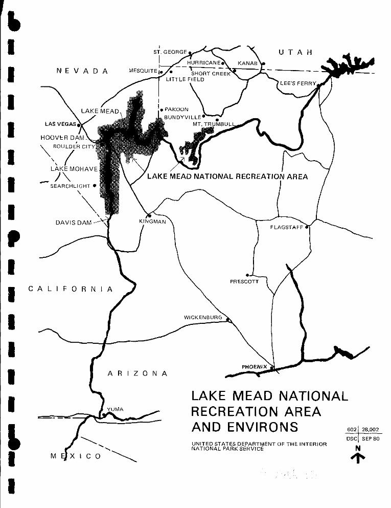
Map Showing Lower Colorado River, Lake Mead NRA, and Environs .
likely Route Followed by Dunn and the Howland Brothers
Historic Roads and Trails
Sketch Map Showing Location of the Grand Gulch and Bronze L Mines and the Roads and Watering Places Between St. Thomas, Nevada, and Grand Gulch, Arizona
Historic Base Map
iii
281
3
71
120
189
281

ACKNOWLEDGEMENTS
When he reflects upon the very large number of people who
contributed their time, assistance, and experiences to the
construction of this historical report, the author begins to
appreciate how truly a cooperative effort it was. The act of
recording a name herein, in and of itself a simple mechanical
process, cannot begin to convey the intense feelings of pleasure,
and gratitude, that the association recalls.
We must begin by thanking John Luzader of the Denver
Service Center and Gordon Chappell of the Western Regional Office
of the National Park Service for giving an author the kind of
support that is needed as one stumbles to a better comprehension
and construction. At the Lake Mead National Recreation Area
headquarters in Boulder City, Nevada, Superintendent Jerry Wagers
literally unlocked a gate that had prevented access to the Shivwits
Plateau, and Dave Huntzinger, Chief Park Interpreter, was
extremely efficient in processing requests for information. Bill
Burke, Wildlife Management Specialist, played a valuable role in
getting our expedition safely through Separation Canyon. Dick
Rundell in the Cessna 206 helped our spirits immensely o,n that trek
as he flew over. And we cannot forget the irrepressable Dennis
Turay who piloted the whaler upriver to Separation Canyon, and
Lee Randall who was a most welcome sight at Mount Dellenbaugh
when we were more than ready to come out. At every ranger
station, cooperation and guidance were superb. Special mention
should be made of Larry Hanneman, Mike Stevenson, John Bezy,
and Larry Metz at Echo Bay for their assistance in the remote areas
of their jurisdiction.
iv
ti I I I I I I I I
' I I I I I I
f I
• I I
,I
I I
I I
I
• I I I I I I
' I I
Many people were visited either for advise or as informants
knowledgeable about the Recreation Area's history. St. George,
Utah, is a lodestone of information. There I talked with Owen
Bundy, Chet Bundy, Reed Mathis, Wally Mathis, Jr., as well as
with Delmar Gott, Librarian of Dixie College; Garth Colton 1 Arizona
Strip District Director for the Bureau of Land Management; and
Barbara Price, also of the BLM. In nearby Santa Clara, Mrs. Dale
Gubler allowed me to copy some of the family Book of Remembrance;
in Mesquite, Ed Yates was courteous and helpful; in Hurricane,
Earl and Homer Englestead recounted colorful stories of life in a
remote country; and in Overton, 11 Chick 11 Perkins, Director of the
Lost City Museum, and Laura Gentry gave generously of their time.
Down in the Strip I was fortunate in being able to find almost all
its permanent residents; Jim Whitmore at Tasi, 11 Buster 11 Esplin at
Wildcat, Pat Bundy at Bundyville, and John Riffey at the Tuweep
Ranger Station of the Grand Canyon National Park. In Short Creek,
Sam Barlow, deputy sheriff of Mohave County, and in Fredonia,
Cecil Cramm, deputy sheriff of Coconino County gave friendly
advice and help. 11 Slim 11 and Mary Waring were interviewed twice in
Flagstaff. In Kingman, help was given by Karen Gaudy of the
Mohave County Historical Society, and Mike Allen, editor of the
Kingman Daily Miner. In Las Vegas, Merle Frehner took time from
a busy schedule to give an interview, and Susan Anderl, archivist
of the library of the University of Nevada, Las Vegas, helped
locate materials. Mack Miller, who for many years was fire lookout
on Mt. Dellenbaugh gave valuable material on the Shivwits Plateau.
With Bob Euler, formerly a colleague at Prescott College and now
NPS archeologist at Grand Canyon, discussions were held on
archeological and historical sites in northern Arizona. Sue
Chamberlin, archivist of Sharlott Hall Museum in Prescott, Don
Bufkin, assistant director of the Arizona Historical Society, Jean
Burt of the Arizona State Parks Commission, all gave valuable
support.
v
Correspondence was entered into with many persons and
responses were re?ceived from Jeff Hunt, Research Assistant,
Nevada Historical Society, Reno; Chad J. Flake, Special Collections,
Brigham Young University; Mrs. Martha R. Stewart, Reference
Librarian, Utah Division of State History; Everett L. Cooley,
Curator, Special Collections, University of Utah; Robert H. Becker,
Assistant to the Director, Bancroft Library, University of
California, Berkeley; Thomas M. Fante, California State Library,
Sacramento; Bert M. Fireman, Curator, Arizona Collection, Library,
Arizona State University; Pamela Crowell, Registrar, Nevada State
Museum; Ross W. Mclachlan, Special Collections Librarian,
University of Nevada; Patricia Crowley, Nevada State Library,
Carson City; Guy Louis Rocha, Curator of Manuscripts, Nevada
Historical Society, Reno; Mrs. Valeria Franco, Huntington Library,
San Marino; M. K. Swingle, Reference Librarian, California
Historical Society; Ellen Guerricagoitia, Senior Library Assistant,
University of Nevada Library, Reno; Connie Christensen, Librarian,
Deseret News; Richard C. Crawford, Civil Archives Division,
National Archives; Ralph S. Rawlinson, Chief, Branch of Lands
Management, Dixie National Forest, Cedar City; and, last but not
least, the sage of the Grand Canyon, 11 Dock" Marston.
Strong support services are always necessary in enterprises of
this kind. Ed Peplow had full responsibility for the non-field work
in mining. Jim Hammond at "Towne Camera Shoppe" in Prescott
took care of the laboratory phi;tography and located a new camera
when mine developed terminal shutter syndrome. Bill Otwell worked
over the map sketches and made them presentable. "Jet11 --known to
his parents as Gene Sternberg 1 Jr. --came along at the right moment
to make the Separation Canyon trek possible. And I was fortunate
indeed 1 to enjoy the strong support of Julie Grogan who not only
translated my scribble to type and transcribed the tapes--some of
them quite difficult--but also became interested and involved in the
process of history.
vi
0 • I I I I I I I
' I I I I 11 I
' , ,
I

• I I I I I I I
• I I
11 11 I
I I
' I I
A NOTE ON METHOD
As has been noted already, this project to identify the historic
resources of the Lake Mead National Recreation Area was
cooperative in nature and many persons participated with great
willingness.
The contract focused on the history of ranching and mining
with Mike Belshaw as principal investigator and Ed Peoplow, Jr.,
devoting himself to the nonfield elements of mining. The
assignment was, unfortunately, a brief one and, both literally and
metaphorically, a lot of ground had to be covered in the nine
months of the project's existence. Sites to be examined were
scattered over 2, 500 miles and at times were difficult to locate,
even with the aid of maps. In the case of some mines, even when
a shaft, headframe, or shack was located, there was no evidence to
indicate the mine's identity. To complicate matters, a rancher on
the Shivwits Plateau locked a gate on the only road giving access to
many sites and immediately after a temporary truce had been
negotiated, the wettest winter on record began. Fearing to get
caught in a winter snowstorm one hundred miles from pavement, the
Pl had to double back in retreat. Several times field trips were
cut short by weather and penetrations had to be repeated at a later
date.
The poor weather was, to some extent, a blessing in disguise
however. In May, a small group hiked out Separation Canyon in
order to get a better understanding of the problems faced by the
men who left Powell's party in 1869. The winter rains gave us the
benefit of flowing water in much of the canyon when normally--in
recent years, that is--there would have been none.
vii

In the process of searching out ranching and mining sites, and
conducting oral history interviews, the Pl became aware of the
importance of several historic trails within the Recreation Area.
Basic research was done on these and, since they all extend beyond
the NRA into lands administered by the Bureau of Land
Management, it is clear that a joint NPS-BLM research effort would
be beneficial for the identification and preservation of these historic
resources.
A cursory examination of the bibliography should indicate that
literature bearing upon the Recreation Area is scant. Enquiries
made to archives yielded very little. Fortunately several persons
still alive participated in events that shaped the region's
development and most of these cooperated marvelously. The reader
is especially recommended to listen to the Englestead tape if the
opportunity arises.
While there is no doubt that further time and effort would
yield more information, expecially on the Shivwits, the Pl believes
that the historical essence has been· captured. Only one major
puzzle needs to be resolved--that of the Dunn I nscription--although
the report makes recommendations for further research of a
somewhat lower order of priority.
viii
.I I I I I I I I
• I I
I
I I I I
' I I
• I I I I I I I I
• 11 I I
'I I
!1
' I l!_ __
PART ONE
HISTORY OF THE LAND AREA OF THE LAKE MEAD
NATIONAL RECREATION AREA
1
INTRODUCTION
High among the peaks of the Rocky Mountains, the Colorado
River rises in perpetual birth. From here it falls to the sea,
gathering on its 1, 700 mile journey other streams such as the
Gunnison, the Green, and the San Juan which are major in their
own right. Together they call waters from seven states in the
United States and from one in Mexico--Wyoming, Colorado, Utah,
New Mexico, Arizona, Nevada, California, and Sonora--and drain
some 246,000 square miles.
Most of the terrain through which the river flows is harsh and
arid with little vegetation to hold the scarce rains. Thus, the
abrading silt that the waters collect contribute to the creation of
mighty canyons that confine the river for one thousand miles as it
goes. These canyons, both those of the river and from its
tributaries, deposit the roe.ks and create the falls that make
navigation difficult or impossible.
The climate of the region, although arid, cannot be taken for
granted. Indeed, the vast size of the drainage area and the
pronounced changes in elevation--from sea level to over 14,000
feet--imply many climates. Searing heat at Yuma is likely to be
simultaneous with snows in the mountains anywhere from Arizona to
Wyoming. Seasonal variations occur, mainly in the form of severe
winter storms leading to a spring runoff in May and
June--paradoxically the driest months in the southern desert
regions--and summer thunderstorms which often cause flash floods.
It is perhaps the annual variation which is most problematical. At
Yuma reported flows range from a dribble of 3, 000 second feet to
an uncontrollable torrent of 380, 000 second feet.
2
.1 I I I I I I I
• I I I I I I
~ I I
~ I I I I I I I , I I I I I I
L I I
UT AH
NEVADA
, "" BOULDER CITY
', ( LAKE MOHAVE
- /"'- LAKE MEAD NATIONAL RECREATION AREA SEARCHLIGHT •
'\
""' \ DAVIS DAM
CALIFORNIA
ARIZONA
M
WICKENBURG
• PRESCOTT
PHOENIX
FLAGSTAFF
LAKE MEAD NATIONAL RECREATION AREA AND ENVIRONS 602 28,002
DSC SEP 80 UNITED STATES DEPARTMENT OF THE INTERIOR N NATIONAL PARK SERVICE
~

In 1905, one such torrent found a weakness in its banks where
a canal had been excavated to carry Colorado waters to the farming
settlements being established near the Salton Sea. The river
followed the canal, and continuing flash and spring floods pushed
aside human efforts to return it to its original channel. The
Southern Pacific Railroad, in part to protect its interests in the
Imperial Valley, and in part relying on a promise of reimbursement
from the Federal Government, spent over $3,000,000 of its own
funds to establish dikes and check dams. Finally, in February
1907, the river was caged, but not tamed. Some means of
control ling it would have to be found.
Much of the credit for the final solution resides with Philip
David Swing, a California attorney and congressman, by whose
persistence the Swing-Johnson Bill (H. R. 5773), the Boulder
Canyon Project Act, was signed by Coolidge in 1928. Prior to that,
in January 1919, the Governor of lJtah called the seven states to
discuss the Colorado River waters and, as a result, the 11 League of
the Southwest" was formed. The League presented resolutions to
the President and before Congress, and, in November 1922, the
Colorado River Compact was signed in Santa Fe. This divided the
river into Upper and Lower Basins and apportioned 7 .5 million acre
feet to each .
Work was begun on the Boulder Dam in 1931 by a consortium
of contractors called the Six Companies and was completed in 1935.
In September 1936, Bou Ider Dam, I ater renamed Hoover Dam, was
inaugurated by President Roosevelt. Waters backed up some 105
miles behind the dam to form Lake Mead. In the process, historic
and prehistoric sites were inundated, but dangerous floods below
the dam were harnessed, irrigation waters were assured for large
areas, and hydroelectric power was genert'lted in time to make a
significant contribution to the conduct of the Second World War. A
4
.~ I I I I I I I
• I I I I 11
I
~ I I
It I I
I I
I I
'I :1 1, I I I I I I
' I I
major land and water recreation area came into being, giving
considerable summertime relief to residents of Nevada and Arizona.
However, the creation of Hoover Dam did not resolve the
special problem of Mexico 1s claims to the waters of the river. As
Frank Waters writes, by 1943:
The various works of the Colorado River Project were
completed. Immense amounts of water were diverted
through the All-American Canal and the Los Angeles
Aqueduct. Boulder Darn was backing up the river. And
1,312,000 acres were under irrigation in the Upper Basin
states, an 1,323,000 acres in those of the Lower Basin.
In Mexico similar changes were under way. It had been
proposed to open up to development both the Mexicali
Valley and the Mexican Delta of the Colorado River just
as the United States had opened Imperial Valley years
before. But now the Mexican farmers woke up to
what was happening .... 1
After a series of negotiations, Mexico and the United States
signed a treaty in 1944 which among other things, allocated water
to Mexico and committed the United States to build the Davis Dam to
regulate the diversion of water to Mexico. This darn was completed
in 1950, and Lake Mohave, 67 miles in length, filled in behind it.
The Lake Mead National Recreation Area, established in 1964,
encompasses some 2,500 square miles of water and terrain and
1. Frank Waters, The Colorado, Holt, Rinehart, and Winston, N.Y., 1974 edition, p-:-361.
5

surrounds both Lake Mead and Lake Mohave. Its southerly point of
beginning is at Davis Dam from which it extends in a northerly
direction to Hoover Dam, and from there to the northeast following
the course of the Virgin River, and to the east, following the
Colorado.
6
' I I I I I I I
• I I I I I I
' I I

I. I I I
i I
I I I
I
• I I I I I I
L I I
CHAPTER ONE
PREHISTORY, EXPLORATION, RIVER CROSSINGS,
AND SETTLEMENT
THE SETTING 1
A. Topography
There is very little of the area under the jurisdiction of the
Lake Mead National Recreation Area that cannot be described as
rugged. Elevations range from 517 feet above sea level at Davis
Dam to 7,072 at Mount Dellenbaugh on the Shivwits Plateau.
Between these extremes, one is hard put to find a level patch of
ground of any usable extent. Lake Mohave, which extends
northward from Davis Dam, is only four miles across for a short
distance at its widest location, and elsewhere is narrowly confined
between abrupt canyon walls. These are penetrated by side
canyons in only a few places. The general impression is one of
barren, heaving mountains in any direction as far as one can see.
Lake Mead, at an elevation of 1,229 feet when full, is the
largest manmade reservoir in the United States, and although wider
in most places than Lake Mohave, is .still confined throughout its
length by cliffs and mountains. In some locations--in Overton Arm,
for example--gentle detrital flood plains slope down from a distance.
More generally, the lake offers a sense of confinement rather than
space.
1. This section is not intended as a definitive discussion of the subjects covered, but only to give the background necessary to an understanding of the events discussed in the text.
7

Several important washes reach the lake, among them Las
Vegas, Detrital, Grand, and Hualapai. Two live streams, the
Muddy and the Virgin, enter at the head of Overton Bay.
However, the lake fulfills its purpose by capturing and holding the
waters of the Colorado River which reach it after disgorging from
the Grand Canyon. Lake Mead has the capacity to contain two
years flow of Colorado average runoff.
Before the construction of the dams, only one ford existed in
the entire length under consideration. This was Ute Crossing just
below the mouth of the Grand Canyon. At low water, the river at
Scanlon Ferry was about a quarter of a mile across and cattle could
be swum there safely.
One important feature of the area, just to the west of the
Grand Canyon, is Grand Wash. This is a wide basin that enters
from the north, and on its east side high cliffs, in a series of two
steps, raise the terrain from lake level (1 ,200 feet approx.) to the
Shivwits Plateau (6,000 feet approx.). The portion of Shivwits
under the jurisdiction of LMRA is the southernmost tip of the
Arizona Strip, an isolated and sparsely settled cattle range. The
plateau extends in long points down towards the Grand Canyon.
Its rim is abrupt and steep, and places of access are few.
B. Climate
The variations in elevation are associated with variations in
temperature. Summer temperatures at lakeshore levels often exceed
100 degrees, whereas temperatures at, or below, freezing can occur
less than ten miles distant on the plateau from September through
May. Similarly snow is exceptional and rain infrequent in the lower
elevations, but are more likely above 5,000 feet.
8
' ,, I I I I I I
• I I I I I I
' I I

I. i• I 'I I I I I I ,, I I I I I I
' I I
Thunderstorms, most frequent in July and August, can be
intense and can precipitate flashfloods which rush down arroyos
with an irresistable wall of water killing the unwary and
unfortunate in their path. Rains and snows can make roads and
trails on · Shivwits impassable. Travellers and. ranchers can be
marooned for very lengthy periods. One learns to treat the
weather with respect and to exercise great prudence.
C. Vegetation
As elevation, exposure, and the contours of the land create
microclimates,
concentration.
vegetation adapts in great variety and variation of
Much of the land appears extremely barren with
only a light cover of creosote bush. Unless the rains are
exceptional in lower elevations, grasses are Ii kely to be found only
near springs and washes. Cactus of various kinds are common and
in some locations such as Hualapai Wash and Grand Wash, there are
forests of Joshua trees.
At higher elevations, the pinon-juniper association begins,
increasing in density as the Shivwits Plateau is reached. There,
the forests are interspersed with savannah and sage. Near Mt.
Dellenbaugh, thickets of ponderosa have at times been sufficient to
support sawmills. The only other iarge trees are cottonwoods at
the occasional oasis.
D. Fauna
Nevertheless, animal life is abundant. The lakes harbor many
species of fish, and waterfowl are common, expecially in the
Overton State Wildlife Management Area. Lizards, snakes, mice,
packrats, cottontails, and jackrabbits, or their evidence, persist
over the entire land area. Similarly the coyote is omnipresent, but
not necessarily visible. Other species tend to be more selective in
their habitat. The feral burro is common near the lakeshore and
9
its tracks gouge hills and washes. Mule deer, on the other hand,
inhabit higher reaches and the Arizona Strip is famous for these.
Mountain sheep are dwellers of the high cliffs and are rarely seen.
Early Anglo explorers were attracted to the river by abundant
beaver. Fairchild reports,
At that time there were many beavers along the Colorado
River, and at night when my boat was tied up to a snag
in the stream, at times these intelligent animals would be
tantalizing. They had a peculiar habit of coming to the
surface while swimming, elevating their flat tails with a
peculiar twist and plunging it into the water making
considerable noise--as 'plunk, plunk.' At times they
would playfully dive beneath the boat and in 'plunking'
spatter water upon me. On several occasions, when this
became annoying, I turned loose my shotgun upon them,
and not many moments .:?lapsed after the report in each
instance until the 'shoop' of astonished Indians could be
heard. To prevent their locating me for an early call, I
would cast my boat adrift, float several miles down stream
and fasten to some newly found snag. There were a few
ducks upon the river and large flocks of egrets (ardea
agretta) in those days. 2
E. Prehistory
Viewed from our current perspective, the prehistory of the
area is essentially that of a hunting and gathering continuum upon
which is superimposed the 700 year florescence of the pueblo
2. Mahlon Dickerson Fairchild, Colorado River 1862-1863, Ms. Society. Written in 1904.
10
Pioneer Reminiscences: from Mohave Pioneers
To The Historical
' ,, I I I I I I
• I I I I I I
' I I
II
I I I I
• I
I
1 I
1• II I I
' I I
period. The Virgin and Muddy Rivers near the present town of
Overton were the site of considerable habitation now called the Lost
City. Most of the remnants were inundated by Lake Mead although
some sites, consisting of stone rooms, are visible on benches above
the waters. Other pueblo sites exist on the Shivwits Plateau. 3
The key to the new way of life was agriculture. The
domesticated plants offered a stable and reliable source of
food; population could increase wherever food could be
raised. Permanent dwellings, public works, a strong
religion, great skill in old and new handicrafts, and great
elaboration of design and form--all were possible when
food was assured through farm or garden crops. 4
Strictly speaking, pueblo dwellers practiced horticulture rather
than agriculture. In other words, cultivation was by hoe or
digging stick instead of with a plough. However, a technological
shift was apparently occuring about the time of Anglo penetration,
possibly as a result of a mediated cultural contact with the Rio
Grand pueblos. Hamblin describes how the Santa Clara Shivwits
used an ash stick with a wide point and how they pushed this
through the soil in such a manner as to construct a continuous
furrow as does a plough. 5
The prolonged drought of 1276 to 1299 was associated with the
abandonment of pueblo facilities. It is of interest that the
3. Interview with Mack Miller, Temple Bar, 26-12-77. An extensive site was seen by the author to the east of Blue Mountain.
4. Jesse D. Jennings, 11 Early Man in Utah, 11 Utah Historical Quarterly, Vol. XXVI 11, #1, Jan. 1960, p. 12.
5. Pearson Harris Corbett, Jacob Hamblin The Peacemaker, Deseret Book Co., Salt Lake City, 1952, p. 53.
11

• Piedes had a legend of how they forced the Moquis (Hopis) to leave I the region, which may reflect a cultural memory of the exodus. 6
Whatever the , circumstances, the effect was the return of
hunters and gatherers to predominance. These people, although
living at a significantly lower material level than the pueblo dwellers
had the resiliency to adapt to, and utilize more closely, the animal
and vegetative environments. The great variety of these, even in
the desert setting, was alluded to in the preceding discussion. A
nomadic existence precluded fixed habitations or anything that could
not be carried from one hunting or scavenging site to another.
Thus, the physical evidence is scant. Petroglyphs are found
in many localities in the area and yam pits exist in a number of
places including Nevershine near Tasi. 7 The Englestead brothers
vividly describe the Indians' marginal existence:
6.
7.
Homer Englestead: This. Squaw Wash. We named .
the sheepherders named it Squaw Wash. There's an old
squaw lived there alone. She lived oH the land. She
find rattlesnakes or anything she would eat and turkey,
uh, turtle. If she found a turtle, she would, just put
him in the pot and boil him alive. The turtle's a great
thing for their food stuff and lasts for quite a while.
And she lived there all that spring, but the next year
when we went down, she wasn't there. But, they went
in there by the herds in winter. You see over here to
Overton, there was about ten thousand of those Indians
lived there and they were progressive people. They'd
Ibid., p. 61.
See transcription of Englestead interview, p. 14.
12
I II
I
I I ,,
I
11 .I I I I I I I
J I I

~ I I I I I I I , I I I I I I
t I
only let
ground
one
and
family
they
industrious people.
have maybe five
were farmers.
or six
And,
acres of
uh, and
Earl Englestead: The Indian through here, they just
lived on the land. And in the summer time you'd go up
on the mountain and you'd find arrowheads almost any
place you'd go. Because . . and they'd always camp
quite close to the water. They wouldn't camp on the
water to contaminate it. They had their codes and they
were pretty good to live right off the land. 8
Although some of the Indians, as this squaw, lived a solitary
existence, the usual social and economic unit among the Shivwits
was the nuclear family. The families would join to become bands
when antelope or :--abbits were hunted. The Mojaves to the south
were somewhat more sedentary and sub-tribal groups of several
families tended to congregate. Fairchild describes how these people
wou Id hunt the mountain sheep:
And, by the way, it may not be inappropriate here to say
something about the Big Horn--Ovis Montana. At that
time they were quite numerous among the mountain ranges
bordering the Colorado River, and occasionally they could
be seen at the brink of the stream quenching their
thirst. Sometimes a dozen in a herd would be startled
from some watering place in the hills, when off they
would go, with incredible fleetness, up to the steep
mountain slopes heading for the most prominent peaks.
Upon arriving at the top of some lofty cliff they would
8. Ibid., pp. 14, 15.
13
halt in silhouette against the clear sky and watch the
departure of their disturbers until gone from sight. It
was a wonder to me how they could gallop up these
shingly inclinations with so little disturbance of loose rock
which laid over the entire surface, and with so little
noise. In hunting mountain sheep in those days the
Indians had no firearms of any account, and had to
depend upon their bows--using poisoned arrows. in
preparing arrows for such use they usually took the liver
of a hare, get a rattlesnake and enrage it, and cause it
to strike the raw liver a number of times with its fangs.
After doing this they let the liver lie in the sun until it
became putrid when they would crush it to a paste and
daub the points of the arrows with it. Thus provided, a
score or two of hunters would start out. Those with the
poisoned arrows--sharp shooters of the tribe--would go to
the highest peaks within the scope of the country to be
hunted over and station themselves at the most favorable
places for concealment, near the run-ways of the Big
Horn, and there abide the time until the quarry came.
All such points of vantage would be patrolled for miles
around. Then the skirmishers would start out and with
great din scare the game and get it running, knowing it
would hasten to some of the heights upon which the
bowmen were waiting. When an Indian succeeded in
piercing the flesh of an animal with one of his poisonous
darts, the chase after that particular animal ceased, but
the following day scouts would be placed upon its track
and the trail followed until the carcass was found--all
knowing that after the chase was abandoned a wounded
animal would lie down and die from the effects of the
poison. There being no hesitancy upon the part of the
14
' I I I I I I I
• I I I I I I
~ I I

I
• I I I I I I I
• I I I I I I
~ I
L!__
Indian about eating the flesh of the animal killed in this
manner, was proof that its toxic effect was harmless to
their stomachs.
It was during the forenoon of September 24th that we
broke camp and resumed our march under guidance of
'Hook-Nose.' Previous to starting he had had earnest
conversation with a number of his tribesmen, and it
seemed to refer principally to us, we were wary, for we
were distrustful. Following the bank of the river eight
or ten miles, our guide by pantomime made us understand
that we were to leave the river and take to the mountains
once more. In doing this we found a very rough trail,
but there were several watering places, and we saw quite
a number of mountain sheep. At each place where there
was water would be heads of several Big Horns--still
retaining the horns some of which being immense for so
small an animal--and also shells of the large land tortoise,
left by Indians after feasting upon their bodies. 9
The gathering of vegetable products was critical to Indian
survival. Acorns, yucca, grass seeds, and so on, had to be
gleaned and it was the destruction of such habitat by cattle that
led to hardship and conflict. (See Chapter Six)
Floodplain agriculture was practiced without the sophisticated
irrigation works of the pueblo people. Jed Smith reported a
"Pautch 11 Indian farmer working on the south side of the Colorado
River opposite the junction with the Virgin when he made his first
trip (1826). 10
9. Fairchild, op. cit., pp. 15, 16.
10. Melvin T. Smith, The Colorado River: Lower Canyon Area, --Sringham Young Dissertation, August 1972, p. 105.
15
Its History in the University, Ph.D.
Pre-contact Indians engaged in mining, both for trade and
their own use. Jed Smith commented on the salt mines near
Overton (now under water). Clay and turquoise were also mined.
Several methods of mining were employed in working
deposits of turquoise and varicolored stones. Open pit
and outcrop mining was used at a site between Boulder
City and Hoover Dam. Other sites required underground
mining. There were conditions when aboveground
exposed rock had to be heated by fire, then shattered by
dousing it with water. Stone picks and hammers were the
only tools used, thus the particles of gemstone had to be
removed by hand. Tailings were carried to dumps in
wicker baskets.
Considering the value of the product and the energy
expended, turquoise was the most logical mineral the
Indians could mine. A system of barter was used to
distribute turquoise from Eldorado Canyon to the
Southwestern United States and Mexico. The Athapascan
and Pueblo cultures of these areas valued this gemstone
highly. As a trade article, or even a medium of
exchange, turquoise was well adapted to the early Great
Basin Indians• primitive transportation methods. Light
the stones were worth many times their and compact,
weight and size. This attribute. alone encouraged the
development of trade in turquoise. 11
11. Melvin T. Smith, The Colorado River: Its History in the Lower Canyon Area, Brigham Young University, Ph.D. Dissertation, August 1972, p. 105.
16
I I I I I
• I I I I I I
~ 11 I
~ I I I I I I I , I I
I
Indians were skilled traders. Had their contact with Europeans
been limited to trading, they could undoubtedly have enhanced
their position.
F. Early Exploration 12
To Jedediah Smith goes the honor of the first recorded
penetration of the area of concern. That others--Spaniards or
Mexicans from the south--preceded him is quite likely.
The possibility of Spanish mining in Eldorado Canyon is
an intriguing question that has been challenging
historiography in Southern Nevada for over a century.
Folklore, statements of reputable residents and authentic
artifacts make it necessary to mention this undocumented
activity primarily for the reason that rumors about it still
persist, and because no one has proven that it did not
occur.
Francis Church Lincoln, former dean of the University of
Nevada, Mackay School of Mines (1914-24) states:
"Mining operations in Nevada were conducted on a small
scale by the
the advent
Indians and the Franciscan Fathers prior to
of the Argonauts," and later, "With the
assistance of their Mexican converts, the Franciscan
Fathers worked placer mines and turquoise deposits in
12. The sections on exploration depend heavily on Smith op. cit. The literature on exploration, by land and river, is so extensive that little purpose is served by repetition. This, then, is an overview. Contours will be highlighted when warranted by some need for emphasis.
17
what is now Clark County, Nevada, and left interesting
relics in some of the mines. 1113
In the fall of 1826, Jed Smith came in from the north, down
the Virgin to the Colorado, hence to the Mojave villages below Black
Canyon, and finally out to California. Below the confluence of the
Virgin and Muddy Rivers, Smith obtained a supply of salt at the
caves. Where he crossed the Colorado is not known, but, once
over, he did have considerable difficulty with the rugged and
waterless terrain. Their meeting with the Mojaves was beneficial in
contrast to that of the following year at which time the Mojaves
k · 11 d f S . h I th • th • 14 1 e many o m1t s men as ey were crossing e river.
15 In 1827 James Ohio Pattie joined with others, including Ewing
Young, George C. Yount, and Thomas L. Smith, to trap the
Colorado. The Mojaves claimed the furs that the group had
13. James M. Greene, Life in Nelson Township, Eldorado Canyon, and Boulder City, Nevada, M.A. Thesis, University of Nevada, Las Vegas, 1975, p. 21. Another story reported by Greene is of some Mexican visitors in 1882 who came to Eldorado Canyon with a very old map which marked the site of the Wall Street Mine. The possibility of white penetration prior to 1826 should be allowed.
14. It is customary to attribute Smith's change of fortune either to conniving Mexican authorities who "ordered" the Mojaves to repulse the Anglos or to rough handling by Pattie's party. While the rough treatment is indisputable, it seems unlikely that the Mojaves would recognize Mexican authority. Another explanation may be of interest which mirrors the experiences that Fairchild had with the Mojaves and which can be generalized to other tribes as well. Most tribes are not a tightly woven group who follow a party line. The bands are quite independent and are likely to react as temperament or circumstances suggest. This is one of the reasons that Indians and non- Indians both broke treaties with frequency.
15. yield to Smith on this date rather than 1826. Enough controversy about Pattie exists already.
18
• I I I I I I I
• I I I I I I
'I I I
11 I

• I I I I I I I
• I I I I I I
' I I I
collected, which claim the trappers were disinclined to recognize.
Hostilities ensued to the eternal anguish of several Indians who,
having no firearms, were at some disadvantage.
From the Mojave villages, the trappers travelled to the north.
The Young and Yount parties then swung to the east below the
point where the Colorado bends to the south. Pattie and Thomas
L. Smith continued up the river, following a route that is
unc~rtain:
To begin with, they apparently continued together up the
Colorado on its south bank into the Grand Canyon itself.
On Spencer Creek three men from the Pattie party left
the main body and were murdered and mutiliated,
probably by the Yavapai; the foul deed was discovered
two days later, March 27, 1827. After burying the
remains, the trappers turned down river retracting their
route out of the canyon, where the parties may have
divided, with the Pattie group crossing the Colorado near
what became Pearce1s Ferry. From that point they could
have swung west into the Grand Wash Cliffs onto the
Shivwit Plateau. Other authorities maintain that both
parties remained on the south side of the river until they
reached the Virgin confluence, then crossed. Since they
were concerned with trapping, this latter water route
seems more likely.
Once over the river, they moved up the Virgin hunting
for furs. After a day or two the Pattie group swung
east (if they indeed had not crossed above Grand Wash
earlier) through St. Thomas Gap into the Grand Wash
drainage, and then onto the Shivwit Plateau, where they
pursued an easterly course past Mt. Trumbull and over
19

the Buckskin Mountains. Very likely in one of these
locations they were caught in an eighteen-inch snow fall
in April.
Another alternative route for the Pattie expedition would
have kept them on the South Rim of the Grand Canyon as
far east as Kanab Creek, where they may have crossed
the Colorado River and climbed out on the North Rim.
However, this route seems unlikely in view of several
facts: the difficulty of getting to the Colorado River
from the South Rim, the purpose for crossing at that
point, and the sudden return to the Colorado after
crossing the Buckskin Mountains. This writer admits
Pattie 1s account is sketchy, but believes the party
crossed near the Virgin River and then moved east, north
of the Colorado. 16
Jed Smith returned to the area in the summer of 1827 and
followed much the same route as previously except for transit up
Detrital Wash to avoid the difficulties of the Black Canyon. One of
his party was Thomas Virgin after whom the river was named. The
Mojaves, smarting over their treatment at the hands of the trappers
who had passed through earlier that year, attacked Smith 1s party,
killing ten and capturing two Indian consorts. Smith fled across
the desert to California.
Trappers were apparently determined men, for both Pattie and
Thomas L. (now Pegleg) Smith returned to the area shortly. Pattie
lost his furs near the mouth of the Colorado in a tidal bore and his
father died in a California prison from illness. Peg leg Smith,
16. Smith, op. cit., pp. 113, 114.
20
-- ------,
• I I I I I I I
• I
I
I,
I I I I
~ I I I

t. I I I I I I I
' I I I
II II
I
' I I
along with some Ute braves, found more profit in stealing horses
from the Californians, which practice they continue until 1840.
Reports of the area's rich furs attracted others in the years
1829-1830. Among these were Peter Skene Ogden of the Hudson's
Bay Company, Ewing Young, and Kit Carson.
Traders followed trappers closely, the first of these being
Antonio Armijo who left Abiquiu in 1829, bound for California. His
party crossed the Colorado River above Lee's Ferry at the Crossing
of the Fathers, apparently the first non-Indians to do so since
Dominguez and Escalante passed that way in 1776. His route by
way of Vegas Springs skirted the area of our concern somewhat to
the north, and opened trade in New Mexico sheep and woolens in
exchange for California horses and mules. These trading caravans
persisted on a yearly basis almost until the end of the Mexican era
in the Southwest. Nevertheless, activity was so sporadic that one
can assert a virtual vacuum in activity, especially in the Black
Canyon area, for two decades.
G. Transcontinental Trails
A number of events including the awakening of California, the
approaching war with Mexico, and the tension between Utah and
eastern United States awoke official interest in the lower Colorado
in the 1840s and later. John Fre'mont passed to the north of our
area of interest in 1844 on his way to Las Vegas Springs, but did
not enter. Gen. Stephen Kearny passed to the south in 1846 and
did not enter the area. Neither did Col. Philip St. George Cook
who crossed at the confluence of the Colorado and Gila in 1847.
The first official entry into the area was by Capt. Lorenzo
Sitgreaves in 1851, who was exploring what is known as
21

the 35th parallel route, later the thoroughfare occupied by the
Santa Fe Railroad and Highway 66--at least as far as Kingman.
The river was crossed, possibly in the vicinity of Eldorado Canyon,
and Sitgreaves headed south to Fort Yuma.
In 1853, Francois Xavier Aubry reversed the usual order of
things and crossed below Black Canyon possibly at Eldorado
Canyon:
Aubry 1s men soon built a raft of driftwood, cut by
beaver, and commenced to ferry goods over and swim the horses. The presence of Mojave Indians caused the men to work with haste and Aubry to proceed with caution.
Five days were used in crossing the river and recruiting
the animals. About one mile east of the crossing a
Mexican boy discovered signs of gold, which also detained
the party. They did not leave the river until July 30. 17
Within the year, Lt. A. M. Whipple crossed above the Needles while
conducting a transcontinental railroad survey. Lt. Edward Beale,
with his camels, crossed at the same place in 1857 . 18
Reaching the river on October 18, Beale began the
'questionable' task of crossing the river. To ferry his
wagons and supplies, the Lieutenant had brought India
rubber boats, which proved adequate. However, several
mules and horses were drowned while being swum across
the stream. Beale had been warned that the camels could
not swim; however, confident they could, he hazed a
17. Smith, op. cit., p. 103.
18. Ibid., p. 151.
22
• I, 11
I I I I I
• I I I I I I
' I I

It I I I I I I I
' I I I I I I
' I I
strong
found
male camel into the water, which as soon as 'he
himself out of his depth struck off without
hesitation for the opposite shore, swimming high and with
perfect ease.' The others were crossed without
hesitation . 19
As an extension of his trip upriver in the Explorer in 1857,
Lt. Joseph C. Ives also examined an overland route to Fort
Defiance, then in New Mexico but now in Arizona. To this end,
Ives had a shore party with mules pace the Explorer as she moved
upstream. The presence of these two groups, and especially their
communicating rockets, caused great concern to Jacob Hamblin who
happened along at the time. A "Mormon War" was bubbling and
Hamblin was convinced that he was witnessing a serious threat from
the south. Instead, Ives left the Explorer and led his packtrain
overland to the east through Gold Road Pass near present day
Oatman.
The report of Lieutenant Beale on the feasibility of the 35th
parallel route excited interest, but with tragic consequences. In
1858, several emigrant wagon trains attempted the difficult trip from
Albuquerque to the river. This the first train reached on 28
August only to find themselves surrounded by Mojave braves who
openly killed and ate some of their stock. On the 30th, the
emigrants were attacked by some 250 Mojaves. The emigrants lost
most of thei.r stock, several persons were wounded, and one was
ki lied. One family ( Bentner), some distance away, was wiped out.
The emigrants returned to Albuquerque, gathering with them as
they turned back other trains who had been following them.
As a consequence, troops were stationed in the area at both
Fort Mojave and Eldorado Canyon.
19. I bid . , p . 203.
23

With the improvement in security, Lieutenant Beale had the
responsibility of constructing the wagon road which was done in
1859. Although the road was completed from Albuquerque to the
river, it did not reach beyond into California. For this and other
reasons, it saw little traffic but did assist in developing alignments
for later rail and highway routes.
H. Up From the Sea of Cortez20
In the year 1851 George A. Johnson arrived at the mouth of
the Colorado River with the schooner Sierra Nevada carrying
supplies for Fort Yuma. He immediately recognized the opportunity
for commerce and next year brought in the steamer General Jesep
with a contract to carry supplies from the river mouth to the fort.
During the next several years Johnson accumulated considerable
river experience and proposed to the government that he receive a
contract to explore the river. However, when, in 1857, Congress
alloted funds to the Army Corps of Engineers for the exploration of
the river as well as an overland route to the east, Lt. Joseph C.
Ives was chosen tci command.
Johnson, however, had been requested to assist Lieutenant
Beale in crossing the river at Needles and, in the course of doing
this, he took the General Jesee_ all the way through Black Canyon
and, on his return in January 1858, passed Ives in his Explorer
laboring upstream.
The Explorer was constructed in Philadelphia, and not very
well apparently, because additional structural supports had to
20. This section is based upon Smith, op. cit., and Frederick S. Dellenbaugh, The Romance of the Colorado River, Rio Grand Press Reprint, Chicago, 1962.
24
' I I I I I I I
' I I I I I I
' I I

• I I I I I I I
• I ;I I I I I
' I I
be supplemented to the hull in San Francisco. These were added
outside the hull and effectively reduced the draft by six inches.
When fully loaded, the Explorer had only six inches of freeboard
and was in danger of being swamped several times. The Explorer
was pieced together at Robinson's Landing, a mud flat at the mouth
of the Colorado, and chugged upstream only to be upstaged by the
General Jesep.
The Mojave guide I reteba was engaged at the villages and the
Explorer continued into the Black Canyon to hit a rock which thus
determined its high point of navigation. While his vessel was being
repaired, Ives continued upstream as far as Vegas Wash in a skiff.
He then returned, met his packtrain at Pyramid Canyon, and
proceeded overland to the east by way of Diamond Creek and the
Hopi villages .
I. The "Mormon War1121
There were several reasons for Mormon interest in the lower
Colorado. The State of Desere~, an empire unto itself, was growing
rapidly by immigration and natural increase, and the long
transcontinental trek was a hardship and hazard; especially, given
the continuing hostility that was harbored in the East. An outlet
to the sea could perhaps offer the Saints easier access to their
Great Basin haven. Furthermore, commerce and investments beyond
the seas were contemplated, among them plantations of sugar cane
on the Hawaiian islands.
Additionally, the region of the river was inhabited by
Lamanites among whom missionary work was needed. Later, as real
21. This section is based on Smith, op. cit., and Corbett, op. cit.
25
and imagined hostility between Deseret and the States intensified, a
threat from the south was perceived and, of course, substantiated
by the rumors about Ives.
As early as 1855 a mission was established at Las Vegas
Springs. From that place, Rufus Allan was called by Brigham
Young to explore the river below Vegas Wash and to determine its
navigability. They travelled downstream, but were forced away
from the river at the head of Black Canyon. At that point,
judging from the smooth flow of the current, they deemed the river
to be navigable. The expedition traversed the west side of the
river, probably as far as Eldorado Canyon from which they
returned to Las Vegas.
In 1856 several Vegas missionaries searched in the other
direction to take a census of the Indians and inventory of
resources. From Vegas Wash the group, as before with an Indian
guide, went upriver to Boulder Canyon at which point they went
cross country to the Virgin River, thence up the Muddy and back
to Vegas. By this time the Mormons had explored the areas near
the Colorado but had never been on the river itself. Their
1855-1856 reports to Brigham Young on the navigability of the river
t .. t• 22 were no opt1m1s 1c.
In 1857, the Mormons, understandably sensitive as a result of
the brutal treatment that they had received at Nauvoo as well as
other harassment, and learning of Ives' land and river thrusts up
from the Gulf, were nervous and needed to acquire intelligence.
The military authorities, for their part, felt that they
22. Smith, op. cit., p. 149.
26
• I I I I I I I
• ,, I I 1
II I , , ' I I i

• I I I I I I I
• I I I I I I
' I I
had reason to believe that the Mormons were inciting the Indians
against them.
Lt. James White, with some troopers, was sent north with
Johnson to investigate. Although real dangers were encountered,
the stage was set for a comic opera.
Jacob Hamblin at that time, shortly following the Mountain
Meadow Massacre, was escorting Gentile wagon trains along the old
Spanish trail. In response to the rumors of invasion, he
dispatched two of his missionaries, Ira Hatch and Dudley Leavitt, to
the Colorado tribes in December of 1857. In Cottonwood Valley, the
men with their Paiute guides, were captured by Mojaves and,
trapped in the rear of a wickiup, found themselves condemned to
death. Their bravery and prayer ,impressed the Mojave chief who
al lowed them to leave .
Shortly thereafter, Hamblin took Thales Haskell, Levitt, and
Knight on another reconnaissance. On seeing the Explorer, they
determined to send Haskell on board as a spy with a concocted
story about a new route to California to avoid Indian depredations.
The other three were to remain in hiding. They did not know their
horses' hoof prints had been seen or that Haskell would be
recognized by troopers who had seen him in Salt Lake City. On
board the Ex~lorer, Haskell was told of the true purpose of the
voyage, but was not thoroughly convinced. Ives interrogated
Haskell about Mormon intentions, "and was assured they would not
interfere with his explorations, as they were fully occupied in the
north and east. 1123
23 . I bid . I p . 256 .
27

After further investigation during which he saw soldiers and
rockets being fired, Hamblin felt confirmed in his suspicions of an
invasion. He prudently returned to Vegas. As a result, a third
expedition was mounted in April 1858 under the leadership of
Apostle Amasa M. Lyman. This expedition was expressly to
determine the limits of navigation and a location for a defensive
site. After leaving Las Vegas, the group went through Railroad
Pass, El Dorado Valley, Cottonwood Canyon, and finally to Pyramid
Canyon from which they were able to identify a good site for
defense. This, despite the rockets, proved unnecessary. As far
as navigation was concerned, they reported that Eldorado Canyon
seemed to be a feasible limit.
J. Eldorado Canyon: The Early Years24
As previously mentioned, mining in Eldorado Canyon
significantly predates the historic period. Indians extracted
turquoise in the area and it is likely that Mexican or Spanish
miners, possibly padres, worked what later became known as the
Wall Street Mine. And in 1855, a Mexican (or Californian)
travelling with Aubry discovered traces of gold there.
Greene25 notes that Sitgreaves in 1851, and Whipple in 1854,
met prospectors in the area, but does not report their finds, if
any. Soldiers, camped in the Canyon in 1859, came upon ore
samples of sufficient value to excite prospectors and a claim, the
Honest Miner, was staked.
24. This section deals briefly with the early years of Eldorado Canyon, with the sole intention of weaving it into the larger mosaic. The canyon, generally spelled Eldorado, but sometimes El Dorado, and pronounced Eldoraydo rather than Eldoral:)_do, is significant in the history of the Lake Mohave area. As has been done by others, it warrants, in itself, volumes of script.
25. Greene, op. cit., p. 23.
28
I II I I I
' I :i,
'1 I I I I
' I I

• I I I II II
I II
• I
II
I I I I ,, I I
Very shortly, other claims were made--the Nash. Piet,
January, Morning Star, Wall Street, and Techatticup among them.
The activity led to the establishment of what was called the
Colorado Mining District. Because of its remote location and lack of
machinery, only high grade, easily worked ore was mined. In 1863
Elmer Vinyard established a ten stamp mill powered by steam on the
river. Bullion, both gold and silver, was then shipped downriver
by steamer to seagoing vessels in the Gulf.
Merle Frehner, whose father freighted to Eldorado, talked of
him swimming in the river:
And one time he had to dive in and he didn't hesitate to
do it. He said he packed lots of gold bars in, uh, in the
mill there, they retort it, you know. Make a bar out of
it, y' know. That boat had come up from the Gulf
and we laid it down the ... we walked a plank out
there 10 or 12 feet or longer, and he'd waf k out on it.
One day he was going out there and he dropped this gold
bar in there in river. He went right in after it. I don't
know how deep it was, probably 10 or 12 feet down, but,
he said, I got the gold out,. the bar. 26
By 1865 the population of Eldorado Canyon was perhaps 1,500
persons. By 1865 over 760 mineral lodes and 850 mining deeds had
been recorded. 27 Even with the inevitable dips and surges of
mining activity through the years, Eldorado Canyon continues to be
worked to this day. Such activity had to be supplied and
26. Transcription of interview with Merle Frehner, 11-1-78, pp. 7, 8.
27. Greene, op. cit., p. 24.
29

Frehner and others brought supplies from Kingman and produce and
salt from the Moapa Valley. (See below, River Crossings)
The canyon saw a turbulent history after the soldiers left in
1868. Much of this will be detailed below in Chapter Three.
K. Take Up Your Mission
In this section we deal briefly with three Mormon settlements:
Callville, St. Thomas, and Rioville, all of which now lie beneath the
waters of Lake Mead.
When settlement of the region began, all of it, including Las
Vegas, Eldorado Canyon, and the Muddy-Virgin settlements, was in
the now vanished Pah-Ute County of Arizona. Speaking of that
time, Bufkin wrote:
The history of settlement in the northwestern corner of
Arizona Territory lying generally north and west of the
Colorado River, with the exception of the mining ventures
principally in El Dorado Canyon, was coincidental with
Mormon attempts to consolidate a corridor of communities
between Utah and points to the southwest in California.
One of the important features of the Mormon concept of 1Deseret1 foresaw the desireability of a seaport on the
Pacific Coast. Such a port would not only serve as an
outlet for the goods produced in the Mormon heartland
and a route of supply for needed importations, but would
also provide a much needed alternate route to that of the
rugged, expensive, and often inhospitable trip overland
from the East Coast. . . 28
28. Donald Bufkin, "The Lost County of Pah-Ute, 11 Arizoniana, Vol. V., #2, pp. 12, 14.
30
• I I I I I I I
• I I I I I I
' I I

• I I I I I I
I
' I I I I I ,, ' I I
In addition, conditions in Utah's Dixie in 1864, principally the
settlements of St. George, Santa Clara, and Washington, were
serious due to catastrophic winter floods. "Something had to be
done or Dixie would die. Also, something had to be done or
possible resources in settlement sites, freighting routes, and
control of the southwest area might be lost to gentile merchants and
miners. . . . The 1864 movement by Mormons to the Colorado
River was motivated by several factors--the Callville Landing,
control of the lower Virgin River area, and acreage on which to
grow cotton . 1129
Late in 1864, Anson Call explored a route from St. George to
the river, identifying along the way, sites for a number of
settlements. Below Boulder Canyon, Call selected a site for a
landing and a warehouse. Following this, he trekked to Hardyville
below Black Canyon to order the necessary supplies. On his
return to what became Callville, the site was surveyed, lots were
laid out, and, while he returned to St. George by the Grand Wash
route, James David and Lyman Hamblin were left behind to dig the
warehouse foundations.
The warehouse settlement, and road construction were financed
by the Deseret Mercantile Association which was apparently heavily
supported by the Church. Simultaneously, large orders were
placed with California merchants for delivery by way of Callville.
In anticipation of the route's visibility, "Mormon leaders instructed
their agents to buy a large Hawaiian plantation where 'members'
could produce cotton, sugar cane and other products which could
be exported to San Francisco and to Utah via the Colorado
Rivers. 1130
29. Smith, op. cit., p. 266.
30. Smith, op. cit., p. 283.
31
In January, William Hardy made delivery by barge of the goods
previously ordered. The Esmeralda, owned by a rival company,
followed shortly in an effort to reach Callville. The attempt may
have been sabotaged. They claimed that their boilers were fouled,
that fogs were thrown into the river ahead of them, and that
firewood was destroyed. In Black Canyon, they met persons from
Callville who reported that the landing had been abandoned.
Captain Trueworthy turned back. 31
Fortune of this kind did not cause Callville to flourish.
Despite its being honored by a post office from 1867 to 1869 and
some salt being transported to the mines from there, the hazards of
river navigation, the miserable condition of the roads from St.
George, and the coming of the transcontinental railroad to Salt Lake
City were obstacles that could not be overcome. It was abandoned
in 1869.
Saint Thomas at the confluence of the Virgin and Muddy
Rivers was abandoned--twice--despite the fact that it was a viable
agricultural community which perormed a vital role supplying the
mining camps. In 1865, Thomas S. Smith led a group of Mormon
pioneers to establish the town. Land was cleared, the church and
homes constructed, and crops were planted. Initially it was
believed that Saint Thomas was in Utah Territory and later (1868)
in Pah-Ute County, Arizona, of which it became the county seat in
1869. However, a survey conducted in 1870 placed Saint Thomas
within Nevada. The Nevada legislature then dealt the settlers a
hard blow demanding not only back taxes, but also that these taxes
be paid in gold coin. This 'latter requirement was especially
31. Ibid., pp. 285, 286.
32
• 11
I I I I I
•1 • I I I II I I
' I I

• I I I I I I I
• I I I I
II I
I
' I I
difficult for an agricultural community that customarily paid its
taxes in kind.
Despite the petitions of the settlers, Nevada took a hard line
and arrested some persons. With the support and consent of
Brigham Young, the settlers were released from their mission.
Only Daniel Bonelli remained.
By 1877, Mormons began to return, among them those with
families whose names are memorialized in the area's
history--Bunker, Gentry, and Whitmore in particular. The
population of this highly productive community eventually reached
2, 000 persons.
Again disaster struck. On 11 June 1938, the waters of Lake
Mead entered the town's precincts. Five days later, the postmaster
hurled the cancellation stamp from the post office window and St.
Thomas was abandoned for the last time.
Daniel Bonelli, who came to St. Thomas with Smith, had twice
been flooded out, once at Santa Clara and again at Beaver Dam:
He planted fruit trees, a vineyard, fields of alfalfa, and
garden crops on his St. Thomas allotment. A strong
family man, he built a five-room adobe house, thatched
with tules from the swamp, and finished with lumber
whip-sawed in the Sheep Mountains and hauled 70 miles
across the desert. The floor was hewed cottonwood limbs
held down with pegs. That house was still standing when
Lake Mead submerged St. Thomas on June 11, 1938. 32
32. Don Ashbaugh, "Ghost Towns of Nevada--Rioville (Bonelli Ferry)," Las Vegas Review Journal, 28 July, 1957.
33

Bonelli remained in St. Thoms to supply the mining towns with farm
produce. This, and the traffic down the valley, made him aware of
the need for a secure river crossing.
Bonelli established a ferry site on
To serve these needs,
the east side of the
Virgin-Colorado confluence and an irrigated farm on the west side.
Despite difficulties with the irrigation system,
He succeeded in raising hay, which along with vegetables
from his St. Thomas fields and meat from his herds,
supplied the mining camps at Eldorado, White Hills,
Chloride and Cerbat--all busy mining camps in those
days.
He had filed on the various salt locations which were
abundant and one of his major sources of income was from
furnishing this much needed chemical to the mines in
every direction.
Rioville became such an important place in the mining
economy of this area that river steamboat captains who
had solved the problem of surmounting the Roaring
Rapids of Black Canyon by using ringbolts imbedded in
the rocky shore, brought their paddle wheelers all the
way through Boulder Canyon to haul back supplies,
particularly the rock salt needed in large quantities to
flux the ore in the mills. 33
As a center for production and trade, and as a river ferry,
Rioville was active through the remainder of the nineteenth
century. Decline began with the turn of the century. Upriver
33. Ibid.
34
• I, I I I I I I
• I I I I I I
' I I

• I I I I I I I
• I I I I I I
' I I
farmers so depleted the waters of the Virgin, that Bonelli could no
longer irrigate and ferry traffic was divered to the railroads.
Bonelli died in 1904, and the post office that had been established
there in 1881 closed in 1906.
L. Later Exploration
Early exploration of the area now under the jurisdiction of the
Lake Mead National Recreation Area was to the west and south of
the Virgin River. It was motivated by interest in communication
between Salt Lake and the sea, military reconnaissance,
transcontinental travel, and the discovery of gold. The forbidding
terrain to the east of the Virgin saw little penetration between the
time of Pattie's transit of 1827 and the 1860s. When exploration
began, its roots lay in Mormon military necessity and curiosity
about the unknown .
One of the most incredible and self-sacrificing men to walk the
lands of the Southwest was Jacob Hamblin who was driven by a
mission, both self imposed and commanded by the church, to bring
peace between the settlers and migrants, on the one hand, and on
the other, the Lamanites, as the Mormons called the Indians.
Preaching the gospel as he believed it, teaching skills of value to
the Indians, setting example by his fortitude, skill and courage, he
merits the credit and admiration that John Wesley Powell and others
bestowed upon him.
Having demonstrated his diplomacy and leadership in Utah, he
was chosen to lead a mission to the Moquis in 1858. The route
chosen was direct from St. George to the Hopi villages, and the
Colorado was forded at the Crossing of the Fathers, although the
Paria River crossing was used later. This was not a secure route.
There was hostility between the Hopi and Navajo, and Navajo and
Ute bands harassed the missionaries and settlers. Accordingly,
35
Hamblin was directed to locate an alternative route which geography
dictated had to be below the mouth of the Grand Canyon.
In 1862 Hamblin led a party down Grand Wash and, using a
small skiff that had been brought along for the purpose, crossed
the Colorado at the mouth of the wash. Hamblin traversed the
plateau below the canyon, visited the Hopi, and returned by way of
the Crossing of the Fathers.
The exit from the river at Grand Wash was difficult, and so
when Hamblin retraced his steps in 1863, he rowed upstream from
Grand Wash to a more convenient crossing, which eventually became
Pearce Ferry. Smith reports:
Access to the new crossing from the north was up Pigeon
Wash to Snap Canyon, down it several miles, then east
across the ridge into Pearce Wash and up along the river
to the crossing. This s 1te allowed a smooth crossing and
an easy ascent from the river up Grapevine Wash. Their
crossing is the first recorded use of Pearce's Ferry. 1134
Hamblin returned to Saint George by essentially the same
route. The locale was not seen again until 1867 when James White
drifted down the Colorado. 35
34. Smith, op. cit., p. 379. Pigeon Wash does not intersect Snap Canyon. However, access across bench between the two is possible and is used today.
35. It is neither productive nor necessary to enter into the controversy surrounding James White. We assume, until a convincing alternative is offered, that the thrust of his account is valid and that, in the course of his misadventure, he floated past both Pearce Ferry and Grand Wash.
36
• I' I I I I 11
I
• I
I I I I
' I, I

I. I
11 'I I I
II II I, I
I I
I
The following year Evastus Snow with a small party which
included Jacob Hamblin, examined a t'Oute from St. George that took
them up Mokiac Canyon to what became known as Wolfe Hole, thence
to Grand Wash. They reported that the route would allow relatively
easy road construction and that good grass and water were
available. Once at the river, Jacob Hamblin and two others rowed
downstream to Callv.ille. Their report was apparently quite accurate
and used by Powell the following year for the final portion of his
journey.
Powell and his party passed through the lower reaches of the
Grand Canyon towards the end of the summer of 1869. On the 28th
of August, three of his party left to walk out what became known
as Separation Canyon. They were not seen again by whites and
the events surrounding their disappearance are confused by
controversy which will be examined in the next chapter. Powell,
and the remainder of his party, reached the mouth of the Virgin
two days later and were greeted by 11 three white men and an Indian
hauling a seine. As we came near, the men seem far less
surprised to see us than we do to see them. They evidently know
who we are, and on talking with them they tell us we have been
reported lost long ago, and that some weeks before a messenger
had been sent from Salt Lake City with instructions for them to
watch for any fragments or relics of our party that might drift
down the stream. 1136 So ended the first phase of Powell's important
endeavor.
We now conclude this section on exploration with reference to
other events. In 1871, Lt. George M. Wheeler surveyed as far as
36. J. W. Powell, The Exploration of the Colorado River and Its Canyons, Dover, N.Y., 1961, p. 287.
37

Diamond Creek, travelling upriver from Fort Mojave. He passed
through Boulder Canyon, Virgin Canyon, and Iceberg Canyon to
the ford at Ute Crossing. Meanwhile a land party under Lt. Daniel
Lockwood traversed St. Thomas Gap and passed Pakoon on its way
to St. George. It returned down Grand Wash and crossed the
Colorado and the Pearce Ferry site. From the river it went on to
Truxton and returned to the Colorado at Diamond Creek where it
was to meet Wheeler coming upriver. Wheeler encountered great
difficulty after he entered the Grand Canyon and Lockwood's party
left the rendezvous before Wheeler arrived. For our purposes, the
main significance of Wheeler's survey was his recommendation that
Pearce Ferry be considered as a site for a railroad crossing.
M. River Crossings
Several important river cr·ossings should now be discussed. 37
These are, beginning at the mouth of the Grand Canyon: Pearce
Ferry, Scanlon/Gregg Ferry, Bonelli Ferry, and Eldorado and
Cottonwood Crossings. Of lesser significance are Ute Crossing and
Grand Wash. 38
In 1863, Jacob Hamblin, having circumnavigated the Grand
Canyon the year before, received instructions from Elder Erastus
Snow to make a second trip to the Moqui Villages by the
37. Treatment of the trails to these crossings will be reserved for Chapter Five--Trails, Freight Roads, and River Crossings. These trails, except for that to Bonelli's, remain above water and should, therefore, be considered for nomination.
38. Ute Crossing was a dyke between Pearce Ferry and the Grand Canyon. It could be forded at low water. Grand Wash was used only once when Jacob Hamblin crossed in 1863. He cached a skiff there on his way to the Moqui villages, but considered the cliffs on the south side of the river too hazardous for regular travel.
38
I 1
I
Ii I I I I
• I I I I I

• I I I I I
II
!I It I I
, I I I
I I ,, I I
southern route so that the hazards of Navajo territory could be
avoided. Elder George A. Smith, in a letter to Snow, dated
February 15, 1863, gave detailed instructions for Hamblin. He was
to make a wagon road with watering places and pasturage, and was
instructed that the way stations for the herders should be fortified
stone houses.
A substantial ferry-boat should be established at the
Colorado, the best, as well as the ferry-men, protected
by a block, or stone house. The location desired beyond
the Colorado, is one that contains good soil, mill power
and good timber together. If the mill power cannot be
found without going too far from the river, and other
qualities are satisfactory, it may be necessary to send to
California for portable engines for the cutting of lumber.
In building a fort, a stockade of timber might be
sufficient by cutting trees some 15 or 18 feet long,
splitting them halfway; it might be best to put the top
ends into the ground, as the American Agriculturist
insists they will last as long again that (they would) if
placed butt down, or generally, securing the upper ends
of the logs by a cap or pin on the top of each post.
As a further security building, a block house to defend
the entrance would be sufficient for the present to
protect the mission from any hostile incursions of the
fierce Navajo or Apache war parties. The enclosure could
be laid out in lots, so as to form the nucleus of a city,
and when it should become crowded, another similar work
could be formed as another ward of the city. 39
39. Letter from Smith to Snow, quoted in Corbett, op. cit., pp. 217, 218.
39

------------ - -- ---
Without such attention to detail, Mormon settlements would
never have achieved their justified renown. Pearce Ferry was
never to gain much distinction as a ·settlement, however. It is
ironic that today it is the· best known of the crossings below Lee's
Ferry, possibly because of p'romotion of the area as a recreational
haven. Nevertheless, its use during the historic period was
desultory.
While Pattie apparently saw the area in 1827 and may have
forded the Colorado River at Ute Crossing, Hamblin's visit to the
Pearce Ferry site is the first of record. After passing down Grand
Wash, he crossed the river on a raft and recovered the skiff that
had been cached the previous year. With this, he travelled up
river until Grapevine Wash was reached on the south shore. From
there he led his group to the Moqui villages and returned, almost
immediately, again using the skiff to cross the river. Hamblin and
his party were then the first known persons to use what became
Pearce Ferry. Although James White and John Wesley Powell passed
by the crossing in 1867 and ·1869 respectively, the next crossing,
as such, was made by Wheeler in 1871 when he used his boats to
assist Lockwood and the ground party across.
Although mining developments below the river stimulated some
interest in the Pearce Ferry crossing, a more important factor was
Mormon colonization of the Little Colorado River and the Salt
River--principally such communities as St. Johns and Show Low on
the plateau, and Mesa in the torrid valley. When Hamblin reached
the river in December 1876, Harrison Pearce was already at work
there building the· ferry boat:
Meanwhile, Harrison Pearce, who, with his son,
John D. L. Pearce, had been called, 11 to establish a ferry
on the Colorado River, 11 continued to prepare the crossing
40
• II I I I I I I
• I I I I I I I
' 11
I

• I I I I I
11 I
• I I I I I I
' I I
for use. How large and effective their skiff was is
uncertain, but apparently it could handle wagons and
general supplies, but not livestock. At first, at least, it 40 was propelled by oar power only.
The ferry was apparently soon ready, for, by the 19th of
March of the following year a fairly large emigrant party crossed in
Pearce's skiff. 41
Use of the ferry remained light. The reasons, according to
Smith, were several. In particular, the crossings at Lee's and
Bonelli's were more reliable and reached by better roads. In 1887,
David P. Kimball was a member of a party that travelled from St.
George to Mesa.
Deseret News. 42 He kept a careful log which was reported in the
Another group led by Bishop N. R. Tuttle and
John W. Tate crossed in 1880. By this time, apparently, Pearce
had become a little relaxed in his responsibilities for the company
had to build their own boat with which to cross the stream. 43
In 1881, another group comprising of J. E. Stevens, Swenn
Neilson, Peter Nasstrom and their families, crossed at the location
but without the assistance of Pearce. In 1882, yet another group,
intending to use the ferry, were turned away by Pearce because
the river was in flood.
In December of that year, Pearce himself threw in the sponge
and wrote to President John Taylor asking that he be released from
his call:
40. Smith, op. cit., pp. 385, 386.
41. At least 26 persons according to Smith, p. 387.
42. I bid. I p. 392.
43. Ibid. I p. 395.
41

During his entire six years at the river, Pearce's
business remained marginal at best . . . he estimated the
ferry was worth $3, 000. 00 and with slight improvement
the road would allow a good business. His son, James,
who had settled in Taylor, Arizona, was in St. George to
take him home with him 11 where he can make my declining
years a little more easy and comfortable. 1144
His release was apparently granted soon after. Although some
incidental use of the ferry site is reported after 1883, to all intents
and purposes, its function as a ferry had ceased by that time.
The next ferry site below Pearce Ferry lay between Virgin
Canyon and Iceberg Canyon, and two ferries were located at the
same site. At this location the river was wide, shallow, and
relatively slow moving. While these conditions made for a fairly
easy crossing, they were largely negated by problems of access,
particularly on the north side where a dugway had to be
constructed.
The stimulus for a ferry was probably the establishment of the
mines around Gold Butte to the north, and others on both sides of
Hualapai Wash to the south. The problems associated with Pearce
Ferry may have diverted some travellers to this location.
By the mid-eighties most traffic into the Grand Wash area
probably swung west as it neared the Colorado to descend
to the river at Scan Ion's Ferry. A second route from the
44. Ibid., p. 401.
42
• I I I I I I I
• I I I I I I
' I I

It I I ii I I I I , I
11 I
I I I I 1, I I
Gold Hills led directly south down "Scanlon Dugway."
This was a later and more precarious route. On the
south an easy ascent was made from the river into
Hualapai Wash for travel to the White Hills or points
south. 45
Scanlon established his ferry in 1881, but, as Smith reports,
only three recorded crossings are known: these were a single team
and outfit (no name given) in 1885, Nutter's crossing of 5,000 head
of cattle in 1893, and Slim Waring in 1916. 46 Smith also reports
that Mormon farmers in Mesquite and Bunkerville used the crossing
to freight farm produce to the mines. Undoubtedly, it was also
used by the miners themselves travelling from White Hills to Gold
Butte.
About 1900, Gregg, who had been operating a ferry above
Scanlon, bought out Scanlon's ferry and farm. The ferry under
Gregg's ownership apparently had little use and plenty of neglect.
Merle Frehner tells of an occasion when his brother, Harvey,
attempted to use it.
Uh, my older brother . when he was 18 and, long
with three other outfits from, uh, St. Thomas, crossed at
Gregg's Ferry. They were go;ng to Kingman, uh, Gold
45. Ibid., the ferry topography least.
p. 406. How travellers would get from Grand Wash to site without using the dugway is a puzzle. The in the vicinity of Iceberg Canyon is tortured to say the
46. See Smith, pp. 407-11. The date given to Smith for Nutter's crossing was 1890. See "Cattle Baron" regarding Nutter in Chapter Two, and Chapter Four, "Ranching," regarding both Nutter and Waring.
43

Roads the other place up there and some of those other
mines. They were going to haul ore to Kingman where it
would be shipped on the railroads. And, uh, they were
there for a number of months. Uh, they went .
that 1 s where they crossed at Gregg's Ferry. And, uh,
he tells quite a bit about that. Uh, he said they, uh,
they were quite perturbed when they pulled in there.
This old, uh, old ferry boat, he said / they worked on it;
nailed boards and fallen aptirt pretty badly / I guess. It
hadn't been used much, and, uh, finally they got it so
they got their teams on it one at a time, you know.
Wei I, he says, he . . though they, most of them, was
pulling a team and four head of horses each, uh, I mean
two teams and a wagon. If they could hold that many.
And, uh, they had to row the thing. They would take it
way up the river. think with a team and, uh, get it
started, and row it to the other side, and get where, uh / they could take it up far enough so they could get the
place to pull out. 47
Merle Frehner believed that the river at the ferry was,
perhaps, 300 yards wide and that it could have been forded near
the sand hills that lie slightly to the east. He mentioned that, in
addition to Nutter 1s crossing of the river in 1893, 11 George Hartman
and his cowboys brought a herd of cattle and horses . . . across.
He came . . . through Hackberry and drove them up the Scanlon
Dugway country and over into Bellevue and when he got across the . h . h' 1148 river, e was in ts own range.
47. Merle Frehner, transcription of interview, p. 11.
48 . I bid . , p . 12 .
44
• I 11 I I I I I
• I I I I I I'
' II I

• I I I I I I I
• I
'I I I I I
' I I
Judging from the scant reports of its use and the fact that
Gregg did not operate it for Harvey Frehner, the ferry was
incidental to the livelihood of both Scanlon and Gregg. The south
shore was irrigated from a stream and both ferrymen grew such
warm climate fruits as figs, dates, grapes, and pomegranates, as
well as raising livestock. Their activities were reported by such
travellers as Stanton and the Kolb brothers. 49
Merle Frehner was there in 1919 to haul out a tractor and
reports that Gregg was farming at that time.
We found the coils, the four coils, made the ignition for
the old Ford, but that there, uh, the job box, the metal
box in back of the . right in front of the driver was
empty. So, uh, the . that trip, we had a shotgun
and we fired that shotgun. We went up on one the
foothills there, and my dad could yell real good.
got . There was two ladies on the other side in the
house over there that had big cottonwoods, and, uh, two
ladies come out on the bank of the river. They had to
come through a lot of brush before ya could even see 'em
come out on the bank, and, uh, they said that Gregg was
down in the field. You could hear him, I believe, with
his mowing machine down in there on the other side, a
big field of alfalfa. Said he'd be up in the evening and
they'd come over. So the three of them come over in a
little row boat and, uh, said what they were after, and,
uh, but the four coils, the four coils was gone out of the
tractor and, uh, they wanted to know if he might be able
to fix us up. He said, uh, well, I think I might be able
49. Smith, op. cit., pp. 408, 410, 411.
45
to. So, uh, he went back and he came with the four
coils that by messing around with the adjustments on it,
we got it going and then they started off the next
morning to back up, but of', uh, Scanlon Dugway was
pretty washed up condition. 5o
Travellers also reported sporadic efforts at placer mining in 51 the river sands near the ferry. The prospects were sufficient to
stimulate Burt Mill and Company to establish a mill in the area. It
is possible that a foundation still in place in Scanlon Wash just
above the present lake level was fer a stamp mill worked by that
company. Nearby is a very large fresno which could have been
used to remove the alluvium and carry it to the mill.
On the west bank of the confluence of the Virgin and Colorado
rivers a ferry was established in 1871 which became known as
Stone's Ferry. The origin :>f the name is not known. Wheeler
reported that two settlers were at work at the ferry site when he
passed through. One was James Thompson, and the other may
have been someone by the name of Stone. 52
This ferry continued in operation until 1877 when it was
purchased by Daniel Bonelli. From 1871 to 1877 a number of uses
of the ferry were recorded including a large band of sheep moving
to Arizona in 1875 and a group of eighty-three emigrants in 1877. 53
50. Frehner, op. cit., p. 1.
51. Smith, op. cit., p. 410.
52. Smith, op. cit., pp. 420, 421.
53. Ibid., p. 421.
46
' I I I 11 I I I
' I I I I I I
' I I

• I I I
II
I 'I I
•
The saga of Daniel Bonelli has already been recounted in part
above in the section "Take Up Your Mission. 11 As the sole occupant
of St. Thomas following the exodus of 1871, he was aware of the
demands for produce, feed, and salt that were created by the mines
downriver, as well as, need for a reliable river crossing. With
these in mind, and while retaining his farm in St. Thomas, as well
as the salt mines nearby, he purchased Stone's Ferry and moved it
to the east side of the confluence. There, Rioville was established.
A substantial stone house and many outbuildings were constructed,
and water from the Virgin River was channelled to irrigate fields of
alfalfa, vegetables, and fruits:
From the north the road from St. Thomas came down the
west side of the Virgin River to near Echo Wash where a
crossing was made and continued to Bonelli 1s ranch. The
road then descended to the river a little east of the
house itself. Bonelli often employed Indians to pull the
boat upriver two or three hundred yards so that they
could row across the river and strike the south bank
above the steep gravel banks of Detrital Wash. The exit
on the south, even so, was often steep and difficult. 54
Bonelli was not above touting the merits of his ferry above
those of his competitors, especially if the claims had some validity.
Pearce, backed by St. George interests, persuaded travellers to
use his route. In one such instance in 1882, Pearce refused to
cross travellers over the flooded river. The travellers had to
retreat and finally crossed at Bonelli's. They praised the route
and the treatment that they had received in a letter to the Silver
Reef Miner:
54. Ibid., p. 428.
47

The significance of this re-routing was not lost upon
Daniel Bonelli at Rioville. In a letter to the same paper a
week later, he impuned [sic] the judgment of those
persons sending people through a desert region when
they could not assure them ferry services upon reaching
the river. According to Ferryman Bonelli, other parties
had also had to traipse from Pearce's Ferry to his own
and when high waters prohibited a crossing at the former •t 55 SI e.
In addition to serving as a ferry for travellers, Rioville
functioned as a post office from 1 aa·1 to 1906 and, as such, was a
way station on the north-south mail route. Harry Gentry of St.
Thomas ran a stage line through Rioville on his route from Pioche
to Hackberry. River vessels such as the Gila and the Southwestern
carried salt, hay, firewood, and other supplies from Rioville and
Moapa Valley down to the minf's at Eldorado.
Merle Frehner recalls some of the agricultural enterprises that
helped Bonelli to prosper:
Yes, people come from St. Thomas, come right down the
Virgin River and right the . . . right to the mouth of
the river was, uh, Bonelli's. They even had that little,
uh, camp down there. They called it Junction City.
And 1 uh, Bonelli had, uh, field there and I can remember
when, uh, real early we went down and they filled it up
with hay down on. . . . We went down the road and
along under them little foothills and right underneath
55. Ibid., pp. 399, 400.
48
• 11 I I I I I I
• I I I I I I
' ,, I'

• I I I I I I I
• I I I I I I
' I I
there was men working two and three cutters and piling
hay and hauling it. Yep, uh, he raised hay and grain
both fer the, uh, fer the Nelson. The freight teams of
Nelson took . my dad would cross down there, and,
uh, come up on the east side of the river. There's a
canyon right above the Nelson, couple of miles up the
river, real narrow. Why I took my dad one time down
there in a boat and he said there's the canyon now
I had no idea that we could go out on top the mountain,
see, and . . . he could take hls whole outfit up Bonelli's
there and load it with hay and grain and, uh, come back.
And then he also would haul supplies and groceries from '
Kingman. That was quite a trip in itself. They got
through Sacremento Valley. They went, oh, right
through there to Kingman. And Santa Fe Railroad was
through there. And that, uh, again made, uh, that was
the closest point to the railroad tracks through there long
time to get into Southern California. 56
About the turn of the century, as St. Thomas, Bunkervilfe,
and Mesquite upriver continued to grow and expand their irrigated
lands, the water for Rioville correspondingly diminished and it was
increasingly difficult for Bonelli to produce his crops.
Simultaneously, railroads and improved roads elsewhere diverted
traffic. Bonelli died of a stroke in 1903, the center of activity
withered and the post office was closed in 1906. Another river
crossing ceased to function.
Below the bend in the river, in what has now become Lake
Mojave, two ferries were established and ran intermittently.
56. Interview with Merle Frehner, op. cit., pp. 8, 9.
49

For several reasons these ferries tended less to serve the long
distance traveller than did the upriver ferries. For one thing,
they served the mining communities in their localities and were not
distant from population centers as were the others. The difficult
approaches to these crossings, especially to the east, discouraged
travellers who were not bound specifically for Eldorado, Nelson, or
Searchlight, or their associated mines. Furthermore, crossings in
the Mojave Valley were distinctly more placid than any we have so
far discussed and, thus, attracted a more steady flow of travellers.
Finally, the river in both directions was navigable so that Eldorado,
for instance, could send its ore downriver by steamer and get salt,
hay, and firewood from the Virgin River settlements upstream.
Nevertheless, in part for reasons of cost, some overland freighting
took place and, for that coming from Rioville or Kingman, the river
had to be crossed. 57 This apparently was done using the labor of
Indians and a boat, the ownership of which is not known. This
ferry must have been privately owned--at least by the inference of
the following quotations from Smith and Emery:
A report in the Mojave County Miner (1916) noted a ferry
in operation at El Dorado Canyon; nevertheless, the ferry
had limited use. Finally, in 1919 a major flood washed
out the ferry carrying the barge three miles down river
and piled it up on the sunken gold dredge. Muri Emery
recalls the event of these words:
11 This was no cause for sorrow. It would keep
the El Dorado Ferryman from starving and give
us (Dad and I) some more business, and it did,
57. As we have seen above, Frehner freighted from both of these places as did Harry Gentry.
50
• 11 I I I I I I
• I I I I I I
' I I

• I I I I I I I
• I I I I I I
' I I
This
possibly one car, maybe a team and wagon,
horse and rider more to us a week. 11
flood apparently ended the El Dorado Ferry's
story. 58
Below Eldorado, only the crossing at the mouth of Cottonwood Canyon had significance. 59 Because of the large island in the
river, a permanent Indian settlement preceded white penetration,
and because of access up Cottonwood Canyon to the west and Union
Pass to the east, the topography would have permitted a more
heavily travelled route than actually came into being.
Intercontinental and interregional traffic favored the easier
crossings of the Mojave Valley to the south .
The first recorded crossing in the area took place in 1858 in
an incident already referred to in the 11 Mormon War" above. A
member of Jacob Hamblin's small party crossed to spy upon Ives in
the Explorer and found himself espied in turn.
Mining near Cottonwood was late in coming, relative to
Eldorado. However, the island was used first as a source of feed
and fuel to the miners and as a pasture for cattle. In 1864, it was
filed on and farms were established that provided the miners with
garden produce.
The area saw greater life as the result of the first boom in
Searchlight to the east which began in 1898 and peaked in 1907.
58. Smith, op. cit., o. 451. Quote rs letter from Muri Emery dated 15-1-72.
59. This section is based entirely on Smith, op. cit., pp. 453-56.
51

In 1900, a railroad was built from Searchlight to a mill that was
established by the Quartette holdings. By 1916 a gasoline powered
ferry was in operaton to be succeeded in the following year by
another owned by Jim Cashman which was operated by Muri Emery
and his father. These ferries carried automobiles and other
vehicles.
After 1920, Cashman moved his ferry downstream and
shortlived ferries were then operated by the town of Chloride and
Mohave County. In the late twenties, William Brown built an aerial
tramway for vehicles and ore.
None of the crossings discussed exists today. All lie beneath
waters impounded by the dams that divert the traffic from earlier
patterns of flow.
52
• I I I I I I I
• I I I I I I
' I I

• I I
I I 11 I I
I I
' I I
CHAPTER TWO
THE UPPER LANDS
A. Dunn and the Howland Brothers
High above the Colorado River, and remote from it and the
other lands of the Lake Mead National Recreation Area, rests the
forest clad Shivwits Plateau which is part of a huge, isolated part
of Arizona called the Arizona Strip.
The Arizona Strip is that portion of the state which is
bounded by the Colorado River to the south and east, the state of
Utah to the north, and the state of Nevada to the west. Except in
the Grand Canyon itself and ·in the Grand Wash, its elevation
exceeds five thousand feet. Its major subregional divisions are
formed by mountains and escarpments running in a generally
north-south direction. Between two of these--the Grand Wash
Cliffs to the west and Hurricane Cliffs to the east--lies the huge
subregion of Main Street Valley. The southwest segment of this is
the Shivwits Plateau, the eastern and northern boundaries of which
plateau are indefinite. The western boundary is the rampart of the
Grand Wash Cliffs and, to the south, the plateau extends long
fingers into the Grand Canyon.
It is these points of land that comprise the portion of the
Shivwits Plateau under the jurisdiction of the Lake Mead National
Recreation Area. Our discussion will focus on these peninsulas,
particularly the largest which terminates in Kelley Point. Most of
the settlement and activity of historic interest took place in the
northern sector which is known as Parashaunt. 1 Some reference
1. Parashaunt is an Indian term meaning "Lots of water." Notes written by Lloyd Swapp, BLM, St. George, Utah.
53

will necessarily be made to places and events outside of the Lake
Mead National Recreation Area which lie in Parashaunt. These,
such as Oak Grove and the Wildcat Ranch, are identified on the
base map.
The first likely penetration of Shivwits was by James 0. Pattie
in 1827. This has already been noted, but Smith's account is worth
repeating here:
Once over the river, they moved up the Virgin hunting
for furs. After a day or two the Pattie group swung
east (if they indeed had not crossed above Grand Wash
earlier) through St. Thomas Gap into the Grand Wash
drainage, and then onto the Shivwit Plateau, where they
pursued an easterly course past Mt. Trumbull and over
the Buckskin Mountains. Very likely in one of these
locations they were caught in an eighteen-inch snow fall
in April.
Another alternative route for the Pattie expedition would
have kept them on the South Rim of the Grand Canyon as
far east as Kanab Creek, where they may have crossed
the Colorado River and climbed out on the North Rim.
However, this route seems unlikely in view of several
facts: the difficulty of getting to the Colorado River
from the South
point, and the
Rim, the purpose for crossing at that
crossing
Pattie's
sudden return to
the Buckskin Mountains.
account is sketchy, but
the Colorado after
This writer admits
believes the party
crossed near the Virgin River and then moved east, north
of the Colorado. 2
2. Smith, op. cit., p. 114.
54
~ I I I I
'1 II I
' I II
I' I' I I
' I I

• I I I I
I I I: I I .
I
I
I , II I I
ti I I I
11 I
:' I I
Even if Pattie were to have traversed Shivwits there is no
certainty that he would have intercepted the boundaries of the
National Recreation Area. Indeed, if he had passed through St.
Thomas Gap, the logical route would have carried him directly east
to Mount. Trumbull and far to the north of the NRA boundary. If
he had passed up Grand Wash, he could have been led to Pigeon
Canyon which also heads north of the boundry. Had he attempted
to traverse the Grand Canyon benches below the rim, the
difficulties would have forced him to top out, and he might then
have entered the area. But the logic of the terrain argues against
this. All that we are in a position to say is that Pattie probably
was the first non-Indian to penetrate Shivwits, but that it is
unlikely that he entered the Shivwits boundaries of the National
Recreation Area. That Mormon missionaries may have entered the
Plateau is suggested by the following quotation from McClintock.
No certainty attaches to this, however, since Pearce may have
encountered the band elsewhere:
That the Shivwits were susceptible to missionary argument
was indicated about 1862, when James H. Pearce brought
from Arizona into St. George a band of about 300
Indians, believed to comprise the whole tribe. All were
duly baptized into the Church, the ceremony performed
by David H. Cannon. Then Erastus Snow distributed
largess of clothing and food. Ten years later Pearce
again was with the Indians, greeted in affectionate
rememberance. But there was a complaint from the
Shivwits they "had not heard from the Lord since he
left. 11 Then followed fervent suggestions from the
tribesmen that they be taken to St. George and be
baptized again. They wanted more shirts. They also
wanted Pearce to write to the Lord and to tell Him the
Shivwits had been pretty good Indians. 3
3. James H. Mcclintock, Mormon Settlement in Arizona, A Record of Peaceful Conquest of the Desert, Phoenix, 1921, p. 67.
55

We can be reasonably certain that members of Powell's
expedition reached the Shivwits Plateau late in the summer of 1869.
On the 28th of August, three men, Seneca Howland, 0. G.
Howland, and William Dunn, left the expedition at what became
known as Separation Canyon. Although it is not necessary to
discuss the factors that led to the separation, we cannot avoid
probing into subsequent events since they bear upon sites on the
Shivwits Plateau. It is impossible to solve completely a murder that
took place over one hundred years ago. One can only hope to
narrow the range of error.
Let us first deal with the known. When the party left the
river on the 28th day of August, they carried with them guns and little else:
Two rifles and a shotgun are given to the men who are
going out. I ask them to help themselves to the rations
and take what they thin~< to be a fair share. This they
refuse to do, saying they have no fear but that they can
get something to eat; but Billy, the cook, has a pan of
biscuits prepared for dinner and these he leaves on a rock.
The three men help us lift our boats over a rock 25 or 30
feet high and let them down again over the first fall, and
now we are all ready to start. The last thing before
leaving, write a fetter to my wife and give it to
Howland. Sumner gives him his watch, directing that it
be sent to his sister should he not be heard from again.
The records of the expedition have been kept in
duplicate. One set of these is given to Howland; and
now we are ready. For the last time they entreat us not
56
•• I 11 I I I I I
• I I I II I
•I ' I I

~ I I I I I I I
' I I I I I I
' I I
to go on ... each party thinks the other is taking the 4 dangerous course.
The three men trekked up Separation Canyon, climbed onto the
Shivwits Plateau, and were killed by members of the Shivwits band
of Pai-ute Indians.
Despite the isolation of the area and its great distance from
settlements, news of the killing reached Jacob Hamblin early in
September, only days after the men left the river. 5
How long it took the men to climb out to the rim is the first of
many questions. A clue may be found in an account of Separation
Canyon given by Chet Bundy. 6 In April of 1931, lven Bundy,
twenty-three years of age, drowned in the Colorado and his body
lost. Chet Bundy, Pat Bundy, and Floyd Iverson searched for him
using an old boat which finally sank as they lowered it down
Separation Rapids. Low on fooj, they had no alternative but to · hike out:
Separation Canyon has a little stream coming down it,
though today it sinks out of sight before reaching the
river. We took off up that canyon at five o'clock in the
afternoon and walked until ten that night. Next morning,
we filled a little quart canteen--all we had--and went
4. J. W. Powell, ~ Explo!:'ation of the Colorado River and Its Canyons, Dover Publications, Inc., N. Y., 1961, pp. 280, 281.
5. Corbett, op, cit., p. 267.
6. Nellie Iverson Cox and Helen Bundy Russell, Footprints 2!2 the. Arizona Strip, Horizon Publishers, Bountiful, 1973, Chapter XV, "The Story of I ven."
57

upstream until we came where three canyons branched
off. We were getting pretty weak, wanting to hold on to
our last mouthful of food. So instead of eating, we took
turns going up the canyons, figuring we were done for if
one of them didn't lead us out.
Pat said, "I'll take my turn first and go up this west
canyon. You fellows stay here until I get back." After
about one hour, he returned. "A bird would have to go
straight up to get out of that," he declared.
Floyd said he would take the middle one. A hour or two
later he came back, saying that not even a bird could get
out of it.
I thought for a few moments and then said, "You fellows
might as well go up this other canyon with me. Because,
if we don't get out of it, we are done for--we will never
get out at all. 117
It took the rest of the day to climb out the east fork. "We
found a bird's nest and sucked those eggs right now." On top
they intercepted the old road to the Snyder Mine and refilled their
canteen at Kelley Seeps. They killed a jackrabbit with a
six-shooter and then walked north, by chance running into two
cowboys, Luther Swanner and Tyne Hecklethorne. 8 They helped
themselves to food at Waring's Horse Valley Ranch, which was
empty. "We were ready for another meal, though, when we reached
the Mathis Ranch. An old fellow staying there asked us where we
7. Ibid., p. 101.
8. Pat Bundy, in a conversation 21-4- 78, corrected this to Luther Swanner and Ed Johnson.
58
' I I I I I I I
' I I I I I I
' I I

• I I I I I I I
• I I I I I I
' I I
had been, and when we told him, he said, 'Anybody crazy enough
to go down the Colorado River looking for a dead man ought to
starve! 1119 After that rebuff, they continued on to a more
hospitable reception at Penn's Valley. To reach Penn's Valley from
the river had, with detours, taken three nights and two days. If
no detours had been made and no night hike was involved, the time
would have been about the same.
The distance from the river to Kelley Tank on top is about ten
miles and the change in elevation is from 1,300 feet to 6,000 feet.
If Powell's men had guessed right at the canyon intersections, they
could well have reached the plateau by the end of their first day.
The distance from Kelley Tank to Mount Dellenbaugh is about
eighteen miles. A three mile an hour walk could have taken them
well beyond it in the second day. Putting the matter another way,
if al I had gone reasonably smooth, the men could have been to the
north of Mt. Dellenbaugh by the 30th of August, 1869.
This estimate is highly optimistic, however. At two o'clock in
the afternoon of May 2, 1978, the author and three companions left
Separation Rapid to hike to Mount Dellenbaugh with the goal of
better understanding the problems faced by the three men. 10 This
expedition, which had the advantages of modern maps, adequate
food, and a cache of water, required three days of travel. It was
possible to avoid making a mistake at a major intersection and, once
on top, to travel a di rt road. Even with the maps, some problems
were encountered in finding a route out the Redwall and onto the
Esplanade.
9. Cox I Russell, ibid I p. 1 o·i.
10. The party consisted of Gene Sternberg, Jr., Bill Burke, Bob Burke, and the author. An informal account is given in Appendix A.
59

The Dunn-Howland party would probably have required at
least three, and possibly four, days to reach the vicinity of
Dellenbaugh. Not only were they hampered by a complete lack of
maps in the confusing maze of canyons, but they were also at a
serious disadvantage with regard to food and water. Food was also 11 a problem to the Bundy party. Our quartette saw a total of two
jackrabbits, three squirrels, and two sets of deer tracks. In 1869,
game, not having to compete with cattle for forage, may have been
more abundant. Water may have been available in the canyon
itself, depending on the summer thunderstorms. On top, it would
have been very difficult to find water since it occurs only at seeps
and springs which lie below the rimrock in a few places. The clue
to these locations is stands of ponderosa on the plateau, and from a
vantage point such as Blue Mountain, these might have been located
from a distance. It would have been logical for the men to head
for Blue Mountain once they topped out. From its summit they
could trace a route to Mount Dellenbaugh which would avoid side
canyons, but take them past Penn's Pocket and Green Spring.
Again, Mount Dellenbaugh would be a Ii kely objective since they
had an obvious need to gain such heights from which they could
work out a course to the Mormon settlements to the north.
Ambush Water Pockets, the location said by Dellenbaugh to
have been the murder site, is twelve miles north of Kelley tank.
Dellenbaugh claims that the men were killed the morning after their
night at that location . 12 Our party reaches this point, also known
as Penn's Pocket, after two and one-half days' travel. The earliest
that the three could have reached that location would then be the
11. Pat Bundy reported that two of his group shot at the jackrabbit but that they could find no bullet hole when they skinned it.
12. Frederick S. Dellenbaugh, The Romance of the Colorado River, Rio Grande Press, Chicago, 1962-:Pp. 227, 228, 229, 230.
60
I I I I I I
• I I I I I I
' I I
• I I I I I I I
• I I I I I I
t I
30th of August, with the killing occurring on the 31st. A later
date at Ambush Water Pockets or at Log Springs--one additional
day 1s travel--is more likely.
At about the same time that Powell's men were leaving the
river, Jacob Hamblin was moving his family from Santa Clara to
Kanab:
In a few days Jacob got word from an Indian runner that
three white men had been killed in a remote place on the
northwest side of the Colorado; that these men had
belonged to a strange party of river explorers. This
information, although scanty, greatly aroused Jacob's . t t 13 in eres .
Who dispatched this runner is not documented. Hamblin,
although on excellent terms with the Paiutes, had not yet travelled
far below the Vermillion Cliffs and had not been in Shivwits or
Uinkaret country. For that matter, how was it known that he was
in Kanab or did the runner go first to Santa Clara? Once can only
speculate that, after the Shivwits had accomplished the killing, the
news was passed on to the Uinl<.iirets in the Mt. Trumbull area, who
then passed it on to the Kanab Pai-uites, who, in their turn,
advised Hamblin. Hamblin received the information no later than
the 6th of September, since 7 September was the first date line on
the news reported by the Deseret News in Salt Lake. 14
13. Corbett, op. cit., p. 267.
14. Smith, op. cit., p. 170, indicates that reports on the incident were carried by The Deseret News on 7, 8, and 15 September, 1869. Attempts toconfirm this b'Ycorrepondence with Smith, The Deseret News, and the Salt Lake City Library (12-3-78, 31-3-78, and 9-4~ respectively) have not been successful. The only response received was from The Deseret News which referred the
61

The Shivwits Plateau is over eighty miles from Kanab by direct
air distance, and well over one hundred miles by road or trail. If
one assumes urgency, which one should not, the news could have
reached the Uinkarets rather slowly and more rapidly from there to
Kanab. At the very least, two days were required from there to
Kanab. At the very least, two days were required and probably 15
foL1r or more. The outer time limits within which the killing took
place are between 31 August and 4 September, a five-day period.
Five days would have been sufficient time for men to reach St.
George, and it is thus probable that the killing took place around
the first of September 1869.
To examine questions of place, motivaton, and circumstances,
let us look at several reports in addition to the one already quoted.
In 1870, John Wesley Powell travelled to the southern part of
the Arizona Strip partially in an effort to find out what happend to
his men. Uinkaret Indians at Mount Trumbull sent for the Shivwits:
author to the Salt Lake City Library. The information would have been wired to The Deseret News via the Deseret Telegraph which had reached Rockville by the end of 1868. Kanab to Rockville would have required a hard day's travel by horseback. 6 September is the very latest that Hamblin could have received the news. On the other hand, it could not have been much earlier since Hamblin had taken four and one-half days to reach Kanab from Santa Clara which he left "on a bright, sunny morning sometime during the forepart of September, 1869. 11 Corbett, op. cit. f p. 266.
15. The following year when Powell was at Mt. Trumbull looking for evidence concerning his men, a runner left for the Shivwits in the morning of 17 September. In the evening of 19 September, the Shivwits came in. The distance from Trumbull to Dellenbaugh is about 30 miles. We also note that the Powell-Hamblin party took over two days to travel from Kanab to Mt. Trumbull.
62
• I f, I' I I I' I
• 11 I I I I I
' I '
Ii I
• I I I I I I I
• I I I I I I
' I I
Mr. Hamblin fell into conversation with one of the men
and held him until the others had left, and then learned
more of the particulars of the death of the three men.
They came upon the Indian village almost starved and
exhausted with fatigue. They were supplied with food
and put on their way to the settlements. Shortly after
they had left, an Indian from the east side of the
Colorado arrived at their village and told them about a
number of m ners having killed a squaw in drunken
brawl, and no doubt these were the men; no person had
ever come down the canyon; that was impossible; they
were trying to hide their guilt. In this way he worked
them into a great rage. They followed, surrounded the
men, in ambush, and filled them full with arrows. 16
A slightly different version is given by Little in his book on
Hamblin:
commenced by explaining to the Indians Professor
Powell's business. endeavored to get them to
understand that he did not visit their country for any
purpose that would work any evil to them; that he was
not hunting gold, silver or other metals; that he would
be along the river next season with a party of men, and
if they found any of them away from the river in the
hills, they must be their friends, and shown them places
where there was water, if necessary.
They answered that some of their friends from the other
side of the river crossed on a raft and told them that
16. Powell, op. cit., p. 323.
63

Powell's men were mihers, and that miners on their side
of the river abused their women.
They advised them to kill the three white men who had
gone back from the river, for if they found any mines in
their country, it would bring great evil among them. 17 The three men then followed, and killed when asleep.
Yet another version is given by Dellenbaugh:
Howland's obligation certainly was to go on as if he were
an enlisted soldier, and he evidently failed in his duty.
When the river party were f sic J ready to start the three
deserters helped lift the two boats over a high rock and
down past the first f al I.
They climbed up on the mighty cliffs to the summit of the
Shewits [sic] Plateau, about fifty-five hundred feet, and
that is a hard climb I can testify, for I climbed down and
back not far above this point. At length they were out
of the canyon, and they must have rejoiced at leaving
those gloomy depths behind. Northward they went, to a
large water-pocket, a favourite
the Shewits, a basin in the
[sic] camping-gound of
rocky channel of an
intermittent stream, discharging into the Colorado. The
only story of their fate was obtained from these Utes.
Jacob Hamblin of Kanab learned it from some other Utes
17. Little, James A., Jacob Hamblin: A Narrative of His Personal Experience, as ~ Frontierman, Missionary to the- Indians and Explorer, Juvenile Instructor Office, SLC, Utah, 1881, p. 97.
64
I I
• I I I I I I
' I I

• I I
11 I I I I
• ,I 1,
I I
L I I
and afterwards got the story from them. They received
the men at their camp and gave them food. During the
night some of the band came in from the north and
reported certain outrages by miners in that country. It
was at once concluded that these whites were the culprits
and that they never came down the Colorado as they
claimed. In the morning, therefore, a number secreted
themselves near the edge of the waterpocket. The trail
to the water leads down under a basaltic cliff perhaps
thirty or forty feet high, as I remember the spot, which
I visited about six years later. As the unfortunate men
turned to come up from filling their canteens, they were
shot down from ambush. In consequence, I have called
this the Ambush Water-Pocket. The guns, clothing, etc.,
were appropriated by the Shewits [sic], and I believe it
was through one of the watches that the facts first leaked
out. have always had a lurking suspicion that the
Shewits were glad of an excuse (if they had one at that
time) for killing the men. When I was there they were in
an ugly mood and the night before I got to the camp my
guide, a Uinkaret, and a good fellow, warned me to be
constantly on my guard or they would steal all we had.
There were three of us, and probably we were among the
first whites to go there. Powell the autumn after the men
were killed went to the Ui"nkaret Mountains, but did not
continue over to the Shewits Plateau. Thompson went
there in 1872. 18
18. Frederick S. Dellenbaugh, The Romance of the Colorado River, Rio Grande Press, Chicago, 196'2-;-r:ip. 227, 228-;--229, 230. Almon Harris Thompson was a member of Powell's second expedition.
65

we have
Strip today.
yet another perspective that has currency in the
Wally Mathis, Jr., the grandson of rancher Wally
Mathis, who entered the Parashaunt area in 1902, interviewed Jimmy
Guerrero, who was a cowboy for Preston Nutter. Mathis, Jr.,
questioned Guerrero about a renegade Indian by the name of Toab:
Jimmy Guerrero: think he helped to kill them Major
Powell people. That what ya looking for?
Wally Mathis, Jr.: I think so. Yeah.
Jimmy Guerrero: Well, I don't know. Tone Ivins wanted
me to go out there. I've gotta go. He's dead. But I
promised to. . . If go, I'll go sometime. Right across
the knoll where they burned them people, he says,
used to couldn't try to ride my horse up over that knoll,
he says, I couldn't get them horses more than half way
up over it. He said, they was bucking, they was back
down said, did ya beat him and try him. He
says, no, never whip my horses, but, he says, I try to
coax 'em up over that knoll, he says, I just couldn't get
them over. He says, you know, they buried
everything that the white man's got . . And while I
was talking to ol '. . . Toab, he used to come there.
Oh, he used to come there pert near ever' winter and
fool around there. He's eat the guts and the head and
things, ya know, we wouldn't ever be eating', ya know.
Well, we all fed the ol' bugger and fed him good. Give
him plenty of meat and he's settin' there one day and he
started telling me about it. And just can't stand to
have people tell me about torturin' thangs, ya know;
especially, people. He begin to tell me, he says, I was a
little bitty boy. He says, when that happen. He says,
66
' I I I I I I I
' I I I I I I
' I I

• I I I I I
11 11
• I I I II I I
' I I
they jest cried and begged and cried and begged. Oh,
he was tellin' me and laughing all the time. Finally,
says, Goddam you Toab, I says, you was anthing but a
little boy. was a little boy. I says, you was a big
boy. You was the first one that struck the match in
their face. No, no, no, little bishop ... talk, talk, 19 talk, none talk.
These accounts clearly conflict. When we explore the question
of motivation, we find none given in the initial report to Hamblin
(1869), but that one year later, the Shivwits are claiming that they
were incited and led to believe that the men were miners not river
runners. It is possible that, given a year in which to reflect, the
Shivwits were able to concoct a story that partly exonerated them.
But surely Hamblin, receiving the news in 1869 and being with
Powell at the "Treaty of Mt. Trumbull" one year later, would have
observed the inconsistency. If he did, was it diplomatically
expedient to overlook it?
Powell was told at Mt. Trumbull that the information regarding
the miners came from an Indian from across the river. Mining had
been carried on at Eldorado Canyon over one hundred miles away
during the decade, but that would seem to be rather remote to be
of great interest to the Shivwits; If one reads prospectors for
miners, the possibility becomes more plausible. Again, the river
crossing to carry such information raises some doubts. The Ute
Crossing above Pearce Ferry was used by Indians for raiding and
trading, but why a solitary Indian from the south would be
motivated to cross the river and carry the news to unrelated tribes
is on the thin edge of probability. Dellenbaugh reports that the
Shivwits were incited by members of their own band who reported
19. Transcript of Jimmy Guerrero interview by Wally Mathis, Jr., pp. 8, 9.
67

outrages to the north. However, there is no evidence of any
mining activity "to the north" in any proximate location at that
time. The nearest mine, the Grand Gulch, was not located until
1873. 20
Before concluding this examination, we should look into the
character of Toab briefly. He was apparently quite a rogue and
Guerrero said that Toab had killed a squaw at Wolf Hole. 21 Merle
Frehner tells of another incident:
We called that area Parashaunt up in there quite a bit.
And I believe they were camped with an oak . . with
the freight teams, uh, this was my older brother, now
deceased, Harvey Frehner. And, uh, they were camped,
think, at Pigeon. Now at this time, I don't know
whether it was morning, noon, or evening camp, but I am
quite sure it was the daylight and, uh, Toab, the first
glimpse they had . . . they were getting ready to eat
and, uh, Marty was cooking over a fire, you know, the
camp fire, and, uh, my older brother looked up and here
was Toab with a big rock in his hand, you know, about
to land it on Marty•s head. And Harvey yelled at him
and run over there and he, uh, the it took
the he wasn't . . . he wasn't too mean about it.
They subdued him all right and took the rock away from
him and they set him down and gave him something to
eat. guess he was starved. And, uh, got to talking
to him. Asked him what he wanted to do that for and he
said he was hungry and, uh, he was afraid of the, and,
20. Claim on file, Bureau of Land Management, Phoenix.
21. Mathis, op. cit., p. 10.
68
• I I I I I I I
• I I I I I I
' I I

• I I I I I I I
• I I I I I I
' I I
uh, but he ... he got talking quite a bit with them and
they fed him good and they . . . Well, that was the
run-in they had up there with him, but, uh, he was
reportedly one of the men that was in on the killing of a
Powell expedition. 22
Under the circumstances of Shivwit's marginal existence,
murder for robbery has to be given high probability and is
consistent with the first story given to Hamblin that does not
require the Shivwits shifting responsibility. Toab, although
sometimes so credited, is unlikely to have been able to commit the
murder alone, but his history gives credibility to his participation
in it.
The location of the killing is also in doubt. Dellenbaugh
states with assurance that it took place at Ambush Water Pockets,
while local tradition places it at Log Spring. There is some
question as to whether the Shivwits would be near Ambush Water
Pocket at that time since late summer and fall would see them in
areas where the crops, or the wild seeds and fruits would be. The
plateau near Ambush Water Pocket is a ponderosa, pinon, juniper
mix that is not especially productive of vegetable food sources
except for the pi non nut which matures late September or October.
Deer can be found there, but these were hunted in solitary fasion.
A jackrabbit drive might have been underway, but it seems unlikely
at that time of year for reasons already given. The Shivwits are
more likely to have been in the north based on their hunting and
gathering patterns.
22. Transcript of interview with Merle Frehner by Mike Belshaw, pp. 12, 13.
69

Ambush Water Pocket was examined by the author in May,
1978. The basaltic cliff referred to by Dellenbaugh does not exist
although there are steep banks of basalt and earth. There are
large pools of water, but the interbasin flow was a trickle of about
two gallons a minute, and that after exceptionally heavy winter
rains. The existant vegetation does not suggest native food
supplies in the month of August. One unidentified bush may yield
b . 23 err1es.
Almon Harris Thompson was apparently the first. white other
than Dunn and the Howlands to enter· this area. His diary records,
Thursday, November 14th [1872]--camp near head of a
canon [sic] a little east of south from Dellenbaugh's
mountain, distant perhaps five miles.
Friday, November 15th--moved our camp about 1\ miles
this morning, then Pa-an-tung and I went some eight
miles to the south . . . . Pa-an-tung says that some 'no
sense' (cat-i-sure) Cherriots killed three American men 24 where we are camped.
This quotation is somewhat confusing. The first campsite 11 a
little east of south of Dellenbaugh's mountain" would place the camp
on Suicide Point. Ambush Water Pockets, however, is southeast of
Mt. Dallenbaugh by about five miles. The second campsite, one
and a half miles from the first, and where Pa-an-tung said the
killing took place, is even harder to pinpoint. Presumably, it is to
the south of the first campsite since Thompson went eight miles
23. An anomaly at the site was a large patch of sweet peas.
24. Herbert E. Gregory, Thompson, 11 Utah Historical
ed., "The Quarterly,
70
Diary of 7 (1939) I
Almon Harris pp. 104, 105.
• I I I I I I I
' I I I I I I
' I ,,
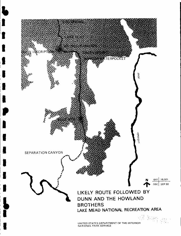
• I I I I I I I
• I I I I I I
t I
SEPARATION CANYON
•• • • • • • \ I • • • ••• • • • • .,·
N 602 2s,001
~ DSC SEPBO
LIKELY ROUTE FOLLOWED BY DUNN AND THE HOWLAND BROTHERS LAKE MEAD NATIONAL RECREATION AREA
UNITED STATES DEPARTMENT OF THE INTERIOR NATIONAL PARK SERVICE

south that same day. This would place the second campsite in an
unidentifiable location on the peninsula below Ambush Water
Pockets. No springs are found there. Green Springs are four
miles slightly south of east of Mount Dellenbaugh and Ambush Water
Pockets are two miles slightly east of south of Green. If Thompson
had given a rather different set of directions, he would have come
up with Ambush Water Pockets as a candidate site. It is difficult
to understand how Thompson, a careful observer, could appear to
have so garbled coordinates and distances.
One has even less confidence in Ambush Water Pockets as the
site of the killing when one considers the informants. Dellenbaugh
apparently based his judgment on Hamblin who never visited the
site, but learned of the killing first from Pai-utes and later from
the Shivwits themselves. We have no record of what he was told
specifically regarding a site, but feel it necessary to discount his
authority in the absence of familiarity with the area. Thompson 1s
Pa-an-tung was not a Shivwits and apparently looked with disfavor
on the band. This is not a situation that gives one assurance in
him as an informant.
We cannot, with complete confidence, discount Ambush Water
Pockets as the killing site, but considerable doubts are raised
concerning it.
Near the summit of Mt. Dallenbaugh an inscription has been
made upon a rock which reads:
WATER
r W. DUNN
1869
It is barely legible in contrast to other inscriptions of later dates
nearby. The arrow below the word WATER points in the direction
of Lake Flat some three miles distant. The intermittent lake was
clearly visible in May, 1978. The lake is the headwaters of
72
ti I I I I I I I
• I I I I I I
~ I I

• I I I I I I I
• I I I I I I
It I I
Parashaunt Wash, and the gap, through which the wash runs, is
clearly visible to the north. Five miles from the lake, north of
Castle Peak, the normally dry wash breaks out at Log Springs,
which, in May 1978, showed a flow of between fifty and one
hundred gallons a minute. Considerable evidence of Indian
habitation surrounds the spring which was identifiable by a local
rancher as the site to which local lore assigns the killing. 25 A
certain plausibility attaches to the Log Spring site, however. One
might reconstruct the events somewhat as fol lows: that on the last
day of August or first day of September, 1869, Dunn and the
Howland brothers reached the base of Mt. Dallenbaugh hungry,
exhausted, and, perhaps, with empty canteens; that Dunn
volunteered to climb the mountain which they had seen two days
before and report on a route out; that as he reached the rimrock
just below the summit, he looked north to see the lake and the way
out; that his caution and training caused him to inscribe his name
and the clue WATER in case he should miss his companions; that
they did rejoin, resupply themselves at the lake, and head north to
the spring where they encountered the Shivwits who were gathering
seeds in the open lands beyond or harvesting corn that they had
planted in the wash; 26 that members of the band, aware of the
men's diminished strength and coveting their few possessions, took
them by surpirse and killed them. Only a watch carried by the
men later showed up. It is possible that they had expended their
ammunition and abandoned their guns and were, thus, defenseless.
25. It does not fit Guerrero's description, however. The two stories agree only in that thei killing took place to the north of Mount Dellenbaugh.
26. That they farmed the washes is a supposition based on the practices of other Paiutes. Dr. Robert C. Euler, who surveyed the area for archeological remnants, discussed this question in a telephone conversation, 18-5-78, found no evidence of Shivwits horticultural practices, but pointed out that the evidence would, by nature, not be long lasting.
73
It is clear that further research is required. An attempt
should be made to verify the inscription by comparing it with
others in the same location, but showing different dates. The first
sighting of the inscription should be determined. More history of
Toab should be gathered to evaluate his testimony. Several
alternative sites outside the Recreation Area should be examined.
Finally, a close analysis of Paiute hunting and gathering patterns
should be overlaid against known. probable, and possible sources of
food.
B. Opening Shivwits
Following the tragedy of Dunn and the Howland brothers the
first fully documented penetration of Shivwits was made in 1872 by
Almon Harris Thompson who was a member of Powell's second
expedition, and whose diary has been referred to above.
Powell himself did not visit the Shivwits Plateau and
Dellenbaugh's visit came several years after that of Thompson.
Powell nevertheless left his mark there by naming a prominent
feature after Dellenbaugh:
Once when we were in the Uinkaret country Powell came
in from a climb to the summit of what he named Mt.
Logan, and said he had just seen a fine mountain off to
the south-west which he would name after me. Of course
I was much pleased at having my name thus perpetuated.
The mountain turned out to be the culminating point of
the Shewits [sic] Plateau. None of us visited it at that
time, but Thompson went there later, and I crossed its
slopes twice several years afterwards. On the summit is
a circular ruin about twenty feet in diameter with walls
remaining two feet high. 27
27. Dellenbaugh, Romance, op. cit., p. 310.
74
" I I I I I I I
' I I I I I I
~ I I

It I I I I I I I
• I I I I I I
L I I
Although it lies neither upon the Shivwits Plateau nor within
the Lake Mead National Recreation Area, the Grand Gulch Mine must
be discussed briefly since it influenced Shivwits development and
was responsible for a major road within the National Recreation
Area. We preface this by a quotation from Billingsley:
Mining on the Arizona Strip and the North Rim was mainly
in the hands of the so-called Dixie Mormons, about whose
activities not much has been recorded. 28
The point is amply and immediately demonstrated when we try
to establish the date of discovery of the Grand Gulch deposits:
More success was attained at the Grand Gulch copper
deposits, first discovered in the western canyon area in
1853 by Richard Bentley, Samuel S. Adams and others. 29
Billingsely's source was the following:
According to Mr. Callaway [S.R. Callaway, mine supt.,
ed.] the Grand Gulch ore deposit was discovered about
1853 though it seems probable that it was known to the
Indians before that time. The prospect was bought from
the Indians for a horse and some flour by a Mr. Adams,
employed by Bishop Snow, of St. George, Utah. Adams
patented No. 37. For a number of years the ore was
hauled to St. George. In 1870 an adobe smelter was
built, which evidently did not meet with marked success,
28. George H. Billingsley, 11 Prospector 1s Proving Ground: Mining in the Grand Canyon, 11 Journal of Arizona History, Vol 17, No. 1, Spring, 1976, p. 71.
29. Ibid. I p. 73.
75
as the small slag dumps have since been shipped for their
metal content. An adobe and stone stack now standing
near the shaft does not seem to have been used. 30
Now consider the following contradiction written by
manager and part owner of the mine in 1910.
The Grand Gulch Mine was discovered by a Shiwits [sic]
Indian about the year 1871. He made known his
discovery to men living at St. George, a small Mormon
settlement in the southern part of Utah, about eighty
miles north of the discovery. The extreme high grade of
the ore excited considerable attention. It was worked in
a primitive way for several years. Several attempts were
made even to smelt the ore. 31
the
However, according to Notice of Location on file with the
Phoenix office of the Bureau of Land Management, the Adams Lode
in the Bentley Mining District was located on 23 June, 1873. 32 The
mine was acquired by the Jennings brothers in 1890 and worked
intermittently by them until 1906 after which it operated
continuously for a decade and then intermittently through the
present. The freight road out to St. Thomas was constructed, or
30. James M. Hill, 11 The Grand Gulch Mining Region, Mohave County, Arizona, 11 U.S.G.S. Bulletin, Contributions to Economics, 1913, Part E., G.P.O., Washington, D.C., 1915, pp. 42, 43.
31. W. P. Jennings, 11 Grand Gulch Copper Mine, 11 Mining and Scientific Press, 18 February 1911, p. 269.
32. The claim was signed by Richard Bentley, Benj. H. Paddock, A.R. Whitehead, W.H. Branch, Sarn'I Cunningham, James Pierce, Sam'I S. Adams, Erastus Snow, Frank Soughery (?), Joseph Burch, Sam 11 0. Crosby, and Walter E. Dod~Je.
76
' I , I I I I
I I I I I I
i I
It I I I I I I I
' I I I I I I
L I I
more probably reconstructed, in 1906. 33 The mine contributed to
the opening of Shivwits both by its demand for lumber and by its
need to feed its workers. Some of its fifty employees worked at
the sawmill that was established in Twin Springs Canyon near Oak
Grove. This was managed, at least at one time, by Tom
Gardner. 34 Hill also reported:
The timbers used at the Grand Gulch Mine are obtained
from the Shivwits Plateau, 25 miles east of the mine,
where there is said to be an open forest of "jack pine"
with some "red-pine" trees, some of which are 3 to 4 feet
in diameter. This timber, square sawed for mining use
and laid down at the mine, is said to cost $30 a thousand
feet. 35
In 1879, the Parashaunt Ranch of the Canaan Cattle Company
was established at Oak Grove, in part to supply the needs of the
Grand Gulch Mine. 36 Oak Grove lies three miles to the north of
the NRA boundary and four miles to the northwest of Mt.
Dallenbaugh. A number of structures exist at the site, principally,
a frame shack which was homesteaded by Murray Stutzneggar, and
the collapsed remains of two log cabins which were the first
non-Indian structures in Shivwits. 37
33. This will be discussed in Chapter V.
34. Interview with Reed Mathis, St. George, 15-11-77.
35. Hill, op. cit., p. 42.
36. Andrew Karl Larson, I Was Called to Dixie, Deseret News Press, Salt Lake City, 1961, -p. 243.
37. The information on Stutzneggar was provided by Reed Mathis, interviewed 15-11-77. This is possibly the same Stutzneggar who left an inscription on the summit of Mt. Dallenbaugh in the 1930s. Since this section is concerned only with a brief overview of Shivwits, further discussion will be found below Chapter 11, Ranching.
77

The Cannan Cattle Company, known also as the Canaan
Cooperative Stock Company, was established by Erastus Snow at
Toquerville in 1870. 38 The Cooperative
was incorporated for $100, 000 at one dollar a share.
Many people paid their tithing with cattle so the church
was the largest stockholder with $10, 000 worth.
Anson P. Winsor was the next largest stockholder with
$3, 000 worth and Brigham Young had $2500 in shares.
The rest were owned by just small stockholders. The
church used their interest in the herd quite extensively
as a subsidy plan for the construction of the Tabernacle
and the Temple. Much beef was slaughtered for the
consumption of the workers on the buildings. 39
In November 1879, the board of the Canaan Cooperative
authorized President Erastus Snow and Secretary Woolley 11 to employ
a suitable man to take charge of the Parashont [sic] Ranche [sic}
and run a dairy there. 1140
The suitable man was found in Albert Foremaster who
carried on dairying activities there at a compensation of
$50 per month and half of the dairy products. John D. L.
Pearce became manager of the Parashaunt Ranch in 1881
38. Larson / op, cit. / p. 237. The company was a product of the United Order, a brief attempt at communal ownership and operation of enterprises and, in some cases, social organization. It ran counter to nascent individualism and was dissolved in 1885.
39. Florence Foremaster, History of Albert Charles Foremaster / 1853-1919, St. George, 1977, p. S, mimeographed. Courtesy of Barbara Price, Arizona Strip District Office, Bureau of Land Management, Saint George.
40. Larson, op. cit., p. 239.
78
' I I I I I I II
• I I I I I I
f I

It I I I I I I I
• I I
' .1 I I
' I I
after Foremaster 1s period of service and he continued the
dairying activities. Very little farming was attempted
because water irrigation was limited.
When Albert became foreman of the Canaan herd at
Parashaunt in the Spring of 1880, he hired his brother
Eph to help him. They milked 25 head of cows and made
butter and cheese which they sold in St. George. They
also had pigs which they turned loose to fatten on
acorns. Daddy said that when they first moved to
Parashaunt it was like a meadow everywhere, but over
grazing has changed that picture today. 41
In 1883 the Canaan Company sold the dairy to B.F.
Saunders, 42 and in that same year, Anthony (Tone) Ivins and
Andrew Sorenson established themselves in Parashaunt. 43 La Berta
Sorenson mentions how there was a breezeway between the two
cabins and that cheese would be placed there to cure. They traded
with the Indians for pine nu·::s, which were then sold in St.
George. Mention is also made of a windmill at that site. 44
Tone Ivins purchased Oak Grove from Saunders in 1886 and he
and Heber Grant purchased 600 head of cattle from the Canaan herd
41. Foremaster, op. cit., p. 5. The farm also supplied the Grand Gulch Mine. Larson, op. cit., p. 243.
42. Larson, op. cit., p. 245.
43. La Berta Sorenson, 11 Andrew Sorenson" from family Book of Remembrance, Provo, Aug., 1971. La Berta was-the daughter-in-law of Andrew. The Book of Remembrance was kindly loaned by Mrs. Dale Gubler, of Santa Clara.
44. There was a spring just above the cabins. Apparently it failed for there is evidence of an attempt to dig it deeper.
79

to establish the Mojave Land and Cattle Company in the Parashaunt.
Albert Foremaster was made foreman of this herd. Ivins befriended
the Shivwits band and recognized the pressure that the cattle were
placing on traditional Indian food supplies. In 1891, Ivins, acting
for this purpose as an agent of the government, arranged for the
acquisition of land near Santa Clara to become a reservation for the
Shivwits. In 1895, coincident with a severe drought in the Strip,
Ivins was called to serve as president of the Juarez Stake in Mexico
that was organized in December of that year.
Ivins sold his interests to Saunders who, because of the
drought, sold out to Preston Nutter (see next section, below).
Saunders used the proceeds to acquire the original Canaan Ranch
which lies on the Utah-Arizona border near Short Creek.
Other cattlemen followed the United Order Pioneers. Foremost
among these was the cattle baron Preston Nutter who entered in
1893 and who gained, by various means, predominant control over
Main Street Valley, Shivwits, and Grand Wash. One of his
principal weapons for outmanuevering other claimants to the area
was the use of scrip to acquire title to the few waters of the arid . 45 region.
That the battle was continuous and that Nutter did not always
triumph, is verified by the fact that some early claimants, or their
descendents, still have holdings in the area. One of these is the
Mathis family. Wally Mathis entered in 1902 initially in Pigeon
Canyon near to the Grand Gulch Mine. He sold beef to the mine
and also drove a hackney from there to St. George. He later
45. Within the NRA, and Ambush Water interview 18-10-77.
these are reported to include Green Springs Pockets, according to Slim Waring in an
80
I I I
lj 'I I I I
' I I I I I I
~ I I

I
I It I I jl I
I
II
i• I
• I I I I I I
t I
established himself at Lake Flat outside the NRA, but close to the
present fire camp. Another prominent cattleman was Slim Waring
who filed on Horse Valley in ·1916 and from that base, expanded to
control most of the peninsula to the south.
Sheep were also run in the Parashaunt, principally by Ray
Esplin. Although the country was open range prior to the Taylor
Grazing Act and sheep competed successfully with cattle, goats,
domestic horses, and mustangs over most of the Strip,
cattlemen were able to keep the sheep out of Paras haunt
contained behind Poverty Mountain for some time.
Ray Esplin leased Santa :=e railroad (sections) in the
Parashaunt area and moved' sheep into the area. Prior to
this time Poverty Mountain was the deadline for sheep .
It was reported Ray ran 10, 000 sheep on the Strip at one
time. Most of these sheep stayed on the Strip year long.
There was a great influx of sheep from Utah during the
winter months.
Strip. Pakoon
They would cover most of the Arizona
was the spring range for thousands of
sheep, also Beaver Dam Slopes, and the slopes of the
V. . R. 46 1rgm 1ver.
the
and
Two documents in the files of the Arizona Strip District Office
of the Bureau of Land Management throw some light on the short
period during which a portion of the Shivwits Plateau, including the
area presently under the jurisdiction of the Lake Mead National
46. Lloyd Swapp, typewritten notes on Arizona Strip history in Arizona District Office, B.L.M., St. George, Utah, p. 5.
81

Recreation Area, was in the Dixie National Forest. 47 An item in
the Washington County News of 16 April 1908, provides
background:
The news that stock are dying on the Canaan range is
everything but encouraging, especially so early in the
year. Sheep have practically cleaned the range of feed
and cattle are having a hard struggle for existence.
This brings home to us the importance of the forestry
service, which regulates the range and does not permit
overgrazong. While this service was looked upon by
many at first sight as a hardship imposed upon them, it
is gradually dawning upon them that it is a good thing,
and we believe time will emphasize this. 48
In October of 1908, Angus M. Woodbury entered the Forest
Service at St. George, and, in July of 1909, took up his duties as
ranger at the Wildcat Ranger Station two miles north of Parashaunt.
July 7. Took possession of house without doors or
windows (unfinished).
10-17. Routine work and work on house, putting in
doors and windows. Went to sawmill and to Green
Springs. Took my wife from Green Springs east to the
47. These are: Summary of Diaries of Angus ~ Woodbury ~ Dixie National Forest, Utah, 1908-1913, prepared in 1956, and a Memorandum of historical information prepared for the Forest Supervisor by Irwin Johnson in 1940.
48. Johnson, op. cit., p. 1. Quoted from Washington County News, 16 April 1908.
82
' I I I I I I I
• I I I I ,, I
f I

~ I
I , I ,, I I.
I I 'I I I t I
I•
brink of the Colorado River Canyon (July 13) to get a 50 49 mile view of the Canyon.
In October of 1909, Woodbury surveyed the north boundary of
Parashaunt Division which he began at Parashaunt Wash, thence to
Andrus Canyon, across Andrus Canyon by triangulation, from
Andrus Canyon to Penn Valley, thence to Parashaunt Pasture,
following which a line was run to Snap and Savanac Canyons. On
28 November he left for St. George and did not return to
Parashaunt.
No further activity is recorded for the Parashaunt Division
until 1916, at which time it was opened for homseteading. On 10
May 1916, President Wilson signed a proclamation:
The effect of which is to exclude from the Dixie N. F. In
Arizona and Utah over one half the lands therein.
Eliminations, which total 588,520 acres are all made from
the two Arizona divisions of this Forest. The area known
as the Parashaunt Division, consisting of a block of land
approximately 25 miles square, bordering the Colorado
River, is abolished and this entire area restored to the
bl . d . 50 pu 1c omarn.
Compared to other portions of the Arizona Strip, notably Main
Street Valley and Mount Trumbull, homesteading in Shivwits
49. Woodbury, op, cit., p. 2. The sawmill referred to was apparently the mill just to the south of Oak Grove being operated by the Grand Gulch Mine.
50. Swapp, op. cit., p. 7. Quoting the Washington County News of 25 May 1916.
83

appeared to be light and, of those who did enter, only Slim Waring
remains. Other homesteads and their claimants can be identified in
some cases. In a few locations, for instance in McDonald Flat north
of the NRA boundary, there are some remnants of dwellings.
Undoubtedly, many who entered failed to prove up. Others were
cowboys who filed and proved up in collusion with ranchers who
then acquired the holding. One of these (outside the NRA) was Ed
Johnson who proved upon the section where the Forest Service
Ranger Station was located. 51 He turned this over to Nutter. It
was acquired by Hale and Vader on the dissolution of Nutter's
holdings after his death. Vader and Hale sold it to Jack Wiggins
who also proved up on Wildcat. These two claims were sold to
Waring in 1942.
Of more immediate interest are the claims reportedly filed
within the NRA. These are:
Horse Valley by Slim Waring
Pine Valley by George Howard Pemberton
Shanley Tank by Jack Spencer
Green Spring by Preston Nutter (Water only)
Penn's Pocket by Preston Nutter (Water only)
That more settlement was not attempted is directly attributable
to the lack of reliable water supplies. The area remains remote and
lonely. In Waring's words, "There's nothing up there. What is the
National Park Service trying to do? There's no water there to
support dudes! 1152
51. Johnson figures in several feuds of importance. See Chapter IV.
52. Interview, 17-10-77. See also Part II, A, Water Sources and Ranches.
84
4 I I I I I I I .I I I I
,, I
I' t, I!

~ I I I I I I I
• I I I I I I
I
C. Cattle Baron
Although many actors made their appearance in the Arizona
Strip during the years of open range prior to the Taylor Grazing
Act, the leading role was played by one who, himself, rarely
ventured on stage for reasons that will become apparent.
Preston Nutter was born in 1850 of Christopher Nutter and
Catherine Pugh Nutter in Clarksburg, West Virginia. 53 He was
orphaned at nine and headed west when only thirteen. His drive
and energy were clearly manifested early for, by about his
twentieth year, he had attended a business college in San Francisco
with $5,000 that he had received from the sale of a mining claim. 54
His life was active and adventurous.,
Among other incidents was an exploration into the San Juans
with Alfred Packer, the Man Eater. He had the good fortune and .
judgment to heed the advice of Chief Ouray and quit the party
before winter set in. Nutter became the chief witness at Packer's
two trials on charges of murder and cannibalism. 55 Nutter served
in the Colorado legislature and established a successful freighting
business that served Colorado mining communities. In 1886 he
acquired a large range in northeastern Utah and began there two
practices that he would use to advantage in the Arizona Strip. One
of these was to upgrade his stock. In Utah he exchanged range
53. Obituary, Salt Lake Tribune, 28 June 1936. Preston Nutter married Katherine Fenton in 1908. She died in 1965. Salt Lake -- ---Tribune, 18 July 1965.
54. Virginia N. (Nutter) Price and John T. Darby, 11 Preston Nutter: Utah Cattleman, 1886-1936, 11 Utah Historical Quarterly, Summer, 1964, Vol. 32, #3, p. 234. Virginia Price was Nutter's daughter. She died on 29 October 1977. Obit. Utah Cattleman, December 1977.
55. Price, Darby, op. cit., p. 235, 237.
85

steers for 1,000 Hereford cows and bulls, the first blooded stock in
that part of the country. And he also freely and deliberately used
outlaws--"Butch Cassidy" among them--as his hands. 56
Nutter's entry into the Arizona Strip was inadvertent. In 1893
he negotiated a lease on Strawberry Valley, west of Ouray, Utah,
and south of the Duchesne River, and was ready to stock it in
September.
He sent word to cattlemen in Arizona, informing them that
he was in the market for 5,000 head of cattle and that he
would take delivery on the north side of the Colorado
River near Scanlon's Ferry . He made Hackleberry
[sic], Arizona, his headquarters for dealing and
contracting. As soon as the cattle were on their way, he
wired Bishop Franklin Johnson in Kanab, asking him to
send the Nutter outfit to Scanlon's Ferry and have them
pick up more good men along the way.
The bulk of the Arizona Stock came from south of
Kingman, some as far south as 300 to 400 miles, along the
Bill Williams, the Santa Maria, and the Big Sandy Rivers.
In all there were 15 Arizona ranchers who agreed to
deliver cattle. The various herds ranged from 25 to 900
head.
The ferry at Scanlon's was small and impractical for
handling any large number of livestock. The Colorado
was wide and the water was swift in the area. However,
56. Ibid., p. 237. Arizona Strip cattlemen also used this and other means to sidetrack the proclivities of rough characters. See Chapter IV.
86
4 I I I I I I I
• I I I I I I
I

It I I I I I
11 I
• I I I I I I
I
by the time the cattle arrived Nutter had found a place
that was reasonably flat and smooth. When a final talley
was taken, it was discovered there were 4,652 head.
Some 400 head had been lost in the hot desert crossing
from Arizona.
As cattle converged on the river, Nutter and his cowboys
bunched them and commenced the .hazardous and
unprecedented job of pushing them in to swim to the
north side. Time after time Nutter, his riders, and the
Arizona men plunged their horses into the silt-laden
Colorado to point and wing the swimming steers. It was
a three day operation with men, horses, and cattle
fighting to stay alive. Amazingly, neither a man nor an . I I . h . 57 anrma was ost in t e crossing .
After leaving Scanlon's, Nutter's herd drifted north along the
Virgin and were exposed to a water shortage, heat, and squalls of
snow that heralded the approach of winter. Some cattle were lost,
and Nutter decided to winter in the Strip rather than risk the
higher elevations in Strawberry. 58
Nutter saw the good range and mild climate of the Strip were
well suited to breeding operations, and he put in motion a variety
of moves which eventually gained him control from the Hurricane
Cliffs to the Nevada line. In arid country, control of water is
control of the range. Nutter deftly outmanuevered the water
usufruct that local ranchers had enjoyed.
57. Ibid., pp. 242, 243.
58. According to Rudgar Atkin, interviewed by the author in December, 1973, Nutter was caught in a snowstorm in Fort Pierce Wash a few miles to the southeast of St. George.
87

Several cattle and sheepmen from around St. George were
using the Strip, but they were doing so without valid
government titles.
B.F. Saunders, a large owner and dealer In cattle,
claimed a number of springs in the Strip. Anthony
Ivins, an apostle in the Mormon Church and owner and
manager of the Mohave Cattle Company, claimed several of
the springs. Nutter was hard pressed to find water for
his cattle. Outsiders were not accepted, and the men
who used the Strip backed up their claims with the
theory that 'might makes right.' However, Nutter was
not easily discouraged. He developed water holes of his
own, and then took necessary steps to acquire legal titles
on some of the land and springs, using preferred Indian
scrip that he bought in Washington, D.C., at a premium
price. 59
The "premium price" that Nutter paid for the scrip was,
according to Reed Mathis, $2 per acre. 60 Each water hole, seep,
or spring that was preempted by scrip was usually surrounded by a
claim of forty acres. Nutter claimed eleven waters that can be
identified, although more may have been added up to a total of
59. Ibid., pp. 243, 244. We should note that Ivins was not an apostle of the church at the time he was defending himself against Nutter, although he was able and highly respected. In the 1920s, he was a member of the Church First Presidency. Nutter, although Utah's largest cattle grower at the time, was not Mormon. Neither, apparently, were his associates or cowboys.
60. Quoted in Cox, op. cit., p. 13.
88
4 I I I I I I I
' I I I I I I
I
It I I I I I I I I~ I I I I t I
I
thirty. 61 Either way, $880 or $2,400, the price was right for
control of so vast a domain.
That local ranchers reacted with "might makes right" is
perhaps understandable:
Preston Nutter, one of the biggest stock holders in Utah,
slipped in and placed a government script on the springs
at I vanpatts and New Springs where Eph and Albert
(Foremaster) had put in so much hard work improving
them. He also put a government script on Antelope. He
then decided he better leave the country. This surely
did make the Foremaster brothers angry when they found
out there was noting they could do about it. They
returned the money they had received from Andrew
Sorenson, Albert made the remark that Preston Nutter
ought to be shot. The word got back to Nutter that Al
Foremaster was going to kill him.
show up for a number of years.
Nutter didn't dare
Finally after things had cooled off, Nutter sent an
invitation for Albert and Eph to come to Salt Lake with all
expenses paid to settle the affair. I don't believe they
went to Salt Lake but they did settle it by giving up
lvanpatts and New Springs for Antelope. 62
61. The identified waters are Black Rock, Wolf Hole, Rock Canyon, Big Spring, lvanpatch, New Spring, Whitmore, Hidden, Andrus, Green, and Penn's Pockets. Ibid, p. 13. A newspaper report (unidentified) in Sharlott Hall Museum, dated 10 June 1937, notes that G.W. Hale and George Veater purchsed 7,000 acres of Nutter holdings and more than 30 patented water rights.
62. Foremaster, op. cit. , p. 7.
89

Nutter also acquired control by outright purchase, sometimes,
apparently, exploiting the problems of the smaller ranchers:
Andrew (Sorenson) sold Parashaunt to Preston Nutter.
Prior to this time Ivins had sold his holdings at
Paras haunt to the same man. There had been heavy
droughts [about 1895, ed.], cattle were dying and
Preston Nutter offered to pay twenty dollars a head for
every animal that could be gathered. At this time,
Andrew had about as many horses as cattle, but Nutter
refused to take the horses but stipluated they must be 63 removed from the range.
According to Price and Darby, in the spring of 1896, Nutter
bought,
The cattle, improvements, and all rights and titles claimed
by Anthony Ivins. The following year he bought Mr.
Saunder's claims and improvements for $3,000, and a small
spring called "Wolf Hole" from M. W. Andrus for $500.
The next year he bought Mr. Foster's range rights,
one-half interest in Big Spring, and 2, 000 head of his
cattle. At about the same time he bought Andrew
Sorenson's cattle, about 500 head, and all his range
rights and claims. Before the turn of the century, he
had acquired most of the cattle outfits on the Strip. He
improved upon the land and springs, but the Strip was
lawless, rugged country that continued to plague him to
the end. 64
63. Soren son , op . cit. , no page number.
64. Price and Darby, op. cit., p. 244.
90
~ I I I' I I I I
• •1 I ,~
t t I
I

' I
I I
II I
• I I
' I I I
t I
Another common device used on the Strip, and elsewhere, to
gain control of land was to hi re a cowboy to file on a homestead,
prove up on it, and then to turn it over to the big outfit. For
example, Nutter hired Ed Johnson to homestead some land near
Wildcat. After Johnson had proved up, Nutter bought the land and
thirty-five or forty calves and paid Johnson expenses and wages. 65
The opposition that Nutter's actions engendered forced him to
hire Texas cowhands and "deputize them to protect his cattle and
springs. 1165 Ed Johnson was one of these cowboys, who, as the
following story told by the Englestead brothers demonstrates, took
his duties seriously:
Homer Englestead: Very likely, when Ed . Ed was a
smart man. When Ed started Wildcat, he set for days and
look out the window and go like that (thumping on the
table) on the table. I wondered why.
Earl Englestead: don't know. Another time old
Ferguson brought a load of salt there and told Ed, he
said, now don't let anybody take any of this without a
note from me. He said, I don't give a damn who he iS I
don't let him have it. This Howard Ingle went up there
to get . I think he had four or five mules, and he
was going to get a bunch of rock salt. Ed told him, he
said, give me the note that Ferg give you. He said, I
haven't got no note from Ferg. Well, he said, you're not
getting any salt. My orders are not to let anybody have
any salt unless they have a note. He was quite a big
65. Cox, op. cit., p. 203.
66. Price and Darby, op. cit., p. 244.
91

guy. He
1 won't.
said, just try to stop me.
So Ed walked back up to
Ed said, don't think
his house and got his
gun, and this is what Ed told me, he said, I'd 'ave hit
the son of a bitch right betweE'n the eyes, but the dirty
bastard turned his head and it just went around, and he
said, he dropped and I just went back in the house. He
said, I didn't give a Goddam how long the son of a bitch
fayed out there. He said, here come . . . I don't know,
a St. George guy that must have happened by and seen
that mule sleeping and rode over to see old Ingle laying
there. Then they went and got somebody fairly close
with a car and they took him to St. George, but he had
been shot and he couldn't walk. 67
Nutter was not close enough to oversee his range properly
·and, according to several informants, ran a sloppy outfit; "his
closest workmen were his worst enemies. 1168 "Nutter's cowboys saw
how loose his outfit was and many started taking his calves. Some
of Nutter's men were local, but only if he didn't find out. He
preferred to bring them in from the outside. 1169
One important result of the friction that existed between
Nutter and the St. George ranchers was his refusal to trade there.
To avoid this, he went to the expense of building a road from the
Strip to St. Thomas. This began in Hidden Canyon (T30N, R13W),
descended into the Grand Gulch down a cliff face on what became
known as the Nutter Twists, and thence generally in a
67. Mike Belshaw, transcription of interview with Homer and Earl Englestead, 14-11-77, p. 3.
68. Chloe Bundy, to Mike Swernoff, May, 1974.
69. Ward Esplin to Sharon Rule, May 1974.
92
' I I I I I I I
• I I I I I I
I

It I I I I I I I
• I I I I I I
southwesterly direction to where it intercepted the Grand Gulch
Mine Road at Cottonwood Wash, two miles south of Pakoon. This
road was used to transport supplies from St. Thomas and salt from
the mines to Nutter's operations in the Strip.
Had Nutter less drive and energy, and more concern for the
rights and efforts of others, perhaps his empire would have been
less extended but the road to St. Thomas would not have been
necessary and the "lawless, rugged country" would not have
"continued to plague him to the end," which came in 1936.
Ironically, 1936 was the year that the Taylor Grazing Act came into
effect in the Strip. Had it arrived earlier, Nutter's consolidation
would have been difficult to challenge, and his empire could be
intact today. The Nutter holdings, purchased by Veater and Hale
in 1937, are now divided among many smaller claimants; ironically,
many of whom are St. George Mormons descended from those at
odds with Nutter in an earlier day.
This section should close with reference to Nutter's actions in
the area of National Recreation Area jurisdiction. As already
noted, Nutter allegedly gained control of Green Springs and Penn's
Pockets (Ambush Water Pockets) by the use of scrip. A fence
crossed the peninsula at Penn's Pockets running two miles in a
generally southeasterly direction. Nutter used this to keep his
steers to the south. When Slim Waring and Bill Shanley settled the
country, they moved Nutter's steers out and branded the
mavericks. In the northern part of the range that Waring was
trying to establish, Ed Johnson set up a brush fence for his own
pasture. Waring countered by setting it on fire. Thereupon,
Johnson, gun on saddle, started to hunt Waring down. Waring
managed to keep out of his way until things cooled down. Waring
said later, 11 Nutter sent Johnson down tc kill everybody off. 1170
70. Earl Cramm interview with Slim Waring, no date.
I 93

-------1 ,, I!
I
II
I: I
I ,, ' Ii
I
I: I
I I I:
I
I: I I:
i
I 1

It I I I I I I I
' I I I I I I
I
CHAPTER THREE
MINING IN THE LAKE MEAD NATIONAL RECREATIONAL AREA
A. Purpose of the study
Within the boundaries of the Lake Mead National Recreational
Area there are a great many old mine workings: shafts, tunnels,
pits, and the occasional building or building remnant. Most of
these constitute dangers to the public using the Recreation Area;
but some of them could represent valuable historic resources.
For the protection of the public, those workings which have no
historical significance should be sealed. On the other hand, for
the enrichment of the cultural treasury of the United States, those
which have distinct historical significance should be identified and
protected by some means, such as inclusion in the National Register
of Historic Places.
The purpose of this study, therefore, is to identify those mine
workings which have historical significance and those which have
not.
B. Criteria
Production can be used only loosely as a criterion. If a mine
had virtually no production, it is unlikely to have had any real
historical significance. On the other hand, large production does
not necessarily mean the mine was historically significant. Nor does
small production preclude historical significance.
Influence on the history of the surrounding area, the building
of trails and roads, the begetting of settlements, meaningful
participation in the trade union movement, encouragement of the
95
building of a fort, substantial influence on the passage of
legislation--these and other considerations must be weighed.
It would be important to know that a given mine had
introduced a new mining technique, a new milling process, a unique
system of transportation, a metallurgy that gave unprecedented
recoveries, and so on.
If at a given mine there had been a battle with Indians, or a
shoot-out between lawmen and outlaws or between two rival gangs,
or a Civil War battle, that would be important to know.
In other words, it is not just a matter of tonnages or the lack
of them that matters; it is what happened at or because of that
mine that imbues it with local, regional, or national historical
significance.
C. Approach
First an effort was made to gain an overall knowledge of the
general history of the area covered in the study. Since the history
of both Nevada and Arizona from the time of the Spanish
conquistadores through the early part of the 20th Century is
largely the story of mining, that study was inevitably interwoven
with the history of the mining in certain areas and districts.
Second, an effort was made to locate every known mine in the
Lake Mead National Recreation Area. For this purpose the primary
tool was the U. S. Geological, Survey1s quadrangle maps covering
the entire LMNRA. These were supplemented by maps appearing in
reference works; by the very detailed series of maps of Mohave
County, Arizona, as prepared and published by the Arizona
Highway Department in 1968; the map of the Lake Mead National
Recreation Area, Arizona-Nevada, Map No. X-300-772, published
96
ti I
I I I I I I I
' I I I I I I
I

• , I I I
11 I I I
' I I I I I I
I
November 1972 by the United States Department of the Interior,
Bureau of Reclamation; and the Mineral Resource Map of Clark
County'· Nevada, by E. H. Pampeyan and Ben Bowyer, prepared
cooperatively by the U. S. Geological Survey and published as
Plate 2, Bulletin 62 by the Nevada Bureau of Mines in 1965.
Next those mines which were identified by name. on such maps
were listed. A search was made of the literature (publications of
the U. S. Geological Survey; the U. S. Bureau of Mines; the
Nevada Bureau of Mines; the Arizona Bureau of Mines; the Arizona
Department of Mineral Resources; the U. S Department of Mineral
Resources; the U.S. Department of the Interior; trade journals;
histories; unpublished manuscripts; local 11 historical 11 publications;
and whatever other materials came to hand) to pinpoint in so far as
possible the histories of those mines.
At the same time note was made of other mines mentioned as
being near those identified in an effort to find the names and
histories of those mines marked on the maps but unidentified.
The Arizona Department of Mineral Resources has been for
about two years associated with other agencies in "The Mohave
County Custom Mill Project, 11 an undertaking aimed at determining
whether the combined potential of mines in Mohave County co.uld
support a custom mill, and whether the existence of such a mill
would make economically feasible the reopening of mines in the
county.
A necessary first step in the project was to research the
histories of all known mines in the county. Through the good
offices of John Jett, Director of the Arizona Department of Mineral
Resources, Jerry Irvin, Tucson field engineer for the Department,
was made available to check the list of mines we submitted as lying
97
within the boundaries of the Arizona portion of the Lake Mead
National Recreational Area. Irvin checked this list carefully and
supplied us with all the information he had gathered on each from
the literature, from Department records, the records of the Arizona
Bureau of Mines, and all other sources he had available to him.
These findings have been incorporated in this report.
In addition we engaged the services of Glenn A. Miller,
another of the Department's field engineers, who is a specialist in
such research as that we have been engaged in for this report.
Miller's assignment has been to double-check our results and to try
to ferret out additional information where ours seemed inadequate.
His assistance has been very productive and valuable insurance that
every possible base was covered.
D. The Research 11 The pioneer prospectors and miners were too busy' overcoming
obstacles, struggling against hardships and celebrating occasional
periods of good fortune to write about their experiences, even if
able to do so. Few authentic records of most of the earlier camps
exist. Available statistics are often far from reliable, and good
judgement is required to separate the true from the false. 11 Gold
Placers and Placering in Arizona, by G. M. Butler, p. 9,
August 15, 1933; Bulletin No. 168, 1961; Arizona Bureau of Mines.
Dr. Butler's statement applies just as much to lode mines as to
placers, and just as much to Nevada as to Arizona. The
unreliability extends from the earliest mining activities up to World
War I. It accrues from the factors Butler mentions and also, in
considerable part, from one he does not mention.
This is not to disparage the efforts of such men as Bancroft,
Hinton, Hamilton, Farish, and other historians, nor those of such
98
,, I
I I , , I I I I
' I I I I I I

' I I I I I I I
• I I I I I I
I
giants as Schrader, whose works are the base on which so much in
the field has rested. But the facts are these:
From its inception, mining in what is now the Lake Mead
National Recreational Area and surrounding areas was conducted in
circumstances of extreme hardship and highly charged emotion.
The county was forbidding, the creature comforts virtually nil, the
mechanical aids primitive, and rewards meagre.
Yet the men who populated the region suffered that primitive,
age-old, and ineradicable disease, gold fever. One of its
manifestations is that ultimately it's not the finding but the search
that fascinates; men have sold obvious bonanzas for pittances to be
on their way again. Values were very ephemeral things.
Another is the hope that amounted to sure conviction that in
the next wash, up the next rise, across the next ridge lay EI
Dorado, the mother lode, the ultimate. It amounted to a real
sickness of which uncounted thousands of men died after being
catapaulted by it through a short .but intense life. It was not,
therefore, deliberate deception but self-delusion that led such men
to exaggerate grossly the worth of their findings. Next to
prospectors fishermen are paragons of truth.
And for many years there was an army of men waiting not only
anxious to believe the prospector's and miner's claims but to
embroider upon them. As mentioned in the previous chapter, the
number of promoters (confidence men) was legion, and back East
they had suckers lined up begging to dump their money into
get-rich-quick mines. At times Oatman, Chloride, and Kingman
were virtual stock exchange centers for mining properties.
99

It is little wonder, then, that the early records prove almost
totally unreliable. Even the work of such a conscientious and able
man as Schrader must be used guardedly. It was literally,
physically impossible for him to visit personally every one of the
hundreds upon hundreds of prospects (all called 11 mines 11 by the
promotors) in every remote district that came to his attention.
Necessarily he was in the same dilemma as today's mining
historian. He was forced to take a large proportion of his
information from the most reliable source he could find and pray it
was reasonably accurate. If, from 1902 to 1918 and later, the truth
in field was rarer than bonanza gold mines, Schrader and his
colleagues were as much victims as the unwary widows in the East
who were gulled by the same hyperbole.
As for men line Hinton and Hamilton, they were much more
commercial writers than historians, and they were capitalizing in
their own way on the intense interest easterners had in the west.
Newspapers that featured the West sold like hotcakes; speakers who
talked about the West packed auditoriums; and books about the West
sold printing after printing. But all were constrained to supply
what the buying public wanted to hear--that the West was the land
of opportunity, the land of unclaimed wealth, the land of dreams.
If, therefore, Hinton's and Hamilton's works read sometimes like
unmitigated promotions, they were simply fulfilling what was
demanded of them.
Bancroft was a good and conscientious historian; but his
reliability increased with the remoteness of the times about which he
was writing. He worked with a stable of researchers and writers,
a short of assembly-line of history. Thus the sorting and appraisal
of a plethora of recent and contemporary information could not be
as careful and mature as the judgement of information to which time
had lent perspective and given proof.
100
41 · I I I I I I I
' I I I: I' I! I
I

~------~ -
~ I I I I
I I I I I I
' I I I
I I I I
I
And Farish, again, was a conscientious but random workman.
Mostly he seems to have proceeded from a multiplicity of sources,
recounting in haphazard fashion what he knew, what he had read,
what he had heard. His work provides many valucible insights; but
it is safest practice to double-check each before accepting it as
gospel.
Dunning, on the other hand, was a graduate and experienced
mining engineer, a meticulous researcher with a dedication to
accuracy, and a man of independent means who therefore was not
unduly hurried by deadlines. His principal work, Rock To Riches,
has been accepted since its publication as the standard in the fields
of the history of Arizona mining.
In the introductory remarks to his chapter, 11 Compendium of
Important Arizona Mines," Dunning says:
11 There are more than 400,000 mining claims in Arizona, and
probably more than 4,000 companies have been incorporated for the
purpose of mining in Arizona.
"Obviously any description or record of individual mines can
touch the highlights only. In this chapter of Rock To Riches the
author has drawn the line at mines which have a recorded
production well over $100,000. A few exceptions are made where
there are historical facts of special interest .... "
"In compiling this chapter, many sources of information have
been used; but hearsay, rumor, and old timers' guesses have been
strictly avoided. 11
Typically the mining man, Dunning chose production as his
first criterion. A valid historian, however, he provided for
exceptions "where there are historical facts of special interest."
101

Dunning, therefore, has been used as a reliable positive guide
to significance. If he says a mine was important, his judgement
has been accepted. On the other hand, the simple fact that a mine
does not appear in his compendium has not dismissed it from
further intensive investigation.
Only two outstanding technological advances were made in gold
and silver mining during the era of the heyday of Mohave and
Clark counties. One was the cyanide process. Invented in 1866-67
by J. S. MacArthur and R. W. and W. Forrest, it was first proved
commercially in South Africa. Dunning records that it was
introduced to Arizona at the Congress Mine in 1895. Its immediate
success there stimulated its quick adoption throughout the area.
The other, Dunning says, also added to profits, 11 Up until this
time, gold miners generally had attacked ore from above, then
followed it downward. That is, the ore was mined out as the shaft
was sunk. However, early in the 1890s, miners realized it would
be much easier and faster to sink a shaft outside of the ore and
run an adit to the vein and mine upward on the ore, thus enabling
the miner to use the law of gravity to his advantage in handling
the loose ore. 11 (Rock To Riches, pp. 130-31.)
Neither of these two major advances originated in any mine
within what is now the Lake Mead National Recreational Area, nor,
apparently, did any other.
Two other facts have emerged from the research for this
report. The quadrant maps of the U.S. Geologic Survey for the
most part are meticulous in their attention to detail. As often as
possible the name of a mine is printed by the symbol for it.
102
~ I I I I I I I
• I I I I I I
I

It I I I I I I I
• I I I I I I
t I
However, many mine symbols are unidentified. This accrues from a
fine point in the definition of the word 11 mine. 11
A mine can be defined as a property developed for the
purpose of recovering ore from a deposit at a profit. The
difference between a prospect and a mine, therefore, becomes that
between a hope (prospect) and an expectation.
The mining law of 1872, and many of those which preceded it,
however, required that to keep a claim (prospect) valid the claimant
must have a 11 discovery 11 of mineral ore and perform at least $100
per year of annual labor or assessment work. This for many years
consisted of digging a hole on the property. For example, the law
required that location work be performed on each claim located by
the prospector. Location work consists of sinking "a location or
'discovery' shaft on the claim to a depth of at least eight feet from
the lowest part of the rim of the shaft at the surface or deeper, if
necessary, to a depth where mineral in place is disclosed in the
shaft. The shaft should have a cross section of at least 4 ft. x 6
ft. . An open cut adit or tunnel equal in amount of work to a
shaft eight feet deep and four feet wide by six feet is equivalent as
location work to a shaft sunk from the surface. 11 (Verity: 1977
30-31) A claim could not be patented until $500 or more of such
work had been done. In the late nineteenth century and early
twentieth, a lot of rock could be moved for $500, leaving a big hole
. and a distinct scar on the landscape.
This, of course, presented the map makers with a problem.
Here was clear evidence that someone had attacked this land with
what appeared to be purposes of mining; they could not know, nor
was it their responsibility to know, whether the property
represented merely a claim or prospect on which annual labor and
103

location work has been performed or a mine. Indeed, in the case
of most gold and silver properties, the distinction never existed
clearly. Claims around the turn of the century were staked almost
exclusively on the basis of surface expression; they yielded values
from the beginning and thus qualified from the first day,
technically, as mines. Yet in most cases the deposit was shallow
and soon mined out simply in the process of development toward
patent. When the claimant was satisfied he had gone "deep
enough, 11 he tried to sell his property and, failing that, simply
walked away, leaving the evidences of his presence for later map
makers and historians to puzzle over as they would. The
significance of the property was purely personal to him and his
associates.
Descriptions and evaluations of the mines 1 prospects, and
mining districts within lake Mead National Recreation Area are in
Part II of this study.
104
fl I I I I I I I, ,, I' I I' I I I 1 ,, I I I

I. I I
I
I I
I
~ I I
II
I
CHAPTER FOUR
RANCHING IN THE LAKE MEAD NATIONAL RECREATION AREA
National Recreation Areas, unlike National Parks, are
multipurpose in function. Within them, recreational uses such as
hunting, and commercial uses such as mining and ranching, are
permitted. Although only two ranch headquarters are located
within the boundaries of the NRA, 1 most of the area is allotted to
grazing leaseholders. Cattle, horses, feral burros, mountain
sheep, and rabbits compete for scarce forage, and burro trails form
interlocking mazes down washes to the waters of the lakes.
As previously discussed, the vegetation of the lower desert is
sparse with non-edible species such as a creosote bush and cactus
predominating. The carrying capacity is low, and such grasses as
are available are found mainly in washes at widely scattered
locations.
On the portion of the Shivwits Plateau within the Recreation
Area, the cover of ponderosa and pinon-juniper gives way to
grassy meadows in a few locations. For the most part, stock
browse upon scrub oak, cliff rose, and chapparral.
Water sources are scattered and are usually springs which
have been opened, developed, and contained. As with elsewhere in
the arid Southwest, the control of water is the control of land.
1. Tasi and Horse Valley. Slim Waring has moved his headquarters from Horse Valley to Wildcat, and so, Horse Valley is now used only as a line camp.
105

The history that we shall recount underlies this, for it is the water
sources that were fought over, traded, and sold, and it was to
them that people came to interact in ways that were, at times,
hostile and, at others, hospitable.
We shall focus our attention on the two ranch headquarters-
Tasi and Horse Valley. However, while Tasi is the only habitation
in the Grand Wash district of the NRA, Horse Valley has to share
its story with other locales.
A T .2 . as1
Tasi Springs, for which the Tasi Ranch was named, is located
in Section 13, Township 33 North, Range 16 West, two and one-half
miles east of the head of Grand Wash Bay. It is now approached
by an unmaintained road down Grand Wash, which crosses a bench,
and then turns down a parallel wash to its junction with Pigeon
Wash at a place called the Box. The spring itself is on the west
side of the wash about twenty feet above the dry river bed. It is
a series of seeps and has a flow of 183,000 gallons per annum as
registered with the Arizona Division of water rights. 3
Both topography and the relief offered by the oasis, made Tasi
an important stop on the Pearce Ferry Road. The ferry would be
about fifteen miles distant from Tasi, a trip that was somewhat over
a long day's travel by wagon.
It is possible that Jacob Hamblin and his party may have
located Tasi on their return from the Moqui villages in 1863.
However, lack of specific mention of it and the story of their
2. Pr. Tasseye.
3. Memorandum, 6-10-77, Bill Burke to Chief Park Ranger.
106
' I II I
I
I I I I
• I I I I I I

It I I I
I I
I I
II
' I I I I
I
d ifficu I ties
unlikely. 4 in finding water in the region, suggest that this is
However, both Hamblin and Pearce defined and
established the road to Pearce Ferry in 1876, which was further
explored and elaborated by Bentley and Cunningham in 1877 who
guided a combined exploration-emigrant party. The party travelled
in March of that year, leaving St. George on the 4th. On the
16th, they reached Tasi "where good water and some feed was
located. While they lay over on the 17th a 'co-op beef' was killed
and divided among the families. May Hunt reported the presence of
two Indians at the spring and how delighted she was to see human
habitation in such desolation. 115
A later party travelling to Pearce Ferry, also reported Indians
there in November 1880:
From that location (Black Willow Springs) they headed for
Tasi Springs, but had difficulty locating the right road.
However, on the 9th they arrived, watered and fed their
stock. There were five or six Indian families living there
at the time. 6
The first claim of record to Tasi was made by 0. 8. Nay and
H. M. Nay on 10 Julie 1903. 7 The Nays, by this action, claimed
the springs plus twenty surrounding acres for purposes of mining,
milling, ranching, and stock raising.
4. Smith, op. cit., p. 380. I
5 . I bid . , p . 389.
6. Ibid., p. 395. The party included Bishop N. R. Tuttle and John W. Tate with their families from Teele County and a "large group from Cache Valley. 11
7. Recorded with Mohave County .Recorders Office, 19 September 1903.
107

------------ -
Merle Frehner accompanied his father to Tasi in 1917 when
they were freighting supplies to a government survey team working
in the area. Mr. Frehner was 15 at the time and has not been
back there. His recall of details, however, is excellent:
Mike Belshaw: You still seem to have a pretty good
recollection of it, as you described it last time, you
recollected the catclaws and the mesquite and .
Merle Frehner: The cottonwoods.
Mike Belshaw: The cottonwoods and were able to . . .
you said something .
Merle Frehner: And I can remember the pasture, the
little alfalfa patch down below the house there and quail
the man was living there. I, uh, we didn't bring a
shotgun with us on that trip and I asked him if he had a
shotgun, and he said, yeah, got a single barrel there
and, uh, so, walked around and I come back with a
bunch of quail and cottontails, and remember it was
cold and stormy and, uh, we took . we took down
there a side of beef, fresh beef. And it was right out.
And we would take it and lay it out on top the wagon at
night, right open, ya know, and so it would, uh, stay
cold. It was it was in quarters. We took that
down to them and, uh, it rode fine shape. My dad was,
uh, was down with him, but, uh, he knew how to
handle it. Got it down there in good shape and those
boys down there, they had mules,
belonged to the government, you
108
beautiful mules,
know. Well ...
I ,, I I I I I I
' I I I I I I
I

It I I I I I I I
' I I I I I I
' I I
Mike Belshaw: Was anybody living at Tasi when you were
there in 1917?
Merle Frehner: Yes. Yes. There was this man was
there. One man, and can't recall his name even though
learned it recently from Laura Gentry, but that he had
a brother, she said, at that time they were there and,
uh, but he . . . he was only one man that was there
when we were there.
Mike Belshaw: And you said that he was living in a small
log house? A, uh, above the water?
Merle Frehner: Uh, I think it was more rock than it was
log. Yeah, I think it was above the embankment where
one of the floods that would come down and on the edge
of the hills--a place level, off up there. And it seems
like he was under a big cottonwood tree up there. 8
The Englestead brothers, who ran sheep in the area in the
teens through the thirties, recall the stone house standing in 1918
on a bench above the springs. They stated that it was owned by
Ed Thomas. The house referred to is no longer standing, and the
stones were undoubtedly used by Ed Yates in 1938 to construct the
present house. However, there is a remnant reinforced concrete
slab with evidence of posts, Which appear to have supported a
porch roof.
The renegade Queho stalked Tasi while the Englestead brothers
were there.
8. Frehner transcription, op. cit., pp. 22-24.
109

Homer Englestead: No. One night there we was getting
supper ready and we sent one of the boys down after a
bucket of water. And he come runnin' back, and, he said, saw Quejo. And Quejo'd been around there and
darn near scared him to death.
Earl Englestead:
just come and got
Quejo, we'd . 9
killed a mutton and Quejo
a piece.
Squaw Wash was
Englestead story quoted
nearby Tasi and was, according 10
above, named after the old squaw
alone, who sustained herself with the creatures of the land.
to the
living
This
may be the same lady mentioned by Ed Yates, whom he interrupted
attempting to dissolve her marriage by giving her husband a
premature burial.11
According to Yates, the squaw's name was
Tasi, and she is thereby memorialized in the springs of the same
name. The springs were so called in 1877 when the first emigrants
passed through, and Yates did not arrive until the 1920s. While
the story is plausible, it does not seem likely.
One of the puzzles associated with Tasi is why Nutter did not
Jay claim to these useful waters. There is a statement in Footprints
£!:! the Arizona Strip that Henry Ferguson and Luther Swanner were
working for Nutter at Tasi in 1921. 12 Nutter was clearly aware of
the springs and may have been using the general area in the 1920s,
9. Englestead transcription, op. cit. , p. 12.
10. See "Prehistory," Chapter One, above.
11. See Ch. VI, "Indians in Contact."
12. Cox, op. cit., p. 84. Nutter wintered his horses in the area. Eng/estead transcription, op. cit., p. 16.
110
~ I I I I I I I
' I I I I I I
' I I

• I I I I
'I I I
• I I I I I I
' I I
as did others. However, it is also unlikely that he would not know
of them before the Nay•s claim of 1903. The St. George Mormons
may have been keeping him so busy on top that he was unable to
capture Tasi in time.
The next apparent claimants to Tasi were Fran and Tyne
Hecklethorne, who saw that the springs were not without a
redeeming economic value.
Horner Englestead: They claimed that they lived there
when they were making that liquer. Now, they aren•t the
ones making the liquer, but they got a pay out of it.
And . uh . . these fellas that come in, hell, they'd
make as high as five hundred gallons of the batch.
Earl Englestead: They had how many big tanks .
thousand gallon tanks that they 1d put mash in.
Homer Englestead: It was a big concern. It was like
Earl said, it was pure grain alcohol and they had brand
new trucks would come in there and these fellas come in
and load that stuff up was dressed like a king. They'd
drive to Vegas and set this five gallon cans on the
railroad and ship them all over.
Earl Englestead: Then when they raided them, they did
two or three truck loads, and you find one of them, why
it was yours.
Homer Englestead: You found five gallon cans all over
there, for two or three years you'd run onto five gallon
cans.
111

Earl Englestead: Hid up in the ledges, you know, man 13 that stuff was potent.
Another view on this same era introduces a new actor.
At Seven Springs, we found the Hermit, a tiny gnome of
a man. He staggered to the door clad only in a pair of
faded blue jeans, to welcome us with a polite flourish,
ending on a hiccup.
"Scuse me, 11 he mumbled, "been trying out a new batch I
just run off. Pretty potent this time, I guess."
"Down at Tasi, the next water, some fellers had a
still--not a measly little still--one that held a thousand
gallons. Them boys was in big business. They had the
Colorado guarded at Pearce's Ferry and this was the only
way in. I was the lookout, and I kept my horse saddled
and tied right behind that big boulder up there back of
the house. One day I looked down and there's a car
coming down the wash. It was revenuers all right,
and I laid right behind that rock with my rifle trained on
them while they ransacked my whole place. Old Betsy
kept as quiet as a mouse and the minute they left, I
jumped on her and galloped six miles overland to Tasi and
beat them there--they had ten miles to go in deep sand.
The boys just grabbed their guns and beat it to the
river. They made it, but there wasn't much left of that
still when the law got through. 1114
13. Englestead transcription, op. cit., p. 14.
14. Edna Calkins Price, Burro Bill and Me, Strawberry Valley Press, ldyllwild, California, 1973, pp. 94-95.-
112
I I I I I
• I I I I I I
' I ,,
'9 1 I I I
'I I I
• I I I I I I
L I I
The next to reside at Tasi, apparently, were not there for
very long, according to Earl Engleste.ad:
There was a little copule come in there from Arizona
about 134 or 35. And they didn 1t have ... they didn 1t
have anything. This the girl was hunting Bill
Durham sacks and she was making quilt top, and they
had a brand book of Arizona, all the brands of Arizona,
and she was crocheting them on this and making a quilt
out of that Bill Durham sacks, and you know what Bill
Durham sacks is. Well, that was the size of the block.
But, anyway, they was about starved out. 15
The couple1s occupancy was followed shortly by that of Ed
Yates, who moved to confirm his water rights and establish his
residence. In the twenties, Yates had acquired Seven Springs from
Frosty McDougat16 and was apparently the Hermit referred to by
Price.
Yates cleaned and cemented the springs and applied for, and
received, an Arizona Certificate of Water Rights in 1936. With this
in hand, he ran off a 11 Mr. Hackleford1117 (Hecklethorne?) who had
two thousand sheep there, and replaced these with 100 cattle. In
an interview with the author, Ed Yates said that Hecklethorne
helped him build the stone house in 1938.18 After the war, Yates
sold Tasi to Eldon Smith, who was dispossessed when he did not
keep
15.
16.
17.
18.
up the payments. It was
Englestead transcription, p. 13.
Ibid., p. 12.
Conducted, 21-10-77.
Conducted, 21-10-77.
113
then resold to Jim and Dennis

Whitmore in 1972. The Whitmore brothers are great-great-
grandsons of Dr. James Whitmore, who was killed by Indians at
Pipe Springs in 1865.
B. Shivwits
Although more sites were involved in ranching activities on
Shivwits, than in Grand Wash, the information available for the
portion within the National Recreation Area is sparse, perhaps, for
the reason, 11 There1s nothing there! 11 as Slim Waring says.
In terms of continuity, Slim Waring's tenure in Shivwits
exceeds all others. He first entered in 1916 and remains active
there to this time (1978). He was not the first to run cattle there
for he was preceeded by Preston Nutter in the 1890s.
Undoubtedly, cattle from the Oai< Grove headquarters of the United
Order were drifting towards Kelley Point by 1880. According to
Waring, B. F. Saunders who managed Oak Grove, watered his cattle
at Green Springs.
Neither can a precise date be attached to Nutter's take over of
the area, although he was well established by the time of Waring's
entry. Nutter consolidated his hold by filing on Green Spring and
Penn's Pocket, which were near the neck of the peninsula. He also
cross-fenced the area at the neck with a line that began at Penn's
Pocket and headed southeast for two miles until it reached the
eastern rim rock. Steers were kept on browse down to Kelley
Point.
In 1916, with the release of the Parashaunt Division of the
Dixie National Forest and its return to public domain, a number of
persons filed for homesteads on the Shivwits Plateau, both within
and without present NRA boundaries. 19 Outside the NRA, Jack
19. The headquarters of the Dixie National Forest in Cedar City has no records of the shortlived Parashaunt Division. The
114
' I I
I
• I' ,, I I I I
~ I I

It I I I I I I I , I I I I I
I
Wiggins, who once freighted for Sheriff Ruffner of Prescott, proved
up on Wildcat. This he sold to Waring in 1942, and it is now
Waring's
occupied
headquarters. Ed Johnson filed on the section previously
by the Forest Service Ranger Station. As previously
reported, this was apparently in connivance with Nutter, who
purchased it from Johnson when he proved up. Upon Nutter's
death, this section was sold to Hale and Veater, who sold it to
Wiggins, who, in turn, sold it to Waring.
Slim Waring came to Arizona from New York in 1912, and, after
spending some time in Phoenix, went to work at the Vulture Mine in
Wickenburg. In 1916, he filed on Horse Valley. Asked why he
selected the location, he responded, 11 Because nobody was there! 11
Waring did not have much opportunity to settle in, for he was
shortly called to military service. After his return, with the
assistance of Lawrence Klein, who cut the logs, the log cabin,
which still stands, was built.
Waring was in partnership with George Weston, until Weston
filed on Penn's Valley outside the NRA and now owned by Afton
Snyder. Waring also worked with Bill Shanley below the Penn's
Pockets cross fence, and together they branded Nutter's maverick
steers, an acceptable rangeland practice at that time. Nutter may
not have thought so, and local fol kl ore has it that Nutter had
enough influence and ill-will to arrange for Waring's military
service.
Forest Service personnel diaries of that era were obtained, in excerpt, from the St. George office of the Bureau of Land Management. The information in this section comes partly from them, but is based almost entirely on interviews conducted with Slim Waring and his wife, Mary, at their home in Flagstaff on 18-10-77 and 11-11-77.
115
Waring also felt that Nutter hired Ed Johnson to force out
operators who challenged him. Johnson's volatile character has
already been demonstrated in the incident already mentioned, 20 in
which he creased a man whom he caught raiding Nutter's salt stock.
He also drew a gun on Ed Yates at one time and bloodshed was 21 avoided by the timely collapse of Johnson's horse. We have also
referred to the incident concerning the firing of the brush fence,
and the subsequent feud between Johnson and Waring. Nutter's
daughter, Mrs. Price, said that "since he had not support from
local St. George authorities, he was forced to hire Texas cowhands
and deputize them to protect his cattle and springs. 1122 The
smaller ranchers stood their ground against Nutter, and those he
did not outmaneuver by placing scrip on their waters, or buy
outright, managed to stick it out if they survived the frequent
droughts.
One other homestead filing within the NRA boundaries is
known. It was one by George Howard Pemberton who filed on Pine
Valley. Jack Spencer is said to
surrounding Shanley Tank. Waring
have proved up on a section
purchased both of these, and,
in addition, sent Spencer, his son, to school in Provo. Waring was
also able to purchase a number of sections of Santa Fe Railroad
land within the area as well as Green Springs, which he bought
from Hale and Veater after Nutter's death. In all, Waring had
20. See "Opening Shivwits" in Chapter Two, above.
21. Englestead transcription, op. cit., p. 1.
22. Price and Darby, op. cit. , authorities" could hardly have jurisdiction over Arizona territory.
116
p. 224. helped,
The "local St. George since they had no
' I I I I I I I
' I I I I I I
' I I

It I I I I I I I
• I I I I I I
~ I I
seventeen sections, and virtual control, by the time the National
Park Service acquired his holdings. 23
23. Further information relating to Tasi and Shivwits developed after this chapter was prepared for typing. It will be reflected in Part I IA, 11 Water Sources and Ranches. 11
117
! !

~ I I I I I I I
• I I I I I I
i I

It I I I I I I I
' I I I I I I
' I I
CHAPTER FIVE
HISTORIC TRAILS OF THE LAKE MEAD
NATIONAL RECREATION AREA
A number of trails of historic significance intersect the Lake
Mead National Recreation Area. Each was associated with a river
crossing now underwater and our discussion addresses only those
portions above the lake and within the NRA boundaries.
In an area as large as that covered by the National Recreation
Area, and interspersed with as many scattered mining sites, it is
natural that a large number of trails can be found. Most, it would
seem, had an existence associa':ed with specific mines, for they
terminated at the shafts. Of these,, we might cite, for example, the
road from Detrital Wash that winds easterly for ten miles and halts
abruptly at the Old Pope Shaft on Indian Pass. The name of the
pass conjures up the expectation that there was something more to
the road than mine service, at least to the Indians, but no clues to
this have yet been found.
That the trails discussed lie to the north of Lake Mead is no
accident, for that is where they have been best preserved. On one
segment of the Grand Gulch Mine Road, we can say with confidence
that it has not seen traffic since 1938, for, with the inundation of
St. Thomas, this small section was isolated on a peninsula between
two arms of the lake to the west of the Virgin Basin. To the south
of Lake Mead, evidence of trails has become lost largely because of
recent use. One instance is the southern extension of the Pearce
Ferry Trail. Parts of what may be this trail can be seen to the
west of the modern highway as it tops out the rim south of the
ferry site.
119

• • • I FERRY
• •
' • \ • •
OLD U.S. 91
/GRAND GULCH MINE TO ST. THOMAS FREIGHT ROADS
SCANLON FERRY AND COLD BUTTE ROADS.
• i BURNTSPRING I CANYON • ...
HUALAPAI WASH ... GRAPEVINE
WASH
I I I
I I
' : DETR ITAL WASH I I I scale of miles I ••• •:ar!'
602
DSC
I HISTORIC ROADS I AND TRAILS LAKE MEAD NATIONAL RECREATION AREA.I UNITED STATES DEPARTMENT OF THE INTERIOR ,. NATIONAL PARK SERVICE
I

I I
• I I I
' I I
A. The Grand Gulch Mine--Saint Thomas Freight Road
In a very literal sense, the road that wound from the Grand
Gulch Mine to St. Thomas saw the heaviest use, for along it plied
wagon trains, two of which were hauled by twenty-horse teams.
The trains consisted of as many as three heavily loaded wagons
with a lighter commissary vehicle in tow.
The mine's isolation--eighty miles from St. George and
forty-five miles from St Thomas--made shipment of ore a significant
obstacle in the first years after its being located in 1873.
According to W. P. Jennings, mine superintendent and part owner
from 1890 to 1912, an effort was made to smelt the ore in those
early years. 1
Remains of the adobe smelter and stack can still be seen at the
site. During the nineteenth century years of operation and into
the first years of this century, the high graded ore was apparently
shipped out by way of St. George. The ownership was St. George
based until 1890 when the mine was sold to the Jennings brothers
of Salt Lake City. Workers, also, came from St. George for the
most part, about 50 being employed in 1913. 2
1. Jennings, op. cit., p. 269.
2. Hill, op. cit., p. 42. Hill stated that St. George was 129 miles by road riorth of the mine. Undoubtedly, it seemed that far, but eighty miles, by way of Wolf Hole, is closer to reality. The Las Vegas Review Journal printed a story, 11 Ghost Towns of Nevada, No. 11, Grand Gulch, 11 8 April 1956, which showed an excellent photograph of the smelter, but also reported that 11 in its heyday there were 800 to 1000 persons living at Grand Gulch . 11
This is out of the question, since such numbers could not have been supported, either by the mine, or by the water supply at Pigeon Spring which yielded 11 a stream of good water about a quarter of an inch in diameter." Hill, p. 41.
121

Wally Mathis, Sr., who established himself in Pigeon Canyon in
1902, operated a jitney service from the mine to St. George for a
number of years and, also, supplied it with beef. Undoubtedly
there was traffic between the mine and St. Thomas during the early
years, but no record of this has come to light, although St.
Thomas must certainly have been a source of salt and provisions.
The orientation to St. George began to waver about the turn
of the century. In 1911, Jennings reported:
The high cost of fuel and fluxes, together with the poor
facilities for transportation, were too much for even such
highgrade copper ore as that of the Grand Gulch. About
ten years ago the extension of the railroad to within 140
miles of the mine and an 18c copper market caused a
revival of interest in the mine: the old company was
reorganized and work resumed. For the next five years,
with still a long wagon haul of 140 miles, the company,
by shipping a product averaging about 48% copper, was
enabled to do considerable development work. When
the Salt Lake route built through to Los Angeles, the
wagon haul was reduced to 70 miles, and about that time
copper moving up to about 25c, new life was put into the
company. 3
Transportation was the key to the mine's success, for, after
1906, when the road to St. Thomas was built, or improved, the
mine operated at increasingly high levels of production which
peaked in the latter years of World War I.
3. Jennings, op. cit., p. 269.
122
' I I I I I I I
' I I I I I I
' I I
• I I I I I I I , I I I I I I
' I I
Jennings gives a good concise overview of the mine
transportation as of 1911.
The company operates its own stageline between the mine
and the nearest settlement, 45 miles where it connects
with the stageline from Moapa, giving a weekly mail and
express service to the mine. Tl1e freighting of ore to the
railroad is done mostly by the farmers from the adjacent
settlements. They freight when they are not busy
putting in or harvesting their crops, and since they turn
out in goodly numbers when they do come, they move all
the ore the company cares to ship. Several six horse
outfits, which are kept continuously on the road, keep
some ore
freight.
condition
shorter
moving all the time and take care of all back
The roads, though long, are kept in good
and are better than most freight roads of
length. The climate is ideal excepting in
midsummer, when it is extremely hot, the thermometer
registering from 110° to 120° in the shade, and not much
shade. At present there is an excellent prospect of the
Salt Lake route building a branch line down the Muddy
River Valley, thus reducing the wagon haul from 70 to 45
miles. 4
The branch line was completed in 1912 and the cost of shipping ore fell from the high of $32 per ton before the railroad reached Moapa Valley to $10 per ton hauled to St. Thomas. 5
Railroad service to St. Thomas on the San Pedro, Los Angeles, and
4. Ibid., p. 269.
5. Hill, op. cit., p. 41.
123

Salt Lake Railroad extended to St. Thomas only in the summer
cantaloupe season. Apparent!~,, ore was stockpiled there at other
times.
Hill offers a description of the road as he saw it in 1913.
The Grand Gulch Mine is 54 miles by road east of St.
Thomas. The road crosses Virgin River by a ford 2 miles
east of St. Thomas, beyond which an ascent of 1,300 feet
in 16 miles along the bottom of a narrow canyon carries it
to the summit of Bitter Springs Pass over the Virgin
Mountains. The road continues on the south bench of
Black Canyon to a point about 2 miles from Grand Wash,
which is crossed at either the Willow Spring or the
Pakoon Well crossing. For about 16 miles east of the
crossing the road passes over the low bench of Grand
Wash to the base of the Grand Wash cliffs, 1,250 feet
high, which are ascended by a tortuous but well
constructed grade, up a narrow canyon that opens to the
north. The mine is about 2~ miles south of the place
where the road reaches th€! top of the first line of cliffs,
but to avoid a deep canyon a detour of 4 miles is made to
reach the camp.
For the most part these roads are rather sandy, and at
the time of visit they were excessively dusty and cut by
deep ruts and 'chuck holes,' owing to the lack of rain for
many months. Freight teams take a week to make the
round trip between the Grand Gulch Mine and St.
Thomas, hauling from 8 to 12 tons, at the rate of $10 a
ton. From 6 to 10 horses are used and usually the
freighters travel in pairs, so as to double on steep hills.
During the summer of 1913 a Saner gasoline truck was
124
ti I I I I I I I
• I I I I I I
' I I

'I I I I I I I
• I I I I I I
I. I I
successfully operated between the Grand Gulch Mine and
the east bank of the Virgin River, but it was taken off in
the fall because of the poor condition of the roads and
the cost of keeping up the tires. 6
One of the early freighters was Harry Howell, a St. Thomas
Mormon who was born in England. Excerpts from his privately
printed Expressions are quoted here at length for they vividly
portray the nature of the trail and the harsh conditions
encountered by the freighters. We should note that, in retrospect,
life on the trail was viewed with nostalgia.
St. Thomas was a quaint, little, old-fashioned village.
This was evident by its old-fashioned church with the big
belfry out in front. Many of the homes were old adobe
buildings, like most of the early Morman [sic] settlements
throughout the country. Big cottonwood trees completely
shaded the main streets where the sun never penetrated.
Here the old freighters camped after a hard trip on the
trail. They took the time to repair their outfits, shod
their teams, and rest in the shade on the hot summer
days.
Harry Gentry ran the store and post office in St.
Thomas. Here the freight teams pulled up on the scales
to weigh their loads and buy their supplies for the return
trip.
After the harvest season was over many of the Virgin
Valley boys put their stock on the freight roads. This
6. Ibid., p. 41.
125

seemed like the only close market they had for their
crops. Through the winter months it seemed Ii ke one
continuous string of freight outfits coming and going all
the time. Long before daylight you would see the
freighters taking care of their stock and making
preparations for the days run. Most generally two or
three outfits traveled together and long before the sun
was up you would see them strung out along the freight
road. 7
The Grand Gulch Mine was east of St. Thomas. The first
few miles of road went winding through big sand dunes
until it came to the banks of the Virgin River. Here the
freighters forded the river at the mouth of Bitter Wash. 8
The freighters never knew just how they would find the
old Virgin River. Sometimes the water would be deep on
one side of the stream, the next time they would find it
7. Harry E. Howell, Expressions of Harry Howell, private printing. Copies available from Mrs. Boyd C. Sunderland, 1025 West State, Lehi, Utah, 84043, pp. 4-7. Freight was carried not only to Grand Gulch, but also to the mines south and east of the river. Despite the distances involved, the Virgin River communities area remained the closest source of produce and salt for the mines. When you ask any of the old freighters about it they all tell you they spent the happiest days of their lives following the freight roads of the west. 11 p. 18.
8. Ibid., p. 13. The sand dunes referred to are no longer visible. There is no evidence of them on the exposed segment of the road on the peninsula and Howell does not specifically mention this segment. What Howell refers to as Bitter Wash may be what is shown on the Overton Beach Quadrangle as Mud Wash. It is probably that Mud Wash was an early segment of the route. It lies 1 to 5 miles south of the route that shows evidence of grading and considerable use.
126
I I I I Ii I
• I I' I I I I
I
~ I I

'I I I I I I I
• I I I I I I
~ I
: I I
all running against the opposite side of the river, or they
might find it all running in the center of the channel.
As the river changed its course it left soft peaks and
bars of treacherous quicksand. This made it so the
loaded freight outfits had to drop the trail wagons and
pull only part of their load across the river. They would
make two or three trips to get their loads across the
stream.
When there was a flood in the river the outfits were tied
up on the banks of the stream for days at a time waiting
for the high water to run down so they could make the
crossing.
One time Martie Bunker was driving an eight horse outfit
loaded with ore. He started across the stream when the
river started to raise. He tried desparately to make the
bank, but when about twenty-five yards from the
landing, he was in swimming water. His outfit was swept
down the stream drowning all but the lead horses that
happened to get free from the outfit and swim to shore.
Martie would have drowned with his outfit if it hadn't
been for a cowboy who was riding along the river and
saw the accident. He uncoiled his lasso rope and threw
one end to Martie, who was struggling in the stream
about twenty-five feet from the bank and pulled him to 9 safety.
9. Ibid., pp. 13, 14. Martie Bunker, it will be recalled, was the freighter whom Toab planned to deactivate in Pigeon Canyon.
127
After crossing the river the road followed up the Bitter
Wash for several miles until it finally narrowed into a
deep winding canyon. In places it seemed so narrow and
crooked that it looked almost impossible for a big outfit to
go through. There the skinner had to understand his
business to make the turns in the canyon. In some
places, it would require four and six over the chain at a
time to make turns . 10
Howell describes the Bitter Springs campground as one of the
best on the trail, but 11 beware of that clear sparkling stream. For
no laxative ever worked faster or more severe than one good drink
of that .... 1111
Shortly after leaving Bitter Springs the freighters came to a
red sandstone valley where outgoing crews cached hay and grain in
pockets high out of reach of cattle. To identify their stores, the
teamsters carved or painted their names on the sandstone.
Mud Springs was the next campground and the purgative
qualitty of the waters was severe, according to Frehner. 12 Mud
was not an especially pleasant camp. There was neither protection
against winter winds nor shade from summer sun. About one mile
10. Ibid., pp. 14, 15. Names used by the freighters and those appearing on Geological Survey maps do not always coincide. The Bitter Wash referred to is apparently what is named Mud Wash on the Overton Beach Quadrangle. Mud Spring appears to be now named Red Bluff Spring and lies outside the NRA at the base of Bitter Ridge.
11. Ibid., p. 16.
12. Frehner transcription, op. cit., p. 14.
128
' I I I I I' I I
• I I I I I I
I
'I 11 I

• II I I I I I I
• I I I I I I
' I I
from Mud Springs a branch of the trclil cut to the south heading for
Horse Springs, Gold Butte, and Scanlon Ferry. The Grand Gulch
road continued on towards Grand Wash by way of Black Canyon.
At the Grand Wash the trail crossed the St. George to Pearce Ferry
Trail. Willow Springs was the last water before the climb through
Grand Gulch itself to the bench upon which the mine was located.
Frehner describes the time consuming task of filling water barrels
at Willow to be used at the dry camp:
Mike Belshaw: Did ... did you haul water to the mine
or was that the water you took just for your own use.
Merle Frehner: No, no, uh, real oak . oak barrels.
50 gallon barrels and they usually in the middle wagon.
That left it . . . they piled it . . they didn't haul any
water until they got to the Black Grand Wash, and
unless they knew they were going to camp in the dry
camp in between sometimes, they make believe they
wouldn't make to Mud or better sometimes they would
camp in Black Wash. Something Ii ke that, but that was
what they would call the Manger, was between the foot of
the mountains and the Grand Wash Springs there back on
the Willow. That had a wagon full of those barrels and,
the Willow, it was a well, and they attached a plank that
went off there about so far, 3 or 4 feet and the driver
would stand on that plank and he would have a strap that
would snap on about 3 or 4 gallon bucket and he would
drop it in the and he must have pulled it up at
least 12 or 15 feet in the water by hand. And he pulled
it up where he was by the side the wagon. Pull it over
into a tub inside the barrel and he had a hose he would
siphon from the tub into the barrels. The barrels just
had holes, small holes in them. 13
13. Ibid., pp. 20-21. 129

It was on the return descent through arduous Grand Gulch
that the teamsters used rough locks to control their outfits.
This is a heavy shoe that fits on the tires of the rear
wheels, fastened with a chain to a crossbar on the
wagon. The chain is just long enough so that when you
set the shoe on the ground in front of the rear wheels
and drive up, the shoe is on the bottom of the tire. The
wheel doesn't turn but slides down the mountain in the
shoe, this makes a good brake without any wear on the
tires. When they get to the foot of the grade they just
back the wagon out of the shoe and hang it upon the side
of the wagon and so on. 14
When the outfits reached the mine, they descended into an
excavated trough built so that the top of the wagon was just below
grade.
There was a platform that extended out and they throw a
plank or some piece there under the wagon . . . and
dump it with the wheelbarrows right in. That would be
high grade ore, too. Now most of that was hand picked
and they would slip these little rubber boot(s) over
several of the fingers or otherwise they would wear them
out on those sharp rocks . 15
14. Howell, op. cit., 'p. 34. A shoe of this type is in Muri Emery's Museum in Nelson. The road through Grand Gulch must have been especially difficult to maintain since it lies in the bottom of a rock strewn canyon. It is today impassable to most vehicles. Pieces of copper ore that fell from the wagons lie wedged between the boulders. They are the only evidence of the trail's former use.
15. Frehner transcription, op. cit., p. 16.
130
' I I I I I I I
' I I I I I I
' I I

It I I I I I I I
' I I I I I I
L I I
Freighting from the Grand Gulch Mine peaked as the First
World War drew to a close.
Along in 1916, 1917, and 1918 the Grand Gulch Trail was
the scene of much activity. Sometimes there were as
many as thirty or forty different outfits on the road at a
time. These were mostly six, eight, ten, and twelve
horse outfits and the average load was figured about a
ton to the horse. 16
Frehner's team was one of the last two hauling from Grand
Gulch.
Merle Frehner: tell you, at last, before they quit
hauling the freight teams, it got mighty slim pickins.
Because I have seen one of probably the last trips that
my folks make there. They had 12 horses, three big
wagons and a driver, we furnished our own hay and
grain and food for the driver and hauled the water and
made the complete trip with and the check was
$125. So you couldn't get rich with a week's work course
you didn't have inflation in those days, but that ...
that's when we gave it up. We had to, we couldn't
operate.
Mike Belshaw: Yes, from your point of view then it was
not, uh, not very profitable towards the end.
Merle Frehner: No, you had to have $150 and $175 for
those trips in those day, because, uh, your expenses
16. Howell, op. cit., p. 35.
131

were pretty heavy. We raised most of our own food and
we couldn't have done it when we did. 17
The draft animals used by the freighters were, for the most
part, horses. Oxen were never employed on the Grand Gulch Road
although they were used at an earlier time to haul lumber from Mt.
Trumbull to the Temple, which was being built in St. George.
Sometimes mules were used.
There was another fellow that they called Buck, also,
that freighted out of Hazen to Tonapah and Goldfield,
Nevada, along in 1903 and 1904. He had the finest
twenty-mule team I ever saw. One day one of the wheel
mules got killed in the freight yard by a switch engine.
Buck looked the country over trying to find a mate for
his other wheeler. One day an old farmer drove into
town with just the mule he wanted. Buck tried to make
some kind of trade, but the farmer didn't want to part
with his mule. Finally, Buck told him that he would give
him all the money he had in his money belt . . . and all
the money he had in his money pouch for the mule. He
counted out three thousand dollars, in twenty-dollar gold
pieces. There is no doubt that Buck got the mule. 18
Frehner reports that his family used mules as well as
Clydesdales upon occasion, but generally used a 11 western draft
17. Frehner transcription, op. cit., p. 20. Because they were paid by the pound delivered at St. Thomas, the freighters were judicious in their use of ore missiles to heave at horses that were not pulling their weight.
18. Howell, op, cit., pp. 35, 36.
132
I
411 I I I I I I I
• I I I I I I
i I

It 11 I I ,I
1' I I
• I I I I I I
t I
horse 11 of 1,600 to 1, 700 pounds. These were geldings. Frehner
remembers a famous stud by the name of Rube, who was drowned in
a flash flood. Howell mentions this horse, too, and devotes a full
page to the history of what must have been an exceptional animal.
The horses were fed a high protein diet. The daily ration for ten
head of horses was one bale of liay and two sacks of oats, fed in
the evening. Since no significant pasture could be counted on, all
feed had to be carried by the teams themselves. As Frehner
pointed out, if the farmers had not raised their own feed, they
would not have been able to afford the work.
As noted, there was an attempt during the historic period to
haul ore by truck. The expense of maintaining the vehicle on the
poor roads caused this experiment to be short-lived. Trucks were
used, of course, during the mine's resurgence that occurred during
and after World War 11 •
B. The Pearce Ferry Trail
Although Pearce Ferry is well known today, it was short-lived
and only lightly used in its day. Remnants of access roads still
exist, more to the north than to the south, because of the isolation
of the Grand Wash Area. Church authorities hoped that the route
from St. George to the south by way of Pearce Ferry would provide
easy, direct, and safe access to the Little Colorado settlements and
to the Salt River Valley. It was none of these things. Sand, lack
of water, lack of forage, narrow trails, and a hazardous pass, made
the trail difficult. It was less than direct to the Little Colorado
settlements, which could be better reached by way of Lee's Ferry,
and only slightly more direct than the more reliable Bonelli Ferry.
Although the trail was not subject to the hazards of serious Indian
attack, the crossing itself was dangerous at high water, and
potential users sometimes had to back track and cross at Bonelli's.
133
The route that eventually evolved left St. George to climb the
dugway up Mokiac Canyon to Wolf Hole, thence to Grand Wash dawn
which it passed until it intercepted Pigeon Wash, which was followed
to Tasi Wash. From Tasi Wash, the trail crossed a bench to Snap
Canyon near the mouth of which another bench was crossed leading
to Pearce Wash. The original access ta the south was up Grapevine
Wash and into Hualapai Valley from which Kingman or Truxton might
be reached.
Much of the history of Pearce Ferry has been recounted above
in Chapter One, in 11 Later Explorations 11 and 11 River Crossings. 11
Although some repetition is unavoidable, the emphasis in this
section is upon the trail itself, and its evolution.
It will be recalled that, in 1862, Jacob Hamblin traversed the
Grand Wash on his way to the Hopi villages, and that he found
river egress below Grand Wash to be hazardous. In 1863, he
retraced his steps and recovered the skiff. Smith writes:
"Hamblin and Andrew Gibbons returned in the skiff to take the
party over; however, reports reached them that a better crossing
had been discovered upriver a few miles. 1119 The statement, by not
identifying the sources of the reports, adds an element of confusion
to the discovery of the ferry site. Apparently, the information
reached Hamblin after he had recovered the skiff rather than when
he was on his way down Grand Wash. The report(s) could have
been made by members of his own party who had reconnoitered, or
it could have come from Indians.
Nevertheless, the consequence of the information was the ferry
site's use by Hamblin and others who followed. While Hamblin and
19. Smith, op. cit., p. 379.
134
~ I I I I II
I I
• I I I I I
It I I I I I I I
• ' I I I I I
' ,, I
Gibbons rowed the skiff upstream, his land party apparently
pioneered this section of the route. According to Smith, 11 Access to
the new crossing from the north was up Pigeon Wash to Snap
Canyon, down it several miles, then east across the ridge into
Pearce Wash and up along the river to the crossing. This site
allowed a smooth crossing and an easy ascent from the river up
Grapevine Wash. Their crossing is the first recorded use of 20 Pearce's Ferry. 11
The main difficulty in understanding this description has to do
with the passage from Pigeon Wash to Snap Canyon, since these two
do not intercept. It would be logical to follow Tasi Wash out of
Pigeon for a short way, but alternate routes exist across the bench
between Tasi and Snap. Which of these would have been used is
not clear. Hamblin's return trip followed the same route, at least
in the vicinity of the ferry. 11 ln Grand Wash, they found
themselves without water, until a mule pawed a hole in the sand.
Further digging produced water, which Hamblin later referred to as
'White Springs. 11121
The portion of the route from St. George to the mouth of
Grand Wash was further explored by Erastus Snow in 1868. His
route to Grand Wash was up Mokiac Canyon to Wolf Hole, and from
there to Grand Wash.
Wheeler's second survey, in 1871, included a land party,
which reconnoitered both north and south of the crossing. Lt.
Daniel W. Lockwood and Lt. D. A. Lyle travelled from St. George
down Grand Gulch to its mouth and from there to the crossing.
20. Ibid., p. 379.
21. Ibid., p. 380.
135
While Lockwood followed the river on the last leg, Lyle traversed
several miles inland. Once across the river, 11 Wheeler's land parties
headed south up a broad wash, probably Grapevine Wash, on to the
edge of the plateau, then continued south past Dinbah, Tin-ah-kah,
at-too-bah Springs to the Beal Road at Truston [sic] Springs. 22
Although mining development on both sides of Hualapai Wash
excited some interest in the Pearce Ferry route, the main impetus
to its development came from the Mormon push for colonization below
the Colorado. In 1876, Hamblin was instructed by Brigham Young
to explore the route by way of the ferry that Pearce was at that
time building. The Deseret News reports on Hamblin 1s trip stated,
"the route was one of the best natural roads that Hamblin had seen
with plenty of grass and water and no sand. 1123
"Other men were called to help 'improve' a road to the river
from St. George. Some tithing script ($214.54) was expended on
the 'Colorado Road account during the winter of 1876. 1 To whom
this fund was paid remains a mystery, but apparently road work
was done in the canyons leading onto the plateau south of St.
George. 1124
Some light on this may be thrown by a letter written to the
Arizona Historical Society by Joseph Pearce.
In about 1873 my grandfather Harrison Pearce and my
father James Pearce laid o[u]t and built a road from St.
George Utah to the mouth of the Grand Canyon and
22 . I bid . , p . 383 .
23. I bid. , p. 387.
24. Ibid., p. 386.
136
~ I I I I I I' I
• ' I 1:
I
I I I
~ ,, I

I. I I I I I I I
• I I I I I I
' I I
established and operated the Pearce Ferry. They built a
road to the ferry and built ferry boats and Harrison
Pearce operated the ferry until 1883 when he sold his
rights and came on to Taylor Arizona.
They laid out a road from the ferry to what is now
Kingman. Hired Sheewits [sic] and Havasupi [sic]
Indians to build the road. 25 - -
That considerable effort was required to build the road is
evident not only from its length, but also from the terrain. The
old Mokiac dugway on the west side of the canyon leaving St.
George was several miles in length and snaked up a very steep
hillside. In writing of the portion in Grand Wash, Howell has this
to say:
Today the old trail is almost obliterated. Parts of the old
trail have been completely destroyed by floods.
,Grease-wood, Joshua, cactus, and brush have grown over
the old trail making it almost impossible to follow, but if
you could follow it you would find stretches of road as
straight as the eagle's homeward fly running through the
country for miles. You would also see handmade dugways
crossing deep canyons with their stone walls still standing
as perfect today as they were the day they were
built. . . . 26
25. Letter dated 1 March 1957, from Joseph Pearce to Arizona Historical Society.
26. Howell, op, cit. , p. 25.
137
With the ferry in service, 1877 saw the beginning of the trail's
use by emigrants. An expedition wagon train consisting of 26
people, ten wagons, horses, and cattle left St. George in March.
They were led by Bentley (of Grand Gulch Mine association) and
Cunningham. Their route took them up the Mokiac to Wolf Hole and
then to Hidden Springs above Grand Wash. Bentley and
Cunningham reconnoitered from Hidden to Pigeon Canyon, but found
that route impassable. Thus was confirmed the generally accepted
trail from Wolf Hole to Grand Gulch. Stock were watered at
Pakoon, Willow, and Tasi Springs.
As they left Tash (Tasi) on the 18th they hoped to reach
the Colorado River before dark. The ascent up Pigeon
Wash was fairly easy but the drive down Snap Wash was
sandy and over the worst road some of them had ever
driven. John Hunt broke his plow, hung on the side of
his wagon, as he passed a large rock. The ascent to the
ridge between Snap and Pearce Wash was steep, requiring
double and tripple [sic) teams for nearly a mile.
Harrison Pearce came out of their delays, they camped on
the hill in sight of the Colorado two miles from the ferry.
May Hunt lamented that such a vast quantity of water was
so poorly distributed. 27
Once across the river the company found it necessary to build
a portion of road between I ran Springs and the Hualapai Valley.
The party's problems with inadequate water, lack of feed, and
rough terrain caused them to discourage others from using the
road.
27. Smith, op. cit., p. 389.
138
I I I I I I I I
' I I I I I I
' I I

I. I
I I I
' ,, I I I I I
t I
It was not until 1879 that another major use of the ferry was
reported, this time by David Kimball. The table of distance and
comments are of interest.
From St. George to Mocase Springs
To Wolf Hole Springs
To Kane Springs
To Black Willow Springs (carry water)
To Tahshari Springs (via Mesa)
Miles
12
11
14
28
10 To Colorado River (Pearce Ferry) 12
To Running Creek (heavy grade and sand) 8
To Grass Springs (heavy, carry water) 14
To Iron Springs 6
To Granite Springs (via Granite Pass) 8
To Hackberry Springs (good road, carry water) 3s28
By this time the route had become established, although one
variant from Saint George to Wolf Hole by way of Price City and
Bentley's Pass was used by Tuttle and Tate in 1880. Another
emigrant party--that of Stevens, Neilson, and Nasstrom--used the
route without mishap, but had difficulties crossing the river.
However, yet another group in 1882 was turned back by Pearce
because of flood conditions. It was this party that had to resort
to Bonelli Ferry, a circumstance that did little to prolong the life of
Pearce Ferry. As previously noted, Pearce asked to be released
from his call because of the paucity of business and this was done in 1883.
28. Adapted from Smith, op, cit., p. 392. The Tahshari Springs referred to is clearly Tasi. The comment, 11 via Mesa" indicates that the contemporary route was used rather than following Grand Wash to the mouth of Pigeon. Kimball goes on to give a log as far as Mesa, Arizona.
139

-----------------
Smith reports occasional use of the ferry subsequent to 1883,
usually by cattlemen. The historic period for Pearce Ferry spanned
only twenty years--from 1863, when Hamblin first crossed, through
the ferry's construction in 1876, to when Pearce left. The same
can essentially be said for certain portions of the road that did not
serve other purposes. Specifically, this would include the section
up Grapevine Wash and that from Tasi to the crossing by way of
Snap Canyon. Elsewhere, the road did not depend on river traffic.
For instance, the Mokiac Dugway for many years gave access to the
Arizona Strip until a new road was cut in the same canyon.
C. The Scanlon--Gregg Ferry Road
As Smith notes, 29 documentation on the use of Scanlon--Gregg
Ferry is inadequate, since its use was, apparently, local for the
most part.
Some uncertainty exists as to the route to the ferry. Smith
asserts: "By the mid-eighties most traffic into the Grand Wash
area probably swung west as it neared the Colorado to descend to
the river at Scan Ion's Ferry. A second route from the Gold Hills
led directly south down 'Scanlon Dugway.' This was a later and
more precarious route. On the south an easy ascent was made from
the river into Hualapai Wash for travel to the White Hills or points
south."30
The precarious nature of Scanlon Dugway is well established,
but no clues exist as to an alternative route from Grand Wash that
would avoid it. The terrain north of Iceberg Canyon is extremely
29. Ibid., p. 407.
30. Ibid., p. 406. Smith's source for this information was an interview with Water Iverson of Washington, Utah, in 1968.
140
' I I I I I I I
' I I I I I I
i I

I , I
I I I
I I
I I I I
' I I
rugged, and is labeled Helfls Kitchen on the U.S.G.S. map.
(Iceberg Canyon quadrangle.) Hualapai Wash to the south would
present little problem to the traveller, but evidence of historic use
is virtually obliterated.
Scanlon built his ferry in 1881, irrigated the river bottom and
constructed the dugway that bears his name. About 1900, Scanlon
sold his ferry to Tom Gregg who remained there at least until 1919,
at which time he was seen by Merle Frehner.
As just noted, the use of the ferry was essentially local. It
served the transit of miners and their needs on both sides of the
river. An example of this would be Harvey Frehner1s crossing at
the ferry on his way to Gold Hills. Frehner used the dugway on
that trip.
The ferry and its access roads were convenient for the few
cattle drives that had to cross the river. The most famous of these
was in 1893 when Nutter crossed 5, 000 head without losses of men
or animals. Another drive of horses and cattle was made by George
Harl man, who came through Hackberry, across the river, and up 31 the Scanlon Dugway to his home range.
Merle Frehner's own experience with the road to the ferry has
been partially recounted. In 1919, he and his father were asked to
haul out a tractor that had been left near the river. When they
located the tractor, they found that the ignition coils were missing,
but they were able to get replacement coils from Gregg who was
working on his farm on the other side of the river. They got the
tractor started and began the return trip towards Gold Butte.
31. Frehner transcription, op. cit., p. 12. No date given.
141

We made it, uh, the iast two miles by hitching a heavy
chain from the rear of the wagon to the front axle of the
tractor. It could pull itself up there, but it couldn't
steer itself. There was no weight on it . the front
wheels would raise off the ground. And just bare ledge,
rock ledge, and one would go to spinning and put it
cross ways in the road and you looking a couple of
hundred yards almost straight down off the dugway. Oh,
my dad wouldn't let me try that very many times. He
insisted on tying the front end so he could turn
that up the road, over the mountain. We made it over
the top. 32
Mining activity on the north side of the river was served by
the dugway at least until 1966 when the Joker was being worked.
Other mines and prospects were the Jumbo, the Eureka, the Union,
and the Lakeshore. The latter mine was post-historic-, and its ore
was shipped on barges along the lake by Muri Emery. Placer
deposits were worked along the river itself and a mill was placed
there in 1909 by Burt Mill and Company in this connection. It is
likely that the huge fresno found there was used in connection with
these activities.
The Scanlon Dugway today is severely eroded and extremely
hazardous. Without reconstruction, it is inaccessible to vehicles.
D. Bonelli Road
The road to Bonelli Ferry north of the Colorado is underwater.
A report has been received that portions of the southern portion
32. Ibid., p. 1.
142
' I' II 11
I 11 I II
• I, I
I I I II
t I'

---- --------
• I ,, I I I I I
' I I I I I I
I
are intact near Temple Bar. This will require field checks and
validation.
E. Eldorado Canyon Trail
Eldorado Canyon, the site of important, but cyclical, mining
activities from the 1860s to this day, saw sporadic transriver traffic
for some years, but was bypassed as a major trade route because of
competition with the easier Mohave Valley crossings. In addition,
most mining supplies and extra~ted ore and bullion was carried by
river vessels from the Gulf of California.
Such traffic as did traverse the district at this point would
use Eldorado Canyon itself, and then cross upriver to one of two
unnamed canyons. The first of these is about one and a half miles
above Nelson's Landing, and the second is one half mile north of
that. It is the second that better fits Frehner's description.
There's a canyon right above the Nelson (Landing),
couple of miles up the river, real narrow. Why, I took
my dad one time down there in a boat and he said,
"There's the canyon!". had no idea that we
could go out on top (of) the mountain . he could take
his whole outfit up Bonelli's there and load it with hay
and grain and come back and then he also would haul
I. d . f K" 33 supp 1es an groceries rom ingman.
Of the two segments of the trail within the NRA, that on the
west side of the river clearly was the more important and had the
heavier usage, for that is the location of the mines. Aubrey
passed down it in 1853, as did Arnasa Lyman in 1858. John Moss
33. Frehner transcript ion, op. cit., p. 9.
143
and Joseph Good staked their claims in 1861, and a brief boom
followed. During the period 1867 to 1869, bi-weekly through mail
service from St. George to Los Angeles passed through Eldorado
and was re-established from 1879 to 1907. 34
During the later period, the mail carriers were Edward
Bunker, James Abbott, Walter Iverson, and Albert Frehner. Harry
Howell wrote:
Another outstanding pioneer of southern Nevada was
Albert Frehner. He was an old Pony Express rider in
the early days when they carried the mail from Pioche,
by way of St. Thomas, to El Dorado Canyon on the
Colorado River. He was a good hand with stock and did
quite a lot of freighting. In the early days everything
was shipped into the valley by teams. He also owned and
operated the only threshing machine the valley had until
later years. 35
Speaking of Abbott and the circumstances of the mail route,
Smith Adds:
James Abbott in 1887 traveled from Rioville to El Dorado
to where a small shack was located on the east bank and
picked up mail from Mineral Park. With a boat he then
ferried himself and mail across. The following day he
returned to the east bank and back to Rioville. Mail was
also sent directly to Mineral Park and the White Hills.
34. Smith, op. cit., p. 446.
35. Howell, op. cit. , p. 7.
144
• I I I I I I I
• I
• I I I I
I
' I I I I I I
• I I I I I I I
' ' I
Abbott reported meeting Albert Frehner, the mail carrier
from that location. When Abbott reached the Colorado
River, Daniel Bonelli ferried him and his horse over the
river. After eating a lunch, Abbott saddled up another
horse and returned to St. Thomas and Bunkerville. 36
Concerning the freight route from Rioville that Frehner and
Harry Gentry used, Smith reports:
Daniel Bonelli would ferry the produce to the south bank
of the Colorado at Detrital Wash (W. S. Mills, manager of
the Southwest Mining Company, thought his $2. 50 per ton
ferriage fee to the lower landing too expensive). From
that point Gentry freighted the goods south, up Detrital
Wash, across the Black Mountain to the east bank of the
Colorado River. At this point Indians were hired for
$2. 00 per day to move the salt and goods over the river
in the "Boat," at a cost to the company of approximately
fifty cents per ton. 37
The crossing and eastern segment saw even less use after 1900
as the Searchlight Ferry at Cottonwood Canyon and the railroad to
Searchlight better served local needs.
F. Searchlight-Cottonwood Canyon
The Searchlight-Cottonwood Canyon crossing was not
established until ·relatively late, and its vitality was directly
proportioned to the level of activity in Searchlight itself. River
36. Smith, op. cit., p. 450.
37. Smith, op. cit., p. 448.
145

access on both sides is relatively easy. Cottonwood Canyon to the
west and Union Pass to the east have long, but gentle, grades. As
with Eldorado, traffic at Cottonwood was essentially local since the
Mohave Valley crossings better served regional and national needs.
The identity of the first non-Indian to cross at Cottonwood has
not been established. It could have been Ewing Young in 1829, or
Aubrey in 1853, or any of a number of trappers or traders
between. As Smith points out, the first recorded crossing occurred
at the meeting of Lieutenant Ives and the Hamblin party in 1858.
Activity, and undoubtedly crossings and travel, came to
Cottonwood Canyon and Cottonwood Island as the area became a
focal point to supply the burgeoning mines. But it remained
sporadic until the mining activity in Searchlight took hold. Ferries
were established as a result of this, particularly, to service the
flow from Chloride and Kingman to Searchlight by 1916. The travel
time from Kingman to Searchlight was about four hours by
automobile. Most of the ferries were the result of pr•vate
initiative, although, both the town of Chloride and Mohave County
also filled in when private ferries waned. The ferries, the last of
which was an overhead cable affair, and their associated traffic,
lasted into the 1930s at which time the traffic was diverted to
Boulder Dam.
The only railroad to enter the NRA during the historic period
operated down Cottonwood Canyon from the Quartette Mining
Company's holdings in Searchlight to a 20 stamp mill erected on the
Colorado. This mill was constructed and completed in 1900. 38 The
38. Mining and Scientific Press, LXXXI, #23, 8 December 1900, p. 576.
146
•I I
I I I I
' ,, I I I I I
' ' I
I I I I I I , I I I I I I
, I
narrow gauge railroad was constructed in 1901, the distance from
the mine being reported in various issues of the Mining and
Scientific Press as 12, 13, 14, '16, 17, and 18 miles. At the time of
its construction, a large flow of water was encountered in one of
the mine shafts, and plans were made for a 20 stamp mill in
Searchlight to utilize this water. 39 The railroad was completed in
1902, and for the month of July it was reported that:
The Quartette Co. milled 800 tons of ore, which netted
$23 per ton. The total cost of mining, transportation
over 16 miles of railroad and miiling was $3.60 per ton.
The railroad is now making two trips a day and hauling
seventy tons daily to the mill. 4o
The locomotive was fired by oil, and an 11,000 gallon oil tank
was built to supply it. The loaded train ran to the mill by gravity
and returned the empty ore cars and flat car loaded with water
barrels. Early in 1904, the ~ailroad was shut down, but returned
to service later in the same year. 41 By early 1906, the mill at the
river was being dismantled for reconstruction in Searchlight. Water
sufficient for milling requirements had been developed at the mine,
and the Colorado mill and the railroad that serviced it were no
longer required. The mill reconstruction was completed by early
summer 1907, and, presumably, the railroad service ended at that . 42 time.
39. M & SP LXXX:24, 15 June 1901, p. 276.
40. M & SP, LXXXV:5, 2 August 1905, p. 66.
41. M & SP, Vol. LXXXVll:8, 20 February 1904, p. 129, and Vol. LXXXIX:15, 8 October 1904, p. 24.
42. M & SP, XCIV:17, 27 April 1907, p. 519.
147

• 11 I
I! I
I i
I I
I
91 . I
I
1:
• ' I 1 I I I
I
I

• I I I I'
' t 1• 1• I I I
1• I
II
t I
CHAPTER SIX
INDIANS IN CONTACT
By the time of the first Anglo contact in 1826, the Indians in
the area of concern to us had long since abandoned the sedentary,
pueblo-style way of life. Those in the upper part of the area,
principally in the quadrant that lies north of the Colorado and east
of the Virgin, were hunters and gatherers, some of whom probably
practiced a form of riverine cultivation in transition from
horticulture to agriculture. As previously discussed, their
existence has to be described as tenuous and marginal, and
required of them both const~mt movement and a sensitivity to
environmental exploitation. How many bands roamed this area has
not been determined. Perhaps, the Shivwits was the only one.
Nevertheless, reports mentioned contact with small groups and
individuals below the Plateau, principally at Tasi.
To the south, on Cottonwood Island below Black Canyon,
bands of the Mojaves were established, engaging there in hunting
and non-irrigated horticulture. Presumably, their more established
settlement was greatly facilitated by fishing in the river.
The first observation of Indians was made by Jedediah Smith
in 1826. At the confluence of the Virgin and Colorado, he looked
across the Colorado and saw a lone Indian farming on the south
bank. No contact was made, although a short time later, Smith met
with a band of the Mojaves who were friendly and helpful.
Early next year, James 0. Pattie encountered circumstances
that were quite different:
149

Soon after the trappers encountered the Mohave Indians
and new problems. At first the Mojaves wanted to trade.
Several trappers tore old shirts into strips, so great was
the Mojave demand for cloth. But hostility developed.
Sti 11, even though the trappers were contentious and
poorly organized, they had sufficient numbers to defend
against the Mojaves. However, when the Mojave Chief
claimed their furs, since they had been trapped in his
river, and asked payment from the trappers, conflict
·came. Pattie states the Mojaves first attacked March 7,
but were repulsed. A few days later the Indians
attacked a second time and several were killed. The
following day the chief appeared on horseback, and from
a safe distance motioned the trappers to depart.
Cautiously they moved on.
On Spencer Creek three men from the Pattie party left
the main body and were murdered and mutilated, probably
by the Yavapai; the foul deed was discovered two days
later, March 27, 1827. After burying the remains, the
trappers turned down river retracing their route out of
the canyon, where the parties may have divided, with the
Pattie group crossing the Colorado near what became Pearce's Ferry. 1
Later in 1827, as Jed Smith retraced his steps, he not only found
the Indian farmer in the same location, but, as a result of the stiff
encounter between Pattie and the Mojaves, lost the majority of his
men in a trap that the Mojaves set up.
1. Smith, op. cit., pp. 110, 113.
150
• I I I I , t I
' I t ., I I I
I

' I I I I
' ,, I , I t I I I
I
J I
----- ----------------------1
It was not until the 1850s that the Indians began to feel the
first hints of pressure, and even this was largely to the north
along the Mormon trail which passed from Santa Clara to the Vegas
Mission. Indians attempted to plunder wagon trains and snuff-out
stragglers on that road. However, one serious event did occur
within NRA boundaries. That was the emigrant train massacre of
1858 noted above. 2 In that incident, a large number of Mojaves
killed and wounded several emigrants and made off with most of
their stock. This incident and the discovery of gold in Eldorado
Canyon brought a new pressure upon the Indians. Far to the
north and east, the killing of Dr. James Whitmore at Pipe Springs
in 1865, the killing of the Berry family at Cane Beds in 1866, the
other depredations and threats by Navajos and Utes, moved both
the Mormons and the United States Government to bring about
peace. Jacob Hamblin and other Mormon missionaries on the one
hand, and military pressure on the other, accomplished this.
The Indians had first contended with the mountain men, not all
of whom were of the charity of Jed Smith, then with migrants
moving through, and next with the military. None of these would
necessarily have preempted the Indians. It remained for the miners
and, especially, the settlers to do this.
Mahlon Fairchild was, as his literate biography demonstrates, a
miner of some education. His writings reveal a sensitive perception
of Indian life at the time of contact, and also indicate the
considerable tension that existed:
2.
Towards the evening two Chemehuevus joined us, and as
it began to get dark we anticipated some coup upon their
See Transcontinental Trails, Chapter One.
151
'
,-----
part--more so because we were apparently remote from
water. Long after dark, however, our animals and
ourselves hungry and weary, were led into a gorge--a
sort of cul de sac--where there was a little water. Here
we were not long in selecting the most favorable location
for defense, unpacking and securing our animals,
concentrating our effects as snugly as we could, eating
our jerky and drinking our coffee, and then lying
down--not to sleep, but to watch the movements of the
red men. Our vigilance baffled any attempt at mischief
the Indians had planned, but it was evident from their
actions, and as subsequent events confirmed, that they
were up to devilment of some sort.
Later in the day:
Our camp was made close by the Colorado River where
there was excellent feed for our animals. Scarcely were
our effects unpacked before a number of Mohave visited
us. They were of both sex, young and old, which
satisfied us that they had no hostile intentions. They
were far more comely in appearance than the members of
any other of the tribes we had seen. As a rule the men
were of large stature and fine figure. As they had no
clothing but a strip of cloth attached to the waist and
hanging down front and back, their physical proportions
were advantageously displayed, and generally they had
intelligent countenances with an agreeable expression.
Their long coal-black hair hung down their backs in two
braids. Occasionally these would be daubed with clay
mud, the purpose of which we surmised was to kill
certain troublesome parasites. The women were of perfect
152
• I I I I
' ,, '
I
' ,, I' 1 I I
I
i I
' ' I I I ,, I I ,, I t I I
, I
I
~ I
form--particularly those who were not aged. The elder
ones, though not unshapely were given to embonpoint.
The only article of dress worn by the women was a short
skirt reaching from the waist to the knee and was worn
quite gracefully. It was made from the inner bark of the
willow or cottonwood with an occasional cord of twisted
wool interspersed--these latter being dyed a very dark
blue color. Children under age of puberty were entirely
nude. Their playul manners and their physical condition
indicated a happy, well fed race. The manner in which
the little babies were cared for was remarkable. Those
very young were disposed of by tying them in a wooden
contrivance that could be carried by hand as readily as a
. cane, and at the same time, if necessary, suspended to
the limb of a tree. As the pappoose [sic] became older it
is released from such confinement and carried at the
mother's waist, sitting astride the bark garment and by
digging its plump fingers into the fat sides of the mother
retaining its equilibrium. In this position a baby could
often be seen nursing--having only to elevate its mouth
at a slight angle to reach its "bottle" always well
supplied.
The Mohaves brought beans, corn, squashes and
watermelons to barter, and in exchange preferred tobacco
to the bright half dollars offered them. Supplying
ourselves with everything needed in the vegetation line,
at nightfall the Mohaves left us, and the only Indians in
camp were "Hook-Nose" and his two tribesmen. Contact
with the Mohaves, and the excellent quarters we were
enjoying, had a soothing effect upon some of the members
of our little party who became less wary of the
Chimehuevus. Having the silver to look after, and
153

------~------~-----------~
besides, having from former experience with Indians
adopted a rule that I must at all times be vigilant while
near them, myself and Dan Waitt selected a place to
spread our bedding where, if any disturbance came, it
must necessarily be from the front. Our effects were so
placed that no one could remove them without walking
over us. The other members of the party were advised
to do likewise, but they thought precaution unnecessary.
All were weary, and in good time laid down too and slept.
About midnight Rogers became chilled by the fresh
breezes which wafted up the river and reached out for an
extra cover where he supposed it would be from its
position when he retired. There was no blanket there.
He reached for his heavy overcoat, but that was not
where he had placed it before lying down. This more
fully awakened him. He arose in a sitting position and
exclaimed 11 Boys, my blanket and overcoat are not where I
put them last evening, which of you has them? 11 This
awakened the entire party·, and Joe Miller after glancing
around exclaimed 11 Why, my valise is gone too . 11 By this
time Dan Waitt and myself were upon our feet and we
yelled "Yes, and those damned Chimehuevus are all gone,
too. 11 The next thing to learn was if our animals were
safe--and they were. There was no more sleep that night
in our camp, but curses galore, and plans for our future
movements. An inventory was taken of the articles
stolen, for the three Indians had gone away pretty well
loaded. We were in the territory of the Mohaves, and to
them would appeal for redress, as another tribe had been
the aggressors. I ritabe was principal chief of the
Moh aves, and had been to our camp. Roger spoke
Spanish fluently, and with English, Spanish, and Ong en
mixed, with considerable pantomino, we were enabled to
154
• ' I I I t I I
' I ' I I I I
f I
' I I I ~-
' ,, It I
' ' I I I I
II I -
11
I
make lritabe comprehend the situation, and he brought us
two active scouts both of whom fortunately had seen the
three thieves in our camp the previous day. We
explained as nearly as possible, by comparison, every
missing article, and told the Mohaves that upon their
restoration each would be given twenty pieces of silver at
the same time showing them the new half-dollar.
The two Mohave scouts started for the Chimehuevus
country forthwith. They appeared to be proud of their
mission, for theirs was a natural antipathy existing
between them and their rascally neighbors; besides, the
theft . having been committed upon Mohave territory, the
property must be recovered by them to maintain Mohave
integrity. Pending the return of the scouts, all we could
do was to exercise patience and bide our time. Meantime
Indians thronged our camp, and though to all outward
appearances friendly, we were careful to guard our
property,. as its too open display might even be too much
of a temptation for the honesty of the Mohave. Not
knowing our exact status, we furthermore made plans for
escape in the event of any hostile movement against us,
the most feasible of which we decided would be to
construct a raft and float down river. With this in view
we collected a number of dry cottonwood and willow sticks
from five to ten inches in diameter, and sixteen to
eighteen feet long, and placed them upon the bank of the
stream where they would be instantly available in an
emergency. To fasten together, we prepared our lariats
and packropes, thereby forming a raft sufficient size to
carry ourselves and goods. With these preparations we
felt as though escape were possible in the event of an
attack.
155

Our commissary was kept constantly supplied by Indians
with green corn which we roasted, and with good sized
squash that were very sweet when baked, which was done
by burying them deeply in the ashes and earth under the
fire. This was done at night just before retiring, when
the squash would be unearthed, finely cooked for
breakfast in the morning. On one occasion of this kind
when I think we had so fixed the prize squash of the
whole Mohave Valley, just before dawn, when the
smouldering embers of our camp fire had somewhat cooled
off, and we were snoozing unconcernedly around it, one
of our burros came into camp undoubtedly cloyed upon
the rich grasses he had been wallowing in for the past
day or two, and hankering after some old sack to which
clung the odor of bacon, was disturbed by his search for
it by a flying boot cast by one of the party who had
been aroused by the visitation, in making a sudden turn
and leap to avoid the flying missile, landed squarely with
both fore feet plump into the center of the mound of
ashes underneath which, in a delicious state of perfect
baking, reposed our toothsome breakfast squash. It was
a hot place to plunge into, and the frightened ass gave
another bound accompanied by a characteristic kick, and
lo, and behold, ashes and juicy pulp of savory squash
filled the air in the immediate vicinity of that campfire
leaving a nasty precipitation upon everything lying near.
There was no squash for the inner man that morning.
Just at dusk of the third day our Mohave scouts had
been gone, from away down the river came the report of
a gun. As we had seen no firearms with the Indians, we
surmised that a party of whites must be approaching, and
we kept anxious watch in the direction whence came the
156
I I I I ,_
I I I
' ' I I I ,1 I I'
I
I

~ ·I II
' I' I I I
' I I I I I I
ii
sound. Before long we heard shouts from Indians, and
in another short interval we could see through the fast
fading twilight the forms of two Indians approaching.
They were our Mohave scouts. When they came up to us
they made gleeful manifestations of triumph in pantomine.
They had recovered nearly everything which had been
stolen by the Chimehuevus and the shot we heard came
from the derringer pistol that was among the things in
Joe Miller's valise. Their good luck and promptness
enlisted our admiration and we gave them additional
compensation. They reported that two of the thieves had
been severely chastised by them. As to 11 Hook-Nose, 11
well, we all vowed to make it hot for him in case
opportunity should ever occur. Subsequently, I travelled
down the Colorado River and learned that the diversion
over the rough mountain trail was unnecessary and
therefore had proof positive of the treachery of 11 Hook-Nose. 11 Eleven months after this unexpectedly
came face to face with him, but he escaped with a much
lighter punishment than I had intended to inflict.
The next day we hired one of our scouts to pilot us upon
our way, believing he might prove faithful to the end.
Traveling about six miles we came to a point upon the
river immediately opposite Fort Mohave. It was not much
of a 11 fort, 11 only a rickety lot of structures made of
willow poles set on end and daubed with mud and having
thatched roofs--sufficient perhaps for a defense for armed
soldiers trained to war, against Indians with only bows,
arrows and clubs. It had not been occupied for several
years and was fast going to decay. Later on, in that
same year, however, it was garrisoned by California
157
volunteers stationed there to watch the movements of "bl . . 3 poss1 e secessionists.
Fairchild recounts other attempts at treachery and also the
retrospectively amusing details for his righting things with 11 Hook-Nose. 11 Useful lessons could be learned from the Indians:
When the time came to build a fire to cook our evening
meal the wind was blowing so furiously that we were in
danger of exhausting our supply of matches, seeing which
our guide gave us a lesson which in after life at times
was useful. He took a small twig of dry willow, scraped
some of the inner bark from it, placed the lint upon a
block of dry wood, in the midst of it threw a little dry
sand and then taking the willow twig and setting it
upright on the block in the lint and sand began twirling
it rapidly in both hands. In a few moments there was
smoke, and in a few moments longer the lint was blazing
and the end of the twig was a coal of living fire. 4
Fairchild has another observation that is of interest concerning
Indian diet:
Rodents and bats were at that time abundant in the
deserts. Rats formed an important food article with most
of the Indian tribes, and my own experience is that when
properly cleaned and cooked, the flesh of a wild rat is
delicious--that is when the appetite is whetted by long
3. Fairchild, op. cit., pp. 15-22.
4. Ibid., p. 25.
158
~ I I
' I I I I
• 1 ,, I I I I
I

I 1• I
' I I I
I
fasting--for it feeds strictly upon seeds and vegetation
and should be wholesome as squirrel meat. One of the
most disgusting exhibitions in gourmandizing ever
witnessed, however, was at an Indian camp where old
bucks were squatted around a large vessel in which they
had cooked a mess and were eating it. Its principal
contents were rats. These had been thrown in the hot
water just as they were killed--with no dressing or
cleaning at al I, when the hot water had done its work of
scalding them through, each Indian would reach into the
vessel with his fingers and fish out a rat. With the
other hand he would partially strip off the slipping fur
and then, placing it between his teeth, tear off and bolt
the flesh--entrails and all. When it came to the head, of
course the brains were too toothsome to be lost, and it
was placed upon some hard substance and crushed with a
stone, and when well broken, into the old heathen's
mouth it would go, hair, ears, eyes and all to be drawn
clean of succulent brain. This sight caused an upheaval
of stomach at the time, and even now, as I write, and in
memory hear the satisfactory smacks those old chaps gave
with their begrimed lips, I retch. 5
To the Indian, prospectors, or any other individuals travelling
in small groups, were fair game. In 1863, while returning to
Eldorado from California, Fairchild encountered two miners who had
been robbed by Indians near the San Francisco Peaks; in rags and
on foot, they had made it as rar as the Mojave River before being
met by Fairchild and receiving succorance. 6
5. Ibid., p. 34.
6. Ibid., p. 29.
159
Whether miners or prospectors incurred any special hatred on
the part of the Indians is not clear. Hamblin, at the meeting at
Mount Trumbull with the Uinkarets and Shivwits, was careful to
explain that Powell and his men were not prospectors. The
inference is either that prospectors were an especially undesirable
breed of whites or that the precious metals were of value to the
Indians. Since the Indians did not themselves mine gold or silver,
one is inclined to the former interpretation. Nevertheless, as
already noted, such considerations did not stop a member of the
Shivwits band from telling St. George Mormons about the Grand
Gulch copper deposit.
Settlers provided the f ndians with yet another set of
circumstances. In some cases such as at Santa Clara and Kanab,
settlers were apparently welcomed for their offered prospects of
trade and new skills. In other areas, however, cattle were a real
threat to Indian survival, their great numbers driving out the game
and clearing the grasses from which Indians extracted seeds.
Tone (Anthony Woodward) Ivins, who ran cattle in the
Parashaunt for a number of years beginning in 1886, was one who
understood the Indians' position:
James Guerrero, a cowboy in the early 1900s, also knew
Anthony Ivins and many of the red men of that day. In
1970, when he was eighty-five, he said, "When they
started putting cattle out on the Strip, Tone Ivins said
the Indians should have the right to kill some and eat
them, since it was their grass that was being eaten, and
it was their game that was being frightened away. Tone
could see there was going to be trouble, so he went to
see Old Shem, the chief. Shem asked him where his gun
was, and Tone said he didn't need one, since he had just
160
~ I I I I I I
' ' I I I I I 1
I

~ ii
I I I I 11
I
• I I I I I I
I
come to talk. Then he asked if Shem would be willing to
move his people to the Foster farm out along the Santa
Clara Creek, if he could get it for him. Shem nearly had
a fit he was so tickled. So Tone took an option on the
land, and in six weeks had the Indians settled there.
Even Old Toab moved in when he saw the others were
being well-treated. (This was in 1891, with additional
land being added in 1916, to a total of 26,800 acres.) 117
Ivins secured the first appropriation for the Shivwits and was,
for two years, government Indian agent to them.
Prior to their moving in 1891, the Shivwits had to adjust to
the few settlers and many cattle that were moving in. The
interaction was mixed, sometimes tense, sometimes amicable, as the
following quotations suggest. The first of these is from Daniel
Nelson Pearce who was interviewed in 1970 at the age of
ninety-eight.
7.
My dad, Thomas Jefferson Pearce, got lvanpatch (ten
miles north of the NRA boundary, ed.) in a trade with
the Indians, and we had our cattle there and at
Parashaunt at the same time that Anthony Ivins and the
Saunders and Soren sons were there. We had trouble with
To-ab, though, as he tore out the trails leading into the
spring, causing the cattle to choke. My dad caught him
and told him he would whip him if he came around there
again. A couple of years later, two prospectors hired
To-ab to guide them through that country. He was
scared of my dad and didn't want to, but they persuaded
Cox, op. cit., p. 10.
161

him to do so. When Dad saw him there, he tied him to a
tree and gave him the promised whipping.
There were about thirty Indians at Parashaunt when I
was a kid. They used to cut the hair ropes I made, for
pure meanness. A little Indian boy was staying with us,
and he was so scared of his own people that he would
· hide whenever they came around Wildcat. 8
La Berta Sorenson writes of a somewhat more positive
interaction:
I have spoken of the Indians out to Parashaunt and that
they were about the only playmates the Sorenson boys
had. Andrew and Amanda, in fact the entire family,
were always very good to these people and the Indians
loved and trusted them. 9
Subsequent to the 1870s, the Indian-White relations were
peaceful, at least in the sense that no raids or massacres took
place. But, well into the twentieth century, problems of a
different order resulted from the depredations of individual,
maverick Indians.
Not all Indians lived in groups or bands with their fellows. A
number of loners have been identified, some of whom were
cold-blooded killers. Others may have been hermits by nature or
rejected by their group.
8. Cox, op. cit., p. 9.
9. Sorenson, op. cit. , no page.
162
I' ,, I
I I I I :.f
I
• I I I 'I I ,,
I

' I I I I I t I
• I I I I I I
Perhaps the squaw mentioned by the Englestead brothers was
one of these. 1
O She may al so have been the one mentioned by Ed
Yates, who had, at least at one time, a blind husband whom she
would lead horseback to Overton. She must have gotten tired of
this dependency situation for, said Yates, he came upon her one
day burying her husband. Yates said she allowed herself to be
dissuaded from this uncharitable act. 11
Toab, who has been mentioned frequently, was, to all
accounts, apart from his band, and thoroughly treacherous.
Apparently few who knew him doubted his participation, and likely
leadership, in the Dunn-Howland killing. This will never be
proven, of course, and it may be that Toab perversely enjoyed the
notoriety he received. It is indicative that no other names have
been associated with the killing even though it is unlikely that Toab
could have accomplished the deed himself. Other tales corroborate
his vicious character--the damage to Pearce•s water hole just
mentioned, the attempted killing of Marty Bunker in Pigeon Canyon,
and the allegation that he had killed a squaw at Wolf Hole.
Another renegade by the name of Mouse began a two-year
spree of killing and thieving at Boneffi's in 1897. The story is a
lengthy one and will not be recounted here. In the end he made a
fatal mistake; he raided a squaw•s garden and stole her largest
cabbage. She recognized his tracks and Bonelli sent a Paiute by
the name of Redeye and a posse off on a two week hunt that
cornered Mouse and ended his career.
10. Englestead transcription, op. cit., p. 14.
11. Interview (not taped), Mike Belshaw with Ed Yates, 21-10-77.
163

Mouse had a score of two killed and two years a fugitive.
Queho's score was twelve killed and more than thirty years running
and hiding.13
Rather like Toab, Queho seems to have had an
inherently mean disposition. Merle Frehner reported:
My father knew Queja. But he was younger than my
dad. And, he said he was a mean old kid. He could
push himself around the mill down there in a
wheel ba rrnw. 14
The flavor of Queho's activities is well captured by the words
of Homer Englestead:
Homer Englestead: In the early days, they [Nay Family,
ed.] was the homesteaders on the water a lot. Wei I they
were good to Quejo. When he had to hide out, they'd
take care of him, hide him. And this was about the last
time they ever seen Queja, so when he left them later,
Sam Gay and a few of 'em went out to hunt him and they
came around the corner there and here he was with a
shotgun. And he looked over to see one of these boys,
these Nay boys that used to protect him, and he wheeled
and went. And that was the last time we never seen
Queja. And they never hunted him again. But he was
around near Pakoon there one or two springs, but when
13. Queho has been variously spelled Quella, Quillo, Quillo, Queyo, Quijo, and Queo. It is generally pronounced Kway-o, although Merle Frehner corrects this to Kwee-o. I am indebted to the Englestead brothers for bringing this gentleman to my attention. The story presented here is illustrative rather than complete.
14. Frehner transcription, op. cit., p. 6. was at Eldorado.
164
The mill referred to
I I I I I I t I
• 11
I
I II 11 I I
I

' I I I I I I 'I
• I I
'I ,, I I
I
your sheep were out grazing, if he was in among them,
you could tell he was there because your sheep would
kind of circle around. And you never did hunt there for
him. One night late at the Grand Wash, I had my sheep
up Tasi water taking them down to the Grand Wash where
the camp was, moonlight night. When I got there, a man
was out, the other side, and I knew it was Queja. And I
was afraid he would shoot me, but I made up my mind
that I was gonna just act like I didn 1t see him and I did.
So I round the sheep up to camp. We have a sheep
wagon then you have the bed made high, where you can
put stuff underneath. So I cleaned everything out and
made my bed underneath there so if he came in to kill
me, I could shoot him first. Lord, I never slept any,
but he didn't come in .
Mike Belshaw: What was his motive for killing? Was it
robbery or hate?
Homer Englestead: Well, there 1s a history to all that.
Back when they were kids there was your lndian 1 s way of
something if you had something wrong and you were told
to go kill somebody you had to, and that1s what started
him to killing. Then he killed miners and different
people in his day to survive, to live on. And take their
clothes. Finally, when they found him, he had been
petrified. He was in one of those caves down by the
river. He survived there for 35 years without any help
other than his own. There's a great history of Queja.
We was about the last ones that he was around out
there. 15
15. Englestead transcription, op. cit., p. 9. referred to was a sheriff.
The Sam Gay
165

Merle Frehner adds more details. In response to the author's
question about when Queho got cornered, Mr. Frehner responded:
He never did, the only time they cornered him was when
they got his corpse and brought it out from a cave he
was holing up down below the boulder, the dam, Boulder
Dam. Hoover Dam, down the river and he's on the west
side. He was up a rugged canyon down there. Probably
three miles below the dam, two or three. And, uh, back
in that canyon he was in a cave and he had tin cans and
pots and odds and ends. He was a skeleton, was
stretched out there and he could be identified by the
equipment he had, particularly that old single barrel long
tom shotgun. And the . . . the prospector's pick with a
long handle and those were the two weapons that he did
his dirty work with. Now, they got his skeleton up and
put it in Eldorado village and it disappeared from there
and don't know where it would . . . but for quite a
while it was an attraction. That old boy is . he was
pretty treacherous, after he went bad I think he killed 12
or 13 people. One, I think, was a woman in a tent down
there, below Eldorado there, a ways, or Nelson rather.
And, uh, then he also shot the two drivers from the team
that was hauling wood from Chatacut mine down to the
mill on the banks of the river down at the mouth of the
river. And, Jones, and I don't know who the relief
driver was for my dad. 16
The woman Mr. Frehner referred to was Maude Douglas.
Other victims were mostly miners and the two drivers who worked
16. Frehner transcription, op. cit., p. 6.
166
' I I I I I I I'
• I I I I I I'
I I
' I I I I I I I
' I I I I I I
I
for Mr. Frehner's father. Had the relief driver not replaced Mr.
Frehner that day, Mr. Frehner would have been a victim of Queho.
Queho would bash his victim's head with a miner's pick and this
embellishment to simple shooting became the sign of his chosen
trade. Mrs. Frehner noted in conversation that when she was a
youngster at school in St. Thomas, local Indians would warn the
people if Queho was about.
There are no Indians with the National Recreation Area today.
Remnants abound, however. Petroglyphs, shards, yam pits,
dwelling sites all testify to an earlier hegemony.
167

' I I I
I
11
II I 11 I
'
ti I
II 11 I II I
I
11
I

' I I
, I
I I I I
• I I I I I I
I
PART II
Description and Evaluation of Historic Resources
169

' I I I I I I I t I 1 I I I I
I

' I I I I I I I
• I I I I I I
I
A. Water Sources and Ranches
1. Tasi (Arizona: T33N, R16W, S13)
Tasi Springs, and their associated ranch structures, are
located near the head of Grand Wash Bay. The site is reached by
a poorly maintained dirt road that passes down Grand Wash, and
crosses an unnamed mesa into a narrow canyon, also unnamed.
Where the combined Pigeon Wash and Tassi Wash enter this canyon
from the east, a series of springs about forty feet above the gravel
bed emerge to create a verdant oasis exploited by man and animal
from prehistoric times.
Structures at the site range from a fairly substantial
home built of rock, the storage sheds, old trailers, and a
corral--all in a dilapidated condition, and none of which appear to
be historic. On a pench above the springs, is a concrete pad
reinforced with drill rod, which may be the only historic remnant .
Huge cottonwood trees provide shade and relief from the
barren surroundings. The gurgling waters flow down a ditch to
irrigate green pastur1!S.
According to onetime owner/occupier Ed Yates, the
springs were named :ifter an Indian squaw by the name of Tasi who
was in that location when Yates entered in the •twenties .1 This
lady for a time had a blind husband and Yates avers that he caught
her in the act of trying to bury same alive. After the gentleman's
death, which is presumed to be natural 1 this lady inhabited the
area nearby, living off the land and its creatures. 2 Yate's account
1. Interview, 21-10-77; not recorded. Prior to his possession/ use of Tasi which apparently began in 1929, Yates owned Seven Springs which he continued to work concurrently with Tasi.
2. See quote from Englestead, Chapter Four, above.
171

-- - ---- - ----
cannot be completely discounted since the lady could have been
alive, and even of some renown, when the first record of the
location was made by Bentley and Cunningham in 1877. 3 Whatever
the Indian name for the spring might have been, Bentley and
Cunningham euphonized it to Tasha. It sounded more like Tahshari
to David Kimball in 1879, 4
and settled down to Tassi after 1880
during which year Tuttle wrote of it. 5 The contemporary spelling is usually Tasi.
Tasi may have entered the historic period in 1863 when
Jacob Hamblin returned from the Moqui villages by way of Grand
Wash. This is not likely, however, since the party was suffering
from a lack of water which would not have been the case had they
encountered Tasi. 6
In 1876, Hamblin and Harrison Pearce further
explored the road to what became Pearce Ferry and may have
discovered the springs. It is likely that they did, and then passed
the information on to Bentley and Cunningham who led a combined
exploration-emigrant party in that year. At Tasi a "coop beef" was
killed which suggests that the party belonged to the United Order.
Two Indians were at the springs at that time. 7
David Kimball, who passed through with a wagon train in
1879, kept a detailed log which indicated Tahshari Springs to be
twelve miles from the Colorado crossing. 8 Bishop Tuttle and John
3. Smith, op. cit., p. 389.
4. Ibid, p. 392.
5. Ibid, p. 395.
6. Ibid, p. 380.
7. Ibid, p. 389.
8. Ibid, p. 392.
172
' I I I
i I I
I I I I t I I I I I I
I

' I I I I I I I
' I I I I I I
I
Tate led yet another group through in 1880. Five or six Indian
families were living at Tasi, and a squaw traded some pine gum 9 which they used to cal k a boat at Pearce Ferry.
White claims on the springs were not made until 1903, at
which time O. B. and H. M. Nay located, claimed, and filed on the
springs and twenty surrounding acres "for mining and milling,
ranching and stock raising purposes. 1110 That they referenced its
location to the Savanic Mine, eight miles distant, may indicate that
their intention was to process ore. This never materialized, and
may account for their apparent abandonment of the spring.
In 1912, Sam Gentry began running cattle in the area
using the springs as a base. 11 Merle Frehner recalls a visit to
Tasi in 1917 with his father to deliver freight to surveyors working
there.12
Homer Englestead was there one year later working 13
sheep. Both recal I a stone house on a bench above the wash and
Englestead says that it was built by Ed Thomas. This may account
for the above mentioned concrete pad. There is no other evidence.
Its rocks may have been recycled to the other structures.
Englestead also recalls that Queho, a particularly murderous Indian
renegade, would sometimes stalk the area and cause great alarm.
9. Ibid, p. 395.
10. One file, Mojave County Courthouse, Kingman.
11. Unless otherwise indicated, this information and the rest that follows is basett on an interview with Laura Gentry, 17-4-78. This was taped and transcribed.
12. Frehner transcription, op. cit., p. 22.
13. Englestead transcription, op. cit., p. 12.
173

In 1921, Henry Ferguson and Luther Swanner were
working cattle at Tasi . 14 They were employed by Preston Nutter at
the time. Nutter apparently wintered horses in the area and some
of his cattle drifted down from the plateau. Nutter's use of Grand
Wash appears to be casual, and he did not lay formal claim to Tasi.
Laura Gentry recalls being with her brother on roundup
at Tasi in May of that year and that twenty-one men and women
were camped there. She has no recollection of a structure on the
bench. Apparently, Frosty McDougal, who sold Seven Springs to
Ed Yates, and a partner by the name of Smith, also used Tasi as
their headquarters for trapping during several years in the early
1920s.
In 1922 or 1923, Sam Gentry sold his claim to Tasi to
George D. Hartman, who had worked for him previously as a
cowboy. About that time, Laura Gentry sold 350 head of cattle to
Hartman who went broke about 1925. To pay off Laura Gentry,
Hartman gave her a deed to the water ~ights which she recorded in
Las Vegas.
From about that time until 1929, Sid (Fran?) and Tyne
Hecklethorne moved into Tasi and ran a profitable still for a number
of years until it was raided . 15 The Hecklethornes were apparently
quite colorful and mischievously venal. They would take some of
their moonshine over to Bill Garrett at Gold Butte and get him so
drunk and sick that he didn't know that he was trading some of his
cattle. Laura Gentry thinks that she bought some of her own cattle
14. Cox, op. cit., p. 84, and Englestead transcription, op. cit., p. 16. Ferguson was Preston Nutter's foreman.
15. Englestead transcription, op. cit., p. 14, and Price, op. cit., pp. 94-95.
174
ti I I I I I I I
• I I I I I I
I

~ I I I I I I I
• I I I I I I
I
from Hecklethorne. He would bring beef to St. Thomas and peddle
it. "I think I bought some of mine own beef from them. Well, I
know I did. And they were awfully nice fellas. 1116
The next claimant to Tasi was Ed Yates who settled there
in 1929. The transfer to him from Laura Gentry was, to say the
least, informal.
He asked me if, uh, I had any objections to it and if I
figured I had any rights, would I turn them over to him.
I said, yeah, that's okay, I have no further use of it.
Go ahead. I never did give Ed a deed. But that was
our understanding between us. He never asked me for a
deed of it. 17
Yates' hold may have been quite loose during that time,
for about 1934 or 1935 11 a little couple came in there from Arizona,"
but, "they was about starved out. 1118 Yates then moved to confirm
his water rights before the Arizona Water Commission. This was
done in 1936. Having established his position, he ran off a "Mr.
Hackleford 11 (Hecklethorne) who had two thousand sheep there, and
replaced these with 100 cattle. 19 In 1938 he built the stone
structure that still stands. According to Yates, he was assisted by
Hecklethorne. According to other sources, he was assisted by his
son Lyn Yates. 20
16. Gentry transcription, p. 7.
17. Ibid, p. 6.
18.
19.
20.
Englestead transcription, op. cit., p. 13.
Burke memorandum, op. cit.
Interview with Jim Whitmore, (not taped), 19-11-77.
175

After the Second World War, Yates sold Tasi to Eldon
Yates, who did not keep up the payments. It was resold to Jim
and Dennis Whitmore in 1972.
Tasi Springs has a long and colorful history, and the site
should be considered a candidate for National Register status.
Except possibly for the conrete porch pad, the structures appear to
be post-historic. Archeological investigation may uncover historic
and prehistoric artifacts.
The ownership of the site is uncertain, and nomination
should not proceed without consultation with the present claimants.
2. Shivwits Plateau
a. Horse Valley Ranch (Arizona: T31N, R11W, 56)
In August of 1916, Jonathon D. (Slim) Waring left
Wickenburg where he had been working in the Vulture Mine, swam
his horse across the Colorado River at Gregg's Ferry, and headed
for the Shivwits Plateau. There he located and filed for homestead
entry on 628 acres of public domain in Horse Valley, just to the
east of Mount Dellenbaugh. No previous habitation existed, but
cattle of the Parashaunt Ranch and Preston Nutter had drifted
through there in the latter part of the nineteenth century.
shed,
later
Waring constructed a cabin / now used as a storage
and shared the area with a partner, George Weston, who
left to file on Penn's Valley (outside NRA). With Bill
Shanley, Waring branded mavericks below the Penn's Pocket cross
fence. Preston Nutter believed these cattle to be his, and it is
rumored that Nutter sought to heel Waring by having him inducted.
In any event, Waring left the ranch in 1917 to serve in the armed
forces.
176
.I I I 11 .~ I I I
• I I I I
I I I

It I I I I I I I
• I I I I I I
I
After his return, he hired Lawrence Klein to help
build the log cabin presently in use as a line camp. It has a
kitchen, bedroom, and living room with a fireplace.
Horse Valley became Waring's headquarters from
which he directed his activities until 1942 when he acquired the
Wildcat Ranch (outside NRA).
Waring gained control of virtually the entire
peninsula below Horse Valley by purchasing railroad sections and
lands that had been homesteaded by others, and by filing on
various waters.
His control was challenged by Nutter through
Nutter1s "hired gun, 11 Ed Johnson, with whom Waring had a feud
lasting a number of years. Waring's post office of residence was
Wolf Hole until its closing. He then transpferred it to Fredonia,
Arizona, where he met his wife Mary who was teaching school
there.
Stock Raising Homestead Entry patent 1019371 for
Horse Valley was issued to Waring on 18 September, 1928.
The structures at the site consist of the cabin, the
storage building, a log storage shed, and an outhouse. Corrals
and tanks have been constructed. The buildings are rapidly
deteriorating and restoration is not warranted.
The site itself is recommended for National Register
status since it represents the location from which control of the
peninsula was directed. Structures should be allowed to deteriorate
naturally, and an interpretive plaque should state the site's name,
ownership, and the lower peninsula sites which were acquired to
accumulate the ranch holdings.
177

The site is now the property of the National Park
Service, but the cabin remains in use as a line camp by the lessee.
b. Pine Valley Ranch (Arizona: T31 N, R11W, 510)
The Pine Valley Ranch lies slightly less than three
miles east-southeast of Horse Valley. Mack Miller describes it:
And one of the best cabins in the whole country is logs, shake
roof . . It doesn't have a chimney in it. Doesn't have a
fireplace "cause the two old men that were making it, building
it, they got in a fight and they split . . . 21
On 30 November, 1926, George Howard Pemberton
filed an entry on 320 acres of this, and patent number 1044610 was
issued on 6 March, 1931. The record shows that the patent went
to "Smith and Faulkner 11 who may have been representing Pemberton
in Phoenix.
On 7 April, 1930, the record has an entry, "Service
had on J. D. Waring. 11 This suggests a dispute between Pemberton
and Waring. Nevertheless, Waring later acquired the property by
purchase.
Although the cabin is in better repair than Waring's
Horse Valley Ranch, it does not appear to have unique historical
significance. As long as grazing is permitted in the area, the
structure should be maintained by the lessee and used as a line
camp. A plaque outlining the Homestead Law and citing the cabin
as a representative structure should be located there. Brief data
on Pemberton and Waring should be supplied.
21. Transcription of Interview with Mack Miller, 26-12-77, p. 4.
178
~~
II
I I I I I I
• I I I I I I
I

It I I I I I I I
• I I I I I I
I
The cabin is the property of the National Park
Service and is used as a line camp by the lessee.
c. Shanley Cabin and Tanks (Arizona:
515) T30N, R11W,
This site consists of a pair of large tanks and a
small cabin (15 1 by 1911) constructed of large squared logs (8 11 by
811
) which came from the mill at Green Springs. Milled lumber
supports a steep, corrugated iron roof. A single room contains a
heavy woodstove, shelving, and a couple of cots. A large concrete
slab has been poured outside the single door.
Although it is called Shanley Cabin, there is no
confirmation that it was built by Bill Shanley, one of Waring's
partners. The land is registered with the Phoenix office of the
Bureau of Land Management as a railroad patent dated 20 March,
1929. According to Mack Miller22 the logs came from the sawmill at
Green Springs, which is a post-historic and largely post World War 11 operation.
No information gained warrants consideration of this structure for National Register status.
d. Dinner Pockets Cabin (Arizona: T30N, R11W, 521)
This structure was apparently built by Bill Shanley,
who operated a still at the small water pocket below. According to
Mack Miller, Shanley blasted a trail to the pocket for his cattle, but
he would have to prod the cattle to it because it was so narrow.
The water is not permanent, but collects from rain or snow. The
cabin is now entirely collapsed, although it "was in good
22. Ibid, p. 2.
179
shape" less then twenty years ago. It was constructed of 11 cedar 11
( . . ) I 23 JUnrper ogs.
Shanley also had a "rock house" in a canyon below,
where he would go when "he was on the dodge. 1124
Shanley was apparently one of the Arizona Strip's
more famous drinkers and many incidents are related by Cox.
According to one source used by Cox, Shanley could have been a
wealthy man if he had been honest and had not drunk so much.
At one time he financed a Whiskey Ring, with
headquarters somewhere on the Parashaunt. Several
others were with him in this, taking part both in the
making and drinking of the stuff. In part, they liked to
drink it so well that they seldom got any ahead to selJ.
They did start to St. George to try to peddle some a few
times, but it would all be gone by the time they got to
Wolf Hole. So they would just load up with barley and
sugar and head back to their hideout to make some more.
To keep on eating / they would go down on Kelley Point
and kill a beef, not worrying whose beef it was. 25
The Dinner Pockets site is difficult to reach and the
structure remnants have little intrinsic interest. The site was not
homesteaded but was a railroad entry on 20 March, 1929. Nothing
warrants nomination or preservation of the site.
23. Ibid, pp. 2, 3.
24. Ibid, p. 2.
25. Cox, op. cit., p. 215.
180
~ I I I I I I I
• I I I I I I
I
I. I I I I I I I
• I
'I 'I I I I
I I
e. Spencer Tank and Cabin Remnants (Arizona: T30N,
R11W, 510)
Collapsed remnants of a homestead exist at this site.
Photographs taken in 1961 by Mack Miller show a cabin of picket log
construction, a few examples of which exist elsewhere in the Strip.
The cabin was constructed by Jack Spencer who, according to
"Slim" Waring, proved up on the section and later sold out to
Waring. 26
A search of the files at the Phoenix office of the
Bureau of Land Management failed to show any record. However,
the section is indicated as patented on a 1955 BLM base map of the
area. No information is available about Spencer other than Waring
sent his son to college in Provo. The name Spencer is not listed in
Cox, Footprints on the Arizona Strip. However, Jack Spencer is
listed as a local resident familiar with Green Spring on Waring's
Application to Appropriate Public Waters, dated 11 March, 1937, and
on file in the Phoenix office of the Bureau of Land Management.
Little durable impact has been left at this site
although archeological investigation might reveal artifacts for
dating. The evidence does not support Register nomination.
f. Nutter Cross Fence and Corral (Arizona: T31 N,
R11W I 522, 26)
Beginning at Penn's Pocket (Ambush Water Pocket)
and heading for two miles in an east southeast direction, is a
barbed wire fence constructed by Nutter during the 1890s.
Associated with the fence in Section 22, and just to the south, are
26. Waring interview, 11-11-77.
181

the remnants of a large corral constructed of juniper trunks
arranged as pickets and partly buried in the ground.
Although Nutter used the Strip primarily as a
cow-calf operation, during the nineties he kept steers south of this
fence where they could browse on cliff rose and scrub oak. 27
Nutter filed on water at Kelley Flat on 20-5-16 with the Mohave
County Recorder. It was in this area that Waring and Shanley
branded mavericks which practice may have earned Waring Nutter's
wrath.
The site is not appropriate for Register nomination,
but should not be destroyed or dismantled.
g. Penn's Pocket (Ambush Water Pocket)
T31N, R11W, S22)
(Arizona:
This site lies on the western escarpment of the
peninsula about five miles to the southeast of Mt. Dellenbaugh. It
is a basin, somewhat over an acre in extent, which has been
gouged out of the volcanic rimrock by intermittent waters flowing
down a wash. The floor of the basin is a succession of pools,
several of which are quite larbe and which could hold water for
extended periods. The site is named "pocket" rather than spring
to reflect the fact that it is a catch basin for intermittent floods
rather than a permanent flow.
Some native shrubs--unidentified, but apparently
berry bearing--grow on the banks; there is a patch of exotic sweet
pea, and ponderosa, juniper, and pinyon are found above the rim.
27. Waring interview, 17-10-77.
182
~ I I I I I I I
• I I I I I I
I

I. i
11 I
II I
I I
I : I I
I I I
I
The site is enclosed by a sheep fence, and remnants
of a brush fence exist to the east. No other cultural materials are
apparent but might be revealed by archeological survey.
The name Ambush Water Pockets was applied by 28 Frederick Dellenbaugh to reflect his belief that Dunn and the
Howlands were killed there. The locally used appellation is Penn's
Pockets, but no explanation of, or reason for, the preference has
been given.
Arguments supporting and refuting Dellenbaugh's
case have been given above (Chapter Two) and are summarized
here.
Arguments supporting Ambush Water Pockets as the
site of the Dunn-Howland killing.
1. The authority of A. H. Thompson, who visited the area
in 1872. 29
2.
3.
4.
The authority of Frederick S. Deffenbaugh who "visited 30 about six years later."
The probability of water at the site following seasonal
summer rains.
The possibility of Indians being in the area hunting game
or gathering berries.
28. Dallenbaugh, op. cit., p. 230.
29. Thompson, op. cit, p. 105.
30. Dellenbaugh, op. cit., p. 229. Presumably he means six years later than the killing which would place him there in 1875.
183

Doubt is cast upon Dellenbaugh 1s assertion by the
following:
1. Thompson 1s description of the site location is not in
accord with areal geography. His distances and vectors
do not lead one to the site from his point of beginning
which is Mt. Dellenbaugh.
2. Dellenbaugh's site description uses the term 11 cliff11
whereas the term 11 bank 11 would better fit Penn's Pocket.
3. Thompson's informant was a Pai-ute not a native to the
area, and hostile towards the local Shivwits. His
communication with them may have been limited.
4. Dellenbaugh is not clear as to his source of information.
"The only story of their fate was obtained from these
Utes (Shivwits, ed.). Jacob Hamblin of Kanab learned it
from some other Utes and afterwards got the story from
them 1131 Since Hamblin did not visit the plateau, his
ability to identify a specific site would have to be
questioned.
5. The reasons for Indians to be at Penn's Pocket are
questionable in the light of food availability. The site
would not appear to yield much in the way of seeds or
berries to be gathered in late summer, although this point
needs more analysis. Members of the band may have
been hunting deer, but this was not a group activity as
was the hunt for rabbit. Rabbit drives would take place
in more open country. Only a few men, on the order of
31. Ibid, p. 228.
184
~I I I I I I I I
• I I I I I I
I

It I I I I I I
'I ,. I I II
I I
'I I I
I
two or three, would have been involved in a deer hunt
and the likelihood of such a small number attacking men
armed with rifles and shotguns would appear remote.
6. Other possible evidence, particularly the inscription
attributed to Dunn and the testimony of the renegade
Toab, would, if substantiated, place the site of the
killing far to the north of Penn's Pockets.
Even during later years the history of this site is
somewhat clouded. Waring32 said that Nutter had filed scrip on the
site in the 1890s, but no record of this could be found although
Nutter's filing elsewhere in the Strip are on record. It is likely
that Nutter used the waters because of the proximity to the cross
fence, but may have bluffed others into believing that he had title.
Despite the lack of record of water rights, Waring
used the waters at that location.
Locally up there it is known as Penn's Pocket ... but it is a
perfect place for ambush and there's always water in
there . . . and they built a trail in there and Slim spent a lot
of time in there and they put in a series of pumps. They'd
pump so high and then into a pond and then on up into a log
trough . 33
Water rights for the use of Penn's Pocket were filed
by William Shanley, 23-9-1922, with the Mohave County Recorder.
The only other record of title that could be located was that of an
32.
33.
Interview, 17-10-77.
Mack Miller transcription, op. cit., p. 5.
185
exchange negotiated by a C. W. Clarke in 1926 in which this location
(T31N, R11W, 522, SW \of NW\) was part of an exchange for land
in the Sierra Forest Reserve in California. This title was, in all
likelihood, acquired by Waring, who then fenced it and exploited
the waters as Miller indicated.
The doubts concerning this site are substantial and
no Register nomination ls warranted pending further analysis.
h. Green Springs (Arizona: T31N, R11W, 59, SE \ of
SW Ja)
Green Springs are located approximately four and
one half miles east southeast of Mt. Dellenbaugh on the west side of
the peninsula. They lie two hundred feet below the rim in a
narrow canyon and can be reached by a narrow trail on the north
face. A pipe runs from the springs to a tank on the rim.
At the head of the canyon is a dilapidated corral and
a small frame structure, six by eight feet, which was once used as
a salt house. 34 On the flat to the north, among a stand of large
ponderosa, remnants of a sawmi II can be found.
Green was apparently used as early as the 1880s by
B. F. Saunders who ran cattle in the area. 35 According to Waring,
and also Cox, Nutter used scrip to preempt the spring and pumped
water to the plateau. 36 No record of this was located at .either the
Phoenix office of the Bureau of Land Management, or at the Mohave
County Recorder's Office.
34. Ibid.
35. Waring interview, 17-10-77.
36. Waring interview, 11-11-77, and Cox, op. cit., p. 13.
186
~ I I I I I I I
' I I I I I I
I
I. I I I I I I I
' I I I I I I
I
The springs were within the jurisdiction of the Dixie
National Forest from 1908 to 1916, at which time the area was
opened to homestead entry.
In 1926, C.W. Clarke, in the transaction referred to
above, acquired Green in exchange for holdings within the Sierra
Forest Reserve of California. These lands were then apparently
acquired by Waring, who, in April of 1937, applied to the State of
Arizona for a Permit to Appropriate Public Waters. This was
granted in July of that year. The permit requested 1,000 gpd. for
domestic use and 12,700 gpd. for stock use. A pump with a
capacity of 25 gpm. was intended.
While the information concerning Green is perhaps
less equivocal than that for Penn's Pocket, it appears neither firm
enough, nor monumental enough, to warrant Register nomination.
187
B. Historic Trails and Roads
1. Grand Gulch Mine to St. Thomas Freight Road
The Grand Gulch Mine (Arizona: T34N, R14W, S21, 22)
lies outside of the Lake Mead National Recreation Area some twelve
miles to the northeast of Grand Wash Bay. It was located in 1873
by a group from St. George, Utah, that included, among others,
Richard Bentley, Samuel Adams, and Erastus Snow. During the
early years of its development and operation, its
orientation--particularly labor force and transportation--was to St.
George. Nevertheless, it is likely that salt and food supplies came
from the Virgin River basin. The major obstacle to the St. Thomas
route was the climb up the major escarpment of the Grand Wash
Cliffs. An incentive to resolve this problem came about the turn of
the century when a railroad reached "to within 140 miles of the
mine and an 18c copper market caused a revival of interest in the
mine .. 1
Hill, who visited the area in 1913, describes the route:
The Grand Gulch Mine is 54 miles by road east of St. Thomas.
The road crosses Virgin River by a ford 2 miles east of St.
Thomas, beyond which an ascent of 1,300 feet in 16 miles
along the bottom of a narrow canyon carries it to the summit
of Bitter Springs Pass over the Virgin Mountains. The road
continues on the south bench of Black Canyon to a point about
2 miles from Grand Wash, which is crossed at either the Willow
Spring or Pakoon Well crossing. For about 16 miles east of
the crossing the road passes over the low bench of Grand
Wash to the base of the Grand Wash cliffs, 1, 250 feet high,
which are ascended by a tortuous but well-constructed
1. Jennings, op. cit., p. 269.
188
~ I I l1 I I: I I
• I I I II
I I'
I

It I I I I I I I
• II I I I I I
I
"" ,.,.•rs· 11 ... •oo•
'
' I
! n .... .sprintl
.L:; 01r.> "'• ~!~ tij~
I I I
H415'
10
Sketch map showing location of Bronze L mines and the roads between St. Thomas, Nev., and From Hill, op. cit., p. 40.
189
-,ji~-45' ~~
,\1~,,,,
( %,
'···~ " \
P~ATEA
113~'
15Mll.£$
the Grand Gulch and and watering places Grand Gulch, Ariz.
grade, up a narrow canyon that opens to the north. The
mine is about 2\ miles south of the place where the road
reaches the top of the first line of cliffs, but to avoid a
deep canyon a detour of 4 miles is made to reach the
camp. 2
Two branches of the road can be found within the
boundaries of the Recreation Area. That showing earliest and
heaviest use follows Mud Wash3 (Nevada: T17S, R69E, S 18, 17,
16, 15) from a point one and a quarter miles east of Fish Island to
the boundary near Red Bluff. This section is about four miles in
length, but evidence of use is likely to be obliterated by
floodwaters.
According to Laura Gentry, a lightly used alternate came
into use 11 about 191411 with the building of Highway 91. 4
Hill's map appears to show this alternate although he
does not mention it. His field work was done in 1913, which could
give the alternate a somewhat earlier date. The alternate,
including parts of Highway 91, is found on the peninsula between
the Virgin and Muddy Rivers (Nevada: T17S, R68E, 512) and on
the east shore, (Nevada: T17S, R69E, S 6, 7, 8, 9, 10, 15) and
totals about four and one half miles. These portions of the road
are clearly identifiable and a field reconnaissance showed
2. Hill, op. cit., p. 41.
3. This is called Bitter Wash in local accounts, eg. Howell, op. cit., p. 14. It is indicated as Mud Wash on the Overton Beach Quadrangle.
4. Laura Gentry interview, 17-4-78.
190
~ I
I I I I
• I I 11
I I I
I

It I I I I I I I
• I I I I I I
I
considerable scattering of historic artifacts. At least one historic
campsite and a large pueblo are also intercepted.
From about 1900 until the end of the First World War,
traffic along the road was constant, at first to Moapa, and later to
St. Thomas after a spur line was built. The mine had several six
horse outfits that kept moving alt the time, and, after the fall
harvest, valley farmers freighted the bulk of the stockpiled ore. 5
Accounts of the trail, incidents associated with it, the techniques of
freighting, logistics, and campsites are found in Jennings, Hill,
Howell, and the transcriptions of Frehner and Gentry. From these,
a profile of the entire length of the trail can be drawn with confidence.
Parts of the trail served other points of call. The
existence of Highway 91, the Arrowhead Trail, has already been
noted. According to Laura Gentry, Harvey Frehner used a span of
ten horses to draw a diamond of railroad ties to cut this road, and
a borrow pit for fill, as well as the path of the rig, are clearly
visible on the peninsula in Section 12. It is likely that this same
early highway extends to the western shore of the lake in Sections
10, 9, 17, 20, and 19 of Nevada: T17S, R68E.
Traffic to the Copper Mountain Mine (Arizona: T32N,
R9W, 514) within the NRA, although very much less, used the
Grand Gulch to St. Thomas road in its entirety, and also west of
Grand Wash from which a spur ascended the Grand Wash Cliffs by
way of Hidden Canyon. Furthermore, traffic to Gold Butte and the
Scanlon Ferry from St. ·Thomas would use a portion of this road.
5. Jennings, op. cit., p. 269.
191
The Grand Gulch Mine to St. Thomas Road is a strong
candidate for National Register status.
fifty-four miles (measured by the most
within the National Recreation Area,
Since only six of its
commonly
and two
used route) lie
of these are
underwater, it is recommended that the National Park Service
coordinate further research and the nomination process with the
Arizona and Nevada state offices of the Bureau of Land Management
through which the road passes so that it can be nominated in its
entirety and considered as a unit. It is further recommended that
an archeological survey of the road be conducted, particularly on
those sections within the NRA and elsewhere that have not been
improved. The road within the NRA should be temporarily barred
from vehicular traffic pending the survey to protect the historic
and prehistoric remnants.
2. Pearce Ferry Road
This famous, but lightly used, trail ran from St. George,
Utah, to Pearce Ferry and then south across the river to merge
with other trails to the Little Colorado River settlements and the
Salt River Valley. The northern segment passed through the
Arizona Strip after leaving St. George. The Mokiac Dugway was
cut up Quail Canyon leading to Wolf Hole. From there, it led to
Grand Wash down Hidden Canyon. Pigeon Canyon was intercepted
at first where it disgorges into Grand Wash and later by way of a
bench or mesa to an unnamed canyon which joined Pigeon Wash at
Tasi. Pigeon would be followed upstream to Tasi Wash which would
be traversed a short way. The likely route thence would be across
a bench to Snap Canyon which would be followed almost to the
river. There, another bench would be crossed to Pearce Wash
which would be followed to the Fer.ry site. Once across, Grapevine 6 Wash would lead to Hualapai Valley and to Truxton.
6. Within the National Recreation Area the trail is found within the following sections, all Arizona: T33N, R16W, 53, 10, 11, 12, 13; T33N, R15W, S6, 7, 18, 17, 20, 21, 29, 33; T32\N, R15W, 533; T32N, R15W, SS, 7; T32N, R16W, S13, 18.
192
~I
I I I I I I I
• I I I
I' I

'I I I I I I I
• I I I I I I
I
The first recorded use of a portion of the trail was by
Jacob Hamblin in 1862 when he passed down Grand Wash on his way
to the Hopi villages. He returned again in 1863, and, this time,
crossed at the future site of Pearce Ferry. While he rowed upriver
in a skiff, his land party trekked up Pigeon Wash and crossed over 7
to Snap . Canyon. Hamblin returned by essentially the same route.
In 1868, Erastus Snow led another group down Grand
Wash. Members of Wheeler's 1871 expedition travelled down Grand
Wash from St. George to the crossing and out to Truxton on the
south. 8
Hamblin, at the orders of Brigham Young, re-explored the
route in 1876 and reported favorably upon it, somewhat to the
distress of many who followed to find parts of the route exceedingly
arduous. 9
At that time, road building began under the direction of
Harrison Pearce who had been called to run the ferry .
The first train of emigrants used the trail and ferry in
1877. Snap Canyon proved to be a hazard and burden, and their
travail did not encourage others to follow . 10 Two years were to
pass before another significant use occurred. That was a party led
by David Kimball who kept a careful log of water and supplies and
d . t 11 1s ances.
In 1882, a group of emigrants who had been encouraged
to use the route, reached the ferry only to find that the river was
7. Smith, op. cit. I pp. 379, 380.
8. Ibid, p. 383.
9. Ibid, p. 387.
10. Ibid, p. 389.
11. Ibid, p. 136.
193

in flood and Pearce would not take them across. The following
year, Pearce requested that he be released from his call. This was
done and the historically significant use of the trail came to an
end.
The Pearce Ferry Trail clearly warrants inclusion in the
National Register. A relatively minor problem exists as to its
course from Tasi Wash to Snap Canyon, but it likely followed the
alignment of the present road. However, no artificts that might
confirm this were seen during the hasty reconnaissance conducted
by the author.
The trail wanders for about fifteen miles through the NRA
and at least eighty miles through the Arizona Strip to Saint George.
Portions of it within the NRA and the Strip require field
investigation for definition.
It is, therefore, recommended that the National Park
Service coordinate with the Arizona Strip District Office of the
Bureau of Land Management to define the trail and to proceed with
National Register nomination based upon these findings. Short of
this, that portion of the trail lying to the east and southeast of
Tasi should be field checked by archeologists. The remoteness of
the trail and its light use do not justify closure to the public at
this time.
3. Scanlon Ferry Road
The Scanlon and Gregg Ferries crossed the Colorado
River at approximately the same location south of Gold Butte and
are of essentially local significance. This was due largely to the
difficulty of access from the north which required the traveler to
pass through the precarious Scanlon Dugway. About five and one
half miles of the road traverse NRA jurisdiction (Nevada: T21S,
R70E, SS, 9, 10, 15, 23; T20S, R70E, 532), and there are some 29
194
,1 I I I I I I I
• I I I I I I
I

1. I I I I I I I ,
, I
I I ,, I I
I
miles to the north to the Grand Gulch road that are within the
jurisdiction of the Nevada BLM.
The road was apparently built by Scanlon sometime after
he established his ferry in 1881. According to Smith, traffic first 12 reached the ferry by way of Grand Wash. The Dugway may have
been constructed before Preston Nutter crossed his steers at the
ferry site in 1893. The route of the trail drive north of the ferry
is not clear, but both local lore and logic suggest that he kept as
close as he could to the Virgin River since water for 5,000 head
would not be available elsewhere. Whether he could get his cattle
out without using the dugway is difficult to determine. Although it
cannot be substantiated, it is likely that the Dugway had been built
by 1893 and that its existence helped Nutter determine the route to
be followed.
ltinerent miners and mining interests were probably the
most frequent users of the road. In 1909, Burt Mill tried to
establish a placer operation and mill at the river, and,
undoubtedly, used the road and dugway to get his equipment,
including a giant fresno, to the site.
In 1916, "Slim" Waring crossed at Scanlon's on his way to
locate his homestead on the Shivwits Plateau. Merle Frehner used
the dugway in 1919 when he went to the ferry to help his father
haul out a gasoline powered tractor and his brother Harvey used
the road at an undetermined date to haul his freight wagons to the
south. 13
12. Smith, op. cit. , p. 407.
13. Frehner transcription, op. cit., p. 12.
195

George Hartman, who acquired Tasi from San Gentry
about 1923 also crossed cattle at the ferry, but, since he was
probably taking them to Tasi, may not have used the road or
dugway.
Although there is some vagueness about the use of the
road and dugway, and the time of their establishment, local
historical significance is clear and nomination to the National
Register should be implemented. This should be done jointly with
the Nevada Bureau of Land Management since most of the road lies
within its jurisdiction. Archeological survey and analysis are
recommended. That portion of the road to the south of the ferry
does not warrant research or nomination since it followed Hualapai
Wash and the probability of finding evidence or artifacts is remote.
4. Bonelli Roads
To the north of Rioville, the roads to Bonelli Ferry lie
under the waters of Lake Mead. To the south, it appears that the
road branched into two major forks. The main one of these leading
to Kingman and Eldorado, followed Detrital Wash or its vicinity.
The east fork apparently served the mines at Salt Spring and may
have extended to Truxton or joined the Pearce Ferry Trail.
The existence of these possibilities came to the attention
of the investigator too late to allow any follow through. However,
physical evidence of the east fork appears quite clear, and has
been closed to vehicular traffic.
It is recommended that the east fork be closed to all
traffic, including hikers, until an archeological survey can be
conducted. High priority should be given to research on both
forks of the Bonelli Road since they are the only major trails
showing remnants on the south shore and which are, therefore,
easily accessible to the public.
196
' I I I I I I I
• I I I I I I
I
I

t. I I I I I I I
• I I I I I I
I
5. Eldorado Can}'.on Trail
The Eldorado Canyon Trail has two segments. The more important, in terms of history and volume of traffic, was on the west side of the river where the mines, a mill, and the town of Nelson generated a great deal of activity. A modern road and
floods have obliterated all traces of the trail except what may be a
short portion between Nelson and the Techatticup Mine, which lies outside the NRA.
To the east, the trail was little used principally because
Eldorado Canyon traffic was carried up and downriver by small
steamers. The exact location of the portion of the east is not clear
and two alternative side canyons exist.
Although undocumented Spanish or Mexican mine working
may have occurred at an earlier date, the first recorded penetration
of the canyon was by Frances X. Aubry in 1853. He was followed
by Amasa Lyman in 1858. The boom that resulted from the opening
of the mines in the 1860s generated mail through service between
St. George and Los Angeles during the years 1867 through 1869
and 1879 through 1907 .14
Mail carriers during these periods
included Albert Frehner, Edward Bunker, James Abbott, and Walter Iverson. 15
During the boom years, freighters, including Albert
Frehner, carried salt and other supplies from the Bonelli Ferry and
Kingman to Eldorado. Such traffic as there was virtually ceased
after 1900 with the deflating of Eldorado's major booms.
14. Smith, op. cit., p. 446.
15. Howell, op. cit. , p. 7.
197

Further research is required on the eastern segment of
the road to determine its location. Since the significance is local,
the traffic was light, few notable historic actors were involved, and
physical remnants are likely to be few or non-existent, this should
not be given high priority.
The western portion does not warrant consideration for
nomination because of the destruction of what remnants may have
existed within NRA boundaries.
6. Searchlight-Cottonwood Canyon-Union Pass
Relatively late in the historic period, a road was
established between the booming mines of Searchlight, Nevada, and
Chloride and Kingman in Arizona. This road followed long, easy
grades between the series of river ferries that crossed the Colorado
and the centers of mining and commerce.
Although the general location on the river has some
historical associations--perhaps, Ewing Young in 1829 and Aubry in
1853, and, certainly, as the meeting place of Ives and Hamblin in
1858--these have a validity ·distinct from that of the road. The
only event of any interest that can be associated with the road is
its use by Governor Campbell of Arizona in 1920, when he
circumnavigated the Grand Canyon. 16 Local traffic to and from the
mines at Searchlight, and, possibly, such isolated and ephemeral
ventures as the Rockefeller and Dupont Mines, which required
dealings with the Arizona settlements, would use the ferries and the
road.
16. James H. Mcclintock, Mormon Settlements in Arizona, Phoenix, 1921, pp. 69. 97.
198
,1 I I I I I I I
• I I I I I I
I

t. 11
I I I I I I
• I I I I I I
I
We have to take the position, therefore, that the road in
question would not survive any test of significance as a historic
trail, and it is not, therefore, recommended for National Register
nomination.
7. Quartette Mining Company Railroad
Although a railroad was built to service the construction
of Boulder/Hoover Dam in the early 1930s, the only railroad to
enter the NRA during the historic period operated from the
Quartette Mining Company's holdings in Searchlight to a twenty
stamp mill erected on the Colorado. 17 (Nevada: R63E, T29S, 512;
R64E, T29S, SG, 5, 4, 3, 2; R64E, T28S, 535, 36; R65E, T28S,
S31, 29, 28, 24, 23, 22) The narrow gauge railroad was
constructed in 1901. The distance from the mine to the mill being
variously reported in the Mining and Scientific Press as 12, 13, 14,
16, 17, and 18 miles. At the time of its construction, a large flow
of water was encountered in one of the mine shafts and plans were
made for a 20-stamp mill in Searchlight to use this water. 18 The
railroad was completed in 1902, and by July, the train was making
two trips a day to the mill. 19
The locomotive was fired by oil and an 11,000 gallon oil
tank was built to supply it. The loaded train ran to the mill by
gravity and returned the
water barrels. Early in
returned to service later
empty ore cars and a flat car loaded with
1904, the railroad was shut down, but 20
that year. By early 1906, the mill at
17. Mining and Scientific Press, LXXXI, #23, 8 December 1900, p. 576.
18. M&SP, LXXX: 24, 15 June 1901, p. 276.
19. M&SP, LXXXV: 5, 2 August 1905, p. 66.
20. M&SP, Vol. LXXXVll: 8, 20 February, 1904, p. 129; and Vol. LXXX~ 15, 8 October, 1904, p. 24.
199

the river was being dismantled for rebuilding in Searchlight. Water
sufficient for milling requirements had been developed at the mine,
and the Colorado Mill and the railroad that serviced it were no
longer required. The new mill had been finished by early summer
1907, and, presumably, rai I road service ended at that time. 21
The Quartette Railroad was an innovative solution to an
engineering and mining problem, and, even though it was relatively
short-lived, it warrants nomination to the National Register. Since
parts of the road bed are easily accessible to the public, a plaque
designating its location and outlining its history should be located
so as to be visible from a roadside parking area.
C. Mines, Prospects, and Mining Districts
It is clear from the maps that the mineral occurences in
Mohave County, Arizona, and Clark County, Nevada, follow the
mountain ranges which run north and south, with generally a slight
tipping northwest and southeast. Along these north-south trends
there occur at irregular intervals areas of concentration. These in
turn gave rise to concentrations of prospects and mines, and these
were referred to as mining districts.
Mining districts have never had any legal status. They were
designated prior to 1872 as rough geographical areas to be
governed by the laws which the claimants proclaimed by mutual
acceptance to be rules concerning the size of claims, the manner in
which they were to be staked and so on in that district. Such laws
were of the essence of the American system in that they were
voluntary surrenderings of personal freedom by the governed in the
21. M&SP, XCIV: 17, 27 April, 1907, p. 519.
200
' , , I I I I I I
• I I I I I I
I
I
1~---
\ 1 I
11 I I ii I I
' I I I I I I
I
common good. They were government by consent of the governed
and it was upon their common content that the mining law of the
United States, promulgated in 1872, was based.
Aside from that, mining districts constituted only a convenient
means of indicating the general geographical situation of a given
property. Often different names were applied to the same district;
the names of the dominant landmarks by which their borders were
identified changed over the years; and still today there is a great
deal of confusion in identifying mining districts.
Mining camps were generally accepted to be the settlements
that grew up in the midst of a concentration of mining activity in
an area. Thus Nelson, Nevada, became a camp in the Eldorado
Canyon District in which there were a great many claims and a
number of active mines. Sometimes the camps were known by the
same name as the district, sometimes, as in the case cited, by a
different name, further adding to the confusion.
For the purposes of this report districts will be called by their
generally accepted names, and camps will include clusters of mines
within a district. If there was a named settlement serving such
clusters, the camp will be called by that name, otherwise by the
name of the dominant mine in the group.
The principal mining
concerned are, in Nevada:
(Bonelli Peak), Eldorado
Vegas-Virgin River.
districts with which this report is
Searchlight, Newberry, Gold Butte
Canyon (Colorado, Nelson), Las
In Arizona they are: Bentley (Grand Gulch, Grand Wash
Cliffs), Lost Basin, Gold Basin (Lost Basin and Gold Basin
frequently are referred to as one and the same, also has been
called Salt Springs), Minnesota, Virginia (Weaver, Mockingbird),
201

White Hills (Indian Secret), Music Mountain, Willow Beach, Eldorado
Pass, Gold Bug, Pilgrim, Katherine (San Francisco), San Francisco
(Oatman, Gold Road, Boundary Cone) / Union Pass (San Francisco),
and Prospect Canyon (in Coconino County). AIL of these are
indicated on Map and Index of Arizona Mining Districts, ABM, 1961.
1. Searchlight District (Nevada):
This district is located some 56 miles south of Las Vegas
on U.S. Highway 95 in the low hills and pediment slope bordering
the western flank of the Opal Mountains. It was discovered in 1897
and had, as of 1965, a recorded production of about $7 ,000,000.
(Longwell, et al, 1965; pp. 112, 113.)
Principal producers in the area were the Quartette, the
Blossom, and the Duplex, all far outside the boundaries of LMNRA.
There were a great many small operations, however, which combined
to lend the camp an aura of romance and to gain for it widespread
notice. The claims and prospects extended for miles in every
direction, some of them east of Searchlight approaching the river.
There are no records, however, of any significant mining
operation in the Searchlight District within the boundaries of what
is now the Lake Mead National Recreation Area.
2. Newberry District (Nevada):
This district is located in the Newberry Mountains in
southeast Clark County. It was discovered in the early 1860s by
soldiers from Fort Mohave, Arizona. Vanderburg states that in
1937 (l.C. 6964; p. 77) the remains of three steam plants on the
ground indicated very early exploitation.
The Homestake Group:
In 1937 the Homestake Group (T 315, R 66E, SW 14, Sec.
35) (gold-silver claims) was owned by J.J. McDonald of Searchlight,
202
' I I I I II I
I
1: I .I
I I , , I I' I

I. I I I I I I I
' I I I I I I
I
who told Vanderburg that the property in its early years was
equipped with a 20-stamp amalgamation mill and that production from
the beginning through 1937 had, according to McDonald 1s estimate,
totaled about $150,000. From 1910 to 1937 McDonald worked the
mine intermittently employing one to three men, hand sorting ore
(averaging $40 per ton), and shipping it to a small mill at
Cottonwood Camp on the river 18 miles north. The mill site has
been inundated by the waters backed up by Davis Dam.
Since the late 1930s and the gold mine closing order of
World War 11 the Homestake Mine has been, to all intents and
purposes, idle. It has very little significance historically except
for its early discovery. It lies within the Lake Mead National
Recreation Area.
The Wiley Inspiration Mine:
(T31S, R66E, NE "a Sec. 34) It is very near the Homestake and
lies within the Lake Mead National Recreation Area. It is shown as
No. 238 on Plate 2, Longwell, et al, 1965; but on page 200 the
Bulletin states there has been no recorded production despite the
fact that it has been explored by 530 feet of underground
workings. No other references have been found in the literature.
It is judged to have no significance for the purposes of this
study.
The Jackdaw Group:
(T30S, R65E, Sec. 21) It is in the Newberry Mountains and
just on the boundary of the Lake Mead National Recreation Area.
Vanderburg ( p. 76- 77) says that in 1937 this group of three
unpatented silver claims was owned by the same J. J. McDonald who
owned the Homestake. It had been worked "intermittently on a
smal I scale" for many years, with total production estimated at
about $15,000.
203

It is judged to have no significance for the purpose of this
study.
The Black Mountain Mining Company:
(T27S, R64E, SE 1a Sec. 25) It consists of 14 unpatented gold
claims owned by Ad Rickard of Searchlight in 1937. Vanderburg
states that as of 1937 11 no production has ever been made. 11 This
property lies just on the boundary of the Lake Mead National
Recreation Area.
It is judged to have no significance for the purposes of this
report.
Camp Dupont Group:
(T27S, R65E, Sec. 29) This group of 23 patented claims is
said to have (according to Longwell, et al, 1965, p. 142, 200)
pockets of highgrade copper-gold-silver ore. Included in the group
are the Sazarac, Bornite, and unpatented ~ Shot claims. There
was considerable development work done; but the only recorded
production was in 1936 when 35 tons of ore from the Big Shot were
shipped. There seems to have been little if any activity on the
property in recent years.
For the purposes of this report this property is judged to
have no significance. (See Also Vanderburg, p 78.)
Goldenrod Group:
(T30S, R65E, Sec. 28) It has a recorded production of about
$3,500. It is also known as Lloyd Searchlight property. Original
discovery was by John Thurman in 1906. In early years there was
a small amalgamation mill on the property. In 1936, 50 tons of ore
said to have $70 per ton value were shipped. ( Longwel I, et al,
1965, p. 200.) (Also, Vanderburg, 1937, p. 76.) This property
lies close to the Lake Mead National Recreation Area boundary.
204
- 1
' I' I I I I I I
• I I I I I I
I

It I I I I I I I
• I I I I I I
. I
For the purposes of this study this property is judged to have
no significance.
Empire:
(T30S, RGSE, Sec. ?)
Quad Map, Spirit Mtn.
It was a small mine shown on U.S.G.S.
Nevada-Arizona. It is nowhere else
identified. ft has no significance.
White Rock:
(T30S, RGSE, Sec. ?) It is a small mine shown on U.S.G.S.
Quad Map, Spirit Mtn. Nevada-Arizona.
identified. ft has no significance.
ft is nowhere else
Also in the Newberry District are the Cottonwood (T31S,
RGSE, Sec. 18); Juniper (T31S, R65E, Sec. 30); St. Louis Group
(T27S, R64E, SE~ Sec. 32); Roman (T30, RGSE, Sec. ?);
Yellowstone (T31S, R65E Sec.?; Potential (T205, R65E, Sec. ?);
Goldenrod (T30S, RGSE, Sec. 28). Longwell, et al, 1965 gives
these coordinates. Spirit Mtn. Nevada-Arizona Quad Map shows a
Goldenrod in Sec. 8 or 9. We have not been able to reconcile the
discrepancy. All of these lie outside the lake Mead National
Recreation Area boundaries, and none of these properties has any
real significance per se.
3. Eldorado Canyon District (Nevada):
There were literally hundreds of claims in this district,
staked from the late 1850s on. It was primarily a gold district,
with silver an important by-product.
$100,000.
There
They
were 12 properties
were: Mockingbird,
that
Wall
produced more than
Street, Techatticup,
Jubilee, Eldorado Rover Mining Co., Eldorado Crown Mining Co.,
Eldorado Rand Group, Eldorado Empire Mining Co., Golden Empire,
Rich Hill, Combination, Silver Legion, and Belmont (which produced
primarily silver) .
205

There was also one mercury prospect mapped by the
Nevada Bureau of Mines, the Patsy; one copper prospect, the
Buster; one bentonite and clay deposit (unnamed); and hundreds of
gold prospects. (See reproduction of Sketch Map of Eldorado
Canyon Mining District Showing Approximate Location of Principal
Claims, Fig. 1, attached.)
All of these lie outside the boundaries of the Lake Mead
National Recreational Area. Individually they and the hundreds of
small other workings did not amount to enough to have any very
significant historical impact. However, cumulatively they made the
Eldorado Canyon District one of the more colorful and interesting
mining areas of the late 1800s and early 1900s, up to the 1930s.
Lying within the boundaries of the Lake Mead National
Recreation Area are the Capitol Mine (T26S, R65E, Sec. 20) and the
Montana Claim (T26S, RGSE, Sec. 20). The Capitol is reported
(Longwell, et al, 1965, p. 181) to have had a total production of
about $100,000. (See Vanderburg, 1937, p. 33-34.) It was
discovered in 1894 by John Appel. Other small discoveries had
been made earlier. Couch and Carpenter, however, do not include
it or any other mines within the Lake Mead National Recreation Area
in their list of properties in the Eldorado Canyon District reporting
total production of $5,000 or more from 1859 through 1940.
Other properties near the Capitol group are the Briggs
Capitol group of 17 patented claims owned by Yoeman Briggs,
Nelson, Nevada; the Wallace group of 10 patented claims owned by
William C. Wallace, Oakland, Calif.; and the Nevada Eagle group of
six patented claims owned by the J. T. Weyerhauser interests,
Tacoma, Wash. in 1937. (See Vanderburg, 1937, p. 33-34.)
206
~ I I I I I I I
• I I I I I I
I '

I. I I I I I I I
• I I I I I I
I
Canyon
Ransome (1907,
is said to date
p. 64-65) says,
from about the
"Mining in
year 1857,
Eldorado
and the Techatticup one of the principal mines, is reported to have
been in intermittent operation since 1863 . It is a little
surprising that a district once alive with activity should have
attracted so little outside notice. This, however, is partly
accounted for by the overshowing predominance of the Comstock,
Eureka, Ely and other districts noted in the early history of mining
in Nevada and by the isolation of Eldorado Canyon. The rich ore
shipped from the canyon in early days was taken down the Colorado
by boat to Needles, Yuma, and the Gulf of California."
Vanderburg (1937, p. 26-27) notes that in 1864 the
Techatticup opened a 15-stamp chlorination mill at the mouth of
Eldorado Canyon on the Colorado River: "The salt required for the
treatment of ore was mined from the Virgin River salt beds near St.
Thomas, Nevada, and transported by boat down the Virgin and Colorado Rivers. 11
Vanderburg states the bulk of the production from this
district was made from 1864 to 1900, "and for this period no
accurate data are available. Yoeman Briggs, of Nelson, Nevada,
has compiled production statistics on all the individual properties in
this area for the Nelson-Searchlight Power District and, according
to Briggs• figures the total production has been about $10,000,000.
Briggs obtained his data from many sources, and due allowance
must be made for old production figures, which have a way of uncreasing with time. 11
Longwell, et al, 1965, p. 117, Table 7, shows total
production of the district from 1907 to 1961 to be $4,626,033.
Assuming the production from 1864 to 1900 did constitute the bulk,
this would tend to validate Briggs' figures.
207

---------- - -------
The Eldorado Canyon Mining District is indeed historically
significant because of its early discovery date, the large number of
prospectors, miners, and promoters it attracted, and its fairly
sizeable production. It was typical of the pioneer southwestern
mining areas of the late 19th and early 20th centuries, with some
extra interest added by the barren ruggedness of its climate and
terrain.
For the purposes of this study, however, it presents
The part of it which lies within the boundaries of the
National Recreation Area was the least productive.
problems.
Lake Mead
Within the boundaries there remain only small and rudimentary ruins
of buildings and no workings large enough or of sufficient
significance to merit preservation. The large producers all lie
outside the boundaries, and the Techatticup and most of the others
are privately owned today.
Thus any effort toward an interpretive project would face
tremendous, probably insuperable, difficulties. It is recommended,
therefore, that the pits and shafts and tunnels which exist within
the Recreation Area, be sealed. Nothing of great historical
significance will be lost.
4. Las Vegas-Virgin River Districts (Nevada):
These districts are large and not well defined. They
extend from the Eldorado Canyon District northward past the
Boulder City area, west a few miles beyond Boulder City, and
eastward to the Virgin River.
The Three Kids Deposit (T21S, R65E, Sec. 35-36) has
been at times since its discovery in 1917 an important producer of
manganese. Its discovery was made as a result of intense interest
in manganese stimulated by the demands of World War I. It was
208
' I I I I I I I
' I I I I I I
I

I I I I I I
• I I I I I I
I
made by Edwards, Marrs, and Jefferson, of Las Vegas, and was
soon sold to Gillice, Connor, and McCoy, who operated as the
Manganese Association. It was sold within a year to Thomas
Thorkildsen of Los Angeles, who retained the Manganese Association
name. (Pardee and Jones, 1920, p. 222.)
Adjoining the Three Kids on the west and northwest are
the Lowney Association Claims, while the Las Vegas Group of seven
claims extends westward about a mile from the northern boundaries
of the Three Kids and Lowney group. There are also other
manganese claims in the immediate area, including those located by
S.E. Yount and associates in 1917 about a mile east of the Three
Kids.
The Three Kids during World War I produced moderate
tonnages, then was worked intermittently until World War 11 •
Between 1942 and 1844 about 65,000 tons of low grade manganese
ore were mined from the 11 A 11 and 11 8 11 pits. Production again
dropped off until 1952, when Manganese, Inc. built a flotation plant
and, under contract with the G~neral Services Administration, went
into heavy production at prices substantially above world prices.
The Three Kids is credited with some 2,225, 000 tons of
crude ore production, . most of which was mined between 1952 and
1961. In the latter year the Government purchase order expired,
and the mill was dismantled. There has been no activity since
(Longwell, et al, 1965, pp. 136-138, 199.)
This property is a good example of America's ability to
supply her own metallic mineral needs in time of emergency through
a cooperative effort of the United States Government and free
enterprise.
209
However, most of the Three Kids most active history
dates from only about 27 years ago. For the purposes of this
report, therefore, this property is judged to have no historical
significance.
(Vanderburg, 1937, pp. 54-56. Hunt, McKelvey, Wiese,
1942. Hewett et al, 1936, p. 86. Couch and Carpenter, 1943,
pp. 27, 30. Hale, 1918, pp. 775-777.)
All of the above lie within the boundaries of the Lake
Mead National Recreation Area.
Fannie Ryan (manganese) (T21S, R63E, Sec. NE14 36) is
within the boundaries of Lake Mead National Recreation Area. No
production is recorded. This property is judged, for the purposes
of this report, to have no significance. (McKelvey et al, 1949, p.
97. King & Trengrove, 1950. Longwell, et al 1965, p. 199, Plate 2
No. 72.)
Red Chief Claim (manganese) (T21S, R64E, Sec. NE\ 30)
is within the boundaries of Lake Mead National Recreation Area.
There has been no recorded production. This property is judged
for the purposes of this report to have no significance. (McKelvey
et al, 1949, p. 98. Longwell, et al 1965, p. 199, Plate 2 No. 71.)
Virgin River Deposit (manganese) (T20S, R67E, Sec.?) is
within the boundaries of Lake Mead National Recreation Area.
There has been no recorded production. This property is judged
for the purposes of this report to have no significance. (McKelvey
et al, 1949, p. 100. King, Soule & Trengrove, 1949. Longwell, et
al, 1965, pp. 138-139, 199, Plate 2 No. 58. Batte & Agey, 1948,
pp. 2-8.)
210
~· l1
I I I I I I
• I I I I I I
I

It I I I I I I I , I I I I I I
I
Bauer-Dollery Deposit (manganese) (T20S, R67E, Sec. ?)
is within the boundaries of Lake Mead National Recreation Area.
There has been no recorded production. This property is judged
for the purposes of this report to have no significance. . (McKelvey
et al, 1949, 101. Longwell, et al, 1965, p. 199, Plate 2 No. 59.)
Boulder City Deposit (manganese) · (T34S, R64E, Sec.
23-24) lies about a mile or less to the west of the Lake Mead
National Recreation Area boundary. There has. been no recorded
production. This property is judged for the purposes of this
report to have no significance. (McKelvey et al, 1949, p. 98.
Longwell, et al, 1965, p. 199, Plate 2 No. 75. Batey & Agey,
1948, pp. 9-12. U.S. G. S. Quad Boulder City, Nevada.)
Salt Mines and Deposits of the Virgin River: Seven sites
of salt deposits are named and numbered in Longwell, et al, 1965,
Plate 2. They are: 16, Salvation Salt Mine; 17, Big Cliff Mine;
18, Stewart Property; 54, Calico Salt Mine; 55, Salt Mine; 56, Black
Salt Mine; and 56, Bonelli Salt Mine. All but the Salvation and the
Big Cliff (T17S, R68E, Secs. 27 and 34) have been completely
inundated by the waters of Lake Mead. Small portions of these
two--or at least extensions of their deposits--may still exist above
the water line.
Vanderburg (1937, pp. 67-68), Hewett, et al (1936, p.
97) and others suggest that these deposits almost certanly were
mined by pt'ehistoric peoples.
that the product of these
There is said to be strong evidence
mines (identified by trace-element
techniques) was an important commodity in the extensive prehistoric
trade networks extending throughout the southwest.
In historic times, salt from these mines was used in the
chlorination mill built at the junction of Eldorado Canyon and the
211

Colorado River in 1864 for the treatment of gold ore. It probably
was used in other similar mills throughout the area. In addition,
salt mined here during the middle and late 1800s was widely used
by the early Mormons and other settlers for domestic and livestock
purposes.
While it is lamentable that the principal deposits and
workings have been obliterated by the waters of Lake Mead, it is
suggested strongly that an intensive anthropological study be
undertaken to determine the extent of the area in which Virgin
River salt was traded and thus its importance to prehistoric
peoples. Archaeologists also should check carefully whatever parts
of the Salvation and Big Cliff deposits remain above water to
determine whether they can properly be identified as parts of the
prehistoric salt mines.
Depending on the findings of these studies, these two
sites should be seriously considered for inclusion in the National
Register of Historic Sites, for preservation, and for the erection of
a meaningful interpretive project.
Borate, Gypsum, Silica-Sand (Sio2
) and Glauberite
Deposits: In the Callville Wash area the following borate properties
are located: Anniversary Mine (borax) (T20S, R65E, Sec. NE~ 15),
about a mile north of and outside the boundary of Lake Mead
National Recreation Area. Production 1922-28 was 200,000 tons.
(Vanderburg, 1937, pp. 58-60. Hewett et al, 1936, p. 113.
Longwell, et al, 1965, pp. 150, 151, 203, Plate 2 No. 60.
University of Nevada Bull. Vol. XXVI, No. 6, 1932, p. 95. Gale,
1921, pp. 524-530. Couch & Carpenter, 1943, p. 31. Noble, 1922,
pp. 34-39.)
212
~ I I I I I I I
• I I I I I I
I

• I I I I I I I
• I I I I I I
' I I
This deposit was discovered in 1923 by F.M. Lovell and
George D. Hartman and for a brief time played an important part in
one of the mining power plays of that time. F.M. 11 Borax 11 Smith
had for many earlier years been the dominant figure in the world's
borax industry. He had, however, lost control of the larger
producing properties and was anxious to augment his holdings with
new producing mines.
As soon as the Lovell-Hartman discovery became known, a
number of potential buyers rushed to them; but 11 Borax 11 Smith
signed a deal in the field (the contract written on a sheet from a
notebook), gave them a deposit of $50,000 against the purchase
price of $250,000, and walked off the winner.
This, of course, sparked a stampede to the region,
everyone looking for borates. A number of claims were staked; but
apparently only the Anniversary yielded appreciable production. In
1928 it was shut down because the new deposits of kernite (another
and better source of borax) near Kramer, California were displacing
colemanite.
While there is a moderately interesting story connected
with it, this property lies outside the boundary of the Lake Mead
National Recreation Area. Its significance for the purposes of this
study is judged insufficient to warrant any effort to acquire it and
preserve it.
Also in the vicinity, but outside the Lake Mead National
Recreation Area, is the American Borax Company Mine (T18S, R66E,
Sec. 26), no recorded production but extensively prospected.
(Vanderburg, 1937, p. 58. Longwell, et al, 1965, pp. 150-151,
203, Plate 2 No. 52, 53.) It is of no significance for this report.
213

Extensive deposits of silica sand exist in Clark County.
Those within or near the boundaries of Lake Mead National
Recreation Area are: Simplot Silica Pit (T17S, R67E, Sec. 11) on
the boundary. (Murphy, 1954, Longwell, et al, 1965, pp. 162-163,
209; Plate 2 No. 14.) Nevada Silica Sand Company Pit (T17S,
R67E, Sec. 12) within the boundary. (Same references as Simplot,
except Plate 2, No. 15.) Silica Sand Prospect (T17S, R67E, Sec.
6), within the boundary. No recorded production. (Same
references as Simplot except not recorded in Murphy, and Plate 2,
No. 13.) Snoreen Company (T16S, R67E, Sec. 36.), within the
boundary: "Approximately 54,000 tons dune sand mined annually . 11
(Longwell, et al, 1965, p. 209; Plate 2 No. 12. Murphy 1954.)
Gypsum deposits are of fairly frequent occurrence in the
district. Only two, however, are close to the boundaries of Lake
Mead National Recreation Area. They are: White Eagle· Mine
(T21S, R63E, Sec. 8 17). Annual production estimated 100,000 tons
prior to 1960. Judged of no significance for purposes of this
report. (Longwell, et al, 1965, p. 205; Plate 2, No. 69, 70); and
an adjoining mine (same coordinates and references).
Glauberite is represented in this report only by the
Stewart Property (T18S, R68E, Sec. 10) which lies within the Lake
Mead National Recreation Area boundary.
Lake Mead. (Vanderburg, 1937, p. 68.
152, 204. Plate 2, No. 18.)
5. Gold Butte District (Nevada)
It has been inundated by
Longwell et al, 1965, pp.
The Gold Butte mining district is in the South Virgin
Mountains in the northeastern part of Clark County. On the south
and west it is bounded by Lake Mead, on the east by the
Nevada-Arizona state boundary, and on the north by a line running
east and west through St. Thomas Gap.
214
• I I I I I I I
• I I I I I I
~ ,, •I
It
' I I I I I I
' I I I I I I
L I I
The district experienced its first mining in 1873 when
Daniel Bonelli discovered mica deposits near the east side of Gold
Butte. Shipments of sheet mica were small, however, totaling only
same six or seven tans by 1908. (Vanderburg, 1937, p. 36.)
About 1905 gold was discovered in veins a little south of
Gold Butte by Frank Burgess and associates, and in 1907 by
Messrs. Bonelli, Burgess, Syphus, and Gentry. (Hill, 1916, p.
48.) This led ta an influx of prospectors and miners in 1908, and
the camp of Gold Butte was founded. Small shipments of copper
and zinc are were recorded from the area during the period 1912 ta
1918. Fallowing 1918, especially during the years 1934-1941, gold
production was dominant, with the Lakeshore Mine by far the
heaviest producer. Its total production up to 1965 (Longwell, et
al, 1965, pp. 127, 129-132. Plate 2 Na. 44) is estimated between
$40,000 and $100,000.
In addition ta the vein gold production from the
Lakeshare, there have been a number of small and generally not
very productive placer operations in the district. They have
worked intermittently aver the years, particularly during the Great
Depression; but their economic and historical contributions have
been from negligible ta nil.
Among the lade gold mines in the district within or just
at the boundaries of the Lake Mead National Recreation Area are:
Windmill (Finance): (T29S, R70E, Sec. SW\ 29). Na
recorded production. (Hill, 1916, p. 53. Langwell, et al, 1965, p.
185; Plate 2 Na. 41. U.S.G.S. Quad Map Iceberg Canyon,
Nevada). Far the purposes of this report this property is judged
ta have no significance.
215

Lakeshore Mine: (T21S, R70E, Sec. NE!a 5). From 1934 to
1940 production estimated at $90,000 to $100,000 (Longwell, et al,
1965, p. 184. The discrepancy between this and the figure quoted
in the fourth paragraph above occurs in Bulletin 62. An
examination of the sources would seem to indicate $40,000-$100,000
is the more reliable figure.)
While this was the dominant mine in an area which had many
mines, it is judged for the purposes of this report to have no
significance.
(See also Lovering, 1954, p. 80. Vanderburg, 1937, pp.
34-35. U.S.G.S. Quad Map Iceberg Canyon, Nevada-Arizona.)
Union Mine: (T215, R70E, Sec. SW\ 8). No recorded
production. For the purposes of this report this property is
judged to have no significance. (Longwell, et al, 1965, p. 185;
Plate 2 No. 45. U.S.G.S. Quad Map Iceberg Canyon,
Nevada-Arizona.)
Jumbo Mine (Prospect): (T21S, R70E, Sec. SW\ 15.) No
recorded production. For the purposes of this report this property
is judged to have no significance. (Longwell, et al, 1965, p. 184;
Plate 2, No. 46. U.S.G.S. Quad Map Iceberg Canyon
Nevada-Arizona.)
Eureka Mine: (T21S, R70E, Sec. SW\ 14 & SE\ 15) Some ore
reportedly shipped. For the purposes of this report this property
is judged to have no significance. (Longwell, et al, 1965, p. 183;
Plate 2 No. 47. U.S.G.S. Quad Map Iceberg Canyon
Nevada-Arizona.)
216
• I I I I I I I
' I I I I I I
i I I

• • t I I I I I , I I I I I I
I. I I
Joker Mine: (T21S, R70E, Sec. SWl.i 22). Some ore probably
milled on property. For the purposes of this report this property
is judged to have no significance. (Longwell, et al, 1965, p. 184;
Plate 2 No. 48. U.S.G.S. Quad Map Iceberg Canyon
Nevada-Arizona.)
Marron Prospect: (T20S, R71 E, Sec. 18). A tungsten
prospect. Tungsten has not been an important resource of Clark
County, and there is no record that this property has ever
produced. Therefore, for the purposes of this report it is judged
to have no significance. (Longwell, et al, 1965, pp. 131, 184;
Plate 2 No. 40.)
Whitmore Property (Greenhorn Mine): (T 20 S, R 70 E, Sec.
SW 14 32) No recorded production. For the purposes of this report
this property is judged to have no significance. (Longwell, et al,
1965, pp. 183, 195; Plate 2 No. 43.)
Among the other properties in this same complex but
lying outside the boundaries of Lake Mead National Recreation Area
are; Winona Group (T 20 S, R 70 E, Sec. 10). No recorded
producton. Nevada Mica Mine: (T 20 S, R 70 E, Sec. SW\ 18).
No recorded production. Getchell (?) Prospect: (T 20 S, R 70 E,
Sec. SW"a 20.) No recorded production. Also the Azure Ridge Mine
(Bonelli) fairly near the western boundary of farther north Lake
Mead National Recreation Area (T 18 S, R 71 E, Sec. 32-33). Two
carloads zinc ore and one carload sorted copper ore reported
shipped, during the period 1912 to 1918. Very small operation.
For the purposes of this report this property is judged to have no
significance. (Longwell, et al, 1965, pp. 126, 129-131, 183; Plate 2
No. 26. Vanderburg, 1937, p. 26.) For the purposes of this
report none of these properties is judged to have any significance.
217

6. Bentley District (Arizona)
Bentley (Grand Gulch, Grand Wash Cliffs) is bounded by
the Colorado River on the south, the Utah-Arizona border on the
north, the Arizona-Nevada border on the west, and a north-south
line drawn through the westernmost boundary of Grand Canyon
National Park on the east. Its principal mines, the Grand Gulch (T
34 N, R 14 W, Sec. 21-22), the Savanic (T 33 N, R 14 W, Sec. 9),
the Cunningham (T 33 N, R 14 W, Sec. 16), and the Bronze L
(three miles SSW of the Grand Gulch), ail are outside the
boundaries of lake Mead National Recreation Aea.
To the east and within Lake Mead National Recreation
Area are: Copper Mountain (also called Copper King) (T 32 N, R
10 W, Sec. 14-15): in 1914 owned by John A. Swapp and worked
by Bishop Whitehead, yielding 23-26% copper ore, shipping one
carload every two months. Apparently a sporadic producer. No
other production records available. Examined for uranium during
1950s, but no record it ever was uranium producer. (Hill, 1914,
p. 56. ABM 180, 1967, pp. 287-288. King & Henderson, 1953.)
Parashant Canyon Mine (T 32 N, R 10 W, Sec. 23), lone
Mountain Mine (T 32 N, R 10 W, Sec. 36), Snyder Mine (T 29 N, R
10 W, Sec. 28), and Old Bonnie Tunnel (T 29 N, R 10 W, Sec. 26)
were obscure and insignificant properties. (Hill, 1914, pp. 42, 43,
56 et seq.)
For the pruposes of this report none of the above
properties is judged to have any significance. (See USGS Quad
Maps Grand Gulch Bench, Ariz. and Whitmore Point Ariz. Mohave
County Map Sheets 5, 6 and 7. DMR Data Files.)
218
4
' a I I I I I
' I I I I I I
' I I

'I I
I "I
I I I I
• :I I I ii I I
I
7. Lost Basin District (Arizona)
This district is sometimes said to include the Gold Basin
District, which lies several miles to the west. They are treated
separately in this report.
Lost Basin District lies partly within Lake Mead National
Recreation Area. It includes the following mines: King Tut Placers
(T 29 N, R 17 W, Sec. 9). It is close to but not in Lake Mead
National Recreation Area. It is shown on U.S.G.S. Quad Map
Garnet Mtn. Arizona and Mohave County Map, Sheet 8. It was
discovered in February 1931 by W.E. Dunlop. Gold production
prior to 1933 was only about $700. From 1934 through 1942
production amounted to about $23,500 in the King Tut Placer Area.
(A.B.M. Bull 168, 1961, pp. 37-38. A.B.M. Bull. 135, 1933, pp.
83-85. AB, Bull. 160, 1952, pp. 37-38. ORM Data Files.) For the
purposes of this report this operation is judged to have no real
significance.
Golden Basin Placers (T 28 & 29 N, R 17 & 18 W). Only part
of it is in Lake Mead National Recreation Area. Discovered in May
1932 by W.E. Dunlop. About 100 men came to this field during the
summer of '32 but left during tr e rainy season. About 40 returned
the following summer. ABM Bulletin 168, 1961, pp. 35-37 says, 11 Experienced, industrious workers each made $1 or more per day,
but most of the operators averaged less than that amount."
It says also, "During the summer of 1933 a large-scale
dry-treatment plant was installed by S.C. Searles in Sec. 29, T 29
N, R 18 W . . . . The U.S. Minerals Yearbooks credit the Gold
Basin placers during 1934-49 with a gold production valued at
$14,500."
219

For the purposes of this report this placer field is judged
to have very little signlficance except as an example of the
extremes to which men were forced to grub a living during the
Great Depression. (ABM Bull. 168, 1961, pp. 35-37. Butler, 1933,
pp. 82-83. ) --------------
Robeson & Joy Lease (T 30 N, R
Mead National Recreation Area. 11
concentrator was being installed. Ne
For the purposes of this report this
significance. (Butler, 1933, p. 85.
Golden Mile Mine (T 29 N, R
Mead National Recreation Area) ~
Sheet 8. No further information
this report this property is judged
----
Lone Jack Mine (T 29 N, R 17 W, Sec. 15) (Outside of but
near Lake Mead National Recreation Area) Shown on Mohave County
Map, Sheet 8. No other references or information. For the
purposes of this report this property is judged to have no
significance.
Climax Mine (T 30 N, R 17 W, Sec. 33) (Outside of but near
Lake Mead National Recreation Area) Shown on U.S.G.S. Quad
Map, Garnet Mountain Arizona, and Mohave County Map, Sheet 8.
No other references or information available. For the purposes of
this report this property is judged to have no significance.
Golden Gate Mine (T 30 N, R 17 W, Sec. 32) (Within the Lake
Mead National Recreation Area) Shown on U.S. G. S. Quad Map,
Garnet Mountain Arizona, and Mohave County Map, Sheet 8. No
further references or information available. For the purposes of
this report this property is judged to have no significance.
220
' I I ,,,
I I I I
• I I I I I I
I
It I I I ,, ' I I
• I I I I ,, I
I
Blue Bird Mine (T 29 N, R 17 W, Sec. 19) (Outside of but
near Lake Mead National Recreation Area) Shown on Mohave County
Map, Sheet 8. No other references or information available. For
the purposes of this report this property is judged to have no
significance.
Oro Rico Mine (T 30 N, R 17 W, Sec. 3) (Within the Lake
Mead National Recreation Area) DMR Data Files. No further
information or references available. For the purposes of this report
this property is judged to have no significance.
Lost Basin Mine (T 29 N, R 17 W, Sec. 16 (?). ORM Data
Files.) No further information or references available. For the
purposes of this report this property is judged to have no
significance .
M & P Micct (T 29 N, R 19 W, Sec. 20. Also recorded as T 28
N, R 17 W, Sec. 36. Both in DMR Data Files.) Had only a
two-year and meagre productive life from 1943 to 1945. For the
purposes of this report this property is judged to have no
significance. (Olson & Hinrichs, 1960, pp. 193-194.)
8. Gold Basin District (Arizona)
The Gold Basin District is also sometimes referred to as
the Salt Springs District and frequently is included in the Lost
Basin District. It is situated in the eastern part of the White Hills.
Most of its mines lie far outside the Lake Mead National Recreation
Area. However, the following are within or close to the Lake Mead
National Recreation Area:
Salt Springs Mines (T 30 N, R 19 W, Sec. (?). Shown on
U.S. G. S. Quad Map Senator Mtn., Arizona and Mohave County Map,
Sheet 8.) In 1909 it was owned by Salt Springs Mining Co. Small
221

producer of gold. Very little notice has been given. For the
purposes of this report this property is judged to have no
significance. (DMR Data Files. ABM Bull. 137 revised 1967, p.
78. Schrader, 1909, p. 127.)
Eureka Mine (T 30 N, R 18 W, Sec. 34). Negligible
production. For the purposes
judged to have no significance.
p. 127.)
of this report this property is
(DMR Data Files. Schrader, 1909,
Lutley Group (T 30 N, R 18 W, Sec. 34). Negligible
production of gold. For the purposes of this report this property
is judged to have no significance. (DMR Data Files. Schrader,
1 909 I P • 127. )
Smuggler-Union Group (T 30 N, R 18 W, Sec. 30). Very small
gold producer. For the purposes of this report this property is
judged to have no significance. (DMR Data Files. Schrader, 1909,
p. 127.)
Old Pope Mine (T 31 N, R 22 W, Sec. 16). Shown on
U.S.G.S. Quad Map Hoover Dam, Nevada-Arizona and on Mohave
County Map, Sheet 9. No other references or information available.
However, Roman Malach, who has written a number of booklets on
the history of Mohave County, in March, 1978, told Glenn A. Miller
and this writer a story about a trip he had made to the vicinity of
the Old Pope and the Cohenour. There he met a man who told him
about a prehistoric turquoise mine he had discovered in a nearby
side canyon. Malach said he and his friends had found the ancient
mine but had not been back since.
For the purpose of this report, the Old Pope is judged to have
no significance.
222
' I I f
' ' I I ti I I I I I I
I

It I
' ' I I I
I ..
1 f,
• I I I I I I
I
Cohenour Mine (T 31 N, R 21 W, Sec. 15). Shown on Mohave
County Map, Sheet 9 and on U.S. G. S. Quad Map, Hoover Dam
Nevada-Arizona.
(DMR Data File.) No further information or references available.
Rainy Day Claims (T 30 N, R 22 W, Sec. (?) ). One of the
hundreds (perhaps thousands) of uranium prospects in Arizona
staked during the uranium rush of the late 1940s and the 1950s.
Like the vast majority, it did not become a mine, and its late date
disqualifies it as of interest for the purposes of this report. ( RME
4026, 1953, p. 112.)
Also in this area, but all outside of the Lake Mead
National Recreation Area, are the Excelsior, Eldorado, O. K. Mine,
Never-Get-Left, Golden Rule, Cycloplc, and the Mascot.
This district is said to have been discovered in the early
1870s and is believed to have had production of gold prior to 1904
of $50,000 to $100,000. It yielded a fairly regular small production
from 1904 to 1920, was essentially inactive from 1920 to 1932, and in
the 1930s was subject to desultory efforts of revival. Hewett et al
(1936, p. 15) credit it with a total production 1904-1932 of $133,014.
Tungstake (T 29 N, R 18 W, Sec. 10). This was staked in
1954 as a sheelite (tungsten) prospect. Its late location disqualifies
it for consideration in this report. (DMR Data Files. Dale, 1961, pp. 100-101.)
Temple Bar Placers (T 32 N, R 20 W, Sec. 16-18). First
mined in September, 1895, by a Captain Delmar and a French
company. Mined by an unusual method in that two large barges
with a large wheel between them raised water 250 feet, then forced
223

it through nozzles, from which water was played on auriferous
gravels. It was believed that in this way 3,000 cubic yards of
gravel per day could be processed. It was not very successful.
The main portion of the bar lay on the Nevada side of the river.
For the purposes of this report this site is judged to have no
real significance. (Report of the Arizona Governor to the Secretary
of the Interior, 1899, p. 64. DMR Data Files.)
9. Willow Beach District (Arizona)
Placering occurred all along the Colorado River wherever
there were accumulations of sand and gravel. All of the principal
sites of such activity at river level above Davis Dam have been
inundated in lake waters; but there still remain a number of dry
placer sites (such as those mentioned in the Lost Basin District) at
which ancient beds of gravel laid down by streams of ages long
past remain.
One such ancient gravel bed was left near the Colorado
River at Willow Beach. It rose some 150 feet above river level and
was only about 250 square feet in extent. There are no reliable
records of when it was first worked by modern miners; but it was
prior to 1920. Perhaps it was before the turn of the century.
Willow Beach was a natural place for intensive placering
activity. An abrupt turn in the river slowed the flow and thus
caused the dropping of the sand, gravel, and gold the river had
gathered in its upper reaches. The early miners, from the 1850s
on, certainly paid it a lot of attention.
As for the ancient bar above the river, ABM Bulletin 168,
1961, (pages 34 and 35) says, "It is made up of an unassorted
aggregate of boulders, gravel, and sand. The boulders, which
224
' ,, I I I I I I
• I I I I I I
I

I. I I I I I I I ,, I I
' I I I
I
range up to more than six feet in diameter, are but slightly
rounded and could not have been transported far. Likewise, the
coarseness of the gold indicates a local derivation. This placer
material was probably eroded from gold-bearing rocks in the
vicinity and washed, by way of tributary gulches, to the river
where it accumulated in the outer portion of the nearest curve.
Subsequent downcutting of the river has left this bar elevated in
its present position. 11
It notes· that in the early 1920s "Mr. Harris" (Sandy
Harris for whome the placer was named) worked this placer by
tunneling on bedrock. In 1920 an unsuccessful attempt was made to
sluice the gravels with water pumped from the river, and a lessee
took out about ten ounces of gold in 1931. (ABM Bull. 168, 1961,
pp. 34-35. DMR Data files.)
Two B's Mine (T 29 N, R 22 W, Sec. 11) is shown on the
Mohave County Map, Sheet 9. It is situated about one mile east of
the 69 KV power line. No other information or references have
been found. For the purposes of this report this property is
judged to have no significance.
It is suggested that the Sandy Harris Placer might well
be preserved, viith an appropriate interpretive display, as
representative of terrace placers. Some simi far operations took
place at Temple Bar (q.v.) and other places in the region. Since
Willow Beach is already owned by the Federal Government and is a
developed recreation site, the program suggested would seem easy
to accomplish for the purpose of informing the public.
There is not enough historic significance, however, to
warrant inclusion of the Sandy Harris Placer in the National
Register of Historic Places.
225
10. Eldorado Pass District (Arizona)
The Eldorado Pass District of Arizona lies on the east
side of the Colorado River opposite the Eldorado Canyon District of
Nevada.
f ncluded under the Eldorado Pass District for the
purposes of this report will be the Gold Bug and Virginia (Weaver,
Mockingbird) districts, both of which form a continuum to the
south, down to a point opposite the Searchlight District of Nevada.
These districts embrace the Black Mountains and their
western slopes down to the Colorado River. In this area are many
mines, most of them outside of the Lake Mead National Recreation
Area.
Starting at the north end of the district, there is an
unnamed mine shown on both the Bureau of Reclamation Map and
the Mohave County Map, Sheet 10 in T 28 N, R 22 W, Sec. 13.
Research has failed to find any further information or reference to
this mine, and for the purposes of this report it is judged to have
no significance.
Top of the World Mine (T 28 N, R 22 W, Sec. 11 (?) ) .
In 1935 Arthur Black and three associates were working the mine.
Prior to that the mine had been idle for about 20 years. Some of
the ore from this mine was milled at the Tom Reed Mine. For the
purposes of this report this site is judged to have no real
significance. (Gardner, 1936, p. 57, DMR Data Files) It is within
the Lake Mead National Recreation Area.
Gold Bug (T 27 N, R 21 W, Sec. 4) Schrader, 1909, p.
217 quotes Mr. H.J. Marmein of the Gold Bug Mining Co. on the
following historical comments, "The first discovery of gold on these
226
I I I I I I I I
• I I I I I'
I
I

It I I I
I I I I
1
1 I I
!f I
1 ·1 1, I I I
I
claims was made in 1882 by two Mormon miners and the exceedingly
rich ore taken out at the very beginning of work attracted much
attention. In 1893 the property was sold for a large sum and was
then worked in a desultory way for two years; during this time
about 50 tons of selected ore was shipped, which netted $43,000. 11
At about this time, ca. 1894, the owners built a 20-ton Huntington
mill on the banks of the Colorado River and processed about 800
tons of ore with disappointing results.
For the purposes of this report this mine is judged to
have very little significance. (U.S.G.S. Quad Map Mt. Perkins,
Arizona-Nevada. Mohave County Map, Sheet 10. Schrader, 1908,
pp. 7273. Schrader, 1909, pp. 217-218. Wilson et al, 1934, p. 78.
Gardner, 1936, pp. 6, 56, 57. DMR Data Files.) It lies within the
Lake Mead National Recreation Area.
Mohave Gold (T 27 N, R 22 W, Sec. 10 or 14). Not
shown on either U.S. G. S. Quad Map or Mohave County Map. Short
period of deveopment 1934. Abandoned 1935. For the purposes of
this report this mine is judged to have no significance. (Gardner,
1936, p. 57.) It lies within Lake Mead National Recreation Area.
Golden Age Mine (T 27 N, R 21 W, Sec. 7 or 8).
Developed originally during late 1920s. J. H. Omie was the owner in
1935. Desultory operation. For the purposes of this report this
mine is judged to have no significance. It lies just at the boundary
of Lake Mead National Recreation Area. (Wilson et al, 1934, p. 79.
Gardner, 1936. p. 57.)
Pope Mine (T 27 N, R 21 W, Sec. 5 or 8). Shown on
Mohave County Map, Sheet 10. U.S.G.S. Quad Map, Mt. Perkins,
Arizona-Nevada. There is almost no information available on this
mine. For the purposes of this report it it judged to have no
significance. (Smith, 1977.)
227

Other mines in this complex, none of which is within the
Lake Mead National Recreation Area, but all of which lie within four
miles or so of it, include Mockingbird (T 26 N, R 21 W, Sec. 22);
Gold Bug (T 27 N, R 21 W, Sec. 33); Mohave (T 27 N, R 21 W,
Sec. 33); Dandy (T 26 N, R 21 W, Sec. 27); Golden West (T 27 N,
R 21 W, Sec. 15); Great West (T 26 N, R 21 W, Sec. 27); Weaver
(Hall) (T 26 N, R 21 W, Sec. 27); Kemple (T 26 N, R 21 W, Sec.
34); Pocahontas (T 26 N, R 21 W, Sec. 27); Van Deemen (T 27 N,
R 21 W, Sec. ?); Liberty (T 27 N, R 21 W, Sec. ?); Porter (T 26
N, R 21 W, Sec. 3); Pilgrim (coordinates unknown).
None of these has any significance for the purposes of
this report.
In the southern portion of this district are several mines
which lie outside the Lake Mead National Recreation Area about four
or five miles from the boundary. None of them has any significance
for the purposes of this report. They are: Golden Door (T 25 N,
R 21 W, Sec. 20); Klondike (T 25 N, R 21 W, Sec. 28); Dixie Gold
(T 25 N, R 21 W, Sec. 33); Dixie Queen (T 25 N, R 21 W, Sec.
33).
11. Katherine District (Union Pass, San Francisco) (Arizona)
The Katherine District extends from the Sacramento Valley
and Union Pass on the east to the Colorado River on the west, and
north and south some six to ten miles. Its western end included
the Pyramid Mine, probably the earliest gold discovery in the
district, which was found in the late 1860s. (Hewett et al, 1936,
p. 18.)
In 1865 the Sheep Trail and Boulevard mines were
discovered by Jack Mellen, a Colorado River steamboat captain.
(Schrader, 1909, p. 204.) They were credited prior to 1906 with
228
~ I I I I I I!
I
I ,, ,, I I I I ,,
I

' I I I I I I I
• I I I I I I
I
approximately 15,000 tons of ore which was hauled to a mill on the
Colorado River.
In 1900 S. C. Baggs discovered the Katherine lode about a
mile NE of the Pyramid. It was operated, beginning in 1901, by
the New Comstock Mining Company until 1904 and produced about
2,000 tons of ore which was trec-ted at the Sheep Trail mill at the
town of Pyramid, on the river. The Arizona Pyramid Gold Mining
Company acquired the Katherine Mine and the Sheep Trail Mill in
1904 and began extensive development work at the Katherine.
In 1900 another mill was built at Pyramid by the owners
of the Homestake Group. The Homestake and Sheep Trail mills
served a number of mines in the Katherine (Union Pass) district for the next several years .
A large number of mines had been staked in the district
over the years. Most of them were small and they lie well outside
the boundaries of what is now the Lake Mead National Recreation
Area. However, it was their common production which gave the
Katherine district its place in history and a fair share of fame.
A rich strike at the Tom Reed in the Oatman District in
1902 prompted a small stampede into the region, and activity
remained high in the Katherine District into the 1920s. On
January 1, 1925, ground was broken for the Katherine Mill, and it
opened June 29 of the same year. It was a 150-ton cyanide plant,
according to Wilson et al (1934, p. 103). Hawver, Dimmick and
Ireland (1927, p. 718) and Gardner (1936, p. 41) say it was a
260-tons-per-day plant, and the evidence tends to validate the latter.
229
This mill ran successfully until 1930, when it and the
mine both were shut down, like most mining operations at the
beginning of the Great Depression.
However, the price of gold was allowed to rise in 1933,
again in 1934, and once more in 1935 to $35 an ounce. The relative
value of gold also had risen in proportion to other commodities, so
gold mining was stimulated.
The Tom Reed and the Katherine mills were put back into
commission in 1934 (Gardner, 1936, p. 59), and before long more
custom ore was being offered than could be accepted. Old mines
reopened, and important new discoveries were made at the Tyro,
Ruth-Rattan, Portland, Minnie and others. A new mill, the Pilgrim,
was built in 1934.
The end came in 1942, however, when L-280, the Federal
Gold Mine Closing Order, was issued at the beginning of World
War 11 in an effort to conserve manpower and strategic materials for
more important war-related activities.
Despite currently uncontrolled prices of $175 and more an
ounce, gold mining in the United States has remained sporadic and
desultory. During the 1950s. experienced mining men confidently
predicted that if gold ever got to $105 an ounce, the Mohave and
Clark county miles would flourish as never before. Inflation and
the inexorable rise in costs, labor and materials, has killed such
hopes for now.
The only mines in the Katherine District which lie within
the Lake Mead National Recreation Area are the Pyramid (now'
inundated by lake waters; the Katherine (T 21 N, R 25 W, Sec. 5);
Federal (T 22 N, R 21 W, Sec. 30); Treasure Vault (T 21 N, R 21
230
.I I I I I I I I
• I I I I I I
I

~ I I I I
11 I
II I I.
1, 1 I I 1·
I'
I
W, Sec. 4); Katherine Extension (T 21 N, R 21 W, Sec. 5); Illinois
Katherine (T 21 N, R 21 W, Sec. 3).
Outside of the Lake Mead National Recreation Area but
very close are the: Gold Chain (T 22 N, R 21 W, Sec. 26 & 27);
§J.9_ Four (T 21 N, R 21 W, Sec. 11); Katherine Revenue (T 21 N,
R 21 W, Sec. 1); Katherine Victor (T 21 N, R 21 W, Sec. 1);
Katherine Midway (T 22 N, R 21 W, Sec. 33), Golden Cycle Mine (T
21 N, N 22 W, Sec. (?)).
Farther from the boundaries but important to the
Katherine 1s history were: Sheep Trail (T 21 N. R 20 W, Sec. 7);
Boulevard (T 21 N, R 20 W, Sec. 7); Tyro (T 21 N, R 20 W, Sec.
6); Arabian Mine (T 21 N, R 20 W, Sec. 20); Roadside Mine (T 21
N, R 20 W, Sec. (?)); Frisco Mine (T 21 N, R 20 W, Sec. 16);
Black Dyke Group (T 21 N, R 21 W, Sec. (?)).
There were other properties close to the Katherine and
perhaps within the boundaries of Lake Mead National Recreation
Area for which no coordinates have been found and only sketchy
information. It is felt that most of them were primarily promotion
schemes which had no significance historically. They include:
Katherine Mohawk (six claims adjoining Katherine Extension on the
SE; some development in 1921. DMR Data Files.) Katherine Rand
(six claims SE of Katherine. Began development in 1923. DMR
Data Files.); Katherine Russell Mining Company (two claims
surveyed for patent, Sept. 1923. DMR Data Files.)
References for the Katherine District and the mines in it
include: Schrader, 1909, pp. 203-214. Schrader, 1907, pp. 74-75.
Wilson et al, 1934, pp. 101-108. Hewett et al, 1936, p. 18.
Koschmann and Bergendahl, 1968, pp. 40-41. Lausen, 1931, pp.
115-126. Gardner, 1936, pp. 40-50. Dimmick and Ireland, 1927,
231

pp. 716-721. Banks, 1935, p. 147. Malach, 1977, pp. 8, 19, 23,
24, 28, 31, 40, 44, 48, 49, 52, 59. Mines Handbook, 1931, pp.
349, 350, 319, 419, 441; and editions 1916 through 1931. Dunning,
1959, pp. 366, 347, 360, 367, 374 and 384. DMR Data Files.
12. Conclusions:
The vast majority of the mines within the Lake Mead
National Recreation Area were individually so small as to be
insignificant. Only the total, combined activities of a group of
mines in close proximity to each other added up to make any impact
economically, socially or historically. There were many such groups
in Clark County, Nevada, and Mohave County, Arizona.
Only one such concentration existed within the boundaries
of what is now the Lake Mead National Recreation Area, around the
Katherine Mine.
Two other areas deserve special attention. As stated in
the foregoing text, the salt mines in the Overton area of the Virgin
River should be the subject of an intensive anthropological study.
The Sandy Harris Placer at Willow Beach should be considered for
preservation and installation of an interpretive, informational
display for the benefit of the public.
It is recommended that as many as possible of the old
shafts, tunnels and pits be closed or sealed in some manner for the
protection of the public in its use of Lake Mead National Recreation
Area. Nothing of historic value will be destroyed.
It should be pointed out that in this report no
consideration has been given the potential economic value of the
properties involved. Mining is totally subject to time-place
economics. Today 1s waste and worthless rock can become valuable
232
~ I I I
' , , I I I
• I I
I 'I I ·1 'I
I
I
' I I I I I
11 I
• I I I I I II
I
ore with the right combination Jf price, mining techniques, and
extraction methods. It is entirely possible that such a combination
could occur and reimbue many of the old properties with new value.
The Katherine mine and millsite plus as many contiguous
mining sites as possible within the boundaries of Lake Mead National
Recreation Area will be recommended for inclusion in the National
Register of Historic Places. An on-site detailed study will need to
be made to determine which, if any, of the Federal, the Golden
Cycle, Treasure Vault, Katherine Extension and Illinois Katherine
could be worked effectively into the interpretive program.
Extensive factual information has been gathered about the Katherine
District for the preparation of this report. However, intensive,
local research should be undertaken to uncover the human interest
aspects of the subject which will add a great deal to the story and
help bring it alive .
D. Additional Sites
The Dunn Inscription
Located some two hundred feet from the peak of Mt.
Dellenbaugh on the Shivwits Plateau, is a dark basaltic rock on
which is inscribed the name of William Dunn, 1869, and the word,
WATER, with what appears to be an arrow pointing toward Lake
Flat. Dunn was a member of J. W. Powell's expedition of 1869, and
together with A. C. Howland and his brother Seneca, he left the
expedition, hiked out Separation Canyon to the Shivwits Plateau,
only to be killed by members of the Shivwits band of Pai-Utes.
Since the reputed site of the killing is either five miles to the
southeast of the inscription at Penn's Pockets, or to the north
about seven miles at Log Spring, verification or denial of the
authenticity of th.e inscription becomes a matter of great importance.
233

Credibility would, thus, be given to one or other of the reputed
sites, and, because of the significance of the killing in the history
of western exploration, the inscription has the potential to become
the most important historic site within the Recreation Area.
Accordingly, the following steps should be taken. The very
highest priority should be given to an immediate examination of the
inscription by a qualified archeologist. This person would take
precise measurements of the incisions and attempt to reach a
judgement as to what instrument might have been used. Forensic
techniques should be called in to capture metallic slivers, if any.
The inscription should be compared with other dated inscriptions in
the area to see if some test of comparative fading or weathering
could be applied.
If there is any possibility that the inscription is authentic, it
should be removed immediately for safekeeping and eventual Visitor
Center display. The present location is readily subject to
vandalism and a plaque should be put in its place, if appropriate.
Supportive research on other apsects of the case should also
be undertaken. According to Mack Miller of Temple Bar, who
served as a fire lookout on Mt. Dallenbaugh since the early sixties,
he is the first person to have seen and reported the inscription.
Nevertheless, it is plausible that others may have seen the
inscription earlier and may never have thought to report on it to an
authority. For this reason, all persons familiar with the area prior
to 1960 should be contacted.
Simultaneous research to evaluate the two (or more) possible
killing sites should include a compilation and evaluation of the story
of Toab, who has been implicated in the killing, and an analysis of
Pai-ute hunting and gathering patterns compared with possible
234
~ I I I I I I I
• I I I I I II
I

It I I I I I I I
• I I I I I I
I
vegetative overlays. Reports of the killing allegedly in the Deseret
News during September 1869, need to be verified. 1 These must be
tied into other inputs, such as the watch that turned up in a
frontier town, communication between the Shivwits Plateau and these
frontier towns, and which office of the Deseret Telegraph was the
reporting point for the news.
Sawmills
There are two small sawmill sites on the Shivwits Plateau
within the National Recreation Area. Little information could be
gathered about either, but no indication of historical potential was
uncovered. 2
The Dame Sawmill, operated by Bud Dame, lies next to the
road between Lake Flat and Horse Valley (Arizona: T32N, R11W,
Mathis3 , is 531; T32N, R12W, 532) and, according
post-World War l l. The site includes mill
log cabin, and remnants of a slash pile. 4
to Reed
foundations, a roofless
The Parashaunt Sawmill is at Green Springs (Arizona: R11W,
T31 N, 59) and is also post-World War 11 according to Mathis. 5 It
1 . Smith, op. cit. , p. 170.
2. The historically significant sawmill near Oak Grove that was used to supply lumber to the Grand Gulch Mine is outside NRA boundaries.
3. Interview, not taped, 15-1277.
4. This was burning at the time of my visit on 16-12-77. The fire could be traced to a sawdust pile which may have ignited spontaneously or been touched off sometime previously by human intervention.
5. Vehicle remnants dating from early 1930s suggest the possibility of earlier use.
235

too, was operated by Bud Dame for a while and later by persons
from Short Creek. 6 While most of the persons employed there were
absent on a trip to Grand Wash Bay, the mill caught on fire and
was destroyed. The only physical remains at the site today are the
vehicle remnants, some bed springs and two overturned outhouses.
E. Recommendations for Continuing Research
Given the size and complexity of the Lake Mead National
Recreation Area, and the short time that could be devoted to the
investigation, it is inevitable that some questions would remain open
at the time of the project's completion. Those not dealing with
mining will be addressed briefly and ranked in order of priority.
I . Dunn Inscription
Undoubtedly, the most important event of national significance
that may have occurred within the boundaries of the NRA, was the
killing of William Dunn and the Howland brothers, who left the John
Wesley Powell expedition in August, 1869. The site of the killing
may have been at Ambush Water Pockets (within the NRA) or at a
site outside the NRA, possibly Log Spring. Testimony throwing
weight in one direction or another will depend upon the authenticity
of an inscription attributed to Dunn that is located on a rock near
the summit of Mt. Dellenbaugh. Persons who have, or who may
have, seen the inscription should be located and interviewed to
establish the earliest sighting. The inscription should be examined
on its own merits, and, comparatively with other inscriptions on the
mountain.
6. This was verified in an interview with Deputy Sheriff Sam Barlow of Short Creek on 27-1-78.
236
~ I I I I I I
I
• I I I I I I
I

It I I I I I I I
• 11 I
I I I
I I I I
I
Arrangements should be made at the earliest possible
convenience to have the inscription analysed and, if there is ~
possiblility that the inscription is authentic, the rock should be
removed to a place of safe keeping.
(2) Research Related to the Dunn Inscription
An analysis bearing directly upon the inscription may prove
difficult and supporting research relating to the possible killing
sites will be necessary.
Based on the flow of water, and the hunting and gathering
practices of the Paiutes, the author has some doubts that the
Shivwits band would be on the peninsula at that time. Certainly,
the possibility cannot be discounted, but hunting and gathering
patterns need to be examined in the light of possible and probable
animal locations and plant product maturations in late August and
early September.
Local folklore has quite a bit to say regarding the killing and
should not be discounted prematurely. Although Toab, who was
alleged to be a participant in the killing, was something less than a
reputable character, at the very least an effort should be made to
determine his probable age in 1867. The consistency of his stories
should also be examined.
Other information, including the Deseret News stories, the log
of the Deseret Telegraph, and the circumstances of the turning up
of a watch carried. by one of the trio, requires checking.
Although controversy surrounding the events will never be
placed completely to rest, it may be possible to develop a scenerio
based on probability, rather than possibility, as is now the case.
237

(3) Bonelli Ferry Roads·
Third priority should be given to elaborating the history, and
determining the routes, of the freight roads that connected Bonelli
Ferry with the south. This is given a relatively high priority,
since, of all the historic trails observable within the NRA, these
are the most visible and accessible. Once the necessary
archeological surveys have been done and the roads verified, they
can become excellent hiking trails. Orthophotoquads, as well as
ground checking, can help in locating the routes that were used.
Documentary sources, such as the Kingman Daily Miner, will have
to be checked.
(4) Grand Gulch Mine to St. Thomas Freight Road
Fourth priority is given to the Grand Gulch Mine to St.
Thomas Freight Road largely because of the relative ease with which
it can be traced and the consequent rapidity with which it can be
nominated for National Register status. In addition, this road was
of great local importance since the revenue derived from freighting
on it contributed to the well-being of valley farmers, and families
associated with the business remain prominent to this day.
Remnants of interest to historical archeology are scattered
along the road, especially within the N. R. A., and survey work
should be done on all sections where recent realignment has not
obliterated traces. Documentary evidence relating to this road is
relatively satisfactory and adequate for present purposes.
A cooperative effort with the Arizona and Nevada offices of the
Bureau of Land Management would be highly desirable in this
project so that the road can be nominated in its entirety.
(5) Pearce Ferry Road
The northern reaches of the Pearce Ferry Road stretching
from the Colorado River to St. George, Utah, are an excellent
238
~ I I I I I I I
• I I I I I I
I
It I I I I I I I
• I I I I I I
I
candidate for National Register nomination. Although the road was
in use for only a short period, it gains significance from some of
the important persons who travelled upon it--Jacob Hamblin and
Harrison Pearce, himself, in particular. Within the N.R.A., only
that section of the route between Tasi Wash and Snap Canyon needs
verification. Between the N. R. A. boundary and St. George,
several sections of the road may be difficult to locate and field
checking, as well as orthophotoquads, will be necessary.
South of the river, the road apparently used Grapevine Wash,
although there are also road remnants in the canyon immediately to
the west that may have historic validity. Below the present
N. R. A. boundary, the road may have merged with others and have
lost its distinct identity.
It is recommended that, in cooperation with the Arizona Strip
Office of the Bureau of Land Management, the northern section be
searched and identified and prepared for National Register
nomination in its entirety. A preliminary exploration of the
southern extension is recommended to ascertain if further enquiry
is warranted.
Relatively good documentation exists on this road, although a
search of local newspapers may prove fruitful.
(6) Scanlon Dugway and Road
Relative to the roads discussed above, the Scanlon Ferry Road
is less significant and considerably less documentation concerning it
has been I coated. On the other hand, its route is well identified
both inside and outside the N. R. A. Nevertheless, search for
artifacts should be conducted, particularly on the dugway and to
the south of it. As with the other roads, it would be desirable to
have the Scanlon Ferry Road nominated in its entirety. The
239
execution of this would require coordination with the Nevada office
of the Bureau of Land Management.
(7) Eldorado Canyon--East Side
Freight and mail service to Eldorado Canyon from Rioville, the
Moapa Valley, and Kingman, reached the river by an as yet
undetermined route. Although the use of this route appears to
have been relatively light, the investigation required to identify it
would probably not be especially difficult, since one could probably
rely on informants who are still alive. Documentary evidence of a
sufficiently precise nature to be helpful is probably nonexistent. A
field survey will be required.
( 8) Union Pass
Union Pass provided access to Cottonwood Canyon and was
used by automobiles during the late historic period when ferries
were operating across the Colorado. It seems to have little
intrinsic significance and is, therefore, assigned a low priority.
(9) Kelley Peninsula--Shivwits Plateau
The several potentially important sites on the Shivwits Plateau
are the Dunn Inscription, Ambush Water Pockets, and the Horse
Valley Ranch. Further research into the Dunn Inscription and
Ambush Water Pockets is given priorities one and two respectively.
It is doubtful that additional investigation will turn up anything of
great significance on the Plateau, although, undoubtedly, local
informants have information of value and interest on certain of the
few sites. Little additional documentary information is likely to
exist. This work should be assigned a time and opportunity
permitting basis.
240
' I I I I I I I
• I I I I I I
I

It I I I
I
• I I I I I I
I
APPENDIX A
Alphabetical Index of Mines and Mining Districts
in This Report
American Borax Company (T 18 S, R 66 E, Sec. 26) Anniversary (T 20 S, R 65 E, Sec. 15 NE\) I 212 Arabian (T 21 N, R 20 W, Sec. 20) / 231
Page I 213
Bauer-Dollery Deposit (T 20 S, R 67 E, Sec. ?) I 211 Belmont I 205 Bentley (Grand Gulch, Grand Wash Cliffs) Mining District, Arizona I 218 Big Cliff I 211 Big Four (T 21 N, R 21 W, Sec. 11) / 231 Black Dyke Group (T 21 N, R 21 W, Sec. ?) I 231 Black Mountain Mining Company (T 27 S, R 64 E, Sec. 25 SE\) I 204 Black Salt I 211 Blossom I 202 Blue Bird (T 29 N, R 17 W, Sec. 19) / 221 Bonellie Salt I 211 Boulevard (T 21 N, R 20 W, Sec. 7) I 228, 231 Briggs Capitol I 206 Bronze L (3 mi. SSW of Grand Gulch) I 218 Boulder City Deposit (T 23 S, R 64 E, Sec. 23-24) I 211 Buster I 206
Calico Salt Mine I 211 Camp Dupont Group (T 27 S, R 65 E, Sec. 19) I 204 Capitol (T 26 S, R 65 E, Sec. 20) / 206 Climax (T 30 N, R 17 W, Sec. 33) I 220 Cohenour (T 31 N, R 21 W, Sec. 15) I 223 Combination I 205 Copper Mountain (Copper King) (T 32 N, R 10 W, Sec. 14-15) I 218 Cottonwood (T 31 S, R 65 E, Sec. 18) I 205 Cunningham (T 33 N, R 14 W, Sec. 16) I 218 Cyclopic I 223
Dandy (T 26 N, R 21 W, Sec. 27) I 228 Dixie Gold (T 25 N, R 21 W, Sec. 33) / 228 Dixie Queen (T 25 N, R 21 W, Sec. 33) I 228 Duplex I 202
Eldorado I 223 , Eldorado (Colorado, Nelson) Canyon Mining District, Nevada I 205 Eldorado Empire Mining Co., I 205 Eldorado Pass Mining District, Arizona I 226
241

Empire (T 30 S, R 65 E, Sec. ?) I 205 Eureka (T 21 S, R 70 E, Sec. 14, 15) I 216 Eureka (T 30 N, R 18 W, Sec. 34) I 222 Excelsior I 223
Fannie Ryan (T 21 S, R 63 E, Sec. 36 NE\) I 210 Federal (T 22 N, R 21 W, Sec. 30) I 230 Frisco (T 21 N, R 20 W, Sec. 16) I 231
Getchell (?) Prospect (T 20 S, R 70 E, Sec. 20) I 211 Gold Basin Mining District, Arizona I 221 Gold Bug (T 27 N, R 21 W, Sec. 33) I 228 Gold Bug (T 27 N, R 21 W, Sec. 4) I 226 Gold Bug Mining District, Arizona I 201 Gold Butte (Bonelli Peak) Mining District, Nevada / 214 Gold Chain (T 22 N, R 21 W, Sec. 26 & 27) I 231 Golden Age (T 27 N, R 21 W, Sec. 7 or 8) I 227 Golden Basin Placers (T 28 & 29 N, R 17 & 18 W) I 219 Golden Cycle (T 21 N, R 22 W, Sec. ?) I 231 Golden Door (T 25 N, R 21 W, Sec. 20) I 228 Golden Empire I 205 Golden Gate (T 30 N, R 17 W, S~~c. 32) I 220 Golden Mile (T 29 N, R 17 W, Sec. 7 & 8) I 220 Golden Rule I 223 Golden West (T 27 N, R 21 W, Sec. 15) / 228 Goldenrod (T 30 S, R 65 E, Sec. 28 or T 30 S, R 65 E,
Sec. 8 or 9) I 205 Goldenrod Group (T 30 S, R 65 E, Sec. 28) I 204 Grand Gulch (T 34 N, R 14 W, Sec. 21, 22) I 218 Great West (T 26 N, R 21 W, Sec. 27) I 228
Illinois Katherine (T 21 N, R 21 W, Sec. 3) I 231
Jackdaw Group (T 30 S, R 65 E, Sec. 31) I 203 Joker (T 21 S, R 70 E, Sec. 22) I 217 Jubilee I 205 Jumbo (T 21 S, R 70 E, Sec. 15 SW\) I 216 Juniper (T 31 S, 65 E, Sec. 30) I 205
Katherine (T 21 N, R 25 E, Sec. 5) I 229, 230 Katherine Extension (T 21 N, R 21 W, Sec. 5) I 231 Katherine Midway (T 22 N, R 21 W, Sec. 33) I 231 Katherine Revenue (T 21 N, R 21 W, Sec. 1) I 231 Katherine (San Francisco) Mining District, Arizona / 228 Katherine Victor (T 21 N, R 21 W, Sec. 1) I 231 Kemple (T 26 N, R 21 W, Sec. 34) I 228 King Tut Placers (T 29 N, R 17 W, Sec. 9) I 219 Klondyke (T 25 N, R 21 W, Sec. 28) I 228
242
' I I I I I I I
• I I I I I I
I

I I I
'I I
I I
!I I
!I I
I
L I
'I
Lakeshore (T 21 S, R 70 E, Sec. 5 NE\) I 215, 216 Las Vegas Group I 209 Las Vegas-Virgin River Mining District, Nevada I 208 Liberty (T 27 N, R 21 W, Sec. ?) I 228 Lone Jack (T 29 N, R 17 W, Sec. 15) I 220 Lone Mountain (T 32 N, R 10 W, Sec. 36) I 218 Lost Basin (T 29 N, R 17 W, Sec. 16 ?) I 219, 221 Lost Basin Mining District, Arizona I 201 Lowney Association I 209 Lutley Group (T 30 N, R 18 W, Sec. 34) / 222
M & P Mica (T 29 N, R 19 W, Sec. 20) (Also recorded as T 28 N, R 17 W, Sec. 36) I 221
Marron Prospect (T 20 S, R 71 E, Sec. 18) I 217 Mascot I 223 Minnesota Mining District, Arizona I 201 Mockingbird I 228 Mockingbird (T 26 N, R 21 W, Sec. 22) I 205 Mohave (T 27 N, R 21 W, Sec. 33) / 228 Mohave Gold (T 27 N, R 22 W, Sec. 10 or 14) I 227 Montana Claim (T 26 S, R 65 E, Sec. 20) I 206 Music Mountain Mining District, Arizona I 202
Nevada Eagle I 206 Nevada Mica (T 20 S, R 70 E, Sec. 18) I 217 Nevada Silica Sand Co. Pit (T 17 S, R 67 E, Sec. 12) / 214 Never-Get-Left I 223 Newberry Mining District, Nevada I 201
o. K. I 223 Old Bonnie Tunnel (T 29 N, R 10 W, Sec. 26) I 218 Old Pope (T 27 N, R 21 W, Sec. 5 or 8) I 227 Old Pope (T 31 N, R 22 W, Sec. 16) / 222 Oro Rico (T 30 N, R 17 W, Sec. 3) I 221
Parashant Canyon (T 32 N, R 10 W, Sec. 23) I 218 Patsy I 206 Pilgrim (coordinates unknown) I 228 Pilgrim Mining District, Arizona I 202 Pocahontas (T 26 N, R 21 W, Sec. 27) I 228 Porter (T 26 N, R 21 W, Sec. 3) / 228 Potential (T 30 S, R 65 E, Sec. ?) I 205 Prospect Canyon Mining District, Arizona / 202 Pyramid (T 21 N, R 25 W, Sec. ?) / 228, 230
Quartette I 202
Rainy Day Claims (T 30 N, R 22 W, Sec. ?) I Red Chief Claim (T 21 S, R 64 E, Sec. 30 NE~) Rich Hill I 205
243
223 I 210

Roadside (T 21 N, R 20 W, Sec. ?) I 231 Robeson & Joy Lease (T 30 N, R 17 W, Sec. 14) I 220 Roman (T 30 S, R 65 E, Sec.?) I 205
St. Louis Group (T 27 S, R 64 E, Sec. 32 SE!a) I 205 Salt Mine I 211 Salt Springs (T 30 N, R 19 W, Sec. ?) I 221 Salvation Salt Mine I 211 San Francisco (Oatman, Gold Road, Boundary Cone) Mining
District, Arizona I 202 Sandy Harris Placer (T 29 N, R 22 W, Savanic (T 33 N, R 14 W, Sec. 9) I Searchlight Mining District, Nevada I Sheep Trail (T 21 N, R 14 W, Sec. 7) Silica Sand Prospect (T 17 S, R 67 E, Silver Legion I 205
Sec. ?) 218
202 I 228,
Sec. 6)
I 225
231 I 214
Simplot Silica Pit (T 17 S, R 67 E, Sec. 11) I 214 Smuggler-Union Group (T 30 N, R 18 W, Sec. 30) I 222 Snoreen Company (T 16 S, R 67 .£, Sec. 36) I 214 Snyder (T 29 N, R 10 W, Sec. 2'3) I 218 Stewart Property (T 18 S, R 68 E, Sec. 10) I 211, 214
Techatticup I 205 Temple Bar Placers (T 32 N, R 20 W, Sec. 16-18) Three Kids Deposit (T 21 S, R 65 E, Sec. 35-36) Top of The World ( T 28 N, R 22 W, Sec. 11 ? ) / Treasure Vault (T 21 N, R 21 W, Sec. 4) I 230 Tungstake (T 29 N, R 18 W, Sec. 10) I 223 Two B's (T 29 N, R 22 W, Sec. 11) / 225 Tyro (T 21 N, R 20 W, Sec. 6) I 230, 231
Union (T 21 S, R 70 E, Sec 8 SW1a) / 216
I 223 I 208 226
Union Pass (San Francisco) Mining District, Arizona I 202
Van Deeman ( T 27 N, R 21 W, Sec. ? ) I 228 Virgina (Weaver, Mockingbird) Mining District, Arizona I 226 Virgin River Deposits (T 20 S, R 67 E, Sec. ? ) I 210
Wall Street I 205 Wallace I 206 Weaver (Hall) (T 26 N, R 21 W, Sec. 27) I 228 White Eagle (T 21 S, R 63 E, Sec. 8-17) I 214 White Hills (Indian Secret) Mining District, Arizona I 202 White Rock (T 30 S, R 65 E, Sec. ?) I 205 Whitmore Property (Greenhorn) (T 20 S, R 70 E, Sec. 32) I 217 Wiley Inspiration (T 31 S, R 66 E, Sec. 34 NE\) I 203 Willow Beach Mining District, Arizona I 224 Windmill (Finance) (T 29 S, R 70 E, Sec. 29 SW"!a) I 215 Winona Group (T 20 S, R 70 E, Sec. 10) / 217
Yellowstone (T 31 S, R 65 E, Sec. ?) I 205 S. E. Yount I 209
244
.1 I I I I I I I
• I I I I I I
~ I I

• I I I I I I I
• I I I I I I
IL I! I 11
APPENDIX B
Separation Canyon, 2 through 5 May 1978
Informal narrative of an expedition to retrace the steps of Dunn
and Howland brothers who left the Powell expedition on 28 August
1869 and were never again seen by white men.
Last Two Weeks of April, 1978
Mike Belshaw
Prescott
Preparations for the trek intermixed with other activities. "Jet"
(Gene Sternberg, Jr.), a Colorado River boatman, agrees to go
along as sherpa so that I can concentrate on other things. "Jet" is
in charge of practical matters like planning food, first aid, and so
on, and his foresight and precautions proved very valuable later
on. Who would be assigned to accompany us from the Lake Mead
National Recreation Area was uncertain until just before the trip
began. But Bill Burke proved to be a good choice. His brother,
Bob, came too, and a remarkably smooth working team resulted
despite the fact that we were strangers when the trip began.
"Jet" and take a reconnaissance for a week. We meet with
"Buster" Esplin who shows us Log Spring, a possible site of the
Dunn-Howland killing, and with "Pat" Bundy who went out
Separation Canyon in 1931. also talk by phone with "Pat's"
brother, Chet, who was on the same expedition. Neither provide
us with essential details although "Pat11 did talk about pools of
water up to one 1s necks. 11 Pat 11 is a shorty, but, even so, we
didn 1t find any pools worth drowning in.
Back in Prescott, I immediately leave for Fort Huachuca to deliver
an address to the Arizona Historical Society, while 11 Jet 11 buys food,
245

arranges packs, etc. I had bought some equipment that proved
untripworthy--a pair of Vasque boots allegedly pre-broken in, but
with upturned soles that threw me off balance; a North Face
sleeping bag claimed to be good to 20 degrees in which I shivered
at 40; and a camara pack on which all else was strung making for
much clanging, banging, and unnecessary weight on bursitis ridden
shoulders.
Monday, 1 May
Final preparations and departure for Temple Bar. A vicious storm
has blown in slopping rain, sleet, and snow all over the high
country. We have to go, nevertheless, because four days is all
that the calendar allows us. I am in Prescott most of the day
replacing a truck tire that blew on the Mt. Trumbull dugway.
Back to the ranch at 4:00, throw gear in the truck, tell the dog
she has to stay behind this time, and off we go. 11 Jet 11 leading in
the VW.
Chino Valley cutoff is slick and the truck tries to swap ends. This
persuades me not to take the back road to Temple Bar. Route 66
west of Ash Fork is predictable--traffic is heavy, the surface is
rough and simultaneously slick from the snow, and visibility is
nugatory as the truckers proclaim on their CBs when they heave
slush at your windshild as they roar by. Thunder rolls and
lightning flashes, and a cold front sweeps the storm out of its way
about the time Peach Springs heaves into sight. Range after range
of mountains is backlighted by a falling sun. The weather will
favor the expedition.
We roll into Temple Bar at 10:00 p.m. and camp. The bar at
Temple Bar has closed, anyway.
246
fl I I I I I I I
• I I I I I I
' I I

It I I I I I I I
• I I I I I I
t I
l
Tuesday, 2 May
We arrive at the dock before 8:00 and push off promptly at 9:45
a.m. Six of us are on board the NPS whaler piloted by Dennis
Turay. With him is a shavetail ranger by the name of Jim. Bill
Burke, NPS Wildlife Management Officer, and Bob Burke, Bill 1s
brother, with the California State Park Commission, join 11 Jet 11 and
me on the expedition.
With Dennis in command of the boat, enjoy three hours and sixty
miles of relaxation and freedom from responsibility; quite
unaccustomed, I realize. It had rained again during the night and
a cumulus cloud was lowering over Gold Butte. It splashed a few
drops as the whaler sped through Virgin Canyon and then all was
clear--dead calm on much of the lake and a following breeze
up-canyon that fought the current into a chop against which the
hull pounded fiercely. Wondered how tight the seams were .
Clear water in the lake gave way to brown near Pearce Ferry. The
Little Colorado was leaving its mark on the mother stream.
The portal of the canyon was reached where the Grand Wash Cliffs
cut across, and openness and light surrendered to the sombre hues
of barren granite. Sandy beaches, secured by the roots of salt
cedars, formed dykes where side canyons entered, and the lagoons
behind them were clear and blue. Neither birds nor animals were
visible.
The whaler sped on for an hour until the outboard spluttered into
silence. While the gas tank was being refilled, the boat drifted
downstream and waters surged about us. The river and the lake
were arguing their claim to the little boat. And we knew that
Separation Rapid was near. This was to be my closest encounter
with a Colorado River rapid and my interest began to heighten.
247

Dennis, who had been absent from this stretch of river for two
years, said that we would soon be there--around the next bend,
for sure. Certainly no foaming, gnashing, crashing, angry rapid
was in sight. Yet, things looked oddly familiar. A curl of water
on our right, Dennis heads for it; and, as we pass a canyon on the
left, I look back and spy a bronze plaque well above the bank. We
are at Separation. The water was high and the rapid was a fizzle.
I had recollected the straight configuration of the channel from a
photograph.
We munch lunch, photograph everybody at the plaque and say adios
to Dennis and Jim. We help them shove off and hold a short
briefing session at which I explain the mission. Our ultimate
purpose is to determine where Dunn and the Howland brothers were
killed. We are to find the inscription attributed to Dunn and
examine a site where Dellenbaugh asserts the killing took place. It
is improtant to gain an idea how long it would take to trek to
various sites and, in so doing, to see what decisions and obstacles
would have to be faced. Where canyons intersected, which ones
would be chosen? Where would water be found? Anything to eat?
The three were confident that, with their guns, they could find
food, but the Bundys who came out in 1931 found only a couple of
eggs and shot a jackrabbit.
The three who left did so under conditions of great adversity.
They were weary of the river, undernourished, and were entering
the unknown which stalked them for days--and won. They were
undoubtedly in tougher shape than we, but that was their only
advantage. We did not carry guns, but had good maps, plenty of
food, a cache of water less than twenty miles away, a NPS radio,
and a plane flying cover for us. We left the river at 2: 00 p. m.
At 2:15, the Cessna roars overhead. Very reassuring.
248
' I I 11 I I I I
• I I I I I I
I
It I I I I I I I , I I I I I I
~ I
The walk begins. The flat bottom of the canyon is constricted
between high granite walls of pink and black. The only hardship
comes from the gravel. It is an uneven surface that gives way
unpredictably and throws one off balance, an event which is
aggravated by the awkward packs.
Very soon we encounter a clear, fluent stream which we follow for
several miles. Would it have been there in August 1869? I surmise
yes, since those were wetter times and it could well have been
charged by thunderstorms. What to eat? There is lots of
vegetation, but only an occasional mesquite bush would proffer
something edible--if one recognized it. Other vegetation is prolific,
but not helpful to the hungry. There are some doves, but where
would they be in the August heat? Coyote tracks are by the river,
and later on, and into the next day, the fox leaves his sign. If
they can survive here, could man, too, on his brief passage?
We see a single set of footprints going up and down canyon for
several miles. They are big and the man was a heavy one. It
makes us wonder how many have traversed the canyon since 1869.
We know of four who have gone up and a slightly larger number
who have gone down--not necessarily easier. There are some stone
monuments for a way. Who placed them?
We stop every hour to blow. By 3: 40 we have done almost three
miles and have gained five hundred feet in elevation. Here is the
West Fork. Would the three have been tempted by it? It looks
narrow and blocked off. The main canyon is level and wide. No
problem here. We slog on straight ahead. There is only one
obstacle--a waterfall up which we line the packs and then negotiate
ourselves by back bracing the wide chimney.
249
The canyon is hot, but not unbearably so. Yesterday's cold front
was a blessing. Even so, we sweat profusely. The unevenness of
the gravel bed slows progress and my pack is a pain--in the
shoulders. I tell "Jet" leave off drinking milk, it's bad for you;
gives bursitis.
Shortly before reaching the East Fork, the canyon narrows. There
are a few pools below inactive waterfalls. We negotiate around them
on sandstone ledges.
The intersection of the East and Middle Forks is abrupt. The
Middle Fork continues ahead. It is strewn with large boulders.
The East Fork cuts back at an acute angle, the base is gravel and
it would appear to carry tnore water. We know it is the way out,
but we know that the Bundys tried the middle fork and assume that
Dunn and the Howlands would have made that choice also. They
would expend four or five hours before the mistake was apparent to
them and they returned to this intersection.
We had arrived at the intersection at 6:30. After a brief rest, we
searched the East Fork for a campsite and, just before dark, found
some high rise studio apartments on rock ledges. We made a dry
camp, gave thanks to Mountain House, and praised "Jet's"
forethought in form of vin ros~. Bill's harmonica echoed the
canyon walls, and in the few minutes before sleep, we counted
debris in the night sky--five satellites and two shooting stars.
Mankind is ahead on the debris count. An owl hooted his comment.
Where would the three have been on their first night? Given their
earlier start in the day and a detour up the Middle Fork, they
could well have been in the same location. Their stomachs would
have been empty and their minds in turmoil over their decision to
leave Powell and fear about the unknown ahead.
250
' II I I I I I I
• I I I I I I
i I

ltt 11 11 I I ,, I I
• I I I I I ii I
I
Wednesday, 3 May
5:30 a.m. Birds are yelling and insects are buzzing. It only takes
one hour and fifty five minutes to be off and stumbling.
It is cool this morning. As long as there is shade, that is. We
hug the south wall of the canyon for air conditioned comfort, but
we sweat profusely whenever we pass through sunny locations.
There seem to be no edible plants although there is one that smells
like sassafrass. One could, I suppose, make a tea from it. Later
in the morning we see some mesquite.
Midmorning we come to a narrow canyon. The floor is sandy and
the walls glazed smooth. High water mark is well above our heads.
No place to get caught in a flash flood, but today it is safe.
There is a whir of wings as a large owl comes whooping down the
canyon with a tiny hawk in pursuit.
By late morning we have reached the 4,000 foot level and ocotillo
and agave have given way to scrawny juniper, scrub oak, and cliff
rose.
At 12:30 p.m. we reach a serious obstacle. There is a waterfall
dropping from an overhang twenty-five feet above grade. Great
place for a shower, but not right now. No way up. What to do? 11 Jet 11 shucks his pack to recon and finds a way around. We
conclude to line the packs and Bill throws a coil of rope to "Jet,"
but the backs prove too heavy. We expend two hours here trying
to establish our location and checking ways out. The water is clear
and clean, and we top off our canteens. We have lunch and Bill
rebraids his line into a tight coil for throwing. Very handy trick.
At 2: 30 we scramble a short side canyon to gain a bench. The
others are ahead. make a wrong turn and, in trying to gain the
251
ridge leading to the top, get caught on a loose, crumbling slope.
When I reach a small escarpment, I am almost hyperventilating.
dump the pack, rest, and try to suppress a rising acrophobia.
Hand the pack to 11 Jet 11 when he returns and, without it, can make
the few last feet.
We turn back down into Separation above the waterfall and see that
we are in a box canyon with a series of falls totalling several
hundred feet blocking the exit. Is there a way out? Bill and Bob
are half a mile ahead checking the. trail. From our position, we
don't see how it is done, but soon they are on the skyline. We
follow. There is a talus slope to the left and some pinons grow
below boulders at the top. The talus is easy. The boulders are
touch and go. Their surface exfoliates to the touch and away you
go. Check each handhold very carefully. Damn it's a long way
down!
Below the rimrock a narrow shelf leads under the waterfall to the
other side of the canyon. "Jet" finds some debris--an old tin can.
Could have been washed down from the Shivwits Plateau way above.
We have a bit of a scramble on the other side, follow up a broken
slope, and then we see the way out. The only way out. It is a
narrow chimney just wide enough for our bodies and some ten feet
high. Now we are on the esplanade. It is green and rich. The
grass is good, there are groves of trees / and flowers in
abundance. This is part of the Sanup Plateau, and for us, a
Shangri La.
We can see the wash extending upwards to our destination at Kelly
Tank. A stiff climb ahead. But to the north there is a canyon
that is closer and looks easy. That is the direction that the three
wanted to go, and so we slog up towards it.
252
,1 I I I I I I I
' I I I I I I
I

It I I I I I I I , I I I I I I
I
Almost at six we come upon acres of yellow and orange poppies and
flop down to rest. It is delightful. Separation spreads before us
and the Grand Canyon can be seen in the distance. We are in a
huge green basin flanked by red cliffs and topped by a forest. We
do not think to camp here, but press on instead.
The last push is a tough climb made harder by fatigue. The slope
is steep and crumbling. At one point, I slip and grab a paw full
of cactus. I am slow and the others top out on a ledge that looks
good for camping. Not so. The mosquitoes had been waiting there
since 1869 and were understandably starved. We followed the little
canyon for a way, the mosquitoes were diminished in number and a
smudge fire discouraged the rest. We slept well despite the rocks
and stones beneath us.
Thursday, 4 May
It is almost nine o'clock before we leave the campsite to follow this
little canyon out. It is easy except for a couple of waterfalls.
Soon we reach the road. It hasn't seen much vehicular traffic, but
some cattle use it as a trail. Signs of wildlife are few in the
pinon-juniper belt. One jackrabbit and one ground squirrel are all
that we see this day. One old set of deer tracks had crossed the
road. In the occasional sagebrush breaks to the north, coyote
tracks were common. The chances of finding game are slim, as
they were for the Bundys. In 1869, deer may have been more
abundant since they did not suffer competition from cattle, but
tanks had not been developed and seeps and springs would ?e the
few sources of water for deer.
What route would the three have taken once they topped out? Blue
Mountain, a rather low knowll, can be seen from various points on
the rim. It would be logical to head for that to get their bearings.
From there, Mount Dellenbaugh could be seen and the bypass
253

around Green Springs could be worked out. Their water situation
is likely to have been desperate. It would not have been found on
top except after a thunderstorm. They would have to follow a
watercourse to the rim and hope then to find a seep below. What
effect the search for water would have on their route is difficult to
speculate.
We were more fortunate since ten gallons had been left for us at
Shanley Tank. We were flat out of it by late morning when the
patrol plane found us after a long search. The pilot told us that
we were a mile from the cabin, but that proved to be a long hour
and a half for us. The cabin, the water, the shade, the
bunks--all were as appreciated as a corner of paradise. It was
difficult to rouse outselves after two hours and get on the way
again; but we did, and Ambush Water Pockets was reached at six.
At least the going had been easy. Sandy and level for the most
part.
Dellenbaugh, in describing Ambush Water Pockets, talked of a
"basaltic cliff perhaps thirty or forty feet high . 11 This we failed to
identify. Instead, we found basaltic banks leading to pools of still
water, some of them large and deep. A flow of perhaps two gal Ions
a minute trickled down, and this after the heavy rains of 1978. It
did not appear to be a perennial flow, and we wondered if much
water would be there under normal circumstances. Was there
anything else to suggest an Indian encampment? A few bushes
clung to the banks and some appeared to be a kind of wild
gooseberry. It was jarring to see a large patch of exotic
sweetpeas. The surrounding forest was a mix of ponderosa, pi non,
and juniper. No pueblo remnants did we see during our short
visit, although we had passed a large site near Blue Mountain.
Conditions may have been different in August 1869; but from the
perspective of 1978, one would give small probability to their
presence there.
254
41 I I I
I I I I I I
• I I I I I I
I

I. I I I I I I I , I I I I I I
I
To find a campsite free of stones, we travelled on another quarter
of a mile. Distant clouds threatened a storm and we secured the
campsite as best we could against the weather.
Friday, 5 May
Transportation out of the Fire Camp had been requested for 11 :00
a. m., and we shoved out of the campsite at 7: 20. The night had
been comfortable, but a cold front billowed in just as we left. The
chill factor was below freezing and later, at the camp, we found
that the thermometer registered 37 degrees at noon.
On the way, Green Springs was checked to see if it would fit
Dellenbaugh's description. There the spring lies below basaltic
cliffs and an old trail leads to it. But these cliffs are well over
one hundred feet in height. Although no native food sources were
found near Green, the site in the pines is a pleasant one for a
camp. Again, a low probability of an Indian encampment would
have to be assigned.
On we trudged, increasingly impatient to reach the Fire Camp. At
11: 15, we arrived after leaving the road to cut across some
meadows. No transportation was in sight and a patch cord to tie
Bill's radio into the antenna couldn't be found, so we were unable
to communicate with headquarters. It was a struggle to tear
ourselves away from the camp, but one important task had to be
accomplished yet. We had to find the inscription attributed to
Dunn.
It was an easy two mile hike to the top of Dellenbaugh and we were
strongly motivated by our goal. The wind continued and flakes of
snow stung us as we got higher. On the jeep road could see the
tire marks from my truck five months previously. Shivwits is a
lonesome place.
255

The previous search had been fruitless. Bill, however, had seen it
two years ago, and there it was, near the summit.
WATER
/i'f
DUNN
1869
with an arrow pointing north. Following its direction, Lake Flat,
full of water, could be seen three miles away. Also clearly visible
was the course of Parashaunt Wash which would lead through a gap
to Log Spring, a fluent spring of some hundred gallons a minute
and the place to which local folklore assigns the notoriety of the
killing. Things seem to fit. We all joined in a handshake and
headed down the mountain at a fast march. One of our number
wondered out loud about changing a name from Mt. Dellenbaugh to
Mt. Dunn.
256
~ I I I I I , , I
•: 1:
I
I I I I Ii

It I I I I I I I , I I I I I I
I
APPENDIX C
Additional Journal and Other References, Nevada Districts
Eldorado Canyon Mining District:
MINING & SCIENTIFIC PRESS: Vol. LXXX No. 7, Feb. 17, 1900,
pp. 177-178; Vol. LXXI No. 10, Sept. 9, 1900, p. 287; Vol. LXXXI
No. 11, Sept. 15, 1900, p. 319; Vol. LXXXI No. 14, Oct. 6, 1900,
p. 407; Vol. LXXXI No. 22, Dec. 1, 1900, p. 562; Vol. LXXXVI
No. 11, March 14, 1903, p. 173; Vol. LXXXVll No. 4, July 25,
1903, p. 56; Vol. LXXXVll No. 24, Dec. 12, 1903, p. 393; Vol.
XCll No. 4, Jan. 27, 1906, p. 61; Vol. XCll No. 6, Feb. 10, 1906,
p. 96; Vol. XCll No. 15, April 14, 1906, p. 264; Vol. XCll No. 20,
May 19, 1906, p. 332; Vol. XClll No. 17, Oct. 27, 1906, p. 500;
Vol. XCIV No. 3, Jan. 19, 1907, p. 78; Vol. LXXXVll No. 8,
Aug. 22, 1908, p. 120; Vol. 100 No. 22, May 21, 1910, p. 780;
Vol. 100 No. 23, June 4, 1910, p. 845; Vol. 100 No. 23, June 4,
1910, p. 845; Vol. 101, No. 3, July 16, 1910, p. 97.
THE MINING JOURNAL: Vol. XO No. 1, May 30, 1931, p. 34; Vol.
XV No. 1, May 30, 1931, p. 34; Vol. XVI No 21, Mar. 30, 1933,
p. 16; Vol. XVI No. 10, Oct. 15, 1932 (lead article).
GREEN, JAMES MENARD: "Life in Nelson Township, Eldorado
Canyon, and Boulder City, Nevada, 1860-1960" Thesis submitted in
partial fulfillment of the requirements for the degree of Master of
Arts in History, University of Nevada, Las Vegas, December 1975.
Searchlight District:
THE MINING JOURNAL: Vol XVII No. 20, Mar. 15, 1934, p. 27.
MINING & SCIENTIFIC PRESS: Vol. XCIV No. 12, Mar. 23, 1907,
p. 358; Vol. XCIV No. 12, Mar. 23, 1907, p. 358; Vol. XCIV
257
~ No. 17, Apr. 27, 1907, p. 519; Vol. XCVll No. 25, Dec. 19, 1908, I p. 827; Vol. XCVlll No. 23, June 5 1 1909, p. 773; Vol. XCVlll
No. 26, June 26, 1909, p. 871; Vol. 100, No. 4, Jan. 22, 1910,
p. 172; Vol. 107 No. 10, Sept. 6, 1913, p. 394; Vol. 106 No. 24,
June 14, 1913, p. 919; Vol. 107 No. 8, Sept. 23, 1913, p. 320.
THE ENGINEERING & MINING JOURNAL: Vol. LXIX No. 24,
June 16, 1900, p. 720; Vol. LXXlll No. 5, Feb. 1, 1902; Vol.
LXXlll No. 13, March 29, 1902, pp. 446-47; Vol. LXXlll No. 15,
Apr. 12, 1902, p. 528; Vol. LXXIV No. 6, Aug. 9, 1902, p. 194;
Vol. LXXV, No. 9, Feb. 28, 1903; Vol. LXXVll No. 1, Jan. 7,
1904, pp. 44-45; Vol. LXXVll No. 16, April 21, 1904, p. 661;
Vol. LXXVll No. 22, June 2, 1904, p. 109; Vol. LXXVlll No. 12,
Sept. 22, 1904, p. 487; Vol. LXXXIV No. 22, Nov. 30, 1907,
p. 1040; Vol. LXXXIV No. 24, Dec. 14, 1907, p. 1140; Vol.
LXXXVI No. 2, July 11, 1908, p. 103; Vol. LXXXVI, No. ?,
Aug. 29, 1908, p. 443; Vol. LXXXVlll No. 25, Dec. 18, 1909,
p. 1244; Vol. LXXXVlll No. 12, Sept. 18, 1909, p. 581; Vol. 89
No. 8, Feb. 19, 1910, p. 438; Vol. 89 No. 16, Apr. 16, 1910,
p. 841; Vol. 90 No. 12, Sept. 17, 1910, p. 558; Vol. 93 No. 11,
Mar. 16, 1912, p. 566; Vol. 95 No. 3, Jan. 18, 1913, p. 203.
Katherine (Union Pass), San Francisco District:
MINING & SCIENTIFIC PRESS: Vol. LXX No. 22, June 2, 1900,
p. 613; Vol. LXXX No. 26, June 30, 1900, p. 738; Vol. LXXXI
No. 7, Aug. 18, 1900, p. 191; Vol. LXXXI No. 19, Nov. 10, 1900,
p. 523; Vol. LXXXI No. 25, Dec. 22, 1900, p. 598; Vol. LXXXll
No. 5, Feb. 2, 1901 , p. 75; Vol LXXX 111 No. 25, Dec. 21, 1901,
p. 276; Vol. LXXXIV No. 2, Jan. 11, 1902, p. 25; Vol. LXXXIV
No. 10, Mar. 8, ±902, p. 134; Vol. LXXXIV No. 15, Apr. 12, 1902,
p. 208; Vol. LXXXIV No. 24, June 14, 1902, p. 326; Vol. LXXXV
No. 3, July 26, 1902, p. 52; Vol. LXXXV No. 8, Aug. 23, 1902,
p. 106; Vol. LXXXVI No. 8, Feb. 21, 1903, p. 123; Vol. LXXXVll
258
I I I I I I
' I I I I I I
I

It I I I I I I I ,
I I I I I I I
L I I
No. 24, Dec. 12, 1903, p. 393; Vol. LXXXVlll No. 5, Jan. 30,
1904, p. 84; Vol. LXXXIX No. 5, July 30, 1904, p. 76; Vol.
LXXXIX No. 20, Nov. 12, 1904, p. 330; Vol. XCI No. 3, July 22,
1905, p. 65; Vol. XCI No. 17, Oct. 21, 1905, p. 281; Vol. XCll
No. 19, May 12, 1906, p. 318; Vol. XCI II No. 3, July 21, 1906, p.
70; Vol. XCVI No. 24, June 13, 1908, p. 789; Vol. XCIV No. 26,
June 29, 1907, p. 804; Vol. XCVI No. 22, May 30, 1908, p. 722;
Vol. XCVlll No. 10, March 6, 1909, p. 336; Vol. XCVlll No. 17,
Apr. 24, 1909, p. 569; Vol. 104 No. 21, May 18, 1912, p. 707; Vol.
108 No. 21, May 16, 1914, p. 824; Vol. 108 No. 21, May 16, 1914,
p. 824; Vol. 117 No. ? , Dec. 14, 1918, p. 805; Vol. 119 No. ? ,
Nov. 1, 1919, p. 653; Vol. 121 No. ?, Dec. 18, 1920, p. 883; Vol.
122 No. ?, Apr. 23, 1921, p. 574; Vol. 122 No. ?, May 14, 1921,
p. ?; Vol. 122 No. ?, June 11, 1921, p. 820; Vol. 123 No. ?, July
30, 1921, p. 166; Vol. 123 No. ? , Sept. 10, 1921, p. 373; Vol. 123
No. ? , Oct. 29, 1921, p. 616; Vol. 124 No. ? , Jan. 14, 1922, p.
63.
THE ENGINEERING & MINING JOURNAL: Vol. XV No. 19, Feb. 29,
1932, p. 21; Vol. XV No. 7, Aug. 30, 1931, p. 20.
THE MINING JOURNAL: Vol. XV No. 4, July 15, 1931, p. 20; Vol.
XV No. 6, Aug. 15, 1931, p. 19; Vol. XV No. 16, Jan. 15, 1932,
p. 18; Vol. XV No. 18, Feb. 15, 1932, p. 20; Vol. XV No. 23,
Apr. 30, 1932, p. 14; Vol. XVI No. 1, May 30, 1932, p. 18; Vol.
XVI No. 2, June 15, 1932, p. 19; Vol. XVI No. 3, June 30, 1932,
p. 20; Vol. XVI No. 5, July 30, 1932, p. 18; Vol. XVI No. 6,
Aug. 15, 1932, p. 18; Vol. XVI No. 7, Aug. 30, 1932, p. 18; Vol.
XVI No. 24, May 15, 1932, p. 10; Vo. XVI No. 15, Dec. 30, 1933,
p. 10; Vol. XVII No. 18, Feb. 15, 1934, p. 10; Vol. XVII No. 23,
Apr. 30, 1934, p. 12; Vol. XVIII No. 5, July 30, 1934, p. 12; Vol.
XVIII No. 6, Aug. 15, 1934, p. 12; Vol. XVIII No. 14, Dec. 15,
1934, p. 12; Vol. XVIII No. 16, Jan. 15, 1935, p. 12; Vol. 19,
No. 7, Aug. 30, 1935, p. 28.
259

Lost Basin and Gold Basin Districts:
Ml NI NG & SCIENTIFIC PRESS: Vol. LXXXI II No. 22, Nov. 30,
1901, p. 235; Vol. LXXXlll No. 22, Nov. 30, 1901, p. 235; Vol.
XCVI No. 8, Feb. 22, 1908, p. 242.
Bentley District:
MINING & SCIENTIFIC PRESS: Vol. 109, No.?, Oct. 10, 1914,
p. 574.
260
,1 I I I I I I I
• I I I I I I
' I I

It I I
'I I I I I , I I I I
I I
I
APPENDIX D
Bibliography
A. General Reference Books
Ashbaugh, Don, Nevada's Turbulent Yesterday - A Study of Ghost Towns, Los Angeles, Westernlore Press, 1963.
Bailey, Paul D., Jacob Hamblin, Buckskin Apostle, Westernlore Press, Los Angeles, 1948.
Bancroft, Hubert Howe, Chronicles of the Builders of the Commonwealth, Vol. 5, The History-Company, San Francisco, c. 1891.
Casebier, Dennis G., Journal of the Colorado Mining District, Norco, Calif., 1971.
Creer, Leland H., The Activities of Jacob Hamblin in the Region of the Colorado, University of Utah, Salt Lake, 1958.-
Corbett, Pearson Harris, Jacob Hamblin - The Peacemaker, Deseret Book Co., Salt Lake City, 1952.
Cox, Nellie Iverson, and Helen Bundy Russell, Footprints on the Arizona Strip, Horizon Publishers, Bountiful, 1973.
Dellenbaugh, F.S., The Romance of the Colorado River, C.P. Putnam's Sons, N.Y., 1902.
Fowler, Don D., and Catherine S. Fowler, Anthropology of the Numa: John Wesley Powell's Manuscript on the Numic Peoples of Western North America 1868-880, Smithsonian Institution Press, City of Washington, 1972.
Geddes, Joseph A., The United Order Among the Mormons, Deseret News Press, Salt Lake, 1924.
Howell, Harry E.W., Expressions of Harry Howell, private printing, copies available from Mrs. Boyd C. Sunderland, 1025 West State, Lehi, Utah.
Larson, Andrew Karl, Salt Lake, 1961.
_ was Called to Dixie, Deseret News Press,
261

Little, James A., Jacob Hamblin - A Narrative of His Personal Experiences ~ ~ Frontiersman, Missionary to the Tndians, and Explorer, Deseret News, Salt Lake, 1909.
Mcclintock, James H., Mormon Settlement in Arizona, A Record of Peaceful Conquest of the Desert, Phoenix, 1921.
Neihardt, John G., The Splendid Wayfaring: The Exploits and Adventures of Jedediah Smith and the Ashley-Henry Men, 1822-1831, University of Nebraska Press, Lincoln, 1973.
Powell, J. W., The Exploration of the Colorado River and Its Canyons, Dover Publications, Inc., N.Y., 1961.
Price, Edna Calkins, Burro Bill and Me, Strawberry Valley Press, ldyllwild, California, 197~ -- --
Wallace, Andrew, Sources and Readings in Arizona History, Arizona Pioneer Historical Society. ·
Waters, Frank, The Colorado, Holt, Rinehart, and Winston, N. Y., 1974.
B. Articles
Ashbaugh, Don, 11 Ghost Towns of Nevada Rioville (Bonelli Ferry), 11 Las Vegas Review Journal, 28 July 1957.
Baldwin, George C., "Archeological Survey of Whitmore Wash and Sh ivwits Plateau, Northwestern Arizona, 11 Utah Archeology, Vol. 13, #1, March 1967.
Billingsley, George H., 11 Prospector1s Proving Grounds: Mining in the Grand Canyon," Journal of Arizona History. Vol. 17, #1, Spring 1976.
Bolton, H. E., 11 Escalante in Dixie and the Arizona Strip," New Mexico Historical Review, January 1928.
Bufkin, Don., 11 The Lost City of Pah-Ute, 11 Arizoniana, Vol. V, #2.
Colton, H. S., 11 A Brief Survey of the Early Expeditions into Northern Arizona, 11 Plateau, March 1930.
Cramp ton, C. G. , 11 F. S. Dellenbaugh of the Colorado," Utah Historical Quarterly, Spring 1969.
Darrah, William C., Ralph V. Chamberlin, and Charles Kelley, eds., "Biographical Sketches and Original Documents of the Second Powell Expedition of 1871-1872, 11 Utah Historical Quarterly, 15.
262
41 I I I I I I I
' I I I I I I
I

I I I
I
• , I , I
I I I I
I
Darrah, William C., Ralph V. Chamberlin, and Charles Kelley, eds., "The Exploration of the Colorado River and the High Plateaus of Utah by the Second Powell Expedition of 1871-1872," Utah Historical Quarterly, 16-17.
Euler, Robert C., "Southern Paiute Ethnohistory," University of Utah Archeological Papers, No. 78, Glen Canyon Series.
Hill, James A., "The Grand Gulch Mining Region, Mohave County, Arizona," USGA Belletin 580, Contribution to Economic Geology, 1913, Part E, Washington GPO, 1915. -
Jennings, Jesse D., "Early Man in Utah," Utah Historical Quarterly Vol. XXVI 11, #1, Jan. 1960.
Jennings, W. P., "Grand Gulch Copper Mine," Mining and Scientific Press, 18 February 1911.
Kelley, C., "The Three Who Were Lost," Desert, April 1945.
Kroeber, A. L., "The Route of James 0. Pattie on the Colorado in 1826," Arizona and the West, Summer 1964 .
Marston, 0. D., "Separation Marks: Notes on 'The Worst Rapid' in the Grand Canyon," Journal of Arizona History, Spring 1976.
Price, Virginia Nutter, and John T. Cattleman, 1886-1936," Utah Vol. 32, #3. --
Darby, "Preston Nutter: Utah Historical Quarterly, Summer,
"Ghost Towns of Nevada, N. 11, Grand Gulch," Las Vegas Review Journal, 8-4-1956.
Mining and Scientific Press LXXI, #23, 8-12-00 LXXX, #24, 15-6-01 LXXXV 11, #8, 20-2-04 LXXXIX, #15, 8-10-04 LXXX, #5, 2-7-05 XCIV, #17, 27-4-07
C. Theses and Dissertations
Fleming, Francis, The History of Steam Transportation on the Colorado River, M.A. Thesis, A.S.U., Tempe, 1950.
Greene, James Menard, Life in Nelson Township, Eldorado Canyon, Boulder City, Nevada, M.A. Thesis, University of Nevada, Las Vegas, 1975.
263
Smith, Melvin T., The Colorado River: Its History in the Lower Canyon Area, Brigham Young University, Ph.D. Dissertation, August, 1972.
D. Archival Materials
Fairchild, Mah Ion Dickerson, Pioneer Reminiscences: To The Colorado River 1862-1863, Ms. from Mohave Pioneers Historical Society. Written in 1904.
Letter: Joseph Pearce to Arizona Historical Society, 1-3-57.
E. Memoranda
Memorandum, Bill Burke to Chief Park Ranger, Lake Mead National Recreation Area, Boulder City, Nevada, 6-10-77.
Johnson, Irwin, Memorandum for Forest Supervisor: Historical Information, Dixie National Forest, St. George, 8-11-40.
Swapp, Lloyd, BLM in-house notes on Arizona Strip history. Typewritten notes.
F. Family Records
Foremaster, Florence, History of Albert Charles Foremaster, 1853-1919, St. George, 1977, mineographed.
Sorenson, La Berta, 11 Andrew Remembrance, Provo, 1971. Gubler.
Sorenson 11 in Family Book of Private collection of Mrs. Dale
G. Taped Interviews
Englestead, Homer and Earl, Transcription of Interview Conducted by Mike Belshaw, 14-11-77.
Frehner, Merle, Transcription of Interview Conducted by Mike Belshaw, 11-1-78.
Gentry, Laura, Transcription of Taped Interview by Mike Belshaw, 17-4-78.
Guerrero, Jimmy, Transcription of Interview by Wally Mathis, Jr., No Date.
264
I I I I I I
' I I I I I I
I

I
I
' 11 I I I I I I , I
Miller, Mack, Transcription of Interview Conducted by Mike Belshaw, 26-12-77.
Waring, Slim, Taped Interview by Earl Cramm, No Date.
H . Interview Notes
Bundy, Chloe: Interview by Mike Swernoff, May 1974.
Esplin, Ward: Interview by Sharon Rule, May 1974.
Waring, 11 Slim 11 and Mary: Interviewed by Mike Belshaw, 18-10-77 and 11-11-77.
Yates, Ed: Interview by Mike Belshaw, 21-10-77. Notes only.
I . Obituaries
"Obituary: Katherine Fenton Nutter, 11 Salt Lake Tribune, 18-7-65.
"Obituary: Preston Nutter, 11 Salt Lake Tribune, 28-6-36.
"Obituary: Virginia Nutter Price, 11 Utah Cattleman, December 1977.
265

I I I I
' I I
I
1:
•• I I
; 11

It I I I II
I I I I
• I I ii II I I
J !I
ILLUSTRATIONS
All Photographs by Mike Belshaw
267

Plate 1. Old Pope Mine. This collapsed, inclined shaft is in hazardous condition typical of many LMN RA mines.
Plate 2. Eureka Mine. This stope is professionally engineered. Side walls soft and crubling. Open box of dynamite in tunnel.
' I I I I I I I
• I
•. I I I I
~ I

tt I I I I
11
1 •
11
• I I I I I I
I
Plate 3. Empire Mine. Miners often adapted tunnels for use as living quarters .
j.'
"'':
""j'.>;''-·-· . ". ,.
-"'""' .~ --Plate 4. Unidentified Mine. Short tunnel excavated with two rooms. Flue extends above. Evidence of coal oil fire.

Plate 5. Unidentifed Mine. Two room shack with vented loft. Gutters indicate attempt to capture rainwater.
Plate 6. Copper Mountain Mine. Shack nestled into bedrock. Typical board and batten construction and corrugated iron roof.
' I I I I I 11 I
• I
i
11 I I I I
I

I
It I I
ii 11 I I
I I
i• I
!• I
I
ii I I
I I I
II I
J I
' ,,.-, ,,
Plate 7. Fresno at Burt Mill Millsite. Apparently used to haul placer gravel. Ranger Dennis Turay standing by.
Plate 8. Burt Mill Millsite. Foundation of Stamp Mill.

S~,; Pi.~1!2 9 Eme>i re Mi'le. Cyanide Tan ks.
Plate 10. K<Jtherine Mill Site. Foundations for tanks and vats.
' I I I I I I I
' I I I I I I
I

It I I I I I I I
I I I I I I I r I
Plate 11. Homestake Mine. Tipple chute.
Plate 12. HomRstake rv1ine. Boiler foundation.

Plate 13. Grand Gu !ch Mine to Tf-1is por·tion is
on Highway 91 and without traffic since 1938.
'
·-.•~: ····· , •'.· .·. ,·· ~, .. :is{.~ " ··.,; ~. _. ..._ 1.... • • . e ~"···-
#. d , ... - ~~ ,~. . ·~'.>. ): ~ -:.i~~:?::~J~E(:~~-~ Plate 14. Grand Gulch Mine to St. Thomas Road. Borrow pit. Lake Mead and Virgin Mts. in background. Ranger Jo'ln Bezy on right.
' I I I I I I I
• I I I I ·I I
I

- --~--
~ I I I I I I I
•• Plate 15. Pea~ce Ferry Road along Tasi Wash.
I I I I I I I r I Plate 16. Tasi. Main house built by Ed Yates in 1938.

Plate 17. Horse Valley Ranch. This three room log cabin was built by "Slim" 'v\!aring after World War I.
Plate 18. Parashaunt Ranch at Oak Grove (outside NRA). This the oldest str-ucture (1880) on the Shivwits Plateau.
I I I I I I
•• I I I I I I
f I
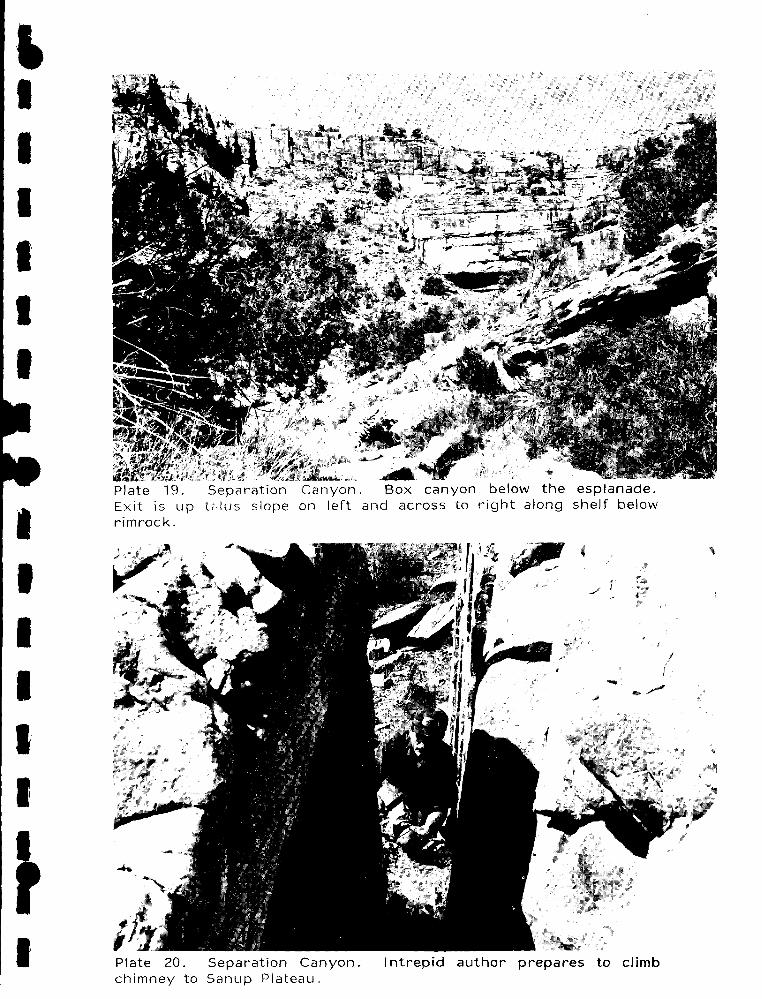
' I I I I I I
I I I I I I
I
Plate 19. Separation Canyon. Box canyon below the esplanade. Exit is up t<,lus slope on left and across to right along shelf below rimrock.
Plate 20. Separation Canyon. Intrepid author prepares to climb chimney to Sanup Plateau.
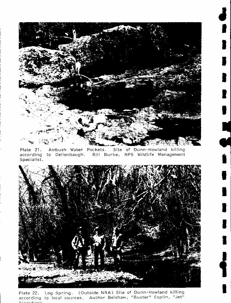
Plate 21. according Specialist.
Ambush Water Pockets. Site to Dellenbaugh. Bill Burke,
of NPS
Dunn-Howland killing Wildlife Management
Plate 22. Log Spring. (Outside NRA) Site of Dunn-Howland killing according to local sources. Author Belshaw, 11 Buster 11 Esp I in, 11 Jet 11
~ I I I I I I
I I I I I I
I

tt I I I
I I
I I
11
I I I I I I I r I
Plate 23. Dunn WATER in center.
Inscription. Name and Arrow below 11 A. 11
year on upper right.
Plate 24. points to
Dunn Inscription with Lake Flat in background. Arrow lake which has been usually dry in recent years.

' I I I I I I I
I I I I I I I ,. I;

- - - - -'!-VALLEY OF FIRE STATE PARK
NEVADA Cl.ARI( COUNlY
.. "'-- • - - - - - -_,,,,..-..... . 1,_. ''........
' \. \ ( peAX(>OO
ARIZONA
To G"'·' G"''" Mme_"'"'"'. l,j,oo Cop0<< Mto. M•o• Sh'''""•'""'''"·'' Ce0< .. ,.,.,WoHHu1<
GRANO CANYON NATIONAL PARK ··· ••.
A' WtlDCAT AAACH MCOOl<AWtlAf
l<>O SI' "• .A .. ORlJ!; Sl'RI ..
ARIZONA,- ' MOHAVE COUNrl
----'°"~"'""'"'&: ., ., M\
N
~
HISTORIC BASE MAP LAKE MEAD NATIONAL RECREATION AREA
_ ..

' I I I I I I I
• I I I I I I
•j

It I I I I I I
I I I I I
I
As the nation's principal conservation agency, the Department of the 1 nterior has basic responsibilities to protect and conserve our land and water, energy and minerals, fish and wildlife, parks and recreation areas, and to ensure the wise use of all these resources. The department also has major responsibility for American 1 ndian reservation communities and for people who live in island territories under U.S. administration.
Publication services were provided by the graphics staff of the Denver Service Center. N PS 1645
283 GPO: 1980--677-150/25

' I I I I I I
I I I I I
I